Biodiversity Assessment Report - Major Projects
239
www.nghenvironmental.com.au e: [email protected] Newcastle ‐ Hunter and North Coast 7/11 union st newcastle west nsw 2302 (t 02 4929 2301) Sydney Region 18/21 mary st surry hills nsw 2010 (t 02 8202 8333) Canberra ‐ NSW SE & ACT 8/27 yallourn st (po box 62) fyshwick act 2609 (t 02 6280 5053) Brisbane 8 trawalla st the gap qld 4061 (t 07 3511 0238) Bega ‐ ACT and South East NSW suite 1, 216 carp st (po box 470) bega nsw 2550 (t 02 6492 8333) Wagga Wagga ‐ Riverina and Western NSW suite 1, 39 fitzmaurice st (po box 5464) wagga wagga nsw 2650 (t 02 6971 9696) Bathurst ‐ Central West and Orana 35 morrisset st (po box 434) bathurst nsw 2795 (t 02 6331 4541) Biodiversity Assessment Report WHITE ROCK WIND FARM DECEMBER 2017
-
Upload
khangminh22 -
Category
Documents
-
view
2 -
download
0
Transcript of Biodiversity Assessment Report - Major Projects

www.nghenvironmental.com.au e: [email protected]
Newcastle ‐ Hunter and North Coast 7/11 union st
newcastle west nsw 2302 (t 02 4929 2301)
Sydney Region 18/21 mary st
surry hills nsw 2010 (t 02 8202 8333)
Canberra ‐ NSW SE & ACT 8/27 yallourn st (po box 62)
fyshwick act 2609 (t 02 6280 5053)
Brisbane 8 trawalla st
the gap qld 4061 (t 07 3511 0238)
Bega ‐ ACT and South East NSW suite 1, 216 carp st (po box 470) bega nsw 2550 (t 02 6492 8333)
Wagga Wagga ‐ Riverina and Western NSW suite 1, 39 fitzmaurice st (po box 5464)
wagga wagga nsw 2650 (t 02 6971 9696)
Bathurst ‐ Central West and Orana 35 morrisset st (po box 434)
bathurst nsw 2795 (t 02 6331 4541)
Biodiversity Assessment Report WHITE ROCK WIND FARM
DECEMBER 2017

www.nghenvironmental.com.au e: [email protected]
Newcastle ‐ Hunter and North Coast 7/11 union st
newcastle west nsw 2302 (t 02 4929 2301)
Sydney Region 18/21 mary st
surry hills nsw 2010 (t 02 8202 8333)
Canberra ‐ NSW SE & ACT 8/27 yallourn st (po box 62)
fyshwick act 2609 (t 02 6280 5053)
Brisbane 8 trawalla st
the gap qld 4061 (t 07 3511 0238)
Bega ‐ ACT and South East NSW suite 1, 216 carp st (po box 470) bega nsw 2550 (t 02 6492 8333)
Wagga Wagga ‐ Riverina and Western NSW suite 1, 39 fitzmaurice st (po box 5464)
wagga wagga nsw 2650 (t 02 6971 9696)
Bathurst ‐ Central West and Orana 35 morrisset st (po box 434)
bathurst nsw 2795 (t 02 6331 4541)
Document Verification
Proposal Title:
White Rock Wind Farm Modification Biodiversity Assessment Report
Proposal Number: 16‐321
Proposal File Name: WRWF STAGE 2 BAR 13122017 FINAL 2.0.docx Revision Date Prepared by (name) Reviewed by (name) Approved by (name)
Draft V1 20/07/17 Mitch Palmer Matt Hingee
Brooke Marshall Brooke Marshall
Draft V1.1 31/07/17 Mitch Palmer Brooke Marshall Brooke Marshall
Final 1.0 10/08/17 Mitch Palmer Minor Changes Minor Changes
Final 2.0 13/12/17 Mitch Palmer Brooke Marshall Brooke Marshall
NGH Environmental prints all documents on environmentally sustainable paper including paper made from bagasse (a by‐product of sugar production) or recycled paper.
NGH Environmental is a registered trading name of NGH Environmental Pty Ltd; ACN: 124 444 622. ABN: 31 124 444 622

Biodiversity Assessment Report White Rock Wind Farm Modification
16 – 321 WRWF BAR Final v2 i
CONTENTS
ACRONYMS AND ABBREVIATIONS ........................................................................................................ VI
EXECUTIVE SUMMARY ........................................................................................................................ VII
1 INTRODUCTION .......................................................................................................................... 1
1.1 THE PROPOSAL ................................................................................................................................. 1
1.1.1 Site location ........................................................................................................................................ 1
1.1.2 Proposal description ........................................................................................................................... 1
1.2 STUDY AIMS ...................................................................................................................................... 5
1.3 REPORT STRUCTURE ......................................................................................................................... 5
1.4 SOURCES OF INFORMATION USED .................................................................................................... 5
1.5 OEH CONSULTATION ........................................................................................................................ 6
2 LANDSCAPE FEATURES ................................................................................................................ 9
2.1 IBRA BIOREGIONS AND SUBREGIONS ............................................................................................... 9
2.2 NSW LANDSCAPE REGIONS (MITCHELL LANDSCAPES) ...................................................................... 9
2.3 NATIVE VEGETATION EXTENT ......................................................................................................... 10
2.4 EXOTIC AREAS ................................................................................................................................. 11
2.5 RIVERS AND STREAMS .................................................................................................................... 11
2.6 WETLANDS...................................................................................................................................... 12
2.7 STATE OR REGIONALLY SIGNIFICANT BIODIVERSITY LINKS .............................................................. 12
2.8 LANDSCAPE VALUE SCORE COMPONENTS ...................................................................................... 12
2.8.1 Method applied ................................................................................................................................ 12
2.8.2 Percent native vegetation cover in the landscape ............................................................................ 12
2.8.3 Connectivity value ............................................................................................................................ 13
2.8.4 Area to perimeter ratio ..................................................................................................................... 14
2.8.5 Patch size .......................................................................................................................................... 14
2.8.6 Landscape value score ...................................................................................................................... 14
3 NATIVE VEGETATION ................................................................................................................ 16
3.1 PLANT COMMUNITY TYPES ............................................................................................................. 16
3.1.1 Endangered Ecological Communities (EECs)tt ................................................................................... 16
3.1.2 Vegetation communities .................................................................................................................. 16
3.1.3 Vegetation zones in the BCC ............................................................................................................. 30
3.1.4 Site values (plot data entered into BCC) ........................................................................................... 31
4 THREATENED SPECIES ............................................................................................................... 36

Biodiversity Assessment Report White Rock Wind Farm Modification
16 – 321 WRWF BAR Final v2 ii
4.1 TARGETED SURVEYS OVERVIEW ..................................................................................................... 36
4.2 GEOGRAPHIC/HABITAT FEATURES .................................................................................................. 37
4.3 HOLLOW BEARING TREES ............................................................................................................... 37
4.4 ECOSYSTEM CREDIT SPECIES ........................................................................................................... 38
4.5 SPECIES CREDIT SPECIES PRESENT .................................................................................................. 38
4.5.1 Candidate species summary ............................................................................................................. 38
4.5.2 Survey timing and effort ................................................................................................................... 40
4.5.3 Targeted survey results .................................................................................................................... 41
4.5.4 Summary of species credit species ................................................................................................... 47
5 EPBC MATTERS OF NATIONAL ENVIRONMENTAL SIGNIFICANCE ................................................ 48
5.1 WETLANDS OF INTERNATIONAL IMPORTANCE ............................................................................... 48
5.2 THREATENED ECOLOGICAL COMMUNITIES .................................................................................... 48
5.3 THREATENED SPECIES ..................................................................................................................... 48
5.4 MIGRATORY SPECIES ...................................................................................................................... 49
6 AVOID AND MINIMISE IMPACTS ............................................................................................... 50
6.1 DIRECT IMPACTS ............................................................................................................................. 50
6.1.1 Design phase .................................................................................................................................... 50
6.1.2 Construction phase ........................................................................................................................... 50
6.1.3 Operational phase ............................................................................................................................ 53
6.2 INDIRECT IMPACTS ......................................................................................................................... 53
6.2.1 Construction phase ........................................................................................................................... 53
6.2.2 Operational phase ............................................................................................................................ 55
6.3 CUMULATIVE IMPACTS ................................................................................................................... 55
7 IMPACT SUMMARY ................................................................................................................... 56
7.1 AREAS NOT REQUIRING ASSESSMENT / OFFSETS ............................................................................ 56
7.2 AREAS NOT REQUIRING AN OFFSET ................................................................................................ 56
7.2.1 Impacts on native vegetation ........................................................................................................... 56
7.2.2 Impacts on species and populations ................................................................................................. 56
7.3 PCTS AND SPECIES POLYGONS REQUIRING AN OFFSET ................................................................... 57
7.3.1 Impacts on native vegetation ........................................................................................................... 57
7.3.2 Impacts on species and populations ................................................................................................. 58
7.4 IMPACTS REQUIRING FURTHER CONSIDERATION ........................................................................... 59
7.4.1 Impacts on landscape features ......................................................................................................... 59
7.4.2 Impacts on native vegetation ........................................................................................................... 60

Biodiversity Assessment Report White Rock Wind Farm Modification
16 – 321 WRWF BAR Final v2 iii
7.4.3 Impacts on threatened species ......................................................................................................... 60
7.4.4 Impacts to EPBC Listed Species ......................................................................................................... 60
7.5 DETERMINING OFFSET REQUIREMENTS ......................................................................................... 62
8 BIODIVERSITY OFFSET STRATEGY .............................................................................................. 65
9 CONCLUSION ............................................................................................................................ 68
10 REFERENCES .............................................................................................................................. 69
APPENDIX A CONSULTATION .........................................................................................................A‐I
APPENDIX B SPECIES LISTS ............................................................................................................. B‐I
APPENDIX C HOLLOW‐BEARING TREE DATA ................................................................................... C‐I
APPENDIX D EPBC PROTECTED MATTERS SEARCH ......................................................................... D‐I
APPENDIX E EPBC ACT ASSESSMENTS OF SIGNIFICANCE ................................................................ E‐I
APPENDIX F EPBC HABITAT ASSESSMENT TABLE ............................................................................ F‐I
APPENDIX G FINAL CREDIT REPORT ............................................................................................... G‐I
TABLES
Table 3‐1 Summary of Blakely’s Red Gum – Yellow Box grassy woodland of the New England Tableland
Bioregion in the proposal site. .................................................................................................................. 17
Table 3‐2 Summary of Ribbon Gum – Mountain Gum – Snow Gum grassy open forest of the New England
Tableland Bioregion in the proposal site. .................................................................................................. 19
Table 3‐3 Summary of Silvertop Stringybark ‐ Mountain Gum grassy open forest of the New England
Tableland Bioregion in the proposal site. .................................................................................................. 22
Table 3‐4 Summary of River Oak ‐ Rough‐barked Apple ‐ red gum ‐ box riparian tall woodland (wetland) of
the Brigalow Belt South Bioregion and Nandewar Bioregion in the proposal site ..................................... 24
Table 3‐6 Summary of Black Sallee ‐ Snow Gum grassy woodland of the New England Tableland Bioregion
in the proposal site. ................................................................................................................................... 26
Table 3‐7 Vegetation zones for the proposal site (EEC italicised) ............................................................. 30
Table 3‐8 Plot data ................................................................................................................................... 32
Table 4‐1 Weather conditions during the field surveys, recorded at Glen Innes ...................................... 36
Table 4‐2 Geographic / habitat features .................................................................................................... 37
Table 4‐3 Ecosystem credit species predicted to occur. ........................................................................... 38
Table 4‐3 Threatened species requiring survey ........................................................................................ 39
Table 4‐5 Threatened species that may generate species credits. ............................................................ 47

Biodiversity Assessment Report White Rock Wind Farm Modification
16 – 321 WRWF BAR Final v2 iv
Table 6‐1 Potential direct impacts to biodiversity during the construction phase ..................................... 50
Table 6‐2 Measures proposed to avoid and minimise direct impacts of the proposal during the construction
phase ........................................................................................................................................................ 51
Table 6‐4 Indirect impacts on biodiversity during the construction phase. ............................................... 53
Table 6‐5 Measures proposed to avoid and minimise indirect impacts of the proposal during the
construction phase .................................................................................................................................... 54
Table 7‐1 Extent of vegetation communities within the proposal site and their impact areas ................. 57
Table 7‐2: Koala habitat assessment tool for coastal areas (DoE 2014) .................................................... 60
Table 7‐3 Credit requirements.................................................................................................................. 64
Table 8‐1 Existing offset credits ................................................................................................................ 65
Table 8‐2 Credit conversion ...................................................................................................................... 67
FIGURES
Figure 1‐1 Location Map, showing proximity to Glenn Innes ...................................................................... 3
Figure 1‐2 Site Map, showing impact areas ................................................................................................ 4
Figure 2‐1 An example of exotic‐dominated (grazing) vegetation within the proposal site ....................... 11
Figure 2‐2 Native vegetation cover ........................................................................................................... 15
Figure 3‐1 Example of moderate to good condition Blakely’s Red Gum – Yellow Box grassy woodland of the
New England Tableland Bioregion in the proposal site. ............................................................................. 18
Figure 3‐2 Example of low condition Blakely’s Red Gum – Yellow Box grassy woodland in the proposal site.
.................................................................................................................................................................. 18
Figure 3‐3 Example of moderate to good condition Ribbon Gum – Mountain Gum – Snow Gum grassy open
forest of the New England Tableland Bioregion in the proposal site. ........................................................ 20
Figure 3‐4 Example of low condition Ribbon Gum – Mountain Gum – Snow Gum grassy open forest in the
proposal site.............................................................................................................................................. 21
Figure 3‐5 Example of moderate to good condition Silvertop Stringybark ‐ Mountain Gum grassy open forest
of the New England Tableland Bioregion in the proposal site. .................................................................. 23
Figure 3‐6 Example of River Oak ‐ Rough‐barked Apple ‐ red gum ‐ box riparian tall woodland (wetland) of
the Brigalow Belt South Bioregion and Nandewar Bioregion .................................................................... 25
Figure 3‐7 Example of moderate to good condition Black Sallee ‐ Snow Gum grassy woodland of the New
England Tableland Bioregion in the proposal site. ..................................................................................... 27

Biodiversity Assessment Report White Rock Wind Farm Modification
16 – 321 WRWF BAR Final v2 v
Figure 3‐8 Example of low condition Black Sallee ‐ Snow Gum grassy woodland of the New England
Tableland Bioregion in the proposal site. .................................................................................................. 27
Figure 3‐9 PCTs at the proposal site .......................................................................................................... 28
Figure 3‐10 EECs at the proposal site ........................................................................................................ 29
Figure 4‐1 Fauna survey result ................................................................................................................. 46

Biodiversity Assessment Report White Rock Wind Farm Modification
16 – 321 WRWF BAR Final v2 vi
ACRONYMS AND ABBREVIATIONS
BBAM BioBanking Assessment Methodology
BCC BioBanking Credit Calculator
BOS Biodiversity Offset Strategy
CEEC Critically Endangered Ecological Community
EEC Endangered Ecological Community
EIS Environmental Impact Statement
EPBC Act Environment Protection and Biodiversity Conservation Act 1999 (Cwth)
EP&A Act Environmental Planning and Assessment Act 1979 (NSW)
FBA Framework for Biodiversity Assessment
ha Hectares
km Kilometres
m Metres
NSW New South Wales
OEH (NSW) Office of Environment and Heritage
PCTs Plant Community Types
SEARs Secretary’s Environmental Assessment Requirements
SEPP State Environmental Planning Policy (NSW)
sp/spp Species/multiple species
TSC Act Threatened Species Conservation Act 1995 (NSW)
WRWFPL White Rock Wind Farm Pty Ltd
WRWF White Rock Wind Farm

Biodiversity Assessment Report White Rock Wind Farm Modification
16 – 321 WRWF BAR Final v2 vii
EXECUTIVE SUMMARY
White Rock Wind Farm Pty Ltd (WRWFPL) is planning for the modification of the White Rock Wind Farm
which would involve additional turbines, turbines in locations not included in the original approval, larger
turbines and associated changes to the track and cabling network to connect these turbines. This
modification relates to Stage 2 of the project.
This Biodiversity Assessment Report (BAR) has been prepared by NGH Environmental on behalf of
WRWFPL. The aim of this BAR is to address the requirements of the Framework for Biodiversity Assessment
(FBA), developed for Major Projects, including requirements under the NSW Biodiversity Offsets Policy for
Major Projects, and to address the biodiversity matters. This BAR will be used to inform an Environmental
Impact Assessment as part of the modification application for a Major Project under the Environmental
Planning and Assessment Act 1979 (EP&A Act).
The FBA underpins the Biodiversity Offsets Policy for Major Projects. It contains the assessment
methodology that is adopted by the policy to assess impacts and provide offset guidance for Major
Projects. This report follows the BAR format required by the FBA. Specifically, this assessment uses the
'multiple fragmentation impact development' assessment methodology, in accordance with Appendix 5 of
the FBA for major proposals.
Field surveys of the study area identified two Endangered Ecological Community (EEC): White Box Yellow
Box Blakely’s Red Gum Grassy Woodland (7.95 ha) listed under the Threatened Species Conservation Act
1995 (TSC Act) and Environment Protection and Biodiversity Conservation Act 1999 (EPBC Act) and Ribbon
Gum – Mountain Gum – Snow Gum grassy open forest of the New England Tableland Bioregion (64.60 ha)
listed under the TSC Act. Other non‐EEC vegetation that provides threatened species habitat will be
impacted by the development. The Biobanking Credit Calculator (BCC) returned a total of 4,547 ecosystem
credits for total removal of both EEC and further threatened species habitat.
Three threatened species were recorded during the surveys however all are ecosystems credits species
within the vegetation communities listed within the BAR. Surveys were conducted for species credit species
generated by the BCC however none were found within the proposal site and therefore no species credits
were generated. Additional surveys areas added since the field surveys for confirmation of vegetation
community and targeted threatened flora searches is a recommendation of this report (if results are in
conflict with the assumptions of this BAR, the credit calculations must be updated to reflect additional
offset requirements).
Vegetation mapping of the study area was provided to WRWFPL to guide design of relevant infrastructure
with the intention of avoiding and minimising impacts to vegetation constituting the highest ecological
value, such as forming components of CEECs, EECs and providing threatened flora and fauna habitat. There
is an opportunity within the final design phase to further reduce impacts to native vegetation, in particular
EEC vegetation.
Mitigation and management measures will be put in place to adequately address impacts associated with
the project, both direct and indirect.
An existing offset package is being developed for the White Rock Wind Farm development. It is intended
that the additional credit requirement required by the modification would be included in this package. It is
noted there may be further opportunities in the final design phase to minimise impacts to native
vegetation, and in particular EEC vegetation, that will avoid and minimise impacts as well as reduce
offsetting requirements.

Biodiversity Assessment Report White Rock Wind Farm Modification
16 – 321 WRWF BAR Final v2 1
1 INTRODUCTION
This Biodiversity Assessment Report (BAR) has been undertaken to support a Modification Application for
the White Rock Wind Farm (WRWF). The WRWF was approved under Section 75J of the Environmental
Planning and Assessment Act 1979 on July 10, 2012 (MP10_160). It is a Major Project and State Significant
Development (SDD). White Rock Wind Farm Pty Ltd (WRWFPL) is the proponent for the Modification
Application.
The modification would involve additional turbines, turbines in locations not included in the original
approval, larger turbines and associated changes to the track and cabling network to connect these
turbines. This modification relates to Stage 2 of the project. The previously approved Stage 1 of the project,
involving the installation of 70 wind turbines, associated infrastructure and ancillary facilities, commenced
construction in May 2016. Construction will be completed by the end of 2017. Stage 2 involves 28 of the
remaining 49 approved turbine locations, adds 20 new turbine locations, and includes the option to replace
Stage 2 turbines with a larger turbine model (and therefore requires greater areas of clearing).
This Biodiversity Assessment Report (BAR) assesses the additional native vegetation clearing required for
the modification, in accordance with the NSW Framework for Biodiversity Assessment (FBA) for Major
Projects, and provides advice on the additional offset requirements for the project. It is noted that
operational risks, such as potential for bird and bat collisions, are being considered separately and are not
addressed in this report.
1.1 THE PROPOSAL
1.1.1 Site location
WRWF is located within the New England Tablelands approximately 20km west of Glen Innes and 40km
east of Inverell. The WRWF is located at the junction of the Glen Innes, Inverell and Guyra local government
area (LGA). The WRWF is south of the Gwydir Highway with the main site entrance accessed directly off
the Gwydir Highway, on the northern site boundary. Access to the southern site boundary, and majority of
the development within the Stage 2 modification, is located off Kelleys Road in the Maybole locality.
Refer to Figure 1‐1 Site map.
1.1.2 Proposal description
The proposed Stage 2 modifications to the approved WRWF development, MP10_160, are summarised as
follows:
Up to 48 turbines (the existing approval allows for 49 approved turbines sites), of which 20 would
be new locations not consented under the original approval;
A larger turbine model GW140 is being considered for all 48 sites in this assessment;
Variations to the on‐site 33kV/132kV grid connection facility located south of White Rock
Mountain, involving a marginally extended 132kV switchyard and 33kV/132kV substation. This
includes an additional 33kV/132kV transformer, switchgear and other components;
Some additional access tracks for the new turbine sites and minor modifications to approved
access track routes to improve constructability;

Biodiversity Assessment Report White Rock Wind Farm Modification
16 – 321 WRWF BAR Final v2 2
Additional 33kV collections circuits, including six overhead 33kV lines (four assessed under the
original approval) and either an upgrade to or a potential parallel line installation for the existing
33kV overhead line between T62 and T35, for the new wind turbine sites.
In terms of the location of the additional infrastructure, four additional properties would be required,
adjacent to the existing proposal site. Three are additional private land holdings. One of these would only
involve an access easement and is owned by WRWF.
A summary of proposed impacts included in the is BAR is as follows;
Cut‐and‐Fill Batters (plus 5m disturbance buffer)
Access Tracks (6m width, plus 5m disturbance buffer)
Hardstands, blade laydown and crane erection area (50 x 80m)
Blade Laydown/Assembly Overhang (70m blade, 85m blade would be single blade lift)
Reticulation (12m + 3m per extra parallel cable)
OHL (24m for full clearance, or tower cone clearance for spanning large gullies)
OHL Towers (20 x 20m)
OHL Tower Access Tracks (5m, upgrade of existing farm tracks).
The infrastructure layout assessed in this report is provided in Figure 1‐2.
The field data used in this assessment was collected over several field programs in response to changes in
the infrastructure layout. Some modifications to the layout have places some infrastructure outside the
areas of the field surveys. These areas have been assessed via desktop and compared to adjacent areas
which have been surveyed. Vegetation mapping was then extrapolated from areas that have been surveyed
using a precautionary approach and only where confidence of vegetation communities was high. However,
these areas have not been surveyed for targeted threatened flora and fauna or ground validated, with the
intention for further surveys to be undertaken during the relevant spring survey periods. These areas are
identified in Fiigures 3‐9 and 3‐10 and Figure 3‐10 and discussed further in Section 4.

Biodiversity Assessment Report White Rock Wind Farm Modification
16 – 321 WRWF BAR Final v2 3
Figure 1‐1 Location Map, showing proximity to Glenn Innes

Biodiversity Assessment Report White Rock Wind Farm Modification
16 – 321 WRWF BAR Final v2 4
Figure 1‐2 Site Map, showing impact areas

Biodiversity Assessment Report White Rock Wind Farm Modification
16 – 321 WRWF BAR Final v2 5
1.2 STUDY AIMS
This BAR has been prepared by NGH Environmental on behalf of Goldwind Australia, owner of the WRWF.
The aim of this BAR is to address the requirements of the FBA, developed for Major Proposals, as directed
by Office of Environment and Heritage (OEH).
This BAR assesses all additional impact areas required for the modification. This includes:
New turbine, cabling and track locations, not assessed under the existing approval.
Increased impact areas, for larger turbine footing requirements, in areas assessed under
the existing approval1.
1.3 REPORT STRUCTURE
This BAR follows the reporting requirements of Sections 1 and 2 of the FBA, including the following:
1. Assessment of all additional turbine sites / impact areas consistent with the requirements
of the FBA, developed for Major Projects. The reporting requirements of Sections 1 and 2
of the FBA is followed, namely:
Identification of biodiversity values subject to the proposed major development
(the proposal) – Chapter 2 (Landscape Features), Chapter 3 (Native Vegetation),
Chapter 4 (Threatened Species).
Impacts of the project on biodiversity as part of an application for approval to
undertake a Major Project under the NSW planning legislation ‐ Chapter 6 (Avoid
and Minimise Impacts), Chapter 7 (Impact Summary).
2. Recalculation of impact areas, based on larger turbine footings (section 3)
1.4 SOURCES OF INFORMATION USED
The following information sources were used in the preparation of this report:
Aerial maps, proposal layers and environmental layers provided by Goldwind and OEH.
Australian Government’s Species Profiles and Threats database (SPRAT) http://www.environment.gov.au/cgi‐bin/sprat/public/sprat.pl
Department of Environment and Climate Change NSW (DECC) (2002). Descriptions for NSW (Mitchell) Landscapes, Version 2.
Department of Sustainability, Environment, Water, Population and Communities (DSEWPC) Environment Protection and Biodiversity Conservation Act 1999 (EPBC Act) Species Profiles and Threats Database (SPRAT).
NSW OEH’s BioBanking credit calculator (http://www.environment.nsw.gov.au/bbccapp/ui/mynews.aspx).
NSW OEH’s threatened species database http://www.threatenedspecies.environment.nsw.gov.au/index.aspx.
1 This has been undertaken as a GIS exercise by Goldwind. The Stage 2 layout has been clipped using the Stage 1 layout, to ensure only the additional areas required for Stage 2 area assessed.

Biodiversity Assessment Report White Rock Wind Farm Modification
16 – 321 WRWF BAR Final v2 6
OEH Threatened Species Profiles.
Office of Environment and Heritage (OEH) (2007). Mitchell Landscapes with per cent cleared estimates.
OEH Vegetation Information System (VIS) Classification Database (OEH 2016).
Office of Environment and Heritage (OEH) (2014). Framework for Biodiversity Assessment: NSW Biodiversity Offsets Policy for Major Proposals. Published by Office of Environment and Heritage for the NSW Government.
1.5 OEH CONSULTATION
Consultation was undertaken with OEH on the 28th November and 20 December 2016 regarding the
biodiversity assessment, landscape assessment approach and mapping of Endangered Ecological
Communities (EECs). Correspondence is provided in Appendix A and summarised as follows:
OEH advice Addressed in this BAR
Biodiversity Assessment
1. For the proposed biodiversity surveys, all impact areas associated
with the Modification (new infrastructure in areas not previously
assessed, new infrastructure in areas previously assessed,
approved infrastructure with proposed larger footprints in areas
previously assessed) must have their vegetation mapped as per the
OEH NE Region Guidance Material for mapping woodland
endangered ecological communities.
Updated vegetation mapping
for all impact areas in
accordance with OEH advice is
provided in Section 3 and
Section 4, Figure 3‐9 and 3‐10.
2. For the assessment of the proposal, the Framework for Biodiversity
Assessment (FBA) must be used to assess areas to be impacted by
the proposed Modification. However, for offset calculations any
existing approved impacts should be subtracted. For example, if an
approved turbine footprint is 400m2 and the new footprint arising
from the proposed Modification is 900m2, then vegetation would
be mapped for the Modification as per Attachment 1 and only the
increase in area (900‐400=500m2) would be used for offset
calculations. This acknowledges that the existing approved
footprint can be cleared and offset in accordance with the existing
approval and biodiversity offset strategy.
Biodiversity assessment for
vegetation clearing follows the
FBA BAR requirements (this
document).
Impact areas required for the
modification are set out in
Section 5 and Section 7,
showing the total amount of
new clearing required. The
credits generated by this area
are set out in Section 8.
Landscape Assessment Approach
We have reviewed the map provided which illustrates the location of the
proposed additional wind turbines across the landscape. Based on these
maps, we are of the view that it would be best if you conduct the landscape
assessment of the impacts according to the methodology for 'multiple
fragmentation impact development', provided at Appendix 5 of the
Framework for Biodiversity Assessment (FBA).
This assessment methodology is appropriate for developments like wind
farms, given the dispersed nature of turbine locations that are linked by an
associated network of development including roads, tracks and
transmission lines, and clustered as arrays.
The 'multiple fragmentation
impact development' method
has been used.

Biodiversity Assessment Report White Rock Wind Farm Modification
16 – 321 WRWF BAR Final v2 7
OEH advice Addressed in this BAR
EEC Mapping
Based on previous ecological assessments undertaken at White Rock Wind
Farm, we are aware that two main vegetation types occur. These include
the Ribbon Gum ‐ Mountain Gum ‐ Snow Gum Grassy Forest/Woodland
and the White Box ‐ Yellow Box ‐ Blakely's Red Gum Woodland. Both of
these vegetation types are listed as EECs.
To ensure that the credit requirement generated for impacts on these EECs
is accurate, the mapping of these EECs should be broad enough to ensure
that all areas of the site where these communities occur are identified…
Ribbon Gum ‐ Mountain Gum ‐ Snow Gum Grassy Forest/Woodland EEC
To assist in the identification of the Ribbon Gum ‐ Mountain Gum ‐ Snow
Gum Grassy Forest/Woodland EEC, the OEH recommends that the
following identification logic be adopted:
EEC mapping for all impact
areas has been undertaken in
accordance with OEH advice
and is provided in Section 4 and
Figure 3‐10 1. Trees up to 15m apart with exotic or native grassland or bare
earth between them ‐ map all as EEC (N.B. this could be up to 30m given
the observed canopy diameters in highly fertile sites but 15m was chosen
as the average canopy diameter to be pragmatic as it captures the
woodland state that can have native or exotic grassland or bare earth
trees).
2. Trees between 15m and 100m apart with all native grassland
between them ‐ map all as EEC (N.B. this is a derived open woodland state
but limiting the state to native grassland in between accords with the
ability of the EEC to be mapped as derived native grassland).
3. Trees between 15m and 100m apart with all exotic grassland
between them ‐ map trees as EEC.
4. Trees between 15m and 100m apart with patches of native and
exotic grassland between them ‐ map trees as EEC and any areas of native
grassland in between as EEC but exclude exotic grassland areas.
5. Trees more than 100m apart with patches of native and exotic
grassland between them‐ map trees as EEC and the areas of native
grassland in between as EEC but exclude exotic grassland areas.
White Box ‐ Yellow Box ‐ Blakely's Red Gum Woodland EEC
To assist in the identification White Box ‐ Yellow Box ‐ Blakely's Red Gum
Woodland EEC, OEH recommends that the following identification logic be
adopted:
EEC mapping for all impact
areas has been undertaken in
accordance with OEH advice
and is provided in Section 4 and
Figure 3‐10 1. Trees up to 50m apart with exotic or native grassland or bare
earth between them ‐ map all as EEC (N.B. this could be up to 100m apart
given the EEC can be an open woodland but 50m was chosen to be
pragmatic given this condition state can have just exotics or even bare
earth in between trees).
2. Trees between 50m and 100m apart with native grassland
between them ‐ map all as EEC (N.B. this could include exotic or bare earth
given it can be an open woodland but limiting the state to native grassland
in between was chosen in order to be pragmatic).

Biodiversity Assessment Report White Rock Wind Farm Modification
16 – 321 WRWF BAR Final v2 8
OEH advice Addressed in this BAR
3. Trees between 50m and 100m apart with exotic grassland
between them ‐map trees as EEC.
4. Trees between 50m and 100m apart with patches of native and
exotic grassland between them ‐map trees as EEC and any areas of native
grassland in between as EEC but exclude exotic grassland areas.
5. Trees more than 100m apart with patches of native and exotic
grassland between them ‐ map trees as EEC and the areas of native
grassland in between as EEC but exclude exotic grassland areas.
For both EEC identification processes set out above, native grassland is
defined as areas of grassland comprising at least 50% native species.

Biodiversity Assessment Report White Rock Wind Farm Modification
16 – 321 WRWF BAR Final v2 9
2 LANDSCAPE FEATURES
WRWFPL proposes to develop additional infrastructure both within the existing WRWF site boundaries and
on an additional four freehold properties, one of which is already owned by the proponent. These areas
are bounded by agricultural land, with mix of native and exotic pastures used for grazing purposes. The
majority of the land to be impacted has been cleared and ‘pasture improved’ with the introduction of exotic
temperate grasses and fertilised accordingly. This has led to many of the introduced species invading
surrounding areas of remnant vegetation and influencing groundcover composition.
2.1 IBRA BIOREGIONS AND SUBREGIONS
Bioregions are large, geographically distinct areas of land with common characteristics such as geology,
landform patterns, climate, ecological features and plant and animal communities. The proposal is located
within The New England Tablelands Bioregion and the Glen Innes‐Guyra Basalts Subregion (IBRA v.7 2012).
The geology of the region is Silurian to Triassic (443 million years) in age, with landforms described as
mountain ranges, dissected plateaus, hills, and undulating plains. The dominant pre‐European vegetation
type is considered to be Eucalyptus Woodlands dominated by Eucalyptus albens and E. melliodora (ASRIS
accessed 27/3/17).
The dominant IBRA subregion affected by the project is the Glen Innes‐Guyra Basalts Subregion. This was
entered in the Biobanking Credit Calculator (BCC) assessment for the project.
2.2 NSW LANDSCAPE REGIONS (MITCHELL LANDSCAPES)
Two Mitchell Landscapes occur within the study area; Glen Innes – Guyra Basalts and Inverell Plateau
Granites (Figure 1‐2).
Glen Innes – Guyra Basalts occurs throughout the majority of the study area. The per cent
cleared estimate for this landscape is currently 82% (OEH 2016).
Inverell Plateau Granites occurs to the east and west of the study area and crosses a small
section of the study area in the northeast. The per cent cleared estimate for this landscape
is currently 37% (OEH 20016).
The Mitchell Landscape descriptions are provided in Error! Reference source not found. below.
Mitchell Landscape
Glen Innes – Guyra Basalts (311369.53 ha)
Undulating to stepped hilly plateau with broad ridges, wide shallow valleys and high rounded peaks on Tertiary basalt, general elevation 700 to 1510m, local relief 300m, average level of the landscape 1300m. Brown structured stony loam and clay loam, on slopes, occasional red structured loam with gradational profiles and deep dark self‐mulching sticky clay on the valley floors. Open woodland with snow gum (Eucalyptus pauciflora), black sallee (Eucalyptus stellulata), manna gum (Eucalyptus viminalis), silvertop stringybark (Eucalyptus laevopinea), and New England peppermint (Eucalyptus cinerea) in higher areas grading to woodland of white box (Eucalyptus albens), yellow box (Eucalyptus melliodora), roughbarked apple (Angophora floribunda) with manna gum (Eucalyptus viminalis) along streams in lower areas. Extensive grassy understorey.

Biodiversity Assessment Report White Rock Wind Farm Modification
16 – 321 WRWF BAR Final v2 10
Mitchell Landscape
Inverell Plateau Granites (890307.02 ha)
Widely distributed and defined undulating plateau with domed peaks on Permian New England granites and granodiorites. Several intrusions have distinctive contact ridges of metamorphosed sedimentary rocks. The area includes Permian acid volcanics and pyroclastics and some undifferentiated Permo‐Carboniferous mudstone and lithic sandstone. General elevation 900 to 1500m, local relief 200m. The highest elevations are along the eastern edge above the Great escarpment, most of the plateau lies ate 900 to 1200m. As mapped this is a large landscape and it might require subdivision on the basis of vegetation. Domed rock outcrop is common with tors. Shallow gritty loam thickens downs lope to red or yellow earthy sand and red, red‐yellow and yellow texture‐contrast soil on lower slopes and valley floors.
Wide valleys may have deep dark clay deposits in swampy streamlines. The vegetation varies with topography, soil, drainage and temperature. In dry areas open forest of; silvertop stringybark (Eucalyptus laevopinea), broad‐leaved stringybark (Eucalyptus caliginosa), Blakely’s red gum (Eucalyptus blakelyii), narrow‐leaved peppermint (Eucalyptus radiata), yellow box (Eucalyptus melliodora), apple box (Eucalyptus bridgesiana), red ironbark (Eucalyptus sideroxylon), Caley’s ironbark (Eucalyptus caleyi), rough‐barked apple (Angophora floribunda) and black cypress pine (Callitris endlicheri).
In moist areas open forest of; New England peppermint (Eucalyptus nova‐angelica), manna gum (Eucalyptus viminalis), mountain gum (Eucalyptus dalrympleana), New England blackbutt (Eucalyptus andrewsii ssp. campanulata), diehard stringybark (Eucalyptus cameronii), Deane’s gum (Eucalyptus deanei), messmate (Eucalyptus obliqua), privet‐leaved stringybark (Eucalyptus ligustrina), Youman’s stringybark (Eucalyptus youmanii), swamp gum (Eucalyptus camphora), Gibraltar rock blackbutt (Eucalyptus pyrocarpa), tumbledown red gum (Eucalyptus dealbata) and orange gum (Eucalyptus prava) sometimes with closed forest species in the understorey especially in the eastern parts of the landscape.
In cold areas snow gum (Eucalyptus pauciflora), black sallee (Eucalyptus stellulata) woodlands are the norm with manna gum and mountain gum along some streams.
Most granite peaks have specialised joint crevice heath communities typically with about 100 plant genera and almost always containing local endemic species. In this landscape the following communities are recognised; Gonocarpus teucriodes ‐ Isotoma axillaris herbfield with black cypress pine, orange gum, tumbledown red gum, Caley’s ironbark, and western New England blackbutt. Babingtonia densifolia‐ Homoranthus prolixus shrubland with black cypress pine, orange gum, tumbledown red gum, and Acacia neriifolia. New England tea tree ‐ Brachyloma saxicola heath on the escarpment of the Gibraltar Range with New England mallee ash (Eucalyptus approximans), diehard stringybark, apple box, forest oak (Allocasuarina torulosa), black cypress pine and orange gum.
The dominant Mitchell Landscape affected by the proposal is Glen Innes – Guyra Basalts and this was entered into the BCC for the proposal.
2.3 NATIVE VEGETATION EXTENT
The landscape assessment utilised the 'multiple fragmentation impact development' method, provided at
Appendix 5 of the FBA. This assessment methodology for linear shaped developments is the most
appropriate methodology due to the nature of the turbines locations and the network of access tracks and
transmission lines throughout the development. Using GIS, a 550m buffer from the outer edge of the
impact areas was established. As the natural vegetation that occurs within the proposal site is woodland
and grassland derived from woodland, native vegetation mapping used over‐storey as a surrogate for
native vegetation cover. This is considered conservative as this would include non‐native vegetation, such
as pine trees and wind breaks. No natural grasslands are relevant to the study area.
The total area of native vegetation mapped within the 550m buffer is 1689.2 ha Refer to Figure 2‐2.

Biodiversity Assessment Report White Rock Wind Farm Modification
16 – 321 WRWF BAR Final v2 11
2.4 EXOTIC AREAS
Throughout the proposal site, areas that have been cleared of overstorey and midstorey vegetation are
primarily used for improved pasture grazing purposes and provide non‐optimal habitat for native fauna. As
above, the majority of these have been pasture improved. Highly disturbed and modified vegetation
community occupies a small proportion of the site and is found where there is complete (100%) dominance
of exotic flora species that make up the groundcover (Figure 2‐1). Within the proposed development
envelope, the groundcover consisted of exotic species used for livestock grazing and was dominated by
Phalaris (Phalaris aquatic), Medow Fescue (Fescuta pratensis), White Clover (Trifolum repens), Red Clover
(Trifolium pratense) and Prairie Grass (Bromus catharticus). Areas within the proposal site that comprise
complete exotic vegetation are those not mapped as native vegetation on Figure 3‐9.
As this vegetation has no native component in any strata, then in accordance with the FBA, this vegetation
does not need to be assessed further.
Figure 2‐1 An example of exotic‐dominated (grazing) vegetation within the proposal site
2.5 RIVERS AND STREAMS
There are approximately nine (9) ephemeral tributaries that are within the proposal site, however, only
one of these is a named stream. The Wellingrove Creek is Strahler order 4 stream and runs through the
east of the proposal site in a northerly direction for approximately 40kms draining into the Severn River.

Biodiversity Assessment Report White Rock Wind Farm Modification
16 – 321 WRWF BAR Final v2 12
2.6 WETLANDS
Naturally occurring areas of inundation may occur within the lower lying area of the proposal site, forming
ephemeral wetlands. These areas are considered likely to provide suitable foraging habitat for groups such
as wading birds and ducks, in addition to suitable breeding habitat for frogs, although they are generally
considered low quality due to a sparse covering of aquatic vegetation.
There are numerous man‐made dams within the proposal site, however not within the impact areas, with
the primary function of providing water to stock, however they provide important habitat values and
provide refuge for native wildlife.
The closest wetland to the proposal site is the RAMSAR listed Little Llangothlin Lagoon and Nature reserve,
located approximately 25 km to the south east of the proposal site.
2.7 STATE OR REGIONALLY SIGNIFICANT BIODIVERSITY LINKS
State significant biodiversity links, regionally significant biodiversity links, very large area biodiversity links,
large area biodiversity links or local area biodiversity links are defined in the FBA. To date, no biodiversity
corridor plans have been approved by the Chief Executive of the OEH.
No state or regionally significant biodiversity links occur within the proposal site and within the buffer area.
2.8 LANDSCAPE VALUE SCORE COMPONENTS
A BCC assessment was completed for this proposal. The proposal ID for the assessment is
0035/2016/4082MP Version 1 and the assessment type was selected as ‘Major proposal’. This section
summarises the values entered into the Landscape values section of the BCC assessment.
2.8.1 Method applied
The project conforms to the definition of a multiple fragmentation impact development according to the
FBA;
‘a development such as wind farms and coal seam gas extractions that require multiple extraction
points or turbines and a network of associated development including roads, tracks, gathering
systems/flow lines and transmission lines’.
As a result, the multiple fragmentation impacts assessment methodology has been used in the assessment,
in accordance with Appendix 5 of the FBA for major proposals.
2.8.2 Percent native vegetation cover in the landscape
The following steps were completed in accordance with Appendix 5 of the FBA. They were completed based
on the proposal site as of July 2017.
Assessing percent current extent of native vegetation cover
Using a GIS, a 550 m buffer was established from the outer boundary of the proposal site (Figure 2‐2).
The total area of the buffer, including the development footprint, is 2,099.3 ha.
The total area of native vegetation mapped within the buffer, including the development
footprint, is 1,689.2 ha.

Biodiversity Assessment Report White Rock Wind Farm Modification
16 – 321 WRWF BAR Final v2 13
Current native vegetation cover is therefore 80.46%
In accordance with Table 16 of the FBA, the score for the percent current extent of native
vegetation cover was determined to be 13.4.
Assessing percent future extent of native vegetation cover
Using then same 550 m buffer along each side of the centre line of the development footprint:
The total area of the buffer, including the development footprint, is 2,099.3 ha
The area of native vegetation mapped within the buffer, excluding the development
footprint, is 1,561.46
Future native vegetation cover is therefore 74%
In accordance with Table 16 of the FBA, the score for the percent future extent of native
vegetation cover was determined to be 13.
2.8.3 Connectivity value
A connecting link is when native vegetation on the site adjoins native vegetation surrounding the site and
the native vegetation:
• is in moderate to good condition, and
• has a patch size >1 ha, and
• is separated by a distance of <100 m (or <30 m for non‐woody ecosystems), and
• is not separated by a large water body, dual carriageway, wider highway or similar hostile
link.
The moderate to good vegetation on the site is well connected to adjacent vegetation. No connecting links
occur at the proposal site.
Extract from the FBA Table 17: Connectivity value scores for multiple fragmentation impact based development
Category of connecting link Defining criteria
State significant biodiversity link
An area identified as being part of a state significant biodiversity link in a plan approved by the Chief Executive, OEH OR A riparian buffer 50 m either side of a 6th order stream or greater OR A riparian buffer 50 m around an important wetland or an estuarine area
Regionally significant biodiversity link
An area identified as being part of a regionally significant biodiversity link and in a plan approved by the Chief Executive, OEH OR
A riparian buffer 20 m either side of a 4th or 5th order stream
Or
A riparian buffer 30 m around a regionally significant wetland
Very large area biodiversity link
Links areas of native vegetation in moderate to good condition that are >5000 ha in total AND Width of vegetation in moderate to good condition that is connecting the area >500m
Large area biodiversity link Links areas of native vegetation in moderate to good condition that are >1000 ha and < 5000 ha in total, or areas >5000 in total AND

Biodiversity Assessment Report White Rock Wind Farm Modification
16 – 321 WRWF BAR Final v2 14
Width of vegetation in moderate to good condition that is connecting the area >100m and <500m
Local area biodiversity link Links areas of native vegetation in moderate to good condition that are >250ha and < 1000 ha in total, or areas >1000 in total AND Width of vegetation in moderate to good condition that is connecting the area >300m and <100m
Connectivity value
The development would not impact on any connecting links or state or regional biodiversity links, however
would impact a large biodiversity link and therefore a connectivity value class of 5 was attributed.
2.8.4 Area to perimeter ratio
For a multiple fragmentation development, an assessment of the change in area to perimeter ratio of patch
size areas must be undertaken. Before development the area/perimeter ratio score is 15 whilst after
development is 11, and therefore a proportional change percentage of 26.7%. As per table 19 in appendix
5 of the FBA, a score of 3 is achieved.
2.8.5 Patch size
For a development that is linear shaped or a multiple fragmentation development, the assessor must assess
the patch size for each Mitchell landscape in which the development occurs. The results are as follows:
Mitchell landscape 1:
Glen Innes – Guyra Basalts 82% cleared
Largest patch size: >100 ha
Table 18 score: 12.5
The final patch size score is 12.5.
2.8.6 Landscape value score
Entering the data documented above into the BCC returned a landscape value score of 20.9.

Biodiversity Assessment Report White Rock Wind Farm Modification
16 – 321 WRWF BAR Final v2 15
Figure 2‐2 Native vegetation cover

Biodiversity Assessment Report White Rock Wind Farm Modification
16 – 321 WRWF BAR Final v2 16
3 NATIVE VEGETATION
3.1 PLANT COMMUNITY TYPES
3.1.1 Endangered Ecological Communities (EECs)tt
Two EECs would be impacted by the modification. These are;
White Box, Yellow Box, Blakely’s Red Gum Grassy Woodland (TSC Act and EPBC Act)
Ribbon Gum – Mountain Gum – Snow Gum grassy open forest of the New England Tableland
Bioregion (TSC Act)
NGH environmental consulted with OEH regarding how these EECs should be mapped (set out in Section
1.6). Refer to Figure 3‐10 for the resulting EEC mapping.
3.1.2 Vegetation communities
Five Plant Community Types (PCT’s) were identified in the proposal site. These include
Blakely’s Red Gum – Yellow Box grassy woodland of the New England Tableland Bioregion
(PCT 510)
Ribbon Gum – Mountain Gum – Snow Gum grassy open forest or woodland of the New
England Tableland Bioregion (PCT 554)
Silvertop Stringybark ‐ Mountain Gum grassy open forest of the New England Tableland
Bioregion (PCT 565)
River Oak ‐ Rough‐barked Apple ‐ red gum ‐ box riparian tall woodland (wetland) of the
Brigalow Belt South Bioregion and Nandewar Bioregion (PCT 84)
Black Sallee ‐ Snow Gum grassy woodland of the New England Tableland Bioregion (PCT
507)
Exotic areas that were completely dominated by non‐indigenous vegetation were not considered to be
native vegetation. They have not been assigned to any PCT and are not considered to provide habitat for
threatened species or communities. They are not considered further in the BCC calculations.
Blakely’s Red Gum – Yellow Box grassy woodland of the New England Tableland Bioregion (PCT
510)
Within the proposal site, PCT 510 occurred as:
Several discrete patches (7.95 ha) of moderate to good woodland vegetation within the
proposal site
Woodland vegetation within the proposal site with 0.51 ha in low condition.
The distribution of this vegetation type at the proposal site is shown on Figure 3‐9 and a summary of the key details provided in Table 3‐1.
This PCT was determined during the survey on the basis of plot data collected within the development
envelope and on surveys conducted in adjacent less disturbed vegetation. This PCT is listed as an
Endangered Ecological Community (EEC) under the TSC and EPBC Act – White Box Yellow Box Blakely’s Red
Gum Woodland. This vegetation community is also listed as a Critically Endangered Ecological Community

Biodiversity Assessment Report White Rock Wind Farm Modification
16 – 321 WRWF BAR Final v2 17
(CEEC) under the EPBC Act ‐ White Box Yellow Box Blakely’s Red Gum Woodland. It should be noted that
this community does not meet the EPBC Act requirements in instances where this this community is in a
highly modified state and classed as in low condition.
The overstorey was characteristically dominated by Yellow Box (Eucalyptus meliodora). The midstorey
consisted of shrubs including Blackthorn (Bursaria spinosa). In areas where this community was in low
condition, the ground cover was heavily invaded with exotic annuals, perennial grasses and forbs including
Medow Fescue (Fescuta pratensis), Perennial Rye Grass (Lollium perene), Phalaris (Phalaris aquatic), White
Clover (Trifoilum repens) and Chickweed (Stellaria media). Where this community was in moderate to good
condition the groundcover was dominated by native species including, Native Geranium (Geranium
solanderi), Snowgrass (Poa sieberiana), Weeping Grass (Microleana stipoides) and Stinking Pennywort
(Hydrocotyle laxifolia).
A range of other native shrub, grass and forb species were also recorded during the plot surveys. All species
recorded, percentage cover and estimated numbers of individuals within each plots is included in Error!
Reference source not found..
Table 3‐1 Summary of Blakely’s Red Gum – Yellow Box grassy woodland of the New England Tableland Bioregion in the proposal site.
Blakely’s Red Gum – Yellow Box grassy woodland of the New England Tableland Bioregion
Vegetation
formation
Grassy woodlands
Vegetation class New England Grassy Woodlands
Vegetation type Plant Community Type (PCT) ID
510
Biometric Vegetation Type ID BR272, HU681, NA258
Common Community Name Blakely’s Red Gum – Yellow Box grassy woodland of theNew England Tableland Bioregion
Approximate extent
within proposal
This vegetation community occurs as discrete patches of native vegetation within the proposal site of which 8.46 ha is proposed to be cleared (Figure 3‐1 & Figure 3‐2).
Condition Moderate to good and low condition woodland.
Survey Effort 6 biometric plots within mod/good condition
3 biometric plots within mod/good condition
Conservation Status This vegetation community is listed as an endangered ecological community (EEC) under
the TSC Act and a critically endangered ecological community (CEEC) under the EPBC Act
known as White Box Yellow Box Blakely’s Red Gum Woodland. It is noted that this
community does not meet the EPBC Act requirements in instances where this this
community is in a highly modified state and classed as in low condition.
Estimate of percent
cleared
80%
Threatened plant
species habitat
This community provides habitat for threatened flora species, including, Bluegrass
(Dicanthium setosum), Hawkweed (Picris evae), Silky Swainson‐pea (Swainsona sericea)
and Snake Orchid (Diuris pedunculata)

Biodiversity Assessment Report White Rock Wind Farm Modification
16 – 321 WRWF BAR Final v2 18
Blakely’s Red Gum – Yellow Box grassy woodland of the New England Tableland Bioregion
Fauna Habitat This vegetation community provides numerous habitat types for fauna. Canopy trees provide foraging and nesting/resting for birds and arboreal fauna. The mid‐storey (if present) provides foraging and nesting for smaller birds, as well as refuge for small‐medium sized mammals and reptiles. Ground cover plants, logs and fallen leaves provide shelter and foraging for terrestrial fauna as well. Where hollow‐bearing trees are present, it may provide daytime resting habitat for bats and mammals, and roosting habitat for birds.
Examples
Figure 3‐1 Example of moderate to good condition Blakely’s Red Gum – Yellow Box grassy woodland of the New England Tableland Bioregion in the proposal site.
Figure 3‐2 Example of low condition Blakely’s Red Gum – Yellow Box grassy woodland in the proposal site.

Biodiversity Assessment Report White Rock Wind Farm Modification
16 – 321 WRWF BAR Final v2 19
Ribbon Gum – Mountain Gum – Snow Gum grassy open forest or woodland of the New England
Tableland Bioregion (PCT 554)
Within the proposal site, PCT 554 was the most abundant vegetation community and occurred as:
Discrete patches (61.92 ha) of moderate to good woodland vegetation within the proposal
site
Woodland vegetation within the proposal site with 77.7 ha in low condition.
The distribution of this vegetation type at the proposal site is shown on Figure 3‐9 and a summary of the key details provided in Table 3‐2.
This PCT was determined during the survey on the basis of plot data collected within the development
envelope and on surveys conducted in adjacent less disturbed vegetation. This PCT is listed as an
Endangered Ecological Community (EEC) under the TSC Act – Ribbon Gum – Mountain Gum – Snow Gum
grassy open forest of the New England Tableland Bioregion.
The overstorey was characteristically dominated by Mountain Gum (Eucalyptus dalrympleana subsp.
heptantha), with subdominant overstorey species including Ribbon Gum (E. viminalis). The midstorey was
sparse and consisted of shrubs including Blackthorn (Bursaria spinosa). In areas where this community was
in low condition, the ground cover was heavily invaded with exotic annuals, perennial grasses and forbs
including Meadow Fescue (Fescuta pratensis), Perennial Rye Grass (Lollium perene), Phalaris (Phalaris
aquatica) and Sweet Vernal Grass (Anthoxanthum odoratum). Where this community was in moderate to
good condition the groundcover was diverse and dominated by native species including, Native Geranium
(Geranium solanderi), Bidge‐widgee (Acaena novae‐zelandiae), Slender Tick‐trefoil (Desmodium varians)
and Stinking Pennywort (Hydrocotyle laxifolia).
A range of other native shrub, grass and forb species were also recorded during the plot surveys. All species
recorded, percentage cover and estimated numbers of individuals within each plots is included in Error!
Reference source not found..
Table 3‐2 Summary of Ribbon Gum – Mountain Gum – Snow Gum grassy open forest of the New England Tableland Bioregion in the proposal site.
Ribbon Gum – Mountain Gum – Snow Gum grassy open forest or woodland of the New England
Tableland Bioregion
Vegetation
formation
Grassy woodlands
Vegetation class Tableland Clay Grassy Woodlands
Vegetation type Plant Community Type (PCT) ID
554
Biometric Vegetation Type ID BR329, HU708, NA331
Common Community Name Ribbon Gum – Mountain Gum – Snow Gum grassy openforest of the New England Tableland Bioregion
Approximate extent
within proposal
This vegetation community occurs as remnant patches of native vegetation throughout the proposal site of which 139.62 ha is proposed to be cleared (Figure 3‐3 & Figure 3‐4).
Condition Moderate to good and low condition woodland.

Biodiversity Assessment Report White Rock Wind Farm Modification
16 – 321 WRWF BAR Final v2 20
Ribbon Gum – Mountain Gum – Snow Gum grassy open forest or woodland of the New England
Tableland Bioregion
Survey Effort 12 biometric plots within mod/good condition
8 biometric plots within low condition
Conservation Status This vegetation community is listed as an endangered ecological community (EEC) under
the TSC Act known as Ribbon Gum – Mountain Gum – Snow Gum grassy open forest of the
New England Tableland Bioregion.
Estimate of percent
cleared
70%
Threatened plant
species habitat
This community provides habitat for threatened the flora species, Thesium australe (Austral
Toadflax), Bluegrass (Dicanthium setosum) and Snake Orchid (Diuris pedunculata)
Fauna Habitat This vegetation community provides numerous habitat types for fauna. Canopy trees provide foraging and nesting/resting for birds and arboreal fauna. The mid‐storey (if present) provides foraging and nesting for smaller birds, as well as refuge for small‐medium sized mammals and reptiles. Ground cover plants, logs and fallen leaves provide shelter and foraging for terrestrial fauna as well. Where hollow‐bearing trees are present, it may provide daytime resting habitat for bats and mammals, and roosting habitat for birds.
Examples
Figure 3‐3 Example of moderate to good condition Ribbon Gum – Mountain Gum – Snow Gum
grassy open forest of the New England Tableland Bioregion in the proposal site.

Biodiversity Assessment Report White Rock Wind Farm Modification
16 – 321 WRWF BAR Final v2 21
Ribbon Gum – Mountain Gum – Snow Gum grassy open forest or woodland of the New England
Tableland Bioregion
Figure 3‐4 Example of low condition Ribbon Gum – Mountain Gum – Snow Gum grassy open forest in the proposal site.
Silvertop Stringybark ‐ Mountain Gum grassy open forest of the New England Tableland Bioregion
(PCT 565)
Within the proposal site, PCT 565 occurred as discrete patches (12.33 ha in total) of moderate to good
woodland vegetation along the western extent of proposal site.
The distribution of this vegetation type at the proposal site is shown on Figure 3‐9 and a summary of the key details provided in Table 3‐3. This PCT is not listed as an Endangered Ecological Community (EEC) under the TSC or the EPBC Act.
This PCT was determined during the survey on the basis of plot data collected within the development envelope and on surveys conducted in adjacent less disturbed vegetation. The overstorey was characteristically dominated by Silvertop Stringybark (Eucalyptus laevopinea). The midstorey was sparse and consisted of shrubs including Blackthorn (Bursaria spinosa). The groundcover was consisted of native species including Bidge‐widgee (Acaena novae‐zelandiae), Slender Tick‐trefoil (Desmodium varians), Stinking Pennywort (Hydrocotyle laxifolia) and introduced species including White Clover (Trifolium repens), Prarie Grass (Bromus catharticus), Phalaris (Phalaris aquatic) and Sweet Vernal Grass (Anthoxanthum odoratum).
A range of other native shrub, grass and forb species were also recorded during the plot surveys. All species
recorded, percentage cover and estimated numbers of individuals within each plots is included in Error!
Reference source not found..

Biodiversity Assessment Report White Rock Wind Farm Modification
16 – 321 WRWF BAR Final v2 22
Table 3‐3 Summary of Silvertop Stringybark ‐ Mountain Gum grassy open forest of the New England Tableland Bioregion in the proposal site.
Silvertop Stringybark ‐ Mountain Gum grassy open forest of the New England Tableland Bioregion
Vegetation
formation
Dry Sclerophyll Forest Shrub/grass sub‐formation
Vegetation class New England Dry Sclerophyll Forests
Vegetation type Plant Community Type (PCT) ID
565
Biometric Vegetation Type ID BR332, NA353
Common Community Name Silvertop Stringybark ‐ Mountain Gum grassy open forest
of the New England Tableland Bioregion
Approximate extent
within proposal
This vegetation community occurs as remnant patches of native vegetation along the western
extent of proposal site, of which 12.33 ha is proposed to be cleared (Figure 3‐5).
Condition Moderate to good woodland.
Survey Effort 8 biometric plots
Conservation Status This vegetation community is not listed as an endangered ecological community (EEC) under
the TSC or the EPBC Act.
Estimate of percent
cleared
45%
Threatened plant
species habitat
This community provides habitat for threatened flora species, including, Small snake Orchid
(Diuris pedunculata) and McKie's Stringybark (Eucalyptus mckieana).
Fauna Habitat This vegetation community provides numerous habitat types for fauna. Canopy trees provide foraging and nesting/resting for birds and arboreal fauna. The mid‐storey (if present) provides foraging and nesting for smaller birds, as well as refuge for small‐medium sized mammals and reptiles. Ground cover plants, logs and fallen leaves provide shelter and foraging for terrestrial fauna as well. Where hollow‐bearing trees are present, it may provide daytime resting habitat for bats and mammals, and roosting habitat for birds.

Biodiversity Assessment Report White Rock Wind Farm Modification
16 – 321 WRWF BAR Final v2 23
Silvertop Stringybark ‐ Mountain Gum grassy open forest of the New England Tableland Bioregion
Examples
Figure 3‐5 Example of moderate to good condition Silvertop Stringybark ‐ Mountain Gum grassy open forest of the New England Tableland Bioregion in the proposal site.
River Oak ‐ Rough‐barked Apple ‐ red gum ‐ box riparian tall woodland (wetland) of the Brigalow
Belt South Bioregion and Nandewar Bioregion (PCT 84)
Within the proposal site, PCT 84 occurred as isolated patches (0.14 ha in total) of moderate to good
woodland vegetation restricted to riparian zones within the proposal site.
The distribution of this vegetation type at the proposal site is shown on Figure 3‐9 and a summary of the key details provided in Table 3‐4. This PCT is not listed as an Endangered Ecological Community (EEC) under the TSC or the EPBC Act.
This PCT was determined during the survey on the basis of plot data collected within the development
envelope and on surveys conducted in adjacent less disturbed vegetation. The overstorey was
characteristically dominated by River Oak (Casuarina cunninghamiana subsp. cunninghamiana). The
midstorey consisted of shrubs including Blackthorn (Bursaria spinosa), Hickory Wattle (Acacia implexa) and
Tree Violet (Melicytus dentatus). The groundcover was consisted of native species including Weeping Grass
(Microleana stipoides), Slender Tick‐trefoil (Desmodium varians), Acaena ovina, Snow Grass (Poa
sieberiana), and introduced species including White Clover (Trifolium repens), Rye Grass (Lollium perene),
and Verbena (Verbena boronariensis).
A range of other native shrub, grass and forb species were also recorded during the plot surveys. All species
recorded, percentage cover and estimated numbers of individuals within each plots is included in Error!
Reference source not found..

Biodiversity Assessment Report White Rock Wind Farm Modification
16 – 321 WRWF BAR Final v2 24
Table 3‐4 Summary of River Oak ‐ Rough‐barked Apple ‐ red gum ‐ box riparian tall woodland (wetland) of the Brigalow Belt South Bioregion and Nandewar Bioregion in the proposal site
River Oak ‐ Rough‐barked Apple ‐ red gum ‐ box riparian tall woodland (wetland) of the Brigalow Belt
South Bioregion and Nandewar Bioregion
Vegetation
formation
Dry Sclerophyll Forest Shrub/grass sub‐formation)
Vegetation class New England Dry Sclerophyll Forests
Vegetation type Plant Community Type (PCT) ID
84
Biometric Vegetation Type ID BR194, NA191
Common Community Name River Oak ‐ Rough‐barked Apple ‐ red gum ‐ box riparian
tall woodland (wetland) of the Brigalow Belt South
Bioregion and Nandewar Bioregion
Approximate extent
within proposal
This vegetation community occurs as isolated patches of native vegetation restricted to
riparian zones within the proposal site, of which 0.14 ha is proposed to be cleared (Figure 3‐6).
Condition Moderate to good woodland.
Survey Effort 1 biometric plot
Conservation Status This vegetation community is not listed as an endangered ecological community (EEC) under
the TSC or the EPBC Act.
Estimate of percent
cleared
60%
Threatened plant
species habitat
This community provides habitat for threatened flora species, including, Hawkweed (Picris evae), Narrow Goodenia (Goodenia macbarronii) and Prasophyllum (Prasophyllum sp. Wybong).
Fauna Habitat This vegetation community provides numerous habitat types for fauna. Canopy trees provide foraging and nesting/resting for birds and arboreal fauna. The mid‐storey (if present) provides foraging and nesting for smaller birds, as well as refuge for small‐medium sized mammals and reptiles. Ground cover plants, logs and fallen leaves provide shelter and foraging for terrestrial fauna as well. Where hollow‐bearing trees are present, it may provide daytime resting habitat for bats and mammals, and roosting habitat for birds.

Biodiversity Assessment Report White Rock Wind Farm Modification
16 – 321 WRWF BAR Final v2 25
River Oak ‐ Rough‐barked Apple ‐ red gum ‐ box riparian tall woodland (wetland) of the Brigalow Belt
South Bioregion and Nandewar Bioregion
Examples
Figure 3‐6 Example of River Oak ‐ Rough‐barked Apple ‐ red gum ‐ box riparian tall woodland (wetland) of the Brigalow Belt South Bioregion and Nandewar Bioregion
Black Sallee ‐ Snow Gum grassy woodland of the New England Tableland Bioregion (PCT 507)
Within the proposal site, PCT 507 occurred as:
Discrete patches (2.67 ha) of moderate to good woodland vegetation along the proposal
Woodland vegetation along the proposal with 5.34 ha in low condition.
The distribution of this vegetation type at the proposal site is shown on figure 3‐9 and a summary of the key details provided in Table 3‐5. This PCT is not listed as an Endangered Ecological Community (EEC) under the TSC or the EPBC Act.
This PCT was determined during the survey on the basis of plot data collected within the development
envelope and on surveys conducted in adjacent less disturbed vegetation. The overstorey was
characteristically dominated by Black sallee (Eucalyptus stellulata) and snowgum (E. puciflora). The
midstorey was sparse and consisted of shrubs including Blackthorn (Bursaria spinosa). In areas where this
community was in low condition, the ground cover was heavily invaded with exotic annuals, perennial
grasses and forbs including Medow Fescue (Fescuta pratensis), White Clover (Trifolium repens), Phalaris
(Phalaris aquatic) and Green Pigeon Grass (Setaria viridis). Where this community was in moderate to good
condition the groundcover was diverse and consisted of native species including, Weeping Grass
(Microleana stipoides), Snowgrass (Poa sieberiana), Kidney Weed (Dichondra repens) and Bluebell
(Wahlenbergia stricta).

Biodiversity Assessment Report White Rock Wind Farm Modification
16 – 321 WRWF BAR Final v2 26
A range of other native shrub, grass and forb species were also recorded during the plot surveys. All species
recorded, percentage cover and estimated numbers of individuals within each plots is included in Error!
Reference source not found..
Table 3‐5 Summary of Black Sallee ‐ Snow Gum grassy woodland of the New England Tableland Bioregion in the proposal site.
Black Sallee ‐ Snow Gum grassy woodland of the New England Tableland Bioregion
Vegetation
formation
Grassy Woodlands
Vegetation class Tableland Clay Grassy Woodlands
Vegetation type Plant Community Type (PCT) ID
507
Biometric Vegetation Type ID BR269, HU679, NA251
Common Community Name Black Sallee ‐ Snow Gum grassy woodland of the New
England Tableland Bioregion
Approximate extent
within proposal
This vegetation community occurs as remnant patches of native vegetation within the extent
of proposal site, of which 8.02 ha is proposed to be cleared (Figure 3‐7 & Figure 3‐8).
Condition Moderate to good and low condition woodland.
Survey Effort 4 biometric plots within mod/good condition
3 biometric plots within low condition
Conservation Status This vegetation community is listed as an endangered ecological community (EEC) under
the TSC Act known as Ribbon Gum – Mountain Gum – Snow Gum grassy open forest of the
New England Tableland Bioregion.
Estimate of percent
cleared
85%
Threatened plant
species habitat
This community provides habitat for threatened flora species, including Thesium australe
(Austral Toadflax), Narrow‐leaved Black Peppermint (Eucalyptus nicholii) and Small Snake
Orchid (Diuris pedunculata)
Fauna Habitat This vegetation community provides numerous habitat types for fauna. Canopy trees provide foraging and nesting/resting for birds and arboreal fauna. The mid‐storey (if present) provides foraging and nesting for smaller birds, as well as refuge for small‐medium sized mammals and reptiles. Ground cover plants, logs and fallen leaves provide shelter and foraging for terrestrial fauna as well. Where hollow‐bearing trees are present, it may provide daytime resting habitat for bats and mammals, and roosting habitat for birds.

Biodiversity Assessment Report White Rock Wind Farm Modification
16 – 321 WRWF BAR Final v2 27
Black Sallee ‐ Snow Gum grassy woodland of the New England Tableland Bioregion
Examples
Figure 3‐7 Example of moderate to good condition Black Sallee ‐ Snow Gum grassy woodland of the New England Tableland Bioregion in the proposal site.
Figure 3‐8 Example of low condition Black Sallee ‐ Snow Gum grassy woodland of the New England Tableland Bioregion in the proposal site.

Biodiversity Assessment Report White Rock Wind Farm Modification
16 – 321 WRWF BAR Final v2 28
Figure 3‐9 PCTs at the proposal site

Biodiversity Assessment Report White Rock Wind Farm Modification
16 – 321 WRWF BAR Final v2 29
Figure 3‐10 EECs at the proposal site

Biodiversity Assessment Report White Rock Wind Farm Modification
16 – 321 WRWF BAR Final v2 30
3.1.3 Vegetation zones in the BCC
The vegetation zones that would be impacted by the proposal, as entered into the BCC, their condition
class, number of biometric plots undertaken within them and their current site value score, as determined
by the BCC, are listed in Table 3‐6 below.
Table 3‐6 Vegetation zones for the proposal site (EEC italicised)
Zone
ID
Vegetation zones Condition
class
Area (ha) within
proposal site
Survey effort
(number of
plots)
Site value
score
(current)
1 PCT #510
BVT BR272 Blakely's Red Gum ‐ Yellow Box grassy woodland of the New England Tableland Bioregion
Moderate – good
7.95 6 72.4
2 PCT #510
BVT BR272 Blakely's Red Gum ‐ Yellow Box grassy woodland of the New England Tableland Bioregion
Low 0.51 3 17.19
3 PCT #554
BVT BR329 Ribbon Gum ‐
Mountain Gum ‐ Snow Gum
grassy open forest or woodland
of the New England Tableland
Bioregion
Moderate – good
61.92 12 67.21
4 PCT #554
BVT BR329 Ribbon Gum ‐ Mountain Gum ‐ Snow Gum grassy open forest or woodland of the New England Tableland Bioregion
Low 77.70 8 13.66
5 PCT #565
BVT BR352 Silvertop Stringybark – Mountain Gum grassy open forest of the New England Tableland Bioregion
Moderate – good
12.33 8 42.53
6 PCT #84
BVT BR194 River Oak ‐ Rough‐
barked Apple ‐ red gum ‐ box
riparian tall woodland (wetland)
of the Brigalow Belt South
Bioregion and Nandewar
Bioregion
Moderate – good
0.14 1 41.15

Biodiversity Assessment Report White Rock Wind Farm Modification
16 – 321 WRWF BAR Final v2 31
Zone
ID
Vegetation zones Condition
class
Area (ha) within
proposal site
Survey effort
(number of
plots)
Site value
score
(current)
7 PCT #507
BVT269 Black Sallee ‐ Snow Gum
grassy woodland of the New
England Tableland Bioregion
Moderate – good
2.68 4 71.04
8 PCT #507
BVT269 Black Sallee ‐ Snow Gum
grassy woodland of the New
England Tableland Bioregion
Low 5.34 3 13.66
Total 168.57 45
Notes:
Threatened species subzones / management zones were entered equivalent to the
vegetation zones. No additional polygons were mapped.
3.1.4 Site values (plot data entered into BCC)
The following plot data was collected in November 2016, January 2017 and February 2017 for vegetation zones 1 to 8 (Table 3‐7). The locations of each survey plot is shown in Figure 3‐9.
Biodiversity Assessment Report White Rock Wind Farm Modification
16 – 321 WRWF BAR Final v2 32
Table 3‐7 Plot data
Zone 1: PCT #510 BVT BR272 Blakely's Red Gum ‐ Yellow Box grassy woodland of the New England Tableland Bioregion Moderate to good condition
Plot name
Native plant species richness
Native over‐ storey cover
Native mid‐ storey cover
Native ground cover (grasses)
Native ground cover (shrubs)
Native ground cover (other)
Exotic plant cover
Number of trees with hollows
Overstorey regeneration
Total length of fallen logs
Easting Northing Zone
Q13 16 20.5 11.5 4 6 44 46 3 1 16 365598 6695992 56
Q14 15 22 4 6 6 40 48 1 1 21 365520 6695876 56
Q19 25 10.5 8 48 2 34 54 1 0 2 358693 6696073 56
Q22 16 14.5 0 4 0 48 48 0 0 29 359315 6695553 56
Q42 19 13.5 1 24 0 24 42 0 0 4 367092 6697431 56
Q31 14 12.5 0 10 0 46 44 2 1 7 360195 6702724 56
Zone 2: PCT #510 BVT BR272 Blakely's Red Gum ‐ Yellow Box grassy woodland of the New England Tableland Bioregion Low condition
Plot name
Native plant species richness
Native over‐ storey cover
Native mid‐ storey cover
Native ground cover (grasses)
Native ground cover (shrubs)
Native ground cover (other)
Exotic plant cover
Number of trees with hollows
Overstorey regeneration
Total length of fallen logs
Easting Northing Zone
Q21 13 0 0 10 0 10 80 0 0 0 359240 6695720 56
Q16 10 13.5 0 0 0 0 100 0 0 7 365379 6695899 56
Q15 10 0 0 16 0 14 70 0 0 27 365489 6696022 56
Zone 3: PCT #554 BVT BR329 Ribbon Gum ‐ Mountain Gum ‐ Snow Gum grassy open forest or woodland of the New England Tableland Bioregion Moderate to good condition
Plot name
Native plant species richness
Native over‐ storey cover
Native mid‐ storey cover
Native ground cover (grasses)
Native ground cover (shrubs)
Native ground cover (other)
Exotic plant cover
Number of trees with hollows
Overstorey regeneration
Total length of fallen logs
Easting Northing Zone
Q1 9 14 0 26 0 16 58 4 0 8 361123 6694453 56
Q2 6 1 0 4 0 16 80 0 0 12 360959 6694524 56
Q4 12 10 0 10 0 32 58 0 1 4 377789 6708670 56
Q5 9 12.5 6 20 0 32 48 0 0 0 362277 6691540 56
Q7 10 10 0 4 0 24 72 2 1 0 361083 6693782 56
Biodiversity Assessment Report White Rock Wind Farm Modification
16 – 321 WRWF BAR Final v2 33
Plot name
Native plant species richness
Native over‐ storey cover
Native mid‐ storey cover
Native ground cover (grasses)
Native ground cover (shrubs)
Native ground cover (other)
Exotic plant cover
Number of trees with hollows
Overstorey regeneration
Total length of fallen logs
Easting Northing Zone
Q11 3 16.5 0 10 0 10 50 0 0 12 367331 6695820 56
Q12 3 14 0 10 0 14 76 3 1 0 366945 6695403 56
Q17 12 10 0 64 0 18 18 0 0 0 365153 6696746 56
Q18 12 3.5 0 10 2 34 54 1 1 2 465018 6696630 56
Q35 23 7 0 86 0 2 6 1 1 20 361798 6698255 56
Q32 20 25 0 52 0 10 2 2 1 4 361273 6696069 56
Q39 23 0 0 42 0 12 44 0 1 0 364347 6695889 56
Zone 4: PCT #554 BVT BR329 Ribbon Gum ‐ Mountain Gum ‐ Snow Gum grassy open forest or woodland of the New England Tableland Bioregion Low condition
Plot name
Native plant species richness
Native over‐ storey cover
Native mid‐ storey cover
Native ground cover (grasses)
Native ground cover (shrubs)
Native ground cover (other)
Exotic plant cover
Number of trees with hollows
Overstorey regeneration
Total length of fallen logs
Easting Northing Zone
Q3 4 0 0 6 0 26 68 0 0 0 361201 6694803 56
Q6 4 0 0 10 0 10 80 0 0 0 362203 6691552 56
Q24 7 0 0 10 0 10 72 0 0 0 359901 6694767 56
Q25 13 0 0 10 0 34 52 0 0 0 360035 6694609 56
Q43 4 0 0 6 0 8 86 0 0 0 368232 6695664 56
Q34 11 0 0 14 0 14 68 0 0 0 362380 6698628 56
Q30 5 0 0 16 0 18 66 0 0 0 362452 6691169 56
Q33 11 0 0 10 0 6 74 0 0 0 362243 6694721 56

Biodiversity Assessment Report White Rock Wind Farm Modification
16 – 321 WRWF BAR Final v2 34
Zone 5: PCT #565 BVT BR352 Silvertop Stringybark – Mountain Gum grassy open forest of the New England Tableland Bioregion Moderate to good condition
Plot name
Native plant species richness
Native over‐ storey cover
Native mid‐ storey cover
Native ground cover (grasses)
Native ground cover (shrubs)
Native ground cover (other)
Exotic plant cover
Number of trees with hollows
Overstorey regeneration
Total length of fallen logs
Easting Northing Zone
Q8 6 0 0 30 0 22 48 0 0 0 358177 6696214 56
Q9 17 5.5 0 16 0 34 50 0 0 0 358174 6696291 56
Q20 27 10.5 0 16 0 38 8 0 1 6 358841 6695931 56
Q23 16 24 9 16 6 12 22 0 0 29 359634 6695194 56
Q26 9 24.5 0 4 0 4 76 0 0 0 359749 6693789 56
Q28 17 2 0 30 0 54 14 0 1 0 361146 6691313 56
Q29 19 23 5 12 0 56 0 0 1 25 361341 6691246 56
Q46 23 14 0 30 0 12 40 0 1 6 359325 6693615 56
Zone 6: PCT #84 BVT BR194 River Oak ‐ Rough‐barked Apple ‐ red gum ‐ box riparian tall woodland (wetland) of the Brigalow Belt South Bioregion and Nandewar Bioregion
Moderate to good condition
Plot name
Native plant species richness
Native over‐ storey cover
Native mid‐ storey cover
Native ground cover (grasses)
Native ground cover (shrubs)
Native ground cover (other)
Exotic plant cover
Number of trees with hollows
Overstorey regeneration
Total length of fallen logs
Easting Northing Zone
Q27 16 11 0 8 0 34 50 0 1 0 362299 6692350 56

Biodiversity Assessment Report White Rock Wind Farm Modification
16 – 321 WRWF BAR Final v2 35
Zone 7: PCT #507 BVT269 Black Sallee ‐ Snow Gum grassy woodland of the New England Tableland Bioregion Moderate to good condition
Plot name
Native plant species richness
Native over‐ storey cover
Native mid‐ storey cover
Native ground cover (grasses)
Native ground cover (shrubs)
Native ground cover (other)
Exotic plant cover
Number of trees with hollows
Overstorey regeneration
Total length of fallen logs
Easting Northing Zone
Q40 20 14 1 14 0 30 48 2 1 14 366667 6693714 56
Q41 14 10.5 6.5 8 2 36 50 1 1 20 366786 6693877 56
Q36 15 13 0 16 0 14 70 0 1 6 366013 6693616 56
Q37 15 7 0 12 0 12 50 1 1 4 366341 6693693 56
Zone 8: PCT #507 BVT269 Black Sallee ‐ Snow Gum grassy woodland of the New England Tableland Bioregion Low condition
Plot name
Native plant species richness
Native over‐ storey cover
Native mid‐ storey cover
Native ground cover (grasses)
Native ground cover (shrubs)
Native ground cover (other)
Exotic plant cover
Number of trees with hollows
Overstorey regeneration
Total length of fallen logs
Easting Northing Zone
Q44 5 0 0 4 0 4 92 0 0 0 367443 6693818 56
Q45 7 0 0 4 0 24 72 0 0 0 367030 6693887 56
Q38 6 0 0 48 0 24 14 0 0 0 366286 6693744 56

Biodiversity Assessment Report White Rock Wind Farm Modification
16 – 321 WRWF BAR Final v2 36
4 THREATENED SPECIES
4.1 TARGETED SURVEYS OVERVIEW
Flora and fauna field surveys were undertaken specific to the Modification Application in November 2016,
January 2017 and February 2017. In addition to vegetation mapping and the collection of plot data,
approximately 75‐person hours were spent on targeted flora surveys. Approximately 12‐person hours
were spent on targeted fauna / fauna habitat surveys over this period. The methods are discussed specific
to the candidate species below. However, additional fauna habitat assessment surveys and incidental
observations were also recorded.
In addition to the surveys undertaken for the Modification Application, WRWF has been subject to an
ecological assessment carried out in 2010 (RPS, 2011). These surveys were carried out in habitats
considered representative of the local area, some of which were similar to the habitat occurring in the
proposal site.
Additionally, pre‐construction bird and bat utilisation surveys are currently being undertaken by Brett Lane
and Associates to inform the approved Bird and Bat Adaptive Management Program (BBAMP) for the White
Rock Wind Farm. Where relevant, these are cited below.
As mentioned in section 1.1.2, additional areas outside of the survey area have been included in this BAR.
These areas have not been surveyed for targeted threatened flora and fauna and are identified in Figure 3‐
9 and Figure 3‐10 in the legends as ‘extrapolated areas’. While the vegetation types have been confidently
extrapolated, discussions and conclusions made in the following sections of this BAR regarding targeted
surveys do not include or account for these additional areas. A requirement to confirm survey results in
these areas is included as a mitigation strategy.
Weather conditions during the field surveys
Weather conditions during the surveys were fine with mild night time and warm daytime temperatures.
Rainfall was recorded during the February surveys however this predominantly fell via a passing storm to
the north of the survey area towards Glen Innes. It was also noted evidence of recent rainfall and storm
activity was observed prior to the January 2017 survey period. Table 4‐1 lists the weather conditions as
recorded at Glen Innes (approximately 20km north east of the site) over the survey periods.
Table 4‐1 Weather conditions during the field surveys, recorded at Glen Innes
Date Temperature min
(°C)
Temperature max (°C) Rain (mm) Wind speed @ 9am
(km/h)
21/11/2016 10 26 0 11
22/11/2016 9.5 25 0 20
23/11/2016 8.5 23 0 6
16/01/2017 16.5 27 0 22
17/01/2017 16 29.5 0 6
18/01/2017 17 31 0 20
20/01/2017 17 26.5 0 19
21/01/2017 19 29 29.2 11

Biodiversity Assessment Report White Rock Wind Farm Modification
16 – 321 WRWF BAR Final v2 37
Date Temperature min
(°C)
Temperature max (°C) Rain (mm) Wind speed @ 9am
(km/h)
22/01/2017 14.5 26 0 22
4.2 GEOGRAPHIC/HABITAT FEATURES
Seven (7) geographic/habitat features suitable for ecosystem credit species were generated by the BCC. These features and whether they would be impacted by the proposal is shown in Table 4‐2 below. Three features are relevant to the impact areas, as shown below.
Table 4‐2 Geographic / habitat features
Impact Common name Scientific name Feature
Yes Austral Toadflax Thesium australe Coastal headlands, grassland, grassy open
forest or woodland on fertile or
moderately fertile soils
Yes Hawkweed Picris evae Grassy forest or woodland on fertile or
moderately fertile soils
No Black‐throated Finch
(southern subspecies)
Poephila cincta subsp.
cincta
Seeding native grasses within 100 m of
water
Yes Narrow‐leaved Black
Peppermint
Eucalyptus nicholii Shallow or infertile soils
No Booroolong Frog Litoria booroolongensis Land within 100 m of stream or creek
banks
No Pale‐headed Snake Hoplocephalus bitorquatus Land within 40 m of watercourses,
containing hollow‐bearing trees, loose bark
and/or fallen timber
No Callistemon pungens Callistemon pungens Along rocky watercourses with sandy
granite or basalt creek beds
4.3 HOLLOW BEARING TREES
A total of 45 hollow‐bearing trees were identified within and adjacent to the proposal site (
Figure 4‐1Error! Reference source not found.). 13 of these trees would be removed by the proposal.
Further information is provided in Appendix C.
Hollows potentially provide roosting habitat for some species of microbats, parrots, owls and arboreal
mammals. Hollow‐dependant fauna species are likely to be impacted due to the proposal. However, the
impacts on hollow‐dependent fauna in the proposal site is likely to be low, as hollow abundance within
vegetation surrounding the site is considered likely to be greater than that within the proposal site.
Mitigation measures have been recommended to address the clearing risks to resident species (Section 6).
The number of hollows to be impacted is assessed within the BCC, via the plot data collected for each
vegetation zone. This data adds to the value of the habitat to be removed, thereby requiring a greater
number of credits to be retired. No specific requirement to offset hollows has been identified.

Biodiversity Assessment Report White Rock Wind Farm Modification
16 – 321 WRWF BAR Final v2 38
4.4 ECOSYSTEM CREDIT SPECIES
The following species are all species predicted by the BCC to occur, based on the data entered for the
landscape assessment and vegetation zones in the assessment. These constitute all species which will
generate ecosystem credits in the credit calculations.
Table 4‐3 Ecosystem credit species predicted to occur.
Common name Scientific name TS offset multiplier
Barking Owl Ninox connivens 3.0
Black‐chinned Honeyeater (eastern
subspecies)
Melithreptus gularis subsp. gularis 1.3
Brown Treecreeper (eastern subspecies) Climacteris picumnus subsp. victoriae 2.0
Diamond Firetail Stagonopleura guttata 1.3
Eastern False Pipistrelle Falsistrellus tasmaniensis 2.2
Flame Robin Petroica phoenicea 1.3
Glossy Black‐Cockatoo Calyptorhynchus lathami 1.8
Greater Broad‐nosed Bat Scoteanax rueppellii 2.2
Hooded Robin (south‐eastern form) Melanodryas cucullata subsp. cucullata 1.7
Little Eagle Hieraaetus morphnoides 1.4
Little Lorikeet Glossopsitta pusilla 1.7
Scarlet Robin Petroica boodang 1.3
Speckled Warbler Chthonicola sagittata 2.7
Spotted Harrier Circus assimilis 1.4
Square‐tailed Kite Lophoictinia isura 1.4
Turquoise Parrot Neophema pulchella 1.8
Varied Sittella Daphoenositta chrysoptera 1.3
Yellow‐bellied Sheathtail‐bat Saccolaimus flaviventris 2.2
4.5 SPECIES CREDIT SPECIES PRESENT
4.5.1 Candidate species summary
The following species were returned by the BCC as ‘requiring survey’. Targeted surveys were undertaken
for all species in accordance with the Draft Threatened Species Survey Guidelines (DECC 2004) and timing
specified in the BCC (detailed in Section 4.3.2). The exceptions to this were:
Prasophyllum sp. Wybong and Diuris pedunculata ‐ survey timing in December and January
was not appropriate for these species (BCC requirements state October and Spring,
respectively).
Koala ‐ Habitat assessment and random searches only

Biodiversity Assessment Report White Rock Wind Farm Modification
16 – 321 WRWF BAR Final v2 39
Extrapolated areas demonstrated on Figure 3‐9 and 3‐10.
Table 4‐4 summarises whether each species was detected during surveys and furthermore, if they are
expected to be impacted by the proposal and therefore are required to be offset.
Table 4‐4 Threatened species requiring survey
Common
name
Scientific
name
Surveys Present/presumed
present
Survey date Affected by the
proposal
Austral
Toadflax
Thesium
australe
Not detected
during targeted
survey
No 20‐22 February 2017 Unlikely
Bluegrass Dichanthium
setosum
Not detected
during targeted
survey
No 20‐22 February 2017 Unlikely
Hawkweed Picris evae Not detected
during targeted
survey
No 20‐22 February 2017 Unlikely
Koala Phascolarctos
cinereus
Not detected
during survey
Proposal site
occurs within
potential habitat
for this species
however not
recorded within
the proposal site
during targeted
surveys – could
occur on occasion
November 2016
January 2017
Unlikely
McKie's
Stringybark
Eucalyptus
mckieana
Not detected
during targeted
survey
No 20‐22 February 2017 Unlikely
Narrow
Goodenia
Goodenia
macbarronii
Not detected
during targeted
survey
No 20‐22 February 2017 Unlikely
Narrow‐leaved
Black
Peppermint
Eucalyptus
nicholii
Not detected
during targeted
survey
No 20‐22 February 2017 Unlikely
Prasophyllum
sp. Wybong
Prasophyllum
sp. Wybong
Not detected
however timing
not suitable for
targeted
surveys for this
species
No – marginal and
poor quality
habitat present
N/A Unlikely
Regent
Honeyeater
Anthochaera
phrygia
Not detected
during targeted
survey
No– not recorded
within the
proposal site, only
one recording
within 20km, and
November 2016
February 2017
Unlikely

Biodiversity Assessment Report White Rock Wind Farm Modification
16 – 321 WRWF BAR Final v2 40
Common
name
Scientific
name
Surveys Present/presumed
present
Survey date Affected by the
proposal
minimal clearance
of marginal
habitat.
Silky
Swainson‐pea
Swainsona
sericea
Not detected
during targeted
survey
No November 2016
20‐22 February 2017
Unlikely
Small Snake
Orchid
Diuris
pedunculata
Timing not
suitable for
targeted
surveys for this
species
No – elevation
above species
range, marginal
and poor quality
habitat present
closest record
more than 50km
south.
N/A Unlikely
4.5.2 Survey timing and effort
Threatened flora species – suitable survey timing
Bluegrass, Austral toadflax, Hawkweed, Silky Swainson‐pea, McKies stringybark, Narrow goodenia and
Narrow‐leaved black peppermint
Targeted surveys were undertaken for Bluegrass (Dichanthium setosum), Austral toadflax (Thesium
austral,) Hawkweed (Picris evae), Silky Swainson‐pea (Swainsona sericea), McKies stringybark (Eucalyptus
mckieana), Narrow goodenia (Goodenia macbarronii) and Narrow‐leaved black peppermint (Eucalyptus
nicholii).
Within the proposal site, where habitat was deemed most suitable for the above listed threatened species,
targeted searches were carried out by conducting parallel transects at distances of approximately 10 m
(depending on vegetation density), covering as much of the vegetation patch as was accessible. This
predominantly included areas that would be impacted by proposed access tracks, turbine locations and
ancillary facilities. Three persons were involved in the searches giving a coverage of 30m per pass.
Additionally, random meander searches (after Cropper 1993) were undertaken on foot throughout the
proposal site where habitat was deemed less that optimal for the above mentioned threatened species.
This method provides a comprehensive approach in terms of detecting the species and variation within
vegetation types, and improves opportunities for detecting significant or sparsely distributed plant species.
Approximately 25 hours per person (75 hours in total) were spent surveying for threatened flora species.
Threatened flora species – unsuitable survey timing
Small Snake Orchid and Prasophyllum sp. Wybong
For the Small Snake Orchid (Diuris pedunculata) and Prasophyllum sp. Wybong, survey timing was not
suitable. Outside of the suitable survey timing (October and Spring, respectively) these species are
considered extremely difficult to detect.

Biodiversity Assessment Report White Rock Wind Farm Modification
16 – 321 WRWF BAR Final v2 41
The assessment as to whether these species have potential to occur and be affected by the proposal has
been informed by the results of the targeted surveys, local records and the nature of the development.
This discussion is provided in Section 4.4.3.
Threatened fauna – suitable survey timing
Regent Honeyeater
Four transect surveys as well as opportunistic observations during targeted flora surveys were
supplemented by song meter surveys, specifically targeting the Regent Honeyeater. Two song meters were
placed in suitable habitat, where Yellow box dominated patches of remnant woodland in good/moderate
condition occurred. The song meters recorded during dawn and dusk periods over three nights.
Approximately 30 hours was spent on the songmeter recording time and analysis in total. Additionally,
approximately six person hours of survey was undertaken on 2ha transects and opportunistic surveys.
Numerous surveys have been undertaken previously by RPS (2011) and Brett Lane and Associates (2016).
The results of these surveys have been considered in evaluating the presence and potential for impact on
this species.
Koala
One of the dominant overstorey species within the proposal site, Ribbon Gum (E.viminalis), is listed as a
primary food tree species for the Koala by the NSW OEH within the New England Tablelands. Ribbon Gum
is also listed as a feed tree species on Schedule 2 of State Environmental Planning Policy (SEPP) 44 – Koala
Habitat Protection. Numerous secondary feed trees including Snow gum (E. pauciflora) and Yellow box (E.
melliodora) occur in abundance throughout the proposal site.
Due to the size of the survey area, random inspections of koala feed trees for scats and activity were
undertaken, as well as inspections for scats and other Koala evidence where primary and secondary feed
trees were located within biometric plot survey areas.
Approximately six person hours were spent on surveys for the Koala however surveys undertaken do not
meet the draft threatened species survey guidelines.
4.5.3 Targeted survey results
None of the candidate species were identified in the targeted surveys. Three threatened species listed
under the NSW TSC Act were detected during the survey (
Figure 4‐1), including:
Scarlett robin Petroica boodang – Vulnerable (TSC Act)
Little lorikeet Circus assimilis ‐ Vulnerable (TSC Act)
Brown treecreeper Climacteris picumnus victoriae ‐ Vulnerable (TSC Act)
These species are ecosystem credit species which are already accounted for in the assessment and do not
generate species credits. The results of targeted surveys for the species requiring survey are detailed
below.

Biodiversity Assessment Report White Rock Wind Farm Modification
16 – 321 WRWF BAR Final v2 42
Austral Toadflax
Austral toadflax (Thesium australe) has been recorded throughout the northern tablelands and is listed as
vulnerable under the TSC Act and EPBC Act. The nearest records to the proposal site from the OEH BioNet
database is approximately 17 kilometres southwest of the proposal site however, observations of this
species were recorded within the Tangari Biobanking Site approximately 5km from the proposal site.
Austral toadflax is often found in habitat containing open woodland and grassland dominated by a
predominately native understorey, including a Kangaroo grass (Themeda australis), which does occur on
occasion within the proposal site.
While the proposal site does contain some suitable habitat for Austral toadflax to occur and a number of
individuals have been recorded approximately 17 kilometres to the southwest of the proposal site,
considering the extensive survey effort with no plants recorded, and the narrow clearing footprint
proposed over a broader area, it is unlikely that a population of Austral toadflax would be impacted by the
proposal.
Bluegrass
Bluegrass (Dicanthium setosum) is listed as vulnerable under the TSC Act and EPBC Act. This species is
associated with basaltic soils, Yellow Box (E. melliodora) and disturbed woodlands and open pastures on
the New England Tablelands. Therefore, habitat for this species occurs within the proposal site. This species
has been previously recorded approximately three (3) kilometres to the west of the proposal site. Extensive
parallel transects and random meander searches were undertaken through the proposal site as it was
determined that this species contained the highest risk of being present however this species was not
recorded. In addition to this, this species was not recorded in similar habitat in previous surveys for WRWF
(RPS, 2011).
While the proposal site does contain some suitable habitat for this species and an individual has been
recorded approximately three (3) kilometres to the west of the proposal site, considering the extensive
survey effort with no plants recorded, and the narrow clearing footprint proposed over a broader area, it
is unlikely that a population of Bluegrass would be impacted by the proposal.
Hawkweed
Hawkweed (Picris evae) has been recorded within the New England Tablelands, predominately in areas
around Inverell, as well as within the northwest slopes and plains and is listed as vulnerable under the TSC
Act and EPBC Act. The nearest record of Hawkweed is along the Gwydir Highway approximately 17km north
west of the proposal site. Hawkweed is often found in habitat containing open Eucalypt forest including a
canopy of yellow box (E. melliodora) as well areas dominated with a Dichanthium grassy understory which
occurs within the proposal site.
While the proposal site does contain some suitable habitat for Hawkweed to occur and a small number of
individuals have been recorded approximately 17 kilometres to the northwest of the proposal site,
considering the extensive survey effort with no plants recorded, and the narrow clearing footprint
proposed over a broader area, it is unlikely that a population of Hawkweed would be impacted by the
proposal.
Koala
No Koala’s or evidence of Koala activity were detected during the surveys. Although there are historical
records surrounding the proposal site, none of these are recorded within the last 20 years and therefore

Biodiversity Assessment Report White Rock Wind Farm Modification
16 – 321 WRWF BAR Final v2 43
shows a lack evidence that the proposal site contains a significant population. As such, the area is not
considered to comprise Core Koala Habitat under SEPP44. However, as the dominant overstorey
vegetation within the proposal site contains a high abundance of primary and secondary feed trees, it
would be considered under Schedule 2 of SEPP44 and as Potential Koala Habitat under SEPP44.
Due to the lack of evidence that a significant koala population exists within or near the proposal site and
the linear nature of the clearing areas, it is unlikely that a population of Koalas or the Koalas ability to
inhabit the area in future would be impacted by the proposal.
McKies Stingybark
Mckies stringybark (E. mckieana) has been recorded within the New England tablelands, predominately in
the drier western areas of the tablelands. This species is listed as vulnerable under the TSC Act and EPBC
Act and often occurs in grassy open forest of poor soils and often along gentle sloping sites. This species is
often associated with other Eucalypt species such as New England Blackbutt (E.andrewsii), Narrow‐leaved
peppermint (E.nicholii), Blakely’s red gum (E.blakeyi) and Rough‐barked apple (Angophora floribunda).
Although these associated species occur sporadically throughout the proposal site, none dominate any
areas of vegetation. The nearest records to the proposal site from the OEH BioNet database is
approximately 14 kilometres southwest of the proposal site however, observations of this species were
recorded within the Tangari Biobanking Site approximately 5km from the proposal site.
While the proposal site may contain some suitable habitat for Mckies stringybark to occur and this species
has been recorded approximately 14 kilometres to the southwest of the proposal site, considering the
extensive survey effort with no plants recorded, it is unlikely that a population of Mckies stringybark would
be impacted by the proposal.
Narrow Goodenia
Although generated by the BCC as requiring survey, this species is no longer listed as threatened under the
TSC Act or EPBC Act. Therefore, no targeted surveys were undertaken for this species and no impact was
recorded for it.
Narrow leaved Black Peppermint
Narrow‐leaved black peppermint (E.nicholii) has been recorded within the New England tablelands,
predominately in the dry grassy woodland of infertile derived volcanic soils. This species is listed as
vulnerable under the TSC Act and EPBC Act. The nearest record to the proposal site is approximately 18
kilometres southwest, however a small number as individuals were observed 10km east of the proposal
site along Maybole Road. However, these individuals were most likely planted within some private
revegetation works.
While the proposal site may contain some suitable habitat for Narrow‐leaved black peppermint to occur
and this species has been recorded approximately 18 kilometres to the southwest of the proposal site,
considering the extensive survey effort with no plants recorded, it is unlikely that a population of Narrow‐
leaved black peppermint would be impacted by the proposal.
Prasophyllum sp. Wybong
Prasophyllum sp. Wybong is a terrestrial orchid and is listed as critically endangered under the EPBC Act. It
is known to sporadically occur within NSW with main records within the Hunter Valley (Denman region)
and north west slopes and plains (Manilla region) however, it is predicted to occur within the New England

Biodiversity Assessment Report White Rock Wind Farm Modification
16 – 321 WRWF BAR Final v2 44
region, particularly the Ashford areas, north of Inverell. This species is often associated within open
eucalypt woodland and grassland.
Targeted surveys were not undertaken for this species in February 2017, as it was not in flower during the
surveys (October only) which makes the species almost undetectable. While marginal habitat for this
species was recorded within the proposal site, it is considered very unlikely that the species would occur
due to:
Historic landuse at the site that includes improved pasture, cropping of areas and a history
of grazing.
No known recordings within 50km of the proposal site.
Based on the assessment above, it is considered unlikely that a population of the Prasophyllum sp. Wybong
would be impacted by the proposal.
Regent Honeyeater
This species is highly nomadic and may occur on very rare occasions during periods of heavy eucalypt
flowering within remnant woodland areas. This species inhabits dry open forest and woodland, particularly
Box‐Ironbark woodland, and riparian forests of River Sheoak. Despite targeted surveys in areas of potential
habitat, this species was not recorded in the proposal site, nor were any potential nests. Furthermore, this
species was not recorded in similar habitat in the recent and nearby WRSF southern potential sites or
WRWF surveys (RPS, 2011) or Brett Lane and Associates (2016). The removal of approximately 7.61 ha
habitat suitable for the regent honeyeater in a linear pattern within the proposal site when compared to
the amount within the broader area it is unlikely that the regent honeyeater would be impacted by the
proposal. Additionally, previous construction and operational impacts determined by RPS (2011) and Brett
Lanes and Associates (2016) on the Regent Honeyeater was determined to be low due to their rare
occurrence.
Silky Swainson‐pea
The Silky Swainson‐pea (Swainsona sericea) has been recorded on New England grassy woodlands which
occur in the proposal site and is listed as vulnerable under the TSC Act. However, it has not been previously
recorded within 40 kilometres of the proposal site. Although targeted, this species was not recorded during
the current surveys. In addition to this, this species was not recorded in similar habitat in previous surveys
for WRWF (RPS, 2011).
While the proposal site may contain some marginal habitat for this species, considering the extensive
survey effort with this species not being recorded and no previous recordings within 40 kilometres of the
proposal site, it is unlikely that a population of a Silky Swainson‐pea (S. sericea) would be impacted by the
proposal.
Small Snake Orchid
The Small Snake Orchid (Diurus pedunculata) is listed as endangered under the TSC Act and the EPBC Act.
This conspicuous orchid is confined to northeast NSW on grassy slopes or flats between 50 and 900 metres
altitude (Quinn et al. 1995). Targeted surveys were not undertaken for this species in February 2017, as it
was not in flower during the surveys (flowers from August to October only) which makes the species almost
undetectable. The closest previous recording of the Small Snake Orchid is approximately 50 kilometres to
the south of the proposal site. While marginal habitat for this species was recorded within the proposal
site, it is considered very unlikely that the species would occur at the proposal site due to;

Biodiversity Assessment Report White Rock Wind Farm Modification
16 – 321 WRWF BAR Final v2 45
Proposal site is above 900m sea level
Historic landuse at the site that includes improved pasture, cropping of areas and a history
of grazing.
No known recordings within 50km of the proposal site
Based on the assessment above, it is considered unlikely that a population of the Small Snake Orchid
(Diurus pedunculata) would be impacted by the proposal.

Biodiversity Assessment Report White Rock Wind Farm Modification
16 – 321 WRWF BAR Final v2 46
Figure 4‐1 Fauna survey result

Biodiversity Assessment Report White Rock Wind Farm Modification
16 – 321 WRWF BAR Final v2 47
4.5.4 Summary of species credit species
In summary, applying the above information to the BCC assessment, the following data were entered into
the BCC. No species credit species will be impacted or generate species credits.
Table 4‐5 Threatened species that may generate species credits.
Common name Scientific name Impacted by
development?
ID method Loss (ha)
Austral Toadflax Thesium australe No Survey 0.00
Bluegrass Dichanthium
setosum
No Survey 0.00
Hawkweed Picris evae No Survey 0.00
Koala Phascolarctos
cinereus
No Survey 0.00
McKie's
Stringybark
Eucalyptus
mckieana
No Survey 0.00
Narrow Goodenia Goodenia
macbarronii
No Survey 0.00
Narrow‐leaved
Black Peppermint
Eucalyptus nicholii No Survey 0.00
Prasophyllum sp.
Wybong
Prasophyllum sp.
Wybong
No Survey 0.00
Regent Honeyeater Anthochaera
phrygia
No Survey 0.00
Small Snake Orchid Diuris
pedunculata
No Survey 0.00
Note, as identified in Section 4.1, this result is specific to the surveyed areas. The ‘extrapolated areas’ have
not been surveyed for threatened species and a requirement to confirm survey results in these areas is
included as a mitigation strategy.

Biodiversity Assessment Report White Rock Wind Farm Modification
16 – 321 WRWF BAR Final v2 48
5 EPBC MATTERS OF NATIONAL ENVIRONMENTAL
SIGNIFICANCE
An EPBC protected matters report was undertaken on the 6th April 2017 (50km buffer of the proposal site)
to identify Matters of National Environmental Significance (MNES) that have the potential to occur within
the proposal site (refer to Appendix DD). Relevant to Biodiversity these include:
Wetlands of International Importance
Threatened Ecological Communities
Threatened species
Migratory species
The potential for these MNES to occur at the site are discussed below.
5.1 WETLANDS OF INTERNATIONAL IMPORTANCE
Five wetlands of international importance were returned from the protected matters report. The nearest
of these (within 50km of the proposal site) is the Little llangothlin nature reserve. The Little llangothlin
nature reserve occurs approximately 30km southeast of the proposal site. Additionally, the Gwydir
wetlands is approximately 150km northwest of the proposal site. Both of these sites are listed as RAMSAR
and would not be impacted by the proposal.
5.2 THREATENED ECOLOGICAL COMMUNITIES
Six threatened ecological communities were returned from the protected matters report. One of these,
the White Box‐Yellow Box‐Blakely's Red Gum Grassy Woodland and Derived Native Grassland CEEC occurs
within the proposal site and would be impacted. Assessment of significance pursuant to the EPBC Act
concluded that a total of 7.95 ha of this CEEC meets the EPBC determination. As this CEEC occurs within
the proposal site as small to moderate patches of intact vegetation with large contiguous patches absent,
it may be considered likely to exacerbate impacts to the point that it would constitute a substantial
reduction in the quality or integrity of the CEEC within the proposal site and therefore referral to the
Commonwealth is required. This is currently being completed and will be submitted upon finalisation of
the BAR. As the NSW EEC listing includes all areas of CEEC that would be impacted, all impacts in these
areas would be offset under the NSW Biobanking scheme.
Another threatened ecological community with the potential to occur within the broader region of the
proposal but not within the proposal site is the New England Peppermint (Eucalyptus nova‐anglica) Grassy
Woodlands. Although the New England peppermint was recorded on occasion with in the proposal site, it
did not dominant areas and where located, was within areas of highly abundant exotic groundcover and
therefore would not meet the criteria of the threatened ecological community listing.
5.3 THREATENED SPECIES
61 threatened flora and fauna species were returned from the protected matters report and habitat
assessments were undertaken (Appendix E). As a result, no EPBC referral is being undertaken and no
Commonwealth offsets are proposed for this project for threatened species.

Biodiversity Assessment Report White Rock Wind Farm Modification
16 – 321 WRWF BAR Final v2 49
5.4 MIGRATORY SPECIES
Ten listed migratory species were returned from the protected matters report. Some migratory species of
are considered likely to occur at the site on occasion however impacts from the proposal are considered
negligible due to the linear nature of the impacts, suitable habitat for these species in the study area
generally occurring outside the impact areas and that breeding habitat for these species is unlikely to occur
within the impact areas. A referral to the Commonwealth is therefore not considered to be warranted in
relation to migratory species.

Biodiversity Assessment Report White Rock Wind Farm Modification
16 – 321 WRWF BAR Final v2 50
6 AVOID AND MINIMISE IMPACTS
6.1 DIRECT IMPACTS
This section assesses the additional native vegetation clearing required for the modification. It is noted that
it does not assess:
Any areas of clearing allowed for under the existing approval.
The operational risks of the project, such as potential for bird and bat collisions. These are being
considered separately and are not addressed in this report.
6.1.1 Design phase
Vegetation mapping of the study area was provided to WRWFPL to guide design of relevant infrastructure
with intention of avoiding and minimising impacts to vegetation constituting the highest ecological value,
such as forming components of CEECs, EECs and providing threatened flora and fauna habitat.
It is noted that there may be further opportunities within the final design phase to minimise impacts to
native vegetation, in particular EEC vegetation. This is consistent with the principles of avoiding and
minimising biodiversity impacts, as outlined under the FBA and may also reduce offset requirements for
the project.
6.1.2 Construction phase
The construction phase of the proposal has the potential to impact a number of biodiversity values of the
site through habitat clearance, refer to Table 6‐1 below.
Table 6‐1 Potential direct impacts to biodiversity during the construction phase
Impact Frequency Intensity Duration Consequence
Habitat clearance for permanent and temporary construction facilities (e.g. wind farm infrastructure, transmission lines, compound sites, stockpile sites, access tracks)
Regular High Construction phase
Direct loss of native flora and fauna habitat: 168.57 ha, including 13 hollow‐bearing trees
Injury and mortality to fauna during clearing of fauna habitat
Introduction and spread of noxious weeds and pathogens
Disturbance to fallen timber, dead wood and bush rock
A range of mitigation measures will be implemented to ensure that impacts on biodiversity during the
construction phase are avoided where possible, and minimised where they cannot be avoided. The
mitigation measures that would be employed during the construction phase are provided in Table 6‐2.
Mitigation measures have considered methods of clearing, clearing operations, timing of construction and
other measures that would minimise impacts of the proposal on biodiversity values.

Biodiversity Assessment Report White Rock Wind Farm Modification
16 – 321 WRWF BAR Final v2 51
Table 6‐2 Measures proposed to avoid and minimise direct impacts of the proposal during the construction phase
Impact Consequence Measures to be implemented Timing Outcome
Habitat clearance Direct loss of native flora and fauna habitat
Consider opportunities to further minimise impacts on higher conservation value areas, during detailed design.
Pre‐construction phase
Minimise the impacts on identified EEC and threatened flora and fauna habitat
Removal or degradation of threatened and/or migratory species habitat
Impacts to threatened flora
Additional surveys of extrapolated areas for confirmation of vegetation community and targeted threatened flora searches. If results are in conflict with the assumptions of this BAR, the credit calculations must be updated to reflect additional offset requirements.
Pre‐Construction phase All clearing impacts are offset in accordance with the FBA
Impacts to hollow dependant fauna
Hollow‐bearing trees within the proposal site would not be cleared between June and January
If clearing outside of this period cannot be achieved, pre‐clearing surveys would be undertaken to ensure these species do not occur.
Construction phase Impacts to threatened hollow dependent species are minimised
Habitat clearance Direct loss of native flora and fauna habitat
Updating of a Flora and Fauna Management Plan (FFMP) that would incorporate protocols relevant for Stage 2 including:
Protection of native vegetation to be retained
Best practice removal and disposal of vegetation
Staged removal of hollow‐bearing trees and other habitat features such as fallen logs with attendance by an ecologist
Weed management
Unexpected threatened species finds
Rehabilitation of disturbed areas
Pre‐construction phase
Construction phase
Minimise the impacts of habitat removal on native flora and fauna

Biodiversity Assessment Report White Rock Wind Farm Modification
16 – 321 WRWF BAR Final v2 52
Impact Consequence Measures to be implemented Timing Outcome
Potential over clearing and/or damage of habitat outside of the proposal site.
Stockpiling materials and equipment and parking vehicles will be avoided within the dripline (extent of foliage cover) of any native tree.
Prior to the commencement of work, a physical vegetation clearing boundary at the approved clearing limit is to be clearly demarcated and implemented. The delineation of such a boundary may include the use of temporary fencing, flagging tape, parawebbing or similar.
Construction phase Prevention of over‐clearing

Biodiversity Assessment Report White Rock Wind Farm Modification
16 – 321 WRWF BAR Final v2 53
6.1.3 Operational phase
The operational phase and associated risks, such as potential for bird and bat collisions, are currently being
considered independently and are not addressed in this report.
6.2 INDIRECT IMPACTS
Vegetation and habitat removal are considered direct impacts of the proposal. Indirect impacts could occur
as a consequence of the clearing and excavation proposed, and can include impacts such as soil and water
contamination, creation of barriers to fauna movement, or the generation of excessive dust, light or noise.
A number of indirect impacts to biodiversity during construction and operation have been identified in
Table 6‐3 below.
6.2.1 Construction phase
Indirect impacts on biodiversity values during the construction phase of the proposal are outlined in Table
6‐3 below. Measures to avoid and minimise these impacts are detailed in Table 6‐4.
Table 6‐3 Indirect impacts on biodiversity during the construction phase.
Impact Frequency Intensity Duration Consequence
Accidental spills and contamination from construction activities (including compound sites)
Rare Moderate Construction phase Pollution of soils and dams
Earthworks Regular Moderate Construction phase Erosion and sedimentation and/or pollution of soils, dams and downstream habitats
Noise Regular Low Construction phase Construction machinery and activities may disturb local fauna
Dust generation Regular Low Construction phase Inhibit the function of plant species and communities, soils and dams
Light spills during night works
Rare Low Construction phase Night works may alter fauna activities/movements
General construction activities
Regular Moderate Construction phase Feral pest, weed and/or pathogen encroachment
Increased Vehicle Traffic
Regular Low Operational phase Increase potential for fauna mortality through vehicle strike

Biodiversity Assessment Report White Rock Wind Farm Modification
16 – 321 WRWF BAR Final v2 54
Table 6‐4 Measures proposed to avoid and minimise indirect impacts of the proposal during the construction phase
Impact Measures to be implemented Timing Outcome Responsibility
Accidental spills and contamination from construction activities
Carry out refuelling of plant and equipment, chemical storage and decanting off site or at least 50 m away from waterways and farm dams in impervious bunds.
Ensure that dry and wet spill kits are readily available.
Construction phase
Prevent/minimise pollution of ephemeral waterways and dams, and sensitive adjacent habitat
Contractor
Earthworks Stage 1 Erosion and Sediment Control Plan must be updated in conjunction with the final design of Stage 2 and will be implemented.
Construction phase
Prevent/minimise erosion and sedimentation of ephemeral waterways and dams, and sensitive adjacent habitat
Contractor
Dust generation The Stage 1 Construction Environmental Management Plan must be updated in conjunction with the final design of Stage 2 to prevent dust spreading to nearby habitats.
Construction phase
Prevent dust inhibiting the function of plant species and communities, ephemeral waterways and dams.
Contractor
Light spill Avoid nightworks.
If night work is unavoidable, ensure any floodlights are directed away from vegetation where possible.
Construction phase
Prevent disturbance to local fauna. Contractor
General construction activities
The Stage 1 Weed Management Plan must be updated in conjunction with the final design of stage 2
Construction phase
Prevent feral pest, weed and/or pathogen encroachment into vegetation adjoining proposal site.
Proponent
Contractor
Increased vehicle traffic Awareness training during site inductions, enforcement of site speed limits.
Operational phase
Minimise fauna strikes Proponent
Contractor

Biodiversity Assessment Report White Rock Wind Farm Modification
16 – 321 WRWF BAR Final v2 55
6.2.2 Operational phase
As stated in Section 6.1.2, the operational phase and associated risks, such as potential for bird and bat
collisions, are not within the scope of the BAR and are currently being considered independently and are
not addressed in this report.
6.3 CUMULATIVE IMPACTS
The clearing of native vegetation, which is a key threatening process at both State and Commonwealth
level, is considered a major factor in the loss of biological diversity. At least 61 per cent of the native
vegetation in NSW has been cleared or highly modified since European settlement (NSW Scientific
Committee 2001), and the removal of vegetation for this proposal is contributing to this process. The
cumulative impact of projects, particularly where EECs are involved, can be considerable given that many
poorly‐conserved vegetation communities have a substantial portion of their extents represented on
private land where the majority of renewable energy projects are proposed. Small losses of such
communities, which may be insignificant at a project level, may accumulate over time to cause a significant
reduction in the extent of remnant patches.
Cumulative impacts are considered best addressed by avoiding and minimising impacts on a case by case
basis. Where avoidance is not possible, the impacts of each contributing proposal is assessed according to
approved methodologies such as the FBA. Long term mechanisms like offsetting through the FBA, are
structured to address these ongoing impacts.
The proposal will impact upon 168.57 ha of vegetation which would result the loss of approximate 4% of
native vegetation extent within the proposal site. This includes 64.60 ha (40%) of EEC vegetation. However,
of the total native vegetation impacted, 94.88 ha (56%) is highly modified low condition and exotic
dominated vegetation. This is in addition to the clearing impacts carried out during the construction of
Stage 1. However, proposed clearing is linear in nature with impacts on connectivity and fragmentation
minimised and therefore limiting potential impacts on native flora and fauna.
Impact’s to EEC and threatened species habitat are required to be offset. Credits requiring offset from this
BAR will either be incorporated into the existing offset area, or an additional BOP will be prepared
depending on the timing of the construction of Stage 2.

Biodiversity Assessment Report White Rock Wind Farm Modification
16 – 321 WRWF BAR Final v2 56
7 IMPACT SUMMARY
7.1 AREAS NOT REQUIRING ASSESSMENT / OFFSETS
In accordance with Section 9.5 of the FBA, areas without native vegetation or aquatic features do not need
to be assessed further. Within the proposal site, these include treeless paddock areas with an understory
of completely dominated by exotic flora species. The total area of land within the proposal site not
requiring further assessment is approximately 11.33 ha.
In accordance with Section 9.4 of the FBA, offsets are not required to be determined for impacts:
a) in a vegetation zone with a site value score of <17, and the PCT has not been identified as a
CEEC or EEC
b) not associated with threatened species habitat according to Section 6.4, and are not
identified as a CEEC or EEC.
As set out in Table 4‐5, no species habitat polygons have been assigned and no impacts to species credit
species are anticipated.
7.2 AREAS NOT REQUIRING AN OFFSET
7.2.1 Impacts on native vegetation
Offsets are not required where the proposal would impact on PCTs that:
a) Have a site value score of <17; or
b) Are not identified as a Critically Endangered Ecological Community (CEEC) or EEC.
Impacts are also not required for PCTs that are not associated with threatened species habitat and are not
identified as CEECs/EECs.
As such, all impacts to native vegetation within the proposal site that has a site value score of <17 and is
not a CEEC or EEC and associated with threatened species habitat do not require offsets.
7.2.2 Impacts on species and populations
Offsets are not required where the proposal:
a) Impacts on non‐threatened species and populations that do not form part of a CEEC or EEC;
or
b) Impacts on threatened species habitat associated with a PCT within a vegetation zone with
a site value score of <17.
As for native vegetation, the habitat provided by the low condition PCT 554 and PCT 507 do not require an
offset as the site value scores are <17 and the vegetation is therefore not classified as part of a CEEC or
EEC.
Species credit species
As discussed in Section 4.5.3, the following species credit species are considered have not been identified
or are unlikely to occur within the habitats within the proposal site:

Biodiversity Assessment Report White Rock Wind Farm Modification
16 – 321 WRWF BAR Final v2 57
Austral Toadflax
Bluegrass
Hawkweed
Koala
McKies Stingybark
Narrow leaved Black Peppermint
Prasophyllum sp. Wybong
Regent Honeyeater
Silky Swainson‐pea
Small Snake Orchid
Impacts to these species are unlikely and offsets are not required.
7.3 PCTS AND SPECIES POLYGONS REQUIRING AN OFFSET
7.3.1 Impacts on native vegetation
Offsets are required where the proposal would impact on any native vegetation that:
a) is identified as a CEEC that is specifically nominated in the SEARs for the Major Project as a
CEEC for which an impact does not require further consideration;
b) is identified as an EEC that has a site value score ≥ 17, unless it is an EEC that is specifically
nominated in the SEARs for the proposal as an EEC for which an impact requires further
consideration; or
c) is associated with threatened species habitat and in a vegetation zone that has a site value
score ≥ 17.
The proposal would have a direct impact on three vegetation communities that form two listed EEC under
the TSC Act, and which has generated ecosystem credits and therefore requires offsetting. The proposal
would have a direct impact on two non‐EEC vegetation communities with a site value score >17 that
provide threatened species habitat as summarised in Table 6‐3.
Table 7‐1 Extent of vegetation communities within the proposal site and their impact areas
Vegetation Community
Threatened Ecological Community (TSC Act or EPBC Act)?
PCT Id Biometric vegetation condition
Site value score
Extent of vegetation
(ha) impacted in proposal
site
Blakely's Red Gum ‐ Yellow Box grassy woodland of the New England Tableland Bioregion
YES
PCT #510
Moderate –
good
72.4 7.95
Blakely's Red Gum ‐ Yellow Box grassy woodland of the New England
NO PCT #510
Low 17.19 0.51

Biodiversity Assessment Report White Rock Wind Farm Modification
16 – 321 WRWF BAR Final v2 58
Vegetation Community
Threatened Ecological Community (TSC Act or EPBC Act)?
PCT Id Biometric vegetation condition
Site value score
Extent of vegetation
(ha) impacted in proposal
site
Tableland Bioregion
Ribbon Gum ‐ Mountain Gum ‐ Snow Gum grassy open forest or woodland of the New England Tableland Bioregion
YES
PCT #554
Moderate –
good
67.21 61.92
Silvertop Stringybark – Mountain Gum grassy open forest of the New England Tableland Bioregion
NO PCT #565
Moderate –
good
42.53 12.33
River Oak ‐ Rough‐barked Apple ‐ red gum ‐ box riparian tall woodland (wetland) of the Brigalow Belt South Bioregion and Nandewar Bioregion
NO PCT #84
Moderate –
good
41.15 0.14
Black Sallee ‐
Snow Gum grassy
woodland of the
New England
Tableland
Bioregion
YES
PCT #507 Moderate –
good
71.04 2.68
Total Vegetation ‐ ‐ ‐ 85.53
7.3.2 Impacts on species and populations
Offsets are required where the proposal would impact on:
a) Any critically endangered species;
b) A threatened species or population that was not specifically nominated in the SEARs as a
species or population for which an impact requires further consideration; or
c) Threatened species habitat associated with a PCT in a vegetation zone with a site value
score of ≥17.

Biodiversity Assessment Report White Rock Wind Farm Modification
16 – 321 WRWF BAR Final v2 59
Ecosystem credit species
The BCC found that 12 threatened ecosystem credit fauna species were predicted to occur within
vegetation communities within the proposal site and thus require offsets, including:
Barking Owl Ninox connivens
Black‐chinned Honeyeater (eastern
subspecies)
Melithreptus gularis subsp. gularis
Brown Treecreeper (eastern subspecies) Climacteris picumnus subsp. victoriae
Diamond Firetail Stagonopleura guttata
Eastern False Pipistrelle Falsistrellus tasmaniensis
Flame Robin Petroica phoenicea
Glossy Black‐Cockatoo Calyptorhynchus lathami
Greater Broad‐nosed Bat Scoteanax rueppellii
Hooded Robin (south‐eastern form) Melanodryas cucullata subsp. cucullata
Little Eagle Hieraaetus morphnoides
Little Lorikeet Glossopsitta pusilla
Scarlet Robin Petroica boodang
Speckled Warbler Chthonicola sagittata
Spotted Harrier Circus assimilis
Square‐tailed Kite Lophoictinia isura
Turquoise Parrot Neophema pulchella
Varied Sittella Daphoenositta chrysoptera
Yellow‐bellied Sheathtail‐bat Saccolaimus flaviventris
Species credit species
No species credits are required to be offset.
7.4 IMPACTS REQUIRING FURTHER CONSIDERATION
This section considers matters raised under Section 9 of the FBA.
7.4.1 Impacts on landscape features
Impacts reducing width of riparian buffer of important rivers, streams and estuaries
Further consideration is required where the proposal would impact on areas of native vegetation within:
a) 20 m either side of a 4th and 5th order stream;
b) 50 m either side of a 6th order stream;
c) 50 m around an estuarine area.
No 4th, 5th or 6th order streams, or estuarine areas will be impacted by the proposal.

Biodiversity Assessment Report White Rock Wind Farm Modification
16 – 321 WRWF BAR Final v2 60
Impacts on species movements along corridors
No state significant biodiversity links as defined by the FBA are known to occur within the proposal site,
therefore the proposal does not trigger the requirement for further consideration to impacts on species
movement along corridors.
7.4.2 Impacts on native vegetation
Further consideration is required where there will be impacts to native vegetation that are likely to cause
the extinction of an EEC/CEEC from an IBRA subregion or significantly reduce its viability. No further
consideration of impacts on native vegetation is required.
7.4.3 Impacts on threatened species
Further consideration is required where the proposal would impact:
a) Any critically endangered species;
b) A threatened species or population that is specifically nominated in the SEARS as a species
or population that is likely to become extinct or have its viability significantly reduced in the
IBRA subregion if it is impacted on by the development; or
c) a threatened species that has not previously been recorded in the IBRA subregion according
to records in the NSW Wildlife Atlas.
No critically endangered species would be impacted by the proposal. No threatened species not previously
recorded for the IBRA subregion were recorded during the surveys. No further consideration of impacts on
threatened species is required.
7.4.4 Impacts to EPBC Listed Species
No EPBC listed species was recorded during the surveys.
The EPBC Referral Guidelines for the Koala (DoE 2014) documents the ‘Koala habitat assessment tool’ to
assist proponents in determining if a proposal may impact on habitat critical to the survival of the Koala.
The tool is provided as Table 7‐2 below as it applies to the proposal. Impact areas that score five or more
using the habitat assessment tool contain habitat critical to the survival of the Koala. The assessment in
Table 7‐2 resulted in a score of 8 and as such habitat within the study area is considered to be critical to
the survival of the Koala and an assessment of significant impact according to the EPBC Act significant
impact criteria is required (Appendix D).
Table 7‐2: Koala habitat assessment tool for coastal areas (DoE 2014)
Attribute Score Inland Applicable to the proposal?
Koala occurrence
+2 (high) Evidence of one or more koalas within the last 2 years.
+1 (medium)
Evidence of one or more koalas within 2 km of the edge of the impact area within the last 5 years.
0 (low) None of the above.

Biodiversity Assessment Report White Rock Wind Farm Modification
16 – 321 WRWF BAR Final v2 61
Attribute Score Inland Applicable to the proposal?
Vegetation composition +2
(high)
Has forest or woodland with 2 or more known koala food tree species, OR 1 food tree species that alone accounts for >50% of the vegetation in the relevant strata.
+1
(medium)
Has forest or woodland with emerging trees with only 1 species of known koala food tree present.
0 (low) None of the above.
Habitat connectivity
+2
(high)
Area is part of a contiguous landscape ≥ 500 ha.
+1
(medium)
Area is part of a contiguous landscape < 5000 ha, but ≥ 300 ha.
0
(low)
None of the above.
Key existing threats
+2
(high)
Little or no evidence of koala mortality from vehicle strike or dog attack at present in areas that score 1 or 2 for koala occurrence.
Areas which score 0 for koala occurrence and have no dog or vehicle threat present
+1
(medium)
Evidence of infrequent or irregular koala mortality from vehicle strike or dog attack at present in areas that score 1 or 2 for koala occurrence, OR
Areas which score 0 for koala occurrence and are likely to have some degree dog or vehicle threat present.
0
(low)
Evidence of frequent or regular koala mortality from vehicle strike or dog attack in the study area at present, OR
Areas which score 0 for koala occurrence and have a significant dog or vehicle threat present.
Recovery +2 (high) Habitat is likely to be important for achieving the interim recovery objectives

Biodiversity Assessment Report White Rock Wind Farm Modification
16 – 321 WRWF BAR Final v2 62
Attribute Score Inland Applicable to the proposal?
value for the relevant context, as outlined in Table 1.
+1 (medium)
Uncertain whether the habitat is important for achieving the interim recovery objectives for the relevant context, as outlined in Table 1.
0 (low)
Habitat is unlikely to be important for achieving the interim recovery objectives for the relevant context, as outlined in Table 1.
Total 8
Decision: Habitat critical to the survival of the Koala—assessment of significance required
An assessment of significant impact was completed for the Koala (Appendix E). The assessment concluded
that although a substantive amount of vegetation is being removed for the proposal, the proposal is
considered unlikely to significantly impact the species due to the lack of evidence that a significant koala
population exists within or near the proposal site and the linear nature of the clearing areas. It is therefore
unlikely that a population of Koalas or the Koalas ability to inhabit the area in future would be impacted to
the extent that a population utilising the proposal site as habitat would decrease in size in the long‐term.
Existing and additional offset areas relating to proposal will ensure extent of habitat for this is improved or
maintained. An EPBC referral is not considered necessary.
Other EPBC Act listed entities with the potential to occur at the site is the critically endangered regent
honeyeater (Anthochaera Phrygia). The vegetation clearing associated with the proposal is considered
unlikely to significantly impact regent honeyeater, as no known individuals or populations of the species
exist within the proposal site, the proposal will not impact on any known populations, and any population
occurring within the proposal site is not considered likely to constitute an important population of the
species. An EPBC referral is not considered necessary.
EPBC Offset requirement
One EPBC listed CEEC, White Box‐Yellow Box‐Blakely's Red Gum Grassy Woodland and Derived Native
Grassland CEEC, was identified within the proposal areas of which 7.95ha would be to be impacted by the
development. The proposal will impact upon 7.95 ha of the CEEC, particularly through the construction of
the access tracks and turbine sites. This is may be considered likely to generate a significant impact to the
community such that it would no longer remain viable within the proposal site or locality. As such, a referral
is recommended. Offsets in accordance with the EPBC Offsets Policy are likely to be required.
7.5 DETERMINING OFFSET REQUIREMENTS
A total of 4,547 ecosystem credits have been generated for the proposal site (BCC Major Project
0035/2016/4082MP). The BCC full credit report is provided in Appendix G.

Biodiversity Assessment Report White Rock Wind Farm Modification
16 – 321 WRWF BAR Final v2 63
Ecosystem credits
The ecosystem credits required are summarised in Table 7‐3.
Species credits
No species credits are required.

Biodiversity Assessment Report White Rock Wind Farm Modification
16 – 321 WRWF BAR Final v2 64
Table 7‐3 Credit requirements
Ecosystem credits
Vegetation Management Zone
Biometric veg code / PC type code
Plant community type name Management zone area (ha)
Loss in Landscape
Value
Loss in site value score
EEC Offset Multiplier
Credits required for Threatened species
Threatened Species with highest credit requirements
TS offset multiplier
Ecosystem credits required
1 PCT #510
Blakely's Red Gum ‐ Yellow Box grassy woodland of the New England Tableland Bioregion
7.95 20.9 72.4 3.0 473 Barking Owl 3.0 473
2 PCT #510
Blakely's Red Gum ‐ Yellow Box grassy woodland of the New England Tableland Bioregion
0.51 20.9 17.19 3.0 0 N/A 0.0 9
3 PCT #554
Ribbon Gum ‐ Mountain Gum ‐ Snow Gum grassy open forest or woodland of the New England Tableland Bioregion
61.92 20.9 67.21 3.0 3445 Barking Owl 3.0 3445
5 PCT #565
Silvertop Stringybark – Mountain Gum grassy open forest of the New England Tableland Bioregion
12.33 20.9 42.53 1.0 458 Barking Owl 3.0 458
6 PCT #84
River Oak ‐ Rough‐barked Apple ‐ red gum ‐ box riparian tall woodland (wetland) of the Brigalow Belt South Bioregion and Nandewar Bioregion
0.14 20.9 41.15 1.0 5 Barking Owl 3.0 5
7 PCT #507
Black Sallee ‐ Snow Gum grassy woodland of the New England Tableland Bioregion
2.68 20.9 71.04 3.0 0 N/A 0.0 157
Biodiversity Assessment Report White Rock Wind Farm Modification
16 – 321 WRWF BAR Final v2 65
8 BIODIVERSITY OFFSET STRATEGY
An existing offset package is being developed for the White Rock Wind Farm development. It is intended that the additional credit requirement required by the
modification would be included in this package.
The existing package includes 184.30 ha in total and includes the following vegetation types:
Table 8‐1 Existing offset credits
Vegetation zones EEC Area (ha) Credits required Stage 1
Credits generated
Surplus/
deficit credits
Surplus/
deficit credits (total matching)
PCT #590
BR391 White Box grassy woodland on the Inverell basalts mainly in the Nandewar Bioregion
White Box ‐ Yellow Box ‐ Blakely's Red Gum grassy woodland
25.3 168 272 104 104
PCT #508
BR270 Blakely's Red Gum ‐ Stringybark ‐ Rough‐barked Apple open forest of the Nandewar Bioregion and western New England Tablelands Bioregion
6.61 0 78 78 78
PCT #599
BR271 Blakely's Red Gum ‐ Yellow Box grassy tall woodland on flats and hills in the Brigalow Belt South and Nandewar Bioregion
5.84 56 59 3
PCT #510
BR272 Blakely's Red Gum ‐ Yellow Box grassy woodland of the New England Tablelands Bioregion
0 38 0 ‐38
PCT #571
BR330 Ribbon Gum ‐ Rough‐barked Apple ‐ Yellow Box grassy woodland/open forest of the New England Tableland Bioregion and NSW North Coast Bioregion
121.41 27 1178 1151

Biodiversity Assessment Report White Rock Wind Farm Modification
16 – 321 WRWF BAR Final v2 66
Vegetation zones EEC Area (ha) Credits required Stage 1
Credits generated
Surplus/
deficit credits
Surplus/
deficit credits (total matching)
PCT #554
BR329 Ribbon Gum ‐ Mountain Gum ‐ Snow Gum grassy open forest or woodland of the New England Tableland Bioregion
Ribbon Gum ‐ Mountain Gum ‐ Snow Gum grassy open forest/
woodland of the New England Tableland Bioregion
12.49 980 144 ‐836 280
PCT #564
BR394 White Cypress Pine ‐ Silver‐leaved Stringybark ‐ Caley's Ironbark open forest of the central Nandewar Bioregion and western New England Tablelands Bioregion
7.76 0 75 75 75
PCT #84 BVT194 River Oak ‐ Rough‐barked Apple ‐ Red Gum ‐ box riparian tall woodland (wetland) of the Brigalow Belt South Bioregion and Nandewar Bioregion
1.12 0 10 10 10
Cleared areas (dams, tracks, etc) ‐ 3.77 ‐ ‐ ‐
184.30 127.74 45 547 547

Biodiversity Assessment Report White Rock Wind Farm Modification
16 – 321 WRWF BAR Final v2 67
Using the OEH credit conversion tool to convert the credit requirement (final biobanking report in Appendix
G) for the Stage 2 Modification to an area estimate, it is estimated that an additional 498.40 ha will be
required to be offset for the modification. Within the existing offset package, 462 surplus credits can be
utilised to offset impacts of the stage 2 development. This equates to approximately 50.75 ha. Therefore,
the total estimated required hectares remaining to be offset is approximately 447.65 ha.
This offset will be identified, secured and managed in perpetuity to ensure that habitats are enhanced in
the future, either as part of the existing Stage 1 offset package or a new BOP to be prepared and submitted
for approval at an appropriate time.
Table 8‐2 Credit conversion
Vegetation Management Zone
Biometric veg code / PC type code
Plant community type name Management zone area
(ha)
Ecosystem credits
required
Area estimate (using credit
conversion tool) (ha)
1 PCT #510
Blakely's Red Gum ‐ Yellow Box grassy woodland of the New England Tableland Bioregion
7.95 473 51.9
2 PCT #510
Blakely's Red Gum ‐ Yellow Box grassy woodland of the New England Tableland Bioregion
0.51 9
3 PCT #554
Ribbon Gum ‐ Mountain Gum ‐ Snow Gum grassy open forest or woodland of the New England Tableland Bioregion
61.92 3445 370.4
5 PCT #565
Silvertop Stringybark – Mountain Gum grassy open forest of the New England Tableland Bioregion
12.33 458 49.2
6 PCT #84
River Oak ‐ Rough‐barked Apple ‐ red gum ‐ box riparian tall woodland (wetland) of the Brigalow Belt South Bioregion and Nandewar Bioregion
0.14 5 1
7 PCT #507
Black Sallee ‐ Snow Gum grassy woodland of the New England Tableland Bioregion
2.68 157 16.9
Total (rounded) 85.53 4547 498.40

Biodiversity Assessment Report White Rock Wind Farm Modification
16 – 321 WRWF BAR Final v2 68
9 CONCLUSION
NGH Environmental has prepared this BAR on behalf of White Rock Wind Farm Pty Ltd (WRWFPL) to
support the Modification Application for the stage 2 White Rock Wind Farm development (WRWF). The
purpose of this BAR was to address the requirements of the FBA, developed for Major Projects, and to
address the biodiversity matters. In this BAR, biodiversity impacts have been assessed through:
Comprehensive mapping and assessment completed in accordance with the requirements
in Appendix 4 of the FBA;
The identification of two EECs within the proposal site and adjacent vegetation, the impacts
to which have been adequately assessed;
Mitigation measures which have been outlined in Section 6 to reduce the impacts to
biodiversity; and
The generation of 4,547 ecosystem credits within the proposal site.
To address areas included after the completion of field surveys, additional surveys of these extrapolated
areas for confirmation of vegetation community and targeted threatened flora searches have been
recommended. These additional surveys will be undertaken prior to the start of construction. If results are
in conflict with the assumptions of this BAR, either positively or negatively, then credit calculations will be
updated to reflect updated offset requirements.
462 surplus credits from the existing offset package will be utilised to offset a portion of the required Stage
2 development. An additional offset area of approximately 447 ha will be required to generate the
remaining 4,085 credits for Stage 2.
The retirement of these credits must be carried out in accordance with the NSW Biodiversity Offsets Policy
for Major Proposals, and will be achieved by:
(a) acquiring or retiring credits under the BioBanking scheme in the TSC Act;
(b) making payments into an offset fund that has been established by the NSW Government;
or
(c) providing suitable supplementary measures.
Obtaining physical onsite offsets are the preferred option. Once identified and secured, this offset will be
managed in perpetuity to ensure that threatened species habitats are enhanced in the future.
It is noted there may be further opportunities in the final design phase to minimise impacts to native
vegetation, and in particular EEC vegetation, that will avoid and minimise impacts as well having potential
to reduce offsetting requirements.

Biodiversity Assessment Report White Rock Wind Farm Modification
16 – 321 WRWF BAR Final v2 69
10 REFERENCES
Cropper, S.C. (1993). Management of Endangered Plants. CSIRO, East Melbourne, Victoria.
DECC (2002) Descriptions for NSW (Mitchell) Landscapes Version 2. NSW Department of Environment and
Climate Change.
DoE (2016). Species Profile and Threats Database, Department of Sustainability, Environment, Water,
Population and Communities, Canberra. Available from: http://www.environment.gov.au/sprat.
DoE (2014) EPBC Act Referral Guidelines for the vulnerable koala (combined populations of Queensland,
New South Wales and the Australian Capital Territory), Commonwealth Department of
Environment, 2014.
Environment Australia (2001) A Directory of Important Wetlands in Australia. 3rd Edition. Environment
Australia, Canberra.
NSW Scientific Committee (2001). Clearing of native vegetation – key threatening process listing.
OEH (2016) NSW Vegetation Information System Classification Database. Accessed online via secure login
at: http://www.environment.nsw.gov.au/NSWVCA20PRapp/LoginPR.aspx.
OEH (2014). Framework for Biodiversity Assessment: NSW Biodiversity Offsets Policy for Major Proposals.
Published by Office of Environment and Heritage for the NSW Government.
(OEH) (2016). Threatened species profiles. [Online]. Available from:
http://www.environment.nsw.gov.au/threatenedSpeciesApp.
Spaven Consulting (2011). Solar Photovoltaic Energy Facilities: Assessment of potential for impact on
aviation. Report prepared January 2011, for RPS Planning and Development.

Biodiversity Assessment Report White Rock Wind Farm Modification
16 – 321 WRWF BAR Final v2 A‐I
APPENDIX A CONSULTATION


Biodiversity Assessment Report White Rock Wind Farm Modification
16 – 321 WRWF BAR Final v2 B‐I
APPENDIX B SPECIES LISTS

Scientific name Family Q1 Q2 Q3 Q4 Q5 Q6 Q7 Q8 Q9 Q10 Q11 Q12 Q13 Q14 Q15 Q16 Q17 Q18 Q19 Q20 Q21 Q22 Q23 Q24 Q25 Q26 Q27 Q28 Q29 Q30 Q31 Q32 Q33 Q34 Q35 Q36 Q37 Q38 Q39 Q40 Q41 Q42 Q43 Q44 Q45 Q46
Tricoryne elatior Anthericaceae X
Dichopogon fimbritus Anthericaceae X X X
*Cyclospermum leptophyllum Apiaceae X X X X X X X
Daucus glochidiatus Apiaceae X X X X X X X X X X X
Hydrocotyle laxiflora Araliaceae X X X X X X X X X X X X X X X X X X X X X
Bulbine bulbosa Asphodelaceae X X X X X
*Cirsium vulgare Asteraceae X X X X X X X X X X X X X X X X X X X X X X X X X X X X X X X
Taraxacum officinale Asteraceae X X X X X X X X X X X X X X X X X X X X
*Sonchus oleraceus Asteraceae X X X X X X X
*Conyza bonariensis Asteraceae X X X X X X X X X X X X
Vittadinia muelleri Asteraceae X X
Euchiton involucratus Asteraceae X X X X
Brachyschome nova‐angelica Asteraceae X X X X X X
Ammobium alatum Asteraceae X X X X X X
*Hypochaeris radicata Asteraceae X X X X X X X X X X X X X X X X X X X X
*Sonchus asper Asteraceae X X X X X X X X X X X X
*Carthamus lanatus Asteraceae X X
*Bidens pilosa Asteraceae X X X X X X
Chrysocephalum apiculatum Asteraceae X X X
Senecio diaschides Asteraceae X X X X
Cymbonotus lasonianus Asteraceae X X X
Calotis cuneifolia Asteraceae X X X X X
*Tagetes minuta Asteraceae X X X X
*Centaurea solstitialis Asteraceae X X
Calotis lappulacea Asteraceae X X X X X X X X X
Microseris lanceolata Asteraceae X X
*Heliotropium amplexicaule Boraginaceae X X
*Brassica rapa Brassicaceae X X X X X X
*Capsella bursa‐pastoris Brassicaceae X X X
Wahlenbergia stricta Campanulaceae X X X X X X X X X X X X X
Wahlenbergia gracilis Campanulaceae X X
Wahlenbergia comunis Campanulaceae X X
*Stellaria media Caryophyllaceae X X X X X X X X X X X X X X X X X X X
*Petrorhagia nanteuilii Caryophyllaceae X X X X X X X X X X X X X X X X X X X X X X
Casuarina cunninghamiana Casuarinaceae X
Dichondra repens Convolvulaceae X X X X X X X X X X X X X X X X X X X X X X
Carex inversa Cyperaceae X X X X X X X X X X X
Cyperus gracilis Cyperaceae X
Pteridium esculentum Dennstaedtiaceae X X X X X X X X X X X X X
Acacia melanoxylon Fabaceae X
Desmodium varians Fabaceae X X X X X X X X X X X X X
Glycine tabacina Fabaceae X X
*Trifolium repens Fabaceae X X X X X X X X X X X X X X X X X X X X X X X X X X X X X X X X X X X X X X X
*Medicago lupulina Fabaceae X X X X X X X X X X X X X X X X X X X X X X X X X X X X X X X
*Trifolium pratense Fabaceae X X X X X X X X X X X X X X X
Glycine clandestina Fabaceae X X X X X X X X X X X X X X
*Trifolium arvense Fabaceae X X X X X X X X
*Vicia sativa Fabaceae X X X X X X X X X X X X X
Hardenbergia violaceae Fabaceae X
Kenedia rubicunda Fabaceae X
*Trifulium dubidum Fabaceae X X X X X X X X X
Acacia implexa Fabaceae X X
*Medicago polymorpha Fabaceae X
Acacia dealbata Fabaceae X
*Centaurium erythraea Gentianaceae X X
Geranium solanderi Geraniaceae X X X X X X X X X X X X X X X X X X X X X X X X X X X

*Geranium molle Geraniaceae X X X X X X X X X X X X X X X X X X X X X X X X X X X X X X
Hypericum gramineum Hypericaceae X X X
Hypoxis hygrometrica Hypoxidaceae X
Juncus usitatus Juncaceae X X X X X X X
*Marrubium vulgare Lamiaceae X X X
Scutteleria humilis Lamiaceae X X X
Ajuga australis Lamiaceae X X
Lindsaea linearis Lindsaeaceae X X
Lomandra multiflora Lomandraceae X X X X
Lomandra longifolia Lomandraceae X X X X X
Amyema sp Loranthaceae X
Eustrephus latifolius Luzuriagaceae X X X
*Malva neglacta Malvaceae X X X X X X
*Sida rhombifolia Malvaceae X X
Eucalyptus viminalis Myrtaceae X X X
Eucalyptus laevopinea Myrtaceae X X X X X X X X X
Eucalyptus dalrympleana subsp. heptantha Myrtaceae X X X X X X X X X X X X X X X X
Eucalyptus melliodora Myrtaceae X X X X X X X X X
Angophora floribunda Myrtaceae X
Eucalyptus stellulata Myrtaceae X X X X
Eucalyptus pauciflora Myrtaceae X
Boerharvia domini Nyctaginaceae X X
Notelea microcarpa Oleaceae X
Oxalis perrenans Oxalidaceae X X X X X X
Dianella revoluta Phormiaceae X X
Phyllanthus virgatus Phyllanthaceae X X X
Bursaria spinosa Pittosporaceae X X X X X X X X X X X X X X X X X X X X X X
*Plantago lanceolata Plantaginaceae X X X X X X X X X X X X X X X X X X X X X X X X
Plantago debilis Plantaginaceae X X X X
Veronica plebeia Plantaginaceae X
Poa sieberiana Poaceae X X X X X X X X X X X X X X X X X X X X X X X X X X X X X X X X
Bothriochloa macra Poaceae X X
Sorghum leiocladum Poaceae X X X X
*Paspalum dilatatum Poaceae X X X X X X X X X X X
Cenchrus purpurascens Poaceae X X X X X X
*Fescuta pratensis Poaceae X X X X X X X X X X X X X X
*Lolium perenne Poaceae X X X X X X X X X X X X X X X X X X X X X
*Phalaris aquatica Poaceae X X X X X X X X X X X X X X X X X X X X X X X X X X X X X X
*Hocus lanatus Poaceae X X X X X X X X X X X X X X
*Bromus catharticus Poaceae X X X X X X X X X X X X X X X X X X X X
*Cynosurus echinatus Poaceae X X X X X X X X X X X
Microleana stipoides Poaceae X X X X X X X X X X X X X X X X X X X X X X
Echinopogon ovatus Poaceae X X X X X X X
*Hordeum leporinum Poaceae X X X X X X
*Pennisetum clandestinum Poaceae X X X X
*Bromus hordeaceus Poaceae X X
Ehrharta erecta Poaceae X
Entolasia stricta Poaceae X X
Elymus scaber Poaceae X X X X X X X X
Aristida vagans Poaceae X X X
*Avena fatua Poaceae X
*Poa annua Poaceae X X X
*Narsella neesiana Poaceae X
Aristida ramosa Poaceae X X X X
Imperata cylindrica Poaceae X X
*Anthoxanthum odoratum Poaceae X X
Rytidosperma sp Poaceae X

Digitaria sanguinalis Poaceae X
Poa costiniana Poaceae X
Austrostipa pubescens Poaceae X
*Setaria sp Poaceae X
*Setaria parviflora Poaceae X X X X X X X X X X X X
*Cenchrus ciliaris Poaceae X
Themeda triandra Poaceae X X X
Rytidosperma racemosum Poaceae X X
*Eleusine tristachya Poaceae X
*Sporobolus africanus Poaceae X
*Festuca arundinacea Poaceae X X X X X
Anthosachne scabra Poaceae X
*Bromus sp Poaceae X
Cynodon dactylon Poaceae X
Cymbopogon refractus Poaceae X
Rumex brownii Polygonaceae X X X X X X X X X X X X X X X X X X X X X X X X X X X X X X
*Acetosella vulgaris Polygonaceae X X X X X X X X X X X
*Rumex crispus Polygonaceae X
Cheilanthes sieberi Pteridaceae X X
Ranunculus lappaceus Ranunculaceae X X X X X X
Clematis glycinoides Ranunculaceae X X
*Rubus fruticosus Rosaceae X X X X X X X X X X X X X X X
Acaena novae‐zelandiae Rosaceae X X X X X X X X X X X X X X X
*Rosa rubiginiosa Rosaceae X X X X
Acaena ovina Rosaceae X X X X X X X X
Rubus parvifolius Rosaceae X X X X
Asperula conferta Rubiaceae X X X X X X X X X X X X X X X X X X X X X X X X X X X X
Pomax umbellata Rubiaceae X
*Verbascum virgatum Scrophulariaceae
Smilax australis Smilacaceae X X
*Solanum nigrum Solanaceae X X X X X X X
Urtica incisa Urticaceae X X X X X X X X X X X X X X X X X X X X X X X X
Parietaria debilis Urticaceae X
*Verbena bonariensis Verbenaceae X X X X X X X
*Verbena rigida Verbenaceae X
Melicytus dentatus Violaceae X X X
Hybanthus monopetalus Violaceae X

FAUNA SPECIES RECORDED AT THE SITE
Common name Scientific name Observation
Aves
Brown Thornbill Acanthiza pusilla Observed,
Call
Eastern Spinebill Acanthorhynchus tenuirostris Observed,
Call
Brown Goshawk Accipiter fasciatus Observed
Grey Teal Anas gracilis Observed
Red Wattlebird Anthochaera carunculata Observed,
Call
Wedge‐tailed Eagle Aquila audax Observed
Sulfur‐crested Cockatoo Cacatua galerita Observed,
Call
Australian Wooduck Chenonetta jubata Observed
Brown Treecreeper (eastern subspecies) (V‐TSC Act)
Climacteris picumnus subsp. victoriae
Observed, Call
Grey Shrike‐thrush Colluricincla harmonica Observed,
Call
White‐bellied Cuckoo Shrike Coracina papuensis Observed,
Call
White‐throated Treecreeper Cormobates leucophaea Observed,
Call
Australian Raven Corvus coronoides Observed,
Call
Pied Butcherbird Cracticus nigrogularis Observed,
Call
Australia Magpie Cracticus tibicen Observed,
Call
Grey Butcherbird Cracticus torquatus Observed,
Call
Galah Eolophus roseicapilla Observed,
Call
Yellow Robin Eopsaltria australis Observed,
Call
Brown Falcon Falco berigora Observed
Nankeen Kestrel Falco cenchroides Observed,
Call

Crested Shrike‐tit Falcunculus frontatus Observed,
Call
White‐throated Gerygone Gerygone olivacea
Call
Musk Lorikeet Glossopsitta concinna Observed,
Call
Little Lorikeet (V‐TSC Act)
Glossopsitta pusilla Observed,
Call
Yellow‐faced Honeyeater Lichenostomus chrysops Observed,
Call
White‐plumed Honeyeater Lichenostomus penicillatus Observed,
Call
Brown Honeyeater Lichmera indistincta Observed,
Call
Superb Fairy‐wren Malurus cyaneus Observed,
Call
Noisy Miner Manorina melanocephala Observed,
Call
Spotted Pardalote Pardalotus punctatus Observed,
Call
Striated Pardalote Pardalotus striatus
Call
Tree Martin Petrochelidon nigricans Observed
Scarlett Robin (V‐TSC Act)
Petroica boodang Observed,
Call
Little Friarbird Philemon citreogularis Observed,
Call
Noisy Friarbird Philemon corniculatus Observed,
Call
Crimson Rosella Platycercus elegans Observed,
Call
Eastern Rosella Platycercus eximius Observed,
Call
Grey Fantail Rhipidura albiscapa Observed,
Call
Willie Wagtail Rhipidura leucophrys Observed,
Call
Pied Currawong Strepera graculina Observed,
Call
Rainbow Lorikeet Trichoglossus moluccanus Observed,
Call
Mammals
*Cattle Bos taurus Observed
*Fallow Deer Dama dama Observed
Eastern Grey Kangaroo Macropus giganteus Observed
Red‐necked Wallaby Macropus rufogriseus Observed
*European Rabbit Oryctolagus cuniculus Observed

Echidna Tachyglossus aculeatus Observed
*European Fox Vulpes vulpes Observed
Swamp Wallaby Wallabia bicolor Observed

Biodiversity Assessment Report White Rock Wind Farm Modification
16 – 321 WRWF BAR Final v2 C‐I
APPENDIX C HOLLOW‐BEARING TREE DATA E N ID Species
Height (m)
DBH (cm)
Small Trunk
Medium Trunk
Large Trunk
Small Limb
Medium Limb
Large Limb
Small Fissure
Medium Fissure
Large Fissure
Image
361955 6691207 HBT 1 E. nova anglica
14 60
1
384
361061 6693701 HBT 2 Stag 12 50 2 385
358145 6696197 HBT 3 Stag 10 30 1 1 386
358218 6696222 HBT 4 Stag 12 50 5 387
358394 6696172 HBT 5 E. laevopinea 15 80 2 3 2 2 390
358433 6696145 HBT 6 E. laevopinea 14 50 1 2
391
358456 6696162 HBT 7 E. laevopinea 12 50 1 392
358451 6696141 HBT 8 Stag 10 40 1 393
358502 6696133 HBT 9 Stag 12 50 2 394
358919 6695978 HBT 10
E. laevopinea 15 70
1
397
359796 6695068 HBT 11
Stag 14 60 4 4
398
367324 6695809 HBT 12
E. dalrympleana subsp. heptantha
15 100
1 2
4
399
366925 6695348 HBT 13
E. dalrympleana subsp. heptantha
15 80
2
2
400
367182 6695224 HBT 14
E. dalrympleana subsp. heptantha
14 70
2
401
367190 6695230 HBT 15
E. dalrympleana subsp. heptantha
14 70
2
402
365539 6696033 HBT 16
E. melliodora 14 70 1
403
365559 6696018 HBT 17
Stag 12 40 1
404

Biodiversity Assessment Report White Rock Wind Farm Modification
16 – 321 WRWF BAR Final v2 C‐II
E N ID Species Height (m)
DBH (cm)
Small Trunk
Medium Trunk
Large Trunk
Small Limb
Medium Limb
Large Limb
Small Fissure
Medium Fissure
Large Fissure
Image
365514 6695866 HBT 18
E. dalrympleana subsp. heptantha
16 90 2
1 2
405
365519 6695886 HBT 19
Stag 80 40
3
406
365557 6695888 HBT 20
Stag 12 40
2 2
407
365312 6695264 HBT 21
E. dalrympleana subsp. heptantha
14 70 2
2
410
365312 6695243 HBT 22
E. dalrympleana subsp. heptantha
14 90 2 2
1
411
365325 6695221 HBT 23
E. dalrympleana subsp. heptantha
15 80 3
3
2
412
360267 6694064 HBT 24
E. nova anglica
16 50 1
1
N/A
359262 6695624 HBT 25
Stag 8 50 2
N/A
360179 6694516 HBT 26
Stag 14 70 2 3
415
360139 6694367 HBT 27
E. laevopinea 14 90 2
2
416
360198 6694364 HBT 28
Stag 14 50 1
417
360255 6694191 HBT 29
E. laevopinea 16 90 3 2
3
418
366744 6696913 HBT 30
E. melliodora 12 60 1
1
N/A
360211 6694284 HBT 31
E. nova anglica
16 80 2 1
1
420
360277 669428 HBT 32
E. nova anglica
12 80 2
1
419

Biodiversity Assessment Report White Rock Wind Farm Modification
16 – 321 WRWF BAR Final v2 C‐III
E N ID Species Height (m)
DBH (cm)
Small Trunk
Medium Trunk
Large Trunk
Small Limb
Medium Limb
Large Limb
Small Fissure
Medium Fissure
Large Fissure
Image
360197 6702738 HBT 33
E. melliodora 10 40 1
1
739
360195 6702763 HBT 34
E. melliodora 12 50
1
740
361230 6696018 HBT 35
Stag 6 30
1 1
741
361259 6696027 HBT 36
E.viminalis 7 40
1 1
742
361787 6698265 HBT 37
E. dalrympleana subsp. heptantha
10 20 1
1
743
366676 6693720 HBT 38
E.pauciflora 10 40
1
744
366690 6693724 HBT 39
E. stellulata 8 50
1
745
366793 6693873 HBT 40
Stag 10 50
1
746
367412 6693951 HBT 41
E. stellulata 10 50
1 1
747
361246 6697062 HBT 42
E. melliodora 15 70 1
1
748
359455 6693479 HBT 43
E. laevopinea 17 80 1
2 1
752
359178 6693567 HBT 44
Stag 8 40
2
750
359172 6693564 HBT 45
Stag 12 40
2 1
749

Biodiversity Assessment Report White Rock Wind Farm Modification
16 – 321 WRWF BAR Final v2 D‐I
APPENDIX D EPBC PROTECTED MATTERS SEARCH

EPBC Act Protected Matters Report
This report provides general guidance on matters of national environmental significance and other mattersprotected by the EPBC Act in the area you have selected.
Information on the coverage of this report and qualifications on data supporting this report are contained in thecaveat at the end of the report.
Information is available about Environment Assessments and the EPBC Act including significance guidelines,forms and application process details.
Other Matters Protected by the EPBC Act
Acknowledgements
Buffer: 50.0Km
Matters of NES
Report created: 06/04/17 15:53:46
Coordinates
This map may contain data which are©Commonwealth of Australia(Geoscience Australia), ©PSMA 2010
CaveatExtra Information
DetailsSummary

Summary
This part of the report summarises the matters of national environmental significance that may occur in, or mayrelate to, the area you nominated. Further information is available in the detail part of the report, which can beaccessed by scrolling or following the links below. If you are proposing to undertake an activity that may have asignificant impact on one or more matters of national environmental significance then you should consider theAdministrative Guidelines on Significance.
Matters of National Environmental Significance
Listed Threatened Ecological Communities:
Listed Migratory Species:
6
Great Barrier Reef Marine Park:
Wetlands of International Importance:
Listed Threatened Species:
None
61
None
None
National Heritage Places:
Commonwealth Marine Area:
World Heritage Properties:
5
None
10
The EPBC Act protects the environment on Commonwealth land, the environment from the actions taken onCommonwealth land, and the environment from actions taken by Commonwealth agencies. As heritage values of aplace are part of the 'environment', these aspects of the EPBC Act protect the Commonwealth Heritage values of aCommonwealth Heritage place. Information on the new heritage laws can be found athttp://www.environment.gov.au/heritage
This part of the report summarises other matters protected under the Act that may relate to the area you nominated.Approval may be required for a proposed activity that significantly affects the environment on Commonwealth land,when the action is outside the Commonwealth land, or the environment anywhere when the action is taken onCommonwealth land. Approval may also be required for the Commonwealth or Commonwealth agencies proposing totake an action that is likely to have a significant impact on the environment anywhere.
A permit may be required for activities in or on a Commonwealth area that may affect a member of a listed threatenedspecies or ecological community, a member of a listed migratory species, whales and other cetaceans, or a member ofa listed marine species.
Other Matters Protected by the EPBC Act
None
None
None
Listed Marine Species:
Whales and Other Cetaceans:
16
Commonwealth Heritage Places:
4
1
Critical Habitats:
Commonwealth Land:
Commonwealth Reserves Terrestrial:
NoneCommonwealth Reserves Marine:
Extra Information
This part of the report provides information that may also be relevant to the area you have nominated.
2
19State and Territory Reserves:
Nationally Important Wetlands:
1Regional Forest Agreements:
Invasive Species: 37
NoneKey Ecological Features (Marine)

Details
Wetlands of International Importance (Ramsar) [ Resource Information ]Name ProximityBanrock station wetland complex 1100 - 1200kmGwydir wetlands: gingham and lower gwydir (big leather) watercourses 150 - 200km upstreamLittle llangothlin nature reserve Within Ramsar siteRiverland 1000 - 1100kmThe coorong, and lakes alexandrina and albert wetland 1200 - 1300km
Listed Threatened Species [ Resource Information ]Name Status Type of PresenceBirds
Regent Honeyeater [82338] Critically Endangered Species or species habitatknown to occur within area
Anthochaera phrygia
Australasian Bittern [1001] Endangered Species or species habitatlikely to occur within area
Botaurus poiciloptilus
Curlew Sandpiper [856] Critically Endangered Species or species habitatknown to occur within area
Calidris ferruginea
Eastern Bristlebird [533] Endangered Species or species habitatmay occur within area
Dasyornis brachypterus
Red Goshawk [942] Vulnerable Species or species habitatlikely to occur within area
Erythrotriorchis radiatus
Squatter Pigeon (southern) [64440] Vulnerable Species or species habitatmay occur within
Geophaps scripta scripta
For threatened ecological communities where the distribution is well known, maps are derived from recoveryplans, State vegetation maps, remote sensing imagery and other sources. Where threatened ecologicalcommunity distributions are less well known, existing vegetation maps and point location data are used toproduce indicative distribution maps.
Listed Threatened Ecological Communities [ Resource Information ]
Name Status Type of PresenceLowland Rainforest of Subtropical Australia Critically Endangered Community likely to occur
within areaNatural grasslands on basalt and fine-textured alluvialplains of northern New South Wales and southernQueensland
Critically Endangered Community likely to occurwithin area
New England Peppermint (Eucalyptus nova-anglica)Grassy Woodlands
Critically Endangered Community likely to occurwithin area
Upland Wetlands of the New England Tablelands(New England Tableland Bioregion) and the MonaroPlateau (South Eastern Highlands Bioregion)
Endangered Community likely to occurwithin area
Weeping Myall Woodlands Endangered Community may occurwithin area
White Box-Yellow Box-Blakely's Red Gum GrassyWoodland and Derived Native Grassland
Critically Endangered Community likely to occurwithin area
Matters of National Environmental Significance

Name Status Type of Presencearea
Painted Honeyeater [470] Vulnerable Species or species habitatknown to occur within area
Grantiella picta
Swift Parrot [744] Critically Endangered Species or species habitatlikely to occur within area
Lathamus discolor
Southern Black-throated Finch [64447] Endangered Species or species habitatmay occur within area
Poephila cincta cincta
Australian Painted Snipe [77037] Endangered Species or species habitatlikely to occur within area
Rostratula australis
Fish
Murray Cod [66633] Vulnerable Species or species habitatmay occur within area
Maccullochella peelii
Frogs
Booroolong Frog [1844] Endangered Species or species habitatmay occur within area
Litoria booroolongensis
Yellow-spotted Tree Frog, Yellow-spotted Bell Frog[1848]
Endangered Species or species habitatlikely to occur within area
Litoria castanea
Peppered Tree Frog [1827] Vulnerable Species or species habitatlikely to occur within area
Litoria piperata
Stuttering Frog, Southern Barred Frog (in Victoria)[1942]
Vulnerable Species or species habitatlikely to occur within area
Mixophyes balbus
Mammals
Large-eared Pied Bat, Large Pied Bat [183] Vulnerable Species or species habitatlikely to occur within area
Chalinolobus dwyeri
Spot-tailed Quoll, Spotted-tail Quoll, Tiger Quoll(southeastern mainland population) [75184]
Endangered Species or species habitatknown to occur within area
Dasyurus maculatus maculatus (SE mainland population)
Corben's Long-eared Bat, South-eastern Long-earedBat [83395]
Vulnerable Species or species habitatknown to occur within area
Nyctophilus corbeni
Greater Glider [254] Vulnerable Species or species habitatknown to occur within area
Petauroides volans
Brush-tailed Rock-wallaby [225] Vulnerable Species or species habitatknown to occur within area
Petrogale penicillata
Koala (combined populations of Queensland, NewSouth Wales and the Australian Capital Territory)[85104]
Vulnerable Species or species habitatknown to occur within area
Phascolarctos cinereus (combined populations of Qld, NSW and the ACT)
Long-nosed Potoroo (SE mainland) [66645] Vulnerable Species or species habitatmay occur within area
Potorous tridactylus tridactylus
New Holland Mouse, Pookila [96] Vulnerable Species or species habitatlikely to occur within area
Pseudomys novaehollandiae

Name Status Type of Presence
Hastings River Mouse, Koontoo [98] Endangered Species or species habitatlikely to occur within area
Pseudomys oralis
Grey-headed Flying-fox [186] Vulnerable Foraging, feeding or relatedbehaviour known to occurwithin area
Pteropus poliocephalus
Plants
McNutt's Wattle [10711] Vulnerable Species or species habitatlikely to occur within area
Acacia macnuttiana
Velvet Wattle [19799] Vulnerable Species or species habitatlikely to occur within area
Acacia pubifolia
Rupp's Wattle [7559] Endangered Species or species habitatmay occur within area
Acacia ruppii
Torrington Pea [56308] Vulnerable Species or species habitatlikely to occur within area
Almaleea cambagei
[56312] Endangered Species or species habitatlikely to occur within area
Astrotricha roddii
Granite Boronia [18598] Endangered Species or species habitatlikely to occur within area
Boronia granitica
[55581] Vulnerable Species or species habitatlikely to occur within area
Callistemon pungens
Pygmy Cypress-pine, Pigmy Cypress-pine, DwarfCypress-pine [66687]
Vulnerable Species or species habitatlikely to occur within area
Callitris oblonga
Leafless Tongue-orchid [19533] Vulnerable Species or species habitatmay occur within area
Cryptostylis hunteriana
bluegrass [14159] Vulnerable Species or species habitatknown to occur within area
Dichanthium setosum
Pale Golden Moths [64565] Vulnerable Species or species habitatlikely to occur within area
Diuris ochroma
Small Snake Orchid, Two-leaved Golden Moths,Golden Moths, Cowslip Orchid, Snake Orchid [18325]
Endangered Species or species habitatknown to occur within area
Diuris pedunculata
Ovenden's Ironbark [56193] Vulnerable Species or species habitatknown to occur within area
Eucalyptus caleyi subsp. ovendenii
McKie's Stringybark [20199] Vulnerable Species or species habitatlikely to occur within area
Eucalyptus mckieana
Narrow-leaved Peppermint, Narrow-leaved BlackPeppermint [20992]
Vulnerable Species or species habitatknown to occur within area
Eucalyptus nicholii
Blackbutt Candlebark [64618] Vulnerable Species or species habitatknown to occur within area
Eucalyptus rubida subsp. barbigerorum

Name Status Type of Presence
Beadle's Grevillea [22002] Endangered Species or species habitatlikely to occur within area
Grevillea beadleana
Tall Velvet Sea-berry [16839] Vulnerable Species or species habitatlikely to occur within area
Haloragis exalata subsp. velutina
[55198] Vulnerable Species or species habitatlikely to occur within area
Homoranthus prolixus
Wandering Pepper-cress [14035] Endangered Species or species habitatmay occur within area
Lepidium peregrinum
Macadamia Nut, Queensland Nut Tree, Smooth-shelled Macadamia, Bush Nut, Nut Oak [7326]
Vulnerable Species or species habitatmay occur within area
Macadamia integrifolia
[64647] Endangered Species or species habitatmay occur within area
Micromyrtus grandis
Omeo Stork's-bill [84065] Endangered Species or species habitatmay occur within area
Pelargonium sp. Striatellum (G.W.Carr 10345)
Hawkweed [10839] Vulnerable Species or species habitatlikely to occur within area
Picris evae
Tarengo Leek Orchid [55144] Endangered Species or species habitatmay occur within area
Prasophyllum petilum
a leek-orchid [81964] Critically Endangered Species or species habitatmay occur within area
Prasophyllum sp. Wybong (C.Phelps ORG 5269)
a mint-bush [20898] Vulnerable Species or species habitatlikely to occur within area
Prostanthera staurophylla
Heath Wrinklewort [13132] Vulnerable Species or species habitatlikely to occur within area
Rutidosis heterogama
Fragrant Pepperbush [21975] Vulnerable Species or species habitatmay occur within area
Tasmannia glaucifolia
Austral Toadflax, Toadflax [15202] Vulnerable Species or species habitatknown to occur within area
Thesium australe
[55231] Endangered Species or species habitatmay occur within area
Tylophora linearis
[20503] Endangered Species or species habitatlikely to occur within area
Tylophora woollsii
Ingram's Zieria [56734] Endangered Species or species habitatlikely to occur within area
Zieria ingramii
Reptiles
Adorned Delma, Collared Delma [1656] Vulnerable Species or species habitatmay occur within area
Delma torquata
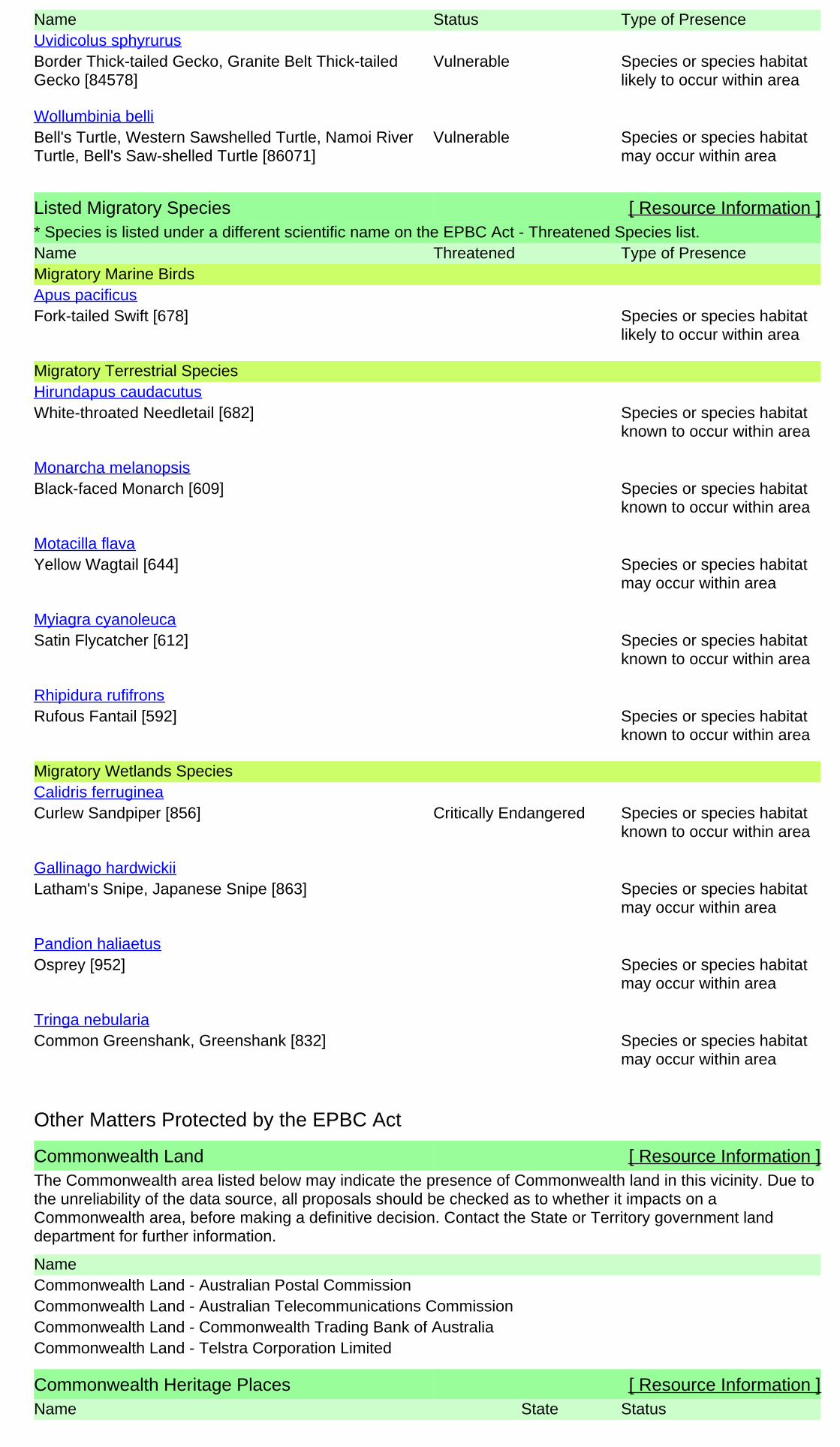
Name Status Type of Presence
Border Thick-tailed Gecko, Granite Belt Thick-tailedGecko [84578]
Vulnerable Species or species habitatlikely to occur within area
Uvidicolus sphyrurus
Bell's Turtle, Western Sawshelled Turtle, Namoi RiverTurtle, Bell's Saw-shelled Turtle [86071]
Vulnerable Species or species habitatmay occur within area
Wollumbinia belli
Listed Migratory Species [ Resource Information ]* Species is listed under a different scientific name on the EPBC Act - Threatened Species list.Name Threatened Type of PresenceMigratory Marine Birds
Fork-tailed Swift [678] Species or species habitatlikely to occur within area
Apus pacificus
Migratory Terrestrial Species
White-throated Needletail [682] Species or species habitatknown to occur within area
Hirundapus caudacutus
Black-faced Monarch [609] Species or species habitatknown to occur within area
Monarcha melanopsis
Yellow Wagtail [644] Species or species habitatmay occur within area
Motacilla flava
Satin Flycatcher [612] Species or species habitatknown to occur within area
Myiagra cyanoleuca
Rufous Fantail [592] Species or species habitatknown to occur within area
Rhipidura rufifrons
Migratory Wetlands Species
Curlew Sandpiper [856] Critically Endangered Species or species habitatknown to occur within area
Calidris ferruginea
Latham's Snipe, Japanese Snipe [863] Species or species habitatmay occur within area
Gallinago hardwickii
Osprey [952] Species or species habitatmay occur within area
Pandion haliaetus
Common Greenshank, Greenshank [832] Species or species habitatmay occur within area
Tringa nebularia
Commonwealth Land [ Resource Information ]The Commonwealth area listed below may indicate the presence of Commonwealth land in this vicinity. Due tothe unreliability of the data source, all proposals should be checked as to whether it impacts on aCommonwealth area, before making a definitive decision. Contact the State or Territory government landdepartment for further information.
NameCommonwealth Land - Australian Postal CommissionCommonwealth Land - Australian Telecommunications CommissionCommonwealth Land - Commonwealth Trading Bank of AustraliaCommonwealth Land - Telstra Corporation Limited
Commonwealth Heritage Places [ Resource Information ]Name StatusState
Other Matters Protected by the EPBC Act

Listed Marine Species [ Resource Information ]* Species is listed under a different scientific name on the EPBC Act - Threatened Species list.Name Threatened Type of PresenceBirds
Fork-tailed Swift [678] Species or species habitatlikely to occur within area
Apus pacificus
Great Egret, White Egret [59541] Species or species habitatknown to occur within area
Ardea alba
Cattle Egret [59542] Species or species habitatmay occur within area
Ardea ibis
Curlew Sandpiper [856] Critically Endangered Species or species habitatknown to occur within area
Calidris ferruginea
Latham's Snipe, Japanese Snipe [863] Species or species habitatmay occur within area
Gallinago hardwickii
White-bellied Sea-Eagle [943] Species or species habitatknown to occur within area
Haliaeetus leucogaster
White-throated Needletail [682] Species or species habitatknown to occur within area
Hirundapus caudacutus
Swift Parrot [744] Critically Endangered Species or species habitatlikely to occur within area
Lathamus discolor
Rainbow Bee-eater [670] Species or species habitatmay occur within area
Merops ornatus
Black-faced Monarch [609] Species or species habitatknown to occur within area
Monarcha melanopsis
Yellow Wagtail [644] Species or species habitatmay occur within area
Motacilla flava
Satin Flycatcher [612] Species or species habitatknown to occur within area
Myiagra cyanoleuca
Osprey [952] Species or species habitatmay occur within area
Pandion haliaetus
Rufous Fantail [592] Species or species habitatknown to occur within area
Rhipidura rufifrons
Painted Snipe [889] Endangered* Species or species habitatlikely to occur within area
Rostratula benghalensis (sensu lato)
Common Greenshank, Greenshank [832] Species or species habitatmay occur within area
Tringa nebularia
Name StatusStateHistoric
Listed placeGlen Innes Post Office NSW

State and Territory Reserves [ Resource Information ]Name StateBarayamal NSWBoorabee and The Willows NSWBooroolong NSWFladbury NSWGoonoowigal NSWGuy Fawkes River NSWIndwarra NSWKings Plains NSWLittle Llangothlin NSWMann River NSWMother Of Ducks Lagoon NSWSingle NSWTarriwa Kurrukun NSWThe Basin NSWTingha Plateau NSWUNE Special Management Zone No1 NSWUNE_LNE_OldGrowth NSWWarra NSWWattleridge NSW
Regional Forest Agreements [ Resource Information ]
Note that all areas with completed RFAs have been included.
Name StateNorth East NSW RFA New South Wales
Extra Information
Invasive Species [ Resource Information ]Weeds reported here are the 20 species of national significance (WoNS), along with other introduced plantsthat are considered by the States and Territories to pose a particularly significant threat to biodiversity. Thefollowing feral animals are reported: Goat, Red Fox, Cat, Rabbit, Pig, Water Buffalo and Cane Toad. Maps fromLandscape Health Project, National Land and Water Resouces Audit, 2001.
Name Status Type of PresenceBirds
Common Myna, Indian Myna [387] Species or species habitatlikely to occur within area
Acridotheres tristis
Mallard [974] Species or species habitatlikely to occur within area
Anas platyrhynchos
European Goldfinch [403] Species or species habitatlikely to occur within area
Carduelis carduelis
Rock Pigeon, Rock Dove, Domestic Pigeon [803] Species or species habitatlikely to occur within area
Columba livia

Name Status Type of Presence
Nutmeg Mannikin [399] Species or species habitatlikely to occur within area
Lonchura punctulata
House Sparrow [405] Species or species habitatlikely to occur within area
Passer domesticus
Spotted Turtle-Dove [780] Species or species habitatlikely to occur within area
Streptopelia chinensis
Common Starling [389] Species or species habitatlikely to occur within area
Sturnus vulgaris
Common Blackbird, Eurasian Blackbird [596] Species or species habitatlikely to occur within area
Turdus merula
Mammals
Domestic Cattle [16] Species or species habitatlikely to occur within area
Bos taurus
Domestic Dog [82654] Species or species habitatlikely to occur within area
Canis lupus familiaris
Goat [2] Species or species habitatlikely to occur within area
Capra hircus
Horse [5] Species or species habitatlikely to occur within area
Equus caballus
Cat, House Cat, Domestic Cat [19] Species or species habitatlikely to occur within area
Felis catus
Feral deer species in Australia [85733] Species or species habitatlikely to occur within area
Feral deer
Brown Hare [127] Species or species habitatlikely to occur within area
Lepus capensis
House Mouse [120] Species or species habitatlikely to occur within area
Mus musculus
Rabbit, European Rabbit [128] Species or species habitatlikely to occur within area
Oryctolagus cuniculus
Black Rat, Ship Rat [84] Species or species habitatlikely to occur within area
Rattus rattus
Pig [6] Species or species habitatlikely to occur within area
Sus scrofa
Red Fox, Fox [18] Species or species habitatlikely to occur within area
Vulpes vulpes
Plants
Madeira Vine, Jalap, Lamb's-tail, Mignonette Vine,Anredera, Gulf Madeiravine, Heartleaf
Species or species habitatlikely to occur
Anredera cordifolia

Nationally Important Wetlands [ Resource Information ]Name StateLittle Llangothlin Lagoon NSWNew England Wetlands NSW
Name Status Type of PresenceMadeiravine, Potato Vine [2643] within area
Bridal Creeper, Bridal Veil Creeper, Smilax, Florist'sSmilax, Smilax Asparagus [22473]
Species or species habitatlikely to occur within area
Asparagus asparagoides
Broom, English Broom, Scotch Broom, CommonBroom, Scottish Broom, Spanish Broom [5934]
Species or species habitatlikely to occur within area
Cytisus scoparius
Montpellier Broom, Cape Broom, Canary Broom,Common Broom, French Broom, Soft Broom [20126]
Species or species habitatlikely to occur within area
Genista monspessulana
Broom [67538] Species or species habitatmay occur within area
Genista sp. X Genista monspessulana
Lantana, Common Lantana, Kamara Lantana, Large-leaf Lantana, Pink Flowered Lantana, Red FloweredLantana, Red-Flowered Sage, White Sage, Wild Sage[10892]
Species or species habitatlikely to occur within area
Lantana camara
African Boxthorn, Boxthorn [19235] Species or species habitatlikely to occur within area
Lycium ferocissimum
Chilean Needle grass [67699] Species or species habitatlikely to occur within area
Nassella neesiana
Serrated Tussock, Yass River Tussock, Yass Tussock,Nassella Tussock (NZ) [18884]
Species or species habitatlikely to occur within area
Nassella trichotoma
Prickly Pears [82753] Species or species habitatlikely to occur within area
Opuntia spp.
Radiata Pine Monterey Pine, Insignis Pine, WildingPine [20780]
Species or species habitatmay occur within area
Pinus radiata
Blackberry, European Blackberry [68406] Species or species habitatlikely to occur within area
Rubus fruticosus aggregate
Willows except Weeping Willow, Pussy Willow andSterile Pussy Willow [68497]
Species or species habitatlikely to occur within area
Salix spp. except S.babylonica, S.x calodendron & S.x reichardtii
Fireweed, Madagascar Ragwort, MadagascarGroundsel [2624]
Species or species habitatlikely to occur within area
Senecio madagascariensis
Silver Nightshade, Silver-leaved Nightshade, WhiteHorse Nettle, Silver-leaf Nightshade, Tomato Weed,White Nightshade, Bull-nettle, Prairie-berry,Satansbos, Silver-leaf Bitter-apple, Silverleaf-nettle,Trompillo [12323]
Species or species habitatlikely to occur within area
Solanum elaeagnifolium
Gorse, Furze [7693] Species or species habitatlikely to occur within area
Ulex europaeus

- non-threatened seabirds which have only been mapped for recorded breeding sites
- migratory species that are very widespread, vagrant, or only occur in small numbers
- some species and ecological communities that have only recently been listed
Not all species listed under the EPBC Act have been mapped (see below) and therefore a report is a general guide only. Where available datasupports mapping, the type of presence that can be determined from the data is indicated in general terms. People using this information in makinga referral may need to consider the qualifications below and may need to seek and consider other information sources.
For threatened ecological communities where the distribution is well known, maps are derived from recovery plans, State vegetation maps, remotesensing imagery and other sources. Where threatened ecological community distributions are less well known, existing vegetation maps and pointlocation data are used to produce indicative distribution maps.
- seals which have only been mapped for breeding sites near the Australian continent
Such breeding sites may be important for the protection of the Commonwealth Marine environment.
Threatened, migratory and marine species distributions have been derived through a variety of methods. Where distributions are well known and iftime permits, maps are derived using either thematic spatial data (i.e. vegetation, soils, geology, elevation, aspect, terrain, etc) together with pointlocations and described habitat; or environmental modelling (MAXENT or BIOCLIM habitat modelling) using point locations and environmental datalayers.
The information presented in this report has been provided by a range of data sources as acknowledged at the end of the report.Caveat
- migratory and
The following species and ecological communities have not been mapped and do not appear in reports produced from this database:
- marine
This report is designed to assist in identifying the locations of places which may be relevant in determining obligations under the EnvironmentProtection and Biodiversity Conservation Act 1999. It holds mapped locations of World and National Heritage properties, Wetlands of Internationaland National Importance, Commonwealth and State/Territory reserves, listed threatened, migratory and marine species and listed threatenedecological communities. Mapping of Commonwealth land is not complete at this stage. Maps have been collated from a range of sources at variousresolutions.
- threatened species listed as extinct or considered as vagrants
- some terrestrial species that overfly the Commonwealth marine area
The following groups have been mapped, but may not cover the complete distribution of the species:
Only selected species covered by the following provisions of the EPBC Act have been mapped:
Where very little information is available for species or large number of maps are required in a short time-frame, maps are derived either from 0.04or 0.02 decimal degree cells; by an automated process using polygon capture techniques (static two kilometre grid cells, alpha-hull and convex hull);or captured manually or by using topographic features (national park boundaries, islands, etc). In the early stages of the distribution mappingprocess (1999-early 2000s) distributions were defined by degree blocks, 100K or 250K map sheets to rapidly create distribution maps. More reliabledistribution mapping methods are used to update these distributions as time permits.
-29.86924 151.59362
Coordinates

-Environment and Planning Directorate, ACT-Birdlife Australia-Australian Bird and Bat Banding Scheme
-Department of Parks and Wildlife, Western Australia
Acknowledgements
-Office of Environment and Heritage, New South Wales
-Department of Primary Industries, Parks, Water and Environment, Tasmania
-Department of Land and Resource Management, Northern Territory-Department of Environmental and Heritage Protection, Queensland
-Department of Environment and Primary Industries, Victoria
-Australian National Wildlife Collection
-Department of Environment, Water and Natural Resources, South Australia
This database has been compiled from a range of data sources. The department acknowledges the followingcustodians who have contributed valuable data and advice:
-Australian Museum
-National Herbarium of NSW
Forestry Corporation, NSW-Australian Government, Department of Defence
-State Herbarium of South Australia
The Department is extremely grateful to the many organisations and individuals who provided expert adviceand information on numerous draft distributions.
-Natural history museums of Australia
-Queensland Museum
-Australian National Herbarium, Canberra
-Royal Botanic Gardens and National Herbarium of Victoria
-Geoscience Australia
-Ocean Biogeographic Information System
-Online Zoological Collections of Australian Museums-Queensland Herbarium
-Western Australian Herbarium
-Tasmanian Herbarium
-Northern Territory Herbarium
-South Australian Museum
-Museum Victoria
-University of New England
-CSIRO
-Other groups and individuals-Tasmanian Museum and Art Gallery, Hobart, Tasmania
-Museum and Art Gallery of the Northern Territory
-Reef Life Survey Australia-Australian Institute of Marine Science-Australian Government National Environmental Science Program
-Australian Tropical Herbarium, Cairns
-Australian Government – Australian Antarctic Data Centre
-Queen Victoria Museum and Art Gallery, Inveresk, Tasmania
-eBird Australia
-American Museum of Natural History
© Commonwealth of Australia
+61 2 6274 1111
Canberra ACT 2601 Australia
GPO Box 787
Department of the Environment
Please feel free to provide feedback via the Contact Us page.

Biodiversity Assessment Report White Rock Wind Farm Modification
16 – 321 WRWF BAR Final v2 E‐I
APPENDIX E EPBC ACT ASSESSMENTS OF SIGNIFICANCE
The Environment Protection and Biodiversity Conservation Act 1999 specifies factors to be taken into account
in deciding whether a development is likely to significantly affect Endangered Ecological Communities,
threatened species and migratory species, listed at the Commonwealth level. The following assessment
assesses the significance of the likely impacts associated with the proposed works on:
White Box – Yellow Box – Blakeley’s Red Gum – Grassy Woodland and Derived Native Grassland
CEEC;
Bluegrass Dichanthium setosum;
Regent Honeyeater Anthochaera Phrygia; and
Koala Phascolarctos cinereus.
Different significant impact criteria apply depending on the level at which a species or community is listed (i.e.
vulnerable, endangered, critically endangered etc.). The appropriate criteria have been applied to the entities
listed above.
In the context of the assessments below, ‘the action’ refers to ‘the proposal’ as described in Section 1.
SIGNIFICANT IMPACT CRITERIA
An action is likely to have a significant impact on a vulnerable species if there is a real chance or possibility that it will:
lead to a long‐term decrease in the size of an important population of a species
reduce the area of occupancy of an important population
fragment an existing important population into two or more populations
adversely affect habitat critical to the survival of a species
disrupt the breeding cycle of an important population
modify, destroy, remove or isolate or decrease the availability or quality of habitat to the extent that the species is likely to decline
result in invasive species that are harmful to a vulnerable species becoming established in the vulnerable species’ habitat
introduce disease that may cause the species to decline, or
interfere substantially with the recovery of the species.
Each of these criteria are addressed below. An ‘important population’ is a population that is necessary for a species’ long‐term survival and recovery. This may include populations identified as such in recovery plans, and/or that are:
key source populations either for breeding or dispersal
populations that are necessary for maintaining genetic diversity, and/or
populations that are near the limit of the species range.

Biodiversity Assessment Report White Rock Wind Farm Modification
16 – 321 WRWF BAR Final v2 E‐II
E.1.1 White Box‐Yellow Box‐Blakely's Red Gum Grassy Woodland and Derived Native
Grassland Critically Endangered Ecological Community
a) reduce the extent of an ecological community?
The EPBC Act listing of White Box‐Yellow Box‐Blakely's Red Gum Grassy Woodland and Derived Native Grassland Critically Endangered Ecological Community (YBGW) is slightly different to the TSC Act listing of White Box‐Yellow Box‐Blakely's Red Gum Woodland Endangered Ecological Community. Areas that are part of the CEEC must have either:
An intact tree layer with a predominantly native understorey containing 12 or more native understorey species present (excluding grasses) with at least one important species present; or
An intact native ground layer with a high diversity of native plant species but no remaining tree layer.
The occurrence of Yellow box woodland within of the proposal site is considered to conform to the EPBC Act definition of the community, as the areas contain a floristic make up of that listed within the scientific determination. YBGW occurs within the proposal site as small to moderate patches of intact vegetation with large contiguous patches absent and surrounded by other vegetation communities. Areas containing a higher proportion of native understory species and a native canopy cover include turbine locations and access tracks have been avoided where possible however, approximately 7.95 ha of YBGW consistent with the EPBC Act definition will be removed as a result of the proposal. Existing and additional offset areas relating to proposal will ensure extent of this CEEC is improved or maintained.
b) fragment or increase fragmentation of an ecological community, for example by clearing vegetation for roads or transmission lines
The YBGW occurring within the proposal site exists within highly connected patches of remnant vegetation that has been utilised for historical agricultural landuse. Whilst some areas have been cleared previously as well as the introduction of exotic improved pastures, connectivity through the proposal site is high. Due to the linear nature of the proposal, associated infrastructure with proposal would result in the minor fragmentation of this habitat.
c) Will modify or destroy abiotic (non‐living) factors (such as water, nutrients, or soil) necessary for an ecological community’s survival, including reduction of groundwater levels, or substantial alteration of surface water drainage patterns
Whilst surface flows will be altered during construction, with mitigation measures implemented, it is considered unlikely that suitable abiotic habitat will be impacted as such that the ecological communities survival is at risk from the proposal.
d) cause a substantial change in the species composition of an occurrence of an ecological community, including causing a decline or loss of functionally important species, for example through regular burning or flora or fauna harvesting?
The proposal will remove an area of approximately 7.95 ha of intact YBGW. These areas are influenced by the invasion of exotic improved pasture species but contain enough native understorey to be considered as CEEC. As such, it will remove and modify the composition of the community. However, due to the linear of the proposal, areas of a higher quality can be avoided and although minor fragmentation would occur, the majority of the community will be retained and remain intact. This is considered likely to ensure that the species complexity and composition of the community remains similar within the proposal site, and within the locality. Existing and additional offset areas relating to project will ensure extent and condition of this CEEC in the broader locality is improved or maintained.
e) cause a substantial reduction in the quality or integrity of an occurrence of an ecological community, including, but not limited to:

Biodiversity Assessment Report White Rock Wind Farm Modification
16 – 321 WRWF BAR Final v2 E‐III
assisting invasive species, that are harmful to the listed ecological community, to become established, or
causing regular mobilisation of fertilisers, herbicides or other chemicals or pollutants into the ecological community which kill or inhibit the growth of species in the ecological community, or
interfere with the recovery of an ecological community
The proposal is not considered likely to generate an increase in invasive species harmful to the ecological community. Mitigation measures implemented during a construction will strictly manage and restrict weed movement through the proposal site.
It is considered unlikely that proposal would kill or inhibit the growth of the CEEC from the regular mobilisation of fertilisers, herbicides or other chemicals.
As YBGW occurs within the proposal site as small to moderate patches of intact vegetation with large contiguous patches absent, the proposal is may be considered likely to interfere with the recovery of the CEEC. The proposal may also be considered likely to exacerbate this impact to the point that it would constitute a substantial reduction in the quality or integrity of the CEEC within the proposal site.
Conclusion
The proposal will impact upon 7.95 ha of the CEEC, particularly through the construction of the access tracks
and turbine sites. This is may be considered likely to generate a significant impact to the community such that
it would no longer remain viable within the proposal site or locality, therefore referral is recommended.
Existing and additional offset areas relating to proposal will ensure extent of this CEEC is improved or
maintained. Potential indirect impacts such as altered hydrology are not considered likely to impact the
community.
E.1.2 Bluegrass Dichanthium setosum
a) Lead to a long‐term decrease in the size of an important population of a species?
An important population is defined as one that is necessary for a species' long‐term survival and recovery, and includes:
A key source population either for breeding or dispersal;
A population that is necessary for maintaining genetic diversity, and/or
A population that is near the limit of the species’ distribution range.
Initial environmental risk assessments for threatened species deemed Dichanthium setosum as having the highest potential and risk of being present within the proposal site. However, following targeted surveys, it is considered unlikely that a population of Dichanthium setosum exists within the proposal site. Targeted threatened species searches have been conducted during the flowering period of the species, and the species was not found. Further, any population occurring within the proposal site is not considered an important population, as the number of individuals would likely be low (based on the lack of detections during searches of the proposal site), indicating that it is not a key source population for dispersal or necessary for the maintenance of genetic diversity. As such, the population is not considered to constitute an important population of the species.
b) Reduce the area of occupancy of an important population
The species was not recorded within the proposal site. Any population of the species occurring within the proposal site is not considered to constitute an important population, therefore the proposal is not considered likely to reduce the area of occupancy of an important population.
c) Fragment an existing important population into two or more populations;

Biodiversity Assessment Report White Rock Wind Farm Modification
16 – 321 WRWF BAR Final v2 E‐IV
The species was not recorded within the proposal site. Any population of the species occurring within the proposal site is not considered to constitute an important population, therefore the proposal is considered unlikely to fragment an existing important population into two or more populations.
d) Adversely affect habitat critical to the survival of a species
The proposal will permanently impact approximately 72.55 ha of moderate/good condition habitat in addition to an area of approximately 83.55 ha of low condition and non‐optimal habitat. This habitat is not considered critical to the survival of the species, as the species has a wide distribution and a higher abundance within the New England Tablelands region. Further, critical habitat has not been declared for the species. As a result, the impacts to a these area for the species range are not considered likely to adversely affect habitat critical to the survival of a species.
e) Disrupt the breeding cycle of an important population
The species was not recorded within the proposal site. Any population of the species occurring within the proposal site is not considered to constitute an important population, therefore the proposal is not considered likely to disrupt the breeding cycle of an important population.
f) Modify, destroy, remove, isolate or decrease the availability or quality of habitat to the extent that the species is likely to decline
The extent of habitat modification and removal is not considered likely to occur to the extent that the species is likely to decline. Habitat for the species will be retained within the higher quality portion within the proposal site. Existing and additional offset areas relating to project will ensure extent and condition of this habitat in the broader locality is improved or maintained.
g) Result in invasive species that are harmful to an vulnerable species becoming established in the vulnerable species’ habitat
The proposal is considered unlikely to generate an increase in invasive species harmful to the species. The proposal is not considered likely to exacerbate this impact to the point that it would constitute a substantial reduction in the quality or integrity of the species habitat within the proposal site. Additionally, the proposal is not considered likely to generate an increase in feral herbivores such as Rabbits.
h) Introduce disease that may cause the species to decline;
The proposal is considered unlikely to introduce disease that may cause the species to decline.
i) Interfere substantially with the recovery of the species;
The proposal is considered unlikely to interfere with the recovery of the species, as the species is considered unlikely to occur within the proposal site, and the proposal will not impact on any known populations of the species.
Conclusion
The proposal is considered unlikely to significantly impact the species, as no known individuals or populations
of the species exist within the proposal site, the proposal will not impact on any known populations, and any
population occurring within the proposal site is not considered likely to constitute an important population of
the species. Existing and additional offset areas relating to proposal will ensure extent of habitat for this is
improved or maintained.
E.1.3 Regent Honeyeater Anthochaera phrygia
a) Lead to a long‐term decrease in the size of a population?
The Regent Honeyeater is listed as critically endangered. Regent Honeyeaters usually nest in horizontal branches or forks in tall mature eucalypts and She‐oaks and mistletoe. It is a generalist forager mainly feeding on nectar from Eucalypts. The species inhabits dry open forest and woodland, particularly Box‐

Biodiversity Assessment Report White Rock Wind Farm Modification
16 – 321 WRWF BAR Final v2 E‐V
Ironbark woodland, and riparian forests of River Sheoak. Regent Honeyeaters inhabit woodlands that support a significantly high abundance and species richness of bird species. The species has been recorded within the broader region but not within the study locality. The proposal will remove some potential foraging habitat for this species, however the extent of removal (approximately 7.95 ha) is considered unlikely to occur to the extent that a population utilising the proposal site as habitat would decrease in size in the long‐term.
b) reduce the area of occupancy of the species
The proposal will reduce the area of available suitable habitat by approximately 7.95 ha. The area of habitat to be removed is considered unlikely to significantly reduce the area of occupancy of the species, as a larger area of intact vegetation will be retained outside of proposal site. This area of vegetation contains a higher proportion of mature native canopy species. Further, the species is highly mobile and would likely only utilise the site on occasion.
c) Fragment an existing important population into two or more populations;
No population of the species is known from the site, however there is potential for the species to forage within the site on occasion. Habitat will be retained within the proposal site, and the proposal is therefore considered unlikely to fragment an existing population into two or more populations. Further, the species is highly mobile and would likely only utilise the site on occasion.
d) Adversely affect habitat critical to the survival of a species
The proposal will remove some potential foraging habitat for this species, however the extent of habitat removal (approximately 7.95 ha) is considered unlikely to adversely affect habitat critical to the survival of the species, as an area of suitable habitat will be retained within the proposal site. Additionally, no critical habitat for the species has been declared or occurs within the proposal site.
e) disrupt the breeding cycle of a population
It is considered unlikely that the species would breed within the proposal site. As such, the proposal is considered unlikely to disrupt the breeding cycle of a population.
f) modify, destroy, remove, isolate or decrease the availability or quality of habitat to the extent that the species is likely to decline
The extent of habitat modification and removal is considered unlikely to occur to the extent that the species is likely to decline. Habitat for the species will be retained within the higher quality portion of foraging habitat within the proposal site.
g) Result in invasive species that are harmful to a vulnerable species becoming established in the vulnerable species’ habitat
The proposal is considered unlikely to generate an increase in invasive species harmful to the species. The proposal is not considered likely to exacerbate this impact to the point that it would constitute a substantial reduction in the quality or integrity of the species habitat within the proposal site. Additionally, the proposal is not considered likely to generate an increase in feral herbivores such as Rabbits.
h) Introduce disease that may cause the species to decline;
The proposal is not considered likely to introduce disease that may cause the species to decline.
i) Interfere substantially with the recovery of the species;
The proposal is considered unlikely to interfere with the recovery of the species, as the species is considered unlikely to occur within the proposal site, and the proposal will not impact on any known populations of the species.
Conclusion
The proposal is considered unlikely to significantly impact the species, as the species is considered likely to only
utilise the proposal site as a foraging resource on occasion, and the highest quality remnant of foraging habitat

Biodiversity Assessment Report White Rock Wind Farm Modification
16 – 321 WRWF BAR Final v2 E‐VI
will be avoided and retained where possible. Existing and additional offset areas relating to proposal will ensure
extent of habitat for this is improved or maintained.
E.1.4 Koala Phascolarctos cinereus
a) Lead to a long‐term decrease in the size of a population?
Although there are historical records surrounding the proposal site, none of these are recorded within the last 20 years and therefore shows a lack evidence that the proposal site contains a significant population. No Koala’s or evidence of Koala activity were detected during the surveys. Due to the lack of evidence that a significant koala population exists within or near the proposal site and the linear nature of the clearing areas, it is unlikely that a population of Koalas or the Koalas ability to inhabit the area in future would be impacted to the extent that a population utilising the proposal site as habitat would decrease in size in the long‐term. Existing and additional offset areas relating to project will ensure extent and condition of this koala habitat in the broader locality is improved or maintained.
b) reduce the area of occupancy of the species
As discussed above, due to the lack of evidence that a significant koala population exists within or near the proposal site and the linear nature of the clearing areas, it is unlikely that a population of Koalas or the Koalas ability to inhabit the area in future and therefore would not reduce the occupancy of this species. Existing and additional offset areas relating to project will ensure extent and condition of this koala habitat in the broader locality is improved or maintained.
c) Fragment an existing important population into two or more populations;
As discussed above, although there are historical records surrounding the proposal site, none of these are recorded within the last 20 years and therefore shows a lack evidence that the proposal site contains a significant population. No Koala’s or evidence of Koala activity were detected during the surveys. Due to the lack of evidence that a significant koala population exists within or near the proposal site and the linear nature of the clearing areas, it is unlikely that a population of Koalas or the Koalas ability to inhabit the area in future would be impacted or fragmented in separate populations. Existing and additional offset areas relating to project will ensure extent and condition of this koala habitat in the broader locality is improved or maintained.
d) Adversely affect habitat critical to the survival of a species
The EPBC Act referral guidelines for the vulnerable koala (DoE, 2014) focus on the impacts of proposals to habitat critical to the survival of the koala. Table 4 of the guidelines provide a habitat assessment tool that allows for a flowchart to be followed in determining impacts to habitat critical to the survival of the species. This tool has been utilised in Section 7.4.4 of this BAR, and has determined that the habitat on site generates a score of 8. This score is higher than the minimum threshold of not constituting impacts to the species. Following the flowchart detailed below due, with the amount of vegetation being removed, it is considered likely that the proposal will adversely affect habitat critical to the survival of the koala, and indicates that a referral is recommended. However, due to the linear nature of the clearing and minimal fragmentation of habitat, and due to the lack of evidence that a significant koala population exists within or near the proposal site, in case a referral is not required. Existing and additional offset areas relating to project will ensure extent and condition of this koala habitat in the broader locality is improved or maintained.

Biodiversity Assessment Report White Rock Wind Farm Modification
16 – 321 WRWF BAR Final v2 E‐VII

Biodiversity Assessment Report White Rock Wind Farm Modification
16 – 321 WRWF BAR Final v2 E‐VIII
e) disrupt the breeding cycle of a population
As discussed above, the site is not considered to support an important population of the species. As such, the proposal is not considered likely to disrupt the breeding cycle of an important population. If a population was to occur within the locality it is considered likely to persist, as connectivity will be retained within the proposal site, and connectivity between patches enhanced in the long‐term. Existing and additional offset areas relating to project will ensure extent and condition of this koala habitat in the broader locality is improved or maintained.
f) modify, destroy, remove, isolate or decrease the availability or quality of habitat to the extent that the species is likely to decline
The extent of habitat modification and removal is considered unlikely to occur to the extent that the species is likely to decline. Existing and additional offset areas relating to project will ensure extent and condition of this koala habitat in the broader locality is improved or maintained.
g) Result in invasive species that are harmful to a vulnerable species becoming established in the vulnerable species’ habitat
The proposal is considered unlikely to generate an increase in invasive species harmful to the species. The proposal is not considered likely to exacerbate this impact to the point that it would constitute a substantial reduction in the quality or integrity of the species habitat within the proposal site. Additionally, the proposal is not considered likely to generate an increase in feral herbivores such as Rabbits.
h) Introduce disease that may cause the species to decline;
The proposal is not considered likely to introduce disease that may cause the species to decline.
i) Interfere substantially with the recovery of the species;
The EPBC Act referral guidelines for the vulnerable koala (DoE, 2014) list several potential impacts that could interfere substantially with the recovery of the species, including:
• Increasing koala fatalities in habitat critical to the survival of the koala due to dog attacks to a level that is likely to result in multiple, ongoing mortalities.
• Increasing koala fatalities in habitat critical to the survival of the koala due to vehicle‐strikes to a level that is likely to result in multiple, ongoing mortalities.
• Facilitating the introduction or spread of disease or pathogens for example Chlamydia or Phytophthora cinnamomi, to habitat critical to the survival of the koala, that are likely to significantly reduce the reproductive output of koalas or reduce the carrying capacity of the habitat.
• Creating a barrier to movement to, between or within habitat critical to the survival of the koala that is likely to result in a long‐term reduction in genetic fitness or access to habitat critical to the survival of the koala.
• Changing hydrology which degrades habitat critical to the survival of the koala to the extent that the carrying capacity of the habitat is reduced in the long‐term.
The proposal will aim to avoid koala mortality through the establishment of environmental no‐go areas within remnant patches, setting site speed limits, implementing hygiene protocols for plant and equipment, and through ensuring that hydrological regimes remain unaltered as far as is practical to ensure that adjacent remnant vegetation remains.
Conclusion
Although a substantive amount of vegetation is being removed from the proposal, the proposal is considered
unlikely to significantly impact the species due to the lack of evidence that a significant koala population exists
within or near the proposal site and the linear nature of the clearing areas. It is therefore unlikely that a
population of Koalas or the Koalas ability to inhabit the area in future would be impacted to the extent that a
population utilising the proposal site as habitat would decrease in size in the long‐term. Existing and additional
offset areas relating to proposal will ensure extent of habitat for this is improved or maintained.

Biodiversity Assessment Report White Rock Wind Farm Modification
16 – 321 WRWF BAR Final v2 F‐I
APPENDIX F EPBC HABITAT ASSESSMENT TABLE The tables present the habitat evaluation for threatened species, ecological communities and endangered populations within 10 kilometres of the proposal site
in the Atlas of NSW Wildlife2 and those identified as potentially occurring in the area according to the Commonwealth EPBC Protected Matters Search Tool3.
Databases were searched on 24 November 2015.
The likelihood of occurrence is based on presence of habitat, proximity of nearest records and mobility of the species (where relevant). The assessment of
potential impact is based on the nature of the proposal, the ecology of the species and its likelihood of occurrence. The following classifications are used:
Presence of habitat:
Present: Potential or known habitat is present within the study area
Marginal: Some suitable or non‐preferred habitat present within the study area
Absent: No potential or known habitat is present within the study area
Likelihood of occurrence
None: Species has never or is never likely to occur in the study area
Unlikely: Species known or predicted within the locality but unlikely to occur in the study area
Possible: Species could occur in the study area
Present: Species was recorded during the field investigations
Possible to be impacted
No: The proposal would not impact this species or its habitats. No Assessment of Significance (AoS) is necessary for this species
Yes: The proposal could impact this species or its habitats. An AOS has been applied to these entities.
2 The Atlas of NSW Wildlife is administered by the NSW Department of Environment, Climate Change and Water (OEH) and is an online database of fauna and flora records that contains over four million recorded sightings.
3 This online tool is designed for the public to search for matters protected under the Environment Protection and Biodiversity Conservation Act 1999 (EPBC Act). It is managed by the Commonwealth Department of the Environment, Water, Heritage and the Arts.

Biodiversity Assessment Report White Rock Wind Farm Modification
16 – 321 WRWF BAR Final v2 F‐II
Species
TSC Act/ FM Act
EPBC Act
Description of habitat4
Number of records (Bionet)
Presence of habitat
Likelihood of occurrence
Possible impact?
Plants
Acacia macnuttiana
Mcnutt's wattle
V V Acacia macnuttiana grows in shallow, rocky soils derived from leucogranite acid volcanics. The vegetation ranges from heath on rocky outcrops to dry sclerophyll forest on deeper soils. Altitudes range from approximately 500 to 1100 m above sea level. Flowering is mostly from August to September with occasional late flushes in October. Associated species include Allocasuarina littoralis, Angophora floribunda, Bursaria spinosa, Callistemon flavovirens, Eucalyptus biturbinata, Leptospermum brachyandra, Lophostemon confertus and Pomaderris sp. (Quinn et al. 1995; Sheringham & Westaway 1995).
0 Absent None No
Acacia pubifolia
Velvet wattle
E E Velvet Wattle is a shrub or small tree 3 ‐ 8 m tall with golden yellow flowers and dark‐grey bark. The leaves are hairy and feel like velvet. The adult leaves are straight or slightly curved, 2 ‐ 10 cm long and 8 ‐ 30 mm wide, with prominent veins and a rounded tip. Its flowers are clustered together in a long tube or spike 2 ‐ 5 cm long and appear during September‐October. Velvet Wattle generally grows in dry shrubby woodland on granite and metasediment soils.
0 Absent Unlikely No
Acacia ruppii
Rupp’s wattle
E E Rupp’s Wattle is an erect, open shrub, 1 – 2 m in height and spread, with spindly arching branches. It has smooth grey bark and flattened hairy branchlets. The leaves are crowded, about 1 – 2 cm long and 1 – 2 mm wide, and have a prominent midvein and a small point at the tip. The round flower heads are golden yellow, and are followed by flat seed pods 4 – 11 cm long.
Grows in the understorey below Needlebark Stringybark (Eucalyptus planchoniana), Red Bloodwood (Corymbia gummifera) and Smudgy Apple (Angophora woodsiana).
0 Absent None No
4 Information sourced from species profiles on NSW OEH’s threatened species database or the Australian Government’s Species Profiles and Threats database (SPRAT) unless otherwise stated.
OEH threatened species database: http://www.threatenedspecies.environment.nsw.gov.au/index.aspx SPRAT: http://www.environment.gov.au/cgi‐bin/sprat/public/sprat.pl

Biodiversity Assessment Report White Rock Wind Farm Modification
16 – 321 WRWF BAR Final v2 F‐III
Species
TSC Act/ FM Act
EPBC Act
Description of habitat4
Number of records (Bionet)
Presence of habitat
Likelihood of occurrence
Possible impact?
Almaleea cambagei
Torrington pea
E E Torrington Pea is a short, spindly shrub up to 2 m tall, with small leaves and orange‐yellow pea flowers. The leaves are 3 ‐ 10 mm long and 0.5 ‐1.5 mm wide with rounded tips. They have a minutely warty or rough underside and are pressed against the stems. The stems are covered with soft hairs. The brightly coloured flowers are about 5mm wide and grow at the end of the stems, but plants may be quite inconspicuous when not in flower. Small seed pods, 3 ‐ 5 mm long, follow the September‐November flowering period. Usually grows in wet heath and acid swamp areas and along watercourses on granite, above 900 m altitude.
0 Absent None No
Astrotricha roddii E E Rodd’s Star Hair is an upright, sparsely‐branched shrub 1 ‐ 3 m tall. The shiny, narrow leaves are 11 ‐ 18 cm long and 1 ‐ 2.5 cm wide with long pointed tips and hairy underside. The stems are covered with dense woolly hairs. The dull purplish flowers grow on stems up to 40 cm long, and appear during October‐February. Rod’s Star Hair is thought to be only short‐lived, with a life‐span of possibly less than 10 years. Rodd’s Star Hair usually grows in low dry woodland and shrublands on granite and acid volcanic outcrops, often in rock crevices.
0 Absent None No
Boronia granitica
Granite boronia
V E Granite Boronia is a medium‐sized shrub 0.6 ‐ 2 m tall. Its leaves are divided into nine to eleven leaflets with each leaflet about 2 ‐ 14 mm long and 1 ‐ 2.5 mm wide. When crushed, the leaves have a pungent scent. The leaflets and stems are covered with soft white hairs. Bright pink flowers 6 ‐ 10 mm long appear from July to October. Granite Boronia occurs in scattered localities on the New England Tablelands and North West Slopes north from the Armidale area to the Stanthorpe district in southern Queensland. It can be locally common in appropriate habitat. Grows on granitic soils amongst rock outcrops, often in rock crevices, and in forests and woodlands on granite scree and shallow soils
0 Absent None No
Callistemon pungens
V Callistemon pungens is a distinct shrub or small tree ranging from 2‐5 m tall. The leaves are 2‐3 cm long with a pungent tip 1‐2 mm long. The flower spike is 5‐6 cm long and 2.5‐4.5 cm in diameter. Habitats range from riparian areas dominated by Casuarina cunninghamiana subsp. cunninghamiana to woodland and rocky shrubland. The species is characterised by its purple stamens and small, pungent leaves.
0 Marginal None No

Biodiversity Assessment Report White Rock Wind Farm Modification
16 – 321 WRWF BAR Final v2 F‐IV
Species
TSC Act/ FM Act
EPBC Act
Description of habitat4
Number of records (Bionet)
Presence of habitat
Likelihood of occurrence
Possible impact?
Callitris oblonga
Pygmy pine
V V Pygmy Cypress Pine is a bushy shrub, to about 5 m tall but usually less with a pine or ‘Christmas tree’ appearance. It has pale green foliage and grey‐brown cones about 12 to 15 mm in diameter. It is generally smaller and grows in wetter, more easterly habitats than the more common Black Cypress Pine C. endlicheri or White Cypress Pine C. glaucophylla. Usually grows in sand along watercourses in shrubland and open woodland in granite country; it also occurs in drier sites, including exposed ridges
0 Absent None No
Cryptostylis hunteriana
Leafless Tongue‐orchid
V V The Leafless Tongue Orchid has no leaf. It produces an upright flower‐stem to 45 cm tall, bearing five to 10 flowers between November and February. This species has inconsistent flowering, with individuals not always flowering each season. It has been recorded from as far north as Gibraltar Range National Park south into Victoria around the coast as far as Orbost. It is known historically from a number of localities on the NSW south coast and has been observed in recent years at many sites between Batemans Bay and Nowra (although it is uncommon at all sites). In NSW there are Leafless Tongue‐orchid populations of unknown size in Washpool, Gibraltar Range, Ku‐ring‐gai Chase, Ben Boyd, Meroo, Morton, Murramarang, Jervis Bay and Lake Conjola National Parks as well as Cambewarra Range and Triplarina Nature Reserves. Brown (2007) indicates that this species is also present in Red Rocks (Yuraygri) National Park and is located on the Red Rocks Plateau in Cambewarra Range Nature Reserve. Also recorded at Nelson Bay, Wyee, Nowendoc State Forest, and two large populations near Bulahdelah. The species occurs mostly in coastal heathlands, margins of coastal swamps and sedgelands, coastal forest, dry woodland, and lowland forest. It prefers open areas in the understorey of forested communities. The soils include moist sands, moist to dry clay loam and occasionally in accumulated eucalypt leaves. The larger populations typically occur in woodland dominated by Scribbly Gum (Eucalyptus sclerophylla), Silvertop Ash (E. sieberi), Red Bloodwood (Corymbia gummifera) and Black Sheoak (Allocasuarina littoralis); appears to prefer open areas in the understorey of this community and is often found in association with the Large Tongue Orchid (C. subulata) and the Tartan Tongue Orchid (C. erecta). Little is known about the ecology of the species; being leafless it is expected to have limited photosynthetic capability and probably depends upon a fungal
0 Absent None No

Biodiversity Assessment Report White Rock Wind Farm Modification
16 – 321 WRWF BAR Final v2 F‐V
Species
TSC Act/ FM Act
EPBC Act
Description of habitat4
Number of records (Bionet)
Presence of habitat
Likelihood of occurrence
Possible impact?
associate to meet its nutritional requirements from either living or dead organic material. In addition to reproducing from seed, it is also capable of vegetative reproduction and thus forms colonies which can become more or less permanent at a site.
Dichanthium setosum
Bluegrass
V V Bluegrass occurs on the New England Tablelands, North West Slopes and Plains and the Central Western Slopes of NSW, extending to northern Queensland. It occurs widely on private property, including in the Inverell, Guyra, Armidale and Glen Innes areas. Associated with heavy basaltic black soils and red‐brown loams with clay subsoil. Often found in moderately disturbed areas such as cleared woodland, grassy roadside remnants and highly disturbed pasture. (Often collected from disturbed open grassy woodlands on the northern tablelands, where the habitat has been variously grazed, nutrient‐enriched and water‐enriched). It is open to question whether the species tolerates or is promoted by a certain amount of disturbance, or whether this is indicative of the threatening processes behind its depleted habitat. Associated species include Eucalyptus albens, Eucalyptus melanophloia, Eucalyptus melliodora, Eucalyptus viminalis, Myoporum debile, Aristida ramosa, Themeda triandra, Poa sieberiana, Bothriochloa ambigua, Medicago minima, Leptorhynchos squamatus, Lomandra aff. longifolia, Ajuga australis, Calotis hispidula and Austrodanthonia, Dichopogon, Brachyscome, Vittadinia, Wahlenbergia and Psoralea species. Locally common or found as scattered clumps in broader populations. The extensive distribution and wide environmental tolerances make predictions about suitable habitat difficult.
1 Present Possible No – not detected during surveys.
Diuris ochroma E E Terestrial orchid with 3‐4 linear leaves to 30 cm long. Plants have pale yellow flowers (about 25 mm across) with reddish‐purple striations, on a stem to 40 cm long. Flowers from November to December, although flowering times are thought to be variable. Open grassy woodland of Eucalyptus viminalis / E. pauciflora or E. pauciflora / E. parvula (or secondary grassland).
0 Absent Unlikely No ‐ not detected during surveys.
Diuris pedunculata E E The Small Snake Orchid is a member of the ‘Donkey’ orchid group, with bright yellow striped flowers and two drooping side petals. The flowering stem is less than 10 cm tall and has one or two flowers with dark stripes. The top petal is more orange than the rest of the flower and has a bright purple centre. The two
0 Marginal Unlikely No ‐ not detected during surveys.

Biodiversity Assessment Report White Rock Wind Farm Modification
16 – 321 WRWF BAR Final v2 F‐VI
Species
TSC Act/ FM Act
EPBC Act
Description of habitat4
Number of records (Bionet)
Presence of habitat
Likelihood of occurrence
Possible impact?
thin leaves are up to 16cm long. Also on shale and trap soils, on fine granite, and among boulders. It flowers during August‐October.
Eucalyptus caleyi subsp. ovendenii
V V Eucalyptus caleyi is one of a group of related rough‐barked species which have concolorous (uniform in colour) adult leaves. It is a medium‐sized tree 25 m tall with grey‐black, hard, rough and deeply corrugated bark. Its leaves are dull blue‐green. The adult leaves are narrower than the juvenile leaves, being 1 ‐ 4 cm wide and 5 ‐ 10 cm long. The gumnuts are egg‐ or pear‐shaped, 6 ‐ 12 mm long and 5 ‐ 7 mm in diameter, and grow in groups of seven. Ovenden’s Ironbark is distinguished from the closely related Caley’s Ironbark (Eucalyptus caleyi subsp. caleyi) by its four‐angled buds and gumnuts. Associated species include Eucalyptus melliodora, Eucalyptus dealbata, Eucalyptus albens, Eucalyptus melanophloia and Geijera parviflora. Preferred altitudes are 610 to 820 m, on granitic substrates. Ovenden's Ironbark occupies a higher geographical range than that of subspecies caleyi, occurring on the crests of broad high ridges and replacing subspecies caleyi inhabiting the lower slopes in the same general area
0 Marginal Unlikely No
Eucalyptus mckieana
Mckie Stingybark
V V A medium sized tree about 25 m tall with red‐brown stringy or fibrous bark extending to the ends of the branches. The juvenile leaves are bristly and very narrow, and adult leaves are glossy or grey‐green, 6 ‐ 9 cm long and 1 ‐ 2 cm wide. The gumnuts are ball‐shaped, 5 ‐ 7 mm wide, and grow clustered in groups of eleven or more. Associated species at Northern Tablelands sites include Angophora floribunda, Eucalyptus amplifolia, Eucalyptus andrewsii, Eucalyptus bridgesiana, Eucalyptus youmanii, Eucalyptus nicholii, Eucalyptus blakelyi and Eucalyptus conica, and at North Western Slopes sites Eucalyptus andrewsii, Eucalyptus stannicola, Eucalyptus prava and Angophora floribunda.
8 Present Unlikely No ‐ not detected during surveys.
Eucalyptus nicholii
Narrow‐leaved Black Peppermint
V V A medium‐sized tree 15 – 20 m tall with rough, thick, grey‐brown bark which extends to the larger branches. This species is widely planted as an urban street tree and in gardens but is quite rare in the wild. It is confined to the New England Tablelands of NSW, where it occurs from Nundle to north of Tenterfield, largely on private property. It occurs in grassy or sclerophyll woodland in association with many other eucalypts that grow in the area, including E. andrewsii and many of the stringybarks, such as E. caliginosa. Grows on shallow relatively infertile soils on shales and slates; Niangala to Glen Innes. The species is reserved
15 Present Unlikely No ‐ not detected during surveys.

Biodiversity Assessment Report White Rock Wind Farm Modification
16 – 321 WRWF BAR Final v2 F‐VII
Species
TSC Act/ FM Act
EPBC Act
Description of habitat4
Number of records (Bionet)
Presence of habitat
Likelihood of occurrence
Possible impact?
in Single National Park and also in Oxley Wild Rivers National Park. The distribution of this species overlaps with the following EPBC Act‐listed threatened ecological communities: White Box‐Yellow Box‐Blakely’s Red Gum Grassy Woodland and Derived Native Grassland, and Upland Wetlands of the New England Tablelands and the Monaro Plateau.
Eucalyptus rubida subsp. barbigerorum
V V A large tree to 40 m tall. It has thick, black bark on the lower trunk and powdery, white, grey, red or pink bark on the upper trunk and branches, which is shed in long ribbons. Its juvenile leaves are oval and dull blue‐green. The adult leaves are narrower, dull green to grey, 9 ‐ 15 cm long and 1 ‐ 2.5 cm wide. The gumnuts are cylindrical or ball‐shaped, 4 ‐ 6 mm long and 5 ‐7 mm wide, and grow in groups of three to seven. Grassy woodland on medium or high fertility soils
0 Present Unlikely No ‐ not detected during surveys.
Grevillea beadleana E E Beadle’s Grevillea is a spreading shrub, up to 2.5 m tall and wide. It has dissected and rather soft leaves about 12 ‐ 16 cm long. There are short hairs on the upper surface and the lower surface is thickly felted with curled hairs. The scarlet flowers are the ‘tooth‐brush’ type and are held prominently at the ends of the branchlets. The fruit is a hairy capsule that splits into two at maturity. Known from four separate areas, all in north‐east NSW: the Torrington area west of Tenterfield, Oxley Wild Rivers National Park, Guy Fawkes River National Park and at Shannon Creek south‐west of Grafton. Historical records suggest it was also once found near Walcha. It is usually found on steep granite slopes at high altitudes, although the population at Shannon Creek is at a lower elevation on sandstone
0 Absent Unlikely No
Haloragis exalata subsp. velutina
V V Tall Velvet Sea‐berry is a shrub to 1.5 m high. The stems are ribbed and square in section. The velvety leaves are opposite, 50 ‐ 60 mm long, 6 ‐ 8 mm wide and have finely toothed margins. The three to seven small yellowish green flowers form where the leaf joins the stem and are followed by tiny pear‐shaped fruit 2 mm long. This subspecies also occurs in woodland on the steep rocky slopes of gorges
0 Absent Unlikely No
Homoranthus prolixus V V Granite Homoranthus is a horizontally spreading shrub about 80 cm high with the ends of the branches growing upwards. The dull, blue‐green leaves are paired on the stem, with successive pairs at right angles to each other, and 3 ‐ 6
0 Absent Unlikely No

Biodiversity Assessment Report White Rock Wind Farm Modification
16 – 321 WRWF BAR Final v2 F‐VIII
Species
TSC Act/ FM Act
EPBC Act
Description of habitat4
Number of records (Bionet)
Presence of habitat
Likelihood of occurrence
Possible impact?
mm long and 0.5 ‐ 1 mm wide, with a tapered tip. The red to yellow flowers are about 5 mm long and grow in the upper part of the branches, with one to six flowers on each branch. Homoranthus prolixus is characterised by the low spreading habit and short and more or less glaucous (dull blue green in colour with whitish bloom) leaves. Homoranthus prolixus grows in heath patches, in skeletal soil among crevices of granite outcrops
Lepidium peregrinum E E A spreading soft‐stemmed perennial herb to sub‐shrub 10 ‐ 80 cm tall but sometimes ascending to 2 m in surrounding vegetation. At the base of the plant are divided leaves 15 cm long with the leaf edges fringed with eyelash‐like hairs. The leaves higher up the stem are toothed, 2 ‐ 6 cm long and 1 ‐ 8 mm wide, with a pointed tip. The small flowers are less than 1 mm long, growing off a horizontal or drooping, hairy flowering stem. Associated species at the Clifton site are dominated by Eucalyptus camaldulensis and Casuarina cunninghamiana, with a variably dense shrubby understorey of Hymenanthera dentata, Bursaria spinosa, Acacia fimbriata, Acacia floribunda, Callistemon viminalis and Leptospermum brachyandrum. Lepidium peregrinum was most abundant in the tussock grassland fringe of the riparian open forest, comprising Poa species, Lomandra longifolia and Paspalum dilatatum.
0 Absent Unlikely No
Macadamia integrifolia V The Macadamia Nut is a medium‐sized tree which can grow to approximately 20 m in height with a similar crown width, giving the tree a rounded shape (Barry & Thomas 1994; Queensland CRA/RFA Steering Committee 1997; Ryan 2006; Stanley & Ross 1986). The leaves are simple, narrow‐elliptical to narrow‐oblong in shape, tough, dark green and occur on branchlets in groups of three. Leaves are 10–15 cm long (Barry & Thomas 1994; Gross 1995; Ryan 2006). Juvenile leaves have a serrated edge but mature leaves have a smooth margin (Ryan 2006). The flowers are cream or creamy‐white in colour and occur on racemes up to 30 cm long (Barry & Thomas 1994; Gross 1995; Forster et al. 1991; Ryan 2006; Stanley & Ross 1986). The racemes originate at the leaf axil (Barry & Thomas 1994). The fruit are a hard brown nut encased in a green leathery outer shell with a 2–3 cm diameter (Barry & Thomas 1994; Ryan 2006). The smooth brown nut contains an edible kernel (Ryan 2006). Does not grow naturally in NSW.
0 Absent Unlikely No

Biodiversity Assessment Report White Rock Wind Farm Modification
16 – 321 WRWF BAR Final v2 F‐IX
Species
TSC Act/ FM Act
EPBC Act
Description of habitat4
Number of records (Bionet)
Presence of habitat
Likelihood of occurrence
Possible impact?
Micromyrtus grandis E Severn River Heath‐myrtle is an upright shrub 1 ‐4 m tall, with paired leaves. Its leaves are smooth or finely toothed, 0.5 ‐ 4 mm long and 0.5 ‐ 1.5 mm wide, with obvious oil dots (visible when the leaf is held up against the light). The tiny cream to pink flowers appear during July‐September, growing in the upper part of the branches. Severn River Heath‐myrtle is distinguished by its overall size which is the largest yet known in the genus and by the 5‐ribbed fruit, stalked flowers and broader leaves compared to other species in its range. Associated species within low woodland include Eucalyptus crebra, Allocasuarina inophloia, Acacia sp. aff. pubifolia, Xanthorrhoea johnsonii; in heath the association comprises Leptospermum novae‐angliae, Micromyrtus sessilis and Leucopogon neo‐anglicus
0 Absent Unlikely No
Prasophyllum petilum E E Natural populations are known from a total of five sites in NSW. These are at Boorowa, Captains Flat, Ilford, Delegate and a newly recognised population c.10 k SE of Muswellbrook. It also occurs at Hall in the Australian Capital Territory. This species has also been recorded at Bowning Cemetery where it was experimentally introduced, though it is not known whether this population has persisted. Grows in open sites within Natural Temperate Grassland at the Boorowa and Delegate sites. Also grows in grassy woodland in association with River Tussock Poa labillardieri, Black Gum Eucalyptus aggregata and tea‐trees Leptospermum spp. at Captains Flat and within the grassy groundlayer dominated by Kanagroo Grass under Box‐Gum Woodland at Ilford (and Hall, ACT).
0 Absent Unlikely No
Picris evae
Hawkweed
V V Hawkweed is a soft‐stemmed annual plant to 130 cm tall with most of the leaves growing around the base of the plant. The leaves are sometimes toothed, have a pointed tip, and are sparsely hairy with split‐end hairs (the hairs divided into two for half their length). Leaves are 2.5 ‐ 15 cm long and 4 ‐ 30 mm wide. The small, yellow flowers grow in dense heads 8 ‐ 10 mm wide at the ends of the stems. Its main habitat is open Eucalypt forest including a canopy of Eucalyptus melliodora, E. crebra, E. populnea, E. albens, Angophora subvelutina, Allocasuarina torulosa , and/or Casuarina cunninghamiana with a Dichanthium grassy understory
1 Present Unlikely No ‐ not detected during surveys.

Biodiversity Assessment Report White Rock Wind Farm Modification
16 – 321 WRWF BAR Final v2 F‐X
Species
TSC Act/ FM Act
EPBC Act
Description of habitat4
Number of records (Bionet)
Presence of habitat
Likelihood of occurrence
Possible impact?
Prasophyllum sp. Wybong
CE Prasophyllum sp. Wybong is a terrestrial orchid that grows to approximately 30 cm high. It has a single dull‐green basal leaf that is tubular and fleshy. The single flower spike has numerous fragrant flowers. Known to occur in open eucalypt woodland and grassland
0 Present Unlikely No ‐ not detected during surveys.
Prostanthera staurophylla
E E Torrington Mint‐bush is an upright shrub 0.4 ‐1.5 m tall. It has light green leaves with numerous glands and curled under edges. The leaves are either narrow like pine needles or deeply divided into lobes, each lobe 5 ‐ 14 mm long and 1 mm wide. The purple, blue or white flowers are 8 ‐ 12 mm long. Torrington Mint‐bush has a strong minty smell when crushed. Within its only current known population, the species occurs in shallow skeletal soil in rock crevices. The site is an exposed granite outcrop near the mountain summit, with skeletal gritty loam soil
0 Absent Unlikely No
Rutidosis heterogama
Heath wrinklewort
V V A perennial herb with decumbent (reclining to lying down) to erect stems, growing to 30 cm high. Scattered coastal locations between Wyong and Evans Head, and on the New England Tablelands from Torrington and Ashford south to Wandsworth south‐west of Glen Innes. Grows in heath on sandy soils and moist areas in open forest, and has been recorded along disturbed roadsides. Occurs on moist sites in open forest and in sedgeland/heathland within shrubby open forest and woodland, at 860–1040 m above sea level, on granitic substrates in podsolic and lithosolic soils. Flowers are borne March to April, chiefly in Autumn or November to January.
0 Marginal Unlikely No
Tasmannia glaucifolia V V A bushy shrub growing up to 3 m tall. It has glossy deep green leaves 4 ‐ 6 cm long and 4 ‐ 15 mm wide, with fine lumps on the underside, and maroon branches. The small white flowers are followed by shiny, deep purple‐black berries which are held in groups of one to three. When crushed, the leaves have a spicy or peppery smell. Known from several locations at high altitude in north east NSW, including the Ben Halls Gap, Point Lookout and Barrington Tops areas. Usually grows in or near Antarctic Beech Nothofagus moorei rainforest along streams in mountain areas at altitudes of between 1200 and 1500 m altitude.
0 Absent Unlikely No

Biodiversity Assessment Report White Rock Wind Farm Modification
16 – 321 WRWF BAR Final v2 F‐XI
Species
TSC Act/ FM Act
EPBC Act
Description of habitat4
Number of records (Bionet)
Presence of habitat
Likelihood of occurrence
Possible impact?
Thesium australe
Austral Toadflax
V V An erect perennial herb to 40 cm high. Found in very small populations scattered across eastern NSW, along the coast, and from the Northern to Southern Tablelands. It is also found in Tasmania and Queensland and in eastern Asia. Occurs in grassland or grassy woodland, often found in damp sites in association with Kangaroo Grass (Themeda australis). A root parasite that takes water and some nutrients from other plants, especially Kangaroo Grass. Flowering is predominantly in spring and summer.
12 Present Possible No ‐ not detected during surveys.
Tylophora linearis E E Slender, almost hairless twiner with a clear sap. Leaves dark green, linear, 1‐5 cm long, 0.5‐3 mm wide. Flowers purplish, 3‐6 mm in diameter, in radiating groups of 3‐8. Fruit is cigar shaped, up to 100mm long and approximately 5 mm diameter, hairless. Majority of records occur in the central western region. Records from Goonoo, Pillaga West, Pillaga East, Bibblewindi, Cumbil and Eura State Forests, Coolbaggie NR, Goobang NP and Beni SCA. Also has been recorded Hiawatha State Forest near West Wyalong in the south and there are old records as far north as Crow Mountain near Barraba and near Glenmorgan in the western Darling Downs. Grows in dry scrub and open forest. Recorded from low‐altitude sedimentary flats in dry woodlands of Eucalyptus fibrosa, Eucalyptus sideroxylon, Eucalyptus albens, Callitris endlicheri, Callitris glaucophylla and Allocasuarina luehmannii.
0 Absent Unlikely No
Tylophora woollsii E E Grows in wet sclerophyll forest and rainforest in the Clouds Creek area near Nymboida and in sclerophyll forest near Parramatta
0 Absent Unlikely No
Zieria ingramii E E Slender, spindly shrub to 0.6 m high, with ridged branches. Leaves composed of 3 narrow leaflets, each 9‐19 mm long and 1‐3 mm wide, dotted with oil glands above. Flowers with 4 white to pale pink petals about 3 mm long, hairy outside and hairless inside. Fruit composed of 4 slightly warted fruitlets. Associated and understorey species include Eucalyptus crebra, E. fibrosa, E. dwyeri, E. beyeriana, E. microcarpa, Callitris endlicheri, Allocasuarina diminuta, A. distyla, A. verticillata, Leptospermum divaricatum, L. parvifolium, Acacia triptera, Acacia gladiiformis, Acacia brownii, Grevillea floribunda, G. triternata, Hakea decurrens, Boronia glabra, Philotheca salsolifolia, Leucopogon attenuatus, Melaleuca uncinata, M. erubescens, Kunzea parvifolia, Calytrix tetragona, Brachyloma
0 Absent Unlikely No

Biodiversity Assessment Report White Rock Wind Farm Modification
16 – 321 WRWF BAR Final v2 F‐XII
Species
TSC Act/ FM Act
EPBC Act
Description of habitat4
Number of records (Bionet)
Presence of habitat
Likelihood of occurrence
Possible impact?
daphnoides, Melichrus urceolatus, Cassinia aculeata, Dodonaea viscosa subsp. spatulata, D. peduncularis, D. heteromorpha, Dillwynia sericea, Hibbertia riparia, Dampiera lanceolata, Dianella longifolia, Prostanthera species and Goodenia species. Known predominately from Goonoo SCA, about 40 km north‐east of Dubbo. An old record exists from a locality east of Mogriguy on the Mendooran Road, however searches of the area have not relocated the species. One record also occurs within Kings Plains National Park, 48 km south of Inverell.
Endangered Ecological Communities
New England Peppermint (Eucalyptus nova‐anglica) Woodland on Basalts and Sediments in the New England Tableland Bioregion
CEEC CE This woodland community is dominated by trees of New England Peppermint (Eucalyptus nova‐anglica) and occasionally Mountain Gum (E. dalrympleana subsp. Heptantha), and is usually 8‐20 metres tall. The woodland has a predominantly grassy understorey with few shrubs. The species present at a site will vary according to recent rainfall or drought condition and the degree of disturbance (including fire). In NSW all sites are within the New England Tablelands. This community is or has been known to occur in the Armidale Dumaresq, Guyra, Inverell, Severn and Tenterfield Local Government Areas, but may occur elsewhere on the New England Tablelands. It has recently been identified in eastern portions of Namoi CMA on the tablelands. Reserves containing the community include Bolivia Hill, Boorolong, Mount Duval, Yina and Imbota Nature Reserves and Warra National Park. The community occurs primarily in valley flats subject to cold air drainage. The valley flats are composed of basaltic soils, fine‐grained sedimentary and acid volcanic substrates with poorly drained loam‐clay soils.
N/A Present Unlikely No
Upland Wetlands of the Drainage Divide of the New England Tableland Bioregion
EEC E This community is composed of a series of high altitude wetlands in the New England Tablelands of Northern NSW. The wetlands have small local catchments, and range from shallow and temporary to near‐permanent wetlands. Vegetation is usually a combination of sedges, rushes, spike‐rushes, grasses and other aquatic plants, occurring either on the shores of open water or extending across shallow or dry wetland beds, and can die back during dry periods. These wetlands are important habitat for a range of native wildlife. Known to occur between the Tenterfield and Uralla Local Government Areas but may occur elsewhere within the New England Tablelands. Generally above 900m
N/A Absent Unlikely No

Biodiversity Assessment Report White Rock Wind Farm Modification
16 – 321 WRWF BAR Final v2 F‐XIII
Species
TSC Act/ FM Act
EPBC Act
Description of habitat4
Number of records (Bionet)
Presence of habitat
Likelihood of occurrence
Possible impact?
altitude and associated with basalt soils. Not connected to river systems by floodplains.
White Box Yellow Box Blakely’s Red Gum Woodland
EEC CE Box‐Gum Woodland is found from the Queensland border in the north, to the Victorian border in the south. It occurs in the tablelands and western slopes of NSW. Characterised by the presence or prior occurrence of White Box, Yellow Box and/or Blakely's Red Gum. The trees may occur as pure stands, mixtures of the three species or in mixtures with other trees, including wattles. Commonly co‐occurring eucalypts include Apple Box (E. bridgesiana), Red Box (E. polyanthemos), Candlebark (E. rubida), Snow Gum (E. pauciflora), Argyle Apple (E. cinerea), Brittle Gum (E. mannifera), Red Stringybark (E. macrorhyncha), Grey Box (E. microcarpa), Cabbage Gum (E. amplifolia) and others.
N/A Present Present AoS completed
Aves
Anthochaera Phrygia
Regent Honeyeater
CE CE The Regent Honeyeater mainly inhabits temperate woodlands and open forests of the inland slopes of south‐east Australia. Birds are also found in drier coastal woodlands and forests in some years. There are only three known key breeding regions remaining: north‐east Victoria (Chiltern‐Albury), and in NSW at Capertee Valley and the Bundarra‐Barraba region. In NSW the distribution is very patchy and mainly confined to the two main breeding areas and surrounding fragmented woodlands. In some years non‐breeding flocks converge on flowering coastal woodlands and forests. The species inhabits dry open forest and woodland, particularly Box‐Ironbark woodland, and riparian forests of River She‐oak. Regent Honeyeaters inhabit woodlands that support a significantly high abundance and species richness of bird species. These woodlands have significantly large numbers of mature trees, high canopy cover and abundance of mistletoes. Every few years non‐breeding flocks are seen foraging in flowering coastal Swamp Mahogany and Spotted Gum forests, particularly on the central coast and occasionally on the upper north coast. Birds are occasionally seen on the south coast. The Regent Honeyeater is a generalist forager, which mainly feeds on the nectar from a wide range of eucalypts and mistletoes. Key eucalypt species include Mugga Ironbark, Yellow Box, Blakely’s Red Gum, White Box and Swamp Mahogany. Also utilises E. maculata, E. polyanthemos, E. mollucana,
0 Present Unlikely AoS completed

Biodiversity Assessment Report White Rock Wind Farm Modification
16 – 321 WRWF BAR Final v2 F‐XIV
Species
TSC Act/ FM Act
EPBC Act
Description of habitat4
Number of records (Bionet)
Presence of habitat
Likelihood of occurrence
Possible impact?
Corymbia robusta, E. crebra, E. caleyi, Corymbia gummifera, E. mckieana, E. macrorhyncha, E. laevopinea, and Angophora floribunda. Nectar and fruit from the mistletoes A. miquelii, A. pendula and A. cambagei are also eaten during the breeding season. When nectar is scarce lerp and honeydew comprise a large proportion of the diet. A shrubby understorey is an important source of insects and nesting material. The species breeds between July and January in Box‐Ironbark and other temperate woodlands and riparian gallery forest dominated by River Sheoak. Regent Honeyeaters usually nest in horizontal branches or forks in tall mature eucalypts and Sheoaks. Also nest in mistletoe haustoria.
Apus pacificus
Fork‐tailed Swift
M This species breeds in the north‐east and mid‐east Asia and winters in Australia and southern New Guinea. It is a visitor to most parts of Western Australia, beginning to arrive in the Kimberley in late September, in the Pilbara and Eucla in November and in the south‐west land division in mid‐December, and leaving by late April. It is common in the Kimberley, uncommon to moderately common near north‐west, west and southeast coasts and rare to scarce elsewhere. They never settle voluntarily on the ground and spend most of their lives in the air, living on the insects they catch in their beaks.
0 Absent Unlikely No
Ardea alba
Great Egret
M The Eastern Great Egret has been reported in a wide range of wetland habitats (for example inland and coastal, freshwater and saline, permanent and ephemeral, open and vegetated, large and small, natural and artificial). These include swamps and marshes; margins of rivers and lakes; damp or flooded grasslands, pastures or agricultural lands; reservoirs; sewage treatment ponds; drainage channels; salt pans and salt lakes; salt marshes; estuarine mudflats, tidal streams; mangrove swamps; coastal lagoons; and offshore reefs. The species usually frequents shallow waters. Eastern Great Egrets usually nest in colonies and rarely as solitary pairs. In Australia, breeding sites are located in wooded and shrubby swamps including mangrove forests (the main habitat of the species in the Top End), Melaleuca swamps (on the eastern coast of Australia and south‐western Western Australia) and mixed eucalypt/acacia/lignum swamps (in the Channel
0 Present Possible No

Biodiversity Assessment Report White Rock Wind Farm Modification
16 – 321 WRWF BAR Final v2 F‐XV
Species
TSC Act/ FM Act
EPBC Act
Description of habitat4
Number of records (Bionet)
Presence of habitat
Likelihood of occurrence
Possible impact?
Country and Murray‐Darling Basin). The Eastern Great Egret has a diverse diet that includes fish, insects, crustaceans, molluscs, frogs, lizards, snakes and small birds and mammal.
Ardea ibis
Cattle Egret
M The Cattle Egret is found in grasslands, woodlands and wetlands, and is not common in arid areas. It also uses pastures and croplands, especially where drainage is poor. Will also forage at garbage dumps, and is often seen with cattle and other stock. The Cattle Egret is partially migratory, moving during winter. The Cattle Egret prefers grasshoppers, especially during breeding season, but eats many other invertebrates. It also eats frogs, cane toads, lizards and some small mammals. Its sharp bill is used in a lunging and stabbing manner. It often feeds by following large animals such as cattle, grabbing insects and worms that they disturb with their feet. They also will sit on cattle to look out for insects. Cattle Egret pairs are monogamous for the breeding season, and they breed in colonies, usually with other waterbirds. Their shallow platform nests are made in wetland areas in trees and bushes, usually as high up as possible. Both parents build the nest and incubate the eggs, with one brood per season being raised.
0 Present Possible No
Botaurus poiciloptilus
Australasian Bittern
E E In NSW, this species occurs along the coast and is frequently recorded in the Murray‐Darling Basin, notably in floodplain wetlands of the Murrumbidgee, Lachlan, Macquarie and Gwydir Rivers. Occurs in permanent freshwater wetlands with tall, dense vegetation. Favours permanent and seasonal freshwater habitats, particularly those dominated by sedges, rushes and/or reeds (e.g. Phragmites, Cyperus, Eleocharis, Juncus, Typha, Baumea, , Bolboschoenus) or cutting grass (Gahnia) growing over muddy or peaty substrate. Hides during the day amongst dense reeds or rushes and feed mainly at night on frogs, fish, yabbies, spiders, insects and snails. Feeding platforms may be constructed over deeper water from reeds trampled by the bird; platforms are often littered with prey remains. Breeding occurs in summer from October to January; nests are built in secluded places in densely‐vegetated wetlands on a platform of reeds; there are usually six olive‐brown eggs to a clutch. In Australia, the Bittern occurs with the Australian Painted Snipe Rostratula benghalensis australis.
0 Absent Unlikely No
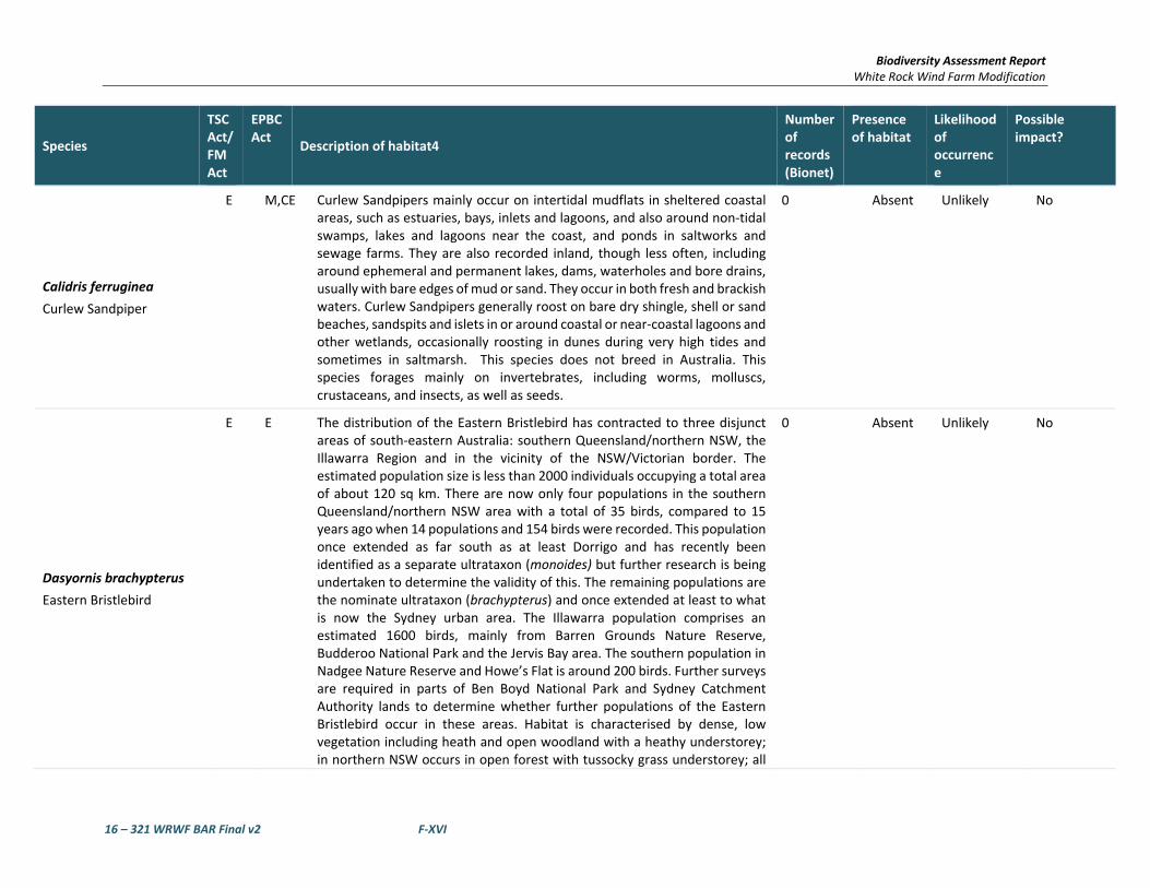
Biodiversity Assessment Report White Rock Wind Farm Modification
16 – 321 WRWF BAR Final v2 F‐XVI
Species
TSC Act/ FM Act
EPBC Act
Description of habitat4
Number of records (Bionet)
Presence of habitat
Likelihood of occurrence
Possible impact?
Calidris ferruginea
Curlew Sandpiper
E M,CE Curlew Sandpipers mainly occur on intertidal mudflats in sheltered coastal areas, such as estuaries, bays, inlets and lagoons, and also around non‐tidal swamps, lakes and lagoons near the coast, and ponds in saltworks and sewage farms. They are also recorded inland, though less often, including around ephemeral and permanent lakes, dams, waterholes and bore drains, usually with bare edges of mud or sand. They occur in both fresh and brackish waters. Curlew Sandpipers generally roost on bare dry shingle, shell or sand beaches, sandspits and islets in or around coastal or near‐coastal lagoons and other wetlands, occasionally roosting in dunes during very high tides and sometimes in saltmarsh. This species does not breed in Australia. This species forages mainly on invertebrates, including worms, molluscs, crustaceans, and insects, as well as seeds.
0 Absent Unlikely No
Dasyornis brachypterus
Eastern Bristlebird
E E The distribution of the Eastern Bristlebird has contracted to three disjunct areas of south‐eastern Australia: southern Queensland/northern NSW, the Illawarra Region and in the vicinity of the NSW/Victorian border. The estimated population size is less than 2000 individuals occupying a total area of about 120 sq km. There are now only four populations in the southern Queensland/northern NSW area with a total of 35 birds, compared to 15 years ago when 14 populations and 154 birds were recorded. This population once extended as far south as at least Dorrigo and has recently been identified as a separate ultrataxon (monoides) but further research is being undertaken to determine the validity of this. The remaining populations are the nominate ultrataxon (brachypterus) and once extended at least to what is now the Sydney urban area. The Illawarra population comprises an estimated 1600 birds, mainly from Barren Grounds Nature Reserve, Budderoo National Park and the Jervis Bay area. The southern population in Nadgee Nature Reserve and Howe’s Flat is around 200 birds. Further surveys are required in parts of Ben Boyd National Park and Sydney Catchment Authority lands to determine whether further populations of the Eastern Bristlebird occur in these areas. Habitat is characterised by dense, low vegetation including heath and open woodland with a heathy understorey; in northern NSW occurs in open forest with tussocky grass understorey; all
0 Absent Unlikely No

Biodiversity Assessment Report White Rock Wind Farm Modification
16 – 321 WRWF BAR Final v2 F‐XVII
Species
TSC Act/ FM Act
EPBC Act
Description of habitat4
Number of records (Bionet)
Presence of habitat
Likelihood of occurrence
Possible impact?
of these vegetation types are fire prone. Age of habitat since fires (fire‐age) is of paramount importance to this species; Illawarra and southern populations reach maximum densities in habitat that has not been burnt for at least 15 years; however, in the northern NSW population a lack of fire in grassy forest may be detrimental as grassy tussock nesting habitat becomes unsuitable after long periods without fire; northern NSW birds are usually found in habitats burnt five to 10 years previously. Shy and cryptic and rarely flies, although can be seen scampering over the ground; when approached, may move to a lookout perch 1 m or more above the ground, then retreat into dense vegetation. Feeds on a variety of insects, particularly ants. Nests are elliptical domes constructed on or near the ground amongst dense vegetation. Suitable habitat is present in upland swamps and heaths.
Erythrotriorchis radiates
Red Goshawk
CE V The Red Goshawk is a large, reddish‐brown hawk with long and broad wings, deeply 'fingered' wing‐tips, and heavy yellow legs. The species is distributed sparsely through northern and eastern Australia, from the western Kimberley Division of northern Western Australia to north‐eastern Queensland and south to far north‐eastern NSW, and with scattered records in central Australia. The species is very rare in NSW, extending south to about 30°S, with most records north of this, in the Clarence River Catchment, and a few around the lower Richmond and Tweed Rivers. Formerly, it was at least occasionally reported as far south as Port Stephens. Red Goshawks inhabit open woodland and forest, preferring a mosaic of vegetation types, a large population of birds as a source of food, and permanent water, and are often found in riparian habitats along or near watercourses or wetlands. In NSW, preferred habitats include mixed subtropical rainforest, Melaleuca swamp forest and riparian Eucalyptus forest of coastal rivers.
0 Absent Unlikely No
Gallinago hardwickii
Latham’s Snipe
M In Australia, Latham's Snipe occurs in permanent and ephemeral wetlands up to 2000 m above sea‐level. They usually inhabit open, freshwater wetlands with low, dense vegetation (e.g. swamps, flooded grasslands or heathlands, around bogs and other water bodies). However, they can also occur in habitats with saline or brackish water, in modified or artificial habitats, and in habitats located close to humans or human activity. Latham's
1 Absent Unlikely No

Biodiversity Assessment Report White Rock Wind Farm Modification
16 – 321 WRWF BAR Final v2 F‐XVIII
Species
TSC Act/ FM Act
EPBC Act
Description of habitat4
Number of records (Bionet)
Presence of habitat
Likelihood of occurrence
Possible impact?
Snipe does not breed within Australian jurisdiction. Latham's Snipe is an omnivorous species that feeds on seeds and other plant material (mainly from species in families such as Cyperaceae, Poaceae, Juncaceae, Polygonaceae, Ranunculaceae and Fabaceae), and on invertebrates including insects (mainly flies and beetles), earthworms and spiders and occasionally molluscs, isopods and centipedes.
Geophaps scripta scripta
Squatter Pigeon (southern)
CE V In New South Wales, the Squatter Pigeon (southern) is thought to have formerly occurred in woodlands dominated in the overstorey by Eucalyptus species, intersected with patches of Acacia species and stands of Cypress Pine (Callitris columellaris) and which have a groundcover of grasses and herbs. The species are restricted to habitats that are mostly dominated in the overstorey by Eucalyptus, Corymbia, Acacia or Callitris species and within 3 km of water bodies or courses.
0 Marginal Unlikely No
Grantiella picta
Painted Honeyeater
V V The Painted Honeyeater is nomadic and occurs at low densities throughout its range. The greatest concentrations of the bird and almost all breeding occurs on the inland slopes of the Great Dividing Range in NSW, Victoria and southern Queensland. During the winter it is more likely to be found in the north of its distribution. Inhabits Boree, Brigalow and Box‐Gum Woodlands and Box‐Ironbark Forests. A specialist feeder on the fruits of mistletoes growing on woodland eucalypts and acacias. Prefers mistletoes of the genus Amyema. Insects and nectar from mistletoe or eucalypts are occasionally eaten. Nest from spring to autumn in a small, delicate nest hanging within the outer canopy of drooping eucalypts, she‐oak, paperbark or mistletoe branches.
0 Marginal Unlikely No
Hirundapus caudacutus
White‐throated Needletail
M White‐throated Needletails often occur in large numbers over eastern and northern Australia. They arrive in Australia from their breeding grounds in the northern hemisphere in about October each year and leave somewhere between May and August. They are aerial birds and for a time it was commonly believed that they did not land while in Australia. It has now been observed that birds will roost in trees, and radio‐tracking has since confirmed that this is a regular activity. The White‐throated Needletail feeds on flying insects, such as termites, ants, beetles and flies. They catch the insects in
0 Marginal Unlikely No

Biodiversity Assessment Report White Rock Wind Farm Modification
16 – 321 WRWF BAR Final v2 F‐XIX
Species
TSC Act/ FM Act
EPBC Act
Description of habitat4
Number of records (Bionet)
Presence of habitat
Likelihood of occurrence
Possible impact?
flight in their wide gaping beaks. Birds usually feed in rising thermal currents associated with storm fronts and bushfires and they are commonly seen moving with wind fronts. White‐throated Needletails are non‐breeding migrants in Australia.
Lathamus discolour
Swift Parrot
E CE Breeds in Tasmania during spring and summer, migrating in the autumn and winter months to south‐eastern Australia from Victoria and the eastern parts of South Australia to south‐east Queensland. In NSW mostly occurs on the coast and south west slopes. On the mainland they occur in areas where eucalypts are flowering profusely or where there are abundant lerp (from sap‐sucking bugs) infestations. Favoured feed trees include winter flowering species such as Swamp Mahogany Eucalyptus robusta, Spotted Gum Corymbia maculata, Red Bloodwood C. gummifera, Mugga Ironbark E. sideroxylon, and White Box E. albens. Commonly used lerp infested trees include Grey Box E. moluccana and Blackbutt E. pilularis. Return to home foraging sites on a cyclic basis depending on food availability.
0 Present Unlikely No
Merops ornatus
Rainbow Bee‐eater
M The Rainbow Bee‐eater is found throughout mainland Australia, as well as eastern Indonesia, New Guinea and, rarely, the Solomon Islands. In Australia it is widespread, except in desert areas, and breeds throughout most of its range, although southern birds move north to breed. The Rainbow Bee‐eater is most often found in open forests, woodlands and shrublands, and cleared areas, usually near water. It will be found on farmland with remnant vegetation and in orchards and vineyards. It will use disturbed sites such as quarries, cuttings and mines to build its nesting tunnels. Southern populations move north, often in huge flocks, during winter; northern populations are present year round. Rainbow Bee‐eaters eat insects, mainly catching bees and wasps, as well as dragonflies, beetles, butterflies and moths. They catch flying insects on the wing and carry them back to a perch to beat them against it before swallowing them. Bees and wasps are rubbed against the perch to remove the stings and venom glands.
0 Present Unlikely No
Monarcha melanopsis
Black‐faced Monarch
M The Black‐faced Monarch is found along the coast of eastern Australia, becoming less common further south. The Black‐faced Monarch is found in rainforests, eucalypt woodlands, coastal scrub and damp gullies. It may be
0 Marginal Unlikely No

Biodiversity Assessment Report White Rock Wind Farm Modification
16 – 321 WRWF BAR Final v2 F‐XX
Species
TSC Act/ FM Act
EPBC Act
Description of habitat4
Number of records (Bionet)
Presence of habitat
Likelihood of occurrence
Possible impact?
found in more open woodland when migrating. Resident in the north of its range, but is a summer breeding migrant to coastal south‐eastern Australia, arriving in September and returning northwards in March. The Black‐faced Monarch forages for insects among foliage, or catches flying insects on the wing. The Black‐faced Monarch builds a deep cup nest of casuarina needles, bark, roots, moss and spider web in the fork of a tree, about 3 m to 6 m above the ground. Only the female builds the nest, but both sexes incubate the eggs and feed the young.
Motacilla flava
Yellow Wagtail
M This species occupies a range of damp or wet habitats with low vegetation, from damp meadows, marshes, waterside pastures, sewage farms and bogs to damp steppe and grassy tundra. In the north of its range it is also found in large forest clearings. It breeds from April to August, although this varies with latitude. The nest is a grass cup lined with hair and placed on or close to the ground in a shallow scrape. Normally it lays four to six eggs. It feeds on a wide variety of terrestrial and aquatic invertebrates as well as some plant material, particularly seeds.
0 Absent Unlikely No
Myiagra cyanoleuca
Satin Flycatcher
M The Satin Flycatcher is found along the east coast of Australia from far northern Queensland to Tasmania, including south‐eastern South Australia. It is also found in New Guinea. The Satin Flycatcher is not a commonly seen species, especially in the far south of its range, where it is a summer breeding migrant. The Satin Flycatcher is found in tall forests, preferring wetter habitats such as heavily forested gullies, but not rainforests. The Satin Flycatcher is a migratory species, moving northwards in winter to northern Queensland and Papua New Guinea, returning south to breed in spring. The Satin Flycatcher takes insects on the wing, foraging actively from perches in the mid to upper canopy.
0 Absent Unlikely No
Pandion cristatus
Eastern Osprey
V M The breeding range of the Eastern Osprey extends around the northern coast of Australia (including many offshore islands) from Albany in Western Australia to Lake Macquarie in NSW. In NSW, the breeding population occurs from the Queensland border (contiguous with the Queensland population) south to Gosford and recently (2005‐2007) to Sydney, with a more recent (2008) breeding attempt recorded further south at Ulladulla, where a bird
0 Absent Unlikely No

Biodiversity Assessment Report White Rock Wind Farm Modification
16 – 321 WRWF BAR Final v2 F‐XXI
Species
TSC Act/ FM Act
EPBC Act
Description of habitat4
Number of records (Bionet)
Presence of habitat
Likelihood of occurrence
Possible impact?
has been observed nest‐building (Clancy 2008, 2009). Vagrants occur south to and beyond the Victorian border. Forages over clear estuarine and inshore marine waters and coastal rivers, and nests in tall (usually dead or dead‐topped) trees in coastal habitats from open woodland to open forest, within 1‐2 km of water. Build a large stick bowl usually in the top of a dead or partly dead tree, from isolated trees in open country to open forest, with prominent emergent perches nearby (e.g. dead trees). The species is increasingly seen making use of artificial structures for nest sites and lookout perches (e.g. power pylons, towers, bridges) and purpose‐built nest platforms on poles. A clutch of usually three eggs is laid in winter, with a single attempt per season. The incubation period is about 38 days, the nestling period 9‐11 weeks, and the post‐fledging dependence period lasts two to three months. Breeding productivity is 0.9‐1.1 young per pair per year in NSW. Feed mostly on surface‐swimming, schooling fish caught by diving into water. Highly mobile and dispersive.
Poephila cincta cincta
Southern Black‐throated Finch
E The Black‐throated Finch (southern) occurs at two general locations: in the Townsville region, where it is considered to be locally common at a few sites around Townsville and Charters Towers; and at scattered sites in central‐eastern Queensland. The Black‐throated Finch (southern) occurs mainly in grassy, open woodlands and forests, typically dominated by Eucalyptus, Corymbia and Melaleuca, and occasionally in tussock grasslands or other habitats (for example freshwater wetlands), often along or near watercourses, or in the vicinity of water.
1 Marginal Unlikely No
Rhipidura rufifrons
Rufous Fantail
M The Rufous Fantail is found in northern and eastern coastal Australia, being more common in the north. It is also found in New Guinea, the Solomon Islands, Sulawesi and Guam. The Rufous Fantail is found in rainforest, dense wet forests, swamp woodlands and mangroves, preferring deep shade, and is often seen close to the ground. During migration, it may be found in more open habitats or urban areas. Strongly migratory in the south of its range, it moves northwards in winter, and virtually disappears from Victoria and New South Wales at this time. The Rufous Fantail feeds on insects, which it gleans
0 Marginal Unlikely No

Biodiversity Assessment Report White Rock Wind Farm Modification
16 – 321 WRWF BAR Final v2 F‐XXII
Species
TSC Act/ FM Act
EPBC Act
Description of habitat4
Number of records (Bionet)
Presence of habitat
Likelihood of occurrence
Possible impact?
from the middle and lower levels of the canopy. It is a very active feeder and constantly fans tail and flicks wings and body while foraging.
Rostratula australis
Australian Painted Snipe
E E Little is known of the ecology, habitat requirements and reproductive biology of Australian Painted Snipe. They feed in shallow water or at the waters' edge and on mudflats, taking seeds and invertebrates such as insects, worms, molluscs and crustaceans. Most records of Australian Painted Snipe are from temporary or infrequently filled freshwater wetlands and although they have occurred at many sites, no site can be identified in which they are resident or regular in occurrence. This may suggest the species is nomadic but the extent to which its cryptic behaviour may contribute to this belief is uncertain. The birds are able to remain hidden in rank vegetation, but many reports are of birds not being secretive, but rather still and unobtrusive. Primarily occurs along the east coast from north Queensland (excluding Cape York) to the Eyre Peninsula in South Australia, including the majority of Victoria and NSW. In NSW, this species has been recorded at the Paroo wetlands, Lake Cowell, Macquarie Marshes and Hexham Swamp. Most common in the Murray‐Darling Basin. Inhabits inland and coastal shallow freshwater wetlands. The species occurs in both ephemeral and permanent wetlands, particularly where there is a cover of vegetation, including grasses, Lignum and Samphire. Individuals have also been known to use artificial habitats, such as sewage ponds, dams and waterlogged grassland.
0 Absent Unlikely No
Tringa nebularia
Greenshank
M The Common Greenshank is found in a wide variety of inland wetlands and sheltered coastal habitats of varying salinity. It occurs in sheltered coastal habitats, typically with large mudflats and saltmarsh, mangroves or seagrass. Habitats include embayments, harbours, river estuaries, deltas and lagoons and are recorded less often in round tidal pools, rock‐flats and rock platforms. The species uses both permanent and ephemeral terrestrial wetlands, including swamps, lakes, dams, rivers, creeks, billabongs, waterholes and inundated floodplains, claypans and saltflats. It will also use artificial wetlands, including sewage farms and saltworks dams, inundated rice crops and bores. The edges of the wetlands used are generally of mud or clay, occasionally of sand, and may be bare or with emergent or fringing
0 Absent Unlikely No

Biodiversity Assessment Report White Rock Wind Farm Modification
16 – 321 WRWF BAR Final v2 F‐XXIII
Species
TSC Act/ FM Act
EPBC Act
Description of habitat4
Number of records (Bionet)
Presence of habitat
Likelihood of occurrence
Possible impact?
vegetation, including short sedges and saltmarsh, mangroves, thickets of rushes, and dead or live trees. It was once recorded with Black‐winged Stilts (Himantopus himantopus) in pasture, but are generally not found in dry grassland.
Amphibians
Litoria booroolongensis
Booroolong Frog
E E The Booroolong Frog is restricted to NSW and north‐eastern Victoria, predominantly along the western‐flowing streams of the Great Dividing Range. It has disappeared from much of the Northern Tablelands, however several populations have recently been recorded in the Namoi catchment. The species is rare throughout most of the remainder of its range. Live along permanent streams with some fringing vegetation cover such as ferns, sedges or grasses. Adults occur on or near cobble banks and other rock structures within stream margins. Shelter under rocks or amongst vegetation near the ground on the stream edge. Sometimes bask in the sun on exposed rocks near flowing water during summer.
0 Absent Unlikely No
Litoria castanea
Yellow‐spotted Tree Frog
CE E Historically, this species occurred in two separate highland ranges: on the New England Tableland, and on the southern and central tablelands from Bathurst to Bombala. The species require large permanent ponds or slow flowing 'chain‐of‐ponds' streams with abundant emergent vegetation such as bulrushes and aquatic vegetation. Adults are active during spring and summer and bask on sunny days and move and forage at night on grassy banks or float on the water's surface. Males call at night from the open water and breeding generally occurs during or following rain. Eggs are laid amongst aquatic vegetation. Shelter during autumn and winter under fallen timber, rocks, other debris or thick vegetation.
0 Absent Unlikely No
Litoria piperata
Peppered Tree Frog
CE V The Peppered Tree Frog has been recorded from five streams on the Northern Tablelands and is distributed from the Gibraltar Ranges to south of Armidale. This species has been found in streamside vegetation and under rocks and fallen timber along rocky streams flowing eastward from the Tablelands at altitudes of 800 to 1120 m.
0 Absent Unlikely No

Biodiversity Assessment Report White Rock Wind Farm Modification
16 – 321 WRWF BAR Final v2 F‐XXIV
Species
TSC Act/ FM Act
EPBC Act
Description of habitat4
Number of records (Bionet)
Presence of habitat
Likelihood of occurrence
Possible impact?
Mixophyes balbus
Stuttering Frog
E V Stuttering Frogs occur along the east coast of Australia from southern Queensland to north‐eastern Victoria. Considered to have disappeared from Victoria and to have undergone considerable range contraction in NSW, particularly in south‐east NSW. It is the only Mixophyes species that occurs in south‐east NSW and in recent surveys it has only been recorded at three locations south of Sydney. The Dorrigo region, in north‐east NSW, appears to be a stronghold for this species. The species is found in rainforest and wet, tall open forest in the foothills and escarpment on the eastern side of the Great Dividing Range. Outside the breeding season adults live in deep leaf litter and thick understorey vegetation on the forest floor and feed on insects and smaller frogs. The species breed in streams during summer after heavy rain. Eggs are laid on rock shelves or shallow riffles in small, flowing streams. As the tadpoles grow they move to deep permanent pools and take approximately 12 months to metamorphose.
0 Absent Unlikely No
Mammals
Chalinolobus dwyeri
Large‐eared Pied Bat
V V Found mainly in areas with extensive cliffs and caves, from Rockhampton in Queensland south to Bungonia in the NSW Southern Highlands. It is generally rare with a very patchy distribution in NSW. Roosts in caves (near their entrances), crevices in cliffs, old mine workings and in the disused, bottle‐shaped mud nests of the Fairy Martin (Hirundo ariel), frequenting low to mid‐elevation dry open forest and woodland close to these features. Females have been recorded raising young in maternity roosts (c. 20‐40 females) from November through to January in roof domes in sandstone caves. Found in well‐timbered areas containing gullies. This species probably forages for small, flying insects below the forest canopy. Likely to hibernate through the coolest months. It is uncertain whether mating occurs early in winter or in spring.
0 Present – Foraging only
Unlikely No
Dasyurus maculatus maculatus (SE mainland population)
Spot‐tailed Quoll
V E Found on the east coast of NSW, Tasmania, eastern Victoria and north‐eastern Queensland. Recorded across a range of habitat types, including rainforest, open forest, woodland, coastal heath and inland riparian forest, from the sub‐alpine zone to the coastline. Individual animals use hollow‐
2 Present Unlikely No

Biodiversity Assessment Report White Rock Wind Farm Modification
16 – 321 WRWF BAR Final v2 F‐XXV
Species
TSC Act/ FM Act
EPBC Act
Description of habitat4
Number of records (Bionet)
Presence of habitat
Likelihood of occurrence
Possible impact?
bearing trees, fallen logs, small caves, rock crevices, boulder fields and rocky‐cliff faces as den sites. Mostly nocturnal, although will hunt during the day; spends most of the time on the ground. The home‐range of this species is unknown, but estimates are between 800ha and 20km2. Usually traverse their ranges along densely vegetated creek lines. They need suitable den sites and abundant food, requiring large areas of intact vegetation for foraging. Use ‘latrine sites’, often on flat rocks among boulder fields and rocky cliff‐faces; latrine sites can be recognised by the accumulation of the sometimes characteristic ‘twisty‐shaped’ faeces deposited by animals. Consumes a variety of prey, including gliders, possums, small wallabies, rats, birds, bandicoots, rabbits and insects; also eats carrion and takes domestic fowl.
Nyctophilus corbeni
Corben's Long‐eared Bat
V V The south eastern form of the Greater Long‐eared Bat is also known as Eastern Long‐eared Bat and has recently been described as new species Corben's Long‐eared Bat (N. corbeni). Overall, the distribution of the south eastern form coincides approximately with the Murray Darling Basin with the Pilliga Scrub region being the distinct stronghold for this species. The species inhabits a variety of vegetation types, including mallee, bulloke Allocasuarina leuhmanni and box eucalypt dominated communities, but it is distinctly more common in box/ironbark/cypress‐pine vegetation that occurs in a north‐south belt along the western slopes and plains of NSW and southern Queensland. Roosts in tree hollows, crevices, and under loose bark. Slow flying agile bat, utilising the understorey to hunt non‐flying prey ‐ especially caterpillars and beetles ‐ and will even hunt on the ground. Mating takes place in autumn with one or two young born in late spring to early summer.
0 Present Unlikely No
Petrogale penicillata
Brush‐tailed Rock‐wallaby
E V The range of the Brush‐tailed Rock‐wallaby extends from south‐east Queensland to the Grampians in western Victoria, roughly following the line of the Great Dividing Range. The species’ range is now fragmented, particularly in the south where they are now mostly found as small isolated populations dotted across their former range. In NSW they occur from the Queensland border in the north to the Shoalhaven in the south, with the population in the Warrumbungle Ranges being the western limit. Occupy
1 Absent Unlikely No

Biodiversity Assessment Report White Rock Wind Farm Modification
16 – 321 WRWF BAR Final v2 F‐XXVI
Species
TSC Act/ FM Act
EPBC Act
Description of habitat4
Number of records (Bionet)
Presence of habitat
Likelihood of occurrence
Possible impact?
rocky escarpments, outcrops and cliffs with a preference for complex structures with fissures, caves and ledges facing north. Throughout their range, Brush‐tailed Rock‐wallabies feed on a wide variety of grasses and shrubs, and have flexible dietary requirements. Shelter or bask during the day in rock crevices, caves and overhangs and are most active at night.
Phascolarctos cinereus
Koala
V V Occurs in eastern Australia, from north‐eastern Queensland to south‐eastern South Australia and to the west of the Great Dividing Range. In NSW it mainly occurs on the central and north coasts with some populations in the western region. It was historically abundant on the south coast of NSW, but now occurs in sparse and possibly disjunct populations. The koala inhabits a range of eucalypt forest and woodland communities, including coastal forests, the woodlands of the tablelands and western slopes, and the riparian communities of the western plains. Examples of important shelter trees are cypress pine and brush box. The quality of forest and woodland communities as habitat for koalas is influenced by a range of factors, such as; species and size of trees present; structural diversity of the vegetation; soil nutrients; climate and rainfall; size and disturbance history of the habitat patch. Feed on the foliage of more than 70 eucalypt species and 30 non‐eucalypt species, but in any one area will select preferred browse species. Home range size varies with quality of habitat, ranging from less than two ha to several hundred hectares in size. Breeding season for the koala peaks between September and February.
5 Present Possible AoS completed
Potorous tridactylus tridactylus
Long‐nosed Potoroo (SE mainland)
V V In NSW it is generally restricted to the east of the Great Dividing Range, with an annual rainfall exceeding 760 mm. Inhabits coastal heaths and dry and wet sclerophyll forests. Dense understorey with occasional open areas is an essential part of habitat, and may consist of grass‐trees, sedges, ferns or heath, or of low shrubs of tea‐trees or melaleucas. A sandy loam soil is also a common feature. The main habitat requirements would appear to be access to some form of dense vegetation for shelter and the presence of an abundant supply of fungi for food. The fruit‐bodies of hypogeous (underground‐fruiting) fungi are a large component of the diet of the Long‐nosed Potoroo. They also eat roots, tubers, insects and their larvae and other
0 Absent Unlikely No

Biodiversity Assessment Report White Rock Wind Farm Modification
16 – 321 WRWF BAR Final v2 F‐XXVII
Species
TSC Act/ FM Act
EPBC Act
Description of habitat4
Number of records (Bionet)
Presence of habitat
Likelihood of occurrence
Possible impact?
soft‐bodied animals in the soil. Individuals are mainly solitary, non‐territorial and have home range sizes ranging between 2‐5 ha. Breeding peaks typically occur in late winter to early summer.
Pseudomys novaehollandiae
New Holland Mouse
V The New Holland Mouse has a fragmented distribution across Tasmania, Victoria, New South Wales and Queensland. Known to inhabit open heathlands, open woodlands with a heathland understorey and vegetated sand dunes. Lives predominantly in burrows shared with other individuals. The home range of the New Holland Mouse ranges from 0.44 ha to 1.4 ha. Breeding typically occurs between August and January, but can extend into autumn. The species peaks in abundance during early to mid‐stages of vegetation succession typically induced by fire. Nocturnal and omnivorous, feeding on seeds, insects, leaves, flowers and fungi, and is therefore likely to play an important role in seed dispersal and fungal spore dispersal.
0 Absent Unlikely No
Pseudomys oralis
Hastings River Mouse
E E The Hastings River Mouse is a brownish‐grey rodent with a greyish‐white belly. Populations of the Hastings River Mouse are widely distributed although isolated in areas over 500 m above sea level. The main factors determining the species' presence appear to be an open canopy and shrub layer between 410 and 1100m elevation. Ground cover varies from almost no cover to a dense, rank cover of grasses, herbs and sedges. Sedges, particularly Carex, Juncus and Cyperus spp. are common to most sites. This habitat occurs beside creeks (permanent and ephemeral) and soakages, but is also found on ridges and grassy plains.
0 Absent Unlikely No
Pteropus poliocephalus
Grey‐headed Flying‐fox
V V Grey‐headed Flying‐foxes are found within 200 km of the eastern coast of Australia, from Bundaberg in Queensland to Melbourne in Victoria. Occur in subtropical and temperate rainforests, tall sclerophyll forests and woodlands, heaths and swamps as well as urban gardens and cultivated fruit crops. Roosting camps are generally located within 20 km of a regular food source, often in stands of riparian rainforest, Paperbark or Casuarina forest, and are commonly found in gullies, close to water, or in vegetation with a dense canopy. Forage on the nectar and pollen of native trees, in particular Eucalyptus, Melaleuca and Banksia, and fruits of rainforest trees and vines. Travel up to 50 km to forage. Annual mating commences in January and a
0 Present Unlikely No

Biodiversity Assessment Report White Rock Wind Farm Modification
16 – 321 WRWF BAR Final v2 F‐XXVIII
Species
TSC Act/ FM Act
EPBC Act
Description of habitat4
Number of records (Bionet)
Presence of habitat
Likelihood of occurrence
Possible impact?
single young is born each October or November. Site fidelity to camps is high with some camps being used for over a century. Foraging habitat available in flowering eucalypts of the study area. No camps located within the study area.
Reptilia
Delma torquate
Adorned Delma
V This species occurs in south‐eastern Queensland, Australia, and was previously restricted to 13 localities, including areas in the Brigalow Belt. Its range may now be further reduced as it is only known from four of these sites; Mount Crosby, Lake Manchester, Karana Downs and the Bunya Mountains. This species occurs on rocky outcroppings in dry, open eucalyptus‐acacia woodlands with an under‐storey of grass and shrubs. It is known to inhabit leaf litter and has also been found under logs and stones.
0 Absent Unlikely No
Uvidicolus sphyrurus
Border Thick‐tailed Gecko
V V Found only on the tablelands and slopes of northern NSW and southern Queensland, reaching south to Tamworth and west to Moree. Most common in the granite country of the New England Tablelands. Occurs at sites ranging from 500 to 1100 m elevation. This species often occurs on steep rocky or scree slopes, especially granite. Recent records from basalt and metasediment slopes and flats indicate its habitat selection is broader than formerly thought and may have extended into areas that were cleared for agriculture. Favours forest and woodland areas with boulders, rock slabs, fallen timber and deep leaf litter. Occupied sites often have a dense tree canopy that helps create a sparse understorey. These Geckos are active at night and shelter by day under rock slabs, in or under logs, and under the bark of standing trees.
0 Absent Unlikely No

Biodiversity Assessment Report White Rock Wind Farm Modification
16 – 321 WRWF BAR Final v2 F‐XXIX
Species
TSC Act/ FM Act
EPBC Act
Description of habitat4
Number of records (Bionet)
Presence of habitat
Likelihood of occurrence
Possible impact?
E TSC = listed as Endangered under Schedule 1 of the NSW Threatened Species Conservation Act 1995
E EPBC = listed as Endangered under the Commonwealth Environment Protection & Biodiversity Conservation Act 1999.
V TSC = listed as Vulnerable under Schedule 2 of the NSW Threatened Species Conservation Act 1995.
V EPBC = listed as Vulnerable under the Commonwealth Environment Protection & Biodiversity Conservation Act 1999.
M EPBC = listed as Migratory and/or Marine under the Commonwealth Environment Protection & Biodiversity Conservation Act 1999.
CE EPBC = listed as Critically Endangered under the Commonwealth Environment Protection & Biodiversity Conservation Act 1999.
CAMBA = Chinese‐Australia Migratory Bird Agreement
JAMBA = Japan‐Australia Migratory Bird Agreement

Biodiversity Assessment Report White Rock Wind Farm Modification
16 – 321 WRWF BAR Final v2 G‐I
APPENDIX G FINAL CREDIT REPORT

Biodiversity credit report
Proposal ID:
Proposal name:
Calculator version:Date of report: 8/12/2017
0035/2016/4082MP
White rock wind farm mod
This report identifies the number and type of biodiversity credits required for a major project.
Time: 1:04:29PM
Major Project details
Proposal address: 1 1 NSW 2370
v4.0
Goldwind Australia Pty LtdProponent name:
Proponent address: Suite 2, Level 23, 201 Elizabeth Street 1 NSW 2000
Proponent phone:
Assessor name: Mitch Palmer
000000
Assessor address: 7/11 Union street NEWCASTLE WEST NSW 2302
Assessor accreditation: 222
Assessor phone: 02 49292301

Summary of ecosystem credits required
Plant Community type Credits createdArea (ha)
Black Sallee - Snow Gum grassy woodland of the New
England Tableland Bioregion
8.02 156.79
Blakely's Red Gum - Yellow Box grassy woodland of the
New England Tableland Bioregion
8.46 482.46
Ribbon Gum - Mountain Gum - Snow Gum grassy open
forest or woodland of the New England Tableland Bioregion
139.62 3,445.00
River Oak - Rough-barked Apple - red gum - box riparian
tall woodland (wetland) of the Brigalow Belt South Bioregion
and Nandewar Bioregion
0.14 5.00
Silvertop Stringybark - Mountain Gum grassy open forest of
the New England Tableland Bioregion
12.33 458.00
168.57 4,547Total
Credit profiles

1. Black Sallee - Snow Gum grassy woodland of the New England Tableland Bioregion, (BR269)
Number of ecosystem credits created
IBRA sub-region
157
Glen Innes-Guyra Basalts
Offset options - IBRA sub-regionsOffset options - Plant Community types
Black Sallee - Snow Gum grassy woodland of the New England Tableland
Bioregion, (BR269)
Candlebark - Ribbon Gum grassy woodland of the New England Tableland
Bioregion, (BR279)
New England Peppermint grassy woodland on sedimentary or basaltic
substrates of the New England Tableland Bioregion, (BR319)
Mountain Gum - Ribbon Gum open forest of drainage lines of the southern
New England Tableland Bioregion, (BR307)
Glen Innes-Guyra Basalts
and any IBRA subregion that adjoins the
IBRA subregion in which the
development occurs

2. Black Sallee - Snow Gum grassy woodland of the New England Tableland Bioregion, (BR269)
Number of ecosystem credits created
IBRA sub-region
0
Glen Innes-Guyra Basalts
Offset options - IBRA sub-regionsOffset options - Plant Community types
Black Sallee - Snow Gum grassy woodland of the New England Tableland
Bioregion, (BR269)
Candlebark - Ribbon Gum grassy woodland of the New England Tableland
Bioregion, (BR279)
New England Peppermint grassy woodland on sedimentary or basaltic
substrates of the New England Tableland Bioregion, (BR319)
Mountain Gum - Ribbon Gum open forest of drainage lines of the southern
New England Tableland Bioregion, (BR307)
Glen Innes-Guyra Basalts
and any IBRA subregion that adjoins the
IBRA subregion in which the
development occurs

3. Blakely's Red Gum - Yellow Box grassy woodland of the New England Tableland Bioregion,
(BR272)
Number of ecosystem credits created
IBRA sub-region
473
Glen Innes-Guyra Basalts
Offset options - IBRA sub-regionsOffset options - Plant Community types
Blakely's Red Gum - Yellow Box grassy woodland of the New England
Tableland Bioregion, (BR272)
Broad-leaved Stringybark - Blakely's Red Gum grassy woodlands of the
New England Tableland Bioregion, (BR121)
Rough-barked Apple - Cabbage Gum grassy woodland of the New
England Tableland Bioregion, (BR334)
Ribbon Gum - Rough-barked Apple - Yellow Box grassy woodland of the
New England Tableland Bioregion and NSW North Coast Bioregion,
(BR330)
Glen Innes-Guyra Basalts
and any IBRA subregion that adjoins the
IBRA subregion in which the
development occurs

4. Blakely's Red Gum - Yellow Box grassy woodland of the New England Tableland Bioregion,
(BR272)
Number of ecosystem credits created
IBRA sub-region
9
Glen Innes-Guyra Basalts
Offset options - IBRA sub-regionsOffset options - Plant Community types
Broad-leaved Stringybark - Blakely's Red Gum grassy woodlands of the
New England Tableland Bioregion, (BR121)
Blakely's Red Gum - Yellow Box grassy woodland of the New England
Tableland Bioregion, (BR272)
Rough-barked Apple - Cabbage Gum grassy woodland of the New
England Tableland Bioregion, (BR334)
Ribbon Gum - Rough-barked Apple - Yellow Box grassy woodland of the
New England Tableland Bioregion and NSW North Coast Bioregion,
(BR330)
Glen Innes-Guyra Basalts
and any IBRA subregion that adjoins the
IBRA subregion in which the
development occurs

5. Ribbon Gum - Mountain Gum - Snow Gum grassy open forest or woodland of the New England
Tableland Bioregion, (BR329)
Number of ecosystem credits created
IBRA sub-region
3,445
Glen Innes-Guyra Basalts
Offset options - IBRA sub-regionsOffset options - Plant Community types
Ribbon Gum - Mountain Gum - Snow Gum grassy open forest or
woodland of the New England Tableland Bioregion, (BR329)
Black Sallee grassy woodland of the New England Tableland Bioregion,
(BR112)
Manna Gum - Rough-barked Apple - Yellow Box grassy woodland/open
forest of the New England Tableland Bioregion and NSW North Coast
Bioregion, (BR153)
Snow Gum - Black Sallee grassy woodland of the New England Tableland
Bioregion, (BR218)
Snow Gum - New England Peppermint grassy open forest of the New
England Tableland Bioregion, (BR220)
Black Sallee - Snow Gum grassy woodland of the New England Tableland
Bioregion, (BR269)
Candlebark - Ribbon Gum grassy woodland of the New England Tableland
Bioregion, (BR279)
New England Peppermint grassy woodland on sedimentary or basaltic
substrates of the New England Tableland Bioregion, (BR319)
Mountain Gum - Ribbon Gum open forest of drainage lines of the southern
New England Tableland Bioregion, (BR307)
Glen Innes-Guyra Basalts
and any IBRA subregion that adjoins the
IBRA subregion in which the
development occurs

6. Ribbon Gum - Mountain Gum - Snow Gum grassy open forest or woodland of the New England
Tableland Bioregion, (BR329)
Number of ecosystem credits created
IBRA sub-region
0
Glen Innes-Guyra Basalts
Offset options - IBRA sub-regionsOffset options - Plant Community types
Black Sallee grassy woodland of the New England Tableland Bioregion,
(BR112)
Manna Gum - Rough-barked Apple - Yellow Box grassy woodland/open
forest of the New England Tableland Bioregion and NSW North Coast
Bioregion, (BR153)
Snow Gum - Black Sallee grassy woodland of the New England Tableland
Bioregion, (BR218)
Snow Gum - New England Peppermint grassy open forest of the New
England Tableland Bioregion, (BR220)
Black Sallee - Snow Gum grassy woodland of the New England Tableland
Bioregion, (BR269)
Candlebark - Ribbon Gum grassy woodland of the New England Tableland
Bioregion, (BR279)
New England Peppermint grassy woodland on sedimentary or basaltic
substrates of the New England Tableland Bioregion, (BR319)
Ribbon Gum - Mountain Gum - Snow Gum grassy open forest or
woodland of the New England Tableland Bioregion, (BR329)
Mountain Gum - Ribbon Gum open forest of drainage lines of the southern
New England Tableland Bioregion, (BR307)
Glen Innes-Guyra Basalts
and any IBRA subregion that adjoins the
IBRA subregion in which the
development occurs

7. Silvertop Stringybark - Mountain Gum grassy open forest of the New England Tableland Bioregion,
(BR352)
Number of ecosystem credits created
IBRA sub-region
458
Glen Innes-Guyra Basalts
Offset options - IBRA sub-regionsOffset options - Plant Community types
Silvertop Stringybark - Mountain Gum grassy open forest of the New
England Tableland Bioregion, (BR352)
Broad-leaved Stringybark - Mountain Gum - Apple Box open forest of the
New England Tableland Bioregion, (BR122)
Broad-leaved Stringybark - Mountain Ribbon Gum - Messmate open forest
of the NSW North Coast Bioregion and New England Tableland Bioregion,
(BR123)
Mountain Gum - Broad-leaved Stringybark shrubby open forest on granites
of the New England Tableland Bioregion, (BR158)
Narrow-leaved Peppermint - Mountain Ribbon Gum grassy open forest of
the eastern New England Tableland Bioregion, (BR165)
Narrow-leaved Peppermint - Wattle-leaved Peppermint shrubby open
forest of the New England Tableland Bioregion, (BR166)
New England Blackbutt grassy open forest of the eastern New England
Tableland Bioregion, (BR174)
New England stringybarks - peppermint open forest of the New England
Tableland Bioregion, (BR177)
Mountain Ribbon Gum - Messmate - Broad-leaved Stringybark open forest
on granitic soils of the New England Tableland Bioregion, (BR309)
Silvertop Stringybark - Rough-barked Apple grassy open forest of southern
Nandewar Bioregion, southern New England Tableland Bioregion and
NSW North Coast Bioregion, (BR355)
Stringybark - Rough-barked Apple - cypress pine shrubby open forest of
the eastern Nandewar Bioregion and western New England Tableland
Bioregion, (BR361)
Youman's Stringybark - Mountain Gum open forest of the western New
England Tableland Bioregion, (BR402)
Broad-leaved Stringybark shrub/grass open forest of the New England
Tableland Bioregion, (BR277)
Silvertop Stringybark - Bendemeer White Gum - Ribbon Gum open forest
in the Kaputar area of the Nandewar Bioregion, (BR351)
Mountain Gum - Blakely's Red Gum open forest on metasediments of the
Torrington area of the New England Tableland Bioregion, (BR306)
Narrow-leaved Black Peppermint open forest mainly on acid volcanics in
the western New England Tableland Bioregion, (BR314)
Glen Innes-Guyra Basalts
and any IBRA subregion that adjoins the
IBRA subregion in which the
development occurs

8. River Oak - Rough-barked Apple - red gum - box riparian tall woodland (wetland) of the Brigalow
Belt South Bioregion and Nandewar Bioregion, (BR194)
Number of ecosystem credits created
IBRA sub-region
5
Glen Innes-Guyra Basalts
Offset options - IBRA sub-regionsOffset options - Plant Community types
River Oak - Rough-barked Apple - red gum - box riparian tall woodland
(wetland) of the Brigalow Belt South Bioregion and Nandewar Bioregion,
(BR194)
Glen Innes-Guyra Basalts
and any IBRA subregion that adjoins the
IBRA subregion in which the
development occurs

Summary of species credits required

Biodiversity Assessment Report White Rock Wind Farm Modification
16 – 321 WRWF BAR Final A-I
APPENDIX A CONSULTATION


Biodiversity Assessment Report White Rock Wind Farm Modification
16 – 321 WRWF BAR Final B-I
APPENDIX B SPECIES LISTS

Scientific name Family Q1 Q2 Q3 Q4 Q5 Q6 Q7 Q8 Q9 Q10 Q11 Q12 Q13 Q14 Q15 Q16 Q17 Q18 Q19 Q20 Q21 Q22 Q23 Q24 Q25 Q26 Q27 Q28 Q29 Q30 Q31 Q32 Q33 Q34 Q35 Q36 Q37 Q38 Q39 Q40 Q41 Q42 Q43 Q44 Q45 Q46
Tricoryne elatior Anthericaceae XDichopogon fimbritus Anthericaceae X X X*Cyclospermum leptophyllum Apiaceae X X X X X X XDaucus glochidiatus Apiaceae X X X X X X X X X X XHydrocotyle laxiflora Araliaceae X X X X X X X X X X X X X X X X X X X X XBulbine bulbosa Asphodelaceae X X X X X*Cirsium vulgare Asteraceae X X X X X X X X X X X X X X X X X X X X X X X X X X X X X X XTaraxacum officinale Asteraceae X X X X X X X X X X X X X X X X X X X X*Sonchus oleraceus Asteraceae X X X X X X X*Conyza bonariensis Asteraceae X X X X X X X X X X X XVittadinia muelleri Asteraceae X XEuchiton involucratus Asteraceae X X X XBrachyschome nova‐angelica Asteraceae X X X X X XAmmobium alatum Asteraceae X X X X X X*Hypochaeris radicata Asteraceae X X X X X X X X X X X X X X X X X X X X*Sonchus asper Asteraceae X X X X X X X X X X X X*Carthamus lanatus Asteraceae X X*Bidens pilosa Asteraceae X X X X X XChrysocephalum apiculatum Asteraceae X X XSenecio diaschides Asteraceae X X X XCymbonotus lasonianus Asteraceae X X XCalotis cuneifolia Asteraceae X X X X X*Tagetes minuta Asteraceae X X X X*Centaurea solstitialis Asteraceae X XCalotis lappulacea Asteraceae X X X X X X X X XMicroseris lanceolata Asteraceae X X*Heliotropium amplexicaule Boraginaceae X X*Brassica rapa Brassicaceae X X X X X X*Capsella bursa‐pastoris Brassicaceae X X XWahlenbergia stricta Campanulaceae X X X X X X X X X X X X XWahlenbergia gracilis Campanulaceae X XWahlenbergia comunis Campanulaceae X X*Stellaria media Caryophyllaceae X X X X X X X X X X X X X X X X X X X*Petrorhagia nanteuilii Caryophyllaceae X X X X X X X X X X X X X X X X X X X X X XCasuarina cunninghamiana Casuarinaceae XDichondra repens Convolvulaceae X X X X X X X X X X X X X X X X X X X X X XCarex inversa Cyperaceae X X X X X X X X X X XCyperus gracilis Cyperaceae XPteridium esculentum Dennstaedtiaceae X X X X X X X X X X X X XAcacia melanoxylon Fabaceae XDesmodium varians Fabaceae X X X X X X X X X X X X XGlycine tabacina Fabaceae X X*Trifolium repens Fabaceae X X X X X X X X X X X X X X X X X X X X X X X X X X X X X X X X X X X X X X X*Medicago lupulina Fabaceae X X X X X X X X X X X X X X X X X X X X X X X X X X X X X X X*Trifolium pratense Fabaceae X X X X X X X X X X X X X X XGlycine clandestina Fabaceae X X X X X X X X X X X X X X*Trifolium arvense Fabaceae X X X X X X X X*Vicia sativa Fabaceae X X X X X X X X X X X X XHardenbergia violaceae Fabaceae XKenedia rubicunda Fabaceae X*Trifulium dubidum Fabaceae X X X X X X X X XAcacia implexa Fabaceae X X*Medicago polymorpha Fabaceae XAcacia dealbata Fabaceae X*Centaurium erythraea Gentianaceae X XGeranium solanderi Geraniaceae X X X X X X X X X X X X X X X X X X X X X X X X X X X

*Geranium molle Geraniaceae X X X X X X X X X X X X X X X X X X X X X X X X X X X X X XHypericum gramineum Hypericaceae X X XHypoxis hygrometrica Hypoxidaceae XJuncus usitatus Juncaceae X X X X X X X*Marrubium vulgare Lamiaceae X X XScutteleria humilis Lamiaceae X X XAjuga australis Lamiaceae X XLindsaea linearis Lindsaeaceae X XLomandra multiflora Lomandraceae X X X XLomandra longifolia Lomandraceae X X X X XAmyema sp Loranthaceae XEustrephus latifolius Luzuriagaceae X X X*Malva neglacta Malvaceae X X X X X X*Sida rhombifolia Malvaceae X XEucalyptus viminalis Myrtaceae X X XEucalyptus laevopinea Myrtaceae X X X X X X X X XEucalyptus dalrympleana subsp. heptantha Myrtaceae X X X X X X X X X X X X X X X XEucalyptus melliodora Myrtaceae X X X X X X X X XAngophora floribunda Myrtaceae XEucalyptus stellulata Myrtaceae X X X XEucalyptus pauciflora Myrtaceae XBoerharvia domini Nyctaginaceae X XNotelea microcarpa Oleaceae XOxalis perrenans Oxalidaceae X X X X X XDianella revoluta Phormiaceae X XPhyllanthus virgatus Phyllanthaceae X X XBursaria spinosa Pittosporaceae X X X X X X X X X X X X X X X X X X X X X X*Plantago lanceolata Plantaginaceae X X X X X X X X X X X X X X X X X X X X X X X XPlantago debilis Plantaginaceae X X X XVeronica plebeia Plantaginaceae XPoa sieberiana Poaceae X X X X X X X X X X X X X X X X X X X X X X X X X X X X X X X XBothriochloa macra Poaceae X XSorghum leiocladum Poaceae X X X X*Paspalum dilatatum Poaceae X X X X X X X X X X XCenchrus purpurascens Poaceae X X X X X X*Fescuta pratensis Poaceae X X X X X X X X X X X X X X*Lolium perenne Poaceae X X X X X X X X X X X X X X X X X X X X X*Phalaris aquatica Poaceae X X X X X X X X X X X X X X X X X X X X X X X X X X X X X X*Hocus lanatus Poaceae X X X X X X X X X X X X X X*Bromus catharticus Poaceae X X X X X X X X X X X X X X X X X X X X*Cynosurus echinatus Poaceae X X X X X X X X X X XMicroleana stipoides Poaceae X X X X X X X X X X X X X X X X X X X X X XEchinopogon ovatus Poaceae X X X X X X X*Hordeum leporinum Poaceae X X X X X X*Pennisetum clandestinum Poaceae X X X X*Bromus hordeaceus Poaceae X XEhrharta erecta Poaceae XEntolasia stricta Poaceae X XElymus scaber Poaceae X X X X X X X XAristida vagans Poaceae X X X*Avena fatua Poaceae X*Poa annua Poaceae X X X*Narsella neesiana Poaceae XAristida ramosa Poaceae X X X XImperata cylindrica Poaceae X X*Anthoxanthum odoratum Poaceae X XRytidosperma sp Poaceae X

Digitaria sanguinalis Poaceae XPoa costiniana Poaceae XAustrostipa pubescens Poaceae X*Setaria sp Poaceae X*Setaria parviflora Poaceae X X X X X X X X X X X X*Cenchrus ciliaris Poaceae XThemeda triandra Poaceae X X XRytidosperma racemosum Poaceae X X*Eleusine tristachya Poaceae X*Sporobolus africanus Poaceae X*Festuca arundinacea Poaceae X X X X XAnthosachne scabra Poaceae X*Bromus sp Poaceae XCynodon dactylon Poaceae XCymbopogon refractus Poaceae XRumex brownii Polygonaceae X X X X X X X X X X X X X X X X X X X X X X X X X X X X X X*Acetosella vulgaris Polygonaceae X X X X X X X X X X X*Rumex crispus Polygonaceae XCheilanthes sieberi Pteridaceae X XRanunculus lappaceus Ranunculaceae X X X X X XClematis glycinoides Ranunculaceae X X*Rubus fruticosus Rosaceae X X X X X X X X X X X X X X XAcaena novae‐zelandiae Rosaceae X X X X X X X X X X X X X X X*Rosa rubiginiosa Rosaceae X X X XAcaena ovina Rosaceae X X X X X X X XRubus parvifolius Rosaceae X X X XAsperula conferta Rubiaceae X X X X X X X X X X X X X X X X X X X X X X X X X X X XPomax umbellata Rubiaceae X*Verbascum virgatum ScrophulariaceaeSmilax australis Smilacaceae X X*Solanum nigrum Solanaceae X X X X X X XUrtica incisa Urticaceae X X X X X X X X X X X X X X X X X X X X X X X XParietaria debilis Urticaceae X*Verbena bonariensis Verbenaceae X X X X X X X*Verbena rigida Verbenaceae XMelicytus dentatus Violaceae X X XHybanthus monopetalus Violaceae X

FAUNA SPECIES RECORDED AT THE SITE
Common name Scientific name Observation
Aves
Brown Thornbill Acanthiza pusilla Observed, Call
Eastern Spinebill Acanthorhynchus tenuirostris Observed, Call
Brown Goshawk Accipiter fasciatus Observed
Grey Teal Anas gracilis Observed
Red Wattlebird Anthochaera carunculata Observed, Call
Wedge‐tailed Eagle Aquila audax Observed
Sulfur‐crested Cockatoo Cacatua galerita Observed, Call
Australian Wooduck Chenonetta jubata Observed
Brown Treecreeper (eastern subspecies) (V‐TSC Act)
Climacteris picumnus subsp. victoriae
Observed, Call
Grey Shrike‐thrush Colluricincla harmonica Observed, Call
White‐bellied Cuckoo Shrike Coracina papuensis Observed, Call
White‐throated Treecreeper Cormobates leucophaea Observed, Call
Australian Raven Corvus coronoides Observed, Call
Pied Butcherbird Cracticus nigrogularis Observed, Call
Australia Magpie Cracticus tibicen Observed, Call
Grey Butcherbird Cracticus torquatus Observed, Call
Galah Eolophus roseicapilla Observed, Call
Yellow Robin Eopsaltria australis Observed, Call
Brown Falcon Falco berigora Observed
Nankeen Kestrel Falco cenchroides Observed, Call

Crested Shrike‐tit Falcunculus frontatus Observed, Call
White‐throated Gerygone Gerygone olivacea Call
Musk Lorikeet Glossopsitta concinna Observed, Call
Little Lorikeet (V‐TSC Act) Glossopsitta pusilla
Observed, Call
Yellow‐faced Honeyeater Lichenostomus chrysops Observed, Call
White‐plumed Honeyeater Lichenostomus penicillatus Observed, Call
Brown Honeyeater Lichmera indistincta Observed, Call
Superb Fairy‐wren Malurus cyaneus Observed, Call
Noisy Miner Manorina melanocephala Observed, Call
Spotted Pardalote Pardalotus punctatus Observed, Call
Striated Pardalote Pardalotus striatus Call
Tree Martin Petrochelidon nigricans Observed
Scarlett Robin (V‐TSC Act) Petroica boodang
Observed, Call
Little Friarbird Philemon citreogularis Observed, Call
Noisy Friarbird Philemon corniculatus Observed, Call
Crimson Rosella Platycercus elegans Observed, Call
Eastern Rosella Platycercus eximius Observed, Call
Grey Fantail Rhipidura albiscapa Observed, Call
Willie Wagtail Rhipidura leucophrys Observed, Call
Pied Currawong Strepera graculina Observed, Call
Rainbow Lorikeet Trichoglossus moluccanus Observed, Call
Mammals
*Cattle Bos taurus Observed
*Fallow Deer Dama dama Observed
Eastern Grey Kangaroo Macropus giganteus Observed
Red‐necked Wallaby Macropus rufogriseus Observed
*European Rabbit Oryctolagus cuniculus Observed

Echidna Tachyglossus aculeatus Observed
*European Fox Vulpes vulpes Observed
Swamp Wallaby Wallabia bicolor Observed
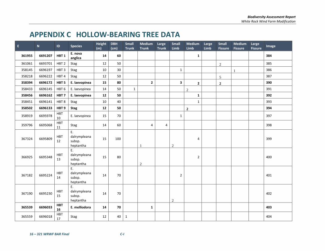
Biodiversity Assessment Report White Rock Wind Farm Modification
16 – 321 WRWF BAR Final C-I
APPENDIX C HOLLOW-BEARING TREE DATA E N ID Species Height
(m) DBH (cm)
Small Trunk
Medium Trunk
Large Trunk
Small Limb
Medium Limb
Large Limb
Small Fissure
Medium Fissure
Large Fissure Image
361955 6691207 HBT 1 E. nova anglica 14 60 1 384
361061 6693701 HBT 2 Stag 12 50 2 385
358145 6696197 HBT 3 Stag 10 30 1 1 386
358218 6696222 HBT 4 Stag 12 50 5 387
358394 6696172 HBT 5 E. laevopinea 15 80 2 3 2 2 390
358433 6696145 HBT 6 E. laevopinea 14 50 1 2 391
358456 6696162 HBT 7 E. laevopinea 12 50 1 392
358451 6696141 HBT 8 Stag 10 40 1 393
358502 6696133 HBT 9 Stag 12 50 2 394
358919 6695978 HBT 10 E. laevopinea 15 70
1
397
359796 6695068 HBT 11 Stag 14 60 4 4 398
367324 6695809 HBT 12
E. dalrympleana subsp. heptantha
15 100
1 2
4
399
366925 6695348 HBT 13
E. dalrympleana subsp. heptantha
15 80
2
2
400
367182 6695224 HBT 14
E. dalrympleana subsp. heptantha
14 70
2
401
367190 6695230 HBT 15
E. dalrympleana subsp. heptantha
14 70
2
402
365539 6696033 HBT 16 E. melliodora 14 70 1
403
365559 6696018 HBT 17 Stag 12 40 1 404

Biodiversity Assessment Report White Rock Wind Farm Modification
16 – 321 WRWF BAR Final C-II
E N ID Species Height (m)
DBH (cm)
Small Trunk
Medium Trunk
Large Trunk
Small Limb
Medium Limb
Large Limb
Small Fissure
Medium Fissure
Large Fissure Image
365514 6695866 HBT 18
E. dalrympleana subsp. heptantha
16 90 2
1 2
405
365519 6695886 HBT 19 Stag 80 40
3 406
365557 6695888 HBT 20 Stag 12 40
2 2 407
365312 6695264 HBT 21
E. dalrympleana subsp. heptantha
14 70 2
2
410
365312 6695243 HBT 22
E. dalrympleana subsp. heptantha
14 90 2 2
1
411
365325 6695221 HBT 23
E. dalrympleana subsp. heptantha
15 80 3
3
2
412
360267 6694064 HBT 24
E. nova anglica 16 50 1 1
N/A
359262 6695624 HBT 25 Stag 8 50 2
N/A
360179 6694516 HBT 26 Stag 14 70 2 3
415
360139 6694367 HBT 27 E. laevopinea 14 90 2 2
416
360198 6694364 HBT 28 Stag 14 50 1
417
360255 6694191 HBT 29 E. laevopinea 16 90 3 2
3
418
366744 6696913 HBT 30 E. melliodora 12 60 1
1
N/A
360211 6694284 HBT 31
E. nova anglica 16 80 2 1 1
420
360277 669428 HBT 32
E. nova anglica 12 80 2 1 419

Biodiversity Assessment Report White Rock Wind Farm Modification
16 – 321 WRWF BAR Final C-III
E N ID Species Height (m)
DBH (cm)
Small Trunk
Medium Trunk
Large Trunk
Small Limb
Medium Limb
Large Limb
Small Fissure
Medium Fissure
Large Fissure Image
360197 6702738 HBT 33 E. melliodora 10 40 1 1 739
360195 6702763 HBT 34 E. melliodora 12 50 1 740
361230 6696018 HBT 35 Stag 6 30
1 1 741
361259 6696027 HBT 36 E.viminalis 7 40
1
1 742
361787 6698265 HBT 37
E. dalrympleana subsp. heptantha
10 20 1
1
743
366676 6693720 HBT 38 E.pauciflora 10 40
1 744
366690 6693724 HBT 39 E. stellulata 8 50
1 745
366793 6693873 HBT 40 Stag 10 50 1 746
367412 6693951 HBT 41 E. stellulata 10 50 1 1 747
361246 6697062 HBT 42 E. melliodora 15 70 1
1 748
359455 6693479 HBT 43 E. laevopinea 17 80 1
2
1 752
359178 6693567 HBT 44 Stag 8 40 2 750
359172 6693564 HBT 45 Stag 12 40
2
1 749

Biodiversity Assessment Report White Rock Wind Farm Modification
16 – 321 WRWF BAR Final D-I
APPENDIX D EPBC PROTECTED MATTERS SEARCH

EPBC Act Protected Matters Report
This report provides general guidance on matters of national environmental significance and other mattersprotected by the EPBC Act in the area you have selected.
Information on the coverage of this report and qualifications on data supporting this report are contained in thecaveat at the end of the report.
Information is available about Environment Assessments and the EPBC Act including significance guidelines,forms and application process details.
Other Matters Protected by the EPBC Act
Acknowledgements
Buffer: 50.0Km
Matters of NES
Report created: 06/04/17 15:53:46
Coordinates
This map may contain data which are©Commonwealth of Australia(Geoscience Australia), ©PSMA 2010
CaveatExtra Information
DetailsSummary

Summary
This part of the report summarises the matters of national environmental significance that may occur in, or mayrelate to, the area you nominated. Further information is available in the detail part of the report, which can beaccessed by scrolling or following the links below. If you are proposing to undertake an activity that may have asignificant impact on one or more matters of national environmental significance then you should consider theAdministrative Guidelines on Significance.
Matters of National Environmental Significance
Listed Threatened Ecological Communities:
Listed Migratory Species:
6
Great Barrier Reef Marine Park:
Wetlands of International Importance:
Listed Threatened Species:
None
61
None
None
National Heritage Places:
Commonwealth Marine Area:
World Heritage Properties:
5
None
10
The EPBC Act protects the environment on Commonwealth land, the environment from the actions taken onCommonwealth land, and the environment from actions taken by Commonwealth agencies. As heritage values of aplace are part of the 'environment', these aspects of the EPBC Act protect the Commonwealth Heritage values of aCommonwealth Heritage place. Information on the new heritage laws can be found athttp://www.environment.gov.au/heritage
This part of the report summarises other matters protected under the Act that may relate to the area you nominated.Approval may be required for a proposed activity that significantly affects the environment on Commonwealth land,when the action is outside the Commonwealth land, or the environment anywhere when the action is taken onCommonwealth land. Approval may also be required for the Commonwealth or Commonwealth agencies proposing totake an action that is likely to have a significant impact on the environment anywhere.
A permit may be required for activities in or on a Commonwealth area that may affect a member of a listed threatenedspecies or ecological community, a member of a listed migratory species, whales and other cetaceans, or a member ofa listed marine species.
Other Matters Protected by the EPBC Act
None
None
None
Listed Marine Species:
Whales and Other Cetaceans:
16
Commonwealth Heritage Places:
4
1
Critical Habitats:
Commonwealth Land:
Commonwealth Reserves Terrestrial:
NoneCommonwealth Reserves Marine:
Extra Information
This part of the report provides information that may also be relevant to the area you have nominated.
2
19State and Territory Reserves:
Nationally Important Wetlands:
1Regional Forest Agreements:
Invasive Species: 37
NoneKey Ecological Features (Marine)

Details
Wetlands of International Importance (Ramsar) [ Resource Information ]Name ProximityBanrock station wetland complex 1100 - 1200kmGwydir wetlands: gingham and lower gwydir (big leather) watercourses 150 - 200km upstreamLittle llangothlin nature reserve Within Ramsar siteRiverland 1000 - 1100kmThe coorong, and lakes alexandrina and albert wetland 1200 - 1300km
Listed Threatened Species [ Resource Information ]Name Status Type of PresenceBirds
Regent Honeyeater [82338] Critically Endangered Species or species habitatknown to occur within area
Anthochaera phrygia
Australasian Bittern [1001] Endangered Species or species habitatlikely to occur within area
Botaurus poiciloptilus
Curlew Sandpiper [856] Critically Endangered Species or species habitatknown to occur within area
Calidris ferruginea
Eastern Bristlebird [533] Endangered Species or species habitatmay occur within area
Dasyornis brachypterus
Red Goshawk [942] Vulnerable Species or species habitatlikely to occur within area
Erythrotriorchis radiatus
Squatter Pigeon (southern) [64440] Vulnerable Species or species habitatmay occur within
Geophaps scripta scripta
For threatened ecological communities where the distribution is well known, maps are derived from recoveryplans, State vegetation maps, remote sensing imagery and other sources. Where threatened ecologicalcommunity distributions are less well known, existing vegetation maps and point location data are used toproduce indicative distribution maps.
Listed Threatened Ecological Communities [ Resource Information ]
Name Status Type of PresenceLowland Rainforest of Subtropical Australia Critically Endangered Community likely to occur
within areaNatural grasslands on basalt and fine-textured alluvialplains of northern New South Wales and southernQueensland
Critically Endangered Community likely to occurwithin area
New England Peppermint (Eucalyptus nova-anglica)Grassy Woodlands
Critically Endangered Community likely to occurwithin area
Upland Wetlands of the New England Tablelands(New England Tableland Bioregion) and the MonaroPlateau (South Eastern Highlands Bioregion)
Endangered Community likely to occurwithin area
Weeping Myall Woodlands Endangered Community may occurwithin area
White Box-Yellow Box-Blakely's Red Gum GrassyWoodland and Derived Native Grassland
Critically Endangered Community likely to occurwithin area
Matters of National Environmental Significance

Name Status Type of Presencearea
Painted Honeyeater [470] Vulnerable Species or species habitatknown to occur within area
Grantiella picta
Swift Parrot [744] Critically Endangered Species or species habitatlikely to occur within area
Lathamus discolor
Southern Black-throated Finch [64447] Endangered Species or species habitatmay occur within area
Poephila cincta cincta
Australian Painted Snipe [77037] Endangered Species or species habitatlikely to occur within area
Rostratula australis
Fish
Murray Cod [66633] Vulnerable Species or species habitatmay occur within area
Maccullochella peelii
Frogs
Booroolong Frog [1844] Endangered Species or species habitatmay occur within area
Litoria booroolongensis
Yellow-spotted Tree Frog, Yellow-spotted Bell Frog[1848]
Endangered Species or species habitatlikely to occur within area
Litoria castanea
Peppered Tree Frog [1827] Vulnerable Species or species habitatlikely to occur within area
Litoria piperata
Stuttering Frog, Southern Barred Frog (in Victoria)[1942]
Vulnerable Species or species habitatlikely to occur within area
Mixophyes balbus
Mammals
Large-eared Pied Bat, Large Pied Bat [183] Vulnerable Species or species habitatlikely to occur within area
Chalinolobus dwyeri
Spot-tailed Quoll, Spotted-tail Quoll, Tiger Quoll(southeastern mainland population) [75184]
Endangered Species or species habitatknown to occur within area
Dasyurus maculatus maculatus (SE mainland population)
Corben's Long-eared Bat, South-eastern Long-earedBat [83395]
Vulnerable Species or species habitatknown to occur within area
Nyctophilus corbeni
Greater Glider [254] Vulnerable Species or species habitatknown to occur within area
Petauroides volans
Brush-tailed Rock-wallaby [225] Vulnerable Species or species habitatknown to occur within area
Petrogale penicillata
Koala (combined populations of Queensland, NewSouth Wales and the Australian Capital Territory)[85104]
Vulnerable Species or species habitatknown to occur within area
Phascolarctos cinereus (combined populations of Qld, NSW and the ACT)
Long-nosed Potoroo (SE mainland) [66645] Vulnerable Species or species habitatmay occur within area
Potorous tridactylus tridactylus
New Holland Mouse, Pookila [96] Vulnerable Species or species habitatlikely to occur within area
Pseudomys novaehollandiae

Name Status Type of Presence
Hastings River Mouse, Koontoo [98] Endangered Species or species habitatlikely to occur within area
Pseudomys oralis
Grey-headed Flying-fox [186] Vulnerable Foraging, feeding or relatedbehaviour known to occurwithin area
Pteropus poliocephalus
Plants
McNutt's Wattle [10711] Vulnerable Species or species habitatlikely to occur within area
Acacia macnuttiana
Velvet Wattle [19799] Vulnerable Species or species habitatlikely to occur within area
Acacia pubifolia
Rupp's Wattle [7559] Endangered Species or species habitatmay occur within area
Acacia ruppii
Torrington Pea [56308] Vulnerable Species or species habitatlikely to occur within area
Almaleea cambagei
[56312] Endangered Species or species habitatlikely to occur within area
Astrotricha roddii
Granite Boronia [18598] Endangered Species or species habitatlikely to occur within area
Boronia granitica
[55581] Vulnerable Species or species habitatlikely to occur within area
Callistemon pungens
Pygmy Cypress-pine, Pigmy Cypress-pine, DwarfCypress-pine [66687]
Vulnerable Species or species habitatlikely to occur within area
Callitris oblonga
Leafless Tongue-orchid [19533] Vulnerable Species or species habitatmay occur within area
Cryptostylis hunteriana
bluegrass [14159] Vulnerable Species or species habitatknown to occur within area
Dichanthium setosum
Pale Golden Moths [64565] Vulnerable Species or species habitatlikely to occur within area
Diuris ochroma
Small Snake Orchid, Two-leaved Golden Moths,Golden Moths, Cowslip Orchid, Snake Orchid [18325]
Endangered Species or species habitatknown to occur within area
Diuris pedunculata
Ovenden's Ironbark [56193] Vulnerable Species or species habitatknown to occur within area
Eucalyptus caleyi subsp. ovendenii
McKie's Stringybark [20199] Vulnerable Species or species habitatlikely to occur within area
Eucalyptus mckieana
Narrow-leaved Peppermint, Narrow-leaved BlackPeppermint [20992]
Vulnerable Species or species habitatknown to occur within area
Eucalyptus nicholii
Blackbutt Candlebark [64618] Vulnerable Species or species habitatknown to occur within area
Eucalyptus rubida subsp. barbigerorum

Name Status Type of Presence
Beadle's Grevillea [22002] Endangered Species or species habitatlikely to occur within area
Grevillea beadleana
Tall Velvet Sea-berry [16839] Vulnerable Species or species habitatlikely to occur within area
Haloragis exalata subsp. velutina
[55198] Vulnerable Species or species habitatlikely to occur within area
Homoranthus prolixus
Wandering Pepper-cress [14035] Endangered Species or species habitatmay occur within area
Lepidium peregrinum
Macadamia Nut, Queensland Nut Tree, Smooth-shelled Macadamia, Bush Nut, Nut Oak [7326]
Vulnerable Species or species habitatmay occur within area
Macadamia integrifolia
[64647] Endangered Species or species habitatmay occur within area
Micromyrtus grandis
Omeo Stork's-bill [84065] Endangered Species or species habitatmay occur within area
Pelargonium sp. Striatellum (G.W.Carr 10345)
Hawkweed [10839] Vulnerable Species or species habitatlikely to occur within area
Picris evae
Tarengo Leek Orchid [55144] Endangered Species or species habitatmay occur within area
Prasophyllum petilum
a leek-orchid [81964] Critically Endangered Species or species habitatmay occur within area
Prasophyllum sp. Wybong (C.Phelps ORG 5269)
a mint-bush [20898] Vulnerable Species or species habitatlikely to occur within area
Prostanthera staurophylla
Heath Wrinklewort [13132] Vulnerable Species or species habitatlikely to occur within area
Rutidosis heterogama
Fragrant Pepperbush [21975] Vulnerable Species or species habitatmay occur within area
Tasmannia glaucifolia
Austral Toadflax, Toadflax [15202] Vulnerable Species or species habitatknown to occur within area
Thesium australe
[55231] Endangered Species or species habitatmay occur within area
Tylophora linearis
[20503] Endangered Species or species habitatlikely to occur within area
Tylophora woollsii
Ingram's Zieria [56734] Endangered Species or species habitatlikely to occur within area
Zieria ingramii
Reptiles
Adorned Delma, Collared Delma [1656] Vulnerable Species or species habitatmay occur within area
Delma torquata

Name Status Type of Presence
Border Thick-tailed Gecko, Granite Belt Thick-tailedGecko [84578]
Vulnerable Species or species habitatlikely to occur within area
Uvidicolus sphyrurus
Bell's Turtle, Western Sawshelled Turtle, Namoi RiverTurtle, Bell's Saw-shelled Turtle [86071]
Vulnerable Species or species habitatmay occur within area
Wollumbinia belli
Listed Migratory Species [ Resource Information ]* Species is listed under a different scientific name on the EPBC Act - Threatened Species list.Name Threatened Type of PresenceMigratory Marine Birds
Fork-tailed Swift [678] Species or species habitatlikely to occur within area
Apus pacificus
Migratory Terrestrial Species
White-throated Needletail [682] Species or species habitatknown to occur within area
Hirundapus caudacutus
Black-faced Monarch [609] Species or species habitatknown to occur within area
Monarcha melanopsis
Yellow Wagtail [644] Species or species habitatmay occur within area
Motacilla flava
Satin Flycatcher [612] Species or species habitatknown to occur within area
Myiagra cyanoleuca
Rufous Fantail [592] Species or species habitatknown to occur within area
Rhipidura rufifrons
Migratory Wetlands Species
Curlew Sandpiper [856] Critically Endangered Species or species habitatknown to occur within area
Calidris ferruginea
Latham's Snipe, Japanese Snipe [863] Species or species habitatmay occur within area
Gallinago hardwickii
Osprey [952] Species or species habitatmay occur within area
Pandion haliaetus
Common Greenshank, Greenshank [832] Species or species habitatmay occur within area
Tringa nebularia
Commonwealth Land [ Resource Information ]The Commonwealth area listed below may indicate the presence of Commonwealth land in this vicinity. Due tothe unreliability of the data source, all proposals should be checked as to whether it impacts on aCommonwealth area, before making a definitive decision. Contact the State or Territory government landdepartment for further information.
NameCommonwealth Land - Australian Postal CommissionCommonwealth Land - Australian Telecommunications CommissionCommonwealth Land - Commonwealth Trading Bank of AustraliaCommonwealth Land - Telstra Corporation Limited
Commonwealth Heritage Places [ Resource Information ]Name StatusState
Other Matters Protected by the EPBC Act

Listed Marine Species [ Resource Information ]* Species is listed under a different scientific name on the EPBC Act - Threatened Species list.Name Threatened Type of PresenceBirds
Fork-tailed Swift [678] Species or species habitatlikely to occur within area
Apus pacificus
Great Egret, White Egret [59541] Species or species habitatknown to occur within area
Ardea alba
Cattle Egret [59542] Species or species habitatmay occur within area
Ardea ibis
Curlew Sandpiper [856] Critically Endangered Species or species habitatknown to occur within area
Calidris ferruginea
Latham's Snipe, Japanese Snipe [863] Species or species habitatmay occur within area
Gallinago hardwickii
White-bellied Sea-Eagle [943] Species or species habitatknown to occur within area
Haliaeetus leucogaster
White-throated Needletail [682] Species or species habitatknown to occur within area
Hirundapus caudacutus
Swift Parrot [744] Critically Endangered Species or species habitatlikely to occur within area
Lathamus discolor
Rainbow Bee-eater [670] Species or species habitatmay occur within area
Merops ornatus
Black-faced Monarch [609] Species or species habitatknown to occur within area
Monarcha melanopsis
Yellow Wagtail [644] Species or species habitatmay occur within area
Motacilla flava
Satin Flycatcher [612] Species or species habitatknown to occur within area
Myiagra cyanoleuca
Osprey [952] Species or species habitatmay occur within area
Pandion haliaetus
Rufous Fantail [592] Species or species habitatknown to occur within area
Rhipidura rufifrons
Painted Snipe [889] Endangered* Species or species habitatlikely to occur within area
Rostratula benghalensis (sensu lato)
Common Greenshank, Greenshank [832] Species or species habitatmay occur within area
Tringa nebularia
Name StatusStateHistoric
Listed placeGlen Innes Post Office NSW

State and Territory Reserves [ Resource Information ]Name StateBarayamal NSWBoorabee and The Willows NSWBooroolong NSWFladbury NSWGoonoowigal NSWGuy Fawkes River NSWIndwarra NSWKings Plains NSWLittle Llangothlin NSWMann River NSWMother Of Ducks Lagoon NSWSingle NSWTarriwa Kurrukun NSWThe Basin NSWTingha Plateau NSWUNE Special Management Zone No1 NSWUNE_LNE_OldGrowth NSWWarra NSWWattleridge NSW
Regional Forest Agreements [ Resource Information ]
Note that all areas with completed RFAs have been included.
Name StateNorth East NSW RFA New South Wales
Extra Information
Invasive Species [ Resource Information ]Weeds reported here are the 20 species of national significance (WoNS), along with other introduced plantsthat are considered by the States and Territories to pose a particularly significant threat to biodiversity. Thefollowing feral animals are reported: Goat, Red Fox, Cat, Rabbit, Pig, Water Buffalo and Cane Toad. Maps fromLandscape Health Project, National Land and Water Resouces Audit, 2001.
Name Status Type of PresenceBirds
Common Myna, Indian Myna [387] Species or species habitatlikely to occur within area
Acridotheres tristis
Mallard [974] Species or species habitatlikely to occur within area
Anas platyrhynchos
European Goldfinch [403] Species or species habitatlikely to occur within area
Carduelis carduelis
Rock Pigeon, Rock Dove, Domestic Pigeon [803] Species or species habitatlikely to occur within area
Columba livia

Name Status Type of Presence
Nutmeg Mannikin [399] Species or species habitatlikely to occur within area
Lonchura punctulata
House Sparrow [405] Species or species habitatlikely to occur within area
Passer domesticus
Spotted Turtle-Dove [780] Species or species habitatlikely to occur within area
Streptopelia chinensis
Common Starling [389] Species or species habitatlikely to occur within area
Sturnus vulgaris
Common Blackbird, Eurasian Blackbird [596] Species or species habitatlikely to occur within area
Turdus merula
Mammals
Domestic Cattle [16] Species or species habitatlikely to occur within area
Bos taurus
Domestic Dog [82654] Species or species habitatlikely to occur within area
Canis lupus familiaris
Goat [2] Species or species habitatlikely to occur within area
Capra hircus
Horse [5] Species or species habitatlikely to occur within area
Equus caballus
Cat, House Cat, Domestic Cat [19] Species or species habitatlikely to occur within area
Felis catus
Feral deer species in Australia [85733] Species or species habitatlikely to occur within area
Feral deer
Brown Hare [127] Species or species habitatlikely to occur within area
Lepus capensis
House Mouse [120] Species or species habitatlikely to occur within area
Mus musculus
Rabbit, European Rabbit [128] Species or species habitatlikely to occur within area
Oryctolagus cuniculus
Black Rat, Ship Rat [84] Species or species habitatlikely to occur within area
Rattus rattus
Pig [6] Species or species habitatlikely to occur within area
Sus scrofa
Red Fox, Fox [18] Species or species habitatlikely to occur within area
Vulpes vulpes
Plants
Madeira Vine, Jalap, Lamb's-tail, Mignonette Vine,Anredera, Gulf Madeiravine, Heartleaf
Species or species habitatlikely to occur
Anredera cordifolia

Nationally Important Wetlands [ Resource Information ]Name StateLittle Llangothlin Lagoon NSWNew England Wetlands NSW
Name Status Type of PresenceMadeiravine, Potato Vine [2643] within area
Bridal Creeper, Bridal Veil Creeper, Smilax, Florist'sSmilax, Smilax Asparagus [22473]
Species or species habitatlikely to occur within area
Asparagus asparagoides
Broom, English Broom, Scotch Broom, CommonBroom, Scottish Broom, Spanish Broom [5934]
Species or species habitatlikely to occur within area
Cytisus scoparius
Montpellier Broom, Cape Broom, Canary Broom,Common Broom, French Broom, Soft Broom [20126]
Species or species habitatlikely to occur within area
Genista monspessulana
Broom [67538] Species or species habitatmay occur within area
Genista sp. X Genista monspessulana
Lantana, Common Lantana, Kamara Lantana, Large-leaf Lantana, Pink Flowered Lantana, Red FloweredLantana, Red-Flowered Sage, White Sage, Wild Sage[10892]
Species or species habitatlikely to occur within area
Lantana camara
African Boxthorn, Boxthorn [19235] Species or species habitatlikely to occur within area
Lycium ferocissimum
Chilean Needle grass [67699] Species or species habitatlikely to occur within area
Nassella neesiana
Serrated Tussock, Yass River Tussock, Yass Tussock,Nassella Tussock (NZ) [18884]
Species or species habitatlikely to occur within area
Nassella trichotoma
Prickly Pears [82753] Species or species habitatlikely to occur within area
Opuntia spp.
Radiata Pine Monterey Pine, Insignis Pine, WildingPine [20780]
Species or species habitatmay occur within area
Pinus radiata
Blackberry, European Blackberry [68406] Species or species habitatlikely to occur within area
Rubus fruticosus aggregate
Willows except Weeping Willow, Pussy Willow andSterile Pussy Willow [68497]
Species or species habitatlikely to occur within area
Salix spp. except S.babylonica, S.x calodendron & S.x reichardtii
Fireweed, Madagascar Ragwort, MadagascarGroundsel [2624]
Species or species habitatlikely to occur within area
Senecio madagascariensis
Silver Nightshade, Silver-leaved Nightshade, WhiteHorse Nettle, Silver-leaf Nightshade, Tomato Weed,White Nightshade, Bull-nettle, Prairie-berry,Satansbos, Silver-leaf Bitter-apple, Silverleaf-nettle,Trompillo [12323]
Species or species habitatlikely to occur within area
Solanum elaeagnifolium
Gorse, Furze [7693] Species or species habitatlikely to occur within area
Ulex europaeus

- non-threatened seabirds which have only been mapped for recorded breeding sites
- migratory species that are very widespread, vagrant, or only occur in small numbers
- some species and ecological communities that have only recently been listed
Not all species listed under the EPBC Act have been mapped (see below) and therefore a report is a general guide only. Where available datasupports mapping, the type of presence that can be determined from the data is indicated in general terms. People using this information in makinga referral may need to consider the qualifications below and may need to seek and consider other information sources.
For threatened ecological communities where the distribution is well known, maps are derived from recovery plans, State vegetation maps, remotesensing imagery and other sources. Where threatened ecological community distributions are less well known, existing vegetation maps and pointlocation data are used to produce indicative distribution maps.
- seals which have only been mapped for breeding sites near the Australian continent
Such breeding sites may be important for the protection of the Commonwealth Marine environment.
Threatened, migratory and marine species distributions have been derived through a variety of methods. Where distributions are well known and iftime permits, maps are derived using either thematic spatial data (i.e. vegetation, soils, geology, elevation, aspect, terrain, etc) together with pointlocations and described habitat; or environmental modelling (MAXENT or BIOCLIM habitat modelling) using point locations and environmental datalayers.
The information presented in this report has been provided by a range of data sources as acknowledged at the end of the report.Caveat
- migratory and
The following species and ecological communities have not been mapped and do not appear in reports produced from this database:
- marine
This report is designed to assist in identifying the locations of places which may be relevant in determining obligations under the EnvironmentProtection and Biodiversity Conservation Act 1999. It holds mapped locations of World and National Heritage properties, Wetlands of Internationaland National Importance, Commonwealth and State/Territory reserves, listed threatened, migratory and marine species and listed threatenedecological communities. Mapping of Commonwealth land is not complete at this stage. Maps have been collated from a range of sources at variousresolutions.
- threatened species listed as extinct or considered as vagrants
- some terrestrial species that overfly the Commonwealth marine area
The following groups have been mapped, but may not cover the complete distribution of the species:
Only selected species covered by the following provisions of the EPBC Act have been mapped:
Where very little information is available for species or large number of maps are required in a short time-frame, maps are derived either from 0.04or 0.02 decimal degree cells; by an automated process using polygon capture techniques (static two kilometre grid cells, alpha-hull and convex hull);or captured manually or by using topographic features (national park boundaries, islands, etc). In the early stages of the distribution mappingprocess (1999-early 2000s) distributions were defined by degree blocks, 100K or 250K map sheets to rapidly create distribution maps. More reliabledistribution mapping methods are used to update these distributions as time permits.
-29.86924 151.59362
Coordinates

-Environment and Planning Directorate, ACT-Birdlife Australia-Australian Bird and Bat Banding Scheme
-Department of Parks and Wildlife, Western Australia
Acknowledgements
-Office of Environment and Heritage, New South Wales
-Department of Primary Industries, Parks, Water and Environment, Tasmania
-Department of Land and Resource Management, Northern Territory-Department of Environmental and Heritage Protection, Queensland
-Department of Environment and Primary Industries, Victoria
-Australian National Wildlife Collection
-Department of Environment, Water and Natural Resources, South Australia
This database has been compiled from a range of data sources. The department acknowledges the followingcustodians who have contributed valuable data and advice:
-Australian Museum
-National Herbarium of NSW
Forestry Corporation, NSW-Australian Government, Department of Defence
-State Herbarium of South Australia
The Department is extremely grateful to the many organisations and individuals who provided expert adviceand information on numerous draft distributions.
-Natural history museums of Australia
-Queensland Museum
-Australian National Herbarium, Canberra
-Royal Botanic Gardens and National Herbarium of Victoria
-Geoscience Australia
-Ocean Biogeographic Information System
-Online Zoological Collections of Australian Museums-Queensland Herbarium
-Western Australian Herbarium
-Tasmanian Herbarium
-Northern Territory Herbarium
-South Australian Museum
-Museum Victoria
-University of New England
-CSIRO
-Other groups and individuals-Tasmanian Museum and Art Gallery, Hobart, Tasmania
-Museum and Art Gallery of the Northern Territory
-Reef Life Survey Australia-Australian Institute of Marine Science-Australian Government National Environmental Science Program
-Australian Tropical Herbarium, Cairns
-Australian Government – Australian Antarctic Data Centre
-Queen Victoria Museum and Art Gallery, Inveresk, Tasmania
-eBird Australia
-American Museum of Natural History
© Commonwealth of Australia
+61 2 6274 1111
Canberra ACT 2601 Australia
GPO Box 787
Department of the Environment
Please feel free to provide feedback via the Contact Us page.

Biodiversity Assessment Report White Rock Wind Farm Modification
16 – 321 WRWF BAR Final E-I
APPENDIX E EPBC ACT ASSESSMENTS OF SIGNIFICANCE The Environment Protection and Biodiversity Conservation Act 1999 specifies factors to be taken into account in deciding whether a development is likely to significantly affect Endangered Ecological Communities, threatened species and migratory species, listed at the Commonwealth level. The following assessment assesses the significance of the likely impacts associated with the proposed works on:
• White Box – Yellow Box – Blakeley’s Red Gum – Grassy Woodland and Derived Native Grassland CEEC;
• Bluegrass Dichanthium setosum; • Regent Honeyeater Anthochaera Phrygia; and • Koala Phascolarctos cinereus.
Different significant impact criteria apply depending on the level at which a species or community is listed (i.e. vulnerable, endangered, critically endangered etc.). The appropriate criteria have been applied to the entities listed above.
In the context of the assessments below, ‘the action’ refers to ‘the proposal’ as described in Section 1.
SIGNIFICANT IMPACT CRITERIA
An action is likely to have a significant impact on a vulnerable species if there is a real chance or possibility that it will:
• lead to a long-term decrease in the size of an important population of a species • reduce the area of occupancy of an important population • fragment an existing important population into two or more populations • adversely affect habitat critical to the survival of a species • disrupt the breeding cycle of an important population • modify, destroy, remove or isolate or decrease the availability or quality of habitat to the extent that
the species is likely to decline • result in invasive species that are harmful to a vulnerable species becoming established in the
vulnerable species’ habitat • introduce disease that may cause the species to decline, or • interfere substantially with the recovery of the species.
Each of these criteria are addressed below. An ‘important population’ is a population that is necessary for a species’ long-term survival and recovery. This may include populations identified as such in recovery plans, and/or that are:
• key source populations either for breeding or dispersal • populations that are necessary for maintaining genetic diversity, and/or • populations that are near the limit of the species range.

Biodiversity Assessment Report White Rock Wind Farm Modification
16 – 321 WRWF BAR Final E-II
E.1.1 White Box-Yellow Box-Blakely's Red Gum Grassy Woodland and Derived Native Grassland Critically Endangered Ecological Community
a) reduce the extent of an ecological community?
The EPBC Act listing of White Box-Yellow Box-Blakely's Red Gum Grassy Woodland and Derived Native Grassland Critically Endangered Ecological Community (YBGW) is slightly different to the TSC Act listing of White Box-Yellow Box-Blakely's Red Gum Woodland Endangered Ecological Community. Areas that are part of the CEEC must have either:
• An intact tree layer with a predominantly native understorey containing 12 or more native understorey species present (excluding grasses) with at least one important species present; or
• An intact native ground layer with a high diversity of native plant species but no remaining tree layer.
The occurrence of Yellow box woodland within of the proposal site is considered to conform to the EPBC Act definition of the community, as the areas contain a floristic make up of that listed within the scientific determination. YBGW occurs within the proposal site as small to moderate patches of intact vegetation with large contiguous patches absent and surrounded by other vegetation communities. Areas containing a higher proportion of native understory species and a native canopy cover include turbine locations and access tracks have been avoided where possible however, approximately 6.99 ha of YBGW consistent with the EPBC Act definition will be removed as a result of the proposal. Existing and additional offset areas relating to proposal will ensure extent of this CEEC is improved or maintained.
b) fragment or increase fragmentation of an ecological community, for example by clearing vegetation for roads or transmission lines
The YBGW occurring within the proposal site exists within highly connected patches of remnant vegetation that has been utilised for historical agricultural landuse. Whilst some areas have been cleared previously as well as the introduction of exotic improved pastures, connectivity through the proposal site is high. Due to the linear nature of the proposal, associated infrastructure with proposal would result in the minor fragmentation of this habitat.
c) Will modify or destroy abiotic (non-living) factors (such as water, nutrients, or soil) necessary for an ecological community’s survival, including reduction of groundwater levels, or substantial alteration of surface water drainage patterns
Whilst surface flows will be altered during construction, with mitigation measures implemented, it is considered unlikely that suitable abiotic habitat will be impacted as such that the ecological communities survival is at risk from the proposal.
d) cause a substantial change in the species composition of an occurrence of an ecological community, including causing a decline or loss of functionally important species, for example through regular burning or flora or fauna harvesting?
The proposal will remove an area of approximately 6.99 ha of intact YBGW. These areas are influenced by the invasion of exotic improved pasture species but contain enough native understorey to be considered as CEEC. As such, it will remove and modify the composition of the community. However, due to the linear of the proposal, areas of a higher quality can be avoided and although minor fragmentation would occur, the majority of the community will be retained and remain intact. This is considered likely to ensure that the species complexity and composition of the community remains similar within the proposal site, and within the locality. Existing and additional offset areas relating to project will ensure extent and condition of this CEEC in the broader locality is improved or maintained.
e) cause a substantial reduction in the quality or integrity of an occurrence of an ecological community, including, but not limited to:

Biodiversity Assessment Report White Rock Wind Farm Modification
16 – 321 WRWF BAR Final E-III
• assisting invasive species, that are harmful to the listed ecological community, to become established, or
• causing regular mobilisation of fertilisers, herbicides or other chemicals or pollutants into the ecological community which kill or inhibit the growth of species in the ecological community, or
• interfere with the recovery of an ecological community The proposal is not considered likely to generate an increase in invasive species harmful to the ecological community. Mitigation measures implemented during a construction will strictly manage and restrict weed movement through the proposal site. It is considered unlikely that proposal would kill or inhibit the growth of the CEEC from the regular mobilisation of fertilisers, herbicides or other chemicals. As YBGW occurs within the proposal site as small to moderate patches of intact vegetation with large contiguous patches absent, the proposal is may be considered likely to interfere with the recovery of the CEEC. The proposal may also be considered likely to exacerbate this impact to the point that it would constitute a substantial reduction in the quality or integrity of the CEEC within the proposal site.
Conclusion
The proposal will impact upon 6.99 ha of the CEEC, particularly through the construction of the access tracks and turbine sites. This is may be considered likely to generate a significant impact to the community such that it would no longer remain viable within the proposal site or locality, therefore referral is recommended. Existing and additional offset areas relating to proposal will ensure extent of this CEEC is improved or maintained. Potential indirect impacts such as altered hydrology are not considered likely to impact the community.
E.1.2 Bluegrass Dichanthium setosum
a) Lead to a long-term decrease in the size of an important population of a species?
An important population is defined as one that is necessary for a species' long-term survival and recovery, and includes: A key source population either for breeding or dispersal; A population that is necessary for maintaining genetic diversity, and/or A population that is near the limit of the species’ distribution range. Initial environmental risk assessments for threatened species deemed Dichanthium setosum as having the highest potential and risk of being present within the proposal site. However, following targeted surveys, it is considered unlikely that a population of Dichanthium setosum exists within the proposal site. Targeted threatened species searches have been conducted during the flowering period of the species, and the species was not found. Further, any population occurring within the proposal site is not considered an important population, as the number of individuals would likely be low (based on the lack of detections during searches of the proposal site), indicating that it is not a key source population for dispersal or necessary for the maintenance of genetic diversity. As such, the population is not considered to constitute an important population of the species.
b) Reduce the area of occupancy of an important population
The species was not recorded within the proposal site. Any population of the species occurring within the proposal site is not considered to constitute an important population, therefore the proposal is not considered likely to reduce the area of occupancy of an important population.
c) Fragment an existing important population into two or more populations;

Biodiversity Assessment Report White Rock Wind Farm Modification
16 – 321 WRWF BAR Final E-IV
The species was not recorded within the proposal site. Any population of the species occurring within the proposal site is not considered to constitute an important population, therefore the proposal is considered unlikely to fragment an existing important population into two or more populations.
d) Adversely affect habitat critical to the survival of a species
The proposal will permanently impact approximately 51.32 ha of moderate/good condition habitat in addition to an area of approximately 65. 79 ha of low condition and non-optimal habitat. This habitat is not considered critical to the survival of the species, as the species has a wide distribution and a higher abundance within the New England Tablelands region. Further, critical habitat has not been declared for the species. As a result, the impacts to a these area for the species range are not considered likely to adversely affect habitat critical to the survival of a species.
e) Disrupt the breeding cycle of an important population The species was not recorded within the proposal site. Any population of the species occurring within the proposal site is not considered to constitute an important population, therefore the proposal is not considered likely to disrupt the breeding cycle of an important population.
f) Modify, destroy, remove, isolate or decrease the availability or quality of habitat to the extent that the species is likely to decline
The extent of habitat modification and removal is not considered likely to occur to the extent that the species is likely to decline. Habitat for the species will be retained within the higher quality portion within the proposal site. Existing and additional offset areas relating to project will ensure extent and condition of this habitat in the broader locality is improved or maintained.
g) Result in invasive species that are harmful to an vulnerable species becoming established in the vulnerable species’ habitat
The proposal is considered unlikely to generate an increase in invasive species harmful to the species. The proposal is not considered likely to exacerbate this impact to the point that it would constitute a substantial reduction in the quality or integrity of the species habitat within the proposal site. Additionally, the proposal is not considered likely to generate an increase in feral herbivores such as Rabbits.
h) Introduce disease that may cause the species to decline; The proposal is considered unlikely to introduce disease that may cause the species to decline.
i) Interfere substantially with the recovery of the species; The proposal is considered unlikely to interfere with the recovery of the species, as the species is considered unlikely to occur within the proposal site, and the proposal will not impact on any known populations of the species.
Conclusion
The proposal is considered unlikely to significantly impact the species, as no known individuals or populations of the species exist within the proposal site, the proposal will not impact on any known populations, and any population occurring within the proposal site is not considered likely to constitute an important population of the species. Existing and additional offset areas relating to proposal will ensure extent of habitat for this is improved or maintained.
E.1.3 Regent Honeyeater Anthochaera phrygia
a) Lead to a long-term decrease in the size of a population?
The Regent Honeyeater is listed as critically endangered. Regent Honeyeaters usually nest in horizontal branches or forks in tall mature eucalypts and She-oaks and mistletoe. It is a generalist forager mainly feeding on nectar from Eucalypts. The species inhabits dry open forest and woodland, particularly Box-

Biodiversity Assessment Report White Rock Wind Farm Modification
16 – 321 WRWF BAR Final E-V
Ironbark woodland, and riparian forests of River Sheoak. Regent Honeyeaters inhabit woodlands that support a significantly high abundance and species richness of bird species. The species has been recorded within the broader region but not within the study locality. The proposal will remove some potential foraging habitat for this species, however the extent of removal (approximately 6.99 ha) is considered unlikely to occur to the extent that a population utilising the proposal site as habitat would decrease in size in the long-term.
b) reduce the area of occupancy of the species
The proposal will reduce the area of available suitable habitat by approximately 6.99 ha. The area of habitat to be removed is considered unlikely to significantly reduce the area of occupancy of the species, as a larger area of intact vegetation will be retained outside of proposal site. This area of vegetation contains a higher proportion of mature native canopy species. Further, the species is highly mobile and would likely only utilise the site on occasion.
c) Fragment an existing important population into two or more populations;
No population of the species is known from the site, however there is potential for the species to forage within the site on occasion. Habitat will be retained within the proposal site, and the proposal is therefore considered unlikely to fragment an existing population into two or more populations. Further, the species is highly mobile and would likely only utilise the site on occasion.
d) Adversely affect habitat critical to the survival of a species
The proposal will remove some potential foraging habitat for this species, however the extent of habitat removal (approximately 6.99 ha) is considered unlikely to adversely affect habitat critical to the survival of the species, as an area of suitable habitat will be retained within the proposal site. Additionally, no critical habitat for the species has been declared or occurs within the proposal site.
e) disrupt the breeding cycle of a population It is considered unlikely that the species would breed within the proposal site. As such, the proposal is considered unlikely to disrupt the breeding cycle of a population.
f) modify, destroy, remove, isolate or decrease the availability or quality of habitat to the extent that the species is likely to decline
The extent of habitat modification and removal is considered unlikely to occur to the extent that the species is likely to decline. Habitat for the species will be retained within the higher quality portion of foraging habitat within the proposal site.
g) Result in invasive species that are harmful to a vulnerable species becoming established in the vulnerable species’ habitat
The proposal is considered unlikely to generate an increase in invasive species harmful to the species. The proposal is not considered likely to exacerbate this impact to the point that it would constitute a substantial reduction in the quality or integrity of the species habitat within the proposal site. Additionally, the proposal is not considered likely to generate an increase in feral herbivores such as Rabbits.
h) Introduce disease that may cause the species to decline; The proposal is not considered likely to introduce disease that may cause the species to decline.
i) Interfere substantially with the recovery of the species; The proposal is considered unlikely to interfere with the recovery of the species, as the species is considered unlikely to occur within the proposal site, and the proposal will not impact on any known populations of the species.
Conclusion
The proposal is considered unlikely to significantly impact the species, as the species is considered likely to only utilise the proposal site as a foraging resource on occasion, and the highest quality remnant of foraging habitat

Biodiversity Assessment Report White Rock Wind Farm Modification
16 – 321 WRWF BAR Final E-VI
will be avoided and retained where possible. Existing and additional offset areas relating to proposal will ensure extent of habitat for this is improved or maintained.
E.1.4 Koala Phascolarctos cinereus
a) Lead to a long-term decrease in the size of a population?
Although there are historical records surrounding the proposal site, none of these are recorded within the last 20 years and therefore shows a lack evidence that the proposal site contains a significant population. No Koala’s or evidence of Koala activity were detected during the surveys. Due to the lack of evidence that a significant koala population exists within or near the proposal site and the linear nature of the clearing areas, it is unlikely that a population of Koalas or the Koalas ability to inhabit the area in future would be impacted to the extent that a population utilising the proposal site as habitat would decrease in size in the long-term. Existing and additional offset areas relating to project will ensure extent and condition of this koala habitat in the broader locality is improved or maintained.
b) reduce the area of occupancy of the species
As discussed above, due to the lack of evidence that a significant koala population exists within or near the proposal site and the linear nature of the clearing areas, it is unlikely that a population of Koalas or the Koalas ability to inhabit the area in future and therefore would not reduce the occupancy of this species. Existing and additional offset areas relating to project will ensure extent and condition of this koala habitat in the broader locality is improved or maintained.
c) Fragment an existing important population into two or more populations;
As discussed above, although there are historical records surrounding the proposal site, none of these are recorded within the last 20 years and therefore shows a lack evidence that the proposal site contains a significant population. No Koala’s or evidence of Koala activity were detected during the surveys. Due to the lack of evidence that a significant koala population exists within or near the proposal site and the linear nature of the clearing areas, it is unlikely that a population of Koalas or the Koalas ability to inhabit the area in future would be impacted or fragmented in separate populations. Existing and additional offset areas relating to project will ensure extent and condition of this koala habitat in the broader locality is improved or maintained.
d) Adversely affect habitat critical to the survival of a species
The EPBC Act referral guidelines for the vulnerable koala (DoE, 2014) focus on the impacts of proposals to habitat critical to the survival of the koala. Table 4 of the guidelines provide a habitat assessment tool that allows for a flowchart to be followed in determining impacts to habitat critical to the survival of the species. This tool has been utilised in Section 7.4.4 of this BAR, and has determined that the habitat on site generates a score of 8. This score is higher than the minimum threshold of not constituting impacts to the species. Following the flowchart detailed below due, with the amount of vegetation being removed, it is considered likely that the proposal will adversely affect habitat critical to the survival of the koala, and indicates that a referral is recommended. However, due to the linear nature of the clearing and minimal fragmentation of habitat, and due to the lack of evidence that a significant koala population exists within or near the proposal site, in case a referral is not required. Existing and additional offset areas relating to project will ensure extent and condition of this koala habitat in the broader locality is improved or maintained.

Biodiversity Assessment Report White Rock Wind Farm Modification
16 – 321 WRWF BAR Final E-VII

Biodiversity Assessment Report White Rock Wind Farm Modification
16 – 321 WRWF BAR Final E-VIII
e) disrupt the breeding cycle of a population As discussed above, the site is not considered to support an important population of the species. As such, the proposal is not considered likely to disrupt the breeding cycle of an important population. If a population was to occur within the locality it is considered likely to persist, as connectivity will be retained within the proposal site, and connectivity between patches enhanced in the long-term. Existing and additional offset areas relating to project will ensure extent and condition of this koala habitat in the broader locality is improved or maintained.
f) modify, destroy, remove, isolate or decrease the availability or quality of habitat to the extent that the species is likely to decline
The extent of habitat modification and removal is considered unlikely to occur to the extent that the species is likely to decline. Existing and additional offset areas relating to project will ensure extent and condition of this koala habitat in the broader locality is improved or maintained.
g) Result in invasive species that are harmful to a vulnerable species becoming established in the vulnerable species’ habitat
The proposal is considered unlikely to generate an increase in invasive species harmful to the species. The proposal is not considered likely to exacerbate this impact to the point that it would constitute a substantial reduction in the quality or integrity of the species habitat within the proposal site. Additionally, the proposal is not considered likely to generate an increase in feral herbivores such as Rabbits.
h) Introduce disease that may cause the species to decline; The proposal is not considered likely to introduce disease that may cause the species to decline.
i) Interfere substantially with the recovery of the species; The EPBC Act referral guidelines for the vulnerable koala (DoE, 2014) list several potential impacts that could interfere substantially with the recovery of the species, including: • Increasing koala fatalities in habitat critical to the survival of the koala due to dog attacks to a level that is likely to result in multiple, ongoing mortalities. • Increasing koala fatalities in habitat critical to the survival of the koala due to vehicle-strikes to a level that is likely to result in multiple, ongoing mortalities. • Facilitating the introduction or spread of disease or pathogens for example Chlamydia or Phytophthora cinnamomi, to habitat critical to the survival of the koala, that are likely to significantly reduce the reproductive output of koalas or reduce the carrying capacity of the habitat. • Creating a barrier to movement to, between or within habitat critical to the survival of the koala that is likely to result in a long-term reduction in genetic fitness or access to habitat critical to the survival of the koala. • Changing hydrology which degrades habitat critical to the survival of the koala to the extent that the carrying capacity of the habitat is reduced in the long-term. The proposal will aim to avoid koala mortality through the establishment of environmental no-go areas within remnant patches, setting site speed limits, implementing hygiene protocols for plant and equipment, and through ensuring that hydrological regimes remain unaltered as far as is practical to ensure that adjacent remnant vegetation remains.
Conclusion
Although a substantive amount of vegetation is being removed from the proposal, the proposal is considered unlikely to significantly impact the species due to the lack of evidence that a significant koala population exists within or near the proposal site and the linear nature of the clearing areas. It is therefore unlikely that a population of Koalas or the Koalas ability to inhabit the area in future would be impacted to the extent that a population utilising the proposal site as habitat would decrease in size in the long-term. Existing and additional offset areas relating to proposal will ensure extent of habitat for this is improved or maintained.

Biodiversity Assessment Report White Rock Wind Farm Modification
16 – 321 WRWF BAR Final F-I
APPENDIX F EPBC HABITAT ASSESSMENT TABLE The tables present the habitat evaluation for threatened species, ecological communities and endangered populations within 10 kilometres of the proposal site in the Atlas of NSW Wildlife2 and those identified as potentially occurring in the area according to the Commonwealth EPBC Protected Matters Search Tool3. Databases were searched on 24 November 2015.
The likelihood of occurrence is based on presence of habitat, proximity of nearest records and mobility of the species (where relevant). The assessment of potential impact is based on the nature of the proposal, the ecology of the species and its likelihood of occurrence. The following classifications are used:
Presence of habitat:
Present: Potential or known habitat is present within the study area
Marginal: Some suitable or non-preferred habitat present within the study area
Absent: No potential or known habitat is present within the study area
Likelihood of occurrence
None: Species has never or is never likely to occur in the study area
Unlikely: Species known or predicted within the locality but unlikely to occur in the study area
Possible: Species could occur in the study area
Present: Species was recorded during the field investigations
Possible to be impacted
No: The proposal would not impact this species or its habitats. No Assessment of Significance (AoS) is necessary for this species
Yes: The proposal could impact this species or its habitats. An AOS has been applied to these entities.
2 The Atlas of NSW Wildlife is administered by the NSW Department of Environment, Climate Change and Water (OEH) and is an online database of fauna and flora records that contains over four million recorded sightings.
3 This online tool is designed for the public to search for matters protected under the Environment Protection and Biodiversity Conservation Act 1999 (EPBC Act). It is managed by the Commonwealth Department of the Environment, Water, Heritage and the Arts.

Biodiversity Assessment Report White Rock Wind Farm Modification
16 – 321 WRWF BAR Final F-II
Species
TSC Act/ FM Act
EPBC Act Description of habitat4
Number of records (Bionet)
Presence of habitat
Likelihood of occurrence
Possible impact?
Plants
Acacia macnuttiana Mcnutt's wattle
V V Acacia macnuttiana grows in shallow, rocky soils derived from leucogranite acid volcanics. The vegetation ranges from heath on rocky outcrops to dry sclerophyll forest on deeper soils. Altitudes range from approximately 500 to 1100 m above sea level. Flowering is mostly from August to September with occasional late flushes in October. Associated species include Allocasuarina littoralis, Angophora floribunda, Bursaria spinosa, Callistemon flavovirens, Eucalyptus biturbinata, Leptospermum brachyandra, Lophostemon confertus and Pomaderris sp. (Quinn et al. 1995; Sheringham & Westaway 1995).
0 Absent None No
Acacia pubifolia Velvet wattle
E E Velvet Wattle is a shrub or small tree 3 - 8 m tall with golden yellow flowers and dark-grey bark. The leaves are hairy and feel like velvet. The adult leaves are straight or slightly curved, 2 - 10 cm long and 8 - 30 mm wide, with prominent veins and a rounded tip. Its flowers are clustered together in a long tube or spike 2 - 5 cm long and appear during September-October. Velvet Wattle generally grows in dry shrubby woodland on granite and metasediment soils.
0 Absent Unlikely No
Acacia ruppii Rupp’s wattle
E E Rupp’s Wattle is an erect, open shrub, 1 – 2 m in height and spread, with spindly arching branches. It has smooth grey bark and flattened hairy branchlets. The leaves are crowded, about 1 – 2 cm long and 1 – 2 mm wide, and have a prominent midvein and a small point at the tip. The round flower heads are golden yellow, and are followed by flat seed pods 4 – 11 cm long. Grows in the understorey below Needlebark Stringybark (Eucalyptus planchoniana), Red Bloodwood (Corymbia gummifera) and Smudgy Apple (Angophora woodsiana).
0 Absent None No
4 Information sourced from species profiles on NSW OEH’s threatened species database or the Australian Government’s Species Profiles and Threats database (SPRAT) unless otherwise stated.
OEH threatened species database: http://www.threatenedspecies.environment.nsw.gov.au/index.aspx SPRAT: http://www.environment.gov.au/cgi-bin/sprat/public/sprat.pl

Biodiversity Assessment Report White Rock Wind Farm Modification
16 – 321 WRWF BAR Final F-III
Species
TSC Act/ FM Act
EPBC Act Description of habitat4
Number of records (Bionet)
Presence of habitat
Likelihood of occurrence
Possible impact?
Almaleea cambagei Torrington pea
E E Torrington Pea is a short, spindly shrub up to 2 m tall, with small leaves and orange-yellow pea flowers. The leaves are 3 - 10 mm long and 0.5 -1.5 mm wide with rounded tips. They have a minutely warty or rough underside and are pressed against the stems. The stems are covered with soft hairs. The brightly coloured flowers are about 5mm wide and grow at the end of the stems, but plants may be quite inconspicuous when not in flower. Small seed pods, 3 - 5 mm long, follow the September-November flowering period. Usually grows in wet heath and acid swamp areas and along watercourses on granite, above 900 m altitude.
0 Absent None No
Astrotricha roddii E E Rodd’s Star Hair is an upright, sparsely-branched shrub 1 - 3 m tall. The shiny, narrow leaves are 11 - 18 cm long and 1 - 2.5 cm wide with long pointed tips and hairy underside. The stems are covered with dense woolly hairs. The dull purplish flowers grow on stems up to 40 cm long, and appear during October-February. Rod’s Star Hair is thought to be only short-lived, with a life-span of possibly less than 10 years. Rodd’s Star Hair usually grows in low dry woodland and shrublands on granite and acid volcanic outcrops, often in rock crevices.
0 Absent None No
Boronia granitica Granite boronia
V E Granite Boronia is a medium-sized shrub 0.6 - 2 m tall. Its leaves are divided into nine to eleven leaflets with each leaflet about 2 - 14 mm long and 1 - 2.5 mm wide. When crushed, the leaves have a pungent scent. The leaflets and stems are covered with soft white hairs. Bright pink flowers 6 - 10 mm long appear from July to October. Granite Boronia occurs in scattered localities on the New England Tablelands and North West Slopes north from the Armidale area to the Stanthorpe district in southern Queensland. It can be locally common in appropriate habitat. Grows on granitic soils amongst rock outcrops, often in rock crevices, and in forests and woodlands on granite scree and shallow soils
0 Absent None No
Callistemon pungens
V Callistemon pungens is a distinct shrub or small tree ranging from 2-5 m tall. The leaves are 2-3 cm long with a pungent tip 1-2 mm long. The flower spike is 5-6 cm long and 2.5-4.5 cm in diameter. Habitats range from riparian areas dominated by Casuarina cunninghamiana subsp. cunninghamiana to woodland and rocky shrubland. The species is characterised by its purple stamens and small, pungent leaves.
0 Marginal None No

Biodiversity Assessment Report White Rock Wind Farm Modification
16 – 321 WRWF BAR Final F-IV
Species
TSC Act/ FM Act
EPBC Act Description of habitat4
Number of records (Bionet)
Presence of habitat
Likelihood of occurrence
Possible impact?
Callitris oblonga Pygmy pine
V V Pygmy Cypress Pine is a bushy shrub, to about 5 m tall but usually less with a pine or ‘Christmas tree’ appearance. It has pale green foliage and grey-brown cones about 12 to 15 mm in diameter. It is generally smaller and grows in wetter, more easterly habitats than the more common Black Cypress Pine C. endlicheri or White Cypress Pine C. glaucophylla. Usually grows in sand along watercourses in shrubland and open woodland in granite country; it also occurs in drier sites, including exposed ridges
0 Absent None No
Cryptostylis hunteriana Leafless Tongue-orchid
V V The Leafless Tongue Orchid has no leaf. It produces an upright flower-stem to 45 cm tall, bearing five to 10 flowers between November and February. This species has inconsistent flowering, with individuals not always flowering each season. It has been recorded from as far north as Gibraltar Range National Park south into Victoria around the coast as far as Orbost. It is known historically from a number of localities on the NSW south coast and has been observed in recent years at many sites between Batemans Bay and Nowra (although it is uncommon at all sites). In NSW there are Leafless Tongue-orchid populations of unknown size in Washpool, Gibraltar Range, Ku-ring-gai Chase, Ben Boyd, Meroo, Morton, Murramarang, Jervis Bay and Lake Conjola National Parks as well as Cambewarra Range and Triplarina Nature Reserves. Brown (2007) indicates that this species is also present in Red Rocks (Yuraygri) National Park and is located on the Red Rocks Plateau in Cambewarra Range Nature Reserve. Also recorded at Nelson Bay, Wyee, Nowendoc State Forest, and two large populations near Bulahdelah. The species occurs mostly in coastal heathlands, margins of coastal swamps and sedgelands, coastal forest, dry woodland, and lowland forest. It prefers open areas in the understorey of forested communities. The soils include moist sands, moist to dry clay loam and occasionally in accumulated eucalypt leaves. The larger populations typically occur in woodland dominated by Scribbly Gum (Eucalyptus sclerophylla), Silvertop Ash (E. sieberi), Red Bloodwood (Corymbia gummifera) and Black Sheoak (Allocasuarina littoralis); appears to prefer open areas in the understorey of this community and is often found in association with the Large Tongue Orchid (C. subulata) and the Tartan Tongue Orchid (C. erecta). Little is known about the ecology of the species; being leafless it is expected to have limited photosynthetic capability and probably depends upon a fungal
0 Absent None No

Biodiversity Assessment Report White Rock Wind Farm Modification
16 – 321 WRWF BAR Final F-V
Species
TSC Act/ FM Act
EPBC Act Description of habitat4
Number of records (Bionet)
Presence of habitat
Likelihood of occurrence
Possible impact?
associate to meet its nutritional requirements from either living or dead organic material. In addition to reproducing from seed, it is also capable of vegetative reproduction and thus forms colonies which can become more or less permanent at a site.
Dichanthium setosum Bluegrass
V V Bluegrass occurs on the New England Tablelands, North West Slopes and Plains and the Central Western Slopes of NSW, extending to northern Queensland. It occurs widely on private property, including in the Inverell, Guyra, Armidale and Glen Innes areas. Associated with heavy basaltic black soils and red-brown loams with clay subsoil. Often found in moderately disturbed areas such as cleared woodland, grassy roadside remnants and highly disturbed pasture. (Often collected from disturbed open grassy woodlands on the northern tablelands, where the habitat has been variously grazed, nutrient-enriched and water-enriched). It is open to question whether the species tolerates or is promoted by a certain amount of disturbance, or whether this is indicative of the threatening processes behind its depleted habitat. Associated species include Eucalyptus albens, Eucalyptus melanophloia, Eucalyptus melliodora, Eucalyptus viminalis, Myoporum debile, Aristida ramosa, Themeda triandra, Poa sieberiana, Bothriochloa ambigua, Medicago minima, Leptorhynchos squamatus, Lomandra aff. longifolia, Ajuga australis, Calotis hispidula and Austrodanthonia, Dichopogon, Brachyscome, Vittadinia, Wahlenbergia and Psoralea species. Locally common or found as scattered clumps in broader populations. The extensive distribution and wide environmental tolerances make predictions about suitable habitat difficult.
1 Present Possible No – not detected during surveys.
Diuris ochroma E E Terestrial orchid with 3-4 linear leaves to 30 cm long. Plants have pale yellow flowers (about 25 mm across) with reddish-purple striations, on a stem to 40 cm long. Flowers from November to December, although flowering times are thought to be variable. Open grassy woodland of Eucalyptus viminalis / E. pauciflora or E. pauciflora / E. parvula (or secondary grassland).
0 Absent Unlikely No - not detected during surveys.
Diuris pedunculata E E The Small Snake Orchid is a member of the ‘Donkey’ orchid group, with bright yellow striped flowers and two drooping side petals. The flowering stem is less than 10 cm tall and has one or two flowers with dark stripes. The top petal is more orange than the rest of the flower and has a bright purple centre. The two
0 Marginal Unlikely No - not detected during surveys.

Biodiversity Assessment Report White Rock Wind Farm Modification
16 – 321 WRWF BAR Final F-VI
Species
TSC Act/ FM Act
EPBC Act Description of habitat4
Number of records (Bionet)
Presence of habitat
Likelihood of occurrence
Possible impact?
thin leaves are up to 16cm long. Also on shale and trap soils, on fine granite, and among boulders. It flowers during August-October.
Eucalyptus caleyi subsp. ovendenii
V V Eucalyptus caleyi is one of a group of related rough-barked species which have concolorous (uniform in colour) adult leaves. It is a medium-sized tree 25 m tall with grey-black, hard, rough and deeply corrugated bark. Its leaves are dull blue-green. The adult leaves are narrower than the juvenile leaves, being 1 - 4 cm wide and 5 - 10 cm long. The gumnuts are egg- or pear-shaped, 6 - 12 mm long and 5 - 7 mm in diameter, and grow in groups of seven. Ovenden’s Ironbark is distinguished from the closely related Caley’s Ironbark (Eucalyptus caleyi subsp. caleyi) by its four-angled buds and gumnuts. Associated species include Eucalyptus melliodora, Eucalyptus dealbata, Eucalyptus albens, Eucalyptus melanophloia and Geijera parviflora. Preferred altitudes are 610 to 820 m, on granitic substrates. Ovenden's Ironbark occupies a higher geographical range than that of subspecies caleyi, occurring on the crests of broad high ridges and replacing subspecies caleyi inhabiting the lower slopes in the same general area
0 Marginal Unlikely No
Eucalyptus mckieana Mckie Stingybark
V V A medium sized tree about 25 m tall with red-brown stringy or fibrous bark extending to the ends of the branches. The juvenile leaves are bristly and very narrow, and adult leaves are glossy or grey-green, 6 - 9 cm long and 1 - 2 cm wide. The gumnuts are ball-shaped, 5 - 7 mm wide, and grow clustered in groups of eleven or more. Associated species at Northern Tablelands sites include Angophora floribunda, Eucalyptus amplifolia, Eucalyptus andrewsii, Eucalyptus bridgesiana, Eucalyptus youmanii, Eucalyptus nicholii, Eucalyptus blakelyi and Eucalyptus conica, and at North Western Slopes sites Eucalyptus andrewsii, Eucalyptus stannicola, Eucalyptus prava and Angophora floribunda.
8 Present Unlikely No - not detected during surveys.
Eucalyptus nicholii Narrow-leaved Black Peppermint
V V A medium-sized tree 15 – 20 m tall with rough, thick, grey-brown bark which extends to the larger branches. This species is widely planted as an urban street tree and in gardens but is quite rare in the wild. It is confined to the New England Tablelands of NSW, where it occurs from Nundle to north of Tenterfield, largely on private property. It occurs in grassy or sclerophyll woodland in association with many other eucalypts that grow in the area, including E. andrewsii and many of the stringybarks, such as E. caliginosa. Grows on shallow relatively infertile soils on shales and slates; Niangala to Glen Innes. The species is reserved
15 Present Unlikely No - not detected during surveys.

Biodiversity Assessment Report White Rock Wind Farm Modification
16 – 321 WRWF BAR Final F-VII
Species
TSC Act/ FM Act
EPBC Act Description of habitat4
Number of records (Bionet)
Presence of habitat
Likelihood of occurrence
Possible impact?
in Single National Park and also in Oxley Wild Rivers National Park. The distribution of this species overlaps with the following EPBC Act-listed threatened ecological communities: White Box-Yellow Box-Blakely’s Red Gum Grassy Woodland and Derived Native Grassland, and Upland Wetlands of the New England Tablelands and the Monaro Plateau.
Eucalyptus rubida subsp. barbigerorum
V V A large tree to 40 m tall. It has thick, black bark on the lower trunk and powdery, white, grey, red or pink bark on the upper trunk and branches, which is shed in long ribbons. Its juvenile leaves are oval and dull blue-green. The adult leaves are narrower, dull green to grey, 9 - 15 cm long and 1 - 2.5 cm wide. The gumnuts are cylindrical or ball-shaped, 4 - 6 mm long and 5 -7 mm wide, and grow in groups of three to seven. Grassy woodland on medium or high fertility soils
0 Present Unlikely No - not detected during surveys.
Grevillea beadleana E E Beadle’s Grevillea is a spreading shrub, up to 2.5 m tall and wide. It has dissected and rather soft leaves about 12 - 16 cm long. There are short hairs on the upper surface and the lower surface is thickly felted with curled hairs. The scarlet flowers are the ‘tooth-brush’ type and are held prominently at the ends of the branchlets. The fruit is a hairy capsule that splits into two at maturity. Known from four separate areas, all in north-east NSW: the Torrington area west of Tenterfield, Oxley Wild Rivers National Park, Guy Fawkes River National Park and at Shannon Creek south-west of Grafton. Historical records suggest it was also once found near Walcha. It is usually found on steep granite slopes at high altitudes, although the population at Shannon Creek is at a lower elevation on sandstone
0 Absent Unlikely No
Haloragis exalata subsp. velutina
V V Tall Velvet Sea-berry is a shrub to 1.5 m high. The stems are ribbed and square in section. The velvety leaves are opposite, 50 - 60 mm long, 6 - 8 mm wide and have finely toothed margins. The three to seven small yellowish green flowers form where the leaf joins the stem and are followed by tiny pear-shaped fruit 2 mm long. This subspecies also occurs in woodland on the steep rocky slopes of gorges
0 Absent Unlikely No
Homoranthus prolixus V V Granite Homoranthus is a horizontally spreading shrub about 80 cm high with the ends of the branches growing upwards. The dull, blue-green leaves are paired on the stem, with successive pairs at right angles to each other, and 3 - 6
0 Absent Unlikely No

Biodiversity Assessment Report White Rock Wind Farm Modification
16 – 321 WRWF BAR Final F-VIII
Species
TSC Act/ FM Act
EPBC Act Description of habitat4
Number of records (Bionet)
Presence of habitat
Likelihood of occurrence
Possible impact?
mm long and 0.5 - 1 mm wide, with a tapered tip. The red to yellow flowers are about 5 mm long and grow in the upper part of the branches, with one to six flowers on each branch. Homoranthus prolixus is characterised by the low spreading habit and short and more or less glaucous (dull blue green in colour with whitish bloom) leaves. Homoranthus prolixus grows in heath patches, in skeletal soil among crevices of granite outcrops
Lepidium peregrinum E E A spreading soft-stemmed perennial herb to sub-shrub 10 - 80 cm tall but sometimes ascending to 2 m in surrounding vegetation. At the base of the plant are divided leaves 15 cm long with the leaf edges fringed with eyelash-like hairs. The leaves higher up the stem are toothed, 2 - 6 cm long and 1 - 8 mm wide, with a pointed tip. The small flowers are less than 1 mm long, growing off a horizontal or drooping, hairy flowering stem. Associated species at the Clifton site are dominated by Eucalyptus camaldulensis and Casuarina cunninghamiana, with a variably dense shrubby understorey of Hymenanthera dentata, Bursaria spinosa, Acacia fimbriata, Acacia floribunda, Callistemon viminalis and Leptospermum brachyandrum. Lepidium peregrinum was most abundant in the tussock grassland fringe of the riparian open forest, comprising Poa species, Lomandra longifolia and Paspalum dilatatum.
0 Absent Unlikely No
Macadamia integrifolia V The Macadamia Nut is a medium-sized tree which can grow to approximately 20 m in height with a similar crown width, giving the tree a rounded shape (Barry & Thomas 1994; Queensland CRA/RFA Steering Committee 1997; Ryan 2006; Stanley & Ross 1986). The leaves are simple, narrow-elliptical to narrow-oblong in shape, tough, dark green and occur on branchlets in groups of three. Leaves are 10–15 cm long (Barry & Thomas 1994; Gross 1995; Ryan 2006). Juvenile leaves have a serrated edge but mature leaves have a smooth margin (Ryan 2006). The flowers are cream or creamy-white in colour and occur on racemes up to 30 cm long (Barry & Thomas 1994; Gross 1995; Forster et al. 1991; Ryan 2006; Stanley & Ross 1986). The racemes originate at the leaf axil (Barry & Thomas 1994). The fruit are a hard brown nut encased in a green leathery outer shell with a 2–3 cm diameter (Barry & Thomas 1994; Ryan 2006). The smooth brown nut contains an edible kernel (Ryan 2006). Does not grow naturally in NSW.
0 Absent Unlikely No

Biodiversity Assessment Report White Rock Wind Farm Modification
16 – 321 WRWF BAR Final F-IX
Species
TSC Act/ FM Act
EPBC Act Description of habitat4
Number of records (Bionet)
Presence of habitat
Likelihood of occurrence
Possible impact?
Micromyrtus grandis E Severn River Heath-myrtle is an upright shrub 1 -4 m tall, with paired leaves. Its leaves are smooth or finely toothed, 0.5 - 4 mm long and 0.5 - 1.5 mm wide, with obvious oil dots (visible when the leaf is held up against the light). The tiny cream to pink flowers appear during July-September, growing in the upper part of the branches. Severn River Heath-myrtle is distinguished by its overall size which is the largest yet known in the genus and by the 5-ribbed fruit, stalked flowers and broader leaves compared to other species in its range. Associated species within low woodland include Eucalyptus crebra, Allocasuarina inophloia, Acacia sp. aff. pubifolia, Xanthorrhoea johnsonii; in heath the association comprises Leptospermum novae-angliae, Micromyrtus sessilis and Leucopogon neo-anglicus
0 Absent Unlikely No
Prasophyllum petilum E E Natural populations are known from a total of five sites in NSW. These are at Boorowa, Captains Flat, Ilford, Delegate and a newly recognised population c.10 k SE of Muswellbrook. It also occurs at Hall in the Australian Capital Territory. This species has also been recorded at Bowning Cemetery where it was experimentally introduced, though it is not known whether this population has persisted. Grows in open sites within Natural Temperate Grassland at the Boorowa and Delegate sites. Also grows in grassy woodland in association with River Tussock Poa labillardieri, Black Gum Eucalyptus aggregata and tea-trees Leptospermum spp. at Captains Flat and within the grassy groundlayer dominated by Kanagroo Grass under Box-Gum Woodland at Ilford (and Hall, ACT).
0 Absent Unlikely No
Picris evae Hawkweed
V V Hawkweed is a soft-stemmed annual plant to 130 cm tall with most of the leaves growing around the base of the plant. The leaves are sometimes toothed, have a pointed tip, and are sparsely hairy with split-end hairs (the hairs divided into two for half their length). Leaves are 2.5 - 15 cm long and 4 - 30 mm wide. The small, yellow flowers grow in dense heads 8 - 10 mm wide at the ends of the stems. Its main habitat is open Eucalypt forest including a canopy of Eucalyptus melliodora, E. crebra, E. populnea, E. albens, Angophora subvelutina, Allocasuarina torulosa , and/or Casuarina cunninghamiana with a Dichanthium grassy understory
1 Present Unlikely No - not detected during surveys.
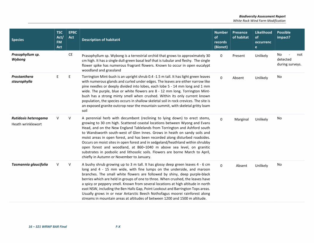
Biodiversity Assessment Report White Rock Wind Farm Modification
16 – 321 WRWF BAR Final F-X
Species
TSC Act/ FM Act
EPBC Act Description of habitat4
Number of records (Bionet)
Presence of habitat
Likelihood of occurrence
Possible impact?
Prasophyllum sp. Wybong
CE Prasophyllum sp. Wybong is a terrestrial orchid that grows to approximately 30 cm high. It has a single dull-green basal leaf that is tubular and fleshy. The single flower spike has numerous fragrant flowers. Known to occur in open eucalypt woodland and grassland
0 Present Unlikely No - not detected during surveys.
Prostanthera staurophylla
E E Torrington Mint-bush is an upright shrub 0.4 -1.5 m tall. It has light green leaves with numerous glands and curled under edges. The leaves are either narrow like pine needles or deeply divided into lobes, each lobe 5 - 14 mm long and 1 mm wide. The purple, blue or white flowers are 8 - 12 mm long. Torrington Mint-bush has a strong minty smell when crushed. Within its only current known population, the species occurs in shallow skeletal soil in rock crevices. The site is an exposed granite outcrop near the mountain summit, with skeletal gritty loam soil
0 Absent Unlikely No
Rutidosis heterogama Heath wrinklewort
V V A perennial herb with decumbent (reclining to lying down) to erect stems, growing to 30 cm high. Scattered coastal locations between Wyong and Evans Head, and on the New England Tablelands from Torrington and Ashford south to Wandsworth south-west of Glen Innes. Grows in heath on sandy soils and moist areas in open forest, and has been recorded along disturbed roadsides. Occurs on moist sites in open forest and in sedgeland/heathland within shrubby open forest and woodland, at 860–1040 m above sea level, on granitic substrates in podsolic and lithosolic soils. Flowers are borne March to April, chiefly in Autumn or November to January.
0 Marginal Unlikely No
Tasmannia glaucifolia V V A bushy shrub growing up to 3 m tall. It has glossy deep green leaves 4 - 6 cm long and 4 - 15 mm wide, with fine lumps on the underside, and maroon branches. The small white flowers are followed by shiny, deep purple-black berries which are held in groups of one to three. When crushed, the leaves have a spicy or peppery smell. Known from several locations at high altitude in north east NSW, including the Ben Halls Gap, Point Lookout and Barrington Tops areas. Usually grows in or near Antarctic Beech Nothofagus moorei rainforest along streams in mountain areas at altitudes of between 1200 and 1500 m altitude.
0 Absent Unlikely No

Biodiversity Assessment Report White Rock Wind Farm Modification
16 – 321 WRWF BAR Final F-XI
Species
TSC Act/ FM Act
EPBC Act Description of habitat4
Number of records (Bionet)
Presence of habitat
Likelihood of occurrence
Possible impact?
Thesium australe Austral Toadflax
V V An erect perennial herb to 40 cm high. Found in very small populations scattered across eastern NSW, along the coast, and from the Northern to Southern Tablelands. It is also found in Tasmania and Queensland and in eastern Asia. Occurs in grassland or grassy woodland, often found in damp sites in association with Kangaroo Grass (Themeda australis). A root parasite that takes water and some nutrients from other plants, especially Kangaroo Grass. Flowering is predominantly in spring and summer.
12 Present Possible No - not detected during surveys.
Tylophora linearis E E Slender, almost hairless twiner with a clear sap. Leaves dark green, linear, 1-5 cm long, 0.5-3 mm wide. Flowers purplish, 3-6 mm in diameter, in radiating groups of 3-8. Fruit is cigar shaped, up to 100mm long and approximately 5 mm diameter, hairless. Majority of records occur in the central western region. Records from Goonoo, Pillaga West, Pillaga East, Bibblewindi, Cumbil and Eura State Forests, Coolbaggie NR, Goobang NP and Beni SCA. Also has been recorded Hiawatha State Forest near West Wyalong in the south and there are old records as far north as Crow Mountain near Barraba and near Glenmorgan in the western Darling Downs. Grows in dry scrub and open forest. Recorded from low-altitude sedimentary flats in dry woodlands of Eucalyptus fibrosa, Eucalyptus sideroxylon, Eucalyptus albens, Callitris endlicheri, Callitris glaucophylla and Allocasuarina luehmannii.
0 Absent Unlikely No
Tylophora woollsii E E Grows in wet sclerophyll forest and rainforest in the Clouds Creek area near Nymboida and in sclerophyll forest near Parramatta
0 Absent Unlikely No
Zieria ingramii E E Slender, spindly shrub to 0.6 m high, with ridged branches. Leaves composed of 3 narrow leaflets, each 9-19 mm long and 1-3 mm wide, dotted with oil glands above. Flowers with 4 white to pale pink petals about 3 mm long, hairy outside and hairless inside. Fruit composed of 4 slightly warted fruitlets. Associated and understorey species include Eucalyptus crebra, E. fibrosa, E. dwyeri, E. beyeriana, E. microcarpa, Callitris endlicheri, Allocasuarina diminuta, A. distyla, A. verticillata, Leptospermum divaricatum, L. parvifolium, Acacia triptera, Acacia gladiiformis, Acacia brownii, Grevillea floribunda, G. triternata, Hakea decurrens, Boronia glabra, Philotheca salsolifolia, Leucopogon attenuatus, Melaleuca uncinata, M. erubescens, Kunzea parvifolia, Calytrix tetragona, Brachyloma
0 Absent Unlikely No

Biodiversity Assessment Report White Rock Wind Farm Modification
16 – 321 WRWF BAR Final F-XII
Species
TSC Act/ FM Act
EPBC Act Description of habitat4
Number of records (Bionet)
Presence of habitat
Likelihood of occurrence
Possible impact?
daphnoides, Melichrus urceolatus, Cassinia aculeata, Dodonaea viscosa subsp. spatulata, D. peduncularis, D. heteromorpha, Dillwynia sericea, Hibbertia riparia, Dampiera lanceolata, Dianella longifolia, Prostanthera species and Goodenia species. Known predominately from Goonoo SCA, about 40 km north-east of Dubbo. An old record exists from a locality east of Mogriguy on the Mendooran Road, however searches of the area have not relocated the species. One record also occurs within Kings Plains National Park, 48 km south of Inverell.
Endangered Ecological Communities
New England Peppermint (Eucalyptus nova-anglica) Woodland on Basalts and Sediments in the New England Tableland Bioregion
CEEC CE This woodland community is dominated by trees of New England Peppermint (Eucalyptus nova-anglica) and occasionally Mountain Gum (E. dalrympleana subsp. Heptantha), and is usually 8-20 metres tall. The woodland has a predominantly grassy understorey with few shrubs. The species present at a site will vary according to recent rainfall or drought condition and the degree of disturbance (including fire). In NSW all sites are within the New England Tablelands. This community is or has been known to occur in the Armidale Dumaresq, Guyra, Inverell, Severn and Tenterfield Local Government Areas, but may occur elsewhere on the New England Tablelands. It has recently been identified in eastern portions of Namoi CMA on the tablelands. Reserves containing the community include Bolivia Hill, Boorolong, Mount Duval, Yina and Imbota Nature Reserves and Warra National Park. The community occurs primarily in valley flats subject to cold air drainage. The valley flats are composed of basaltic soils, fine-grained sedimentary and acid volcanic substrates with poorly drained loam-clay soils.
N/A Present Unlikely No
Upland Wetlands of the Drainage Divide of the New England Tableland Bioregion
EEC E This community is composed of a series of high altitude wetlands in the New England Tablelands of Northern NSW. The wetlands have small local catchments, and range from shallow and temporary to near-permanent wetlands. Vegetation is usually a combination of sedges, rushes, spike-rushes, grasses and other aquatic plants, occurring either on the shores of open water or extending across shallow or dry wetland beds, and can die back during dry periods. These wetlands are important habitat for a range of native wildlife. Known to occur between the Tenterfield and Uralla Local Government Areas but may occur elsewhere within the New England Tablelands. Generally above 900m
N/A Absent Unlikely No

Biodiversity Assessment Report White Rock Wind Farm Modification
16 – 321 WRWF BAR Final F-XIII
Species
TSC Act/ FM Act
EPBC Act Description of habitat4
Number of records (Bionet)
Presence of habitat
Likelihood of occurrence
Possible impact?
altitude and associated with basalt soils. Not connected to river systems by floodplains.
White Box Yellow Box Blakely’s Red Gum Woodland
EEC CE Box-Gum Woodland is found from the Queensland border in the north, to the Victorian border in the south. It occurs in the tablelands and western slopes of NSW. Characterised by the presence or prior occurrence of White Box, Yellow Box and/or Blakely's Red Gum. The trees may occur as pure stands, mixtures of the three species or in mixtures with other trees, including wattles. Commonly co-occurring eucalypts include Apple Box (E. bridgesiana), Red Box (E. polyanthemos), Candlebark (E. rubida), Snow Gum (E. pauciflora), Argyle Apple (E. cinerea), Brittle Gum (E. mannifera), Red Stringybark (E. macrorhyncha), Grey Box (E. microcarpa), Cabbage Gum (E. amplifolia) and others.
N/A Present Present AoS completed
Aves
Anthochaera Phrygia Regent Honeyeater
CE CE The Regent Honeyeater mainly inhabits temperate woodlands and open forests of the inland slopes of south-east Australia. Birds are also found in drier coastal woodlands and forests in some years. There are only three known key breeding regions remaining: north-east Victoria (Chiltern-Albury), and in NSW at Capertee Valley and the Bundarra-Barraba region. In NSW the distribution is very patchy and mainly confined to the two main breeding areas and surrounding fragmented woodlands. In some years non-breeding flocks converge on flowering coastal woodlands and forests. The species inhabits dry open forest and woodland, particularly Box-Ironbark woodland, and riparian forests of River She-oak. Regent Honeyeaters inhabit woodlands that support a significantly high abundance and species richness of bird species. These woodlands have significantly large numbers of mature trees, high canopy cover and abundance of mistletoes. Every few years non-breeding flocks are seen foraging in flowering coastal Swamp Mahogany and Spotted Gum forests, particularly on the central coast and occasionally on the upper north coast. Birds are occasionally seen on the south coast. The Regent Honeyeater is a generalist forager, which mainly feeds on the nectar from a wide range of eucalypts and mistletoes. Key eucalypt species include Mugga Ironbark, Yellow Box, Blakely’s Red Gum, White Box and Swamp Mahogany. Also utilises E. maculata, E. polyanthemos, E. mollucana,
0 Present Unlikely AoS completed

Biodiversity Assessment Report White Rock Wind Farm Modification
16 – 321 WRWF BAR Final F-XIV
Species
TSC Act/ FM Act
EPBC Act Description of habitat4
Number of records (Bionet)
Presence of habitat
Likelihood of occurrence
Possible impact?
Corymbia robusta, E. crebra, E. caleyi, Corymbia gummifera, E. mckieana, E. macrorhyncha, E. laevopinea, and Angophora floribunda. Nectar and fruit from the mistletoes A. miquelii, A. pendula and A. cambagei are also eaten during the breeding season. When nectar is scarce lerp and honeydew comprise a large proportion of the diet. A shrubby understorey is an important source of insects and nesting material. The species breeds between July and January in Box-Ironbark and other temperate woodlands and riparian gallery forest dominated by River Sheoak. Regent Honeyeaters usually nest in horizontal branches or forks in tall mature eucalypts and Sheoaks. Also nest in mistletoe haustoria.
Apus pacificus Fork-tailed Swift
M This species breeds in the north-east and mid-east Asia and winters in Australia and southern New Guinea. It is a visitor to most parts of Western Australia, beginning to arrive in the Kimberley in late September, in the Pilbara and Eucla in November and in the south-west land division in mid-December, and leaving by late April. It is common in the Kimberley, uncommon to moderately common near north-west, west and southeast coasts and rare to scarce elsewhere. They never settle voluntarily on the ground and spend most of their lives in the air, living on the insects they catch in their beaks.
0 Absent Unlikely No
Ardea alba Great Egret
M The Eastern Great Egret has been reported in a wide range of wetland habitats (for example inland and coastal, freshwater and saline, permanent and ephemeral, open and vegetated, large and small, natural and artificial). These include swamps and marshes; margins of rivers and lakes; damp or flooded grasslands, pastures or agricultural lands; reservoirs; sewage treatment ponds; drainage channels; salt pans and salt lakes; salt marshes; estuarine mudflats, tidal streams; mangrove swamps; coastal lagoons; and offshore reefs. The species usually frequents shallow waters. Eastern Great Egrets usually nest in colonies and rarely as solitary pairs. In Australia, breeding sites are located in wooded and shrubby swamps including mangrove forests (the main habitat of the species in the Top End), Melaleuca swamps (on the eastern coast of Australia and south-western Western Australia) and mixed eucalypt/acacia/lignum swamps (in the Channel
0 Present Possible No

Biodiversity Assessment Report White Rock Wind Farm Modification
16 – 321 WRWF BAR Final F-XV
Species
TSC Act/ FM Act
EPBC Act Description of habitat4
Number of records (Bionet)
Presence of habitat
Likelihood of occurrence
Possible impact?
Country and Murray-Darling Basin). The Eastern Great Egret has a diverse diet that includes fish, insects, crustaceans, molluscs, frogs, lizards, snakes and small birds and mammal.
Ardea ibis Cattle Egret
M The Cattle Egret is found in grasslands, woodlands and wetlands, and is not common in arid areas. It also uses pastures and croplands, especially where drainage is poor. Will also forage at garbage dumps, and is often seen with cattle and other stock. The Cattle Egret is partially migratory, moving during winter. The Cattle Egret prefers grasshoppers, especially during breeding season, but eats many other invertebrates. It also eats frogs, cane toads, lizards and some small mammals. Its sharp bill is used in a lunging and stabbing manner. It often feeds by following large animals such as cattle, grabbing insects and worms that they disturb with their feet. They also will sit on cattle to look out for insects. Cattle Egret pairs are monogamous for the breeding season, and they breed in colonies, usually with other waterbirds. Their shallow platform nests are made in wetland areas in trees and bushes, usually as high up as possible. Both parents build the nest and incubate the eggs, with one brood per season being raised.
0 Present Possible No
Botaurus poiciloptilus Australasian Bittern
E E In NSW, this species occurs along the coast and is frequently recorded in the Murray-Darling Basin, notably in floodplain wetlands of the Murrumbidgee, Lachlan, Macquarie and Gwydir Rivers. Occurs in permanent freshwater wetlands with tall, dense vegetation. Favours permanent and seasonal freshwater habitats, particularly those dominated by sedges, rushes and/or reeds (e.g. Phragmites, Cyperus, Eleocharis, Juncus, Typha, Baumea, , Bolboschoenus) or cutting grass (Gahnia) growing over muddy or peaty substrate. Hides during the day amongst dense reeds or rushes and feed mainly at night on frogs, fish, yabbies, spiders, insects and snails. Feeding platforms may be constructed over deeper water from reeds trampled by the bird; platforms are often littered with prey remains. Breeding occurs in summer from October to January; nests are built in secluded places in densely-vegetated wetlands on a platform of reeds; there are usually six olive-brown eggs to a clutch. In Australia, the Bittern occurs with the Australian Painted Snipe Rostratula benghalensis australis.
0 Absent Unlikely No

Biodiversity Assessment Report White Rock Wind Farm Modification
16 – 321 WRWF BAR Final F-XVI
Species
TSC Act/ FM Act
EPBC Act Description of habitat4
Number of records (Bionet)
Presence of habitat
Likelihood of occurrence
Possible impact?
Calidris ferruginea Curlew Sandpiper
E M,CE Curlew Sandpipers mainly occur on intertidal mudflats in sheltered coastal areas, such as estuaries, bays, inlets and lagoons, and also around non-tidal swamps, lakes and lagoons near the coast, and ponds in saltworks and sewage farms. They are also recorded inland, though less often, including around ephemeral and permanent lakes, dams, waterholes and bore drains, usually with bare edges of mud or sand. They occur in both fresh and brackish waters. Curlew Sandpipers generally roost on bare dry shingle, shell or sand beaches, sandspits and islets in or around coastal or near-coastal lagoons and other wetlands, occasionally roosting in dunes during very high tides and sometimes in saltmarsh. This species does not breed in Australia. This species forages mainly on invertebrates, including worms, molluscs, crustaceans, and insects, as well as seeds.
0 Absent Unlikely No
Dasyornis brachypterus Eastern Bristlebird
E E The distribution of the Eastern Bristlebird has contracted to three disjunct areas of south-eastern Australia: southern Queensland/northern NSW, the Illawarra Region and in the vicinity of the NSW/Victorian border. The estimated population size is less than 2000 individuals occupying a total area of about 120 sq km. There are now only four populations in the southern Queensland/northern NSW area with a total of 35 birds, compared to 15 years ago when 14 populations and 154 birds were recorded. This population once extended as far south as at least Dorrigo and has recently been identified as a separate ultrataxon (monoides) but further research is being undertaken to determine the validity of this. The remaining populations are the nominate ultrataxon (brachypterus) and once extended at least to what is now the Sydney urban area. The Illawarra population comprises an estimated 1600 birds, mainly from Barren Grounds Nature Reserve, Budderoo National Park and the Jervis Bay area. The southern population in Nadgee Nature Reserve and Howe’s Flat is around 200 birds. Further surveys are required in parts of Ben Boyd National Park and Sydney Catchment Authority lands to determine whether further populations of the Eastern Bristlebird occur in these areas. Habitat is characterised by dense, low vegetation including heath and open woodland with a heathy understorey; in northern NSW occurs in open forest with tussocky grass understorey; all
0 Absent Unlikely No

Biodiversity Assessment Report White Rock Wind Farm Modification
16 – 321 WRWF BAR Final F-XVII
Species
TSC Act/ FM Act
EPBC Act Description of habitat4
Number of records (Bionet)
Presence of habitat
Likelihood of occurrence
Possible impact?
of these vegetation types are fire prone. Age of habitat since fires (fire-age) is of paramount importance to this species; Illawarra and southern populations reach maximum densities in habitat that has not been burnt for at least 15 years; however, in the northern NSW population a lack of fire in grassy forest may be detrimental as grassy tussock nesting habitat becomes unsuitable after long periods without fire; northern NSW birds are usually found in habitats burnt five to 10 years previously. Shy and cryptic and rarely flies, although can be seen scampering over the ground; when approached, may move to a lookout perch 1 m or more above the ground, then retreat into dense vegetation. Feeds on a variety of insects, particularly ants. Nests are elliptical domes constructed on or near the ground amongst dense vegetation. Suitable habitat is present in upland swamps and heaths.
Erythrotriorchis radiates Red Goshawk
CE V The Red Goshawk is a large, reddish-brown hawk with long and broad wings, deeply 'fingered' wing-tips, and heavy yellow legs. The species is distributed sparsely through northern and eastern Australia, from the western Kimberley Division of northern Western Australia to north-eastern Queensland and south to far north-eastern NSW, and with scattered records in central Australia. The species is very rare in NSW, extending south to about 30°S, with most records north of this, in the Clarence River Catchment, and a few around the lower Richmond and Tweed Rivers. Formerly, it was at least occasionally reported as far south as Port Stephens. Red Goshawks inhabit open woodland and forest, preferring a mosaic of vegetation types, a large population of birds as a source of food, and permanent water, and are often found in riparian habitats along or near watercourses or wetlands. In NSW, preferred habitats include mixed subtropical rainforest, Melaleuca swamp forest and riparian Eucalyptus forest of coastal rivers.
0 Absent Unlikely No
Gallinago hardwickii Latham’s Snipe
M In Australia, Latham's Snipe occurs in permanent and ephemeral wetlands up to 2000 m above sea-level. They usually inhabit open, freshwater wetlands with low, dense vegetation (e.g. swamps, flooded grasslands or heathlands, around bogs and other water bodies). However, they can also occur in habitats with saline or brackish water, in modified or artificial habitats, and in habitats located close to humans or human activity. Latham's
1 Absent Unlikely No

Biodiversity Assessment Report White Rock Wind Farm Modification
16 – 321 WRWF BAR Final F-XVIII
Species
TSC Act/ FM Act
EPBC Act Description of habitat4
Number of records (Bionet)
Presence of habitat
Likelihood of occurrence
Possible impact?
Snipe does not breed within Australian jurisdiction. Latham's Snipe is an omnivorous species that feeds on seeds and other plant material (mainly from species in families such as Cyperaceae, Poaceae, Juncaceae, Polygonaceae, Ranunculaceae and Fabaceae), and on invertebrates including insects (mainly flies and beetles), earthworms and spiders and occasionally molluscs, isopods and centipedes.
Geophaps scripta scripta Squatter Pigeon (southern)
CE V In New South Wales, the Squatter Pigeon (southern) is thought to have formerly occurred in woodlands dominated in the overstorey by Eucalyptus species, intersected with patches of Acacia species and stands of Cypress Pine (Callitris columellaris) and which have a groundcover of grasses and herbs. The species are restricted to habitats that are mostly dominated in the overstorey by Eucalyptus, Corymbia, Acacia or Callitris species and within 3 km of water bodies or courses.
0 Marginal Unlikely No
Grantiella picta Painted Honeyeater
V V The Painted Honeyeater is nomadic and occurs at low densities throughout its range. The greatest concentrations of the bird and almost all breeding occurs on the inland slopes of the Great Dividing Range in NSW, Victoria and southern Queensland. During the winter it is more likely to be found in the north of its distribution. Inhabits Boree, Brigalow and Box-Gum Woodlands and Box-Ironbark Forests. A specialist feeder on the fruits of mistletoes growing on woodland eucalypts and acacias. Prefers mistletoes of the genus Amyema. Insects and nectar from mistletoe or eucalypts are occasionally eaten. Nest from spring to autumn in a small, delicate nest hanging within the outer canopy of drooping eucalypts, she-oak, paperbark or mistletoe branches.
0 Marginal Unlikely No
Hirundapus caudacutus White-throated Needletail
M White-throated Needletails often occur in large numbers over eastern and northern Australia. They arrive in Australia from their breeding grounds in the northern hemisphere in about October each year and leave somewhere between May and August. They are aerial birds and for a time it was commonly believed that they did not land while in Australia. It has now been observed that birds will roost in trees, and radio-tracking has since confirmed that this is a regular activity. The White-throated Needletail feeds on flying insects, such as termites, ants, beetles and flies. They catch the insects in
0 Marginal Unlikely No

Biodiversity Assessment Report White Rock Wind Farm Modification
16 – 321 WRWF BAR Final F-XIX
Species
TSC Act/ FM Act
EPBC Act Description of habitat4
Number of records (Bionet)
Presence of habitat
Likelihood of occurrence
Possible impact?
flight in their wide gaping beaks. Birds usually feed in rising thermal currents associated with storm fronts and bushfires and they are commonly seen moving with wind fronts. White-throated Needletails are non-breeding migrants in Australia.
Lathamus discolour Swift Parrot
E CE Breeds in Tasmania during spring and summer, migrating in the autumn and winter months to south-eastern Australia from Victoria and the eastern parts of South Australia to south-east Queensland. In NSW mostly occurs on the coast and south west slopes. On the mainland they occur in areas where eucalypts are flowering profusely or where there are abundant lerp (from sap-sucking bugs) infestations. Favoured feed trees include winter flowering species such as Swamp Mahogany Eucalyptus robusta, Spotted Gum Corymbia maculata, Red Bloodwood C. gummifera, Mugga Ironbark E. sideroxylon, and White Box E. albens. Commonly used lerp infested trees include Grey Box E. moluccana and Blackbutt E. pilularis. Return to home foraging sites on a cyclic basis depending on food availability.
0 Present Unlikely No
Merops ornatus Rainbow Bee-eater
M The Rainbow Bee-eater is found throughout mainland Australia, as well as eastern Indonesia, New Guinea and, rarely, the Solomon Islands. In Australia it is widespread, except in desert areas, and breeds throughout most of its range, although southern birds move north to breed. The Rainbow Bee-eater is most often found in open forests, woodlands and shrublands, and cleared areas, usually near water. It will be found on farmland with remnant vegetation and in orchards and vineyards. It will use disturbed sites such as quarries, cuttings and mines to build its nesting tunnels. Southern populations move north, often in huge flocks, during winter; northern populations are present year round. Rainbow Bee-eaters eat insects, mainly catching bees and wasps, as well as dragonflies, beetles, butterflies and moths. They catch flying insects on the wing and carry them back to a perch to beat them against it before swallowing them. Bees and wasps are rubbed against the perch to remove the stings and venom glands.
0 Present Unlikely No
Monarcha melanopsis Black-faced Monarch
M The Black-faced Monarch is found along the coast of eastern Australia, becoming less common further south. The Black-faced Monarch is found in rainforests, eucalypt woodlands, coastal scrub and damp gullies. It may be
0 Marginal Unlikely No

Biodiversity Assessment Report White Rock Wind Farm Modification
16 – 321 WRWF BAR Final F-XX
Species
TSC Act/ FM Act
EPBC Act Description of habitat4
Number of records (Bionet)
Presence of habitat
Likelihood of occurrence
Possible impact?
found in more open woodland when migrating. Resident in the north of its range, but is a summer breeding migrant to coastal south-eastern Australia, arriving in September and returning northwards in March. The Black-faced Monarch forages for insects among foliage, or catches flying insects on the wing. The Black-faced Monarch builds a deep cup nest of casuarina needles, bark, roots, moss and spider web in the fork of a tree, about 3 m to 6 m above the ground. Only the female builds the nest, but both sexes incubate the eggs and feed the young.
Motacilla flava Yellow Wagtail
M This species occupies a range of damp or wet habitats with low vegetation, from damp meadows, marshes, waterside pastures, sewage farms and bogs to damp steppe and grassy tundra. In the north of its range it is also found in large forest clearings. It breeds from April to August, although this varies with latitude. The nest is a grass cup lined with hair and placed on or close to the ground in a shallow scrape. Normally it lays four to six eggs. It feeds on a wide variety of terrestrial and aquatic invertebrates as well as some plant material, particularly seeds.
0 Absent Unlikely No
Myiagra cyanoleuca Satin Flycatcher
M The Satin Flycatcher is found along the east coast of Australia from far northern Queensland to Tasmania, including south-eastern South Australia. It is also found in New Guinea. The Satin Flycatcher is not a commonly seen species, especially in the far south of its range, where it is a summer breeding migrant. The Satin Flycatcher is found in tall forests, preferring wetter habitats such as heavily forested gullies, but not rainforests. The Satin Flycatcher is a migratory species, moving northwards in winter to northern Queensland and Papua New Guinea, returning south to breed in spring. The Satin Flycatcher takes insects on the wing, foraging actively from perches in the mid to upper canopy.
0 Absent Unlikely No
Pandion cristatus Eastern Osprey
V M The breeding range of the Eastern Osprey extends around the northern coast of Australia (including many offshore islands) from Albany in Western Australia to Lake Macquarie in NSW. In NSW, the breeding population occurs from the Queensland border (contiguous with the Queensland population) south to Gosford and recently (2005-2007) to Sydney, with a more recent (2008) breeding attempt recorded further south at Ulladulla, where a bird
0 Absent Unlikely No

Biodiversity Assessment Report White Rock Wind Farm Modification
16 – 321 WRWF BAR Final F-XXI
Species
TSC Act/ FM Act
EPBC Act Description of habitat4
Number of records (Bionet)
Presence of habitat
Likelihood of occurrence
Possible impact?
has been observed nest-building (Clancy 2008, 2009). Vagrants occur south to and beyond the Victorian border. Forages over clear estuarine and inshore marine waters and coastal rivers, and nests in tall (usually dead or dead-topped) trees in coastal habitats from open woodland to open forest, within 1-2 km of water. Build a large stick bowl usually in the top of a dead or partly dead tree, from isolated trees in open country to open forest, with prominent emergent perches nearby (e.g. dead trees). The species is increasingly seen making use of artificial structures for nest sites and lookout perches (e.g. power pylons, towers, bridges) and purpose-built nest platforms on poles. A clutch of usually three eggs is laid in winter, with a single attempt per season. The incubation period is about 38 days, the nestling period 9-11 weeks, and the post-fledging dependence period lasts two to three months. Breeding productivity is 0.9-1.1 young per pair per year in NSW. Feed mostly on surface-swimming, schooling fish caught by diving into water. Highly mobile and dispersive.
Poephila cincta cincta Southern Black-throated Finch
E The Black-throated Finch (southern) occurs at two general locations: in the Townsville region, where it is considered to be locally common at a few sites around Townsville and Charters Towers; and at scattered sites in central-eastern Queensland. The Black-throated Finch (southern) occurs mainly in grassy, open woodlands and forests, typically dominated by Eucalyptus, Corymbia and Melaleuca, and occasionally in tussock grasslands or other habitats (for example freshwater wetlands), often along or near watercourses, or in the vicinity of water.
1 Marginal Unlikely No
Rhipidura rufifrons Rufous Fantail
M The Rufous Fantail is found in northern and eastern coastal Australia, being more common in the north. It is also found in New Guinea, the Solomon Islands, Sulawesi and Guam. The Rufous Fantail is found in rainforest, dense wet forests, swamp woodlands and mangroves, preferring deep shade, and is often seen close to the ground. During migration, it may be found in more open habitats or urban areas. Strongly migratory in the south of its range, it moves northwards in winter, and virtually disappears from Victoria and New South Wales at this time. The Rufous Fantail feeds on insects, which it gleans
0 Marginal Unlikely No

Biodiversity Assessment Report White Rock Wind Farm Modification
16 – 321 WRWF BAR Final F-XXII
Species
TSC Act/ FM Act
EPBC Act Description of habitat4
Number of records (Bionet)
Presence of habitat
Likelihood of occurrence
Possible impact?
from the middle and lower levels of the canopy. It is a very active feeder and constantly fans tail and flicks wings and body while foraging.
Rostratula australis Australian Painted Snipe
E E Little is known of the ecology, habitat requirements and reproductive biology of Australian Painted Snipe. They feed in shallow water or at the waters' edge and on mudflats, taking seeds and invertebrates such as insects, worms, molluscs and crustaceans. Most records of Australian Painted Snipe are from temporary or infrequently filled freshwater wetlands and although they have occurred at many sites, no site can be identified in which they are resident or regular in occurrence. This may suggest the species is nomadic but the extent to which its cryptic behaviour may contribute to this belief is uncertain. The birds are able to remain hidden in rank vegetation, but many reports are of birds not being secretive, but rather still and unobtrusive. Primarily occurs along the east coast from north Queensland (excluding Cape York) to the Eyre Peninsula in South Australia, including the majority of Victoria and NSW. In NSW, this species has been recorded at the Paroo wetlands, Lake Cowell, Macquarie Marshes and Hexham Swamp. Most common in the Murray-Darling Basin. Inhabits inland and coastal shallow freshwater wetlands. The species occurs in both ephemeral and permanent wetlands, particularly where there is a cover of vegetation, including grasses, Lignum and Samphire. Individuals have also been known to use artificial habitats, such as sewage ponds, dams and waterlogged grassland.
0 Absent Unlikely No
Tringa nebularia Greenshank
M The Common Greenshank is found in a wide variety of inland wetlands and sheltered coastal habitats of varying salinity. It occurs in sheltered coastal habitats, typically with large mudflats and saltmarsh, mangroves or seagrass. Habitats include embayments, harbours, river estuaries, deltas and lagoons and are recorded less often in round tidal pools, rock-flats and rock platforms. The species uses both permanent and ephemeral terrestrial wetlands, including swamps, lakes, dams, rivers, creeks, billabongs, waterholes and inundated floodplains, claypans and saltflats. It will also use artificial wetlands, including sewage farms and saltworks dams, inundated rice crops and bores. The edges of the wetlands used are generally of mud or clay, occasionally of sand, and may be bare or with emergent or fringing
0 Absent Unlikely No

Biodiversity Assessment Report White Rock Wind Farm Modification
16 – 321 WRWF BAR Final F-XXIII
Species
TSC Act/ FM Act
EPBC Act Description of habitat4
Number of records (Bionet)
Presence of habitat
Likelihood of occurrence
Possible impact?
vegetation, including short sedges and saltmarsh, mangroves, thickets of rushes, and dead or live trees. It was once recorded with Black-winged Stilts (Himantopus himantopus) in pasture, but are generally not found in dry grassland.
Amphibians
Litoria booroolongensis Booroolong Frog
E E The Booroolong Frog is restricted to NSW and north-eastern Victoria, predominantly along the western-flowing streams of the Great Dividing Range. It has disappeared from much of the Northern Tablelands, however several populations have recently been recorded in the Namoi catchment. The species is rare throughout most of the remainder of its range. Live along permanent streams with some fringing vegetation cover such as ferns, sedges or grasses. Adults occur on or near cobble banks and other rock structures within stream margins. Shelter under rocks or amongst vegetation near the ground on the stream edge. Sometimes bask in the sun on exposed rocks near flowing water during summer.
0 Absent Unlikely No
Litoria castanea Yellow-spotted Tree Frog
CE E Historically, this species occurred in two separate highland ranges: on the New England Tableland, and on the southern and central tablelands from Bathurst to Bombala. The species require large permanent ponds or slow flowing 'chain-of-ponds' streams with abundant emergent vegetation such as bulrushes and aquatic vegetation. Adults are active during spring and summer and bask on sunny days and move and forage at night on grassy banks or float on the water's surface. Males call at night from the open water and breeding generally occurs during or following rain. Eggs are laid amongst aquatic vegetation. Shelter during autumn and winter under fallen timber, rocks, other debris or thick vegetation.
0 Absent Unlikely No
Litoria piperata Peppered Tree Frog
CE V The Peppered Tree Frog has been recorded from five streams on the Northern Tablelands and is distributed from the Gibraltar Ranges to south of Armidale. This species has been found in streamside vegetation and under rocks and fallen timber along rocky streams flowing eastward from the Tablelands at altitudes of 800 to 1120 m.
0 Absent Unlikely No

Biodiversity Assessment Report White Rock Wind Farm Modification
16 – 321 WRWF BAR Final F-XXIV
Species
TSC Act/ FM Act
EPBC Act Description of habitat4
Number of records (Bionet)
Presence of habitat
Likelihood of occurrence
Possible impact?
Mixophyes balbus Stuttering Frog
E V Stuttering Frogs occur along the east coast of Australia from southern Queensland to north-eastern Victoria. Considered to have disappeared from Victoria and to have undergone considerable range contraction in NSW, particularly in south-east NSW. It is the only Mixophyes species that occurs in south-east NSW and in recent surveys it has only been recorded at three locations south of Sydney. The Dorrigo region, in north-east NSW, appears to be a stronghold for this species. The species is found in rainforest and wet, tall open forest in the foothills and escarpment on the eastern side of the Great Dividing Range. Outside the breeding season adults live in deep leaf litter and thick understorey vegetation on the forest floor and feed on insects and smaller frogs. The species breed in streams during summer after heavy rain. Eggs are laid on rock shelves or shallow riffles in small, flowing streams. As the tadpoles grow they move to deep permanent pools and take approximately 12 months to metamorphose.
0 Absent Unlikely No
Mammals
Chalinolobus dwyeri Large-eared Pied Bat
V V Found mainly in areas with extensive cliffs and caves, from Rockhampton in Queensland south to Bungonia in the NSW Southern Highlands. It is generally rare with a very patchy distribution in NSW. Roosts in caves (near their entrances), crevices in cliffs, old mine workings and in the disused, bottle-shaped mud nests of the Fairy Martin (Hirundo ariel), frequenting low to mid-elevation dry open forest and woodland close to these features. Females have been recorded raising young in maternity roosts (c. 20-40 females) from November through to January in roof domes in sandstone caves. Found in well-timbered areas containing gullies. This species probably forages for small, flying insects below the forest canopy. Likely to hibernate through the coolest months. It is uncertain whether mating occurs early in winter or in spring.
0 Present – Foraging only
Unlikely No
Dasyurus maculatus maculatus (SE mainland population) Spot-tailed Quoll
V E Found on the east coast of NSW, Tasmania, eastern Victoria and north-eastern Queensland. Recorded across a range of habitat types, including rainforest, open forest, woodland, coastal heath and inland riparian forest, from the sub-alpine zone to the coastline. Individual animals use hollow-
2 Present Unlikely No

Biodiversity Assessment Report White Rock Wind Farm Modification
16 – 321 WRWF BAR Final F-XXV
Species
TSC Act/ FM Act
EPBC Act Description of habitat4
Number of records (Bionet)
Presence of habitat
Likelihood of occurrence
Possible impact?
bearing trees, fallen logs, small caves, rock crevices, boulder fields and rocky-cliff faces as den sites. Mostly nocturnal, although will hunt during the day; spends most of the time on the ground. The home-range of this species is unknown, but estimates are between 800ha and 20km2. Usually traverse their ranges along densely vegetated creek lines. They need suitable den sites and abundant food, requiring large areas of intact vegetation for foraging. Use ‘latrine sites’, often on flat rocks among boulder fields and rocky cliff-faces; latrine sites can be recognised by the accumulation of the sometimes characteristic ‘twisty-shaped’ faeces deposited by animals. Consumes a variety of prey, including gliders, possums, small wallabies, rats, birds, bandicoots, rabbits and insects; also eats carrion and takes domestic fowl.
Nyctophilus corbeni Corben's Long-eared Bat
V V The south eastern form of the Greater Long-eared Bat is also known as Eastern Long-eared Bat and has recently been described as new species Corben's Long-eared Bat (N. corbeni). Overall, the distribution of the south eastern form coincides approximately with the Murray Darling Basin with the Pilliga Scrub region being the distinct stronghold for this species. The species inhabits a variety of vegetation types, including mallee, bulloke Allocasuarina leuhmanni and box eucalypt dominated communities, but it is distinctly more common in box/ironbark/cypress-pine vegetation that occurs in a north-south belt along the western slopes and plains of NSW and southern Queensland. Roosts in tree hollows, crevices, and under loose bark. Slow flying agile bat, utilising the understorey to hunt non-flying prey - especially caterpillars and beetles - and will even hunt on the ground. Mating takes place in autumn with one or two young born in late spring to early summer.
0 Present Unlikely No
Petrogale penicillata Brush-tailed Rock-wallaby
E V The range of the Brush-tailed Rock-wallaby extends from south-east Queensland to the Grampians in western Victoria, roughly following the line of the Great Dividing Range. The species’ range is now fragmented, particularly in the south where they are now mostly found as small isolated populations dotted across their former range. In NSW they occur from the Queensland border in the north to the Shoalhaven in the south, with the population in the Warrumbungle Ranges being the western limit. Occupy
1 Absent Unlikely No

Biodiversity Assessment Report White Rock Wind Farm Modification
16 – 321 WRWF BAR Final F-XXVI
Species
TSC Act/ FM Act
EPBC Act Description of habitat4
Number of records (Bionet)
Presence of habitat
Likelihood of occurrence
Possible impact?
rocky escarpments, outcrops and cliffs with a preference for complex structures with fissures, caves and ledges facing north. Throughout their range, Brush-tailed Rock-wallabies feed on a wide variety of grasses and shrubs, and have flexible dietary requirements. Shelter or bask during the day in rock crevices, caves and overhangs and are most active at night.
Phascolarctos cinereus Koala
V V Occurs in eastern Australia, from north-eastern Queensland to south-eastern South Australia and to the west of the Great Dividing Range. In NSW it mainly occurs on the central and north coasts with some populations in the western region. It was historically abundant on the south coast of NSW, but now occurs in sparse and possibly disjunct populations. The koala inhabits a range of eucalypt forest and woodland communities, including coastal forests, the woodlands of the tablelands and western slopes, and the riparian communities of the western plains. Examples of important shelter trees are cypress pine and brush box. The quality of forest and woodland communities as habitat for koalas is influenced by a range of factors, such as; species and size of trees present; structural diversity of the vegetation; soil nutrients; climate and rainfall; size and disturbance history of the habitat patch. Feed on the foliage of more than 70 eucalypt species and 30 non-eucalypt species, but in any one area will select preferred browse species. Home range size varies with quality of habitat, ranging from less than two ha to several hundred hectares in size. Breeding season for the koala peaks between September and February.
5 Present Possible AoS completed
Potorous tridactylus tridactylus Long-nosed Potoroo (SE mainland)
V V In NSW it is generally restricted to the east of the Great Dividing Range, with an annual rainfall exceeding 760 mm. Inhabits coastal heaths and dry and wet sclerophyll forests. Dense understorey with occasional open areas is an essential part of habitat, and may consist of grass-trees, sedges, ferns or heath, or of low shrubs of tea-trees or melaleucas. A sandy loam soil is also a common feature. The main habitat requirements would appear to be access to some form of dense vegetation for shelter and the presence of an abundant supply of fungi for food. The fruit-bodies of hypogeous (underground-fruiting) fungi are a large component of the diet of the Long-nosed Potoroo. They also eat roots, tubers, insects and their larvae and other
0 Absent Unlikely No

Biodiversity Assessment Report White Rock Wind Farm Modification
16 – 321 WRWF BAR Final F-XXVII
Species
TSC Act/ FM Act
EPBC Act Description of habitat4
Number of records (Bionet)
Presence of habitat
Likelihood of occurrence
Possible impact?
soft-bodied animals in the soil. Individuals are mainly solitary, non-territorial and have home range sizes ranging between 2-5 ha. Breeding peaks typically occur in late winter to early summer.
Pseudomys novaehollandiae New Holland Mouse
V The New Holland Mouse has a fragmented distribution across Tasmania, Victoria, New South Wales and Queensland. Known to inhabit open heathlands, open woodlands with a heathland understorey and vegetated sand dunes. Lives predominantly in burrows shared with other individuals. The home range of the New Holland Mouse ranges from 0.44 ha to 1.4 ha. Breeding typically occurs between August and January, but can extend into autumn. The species peaks in abundance during early to mid-stages of vegetation succession typically induced by fire. Nocturnal and omnivorous, feeding on seeds, insects, leaves, flowers and fungi, and is therefore likely to play an important role in seed dispersal and fungal spore dispersal.
0 Absent Unlikely No
Pseudomys oralis Hastings River Mouse
E E The Hastings River Mouse is a brownish-grey rodent with a greyish-white belly. Populations of the Hastings River Mouse are widely distributed although isolated in areas over 500 m above sea level. The main factors determining the species' presence appear to be an open canopy and shrub layer between 410 and 1100m elevation. Ground cover varies from almost no cover to a dense, rank cover of grasses, herbs and sedges. Sedges, particularly Carex, Juncus and Cyperus spp. are common to most sites. This habitat occurs beside creeks (permanent and ephemeral) and soakages, but is also found on ridges and grassy plains.
0 Absent Unlikely No
Pteropus poliocephalus Grey-headed Flying-fox
V V Grey-headed Flying-foxes are found within 200 km of the eastern coast of Australia, from Bundaberg in Queensland to Melbourne in Victoria. Occur in subtropical and temperate rainforests, tall sclerophyll forests and woodlands, heaths and swamps as well as urban gardens and cultivated fruit crops. Roosting camps are generally located within 20 km of a regular food source, often in stands of riparian rainforest, Paperbark or Casuarina forest, and are commonly found in gullies, close to water, or in vegetation with a dense canopy. Forage on the nectar and pollen of native trees, in particular Eucalyptus, Melaleuca and Banksia, and fruits of rainforest trees and vines. Travel up to 50 km to forage. Annual mating commences in January and a
0 Present Unlikely No

Biodiversity Assessment Report White Rock Wind Farm Modification
16 – 321 WRWF BAR Final F-XXVIII
Species
TSC Act/ FM Act
EPBC Act Description of habitat4
Number of records (Bionet)
Presence of habitat
Likelihood of occurrence
Possible impact?
single young is born each October or November. Site fidelity to camps is high with some camps being used for over a century. Foraging habitat available in flowering eucalypts of the study area. No camps located within the study area.
Reptilia
Delma torquate Adorned Delma
V This species occurs in south-eastern Queensland, Australia, and was previously restricted to 13 localities, including areas in the Brigalow Belt. Its range may now be further reduced as it is only known from four of these sites; Mount Crosby, Lake Manchester, Karana Downs and the Bunya Mountains. This species occurs on rocky outcroppings in dry, open eucalyptus-acacia woodlands with an under-storey of grass and shrubs. It is known to inhabit leaf litter and has also been found under logs and stones.
0 Absent Unlikely No
Uvidicolus sphyrurus Border Thick-tailed Gecko
V V Found only on the tablelands and slopes of northern NSW and southern Queensland, reaching south to Tamworth and west to Moree. Most common in the granite country of the New England Tablelands. Occurs at sites ranging from 500 to 1100 m elevation. This species often occurs on steep rocky or scree slopes, especially granite. Recent records from basalt and metasediment slopes and flats indicate its habitat selection is broader than formerly thought and may have extended into areas that were cleared for agriculture. Favours forest and woodland areas with boulders, rock slabs, fallen timber and deep leaf litter. Occupied sites often have a dense tree canopy that helps create a sparse understorey. These Geckos are active at night and shelter by day under rock slabs, in or under logs, and under the bark of standing trees.
0 Absent Unlikely No

Biodiversity Assessment Report White Rock Wind Farm Modification
16 – 321 WRWF BAR Final F-XXIX
Species
TSC Act/ FM Act
EPBC Act Description of habitat4
Number of records (Bionet)
Presence of habitat
Likelihood of occurrence
Possible impact?
E TSC = listed as Endangered under Schedule 1 of the NSW Threatened Species Conservation Act 1995 E EPBC = listed as Endangered under the Commonwealth Environment Protection & Biodiversity Conservation Act 1999. V TSC = listed as Vulnerable under Schedule 2 of the NSW Threatened Species Conservation Act 1995. V EPBC = listed as Vulnerable under the Commonwealth Environment Protection & Biodiversity Conservation Act 1999. M EPBC = listed as Migratory and/or Marine under the Commonwealth Environment Protection & Biodiversity Conservation Act 1999.
CE EPBC = listed as Critically Endangered under the Commonwealth Environment Protection & Biodiversity Conservation Act 1999. CAMBA = Chinese-Australia Migratory Bird Agreement JAMBA = Japan-Australia Migratory Bird Agreement

Biodiversity Assessment Report White Rock Wind Farm Modification
16 – 321 WRWF BAR Final G-I
APPENDIX G FINAL CREDIT REPORT
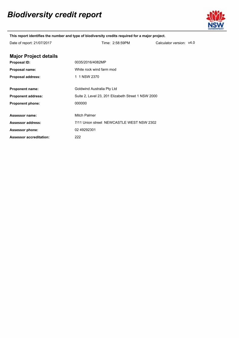
Biodiversity credit report
Proposal ID:
Proposal name:
Calculator version:Date of report: 21/07/2017
0035/2016/4082MP
White rock wind farm mod
This report identifies the number and type of biodiversity credits required for a major project.
Time: 2:58:59PM
Major Project details
Proposal address: 1 1 NSW 2370
v4.0
Goldwind Australia Pty LtdProponent name:
Proponent address: Suite 2, Level 23, 201 Elizabeth Street 1 NSW 2000
Proponent phone:
Assessor name: Mitch Palmer
000000
Assessor address: 7/11 Union street NEWCASTLE WEST NSW 2302
Assessor accreditation: 222
Assessor phone: 02 49292301

Summary of ecosystem credits required
Plant Community type Credits createdArea (ha)
Black Sallee - Snow Gum grassy woodland of the New
England Tableland Bioregion
5.27 111.16
Blakely's Red Gum - Yellow Box grassy woodland of the
New England Tableland Bioregion
7.47 424.78
Ribbon Gum - Mountain Gum - Snow Gum grassy open
forest or woodland of the New England Tableland Bioregion
104.37 2,279.00
River Oak - Rough-barked Apple - red gum - box riparian
tall woodland (wetland) of the Brigalow Belt South Bioregion
and Nandewar Bioregion
0.14 5.00
Silvertop Stringybark - Mountain Gum grassy open forest of
the New England Tableland Bioregion
10.49 389.00
127.74 3,209Total
Credit profiles

1. Black Sallee - Snow Gum grassy woodland of the New England Tableland Bioregion, (BR269)
Number of ecosystem credits created
IBRA sub-region
111
Glen Innes-Guyra Basalts
Offset options - IBRA sub-regionsOffset options - Plant Community types
Black Sallee - Snow Gum grassy woodland of the New England Tableland
Bioregion, (BR269)
Candlebark - Ribbon Gum grassy woodland of the New England Tableland
Bioregion, (BR279)
New England Peppermint grassy woodland on sedimentary or basaltic
substrates of the New England Tableland Bioregion, (BR319)
Mountain Gum - Ribbon Gum open forest of drainage lines of the southern
New England Tableland Bioregion, (BR307)
Glen Innes-Guyra Basalts
and any IBRA subregion that adjoins the
IBRA subregion in which the
development occurs

2. Black Sallee - Snow Gum grassy woodland of the New England Tableland Bioregion, (BR269)
Number of ecosystem credits created
IBRA sub-region
0
Glen Innes-Guyra Basalts
Offset options - IBRA sub-regionsOffset options - Plant Community types
Black Sallee - Snow Gum grassy woodland of the New England Tableland
Bioregion, (BR269)
Candlebark - Ribbon Gum grassy woodland of the New England Tableland
Bioregion, (BR279)
New England Peppermint grassy woodland on sedimentary or basaltic
substrates of the New England Tableland Bioregion, (BR319)
Mountain Gum - Ribbon Gum open forest of drainage lines of the southern
New England Tableland Bioregion, (BR307)
Glen Innes-Guyra Basalts
and any IBRA subregion that adjoins the
IBRA subregion in which the
development occurs

3. Blakely's Red Gum - Yellow Box grassy woodland of the New England Tableland Bioregion,
(BR272)
Number of ecosystem credits created
IBRA sub-region
416
Glen Innes-Guyra Basalts
Offset options - IBRA sub-regionsOffset options - Plant Community types
Blakely's Red Gum - Yellow Box grassy woodland of the New England
Tableland Bioregion, (BR272)
Broad-leaved Stringybark - Blakely's Red Gum grassy woodlands of the
New England Tableland Bioregion, (BR121)
Rough-barked Apple - Cabbage Gum grassy woodland of the New
England Tableland Bioregion, (BR334)
Ribbon Gum - Rough-barked Apple - Yellow Box grassy woodland of the
New England Tableland Bioregion and NSW North Coast Bioregion,
(BR330)
Glen Innes-Guyra Basalts
and any IBRA subregion that adjoins the
IBRA subregion in which the
development occurs

4. Blakely's Red Gum - Yellow Box grassy woodland of the New England Tableland Bioregion,
(BR272)
Number of ecosystem credits created
IBRA sub-region
9
Glen Innes-Guyra Basalts
Offset options - IBRA sub-regionsOffset options - Plant Community types
Broad-leaved Stringybark - Blakely's Red Gum grassy woodlands of the
New England Tableland Bioregion, (BR121)
Blakely's Red Gum - Yellow Box grassy woodland of the New England
Tableland Bioregion, (BR272)
Rough-barked Apple - Cabbage Gum grassy woodland of the New
England Tableland Bioregion, (BR334)
Ribbon Gum - Rough-barked Apple - Yellow Box grassy woodland of the
New England Tableland Bioregion and NSW North Coast Bioregion,
(BR330)
Glen Innes-Guyra Basalts
and any IBRA subregion that adjoins the
IBRA subregion in which the
development occurs

5. Ribbon Gum - Mountain Gum - Snow Gum grassy open forest or woodland of the New England
Tableland Bioregion, (BR329)
Number of ecosystem credits created
IBRA sub-region
2,279
Glen Innes-Guyra Basalts
Offset options - IBRA sub-regionsOffset options - Plant Community types
Ribbon Gum - Mountain Gum - Snow Gum grassy open forest or
woodland of the New England Tableland Bioregion, (BR329)
Black Sallee grassy woodland of the New England Tableland Bioregion,
(BR112)
Manna Gum - Rough-barked Apple - Yellow Box grassy woodland/open
forest of the New England Tableland Bioregion and NSW North Coast
Bioregion, (BR153)
Snow Gum - Black Sallee grassy woodland of the New England Tableland
Bioregion, (BR218)
Snow Gum - New England Peppermint grassy open forest of the New
England Tableland Bioregion, (BR220)
Black Sallee - Snow Gum grassy woodland of the New England Tableland
Bioregion, (BR269)
Candlebark - Ribbon Gum grassy woodland of the New England Tableland
Bioregion, (BR279)
New England Peppermint grassy woodland on sedimentary or basaltic
substrates of the New England Tableland Bioregion, (BR319)
Mountain Gum - Ribbon Gum open forest of drainage lines of the southern
New England Tableland Bioregion, (BR307)
Glen Innes-Guyra Basalts
and any IBRA subregion that adjoins the
IBRA subregion in which the
development occurs

6. Ribbon Gum - Mountain Gum - Snow Gum grassy open forest or woodland of the New England
Tableland Bioregion, (BR329)
Number of ecosystem credits created
IBRA sub-region
0
Glen Innes-Guyra Basalts
Offset options - IBRA sub-regionsOffset options - Plant Community types
Black Sallee grassy woodland of the New England Tableland Bioregion,
(BR112)
Manna Gum - Rough-barked Apple - Yellow Box grassy woodland/open
forest of the New England Tableland Bioregion and NSW North Coast
Bioregion, (BR153)
Snow Gum - Black Sallee grassy woodland of the New England Tableland
Bioregion, (BR218)
Snow Gum - New England Peppermint grassy open forest of the New
England Tableland Bioregion, (BR220)
Black Sallee - Snow Gum grassy woodland of the New England Tableland
Bioregion, (BR269)
Candlebark - Ribbon Gum grassy woodland of the New England Tableland
Bioregion, (BR279)
New England Peppermint grassy woodland on sedimentary or basaltic
substrates of the New England Tableland Bioregion, (BR319)
Ribbon Gum - Mountain Gum - Snow Gum grassy open forest or
woodland of the New England Tableland Bioregion, (BR329)
Mountain Gum - Ribbon Gum open forest of drainage lines of the southern
New England Tableland Bioregion, (BR307)
Glen Innes-Guyra Basalts
and any IBRA subregion that adjoins the
IBRA subregion in which the
development occurs

7. Silvertop Stringybark - Mountain Gum grassy open forest of the New England Tableland Bioregion,
(BR352)
Number of ecosystem credits created
IBRA sub-region
389
Glen Innes-Guyra Basalts
Offset options - IBRA sub-regionsOffset options - Plant Community types
Silvertop Stringybark - Mountain Gum grassy open forest of the New
England Tableland Bioregion, (BR352)
Broad-leaved Stringybark - Mountain Gum - Apple Box open forest of the
New England Tableland Bioregion, (BR122)
Broad-leaved Stringybark - Mountain Ribbon Gum - Messmate open forest
of the NSW North Coast Bioregion and New England Tableland Bioregion,
(BR123)
Mountain Gum - Broad-leaved Stringybark shrubby open forest on granites
of the New England Tableland Bioregion, (BR158)
Narrow-leaved Peppermint - Mountain Ribbon Gum grassy open forest of
the eastern New England Tableland Bioregion, (BR165)
Narrow-leaved Peppermint - Wattle-leaved Peppermint shrubby open
forest of the New England Tableland Bioregion, (BR166)
New England Blackbutt grassy open forest of the eastern New England
Tableland Bioregion, (BR174)
New England stringybarks - peppermint open forest of the New England
Tableland Bioregion, (BR177)
Mountain Ribbon Gum - Messmate - Broad-leaved Stringybark open forest
on granitic soils of the New England Tableland Bioregion, (BR309)
Silvertop Stringybark - Rough-barked Apple grassy open forest of southern
Nandewar Bioregion, southern New England Tableland Bioregion and
NSW North Coast Bioregion, (BR355)
Stringybark - Rough-barked Apple - cypress pine shrubby open forest of
the eastern Nandewar Bioregion and western New England Tableland
Bioregion, (BR361)
Youman's Stringybark - Mountain Gum open forest of the western New
England Tableland Bioregion, (BR402)
Broad-leaved Stringybark shrub/grass open forest of the New England
Tableland Bioregion, (BR277)
Silvertop Stringybark - Bendemeer White Gum - Ribbon Gum open forest
in the Kaputar area of the Nandewar Bioregion, (BR351)
Mountain Gum - Blakely's Red Gum open forest on metasediments of the
Torrington area of the New England Tableland Bioregion, (BR306)
Narrow-leaved Black Peppermint open forest mainly on acid volcanics in
the western New England Tableland Bioregion, (BR314)
Glen Innes-Guyra Basalts
and any IBRA subregion that adjoins the
IBRA subregion in which the
development occurs

8. River Oak - Rough-barked Apple - red gum - box riparian tall woodland (wetland) of the Brigalow
Belt South Bioregion and Nandewar Bioregion, (BR194)
Number of ecosystem credits created
IBRA sub-region
5
Glen Innes-Guyra Basalts
Offset options - IBRA sub-regionsOffset options - Plant Community types
River Oak - Rough-barked Apple - red gum - box riparian tall woodland
(wetland) of the Brigalow Belt South Bioregion and Nandewar Bioregion,
(BR194)
Glen Innes-Guyra Basalts
and any IBRA subregion that adjoins the
IBRA subregion in which the
development occurs