Civil & Stormwater Report - Major Projects
62
Revision 005 – 15-Dec-2020 Prepared for – Deicorp Projects (Tallawong Station) Pty Ltd – ABN: 73 630 425 955 State Significant Development Application (SSDA) Tallawong Station Precinct South Deicorp Projects (Tallawong Station) Pty Ltd 15-Dec-2020 Civil & Stormwater Report Tallawong Station Precinct South
-
Upload
khangminh22 -
Category
Documents
-
view
3 -
download
0
Transcript of Civil & Stormwater Report - Major Projects

Revision 005 – 15-Dec-2020 Prepared for – Deicorp Projects (Tallawong Station) Pty Ltd – ABN: 73 630 425 955
State Significant Development Application (SSDA)
Tallawong Station Precinct South
Deicorp Projects (Tallawong Station) Pty
Ltd
15-Dec-2020
Civil & Stormwater Report
Tallawong Station Precinct South

Tallawong Station Precinct South
Civil & Stormwater Report – Tallawong Station Precinct South
Revision 005 – 15-Dec-2020 Prepared for – Deicorp Projects (Tallawong Station) Pty Ltd – ABN: 73 630 425 955
AECOM
Civil & Stormwater Report
Tallawong Station Precinct South
Client: Deicorp Projects (Tallawong Station) Pty Ltd
ABN: 73 630 425 955
Prepared by
AECOM Australia Pty Ltd
Level 21, 420 George Street, Sydney NSW 2000, PO Box Q410, QVB Post Office NSW 1230, Australia
T +61 2 8934 0000 F +61 2 8934 0001 www.aecom.com
ABN 20 093 846 925
15-Dec-2020
Job No.: 60618532
AECOM in Australia and New Zealand is certified to ISO9001, ISO14001 AS/NZS4801 and OHSAS18001.
© AECOM Australia Pty Ltd (AECOM). All rights reserved.
AECOM has prepared this document for the sole use of the Client and for a specific purpose, each as expressly stated in the document. No other
party should rely on this document without the prior written consent of AECOM. AECOM undertakes no duty, nor accepts any responsibility, to any
third party who may rely upon or use this document. This document has been prepared based on the Client’s description of its requirements and
AECOM’s experience, having regard to assumptions that AECOM can reasonably be expected to make in accordance with sound professional
principles. AECOM may also have relied upon information provided by the Client and other third parties to prepare this document, some of which
may not have been verified. Subject to the above conditions, this document may be transmitted, reproduced or disseminated only in its entirety.

Tallawong Station Precinct South
Civil & Stormwater Report – Tallawong Station Precinct South
Revision 005 – 15-Dec-2020 Prepared for – Deicorp Projects (Tallawong Station) Pty Ltd – ABN: 73 630 425 955
AECOM
Quality Information
Document Civil & Stormwater Report
Ref 60618532
Date 15-Dec-2020
Prepared by William Wong / Andy Toh
Reviewed by Gijs Roeffen
Revision History
Rev Revision Date Details
Authorised
Name/Position Signature
001 03-Mar-2020 For Review Daniel Fettell Principal Engineer – Urban Development Team Leader
002 16-Apr-2020 For Issue Daniel Fettell Principal Engineer
003 07-May-2020 For Issue Daniel Fettell Principal Engineer
004 27-Nov-2020 For Council Review Gijs Roeffen Principal Engineer
005 15-Dec-2020 For Submission Gijs Roeffen Principal Engineer

Tallawong Station Precinct South
Civil & Stormwater Report – Tallawong Station Precinct South
Revision 005 – 15-Dec-2020 Prepared for – Deicorp Projects (Tallawong Station) Pty Ltd – ABN: 73 630 425 955
AECOM
Table of Contents
Executive Summary iii 1.0 Introduction 1
1.1 Planning Requirements 2 2.0 Civil Engineering Design 4
2.1 Design Overview 4 2.2 Design Documentation 5 2.3 Consultation 6 2.4 Roadworks, Earthworks Level Design 6 2.5 General Description 8 2.6 Lot Splays 9 2.7 Conferta Avenue Parking 9 2.8 Pavement Design 10
2.8.1 Type PT-CUD-01C – Unbound Granular 10 2.8.2 Type PT-CUD-15 - Footpath Pavement 10
2.9 Lighting Design 11 2.10 Construction Staging 12
3.0 Utilities Assessment 14 3.1 Utilities Reports 14 3.2 Combined Services Plan 15 3.3 Potable Water 17 3.4 Wastewater 20 3.5 Electrical 23 3.6 Gas 25 3.7 Telecommunications 27
4.0 Stormwater Quantity 29 4.1 Existing Site Conditions 29 4.2 Stormwater Management Strategy 29 4.3 Design Standard and Approach 30
4.3.1 Area 20 Water Cycle Management Strategy Report Incorporating Water Sensitive Urban Design (2010, JWP) 30
4.3.2 Blacktown City Council (BCC) Development Control Plan 30 4.3.3 Blacktown City Council (BCC) Design Standards 31 Design Standards 31 4.3.4 Design Criteria 32
4.4 Catchment Description 34 4.5 Existing Minor Stormwater Network 34
4.5.1 Recent Infrastructure Upgrades 34 4.6 Proposed Stormwater Drainage Strategy 35
4.6.1 Demonstration of Compliance (DRAINS Modelling) 36 5.0 Stormwater Quality 40
5.1 WSUD Implementation 40 5.2 On Lot Filtration 40 5.3 Regional Bioretention Systems 40
5.3.1 Existing Biofiltration Basin 40 5.4 Proposed Rainwater Tank 42 5.5 Biofiltration Street Trees 42 5.6 Demonstration of Compliance (MUSIC Modelling) 43
6.0 Conclusion 48 Appendix A – Sydney Metro at Grade and Elevated Sections Corridor Protection Guidelines Letter A Appendix B – Stream Erosion Index Calculation B

Tallawong Station Precinct South
Civil & Stormwater Report – Tallawong Station Precinct South
Revision 005 – 15-Dec-2020 Prepared for – Deicorp Projects (Tallawong Station) Pty Ltd – ABN: 73 630 425 955
AECOM
List of Figures
Figure 1 Site Plan 1 Figure 2 BCC Growth Centre Precincts Road Widths 8 Figure 3: Recommended Conferta Parking 9 Figure 4 Type PT-CUD-01C Pavement (Proposed Roads MC01, MC02) 10 Figure 5 Footpath Pavement 11 Figure 6: Proposed Staging 12 Figure 7: Proposed Stormwater Asset Staging 13 Figure 8 Combined Services Plan 16 Figure 9 Potable Water Supply (Sydney Water Corporation, 2017) 17 Figure 10 Potable Water Clearances (WSA 03-2011-3.1, Sydney Water Edition – 2012) 19 Figure 11 Sydney Water Wastewater Systems 20 Figure 12 Sewer Clearances WSA 02-2002-2.2, Sydney Water Edition – V3) 22 Figure 13 Endeavour Energy Supply Network 23 Figure 14 NBN Rollout (NBN Co. 2017) 27 Figure 15 NBN Clearances from Other Carriers and Underground Services 28 Figure 16 Site Context 29 Figure 17 Proposed Stormwater Plan 37 Figure 18 Minor Storm Flow 38 Figure 19 Major Storm Flow 39 Figure 20 Proposed Rainwater Tank 42 Figure 21 Proposed biofiltration street trees 43 Figure 22 - Private WSUD Catchments 45 Figure 23 - Public WSUD Catchments 46
List of Tables
Table 1 Response to SEARs 2 Table 2 Key Design Considerations 4 Table 3 Design Documentation 5 Table 4 Road Design Criteria 6 Table 5 Summary of Existing Services 14 Table 6 Jemena Minimum Separation Between Utilities 26 Table 7 Stormwater Drainage reference documents and standards 32 Table 8 Stormwater Drainage Design Criteria 33 Table 9 On-lot filtration for private area 40 Table 10 - Stormwater pollutant load reduction targets 41 Table 11 Land Use Schedule 44 Table 12 MUSIC Modelling Results for Private Area 47 Table 13 MUSIC Modelling Results for Public Area 47 Table 14 Response to SEARs 48

Tallawong Station Precinct South
Civil & Stormwater Report – Tallawong Station Precinct South
Revision 005 – 15-Dec-2020 Prepared for – Deicorp Projects (Tallawong Station) Pty Ltd – ABN: 73 630 425 955
AECOM
Executive Summary
The Tallawong Station Precinct South development site comprises around 7.8 ha of former government owned land within the Area 20 precinct in the North Western Growth Centre. Located between Cudgegong Road, Tallawong Road, Schofields Road and the Metro corridor.
A Civil and Stormwater Report has been prepared to support the State Significant Development Application (SSDA) for this precinct and covers the below items:
• Civil Engineering;
• Utilities Assessment;
• Stormwater Quantity Management;
• Stormwater Quality Management; and
• A Sydney Metro Corridor Protections Letter.
The Utilities Assessment section demonstrates that public infrastructure (including the supply of potable water, wastewater, electricity, gas and telecommunications) have been considered within the proposal and will be made available to adequately service the future precinct development;
The Stormwater Quantity Management section details the site drainage, the site drains in a south eastern direction to a degraded section of Second Ponds Creek. Station enabling works and existing roads include stormwater pipe drainage across Cudgegong Road in two locations. The proposed development will connect to this stormwater network. These drainage structures have been planned to accommodate future development including the proposed development;
As detailed in the Stormwater Quality Management section, water sensitive urban design (WSUD) elements are proposed as part of the treatment train that will provide an acceptable level of detention and treatment to achieve the prescribed stream stability metric and stormwater quality targets; and
The Sydney Metro Corridor Protections Letter confirms that due to the distance between the Tallawong Metro Station and the proposed development, the development is not located within the protection reserve of the metro nor does it cause design and construction related safety, engineering, maintenance and operational impact on the at grade and elevated Metro infrastructure.

Tallawong Station Precinct South
Civil & Stormwater Report – Tallawong Station Precinct South
Revision 005 – 15-Dec-2020 Prepared for – Deicorp Projects (Tallawong Station) Pty Ltd – ABN: 73 630 425 955
1 AECOM
1.0 Introduction
Tallawong is a key destination within the ever-growing North West Priority Growth Area. As the location for the final Norwest Metro line, Tallawong offers the immediate community direct connection to the city and surrounding key recreational, social and economic facilities.
The site is located:
• Directly adjacent to the Tallawong Metro Station; and
• Adjacent to Schofields Road and Cudgegong Road.
The Tallawong development will deliver residential, commercial and retail services consisting of 987 units. The Site 1 area is 16,240m2 while the Site 2 area is 27,030m2, the areas are shown Figure 1 below.
This document summarises the design approach, key assumptions, references and standards considered in developing the civil and stormwater design documentation for the Tallawong Station Precinct South development.
Figure 1 Site Plan
The civil scope of works for the design includes:
• Pedestrian paths – up to the kerb line at Conferta Avenue and Themeda Avenue;
• Proposed private and public internal roads;
• A shared path in site 2; and
• Residential, retail, commercial building entry points.

Tallawong Station Precinct South
Civil & Stormwater Report – Tallawong Station Precinct South
Revision 005 – 15-Dec-2020 Prepared for – Deicorp Projects (Tallawong Station) Pty Ltd – ABN: 73 630 425 955
2 AECOM
Further indicative dedications can be found in the SSDA Civil Engineering Drawing Package accompanying this report.
The concept proposal generally adheres to the State Environmental Planning Policy (SEPP) (Sydney Region Growth Centres, 2006) Indicative Layout Plan (ILP) and Development Control Plan (DCP) for Area 20.
1.1 Planning Requirements
Table 1 below provides a summary of the planning requirements that are addressed within this report, these are from:
• SSD-10425 Secretary’s Environmental Assessment Requirements (SEARS);
• Additional recommendations from the Environment, Energy and Science Group (EES); and
• Blacktown City Council (BCC) review of SEARS.
Table 1 Response to SEARs
Item Description Action
SEARS Utilities The EIS must:
• identify and address the existing capacity to service the development proposed and any augmentation requirements for utilities in consultation with relevant agencies; and
• identify any potential impacts of the proposed construction and operation on the existing utility infrastructure and service provider assets, and demonstrate how these will be protected, or impacts mitigated.
SEARS Plans and Documents The EIS must include all relevant plans, architectural drawings, diagrams and relevant documentation required under Schedules 1 and 2 of the Environmental Planning and Assessment Regulation 2000 including:
• Services and utilities impact assessment; and
• Sydney Metro Underground Corridor Protection Guidelines or Sydney Metro at Grade and Elevated Sections Corridor Protection Guidelines report.
DPIE EE Comments 9.
Water and Soils The EIS must map the following features relevant to water and soils including:
• Rivers, streams, wetlands, estuaries (as described in s4.3 of the Biodiversity Assessment Method); and
• Proposed intake and discharge locations.
DPIE EE Comments 10.
Water and Soils THE EIS must describe background conditions for any water resource likely to be affected by the development, including:
• Existing surface and groundwater;
• Hydrology, including volume, frequency and quality of discharges at proposed intake and discharge locations;

Tallawong Station Precinct South
Civil & Stormwater Report – Tallawong Station Precinct South
Revision 005 – 15-Dec-2020 Prepared for – Deicorp Projects (Tallawong Station) Pty Ltd – ABN: 73 630 425 955
3 AECOM
Item Description Action
• Water Quality Objectives (as endorsed by NSW Government) including groundwater as appropriate that represent the community’s uses and values for the receiving waters.
BCC Review -10-13.
Engineering Engineering:
• All roads must comply with engineering standards set out in Council’s Engineering Guide for Development. No basement parking permitted under a public road therefore the road must remain private with a public easement for access;
• Drainage overland flow path must be dedicated and in a public road (not a private easement);
• Overland drainage must be in public space and treated to meet CPTED requirements; and
• Splays are required on corners of overland flow paths and public roads.
BCC Review -14-15.
Drainage Drainage:
• Compliance with drainage requirements as outlined in meeting with Council’s drainage section on 7th February 2020; and
• Compliance with water sensitive urban design requirements set out in Part J of the Blacktown Development Control Plan.
BCC Review -5-6.
Drainage and Engineering Compliance with engineering and drainage requirements as outlined in Councils Letter from 28th July 2020

Tallawong Station Precinct South
Civil & Stormwater Report – Tallawong Station Precinct South
Revision 005 – 15-Dec-2020 Prepared for – Deicorp Projects (Tallawong Station) Pty Ltd – ABN: 73 630 425 955
4 AECOM
2.0 Civil Engineering Design
2.1 Design Overview
The key considerations incorporated throughout the design of the urban areas of the development include the following principles:
• A connected town centre;
• Street network hierarchy;
• Pedestrian and cycle network;
• Open space network;
• Urban block structure;
• Variations in height and scale;
• A range of housing typologies; and
• Mixed-uses and activation.
A summary of the design parameters considered for the concept proposal is outlined below in Table 2.
Table 2 Key Design Considerations
Area Key Design Considerations
Proposed Roads • Pedestrian crossing at the intersection with Conferta Avenue;
• Trees and planting to improve the outdoor aesthetic and provide water
quality treatment;
• Utility services underneath footpath to service development lots;
• Road design to support vehicular access to development lots;
• Loading zone parking;
• Lighting; and
• Integration with the landscape design.
Private Park and
Urban Plaza
• Flexible seating / event space adjacent;
• Retaining walls allow a view of the park and surrounds; and
• Integration with the landscape design to form an interconnected open
space.
Pedestrian and Cycle
Network
• Create a series of through site links that extend the pedestrian and cycle
network connecting key elements such as the Metro station with landscaped
spaces, major intersections and residential areas.
• Seating along the walkway;
• Trees and planting to improve the outdoor aesthetic and provide water
quality treatment;
• Coordination with the landscape of the existing traverse roads;
• Crime prevention through environmental design (CPTED); and
• Integration with the landscape design.

Tallawong Station Precinct South
Civil & Stormwater Report – Tallawong Station Precinct South
Revision 005 – 15-Dec-2020 Prepared for – Deicorp Projects (Tallawong Station) Pty Ltd – ABN: 73 630 425 955
5 AECOM
2.2 Design Documentation
The Design Documentation comprises of the following drawing list:
Table 3 Design Documentation
Drawing Number Drawing Name Other
GENERAL PLANS
60558549-SHT-CI-0001 COVER SHEET
60558549-SHT-CI-0003 GENERAL NOTES
60558549-SHT-CI-0011 KEY PLAN
60558549-SHT-CI-0021 GENERAL ARRANGEMENT
PUBLIC DOMAIN PLANS
60558549-SHT-CI-0101 PUBLIC DOMAIN - PLAN SHEET 01
60558549-SHT-CI-0102 PUBLIC DOMAIN - PLAN SHEET 02
60558549-SHT-CI-0103 PUBLIC DOMAIN - PLAN SHEET 03
60558549-SHT-CI-0104 PUBLIC DOMAIN - PLAN SHEET 04
TYPICAL SITE SECTIONS
60558549-SHT-CI-0121 TYPICAL SITE SECTION SHEET 01
60558549-SHT-CI-0122 TYPICAL SITE SECTION SHEET 02
60558549-SHT-CI-0123 TYPICAL SITE SECTION SHEET 03
60558549-SHT-CI-0124 TYPICAL SITE SECTION SHEET 04
60558549-SHT-CI-0125 TYPICAL SITE SECTION SHEET 05
LONGITUDINAL SECTIONS
60558549-SHT-CI-0161 PUBLIC DOMAIN LONGITUDINAL SECTIONS MC01 SHEET 01
60558549-SHT-CI-0162 PUBLIC DOMAIN LONGITUDINAL SECTIONS MC01 SHEET 02
60558549-SHT-CI-0163 PUBLIC DOMAIN LONGITUDINAL SECTIONS MC02 SHEET 03
60558549-SHT-CI-0164 PUBLIC DOMAIN LONGITUDINAL SECTIONS MC02 SHEET 04
EROSION AND SEDIMENTATION CONTROL PLANS
60558549-SHT-CI-0201 EROSION AND SEDIMENT CONTROL PLAN
60558549-SHT-CI-02221 EROSION AND SEIDMENT CONTROL DETAIL
ISPACH PLANS
60558549-SHT-CI-0220 ISOPACH – PLAN – SITE WIDE
DRAINAGE PLANS
60558549-SHT-CI-0300 DRAINAGE – PLAN – SITE WIDE
60558549-SHT-CI-0301 DRAINAGE – PLAN SHEET 01
60558549-SHT-CI-0302 DRAINAGE – PLAN SHEET 02
Tallawong Station Precinct South
Civil & Stormwater Report – Tallawong Station Precinct South
Revision 005 – 15-Dec-2020 Prepared for – Deicorp Projects (Tallawong Station) Pty Ltd – ABN: 73 630 425 955
6 AECOM
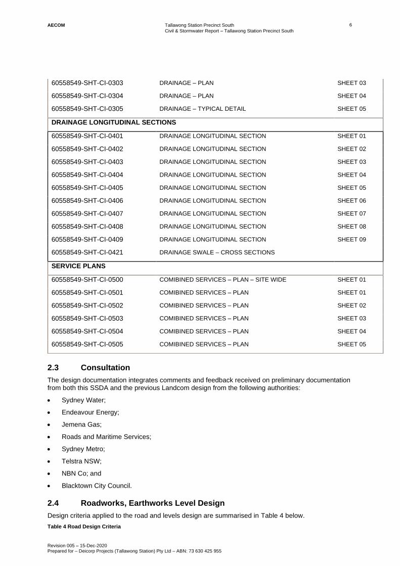
2.3 Consultation
The design documentation integrates comments and feedback received on preliminary documentation from both this SSDA and the previous Landcom design from the following authorities:
• Sydney Water;
• Endeavour Energy;
• Jemena Gas;
• Roads and Maritime Services;
• Sydney Metro;
• Telstra NSW;
• NBN Co; and
• Blacktown City Council.
2.4 Roadworks, Earthworks Level Design
Design criteria applied to the road and levels design are summarised in Table 4 below.
Table 4 Road Design Criteria
60558549-SHT-CI-0303 DRAINAGE – PLAN SHEET 03
60558549-SHT-CI-0304 DRAINAGE – PLAN SHEET 04
60558549-SHT-CI-0305 DRAINAGE – TYPICAL DETAIL SHEET 05
DRAINAGE LONGITUDINAL SECTIONS
60558549-SHT-CI-0401 DRAINAGE LONGITUDINAL SECTION SHEET 01
60558549-SHT-CI-0402 DRAINAGE LONGITUDINAL SECTION SHEET 02
60558549-SHT-CI-0403 DRAINAGE LONGITUDINAL SECTION SHEET 03
60558549-SHT-CI-0404 DRAINAGE LONGITUDINAL SECTION SHEET 04
60558549-SHT-CI-0405 DRAINAGE LONGITUDINAL SECTION SHEET 05
60558549-SHT-CI-0406 DRAINAGE LONGITUDINAL SECTION SHEET 06
60558549-SHT-CI-0407 DRAINAGE LONGITUDINAL SECTION SHEET 07
60558549-SHT-CI-0408 DRAINAGE LONGITUDINAL SECTION SHEET 08
60558549-SHT-CI-0409 DRAINAGE LONGITUDINAL SECTION SHEET 09
60558549-SHT-CI-0421 DRAINAGE SWALE – CROSS SECTIONS
SERVICE PLANS
60558549-SHT-CI-0500 COMIBINED SERVICES – PLAN – SITE WIDE SHEET 01
60558549-SHT-CI-0501 COMIBINED SERVICES – PLAN SHEET 01
60558549-SHT-CI-0502 COMIBINED SERVICES – PLAN SHEET 02
60558549-SHT-CI-0503 COMIBINED SERVICES – PLAN SHEET 03
60558549-SHT-CI-0504 COMIBINED SERVICES – PLAN SHEET 04
60558549-SHT-CI-0505 COMIBINED SERVICES – PLAN SHEET 05

Tallawong Station Precinct South
Civil & Stormwater Report – Tallawong Station Precinct South
Revision 005 – 15-Dec-2020 Prepared for – Deicorp Projects (Tallawong Station) Pty Ltd – ABN: 73 630 425 955
7 AECOM
Item Standard Adopted Comment Horizontal Road Alignment
Vehicle Design Speed BCC DCP 50 km/h
Based on operational speed
of 50 km/h
Turning Paths BCC/TfNSW
AS 2890.2 – 2002
Design Vehicle:
BCC Refuse vehicle:
• Overall length = 11m
• Width = 2.5m
• Wall to wall turn radius
= 10.5m
Medium Rigid Vehicle
(MRV)
• Overall Length = 8.8m
• Overall Width = 2.5m
• Kerb to kerb turn
radius = 10m
Access for BCC Garbage
Truck and single Medium
Rigid Vehicle (MRV) to
proposed roads required.
Refer to Traffic Engineers
report for details of swept
paths.
Austroads 2008 Emergency response
vehicles and service
vehicles
L = 19.0m
Road Reserve Width
Lane Width BCC Engineering Guideline Proposed Roads
• Local Road = 16m
• Collector Road = 18m
• Pathways = 4.0 – 10m (depending of function)
Parking Lane AS 2890.5 – 1993 On-Street Car Parking
Min Width = 2.1 m
Length 1 space = 6.3m
Allows for kerbs and/or
obstructions at either end of
the parking spaces.
Footpath/Cycleway BCC Engineering Guideline Min Width = 4.0m
Max Width = 10.0m
Depending on function
(access/drainage/servicing)
Kerb Types
Collector Road
(Major and Minor)
BCC Engineering Guideline 150mm kerb & gutter
Local Road/Street BCC Engineering Guideline Roll top kerb & gutter
Vertical Road Alignment
Maximum Longitudinal
Grade
BCC Engineering Guideline Residential Roads
Desirable = 12%
Maximum = 16%
Maximum Longitudinal Grade at intersections
BCC Engineering Guideline 5 %
Minimum Longitudinal Grade
BCC Engineering Guideline Desirable = 1%
Minimum = 0.7%
% change in grade requiring a Vertical Curve
BCC Engineering Guideline 1%
Min VC lengths BCC Engineering Guideline Cul-de-sac, Access and
Local Streets
Desirable = 25m
Acceptable = 6m
Collector Streets
Desirable = 35m
Lengths of VC given are for straight alignments; longer curves may be necessary where roads also have horizontal curvature.

Tallawong Station Precinct South
Civil & Stormwater Report – Tallawong Station Precinct South
Revision 005 – 15-Dec-2020 Prepared for – Deicorp Projects (Tallawong Station) Pty Ltd – ABN: 73 630 425 955
8 AECOM
Item Standard Adopted Comment Acceptable = 12m
Cross fall BCC Engineering Guideline Concrete = 2.0-3.0%
Asphaltic Concrete = 3.0%
Sprayed Seal = 3.0-4.0%
Vertical Footpath Alignment
Maximum Longitudinal Fall
BCC Engineering Guideline 8.3% Grading of pathways shall
not be steeper than 1 in 12
Minimum Footpath Cross Fall
BCC Engineering Guideline 2% To accommodate existing vehicular crossing and other facilities.
Maximum Footpath Cross Fall
BCC Engineering Guideline 6% With prior approval from Council
Cross fall BCC Engineering Guideline Roads 2.0 to 3.0%
Footpaths 2.0 to 6.0%
For concrete road pavement
2.5 General Description
The following are the main features of the road and earthworks design for the project:
• Design of roads with 2-way cross-fall to suit stormwater management requirements;
• Kerb radii to suit the turn path of the design vehicle;
• Footpath cross fall designed to meet BCC standards; and
• Landscaping and earthworks to suit a public park.
The design of public roadways including footpaths, shared paths and private roadways within the Tallawong Station South Precinct comply with the Blacktown City Council Growth Centre Precincts DCP as outlined in Figure 3-14 of the DCP (refer Figure 2 below) however with indented parking.
Figure 2 BCC Growth Centre Precincts Road Widths

Tallawong Station Precinct South
Civil & Stormwater Report – Tallawong Station Precinct South
Revision 005 – 15-Dec-2020 Prepared for – Deicorp Projects (Tallawong Station) Pty Ltd – ABN: 73 630 425 955
9 AECOM
2.6 Lot Splays
Lot splays are currently provided at the edges of Cudgegong Road as per the previously approved Landcom SSDA submission. Furthermore – at the request of Blacktown City Council – splays have been included at the corners of Site 2A and the northwest corner of site 2BCE.
2.7 Conferta Avenue Parking
Conferta Avenue is an existing council public road, as a part of this development we would recommend Blacktown City Council install parking signage to allow parking on Conferta and slow passing vehicles.
There are 17 on-street parking spaces that can be made available while complying with Australian Standards and road rules as shown below in Figure 3.
Figure 3: Recommended Conferta Parking

Tallawong Station Precinct South
Civil & Stormwater Report – Tallawong Station Precinct South
Revision 005 – 15-Dec-2020 Prepared for – Deicorp Projects (Tallawong Station) Pty Ltd – ABN: 73 630 425 955
10 AECOM
2.8 Pavement Design
Paved areas throughout the Tallawong Station Precinct South development include roads and footpaths along the Proposed Roads and along the pedestrian and cycle thoroughfares. This section summarises the structural design process for the pavements within the Tallawong Station Precinct South development. Pavements included in the design are summarised as follows:
• Pavement Type PT-CUD-01C - Flexible Road Pavement; and
• Pavement Type PT-CUD-15 – Concrete Footpath.
These pavement designs will tie into the existing pavement for the precinct constructed as part of the Northwest Rapid Transit (NRT) works. BCC Engineering guidelines indicate that pavements should be designed using the general principles of Austroads (2012) “Guide to Pavement Technology – Part 2 Pavement Structural Design”. These pavement designs are subject to further detailed analysis and may change during design development.
2.8.1 Type PT-CUD-01C – Unbound Granular
Flexible pavement is presented along the road surface of the Proposed Roads (MC01 and MC02). The previous pavement along Precinct Streets C (Aristida) and D (Conferta) for the NRT design is shown below, adopting a Design Traffic Loading (ESA) 3.90 x 10⁵.
Figure 4 Type PT-CUD-01C Pavement (Proposed Roads MC01, MC02)
2.8.2 Type PT-CUD-15 - Footpath Pavement
Footpath pavement will be used along to link the site from North to South. All new footpaths within the Tallawong Station Precinct South will implement the following footpath pavement design.
Pavement Tag Pavement Type Thickness (mm) Subgrade CBR%
PT-CUD-01C Unbound Granular 180 (DGB20) 3 180 (DGB20)
150 (SMZ)
PT-CUD-01C Unbound Granular 150 (DGB20) 7
150 (DGS20)
PT-CUD-01C Unbound Granular 150 (DGB20) 12
150 (DGS20)

Tallawong Station Precinct South
Civil & Stormwater Report – Tallawong Station Precinct South
Revision 005 – 15-Dec-2020 Prepared for – Deicorp Projects (Tallawong Station) Pty Ltd – ABN: 73 630 425 955
11 AECOM
Figure 5 Footpath Pavement
New pavement calculations will be undertaken as part of detailed design, but the intent would be to match the existing NRT design wherever possible with the exception of different finishes for the indented car bays and the proposed new plaza.
2.9 Lighting Design
Street lighting will be installed along all proposed Roads, pedestrian footpaths and cycle ways. These will be provided in accordance with Blacktown City Council and Endeavour Energy requirements. The key methodology and assumptions to be applied to the street lighting design are outlined below:
• Council requires all new lighting levels are to be in accordance with AS/NZ 1158 in its various parts and to comply with all the requirements of Endeavour Energy’s document “Public Lighting Equipment – Luminaires, Lamps & Ancillary Equipment, Technical Specification (2014)”;
• The lighting of arterial and sub-arterial (Traffic Route Lighting) roads must comply with AS/NZS 1158. Part 1.1 – Vehicular Traffic (Category V) Lighting – Performance and Installation Design Requirements 1997, using the appropriate lighting categories;
• Lighting of residential roads and public places must comply with AS/NZS 1158 Residential Street Lighting Part 3.1: Pedestrian Area (category P) Lighting – Performance and Installation Design Requirements 1999, using the appropriate lighting categories;
• Luminaire Type (roads) = SHP250w ROADSTER;
• Column Height/Outreach = 8.5m / 3m (to be confirmed in lighting design); and
• Maintenance Factor = 0.7.
Luminaries to be supplied are to comply with AS/NZS 1158.6 specifications and Endeavour Energy’s documents and shall be:
• With National Electrical Manufacturers Association (NEMA) photoelectric cell base;
• With integral control gear;
• Designed for clear tubular lamp;
• Single insulated;
• With radio and television interference suppression capacitors; and
• With a Metal Oxide Varistor (MOV) – minimum 320 Joules.

Tallawong Station Precinct South
Civil & Stormwater Report – Tallawong Station Precinct South
Revision 005 – 15-Dec-2020 Prepared for – Deicorp Projects (Tallawong Station) Pty Ltd – ABN: 73 630 425 955
12 AECOM
2.10 Construction Staging
Construction will be carried out in the following order – as shown in Figure 6 below
o Stage 1 (Site 1A+ 1B)
o Stage 2 (Site 2A)
o Stage 3 (Site 2D)
o Stage 4 (Site 2BCE)
Figure 6: Proposed Staging
The drainage for Site 1A+1B will be constructed and provided at Stage 1. This would include jellyfish filters and Gross pollutant traps (GPT) provisions to comply with WSUD requirements. Erosion and Sediment Control Plan and management procedures will be also maintained during construction to prevent pollution downstream. The drainage constructed for site 1A+1B connects into existing council drainage along Conferta avenue and into the bio-retention basin downstream.
The drainage from site 2A connecting to existing downstream connection points at Conferta Avenue (low-flow) and Schofields Road (high-flow) will be constructed upfront and provided at Stage 2. This would include the drainage along the internal road adjacent to sites 2A, 2D and 2BCE. Refer image highlighted in yellow in Figure 7 below.

Tallawong Station Precinct South
Civil & Stormwater Report – Tallawong Station Precinct South
Revision 005 – 15-Dec-2020 Prepared for – Deicorp Projects (Tallawong Station) Pty Ltd – ABN: 73 630 425 955
13 AECOM
Figure 7: Proposed Stormwater Asset Staging
Site drainage, jellyfish filters and Gross pollutant traps (GPT) provisions for Stages 3 and 4 will be provided at their respective stages to connect into the downstream network.
Erosion and Sediment Control Plan and management procedures should also maintained during all stages of construction to prevent pollution downstream.

Tallawong Station Precinct South
Civil & Stormwater Report – Tallawong Station Precinct South
Revision 005 – 15-Dec-2020 Prepared for – Deicorp Projects (Tallawong Station) Pty Ltd – ABN: 73 630 425 955
14 AECOM
3.0 Utilities Assessment
A Dial Before You Dig request was submitted for the site area which identified a range of services present within the study area. These are summarised in Table 5.
Table 5 Summary of Existing Services
Authority Name Phone Utility Type
Optus and/or Uecomm, Nsw 1800505777 Data and Telecommunications
PIPE Networks, Nsw 1800201100 Data and Telecommunications
Telstra NSW, Central 1800653935 Data and Telecommunications
Endeavour Energy 0249510899 Electricity
Jemena Gas 1300880906 Gas
The Hills Shire Council 0292659819 Other
Roads and Maritime Services 0294227792 Other
Sydney Water 0132092 Potable and Recycled Water / Wastewater
Sydney Metro 0291119083 Road & Rail
NBN Co, NswAct 1800626762 Communications
The plans provided from the DBYD requests were considered as a part of the condition and capacity review.
3.1 Utilities Reports
A number of annual reports and master plans that have been prepared by stakeholders provide information relevant to the study area. A list of the reports used in the infrastructure strategy assessment is shown below:
• Northwest Rapid Transit Project Integrated Management System, 2015
• Area 20 Primary Utilities Report, Cardno 2015
• Blacktown City Council Growth Centre Precincts, Development Control Plan, NSW Government, 2016
• Cudgegong Road Station, (Area 20 Precinct) Finalisation Report, NSW Government, 2015
• North West Rail Link, Cudgegong Road Station Structure Plan, NSW Government, 2013
• Development Servicing Plan (Rouse Hill Recycled Water System), Sydney Water, 2016
• Draft Metropolitan Strategy for Sydney To 2031, NSW Government, 2014
• A Plan for Growing Sydney, NSW Government, 2014
• NSW Long Term Transport Master Plan, NSW Government, 2014
• Decentralised Water - Master Plan, City of Sydney, 2012
• Growth Servicing Plan July 2014 to June 2019, Sydney Water, 2014
• Wastewater Systems, Sydney Water, 2014
• Distribution Annual Planning Report, Endeavour Energy, 2016
• BASIX Water Savings Monitoring – Sydney Water, 2009
• BASIX Monitoring Report - Electricity Consumptions for 2007-2009, NSW Department of Planning, 2010

Tallawong Station Precinct South
Civil & Stormwater Report – Tallawong Station Precinct South
Revision 005 – 15-Dec-2020 Prepared for – Deicorp Projects (Tallawong Station) Pty Ltd – ABN: 73 630 425 955
15 AECOM
3.2 Combined Services Plan
A combined services plan has been developed for the Tallawong Station Precinct South site,
presenting utility service routes throughout the precinct and considering the following:
• Connection to existing utility infrastructure;
• Potential development lot connection points;
• Coordination between services; and
• Provision of water, wastewater, electrical and gas supply.
All services are shown schematically and are subject to changes during further design stages and input from the relevant utility authorities. Schematic layouts for each utility service are presented in the individual sections within this report.
The Combined Services Plan sheets are shown in Figure 8.

5
0
.
0
0
R
A
G
Ø375
Ø375
Ø375
Ø375
Ø375
Ø
9
0
0
Ø
5
2
5
Ø
9
0
0
Ø100
Ø3
75
SC
HO
FIE
LD
S R
OA
D
C
U
D
G
E
G
O
N
G
R
O
A
D
CUDGEGONG ROAD STATION
THEMEDA AVENUE
CONFERTA AVENUE
AR
TIS
TID
A S
TR
EE
T
N
T
N
INDICATIVE BUILDING
CONNECTION POINT
INDICATIVE BUILDING
CONNECTION POINT
INDICATIVE BUILDING
CONNECTION POINT
INDICATIVE BUILDING
CONNECTION POINT
INDICATIVE BUILDING
CONNECTION POINT
INDICATIVE BUILDING
CONNECTION POINT
Last saved by: R
EY
ES
C5(2020-11-25
) Last P
lotted: 2020-11-27
FIGURE 8
COMBINED SERVICES
PLAN
SITE WIDE
SHEET NUMBER
60618532-SHT-00-0000-CI-0500
Filenam
e: \\A
US
YD
1F
P001\P
RO
JE
CT
S\605X
\60558549\5. C
AD
\20-S
HE
ET
S\60618532-S
HT
-00-0000-C
I-0500.D
WG
PROJECT NUMBER
60618532
I/R DATE DESCRIPTION
ISSUE/REVISION
1 03.04.2020 ISSUE FOR REVIEW.
2 16.04.2020 ISSUE FOR SUBMISSION
3 07.05.2020 ISSUE FOR SUBMISSION
4 25.11.2020 ISSUE FOR SUBMISSION
G.ROEFFENN.MITCHELL-
DESIGNER CHECKED APPROVED
PROJECT MANAGEMENT INITIALS
- N.MITCHELL G.ROEFFEN
This draw
ing is confidential and shall only be used for the purpose of this project. T
he signing of this title block confirm
s the design and drafting of this project have been prepared and checked in accordance w
ith the A
EC
OM
quality assurance system
to IS
O 9001-2000.
IS
O A
1 594m
m x 841m
m
KEY PLAN
CONSULTANT
AECOM Australia Pty Ltd
A.B.N 20 093 846 925
www.aecom.com
CLIENT
PRELIMINARY
SCALE BAR
PROJECT
TALLAWONG STATION
PRECINCT SOUTH
CIVIL PACKAGE
DEICORP PROJECTS
(TALLAWONG STATION) PTY LTD
0 12.5 25
1:500
m
LEGEND
DRAINAGE LINE
DRAINAGE PITS
EXISTING DRAINAGE LINE
COMMUNICATIONS
GAS (JEMENA)
ELECTRICITY (AUSGRID)
SEWER (SYDNEY WATER)
WATER (SYDNEY WATER)
EXISTING COMMUNICATIONS
EXISTING GAS
EXISTING ELECTRICITY
EXISTING SEWER
EXISTING WATER
EXISTING HIGH VOLTAGE
CAP BUILDING
CONNECTION POINT
AT BOUNDARY
STREET LIGHTING
(CITY OF SYDNEY)
INDICATIVE FIRE WATER LINE
Ø525
PROPOSED BUILDING OUTLINE
NEW SUBSTATION

Tallawong Station Precinct South
Civil & Stormwater Report – Tallawong Station Precinct South
Revision 005 – 15-Dec-2020 Prepared for – Deicorp Projects (Tallawong Station) Pty Ltd – ABN: 73 630 425 955
17 AECOM
3.3 Potable Water
Sydney Water supplies potable water to the Tallawong Station Precinct from the prospect supply system as shown below in Figure 9.
Figure 9 Potable Water Supply (Sydney Water Corporation, 2017)
The Rouse Hill Supply Area is supplied via the Potts Hill Trunk Delivery System and incorporates the Rouse Hill WWTP/WRP, Parklea North Reservoir, Kellyville Reservoir and Parklea Reservoir. There are also three potable water pumping stations within the system:
• Parklea North WP0308;
• Kellyville WP0307; and
• Parklea WP0309.
Existing On-Site Utility Infrastructure
The existing Sydney Water potable water network on the Tallawong Station Precinct South site has been identified based on Dial Before You Dig (DBYD) records. These records indicate the presence of numerous potable water mains within and adjacent to the precinct boundaries.
The existing potable network in the immediate surrounding vicinity consists of the following:
• External DN250 DICL main running along Schofields Road South of the site;
• External DN750 DICL main running along the eastern side of Cudgegong Road;
• External DN250 DICL main running along the western side of Cudgegong Road; and
• External DN450 DICL main running along Tallawong Road west of the site.
The depths and position of the existing reticulation mains are unknown, further investigation is required to determine the exact existing layout. Additionally, while Sydney Water have confirmed that the trunk mains should have sufficient capacity to service the projected demand, smaller reticulation mains may require amplification.
It should be noted that the above discussion only considers Sydney Water infrastructure, it is likely that private or other authority water infrastructure is present on the site (particularly on NRT land).

Tallawong Station Precinct South
Civil & Stormwater Report – Tallawong Station Precinct South
Revision 005 – 15-Dec-2020 Prepared for – Deicorp Projects (Tallawong Station) Pty Ltd – ABN: 73 630 425 955
18 AECOM
Potential On-Site Infrastructure Layouts
It is assumed that the proposed development would ultimately be supplied from the existing DN750 DICL or DN250 DICL external main along Cudgegong Road.
The proposed internal water reticulation layout assumes connections to the existing Sydney Water network to be made in two locations. A new potable water main is to extend from Cudgegong Road running westbound underneath Conferta Avenue to supply new buildings within the southern site. Connections will also be made to newly constructed water mains beneath the proposed new public road for buildings adjacent.
It has been assumed that one point of connection is required per lot, these points of connection have been located adjacent to the assumed driveway locations of each building and are proposed to be co-located with other services connections.
The potable water reticulation network will also likely require new hydrants within the streets however these will be confirmed during detailed design. It is noted that Sydney Water will generally not provide a lot connection until an application is made by that developer for a service and Sub-division of lots is required prior to submitting applications to Sydney Water.
The proposed potable water infrastructure may be influenced by staging of the development and requirements for connection to individual lots.
Coordination of Potable Water Infrastructure with Other Services
Coordination of the proposed potable water infrastructure with other services in the proposed street network would generally be based on the Streets Opening Conference standards.
Section 5.12.5.2 of the Water Services Association of Australia codes (WSA 03-2011-3.1, Sydney Water Edition – 2012) states that the clearance requirements for water mains from other service utility assets shall not be less than the minimum vertical and horizontal clearances as summarised in Figure 10.

Tallawong Station Precinct South
Civil & Stormwater Report – Tallawong Station Precinct South
Revision 005 – 15-Dec-2020 Prepared for – Deicorp Projects (Tallawong Station) Pty Ltd – ABN: 73 630 425 955
19 AECOM
Figure 10 Potable Water Clearances (WSA 03-2011-3.1, Sydney Water Edition – 2012)
Tallawong Station Precinct South
Civil & Stormwater Report – Tallawong Station Precinct South
Revision 005 – 15-Dec-2020 Prepared for – Deicorp Projects (Tallawong Station) Pty Ltd – ABN: 73 630 425 955
20 AECOM
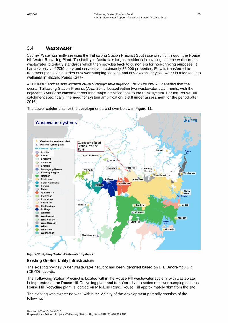
3.4 Wastewater
Sydney Water currently services the Tallawong Station Precinct South site precinct through the Rouse Hill Water Recycling Plant. The facility is Australia’s largest residential recycling scheme which treats wastewater to tertiary standards which then recycles back to customers for non-drinking purposes. It has a capacity of 20ML/day and services approximately 32,000 properties. Flow is transferred to treatment plants via a series of sewer pumping stations and any excess recycled water is released into wetlands in Second Ponds Creek.
AECOM’s Services and Infrastructure Strategic Investigation (2014) for NWRL identified that the overall Tallawong Station Precinct (Area 20) is located within two wastewater catchments, with the adjacent Riverstone catchment requiring major amplifications to the trunk system. For the Rouse Hill catchment specifically, the need for system amplification is still under assessment for the period after 2016.
The sewer catchments for the development are shown below in Figure 11.
Figure 11 Sydney Water Wastewater Systems
Existing On-Site Utility Infrastructure
The existing Sydney Water wastewater network has been identified based on Dial Before You Dig (DBYD) records.
The Tallawong Station Precinct is located within the Rouse Hill wastewater system, with wastewater being treated at the Rouse Hill Recycling plant and transferred via a series of sewer pumping stations. Rouse Hill Recycling plant is located on Mile End Road, Rouse Hill approximately 3km from the site.
The existing wastewater network within the vicinity of the development primarily consists of the following:

Tallawong Station Precinct South
Civil & Stormwater Report – Tallawong Station Precinct South
Revision 005 – 15-Dec-2020 Prepared for – Deicorp Projects (Tallawong Station) Pty Ltd – ABN: 73 630 425 955
21 AECOM
• DN600 GRP pipe running through property east of the Precinct.
While this assessment only considers Sydney Water infrastructure, it should be noted that there may be existing wastewater lines adjacent to the site that have not been dedicated to Sydney Water.
Potential On-Site Infrastructure Layouts
The scope of external infrastructure upgrades are to be confirmed based on hydraulic modelling to be undertaken during detailed design. In advance of this detail, it is assumed that the proposed internal gravity reticulation network splits the site into two sub-catchments to generally complement the staging of the proposed development
• New DN300 main at 1% grade connecting the site to existing external DN600 GRP main parallel to Second Ponds Creek.
The proposed upgrades and building wastewater connection points are shown in the combined services plan. Each lot is required to be serviced with a single sewer connection with detailed requirements nominated in the Sydney Water Notice of Requirements. Sub-division of lots is required prior to submitting applications to Sydney Water.
Coordination of Wastewater Infrastructure with Other Services
Coordination of the proposed wastewater infrastructure with other services in the proposed street network would generally be based on the Streets Opening Conference standards.
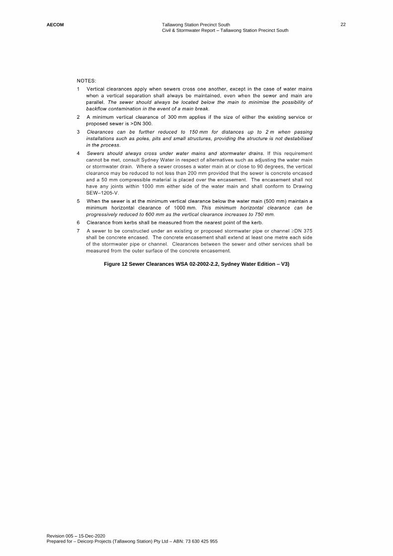
Section 4.4.5.2 of Water Services Association of Australia codes (WSA 02-2002-2.2, Sydney Water Edition – Version 3) states the clearance requirements for sewers in Table 4.2, as summarised below in Figure 12.
Tallawong Station Precinct South
Civil & Stormwater Report – Tallawong Station Precinct South
Revision 005 – 15-Dec-2020 Prepared for – Deicorp Projects (Tallawong Station) Pty Ltd – ABN: 73 630 425 955
22 AECOM
Figure 12 Sewer Clearances WSA 02-2002-2.2, Sydney Water Edition – V3)

Tallawong Station Precinct South
Civil & Stormwater Report – Tallawong Station Precinct South
Revision 005 – 15-Dec-2020 Prepared for – Deicorp Projects (Tallawong Station) Pty Ltd – ABN: 73 630 425 955
23 AECOM
3.5 Electrical
Endeavour energy is the main supplier of the study area as shown below in Figure 13.
Figure 13 Endeavour Energy Supply Network
Projections indicate that there will be a substantial increase in electrical demand from the Tallawong Station Precinct South. At this time, it is expected that there will be sufficient capacity within the local zone substation to supply the proposed demand for the site. However further consultation with Endeavour Energy is required during the time of application for connection given concurrent development activities may utilise some of the existing capacity.
AECOM’s Services and Infrastructure Strategic Investigation (2014) for NWRL identified that within the overall Tallawong Station Precinct, while there is capacity to service initial development, major additional subtransmission capacity (zone substation or subtransmission lines) will be required to service ultimate development. The delivery of new transmission lines and new zone substations can take between 3 to 5 years of planning respectively.
The precinct is predominantly serviced via 22kV reticulation feeders from the Mungerie Park Zone Substation located 2km east of the site along Commercial Road.
Detailed lead-in infrastructure upgrades will need to be confirmed with Endeavour Energy as part of formal applications made as a part of detailed design. In addition, street lighting supply may comprise a separate Blacktown City Council network (with the supply taken from the local Endeavour Energy (LV) network). This will need to be confirmed with Blacktown City Council through detailed design, however if this is the case, a separate Blacktown City Council infrastructure study will also be required.
Existing On-Site Utility Infrastructure
The existing Endeavour Energy electrical infrastructure on the site has been identified based on Dial Before You Dig (DBYD) records.
Cudgegong
Road Station
Precinct South

Tallawong Station Precinct South
Civil & Stormwater Report – Tallawong Station Precinct South
Revision 005 – 15-Dec-2020 Prepared for – Deicorp Projects (Tallawong Station) Pty Ltd – ABN: 73 630 425 955
24 AECOM
There are existing underground electrical assets adjacent to the site boundary. These include electrical conduits running underneath Schofields Road and Cudgegong Road and while additional underground cables have been proposed to run along Tallawong Road.
The existing and proposed Endeavour Energy infrastructure are outlined below, it is noted that this section only considers Endeavour Energy infrastructure and does not include private electrical infrastructure which may be present within the site.
Potential On-Site Infrastructure Layouts
As noted previously the scope of external infrastructure upgrades and lead-in works will be confirmed when formal Endeavour Energy applications are made as part of detailed design.
Upgrades to the existing Endeavour Energy underground electrical network are proposed to service each lot. The proposed potential electrical layout consists of a single connection point to the existing service on Stores Street.
It has been assumed that internal road layouts will be dedicated to Blacktown City Council and that easements will not be required where the electrical assets pass through public land or roads.
As noted previously, ownership of the street lighting will need to be confirmed as part of detailed design. If Endeavour Energy assets within the precinct are to be fed by the local Endeavour Energy LV network it may require the proposed network to be expanded to ensure that all road network are covered.
Coordination of Electrical Infrastructure with Other Services
Coordination of the proposed electrical infrastructure with other services in the proposed street network would generally be based on the Streets Opening Conference standards.
Endeavour Energy’s specification “MDI 0028 – Underground distribution network design” does not provide specific information on clearances from other services. If the electrical services are installed within the standard allocation, the separations given by the other services provider should apply for all crossings. Where a reduced allocation is proposed, separations should be determined in consultation with Endeavour Energy.

Tallawong Station Precinct South
Civil & Stormwater Report – Tallawong Station Precinct South
Revision 005 – 15-Dec-2020 Prepared for – Deicorp Projects (Tallawong Station) Pty Ltd – ABN: 73 630 425 955
25 AECOM
3.6 Gas
Gas servicing to the Tallawong Station Precinct South is provided by Jemena. Projections indicate that there will be an increase in the gas demand for the Tallawong Station development site. Whilst there is a substantial distribution network in the area, it is predominately comprised of small connections providing supply at a low pressure.
Jemena have not confirmed whether the existing infrastructure within the Tallawong Station Precinct has sufficient capacity. Confirmation of capacity and potential required upgrades will be received when formal connection applications are received.
Existing On-Site Utility Infrastructure
Existing Jemena gas infrastructure on site have been identified using Dial Before You Dig (DBYD) records. These records indicate the presence of a number of existing gas mains surrounding the proposed development site. These primarily consist of:
• External DN110 PE main underneath Schofields Road;
• External DN110 PE main underneath Cudgegong Road; and
• External DN50 NY main underneath Tallawong Road.
Plans of newly laid internal mains have also been provided by NRT. These include:
• DN50 NY main underneath Themeda Avenue;
• DN50 NY main underneath NRT Arstida Street; and
• DN50 NY main underneath Conferta Avenue.
The exact depths and positions of the existing reticulation mains have not been confirmed and further investigations will likely be required to determine the extent of diversions required.
Potential On-Site Infrastructure Layouts
New internal gas connections will be made between the proposed buildings and existing gas infrastructure. Their connection location will be designed to be adjacent to the assumed building driveways.
The natural gas infrastructure is to be installed by Jemena within a trench prepared as part of infrastructure facilitation works.
Coordination of Gas Infrastructure with Other Services
Coordination of the proposed gas infrastructure with other services in the proposed street network would generally be based on the Streets Opening Conference standards.
Jemena provide guidance on horizontal and vertical clearances, the minimum separations between electrical and natural gas mains are provided in Table 1.0 of “Natural Gas Requirements for Developer Provided Trench” as summarised in Table 6.

Tallawong Station Precinct South
Civil & Stormwater Report – Tallawong Station Precinct South
Revision 005 – 15-Dec-2020 Prepared for – Deicorp Projects (Tallawong Station) Pty Ltd – ABN: 73 630 425 955
26 AECOM
Table 6 Jemena Minimum Separation Between Utilities
Utility Minimum Separation
Gas Mains up to 75mm diameter Gas Mains of 110mm diameter or larger
Telecommunication cables and/or
conduits 150 mm 300 mm
Protected2 Low Voltage electricity cables 150 mm 300 mm
Protected2 High Voltage electricity cables 300 mm 300 mm
1. Separations relate to distances between conduits/cables peripheries
2. “Protected” refers to mechanical protection of the cables, which usually takes the form of either polymeric strips (at least
3 mm thick) or clay brick
3. The above table is considered to provide desirable minimum separations. Consideration should be given for the need to
access for future maintenance of services when determining the required separations

Tallawong Station Precinct South
Civil & Stormwater Report – Tallawong Station Precinct South
Revision 005 – 15-Dec-2020 Prepared for – Deicorp Projects (Tallawong Station) Pty Ltd – ABN: 73 630 425 955
27 AECOM
3.7 Telecommunications
A number of communication providers have assets around the Tallawong Station Precinct South. However, the only providers which have assets that border or intersect with the site are:
• Telstra;
• Uecomm; and
• NBN Co.
The exact provider of telecommunications services will be confirmed later in the development process however opportunities to connect to the National Broadband Network (NBN) have been assessed within this report.
Figure 14 below illustrates the current extents of the NBN rollout with reference to the investigation site area.
Figure 14 NBN Rollout (NBN Co. 2017)
Existing On-Site Utility Infrastructure
Telstra
Underground Telstra services have been identified underneath the streets surrounding the Tallawong Station Precinct South boundaries, namely underneath Tallawong, Schofields and Cudgegong Roads. These are assumed to be servicing existing properties and buildings within the site. It has been assumed at this stage that the existing Telstra services are to be retained in order to continue servicing the site’s existing buildings, and to provide connection points for the new reticulation required to service the proposed buildings within the Precinct. This will need to be confirmed as part of the detailed design.

Tallawong Station Precinct South
Civil & Stormwater Report – Tallawong Station Precinct South
Revision 005 – 15-Dec-2020 Prepared for – Deicorp Projects (Tallawong Station) Pty Ltd – ABN: 73 630 425 955
28 AECOM
Optus/Uecomm
DBYD records have identified a series of Optus pits and underground cables located along Cudgegong Road only. No existing connections to the proposed development site have been shown.
NBN Co.
DBYD records have identified NBN Co. assets being present within the project precinct and are in the process of being rolled out. NRT plans show NBN cables located underneath Themeda Avenue, Conferta Avenue and NRT Implexa Parade fed through Cudgegong and Tallawong Roads.
Coordination of Telecommunications Infrastructure with Other Services
Coordination of the proposed communications infrastructure with other services in the proposed street network would generally be based on the Streets Opening Conference standards.
The clearances for NBN services from other utilities is given in Section 5.2.13 of “New Development: Deployment of the NBN Co Conduit and Pit Network – Guidelines for Developers”, these requirements are presented in Figure 15.
Figure 15 NBN Clearances from Other Carriers and Underground Services

Tallawong Station Precinct South
Civil & Stormwater Report – Tallawong Station Precinct South
Revision 005 – 15-Dec-2020 Prepared for – Deicorp Projects (Tallawong Station) Pty Ltd – ABN: 73 630 425 955
29 AECOM
4.0 Stormwater Quantity
4.1 Existing Site Conditions
The Tallawong Station Precinct South site is located within the Blacktown City Council Local Government Area (LGA) and is approximately 2km west of Rouse Hill Town Centre and 45km northwest of the Sydney CBD.
The Precinct site is approximately 7.8ha in size, is bounded by Tallawong Road to the West, Cudgegong Road to the East, Schofields Road to the South and Tallawong Metro Station to the north. The current site can be characterised as having semi-rural lots to the north and low density residential to the south. The site context is shown in Figure 16 below.
Figure 16 Site Context
The development site is located adjacent Schofields Road and 90m west of the Second Ponds Creek channel. Both waterways drain into the Hawksbury River catchment which is located to the north.
4.2 Stormwater Management Strategy
The Tallawong Station Precinct South is within the area covered by the Rouse Hill Trunk Drainage Strategy, developed by GHD on behalf of the Rouse Hill Infrastructure Consortium during the late 1990’s. Sydney Water is the authority for management of the trunk drainage infrastructure incorporated within the strategy.
Stormwater quantity management for the precinct is addressed through the provision of regional detention basins, located external to the site. As such, regional stormwater quantity management, relating to detention basins, does not require further consideration as part of this stormwater strategy.
The above not withstanding High flows from the southern catchment connect through an 825mm diameter pipe crossing at Cudegong and Schofields Road. In order to meet the existing flows in the 5%AEP event an OSD of 470 m3 has been proposed upstream of this crossing. This has been undertaken following consultation with TfNSW on the design capacity of this pipe in the post-developed scenario. It is anticipated this OSD would be integrated into the open space during detailed design (likely as tank).
In accordance with the previous approvals, streets within the development were constructed as part of the Sydney Metro Northwest works will be dedicated to Blacktown City Council.

Tallawong Station Precinct South
Civil & Stormwater Report – Tallawong Station Precinct South
Revision 005 – 15-Dec-2020 Prepared for – Deicorp Projects (Tallawong Station) Pty Ltd – ABN: 73 630 425 955
30 AECOM
4.3 Design Standard and Approach
The following sections detail the criteria and standards that have been used to guide the development of the stormwater quality and quantity management strategy.
Note that ‘pre-development’ refers to conditions prior to works undertaken by Northwest Rapid Transit on the precinct.
4.3.1 Area 20 Water Cycle Management Strategy Report Incorporating Water Sensitive Urban Design (2010, JWP)
The following approach, defined in the Area 20 Water Cycle Management Strategy Report Incorporating Water Sensitive Urban Design (2010, JWP) has been adopted in developing a water and stormwater management strategy for the site:
• The strategy should include water reuse and maximise potable water conservation;
• Stormwater management should be based on the objectives and principles of WSUD;
• Existing waterways and riparian zones should be conserved and enhanced where possible;
• Stormwater management strategies must consider and addresses potential salinity hazards;
• Stormwater management strategies should maximise efficient use of land and facilitate adequate allocation of land for stormwater management purposes;
• A treatment train approach should be used, incorporating structural stormwater treatment measures at the primary, secondary and tertiary levels as necessary to comply with the stormwater management targets;
• The design of stormwater management systems should be integrated with the planning of road layout and design, given the potential benefits of incorporating suitable WSUD elements into road corridors;
• Stormwater reuse, retention and detention strategies should be used to minimise changes to the hydrological (or flow) regime of receiving waterways;
• Management of stormwater should be considered on a sub catchment basis to employ source control techniques in preference to highly centralised ‘end-of-pipe’ treatment measures wherever practicable;
• Trunk drainage routes and dual carriageways should be aligned where possible, to allow use of centre medians for WSUD drainage systems; and
• WSUD drainage systems may be incorporated into other roads and streets, where practicable and compatible with other design issues, including safety requirements of the relevant Road Authority.
4.3.2 Blacktown City Council (BCC) Development Control Plan
The Blacktown City Council (BCC) Development Control Plan 2016 requires the proposed development to implement stormwater quantity controls to achieve the following:
• Manage the flow of stormwater from urban parts of the Precinct to replicate, as closely as possible pre-development flows;
• Define the flood constraints and standards applicable to urban development in the Precinct;
• Minimise the potential of flooding impacts on development;
• No residential allotments are to be located at a level lower than the 1% AEP flood level plus freeboard of 500mm;
• Pedestrian and cycle pathways and open space may extend within the 100-year ARI flood level, provided the safe access criteria contained in the NSW Floodplain Manual are met;
• Stormwater is to be managed primarily through the street network in accordance with Council’s DCP;

Tallawong Station Precinct South
Civil & Stormwater Report – Tallawong Station Precinct South
Revision 005 – 15-Dec-2020 Prepared for – Deicorp Projects (Tallawong Station) Pty Ltd – ABN: 73 630 425 955
31 AECOM
• Roads on primary drainage lines shown on the Key elements of the water cycle management and ecology strategy figure, in the relevant Precinct Schedule, are to be constructed in the locations shown, and are to be designed in accordance with specifications of Council in relation to management of stormwater flows and quality;
• Roads are generally to be located above the 1% AEP level;
• Management of ‘minor’ flows using piped systems for the 20-year ARI (residential land use) and 10-year ARI (commercial land use) shall be in accordance with Blacktown Council’s Engineering Guidelines for Subdivision and Development. Management measures shall be designed to:
o prevent damage by stormwater to the built and natural environment;
o reduce nuisance flows to a level which is acceptable to the community;
o provide a stormwater system which can be economically maintained, and which uses
open space in a compatible manner;
o control flooding;
o minimise urban water run-off pollutants to watercourses, and
o meet the standards for a 100-year ARI flood level.
• Management of ‘major’ flows using dedicated overland flow paths such as open space areas, roads and riparian corridors for all flows in excess of the pipe drainage system capacity and above the 20-year ARI shall be in accordance with Blacktown Council’s Engineering Guidelines for Subdivision and Development. Management measures shall be designed to:
o prevent both short term and long-term inundation of habitable dwellings;
o manage flooding to create lots above the designated flood level with flood free access
to a public road located above the 100-year ARI flood level;
o control flooding and enable access to lots, stabilise the landform and control erosion;
o provide for the orderly and safe evacuation of people away from rising floodwaters;
o stabilise the landform and control erosion; and
o meet the standards for a 100-year ARI flood level.
• The trunk stormwater system is to be constructed and maintained by Council in accordance with the Riparian and Water Cycle Management Strategy, and to achieve water quality targets set by the Department of Environment, Climate Change and Water (DECCW); and
• Where development on land affected by local runoff or local overland flooding – major drainage is proposed, it must be designed in accordance with Council’s Engineering Guide for Development.
4.3.3 Blacktown City Council (BCC) Design Standards
The BCC Works Specification Civil and Engineering Guide for Development provide detailed requirements addressing stormwater drainage and erosion and sediment control. BCC has also developed a design criteria memo for design of Council stormwater assets which has been referenced.
Design Standards
BCC design standards have generally been adopted for the Tallawong Station Precinct South development, as the stormwater infrastructure that is to be delivered external to the buildings will ultimately be dedicated to council. A summary of each of the standards, codes and other additional design documents used in the design of stormwater infrastructure for the development are presented in Table 7 below:

Tallawong Station Precinct South
Civil & Stormwater Report – Tallawong Station Precinct South
Revision 005 – 15-Dec-2020 Prepared for – Deicorp Projects (Tallawong Station) Pty Ltd – ABN: 73 630 425 955
32 AECOM
Table 7 Stormwater Drainage reference documents and standards
Reference Number
Title
SEPP 2006 State Environmental Planning Policy (Sydney Region Growth Centres) 2006. Growth Centres Development Code 2006
DCP Blacktown City Council Growth Centre Precincts Development Control Plan, DPE 2016.
DCP Part J Blacktown City Council Development Control Plan 2015 including Part J and associated handbooks and guidelines.
EGFD Blacktown City Council Engineering Guide for Development.
RMS R11 RMS Specification R11.
Works Specification Civil
Blacktown City Council Works Specification Civil, 2005
NSW FDM New South Wales Floodplain Development Manual
- Precinct Planning Watercycle Management Strategy reports.
- Dams Safety Act 1978 and Dams Safety Committee Policies and Guidelines.
CPA Concrete Pipe Association’s “Concrete Pipe Selection and Installation” Guide
AR&R Vol 1 Australian Rainfall and Runoff “A Guide to Flood Estimation” Volume 1, 1987.
AR&R Vol 2 Australian Rainfall and Runoff “A Guide to Flood Estimation” Volume 2, 1987.
AR&R – Project 10 Australian Rainfall and Runoff – Revision Projects “Appropriate Safety Criteria for People”
AR&R – Project 11 Australian Rainfall and Runoff – Revision projects “Blockage of Hydraulic Structures”
AS 3500.3 Australian Standard AS3500.3: Plumbing and Drainage Code – Stormwater Drainage (2003)
AS 3725 Australian Standards AS3725: Design for Installing of Buried Concrete Pipes
Section 79C Environmental Planning and Assessment Act 1979
4.3.4 Design Criteria
Based on the planning commitments and the requirements of the various design standards, the stormwater drainage design criteria adopted for the development are summarised below in Table 8.

Tallawong Station Precinct South
Civil & Stormwater Report – Tallawong Station Precinct South
Revision 005 – 15-Dec-2020 Prepared for – Deicorp Projects (Tallawong Station) Pty Ltd – ABN: 73 630 425 955
33 AECOM
Table 8 Stormwater Drainage Design Criteria
Item Standard Adopted Comment
Hydrology
Hydrological Model BCC Engineering Guide for Development, 2005
DRAINS model Using the Time Area method – ILSAX
Time of concentration BCC Engineering Guide for Development, 2005
Kinematic Wave Equation. Paved: n=0.013 Grassed: n=0.33
Kinematic Wave Equation.
Minor Design Storm BCC Engineering Guide for Development, 2005
20-year Average Recurrence Interval (5% AEP)
Commercial area with overflow to bypass to public road
Major Design Storm BCC Engineering Guide for Development, 2005
100-year ARI (1% AEP)
Applied to calculating flood safety criteria in streets
Design Rainfall BCC Engineering Guide for Development, 2005
As per table or BOM values
AR&R 1987 values have been adopted
Rural Rainfall Losses Pervious IL = 15mm Pervious CL = 2.5mm/h Imperv. IL = 1.5 mm Imperv. CL = 0 mm/h
Applied in flood modelling
Urban Rainfall Losses Pervious IL = 5mm Pervious CL = 2.5mm/h Imperv. IL = 1.0 mm Imperv. CL = 0.0 mm/h
Applied in flood modelling
Hydraulics
Pipe size BCC Engineering Guide for Development, 2005
Min. 150mm diameter Min. 375mm diameter
150mm pipe diameter is the absolute minimum for pipes located in private property. 375mm pipe diameter is the minimum for pipes owned by Blacktown City Council.
Retardance Coefficient BCC Engineering Guide for Development, 2005
Road/Paved Areas Only = 0.01 Medium Density Residential = 0.06 Parkland = 0.15 Open Space (Natural Bushland) = 0.3
Pit spacing BCC Engineering Guide for Development, 2005
Max. 80m Maximum spacing increases with increasing pipe sizes
Pit losses BCC Engineering Guide for Development, 2005
Missouri Charts, (Sangster et al, 1958)
Pit blockage factors BCC Engineering Guide for Development, 2005
Minor system (5% AEP): Sag Pit = 0 On Grade Pit = 0 Major system (1% AEP): Sag Pit = 0.5
Applied to proposed infrastructure

Tallawong Station Precinct South
Civil & Stormwater Report – Tallawong Station Precinct South
Revision 005 – 15-Dec-2020 Prepared for – Deicorp Projects (Tallawong Station) Pty Ltd – ABN: 73 630 425 955
34 AECOM
Item Standard Adopted Comment
On Grade Pit = 0.2
Pit blockage factors for overland flow calculations
BCC design memo Small pipes - 30% Large pipes – 50%
Applied when calculating floor levels or overland flow path capacity
Flood and Overland Flow
Appropriate Safety Criteria for People
AR&R – Project 10 Max. Depth x Velocity = 0.4m2s-1
Not applied when calculating overland in swales
Stormwater Quality Targets
Pollution reductions targets
Blacktown City Council Growth Centre Precinct Development Control Plan
Gross Pollutants – 90% TSS – 85% TP – 65% TN – 45%
Stream Erosion Metrics Growth Centres DCP and BCC DCP
Stream Erosion Index no greater than 3.5
4.4 Catchment Description
The project site is located within a semi-rural to low-density residential external catchment which drains towards the Second Ponds Creek low point extending from the high point north-west of the site. Stormwater from this external catchment is conveyed via overland flow paths and Blacktown City Council pipe drainage network which are currently present underneath Schofields Road to the south.
4.5 Existing Minor Stormwater Network
An existing stormwater network has been delivered to service Tallawong Station, access roads and car parks. The network consists of pit and pipe drainage networks and informal flow paths controlled by BCC and NRT.
Drainage assets owned by Council have been identified underneath Schofields Road and Cudgegong Road, which generally service the overall site catchment area and outlet towards Second Ponds Creek in the East. This includes an existing biofiltration basin to manage stormwater from Council owned roads.
A new drainage network has been constructed by NRT servicing the rail corridor and carparks located adjacent to the designated Tallawong Station Precinct. Collected stormwater here converges to a DN900mm pipe underneath Conferta Avenue and outlets across Cudgegong Road through the raingarden basin immediately east of the site.
The Roads and Maritime Services (RMS) also currently owns the drainage assets underneath the newly upgraded Schofields Road and parts of Cudgegong Road. The development site’s low point in the South East corner of the site is serviced by a series of pits and pipes specifically a Median Gully Pit Quadruple Grate (M.G.Q.G) and two DN825 which grade towards Second Ponds Creek underneath Schofields Road.
4.5.1 Recent Infrastructure Upgrades
NRT has been provided stormwater drainage infrastructure as part of the precinct enabling and augmentation works as agreed in the North West Rail Link OTS Project Deed – Scope and Performance Requirements Appendix 96 – Precinct Utility Services Revision C.
RMS currently owns a network of pits and pipes underneath Schofields and Cudgegong Road which were constructed during the widening Schofields Road completed in June 2014.

Tallawong Station Precinct South
Civil & Stormwater Report – Tallawong Station Precinct South
Revision 005 – 15-Dec-2020 Prepared for – Deicorp Projects (Tallawong Station) Pty Ltd – ABN: 73 630 425 955
35 AECOM
4.6 Proposed Stormwater Drainage Strategy
The proposed stormwater drainage system for the Tallawong Station Precinct South will comply with the design requirements identified above.
The stormwater drainage strategy has been split into three different areas:
• Public stormwater drainage;
• Site 1 private stormwater;
• Site 2 private stormwater; and
• An overflow path easement.
Public Stormwater Drainage
• There is no public stormwater proposed for Site 1 as the entirety of this lot is proposed to be private;
• It is proposed to connect into the existing drainage along Conferta Avenue;
• Public stormwater drainage for site 2 is proposed to run through the proposed new streets and features a bifurcation pit which separates low flows into the existing bio-retention basin (via site 1) while high flows are directed to the south of site and ultimately connect to twin DN825mm pipes under Cudgegong Rd.
Site 1 Private Drainage
• Site 1 drainage including the proposed park drainage are to connect to the existing stormwater pipe network in Conferta Avenue which ultimately drains to a DN900mm pipe that runs perpendicular underneath Cudgegong road and discharges into a biofiltration basin to the east of Cudgegong Rd.
Site 2 Drainage
• Site 2 drainage is split into three areas:
o The area north of the proposed new public road, this area connects to the new public drainage downstream of the bifurcation pit. This pit will be designed to have high flows flow toward the south (pit 36.1a) and low flows towards the north (pit 25.10) and ultimately into the biofiltration basin. It is expected that overflow (beyond the 3 month flow) will discharge from biofiltration basin via existing overland flow;
o The area south of the proposed new public road, has been designed with new pipework adjacent to the southern swale which connects to the new council drainage within the new shared path (pit 36.3). As noted in discussions with Council there will also likely be overflow from the adjacent existing carpark to the west. A combination of pipes and swale has been proposed to convey this anticipated flow parallel to Schofields Road. This arrangement ultimately connects to twin DN825mm pipes under Cudgegong Rd at pit 36.8. Rate of overflow from the existing carpark has been rationalised and anticipated pipe sizing have been absorbed into the proposed design. Final pipe sizing for this arrangement will be confirmed during the detailed design stage in consultation with Council and other appropriate stakeholders; and
o The area east of the proposed new public road, this area has a new stormwater line that connects into the new council drainage that runs on the southern portion of the site (at pit 36.6). As noted in Section 4.2 the existing discharge under Cudgegong Road restricts the discharge for the southern catchment. A preliminary OSD volume of 470m3 has been proposed and will be incorporated into the greater development during detailed design. This solution will be further developed in conjunction with the upstream overflows from the existing carpark
Tallawong Station Precinct South
Civil & Stormwater Report – Tallawong Station Precinct South
Revision 005 – 15-Dec-2020 Prepared for – Deicorp Projects (Tallawong Station) Pty Ltd – ABN: 73 630 425 955
36 AECOM
Overflow Path Easement:
• There is an existing overflow from the NRT carpark to the west of site 2, this has been incorporated into the design via a vegetated swale with an associated drainage easement.
All of these elements are shown within the Civil Engineering Drawings submitted along with this report and also in Figure 17.
It is noted that the overall stormwater quantity strategy is in line with the previously approved Landcom SSDA package.
4.6.1 Demonstration of Compliance (DRAINS Modelling)
A notional pipe design has been developed using DRAINS hydraulic modelling software. The model demonstrates that the proposed site can be developed and achieve the requirements of BCC’s minor and major drainage networks. The proposed network and notional pipe diameters are provided in
Screenshots of the DRAINS model compiled for both minor and major storm events is presented in Figure 18 and Figure 19 below.

054055056057058 053 052 051 050
108 107 106 105 104 103 102
038037036035034033032
012 013 014 015 016 017 018 019 020
040
039
041
042
043
044
045
046
047
048
049
295 269294293292291290
269 271270 272 273 275274 276 277
298
297
299
300
301
302
303
304
306 305307308309310311312313314
048 047 046 045 044 043 042 041 040 039 038 037
028
027
026
025
024
023
022
021
020
019
018
017
016
015
014
013
012
011
010
009
033
034
035
036
032
031
030
029
060
059
058
057
049
050
051
052
053
054
055
056
061
062
063
064
077
076
079
078
081
080
083
082
084
086
085
130
129
128
127
126
125
124
123
122
121
120
119
118
117
116
115
114
113
112
111
110
109
108
107
104
106
105
131
146
145
144
143
150
149
148
147
152
151
136
135
134
133
140
139
138
137
142
141
132
071
072
073
074
067
068
069
070
065
066
075
007
008
005
006
003
004
001
002
087 088 089
100101102 095096097098099
103
091092093094 090
185
186
187
188
189
181
182
183
184
148
149
150
151
152
153
142
143
144
145
146
147
136
137
138
139
140
141
130
131
132
133
134
135
124
125
126
127
128
129
123
154
096
090
091
092
093
094
095
084
085
086
087
088
089
078
079
080
081
082
083
072
073
074
075
076
077
071
180
174
175
176
177
178
179
168
169
170
171
172
173
162
163
164
165
166
167
156
157
158
159
160
161
155
067066065064 070069068063
5
0
.
0
0
R
A
G
Ø375
Ø375
Ø375
Ø375
Ø375
Ø
9
0
0
Ø
5
2
5
Ø
9
0
0
Ø100
Ø3
75
Ø375
T
fN
S
W
1
.0
5
B01/24
B01/23
B19/1
B01/22
B01/21
B01/20
B01/18
B01/19
B20/01
B02/02
B01/17
B14/01
B01/16
B13/03
B13/02
B13/01
B01/15
B12/02
B12/01
B01/14
B01/03A
B01/13B
B11/01
B15/01A
B15/01
B01/12
B01/11B01/10
B01/09
B01/08
B01/07
B07/01
B06/03
B06/02
B06/01
B05/02B05/01
B08/01
B09/01
B10/01
B10/02
B18/03
Ø900
Ø375
Ø450
Ø450 Ø450 Ø525
Ø75
Ø
1
5
0
Ø375
Ø375
Ø150
Ø375
Ø375
Ø
3
7
5
Ø
3
7
5
Ø375
Ø375
Ø375
Ø
6
7
5
Ø
6
0
0
Ø
600
Ø
6
0
0
Ø
6
0
0
Ø525
Ø
375
Ø525
Ø
5
2
5
Ø
3
7
5
Ø375
Ø375
Ø900
Ø
900
Ø525
Ø525
Ø525Ø450
5
0
5
1
5
1
51
5
2
5
2
5
2
53
5
3
5
3
54
5
4
5
4
5
4
5
4
5
5
5
5
55
5
5
5
5
56
56
5
6
5
6
5
6
5
6
57
5
7
5
7
5
7
5
7
5
7
57
57
5
8
5
8
5
8
5
9
5
9
6
0
5
7
6
0
.5
6
0
.0
59.5
59.5
5
9
.
0
5
9
.
0
5
8
.
5
58.5
58.0
57.5
57.5
5
7
.
0
Ø
4
5
0
Ø375
Ø675
Ø
7
5
0
Ø750
Ø825
Ø825
Ø825
Ø825
Ø
8
2
5
Ø
9
0
0
Ø525
Ø375
Ø
3
7
5
Ø375
Ø
3
7
5
Ø
6
0
0
Ø
6
0
0
Ø
6
0
0
Ø600
Ø225
Ø
3
7
5
Ø
3
7
5
Ø
225
Ø225
Ø375
Ø450Ø
4
5
0
Ø4
50
Ø375
Ø3
75
Ø375
Ø
3
7
5
Ø
3
7
5
Ø375
Ø3
75
Ø375Ø375
Ø3
75
Ø375
Ø
3
7
5
Ø375
Ø375
Ø
3
7
5
Ø
3
7
5
Ø
3
7
5
Ø375
Ø375
Ø525
Ø375
Ø375
Ø
3
7
5
Ø
3
7
5
Ø375
Ø375
Ø5
25
Ø525
Ø
6
0
0
Ø6
00
Ø
3
7
5
Ø3
75
Ø600
Ø375
Ø
3
7
5
P25.1
P41.1
P25.3
P25.4
P27.1
P25.5
P28.1
P25.6
P29.1
P25.7
P30.1
P25.8
P31.1
P25.9
P32.1
P25.10
P25.11
P33.1
P25.12
P25.13
P25.15
P25.16
P25.17
P36.1
P39.1
P38.2
P38.3
P38.4
P40.1
P40.2
P40.3
P36.2
P36.3
P36.5
P36.8
P35.1
P35.2
P35.3
P23.1
P6.1
P22.1
P6.3
P6.5
P24.1
P6.8
P6.7 P6.6
P25.14
P36.4
P34.1
P34.2
P7.1
P8.1
P6.2
P9.1
P9.2
P6.4
P10.1
P36.6
P36.7
Ø
3
7
5
Ø300
Ø375
Ø
3
7
5
Ø375
Ø375
Ø375
Ø375
Ø
375
Ø375
Ø375
Ø375
Ø
7
5
0
Ø
7
5
0
Ø
7
5
0
Ø525
Ø450
Ø375
Ø
3
7
5
Ø
3
7
5
Ø375
Ø375
Ø375
Ø375
Ø375
Ø375
Ø375
Ø375
Ø375
Ø375
Ø375
Ø
3
7
5
Ø375
Ø375
Ø375
Ø
3
7
5
Ø375
Ø375
Ø
3
7
5
Ø375Ø375Ø375
Ø375Ø375
Ø375
Ø375
Ø300
Ø
3
7
5
Ø375
Ø450
Ø600
Ø525Ø525
Ø525
Ø375
Ø375
P11.1
Ø375
P6.9
P42.2
P42.1
Ø375
Ø375
P43.2
Ø375
P43.1
Ø375
Ø
3
7
5
Ø600
Ø375
EX C01/12
P36.1a
Ø
3
7
5
P26.1
Ø375
P25.2
Ø375
EX C01/15
SC
HO
FIE
LD
S R
OA
D
C
U
D
G
E
G
O
N
G
R
O
A
D
CUDGEGONG ROAD STATION
THEMEDA AVENUE
CONFERTA AVENUE
AR
TIS
TID
A S
TR
EE
T
N
T
N
P25.1
P41.1
P25.3
P25.4
P27.1
P25.5
P28.1
P25.6
P29.1
P25.7
P30.1
P25.8
P31.1
P25.9
P32.1
P25.10
P25.11
P33.1
P25.12
P25.13
P25.15
P25.16
P25.17
P36.1
P39.1
P38.2
P38.3
P38.4
P40.1
P40.2
P40.3
P36.2
P36.3
P36.5
P36.8
P35.1
P35.2
P35.3
P23.1
P6.1
P22.1
P6.3
P6.5
P24.1
P6.8
P6.7 P6.6
P25.14
P36.4
P34.1
P34.2
P7.1
P8.1
P6.2
P9.1
P9.2
P6.4
P10.1
P36.6
P36.7
Ø
3
7
5
Ø300
Ø375
Ø
3
7
5
Ø375
Ø375
Ø375
Ø375
Ø
375
Ø375
Ø375
Ø375
Ø
7
5
0
Ø
7
5
0
Ø
7
5
0
Ø525
Ø450
Ø375
Ø
3
7
5
Ø
3
7
5
Ø375
Ø375
Ø375
Ø375
Ø375
Ø375
Ø375
Ø375
Ø375
Ø375
Ø375
Ø
3
7
5
Ø375
Ø375
Ø375
Ø
3
7
5
Ø375
Ø375
Ø
3
7
5
Ø375Ø375Ø375
Ø375Ø375
Ø375
Ø375
Ø300
Ø
3
7
5
Ø375
Ø450
Ø600
Ø525Ø525
Ø525
Ø375
Ø375
P11.1
Ø375
P6.9
P42.2
P42.1
Ø375
Ø375
P43.2
Ø375
P43.1
Ø375
Ø
3
7
5
Ø600
Ø375
EX C01/12
P36.1a
Ø
3
7
5
P26.1
Ø375
P25.2
Ø375
EX C01/15
ROOF CONNECTIONS
TO RAINWATER TANK
SWALE
VEGETATED SWALE
PROPOSED NEW
BIFURCATION PIT
EXISTING REGIONAL
BIO-RETENTION BASIN
PITS TO BE REBUILT
EXISTING DRAINAGE
PIPE TO BE REMOVED
OVERLAND FLOW
SWALE DRAINAGE
EXISTING CUDGEGONG
ROAD STORMWATER
CROSSING
TREATMENT LOCATON 3 -
GROSS POLLUTANT TRAP
AND JELLYFISH FILTER 2
TREATMENT LOCATON 4 -
GROSS POLLUTANT TRAP
AND JELLYFISH FILTER 3
160kL RAINWATER TANK
2.9m DEEP 3m WIDE
18.3m LONG
CONNECTION TO
EXISTING DRAINAGE
TREATMENT LOCATON 1 -
GROSS POLLUTANT TRAP
AND STORMFILTER
TREATMENT LOCATON 2 -
GROSS POLLUTANT TRAP
AND JELLYFISH FILTER 1
CONNECTION TO
EXISTING DRAINAGE
CONNECT TO EXISTING TfNSW
DRAINAGE PIT. DISCHARGE FLOW
REDUCED BY PROVISION OF OSD
SURFACE INLET PIT
PIPE TO BE DESIGNED
TO ACCOMODATE
OVERFLOW FROM
EXISTING CARPARK
OVERLAND FLOW PATH FROM
EXISTING CARPARK. FLOW
VOLUME TO BE CONFIRMED
WITH COUNCIL
OVERLAND FLOW
INTO EASEMENT
EXISTING TREES
TO BE RETAINED
Last saved by: R
EY
ES
C5(2020-11-25
) Last P
lotted: 2020-11-27
FIGURE 18
DRAINAGE
PLAN
SITE WIDE
SHEET NUMBER
60618532-SHT-00-0000-CI-0300
Filenam
e: \\A
US
YD
1F
P001\P
RO
JE
CT
S\605X
\60558549\5. C
AD
\20-S
HE
ET
S\60618532-S
HT
-00-0000-C
I-0300.D
WG
PROJECT NUMBER
60618532
I/R DATE DESCRIPTION
ISSUE/REVISION
1 03.04.2020 ISSUE FOR REVIEW.
2 16.04.2020 ISSUE FOR SUBMISSION
4 07.05.2020 ISSUE FOR SUBMISSION
4 25.11.2020 ISSUE FOR SUBMISSION
G.ROEFFENN.MITCHELLA.TOH
DESIGNER CHECKED APPROVED
PROJECT MANAGEMENT INITIALS
A.TOH N.MITCHELL G.ROEFFEN
This draw
ing is confidential and shall only be used for the purpose of this project. T
he signing of this title block confirm
s the design and drafting of this project have been prepared and checked in accordance w
ith the A
EC
OM
quality assurance system
to IS
O 9001-2000.
IS
O A
1 594m
m x 841m
m
KEY PLAN
CONSULTANT
AECOM Australia Pty Ltd
A.B.N 20 093 846 925
www.aecom.com
CLIENT
PRELIMINARY
SCALE BAR
PROJECT
TALLAWONG STATION
PRECINCT SOUTH
CIVIL PACKAGE
DEICORP PROJECTS
(TALLAWONG STATION) PTY LTD
0 12.5 25
1:500
m
LEGEND
Ø525
DRAINAGE SIZE AND FLOW DIRECTION
EXISTING DRAINAGE LINE
EXISTING RMS DRAINAGE
56.5MAJOR COUNTOURS
DRAINAGE PITS (REFER
DRAINAGE DRAWINGS
FOR DETAILS)
PUBLIC DRAINAGE
PRIVATE DRAINAGE
PUBLIC SWALE
PRIVATE SWALE
DRAINAGE PIT TAG
P1.7
OVERLAND FLOW PATH

Tallawong Station Precinct South
Civil & Stormwater Report – Tallawong Station Precinct South
Revision 005 – 15-Dec-2020 Prepared for – Deicorp Projects (Tallawong Station) Pty Ltd – ABN: 73 630 425 955
38 AECOM
Figure 18 Minor Storm Flow

Tallawong Station Precinct South
Civil & Stormwater Report – Tallawong Station Precinct South
Revision 005 – 15-Dec-2020 Prepared for – Deicorp Projects (Tallawong Station) Pty Ltd – ABN: 73 630 425 955
39 AECOM
Figure 19 Major Storm Flow

Tallawong Station Precinct South
Civil & Stormwater Report – Tallawong Station Precinct South
Revision 005 – 15-Dec-2020 Prepared for – Deicorp Projects (Tallawong Station) Pty Ltd – ABN: 73 630 425 955
40 AECOM
5.0 Stormwater Quality
The stormwater quality management approach incorporates Water Sensitive Urban Design (WSUD) principles and treatment train to ensure water quality targets prescribed in the Area 20 DCP. The water quality targets are measured as ‘mean annual pollutant load’ discharged from a development site and the minimum percentage reductions are specified in Table 8 above.
It is intended that individual development lots will meet water quality requirements through at-source controls on the lot as documented in this section. A rainwater tank is proposed to capture runoff from the building rooves north of Conferta Avenue and provide water for irrigation throughout the precinct.
Stormwater quality management for runoff from Council roads and public open space is to be provided via the existing regional stormwater management basin which is located on the eastern side of the Cudgegong Road. It is proposed that some stormwater quality management is also provided via biofiltration street trees in new streets located within Site 1 and Site 2.
5.1 WSUD Implementation
WSUD measures including on lot filtration, gross pollutant traps, passive irrigation and bioretention have been considered for the development as well as a large rainwater tank in Site 1.
General layouts have been adopted for the current design, and further details including subsoil drainage and exact infrastructure layouts will be further developed in detailed design.
5.2 On Lot Filtration
At-source stormwater pollution control devices provide flexibility to achieve stormwater treatment targets without an associated land take at ground level. Stormwater filtration of this type is suited to densely populated sites where public open space is limited.
These treatment strategies are typically deployed to achieve stormwater pollution reduction targets prior to discharge from a super lot. The locations of the on-lot filtration will be within the private domain. A typical treatment arrangement for the private lots has been provided as part of the drawing set.
The proposed on-lot filtration is shown in Table 9 below. There are 4 locations where on-lot filtration is provided, prior to the private drainage discharging to the public drainage system.
Table 9 On-lot filtration for private area
Location Gross Pollutant Trap Treatment device
1 HumeGard HG15 Stormfilter – Chamber 16m2, 25 x 690mm Full Flow ZPG Stormfilter
2 HumeGard HG12A Jellyfish JF2250-7-2
3 HumeGard HG12A Jellyfish JF2250-7-2
4 HumeGard HG12A Jellyfish JF3250-16-3
5.3 Regional Bioretention Systems
5.3.1 Existing Biofiltration Basin
An existing biofiltration basin has been provided east of the intersection of Rd Precinct Road and Cudgegong Road. It is assumed that the existing regional bioretention system was constructed in accordance with best practice design and therefore achieves existing water quality requirements. This basin achieves the stormwater management targets for Council’s roads and the proposed public open space.
It is proposed that the new public road drainage in Site 2 is directed to this existing biofiltration basin and involves the use of the existing GPT installed as part of the NRT works. An assessment has been

Tallawong Station Precinct South
Civil & Stormwater Report – Tallawong Station Precinct South
Revision 005 – 15-Dec-2020 Prepared for – Deicorp Projects (Tallawong Station) Pty Ltd – ABN: 73 630 425 955
41 AECOM
undertaken to determine the treatment capacity of the existing biofiltration basin and determine whether an increase in size is needed to account for the additional public road catchment.
A public domain MUSIC model has been developed to assess the effectiveness of the public water quality strategy. The strategy relies on the private domain achieving Blacktown City Council pollutant load reduction targets as shown in Table 10 independently to the public WSUD scheme through on-lot filtration. It was shown through MUSIC modelling, that the total catchment achieves the pollutant load reduction targets through the use of on-lot filtration for the private area and the existing biofiltration basin for the public area. It is not recommended at this stage that the biofiltration basin will need to be upgraded, as targets are achieved with existing dimensions. The demonstration of compliance is discussed below in section 5.6.
Table 10 - Stormwater pollutant load reduction targets
Pollutant Load Reduction Target (%)
Total Suspended Solids 85
Total Phosphorus 65
Total Nitrogen 45
Gross Pollutants 90
Total hydrocarbons 90

Tallawong Station Precinct South
Civil & Stormwater Report – Tallawong Station Precinct South
Revision 005 – 15-Dec-2020 Prepared for – Deicorp Projects (Tallawong Station) Pty Ltd – ABN: 73 630 425 955
42 AECOM
5.4 Proposed Rainwater Tank
A 160kL rainwater tank is proposed for Site 1, all non-trafficable roofed areas are directed into this rainwater tank, the rainwater tank provides irrigation to greenspace throughout the site and commercial non-potable usage within Site 1.
The estimated irrigation demand is summarised below:
• Available volume: 160kL
• Annual Irrigation Demand: 2783kL/year.
• Daily commercial non-potable usage: 7.7kL/day
The irrigation and non-potable demands will be backed up with potable water to account for prolonged periods without rainfall. Opportunities for having a recycled water backup for irrigation will also be investigated as a part of the detailed design of the irrigation system post DA.
All downpipes from the roofed areas connected to the rainwater tank will be fitted with a first flush pipe to allow for the first flush of debris and rain from the roof to be collected prior to the rainwater tank.
Details of the proposed rainwater tank are shown below in Figure 20.
5.5 Biofiltration Street Trees
Consultation with Blacktown Council indicates that street tree biofiltration is not supported where it would reduce on street parking. Biofiltration street trees are not proposed along existing Themeda and Conferta Avenues but are proposed along new Council road in Site 2 and the new private road in Site 1 as shown below in Figure 21.
The strategy is reliant on these trees providing stormwater pollutant load reductions within the private road catchment. These trees will also be utilised for providing additional pollutant reduction within the public area, however reduction targets are being met without the consideration of the street tree benefits.
Figure 20 Proposed Rainwater Tank

Tallawong Station Precinct South
Civil & Stormwater Report – Tallawong Station Precinct South
Revision 005 – 15-Dec-2020 Prepared for – Deicorp Projects (Tallawong Station) Pty Ltd – ABN: 73 630 425 955
43 AECOM
The subject streets are graded at 3 to 4% which will not be associated with adverse level changes or trip hazards. Each street tree is designated to have 100mm of ponding over a 2.5 m2 area above the tree pit. TUFLOW modelling indicates flood velocities from along the proposed roads will vary between 0.7 and 1.2 m/s in a 1% AEP event which suggests some erosion control measures may be required, but overall velocities are not unsuitable.
This proposed bio-retention street detail will be as per Blacktown City Council standard drawings.
Figure 21 Proposed biofiltration street trees
5.6 Demonstration of Compliance (MUSIC Modelling)
MUSIC modelling has been undertaken to assess the quality of stormwater runoff discharged from the proposed development site to ensure water quality requirements are met. MUSIC modelling results for the entire Area 20 zone demonstrate that integrating proposed WSUD techniques allow the pollutant reduction targets to be met.
The catchment areas considered for the WSUD modelling can be seen in Figure 23 and Figure 22. The WSUD catchments were delineated using the available information which included LiDAR, survey and design contours as well as existing and design stormwater networks. The land use schedule presented in Table 11 summarises the public and private catchment areas that were considered for this assessment, both within the precinct development site and outside as part of the existing area.

Tallawong Station Precinct South
Civil & Stormwater Report – Tallawong Station Precinct South
Revision 005 – 15-Dec-2020 Prepared for – Deicorp Projects (Tallawong Station) Pty Ltd – ABN: 73 630 425 955
44 AECOM
Table 11 Land Use Schedule
Existing Areas Area (Ha)
Existing Public Roads 3.41
Existing Carparks (with existing on-lot treatment) 3.18
Tallawong Station South Development Site Area (Ha)
Roof areas 2.27
Green Courtyards/Gardens 1.08
Paved Areas 0.51
Private Roads 0.22
Council Open Space 0.10
Council Roads - To be dedicated 0.38
Two MUSIC models have been developed to assess:
1. Private area pollutant load reduction
2. Public areas pollutant load reduction
Both models were developed using Blacktown City Council standards, including representation land use nodes, council MUSIC treatment nodes and following the WSUD handbook and guidelines. The private area MUSIC model has been used to only assess the pollutant load reduction targets for the private area to ensure the development meets the pollutant load reduction targets. The public MUSIC model includes both private and public area, as the private area drains to the public drainage system. For the public MUSIC model, a generic treatment node has been used to represent the treatment efficiencies of the private areas, as per council guidance.

Tallawong Station Precinct South
Civil & Stormwater Report – Tallawong Station Precinct South
Revision 005 – 15-Dec-2020 Prepared for – Deicorp Projects (Tallawong Station) Pty Ltd – ABN: 73 630 425 955
45 AECOM
Figure 22 - Private WSUD Catchments

Tallawong Station Precinct South
Civil & Stormwater Report – Tallawong Station Precinct South
Revision 005 – 15-Dec-2020 Prepared for – Deicorp Projects (Tallawong Station) Pty Ltd – ABN: 73 630 425 955
46 AECOM
Figure 23 - Public WSUD Catchments
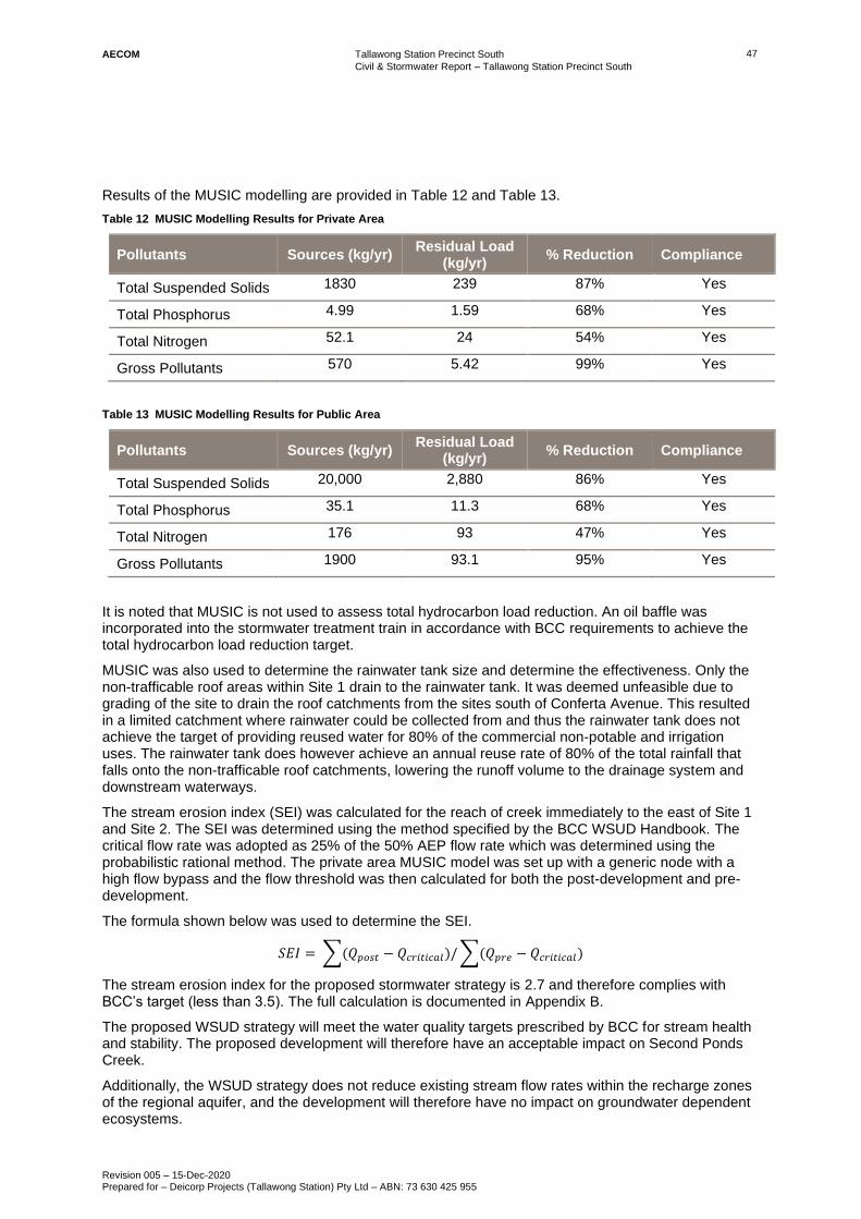
Tallawong Station Precinct South
Civil & Stormwater Report – Tallawong Station Precinct South
Revision 005 – 15-Dec-2020 Prepared for – Deicorp Projects (Tallawong Station) Pty Ltd – ABN: 73 630 425 955
47 AECOM
Results of the MUSIC modelling are provided in Table 12 and Table 13.
Table 12 MUSIC Modelling Results for Private Area
Pollutants Sources (kg/yr) Residual Load
(kg/yr) % Reduction Compliance
Total Suspended Solids 1830 239 87% Yes
Total Phosphorus 4.99 1.59 68% Yes
Total Nitrogen 52.1 24 54% Yes
Gross Pollutants 570 5.42 99% Yes
Table 13 MUSIC Modelling Results for Public Area
Pollutants Sources (kg/yr) Residual Load
(kg/yr) % Reduction Compliance
Total Suspended Solids 20,000 2,880 86% Yes
Total Phosphorus 35.1 11.3 68% Yes
Total Nitrogen 176 93 47% Yes
Gross Pollutants 1900 93.1 95% Yes
It is noted that MUSIC is not used to assess total hydrocarbon load reduction. An oil baffle was incorporated into the stormwater treatment train in accordance with BCC requirements to achieve the total hydrocarbon load reduction target.
MUSIC was also used to determine the rainwater tank size and determine the effectiveness. Only the non-trafficable roof areas within Site 1 drain to the rainwater tank. It was deemed unfeasible due to grading of the site to drain the roof catchments from the sites south of Conferta Avenue. This resulted in a limited catchment where rainwater could be collected from and thus the rainwater tank does not achieve the target of providing reused water for 80% of the commercial non-potable and irrigation uses. The rainwater tank does however achieve an annual reuse rate of 80% of the total rainfall that falls onto the non-trafficable roof catchments, lowering the runoff volume to the drainage system and downstream waterways.
The stream erosion index (SEI) was calculated for the reach of creek immediately to the east of Site 1 and Site 2. The SEI was determined using the method specified by the BCC WSUD Handbook. The critical flow rate was adopted as 25% of the 50% AEP flow rate which was determined using the probabilistic rational method. The private area MUSIC model was set up with a generic node with a high flow bypass and the flow threshold was then calculated for both the post-development and pre-development.
The formula shown below was used to determine the SEI.
𝑆𝐸𝐼 = ∑(𝑄𝑝𝑜𝑠𝑡 − 𝑄𝑐𝑟𝑖𝑡𝑖𝑐𝑎𝑙)/ ∑(𝑄𝑝𝑟𝑒 − 𝑄𝑐𝑟𝑖𝑡𝑖𝑐𝑎𝑙)
The stream erosion index for the proposed stormwater strategy is 2.7 and therefore complies with BCC’s target (less than 3.5). The full calculation is documented in Appendix B.
The proposed WSUD strategy will meet the water quality targets prescribed by BCC for stream health and stability. The proposed development will therefore have an acceptable impact on Second Ponds Creek.
Additionally, the WSUD strategy does not reduce existing stream flow rates within the recharge zones of the regional aquifer, and the development will therefore have no impact on groundwater dependent ecosystems.
Tallawong Station Precinct South
Civil & Stormwater Report – Tallawong Station Precinct South
Revision 005 – 15-Dec-2020 Prepared for – Deicorp Projects (Tallawong Station) Pty Ltd – ABN: 73 630 425 955
48 AECOM
6.0 Conclusion
Responses to design standards and approaches taken to fulfil the requirements are summarised below.
Growth Centres Development Code (Growth Centres Commission 2006)
The Civil and Stormwater Report for the Tallawong Station Precinct South project adopts a WSUD approach to water management and is consistent with the Growth Centres Development Code in:
• Reuse of rainwater;
• Achieving the stormwater quality targets stipulated by BCC, and on this basis protecting water quality within Second Ponds Creek in accordance with BCC objectives
• Achieving the target stream erosion index criteria, and on this basis, managing potential erosion impacts in Second Ponds Creek in accordance with BCC objectives ;
• Avoiding potential salinity hazards by prescribing stormwater filtration basins that do not interact with groundwater;
• Utilising a treatment train approach through use of GPTs, on-lot filtration and regional stormwater filtration basins;
• Integrating passive irrigation and street tree biofiltration amongst parking bays for improved amenity, street tree health and canopy cover;
• Proposing a mix of on-lot, street scape and ‘end-of-pipe’ treatment measures in a practical way;
• Aligning trunk drainage routes with local roads and drainage easements overland flow paths where possible; and
• Avoiding safety issues associated with biofiltration street trees in collector roads.
Adherence to Blacktown City Council Engineering Guidelines for Development (2005)
The civil and stormwater strategy demonstrates that minor and major drainage can be provided without risk of property damage or public safety. The concept stormwater drainage design demonstrates that the appropriate freeboard between hydraulic grade lines and street levels and habitable floor levels in design minor and major storm events respectively.
Summary of Responses to SEARs
Table 14 provides a summary of how each of the project SEARS requirements (SSD9063) are addressed in this management plan.
Table 14 Response to SEARs
Item Action Response
SEARS
Utilities
The EIS must:
• identify and address the existing capacity to service the development proposed and any augmentation requirements for utilities in consultation with relevant agencies; and
• identify any potential impacts of the proposed construction and operation on the existing utility infrastructure and service provider assets, and demonstrate how these will be protected, or impacts mitigated.
Please see responses below:
• Existing capacity and potential connection points are shown within Section 3.0 of this report.

Tallawong Station Precinct South
Civil & Stormwater Report – Tallawong Station Precinct South
Revision 005 – 15-Dec-2020 Prepared for – Deicorp Projects (Tallawong Station) Pty Ltd – ABN: 73 630 425 955
49 AECOM
Item Action Response
SEARS
Plans and Documents
The EIS must include all relevant plans, architectural drawings, diagrams and relevant documentation required under Schedules 1 and 2 of the Environmental Planning and Assessment Regulation 2000 including:
• services and utilities impact assessment; and
• Sydney Metro Underground Corridor Protection Guidelines or Sydney Metro at Grade and Elevated Sections Corridor Protection Guidelines report.
Please see responses below:
• A services and utilities impact assessment has been carried, refer Section 3.0; and
• The Sydney Metro Underground Protection guidelines requirements are contained within Appendix A.
DPIE EE Comments 9.
Water and Soils
THE EIS must map the following features relevant to water and soils including:
• Rivers, streams, wetlands, estuaries (as described n s4.3 of the Biodiversity Assessment Method); and
• Proposed intake and discharge locations.
Please see responses below:
• There are no wetlands or estuaries within the proposed development boundary or impacts, for more information on groundwater please refer to the Geotechnical Investigation Report; and
• There is no proposed groundwater intake for this site, stormwater discharge locations are shown within Section 4.0 and 5.0.
DPIE EE Comments 10.
Water and Soils
THE EIS must describe background conditions for any water resource likely to be affected by the development, including:
• Existing surface and groundwater;
• Hydrology, including volume, frequency and quality of discharges at proposed intake and discharge locations;
• Water Quality Objectives (as endorsed by NSW Government) including groundwater as appropriate that represent the community’s uses and values for the receiving waters.
Please see responses below:
• Existing surface water impacts are shown in Section 4.0 and 5.0, for groundwater refer to the Geotechnical Investigation Report;
• Hydrology and discharge information is contained within Section 4.0 and 5.0; and
• Water Quality Objectives are shown in Section 4.0.
BCC Review -10-13.
Engineering
Engineering:
• All roads must comply with engineering standards set out in Council’s Engineering Guide for Development. No basement parking permitted under a public road therefore the road must remain private with a public easement for access;
• Drainage overland flow path must be dedicated and in a public road (not a private easement);
• Overland drainage must be in public space and treated to meet CPTED requirements; and
Please see responses below:
• All public roads comply with the Councils Engineering Guide for Development, Refer to Section 2.0;
• Drainage overland flow is contained with Section 4.0, the only overland flow in private land is an existing discharge from the NRT car parks;

Tallawong Station Precinct South
Civil & Stormwater Report – Tallawong Station Precinct South
Revision 005 – 15-Dec-2020 Prepared for – Deicorp Projects (Tallawong Station) Pty Ltd – ABN: 73 630 425 955
50 AECOM
Item Action Response
• Splays are required on corners of overland flow paths and public roads.
• Details of CPTED treatments are contained within the CPTED report; and
• Splays are described in Section 2.0.
BCC Review -14-15.
Drainage
Drainage:
• Compliance with drainage requirements as outlined in meeting with Council’s drainage section on 7th February 2020; and
• Compliance with water sensitive urban design requirements set out in Part J of the Blacktown Development Control Plan.
Please see responses below:
• The drainage strategy in Section 4.0 is consistent with the requirements discussed with the council’s drainage section on the 7th February 2020; and
• Compliance with water sensitive urban design requirements is contained within Section 5.0 of the report.
BCC Review -5-6.
Drainage and Engineering Compliance with engineering and drainage requirements as outlined in Councils Letter from 28th July 2020

Tallawong Station Precinct SouthCivil & Stormwater Report – Tallawong Station Precinct South
Revision 004 – 25-Nov-2020Prepared for – Deicorp Projects (Tallawong Station) Pty Ltd – ABN: 73 630 425 955
AAECOM
Appendix A – Sydney Metro at Grade and Elevated SectionsCorridor Protection Guidelines Letter

AECOM Australia Pty Ltd
Level 21, 420 George Street
Sydney NSW 2000
PO Box Q410
QVB Post Office NSW 1230
Australia
www.aecom.com
+61 2 8934 0000 tel
+61 2 8934 0001 fax
ABN 20 093 846 925
13th March 2020
Marvin Huang Development Manager Deicorp Pty Ltd Level 3/161 Redfern Street, Redfern NSW 2016
Dear Marvin
Tallawong Station Precinct Development RE: Development Near Rail Corridor
Summary
The Protection Zone around rail corridors is divided into two classifications: “First Reserve” and “Second Reserve”. Demolition and construction works are generally not possible within the First Reserve, while works within the Second Reserve are normally possible, subject to a detailed engineering assessment.
The principle elements for this assessment are to confirm the proposed ground loadings and ensure that the at-grade rail asset is not adversely affected by the proposed development works. Assessment also entails demonstrating that the presence of the rail will not adversely affect the proposed development (noise, vibration etc.). Other requirements are subject to further assessment.
The relevant guidelines for works around the Sydney Metro rail corridor is the Sydney Metro At Grade and Elevated Sections corridor Protection Guidelines (2018). These stipulate the specific requirements and provides technical and procedural guidelines to be followed for new developments near existing and future Sydney Metro rail at grade and elevated infrastructure during development planning, designing, construction and operating stages.
The guidelines define the Rail Corridor Protection Zone as elements as follows;
a) Elevated viaduct - 25m from the centre line of the dual track structure.
b) At Grade embankments and cuttings within a fenced or walled boundary - 25m from the centre line of the dual track structure.
c) For other infrastructure the protection zone shall be assessed based on the adjacent proposed development.
Figure 3.2 (see below) from Sydney Metro at Grade and Elevated Sections Corridor Protection Guidelines defines the zones that forms the First Reserve and Second Reserve around Metro infrastructure. The Corridor Protection Zone that encompasses both reserves measure 25 metres either side from the centreline of track.

c:\users\fettelld\documents\tallawong protection zone letter (rev 2).docx
2 of 3
Proposed Development
The proposed Tallawong Station Precinct South Development has a frontage to Themeda Avenue which is adjacent to the southern side of Tallawong Station. Tallawong station is in cut.
The proposed development comprises commercial and residential buildings up to eight stories high and with up to three basement levels. The deepest basement on the Themeda Avenue boundary has a proposed finished surface level of RL46 AHD, about 10m below existing ground level.
The distance between the boundary of the proposed Tallawong Station Precinct Development and the dual track centreline is approximately 50 metres, well clear of the 25-metre Corridor Protection Zone. It should also be noted that the Themeda Avenue road reserve is over 15m wide and a 45 degree zone of influence extending up from the basement excavation will not extend past the road reserve Tallawong station.
A visual representation of the relationship between the proposed development and the station is shown below in Figure 1.
Figure 1: Distance of proposed development from track centreline
Due to the distance between the Metro and the proposed development, it is clear that the Tallawong Station Precinct South Development:
• Is not located within the protection reserve; and
• Does not have the potential to cause design and construction related safety, engineering, maintenance and operational impact on the at grade and elevated Metro infrastructure.

c:\users\fettelld\documents\tallawong protection zone letter (rev 2).docx
3 of 3
The development of this future precinct was considered as a part of the Tallawong Station design andthe adjacent roads and frontages are already completed, with new works limited to the south of therecently constructed road.
It is recommended that construction access to the proposed development is limited to ConfertaAvenue (the street frontage away from the station).
If you require any further information, please don’t hesitate to contact me on the details below.
Yours faithfully
Daniel Fettell Principal Engineer D +61 2 8934 0905 M +61 422 623 253 [email protected] AECOM Level 21, 420 George Street, Sydney, NSW 2000 PO Box Q410, QVB PO, Sydney, NSW, 1230 T +61 2 8934 0000 F +61 2 8934 0001 www.aecom.com

Tallawong Station Precinct SouthCivil & Stormwater Report – Tallawong Station Precinct South
Revision 004 – 25-Nov-2020Prepared for – Deicorp Projects (Tallawong Station) Pty Ltd – ABN: 73 630 425 955
BAECOM
Appendix B – Stream Erosion Index Calculation

Catchment (Ha) 4.077 Ha sum area based on MUSIC Export Tc 0.2 HoursTc 14 MinsI 2yr 14min 66 mm/hrC2 0.444Q2 0.33 m3/sQcritical 0.08 m3/s
Pre-development Post Flow ThresholdFlow (ML/yr) 8.51 1.26 85.2Peak Flow (m3/s)Total Suspended Solids (kg/yr) 4.51E+02 146 67.7Total Phosphorus (kg/yr) 1.14 0.298 73.8Total Nitrogen (kg/yr) 12 2.81 76.7Gross Pollutants (kg/yr) 0 0 0
Post-development Post Flow ThresholdFlow (ML/yr) 24.1 3.41 85.8Peak Flow (m3/s)Total Suspended Solids (kg/yr) 1.83E+03 99.5 94.6Total Phosphorus (kg/yr) 4.99 0.35 93Total Nitrogen (kg/yr) 51.9 4.48 91.4Gross Pollutants (kg/yr) 570 1.68 99.7
SEI 2.7 Must be less than 3.5
Stream Erosion Index (SEI)