traffic and transport impact statement - Major Projects
43
TRAFFIC AND TRANSPORT IMPACT STATEMENT 70 – 100 FULLAGAR ROAD, WENTWORTHVILLE (PROPOSED ALTERATIONS AND ADDITIONS TO WENTWORTHVILLE PUBLIC SCHOOL) Date: 28 February 2019 Office: Suite 15/9 Hoyle Ave., Castle Hill NSW 2154 All Correspondence: 75 Gindurra Ave., Castle Hill NSW 2154 Ph: (02) 8850 2799 Mob: 0418 262 125 (David Thompson) 0450 747 401 (Yafeng Zhu) Email: [email protected] [email protected] Website: www.thompsonstanbury.com.au
-
Upload
khangminh22 -
Category
Documents
-
view
0 -
download
0
Transcript of traffic and transport impact statement - Major Projects
TRAFFIC AND TRANSPORT
IMPACT STATEMENT
70 – 100 FULLAGAR ROAD,
WENTWORTHVILLE (PROPOSED
ALTERATIONS AND ADDITIONS TO
WENTWORTHVILLE PUBLIC
SCHOOL)
Date:
28 February 2019
Office:
Suite 15/9 Hoyle Ave., Castle Hill
NSW 2154
All Correspondence: 75 Gindurra Ave., Castle Hill NSW
2154
Ph: (02) 8850 2799
Mob:
0418 262 125 (David Thompson)
0450 747 401 (Yafeng Zhu)
Email:
Website:
www.thompsonstanbury.com.au
TSA Page 2
Fullagar Road, Wentworthville 17-136
TABLE OF CONTENTS
PAGE NO.
SUMMARY RESPONSE TO SECREATARY’S ENVIRONMENTAL
ASSESSMENT REQUIREMENTS (SEARS) ........................................................... 4
1. INTRODUCTION................................................................................................ 8
2. SITE DETAILS .................................................................................................. 10
2.1 SITE LOCATION ................................................................................................. 10
2.2 SITE DESCRIPTION ............................................................................................ 10
2.3 EXISTING USES ................................................................................................. 10
2.4 SURROUNDING USES ......................................................................................... 10
3. PROPOSED DEVELOPMENT ....................................................................... 12
3.1 BUILT FORM/SCHOOL DEMOGRAPHIC CHANGES .............................................. 12
4. ACCESS & PARKING CONSIDERATIONS ................................................ 13
4.1 ACCESS ARRANGEMENTS.................................................................................. 13
4.1.1 Vehicular Access ...................................................................................... 13
4.1.2 Pedestrian Access .................................................................................... 13
4.2 PARKING PROVISION ......................................................................................... 13
4.2.1 Car Parking ............................................................................................. 14
4.2.2 Bicycle Parking ........................................................................................ 16
5. EXTERNAL TRAFFIC CONDITIONS .......................................................... 18
5.1 SURROUNDING ROAD NETWORK ...................................................................... 18
5.2 EXISTING TRAFFIC VOLUMES ........................................................................... 20
5.3 EXISTING ROAD NETWORK OPERATIONS .......................................................... 22
5.4 PEDESTRIAN INFRASTRUCTURE AND VOLUMES ................................................ 24
5.5 PARKING ARRANGEMENTS AND CONDITIONS ................................................... 26
5.6 PUBLIC TRANSPORT (PUBLIC BUS & SCHOOL BUS) .......................................... 26
6. PROJECTED TRAFFIC CONDITIONS ........................................................ 28
6.1 TRAFFIC GENERATION AND TRIP ASSIGNMENT ................................................. 28
6.2 PROJECTED TRAFFIC IMPACTS .......................................................................... 31
6.2.1 Intersection Network Performance .......................................................... 31
6.2.2 Set-down / Pick-Up Activity and Staff Parking Considerations .............. 32
6.2.3 Public Transport ...................................................................................... 32
7. GREEN TRAVEL PLAN (GTP) ...................................................................... 33
7.1 INTRODUCTION ................................................................................................. 33
7.2 GREEN TRAVEL PLAN DEFINITION .................................................................... 33
7.3 GREEN TRAVEL PLAN BENEFITS AND OBJECTIVES ........................................... 33
7.4 MODE SHIFT INITIATIVES .................................................................................. 34
7.4.1 Promote Cycling (for staff) ...................................................................... 34
7.4.2 Promote Walking (for staff and students) ................................................ 34
7.4.3 Promote Public Transport (for staff and students) .................................. 35
7.4.4 Promote Carpooling (for staff and students) ........................................... 35
7.5 MONITORING .................................................................................................... 35
TSA Page 3
Fullagar Road, Wentworthville 17-136
8. INTERNAL OPERATIONAL TRAFFIC & PEDESTRIAN
MANAGEMENT PLAN ........................................................................................... 38
8.1 OPERATIONAL TRAFFIC & PEDESTRIAN MANAGEMENT ................................. 38
8.1.1 General Items ........................................................................................... 38
8.1.2 Internal Staff Parking .............................................................................. 38
8.1.3 Student Set-Down / Pick-Up .................................................................... 39
9. CONSTRUCTION ISSUES .............................................................................. 40
9.1 INTRODUCTORY STATEMENT ............................................................................ 40
9.2 PROPOSED WORKS AND TRAFFIC MANAGEMENT ............................................. 40
9.3 SAFE INGRESS AND EGRESS OF CONSTRUCTION TRAFFIC ................................. 41
9.4 CONSTRUCTION VEHICLE TRANSPORT ROUTES ................................................ 41
9.5 PARKING CONTROL ........................................................................................... 41
9.6 CONSTRUCTION TRAFFIC GENERATION ............................................................ 42
9.7 TRAFFIC IMPACT ............................................................................................... 42
9.8 IMPACTS ON PEDESTRIANS ................................................................................ 42
10. CONCLUSIONS ................................................................................................ 43
TSA Page 4
Fullagar Road, Wentworthville 17-136
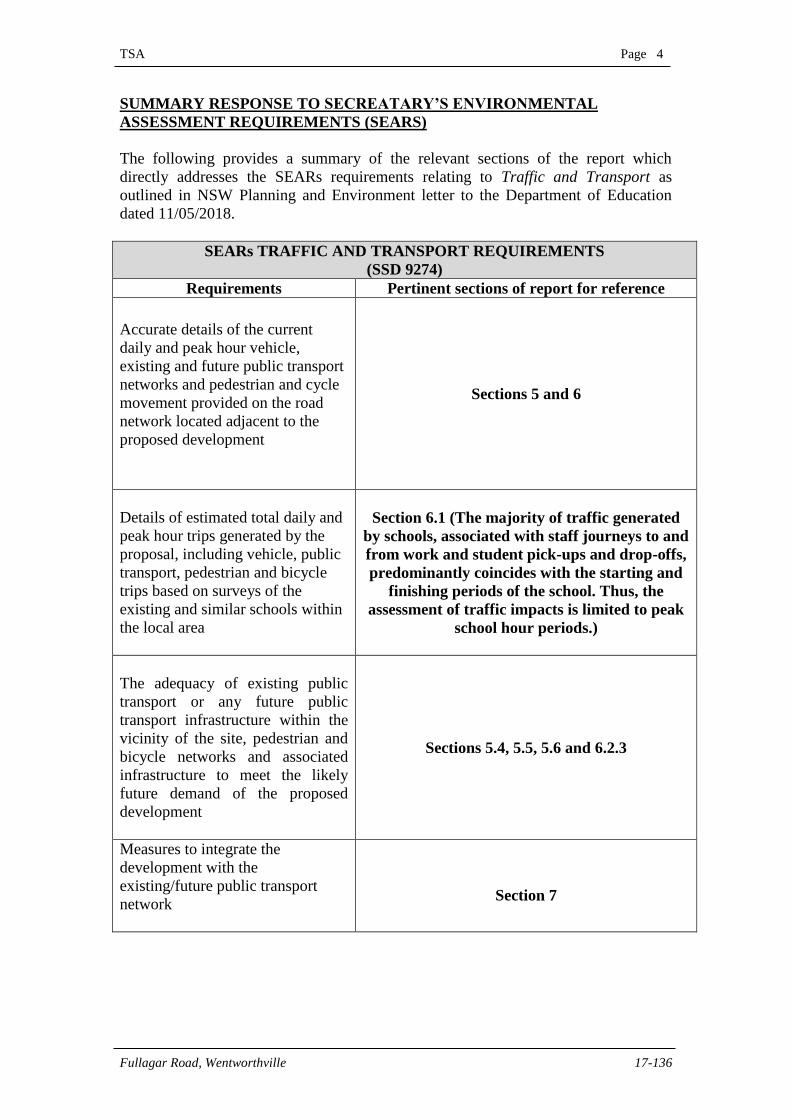
SUMMARY RESPONSE TO SECREATARY’S ENVIRONMENTAL
ASSESSMENT REQUIREMENTS (SEARS)
The following provides a summary of the relevant sections of the report which
directly addresses the SEARs requirements relating to Traffic and Transport as
outlined in NSW Planning and Environment letter to the Department of Education
dated 11/05/2018.
SEARs TRAFFIC AND TRANSPORT REQUIREMENTS
(SSD 9274)
Requirements Pertinent sections of report for reference
Accurate details of the current
daily and peak hour vehicle,
existing and future public transport
networks and pedestrian and cycle
movement provided on the road
network located adjacent to the
proposed development
Sections 5 and 6
Details of estimated total daily and
peak hour trips generated by the
proposal, including vehicle, public
transport, pedestrian and bicycle
trips based on surveys of the
existing and similar schools within
the local area
Section 6.1 (The majority of traffic generated
by schools, associated with staff journeys to and
from work and student pick-ups and drop-offs,
predominantly coincides with the starting and
finishing periods of the school. Thus, the
assessment of traffic impacts is limited to peak
school hour periods.)
The adequacy of existing public
transport or any future public
transport infrastructure within the
vicinity of the site, pedestrian and
bicycle networks and associated
infrastructure to meet the likely
future demand of the proposed
development
Sections 5.4, 5.5, 5.6 and 6.2.3
Measures to integrate the
development with the
existing/future public transport
network
Section 7
TSA Page 5
Fullagar Road, Wentworthville 17-136
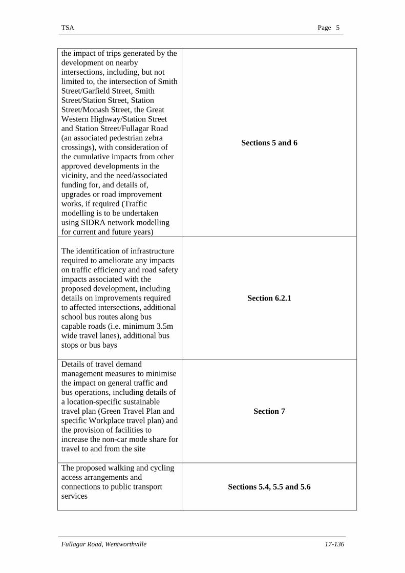
the impact of trips generated by the
development on nearby
intersections, including, but not
limited to, the intersection of Smith
Street/Garfield Street, Smith
Street/Station Street, Station
Street/Monash Street, the Great
Western Highway/Station Street
and Station Street/Fullagar Road
(an associated pedestrian zebra
crossings), with consideration of
the cumulative impacts from other
approved developments in the
vicinity, and the need/associated
funding for, and details of,
upgrades or road improvement
works, if required (Traffic
modelling is to be undertaken
using SIDRA network modelling
for current and future years)
Sections 5 and 6
The identification of infrastructure
required to ameliorate any impacts
on traffic efficiency and road safety
impacts associated with the
proposed development, including
details on improvements required
to affected intersections, additional
school bus routes along bus
capable roads (i.e. minimum 3.5m
wide travel lanes), additional bus
stops or bus bays
Section 6.2.1
Details of travel demand
management measures to minimise
the impact on general traffic and
bus operations, including details of
a location-specific sustainable
travel plan (Green Travel Plan and
specific Workplace travel plan) and
the provision of facilities to
increase the non-car mode share for
travel to and from the site
Section 7
The proposed walking and cycling
access arrangements and
connections to public transport
services
Sections 5.4, 5.5 and 5.6
TSA Page 6
Fullagar Road, Wentworthville 17-136
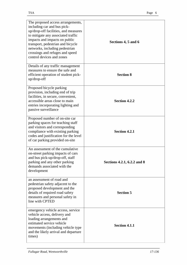
The proposed access arrangements,
including car and bus pick-
up/drop-off facilities, and measures
to mitigate any associated traffic
impacts and impacts on public
transport, pedestrian and bicycle
networks, including pedestrian
crossings and refuges and speed
control devices and zones
Sections 4, 5 and 6
Details of any traffic management
measures to ensure the safe and
efficient operation of student pick-
up/drop-off
Section 8
Proposed bicycle parking
provision, including end of trip
facilities, in secure, convenient,
accessible areas close to main
entries incorporating lighting and
passive surveillance
Section 4.2.2
Proposed number of on-site car
parking spaces for teaching staff
and visitors and corresponding
compliance with existing parking
codes and justification for the level
of car parking provided on-site
Section 4.2.1
An assessment of the cumulative
on-street parking impacts of cars
and bus pick-up/drop-off, staff
parking and any other parking
demands associated with the
development
Sections 4.2.1, 6.2.2 and 8
an assessment of road and
pedestrian safety adjacent to the
proposed development and the
details of required road safety
measures and personal safety in
line with CPTED
Section 5
emergency vehicle access, service
vehicle access, delivery and
loading arrangements and
estimated service vehicle
movements (including vehicle type
and the likely arrival and departure
times)
Section 4.1.1
TSA Page 7
Fullagar Road, Wentworthville 17-136
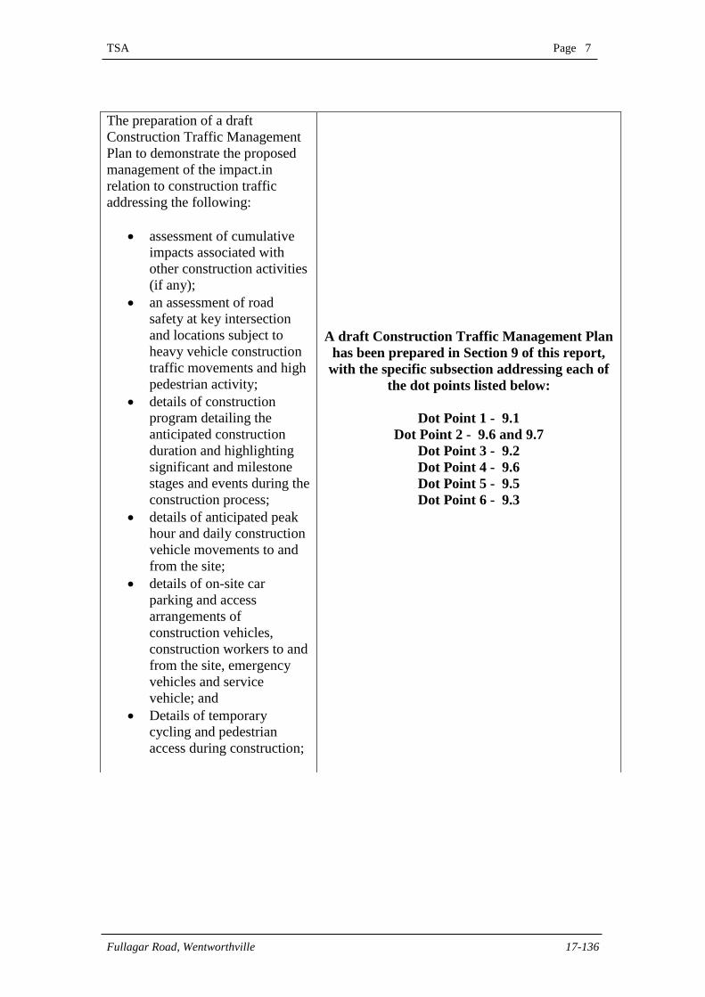
The preparation of a draft
Construction Traffic Management
Plan to demonstrate the proposed
management of the impact.in
relation to construction traffic
addressing the following:
assessment of cumulative
impacts associated with
other construction activities
(if any);
an assessment of road
safety at key intersection
and locations subject to
heavy vehicle construction
traffic movements and high
pedestrian activity;
details of construction
program detailing the
anticipated construction
duration and highlighting
significant and milestone
stages and events during the
construction process;
details of anticipated peak
hour and daily construction
vehicle movements to and
from the site;
details of on-site car
parking and access
arrangements of
construction vehicles,
construction workers to and
from the site, emergency
vehicles and service
vehicle; and
Details of temporary
cycling and pedestrian
access during construction;
A draft Construction Traffic Management Plan
has been prepared in Section 9 of this report,
with the specific subsection addressing each of
the dot points listed below:
Dot Point 1 - 9.1
Dot Point 2 - 9.6 and 9.7
Dot Point 3 - 9.2
Dot Point 4 - 9.6
Dot Point 5 - 9.5
Dot Point 6 - 9.3
TSA Page 8
Fullagar Road, Wentworthville 17-136
1. INTRODUCTION
This Practice has been engaged by Fulton Trotter Architects to prepare a traffic and
transport impact assessment to accompany a Development Application (‘DA’) lodged
with the Department of Planning and Environment (‘DPE’) and the Roads and
Maritime Services, in accordance with Clause 13 of the State Environmental Planning
Policy for Educational Establishments and Child Care Facilities 2017 (SEPP 2017).
The subject proposal involves alterations and additions to Wentworthville Public
School, located at 70 – 100 Fullagar Road, Wentworthville (‘Subject Site’), to
accommodate an increase in school population from 604 to 1,000 students between K
– Year 6.
The purpose of this report is to assess and document the likely traffic and parking
impacts resulting from the proposed development and to recommend, where
appropriate treatments to ameliorate any such impacts. This assessment is provided in
response to DPE’s Secretary Environmental Assessment Requirements (SEARs)
under the Traffic and Accessibility section, applicable to the subject development,
which is considered to be a State Significant Development (SSD 9273). In this regard,
this report undertakes assessment of the following:
The existing road network conditions within the vicinity of the site including
traffic volumes and general traffic safety;
Identify traffic likely to be generated by the proposal;
Assess the ability of the surrounding public road network to accommodate
additional traffic movements;
The existing sustainable transport infrastructure including pedestrian, cycle,
bus, train and ferry travel modes within the vicinity of the site;
The likely additional demands on surrounding pedestrian, cycle, bus, train and
ferry infrastructure as a result of the proposal and the ability of existing
infrastructure to accommodate additional demand;
Initiatives to encourage more sustainable forms of travel, intended to reduce
the impact of general traffic on the surrounding road network to be detailed
within a Green Travel Plan;
The accessibility to and from the site from the frontage roads under existing
and projected conditions;
The suitability and safety of the internal circulation, manoeuvring, queuing
and parking arrangements as relevant to the site and local conditions; and
Preliminary assessment of the traffic and transport impacts during construction
and the primary items to be incorporated into a Construction Traffic &
Pedestrian Management Plan.
TSA Page 9
Fullagar Road, Wentworthville 17-136
Reference has been made to the following documents throughout this report:
The Australian Standard for Parking Facilities Part 1: Off-Street Car Parking
(AS2890.1-2004);
The Australian Standard for Parking Facilities Part 6: Off-Street People for
People with Disabilities (AS2890.6-2009); and
Cumberland Council’s Holroyd Development Control Plan 2013 (DCP 2013).
This report should be read in conjunction with the architectural plans prepared by
Fulton Trotter Architects, copies of which are submitted under separate cover.
TSA Page 10
Fullagar Road, Wentworthville 17-136
2. SITE DETAILS
2.1 Site Location
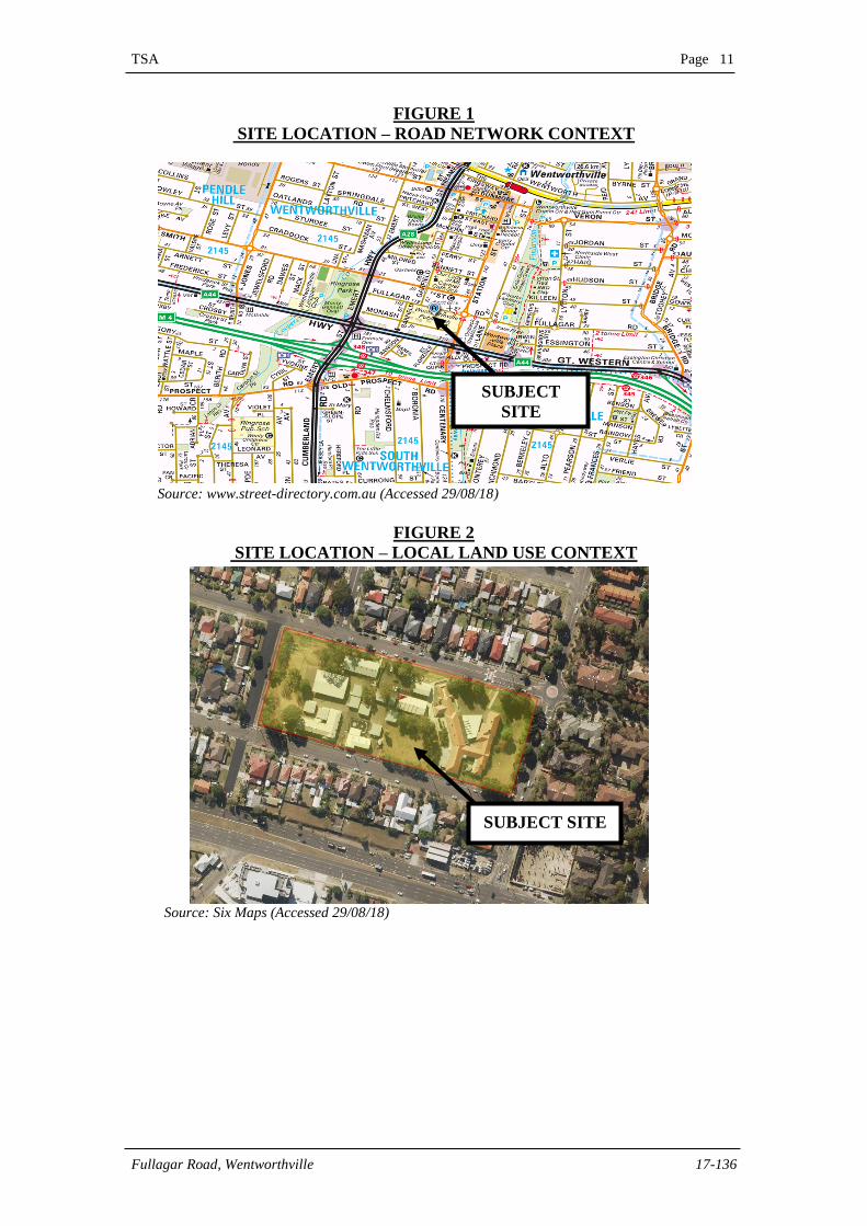
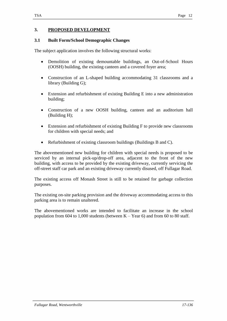
The subject site is bound by Fullagar Road to the north, Garfield Street to the west,
Monash Street to the south and Station Street, Wentworthville to the east. This
location is shown in the context of its surrounding road network and land use in
Figures 1 and 2 overleaf.
2.2 Site Description
The subject site provides a legal property description of Lot 1 in Deposited Plan
1245593 and a street address of 70 – 100 Fullagar Road, Wentworthville. The site
forms a rectangular shaped parcel of land, providing frontages of approximately 242m
to Fullager Street along its northern boundary, 91m to Station Street along its eastern
boundary, 242m to Monash Street along its southern boundary and 91m to Garfield
Street along its western boundary. The total area of the site is in the order of 2.205ha.
2.3 Existing Uses
The site currently accommodates Wentworthville Public School, a co-educational
primary school accommodating 604 students (between Kindergarten – Year 6) and 49
staff. The current hours of operation of the primary school is between 8:25am to
2:55pm. The school campus currently accommodates a number of buildings,
providing learning and administration facilities in conjunction with on-site student
recreation, play and sporting areas.
The school is primarily serviced by passenger vehicle car park containing 20 formally
painted car parking spaces, accessible off Fullagar Road via a combined entry/exit
driveway at the centre of the northern property boundary. Further, access to an
internal maintenance vehicle area and a pick-up/set-down area for children with
special needs is facilitated via separate driveways off Monash Street at the southern
property boundary.
2.4 Surrounding Uses
The site is primarily surrounded by a mix of medium to high density residential land
uses in its immediate vicinity (i.e. detached dwellings to the north, south and west and
apartment buildings to the east).
TSA Page 11
Fullagar Road, Wentworthville 17-136
FIGURE 1
SITE LOCATION – ROAD NETWORK CONTEXT
Source: www.street-directory.com.au (Accessed 29/08/18)
FIGURE 2
SITE LOCATION – LOCAL LAND USE CONTEXT
Source: Six Maps (Accessed 29/08/18)
SUBJECT
SITE
SUBJECT SITE
TSA Page 12
Fullagar Road, Wentworthville 17-136
3. PROPOSED DEVELOPMENT
3.1 Built Form/School Demographic Changes
The subject application involves the following structural works:
Demolition of existing demountable buildings, an Out-of-School Hours
(OOSH) building, the existing canteen and a covered foyer area;
Construction of an L-shaped building accommodating 31 classrooms and a
library (Building G);
Extension and refurbishment of existing Building E into a new administration
building;
Construction of a new OOSH building, canteen and an auditorium hall
(Building H);
Extension and refurbishment of existing Building F to provide new classrooms
for children with special needs; and
Refurbishment of existing classroom buildings (Buildings B and C).
The abovementioned new building for children with special needs is proposed to be
serviced by an internal pick-up/drop-off area, adjacent to the front of the new
building, with access to be provided by the existing driveway, currently servicing the
off-street staff car park and an existing driveway currently disused, off Fullagar Road.
The existing access off Monash Street is still to be retained for garbage collection
purposes.
The existing on-site parking provision and the driveway accommodating access to this
parking area is to remain unaltered.
The abovementioned works are intended to facilitate an increase in the school
population from 604 to 1,000 students (between K – Year 6) and from 60 to 80 staff.
TSA Page 13
Fullagar Road, Wentworthville 17-136
4. ACCESS & PARKING CONSIDERATIONS
4.1 Access Arrangements
4.1.1 Vehicular Access
Vehicular access to the on-site passenger vehicle parking area for staff is currently
facilitated by a 5m wide driveway supporting a combined ingress and egress function
off Fullagar Road at the northern property boundary. This existing driveway is also
proposed to service ingress movements to the new internal pick-up/drop-off area
dedicated for children with special needs. Vehicles exiting this pick-up/drop-off area
are to do so via an existing 5.7m wide driveway currently disused, which also
provides accessibility to Fullagar Road at the northern property boundary.
It is also noted that emergency vehicles and service vehicles currently use the existing
driveway mentioned above to access the site. It is understood that the site currently
accommodates up to one (1) service vehicle a day, which generally occurs outside of
the peak starting and finishing times of the school.
The existing vehicular driveway arrangements for passenger, service and emergency
vehicles and the number of service vehicle movements to and from the site are to
remain unaltered as part of the subject proposal.
4.1.2 Pedestrian Access
Primary pedestrian access to the school grounds is currently controlled by a gated
entrance connecting with the southern Fullagar Road footpath, which is to be retained
as part of the subject proposal.
4.2 Parking Provision
The existing off-street parking area which is to remain unchanged, provides 20 formal
passenger vehicle parking spaces, allocated primarily to staff.
Visitor parking primarily associated with student pick-up/drop-off activity is currently
being accommodated by the surrounding on-street public parking facilities. It is
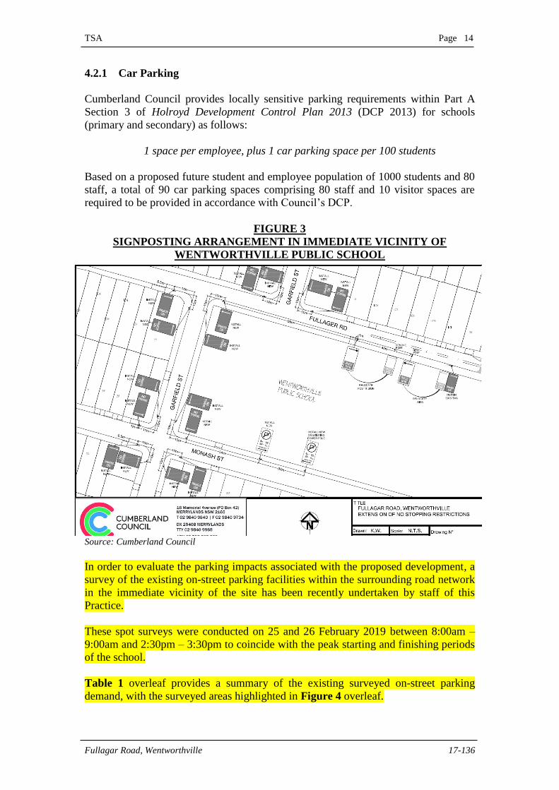
further noted following discussions with Council’s traffic engineer at a meeting on 23
July 2018 that an on-street pick-up/set-down zone, approximately 33m in length,
along the northern side of Monash Street, adjacent to the southern property boundary
is to be installed. Figure 3 overleaf shows the signposting plan prepared by Council,
illustrating the extent of the on-street student pick-up/set-down zone.
A recent inspection has indicated that the signposting associated with the student
pick-up/set-down area has been implemented. Further, it is noted that six (6) formally
linemarked parallel parking spaces have been provided within the designated student
pick-up/set-down area.
TSA Page 14
Fullagar Road, Wentworthville 17-136
4.2.1 Car Parking
Cumberland Council provides locally sensitive parking requirements within Part A
Section 3 of Holroyd Development Control Plan 2013 (DCP 2013) for schools
(primary and secondary) as follows:
1 space per employee, plus 1 car parking space per 100 students
Based on a proposed future student and employee population of 1000 students and 80
staff, a total of 90 car parking spaces comprising 80 staff and 10 visitor spaces are
required to be provided in accordance with Council’s DCP.
FIGURE 3
SIGNPOSTING ARRANGEMENT IN IMMEDIATE VICINITY OF
WENTWORTHVILLE PUBLIC SCHOOL
Source: Cumberland Council
In order to evaluate the parking impacts associated with the proposed development, a
survey of the existing on-street parking facilities within the surrounding road network
in the immediate vicinity of the site has been recently undertaken by staff of this
Practice.
These spot surveys were conducted on 25 and 26 February 2019 between 8:00am –
9:00am and 2:30pm – 3:30pm to coincide with the peak starting and finishing periods
of the school.
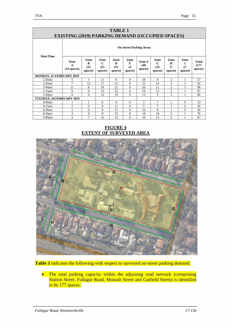
Table 1 overleaf provides a summary of the existing surveyed on-street parking
demand, with the surveyed areas highlighted in Figure 4 overleaf.
TSA Page 15
Fullagar Road, Wentworthville 17-136
TABLE 1
EXISTING (2019) PARKING DEMAND (OCCUPIED SPACES)
Date/Time
On-Street Parking Areas
Zone
A
(14 spaces)
Zone
B
(15
spaces)
Zone
C
(25
spaces)
Zone
D
(32
spaces)
Zone
E
(4
spaces)
Zone F
(40
spaces)
Zone
G
(33
spaces)
Zone
H
(7
spaces)
Zone
I
(7
spaces)
Total
(177
spaces)
MONDAY, 25 FEBRUARY 2019
2.30am 5 3 11 9 0 18 8 2 1 57
2.45am 7 12 17 15 0 23 14 3 1 92
3.00pm 11 8 16 21 0 26 11 2 3 98
3.15pm 9 9 13 22 0 19 12 2 1 87
3.30pm 8 6 10 19 0 13 9 2 1 68
TUESDAY, 26 FEBRUARY 2019
8.00am 1 1 6 4 0 3 7 1 0 23
8.15am 2 2 8 11 0 5 7 1 0 36
8.30am 3 6 9 13 0 16 8 1 0 56
8.45pm 3 9 9 15 0 18 18 3 1 76
9.00pm 3 7 12 13 0 16 13 2 1 67
FIGURE 4
EXTENT OF SURVEYED AREA
Table 3 indicates the following with respect to surveyed on-street parking demand:
The total parking capacity within the adjoining road network (comprising
Station Street, Fullagar Road, Monash Street and Garfield Street) is identified
to be 177 spaces;
TSA Page 16
Fullagar Road, Wentworthville 17-136
The maximum parking demand was surveyed to be 76 vehicles during the
morning peak period resulting in a minimum of 101 unoccupied spaces (177 –
76); and
The maximum parking demand was surveyed to be 98 vehicles during the
morning peak period resulting in a minimum of 79 unoccupied spaces (177 –
98).
With regards to the above, it is noted that the shortfall in parking (of 70 spaces with
respect to Council’s DCP can be readily accommodated within the on-street public
parking facilities in the immediate vicinity of the site. Further, the following factors
also contribute to reducing on-street parking:
A large number of students are currently observed to travel to and from the
site by walk trips as reflected in the pedestrian movement survey results
presented in Section 5.4 of this report. This trend is expected to continue as the
surrounding locality serviced by the school is understood to undergo further
urbanisation in the future characterised by high density residential land uses,
which are anticipated to be designed based on initiatives that promote
sustainable travel that reduce private vehicle parking, in line with DPE’s
Apartment Design Guide; and
Further, a Green Travel Plan (GTP) has been prepared by this Practice within
Section 7 of this report, in response to DPE’s SEARs condition under
Transport and Accessibility, which is also designed to promote greater
walk/bicycle trips, more public transport usage and other modes of travel, as
an alternative to private vehicle utilisation. The measures raised within the
GTP are intended to ensure that the transport infrastructure, services and
policies within and outside the site are tailored to the future site users, being
coordinated to achieve sustainable outcomes aimed at minimising traffic and
parking impacts within the surrounding road network.
4.2.2 Bicycle Parking
Cumberland Council does not provide any specific bicycle parking requirements for
schools within their DCP.
In any case, the subject development proposes to provide 15 double sided bicycle
racks on site adjacent to building B, which is designed in accordance with AS2890.3-
2015 and capable of accommodating up to 30 bicycles. Further, based on information
provided by the Fulton Trotter Architects, other end-of trip facilities proposed to be
provided are detailed below:
Showering facilities for staff are to be provided within Building E; and
Storage lockers for staff are to be provided within Building E.
TSA Page 17
Fullagar Road, Wentworthville 17-136
Recent observations have indicated that bicycle trips to and from the site associated
with staff, students and general visitors was found to be currently negligible.
However, as outlined within the Green Travel Plan (GTP) in Section 7 of this report,
there is an expectation that parents, students and staff travel characteristics/behaviour
are encouraged to change, as alternative forms of transport to private vehicle usage
are contemplated and actioned. The proposed bicycle parking provision is expected to
assist with facilitating greater bicycle trips, consistent with this GTP objective.
Further, with regards to the provision of end-of-trip facilities, it is noted that
Austroads Part 11: Guide to Traffic Management: Parking states that ‘primary and
secondary schools are exempt from having to provide end-of-trip facilities’.
TSA Page 18
Fullagar Road, Wentworthville 17-136
5. EXTERNAL TRAFFIC CONDITIONS
5.1 Surrounding Road Network
The following provides a road network immediately adjoining of the school site,
which are expected to be most affected by the additional traffic generated by the
proposed development:
Great Western Highway performs a State Road function under the care and control
of the Roads & Maritime Services. It provides an east-west arterial road linking
Parramatta in the east and Leonay in the west. In the vicinity of the subject site, it
forms a six lane divided carriageway providing three through lanes in each direction.
Pavement widening is provided on approach to major junctions in order to
accommodate exclusive turning lanes.
Great Western Highway intersects with Station Street and Centenary Road adjacent to
the subject site under traffic signal control. Exclusive left and right turn lanes are
provided within the westbound approach to this junction, whilst a right turn bay is
provided within the eastbound approach.
Traffic flow within Great Western Highway is governed by a sign posted speed limit
of 80km/h.
Station Street performs a collector road function under the care and control of
Cumberland Council. In this regard, it provides a north/south connection between the
Dunmore Street in the north (in the vicinity of Wentworthville Railway Station) and
Great Western Highway/Centenary Road in the south, intersecting with both under
traffic signal control.
Station Street forms a 13m wide carriageway accommodating one through lane of
traffic in each direction between formalised kerb and guttering. No Stopping (between
8:00am – 9:30am and 2:30pm – 4:00pm School Days) and Bus-Zone restrictions
apply along the western side of Station adjacent to the eastern site frontage.
Immediately adjacent to the north-eastern corner of the site, Station Street intersects
Fullagar Road under a single lane circulating roundabout. A pedestrian footpath is
also provided along both sides of Station Street, with a wombat crossing facilitating
pedestrian connectivity between the footpaths, approximately 12m to the south of this
roundabout intersection.
Fullagar Road performs a local access function under the care and control of
Cumberland Council. It provides an east/west orientation, connecting Bridge Road in
the east with Garfield Road in the west, in the immediate vicinity of the site.
Continuing further west, Fullagar Road terminates in a cul-de-sac.
Fullagar Road also provides a 13m wide pavement servicing one through lane of
traffic in each direction in conjunction with parallel parking along both kerb
alignments. No Stopping and Bus-Zone restrictions apply along the southern side of
Fullagar Road along the northern site frontage. Approximately 44m west of its
roundabout intersection with Station Street, a wombat crossing is provided which
provides a pedestrian link across Fullagar Road between the footpath within the
TSA Page 19
Fullagar Road, Wentworthville 17-136
northern verge and the footpath within the southern verge connecting with the
pedestrian gate to the school.
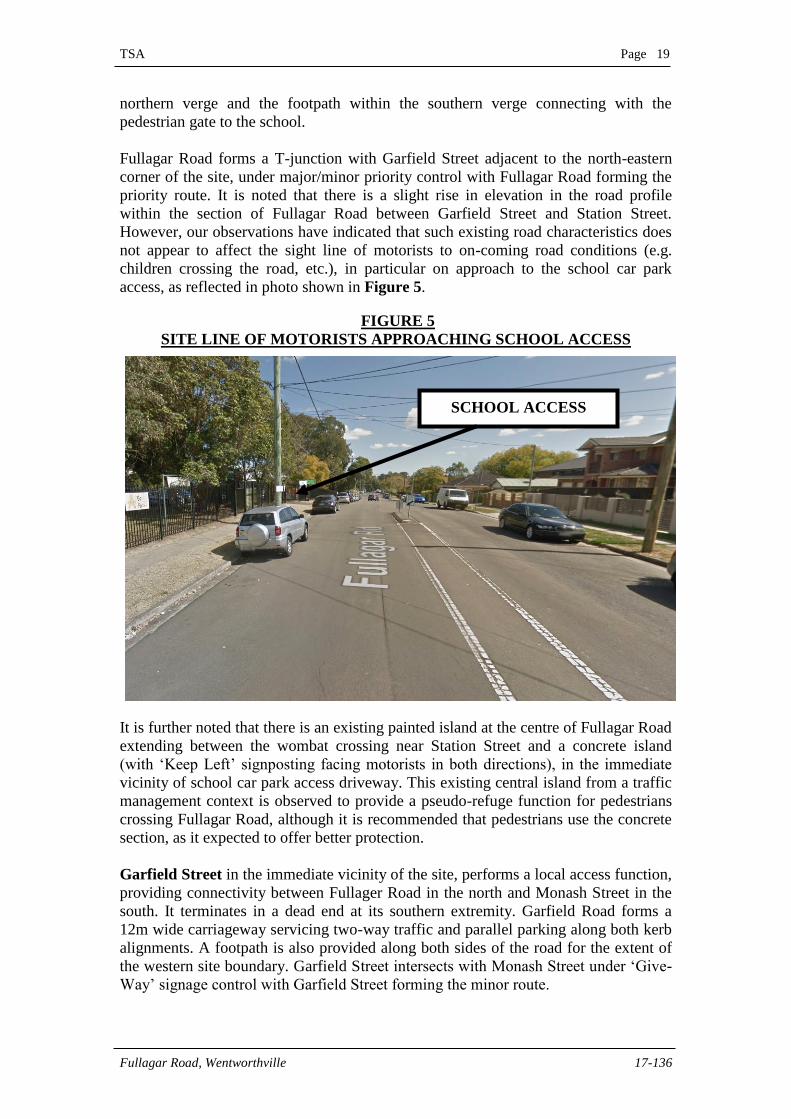
Fullagar Road forms a T-junction with Garfield Street adjacent to the north-eastern
corner of the site, under major/minor priority control with Fullagar Road forming the
priority route. It is noted that there is a slight rise in elevation in the road profile
within the section of Fullagar Road between Garfield Street and Station Street.
However, our observations have indicated that such existing road characteristics does
not appear to affect the sight line of motorists to on-coming road conditions (e.g.
children crossing the road, etc.), in particular on approach to the school car park
access, as reflected in photo shown in Figure 5.
FIGURE 5
SITE LINE OF MOTORISTS APPROACHING SCHOOL ACCESS
It is further noted that there is an existing painted island at the centre of Fullagar Road
extending between the wombat crossing near Station Street and a concrete island
(with ‘Keep Left’ signposting facing motorists in both directions), in the immediate
vicinity of school car park access driveway. This existing central island from a traffic
management context is observed to provide a pseudo-refuge function for pedestrians
crossing Fullagar Road, although it is recommended that pedestrians use the concrete
section, as it expected to offer better protection.
Garfield Street in the immediate vicinity of the site, performs a local access function,
providing connectivity between Fullager Road in the north and Monash Street in the
south. It terminates in a dead end at its southern extremity. Garfield Road forms a
12m wide carriageway servicing two-way traffic and parallel parking along both kerb
alignments. A footpath is also provided along both sides of the road for the extent of
the western site boundary. Garfield Street intersects with Monash Street under ‘Give-
Way’ signage control with Garfield Street forming the minor route.
SCHOOL ACCESS
TSA Page 20
Fullagar Road, Wentworthville 17-136
Monash Street perform a local access function to abutting developments. It has an
east/west alignment which runs parallel to Fullagar Road to the south of the site. At its
eastern extremity, Monash Street forms a T-junction with Station Street under
major/minor priority control with Station Street forming the priority route. At its
western extremity, the road terminates in a cul-de-sac.
Monash Street provides a 13m wide pavement carriageway accommodating one
through lane of traffic in each direction in conjunction with parallel parking along
both kerb alignments. It is understood that the school is proposing to seek an on-street
‘Kiss & Drop’ area within Monash Street, along the southern frontage of the school
site. In this regard, the Department of Education is required to submit a formal
proposal for such a facility to Cumberland Traffic Committee for evaluation, as a
separate application.
Traffic flow within all of the abovementioned roads is governed by a sign posted
speed limit of 50km/hr, with 40km/h school zone speed restrictions applying between
8:00am – 9:30am and 2:30pm – 4:00pm during school days.
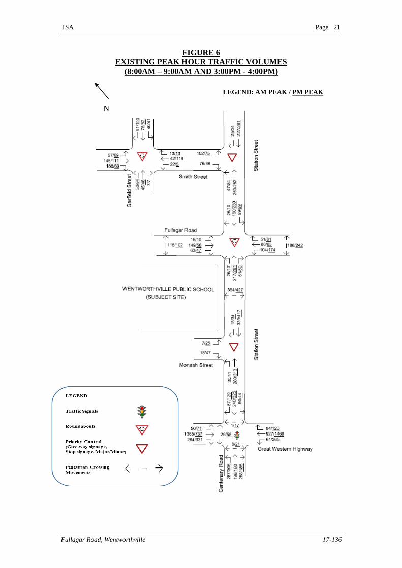
5.2 Existing Traffic Volumes
In order to obtain an indication of the existing performance of the surrounding public
road network immediately adjacent to the site, peak hour morning and afternoon
weekday traffic surveys were undertaken at the following intersections:
Great Western Highway and Station Street;
Station Street and Monash Street;
Station Street and Fullagar Road;
Station Street and Smith Street; and
Smith Street and Garfield Street
These surveys were undertaken on 21st of May and 27th of July 2018 between 7:00am
– 9:00am and 2:00pm – 4:00pm to coincide with the starting and finishing periods of
the primary school. Figure 6 overleaf illustrates the surveyed peak hour (8.00am –
9.00am and 3.00pm – 4.00pm) traffic flows at the surveyed intersections, whilst full
details are available upon request.
It is noted that there are some minor net gains and losses between intersections
associated with private development access locations, parking / unparking
manoeuvres and differing survey days.
In addition to the above, it is noted that approximately 5% of the total peak hour
traffic volumes at the surveyed intersection represent heavy vehicle movements.
TSA Page 21
Fullagar Road, Wentworthville 17-136
FIGURE 6
EXISTING PEAK HOUR TRAFFIC VOLUMES
(8:00AM – 9:00AM AND 3:00PM - 4:00PM)
N
LEGEND: AM PEAK / PM PEAK
TSA Page 22
Fullagar Road, Wentworthville 17-136
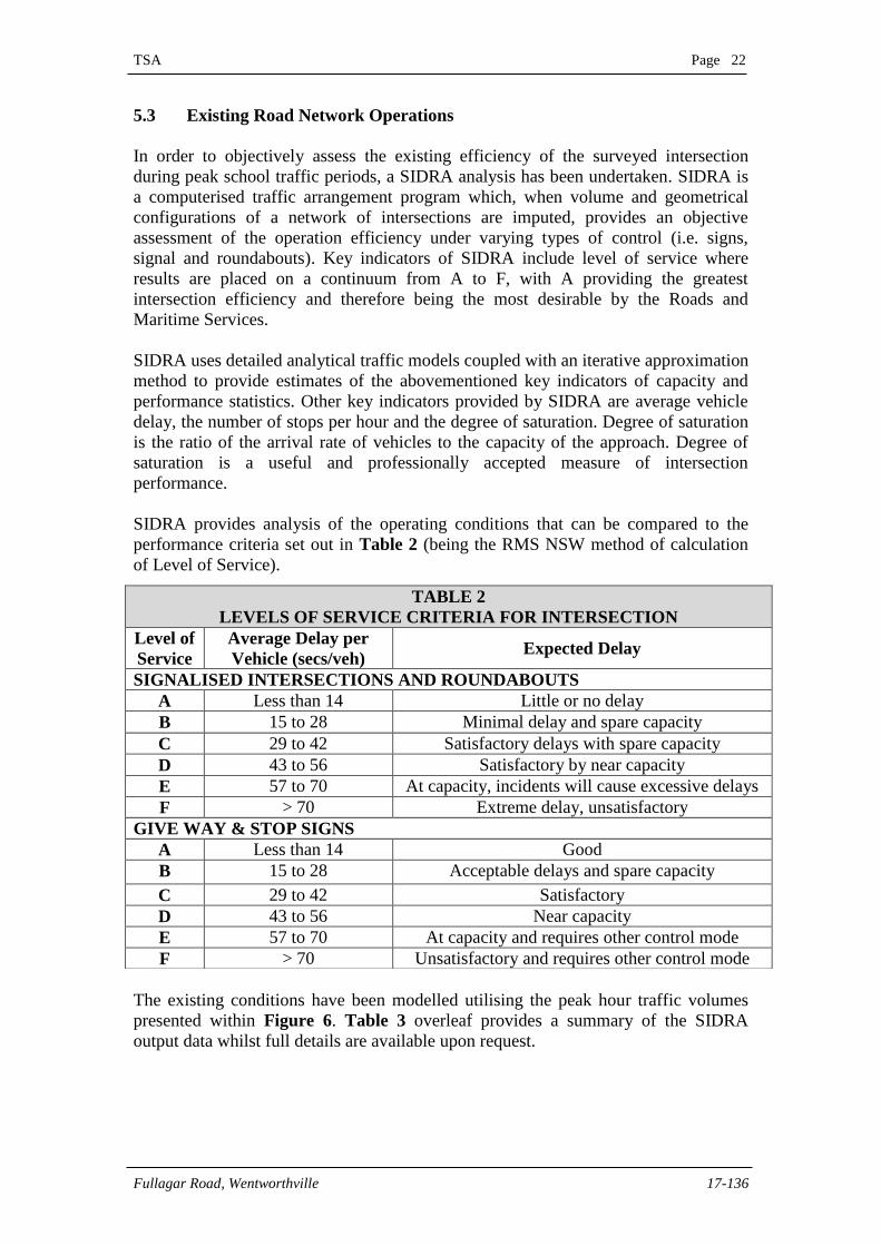
5.3 Existing Road Network Operations
In order to objectively assess the existing efficiency of the surveyed intersection
during peak school traffic periods, a SIDRA analysis has been undertaken. SIDRA is
a computerised traffic arrangement program which, when volume and geometrical
configurations of a network of intersections are imputed, provides an objective
assessment of the operation efficiency under varying types of control (i.e. signs,
signal and roundabouts). Key indicators of SIDRA include level of service where
results are placed on a continuum from A to F, with A providing the greatest
intersection efficiency and therefore being the most desirable by the Roads and
Maritime Services.
SIDRA uses detailed analytical traffic models coupled with an iterative approximation
method to provide estimates of the abovementioned key indicators of capacity and
performance statistics. Other key indicators provided by SIDRA are average vehicle
delay, the number of stops per hour and the degree of saturation. Degree of saturation
is the ratio of the arrival rate of vehicles to the capacity of the approach. Degree of
saturation is a useful and professionally accepted measure of intersection
performance.
SIDRA provides analysis of the operating conditions that can be compared to the
performance criteria set out in Table 2 (being the RMS NSW method of calculation
of Level of Service).
The existing conditions have been modelled utilising the peak hour traffic volumes
presented within Figure 6. Table 3 overleaf provides a summary of the SIDRA
output data whilst full details are available upon request.
TABLE 2
LEVELS OF SERVICE CRITERIA FOR INTERSECTION
Level of
Service
Average Delay per
Vehicle (secs/veh) Expected Delay
SIGNALISED INTERSECTIONS AND ROUNDABOUTS
A Less than 14 Little or no delay
B 15 to 28 Minimal delay and spare capacity
C 29 to 42 Satisfactory delays with spare capacity
D 43 to 56 Satisfactory by near capacity
E 57 to 70 At capacity, incidents will cause excessive delays
F > 70 Extreme delay, unsatisfactory
GIVE WAY & STOP SIGNS
A Less than 14 Good
B 15 to 28 Acceptable delays and spare capacity
C 29 to 42 Satisfactory
D 43 to 56 Near capacity
E 57 to 70 At capacity and requires other control mode
F > 70 Unsatisfactory and requires other control mode
TSA Page 23
Fullagar Road, Wentworthville 17-136
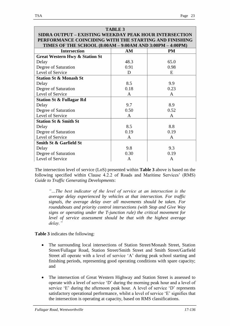
The intersection level of service (LoS) presented within Table 3 above is based on the
following specified within Clause 4.2.2 of Roads and Maritime Services’ (RMS)
Guide to Traffic Generating Developments:
“…The best indicator of the level of service at an intersection is the
average delay experienced by vehicles at that intersection. For traffic
signals, the average delay over all movements should be taken. For
roundabouts and priority control intersections (with Stop and Give Way
signs or operating under the T-junction rule) the critical movement for
level of service assessment should be that with the highest average
delay.”
Table 3 indicates the following:
The surrounding local intersections of Station Street/Monash Street, Station
Street/Fullagar Road, Station Street/Smith Street and Smith Street/Garfield
Street all operate with a level of service ‘A’ during peak school starting and
finishing periods, representing good operating conditions with spare capacity;
and
The intersection of Great Western Highway and Station Street is assessed to
operate with a level of service ‘D’ during the morning peak hour and a level of
service ‘E’ during the afternoon peak hour. A level of service ‘D’ represents
satisfactory operational performance, whilst a level of service ‘E’ signifies that
the intersection is operating at capacity, based on RMS classifications.
TABLE 3
SIDRA OUTPUT – EXISTING WEEKDAY PEAK HOUR INTERSECTION
PERFORMANCE COINCIDING WITH THE STARTING AND FINISHING
TIMES OF THE SCHOOL (8:00AM – 9:00AM AND 3:00PM – 4:00PM)
Intersection AM PM
Great Western Hwy & Station St
Delay
Degree of Saturation
Level of Service
48.3
0.91
D
65.0
0.98
E
Station St & Monash St
Delay
Degree of Saturation
Level of Service
8.5
0.18
A
9.9
0.23
A
Station St & Fullagar Rd
Delay
Degree of Saturation
Level of Service
9.7
0.50
A
8.9
0.52
A
Station St & Smith St
Delay
Degree of Saturation
Level of Service
8.5
0.19
A
8.8
0.19
A
Smith St & Garfield St
Delay
Degree of Saturation
Level of Service
9.8
0.30
A
9.3
0.19
A
TSA Page 24
Fullagar Road, Wentworthville 17-136
In addition to the above, it is acknowledged based on recent discussions with the
Roads and Maritime Services at a meeting on the 15th May, 2018 and past
assessments associated with other projects undertaken by this Practice that the
intersection of Great Western Highway and Station Street currently operates with a
poor level of service (‘F’) during the peak afternoon period (between 4:00pm –
6:00pm) associated with commuters’ journeys from work.
It is noted however that the abovementioned peak commuter period lies outside of the
peak period (2:00pm – 4:00pm), where the school generates its peak traffic activity.
In this regard, the additional traffic generated by the school is not expected to impact
the operations of this intersection where delay is currently identified to be the highest.
The abovementioned SIDRA output is generally consistent with numerous inspections
undertaken by staff of this Practice of the surrounding road network immediately
adjacent to the site in recent times. It is also noted from our observations that the
influx of traffic demand associated with the school is concentrated over a 15 – 30
minute window. As such, any inconvenience on other motorists, caused by this school
traffic was observed to be generally a temporary event.
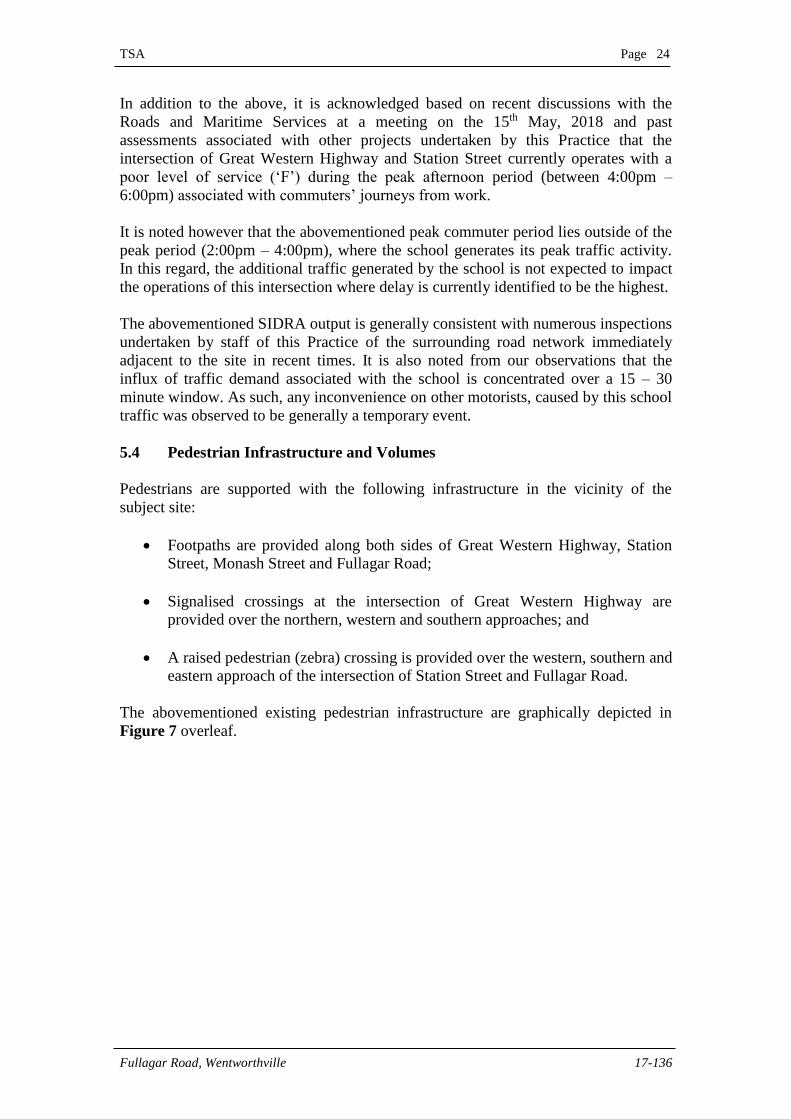
5.4 Pedestrian Infrastructure and Volumes
Pedestrians are supported with the following infrastructure in the vicinity of the
subject site:
Footpaths are provided along both sides of Great Western Highway, Station
Street, Monash Street and Fullagar Road;
Signalised crossings at the intersection of Great Western Highway are
provided over the northern, western and southern approaches; and
A raised pedestrian (zebra) crossing is provided over the western, southern and
eastern approach of the intersection of Station Street and Fullagar Road.
The abovementioned existing pedestrian infrastructure are graphically depicted in
Figure 7 overleaf.
TSA Page 25
Fullagar Road, Wentworthville 17-136
FIGURE 7
PUBLIC PEDESTRIAN INFRASTRUCTURE
IMMEDIATE ADJACENT TO THE SUBJECT SITE
Surveys of the pedestrian crossing movements over the crossing facilities denoted as
A, B and C in Figure 7 were undertaken by staff of this Practice in conjunction with
the previously presented vehicle volume surveys during school start and finish periods
on the 28th of May and 31st of July, 2018. Table 4 provides a summary of the existing
pedestrian crossing movements whilst full details are available upon request.
TABLE 4
PEDESTRIAN MOVEMENTS COINCIDING WITH START AND FINISH
PERIODS OF THE SCHOOL
Crossing Facility AM (Peds/Hr) PM (Peds/Hr)
Adults Children Total Adults Children Total
Raised zebra crossing (A) 136 218 354 153 274 427
Raised zebra crossing (B) 75 113 188 93 149 242
Raised zebra crossing (C) 45 73 118 39 63 102
Total 256 404 660 285 486 771
SUBJECT
SITE
Raised pedestrian
crossing (A)
Footpaths
Raised pedestrian
crossing (B)
Raised pedestrian
crossing (C)
Signalised crossing
TSA Page 26
Fullagar Road, Wentworthville 17-136
5.5 Parking Arrangements and Conditions
The following provides a summary of the existing on-street public parking facilities in
the immediate vicinity of the site:
Station Street, between Fullagar Road and Monash Street has ‘No-Stopping’
(and Bus Zone parking restrictions applicable along both sides of the road;
Fullagar Road generally accommodates unrestricted parallel parking along
both sides of the road, with the exception of a signposted bus zone applicable
between 8:00am – 5:00pm on school days, along the southern side of the road
adjacent to the northern site frontage; and
Unrestricted parallel parking generally applies within other surrounding local
roads (e.g. Monash Street and Garfield Street) within close proximity to the
school.
Recent observations have found that whilst on-street parking within the surrounding
road network are somewhat notable during peak starting and finishing times of the
school, primarily associated with parents/guardians dropping-off/picking up their
children and some staff parking. However, the on-street parking demand outside of
these peak periods have been observed to be considerably lower.
5.6 Public Transport (Public Bus & School Bus)
The closest public bus stops are located along both sides of Station Street to the
immediate east of the school site. Further, a school bus stop is provided along the
southern side of Fullagar Road approximately central to northern property boundary.
These bus stops service the following public and school bus routes within close
walking distance to the site:
Public Services
Hillbus operates the following services:
Route 818 – Westmead to Merrylands; and
Route S8 – Pendle Hill to Wentworthville.
Based on the latest timetables obtained from Transport for NSW website, both Routes
818 and S8 provides one (1) service each during the morning and afternoon peak hour
period coinciding with the starting and finishing times of the school (8.00am –
9.00am and 3:00pm – 4:00pm) with such services operating on 60 minute frequencies.
School Services
Based on information obtained from Hillsbus website (effective 26 February 2018), it
is understood that three (3) buses currently service the school coinciding with its
starting and finishing times, as follows:
TSA Page 27
Fullagar Road, Wentworthville 17-136
Route 8005 – Operates between Wentworthville Avenue and Wentworthville
Public School via Westmead;
Route 8021 – Operates between Girraween Road and Magowar Road via
Wentworthville Public School; and
Route 2558 – Operates between Wentworthville Public School and Barina
Downs Road.
The Hillsbus travel advice dated 26 February 2018 indicates that Routes 8005 and
8021 provides one (1) service during the morning school start period at 8:05am and
8:32am respectively. In the afternoon school finish period, Route 2558 runs one (1)
service at 3:00pm.
The staggering of the abovementioned bus services is such that at no time were buses
observed to queue back out of the sign posted zones such that no unreasonable
impedance on adjoining through traffic flow occurred.
TSA Page 28
Fullagar Road, Wentworthville 17-136
6. PROJECTED TRAFFIC CONDITIONS
6.1 Traffic Generation and Trip Assignment
The subject development is projected to generate additional traffic demand to and
from the site associated with the increase in school population from 604 to 1,000
students and from 60 to 80 staff. In order to estimate this additional traffic generating
potential, the following factors and assumptions are considered:
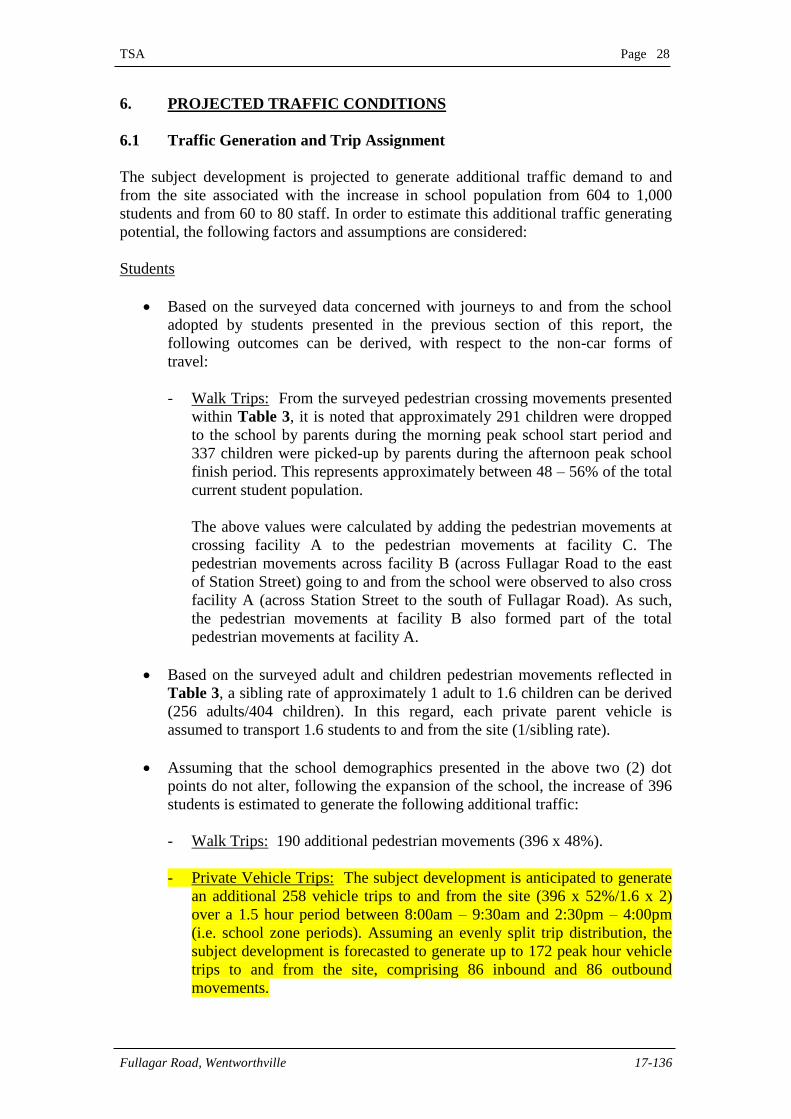
Students
Based on the surveyed data concerned with journeys to and from the school
adopted by students presented in the previous section of this report, the
following outcomes can be derived, with respect to the non-car forms of
travel:
- Walk Trips: From the surveyed pedestrian crossing movements presented
within Table 3, it is noted that approximately 291 children were dropped
to the school by parents during the morning peak school start period and
337 children were picked-up by parents during the afternoon peak school
finish period. This represents approximately between 48 – 56% of the total
current student population.
The above values were calculated by adding the pedestrian movements at
crossing facility A to the pedestrian movements at facility C. The
pedestrian movements across facility B (across Fullagar Road to the east
of Station Street) going to and from the school were observed to also cross
facility A (across Station Street to the south of Fullagar Road). As such,
the pedestrian movements at facility B also formed part of the total
pedestrian movements at facility A.
Based on the surveyed adult and children pedestrian movements reflected in
Table 3, a sibling rate of approximately 1 adult to 1.6 children can be derived
(256 adults/404 children). In this regard, each private parent vehicle is
assumed to transport 1.6 students to and from the site (1/sibling rate).
Assuming that the school demographics presented in the above two (2) dot
points do not alter, following the expansion of the school, the increase of 396
students is estimated to generate the following additional traffic:
- Walk Trips: 190 additional pedestrian movements (396 x 48%).
- Private Vehicle Trips: The subject development is anticipated to generate
an additional 258 vehicle trips to and from the site (396 x 52%/1.6 x 2)
over a 1.5 hour period between 8:00am – 9:30am and 2:30pm – 4:00pm
(i.e. school zone periods). Assuming an evenly split trip distribution, the
subject development is forecasted to generate up to 172 peak hour vehicle
trips to and from the site, comprising 86 inbound and 86 outbound
movements.

TSA Page 29
Fullagar Road, Wentworthville 17-136
Staff
It is noted from survey data provided by the school that a large majority (85%)
of employees travel to and from the site by private vehicle, with the remaining
employees travelling by walking, public transport (i.e. buses) and carpooling.
Based on these transport mode preferences, up to 17 (20 x 85%) of the
additional staff can be expected to travel to and from the school by private
vehicle means. It is advised that alternative travel modes should be encouraged
as much as practical (See Green Travel Plan in Section 7 of the report), if not
already to minimise traffic and parking impact on the surrounding road
network.
It is noted that staff are generally expected to arrive prior to students arriving and
leave after students depart the school. In this regard, the maximum traffic generating
potential of the proposed development over an hourly period is anticipated to be
predominantly associated with student pick-up/drop-off activity. Table 5 provides a
summary of the peak hour traffic generating ability of the subject based on the above
discussion.
TABLE 5
SUMMARY OF ADDITIONAL PRIVATE VEHICLE
TRIPS ASSOCIATED WITH THE SUBJECT PROPOSAL
AM PEAK PM PEAK
Inbound 86 86
Outbound 86 86
Total 172 172
In order to gauge the impact of the traffic projected to be generated by the proposal, it
is necessary to determine the impact on surrounding route and intersection efficiency.
The objective of this section is to distribute the traffic generated by the proposed
development along the major approach routes before it dissipates throughout the
general road network.
It is rarely possible to precisely forecast the route that motorists will elect to utilise.
Perceived traffic safety, traffic efficiency and individual preferences are all variables
that will influence the traffic route selected by motorists. Nevertheless, it is common
to assume that trips to the subject site will be distributed in accordance with existing
traffic patterns and alterations currently observed in the surrounding road network.
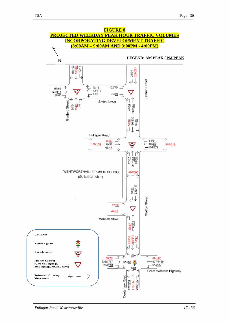
With regards to the above, the post-development traffic volumes diagrammatically
presented in Figure 8 overleaf incorporates the additional traffic generated by the
proposed development (in red), which have been assigned, based on the existing
surrounding traffic distributions illustrated within Figure 6.
Further, up to 70% of the total additional traffic is assumed to originate from the north
with the remaining 30% originating from the south via Station Street.
TSA Page 30
Fullagar Road, Wentworthville 17-136
FIGURE 8
PROJECTED WEEKDAY PEAK HOUR TRAFFIC VOLUMES
INCORPORATING DEVELOPMENT TRAFFIC
(8:00AM – 9:00AM AND 3:00PM - 4:00PM)
N LEGEND: AM PEAK / PM PEAK
TSA Page 31
Fullagar Road, Wentworthville 17-136
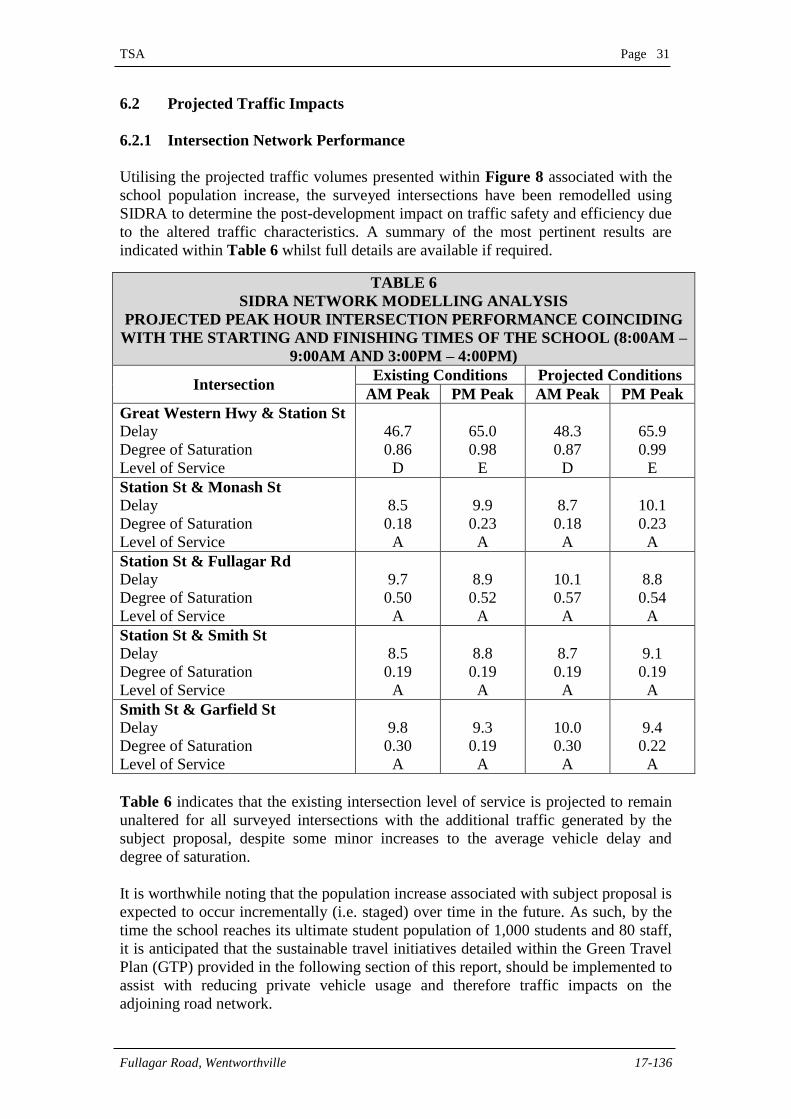
6.2 Projected Traffic Impacts
6.2.1 Intersection Network Performance
Utilising the projected traffic volumes presented within Figure 8 associated with the
school population increase, the surveyed intersections have been remodelled using
SIDRA to determine the post-development impact on traffic safety and efficiency due
to the altered traffic characteristics. A summary of the most pertinent results are
indicated within Table 6 whilst full details are available if required.
Table 6 indicates that the existing intersection level of service is projected to remain
unaltered for all surveyed intersections with the additional traffic generated by the
subject proposal, despite some minor increases to the average vehicle delay and
degree of saturation.
It is worthwhile noting that the population increase associated with subject proposal is
expected to occur incrementally (i.e. staged) over time in the future. As such, by the
time the school reaches its ultimate student population of 1,000 students and 80 staff,
it is anticipated that the sustainable travel initiatives detailed within the Green Travel
Plan (GTP) provided in the following section of this report, should be implemented to
assist with reducing private vehicle usage and therefore traffic impacts on the
adjoining road network.
TABLE 6
SIDRA NETWORK MODELLING ANALYSIS
PROJECTED PEAK HOUR INTERSECTION PERFORMANCE COINCIDING
WITH THE STARTING AND FINISHING TIMES OF THE SCHOOL (8:00AM –
9:00AM AND 3:00PM – 4:00PM)
Intersection Existing Conditions Projected Conditions
AM Peak PM Peak AM Peak PM Peak
Great Western Hwy & Station St
Delay
Degree of Saturation
Level of Service
46.7
0.86
D
65.0
0.98
E
48.3
0.87
D
65.9
0.99
E
Station St & Monash St
Delay
Degree of Saturation
Level of Service
8.5
0.18
A
9.9
0.23
A
8.7
0.18
A
10.1
0.23
A
Station St & Fullagar Rd
Delay
Degree of Saturation
Level of Service
9.7
0.50
A
8.9
0.52
A
10.1
0.57
A
8.8
0.54
A
Station St & Smith St
Delay
Degree of Saturation
Level of Service
8.5
0.19
A
8.8
0.19
A
8.7
0.19
A
9.1
0.19
A
Smith St & Garfield St
Delay
Degree of Saturation
Level of Service
9.8
0.30
A
9.3
0.19
A
10.0
0.30
A
9.4
0.22
A
TSA Page 32
Fullagar Road, Wentworthville 17-136
6.2.2 Set-down / Pick-Up Activity and Staff Parking Considerations
Based on a future school population of 1,000 students and assuming that the existing
travel characteristics remain unaltered (i.e. average vehicle occupancy rate = 1.6 child
per vehicle and 52% of students travel to/from school by car), the proposed
development could generate up to 217 vehicles over an hourly period ((1000 x
52%/1.6)/1.5 hours) associated with student pick-up/drop-off activity. This is
equivalent to approximately 3.6 vehicles per minute (i.e. 217 vehicles/60 minutes).
Further to the above, based on our observations of current school operations, the
average length of stay for parents/guardians during the student drop-off/collection
process is approximately five (5) minutes. In this regard, the proposed development
could be expected to generate a maximum short term parking demand/queue of up to
18 vehicles, corresponding to student drop-off/collection activity during school start
and finish periods. Based on Figure 2.5 of AS2890.1-2004, the minimum length for a
parallel parked vehicle ranges between 5.9m – 6.2m. As such, a peak parking demand
of approximately 18 vehicles could potentially require a kiss and drop bay length of
around 106 – 112m.
It is noted that there is opportunity for the recently installed on-street student pick-
up/drop-off area within Monash Street to be extended along the school frontage to
accommodate the abovementioned pick-up/drop-off demand associated with the
subject proposal. In this regard, it is recommended that the existing signposted kiss &
ride zone within Monash Street be extend to cover the whole length of the site
frontage (approximately 240m). It is noted that this measure is not expected to have
any significant impact to the parking needs of staff of the school (with the parking
surveys previously presented indicating that there is ample within the surrounding
road network) as well as existing surrounding residential land uses (which have off-
street parking facilities). Further, such a measure can be implemented through
relocating the existing ‘No Stopping 8am – 9:30am and 2:30pm – 4pm School Days’
signposting and does not involve any further modification to the adjoining local road
network. In any case, any modification to the existing student pick-up/drop-off area is
subject to further review and monitoring by Council, as the school increases in student
enrolment.
In order to alleviate further some of the on-street parking impacts, it is recommended
that consideration be given by the school to implement an Operational Traffic &
Pedestrian Management Plan (OTPMP), prepared in the Section 8 of this report to
govern the use of the on and off-site parking areas during peak school starting and
finishing periods.The purpose of an OTPMP is to govern the implementation of the
proposed altered parking arrangements and also to improve the safety and efficiency
with which students are set-down / picked-up by private vehicles (e.g. to ensure the
signposted student pick-up/drop-off area is not improperly used by staff during school
zone periods). The OTPMP addresses issues which are considered vital to the safety
of school students as well as to the sound site and public road management as they
relate to traffic and pedestrian safety. The OTPMP should also be used in conjunction
with the GTP to minimise parking impacts on the surrounding road network.
6.2.3 Public Transport
The additional students projected to use buses is not of sufficient size to have any
measurable impact to the existing public transport services.
TSA Page 33
Fullagar Road, Wentworthville 17-136
7. GREEN TRAVEL PLAN (GTP)
7.1 Introduction
Transport is an unavoidable factor in modern society and a major contributor to
emissions in Australia. However, the effects of transport associated with new
developments can be managed through the implementation of travel plans, which
provide an opportunity to reduce harmful greenhouse gases. In conjunction with
striving to provide more efficient environmental outcomes, providing a range of travel
choices with a focus on walking, cycling and public transport will result in major
public health advantages to the Wentworthville Public School and the surrounding
precinct.
This Green Travel Plan (GTP) is intended to assist with ensuring that the transport
infrastructure, services and policies within and outside the site are tailored to the
future site users, being coordinated to achieve sustainable outcomes.
7.2 Green Travel Plan Definition
This Green Travel Plan provides a series of measures aimed at promoting and
encouraging sustainable travel and reducing reliance on the private car. The aim of the
Plan is to achieve travel behaviour change through raising awareness of alternatives to
private motor vehicle use. The development of a site based Plan focuses on providing
information, offering incentives and mode specific actions to optimise the use of
sustainable travel (public transport, cycling and walking).
This Green Travel Plan specifically examines how future site users can travel to and
from the site and what can be done to replace single occupancy motor vehicle trips
with sustainable trips. As a trip generator, the site can enhance the choices available to
residents in a way that promotes health, safety and environmentally sustainable
outcomes.
The potential to change site based travel is affected by several factors including car
parking provision, the provision of car share schemes, site user interest in changing,
the provision of support for change and the availability of various forms of public
transport in the immediate vicinity.
7.3 Green Travel Plan Benefits and Objectives
This Green Travel Plan provides a wide range of benefits to residents, the community
and the environment including:
Decreasing greenhouse gas emissions;
Promoting the subject site and surrounding area as an innovative and
environmentally aware location;
Improving health and fitness of site users through increased cycling and
walking activity;
Improving site user moral and social interaction;

TSA Page 34
Fullagar Road, Wentworthville 17-136
Reducing traffic congestion and car parking problems;
Fostering a sense of community; and
Reducing general living expenses.
The main objectives of this Green Travel Plan are to:
Reduce vehicle kilometres travelled (VKT) to and from the subject site,
particularly single occupancy vehicle trips;
Increase site user use of sustainable transport modes (walking, cycling and
public transport);
Ensure that site users are informed on the opportunities and benefits of using
sustainable transport; and
Promote the subject site and area as an innovative and environmentally aware
location.
7.4 Mode Shift Initiatives
The close proximity of the site to a wide range of sustainable transport options (e.g.
buses and walk trips) should be better capitalised to minimise dependence on private
motor vehicles.
The following sub-sections provide a summary of these measures to promote
sustainable transport for the subject development. The measures are to be in place
from the initial occupancy of the development as people will establish lasting habits
from this time.
7.4.1 Promote Cycling (for staff)
Display cycling maps and fact sheets on the benefits of cycling to staff
through school noticeboards, flyers, emails and other forms of
communication;
Encourage surrounding bicycle groups to advertise cycle skills training and
bicycle maintenance workshops within school noticeboards; and
Promote events such as Ride to Work Day, Bike Week etc. to encourage
greater cycling trips.
7.4.2 Promote Walking (for staff and students)
Display walking maps and fact sheets on the benefits of walking cycling to
staff through school noticeboards, flyers, emails and other forms of
communication; and
TSA Page 35
Fullagar Road, Wentworthville 17-136
Promote programs with incentives that encourage staff and students to walk to
and from the school (e.g. walk to school competition with reward for top
performers, etc.).
7.4.3 Promote Public Transport (for staff and students)
Display route maps and timetables of bus routes with stops within 10 minutes
walking distance of the site through school noticeboards, flyers, emails and
other forms of communication.
Provision of Opal cards for all new and existing students and staff.
7.4.4 Promote Carpooling (for staff and students)
Display a fact sheet on the benefits of carpooling on the benefits of walking
cycling to staff through school noticeboards, flyers, emails and other forms of
communication; and
Promote programs with incentives that encourage staff and students to car
pool (e.g. Travel cost reimbursements for car pooled staff).
7.5 Monitoring
A checklist is provided in Table 7 overleaf, identifying potential tasks/strategies
outlined in the previous sections, which should be undertaken by the school to assist
with the facilitation of green travel initiatives.
It is noted that a Green Travel Plan is a dynamic document, which will change over
time depending on the environment and circumstances of the subject development.
Accordingly, monitoring, evaluating and reviewing the Plan is important as it will
guide ongoing efforts to reduce vehicle kilometres travelled and encourage the use of
sustainable transport.
Monitoring and evaluation is an ongoing process which involves fine tuning. There is
no standard methodology for the monitoring of a Green Travel Plan however,
generally speaking, students and staff should be regularly surveyed as to their travel
behaviour to ascertain the areas in which the Travel Plan is successful and those
which require altered or improved initiatives.
It is important to understand people’s reasons for travelling the way they do, any
barriers to changing their behaviour and their propensity to change. This will enable
the most effective initiatives to be identified, and conversely less effective initiatives
to be modified or replaced to ensure the best outcomes are achieved.
It will be necessary to provide feedback to students and staff to ensure that they can
see the benefits of sustainable transport. It is proposed that this occur through the
provision of survey results within the school community noticeboards and other
communication channels.
TSA Page 36
Fullagar Road, Wentworthville 17-136
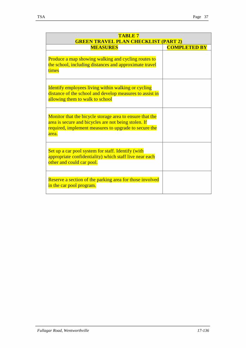
TABLE 7
GREEN TRAVEL PLAN CHECKLIST (PART 1)
MEASURES COMPLETED BY
Prepare a new starter pack for staff and students. The
pack will include the following:
Maps and timetables of public transport in the
area
Maps of the shared path network in the precinct
Details of measures provided to secure bicycles
Details of the car pool scheme and how to join
Details of any measures provided by the school
to minimise transport of heavy or bulky
materials
At the start of each year:
Provide a forum to link possible cycling or
walking partners
Set up a new forum to form new groups as part
of the car pool, taking into consideration the
timetable for the following year.
Review the plan and update as required.
Utilise the school website, newsletters and social media
to keep students, parents and staff informed of any
changes to public transport, shared paths or other
sustainable transport measures
Develop a map showing the public transport routes to
the school – both regular services and school service.
Map to be available on the school website.
At the start of the school year and mid-year, update the
map to reflect any changes.
Provide links on the school website to public transport
companies servicing the area
TSA Page 37
Fullagar Road, Wentworthville 17-136
TABLE 7
GREEN TRAVEL PLAN CHECKLIST (PART 2)
MEASURES COMPLETED BY
Produce a map showing walking and cycling routes to
the school, including distances and approximate travel
times
Identify employees living within walking or cycling
distance of the school and develop measures to assist in
allowing them to walk to school
Monitor that the bicycle storage area to ensure that the
area is secure and bicycles are not being stolen. If
required, implement measures to upgrade to secure the
area.
Set up a car pool system for staff. Identify (with
appropriate confidentiality) which staff live near each
other and could car pool.
Reserve a section of the parking area for those involved
in the car pool program.
TSA Page 38
Fullagar Road, Wentworthville 17-136
8. INTERNAL OPERATIONAL TRAFFIC & PEDESTRIAN
MANAGEMENT PLAN
In order to ensure safe and efficient school operations during peak start and finish
periods, it is recommended that an Operational Traffic & Pedestrian Management
Plan (OTPMP) be implemented. The following subsections of this report provide a
summary of the key strategies which should be incorporated within the Plan, the
requirement for which could be reasonably imposed by Council as a condition of
Development Consent.
8.1 Operational Traffic & Pedestrian Management
8.1.1 General Items
A Management & Safety Committee is to be established to implement the
operational traffic and pedestrian management measures incorporated within
this Plan and to develop further guidelines in order to ensure that on-site and
off-site vehicular and pedestrian safety is maximised.
The Committee shall comprise the school principal or his / her senior
representative, a parent’s representative as well as an independent traffic
consultant to provide initial assistance in the implementation of the Plan and
subsequent periodic guidance in ongoing review of the Plan.
The Management & Safety Committee shall ensure that the procedures
contained within the OPTM are put in place with respect to: on and off-site
traffic and pedestrian management and safety issues.
The Committee shall put in place measures which should ensure parent /
guardian compliance with the Plan. These should take the form of specific
instructions via student newsletters and indications that such instructions are to
be observed as may be applicable to any private property and could therefore
form part of the initial enrolment procedures.
The Plan should also be subject to periodic review by the school (in
consultation with Council for endorsement), to ensure that road safety issues
as they relate to the public roads close the school, are appropriately
documented and implemented in accordance with sound traffic engineering
and road safety practices.
8.1.2 Internal Staff Parking
Staff parking is to occur within the designated internal parking area on site.
Staff who wish to utilise the site parking facilities are to arrive prior to 8.00am
and exit after 4.00pm on school days to minimise the interaction of this
vehicle movements with the peak student set-down / pick-up periods during
school start and finish periods.
TSA Page 39
Fullagar Road, Wentworthville 17-136
8.1.3 Student Set-Down / Pick-Up
Student set-down / pick-up is to be undertaken within the formalised and
signposted indented set-down / pick-up bay off Monash Street adjacent to the
southern boundary of the school site, during the morning school start and
afternoon school finish period.
School Start
Parents setting-down students during the morning peak are to do so in the
abovementioned signposted student set-down / pick-up parking area.
Students set-down within the area are to access the school buildings to the
north via the existing pathway adjoining the set-down / pick-up parking area to
the north.
No staff or parent parking is to occur within the set-down / pick-up area during
the morning school start period.
During the initial stages of the implementation of this TMP, a traffic warden
(wearing an appropriate clean high visibility reflective vest) will supervise the
set-down / pick-up area during the morning prior to school start to ensure that
students disembark parent vehicles in a safe and efficient manner.
School Finish
The school will implement the following operational management
arrangements during the afternoon school finish period:
- Students assemble under the supervision of a warden at the pick-up area
following the completion of the school day;
- Parents display the names of children to be picked-up on the windscreen of
the vehicle when entering the pick-up area; and
- The warden supervising the student assembly area arranges for the relevant
student/s to be brought to the front of the assembly area upon the arrival of
the parent vehicle to the pick-up location.
No staff or parent parking is to occur within the student pick-up area during
the afternoon school finish period.
TSA Page 40
Fullagar Road, Wentworthville 17-136
9. CONSTRUCTION ISSUES
9.1 Introductory Statement
This Section of the report constitutes a preliminary Construction Traffic Management
Plan (CTMP) addressing the traffic access and safety issues associated with
construction works relating to the proposed development in response to DPE’s
SEARs comments under the Traffic and Accessibility section (SSD 9273). There is
currently no construction activity observed in the immediate vicinity of the site
associated with adjoining land uses. In this regard, the assessment contained in this
draft CTMP is limited to the school site only.
CTMPs are generally prepared at Construction Certificate stage following the
commissioning of a builder thereby allowing a greater appreciation of the likely
construction methodology and therefore the required traffic management measures to
be implemented.
The terms of the initiatives contained within the following subsections of this report
are therefore somewhat generic and some modifications may be needed by or on
behalf of the successful builder / civil contractor at Construction Certificate stage
depending on their feasibility taking into consideration all project requirements.
9.2 Proposed Works and Traffic Management
The demolition and construction works are likely to be undertaken within three (3)
separate stages as follows:
Stage 1 – demolition of the relevant site structures;
Stage 2 – remediation of demolished areas; and
Stage 3 – construction of new site structures; and
It is noted that the scale of the buildings on site is such that there may be a
requirement for construction vehicle activity to be accommodated within the
adjoining public road network, which would necessitate a works zone to be
implemented. The implementation of any proposed works zones will also necessitate
an application being submitted to Council for a Works Permit, including the provision
of appropriate application fees and charges. All areas of demolition / construction
during the various stages including the construction compounds are to be fenced such
that there will be no unreasonable interaction between the construction activities and
the surrounding public roads.
Any potential occupation of the public roadway, associated with the provision of
works zones may require the preparation of traffic control plan/s (TCP) to be prepared
by the relevant contractor and submitted to Council for approval, prior to such works
being undertaken. Any traffic control management measures detailed within such
plan(s) to be implemented are to be sensitive to the surrounding land uses. Further, all
traffic management measures included within the plan/s are to be certified on the
drawings as being in accordance with AS1742.3 and the Roads & Maritime Services’
Traffic Control at Work Sites manual.
TSA Page 41
Fullagar Road, Wentworthville 17-136
9.3 Safe Ingress and Egress of Construction Traffic
During all stages of demolition / construction, all construction vehicles will enter and
exit the site and/or works zone in a forward direction via an existing / proposed
driveway. Reversing manoeuvres to and from the site will be prohibited, unless
specific approval is granted by Cumberland Council. Site access and egress
manoeuvres may be controlled by appropriately qualified traffic controllers to ensure
that all such movements are undertaken in a safe and efficient manner. Traffic
controllers are not to stop traffic on the public street to allow construction vehicles to
enter or leave the site. They must wait until a suitable gap in traffic flow allows them
to assist construction vehicles to enter or exit the site. The Roads Act does not give
any special treatment for trucks leaving a construction site – the vehicles already on
the road have right of way.
The timing of access / egress by construction traffic will be sensitive to the
surrounding land uses and traffic flow demands. In this regard, construction vehicle
ingress and egress movements are to be minimised where possible during road
network and school peak periods (7.00am – 9.30am and 2.30pm – 6.00pm). With
regards to pedestrian and cycling access during construction, this is to be confirmed
with the future successful builder / civil contractor to be appointed.
9.4 Construction Vehicle Transport Routes
The frontage roads provide good connectivity to surrounding regional and arterial
routes servicing the Sydney metropolitan area thereby indicating that construction
vehicles are able to access and depart the site creating very little disturbance to
surrounding local road traffic flow. The multiple directional traffic lanes of the
approach and departure routes are such that heavy vehicle manoeuvring is able to
occur without any unreasonable encroachment on opposing travel lanes, kerbs and / or
parking lanes. None of the abovementioned roads are light thoroughfares or are
restricted by load limits.
9.5 Parking Control
At no time are construction worker / tradesperson vehicles or construction vehicles to
be parked within the adjoining public road network. In order to minimise the demand
for parking associated with construction workers and thus the impact of the works on
surrounding precinct amenity and parking provision, it is recommended that
construction workers / tradespersons be encouraged to do either of the following when
travelling to the site:
Utilise public transport to the site (the site is well serviced by bus routes); and
/ or
Car pool with other construction workers.
The above transport options are to be made available to site workers and as such form
part of any site induction process. Details of induction scheduling and procedures are
contained within the Occupational Health & Safety, Safe Work Method Statement and
Induction Record Forms prepared by others are submitted as part of the Construction
Certificate application.
TSA Page 42
Fullagar Road, Wentworthville 17-136
9.6 Construction Traffic Generation
Construction materials are to be transported to and from the site and/or works zone by
vehicles up to and including Heavy Rigid Vehicles (HRVs). The number of vehicles
needed at each stage of the construction works has been estimated based on this
Practice’s experience with developments of similar scale as follows:
Stage 1 – demolition of the relevant site structures – 60 vehicles per week or
two (2) vehicles per hour
Stage 2 – remediation of demolished areas – 10 vehicles per week or one (1)
vehicles per hour; and
Stage 3 – construction of new site structures – 30 vehicles per week or one (1)
vehicles per hour.
The construction activities are projected to generate significantly less traffic than the
proposed future use, thereby indicating suggesting that impacts will be minimal.
During periods of more heavy construction vehicle generation (i.e. a concrete pour),
drivers are to be instructed by radio when to arrive at the site to ensure that there is no
vehicle queuing or parking within the adjoining road network. This is to be strictly
adhered to.
9.7 Traffic Impact
The recent traffic investigations of the adjoining road network and the analysis
contained within previous sections of this report have indicated that motorists are
provided with a reasonable level of service within the immediately adjoining public
road network. It is therefore considered that the limited traffic generation associated
with the construction activities can be accommodated without any unreasonable
impacts on adjoining vehicle movements considering the previously mentioned
maximum hourly traffic generation. Notwithstanding this, it has accordingly been
recommended that construction vehicle movements to and from the site be minimised
where possible during road network peak periods (7.00am – 9.30am and 2.30pm –
6.00pm).
9.8 Impacts on Pedestrians
It has previously been presented that all internal construction zones are to be fenced to
prevent pedestrian access. Pedestrians are to be protected from dust and debris by full
perimeter scaffolding around the staged construction compounds, combined with
chain wire mesh and shade cloth.
Qualified traffic controllers are to assist all site access movements during vehicular
ingress and egress. In addition, the reduction and / or elimination vehicular
movements during peak commuter periods (when pedestrian movements within the
adjoining road network are at their greatest) will limit the impact of the construction
works on pedestrian accessibility and safety.
TSA Page 43
Fullagar Road, Wentworthville 17-136
10. CONCLUSIONS
This report details our assessment of the traffic, access and safety considerations
associated with proposed alterations and additions to Wentworthville Public School,
located at 70 – 100 Fullagar Road, Wentworthville. Having regard to the contents of
this report, the following conclusions are now made:
The application is expected to result in an increase in the school population
from 604 to 1,000 students and from 60 to 80 staff;
The existing access arrangements and off-street car parking provision are
proposed to remain unaltered as part of the subject proposal;
The surrounding road network in the immediate vicinity of the site is assessed
to currently operate with a predominantly good level of service ‘A’ during
peak school start/finish periods, with the exception of the Station Street’s
intersection with Great Western Highway, which is assessed to operate with a
level of service ‘D’ and ‘E’ during the morning and afternoon peak period
respectively. A level of service ‘E’ indicates that the intersection is operating
close to capacity, based on RMS guidelines;
The school has been projected to generate an additional 172 peak hour vehicle
trips to and from the site during school start and finish periods;
The remodelled SIDRA output generally indicates no changes to the existing
level of service due to the additional traffic generated by the subject proposal,
within the surveyed intersections, despite some slight increases in average
delay and degree of saturation; and
Implementation of an OTPM in conjunction with the GTP is anticipated to
assist with ensuring that the additional traffic generating potential of the
proposed school expansion will not result in any unreasonable impacts on the
surrounding road network and improve the overall efficiency & safety of the
internal roads servicing the school during peak school start and finish periods.
Based on the contents contained within this report, there are no parking and traffic
related issues associated with the proposed development which would prevent this
Practice from recommending the proposal for approval by the Department of Planning
and Environment.