
Basin Water Allocation Planning - CiteSeerX
144
Part of a series on strategic water management Basin Water Allocation Planning © United Nations Educational, Scientific and Cultural Organization GIWP Principles, Procedures and Approaches for Basin Allocation Planning
-
Upload
khangminh22 -
Category
Documents
-
view
4 -
download
0
Transcript of Basin Water Allocation Planning - CiteSeerX

Part of a series on strategic water management
Basin Water Allocation Planning
Basin W
ater Allocation Planning
Principles, P
rocedures and Approaches for Basin Allocation P
lanning
©United NationsEducational, Scientific and
Cultural Organization
GIWP
Principles, Procedures and Approaches for Basin Allocation Planning
Printed on recycled paper
Asian Development Bank6 ADB Avenue, Mandaluyong City,1550 Metro Manila, Philippineswww.adb.org
GIWP(General Institute of WaterResources and HydropowerPlanning and Design,Ministry of Water Resources)2-1, Liupukang Beixiao Street,Xicheng District,Beijing, China.www.giwp.org.cn
UNESCO7, place de Fontenoy75352 Paris 07 SPFrancewww.unesco.org
WWF InternationalAv. du Mont-Blanc1196 GlandSwitzerlandwww.panda.org
Basin water allocation planning Principles, Procedures and Approaches for Basin Allocation Planning
As water scarcity has increased globally, water allocation plans and agreements have taken on increasing significance in resolving international, regional and local conflicts over access to water. This book considers modern approaches to dealing with these issues at the basin scale, particularly through the allocation of water amongst administrative regions.
Drawing on experiences from around the world, this book distils best practice approaches to water allocation in large and complex basins and provides an overview of emerging good practice. Part A includes discussion of the evolution of approaches to water allocation, provides a framework for water allocation planning at the basin scale, and discusses approaches to deciding and defining shares to water and to dealing with variability and uncertainty related to water availability. Part B describes some of the techniques involved in water allocation planning, including assessing and implementing environmental flows and the use of socio-economic assessments in the planning process.

Robert Speed, Li Yuanyuan,
Tom Le Quesne, Guy Pegram and
Zhou Zhiwei
Basin Water Allocation Planning
Principles, Procedures and Approaches for Basin Allocation Planning

2
About the authors
Robert Speed is director of Okeanos Pty Ltd, a consultancy company specializing in water resources policy and strategy. Robert has 15 years experience in environmental and water policy and management, with an expertise in water resources planning, the implementation of environmental flows, and river health assessment. Robert has qualifications in science and environmental law. He has worked professionally in Australia, China, India, Ecuador, Switzerland, Sri Lanka, and Laos.
Li Yuanyuan is Vice-President, Professor, and Senior Engineer of the General Institute of Water Resources and Hydropower Planning and Design at the Chinese Ministry of Water Resources. He studied hydrology and water resources in Chengdu University of Science and Technology. His research fields include water resources mechanisms, the interaction between human activities and water resources, water resources system analysis and planning, water ecology and environment protection. He has led at the national-level many water resources surveys, the development of water resources strategies, comprehensive water resources planning activities, policy formulation, and management activities, as well as international programmes. He is widely published on water-related topics.
Tom Le Quesne is a Senior Policy Advisor at WWF-UK. Tom works on water policy and sustainability issues across the WWF Network, including work in Asia, Africa, Latin America and Europe. This has included a particular focus on water and
environmental policy issues in China and India. Tom has published a number of reviews of water management and environmental issues, including work on water allocation, environmental flows and climate change. Tom holds a Masters and PhD in economics.
Guy Pegram is the managing director of Pegasys Strategy and Development based in Cape Town, South Africa, with 25 years professional experience in the water sector. He is a professionally registered civil engineer with a PhD in water resources planning from Cornell University and an MBA from University of Cape Town. He has worked extensively on strategic, institutional, financial and organisational aspects related to the water sector within SADC, Africa and globally. In particular he has been actively involved with water resources institutional and policy reform processes in various African countries, and has been extensively involved in strategic basin planning, institutional and legal processes for both national and transboundary river basins.
Zhou Zhiwei is Division Deputy Chief of the General Institute of Water Resources and Hydropower Planning and Design at the Ministry of Water Resources. He is a senior engineer with a master degree in hydrology and water resources from Tsinghua University. His main fields of work include water resources analysis, water resources planning, water resources allocation, water resources policy and management. He is also involved in many international cooperation programmes.
Citation
R. Speed, Li Y., T. Le Quesne, G. Pegram and Z. Zhiwei (2013) Basin Water Allocation Planning. Principles, procedures and approaches for basin allocation planning, UNESCO, Paris.
Acknowledgements
This book has been drafted as part of an extended dialogue that took place between 2009 and 2012, between a team of international experts led by the World Wide Fund for Nature (WWF) and a Chinese policy team led by the General Institute of Water Resources and Hydropower Planning and Design (GIWP), Ministry of Water Resources, People’s Republic of China.
The international team included Guy Pegram (Pegasys Strategy and Development, South Africa), Gabriel Azevedo (Odebrecht, Brazil), Gerry Galloway (University of Maryland, United States), Paul Sayers (Sayers and Partners, United Kingdom), Robert Speed (Okeanos Pty Ltd, Australia), Daniel Gunaratnam (United States), Doug Kenney (University of Colorado, United States), Tom Le Quesne (WWF, United Kingdom) and Ma Chaode (WWF, China). The team from GIWP has been led by Professor Li Yuanyuan (GIWP), and has included Shen Fuxin (GIWP), Li Jianqiang (GIWP), Zhou Zhiwei (GIWP), Huang Huojian (GIWP), Wen Kang (Nanjing Hydraulics Research Institute), Wen Lei (McGill University), Chen Yiwei (GIWP) and Guan Yuhui (GIWP).
In addition to the lead authors and team members described above, this book has benefited from contributions by Gavin Quibell, Pegasys Strategy and Development, South Africa (Chapters 1 and 4), Barbara Schreiner, Pegasys Strategy and Development, South Africa (Chapter 4), Jim Binney, MainStream Pty Ltd, Australia (Chapters 7 and 11) and Jane Catford, Melbourne University, Australia (Chapter 10). Reviews of Chapter 10 were provided by Scott Spencer (Australia) and Angela Arthington (Griffith University, Australia). An anonymous reviewer provided valuable comments on an earlier draft.
The following people have contributed to the layout, figures and final editorial of the book: Karis McLaughlin, Alicia Doherty (WWF-UK), Ian Denison, Shahbaz Khan, Alain Michel Tchadie, Martin Wickenden, Aurelia Mazoyer (UNESCO) and Susan Curran (copy editor).
Principal funding for the project has been provided by HSBC through the HSBC Climate Partnership. Additional funding support for publication has been provided by the Asian Development Bank (ADB). Writing of Chapter 10 on environmental flow assessment, and publication costs, were supported by funding from the Australian Agency for International Development, AusAID, as part of the River
Health and Environmental Flow in China Project. WWF and GIWP would like to extend their thanks to HSBC, AusAID and ADB for their support for this project.
Disclaimer
The opinions expressed in this book are those of the authors and do not necessarily reflect the views and policies of WWF, GIWP, UNESCO and the Asian Development Bank (ADB) or its Board of Governors or the governments they represent.
WWF, GIWP, UNESCO and ADB do not guarantee the accuracy of the data included in this publication and accept no responsibility for any consequence of their use.
By making any designation of or reference to a particular territory or geographic area, or by using the term ‘country’ in this document, WWF, GIWP, UNESCO and ADB do not intend to make any judgements as to the legal or other status of any territory or area.
WWF, GIWP, UNESCO and ADB encourage printing or copying of information for personal or non-commercial use with proper acknowledgment of WWF, GIWP, UNESCO and ADB. Users are restricted from reselling, redistributing or creating derivative works for commercial purposes without the express, written consent of WWF, GIWP, UNESCO and ADB.
The ‘People’s Republic of China (PRC)’ is recognized as the official country name under ADB publication standards and guidelines. For the remainder of this document, though, the name “China” will be taken to represent the terms ‘People’s Republic of China (PRC)’ as per UNESCO publication guidelines.
ISBN 978-92-3-001158-1
Copyright
© Asian Development Bank, GIWP, UNESCO, and WWF-UK, 2013All rights reserved.

3
EXECUTIVE SUMMARY
As water scarcity has increased globally, water allocation plans and agreements have taken on increasing significance in resolving international, regional and local conflicts over access to water. While objectives and approaches have evolved over time, ultimately water resources allocation has fundamentally remained the process of determining how much water is available for human use and how that water should be shared between competing regions and users. This book considers modern approaches to dealing with these issues at the basin scale, particularly through the allocation of water amongst administrative regions.
A number of related challenges that developed towards the end of the twentieth century have led to a significant evolution in basin allocation planning. These challenges have included:
▶▶ growth in water abstractions
▶▶ basin ‘closure’ and the lack of availability of more sites for water infrastructure
▶▶ growth and change in the economy, leading to a wider variety of water users with different water demands
▶▶ the decline of freshwater ecosystems and the loss of river system functions
▶▶ in recent times, climate change.
In response to these and other challenges, modern basin allocation planning now focuses more on optimizing the use of existing supplies through significant economic, social and environmental analyses and the assessment of trade-offs between competing users. This is coupled with a shift away from the traditional emphasis on the construction of new infrastructure to meet rising demand, and instead to the adoption of demand management measures.
Modern approaches to basin water allocation are consequently often founded on complex rules for dealing with variability, and for balancing the environmental, social, political and economic implications of different water allocation scenarios. Rather than a simple set of fixed rules, modern allocation plans may include or be based on scenarios projecting how water use may respond to climate change, shifting economies, water pricing incentives, and options to share the benefits of water use rather than on sharing the water itself. These new approaches are typified by:
▶▶ A better balance between rights to take water and protection of the environment: in recognition of the natural limits of river systems and the need to protect natural infrastructure. This has included both improved assessments of environmental water requirements (see below) and more detailed assessments of water demands for human use, including appropriate levels of efficiency.
▶▶ Sophisticated, risk-based environmental flow assessments: in recognition of the importance of the flow regime for maintaining freshwater ecosystems and the services and functions that rivers provide to human communities.
▶▶ A better understanding of the value of water and the demands of water users: in recognition of the central – and often limiting – role that water plays in the economy and the diverse range of water users and their differing needs.
▶▶ Greater flexibility in the way water is allocated: in recognition of the significant uncertainty associated with changes in climate, economies and demographics, and the need for water allocation systems to respond to these changes.
Water allocation process
The allocation process typically culminates in the granting of water entitlements to individual abstractors. The process can involve allocating water at a variety of administrative and geographic levels, including at a national, basin, sub-basin or regional level.
This book focuses on the allocation of water at the basin scale, typically through a water allocation plan that establishes regional water shares, granted to subcatchments or regional governments, and with a particular focus on basin allocation within a single country. However, basin-level allocation still needs to consider:
▶▶ national-level water allocation planning, which can determine how water will be shared amongst basins (for instance, through interbasin transfers) or between provinces

4
▶▶ regional or sub-basin plans, which may be required, and which give effect to basin-level allocation decisions
▶▶ individual water users within a basin, which can affect the levels of reliability of supply that are required
▶▶ other water-related plans, such as those related to flood management, hydropower development and water resources protection, which may link closely to water allocation decisions.
Water allocation planning involves consideration of the total water resources available within a basin. This can include surface and groundwater supplies, as well as water from interbasin transfers. The amount of water available for allocation will be a function of this total volume, less:
▶▶ water that cannot in practice be used (for example, water that cannot be stored or used and passes during uncontrolled flooding)
▶▶ water retained in the river system to meet ecological needs (i.e. environmental flows).
The relationship between these elements for a surface water system is shown in Figure 1.
Establishing a water allocation plan now commonly involves a detailed situation assessment to identify water availability, existing water use and expected future demand, and water requirements for environmental purposes. This information is used to develop different allocation scenarios, which can be assessed based on their social, economic and environmental consequences. An example of this process is shown in Figure 2.
The particular approach adopted should be tailored to suit the situation. Notably, the nature of technical assessment that is appropriate can differ greatly depending on the level of water development and water stress in a basin.
Objectives of allocation
Basin water allocation planning is typically undertaken to achieve a series of overarching policy objectives. In many jurisdictions, these now include:
▶▶ Equity: allocating water in a way that is fair and equitable amongst different regions and user groups. This can include equity between different administrative regions and between upstream and downstream areas.
▶▶ Environmental protection: allocating water in a way that recognizes the needs of freshwater-dependent ecosystems and protects key freshwater services such
as sediment transport, groundwater recharge, waste assimilation and estuarine functioning.
▶▶ Development priorities: allocating water in a way that supports and promotes economic and social development. This can include supporting strategic priorities and protecting existing dependencies.
▶▶ Balancing supply and demand: water allocation plans need to balance water supplies with demands, particularly to manage the natural variability of water availability, and to avoid frequent or unexpected water shortfalls.
▶▶ Promoting the efficient use of water: allocating water in a way that promotes the most efficient use of available water.
Sharing water amongst competing users
Internationally, approaches to deciding on how water resources will be shared between different administrative regions have included approaches based on:
▶▶ proportionate division, for example based on the physical characteristics of the basin (size, runoff and other factors in each region), or based on population living in or dependent on the basin’s water resources
▶▶ existing use, for example based on historic use, levels of dependency, or current efficiency and productivity
▶▶ future use, for example based on growth projections or to align with development planning.
It is common for some of the allocable water to be granted or reserved for priority purposes, prior to water being shared between different regional interests. Water may be set aside to satisfy environmental requirements, for domestic purposes, or for national or strategic priorities, such as for power supply. Such interests may be given priority both at the time of granting (long-term) water entitlements and during the annual allocation process.

5
Figure 1: Relationship between total surface water resources, utilizable water and allocable water
“Total surface water resources”
Losses (evaporation, seepage)
“Utilizable water”
Uncontrolled �ooding
Water able to be allocated“Allocable water”
Water to meet ecological needs (“environmental �ows”) Note: this requirement will be part met by uncontrolled �ooding
Note: position of this line will vary infrastructure development
Figure 2: Water allocation planning process
• Identify available resources• Identify demand
management infrastructure development options
• Identify key environmental assets
• Identify required flow
Infrastructure plans• Development
plans• Operation plans
Water efficiency plans
Water allocation plans• National and basin plans• Regional and sector
plans
• Identify existing water use and efficiency
• Identify future demand
• Determine priorities and principles for sharing water
Assess and consider variability/uncertainly
• Identify different supply and allocation options• Modelling (or other) to develop scenario water balance
Decision on preferred options
Situation assessment
Water resource availability
Environmental �ow assessment
Principles for sharing
Review requirements options and priorities
Scenario development
Assess implications of di�erent scenarios
Decision and approval
Final plans and implementation
Environmental Social equityEconomic/development
Water use and demand

6
Defining water entitlements
The key operative provisions of a water allocation plan or agreement are those that define the entitlements of different regions and water users. There are various ways these entitlements can be specified. The most suitable approach will depend on factors including the local hydrology, the nature and extent of water infrastructure, capacity for monitoring and implementation, and the objectives for sharing water under different seasonal conditions. Approaches to defining water entitlements have included:
▶▶ mean annual or monthly diversions – such approaches require a mechanism for converting the average volume into an actual volume that may be used, based on the seasonal conditions
▶▶ minimum guaranteed volume – a volume of water that will be supplied in all conditions, and ahead of other competing users
▶▶ caps on abstractions – an upper limit on abstractions, regardless of the water available in a particular year
▶▶ cross-boundary flow requirements – specified as a minimum daily, monthly or annual volume of water passing from one region into another
▶▶ percentage of available flow – water shares defined based on shares of what is physically available in the river at a given time
▶▶ sharing of tributaries – where there are multiple shared tributaries, water may be allocated based on entitlement to the water in different tributaries
▶▶ ‘no further development’ approach – water shares defined based on infrastructure, entitlements and sharing rules in place at a particular point in time, with no changes permitted that would increase total water abstractions.
Dealing with variability
Dealing with variability in interannual and seasonal availability of water is one of the defining challenges of water allocation planning. The most suitable approach will depend on how water entitlements have been defined in the first instance. Often some form of annual allocation process is required to convert long-term entitlements to a defined volume of water, based on the prevailing seasonal conditions. This process may recognize the relative priority of different water users, and can thus ensure that, particularly where less than the full water entitlement is available, different regions and user groups are affected in different ways (see Figure 3). Such approaches
recognize the differing capacities of water users to adjust to changes in the volume of water that is available to them, as well as the different social and economic consequences from changes (especially reductions) to water supply.
Figure 3: Adjusting water entitlements to deal with seasonal variability
Reduced by 35%
Reduced by 10%
Reduced by 10%
100% entitlement maintained
100% entitlement maintained
Norm
al ye
ar: 1
00%
of en
titlem
ents
avail
able
Dry y
ear:
80%
of en
titlem
ents
avail
able
Low value/annual agriculture
High value/perennial agriculture
Industry
Electricity production
Domestic supplies
Dealing with uncertainty
Current and future changes associated with socio-economic development and climate are characterized by high levels of uncertainty. Uncertainty can relate to changes in average water availability, greater climatic variability, and limited information on the nature and impact of possible changes.
These and other factors are contributing to profound uncertainty about the future. Generally, planning in the context of an uncertain future should:
▶▶ ensure that decisions do not foreclose future options
▶▶ allow responses to unforeseen events, including events that lie outside the historic record
▶▶ establish monitoring systems to observe change.
Water allocation plans and regional water shares need to be sufficiently robust to be able to cope with multiple future scenarios, including changes in water availability, water use efficiency and water demands. Approaches can include:

7
▶▶ adopting a precautionary approach to allocating water, including being conservative in assessing available water and allocating it between regions and users
▶▶ incorporating mechanisms for annual sharing that recognize that the nature of variability may itself change over time
▶▶ ensuring contingencies exist for changes in circumstances, such as through contingency allocations
▶▶ establishing mechanisms to allow for water to be reallocated
▶▶ ensuring environmental flows are protected under a range of scenarios.
Golden rules of allocation planning
Based on international experience, this report identifies ten ‘golden rules’ of basin water allocation planning. They are:
1. In basins where water is becoming stressed, it is important to link allocation planning to broader social, environmental and economic development planning. Where interbasin transfers are proposed, allocation planning also needs to link to plans related to that development.
2. Successful basin allocation processes depend on the existence of adequate institutional capacity.
3. The degree of complexity in an allocation plan should reflect the complexity and challenges in the basin.
4. Considerable care is required in defining the amount of water available for allocation. Once water has been (over) allocated, it is economically, financially, socially and politically difficult to reduce allocations.
5. Environmental water needs provide a foundation on which basin allocation planning should be built.
6. The water needs of certain priority purposes should be met before water is allocated among other users. This can include social, environmental and strategic priorities.
7. In stressed basins, water efficiency assessments and objectives should be developed within or alongside the allocation plan. In water-scarce situations, allocations should be based on an understanding of the relative efficiency of different water users.
8. Allocation plans need to have a clear and equitable approach for addressing variability between years and seasons.
9. Allocation plans need to incorporate flexibility in recognition of uncertainty over the medium to long term in respect of changing climate and economic and social circumstances.
10. A clear process is required for converting regional water shares into local and individual water entitlements, and for clearly defining annual allocations.


9
CONTENTS
Executive summary 3
Figures and tables 8
Glossary 14
Introduction 16
Part A PRINCIPLES AND FRAMEWORK FOR ALLOCATION 19
Chapter 1 Role, history and evolution of water allocation 20
1.1 Role of water allocation 201.2 A brief history of water allocation 20
Historical origins 20Early basin-level allocation plans 22Water rights and individual water abstractions 22Modern basin allocation planning 23Trends in water allocation 24
1.3 Emerging challenges and live issues 251.4 The development of water allocation in selected basins 26
Colorado River 26Indus River (Pakistan) 27Yellow River 28Lerma-Chapala River basin 30Inkomati River basin 30Murray-Darling River basin 31
Chapter 2 Modern approaches to basin water allocation 33
2.1 Drivers of changing approaches to basin water allocation 332.2 Characteristics of modern basin allocation planning 34
1. A focus on trade-offs between users rather than engineering development 342. A better understanding of the value of water and the requirements of water users 343. Sophisticated, risk-based environmental flow assessment 354. Greater flexibility as needs and objectives change 355. Increased focus on demand management and efficiency and productivity of water use 366. More complex basin water allocation agreements and plans 36
2.3 Ten golden rules of basin water allocation 37
Chapter 3 Framework for water allocation 39
3.1 Definitions and concepts in allocating water 393.2 Multilevel approaches to allocation 413.3 National water allocation planning 433.4 Basin water allocation planning 453.5 Subcatchment and regional water allocation plans 473.6 Water allocation over different timescales 483.7 Alignment with other basin planning activities 49

10
Chapter 4 Principles for determining entitlements to water 51
4.1 Allocation objectives 514.2 General approach to sharing available water 524.3 Considerations in sharing water 52
Proportionate division 53Existing use 54Future use 55
4.4 Allocating water to high-priority purposes 56Basic human needs 57Rural livelihoods 57Strategic allocations 57Interstate agreements and interbasin transfers 58Reserve or contingency 58Environmental flows 58Groundwater/surface water interactions 58
4.5 Methodologies for deciding on shares 58Hierarchy approaches 59Criteria approaches (single or multiple) 60Strategic development approaches 60Market-based approaches 60
Chapter 5 Content of a plan and defining regional water shares 62
5.1 Content of a water allocation plan 625.2 Defining regional water shares 63
Elements of a regional water share 63Approaches to defining regional water shares 64Considerations of scale and administrative responsibilities 65
Chapter 6 Variability and uncertainty 67
6.1 Overview 676.2 Objectives in dealing with variability 686.3 Reliability, variability and different user requirements 68
Reliability and assurance of supply 70
6.4 Approaches to basin allocation and variability 70Proportionate reductions 71Scenario-based allocation regimes 72Long-term discharge requirements 73Drought planning 73Assessing annually available water 74
6.5 Dealing with change, uncertainty and complexity 74The multiple dimensions of change and uncertainty 75Management principles in the context of uncertainty and change 76Incorporating uncertainty into the basin planning process 78
Chapter 7 Process for developing a basin allocation plan 79
7.1 Overall approach 797.2 Adopting an approach to suit the basin 80
Unregulated and low-utilization basins 80Hydropower and developing basins 81Fully allocated and overallocated basins 81
7.3 Stages in preparation of the plan 82

11
7.4 Consultation and coordination 83Stakeholder consultation 84Regional coordination and reaching an agreement 85
7.5 Approval process 867.6 Review and revision 877.7 Reallocation of water 87
Reallocation policy alternatives 88
Chapter 8 Enabling environment and implementation 91
8.1 Barriers to implementation 91Lack of capacity to develop or enforce allocation plans 91Lack of political will 91The challenge of overallocated basins 92Lack of data or lack of confidence in the data 92
8.2 Policy and legislation 928.3 Operational requirements 938.4 Institutional capacity and management systems 948.5 Monitoring, reporting and compliance 95
What to monitor 96Considerations in building a monitoring programme 96Accounting and reporting 96Compliance and enforcement 96
Part B PROCEDURES AND APPROACHES 99
Chapter 9 Assessing allocable water 100
9.1 Concepts and definitions 1009.2 Approach to estimating allocable water 103
Process of analysis 103Scale of analyses 103
9.3 Assessing total water resources availability 104Surface water 104Groundwater 104The hydrological modelling process 105
9.4 Determining water use requirements 1059.5 Defining allocable water 106
Average estimation 106Hydrological mass-balance modelling 107Yield modelling 108
9.6 Considerations in estimating allocable water 108Preparation of inputs for yield determination 108Assessment of yield 109
Chapter 10 Environmental flow assessment 110
10.1 Environmental assessments and water allocation planning 11010.2 The importance of environmental flows 110
The nature of environmental flows 111The consequences of altered flow regimes 113
10.3 Framework for providing environmental flows 114Groundwater and environmental flows 116National environmental flow policies and laws 116Institutional capacity 117Basin planning and strategic environmental assessments 118

12
10.4 Assessing environmental flow requirements 118Framework for environmental flow assessment 119Asset identification 120Use of conceptual models to link flows and assets/functions 120Determining flow objectives 120Environmental flows assessment case study: the UK TAG process 121Environmental flows assessment case study: the Murray-Darling Basin Plan 121Environmental flows assessment case study: China’s Pearl River 122
10.5 Trade-offs, socio-economic inputs and community engagement 123Trade-offs between environment and other water users 124
10.6 Incorporating environmental flows into allocation and management arrangements 125
Defining environmental flow objectives 126Mechanisms for implementing environmental flows 126Hydropower operation, minimum flows and special flow releases 127Preconditions to abstraction and event-based management rules 128Granting of environmental water entitlements 128
10.7 Lessons and conclusions 129
Chapter 11 Socio-economic models and assessments 131
11.1 Role and evolution of approaches to socio-economic assessment 131Economic and financial analyses to support reconciliation planning 131Assessing the benefits of alternative uses of water to support allocation planning 131Modern, scenario-based allocation planning 132
11.2 Socio-economic situation assessment 132Economic value of water analyses 132Socio-economic impact and dependency assessments 133GDP and demand growth projections 134
11.3 Decision-support techniques 134Financial analysis 134Cost–benefit analysis 134Multiple-option least-cost reconciliation analysis 135Scenario-based future economic development scenarios 136
References 138

13
FIGURES AND TABLES
Figures
Figure 1: Relationship between total surface water resources, utilizable water and allocable water
Figure 2: Water allocation planning process
Figure 3: Adjusting water entitlements to deal with seasonal variability
Figure 4: Total water resources, allocable water and environmental flows
Figure 5: Basin water allocation agreements and plans in the twentieth century
Figure 6: Evolution of techniques for basin allocation planning: infrastructure development to demand management
Figure 7: Map of the Colorado River basin
Figure 8: Map of the Indus River
Figure 9: Map of the Yellow River basin
Figure 10: The Lerma Chapala River basin
Figure 11: The Inkomati River basin
Figure 12: The Murray-Darling River basin
Figure 13: Urbanization in Asia
Figure 14: A conceptual diagram showing the relationship between total water resources, utilizable water and allocable water
Figure 15: The water allocation process, showing the distinction between long-term planning and annual planning
Figure 16: The multiple levels of water allocation
Figure 17: Hierarchy of water allocation instruments in China, Australia, South Africa and United Kingdom
Figure 18: Example of the allocation of water by a national water allocation plan
Figure 19: Basin water allocation, defining environmental flows and allocable water, as well as the regional water shares for different administrative regions
Figure 20: Allocation of water between administrative regions
Figure 21: Alignment of the basin water allocation plan with other water plans
Figure 22: Allocating water for priority purposes
Figure 23: Hypothetical approach to annual allocation. Water available for different sectors is reduced by different percentage values during periods of reduced overall water availability
Figure 24: Increasing uncertainty over time. In addressing future changes, including climate change, water allocation needs to manage these high levels of uncertainty
Figure 25: Water allocation planning process
Figure 26: Consultation at different stages of the planning process
Figure 27: Alternative approaches to recovering water
Figure 28: The water allocation process
Figure 29: Total surface water resources and utilizable water, or yield
Figure 30: Total water resources and water available for allocation
Figure 31: Different elements of the flow regime
Figure 32: The different components and ecological roles of a hypothetical hydrograph
Figure 33: Flow components and linkages to hydraulic structures and habitats for biota
Figure 34: Environmental flows planning and implementation framework
Figure 35: Water allocation planning and environmental flows framework
Figure 36: Map of the Pearl River basin.
Figure 37: Integrated basin flow assessments
Figure 38: Options for trade-off between environmental flows and water supply in the Jiao River, China
Figure 39: Framework adopted by the Australian Commonwealth Environmental Water Holder for prioritizing environmental water
Tables
Table 1: Water sharing under the 1991 Indus Water Accord
Table 2: Principles and criteria for sharing water
Table 3: Hypothetical approach to allocation planning in different classes of basin
Table 4: Summary of key water allocation terms
Table 5: UK TAG standards to achieve ‘good’ status
Table 6: Environmental flow requirements in the Pearl River
Table 7: Lerma-Chapala Allocation Agreement – maximum extraction volumes for irrigation district 06120

14
GLOSSARY
Allocation planning is the process of assessing the volume of water available for use within a basin or region and determining how that water should be allocated between different regions, sectors, or users. The result of this is a water allocation plan. This is the instrument – usually issued by government or a government agency – that defines the water available for allocation. The plan may allocate water directly to regions and/or sectors. Alternatively it may define a process for allocating the available resources. Similarly, a water sharing agreement refers to a negotiated agreement, whereby the parties agree to how a common water resource will be shared. In this report, water allocation plan is often used in a broad sense, to refer to both agreements and plans.1
Allocable water is the volume of water available for allocation, and subsequent use, between different regions, groups and sectors. This important concept is discussed in more detail in Chapter 9. Historically, allocable water was understood in terms of the concept of yield, which described the amount of the total water resources in the basin or region that could be utilized based on the hydrology and infrastructure development in the basin. More recently, the need to set aside water to maintain ecological health has also been recognized
1 This book focuses primarily on water allocation plans that are prepared by a central authority. However, similar principles apply where a water-sharing agreement is made by the different jurisdictions that share a basin or aquifer.
as another determining factor. This is shown in a simplified form in Figure 4.
The concept of a water entitlement is used broadly in this report to cover the range of different mechanisms by which the long-term right to a share of the available water is granted to regions, sectors or individuals. Entitlements may be defined as a fixed volume, a mean annual volume, or in other ways (see Section 5.2). Different types of water entitlements include:
▶▶ Regional water shares: the right granted to an administrative region or otherwise available to water users within the particular region. The water available under the right is then allocated amongst subregions or directly to water abstractors.
▶▶ Abstractor rights, water rights or water licences: the right of an entity or individual (such as a factory, farmer, irrigation district or water supply company) to abstract water from a watercourse or aquifer. These are often in the form of a licence or similar authority. The term water right is used in a broader sense in some contexts, to include all water entitlements. In this book, we use water right to refer to the rights held by individuals or entities at the abstractor level.
Figure 4: Total water resources, allocable water and environmental flows
Total water resources
Available for allocation ("allocable water")
Water for the in-stream ecology ("environmental �ows") and uncontrolled �ooding
Water allocated amongst di�erent regions, sectors and/or abstractors

15
A water allocation is the volume of water available under a water entitlement in any given year or season. This is the actual volume of water available for abstraction by the entitlement holder at a particular point in time. It is determined based on the annual conditions and rules for prioritizing between different water entitlements. The process of determining the water allocations for a year (or other period) is the annual allocation process.
Efficiency is used in a number of different ways in this report. Water efficiency refers to output produced per unit of water. Irrigation efficiency refers to the ratio between water supplied to the crops and water abstracted for the purpose. Finally, economic efficiency of water utilization refers to the economic value generated per unit of water.
List of acronymsADB Asian Development Bank
ARMCANZ Agriculture and Resource Management Council of Australia and New Zealand
AusAID Australian Agency for International Development
BCC Basin Community Committee (Murray-Darling)
BDL baseline diversion limit
BOD biochemical oxygen demand
CBA cost–benefit analysis
CEWH Commonwealth Environmental Water Holder
Conagua National Water Commission (Mexico)
COP13 Thirteenth Conference of the Parties (to the UNFCCC)
CRBOM Centre for River Basin Organizations and Management
CSIRO Commonwealth Scientific and Industrial Research Organisation (Australia)
DWAF South African Department of Water Affairs
GDP gross domestic product
GIWP General Institute of Water and Hydropower Planning
GL gigalitres
GWP Global Water Partnership
hm3 hectometre
IAG Independent Audit Group
IWRM integrated water resources management
MAF million acre feet
MAR mean annual runoff
MDB Murray-Darling basin
MDBA Murray-Darling Basin Authority
NWI National Water Initiative (Australia)
SAGARPA Minister of Agriculture, Mexico
SDL sustainable diversion limit (Australia)
SEA strategic environmental assessment
TAG Technical Advisory Group
UNFCCC United Nations Framework Convention on Climate Change
WFD EU Water Framework Directive
WHO World Health Organization
WRC Water Research Commission
WWF World Wide Fund for Nature

16
INTRODUCTION
Background
This book is the result of a collaborative effort between the World Wide Fund for Nature (WWF) and the General Institute of Water Resources and Hydropower Planning and Design (GIWP), Ministry of Water Resources, People’s Republic of China. GIWP has been tasked with coordinating the review and revision of a number of China’s water policies, including its master basin plans, the national water strategy, and the development of new interprovincial water allocation plans. This book was originally conceived to provide support to these processes through the review and dissemination of modern approaches to water management challenges. The final product provides systematic analyses of the general process and methodologies for basin water allocation, which the authors consider to have universal application.
The primary output from this collaboration has been three books, which together consider three fundamental water resources management issues: river basin planning, basin water allocation, and flood risk management. The books are:
▶▶ River Basin Planning: Principles, Procedures and Approaches for Strategic Basin Planning (Pegram et al., 2013)
▶▶ Basin Water Allocation Planning: Principles, Procedures and Approaches for Basin Allocation Planning (this book)
▶▶ Flood Risk Management: A Strategic Approach (Sayers et al., 2013).
The drafting of these books has been informed by a review of international experience in these fields. The results of this review form the basis of three additional books, which document a number of case studies on these three topics.
This book draws on the lessons from its companion case study volume, Basin Water Allocation Planning: International Experience and Lessons (Quibell et al., 2013). That volume includes detailed case studies for the Indus River (Pakistan), the Inkomati River (South Africa), the Murray-Darling (Australia), the Colorado (United States), the Lerma-Chapala (Mexico), the Cauvery (India), the Yellow River (China), and the development of allocation planning in Spain. These cases are referred to frequently in this book.
This document is designed to provide the reader with a general understanding of the process and frameworks for basin water
allocation planning and to describe techniques available to support the allocation process, including how and when these techniques might be used. It is not intended to provide guidance on the detailed technical tools and means of analyses that form part of the water allocation process, for example detailed hydrological, ecological or economic assessment methodologies.
References
This book frequently references the river basins that are the subject of the companion case-study volume (Quibell et al., 2013). In this book, the case study volume is often referred to as the reference source for material on those key cases. Further detailed references can be found in Quibell et al. (2013). In addition, for the Chinese case studies, much of the material relies on contributions made by members of the GIWP team, based on documents that are not publicly available. In these instances, the source of the material is referenced as ‘GIWP’.
Scope
This report is focused on basin allocation planning and the granting of regional water shares; that is, the allocation of water from a common resource – typically a shared river – between different administrative regions. In many cases, bulk regional water allocation planning is undertaken at the basin level, and this forms the primary focus of this book. In other cases, a water allocation plan may cover several tributaries of a river, or several river basins, or may share the waters from a transboundary aquifer. The same allocation principles that are discussed here will also largely apply.
Once regional water shares have been defined, those shares are typically allocated amongst subregions or users within the region. Regional water shares ultimately need to be converted into individual water abstraction rights, possibly by way of a subregional or sectoral allocation processes. The detailed issues associated with individual water abstraction rights are not the subject of this book, which rather focuses on basin or regional water allocation planning. However, it is important

17
that allocation of water at the individual level occurs in a way consistent with the overarching basin water allocation plan. At the same time, basin plans need to consider any national water planning decisions, particularly where interbasin water transfers occur. In this book, such issues are considered to the extent that they are relevant to water allocation at the basin level.
This book covers issues related to both surface and groundwater. However, given the emphasis on regional sharing arrangements, more attention is paid to surface water issues, which are generally the focus of basin-level water allocation agreements. That said, groundwater is a critical and often neglected aspect of the hydrological cycle. Amongst other things, groundwater is a relevant consideration in water allocation planning where a plan is specifically addressing sharing arrangements for a transboundary aquifer, where groundwater and surface water supplies are connected, and where groundwater provides an alternative (current or potential) water source for one or more regions.
A cautionary note on terminology
As is emphasized throughout this volume, approaches to and techniques for managing water will always be shaped by local context, institutions, history and conditions. This means that there will always be important differences between the approaches adopted in different countries. As such, there can be no single template for water resources management.
This variety also creates a linguistic trap. The same concepts and words used in different contexts can mean very different things. Even the most basic concepts such as water rights and water resource management plans cover a broad array of very different approaches and ideas in different places. For example, many countries produce a ‘National Water Resources Strategy’ or ‘National Water Resources Plan’. However, the different legal, political and institutional systems mean that the objectives and content of these plans can be very different. At one extreme, in some unitary systems these plans may allocate water between regions or basins in detail; in other countries, these plans may simply be expressions of strategic direction, without substantive administrative content. Attempts to draw approaches from one context across to another without a clear understanding of these differences can be problematic.
We have attempted to use consistent terminology, and our understanding of different terms is set out in the glossary on page 14. Nevertheless, significant caution is required in the interpretation of the approaches set out here and their application to different situations.
Structure of the document
This document consists of two parts. Part A introduces the philosophy and key elements of the water allocation process, and describes a framework for the allocation of water at a basin scale. Part B provides a more detailed description of some of the key steps involved in implementing the allocation framework. It includes chapters on approaches to determining the water available for allocation; assessing environmental water requirements, and approaches to implementing these through allocation plans; and the use of economic modelling and assessments to support water allocation planning.


19
PART APRINCIPLES AND
FRAMEWORK FOR ALLOCATION

CHAPTER 1 ROLE, HISTORY AND EVOLUTION OF WATER ALLOCATION PLANNING20
CHAPTER 1 ROLE, HISTORY AND EVOLUTION OF WATER ALLOCATION
1.1 Role of water allocation
Water allocation is the process of sharing a limited natural resource between different regions and competing users. It is a process made necessary when the natural distribution and availability of water fails to meet the needs of all water users – in terms of quantity, quality, timing of availability, or reliability. In simple terms, it is the mechanism for determining who can take water, how much they can take, from which locations, when, and for what purpose.
Historically, access to water has been regulated to meet a wide range of social objectives, including agricultural production, economic development, public health and – more recently – environmental protection. Examples of water-sharing rules and arrangements date back to the times of the ancient civilizations of Babylon, Rome and China.
As water scarcity has increased globally, water allocation plans and agreements have taken on increasing significance in resolving international, regional and local conflicts over access to water. With water now a limiting factor to food production and economic growth, a vital input to power generation, and with the rapid decline in the health of aquatic ecosystems, how water is allocated has taken on increasing significance.
Allocation objectives have evolved over time, and different approaches have emerged to calculating, defining and managing water resources. Ultimately though, water resources allocation has remained the process of deciding who is entitled to the available water. Fundamentally, this consists of:
1. Determining how much water is available for allocation. This can include assessing different locations, different sources (such as groundwater and surface water), for different times of the year, or under different climatic conditions.
2. Determining how that water should be shared between different regions and competing users: who should be entitled to what? The water allocation process may distinguish between different administrative or geographic regions, different sectors, and (ultimately) individual water abstractors and users.
This report describes approaches to answering these questions, with a focus on basin water allocation planning and the allocation of water between regions.
1.2 A brief history of water allocation
HISTORICAL ORIGINS
Prior to 3000 BC, early agricultural communities were primarily based on localized rain fed cultivation, storage of food and semi-nomadic livelihoods. However, the development of irrigation technology in the third millennium bc enabled settled permanent agriculture. Increased production in irrigated, silt enriched fields created food surpluses, freeing up some of the population to pursue other livelihoods. This allowed the growth of much larger civilizations around increasingly complex irrigation systems, sometimes covering

21CHAPTER 1 ROLE, HISTORY AND EVOLUTION OF WATER ALLOCATION PLANNING
thousands of hectares. More concentrated and larger farming populations required the development of land tenure and water allocation systems to assure the supply of water to permanent farms along extended irrigation canals.
Regional political and economic integration, based first on managing large irrigation systems, freed up and brought people together to engage in the arts, economy, engineering and the sciences – stimulating the growth of civilization. Not surprisingly, therefore, the earliest human civilizations developed along large river systems in the more fertile regions of the world. Water allocation along irrigation systems and the replenishment of soil nutrients through flooding not only enabled but also sustained these civilizations for thousands of years. The ancient civilizations of Egypt (on the Nile), Babylon (on the Tigris and Euphrates), the Harappan (on the Indus), and the Shang and Zhou empires of China (on the Yellow River) therefore yield some of the earliest approaches to water allocation around irrigation systems (Cech, 2010).
These civilizations grew up along large river systems at a time when water availability far exceeded demands. Early water allocation practices, therefore, focused on allocating water between individual farmers along irrigation systems. In ancient Babylon, King Hammurabi (1795–1750 bc) established the Code of Hammurabi, a collection of laws on a wide variety of subjects, including water allocation. In Babylon, irrigation in the arid Tigris and Euphrates valley was reliant on waters from the winter snowmelt. Summer irrigation was enabled through a system of small storage dams and irrigation canals. The Code of Hammurabi established a set of laws governing the equitable use of the water from storage, as well as controls on its overuse (Cech, 2010).
In China, in the Hexi Corridor – along the northern silk route passing through Gansu Province – the first irrigation districts were constructed during the Western Han Dynasty around 100 bc. In these districts, water rights have been formally allocated since the time the first official water laws were introduced, around 700 ad during the Tang Dynasty. Allocations to different regions were defined by reference to the supply of water to a canal of a specified size for a defined period of time: together these equated to a fixed volume of water. Time was measured by the burning of incense sticks, a system which operated for more than a thousand years (Shen, 2008).
The Roman civilization was the first to view law as a specific discipline, developing a significant body of law over the years. The Justinian Code, ordered by the Roman Emperor Justinian in 528 ad, drew together the laws which had accumulated over 1300 years of the Roman civilization, including laws for the allocation of water. As part of this process, Justinian codified for the first time the riparian doctrine (Cech, 2010). This held
that the water in rivers and streams belonged to the public for fisheries and navigation. However, those who owned land on the edge of the stream had a right to make ‘reasonable’ use of the water for milling, domestic and agricultural purposes – as long as navigation was not hindered. The riparian doctrine remains at the core of water allocation principles in many countries to this day, and ‘reasonable and equitable’ use formed the cornerstone of twentieth century approaches to inter-state water allocations.
The Visigoths, Germanic invaders in Spain in the 6th century ad, further elaborated this principle, establishing a royal decree prohibiting the construction of dams or weirs that inhibited fish migration and navigation. By 1000 ad, successive rulers had encouraged the development of irrigation from smaller river systems as a means of increasing tax revenues to the crown, requiring a growing body of rules and procedures governing water allocation.
Water allocation had consequently evolved into a substantive body of law, controlling not only the ‘reasonable and equitable use’ of water based on the riparian doctrine, but also allowing aggrieved land owners to seek compensation for upstream water use. In 1680, King Carlos of Spain introduced laws requiring permits for the diversion of water, but indicating that water for domestic use was to be unlimited – introducing the concept of priority use. From the 12th to the 17th centuries, English common law further developed the concept of priority use, favouring mills in spite of their impacts on upstream flooding and reduced flows downstream (Cech, 2010). Similar principles were incorporated in the Napoleonic Code, established in France in 1804, which established the rights of riparian landowners to water resources, as well as navigation rights (Cech, 2010).
The core principle established during this time was that provided that the water use by the riparian landowner was reasonable and efficient, some impacts on other users and the river system were considered acceptable. This principle underlay the development of water law in many parts of the world well into the twentieth century. However, even with this growing body of rules and principles for water allocation, water resources management remained focused on local interventions between individual water users along individual river reaches, and seldom considered basin-wide implications.
EARLY BASIN-LEVEL ALLOCATION PLANS
As the extent of water utilization and water diversions developed through the nineteenth century, so did the need for allocation agreements at the basin level. In China, basin-level water allocation agreements first arose during the nineteenth century

22 CHAPTER 1 ROLE, HISTORY AND EVOLUTION OF WATER ALLOCATION PLANNING
under the Qing dynasty. This occurred in the Hexi corridor (what is now Gansu province) and included the Shiyang, Hei and Shule river basins. The allocation system was a multitiered one: water was first allocated between counties in the river basin. In the absence of agreement, the provincial governor adjudicated the matter, with decisions supported by military force where necessary. Water was then allocated by the county governor between canals and dams in the county. Water was typically allocated based on the principle of protecting downstream users and with consideration of the areas of farmland available for irrigation and the requirements for grain production. The agreements were often carved in stone to assist management and reduce disputes. Finally, water was allocated amongst farmers along a canal system (Shen, 2008).1
The key driver for the development of the first major suite of basin allocation agreements around the world was the development of the engineering capacity to construct dams with the potential to store and divert major quantities of water. The construction of large-scale water infrastructure meant that for the first time there was the potential for water use to have significant impacts on water users across the basin, not just locally. Further, the significant investment required to build large water projects often encouraged or obliged the parties involved to establish formal rules about access to water, to facilitate and protect their investments.
These basin-scale allocation agreements and plans tended to be relatively simple, detailing the division of the available water between the regions in a basin, setting requirements for transboundary flows, or limiting the extent of construction of basin infrastructure.
In India, conflicts arose in the late nineteenth century between the states of Mysore and Madras over the expansion of irrigated agriculture in the upper parts of the Cauvery River basin, and the potential impacts of this development on rice production in the downstream reaches. This led to an agreement in 1892 between the two state governments, whereby Mysore agreed not to build any new irrigation works without first obtaining the consent of the Madras government (Gebert, 1983; Guhan, 1993). The subsequent 1924 Cauvery Agreement was made in response to the construction of a dam at Krishnarajasagara. The agreement defined the volumes of water to be released from the dam and set limits on the irrigable area both upstream and downstream.
Similarly, the 1922 Colorado River Compact was stimulated by the debate surrounding the construction of the Hoover Dam, and the need to secure agreement among the basin states over the distribution of costs and benefits of the new dam. At the
1 See also http://economy.guoxue.com/article.php/4380 (in Chinese) (Accessed 15 June 2011).
same time, the rapid expansion in states in the lower Colorado basin was threatening to appropriate the river’s water resources and thus limit the scope for future development in states in the upper basin. These factors together drove development of an interstate compact to deal with issues of water allocation at the basin level, the first in the United States.
WATER RIGHTS AND INDIVIDUAL WATER ABSTRACTIONS
Parallel to developments in the way water was regulated at a basin scale, controls over individual access to water resources have also changed significantly over time. As noted above, much of the early law regarding water rights has its origins in the riparian doctrine, first defined in the Justinian Code, and subsequently adopted by the English common law and elsewhere around the world. The doctrine broadly established the right of riparian landowners to take and use water from a river, subject to certain limitations (the reasonableness of the use, that it not unduly impact on other users, and so on).
Just as large-scale development necessitated changes to the way water was managed at a basin scale, so too did the expansion of individual water use. As water abstractions increased, general principles like the riparian doctrine struggled to deal with growing conflicts and the risk of overexploitation of a common resource.
In the western United States, the rights of riparian landowners evolved into the doctrine of prior appropriation, following a Supreme Court decision regarding a dispute between two states over the Colorado River (Wyoming v. Colorado). This new doctrine established and protected the rights of water users who had historically taken water and used it for a beneficial purpose from the impacts of any subsequent water abstractors. The doctrine was encapsulated in the concept of ‘first in time, first in right’.
While case law has often provided the foundation for rights to water, increasingly it has fallen to government, and its executive agencies, to impose regulations around access to water resources. Such regulations are founded on the understanding that ownership of natural water resources, or at the least the right to use and control them, ultimately lies with the state. Thus, in China, the constitution provides that water is ‘owned’ by the state. China’s Water Law (2002) established the framework by which the state manages this water. South Africa’s National Water Act (1998) abolished the existing riparian-based rights system, declared the national government as ‘public trustee of the nation’s water resources’ and granted it the power to regulate the ‘use, control and flow’ of all water in the country. Similarly, in Australia, individual states have passed laws declaring their

23CHAPTER 1 ROLE, HISTORY AND EVOLUTION OF WATER ALLOCATION PLANNING
right to the ‘use, control and flow’2 of water in watercourses and aquifers.
In modern times, water use at the user level has typically been regulated by licensing systems, with water abstractors required to hold a licence or other form of authorization, which allows and regulates their abstraction of water. Licences may define the authorized works (for instance, a particular size of pump or other works for taking water), an area authorized to be irrigated, an actual volume of water, or the length of time irrigation is permitted to occur. Such systems have become increasingly sophisticated over time, and licences can now include a range of terms, including when water can be taken, the purpose it may be used for, and the level of reliability of supply that the licence holder can expect. In some instances, such rights are now tradable, allowing water users to buy and sell their entitlements to abstract water.
These licensing systems allow water resource managers far greater control over the volume and timing of water abstractions, as well as the use that is made of that water. Importantly for present purposes, it is these mechanisms for managing water at a user level that give effect to basin-scale allocation plans and agreements, by ensuring that water use is in accordance with the overarching rules and objectives established for the basin.
MODERN BASIN ALLOCATION PLANNING
Through the 1900s, and now into the twenty-first century, relatively simple basin allocation plans and agreements have progressively been replaced by more complex documents. This has been an acknowledgement of the range of competing issues that must be addressed in managing water resources at a basin level, and the challenge of doing so in a way that maximizes economic, social and environmental benefits.
Approaches like that of the Colorado River Compact – which simply defines the rights of the lower states based on the flow required to pass the midway point of the basin – have given way to plans that define the relative shares of different riparian states, based on mean annual flows: the approach adopted in the Yellow River Water Allocation Scheme (1987) and Pakistan’s Indus Water Accord (1991).
2 See for example the Water Act 1989 (Victoria), section 7.
More recent allocation plans, such as those governing the Lerma Chapala (Mexico), Inkomati (South Africa) and Murray-Darling (Australia) basins, have involved even more sophisticated means of assessing the available water resources, and defining how that water will be shared amongst different regions and users.
Box 1: Integrated water resources management and water allocation
Through the second half of the twentieth century, heightened awareness of the environmental challenges facing the planet led to a series of landmark agreements and declarations that had profound impacts on the way water resources are now management. These included the 1987 Brundtland Report, Our Common Future, which recast the concept of sustainable development. The 1992 Dublin Principles dealt specifically with the issue of water resources and set out four principles, which recognized the importance of water for life, development and the economy; the importance of participatory management of water resources; the central role of women in water management; and water’s status as an ‘economic good’. Aspects of these principles were subsequently articulated in the concept of integrated water resources management (IWRM).
Agenda 21, the action plan arising from the 1992 United Nations Conference on Environment and Sustainable Development, held in Rio de Janeiro, defined IWRM as: ‘based on the perception of water as an integral part of the ecosystem, a natural resource and a social and economic good, whose quantity and quality determine the nature of its utilization’ (UNDESA, 1992). The Global Water Partnership (GWP) has defined IWRM as ‘a process that promotes the coordinated development and management of water, land and related resources, in order to maximize the resultant economic and social welfare in an equitable manner without compromising the sustainability of vital ecosystems’ (GWP, n.d)..
These efforts were at their heart a response to deteriorating and collapsing ecosystems, together with the constraints on economic and social development associated with inefficient development and allocation of water. This philosophy was taken to its conclusion in the 2000 European Union Water Framework Directive (WFD) requirement for comprehensive basin management plans and the 2002 Johannesburg World Summit on Sustainable Development commitment by countries to develop IWRM plans at a national level. Over this period, and particularly since 1990, a number of low and middle-income countries undertook thorough reforms of their water policy and legislation, and incorporated new basin-scale management and institutional arrangements into their legal frameworks. These reforms were often based on IWRM principles. In the context of basin allocation planning, perhaps the two most important ideas to come out of these principles have been the recognition of the basin as the fundamental unit for managing water resources, and the acknowledgement of the needs of the environment as a legitimate user of water.

24 CHAPTER 1 ROLE, HISTORY AND EVOLUTION OF WATER ALLOCATION PLANNING
Figure 5: Basin water allocation agreements and plans in the twentieth century
1890 1910 1930 1950 1970 1990 2010
CauveryR. Ag. (1892)
River Murray Ag. (1915)
Cauvery R. Ag. (1924)
Spanish National Hydraulic Plan (1933)
India-Pakistan Indus Waters Treaty (1961)
Pakistan (Provincial) Indus Water Accord (1991)
Revised Murray Darling Ag. (1992) and Cap (1995)
Upper Colorado R. Basin Compact (1948)
Yellow R. Annual Regulation Scheme (1997)
Yellow R. Water Allocation Plan (1987)
Colorado R. Compact (1922)
Nile Basin Treaty (1929)
U.S. Mexico Water Treaty (1944)
Lerma Chapala Ag. (1991)
Lerma Chapala Ag. (2004)
Murray-Darling Basin Plan (2012)
Modern basin allocation planning – at least within a sovereign state – is now commonly undertaken within a statutory water planning framework. As noted above, laws in China, South Africa and Australia, and many other countries, establish the right of the state to manage water resources, and provide the basis, and indeed often the requirement, for government agencies to develop and implement water allocation plans. Rather than ad hoc approaches to resolving water disputes, water allocation planning now often occurs in accordance with clearly defined principles and processes for assessing available water and for sharing it between regions and users.
At the international level, laws have also emerged governing the negotiation and implementation of water-sharing agreements for rivers that cross national borders. These have included an increasingly large number of transboundary water agreements (for example, between India and Pakistan over the Indus River, and Mexico and the United States concerning the Colorado and Bravo rivers). Attempts have also been made to develop general global principles for the development of transboundary agreements, including the 1966 Helsinki Rules on the Uses of the Waters of International Rivers and the 1997 Convention on the Law of the Non-Navigational Uses of International Watercourses. Among others, these include provisions relating to the ‘reasonable and equitable’ use of transboundary rivers: that is, principles for allocation of water.
TRENDS IN WATER ALLOCATION
Often, the shift to more sophisticated approaches to allocation and the development of new or revised plans or agreements have been prompted by a crisis, typically originating in increasing scarcity and competition for basin water resources. For example, a major environmental crisis in the Murray-Darling
basin in the early 1990s led to a revision of the Murray-Darling Agreement and the introduction of a basin-wide ‘cap’ on further abstractions. The implementation of the 1987 Water Allocation Scheme for the Yellow River and subsequent regulations came as a response to the regular drying-out of the river. On other occasions, reform has been required to provide water for new users at the same time as addressing environmental concerns, for example in allocation planning following the 1998 South Africa Water Act and the 1992 Mexican Water Act.
Water allocation planning has therefore gradually developed from early systems aimed at equitable use of water along irrigation systems, through managing diversions along river reaches, to managing small catchments, and finally to managing larger basins and allocations between administrative regions. More recently water allocation planning has taken on a broader vision of the use of water in the economy, the impacts of variability on different users, and increasingly, making provision for environmental water needs.
The agreements and plans that have been implemented over the past century – including those on the Colorado, the Indus, the Murray-Darling, the Lerma-Chapala and the Yellow rivers – are representative of this shift over time in approach to basin water allocation. These and other cases highlight the evolving nature of water allocation planning, as it grapples with balancing pressures from growing populations and expanding economies with demands for environmental sustainability.
The evolution of this process through time is illustrated in Figure 6. As water use increases, demand is initially met through infrastructure development, increasing total water availability. The focus of allocation planning in this phase is therefore on the development and operation of infrastructure, and how the water from that infrastructure will be used. Over time, however,

25CHAPTER 1 ROLE, HISTORY AND EVOLUTION OF WATER ALLOCATION PLANNING
water use increases beyond the volume of water that can be made available, even with new infrastructure.
In addition, an increasing awareness of environmental water needs provides a further constraint on the amount of water that is available. Under these circumstances, total water demand
exceeds availability, and economic and environmental crises can occur. It is at this stage that a more integrated basin allocation process is required, which is not just focused on issues linked to infrastructure construction and operation, but also looks to optimize the benefits from the available water supplies, manage demand and meet environmental needs.
Figure 6: Evolution of techniques for basin allocation planning: infrastructure development to demand management
Wat
er qu
antit
y
Time
Sustainable water availableWater available
Water use
Demand management
Water resources
infrastructure development
1.3 Emerging challenges and live issues
Modern approaches to basin water allocation are attempting to respond to the rapid growth in demand for water and water services, and the resulting pressures on available water resources. While there has been significant progress in this field of water resources management, there remain a number of live issues in the development of these approaches.
▶▶ The need for reallocation. Rapid economic growth, recognition of the importance of ecosystem function, and the closure of many river basins have created pressure to reallocate water from existing (often low-value) water uses to new uses. However, reallocation is proving to be a major challenge politically, economically and administratively. Existing water law and allocation systems may actively hinder reallocation, or require the development of new regulations. There are typically powerful political interests associated with existing water users, in particular politically powerful agricultural lobbies. Reallocation requires that existing economic dependency on water, even where this is of low economic value per consumptive unit, be addressed. This can require the payment of significant compensation, as well as consideration of the broader social and economic issues associated with changes to livelihoods. This suite of challenges means that many
more countries have identified the need for substantial reallocation of water than have, to date, succeeded in its implementation.
▶▶ Implementing environmental needs. While most countries around the world now recognize environmental water needs in high-level laws or policy statements, providing for environmental water requirements remains an ongoing challenge. Meeting environmental needs poses both technical and political challenges. While methodologies for identifying environmental flow needs have improved significantly, there remain challenges in developing scientifically robust but practically implementable approaches. There will always be political challenges in prioritizing water for environmental needs over other water users, in particular as the benefits from functioning ecosystems are often unrecognized, or the benefits flow to groups or interests without a strong political voice.
▶▶ Climate change. While water planners now recognize the significance that climate change will have for water allocation and management, it remains a significant challenge to identify how this can actually be done in equitable ways. Taken together with rapid economic growth and shifting patterns of water demand, this implies that water allocation planning will need to manage rapid changes.

26 CHAPTER 1 ROLE, HISTORY AND EVOLUTION OF WATER ALLOCATION PLANNING
Figure 7: Map of the Colorado River basin
Source: WWF (2013).
▶▶ Basin management in federal systems. Countries with federal political systems such as India, Pakistan, Australia and the United States are now facing significant challenges in managing water resources in large interstate basins. Historically, many such basins have been managed through legally binding interstate water agreements, with limited or no flexibility, and disputes enforced through lengthy procedures in national courts. However, such fixed legal agreements are not well suited to modern requirements for sophisticated, flexible and adaptive allocation planning, and this is putting significant pressure on these basins. In some cases, such as in Australia, states have transferred legal mandates for water planning to national authorities in recognition of this challenge.
▶▶ Institutional capacity. The more sophisticated approach of modern allocation plans, including complex rules dealing with annual allocations and environmental requirements, requires substantial institutional capacity to develop, implement and enforce these plans. However institutional capacity often lags behind the aspirations of water policy-makers and planners.
1.4 The development of water allocation in selected basins
The trends in water allocation over the past century are well demonstrated by the water allocation plans in the Colorado (United States), Indus (India/Pakistan), Inkomati (South Africa), Murray-Darling (Australia) and Lerma-Chapala (Mexico) river basins.
These case studies show the progressive shift from straightforward approaches to assessing and defining water shares (such as in the Colorado) to the more sophisticated approaches that are now being applied to assessing and allocating water, to identifying environmental water requirements, and to dealing with annual variability. These case studies, along with detailed references, are discussed in more detail in the companion volume to this report – Basin Water Allocation Planning: International Experience and Lessons (Quibell et al., 2013) – and are referred to throughout this report.
COLORADO RIVER
The Colorado River passes through seven states within the United States (US) before crossing into Mexico. Sharing of water within the basin is governed by a series of agreements, most significantly the 1922 Colorado River Compact. Compacts are a tool provided for under the US Constitution, and amount to a legal contract between the parties. Once ratified by the state legislatures and Congress, the agreement has the effect of both state and federal law.
The Colorado River Compact was designed to share the available water (as estimated in 1922) equally between the four US states in the upper basin and the three US states in the lower basin. It operates by requiring the upper basin to allow an average of 9.25 billion m3 to flow downstream, based on a ten-year rolling average. A subsequent treaty between the United States and Mexico provides for the United States to allow a minimum of 1.85 billion m3 to cross the Mexican border.
The compact arose as a result of moves to expand water resources development in the basin, and particularly the construction of a large reservoir (which ultimately became Hoover Dam) to address flood and water supply challenges. At the same time, there were concerns that the doctrine of prior appropriation would mean that the fast-growing states in the lower basin would lay claim to the majority of the basin’s water resources and thus deny the upper basin opportunities for future development. The compact thus sought to strike a balance between meeting the water demands of the lower basin, while reserving water for the upper basin.

27CHAPTER 1 ROLE, HISTORY AND EVOLUTION OF WATER ALLOCATION PLANNING
Implementation and monitoring compliance with the compact is relatively simple, given the nature of the regional water shares. The compact has provided for a clear and transparent allocation of the water in the basin, offering a significant level of certainty to many water users over the amount of water that will be available.
The compact has however proved problematic. For a number of reasons, actual water availability is less than that estimated in 1922. At the same time, the compact does not provide a mechanism for adjusting shares in accordance with the water available each year: the lower basin is simply entitled to a fixed volume. As a result, the upper basin is often required to release more than 50 per cent of what is actually available.
No provision was, or is, made in the compact for environmental flows. Severe environmental degradation has led to increasing pressures to provide for these flows. Moreover, legislation requiring special protection of certain species now conflicts with the allocation agreements. Similarly, the declaration of the Colorado River delta as a Ramsar site places obligations on the upstream states to provide for environmental flows, which cannot be accommodated under the compact agreements. There is increasing pressure from environmental lobbyists to address the environmental degradation.
The compacts do not make provision for interstate water trading. While the compacts do not explicitly prevent interstate trading, in practice this is difficult to realize, as trading unused water out of a state would be seen as giving up the potential for future growth. This option could nevertheless make a significant contribution to demands in other states, or to the environment. Similarly, mechanisms do not exist to enable water conservation efforts made in one state to meet the needs in another, or the requirements of the environment.
On top of all these issues, the compact does not provide for the revision or review of the agreement, and the rights now granted at the abstractor level are so entrenched that adjustments would be very difficult. This in turn has meant that allocations have not been adjusted, and there is no clear pathway for doing so in the future.
For example, the unforeseen expansion of Las Vegas has led to demands that exceed the allocation to Nevada, resulting in an ongoing water supply challenge. At the time of the Compact negotiations, Las Vegas was a small town, and allocations to Nevada in the Compact were low. However, the continuing rapid expansion of Las Vegas is placing increasing pressure on water resources, and has necessitated special provisions like water banking to ensure urban demands can be met. These options are limited, exposing the lack of flexibility in the agreement.
The Colorado River Compact provides a good example of a straightforward mechanism for sharing water supplies between regions. It highlights the benefits of such a mechanism, particularly
the certainty this brings. It also demonstrates the limitations of an
inflexible approach that does not allow for annual adjustments, does
not allocate water for environmental purposes, and does not provide
for reviews over time as climate, demands, priorities and other factors
change. It is also a reminder of the difficulties and inefficiencies that
can arise when a basin is not managed as a single unit.
INDUS RIVER (PAKISTAN)
The Indus River originates in China before passing through India and
finally Pakistan. On entering Pakistan, the river passes through four
provinces on its way to the sea. In 1961 India and Pakistan signed a
treaty governing the transboundary management of the river. This in
effect allowed India free use of three tributaries that passed through
its territory, while allocating the remaining water to Pakistan.
A 1991 Water Accord, signed by Pakistani state chief ministers, allocates
Pakistan’s available water supplies between the four provinces. The
Indus River System Authority was subsequently set up to implement
the Water Accord. The Accord defines the total water available for
allocation (approximately 144 billion m3) and the average annual
share of each province (see Table 1). Shares were agreed as part of
an extended political negotiation, although size, population and area
of irrigated land were the primary criteria used in apportioning the
available water. Annual shares are adjusted up or down based on a
formula included in the accord.
Table 1: Water sharing under the 1991 Indus Water Accord
Province Allocation of water resources (average million acre feet, MAF)Punjab 55.94 MAF (69 billion m3)Sindh 48.76 MAF (60.1 billion m3)NWFP 5.78 MAF (7.1 billion m3)Baluchistan 3.87 MAF (4.7 billion m3)Ungauged canals 3.00 MAF (3.7 billion m3)Total 117.35 MAF (144.7 billion m3)
The Water Accord is a short document (only a few pages long),
and despite some shortcomings, has generally worked as a
mechanism for sharing water. Its success is attributed to the
consensus nature of the agreement, which was supported by
all provinces.
Ambiguity in the Water Accord has created some disagreement,
including the interpretation of provisions relating to the
construction of new reservoirs. Similarly, requirements to allow a
minimum environmental flow (an average 10 MAF is set aside for
‘escapages’ to the sea) have not been met, as a result of disputes
over who is responsible for delivering the water, what benefits
it will bring, and claims that new infrastructure is required to
provide the additional water.

28 CHAPTER 1 ROLE, HISTORY AND EVOLUTION OF WATER ALLOCATION PLANNING
Figure 8: Map of the Indus River
Tarbela Dam
Mangla Dam
Indu
s R
.
Nal
R.
Ravi R
.
Chena
b R.
Jhel
um R
.
Indu
s R
.
Indus R.
Kabul R.
Kunar R.
Swat
R.
Sutlej R.
A R A B I A N S E A
Che
nab
R.
Taunsa B.
Panjnad B.
Trimmu B.
Suleimanki B.
Islam B.
Sidhnai B.
Jinnah/Kalabagh B.
Rasul B.
Balloki B.
Marala B.
Khanki B.
Qadirabad B.
Kotri B.
Sukkur B.
Guddu B.
ISLAMABAD
KABUL
Peshawar
Karachi
Lahore
Quetta
1000 20050
Kilometers
N
12-3945a HR
73 00'Eo
73 00'Eo
35 00'No
35 00'No
66 00'Eo
66 00'Eo
26 00'No
26 00'No
This map was produced by the cartography unit of the Asian Development Bank. The boundaries, colors, denominations, and any other information shown on this map do not imply, on the part of the Asian Development Bank, any judgment on the legal status of any territory, or any endorsement or acceptance of such boundaries, colors, denominations, or information.
The Water Accord shows the shift towards a more sophisticated
approach to allocating water, with the inclusion of adjustment
measures to allow for seasonal variations, as well as an attempt
to include water for environmental flow requirements. However,
the allocation process was driven primarily by existing need,
rather than a comprehensive assessment of future demands.
As a result, there was a failure to consider alternative water
supplies available to the different provinces. For example, there
are large groundwater supplies available to Punjab, which do
not occur in other provinces. Similarly, the water reserved for
the environment was not defined based on an understanding
of ecological water requirements, and in any case the limitations
of the accord itself have meant that the limited volume reserved
for the environment has not been delivered. These remain live
issues within the basin.
YELLOW RIVER
The Yellow River, China’s ‘mother river’, winds its way for nearly
5,500 km as it passes through nine provinces3 on its way to
the Bohai Sea. The river basin nurtured some of the world’s
first civilizations and was the focus of some of China’s first river
management rules, regulations and institutions. In recent years,
it has been at the forefront of China’s efforts to introduce a water
entitlement system, to regulate the annual allocation of water,
and to pilot water trading. The management of the basin can
be seen as representative of the direction of water resources
management across China as a whole.
3 Province here also refers to autonomous regions and centrally administered municipalities, which have a similar status under China’s administrative system.

29CHAPTER 1 ROLE, HISTORY AND EVOLUTION OF WATER ALLOCATION PLANNING
Figure 9: Map of the Yellow River basin
Figure 9: Map of the Yellow River basin
Since the establishment of PR China in 1949, water use and development in the Yellow River basin has grown signi cantly, and the available water – per capita and per unit of arable land – is low compared with world averages. During the 1970s and 1980s, this growth in demand led to water shortages in
Like the Indus Accord, the Yellow River Water Allocation Scheme demonstrates the shift towards a more sophisticated approach to basin-level allocation of water between regional governments. The history of the Yellow River highlights in particular the importance of ensuring that a mechanism is in
Source: UNESCO (2013).
Since the establishment of the People’s Republic of China in 1949, water use and development in the Yellow River basin has grown significantly, and the available water – per capita and per unit of arable land – is low compared with world averages. During the 1970s and 1980s, this growth in demand led to water shortages in a number of provinces. To address these issues, in 1987 the State Council issued the ‘Water Allocation Scheme for the Yellow River’. The scheme identified the mean annual surface water available for consumption (estimated at 58 billion m3) and allocated this between the eleven provinces that use the river as a water source (see Box 9). The scheme also allocated 21 billion m3 of the average annual volume for sediment transportation and other environmental purposes. This volume is intended to transport the Yellow River’s extremely high sediment load to the sea, which is important for managing flood risk, among other reasons.
Ten years following its introduction, the scheme had still not been implemented. As a result, overabstraction led to large lengths of the lower river drying up for extended periods. This crisis reached a critical point in 1997, which led to the development of a series of regulatory measures, the last of which were issued by the all-powerful State Council. Under these measures, now in place, water is allocated on an annual basis between the eleven provinces, based on seasonal availability and the regional shares specified in the original 1987 Agreement. Annual allocations are broken down into monthly (and during peak periods ten-daily) entitlements,
and cross-provincial flow requirements are also defined and
enforced by the basin commission (Shen and Speed, 2009).
Like the Indus Accord, the Yellow River Water Allocation
Scheme demonstrates the shift towards a more sophisticated
approach to basin-level allocation of water between regional
governments. The history of the Yellow River highlights in
particular the importance of ensuring that a mechanism is in
place for implementing a water allocation plan, particularly
for converting regional water shares into annual or seasonal
volumes.
The Yellow River case demonstrates the benefits of having a
strong central government involved in the allocation process.
While there were still major political challenges in reaching a
solution, the capacity of China’s State Council to impose an
allocation plan on regional governments was fundamental to
resolving allocation issues.
Water managers in the basin currently face a raft of live
issues, many of which are common elsewhere in the world.
Runoff across the basin has been reduced because of land
use changes, including tree planting and terracing. Rainfall
across the basin has generally reduced over recent decades,
and climate models predict further reductions in rainfall into
the future. Runoff records for the recent past indicate that the
mean annual runoff in the basin is nearly 10 per cent less than
was estimated at the time the 1987 scheme was made.
Sea

30 CHAPTER 1 ROLE, HISTORY AND EVOLUTION OF WATER ALLOCATION PLANNING
At the same time, the river is required to support a burgeoning economy, including large industrial and mining growth in the middle catchment, which was previously dominated by agriculture. This has resulted in changes in the level and timing of demands, as well the required reliability of supply.
The construction of the South to North Water Project, which will divert water from the Yangtze River to Northern China, is ongoing, with the first phase planned for completion by 2014. Water allocation arrangements will need to be adjusted, as the project is likely to make more water available to provinces in the Yellow River basin.
Finally, there is a need to expand the scope of the allocation scheme. The existing scheme in theory applies to the river’s tributaries, but in practice regulation of these has been problematic. Consideration is being given to placing tighter controls on the flows required from tributaries into the trunk stream. At the same time, groundwater abstractions across the basin have grown rapidly over recent decades – the 1987 scheme only applies to surface water. These issues will pose a challenge as China’s government reassesses water-sharing arrangements across the country as part of an ongoing national review.
LERMA-CHAPALA RIVER BASIN
The Lerma-Chapala basin in Mexico flows through five states. The basin is recognized as overallocated, with the vast majority of water used for irrigated agriculture, and significant conflicts have arisen over water sharing. Surface water in the basin is allocated via the 2004 Water Allocation Agreement, signed by the federal government, five state governments, and representatives of water users. An annual bulletin which is prepared, based on the terms of the agreement, specifies the water available to different regions and sectors on an annual basis.
The agreement was developed by the National Water Commission (Conagua), together the Lerma-Chapala Basin Council, which has both government and nongovernment members (including water user representatives).
Development of the agreement was supported by a sophisticated water allocation model, which incorporated the demands of 400,000 licensed users within the basin. Certain priority allocations are also recognized in the agreement, including water for urban purposes.
Environmental water needs are managed by the requirement to maintain water levels in Lake Chapala. While the allocation to the environment has not been based on detailed scientific assessments, it does provide a tangible outcome, which can be readily grasped by the broader community and which is likely to bring general ecological benefits, even if those are not yet fully defined or understood.
Figure 10: The Lerma Chapala River basin
Source: WWF (2013).
The 2004 Agreement provides an example of water sharing by agreement, but within a unitary system. Preparation of the agreement relied on the type of detailed technical assessments that are becoming increasingly common to support allocation planning, especially in stressed basins.
The case of the Lerma-Chapala basin highlights the challenge of reducing allocations once they have been granted. Because of the overallocation that has already occurred, it will be necessary to come up with creative, incentive-based mechanisms to reduce allocations, which will likely be based on improving the efficiency of existing water users and providing incentives to do so.
The lack of a formal groundwater allocation agreement limits the effectiveness of the 2004 agreement, since groundwater is often relied upon when surface water resources are limited. As a result, the surface water agreement has at times exacerbated the overexploitation of groundwater, as groundwater has been used to compensate for any restrictions placed on surface water use. Future efforts will need to look to manage all sources of water in the basin.

31CHAPTER 1 ROLE, HISTORY AND EVOLUTION OF WATER ALLOCATION PLANNING
INKOMATI RIVER BASIN
The Inkomati River basin is located in southern Africa, and spans South Africa, Mozambique and Swaziland. The basin is considered overallocated and is the subject of an international agreement. The South African part of the basin has been identified by the South African government as a future development zone, and also contains the environmentally significant Kruger National Park.
The South African government selected its portion of the basin to test a process of compulsory reallocation of water. The intention of the compulsory reallocation process was to free up water for race and gender redress, while ensuring that international obligations were maintained, providing for environmental flows, and minimizing the potential impacts on existing users. Given the water-stressed nature of the basin, the process required significant curtailments to existing water users.
South Africa’s Department of Water Affairs consequently developed a Framework for Water Allocation for the South African portion of the basin (DWAF, 2007). This outlined the targets and rules for proposed reallocations to different water use sectors, aimed at minimizing the risks of reallocation. The framework does not involve the allocation of water to administrative regions, although different allocation criteria were developed for different sub-basins. However the framework has not yet been implemented, in large part as a result of political constraints.
Figure 11: The Inkomati River basin
M O Z A M B I Q U E
S O U T H A F R I C AK ruge rNa t i ona lPa r c
Graskop
Sabie
Machadodorp
Carolina
Nelspruit
Skukuza
Komatipoort
Moamba
ManhicaRessano Garcia
Maputo
Barberton
Manzini
Mbanbana
Big BendCatuane
Salamangu
Piet RetifHeyshope Dam
Morgenstond Dam
Jericho Dam
Vygeboom Dam
Nooltgedacht Dam
KwenaDam
Westoe Dam Luphohlo Dam
MnjoliDam
Sand RiverDam
Drie-kopplesDam
Corumana Dam
PequenosLibombos
Dam
Ngwavuma
MagugaDam
Inyaka Dam
Lake Chuali
Luphohlo Dam
Bivane DamPongolapoort Dam
Buena Vista
Piggs Peak
I N COMAT I
UMBE LUZ I
MAPUTO
SWAZ I LAND
Source: UNESCO (2013).
The reallocation process has been supported by detailed hydrological and economic assessments. This has included a benchmarking exercise, which looked at efficiency levels across different sectors (agricultural, industrial, urban) and considered the likely impacts of any curtailments.
An environmental flows assessment identified the water required to meet the requirements under national legislation for an environmental water ‘reserve’. This process included determining what level of modification (and implicitly what level of environmental degradation) was acceptable. This process identified the different volumes of water that would be required, depending on the agreed level of environmental protection, thus allowing consideration of the trade-offs between water supply and environmental outcomes.
The Inkomati provides an example of a systematic approach to identifying available water resources, determining priorities for allocation (including reserving water for environmental purposes and to meet international obligations), assessing water demands for different sectors based on efficiency benchmarks, and establishing a framework for the reallocation of water between different regions and user groups and areas. It is representative of modern approaches to considering the economic role of water and the impacts of different allocation decisions. That the agreement has not been implemented at the time of writing reinforces the importance of implementation, in particular in the context of the increasingly common challenge of reallocating water, and thus reducing the water available to existing water users.
MURRAY-DARLING RIVER BASIN
The Murray-Darling River basin in Australia crosses four states and accounts for the majority of Australia’s irrigated agriculture. While constitutional responsibilities for water allocation primarily sit at the state level, a basin agreement (in various forms) has been in place between the states and the federal government for nearly 100 years, starting with the River Murray Water Agreement, signed in 1917. These agreements have been amended periodically by agreement to reflect changing needs and challenges (Connell, 2007). The Murray-Darling Basin Agreement was first signed in 1987, although various amendments have followed. It includes detailed sharing arrangements for the lower part of the basin. It defines minimum monthly flows to be delivered to South Australia, and shares the remaining water in the lower Murray equally between Victoria and New South Wales. The agreement also includes a cap on further development and abstractions across the basin, by reference to baseline conditions in 1994.
In late 2008 the states referred certain powers in respect of planning and management of the basin to the federal

32 CHAPTER 1 ROLE, HISTORY AND EVOLUTION OF WATER ALLOCATION PLANNING
government. This allowed for the creation of a more powerful basin authority and for the preparation of the first whole-of-basin plan, which was approved in November 2012. The new basin plan sets sustainable diversion limits – for both surface and groundwater – for catchments throughout the basin, and includes an environmental watering plan. State water allocation plans are required to be consistent with the basin plan (see generally, Australia’s Water Act 2007).
The Murray-Darling Basin Agreement provides an example of a negotiated agreement for sharing water between regions under a federal system. The agreement is detailed in terms of annual sharing rules, as well as monitoring and reporting requirements. The framework for the new basin plan provides a sophisticated model for a top-down approach to basin planning.
Figure 12: The Murray-Darling River basin
QLD
SA
NSW
VIC
AlburyShepparton
Gwydir River
Cond
amine River
Murrumbidgee River
River Murray
Culgoa River
Warreg
o Rive
r
Moonie River
La
chlan River
Loddon R
iver
Nebine
Creek
Mun
gall a
la C
reek
Billabong Creek
Barwon River
Bogan R
iver
Murray River
Barwon
River
Macquarie
River
Darling
River
Macintyre River
Maranoa
River
Wentworth
Roma
Moree
Dubbo
Bourke
OrangeForbes
HorshamSeymour
Ivanhoe
Mildura
Bendigo
Renmark
Tamworth
Narrabri
Griffith
ToowoombaSt George
Deniliquin
Broken Hill
Wagga Wagga
Goondiwindi
Charleville
Murray Bridge
SYDNEY
BRISBANE
CANBERRAADELAIDE
MELBOURNE
capital city
main town
state border
main rivers
Basin Plan regionsBarwon−Darling
Border Rivers
Campaspe
Condamine−Balonne
Eastern Mt Lofty Ranges
Goulburn−Broken
Gwydir
Lachlan
Loddon
Lower Darling
Macquarie−Castlereagh
Moonie
Murray
Murrumbidgee
Namoi
Ovens
Paroo
Warrego
Wimmera−Avoca
0 200100 km
Source: MDBA (2010).
Preparation of the plan has been underpinned by a comprehen-sive hydrological modelling exercise, aimed at determining the total water available for allocation. This included consideration of the water that will be available under different climate change scenarios. Socio-economic and environmental assessments were also undertaken. The plan provides for a significant reduction in existing allocations - in the order of 20 per cent - to arrest the declining ecological health of the basin.
Recent developments in the Murray-Darling basin typify the modern challenges faced globally in water allocation planning. These include the difficulties of managing transboundary rivers through a binding agreement. Disagreements over how the basin should be managed predate Australia’s federation in 1901, and have persisted under its federal system. While major political challenges remain, the referral of power by the states to the federal government has provided greater capacity for the federal government to make decisions unilaterally about water in the basin. The power for the federal water minister to make a basin plan – rather than relying on the agreement of the riparian states – paved the way for a more strategic approach to managing the basin’s resources.
One of the biggest drivers of Australia’s water reforms has been the significant ecological decline of the Murray-Darling system, coupled with the growing recognition of the impor-tance of the basin’s ecological assets and the services they perform. Approaches to water allocation have changed fun-damentally to allow for consideration of environmental water needs, identified through comprehensive environmental flow assessments. Allocation plans at the basin and state levels are now required to provide water to achieve ecological goals. Which assets and river functions should be protected, what level of protection they should receive, and how much wa-ter is required to achieve that remains a source of significant debate.
As much as anything, the situation in the Murray-Darling highlights the immense challenge of water planning in an overallocated basin. This has led to the national government committing billions of dollars to return allocations to a sustainable level, including an investment of A$3.1 billion to buy back water for the environment (DEWHA, 2008). It has also led to major public outcry over proposed reductions and their potential impact on regional communities (see for example, ABC, 2010). While the technical aspects of preparing the basin plan require significant skill and resources, it is the political issues – mostly related to reducing irrigators’ water entitlements and the potential flow-on impacts for communities – that have posed the greatest barrier to the approval and implementation of the first whole-of-basin plan for the Murray-Darling.

CHAPTER 2 MODERN APPROACHES TO BASIN WATER ALLOCATION 33
CHAPTER 2 MODERN APPROACHES TO BASIN WATER ALLOCATION
2.1 Drivers of changing approaches to basin water allocation
A number of related challenges that developed towards the end of the twentieth century have led to a significant evolution in basin allocation planning. These challenges include the following:
▶▶ Growth in water abstractions. Population growth, and the expansion of irrigated agriculture in particular, have resulted in large increases in water usage, with the United Nations estimating that water abstractions have tripled over the past fifty years (WWAP, 2009). Continued growth in population, and with it demand for food and other goods, will only increase demands for water over the coming decades. This pressure has already led to conflicts over available resources, and the need for what water is available to be used efficiently to meet a wide range of needs. Urbanization (see Figure 13) is a driver of growth in abstractions, as well as placing pressures on water resources through higher demands of food and energy, and high waste production.1
1 Consider for example the following comment on this made in Toan (2011). In the Vu Gia-Thu Bon basin in Viet Nam, according to the author, ‘“business as usual” is not possible, because of population growth and urbanization, and external competition in an opening economy, not to speak of the many opportunities offered by new technology and trade. Once water is fully used (in a part of the year, perhaps), a re-allocation can be a zero-sum game. If someone needs more, someone else must have less. Increased supplies to households and growth sectors (manufacturing, industries, services) are only possible if supplies to agriculture are reduced.’
Figure 13: Urbanization in Asia
0 billion
1950 2000 2050
1 billion
2 billion
3 billion
4 billion
5 billionRural populationUrban population
Source: US Census Bureau.
▶▶ Basin ‘closure’ and the lack of availability of more infrastructure sites. In many river basins around the world, it is no longer possible to meet increasing demand through the construction of new infrastructure. This is either because all of the runoff in a basin is already being utilized (the basin is now ‘closed’), or because there is an absence of suitable sites for the construction of new infrastructure. This means that there is far greater competition for existing water supplies, and that a new approach to water management is required if water is to be made available for new or expanding water users.
▶▶ Greater interaction between surface and groundwater resources. The combination of growing demands and scarcity of supply has led to increases in abstractions of both groundwater and surface water. In particular, increases in

34 CHAPTER 2 MODERN APPROACHES TO BASIN WATER ALLOCATIONCHAPTER 2 MODERN APPROACHES TO BASIN WATER ALLOCATION
groundwater abstraction, coupled with a decline in aquifer recharge, have highlighted the connections between surface and groundwater.
▶▶ Growth and change in the economy, with a wider variety of water users. Whereas water use in the early twentieth century was dominated by agriculture, water is now being used to support a broader range of industries. Allocating water in a way that supports development objectives requires consideration of the different uses being made of water by competing sectors: the impact of timing, and particularly the reliability, of water supply can vary significantly between sectors.
▶▶ Loss of environmental functions. Increased damming of rivers and abstraction of water has had major negative impacts on ecosystems and the environmental functions and services provided by river systems. Estimates are that freshwater ecosystem populations have been reduced by half over the period 1970 to 2005 (WWAP, 2009). Water abstractions and fragmentation have also resulted in pervasive system-level impacts such as saline intrusion into estuarine and delta areas, and changes to sediment transport in river systems. Aquatic environments provide services that sustain human communities and their water needs, and diverting water leads to the loss of some of these services. Recognition of the value of river ecosystems and the services they provide has led to changes in water allocation practices that attempt to provide water and flows to protect important environmental assets and functions.
▶▶ Climate change. In recent times, concerns over climate change, with projected changes to water availability, variability and the frequency of extreme events, have contributed to concerns over the need to develop more flexible allocation practices and the capacity to better respond to scarcity of supply.
These challenges have led to the development of new approaches to basin allocation planning, underpinned by a new philosophy towards how water should be shared. Among other consequences, these factors have resulted in the need for more flexible and adaptive approaches to allocating water, to accommodate urbanization, expanding industries, changing climate, and general uncertainty over future water availability and demands.
2.2 Characteristics of modern basin allocation planning
While the underlying purpose of water allocation – that is, sharing available water resources – has not changed fundamentally, some of the key considerations driving basin allocation planning have evolved significantly over time. This has led to changes in approaches to water allocation. This evolution was discussed in part in Chapter 1, with a particular emphasis on the shift from allocation in support of water resources infrastructure development to allocation suited to a resource in limited supply in the context of economic growth and environmental constraints.
As noted above, key drivers to these changes have been increasing demands for water resources to meet economic and population growth, coupled with the declining health of freshwater ecosystems and the loss of many river system functions. These and other factors have led to changes in the nature of more modern approaches to basin allocation planning, which are typified by the following characteristics.
1. A FOCUS ON TRADE-OFFS BETWEEN USERS RATHER THAN ENGINEERING DEVELOPMENT
Modern basin water allocation planning typically takes place in the context of ‘closed’ basins, with limited or no extra water availability. This implies that the focus of basin water allocation planning has shifted substantially, with a greater focus on demand management and on optimizing the use of existing supplies. This is coupled with a shift away from the more traditional emphasis on the construction of new infrastructure to meet rising demand. This new approach to water allocation is fundamentally different, and involves significant economic, social and environmental analyses and the assessment of trade-offs between competing users. At its core, therefore, modern basin water allocation planning is as much a socio-economic exercise as one based around hydrology and engineering. This requires both new planning techniques, and new sets of skills amongst those conducting the basin planning exercise.
2. A BETTER UNDERSTANDING OF THE VALUE OF WATER AND THE REQUIREMENTS OF WATER USERS
As water has become a limiting factor to social and economic development in many regions, and as options to increase water availability become more limited, choices and trade-offs increasingly need to be made between competing uses of water. This has driven a greater understanding and deeper analyses

35CHAPTER 2 MODERN APPROACHES TO BASIN WATER ALLOCATION
of the value of water. In modern allocation planning, greater consideration is now given to basin and national development objectives, more detailed socio-economic assessments are used to inform allocation decisions, there is greater consideration of the efficiency of use in determining water requirements for different sectors and users, and environmental flow assessments are now a central component of the water allocation process.
All of these considerations combine to produce a significantly more sophisticated understanding of the values of water. As part of this process, there has been a focus on the detailed requirements of water users, including timing of supply and reliability. The requirements of, and implications of curtailments on, power stations, urban water utilities and different agricultural producers can vary significantly. Water abstractors now demand greater levels of certainty and security of supply, clear rules on how and when their allocations may be curtailed, and the likelihood of that occurring.
Box 2: A better understanding of the value of water
Modern allocation planning relies on increasingly detailed analyses of the economic value of water, including an understanding of the impacts of changes in water availability to different sectors under a variety of scenarios. The Inkomati basin allocation planning used a series of benchmarking exercises to understand the impact of reductions in water licences to different sectors, including both water efficiency and financial analyses. Preparing the draft Murray-Darling Basin Plan (MDBA, 2011) involved an assessment of the economic and social impacts of three different scenarios of reductions in water allocation, on different regions, communities and economic sectors. Decisions have also been informed by an assessment of economic benefits of the ecosystem services provided by the river (CSIRO, 2012). The assessment compared three scenarios: natural, a 2009 baseline, and the basin with 2800 GL returned to the river. It considered incremental changes in water quality and ecosystem services, and attempted to quantify the economic benefits of these changes, including looking at monetary values associated with food and fibre production, carbon sequestration, water quality (including increased water treatment costs), erosion prevention, tourism, and reduction in risk of flood (CSIRO, 2012).
3. SOPHISTICATED, RISK-BASED ENVIRONMENTAL FLOW ASSESSMENT
As understanding of the importance of healthy rivers has grown, greater emphasis has been placed on providing the flow regime required to maintain important environmental assets and functions. Water allocation plans have thus evolved from making no allowance for environmental water needs, to the provision of some basic reserve for the environment (such as a minimum base-flow requirement), to the point where modern plans may now incorporate detailed environmental objectives and management arrangements to deliver the flows necessary to meet those objectives.
Such plans are typically underpinned by comprehensive assessments of the environmental flow needs of a river basin.
This approach is characterized by first understanding the value of the natural riverine and associated environments and the benefits derived from them by the human population. Second is the recognition that ecosystem condition and function can decline as the flow regime is altered, which can in turn result in the loss of these benefits. Third, different aspects of the flow regime serve different purposes for ecosystem function, and while all abstractions are likely to have some impact on river condition, there are different risks associated with changes of different types and of different magnitude.
Modern plans thus identify the environmental values of the river system, and rely on an understanding of the links between flow alteration and ecosystem function (and associated values), to define flow objectives and set management rules to protect those values.
Box 3: Environmental flow assessment in South Africa
South Africa’s 1998 Water Act requires the establishment of a ‘reserve’ as part of the water planning process. This reserve includes the water required to protect the aquatic ecosystems of the water resource (Water Act 1998, section 16). The nature of the scientific process that underpins the establishment of the reserve can vary significantly, and may range from a desktop study (undertaken over only a few days) to a comprehensive assessment based on field studies (which can take several years). The type of approach adopted will depend on the planning context, the value of the assets in question, and the likely risk to the assets associated with changes to the flow regime.
4. GREATER FLEXIBILITY AS NEEDS AND OBJECTIVES CHANGE
Rapid economic and social changes in the context of stressed basins increase the need for changes in the way water is allocated over time. Climate change is only likely to exacerbate this need. Adjustments to water entitlements – including the total volume of entitlements, as well as by whom they are held – can be achieved through either regulatory measures (such as revision of an existing basin plan), or market-based reallocation mechanisms. Regional shares and individual water rights need to be structured in a way that enables this flexibility. In many river basins, allocation plans now have to grapple with the issues of not only allowing for future changes, but also reforming historic allocations of water that are no longer deemed to be appropriate. Most commonly, these changes are required so that water can be reallocated away from existing agricultural users to provide water for growing urban and industrial uses with a higher economic value.
The requirement for greater flexibility in allocating water has also led to a deeper understanding of the concept of what water is available for allocation. This is closely tied to more sophisticated approaches to addressing variability of

36 CHAPTER 2 MODERN APPROACHES TO BASIN WATER ALLOCATIONCHAPTER 2 MODERN APPROACHES TO BASIN WATER ALLOCATION
supply, including both interannual and seasonal variability. This is crucial in addressing the drivers identified above. As systems become more stressed, more precise specification of water availability and improved mechanisms for addressing variability are crucial to preventing conflict and negative environmental impacts. At the same time, maximizing available supplies has required looking beyond concepts of mean annual volumes, to consider instead the full range of the hydrograph and how it can be utilized. This has driven the need for allocation systems that can reflect seasonal variability and are robust to different annual conditions. Sophisticated responses to increasing variability will be at the core of efforts to adapt to climate change. These changes are reflected in the complexity of modern allocation plans, the way they define entitlements, and their detailed annual allocation rules.
Box 4: Increasingly sophisticated approaches to understanding water availability
The increasing sophistication of understanding of water availability can be illustrated by comparing older allocation agreements with more modern ones. The Colorado River Compact (agreed in 1922) based the allocation agreement on average river flows, taken at the mid-point in the basin, assessed against flow record for the previous thirty years. Similarly, the Indus Accord (1991) was based on an assessment of annual average water availability based on historical flow records.
In contrast, the Inkomati and Murray-Darling basin allocation processes evidence more sophisticated approaches. The Inkomati Allocation Framework assessed the amount of water generated locally by rainfall runoff modelling on a stochastic basis. This generated a large number of multiple-year runoff scenarios based on the known rainfall data. This simulated a range of possible allocable volumes based on historical records, and allowed for assurance of supply and maximum curtailments to be established for each water user. The Murray-Darling Sustainable Yields Project formed the basis of determining available water. This was based on defining the subcatchment areas and climate and development (growth) scenarios, and generating rainfall runoff and groundwater recharge models.
These characteristics highlight the way that modern basin allocation plans are significantly more complex than their historic predecessors, in both the analyses undertaken in preparation of any allocation plan, and the complexity of the plan itself. Among other things, this requires the existence of water management agencies with the capacity and resources to develop, monitor and implement these more sophisticated approaches.
5. INCREASED FOCUS ON DEMAND MANAGEMENT AND EFFICIENCY AND PRODUCTIVITY OF WATER USE
Concerns that water be used efficiently and productively have become central to basin water allocation exercises. This can include the incorporation of significant demand management measures as part of the basin allocation plan, and the assessment of the existing efficiency with which water is used as part of the criteria by which shares of water are allocated in the basin.
Many traditional irrigation schemes and practices have low water efficiency. The same is the case with some (old) industries. However, low water efficiency can be seen both as part of the problem, as well as part of the solution. There is a clear scope for ‘producing more with less water’,2 and low efficiencies can amount to an unallocated water resource. Improved water efficiencies can reduce or neutralize negative social impacts of adaptive water allocation, interacting positively with other pressures related to markets and climate change.
6. MORE COMPLEX BASIN WATER ALLOCATION AGREEMENTS AND PLANS
Modern approaches to water allocation are often founded on complex rules for dealing with variability, and for balancing the environmental, social, political and economic implications of different water allocation scenarios. Rather than a simple set of fixed rules, modern allocation plans may include or be based on scenarios projecting how water use may alter in response to climate change, shifting economies, water pricing incentives, and options to share the benefits of water use rather than on sharing the water itself.
To accommodate the complexity and flexibility associated with these approaches, basin allocation plans are transitioning from relatively simple documents, to more sophisticated, longer, and more flexible ones. Whereas older basin allocation plans and agreements may have been only a few pages in length (as was the 1922 Colorado River Compact), modern basin allocation plans and agreements like those for the Lerma-Chapala and Murray-Darling basins can be several hundred pages in length. These more complex agreements and associated methods require a significant increase in institutional capacity to implement, monitor and enforce.
2 Expression borrowed from Guerra et al. (1998).

37CHAPTER 2 MODERN APPROACHES TO BASIN WATER ALLOCATION
2.3 Ten golden rules of basin water allocation
The appropriate approach to basin allocation planning will be determined by the local context, history, natural conditions, economy and institutions: there is no single correct approach. However, based on international experience, a number of key principles are emerging which can help to guide the development and implementation of basin water allocation plans. These are described here in the form of ten golden rules.
RULE 1: IN BASINS WHERE WATER IS BECOMING STRESSED, IT IS IMPORTANT TO LINK ALLOCATION PLANNING TO BROADER SOCIAL, ENVIRONMENTAL AND ECONOMIC DEVELOPMENT PLANNING
Water availability can be an important catalyst for the economic development and growth of a region; at the same time, a lack of water may act as a constraint on these things, as well as having a fundamental role in influencing ecosystem function. Where water is scarce, allocation decisions involve trade-offs between alternative demands for water from different regions or economic sectors. Water allocation planning therefore needs to align with future development and economic objectives. This requires both the development of economic scenarios and analyses within the allocation planning process, and engagement with economic and political decision-makers in the development of allocation plans.
RULE 2: SUCCESSFUL BASIN ALLOCATION PROCESSES DEPEND ON THE EXISTENCE OF ADEQUATE INSTITUTIONAL CAPACITY
As allocation plans become more sophisticated, this implies the need for an increasing sophistication and capacity of institutions to develop, implement, monitor and enforce the plan. For example, where basin plans identify complex annual allocation processes, based on changing water variability, the capacity needs to exist to implement and monitor compliance with these changing requirements.
RULE 3: THE DEGREE OF COMPLEXITY IN AN ALLOCATION PLAN SHOULD REFLECT THE COMPLEXITY AND CHALLENGES IN THE BASIN
In large, complex and diverse basins with many users, it is likely that a basin allocation agreement will be sophisticated and detailed. Allocation plans in some contexts are now hundreds of pages long. In simpler or less stressed basins, plans may not need to be as complex. The complexity of the plan should also
take into account the information available and the capacity of institutions to enforce agreements.
RULE 4: CONSIDERABLE CARE IS REQUIRED IN DEFINING THE AMOUNT OF WATER AVAILABLE FOR ALLOCATION
Caution should be adopted to avoid the overallocation of water. Once water has been (over)allocated, it is politically, economically and financially difficult to reallocate. In stressed or fully allocated systems, a more precautionary approach to allocation should be adopted until environmental water needs are identified. Similarly, care should be taken to avoid the common mistake of overestimating the amount of water available in the basin. It is easier to allocate more water at a later stage if it proves that water is available. Climate change provides an important additional reason for caution.
RULE 5: ENVIRONMENTAL WATER NEEDS PROVIDE A FOUNDATION ON WHICH BASIN ALLOCATION PLANNING SHOULD BE BUILT
Environmental water is crucial to maintain key system functions on which many services depend, and needs to be incorporated at the heart of allocation planning. These requirements should be included even where information is short. Environmental allocations should recognize the need for a variety of different flows, including minimum flow levels and high water levels at the appropriate time of year. Environmental allocations should be recognized along the length of the river, not just at boundary points.
RULE 6: THE WATER NEEDS OF CERTAIN PRIORITY PURPOSES SHOULD BE MET BEFORE WATER IS ALLOCATED AMONG OTHER USERS
This should include not only environmental water needs, but also some social and strategic water uses. These priority purposes should be recognized both in developing the allocation plan, and in allocating water on an annual basis.
RULE 7: IN STRESSED BASINS, WATER EFFICIENCY ASSESSMENTS AND OBJECTIVES SHOULD BE DEVELOPED IN OR ALONGSIDE THE ALLOCATION PLAN
This may include allocations that are based on an assessment of the relative water efficiency of different sectors or regions, or the development of detailed water efficiency programmes as part of the overall allocation planning and implementation process.

38 CHAPTER 2 MODERN APPROACHES TO BASIN WATER ALLOCATIONCHAPTER 2 MODERN APPROACHES TO BASIN WATER ALLOCATION
RULE 8: ALLOCATION PLANS NEED TO HAVE A CLEAR AND EQUITABLE APPROACH FOR ADDRESSING VARIABILITY BETWEEN YEARS
Inadequate provisions for dealing with interannual variability are the root cause of many basin water management disputes around the world. Poorly designed allocation plans can inadvertently penalize certain regions or sectors. Equally, agreements may lack a clear or agreed mechanism for addressing this problem, leading to conflict. More or less sophisticated approaches are available for doing this, ranging from simple rules for dividing deficits or surplus, through to complex methods based on monthly water resource modelling. Such measures need to link to the way water is allocated at the user level: farmers and industries require allocations that are both reliable and predictable to allow them to realize the full value of the water. Allocation plans should include approaches for dealing with drought: it can be politically more difficult to develop these responses once drought situations develop.
RULE 9: ALLOCATION PLANS NEED TO INCORPORATE FLEXIBILITY IN RECOGNITION OF UNCERTAINTY OVER THE MEDIUM TO LONG TERM
Changing economic circumstances are likely to lead to different allocation needs. It is simply not possible now to know what national economic activity will look like in half a century. This need for flexibility is distinct from the need for allocation plans to deal with hydrological variability. The extent to which flexibility is possible may be determined by national policy frameworks rather than an individual allocation plan. The reallocation of water to adjust to changed circumstances can be achieved either through an administrative review of water entitlements, or by enabling market-based reallocations.
RULE 10: A CLEAR PROCESS IS REQUIRED FOR CONVERTING REGIONAL WATER SHARES INTO LOCAL AND INDIVIDUAL WATER ENTITLEMENTS, AND FOR CLEARLY DEFINING ANNUAL ALLOCATIONS
There need to be clear rules and processes that set out how and by whom decisions will be made on annual allocations, including clear institutional mandates. Clarity is required on how regional and individual entitlements will change in response to basin-scale hydrological variability.

CHAPTER 3 FRAMEWORK FOR WATER ALLOCATION 39
CHAPTER 3 FRAMEWORK FOR WATER ALLOCATION
Water allocation is at the core of most water resource management systems. This book focuses on regional water shares and how water is allocated (usually at the basin level) between different regions. This chapter provides some context to these entitlements, by describing how regional water shares relate to other elements of the water allocation system. It discusses the ways in which water is allocated by the granting of water entitlements at the national, basin, local and abstractor levels, and how that water is shared over different timescales. It also discusses the relationship between water allocation and other aspects of the water resources management system, including flood and hydropower management.
3.1 Definitions and concepts in allocating water
The water allocation process ultimately requires the granting of entitlements to abstract and use water. These describe the way in which water is to be divided between different groups, regions and individuals. Such entitlements take many different forms, both within a single basin and in different contexts. This section describes these different entitlements, and in the process sets out the framework within which basin allocation planning takes place.
In addition to the different forms that water entitlements take, there are differing definitions used in different places. This section defines some of the key terms used in this book. The terminology used in the water management sector varies across jurisdictions, and it is possible there will be inconsistencies between the way in which some of these terms are defined here and the way they are used in some contexts.
Allocation planning is the process of assessing the volume of water available for use within a basin (or region) and determining how that water should be allocated amongst different administrative regions, sectors or users. The result of this is a water allocation plan. This is the instrument – usually issued by government – that defines the water available for allocation. The plan may allocate water directly to regions, sectors and/or users, or alternatively it may define a process by which the available resources will be allocated. Similarly, a water sharing agreement refers to a negotiated agreement, whereby the parties agree to how a common water resource will be shared.1
Water allocation planning requires a clear understanding of what water resources are available to be allocated. This report uses the following terms to describe water resources:
▶▶ Total water resources: the total water resource volume within a region or basin. This may (depending on the context) include both groundwater and surface water resources.
▶▶ Utilizable water: the volume of water potentially available for abstraction. How much of the total water is available will depend on the hydrology of the system and the water infrastructure in place. In simple terms, the construction of reservoirs can increase the available water, by retaining water that might otherwise be unavailable for use, for example by retaining floodwaters for later use.
▶▶ Allocable water: the volume of water that can be allocated (for subsequent use) to different regions, groups and sectors. Allocable water is determined
1 This book focuses primarily on water allocation plans that are prepared by a central authority. However, similar principles and methods can be applied where a water sharing agreement is agreed by the different jurisdictions that share a basin or aquifer, for example within a federal water resources management system.

40 CHAPTER 3 FRAMEWORK FOR WATER ALLOCATION
based on the utilizable water, less that water required to meet environmental objectives (environmental flows). As such, the allocable water within a basin will depend on the hydrology, infrastructure, and decisions about environmental water requirements. Determining the allocable water in a basin involves sociopolitical decisions, in addition to scientific and hydrological assessments.
These concepts are discussed in more detail in Chapter 9 and are shown in a simplified form in Figure 14. This conceptual diagram is expanded at various stages during this book, showing in greater detail different aspects of the allocation process. Notably, the diagram is not indicative of the timing of different steps in allocating water: while it shows the different pieces of the allocation ‘pie’, it is not attempting to show the order in which they are carved up. For example, decisions around the water required to satisfy environmental flow requirements cannot generally be made independent of decisions on water demands and allocations for consumptive use: much of the process is iterative, rather than sequential.
The concept of a water entitlement is used broadly in this report to cover the range of different authorizations by which a long-term share of water is granted to regions, individuals or entities. A water entitlement confers on the holder the right to a share of the available water. Entitlements may be defined as a fixed volume, a mean annual volume, or in other ways (see Section 5.2). Water entitlements include:
▶▶ Regional water shares: the right granted to an administrative region or otherwise available to water users in the particular region. The water available under the entitlement is then allocated between subregions or directly to water abstractors.
▶▶ Abstractor rights, water rights or water licences: the right of an entity or individual (such as a factory, farmer, irrigation district or water supply company) to abstract water from a watercourse or aquifer. These are often in the form of a licence or similar authority. The term water right is used in a broader sense in some contexts, to include all water entitlements. In this book, we use the term water right to refer to the rights held by individuals or entities at the abstractor level.
Water allocation plans may reserve a volume of water for a particular sector (for example, for irrigated agricultural or domestic supply). In this book, this is referred to as a sectoral entitlement. These entitlements do not generally give rise to a right to take or allocate water as such, but rather are policy or planning decisions given effect through subsequent granting of water entitlements to individuals or entities in the sector.
An annual water allocation is the volume of water available under a water entitlement in any given year or season. This is the actual volume of water available for abstraction by the entitlement holder. It is determined based on the annual conditions and rules for prioritizing between different water entitlements. The process of determining the water allocations for a year is the annual allocation process.2 The relationship between long-term planning and annual planning is shown in Figure 15.
Note that the term allocation is also used broadly to refer to the process of determining how water will be shared, including the granting of water entitlements.
2 In some instances, such as in Pakistan, this process is undertaken on a seasonal rather than annual basis.
Figure 14: A conceptual diagram showing the relationship between total water resources, utilizable water and allocable water
“Total surface water resources”
Losses (evaporation, seepage)
“Utilizable water”
Uncontrolled �ooding
Water able to be allocated“Allocable water”
Water to meet ecological needs (“environmental �ows”) Note: this requirement will be part met by uncontrolled �ooding
Note: position of this line will vary infrastructure development
Note: This figure only represents surface water. Under some circumstances, groundwater should also be considered as part of this process.

41CHAPTER 3 FRAMEWORK FOR WATER ALLOCATION
Figure 15: The water allocation process, showing the distinction between long-term planning and annual planning
Water Allocation Process
Long-term planning Annual planning
Water allocation plan
Water entitlements Water allocation
> Regional water shares> Abstractor rights
Annual allocation process
Figure 16: The multiple levels of water allocation
National allocation plan
Basin allocation plan
Regional allocation plan
Water entitlements are typically subject to a number of conditions, which will be a product of the policy decisions made by the relevant government and the particular regulatory system in place. It is this system that will establish, for example:
▶▶ the mechanism for determining how much water is available under different seasonal conditions (including prioritizing between different water entitlements)
▶▶ the duration of the entitlement
▶▶ other conditions on the entitlement, including the use to which the water taken under the entitlement may be put.
In most instances, water is allocated via an administrative process. That is, a government agency allocates entitlements to water, either through a planning process or in response to
applications by individual entities. In contrast, some countries have now moved towards a market-based approach to allocation (Productivity Commission, 2003). These typically operate on a cap-and-trade basis, with the total available resource defined and allocated amongst regions or users. Water entitlement holders are then permitted to sell their entitlements, subject to trading rules. A market-based approach can also be applied to the granting of new water entitlements: where additional water is available for allocation, entitlements to that water may be granted via an auction or tender process.
3.2 Multilevel approaches to allocation
The typical endpoint for the water allocation process is the division of water supplies between individual abstractors; beyond that point, the water will often move out of the jurisdiction of the relevant water management agency.3 There are various ways for achieving this objective.
In some instances, particularly in smaller catchments with no transboundary element, water in the basin may be allocated directly to individual abstractors through a single-step process. In more complicated systems – including larger basins, transboundary basins, and where inter-basin transfers occur – it may be necessary to allocate water through a multi-step approach. This can involve the allocation of water first to basins, then to regions, and ultimately to individual abstractors or users. The process is shown in Figure 16.
There are many ways this framework is applied in practice. In the case of the Yellow River, water is allocated at all three levels (see Box 11). In South Africa, a national plan allocates water between basins, with a basin allocation plan then allocating water directly to individual abstractors. In Australia, while there is no national allocation plan, in the Murray-Darling basin a hierarchy of state-level subcatchment plans is nested under the basin plan. In the United Kingdom, licences are granted to individual abstractors based on a catchment-level strategy. Figure 17 provides examples of the different approaches in China, Australia, South Africa and the United Kingdom. These concepts are expanded on further below.
3 In some instances water management agencies may retain a role in allocating water beyond its point of abstraction, such as within an irrigation district, or within an urban water supply system.

42 CHAPTER 3 FRAMEWORK FOR WATER ALLOCATION
Figure 17: Hierarchy of water allocation instruments in China, Australia, South Africa and the United Kingdom
Individual
Basin
National National plan
Basinplan
Provincial plan
Water licences
China
Basinplan
Sub-basin plan
Water licences
Australia
National plan
Basinplan
Water licences
South Africa
Catchment strategy
Water licences
UnitedKingdom
Regional/sub-basin
Note: In China, there can be additional allocation plans below the provincial plan. In Australia, while a national water policy document (the 2004 National Water Initiative) exists, this does not allocate water at the national level.
Box 5: Water allocation in China
The process of allocating water at multiple administrative or geographic levels is typically an iterative one. In the case of China, the water allocation process involves a complicated multistep approach, whereby a national water plan identifies the total water resources available nationally, as well as the way that total volume is to be split both administratively (between provinces) and spatially (between basins).
Basin water allocation plans then allocate a basin’s resources between the relevant provinces. This process involves consideration of both the water available for allocation in the basin – based on the national plan – and the total water entitlement of each province in the basin (in other words, a province’s share of the total national resource).
Determining a province’s share of a basin’s water resources thus involves both a top-down process (based on the water allocated to the basin) and a bottom-up process (to ensure the provincial allocations for different basins equate to the total provincial share, as defined by the national plan).
In large politically and hydrologically complex societies such as India, China, Pakistan and the United States, decisions over water allocation can flow out of decisions and agreements at the national, regional and irrigation district levels. There are two key elements to this multitiered decision-making process:
▶▶ Decision-making area. Different administrative units are responsible for allocating water in different contexts. These may be based on basin boundaries, political boundaries, or the boundaries of a particular piece of water infrastructure such as a command area. Allocation may then involve a combination of institutions based on political boundaries
(nations or regions) and hydrological boundaries (basins or schemes).
▶▶ Political mandate. Power to make decisions can be devolved to different levels of political institution in different situations. In particular, in unitary systems, national government typically retains more power over water allocation decisions than in federal systems, where regional or state governments may have greater responsibilities. Even in federal systems, however, national courts may be able to rule on the legality of decisions and plans made by regional governments.
The way in which responsibility for decisions is split between different levels of government will determine the type and content of plans at these different levels. Importantly, a systematic approach to allocating water is important to ensure consistency between the entitlements granted at different levels and to maintain the integrity of the allocation system as a whole. This is not always straightforward. Inconsistencies in details such as the way in which interannual variability or the ability to trade entitlements is addressed can lead to problems and conflict.
The overarching context for the allocation process is set at the national level. The importance of a strong, top-down approach to allocation will vary significantly depending on both the nature of the basins (complexity, interconnectedness and other aspects) and the political system. In a federal system, individual states typically have greater autonomy in making water allocation decisions, while in a unitary system, the central government is more likely to dictate the objectives and strategies.

43CHAPTER 3 FRAMEWORK FOR WATER ALLOCATION
Given this, there can be a number of different elements to the national allocation framework. These may include:
▶▶ A national legal and regulatory framework. The laws and regulations that set out the rules by which water will be allocated within the country, in particular specifying who has the power to make decisions and the process by which decisions will be taken. National laws may also define the broad national objectives in respect of water allocation, and require protection for environmental needs. A national legal and regulatory framework of some form is in existence in nearly all countries, even those such as the United States and India where management of water is devolved to the state level.
▶▶ A national allocation plan. A national plan may detail not only the process by which allocation decisions are to be reached, but also national resource availability and some of the elements of regional entitlements and priorities. It may also define where interbasin transfers will be made, the water available for allocation and use within different basins, regions or sectors, and some of the objectives for that use.
There is often a significant contrast in water management systems between unitary and federal countries. These differences are typically driven by historic agreements over the general division of powers between national and state governments when national constitutions were created, rather than specific policy decisions made in the water sector.
In both China and South Africa, for example, detailed water allocation planning is undertaken at a devolved scale, but in the context of a strong national framework. Basin commissions (in the case of China) and catchment management agencies (in the case of South Africa) draw up basin allocation plans. However, in both cases, these basin plans must comply with national water resources strategies and plans and be approved at a national level, in China’s case by the State Council, and in the case of South Africa by the Minister of Water Affairs.
There is significantly less national coordination in federal systems, most notably in India and the United States, where water is a ‘state subject’ with limited national government powers to direct state governments over water allocation. In both cases, no substantive national water allocation plan or strategy is produced, and basin allocation planning is undertaken through the negotiation of long-standing and (at least in theory) legally binding agreements.
Federal systems such as those in the United States and India have significant disadvantages. First, the lack of a national approach can make it difficult to adopt a strategic approach to allocation and development of water resources, for example the planning of new infrastructure. Second, the use of allocation agreements can lead to management arrangements that are
inflexible: the lack of flexibility around interstate allocation under the Colorado River Compact has arguably resulted in inefficient allocation of the water from the river. Third, there is limited ability for national governments to intervene to enforce protection of environmental flows. Lastly, the lack of national authority means that disputes between basins are often difficult to resolve, leading to significant allocation problems and ongoing legal disputes (see Box 6).
In recognition of these problems, a number of countries that have historically had federal water management systems are moving towards more unitary-style systems. In Australia, the state governments referred significant powers over management of the Murray-Darling system to the national government in 2008 in recognition of the need for a basin-level plan to address the problems on the system (COAG, 2008). In 2009, the Government of India gazetted the National River Ganga Basin Authority to address the problems on the Ganga in a unified way, albeit with significantly less meaningful transfer of authority than on the Murray-Darling.
Box 6: Water conflict in the south-eastern United States
During the summer of 2007, Atlanta, Georgia, the largest city in the US south-east, was on the verge of running out of water. A long-standing dispute between Georgia and its neighbouring states, Alabama and Florida, over water allocation had been ongoing for nearly two decades. The absence of an agreement put all decisions in the hands of federal courts. At the height of the Georgia drought, state officials were developing plans to truck in water from distant locations and were considering pipelines from distant reservoirs. Heavy rains subsequently relieved the pressure on the state, and few mitigation measures were put in place.
In 1997 in the face of the ongoing disagreement among the states, the US Congress had authorized the states to enter into a compact on the allocation of water, and stated that the authority for creation of the compact would expire in 2003. A compact was not concluded by 2003 and the allocation disputes returned to the courts. In 2009 a federal judge ruled that Atlanta was illegally taking water from the disputed lake. The court action continues (Bryan, 2011).
3.3 National water allocation planning
The contents and scope of national water allocation plans will depend on the way decision-making powers are distributed between national, regional and basin authorities: there is no standard template. Most importantly for the allocation process, a national allocation plan may identify – either directly or indirectly – the water available to subordinate regions and organizations, including to basins, and thus set the bounds of subordinate allocation plans (see Figure 18).

44 CHAPTER 3 FRAMEWORK FOR WATER ALLOCATION
A national allocation plan may include provisions related to some or all of the following elements:
▶▶ Objectives: a plan may define national objectives for the allocation process, for example priority regions or sectors for development or other priorities, as well as the broad approach to achieving those objectives. A plan may identify either specific or general environmental goals (such as to protect certain regions, habitats, species or processes) and may set targets for water use efficiency.
▶▶ Resources: a plan may identify the total water resources available in the country and within individual basins,
including groundwater and surface water supplies. The plan may allocate the available water between different regions for onward allocation, as well as any benefits or obligations associated with interbasin transfers or transboundary flows. Alternatively, a plan may specify the process for allocating those resources.
▶▶ Infrastructure: a plan may include national water infrastructure development priorities and programmes, such as what water supply infrastructure is to be built, and entitlements to the associated water. This may include any current and future interbasin transfer projects and associated water volumes.
Figure 18: Example of the allocation of water by a national water allocation plan
Total national water resources
Water from inter-basin transfer
Basin A Basin B Basin C
Inter-basintransfer
Inter-basintransfer
Water resources available to basin
Water resources available to basin
Locally availablewater resources
"National water allocation plan" to de�ne:• Total water resources• Inter-basin transfers and thus• Water available in each basin

45CHAPTER 3 FRAMEWORK FOR WATER ALLOCATION
Box 7: South Africa’s National Water Strategy
South Africa’s 1998 Water Act requires the water minister to prepare a National Water Resources Strategy. The Act requires that the national strategy ‘set out the strategies, objectives, plans guidelines and procedures of the Minister and institutional arrangements relating to the protection, use, development, conservation, management and control of water resources’.
Among other things, the strategy identifies the expected availability of water within South Africa’s nineteen catchment management areas, including as a result of existing and proposed interbasin water transfers. The strategy provides the framework for the preparation of individual catchment management strategies for these nineteen management areas. The areas, interbasin transfers and the water availability (for the years 2000 and 2025, as well as potential availability) are identified in the strategy and shown in the figure below.
Source: DWAF (2004).
3.4 Basin water allocation planning
As noted above, in larger or more complex basins, the allocation process may involve multiple steps, with water first allocated to regions and/or sectors, before ultimately being allocated to individual abstractors. This latter approach is illustrated in Figure 19.
The total utilizable water in a basin is typically determined based on the national water allocation plan (where one exists) and/or a local assessment of availability (see Chapter 9). Development of a basin allocation plan should also involve an assessment of the water required for environmental flows, as a decision on this
will determine the sustainable limits of abstraction. The process for determining environmental flow requirements is discussed in detail in Chapter 10.
The allocable water is then divided between:
▶▶ priority purposes, for example, to meet inter-basin requirements, and for strategic purposes, such as for major national projects, like hydropower schemes
▶▶ different regions, based on administrative boundaries, sub-catchment boundaries or some other division.

46 CHAPTER 3 FRAMEWORK FOR WATER ALLOCATION
Figure 19: Basin water allocation, defining environmental flows and allocable water, as well as the regional water shares for different administrative regions
Total surface water resources
Allocablewater
Environmental �ows and uncontrolled �ooding (note there is some overlap between two)
Available for allocation amongst administrative regions
Allocated or reserved for priority purposes
Losses (evaporation, seepage)
Region A("regional water share")
Region B
Region C
Box 8: Groundwater and basin allocation plans
In the past, many basin allocation plans have not addressed the issue of groundwater. Indeed, of the 1922 Colorado River Compact, the 1987 Yellow River Water Allocation Scheme, the 1991 Indus Accord, the 1992 Murray-Darling Basin Agreement and the 2004 Allocation Agreement for the Lerma Chapala, none explicitly deals with this issue. In all these cases, with perhaps the exception of the Colorado, the omission has proven problematic (Quibell et al., 2013).
In the absence of effective regulatory controls, the introduction of water allocation plans for surface water has often led to a significant growth in the use of groundwater, with negative impacts on both groundwater and connected surface water supplies.
Clearly, groundwater should be considered as part of any assessment and allocation process where there is connectivity between surface and groundwater supplies, or where it is a significant source or potential source of water – and hence it is relevant in considering the alternatives available for different regions to meet their water supply demands. As well as impacting on the availability of water for consumptive purposes, overabstraction can also impact on groundwater-dependent ecosystems, and limit the capacity of groundwater to contribute to environmental flows (Sinclair Knight Mertz, 2001; Fleckenstein et al., 2006). Groundwater abstractions can also lead to land subsidence. Even where an allocation plan does not attempt to allocate groundwater, consideration should be given to whether regulation of groundwater abstraction should be strengthened.
The allocation of water for priority purposes may occur at multiple – national, basin and regional – levels. A regional government may, for example, choose to establish additional strategic objectives, say for hydropower development, beyond those stipulated by the national government or a basin commission, and allocate water accordingly. Likewise, water may be allocated for environmental flows at multiple levels: a regional government may identify additional environmental assets and priorities beyond those recognized and protected in a basin plan, and allocate additional water to meet the environmental water requirements of those assets, in addition to any environmental water reserved in the basin plan.
There is an important distinction between basin allocation agreements and basin allocation plans. The former are typically produced between sovereign states, or between provinces or regions in a federal political system. They are legally binding agreements that typically focus on the boundary conditions between the regions within the basin, with few details of management at the sub-basin level. Basin allocation plans, on the other hand, are more often produced by a basin authority or commission in the context of a unitary system. They are not always legally binding, often go into considerable detail about regional and sectoral water use within the basin, and tend to be more open to review and amendment.

47CHAPTER 3 FRAMEWORK FOR WATER ALLOCATION
Box 9: The 1987 Yellow River Water Allocation Scheme
The 1987 Yellow River Water Allocation Scheme identifies a mean annual flow for the river of 58 billion m3. Of this, 21 billion m3 is reserved to ensure there is sufficient flow to transport the river’s high sediment load. The remaining 37 billion m3 is allocated amongst the eleven provinces4 that rely on the river’s water resources. The plan also specifies the amounts of this water available for agriculture, versus other purposes. These volumes are specified as long-term mean annual flows, and are available to the provincial governments for allocation to regions and users within their jurisdiction.
4 In China, provinces, autonomous regions and centrally administered cities (all described here as ‘provinces’ as noted earlier) all answer directly to the central government.
Province/region Water for agriculture
(million m3)
Water for other purposes
(million m3)
Total (million m3)
Qinghai 1,161 249 1,410Sichuan 40 0 40Gansu 2,580 460 3,040Ningxia Hui 3,888 112 4,000Inner Mongolia 5,251 609 5,860Shaanxi 3,317 483 3,800Shanxi 2,911 1,399 4,310Henan 4,669 871 5,540Shandong 5,324 1,676 7,000Tianjin and Hebei 0 2,000 2,000Reserved for sediment flushing
21,000 21,000
Total 29,141 28,859 58,000
Source: GIWP, 1987 Yellow River Water Allocation Scheme.
3.5 Subcatchment and regional water allocation plans
The water specified under a regional water share is available to the appropriate authorities to share between local interests, such as under a regional or subcatchment allocation plan. Again, depending on the complexity of the system and the policy objectives, water may be allocated:
▶▶ to further subregions
▶▶ to sectoral groups (such as agriculture, industry, domestic water supply)
▶▶ to priority purposes (local or regional strategic priorities)
▶▶ to meet additional environmental flow requirements, including flows beyond those provided for by any overarching basin plan.
While allocation plans may specify the entitlements to be granted to individual abstractors, it is more common that plans provide a framework for doing so: by identifying the water available in different parts of the catchment or region, and the uses for which it is available. Entitlements to this water may then be granted to individual water abstractors via some form of licensing system.
The process of preparing, and the content of, a subcatchment or regional allocation plan will not differ greatly from a basin allocation plan. The key difference arises as a result of scale, which typically results in a lower-level plan having greater detail on objectives, priorities, entitlements and management arrangements. Importantly, water entitlements granted under local, regional or sectoral plans need to be specified and managed in a way consistent with any overarching basin or national allocation plan, to ensure the integrity of the allocation system.

48 CHAPTER 3 FRAMEWORK FOR WATER ALLOCATION
Figure 20: Allocation of water between administrative regions
Regionalwater shares
Water allocated to sub-regions,sectors or individual abstractorsWater for additional priority purposes/additional environmental�ow needs
"Regionalwaterresourcesplan"
Region C
Region B
Region A
Box 10: Subcatchment water resources plans in the Murray-Darling basin
Australia’s National Water Act 2007 provides for the making of a basin allocation plan for the Murray-Darling. This plan specifies ‘sustainable diversion limits’ for the subcatchments across the basin. These define the maximum average annual volume of water that may be abstracted from the subcatchment. These limits, together with the existing Murray-Darling Basin Agreement, define the water available for allocation within the four basin states. This water is ultimately allocated via state water allocation plans prepared by state water management agencies in accordance with state laws. The Water Act 2007 provides for an accreditation process, whereby state allocation plans must be certified as consistent with the basin plan and its sustainable diversion limits. How state plans will be aligned with the basin plan is a work in progress.
Adopted by Commonwealth
Water Minister
Adopted byStates/State Water
MinistersAccredited by
CommonwealthWater Minister
Murray Darling Basin Plan• Sets sustainable diversion limits for sub-catchments, based on environmental water requirements• Sets the Environmental Watering Plan• Sets the Water Quality and Salinity Management Plan• Sets accreditation requirements for water resource plans• Sets water trading rules• Sets program monitoring
State water resource plans• Implement sustainable diversion limits• Turns the Environmental Watering Plan into local environmental watering• Turns the Water Quality and Salinity Management Plan into local management of water quality and salinity• Local water monitoring
Source: adapted from MDBA (2010).
3.6 Water allocation over different timescales
Long-term water entitlements are typically expressed as mean annual volumes, or by reference to some other long-term flow statistic or requirement. These then need to be converted into the actual volume of water that will be available to the entitlement holder at any particular point in time, to allow for seasonal variability. This process is usually undertaken annually or seasonally, and is referred to in this report as the annual allocation process. This is the mechanism for implementing the basin allocation plan (and other allocation decisions), and should be done in a way that gives effect to the basin allocation plan’s objectives for both volume and assurance of supply.
Just as the process for establishing long-term allocations can occur at multiple levels, the same principles apply to annual allocations. Ultimately, the integrity of a water allocation system depends on recognition of the connections between the allocation and use of water at the basin, regional, local and individual level, both over the long term and on an annual basis. Box 11 shows China’s water allocation framework, which incorporates entitlements, starting from regional water shares at the basin level, down to the rights of an individual farmer within an irrigation district in a particular year.
Approaches to determining annual allocations are described in more detail in Chapter 6.

49CHAPTER 3 FRAMEWORK FOR WATER ALLOCATION
Box 11: Water entitlements and seasonal allocations in the Yellow River
In the Yellow River, long-term rights to water are allocated at multiple levels. These include provincial rights (granted under the basin allocation plan), abstraction rights (such as those granted for irrigation districts, or to water supply companies), and ‘water certificates’, which define the entitlement of individual farmers in an irrigation district and hence their share of the district’s total quota. Water is
then allocated on an annual basis, again at all of these levels, based on first, the long-term rights held by the various parties, and second, the prevailing seasonal conditions, including water in storage, and current or anticipated flows (Shen and Speed, 2009). These elements and their relationship to one another are shown below.
Annual water resources (basin) regulation plan
Annual water resources regulation regulation plan
Annual water resourcesallocation plan
Annual waterabstraction plan
Annual/seasonal irrigationdistrict/urban water use plan
Water use
Basin-level water resourcesallocation plan
Regional water resources allocationplan (provincial)
Regional water resources allocationplan (prefecture)
Water abstractionpermit
Irrigation district/urban supply water resources allocation plan
Individual water user entitlements(in some cases)
Long-term entitlements
Basin /regionalallocation
Abstractor level
Public watersupply
Annual/seasonal entitlements
3.7 Alignment with other basin planning activities
Water allocation planning is usually one of a number of planning activities within a basin. The full scope of plans will vary depending on the local circumstances, but may include:
▶▶ A river basin plan, a master plan or other strategic document, which defines the vision and high-level objectives for the basin. Amongst other things, the river basin plan should ideally provide guidance on prioritizing between competing objectives in the basin.
▶▶ Thematic plans, designed to implement the river basin plan. These can include plans related to water resources protection, flood management, hydropower development and navigation. The basin water allocation plan can be regarded as a thematic plan, although given the fundamental
importance of water allocation it may be included in the river basin plan itself.
It is critical that the water allocation plan gives effect to the intent of the river basin plan, and is consistent with the objectives and activities prescribed by other thematic plans.
Interplay between the basin allocation plan and other thematic plans can exist for a number of reasons. Management objectives and activities related to the following themes can all be of relevance to allocation decisions (and vice versa):
▶▶ Water quality management. This is relevant to ensure that water allocated is fit for the purpose for which it is being allocated (for instance, as a drinking water supply). Similarly, instream water quality will be affected by the volume of water in the watercourse, which will vary with different water allocation decisions.

50 CHAPTER 3 FRAMEWORK FOR WATER ALLOCATION
▶▶ Flood risk management. Different approaches to managing flood risk will affect reservoir yield, and hence the water available for allocation for consumptive and other purposes. Flood releases can also potentially be managed to achieve other allocation objectives, including environmental flow objectives.
▶▶ Water supply and demand management plans. These will affect levels of demand for water, as well as the scope for improved water use efficiency to reduce water requirements.
▶▶ Conservation and restoration plans. These depend on sufficient water (for instance, as environmental flows) to maintain important environmental assets and processes. There is little point in investing resources in protecting or restoring an ecosystem if it is not allocated the water required to maintain it.
▶▶ Infrastructure and operation plans. The operation of dams (for hydropower or navigation), although they are
nonconsumptive of water resources, will affect system yield, which has implications for the amount of allocable water and the flow pattern. This also has implications for meeting environmental flow objectives.
The river basin plan will ideally provide the framework for aligning these competing interests. This process is increasingly being supported by complex hydrological water resources management, and hydro-economic models. Models can be used to assess the implications of different allocation and management scenarios, in terms of a range of competing objectives, allowing for allocation and other management decisions to be optimized.
River basin planning, including mechanisms for reconciling multiple competing interests, is addressed in detail in one of the other books in this series, which focuses on strategic basin planning (Pegram et al., 2013).
Figure 21: Alignment of the basin water allocation plan with other water plans
Basin water allocation
plan
Water quality and pollution control plans
NavigationHydropower plan
Flood management
plan
Regional allocation
plans
River basin plan
Horizontalalignment
Verticalalignment

CHAPTER 4 PRINCIPLES FOR DETERMINING ENTITLEMENTS TO WATER 51
CHAPTER 4 PRINCIPLES FOR DETERMINING ENTITLEMENTS TO WATER
4.1 Allocation objectives
Basin water allocation planning is typically undertaken to achieve a series of overarching objectives. These objectives may be stated explicitly in national water law or policy, have developed over time with the establishment of agreements and plans, or be implicit in policy-making. In many jurisdictions, these now include:
▶▶ Equity: allocating water in a way that is fair and equitable amongst different regions and user groups. This can include equity between different administrative regions and between upstream and downstream areas. Considerations of social equity can also motivate allocation planning that seeks to support opportunities for development in underdeveloped regions, as well as protecting and promoting the interests of socially marginalized groups.
▶▶ Environmental protection: allocating water in a way that recognizes environmental water needs. This can include recognition of the needs of freshwater-dependent ecosystems, as well as the identification and protection of key freshwater services such as sediment transport, groundwater recharge, waste assimilation and estuarine functioning.
▶▶ Development priorities: allocating water in a way that supports and promotes economic and social development. This can include national and strategic development priorities. As part of this, recognition is often given to any existing dependencies of communities and industries.
▶▶ Balancing supply and demand: water allocation plans need to balance water supplies with demands, and particularly to
manage the natural variability of water availability, and to avoid frequent or unexpected water shortfalls.
▶▶ Promoting the efficient use of water: allocating water in a way that promotes the most efficient use of available water.
There is inevitably significant tension between these objectives. Hence, while the different objectives of a national or basin water strategy are often clearly defined, it is less common for water planners to have clarity over how competing objectives should be reconciled. Often legislation, policy or overarching allocation plans may list various objectives (equity, economic development, environmental protection) but not specify which should take priority, and when. In reality, there is no simple way, technically or politically, in which these competing objectives can be reconciled.
As a general rule, the political strength of constituencies, whether they are provinces or different regions and user groups, often plays a key role in determining the final outcome. Powerful states are able to impose their will on neighbours, and politically influential sectors are often able to influence allocation reforms and decisions in their favour. At the same time, even though political influence can never be removed from the process, setting out principles and goals for allocation planning either in national law or early in the process is an important step. These principles can help to shape debates and constrain the parameters of any final plan.
The companion book on basin planning (Pegram et al., 2013) includes an extended discussion of some of the approaches and techniques available for identifying and reconciling competing objectives in the basin planning process – such as conflicting objectives related to hydropower production, flood protection

52 CHAPTER 4 PRINCIPLES FOR DETERMINING ENTITLEMENTS TO WATER
and irrigation water supply. These techniques can be equally important in the context of basin water allocation planning.
Box 12: Allocation objectives in Australia, South Africa and the United States
Australia’s Water Act 2007 provides for the preparation of the first whole-of-basin plan for the Murray-Darling River system. The plan defines sustainable diversion limits for the basin. The objectives of the Act include ‘to promote the use and management of the [Murray-Darling] basin water resources in a way that optimizes economic, social and environmental outcomes’ (Water Act 2007 (Cth), section 3(c)). Exactly how this objectives clause should be interpreted, and particularly what weight should be given to each of these competing factors, has been the subject of significant debate.
Similarly, section 3(2) of South Africa’s Water Act 1998 requires that the minister ‘ensure that water is allocated equitably and used beneficially in the public interest, while promoting environmental values’. One of the mechanisms used to achieve this objective is ‘compulsory licensing’. This allows for water to be reallocated from white farmers to black farmers, as a means of redressing historic racial and gender inequities.
The 1922 Colorado River Compact, which shares the waters of the Colorado River between seven US states, provides that the major purpose of the compact is ‘to provide for the equitable division and apportionment of the use of the waters of the Colorado River system; to establish the relative importance of different beneficial uses of water, to promote interstate comity; to remove causes of present and future controversies; and to secure the expeditious agricultural and industrial development of the Colorado River basin, the storage of its waters, and the protection of life and property from floods’.
4.2 General approach to sharing available water
At the core of the water allocation process is a series of decisions over who is entitled to use water among a number of competing users. Ultimately, this requires that criteria and reasons be identified that provide a basis for this decision, and a methodology developed for converting these criteria into regional, sectoral or individual entitlements. These criteria are then the basis for the allocation process.
Approaches to deciding how to share water have increased significantly in sophistication over the course of the last century. Earlier schemes often simply defined water shares based on geographical area or basin population. In other cases, allocation decisions may have been completely arbitrary. This is in contrast to evolving modern approaches that incorporate complex economic models into decision-making criteria. These changes are at the core of the move from simpler, engineering-based allocation plans to more sophisticated, strategic plans that consider a range of possible futures and possible outcomes.
The same approach to deciding on shares may not be used across a country or basin. Different criteria may be used:
▶▶ for allocation at different administrative levels: for example, different methodologies are often used for dividing water between the states in a basin, and for dividing water between sectors or users within a state or province
▶▶ for allocating water between existing water users, versus dealing with future water use
▶▶ for allocating long-term rights to water (that is, entitlements in average years), versus determining how those entitlements will be curtailed in dry years.
This chapter discusses some of the common considerations in determining how common water resources might be shared amongst different groups or regions, as well as some more detailed methodologies that have been used globally. It also discusses approaches to allocating water for priority purposes.
4.3 Considerations in sharing water
No standard formula exists that can be applied in determining how water should be allocated between different regions, and this book does not attempt to provide one. This reflects the large variance between river basins and political situations. It is also an acknowledgement that the decisions that must be made are ultimately political ones. Nonetheless, a number of considerations have guided basin allocation plans and agreements across the world, which can be important in framing the political debate and as a starting point for political negotiations and making decisions on trade-offs. Table 2 provides an overview of these criteria divided into three main categories.
Table 2: Principles and criteria for sharing water
Consideration MeasureProportionate division1. Equal division Equal shares for each riparian state/province2. Physical characteristics of the basin
Area, rainfall, length of river
3. Population Population numbers in, or dependent on, the basinExisting use4. Historic or current use Existing diversions or shares5. Estimated demand Water demand assessment, e.g. crop water needs6. Efficiency of water use Output per unit of water (physical or economic)7. Social and economic dependency
Socio-economic reliance of the population on the waters of the basin
Future use

53CHAPTER 4 PRINCIPLES FOR DETERMINING ENTITLEMENTS TO WATER
8. Growth projectionsRegional and sectoral gross domestic product (GDP) growth estimates
9. Alignment with development planning
Development space, future development priorities, value added per unit of water
Historically, the first five of these principles have been the most important in defining shares of water. However, as basins have come under increasing stress, with limited potential for future development of resources and increasing economic costs from poor allocation practices, there has been greater weight given to economic assessments and the efficiency of water use. In the context of limited water resources and rapid economic development in many parts of the world, there is greater focus on mechanisms for assessing and incorporating current and future development scenarios in allocation planning.
The relevance of different considerations in determining regional allocations can vary significantly. For example, rivers in federal political systems, equity considerations and the relative power of states are likely to be paramount. In the case of basins in more centralized water management systems, decision-makers have a greater opportunity to consider broader whole-of-country interests and the maximization of the collective benefit from available water resources. In these latter circumstances it may be more appropriate to focus on the current and future development needs of different regions, rather than existing rights and use.
The relevance of certain criteria can also vary with levels of development. In an undeveloped basin, allocation planning is likely to focus on sharing the surplus water, and determining where the rights to, and priorities for, future development lie. Within fully or overallocated basins, where entitlements may need to be reallocated or reduced, the emphasis may instead turn to the efficiency and productivity of existing users, the responsibility for any overallocation, and who will benefit from and pay for any reallocations, whether to the environment, other sectors or other regions.
Often a combination of these principles is appropriate. For example, many modern allocation plans wish to recognize the social and economic importance of current water uses, but at the same time seek to reallocate water for future development. In this context, considerations of economic dependency may be used to assess where reductions in existing allocations can be made, while future development scenarios are used as the basis for allocation of any ‘spare’ water to future uses.
Despite these principles, the reality of many basin water allocation plans and agreements globally has tended to be that water is allocated on the basis of historic use and the relative political power of the different regions involved.
The nature of, and issues associated with, these different criteria are discussed in the following sections.
Box 13: Application of allocation principles in water planning in China
A range of different approaches to sharing water have been adopted in China. The following table shows the principles and/or considerations that have been applied in five different cases.
River basin (province)
Allocation year Allocation principles/considerations
Yellow River 1987 ▶▪ Priority given to water for domestic needs and priority state development and industry
▶▪ Water for sediment transport in the Lower Yellow River
▶▪ Consideration of upstream and downstream needs
▶▪ No increase in groundwater extraction Zhang River (Hebei)
2003 ▶▪ Water saving potential
▶▪ Consideration of upstream and downstream, the left bank and right bank
▶▪ Respecting the history, facing the reality, and considering the needs of future development
▶▪ Taking into account the engineering status and current water usage
Wei River (Hebei)
2003 ▶▪ Sustainable development
▶▪ Priority to basic living needs and ecological demand
▶▪ Respecting the history, facing the reality, and considering the needs of future development
▶▪ Equality and efficiencyHuoling River (Inner Mongolia and Jilin)
2006 ▶▪ Government’s macro-regulation and consultation
▶▪ Uniform basin distribution
▶▪ Total water use control and water use efficiency benchmarks
▶▪ Justice, equity and openness
▶▪ Integrated plan of usage and future demandShiyang River (Gansu)
1990–2006 ▶▪ National ownership principle
▶▪ Domestic water priority and balance between fairness and efficiency
▶▪ Respecting the history, facing the reality, and considering the needs of future development
▶▪ Democratic consultation and integrated decision-making
Source: adapted from Water Entitlements and Trading Project (2007).
PROPORTIONATE DIVISION
The simplest approach to allocating shares involves equal division of the waters between the basin states, either explicitly or implicitly. Such a division can be based on absolute equality between all states, or an equal amount of water per capita. This can include consideration of both current and projected populations.
Proportionate division can also involve consideration of key physical elements of the basin, such as the length of the river lying in or adjacent to the riparian states; the area of the basin lying within the territory of the basin states; and the contributions made to the runoff by different basin states.

54 CHAPTER 4 PRINCIPLES FOR DETERMINING ENTITLEMENTS TO WATER
These types of approaches provide a simple mechanism for calculating the shares of competing regions. They do not however necessarily produce results that reflect existing or future demands or priorities. Such criteria can then be useful in providing some input to the decision-making process, but are seldom the sole determining factors in allocation decisions.
Box 14: Case studies: the Colorado River and the Narmada River
While the natural characteristics of the basin have played a role in apportioning water between provinces, this is not usually seen as the primary factor. The Colorado River Compact, for example, balanced contributions to runoff and land area in allocating water equally between the upstream states – which generate most of the runoff – and downstream states, which make up the largest percentage of the basin by area (and have the larger demand).
In a subsequent dispute concerning water sharing in the Vermejo River, which lies in the Colorado River basin, the US Supreme Court rejected the assertion that New Mexico water users should be fully protected against any future development in the upstream reaches, simply due to their priority in time. The court found that, while prior (senior) users should be protected in accordance with the doctrine of prior appropriation, it was also appropriate ‘to consider additional factors relevant to a just apportionment, such as the conservation measures available to both States here and the balance of harms and benefits to the States that might result from the diversion sought by Colorado’ (Colorado v. New Mexico, pp. 184–7).
The court affirmed an earlier US Supreme Court decision, which held it was appropriate in making an apportionment to consider all relevant factors, including:
physical and climatic conditions, the consumptive use of water in the several sections of the river, the character and rate of return flows, the extent of established uses, the availability of storage water, the practical effect of wasteful uses on downstream areas, [and] the damage to upstream areas as compared to the benefits to downstream areas if a limitation is imposed on the former. (Wyoming v. Nebraska)
The natural characteristics of the basin played a role in allocations between the states of Madhya Pradesh and Gujarat in India. Madhya Pradesh based its claim for water from the Narmada River on the extent of the basin located in its territory (over 95 per cent). However, in making its 1979 ruling, the Narmada Water Tribunal ultimately based the apportionment primarily on social and economic needs, and concluded that the State of Gujarat should be allocated 37.59 per cent of the waters and Madhya Pradesh 62.41 per cent. However, the Tribunal then considered the proportion of the basin lying in the two states, and on this basis, adjusted the allocation to 33 per cent for Gujarat and 67 per cent for Madhya Pradesh (NWDT, 1979; Cech, 2010).
EXISTING USE
The allocation of water based on historic usage is perhaps the most common starting point for determining shares of a common water resource. Such an approach is pragmatic: existing use generally equates to an existing dependency and any change to the status quo may result in a social and economic impact. This principle also recognizes political realities, with significant political difficulties associated with attempts to remove existing water shares from any parties.
This may be based on existing diversion rules. Alternatively, allocations may be based on estimates of existing water demand. This is most common in relation to allocation based on agricultural water requirements, where crop water needs and areas under irrigation can be used to understand existing demand for water. This approach is also commonly used in allocation of water at a subregional and local scale, down to allocation of shares of water to individual agricultural users.
In practice, most plans and agreements recognize existing rights. For example, in Australia’s Murray-Darling, the 1995 basin cap on diversions was set based on development in the different states at a given point in time.
There are obvious downsides to allocating based on existing use. In the absence of reallocation mechanisms (such as trading) it can constrain future development. Equally, such an approach typically benefits those regions with higher levels of development, and can limit economic opportunities for those that need them most. It can also reward regions that overexploit a river’s resources. In particular, it can encourage parties to increase their usage (and consumption baseline) in anticipation of a future cap and/or agreement. Finally, it can give rise to arguments over how far back in history to go in considering existing or prior rights.
While existing uses of water are always likely to be a factor in drawing up allocation plans, it does not follow that the status quo will always be maintained. As water becomes limited, existing uses tend to be scrutinized for their beneficial and economic use of water and their environmental impacts. At the most basic level, assessment can be made of the efficiency with which water is currently used.
Box 15: Case studies: assessing the efficiency of existing use
In the formulation of the 1987 Water Allocation Plan for the Yellow River, irrigation efficiency was included as a factor in arriving at the final shares between provinces. Priority was given to provinces with high irrigation efficiency, while Ningxia Hui and Inner Mongolia autonomous regions were granted lower shares because of their inefficiency of agricultural water use relative to other provinces, based on the volume of water consumed per irrigated area.
In India, the Narmada Water Disputes Tribunal (first established 1969) found that the State of Gujarat, in seeking to irrigate a barren and sparsely populated area, was contemplating a wasteful usage of the shared waters, and did not accommodate this in its apportionment of water. The Krishna Water Tribunal similarly found that Indian states should not be allowed to waste interstate waters, but that efficiency was linked to their economic capability – that is, the tribunal recognized the limited capacity in less wealthy states and thus allowed for a lower level of efficiency in those states (Cech, 2010).
In the Argentinean water dispute between the provinces of La Pampa and Mendoza, the former founded its claim entirely on the inefficiency of the latter. The Supreme Court, though acknowledging that Mendoza’s irrigation system was old and under-maintained, rejected the claim as it was satisfied that Mendoza was not intentionally inefficient, and still allocated all the waters to Mendoza (La Pamapa v. Mendoza (1987), cited by MacIntyre, 2007 and Cech, 2010).

55CHAPTER 4 PRINCIPLES FOR DETERMINING ENTITLEMENTS TO WATER
Box 16: Understanding social and economic dependency in the Inkomati, South Africa
A key challenge in the development of a water allocation plan in the Inkomati basin has been the need to reallocate water from existing users, to provide water for allocation for the redress of historic race and gender inequities, while ensuring that international obligations and environmental flows were maintained. The approach adopted sought to do this while at the same time minimizing the potential impact on existing users. The approach therefore considered the concept of social and economic dependency, assessed in terms of water use efficiency, enterprise viability, and the contribution of different sectors to regional income and employment.
The assessment was undertaken through a series of ‘benchmarking’ exercises. First, a notional volume for different users was determined in line with high standards of efficiency of use. Benchmarks for irrigation were established on the basis of crop water requirements assessed against allocated volumes. The weighted average ratio for irrigation areas in the Inkomati was found to be 69 per cent (that is, 69 per cent of the water abstracted was applied to the crop). Studies showed that this could be improved to 85 per cent with minimal investment. For industrial users in the basin, international best practice was used to create a benchmark, while domestic use was benchmarked at 300 litres/person/day for high-income areas and 145 litres/person/day for low-
income areas. These benchmarks were applied to users within the basin to determine allocations.
The water use requirements for each group were then determined in accordance with these benchmarks. This established that, even at these lower (more efficient) levels, further reductions in existing water entitlements were still required in some catchments. Reductions were therefore made that would not necessarily compromise the ‘economic viability’ of existing water-using enterprises. Due to the high financial and employment returns from industrial users of water, it was decided that the further curtailments would only apply to irrigated agriculture.
The assessment of enterprise viability was based on financial models of agricultural businesses. These models determined whether irrigation enterprises could still yield a viable return on capital investment plus a reasonable profit with reduced water application rates, assuming standard farm inputs (fertilizers and so on). These models indicated that an average application rate of some 7,500 cubic meters/hectare/year (depending on crop type and area) would be unlikely to cause significant economic hardship or job losses on most farms. This was consequently proposed as a viable starting point where further reductions (over the baseline scenario) were required.
Source: Quibell et al. (2012).
Consideration of existing use can be taken a step further by considering social and economic dependencies. This principle recognizes that allocation plans should attempt to account for existing users of water, to prevent economic harm or social damage from withdrawing water from existing users. However, rather than basing this understanding on volumes of water used, this approach considers the dependency of the region on the water of the basin.
This factor inherently has three components: the water demands exerted by the economy of the state or province, the population dependent on the shared waters, and the extent of that dependency. This last criterion can be developed through a range of ways of understanding the extent of dependency, including the efficiency of existing use, alternative water supplies, and income (for instance, in terms of capacity to improve efficiency or to develop alternative supplies).
There are various examples internationally where these criteria have been considered in allocating water. A 1958 US Federal Department of State Memorandum relating to the shared waters of the Columbia River stated that a reasonable and just apportionment of water should consider the extent of the dependence of each riparian state on the waters. The Krishna Water Disputes Tribunal in India also awarded the State of Andhra Pradesh, with a smaller population and less irrigable land, a disproportionate share of water of the Krishna River, as it was able to establish that its economy was highly dependent on those waters.
FUTURE USE
Requirements for future use are typically considered in water allocation planning; many allocation plans recognize the need to allocate water to regions to allow for future economic growth (while allowing for improvements in efficiency of use), rather than simply on the basis of existing patterns of use. However, modern allocation planning is often undertaken in the context of significant water stress and associated constraints on economic activities. Under these situations, there is significant focus on the need to understand future demand for water and provide for key demands in allocation plans. That is, rather than simply reserving some water to support future development (as may have occurred in the past), plans may now attempt to understand in more detail what future development is expected or desired, and seek to allocate water to meet those needs.
Box 17: Allocating water for future use in the Colorado River basin
In a dispute over access to the Vermejo River, the US state of New Mexico argued that as all the water from the river was already abstracted and used within New Mexico, the doctrine of prior appropriation applied exclusively to the river and there could be no apportionment to Colorado. The Supreme Court rejected that view and found it appropriate in applying the principle of equitable apportionment to allocate water to meet future needs. However, in doing so it held that a state seeking a diversion for future uses ‘must demonstrate by clear and convincing evidence that the benefits of the diversion substantially outweigh the harm that might result’. In weighing the costs and benefits, the court found it relevant to consider the economic impact of any apportionment (Colorado v. New Mexico, pp. 184–7).

56 CHAPTER 4 PRINCIPLES FOR DETERMINING ENTITLEMENTS TO WATER
Considerations of future demand can be made against a variety of different criteria. At a relatively basic level, assessments can be made of future GDP growth, and water use figures extrapolated on the basis of these. This can be combined with an assessment of sectoral growth projections to provide a more accurate projection of future water demands.
However, these deterministic methods might be insufficient where economic change is rapid. There may also be strong political and economic imperatives that favour the allocation of water to particular regions or particular industries, especially to those that are fundamental to national economic growth. Alternatively, underdeveloped regions (or social sectors) may be afforded a high development priority. In both cases, developmental and political realities may be more important than technical growth analyses.
In assessing future water use, many allocation planning processes combine detailed, technical economic analyses with considerations of broader developmental requirements. Differing approaches and methodologies that can be used to inform understanding of economic and development requirements are discussed at greater length in Chapter 11.
4.4 Allocating water to high-priority purposes
Modern approaches to water allocation increasingly recognize that different levels of priority should be afforded to different users. In a basin allocation process, priority water needs should be identified and met before the remaining water is allocated among the regions within the basin. This concept is illustrated in Figure 22. For the purposes of this book, priority purposes include both:
▶▶ water to meet priority human and political needs: such as water for basic human needs (drinking water, sanitary purposes) and for projects of strategic or national significance
▶▶ water to meet environmental flow requirements: that is, the water and flow patterns required to sustain aquatic ecosystems and river processes.
Priority water uses can be identified at the different stages of the water allocation process, not just at the national or basin level. A regional government may identify its own priorities during regional allocation planning. However, water for environmental flows often needs to be managed at the basin level, given the whole-of-system processes associated with the flow regime. It can also be important to have runoff
across the catchment contribute to environmental outcomes: it may not be physically possible to achieve end of system flow requirements, such as flows to the river delta, solely from the runoff in the lower catchment.
Figure 22: Allocating water for priority purposes
Allocablewater
Available for allocationamongst administrativeregions
Environmental �ows anduncontrolled �ooding
Allocated for priority purposes (includes environmental water requirements)
As discussed in Section 3.6, the water allocation process involves allocating water at two different timescales: both entitlements to water over the long term (often defined as a long-term average volume or equivalent), and the water available in a given year, based on seasonal availability. Both of these are relevant to the provision of water for priority purposes.
The long-term planning process needs to identify and account for the water required to meet priority needs. Ideally it is at this stage, during the development of the water allocation plan, that priority purposes are determined and water is made available for such purposes.
At least as important is the process for sharing water on an annual basis, especially in times of water shortage. Where water is allocated for priority purposes, this water is often required with a high level of reliability. To meet these requirements, the annual allocation process will often provide that the water available in a particular year is first allocated to meet high priority demands: for example, during a period of drought, water will typically be allocated to meet basic human needs (such as for drinking water), before any water is granted for agricultural purposes.
In other cases, priority purposes may be curtailed along with other water entitlements: the water reserved to meet transboundary flow obligations might not necessarily be a fixed volume, but may be adjusted based on the seasonal conditions. Similarly the water released or reserved for environmental flows may also be adjusted based on the water available in a given year. Issues related to annual sharing of water and interannual variability are discussed in detail in Chapter 6.

57CHAPTER 4 PRINCIPLES FOR DETERMINING ENTITLEMENTS TO WATER
As noted earlier, the process of allocating water for priority purposes can occur at multiple administrative levels: a basin allocation plan may reserve water for certain national strategic development purposes. A regional government may then, in allocating its regional water share, set aside water for local strategic objectives. Similar issues apply to the provision of water for environmental flows. As with most of the issues discussed in this book, the approach will depend on the local context.
Box 18: The South African priorities for allocating water
The 1998 South Africa Water Act provides for the establishment of a ‘reserve’, by which water is allocated ahead of all other priorities to meet certain critical needs. The reserve includes:
▶▶ a basic human needs reserve: which is the water required for the essential needs of individuals, including water for drinking, for food preparation and for personal hygiene
▶▶ an ecological reserve: which is the water required to protect dependent aquatic ecosystems.
Thus, in preparing catchment allocation plans, water is first allocated to meet the needs of the reserve. Next, in order of priority, water is allocated to meet any interstate or international agreements, for example commitments to a minimum or average cross-boundary flow in an international river. Water is also reserved to meet any strategic priorities of the national government. Finally, the remaining water is available for allocation between the water users in the basin. This hierarchy is shown in the figure below.
Allocable water
Strategic water use
International/inter-state agreements
Ecological requirements
Social/basic human needs
Avai
labl
e wat
er
The following sections discuss a range of different priority purposes that are commonly recognized in the water allocation process.
BASIC HUMAN NEEDS
Allocating water to meet basic societal needs – that is, the water necessary for domestic survival – is naturally the first priority of most water allocation systems. A number of different values have been suggested to meet this requirement, ranging
from 20 to 100 litres per capita per day (WHO, 2003). This basic human need has been translated in the South African context, for example, as 6,000 litres per household per month. However, there has been much debate about whether this is indeed sufficient, especially in poor and marginalized communities that may not necessarily have access to high-quality health care facilities. In Africa, for example, where communities are being ravaged by HIV/AIDS, tuberculosis and other illnesses, the World Health Organization (WHO) suggests that 100 litres per person per day is a more appropriate minimum requirement.
In addition to water for basic survival needs, there may be a policy decision to guarantee all domestic water use as a priority purpose, ahead of the water needs of the economic sectors. In such circumstances, a significantly higher volume of water may be required, particularly in developed countries. Ultimately, domestic water use in the majority of catchments is a very small percentage of the total available resource.
RURAL LIVELIHOODS
In addition to domestic requirements, water may be allocated as a priority to communities to support subsistence livelihoods. This can particularly apply within poorer communities, where water is used to maintain food gardens and to support livestock.
This water is often not recognized as water for basic human needs, as it is used for a productive purpose. However due to the subsistence nature of its use and its importance to such marginalized groups, policy and law often recognize this as a permissible water use without any further authorization required. As such, statutory or common law rights to take water for such purposes are recognized in many jurisdictions – in such circumstances a person may be allowed to take water for watering livestock or for subsistence farming, without the need for a licence or other permit.
STRATEGIC ALLOCATIONS
There are a variety of water uses that may be considered strategic in nature; in fact, anything that the government of the day considers of high importance may fall in this category. Water use in the energy arena (including for hydropower production and cooling purposes) is most often considered a strategic use, but others may include strategic transport routes or even defence. As with water for basic human needs, these uses typically require high levels of assurance of supply and are often given priority over other water uses during periods of shortage.

58 CHAPTER 4 PRINCIPLES FOR DETERMINING ENTITLEMENTS TO WATER
INTERSTATE AGREEMENTS AND INTERBASIN TRANSFERS
Where an interstate agreement provides for an upstream party to provide water to one downstream, this obligation should be considered and accounted for prior to water being allocated between other water users. Similar considerations apply to interbasin transfers. For example, in the Lerma-Chapala system in Mexico, interbasin transfers of water to Mexico City are afforded the first priority. There is also a guaranteed but capped allocation to the city of Guadalajara (the second largest city in Mexico) for urban use.
RESERVE OR CONTINGENCY
In some instances, contingency allocations may be included as part of the strategic allocation. This water is set aside to allow for future development in the basin, or to meet national development priorities. This recognizes the significant difficulties associated with reallocating water away from existing users once it has been allocated, and therefore seeks to keep some water available for as yet undefined future needs. This approach can be particularly important in rapidly developing economies where demands and priorities can change rapidly. Climate change provides a further reason for maintaining a contingency, by providing a buffer against reduced water availability.
ENVIRONMENTAL FLOWS
There is now wide recognition of the importance of maintaining an appropriate flow regime to maintain the ecological health of river basins, and thus for preserving the ecological services provided by rivers. As a result, water allocation plans are increasingly allocating water to meet instream ecological requirements, commonly referred to as environmental flows. In recognition of the fundamental importance of protecting a river’s ecological services and values, water is often allocated to meet environmental flow requirements prior to water being allocated to other users.
The process of providing water for environmental flows usually involves some determination of the ecological assets and ecosystem functions of significance (for which flows should be provided) and what will be an acceptable condition for those assets – in other words what would be an the acceptable level of ‘health’, or alternatively the acceptable level of degradation/risk of decline. As such, the provision of environmental flows itself involves a process of prioritization, in determining both which ecological assets should be provided for, and to what extent flows will be provided to meet their needs. The process of determining environmental flow requirements, and for incorporating those within allocation plans, is discussed in detail in Chapter 10.
GROUNDWATER/SURFACE WATER INTERACTIONS
In areas with significant connectivity between surface and groundwater, high levels of groundwater abstraction can affect the availability of surface water. It can be appropriate to consider the extent to which water should be set aside to provide for groundwater recharge, and for declines in surface water availability, before allocating water amongst different regions.
4.5 Methodologies for deciding on shares
There are various methodologies used to convert these broad allocation principles into basin allocation plans. Broadly, four different families of methodological approach exist for deciding on basin allocation shares:
▶▶ hierarchy approaches▶▶ criteria (single or multiple) approaches▶▶ strategic development approaches▶▶ market-based approaches.
It is important to note that there can be significant overlaps between these methodologies. For example, there are many elements of more sophisticated multicriteria approaches that are incorporated into the methodologies under strategic development approaches.
Different methodologies may be used for deciding on shares at different levels in the water allocation framework (at national, basin or regional level). For example, single or multicriteria approaches have often been used for deciding on shares between states or regions in a basin; those states or regions may then use a hierarchy approach for dividing water between sectors. Similarly, initial allocations of water may be based on a criteria or hierarchy-based approach, with any subsequent reallocation of water via market mechanisms.
In general, strategic development approaches to allocation at a basin scale represent a more sophisticated approach to sharing water. As basins become more stressed and future uncertainty increases, simpler hierarchy and criteria-based approaches may not be able to address the risks and needs of these more complex situations. Strategic development approaches by their very nature are better designed to consider complex economic and social futures. However, in basins not yet experiencing significant water stress, there may not be the need to undertake the detailed assessments that underpin strategic approaches; equally, in states in federal systems that rely on negotiated or judicial processes, it may not be appropriate or feasible to adopt the nuanced, basin-wide view implied by strategic development approaches.

59CHAPTER 4 PRINCIPLES FOR DETERMINING ENTITLEMENTS TO WATER
HIERARCHY APPROACHES
The hierarchy approach divides water use in a basin on sectoral principles, with certain sectors afforded a higher priority than other sectors. Traditionally, for example, agriculture has often been awarded the highest priority, although many countries are now reforming this ranking. A hierarchy approach can most simply be applied where basin plans allocate water straight to users or sectors. A hierarchy approach can, however, also be used where basin plans allocate water to regional shares. Under this approach, regional shares are determined on the basis of the volume of water demanded by priority sectors within that region. For example, under this approach, all regions in a basin may first be allocated sufficient water to satisfy all demands for the highest priority sector, whether that is industrial use, energy
or agriculture. Any remaining water can then be allocated according to the volume of water used by the next priority of users within a basin.
The hierarchy approach can be used both explicitly and implicitly. Where the approach is used explicitly, as for example in Spanish allocation policy, decisions are made entirely on the basis of this mechanism. However, many strategic approaches to allocation include an implicit hierarchy. For example, planners may identify the needs of industries such as energy, mining or manufacturing as of being strategic economic importance, and therefore requiring particular attention in water allocation. In these cases, a formal allocation hierarchy may not be set out, and a range of other considerations is also included in formulating the final plan.
Box 19: Changing allocation hierarchies in Spanish water policy
The hierarchy approach has been used as the basis for water allocation under Spanish water policy. The priority afforded to different sectors has changed with revisions over time to the Spanish water law, reflecting not only changes in Spanish water policy objectives, but also broader social and economic priorities in the country.
National allocation hierarchy:1879 Water Act
National allocation hierarchy:1985 Water Act
▶▪ Domestic water supply▶▪ Railroads▶▪ Agriculture▶▪ Navigation canals▶▪ Water mills, crossing boats and floating bridges▶▪ Aquaculture
▶▪ Domestic water supply▶▪ Irrigation and agriculture▶▪ Hydropower generation▶▪ Other industrial uses▶▪ Aquaculture▶▪ Recreational uses▶▪ Navigation▶▪ Other uses
Following the 1992 Instruction for Hydrologic Planning, river basin districts in Spain were required to produce basin management plans. Each district was given the opportunity to define orders of priority for that basin. These basin hydrological plans were approved in 1998, with differing orders of priority for the different basins. A 1999 amendment to the National Water Law introduced a number of reforms including a national requirement to establish environmental flows as the highest-priority use. However, the requirement for environmental flows was vague, and few areas have fully recognized environmental flows in planning.
Allocation hierarchy: 1998 basin hydrologic plansDuero Ebro Guadalquivir Guadiana Júcar North Segura TajoDrinking water Drinking water Drinking water Drinking water Drinking water Drinking water Drinking water Drinking waterEnvironmental flows Environmental flowsIndustry Irrigation Irrigation Industry Irrigation Agriculture Irrigation IrrigationIrrigation Hydropower Hydropower Irrigation Hydropower Industry Industry Hydropower
Hydropower Industry Industry HydropowerRefrigeration Energy
Irrigation Hydropower Industry
Industry Aquaculture Aquaculture Aquaculture Industry Industry Aquaculture AquacultureAquaculture Recreational Recreational Recreational Aquaculture Hydropower Recreational RecreationalRecreational Navigation Navigation Navigation Recreational Aquaculture Other uses Other usesNavigation Other uses Other uses Other uses Other uses RecreationalOther uses Navigation
Other uses
Source: Quibell et al. (2012)

60 CHAPTER 4 PRINCIPLES FOR DETERMINING ENTITLEMENTS TO WATER
CRITERIA APPROACHES (SINGLE OR MULTIPLE)
As reflected in the discussions of allocation principles, a range of different criteria exist by which water can be allocated between different regions. In many cases, water is allocated based on a number of criteria. This often reflects the reality that any one criterion or principle is likely to favour one particular region, whereas a combination of criteria may lead to a more equitable result.
Multicriteria approaches are often used where allocation plans are based on a negotiated settlement between regions, or a judgement based on an assessment by a river basin authority, legal tribunal or court. More formalized and more sophisticated approaches to the development of multicriteria approaches can be adopted. At their most sophisticated extreme, criteria-based approaches can include, for example, allocations based on detailed projections of future GDP growth, from which appropriate criteria and rules can be developed.
STRATEGIC DEVELOPMENT APPROACHES
Strategic development approaches are typically driven by the desire to maximize a range of complex and often competing benefits, while also allowing for what can be a highly uncertain future. This will usually involve attempts to maximize a series of strategic development priorities, and balance these with environmental priorities and constraints. These objectives can seldom be achieved through the application of straightforward criteria, and more sophisticated, political processes need to be applied that can recognize multiple challenges, possibilities and risks.
These approaches are typically based around the development of a number of alternative scenarios to enable decision-makers to understand the implications and risks of different allocation schemes. These alternative scenarios are typically underpinned by a range of sophisticated economic and development analyses, and evaluated against a range of criteria that identify the strategic development priorities within the basin. Priorities may include particular industries because of their strategic significance (for example their foreign exchange earnings or employment), marginalized areas or particular growth hubs. The relevant priorities will be determined entirely by the local context.
These approaches are more likely to be applicable in unitary systems, where an overarching authority has the mandate to impose a sophisticated solution on the different regions or areas within the basin.
The challenge of designing a process to arrive at these decisions is the focus of the accompanying book on basin planning
(Pegram et al., 2013), which includes a more detailed discussion of the approaches to strategic basin planning. Discussions of the techniques for assessing the economic and environmental implications of allocation schemes are discussed in Chapter 10 and Chapter 11.
Box 20: Scenario-based approach to developing the draft Murray-Darling Basin Plan
The 2010 Guide to the Proposed Murray-Darling Basin Plan (MDBA, 2010a) used a scenario-based approach to deciding on an allocation scheme for the basin. The fundamental challenge faced by the plan is to reduce water consumption in the basin in order to meet environmental flow requirements, for both aquatic ecosystem and water quality needs, without unacceptably damaging water-dependent economies and communities in the basin. The 2007 Water Act, in mandating the preparation of the plan, requires that the allocation plan be drawn up in such a way that it ‘optimizes economic, social and environmental outcomes’. In drawing up the draft Basin Plan, the Murray-Darling Basin Authority (MDBA) explicitly moved away from a criteria-based approach to the achievement of this objective: ‘The Authority recognizes that there is no formula for determining the optimal result and will do this by applying its judgment.’ In order to support this process, three basin allocation scenarios were developed, underpinned by sophisticated social, economic and environmental assessments. The draft basin plan was subsequently developed after an assessment of the environmental, social and economic outcomes and risks associated with each scenario.
Sources: MDBA (2010a, 2011).
MARKET-BASED APPROACHES
The majority of mechanisms for allocating water at the basin scale involve some form of planning process, whether through centralized planning, or negotiation between states or provinces. A contrasting alternative is a market-based approach, through which water is allocated through market instruments such as trading or auctions.
Market-based mechanisms can, in theory, be used for an initial allocation of water entitlements at a basin scale through an auction process, in particular where basin processes allocate straight to abstractor rights. However, there are no international precedents for such an approach. Examples do exist of ‘new’ water entitlements for previously unallocated water being issued based following a market process at a local or scheme level. For example, in Queensland, Australia, where new water infrastructure has been constructed or where unallocated water has been identified within an unregulated system, entitlements associated with the new infrastructure have been granted to water users following an auction and/or tender processes. However, this approach has not been applied at a catchment scale to determine regional allocations, but has only been used in respect of individual entitlements.

61CHAPTER 4 PRINCIPLES FOR DETERMINING ENTITLEMENTS TO WATER
Where market approaches are more common is as a mechanism for reallocation of water between users, creating a mechanism for introducing flexibility and adaptation into allocation plans. Markets most typically function locally, but there are also opportunities for the use of market mechanisms for reallocation of water between regions. This can be achieved either through transactions between individual user entities in different states, or between the states or provinces themselves. Even where such transactions take place between individual users, they can result in an incremental change to the allocation between regions.
There is increasing international experience with the advantages and disadvantages of the use of market-based approaches such as trading of water entitlements, and this has highlighted the conditions that are necessary for their success. Consideration of these details is beyond the scope of this book.1 The use of market mechanisms to support reallocation of water within fully allocated systems is discussed in Section 7.7.
1 For a detailed discussion of the use of market mechanisms in water allocation, see Productivity Commission (2003).
Box 21: International experience in agreeing shares
Each of the cases below is located within a federal political system, and emphasizes the point that, in many such cases, political considerations are often as important as principles or sophisticated criteria.
Colorado River Compact (1922)
The lower states in the basin agreed that allocations in the Compact should meet all the demands at that time. Attempts to base additional allocations on potential future demands failed as states could not agree on the criteria for determining these demands. As a consequence, the available water was allocated equally between the upper and lower basins. This balanced the facts that the greater current demands were in the lower basin, and the greater portion of the runoff (83 per cent) was generated in the upper basin.
Indus Water Accord (1991)
As 97 per cent of the Indus water is used in irrigation, irrigation demands dominated the allocation process ahead of the preparation of the Accord between Pakistan’s provinces. Punjab province argued that historical use should determine the allocations, but this was rejected by the Council of Common Interests (at the federal level). Broader national objectives and equity between the provinces were also considered, and the provincial allocations were primarily based on population and area under irrigation. Ultimately, the allocations were based on a ten-day average irrigation use across the whole system, based on actual system uses. This was adjusted for the different crop-growing seasons, and was based on data provided by the provinces.
Source: Quibell et al. (2012).

CHAPTER 5 CONTENT OF A PLAN AND DEFINING REGIONAL WATER SHARES62
CHAPTER 5 CONTENT OF A PLAN AND DEFINING REGIONAL WATER SHARES
5.1 Content of a water allocation plan
In some instances the minimum content of a water allocation plan may be mandated by legislation; in other cases this will be a matter for planners to determine. The level of detail can vary significantly between jurisdictions, for different types of rivers, based on the complexity of the system, and depending on the objectives of the plan. Increasingly though, allocation plans are becoming longer and more complicated documents, as water managers adopt more sophisticated approaches to defining and allocating water.
The following are some of the key elements typically addressed by a water allocation plan. Note that in some jurisdictions, some of these issues may be addressed in other documents, by legislation, or may not be relevant at all.
▶▶ Objectives of the plan. These identify what the plan is trying to achieve, and can be important during implementation in interpreting the intention of certain provisions. They are also important when reviewing the plan, to allow for an assessment of whether the strategies adopted by the plan have achieved their objectives.
▶▶ Water resources subject to the plan. A plan should identify the water resources covered by it. This can include the geographic limits of the plan (such as basin or administrative boundaries), as well as different water sources covered by the plan, such as any or all of surface water, groundwater and any interbasin transfers.
▶▶ Allocable water and regional water shares/water entitlements. The allocation plan should quantify the total volume and reliability of water available for abstraction in various parts of the river basin. It should also identify how that water is allocated between competing interests (administrative regions, sectors, priority purposes and so on). In some instances a plan may establish a process or framework for granting entitlements to the allocable water. However, in the case of regional water shares, these are normally specified in the allocation plan itself. Approaches to defining regional water shares are discussed in more detail in Section 5.2.
▶▶ Annual allocation rules. These rules define the process for calculating:
▶� How much water is available in any given year or at a particular time. This is typically based on water already held in storage as well as estimates of future availability.
▶� How that water is to be shared between different regions, based on their regional water shares and seasonal conditions. This includes identifying which shares or entitlements (if any) will be given priority.
Approaches to dealing with annual variability are discussed in more detail in Chapter 6.
▶▶ Environmental flows. A water allocation plan may allocate water to meet environmental flow needs. This may include information on:
▶� ecosystem assets, values and services that are a priority to maintain or restore

63CHAPTER 5 CONTENT OF A PLAN AND DEFINING REGIONAL WATER SHARES
▶� the different flows, and objectives for those flows, that are required
▶� the rules and strategies to achieve the environmental flow objectives.
Approaches to defining environmental flow objectives are discussed in more detail in Section 10.6.
▶▶ Infrastructure development. The plan may identify options for future water infrastructure in the basin. Alternatively, infrastructure development may be addressed by a separate planning document. Regardless though, an allocation plan should identify where there is the potential for increasing the available water through construction of new water infrastructure, and identify a framework for allocating water entitlements associated with any such development.
▶▶ Operating rules. It may not be appropriate to include detailed rules for the operation of water infrastructure within the water allocation plan – these might best be addressed
elsewhere. Regardless though, the allocation plan may need to prescribe certain minimum operational requirements or principles regarding how infrastructure in the plan area will be operated. Such rules can be critical to managing system yield (and hence the volume of water available for allocation), to the reliability of supply, and for achieving environmental flows.
▶▶ Monitoring and reporting. The plan may prescribe what data is to be collected, by whom, and how that will be reported. This can include monitoring and reporting to assess both compliance with the plan’s strategies and achievement of the plan’s objectives. Approaches to monitoring and reporting are discussed in more detail in Section 8.5.
▶▶ Review. A plan may identify the timing or trigger for the expiry and/or review of the plan. It may also prescribe the process for the review. Alternatively, this may be addressed by legislation. Approaches to review and revision are discussed in more detail in Section 7.6.
Box 22: Case studies: content of allocation plans
The allocation plans for the Colorado River and the Lerma-Chapala provide a good contrast in the evolution of allocation plans over the past century.
Made in 1922, the Colorado River Compact is less than four pages in length. The document does little more than define the right of the US states that constitute the ‘lower basin’ (California, Arizona and Nevada) to a volume of 7.5 MAF/year, averaged over any given ten-year period. In practice, the Compact – while having significant limitations – has generally been adequate for achieving its primary goal of sharing water amongst the upper and lower basin, and there is sufficient detail to give effect to the intent of the agreement.
In contrast the 2004 Allocation Agreement for the Lerma-Chapala River basin in Mexico, including its various annexes, is more than 100 pages long. The agreement documents in significant detail arrangements for managing the basin’s water resources, including the restoration of the basin and returning abstractions to a sustainable level. The agreement includes detailed objectives, and defines regional and institutional rights and responsibilities. The agreement identifies the volume of water available to be allocated (by region), as well as guaranteed minimum water supplies for certain users, including the city of Guadalajara. The agreement defines the process for assessing the water available at a particular point in time, and for determining the maximum extraction volumes for different irrigation districts or units. It also includes information on restoration measures, and mechanisms for reallocating water.
Source: Quibell et al. (2012).
5.2 Defining regional water shares
ELEMENTS OF A REGIONAL WATER SHARE
The fundamental objective of a basin water allocation plan is to define how water will be shared between the regions and users in the basin. As such, the way the agreement defines regional water shares will be of utmost importance.
Water entitlements, including regional water shares, may be specified with reference to some or all of the following:
▶▶ Quantity of water. Most commonly this is specified as an average volume of water (per year, month or other period). It might however be defined as a guaranteed minimum volume, as a percentage of available supplies (a share of flow or of the volume in storage), or defined by a particular access rule (for example, the right to take a certain volume under particular circumstances). Different approaches to defining the quantity of water are discussed later in this section.

64 CHAPTER 5 CONTENT OF A PLAN AND DEFINING REGIONAL WATER SHARES
▶▶ Level of assurance or reliability. The reliability of an entitlement can be as critical as the volume itself, and can significantly affect the utility of a water entitlement. This is particularly the case in rivers with little or no storage capacity (where users depend on the run of the river) or rivers with a highly variable hydrology. Reliability can be defined in many ways, including by reference to a daily, monthly or annual performance.
▶▶ Water quality. A water entitlement may refer to the right to water of a certain minimum quality or standard, such as water suitable for drinking water supplies. This can be problematic where the water allocation plan does not regulate the quality of water within a watercourse, and therefore the responsible body is not necessarily able to guarantee that water of a certain quality will be available.
▶▶ Location and source of water. The entitlement should identify where the water may be taken from. This may be by reference to a reservoir, a reach of a river, a catchment or an aquifer.
▶▶ Purpose. A water entitlement may specify the purpose for which the water may be used. Whether or not this is included as a condition of an entitlement will depend on whether the water allocation process is being used as a tool for implementing broader development objectives (and hence reserving water for certain purposes to achieve those objectives). Alternatively, there may be no defined purpose: in this case, a regional authority would then have the discretion to determine those sectors or uses to which its regional water share is allocated.
APPROACHES TO DEFINING REGIONAL WATER SHARES
There are a number of different ways that regional water shares may be specified. The following examples are not mutually exclusive, and various approaches are often used in conjunction:
▶▶ Mean annual or monthly diversions: such approaches can be specified easily and understood readily, but require a mechanism for converting the entitlement to an annual volume for the purposes of compliance.
Example: the Yellow River Water Allocation Plan identifies average annual water availability at 58 billion m3, and specifies the shares of this to the eleven provinces/regions that rely on this source (see Box 9).
▶▶ Minimum guaranteed volume: a volume of water that will be supplied in all conditions, and ahead of other competing users. This approach can be most appropriate in the case of critical water supplies, such as urban water requirements.
Example: Mexico’s 2004 Allocation Agreement for the Lerma-Chapala basin provides that 240 hm3 will be supplied from the basin to the city of Guadalajara annually. This is a fixed volume, to be taken directly from Lake Chapala and conducted to the city water supply system.
▶▶ Caps on abstractions: specified as a maximum level of abstraction. This may be by reference to a volume of water or certain operational rules. Whereas a mean annual entitlement defines the average amount that will be made available, a cap places an upper limit on abstractions, regardless of the water available in a particular year. A cap can operate in conjunction with other limits on mean annual diversions.
Example: the Murray-Darling Basin Agreement introduces a cap on the amount of water each state can divert. While some aspects of the cap are based on average annual volumes, other elements are defined as the maximum volume a state may take during any given year.
▶▶ Cross-boundary flow requirements: specified as a minimum daily, monthly or annual volume of water passing from one region into another. Such approaches are the easiest to monitor, but need to include a mechanism to address fluctuations between and within years. These approaches on their own may result in upstream regions benefiting the most during periods of above-average flow, or downstream regions benefiting during drier periods
Example: the Colorado River Compact divides the river’s water between the upper and lower basins. Each is entitled to a ten-year rolling average of 7.5 MAF (9.25 billion m3). This is given effect by the requirement that this volume pass downstream of the Hoover Dam, the dividing point between the upper and lower basins.
▶▶ Percentage of available flow: water shares defined based on shares of what is physically available in the river at a given time. This may be particularly relevant for sharing seasonal flow events.
Example: the water allocation agreement for the Jin River in China’s Fujian province allocates water between the local governments in the lower reaches of the river. The allocation plan is based on supply during extreme dry periods. The plan only applies during such times (based on flows during the driest 3 per cent of years) as it is only during these times that there are significant shortages.
▶▶ Sharing of tributaries: where there are multiple shared tributaries, water may be allocated based on entitlement to the water in different tributaries. For example, a region may be entitled to all (or a fixed percentage of ) the water from one tributary.
Example: the Murray-Darling Basin Agreement provides that New South Wales and Victoria are each entitled to all

65CHAPTER 5 CONTENT OF A PLAN AND DEFINING REGIONAL WATER SHARES
of the flow of certain tributaries that fall entirely within their jurisdiction.
▶▶ ‘No further development’ approach: water shares are defined based on infrastructure, entitlements and sharing rules in place at a particular point in time, with no changes to existing operations permitted that would increase total water abstractions. Such an approach requires a high level of trust between the parties, and requires complicated accounting and monitoring to ensure enforcement.
Example: the Murray-Darling Basin Agreement provides that states will not increase their abstractions beyond what was possible at a particular date in time, based on the rules and infrastructure in place at that time. Similarly, the Basin Plan for the Murray-Darling Basin sets mean annual abstraction limits for a number of subcatchments by reference to the existing levels of take, referred to as the baseline diversion limit (BDL). These may be defined by reference to existing state allocation plans and laws, by reference to ‘the cap’, or by defined levels of take.
The most appropriate approach to specification of allocations for a basin is likely to depend on:
▶▶ The hydrology of the basin: for example, mean annual diversions can be more problematic, and less meaningful, in highly irregular systems.
▶▶ The political situation, the capacity of parties to cooperate on an ongoing basis, and the risk of noncompliance. This in turn influences the monitoring requirements.
▶▶ The nature and timing of the water demands: different approaches can be adopted where water demands are only
high (or supplies are only scarce) for limited periods of time each year.
▶▶ The level of development and water stress: more sophisticated approaches can allow for a more efficient use of scarce supplies, and generally can be more suited where there is greater dispute over what water is available. In less developed basins, a simpler approach may be appropriate.
CONSIDERATIONS OF SCALE AND ADMINISTRATIVE RESPONSIBILITIES
In centrally administered political systems, there may be discretion over the administrative level at which regional water shares will be granted. That is, whether to retain control at a higher (such as provincial) level, or pass responsibility down to a more local level. In such circumstances, it may be relevant to consider the most efficient and effective level at which water can be managed. Considerations may include:
▶▶ the potential for local political pressures to lead to overallocation of available resources, versus the advantages of grassroots involvement in river management, in terms of both local support and knowledge
▶▶ economies of scale from a management perspective, which can also link to capacity issues, particularly given increasingly sophisticated approaches to water management
▶▶ the benefits of a more holistic approach to basin management, which is supported by retaining greater control over management decisions at a higher level.

66 CHAPTER 5 CONTENT OF A PLAN AND DEFINING REGIONAL WATER SHARES
Box 23: Defining entitlements to groundwater in the Murray-Darling and Shiyang River basins
Groundwater entitlements are generally defined by reference to an average annual entitlement and/or an annual limit on the amount that can be abstracted: the timing of abstractions during a year is less of an issue than for surface water. In catchments where there is a high level of connectivity, it can be appropriate to define a single entitlement, which encompasses the surface and groundwater entitlement of a region. Subordinate plans and licensing arrangements would then determine what proportion of the total could be taken from different sources.
Alternatively, surface and groundwater can be allocated separately. The Murray-Darling Basin Plan sets distinct ‘sustainable diversion limits’ (SDL) for surface and groundwater. These limits – average annual abstraction volumes – are set for the seventeen groundwater water resource plan areas, thirteen surface-water water resources plan areas, and six combined surface-groundwater water resources plan areas that make up the basin. Plan areas may be further subdivided into ‘SDL resource units’. For each unit, a separate average annual level of abstraction is
defined for both surface and groundwater. A ‘water resource plan area’ refers to a geographic region that will be subject to a subordinate plan. As such, some of the subordinate plans will only address one of groundwater or surface water, while others will deal with both within a single document.
The plan includes an appendix which specifies, for each groundwater SDL unit:
▶▶ the groundwater covered by the plan: the plan may cover all groundwater, or only groundwater from certain aquifers/sources
▶▶ the existing level of abstraction (referred to as the BDL)
▶▶ the long-term average sustainable diversion limit.
The plan thus clearly shows those areas where current levels of abstractions will need to be reduced. An extract from the plan is included below.
Item Column 1 Groundwater SDL resource unit (code)
Column 2 Groundwater covered by groundwater SDL resource unit
Column 3 BDL for the SDL resource unit in gigalitres (GL) per year
Column 4 Long-term average sustainable diversion limit for SDL resource unit in gigalitres (GL) per year
76 Upper Condamine Alluvium (Central Condamine Alluvium) (GS67a)
all groundwater in aquifers above the Great Artesian Basin
81.4 46.0
77 Upper Condamine Alluvium (Tributaries) (GS67b)
all groundwater in aquifers above the Great Artesian Basin
45.5 40.5
78 Upper Condamine Basalts (GS68) all groundwater in aquifers above the Great Artesian Basin
79.0 79.0
The Shiyang River is a densely populated inland river basin in China’s central-north, an area that suffers from serious water conflicts and related environmental problems. Total water resources in the river basin are 1.66 billion m3, including 1.56 billion m3 of surface water resources and 100 million m3 of unconnected groundwater. In 2003, total water supplied from the basin was 2.88 billion m3, of which 37.9 per cent was supplied from surface water projects and 50.3 per cent from groundwater. Water consumption considerably exceeds the total renewable water resources within the river basin, and the population is therefore heavily reliant on supply from groundwater: in 2003, the volume of groundwater abstracted exceeded the sustainable yield by 432 million m3. This level of use at the expense of ecological water requirements is leading to serious damage to the environment, and ultimately threatens sustainable socio-economic development in the basin.
To address the serious situation and establish an organized plan for water management, the government of Gansu province issued a Water Allocation Scheme for the Shiyang River in 2005. Minqin is a crucial region in the basin, and is located in the lower Shiyang River basin, surrounded by the Tengger and Badain Jaran deserts. The Minqin sub-basin faces problems of declining groundwater tables, increasing salinity, land desertification and large-scale loss of vegetation. If these continued, they would lead to irreversible ecological collapse. One objective in formulating the water allocation scheme for the Shiyang River basin was to
reverse the environmental degradation of the Minqin sub-basin, especially in the northern parts. Concrete actions needed to realize this goal included curbing overexploitation of groundwater and gradually restoring groundwater levels.
During the process of formulation of the water allocation scheme, different water supply and demand schemes were analysed. Since water resources were overexploited and further socio-economic development was unsustainable, it was essential to adjust the structure and direction of socio-economic development consistent with the characteristics of water resources availability in the basin. A groundwater mass balance was carefully compared for each approach, and the optimal one was selected as the basis for water allocation. This required a reduction in total ground water use.
Besides the provision of water allocation for average conditions, the scheme indicates water allocation schedules for different conditions of runoff. The approach is based on different priorities of water use. In dry years the first priority is water for domestic use, followed by key industrial demands and basic ecological water requirements. After these demands are met, any remaining water may be allocated to agriculture and other uses. In wet years water resources will be allocated according to the same priorities, but the total volume of water resources allocated for consumptive use cannot be more than the water allocation provision for average years. As such, all surplus water resources are released downstream and benefit the environment.
Source: GIWP.

CHAPTER 6 VARIABILITY AND UNCERTAINTY 67
CHAPTER 6 VARIABILITY AND UNCERTAINTY
6.1 Overview
This chapter discusses two of the defining challenges of water allocation planning: how to deal with variability in the availability of water, and how to manage long-term uncertainty in respect of water supply and demand. While these have long been challenges for basin allocation planning, growing pressure on water resources, rapid and unpredictable economic growth patterns, and climate change and variability are significantly increasing the importance of these issues.
Hydrological variability exists both seasonally and interannually, and these pose different challenges. Seasonal variability results from the normal changes in water availability over the course of the year, for example due to increased water availability in the monsoon or at times of snow melt. Seasonal variability is less of a challenge in basins where available storage represents a high percentage of the available runoff. Where seasonal variability is an important factor – generally, where water is routinely in short supply at particular times of the year – this needs to be accounted for in the allocation plan, for example by specifying different sharing arrangements for different periods of the year. Environmental water requirements typically vary on a seasonal basis, and this may also need to be reflected in how water is allocated during the year.
Interannual variability poses different challenges. Unlike seasonal variability, interannual variability is inherently unpredictable. Effective water allocation planning is most critical in arid regions where demands for water have outstripped, or may soon outstrip, availability. Unfortunately these regions can be especially prone to highly variable rainfall. The total amount of water available for allocation may consequently vary significantly from year to year.
Arid regions can also be prone to long-term droughts, which can lead to water shortages even where there is significant storage capacity.
Addressing these issues requires there to be rules and systems in place to allocate the water available on an annual basis amongst the holders of regional water shares in a way that will give effect to the overall objectives of the water allocation plan: to ensure that water is made available in accordance with the volumes and reliabilities specified by the water allocation plan, and ultimately to achieve the plan’s broader socio-economic and environmental objectives.
This is often not a simple task: disputes over annual allocations of water under basin plans have been at the heart of interprovincial water disputes in the Cauvery and Indus basins, and have been noted as key allocation planning issues in the Colorado, Inkomati and Lerma-Chapala basins and in Spain. It is this interannual, hydrological variability that is the focus of this chapter.
While this book is largely focused on allocation planning at the basin scale, in addressing variability the relationship between individual or sectoral water allocation and broader basin-scale allocation is particularly important. Therefore, while this chapter focuses on managing variability from the perspective of regional water shares, this needs to be considered in light of the implications for individual water users and sectors.
The relationship between regional water entitlements and individual water users is particularly significant where economic composition differs markedly between regions. Urban water use (such as domestic use) typically demands a higher level of reliability than agricultural use, and this need is often accounted for in sharing arrangements by granting priority to urban water

68 CHAPTER 6 VARIABILITY AND UNCERTAINTY
supply. In a shared basin, where one region has a markedly higher proportion of urban use than another, it may then be necessary to afford the more urbanized region a higher priority. This issue is discussed at various points in this chapter.
In addition to interannual variability, this chapter discusses the challenge of addressing uncertainty over the medium to long term – in terms of uncertainty over future water availability (as a result of changes in climate or other factors in the catchment that affect the amount of runoff ) and future levels of development and associated water demand.
6.2 Objectives in dealing with variability
In dealing with variability, the same allocation objectives apply as underpin decisions around allocating (long-term) regional water shares (see Section 4.1). However, there are particular issues that must be considered in relation to each when considering interannual variability:
▶▶ Equity. At a basic level, considerations of equity require that different regions, sectors and individuals be treated fairly. In some instances, this may mean regions are treated in the same way, with rules ensuring an equal or proportionate response to variability. In other instances, it may be necessary or appropriate to give priority to one region or sector during dry years. In this case it could be balanced, for example, by ensuring that the region or sector that was given lower priority during drought is compensated by receiving a larger share of any surplus water that is available at some later point in time.
▶▶ Development priorities. Water is often allocated to maximize the social and economic benefits it can bring. In the context of variability, this can mean that surplus water should be allocated to ensure it is used productively. Perhaps more importantly, this also implies that attempts should be made to minimize the socio-economic impacts of reduced water availability in dry periods. As different water users respond to reduced water availability in different ways and with different consequences, it may be appropriate to reduce water allocations by different amounts (or different percentages) for different users. Where there are significant differences in the economic composition of different regions in the basin, this may require that annual allocations for some regions be decreased (or increased) by a greater percentage than others.
▶▶ Environmental protection. Freshwater ecosystems are often particularly vulnerable at times of reduced water availability, because the inherent challenge of surviving
natural dry spells is often exacerbated by water users taking a disproportionately high percentage of the available water during drought times. While allocations to the environment may vary between wet and dry years, basin allocation plans need to ensure that appropriate protection is in place in dry years.
▶▶ Balance between annual supply and demand. Central to addressing variability is a transparent and robust mechanism for developing an annual allocation plan that allows for supply and demand to be reconciled. A transparent mechanism reduces conflict, and provides clarity to water users to enable them to plan accordingly.
A number of interconnected issues need to be addressed in dealing with variability in basin allocation plans. These include the total amount of water to be allocated by the water allocation plan, the way in which interannual variability is addressed, and the implications of variable allocations at the local or individual water user level.
6.3 Reliability, variability and different user requirements
Central to the challenge of managing variability in allocation planning is the fact that different water users can respond to variability in different ways, and that there are different implications for both the water user and the wider economy from changes to the volume of water available to them. While this book is focused on basin-scale water allocation, understanding these sectoral differences is crucial to managing variability. While the particular conditions will vary from basin to basin, a number of general principles apply across different sectors.
▶▶ Agriculture. While there are significant differences within the sector, agriculture is often the sector that is best placed to accommodate variability in water availability. Many of the inputs to agricultural production are annual rather than fixed capital costs, meaning that production levels can be increased and decreased on an annual basis with less significant losses. Important exceptions to this exist, including high-value permanent crops such as grapes and fruit trees. Conversely, and for the same reasons, the agricultural sector is often well placed to make productive use of additional water in years of surplus. At the same time, agriculture is typically the least economically productive user of water, and consequently reductions in agricultural production have less economic impact than reductions in other sectors.

69CHAPTER 6 VARIABILITY AND UNCERTAINTY
▶▶ Industrial. Industrial water use is typically very productive, in terms of both economic value and employment. While industrial water users may be able to accommodate occasional shortfalls in water availability, there are likely to be high costs associated with significant reductions in allocation.
▶▶ Urban. The ability of urban water users to accommodate reductions in availability is highly varied. In low-income communities with low normal use of water, curtailments in limited existing uses of water can have very high social and public health impacts. In middle and high-income households with more ‘luxury’ use of water, there may be significantly greater opportunities to reduce water use at times of lower water availability. At the same time, urban water users typically use a relatively low percentage of overall water availability in a basin, and there is evidence of a relatively high willingness of affluent urban users to pay for water.
▶▶ Power generation. Many forms of power generation depend on significant quantities of water, for example for hydropower generation or cooling water for thermal or nuclear power stations. In circumstances in which reductions in water allocation to the energy sector result in power shortages, the wider economic consequences may be very significant indeed because of the broader impacts across the economy.
▶▶ Environment. Many freshwater systems have evolved to cope with variability in water availability. As a result, it may be possible to vary the allocations to the environment between wet and dry years without unacceptable impacts on ecosystems. However, at the same time, it is during periods of water stress that ecosystems may be most vulnerable to long-term damage. This may mean that priority protection is required at times of particular drought. Most importantly, the water allocation process should recognize the relative importance of different aspects of the flow regime for the environment, and the consequences of altering the natural regime. Flows at certain times of the year may be particularly important, so it might be necessary to prioritize these over other water users at that time. Similarly, there are thresholds beyond which the consequences for the environment can be drastic: a wetland may be able to tolerate several years of drought, but it might be possible to identify the point (the number of years without a flood) at which there is a high risk of the ecosystem collapsing. It may then be appropriate to prioritize water for the wetland based on that threshold. These types of issues need to be factored into the annual sharing process.
▶▶ Natural losses. Losses to evaporation and seepage to deep groundwater need to be accounted for, and these will vary depending on the seasonal conditions.
While the approach to different sectors will often vary depending on the local economic, social and political context, these different characteristics typically mean that a different order of priority is afforded to different sectors at times of lower water availability. Consequently, water allocated to low-value annual agriculture is typically reduced by the most significant amount, while water for energy generation and domestic use is protected.
This approach is illustrated in Figure 23, where the annual allocation to different sectors is varied between those years in which there is sufficient water to supply the full entitlement to all users and those years in which shortage of availability means that curtailments are required. Different percentage reductions are made for different sectors.
Figure 23: Adjusting water entitlements to deal with seasonal variability
Reduced by 35%
Reduced by 10%
Reduced by 10%
100% entitlement maintained
100% entitlement maintained
Norm
al ye
ar: 1
00%
of en
titlem
ents
avail
able
Dry y
ear:
80%
of en
titlem
ents
avail
able
Low value/annual agriculture
High value/perennial agriculture
Industry
Electricity production
Domestic supplies
There are a range of different ways in which this differential approach to sectors can be achieved in allocation planning. In some cases, it is recognized in the allocation plan. In other cases, other mechanisms are used. For example, in very large basins where water is allocated to provinces rather than sectors, it might not be necessary to account for these differences at the basin scale (the exception being where the economic composition differs markedly between regions). Similarly, annual trading between water users can be an effective mechanism for allowing water users to adjust to changes in annual water availability. A number of these possibilities are discussed below.

70 CHAPTER 6 VARIABILITY AND UNCERTAINTY
RELIABILITY AND ASSURANCE OF SUPPLY
The reliability, or assurance of supply, of a water entitlement is a measure of the probability of a certain volume being available under the entitlement. These are typically expressed by reference to a statistical performance indicator, and calculated using water resources management models.
The assurance of supply is a critical and defining element of a water entitlement. Indeed, the two core elements of an entitlement are the volume and its reliability. Without some reference to its expected reliability, an entitlement can be of limited value: it is fundamental to understanding how the entitlement will perform (that is, what water will be available under it) under different conditions, and over the long term.
The assurance of supply can be specified in a way that provides information to the entitlement holder on:
▶▶ how much water they can expect in normal years, commonly defined by reference to an annual reliability
▶▶ how often they are likely to receive less than their full entitlement
▶▶ in those drier years, how much less they might expect to receive (for instance, whether there is some minimum volume they can expect, even during extreme shortages)
▶▶ how water availability might vary during a year – whether they are likely to have a consistent volume available over the year, or whether there are likely to be significant fluctuations on a daily basis.
Assurance of supply can be specified by reference to any of a range of performance indicators, and with respect to various timescales. For example, an annual reliability of 95 per cent for a defined volume implies that the volume would be available in 95 per cent of years, with some lesser volume available in the remaining years. In addition (or as an alternative) the entitlement may be defined by reference to a lower number, but with a higher reliability. For example, a single entitlement may be defined such that 1 million m3 is expected in 75 per cent of years, but that (at the same time) 800,000 m3 can be expected for 95 per cent of years. That is, even in the drier years, there will usually be a significant percentage of the entitlement volume available for use.
Similarly, reliability can be expressed by reference to daily reliability (the probability of a certain volume being available each day), monthly reliability, or for some other period. Different levels and types of reliability have different implications of different sectors. For example, daily assurance of supply is usually of critical importance for urban water supply, but generally far less so for agriculture.
Understanding the assurance of supply required by different sectors is central to establishing water-sharing arrangements that respond appropriately to variability in the availability of water. The challenge of reconciling the differing requirements of assurance of supply of different sectors with individual and basin-level definitions of water availability is becoming both more important and more challenging in the context of economic growth and rapid changes in sectoral water use. Economic development has meant a growth in industrial demand for water, with changing assurance of supply requirements. This needs to be accounted for as individual entitlements are transferred from agricultural to industrial uses, and as regions transition from largely agricultural economies to economies with significant industrial water use. If this is not done, there is a risk that industrial or energy-generating sectors will be granted water entitlements on the understanding that this water will be available at a high reliability, when in fact the water is only available for some of the time. While agricultural economies are able to accommodate a less reliable assurance of supply, such supply interruptions may have very severe consequences for rapidly industrializing regions.
Box 24: Defining total water availability and assurance of supply in the Inkomati basin, South Africa
Under the South African Water Act, basin plans allocate water directly to individual users rather than to regions. In the Inkomati basin, water allocations were granted based on a high assurance of supply (generally over 85 per cent). This addressed much of the problem of managing interannual variability by only granting entitlements to water that could be provided in the majority of years. This has as a result removed the need for the production of annual allocation plans, and provides greater security for investments in water-using enterprises. However, this approach also means that there is by definition less water available for allocation. In the Inkomati, it was calculated that 25 per cent more water could be allocated if annual demands are met for only 90 per cent of the time, and 46 per cent more water is available at an 85 per cent assurance than if demands are to be met in all years. Increasing the assurance of supply is consequently often an unpalatable option for provincial governments and water users, who feel that this unnecessarily reduces the total amount of water available for allocation.
Source: Quibell et al. (2012).
6.4 Approaches to basin allocation and variability
In accounting for variability and defining annual allocation plans at the basin scale, there are a number of approaches that can be used, including simple proportionate reductions in water allocation, simple or complex rules setting out how allocations will be adjusted at different times, and requirements on upstream regions to release a certain volume of water, either on a daily basis or over a longer time horizon.

71CHAPTER 6 VARIABILITY AND UNCERTAINTY
In many basins, it is likely that a combination of approaches will in fact be used. There can be different approaches based on a number of factors:
▶▶ Different approaches may be required for allocating water between regions at the basin scale, versus the approach to allocating to particular sectors or users.
▶▶ Different approaches may be adopted for different circumstances – such as during dry or wet periods, or for different water uses. In the Murray-Darling system for example, water is usually shared according to an agreed formula, save for declared ‘special accounting periods’, when water supplies are low. In this situation, the usual entitlements (particularly of South Australia, at the downstream of the basin) do not apply, and instead the three basin states share the available water equally. Particular rules may be required for particular water uses, for example the environment or power generation.
Where different approaches to managing variability are used within a basin, in particular at the regional and individual levels, it is important that water is allocated in a way that is consistent. This can be challenging. For example, regional allocations within a basin are often defined in terms of the mean annual runoff. Where long-term average figures are used as the basis for the defining regional shares, annual allocations are by definition likely to be less than the volume specified in the agreement in many years (around half of all years). Where this is the case, it is important that individual water entitlements are granted with an understanding of the actual level of reliability of their overarching regional water shares. Calculations are required, either at the basin or regional scale, of the frequency with which different volumes of water are likely to be available. This will be a function of the natural variability of runoff in the basin, and available storage.
PROPORTIONATE REDUCTIONS
The most straightforward approach to sharing surpluses and deficits in basin allocation planning is through a proportionate increase or decrease in the water that is allocated to different regions or users. Under this approach, an allocation plan defines regional shares based on the water that is available in a ‘normal’ year, such as a mean annual volume. On an annual basis, these shares are then adjusted up or down proportionately, based on actual availability. The advantage of this approach is that it is relatively straightforward and easy to understand. The principal drawback is that it is unable to account for the different ability of different water users to respond to variability. As a result, it is not always an appropriate approach to allocating water to sectors or individual users. Where it is used in these circumstances, there may be a risk of severe economic or environmental consequences as very high-value water use is curtailed while some low-value water use continues.
In the context of basin allocation plans that allocate water to regions rather than users, these issues may be less important. Proportionate responses to variability may therefore have a more important role in addressing variability in allocation plans between regions in large basins. In these circumstances, the different requirements of different sectors can be addressed in the sectoral or individual water allocation planning undertaken at the regional level.
Where proportional approaches are used at the regional level, there are a number of issues that may need to be considered and recognized within the plan:
▶▶ Environmental and other priority needs. Environmental flows may require special rules to ensure that environmental allocations do not fall below a particular threshold. Similar considerations may apply to other high-volume, high-priority uses. In any of these cases, it may be that these priority water needs are first met under the agreement, with the remaining water allocated proportionately.
▶▶ Basins with some highly industrial regions. Where the different regions within a basin have very different economies, proportionate reductions may fail to protect high-value water uses. In particular, it may be the case that while many regions in a basin are composed largely of agricultural water use, one or two regions have a significant proportion of industrial water use. Under these conditions, if allocations to all regions are reduced in a proportionate manner, there is a risk that economically harmful curtailments of water to high-value industry in some regions will be required while low-value agricultural water use continues in other regions. In these situations, special conditions to protect industrial regions may be required. This issue can be particularly challenging where the pattern of economic development within a basin changes over time in ways that not anticipated when the basin allocation plan was drawn up. The need to reflect the water requirements of newly emerging, highly industrial regions is likely to be one of the most important reasons that basin allocation plans need to be amended. For this reason, it may be useful in the basin allocation plan to identify the conditions under which amendments may be triggered in the future, or conditions under which alterations to a simple proportionate system introduced.
▶▶ Interbasin water transfers. Transfers of water into and out of basins may require special consideration in basin allocation agreements. This may be because of agreements associated with the establishment of the transfer, or particular high-priority water needs associated with basin water transfers. For example, under the 2004 Lerma-Chapala Basin Allocation Agreement, water transfers out of the basin to provide urban water supply to Mexico City and other urban areas are not included in the calculation of runoff available for allocation to users within the basin.

72 CHAPTER 6 VARIABILITY AND UNCERTAINTY
Box 25: Approaches to sharing water in the Indus and Yellow rivers
Under the Indus Water Accord between the provinces of Pakistan, the allocation agreement makes provision for the allocation of an average annual volume of water (114.35 MAF or 141 billion m3), divided between two crop-growing seasons (for kharif and rabi). This is allocated between four provinces. Every year the Indus River System Authority specifies the actual volumes of water that are available in that year. In years where there is less than the 114.35 MAF available, the water available to each province is reduced in proportion to the shares of the provinces, as specified in the Accord. In years with surplus, the smaller provinces get more than their regular formula share.
There is an additional complication regarding disputes over the provision of water for the environment. The federal government and the upstream province of Punjab have argued that the flood year excess water should be kept in the river as environmental flows. The smaller provinces, especially Sindh, have disagreed with this proposal, and
argue that there should be a separate allocation of 10 MAF (12 billion m3) for outflow to the sea, allocated before water is shared between the provinces for consumptive purposes. Disagreements over whether environmental flows should or should not be included in the volume of water to be divided proportionately among the provinces are therefore a source of conflict in the Indus.
The 1987 Water Allocation Scheme for the Yellow River allocates a mean annual volume of water to each of the eleven provinces that rely on it for water supply (see Box 9). Each year an Annual Regulation Plan is prepared by the Yellow River Conservancy Commission, which specifies the volumes of water available to each province for the year. This is calculated based on an assessment of the water available for use (both in storage, and anticipated inflows). The water available to each province is increased or decreased in proportion to their shares specified in the 1987 Scheme.
Box 26: The sophisticated treatment of variability in the Lerma-Chapala basin, Mexico
Following significant conflict and long-term degradation of Lake Chapala because of water stress, a sophisticated new basin allocation agreement was made in 2004 for the Lerma-Chapala basin, with particular emphasis on a detailed treatment of different scenarios of water availability. The agreement is based on a sophisticated hydrological model that links environmental conditions in Lake Chapala with anticipated water availability to derive different allocation entitlements for the different sub-basins and user groups in the basin. The 2004 Allocation Agreement describes in detail the ranges of anticipated runoff scenarios for the basin and the corresponding water volume limits to be allocated for each of the subsystems under three different scenarios.
The 2004 Allocation Agreement sets forth the rules for making this determination in great detail. For the upper reaches of the basin farther from Lake Chapala, three ranges of runoff (critical, medium and abundance scenarios) have been established for each of the irrigation districts or groups of small irrigation units. The 2004 Allocation Agreement then specifies the maximum extraction volume according to each range of runoff for each irrigation district or group of irrigation units. As an example, the table below presents how this determination is made for Irrigation District 011.
Maximum Extraction Volumes for Irrigation District 011
Runoff (hm3)* Maximum extraction volume (hm3)*0–999 477>999–1644 74% of runoff generated – 263>1644 955
* hm3 = hectometre = 1,000,000 m3, which also = 1 gigalitre (GL).
Downstream and therefore nearer to Lake Chapala, the storage volume of the lake on 1 November each year is an additional criterion in determining the maximum extraction volume. The three scenarios referred to as critical, medium and abundance are defined according to the storage volume of Lake Chapala. The critical scenario corresponds to a volume of 3,300 hm3or less; the medium scenario is when the water storage of the lake is between 3,300 and 6,000 hm3; and the abundance scenario corresponds to water storage in Lake Chapala above 6,000 hm3. Once the lake classification has been made, the three classifications of runoff are then applied to determine the maximum extraction volume. As an example, the table below shows how this process applies to Irrigation District 061. The 2004 Allocation Agreement contains pages and pages of similar specifications to cover every portion of the basin.
Maximum extraction volumes for Irrigation District 061
Volume of Lake Chapala on 1 November (hm3)
Runoff (hm3) Maximum extraction volume (hm3)
<3,300 0–2211 51>2211–3530 7% of runoff generated – 104>3530 144
3300– 6000 0–2211 101>2211–3530 7% of runoff generated – 54>3530 195
>6,000 0–2211 106>2211–3530 7% of runoff generated – 49>3530 200
Source: Quibell et al. (2012).1
SCENARIO-BASED ALLOCATION REGIMES
As an alternative to proportionate reductions, annual allocations can be determined by reference to predetermined scenarios. This can allow for a more sophisticated set of alternatives to reflect different conditions and requirements in different parts of the basin. Under this approach, the water
allocation plan may define the different allocation scenarios (for instance, related to the water available in a particular year) together with the sharing arrangements or formula for each scenario.
At its most basic, this is simply a rule that states the volume of water to be shared under wet and dry circumstances. For

73CHAPTER 6 VARIABILITY AND UNCERTAINTY
example, India and Bangladesh signed the Ganges Water Sharing Treaty in 1996 to govern the sharing of water in the lower Ganges in the dry season (January to May). The treaty stipulates that below a certain flow rate, India and Bangladesh will each share half of the water. Above a certain limit, Bangladesh will be guaranteed a certain minimum level, and if the water flow exceeds a given limit, India will withdraw
a given amount, and the balance (which will be more than 50 per cent) will be received by Bangladesh.
At the other extreme, the allocation plan can provide complex scenarios and rules, including a series of trigger points for multiple scenarios, detailed reservoir operating rules, multiple environmental flow regimes, and different allocation scenarios for different users and sectors. Whether this level of complexity is necessary or appropriate will depend on the context.
Box 27: Water allocation in the Hei River basin
The Hei River basin in the north-west of China is the country’s second largest inland river, and is a located in a region with a variable, and drought-prone, climate. Significant increases in the use of water resources from the basin during the second half of the twentieth century resulted in a sharp decline in the water reaching the basin’s terminus. This in turn caused major impacts on the terminal wetlands and other dependent ecosystems. In response to these and other problems caused by the overabstraction of water, a pair of water allocation plans (one in 1992 and one in 1997) were introduced by the State Council and the Ministry of Water Resources.
These plans provide a sliding scale for calculating the water to be allocated to the downstream regions of the basin, based on the runoff within the basin, and for different times of the year. This is shown in the following table (note the unit for volumes shown is 100 million m3/year).
One effect of this sharing arrangement is that the downstream regions – and particularly the terminal wetlands – receive a greater percentage of the total runoff during wet periods, whereas during drier times a higher proportion is allocated for abstraction in the upstream regions.
Guarantee rate (%) 10 25 75 90 AverageAll year Runoff 19.0 17.1 14.2 12.9 15.8
Water allocation
13.2 10.9 7.6 6.3 9.5
11 November to 10 March (following year)
Runoff 13.6 10.9 8.6 7.6 10.0Water allocation
4.5 4.05 3.65 3.45 3.95
11 March to 30 June
Runoff 5.6 5.0 3.5 2.9 4.25Water allocation
2.35 1.9 0.75 0.7 1.35
1 July to 10 November
Runoff 13.6 10.9 8.6 7.6 10.0Water allocation
8.0 5.2 2.7 1.6 4.2
Source: GIWP.
LONG-TERM DISCHARGE REQUIREMENTS
An alternative approach is to require upstream states to release or otherwise make available a certain volume of water on an annual basis. This volume may be averaged over a stated period, to allow for annual variability to be evened out. Examples of this include the 1922 Colorado River Compact, which allocates 7.5 MAF per year each to the upper and lower basin states. In order to account for variability, the upper basin states must allow a minimum of 75 MAF to flow downstream to the lower basin every ten years, based on a running average.
The drawback to this approach is that because it assumes that variability can be averaged out over a ten-year period, it is poorly adapted to address longer-term changes in water availability. The consequences of this can be seen in the Colorado River, where a long-term decline in total water resources means that the upper and lower basin states are not afforded the equitable treatment that had been intended by these provisions. In the context of
a changing global climate, this is probably not an advisable approach for future basin allocation planning approaches.
DROUGHT PLANNING
In addition to mechanisms for addressing normal variability, basin allocation plans may also identify acute periods of water shortage when special drought-sharing rules are triggered. In the Murray-Darling a period of ‘special accounting’ is triggered when the water held in ‘reserve’ falls below certain levels. In Spain, drought plans are triggered based on storage levels. These are normal, pre-alert, alert and emergency levels, each of which elicits a particular response. Pre-alert levels spark increased public awareness campaigns on water saving, alert levels trigger mandatory water conservation measures, and emergency levels result in water restrictions. Experience shows that the trigger levels and responses should be spelled out in the basin allocation agreement, and allocation regimes should
1 Note that figures have been rounded to the nearest whole number from those prescribed in the agreement.

74 CHAPTER 6 VARIABILITY AND UNCERTAINTY
be determined or triggered by the federal government or jointly by the provincial governments.
ASSESSING ANNUALLY AVAILABLE WATER
The annual allocation process relies on an assessment of the amount of water that will be available for allocation in that particular year. How annual allocations are calculated will vary depending on the hydrology of the system, the water infrastructure in place, and the way the long-term water entitlements have been specified. Where regional water shares are defined as a fixed volume of water, the process is simple. There is no requirement for any further calculation, as the annual allocation does not vary from year to year. This is essentially the case in the Colorado River Compact (which specifies a fixed volume, averaged over ten years). In other situations, the sharing arrangements can be complex, and may require significant institutional capacity as well as water monitoring and accounting systems to be implemented.
Where regional shares are specified as a share of the mean annual runoff, a common approach (within regulated systems: that is, those with significant water storage) is to make an annual announcement of the water allocated to different regions, sectors or users, based on an assessment of what is available for the year. Broadly speaking, the assessment may be based on actual water in storage, or projected water availability (for instance, based on the amount of snow in the catchment or on predicted future rainfall). In the Lerma-Chapala system in Mexico, for example, entitlements are derived on two bases. Rainfall and runoff patterns are compared against the historical record, to derive an estimate of likely water availability over the coming season. This is then combined with an assessment of water volumes in Lake Chapala. Alternatively, in snow-fed systems, assessments can be made of likely runoff from snowmelt.
Available supplies may be calculated in a way that guarantees all of the water allocated for the year will be available during the year. This for example applies where only water that is currently in storage (less any projected system losses) is allocated, and thus there is an extremely high level of certainty that the water will be available.
An even more conservative approach is to allocate based on what is in storage, but spread that water over a longer allocation time scale (such as three years). In that case, annual allocations are set at a level which would guarantee supply (at that level) for the next three years, even if there were no further inflows during that period. This type of approach can be appropriate in arid systems with highly variable rainfall, where floods stored during one year may form the basis of supply for several years.
This type of approach can also be suitable to situations where a highly reliable water supply is important.
Alternatively water can be allocated on the assumption that further rain will fall during the allocation period (for instance, during the year). Such an approach will increase the long-term yield of the system, but also increases the risk of a failure of supply. The preferred approach will vary depending on:
▶▶ the long-term variability of rainfall
▶▶ the probability of the further water becoming available during the allocation period
▶▶ the consequences of a failure of supply.
The last of these points is particularly significant. The consequences of failure will vary based on the use of the water. For example, in the irrigated agriculture sector, where water is used for annual crops, it may be acceptable to adopt an aggressive approach to allocating the available water: this can maximize the long-term volume of water available for irrigation. In such circumstances, farmers rely on greater crop production during the wet years to support them during periods of reduced or no allocation.
However, where water is used for perennial crops (such as fruit trees and grapes), it may not be acceptable to have periodic water shortages, as it takes years to recover from a crop failure. In such regions, it may be more appropriate to allocate smaller volumes at a higher reliability.
Where water trading has been introduced, this can add an additional reason for adopting a more conservative approach and protecting the reliability of supply under an annual allocation. Overestimation of supplies at the start of a water year can have major implications for the integrity of the market if it is necessary to adjust annual allocations downwards during a year.
6.5 Dealing with change, uncertainty and complexity
Considerations of change and uncertainty have become increasingly central to the water allocation process. This development has been driven by the emergence of global climate change and with it the likelihood of greater climate variability, and the rapid pace of social and economic development in many parts of the world. In each of these cases, significant future change is associated with high degrees of uncertainty.
The principles, procedures and approaches outlined in this volume are designed to address precisely these challenges. This

75CHAPTER 6 VARIABILITY AND UNCERTAINTY
volume does not consider specific mechanisms for addressing climate change as an isolated process from the broader process of water allocation. Rather, mechanisms are set out that enable good water management in the broader context of rapid change and uncertainty. This section nevertheless highlights some of the key principles of water allocation, and basin planning more broadly, which relate to change and uncertainty.
Box 28: Nairobi Statement on Climate Change Adaptation
In response to the Bali Action Plan adopted at the Thirteenth Conference of the Parties (COP13) to the United Nations Framework Convention on Climate Change (UNFCCC), an international dialogue was established to identify guiding principles and recommendations for action on land and water management that can promote sustainable development while responding to the impacts of climate change. The dialogue led to the adoption of a statement incorporating the following five guiding principles.
Guiding Principle No. 1 (Sustainable Development): Adaptation must be addressed in a broader development context, recognizing climate change as an added challenge to reducing poverty, hunger, diseases and environmental degradation.
Guiding Principle No. 2 (Resilience): Building resilience to ongoing and future climate change calls for adaptation to start now by addressing existing problems in land and water management.
Guiding Principle No. 3 (Governance): Strengthening institutions for land and water management is crucial for effective adaptation and should build on the principles of participation of civil society, gender equality, subsidiarity and decentralization.
Guiding Principle No. 4 (Information): Information and knowledge for local adaptation must be improved, and must be considered a public good to be shared at all levels.
Guiding Principle No. 5 (Economics and Financing): The cost of inaction, and the economic and social benefits of adaptation actions, calls for increased and innovative investment and financing.
Source: Nairobi Statement (2009).
THE MULTIPLE DIMENSIONS OF CHANGE AND UNCERTAINTY
The impact on the hydrological cycle has been identified as one of the key consequences of global climate change and variability. Projected future changes include, for example, an increase in the frequency of floods and droughts; long-term changes to patterns of overall water resources availability; increased variability in water
resource availability; increased temperatures driving increased risks of eutrophication; and changes to the seasonality of water, driven for example by shifts in precipitation from snow to rainfall (see for example the IPCC technical report on Climate Change and Water, Bates et al., 2008). These changes have the potential to drive significant impacts, often negative, both on the social and economic activities dependent on water, and on freshwater ecosystems.
In addition to such climate-driven change, extraordinarily rapid social and economic change is taking place in many parts of the world, associated with profound changes in demand for, and impacts on, water resources. These social and economic changes will often be more significant than changes in the climate over the periods of relevance to many water planning decisions. Changes in both the climate and socio-economic development are characterized by high levels of uncertainty. This uncertainty consists of a number of factors:
▶▶ Changes in average water availability. Climate change is likely to alter levels of precipitation, evaporation and runoff, and hence the volumes of water available for consumption. The nature and level of change will vary between regions, and is subject to considerable uncertainty.
▶▶ Greater climatic variability. Most climate predictions point to greater variability in climate, including more extreme events. Thus, even where long-term average runoff remains the same, there might be an increase in the number of drought and flood periods. Alternatively, there might be greater variability in the timing of the annual wet season or other events.
▶▶ Limited information. Existing climate models cannot predict changes in climate with sufficient confidence to allow water planners can make decisions with certainty, and might never do so. In many cases, models do not even agree on whether total precipitation and runoff will increase or decrease for many regions. Models are increasingly unreliable at the smaller geographical and temporal scales, which are the scales of most relevance for water resources managers. This applies even in relatively large river basins such as the Yangtze in China and the Mississippi in North America.
▶▶ Profound uncertainty about the future. The number of factors that are contributing to uncertainty over the future mean that even the development of ever more sophisticated modelling is unlikely to resolve future uncertainty. This is likely to be particularly the case when climate and development futures are considered together.

76 CHAPTER 6 VARIABILITY AND UNCERTAINTY
Figure 24: Increasing uncertainty over time. In addressing future changes, including climate change, water allocation needs to manage these high levels of uncertainty
Risk
Time
Several futures are plausible (re�ecting a range of drivers-including climate
change, socio-economic change, and management responses)
Uncertainty in present day risks
Gross uncertainty inherent in our understanding of the future
Som
e tim
e in
the f
utur
e
Pres
ent d
ay
Source: Sayers et al. (2013).
Box 29: Uncertainty and change in the Yellow River
In 1987, the Government of China issued a water allocation scheme for the Yellow River, detailing the annual quantities of water available for consumptive use. The scheme was based on an average annual runoff of 58 billion m3. Of this, 21 billion m3 was allocated to instream purposes (primarily for the maintenance of sediment transport), while the remaining 37 billion m3 was allocated between the ten provinces and regions that rely on the river as a water source.
Since the scheme was made, there have been substantial and unforeseen changes in the basin. The 58 billion m3 of average annual runoff allocated by the scheme was based on flow data for the period 1919 to 1975. In contrast, data for the period to 1956 to 2000 suggests annual runoff has reduced by
around 10 per cent to 53 billion m3. This is believed to be a result of changes to land use in the catchment, long-term declines in basin groundwater levels, and a reduction in precipitation, the last potentially as a result of a shift in long-term climate. At the same time, the south–north water transfer project will significantly increase water availability in the basin in future years, while there have been major changes in the basin’s economic profile. Taken together, these changes mean that conditions in the basin are now very different from those on which the 1987 scheme was based. The 1987 scheme did not include a mechanism for making alterations to reflect these changes, and the question of whether the current allocation arrangements should be revised is a live issue in the basin.
Source: Quibell et al. (2012).
MANAGEMENT PRINCIPLES IN THE CONTEXT OF UNCERTAINTY AND CHANGE
The recognition of these changes, and the uncertainty
associated with them, has been one of the key factors behind
the development of more strategic approaches to basin
planning. Adapting water resources management to rapid
socio-economic development and increasing climate variability
requires approaches that are both robust to uncertainty and flexible enough to respond to changes as they occur. With this shift to a nonstationary and uncertain future, the underlying aims and associated techniques for basin planning are beginning to move from a desire to identify an ‘optimal’ outcome based on historical and current conditions in the basin, to the pursuit of robust outcomes that will be successful under a range of possible futures.

77CHAPTER 6 VARIABILITY AND UNCERTAINTY
These factors are also influencing approaches to water allocation. For example, they require that water allocation systems incorporate mechanisms that allow for water to be allocated equitably in the context of increased variability. Equally, environmental flows need to maintain riverine ecosystems in a condition such that they can withstand shocks and changes.
In order to enable robust responses to an uncertain future, a number of high-level principles can be applied to water allocation planning decisions:
▶▶ Make decisions that do not foreclose future options. Allocation plans should be structured in a way that they can be adapted and amended as required. There exists a natural tension in the way water allocation plans and water entitlement systems balance the issues of certainty (for entitlement holders to know what share of the water resources they can expect to receive) with the need for adaptive management, to respond to changing needs and circumstances. Balancing these two competing needs is an enduring challenge. Greater levels of uncertainty are likely to increase the need for adaptive management and thus increase the importance of having the flexibility to amend allocation plans and water entitlements (including regional water shares). This can include the periodic review and revision of plans, as well as establishing trigger points for reviews. These issues are discussed in detail in Section 7.6.
▶▶ Develop the ability to respond to unforeseen events. This includes the establishment of clear drought planning, including the ability to manage and respond to events that lie outside the historic record. Unforeseen events can also occur over longer time horizons, for example the development of new industrial, urban or agricultural centres in unforeseen locations, or long-term declines in runoff.
▶▶ Monitor indicators to observe change. An effective and comprehensive system of monitoring is a crucial prerequisite to the adaptive management that is at the core of responding to change. Water resources management and monitoring systems should be designed to improve understanding of system function over time, test the assumptions that underpin allocation assessments and decisions, and generally reduce uncertainty. Monitoring needs to cover a suitable suite of hydrological, water quality,
ecological and economic variables, and importantly, be accompanied by sufficient resources to analyse and assess data to identify long-term changes and trends. Where appropriate, policies, plans and water entitlements should be adjusted as new information becomes available.
These principles have relevance across many aspects of basin planning. In addition, there are some specific considerations that apply to water allocation. Water allocation plans and regional water shares need to be sufficiently robust to be able to cope with multiple future scenarios, including changes in water availability and water demands. Approaches can include:
▶▶ Adopt a precautionary approach to allocating water, including being conservative in assessing available water and allocating it amongst regions and users.
▶▶ Incorporate mechanisms for annual sharing that recognize that the nature of variability may itself change over time. Arrangements for dealing with interannual variability are likely to become particularly important under future climate change scenarios, and so need to be clear and resilient to a range of conditions of variability.
▶▶ Ensure contingencies exist for changes in circumstances. This may include reserving some of the available water for future allocation, or to act as a buffer in the event that long-term water availability falls.
▶▶ Establishing mechanisms to allow for water to be reallocated where necessary, either to reduce consumptive use and ensure environmental water needs are met, or to provide water for new users.
▶▶ Ensure environmental flows are protected under a range of scenarios. Changes to the volume and timing of precipitation are likely to be among the most important impacts of climate change on freshwater systems (Le Quesne et al., 2010a). This will place an increased pressure on the maintenance of environmental flows. Ensuring that there are adequate environmental flow protections in place within a basin allocation plan, and that these protections will continue to function in the event of drought or shifts in precipitation patterns, will be crucial to the ability of freshwater ecosystems to withstand climate change.

78 CHAPTER 6 VARIABILITY AND UNCERTAINTY
Box 30: The 1922 Colorado River Compact: poorly equipped to address variability and change
The allocation of water between the basin states on the Colorado River is based primarily on the 1922 Colorado River Compact, supplemented by the 1944 Treaty between the United States and Mexico and the 1948 Upper Colorado River Compact. The 1922 Compact provides a very clear example on how a basin allocation agreement has not proved able to deal with changed hydrological and socio-economic conditions in the basin, which were not anticipated at the time that the Compact was developed.
In essence, the 1922 Compact divides the basin states into two groups: the upper basin states (Colorado, New Mexico, Utah and Wyoming) and the lower basin states (Arizona, California and Nevada). The Compact was based on the assessment that the annual average flow of the Colorado River was 16.4 MAF (20.2 billion m3). On this basis, 7.5 MAF (9.2 billion m3) per year was allocated to both the upper and lower basin states. The 1944 Treaty allocated a further 1.5 MAF per year to Mexico. The Mexican allocation is regarded as the highest-priority allocation in the river. Further to this, the 1922 Compact gives effect to the division of water by requiring the upper basin states to release 75 MAF to the lower basin states over ten years.
A number of problems have arisen. Most significantly, the assessment of annual average flows was based on thirty years of data that have, with
hindsight, proved to cover a particularly wet period. Over a century of gauged records suggest an annual average of 14.8 MAF. Given that the 1922 Compact and the 1944 Treaty allocate 16 MAF, it is clear that the basin is overallocated. The way in which the treaty allocates water means that this shortfall has not been shared equally between the basin states. Instead, Mexico and the lower basin states receive their allotted share, while the upper basin does not. Climate studies in the basin are nearly unanimous in predicting further declines in runoff (USBR, 2007), which will exacerbate this problem.
By way of contrast with this flawed approach, the 1948 Upper Colorado River Compact allocates water between the parties on the basis of percentage of available supplies, a mechanism that is robust to variability and change. Under a proportional approach, each state shares equally in any shortfalls.
In addition to the decline in water availability, the explosive growth of Las Vegas in Nevada was not anticipated in 1922. Nevada was allocated very low quantities of water in the original compacts. No provision was made in the Compact for flexibility in response to future development, and trading of water between states does not take place. These arrangements mean that there is increasing pressure on water availability for Las Vegas, with no mechanism available to respond to this.
Sources: Quibell et al. (2012), USBR (2007).
INCORPORATING UNCERTAINTY INTO THE BASIN PLANNING PROCESS
The existence of increasing variability, change and profound uncertainty implies significant changes in the processes and methodologies by which basin planning and water allocation is undertaken. At its core, this involves a shift from a linear model of strategy development, based on certainty about future states of affairs and a single basin development pathway, to an adaptive model of strategy development that emphasizes risks, multiple future scenarios and options, and adaptive decision-making to achieve longer-term visions and objectives.
A number of techniques are increasingly well developed that allow for planning to incorporate uncertainty and a range of possible futures. Central to this is the use of a range of scenarios for future conditions. These scenarios can combine both a series of possible development and climate futures. Risk assessment tools can supplement this as a mechanism for testing planned approaches against possible outcomes (World Bank, 2009).
Box 31: Climate and development scenario planning in California and the Murray-Darling basin
Preparation of the first basin plan for the Murray-Darling basin has been supported by a major assessment of the availability of water across the basin, undertaken as part of the Sustainable Yields Project. The project involved consideration of four scenarios of climate and development, and relied on 111 years of climate data. The four scenarios considered were:
▶▶ A baseline scenario (1895–2006), incorporating existing levels of development.
▶▶ A scenario based on the period 1997 to 2006, to project the consequences of the long-term continuation of the ongoing drought.
▶▶ An assessment of possible climate change impacts by 2030, using three different levels of climate impact and fifteen different climate models from the Fourth Assessment Report of the Intergovernmental Panel on Climate Change (IPCC, 2007). These future climate scenarios were tested against first, current levels of development, and second, a future development scenario (which incorporated the impacts on catchment runoff).
Source: CSIRO (2007).
Water resources managers in California have recognized that water resources management strategies and plans must be dynamic and adaptive, and must incorporate considerations of uncertainty, risk and sustainability. The California Water Plan Update 2009 (State of California, 2009) used an approach encompassing multiple future scenarios and alternative response packages. The scenarios represented a range of plausible development and climate conditions for the future, while the response strategies combined different mixes of management strategies. The California plan does not try to take any one scenario and plan for that, but rather to use the three main scenarios to test what is necessary to manage water resources for each scenario, and within this, to identify if there are certain management responses that hold true for all scenarios (see Box 50).
Source: State of California (2009).

CHAPTER 7 PROCESS FOR DEVELOPING A BASIN ALLOCATION PLAN 79
CHAPTER 7 PROCESS FOR DEVELOPING A BASIN ALLOCATION PLAN
7.1 Overall approach
This chapter outlines the key steps involved in the development of a basin water allocation plan. The process described is a generic one, and requirements will vary with the local situation. This chapter focuses on those aspects of the planning process that international experience has shown to be universal, and critical.
The process of developing an allocation plan is fundamentally challenging because of the complexity of issues, the number of interested parties, and the extent of the uncertainty involved. As the extent of water stress increases in catchments, so the process becomes more complex and contested. The companion book to this one on basin planning (Pegram et al., 2013) addresses in detail the overall processes, mechanisms and philosophies for addressing these challenges. This book provides a brief summary of the strategic basin planning process in the context of allocation planning. A number of key elements of modern strategic planning, both for basins as a whole and with respect to allocation planning, are identified in the companion book. These include:
▶▶ The need to identify key issues and trade-offs within the basin. The development of allocation plans involves assessment of complex environmental, social and economic issues. In order for strategic decisions to be made about the allocation of water in a basin, it is necessary to identify from this complexity the most important challenges, priorities and trade-offs that the allocation plan must address.
▶▶ A sophisticated understanding of environmental and development requirements, and the development of
techniques for the analyses and decision-making over trade-offs. This is likely to require detailed understanding of a range of processes, and the development of future scenarios.
▶▶ An iterative process, with the development of high-level objectives leading to detailed implementation plans. The development of a detailed allocation plan requires decisions to pass through a series of stages, from the establishment of a set of principles to the development of high-level objectives, and ultimately a detailed allocation plan. Each of the stages of an allocation planning process depends upon the preliminary development of the next stage in the process. For example, high-level objectives for the basin cannot be established in the absence of a more detailed understanding of the implications of implementing them.
▶▶ The engagement of senior decision-makers at key strategic points in the decision-making process. Basin allocation decisions have significant socio-economic implications. It is necessary that they be aligned with development strategies, and vice versa.
Whatever process is set out for developing a basin allocation plan, experience suggests that the reality is never as simple as the process seems. Most basin allocation planning processes take many years, often involve considerable conflict and political interference, and call for changes to decisions that have been made earlier in the process. There are typically ‘bumps in the road’ which lead to significant departures from, or hold-ups in the process. Nevertheless, a well-thought-through process for developing the plan and for engaging with key interested parties can help to reduce these departures and conflicts.

80 CHAPTER 7 PROCESS FOR DEVELOPING A BASIN ALLOCATION PLAN
7.2 Adopting an approach to suit the basin
A key lesson from international experience in water allocation is that the same challenges and approaches are not applicable across all contexts. Differing hydrological and economic conditions, as well as different levels of water resources development, give rise to very different requirements and challenges. These in turn can require different approaches to developing and implementing allocation plans.
At the most basic level, a different emphasis is required when considering basins that are largely undeveloped and experience water stress only episodically, as against highly developed basins with heavy water stress and competition over water uses. A different approach may also be required for basins that are not yet experiencing stress, but that have significant volumes of storage for consumptive use and/or hydropower. Because of their complexity, and the ability of basin infrastructure to capture high-flow events and generally alter the flow regime, such basins may require a more sophisticated approach to system modelling and operation.
The most important differences in the methods that might be adopted include:
▶▶ The quantity of effort devoted to assessment, analyses and monitoring. In economically, socially and/or ecologically important basins, as well as those experiencing significant water stress, it will be necessary to devote significantly greater resources to the development of an allocation plan. This includes the extent of assessments and analyses, and the resources to be devoted to monitoring and reviewing plans, including:
▶� Extent of environmental assessment. Environmental flow assessments can be undertaken simply in a matter of days using desktop tools, or they can be developed over months and years based on extensive field research. The level of assessment appropriate will depend on the importance of the ecosystems in question, and the level of risk associated with different allocation options, as well as the usual financial and human resource constraints.
▶� Extent of economic analyses. As with environmental assessment, economic analyses and modelling to support basin plans can consist of simple reviews, or the development of detailed and sophisticated economic models.
▶▶ Approach to defining and managing water entitlements. Allocation plans may only require simple management systems to be implemented – for example, relating to the operation of
water infrastructure – or may involve sophisticated approaches to defining both water entitlements and the annual water allocations. Different approaches can mean that the resultant plans are short documents that simply set out basic flow allocation between regions or sectors, or they can run to hundreds of pages, providing details on allocations and release schedules for a variety of basins, sub-basins and sectors under a range of different assurances of supply.
▶▶ Accompanying plans and mechanisms. Allocation plans may or may not be accompanied by implementation and enabling plans, including the development of detailed market-based mechanisms and investment in water-efficiency planning and technologies.
▶▶ Frequency and nature of review. Plans can be fixed for extended periods of time, or reviewed on a regular basis or at particular trigger points.
This book describes a classification system, which gives a recommended approach to each of the above issues for different classes of basin or region. It is designed to provide water planners with criteria for determining the method to be adopted in preparing a water allocation plan (for the level of environmental flows assessment required, for example, and the approach to defining water entitlements) based on the nature and condition of the basin (including issues such as the existing level of development).
Because of the wide variety of different circumstances, an overly prescriptive approach to allocation planning is seldom desirable. Nevertheless, a number of different classes of river basin are described below, together with the requirements that are likely to be appropriate to each. The thresholds given here should not be viewed as hard and fast rules, and the classification system should be refined based on the local conditions.
The key principle that underpins this approach is the need to tailor the planning process to the basin in question. An overly simplistic approach may result in conflict, inefficient allocation and environmental damage, whereas an overly complex approach may be unnecessarily time and resource intensive. This report distinguishes between the following three classes of basin. For each basin, the proposed approach to planning is described in Table 3.
UNREGULATED AND LOW-UTILIZATION BASINS
This class refers to basins in which a low percentage of the total annual runoff is utilized, and there is not significant infrastructure. Water stress in these systems is likely to be confined to dry seasons or drought periods.
The needs of such systems are likely to be met by a relatively simple allocation plan, with a focus on sharing water during the dry

81CHAPTER 7 PROCESS FOR DEVELOPING A BASIN ALLOCATION PLAN
seasons of the year. Extensive and sophisticated environmental and economic analyses may not be necessary.
HYDROPOWER AND DEVELOPING BASINS
This class refers to basins that are not yet fully allocated or heavily utilized, but have a high percentage of storage (for example, storage capacity at more than 50 per cent of mean annual runoff). This class may include basins with significant development of large hydropower infrastructure in place or planned. In these basins, the ability to alter high-flow timing may lead to significant conflict, as well as threatening environmental damage.
Allocation plans in highly regulated basins are likely to require detailed annual allocation rules, including rules that cover both minimum and maximum flow periods. Allocation plans are likely to focus on infrastructure operations, and the reconciliation of infrastructure operations and timing with demand and environmental needs. Because of the need to assess the impacts of alterations to high flows and flood pulses, a more sophisticated environmental flow assessment is likely to be required.
FULLY ALLOCATED AND OVERALLOCATED BASINS
A different and significantly more sophisticated approach is likely to be required in basins where the water supply is fully allocated or overallocated. In these basins, there is likely to be
more frequent conflict over access to water, alongside potential or actual environmental damage. No additional water is available, threatening economic development.
Allocation plans in these basins should be based on a comprehensive situation assessment and analyses. This is likely to include the need for detailed economic analyses and modelling, significant analyses of existing and potential water use efficiency, and a full environmental flow assessment. Allocation plans are likely to be significantly more sophisticated, and may set out allocations not only between provinces but also at the sector level. Plans are likely to be subject to more frequent review, and accompanied by detailed implementation plans, in particular investment in water efficiency and the development of water trading and water markets to enable water to be made available for economic growth.
In addition to the detailed requirements for allocation plans in fully allocated systems, overallocated basins will also require the development of plans for reallocation of water away from existing users.
A further criterion concerning environmental significance may apply to basins in any of these classes. For basins with high environmental importance, a more sophisticated approach to assessing environmental requirements may be required. This is likely to require investment in prior environmental assessment, including sophisticated environmental flow assessment, accompanied by the development of environmental monitoring plans.
Table 3: Hypothetical approach to allocation planning in different classes of basin
Unregulated and low- utilization basin Hydropower and developing basins Fully allocated and overallocated basins
Basin characterization
Low percentage of runoff utilized; water stress confined to dry season or drought periods
System not subject to significant water stress, but high percentage (>50% annual runoff) storage capacity; particularly applicable for heavily utilized hydropower basins
High percentage of runoff utilized
Key water allocation challenges
Drought planning; allocating low flows Environmental challenges – base flow and removal of flood peaks; removal of variability.
Reconciliation of infrastructure operation and construction with demands (multipurpose operation).
Whether new storage should be built (financial considerations).
Trade-offs and economic prioritization, including conflicts during restriction periods, challenge of determining who to allocate water to in future/where to find water for future use, and challenge of reallocating water/curtailing water use
Assessment and analyses
Basic hydrological and water use assessments; system yield models
Basic hydrological and water use assessments; system yield and optimization models
Sophisticated hydrological and operational modelling; detailed water use assessment
Environmental flow assessment
Simple environmental flow assessment; may require particular assessment of dry period flows
Full environmental flow assessment Full environmental flow assessment; social, economic and environmental assessment of river assets and values
Economic assessment
Not required Some may be required Full economic model; economic and social model of reallocation options
Type of allocation plan
Focus on allocations for dry seasons and/or drought years; preliminary future cap on abstractions established
Detailed annual rules, including infrastructure rules; limitations to alterations in both low-flow and high-flow conditions
Full annual allocation agreement and plan, detailed sectoral allocations within areas may be specified; reallocation plan included
Accompanying plans
Not required Infrastructure operation plans Efficiency plans and institutional and market-based mechanism to be developed and implemented alongside allocations
ReviewLess frequent, review initiated when abstractions reach a certain level
Frequent review of allocations and rules (5 years +/-) Frequent review of allocations and rules (5 years +/-)

82 CHAPTER 7 PROCESS FOR DEVELOPING A BASIN ALLOCATION PLAN
7.3 Stages in preparation of the plan
Figure 25 shows the key steps in establishing and implementing a water allocation plan. The process shown is for development of a basin plan, for example made by a central government, sharing water between provinces. Each of the steps is described further below, and key steps are discussed in detail in Part B.
1. Planning initiation. Development of an allocation plan typically requires formal initiation. This informs all interested parties that the planning process has commenced. The initiation should involve agreement on the scope of the planning activity and the future plan: what area and waters the plan will or will not cover; the process and timeline for preparing the plan; and the data that will be used or collected to inform the planning process. Obtaining consensus on these matters can be critical to obtaining support for the plan’s recommendations further down the track.
There are significant advantages in agreeing on principles and priorities for allocation, even at this early stage in the process. This can include agreement on the overall principles that will be used to make a decision over allocation (such as existing dependency, future development needs, environmental sustainability), as well as identifying any priorities for allocation. Many of these issues will be prescribed by national policy or
legislation. Even though these may only be general principles, they can still play an important role in framing discussions at a later, more detailed and potentially more contested stage.
2. Situation assessment. These include assessments of total water availability; supply options (including from existing or new infrastructure); projected water demands; socio-economic assessments of impacts of different options; assessments of water use efficiency and demand-management options; and environmental flow assessments to identify key environmental assets and processes and their water needs. Techniques and methods for undertaking these assessments are discussed in detail in Part B.
3. Scenario development and analyses. The use of scenarios has become increasingly common as a planning tool. This can provide decision-makers and stakeholders in the basin with the opportunity to understand the options that are available, and the implications of those options. Scenarios also provide a mechanism for considering the implications of different possible futures in the context of uncertainty, whether the uncertainty relates to economic development or a changing climate. This can result in the need to revisit earlier situation assessments, or undertake further studies on the social, economic and ecological impacts of different scenarios, as new issues or risks are identified. This is an iterative process, aimed at identifying ways to maximize the benefit and minimize the adverse impacts of different allocation and management options.
Figure 25: Water allocation planning process
• Identify available resources• Identify demand
management infrastructure development options
• Identify key environmental assets
• Identify required flow
Infrastructure plans• Development
plans• Operation plans
Water efficiency plans
Water allocation plans• National and basin plans• Regional and sector
plans
• Identify existing water use and efficiency
• Identify future demand
• Determine priorities and principles for sharing water
Assess and consider variability/uncertainly
• Identify different supply and allocation options• Modelling (or other) to develop scenario water balance
Decision on preferred options
Situation assessment
Water resourceavailability
Environmental�ow assessment
Principlesfor sharing
Review requirements options and priorities
Scenario development
Assess implications of di�erent scenarios
Decision and approval
Final plans and implementation
Environmental Social equityEconomic/development
Water useand demand

83CHAPTER 7 PROCESS FOR DEVELOPING A BASIN ALLOCATION PLAN
4. Option selection and approval. At some point in the process, a decision must be made on how water is to be allocated and the allocation plan that is to be adopted. The requirements of approval will vary depending on the nature of plan and the legal and political context.
5. Detailed plan development. Once headline allocation objectives and strategies have been agreed, there remains the need to develop detailed implementation plans. In some contexts, final plan approval only occurs following the development of some, or all, of these more detailed plans. Examples of the more detailed implementation plans that need to be developed are:
▶� further allocation plans (at the regional or subcatchment level)
▶� physical works, such as construction of infrastructure or implementation of water use efficiency measures
▶� annual allocation and management activities, to ensure water is allocated between entitlement holders in accordance with the plan
▶� development and implementation of new reservoir operation rules
▶� environmental management, including approaches to managing environmental flows.
7.4 Consultation and coordination
Preparation of a water allocation plan requires consultation and coordination with a range of stakeholders and decision-makers at various stages in the planning process. This includes both those parties that must endorse a plan for it to take effect (the governments or agencies who must agree to a plan before it can be given legal or practical effect), and those parties whose agreement and support would be beneficial, because of either their political influence or their role in implementation.
The importance of stakeholder engagement has become something of an article of faith in the development of concepts of IWRM and integrated river basin management. As a result, some of the reasons that engagement, consultation and coordination are important have been neglected. Consultation and coordination are necessary to achieve a range of different objectives, including:
▶▶ Identification of information in the development of the plan. Development of water allocation plans depends on a good understanding of economic, social and environmental conditions. This information will be held by a very broad range of public and private sector organizations and individuals, who need to be engaged appropriately with the process.
▶▶ Alignment with other plans. Water allocation plans have fundamental implications for broader economic development and environmental plans. Allocation plans therefore need to be consistent with these broader plans, both as they currently stand and into the future. At the same time, decisions made in allocation plans will constrain future economic decision-making. This requires that both planners and political decision-makers be involved in the process.
▶▶ Support for decisions and reduction of conflict. Decisions on the final content of allocation plans are inevitably politically driven, with politically powerful interests seeking to ensure that plans are in their favour. Basin allocation planning also often involves dealing with conflict. It is naïve to assume that these realities can be removed. However, the construction of a participative process for both senior political decision-makers and affected groups can play a significant role in reducing the extent of conflict and increasing the extent to which final decisions are supported.
As such, the planning process needs to engage with a range of different stakeholders at a series of different levels. This will range from senior political decision-makers to those who will be affected by the allocation plan. A good consultation process requires multiple elements. Further, many groups will need to be engaged not once, but at a series of stages in the development of a plan. Figure 26 sets out the broad stages in the development of an allocation plan, and the consultation and engagement process that is associated with each of these.
This report distinguishes between ‘coordination’ – the process of aligning interests and reaching agreement amongst decision-makers, such as those from different governments, levels of government, or across agencies – and ‘consultation’, which here refers to the broader process of engaging with other stakeholders, such as water users and the broader community. The following sections discuss approaches to these related, but distinct, tasks.

84 CHAPTER 7 PROCESS FOR DEVELOPING A BASIN ALLOCATION PLAN
Figure 26: Consultation at different stages of the planning process
(a) Initiation
(b) Technical assessment
(c) Allocation framework/options
(d) Detailed draft plan
• Assessment of draft plan against established criteria
Engagement on scope, methodand principles
Engagement on differentallocation scenarios
Engagement on detailed approach to implementing preferred scenario
Involvement in implementation; engagement during review phase
• Annual allocation process in place• Monitoring and enforcement• Review and revision of plan
1. Technical preparation of plan 4. Coordination and consultation
2. Evaluation and approval
3. Implementation
STAKEHOLDER CONSULTATION
The objective of any stakeholder consultation should be established at the outset of the process. Consultation may be designed to inform: that is, to provide information to assist stakeholders in understanding the problem, alternatives, opportunities and/or solutions. It may be used as an opportunity to consult and obtain feedback on the process, options and/or decisions. Alternatively it can mean having stakeholders more directly involved in the planning process, including in developing different allocation options.
A stakeholder analysis is usually required to identify those parties with an interest in, or able to inform, the water allocation process. This may include government and non-government entities, research bodies, water users, industry and the broader community. There can also be various times in the process when it is appropriate to engage stakeholders (Figure 26). The nature of the consultation, and who should be consulted, may also vary for different stages of the process.
Finally, it is necessary to determine the most appropriate mechanism for engaging stakeholders. Possible options include:
▶▶ Public (or restricted) meetings and workshops to allow an opportunity to present and discuss issues related to the plan.
▶▶ Consultative committees to allow representatives of affected groups to provide input to the process. These can also provide a conduit for information to other stakeholders. Such committees provide an opportunity for more detailed discussion of issues of key interest to the representative group.
▶▶ Surveys to gauge public attitudes to the plan and different alternatives. Surveys can provide information on community priorities and expectations, which can be valuable in setting plan objectives and reconciling competing interests.
▶▶ Requests for submissions to obtain direct feedback from a broad range of stakeholders, by providing an official process for affected parties to provide comment at key stages in the planning process, for example comments on a draft plan.
Different approaches to consulting stakeholders and to coordinating and reconciling their views and requirements are discussed in more detail in the companion book to this one on river basin planning (Pegram et al., 2013).

85CHAPTER 7 PROCESS FOR DEVELOPING A BASIN ALLOCATION PLAN
Box 32: Stakeholder engagement in the Murray-Darling basin
In preparing the basin plan for the Murray-Darling basin, stakeholders were engaged through the following mechanisms:
▶▶ intergovernmental advisory councils and committees, at both a ministerial and officer level
▶▶ a formal community consultative body
▶▶ both formal and informal opportunities for the general public to express their views.
The MDBA is overseen by a Ministerial Council, consisting of water ministers from each of the states and chaired by the federal water minister. A Basin Officials Committee also exists, constituted by senior water bureaucrats, again from the basin states and the federal government. These groups are the primary mechanism for input into basin-level activities by government stakeholders. In addition, the basin plan was likely considered by Cabinet (at a meeting of senior ministers) prior to the water minister approving the final plan. This would have allowed for the views of other (nonwater) agencies to be considered. Inter-agency consultation at officer level is typically required prior to a matter being submitted for Cabinet consideration.
The Water Act 2007 requires the Basin Authority to establish an advisory committee, known as the Basin Community Committee (BCC). The current committee consists of sixteen members, who represent irrigation, environmental and indigenous interests across the basin. Many of the representatives are members or leaders of peak industry bodies. The function of the BCC is prescribed by the Act, and is to advise the MDBA ‘about the performance of its functions, including in relation to:
▶▶ Engaging the community in the preparation of each draft basin plan
▶▶ Community matters relating to the basin water resources
▶▶ Matters referred to the committee by the authority’.
The Act also requires the committee to establish three subcommittees, to deal with irrigation, environmental and indigenous issues.
Broader public consultation is provided for in a number of ways in the Act. For example, once a draft basin plan is prepared, the Basin Authority is required to:
▶▶ publish a notice widely calling for submissions on the draft
▶▶ make a copy of the draft plan as well as a plain English summary available to the public, along with summaries of the scientific and other assessments undertaken.
The Authority is required to allow for a minimum of sixteen weeks for public submissions. After that time, it is required to consider all submissions and to publish a report detailing how the submissions were considered and any changes made to the draft plan as a result.
Notably, and despite these requirements, there has been significant criticism of the ongoing process of preparing the first basin plan for the Murray-Darling, and particularly the extent to which the community has been engaged. The release in late 2010 of a guide to the draft plan resulted in a major outcry from many quarters, most notably from regional communities and the agricultural sector. The malcontent over the proposed plan, and the political weight being attached to this dissatisfaction, was such that it threatened to derail the entire planning process. The situation highlights the importance of stakeholder support, particularly where those stakeholders are critical either to obtaining the political backing for the approval of the plan, or for its subsequent implementation.
Source: Australian Water Act 2007, subdivision E and section 202.
REGIONAL COORDINATION AND REACHING AN AGREEMENT
Separate to stakeholder consultation is the process of obtaining the agreement of those parties whose support is mandatory for an allocation plan to take effect. For example, in a federal system, it may be necessary for individual states or provinces to sign an agreement for it to have legal force, such as in the United States, where interstate compacts are signed by the relevant states. Even in a unitary system, where the agreement of basin states may not be legally required, a central government may be reluctant to proceed with an allocation plan without the support of the affected states. Similarly, interagency support can be critical to the success of an allocation plan and will often be a prerequisite to a plan’s approval.
Coordinating the interests of multiple governments and agencies and negotiating an agreement is notoriously difficult in the case of water allocation plans. While informed by a range of technical assessments, the processes and decisions involved are ultimately political, and as such there is no common formula for reaching an agreement. Experience internationally shows though that there are a number of tools and approaches that
can facilitate the relevant parties reaching agreement, some of which can apply to any negotiation. These include:
▶▶ Linking agreements with investments: financial incentives can be vital in encouraging parties to reach agreement. Agreement on water-sharing arrangements in the Colorado River was required to secure passage of the Boulder Canyon Project Act and with it federal funding for the construction of the Hoover Dam. In Australia, the major reforms to water sector during the 1990s and early 2000s, including the introduction of catchment water allocation plans, were driven by a national agreement on water reform (NCC, 1998). The federal government was able secure the support of the states for the reform with the promise of significant financial payments on achieving key reform milestones.
▶▶ Establishing a clear process, linked to a transparent engagement strategy: this can include setting bounds on the debate, which can help focus negotiations, and establishing principles and objectives for the plan in advance of considering the detailed consequences of different allocation options. Having a clear process ensures

86 CHAPTER 7 PROCESS FOR DEVELOPING A BASIN ALLOCATION PLAN
that parties agree, for example, on the technical assessments that be required to underpin the planning process and inform future negotiations. Particularly where scientific assessments are used to justify allocation decisions – such as in recommending environmental water requirements – it is important that the process engenders confidence in the science. Transparency in the planning process is important more broadly in developing trust amongst the negotiating parties: with the planning authority, with the technical findings, and amongst themselves.
▶▶ Ensuring a strong and clear mandate: those given the responsibility of preparing an allocation plan need the powers to do so, including a mandate that will bring all relevant parties to the negotiating table. Clear direction from their political masters is critical to ensure that the technical work is undertaken with an understanding of the overriding political objectives of the process, what is within its scope, those aspects of the plan that are non-negotiable, and generally what sort of outcomes – and plan – are politically acceptable and which are not.
▶▶ Setting a timetable, deadlines and a process for resolving deadlocks: a timetable with clear deadlines can provide impetus to keep parties moving towards a resolution. Perhaps more important is to have a mechanism that will operate in the event of an impasse. Having a dispute resolution process that is unattractive to the basin states – such an overarching body with power to make a binding decision – can provide an incentive for parties to compromise and reach an agreement, to avoid having a decision thrust upon them.
▶▶ Prioritizing early wins: where planning is to be undertaken across multiple basins, starting with those regions with fewer political and allocation issues – such as less developed basins – can be beneficial. This can allow systems and processes to be tested in less challenging environments, and help build momentum and support for the allocation process.
7.5 Approval process
The process for finalizing and approving a water allocation plan will naturally depend on the context. Often, especially in the case of statutory plans, the formal steps required for a plan to take effect, including who must approve the plan – which might be a minister, the legislature or some other party – will be prescribed by legislation. Regardless, the following issues are relevant at the time of finalizing a plan:
▶▶ Criteria for assessing suitability of the plan. It may be appropriate to establish formal criteria against which a draft plan can be assessed. These could include both assessment of the process and a review of the content of the proposed plan. The content review could include assessment of both the technical assessments that underpin the plan (such as the hydrological, environmental and economic assessments) and the principles that have been applied (for instance, the criteria used to determine regional water shares).
▶▶ Consideration of the consultation process. In assessing a draft plan, it may be relevant to review the consultation process and any comments or submissions made by relevant stakeholders, and to assess how the plan has responded to those issues.
▶▶ Formal standing of the plan. The approval process will often determine the legal status of the plan. Plans may be made as statutory instruments (that is, they are made under legislation, often formally approved by the government, and taking the force of law), administrative documents (which are issued by a department, but are not necessarily binding on other parties), or as binding or nonbinding agreements between states. In heavily contested basins, the importance of having legally enforceable and defensible plans is becoming increasingly apparent.
Box 33: Approval of interstate compacts in the United States and Australia
Interstate compacts are a tool provided for in the US Constitution. Negotiation of a compact normally entails five steps:
1. Congress authorizes the states to negotiate a compact.
2. State legislatures appoint commissioners.
3. The commissioners meet, usually aided by a Federal chairman, to negotiate and sign the agreement.
4. The state legislatures ratify the compact.
5. Congress ratifies the compact.
Once ratified by the state legislatures and Congress, the agreement has the effect of both state and federal law. Unless otherwise specified, compact disputes are under the jurisdiction of the US Supreme Court, the highest court in the land, which further supports the status of an interstate compact as an unusually strong agreement. The use of compacts in water resource disputes has become quite extensive, with the Colorado River Compact being the first of around twenty-four water allocation compacts (Kenney, 2002).
This is in contrast to the process of making the basin plan for the Murray-Darling basin. Under the federal Water Act 2007, the MDBA is required to prepare a plan for the basin and present it to the federal water minister. The minister may then adopt the plan, with or without amendments. Once adopted, the minister is required to table the final plan before parliament (Water Act, 2007 (Cth), ss. 41, 44).

87CHAPTER 7 PROCESS FOR DEVELOPING A BASIN ALLOCATION PLAN
7.6 Review and revision
As noted previously, the demands and priorities for water across a basin are not static. Plans need to be reviewed periodically to allow for their objectives to be reassessed, and to determine whether the same or different strategies would be most suitable to achieving the basin’s objectives. This also allows for a reassessment of the validity of the data and assumptions that underpin the plan, such as assessments of the sustainable yield of the system. However, reviews are inevitably problematic. A change of arrangements that benefits one party will in most instances be to the detriment of others.
The review and revision of an allocation plan raises two conflicting issues, which must be balanced in determining the frequency and process for revision of a plan. Leaving a plan in place for an extended period, without the scope for review, provides a level of certainty to all parties. It also defers the conflict that often arises when plans are renegotiated. However, limiting the scope for review – or setting plans or agreements in place in perpetuity, as is the case in the Colorado River Compact – greatly limits the capacity for the plan to be reconsidered in light of new circumstances or new information, and the scope for an adaptive approach to water management.
How these matters are to be balanced should be considered and addressed as part of the process of making the plan in the first place. For example, the review process may be incorporated as part of the plan, to provide certainty to stakeholders as to how long the plan will be in place, and what will happen at the end of its term.
Typically a review will follow the same formal steps as applied in making the plan in the first place. There are two key issues to consider though for the review:
▶▶ The principles that will be applied during the review and developing the new plan. It may not always be possible or preferable to address this issue – the parties may prefer to start negotiations with no pre-conditions. However, agreeing to certain principles in advance reduces the risk of major adjustments on revision of the plan (or at least highlights what can be changed), once again providing a level of certainty to the parties and reducing the matters that are open to discussion at the revision stage.
▶▶ The triggers for review. This refers to the time or event that will give rise to a review of the plan. Triggers may include:
▶� Whole of basin planning activities. Where there is a new strategic plan for the basin, or a significant change to the existing plan, this may necessitate a revision of the basin water allocation plan.
▶� Construction of new infrastructure. A plan should identify principles to apply to any ‘new’ water, but the plan may need to be amended once design and construction have been completed to include detailed arrangements for the operation of the infrastructure and the sharing of any water made available.
▶� New environmental priorities. These may be needed when a change in government policy creates different environmental priorities, such as a greater emphasis on environmental protection.
▶� New information on environmental water requirements. New assessments may be needed where research or monitoring suggests that current provisions of water for the environment are inadequate to achieve the stated objectives of the plan.
▶� Cyclical planning. In most instances it is appropriate to provide for regular reviews to consider the ongoing suitability of the plan, for example after five, ten or fifteen years.
A different review process may apply for different triggers. For example, the plan may provide for a complete review of the plan at a particular time in the future. However, the construction (or proposed construction) of a new dam may require that certain aspects of the plan be reviewed, but not the whole document. Limiting the review to those matters of direct relevance can reduce the risk of the revision being derailed by other concerns with the plan, which might better be considered at a later date.
It is important that the water-sharing arrangements under the plan – or some alternative arrangements – continue to apply during the review period.
7.7 Reallocation of water
In systems where there is no additional water available to be allocated for new requirements, mechanisms need to exist to allow for water to be reallocated to different users or for different purposes. The importance of such mechanisms is heightened by increased uncertainty over future water availability, priorities and demands, including uncertainty of environmental water needs.
Reallocation of water may be necessary to allow for water to shift between sectors, for example to allow for changing economic or developmental priorities. Similarly, water may be reallocated to different regions, again to support growth or national priorities. In overallocated systems, total water abstractions may need to be reduced. This may arise because of changes in long-term

88 CHAPTER 7 PROCESS FOR DEVELOPING A BASIN ALLOCATION PLAN
climate, because of improved understanding of environmental water requirements, or simply because the previous allocation processes had not accurately assessed the volume of water actually available for allocation. In such circumstances, water may need to be reallocated to provide for basic ecological needs, or simply to improve the reliability of (other) existing water allocations.
As such, ‘reallocation’ is used here to describe a process that can either involve the shift of water entitlements for consumptive use from one region, sector or user to another, or the process of reducing the total consumptive pool, such as to increase water for the environment.
Fully allocated and overallocated systems pose special challenges because of the need to make additional water available both for future development and to meet environmental needs. Different considerations can apply in making water allocation decisions in these situations, compared with sharing out as-yet unallocated water amongst water users.
Existing water use is typically linked to existing dependency and investment, and the sunk costs of water-dependent businesses are an important consideration in any economic assessment. The reallocation process also inevitably raises questions of equity and rights to compensation for those whose entitlements are being reduced or cancelled. These issues make reallocation decisions highly political. The political, financial, economic and social costs associated with reallocating water mean that there have been few successful cases internationally of water being reallocated, particularly where the goal of the reallocation process is to reduce overall levels of water abstraction.
Box 34: Livelihoods and the reallocation of water
Livelihoods, including rural livelihoods, can be at risk in connection with the reallocation of water resources. Livelihoods come under threat not only from water shortage and climate-related irregularities, but also from new demands, higher food prices, and lower trade barriers and increased competition. All of these factors can favour more efficient and perhaps large-scale production systems at the cost of traditional (and often less efficient) ones. While changes to production systems driven by this may be desirable in the long term, in the medium term there is a clear risk of serious social side-effects. Allocation and planning should support a smooth transition of water between sectors, to avoid major social impacts within water-dependent communities, notwithstanding any resultant economic gains. As Thi Thanh Van Ngo (2010) notes, ‘the transition between today and the future is a major challenge. If conducted smoothly, the [the paddy cultivation] sector will emerge as prosperous and competitive, well placed to generate income for the farmers and food for the population. If conducted less smoothly, there is a risk of unemployment, and farm incomes that are even lower than today. This can happen if the changes take place too fast, or without appropriate support.’
REALLOCATION POLICY ALTERNATIVES
There are a number of policy approaches that can be used to reduce water use in overallocated basins to allow the water to be reallocated. These can generally be divided into three broad categories of approaches: regulatory and administrative, economic and market, and information or suasive (Figure 27).
Figure 27: Alternative approaches to recovering water
Regulatory and administrativeWork by amending
regulated property rightsfor access to or use
of water
Economic/market basedWork by changing
water use behaviourin existing markets or by
creating a market
Policy optionsto recover water
Information/suasiveWork by using information, extension, capacity building and other social processes to
encourage voluntary reductions in water use
Sources: Based on Productivity Commission (2010 ) and Marsden Jacob Associates (2010).
Regulatory and administrative
Typically, where the government has been responsible for allocating water in the first place, it will have the capacity to adjust those allocations. For example, this may be possible via amendments to licences or to allocation plans. Reallocation can occur either as part of the regular planning cycle, however defined, or alternatively via a one-off intervention. Regulatory reallocation may be appropriate in a variety of circumstances:
▶▶ for a specific public purpose – for example, for domestic water supply (in the same way that governments acquire land for new roads)
▶▶ to align with broader economic or development objectives – for example, to provide water to support the development of new industries
▶▶ to meet public policy objectives, including environmental or social objectives (as has occurred in the Inkomati basin to redress race and gender inequities).
Reducing the water available to a region or sector might well have social and economic consequences. Where reallocation is required, consideration should therefore be given to measures to balance or soften any adverse impacts. This can include staging reallocation over time or providing compensation or structural adjustment assistance.

89CHAPTER 7 PROCESS FOR DEVELOPING A BASIN ALLOCATION PLAN
A core policy decision in the allocation process is determining the duration of the water allocation plan and the period for which water entitlements will be granted, and what process will exist for renewing or adjusting those allocations on their expiry. This involves balancing the need for certainty (amongst entitlement holders) versus the importance of retaining the capacity to adapt to new circumstances or information. Coupled with this is the question of whether compensation is payable in the event of a compulsory reallocation or reduction.
The threat of reallocation can also have adverse impacts on investment: parties may be unwilling to invest where there is a risk that water may be compulsorily reallocated to others. Such risks can be reduced by clearly defining the time and the process for revisiting allocation plans or agreements, as well as specifying the circumstances (if any) under which compensation will be payable.
These approaches can prove an effective tool to reduce the risks of overallocation to resource condition and to address information-related market failure and externalities. Regulatory approaches are often used to set a baseline for management (such as total consumptive use in a basin), and typically underpin many market-based approaches (such as payments for ecosystem services). However, regulation and administrative approaches can have some limitations, including:
▶▶ They do not encourage innovation or actions above the minimal regulatory requirements.
▶▶ Where there are insufficient private incentives to meet regulated requirements and a low probability of compliance regimes being effective, compliance can be very low.
▶▶ Where there is significant variation in the benefits and costs of improving water use efficiency across regions or water entitlement holders, regulatory approaches may not result in economically efficient outcomes.
Box 35: Australia’s approach to assigning risk for changes to water entitlements
Australia’s NWI includes a ‘risk assignment framework’, which describes how the risk associated with changes to water entitlements is to be shared between water entitlement holders and government. The principles have (generally) been incorporated into state laws, and provide the circumstances in which water entitlement holders will receive compensation in the event of a change to (that is, a reduction in) their entitlement. Note that prior to 2014 water users will bear the risk of adjustments based on improved science. By that time catchment water allocation plans should have been completed across the country, and compensation would be payable in accordance with the risk-sharing rules below. This allows water resource managers a period in which to initialize water entitlements, without a requirement to pay compensation for existing overallocation. In summary, the NWI provides that:
▶▶ Water entitlement holders bear the risks of any reduction or less reliable water allocation as a result of seasonal or long-term changes in climate or periodic natural events like droughts.
▶▶ The risks of any reduction or less reliable ... water access entitlement, arising as a result of bona fide improvements in the knowledge of water systems’ capacity to sustain particular extraction levels are to be shared over each ten-year period between the water entitlement holder and the state and federal governments. The entitlement holder bears the first 3 per cent reduction in an entitlement, and the balance is split between the state and federal governments in accordance with a specified formula.
▶▶ Governments bear the risk of any reduction or less reliable water allocation arising from changes in government policy (for example, new environmental objectives).
Source: COAG (2004, clauses 48–50).
Market-based reallocation
Market mechanisms – particularly cap and trade systems – are increasingly being used to allow for water to be reallocated between different users, sectors or regions. Water markets operate on the principle of clearly defining entitlements to water (whether regional or at the user level) and allowing for those entitlements to be traded.
Water markets must be underpinned by water rights systems: before water trading can occur, a purchaser needs to know what it is that they are buying, and to have confidence that the entitlement they are purchasing will not be undermined by the grant of additional water (reducing water availability and reliability) or by arbitrary adjustments by government. As such, water markets depend on strong water management systems,
with clearly defined entitlements to water, established rules for annual sharing of available supplies, and adequate monitoring and enforcement mechanisms to ensure compliance.
Market-based reallocation has several advantages. It allows, at least theoretically, for water to be reallocated to higher (economic) value uses, maximizing the economic return from available water resources. Trading also provides incentives to water users to be more efficient, as they can profit from any water savings they make.
Water markets can also allow for both short-term and long-term adjustments. Markets often allow for trading in both the long-term right to water (often referred to as ‘permanent trading’) and the actual volume available in a given year (known as ‘temporary trading’). Permanent trading allows the option for

90 CHAPTER 7 PROCESS FOR DEVELOPING A BASIN ALLOCATION PLAN
water to be reallocated in the case of permanent, structural
adjustment (such as a shift to a less water-intensive industry) or
where water efficiency measures mean that less water will now
be required. Temporary trading on the other hand can be used
to allow for seasonal adjustments to water allocation, based on
the particular needs of regions or sectors, because of prevailing
conditions.
Governments are still able to exercise a level of control over
how and where water is reallocated through trading rules.
This can be used to protect against – or to promote – certain
outcomes: for example to limit the total volume of water that
can shift from one sector to another, or one region to another.
Market mechanisms can also be used to reallocate water for
strategic or environmental purposes: where a market is in
place, a government could choose to buy entitlements back
from voluntary setters (rather than compulsory acquisition with
compensation). This can allow for government to reallocate
water in a light-handed manner, and thus minimize social
discontent. It is one of the approaches that has been applied
in the Murray-Darling basin to increase the water available
for the environment, with the federal government allocating
approximately US$3 billion to a fund to buy back water for the
environment.
The key advantage of economic and market approaches is that
they provide flexibility and continuous economic incentives to
improve practice. However, these approaches can have some
limitations, including:
▶▶ The outcomes of these approaches are relatively uncertain, particularly price-based approaches.
▶▶ The costs of establishing economic and market approaches can be relatively high, and these costs need to be weighed up against any efficiency gains from moving to these more sophisticated approaches.
▶▶ These approaches can rarely be run in isolation, as many approaches (particularly quantity-based) rely on regulatory and administrative instruments to define property rights for trade and administrative rules which underpin the market.
Suasive and information approaches
Suasive and information approaches encourage positive behaviour through the provision of information and other tools that will enable landowners and other water users to enhance water management and use. This includes basic information practices (such as on water use efficiency), guidelines and voluntary codes of practice, and extension services.
Suasive approaches are extremely effective where there are net private benefits from behaviour change and the key impediment to change is a lack of information or capacity. However, the outcomes from suasive approaches can be highly uncertain as their impact on behaviour can be highly variable and there are often long lag times between outcomes from suasive approaches (such as better information) and actual behaviour change.
Box 36: Water transfers, trading and buybacks
The Rio Conchos/Rio Grande is a transboundary river, crossing from Mexico into the United States, that has suffered from overallocation for a number of years. In an effort to rectify this situation, and in particular to preserve the productivity and competitiveness of irrigation districts, the Mexican government undertook a programme to permanently buy back water rights. The programme was undertaken in accordance with the operation rules issued in August 2003 by the Minister of Agriculture in Mexico (SAGARPA) published under the title ‘Water Rights Use Adequacy and Resizing of Irrigation Districts’ (Programa de Adecuación de Derechos de Uso del Agua y Redimensionamiento de Distritos de Riego, PADUA), (SAGARPA, 2003).
Over the period from 2004 to 2006, under the PADUA programme the government bought back a total of 112 million m3 of surface water rights and 18 million m3 of groundwater rights across two irrigation districts at a total cost of US$25.6 million (Sandoval-Solis et al., n.d)..
In China, ‘water trading’ has been used to reallocate water in a number of cases. In December 2000 in what is considered the country’s first example of water trading, the regional governments of Dongyang and Yiwu signed a contract, whereby Dongyang agreed to supply Yiwu with water from the Hengjin Reservoir in Dongyang. The contract provided for ‘the permanent transfer of the water use right’ for 50 million m3, in return for a lump sum payment to Dongyang of RMB200 million. A pipeline to provide the water to Yiwu was completed in
2005 (Speed, 2009). The Yellow River has also been the home to several pilot water reallocation projects. These projects, undertaken in irrigation districts in the autonomous regions of Ningxia Hui and Inner Mongolia, have involved the transfer of water rights associated with water ‘saved’ through water use efficiency measures within the irrigation districts, primarily the lining of canals. The project has been facilitated by government water agencies and funded by industry. The water abstraction licences held by the irrigation district were reduced in line with the saved volumes, and new licences granted to the various industries that provided the funding. The projects have been an important effort to free up water for industry in regions where water supply is becoming a significant constraint to economic growth (Speed, 2009).
Finally, in Australia’s Murray-Darling basin, the federal government is investing A$12.9 billion over ten years in water buybacks, infrastructure to improve water use efficiency and policy reforms. This includes A$3.1 billion to purchase water entitlements in the Murray-Darling basin to be returned to the river for environmental purposes (DEWHA, 2008). Entitlements are being purchased under a voluntary programme, with irrigators in overallocated regions invited to submit offers to sell some or all of their entitlement to the government. Water entitlements purchased by the government are then managed by the ‘Commonwealth Environmental Water Holder’. As at 31 May 2012, a total of 1.36 million ML of entitlement had been purchased under the buyback programme (SEWPAC, n.d)..

CHAPTER 8 ENABLING ENVIRONMENT AND IMPLEMENTATION 91
CHAPTER 8 ENABLING ENVIRONMENT AND IMPLEMENTATION
Making and implementing effective water allocation plans is a challenging task. Experience shows that it can take years, even decades, to finalize a plan. It is important then that the preconditions for successfully preparing and implementing a plan, as well as the common barriers to success, are well understood from the outset. It is also important to recognize that finalization of a water allocation plan is only the beginning – plans are of little value if not given effect by actions.
This chapter considers a number of the key requirements necessary to support the development and implementation of a water allocation plan, as well as some of the common challenges.
8.1 Barriers to implementation
International experience shows a number of common barriers to the successful development and implementation of water allocation plans. These include the following.
LACK OF CAPACITY TO DEVELOP OR ENFORCE ALLOCATION PLANS
As has been noted above, increasingly complex allocation plans require significant institutional capacity both to develop and to enforce. This often represents a key obstacle, with plans either not developed, or developed and not implemented. While it is vital to develop institutional capacity, it may be important to make a realistic assessment of institutional capacities in designing the approach to basin allocation
planning. It may be a mistake to adopt a complex approach that is beyond the capabilities of institutions to implement, even where a concerted programme of institutional development is established.
Box 37: Implementation challenges in South Africa and China
South Africa’s constitutional reforms of the post-apartheid period led in turn to a major overhaul of the country’s water sector, including a new water planning and allocation regime. The National Water Law and the framework it established drew on world best practice, and set an ambitious agenda for water management across the country. However, implementation of the Act has proved challenging and has been ‘plagued by a range of constraints, including delays in producing catchment management strategies, unlawful water use, lack of incentives for compliance, lack of political will to enforce, [and] scant monitoring and reassessment’ (Le Quesne et al., 2010b). A significant contributing factor has been a lack of institutional capacity to prepare and implement allocation plans within the sophisticated framework created by the National Water Act. This has in turn greatly limited progress in achieving the broader social, economic and environmental outcomes sought under the Act.
In the Yellow River basin, the lack of a mechanism for converting regional water shares into annual management arrangements hindered efforts to enforce the 1987 Water Allocation Scheme, resulting in noncompliance with the sharing arrangements and the drying of the lower stretches of the river. It was not until an annual regulation plan was put in place – which, unlike the 1987 scheme, could readily be enforced – that the objectives of the scheme could be realized.
LACK OF POLITICAL WILL
The development and implementation of basin allocation plans can often involve difficult political decisions, creating winners and losers among regions and sectors. This can lead to significant hold-ups in finalizing or implementing the plan.

92 CHAPTER 8 ENABLING ENVIRONMENT AND IMPLEMENTATION
While there are no easy short-cuts to addressing this challenge, a number of approaches can be helpful. As has been noted in several places already, water allocation involves both technical and political issues. It cannot be undertaken in a vacuum – broader objectives and priorities for the basin need to be considered. Water planners must rely on their political masters to provide a clear vision for the basin, as well as appropriate mechanisms for reconciling competing objectives and activities. Without such a vision, and such mechanisms, the water allocation process is likely to struggle to gain the broad support required for its approval and implementation.
While it is possible to make allocation plans without regional and grassroots support – from stakeholders including local government, water users, communities and implementing agencies – the process is far more challenging without it. Similarly, where there are strong government interests (such as regional government) opposed to the planning process, this can pose major challenges.
Options for mitigating these challenges include broad community education and engagement on the issues, and consultation to identify those areas of potential conflict. Where particular regions or communities are likely to be disadvantaged by certain allocation decisions, it may be appropriate to put in place some form of redress, such as compensation or providing alternate development opportunities.
THE CHALLENGE OF OVERALLOCATED BASINS
Inevitably, it is those basins that are most in need of major changes to the way water is allocated where it is most difficult to implement such changes. Fully allocated and overallocated basins pose the greatest challenge, as they raise hard questions about the priorities and rights of existing water users. They are also the plans that are the most likely to have negative impacts on the communities within the basin.
The best solution to this problem is of course to avoid the issue from arising, by putting in place a water allocation plan, or at least a ceiling on water use, before a basin becomes overallocated. Where basins have become overallocated, it is important that something be done to prevent further growth in abstractions, and to put in place a process for returning abstractions to a more sustainable level. Taking small steps can be effective, provided they are in the right direction.
Box 38: Addressing over-allocation in the Murray-Darling basin
The challenge of preparing the first whole-of-basin plan for the Murray-Darling basin highlights the problems of addressing overallocation. In an effort to restore flows for environmental purposes, the basin plan requires average annual abstractions of water across the basin to be reduced by around 20 per cent. Separate to the planning process, the federal government has committed A$12.9 billion to water sector reforms, aimed primarily at improving the condition of the basin and improving the reliability of water supplies. This includes major investments in water use efficiency and the voluntary buyback of water entitlements (see Box 36).
Despite this massive investment of federal funds, which aim to minimize the social and economic impact of reducing water abstractions, and the voluntary nature of the buyback scheme, the proposed reductions have been strongly rejected by the agricultural sector, and the political opposition threatens to derail the entire planning process (ABC, 2010). This response led (at least in part) to a parliamentary inquiry into an earlier draft of the plan..
LACK OF DATA OR LACK OF CONFIDENCE IN THE DATA
As noted previously, water allocation planning depends on a number of socio-economic, hydrological and environmental studies to inform the decision-making process. Often these studies are limited by a lack of suitable data. This can erode confidence in the planning process and support for its recommendations, and ultimately hinder a plan’s approval and implementation. This has particularly been the case where there have been questions over the science relating to environmental flows: some sectors may dispute findings on the health of the river, or its requirements for additional water to maintain ecological assets. The planning process should draw on the best information available. Where knowledge gaps are identified, monitoring programmes should be designed to address these shortfalls, so that the necessary information is available to support future planning activities. In basins where plans are not currently prepared – for example because of limited development and/or stress – it may be worth considering what information might be required in the future, if and when a water allocation plan is drawn up. Monitoring programmes can then be structured based on these likely future needs.
8.2 Policy and legislation
As for any major government initiative, basin water allocation planning depends on high-level support within government. This support should ideally be reflected in policies and legislation that provide guidance (and some certainty) to

93CHAPTER 8 ENABLING ENVIRONMENT AND IMPLEMENTATION
policy-makers, water managers and stakeholders on the government’s agenda, and the agreed mechanism for its implementation. This should:
▶▶ Establish the overarching objectives and framework for basin water allocation planning – describing the different plans or instruments to be prepared, their legal effect, and the purpose of making the plan(s).
▶▶ Define the process for preparing a plan. This should strike a balance between providing flexibility, while ensuring that there are concrete milestones and timeframes for action.
▶▶ Establish or designate the institutions tasked with developing and implementing water allocation plans. The role of other relevant government agencies should also be specified.
▶▶ Create the legal mandate for those institutions to undertake their work. This is particularly important to help resolve interdepartmental disputes on priorities for how water or rivers should be used or managed. The designated planning agency should be granted the powers it requires to collect the information it requires and generally to undertake the planning process.
▶▶ Provide guidance on high-level priorities and objectives for allocation planning.
▶▶ Set out environmental protection requirements and how these should be incorporated into allocation planning.
▶▶ Establish formal mechanisms for community engagement, the airing of grievances, and dispute resolution.
These requirements can be set out through a series of mechanisms, including laws, regulations, policies and strategies. The appropriate combination will depend on the political and legal contexts.
8.3 Operational requirements
Implementing a water allocation plan and achieving its water supply objectives require coordination of a number of water management activities. The most important of these are discussed below.
The way reservoirs and other water resources infrastructure are operated is central to the implementation of a water allocation plan. Reservoir operation rules will determine what water level will be maintained under different circumstances, when water is to be released from a reservoir, and the volumes, timing and rates of release. These operational rules will affect the overall
system yield, and thus determine what water will be available to satisfy the needs of water entitlement holders and the overall reliability of water supply.
Reservoirs are often operated to achieve a range of objectives: to reduce flooding, to maintain water levels to aid navigation, to generate hydro-electric power, to provide flows for environmental purposes, and of course to provide for water abstraction and use by households, industry and agriculture. Reservoir operating arrangements must be designed to give effect to decisions about managing these competing interests. This includes giving effect to the requirements of a water allocation plan. Reservoir operating rules may then need to be amended as a result of the making of a water allocation plan, to ensure that water is stored and released in a way that is consistent with, and gives effect to, the water allocation plan. This may involve a requirement to release water at certain times, to ensure minimum cross-boundary flows for supply or environmental purposes, or requirements to not release water to ensure there is adequate water to meet water supply obligations.
Similarly, water allocation plans depend on allocation decisions being given effect at the user level – there must be confidence that regional limits on abstraction are given effect on the ground in the way that individual abstractors are regulated. This is typically via water entitlement or licensing systems. These usually define the rights of individual water abstractors to take a volume of water, subject to certain conditions. These licensing systems need to align with the water allocation plan and any regional water shares, and be mindful of the plan’s objectives and requirements.
Figure 28: The water allocation process
Water Allocation Process
Long-term planning Annual planning
Water allocation plan
Water entitlements Water allocation
> Regional water shares> Abstractor rights
Annual allocation process
Finally, and as discussed at length in Chapter 6, implementation of a water allocation plan will usually involve an annual allocation process, through which the water available that year is assessed and allocated between different regions in accordance with their regional water shares and the water allocation plan (see Figure 28). At the operational level, this then requires that there are systems and processes in place for measuring (for

94 CHAPTER 8 ENABLING ENVIRONMENT AND IMPLEMENTATION
example, reservoir or river levels, or the amount of snow in the catchment), predicting (such as through weather forecasting) and ultimately assessing the water available for allocation that year. This volume then needs to be divided between the regions (and at the abstractor level, between the individual abstractors), and decisions on that communicated to relevant stakeholders, including water entitlement holders, reservoir operators and water resource managers.
8.4 Institutional capacity and management systems
As modern approaches to water allocation planning have become more sophisticated, so too have the demands on the relevant government agencies and their staff and systems. Internationally, a key challenge to the development and implementation of allocation plans has been the need for sufficient institutional capacity. Without this, policies cannot be converted to action.
Different approaches to planning and allocation are accompanied by different institutional requirements. The approach adopted should be tailored to meet existing institutional capacity. A common mistake internationally has been the adoption of approaches that exceed local capacity, resulting in policy and implementation failures. South Africa, for example, provides a good example of a country that has established a comprehensive and sophisticated water allocation and management framework, but which has lacked the institutional capacity for its successful implementation. At the same time, capacity may need to be developed to allow the adoption of more sophisticated approaches in the future. Policy and capacity should be developed in parallel.
Some of the key institutional and system requirements are:
▶▶ Human capacity and resources. This is perhaps the most critical requirement. With it, anything is possible, and other skills and systems can be developed; without it, the process is likely to falter. Water planning agencies require the technical ability (or to be able to access it) to undertake hydrological, socio-economic and ecological assessments, to distil the results of those studies, and to identify appropriate options and strategies. A range of skills is also required to support implementation.
▶▶ Funding. A revenue source is required to fund both the initial planning process and the implementation of the plan. Governments need to recognize what the long-term cost of different allocation and management systems will be, and ensure that funding is available to support whichever model is adopted.
▶▶ Hydrology and hydrologic modelling. An understanding of the hydrology of the river system is of course essential. Hydrological models are increasingly being used to understand the natural flow pattern of a river, the impacts of development, the water available for allocation (and the level of reliability) under different scenarios, and generally the consequences of different allocation and management decisions.
▶▶ Data collection and management. Allocation decisions are typically informed by a raft of social, hydrological, environmental and economic studies. These in turn depend on the availability of data: on water demands, population growth, ecological health, rainfall, hydrology and so on.
▶▶ Environmental science. High-quality science is essential both to determine environmental flow requirements in the first instance, and as part of ongoing monitoring and analyses to determine whether the flows provided to the environment are achieving the desired ecological and other outcomes. At the outset, a lack of data and understanding of local flow–ecology relationships can limit the capacity to make allocation decisions based on scientific evidence. Developing environmental flows science over time can lead to improvements in the quality of decisions and better outcomes for all sectors. Importantly, basin-specific science should be developed: as noted later, the types and size of flows that are necessary to maintain assets in one type of river system will not necessarily be suitable to other basins.
▶▶ Water licensing systems. As discussed above, water allocation plans rely on effective water licensing systems to give effect to allocation decisions at the abstractor level.
▶▶ Monitoring. An appropriate monitoring system is critical to assess compliance with allocation rules, to ascertain whether environmental flow rules have achieved their objectives, and to provide the information necessary to support future revisions of the plan. Reporting the results of a monitoring programme is important in maintaining the confidence of all parties that the plan is being implemented and is effective. Monitoring requirements are considered in further detail in Section 8.5.
▶▶ Compliance and enforcement. It is important that the legal and institutional capacities, and the political will, exist to enforce allocation plans. This can include ensuring that subordinate governments allocate their water entitlements in accordance with the basin agreement, that hydropower companies (or government agencies) comply with reservoir operation rules, and that water users do not exceed their authorized levels of abstraction. Equally, the penalties for noncompliance need to be sufficient to act as a deterrent.

95CHAPTER 8 ENABLING ENVIRONMENT AND IMPLEMENTATION
8.5 Monitoring, reporting and compliance
Monitoring, and reporting the results of monitoring, is a critical part of the implementation of a water allocation plan, and water resources management in general. Monitoring has several roles:
▶▶ To assist water management and the implementation of the plan. Information on current flows, reservoir levels and groundwater levels can be fundamental to making decisions under water allocation plans, including during the annual allocation process.
▶▶ To ensure compliance. Monitoring is an important tool to ensure that water is being allocated and used in accordance with the principles and rules prescribed by the plan. This can apply equally to ensuring that water abstractors and users are complying with the plan, and that government agencies and entities, such as dam owners and operators, are doing so. Compliance monitoring is important not only to ensure that the plan is complied with, but also to generate public confidence in the plan, by demonstrating that this is happening.
▶▶ To provide relevant information to stakeholders. Those with an interest in river management can depend on monitoring and reporting systems to allow them to make decisions. For example, farmers may rely on information on water availability to determine the crop they will grow in a given year; similarly, those investing in water-dependent industries need to understand what water is available to support their venture. Monitoring systems can provide these stakeholders with both long-term and real-time data.
▶▶ To inform future allocation and management decisions. Monitoring provides the opportunity to gather information about the basin that is necessary to support future management decisions. This can include information to fill knowledge gaps, or test hypotheses developed during the planning process – such as the validity of hydrologic or hydraulic models, or assumptions about flow-ecology relationships (see Box 39). The information gathered by monitoring programmes is crucial to support adaptive management, including the review and revision of an allocation plan.
Box 39: Monitoring the impacts of environmental flows
In British Colombia, Canada, hydropower operators may be required to prepare a water use plan as a condition of their water licence. The plan details the day-to-day operating arrangements for the particular facility, and is designed to reconcile a range of competing interests, including providing water to meet environmental requirements. The plan also includes requirements for ‘monitoring studies’. These are designed to test assumptions made during the preparation of the plan, or to
fill knowledge gaps. The table below shows elements of the monitoring studies proposed for the Coquitlam-Buntzen Water Use Plan. The plan clearly spells out:
▶▶ the hypothesis that is being tested▶▶ the information that is required to test the hypothesis▶▶ what the study may mean for how the hydropower station is operated in the
future.
Study Hypothesis Uncertainty/data gap Operational implications DurationRamping rates Fish mortality and stranding are affected
by flow rate changes at the damOpportunistically, through field tests, determine the ramp-rates which reduce impacts of operations through stranding of juvenile fish
Move to an approved ramping regime after completion of field tests
2 years
Pink salmon access Pink salmon mainstem access is not affected by the proposed flow changes from the dam
Determine flows at which pink salmon access is unhindered
Change in flow allocation during August and September
10 years
Invertebrate productivity index
Flow releases from the dam affect invertebrate productivity and is related to habitat availability
Determine invertebrate productivity response to flow treatments
Move to an approved operational regime after the full review period
12 years
Flushing flow effectiveness
Flushing flows from the dam may significantly improve habitat quality and fish productivity
Determine the physical changes in the substrate quality and relate to fish production
Could confirm the benefits of the opportunistic flushing flow
6 years
Source: BC Hydro (2005).

96 CHAPTER 8 ENABLING ENVIRONMENT AND IMPLEMENTATION
WHAT TO MONITOR
What to monitor will depend on the particular objectives and requirements of the allocation plan. Typically, a monitoring programme will gather information on some or all of the following:
▶▶ water resources, such as river flow data at different sites in the basin, water in storages, inflows to storages, groundwater levels and pressures, and water quality
▶▶ water abstraction and use, such as the volumes of water abstracted from watercourses or aquifers, and releases made from reservoirs
▶▶ dependent ecosystems, including information on the extent and condition of species, habitats and ecosystems that are dependent on freshwater resources in the basin.
CONSIDERATIONS IN BUILDING A MONITORING PROGRAMME
The following are some of the key issues to consider in building a monitoring programme to support a water allocation plan:
▶▶ The purpose of the monitoring programme. Monitoring should not be done for its own sake – it needs to be done with a clear objective in mind. The objective(s) should be identified from the outset and the monitoring programme designed to meet those needs. All too often, information can be gathered that is not required, or that is not suitable for the required purpose.
▶▶ Costs and benefits. Monitoring programmes can be expensive. Different monitoring options need to be fully costed, and assessed against both the benefit from collecting that information and the likely implications – including the risks – if certain monitoring is not undertaken.
▶▶ Responsibilities for monitoring. A monitoring programme needs to identify who is responsible for the monitoring. In some cases, monitoring may be undertaken by water users as a form of self-assessment – water supply companies may be required to monitor the water they abstract; hydropower companies may be required to monitor the water they release. In other cases, it may be appropriate that government agencies, or even independent bodies, are responsible for certain monitoring functions. Consideration should also be given to options for combining or aligning monitoring programmes managed by different government agencies – such as where different government agencies manage parallel water quality monitoring programmes.
▶▶ Quality assurance. Standards for monitoring equipment and sampling methods should be developed to ensure the quality, consistency and comparability of the data collected.
▶▶ Accuracy and frequency of monitoring. Consideration should be given to how accurate the data collected needs to be to achieve its purpose. Similarly, it must be decided how frequently data needs to be gathered. For some purposes, monthly data may be sufficient (for instance, measuring the water taken by a water supply company, to assess compliance with its bulk water allocations); for others, daily data may be required – for example, environmental flow assessments typically depend upon daily flow data.
ACCOUNTING AND REPORTING
Reporting information on water resources, their allocation and management achieves several functions. Broadly, it provides a degree of transparency, promoting accountability in the allocation process. Reports can provide confidence to interested parties that allocation plans are being implemented as required. Reporting can also be important for providing information required by stakeholders to inform their decisions, such as allowing water users to know current or predicted water availability. Reporting requirements need to be tailored to suit the situation, based on the audience, the type and depth of information required, and the best method(s) for communication.
COMPLIANCE AND ENFORCEMENT
Clearly, the success of an allocation plan in achieving its broader social, economic and environmental objectives will depend on the level of compliance. This extends to compliance by water abstractors, different levels of government and government agencies, and water infrastructure operators. As with other aspects of the water allocation process, responsibilities for and approaches to assessing and ensuring compliance vary significantly.
In some instances, testing compliance is a straightforward process: for example, in the case of the Colorado River Compact, provided the average minimum flow is released from Hoover Dam, the key requirements of the compact will be met. Similarly, the 1960 Indus Waters Treaty between Pakistan and India divides the upper tributaries of the Indus amongst the two countries. The agreement allows India, in the upstream, full use of three of the tributaries, while reserving the other three for Pakistan. Testing compliance with this sharing arrangement is again a simple matter.

97CHAPTER 8 ENABLING ENVIRONMENT AND IMPLEMENTATION
In unitary systems, the presence of powerful basin commissions can assist with compliance. The Yellow River Conservancy Commission has operational responsibility for major water infrastructure along on the river’s main stem, including major offtakes for irrigation. This gives it direct control over releases and abstractions, and the capacity to ensure that the annual water regulation plan is complied with and transprovincial flow requirements are met. Likewise Conagua, Mexico’s national water commission, is responsible for releases from water reservoirs, giving it a controlling hand in the way water is managed in the Lerma-Chapala to ensure compliance with the 2004 Allocation Agreement.
In contrast, Australia’s federal system, together with the complicated approach adopted in the Murray-Darling Basin Agreement to sharing water, has necessitated a more sophisticated approach to assessing and enforcing compliance. The MDB agreement requires each state to report annually on its compliance with the agreement’s cap on abstractions. The annual report must, for each catchment in the basin, detail diversions to and from the catchment; entitlements, announced allocations, and any authorization to take unregulated flows; water trading; and whether the state has complied with its annual diversion target and, where necessary, proposed steps to ensure that it complies in the future.
The basin authority is required to maintain a register to record actual annual diversions against annual diversion targets. The agreement also establishes the Independent Audit Group (IAG). The IAG is charged with undertaking an annual audit of each state to assess compliance against the cap commitments and reporting on its findings.
A similar type of system has been established under the new basin plan. The plan requires that each state record, first, the amount of water permitted to be taken from each ‘SDL resource unit’ (which will be determined by the basin plan and subordinate state plans), and second the actual volume of water taken. The accounting system will operate on a rolling basis, and if there is a cumulative debt of more than 20 per cent (that is, the actual take is more than 20 per cent greater than the permitted take), the state will be deemed to be in breach of the relevant sustainable diversion limit. A state is then required to report to the basin authority on the steps it will take to bring it back into compliance with the limits (MDBA, 2011, part 4, division 2).


PART BPROCEDURES
AND APPROACHES
Part B of this book describes in detail a
number of the key procedures involved in basin water allocation.
Each chapter covers one or more elements of the allocation framework and the steps
involved in preparing and implementing a plan. Each chapter includes a discussion of the
significance of this step, a number of the important lessons that have emerged from
international practice, and a description of the key considerations at this
step in the process.

CHAPTER 9 ASSESSING ALLOCABLE WATER100
CHAPTER 9 ASSESSING ALLOCABLE WATER
Water allocation requires an understanding of how much water is available, where it is available and when it is available. This clearly needs to be matched with the requirement for water use, including where and when it is required. Where there is an abundance of water, the rules for allocation and the assessment requirements may be relatively simple, such as allocating according to the historic observed average flows. However, with greater pressures on the available water, more sophisticated allocation rules have been adopted, in which water is allocated differentially from the hydrograph at different times of the year. In order to ensure that requirements are met throughout the basin and during all seasons, a more detailed assessment and understanding of water availability is necessary.
This chapter provides a preliminary introduction to the main concepts that are used to understand the notion of allocable water, and the approaches and techniques that are used to define available water and water use requirements. It includes an introduction to the different definitions of water resources in a basin and their uses, as well as a discussion of some of the processes and techniques that are available for these purposes. This chapter is not intended to provide a detailed introduction to the technical methodologies and approaches that are available for undertaking hydrological analyses.
9.1 Concepts and definitions
A number of different concepts have traditionally been used in water resources and allocation planning, each of which has a specific purpose and interpretation. From a hydrological perspective, two key assessments are required to support basin water allocation: first, estimation of the total volume and distribution (spatial and temporal) of water resources in a basin; and second, determination of the water that is available for use at different times and places. These two concepts are illustrated
in Figure 30. Beyond this, decisions over the allocation of water are based on political, economic, social and technical criteria, as described in elsewhere in this book.
The total water available in a catchment is typically estimated as the mean annual runoff (MAR), based on a long-term average of the flow passing a particular point in the system. It is important to recognize that being an average, the MAR does not reflect the inherent hydrological seasonal and interyear variability of most basins. Seasonal variability may be captured by estimates of average monthly runoff, while the MAR of wet and dry years may be used to reflect interyear variability.
Figure 29: Total surface water resources and utilizable water, or yield
Total surfacewater resources
Water that can beabstracted("utilizable water")
Uncontrolled �ooding
Note: water for environmental needs is not included in this figure.
The MAR may be estimated from observed streamflow data or through hydrological modelling of surface water and/or groundwater. Flow records are often limited in space and time, and the MAR in a catchment may shift over time with changing land use or climate, so natural (undeveloped) MAR, current-day MAR and

101CHAPTER 9 ASSESSING ALLOCABLE WATER
future (projected) MAR are typically estimated using hydrological rainfall-runoff modelling. Where there is groundwater available, an estimate of the available groundwater that does not reduce the baseflow contribution to the surface MAR may be added to provide an estimate of the total available water resources.
Table 4: Summary of key water allocation terms
Total water resources
Total water resource volume within a region or basin. This may (depending on the context) include either or both of groundwater and surface water resources.
Utilizable water The volume of water potentially available for abstraction. How much of the total water is available will depend on the hydrology of the system and the water infrastructure in place. In simple terms, the construction of reservoirs can increase the available water, by retaining water that might otherwise be unavailable for use, for example by retaining floodwaters for later use.
Allocable water The volume of water that can be allocated (for subsequent use) between different regions, groups and sectors. Allocable water is determined based on the utilizable water, less that water required to meet environmental objectives (environmental flows). As such, the allocable water within a basin will depend on the hydrology, infrastructure, and decisions about environmental water requirements.
While MAR is the building block for allocation, it typically does not equate to the amount of water available for use (the utilizable water). In climatically variable countries, a large portion of the MAR occurs during flood events when water cannot be used and during wet years or seasons, when agricultural water use requirements may be lower than normal. The portion of the MAR that is physically available for use therefore depends on the storage capacity of the system and the ability to capture these flood and wet season flows for use when they are required during the dry seasons or drought years. As with MAR, seasonal estimates of the utilizable water may be calculated, as utilizable water associated with average wet and dry years.
In relatively undeveloped catchments (those with limited storage), the utilizable water relates primarily to the average low flows during the season in which the water is required for consumptive purposes. There is usually no water limitation during the wet seasons in these catchments.
The concept of yield is used to represent the amount of water that can reliably be abstracted from a catchment with one or more storage reservoirs; these may be large dams or dispersed smaller dams. Yield is always less than the MAR, and is related to the assurance of supply, or conversely the risk of failure: a 90 per cent assurance of supply implies that the yield will not be met fully once every ten years. Estimating yield requires hydrological modelling of the operational system, including hydropower
releases, and navigational water levels or flood storage where these are required. Hydropower operation typically reduces yield because of the requirement for constant releases with high head (storage), while flood storage may reduce yield by requiring dams to be maintained at less than full capacity.
The total allocable water in a system is dependent on the utilizable water, but may also need to consider environmental water requirements, where legislation or government policy prioritizes this. Environmental flows need to be deducted from the utilizable water, in order to estimate the water available for allocation to catchments, regions, sectors or schemes within a basin (see Figure 31).
Chapter 10 provides a detailed description of the process of determining environmental flow requirements. This can involve considerations of the importance of different aspects of the flow regime (high flows, low flows, floods) for different environmental assets and river processes. Importantly, while calculating environmental flow requirements is underpinned by science, the process is not value free: the environmental flows required for a particular river will depend on the environmental assets and services in the basin that are valued by government and the community and which depend on an appropriate flow regime being maintained.
Briefly, calculating environmental flows for the purpose of determining allocable water can involve consideration of the following:
▶▶ In relatively undeveloped basins, the dry season or low flows are most important, because the flood requirements are typically met. As such, estimates of allocable water tend to focus on the available water less the flows required to maintain the required minimum flows.
▶▶ On the other hand, environmental flows in highly developed systems need to be defined as operating rules for both low-flow periods and flood events, which usually results in a reduction of the system yield and thus the allocable water.
▶▶ In some systems, the need to maintain acceptable instream water quality levels requires dilution flows or reservoir system operation that may also reduce the yield or allocable water.
Lastly, the water available for allocation will also depend on the extent of any water transfers into, or out of, the basin.
In summary, the water available for allocation is calculated by considering the total water resources in the basin (including groundwater, surface water and any transfers into the basin from other regions), less any water transferred out to other basins, water ‘lost’ to uncontrolled flooding, or to be retained in the river to meet environmental flow needs.

102 CHAPTER 9 ASSESSING ALLOCABLE WATER
Figure 30: Total water resources and water available for allocation
Total waterresources
Groundwaterresources
Inter-basintransfer (in)
Surface waterresources
Inter-basin transfer (out)
Groundwater ableto be taken sustainably
Available for allocation ("allocable water")
Environmental �ows and uncontrolled�ooding (note the overlap between these two)
Water allocated amongstdi�erent regions, sectorsand/or abstractors
The preceding concepts have focused on the available water resources, but allocable water also depends upon the nature of the allocation and use of that water. There are two basic types of allocation:
▶▶ area-based allocations, made to subcatchments or administrative areas (such as provinces)
▶▶ purpose-based allocations, made to sectoral user groups or supply schemes.
Area-based allocations are commonly made in larger, administratively complex basins. This typically involves the spatial allocation of the available water down the basin, according to an average-period water balance between MAR and water requirements, while considering environmental flow and strategic requirements. This may have a seasonal dimension.
Area-based allocation does not directly address the details of water allocation to sectors, schemes or water users within the area. This is the focus of purpose-based allocation, which is often adopted within a subarea of a basin associated with a supply system/scheme, or for smaller, administratively simple basins (see Section 3.1). This involves balancing the allocable water with the requirements of water users. Thus the reliability of supply (when it is needed) and the comparative assurance required by different regions and user groups become important. Certain agricultural irrigation users may tolerate regular water restrictions (perhaps every five years, which equates to an 80 per cent assurance), in order to increase their use in wetter years. On the other hand industrial users may argue for a higher assurance in excess of 95 per cent (only accepting restrictions every twenty
years). Therefore the nature of the water users and their required
assurances will influence the amount of water that can be
allocated in a catchment area, and thus allocable water may be
defined according to overall system yield or based on reliability
at times of low flow.
The scale at which allocations are being made influences the
estimation of allocable water. At the national scale, allocation
may need to consider strategic water users, interbasin transfers
or future contingencies, as priorities. This may imply that
allocable water at a basin scale represents the total allocable
water within the basin, less these strategic allocations.
Regardless of the purpose, there is an important distinction
between the utilizable (or allocable) water under current
conditions, versus the potential future utilizable (or allocable)
water associated with economically viable infrastructure
development that captures wet season flows and floods, and
increases the water that is reliably available for use and thus
for allocation. The potential allocation depends on physical
characteristics of the basin (such as hydrological variability and
possible dam sites) as well as the economics of infrastructure
development relative to the proposed water use.
It is clear that all of these concepts influence the assessment of
allocable water. A final distinction needs to be made between
assessment for planning purposes, which takes a long-term
perspective of allocable water, and assessment for operational
purposes, which tends to be based on the current state of the
basin and water availability forecasts over the medium term (for
example, one to five years).

103CHAPTER 9 ASSESSING ALLOCABLE WATER
9.2 Approach to estimating allocable water
From the preceding overview it should be clear that the estimation of allocable water depends on the nature of the allocation process. While a generic process may be described, the details of the tools and approaches at each stage will depend upon whether the allocation is to a region (catchments/provinces) or to a user group (sectors/schemes/individuals). The focus of this assessment is on regional allocations and surface water, although sectoral allocations and groundwater are referred to where relevant.
PROCESS OF ANALYSIS
An accurate characterization of the amount of water that is available for use in a system is a crucial part of a successful water allocation plan. The process required to estimate allocable water resources in a basin follows the following five steps:
1. The first step is to delineate the catchments in the basin in a way that reflects the biophysical and hydrological characteristics of the basin, as a means of estimating available water, together with the administrative boundaries that must be considered for water allocation.
2. The second stage involves characterizing the surface water and groundwater availability in the basin, including the MAR associated with the delineated subcatchments. The study of the surface water availability in rivers, lakes and wetlands is broadly addressed through hydrological analyses. The investigation of the groundwater availability is done through geohydrological analyses, and also relates to the surface–groundwater interaction. This stage is discussed in more detail in Section 9.3.
3. The third stage involves determining the water requirements of the basin by sector and/or region, as this is an important aspect of assessing the allocable water. It may distinguish priority requirements that may be considered before the utilizable and allocable water is determined, such as environmental flows or social needs. This stage is discussed in more detail in Section 9.4.
4. The next stage involves assessing the water balance between availability and requirements in different parts of the basin. Different techniques may be used for this analysis, depending upon the nature of the allocation plan, ranging from the comparison of average annual or seasonal streamflow and water use, through to sophisticated rule-based modelling of system yield against water demands to be met at specified assurance of supply. This may only consider existing development, or may assess the implications of future changes in climate and catchment hydrology or infrastructure development. This stage is discussed in more detail in Section 9.4.
5. The final stage of assessment is the estimation of allocable water at different parts of the basin, during different seasons and potentially at different levels of assurance. This is based on the understanding gained through the water balance assessment.
SCALE OF ANALYSES
The underlying requirement for any basin study is to have an accepted delineation of surface water and groundwater areas that relate to both catchment and administrative boundaries. A balance needs to be found between defining areas that are small enough to allow effective detailed analyses, while not adopting an unmanageable number of subdivisions or management units.
Available water relates to the hydrology of the entire basin, so the basin hydrological assessment tends to be delineated first on hydrological boundaries, preferably where these coincide with streamflow monitoring points. Where hydrological and administrative boundaries are not aligned, further disaggregation of allocable water in a hydrological catchment may be required to enable the estimation of allocable water between administrative areas. In basins where groundwater aquifers cross the catchment or basin boundaries, the entire aquifer may need to be considered, with an estimate of the allocable water for each management unit being derived from this total available water.
Box 40: Assessing available water in the Murray-Darling basin
Development of the first basin plan for the Murray-Darling has been underpinned by a major water availability assessment, the Murray-Darling Basin Sustainable Yields Project. The first step in the process was the delineation of regional boundaries, which was done based on subcatchment boundaries together with existing river system models. This process resulted in eighteen subregions being used as the basis for more detailed assessments of water availability across the basin. These regions are shown in the map below.
Source: CSIRO (2008).

104 CHAPTER 9 ASSESSING ALLOCABLE WATER
In some cases the estimation of available water is conducted nationally through a standardized process as part of a national allocation planning process. The advantage of this is that it introduces consistency between river basins, which enables coherent estimation of allocable water to administrative areas that are located in two or more basins. It also facilitates decisions on making interbasin transfers from water-abundant to water-scarce areas.
This introduces the last aspect of basin delineation, namely water resources infrastructure systems, particularly where these cross basin or catchment boundaries. Where water is transferred into a basin, this increases the allocable water, while transfers out reduce allocable water. These transfers are typically national or provincial development planning decisions that are typically taken before or outside of the allocation planning process.
9.3 Assessing total water resources availability
SURFACE WATER
One of the fundamental concepts in hydrological modelling is mean annual runoff or MAR, which is used as a way of assessing how much water is available in a catchment. It is defined as the average total quantity of surface water that flows past a certain point in a river in a year.
MAR is obtained by taking the average of the total annual runoff values over certain period of time (usually more than fifty years). In arid areas, the MAR can vary considerably, depending on which years are used in the calculation, so the historical MAR is usually quoted with an associated period (such as 1925–2005). The MAR does not take seasonal variations of flow into account, and can change over time depending on the extent of land use in the catchment upstream of where it is measured, as well as changes in climate.
Before any development occurs in a catchment, the runoff is referred to as ‘natural’. There are very few catchments left where the actual MAR can be described as the natural MAR because of the widespread nature of human development. It is therefore usually necessary to create artificially the equivalent of a natural runoff sequence through modelling in order to estimate the naturalized MAR. This is defined as the average annual amount of water that would find its way into rivers if the catchment was in its original natural state and no human development had occurred.
An objective of most hydrological modelling exercises is to produce long-term naturalized runoff flow sequences at points of interest in the study area. These can then be used as inputs to yield analyses
in order to determine the utilizable water at those points of interest. The process of producing these is referred to as naturalizing the flows, and consists of configuring and calibrating a rainfall-runoff model in order to simulate the runoff for the natural landscape.
Current-day MAR is the actual amount of water that finds its way into rivers at the present level of development, and is usually linked to a specific period or date in time, since the level of development is constantly changing, and usually increasing. The current-day MAR is usually different from the naturalized runoff because of changed land use, with urbanization resulting in greater runoff and some agricultural land use change resulting in reduced runoff. Again this requires synthetically developing runoff sequences through rainfall-runoff modelling.
Potential future MAR is an estimate of the MAR at some time in the future, should certain land use or climate changes occur. It is used in water resource planning studies to assist decision-making. Often a number of different potential future runoff scenarios are simulated through the hydrological models to enable comparisons to be made.
GROUNDWATER
Water available from a groundwater aquifer can be determined by methods that vary from simple analytical calculations through to detailed numerical modelling. The level of abstraction that will maintain the desired environmental state of the aquifer is referred to as the sustainable water available (or yield). This state includes achieving a long-term average groundwater level, maintaining the existence of natural springs, preventing the mobilization of low-quality water, and preventing saline intrusion into coastal aquifers. This must consider the storage in the aquifer, the recharge of the aquifer and the discharge to surface of deep groundwater.
Box 41: Determining sustainable groundwater limits in the Murray-Darling basin
Australia’s Water Act 2007 requires that the Murray-Darling Basin Plan identify sustainable diversion limits for both surface and groundwater. The quantity of groundwater available for abstraction was calculated by considering the following key factors:
▶▶ Flow required for maintaining base flow.
▶▶ Accounting for groundwater-induced recharge where surface and groundwater systems are connected, to ensure there is no double accounting.
▶▶ Protecting against continued drawdown of groundwater levels, such that groundwater levels are stabilized within fifty years, and ensuring the use is less than recharge.
▶▶ Maintaining key groundwater-dependent environmental assets.
▶▶ Protecting against salinization, which is a risk because of the highly saline nature of much of the groundwater within the basin.
Sources: MDBA (2010b, pp. 76–8).

105CHAPTER 9 ASSESSING ALLOCABLE WATER
THE HYDROLOGICAL MODELLING PROCESS
The MAR may be estimated from observed data or through hydrological modelling of rainfall–runoff relationships; rainfall records tend to be longer, more reliable and more dispersed than streamflow records, and therefore hydrological modelling is often used to improve the reliability of estimates of water availability.
Most allocation planning exercises require the development of a hydrological model of the basin. A range of different hydrological models with different strengths and weaknesses is available. Hydrological measurements such as rainfall, evaporation and river flow are analysed in combination with land use and water use information. It is also important to model the interaction of surface and groundwater as accurately as possible. Usually, rainfall information is more available than streamflow data, so river catchments are modelled using rainfall–runoff relationships. A monthly time step is most commonly used for water resources modelling purposes.
There are three main types of models available: physical-based, deterministic and stochastic models:
▶▶ Physical-based models are extremely data-intensive as they require direct measurement of all the components that influence the rainfall–runoff relationship. These models are applied in cases where intensive study is being undertaken of a small area, often making use of a daily time-step. This means that they are not usually used in basin studies.
▶▶ Deterministic models are similar to physical-based models in that the principal processes are included as components. However, instead of the numerical values being measured directly, values are assigned by means of a calibration process. This speeds up the modelling process and allows larger areas to be modelled, and also enables verification of the model through calibration against a flow record. The most important inputs are monthly rainfall and evaporation, and streamflow is the output. Calibration parameters can vary from six to thirty in number.
▶▶ Stochastic models make use of statistical methods to produce a range of possible flow sequences from one or more flow sequences and/or rainfall records. As mentioned previously, the fact that most flow records reduce over time due to increasing abstractions introduces non-stationarity into the record. Naturalization of the record is required so that stationarity can be restored before it can be used as input to a stochastic model. The result is that conceptual rainfall–runoff models are usually used first to produce the naturalized flow sequences, and these are then used as input to a stochastic model in order to assess the yield from that system.
9.4 Determining water use requirements
The estimation of allocable water typically involves an assessment of existing and future water requirements. First, environmental flow estimates are required to determine how much of the total water resources needs to be reserved to maintain ecological goods and services. Detailed techniques for assessing environmental flow requirements are discussed in Chapter 10.
Second, it is necessary to consider the levels of assurance of supply required by different users, in light of hydrological variability. While this is most critical for estimating allocable water at a more local or sectoral level, it can also be relevant at a regional level, where more industrialized provinces may require a higher assurance of supply than more agricultural ones. Different mechanisms for estimating water use requirements include the following:
▶▶ Monitored observed use. Water use may be assessed from observed use by groups of water users, where these are monitored. However, this is usually only reliable for large urban, industrial or irrigation schemes. Alternatively, demand is estimated through mass balance modelling, distinguishing between the estimated MAR and the observed flow (considering system losses and return flows).
▶▶ Registered authorized use. Where reliable records of water users have been maintained through the licensing, permitting or billing process, these may be used to estimate registered water use.
▶▶ Estimated sector use. Water use may be estimated through some proxy, such as the area under irrigation or number of households in a town. This is typically estimated using benchmarks of typical water use per hectare or person.
▶▶ Return flows. Estimating return flows is also an important part of the water requirement assessment, because this is reusable downstream. Return flows can represent a significant portion of the allocable water in downstream parts of highly developed basins. Again this may be done through observed, authorized and/or estimated values.
▶▶ Reliability and assurance. The required assurance of supply relates either to sector agreements at a national, catchment, scheme or individual level, or to an estimate (benchmark) of acceptable assurance for groups of users within the basin.
▶▶ Efficiency and benchmarking. An important aspect of understanding water use is an understanding of the technical benchmark efficiency of water use for different sectors/groups under different climate conditions.

106 CHAPTER 9 ASSESSING ALLOCABLE WATER
9.5 Defining allocable water
Determination of the quantity of water available for allocation in a basin involves using the assessment of hydrology (MAR), together with the understanding of water requirements (principally environmental flow and other priority water uses, and the required levels of assurance of supply), to provide estimates of the allocable water in different parts of the basin (regions or catchments). This spatial dimension may also be refined further according to the seasonal and/or interyear variability, depending upon the needs of the water users.
The degree and way in which the estimation of allocable water at the basin, regional and catchment scale must consider water requirements is dependent upon the policy and legal context of the allocation planning process, particularly around environmental flows and strategic considerations. This book has taken the approach that utilizable water does not include uncontrolled floods (for obvious hydrological reasons), while allocable water excludes environmental flow requirements (assuming this is enabled by law), but each country may have its own interpretation of basin-level allocable water.
Definition of allocable water should start in the upper catchments, and sequentially work down the basin to the lower incremental catchments, following the hydrological flow. It is usual to represent both the incremental and the cumulative MAR, utilizable water and allocable water for each delineated catchment or administrative area of the basin. It is also useful to provide an indication of the mass balance sequentially down the basin, representing a comparison between utilizable water and current-day water use.
The appropriate approach to estimating allocable water in a specific basin situation, will depend upon:
▶▶ the nature of the allocation (that is, the approach to defining allocations), for regions or sectors/schemes
▶▶ the characteristics of the basin in terms of its size, hydrology and infrastructure
▶▶ the level of stress and thus accuracy required for the estimates
▶▶ the intended treatment of reliability/assurance in the allocation, reflecting seasonal and interyear variability
▶▶ the information and resources available for the assessment.
There are three fundamental approaches to estimating allocable water, each of which includes greater modelling complexity and sophistication (described in more detail below):
▶▶ average estimation (annual or seasonal)
▶▶ hydrological modelling considering inter-annual and seasonal variability
▶▶ yield modelling according to system operating rules.
AVERAGE ESTIMATION
The most simplistic approach is to derive allocable water from estimates of the MAR (possibly seasonally disaggregated). An estimate of the total environmental flow requirement (also possibly disaggregated by season) may be deducted from the MAR to provide an indication of the allocable water. The advantage of this approach is its relative simplicity and limited information and modelling requirements.
The challenge of this approach is that it implies that all the available water may be allocated (for use) and does not address the degree to which the system configuration and water use requirements (including return flow) may influence the water balance. No direct attempt is made to consider uncontrolled flooding and thereby distinguish the utilizable from available water. However, accounting for environmental flows (where they include some flood peaks) does mitigate this to some degree, and must be included in the assessment (for practical and environmental reasons). The issues may also partially be addressed by distinguishing wet, normal and dry years, and estimating the allocable water under these hydrological regimes. In relatively undeveloped basins (with limited infrastructure), this can also be handled by focusing estimation on the dry season allocation.
By definition, there is no distinction between current system and potential utilizable water, because the allocable water estimates already reflect the latter. This approach is thus far more relevant for regional allocation in large basins, in which provinces or local/catchment authorities are required to enable use of their allocations through infrastructure development.
Box 42: Estimating flows in the Colorado River
Negotiations over the Colorado River Compact relied on an estimate of average annual river flows. The estimate was based on less than three decades of streamflow records. This relied on flows in the main stem at the approximate midpoint of the basin, and included contributions from upstream tributaries only. The flow records suggested an average annual flow of at least 16.8 MAF, although ultimately the more conservative estimate of 16.4 MAF, put forward by the Reclamation Service (Bureau of Reclamation), was used as the basis for the Compact. Groundwater was not explicitly considered in these calculations.
This approach to determining allocable water was suitable for the situation given the approach adopted to defining and sharing the basin’s water resources: the compact simply defines the annual flow that is required to pass Lees Ferry, the approximate midpoint of the river basin, thus setting the shares of the upper and lower basins. Defining the allocation of the upper and lower basins in this way left responsibility to the individual states to manage their own water supplies within these constraints, and removed the need to model water supply and demand across the basin, or to calculate system yield.
Sources: Quibell et al. (2013).

107CHAPTER 9 ASSESSING ALLOCABLE WATER
HYDROLOGICAL MASS-BALANCE MODELLING
This approach builds on the hydrological rainfall–runoff model that was used to estimate MAR, by simulating flow through the basin under current infrastructure and water use conditions. This water mass-balance modelling is typically based on a monthly timestep over a number of years, in which water is released, stored and abstracted from reservoirs and rivers according to system operating rules, which should include environmental flow requirements. This approach allows the impact of assurance of supply to different areas or users to be assessed, as well as assessment of the agricultural, urban and industrial return flows to be considered in the downstream mass balance. The implications of hydropower or navigation can also be assessed, as long as operating rules are defined for these allocations. As such, this approach is applicable to both large basins with regional allocations and smaller basins with sectoral allocations.
Analysis of the simulation provides a more detailed indication of the range and probability distribution of total, utilizable and allocable water under different hydrological conditions, and particularly the system performance during dry seasons and years. Alternative future hydrology, infrastructure systems and water use patterns can also be simulated to assess allocable water under different assumptions or scenarios. Synthetically generated hydrological records may be used to provide long-term probability distributions of allocable water (rather than only that associated with the historical record).
System simulation provides a more accurate description of allocable water and is therefore potentially more suitable for basins in which water is scarce, and improved understanding and management response is required for allocation planning. However, it does come at a cost in terms of the information and resources required to develop these models, which is usually only warranted in more stressed basins.
Box 43: Mass balance modelling in the Murray-Darling and Lerma-Chapala basins
The Murray-Darling Sustainable Yields Project, led by the Commonwealth Scientific and Industrial Research Organisation (CSIRO), involved more than 1.4 billion simulations of water balances. The project involved an assessment of the sustainable yields of surface and groundwater systems in the Murray-Darling basin. This included the use of river system models which encapsulated the current infrastructure, water demands, and water management and sharing rules to assess the implications of a range of scenarios. The key steps in the project are shown in the figure below.
SW-GWexchanges
in�ows in�ows
De�ne climate scenarios
De�ne reporting regions and
sub-catchments
Groundwater modelling and
assessment
Rainfall-runo� modelling
Groundwaterrecharge modelling
Reporting
River system modelling
Environmental assessments
Monthly water accounts
Similarly, development of the 2004 Allocation Agreement for the Lerma-Chapala basin relied on a system-dynamics-based, basin-wide simulation model. The model includes the Lerma River mainstream and its tributaries, existing reservoirs, irrigation units, cities, towns and industrial complexes, as well as the aquifers and of course the lake. The LERMA dynamic model has been very important to perform simulations of conditions under various scenarios and to visualize them in a relatively easy way.
The model is comprised of six modules: a rainfall–runoff module, a module for the daily mass balances in the reservoirs, a groundwater module that keeps track of the mass balance in the aquifers, a demand module that calculates the water requirements of cities and crops, a water quality module that includes a transport model to determine biochemical oxygen demand (BOD) along the mainstream and the evolution of phosphorus content in Lake Chapala, and a module to determine the water allocation rules among basin users.
The model incorporates diverse hydrologic, economic and environmental variables to simulate basin behaviour under water management and allocation scenarios. The model comprises seventeen sub-basins as hydrological response units, nine main reservoirs including Lake Chapala, eight irrigation districts, nine cities, and twenty out of the forty most important aquifers in the basin.
Sources: CSIRO (2007), Quibell et al. (2013).

108 CHAPTER 9 ASSESSING ALLOCABLE WATER
YIELD MODELLING
This approach focuses on estimation of the amount of water that can reliably be supplied (and thus allocated) from a system. The yield of a single reservoir, system of reservoirs or run-of-river scheme (zero storage) is defined as the volume of water that can be abstracted over a specified period of time and at a specified level of assurance. Again, it is typically an extension of the mass-balance simulation modelling, in which system operation may be optimized to estimate the maximum quantity of water that may be allocated from the system. Often yield analyses are used to develop operating rules that maximize allocable water, the converse of the simulation approach, which assesses the allocable water associated with given operating rules.
Yield modelling is thus an explicit comparison of the reliability of supply at different parts of the system with the assurance required by different regions and user groups, and may be assessed by use of optimization algorithms linked to simulation models. It is appropriate for assessing the allocable water associated with systems and schemes, particularly where these are moving towards full allocation, and intersector allocations at different assurance must be considered. However, these approaches are information and resource intensive.
Yield is determined by various factors including flow variability, volume of storage provided, demand pattern, and volume and capacity of bulk transfer infrastructure. Furthermore, during yield calculations, allowance must be made for the anticipated loss of storage as a result of the accumulation of sediments in reservoirs. Environmental releases, particularly the base flow and medium flow components which can significantly affect yield, and other compensation releases, also need to be incorporated into the yield analyses. Finally it is important to note that, specifically in multireservoir systems, the system yield can be very sensitive to the operating rules that govern the operation of the system, such as those for hydropower production or flood management.
In any basin, there will be an upper limit to the volume of water that can be abstracted for use, based on different configurations of the infrastructure system and water demand patterns. Physical, environmental and economic considerations influence the economically viable yield, because although it is technically possible to capture all water, the marginal cost of water supplied tends to increase exponentially as the basin is developed.
As the water requirements in the area grow, it becomes increasingly more difficult (and thus more expensive) to obtain higher yields from the same catchment. As more and more of the water resources in one particular catchment are abstracted, the economic, social and environmental costs of abstraction increase. At some point, the ‘economic yield’ is reached. At this point, it is no longer economically viable to increase infrastructure development, and therefore yield, in the catchment.
The level of economic yield is determined not only by the physical and hydrological characteristics of the catchment, but also by the water users. The use to which water is put will determine its economic value. Subsistence and low-grade agriculture provide the lowest returns for water use, while domestic, industrial and mining use provide the highest returns. In catchments with a significant proportion of higher economic value users, the economic potential to develop more infrastructure will be greater, and therefore the ‘economic yield’ will be higher.
The ‘yield’ of the hydropower component (in terms of the amount of power and energy it generates) can be analysed in a similar way to water supply yield in order to determine the operating rules that will give the highest yields for the least cost. The effect of these operating rules on the water yield can also be modelled, and the operating rules that provide the best overall solution can be determined.
9.6 Considerations in estimating allocable water
Assessing allocable water to any degree of accuracy and reliability requires extensive data analyses. The following considerations highlight issues that should be considered.
PREPARATION OF INPUTS FOR YIELD DETERMINATION
▶▶ Naturalization of gauged streamflow records: Once a satisfactory calibration of the rainfall–runoff model has been obtained, the patched observed flow record can be naturalized. The simulated demands that were met over the time period of observed flow are added to the patched observed flow record, and the return flows for that time period are subtracted.
▶▶ Extended naturalized flow sequences. In most water resource studies, long-term flow sequences (for over fifty years) are required, and often the period of gauged flows does not span the whole period. In these cases, an extended naturalized flow sequence is created by concatenating the naturalized observed flow record with simulated flow data for the missing periods. It is important that the extended values are identified as such by the addition of flags, so that this information is not lost in future analyses.
▶▶ Preparation of current-day demand sequences. The demands in a basin usually increase over time, and are modelled as ‘time slices’ which increase in magnitude. For yield-modelling purposes, a uniform demand over time is

109CHAPTER 9 ASSESSING ALLOCABLE WATER
usually required, giving a yield for a set ‘target draft’. Most of these uniform demand sequences are prepared using the rainfall–runoff model set at one particular level of demand for the entire period. These are then used as input to the yield modelling process, along with the long-term naturalized flow sequences.
▶▶ Preparation of future demand sequences. Projected future demands are similarly modelled in the rainfall–runoff model for the entire period, and used in the yield modelling process to test out potential future scenarios of water requirements.
ASSESSMENT OF YIELD
During the start of a water resource planning study, various alternative abstraction sites and/or dam sites are typically considered. At this stage, relatively simple techniques for assessing the yield characteristics of the various schemes are required. These preliminary design techniques often entail simplifying assumptions: for example storage losses through sedimentation and evaporation are ignored, seasonal variations in inflows and abstractions are not taken into account, and the probability of failure is not considered. Once the list of potential schemes has been refined through preliminary yield analyses, more sophisticated techniques are used.
Techniques for assessing system yield can be classified into three categories:
▶▶ Critical period techniques simulate the temporal variation of a system, from which the required storage capacity is then determined to ensure that demands are always met. As the name suggests, these techniques essentially base the storage requirement on reservoir or system behaviour during the ‘critical period’. Although there is not a universally applicable definition of ‘critical period’, it is usually defined
as the period during which a system goes from full to empty without spilling in the intervening period, or from a full condition, through empty to a full condition again. These techniques involve both graphical and analytical methods, and base the required system storage capacity on the difference between water demand and inflows, with storage essentially determined by the most severe drought sequence in the historical record.
▶▶ Simulation analyses, which essentially entail a mass balance of storage content, usually on a monthly time step. If the analysis is based on a historical flow sequence, the probability of failure cannot be assessed, although the ratio of the number of months of failure in the simulation period to the total number of simulation months is sometimes used as a coarse indicator of probability of failure.
▶▶ Stochastic analysis techniques embrace methods that can be classified under the critical period and probability matrix techniques, although simulation analysis is generally the favoured method. The use of a large number of stochastically generated flow sequences allows a reliability to be assigned to the calculated system yield and as such addresses a key shortcoming of historical analyses techniques. The generation of stochastic sequences entails the use of statistical models for generating a large number of stream flow sequences based on the statistical properties of the historical flow sequence. Once stochastic sequences have been generated, these need to be verified and validated. Verification involves comparing key statistical parameters of the generated sequences and historical sequences, while validation involves a comparison of key system characteristics such as deficits and yield-capacity characteristics based on the historical and stochastic sequences. Stochastically generated flow sequences are usually accepted if the historical values fall within the 25th to 75th percentile range of the stochastic sequence.

CHAPTER 10 ENVIRONMENTAL FLOW ASSESSMENT110
CHAPTER 10 ENVIRONMENTAL FLOW ASSESSMENT
10.1 Environmental assessments and water allocation planning
Water resources development can have significant, adverse impacts on the natural environment, and assessments of the environmental impact of proposed water development and management decisions are now commonplace.
From a water allocation perspective, the most significant environmental consideration is the impact of allocation decisions on the flow regime and the provision of environmentally important flows. The water allocation process can result in major reductions in annual river flows and changes in the size, timing and frequency of different flow events. This in turn has resulted in significant declines in river health in many river basins around the world. This chapter focuses on these issues. It discusses the significance of the flow regime to river ecosystems, and different approaches to identifying and providing flows to maintain river health.
The development and use of water resources does of course have impacts on the environment beyond just changes to the flow regime. The construction of dams and weirs can create lakes where they did not previously exist, remove important (shallow-water) habitat, and reduce connectivity across a river system. Development and associated water use can affect catchment conditions and result in an increase in pollutants entering the river. Such considerations need to be incorporated into the broader basin planning exercise. These issues are addressed in detail in the companion book to this one on river basin planning (Pegram et al., 2013), which includes a separate chapter on strategic environmental planning.
10.2 The importance of environmental flows
There is now widespread recognition of the importance of allocating water and managing rivers in a way that recognizes the flow requirements of freshwater ecosystems. Flow patterns are integral to rivers, riverine wetlands, floodplains and estuaries: without them, these ecosystems, and the services and functions that they provide, would not exist. The availability of water within rivers (and associated systems such as wetlands, lakes and deltas) to achieve environmental outcomes is now known as environmental flows.
Flow regimes – that is, the overall pattern of flow, including the magnitude, timing, frequency and duration of flows, seasonality and variability across years – are important to river health for a number of reasons:
▶▶ Flow is a major determinant of the physical habitat in rivers. Flow regulation can result in the loss of habitat (instream and on floodplains), affect erosion and sedimentation processes, and transform a previously diverse riverine environment into a more homogeneous one, less likely to support biodiversity (Bunn and Arthington, 2002).
▶▶ Aquatic species have evolved life history strategies in response to their natural flow regimes. Changes to the hydrological regime can disrupt life history processes and recruitment (successful reproduction and establishment). Flow regime changes have caused the decline of floodplain forests (Kingsford, 2000), changes in algal and aquatic plant community structure and dynamics (Bowling and Baker, 1996;

111CHAPTER 10 ENVIRONMENTAL FLOW ASSESSMENT
Capon, 2003), reductions in biodiversity and population size of aquatic plants, invertebrates, amphibians, fish and water birds (e.g. Doeg et al., 1987; Gehrke et al., 1999; Kingsford and Johnson, 1999).
▶▶ Flows maintain longitudinal (upstream–downstream) and lateral (river–floodplain) connectivity. A loss of lateral connectivity can alienate floodplains from the river system and may change aquatic systems to terrestrial ones. Longitudinal connectivity can be lost with the construction of dams and weirs, which can prevent the passage of fish or dispersal of vegetation propagules (Johansson et al., 1996).
▶▶ Changes to flow regimes facilitate the spread of unwanted pest species. New flow regimes can create an environment suited to alien fish, plant, or other species, or can make it more difficult for native species to compete (Bunn and Arthington, 2002; Howell and Benson, 2000). Invasive species cause major ecological and economic impacts.
A naturally variable flow regime is thus integral to diverse healthy rivers, riverine wetlands, floodplains, groundwater systems and estuaries: without it these ecosystems, and the services and functions that they provide, would not exist. As such, riparian and instream development, flow regulation and the abstraction of water – all of which can affect the flow regime – can have significant consequences for both rivers and the people, communities and businesses that depend on them. Flow alteration can:
▶▶ reduce the quality of freshwater, including its suitability for human use
▶▶ affect the movement of sediment and alter channel morphology, which can increase the risk of flooding and reduce navigability
▶▶ increase saline intrusion, which can affect water supplies and riparian land
▶▶ alter the water depth within a river, thus changing the habitat available to aquatic species, as well as the extent to which wetlands and floodplains become inundated
▶▶ reduce groundwater recharge, and thus the availability of groundwater as a water supply
▶▶ impact on riverine and riparian goods, species and ecosystems used by humans, including vegetation, fish and other aquatic fauna
▶▶ reduce cultural and spiritual values and the suitability of rivers for recreational activities.
THE NATURE OF ENVIRONMENTAL FLOWS
Maintaining a sufficient minimum flow of water in rivers and preventing overabstraction during low-flow periods is a key challenge of environmental flow management. However, environmental flows are not just about the maintenance of a minimum flow level. Many of the most important functions of environmental flows such as maintaining water quality, triggering fish spawning and migration, sediment transport, groundwater recharge and wetland inundation require periodic high flows. Maintaining only a minimum flow level without consideration of the wider range and timing of flows is not likely to be sufficient to support healthy river systems and ecological services. Releasing too much water from storage during periods when rivers would naturally experience low flows can also negatively impact river ecosystems. All aspects of the flow regime are potentially important to the environment, and this natural variability (see Figure 31) needs to be accounted for in allocating and managing water resources. Importantly, environmental flow requirements can vary significantly between different types of river, and these differences need to be understood and allowed for in river basin management.
Figure 31: Different elements of the flow regime
Seasonal timing Inter-annual variability & predictability
Low �ow duration
Flood magnitude
Rate of rise & fall
Flood duration
Flood frequency
1990 April
Disch
arge
1975 1980 1980 1990 1995 2000
Source: Pusey and Kennard (2009).
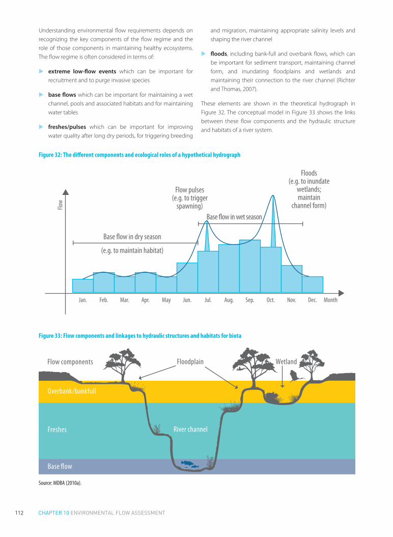
112 CHAPTER 10 ENVIRONMENTAL FLOW ASSESSMENT
Understanding environmental flow requirements depends on recognizing the key components of the flow regime and the role of those components in maintaining healthy ecosystems. The flow regime is often considered in terms of:
▶▶ extreme low-flow events which can be important for recruitment and to purge invasive species
▶▶ base flows which can be important for maintaining a wet channel, pools and associated habitats and for maintaining water tables
▶▶ freshes/pulses which can be important for improving water quality after long dry periods, for triggering breeding
and migration, maintaining appropriate salinity levels and shaping the river channel
▶▶ floods, including bank-full and overbank flows, which can be important for sediment transport, maintaining channel form, and inundating floodplains and wetlands and maintaining their connection to the river channel (Richter and Thomas, 2007).
These elements are shown in the theoretical hydrograph in Figure 32. The conceptual model in Figure 33 shows the links between these flow components and the hydraulic structure and habitats of a river system.
Figure 32: The different components and ecological roles of a hypothetical hydrograph
Flow
MonthJan. Feb. Mar. Apr. May Jun. Jul. Aug. Sep. Oct. Nov. Dec.
Base �ow in dry season
Base �ow in wet season
(e.g. to maintain habitat)
Flow pulses(e.g. to trigger
spawning)
Floods(e.g. to inundate
wetlands;maintain
channel form)
Figure 33: Flow components and linkages to hydraulic structures and habitats for biota
Base �ow
Floodplain WetlandFlow components
River channel
Overbank/bankfull
Freshes
Source: MDBA (2010a).

113CHAPTER 10 ENVIRONMENTAL FLOW ASSESSMENT
THE CONSEQUENCES OF ALTERED FLOW REGIMES
The consequences for the environment, and for dependent communities, of altering the natural flow regime can be severe if it is not undertaken with an understanding of the implications for the river system as a whole. Poor environmental flow allocation and management can mean that many of the goods and services that rivers provide – for free – can be lost. A host of international cases highlight the results of a lack of environmentally appropriate flows. The consequences can be both direct and indirect. For some of these examples, the impacts have been immediate, while in others they have emerged over time; some are predictable, while others are subtler and more difficult to measure.
The Aral Sea: an ecological and human disaster
Overabstraction over a period of decades led to declines of more than 90 per cent in the annual inflows from the Amu Darya River to the inland lake that constitutes the Aral Sea. This has resulted in a 90 per cent decline in the lake’s volume, and salinity increasing to levels comparable to seawater (World Bank, 2001; International Lake Environment Committee, 2004). These changes led to the extinction of all twenty-four endemic fish species, the collapse of the local fisheries industry, and resultant declines in nutrition in surrounding communities. The desiccation of the sea has led to major declines in the quality of both surface and groundwater, as well as soil erosion and resultant air pollution. The impacts on human health have also been enormous, with raised levels of infectious diseases and the local population of 5 million now inhabiting ‘some of the most chronically sick places on earth’ (Small et al., 2001).
The Murray-Darling basin: the high cost of restoring environmental flows
Australia’s Murray-Darling basin is the country’s food basket and the basin most affected by river regulation and flow diversion (Kingsford, 2000). After several decades of overallocation, approximately 50 per cent of the basin’s surface water resources are taken from the river system for consumptive purposes. Water abstraction, combined with extreme drought, has severely impacted on the ecological health of the basin’s rivers and floodplains, with twenty of the twenty-three catchments in the basin now classed as in poor or very poor health. The mean annual flow at the mouth of the River Murray in South Australia has been reduced by 61 per cent, and from 2002 until late 2010 there were no significant flows through the mouth of the Murray River. To reverse this situation, the Australian government is investing approximately US$9 billion to restore flows for the environment, through improving water use efficiency and to fund the voluntary buyback of entitlements. The new basin plan, approved in November 2012, requires that abstractions of
water be reduced by 2,750 GL to restore river health. Despite this huge investment, there are still major concerns amongst regional communities about the impact on their long-term viability because of this significant shift in allocation of water for environmental purposes. Ecologists are also concerned that the volumes of water to be returned may not be sufficient to restore the river’s ecological health, which is the main goal of the new policy.
The Yellow River: overabstraction leading to heightened flood risk
China’s Yellow River basin is home to over 100 million people. Erosion from the Loess Plateau means that the river carries one of the highest sediment loads of any river, in the order of 35kg/m3. Overabstraction during the 1980s and 1990s left the lower sections of river dry for the first time in known history, often for extended periods. The combination of reservoir construction, water abstraction and the building of flood protection levees has drastically altered the natural process of sediment transport and dispersal. As a result, the bed of the lower river has been raised significantly, resulting in a river that is ‘suspended’ above the surrounding landscape. This has both reduced the capacity of the river to transport large floods and increased the risk of flooding for the millions of people that live within the river’s floodplain (Quibell et al., 2013).
The Orange River: negative impacts from stable flows
Increasing the flows in rivers, particularly in rivers that naturally experience dry spells, can also have negative impacts. The construction and operation of two large reservoirs on the Orange River in South Africa in the late 1970s led to changes in the natural flow regime. Releases for hydropower generation, as well as for irrigation, resulted in higher and more stable winter base flows than naturally occurred. This in turn increased habitat for the overwintering of black fly larvae, which resulted in blackflies reaching pest proportions. The blackflies are particularly detrimental to local livestock, and the outbreaks had significant economic impacts in the Orange River valley and resulted in an estimated loss of livestock production in the order of R30 million per year in the 1980s (Palmer, 1995, 1997).
The Indus River delta: saltwater encroachment and environmental declines
A reduction in river flows to a delta can have major economic and environmental consequences. The 1991 Indus River Water System Accord reserves less than 9 per cent of the available flow for ‘escapages’ to the sea. In practice, however, even this small volume is not fully protected, as there has been disagreement over how this water should be accounted for and managed, and annual flows to the delta are around 6.5 per cent of what they were a century ago. This has had a drastic impact on the delta’s

114 CHAPTER 10 ENVIRONMENTAL FLOW ASSESSMENT
ecosystem and dependent communities. Reduced flows mean
that salt water now intrudes around 64 km inland, resulting
in the loss of approximately 1.2 million acres of farmland. The
annual fish catch, on which the majority of the delta’s population
depend, has now been reduced to around 70 per cent of its
potential (IUCN, n.d)..
10.3 Framework for providing environmental flows
The requirements for successfully providing environmental flows
will vary significantly depending on the political, environmental
and water resource development context. Regardless of these
variations, there are elements that are likely to be central to most
efforts. These include having appropriate enabling conditions
(policy, institutional), undertaking the necessary assessment
and planning to understand what flows are required to meet
environmental needs, and putting in place mechanisms to achieve those flows. These elements are shown in Figure 34.
The framework put forward here is a generic framework, intended to be suitable to any situation. It is designed to be flexible, and should be adapted to meet the local context, including the particular local priorities and the capacity and resources of local agencies.
Not all elements of the framework will be required in all situations: some countries do not undertake (or require) whole-of-basin planning, or develop separate thematic water management plans; water allocation may occur at a single level (rather than involving the multiple levels shown below); and implementing environmental flows may only require a single mechanism (such as changes to hydropower operation, rather than the use of the full range of tools shown).
Importantly, providing environmental flows does not depend on implementation of all aspects of the framework from the outset: environmental flows can be introduced incrementally as and when opportunities arise.
Figure 34: Environmental flows planning and implementation framework
Strategic basin and environmental planning policy
Basin thematic plans• Hydropower, water quality, and flood management plans• Ensure consistency with e-flow objectives
Basin water allocation plan• Basin-level e-flow outcomes and objectives• Bulk allocation for environment
Regional/sub catchment water allocation plan• Local e-flow outcomes and objectives• Allocation and management of e-flows
Project-based environmental impact assessment• Site-specific assessment
Legislation and WRM systems
Nationale-�ows policy
Reservoir/hydropower
operation
Limits on abstraction
(licenses, caps)
Annual and event-based sharing rules
Granting and management of environmental
water entitlements
Enabling policiesand plansand systems
Implementation
Water allocationplanning
Basin planning(other than water
allocation)
Assessment, planning, and allocation of water resources to de�ne e-�ow needs and objectives
Adaptivemanagement,including• Monitoring• Programme to improve e-�ow science

115CHAPTER 10 ENVIRONMENTAL FLOW ASSESSMENT
An appropriate enabling environment is (by definition) a precondition to establishing environmental flows. It is important to have appropriate policies and legislation to promote and support the establishment of environmental flows. Agreement on the objective of, and approach to, achieving environmental flows is essential. In addition, implementing environmental flows also depends on having an effective water resources management and regulatory system . In particular there must be effective controls over water abstractions and the operation of water infrastructure for environmental flows to be delivered.
Where possible, environmental flows assessment and implementation should be supported by basin-level planning to identify strategic environmental goals and to prioritize competing objectives for water and river resources. This is more likely to be an issue in larger and/or more complex basins, where there are likely to be many competing uses and users.
A robust assessment and planning system should be used to determine environmental water requirements (see Figure 35, which expands on the water allocation planning aspects of the framework). Environmental flow assessments will (usually) need to be considered in the context of the broader water allocation planning process, as well as other relevant basin planning activities. The assessment process should involve determining:
▶▶ the key environmental objectives for the river basin, such as important environmental assets or processes to be sustained
▶▶ the flow regime required to meet those objectives (for instance, to sustain important assets in the desired condition).
Figure 35: Water allocation planning and environmental flows framework
Environmental �ow assessments• Identify environmental objectives/key assets• Assessment of flow requires to achieve objectives/sustain key assets.
Re-allocation (where required)Water for environment increased through:• Compulsory reductions to entitlements• Water trading (purchase of allocation)• Improved water use efficiency
Water planning assessments• Assessment of water supply and demand needs and options• Socio-economic assessment of impacts of different allocation scenarios
Environmental water provisions
Implementation and monitoring
Trade-o� between environmental and consumptive demands
Decision on basin/regional allocations and priorities
Basin/regional water allocation plans
Reassess supplyobjectives
and options
Other basinplanning activities
Reassessenvironmental
objectives
Enabling policies, legislation, and systems; master planning
Water allocation planning

116 CHAPTER 10 ENVIRONMENTAL FLOW ASSESSMENT
It is important to appreciate that the water allocation process is fundamentally a socio-economic process, albeit one informed by the best available science and involving multiple objective optimization. It is the mechanism for deciding how water should be allocated between competing uses and users. Thus, while an environmental flow assessment may identify a preferred flow regime, the water allocation process should reconcile these requirements with the needs of other water users. This may involve adjusting or trading off environmental objectives against other uses.
The purpose of this process is to make informed allocation decisions, recognizing the costs and benefits of different alternatives. This is to ensure that where water is allocated to the environment, this water will be made available (in terms of timing and volumes) in a way that maximizes its environmental benefit. Similarly, where decisions are made not to provide water for certain environmental purposes, this is done with an understanding of the risk of environmental damage and the likelihood of loss of environmental goods and services. The water allocation process, and the role of environmental flow assessments in this process, is shown in Figure 25.
The result of this process should be an allocation plan which:
▶▶ identifies key environmental assets, and the flows required to sustain them
▶▶ determines the consumptive/nonconsumptive split within the basin (that is, how water will be shared between the environment and other water users)
▶▶ determines the mechanism for achieving the required flows.
The assessment and implementation of environmental flow requirements can also be undertaken at a more local scale, outside of a planning process. Project-based environmental flow assessments focus on the local impacts of a new (or existing) project, such as a reservoir or hydropower station. This type of assessment can provide an opportunity to:
▶▶ Develop and establish environmental flow rules where none currently exist.
▶▶ Establish more detailed environmental flow rules, to complement those already established by an overarching allocation or management plan. This may involve testing or refining assumptions made as part of an earlier environmental flows assessment.
Once environmental flow requirements have been identified, these need to be provided or protected. Implementation of environmental flows can involve a range of regulatory mechanisms. These may include regulation of water abstractions, regulation of the operation of instream infrastructure, and active management of water entitlements granted for environmental purposes.
GROUNDWATER AND ENVIRONMENTAL FLOWS
The framework shown above is primarily focused on surface
water, and the assessment and provision of environmental flows
in rivers. Groundwater is of course also an important element of
the hydrological cycle. Among other things, groundwater can be
a relevant consideration in environmental flows management
due to:
▶▶ the importance of environmental flows to increasing
groundwater recharge and water tables (e.g. Hou et al., 2007)
▶▶ the contribution of groundwater to environmental flows
and the importance of environmental flows to maintaining
groundwater-dependent ecosystems (Sinclair Knight Mertz,
2001; Fleckenstein et al., 2006).
These issues should be considered as part of any environmental
flow assessment.
NATIONAL ENVIRONMENTAL FLOW POLICIES AND LAWS
As for any other major national initiative, incorporating
environmental flows into the water resources management
system depends on high-level support within government.
This support should be reflected in national policies and
legislation that:
▶▶ establish the overarching objectives and framework for
providing water to meet environmental needs
▶▶ establish the institutions necessary to develop and
implement an environmental flows policy
▶▶ create the legal mandate – and obligation – for those
institutions to undertake their work, including helping to
resolve interdepartmental disputes over priorities
▶▶ generally provide guidance to policy-makers, water
managers, scientists and stakeholders on the government’s
agenda, and the agreed mechanism for its implementation.
Many national water acts now mandate the provision of
environmental flows. South Africa’s 1998 Water Act requires
the water minister to establish a ‘reserve’ for different water
resources, which includes the water required ‘to protect
aquatic ecosystems in order to secure ecologically sustainable
development and use of the relevant water resource’ (Sections
16–18). Similarly, China’s 2002 Water Law requires that the water
planning process ‘pay attention to maintaining the rational
river flow and the rational water level of lakes, reservoirs and
groundwater and to maintaining the natural purification
capacity of the water system’ (article 30).

117CHAPTER 10 ENVIRONMENTAL FLOW ASSESSMENT
In Australia, a 1997 statement by the Agriculture and Resource Management Council of Australia and New Zealand set out a series of national principles for the provision of water for ecosystem services (ARMCANZ and ANZECC, 1996). While many of these principles may now seem obvious, at the time they were important in developing consensus on how the issue of environmental flows should be approached, and in moving the debate beyond some of these basic concepts to detailed issues relating to implementation. Many of these principles are now reflected in state and national water legislation, as well as in the key national water policy document, the 2004 National Water Initiative.
INSTITUTIONAL CAPACITY
Assessment and implementation of environmental flows depends on the existence of effective water resources management institutions and systems. This institutional capacity is critical: without it, policies cannot be converted to action. Different approaches to environmental flows are accompanied by different institutional requirements. The approach taken should be tailored to meet existing institutional capacity. A common mistake internationally has been the adoption of approaches that exceed local capacity, resulting in policy and implementation failures (Le Quesne et al., 2010a). At the same time, capacity may need to be developed to allow the adoption of more sophisticated approaches to environmental flow management at a future date. Policy and capacity should be developed in parallel.
The institutional needs reflect those more broadly required to support water allocation planning (see Section 8.3). Specific requirements for implementing environmental flows include:
▶▶ Human capacity and resources. Water resources management authorities require the technical ability (or should be able to access it) to undertake environmental flow assessments, and staff and resources for implementation. Funding can be necessary to support environmental flows assessments, for ongoing management, and for compensation where water is to be reallocated away from existing users to meet environmental needs.
▶▶ Water allocation and planning. The provision of environmental flows fundamentally depends on water being reserved as part of the allocation process to meet environmental objectives. A robust planning and allocation framework is important to meet this requirement. It is still possible to provide environmental flows outside of a formal planning process: for example, site-specific environmental release rules can be imposed on a reservoir operator.
However, in heavily developed river basins the presence of a comprehensive allocation and planning system, and one that recognizes environmental water requirements, is critical.
▶▶ Regulatory and management systems. The regulatory requirements for providing environmental flows are much the same as those broadly required for water resources management as a whole. These include the ability to regulate who can take water, how much and when; and to regulate activities within watercourses, including the construction of reservoirs and the way they are operated. Typically this involves some form of licensing mechanism, for approving and controlling activities that affect rivers and their flows.
▶▶ Hydrological modelling. Models are increasingly being used to understand the natural flow pattern of a river, the impacts of development, and generally the consequences of different allocation and management scenarios. More sophisticated environmental flow management methods depend on such models, including the data and staff necessary for their use. Many environmental flow assessments now rely on simulated daily flow data.
▶▶ Monitoring, data collection, storage and analyses. These are important to assess whether environmental flows have been provided in accordance with the relevant plan or licence, whether the flows have achieved the environmental response required, and generally to improve understanding of flow–ecology relationships and thus improve the quality of future allocation and management decisions.
▶▶ Compliance and enforcement. It is important that both the institutional capacity, and the political will, exists to enforce environmental flow requirements. This can include ensuring hydropower operators comply with release rules, irrigators do not exceed their authorized levels of abstraction, and instream works are only constructed as and where approved. Equally, the penalties for noncompliance need to be sufficient to act as a deterrent. It may also be appropriate to allow for third-party enforcement of environmental flow obligations, to ensure that government agencies meet their obligations to provide water for the environment.
▶▶ Science. High-quality science is essential both to determine environmental flow requirements in the first instance, and as part of ongoing monitoring and analysis to determine whether the flows provided to the environment are achieving the desired ecological and other outcomes.

118 CHAPTER 10 ENVIRONMENTAL FLOW ASSESSMENT
BASIN PLANNING AND STRATEGIC ENVIRONMENTAL ASSESSMENTS
Water allocation planning, and associated environmental water planning, is typically one of a range of water-related planning and management activities, albeit a central one. Plans may exist to govern hydropower development and operations, flood management, water quality protection, navigation, and sand and gravel extraction, amongst others (see Figure 21).
Such plans are potentially relevant to achieving environmental flow objectives. Ideally, the alignment of these plans should be guided by a strategic vision for the basin. This may be via a strategic basin plan, an overarching policy document or some other mechanism. The adoption of a strategic approach to basin planning, such as via an overarching basin plan can:
▶▶ minimize the conflict between different plans
▶▶ help planners to prioritize between different objectives and avoid conflicts arising between different users: for example by identifying when environmental objectives should take precedence over competing objectives
▶▶ maximize the environmental benefits that arise from other water management activities: for example by managing water released for flood mitigation, irrigation supply or hydropower production in a way that also maximizes the ecological benefit of the associated flows.
Similarly, strategic environmental assessments (SEAs) and planning can both improve the efficiency of more regionalized environmental flow assessments, and can ensure that decisions on providing environmental flows contribute towards broader basin or national environmental objectives. SEAs can:
▶▶ Assist the identification of priority environmental assets or values, such as important sites (for example, for migratory birds) or species. These then form the starting point of any future environmental flow assessment.
▶▶ Determine the level of protection that should be afforded the environment in different regions and rivers: this recognizes that there can be different objectives for different rivers. Some rivers will be in high-priority economic development areas, whereas other rivers will be of particular ecological importance, or have particular functions that require special flow protections. By setting different levels of protection for different rivers or reaches, it is possible to balance the needs of development with the needs of the environment in a coordinated way.
▶▶ Guide future development decisions, to minimize the impact on the environment and environmentally relevant flows. For example new water infrastructure may be sited to maximize longitudinal connectivity and to minimize the
number of physical barriers for fish to pass to reach critical spawning sites.
▶▶ Generally guide national, basin and local decisions about the allocation of water, and how it is to be split amongst consumptive and ecological purposes.
Approaches to SEAs are discussed in more detail in the companion book on river basin planning (Pegram et al., 2013).
10.4 Assessing environmental flow requirements
There is no single correct approach to the assessment of environmental flows, and no one approach or method will be appropriate in all circumstances across a country or region. There are now well over 200 different methods by which environmental water requirements can be assessed (Tharme, 2003), and this report is not the place for a comprehensive review of these different approaches. However, some of the most important categories of environmental flow assessment methods include:
▶▶ Hydrology or look-up table methods. Application of these methods does not require any field research, but instead relies upon hydrological modelling or look-up hydrological tables to identify permissible alterations to flow levels under different conditions.
▶▶ Hydraulic rating and habitat simulation methods. These methods estimate the habitat available during different flows as a basis for calculating environmental flow requirements.
▶▶ Holistic methods. These methods undertake assessments of a range of different impacts of flow alterations, and develop recommendations for flow regimes on the basis of these assessments.
▶▶ Extrapolation methods. These methods use the results of existing field assessments to develop projections of environmental flow needs in a broader suite of river systems (O’Keeffe and Le Quesne, 2009).
The time and resources devoted to environmental flow assessments can vary hugely, from simple hydrological methods that can be completed in a matter of hours or days, through to assessments that can take teams of people several years to complete. The choice of the appropriate assessment method and the amount of time and resources that should be devoted to the assessment are likely to be based on a number of factors. These include the importance and complexity of

119CHAPTER 10 ENVIRONMENTAL FLOW ASSESSMENT
the river, the likely cost of implementation, the urgency of the problem, and the time, resources and information available for the analyses.
Whatever method is used, it should be recognized that there will always be some uncertainty around the findings, and that this should not be a barrier to implementation. However, it is important that methods are not used blindly, but with an understanding of their scientific basis and their limitations and constraints. This is perhaps most important in the application of hydrological methods, which are most prone to being applied in inappropriate circumstances because they typically lack any calibration of their ecological relevance.
All hydrological methods rely on the establishment of relationships, or assumptions about relationships, between flow and geomorphology, water quality and ecology. For example, the Tennant method proposes mean seasonal flow requirements based on observations of how stream width, depth and velocity (which affect suitable fish habitat) varied with discharge on eleven streams in Montana, Wyoming and Nebraska (Tennant, 1976).
As such, the method may then be suitable for determining the flows required to achieve that particular objective (providing habitat for trout) in that type of river (small mountain streams). The method does not, however, provide a sound scientific approach for calculating the environmental flow requirements of rivers with different hydrologic or hydraulic characteristics (such as larger rivers, ephemeral or highly variable river systems) or for achieving different ecological objectives (such as maintaining floodplains or deltas, or transporting sediment and maintaining channel form). Every hydrological recommendation forming part of an environmental flow assessment should be calibrated to the particular stream or river system or hydrologic class of river.
Some assessment methods (extrapolation methods) now focus on determining environmental flow requirements for different types of river, based on an understanding of their hydrology and ecology. Once these relationships have been established, they allow for the rapid assessment of the environmental flow needs in other rivers of the same type without the need for the same level of fieldwork, while maintaining a level of confidence that the recommendations are based on an understanding of the flow–ecology relationship relevant to the river type (Poff et al., 2010). Such an approach has been adopted in the US state of Michigan to support water allocation decisions.
Environmental flow assessments can also be undertaken at different scales, ranging from basin-level assessments (for instance, in preparing a basin water allocation plan) to site-specific assessments (for example, to determine operating arrangements for a new reservoir). The approach and nature
of the result can vary significantly. Basin-level assessments may for example focus on assets and processes of significance at the basin scale, leaving regional or local assessments to identify assets and objectives at a smaller scale. The recommendations from basin-level assessments can be refined and improved over time, based on regional or local studies that provide more information on local flow–ecology relationships.
FRAMEWORK FOR ENVIRONMENTAL FLOW ASSESSMENT
Not all rivers require the same flow pattern to maintain their functions and ecosystems. What is important in one river, or to one ecological community, may be very different from another. Certain flows may be important based on local needs or uses, for example to recharge groundwater, to maintain wetlands or to prevent saline intrusion. Similarly, different assets will require very different flows, in terms of size, frequency, timing and duration: the flows required for sediment transport are unlikely to be the same as those required to maintain fish habitat.
Some environmental flow assessment methods such as hydrology-based approaches have very significant limitations in identifying these important river-specific flows, in particular hydrology-based methods that focus only on the maintenance of certain minimum flow levels. In many cases when conducting environmental flow assessment it will be important to select a method that is capable of identifying the key assets or processes within a river, and the specific flows that may be necessary to maintain them.
It is necessary then to be specific about what the objectives are for the river: which elements of the environment are most important, and which assets do government or the community want to restore, protect and/or use. What was found to be suitable in one river will not automatically apply to another. Determining environmental flow requirements should involve:
▶▶ identifying the assets and river functions that are of value to society, and which are to be protected or restored: for example wetlands, endangered species, sediment transport, water purification, the prevention of saline intrusion
▶▶ determining the aspects of the flow regime that are important to maintaining the assets and functions: for example base flows to prevent saline intrusion, pulses to trigger fish migration, or floods to inundate wetlands and maintain channel form
▶▶ determining the specific flows required to maintain assets and functions at an acceptable level: for example the size, timing and frequency of a flood required to inundate a wetland

120 CHAPTER 10 ENVIRONMENTAL FLOW ASSESSMENT
▶▶ making a final decision on an acceptable environmental flow regime, based on consideration of various factors, including consumptive water requirements, the prioritization of environmental outcomes, and the acceptable levels of risk of not achieving those outcomes.
These steps can be undertaken either as part of a water allocation planning process (see Figure 35), or alternatively as part of a site-specific assessment of the environmental flow requirements, for example in designing a new reservoir and developing rules for its operation. Some of the key steps are discussed further below.
ASSET IDENTIFICATION
A river ‘asset’ can include any attribute of the natural ecosystem of value to society. It can include:
▶▶ goods – for example, species or materials
▶▶ services – for example, water purification, sediment transportation, hydropower production
▶▶ values – for example, cultural or aesthetic aspects of the river valued by the community
▶▶ conservation assets – species, ecological communities, habitats, and ecosystems of conservation importance (WET, 2007).
River assets can include those instream, offstream (for instance floodplains and wetland), groundwater, estuarine ecosystems and marine receiving waters. In some rivers, the focus may be on maintaining a single critical asset, while in other rivers the objectives may include a number of different environmental assets.
The identification of assets serves two purposes. First, it allows the scientific assessment to focus on the flow requirements for these priority assets – that is, which aspects of the flow regime (low flows, pulses and so on) are most important to maintaining these assets (water quality, fish, maintenance of wetlands and so on). Second, it can provide the public, politicians and other stakeholders with a clearer understanding of the goods, services and values provided by the river, and hence the benefits of providing flows to maintain the assets. This also helps highlight what will be lost or put at risk if the necessary flows are not provided.
USE OF CONCEPTUAL MODELS TO LINK FLOWS AND ASSETS/FUNCTIONS
Different parts of the flow regime are likely to have different environmental and ecological functions. It is necessary to identify those environmental flow components of most significance to the assets to be restored or protected. As part of this process, the hydrology of the river should be characterized, and the key flow components identified. Typically this will require hydrological modelling. The hydrological data are used in conjunction with a literature review, field inspection and expert knowledge, to develop conceptual models linking flow components to important physical and biological processes.
Understanding the linkages between different flow components and the different assets allows a better understanding of the consequences of different flow allocation scenarios. For example, if the role that floods play in the ecosystem is understood, it is easier to predict the ecological consequences of removing floods via regulation.
DETERMINING FLOW OBJECTIVES
Once the relationship between flow components and river assets has been identified, specific flow objectives need to be determined: that is, the volume, frequency, timing and duration of flows required to achieve the desired environmental outcomes. For example:
▶▶ What flow is required for the river to break its banks and to inundate the wetland? How often is this required to support the wetland ecosystem?
▶▶ What flow is required to trigger fish spawning, and at what time of year?
These objectives are typically developed based on a combination of field studies, literature review and expert opinion. This process is often supported by hydrologic modelling, to understand changes to the natural or existing flow regime under different scenarios, and hydraulic modelling, to understand the relationship between habitat, hydraulics and hydrology (for instance flow requirements to achieve particular results, such as inundating a wetland or keeping a riffle inundated at the right time of year).
The various assessment methods depend on identifying a reference condition (usual the natural flow regime), and then determining an acceptable level of alteration: that is, how much the volume, frequency and so on, can be varied without compromising the environmental asset, or what flows should be restored.1
1 For a detailed discussion of the process of calculating environmental flow objectives, see WET Project (2007).

121CHAPTER 10 ENVIRONMENTAL FLOW ASSESSMENT
ENVIRONMENTAL FLOWS ASSESSMENT CASE STUDY: THE UK TAG PROCESS
The UK Technical Advisory Group (TAG) on the EU Water Framework Directive (WFD) undertook a process to identify limits of flow alteration that would be consistent with maintaining good ecological health of UK rivers. The environmental flow assessment in this case was not undertaken specifically as part of a water allocation process, but rather to determine a benchmark for assessing river health.
In developing the standards, the group determined that there was a lack of data to allow for meaningful statistical correlations between hydrological alteration and ecological impact. Instead, the process relied on expert opinion to identify relevant flows for key biological elements: macrophytes, macro-invertebrates and fish. These were consolidated into a single table (Table 5), which shows the permitted deviations below natural conditions. Different flow requirements were identified for four different types of river (and four subtypes), derived based principally on altitude, gradient and geology.
Different flow requirements were also identified for summer and winter periods, to protect key stages of the life-cycles of important species: notably to provide flows for macrophytes during spring and early summer, and for macro-invertebrates and fish during late summer and early autumn (UKTAG, 2008).
In Table 5, QN refers to the natural flow, and >QN60 refers to natural flow exceeded for more than 60 per cent of the time. For example, the table provides that, in streams from type A1 during the summer months, for all natural flows greater than QN60, 30 per cent of the water is available for abstraction. The table also protects low flows: for example, for flows smaller than the natural flow exceeded 95 per cent of the time (that is, the extreme low flows), only 15 per cent of the flow is available for abstraction from type A streams during summer months.
Table 5: UK TAG standards to achieve ‘good’ status
Types Season Flow >QN60
Flow >QN70
Flow >QN90
Flow <QN95
A1 April–October 30 25 20 15November–March 35 30 25 20
A2 (downstream), B1, B2, C1, D1
April–October 25 20 15 10November–March 30 25 20 15
A2 (headwaters), C2, D2
April–October 20 15 10 7.5November–March 25 20 15 10
Salmonoid spawning and nursery areas (not Chalk rivers)
April–October 25 20 15 10November–March 20 15 Flow
> QN80
10
Flow < QN80
7.5
Source: adapted from UKTAG (2008).
ENVIRONMENTAL FLOWS ASSESSMENT CASE STUDY: THE MURRAY-DARLING BASIN PLAN
The Murray-Darling Basin Plan sets limits on the amount of water (both surface and groundwater) that can be abstracted from different subcatchments across the basin. These limits have been set based on what can be abstracted sustainably, having regarded to the environmental water requirements of key environmental assets and functions.
The methodology used to determine environmental water requirements as part of preparing the first draft of the plan involved the following:
1. Identification of key assets and functions. Through an assessment of river, groundwater and wetland environments, the Authority identified:
▶� four key ‘ecosystem functions’ – these relate to provision of habitat; transportation and dilution of nutrients, organic matter and sediment; and provision of lateral (for instance, with adjacent wetlands) and longitudinal connectivity
▶� 2,442 key ‘environmental assets’ – including rivers, wetlands, floodplains and the river mouth.
2. Selection of hydrologic indicator sites. A total of 106 hydrologic indicator sites were selected (88 relating to ecosystem functions, and 18 for ecological assets). These sites were selected to test whether flows (under modelled conditions) were being met to provide the water required for maintaining the key functions and assets. These sites were selected using a number of criteria (such as their representative nature, or because they were in regions of significant development). Because of the interconnectedness of many of the key functions and sites, it was assumed that if the flow requirements were met at these locations, they would also be met for other key sites and functions.
3. Identification of flow requirements of key assets. The major focus of this work was on requirements for flooding. The process involved grouping species with similar flow requirements and identifying their flooding needs (for instance to maintain habitat or vegetation). These flow requirements were consolidated to provide a single set of flows that would meet the minimum needs of all groups. Flows were specified in terms of a total volume or threshold, duration, timing, frequency and groundwater dependency.
4. Identification of key flow requirements of key functions. A series of standard flow metrics (representing different aspects of the flow regime, such as low flows and medium flows) were developed. Flows for each metric were assessed against a scale relative to the predevelopment flow levels.

122 CHAPTER 10 ENVIRONMENTAL FLOW ASSESSMENT
A score of >80 per cent of natural was graded as good; 60–
80 per cent was graded as moderate; less than 60 per cent
was considered poor and to imply that key ecosystem
functions were compromised.
5. Hydrological modelling. This estimated the minimum
flow requirements to meet the needs of the key assets and
functions, at the 106 hydrological indicator sites, based on
the flow requirements determined through the process
described above.
6. Converting the flows into a minimum sustainable diversion limit. The key outcome of the basin plan will
be setting ‘sustainable diversion limits’ for the basin. These
will be the basis for regulating abstraction in the basin. To
do this, the environmental flow requirements were first
converted to a long-term average volume of water required
by the environment.
This assessment was used to define the proposed sustainable
diversion limits for the basin’s nineteen subregions, which (if
and when approved) will be given effect through regional water
allocation plans.
Based on this study, the MDBA assessed that an additional
average of 3,000–7,600 GL/year would be required for
the environment. The Authority subsequently considered
increasing environmental flows at the lower end of that range,
by between 3,000 and 4,000 GL/year, because of the high socio-
economic impacts associated with reallocating water to the
environment. An increase of 3,000–4,000 GL/year would mean
that approximately 22,100–23,000 GL/year would be available
to the environment, or 67–70 per cent of all inflows, compared
with 58 per cent under the current arrangements (MDBA,
2010a). Ultimately, the draft basin plan, released in November
2011, proposed reducing abstractions to provide an additional
2,750 GL/year for the environment.
ENVIRONMENTAL FLOWS ASSESSMENT CASE STUDY: CHINA’S PEARL RIVER
The assessment of environmental flows on the Pearl River
considered flows at eighteen points on the river system, and
assessed ecological and environmental water needs on both
the mainstem and different tributaries. For each point, monthly
runoff data was used to estimate a basic environmental flow
requirement based on the Q90 (that is, the flow exceeded 90 per
cent of the time). However, this approach leads to a very low
minimum environmental flow standard, especially during the
flood season, and the results were considered unsuitable. So in
addition to this, the ‘Tennant’ read-off table was adapted for use
in the basin to determine an environmental flow requirement
both in the flood season and dry season. By combining the flow
requirements at the eighteen points, the total annual volume
of water required to meet environmental requirements at the
basin scale was calculated. On this basis, the total environmental
flow was estimated at 147 billion m3, which amounts to 31 per
cent of the total surface water resource.
Additional flows are also required to prevent seawater intrusion
in the lower reaches during the dry season. To do so, discharge
at Wuzhou and Shijiao should not be less than 2,100 and
2,500 m3/s respectively, and at Hongshuihe, Liujiang, Yujiang
and Guijiang (further upstream) the requirements are 494, 217,
400 and 55 m3/s respectively. Meeting the flows in the upstream
locations only achieves a flow at Wuzhou of 1,800 m3/s, so
additional water needs to be released to meet the targets for
seawater intrusion.
Table 6: Environmental flow requirements in the Pearl River
River Location
Annual runoff (m3/s)
Annual E-flow E-flow in dry season
E-flo
w (m
3 /s)
Perce
ntag
e
Flow
requ
ired f
or
navig
ation
(m3 /s)
E-flo
w us
ing Te
nnan
t m
etho
d (m
3 /s)
Selec
ted E
-flow
(m3 /s)
Hongshuihe Qianjiang 2,184 657 30.1% 395 494 494
Liujiang Liuzhou 1,287 300 23.3% 167 217 217
Qiangjiang Wuxuan 4,153 1,502 36.2% 920 1,071 1,071
Yujiang Guigang 1,512 472 31.2% - 400 400
Guijiang Majiang 570 120 21.1% - 55 55
Hejiang Nanfeng 276 76 27.5% - 61 61
Xijiang Wuzhou 6,739 2,309 34.3% 1,130 1,800 1,800
Xijiang Gaoyao 7,308 2,348 32.1% 1,230 1,980 1,980
Beijiang Shijiao 1,359 388 28.6% 209 250 250
Dongjiang Boluo 782 241 30.8% 210 212 212
Hanjiang Chaoan 834 254 30.5% 100 200 200
Nandujiang Longtang 214 55 25.7% - 39 39
Jianjiang Huazhou 191 53 27.7% - 42 42
Qinjiang Luwu 39 10 25.6% - 3 3
Dafengjiang Polangping 20 5 25.0% - 2 2
Jiuzhoujiang Gangwayao 93 25 26.9% - 22 22
Moyangjiang Shuangjie 196 47 24.0% - 27 27
Nanliujiang Changle 178 40 22.5% - 14 14

123CHAPTER 10 ENVIRONMENTAL FLOW ASSESSMENT
Figure 36: Map of Pearl River basin
Source: WWF (2013).
10.5 Trade-offs, socio-economic inputs and community engagement
The assessment process is an iterative one involving both scientific and socio-economic inputs. Indeed, nonscientific considerations are a major element of the process of determining environmental flow requirements. A failure to give due attention to this aspect of the assessment process can reduce the quality of the assessment, and result in major challenges at the implementation stage.
The major discontent in Australia over the Murray-Darling Basin Plan and cutbacks to water users in the basin highlights this issue. In the early stages, the planning process focussed heavily on the technical (ecological and hydrological) process of determining environmental flow requirements, arguably at the expense of the social considerations. Much of the earlier criticism of the planning process has been over the lack of community engagement, and inadequate consideration of what the plan would mean for communities in the basin. As a result, there is not strong support within the basin for what is proposed, and indeed the backlash has been such that it has threatened to derail the entire planning process.
The case highlights the importance of community engagement in the environmental flow assessment process, and more broadly during water allocation and planning – at a minimum to foster
understanding, and ideally to generate community support for the final result.
The most appropriate mechanism for engaging the stakeholders and the general community should be designed based on the context. Regardless of context though, nonscientific inputs are important in determining the following:
▶▶ The river assets. Environmental flow provisions should ultimately be focused on providing flows to meet the requirements of those ecological assets and functions identified as important by the government and/or community, based on what people want from the river.
▶▶ The acceptable condition of the river assets. What is considered an acceptable condition for the assets of importance: for example whether water quality in a river should be suitable for swimming, or merely for irrigation; what, if any, level of environmental degradation is considered acceptable?
Box 44: Identifying environmental targets in the Lerma-Chapala
The 2004 Lerma-Chapala Allocation Agreement uses the level of water in Lake Chapala as an indicator for environmental water requirements. Water levels in the lake are protected by reducing the water available to abstractors when the lake levels are low. The selection of the lake as an environmental indicator was not based on a scientific assessment of ecological needs. Rather, it was the result of detailed stakeholder consultation and the general community view that water levels in the lake should be maintained.
Source: Quibell et al. (2012).

124 CHAPTER 10 ENVIRONMENTAL FLOW ASSESSMENT
▶▶ What level of risk is acceptable. Environmental flows science is not absolute, and different allocation scenarios will identify different levels of certainty of achieving the desired ecological result. Science may be able to estimate the risk of certain outcomes (such as loss of species or river function), but it should be a matter for government and communities to determine what is an acceptable level of risk.
▶▶ Water supply requirements and reliability of supply. Efforts to provide water for the environment are inevitably constrained by the need to provide water for human consumption. Human needs for water, and how these should be balanced with environmental needs, are again a question for government and communities. Trading off between these competing needs is a central task of the water allocation process, and is discussed in detail in the following section.
TRADE-OFFS BETWEEN ENVIRONMENT AND OTHER WATER USERS
The water allocation process involves inherent trade-offs between the environment and other water users, as well, as trade-offs between different environmental assets. An environmental flow assessment, as well as other socio-economic assessments, should be designed to allow the government to make informed decisions about how to balance these competing interests.
In some instances, the government may decide that water will be allocated not to meet environmental objectives, but rather for consumptive requirements. In such circumstances, the decision should be made in a transparent way and with an understanding of the impact, or risk of impact, for the environment: decisions to choose development outcomes over the environment should be made consciously rather than by default.
Importantly, allocation decisions should be made strategically, with a long-term vision for the basin, rather than on an incremental basis. Adopting an integrated approach to this decision-making process allows consideration of a range of different scenarios. Thus, the impact of different decisions on both environmental assets and human requirements can be assessed. Figure 38 shows a hypothetical example of a matrix that compares different scenarios based on their impact on ecosystem attributes and benefits for people and society.
Hydrological and economic models can provide valuable tools to support these kinds of decisions, and can allow for ready comparison of the modelled results of different scenarios of water for the environment and the community. For example, in preparing the draft Murray-Darling Basin Plan, the MDBA
modelled three scenarios – involving returning 3,000, 3,500
and 4,000 GL/year to the environment. The planning process
required that these three scenarios should be assessed for
both their impact on key environmental assets, and impacts
on dependent communities.
Figure 37: Integrated basin flow assessments
IndicatorsScenarios of increasing levels
of water-resource developmentPD A B C D E
Man-made benefitsHydropower generation x x x xx xxx xxxCrop production x x xx xxx xxxx xxxxWater security x xx xxx xxx xxxx xxxxNational economy x x xxx xxxx xxxx xxxxAquaculture x xx xxx xxx xxx xxx
Ecosystem attributesWild fisheries xxxx xxx xxx xx xx xWater quality xxx xxx xx xx x xFloodplain functions xxxx xxxx xxx xx x xCultural, religious values xxxx xxx xxx xxx xx xxEcosystem buffer against needs for compensation of subsistence users
xxxx xxx xx xx x x
These indicators would be more numerous than shown and could differ from river to river. The crosses illustrate possible trends in the level of beneficial use under each scenario, and would normally be replaced by quantitative or qualitative details from supporting research. PD, Present Day-not necessarily pristine.
Source: King and Brown (2010).
The trade-off process can also involve prioritizing between
different environmental assets and different environmental
flows. Not all environmentally relevant flows are of equal
significance: some perform more important roles than others.
Likewise, some flows can achieve a large environmental
benefit for a small increase in environmental water, or for
a small impact on water supply or infrastructure operating
arrangements. Different flow components can thus be ranked
based on:
▶▶ The potential impact on human water supplies from
providing the environmental flows. (For example, a pulse
to trigger fish spawning might only require a small volume
of water. This flow could be provided with limited impact
on consumptive water users).
▶▶ The risk to the environment from not providing the
flow. For example, it may be possible to remove some
floods without having significant environmental impacts,
provided floods of sufficient size occur with sufficient
frequency. On the other hand, a reduction in base flows,
such that the river dries out, may have rapid, and major,
environmental consequences.

125CHAPTER 10 ENVIRONMENTAL FLOW ASSESSMENT
Based on these results, where the full suite of environmental flows cannot be provided, water managers can trade off those flows which will achieve the greatest gains for consumptive users at the lowest environmental cost (see Figure 39).
Figure 38: Options for trade-off between environmental flows and water supply in the Jiao River, China
Facets of the flow components
Relative security of supply improvement
Relative risk to environment
Relative potential to modify
Rank potential to modify
LF magnitude Moderate High Nil -HF magnitude Mod-High Moderate Moderate 4LFP magnitude Low High Nil -LFP duration Low Moderate Low 7LFP frequency Low Low Low-Mod 5HFP magnitude Moderate High Nil -HFP duration Moderate Moderate Low-Mod 6HFP frequency Moderate Low High 1BF magnitude Mod-High High Nil -BF duration Nila Moderate Nila 6a
BF frequency Mod-High Moderate Moderate 3OB magnitude High High Nil -OB duration Nil Moderate Nil -OB frequency High Moderate Mod-High 2
Note: a. Reach 3 an exception, with moderate potential to improve security of supply. Implement with High flow pulse duration reduction. LF = Low flow; HF = High flow; LFP = Low flow pulse; HFP = High flow pulse; BF = Bankfull; OB = Overbank.
Source: Gippel et al. (2009).
Box 45: Trade-offs between hydropower and the environment: the British Columbia approach
In British Columbia, Canada, as a condition of its water licence, the operator of a hydroelectric power facility might be required to prepare a ‘water use plan’. These plans detail the day-to-day operating arrangements for the hydroelectric plant, and are designed to reconcile a range of competing interests, including those of the environment. The government guidelines for preparing water use plans identify a process for undertaking a ‘trade-off analysis’. The process is designed to frame the consultation, provide a concrete understanding of how different allocations would affect different interests, and provide all parties with summary information on the impact of different operating options. The steps proposed are:
1. Define the objectives of the water use interests, and measures for assessing their attainment.
2. Gather the information needed to make meaningful comparisons of the impacts associated with each objective.
3. Define a range of distinct operating alternatives for the facility.
4. Evaluate the trade-offs between the alternatives in terms of the objectives/measures.
5. Assess the impact of risk and uncertainty in evaluating different alternatives.
6. Document the analysis and results.
The guidelines also identify a number of techniques to assist in the process, including cost–benefit analysis, multiple account evaluation, threshold/critical value analysis and multi-attribute trade-off analysis.
Source: Province of British Colombia (1998).
10.6 Incorporating environmental flows into allocation and management arrangements
Internationally, implementation has proved to be the key challenge for environmental flows. While there have been many hundreds of environmental flow assessments undertaken around the world, converting the recommendations from these assessments into management actions and thus achieving the desired river flows has been a slow process.
The implementation of environmental flows requires the management of water resources to provide and protect those flows identified as important during the assessment process. This can require regulation of some or all of the following:
▶▶ the total volume of water allowed to be abstracted from
the river: which will determine the share of the total volume
that is retained within the river to meet environmental
requirements
▶▶ the timing, rate and antecedent conditions that govern
water abstractions or releases: which will influence the
pattern of the flow regime
▶▶ the design of instream infrastructure: which will influence
the extent to which infrastructure is physically able to
achieve the desired operational releases (for instance, based
on the capacity of reservoir gates) and minimize impacts on
connectivity (such as through fish ladders)
▶▶ the location of instream infrastructure: which can be located
so as to minimize the disturbance of key ecological assets,
loss of connectivity and adverse impacts on flow regimes.
Ultimately, the objective should be to ensure that water management rules and systems are structured such that different parties – water managers, water abstractors, reservoir operators – have clearly defined rights and obligations about what they can and cannot do: when they can take water, when they must release water and so on. These obligations should be defined in such a way as to ensure the overarching environmental flow objectives will be met.
Where the rules are so defined, this can remove the need to consider environmental requirements on a case-by-case basis. Provided the allocation, abstraction and management rules have been specified carefully, compliance with the rules should ensure that the required flows are provided and the broader environmental outcomes are achieved. For example, this can remove the need for

126 CHAPTER 10 ENVIRONMENTAL FLOW ASSESSMENT
an environmental flow assessment in respect of an application
for a new abstraction permit: if the allocation plan has already
identified environmental flow requirements (and the water that
can be abstracted while still meeting those requirements) then the
application need only be assessed against the plan’s requirements,
and no further environmental assessment may be required.
DEFINING ENVIRONMENTAL FLOW OBJECTIVES
Based on the environmental flow assessment and trade-off
process, flow objectives should be set. These can be defined in
two quite distinct ways:
Flow requirements that must be met at or over a particular time/period of time
For example: the flow at location X must be greater than Y m3/s
at all times; there must be a flow greater than Z m3/s for two
days during April each year. This approach has the advantage
that it is easy to understand and (relatively) straightforward to
implement. It is also generally simple to assess whether or not
the objective has been met. The disadvantage of this approach
is that it might not recognize natural variability. For example,
the objective could result in water being released during a dry
period, when the river would not naturally have had flows of
that size.
Long-term flow objectives
These define the pattern of flow to be achieved over an
extended period of time. This approach involves defining a
series of long-term flow objectives (expressed as long-term flow
statistics) to be achieved, and the use of hydrological models to
assess whether, hypothetically, those objectives would be met
under different management arrangements. An example of this
approach is given in Box 46.
This approach recognizes the natural variability of rivers, and that
(at least for some rivers) it may not be possible or appropriate to
achieve particular flows each year. This approach can be more
confusing, particularly for the broader public. Also, because flow
objectives are set based on long-term averages, it is not possible
to assess on an annual basis whether or not the objectives are
being met, and the linkages between these objectives and
operational rules can be less obvious.
These two approaches are not mutually exclusive, and it is
possible to define flow objectives using both approaches.
Box 46: Queensland water resource plans and environmental flows
In Queensland, Australia, for each catchment-based water resource plan, relevant performance indicators are selected. These are statistical benchmarks that are of relevance to ecological health. For example, the water resource plan for the Moonie River includes the following performance indicators:
▶▶ end of system flow – the total flow at the end of the system
▶▶ low flow – the number of days when there is a ‘low flow’ (defined by reference to the median flow) in the system
▶▶ beneficial flooding flow – the median flow for the wettest ninety-day period in each year
▶▶ one in two-year flood – the size of flood that occurs on average once every two years.
Using a model, indicator values are calculated for various locations in the catchment area. For each indicator, an objective is set. The objective is often based on the statistical performance for the indicator under the pre-development case. The Moonie plan, for example, requires that each of these indicators should be no more than one-third above or below the predevelopment level.
This means that for an indicator – for example the end of system flow – a hydrological model is used to calculate the total system flow in the simulation period. In the case of the Moonie, this is a 109-year period. This is first done for the predevelopment case; that is, on the assumption that there are no licences to take water and no storages or works on the river.
For any proposed management arrangements, the programme is then used to calculate the total flow. The result must be within the environmental flow objective for the plan: that is, no more than one-third above or below the result for the predevelopment case.
By this mechanism, all water management decisions made in the plan are tested, including in the making of the operational rules, in setting the cap on the total extractions that can be made from the system, and in deciding whether to allow for the trade of a water entitlement.
Source: WET (2006).
MECHANISMS FOR IMPLEMENTING ENVIRONMENTAL FLOWS
There is a range of regulatory tools and approaches used for implementing environmental flows. These options are not mutually exclusive, and in many instances a combination of these approaches may be appropriate. The type of approach adopted may vary with the level of development, the level of environmental stress, and based on what is practically possible given the existing water resources management systems.
The following approaches are generally given effect through one or a combination of water allocation plans, annual water allocation rules, water abstraction licences and reservoir operation licences.

127CHAPTER 10 ENVIRONMENTAL FLOW ASSESSMENT
CAPS AND LIMITS ON ABSTRACTION
A water allocation plan may reserve a volume or percentage of the available water for environmental purposes. Water entitlements are granted to other water users with consideration of this reserve. As a result, provided estimates of the available water supplies are correct, and provided water users do not exceed their entitlements, the reserved water should remain in the river system for environmental purposes. These limits are typically given effect through licensing systems, with water managers not allowed to grant water licences that will take total consumption beyond the defined limit.
Placing a cap on abstractions can be a critical first step in protecting flows for the environment. Experience shows that it can be extremely difficult to recover water for the environment. As such, there can be merit in establishing a cap on further growth in abstractions, even where there is not a detailed understanding of the environmental flow requirements for the basin.
This approach can be effective in reserving water for the environment, but also involves some risk. Where an allocation plan overestimates the amount of available water, or where this amount reduces (for instance through climate change), it can be the environment that wears any shortfall. Similarly, and depending on how annual sharing arrangements work, during periods of drought it can again be the environment that suffers disproportionately from the reduction in available water. This approach can then mean that the environment simply gets ‘what is left over’ after water has been allocated between other users. However, reserves can be established which provide priority to environmental water requirements.2
Example: Pakistan’s 1991 Indus Water Accord reserves an average of 10 MAF per year for ‘escapages to the sea’, primarily to prevent saltwater intrusion. The agreement allocates the remaining water (117.35 MAF) between Pakistan’s four provinces. However, because there is no clear mechanism for converting this average end-of-system flow into an annual volume, in practice these flows have not been provided.
Example: South Africa’s 1998 Water Act requires that the water minister establish a ‘reserve’ for all water resources, which consists of two parts, a basic human needs reserve and an ecological reserve. The level of the ecological reserve required is determined based on a sophisticated classification system. The reserve is then (at least in theory) given effect through local catchment management strategies, and where necessary the reallocation of water through a compulsory licensing system. In practice, the complexity of the system has meant it has only been implemented in a limited number of catchments.3
2 See the Indus River case study (Quibell et al., 2013).
3 See the Inkomati River case study (Quibell et al., 2013).
Example: The Murray-Darling Basin Agreement placed an interim cap on increases in allocation in 1995 (which was made permanent in 1997), based on the level of development in 1993/94. This cap will be replaced via the basin plan for the Murray-Darling basin, which specifies ‘sustainable diversion limits’ for each of the basin’s sub-catchments. These limits define the long-term maximum level of abstraction permitted from each region. These limits will be given effect through regional water allocation plans and water licensing systems.
HYDROPOWER OPERATION, MINIMUM FLOWS AND SPECIAL FLOW RELEASES
A water allocation plan may define a minimum volume of water that must be flowing in the river at certain locations and at certain times. It is commonly used to regulate the actions of infrastructure operators, including for hydropower production. A water allocation plan or a water infrastructure licence may specify environmental flow requirements with which the reservoir operator must comply, including:
▶▶ minimum daily releases (for instance to maintain base flows)
▶▶ requirements to pass-through certain events (such as environmentally important pulses)
▶▶ maximum rates of rise and fall (to minimize ecological harm caused by rapid changes in flow rate or depth)
▶▶ requirements not to release water at certain times (for instance, in rivers that are periodically dry under natural conditions).
This type of approach can be particularly relevant where total water abstraction is low (that is, mean annual flows remain high relative to natural levels), but significant hydropower development means there is a potential for major changes to the seasonality and variability of the flow pattern.
Example: in British Columbia, hydropower operators can be required to prepare a water use plan as a condition of their water licence. These prescribe the day-to-day operating arrangements, including how they will meet environmental requirements. For example, the Coquitlam-Buntzen Water Use Plan – prepared by BC Hydro and approved by the Comptroller of Water Rights – prescribes an instream flow release target (in m3/second) for each month of the year. The plan also sets a reduced instream flow release target, and a series of rules for prioritizing between these environmental flow targets, hydropower production and town water supply. The plan also includes ‘ramping rates’, which define the maximum rate of increase or decrease in water releases from the reservoir.
Example: The 1987 Yellow River Water Allocation Plan reserves 21 billion m3 out of an average annual volume of 58 billion m3 for environmental flows, primarily for sediment transportation. This

128 CHAPTER 10 ENVIRONMENTAL FLOW ASSESSMENT
water is managed by the Yellow River Conservancy Commission, which prepares an annual regulation plan for the basin to give effect to the allocation plan. The allocation plan was developed in response to issues of overallocation, overabstraction and (among other resulting problems) ongoing sediment deposits in the main channel because of the river’s high sediment load, which increased flooding risks. In response, a plan was developed to improve flows to maintain sediment transportation to the river mouth. The 21 billion m3 for the environment is managed in two ways. First, it provides a major sediment flushing flow of approximately 4000 m3/s for a period of twenty days prior to the wet season, and second, 5 billion m3 is allocated to provide a continuous minimum flow at the river mouth during the dry season. This latter flow serves several purposes, including reducing saline intrusion and its impacts on the delta region.
PRECONDITIONS TO ABSTRACTION AND EVENT-BASED MANAGEMENT RULES
A water allocation plan or an abstraction licence may prescribe flow conditions that must be met prior to water being abstracted, or limit the amount of water that can be abstracted. Such an approach can allow for environmental water requirements to be given priority, by limiting water abstraction by other users until environmental needs have been met.
Example: The 2004 Allocation Agreement for Mexico’s Lerma-Chapala River basin uses the levels of Lake Chapala as an indicator for environmental water requirements. The Allocation Agreement includes a mechanism for calculating the water available for abstraction each year by different irrigation districts. This volume varies depending on the level of water in the lake. Table 7 shows the link between allowable abstractions and the volume of water in the lake for one of the irrigation districts.
Table 7: Lerma-Chapala Allocation Agreement – maximum extraction volumes for irrigation district 061
Volume of Lake Chapala on 1 Nov (hm3)
Runoff (hm3) Maximum extraction volume (hm3)
<3,300 0–2,211 51>2,211–3,530 7% of runoff generated minus 105>3,530.19 144
3,300–6,000 0–2,211 102>2,211–3,530 7% of runoff generated minus 105>3,530.19 195
>6,000 0–2,211 107>2,211–3,530 7% of runoff generated minus 49>3,530.19 200
Source: Cea Jalisco (2004).
Similarly, a water allocation plan or water abstraction licence may reduce the amount of water users may take during defined, environmentally important events. Likewise, rules may require a reservoir operator to pass flows, or part of the flow, through its infrastructure. This approach differs from other approaches in that it can require real-time decisions about whether or not a particular flow event meets the required criteria, and environmental needs are therefore to be prioritized over other users.
Example: In the Fitzroy River (Queensland, Australia), studies identified the first post-winter flow as critical for triggering fish spawning. The water resource plan requires that the river be managed to ensure the number of ‘first post winter flow’ events is at least 80 per cent of what would have occurred under natural conditions. For example, if models suggest that a first post winter flow would have occurred in 50 out of the 100 years in the modelled sequence, the operating arrangements must ensure that such flows will now occur in at least 40 out of 100 years (that is, 80 per cent of the time they would have occurred without human interference). As such, compliance is tested is by running the operating conditions through a water resources management model.
A ‘first post winter flow’ is defined as (among other things) a flow between 15 September and 10 April, which last for twenty-one days, where the depth of water exceeds 1.5 metres and where the water temperature is greater than 23 degrees Celsius (State of Queensland, 1999).
Example: The Water Resource Plan for the Condamine Balonne catchment (in the Murray-Darling basin) includes a flow management rule designed specifically to improve water availability for bird breeding in the Narran Lakes, a Ramsar-listed wetland at the bottom of the catchment area. The water resource plan requires that where there is a flow event during the winter bird-breeding months, and where the flow would have filled the lakes under predevelopment conditions, then the volume of water allowed to be taken under water licences is reduced by 10 per cent for a period of 10 days (State of Queensland, 2004).
GRANTING OF ENVIRONMENTAL WATER ENTITLEMENTS
Environmental flows can be provided and managed by granting entitlements to the environment that are equivalent to other consumptive entitlements: that is, there is a water licence or similar authority held by an entity, on behalf of the environment. The water entitlement is treated the same as or similarly to consumptive water entitlements, and is allocated a volume of water seasonally or annually in accordance with the local water sharing rules. The water is then available to the environmental water manager to be used as it deems appropriate, to achieve the maximum environmental benefit.

129CHAPTER 10 ENVIRONMENTAL FLOW ASSESSMENT
One advantage of such an approach is that it protects the environmental interests during dry periods: the environmental water entitlement is afforded the same level of priority as other users when the available water is shared. It can also allow for greater flexibility in the way environmental water is used. Rather than being bound by rigid release rules, the environmental water holder can make decisions throughout the year based on the seasonal conditions and water held in storages.
Example: In Australia, the Commonwealth Environmental Water Holder (CEWH) is a statutory position, created under the Water Act 2007. At present the federal government is purchasing water entitlements from willing sellers using an A$3.1 billion fund, to increase the water available to the environment. These
entitlements4 – issued under state water laws – are then held by the CEWH and managed to achieve environmental outcomes. As at 30 April 2012, the CEWH held water entitlements of approximately 1.3 billion m3.
Water is managed under a framework prepared by the CEWH in consultation with a scientific advisory committee, as well as a range of stakeholders. The framework provides ecological management objectives for different levels of water availability (Commonwealth of Australia, 2009). These objectives are summarized in Figure 39.
4 The Commonwealth’s water holdings are registered on state-managed entitlement registers and available in summary form at www.environment.gov.au/ewater/about/index.html#water-holdings (accessed 27 May 2012).
Figure 39: Framework adopted by the Australian Commonwealth Environmental Water Holder for prioritizing environmental water
Management Actions
Watering Objectives
Water refugia & provide emergency water at key sites
Avoid damage to key assets
Extreme Dry
Water refugia & provide low �ows;
limited recruitment
Ensure capacity for recovery
Dry
Increase �ood duration & extent;
high �ows & connectivity
Improve & extend ecosystems
Wet
Prolong �ooding events; provide
in-channel �ows & limited connectivity
Maintain health & resilience
Median
Note that a ‘median’ year is one where the rainfall and runoff is close to the long-term median. Likewise, a ‘dry’ year is one below the median level of rainfall and runoff, and a wet year one that is above it. No criteria are given for what constitutes ‘extreme dry’.
The CEWH is in its formative years and is still refining its operating arrangements. However, the framework currently provides for:
▶▶ identifying priority assets (principally different wetlands)
▶▶ determining what water is available under the CEWH water entitlements
▶▶ determining which assets are within scope: that is, which assets it is feasible to water
▶▶ determining ecological priorities for the year
▶▶ determining watering actions for the year (including through considering risks associated with different options, cost-effectiveness, the need for follow-up water to be effective, and ecological opportunity costs.
Based on this framework, the CEWH requests the relevant reservoir operators to make water releases from their allocation. The Murray-Darling Basin Plan, currently under preparation, will include an environmental watering plan, which will guide future decisions of the CEWH.
There are a number of other entities that operate in Australia at
the state level and perform a similar role to the CEWH.
10.7 Lessons and conclusions
Despite advances in improving environmental flows science
and establishing national environmental flows policies,
internationally progress in implementation remains poor. In
most cases, environmental flows implementation has remained
stalled at the policy level, with relatively few instances of
environmental flows being incorporated into allocation rules
and operating arrangements. In those instances where water has
been allocated for the environment, it has often been done in a
simplistic manner, with little understanding of the underlying
environmental needs, and at levels below what is required to
achieve a healthy ecosystem (Le Quesne et al. 2010a).

130 CHAPTER 10 ENVIRONMENTAL FLOW ASSESSMENT
A recent review of progress internationally in implementing environmental flows (Le Quesne et al., 2010a) identified three common barriers to implementation. They were:
▶▶ a lack of political will and stakeholder support
▶▶ insufficient resources and capacity, in water management institutions generally, and particularly amongst those tasked with assessing and enforcing environmental requirements
▶▶ institutional barriers and conflicts of interest.
In response, the review identified the following recommendations for implementing environmental flows:
▶▶ Be opportunistic. Institutional barriers can often be overcome by introducing and implementing environmental flow policies opportunistically. Opportunities may take the form of water resource planning, creative interpretations of existing policy, legal challenges or other crises such as social reform or climate change.
▶▶ Do not exceed available capacity, while building capacity from the onset of policy development. In most contexts an approach is adopted that is too sophisticated for the relevant local capacity constraints. It is important that at any given time the policy, methods and approaches are within the capability of the existing institutions. By continuously building technical and managerial capacity in parallel with progressive policy implementation, the capacity to implement will not be exceeded.
▶▶ Limit allowable water abstraction and flow alteration as soon as possible. It is much easier to implement requirements on new users than to enact changes to existing use. Experience demonstrates that it is better to introduce a cap now and limit the risk of a difficult future water reallocation process.
▶▶ Develop a clear statement of objectives for environmental flows policy based on an inclusive, transparent and well-communicated process. Support for implementation is bolstered where a clear statement of objectives is achieved at the national policy and river basin level. Arriving at these decisions should involve as broad a range of groups, interests and stakeholders as practical.
▶▶ Develop a clear institutional framework, including
independent oversight. Transparent, effective institutions
and rules for water allocation and management are critical
precursors to effective environmental flow policy.
▶▶ Create sustainable financing mechanisms, in particular
financial resources where reallocation of water is required.
Environmental flow programmes, like any other government
programme, require sustainable funding.
▶▶ Conduct proof-of-concept pilot projects. Successful local
pilot projects are vital for building technical capacity and
political support, and showing that implementation and
beneficial ecological and social outcomes are possible.
▶▶ Allow flexibility for implementation methods, while
setting a clear deadline and goals for implementation.
Programmatic flexibility is important for adapting
approaches according to learning, local circumstances
and climate change. Deadlines for implementation can
counterbalance flexibility and ensure progress.
The establishment of environmental flows should be based, to
the greatest extent possible, on deliberate, informed decisions.
The process of allocating and managing water resources should
involve:
▶▶ The identification of the river assets, values and functions
that are to be protected or restored.
▶▶ Reserving water to meet the flow needs of those assets,
values and functions. This should include provision of a
complete flow regime – not just minimum flows – and be
based on an understanding of the links between flow and
ecology.
Importantly, where a decision is made to not provide water
for the environment (or at least for particular environmental
assets) this should be done deliberately, rather than by default,
and in a transparent way. Such decisions should be made
with an understanding of their potential impacts on the
river’s ecosystems and the goods and services the river would
otherwise provide.

CHAPTER 11 SOCIO-ECONOMIC MODELS AND ASSESSMENTS 131
CHAPTER 11 SOCIO-ECONOMIC MODELS AND ASSESSMENTS
11.1 Role and evolution of approaches to socio-economic assessment
Social and economic analyses are increasingly at the core of basin allocation planning exercises. As with overall approaches to basin planning, these analyses have evolved significantly over time in the role that they play in allocation planning, and the sophistication of the analyses that underpin these approaches. As basins become more stressed and social and economic growth continues at a high speed, this is increasingly likely to continue.
Social, economic and financial analyses can play a very wide range of different roles, in a range of contexts in allocation planning. There has been a marked trend in the role of economic assessment as part of basin allocation plans, with a shift away from analyses focused on infrastructure augmentation and towards an increasing emphasis on more sophisticated, scenario-based optimization exercises accompanied by sophisticated economic and social assessments. Within this evolution, three broad approaches can be identified.
ECONOMIC AND FINANCIAL ANALYSES TO SUPPORT RECONCILIATION PLANNING
Reconciliation assessments focus on how to best meet current and future demands for water. The patterns of future demand are largely taken as a given for the analyses, and assessments seek to find the least-cost way of satisfying them. Reconciliation analyses have often been focused on infrastructure construction options, assessing whether these can be justified. Multi-option
reconciliation assessments have been used by water resource
planners for many years to identify the least-cost way of meeting
water demand. Accordingly, a range of supply and demand-side
measures are compared. Importantly, under these analyses, the
assessment of demand-side measures looks at mechanisms for
meeting the same social and economic needs with differing
levels of water, for example through mechanisms focused on
water efficiency.
Notably, these assessments do not analyse the economic benefits
of underlying water use patterns. Reconciliation assessments can
take a narrow financial view, evaluating the cost of alternative
options for increasing system yield through the construction
of increased infrastructure, and whether water demands
and financial resources are available to justify this increase in
infrastructure. Alternatively, a broader economic assessment
can be undertaken, assessing whether the economic benefits of
increased infrastructure are greater than the costs. This requires
an assessment in some form of the economic values or benefits
of water use, and a comparison of this with infrastructure costs.
Classically, this assessment makes use of cost–benefit analysis.
ASSESSING THE BENEFITS OF ALTERNATIVE USES OF WATER TO SUPPORT ALLOCATION PLANNING
As reconciling supply and demand imbalances purely through
infrastructure construction has become more problematic,
basin allocation planning exercises are required to make
decisions on allocation of water between competing regions,
sectors and individual users. Social and economic criteria, and
the accompanying analyses, can be used to support this. At

132 CHAPTER 11 SOCIO-ECONOMIC MODELS AND ASSESSMENTS
the most basic level, regional allocation plans can be based on current or projected GDP. More sophisticated assessments look at the economic value-added or employment generated per volume of water in different sectors and economic activities, or benchmark the efficiency with which water is being used. On this basis, water can then be allocated to the highest value-added economic activities.
MODERN, SCENARIO-BASED ALLOCATION PLANNING
As future uncertainty, complexity and the stresses on basins have increased, modern basin allocation planning approaches have developed that seek to use approaches based on identification of a range of future scenarios in the basin, and the identification of key social, economic and environmental priorities and trade-offs. Social and economic analysis plays a range of roles in support of these more strategic approaches to basin planning, including techniques utilized in both reconciliation and allocation planning, as well as understanding the broader role of water in the economy, and understanding future development scenarios in more detail. Strategic basin planning approaches are discussed in detail in the accompanying book to this on basin planning techniques (Pegram et al., 2013).
In modern allocation planning, social and economic analyses can therefore take place at a number of different places in the overall process, including the situation assessment and in supporting decisions about allocation planning in the basin. As with so many issues associated with basin planning, deploying the right technique is critically about understanding the context and issues that need to be considered. The different categories of river basin introduced in Chapter 4 are of importance here. In relatively undeveloped systems, for example, there simply may not be the need for a complex economic optimization exercise, with the focus instead on examining the economic and financial viability of supply augmentation. At the opposite extreme, for basins such as the Murray-Darling system where options for future augmentation have been largely exhausted, and existing uses significantly exceed sustainable limits, the focus of the economic assessment is likely to be on the social and economic impacts of reduced allocation among existing users.
11.2 Socio-economic situation assessment
Where basin allocation planning is supported by a detailed situation assessment, a number of key socio-economic assessments can be undertaken. Fundamentally, these seek to understand first, the different social and economic values of
current water use, and second, the potential future demand for water in the basin. Taken together, this can provide the basis for an informed decision-making process in the basin, providing stakeholders, basin allocation planners and political decision-makers with the information to understand the social and economic implications of allocation planning decisions.
If broader development priorities are to be identified and supported by the allocation plan, it is critical that economic and development planners in the basin are engaged successfully. The socio-economic assessment techniques set out here therefore play an important role in supporting the process of engagement and cooperation set out in Chapter 7.
ECONOMIC VALUE OF WATER ANALYSES
Understanding the economic value of water used in different sectors is a core piece of economic analysis that has been used to contribute to the development of allocation plans. These analyses seek to establish the economic value that is added by certain volumes of water. This normally requires understanding water as one of a number of factors of production of any economic activity, and calculating the value of that factor of production in isolation from other factors. For nonmarket goods such as domestic use, the willingness of consumers to pay for water (whether real or modelled) is indicative of the value of water.
These types of analysis are used in the context of allocation planning in order to maximize the economic returns available from water used. Such analyses can also be used to compare the benefits from water use with the costs of supply augmentation options as part of a cost–benefit analysis. A variety of different analytical methods are available for calculating the value of water used to different sectors, and a detailed technical discussion of the relative merits of these different mechanisms is beyond the scope of this book. Where water is traded within a basin, even at a local level on a seasonal basis, this can also provide a good indication of the value of water to different users.
Assessments of the economic value of water can be broadened beyond the analyses of immediate marginal value added to include a broader set of economic values. For example, the South African National Water Strategy is supported by analyses of national economic multipliers per million m3 of water used, expressed as employment opportunities and GDP supported. High, mid-level and low-level jobs are distinguished, based on the skill levels required to produce the output.
Understanding the relative economic value of water in different sectors can yield important information to contribute to allocation planning. However, there are a number of

133CHAPTER 11 SOCIO-ECONOMIC MODELS AND ASSESSMENTS
drawbacks to relying on this information as a stand-alone in making allocation decisions. First, allocation decisions are in fact rarely made on the basis purely of economic value-added. Even leaving aside political influence, allocation plans are likely to wish to take into account a broader series of socio-economic issues, for example employment, equity, foreign exchange earnings, food security, strategic importance and support to marginalized economic groups. These are not accounted for in economic valuation exercises. Second, these analyses do not consider future development scenarios and imperatives. As a consequence, economic valuation studies and cost–benefit analyses are rarely used as the principal tool for allocation planning, as opposed to playing an important contributory role.
Box 47: Economic values of water use in the Hai River, northern China
In 2007, the China Institute of Water Resources and Hydropower Research completed an assessment of the relative economic value of water use in different economic sectors in the Hai River basin in northern China. The Hai River is a heavily developed basin, with up to 98 per cent exploitation rates of water, and 60 per cent of river channels in the main plains rivers have dried up. The findings of the study echoed those of other studies around the world, with a greater economic value of water in secondary and tertiary industries than the agricultural sector:
Sector Value (yuan/m3)Tertiary 33.7Secondary 19.0
Mining 24.7Production of electricity, water, gas 24.3Manufacturing 21.3Construction 18
Primary (crop production) 4.2Vegetables 12.3Paddy 1.8Non-paddy irrigated 1.0
However, the study also highlighted the difficulty of using these findings to draw direct conclusions for an allocation plan. In particular, the study noted that while the economic value of water used in grain production is less than 5 per cent of that for the use of water in secondary and tertiary industries in the basin, the Hai basin is in the main grain production region of China, with the quantity and quality of wheat ranking first in the country. As a result, the study recommended that allocation decisions in the Hai basin should not be taken in isolation of broader considerations and planning concerning national food security issues and strategy in China.
Source: China Institute of Water Resources and Hydropower Research (2007).
SOCIO-ECONOMIC IMPACT AND DEPENDENCY ASSESSMENTS
As basin plans seek to make trade-offs between existing and potential future users of water, there is an increasing need to move beyond simply analysing the marginal economic value-added of water, and to understand the broader socio-economic context of water use. Understanding these effects through assessments of the socio-economic impacts of proposed water allocation and reallocation plans can contribute to the design of an allocation plan that reduces negative socio-economic impacts and maximizes benefits.
The concept of dependency is often used as an important part of these assessments. This concept tries to understand the extent to which alternatives are available to sectors and regions. The concept can enable the identification of those groups who will therefore suffer the most significant adverse impacts from reductions in water allocations. In Chapter 7 the concept of dependency was introduced, and illustrated in the context of the Inkomati basin in South Africa, where assessments were made of the viability of water-using agricultural enterprises in the context of reductions in water allocation.
Detailed studies of the impacts of reallocation can make an important contribution to the development of basin allocation plans. They are of course limited in their scope, and can provide no guidance on future development priorities or options for meeting increased demand. As such, like most economic analyses, they are best used as part of a suite of economic analyses to support the development of allocation plans in stressed environments.
Box 48: Social and economic impact assessment of allocation reductions in the Murray-Darling
As part of the preparation of the Murray-Darling Basin Plan, the MDBA prepared a socio-economic impact assessment to evaluate the consequences on basin communities of reductions in water allocations to meet environmental requirements. This sought both to assess both the direct economic impacts of reduced allocations and to understand the relative vulnerability of different communities to these changes.
The assessments took place in the context of a variety of scenarios for the reduction of allocations in the basin, ranging from 3,000 to 7,600 GL per year. The economic assessment estimated that reductions in the lower range of these scenarios (3,000 to 4,000 GL/yr) would lead to a reduction of from 13 to 17 per cent in the gross value of irrigated agricultural output, a total of A$0.8–1.1 billion.
The vulnerability assessment compared different sectors and regions, and looked at factors such as level of exposure, sensitivity, adaptive capacity, and residual vulnerability following the implementation of mitigation measures. Significant differences in the sensitivity of communities to change were identified in the basin:
▶▶ Sensitivity to reductions in allocation for farmers was found to increase with increasing water dependency, increasing financial stress (particularly indebtedness), decreasing personal well-being and optimism, and being a middle-aged farmer. Based on these identified factors, sectors and regions were ranked in

134 CHAPTER 11 SOCIO-ECONOMIC MODELS AND ASSESSMENTS
terms of relative sensitivity, with dairy, horticulture and rice found to be relatively more sensitive to reduced allocations.
▶▶ Regional/community sensitivity was assessed in terms of water dependency and socio-economic disadvantage. This indicated a clear north–south divide in the basin, with higher sensitivity in the southern basin communities which had greater dependence on irrigated agriculture and higher levels of disadvantage.
▶▶ Sectoral variations in the impacts of reductions were found, with impacts greatest for cotton-dependent towns, which often lack other economic activities or future economic opportunities. At levels of reduction greater than 40 per cent, cotton production would contract and regions would lose processing capacity. The rice sector was ranked second in terms of vulnerability: at around 40 per cent reduction in water availability, rice production in southern to central New South Wales would be substantially undermined, and at 60 per cent reduction the rice sector largely would fail. The dairy and horticulture sectors were found to have a slightly less sensitivity or greater adaptive capacity, in particular due to their ability to purchase water from lower-value users. However, a reduced intensity of economic activity would be experienced across all irrigation sectors and regions as a result of reductions.
On the basis of these assessments, the MDBA recommended that reductions in water allocations in the basin should be at the lower end of the range of possible scenarios, from 3,000 to 4,000 GL/yr. At levels above this, impacts on communities in the basin would be not be acceptable, given the Authority’s legal requirement to optimize social, economic and environmental outcomes. The impact assessments undertaken for the plan also identified key impact mitigation measures to accompany any reductions in allocations, including transitional assistance mechanisms; providing adequate compensation for water surrendered; targeting regional community adjustment, including considering those in the irrigated agriculture value chain (not just irrigators) who would be affected by any fall-off in economic activity as a result of the reductions; and giving more consideration to alternative ways of meeting environmental water requirements.
Source: MDBA (2010).
GDP AND DEMAND GROWTH PROJECTIONS
Allocation planning typically requires some estimate of future water demand. A variety of methods exist for assessing this, typically based on projections of existing trends or broader national forecasts of economic growth. These growth forecasts can be used to extrapolate trends in water demand.
These methods have formed the backbone of allocation planning exercises for many years. They do, however, suffer from some drawbacks. First, they do not on their own distinguish between different strategic priorities for water growth. Second, they become increasingly problematic in the context of high rates of change and uncertainty. In many cases, projections based around an extension of current trends have been very significantly wrong. This has resulted in overinvestment in water infrastructure that is not required, or significant constraints on unanticipated growth.
11.3 Decision-support techniques
In addition to providing important background information to support the development of an allocation plan, economic assessment can also play an important role in evaluating and contributing to decisions over different allocation options. Approaches include financial analysis, cost–benefit analysis, least-cost reconciliation analysis and scenario-based assessment. Many of these techniques build directly from the analyses undertaken in the situation assessment.
FINANCIAL ANALYSIS
The most basic form of decision-making undertaken in the context of allocation planning examines the financial feasibility of infrastructure construction. The analyses assess the cost of the construction of new infrastructure, and compare it against projected demand for water to decide whether proposed infrastructure schemes are viable. This type of analysis is, of course, extremely limited in its scope and focus, and primarily of use in cases where basins have significant ‘spare’ water that can be exploited. In most cases, this type of financial analysis should at the very least be preceded by an assessment of whether demand-based alternatives would be a cheaper alternative. Financial analysis of this type was more characteristic of earlier, less strategic allocation and basin planning exercises.
COST–BENEFIT ANALYSIS
Cost–benefit analysis (CBA) can in theory be used widely in decision-making across the water resources sector. In the context of allocation planning, it can be used either to undertake a more detailed assessment of the costs and benefits of new augmentation schemes than simple financial analysis, or more broadly to evaluate the impacts of different policy options. CBA is founded on quantitative assessment of economic costs and benefits, and has an extensive technical literature to accompany it. It is used in particular in decision-making and policy-making in more developed countries.
As it is based on quantitative economic valuations, CBA suffers from the same drawbacks as economic valuation exercises. In particular, allocation decisions are typically made on the basis of a range of social, economic and political considerations, and rarely on a pure economic cost basis. CBA can have a more important role in infrastructure decision-making, where it can assist in ensuring that there is real value to investment in infrastructure.

135CHAPTER 11 SOCIO-ECONOMIC MODELS AND ASSESSMENTS
MULTIPLE-OPTION LEAST-COST RECONCILIATION ANALYSIS
Multiple-option least-cost reconciliation analysis seeks to consider a range of alternatives to meeting a projected gap in supply and demand. As such, there are a number of components to such analyses: an assessment needs to be made of future demands for water; options need to be identified for closing this gap, including options both for augmenting available supplies and increasing the efficiency of water use in existing users; and costs need to be developed and compared for each of these options.
Such an approach has been used for many years by water resources planners as a core methodology in many contexts. By considering the full range of options, these types of analysis are
likely to be integral to many water allocation planning exercises.
However, there are significant limitations to this type of approach
as no attempt is made to understand alternative water-using
scenarios in the economy. The methodology makes no attempt
to ask whether necessary investments in meeting a supply–
demand gap can be justified. It could mean that significant
investment is made for very low-value water uses. Similarly,
the analyses are incapable of making trade-offs between
competing water users. As such, the analysis is predicated on the
assumption that spare water is available or can be developed,
whether through demand or supply-side measures. These types
of analysis need to be supplemented by additional analyses in
those situations in which all water demands cannot be met, and
trade-offs need to be made between alternative, competing
water uses.
Box 49: Marginal least-cost analysis to support the South African Integrated Water Resources Plan
The South African Department of Water Affairs (DWAF) conducted a least-cost analysis to determine future water management options across the major water resource systems in the country. For each of the systems, future demand to 2050 was calculated. Existing water availability was then calculated, including future reductions in yield to meet environmental water requirements. Options to meet the identified supply–demand gap were then assessed, with the unit cost of water under each option calculated. Least-cost options were identified, with lowest-cost projects selected for development first. In all cases, investment in a programme of water conservation and water demand management was identified. On the basis of national assessments, this was calculated as reducing the supply–demand gap for less cost than engineering-based augmentation alternatives.
These options can be shown graphically over time against increasing demand, as in the case of the figure below for the Vaal system. In this case, water requirements in the absence of demand management measures in place are shown as the red line, and with demand management as the lower, blue
line. The existing yield of the system is shown in the bottom blue ‘block’, with yield declining initially as environmental water requirements are met. This illustrates the increasing gap between supply and demand over time. Options for meeting this are then shown as additional blocks, with the cheapest options programmed for development first. In this case, reuse of acid mine drainage water is shown first: although it has a slightly higher unit cost of water (R8.5/m3) than alternative augmentation approaches, it can be introduced most rapidly to meet the supply–demand gap. Successive schemes include further development of the Lesotho Highlands Water Project and the Orange–Vaal transfer project. Desalination and transfer from the Zambezi were shown to be highly costly and therefore impractical.
Least cost option assessment, Vaal system, South Africa
In common with other uses of this methodology, the least-cost analysis did not assess the value of water, either in general or to different sectors or users. Parallel studies undertaken by DWAF showed a huge disparity in the economic returns to water from agriculture and industry. In particular in
the case of agriculture, these parallel studies demonstrated that ‘the unit cost of water from some new developments will substantially exceed the economic value of some existing water uses. The re-allocation of water could therefore offer a feasible alternative to some new resource developments and augmentation schemes.’ As elsewhere, there are significant political issues associated with reallocation of water from the agricultural sector. Nevertheless, it is a very significant drawback of these least-cost methodologies used in isolation that they do not incorporate this issue. Used in isolation, this can result in investment in expensive infrastructure to supply very low-value water uses.
Source: DWAF (2010).

136 CHAPTER 11 SOCIO-ECONOMIC MODELS AND ASSESSMENTS
SCENARIO-BASED FUTURE ECONOMIC DEVELOPMENT SCENARIOS
As will be clear from the preceding discussion, no single economic methodology is able to provide an overall decision-making framework for developing allocation plans. This reflects the challenges inherent in modern water resources planning, in particular the need to consider complexity, future uncertainty and the identification of strategic priorities. In this context, modern allocation planning exercises are increasingly using future socio-economic scenarios as the basis on which to incorporate economic and social analyses into decision-making. Under these approaches, a series of social and economic analyses are undertaken, from which a range of scenarios of future
economic growth patterns can be developed. The implications of these different scenarios for allocation planning can then be assessed using a range of social and economic assessment tools. Allocation plans can attempt to create responses which are resilient to the range of possible outcomes. Scenario analyses can also help to focus decisions on the key issues and trade-offs that need to be addressed in the planning process.
Scenarios can be used in a number of different ways in the allocation planning process. This can include purely economic and social scenarios; scenarios that incorporate environmental options and climate change; and combining future scenarios with allocation responses, to allow for the implications of different responses to be understood.

137CHAPTER 11 SOCIO-ECONOMIC MODELS AND ASSESSMENTS
Box 50: Scenario-based planning in California
Water resources managers in California have recognized that water resources management strategies and plans must be dynamic and adaptive, must integrate physical, biological and social issues, and must incorporate considerations of uncertainty, risk and sustainability. To address this challenge, the California Water Plan Update 2009 (State of California, 2009) used an approach encompassing multiple future scenarios and alternative response packages. The scenarios represented a range of plausible conditions for the future, while the response strategies combined different mixes of management strategies in response to the different conditions of the various scenarios.
In creating the scenarios, a series of workshops were held with the key advisory groups for the Water Plan. The most challenging part of the scenario work was to get agreement on the narrative themes behind the three scenarios. The only economic element associated with the scenario work was to include elasticity factors to predict future water demand. Elasticity factors were included for water price, family income, and family size and water conservation improvements. Three future water use scenarios were developed for the plan (see the figure below):
Scenario 1 – current trends. For this scenario, recent trends are assumed to continue into the future. In 2050, nearly 60 million people live in California. Affordable housing has drawn families into the interior valleys. Commuters take
longer trips in distance and time. In some areas where urban development and natural resources restoration has been increased, irrigated cropland has decreased.
Scenario 2 – slow and strategic growth. Private, public and governmental institutions form alliances to provide for more efficient planning and development that is less resource-intensive than current conditions. Population growth is slower than currently projected – about 45 million people live in California. Compact urban development has eased commuter travel. Californians embrace water and energy conservation. Conversion of agricultural land to urban development has slowed and occurs mostly for environmental restoration and flood protection.
Scenario 3 – expansive growth. Future conditions are more resource-intensive than existing conditions. Population growth is faster than currently projected, with 70 million people living in California in 2050. Families prefer low-density housing, and many seek rural residential properties, expanding urban areas. Some water and energy conservation programmes are offered but at a slower rate than trends in the early century. Irrigated cropland has decreased significantly where urban development and natural restoration have increased.
The California plan does not try to take any one scenario and plan for that, but rather to use all three scenarios to test what is necessary to manage water resources for each scenario, and within this, to identify if there are certain management responses that hold true for all scenarios.
Regional water demand scenarios projected under the California 2009 Water Plan Update
-0.4
0
0.4
0.8
1.2
1.6
2.0
2.4
2.8
-0.4
0
0.4
0.8
1.2
-0.4
0
0.4
0.8
1.2
-0.4
-0.8
-1.2
0
0.4
0.8
-0.4
0
0.4
-0.4
0
0.4
0.8
1.2
1.6
2.0
-0.4
0
0.4
-0.4
0
0.2
-0.4
0
0.4
0.8
-0.4
0
0.4
0.8
Sacramento River
North Coast
San Francisco
Central Coast
South Coast
San Joaquin River
North Lahontan
South Lahontan
Colorado River
Tulare
Future Regional Water Demand Changes by Scenario
range with climate change
without climate change Cu
rrent
Tren
d
Slow
& St
rate
gicGr
owth
Expa
nsive
Gro
wth
-0.4
0
0.4
0.8
Wat
er D
eman
d Ch
ange
(m
illio
n ac
re-f
eet p
er y
ear)
Hydrologic regions expecting higher population growth show higher changes in water demands. Water demand changes in Central Valley agricultural areas were most sensitive to the warmer and drier climate change scenarios.
Wat
er D
eman
d Cha
nge
(mill
ion ac
re-fe
et pe
r yea
r)
22.0MAF
22.2MAF
1.6MAF
1.4MAF
4.8MAF
10.8MAF
0.8MAF
0.7 MAF
4.0MAF
11.7MAF
L E G E N D
MAF
0 baseline = Average historical demand (1998-2005)
Average projectedfuture demand
(2043-2050)
Water demand change:
Source: State of California (2009).

138
References
ARMCANZ and ANZECC. 1996. National principles for the provision of water for ecosystems. Occasional Paper SWR No. 3, Sustainable Land and Water Resources Management Committee, Subcommittee on Water Resources. Canberra, Commonwealth of Australia. www.environment.gov.au/water/publications/environmental/ecosystems/pubs/water-provision.pdf (Accessed 20 June 2011).
Australian Broadcasting Commission (ABC). 2010a. Murray-Darling Plan gets fiery reception. Lateline, 14 October. www.abc.net.au/lateline/content/2010/s3038842.htm (Last viewed 2 August 2011).
ABC. 2010b. Angry crowd burns copy of Murray-Darling report. ABC News, 13 October. www.abc.net.au/news/stories/2010/10/13/3037000.htm (Accessed 10 December 2011).
Bates, B., Kundzewicz, Z., Wu, S. and Palutikof, J. (eds). 2008. IPCC: Climate Change and Water. IPCC Working Group II, Technical Paper of the Intergovernmental Panel on Climate Change. Geneva, IPCC Secretariat.
BC Hydro. 2005. Coquitlam-Buntzen Project Water Use Plan, 7 April. Burnaby, BC, BC Hydro.
Bowling, L. C. and Baker, P. D. 1996. Major cyanobacterial bloom in the Barwon-Darling River, Australia, in 1991, and underlying limnological conditions. Marine and Freshwater Research, Vol. 47, No. 4, pp. 643–57.
Bruntland, G. (ed). 1987. Our Common Future: Report of the World Commission on Environment and Development. Oxford, Oxford University Press.
Bryan, 2011. Interstate water disputes. Encyclopaedia of Alabama. www.encyclopediaofalabama.org/face/Article.jsp?id=h-1498 (Accessed 4 August 2011).
Bunn, S. E. and Arthington, A. H. 2002. Basic principles and ecological consequences of altered flow regimes for aquatic biodiversity. Environmental Management, Vol. 30, No. 4, pp. 492–507.
Capon, S. J. 2003. Plant community responses to wetting and drying in a large arid floodplain. River Research and Applications, Vol. 19, No. 5–6, pp. 509–520.
Cea Jalisco. 2004. 2004 Allocation Agreement for the Lerma Chapala Basin, Annexe 5. www.ceajalisco.gob.mx/images/cuencas/convenio.pdf (Accessed 21 June 2010).
Cech, T. V. 2010. Principles of Water Resources: History, Development, Management, and Policy, 3rd edn. Hoboken, N.J., John Wiley & Sons.
China Institute of Water Resources and Hydropower Research. 2007. Economic Value of Water and Policy Intervention in the Hai Basin. September 2007. Beijing, China Institute of Water Resources and Hydropower Research.
Commonwealth of Australia. 2009. A Framework for Determining Commonwealth Environmental Watering Actions. Canberra, Department of Environment, Water, Heritage and the Arts. www.environment.gov.au/water/publications/action/cewh-framework.html (Accessed 21 June 2011).
Commonwealth Scientific and Industrial Research Organisation (CSIRO). 2007. Overview of project methods. A report to the Australian Government from the CSIRO Murray-Darling Basin Sustainable Yields Project. Australia, CSIRO.
CSIRO. 2008. Water availability in the Murray-Darling Basin. A report to the Australian Government from the CSIRO Murray-Darling Basin Sustainable Yields Project. Australia, CSIRO.
CSIRO. 2012. Assessment of the ecological and economic benefits of environmental water in the Murray-Darling Basin. CSIRO Water for a Healthy Country National Research Flagship. Australia, CSIRO.
Connell, D. (2007) Water and Politics in the Murray-Darling Basin. Sydney, Federation Press.
Council of Australian Government (COAG). 2004. Intergovernmental Agreement on a National Water Initiative, 25 June. www.nwc.gov.au/resources/documents/Intergovernmental-Agreement-on-a-national-water-initiative.pdf (10 August 2012).
COAG. 2008. Agreement on Murray-Darling Basin Reform – Referral. www.coag.gov.au/intergov_agreements/ (Accessed 10 August 2012).

139
Davies, P. E., Harris, J. H., Hillman, T. J. and Walker, K. F. 2010. The Sustainable Rivers Audit: assessing river ecosystem health in the Murray-Darling basin, Australia. Australia Marine and Freshwater Research, Vol. 61, No. 7, pp. 764–77.
Department of Environment, Water, Heritage and the Arts (DEWHA) (Australia). 2008. Media release: Rudd government to invest $12.9 billion in water. Canberra. www.environment.gov.au/minister/wong/2008/pubs/mr20080429.pdf (Accessed 15 December 2010).
Department of Water Affairs and Forestry (DWAF) (South Africa). 2004. National Water Resource Strategy, 1st edn, September. Pretoria, DWAF.
DWAF. 2007. A Framework for Water Allocation to Guide the Compulsory Licensing Process, November. Pretoria, DWAF.
DWAF. 2010. Assessment of the Ultimate Potential and Future Marginal Cost of Water Resources in South Africa, September. Pretoria, DWAF.
Doeg, T. J., Davey, G. W. and Blyth, J. D. 1987. Response of the aquatic macroinvertebrate communities to dam construction on the Thomson River, southeastern Australia. Regulated Rivers: Research and Management, Vol. 1, No. 3, pp. 195–209.
Fleckenstein, J. Niswonger, R. and Fogg, G. 2006. River–aquifer interactions, geologic heterogeneity, and low-flow management. Groundwater, Vol. 44, Issue 6, pp. 837–52.
Gebert, R. I. 1983. The Cauvery River dispute: hydrological politics in Indian federalism. MA thesis, Department of Political Science.
Gehrke, P., Schiller, C. B. and Brown, P. 1999. Native fish and river flows: the Paroo perspective. R. T. Kingsford (ed)., A Free-Flowing River: the Ecology of the Paroo River. Sydney, New South Wales Parks and Wildlife Service, pp. 201–222.
Gippel, C. J., Bond, N. R., James, C. and Wang, X. 2009. An asset-based, holistic, environmental flows assessment approach. Water Resources Development, Vol. 25, No. 2, pp. 305–33.
Gleick, P. H. 2000. Water: the potential consequences of climate variability and change for water resources of the United States. Report of the National Water Assessment Group, US Global Change Research Program. Oakland, Calif., Pacific Institute for Studies in Development, Environment, and Security.
Global Water Partnership (GWP) n.d. What is IWRM? www.gwp.org/The-Challenge/What-is-IWRM/ (Accessed 10 August 2012).
Guerra, L. C., Bhuiyan, S. I., Tuong, T. P. and Barker, R. 1998. Producing more rice with less water from irrigated systems. SWIM paper 5, Colombo, IWMI.
Guhan, S. 1993. The Cauvery Disputes: Towards Conciliation. Madras: Frontline.
Hou, P., Beeton, R. J. S., Carter, R. W., Dong, X. G. and Li, X. 2007. Response to environmental flows in the lower Tarim River, Xinjiang, China: ground water. Journal of Environmental Management, Vol. 83, No. 4, pp. 371–82.
Howell, J. and Benson, D. 2000. Predicting potential impacts of environmental flows on weedy riparian vegetation of the Hawkesbury-Nepean River, south-eastern Australia. Austral Ecology, Vol. 25, pp. 463–75.
Hundley, N. Jr. 1975. Water and the West: The Colorado River Compact and the Politics of Water in the American West. Berkeley, Calif., University of California Press.
International Conference on Water and the Environment (ICWE). 1992. Dublin Principles, adopted by the ICWE in Dublin in January 1992.
International Lake Environment Committee. 2004. Lake Basin Management Initiative. Experience and Lessons Learned. Brief No 1. Aral Sea. Kusatsu, Japan, International Lake Environment Committee.
Intergovernmental Panel on Climate Change (IPCC). 2007. Climate Change: Fourth Assessment Report of the IPCC. Cambridge, United Kingdom and New York, NY, USA, Cambridge University Press.
International Union for Conservation of Nature (IUCN). n.d. The Lower Indus River: Balancing Development and Maintenance of Wetland Ecosystems and Dependent Livelihoods. http://cmsdata.iucn.org/downloads/indus.pdf (Accessed 20 June 2011).
Johansson, M. E., Nilsson, C. and Nilsson, E. 1996. Do rivers function as corridors for plant dispersal? Journal of Vegetation Science, Vol. 7, No. 4, pp. 593–8.
Kenney, D. S. 2002. Water allocation compacts in the west: an overview. Paper presented at the Law of the Aquifer conference, Gonzaga University School of Law (Spokane), 19 September.
King, J. and Brown, C. 2010. Integrated basin flow assessments: concepts and method development in Africa and

140
South-east Asia. Freshwater Biology, Vol. 55, No. 1. pp. 127–46.
Kingsford, R. T. 2000. Ecological impacts of dams, water diversions and river management on floodplain wetlands in Australia. Austral Ecology, Vol. 25, pp. 109–27.
Kingsford, R. T. and Johnson, W. 1999. The impact of water diversions on colonially nesting waterbirds in the Macquarie Marshes in arid Australia. Colonial Waterbirds, Vol. 21, No. 2, pp. 159–70.
Le Quesne, T., Kendy, E. and Weston, D. 2010a. The Implementation Challenge: Taking Stock of Government Policies to Protect and Restore Environmental Flows. WWF and Nature Conservancy. www.panda.org/about_our_earth/about_freshwater/freshwater_resources/?196955/The-Implementation--Challenge---Taking-stock-of-government-policies-to-protect-and-restore-environmental-flows (Accessed 20 June 2011).
Le Quesne T., Matthews, J., Von der Heyden, C., Wickel, A. Wilby, R., Hartmann, J., Pegram, G., Kistin, E., Blate, G., Kimura de Freitas, G., Levine, E., Guthrie, C., McSweeney, C., Sindorf, N. 2010b. Flowing forward: freshwater ecosystem adaptation to climate change in water resources management and biodiversity conservation. Water Working Note No. 28, November. Report prepared by WWF for the World Bank. Washington DC, World Bank.
Marsden Jacob Associates. 2010. The Economic and Social Impacts of Protecting Environmental Values in Great Barrier Reef Catchment Waterways and the Reef Lagoon. Brisbane.
McIntyre, O. 2007. Environmental protection of international watercourses under international law. Aldershot, England.
Milly, P. C. D., Betancourt, J., Falkenmark, M., Mirsch, R. M., Kundzewicz, Z. W., Lettenmaier, D. P. and Stouffer, R. J. 2008. Stationarity is dead: whither water management? Science, Vol. 319, pp. 573–4.
Murray-Darling Basin Authority (MDBA). 2010a. Guide to the Proposed Basin Plan: Technical Background. Canberra, MDBA. http://thebasinplan.mdba.gov.au/guide/guide.php?document=technical-background (Accessed 31 May 2011).
MDBA. 2010b. Guide to the Proposed Basin Plan: Overview. Canberra, MDBA.
MDBA. 2011. Proposed Basin Plan. Canberra, MDBA. www.mdba.gov.au/draft-basin-plan (Accessed 6 December 2011).
Nairobi Statement. 2009. The Nairobi Statement on Land and Water Management for adaptation to Climate Change. Nairobi, 17 April.
Narmada Water Dispute Tribunal (NWDT). 1979. Final Order and Decision of the Tribunal, 12 December. www.sscac.gov.in/NWDT.pdf (Accessed 3 August 2011).
National Competition Council (NCC) (Australia). 1998. Compendium of National Competition Policy Agreements, 2nd edn, June. Canberra, NCC.
O’Keeffe, J. and Le Quesne, T. 2009. Keeping rivers alive: a primer on environmental flows. WWF Water Security Series 2. Godalming, WWF-UK.
Palmer, R. W. 1995. Biological and chemical control of blackflies (Diptera: simuliidae) in the Orange River. Water Research Commission (WRC) Report No. 343/1/95. Pretoria, South Africa, WRC.
Palmer, R. W. 1997. Principles of integrated control of blackflies (Diptera: simuliidae). WRC Report No. 650/1/97. Pretoria, South Africa, WRC.
G. Pegram, Y. Li, T. Le Quesne, R. Speed, J. Li, and F. Shen. 2013. River basin planning: Principles, procedures and approaches for strategic basin planning. UNESCO, Paris.
Poff, N. L., Richter, B., Arthington, A. H., Bunn, S. E., Naiman, R. J., Kendy, E., Acreman, M., Apse, C., Bledsoe, B. P., Freeman, M., Henriksen, J., Jacobson, R. B., Kennen, J., Merritt, D. M., O’Keefe, J., Olden, J., Rogers, K., Tharme, R. E. and Warner, A. 2010. The ecological limits of hydrologic alteration (ELOHA): a new framework for developing regional environmental flow standards. Freshwater Biology, Vol. 55, No. 1, pp. 147–70.
Productivity Commission (Australia). 2003. Water rights arrangements in Australia and overseas. Commission Research Paper. Melbourne, Productivity Commission.
Productivity Commission. 2010. Market mechanisms for recovering water in the Murray-Darling Basin. Melbourne, Productivity Commission.
Province of British Columbia. 1998. Water Use Plan Guidelines, December. Victoria BC, Canada, Ministry of the Environment, Province of British Columbia.
Pusey, B. J. and Kennard, M. J. 2009. Chapter 3 – Aquatic ecosystems of northern Australia. P. Stone (ed).,

141
Northern Australia Land and Water Science Review: Final report to the Northern Australia Land and Water Taskforce. CSIRO Publishing.
Quibell, G., Le Quesne, T., and Speed, R. 2013. Basin Water Allocation Planning: International Experience and Lessons. WWF, Gland. (In press)
Richter, B. D. and Thomas, G. A. 2007. Restoring environmental flows by modifying dam operations. Ecology and Society, Vol. 12, No. 1, p. 12.
Sandoval-Solis, S., McKinney, D. and Teasley, R. n.d. Water management policies to reduce the overallocation of water in the Rio Grande. www.inweb.gr/twm4/abs/TEASLEY%20Rebecca.pdf (Accessed 3 August 2011).
P. Sayers, Y. L.i, G. Galloway, E. Penning-Rowsell, F. Shen, K. Wen, Y. Chen, and T. Le Quesne. 2013. Flood Risk Management: A Strategic Approach. UNESCO, Paris.
Secretaría de Agricultura, Ganadería, Desarrollo Rural, Pesca y Alimentación (SAGARPA) (Mexico). 2003. Reglas de Operación del Programa de Adquisición de Derechos de Uso del Agua. SAGARPA, Diario Oficial de la Nación, Martes 12 de agosto. (in Spanish)
SEWPAC. n.d. Progress of water recovery under the Restoring the Balance in the Murray-Darling Basin program. www.environment.gov.au/water/policy-programs/entitlement-purchasing/2008-09.html (Accessed 10 December 2011)
Shen, D. 2008. Water Resources Allocation and Regulation Methods and Practices. Beijing, China Water and Power Press. (in Chinese).
Shen, D. and Speed, R. 2009. Water resources allocation in the China. International Journal on Water Resources Development, Vol. 25, No. 2, pp. 209–226.
Sinclair Knight Mertz. 2001. Environmental water requirements to maintain groundwater dependent ecosystems. National River Health Program, Environmental flows initiative technical report No. 2. Canberra, Sinclair Knight Mertz Pty Ltd for Environment Australia.
Small, I., van der Meer, J. and Upshur, R. E. 2001. Acting on an environmental health disaster: the case of the Aral Sea. Environmental Health Perspectives, Vol. 109, No. 6, pp. 547–9.
Speed, R. 2009. Transferring and trading water rights in the China. International Journal on Water Resources Development, Vol. 25, No. 2, pp. 269–82.
State of California. 2009. California Water Plan Update 2009, Integrated Water Management. Sacramento, Calif., State of California, California Natural Resources Agency, Department of Water Resources. www.waterplan.water.ca.gov/cwpu2009/index.cfm#volume1 (Accessed 27 May 2011).
State of Queensland. 1999. Water Resource (Fitzroy Basin) Plan 1999. Queensland, Australia, State of Queensland Department of Environment and Resource Management. www.legislation.qld.gov.au/LEGISLTN/CURRENT/W/WaterRFBPlan99.pdf (Accessed 21 June 2011).
State of Queensland. 2004. Water Resource (Condamine Balonne Basin) Plan 2004. Queensland, Australia, State of Queensland Department of Environment and Resource Management. www.legislation.qld.gov.au/LEGISLTN/SLS/2004/04SL151.pdf (Accessed 21 June 2011).
Tennant, D. L. 1976. Instream flow regimes for fish, wildlife, recreation and related environmental resources. Fisheries, Vol. 1, No. 4, pp. 6–10.
Tharme, R. E. 2003. A global perspective on environmental flow assessment: emerging trends in the development and application of environmental flow methodologies for rivers. River Research and Applications, Vol. 19, No. 5–6, pp. 397–441.
Thi Thanh Van Ngo. 2010.Paddy cultivation – 20 years from now, April. Centre for River Basin Organizations and Management (CRBOM) Small Publications Series no. 20. Solo, Central Java, CRBOM. www.crbom.org/SPS/ (Accessed 22 August 2012)
Toan, Pham Phuoc: Adaptive water-sharing in the Vu Gia-Thu Bon Basin. CRBOM Small Publications Series no. 32. Solo, Central Java, CRBOM. www.crbom.org/SPS/ (Accessed 22 August 2012).
United Kingdom Technical Advisory Group on the Water Framework Directive (UKTAG). 2008. UK Environmental Standards and Conditions (Phase 1), Final Report, (SR1-2006). London, UKTAG. www.wfduk.org/UK_Environmental_Standards/LibraryPublicDocs/UKTAG%20ReportAug%202006UKEnvironmentalStandardsand ConditionsFinalReport (Accessed 21 June 2011).
United Nations Department of Economic and Social Affairs (UNDESA). 1992. Agenda 21. www.un.org/esa/dsd/agenda21/ (Accessed 12 July 2012).

142
US Bureau of Reclamation. 2007. Colorado River Interim Guidelines for Lower Basin Shortages and Coordinated Operations for Lake Powell and Mead. Washington. Available at: http://www.usbr.gov/lc/region/programs/strategies/RecordofDecision.pdf (Accessed 10 August 2012).
Water Entitlements and Trading Project (WET) (Australia). 2006. WET Project, Phase 1 Final Report. www.environment.gov.au/water/locations/international/wet1.html (Accessed 21 June 2011).
WET. 2007. WET Project, Phase 2 Final Report. www.environment.gov.au/water/locations/international/wet2.html (Accessed 20 June 2011). DEWHA, Australia and the Chinese Ministry of Water Resources, with funding provided by the Australian Agency for International Development. China (in English and Chinese)/Canberra, DEWHA. www.environment.gov.au/water/action/international/wet2.html (Accessed 2 August 2011).
World Bank. 2001. Syr Darya Control and Northern Aral Sea Phase-I Project. Project Appraisal Document. Washington, DC, World Bank.
World Bank. 2009. Water and Climate Change: Understanding the Risks and Making Climate-Smart Investment Decisions. Washington, DC, World Bank.
World Health Organization (WHO). 2003. The Right to Water. Health and human rights publication series no. 3. Geneva, WHO.
World Water Assessment Program (WWAP). 2009. The United Nations World Water Development Report 3: Water in a Changing World. Paris, UNESCO and London, Earthscan.
Legal judgments
Colorado v. New Mexico, 459 U.S. 176 (1982).
La Pampa v. Mendoza. 1987. Fallos de la Corta Suprema de Justicia de la Nacion, 1987, tomo 310, vol. 3 at 2545. (cited in MacIntyre, 2007).
Wyoming v. Colorado, 259 US 419 (1922).

Part of a series on strategic water management
Basin Water Allocation Planning
Basin W
ater Allocation Planning
Principles, P
rocedures and Approaches for Basin Allocation P
lanning
©United NationsEducational, Scientific and
Cultural Organization
GIWP
Principles, Procedures and Approaches for Basin Allocation Planning
Printed on recycled paper
Asian Development Bank6 ADB Avenue, Mandaluyong City,1550 Metro Manila, Philippineswww.adb.org
GIWP(General Institute of WaterResources and HydropowerPlanning and Design,Ministry of Water Resources)2-1, Liupukang Beixiao Street,Xicheng District,Beijing, China.www.giwp.org.cn
UNESCO7, place de Fontenoy75352 Paris 07 SPFrancewww.unesco.org
WWF InternationalAv. du Mont-Blanc1196 GlandSwitzerlandwww.panda.org
Basin water allocation planning Principles, Procedures and Approaches for Basin Allocation Planning
As water scarcity has increased globally, water allocation plans and agreements have taken on increasing significance in resolving international, regional and local conflicts over access to water. This book considers modern approaches to dealing with these issues at the basin scale, particularly through the allocation of water amongst administrative regions.
Drawing on experiences from around the world, this book distils best practice approaches to water allocation in large and complex basins and provides an overview of emerging good practice. Part A includes discussion of the evolution of approaches to water allocation, provides a framework for water allocation planning at the basin scale, and discusses approaches to deciding and defining shares to water and to dealing with variability and uncertainty related to water availability. Part B describes some of the techniques involved in water allocation planning, including assessing and implementing environmental flows and the use of socio-economic assessments in the planning process.