
Bandwidth-Effective Design of a Satellite-Based Hybrid Wireless Sensor Network for Mobile Target...
9
74 IEEE SYSTEMS JOURNAL, VOL. 2, NO. 1, MARCH 2008 Bandwidth-Effective Design of a Satellite-Based Hybrid Wireless Sensor Network for Mobile Target Detection and Tracking Mohamed Hamdi, Noureddine Boudriga, and Mohammad S. Obaidat, Fellow, IEEE Abstract—Wireless sensor networks (WSNs) have the potential to assist advanced target tracking applications. The major chal- lenge related to the design of such networks is to cope with the en- ergy and computational limitations that characterize sensor nodes. To address this problem, we propose a hybrid architecture that in- tegrates two sensor categories. The first performs basic detection and tracking functions while the second supports complex tasks such as imaging and broadband communication via a satellite net- work. Moreover, we develop a technique that allows vision sensors adapting the rate of the exchanged data according to the target activity in the monitored zone. Finally, a tracking approach taking into consideration the error on local sensor position measurements is presented. Index Terms—Energy-effective design, hybrid wireless sensor networks (WSNs), mobile target tracking, satellite backbone, vision sensors. I. INTRODUCTION S ENSOR networks are dense wireless networks of heteroge- neous nodes collecting, forwarding, and analyzing environ- mental data. A large proportion of emerging sensor technology applications, such as target detection, recognition, and tracking, require the support of image sensing capabilities [1], [2]. For in- stance, consider a military wireless sensor network (WSN) de- ployed in the battlefield, once an intruder target is detected, high resolution images, and even video sequences, may be needed to explore several details about the intrusion. This encompasses the use of large image and video repositories as well as broadband links to support the storage and transmission of high-resolution multimedia data. The major problem that one should think of when designing such applications is that typical sensor nodes are characterized by hardware (i.e., processing, memory), en- ergy, and power limitations. To better handle high quality image and video streams, we propose, in this paper, to enhance the sensor network with a satellite backbone. This paper extends the WHOMoVeS sensor network, which has been previously devised by the authors, by addressing novel issues such as image sensing, satellite access, and multimedia communication [3]. We consider two categories of sensor nodes: Manuscript received March 25, 2007; revised December 10, 2007. M. Hamdi and N. Boudriga are with the Engineering School of Telecommu- nications, ESPTT 2083 Ariana, Tunis, Tunisia. M. S. Obaidat is with the Department of Computer Science, Monmouth Uni- versity, West Long Branch, NJ 07764 USA. Color versions of one or more of the figures in this paper are available online at http://ieeexplore.ieee.org. Digital Object Identifier 10.1109/JSYST.2007.916049 detection sensors and vision sensors. The first is used to detect and track mobile targets within the monitored area while the second provides refined details about the nature of the target and the intrusion strategy. A satellite-based network assists this detection infrastructure by providing a reliable and broadband communication infrastructure. Using this approach, data gath- ered at distributed battlefields can be forwarded towards an anal- ysis center where the collected information is appropriate. Fur- thermore, a coding technique is developed in order to adapt the size of the multimedia content to the satellite transmission and storage requirements. Effectively, the size of high-resolu- tion multimedia stream grows according to the quality of the data. Moreover, image and video processing becomes compu- tationally complex when high quality is required. Hence, we propose an efficient coding scheme that allows tuning the rate of the transmitted images according to the target activity in the monitored zone. For this purpose, we adapt the well-known em- bedded zero-tree wavelet (EZW) coding algorithm with minor modification by introducing spatial information about target ac- tivity. In other terms, the transmitted image will include dif- ferent regions that have different resolutions, depending on their proximity to the intruder target(s). Finally, an approach to en- hance the precision of target tracking based on information fil- tering is described. The idea is to take into consideration the error made on sensor location measurement so that the target position can be estimated with more accuracy. The rest of this paper is organized as follows. Section II describes the wireless hybrid optimal mobile vehicle sensing (WHOMoVeS) infrastructure and reviews the major results that have been established. Section III details the architectural issues related to a satellite-based design of a hybrid WSN for target detection and tracking. Section IV proposes an image coding algorithm based on EZW and introduces spatial information about the mobile target location in the compression process. A target tracking technique relying on information filtering is presented in Section V. Section VI describes and analyzes the performance of the proposed techniques in a simulation environment. Section VII concludes this paper. II. PREVIOUS WORK To use WSNs in sensitive applications, the measurement quality as well as the transmission rate and availability should meet several requirements. In fact, in such contexts, error occurrences should be minimized. In the currently available products, sensor nodes can range from small motes to image sensors equipped with long-range radio interfaces. As the use of sophisticated sensing and communication technologies in 1932-8184/$25.00 © 2008 IEEE Authorized licensed use limited to: FU JEN CATHOLIC UNIVERSITY. Downloaded on October 13, 2008 at 23:36 from IEEE Xplore. Restrictions apply.
-
Upload
independent -
Category
Documents
-
view
0 -
download
0
Transcript of Bandwidth-Effective Design of a Satellite-Based Hybrid Wireless Sensor Network for Mobile Target...

74 IEEE SYSTEMS JOURNAL, VOL. 2, NO. 1, MARCH 2008
Bandwidth-Effective Design of a Satellite-BasedHybrid Wireless Sensor Network for Mobile
Target Detection and TrackingMohamed Hamdi, Noureddine Boudriga, and Mohammad S. Obaidat, Fellow, IEEE
Abstract—Wireless sensor networks (WSNs) have the potentialto assist advanced target tracking applications. The major chal-lenge related to the design of such networks is to cope with the en-ergy and computational limitations that characterize sensor nodes.To address this problem, we propose a hybrid architecture that in-tegrates two sensor categories. The first performs basic detectionand tracking functions while the second supports complex taskssuch as imaging and broadband communication via a satellite net-work. Moreover, we develop a technique that allows vision sensorsadapting the rate of the exchanged data according to the targetactivity in the monitored zone. Finally, a tracking approach takinginto consideration the error on local sensor position measurementsis presented.
Index Terms—Energy-effective design, hybrid wireless sensornetworks (WSNs), mobile target tracking, satellite backbone,vision sensors.
I. INTRODUCTION
SENSOR networks are dense wireless networks of heteroge-neous nodes collecting, forwarding, and analyzing environ-
mental data. A large proportion of emerging sensor technologyapplications, such as target detection, recognition, and tracking,require the support of image sensing capabilities [1], [2]. For in-stance, consider a military wireless sensor network (WSN) de-ployed in the battlefield, once an intruder target is detected, highresolution images, and even video sequences, may be needed toexplore several details about the intrusion. This encompasses theuse of large image and video repositories as well as broadbandlinks to support the storage and transmission of high-resolutionmultimedia data. The major problem that one should think ofwhen designing such applications is that typical sensor nodesare characterized by hardware (i.e., processing, memory), en-ergy, and power limitations. To better handle high quality imageand video streams, we propose, in this paper, to enhance thesensor network with a satellite backbone.
This paper extends the WHOMoVeS sensor network, whichhas been previously devised by the authors, by addressing novelissues such as image sensing, satellite access, and multimediacommunication [3]. We consider two categories of sensor nodes:
Manuscript received March 25, 2007; revised December 10, 2007.M. Hamdi and N. Boudriga are with the Engineering School of Telecommu-
nications, ESPTT 2083 Ariana, Tunis, Tunisia.M. S. Obaidat is with the Department of Computer Science, Monmouth Uni-
versity, West Long Branch, NJ 07764 USA.Color versions of one or more of the figures in this paper are available online
at http://ieeexplore.ieee.org.Digital Object Identifier 10.1109/JSYST.2007.916049
detection sensors and vision sensors. The first is used to detectand track mobile targets within the monitored area while thesecond provides refined details about the nature of the targetand the intrusion strategy. A satellite-based network assists thisdetection infrastructure by providing a reliable and broadbandcommunication infrastructure. Using this approach, data gath-ered at distributed battlefields can be forwarded towards an anal-ysis center where the collected information is appropriate. Fur-thermore, a coding technique is developed in order to adaptthe size of the multimedia content to the satellite transmissionand storage requirements. Effectively, the size of high-resolu-tion multimedia stream grows according to the quality of thedata. Moreover, image and video processing becomes compu-tationally complex when high quality is required. Hence, wepropose an efficient coding scheme that allows tuning the rateof the transmitted images according to the target activity in themonitored zone. For this purpose, we adapt the well-known em-bedded zero-tree wavelet (EZW) coding algorithm with minormodification by introducing spatial information about target ac-tivity. In other terms, the transmitted image will include dif-ferent regions that have different resolutions, depending on theirproximity to the intruder target(s). Finally, an approach to en-hance the precision of target tracking based on information fil-tering is described. The idea is to take into consideration theerror made on sensor location measurement so that the targetposition can be estimated with more accuracy.
The rest of this paper is organized as follows. Section IIdescribes the wireless hybrid optimal mobile vehicle sensing(WHOMoVeS) infrastructure and reviews the major results thathave been established. Section III details the architectural issuesrelated to a satellite-based design of a hybrid WSN for targetdetection and tracking. Section IV proposes an image codingalgorithm based on EZW and introduces spatial informationabout the mobile target location in the compression process.A target tracking technique relying on information filteringis presented in Section V. Section VI describes and analyzesthe performance of the proposed techniques in a simulationenvironment. Section VII concludes this paper.
II. PREVIOUS WORK
To use WSNs in sensitive applications, the measurementquality as well as the transmission rate and availability shouldmeet several requirements. In fact, in such contexts, erroroccurrences should be minimized. In the currently availableproducts, sensor nodes can range from small motes to imagesensors equipped with long-range radio interfaces. As the useof sophisticated sensing and communication technologies in
1932-8184/$25.00 © 2008 IEEE
Authorized licensed use limited to: FU JEN CATHOLIC UNIVERSITY. Downloaded on October 13, 2008 at 23:36 from IEEE Xplore. Restrictions apply.

HAMDI et al.: BANDWIDTH-EFFECTIVE DESIGN OF A SATELLITE-BASED HYBRID WSN 75
large areas turns out to be expensive, the deployed sensor nodesshould present variety in size, processing, energy resources,and communication techniques. Therefore, new approachesinvolving hybrid WSNs are emerging.
Hybrid WSNs have two major properties, namely, the broad-band backbone and the multimodal sensing. These features arethe result of integrating different categories of sensors within asingle application, allow advanced (i.e., intelligent, high-resolu-tion) data gathering, processing, and archiving. The main advan-tage is to ensure processing and energy savings for resource-im-poverished sensors.
In [3], Hambdi et al. introduced a hybrid WSN model calledWHOMoVeS. The proposed architecture exhibits two funda-mental advantages, which are as follows.
• Multimodal Sensing: The use of multiple sensing tech-nologies enhances the analysis of the gathered data. Forinstance, images are more appropriate for visual controlof the monitored area while electromagnetic and acousticsensing provide efficient detection and tracking alterna-tives.
• Broadband Communication: The ability of delivering reli-ably large volume of high quality data is strongly neededin a hybrid WSN. However, tiny motes do not allow trans-mitting huge volumes of data that are gathered by sophis-ticated sensors. To overcome this limitation, multiple tech-nologies such as IEEE 802.16 and possibly UWB can beused for this purpose.
WHOMoVeS is composed of two layers: the core layer andthe sensing layer. The core layer includes sensors, denotedby , which are equipped with powerful sensingand transmission capabilities. The sensing layer consists ofminiature devices, also referred to as elementary sensors de-noted by , whose role is limited to the detectionof hostile presence.
The major issue that has been addressed in [3] is to develop anoptimal node placement strategy. In our case, since the sensorsare randomly scattered, the major challenge is to determine thesensor density (i.e., number of sensors per unit of surface). Weassume that sensors are randomly deployed inthe monitored area with a density . We assume that a sensor ischaracterized by a sensing range and a communication range
. We also suppose that all the elementary sensor nodes are bi-nary, meaning that they detect one bit of information indicatingwhether the Euclidian distance between the sensor and the targetis lower than or not. The authors proved in [3] that the min-imal sensor density ensuring that a randomly located target isdetected by sensors equals , where
is the radius of the target. Moreover, it has been demon-strated that if sensors make a distance during a time interval
according to uniformly distributed random directions (on), and if denotes an integer such that is -cov-
ered at instant , then the variation of according to time isexpressed by
(1)
where denotes the floor operator,,
, ,
.Moreover, the function is the root of the differentialequation (in )
where denotes the derivative of with respect toits second variable and .
In the following section, we present a satellite-based archi-tecture that implements the WHOMoVeS approach. Broadbandmultimedia data transmission is performed through satel-lite links in order to support advanced acoustic-based andimage-based target tracking.
III. SATELLITE-BASED BACKBONE FOR MOBILE VEHICLE
TRACKING AND RECOGNITION
Tracking based on acoustic and electromagnetic sensors maynot provide adequate information regarding intruding vehicles.More details related to the vehicle itself, onboard personalsand/or armament, might also be interesting to gather. Toachieve this need, imaging sensors can be used in conjunctionwith the sensing layer nodes, by being embedded in the corelayer nodes. Nevertheless, the use of image sensors cannot beuncontrolled because they have a high sensing cost and theygenerate a huge volume of data. In fact, these factors limit theirmassive and continuous activation. The volume of generateddata not only poses a heavy burden from the data deliveryperspective but might also flood the useful image frames witha huge amount of frames of non-interesting scenes. Moreover,the considerable power consumption of image sensors mayreduce the network lifetime, even though vision sensors aresupposed to have much less energy constraints than simple sen-sors. Henceforth, imaging should be triggered by the trackingresults of the sensing-layer devices, which use traditionaltracking algorithms. From an architectural point of view, imagesensors should be integrated within uninhabited aerial vehicles(UAVs). Using this approach, only the image scenes that exhibita substantial interest, from the military strategy perspective,are sensed in more details. Fig. 1 depicts an overview of theproposed hybrid sensor network architecture. The reader cannotice that this architecture defines three major components:ground sensors, aerial sensors, and the satellite backbone.
A ground sensor is assumed to perform three types of opera-tions: 1) collecting information about presumably malicious ob-jects; 2) generating real-time events related to the detected tar-gets and transmitting the events towards the closest core sensor;and 3) relaying the events generated by other sensors to the coresensors.
At the aerial sensors’ layer, nodes are able to acquire and ex-change voluminous high-resolution data related to the events de-tected by the low-level sensors. On the one hand, this layer in-terfaces a satellite communication backbone allowing to spreaddata collected by elementary sensors on a wide area. On theother hand, it has enhanced sensing features permitting to refinethe information gathered at the low level. Therefore, the majorfunctionalities that should be supported by core sensors are:1) acquiring high-resolution data about the detected events (i.e.,
Authorized licensed use limited to: FU JEN CATHOLIC UNIVERSITY. Downloaded on October 13, 2008 at 23:36 from IEEE Xplore. Restrictions apply.

76 IEEE SYSTEMS JOURNAL, VOL. 2, NO. 1, MARCH 2008
Fig. 1. Architecture of the proposed satellite-based communication backbone.
image or video data); 2) forwarding voluminous data-packetsvia a broadband infrastructure; 3) analyzing the events gener-ated by low-level sensors in order to minimize erroneous de-cisions; and 4) communicating hostile presence to the adjacentcore sensors so that they activate low-level sensors.
The process of acquiring and analyzing data related to mo-bile targets in the battlefield includes five steps as illustrated inFig. 1. These steps are briefly described in the following.
1) Ground sensors detect the presence of a hostile target in themonitored field and store the events in memory. The satel-lite periodically contacts sensor nodes to download updatesabout target presence.
2) Satellite contacts the UAVs to acquire image data about thescene where the intrusion has been detected.
3) UAVs gather image data through the embedded imagingsensors.
4) UAVs establish connections with the satellite communica-tion backbone in order to transmit high-quality multimediadata about the battlefield.
5) Images related to multiple intrusion events are forwardedthrough the broadband satellite backbone to the analysiscenter where advanced tracking functionalities are carriedout.
Clearly, the focal component of the proposed architecture isthe satellite backbone. Supporting the transmission of high-res-olution multimedia data requires the use of new technologies inthe satellite system. In fact, the current satellite system archi-tectures are generally responder satellites. This basically meansthat the satellite reflects the uplink signal on the downlink fre-quency. Introducing processing technologies in the satellite al-lows demodulating the uplink signal and remodulates it to con-stitute the downlink signal. One major future generation satel-lite system that has been designed in the military context isthe transformational satellite (TSAT) system, which is a com-posite of space-based assets of the National Aeronautics andSpace Administration (NASA), the U.S. Department of Defense(DoD) and the Intelligence Community (IC). TSAT system isconceived as a constellation of five satellites, placed in geo-stationary orbit, that constitute a space-based high-bandwidthcommunication backbone to allow terrestrial units to access op-tical and radar imagery from UAVs and satellites in real time.This backbone provides broadband, reliable, worldwide, and
secure transmission of various data. The satellite componentsof the TSAT system will incorporate RF and laser communi-cation links to meet requirements for high data rate protectedcommunications. The TSAT resources support RF data rates upto 45 Mb/s and laser communication user data rates into the10–100-Gb/s range.
The previous description of the TSAT system illustrates theimportant capabilities of the next-generation satellite systems.Such satellite systems constitute one fundamental component,on which the WHOMoVeS tracking network is built.
IV. BANDWIDTH-EFFICIENT MULTIMEDIA CODING
A. Embedded Zerotree Image Coding
The EZW encoder is based on progressive encoding to com-press an image into a bit stream with increasing accuracy. Thismeans that when more bits are added to the stream, the decodedimage will contain more detail. The basic idea is to use thedependency between the wavelet coefficients across differentscales to efficiently encode large parts of the image which arebelow a threshold that is updated at each iteration of the algo-rithm. The EZW scheme therefore includes a main loop, whichis repeated for values of the threshold that are halved at the endof each iteration. The threshold is used to calculate a signifi-cance map of significant and insignificant wavelet coefficients.Zerotrees are used to represent the significance map in an effi-cient way. The main steps of the EZW coding scheme are givenin the following.
• Initialization: Set the threshold to the smallest power of2 that is greater than , where are thewavelet coefficients.
• Significance Map Coding: Scan all the coefficients in apredefined way and output a symbol when .When the decoder inputs this symbol, it sets 1.5 T.
• Refinement: Refine each significant coefficient by sendingone more bit of its binary representation. When the decoderreceives this, it increments the current coefficient value by
0.25 T.• Set 0.5 T, and go to step 2 if more iterations are needed
(i.e., ).A wavelet coefficient is considered insignificant with re-
spect to the current threshold if . The zero-tree datastructure is based on the following well-known experimental re-sult. If a wavelet coefficient at a coarse scale (i.e., high in theimage pyramid) is insignificant with respect to a given threshold
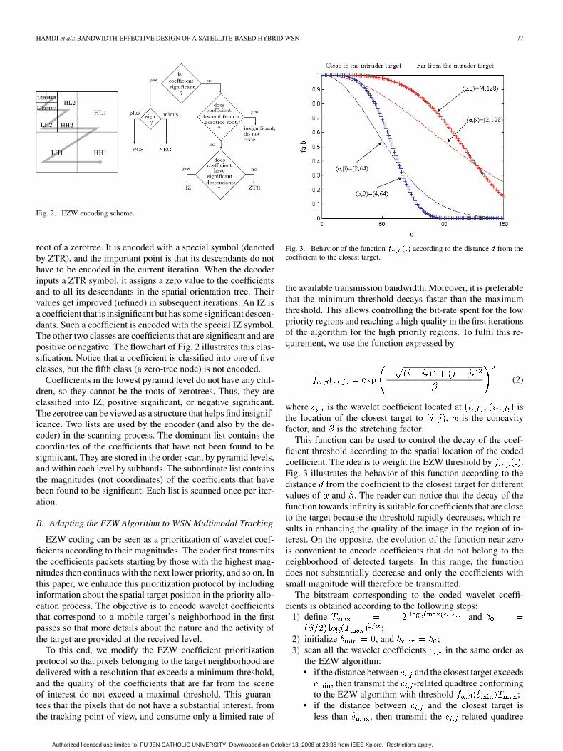
, then all of the coefficients of the same orientation in the samespatial location at finer scales (i.e., located lower in the pyramid)are very likely to be insignificant with respect to . In each itera-tion, all the coefficients are scanned in the order shown in Fig. 2.This guarantees that when a node is visited, all its parents will al-ready have been scanned. The scan starts at the lowest frequency(i.e., subband ), continues with subbands , , and
, and drops to level , where it scans , ,and . Each subband is fully scanned before the algo-rithm proceeds to the next subband.
Each coefficient visited in the scan is classified as a zero-treeroot (ZTR), an isolated zero (IZ), positive significant (POS), ornegative significant (NEG). A ZTR is a coefficient that is in-significant and all its descendants (in the same spatial orienta-tion tree) are also insignificant. Such a coefficient becomes the
Authorized licensed use limited to: FU JEN CATHOLIC UNIVERSITY. Downloaded on October 13, 2008 at 23:36 from IEEE Xplore. Restrictions apply.
HAMDI et al.: BANDWIDTH-EFFECTIVE DESIGN OF A SATELLITE-BASED HYBRID WSN 77
Fig. 2. EZW encoding scheme.
root of a zerotree. It is encoded with a special symbol (denotedby ZTR), and the important point is that its descendants do nothave to be encoded in the current iteration. When the decoderinputs a ZTR symbol, it assigns a zero value to the coefficientsand to all its descendants in the spatial orientation tree. Theirvalues get improved (refined) in subsequent iterations. An IZ isa coefficient that is insignificant but has some significant descen-dants. Such a coefficient is encoded with the special IZ symbol.The other two classes are coefficients that are significant and arepositive or negative. The flowchart of Fig. 2 illustrates this clas-sification. Notice that a coefficient is classified into one of fiveclasses, but the fifth class (a zero-tree node) is not encoded.
Coefficients in the lowest pyramid level do not have any chil-dren, so they cannot be the roots of zerotrees. Thus, they areclassified into IZ, positive significant, or negative significant.The zerotree can be viewed as a structure that helps find insignif-icance. Two lists are used by the encoder (and also by the de-coder) in the scanning process. The dominant list contains thecoordinates of the coefficients that have not been found to besignificant. They are stored in the order scan, by pyramid levels,and within each level by subbands. The subordinate list containsthe magnitudes (not coordinates) of the coefficients that havebeen found to be significant. Each list is scanned once per iter-ation.
B. Adapting the EZW Algorithm to WSN Multimodal Tracking
EZW coding can be seen as a prioritization of wavelet coef-ficients according to their magnitudes. The coder first transmitsthe coefficients packets starting by those with the highest mag-nitudes then continues with the next lower priority, and so on. Inthis paper, we enhance this prioritization protocol by includinginformation about the spatial target position in the priority allo-cation process. The objective is to encode wavelet coefficientsthat correspond to a mobile target’s neighborhood in the firstpasses so that more details about the nature and the activity ofthe target are provided at the received level.
To this end, we modify the EZW coefficient prioritizationprotocol so that pixels belonging to the target neighborhood aredelivered with a resolution that exceeds a minimum threshold,and the quality of the coefficients that are far from the sceneof interest do not exceed a maximal threshold. This guaran-tees that the pixels that do not have a substantial interest, fromthe tracking point of view, and consume only a limited rate of
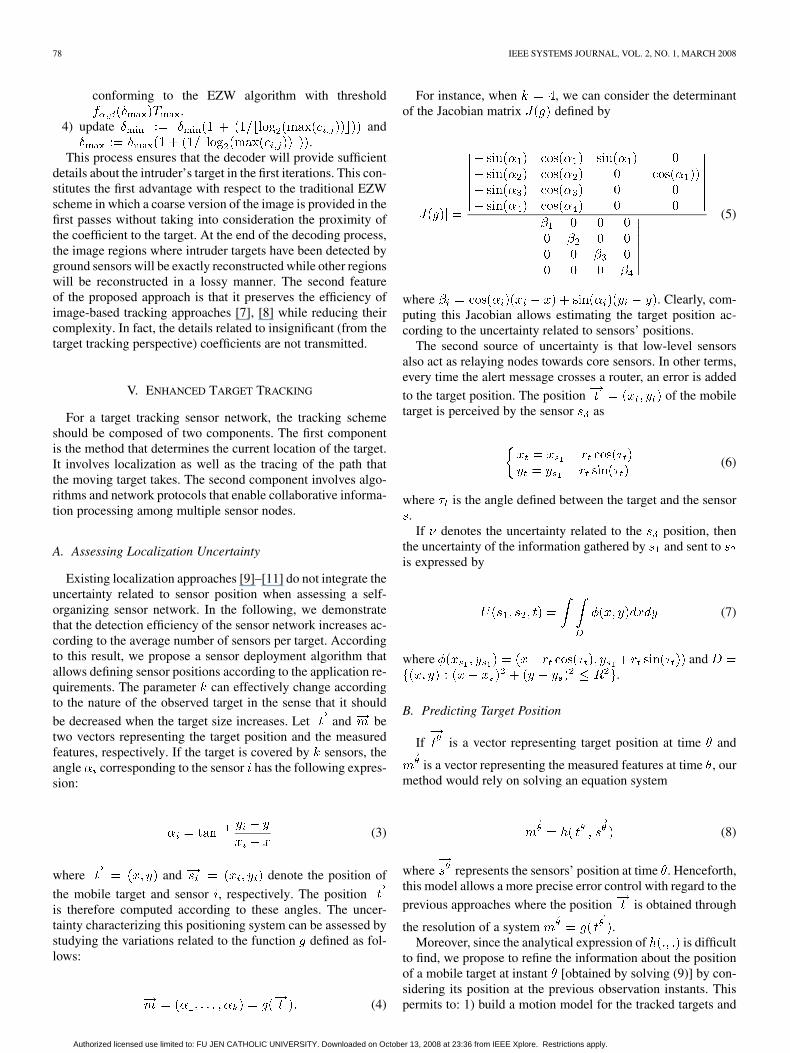
Fig. 3. Behavior of the function f (:) according to the distance d from thecoefficient to the closest target.
the available transmission bandwidth. Moreover, it is preferablethat the minimum threshold decays faster than the maximumthreshold. This allows controlling the bit-rate spent for the lowpriority regions and reaching a high-quality in the first iterationsof the algorithm for the high priority regions. To fulfil this re-quirement, we use the function expressed by
(2)
where is the wavelet coefficient located at , isthe location of the closest target to , is the concavityfactor, and is the stretching factor.
This function can be used to control the decay of the coef-ficient threshold according to the spatial location of the codedcoefficient. The idea is to weight the EZW threshold by .Fig. 3 illustrates the behavior of this function according to thedistance from the coefficient to the closest target for differentvalues of and . The reader can notice that the decay of thefunction towards infinity is suitable for coefficients that are closeto the target because the threshold rapidly decreases, which re-sults in enhancing the quality of the image in the region of in-terest. On the opposite, the evolution of the function near zerois convenient to encode coefficients that do not belong to theneighborhood of detected targets. In this range, the functiondoes not substantially decrease and only the coefficients withsmall magnitude will therefore be transmitted.
The bitstream corresponding to the coded wavelet coeffi-cients is obtained according to the following steps:
1) define and;
2) initialize , and ;3) scan all the wavelet coefficients in the same order as
the EZW algorithm:• if the distance between and the closest target exceeds
, then transmit the -related quadtree conformingto the EZW algorithm with threshold ;
• if the distance between and the closest target isless than , then transmit the -related quadtree
Authorized licensed use limited to: FU JEN CATHOLIC UNIVERSITY. Downloaded on October 13, 2008 at 23:36 from IEEE Xplore. Restrictions apply.
78 IEEE SYSTEMS JOURNAL, VOL. 2, NO. 1, MARCH 2008
conforming to the EZW algorithm with threshold.
4) update and.
This process ensures that the decoder will provide sufficientdetails about the intruder’s target in the first iterations. This con-stitutes the first advantage with respect to the traditional EZWscheme in which a coarse version of the image is provided in thefirst passes without taking into consideration the proximity ofthe coefficient to the target. At the end of the decoding process,the image regions where intruder targets have been detected byground sensors will be exactly reconstructed while other regionswill be reconstructed in a lossy manner. The second featureof the proposed approach is that it preserves the efficiency ofimage-based tracking approaches [7], [8] while reducing theircomplexity. In fact, the details related to insignificant (from thetarget tracking perspective) coefficients are not transmitted.
V. ENHANCED TARGET TRACKING
For a target tracking sensor network, the tracking schemeshould be composed of two components. The first componentis the method that determines the current location of the target.It involves localization as well as the tracing of the path thatthe moving target takes. The second component involves algo-rithms and network protocols that enable collaborative informa-tion processing among multiple sensor nodes.
A. Assessing Localization Uncertainty
Existing localization approaches [9]–[11] do not integrate theuncertainty related to sensor position when assessing a self-organizing sensor network. In the following, we demonstratethat the detection efficiency of the sensor network increases ac-cording to the average number of sensors per target. Accordingto this result, we propose a sensor deployment algorithm thatallows defining sensor positions according to the application re-quirements. The parameter can effectively change accordingto the nature of the observed target in the sense that it should
be decreased when the target size increases. Let and betwo vectors representing the target position and the measuredfeatures, respectively. If the target is covered by sensors, theangle corresponding to the sensor has the following expres-sion:
(3)
where and denote the position of
the mobile target and sensor , respectively. The positionis therefore computed according to these angles. The uncer-tainty characterizing this positioning system can be assessed bystudying the variations related to the function defined as fol-lows:
(4)
For instance, when , we can consider the determinantof the Jacobian matrix defined by
(5)
where . Clearly, com-puting this Jacobian allows estimating the target position ac-cording to the uncertainty related to sensors’ positions.
The second source of uncertainty is that low-level sensorsalso act as relaying nodes towards core sensors. In other terms,every time the alert message crosses a router, an error is added
to the target position. The position of the mobiletarget is perceived by the sensor as
(6)
where is the angle defined between the target and the sensor.
If denotes the uncertainty related to the position, thenthe uncertainty of the information gathered by and sent tois expressed by
(7)
where and.
B. Predicting Target Position
If is a vector representing target position at time and
is a vector representing the measured features at time , ourmethod would rely on solving an equation system
(8)
where represents the sensors’ position at time . Henceforth,this model allows a more precise error control with regard to the
previous approaches where the position is obtained through
the resolution of a system .Moreover, since the analytical expression of is difficult
to find, we propose to refine the information about the positionof a mobile target at instant [obtained by solving (9)] by con-sidering its position at the previous observation instants. Thispermits to: 1) build a motion model for the tracked targets and
Authorized licensed use limited to: FU JEN CATHOLIC UNIVERSITY. Downloaded on October 13, 2008 at 23:36 from IEEE Xplore. Restrictions apply.
HAMDI et al.: BANDWIDTH-EFFECTIVE DESIGN OF A SATELLITE-BASED HYBRID WSN 79
2) enhance the position estimate efficiency because former po-sitions may convey some information that is not included in themonitored metrics. To this end, we propose to extend the jointprobabilistic data association filters (JPDAFs) [12], that havebeen previously used in robotics applications [13] to the case ofWSN. The state vector models the coordinates and the ve-locity of the mobile target
(9)
where and are the identity matrix and the zero matrixin dimension 2, respectively, and represents the error process
due to the uncertainty on .We also assume that measurements are available according
to the stochastic process
(10)
where is a zero-mean Gaussian error independent of .Under these assumptions, particle filtering allows to compute
an estimate of such that the covariance matrix, containingthe coefficients , can be controlled according to
(11)
VI. PERFORMANCE EVALUATION
In this section, we assess the efficiency of the image codingand target tracking techniques proposed in the foregoing sec-tions. Real aerial image data have been used in this context.
A. Description of the Test Images
Four test images (“Adams1,” “Adams2,” “Zurich,” and“Vivid”) have been used to simulate the image coding andtarget tracking techniques that have been proposed in thispaper. Brief descriptions of these images are given in thefollowing.
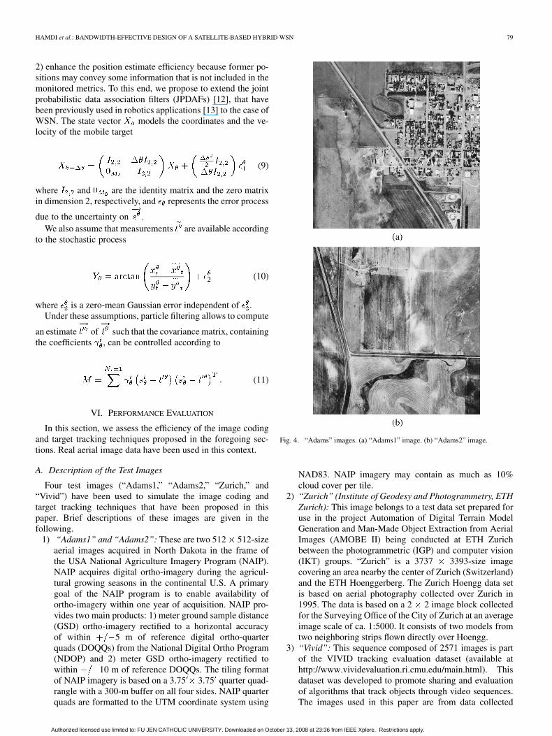
1) “Adams1” and “Adams2”: These are two 512 512-sizeaerial images acquired in North Dakota in the frame ofthe USA National Agriculture Imagery Program (NAIP).NAIP acquires digital ortho-imagery during the agricul-tural growing seasons in the continental U.S. A primarygoal of the NAIP program is to enable availability ofortho-imagery within one year of acquisition. NAIP pro-vides two main products: 1) meter ground sample distance(GSD) ortho-imagery rectified to a horizontal accuracyof within 5 m of reference digital ortho-quarterquads (DOQQs) from the National Digital Ortho Program(NDOP) and 2) meter GSD ortho-imagery rectified towithin 10 m of reference DOQQs. The tiling formatof NAIP imagery is based on a 3.75 3.75 quarter quad-rangle with a 300-m buffer on all four sides. NAIP quarterquads are formatted to the UTM coordinate system using
Fig. 4. “Adams” images. (a) “Adams1” image. (b) “Adams2” image.
NAD83. NAIP imagery may contain as much as 10%cloud cover per tile.
2) “Zurich” (Institute of Geodesy and Photogrammetry, ETHZurich): This image belongs to a test data set prepared foruse in the project Automation of Digital Terrain ModelGeneration and Man-Made Object Extraction from AerialImages (AMOBE II) being conducted at ETH Zurichbetween the photogrammetric (IGP) and computer vision(IKT) groups. “Zurich” is a 3737 3393-size imagecovering an area nearby the center of Zurich (Switzerland)and the ETH Hoenggerberg. The Zurich Hoengg data setis based on aerial photography collected over Zurich in1995. The data is based on a 2 2 image block collectedfor the Surveying Office of the City of Zurich at an averageimage scale of ca. 1:5000. It consists of two models fromtwo neighboring strips flown directly over Hoengg.
3) “Vivid”: This sequence composed of 2571 images is partof the VIVID tracking evaluation dataset (available athttp://www.vividevaluation.ri.cmu.edu/main.html). Thisdataset was developed to promote sharing and evaluationof algorithms that track objects through video sequences.The images used in this paper are from data collected
Authorized licensed use limited to: FU JEN CATHOLIC UNIVERSITY. Downloaded on October 13, 2008 at 23:36 from IEEE Xplore. Restrictions apply.

80 IEEE SYSTEMS JOURNAL, VOL. 2, NO. 1, MARCH 2008
Fig. 5. “Zurich” image.
Fig. 6. Sample frames from the “Vivid” dataset.
at Eglin during DARPA VIVID program. Vehicles looparound on a runway, then drive straight. It representsseveral military vehicles looping around on a runway, thendriving straight. The vehicle being tracked, which looksvery similar to another vehicles it passes, then speeds upand passes others.
Figs. 4–6 depict samples of the aforementioned imagedataset.
B. Assessing the Efficiency of the Enhanced EZW Scheme
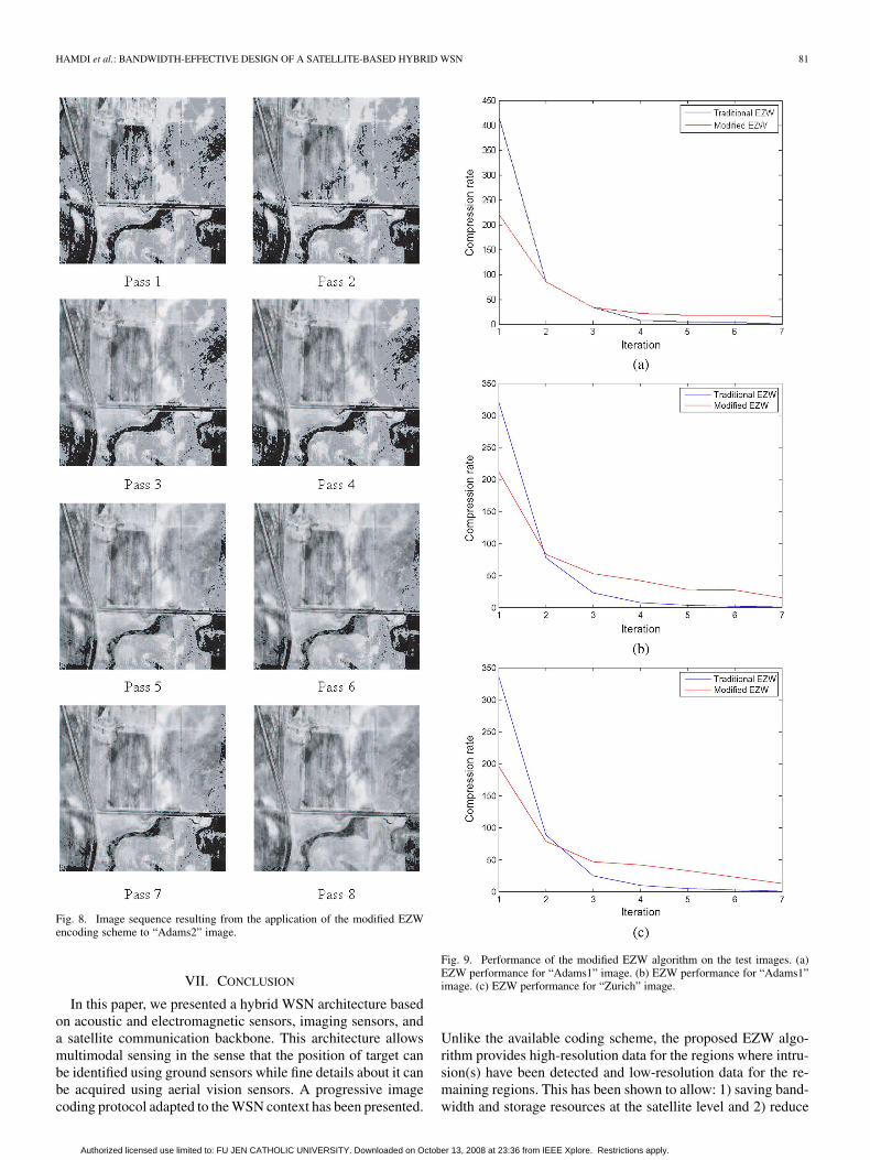
To evaluate the performance of the proposed EZW encoder,we performed both traditional and modified EZW schemes onthe test images presented in the previous subsection. Figs. 7 and8 illustrate the result of the application of the traditional andmodified EZW, respectively, on the “Adams2” image. It is vi-sually noticeable that the traditional EZW scheme produces anembedded image stream such that the quality of the whole sceneis improved at each iteration. However, the proposed algorithmexhibits an important difference, in terms of visual quality, be-tween the neighborhood of the target, which is located in thiscase at pixel (100,96) (right top corner of the image), and therest of the image. The resolution in the former region is rapidlyenhanced while no substantial improvements are remarked inthe latter region.
Fig. 9 shows the performance of the modified EZW codingscheme in terms of compression rate (i.e., number of bits in theoriginal image over number of bits in the coded image). The re-sults show that the traditional EZW outperforms the modified
Fig. 7. Image sequence resulting from the application of the EZW encodingscheme to “Adams2” image.
algorithm only for the two first iterations, where the quality ofthe EZW image is not acceptable for target tracking. For the re-maining iterations, the modified EZW gives much better resultsthan the traditional one. This confirms the hypothesis that en-hancing the resolution in the regions of interest and controllingthe bit rate in regions where no intrusions occur allows to sig-nificantly enhance the performance of the progressive codingscheme.
Authorized licensed use limited to: FU JEN CATHOLIC UNIVERSITY. Downloaded on October 13, 2008 at 23:36 from IEEE Xplore. Restrictions apply.
HAMDI et al.: BANDWIDTH-EFFECTIVE DESIGN OF A SATELLITE-BASED HYBRID WSN 81
Fig. 8. Image sequence resulting from the application of the modified EZWencoding scheme to “Adams2” image.
VII. CONCLUSION
In this paper, we presented a hybrid WSN architecture basedon acoustic and electromagnetic sensors, imaging sensors, anda satellite communication backbone. This architecture allowsmultimodal sensing in the sense that the position of target canbe identified using ground sensors while fine details about it canbe acquired using aerial vision sensors. A progressive imagecoding protocol adapted to the WSN context has been presented.
Fig. 9. Performance of the modified EZW algorithm on the test images. (a)EZW performance for “Adams1” image. (b) EZW performance for “Adams1”image. (c) EZW performance for “Zurich” image.
Unlike the available coding scheme, the proposed EZW algo-rithm provides high-resolution data for the regions where intru-sion(s) have been detected and low-resolution data for the re-maining regions. This has been shown to allow: 1) saving band-width and storage resources at the satellite level and 2) reduce
Authorized licensed use limited to: FU JEN CATHOLIC UNIVERSITY. Downloaded on October 13, 2008 at 23:36 from IEEE Xplore. Restrictions apply.

82 IEEE SYSTEMS JOURNAL, VOL. 2, NO. 1, MARCH 2008
the complexity of the image-based tracking approaches. Finally,a tracking technique taking into consideration the uncertaintyon sensor node positions has been proposed. It has been ana-lytically shown that it outperforms the existing approaches thatconsider only the errors made by the measurement system itself(i.e., the sensing framework).
In future works, the results presented in this paper can be im-proved by considering more sophisticated prioritization strate-gies to enhance the performance of the progressive encoder. Fur-thermore, a multimodal sensing technique is being developedbased on both ground and aerial sensor measurements.
REFERENCES
[1] M. Gerla and K. Xu, “Multimedia streaming in large-scale sensor net-works with mobile swarms,” ACM SIGMOD Recors, vol. 32, no. 4, pp.72–76, Dec. 2003.
[2] S. Soro and W. B. Heinzelman, “On the coverage problem in video-based wireless sensor networks,” in Proc. 2nd Int. Conf. BroadbandNetw., 2005, pp. 932–939.
[3] M. Hamdi, N. Boudriga, and M. S. Obaidat, “WHOMoVeS: An opti-mized broadband sensor network for military vehicle tracking,” Int. J.Commun. Syst., 2007, to be published.
[4] C. Anderson, “MLSATCOMVL transformation,” presented at theGround Syst. Arch. Workshop, Manhattan Beach, CA, 2005.
[5] J. Mineweaser, “Networking in the transformational communicationsarchitecture,” presented at the NASA 3rd Space Internet Workshop,Hanover, MD, 2003.
[6] J. Shapiro, “Embedded image coding using zerotrees of wavelet coef-ficients,” IEEE Trans. Signal Process., vol. 41, no. 12, pp. 3445–3462,Dec. 1993.
[7] R. T. Collins, X. Zhou, and S. K. Teh, “An open source tracking testbedand evaluation web site,” presented at the IEEE Int. Workshop Perform.Eval. Track. Surveillance (PETS), Breckenridge, CO, 2005.
[8] X. Fengjun and D. Morrell, “Target tracking using an image sensor witha configurable active area,” in Conf. Rec. 38th Asilomar Conf. Signals,Syst. Comput., 2004, pp. 2111–2115.
[9] L. Lazos and R. Poovendran, “HiRLoc: High-resolution robust local-ization for wireless sensor networks,” IEEE J. Sel. Areas Commun.,vol. 24, no. 2, pp. 233–246, Feb. 2006.
[10] S. Capkun and J. Hubaux, “Secure positioning of wireless devices withapplication to sensor networks,” in Proc. IEEE INFOCOM, 2005, pp.1917–1928.
[11] T. He, C. Huang, B. Blum, J. Stankovic, and T. Abdelzaher, “Range-free localization schemes in large scale sensor network,” Inf. Process.Sensor Netw., vol. 4, no. 4, pp. 877–906, Nov. 2005.
[12] Y. Bar-Shalom and T. Fortmann, “Tracking and data association,” inMathematics in Science and Engineering. New York: Academic,1988.
[13] D. Schulz, W. Burgard, D. Fox, and A. Cremers, “Tracking multiplemoving targets with a mobile robot using particle filters and statis-tical data association,” in Proc. IEEE Conf. Robot. Autom., 2001, pp.1665–1670.
Mohamed Hamdi received the EngineeringDiploma, M.S., and Ph.D. degrees in telecom-munications from the Engineering School ofCommunications, Sup’Com, Tunisia, in 2000, 2002,and 2005, respectively.
Currently, he is serving as an Assistant Professorwith the Engineering School of Communication ofTunis, Tunis, Tunisia. He is also the Coordinator ofthe Formal Aspects of Network Security ResearchTeam, Communication Networks and Security Lab-oratory, where he is conducting research activities in
the areas of risk management, algebraic modeling, relational specifications, in-trusion detection, network forensics, and wireless sensor networks. From 2001to 2005, he was the head of the Risk Analysis Team, National Digital Certi-fication Agency (NDCA), Tunis, Tunisia, where he was in charge to build thesecurity strategy for the Tunisian root Certification Authority and to continu-ously assess the security of the NDCA’s networked infrastructure. He has alsoserved in various national technical committees for securing e-government ser-vices.
Noureddine Boudriga received the Ph.D. degree inalgebraic topology from University Paris XI, Paris,France, and the Ph.D. degree in computer sciencefrom University of Tunis, Sup’Com, Tunisia.
He is currently a Professor with the Telecommuni-cations Department, University of Carthage, Tunis,Tunisia, and the Director of the Communication Net-works and Security Research Laboratory (CNAS).He is an internationally known Scientist/Academic.He has served as the General Director and founder ofthe Tunisian National Digital Certification Agency.
He was involved in very active research and authored or coauthored manychapters and books. He published over 200 refereed journal and conferencepapers.
Prof. Boudriga was a recipient of the Tunisian Presidential Award in Scienceand Research (2004). He is the President of the Tunisian Scientific Telecommu-nications Society.
Mohammad S. Obaidat (F’05) is an internationallywell-known academic, researcher, and scientist. Hereceived the M. S. and Ph.D. degrees in computer en-gineering with a minor in computer science from TheOhio State University, Columbus.
He is currently a Full Professor with the Depart-ment of Computer Science, Monmouth University,West Long Branch, NJ. Among his previous positionsare Chair of the Department of Computer Science andDirector of the Graduate Program, Monmouth Uni-versity, and a faculty member with the City Univer-
sity of New York, NY. He has received extensive research funding. He has au-thored or coauthored five books and over 360 refereed scholarly journal andconference articles. He has served as a consultant for several corporations andorganizations worldwide. In 2002, he was the scientific advisor for the WorldBank/UN Workshop on Fostering Digital Inclusion. He has made pioneeringand lasting contributions to the multi-facet fields of computer science and engi-neering.
Dr. Obaidat was a recipient of the distinguished Nokia Research Fel-lowship, the Distinguished Fulbright Award, and a recognition certificatefrom the IEEE. He is an editor of many scholarly journals including beingthe Editor-in-Chief of the International Journal of Communication Systems(Wiley). He is also an Editor of the IEEE Wireless Communications Magazineand nine other transactions and scholarly international journals includingtwo IEEE transactions. He has Guest Edited numerous special issues ofscholarly journals such as IEEE TRANSACTIONS ON SYSTEMS, MAN, AND
CYBERNETICS—PART B: CYBERNETICS, Elsevier Performance Evaluation,SIMULATION: Transactions of SCS, Elsevier Computer CommunicationsJournal, Journal of C & EE, and International Journal of CommunicationSystems. He has served as the steering committee chair, advisory CommitteeChair, honorary chair, and program chair of many international conferences.He is the founder of the International Symposium on Performance Evaluationof Computer and Telecommunication Systems (SPECTS) and has served asthe General Chair of SPECTS since its inception. Between 1994–1997, he hasserved as distinguished speaker/visitor of IEEE Computer Society. Since 1995,he has been serving as an ACM distinguished Lecturer. He is also an SCSDistinguished Lecturer and the founder of the SCS Distinguished LecturerProgram (DLP) and its present director. Between 1996 and 1999, he served asan IEEE/ACM program evaluator of the Computing Sciences AccreditationBoard/Commission, CSAB/CSAC. Between 1995 and 2002, he has served asa member of the board of directors of the Society for Computer SimulationInternational. Between 2002 and 2004, he has served as Vice President ofConferences of the Society for Modeling and Simulation International SCS.Between 2004–2006, he has served as Vice President of Membership of SCS.He is currently the Senior Vice President of SCS. He has been invited tolecture and give keynote speeches worldwide. His research interests includewireless communications and networks, modeling and simulation, performanceevaluation of computer systems, and telecommunications systems, securityof computer and network systems, high performance computing/computers,applied neural networks and pattern recognition, security of e-based systems,and speech processing. During the 2004/2005 academic, he was on sabbaticalleave as Fulbright distinguished Professor and Advisor to the President ofPhiladelphia University, Dr. A. Badran. He is a Fellow of the Society forModeling and Simulation International SCS.
Authorized licensed use limited to: FU JEN CATHOLIC UNIVERSITY. Downloaded on October 13, 2008 at 23:36 from IEEE Xplore. Restrictions apply.