Baja California and California’s Merging Tourist Corridors Bringas JED 2002
30
10.1177/107049602237158 JOURNAL OF ENVIRONMENT & DEVELOPMENT Bringas / MEXICAN GOVERNMENT POLICIES POLICY ANALYSIS Baja California and California’s Merging Tourist Corridors: The Influence of Mexican Government Policies NORA L. BRINGAS-RÁBAGO This article aims to show how the Mexican government’s development policies have contributed to promoting coastal regions whose economic base rests on tourist activity. In this context, it describes the pattern of development taken by urbanization within a tourism development zone in northern Mexico: the Tijuana-Ensenada Coastal Corridor (Corredor Costero Tijuana-Ensenada), in Baja California. The article is concerned with the events that have influenced the zone’s current configuration, that is, how and under what conditions tour- ism’s process of implantation in space has occurred and what mechanisms have facilitated it. The existence of natural resources and historical landmarks to a large extent determines tourism flows to a region, as do other factors such as tourists’ discretionary income levels and preferences, for example. With the onset of mass tourism, the beach-sun combination became the main motivating factor for people to travel great distances in search of greater enjoyment of their leisure time. This marked the start of a change in how the space of tourism is valued: from being a space that is the object of observation and contemplation, it becomes a space that is consumed and coveted. The strong tourism pressures to which coastal zones are sub- jected arose from this transition (Lozato-Giotart, 1993). Throughout human history, coastal zones have occupied a strategic place for the development of commerce as well as for the expansion and domination of one people over others. Therefore, coastal zones in and of themselves became a scarce resource that must be conserved and pre- served through rational use. This does not mean that they cannot be used for commercial, industrial, or transportation ends or for the estab- lishment of tourist zones. But it must be done with caution because the advantage that is the commodity’s scarcity is what determines its demand. This is why speculation often occurs with this type of space. 267 Journal of Environment & Development, Vol. 11, No. 3, September 2002 267-296 DOI: 10.1177/107049602237158 © 2002 Sage Publications
Transcript of Baja California and California’s Merging Tourist Corridors Bringas JED 2002

10.1177/107049602237158JOURNAL OF ENVIRONMENT & DEVELOPMENTBringas / MEXICAN GOVERNMENT POLICIES
POLICY ANALYSIS
Baja California and California’sMerging Tourist Corridors: The Influence
of Mexican Government Policies
NORA L. BRINGAS-RÁBAGO
This article aims to show how the Mexican government’s development policieshave contributed to promoting coastal regions whose economic base rests ontourist activity. In this context, it describes the pattern of development takenby urbanization within a tourism development zone in northern Mexico: theTijuana-Ensenada Coastal Corridor (Corredor Costero Tijuana-Ensenada), inBaja California. The article is concerned with the events that have influencedthe zone’s current configuration, that is, how and under what conditions tour-ism’s process of implantation in space has occurred and what mechanisms havefacilitated it.
The existence of natural resources and historical landmarks to a largeextent determines tourism flows to a region, as do other factors such astourists’ discretionary income levels and preferences, for example. Withthe onset of mass tourism, the beach-sun combination became the mainmotivating factor for people to travel great distances in search of greaterenjoyment of their leisure time. This marked the start of a change in howthe space of tourism is valued: from being a space that is the object ofobservation and contemplation, it becomes a space that is consumed andcoveted. The strong tourism pressures to which coastal zones are sub-jected arose from this transition (Lozato-Giotart, 1993).
Throughout human history, coastal zones have occupied a strategicplace for the development of commerce as well as for the expansion anddomination of one people over others. Therefore, coastal zones in and ofthemselves became a scarce resource that must be conserved and pre-served through rational use. This does not mean that they cannot beused for commercial, industrial, or transportation ends or for the estab-lishment of tourist zones. But it must be done with caution because theadvantage that is the commodity’s scarcity is what determines itsdemand. This is why speculation often occurs with this type of space.
267
Journal of Environment & Development, Vol. 11, No. 3, September 2002 267-296DOI: 10.1177/107049602237158© 2002 Sage Publications

In this context, an important question becomes, How can coastalzones be developed while at the same time their natural condition is pro-tected? This is a challenge that all countries with extensive coastlines,such as Mexico, must face. The complexity of territorial occupation hasforced those who have the task of promoting development and regionalplanning to seek and propose new methods and techniques that canenable a greater involvement and understanding of what must be done.As such, geography can be highlighted as a discipline that has contrib-uted to identifying and explaining the spatial incidence of certain socialphenomena.
To examine a space such as the Tijuana-Ensenada Coastal Corridor(Corredor Costero Tijuana-Ensenada [COCOTEN]) is not an easy task,because this space has characteristics that make it unlike other tourismspaces in Mexico: They are the land and the maritime border with thestate of California, the richest state in the United States. In addition, Cali-fornia (along with Texas) is one of the states with the highest percentageof population of Mexican descent. At the same time, 50% of the tourismflows to Mexico are from California and Texas. A great many of theopportunities and challenges facing this region are derived from this factbecause this coastal space is closely linked to the processes that takeplace on the other side of the border.
In the context of a developing country that needs to generate incomewhile adopting a logic of conserving natural resources, a paradox devel-ops of how to take advantage of the natural and cultural resources thatexist in the territory without mortgaging the future prosperity of theregion. To do this requires the implementation of measures that usuallyare not very well received by economic groups who want to develop thezone without taking into account the conservation and protection ofareas of high ecological value. These measures can ensure the health ofcoastal ecosystems that are exposed to enormous tourism pressure.
The attraction that coastal zones exert on tourism constitutes a two-edged sword. On one hand, there are big economic interests pushing forrapid and ongoing urban development of the coastal zone with a tradi-tional tourism approach—vertical hotel constructions and the buildingof vacation homes on the beachfront. With this approach, environmentalconcerns and a harmonious landscape are rarely taken into account. Onthe other hand, there are those (fewer in number) who struggle for carry-ing out a kind of tourism development that is in harmony with the sur-rounding environment.
In decades past, the balance was loaded toward economic aspectswhile neglecting environmental concerns; beginning in the 1970s, a con-cern with environmental conservation developed on a world scale. Thisconcern has not been absent from the tourism arena. Since the 1970s, newplanning currents have arisen that argue that urbanization can be pro-
268 JOURNAL OF ENVIRONMENT & DEVELOPMENT

moted while respecting the environment and its conservation as a basisfor achieving sustainable development.
Therefore, the aim of this article is to determine what have been thepromotion policies sponsored by the Mexican government in coastalzones with tourism potential. For this purpose, the article is divided intothree parts. The first presents a general overview of the approach thathas been followed by mass tourism in coastal zones. The second partreveals the role of the state as a promoter of policies aimed at stimulatingcoastal development through tourism. The final part describes thedevelopment of tourism in the COCOTEN, highlighting to the extentpossible the impact that urban development and tourism promotionpolicies of the Mexican government have had on its expansion.
The Invasion of the Beaches:The Expansion of Mass Tourism
Up until the Second World War, the uses of the coastal zone weredetermined above all by primary sector activities and trade. But in theperiod following the war, industry and tourism appeared as two of thepredominant activities making use of the coastal zone, to the degree thattoday these kinds of uses are the most rapidly growing (Barragán, 1994).
Beginning with the second half of the 20th century, the value placedon the ocean really began to change. During this period, the sea and thesun became part of the ideal vacation, accentuating a model of consump-tion based on the four Ss (sun, sea, sand, and sex). This has resulted insharp spatial polarization, accompanied by a high concentration of tour-ists during a short period of time in reduced spaces. This has producedovercrowding and additional pressures on the environment, markingthe start of a veritable tourist invasion of the coastal zone (Cazes,Lanquar, & Raymond, 1993; Racine, 1982; Shaw & Williams, 1998).
This kind of tourism has made the role of the modification of urbanorganization important, as expressed in the appearance and spread oftourism centers on ocean fronts, to the detriment of settlements thatalready existed adjacent to the coastline on interior lands (Callizo, 1991).Therefore, it should not be surprising that the model of developmentthat was followed for conventional tourism was the construction of bigvertical hotels on the beachfronts, which had all the amenities and ser-vices within the same space. This meant that each hotel functioned as asort of enclave,1 in such a way that contact between the tourists and thereceiving community was nonexistent.
Bringas / MEXICAN GOVERNMENT POLICIES 269
1. This type of enclave development prevents visitors from interacting with the receiv-ing community, and visitors’ mobility is confined to the route from the plane to the hotel tothe beach. The organization of coastal space oriented toward conventional tourism has

As a consequence of the invasion of coastal zones by tourism, aboveall in European countries along the Mediterranean, major transforma-tions took place that totally changed the traditional physiognomy ofsome beaches. Strong speculation in land, the construction of largehotels and condominiums on the beach, and the purchase of land by for-eigners unleashed an all-out struggle to take control of beachfronts(Fernández, 1991; Jurado, 1990, 1992). In this context, residential tourismbecame one of the main factors in mass tourism to coastal zones. Becauseof the high demands that this type of tourism places on land, there beganto be serious problems in the organization of space.
The excessive development of the tourism real estate business hasbeen an opportunity and a way to escape for some, an escape that trans-lates into a change from the temporary enjoyment of a place to the per-manent appropriation of the vacation home. A spatial-temporal formrapidly took shape in which new spaces emerged, spaces that were eas-ily urbanized, marketed, and ordered, in a speculative context of sales oflots and vacation homes close to the beach. Anarchic building construc-tion at the edge of the sea took place with an enormous waste of spaceand low tourism productivity (Cazes et al., 1993).
With this, the construction of secondary residences became the mainprotagonist of this metamorphosis, and that activity became a voraciousconsumer of territory. Thus, the only guiding orientation for the processof implantation of tourism in a given territory was the change from natu-ral to built land use, transforming the coastal zones. In this way, the realestate business was enshrined as the dynamic element in coastal touristzones, to the detriment of traditional activities, which were abandoned.Also neglected were the objectives that gave rise to tourism activityitself; interest now focused on the sale of lots and real estate speculation,the latter linked to the availability of land and distance to the sea (Vera,1997).
All this produced anarchic, out-of-control urbanization on ocean-fronts and an enormous waste of space to build hotels or secondary resi-dences. It also led to the rise of various types of tourism implantations inspace, some of which have appeared spontaneously and others as theresult of planned actions. This created a wide range of typologies of spa-tial organization with similar patterns of concentration on the coastline,although with differing degrees of articulation to the local and regionalspheres (Barbaza, 1970; Santana, 1997; Vera, 1997).
270 JOURNAL OF ENVIRONMENT & DEVELOPMENT
produced the rapid growth of these zones without adequate planning or corrective mea-sures to mitigate the negative impacts on the environment caused by accelerated construc-tion and the intense use to which these ecosystems are subjected by visitors.

TYPES OF ORGANIZATION OFTOURISM SPACES IN COASTAL ZONES
The expansion of mass tourism has given rise to very diverse forms ofterritorial ordering. Among the main criteria needed to make a typologyof tourism implantations in coastal spaces, according to Barbaza (1970),there are three aspects that must be taken into consideration. The first isthe intensity in the use of space, that is, the diversity of activities thatexisted in a territory prior to the appearance of tourism. The second hasto do with the spontaneous or voluntary character of buildup. The thirdis the one-time or continuous character of the implantations.
The most notable example of the first type that is intensive and spon-taneous is Spain’s Costa Brava, which attracted massive tourism in thepostwar period (1945-1950). The arrival of tourists to the region pre-ceded urbanization, and therefore the latter had to rapidly respond tothe demand, setting off a race to supply tourism’s needs in which theanarchy of constructions and real estate speculation gained ground andthe destruction of the landscape became unimportant. Despite theseharmful effects, tourism gave the region a unity or identity that it did notpreviously have, converting it into a true tourist space (Barbaza, 1970;Callizo, 1991).
A second type of organization of tourist space has to do with the so-called planned centers in specific locations. Examples of this are the tour-ist centers built in Bulgaria and Romania on the coast of the Black Seawith strong state participation characteristic of socialist regimes. Thefirst of these centers was established in 1948, but it was not until 1956 and1957 that both centers experienced buildups. In both cases, the touristcenters were conceived and planned by the state and were later offeredto tourism, so supply preceded demand. This type of organization con-stituted a functional unit that defined what to offer the tourists in previ-ously unknown places that were chosen because they were character-ized by large expanses of land and great short-run profit-makingopportunities. These sites became the ideal prototype for vacation cen-ters (Barbaza, 1970; Callizo, 1991).
Unlike the Costa Brava, which represented spontaneous and inten-sive development, in this other type of organization, there is not the con-tinuous utilization of space but rather a tourist nucleus linked to theenvironment in a given location. The bulk of construction was up to thestate, and its distribution was carefully calculated, foreseen, and put inplace for tourist consumption. Each portion of space was assigned a spe-cific function to avoid future conflicts over utilization. Space was super-ficially decorated, and perhaps it was this lack of authenticity that madeit difficult for a self-identity to take shape because the space presenteditself as something completely artificial and placed in a showcase for the
Bringas / MEXICAN GOVERNMENT POLICIES 271
enjoyment of the tourists, without any charm and without a real integra-tion to the region.
The third type of order is the continuous or integrated-extensive type.The best example of this is France’s Languedoc-Roussillon region(Callizo, 1991; Cazes, 1972). This type of tourism organization was theresult of an ambitious territorial ordering project promoted by theFrench government for this region in 1963. The idea was to develop thistype of project in an area that was not very attractive to tourists, despitethe existence of beaches with fine sand and the Mediterranean sun.However, the strong winds and the existence of a number of marshesand swamps made a favorable habitat for mosquitoes, which were a realplague that scared away the tourists who ventured into the area.
Due to the features mentioned, there were low population concentra-tions in the area, and these people made a living primarily from agricul-ture and fishing. Perhaps because of this, only the government couldhave ventured an undertaking such as the one it set out to do. The projectentailed the overall ordering of a continuous space that would cover theentire coastal zone and that would integrate the existing localities, incontrast to the Bulgarian-Romanian case, which was at a single location.At least in theory, there was a concern with integrating the coastal zonein a regional space, and there was an idea that tourism would be the det-onator to kick off development in the region as a whole. A very special-ized vacation space was created. Just as in the Bulgarian case, it wassomewhat artificial. However, unlike the former, the Languedoc-Roussillon region did try to incorporate interior land to the coastal zoneto expand. Nevertheless, it may be said that it was more a cosmetic than areal integration, although this region is among those with the greatestnumber of planned tourist centers.
In the cases noted above, we can see that there are various factors thatlimit or favor the type of tourism utilization of space and its planned orspontaneous character. Among these elements are the economic struc-ture already existing in the region, the degree of state participation as apromoter and developer, and the zone’s own natural features. In the caseof planned centers, the participation of the public sector has been funda-mental in deciding the single-point or integrated nature of the touristdevelopment model. Unlike spontaneous implantations, where con-struction takes place after the demand has been expressed and is addedto already existing structures, most often in a disorderly and uncon-trolled way, in planned centers new spaces are created with buildingsand infrastructure that are independent of what is already in place.2
272 JOURNAL OF ENVIRONMENT & DEVELOPMENT
2. The work of Peck and Lepie (1989) is recognized as the first attempt to classify coastaltourism development in the United States. These authors carried out a study of threecoastal communities of North Carolina to analyze the changes brought about by tourism.They focused on three categories: (a) the rate of transformation caused by tourism, which

The State as a Promoter ofTourism Development Policies
in Mexico’s Coastal Zones
There has not been a clear policy in Mexico regarding the type ofdevelopment that should take place in coastal zones. Although it is rec-ognized that the coast is important for the development of some activi-ties, such as industry, trade, and tourism, this recognition has not, at leastexplicitly, been translated into concrete measures to protect it, aside fromdeclarations by the National System of Protected Areas (SistemaNacional de Áreas Protegidas), which includes some coastal zones.
Mexico, with a coastline of a bit more than 11,000 kilometers (nearly7,000 miles), is a country with enormous potential for coastal zone devel-opment. Regrettably, to date there has not been a clear policy on the typeof development that should take place. The coastal areas of the Gulf ofMexico have been the most accessible and the most integrated to theurban zones in the center of the country. They have large amounts ofmaritime traffic and great growth perspectives thanks to oil reserves inthe region. The Pacific coast is greater in area and more heterogeneous,discontinuous, underpopulated, and poorly integrated with the hinter-lands and among communities along the coast. However, this has notbeen a barrier for the development of some of the country’s main beachtourist centers.
In the period since the Second World War, the development of tour-ism in Mexico has experienced dynamic growth. One of its main attrib-utes is the positive impact it has on the economy, measured by its share inthe balance of payments, in the gross domestic product, and in employ-ment creation and its multiplier effect on other activities. All of this is ori-ented toward promoting regional development.
The expansion of tourist activity in Mexico has gone hand in handwith the level of socioeconomic development reached by modern societ-ies. This development has created the necessary conditions to bringabout social welfare among the population, providing greater and betterpossibilities of access to social security and public health systems, aswell as the right to obligatory paid rest time as stipulated by the Mexicanconstitution. Provision of paid vacation has allowed tourist activity to
Bringas / MEXICAN GOVERNMENT POLICIES 273
includes the speed and the extent of development (slow, fast, and temporary); (b) the basisof power that rests on the ownership of land, the sources of financing, the contributions ofthe host population, and the relationship between local traditions and the purposes ofdevelopment; and (c) the effects of commercialism (social impacts that transform thereceiving community’s norms and customs) on the receiving communities and of profit-ability (economic benefits of tourism and social mobility). These criteria were able to showthe effects of power, of profitability, and of commercialism on the host community’s prac-tices, so that the emphasis is more anthropological than geographic.

take an important leap. Although once it was something within reach ofonly a privileged minority, it is now a part of the broader sphere of socialand cultural life for a majority of the population who increasinglydemand the right to enjoy their leisure time through recreational activi-ties and tourism.
The practice of tourism presupposes the existence of a varied supplyof tourist services, activities, and infrastructure, and Mexico is a countryrich in natural and cultural resources. Because of this, and knowing thecountry’s comparative advantages compared to other destinations, thefederal government has promoted tourism mainly in beach locationsthat are most in demand by domestic as well as foreign visitors. Thus, in1963, the Department of Tourism created the first National TourismDevelopment Plan, wherein the strategic role of tourism for the coun-try’s progress was reaffirmed. With this as its starting point, the federalgovernment took the lead in planning, placing the greatest emphasis onthe creation of infrastructure and support for investment in the tourismsector.
The history of government intervention as an investor and promoterof tourism activities located in Mexico’s beach destinations has beenvery intense during the past 30 years (Jiménez, 1992). Nevertheless,there are certain fundamental aspects that characterize governmentalaction with regard to tourism, all in the context of the country’s eco-nomic development. These include employment creation, generation offoreign exchange, direct government participation as a provider ofinvestment and as a planning agent of economic activity, and finally,tourism’s ability to bring about development in regions of Mexico thatare lagging economically but that have natural attractions capable ofdrawing those on the market for beach tourism.
In this context, planning has aimed at the international market due toits importance in the generation of foreign exchange. Only tangentiallywere programs designed that were oriented toward satisfying the recre-ational needs of the Mexican tourist population. Economic criteria con-tinue to be prioritized, given the undeniable argument of attracting for-eign exchange with the goal of recovering the enormous investments bythe public sector in its efforts to modernize facilities and gain interna-tional market shares. This became the basis for tourism policies fromthen on in Mexico. Policy has been characterized by giving priority to theeconomic aspect while neglecting the social and cultural implicationsthat tourism activity has as a social experience (Bringas, 1997b).
Federal investment in tourism has been very low, never reaching 1%of the total budget. Not even in the oil bonanza days of President JoséLópez Portillo did it go over 1%, although its share of the budget didincrease.3 Investment in the sector has especially benefited the hotel
274 JOURNAL OF ENVIRONMENT & DEVELOPMENT
3. During the period 1959 through 1970, the federal budget for tourism represented0.21% of the total budget; from 1971 to 1977, it was 0.13%; from 1978 to 1982, it was 0.28%;

industry4 and has made it the spearhead for the takeoff of tourist activi-ties through the creation of lodging that is competitive with other beachdestinations worldwide, especially those of the Caribbean. The empha-sis on providing infrastructure was another one of the development-through-tourism strategies on which a great part of the expectations forregional growth were based.
The state has become a planning agent through the creation of institu-tions and agencies whose direct participation has involved practicallyeverything from the initial design to the construction and financing oftourism centers.5 During the 1960s, there was a pause in governmentalactions having to do with tourism. However, toward the end of thatdecade, things began to change. In 1968, the federal government askedthe Banco de México to design a policy to promote tourism in the coun-try. This resulted in the creation of the Fund for the Promotion of Tour-ism Infrastructure (Fondo de Promoción de Infraestructura Turística),whose objective was to carry out an integrated program for tourist cen-ters. To do this, a series of studies was begun on the vast surface of Mex-ico’s territory to locate appropriate zones for investment in tourisminfrastructure (Fondo Nacional de Fomento al Turismo [FONATUR],1981).
This program to identify zones marked the beginning of the discov-ery of the sea as a tourist attraction and as a focus for a developmentstrategy. It was crystallized in 1974 with the creation of the FONATUR,which resulted from the fusion of Fondo de Garantía y Fomento al
Bringas / MEXICAN GOVERNMENT POLICIES 275
and from 1983 to 1990, it was 0.22% of the total. The highest share of tourism in the budgetwas in 1990, when it made up 0.57% of the total budget, and in 1980 and 1981, when it was0.51% and 0.37%, respectively. See Jiménez (1992, p. 358).
4. During the postwar period (1946-1956), the hotel industry in Mexico was dominatedby foreign hands. For this reason, in 1956, the Mexican government created the TourismGuarantee and Promotion Fund (Fondo de Garantía y Fomento al Turismo) so that Mexi-can investors could invest in hotel infrastructure and in this way be able to compete withforeign capital. In 1963, the government reaffirmed its support of the hotel industry by car-rying out a reform of legislation regulating credit institutions (Ley General de Institucionesde Crédito). This reform allowed mortgage banks to increase credits to hotel establish-ments from 30% to 50%. Between 1957 and 1970, the accumulated total of loans issued byFondo de Garantía y Fomento al Turismo to the Mexican hotel industry was on the order of496.4 million pesos (Jiménez, 1992, p. 79). The role of the state as a promoter and investor inthe tourism sector, primarily in hotel accommodations, was consolidated with the estab-lishment of Fondo Nacional de Fomento al Turismo in 1974. Thus, 57% of all credits issuedby Fondo Nacional de Fomento al Turismo during the period between 1973 and 1990 werefor the establishment of new hotels. The total amount of credits granted to Mexico by theInter-American Development Bank and the World Bank during the period between 1971and 1990 in total came to U.S. $471.5 million, of which 68% was to finance the hotel sector(Jiménez, 1992, pp. 367-376).
5. This article does not attempt to carry out an exhaustive review of the critiques of thetourism planning model in Mexico. For this, see, for example, Rodríguez (1991), SECTUR(1988), Olivera (1977), IMIT (1980), and Bringas (1995b).

Turismo and Fondo de Promoción de Infraestructura Turística. Its maincontribution was to grant credits to foster the development of the tour-ism sector in selected destinations (Ramírez, 1986). Thus, FONATURbecame an instrument of the federal government charged with fosteringthe growth of Mexico’s tourist installations by granting investment cred-its and strengthening general tourist activities.
From this period forward, a series of changes took place with regardto tourism policy. The importance of tourism as a stimulus to regionaldevelopment was recognized, and with this premise, the participation ofthe state in tourism gradually widened. Thus, two strategies were fol-lowed in Mexico to promote tourism in some of the country’s coastalzones. On one hand, credits were granted for the construction of infra-structure in already existing beach centers, as was the case with Aca-pulco in the state of Guerrero, and to a lesser degree with Puerto Vallartain the state of Jalisco, Manzanillo in the state of Colima, and the port ofVeracruz, among others.
On the other hand, a larger scale strategy was launched, which con-sisted of the development of new, fully planned tourist centers. Thus, atthe end of the 1970s, five hitherto unknown beach destinations wereselected to be directed and operated by FONATUR. External support forcreating and financing these centers was sought from the Inter-AmericanDevelopment Bank. These centers were Cancún, in the state of QuintanaRoo; Ixtapa, in the state of Guerrero; and Loreto and Los Cabos, in thestate of Baja California Sur. The construction of Bahías Huatulco in thestate of Oaxaca began 10 years later.
In contrast to the traditional tourist centers, which arose spontane-ously and where the development of infrastructure and services tookplace as a function of the demand and only later with the support of thefederal government through credits, the birth of the new centers wasinduced and promoted by the state. The justification for their creationwas based on the fact that they would contribute to and promote thedevelopment of economically backward zones of Mexico.
But did this development strategy really reflect an overall policy ofbringing order to coastal zones? The answer is not yet clear for, as weshall see below, the attempt to fully plan tourism in the regions where thenew poles of development were located had the opposite effects of whatwas expected. Instead of causing a chain reaction of multiplier effects inthe regions, these centers became tourist enclaves (Cazes, 1980;Gormsen, 1977; Hiernaux, 1989).
FONATUR’s planned centers are the clearest example of a touristenclave. However, the fact cannot be ignored that even in the traditionalbeach centers, the hotels or tourist complexes themselves function asminienclaves that seek to keep the tourists within their confines by offer-ing all services so that they do not have to go out to find them outside ofthe establishment itself. Services offered by the hotel are reserved exclu-
276 JOURNAL OF ENVIRONMENT & DEVELOPMENT

sively for use by customers, as are the beaches that these hotels are on,even though by law the beaches may not be private because they are con-sidered a public good.
The local population does not fit into this blueprint for development.On the contrary, it is excluded and pushed to the margins socially, eco-nomically, and territorially. Even though these centers are functionallyand territorially integrated into the region, they do not integrate theregion. In fact, this has been one of the major critiques of the tourismmodel based on poles of development, the theory that justifiedFONATUR’s integrally planned beach centers. Currently, these trendsare shifting, and there is an increasing recognition of the need for touriststo be integrated into receiving communities.
During the presidential administration of Luis Echeverría (1970-1976), a series of changes took place with regard to tourism policy, in par-ticular for certain zones of Mexico. In 1971, the legal mechanisms werecreated (through contracts for property held in trust) to allow foreignersthe use and enjoyment of real estate located on Mexico’s coasts and in itsborder areas, which had been called the forbidden zone for foreignersand covered all territory 100 kilometers (about 60 miles) from the bor-ders into the interior of the country and 50 kilometers (about 30 miles)from the coast inland. One of the purposes for the creation of these trustswas to control illegal foreign investment in those areas, for even thoughit was against the law, there were foreigners who used Mexican “name-lenders” (prestanombres) to gain access to real estate in these zones(Ramírez, 1981).
Ejidos6 for tourism also appeared during this period, located in mostcases in coastal zones. This arrangement allowed ejido lands that werenot suitable for agriculture to be utilized for tourist activities. This led tovarious ejidos’ exploitation of their natural resources to survive. In fact,this allowed the Playas de Rosarito delegation (what was once theMazatlán ejido) to become the last of Baja California’s five municipali-ties, and this was possible thanks to tourism.
The unbridled population growth experienced by Mexico’s coastalzones, particularly in the second half of the 20th century, has broughtwith it a chaotic redistribution of human settlements and productionactivities. This has had negative impacts on both the use and the benefitsof coastal ecosystems. The creation in 1999 of the Special Program forSustainable Utilization of Beaches, the Maritime-Terrestrial FederalZone (Zona Federal Marítimo-Terrestre), and land taken from the sea(terrenos ganados al mar) was a measure aimed at ordering coastal occupa-tion and coastal activities. Initially, the program set out to apply zoningto land use, taking into account environmental and urban aspects that
Bringas / MEXICAN GOVERNMENT POLICIES 277
6. Ejido is defined as all land, woods, and water sources, conceded to a nucleus of ruralpopulation by virtue of the Agrarian Law of January 1915.

could promote the sustainable use of coastal resources (InstitutoNacional de Ecología [INE], 2000).
As will be discussed below, the policies implemented by the Mexicangovernment to promote tourism in coastal zones have been contradic-tory. On one hand, significant projects were developed to build infra-structure and amenities, such as highways, airports, and services in gen-eral, which in addition to benefiting tourism also benefited the localpopulation. But on the other hand, a marked spatial segregation arosebetween the tourism zones and areas where local residents live; therewas also differential access to services to the detriment of living condi-tions for local residents.
In addition, the negative impacts on space resulting from bad plan-ning must not be ignored. In both cases, an anarchic use of the coastalzone is evident, and there has even been a degradation of naturalresources that is already having negative effects on the environment.This will create doubts about the new tourism model, which at least in itsplans and programs mentions as one of its main objectives the achieve-ment of sustainable development of the tourism industry.
THE COASTAL ZONES’IMPORTANCE FOR TOURISM
To fully understand the importance of the coastal zones, it is neces-sary to first define their specificity as a function of physical as well ashuman factors. From the perspective of the natural physical environ-ment, the coast is considered “a space of contact between the litho-sphere, the hydrosphere, and the atmosphere,” whereas from the humanperspective it is “an environment to be visited and the site of activitiesbroadly influenced by the presence of the sea” (Michaud, 1981, p. 34).Although the term coast implicitly contains the land-sea combination,here the concept that will be used is that of Roselló (1982), who spoke of“a strip of land that lives from the sea or for the sea” (p. 53).
This leads to the consideration that coastal zones are fragile spacesand a scarce commodity, which makes them highly coveted spaces. Theycontain an incalculable ecological richness, and they bring togetherdiverse ecosystems that are valued by human beings for different rea-sons. They represent the natural environment, are of genuine scientificinterest, have an effect on the economic production system (food, com-munications), have cultural significance, and most important, offer thepossibility for creative use of leisure time (Barragán, 1994).
In times past, coastal zones were the bridges connecting various con-tinents. The existence of coastal zones has sparked conflicting senti-ments for on one hand they were considered a source of food and theonly way for people to reach each other, benefiting the development oftrade, but on the other hand, they also represented a source of illness
278 JOURNAL OF ENVIRONMENT & DEVELOPMENT

(malaria) and of insecurity (piracy). With the passage of time, and partic-ularly after the Second World War, the concept of enemy sea gave way tothe image of friendly sea, especially when dealing with tourist and recre-ation activities. However, there are also social groups in opposition tothe development of the industry, knowing of the contamination that itgenerates or simply because of the large number of visitors (Roselló,1982).
For beach tourist destinations, the coast functions as a leisure space. Itis a place to rest, to get away from the monotony of work or from theusual place of residence. Or it is simply a space that brings us into contactwith the natural environment. The production of mental space or spaceof representation is very important for these spaces.7 Thus, the coasttakes on importance because of the way in which it is conceived: “lifecontext, myth, symbol, and support for the imaginary, representation”(Dumolard, 1981, p. 17).
The coast functions as an escape from the pressures of life in the city. Itis a space in which people seek respite from their habitual tasks. Thus,the individual tends to experience momentary deurbanization. And inMichaud’s (1981) words, the yellow light goes on when this “anti-city”starts to become urbanized and populated in an anarchic way to thepoint that it loses the original “naturalness” that determined its originalattraction.
Coastal space is a stage on which conflicting interests arise among dif-ferent players and where power relations are established. Coastal zones’economic and social importance makes them highly susceptible to inter-national dynamics and turns them into sites that are favorable for pro-cesses of rapid growth and expansion. These processes radically alter theorganization of the territory and to a large extent determine the pathsfollowed by the occupation of space devoted to touristic uses.
The Evolution of TourismDevelopment in COCOTEN
The analysis of a territory’s spatial organization in a border contextbrings us to the nature of the tourism-urbanization duality as an expres-sion of the relationship between space and society, because it refers to themanner in which production and consumption are socially organized ina given space. It is also very closely related to the geographic and eco-nomic differences of the specific milieu where the zone is located, and
Bringas / MEXICAN GOVERNMENT POLICIES 279
7. For Lefebvre (1976), mental space is that which is perceived, conceived of, and repre-sented. This is why he also called it the space of representation. This explains the impor-tance that the landscape acquires as a symbol for those who perceive it.
finally, it has to do with historical processes of settlement and socioeco-nomic development.
This section aims to describe the historical scenario of how and underwhat conditions the zone between Tijuana and Ensenada took shape, forthe changes that have occurred throughout its history permit a betterunderstanding of its present organization. It is a twofold process: Theflow of tourists has gradually adapted to the changes that have arisenthroughout its history while at the same time it continues to have amarked influence on the life of the coastal corridor, leaving its footprintby affecting the configuration of space. In this sense, the making of thecorridor is determined by changes in social organization and by new fea-tures presented by the flow of tourists.
To attempt to understand what the dynamics of tourism have been inthe coastal corridor, reference is made to the history and the phases oftourism development. To the extent possible, for each stage, there is anattempt to highlight the elements that make up the tourism product.These include natural and artificial attractions, facilities (lodging, ser-vices, infrastructure), accessibility (various types of transportation), andthe role that the state has played in that development.
The coastal corridor’s privileged geographic situation with regard toCalifornia and the United States and the closeness of the relationshipbetween the two regions lead us to suppose that its relationship to Cali-fornia is as a periphery. This is explainable not because it is far removedfrom central Mexico but rather because it borders on a traditional centerof tourist attraction, namely the beaches of Southern California from LosAngeles to San Diego. Therein lies its peculiarity and the possible factorsthat explain its development.
Just as Christaller (1963) put forth in his central place theory, touristactivities avoid central places and frequently are located in isolated orperipheral zones, fleeing the agglomerations of industry in search of nat-ural elements such as beaches. What is paradoxical about this is thattourists who go to the beach on vacation to rest, fleeing the city andeverything that it represents (noise, traffic, pollution, masses of people),only find beaches saturated with visitors. To attempt to understandwhat the dynamics of tourism have been along the corridor stretchingbetween Los Angeles and Ensenada, three time periods are analyzed:takeoff (1924-1960), expansion (1967-1989), and consolidation (1990onward).
TAKEOFF (1924-1960)
The tourism corridor covers the coastal portion of the municipalitiesof Tijuana, Rosarito, and part of Ensenada. It extends continuously along140 kilometers (nearly 87 miles) of coast, following an imaginary lineapproximately 2 kilometers (about 1 1/4 miles) inland. In some cases,
280 JOURNAL OF ENVIRONMENT & DEVELOPMENT

this line goes farther inland, depending on topographic features (see Fig-ure 1).
It should be noted that since the end of the 19th century, the federalgovernment promoted population growth for the region betweenTijuana and Ensenada through land concessions to foreign companiesfor urbanization (Aguirre, 1975, p. 118). Although it may seem contra-dictory, this measure was aimed at preventing the United States fromtaking over a greater portion of Mexican territory. As was to be expected,the policy turned out to be counterproductive as it fanned the economicinterests of the neighbors to the north eager to appropriate that part ofMexico for themselves.
COCOTEN’s takeoff had very special growth characteristics, for itsdevelopment relied in large part on the boom that the city of Tijuana andto a lesser extent Ensenada experienced during the period of Prohibitionin the United States (1920-1933) that produced very large numbers oftourist flows to both of these cities.8 The visitors were drawn not by theexistence of the beaches but rather by a whole series of services offered inMexico that were prohibited in the United States, such as casinos, gam-bling, betting, and horse racing. The coastal zone grew very little andremained rural, despite the fact that the urbanization of the cities ofTijuana and Ensenada was well under way.
Because it was farther from the border, Ensenada received a lowerflow of visitors. Therefore, faced with the possibility that the avalancheof tourists arriving in Tijuana might travel to the port, the Chamber ofCommerce demanded that the highway joining the two cities be wid-ened and paved. For although the distance could be covered in 6 hours,due to the abrupt terrain, few tourists visited the port city. In 1924,Ensenada saw 40 tourist automobiles a day and only on holidays did itsee as many as 80 (Bonifaz de Novelo, 1983, pp. 462-463).
Construction of the first tourist center in Rosarito took place in 1924,and at the end of that decade, the first hotel was built. This began to laythe basis for what would become the most important tourist center in thestate of Baja California, but the zone’s tourism potential as a beach desti-nation was still not clear.
Major efforts to increase the flow of tourists to Ensenada met with lit-tle success, mainly due to the lack of funds from the Mexican govern-ment to continue with infrastructure works and the absence of anentirely paved highway that could cut travel time even more. It nowtook 3 hours, but the highway could be impassable during rainy season(Bonifaz de Novelo, 1983, pp. 462-463). In addition, the Great Depressionof 1929, which struck the entire world, marked the beginning of a declin-
Bringas / MEXICAN GOVERNMENT POLICIES 281
8. Translator’s note: During Prohibition, the manufacture, transportation, and sale ofalcoholic beverages were illegal in the United States.

ing trend in the flow of visitors, which culminated with the repeal of Pro-hibition in 1933.
At the start of this period, the situation was certainly difficult. Manybusinesses closed as a direct consequence of the repeal of Prohibition,and this generated unemployment. There were also serious problems ofsupply for at that time there were no communication and transportation
282 JOURNAL OF ENVIRONMENT & DEVELOPMENT
Figure 1: Tijuana-Ensenada Coastal Zone Localization

links between this zone and the rest of Mexico. That situation led mer-chants to insistently ask that duty-free perimeters be established for theimportation of commodities.
A delegation of the city’s prominent businessmen traveled to theMexican capital to convince Abelardo L. Rodríguez, then president ofthe republic, of this. Rodríguez, who had been governor of the northerndistrict of Baja California and knew the situation first-hand, had noproblem recognizing the advantages that such a policy could have, andthe proposal to establish duty-free perimeters went forward with rela-tive ease. In 1933, Tijuana and Ensenada enjoyed an experimental specialregime that permitted differential tariffs on imports.
In 1935, as one way to achieve improved communication and integra-tion between the cities of Tijuana and Ensenada, as well as to support thegrowth of tourism activity, the state government did the necessary lob-bying to begin the construction of a toll-free highway joining the two cit-ies. The administration of President Lázaro Cárdenas issued a credit for100,000 pesos for the construction of the highway, and this made possi-ble its near completion by 1936 (Aguirre Bernal, 1975).
Later, in the context of Agrarian Reform (1936-1940), the federal gov-ernment expropriated the lands that were in foreign hands in Baja Cali-fornia and distributed them to peasants in the form of ejidos (Aguirre,1983). Land distribution was the first social benefit that the region’speasants received from the federal government. It resulted in migrationtoward the area in search of land, and this was how the main ejidos thatexisted along the coast took shape. As a result, by 1955, Rosarito alreadyhad a population of approximately 2,520 (Ortiz, 1985, p. 166).
Different interests were in dispute over how to define the future of thecoastal space. Instead of ejido or private cultivation of the land, therewas an alternative: renting lots to foreigners as an alternative way toobtain income. Thus, toward the end of the 1950s, an event damaged thefuture of the zone (Castellanos, 1983, pp. 53-62). At that time, a U.S.investor sought to buy land in that area, but because Article 27 of theMexican constitution imposed restrictions on ownership of property byforeigners, he formed an alliance with a Mexican who had 8 hectares ofland (nearly 20 acres). They formed a club and sold 99-year member-ships in the United States, offering the use and enjoyment of the land.The memberships sold rapidly, and just as rapidly, the investorsacquired the land next to theirs. The problem really started when thosewho had bought memberships tried to exercise their rights to the land,for the sale was in violation of Mexican law.
This situation took on an international dimension, for the neighbor tothe north intervened to defend the interests of American citizens. Thisdamaged the area’s image and created a climate of uncertainty for inves-tors that its northern neighbors took full advantage of to denigrate Mex-ico and prevent American citizens from buying properties in the region.
Bringas / MEXICAN GOVERNMENT POLICIES 283

Therefore, it is not strange that up until the mid-1960s, the economy ofthe region was based more on primary activities such as agriculture, cat-tle, and fishing than on tourism. Throughout this period, federal publicpolicies of land distribution to peasants, support to investments for theconstruction of highway infrastructure, and the authorization of duty-free perimeters—although not directly aimed at promoting tourism—were in fact determining elements for the development that the coastalcorridor would later experience.
EXPANSION (1961-1989)
This period is important because the federal government made greatefforts to promote employment and diversify the economy in the borderregion. At the same time, it marked the beginning of a new stage, withthe opening of means of communication that favored the region’s devel-opment. From then on, the border zone began to experience a series ofchanges with regard to land use. This was basically due to the construc-tion of the toll highway, which linked the different settlements thatexisted along this communication axis. The tourism potential of thecoastal zone was now discovered.
In 1961, the federal government established the National Border Pro-gram (Programa Nacional Fronterizo) to counteract the rise in unem-ployment and to improve infrastructure in border cities. ProgramaNacional Fronterizo’s main objectives were to foster the economic inte-gration of Mexico’s northern border region to the mainland, improve theappearance of the border cities, create sources of employment, stimulateflows of tourism, and improve urban and environmental conditions.The program did not meet its objectives, so later, in 1965, the federal gov-ernment established the Border Industrialization Program, which had asits goals creating jobs, improving the living conditions of the borderpopulation, and promoting the use of Mexican domestic inputs in bor-der region assembly plants, known as the maquiladora industry (Barrera,1987).
Within this framework, the mid-1960s saw the start of major infra-structure works in Tijuana, such as the La Misión Aqueduct, the FederalElectricity Commission (Comisión Federal de Electricidad) plant, and aPetróleos Mexicanos plant. All this enabled the municipality of Tijuanato grow southward and lay the basis for what would be the future tour-ism development of this zone. Some tourist camps developed duringthat decade, such as Popotla, Cantiles Dorados, Villa Lepro, Raúl’s, andBaja Malibú (Bringas, 1995a).
One of the constants in the COCOTEN has been the displacement ofagricultural or cattle-raising ejidos, whose presence has steadily dimin-ished in the name of tourism and residential development. In the case ofthe Mazatlán ejido, for example, a large plot was expropriated for urban
284 JOURNAL OF ENVIRONMENT & DEVELOPMENT

use by what today is the seat of the municipality of Playas de Rosarito.Similarly, some ejido members have been easy prey for the economicinterests of some former public officials, who have abused their power totake over plots of land and sell them to the highest bidder (O. Salazar,personal communication, May, 2001). The small rural communities thatexist in the area are characterized by the fact that the majority of theirinhabitants are engaged in agriculture, small-scale cattle raising, flowergrowing, and fishing; in some instances, they also extract constructionmaterials.
The expansion of the tourism centers in the COCOTEN really beganin the 1970s, as a consequence of the ratification of the 1971 law to pro-mote Mexican investment and regulate foreign investment. That sameyear, a new Agrarian Reform Law was also enacted; in Article 144, thisnew law granted all of Mexico’s ejidos authorization to exploit tourism,fishing, and mining. Although there were already foreigners who pos-sessed property on the coast, and tourism was exploited in some ejidos,these laws gave foreign investors the security needed to acquire realestate in the coastal zone.
Tourism development of the COCOTEN has taken place based on theexistence of a preexisting urban nucleus (Rosarito) around which havearisen a whole series of tourist centers of various types, from luxuryhousing developments that provide vacation homes for (mostly retired)foreigners to spaces for truck campers and trailer parks for foreigners.Rosarito has functioned as a first-order urban center, where the inhabit-ants of the coastal and tourist center localities obtain supplies, employ-ment, schooling, health, and entertainment.
The coastal zone began its urbanization during the 1980s with the cre-ation of major tourist centers such as Plaza Santa María (today Plaza delMar), Las Gaviotas, Rosamar, Ricamar, Baja del Mar, Calafia, and Villasdel Mar, among others. Since then, second residences or vacation homesfor foreigners have come to be one of the predominant forms of land usein the coastal zone, and the costs of bringing in services and facilitieshave generally been borne by the developers themselves and not thestate.
This expansion of tourism services coincided with the 1982 pesodevaluation, which was one of the sharpest during the period. In a way,it was the signal for some property owners who had lots on the coast tobegin to invest more in their land and to improve the services theyoffered because many of these lots were rustic and therefore were rentedat very low prices. The devaluation played a fundamental role in thereevaluation of the coastal zone’s great tourism potential. It was duringthis time that the giant real estate companies entered the scene and anall-out struggle began to take control of the best lots facing the ocean.The value of these lots increased considerably, and this set off strong realestate speculation, which in turn signaled the current spatial segregation
Bringas / MEXICAN GOVERNMENT POLICIES 285

of coastal tourism development that marginalizes those who do nothave the resources to invest in their land.
TOWARD THE CONSOLIDATION OF THE COCOTEN (1990-)
The 1990s were characterized by the globalization of the economyand the formation of trade blocs to face the challenges of worldwidecompetition. The failure of the multilateral GATT negotiations in 1990,the integration of the European Economic Community into a single mar-ket, and the strong presence of Asian countries on the Pacific Rim wereassuredly all factors that influenced the creation of a North Americanregion encompassing Mexico, the United States, and Canada. Theseaspects would play an important role in defining the region’s currentprofile.
A new stage for COCOTEN began in the 1990s, which saw its greaterconsolidation. And depending on the tasks carried out by each of theactors involved in its development, it could possibly lead to the long-desired tourism boom. There is for the first time an explicit recognition ofthe importance of the COCOTEN for the region’s tourism development.
To date, the growth of this region has been anarchic and unregulated.Because of its history, the area has serious land tenure problems, withejido and private interests competing with the interests of the govern-ment. Because of this, its development has been shaped by fluctuationsin the real estate market for touristic demands and is far removed fromany policy for orderly urban development.
It was not until the creation of the 1990 to 1995 state development plan(Plan de Desarrollo Estatal) that the government of Baja California con-sidered the need for territorial ordering as part of urban planning guide-lines in the Tijuana-Ensenada corridor and as an integral part of foster-ing regional development. The plan established as a priority theelaboration of a program that includes urbanization and public servicesboth for the tourist zones and for their surrounding communities. Theimportance of tourism for Baja California is clearly reflected by theresources it generates. In 1990, the state obtained an income of U.S. $746million from tourists visiting the COCOTEN (FONATUR-COLEF, 1991).
Despite the good intentions expressed on paper, the problems of anurban locality that develops without adequate zoning continueunsolved. In 1995, the government of the state of Baja California pub-lished the urban, tourism, and ecological Regional Development Pro-gram for the COCOTEN. This document aspired to become the “guidinginstrument for regulating and controlling the zone’s development”(Gobierno del Estado de Baja California, 1995, p. 16). Although the ideawas for this program to provide guidelines for the growth of the coastalzone and to regulate land use, in practice, this objective was not metbecause of the lack of an agency that would be responsible for imple-
286 JOURNAL OF ENVIRONMENT & DEVELOPMENT
menting the plan, among other reasons. Three levels of governmentfinanced the study, but it was never decided who would be responsiblefor coordinating it.
The mirages of planning persist. It is thought that a plan by itself willsolve problems, when in reality what is required is the political will toimplement it. Apparently, the state government and the municipalitiesinvolved in this zone do not feel a real urgency to regulate the growth ofthe coastal zone, much less to regulate land use; thus, this program hassuffered no better fate than previous ones.
Although urban problems persist in the coastal corridor, it continuesto be enormously attractive to foreigners. This is due primarily to theproximity of the ocean and to the Mediterranean climate that prevails inthe zone. These characteristics make the corridor particularly differentfrom other parts of the same state because the rest of the region is mainlya desert environment. The low cost of lots has become one more attrac-tive feature for many foreigners seeking to acquire second homes on thecoasts of Baja California, given that geographic proximity to the UnitedStates allows them to travel quickly and easily back to the United Stateswhile providing them with a transborder sphere of living. This has givenrise to a growing process of urbanization and to the creation of a service-oriented infrastructure.
Very specialized and exclusive zones coexist in the corridor, such asthe trusts that spearhead the process of territorial occupation. They con-tinue to exist thanks to the high purchasing power that foreign touristshave while searching for tranquility and entertainment. These touristsform small enclaves all along the COCOTEN, and their links with otherlocalities is limited to contracting temporary labor and a minimal con-sumption of goods. At the same time, there are housing areas for low-income inhabitants and tourists, such as the trailer parks and camp-grounds that satisfy both temporary and permanent consumers.
In a national context, the coastal corridor has been considered a partof priority tourism centers and regions that the tourism developmentprogram for 1995 to 2000 (programa de desarrollo del sector turismo1995-2000) would support. Because of this, measures by the federal andthe state governments should be aimed at privileging the developmentof this zone due to its importance as a source of tourist flows and foreignexchange. An additional element that may play a fundamental role inconsolidating the region’s development is the fact that the fifth munici-pality in the state of Baja California was formally created in December1995. This is Playas de Rosarito, which for years had sought autonomyfrom Tijuana, arguing that it was economically self-sufficient, thanksabove all to the income generated by tourism. The new municipality willno doubt be fundamental in defining the area’s profile.
In addition to the above, in 1996, Estudios Cinematográficos Baja Fox(a movie studio) was established in the corridor, creating a small nucleus
Bringas / MEXICAN GOVERNMENT POLICIES 287

that has turned out to be an important focus of employment creation aswell as a tourist attraction for the region. Much of the movie Titanic wasshot here. Generalizations are not possible, because Titanic was a verylarge production, with a budget of about U.S. $200 million, of which U.S.$30 million was spent on construction of the studio. But the filming ofTitanic alone provides an indication of the economic potential that thefilm industry can bring to the region (SECTURE, 1998).
Without considering the impacts that the Baja Fox studios have had inthe state, there are estimates that show that in 1996, annual spending inthis region amounted to U.S. $425 million (COLEF-CESTUR, 1997), rep-resenting 6.1% of income obtained nationally in that same year (U.S.$6,934.4 million) and 25.8% of all income obtained along the border fromvisitors (SECTUR, 1997).
But the corridor is not all a bonanza. The effects of tourism and urban-ization on the coastal zone have had an impact on the geographic config-uration of the landscape, the privatization of beaches, beach pollutionfrom sewage dumped in the ocean by the local population as well as bytourists, and industrial pollution caused by the Petróleos Mexicanos(state oil monopoly) and Comisión Federal de Electricidad (electricpower) plants. This in turn results in the deterioration of the ecosystem,creating a danger of extinction for marine species that provide suste-nance and livelihood to communities devoted to fishing and that formone of the bases of tourism itself.9
The provision of public services such as water, sewage, and electricityin residential housing developments in the coastal corridor’s rural areashas depended mostly on the tourism developers themselves and not onthe contributions of local government. This has produced levels ofurbanization and infrastructure that are differentiated when comparedto each other and when compared to the communities of local residents.
288 JOURNAL OF ENVIRONMENT & DEVELOPMENT
9. The Corredor Costero Tijuana-Ensenada has pollution problems due to the dischargeof residential waste from the Tijuana, Baja California, and Point Loma, California, treat-ment plants. The waste reaches the area because of the pattern of the marine currents. TheBay of Ensenada is another one of the areas polluted by wastewater, as well as by organicwaste from fishmeal processing plants. In terms of water quality, it has been found that inthe most polluted parts, there are coliform concentrations of about 2,400 per 10 millileters,a level very far above Mexico’s bacteriological norms for the quality of water for recre-ational use. The norms stipulate indexes below 200 coliforms per 100 millileters (seeGobierno del Estado de Baja California, 1995, p. 9). The deficit in sewage lines also height-ens pollution problems because in Rosarito sewage lines serve the needs of no more than53% of the population, and in the case of Ensenada, although the figure is lower (23%), it isstill very significant. Both waste flows discharge into the ocean. Estimates of wastewatertreatment deficits in the corridor’s urbanized zones run as high as 80%, which causes pol-lution in the beaches near urban centers. The most affected areas are San Antonio del Mar,Rosarito, and Bahía de Todos Santos in Ensenada, which also receives industrial wastefrom El Sauzal (Gobierno del Estado de Baja California, 1995, p. 9).
But at the same time, this has opened up the possibility that in the nearfuture these services may be introduced in the localities at lower prices,both for local government and for the population, because private enter-prise has already borne the initial costs.
This explains the high level of coverage of public services such aspotable water (90%) and electricity (98%) in the trusts, especially com-pared to other types of establishments such as trailer parks or camp-grounds, where it is lower. Among these services, in general, the mostproblematic and conflict ridden are the demand for sewage and the han-dling of wastewater. It is noteworthy that 60% of the trusts havewastewater treatment plants, although they do not necessarily functionall the time. Thus, although the tourism centers in trusts have the highestlevels of urbanization and a high level of coverage for services, these lev-els are lower in the trailer parks. Only 51.6% of them are connected tomunicipal water services, and 14% have sewage lines; in contrast, 86%have septic tanks despite the environmental and health risks that theyentail. Electricity coverage is about 89% (Bringas, 1997a).
Because of the trends observed in the coastal corridor, it can be saidthat urbanization is greater to the extent that demand increases in thevarious tourist localities, and the process of spatial segregation betweenthe local population and the tourist population is also greater.
Final Comments:Hidden Dangers for Regional Development
The process of development of mass tourism has brought about sig-nificant changes in all social spheres. But basically, the most visible signsof transformation are in the coastal zones, as a consequence of the greattourist demand for these areas. This metamorphosis appears to be to alarge extent determined by the major concentration of tourism centersalong the beaches, occupying the oceanfront areas. These agglomera-tions are characterized by their highly seasonal nature and by the highdensity of vacation residences that they offer, especially to the foreignpopulation.
Because of its proximity to California, the COCOTEN has become theideal site for inhabitants of the neighboring country to take short vaca-tions. The region offers an atmosphere of tranquility or fun, dependingon the tourist segment that is sought. Furthermore, the corridor’s privi-leged location guarantees a transborder way of life to those who haveacquired a second residence or who cross the border to enjoy their holi-days or weekends in hotels or in the various establishments that rentspaces for trailer parks or camping.
Bringas / MEXICAN GOVERNMENT POLICIES 289

Thus, tourism is a process that alters the territorial, urban, social, andeconomic structures of the coastal areas. It culminates in truly special-ized tourist centers, as in the case of the trusts, and others that arise spon-taneously without planning, much like many of the settlements that rentspaces for trailer parks or camping in the corridor.
Urbanization of the COCOTEN has been the outcome of two super-imposed processes. On one hand, rural spaces have been transformedinto urban spaces with the introduction of new means of communicationalong with the installations necessary to supply the needs of a growingpopulation. Simultaneously, tourism promotion policies caused a transi-tion from an economy based on primary activities to one clearly orientedtoward the tertiary sector, especially tourism and commercial services.This unleashed an all-out struggle over land use, where tourism centersarose as one of the main land uses to the detriment of the agriculturalejido areas.
In this context, the Tijuana-Ensenada coastal zone itself constitutes asui generis space that arose in a spontaneous way where demand pre-ceded supply. It is perhaps this feature that has stamped it with its anar-chic and improvised character; all along the coastal zone one frequentlyfinds luxury planned tourism developments (trusts and hotels) side byside with tourist centers lacking even the most minimal services andinfrastructure (trailer parks and campgrounds). With this type of organi-zation, there is no continuous space but rather developments at givenpoints along the coastline that are not really integrated into the region.This is the unequivocal mark of coastal tourism along this corridor.
The “discovery of the ocean” by foreign visitors came some time afterthe decline of tourism in Tijuana and Ensenada in the 1930s followingthe closure of casinos and the enactment of laws against gambling inMexico. But this did not stop the enormous urban transformation thatthe region has experienced, especially in the past two decades. This hassimultaneously given rise to the dynamic appearance of various tourismcenters on the oceanfronts.
The above defines the zone’s profile and the path followed by most ofthe localities that are in the COCOTEN. There is no doubt that the con-struction of the scenic highway became the axis that articulated thecoastal space because it joined the main urban centers with the small set-tlements along the coastal zone. With the construction of the highway,lodging establishments began to be built right on the coastline. Later,dedicated tourism services and establishments appeared at specificpoints. They sprouted in an unplanned manner, discontinuous in space,appearing in areas contiguous to the ocean. Afterward, some more orga-nized centers emerged, most of them in the form of enclaves, althoughthe idea in the background was to follow an integrated development of
290 JOURNAL OF ENVIRONMENT & DEVELOPMENT

the area, albeit being understood mostly in economic terms and not interms of spatial integration.
In general, there is a high degree of specialization in the northern partof the corridor (from Playas de Tijuana to Rosarito), where luxury resi-dential developments along with housing rentals in spaces dedicated totrailer parks predominate. In contrast, in the southern part of the corri-dor, from La Misión to La Bufadora in Ensenada, campgrounds predom-inate; that is, rustic spaces with less service coverage, particularly in thearea of Punta Banda, one of the zones with the most spectacular pan-oramic view and with native vegetation that is well conserved.
The issue of conservation is of vital importance because the diversityof interests that converge in the Tijuana-Ensenada coastal zone has per-mitted a process of change in land use tending in varying degreestoward the displacement of the rural by the urban and by tourism. Thus,we find that from 1966 to 1993, urban land use expanded the most (55.2square kilometers), followed by tourism use (0.7 square kilometers).This growth does not include that which took place within the urbanzones of the main localities of the COCOTEN. There was a correspond-ing loss of 63.5 square kilometers of natural vegetation (coastal scrub),whereas sown vegetation (pastures) gained 52.2 squared kilometers(Bringas, 2001) (see Figure 2).
It is noteworthy that the COCOTEN has experienced a boom, espe-cially beginning in the 1990s. In a relatively short period of time, from1993 to 1999, the region has been notably transformed, giving way to theformation of new spaces and new actors on the ground. During thisperiod, urban use expanded its area by 19.2%; that is, it grew at a pace of2.7 square kilometers per year. Tourism use rose by 12.7% in the sameperiod, which means that a new 1.7 square kilometers were added, at arate of growth of only 0.28 square kilometers per year. However, from1999 to the present, tourism use has experienced a dizzying increase thathas not yet been possible to measure.
From the above, it can be inferred that based on the evolution of landuse and the different types of vegetation found in the COCOTEN, it ispossible to foresee the future of the zone, provided the growth patternremains the same. It is important to note the danger of a polarization inthe standards of living between tourism establishments and nontourismhuman settlements along the corridor. The rapid growth of spontaneoussettlements with incomplete urbanization in parts of Tijuana-Rosaritomay lead to the creation of a strip of precarious settlements or shanty-towns running parallel to the tourism establishments. This can lead tosituations of social, economic, environmental, and political conflict suchas those that have already occurred in other tourism regions of Mexico.In the southern part of the corridor (Ensenada), the risk is that ejido cen-
Bringas / MEXICAN GOVERNMENT POLICIES 291

ters will be transformed into tourism activity zones under unfavorableconditions for their inhabitants as well as for the ecological and socialbalance of the region.
The current state of growth of the region and of its problems requiresimmediate action to prevent the decline of the coastal zone. One of themain factors that traditionally have led to the decline of tourism and itscenters has been inadequate planning and management, as the centersgenerally become isolated from the local or regional context into whichthey supposedly should integrate.
To counteract this, the point of departure must be that successful tour-ism must have as its aim the incorporation of the local communities thathost tourist flows. This means providing them with the necessary urbaninfrastructure and services. This reality cannot be left out of tourismstudies and planning, for the local economies and societies generallyreflect more global processes. Beyond thinking merely about satisfying ademand, it is also necessary to consider that the host society must be thebeneficiary of the regional development that in theory will be generatedby tourism. For this to happen, structural changes must take place in theway we think about tourism. It must be adapted to the new requirementsdemanded by the global market, which seeks closer interactions with thehost communities in a healthy environment. Therefore, it is necessary tosee the provision of services and installations in the host communities aspart of a restructuring of the tourism centers.
In the case at hand, what are required are joint strategies that bringtogether private enterprise, the different levels of government, the localpopulation, and the various social actors who play a role in the Tijuana-Ensenada coastal zone. I believe that zoning offers a framework that canreduce spatial disequilibria, as well as make land use and the distribu-tion of activities within human settlements in the territory compatible.Any delay in the application of measures to regulate the growth of theTijuana-Ensenada coastal zone will result in a significant increase in
292 JOURNAL OF ENVIRONMENT & DEVELOPMENT
- 5,000.00 10,000.00 15,000.00 20,000.00 25,000.00 30,000.00 35,000.00 40,000.00 45,000.00
Urban & Industrial Use
Tourist Use
Agriculture Use
Natural Area
1993 1999
Figure 2: Land Use and Vegetation Changes Along the Tijuana-Ensenada CoastalZone
Source: Bringas (2001).

social, economic, and environmental costs, detrimental to the futuredevelopment of the corridor and tourism itself.
Manuscript submitted July 1, 2002; revised manuscript accepted for publi-cation July 15, 2002.
Acknowledgments
I would like to thank the translator, Aníbal Yáñez-Chávez of the Cen-ter for Border and Regional Affairs, California State University, SanMarcos, and Gustavo del Castillo of El Colegio de la Frontera Norte forhis assistance in editing the final version of this article. I gratefully ac-knowledge Kathy Kopinak and Jane Clough-Riquelme for their valu-able assistance with this article. Finally, I am grateful for the support ofthe staff of the Center for U.S.-Mexican Studies.
References
Aguirre, C. (1975). Tijuana, su historia y sus hombres [Tijuana, its history and its men].Mexicali, Mexico: N. E.
Aguirre, C. (1983). La mexicanización del Valle de Mexicali [The mexicanization of theMexicali Valley]. In D. Piñeira (Coordinator) Panorama histórico de Baja California(pp. 487-496). Tijuana, Mexico: Centro de Investigaciones Históricas—UNAM-UABC.
Barbaza, Y. (1970). Trois types d’intervention du tourisme dans l’organisation de l’espacelittoral [Three types of tourism intervention in the coastal-space organization]. Annalesde Géographie, 434, 446-469.
Barragán, J. M. (1994). Ordenación, planificación y gestión del espacio litoral [Planning andmanagement of the littoral space]. Barcelona, Spain: Oikos-Tau.
Barrera, D. (1987). Condiciones de vida de los trabajadores de Tijuana: 1970-1978 [Living condi-tions of workers in Tijuana: 1970-1978]. Distrito Federal, Mexico: Instituto Nacional deAntropología e Historia, SEP.
Bonifaz de Novelo, M. E. (1983). Ensenada en la Época de los Veintes [Ensenada in the1920s]. In D. Piñera (Coordinator), Panorama histórico de Baja California (pp. 462-463).Tijuana, Mexico: Centro de Investigaciones Históricas—UNAM-UABC.
Bringas, N. L. (1995a). Les usages du sol dans la zone côtière Tijuana-Ensenada [Land usesin the Tijuana-Ensenada coastal zone]. In J. Revel-Mouroz (Coordinator), La frontièreMexique–Etats-Unis: Processus d’intégration et d’internationalisation dans les régions de lafrontière nord et du centre-ouest mexicain (pp. 37-73). Paris: CREDAL/ORSTOM.
Bringas, N. L. (1995b). Turismo, municipio y desarrollo regional en la frontera norte: Elcaso del corredor turístico Tijuana-Ensenada [Tourism, municipality and regionaldevelopment in Mexico’s northern border: The case of the Tijuana-Ensenada touristcoastal corridor]. In T. Guillén & G. Ordóñez (Coordinators), El municipio y el desarrollosocial en la frontera norte (pp. 91-125). Distrito Federal, Mexico: El COLEF–FundaciónFriedrech Ebert.
Bringas, N. L. (1997a). Inventario de establecimientos turísticos del COCOTEN [Inventory oftourist services of COCOTEN] (Research Report). Tijuana, Mexico: COLEF-SECTURE.
Bringas / MEXICAN GOVERNMENT POLICIES 293
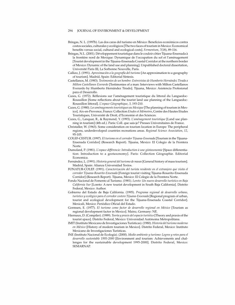
Bringas, N. L. (1997b). Las dos caras del turismo en México: Beneficios económicos contracostos sociales, culturales y ecológicos [The two faces of tourism in Mexico: Economicalbenefits versus social, cultural and ecological costs]. Fermentum, 7(18), 89-116.
Bringas, N.L. (2001). Développement touristique dans le couloir côtier Tijuana-Ensenada àla frontière nord de Mexique: Dynamique de l’occupation du sol et l’aménagement[Tourist development in the Tijuana-Ensenada Coastal Corridor at the northern borderof Mexico: Dynamic of the land use and planning]. Unpublished doctoral dissertation,Université Paris III, La Sorbonne Nouvelle, Paris.
Callizo, J. (1991). Aproximación a la geografía del turismo [An approximation to a geographyof tourism]. Madrid, Spain: Editorial Síntesis.
Castellanos, M. (1983). Testimonios de un hombre: Entrevistas de Humberto Hernández Tirada aMilton Castellanos Everardo [Testimonies of a man: Interviews with Milton CastellanosEverardo by Humberto Hernández Tirado]. Tijuana, Mexico: Asistencia Profesionalpara el Desarrollo.
Cazes, G. (1972). Réflexions sur l’aménagement touristique du littoral du Languedoc-Roussillon [Some reflections about the tourist land use planning of the Languedoc-Roussillon littoral]. L’espace Géographique, 3, 193-210.
Cazes, G. (1980). Les aménagements touristiques au Mexique [The planning of tourism in Mex-ico]. Aix-en-Provence, France: Collection Etudes et Mémoires, Centre des Hautes EtudesTouristiques, Université de Droit, d’Economie et des Sciences.
Cazes, G., Lanquar, R., & Raymond, Y. (1993). L’aménagement touristique [Land use plan-ning in tourism] (4th ed.). Paris: Coll. que sais-je? Presses Universitaires de France.
Christaller, W. (1963). Some consideration on tourism location in Europe: The peripheralregions, underdeveloped countries recreations areas. Regional Science Association, 12,95-105.
COLEF-CESTUR. (1997). El turismo en el corredor Tijuana-Ensenada [Tourism in the Tijuana-Ensenada Corridor] (Research Report). Tijuana, Mexico: El Colegio de la FronteraNorte.
Dumolard, P. (1981). L’espace différencie: Introduction à une géotaxonomie [Space differentia-tion: Introduction to a geotaxonomy]. Paris: Collection Géographie. EditorialEconomica.
Fernández, L. (1991). Historia general del turismo de masas [General history of mass tourism].Madrid, Spain: Alianza Universidad Textos.
FONATUR-COLEF. (1991). Caracterización del turista residente en el extranjero que visita elcorredor Tijuana-Rosarito-Ensenada [Foreign tourist visiting Tijuana-Rosarito-EnsenadaCorridor] (Research Report). Tijuana, Mexico: El Colegio de la Frontera Norte.
Fondo Nacional de Fomento al Turismo. (1981). Loreto: Un nuevo desarrollo turístico en BajaCalifornia Sur [Loreto: A new tourist development in South Baja California]. DistritoFederal, Mexico: Author.
Gobierno del Estado de Baja California. (1995). Programa regional de desarrollo urbano,turístico y ecológico para el corredor costero Tijuana-Ensenada [Regional program of urban,tourist and ecological development for the Tijuana-Ensenada Coastal Corridor].Mexicali, Mexico: Periódico Oficial del Estado.
Gormsen, E. (1977). El turismo como factor de desarrollo regional en México [Tourism asregional development factor in Mexico]. Mainz, Germany: NE.
Hiernaux, D. (Compiler). (1989). Teoría y praxis del espacio turístico [Theory and praxis of thetourist space]. Distrito Federal, Mexico: Universidad Autónoma Metropolitana.
IMIT (Instituto Mexicano de Investigaciones Turísticas). (1980). Historia del turismo modernoen México [History of modern tourism in Mexico]. Distrito Federal, Mexico: InstitutoMexicano de Investigaciones Turísticas.
INE (Instituto Nacional de Ecología). (2000). Medio ambiente y turismo: Logros y retos para eldesarrollo sustentable 1995-2000 [Environment and tourism: Achievements and chal-lenges for the sustainable development 1995-2000]. Distrito Federal, Mexico:SEMARNAP.
294 JOURNAL OF ENVIRONMENT & DEVELOPMENT
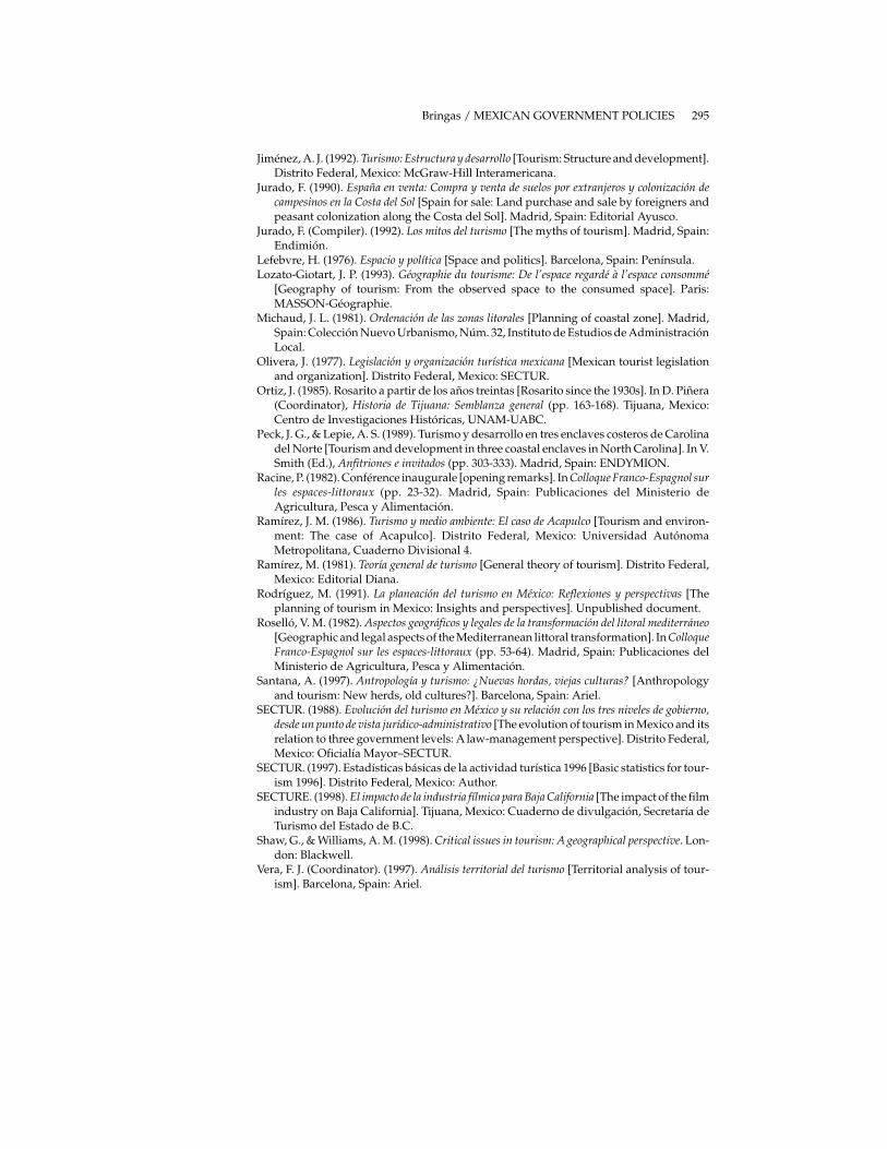
Jiménez, A. J. (1992). Turismo: Estructura y desarrollo [Tourism: Structure and development].Distrito Federal, Mexico: McGraw-Hill Interamericana.
Jurado, F. (1990). España en venta: Compra y venta de suelos por extranjeros y colonización decampesinos en la Costa del Sol [Spain for sale: Land purchase and sale by foreigners andpeasant colonization along the Costa del Sol]. Madrid, Spain: Editorial Ayusco.
Jurado, F. (Compiler). (1992). Los mitos del turismo [The myths of tourism]. Madrid, Spain:Endimión.
Lefebvre, H. (1976). Espacio y política [Space and politics]. Barcelona, Spain: Península.Lozato-Giotart, J. P. (1993). Géographie du tourisme: De l’espace regardé à l’espace consommé
[Geography of tourism: From the observed space to the consumed space]. Paris:MASSON-Géographie.
Michaud, J. L. (1981). Ordenación de las zonas litorales [Planning of coastal zone]. Madrid,Spain: Colección Nuevo Urbanismo, Núm. 32, Instituto de Estudios de AdministraciónLocal.
Olivera, J. (1977). Legislación y organización turística mexicana [Mexican tourist legislationand organization]. Distrito Federal, Mexico: SECTUR.
Ortiz, J. (1985). Rosarito a partir de los años treintas [Rosarito since the 1930s]. In D. Piñera(Coordinator), Historia de Tijuana: Semblanza general (pp. 163-168). Tijuana, Mexico:Centro de Investigaciones Históricas, UNAM-UABC.
Peck, J. G., & Lepie, A. S. (1989). Turismo y desarrollo en tres enclaves costeros de Carolinadel Norte [Tourism and development in three coastal enclaves in North Carolina]. In V.Smith (Ed.), Anfitriones e invitados (pp. 303-333). Madrid, Spain: ENDYMION.
Racine, P. (1982). Conférence inaugurale [opening remarks]. In Colloque Franco-Espagnol surles espaces-littoraux (pp. 23-32). Madrid, Spain: Publicaciones del Ministerio deAgricultura, Pesca y Alimentación.
Ramírez, J. M. (1986). Turismo y medio ambiente: El caso de Acapulco [Tourism and environ-ment: The case of Acapulco]. Distrito Federal, Mexico: Universidad AutónomaMetropolitana, Cuaderno Divisional 4.
Ramírez, M. (1981). Teoría general de turismo [General theory of tourism]. Distrito Federal,Mexico: Editorial Diana.
Rodríguez, M. (1991). La planeación del turismo en México: Reflexiones y perspectivas [Theplanning of tourism in Mexico: Insights and perspectives]. Unpublished document.
Roselló, V. M. (1982). Aspectos geográficos y legales de la transformación del litoral mediterráneo[Geographic and legal aspects of the Mediterranean littoral transformation]. In ColloqueFranco-Espagnol sur les espaces-littoraux (pp. 53-64). Madrid, Spain: Publicaciones delMinisterio de Agricultura, Pesca y Alimentación.
Santana, A. (1997). Antropología y turismo: ¿Nuevas hordas, viejas culturas? [Anthropologyand tourism: New herds, old cultures?]. Barcelona, Spain: Ariel.
SECTUR. (1988). Evolución del turismo en México y su relación con los tres niveles de gobierno,desde un punto de vista jurídico-administrativo [The evolution of tourism in Mexico and itsrelation to three government levels: A law-management perspective]. Distrito Federal,Mexico: Oficialía Mayor–SECTUR.
SECTUR. (1997). Estadísticas básicas de la actividad turística 1996 [Basic statistics for tour-ism 1996]. Distrito Federal, Mexico: Author.
SECTURE. (1998). El impacto de la industria fílmica para Baja California [The impact of the filmindustry on Baja California]. Tijuana, Mexico: Cuaderno de divulgación, Secretaría deTurismo del Estado de B.C.
Shaw, G., & Williams, A. M. (1998). Critical issues in tourism: A geographical perspective. Lon-don: Blackwell.
Vera, F. J. (Coordinator). (1997). Análisis territorial del turismo [Territorial analysis of tour-ism]. Barcelona, Spain: Ariel.
Bringas / MEXICAN GOVERNMENT POLICIES 295

Nora L. Bringas-Rábago is a researcher at the Urban and Regional Studies Program at the Colegiode la Frontera Norte in Tijuana, Mexico. Her research interests include land use management,regional development, and sustainable tourism.
296 JOURNAL OF ENVIRONMENT & DEVELOPMENT