Witnessed Presence in Merging Realities in Healthcare Environments
Upload
khangminh22Category
view
0download
0
HAL Id: hal-03009220https://hal.archives-ouvertes.fr/hal-03009220
Submitted on 17 Nov 2020
HAL is a multi-disciplinary open accessarchive for the deposit and dissemination of sci-entific research documents, whether they are pub-lished or not. The documents may come fromteaching and research institutions in France orabroad, or from public or private research centers.
L’archive ouverte pluridisciplinaire HAL, estdestinée au dépôt et à la diffusion de documentsscientifiques de niveau recherche, publiés ou non,émanant des établissements d’enseignement et derecherche français ou étrangers, des laboratoirespublics ou privés.
Merging regional and global aerosol optical depthrecords from major available satellite products
Larisa Sogacheva, Thomas Popp, Andrew Sayer, O. Dubovik, Michael Garay,Andreas Heckel, N. Christina Hsu, Hiren Jethva, Ralph Kahn, Pekka
Kolmonen, et al.
To cite this version:Larisa Sogacheva, Thomas Popp, Andrew Sayer, O. Dubovik, Michael Garay, et al.. Merging re-gional and global aerosol optical depth records from major available satellite products. AtmosphericChemistry and Physics, European Geosciences Union, 2020, 20 (4), pp.2031 - 2056. �10.5194/acp-20-2031-2020�. �hal-03009220�

Atmos. Chem. Phys., 20, 2031–2056, 2020https://doi.org/10.5194/acp-20-2031-2020© Author(s) 2020. This work is distributed underthe Creative Commons Attribution 4.0 License.
Merging regional and global aerosol optical depth records frommajor available satellite productsLarisa Sogacheva1, Thomas Popp2, Andrew M. Sayer3,4, Oleg Dubovik5, Michael J. Garay6, Andreas Heckel7,N. Christina Hsu8, Hiren Jethva3,4, Ralph A. Kahn8, Pekka Kolmonen1, Miriam Kosmale2, Gerrit de Leeuw1,Robert C. Levy8, Pavel Litvinov9, Alexei Lyapustin8, Peter North7, Omar Torres10, and Antti Arola1
1Finnish Meteorological Institute, Climate Research Programme, Helsinki, Finland2German Aerospace Center (DLR), German Remote Sensing Data Center (DFD), Oberpfaffenhofen, Germany3Goddard Earth Sciences Technology And Research (GESTAR), Universities Space Research Association,Columbia, MD, USA4NASA Goddard Space Flight Center, Greenbelt, MD, USA5Laboratoire d’Optique Atmosphérique, CNRS–Université Lille, France6Jet Propulsion Laboratory, California Institute of Technology, Pasadena, CA, USA7Department of Geography, Swansea University, Swansea, UK8Climate and Radiation Laboratory, Earth Science Division, NASA Goddard Space Flight Center, Greenbelt, MD 20771, USA9Generalized Retrieval of Atmosphere and Surface Properties SAS, Lille, France10Atmospheric Chemistry and Dynamics Laboratory, Earth Science Division,NASA Goddard Space Flight Center, Greenbelt, MD 20771, USA
Correspondence: Larisa Sogacheva ([email protected])
Received: 10 May 2019 – Discussion started: 21 June 2019Revised: 29 November 2019 – Accepted: 15 January 2020 – Published: 24 February 2020
Abstract. Satellite instruments provide a vantage point forstudying aerosol loading consistently over different regionsof the world. However, the typical lifetime of a single satel-lite platform is on the order of 5–15 years; thus, for climatestudies, the use of multiple satellite sensors should be con-sidered. Discrepancies exist between aerosol optical depth(AOD) products due to differences in their information con-tent, spatial and temporal sampling, calibration, cloud mask-ing, and algorithmic assumptions. Users of satellite-basedAOD time-series are confronted with the challenge of choos-ing an appropriate dataset for the intended application. Inthis study, 16 monthly AOD products obtained from dif-ferent satellite sensors and with different algorithms wereinter-compared and evaluated against Aerosol Robotic Net-work (AERONET) monthly AOD. Global and regional anal-yses indicate that products tend to agree qualitatively on theannual, seasonal and monthly timescales but may be offsetin magnitude. Several approaches were then investigated tomerge the AOD records from different satellites and create anoptimised AOD dataset. With few exceptions, all merging ap-
proaches lead to similar results, indicating the robustness andstability of the merged AOD products. We introduce a grid-ded monthly AOD merged product for the period 1995–2017.We show that the quality of the merged product is as least asgood as that of individual products. Optimal agreement of theAOD merged product with AERONET further demonstratesthe advantage of merging multiple products. This mergeddataset provides a long-term perspective on AOD changesover different regions of the world, and users are encouragedto use this dataset.
1 Introduction
Interactions of atmospheric aerosols with clouds and radi-ation are the largest source of uncertainty in modelling ef-forts to quantify current climate and predict climate change(IPCC, 2018). To reduce such uncertainties, we need obser-vations to constrain climate models. However, these observa-tions must be accurately calibrated and validated, have con-
Published by Copernicus Publications on behalf of the European Geosciences Union.

2032 L. Sogacheva et al.: Merging regional and global satellite AOD records
sistent or at least well-characterised uncertainties, and pro-vide adequate temporal and spatial sampling over a long pe-riod of time. With their ability to cover the globe systemati-cally, satellites provide this global and temporal perspective.Satellite observations have produced major advances in ourunderstanding of the climate system and its changes, includ-ing quantifying the spatio-temporal states of the atmosphere,land and oceans, and aspects of the underlying processes.However, as the typical lifetime of a single satellite platformis on the order of 5–15 years, a single sensor data recordmay not be long enough to discern a climate signal (WMO,2017). Moreover, aerosol products from different satellitesand algorithms all have limitations regarding their spatial andtemporal coverage and vary in their accuracies depending onenvironmental conditions (aerosol loading and type, surfacebrightness, and observation geometry), often leading to re-gional differences (e.g. Li et al., 2014b). Thus, the applica-tion of satellite observations for climate change studies re-quires using products from multiple sources to derive consis-tent regional conclusions.
The key parameter used for aerosol-related studies to dateis the aerosol optical depth (AOD), which is the vertical in-tegral of extinction by aerosol particles through the atmo-spheric column. Over the last several decades, AOD remotesensing has been performed from space using a wide va-riety of sensors that have different characteristics, includ-ing being passive or active, operating in ultraviolet (UV) tothermal infrared (TIR) spectral regions, being single-view tomulti-view, being single-pixel to broad swath, having a sub-kilometre to tens-of-kilometres resolution, being intensity-only or polarimetric, and having different orbits and obser-vation time(s). Table 1 lists the datasets used in the currentstudy, together with key references. Aside from the EarthPolychromatic Imaging Camera (EPIC; orbiting at L1 La-grange point directly between the Earth and the sun on theDeep Space Climate Observatory (DSCOVR) satellite), allsensors are in polar-orbiting, sun-synchronous low-earth or-bits (∼ 600–800 km). Only a few of these sensors were op-timised for accurate aerosol property retrieval, and for many,AOD at one or more visible wavelengths is the only quan-titatively reliable aerosol parameter they provide. Table 1 isnot exhaustive for available AOD products. Other AOD prod-ucts such as those from active sensors such as the Cloud-Aerosol Lidar with Orthogonal Polarization (CALIOP) andimaging radiometers on geostationary satellites are not con-sidered here, as they have very different sampling charac-teristics (e.g. CALIOP profiles a curtain swath, with areaseither viewed twice daily and twice during the night duringa month or not at all; geostationary sensors sample a con-stant disc, typical at a frequency of 10 min to 1 h); thus theirmonthly mean products are conceptually very different frompolar-orbiters.
No two datasets provide identical results, whether apply-ing the same algorithm principles to multiple similar sensors(Sayer et al., 2017, 2019; S. Li et al., 2016; Levy et al., 2013)
or even between “identical” sensors, such as the ModerateResolution Imaging Spectroradiometers (MODISs) on Terraand Aqua (Sayer et al., 2015; Levy et al., 2018) for which cal-ibration and time of day differences remain. Using differentretrieval algorithms for products retrieved from the same in-struments introduces additional discrepancies, such as thosefound by de Leeuw et al. (2015), Popp et al. (2016) for threeAlong Track Scanning Radiometer (ATSR) datasets.
Differences can become larger when comparing productsfrom different sensors and algorithms (Kokhanovsky and deLeeuw, 2009; Kinne, 2009; Li et al., 2014b). One other im-portant factor contributing to differences is related to the ap-proach to cloud masking, which affects the pixels selected forprocessing by retrieval algorithms and propagates into differ-ent levels of clear-sky bias in daily and monthly aggregates(Sogacheva et al., 2017; Zhao et al., 2013; Li et al., 2009).Escribano et al. (2017) estimated the impact of choosing dif-ferent AOD products for a dust emission inversion schemeand concluded that the large spread in aerosol emission fluxover the Sahara and Arabian Peninsula is likely associatedwith differences between satellite datasets. Similarly, Li etal. (2009) concluded that differences in cloud-masking alonecould account for most differences among multiple satelliteAOD datasets, including several for which different algo-rithms were applied to data from the same instrument.
There is no single “best” AOD satellite product globally.For example, the MODIS Deep Blue (DB) AOD productshows better performance than MODIS Dark Target (DT)in most regions, besides bright surfaces (i.e. deserts andarid/semi-arid areas) (Wei et al., 2019a). However, despitethe differences between satellite products and the fact thatnone is uniformly most accurate (Sayer et al., 2014; deLeeuw et al., 2015, 2018), the application of statistical tech-niques such as principal component or maximum covarianceanalysis (Li et al., 2013, 2014a, b) shows that there are keysimilarities among the AOD products tested.
Merging multi-sensor AOD products holds the potentialto produce a more spatially and temporally complete andaccurate AOD picture. With multiple observational datasetsavailable, it is important to examine their consistency in rep-resenting aerosol property variability in these dimensions.This is useful for constraining aerosol parameterisations inclimate models (Liu et al., 2006), in the study of aerosol cli-mate effects (Chylek et al., 2003; Bellouin et al., 2005) andfor verifying global climate models (e.g. Kinne et al., 2003,2006; Ban-Weiss et al., 2014) in which satellite-retrievedAOD monthly aggregates are used.
However, such an integration into a coherent and consis-tent climatology is a difficult task (Mishchenko et al., 2007;Li et al., 2009). There are only a few studies where an AODrecord was merged from different satellites. Chatterjee etal. (2010) describe a geostatistical data fusion technique thatcan take advantage of the spatial autocorrelation of AOD dis-tributions retrieved from the Multi-angle Imaging Spectrora-diometer (MISR) and MODIS, while making optimal use of
Atmos. Chem. Phys., 20, 2031–2056, 2020 www.atmos-chem-phys.net/20/2031/2020/

L. Sogacheva et al.: Merging regional and global satellite AOD records 2033
all available datasets. Tang et al. (2016) performed a spatio-temporal fusion of satellite AOD products from MODIS andSea-Viewing Wide Field-of-View Sensor (SeaWiFS) usinga Bayesian maximum entropy method for eastern Asia andshowed that, in the regions where both MODIS and Sea-WiFS have valid observations, the accuracy of the mergedAOD is higher than those of the MODIS and SeaWiFS AODsindividually. Han et al. (2017) improved the AOD retrievalaccuracy by fusing MODIS and CALIOP data. Sogachevaet al. (2018b) combined ATSR and MODIS AOD to studythe trends in AOD over China between 1995 and 2017.Naeger et al. (2016) combined daily AOD products frompolar-orbiting and geostationary satellites to generate a near-real-time (NRT) daily AOD composite product for a casestudy of trans-Pacific transport of Asian pollution and dustaerosols in mid-March 2014. J. Li et al. (2016) constructed amonthly mean AOD ensemble by combining monthly AODanomaly time series from MODIS, MISR, SeaWiFS, OzoneMonitoring Instrument (OMI) and POLarization and Direc-tionality of the Earth’s Reflectances (POLDER) and apply-ing an ensemble Kalman filter technique to these multi-sensor and ground-based aerosol observations to reduce un-certainties. Penning de Vries et al. (2015) examined rela-tionships between the monthly mean AOD, Ångström expo-nent (AE) from MODIS, UV Aerosol Index from the GlobalOzone Monitoring Experiment–2 (GOME-2) and trace gascolumn densities and showed the advantage of using multi-ple datasets with respect to characterising aerosol type. Boyset al. (2014) combined SeaWiFS and MISR AODs with theGEOS-Chem global model to create and study trends in a15-year time series of surface particulate matter levels.
A meaningful merge should account for the strengths andlimitations of each constituent record. The spread of satel-lite AOD records also adds to the value of constraining theiruncertainty; whereas a lack of diversity among datasets doesnot mean that they have converged on the true value, the ex-istence of unexplained diversity does imply that they havenot.
To assess their consistency, the products should be com-pared during overlapping periods, because interannual andshorter-term variability in atmospheric aerosols can be sig-nificant in some parts of the world (e.g. Lee et al., 2018). Inthe current study, AOD monthly aggregates from 16 differ-ent satellite products were evaluated with ground-based mea-surements from the Aerosol Robotic Network (AERONET;Holben et al., 1998). Note that, as with all measurements,even the AERONET spectral AOD has limitations as towhere it can be informative. For example, AERONET in-cludes∼ 450 active stations in 2019, offering far more spatialcoverage than in 1993 when the network was founded, yeteven now AERONET spatial sampling is particularly limitedin remote areas which are often those where aerosol gradi-ents are large, e.g. near sources (e.g. Shi et al., 2011; J. Li etal., 2016).
Based on the comparison with AERONET, we estimatehow well the satellite AOD monthly aggregates reproducethe AERONET AOD climatology. We considered areas withdifferent aerosol types, aerosol loading and surface types,which are the dominant factors affecting AOD product qual-ity. This allows users to choose the AOD product of a bet-ter quality, depending on the area and research objective. Averification of open-ocean monthly data using the MaritimeAerosol Network (MAN; Smirnov et al., 2009) is not pos-sible in this way, because MAN data are acquired duringcruises on ships of opportunity rather than as regular, repeat-ing observations at specific locations.
Different approaches for merging the AOD products (me-dian, weighted according to the evaluation results) are intro-duced in the current paper. AOD evaluation results are usedto merge the L3 gridded monthly AOD data and AOD timeseries for the period 1995–2017, using different method-ologies. The resulting AOD merged products are evaluatedagainst AERONET and compared against one another.
This study grew out of discussions at annual AeroSat(https://aerosat.org, last access: 9 May 2019) meetings abouthow to move forward on the difficult topic of combiningdistinct aerosol data records. AeroSat is a grass-roots groupof several dozen algorithm developer teams and data users.Meeting in person around once a year in concert with its sib-ling AeroCom group of aerosol modellers (https://aerocom.mpimet.mpg.de, last access: 9 May 2019) allows an activediscussion between data providers and data users to highlightdevelopments, discuss current issues and open questions inthe field of satellite aerosol remote sensing and aerosol mod-elling.
The paper is organised as follows. In Sect. 2, the AODproducts and regions of interest are introduced. The mainprinciples and results for the statistical evaluation of in-dividual monthly AOD retrievals are presented in Sect. 3.Alternative methods for merging are discussed in Sect. 4.AOD merged products are introduced, evaluated and inter-compared with individual products in Sect. 5. Annual, sea-sonal and monthly regional AOD time series are presentedand discussed in Sect. 6. A brief summary and conclusionare given in the final section.
2 Regions of interest, instruments and AOD products
2.1 Regions of interest
There are huge regional differences in AOD loading types(composition and optical properties), seasonality and surfacereflectance (Holben et al., 2001; Dubovik et al., 2002; Pintyet al., 2011). Retrieval quality (accuracy, precision and cov-erage) varies considerably as a function of these conditions,as well as whether a retrieval is over land or ocean. There-fore, this study focuses on surface-specific (land or ocean)and regional evaluation of these diverse aerosol products.
www.atmos-chem-phys.net/20/2031/2020/ Atmos. Chem. Phys., 20, 2031–2056, 2020

2034 L. Sogacheva et al.: Merging regional and global satellite AOD records
In addition to evaluating AOD products AOD over land,over ocean and globally (note that not all sensor–algorithmcombinations retrieve over both surfaces), we chose 15 re-gions that seem likely to represent a sufficient variety ofaerosol and surface conditions (Fig. 1 and Table S1 in theSupplement). These include 11 land regions, two ocean re-gions and one heavily mixed region. The land regions repre-sent Europe (denoted by Eur), Boreal (Bor), northern, easternand western Asia (AsN, AsE and AsW, respectively), Aus-tralia (Aus), northern and southern Africa (AfN and AfS),South America (AmS), and eastern and western NorthernAmerica (NAE and NAW). The Atlantic Ocean is repre-sented as two ocean regions, one characterised by Saha-ran dust outflow over the central Atlantic (AOd) and a sec-ond that includes burning outflow over the southern Atlantic(AOb). The mixed region over Indonesia (Ind) includes bothland and ocean. Due to documented large changes in AODduring the last 25 years (Sogacheva et al., 2018a, b), we alsoconsidered the south-eastern China (ChinaSE) subset of theAsE region.
The main body of the paper focuses on two regions, Eu-rope and ChinaSE, and the big-picture results (global, allland and all ocean). The two regions, Europe and ChinaSE,were chosen because they are often the focus of aerosol stud-ies. Results from the remaining regions are presented in theSupplement.
2.2 Instruments, algorithms and AOD products
An overview of the instruments and AOD products includedin this study is presented in Table 1. AOD products fromthe same instruments retrieved with different algorithms arenamed in the paper with the instrument and retrieval algo-rithms, e.g. ATSR dual-view (ADV), ATSR Swansea Uni-versity (SU), Terra Dark Target (DT) & Deep Blue (DB) andTerra MAIAC (multi-angle implementation of atmosphericcorrection). When both Terra and Aqua are considered, wecall them together as MODIS DT&DB or MODIS MAIAC.Note that we used the merged MODIS Dark Target and DeepBlue product (Sayer et al., 2014; denoted “DT&DB”), ratherthan the results of the individual DB and DT algorithms, asthis merged dataset was introduced into the product for sim-ilar purposes as the one explored in this work. An ensem-ble ATSR product (ATSR_ens) was generated from the threeATSR products (ATSR ADV, ATSR SU and ATSR ORAC– ATSR with the optimal retrieval of aerosol and cloud algo-rithm) in order to combine the strengths of several algorithmsand to increase the coverage of the combined product (Kos-male et al., 2020). The ensemble was calculated per pixel asthe weighted mean of the individual algorithm values withweights given by the inverse of the individual pixel level un-certainty values. The ensemble algorithm required as a mini-mum for each pixel to have valid results from at least two ofthe contributing algorithms. The uncertainties in each algo-
rithm were first corrected in their absolute values to agree onaverage with the mean error.
For some products, AOD data are available for wave-lengths other than 0.55 µm. Specifically, Total Ozone Map-ping Spectrometer (TOMS) and OMI products include AODat 0.50 µm, Advanced Very-High-Resolution Radiometer(AVHRR) NOAA includes AOD at approximately 0.63 µm(with slight variation between the different AVHRR sensors),and EPIC AOD is available at 0.44 µm (in the dataset used inthe current study). If the wavelength is not mentioned specif-ically, 0.55 µm is implicit.
In most cases the official AOD monthly products (typi-cally referred to as Level 3 or L3 data), which correspond toarithmetic means of daily mean data aggregated onto (typ-ically) a 1◦× 1◦ grid, have been used without further pro-cessing. The first exceptions are for AVHRR NOAA andPOLDER, which provide very high AOD values poleward ofca. 60◦ and over Hudson Bay (50–70◦ N, 70–95◦ E), respec-tively. The values are unrealistic, a likely a consequence ofcloud and/or sea ice contamination. To eliminate those unre-alistic values, AOD values of > 0.7 have been removed overthe mentioned-above areas. Applying that limit decreased theoffset between the AVHRR NOAA product and other prod-ucts but did not eliminate it (see Sect. S2 in the Supplementfor details). Additionally, MISR standard (0.5◦× 0.5◦ reso-lution) and AVHRR NOAA (0.1◦× 0.1◦ resolution) L3 AODproducts were aggregated by simple averaging to 1◦ to matchthe other datasets.
Due to differences in instrument capabilities and swathwidths (Table 1), the spatial and temporal data samplingavailable for calculating monthly averages varies consider-ably among the satellite products. The ATSR products andMISR have narrow swaths and generally provide only a fewdays with retrievals per month, whereas most of the rest seethe whole planet roughly every day or two so that their cover-age is mostly limited by, e.g. the persistence of cloud cover.As mentioned previously, EPIC is a special case, as it pro-vides moving snapshots of the day-lit portion of the Earth, upto several times per day, as distinct from overpasses at onlyspecific local solar equatorial crossing times for the sensorson polar-orbiting satellites. Further, TOMS and OMI have anotably coarser pixel resolution than the others, so their cov-erage and quality are more sensitive to cloud masking de-cisions. Some datasets provide measures of internal diver-sity (e.g. standard deviation), but none currently provides es-timates of the monthly aggregate uncertainty against somestandard, which would be a combination of (both systematicand random) retrieval uncertainties and sampling limitations.This is an area currently being investigated by AeroSat dueto the wide use of L3 products.
For the intercomparison between AOD products, we chosethree “reference” years:
– 2000, when the AOD products from TOMS, AVHRRNOAA, SeaWiFS, ATSR-2, MODIS Terra and MISR
Atmos. Chem. Phys., 20, 2031–2056, 2020 www.atmos-chem-phys.net/20/2031/2020/

L. Sogacheva et al.: Merging regional and global satellite AOD records 2035
Figure 1. Fifteen land and ocean regions defined in this study: Europe (Eur), Boreal (Bor), northern Asia (AsN), eastern Asia (AsE), westernAsia (AsW), Australia (Aus), northern Africa (AfN), southern Africa (AfS), South America (SA), eastern North America (NAE), westernNorth America (NAW), Indonesia (Ind), Atlantic Ocean dust outflow (AOd) and Atlantic Ocean biomass burning outflow (AOb). In addition,south-eastern China (ChinaSE), which is part of the AsE region, marked with a blue frame, is considered separately. Land, ocean and globalAOD were also considered.
are available (for the full year, except for MISR andMODIS Terra, which were available from March to De-cember);
– 2008, when the AOD products from Advanced ATSR(AATSR), MODIS Terra and Aqua, MISR, AVHRRNOAA, AVHRR DB/SOAR (Satellite Ocean AerosolRetrieval), SeaWiFS and POLDER are available; and
– 2017, when the AOD products from MODIS Terraand Aqua, MISR, VIIRS (Visible Infrared Imaging Ra-diometer Suite) and EPIC are available.
For products with no coverage over ocean (TOMS, OMI andMAIAC products) or land (AVHRR NOAA), global AODwas not considered.
3 AOD products intercomparison and evaluation withAERONET
The AOD deviations of the individual products from the me-dian AOD (Figs. S1 and S2 in the Supplement) are discussedin detail in the Supplement (Sect. S2). These show regionaldifferences, even for products retrieved from the same instru-ments with similar algorithm. Both negative and positive de-viations are observed in regions with high AOD; both aerosoloptical model assumptions and surface type are also likelyto influence the AOD retrieval. High AOD might, in turn, bewrongly screened as cloud, and thus the resulting lack of high
AOD retrieval leads to a low bias in monthly AOD. To furtherreveal differences among the AOD products retrieved withdifferent algorithms and applied to different satellites, thediversity of the satellite annual mean AOD for years 2000,2008 and 2017 is discussed in Sect. S3 (Figs. S3 and S4).The diversity is lower in 2017, when only MODIS, MISR,EPIC and VIIRS AOD products are available.
3.1 Evaluation of monthly AOD
To evaluate the quality of any AOD product, the verifica-tion of the product against more accurate reference measure-ments, where possible, is obligatory. Ground-based measure-ments such as those from AERONET (cloud screened andquality assured Version 3 Level 2.0; Giles et al., 2019) pro-vide highly accurate measures of AOD that are widely usedas ground truth for the validation of satellite AOD data. Ex-tensive L2 AOD validation has been performed for differentaerosol products.
However, climate model evaluation is often performed onmonthly scales. Thus, climate analysis begs for evaluationof satellite AOD monthly aggregates (Nabat et al., 2013;Michou et al., 2015; S. Li et al., 2016). Only a few at-tempts have been made to evaluate AOD monthly aggre-gates retrieved from satellites (e.g. Li et al., 2014b, Wei etal., 2019b). This is because verification of the L3 monthlyaggregate satellite AOD is not a true validation (and note theuse of “evaluation” and “verification” here instead of “valida-
www.atmos-chem-phys.net/20/2031/2020/ Atmos. Chem. Phys., 20, 2031–2056, 2020

2036 L. Sogacheva et al.: Merging regional and global satellite AOD records
Table 1. Overview of the sensors, data records and AOD algorithms discussed in this paper. For the products availability, see Table 4.
Sensor(s) Coverage and L3 gridsize
Algorithm version Algorithm principles References
Total Ozone Mapping Spec-trometer (TOMS) (UV spec-trometer)
1979–1993 and 1996–2001; 3100 km swath;1◦; daily and monthly
Nimbus-7/TOMS:N7AERUV v. 0.4.3;EP/TOMS: EPAERUVv. 0.1.3.
Enhanced sensitivity of TOA(top of the atmosphere) spectralreflectance in the UV to aerosolextinction and absorption.
Torres et al. (1998, 2005)
Advanced Very-High-Resolution Radiometer(AVHRR)
1981–2017; 2900 kmswath; 0.1◦; daily andmonthly
AVHRR NOAA Single-channel retrieval ofaerosol optical depth; overocean only.
Ignatov and Stowe (2002) Hei-dinger et al. (2002), Zhao etal. (2008)
(bispectral, single-view, broad-swath radiometer)
1989–1991 (NOAA7),1995–1999 (NOAA14)and 2006–2011(NOAA18); 0.5 and 1◦;daily and monthly
Deep Blue/SOAR, V. 4 Land: surface modelled usingdatabase or NDVI (normaliseddifference vegetation index).Ocean: bispectral simultaneousretrieval.
Hsu et al. (2017), Sayer etal. (2017)
Along Track Scanning Ra-diometer (ATSR-2) and Ad-vanced ATSR (AATSR), bothcalled as ATSR
1995–2003 (ATSR-2)and 2002–2012(AATSR);512 km swath; 1◦; dailyand monthly
ADV/ASVv2.31
Land: spectral constant re-flectance ratio.Ocean: modelled reflectance.
Flowerdew and Haigh (1995),Veefkind et al. (1998), Kolmo-nen et al. (2016), Sogacheva etal. (2017)
(dual-view radiometer in thevisible and near-infrared; ther-mal infrared for cloud)
SU v4.3 Iterative model inversion forcontinuous retrieval of AODand FMF. Land: retrieval ofBRDF parameters. Ocean: priorreflectance model.
North et al. (1999), North(2002), Bevan et al. (2012)
ORAC v4.01 (in current pa-per, as a part of the ATSRensemble only)
Optimal estimation.Land: SU surface parametriza-tion.Ocean: sea surface reflectancemodel.
Thomas et al. (2009), Sayer etal. (2010)
ATSR ensemble v. 2.7 Uncertainty-weighted mean ofATSR2/AATSR baseline algo-rithms ADV, ORAC and SU.
Kosmale et al. (2020)
Sea-viewing Wide Field-of-view Sensor (SeaWiFS)(multispectral, single-view,broad-swath radiometer)
1997–2010;1502 km swath; 0.5 and1◦; daily and monthly
Deep Blue/SOARV.1
Land: surface modelled usingdatabase or NDVI.Ocean: multispectral simulta-neous retrieval.
Sayer et al. (2012a, b), Hsu etal. (2004, 2013a)
Multi-angle Imaging Spec-troRadiometer (MISR)(multispectral, with fourbands, visual–near-infrared,multi-angle, i.e. nine angles,radiometer)
2000–present; 380 kmswath; 0.5◦; daily andmonthly
Standard algorithm (SA)V23
Land: surface contribution es-timated by empirical orthogo-nal functions and assumption ofspectral shape invariance.Ocean: two-band (red, NIR) re-trieval using cameras not af-fected by sun glint.Both: lookup table with 74 mix-tures of 8 different particle dis-tributions.
Martonchik et al. (2009), Garayet al. (2017, 2019), Witek etal. (2018), Kahn et al. (2010)
Moderate Resolution ImagingSpectroradiometer (MODIS)Terra and Aqua (multispec-tral, single-view, broad-swathradiometer)
Terra: 2000–present;Aqua: 2002–present;2300 km swath; 1◦;daily, 8 d and monthly
DT&DBC6.1
DT: surface is function of windspeed (ocean) or parameter-ized spectral relationship (land–vegetation/dark soil).DB: database and spectral rela-tions of surface reflectance.
DT: Levy et al. (2013, 2018),Gupta et al. (2016)DB: Hsu et al. (2013a, 2019)DT&DB: Levy et al. (2013),Sayer et al. (2014)
MAIAC V6 Simultaneous retrieval of sur-face and aerosol from time se-ries of observations.
Lyapustin et al. (2018)
Ozone Monitoring Instrument(OMI) (UV spectrometer)
2004–2016; 2600 kmswath; 1◦; daily andmonthly
OMAERUV v. 1.8.9.1 Enhanced sensitivity of TOAspectral reflectance to UVaerosol extinction and absorp-tion.
Jethva and Torres (2011), Tor-res et al. (2007, 2013, 2018)
Atmos. Chem. Phys., 20, 2031–2056, 2020 www.atmos-chem-phys.net/20/2031/2020/

L. Sogacheva et al.: Merging regional and global satellite AOD records 2037
Table 1. Continued.
Sensor(s) Coverage and L3 gridsize
Algorithm version Algorithm principles References
Polarization and Directional-ity of the Earth’s Reflectances(POLDER) 3 (multispectral,multi-angle polarimeter)
Dec 2004–Dec 20132100km× 1600 kmswath; 1◦; daily,monthly and seasonally
GRASP v.1 Simultaneous retrieval of sur-face and aerosol in frame ofmulti-pixel approach: statisti-cally optimised fitting of largepixels groups (aggregated intime and space); the aerosol isassumed as an external mixtureof several predefined aerosolcomponents.
Dubovik et al. (2011, 2014,2019)
Visible Infrared Imaging Ra-diometer Suite (VIIRS) (mul-tispectral, single-view, broad-swath radiometer)
2012–present; 3040 kmswath; 1◦; daily andmonthly
Deep Blue/SOAR, V.1 Land: surface modelled usingdatabase or spectral relation-ship.Ocean: multispectral simulta-neous retrieval.
Sayer et al. (2018a, b, 2019),Hsu et al. (2019)
Earth Polychromatic ImagingCamera (EPIC) (multispectralradiometer orbiting at Lagrangepoint)
2015–2016; 1◦; dailyand monthly
MAIAC V1 Simultaneous retrieval of sur-face and aerosol from time se-ries of observations.
Huang et al. (2020)
tion”). AERONET provides AOD at a single point and is notnecessarily representative of AOD in a 1◦× 1◦ grid. WhileAERONET samples during all cloud-free daylight hours, agiven polar-orbiting sensor will only report once per day andat the same time each day (e.g. 13:30 LT for sensors in the A-Train). The possible spatial representativity issues associatedwith this latter point are a topic of current investigation (e.g.J. Li et al., 2016; Virtanen et al., 2018; Schutgens, 2019).Nevertheless, AERONET’s instantaneous AOD uncertainty(around 0.01 in the mid-visible; Eck et al., 1999) is signif-icantly lower than most satellite products, and its temporalsampling is much more complete. As such, it remains a use-ful source for evaluating these L3 products, and for this pur-pose we compare AOD monthly aggregates of all availabledata from both AERONET and each satellite product. Devi-ations between satellite and AERONET monthly aggregatesare expected, e.g. due to differences in satellite spatial andtemporal sampling (Sect. 2.2, Table 1), particularly for thosesatellites with lower coverage.
Results from this comparison have limitations. As men-tioned previously, AERONET provides data over certain lo-cations within a grid cell, whereas satellites cover a largerfraction of the area of a grid cell (depending on samplingand cloud cover). So, for example, if AERONET is likelyto miss extreme high values (localised plumes missing anAERONET station), that will result in AERONET showinglower AOD than from a satellite. Conversely, if a station hap-pens to be directly under an aerosol plume and the satellitealgorithm filters as a cloud, the AERONET value would behigher.
Neither AERONET nor satellite monthly AOD aggregatesare true monthly AOD values. When we refer to “AODmonthly aggregate” we mean the daytime, cloud-free AODmonthly aggregated from whatever data are available. How
the aggregate is calculated is also important; AOD distribu-tions on monthly scales are often closer to lognormal thannormal, which suggests that the arithmetic monthly meanmay not be the most appropriate summary metric (O’Neillet al., 2000; Sayer and Knobelspiesse, 2019). The discrep-ancies between different statistics can be exacerbated whena dataset provides poor sampling of the extreme conditions.Nevertheless, as it is the most widely used statistic within thecommunity and is the standard output of current L3 products,monthly means are presented in this analysis. The generalframework could be applied to other AOD summary statis-tics (e.g. monthly median or geometric mean, advocated bySayer and Knobelspiesse, 2019) if these L3 outputs becomemore widely available in the future.
In the evaluation exercise, AERONET monthly meanAOD and AE (which describes how AOD depends on wave-length and is sometimes used as a proxy for aerosol type)were calculated from AERONET daily means. AOD verifi-cation was performed for all available AERONET monthlydata and separately for different aerosol types, which weredefined with AOD and AE thresholds. Although these thresh-olds are subjective, we consider “background aerosol” tobe cases where AOD< 0.2, “fine-dominated” to be whereAOD> 0.2 and AE> 1, and “coarse-dominated” to be caseswhere AOD> 0.2 and AE< 1 (e.g. Eck et al., 1999). Thisclassification has also been used by e.g. Sayer et al. (2018b)and Sogacheva et al. (2018a, b). The annual and seasonalmaps of prevailing aerosol type for AERONET locations,calculated from the AERONET data available for the periodof 1995–2017, are shown in Fig. S5. Such a classificationdifferentiates major aerosol scenarios. The biomass burningseasons over the Amazon and South Africa are clearly iden-tified by a domination of the fine aerosol particles in JJA(June, July, August) and SON (September, October, Novem-
www.atmos-chem-phys.net/20/2031/2020/ Atmos. Chem. Phys., 20, 2031–2056, 2020

2038 L. Sogacheva et al.: Merging regional and global satellite AOD records
ber), and the Asian dust transport season in MAM (March,April, May) is clearly coarse dominated. As the deviationof each satellite product from the median has regional com-ponents (Figs. S1 and S2). Even though we tried to chooseregions with (somewhat) homogeneous aerosol conditionsduring a given season, AOD conditions (and thus algorithmperformance) might vary within the regional AERONET sta-tions, which may represent different aerosol/surface condi-tions within one study regions, may have different recordlengths. To keep similar weighting for each station in a re-gion, we first calculated statistics for each AERONET stationseparately and then calculated the regional median validationstatistics from all available stations.
To reveal how retrieval quality depends on AOD load-ing, offsets between AERONET AOD and satellite productAOD were estimated for binned AERONET AOD, and thenumber of observations in each AOD bin is reported. Cor-relation coefficient (R, Pearson correlation), offset (satelliteproduct−AERONET), root-mean square error (RMSE) andfraction of points that fulfil the Global Climate ObservingSystem (GCOS) uncertainty goals (GE) of the larger of 0.03or 10 % of AOD (GCOS, 2011) are also reported.
These monthly AOD verification results are used to calcu-late weights for each satellite dataset in one of the mergingapproaches later in Sect. 4.2.
3.1.1 Binned offset global evaluation
As an example, AOD-binned evaluation results are shown inFig. 2. for Terra DT&DB and in Fig. S6 for all products.A general tendency towards positive satellite-retrieved AODoffsets is observed for most products under background con-ditions. On average, 70 %–80 % of monthly AODs fall intoclass “background” (AOD≤ 0.2), so total AOD mean biasesare expected to have similar behaviour. TOMS and OMI havethe highest positive offsets globally, which is in line with theresults from the dataset spatial intercomparison (Sect. S2).Offsets close to 0 for background AOD are observed for theMODIS MAIAC products.
For most products, except MODIS DT&DB, AOD offsetsbecome negative for AOD> 0.2 (fine- and coarse-dominatedaerosol types) with increasing amplitude (up to 0.2–0.5) to-wards highest AOD values. MODIS DT&DB show the low-est offsets for 0.2< AOD< 1. Offsets for VIIRS are closeto 0 for AOD< 0.5 and reach ca. 30 % of AOD at AOD≈ 1.For the current MISR standard product, AOD is systemat-ically underestimated for AOD>∼ 0.5; this is largely dueto treatment of the surface boundary condition at high AOD(Kahn et al., 2010) and is addressed in the research aerosolretrieval algorithm (Garay et al., 2019; Limbacher and Kahn,2019). Except for TOMS and Terra MAIAC, offsets aresmaller for coarse-dominated AOD.
AOD products retrieved from satellites having better cov-erage show a better agreement with AERONET monthly ag-gregates. Thus, sampling differences (swath and pixel selec-
Figure 2. Difference between Terra DT&DB and AERONETmonthly AOD for selected AOD bins: median bias (circles), biasstandard deviation (error bars) for all AOD types (purple), back-ground aerosol (purple; AOD≤ 0.2), fine-dominated AOD (blue)and coarse-dominated AOD (green) The fraction (F) of points ineach bin is represented by orange bars. For all individual productssee Fig. S6.
tion) are critical in evaluation of monthly products, as ex-pected but are not the only factor influencing the evaluationresults.
3.1.2 AOD evaluation over selected regions
Due to differences in instrument specifications and retrievalapproaches, the performance of retrieval algorithms dependslargely on aerosol type, aerosol loading and surface proper-ties at certain locations (e.g. Sayer et al., 2014). In this sec-tion we show the evaluation results for AOD products in twoselected regions: Europe and ChinaSE (Fig. 3). Results forall regions are shown in Fig. S7. For each region, statistics(R, % of points in GE, offset and RMSE) for all 16 productsare combined into one subplot. The merged AOD product Mis introduced in Sect. 5.2; evaluation results for that productare summarised in Sect. 5.2.1.
Algorithm performance over Europe is similar for mostproducts, with an R of 0.55–0.65, 45 %–55 % of the pixelsin the GE, an offset of 0.05–0.1 and RMSE of ∼ 0.1. ForTOMS and OMI, the performance of each is slightly worsethan for other products in Europe. In ChinaSE, the offset(0.1–0.2) and RMSE (0.2–0.3) are considerably higher thanin Europe, and fewer pixels fit within the GE (15 %–30 %).This is likely due to a combination of high AOD loading andaccompanying high uncertainty in the products, indicated byhigh variability in aerosol composition and surface proper-ties. In Indonesia and for the biomass burning outflow overthe Atlantic, the MODIS and MISR products show a betteragreement with AERONET than the ATSR-family products.
Atmos. Chem. Phys., 20, 2031–2056, 2020 www.atmos-chem-phys.net/20/2031/2020/

L. Sogacheva et al.: Merging regional and global satellite AOD records 2039
Several products which use different surface treatment(ATSR SU, MODIS-family and MISR) show a similarlyhigher R over AfN, an area of high surface reflectance. How-ever, a high R does not imply that performance is better, onlythat variations in AOD are captured better. Other statistics(number of pixels within GE, offset and RMSE) in AfN areworse compared with those in Europe.
Overall, no single product has the best statistics for allmetrics and regions. Retrievals tend to perform well in ar-eas with darker (more vegetated) surfaces and where aerosoltype is less variable over time. In these cases, biases are smalland retrieval uncertainties are often better than the GE, track-ing temporal AOD variability well but with a tendency tounderestimate high-AOD events. In more complex tropicalenvironments, data should be used with greater caution, asthere is a greater tendency to underestimate AOD. However,correlation often remains high, suggesting a good ability toidentify monthly AOD variations, despite this underestima-tion.
3.2 AOD time series
In order to move towards consistency in regional and globalAOD records derived from multiple satellites using differentsensors and retrieval techniques, this section examines an-nual regional AOD time series obtained from the differentproducts.
Besides the positive offset for TOMS and OMI (Figs. S1,S2, S6 and S7), consistent temporal patterns are observed,and similar interannual AOD variability is tracked by alldatasets (Figs. 4 and S8). AOD peaks in Europe in 2002,in ChinaSE in 2006/2007, 2011 and 2014, (possibly relatedto changes in anthropogenic emissions; Sogacheva et al.,2018a, b). Relative AOD peaks over the Atlantic dust areain 1998, 2012 and 2015 (Peyridieu et al., 2013), and obviousAOD peaks in Indonesia related to the intensive forest firesin 1997, 2002, 2006 and 2015 (Chang et al., 2015; Shi et al.,2019) are clearly seen.
However, significant regional offsets between products ex-ist, which are largest in regions with high aerosol load-ing. Over ChinaSE, MODIS-family products show highermonthly AOD compared to all others. Over AfN, ATSRSU and ATSR_ens reach higher monthly aggregated AODthan the MODIS-family products, whereas comparisons withAERONET are similar for ATSR and MODIS (with slightlyhigher RMSE for ATSR by 0.05); differences are likely tiedto the small number of stations in this region. A large off-set between MODIS and ATSR is revealed over Australia(Fig. S8).
AOD annual cycles for individual products for theyear 2008 are discussed in Sect. S8. As in the annual timeseries (Figs. 4 and S8), the annual AOD cycles are similarbetween the products (Fig. S9), with more pronounced devi-ations in areas of high AOD.
4 AOD merging approaches
Here, 12 AOD products (all available at 0.55 µm) were usedto create a merged AOD product for the period of 1995–2017.The temporal availability of the AOD products is shown inTable 2 (counting cases of partial coverage of a dataset duringa year as available).
We tested two broad approaches for merging, summarisedin Fig. 5. In the first, the median AODs from the available(10 globally and two over land) individual uncorrected andoffset-adjusted (shifted to a common value) products werecalculated (approach 1, Sect. 4.1 for details). In the sec-ond approach, AOD-weighted means were created where theweights for individual products were derived from the eval-uation with the AERONET through two different rankingmethods (see approach 2 in Sect. 4.2 for details). The samemerging scheme was applied to the L3 uncorrected products(Sect. 2.2) and regional time series (Sect. 3.1) yielding 10merged AOD products and 10 merged regional time series.
To achieve best estimates of the regional AOD by merg-ing multi-sensor monthly AOD data, the systematic and ran-dom components of uncertainties within each product shouldbe considered explicitly. However, this cannot yet be done;only some of the L2 products used to create the L3 monthlyproducts contain pixel-level propagated or estimated uncer-tainties, and their associated propagations to L3 products(together with other contributions from e.g. sampling lim-itations) have not yet been quantified robustly. The analysisherein therefore represents an initial effort in the absence of afull uncertainty budget. Uncertainties for the chosen mergedL3 product (details are discussed in Sect. 5.2.2) were esti-mated as the root-mean-squared sum of the deviations be-tween the chosen merged product and either the median fromthe all uncorrected products (approach 1) or each of the otherseven merged products (approach 2).
4.1 Approach 1: AOD median for uncorrected andoffset-adjusted (shifted) AOD products
The mean (arithmetic average) value, although commonlyused in climate studies, is not generally equal to the mostfrequently occurring value (the mode) and may not reflect thecentral tendency (the median) of strongly asymmetrical dis-tributions such as those that can be found for AOD (O’Neillet al., 2000; Sayer and Knobelspiesse, 2019). Although thecentral limit theorem implies that this should be less of aneffect when making an estimate of the mean AOD from acluster of AOD datasets (i.e. a merged time series), in prac-tice this is unlikely to be fully the case because the differ-ent datasets are not independent estimates of the underly-ing AOD field. This is because they are made with sensorsand techniques which are not independent (i.e. typically sim-ilar spectral/spatial bands and sampling limitations) and mayhave different bias characteristics. Further, by itself, the meandoes not provide any information about how the observations
www.atmos-chem-phys.net/20/2031/2020/ Atmos. Chem. Phys., 20, 2031–2056, 2020

2040 L. Sogacheva et al.: Merging regional and global satellite AOD records
Figure 3. AERONET evaluation statistics for Europe and ChinaSE: correlation coefficient R, bar, and fraction of pixels satisfying the GCOSrequirements, GE, ⊕; offset (satellite product−AERONET), 1, and root-mean-square error RMSE, *. Shown for AOD monthly aggregatesfor each product (1 : 16; legend for products below the plot) and the L3 merged product (M; approach 2 with RM2 for all aerosol types; fordetails see Sect. 4.2) with corresponding colours (legend) for the selected regions (as in Fig. 1).N is the number of matches with AERONET.Note, for products that do not provide the global coverage (e.g. no retrieval over oceans), the results are missing. For all studied regions, seeFig. S7.
Figure 4. Annual AOD time series from different products (see legend) for Europe and ChinaSE. For all selected regions see Fig. S8.
are scattered, whether they are tightly grouped or broadlyspread out. Thus, we study the median (which is more robustin the presence outliers which might be caused by a poorlyperforming algorithm in a certain region) and standard devi-ations (as a metric of diversity) between the products chosenfor merging.
As shown in Sect. 3, the AOD time series of different prod-ucts display highly consistent temporal patterns, albeit withspatiotemporally varying offsets (Figs. 4, S8 and S9). We usethe Terra DT&DB product as a reference to estimate the av-erage offsets between products, because its time period over-laps with each AOD product considered in the current study.
Means and standard deviations of the offsets for all in-dividual products from the Terra DT&DB AOD are shownin Fig. 6 for Europe and ChinaSE and in Fig. S10 for allselected regions. Offset magnitudes and their variations de-pend on AOD loading; offsets are typically higher for highAOD. Over land, ocean and thus globally, the offset is nega-tive relative to Terra DT&BD for most of the products. Thisincludes Europe and ChinaSE. However, over the bright sur-
face area in northern Africa, AVHRR DT/SOAR, VIIRS,ATSR SU and ATSR ensemble show high (0.05–0.1) posi-tive bias. Also, all ATSR products are biased high in Aus-tralia and South America. Thus, the median for the offset-adjusted product is expected to be positive biased. For de-tails, see Sect. 5.1, where evaluation results for the AODproducts merged with different approaches are discussed.
With the shifted median merging approach, each AODproduct was shifted on a regional basis, based on its regionaloffset with respect to Terra DT&DB (Sect. 5.2). The medianand standard deviation of AOD time series were then derivedfrom these 10 shifted and Terra DT&DB data records.
4.2 Approach 2: weighted AOD
4.2.1 Method
As shown in Sect. 3.1, the products differ in the degree towhich each represents the AERONET values on the monthlyscale. Our second approach is a weighted mean AOD, where
Atmos. Chem. Phys., 20, 2031–2056, 2020 www.atmos-chem-phys.net/20/2031/2020/

L. Sogacheva et al.: Merging regional and global satellite AOD records 2041
Table 2. Availability and coverage of the AOD products for merging for each year in the period 1995–2017. N : annual number of availableproducts.
Year AVHRR SeaWiFS VIIRS ATSR ATSR ATSR Terra Terra Aqua Aqua MISR POLDER N
DT/SOAR ADV SU ensemble DT&DB MAIAC DT&DB MAIACglobal global global global global global global land global land global global
1995 × × × × 41996 × × × × 41997 × × × × × 51998 × × × × × 51999 × × × × × 52000 × × × × × × × 72001 × × × × × × × 72002 × × × × × × × × 82003 × × × × × × × × × × 92004 × × × × × × × × × × 92005 × × × × × × × × × × 102006 × × × × × × × × × × × 112007 × × × × × × × × × × × 112008 × × × × × × × × × × × 112009 × × × × × × × × × × × 112010 × × × × × × × × × × × 112011 × × × × × × × × × × 102012 × × × × × × × 72013 × × × × × × × 72014 × × × × × × 62015 × × × × × × 62016 × × × × × × 62017 × × × × × × 6
Figure 5. Scheme for the merging approaches; applied for L3 products or regional time series.
the weights are assigned based on the agreement of eachdataset with monthly AERONET averages. This representsan initial attempt to adjust the level of confidence assignedto each product on a regional basis; better-comparing prod-ucts are given more weight in the calculation of a combinedproduct.
An AOD-weighted mean was calculated, with a rankingapproach based on the statistics from the AERONET com-parison for AOD: R, bias, RMSE, GE (Figs. 4 and S8) andmedian bias of the binned AOD in the range [0.45, 1] (Figs. 3and S7). The last criterion was added to specifically consideralgorithm performance for higher AOD.
www.atmos-chem-phys.net/20/2031/2020/ Atmos. Chem. Phys., 20, 2031–2056, 2020

2042 L. Sogacheva et al.: Merging regional and global satellite AOD records
Figure 6. Regional annual average AOD offset between eachdataset and the Terra DT&DB dataset. GCOS requirement of±0.03is shown as a background colour. For all selected regions, seeFig. S10.
Two ranking methods were tested. For the first rankingmethod (RM1) based on best statistics, the 12 products wereranked from 1 (worst) to 12 (best) for each statistic (R, GE,RMSE, bias and binned bias) separately. The five separateranks were then summed, so the maximum possible rank is12 · 5= 60. A downside of this method is that when severalproducts have similar statistics small variations in statisticscan produce large spread in ranking. Note that no productreceived a perfect (60) rating.
To overcome this potential downside, the second rank-ing method (RM2) considers statistics falling into binnedranges (rather than the absolute evaluation statistics). Foreach statistic, the following windows, [0.5, 1] for R, [0, 0.5]for GE, [0, 0.2] for bias, [0, 0.15] for RMSE and [−0.5, 0] forthe binned bias, were divided into 10 bins, and a rank (from1 to 10) was assigned depending on which bin a particularstatistic falls for a particular product. As a result, several al-gorithms can be ranked equally for certain statistics if theirstatistics fell within the same bin. For example, if R for threeproducts is between 0.8 and 0.85, all three receive a rankscore of 8 for that statistic.
The sum of the five ranks (R, GE, RMSE, bias and binnedbias), w, for each product i was calculated and transformedto a weight of each product (as a fraction of total sum forthe product from the total sum of ranking for all products) tocalculate the AOD-weighted mean, AOD, as follows:
AOD=
n∑i=1(wi ·AODi)
n∑i=1(wi)
. (1)
As shown in Sect. 3.1, the performance of the retrieval al-gorithms often depends on the aerosol conditions (aerosoltype and loading; Fig. 2) and surface properties. Accordingly,weights for the different AOD products were calculated sep-arately for each region for different aerosol types (back-ground, fine-dominated or coarse-dominated) separately and“all” aerosol types together considering the correspondingregional statistics from the AERONET comparison. How-ever, aerosol types often change in time and space within thesame region (Fig. S5). Thus, those weights for each aerosoltype were applied globally to merge both L3 monthly prod-ucts and time series. As a result, eight merged AOD prod-ucts were obtained, which include the following: the productof two ranking approaches (RM1 and RM2) and four setsof statistics (all points and the background and the fine- andcoarse-dominated subsets).
4.2.2 Ranking results (weights) for individual products
The weighting of the contribution of each product to themerged data product is shown in Fig. 7 (Europe and Chi-naSE) and Fig. S11 (all selected regions) for three aerosoltypes (background, fine-dominated and coarse-dominated)and all aerosol types together (all). With some exceptions(e.g. in AOb, where the RM2 weight of Aqua DT&DB isca. 15 % higher for coarse-dominated type, and in Australia,where the RM2 weight of SeaWiFS and Aqua MAIAC is10 %–15 % higher for coarse-dominated type; Fig. S11), thedifference in weights obtained with RM1 and RM2, if theyexist, does not exceed 5 %–10 %. Thus, the ranking meth-ods RM1 and RM2 introduced in the current study producesimilar results. Some products show a better performance forcertain aerosol types (Figs. 4 and S4). Thus, the weight ofthe product depends on which aerosol type is favoured formerging. For example, in Europe VIIRS has lower weight forfine-dominated aerosols, whereas the corresponding weightfor ATSR SU is higher for that aerosol type. In ChinaSE,Terra DT&DB performs worse than Terra MAIAC for back-ground aerosols, so for that aerosol type the weight for TerraMAIAC is higher.
As with the results discussed in Sect. 3, none of the al-gorithms consistently outperforms the others in all regions.There is no clear leader over Europe, a region with lowAOD, indicating a similar performance of all algorithms un-der background conditions. Over land globally, also a re-gion with low AOD, the ranks are similar for EOS (electro-optical-system) sensors and ATSR, with somewhat highernumber for VIIRS. Over ocean globally, the ranks are simi-lar for all existing products. One likely reason that the VIIRSand MODIS ranks are often higher is their better coverage,which enables them to better represent AERONET monthlymeans over land as they sample the variations more fully.However, MODIS is ranked lower over the Atlantic dust re-gion. The lowest ranks are obtained consistently for TOMS,OMI and POLDER, due to their high biases.
Atmos. Chem. Phys., 20, 2031–2056, 2020 www.atmos-chem-phys.net/20/2031/2020/

L. Sogacheva et al.: Merging regional and global satellite AOD records 2043
Ranks for the different aerosol classes (all, background,fine-dominated and coarse-dominated) are different, whichraises another aspect of using multiple products. Over land,MODIS MAIAC often has a higher rank for backgroundAOD, whereas MODIS DT&DB is better for other aerosoltypes.
5 Merged L3 AOD products
As a recap, 10 merged products are created, which in-clude the following: shifted and unshifted medians from ap-proach 1 and eight (two ranking methods times four aerosoltype classes) from approach 2. In this section these productsare evaluated against AERONET.
5.1 Evaluation of the all merged L3 AOD productswith AERONET
Evaluation results (using the same method as in Sect. 3.1)reveal similarities in the accuracy of products merged withdifferent approaches. The AOD binned bias of the mergedproducts (Fig. S12) shows a similarly small deviation fromAERONET (±0.03) for AOD< 0.5 (positive for AOD< 0.3and negative for 0.3< AOD< 0.5). The offset is slightlyhigher for the median of the shifted AOD product (ap-proach 1), because as discussed earlier, Terra DT&DB hasa positive bias relative to most of the other individual prod-ucts; this results in slightly elevated AOD compared to theothers. For AOD> 0.5, where the number of cases is verylow, the underestimation increases as AOD increases. As forindividual products, the coarse-dominated merged productshave the smallest offset with AERONET.
Correlation coefficient, number of the pixels in the GE,offset and RMSE for the AOD merged product are shown inFig. 8 for Europe and ChinaSE and in Fig. S13 for all regions.The merged products have the best temporal coverage and thenumber of points used for validation (N ) is higher than forany individual product. The correlation coefficients and thenumber of the pixels matching within the GE are as high asfor the one or two best ranked products in the correspondingregions, except for the product merged with approach 2. Theoffset is close to the average offset, and the RMSE tends tobe lowest. Thus, the quality of the merged products, exceptfor the shifted AOD product, is as good as that of the mosthighly ranked individual AOD products in each region.
5.2 Final merged product evaluation andintercomparison with individual products
The agreement of the RM1 and RM2 approaches is en-couraging, as we can conclude from the big-picture analysis(Sect. 5.1) that the details of the methodology do not mat-ter much. As there is no significant difference in the evalua-tion results for products merged with approaches 1 and 2, wechoose the RM2 approach for all aerosol types as the main
merged product. We use this for further intercomparison withindividual products to reveal the regional and seasonal dif-ferences between the products. If not specifically stated, themerged product mentioned below is the one obtained withRM2 for all aerosol types (RM2 for all).
5.2.1 Summarised evaluation results
The difference between the L3 merged product and the me-dian of all individual products used for merging (Table 2) wascalculated for the year 2008 (Fig. 9a, as Fig. S1 for individ-ual products). The difference is within GCOS requirementsover both land and ocean (0.009 and 0.007, respectively) andglobally (0.008). High latitudes contribute most to the pos-itive bias over oceans, whereas a positive bias is observedover land mostly over bright surfaces.
The evaluation statistics for the L3 merged product againstAERONET extracted from Figs. S12 and S13 are combinedin Fig. 9b, c, d for all 15 regions, as well as for land, oceanand globally. For most regions, R is between 0.75 and 0.85,20 %–60 % fall within the GE, and the RMSE and offset arebetween 0.05 and 0.1, though somewhat higher for the re-gions with potentially high AOD loading (Indonesia, AOd,AsW and AsE). Statistics for the merged product (M) arealso shown in Figs. 3 and S7 for comparisons with individualproducts.
5.2.2 Uncertainties
Uncertainties (unc, meaning 1−σ of the uncertainty distri-bution) for the merged L3 products (monthly, seasonal andannual) were estimated as the root-mean-squared sum ofthe deviations between the chosen merged product M (RM2for all), the median from the all uncorrected products (ap-proach 1) and each of the other seven merged products (ap-proach 2, with RM1 for all aerosol types and RM1 and RM2each applied for background, fine-dominated and coarse-dominated particles).
unc=
√√√√ 1N
N∑1(mi −M)
2, (2)
where mi is AOD from alternative merged product i, M isAOD from the chosen merged product (RM2 for all), and Nis the number of the alternative merged products. Note thatthis is a structural uncertainty (i.e. a sensitivity to diversityand decisions in dataset merging) rather than a total uncer-tainty for the merged product. Seasonal and annual uncer-tainties for the year 2008 are shown in Fig. 10. These un-certainties show artefacts at regional boundaries because themerging was done according to regional statistics.
The estimated annual and seasonal structural uncertain-ties are low, 0.005–0.006 globally. They show seasonal de-pendence, reaching 0.008 and 0.009 on average over landin MAM and JJA, respectively. The uncertainties are larger
www.atmos-chem-phys.net/20/2031/2020/ Atmos. Chem. Phys., 20, 2031–2056, 2020

2044 L. Sogacheva et al.: Merging regional and global satellite AOD records
Figure 7. (a) Weights of each product obtained with RM1 and RM2 for Europe and (b) ChinaSE for different aerosol types (all, background,fine-dominated and coarse-dominated). For all regions, see Fig. S11.
Figure 8. AERONET comparison statistics: correlation coefficient R, bar, and fraction of pixels satisfying the GCOS requirements, GE, ⊕;offset, 1, and root-mean-square error RMSE, *. Shown for AOD products merged with different approaches, median, shifted median, RM1and RM2 for different aerosol types for Europe and ChinaSE. For all regions, see Fig. S13.
(0.01–0.03, on average, up to 0.05) in regions with high AOD(e.g. ChinaSE, India in JJA, AfN in MAM and JJA, AfS inJJA and SON). This means that the uncertainties introducedthrough the choice of merging strategy often fulfil the re-quirements calculated by Chylek et al. (2003) for an AODuncertainty of 0.015 over land and 0.010 over ocean, in or-der to estimate the direct aerosol radiative effect to within0.5 Wm−2. The fact that this merging uncertainty estimate issmaller than the previously discussed GCOS goal uncertain-ties implies that reasonable merging method decisions maybe of secondary importance in terms of meeting those goals.It is cautioned, though, that since many of the algorithms aresusceptible to the same error sources and subject to simi-lar sampling limitations, the uncertainty estimates calculatedhere are likely to be a lower bound on the true uncertainty inthe merged datasets. And it should be remembered that theseuncertainties cover only the aspect of choosing the mergingmethod but not the entirety of the uncertainties in the mergeddatasets versus AERONET.
5.2.3 Spatial and temporal intercomparison with otherproducts
The deviation between individual products and the mergedproduct for the year 2008 is shown in Fig. 11. Among theproducts used for merging, POLDER has largest positive off-set (0.026), and SeaWiFS has the highest largest negative off-set (−0.026) on global average. Over land, POLDER has thehighest positive offset (0.031); the offsets for ATSR SU andTerra DT&DB are also high (0.024 and 0.023, respectively).The highest negative offsets relative to the merged productare for MAIAC (−0.046 and −0.041 for Terra and Aqua, re-spectively). Over ocean, POLDER, Terra DT&DB and ATSRADV are offset high by 0.022–0.024, whereas ATSR SU andSeaWiFS are offset low (−0.030 and −0.027, respectively)compared to the merged AOD product. Most of the observedglobal, land and ocean AOD offsets (except for Aqua MA-IAC over land) are within the GCOS requirement of ±0.03.VIIRS agrees best with the merged product globally (0.003)
Atmos. Chem. Phys., 20, 2031–2056, 2020 www.atmos-chem-phys.net/20/2031/2020/

L. Sogacheva et al.: Merging regional and global satellite AOD records 2045
Figure 9. (a) L3 merged (approach 2 with RM2 for all) AOD product deviation from the annual median AOD calculated from individualproducts used for merging (Table 2) for the year 2008 (as Fig. S1 for individual products), (b) L3 monthly merged AOD product evaluationwith AERONET: binned AOD bias for all (purple; background (AOD< 0.2; purple), fine-dominated (blue) and coarse-dominated (green)aerosol types. (c,d) Regional statistics (c: correlation coefficient R, bar, and fraction of pixels that fulfil the GCOS requirements, GE, circle;d: offset, 1; RMSE, *).
and over ocean (−0.003); AVHRR DT/SOAR and AQUADT&DB agree best with the merged product over land, show-ing opposite-in-sign offsets of −0.011 and 0.009, respec-tively. Regional biases between the individual products andthe merged product are similar to regional biases shown inFig. 2, where the individual products were compared withmedian AOD calculated from all individual products avail-able at 0.55 µm.
Regional annual offsets between individual AOD productsand the merged AOD product are shown in Fig. S14 (cf. withthose for the median AOD product in Figs. 6 and S10). ForAsE, which includes ChinaSE and AfN, the AOD offset ishigher than 0.03 (GCOS requirement in low-AOD condi-tions) for some products. However, those areas are charac-terised by high AOD loading (annual AOD is between 0.4and 0.8) that is related to e.g. anthropogenic pollution and/ordust events. If the GCOS requirement of 10 % of AOD isalso applied here, then most of the offsets are within theGCOS requirements. The highest regional offsets relative tothe merged AOD dataset are associated with products whichprovide AOD at wavelengths other than 0.55 µm – TOMS(0.50 µm), OMI (0.50 µm) and EPIC (0.44 µm) – and thus arenot used for merging.
In some regions, AOD offsets between individual productsand the merged product show seasonal behaviour (Fig. S15).In ChinaSE, the negative offsets for AVHRR NOAA, Sea-WiFS and VIIRS are most pronounced in JJA. In AsW,the ATSR ADV positive offset is higher for that season. InAfN, most products have their largest negative offsets in JJA,whereas ATSR SU and ATSR_ens (which includes the ATSRSU product) have their highest positive biases. In SA, offsetsare lower in JJA for all products. In AOb offsets are lower inMAM, and in AOd offsets are lower in SON for all products.
6 Merged AOD time series
As the L3 AOD merged products (Sect. 5), the AOD timeseries from the individual products (Figs. 4 and S8) weremerged, using approach 1 (median for uncorrected AOD)and approach 2 (RM1 and RM2 for different aerosol types).The shifted AOD median (approach 1 for shifted products)has clear limitations when the product chosen as a refer-ence (Terra DT&DB, in our case) deviates considerably fromother products over most of the regions (except for Aus, AfNand SA; Fig. S8). Thus, the median for shifted products isnot discussed here. However, the median-shifted AOD ap-
www.atmos-chem-phys.net/20/2031/2020/ Atmos. Chem. Phys., 20, 2031–2056, 2020

2046 L. Sogacheva et al.: Merging regional and global satellite AOD records
Figure 10. Seasonal and annual structural uncertainties between the L3 merged product (M; approach 2 with RM2 for all) and other L3merged products calculated with the approaches 1 and 2 for the year 2008.
Table 3. Mean offset and standard deviation (in parentheses) between time series obtained with different approaches for three time periods,determined based on products availability.
1995–1999 2000–2011 2012–2017
Time series from merged L3 to median time series 0.009 (0.009) 0.007 (0.005) 0.011 (0.006)Merged time series to median time series 0.011 (0.010) 0.004 (0.002) 0.009 (0.006)Time series from merged L3 to merged time series 0.010 (0.014) 0.004 (0.004) 0.004 (0.004)
proach allows an extension of the time series back to 1978–1994, where only the TOMS AOD (over land) and AVHRRNOAA (over ocean) long-term products currently exist andthe merging approaches introduced in the current study arenot applicable.
The two merging approaches (approach 1 for uncorrectedproducts and approach 2 for weighted AOD) tested hereagree well (Fig. 12). The offsets between time series calcu-lated with different approaches are again low (0.004–0.011).Spatial consistency is indicated by high correlation (simi-
Atmos. Chem. Phys., 20, 2031–2056, 2020 www.atmos-chem-phys.net/20/2031/2020/

L. Sogacheva et al.: Merging regional and global satellite AOD records 2047
Figure 11. AOD deviation of the individual products relative to the merged AOD product for the year 2008. Global, land and ocean AODmean differences are shown for each product, when available.
www.atmos-chem-phys.net/20/2031/2020/ Atmos. Chem. Phys., 20, 2031–2056, 2020
2048 L. Sogacheva et al.: Merging regional and global satellite AOD records
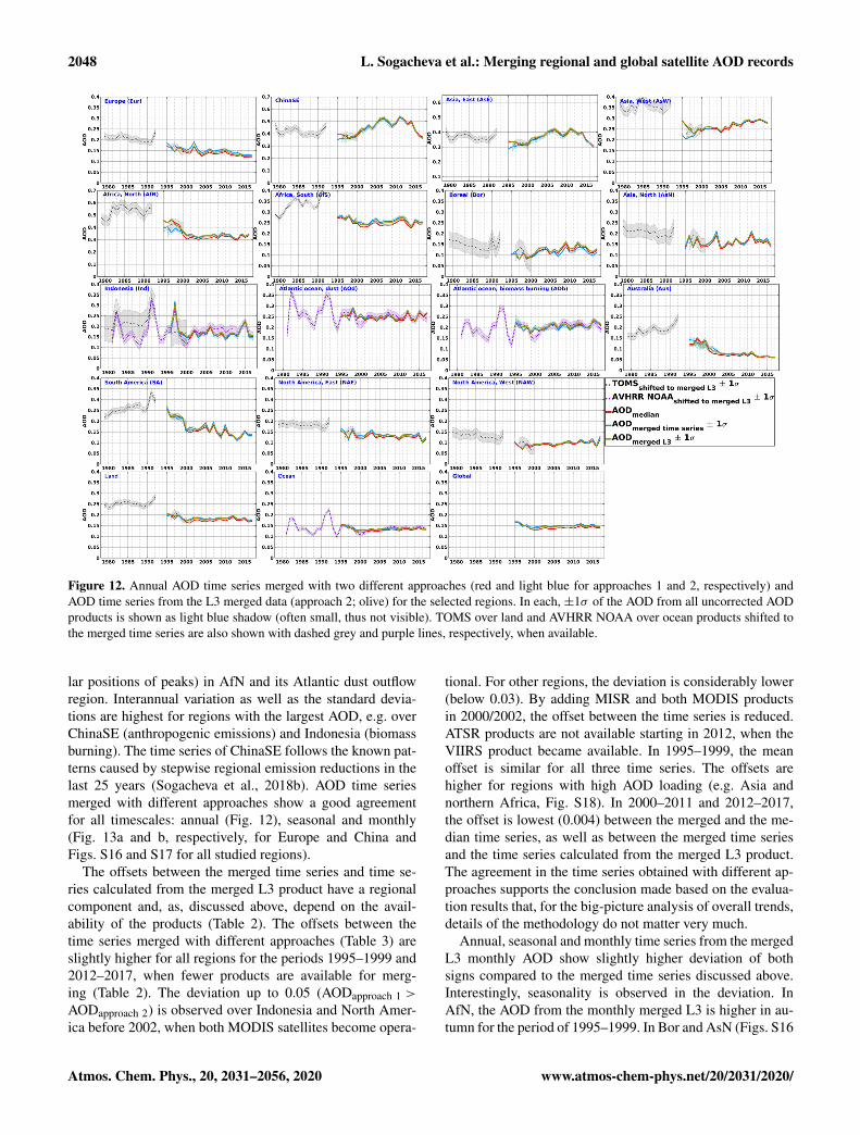
Figure 12. Annual AOD time series merged with two different approaches (red and light blue for approaches 1 and 2, respectively) andAOD time series from the L3 merged data (approach 2; olive) for the selected regions. In each, ±1σ of the AOD from all uncorrected AODproducts is shown as light blue shadow (often small, thus not visible). TOMS over land and AVHRR NOAA over ocean products shifted tothe merged time series are also shown with dashed grey and purple lines, respectively, when available.
lar positions of peaks) in AfN and its Atlantic dust outflowregion. Interannual variation as well as the standard devia-tions are highest for regions with the largest AOD, e.g. overChinaSE (anthropogenic emissions) and Indonesia (biomassburning). The time series of ChinaSE follows the known pat-terns caused by stepwise regional emission reductions in thelast 25 years (Sogacheva et al., 2018b). AOD time seriesmerged with different approaches show a good agreementfor all timescales: annual (Fig. 12), seasonal and monthly(Fig. 13a and b, respectively, for Europe and China andFigs. S16 and S17 for all studied regions).
The offsets between the merged time series and time se-ries calculated from the merged L3 product have a regionalcomponent and, as, discussed above, depend on the avail-ability of the products (Table 2). The offsets between thetime series merged with different approaches (Table 3) areslightly higher for all regions for the periods 1995–1999 and2012–2017, when fewer products are available for merg-ing (Table 2). The deviation up to 0.05 (AODapproach 1 >
AODapproach 2) is observed over Indonesia and North Amer-ica before 2002, when both MODIS satellites become opera-
tional. For other regions, the deviation is considerably lower(below 0.03). By adding MISR and both MODIS productsin 2000/2002, the offset between the time series is reduced.ATSR products are not available starting in 2012, when theVIIRS product became available. In 1995–1999, the meanoffset is similar for all three time series. The offsets arehigher for regions with high AOD loading (e.g. Asia andnorthern Africa, Fig. S18). In 2000–2011 and 2012–2017,the offset is lowest (0.004) between the merged and the me-dian time series, as well as between the merged time seriesand the time series calculated from the merged L3 product.The agreement in the time series obtained with different ap-proaches supports the conclusion made based on the evalua-tion results that, for the big-picture analysis of overall trends,details of the methodology do not matter very much.
Annual, seasonal and monthly time series from the mergedL3 monthly AOD show slightly higher deviation of bothsigns compared to the merged time series discussed above.Interestingly, seasonality is observed in the deviation. InAfN, the AOD from the monthly merged L3 is higher in au-tumn for the period of 1995–1999. In Bor and AsN (Figs. S16
Atmos. Chem. Phys., 20, 2031–2056, 2020 www.atmos-chem-phys.net/20/2031/2020/

L. Sogacheva et al.: Merging regional and global satellite AOD records 2049
Figure 13. (a) Seasonal and (b) monthly AOD median time series (red), merged time series (blue) and time series from the merged L3product (olive) for Europe and ChinaSE. AOD± 1σ for the merged time series and for the time series from the merged L3 products areshown as light blue and light olive shadows, respectively. Note the different scale. For all selected regions, see Figs. S16 and S17.
and S17), the deviation is higher in spring for the period of1997–1999. A possible explanation might be the sparser cov-erage in those areas (due to restrictions in retrieval algorithmsto retrieve bright surfaces, e.g. desert or snow). Regional off-sets between the annual, seasonal and monthly AOD mergedtime series and the time series from the merged L3 monthlyproduct are summarised for three timescales in Fig. S19. Theoffset is lower for annual data and generally increases withthe time resolution. As the previous analysis showed, the off-set is bigger in high-AOD regions (e.g. Asia, AfN and SA).
Overall, good agreement exists between the time seriescalculated using different merging approaches and differentorders of the processing steps. There is a general consistency,and similar temporal patterns are observed between the timeseries merged with two approaches and the time series frommerged L3 AOD product, despite small differences, whichare more pronounced at the beginning of the period, whenless products are available. With only few exceptions, theoffsets between the AOD time series calculated with differ-
ent approaches are within the GCOS requirement of ±0.03or 10 % of AOD.
A separate study is planned where regional and globaltrends in this merged AOD L3 product will be analysed.
7 Conclusions
This study has analysed the consistency of regional timerecords of monthly AOD from 16 different satellite prod-ucts. These were obtained from a wide range of different in-struments – TOMS, AVHRR, SeaWiFS, ATSR-2, AATSR,MODIS, MISR, POLDER, VIIRS and EPIC – with largelyvarying information content and sampling and with differ-ent algorithms based on different remote sensing approaches,quality filtering, cloud masking and averaging. Differencesbetween those 16 data records in a set of regions with differ-ent characteristics across the globe were demonstrated andverified against a ground-based AERONET monthly meandataset in order to answer the question how well a satel-
www.atmos-chem-phys.net/20/2031/2020/ Atmos. Chem. Phys., 20, 2031–2056, 2020

2050 L. Sogacheva et al.: Merging regional and global satellite AOD records
Table 4. Instrument, archive, URL and DOI (last access: 17 February 2020, for all), name and creator of the products used in the currentstudy (if available).
Instrument Archive Name of the product, link, creator
Merged AOD Sodankylä FMI_SAT_AOD-MERGED:(product introduced in the current paper) NSDC URL http://nsdc.fmi.fi/data/data_aod
TOMS NASA URL L2 daily:GES DISC https://disc.gsfc.nasa.gov/datasets?page=1&subject=
Aerosols&measurement=Aerosol%20Optical%20Depth%2FThicknessL3 monthly AOD data available by request
OMI NASA URL L2 daily: https://aura.gesdisc.eosdis.nasa.gov/data/Aura_OMI_Level2/OMAERUV.003/
GES DISC (Torres, 2006)L3 monthly AOD data available by request
AVHRR NOAA URL AOT_AVHRR_v003r00_monthly_avg: https://data.nodc.noaa.gov/cgi-bin/iso?id=gov.noaa.ncdc:C00977
DOI https://doi.org/10.7289/V5BZ642P(Zhao and NOAA CDR Program, 2017)
AVHRR NASA URL DBAER_avhrrnoaa11_monthly_1deg:NCCS https://portal.nccs.nasa.gov/datashare/AVHRRDeepBlue
SeaWiFS NASA URL DeepBlue-SeaWiFS-1.0_L3M:GES DISC https://measures.gesdisc.eosdis.nasa.gov/data/
DeepBlueSeaWiFS_Level3/SWDB_L3M10.004/
DOI https://doi.org/10.5067/MEASURES/SWDB/DATA304(Hsu et al., 2013b)
VIIRS NASA URL AERDB_M3_VIIRS_SNPP: https://search.earthdata.nasa.gov/search/granules?p=C1561219905-LAADS&m=36.67372044211211!10.125!0!1!0!0%2C2&ac=true&tl=1566140492!4!!&fs10=Aerosol%20Optical%20Depth/Thickness&fsm0=Aerosols&fst0=Atmosphere
LAADS DOI https://doi.org/10.5067/VIIRS/AERDB_M3_VIIRS_SNPP.001(via EarthData) (Sayer et al., 2018a)
ATSR ADV ICARE URL ESACCI_L3C_ATSR_ENVISAT_ADV:http://www.icare.univ-lille1.fr/archive(Kolmonen et al., 2016)
ATSR SU ICARE URL ESACCI_L3C_ATSR_ENVISAT_SU:http://www.icare.univ-lille1.fr/archive
ATSR ensemble ICARE URL ESACCI_L3C_ATSR_ENVISAT_ENS:http://www.icare.univ-lille1.fr/archive
MODIS DT&DB* NASA LAADS URL Terra: MOD08_M3: https://ladsweb.modaps.eosdis.nasa.gov/archive/allData/61/MOD08_M3
Aqua: MYD08_M3: https://ladsweb.modaps.eosdis.nasa.gov/archive/allData/61/MYD08_M3
DOI Terra:https://doi.org/10.5067/MODIS/MOD08_M3.006
Aqua:https://doi.org/10.5067/MODIS/MYD08_M3.006(Platnick et al., 2015)
Atmos. Chem. Phys., 20, 2031–2056, 2020 www.atmos-chem-phys.net/20/2031/2020/

L. Sogacheva et al.: Merging regional and global satellite AOD records 2051
Table 4. Continued.
Instrument Archive Name of the product, link, creator
MODIS MAIAC LP DAAS URL L2 daily:https://lpdaac.usgs.gov/data_access/data_poolL3 monthly AOD data available by request
MISR URL MISR_AM1_CGAS:http://eosweb.larc.nasa.gov/project/misr/misr_table
DOI https://doi.org/10.5067/Terra/MISR/MIL3MAE_L3.004
POLDER URL https://www.grasp-open.com
EPIC URL L3 monthly AOD data available by request
AERONET URL https://aeronet.gsfc.nasa.gov/(Holben et al., 1998)
* Additional online documentation at: https://modis-atmos.gsfc.nasa.gov/, https://darktarget.gsfc.nasa.gov/.
lite dataset can reproduce monthly gridded mean AERONETvalues in a region.
AOD time series (monthly, seasonal and annual) from theproducts show a good consistency of temporal patterns butsignificant regional biases due to all those differences. Inmany cases the more pronounced differences were betweendifferent algorithms applied to the same sensor, rather thanbetween similar algorithms applied to different sensors. Thisis encouraging in that it implies that algorithmic uncertain-ties (either retrieval assumptions or pixel selection criteria)can be similar to or larger than sensor ones (e.g. calibrationquality and sampling limitations), and as such, refining in-dividual algorithms can still make meaningful steps towardsproviding better L3 products.
To build an AOD product merged from 12 individual satel-lite products, two different approaches were introduced andtested. In approach 1, a simple median of the 12 uncorrectedand shifted to Terra DT&DR product time records was con-ducted. In approach 2, the AOD evaluation results (for dif-ferent aerosol types) against AERONET were used to infera ranking which was then used to calculate a weighted AODmean. Two different ranking methods, RM1, simple rankingbased on better statistics, and RM2, ranking based on binnedstatistics, were tested in approach 2. In addition, the orderof the processing steps in approach 2 was interchanged (L3dataset merging or regional merging) to test the stability ofthe results.
Ten merged L3 AOD monthly products were created andevaluated with AERONET. The evaluation shows that thequality of the merged products (except for one created withthe approach 1 for shifted AOD) is as good as that of themost highly ranked individual AOD products in each region.One of the merged products (approach 2 with RM2 for all)was chosen as a final merged product (http://nsdc.fmi.fi/data/data_aod, last access: 20 January 2020), based on slightly
better evaluation results. Structural uncertainties for the finalmerged product were estimated.
All merged regional AOD time series show a very highconsistency of temporal patterns and between regions, andthe time records with their uncertainties (standard deviationsshaded around the median values) clearly illustrate the evolu-tion of regional AOD. With few exceptions all merging meth-ods lead to very similar results, which is reassuring for theusefulness and stability of the merged products.
There are of course caveats to these rather simple andstraightforward merging approaches, which do not considerin much detail the differences in sampling and sensitivity todifferent conditions (e.g. surface brightness or number of in-dependent observables) of the different instruments and al-gorithms. It is well known that monthly, seasonal or annualgridded mean values can carry large uncertainties, whetherinferred from a few ground-based stations meant to representa full grid cell or from satellite images containing large gapsdue to limited swath, clouds or failed retrievals. Pixel-leveluncertainties are becoming available for a growing number ofsatellite products, and it would be highly beneficial if theseestimated errors could be propagated consistently to thosegridded monthly products. However, this requires deeper in-sight and new methods to take into account correlation pat-terns among parts of the uncertainties and to estimate prac-tically the sampling-based uncertainties in light of approxi-mated AOD variability. Altogether, as frequently requestedfrom a user point of view, the stability and consistency of re-gional, merged AOD time series should be seen as strength-ening our confidence in the reliability of satellite-based datarecords. Recent, ongoing and future work to improve theLevel 3 uncertainty budget of the satellite products – aswell as assessment of spatio-temporal uncertainties in time-aggregated AERONET data – will benefit the creation andassessment of merged time series. The corresponding timeseries can be used in regional and global AOD trend analy-
www.atmos-chem-phys.net/20/2031/2020/ Atmos. Chem. Phys., 20, 2031–2056, 2020

2052 L. Sogacheva et al.: Merging regional and global satellite AOD records
ses and for comparison with (climate and reanalysis) modelAOD fields. Aside from the merged dataset itself, some keymain outcomes of this research have been a quantificationof the diversity between monthly satellite AOD products andtheir comparability with monthly averages from AERONETand the sensitivity of the merged time series to some sensibledecisions which must be made in creating it. Merged AODproduct will be extended as satellite missions continue andnew data versions are released.
Data availability. URL and DOI (if available) of the productsused in the current study, as well as of the merged AOD product(FMI_SAT_AOD-MERGED), are summarised in Table 4.
Supplement. The supplement related to this article is available on-line at: https://doi.org/10.5194/acp-20-2031-2020-supplement.
Author contributions. The exercise on AOD merging has been ini-tiated and widely discussed by the AeroCom/AeroSat community.The work has been performed by LS, who collected data, devel-oped the methodology, performed the analysis and wrote the ex-tended draft of the paper. The evaluation results were widely dis-cussed with the AOD data providers, who coauthor the paper. TP,AMS and RAK also considerably contributed to writing. All authorscontributed to reviewing the drafts.
Competing interests. The authors declare that they have no conflictof interest.
Acknowledgements. The authors thank attendees of Aero-Com/AeroSat workshops over the past several years for livelyand informative discussions, which helped provide the impetusfor and shape this analysis. AeroCom and AeroSat are unfundedcommunity networks which participants contribute to within theremit and constraints of their other aerosol research.
Financial support. The work presented is partly supported by theCopernicus Climate Change Service (contracts C3S_312a_lot5 andC3S_312b_Lot2) which is funded by the European Union, withsupport from ESA as part of the Climate Change Initiative (CCI)project Aerosol_cci (ESA-ESRIN projects AO/1-6207/09/I-LG andESRIN/400010987 4/14/1-NB) and the AirQast 776361 H2020-EO-2017 project.
Review statement. This paper was edited by Stelios Kazadzis andreviewed by three anonymous referees.
References
Ban-Weiss, G. A., Jin, L., Bauer, S. E., Bennartz, R., Liu,X., Zhang, K., Ming, Y., Guo, H., and Jiang, J. H.:Evaluating clouds, aerosols, and their interactions in threeglobal climate models using satellite simulators and ob-servations, J. Geophys. Res.-Atmos., 119, 10876–10901,https://doi.org/10.1002/2014JD021722, 2014.
Bellouin, N., Boucher, O., Haywood, J., and Shekar, R.M.: Global estimate of aerosol direct radiative forcingfrom satellite measurements, Nature, 438, 1138–1141,https://doi.org/10.1038/nature04348, 2005.
Bevan, S., North, P., Los, S., and Grey, W.: A global dataset ofatmospheric aerosol optical depth and surface reflectance fromAATSR, Remote Sens. Environ., 116, 199–210, 2012.
Boys, B. L., Martin, R. V., van Donkelaar, A., MacDonell, R. J.,Hsu, N. C., Cooper, M. J., Yantosca, R. M., Lu, Z., Streets, D.G., Zhang, Q., and Wang, S. W.: Fifteen-year global time seriesof satellite-derived fine particulate matter, Environ Sci Technol.,48, 11109–11118, 2014.
Chang, C.-H., Hsiao, Y.-L., and Hwang, C.: Evaluating Spa-tial and Temporal Variations of Aerosol Optical Depth andBiomass Burning over Southeast Asia Based on SatelliteData Products, Aerosol Air Qual. Res., 15, 2625–2640,https://doi.org/10.4209/aaqr.2015.10.0589, 2015.
Chatterjee, A., Michalak, A. M., Kahn, R. A., Paradise, S. R.,Braverman, A. J., and Miller, C. E.: A geostatistical data fu-sion technique for merging remote sensing and ground-based ob-servations of aerosol optical thickness, J. Geophys. Res., 115,D20207, https://doi.org/10.1029/2009JD013765, 2010.
Chylek, P., Henderson, B., and Mishchenko, M.: Aerosolradiative forcing and the accuracy of satellite aerosoloptical depth retrieval. J. Geophys. Res., 108, 4764,https://doi.org/10.1029/2003JD004044, 2003.
de Leeuw, G., Holzer-Popp, T., Bevan, S., Davies, W., Descloitres,J., Grainger, R. G., Griesfeller, J., Heckel, A., Kinne, S., Klüser,L., Kolmonen, P., Litvinov, P., Martynenko, D., North, P. J. R.,Ovigneur, B., Pascal, N., Poulsen, C., Ramon, D., Schulz, M.,Siddans, R., Sogacheva, L., Tanré, D., Thomas, G. E., Virtanen,T. H., von Hoyningen Huene, W., Vountas, M., and Pinnock, S.:Evaluation of seven European aerosol optical depth retrieval al-gorithms for climate analysis, Remote Sens. Environ., 162, 295–315, https://doi.org/10.1016/j.rse.2013.04.023, 2015.
de Leeuw, G., Sogacheva, L., Rodriguez, E., Kourtidis, K., Geor-goulias, A. K., Alexandri, G., Amiridis, V., Proestakis, E.,Marinou, E., Xue, Y., and van der A, R.: Two decadesof satellite observations of AOD over mainland China us-ing ATSR-2, AATSR and MODIS/Terra: data set evaluationand large-scale patterns, Atmos. Chem. Phys., 18, 1573–1592,https://doi.org/10.5194/acp-18-1573-2018, 2018.
Dubovik, O., Holben, B. N., Eck, T. F., Smirnov, A., Kaufman, Y. J.,King, M. D., Tanre, D., and Slutsker, I.: Variability of absorptionand optical properties of key aerosol types observed in world-wide locations, J. Atmos. Sci., 59, 590–608, 2002.
Dubovik, O., Herman, M., Holdak, A., Lapyonok, T., Tanré,D., Deuzé, J. L., Ducos, F., Sinyuk, A., and Lopatin, A.:Statistically optimized inversion algorithm for enhanced re-trieval of aerosol properties from spectral multi-angle polari-metric satellite observations, Atmos. Meas. Tech., 4, 975–1018,https://doi.org/10.5194/amt-4-975-2011, 2011.
Atmos. Chem. Phys., 20, 2031–2056, 2020 www.atmos-chem-phys.net/20/2031/2020/

L. Sogacheva et al.: Merging regional and global satellite AOD records 2053
Dubovik, O., Lapyonok, T., Litvinov, P., Herman, M., Fuertes, D.,Ducos, F., Lopatin, A., Chaikovsky, A., Torres, B., Derimian, Y.,Huang, X., Aspetsberger, M., and Federspiel, C.: GRASP: a ver-satile algorithm for characterizing the atmosphere, SPIE: News-room, https://doi.org/10.1117/2.1201408.005558, 2014.
Dubovik, O., Li, Z., Mishchenko, M. I., Tanre, D., Karol, Y., Bo-jkov, B., Cairns, B., Diner, D. J., Espinosa, R., Goloub, P., Gu,X., Hasekamp, O., Hong, J., Hou, W., Knobelspiesse, K. D.,Landgraf, J., Li, L., Litvinov, P., Liu, Y., Lopatin, A., Mar-bach, T., Maring, H., Martins, V., Meijer, Y., Milinevsky, G.,Mukai, S., Parol, F., Qiao, Y., Remer, L., Rietjens, J., Sano,I., Stammes, P., Stamnes, S., Sun, X., Tabary, P. Travis, L.D., Waquet, F., Xu, F., Yan, C., and Yin, D.: Polarimetric re-mote sensing of atmospheric aerosols: instruments, methodolo-gies, results, and perspectives, J. Quant. Spectrosc. Ra., 474–511,https://doi.org/10.1016/j.jqsrt.2018.11.024, 2019.
Eck, T. F., Holben, B. N., Reid, J. S., Dubovik, O., Smirnov, A.,O’Neill, N. T., Slutsker, I., and Kinne, S.: Wavelength depen-dence of the optical depth of biomass burning, urban, and desertdust aerosol, J. Geophys. Res., 104, 31333–31350, 1999.
Escribano, J., Boucher, O., Chevallier, F., and Huneeus, N.: Impactof the choice of the satellite aerosol optical depth product in asub-regional dust emission inversion, Atmos. Chem. Phys., 17,7111–7126, https://doi.org/10.5194/acp-17-7111-2017, 2017.
Flowerdew, R. J. and Haigh, J. D.: An approximation to improveaccuracy in the derivation of surface reflectances from multi-looksatellite radiometers, Geophys. Res. Let., 22, 1693–1696, 1995.
Garay, M. J., Kalashnikova, O. V., and Bull, M. A.: Develop-ment and assessment of a higher-spatial-resolution (4.4 km)MISR aerosol optical depth product using AERONET-DRAGON data, Atmos. Chem. Phys., 17, 5095–5106,https://doi.org/10.5194/acp-17-5095-2017, 2017.
Garay, M. J., Witek, M. L., Kahn, R. A., Seidel, F. C., Limbacher,J. A., Bull, M. A., Diner, D. J., Hansen, E. G., Kalashnikova, O.V., Lee, H., Nastan, A. M., and Yu, Y.: Introducing the 4.4 kmSpatial Resolution MISR Aerosol Product, Atmos. Meas. Tech.Discuss., https://doi.org/10.5194/amt-2019-340, in review, 2019.
GCOS: Systematic observation requirements for satellite-baseddata products for climate, 2011 update, World Meteorologi-cal Organization (WMO) Global Climate Observing System(GCOS) report GCOS-154, available at: https://library.wmo.int/doc_num.php?explnum_id=3710 (last access: 19 June 2019),2011.
Giles, D. M., Sinyuk, A., Sorokin, M. G., Schafer, J. S., Smirnov,A., Slutsker, I., Eck, T. F., Holben, B. N., Lewis, J. R., Campbell,J. R., Welton, E. J., Korkin, S. V., and Lyapustin, A. I.: Advance-ments in the Aerosol Robotic Network (AERONET) Version 3database – automated near-real-time quality control algorithmwith improved cloud screening for Sun photometer aerosol op-tical depth (AOD) measurements, Atmos. Meas. Tech., 12, 169–209, https://doi.org/10.5194/amt-12-169-2019, 2019.
Gupta, P., Levy, R. C., Mattoo, S., Remer, L. A., and Mun-chak, L. A.: A surface reflectance scheme for retrievingaerosol optical depth over urban surfaces in MODIS Dark Tar-get retrieval algorithm, Atmos. Meas. Tech., 9, 3293–3308,https://doi.org/10.5194/amt-9-3293-2016, 2016.
Han, B., Ding, H., Ma, Y., and Gong, W.: Improving retrieval ac-curacy for aerosol optical depth by fusion of MODIS and Caliopdata, Tehni ki Vjesnik, 24, 791–800, 2017.
Heidinger, A. K., Cao, C., and Sullivan, J.: Using Mod-erate Resolution Imaging Spectrometer (MODIS) tocalibrate Advanced Very High Resolution Radiometer(AVHRR) reflectance channels, J. Geophys. Res., 107, 4702,https://doi.org/10.1029/2001JD002035, 2002.
Holben, B. N., Eck, T. F., Slutsker, I., Tanré, D., Buis, J. P., Set-zer, A., Vermote, E., Reagan, J. A., Kaufman, Y., Nakajima, T.,Lavenu, F. , Jankowiak, I., and Smirnov, A.: AERONET – A fed-erated instrument network and data archive for aerosol character-ization, Remote Sens. Environ., 66, 1–16, 1998.
Holben, B. N., Tanre, D., Smirnow, A., Eck, T. F., Slutsker, I.,Abuhassan, N., Newcomb, W. W., Schafer, J. S., Chatenet,B., Lavenu, F., Kaufman, Y. J., Vande Castle, J., Setzer, A.,Markham, B., Clark, D., Halthore, R., Karneli, A., O’Neili, N.T., Pietras, C., Pinker, R. T., Vos. K., and Zibord, G.: An Emerg-ing Ground-Based Aerosol Climatology, J. Geophys. Res., 106,12067–12097, 2001.
Hsu, N. C., Tsay, S. C., King, M. D., and Herman, J. R.: Aerosolproperties over bright-reflecting source regions, IEEE T. Geosci.Remote, 42, 557–569, 2004.
Hsu, N. C., Jeong, M.-J., Bettenhausen, C., Sayer, A. M.,Hansell, R., Seftor, C. S., Huang, J., and Tsay, S.-C.: En-hanced Deep Blue aerosol retrieval algorithm: The sec-ond generation, J. Geophys. Res.-Atmos., 118, 9296–9315,https://doi.org/10.1002/jgrd.50712, 2013a.
Hsu, N. C., Sayer, A. M., Jeong, M.-J., and Bettenhausen, C.:SeaWiFS Deep Blue Aerosol Optical Depth and AngstromExponent Monthly Level 3 Data Gridded at 1.0 De-grees V004, Greenbelt, MD, USA, Goddard Earth Sci-ences Data and Information Services Center (GES DISC),https://doi.org/10.5067/MEASURES/SWDB/DATA304, 2013b.
Hsu, N. C., Lee, J., Sayer, A. M., Carletta, N., Chen, S.-H., Tucker,C. J., and Tsay, S.-C: Retrieving near-global aerosol loading overland and ocean from AVHRR, J. Geophys. Res., 122, 9968–9989,https://doi.org/10.1002/2017JD026932, 2017.
Hsu, N. C., Lee, J., Sayer, A. M., Kim, W., Bettenhausen,C., and Tsay, S.-C.: VIIRS Deep Blue aerosol prod-ucts over land: Extending the EOS long-term aerosoldata records, J. Geophys. Res.-Atmos., 124, 4026–4053,https://doi.org/10.1029/2018JD029688, 2019.
Huang, D., Lyapustin, A., Korkin, S., Wang, Y., Blank, K., and Mar-shak, A.: The Multi-Angle Implementation of Atmospheric Cor-rection (MAIAC) algorithm for DSCOVR EPIC and initial anal-ysis of data products, Remote. Sens. Environ., in review, 2020.
Ignatov, A. and Stowe, L. L.: Aerosol Retrievals from IndividualAVHRR Channels. Part I: Retrieval Algorithm and Transitionfrom Dave to 6S Radiative Transfer Model, J. Atmos. Sci., 59,313–334, 2002.
IPCC: Summary for Policymakers of IPCC Special Report onGlobal Warming of 1.5 ◦C approved by governments, availableat: https://www.ipcc.ch/site/assets/uploads/2018/11/pr_181008_P48_spm_en.pdf (last access: 30 April 2019), 2018.
Jethva, H. and Torres, O.: Satellite-based evidence of wavelength-dependent aerosol absorption in biomass burning smoke in-ferred from Ozone Monitoring Instrument, Atmos. Chem. Phys.,11, 10541–10551, https://doi.org/10.5194/acp-11-10541-2011,2011.
Kahn, R. A., Gaitley, B. J., Garay, M. J., Diner, D. J., Eck, T. F.,Smirnov, A., and Holben, B. N.: Multiangle Imaging SpectroRa-
www.atmos-chem-phys.net/20/2031/2020/ Atmos. Chem. Phys., 20, 2031–2056, 2020
2054 L. Sogacheva et al.: Merging regional and global satellite AOD records
diometer global aerosol product assessment by comparison withthe Aerosol Robotic Network, J. Geophys. Res., 115, D23209,https://doi.org/10.1029/2010JD014601, 2010.
Kinne, S.: Remote sensing data combinations: superior globalmaps for aerosol optical depth, in: Satellite Aerosol RemoteSensing over Land, Springer, Berlin Heidelberg, 361–381,https://doi.org/10.1007/978-3-540-69397-0_12, 2009.
Kinne, S., Lohmann, U., Feichter, J., Schulz, M., Timmreck,C., Ghan, S., Easter, R., Chin, M., Ginouz, P. , Takemura,T., Tegen, I., Koch, D., Herzog, M., Penner, J., Pitari, G.,Holben, B., Eck, T., Smirnov, A., Dubovik, O., Slutsker, I.,Tanre, D., Torres, O., Mishchenko, M. Geogdzhayev, I., Chu,D. A., and Kaufman, Y.: Monthly averages of aerosol prop-erties: A global comparison among models, satellite data,and AERONET ground data, J. Geophys. Res., 108, 4634,https://doi.org/10.1029/2001JD001253, 2003.
Kinne, S., Schulz, M., Textor, C., Guibert, S., Balkanski, Y., Bauer,S. E., Berntsen, T., Berglen, T. F., Boucher, O., Chin, M., Collins,W., Dentener, F., Diehl, T., Easter, R., Feichter, J., Fillmore, D.,Ghan, S., Ginoux, P., Gong, S., Grini, A., Hendricks, J., Herzog,M., Horowitz, L., Isaksen, I., Iversen, T., Kirkevåg, A., Kloster,S., Koch, D., Kristjansson, J. E., Krol, M., Lauer, A., Lamarque,J. F., Lesins, G., Liu, X., Lohmann, U., Montanaro, V., Myhre,G., Penner, J., Pitari, G., Reddy, S., Seland, O., Stier, P., Take-mura, T., and Tie, X.: An AeroCom initial assessment – opticalproperties in aerosol component modules of global models, At-mos. Chem. Phys., 6, 1815–1834, https://doi.org/10.5194/acp-6-1815-2006, 2006.
Kokhanovsky, A. A. and de Leeuw, G. (Eds.): Satellite Aerosol Re-mote Sensing Over Land, Springer-Praxis, Berlin, 388 pp., 2009.
Kolmonen, P., Sogacheva, L., Virtanen, T. H., de Leeuw,G., and Kulmala, M.: The ADV/ASV AATSR aerosol re-trieval algorithm: current status and presentation of a full-mission AOD data set, Int. J. Digital Earth, 9, 545–561,https://doi.org/10.1080/17538947.2015.1111450, 2016.
Kosmale, M., et al.: in preparation, 2020.Lee, H., Garay, M. J., Kalashnikova, O. V., Yu, Y., and Gibson, P. B.:
How Long should the MISR Record Be when Evaluating AerosolOptical Depth Climatology in Climate Models?, Remote Sens.,10, 1326, 2018.
Levy, R. C., Mattoo, S., Munchak, L. A., Remer, L. A., Sayer, A.M., Patadia, F., and Hsu, N. C.: The Collection 6 MODIS aerosolproducts over land and ocean, Atmos. Meas. Tech., 6, 2989–3034, https://doi.org/10.5194/amt-6-2989-2013, 2013.
Levy, R. C., Mattoo, S., Sawyer, V., Shi, Y., Colarco, P.R., Lyapustin, A. I., Wang, Y., and Remer, L. A.: Explor-ing systematic offsets between aerosol products from thetwo MODIS sensors, Atmos. Meas. Tech., 11, 4073–4092,https://doi.org/10.5194/amt-11-4073-2018, 2018.
Li, J., Carlson, B. E., and Lacis, A. A.: Application of spec-tral analysis techniques in the inter-comparison of aerosol data.Part I: An EOF approach to analyze the spatial-temporal vari-ability of aerosol optical depth using multiple remote sens-ing data sets, J. Geophys. Res.-Atmos., 118, 8640–8648,https://doi.org/10.1002/jgrd.50686, 2013.
Li, J., Carlson, B. E., and Lacis, A. A.: Application of spectralanalysis techniques in the inter-comparison of aerosol data. PartII: Using maximum covariance analysis to effectively comparespatio-temporal variability of satellite and AERONET measured
aerosol optical depth, J. Geophys. Res.-Atmos., 119, 153–166,https://doi.org/10.1002/2013JD020537, 2014a.
Li, J., Carlson, B. E., and Lacis, A. A.: Application of spec-tral analysis techniques to the intercomparison of aerosoldata – Part 4: Synthesized analysis of multisensor satelliteand ground-based AOD measurements using combined maxi-mum covariance analysis, Atmos. Meas. Tech., 7, 2531–2549,https://doi.org/10.5194/amt-7-2531-2014, 2014b.
Li, J., Li, X., Carlson, B. E., Kahn, R. A., Lacis, A. A., Dubovik,O., and Nakajima, T.: Reducing m ultisensor satellite monthlymean aerosol optical depth uncertainty: 1. Objective assessmentof current AERONET locations, J. Geophys. Res.-Atmos., 121,13609–13627, https://doi.org/10.1002/2016JD025469, 2016.
Li, S., Yu, C., Chen, L., Tao, J., Letu, H., Ge, W., Si, Y., and Liu,Y.: Inter-comparison of model-simulated and satellite-retrievedcomponential aerosol optical depths in China, Atmos. Environ.,141, 320–332, https://doi.org/10.1016/j.atmosenv.2016.06.075,2016.
Li, Z., Zhao, X., Kahn, R., Mishchenko, M., Remer, L., Lee, K.-H., Wang, M., Laszlo, I., Nakajima, T., and Maring, H.: Un-certainties in satellite remote sensing of aerosols and impacton monitoring its long-term trend: a review and perspective,Ann. Geophys., 27, 2755–2770, https://doi.org/10.5194/angeo-27-2755-2009, 2009.
Limbacher, J. A. and Kahn, R. A.: Updated MISR over- wa-ter research aerosol retrieval algorithm – Part 2: A multi-angle aerosol retrieval algorithm for shallow, turbid, olig-otrophic, and eutrophic waters, Atmos. Meas. Tech., 12, 675–689, https://doi.org/10.5194/amt-12-675-2019, 2019.
Liu, L., Lacis, A. A., Carlson, B. E., Mishchenko, M. I., andCairns, B.: Assessing Goddard Institute for Space Studies Mod-elE aerosol climatology using satellite and ground-based mea-surements: A comparison study, J. Geophys. Res., 111, D20212,https://doi.org/10.1029/2006JD007334, 2006.
Lyapustin, A., Wang, Y., Korkin, S., and Huang, D.: MODIS Collec-tion 6 MAIAC algorithm, Atmos. Meas. Tech., 11, 5741–5765,https://doi.org/10.5194/amt-11-5741-2018, 2018.
Martonchik, J. V., Kahn, R. A., and Diner, D. J.: Retrievalof Aerosol Properties over Land Using MISR Observations,in: Satellite Aerosol Remote Sensing Over Land, edited by:Kokhanovsky, A. A. and de Leeuw, G., Springer, Berlin, 267–293, 2009.
Michou, M., Nabat, P., and Saint-Martin, D.: Development and ba-sic evaluation of a prognostic aerosol scheme (v1) in the CNRMClimate Model CNRM-CM6, Geosci. Model Dev., 8, 501–531,https://doi.org/10.5194/gmd-8-501-2015, 2015.
Mishchenko, M. I., Geogdzhayev, I. V., Cairns, B., Carl-son, B. E., Chowdhary, J., Lacis, A. A., Liu, L., Rossow,W. B., and Travis, L. D.: Past, present, and future ofglobal aerosol climatologies derived from satellite observa-tions: A perspective, J. Quant. Spectrosc. Ra., 106, 325–347,https://doi.org/10.1016/j.jqsrt.2007.01.007, 2007.
Nabat, P., Somot, S., Mallet, M., Chiapello, I., Morcrette, J. J., Sol-mon, F., Szopa, S., Dulac, F., Collins, W., Ghan, S., Horowitz, L.W., Lamarque, J. F., Lee, Y. H., Naik, V., Nagashima, T., Shin-dell, D., and Skeie, R.: A 4-D climatology (1979–2009) of themonthly tropospheric aerosol optical depth distribution over theMediterranean region from a comparative evaluation and blend-
Atmos. Chem. Phys., 20, 2031–2056, 2020 www.atmos-chem-phys.net/20/2031/2020/
L. Sogacheva et al.: Merging regional and global satellite AOD records 2055
ing of remote sensing and model products, Atmos. Meas. Tech.,6, 1287–1314, https://doi.org/10.5194/amt-6-1287-2013, 2013.
Naeger, A. R., Gupta, P., Zavodsky, B. T., and McGrath, K. M.:Monitoring and tracking the trans-Pacific transport of aerosolsusing multi-satellite aerosol optical depth composites, Atmos.Meas. Tech., 9, 2463–2482, https://doi.org/10.5194/amt-9-2463-2016, 2016.
North, P.: Estimation of aerosol opacity and land surface bidirec-tional reflectance from ATSR-2 dual-angle imagery: Operationalmethod and validation, J. Geophys. Res., 107, AAC 4-1–AAC4-10, 2002.
North, P., Briggs, S., Plummer, S., and Settle, J.: Retrieval of landsurface bidirectional reflectance and aerosol opacity from ATSR-2 multiangle imagery, IEEE T. Geosci. Remote S., 37, 526–537,1999.
O’Neill, N. T., Ignatov, A., Holben, B. N., and Eck, T. F.: Thelognormal distribution as a reference for reporting aerosol op-tical depth statistics: Empirical tests using multi-year, multi-siteAERONET sun-photometer data, Geophys. Res. Lett., 27, 3333–3336. https://doi.org/10.1029/2000GL011581, 2000.
Penning de Vries, M. J. M., Beirle, S., Hörmann, C., Kaiser, J. W.,Stammes, P., Tilstra, L. G., Tuinder, O. N. E., and Wagner, T.:A global aerosol classification algorithm incorporating multiplesatellite data sets of aerosol and trace gas abundances, Atmos.Chem. Phys., 15, 10597–10618, https://doi.org/10.5194/acp-15-10597-2015, 2015.
Peyridieu, S., Chédin, A., Capelle, V., Tsamalis, C., Pierangelo, C.,Armante, R., Crevoisier, C., Crépeau, L., Siméon, M., Ducos, F.,and Scott, N. A.: Characterisation of dust aerosols in the infraredfrom IASI and comparison with PARASOL, MODIS, MISR,CALIOP, and AERONET observations, Atmos. Chem. Phys., 13,6065–6082, https://doi.org/10.5194/acp-13-6065-2013, 2013.
Pinty, B., Taberner, M., Haemmerle, V.., Paradise, S. R., Vermote,E., Verstraete, M. M., Gobron, N., and Widlowski, J. L.: Global-Scale Comparison of MISR and MODIS Land Surface Albedos,J. Climate, 24, 732–749, 2011.
Platnick, S., Hubanks, P., Meyer, K., and King, M. D.: MODISAtmosphere L3 Monthly Product (08_L3), NASA MODISAdaptive Processing System, Goddard Space Flight Center,https://doi.org/10.5067/MODIS/MOD08_M3.061, 2015a.
Platnick, S., Hubanks, P., Meyer, K., and King, M. D.: MODISAtmosphere L3 Monthly Product, NASA MODIS Adap-tive Processing System, Goddard Space Flight Center, USA,https://doi.org/10.5067/MODIS/MYD08_M3.061, 2015b.
Popp, T., de Leeuw, G., Bingen, C., Brühl, C., Capelle, V., Chedin,A., Clarisse, L., Dubovik, O., Grainger, R., Griesfeller, J.,Heckel, A., Kinne, S., Klüser, L., Kosmale, M., Kolmonen, P.,Lelli, L., Litvinov, P., Mei, L., North, P., Pinnock, S., Povey, A.,Robert, C., Schulz, M., Sogacheva, L., Stebel, K., Stein Zweers,D., Thomas, G., Tilstra, L.G., Vandenbussche, S., Veefkind, P.,Vountas, M., and Xue, Y.: Development, Production and Evalu-ation of Aerosol Climate Data Records from European SatelliteObservations (Aerosol_cci), Remote Sens., 8, 421, 2016.
Sayer, A. M. and Knobelspiesse, K. D.: How should we aggre-gate data? Methods accounting for the numerical distributions,with an assessment of aerosol optical depth, Atmos. Chem.Phys., 19, 15023–15048, https://doi.org/10.5194/acp-19-15023-2019, 2019.
Sayer, A. M., Thomas, G. E., and Grainger, R. G.: Asea surface reflectance model for (A)ATSR, and applica-tion to aerosol retrievals, Atmos. Meas. Tech., 3, 813–838,https://doi.org/10.5194/amt-3-813-2010, 2010.
Sayer, A. M., Hsu, N. C., Bettenhausen, C., Ahmad, Z., Holben,B. N., Smirnov, A., Thomas, G. E., and Zhang, J.: SeaWiFSOcean Aerosol Retrieval (SOAR): Algorithm, validation, andcomparison with other data sets, J. Geophys. Res., 117, D03206,https://doi.org/10.1029/2011JD016599, 2012a.
Sayer, A. M., Hsu, N. C., Bettenhausen, C., Jeong, M.-J., Holben,B. N., and Zhang, J.: Global and regional evaluation of over-landspectral aerosol optical depth retrievals from SeaWiFS, Atmos.Meas. Tech., 5, 1761–1778, https://doi.org/10.5194/amt-5-1761-2012, 2012b.
Sayer, A. M., Munchak, L. A., Hsu, N. C., Levy, R. C.,Bettenhausen, C., and Jeong, M. J.: MODIS Collection 6aerosol products: Comparison between Aqua’s e-Deep Blue,Dark Target, and ”merged” data sets, and usage recom-mendations, J. Geophys. Res.-Atmos., 119, 13965–13989,https://doi.org/10.1002/2014jd022453, 2014.
Sayer, A. M., Hsu, N. C., Bettenhausen, C., Jeong, M.-J., andMeister, G.: Effect of MODIS Terra radiometric calibration im-provements on Collection 6 Deep Blue aerosol products: Valida-tion and Terra/Aqua consistency, J. Geophys. Res.-Atmos., 120,12157–12174, https://doi.org/10.1002/2015JD023878, 2015.
Sayer, A. M., Hsu, N. C., Lee, J., Carletta, N., Chen, S.-H.,and Smirnov, A.: Evaluation of NASA Deep Blue/SOARaerosol retrieval algorithms applied to AVHRR mea-surements, J. Geophys. Res.-Atmos., 122, 9945–9967,https://doi.org/10.1002/2017JD026934, 2017.
Sayer, A. M., Hsu, N. C., Lee, J., Bettenhausen, C., Kim, W.V., and Smirnov, A.: Satellite Ocean Aerosol Retrieval (SOAR)algorithm extension to S-NPP VIIRS as part of the “DeepBlue” aerosol project, J. Geophys. Res.-Atmos., 123, 380–400,https://doi.org/10.1002/2017JD027412, 2018a.
Sayer, A. M., Hsu, N. C., Lee, J., Kim, W. V., Dubovik, O.,Dutcher, S. T., Huang, D., Litvinov, P., Lyapustin, A., Tack-ett, J. L., and Winker, D. M.: Validation of SOAR VIIRS over-water aerosol retrievals and context within the global satel-lite aerosol data record, J. Geophys. Res.-Atmos., 123, 13496–13526, https://doi.org/10.1029/2018JD029465, 2018b.
Sayer, A. M., Hsu, N. C., Lee, J., Kim, W., and Dutcher,S.: Validation, stability, and consistency of MODIS Col-lection 6.1 and VIIRS Version 1 Deep Blue aerosol dataover land, J. Geophys. Res.-Atmos., 124, 4658–4688,https://doi.org/10.1029/2018JD029598, 2019.
Schutgens, N. A. J.: Site representativity of AERONET and GAWremotely sensed AOT and AAOT observations, Atmos. Chem.Phys. Discuss., https://doi.org/10.5194/acp-2019-767, in review,2019.
Shi, Y., Zhang, J., Reid, J. S., Hyer, E. J., Eck, T. F., Holben, B.N., and Kahn, R. A.: A critical examination of spatial biasesbetween MODIS and MISR aerosol products – application forpotential AERONET deployment, Atmos. Meas. Tech., 4, 2823–2836, https://doi.org/10.5194/amt-4-2823-2011, 2011.
Shi, Y. R., Levy, R. C., Eck, T. F., Fisher, B., Mattoo, S., Remer, L.A., Slutsker, I., and Zhang, J.: Characterizing the 2015 Indone-sia fire event using modified MODIS aerosol retrievals, Atmos.
www.atmos-chem-phys.net/20/2031/2020/ Atmos. Chem. Phys., 20, 2031–2056, 2020

2056 L. Sogacheva et al.: Merging regional and global satellite AOD records
Chem. Phys., 19, 259–274, https://doi.org/10.5194/acp-19-259-2019, 2019.
Smirnov, A., Holben, B. N., Slutsker, I., Giles, D. M., Mc-Clain, C. R., Eck, T. F., Sakerin, S. M., Macke, A., Croot,P., Zibordi, G., Quinn, P. K., Sciare, J., Kinne, S., Harvey,M., Smyth, T. J., Piketh, S., Zielinski, T., Proshutinsky, A.,Goes, J. I., Nelson, N. B., Larouche, P., Radionov, V. F.,Goloub, P., Krishna Moorthy, K., Matarrese, R., Robertson, E.J., and Jourdin, F.: Maritime Aerosol Network as a componentof Aerosol Robotic Network, J. Geophys. Res.-Atmos., 114,D06204, https://doi.org/10.1029/2008JD011257, 2009.
Sogacheva, L., Kolmonen, P., Virtanen, T. H., Rodriguez, E.,Saponaro, G., and de Leeuw, G.: Post-processing to removeresidual clouds from aerosol optical depth retrieved using the Ad-vanced Along Track Scanning Radiometer, Atmos. Meas. Tech.,10, 491–505, https://doi.org/10.5194/amt-10-491-2017, 2017.
Sogacheva, L., de Leeuw, G., Rodriguez, E., Kolmonen, P., Geor-goulias, A. K., Alexandri, G., Kourtidis, K., Proestakis, E., Mari-nou, E., Amiridis, V., Xue, Y., and van der A, R. J.: Spatialand seasonal variations of aerosols over China from two decadesof multi-satellite observations – Part 1: ATSR (1995–2011) andMODIS C6.1 (2000–2017), Atmos. Chem. Phys., 18, 11389–11407, https://doi.org/10.5194/acp-18-11389-2018, 2018a.
Sogacheva, L., Rodriguez, E., Kolmonen, P., Virtanen, T. H.,Saponaro, G., de Leeuw, G., Georgoulias, A. K., Alexandri,G., Kourtidis, K., and van der A, R. J.: Spatial and seasonalvariations of aerosols over China from two decades of multi-satellite observations – Part 2: AOD time series for 1995–2017 combined from ATSR ADV and MODIS C6.1 and AODtendency estimations, Atmos. Chem. Phys., 18, 16631–16652,https://doi.org/10.5194/acp-18-16631-2018, 2018b.
Tang, Q., Bo, Y., and Zhu, Y.: Spatiotemporal fusion of multiple-satellite aerosol optical depth (AOD) products using Bayesianmaximum entropy method, J. Geophys. Res.-Atmos., 121, 4034–4048, https://doi.org/10.1002/2015JD024571, 2016.
Thomas, G. E., Carboni, E., Sayer, A. M., Poulsen, C. A.,Siddans, R., and Grainger, R. G.: Oxford-RAL Aerosoland Cloud(ORAC): aerosol retrievals from satellite ra-diometers, in: Satellite Aerosol Remote Sensing overLand, edited by: Kokhanovsky, A. and de Leeuw, G.,Springer Praxis Books, Springer, Berlin,Heidelberg, 193–225, https://doi.org/10.1007/978-3-540-69397-0_7, 2009.
Torres, O. O.: OMI/Aura Near UV Aerosol Optical Depthand Single Scattering Albedo 1-orbit L2 Swath 13× 24 kmV003, Greenbelt, MD, USA, Goddard Earth SciencesData and Information Services Center (GES DISC),https://doi.org/10.5067/Aura/OMI/DATA2004, 2006.
Torres, O., Bhartia, P. K., Herman, J. R., Ahmad, Z., and Gleason, J.:Derivation of aerosol properties from satellite measurements ofbackscattered ultraviolet radiation: Theoretical basis, J. Geophys.Res., 103, 17099–17110, https://doi.org/10.1029/98JD00900,1998.
Torres, O., Bhartia, P. K., Sinyuk, A., Welton, E. J., and Hol-ben, B.: Total Ozone Mapping Spectrometer measurements ofaerosol absorption from space: Comparison to SAFARI 2000ground-based observations, J. Geophys. Res., 110, D10S18,https://doi.org/10.1029/2004JD004611, 2005.
Torres, O., Tanskanen, A., Veihelmann, B., Ahn, C., Braak,R., Bhartia, P. K., Veefkind, P., and Levelt, P.: Aerosolsand surface UV products from Ozone Monitoring Instrumentobservations: An overview, J. Geophys. Res., 112, D24S47,https://doi.org/10.1029/2007JD008809, 2007.
Torres, O., Ahn, C., and Chen, Z.: Improvements to theOMI near-UV aerosol algorithm using A-train CALIOPand AIRS observations, Atmos. Meas. Tech., 6, 3257–3270,https://doi.org/10.5194/amt-6-3257-2013, 2013.
Torres, O., Bhartia, P. K., Jethva, H., and Ahn, C.: Impact of theozone monitoring instrument row anomaly on the long-termrecord of aerosol products, Atmos. Meas. Tech., 11, 2701–2715,https://doi.org/10.5194/amt-11-2701-2018, 2018.
Veefkind, J. P., de Leeuw, G., and Durkee, P. A.: Retrieval of aerosoloptical depth over land using two-angle view satellite radiometryduring TARFOX, Geophys. Res. Lett., 25, 3135–3138, 1998.
Virtanen, T. H., Kolmonen, P., Sogacheva, L., Rodríguez, E.,Saponaro, G., and de Leeuw, G.: Collocation mismatch uncer-tainties in satellite aerosol retrieval validation, Atmos. Meas.Tech., 11, 925–938, https://doi.org/10.5194/amt-11-925-2018,2018.
Wei, J., Li, Z., Peng, Y., and Sun, L.: MODIS Collection 6.1 aerosoloptical depth products over land and ocean: validation and com-parison, Atmos. Environ., 201, 428–440, 2019a.
Wei, J., Peng, Y., Mahmood, R., Sun, L., and Guo, J.: Intercom-parison in spatial distributions and temporal trends derived frommulti-source satellite aerosol products, Atmos. Chem. Phys., 19,7183–7207, https://doi.org/10.5194/acp-19-7183-2019, 2019b.
Witek, M. L., Garay, M. J., Diner, D. J., Bull, M. A., and Seidel,F. C.: New approach to the retrieval of AOD and its uncertaintyfrom MISR observations over dark water, Atmos. Meas. Tech.,11, 429–439, https://doi.org/10.5194/amt-11-429-2018, 2018.
WMO: Guidelines on the Calculation of Climate Normals, WMO-No.1203, 2017.
Zhao, T. X. P., Chan, P. K., and Heidinger, A. K.: A global surveyof the effect of cloud contamination on the aerosol optical thick-ness and its long-term trend derived from operational AVHRRsatellite observations, J. Geophys. Res.-Atmos., 118, 2849–2857,https://doi.org/10.1002/jgrd.50278, 2013.
Zhao, X. and NOAA CDR Program: NOAA Climate DataRecord (CDR) of AVHRR Daily and Monthly Aerosol Op-tical Thickness (AOT) over Global Oceans, Version 3.0,NOAA National Centers for Environmental Information,https://doi.org/10.7289/V5BZ642P, 2017.
Zhao, X. P., Laszlo, I., Guo, W., Heidinger, A., Cao, C., Je-lenak, A., Tarpley, D., and Sullivan, J.: Study of long-termtrend in aerosol optical thickness observed from operationalAVHRR satellite instrument, J. Geophys. Res., 113, D07201,https://doi.org/10.1029/2007JD009061, 2008.
Atmos. Chem. Phys., 20, 2031–2056, 2020 www.atmos-chem-phys.net/20/2031/2020/
Copyright © 2022 FDOKUMEN