Availability, Scarcity and Potentiality of Groundwater Resources in Puruliya District of West...
16
ISSN 2310-4090 2014. The Authors, International Journal of Scientific Footprints This is an open access article which permits use, distribution and reproduction in any medium, with the condition that original work is properly cited. Availability, Scarcity and Potentiality of Groundwater Resources in Puruliya District of West Bengal: An Appraisal Dr. Anirban Roy 1 1 A.H.M, Kaijuri High School, India Keywords: Groundwater development; water scarcity; groundwater potential; groundwater quality. Correspondence: Dr. Anirban Roy. A.H.M, Kaijuri High School, India. E-mail: [email protected] Funding Information: No funding information provided . Received: 02 February 2014; Accepted: 17 F e b r u a r y 2014 International Journal of Scientific Footprints 2014; 2(1): 78–93 Abstract Puruliya district is located in western boundary of West Bengal. It is situated within 22°42´23´´North to 28°45´North latitudes and 85°45´East to 87°East longitudes. Geographically the district is part of ancient plateau of Chotanagpur where ancient crystalline rocks prevails at large. It is one of the most backward districts of the state in terms of economic and human developments. Notably the district possess second highest scheduled tribe population in the state. Water belonged at the epicenter of the socio-cultural activities of the people of Puruliya from a distant part, particularly its scarcity. Although, district receives 1400 mm of average rainfall during monsoonal months, most of it is drained through Kumari- Kangsaboti river systems. Low retention capacity of soil and presence of hard crystalline rocks beneath the ground create constraints to groundwater development. In Puruliya district, ground water occurs in four hydro-geological conditions i.e. weathered mantle, saprolitic zone, and fractured zones on hard rocks and in unconsolidated sediments. Total dynamic ground water reserve of Puruliya district is assessed as 70147 hector meters (ha m). Only 9666 ha m or 13.78% of the net ground water availability is currently abstracted. Distribution of ground water reserve varies greatly among different blocks of Puruliya district, so as the utilization. Sixteen out of twenty blocks of the district belong to low groundwater utilization class. So, a huge groundwater potential is left unutilized in Puruliya district. It is intentional in some blocks while in others, low yielding capacity of the aquifers restricted proper ground water development. Ground water in Puruliya is neutral to slightly alkaline in nature, with pH ranging between 7.6 and 8.2. Electrical conductivity value varies from 141 to 2830 micromohs/cm at 25ºc. Chloride value ranges between 11 and 355 mg/l. Iron concentration varies from 0.01 to 1.9 mg/l. Fluoride concentration varies from 0.43 to 1.9 mg/l. Micro-watershed planning, particularly rain water harvesting seems to be the viable solution to the water scarcity in Puruliya district. Besides modern techniques of ground water abstraction and proper utilization of available water with pre-fixed sectoral priorities are urgently needed. Introduction The land bounded by the administrative boundary of district Puruliya is situated at the western border of the state West Bengal. Geographically the region is located between 22º42´23´´North and 28º45´North latitudes
-
Upload
independent -
Category
Documents
-
view
1 -
download
0
Transcript of Availability, Scarcity and Potentiality of Groundwater Resources in Puruliya District of West...

ISSN 2310-4090
2014. The Authors, International Journal of Scientific Footprints
This is an open access article which permits use, distribution and reproduction in any medium, with the condition that original work is properly cited.
Availability, Scarcity and Potentiality of Groundwater Resources in
Puruliya District of West Bengal: An Appraisal
Dr. Anirban Roy1
1A.H.M, Kaijuri High School, India
Keywords:
Groundwater development; water scarcity;
groundwater potential; groundwater quality.
Correspondence:
Dr. Anirban Roy. A . H. M , Ka i j u r i H i gh
S c h oo l , In d i a .
E-mail: [email protected]
Funding Information:
No funding information provided.
Received:
02 February 2014; Accepted: 17 F e b r u a r y
2014
International Journal of Scientific
Footprints 2014; 2(1): 78–93
Abstract
Puruliya district is located in western boundary of West Bengal. It is situated
within 22°42´23´´North to 28°45´North latitudes and 85°45´East to 87°East
longitudes. Geographically the district is part of ancient plateau of Chotanagpur
where ancient crystalline rocks prevails at large. It is one of the most backward
districts of the state in terms of economic and human developments. Notably the
district possess second highest scheduled tribe population in the state. Water
belonged at the epicenter of the socio-cultural activities of the people of Puruliya
from a distant part, particularly its scarcity. Although, district receives 1400 mm of
average rainfall during monsoonal months, most of it is drained through Kumari-
Kangsaboti river systems. Low retention capacity of soil and presence of hard
crystalline rocks beneath the ground create constraints to groundwater
development.
In Puruliya district, ground water occurs in four hydro-geological conditions i.e.
weathered mantle, saprolitic zone, and fractured zones on hard rocks and in
unconsolidated sediments. Total dynamic ground water reserve of Puruliya district
is assessed as 70147 hector meters (ha m). Only 9666 ha m or 13.78% of the net
ground water availability is currently abstracted. Distribution of ground water
reserve varies greatly among different blocks of Puruliya district, so as the
utilization. Sixteen out of twenty blocks of the district belong to low groundwater
utilization class. So, a huge groundwater potential is left unutilized in Puruliya
district. It is intentional in some blocks while in others, low yielding capacity of the
aquifers restricted proper ground water development.
Ground water in Puruliya is neutral to slightly alkaline in nature, with pH ranging
between 7.6 and 8.2. Electrical conductivity value varies from 141 to 2830
micromohs/cm at 25ºc. Chloride value ranges between 11 and 355 mg/l. Iron
concentration varies from 0.01 to 1.9 mg/l. Fluoride concentration varies from 0.43
to 1.9 mg/l. Micro-watershed planning, particularly rain water harvesting seems to
be the viable solution to the water scarcity in Puruliya district. Besides modern
techniques of ground water abstraction and proper utilization of available water
with pre-fixed sectoral priorities are urgently needed.
Introduction
The land bounded by the administrative
boundary of district Puruliya is situated at the
western border of the state West Bengal.
Geographically the region is located between
22º42´23´´North and 28º45´North latitudes
Int. j. sci. footpr. Roy, A. (2014)
and 85º45´East and 87ºEast longitudes.
Administratively Puruliya district shares its
boundary with three other districts of West
Bengal i.e. Burdwan in North-East, Bankura
in East and Midnapur in South-East. South-
Western and Western parts of the district
share boundary with the state of Jharkhand
while Northern part is bounded by the state of
Bihar. Geologically the region is a part of
ancient plateau of Chhotonagpur (Census-
1991).
In ancient Jain, Buddhist and Hindu
literatures the land is called –in full or a part-
as ‘Bajrabhumi’, ‘Shumbho Bhumi’ , ‘Shikhar
Bhum’ ,‘Radha’ ‘Manbhumi’ etc (Roy, 2007).
Undulated plains dotted with numerous
residual hills made of old Granite and Gneiss
dominates the morphology. Some great rivers
of ‘Rahr Bengal’ either originated or passé
through the district Damodar, Dwarkeswar,
Kangsaboti, Kumari, Shilaboti, and
Subarnarekha etc. are the main rivers of the
region. These ephemeral and non-perennial
streams, except Subarnarekha, are the western
tributaries or sub-tributaries of the great river
Bhagirathi-Hooghly. Rainfall is scanty but
enough for the growth of dense forests. Sal,
Palash, Kusum, Mohua, Bamboo and different
type of grasses grow in abundance over the
unfertile lateritic ‘Tanr’ soil. Lack of
cohesiveness within the soil gives rise to vast
badlands along the courses of the main rivers
and their tributaries.
The land was the habitat of aboriginal Austro-
Dravidian tribal people for a very long time.
Santhal, Munda, Bhumij, Kora, Sadak, Oraon,
Birhore etc.are some eminent tribal groups of
this region (Ghosh, 1973). Puruliya is one of
the most backward districts of West Bengal in
terms of economy and human development.
This district ranks 15th in West Bengal
according to population size and 5th in its
land surface area. Notably the district has the
second highest concentration of Scheduled
Tribe population in West Bengal (Census-
2011).
Water, particularly its scarcity, belonged at
the epicenter of socio-cultural activities of the
people in Puruliya from a distant past.
Recurrent droughts are common in this part of
West Bengal so, access and availability of
water certainly have great influence in
people’s life. Scarcity of water is illustrated in
numerous folksongs i.e. Tusu,Vadu, Jhumur
etc. and folklores (Gangopadhaya, 2003). The
rivers running through the district, i.e.
Shilaboti, Kangsaboti, Dwarkeswar, Kumari,
Bandu, Hanumata etc. are ephemeral in
nature. After a short spell of runoff in the
monsoon, their flat courses remain dry and
sandy like a desert land (ibid).

Int. j. sci. footpr. Roy, A. (2014)
Objectives:
The main objectives of the present study are;
I. To assess the present status of the
water resources in Puruliya
district;
II. To identify the root causes of water
scarcity in Puruliya district; and.
III. To bring out the potentiality of
groundwater resources for future
development.
Methodology
To satisfy the afore said objectives the
following methodology have been followed in
the present study-
• Information gathered from different
secondary sources, mostly books and journals,
about the magnitude of the problem of water
scarcity in Puruliya district.
• Different Government reports were
consulted to build up the hypotheses.
• The hypotheses were tested through
extensive field surveys.
• Necessary changes were made based
on ground truth verification and spatio-
temporal changes were reflected in
cartographic exercises with interpretation.
Scarcity of water: Puruliya have a long
history of water scarcity. Deficient rain
clubbed with low moisture retention capacity
of soil and faulty agricultural practices led to a
situation where the gap between demand and
supply of water is widening day by day. Rapid
increase in population in last two decades
enhanced the pressure on the existing water
supply while there are no sign of planned
groundwater abstraction policy that can bridge
the gap efficiently.
Ancient rulers of Puruliya had excavated
many fresh water lakes, locally called
‘Bandh’. ‘Ranibandh’ in Jaypur, ‘Shambandh’
in Cheliyama, ‘Barabandh’ in Manbazar and
‘Dakaibandh’ of Hura are some of them (Roy,
2003). In monsoonal months, rainwater used
to accumulate and store in those dug-storages
that facilitated groundwater recharge and
provided yearlong fresh water supply for
nearby residents. Where this type of lakes was
not available, there was another process of
expelling water. Large holes were excavated
on the courses of ephemeral ‘jhore’, ‘jhar’ and
rivers to accumulate the seepage water. These
water expelling holes were locally called
‘Chuya’. Even today, in extreme water scares
parts of Puruliya, this kind of water collecting
process is still practiced (Adhikary, 2003).
Excavation of ‘Sahebbandh’ of Puruliya town
was started in 1843 under supervision of

Int. j. sci. footpr. Roy, A. (2014)
English Deputy Commissioner Col. Tickel
and was completed in 1848. This was only
potable water source for the residents of
Puruliya town till 1958. The ‘Sahebbandh’ of
Adra and Anara towns bare almost same
history (ibid).
Several works have done after independence
of India to mitigate the water problem of
Puruliya district. Wells, tube wells being
installed and ponds excavated in several
blocks under supervision of Gram-Panchayet
and Jilla-Parishad. Apart from the different
small and medium irrigation projects
including river water lifting, dug-wells and
canals have been constructed. As a result of
that net shown area has increased and
migration of people from water scares regions
in summer has stopped (Gangopadhaya,
2003). But yet, there are abundant examples
like the village Dakakendu where the tube-
wells become dry in summer (Adhikari,
2003).
The rainfall statistics of Puruliya present a
reverse scenario. Total rainfall for the
consecutive years from 1999 to 2003 were
1,606 mm, 1,033 mm, 1,434 mm, 1,383 mm
and 1,260 mm respectively (Govt. of W.B,
2004). Here, 1,398 m.m rainfall a year is
considered as ‘normal’. So from 1999 to 2003
the rainfall was far above the normal rate.
Only in 2000 it was below normal (Govt. of
India- 2003). Even flood is not alien word in
this water deficit district of West Bengal. The
years 1898, 1946, 1992 and 2005 bares the
reminiscence of devastating floods in
Puruliya. So here the input of water through
rain is plenty. But there is neither capacity of
soil to hold the moisture for long time, nor
any initiative to collect and harvest the excess
runoff and rain water through proper
technology to use it in time of deficiency.
Clearly there exists a gap between water
demand and supply in the district and that has
been expanded due to failure in utilizing the
potential of ground water and runoff. In this
paper, however, only the potential presented
by the ground water resources in different
blocs of Puruliya district is taken for
consideration.
Present status of water resource utilization
in Puruliya district: A precarious situation
exists in present day water utilization scenario
of Puruliya district. Plenty of rainfall in
monsoonal months washing off the slopes
making the soil cover too thin to support
vegetation, yet the soil profile suffers from
acute shortage of water that causes young
saplings to wilt at the winter. Much of the
ground water potential lie unutilized yet
dearth of irrigation restricts extension and
development of agriculture in the district. In a
district where a large number of residents
Int. j. sci. footpr. Roy, A. (2014)
have no access to safe and dependable source
of potable water, much of the governmental
effort and huge amount of money is drained in
constructing large sized pumped storage
hydroelectricity project.
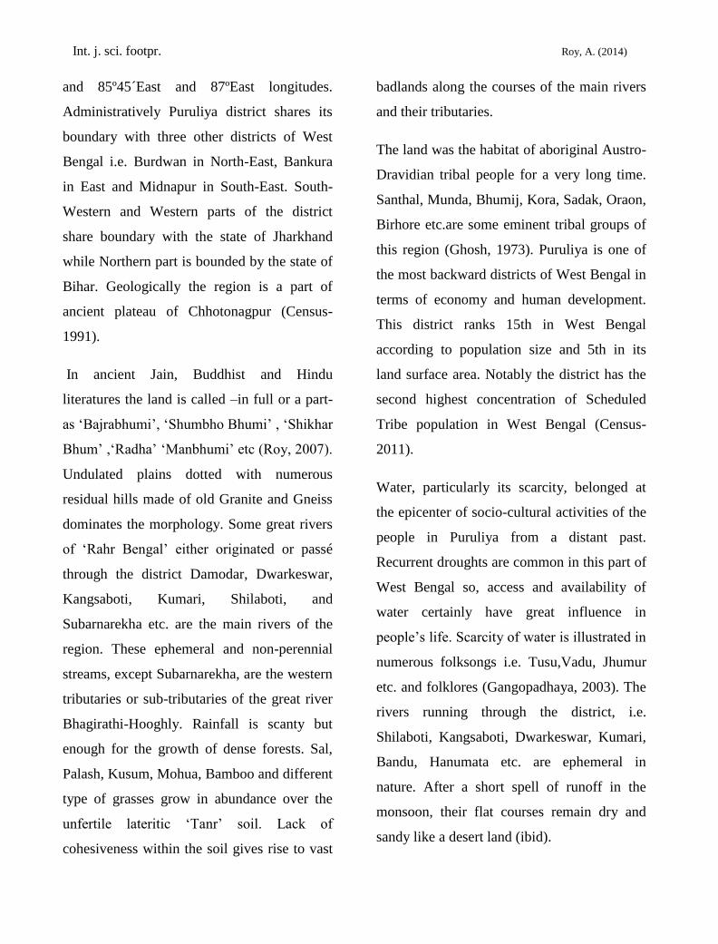
There are disparities in ground water reserve
and utilization among the blocks of Puruliya
district. Utilization of ground water depends
on the yielding capacity of the aquifer and the
quality of the abstracted water from them.
Central Ground Water Board (CGWB) and
State Water and Irrigation Department
(SWID) of West Bengal have jointly assessed
the dynamic ground water resources of
Puruliya district. They declared all of the
blocks in Puruliya district are in ‘safe
category’ i.e. no imbalance in ground water
recharge and withdrawal (Govt. of India,
2007).
Hydrogeology: Geological set up of Puruliya
district shows that the district is underlain by
Pre-Cambrian metamorphic except in some
parts of northeast where Gondwana sediments
predominate. Unconsolidated sediments of
recent or sub recent age are found in narrow
stretches along the major river courses.
Granite and granite gneisses are most
common rocks with widespread occurrence in
the district into which metabasics occur as

Int. j. sci. footpr. Roy, A. (2014)
intrusive (CGWB, 2006). The rock types
other than granite gneiss are amphibolites,
mica schist, quartzite, quartz vein, calc-
silicate rocks with inter banded crystalline
limestone. The upper surface of the district is
composed of thin soil cover followed by
crystalline massive metamorphic rocks of
very high resistivity. Metamorphic rocks are
also exposed on the surface at several
locations (Sharma, 2005).
The study conducted by the Central Ground
Water Board in Puruliya district shows that
ground water occurs in Puruliya within four
distinct zones, i.e. (i) weathered mantle, (ii)
saprolitic zone, (iii) fractured zone of hard
rock and (iv) zone of unconsolidated
sediments.
The weathered Mantle varies in depth in
different parts of the district and its maximum
thickness reaches up to 25 meters. Ground
water occurs in water table conditions and
predominantly developed by open dug wells.
In some places these wells become dry in dry
summer season. Water yielding capacities are
low and restricts within 2.75 liters per second
(lps).
The saprolitic zone is sandwiched between
weathered mantle and un-weathered granitic
rocks. Depth of this zone ranges between 10 –
30 mts. below ground level (mbgl). Average
thickness of this zone is 4 mts. Ground water
occurs in semi confined conditions that can
yield water at a rate of 2.5 lps. Drawdown in
the wells tapping this zone is much less and
recovery is quite fast.
In the hard crystalline rocks ground water
occurs in saturated fractures situated well
beneath the ground. The occurrences of these
fractures are generally restricted to 50 – 110
mbgl. Fractures, that are of shallower depths
generally occur at 50 – 60 m depth and tapped
mainly by borewells fitted with hand pumps,
yield water at a rate below 1 to 2.77 lps.
Deeper fractures are found at 100 to 110 m
depth. Yielding capacity of this zone in
Manbazar is 3 lps. In Gondwana sediment
zones, fractures are encountered at 103 m
depth. They are located within the depth of 24
to 36 mbgl and are capable of yield water at
3.3 – 5.5 lps.
Along the river valleys, stretches the zone of
unconsolidated sediments in 5 to 13 mbgl
level. This narrow zone varies in thickness
and its areal extent is limited within 1 – 2 k.m.
across the valley. Saturated thickness of
alluvial tract varies from 1 m to 5.5 m. Water
yielding capacity of this zone is medium.
Open dug wells and shallow tube wells can
yield 20 m3 of water per hour for a
considerable period of time.

Int. j. sci. footpr. Roy, A. (2014)
Observation records from different ground
water monitoring wells throughout the district
reveals that, in the year 2006 the pre monsoon
and post monsoon water levels in Puruliya
district ranges from 4.32 – 11.68 mbgl and
2.07 – 5.60 mbgl respectively. The regional
fluctuation is restricted within 2.00 mbgl only;
hence no abnormal rise or fall in water level is
observed here (Govt. of India, 2007). In a
study conducted between 1997 and 2006,
water table in Arsha, Baghmundi, Barabazar,
Bandwan, Jhalda- I and II and Puncha block
of Puruliya district showed a trend of rise
during pre and post monsoon seasons.
Maximum rise of 9.01 mgbl was recorded in
Hura block. The other blocks of the district
experienced rise as well as fall in ground
water level during the study period (CGWB,
2007). Out of 50 ground water monitoring
wells in Puruliya, 34 wells showed rise when
the other16 of them recorded fall during pre
and post monsoon decadal (1997 – 2006)
trend of water level. During pre-monsoon
season, 0.001 to 0.37 m/year rise and 0.006 to
0.44 m/year fall had been recorded when the
same for the post monsoon season were 0.016
to 0.36 m/year and 0.014 to 0.37 m/year
respectively (ibid).
Groundwater availability and potential:
Total dynamic ground water reserve of
Puruliya district is assessed as 70147 hector
meters (ha m). Only 9666 ha m or 13.78% of
the net ground water availability is currently
abstracted for use in different sectors e.g.
domestic, agriculture, industry etc. Among the
utilized resource, irrigation comprises lion’s
share of 6000 ha m. Rest 3666 ha m is
consumed jointly by domestic and industrial
sectors. CGWB and SWID forecasted very
small increase in future demand of ground
water in Puruliya district for domestic and
industrial use. According to them the present
figure of 3666 ha m will reach to 4940 ha m
in next 25 years. The available ground water
for future irrigation development is thus
measured as 59207 ha m (Govt. of India-
2007).
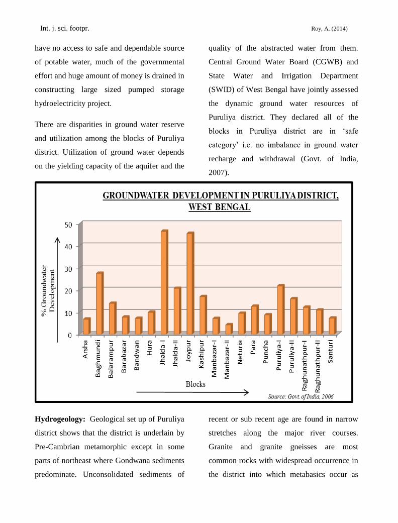
Ground water reserve varies greatly among
different blocks of Puruliya district, so as the
utilization. Barabazar block ranks first in
ground water availability within the district.
Net ground water available in this block is
estimated as 6275 ha m. On the other hand,
Jaypur block stands at the end of the list with
mere 2090 ha m of ground water reserves.
According to their ground water availability,
blocks of Puruliya is divided into four classes
i.e. very low, low, medium and high as
described in the table below.

Int. j. sci. footpr. Roy, A. (2014)
Table 1: Groundwater availability in blocks of Puruliya district
Ground water availability class Blocks
Very low (below 3000 ha m) Baghmundi, Balarampur,
Bandwan, Jhalda-I and II, Jaypur,
Neturia, Raghunathpur- I and II
Low (3000 – 3999 ha m) Arsha, Hura, Manbazar-II, Para,
Puruliya – I and II, Santuri.
Medium (4000 – 4999 ha m) Puncha
High (5000 and above) Manbazar-I, Barabazar, Kashipur.
Source: constructed by the author by the data available from Ministry of water resources, government of India
It is evident from the above table that most of
the blocks in Puruliya are poor in ground
water reserve. Sixteen out of twenty blocks of
the district lay below 4000 ha m reserve
category. Distribution of ground water rich
and poor blocks have no distinct pattern,
rather the rich blocks stands amidst of their
poorer counter parts.
Groundwater utilization: Utilization status
of ground water is even poorer in Puruliya
district. No block has succeeded in abstracting
50% of its available ground water. Manbazar-
II block utilize only 4.2% of its groundwater
resources. Amount of groundwater
withdrawal varies between 168 ha m in
Manbazar-II to 1028 ha m in Kashipur. Thus
the blocks of Puruliya district are divided into
various classes of groundwater utilization in
the following table.
Table 2: Groundwater utilization in blocks of Puruliya district
Groundwater utilization classes Blocks
Very low ( below 300 ha m) Arsha, Bandwan, Manbazar-II, Neturia,
Raghunathpur-II, Santuri.
Low ( 300 – 599 ha m) Baghmundi, Balarampur, Barabazar, Hura, Jhalda-II,
Manbazar-I, Para, Puncha, Raghunathpur-I
Medium ( 600 – 899 ha m) Puruliya-I and II
High ( 900 ha m and above) Jhalda-I, Jaypur, Kashipur.
Source: constructed by the author using the data available from Ministry of water resources, government of India

Int. j. sci. footpr. Roy, A. (2014)
A huge groundwater potential is left
unutilized in Puruliya district. Sometimes it is
intentional, as in Manbazar-I and II, where
other sources like canals and reservoirs
supplement the water demand. But in most of
the cases, hydro-geological conditions play a
negative role in groundwater abstraction. Low
yielding capacities of the aquifers in some
blocks possess serious constraint to
groundwater development. The plea enhances
with poor abstraction structures installed for
ground water exploitation. The following
table explains relation between hydrogeology
and water utilization in Puruliya.
Int. j. sci. footpr. Roy, A. (2014)
EXISTING GAP IN AVAILIBILITY OF GROUND
WATER IN DIFFERENT BLOCKS OF PURULIYA
EXISTING GAP IN GROUND WATER UTILIZATION IN
PURULIYA DISTRICT
Data Source: Govt. of India 2006 86°30’
22°45’
23°15’
23°45’
86° 86°45’
Data Source: Govt. of India, 2006
22°45’
23°45’
86°30’
23°15’
86° 86°45’
High
Medium
Low
Very Low
Index
km 0 10 20 km
High
Medium
Low
Very Low
Index
Km 0 10 20 km
Dig -3
Dig - 4
Int. j. sci. footpr. Roy, A. (2014)
GROUND WATER POTENTIAL IN PURULIYA DISTRICT
(BY EXISTING GAP)
86°30’
22°45’
23°45’
23°15’
Data Source: Govt. of India, 2006
Groundwater potential levels
Moderate
Low
High
Index
Km 0 10 20 Km
Data Source: Govt. of India, 2006
Dig - 5
Dig - 6
Int. j. sci. footpr. Roy, A. (2014)
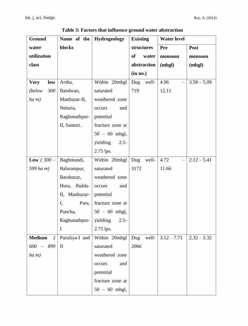
Table 3: Factors that influence ground water abstraction
Ground
water
utilization
class
Name of the
blocks
Hydrogeology Existing
structures
of water
abstraction
(in no.)
Water level
Pre
monsoon
(mbgl)
Post
monsoon
(mbgl)
Very low
(below 300
ha m)
Arsha,
Bandwan,
Manbazar-II,
Neturia,
Raghunathpur-
II, Santuri.
Within 20mbgl
saturated
weathered zone
occurs and
potential
fracture zone at
50 – 60 mbgl,
yielding 2.5-
2.75 lps.
Dug well-
719
4.96 –
12.11
3.58 – 5.09
Low ( 300 –
599 ha m)
Baghmundi,
Balarampur,
Barabazar,
Hura, Jhalda-
II, Manbazar-
I, Para,
Puncha,
Raghunathpur-
I
Within 20mbgl
saturated
weathered zone
occurs and
potential
fracture zone at
50 – 60 mbgl,
yielding 2.5-
2.75 lps.
Dug well-
3172
4.72 –
11.66
2.12 – 5.41
Medium (
600 – 899
ha m)
Puruliya-I and
II
Within 20mbgl
saturated
weathered zone
occurs and
potential
fracture zone at
50 – 60 mbgl,
Dug well-
2066
3.12 – 7.71 2.32 – 3.32
Int. j. sci. footpr. Roy, A. (2014)
yielding 2.5-
2.75 lps.
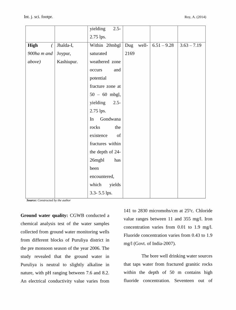
High (
900ha m and
above)
Jhalda-I,
Joypur,
Kashiupur.
Within 20mbgl
saturated
weathered zone
occurs and
potential
fracture zone at
50 – 60 mbgl,
yielding 2.5-
2.75 lps.
In Gondwana
rocks the
existence of
fractures within
the depth of 24-
26mgbl has
been
encountered,
which yields
3.3- 5.5 lps.
Dug well-
2169
6.51 – 9.28 3.63 – 7.19
Source: Constructed by the author
Ground water quality: CGWB conducted a
chemical analysis test of the water samples
collected from ground water monitoring wells
from different blocks of Puruliya district in
the pre monsoon season of the year 2006. The
study revealed that the ground water in
Puruliya is neutral to slightly alkaline in
nature, with pH ranging between 7.6 and 8.2.
An electrical conductivity value varies from
141 to 2830 micromohs/cm at 25ºc. Chloride
value ranges between 11 and 355 mg/l. Iron
concentration varies from 0.01 to 1.9 mg/l.
Fluoride concentration varies from 0.43 to 1.9
mg/l (Govt. of India-2007).
The bore well drinking water sources
that taps water from fractured granitic rocks
within the depth of 50 m contains high
fluoride concentration. Seventeen out of

Int. j. sci. footpr. Roy, A. (2014)
twenty blocks of Puruliya have sporadic
occurrence of fluoride in ground water above
permissible level i.e. below1.5 mg/l. The
maximum range of contamination found in
Jaypur where it ranges between 1.74 and 7.70
mg/l. Table - 4 shows the maximum value of
fluoride in ground water of Puruliya district
Table 4: Analyzed results from rapid assessment report of fluoride task force
SL.NO. Block Maximum Concentration(mg/l)
1. Arsha 2.92
2. Baghmundi 2.38
3. Balarampur 2.12
4. Barabazar 2.08
5. Hura 2.10
6. Jhalda-I 4.93
7. Jaypur 7.7
8. Kashipur 2.78
9. Manbazar-I 2.73
10. Neturia 1.77
11. Para 2.34
12. Puncha 2.41
13. Puruliya-I 3.53
14. Puruliya-II 2.54
15. Raghunathpur-I 4.30
16. Raghunathpur-II 1.74
17. Santuri 2.38
Source: Government of India, 2007
Findings: Major findings that emerged from
the present study are enlisted below.
1. Puruliya district is a drought
prone district of West Bengal with a
perpetual shortage of water availability,
particularly in winter months.
2. Input of water through rain is
plenty but most of the water available
from rain are drained out of the district as
surface runoff and channel flow.
3. Lack of moisture holding
capacity of the soil, in most part of the

Int. j. sci. footpr. Roy, A. (2014)
district, leads to acute shortage of water in
the soil profile.
4. Underlain granitic-gneissic
hard crystalline rocks forms constraints in
water percolation, thus restricts the water
table formation.
5. Seasonal fluctuation of water
level in the aquifers is common in
Puruliya, general trend being the post
monsoon rise.
6. Yielding capacity of the
aquifers in most blocs of Puruliya district
is poor.
7. Only the aquifers in Gondwana
sediments, in the northern blocks possess
considerable water yielding capacity.
8. Groundwater utilization is very
poor. Only 13.78% of the net groundwater
reserve is being utilized at present. Thus a
huge potential is left out untouched.
9. Groundwater abstraction
techniques are primitive, mostly they are
dug wells.
10. Groundwater in Puruliya is
neutral to slightly alkaline in reaction.
Most of the blocs suffer from fluoride
contamination. Some blocs have the
problem of higher iron concentration in
groundwater.
Conclusion: It is clear from the above
discussion that the problem of water scarcity
in Puruliya district is a combined effect of
hydro geological constraints and lack of
proper groundwater abstraction policy. If the
potentiality offered by the groundwater
reserve is used in prudent way, the problem of
water shortage can be sustainably mitigated.
Here are some humble suggestions for
groundwater abstraction planning in Puruliya
district-
i. Scientific explorations, using
remote sensing techniques, are needed to
prepare a detailed groundwater map of
Puruliya district that can be used in
planning bloc level water abstraction
policies.
ii. Primitive dug wells should
immediately be replaced by pump fitted
bore wells.
iii. Different abstraction limits
should be fixed for different hydro
geological units, e.g. higher limits in
Gondwana sediment and fractured zones
and lower limits for hard crystalline rock
zones.
iv. Sectoral priorities in
groundwater distribution should be
prefixed. Priority should be given to
ensure yearlong supply of potable water to
every resident of the district.
v. Economic use of groundwater
should be encouraged to restrict
Int. j. sci. footpr. Roy, A. (2014)
overutilization, in order to maintain its
sustainability.
vi. Micro watershed planning and
rainwater harvesting should be
emphasized to release pressure on ground
water. Demand of water in agriculture and
industry should be mitigated in this way.
Filtration facility should be established at
village level where there is problem of
contamination in ground water
References
[1] Adhikary. (2003). Puruliya: Joler
Eitihyas. Lok, special yearly edition,
Kolkata Book fair, Kolkata.351-355p.
[2] Government of India. (1991) .District
Statistical abstracts, Puruliya District,
Department of Census operations,
Kolkata.
[3] Government of India. (2011). District
Statistical abstracts, Puruliya District,
Department of Census operations,
Kolkata.
[4] Government of India. (2006).
Groundwater information booklet,
Puruliya district, Central Ground
Water Board, Ministry of Water
resources, Kolkata.
[5] Ghosh. (1973). Paschimbanger
Sanskrity ( Vol.-1 ). Prakash Bhaban,
Kolkata. 459pp.
[6] Roy. (1969). Bangalir Iitihas-Adi
Parva {vol.-1) 3rd
edition, Kolkata.
[7] Roy. (2003). Puruliuar Janasamaj: Jol
O jolashoy. Swadesh Charcha Lok,
Special Edition. Kolkata. 432-441pp.
[8] Sharma and Baranwal. (2005).
Delineation of groundwater-bearing
fracture zones in a hard rock area
integrating Very Low Frequency
Electromagnetic and Resistivity data.
Journal of Applied Geophysics, Vol.
57(2):155-166.