Author's personal copy Reciprocality between biology and geology: Reconstructing polar Gondwana
15
This article appeared in a journal published by Elsevier. The attached copy is furnished to the author for internal non-commercial research and education use, including for instruction at the authors institution and sharing with colleagues. Other uses, including reproduction and distribution, or selling or licensing copies, or posting to personal, institutional or third party websites are prohibited. In most cases authors are permitted to post their version of the article (e.g. in Word or Tex form) to their personal website or institutional repository. Authors requiring further information regarding Elsevier’s archiving and manuscript policies are encouraged to visit: http://www.elsevier.com/copyright
-
Upload
independent -
Category
Documents
-
view
0 -
download
0
Transcript of Author's personal copy Reciprocality between biology and geology: Reconstructing polar Gondwana

This article appeared in a journal published by Elsevier. The attachedcopy is furnished to the author for internal non-commercial researchand education use, including for instruction at the authors institution
and sharing with colleagues.
Other uses, including reproduction and distribution, or selling orlicensing copies, or posting to personal, institutional or third party
websites are prohibited.
In most cases authors are permitted to post their version of thearticle (e.g. in Word or Tex form) to their personal website orinstitutional repository. Authors requiring further information
regarding Elsevier’s archiving and manuscript policies areencouraged to visit:
http://www.elsevier.com/copyright

Author's personal copy
Reciprocality between biology and geology: Reconstructing polar Gondwana
B. MichauxPrivate Bag, Kaukapakapa, New Zealand
a b s t r a c ta r t i c l e i n f o
Article history:Received 11 March 2009Received in revised form 31 May 2009Accepted 9 June 2009Available online 21 June 2009
Keywords:Reconstruction modelsPhylogeniesWegenerEast GondwanaWest GondwanaChatham IslandsReciprocal illumination
The reciprocal nature of the relationship between historical geology (reconstruction models) and biology(constructing phylogenies) is discussed and the conceptual basis of such a relationship is examined throughits historical development. Examples to illustrate aspects of the relationship are drawn from the Cretaceousbreakup of polar Gondwana and the Cenozoic history of some of the resultant microcontinental fragments. Anew mid-Cretaceous (circa 100 Ma) rift zone, separating the west Gondwanan Campbell Plateau, southernNew Zealand, from the east Gondwanan Melanesian Rift is proposed, and biological and geological evidencefor it is presented and discussed. It is also suggested that the Bounty Trough, Chatham Rise, and HikurangiPlateau unit is incorrectly placed in reconstruction models, and it should be fitted outboard of the MelanesianRift until its mid-Cenozoic attachment to the Campbell Plateau. It is concluded that both reconstructionmodelling and phylogenetic analyses have much to gain through ‘reciprocal illumination’.
© 2009 International Association for Gondwana Research. Published by Elsevier B.V. All rights reserved.
1. Introduction
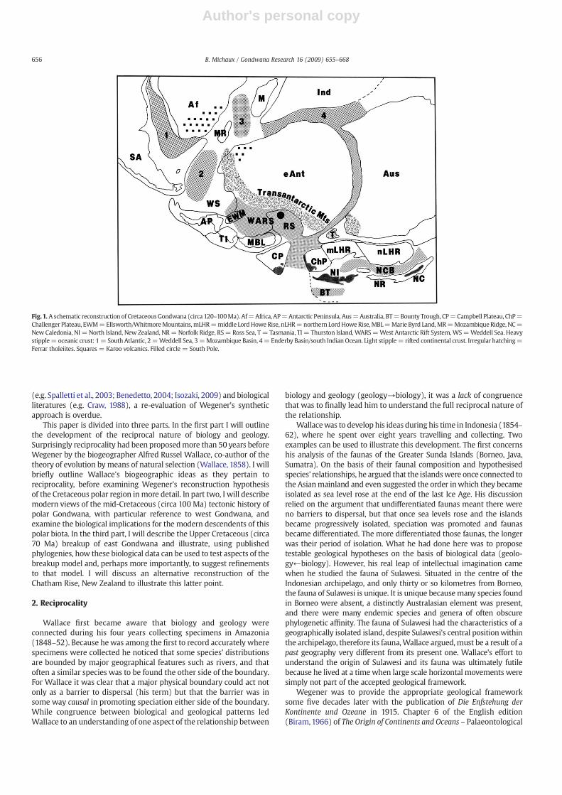
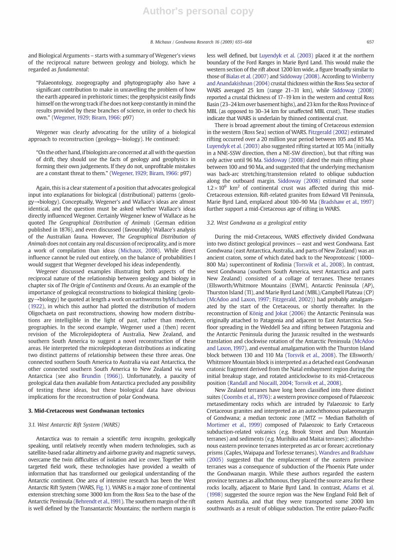
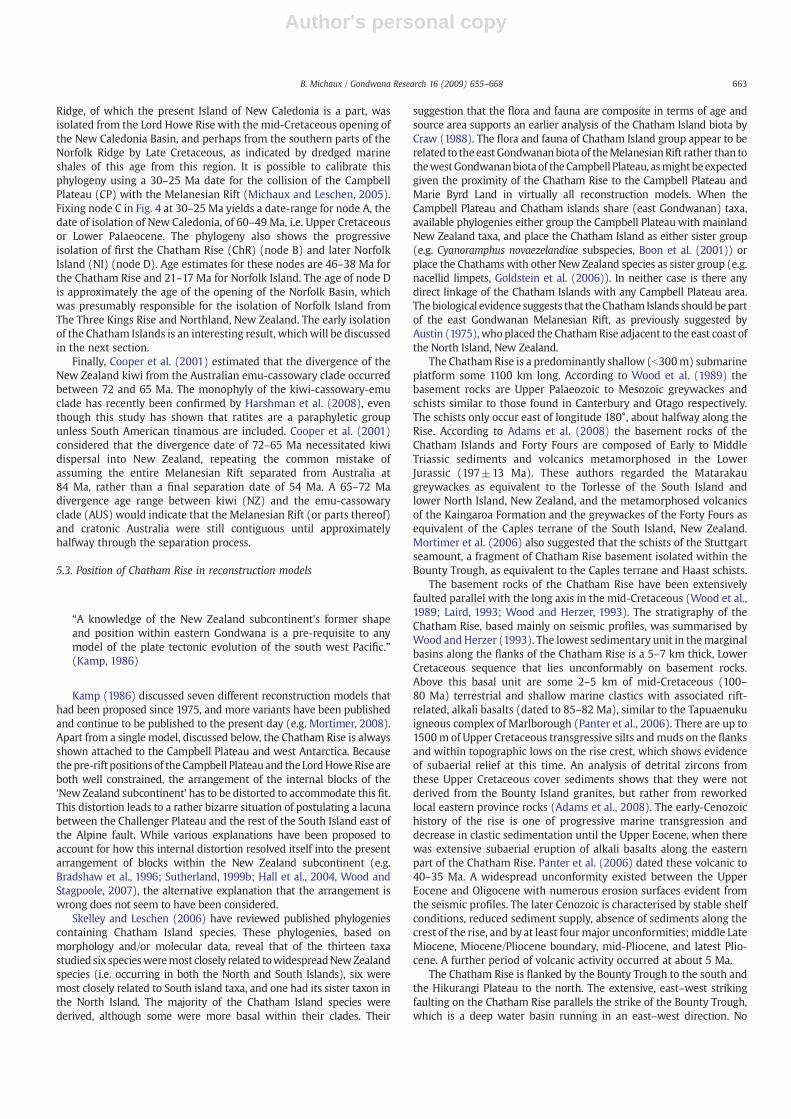
Fig. 1 shows an Early Cretaceous reconstruction of polar Gondwana(southern South America, west Antarctica, Campbell Plateau, southeastAustralia, New Zealand, and adjacent parts of east Antarctica) that wastectonically active, and had been for some time. Earlier mid-Jurassicemplacement of the Ferrar tholeiites into an active rift system inAntarctica (which extended intoTasmania and southeast Australia), andlinked to the eruption of the Karoo basalts in southern Africa, was theearliest sign of the breakup of the super-continent of Gondwana (Elliotand Fleming, 2000; Riley and Knight, 2001; Veevers, 2006). Elliot andFleming (2000) suggested that a triple junction existed in the proto-Weddell Sea region linking these spreading centres. During theCretaceous, active rifting resumed outboard of the Ferrar volcanics andbecame centred on the West Antarctic Rift System (WARS). This majorcontinental rift, comparable to today's Great Rift Valley of Africa, neverdeveloped to the stage of sea-floor spreading, except briefly in themid-Cenozoic (43Ma)when the rift became re-activated in theAdare Trough(Cande et al., 2000). However, it was sporadically active for much of theCretaceousand resulted in extensive crustal thinning.WARSwasamajorfeature of the Cretaceous polar landscape (Fitzgerald, 2002) andseparated low relief, cratonic east Gondwana (east Antarctica/Australia)from the higher, often mountainous relief of the geologically compositewest Gondwana (southern South America/west Antarctica/CampbellPlateau) (Adams et al., 2005; Vaughan et al., 2005; Torsvik et al., 2008).
The mountains and coastal plains were probably wet and temperateeven at high latitudes. The combination of warmth and moistureallowed forests dominated byNothofagus (Dettman and Pocknall,1990),podocarps and araucarians (Mildenhall, 1980) to grow over much ofwestGondwana and coastal east Gondwana, despite the longdark of thepolar winter (McLoughlin, 2001).
The Cretaceous was an important time in the evolution of modernlife as many major biological groups, including flowering plants(Bremer and Gustafsson, 1997; McLoughlin, 2001), birds and mammals(Hedges et al., 1996), were in the process of diversifying. It was also aperiod of accelerating fragmentation of Gondwana as a whole, and ofthe polar region in particular, as rifts opened and new oceanswere born(Fig. 1). What happened to the flora and fauna of polar Gondwana asthese tectonic events unfolded? Is there any evidence of a ‘tectonicimprint’ on the distribution patterns of their modern descendants?Wegener was the first to provide a possible answer to the latterquestion in the fourth and final edition of Die Entstehung der Kontinenteund Ozeane (Wegener, 1929; English translation Biram, 1966). WhileWegener's arguments will be discussed more fully later, he not onlyused modern and fossil distributions to corroborate his reconstructionmodels (geology→biology), but he also used distributions of extantspecies from South America, Australia, and New Zealand to suggestnovel pre-breakup reconstructions for these areas (geology←biology).The arrow indicates the directionality of the hypothesis-test cycle.Wegener's use of phylogenies (hypotheses of biological relationships)as both test of geological hypotheses and generator of reconstructionhypotheses highlights an important aspect of the conceptual relation-ship between biology and geology — reciprocality. While aspects ofreciprocality have continued to be explored in the modern geological
Gondwana Research 16 (2009) 655–668
E-mail address: [email protected].
1342-937X/$ – see front matter © 2009 International Association for Gondwana Research. Published by Elsevier B.V. All rights reserved.doi:10.1016/j.gr.2009.06.002
Contents lists available at ScienceDirect
Gondwana Research
j ourna l homepage: www.e lsev ie r.com/ locate /gr
Author's personal copy
(e.g. Spalletti et al., 2003; Benedetto, 2004; Isozaki, 2009) and biologicalliteratures (e.g. Craw, 1988), a re-evaluation of Wegener's syntheticapproach is overdue.
This paper is divided into three parts. In the first part I will outlinethe development of the reciprocal nature of biology and geology.Surprisingly reciprocality had been proposedmore than 50 years beforeWegener by the biogeographer Alfred Russel Wallace, co-author of thetheory of evolution by means of natural selection (Wallace, 1858). I willbriefly outline Wallace's biogeographic ideas as they pertain toreciprocality, before examining Wegener's reconstruction hypothesisof the Cretaceous polar region in more detail. In part two, I will describemodern views of the mid-Cretaceous (circa 100 Ma) tectonic history ofpolar Gondwana, with particular reference to west Gondwana, andexamine the biological implications for the modern descendents of thispolar biota. In the third part, I will describe the Upper Cretaceous (circa70 Ma) breakup of east Gondwana and illustrate, using publishedphylogenies, how these biological data can be used to test aspects of thebreakup model and, perhaps more importantly, to suggest refinementsto that model. I will discuss an alternative reconstruction of theChatham Rise, New Zealand to illustrate this latter point.
2. Reciprocality
Wallace first became aware that biology and geology wereconnected during his four years collecting specimens in Amazonia(1848–52). Because hewas among the first to record accurately wherespecimens were collected he noticed that some species' distributionsare bounded by major geographical features such as rivers, and thatoften a similar species was to be found the other side of the boundary.For Wallace it was clear that a major physical boundary could act notonly as a barrier to dispersal (his term) but that the barrier was insome way causal in promoting speciation either side of the boundary.While congruence between biological and geological patterns ledWallace to an understanding of one aspect of the relationship between
biology and geology (geology→biology), it was a lack of congruencethat was to finally lead him to understand the full reciprocal nature ofthe relationship.
Wallacewas to develop his ideas during his time in Indonesia (1854–62), where he spent over eight years travelling and collecting. Twoexamples can be used to illustrate this development. The first concernshis analysis of the faunas of the Greater Sunda Islands (Borneo, Java,Sumatra). On the basis of their faunal composition and hypothesisedspecies' relationships, he argued that the islandswere once connected tothe Asianmainland and even suggested the order inwhich they becameisolated as sea level rose at the end of the last Ice Age. His discussionrelied on the argument that undifferentiated faunas meant there wereno barriers to dispersal, but that once sea levels rose and the islandsbecame progressively isolated, speciation was promoted and faunasbecame differentiated. The more differentiated those faunas, the longerwas their period of isolation. What he had done here was to proposetestable geological hypotheses on the basis of biological data (geolo-gy←biology). However, his real leap of intellectual imagination camewhen he studied the fauna of Sulawesi. Situated in the centre of theIndonesian archipelago, and only thirty or so kilometres from Borneo,the fauna of Sulawesi is unique. It is unique becausemany species foundin Borneo were absent, a distinctly Australasian element was present,and there were many endemic species and genera of often obscurephylogenetic affinity. The fauna of Sulawesi had the characteristics of ageographically isolated island, despite Sulawesi's central positionwithinthe archipelago, therefore its fauna,Wallace argued, must be a result of apast geography very different from its present one. Wallace's effort tounderstand the origin of Sulawesi and its fauna was ultimately futilebecause he lived at a timewhen large scale horizontal movements weresimply not part of the accepted geological framework.
Wegener was to provide the appropriate geological frameworksome five decades later with the publication of Die Enfstehung derKontinente und Ozeane in 1915. Chapter 6 of the English edition(Biram,1966) of The Origin of Continents and Oceans – Palaeontological
Fig. 1. A schematic reconstruction of CretaceousGondwana (circa 120–100Ma). Af=Africa, AP=Antarctic Peninsula, Aus=Australia, BT=Bounty Trough, CP=Campbell Plateau, ChP=Challenger Plateau, EWM=Ellsworth/WhitmoreMountains,mLHR=middle LordHoweRise, nLHR=northern LordHoweRise,MBL=Marie Byrd Land,MR=MozambiqueRidge, NC=New Caledonia, NI = North Island, New Zealand, NR=Norfolk Ridge, RS= Ross Sea, T = Tasmania, TI = Thurston Island, WARS=West Antarctic Rift System,WS=Weddell Sea. Heavystipple= oceanic crust: 1= South Atlantic, 2=Weddell Sea, 3=Mozambique Basin, 4= Enderby Basin/south Indian Ocean. Light stipple= rifted continental crust. Irregular hatching=Ferrar tholeiites. Squares = Karoo volcanics. Filled circle = South Pole.
656 B. Michaux / Gondwana Research 16 (2009) 655–668
Author's personal copy
and Biological Arguments – starts with a summary ofWegener's viewsof the reciprocal nature between geology and biology, which heregarded as fundamental:
“Palaeontology, zoogeography and phytogeography also have asignificant contribution to make in unravelling the problem of howthe earth appeared in prehistoric times; the geophysicist easily findshimself on thewrong track if hedoesnot keep constantly inmind theresults provided by these branches of science, in order to check hisown.” (Wegener, 1929; Biram, 1966: p97)
Wegener was clearly advocating for the utility of a biologicalapproach to reconstruction (geology←biology). He continued:
“On theotherhand, if biologists are concerned at allwith thequestionof drift, they should use the facts of geology and geophysics informing their own judgements. If they do not, unprofitable mistakesare a constant threat to them.” (Wegener, 1929; Biram, 1966: p97)
Again, this is a clear statement of a position that advocates geologicalinput into explanations for biological (distributional) patterns (geolo-gy→biology). Conceptually, Wegener's and Wallace's ideas are almostidentical, and the question must be asked whether Wallace's ideasdirectly influenced Wegener. Certainly Wegener knew of Wallace as hequoted The Geographical Distribution of Animals (German editionpublished in 1876), and even discussed (favourably) Wallace's analysisof the Australian fauna. However, The Geographical Distribution ofAnimalsdoes not contain any real discussion of reciprocality, and ismorea work of compilation than ideas (Michaux, 2008). While directinfluence cannot be ruled out entirely, on the balance of probabilities Iwould suggest that Wegener developed his ideas independently.
Wegener discussed examples illustrating both aspects of thereciprocal nature of the relationship between geology and biology inchapter six of The Origin of Continents and Oceans. As an example of theimportance of geological reconstructions to biological thinking (geolo-gy→biology) he quoted at length a work on earthworms byMichaelson(1922), in which this author had plotted the distribution of modernOligochaeta on past reconstructions, showing how modern distribu-tions are intelligible in the light of past, rather than modern,geographies. In the second example, Wegener used a (then) recentrevision of the Microlepidoptera of Australia, New Zealand, andsouthern South America to suggest a novel reconstruction of theseareas. He interpreted the microlepidopteran distributions as indicatingtwo distinct patterns of relationship between these three areas. Oneconnected southern South America to Australia via east Antarctica, theother connected southern South America to New Zealand via westAntarctica (see also Brundin (1966)). Unfortunately, a paucity ofgeological data then available from Antarctica precluded any possibilityof testing these ideas, but these biological data have obviousimplications for the reconstruction of polar Gondwana.
3. Mid-Cretaceous west Gondwanan tectonics
3.1. West Antarctic Rift System (WARS)
Antarctica was to remain a scientific terra incognito, geologicallyspeaking, until relatively recently when modern technologies, such assatellite-based radar altimetry and airborne gravity andmagnetic surveys,overcame the twin difficulties of isolation and ice cover. Together withtargeted field work, these technologies have provided a wealth ofinformation that has transformed our geological understanding of theAntarctic continent. One area of intensive research has been the WestAntarctic Rift System (WARS, Fig. 1). WARS is a major zone of continentalextension stretching some 3000 km from the Ross Sea to the base of theAntarctic Peninsula (Behrendt et al.,1991). The southernmargin of the riftis well defined by the Transantarctic Mountains; the northern margin is
less well defined, but Luyendyk et al. (2003) placed it at the northernboundary of the Ford Ranges in Marie Byrd Land. This would make thewestern section of the rift about 1200 kmwide, a figure broadly similar tothose of Bialas et al. (2007) and Siddoway (2008). According toWinberryandAnandakishnan (2004) crustal thicknesswithin the Ross Sea sector ofWARS averaged 25 km (range 21–31 km), while Siddoway (2008)reported a crustal thickness of 17–19 km in the western and central RossBasin (23–24kmoverbasementhighs), and23kmfor theRossProvinceofMBL (as opposed to 30–34 km for unaffected MBL crust). These studiesindicate that WARS is underlain by thinned continental crust.
There is broad agreement about the timing of Cretaceous extensionin thewestern (Ross Sea) section of WARS. Fitzgerald (2002) estimatedrifting occurred over a 20 million year period between 105 and 85 Ma.Luyendyk et al. (2003) also suggested rifting started at 105Ma (initiallyin a NNE-SSW direction, then a NE-SW direction), but that rifting wasonly active until 96 Ma. Siddoway (2008) dated the main rifting phasebetween 100 and 90Ma, and suggested that the underlyingmechanismwas back-arc stretching/transtension related to oblique subductionalong the outboard margin. Siddoway (2008) estimated that some1.2×106 km2 of continental crust was affected during this mid-Cretaceous extension. Rift-related granites from Edward VII Peninsula,Marie Byrd Land, emplaced about 100–90 Ma (Bradshaw et al., 1997)further support a mid-Cretaceous age of rifting in WARS.
3.2. West Gondwana as a geological entity
During the mid-Cretaceous, WARS effectively divided Gondwanainto two distinct geological provinces — east and west Gondwana. EastGondwana (east Antarctica, Australia, and parts of NewZealand)was anancient craton, some of which dated back to the Neoprotozoic (1000–800 Ma) supercontinent of Rodinia (Torsvik et al., 2008). In contrast,west Gondwana (southern South America, west Antarctica and partsNew Zealand) consisted of a collage of terranes. These terranes(Ellsworth/Whitmore Mountains (EWM), Antarctic Peninsula (AP),Thurston Island (TI), andMarie Byrd Land (MBL)/Campbell Plateau (CP)(McAdoo and Laxon, 1997; Fitzgerald, 2002)) had probably amalgam-ated by the start of the Cretaceous, or shortly thereafter. In thereconstruction of König and Jokat (2006) the Antarctic Peninsula wasoriginally attached to Patagonia and adjacent to East Antarctica. Sea-floor spreading in the Weddell Sea and rifting between Patagonia andthe Antarctic Peninsula during the Jurassic resulted in the westwardstranslation and clockwise rotation of the Antarctic Peninsula (McAdooand Laxon, 1997), and eventual amalgamationwith the Thurston Islandblock between 130 and 110 Ma (Torsvik et al., 2008). The Ellsworth/WhitmoreMountain block is interpreted as a detached east Gondwanancratonic fragment derived from the Natal embayment region during theinitial breakup stage, and rotated anticlockwise to its mid-Cretaceousposition (Randall and Niocaill, 2004; Torsvik et al., 2008).
New Zealand terranes have long been classified into three distinctsuites (Coombs et al., 1976): awestern province composed of Palaeozoicmetasedimentary rocks which are intruded by Palaeozoic to EarlyCretaceous granites and interpreted as an autochthonous palaeomarginof Gondwana; a median tectonic zone (MTZ = Median Batholith ofMortimer et al., 1999) composed of Palaeozoic to Early Cretaceoussubduction-related volcanics (e.g. Brook Street and Dun Mountainterranes) and sediments (e.g. Murihiku andMaitai terranes); allochtho-nous eastern province terranes interpreted as arc or forearc accretionaryprisms (Caples,Waipapa and Torlesse terranes).Wandres and Bradshaw(2005) suggested that the emplacement of the eastern provinceterranes was a consequence of subduction of the Phoenix Plate underthe Gondwanan margin. While these authors regarded the easternprovince terranes as allochthonous, they placed the source area for theserocks locally, adjacent to Marie Byrd Land. In contrast, Adams et al.(1998) suggested the source region was the New England Fold Belt ofeastern Australia, and that they were transported some 2000 kmsouthwards as a result of oblique subduction. The entire palaeo-Pacific
657B. Michaux / Gondwana Research 16 (2009) 655–668

Author's personal copy
margin was a long-lived orogenic belt resulting from subduction andplate convergence beginning in the Lower Palaeozoic and continuing tothe mid-Cretaceous (Wandres and Bradshaw, 2005; Vaughan et al.,2005; Vaughan and Pankhurst, 2008). The change from convergent toextensional tectonics occurred in the Early Jurassic in northeastAustralia, in the Cretaceous in New Zealand/west Antarctica, and inthe Cenozoic in the Antarctic Peninsula (Adams et al., 1998).
A number of authors have proposed correlations between thevarious terranes found from New Zealand with those of westAntarctica and southern South America. Adams et al. (2005) tracedwestern province terranes (which they regarded as part of the Lachlanfold belt) from southeastern Australia into New Zealand, the CampbellPlateau, western Marie Byrd Land, the Antarctic Peninsula, andsouthern South America. Bradshaw (2008) also traced the Lachlanfold belt into west Antarctica. Possible correlations of MTZ terranes ofNew Zealand are unresolved. Wandres and Bradshaw (2005)suggested that the MTZ could be traced across the Campbell Plateau(Bounty Island Granite) and into the Amundsen Province of easternMarie Byrd Land (Bradshaw et al., 1997). However, Adams (2007)suggested that the Bounty Island granites were not part of the MTZ,relating them instead to similar aged granites on Thurston Island, westAntarctica. The magnetic data reported in Sutherland (1999a)suggests that the MTZ is only present in western Campbell Plateau.Finally, eastern province terranes have been recognised in theAntarctic Peninsula (the Western Domain of Vaughan and Storey(2000)) and the western archipelago of southern Chile (Adams et al.,2005). No eastern province terranes have been identified in MarieByrd Land or the Campbell Plateau.
3.3. Campbell Rift
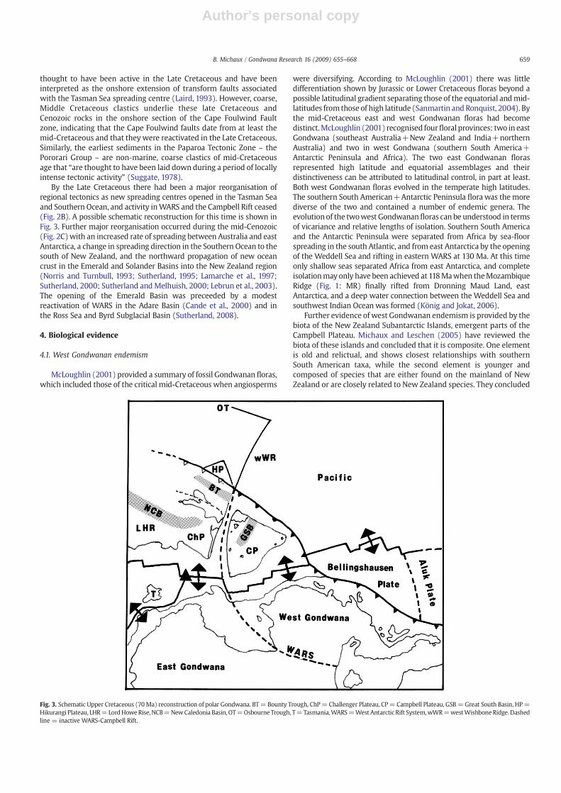
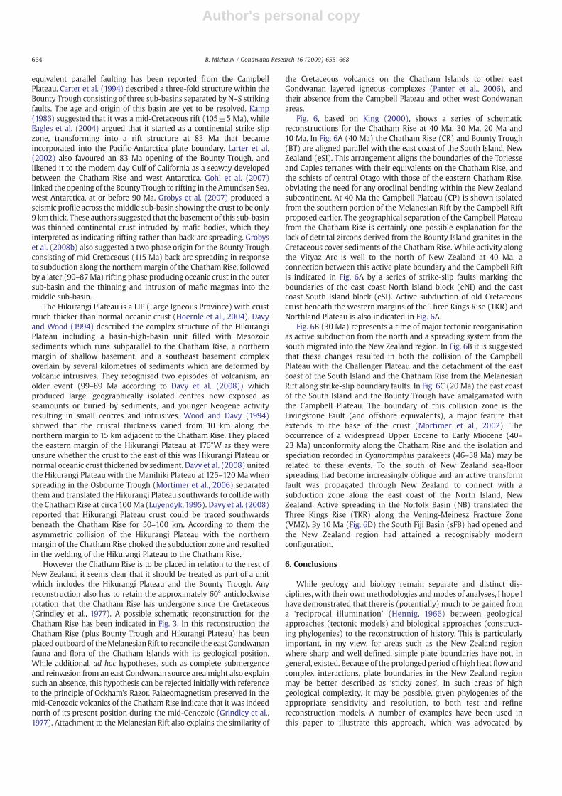
West Gondwana was bounded by the Weddell Sea and WARS,which separated southern South America and west Antarcticarespectively from east Antarctica (Fig. 1). The mid-Cretaceous(100 Ma) reconstruction shown in Fig. 1 is abstracted in Fig. 2A(note that the view is reversed in Fig. 2). In Fig. 2A a boundary, termedthe Campbell Rift, is shown separating the Campbell Plateau/MarieByrd Land from the Australasian sector of east Gondwana. It isproposed that a mid-Cretaceous triple junction (Fig. 2A: proto-MTJ)existed within the Ross Sea sector connecting a rift–rift–rift system.WARS and the Australian–east Antarctica rift formed two of thesearms. The Australian–east Antarctica rift was similar in a number ofways to WARS. Early rifting in the late Jurassic or earliest Cretaceousproduced oceanic crust only in the west as India/Madagascar riftedfrom east Gondwana (Powell et al., 1988; Veevers, 2006). Slow andsporadic spreading during the Cretaceous produced a rift valleygeomorphology, but no oceanic crust, in the central and easternsectors (Powell et al., 1988; Norvick and Smith, 2001; Palmowski et al.,2001). UnlikeWARS, themajor spreading phase occurred in the UpperCretaceous and Cenozoic, as opposed to mid-Cretaceous, and itsdevelopment culminated in the formation of the Southern Ocean asAustralia separated from east Antarctica (Fig. 2C).
A third arm of the triple junction is a geometric necessity and thereare a number of lines of evidence suggesting that this rift should beplaced between the west Gondwanan Campbell Plateau and theChallenger Plateau/Norfolk Ridge sector of east Gondwana. Firstly, thewestern margin of the Campbell Plateau is straight and has nocontinental slope to speak of— typical characteristics of riftedmarginsin general. While this modern margin is the product of mid-Cenozoicrifting following the opening of the Emerald Basin, restoring theResolution Ridge, a detached continental sliver (Wood et al., 1996;Lebrun et al., 2003), to its pre-rift position along the western marginof the Campbell Plateau does not materially affect this observation.Secondly, it is known that the Campbell Plateau has undergoneextension (Sutherland and Melhuish, 2000; Grobys et al., 2008a).Grobys et al. (2008a) argued that the extension phase responsible for
crustal thinning preceded the opening of the Great South Basin whichprobably occurred in the mid-Cretaceous (100 Ma) (Beggs, 1993;Laird, 1993; Cook et al., 1999; Sutherland, 2000, Grobys et al., 2008a)as a precursor to the tectonic events leading to the eventualdetachment of the Campbell Plateau fromMarie Byrd Land. Siddoway(2008: Fig. 9) showed NW-SE oriented extension at circa 100 Mabetween the Campbell and Challenger Plateaux.
Faulting parallel to the southern margin of the Challenger Plateau(Cape Foulwind Fault Zone and Paparoa Tectonic Zone) is present inboth on- and offshore Cretaceous sequences of the west coast of theSouth Island, New Zealand (Bishop,1992; Laird,1993). These faults are
Fig. 2. Tectonic development in the polar Gondwana region at three time intervals. Darklines= active tectonic boundaries, grey lines= inactive tectonic boundaries, triangle=triple junction, MTJ = Macquarie Triple Junction. Aus = Australian craton, CP =Campbell Plateau, ChP= Challenger Plateau, LHR= Lord Howe Rise, MBL=Marie ByrdLand, NR = Norfolk Ridge, WARS = West Antarctic Rift System.
658 B. Michaux / Gondwana Research 16 (2009) 655–668
Author's personal copy
thought to have been active in the Late Cretaceous and have beeninterpreted as the onshore extension of transform faults associatedwith the Tasman Sea spreading centre (Laird, 1993). However, coarse,Middle Cretaceous clastics underlie these late Cretaceous andCenozoic rocks in the onshore section of the Cape Foulwind Faultzone, indicating that the Cape Foulwind faults date from at least themid-Cretaceous and that they were reactivated in the Late Cretaceous.Similarly, the earliest sediments in the Paparoa Tectonic Zone – thePororari Group – are non-marine, coarse clastics of mid-Cretaceousage that “are thought to have been laid down during a period of locallyintense tectonic activity” (Suggate, 1978).
By the Late Cretaceous there had been a major reorganisation ofregional tectonics as new spreading centres opened in the Tasman Seaand Southern Ocean, and activity inWARS and the Campbell Rift ceased(Fig. 2B). A possible schematic reconstruction for this time is shown inFig. 3. Further major reorganisation occurred during the mid-Cenozoic(Fig. 2C)with an increased rate of spreading between Australia and eastAntarctica, a change in spreading direction in the Southern Ocean to thesouth of New Zealand, and the northward propagation of new oceancrust in the Emerald and Solander Basins into the New Zealand region(Norris and Turnbull, 1993; Sutherland, 1995; Lamarche et al., 1997;Sutherland, 2000; Sutherland andMelhuish, 2000; Lebrun et al., 2003).The opening of the Emerald Basin was preceeded by a modestreactivation of WARS in the Adare Basin (Cande et al., 2000) and inthe Ross Sea and Byrd Subglacial Basin (Sutherland, 2008).
4. Biological evidence
4.1. West Gondwanan endemism
McLoughlin (2001) provided a summary of fossil Gondwanan floras,which included those of the critical mid-Cretaceous when angiosperms
were diversifying. According to McLoughlin (2001) there was littledifferentiation shown by Jurassic or Lower Cretaceous floras beyond apossible latitudinal gradient separating those of the equatorial andmid-latitudes from those of high latitude (Sanmartin andRonquist, 2004). Bythe mid-Cretaceous east and west Gondwanan floras had becomedistinct.McLoughlin (2001) recognised fourfloral provinces: two in eastGondwana (southeast Australia+New Zealand and India+northernAustralia) and two in west Gondwana (southern South America+Antarctic Peninsula and Africa). The two east Gondwanan florasrepresented high latitude and equatorial assemblages and theirdistinctiveness can be attributed to latitudinal control, in part at least.Both west Gondwanan floras evolved in the temperate high latitudes.The southern South American+Antarctic Peninsula flora was the morediverse of the two and contained a number of endemic genera. Theevolutionof the twowest Gondwananfloras can be understood in termsof vicariance and relative lengths of isolation. Southern South Americaand the Antarctic Peninsula were separated from Africa by sea-floorspreading in the south Atlantic, and from east Antarctica by the openingof the Weddell Sea and rifting in eastern WARS at 130 Ma. At this timeonly shallow seas separated Africa from east Antarctica, and completeisolationmayonly have been achieved at 118Mawhen theMozambiqueRidge (Fig. 1: MR) finally rifted from Dronning Maud Land, eastAntarctica, and a deep water connection between the Weddell Sea andsouthwest Indian Ocean was formed (König and Jokat, 2006).
Further evidence of west Gondwanan endemism is provided by thebiota of the New Zealand Subantarctic Islands, emergent parts of theCampbell Plateau. Michaux and Leschen (2005) have reviewed thebiota of these islands and concluded that it is composite. One elementis old and relictual, and shows closest relationships with southernSouth American taxa, while the second element is younger andcomposed of species that are either found on the mainland of NewZealand or are closely related to New Zealand species. They concluded
Fig. 3. Schematic Upper Cretaceous (70Ma) reconstruction of polar Gondwana. BT= Bounty Trough, ChP= Challenger Plateau, CP= Campbell Plateau, GSB=Great South Basin, HP=Hikurangi Plateau, LHR=LordHoweRise,NCB=NewCaledonia Basin,OT=Osbourne Trough, T=Tasmania,WARS=West Antarctic Rift System,wWR=westWishboneRidge.Dashedline = inactive WARS-Campbell Rift.
659B. Michaux / Gondwana Research 16 (2009) 655–668
Author's personal copy
that the older fauna is west Gondwanan and dates from circa 88 Ma(Eagles et al., 2004) to 83 Ma (McAdoo and Laxon, 1997) when theCampbell Plateau separated from Marie Byrd Land, west Gondwana.
4.2. Polar Gondwanan biogeographic patterns
The nature of the relationship between southern South America,Australia and New Zealand is a classic biogeographic problem thatremains unresolved to this day. Sanmartin and Ronquist (2004) havereviewed and summarised the phylogenies of 54 animal and 19 planttaxa whose distributions include southern South America, Australiaand New Zealand. Based on these phylogenies, they identified threebiogeographic patterns; the southern Gondwana pattern (SGP) inwhich southern south America is more closely related to Australiathan to New Zealand – (NZ(sSA,Aus)) – the plant southern pattern(PSP) – (sSA(NZ,Aus)) – and the inverted southern pattern (ISP) –
(Aus(NZ,sSA). This study, while exhaustive and thorough, suffers froma fundamental problem which precludes any solution to this classicbiogeographic problem. This problem has recently been discussed byGiribit and Edgecombe (2006) and concerns the importance ofanalysing areas at the appropriate scale. Giribit and Edgecombe(2006) pointed out that treating ‘Australia’ as a biogeographic unitobscured finer biogeographic detail, and that artefactual results are alikely consequence of such an analysis (Nelson and Ladiges, 1996,2001). Treating areas with differing histories as single entities can alsolead to false paradoxes. For example, how can New Zealand be mostclosely related to Australia and southern South America simulta-neously (PSP and ISP)? If New Zealand is biologically and geologicallycomposite, as is argued here, then the apparent paradox vanishes ifeach element is treated separately.Wegener's (1929) observation thatsouthern South America's relationshipwith New Zealandwas viawestAntarctica (ISP of Sanmartin and Ronquist, 2004) can now be refinedas a relationship between southern South America and the CampbellPlateau via west Antarctica, which is a result of the originalconfiguration of these areas into west Gondwana between circa105 Ma and 88 Ma.
Using modern geography to describe endemic areas (the terminalnodes of the cladogram) rather than Cretaceous geography also leads toartefactual results. If the nodes of the three patterns described bySanmartin and Ronquist (2004) are defined in terms of Cretaceousgeography, then it becomes clear that only two of the patterns (ISP andPSP) are real. The ISP links two west Gondwanan areas (internal nodedate of 88 Ma) with east Gondwana (Australia). The basal node joiningeast and west Gondwana can be dated to 105 Ma. In the PSP, two eastGondwanan areas are linked (internal node dated to the opening of theTasman Sea between 85 and 55 Ma — see following section), and thebasal node representing the east-west Gondwans split at 105Ma. In theSGP the internal node represents the east-west Gondwana split at105 Ma rendering the basal node paralagous (Nelson and Ladiges,1996). In other words, the SGP is a pattern based onwidespread speciesand is equivalent to a polyphyletic (or non-natural) taxonomic group.
4.3. Biological dating of geological events
Phylogenies based on molecular data have an advantage overmorphological-based phylogenies because it is possible to calibraterates of change and date internal nodes, assuming that substitution/deletion rates remain constant for all lineages. While calibration is notstraightforward and is amatter of some contention (Heads, 2005), thereare a number of studies that are relevant to the timing of events relatedto the breakup of polar Gondwana.McDaniel and Shaw (2003) used themoss Pyrrhobryummnioides, found in New Zealand, southeast Australiaand Tasmania, southern South America, and the neotropics of SouthAmerica, to estimate when east and west Gondwana separated. Theiranalysis, based on three chloroplast loci, produced a phylogeny inwhichAustralasian and South American populations of this species grouped
into two clades. Resolution in the Australasian clade was poor (perhapsthe assumption of constant rates did not hold), but the South Americantaxa resolved into two distinct groups, a neotropical clade and asouthern clade. McDaniel and Shaw (2003) calibrated their phylogenyusing a 14Ma age for the origination of the AtacamaDesert,which theseauthors suggested represented the vicariant event responsible forsplitting the southern and neotropical South American populations.Using this date yields an 80 Ma estimate for the split between east andwest Gondwana. While this estimate is too imprecise to test thegeological estimate of 105 Ma, it is within the right order of magnitudeand shows the utility of their calibration method.
Renner et al. (2000) produced a molecular phylogeny for thesouthern sassafrases (Atherospermataceae) found in Australia, NewZealand, New Caledonia, New Guinea, and southern South America.Sassafras species exhibit a strong ecological association with thesouthern beeches (Nothofagus), and other old Gondwanan plantgroups such as the podocarps and araucarians. The sassafrasephylogeny [(Aus(NG(Aust,NC)(sSA(sSA,NZ))))] grouped the southernSouth American and New Zealand species into a west Gondwananclade that is a sister group to an east Gondwanan clade (Australia andNew Caledonia species). Renner et al. (2000) used a variety of fossiland geological dates to calibrate the phylogeny. For example, theydated the node linking the New Zealand and Chilean species at 80 Mabased on the age of fossil Laureliopsis-likewood. This date is consistentwith geological estimates of the age when the Campbell Plateau splitfrom west Gondwana, and suggested a 109 Ma date for the nodelinking the east and west Gondwanan clades.
While modern Antarctica is a frozen wasteland there is a restrictedterrestrial fauna present. Allegrucci et al. (2006) used a molecular-based study of Antarctic Chironomidae to show that these midges hadoriginated on the continent and had remained in situ during climaticdeterioration. This is a very important result because it means that ageestimates of cladogram nodes can be obtained directly from endemicAntarctic species, rather than indirectly from species of surroundingareas. Allegrucci et al. (2006) used assumed substitution rates to obtaindivergence ages that are consistent with geological estimates. Forexample, they estimated that the Antarctic Peninsula midges evolved atapproximately 49 Ma as the Drake Passage opened and the AntarcticPeninsula became isolated from southern South America.
5. Late-Cretaceous disruption of east Gondwana
5.1. Melanesian Rift
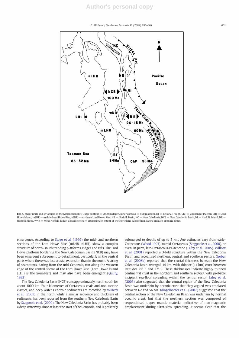
Fig. 4 shows the main components of what I have here termed theMelanesian Rift. The Melanesian Rift is an elongate continentalfragment that detached from east Gondwana during the Cretaceousand Palaeogene. Knowledge of this largely submerged continentalfragment has increased rapidly in recent years as both New Zealand(Wright et al., 2002) and Australia (Stagg et al., 1999) carried outextensive marine surveys to delimit their respective continentalshelves following ratification of the United Nations Convention on theLaw of the Sea (UNCLOS) in 1996, and oil companies developed thetechnology to allow them to prospect in deep water, offshore basins.
Gaina et al. (1998) modelled the separation of the Lord Howe Rise(LHR) from the eastern margin of Australia. Their animation showedan asynchronous detachment of the Lord Howe Rise from the easternmargin of Australia, starting at approximately 85 Ma in the south(although extension probably started much earlier (Crawford et al.,2003)) and finishing as late as 52 Ma in the north when sea-floorspreading in the Coral Sea ceased. The southern section of the LordHowe Rise, the Challenger Plateau (ChP), became isolated when theBellona Trough (BT) opened between 84 and 73 Ma. The ChallengerPlateau is composed of continental crust (Tulloch et al., 1991) onlymoderately thinned (Wood and Woodward, 2002). The thinness ofsediment cover (Wood,1993) indicates substantial periods of post-rift
660 B. Michaux / Gondwana Research 16 (2009) 655–668
Author's personal copy
emergence. According to Stagg et al. (1999) the mid- and northernsections of the Lord Howe Rise (mLHR, nLHR) show a complexstructure of north–south trending platforms, ridges and rifts. The LordHowe platform bordering the New Caledonian Basin (NCB) may havebeen emergent subsequent to detachment, particularly in the centralparts where therewas less crustal extension than in the north. A stringof seamounts, dating from the mid-Cenozoic, run along the westernedge of the central sector of the Lord Howe Rise (Lord Howe Island(LHI) is the youngest) and may also have been emergent (Quilty,1993).
The NewCaledonia Basin (NCB) runs approximately north–south forabout 1000 km. Four kilometres of Cretaceous coals and non-marineclastics, and deep water Cenozoic sediments are recorded by Willcoxet al. (2001) in the north, while a similar sequence and thickness ofsediments has been reported from the southern New Caledonia Basinby Stagpoole et al. (2000). The New Caledonia Basin has probably beena deepwaterway since at least the start of the Cenozoic, and is presently
submerged to depths of up to 5 km. Age estimates vary from early-Cretaceous (Wood,1993), tomid-Cretaceous (Stagpoole et al., 2000), oreven, in parts, late-Cretaceous-Palaeocene (Lafoy et al., 2005). Willcoxet al. (2001) reported a 3-fold structure within the New CaledoniaBasin, and recognised northern, central, and southern sectors. Grobyset al. (2008b) reported that the crustal thickness beneath the NewCaledonia Basin averaged 14 km, with thinner (11 km) crust betweenlatitudes 25° S and 27° S. These thicknesses indicate highly thinnedcontinental crust in the northern and southern sectors, with probableincipient sea-floor spreading within the central sector. Lafoy et al.(2005) also suggested that the central region of the New CaledoniaBasin was underlain by oceanic crust that they argued was emplacedbetween 62 and 56 Ma. Klingelhoefer et al. (2007) suggested that thecentral section of the New Caledonian Basin was underlain by normaloceanic crust, but that the northern section was composed ofserpentinised upper mantle material indicative of non-magmaticemplacement during ultra-slow spreading. It seems clear that the
Fig. 4.Major units and structures of the Melanesian Rift. Outer contour = 2000 m depth, inner contour = 500 m depth. BT = Bellona Trough, ChP = Challenger Plateau, LHI = LordHowe Island, mLHR=middle Lord Howe Rise, nLHR= northern Lord Howe Rise, NB= Norfolk Basin, NC=New Caledonia, NCB=New Caledonia Basin, NI = Norfolk Island, NR=Norfolk Ridge, wNR = west Norfolk Ridge. Closed circles = approximate extent of the Northland Allochthon. Dates indicate opening times.
661B. Michaux / Gondwana Research 16 (2009) 655–668

Author's personal copy
New Caledonia Basin has acted to isolate New Caledonia (NC) and theNorfolk Ridge (NR) from the Lord Howe Rise for a considerable period.
The Norfolk Ridge is a complex structure that became disruptedduring themid-Cenozoic. Grobys et al. (2008b) reported average crustalthicknesses of 24 km for the West Norfolk Ridge (wNR) and 21 km forthe Norfolk Ridge, while Klingelhoefer et al. (2007) reported a thicknessof 17 km for a region south of New Caledonia. These results indicate thatboth sections of the Norfolk Ridge are composed of thinned continentalcrust. Granites, metamorphics, andmid-Cretaceous coal measures havebeen dredged from the West Norfolk Ridge, and Upper Cretaceousmarine shales from the Norfolk Ridge south of New Caledonia (Herzeret al., 1999). The Norfolk Ridge was disrupted in the mid-Cenozoic bythe opening of the Norfolk Basin (NB), forming the West Norfolk Ridgeand translating the Three Kings Rise eastwards. Early models of theNorfolk Basin treated it as a back-arc basin resulting from westwarddipping subduction along the eastern margin of the Three Kings Riseduring the opening of the South Fiji Basin (e.g. Ballance et al., 1982).However, subduction-related, Miocene andesite volcanics are found onthe western margin of the Three Kings Rise indicating eastwardssubduction.
Recent studies of the Norfolk Basin suggest that its history is morecomplex than a simple back-arc origin (Sdrolias et al., 2004). Sdroliaset al., 2004 described a complex structure of plateaux and abyssal plainswithin the Norfolk Basin. They interpreted the plateaux as disruptedCretaceous oceanic crust trappedwithin a matrix of later, mid-Cenozoicoceanic crust. They suggested that this older crustwas formed in a back-arc basin during the mid-Cretaceous as Pacific crust was beingsubducted beneath east Gondwana. The opening of this back-arcbasin separated a Loyalty-Three Kings Rise arc from the Pacific marginof east Gondwana. This marginal basinwas subsequently closed as crustwas subducted beneath the western margin of the Loyalty-Three KingsRise arc in response to the northeastwards translation of theMelanesian Rift as the Tasman Sea opened. The closing of this marginalbasin resulted in the collision of the Loyalty-Three Kings Rise arc withthe Melanesian Rift causing, according to Sdrolias et al. (2004), theobduction of the New Caledonian ophiolites at 45 Ma and the trappingof Cretaceous oceanic crust between the Norfolk Ridge and Three KingsRise. There was regional uplift and subaerial erosion on the Lord HoweRise during this period of tectonic compression during the UpperEocene (38 Ma) to Middle Oligocene (30 Ma) coincident with theseevents (Klingelhoefer et al., 2007). Following collision of the Loyalty-Three Kings Rise arc with the Melanesian Rift, subduction polarityswitched to the west and migrated southwards (Vityaz Arc, Fig. 4),opening the South Fiji Basin and causing back-arc extension in theNorfolk basin. The presence of emergent islands along the Three KingsRise and Norfolk Ridge between 38 and 31 Ma reported in Meffre et al.(2006) indicates uplift in this region at this time. Schellart et al. (2006)suggested that collision of the d'Entrecasteaux-Loyalty-Three KingsRise-Northland Plateau arc was also responsible for the emplacement ofthe Northland Allochthon. In their model the collision is asynchronous,with earlier contact in the north (emplacement of the New Caledonianophiolites between 38 and 34 Ma) and later collision in the south(emplacement of the Northland Allochthon between 25 and 22 Ma).This latter suggestion is in contrast to other models of the formationand emplacement of the Northland Allochthon (e.g. Rait, 2000;Bradshaw, 2004; Whattam et al., 2005; Mortimer et al., 2007).
Running south from the Norfolk Basin are a series of basins – Reinga(Herzer et al., 1997; Stagpoole et al., 2000), Northland (Isaac et al., 1994;Uruski et al., 2004) and north and south Taranaki (Kamp et al., 2004;Stagpoole et al., 2004) – that Kamp (1986) collectively termed theNorth Island Rift System (Fig. 4: West Coast Rift). This rift systemwas amajor feature some 1200 km long and 100–200 km wide during theUpper Cretaceous (60Ma) to mid-Cenozoic (35Ma). It was surroundedby coastal plains that were terrestrial, in part at least, until the end ofthe Eocene. Subsidence and flooding of the rift proceeded from thenorth from about 60 Ma, finally inundating the southern portion at
about 35 Ma, effectively isolating the North Island, New Zealand fromthe Challenger Plateau.
5.2. Biological evidence
While the number of molecular phylogenies of Melanesian Rifttaxa is small there are sufficient to illustrate the potential importanceof such studies as aids in model reconstruction. The two mostextensive studies of Melanesian Rift taxa are those of Ponder et al.(2003) for the flax snail Placostylus, and Boon et al. (2001) for theparakeet Cyanoramphus. Placostylus species are large (5–9 cm)pulmonate gastropods found in northern New Zealand, Three KingsIslands, New Caledonia, Loyalty Islands, Lord Howe Island, Vanuatu,Solomon Islands, and Fiji. While the study of Ponder et al. (2003) isweakened – biogeographically – by the inclusion of only one of themany New Caledonian taxa, and no species from the Loyalty Islands,Vanuatu, Solomons or Fiji, the resulting phylogeny [(TKI(NC(NZ,LHI)))] is fascinating, and if repeated for other groups could settle thecontroversy over the Cretaceous-Eocene boundary between thePacific plate and the Melanesian Rift discussed by Schellart et al.(2006). The important (and unexpected) result was the basalplacement of the Three Kings Islands species, making this clade theearliest lineage of all the Placostylus species. This result clearlysupports the model of Sdrolias et al. (2003), which posited aCretaceous origin for the Loyalty-Three Kings Rise arc, and thus byimplication supports an eastwards dipping subduction zone betweenthe Melanesian Rift and Pacific plate from the mid-Cretaceous toEocene.
Fig. 5 is a simplified version of the Cyanoramphus phylogenypublished in Boon et al. (2001). The basal position of C. saisetti showsthat New Caledonia (NC) was the first area to be isolated from the restof theMelanesian Rift. New Caledonia (plus New Zealand) is also basalin the phylogeny of owlet-nightjars (Dumbacher et al., 2003),reinforcing the view that much of New Caledonia's flora and faunais old and relictual (Ladiges and Cantrill, 2007). The northern Norfolk
Fig. 5. Simplified phylogeny of Cyanoramphus parakeets after Boon et al. (2001). ChR =Chatam Rise, CP= Campbell Plateau, MI=Macquarie Island, NC=New Caledonia, NI =Norfolk Island, NZ = New Zealand.
662 B. Michaux / Gondwana Research 16 (2009) 655–668
Author's personal copy
Ridge, of which the present Island of New Caledonia is a part, wasisolated from the Lord Howe Rise with the mid-Cretaceous opening ofthe New Caledonia Basin, and perhaps from the southern parts of theNorfolk Ridge by Late Cretaceous, as indicated by dredged marineshales of this age from this region. It is possible to calibrate thisphylogeny using a 30–25 Ma date for the collision of the CampbellPlateau (CP) with the Melanesian Rift (Michaux and Leschen, 2005).Fixing node C in Fig. 4 at 30–25 Ma yields a date-range for node A, thedate of isolation of New Caledonia, of 60–49 Ma, i.e. Upper Cretaceousor Lower Palaeocene. The phylogeny also shows the progressiveisolation of first the Chatham Rise (ChR) (node B) and later NorfolkIsland (NI) (node D). Age estimates for these nodes are 46–38 Ma forthe Chatham Rise and 21–17 Ma for Norfolk Island. The age of node Dis approximately the age of the opening of the Norfolk Basin, whichwas presumably responsible for the isolation of Norfolk Island fromThe Three Kings Rise and Northland, New Zealand. The early isolationof the Chatham Islands is an interesting result, whichwill be discussedin the next section.
Finally, Cooper et al. (2001) estimated that the divergence of theNew Zealand kiwi from the Australian emu-cassowary clade occurredbetween 72 and 65 Ma. The monophyly of the kiwi-cassowary-emuclade has recently been confirmed by Harshman et al. (2008), eventhough this study has shown that ratites are a paraphyletic groupunless South American tinamous are included. Cooper et al. (2001)considered that the divergence date of 72–65 Ma necessitated kiwidispersal into New Zealand, repeating the common mistake ofassuming the entire Melanesian Rift separated from Australia at84 Ma, rather than a final separation date of 54 Ma. A 65–72 Madivergence age range between kiwi (NZ) and the emu-cassowaryclade (AUS) would indicate that the Melanesian Rift (or parts thereof)and cratonic Australia were still contiguous until approximatelyhalfway through the separation process.
5.3. Position of Chatham Rise in reconstruction models
“A knowledge of the New Zealand subcontinent's former shapeand position within eastern Gondwana is a pre-requisite to anymodel of the plate tectonic evolution of the south west Pacific.”(Kamp, 1986)
Kamp (1986) discussed seven different reconstruction models thathad been proposed since 1975, and more variants have been publishedand continue to be published to the present day (e.g. Mortimer, 2008).Apart from a single model, discussed below, the Chatham Rise is alwaysshown attached to the Campbell Plateau and west Antarctica. Becausethepre-rift positionsof theCampbell Plateauand theLordHoweRise areboth well constrained, the arrangement of the internal blocks of the‘New Zealand subcontinent’ has to be distorted to accommodate this fit.This distortion leads to a rather bizarre situation of postulating a lacunabetween the Challenger Plateau and the rest of the South Island east ofthe Alpine fault. While various explanations have been proposed toaccount for how this internal distortion resolved itself into the presentarrangement of blocks within the New Zealand subcontinent (e.g.Bradshaw et al., 1996; Sutherland, 1999b; Hall et al., 2004, Wood andStagpoole, 2007), the alternative explanation that the arrangement iswrong does not seem to have been considered.
Skelley and Leschen (2006) have reviewed published phylogeniescontaining Chatham Island species. These phylogenies, based onmorphology and/or molecular data, reveal that of the thirteen taxastudied six speciesweremost closely related towidespreadNewZealandspecies (i.e. occurring in both the North and South Islands), six weremost closely related to South island taxa, and one had its sister taxon inthe North Island. The majority of the Chatham Island species werederived, although some were more basal within their clades. Their
suggestion that the flora and fauna are composite in terms of age andsource area supports an earlier analysis of the Chatham Island biota byCraw (1988). The flora and fauna of Chatham Island group appear to berelated to the east Gondwananbiota of theMelanesianRift rather than tothewestGondwananbiotaof theCampbell Plateau, asmight beexpectedgiven the proximity of the Chatham Rise to the Campbell Plateau andMarie Byrd Land in virtually all reconstruction models. When theCampbell Plateau and Chatham islands share (east Gondwanan) taxa,available phylogenies either group the Campbell Plateau with mainlandNew Zealand taxa, and place the Chatham Island as either sister group(e.g. Cyanoramphus novaezelandiae subspecies, Boon et al. (2001)) orplace the Chathamswith other New Zealand species as sister group (e.g.nacellid limpets, Goldstein et al. (2006)). In neither case is there anydirect linkage of the Chatham Islands with any Campbell Plateau area.Thebiological evidence suggests that theChatham Islands should bepartof the east Gondwanan Melanesian Rift, as previously suggested byAustin (1975), whoplaced the ChathamRise adjacent to the east coast ofthe North Island, New Zealand.
The ChathamRise is a predominantly shallow (b300m) submarineplatform some 1100 km long. According to Wood et al. (1989) thebasement rocks are Upper Palaeozoic to Mesozoic greywackes andschists similar to those found in Canterbury and Otago respectively.The schists only occur east of longitude 180°, about halfway along theRise. According to Adams et al. (2008) the basement rocks of theChatham Islands and Forty Fours are composed of Early to MiddleTriassic sediments and volcanics metamorphosed in the LowerJurassic (197±13 Ma). These authors regarded the Matarakaugreywackes as equivalent to the Torlesse of the South Island andlower North Island, New Zealand, and the metamorphosed volcanicsof the Kaingaroa Formation and the greywackes of the Forty Fours asequivalent of the Caples terrane of the South Island, New Zealand.Mortimer et al. (2006) also suggested that the schists of the Stuttgartseamount, a fragment of Chatham Rise basement isolated within theBounty Trough, as equivalent to the Caples terrane and Haast schists.
The basement rocks of the Chatham Rise have been extensivelyfaulted parallel with the long axis in the mid-Cretaceous (Wood et al.,1989; Laird, 1993; Wood and Herzer, 1993). The stratigraphy of theChatham Rise, based mainly on seismic profiles, was summarised byWood and Herzer (1993). The lowest sedimentary unit in themarginalbasins along the flanks of the Chatham Rise is a 5–7 km thick, LowerCretaceous sequence that lies unconformably on basement rocks.Above this basal unit are some 2–5 km of mid-Cretaceous (100–80 Ma) terrestrial and shallow marine clastics with associated rift-related, alkali basalts (dated to 85–82 Ma), similar to the Tapuaenukuigneous complex of Marlborough (Panter et al., 2006). There are up to1500m of Upper Cretaceous transgressive silts andmuds on the flanksand within topographic lows on the rise crest, which shows evidenceof subaerial relief at this time. An analysis of detrital zircons fromthese Upper Cretaceous cover sediments shows that they were notderived from the Bounty Island granites, but rather from reworkedlocal eastern province rocks (Adams et al., 2008). The early-Cenozoichistory of the rise is one of progressive marine transgression anddecrease in clastic sedimentation until the Upper Eocene, when therewas extensive subaerial eruption of alkali basalts along the easternpart of the Chatham Rise. Panter et al. (2006) dated these volcanic to40–35 Ma. A widespread unconformity existed between the UpperEocene and Oligocene with numerous erosion surfaces evident fromthe seismic profiles. The later Cenozoic is characterised by stable shelfconditions, reduced sediment supply, absence of sediments along thecrest of the rise, and by at least fourmajor unconformities; middle LateMiocene, Miocene/Pliocene boundary, mid-Pliocene, and latest Plio-cene. A further period of volcanic activity occurred at about 5 Ma.
The Chatham Rise is flanked by the Bounty Trough to the south andthe Hikurangi Plateau to the north. The extensive, east–west strikingfaulting on the Chatham Rise parallels the strike of the Bounty Trough,which is a deep water basin running in an east–west direction. No
663B. Michaux / Gondwana Research 16 (2009) 655–668
Author's personal copy
equivalent parallel faulting has been reported from the CampbellPlateau. Carter et al. (1994) described a three-fold structure within theBounty Trough consisting of three sub-basins separated by N–S strikingfaults. The age and origin of this basin are yet to be resolved. Kamp(1986) suggested that it was a mid-Cretaceous rift (105±5 Ma), whileEagles et al. (2004) argued that it started as a continental strike-slipzone, transforming into a rift structure at 83 Ma that becameincorporated into the Pacific-Antarctica plate boundary. Larter et al.(2002) also favoured an 83 Ma opening of the Bounty Trough, andlikened it to the modern day Gulf of California as a seaway developedbetween the Chatham Rise and west Antarctica. Gohl et al. (2007)linked the opening of the Bounty Trough to rifting in the Amundsen Sea,west Antarctica, at or before 90 Ma. Grobys et al. (2007) produced aseismic profile across themiddle sub-basin showing the crust to be only9 km thick. These authors suggested that the basement of this sub-basinwas thinned continental crust intruded by mafic bodies, which theyinterpreted as indicating rifting rather than back-arc spreading. Grobyset al. (2008b) also suggested a two phase origin for the Bounty Troughconsisting of mid-Cretaceous (115 Ma) back-arc spreading in responseto subduction along the northern margin of the Chatham Rise, followedby a later (90–87Ma) rifting phase producing oceanic crust in the outersub-basin and the thinning and intrusion of mafic magmas into themiddle sub-basin.
The Hikurangi Plateau is a LIP (Large Igneous Province) with crustmuch thicker than normal oceanic crust (Hoernle et al., 2004). Davyand Wood (1994) described the complex structure of the HikurangiPlateau including a basin-high-basin unit filled with Mesozoicsediments which runs subparallel to the Chatham Rise, a northernmargin of shallow basement, and a southeast basement complexoverlain by several kilometres of sediments which are deformed byvolcanic intrusives. They recognised two episodes of volcanism, anolder event (99–89 Ma according to Davy et al. (2008)) whichproduced large, geographically isolated centres now exposed asseamounts or buried by sediments, and younger Neogene activityresulting in small centres and intrusives. Wood and Davy (1994)showed that the crustal thickness varied from 10 km along thenorthern margin to 15 km adjacent to the Chatham Rise. They placedthe eastern margin of the Hikurangi Plateau at 176°W as they wereunsure whether the crust to the east of this was Hikurangi Plateau ornormal oceanic crust thickened by sediment. Davy et al. (2008) unitedthe Hikurangi Plateau with the Manihiki Plateau at 125–120 Mawhenspreading in the Osbourne Trough (Mortimer et al., 2006) separatedthem and translated the Hikurangi Plateau southwards to collide withthe Chatham Rise at circa 100 Ma (Luyendyk, 1995). Davy et al. (2008)reported that Hikurangi Plateau crust could be traced southwardsbeneath the Chatham Rise for 50–100 km. According to them theasymmetric collision of the Hikurangi Plateau with the northernmargin of the Chatham Rise choked the subduction zone and resultedin the welding of the Hikurangi Plateau to the Chatham Rise.
However the Chatham Rise is to be placed in relation to the rest ofNew Zealand, it seems clear that it should be treated as part of a unitwhich includes the Hikurangi Plateau and the Bounty Trough. Anyreconstruction also has to retain the approximately 60° anticlockwiserotation that the Chatham Rise has undergone since the Cretaceous(Grindley et al., 1977). A possible schematic reconstruction for theChatham Rise has been indicated in Fig. 3. In this reconstruction theChatham Rise (plus Bounty Trough and Hikurangi Plateau) has beenplaced outboard of theMelanesian Rift to reconcile the east Gondwananfauna and flora of the Chatham Islands with its geological position.While additional, ad hoc hypotheses, such as complete submergenceand reinvasion from an east Gondwanan source area might also explainsuch an absence, this hypothesis can be rejected initially with referenceto the principle of Ockham's Razor. Palaeomagnetism preserved in themid-Cenozoic volcanics of the Chatham Rise indicate that it was indeednorth of its present position during the mid-Cenozoic (Grindley et al.,1977). Attachment to the Melanesian Rift also explains the similarity of
the Cretaceous volcanics on the Chatham Islands to other eastGondwanan layered igneous complexes (Panter et al., 2006), andtheir absence from the Campbell Plateau and other west Gondwananareas.
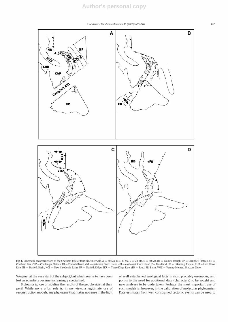
Fig. 6, based on King (2000), shows a series of schematicreconstructions for the Chatham Rise at 40 Ma, 30 Ma, 20 Ma and10 Ma. In Fig. 6A (40 Ma) the Chatham Rise (CR) and Bounty Trough(BT) are aligned parallel with the east coast of the South Island, NewZealand (eSI). This arrangement aligns the boundaries of the Torlesseand Caples terranes with their equivalents on the Chatham Rise, andthe schists of central Otago with those of the eastern Chatham Rise,obviating the need for any oroclinal bending within the New Zealandsubcontinent. At 40 Ma the Campbell Plateau (CP) is shown isolatedfrom the southern portion of the Melanesian Rift by the Campbell Riftproposed earlier. The geographical separation of the Campbell Plateaufrom the Chatham Rise is certainly one possible explanation for thelack of detrital zircons derived from the Bounty Island granites in theCretaceous cover sediments of the Chatham Rise. While activity alongthe Vityaz Arc is well to the north of New Zealand at 40 Ma, aconnection between this active plate boundary and the Campbell Riftis indicated in Fig. 6A by a series of strike-slip faults marking theboundaries of the east coast North Island block (eNI) and the eastcoast South Island block (eSI). Active subduction of old Cretaceouscrust beneath the western margins of the Three Kings Rise (TKR) andNorthland Plateau is also indicated in Fig. 6A.
Fig. 6B (30 Ma) represents a time of major tectonic reorganisationas active subduction from the north and a spreading system from thesouth migrated into the New Zealand region. In Fig. 6B it is suggestedthat these changes resulted in both the collision of the CampbellPlateau with the Challenger Plateau and the detachment of the eastcoast of the South Island and the Chatham Rise from the MelanesianRift along strike-slip boundary faults. In Fig. 6C (20 Ma) the east coastof the South Island and the Bounty Trough have amalgamated withthe Campbell Plateau. The boundary of this collision zone is theLivingstone Fault (and offshore equivalents), a major feature thatextends to the base of the crust (Mortimer et al., 2002). Theoccurrence of a widespread Upper Eocene to Early Miocene (40–23 Ma) unconformity along the Chatham Rise and the isolation andspeciation recorded in Cyanoramphus parakeets (46–38 Ma) may berelated to these events. To the south of New Zealand sea-floorspreading had become increasingly oblique and an active transformfault was propagated through New Zealand to connect with asubduction zone along the east coast of the North Island, NewZealand. Active spreading in the Norfolk Basin (NB) translated theThree Kings Rise (TKR) along the Vening-Meinesz Fracture Zone(VMZ). By 10 Ma (Fig. 6D) the South Fiji Basin (sFB) had opened andthe New Zealand region had attained a recognisably modernconfiguration.
6. Conclusions
While geology and biology remain separate and distinct dis-ciplines, with their ownmethodologies andmodes of analyses, I hope Ihave demonstrated that there is (potentially) much to be gained froma ‘reciprocal illumination’ (Hennig, 1966) between geologicalapproaches (tectonic models) and biological approaches (construct-ing phylogenies) to the reconstruction of history. This is particularlyimportant, in my view, for areas such as the New Zealand regionwhere sharp and well defined, simple plate boundaries have not, ingeneral, existed. Because of the prolonged period of high heat flowandcomplex interactions, plate boundaries in the New Zealand regionmay be better described as ‘sticky zones’. In such areas of highgeological complexity, it may be possible, given phylogenies of theappropriate sensitivity and resolution, to both test and refinereconstruction models. A number of examples have been used inthis paper to illustrate this approach, which was advocated by
664 B. Michaux / Gondwana Research 16 (2009) 655–668
Author's personal copy
Wegener at the very start of the subject, but which seems to have beenlost as scientists became increasingly specialised.
Biologists ignore or sideline the results of the geophysicist at theirperil. While no a priori role is, in my view, a legitimate use ofreconstructionmodels, any phylogeny thatmakes no sense in the light
of well established geological facts is most probably erroneous, andpoints to the need for additional data (characters) to be sought andnew analyses to be undertaken. Perhaps the most important use ofsuch models is, however, in the calibration of molecular phylogenies.Date estimates from well constrained tectonic events can be used to
Fig. 6. Schematic reconstructions of the Chatham Rise at four time intervals. A = 40 Ma, B = 30 Ma, C = 20 Ma, D = 10 Ma. BT = Bounty Trough, CP = Campbell Plateau, CR =Chatham Rise, ChP= Challenger Plateau, EB= Emerald Basin, eNI = east coast North Island, eSI = east coast South Island, F= Fiordland, HP=Hikurangi Plateau, LHR= Lord HoweRise, NB = Norfolk Basin, NCB = New Caledonia Basin, NR = Norfolk Ridge, TKR = Three Kings Rise, sFB = South Fiji Basin, VMZ = Vening-Meinesz Fracture Zone.
665B. Michaux / Gondwana Research 16 (2009) 655–668

Author's personal copy
estimate ages of other nodes within a phylogeny, and consistency ofdates obtained from different phylogenies could establish the veracityof such estimates. Examples are also provided to illustrate some ofthese points.
Acknowledgements
My thanks to two anonymous referees, and to Jan Grobys andM. Santosh for constructive and useful comments on an earlier draft ofthis paper.
References
Adams, C.J., 2007. Geochronology of Palaeozoic terranes at the Pacific Ocean margin ofZealandia. Gondwana Research 13, 250–258.
Adams, C.J., Campbell, H.J., Graham, I.J., Mortimer, N., 1998. Torlesse, Waipapa andCaples suspect terranes of New Zealand: integrated studies of their geologicalhistory in relation to neighbouring terranes. Episodes 21, 235–240.
Adams, C.J., Pankhurst, R.J., Maas, R., Millar, I.L., 2005. Nd and Sr isotopic signatures ofmetasedimentary rocks around the South Pacific margin and implications for theirprovenance. Geological Society, London, Special Publications 246, 113–141.
Adams, C.J., Campbell, H.J., Griffin, W.J., 2008. Age and provenance of basement rocks ofthe Chatham Islands: an outpost of Zealandia. New Zealand Journal of Geology andGeophysics 51, 245–259.
Allegrucci, G., Carchini,G., Todisco, V., Convey, P., Sbordoni, V., 2006.Amolecularphylogenyof Antarctic chironomidae and its implications for biogeographical history. PolarBiology 29, 320–326.
Austin, P.M., 1975. Paleogeographic and paleotectonic models for the New Zealandgeosyncline in eastern Gondwanaland. Geological Society of America Bulletin 86,1230–1234.
Ballance, P.F., Pettinga, J.R., Webb, C., 1982. A model of the Cenozoic evolution of northernNew Zealand and adjacent areas of the southwest Pacific. Tectonophysics 87, 37–48.
Beggs, J.M.,1993.Depositional and tectonic historyof the great south basin. In: Ballance, P.F.(Ed.), South Pacific Sedimentary Basins. In: Sedimentary Basins of the World, vol. 2.Elsevier, Amsterdam, pp. 365–373.
Behrendt, J.C., LeMasurier, W.E., Cooper, A.K., et al., 1991. Geophysical studies of theWest Antarctic Rift System. Tectonics 10, 1257–1273.
Benedetto, J.L., 2004. The allochthony of the Argentine Precordillera ten years later(1993–2003): a new paleobiogeographic test of the microcontinental model.Gondwana Research 7, 1027–1039.
Bialas, R.W., Studinger, M., Fitzgerald, P.G., 2007. Plateau collapse model for theTransantarctic-West Antarctic Rift System: insights from numerical experiments.Geology 35, 687–690.
Biram, J. (Translator), 1966. The Origin of Continents and Oceans (English edition of 4threvised edition). Dover Publications, New York.
Bishop, D.J., 1992. Extensional tectonism and magmatism during the middle Cretaceousto Paleocene, North Westland, New Zealand. The New Zealand Journal of Geologyand Geophysics 35, 81–91.
Boon, W.M., Kearvell, J.C., Daugherty, C.H., Chambers, G.K., 2001. Molecular Systematicsand Conservation of kakariki (Cyanoramphus spp.). In: Science for Conservation,vol. 176. Department of Conservation, Wellington.
Bradshaw, J.D., 2004. Northland Allochthon: an alternative hypothesis of origin.New Zealand Journal of Geology and Geophysics 47, 375–382.
Bradshaw, J.D., 2008. The Ross Orogen and Lachlan Fold Belt in Marie Byrd Land,Northern Victoria Land and New Zealand: implications for the tectonic setting ofthe Lachlan Fold Belt in Antarctica. In: Cooper, A.K., Raymond, C.R., et al. (Eds.),Antarctica: a Keystone in a Changing World. doi:10.3133/of2007-1047.srp059.
Bradshaw, J.D., Weaver, S.D., Muir, R.J., 1996. Mid-Cretaceous oroclinal bending ofNew Zealand terranes. New Zealand Journal of Geology and Geophysics 39,461–468.
Bradshaw, J.D., Pankhurst, R.J., Storey, B.C., et al., 1997. New Zealand superterranesrecognised in Marie Byrd Land and Thurston Island. In: Ricci, C.A. (Ed.), The AntarcticRegion: Geological Evolution and Processes. Siena, Terra Antarctica, pp. 429–436.
Bremer, K., Gustafsson, M.H.G., 1997. East Gondwanan ancestry of the sunflower allianceof families. Proceedings of the National Academy of Sciences of the United StatesAmerica 94, 9188–9190.
Brundin, L., 1966. Transantarctic relationships and their significance, as evidenced bychironomid midges, with a monograph of the subfamily Podonominae andAphroteniinae and the austral Heptagyniae. Kongliga Svenska Ventenskaps Acade-miens Handlinger 11, 1–472.
Cande, S.C., Stock, J.M., Mϋller, R.D., Ishihara, T., 2000. Cenozoic motion between Eastand West Antarctica. Nature 404, 145–150.
Carter, R.M., Carter, L., Davy, B., 1994. Seismic stratigraphy of the Bounty Trough, south-west Pacific Ocean. Marine and Petroleum Geology 11, 79–93.
Cook, R.A., Sutherland, R., Zhu, H., 1999. Cretaceous-Cenozoic geology and petroleumsystems of the Great South Basin, New Zealand. Institute of Geological & NuclearSciences Monograph 20 190 pp.
Coombs, D.S., Landis, C.A., Norris, R.J., et al., 1976. The DunMountain ophiolite belt, NewZealand, its tectonic setting, constitution, and origin, with special reference to thesouthern portion. American Journal of Science 276, 561–603.
Cooper, A., Lalueza-Fox, C., Anderson, S., et al., 2001. Complete mitochondrial genomesequence of two extinct moas clarify ratite evolution. Nature 409, 704–707.
Craw, R.C., 1988. Continuing the synthesis between panbiogeography, phylogeneticsystematic and geology as illustrated by empirical studies on the biogeography ofNew Zealand and the Chatham Islands. Systematic Zoology 37, 291–310.
Crawford, A.J., Meffre, S., Symonds, P., 2003. 120 to 0 Ma tectonic evolution of thesouthwest Pacific and analogous geological evolution of the 600 to 220 Ma Tasmanfold belt system. Geological Society of Australia Special Publication 22, 379–397.
Davy, B., Wood, R., 1994. Gravity and magnetic modelling of the Hikurangi Plateau.Marine Geology 118, 139–151.
Davy, B., Hoernle, K., Werner, R., 2008. Hikurangi Plateau: crustal structure, riftedformation, andGondwana subduction history. Geochemistry, Geophysics, Geosystems9. doi:10.1029/2007GC001855.
Dettman, M.E., Pocknall, D.J., 1990.Nothofagidites Erdtman ex Potonié,1960; a catalogue ofspecies with notes on the paleogeographic distribution of Nothofagus Bl. (SouthernBeech). New Zealand Geological Survey Paleontological Bulletin 60 (Wellington).
Dumbacher, J.P., Pratt, T.K., Fleischer, R.C., 2003. Phylogeny of the owlet-nightjars (Aves:Aegothelidae) based onmitochondrial DNA sequence. Molecular Phylogenetics andEvolution 29, 540–549.
Eagles, G., Gohl, K., Larter, R.D., 2004. High resolution animated tectonic reconstructionof the South Pacific and West Antarctic margin. Geochemistry, Geophysics,Geosystems 5. doi:10.1029/2003GC000657.
Elliot, D.H., Fleming, T.H., 2000. Weddell triple junction: the principal focus of Ferrarand Karoo magmatism during initial breakup of Gondwana. Geology 28, 539–542.
Fitzgerald, P., 2002. Tectonics and landscape evolution of the Antarctic plate since thebreakup of Gondwana, with emphasis on the West Antarctic Rift System and theTransantarctic Mountains. Royal Society of New Zealand Bulletin 35, 453–469.
Gaina, C., Roest, W.R., Mϋller, R.D., Symonds, P., 1998. The opening of the Tasman Sea: agravity anomaly animation. Earth Interactions 2-004 (Electronic Journal).
Giribit, G., Edgecombe, G.D., 2006. The importance of looking at small-scale patternswheninferring Gondwanan biogeography: a case study of the centipede Paralamyctes(Chilopoda, Lithobiomorpha, Henicopidae). Biological Journal of the Linnean Society89, 65–78.
Gohl, K., Teterin, D., Eagles, G., et al., 2007. Geophysical survey reveals tectonicstructures in the Amundsen Sea embayment, West Antarctica. In: Cooper, A.K., et al.(Ed.), Antarctica's Continent-Ocean Transitions: Consequences for Tectonic Recon-structions: Antarctica: a Keystone in a Changing World. The United StatesGeological Society Open-File Report. doi:10.3133/of2007-1047-srp047.
Goldstein, S.J., Gemmell, N.J., Schiel, D.R., 2006. Molecular phylogenetics andbiogeography of the nacellid limpets of New Zealand (Mollusca: Patellogastro-poda). Molecular Phylogenetics and Evolution 38, 261–265.
Grindley, G.W., Adams, C.J., Lumb, J.T., Watters, W.A., 1977. Palaeomagnetism, K-Ar dating,and tectonic interpretation of Upper Cretaceous and Cenozoic volcanic rocks of theChatham Islands, New Zealand. New Zealand Journal of Geology and Geophysics 20,425–467.
Grobys, J.W.G., Gohl, K., Barker, D., et al., 2007. Is the Bounty Trough off easternNewZealandan aborted rift? Journal of Geophysical Research 112. doi:10.1029/2005JB004229.2007.
Grobys, J.W.G., Gohl, K., Uenzelmann-Neben, G., et al., 2008a. Extensional andmagmaticnature of the Campbell Plateau and Great South basin from deep crustal studies.Tectonophysics. 472, 213–225 doi:10.1016/j.tecto.2008.05.003.
Grobys, J.W.G., Gohl, K., Eagles, G., 2008b. Quantitative tectonic reconstructions ofZealandia based on crustal thickness estimates. Geochemistry, Geophysics,Geosystems 9. doi:10.1029/2007gc001691.
Hall, L.S., Lamb, S.H., Niocaill, C.M., 2004. Cenozoic distributed rotational deformation,South Island, New Zealand. Tectonics 23. doi:10.1029/2002TC001421.
Harshman, J., Braun, E.L., Braun, M.J., et al., 2008. Phylogenetic evidence for multiplelosses of flight in ratite birds. Proceedings of the National Academy of Sciences 105,13462–13467.
Heads, M., 2005. Dating nodes on molecular phylogenies: a critique of molecularbiogeography. Cladistics 21, 62–78.
Hedges, S.B., Parker, P.H., Sibley, C.G., Kumar, S., 1996. Continental breakup and theordinal diversification of birds and mammals. Nature 381, 226–229.
Hennig, W., 1966. Phylogenetic Systematics, (Davis, D.D., Zangeri, R., Translators). Urbana,University of Illinois Press.
Herzer, R.H., Chaproniere, G.C.H., Edwards, A.R., et al., 1997. Seismic stratigraphy andstructural history of the Reinga basin and its margin, southern Norfolk Ridgesystem. New Zealand Journal of Geology and Geophysics 40, 425–451.
Herzer, R.H., Sykes, R., Killops, S.D., et al., 1999. Cretaceous carbonaceous rocks from theNorfolk Ridge System, Southwest Pacific: implications for regional petroleumpotential. New Zealand Journal of Geology and Geophysics 42, 57–73.
Hoernle, K., Hauff, F., Werner, R., Mortimer, N., 2004. New Insights into the Origin andEvolution of the Hikurangi Oceanic Plateau (Southwest Pacific) from Multi-beamMapping and Sampling EOS: Transactions of the American Geophysical Union, vol. 85,pp. 401–408.
Isaac, M.J., Herzer, R.H., Brook, F.J., Hayward, B.W., 1994. Cretaceous and Cenozoicsedimentary basins of Northland, New Zealand. Institute of Geological and NuclearSciences Monograph, vol. 8. Institute of Geological and Nuclear Sciences, Lower Hutt.
Isozaki, Y., 2009. Illawarra Reversal: the fingerprint of a superplume that triggeredPangean breakup and the end-Guadalupian (Permian) mass extinction. GondwanaResearch 15, 421–432.
Kamp, P.J., 1986. Late Cretaceous-Cenozoic tectonic development of the southwestPacific region. Tectonophysics 121, 225–251.
Kamp, P.J., Vonk, A.J., Nelson, C.S., et al., 2004. Constraints on the evolution of theTaranaki Fault from thermochronology and basin analysis. Implications for theTaranaki Fault play. 2004 New Zealand Petroleum Conference Proceedings, 7–10March, 2004.
King,P.R.,2000. Tectonic reconstructionsofNewZealand:40Ma to thePresent.NewZealandJournal of Geology and Geophysics 43, 611–638.
666 B. Michaux / Gondwana Research 16 (2009) 655–668

Author's personal copy
Klingelhoefer, F., Lafoy, Y., Collot, J., et al., 2007. Crustal structure of the basin and ridgesystem west of New Caledonia (southwest Pacific) from wide-angle and reflectionseismic data. Journal of Geophysical Research 112. doi:10.1029/2007JB005093.
König, M., Jokat, W., 2006. The Mesozoic breakup of the Weddell sea. Journal ofGeophysical Research 111. doi:10.1029/2005JB004035.
Ladiges, P.Y., Cantrill, D., 2007. New Caledonia–Australian connections: biogeographicpatterns and geology. Australian Systematic Botany 20, 383–389.
Lafoy, Y., Brodien, I., Vially, R., Exon, N.F., 2005. Structure of the basin and ridge systemwestof NewCaledonia (Southwest Pacific): a synthesis. MarineGeophysical Researches 26,37–50.
Laird, M.G., 1993. Cretaceous Continental Rifts: New Zealand Region. In: Ballance, P.F.(Ed.), South Pacific Sedimentary Basins. In: Sedimentary Basins of theWorld, vol. 2.Elsevier, Amsterdam, pp. 37–49.
Lamarche, G., Collot, J.-Y., Wood, R.A., et al., 1997. The Oligocene-Miocene Pacific-Australia plate boundary, south of New Zealand: evolution from oceanic spreadingto strike-slip faulting. Earth and Planetary Science Letters 148, 129–139.
Larter, R.D., Cunningham, A.P., Barker, P.F., et al., 2002. Tectonic evolution of the Pacificmargin of Antarctica 1. Late Cretaceous tectonic reconstructions. Journal ofGeophysical Research 107. doi:10.1029/2000JB000052.
Lebrun, J.-F., Lamarche, G., Collot, J.-Y., 2003. Subduction initiation at a strike-slip plateboundary: the Cenozoic Pacific-Australian plate boundary south of New Zealand.Journal of Geophysical Research 108, 1–18.
Luyendyk, B.P., 1995. Hypothesis for Cretaceous rifting of East Gondwana caused bysubducted slab capture. Geology 23, 373–376.
Luyendyk, B.P., Wilson, D.S., Siddoway, C.S., 2003. Eastern margin of the Ross Sea Rift inwestern Marie Byrd Land, Antarctica: crustal structure and tectonic development.Geochemistry, Geophysics, Geosystems 4. doi:10.1029/2002GC000462.
McAdoo, D., Laxon, S., 1997. Antarctic tectonics: constraints from ERS-1 satellite marinegravity field. Science 276, 556–560.
McDaniel, S.F., Shaw, A.J., 2003. Phylogeographic structure and cryptic speciation in thetrans-Antarctic moss Pyrrhobryum mnioides. Evolution 57, 205–215.
McLoughlin, S., 2001. The breakup history of Gondwana and its impact on pre-Cenozoicfloristic provincialism. Australian Journal of Botany 49, 271–300.
Meffre, S., Crawford, A.J., Quilty, P.G., 2006. Arc-continent collision forming a largeisland between New Caledonia and New Zealand in the Oligocene. AESC 2006,Melbourne, Australia.
Michaelson,W.,1922.DieVerbreitungderOligochätea imLichte derWegenerschenTheorieder Kontinentenverschiebung und andere Verbreitung dieser Tiergruppe. Verhandlun-gen des Naturwissenschaftlichen Veriens zu Hamburg im 1922. Hamburg. 37 pp.
Michaux, B., 2008. Alfred Russel Wallace — biogeographer. In: Smith, C., Beccaloni, G.(Eds.), Natural Selection and Beyond: Celebrating the Intellectual Legacy of AlfredRussel Wallace. Oxford University Press, UK, pp. 166–185.
Michaux, B., Leschen, R.A.B., 2005. East meets west: biogeology of the Campbell Plateau.Biological Journal of the Linnean Society 2005, 95–115.
Mildenhall, D.C., 1980. New Zealand Late Cretaceous and Cenozoic Plant Biogeography:a contribution. Palaeogeography, Palaeoclimatology, Palaeogeography 31, 197–233.
Mortimer, N., 2008. Zealandia. Arizona Geological Society Digest 22, 227–233.Mortimer, N., Tulloch, A.J., Spark, R.N., et al., 1999. Overview of the Median Batholith,
New Zealand: a new interpretation of the geology of the Median Tectonic Zone andadjacent rocks. Journal of African Earth Sciences 29, 257–268.
Mortimer, N., Davey, F.J., Melhuish, A., et al., 2002. Geological interpretation of a deepseismic reflection profile across the Eastern Province and Median Batholith: crustalarchitecture of an extended Phanerozoic convergent orogen. New Zealand Journalof Geology and Geophysics 45, 349–363.
Mortimer, N., Hoernle, K., Hauff, F., et al., 2006. New constraints on the age andevolution of the Wishbone Ridge, southwest Pacific Cretaceous microplates, andZealandia–West Antarctica breakup. Geological Society of America 34, 185–188.
Mortimer, N., Herzer, R.H., Gans, P.B., et al., 2007. Oligocene–Miocene tectonic evolutionof the South Fiji Basin and Northland Plateau, SW Pacific Ocean: evidence frompetrology and dating of dredged rocks. Marine Geology 237, 1–24.
Nelson, G., Ladiges, P.Y., 1996. Paralogy in cladistic biogeography and analysis ofparalogy-free subtrees. American Museum Novitates 3167 58 pp.
Nelson, G., Ladiges, P.Y., 2001. Gondwana, vicariance biogeography and the New YorkSchool revisited. Australian Journal of Botany 49, 389–409.
Norris, R.J., Turnbull, I.M., 1993. Cenozoic basins adjacent to an evolving transform plateboundary, southwest New Zealand. In: Ballance, P.F. (Ed.), South Pacific SedimentaryBasins. Sedimentary Basins of the World, vol. 2. Elsevier, Amsterdam, pp. 251–270.
Norvick, M.S., Smith, M.A., 2001. Mapping the plate tectonic reconstruction of southernand southeastern Australia and implications for petroleum systems. AustralianPetroleum Production and Exploration Association Journal 15–35.
Palmowski, D., Hill, K.C., Hoffman, N., Bernecker, T., 2001. Otway Basin rifting to sea-floor spreading — hydrocarbon implications. PESA Eastern Australasian BasinsSymposium, Melbourne 25–28 November, pp. 499–505.
Panter, K.S., Blusztajn, J., Hart, S.R., et al., 2006. The origin of HIMU in the SW Pacific:evidence from intraplate volcanism in southern New Zealand and subantarcticIslands. Journal of Petrology 17, 1673–1704.
Ponder, W.F., Colgan, D.J., Gleeson, D.M., Sherley, G.H., 2003. Relationships of Placostylusfrom Lord Howe Island: an investigation using the mitochondrial cytochrome coxidase 1 gene. Molluscan Research 23, 159–178.
Powell, C.McA., Roots, S.R., Veevers, J.J., 1988. Pre-breakup continental extension in EastGondwanalanda and the early opening of the eastern Indian Ocean. Tectonophysics155, 261–283.
Quilty, P.G., 1993. Tasmantid and Lord Howe seamounts: biostratigraphy andpalaeoceanographic significance. Alcheringa 17, 28–53.
Rait, G.J., 2000. Thrust transport directions in the Northland Allochthon, New Zealand.New Zealand Journal of Geology and Geophysics 43, 271–288.
Randall, D.E., Niocaill, C.M., 2004. Cambrian paleomagnetic data confirm a NatalEmbayment location for the Ellsworth-Whitmore Mountains, Antarctica, inGondwana reconstructions. Geophysical Journal International 157, 105–116.
Renner, S.S., Foreman, D.B., Murray, D., 2000. Timing transantarctic disjunctions in theAtherospermataceae (Laurales): evidence from coding and noncoding chloroplastsequences. Systematic Biology 49, 579–591.
Riley, T.R., Knight, K.B., 2001. Age of pre-break-up Gondwana magmatism. AntarcticSciences 13, 99–110.
Sanmartin, I., Ronquist, F., 2004. Southern hemisphere biogeography inferred by event-based models: plant versus animal patterns. Systematic Biology 53, 216–243.
Schellart, W.P., Lister, G.S., Toy, V.G., 2006. A Late Cretaceous and Cenozoicreconstruction of the southwest Pacific region: tectonics controlled by subductionand slab rollback processes. Earth-Science Reviews 76, 191–233.
Sdrolias, M., Mϋller, R.D., Gaina, C., 2003. Tectonic evolution of the Southwest Pacificusing constraints from back arc basins. In: Hills, R.R., Mϋller, R.D. (Eds.), Evolutionand Dynamics of the Australian Plate: Geological Society of Australia SpecialPublication, vol. 22, pp. 343–359.
Sdrolias, M., Mϋller, R.D., Mauffret, A., Bernardel, G., 2004. Enigmatic formation of theNorfolk Basin, SW Pacific: a plume influence on back-arc extension. Geochemistry,Geophysics, Geosystems 5. doi:10.1029/2003GC000643.
Siddoway, C.S., 2008. Tectonics of theWest Antarctic Rift System: new light on the historyand dynamics of distributed intracontinental extension. In: Cooper, A.K., et al. (Ed.),Antarctica: a Keystone in a Changing World. The National Academies Press,Washington, DC, pp. 91–110.
Skelley, P.E., Leschen, R.A.B., 2006. Erotylinae (Insecta: Coleoptera: Cucujoidea:Erotylidae): taxonomy and biogeography. Fauna of New Zealand 59 58 pp.
Spalletti, L.A., Artabe, A.E., Morel, E.M., 2003. Geological factors and evolution ofsouthwestern Gondwana Triassic plants. Gondwana Research 6, 119–134.
Stagg, H.M.J., Borissova, I., Alcock, M., Moore, A.M.G., 1999. Tectonic provinces of the LordHowe Rise ‘Law of the Sea’ study has implications for frontier hydrocarbons. AGSOResearch Newsletter 31 (http://www.agso.gov.au/information/publications/renews/).
Stagpoole, V., Herzer, R., Funnell, R., Uruski, C., 2000. Deep water frontier basins ofnorthwestern NZ— burial history and hydrocarbonmaturation. 2000 NZ PetroleumConference Proceedings, 19–22 March, 2000.
Stagpoole, V., Dravitzki, S., Ingham, M., Bennie, S., Bibby, H., 2004. Structure of theTaranaki Fault from the interpretation of magneto-telluric observations. 2004New Zealand Petroleum Conference Proceedings, 7–10 March, 2004.
Suggate, R.P. (Ed.), 1978. The Geology of New Zealand, 2 Vols. Government Printer,Wellington.
Sutherland, R., 1995. The Australian boundary and Cenozoic plate motions in the SWPacific: some constraints from Geosat data. Tectonics 14, 819–831.
Sutherland, R., 1999a. Basement geology and tectonic development of the greaterNew Zealand region: an interpretation from regional magnetic data. Tectonophy-sics 308, 341–362.
Sutherland, R., 1999b. Cenozoic bending of the New Zealand basement terranes andAlpine Fault displacement: a brief review. New Zealand Journal of Geology andGeophysics 42, 295–301.
Sutherland, R., 2000. Recent progress in understanding the structure and petroleumpotential of southern South Island's frontier basins. 2000 New Zealand PetroleumConference Proceedings, 19–22 March, 2000, pp. 153–162.
Sutherland, R., 2008. The significance of Antarctica for studies of global geodynamics.In: Cooper, A.K., et al. (Ed.), Antarctica: a Keystone in a Changing World. TheNational Academies Press, Washington, DC, pp. 115–124.
Sutherland, R., Melhuish, A., 2000. Formation of the Solander Basin, southwesternSouth Island, New Zealand, controlled by a major fault in continental crust andupper mantle. Tectonophysics 19, 44–61.
Torsvik, T.H., Gaina, C., Redfield, T.F., 2008. Antarctica and global paleogeography: fromRodinia, through Gondwanaland and Pangea, to the birth of the Southern Oceanand the opening of gateways. In: Cooper, A.K., et al. (Ed.), Antarctica: a Keystone in aChanging World. The National Academies Press, Washington, DC, pp. 125–140.
Tulloch, A.J., Kimbrough, D.L., Wood, R.A., 1991. Carboniferous granite basementdredged from a site on the southwestern margin of the Challenger Plateau, TasmanSea. New Zealand Journal of Geology and Geophysics 34, 121–126.
Uruski, C.I., Cook, R.A., Herzer, R.H., Isaac, M.J., 2004. Petroleum geology of theNorthland sector of the greater Taranaki Basin. New Zealand Petroleum ConferenceProceedings, pp. 7–10. March, 2004.
Vaughan, A.P.M., Pankhurst, R.J., 2008. Tectonic overview of the West Gondwanamargin. Gondwana Research 13, 150–162.
Vaughan, A.P.M., Storey, B.C., 2000. The eastern Palmer Land shear zone: a new terraneaccretion model for the Mesozoic development of the Antarctic Peninsula. Journalof the Geological Society (London) 157, 1243–1256.
Vaughan, A.P.M., Leat, P.T., Pankhurst, R.J., 2005. Terrane processes at the margins ofGondwana: introduction. Geological Society, London, Special Publications 246, 1–21.
Veevers, J.J., 2006. Updated Gondwana (Permian-Cretaceous) earth history of Australia.Gondwana Research 9, 231–260.
Wallace, A.R., 1858. On the tendency of varieties to depart indefinitely from the originaltype. Proceedings of the Linnean Society 3, 53–62.
Wandres, A.M., Bradshaw, J.D., 2005. New Zealand tectonostratigraphy and implicationsfrom conglomeratic rocks for the configuration of the SW Pacific margin ofGondwana. Geological Society, London, Special Publications 246, 179–216.
Wegener, A., 1929. Die Entstehung der Kontinente und Ozeane, 4th revised edition.Friederich Vieweg und Sohn, Braunschweig.
Whattam, S.A., Malpas, J., Ali, J.R., et al., 2005. Formation and emplacement of theNorthland ophiolite, northern New Zealand: SW Pacific tectonic implications.Journal of the Geological Society of London 162, 225–241.
667B. Michaux / Gondwana Research 16 (2009) 655–668

Author's personal copy
Willcox, J.B., Sayers, J., Stagg, H.M.J., van den Beuque, S., 2001. Geological framework ofthe Lord Howe Rise and adjacent ocean basins. Eastern Australasian BasinsSymposium, pp. 211–227.
Winberry, J.P., Anandakishnan, S., 2004. Crustal structure of the West Antarctic riftsystem and Marie Byrd Land hotspot. Geology 32, 977–980.
Wood, R., 1993. The Challenger Plateau. In: Ballance, P.F. (Ed.), South PacificSedimentary Basins — Sedimentary Basins of the World. Elsevier, Amsterdam, pp.351–364.
Wood, R., Davy, B., 1994. The Hikurangi Plateau. Marine Geology 118, 153–173.Wood, R., Herzer, R.H., 1993. The Chatham Rise, New Zealand. In: Ballance, P.F. (Ed.),
South Pacific Sedimentary Basins — Sedimentary Basins of the World. Elsevier,Amsterdam, pp. 329–349.
Wood, R.A., Stagpoole, V.M., 2007. Validation of tectonic reconstructions by crustalvolume balance: New Zealand through the Cenozoic. Geological Society of AmericaBulletin 119, 933–943.
Wood, R., Woodward, D., 2002. Sediment thickness and crustal structure of offshorewestern New Zealand from 3D gravity modelling. New Zealand Journal of Geologyand Geophysics 45, 243–255.
Wood, R., Andrews, P.B., Herzer, R.H., et al., 1989. Cretaceous and Cenozoic geology ofthe Chatham Rise region, South Island, New Zealand: New Zealand GeologicalSurvey Basin Studies, vol. 3. 76pp.
Wood, R., Lamarche, G., Herzer, R., Delteil, J., Davy, B., 1996. Paleogene seafloor spreadingin the south east Tasman Sea. Tectonics 15, 966–975.
Wright, I., Sheppard, J., Turner, R., et al., 2002. New Zealand Continental Shelf Project — astatus report of the survey programme. NZ Petroleum Conference proceedings, 24–27February, 2002.
668 B. Michaux / Gondwana Research 16 (2009) 655–668