Assessment of the desertification vulnerability of the Cappadocian district (Central Anatolia,...
35
Volume: 8 Issue: 1 Year: 2011 Assessment of the desertification vulnerability of the Cappadocian district (Central Anatolia, Turkey) based on aridity and climate-process system Murat Türkeş 1 A. Serap Akgündüz 2 Abstract The present study discusses climate of the Cappadocian district in Turkey on the basis of Thornthwaite’s climate classification and water budget, Erinç’s aridity index and United Nations Convention to Combat Desertification (UNCCD) aridity index, along with the spatial and inter-seasonal variations of precipitation and air temperatures. Vulnerability of the Cappadocia to desertification processes was also investigated with respect to the aridity, lithology dominated by tuffs and climate-process system and present land-use features of the district. The data analysis revealed that coefficients of variation (CV) of the mean and maximum temperatures are the greatest in summer and the smallest in winter. Nevşehir and Kayseri environs are the most continental parts of the Cappadocia with a high inter-annual variability and low temperatures. Cappadocia is characterized with a continental rainfall regime having a maximum precipitation in spring. Variability of summer precipitation totals is greater than that of other seasons, varying from 65.7% to 78%. The CVs of the annual precipitation totals are about 18% at north and about 20% at south. Semi-arid and dry sub-humid or semi-humid climate types prevail over Cappadocia according to Thornthwaite’s moisture and Erinç’s aridity indices. Steppe is the dominant vegetation formation with sparse dry trees. The Cappadocia is vulnerable to the desertification processes due to both natural factors (e.g. degree of aridity, climate-process system, weathering of tuffs, erosion, climate change, etc.) and human-involvement (e.g. land degradation and intensive tourism, etc.). In order to mitigate desertification and to preserve the historical and cultural heritages in Cappadocia, sustainable land-use management and tourism planning applications are urgently needed. Key Words: Turkey; Cappadocia; climate variability; Thornthwaite’s water budget; Erinç and the UNCCD aridity indices; climate-process system; desertification. 1 Prof. Dr. Çanakkale Onsekiz Mart University, Faculty of Sciences and Arts, Department of Geography, Physical Geography Division, Terzioğlu Campus, 17020 – Çanakkale. E-mail: [email protected] 2 Department of Research, Turkish State Meteorological Service, Kalaba – Ankara
Transcript of Assessment of the desertification vulnerability of the Cappadocian district (Central Anatolia,...

Volume: 8 Issue: 1 Year: 2011
Assessment of the desertification vulnerability of the Cappadocian district (Central Anatolia, Turkey) based
on aridity and climate-process system
Murat Türkeş 1 A. Serap Akgündüz 2
Abstract
The present study discusses climate of the Cappadocian district in Turkey on the basis of Thornthwaite’s climate classification and water budget, Erinç’s aridity index and United Nations Convention to Combat Desertification (UNCCD) aridity index, along with the spatial and inter-seasonal variations of precipitation and air temperatures. Vulnerability of the Cappadocia to desertification processes was also investigated with respect to the aridity, lithology dominated by tuffs and climate-process system and present land-use features of the district. The data analysis revealed that coefficients of variation (CV) of the mean and maximum temperatures are the greatest in summer and the smallest in winter. Nevşehir and Kayseri environs are the most continental parts of the Cappadocia with a high inter-annual variability and low temperatures. Cappadocia is characterized with a continental rainfall regime having a maximum precipitation in spring. Variability of summer precipitation totals is greater than that of other seasons, varying from 65.7% to 78%. The CVs of the annual precipitation totals are about 18% at north and about 20% at south. Semi-arid and dry sub-humid or semi-humid climate types prevail over Cappadocia according to Thornthwaite’s moisture and Erinç’s aridity indices. Steppe is the dominant vegetation formation with sparse dry trees. The Cappadocia is vulnerable to the desertification processes due to both natural factors (e.g. degree of aridity, climate-process system, weathering of tuffs, erosion, climate change, etc.) and human-involvement (e.g. land degradation and intensive tourism, etc.). In order to mitigate desertification and to preserve the historical and cultural heritages in Cappadocia, sustainable land-use management and tourism planning applications are urgently needed. Key Words: Turkey; Cappadocia; climate variability; Thornthwaite’s water budget; Erinç and the UNCCD aridity indices; climate-process system; desertification. 1 Prof. Dr. Çanakkale Onsekiz Mart University, Faculty of Sciences and Arts, Department of Geography, Physical Geography Division, Terzioğlu Campus, 17020 – Çanakkale. E-mail: [email protected] 2 Department of Research, Turkish State Meteorological Service, Kalaba – Ankara

Türkeş, M., Akgündüz, A. S. (2011). Assessment of the desertification vulnerability of the Cappadocian district
(Central Anatolia, Turkey) based on aridity and climate-process system. International Journal of Human Sciences [Online]. 8:1. Available: http://www.insanbilimleri.com/en
1235
Figure 1: Location map of the Central Anatolia Region of Turkey including the Kızılırmak sub-region, and locations of six meteorological stations over the Cappadocian district used in the study.
1. Introduction
In addition to the agriculture, tourism is one of the important and increasing values of
the Central Anatolia (CAN, here after) region of Turkey. Most of the touristic sites and
activities are found around the administrative city provinces of the region, such as Ankara,
Konya, Kayseri, Nevşehir, Aksaray and Niğde. Among these, Nevşehir-Aksaray-Niğde
environs take part within the Middle Kızılırmak (Red River) sub-region of the CAN region.
Today’s Middle Kızılırmak sub-region, which is a definition used according to the
Türkeş, M., Akgündüz, A. S. (2011). Assessment of the desertification vulnerability of the Cappadocian district
(Central Anatolia, Turkey) based on aridity and climate-process system. International Journal of Human Sciences [Online]. 8:1. Available: http://www.insanbilimleri.com/en
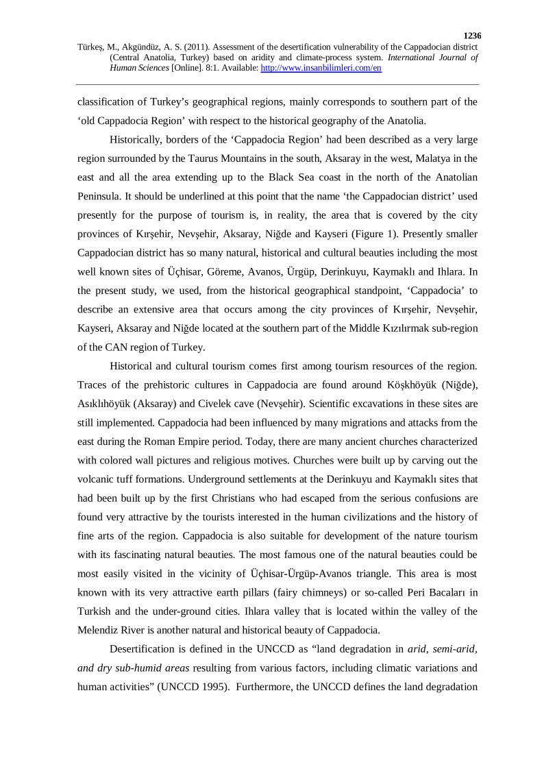
1236
classification of Turkey’s geographical regions, mainly corresponds to southern part of the
‘old Cappadocia Region’ with respect to the historical geography of the Anatolia.
Historically, borders of the ‘Cappadocia Region’ had been described as a very large
region surrounded by the Taurus Mountains in the south, Aksaray in the west, Malatya in the
east and all the area extending up to the Black Sea coast in the north of the Anatolian
Peninsula. It should be underlined at this point that the name ‘the Cappadocian district’ used
presently for the purpose of tourism is, in reality, the area that is covered by the city
provinces of Kırşehir, Nevşehir, Aksaray, Niğde and Kayseri (Figure 1). Presently smaller
Cappadocian district has so many natural, historical and cultural beauties including the most
well known sites of Üçhisar, Göreme, Avanos, Ürgüp, Derinkuyu, Kaymaklı and Ihlara. In
the present study, we used, from the historical geographical standpoint, ‘Cappadocia’ to
describe an extensive area that occurs among the city provinces of Kırşehir, Nevşehir,
Kayseri, Aksaray and Niğde located at the southern part of the Middle Kızılırmak sub-region
of the CAN region of Turkey.
Historical and cultural tourism comes first among tourism resources of the region.
Traces of the prehistoric cultures in Cappadocia are found around Köşkhöyük (Niğde),
Asıklıhöyük (Aksaray) and Civelek cave (Nevşehir). Scientific excavations in these sites are
still implemented. Cappadocia had been influenced by many migrations and attacks from the
east during the Roman Empire period. Today, there are many ancient churches characterized
with colored wall pictures and religious motives. Churches were built up by carving out the
volcanic tuff formations. Underground settlements at the Derinkuyu and Kaymaklı sites that
had been built up by the first Christians who had escaped from the serious confusions are
found very attractive by the tourists interested in the human civilizations and the history of
fine arts of the region. Cappadocia is also suitable for development of the nature tourism
with its fascinating natural beauties. The most famous one of the natural beauties could be
most easily visited in the vicinity of Üçhisar-Ürgüp-Avanos triangle. This area is most
known with its very attractive earth pillars (fairy chimneys) or so-called Peri Bacaları in
Turkish and the under-ground cities. Ihlara valley that is located within the valley of the
Melendiz River is another natural and historical beauty of Cappadocia.
Desertification is defined in the UNCCD as “land degradation in arid, semi-arid,
and dry sub-humid areas resulting from various factors, including climatic variations and
human activities” (UNCCD 1995). Furthermore, the UNCCD defines the land degradation

Türkeş, M., Akgündüz, A. S. (2011). Assessment of the desertification vulnerability of the Cappadocian district
(Central Anatolia, Turkey) based on aridity and climate-process system. International Journal of Human Sciences [Online]. 8:1. Available: http://www.insanbilimleri.com/en
1237
as a reduction or loss in arid, semi-arid, and dry sub-humid areas of the biological or
economic productivity and complexity of rain-fed cropland, irrigated cropland, or range,
pasture, forest, and woodlands resulting from land uses or from a process or combination
of processes, including those arising from human activities and habitation patterns, such as:
(i) Soil erosion caused by wind and/or water; (ii) Deterioration of the physical, chemical,
and biological or economic properties of soil; and (iii) Long-term loss of natural
vegetation.
With parallel to these definitions, desertification vulnerability is of the degree to
which a system (e.g. an arid or a semi-arid ecosystem or land) is susceptible to, or unable to
cope with, adverse effects of desertification intensified by climate changes including
increased climate variability and extremes. Vulnerability is also a function of the nature,
magnitude, and rate of desertification to which a system is exposed, its sensitivity, and its
adaptive capacity. In this frame, desertification vulnerability of the land mostly appears
because of the miss land-use practices such as over-grazing, woodcutting, over-cultivation
practices. On the other hand, wrong and/or irrational water management plans and
applications leading to soil salinization is the main cause of the degradation of irrigated
lands. Desertification process would also cause serious loss of soil fertility, soil compaction
and crusting, in addition to vegetation degradation, soil erosion and salinization.
Although understanding vulnerability of a region or a district to the desertification in
the arid, semi-arid and dry sub-humid or even in semi-humid environment are of great
importance, vulnerability studies for these climatologically dry climate regions with an
evident water deficient through the year or it’s only one season or it’s few seasons are
limited with respect to both the content and numbers. There are some different approaches in
studying the desertification process and vulnerability of a geographical area to
desertification.
For instance, Reynolds et al. (2007) suggested a new synthetic framework so called
“the Drylans Development Paradigm (DDP) by considering the recent lessons includes
functioning of dryland ecosystems and the livelihood systems of their human residents. The
DDP is supposed to help guiding the inherent complexity of desertification and dryland
development, identifying and synthesizing those factors important to research, management,
and policy makers. Some researchers investigated efficient and applicable ways of
monitoring of the desertification processes and desertification vulnerability by making use of

Türkeş, M., Akgündüz, A. S. (2011). Assessment of the desertification vulnerability of the Cappadocian district
(Central Anatolia, Turkey) based on aridity and climate-process system. International Journal of Human Sciences [Online]. 8:1. Available: http://www.insanbilimleri.com/en
1238
the climatic series of observations and climate-related variables, various climatic and/or
aridity and drought severity indices, and remotely-sensed data and indices (Türkeş and Tatlı,
2010). For instance, these kind of studies were performed by Feoli et al. (2003) for the
coastal area of Turkey, Karnieli and Dall'Olmo (2003) for the Negev (Israel) and Sinai
(Egypt) regions of the Middle East, Michetti et al. (2007) for the Southern Italy, Sonmez et
al. (2005), Türkeş (1999), Türkeş and Tatlı (2009), and Türkeş et al. (2009) for Turkey.
In further detailed studies, for example, Frattaruolo et al. (2008) produced a
desertification vulnerability map at a scale of 1:25,000 for the Northern Apulia (Tavoliere)
sub-region of the Southern Italy by combining two different approaches proposed by the
Sardinian Regional Agrometeorological Service and by Pimenta et al. (1999). This
methodology is mainly based on the combination of aridity, drought and soil loss indices.
Each of these indices is related to one significant precipitation and water related aspects of
the desertification process. On the other hand, Reich et al. (2001) investigated the
desertification vulnerability of Africa by assessing the information on soils, climate and
previously evaluated land resource stresses. The GIS-based desertification vulnerability map
was coupled to the interpolated population density map to estimate the number of persons
affected by the desertification. Eswaran et al. (2001) also studied the global desertification
tension zones of the Earth’s land surfaces and developed derivative maps of major land
resource stresses, land quality, vulnerability to desertification, and susceptibility to wind and
water erosion based on spatial data bases of the global soils, climates and published
information on land resource constraints. Being similar with Reich et al. (2001), they
superimposed the map of vulnerability to desertification on an interpolated population
density map in order to evaluate the number of people affected. Their analysis revealed that
there are about 7.1 million km2 of land under low risk of human-induced desertification, 8.6
million km2 at moderate risk, 15.6 million km2 at high risk, and 11.9 million km2 under very
high risk due to the desertification processes. They also pointed out that the major critical
tension zone that requires immediate attention via policies and measures is the very high-risk
class characterized with an 11.9 million km2 of land with about 1.4 billion inhabitants.
It is generally known that the Cappadocian district is characterized with a continental
climate and arid environmental conditions. However, the Cappadocian climate was not
studied so far in detail except those performed by Kutiel and Türkeş (2006), Türkeş (2007)
and Atalay (2010), although some important spatial differences are evident with respect to
Türkeş, M., Akgündüz, A. S. (2011). Assessment of the desertification vulnerability of the Cappadocian district
(Central Anatolia, Turkey) based on aridity and climate-process system. International Journal of Human Sciences [Online]. 8:1. Available: http://www.insanbilimleri.com/en
1239
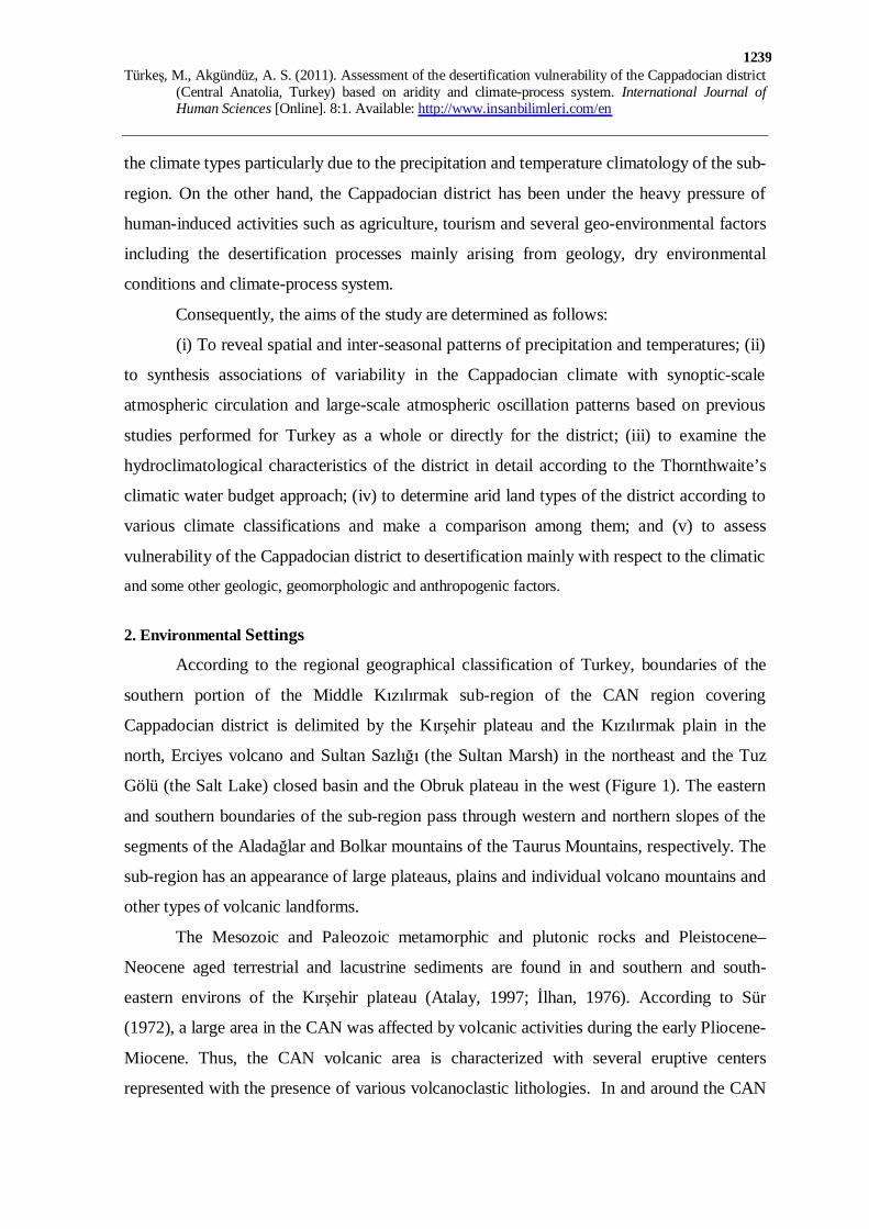
the climate types particularly due to the precipitation and temperature climatology of the sub-
region. On the other hand, the Cappadocian district has been under the heavy pressure of
human-induced activities such as agriculture, tourism and several geo-environmental factors
including the desertification processes mainly arising from geology, dry environmental
conditions and climate-process system.
Consequently, the aims of the study are determined as follows:
(i) To reveal spatial and inter-seasonal patterns of precipitation and temperatures; (ii)
to synthesis associations of variability in the Cappadocian climate with synoptic-scale
atmospheric circulation and large-scale atmospheric oscillation patterns based on previous
studies performed for Turkey as a whole or directly for the district; (iii) to examine the
hydroclimatological characteristics of the district in detail according to the Thornthwaite’s
climatic water budget approach; (iv) to determine arid land types of the district according to
various climate classifications and make a comparison among them; and (v) to assess
vulnerability of the Cappadocian district to desertification mainly with respect to the climatic
and some other geologic, geomorphologic and anthropogenic factors.
2. Environmental Settings
According to the regional geographical classification of Turkey, boundaries of the
southern portion of the Middle Kızılırmak sub-region of the CAN region covering
Cappadocian district is delimited by the Kırşehir plateau and the Kızılırmak plain in the
north, Erciyes volcano and Sultan Sazlığı (the Sultan Marsh) in the northeast and the Tuz
Gölü (the Salt Lake) closed basin and the Obruk plateau in the west (Figure 1). The eastern
and southern boundaries of the sub-region pass through western and northern slopes of the
segments of the Aladağlar and Bolkar mountains of the Taurus Mountains, respectively. The
sub-region has an appearance of large plateaus, plains and individual volcano mountains and
other types of volcanic landforms.
The Mesozoic and Paleozoic metamorphic and plutonic rocks and Pleistocene–
Neocene aged terrestrial and lacustrine sediments are found in and southern and south-
eastern environs of the Kırşehir plateau (Atalay, 1997; İlhan, 1976). According to Sür
(1972), a large area in the CAN was affected by volcanic activities during the early Pliocene-
Miocene. Thus, the CAN volcanic area is characterized with several eruptive centers
represented with the presence of various volcanoclastic lithologies. In and around the CAN

Türkeş, M., Akgündüz, A. S. (2011). Assessment of the desertification vulnerability of the Cappadocian district
(Central Anatolia, Turkey) based on aridity and climate-process system. International Journal of Human Sciences [Online]. 8:1. Available: http://www.insanbilimleri.com/en
1240
volcanic area, there are several tectonically induced Quaternary basins of various shapes and
size (Kuzucuoglu et al., 1998), such as Salt Lake (Tuz Gölü) and Konya Plain to the west,
Derinkuyu and Niğde basins to the south, and the Sultansazlığı depression to the east.
Kuzucuoglu et al. (1998) studied the Quaternary environmental evolution history in the
CAN. They considered tephra layers as chronostratigraphical markers between lacustrine
sequences studied in cores or in sections surrounding eruptive centers of the CAN volcanic
area. They identified, characterized and linked tephra samples from different locations in the
Konya Plain and the Cappadocia, to eruptions of the nearby volcanoes. In addition, their
study on the sediment fill of the so-called Eski Acıgöl (or Nar Gölü) maar near Nevşehir has
allowed the recognition of several eruptions during the Late Glacial and the Holocene in the
vicinity of this lake.
The most interesting erosion landforms cut in ignimbrites are situated around the
volcanic fields. The Quaternary and the late Pliocene aged volcanic formations are most
pronounced for the Nevşehir and Ürgüp environs (Sür, 1972). Earth pillars that constitute
very spectacular landforms in Cappadocia area are found typically in the Nevşehir and
Ürgüp environs. Today, these forms have a considerable tourism value and, in practice, they
are used for several purposes, such as residents, fruit and vegetable store places. To conclude
in terms of the geomorphologic perspective, the most obvious characteristic of the
Cappadocian district is that the landforms do not show great complexity due particularly to
geologic and tectonic features.
The climate of Turkey, which is characterized mainly by the Mediterranean
macroclimate, results from seasonal alternation of the mid-latitude frontal lows, with the
polar air masses, and the subtropical high pressures, with the subsiding maritime tropical and
continental tropical air masses. Continental tropical air-streams from the Northern African
and the Middle East/Arabian regions generally dominate particularly throughout summer by
causing long-lasting warm and dry conditions over Turkey, except in the Black Sea region
and the continental northeastern part of the Anatolian Peninsula (Türkeş, 1996, 1998, 1999,
2003a). In winter, a well-known combination of the North-eastern Atlantic originated mid-
latitude and the Mediterranean cyclones and subtropical anticyclones from the Azores
control the weather and climate in Turkey. Turkish precipitation is generally associated with
the location, variation and activity of the atmospheric centers of action throughout the year

Türkeş, M., Akgündüz, A. S. (2011). Assessment of the desertification vulnerability of the Cappadocian district
(Central Anatolia, Turkey) based on aridity and climate-process system. International Journal of Human Sciences [Online]. 8:1. Available: http://www.insanbilimleri.com/en
1241
except summer over most of Turkey (e.g., Atalay, 2010; Kutiel et al., 2001; Tatli et al., 2004;
Türkeş, 1998, 2010a; Türkeş et al., 2002a; Türkeş et al., 2009).
In a recent study, Jones et al. (2006) produced a high-resolution proxy record, which
is a proxy of precipitation and evaporation variability through the past 1700 years, from
oxygen isotope analysis of a varved lake sequence from the Cappadocian district of the
continental CAN region, and analyzed its links to the North Atlantic and the monsoon
climate. They concluded that changes in their proxy data were consistent with changes in
instrumental and proxy records of Indian monsoon, dry summer in the Eastern
Mediterranean being related with periods of enhanced monsoon precipitation. In addition,
major shifts in the record were coherent with changes in North Atlantic winter climate with
cold, wet periods in the Alps occurring at times of dry Turkish climate (Jones et al., 2006).
Table 1: Basic information on six meteorology stations of the Cappadocian district chosen for the study.
Station ID Longitude Latitude Station Record period Station Number (E) (N) Height (m) Precipitation Temperature Kırşehir 17160 34°09' 39°10' 1007 1930-2002 1930-2002 Kayseri 17196 35°29' 38°45' 1093 1938-2002 1938-2002 Ürgüp 17835 34°55' 38°38' 1060 1963-2002 1970-2002 Nevşehir 17193 34°42' 38°37' 1260 1955-2002 1960-2002 Aksaray 17192 34°03' 38°23' 961 1938-2002 1964-2002 Niğde 17250 34°41' 37°58' 1211 1935-2002 1935-2002
3. Data
Precipitation and temperature data sets used in the study were originally developed
by Türkeş (1996, 1998) for the 99 stations in the period 1929-1993 and Türkeş et al. (2002b)
for the 70 stations in the period 1929-1999 in Turkey, respectively. The precipitation data set
was updated for the years 1994 to 2002 and temperature set 2000 to 2002 with two short-
period stations such as Ürgüp and Nevşehir for the present study. Precipitation and
temperature data sets consisted of monthly precipitation totals (mm) and monthly mean,
maximum and minimum temperatures (°C) recorded at six stations of the Turkish State
Meteorological Service (Table 1). Detailed information for meta-data and homogeneity
analyses applied to long-term precipitation and temperature series of Turkey can be found in
Türkeş, M., Akgündüz, A. S. (2011). Assessment of the desertification vulnerability of the Cappadocian district
(Central Anatolia, Turkey) based on aridity and climate-process system. International Journal of Human Sciences [Online]. 8:1. Available: http://www.insanbilimleri.com/en
1242
Türkeş (1996, 1999) and Türkeş et al. (2009), and Türkeş et al. (2002b), respectively. Spatial
distribution of six stations over Cappadocia is shown in Figure 1.
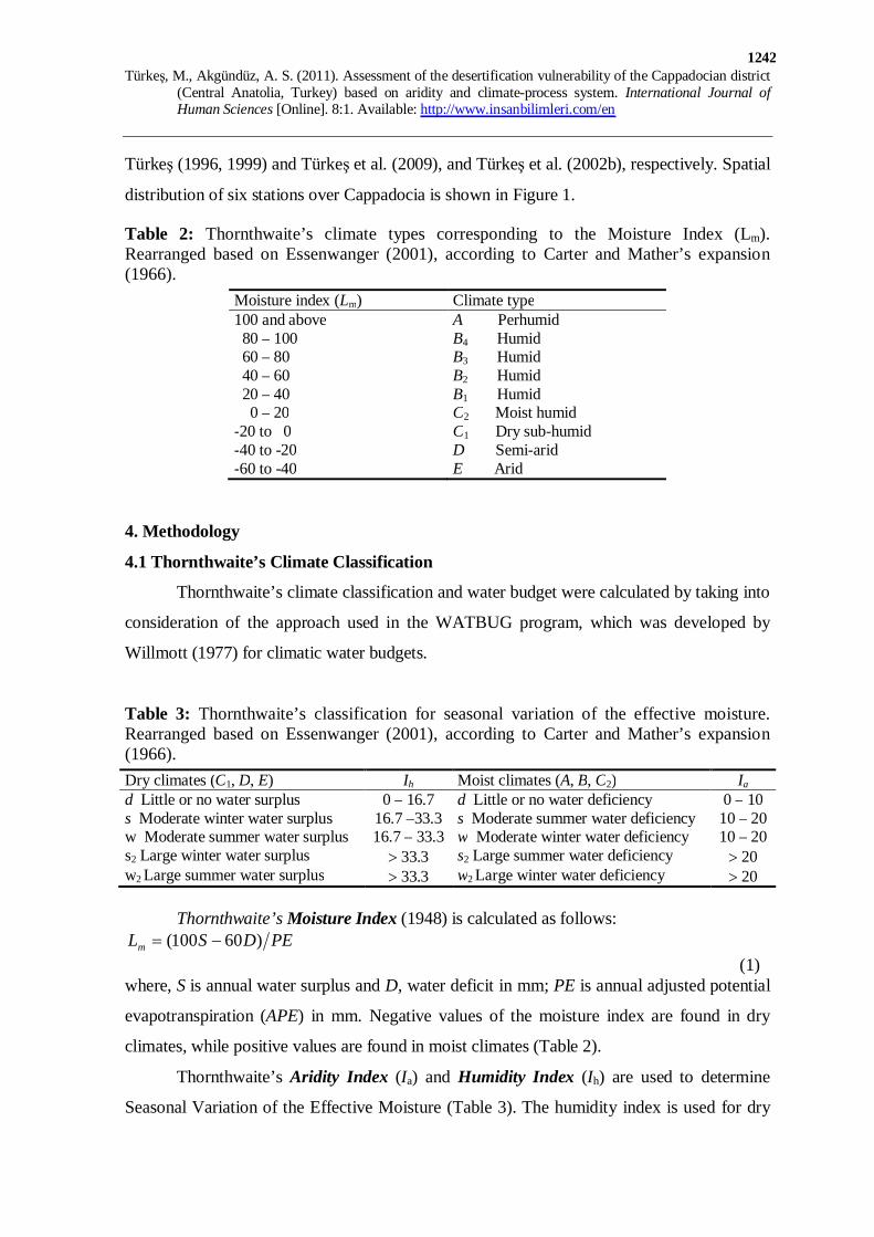
Table 2: Thornthwaite’s climate types corresponding to the Moisture Index (Lm). Rearranged based on Essenwanger (2001), according to Carter and Mather’s expansion (1966).
Moisture index (Lm) Climate type 100 and above A Perhumid 80 – 100 B4 Humid 60 – 80 B3 Humid 40 – 60 B2 Humid 20 – 40 B1 Humid 0 – 20 C2 Moist humid -20 to 0 C1 Dry sub-humid -40 to -20 D Semi-arid -60 to -40 E Arid
4. Methodology
4.1 Thornthwaite’s Climate Classification
Thornthwaite’s climate classification and water budget were calculated by taking into
consideration of the approach used in the WATBUG program, which was developed by
Willmott (1977) for climatic water budgets.
Table 3: Thornthwaite’s classification for seasonal variation of the effective moisture. Rearranged based on Essenwanger (2001), according to Carter and Mather’s expansion (1966). Dry climates (C1, D, E) Ih Moist climates (A, B, C2) Ia
d Little or no water surplus 0 – 16.7 d Little or no water deficiency 0 – 10 s Moderate winter water surplus 16.7 –33.3 s Moderate summer water deficiency 10 – 20 w Moderate summer water surplus 16.7 – 33.3 w Moderate winter water deficiency 10 – 20 s2 Large winter water surplus > 33.3 s2 Large summer water deficiency > 20 w2 Large summer water surplus > 33.3 w2 Large winter water deficiency > 20
Thornthwaite’s Moisture Index (1948) is calculated as follows:
PEDSLm )60100( -= (1) where, S is annual water surplus and D, water deficit in mm; PE is annual adjusted potential
evapotranspiration (APE) in mm. Negative values of the moisture index are found in dry
climates, while positive values are found in moist climates (Table 2).
Thornthwaite’s Aridity Index (Ia) and Humidity Index (Ih) are used to determine
Seasonal Variation of the Effective Moisture (Table 3). The humidity index is used for dry
Türkeş, M., Akgündüz, A. S. (2011). Assessment of the desertification vulnerability of the Cappadocian district
(Central Anatolia, Turkey) based on aridity and climate-process system. International Journal of Human Sciences [Online]. 8:1. Available: http://www.insanbilimleri.com/en
1243
climates; and the aridity index is used for moist climates (Mather, 1974). These indices are
defined as follows:
100)( ×= PESI h (2)
and
100)( ×= PEDI a (3)
where, S, D and PE equal annual water surplus, deficit, and potential evapotranspiration,
respectively.
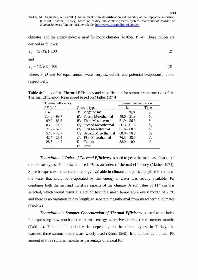
Table 4: Index of the Thermal Efficiency and classification for summer concentration of the Thermal Efficiency. Rearranged based on Mather (1974).
Thermal efficiency Summer concentration PE (cm) Climate type % Type 114.0 A' Megathermal < 48.0 a' 114.0 – 99.7 B'4 Fourth Mesothermal 48.0 – 51.9 b'4 99.7 – 85.5 B'3 Third Mesothermal 51.9 – 56.3 b'3 85.5 – 71.2 B'2 Second Mesothermal 56.3 – 61.6 b'2 71.2 – 57.0 B'1 First Mesothermal 61.6 – 68.0 b'1 57.0 – 42.7 C'2 Second Microthermal 68.0 – 76.3 c'2 42.7 – 28.5 C'1 First Microthermal 76.3 – 88.0 c'1 28.5 – 14.2 D' Tundra 88.0 – 100 d' – E' Frost –
Thornthwaite’s Index of Thermal Efficiency is used to get a thermal classification of
the climate types. Thornthwaite used PE as an index of thermal efficiency (Mather 1974).
Since it expresses the amount of energy available in climate at a particular place in terms of
the water that could be evaporated by this energy if water was readily available, PE
combines both thermal and moisture aspects of the climate. A PE value of 114 cm was
selected, which would result at a station having a mean temperature every month of 23°C
and there is no variation in day length, to separate megathermal from mesothermal climates
(Table 4).
Thornthwaite’s Summer Concentration of Thermal Efficiency is used as an index
for expressing how much of the thermal energy is received during three summer months
(Table 4). Three-month period varies depending on the climate types. In Turkey, the
warmest three summer months are widely used (Erinç, 1969). It is defined as the total PE
amount of three summer months as percentage of annual PE.

Türkeş, M., Akgündüz, A. S. (2011). Assessment of the desertification vulnerability of the Cappadocian district
(Central Anatolia, Turkey) based on aridity and climate-process system. International Journal of Human Sciences [Online]. 8:1. Available: http://www.insanbilimleri.com/en
1244
4.2 Erinç’s Aridity Index
Erinç’s Aridity (Precipitation Efficiency) Index (Im) (1965) is based on precipitation
and maximum temperature, which is supposed to cause water deficiency due to evaporation.
The basic equation of Im is defined as follows:
)( maxTPI m = (4)
where, P and maxT equal to long-term averages of annual precipitation total (mm) and
annual maximum temperature (°C), respectively.
Table 5: Erinç’s climate types corresponding to the Aridity Index (Im) and vegetation types (from Kutiel and Türkeş (2005) based on Erinç (1965).
Aridity Index (Im) Climate type Vegetation type < 8 Severe arid Desert 8 – 15 Arid Desert-like steppe 15 – 23 Semi-arid Steppe 23 – 40 Semi-humid Dry forest 40 – 55 Humid Humid forest > 55 Perhumid Perhumid forest
Erinç (1965) divided his index into six major classes by comparing results of the index with
spatial distribution of vegetation formations over Turkey as in Table 5.
Table 6: Dry land (arid climate) types in Turkey according to the Aridity Index (AI) and their vulnerability to desertification (Türkeş, 1999). Aridity criteria Dry land type Assessment
20.005.0 <£ AI Arid areas Vulnerable to desertification (no in Turkey) 50.020.0 <£ AI Semi-arid areas Vulnerable to desertification 65.050.0 <£ AI Dry sub-humid areas Vulnerable to desertification 80.065.0 <£ AI Sub-humid areas Vulnerable to desertification
4.3 The UNCCD Aridity Index
For the purposes of the United Nations Convention to Combat Desertification
(UNCCD), arid, semi-arid and dry sub-humid climates were defined as “areas, other than
polar and sub-polar regions, in which the ratio of annual precipitation to potential
evapotranspiration falls within the range from 0.05 to 0.65” (UNCCD 1995). In the present
study, UNCCD Aridity Index (AI) is used as one of the base methods for determining dry
land types in the study area and assessing their vulnerability to the desertification processes.
Following the UNEP (1993), AI is written as:
Türkeş, M., Akgündüz, A. S. (2011). Assessment of the desertification vulnerability of the Cappadocian district
(Central Anatolia, Turkey) based on aridity and climate-process system. International Journal of Human Sciences [Online]. 8:1. Available: http://www.insanbilimleri.com/en
1245
)( PEPAI = (5)
where, P and PE are annual precipitation (mm) and potential evapotranspiration (mm)
totals, respectively. The AI values below 1.0 show an annual moisture deficit in mean
climatic conditions. The criterions in Table 6 were used to characterize the dry lands of
Turkey (Türkeş, 1999).
5. Results
5.1 General Climatology
Temperature Conditions
The coldest month of monthly minimum temperatures (monthly averages of daily
minimum (night-time) temperatures) is January and the warmest month is July at all stations.
If all monthly average minimum temperatures are compared, it is seen that monthly
minimum temperatures in Cappadocia vary between -7.3 °C at Kayseri station in January
and 15.7 °C at Aksaray station in July (monthly tables and figures of minimum, maximum
and mean temperatures are not given). Annual (Figure 2a) and seasonal average minimum
temperatures are generally characterized by a meridional pattern increasing from west to
east.
The coldest month of monthly average maximum temperatures (monthly averages of
daily maximum (day time) temperatures) is January at all stations with a minimum of 3.4 °C
at Nevşehir, whereas the warmest month is July at stations of Kayseri, Aksaray, Nevşehir
and Ürgüp with a maximum of 30.5 °C at Kayseri. However, August is the warmest month
at Kırşehir and Niğde. Annual (Figure 2b) and seasonal average maximum temperatures
display a geographical relationship over the sub-region with a centre of minimum just over
Nevşehir.
Regarding all monthly mean temperatures (monthly averages of daily mean
temperatures), the coldest month of the year is January with a minimum value of about -2.0
°C at Kayseri, while the warmest month of the year is July with a maximum value of 23.4 °C
at Aksaray. Mean January temperatures are below zero at all stations, except a positive value
at Aksaray. Annual (Figure 2c) and seasonal averages of mean temperatures generally show
a different spatial pattern when compared with each other. The mean annual temperatures
vary from 10 °C at Ürgüp to 11.8 °C at Aksaray). Below zero mean winter temperatures are

Türkeş, M., Akgündüz, A. S. (2011). Assessment of the desertification vulnerability of the Cappadocian district
(Central Anatolia, Turkey) based on aridity and climate-process system. International Journal of Human Sciences [Online]. 8:1. Available: http://www.insanbilimleri.com/en
1246
observed at Kayseri and Ürgüp, which are more continental type stations in the east of the
sub-region.
Kırşehir
KayseriÜrgüpNevşehir
Aksaray
Niğde
(a)Annual
minimumtemperature (°C)
Kırşehir
KayseriÜrgüpNevşehir
Aksaray
Niğde
(b)Annual
maximumtemperature (°C)
Kırşehir
KayseriÜrgüpNevşehir
Aksaray
Niğde
(c)Annualmean
temperature (°C)
Figure 2: Spatial distributions of long-term averages of annual minimum, maximum and mean temperatures (°C) for six stations in the Cappadocian district.
Türkeş, M., Akgündüz, A. S. (2011). Assessment of the desertification vulnerability of the Cappadocian district
(Central Anatolia, Turkey) based on aridity and climate-process system. International Journal of Human Sciences [Online]. 8:1. Available: http://www.insanbilimleri.com/en
1247
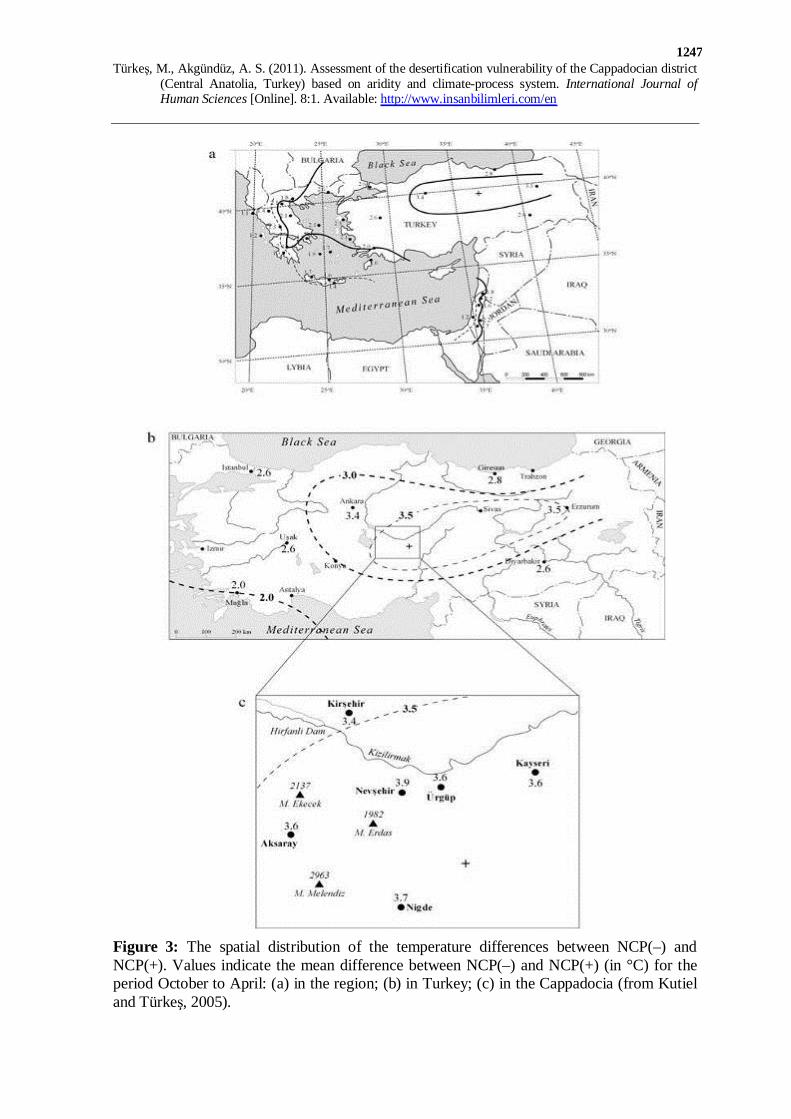
Figure 3: The spatial distribution of the temperature differences between NCP(–) and NCP(+). Values indicate the mean difference between NCP(–) and NCP(+) (in °C) for the period October to April: (a) in the region; (b) in Turkey; (c) in the Cappadocia (from Kutiel and Türkeş, 2005).
Türkeş, M., Akgündüz, A. S. (2011). Assessment of the desertification vulnerability of the Cappadocian district
(Central Anatolia, Turkey) based on aridity and climate-process system. International Journal of Human Sciences [Online]. 8:1. Available: http://www.insanbilimleri.com/en
1248
Kutiel et al. (2002) showed that temperatures in the continental CAN region, as in
other regions of Turkey and the Middle East, are highly influenced by large-scale circulation
at the 500 hPa upper-air level. The two phases of the North Sea–Caspian Pattern (NCP-an
upper level teleconnection with two poles located at the North-Sea and at the Caspian)
differentiate better than any other teleconnection between below or above normal
temperatures. During the negative phase – NCP(-), there is an enhancement of south-
westerly to southerly circulation resulting in above average temperatures, whereas during the
positive phase – NCP(+), there is an enhancement of opposite circulation, resulting in a
significant temperature reduction. The greatest influence on mean temperatures was detected
in Turkey, especially over Cappadocia district, mainly from October to April (Kutiel et al.,
2002; Kutiel and Türkeş, 2005) (Figure 3).
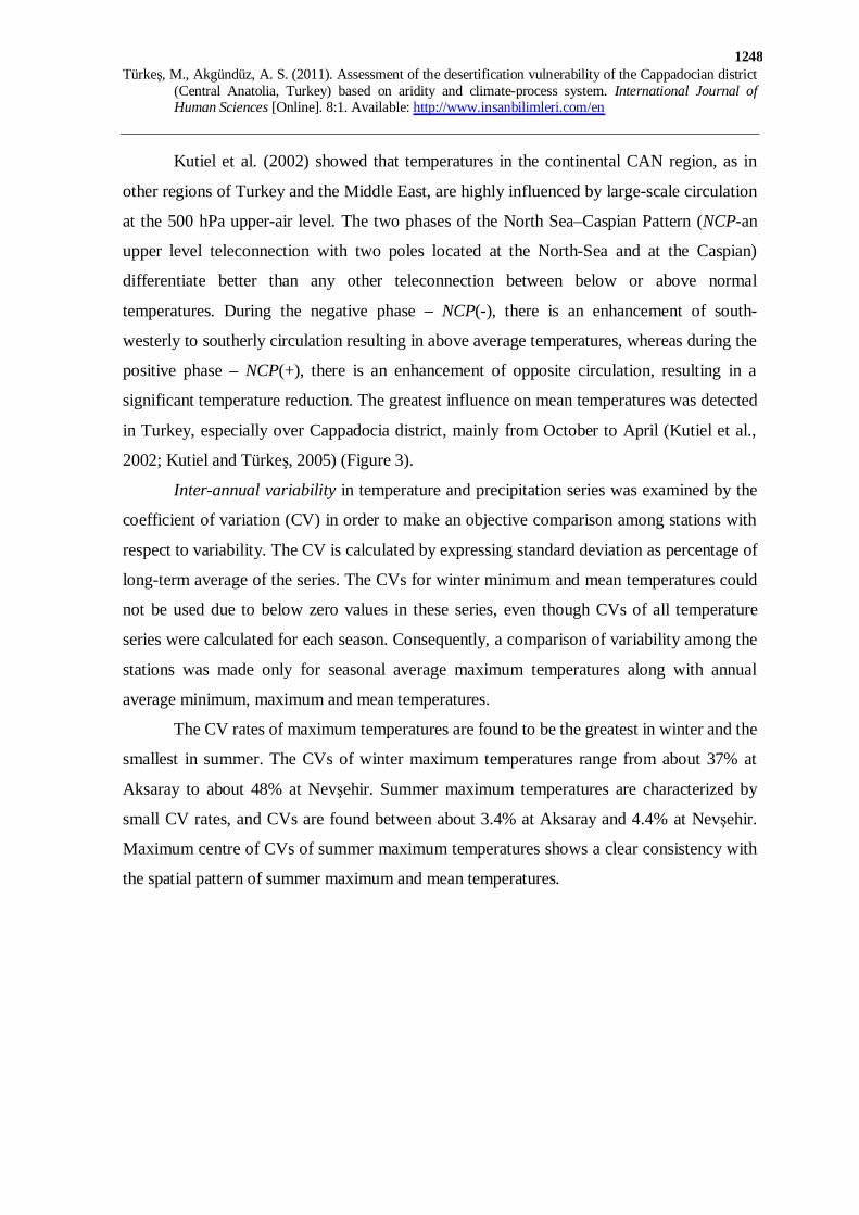
Inter-annual variability in temperature and precipitation series was examined by the
coefficient of variation (CV) in order to make an objective comparison among stations with
respect to variability. The CV is calculated by expressing standard deviation as percentage of
long-term average of the series. The CVs for winter minimum and mean temperatures could
not be used due to below zero values in these series, even though CVs of all temperature
series were calculated for each season. Consequently, a comparison of variability among the
stations was made only for seasonal average maximum temperatures along with annual
average minimum, maximum and mean temperatures.
The CV rates of maximum temperatures are found to be the greatest in winter and the
smallest in summer. The CVs of winter maximum temperatures range from about 37% at
Aksaray to about 48% at Nevşehir. Summer maximum temperatures are characterized by
small CV rates, and CVs are found between about 3.4% at Aksaray and 4.4% at Nevşehir.
Maximum centre of CVs of summer maximum temperatures shows a clear consistency with
the spatial pattern of summer maximum and mean temperatures.
Türkeş, M., Akgündüz, A. S. (2011). Assessment of the desertification vulnerability of the Cappadocian district
(Central Anatolia, Turkey) based on aridity and climate-process system. International Journal of Human Sciences [Online]. 8:1. Available: http://www.insanbilimleri.com/en
1249
Kırşehir
KayseriÜrgüpNevşehir
Aksaray
Niğde
(a)Annualmean
temperaturevariability (CV, %)
Kırşehir
KayseriÜrgüpNevşehir
Aksaray
Niğde
(b)Annual
minimum temperature
variability(CV, %)
Kırşehir
KayseriÜrgüpNevşehir
Aksaray
Niğde
(c)Annual
maximumtemperature
variability(CV, %)
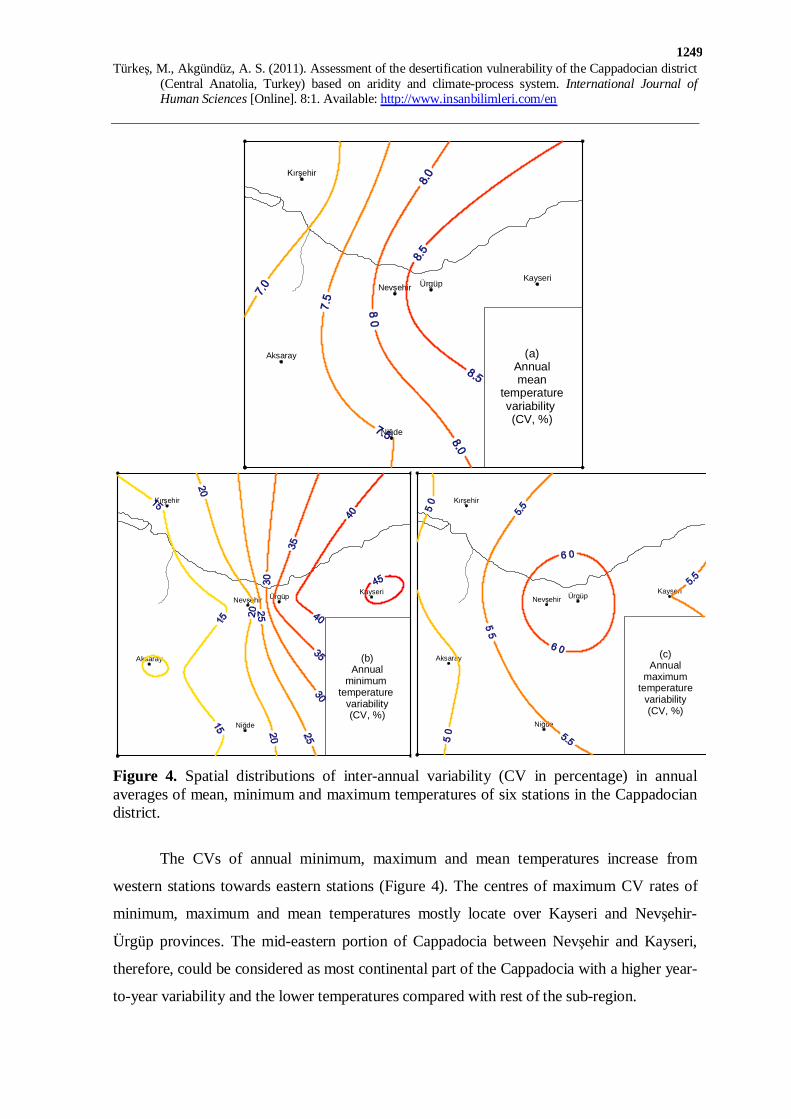
Figure 4. Spatial distributions of inter-annual variability (CV in percentage) in annual averages of mean, minimum and maximum temperatures of six stations in the Cappadocian district.
The CVs of annual minimum, maximum and mean temperatures increase from
western stations towards eastern stations (Figure 4). The centres of maximum CV rates of
minimum, maximum and mean temperatures mostly locate over Kayseri and Nevşehir-
Ürgüp provinces. The mid-eastern portion of Cappadocia between Nevşehir and Kayseri,
therefore, could be considered as most continental part of the Cappadocia with a higher year-
to-year variability and the lower temperatures compared with rest of the sub-region.
Türkeş, M., Akgündüz, A. S. (2011). Assessment of the desertification vulnerability of the Cappadocian district
(Central Anatolia, Turkey) based on aridity and climate-process system. International Journal of Human Sciences [Online]. 8:1. Available: http://www.insanbilimleri.com/en
1250
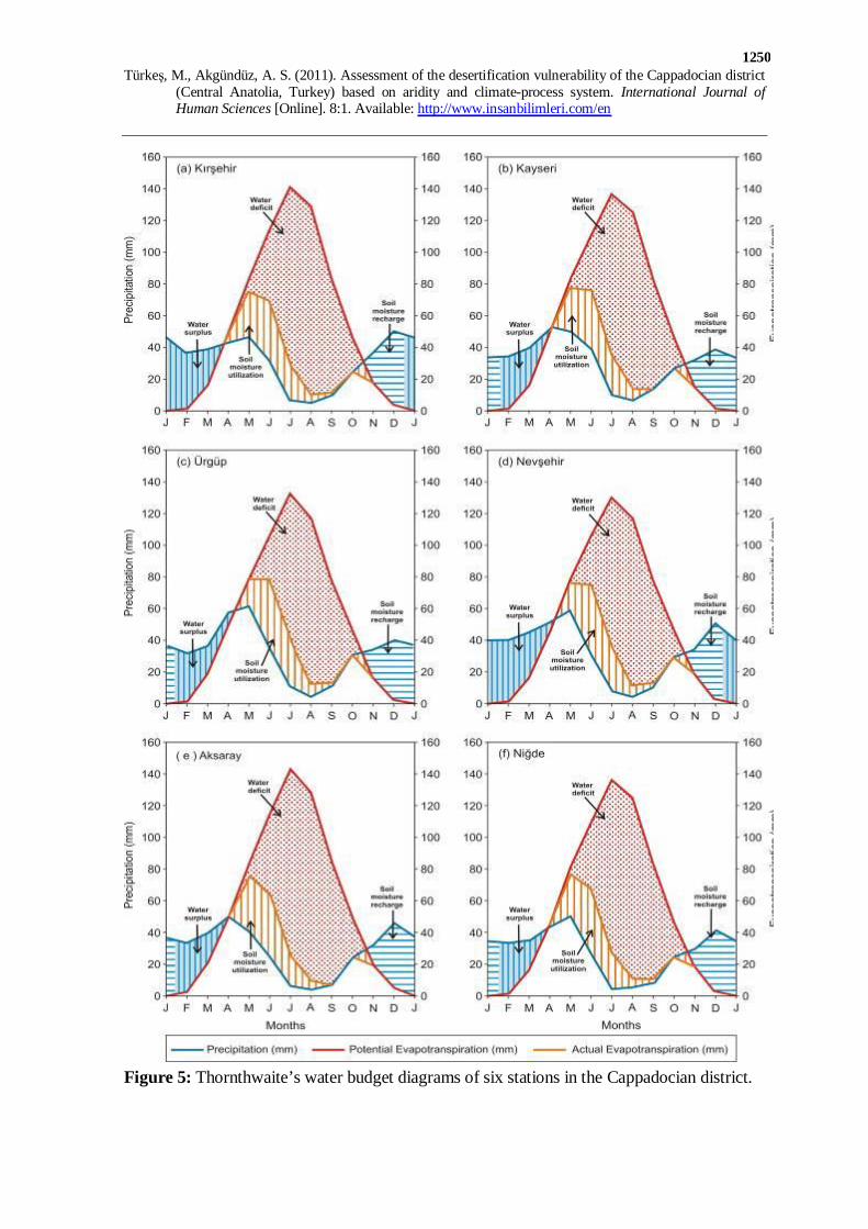
Figure 5: Thornthwaite’s water budget diagrams of six stations in the Cappadocian district.
Türkeş, M., Akgündüz, A. S. (2011). Assessment of the desertification vulnerability of the Cappadocian district
(Central Anatolia, Turkey) based on aridity and climate-process system. International Journal of Human Sciences [Online]. 8:1. Available: http://www.insanbilimleri.com/en
1251
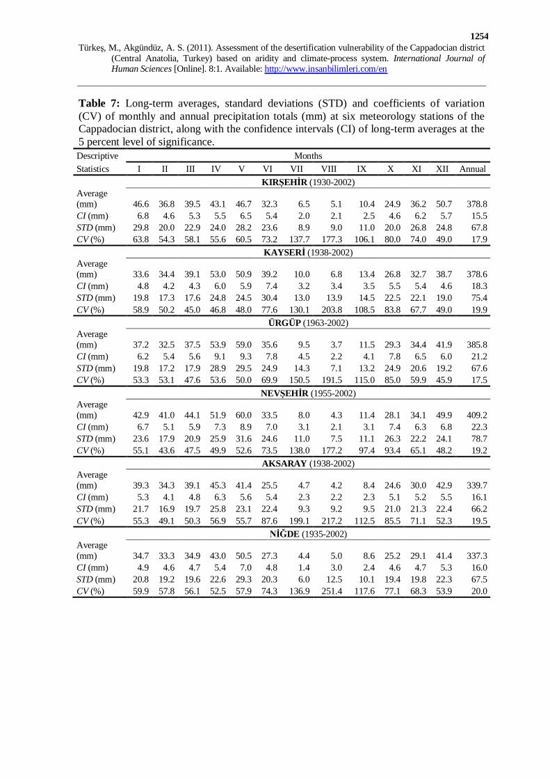
Hydroclimatology
Temporal variations of monthly average precipitation amounts show a somewhat
uniform distribution in course of the year, except the period of July-August-September
(Table 7). The period from July to September is characterized with insufficient precipitation
and great evapotranspiration compared with other months. According to the Thornthwaite’s
water budget calculated for the six stations, a market water (i.e. soil moisture) deficit also
occurs in this hot and dry period of the year (Figure 5).
Maximum precipitation amounts show up in spring months (April or May) at all
stations except at Kırşehir that is in December, whereas minimum precipitation amounts are
recorded in August at all stations except at Niğde that is in July (Table 7). Maximum
precipitation amounts in May or April are explained by additional contribution of the local
convective instability showers and thunderstorm activities, which are so called “Kırkikindi
yağmurları” (forty-afternoon rains) in Turkish, to the frontal mid-latitude cyclone activities
in spring.
Dry (rainy) conditions in the sub-region are closely related with the anticyclonic
(cyclonic) circulation types or pressure centers over just Turkey and/or its near surroundings.
Regarding dry and wet conditions in the continental CAN region (including Cappadocia)
represented by Ankara station, it is very likely that dry conditions in the region are associated
with the anticyclonic anomaly circulation over Turkey, whereas wet conditions are linked to
the cyclonic anomaly circulation just over Turkey or over the Aegean Sea and the Balkans,
and the Black Sea basin from November to April (Kutiel et al., 2001).
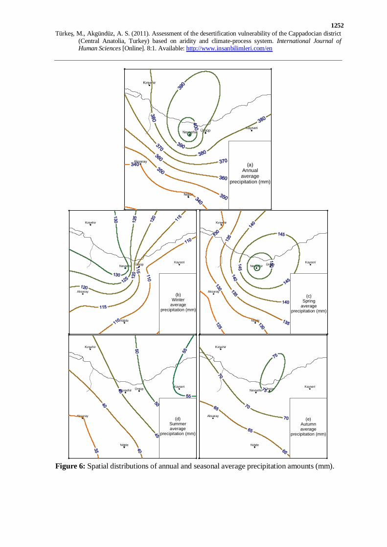
Annual and seasonal average precipitation amounts in Cappadocia tend to decrease
spatially from north or northeast to southwest (Figure 6). Annual precipitation amounts vary
from a maximum of 412.4 mm at Nevşehir to a minimum of 336.4 mm at Niğde (Figure 6a).
Maximum precipitation is generally concentrated over Nevşehir and Ürgüp environs, except
in winter with a maximum at Kırşehir. Spring is the rainiest season in the sub-region except
at Kırşehir, whereas the driest season is summer at all stations (Figure 6). Spring
precipitation varies between a maximum of 156.6 mm at Nevşehir and a minimum of 126
mm at Aksaray, whereas winter precipitation range from a maximum of 134.6 mm at
Kırşehir to a minimum of 106.4 mm at Kayseri. In autumn, precipitation amounts are found
between 75.2 mm at Ürgüp and 61.9 mm at Niğde.
Türkeş, M., Akgündüz, A. S. (2011). Assessment of the desertification vulnerability of the Cappadocian district
(Central Anatolia, Turkey) based on aridity and climate-process system. International Journal of Human Sciences [Online]. 8:1. Available: http://www.insanbilimleri.com/en
1252
Kırşehir
KayseriÜrgüpNevşehir
Aksaray
Niğde
(a)Annualaverage
precipitation (mm)
Kırşehir
KayseriÜrgüpNevşehir
Aksaray
Niğde
(b)Winter
averageprecipitation (mm)
Kırşehir
KayseriÜrgüpNevşehir
Aksaray
Niğde
(c)Spring
averageprecipitation (mm)
Kırşehir
KayseriÜrgüpNevşehir
Aksaray
Niğde
(d)Summeraverage
precipitation (mm)
Kırşehir
KayseriÜrgüpNevşehir
Aksaray
Niğde
(e)Autumnaverage
precipitation (mm)
Figure 6: Spatial distributions of annual and seasonal average precipitation amounts (mm).

Türkeş, M., Akgündüz, A. S. (2011). Assessment of the desertification vulnerability of the Cappadocian district
(Central Anatolia, Turkey) based on aridity and climate-process system. International Journal of Human Sciences [Online]. 8:1. Available: http://www.insanbilimleri.com/en
1253
Precipitation variability of the study area is most sensitive to influence of the North
Atlantic Oscillation (NAO). Türkeş and Erlat (2003, 2005) found a negative relationship
between year-to-year variability of most of annual and seasonal precipitation series of
Turkey, except in summer, and variability of the NAO indices (NAOIs). Negative
correlation coefficients, which are particularly strong in winter and partly in autumn over
western and central Turkey including the Cappadocia, become weaker in spring and almost
non-existent in summer. Türkeş and Erlat (2003) showed that precipitation regime in
Turkey is mostly characterized by wetter than long-term average conditions during the
negative (i.e. weak) NAOI phase, whereas the positive (i.e. strong) NAOI responses mostly
exhibit drier than long-term average conditions throughout the year, except in summer.
As for the seasonality of precipitation, percentage contribution of spring average
precipitation amount to annual average precipitation total, which is varying between about
34% and 39.0%, is greater than in winter at all stations except at Kırşehir. Contribution of
winter precipitation is found between 28.1% and 35.5%. Summer precipitation contributes
to about 10% to 15% of annual total, whereas autumn precipitation contributes about 18%
to 20% of annual total, which are the most homogeneous inter-stations distribution
compared with other seasons. According to Türkeş’s (1996, 1998) classification, the
Cappadocian district belongs to the continental CAN rainfall regime. The CAN rainfall
region is mainly situated between the uniform rainy Black Sea rainfall regime at north and
the winter-rainy Mediterranean rainfall regime at south. Consequently, seasonality
characteristics of the Cappadocian precipitation are influenced somehow by both two
rainfall regimes in addition to influence of the continentality effect from the continental
Eastern Anatolia region. Therefore, the Cappadocian rainfall regime is neither wholly
uniform as in the Black Sea regime nor apparently seasonal as in the Mediterranean regime.
Inter-annual variability of monthly precipitation totals is considerably high in the
Cappadocian district (Table 7). CV rates are well above 45% at all stations except at
Nevşehir in February with a rate of 43.6%. Minimum CVs are found in winter or spring
months. Maximum CVs correspond to August ranging from 177.2% at Nevşehir to 251.4%
at Niğde (Table 7). These rates indicate very likely that the higher the inter-annual
variability, the higher probability of occurrence of the drought events in summer in
Cappadocia.
Türkeş, M., Akgündüz, A. S. (2011). Assessment of the desertification vulnerability of the Cappadocian district
(Central Anatolia, Turkey) based on aridity and climate-process system. International Journal of Human Sciences [Online]. 8:1. Available: http://www.insanbilimleri.com/en
1254
Table 7: Long-term averages, standard deviations (STD) and coefficients of variation (CV) of monthly and annual precipitation totals (mm) at six meteorology stations of the Cappadocian district, along with the confidence intervals (CI) of long-term averages at the 5 percent level of significance. Descriptive Months Statistics I II III IV V VI VII VIII IX X XI XII Annual KIRŞEHİR (1930-2002) Average (mm) 46.6 36.8 39.5 43.1 46.7 32.3 6.5 5.1 10.4 24.9 36.2 50.7 378.8 CI (mm) 6.8 4.6 5.3 5.5 6.5 5.4 2.0 2.1 2.5 4.6 6.2 5.7 15.5 STD (mm) 29.8 20.0 22.9 24.0 28.2 23.6 8.9 9.0 11.0 20.0 26.8 24.8 67.8 CV (%) 63.8 54.3 58.1 55.6 60.5 73.2 137.7 177.3 106.1 80.0 74.0 49.0 17.9 KAYSERİ (1938-2002) Average (mm) 33.6 34.4 39.1 53.0 50.9 39.2 10.0 6.8 13.4 26.8 32.7 38.7 378.6 CI (mm) 4.8 4.2 4.3 6.0 5.9 7.4 3.2 3.4 3.5 5.5 5.4 4.6 18.3 STD (mm) 19.8 17.3 17.6 24.8 24.5 30.4 13.0 13.9 14.5 22.5 22.1 19.0 75.4 CV (%) 58.9 50.2 45.0 46.8 48.0 77.6 130.1 203.8 108.5 83.8 67.7 49.0 19.9 ÜRGÜP (1963-2002) Average (mm) 37.2 32.5 37.5 53.9 59.0 35.6 9.5 3.7 11.5 29.3 34.4 41.9 385.8 CI (mm) 6.2 5.4 5.6 9.1 9.3 7.8 4.5 2.2 4.1 7.8 6.5 6.0 21.2 STD (mm) 19.8 17.2 17.9 28.9 29.5 24.9 14.3 7.1 13.2 24.9 20.6 19.2 67.6 CV (%) 53.3 53.1 47.6 53.6 50.0 69.9 150.5 191.5 115.0 85.0 59.9 45.9 17.5 NEVŞEHİR (1955-2002) Average (mm) 42.9 41.0 44.1 51.9 60.0 33.5 8.0 4.3 11.4 28.1 34.1 49.9 409.2 CI (mm) 6.7 5.1 5.9 7.3 8.9 7.0 3.1 2.1 3.1 7.4 6.3 6.8 22.3 STD (mm) 23.6 17.9 20.9 25.9 31.6 24.6 11.0 7.5 11.1 26.3 22.2 24.1 78.7 CV (%) 55.1 43.6 47.5 49.9 52.6 73.5 138.0 177.2 97.4 93.4 65.1 48.2 19.2 AKSARAY (1938-2002) Average (mm) 39.3 34.3 39.1 45.3 41.4 25.5 4.7 4.2 8.4 24.6 30.0 42.9 339.7 CI (mm) 5.3 4.1 4.8 6.3 5.6 5.4 2.3 2.2 2.3 5.1 5.2 5.5 16.1 STD (mm) 21.7 16.9 19.7 25.8 23.1 22.4 9.3 9.2 9.5 21.0 21.3 22.4 66.2 CV (%) 55.3 49.1 50.3 56.9 55.7 87.6 199.1 217.2 112.5 85.5 71.1 52.3 19.5 NİĞDE (1935-2002) Average (mm) 34.7 33.3 34.9 43.0 50.5 27.3 4.4 5.0 8.6 25.2 29.1 41.4 337.3 CI (mm) 4.9 4.6 4.7 5.4 7.0 4.8 1.4 3.0 2.4 4.6 4.7 5.3 16.0 STD (mm) 20.8 19.2 19.6 22.6 29.3 20.3 6.0 12.5 10.1 19.4 19.8 22.3 67.5 CV (%) 59.9 57.8 56.1 52.5 57.9 74.3 136.9 251.4 117.6 77.1 68.3 53.9 20.0
Türkeş, M., Akgündüz, A. S. (2011). Assessment of the desertification vulnerability of the Cappadocian district
(Central Anatolia, Turkey) based on aridity and climate-process system. International Journal of Human Sciences [Online]. 8:1. Available: http://www.insanbilimleri.com/en
1255
Kırşehir
KayseriÜrgüpNevşehir
Aksaray
Niğde
(a)Annual
precipitationvariability (CV, %)
Kırşehir
KayseriÜrgüpNevşehir
Aksaray
Niğde
(b)Winter
precipitationvariability (CV, %)
Kırşehir
KayseriÜrgüpNevşehir
Aksaray
Niğde
(c)Spring
precipitationvariability (CV, %)
Kırşehir
KayseriÜrgüpNevşehir
Aksaray
Niğde
(d)Summer
precipitationvariability (CV, %)
Kırşehir
KayseriÜrgüpNevşehir
Aksaray
Niğde
(e)Autumn
precipitationvariability (CV, %)
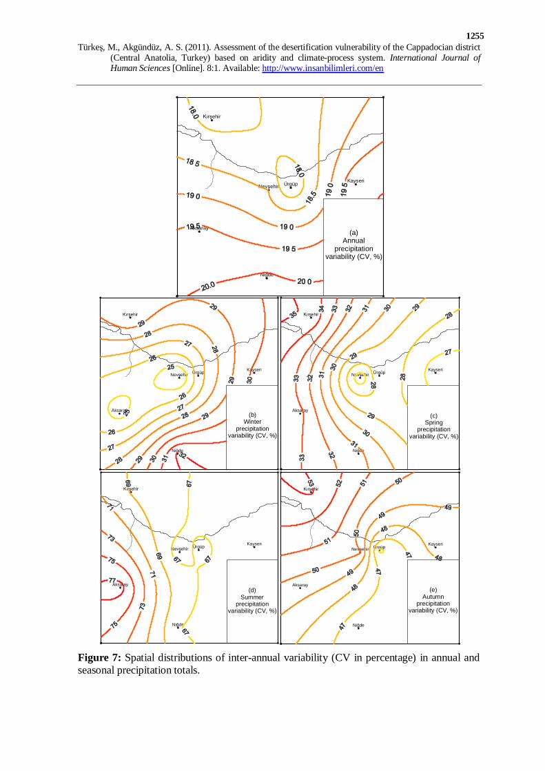
Figure 7: Spatial distributions of inter-annual variability (CV in percentage) in annual and seasonal precipitation totals.
Türkeş, M., Akgündüz, A. S. (2011). Assessment of the desertification vulnerability of the Cappadocian district
(Central Anatolia, Turkey) based on aridity and climate-process system. International Journal of Human Sciences [Online]. 8:1. Available: http://www.insanbilimleri.com/en
1256
Spatial pattern of inter-annual variability in annual precipitation totals (Figure 7a)
reflects the common pattern of annual precipitation variability over Turkey, which
decreases from southern part of the country mainly characterized by the Mediterranean
type rainfall regimes to the Black Sea coast mainly with a uniform-rainy rainfall regime
(Türkeş, 1996, 1999). The CVs are found between about 18% at north and about 20% at
south, with a minimum centre of 17.5% at Ürgüp. On the other hand, variability in
seasonal precipitation totals exhibit a differentiated spatial pattern among seasons with
different maximum and minimum centers (Figure 7b-e).
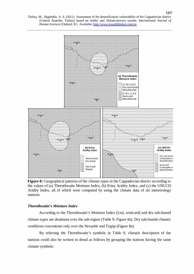
Table 8: Climate types of the Cappadocian district in terms of various climate classifications.
Station
Erinç’s Aridity Index (Im) Climate type
Thornthwaite’s Moisture Index (Lm)
Climate Type
UNCCD Aridity Index (AI)
Climate type
Kırşehir 21.55 Semi-arid -22.6 Semi-arid 0.55 Dry sub-humid Kayseri 21.15 Semi-arid -22.4 Semi-arid 0.57 Dry sub-humid Ürgüp 22.71 Semi-arid -20.0 Dry sub-humid 0.60 Dry sub-humid Nevşehir 25.73 Semi-humid -17.8 Dry sub-humid 0.63 Dry sub-humid Aksaray 18.54 Semi-arid -27.9 Semi-arid 0.49 Semi-arid Niğde 19.46 Semi-arid -26.2 Semi-arid 0.50 Dry sub-humid
5.2 Climate Types
Climate types of Cappadocia were determined by three climate classifications, and
climate types of the stations were summarized in Table 8. Spatial distributions of these
various classifications of Cappadocia climate are also shown in Figure 8 together in order to
make a comparison among them.
Table 9: Detailed climate types of the Cappadocian district according to Thornthwaite’s climate classification. Station Moisture index
(Lm) Thermal efficiency
Humidity index (Ih)
Summer concentration (%)
Climate type with symbols
Kırşehir -22.6 68.4 10.2 55.9 D B'1 d b'3 Kayseri -22.4 65.9 8.4 56.4 D B'1 d b'3 Ürgüp -20.0 63.6 8.5 55.6 C1 B'1 d b'3 Nevşehir -17.8 64.8 11.7 54.6 C1 B'1 d b'3 Aksaray -27.9 70.0 5.8 55.1 D B'1 d b'3 Niğde -26.2 66.7 6.7 55.4 D B'1 d b'3
Türkeş, M., Akgündüz, A. S. (2011). Assessment of the desertification vulnerability of the Cappadocian district
(Central Anatolia, Turkey) based on aridity and climate-process system. International Journal of Human Sciences [Online]. 8:1. Available: http://www.insanbilimleri.com/en
1257
Kırşehir
KayseriÜrgüpNevşehir
Aksaray
Niğde
(b) ErinçAridity Index
Semi-humidDry forest
Semi-aridSteppe
Kırşehir
KayseriÜrgüpNevşehir
Aksaray
Niğde
(c) UNCCDAridity Index
Dry sub-humid(Vulnerable todesertification)
Semi-arid(Vulnerable todesertification)
Kırşehir
KayseriÜrgüpNevşehir
Aksaray
Niğde
(a) ThornthwaiteMoisture Index
C1 B'1 d b'3Dry sub-humidMesothermalD, B'1, d, b'3Semi-aridMesothermal
Figure 8: Geographical patterns of the climate types in the Cappadocian district according to the values of (a) Thornthwaite Moisture Index, (b) Erinç Aridity Index, and (c) the UNCCD Aridity Index, all of which were computed by using the climate data of six meteorology stations.
Thornthwaite’s Moisture Index
According to the Thornthwaite’s Moisture Index (Lm), semi-arid and dry sub-humid
climate types are dominant over the sub-region (Table 9; Figure 8a). Dry sub-humid climatic
conditions concentrate only over the Nevşehir and Ürgüp (Figure 8a).
By referring the Thornthwaite’s symbols in Table 9, climatic description of the
stations could also be written in detail as follows by grouping the stations having the same
climate symbols:
Türkeş, M., Akgündüz, A. S. (2011). Assessment of the desertification vulnerability of the Cappadocian district
(Central Anatolia, Turkey) based on aridity and climate-process system. International Journal of Human Sciences [Online]. 8:1. Available: http://www.insanbilimleri.com/en
1258
(1) Kırşehir, Kayseri, Aksaray and Niğde are semi-arid, first mesothermal, little or no water
surplus throughout the year, with a summer concentration of thermal efficiency equal to a
third mesothermal climate.
(2) Ürgüp and Nevşehir are in a dry sub-humid climatic region, first mesothermal, little or
no water surplus throughout the year, with a summer concentration of thermal efficiency
equal to a third mesothermal climate.
Erinç’s Aridity Index
Erinç’s Aridity Index (Im) perfectly depicts similar climatic conditions with the
Thornthwaite’s Moisture Index: semi-arid and semi-humid climate types prevail over the
sub-region (Table 8 and Figure 8b). Semi-humid climate concentrates only over Nevşehir
and Ürgüp environs, which is very similar spatial pattern with dry sub-humid climate of
Thornthwaite’s Lm over the same area (Figure 8b).
The UNCCD Aridity Index
According to the UNCCD Aridity Index (AI), dry sub-humid climate dominates at all
stations except at Aksaray (Table 8). Dry sub-humid climate conditions exhibit a large
spatial coherence over the sub-region, except the semi-arid area that covers southwestern
portion of Aksaray and Niğde environs (Figure 8c). Although the AI generally produces
more humid climate conditions for Cappadocia than those of other two climate indices, the
Cappadocian district takes part in the semi-arid lands of the Earth having vulnerability to the
impacts of the desertification processes with respect to the present (contemporary) climate.
5.3 Climate and Morphogenesis
Climatic geomorphology is one of the major philosophic approaches in the science of
geomorphology. Wilson (1968) suggested the relationship between climate and process that
is called a climate-process system, and the relationship between climate-process and
landforms that is called a morphogenetic system. Based on the diagram (Ritter et al., 2002)
consisting of the six major climate process systems that had been originally suggested by
Wilson (1968), the Cappadocian district takes place within a semi-arid (sub-humid) climate
process system. This assessment was made based on the data of Kırşehir, Niğde, Kayseri,
Aksaray, Nevşehir and Ürgüp meteorology stations, by using their long-term averages of
Türkeş, M., Akgündüz, A. S. (2011). Assessment of the desertification vulnerability of the Cappadocian district
(Central Anatolia, Turkey) based on aridity and climate-process system. International Journal of Human Sciences [Online]. 8:1. Available: http://www.insanbilimleri.com/en
1259
annual mean temperatures with 11.3, 11.0, 10.5, 11.8, 10.4 and 10.0 °C and of annual
precipitation amounts of 378.8, 336.4, 378.6, 340.0, 412.4 and 385.8 mm, respectively.
Consequently, dominant geomorphic processes in the research area are of running water and
weathering (especially mechanical), which is the most common process seen in the research
area, and associated landscape characteristics include pediment and fans, angular slopes with
coarse debris and badlands.
5.4 Ecosystems and Land-use
Under the present semi-arid and dry sub-humid climate conditions, steppe is the
dominant vegetation type in Cappadocia with some dry forests. According to Atalay (2002),
who classified the ecological regions of Turkey, Cappadocia is located in the “dry forest-
anthropogenic steppe sub-region” of the CAN region. Oaks (Quercus sp.) and black pine
(Pinus nigra) are main natural tree species of the region. However, major parts of these
forests were mostly cleared; only some little forested areas dominated on the slopes facing
north and of the mountainously areas of the Cappadocian district. Steppe formation is
widespread on the destroyed dry forest areas. Mountain grass formation (Alpine meadows) is
only found on the mountainous areas rising over 2000 m such as on the mountains of
Erciyes, Melendiz and Hasan Dağı. In general, the central Anatolia plateau of Turkey has
historically been an important meeting place and corridor for animals moving between the
Europe and the Asia, and between the Eastern Europe and the Africa. This terrestrial
ecoregion characterized with step ecosystem and important inland wetlands (e.g. Tuz Gölü
and Sultan Sazlığı, etc.) is also classified as an “Important Bird Area” by the Birdlife
International, because it provides critical habitat for many threatened and restricted-range
species.
With respect to the land-use, volcanic sand and tuff that are widespread in
Cappadocia create suitable conditions for the agriculture of potato and particularly quality
grape that well grows on these volcanic originated sandy soils under the dry-farming.
Yellowish and white sandy soils are seen on the volcanic formations in the vicinities of
Nevşehir, Ürgüp and Niğde (Atalay, 2002).
Türkeş, M., Akgündüz, A. S. (2011). Assessment of the desertification vulnerability of the Cappadocian district
(Central Anatolia, Turkey) based on aridity and climate-process system. International Journal of Human Sciences [Online]. 8:1. Available: http://www.insanbilimleri.com/en
1260
6. Discussion on the Vulnerability of Cappadocia to Desertification
As mentioned previously, the unique erosion morphologies i.e. so-called fairy
chimneys, in Cappadocian were cut in ignimbrites. The fairy chimneys with historically and
culturally valuable wall paintings, which had been used as dwellings in the past, have been
under the process of chemical and physical weathering due to the atmospheric effect [erosion
because of the rainfall events (splash and rill erosion), wind erosion, corrosion effect and
thermoclastic effects, etc.] in addition to the various human-induced adverse effects. For
conservation and sustainability studies in the Cappadocian area, understanding of the
properties of the tuff is of utmost significance. This account has been previously connoted by
several authors focusing on the engineering and geological properties, durability and
weathering assessments of the Cappadocian volcanic formations (Topal and Doyuran, 1997,
1998). On the other hand, our results of analysis towards understanding of the aridity and
climate-process system in the study area seem to be in good agreement with these geologic
findings. Indeed, desertification vulnerability of the Cappadocian district is firmly associated
with the dominant semi-arid and dry sub-humid climate characterized by the unique
temperature and precipitation regime and variability in addition to the erosion-prone
lithology dominated by tuff and ignimbrite. The maximum precipitations caused by cyclonic
anomaly circulation just over Turkey in spring (April or May) that range between 156.6 mm
and 126 mm, is of primary importance in terms of gully erosion, sheet flood effect and
precipitation of iron-oxide and formation of smectite-type clay mineral by chemical
weathering on rock surfaces (Topal and Doyuran, 1998). The effects of running water and
rock weathering are also increased by the occurrence of the intensive rainfall events so called
“Kırkikindi yağmurları” in that period.
However, winter precipitations varying between 134.6 mm and 106.4 mm are of
secondary importance. Dry and hot summer climate in Turkey is mainly associated with the
increased anticyclonic circulation types from west and surface circulation-based effect of the
Asian monsoon over the eastern Mediterranean basin including Turkey and its region. In
summer, overall precipitation is just of minor importance with insufficient precipitation
percentages of about 10% to 15%. During this dry and hot period, mechanical disintegration
occur at a maximum rate based on approach on major climate process systems (Wilson,
1968; Ritter et al., 2002) during the period from July to September under very low
precipitation and very high evapotranspiration conditions. Having considered salt occurrence
Türkeş, M., Akgündüz, A. S. (2011). Assessment of the desertification vulnerability of the Cappadocian district
(Central Anatolia, Turkey) based on aridity and climate-process system. International Journal of Human Sciences [Online]. 8:1. Available: http://www.insanbilimleri.com/en
1261
within the tuffs, the possible negative effects of soluble salts was indicated by Topal and
Doyuran (1998). Climate and water budget analyses also support this view, because
increased evapotranspiration is of great potential for crystallization of salt during the dry
season.
Based on petrographic and geochemical analyses of volcanics collected from Hasan
Dağı and Karacadağ volcanic mountains, Ercan et al. (1990) investigated characteristic
features of the volcanism of the CAN for the period from the Middle Miocene to the recent.
They identified 15 different lithologic units mainly characterized with subalkaline (tholeiitic
+ calcalkaline) and alkaline rocks. In a recent study by Ertek and Öner (2008), mineralogy,
geochemistry and uses of altered tuff from Cappadocia were suggested as a potential raw
material for manufacturing of white cement. Their analyses indicated that the altered tuffs
are mainly composed of quarts and kaolinite. The alteration of tuff and formation of kaolinite
and quartz took place through thermal water, which was found to circulate along the NW-SE
trending fault system. Alkali and other major oxides (Fe2O3, MgO, CaO, MnO, P2O5 and
Na2O) were found to have been leached out from parent rock by the hydrothermal process.
Topal and Doyuran (1997, 1998) indicated that the Cappadocian tuff is mostly fresh, with
local discoloration and moderately weak to very weak, and has low unit weight, very high
porosity and high deformability. The presence of smectite-type clay mineral was fount to be
associated with chemical alteration of tuffs (Topal and Doyuran 1998), which is a common
occurrence in tuff as previously evidenced from various parts of the world (Franks et al.,
1999; Duzgoren-Aydin et al., 2002; Dobson and Nakagava, 2005; Tazaki, 2006).
With respect to the durability of the tuff, they found dominance of poor to very poor
durability, and the adverse effects of joints on the structural stability of the fairy chimneys.
Topal and Doyuran (1998) further indicated that chemical weathering on the tuff may be
traced to a depth of 2 cm below lichen-covered surfaces and 20 cm adjacent to discolored
joint walls.
On the other hand, Burri and Petitta (2005) investigated some aspects of runoff
drainage, groundwater exploitation and irrigation with underground channels in Meskender
Valley adjacent to the Göreme Valley. In terms of the future development and possible
conservation measures, Burri and Petitta (2005) indicated for the study area, terracing,
groundwater drainage tunnels and drainage channels are emblematic of the integrated
management of the area, albeit in a poorly defined historical period. They made some
Türkeş, M., Akgündüz, A. S. (2011). Assessment of the desertification vulnerability of the Cappadocian district
(Central Anatolia, Turkey) based on aridity and climate-process system. International Journal of Human Sciences [Online]. 8:1. Available: http://www.insanbilimleri.com/en
1262
recommendations for conservation of natural and architectural patrimony at rock churches in
Cappadocia, tunnel topography and other historical values in order to prevent present serious
risks of irreversible degradation already faced in many cites of the district. Burri and Petitta
(2005) summarized the causes of degradation as lack of maintenance due to the low interest
in their function, in turn due to the abandonment of this particular agricultural practice,
which survives only episodically, and excessive tourist pressure since the course of the
historical tunnels is included in tour routes. Burri and Petitta (2005) also proposed that
promoting the resumption of the traditional agricultural practice with restoration of the
channels, and regulation of the tourist flows by limiting to a few emblematic structures and
providing further information in the form of illustrative panels or museum-type micro-
installations are of specific conservation measures.
Although wind erosion is considered as an important degradation process of soils in
the arid and semi-arid lands of the Earth’s surface in addition to the adverse impacts of
climate change, little is known in Turkey about the nature and magnitude of this process and
its effect on soil nutrient transport.
When the dominant geologic formations, which are of mainly tuff -characterized with
the high deformability, poor to very poor durability- and ignimbrites, and characteristics of
soils that developed over these formations are considered, it is assessed that summer water
deficit and strong evaporation (Figure 5) causing soil drying in Cappadocia also make the
district more vulnerable to wind erosion risk particularly during summer. Even though
detailed studies based on specific surface meteorological observations and soil analyses were
not performed for the district, theoretically wind erosion, which is significantly effective
during the dry season, in addition to other adverse factors such as intense showers, is very
likely supposed to sweep away the productive upper soil and make the soils poor in terms of
nutrient matters. For instance, Somuncu (1988) found that wind-driven sand and dust
transportation and accumulation cause sand and dust movements, and dune formations in
some smaller areas in the Develi Plain, which is located in south-eastern margin of the study
area, and provided some suggestions to prevent wind erosion in that plain.
On conclusion, both dry sub-humid (semi-humid for Erinç’s index) and semi-arid
areas, which entirely dominate over Cappadocia (Figure 8), are vulnerable to the
desertification processes in the region whether natural including climatic change or human-
induced. Those processes include a large number of factors: such as; high year-to-year
Türkeş, M., Akgündüz, A. S. (2011). Assessment of the desertification vulnerability of the Cappadocian district
(Central Anatolia, Turkey) based on aridity and climate-process system. International Journal of Human Sciences [Online]. 8:1. Available: http://www.insanbilimleri.com/en
1263
climatic variability, summer dryness, drought events and mid- and high-level drought
occurrence probabilities in various time-scales (Türkeş, 1996, 1998, 1999, 2010b; Türkeş
and Tatlı, 2008, 2009, 2010; Türkeş et al., 2009 etc.), increased surface air temperatures
(Türkeş et al., 2002b) and heat waves (Kuglitsch et al., 2010), geology (lithology and
structure) and geomorphology, soil and vegetation features, erosive effects due to rainfall
and wind, land degradation arising from miss-land use activities, and over-use of the
historical sites and natural beauties of the sub-region by all kind of intense and unplanned
tourism activities.
7. Conclusions
(1) The mid-eastern portion of the Cappadocia district could be considered as the
most continental part of with a higher year-to-year variability and the lower temperatures.
Cappadocia is characterized by a continental rainfall regime with a maximum precipitation in
spring. Contribution of spring precipitation to the annual total is found between about 34%
and 39%, whereas summer precipitation accounts for about 10% to 15% of the annual total.
Inter-annual variability of monthly precipitation totals is considerably high in all months.
The CVs of annual precipitation totals are about 18% in the north and about 20% in the
south. Variability of summer precipitation totals is greater than that of other seasons, and
ranges from about 65.7% to 78%.
(2) According to Thornthwaite’s Moisture Index and Erinç’s Aridity Index, semi-arid
and dry sub-humid or semi-humid climate types prevail in the Cappadocia district. Dry sub-
humid or semi-humid climatic conditions concentrate only over the Nevşehir and Ürgüp
environs. On the other hand, the UNCCD aridity index indicates relatively more humid
conditions than those of other two climate indices. Dry sub-humid climate dominates at all
stations except at Aksaray. Steppe is the dominant vegetation formation and terrestrial
ecosystem in Cappadocia with sparse dry forests.
(3) The stable and mobile processes of landform development such as chemical
weathering, physical disintegration, and intensive gully erosion and sheet floods are greatly
climatically controlled in Cappadocia. Climate, especially high evapotranspiration and low
precipitation conditions in dry and hot period and maximum precipitation amounts in spring
season, are of importance for both desertification vulnerability and engineering geological

Türkeş, M., Akgündüz, A. S. (2011). Assessment of the desertification vulnerability of the Cappadocian district
(Central Anatolia, Turkey) based on aridity and climate-process system. International Journal of Human Sciences [Online]. 8:1. Available: http://www.insanbilimleri.com/en
1264
properties. Our aridity and climate-process system-focused approach could be of potential
for accurate definition geological characteristics of tuff and ignimbrite.
(4) By taking the contemporary desertification and vulnerability definitions and
concepts into account (Türkeş, 1999, 2010b; Türkeş and Tatlı, 2010; UNCCD, 1995; UNEP,
1993), it should be recognized that the Cappadocian district of Turkey, which is
characterized entirely with semi-arid and dry sub-humid climatic conditions, is vulnerable to
adverse effects of the desertification processes. It should be also expected that these
influences will be stronger in a warmer and drier Turkey in the future (Türkeş, 1999, 2010b;
Türkeş and Tatlı, 2009; Türkeş et al., 2002b), associated with the projected human-induced
global climate change mainly due to increased green-house effect of the Earth’s atmosphere
(IPCC, 2001, 2007; Demir et al., 2008; Önol and Semazzi, 2009; Türkeş, 2003b, 2008,
2010c, etc.). Therefore, in order to protect and sustain its historical, cultural and natural
heritages, all human activities and applications in Cappadocia should be planned in particular
by considering environmentally sound socio-economic development principles.
Acknowledgements We would like to thank the research assistant M. Zeynel ÖZTÜRK of the Çanakkale
Onsekiz Mart University (Department of Geography) for his help in re-drawing of the Thornthwaite’s water budget diagrams.
References
Atalay, İ. (2002). Ecoregions of Turkey, Orman Bakanlığı Yayınları No. 163, 266 p, İzmir.
Atalay, İ. (2010). Applied Climatology, Meta Basım, İzmir. (In Turkish)
Burri, E., Petitta, M. (2005). Runoff drainage, groundwater exploitation and irrigation with underground channels in Cappadocia: Meskendir Valley case-study. Journal of Cultural Heritage 6, 191-197.
Carter, D.B., Mather, J. R. (1966). Climatic classification for environmental biology, in: Climatology, XIX, 4: 305-395, Laboratory of Climatology, Elmer.
Demir, İ., Kılıç, G., Coşkun, M. (2008). Climate predictions for Turkey using PRECIS Regional Climate Model: Scenario HaDAMP3 SRES A2. In Proceedings of the International Fourth Symposium on Atmospheric Sciences, 25–28 March 2008, İstanbul, Turkey.
Türkeş, M., Akgündüz, A. S. (2011). Assessment of the desertification vulnerability of the Cappadocian district
(Central Anatolia, Turkey) based on aridity and climate-process system. International Journal of Human Sciences [Online]. 8:1. Available: http://www.insanbilimleri.com/en
1265
Dobson, P. F., Nakagawa, S. (2005). Summary of rock-property measurements for Hong Kong tuff samples. Lawrence Berkeley National Laboratory. Paper LBNL-58878. http://repositories.cdlib.org/lbnl/LBNL-58878.
Düzgören-Aydın, N. S., Aydın, A., Malpas, J., (2002). Distribution of clay minerals along a weathered pyroclastic profile. Catena 50, 17-51.
Ercan, T. et al. (1990). The origin and evolution of the Cenozoic volcanism of Hasandağı – Karacadağ area (Central Anatolia), Bulletin of Geomorphology 18, 39-54. (In Turkish)
Erinç, S. (1965). An Attempt on Precipitation Efficiency and A New Index, İstanbul Üniversitesi Coğrafya Enstitüsü Yayınları No. 41, İstanbul, 51 p. (In Turkish)
Erinç, S. (1969). Climatology and Methods, İstanbul Üniversitesi Coğrafya Enstitüsü Yayınları No. 35, İstanbul, 538 p. (In Turkish)
Ertek, N., Öner, F. (2008). Mineralogy, geochemistry of altered tuff from Cappadocia (Central Anatolia) and its use as potential raw material for the manufacturing of white cement. Applied Clay Science doi:10.1016/j.clay.2008.01.020.
Essenwanger, O.M. (2001). Classification of Climates, in World Survey of Climatology Volume 1C (General Climatology 1C), Epilogue by Landsberg H E, Elsevier, Amsterdam, 112 p.
Eswaran, H., Reich, P., Beinroth, F. (2001). Global Desertification Tension Zones. In Sustaining the Global Farm, D.E. Stott, R.H. Mohtar and G.C. Steinhardt (eds). Selected papers from the 10th International Soil Conservation Organization Meeting held May 24-29, 1999 at Purdue University and the USDA-ARS National Soil Erosion Research Laboratory, pp.24-28.
Feoli, E., Giacomıch, P., Mignozzi, K., Öztürk, M., Scimone, M. (2003). Monitoring desertification risk with an index integrating climatic and remotely-sensed data: An example from the coastal area of Turkey. Management of Environmental Quality: An International Journal 14, 10-21.
Franks, C.A.M., Campbell, S.D.G., Shum, W.W.L. (1999). Assessment of geological features related to recent landslides in volcanic rocks of Hong Kong. Phase B-Aberdeen study area. GEO Report No. 67, Geotechnical Engineering Office, Civil Engineering Department, The Government of Hong Kong.
Frattaruolo, F., Pennetta, L., Piccarreta, M. (2008). Desertification vulnerability map of Tavoliere, Apulia (Southern Italy). Journal of Maps, 117-125.
IPCC. 2001. Climate Change (2001): The Scientific Basic - Contribution of Working Group I to the Third Assessment Report of the Intergovernmental Panel on Climate Change (IPCC), Eds.: J. T. Houghton et al., Cambridge University Press, Cambridge.
IPCC. 2007. Climate Change (2007): The Physical Science Basis. Contribution of Working Group I to the Fourth Assessment Report of the Intergovernmental Panel on Climate Change (IPCC), Eds.: S. Solomon et al., Cambridge University Press, Cambridge.
İlhan, E. (1976). Geology of Turkey, ODTÜ Mühendislik Fakültesi Yayın No. 51, Ankara, 239 pp. (In Turkish)

Türkeş, M., Akgündüz, A. S. (2011). Assessment of the desertification vulnerability of the Cappadocian district
(Central Anatolia, Turkey) based on aridity and climate-process system. International Journal of Human Sciences [Online]. 8:1. Available: http://www.insanbilimleri.com/en
1266
Jones, M.D., Roberts, C.N., Leng, M.J., Türkeş, M. (2006). A high-resolution late Holocene lake isotope record from Turkey and links to North Atlantic and monsoon climate. Geology 34, 361-364.
Karnieli A., Dall'Olmo G. (2003). Remote-sensing monitoring of desertification, phenology, and droughts. Management of Environmental Quality: An International Journal 14, 22-38.
Michetti, L., Del Moro, M.A., Testa, O., Teodonıo, L. (2007). Climate change and desertification vulnerability in Southern Italy. Phytocoenologia 37, 495-521.
Kuglitsch, F. G., Toreti, A., Xoplaki, E., Della-Marta, P.M., Zerefos, C. S., Türkeş, M., Luterbacher, J. (2010). Heat wave changes in the eastern Mediterranean since 1960. Geophysical Research Letters 37, L04802, DOI:10.1029/2009GL041841.
Kutiel, H., Hirsch-Eshkol, T.R., Türkeş, M. (2001). Sea level pressure patterns associated with dry or wet monthly rainfall conditions in Turkey. Theoretical and Applied Climatology 69, 39-67.
Kutiel, H., Maheras, P., Türkeş, M., Paz, S. (2002). North Sea – Caspian Pattern (NCP) – an upper level atmospheric teleconnection affecting the eastern Mediterranean – implications on the regional climate. Theoretical and Applied Climatology 72, 173-192.
Kutiel, H., Türkeş, M. (2005). New evidence about the role of the North Sea – Caspian Pattern (NCP) on the temperature and precipitation regimes in continental central Turkey. Geografiska Annaler: Series A, Physical Geography 87, 501-513.
Kuzucuoğlu, C., Pastre, J.-F, Black, S., Ercan, T., Fontugne, M., Guillou, H., Hatté, C., Karabiyikoğlu, M., Orth, P., Türkecan, A. (1998). Identification and dating of tephra layers from Quaternary sedimentary sequences of Inner Anatolia, Turkey. Journal of Volcanology and Geothermal Research 85, 153-172.
MatheR, J.R. (1974). Climatology: Fundamentals and Applications, McGraw-Hill Book Company, New York, 412 p.
Önol, B., Semazzi, F.H.M. (2009). Regionalization of climate change simulations over the Eastern Mediterranean. Journal of Climate 22, 1944-1960.
Pimenta, M.T., Santos, M.J., Rodrigues, R. (1999). A proposal of indices to identify desertification prone areas. In CCD Portugal - Instituto de Agua, Murcia, 22-23 May 1999, p.11.
Reich, P.F., Numbem, S.T., Almaraz, R.A., Eswaran, H. (2001). Land resource stresses and desertification in Africa. Agro-Science 2, 1-10.
Reynolds, J.F. et al. (2007). Global Desertification: Building a Science for Dryland Development. Science 316, 847 – 851.
Ritter, D.F., Kochel, R.C., Miller, J.R. (2002). Process Geomorphology. Fourth Edition. Mc Graw Hill, New York.
Somuncu, M. (1988). Some problems of wind-erosion and its precautions: a case study of northern and western part of the Develi Plain, Central Anatolia, Bulletin of Geomorphology 16, 37-45. (In Turkish)
Türkeş, M., Akgündüz, A. S. (2011). Assessment of the desertification vulnerability of the Cappadocian district
(Central Anatolia, Turkey) based on aridity and climate-process system. International Journal of Human Sciences [Online]. 8:1. Available: http://www.insanbilimleri.com/en
1267
Sönmez, F.K., Kömüşçü, A.U., Erkan, A., Turgu, E. (2005). An analysis of spatial and temporal dimension of drought vulnerability in Turkey using the standardized precipitation index. Natural Hazards 35, 243-264.
Sür, Ö. (1972). Geomorphological Research in the Volcanic Area of Turkey, especially in Central Anatolia, Ankara Üniversitesi DTCF Yayınları No. 223, Ankara, 119 p.
Tatli, H., Dalfes, H.N., Menteş, Ş.S. (2004). A statistical downscaling method for monthly total precipitation over Turkey. International Journal of Climatology 24, 161-180
Tazaki, K. (2006). Green-tuff landslide areas are beneficial for rice nutrition in Japan. Anais da Academia Brasileira Ciências 78, 749-763.
Thornthwaite, C.W. (1948). An Approach toward a rational classification of climate. Geography Review 38, 55-94.
Topal, T., Doyuran, V. (1997). Engineering geological properties and durability assessment of the Cappadocian tuff. Engineering Geology 47, 175-187.
Topal, T., Doyuran, V. (1998). Analyses of deterioration of the Cappadocian tuff, Turkey. Environmental Geology 34, 5-20.
Türkeş, M. (1996). Spatial and temporal analysis of annual rainfall variations in Turkey. International Journal of Climatology 16, 1057-1076.
Türkeş, M. (1998). Influence of geopotential heights, cyclone frequency and Southern Oscillation on rainfall variations in Turkey. International Journal of Climatology 18, 649-680.
Türkeş, M. (1999). Vulnerability of Turkey to desertification with respect to precipitation and aridity conditions. Turkish Journal of Engineering and Environmental Science 23, 363-380.
Türkeş, M. (2003a). Spatial and temporal variations in precipitation and aridity index series of Turkey, in: Bolle, H.J. (Ed), Mediterranean Climate – Variability and Trends, Regional Climate Studies, Springer Verlag, Heidelberg, pp. 181-213.
Türkeş, M. (2003b). Global climate change and our future climate. In Türkeş, M. (Ed), 23 Mart Dünya Meteoroloji Günü Kutlaması Gelecekteki İklimimiz Paneli Bildiriler Kitabı, Devlet Meteoroloji İşleri Genel Müdürlüğü, Ankara, pp. 12-37. (In Turkish)
Türkeş, M. (2007). Orta Kızılırmak Bölümü güney kesiminin (Kapadokya Yöresi) iklimi ve çölleşmeden etkilenebilirliği. Ege Coğrafya Dergisi 14, 75-99.
Türkeş, M. (2008). What is climate change? Basic definition, causes, observed and predicted results of climate change. İklim Değişikliği ve Çevre 1, 45-64.
Türkeş, M. (2010a). Climatology and Meteorology. First Edition, Kriter Publisher - Publication No. 63, Physical Geography Series No. 1, ISBN: 978-605-5863-39-6, 650 + XXII pp., İstanbul (in Turkish).
Türkeş, M. (2010b). Analysis of the UN Convention to Combat Desertification with respect to the climate, climate change and drought, and applications in Turkey, Invited Panel Paper. In Proceeding of Symposium on Combating Desertification. Çorum: Turkey, pp.601-616. (In Turkish)
Türkeş, M., Akgündüz, A. S. (2011). Assessment of the desertification vulnerability of the Cappadocian district
(Central Anatolia, Turkey) based on aridity and climate-process system. International Journal of Human Sciences [Online]. 8:1. Available: http://www.insanbilimleri.com/en
1268
Türkeş, M. (2010c). Global climate change: Principal causes, observed and predicted changes and their impacts, Invited Paper. In Uluslararası Katılımlı 1. Meteoroloji Sempozyumu Bildiri Kitabı, pp.9-38, Ankara. (In Turkish)
Türkeş, M., Erlat, E. (2003). Precipitation changes and variability in Turkey linked to the North Atlantic Oscillation during the period 1930-2000. International Journal of Climatology 23, 1771-1796.
Türkeş, M., Erlat, E. (2005). Climatological responses of winter precipitation in Turkey to variability of the North Atlantic Oscillation during the period 1930-2001. Theoretical and Applied Climatology 81, 45-69.
Türkeş, M., Koç, T., Sarış, F. (2009). Spatiotemporal variability of precipitation total series over Turkey. International Journal of Climatology 29, 1056-1074.
Türkeş, M., Sümer, U.M., Kılıç, G. (2002a). Persistence and periodicity in the precipitation series of Turkey and associations with 500 hPa geopotential heights. Climate Research 21, 59-81.
Türkeş, M., Sümer, U.M., Demir, İ. (2002b). Re-evaluation of trends and changes in mean, maximum and minimum temperatures of Turkey for the period 1929-1999. International Journal of Climatology 22, 947-977.
Türkeş, M., Akgündüz, A.S., Demirörs, Z. (2009). Drought periods and severity over the Konya Sub-region of the Central Anatolia Region according to the Palmer Drought Index. Turkish Journal of Geographical Sciences 7, 129-144. (In Turkish).
Tatlı, H., Türkeş, M. (2008). Drought events of 2006/2007 in Turkey and determination of its association with large-scale atmospheric variables by logistic regression. In IV. Atmosfer Bilimleri Sempozyumu Bildiri Kitabı, pp.516-527, İstanbul. (In Turkish)
Türkeş, M., Tatlı, H. (2009). Use of the standardized precipitation index (SPI) and modified SPI for shaping the drought probabilities over Turkey. International Journal of Climatology 29, 2270–2282.
Türkeş, M., Tatlı, H. (2010). The Role of drought and precipitation severity indices for determination, characterization and monitoring of the desertification. In the Proceeding of Symposium on Combating Desertification. Çorum: Turkey, pp.245-263 (In Turkish).
UNCCD, (1995). The United Nations Convention to Combat Desertification in those Countries Experiencing Serious Drought and/or Desertification, Particularly in Africa, United Nations Environment Programme (UNEP), Geneva, 71p.
UNEP, (1993). World Atlas of Desertification, United Nations Environment Programme (UNEP), London.
Willmott, C.J. (1977). WATBUG: A FORTRAN IV Algorithm for Calculating the Climatic Water Budget, University of Delaware, Delaware.
Wilson, L. (1968). Morphogenetic classification in Encyclopedia of Geomorphology, Ed.: Fairbridge, R. W., Dowden, Hutchinson and Ross, Inc.