Combating Desertification in Asia, Africa and the Middle East
35
Combating Desertification in Asia, Africa and the Middle East
-
Upload
khangminh22 -
Category
Documents
-
view
0 -
download
0
Transcript of Combating Desertification in Asia, Africa and the Middle East

Combating Desertification in Asia, Africaand the Middle East


G. Ali Heshmati • Victor R. SquiresEditors
Combating Desertificationin Asia, Africa and theMiddle East
Proven practices
123

EditorsG. Ali HeshmatiDepartment of Rangeland ManagementGorgan University of Agricultural Sciences
and Natural ResourcesGorgan, Iran
Victor R. SquiresCollege of Grassland ScienceGansu Agricultural UniversityLanzhou, China
ISBN 978-94-007-6651-8 ISBN 978-94-007-6652-5 (eBook)DOI 10.1007/978-94-007-6652-5Springer Dordrecht Heidelberg New York London
Library of Congress Control Number: 2013939787
© Springer Science+Business Media Dordrecht 2013This work is subject to copyright. All rights are reserved by the Publisher, whether the whole or part ofthe material is concerned, specifically the rights of translation, reprinting, reuse of illustrations, recitation,broadcasting, reproduction on microfilms or in any other physical way, and transmission or informationstorage and retrieval, electronic adaptation, computer software, or by similar or dissimilar methodologynow known or hereafter developed. Exempted from this legal reservation are brief excerpts in connectionwith reviews or scholarly analysis or material supplied specifically for the purpose of being enteredand executed on a computer system, for exclusive use by the purchaser of the work. Duplication ofthis publication or parts thereof is permitted only under the provisions of the Copyright Law of thePublisher’s location, in its current version, and permission for use must always be obtained from Springer.Permissions for use may be obtained through RightsLink at the Copyright Clearance Center. Violationsare liable to prosecution under the respective Copyright Law.The use of general descriptive names, registered names, trademarks, service marks, etc. in this publicationdoes not imply, even in the absence of a specific statement, that such names are exempt from the relevantprotective laws and regulations and therefore free for general use.While the advice and information in this book are believed to be true and accurate at the date ofpublication, neither the authors nor the editors nor the publisher can accept any legal responsibility forany errors or omissions that may be made. The publisher makes no warranty, express or implied, withrespect to the material contained herein.
Printed on acid-free paper
Springer is part of Springer Science+Business Media (www.springer.com)

Editor’s Preface
The stimulus for producing this collection of important and detailed case studies oncombating desertification arose from our involvement in the International TrainingCourse on Desert Control Science and Technology sponsored by the Ministry ofCommerce, which has been held in Wu Wei, Gansu, for many years under theauspices of the Gansu Desert Control Research Institute (GDCRI). The trainingcourse drew together participants from many countries, and these people were ableto share their experiences as well as learn new techniques and approaches that havepotential to be applied in their respective homelands.
But as we pondered the problems faced by many countries in their efforts to arrestand reverse accelerated land degradation and loss of productivity and its deleteriousimpacts on people and their livelihoods, we came to realize that most publicationsabout desertification focus on the reasons for it, its proximate and underlying causesand on debates about whether humans cause desertification or whether it is allbecause of climate change. These matters are important discussion points, but thereis still the question of ‘how do we go about combating desertification?’
Emphasis on the “why?” has its place, but there is an urgent need to shareinformation about successful and proven approaches and field techniques that couldbe applied elsewhere in the world.
The International Training Course on Desert Control Science and Technologyhas been conducted by the Gansu Desert Control Research Institute (GDCRI) andsponsored by the Ministry of Commerce for 13 years now. They bring togetherresearchers, academics, land administrators and policy makers from a wide rangeof African and Asian countries. The sharing of experiences, the formal lectures andstudy tours all help to strengthen the appreciation of the technical advances wroughtin China in the field of desertification control. The Training course also providesan opportunity to consider the interplay of social, economic and cultural aspectsand the importance of creating an enabling environment (legislative and regulatory)in which the integrated approach can succeed. Similarly, the need to forge a linkbetween science and community action becomes clear.
The world’s drylands occupy a vast region and are home to more than 2.5 billionpeople. Many of the world’s regions are adversely affected by desertification. Here
v

vi Editor’s Preface
the full interplay of human-induced environmental change and the often harsh andunpredictable climate is being experienced. Dryland regions have such a delicatebalance between the number of people and the capacity to have food security. Manyregions in Africa and Asia have undergone upheaval (social and economic) in thepast 50–70 years.
The fight against land degradation in terrestrial ecosystems forms one of themost complex challenges with regard to the various global environmental problems.It is most intensively linked to human life quality and to current living conditionsin the poorer countries of the drier biomes on earth. The concept of the combatof desertification, as rooted in the charter of the United Nations Conventionto combat Desertification and Drought (UNCCD), can also be transferred to awider sustainability agenda for the more humid ecosystems where accelerated landdegradation, loss of biodiversity and vulnerability to climate change are emergingissues of global significance.
Serious land degradation is a problem that many countries face. The economiccosts are significant but the human tragedy of crops and animals destroyed, and liveslost bring home the true nature and extent of the problem. Add to this the impact onbiodiversity and the impact on global climate change as the albedo changes.
China is one of many countries around the globe facing the serious problem ofdesertification. The Chinese Government attaches great importance to combatingdesertification and to the improvement of ecosystems and the environment, andhave incorporated, as a basic state policy, desertification combating, ecologyimprovement and environmental protection into the National Economic and SocialDevelopment Plan.
China has led a long struggle against land degradation and desertification.As early as the 1950s, the Government of China organized scientific surveys andstudies on affected lands and has given priority to combating desertification inseriously impacted regions. Since the 1970s, China has initiated and implementedsuccessively such major ecology restoration projects such as the Three NorthRegions Shelter Belt Development Project, the Coastal Protection Shelter BeltProject, the National Action Program to Combat Desertification, the Plain FarmlandProtective Networks project and the Green Belt Establishment Project along theMiddle and Upper stream of the Yellow River. All these projects have accumulatedsuccessful experiences and scored remarkable achievements, with many convincingmodels emerging. Since the 1990s, the National Action Program to Combat Deser-tification (NAP) and the Three North Region Shelter Belt Development Project havebrought more than 16 million ha of farmland and 10 million ha of rangeland undereffective protection.
In this volume, we draw together case studies from such diverse countries as SriLanka, an island nation in south Asia, Uzbekistan and Mongolia from Central Asia,China, Iran, Kenya, Lesotho and The Philippines, with its extensive archipelago,in SE Asia. This diversity, in terms of climate geography, stage of economicdevelopment and systems of governance, makes for contrasts in the approachadopted and the outcomes recorded.

Editor’s Preface vii
We also weigh into the debate the differences between ‘fighting or taming thedesert’ and the urgent task of arresting and reversing desertification – a totally dif-ferent agenda. Spectacular and costly measures directed at pushing back the desertor ‘making the desert bloom’ are a distraction from the real task of implementingmore sustainable land use practices and changing the enabling environment that willallow better land stewardship to take root and prosper.
The lessons to be learned from experiences in several contrasting geographicregions of the world presented here should be especially valuable in framing theaction plans of the various countries in the dryland regions of Africa, Asia and theMiddle East. The opportunity presented by the compilation of this report is thereforeto be greatly welcomed and timely.
Many agencies in China and elsewhere have a special interest in the problems(and solutions) outlined in this report. Because many of the problems involved aretransnational in their nature and geographic spread, it is important that internationalcooperation is promoted to effect solutions, to coordinate research and shareinformation.
We believe that this book will prove to be of value to land managers, researchers,aid agency personnel and UN system bureaucrats – all of whom are struggling toarrest and reverse the scourge of land degradation.
Gorgan, Iran G. Ali HeshmatiLanzhou, China Victor R. Squires


Contents
Part I Deserts and Desertification in China
1 Introduction to Deserts and Desertified Regions in China . . . . . . . . . . . . . 3G. Ali Heshmati and Victor R. Squires
2 Controlling Sand Movement Through MechanicalMeasures: China’s Experience . . . . . . . . . . . . . . . . . . . . . . . . . . . . . . . . . . . . . . . . . . . . 21G. Ali Heshmati
3 Successful Biological Methods for CombatingDesertification at Degraded Areas of China . . . . . . . . . . . . . . . . . . . . . . . . . . . . . 49G. Ali Heshmati
Part II Deserts and Desertification in Three North AfricanCountries
4 Libya: Reversal of Land Degradation and DesertificationThrough Better Land Management . . . . . . . . . . . . . . . . . . . . . . . . . . . . . . . . . . . . . . 75Ali Mansour Saad, Noresah Mohd Shariff, and Sanjay Gariola
5 Desertification and Its Control in Morocco . . . . . . . . . . . . . . . . . . . . . . . . . . . . . . 91Y. Hammouzaki
6 Egypt: Land Degradation Issues with Special Referenceto the Impact of Climate Change . . . . . . . . . . . . . . . . . . . . . . . . . . . . . . . . . . . . . . . . . 113Kh. Darwish, M. Safaa, A. Momou, and S.A. Saleh
Part III Deserts and Desertification in Other AfricanCountries
7 Combating Desertification in Kenya . . . . . . . . . . . . . . . . . . . . . . . . . . . . . . . . . . . . . 139P.M. Nguru and D.K. Rono
ix
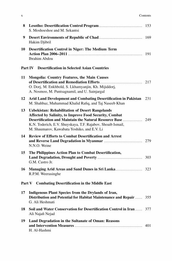
x Contents
8 Lesotho: Desertification Control Program . . . . . . . . . . . . . . . . . . . . . . . . . . . . . . . 153S. Moshoeshoe and M. Sekantsi
9 Desert Environments of Republic of Chad. . . . . . . . . . . . . . . . . . . . . . . . . . . . . . . 169Hakim Djibril
10 Desertification Control in Niger: The Medium TermAction Plan 2006–2011 .. . . . . . . . . . . . . . . . . . . . . . . . . . . . . . . . . . . . . . . . . . . . . . . . . . . . 191Ibrahim Abdou
Part IV Desertification in Selected Asian Countries
11 Mongolia: Country Features, the Main Causesof Desertification and Remediation Efforts . . . . . . . . . . . . . . . . . . . . . . . . . . . . . . 217O. Dorj, M. Enkhbold, S. Lkhamyanjin, Kh. Mijiddorj,A. Nosmoo, M. Puntsagnamil, and U. Sainjargal
12 Arid Land Development and Combating Desertification in Pakistan 231M. Shahbaz, Muhammad Khalid Rafiq, and Taj Naseeb Khan
13 Uzbekistan: Rehabilitation of Desert RangelandsAffected by Salinity, to Improve Food Security, CombatDesertification and Maintain the Natural Resource Base . . . . . . . . . . . . . . 249K.N. Toderich, E.V. Shuyskaya, T.F. Rajabov, Shoaib Ismail,M. Shaumarov, Kawabata Yoshiko, and E.V. Li
14 Review of Efforts to Combat Desertification and Arrestand Reverse Land Degradation in Myanmar . . . . . . . . . . . . . . . . . . . . . . . . . . . 279N.N.O. Weine
15 The Philippines Action Plan to Combat Desertification,Land Degradation, Drought and Poverty . . . . . . . . . . . . . . . . . . . . . . . . . . . . . . . . 303G.M. Castro Jr.
16 Managing Arid Areas and Sand Dunes in Sri Lanka . . . . . . . . . . . . . . . . . . . 323R.P.M. Weerasinghe
Part V Combating Desertification in the Middle East
17 Indigenous Plant Species from the Drylands of Iran,Distribution and Potential for Habitat Maintenance and Repair . . . . . 355G. Ali Heshmati
18 Soil and Water Conservation for Desertification Control in Iran . . . . . 377Ali Najafi Nejad
19 Land Degradation in the Sultanate of Oman: Reasonsand Intervention Measures . . . . . . . . . . . . . . . . . . . . . . . . . . . . . . . . . . . . . . . . . . . . . . . . 401H. Al-Hashmi

Contents xi
Part VI Desertification Control: Problems and Prospects
20 Desert Development: How Does It Relateto Anti Desertification Measures? . . . . . . . . . . . . . . . . . . . . . . . . . . . . . . . . . . . . . . . . 427Victor R. Squires
21 Replication and Scaling Up: Where to from Here? . . . . . . . . . . . . . . . . . . . . . 445Victor R. Squires
Appendix . . . . . . . . . . . . . . . . . . . . . . . . . . . . . . . . . . . . . . . . . . . . . . . . . . . . . . . . . . . . . . . . . . . . . . . . . . 461
Glossary . . . . . . . . . . . . . . . . . . . . . . . . . . . . . . . . . . . . . . . . . . . . . . . . . . . . . . . . . . . . . . . . . . . . . . . . . . . 467
Index . . . . . . . . . . . . . . . . . . . . . . . . . . . . . . . . . . . . . . . . . . . . . . . . . . . . . . . . . . . . . . . . . . . . . . . . . . . . . . . 471


Contributors
Ibrahim Abdou Directeur Departemental De l’Environnement De Tchirozerine,Ing. Des Eaux et Forets, B.C Aqua. and Wetland/Fisheries Mgt, Agadez, Niger,West Africa
H. Al-Hashmi Directorate General of Agricultural Research and Livestock, Barka,Oman
G.M. Castro Jr. Department of Agriculture, Quezon City, Philippines
Kh. Darwish Agricultural and Biological Division, National Research Center(NRC), Cairo, Egypt
Hakim Djibril Graduate Institute of Environmental Policy, National Dong HwaUniversity, Shoufeng, Taiwan (R.O.C)
O. Dorj State Specialized Inspection Agency (SSIA), Ulaanbaatar, Mongolia
M. Enkhbold Mongol Arga University, Ulaanbaatar, Mongolia
Sanjay Gariola Universiti Sains, Penang, Malaysia
Y. Hammouzaki High Commissariat of Water Forest and Desert Control,Marrakech, Morocco
G. Ali Heshmati Department of Rangeland Management, Gorgan University ofAgricultural Sciences and Natural Resources, Gorgan, Iran
Shoaib Ismail International Center for Biosaline Agriculture, Dubai, UAE
Taj Naseeb Khan National Agricultural Research center, Islamabad, Pakistan
E.V. Li Samarkand State University, Samarkand, Uzbekistan
International Center for Biosaline Agriculture, Dubai, UAE
S. Lkhamyanjin Mongol Arga University, Ulaanbaatar, Mongolia
Kh. Mijiddorj Mongol Arga University, Ulaanbaatar, Mongolia
xiii
xiv Contributors
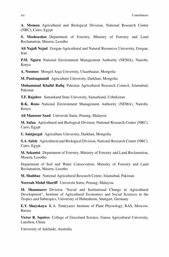
A. Momou Agricultural and Biological Division, National Research Center(NRC), Cairo, Egypt
S. Moshoeshoe Department of Forestry, Ministry of Forestry and LandReclamation, Maseru, Lesotho
Ali Najafi Nejad Gorgan Agricultural and Natural Resources University, Gorgan,Iran
P.M. Nguru National Environment Management Authority (NEMA), Nairobi,Kenya
A. Nosmoo Mongol Arga University, Ulaanbaatar, Mongolia
M. Puntsagnamil Agriculture University, Darkhan, Mongolia
Muhammad Khalid Rafiq Pakistan Agricultural Research Council, Islamabad,Pakistan
T.F. Rajabov Samarkand State University, Samarkand, Uzbekistan
R.K. Rono National Environment Management Authority (NEMA), Nairobi,Kenya
Ali Mansour Saad Universiti Sains, Penang, Malaysia
M. Safaa Agricultural and Biological Division, National Research Center (NRC),Cairo, Egypt
U. Sainjargal Agriculture University, Darkhan, Mongolia
S.A. Saleh Agricultural and Biological Division, National Research Center (NRC),Cairo, Egypt
M. Sekantsi Department of Forestry, Ministry of Forestry and Land Reclamation,Maseru, Lesotho
Department of Soil and Water Conservation, Ministry of Forestry and LandReclamation, Maseru, Lesotho
M. Shahbaz National Agricultural Research Center, Islamabad, Pakistan
Noresah Mohd Shariff Universiti Sains, Penang, Malaysia
M. Shaumarov Division “Social and Institutional Change in AgriculturalDevelopment”, Institute of Agricultural Economics and Social Sciences in theTropics and Subtropics, University of Hohenheim, Stuttgart, Germany
E.V. Shuyskaya K.A. Timiryazev Institute of Plant Physiology, RAS, Moscow,Russia
Victor R. Squires College of Grassland Science, Gansu Agricultural University,Lanzhou, China
University of Adelaide, Australia

Contributors xv
K.N. Toderich International Center for Biosaline Agriculture (ICBA)PFU-CGIAR at ICARDA sub-office in Tashkent, Tashkent, Uzbekistan
R.P.M. Weerasinghe Department of Forest Conservation, Divisional Forest Office,Ratnapura, Sri Lanka
N.N.O. Weine Department of Biotechnology, Ministry of Science and Technology,Yangon, Myanmar
Kawabata Yoshiko Tokyo University of Agriculture and Technology, Fuchu,Tokyo, Japan


Acronyms and Abbreviations
ADB Asian Development BankACIAR Australian Center for International Agricultural ResearchARIS Agricultural Resources Information System (ARIS)ASALS Arid and Semi Arid Lands (In Kenya)ASLR Accelerated Sea Level riseAU African UnionBSWM Bureau of Soil and Water ManagementCAP Common Agricultural PolicyCBD UN Convention on BiodiversityCBO Community-based organizationsCCCD (see also UNCCD)CDM Clean Development MechanismCITES Convention on International Trade in Endangered SpeciesDOA Department of AgricultureDSS Dust and Sand StormsEEAA Egyptian Environmental Affairs AgencyESCAP Economic and Social Commission for Asia and PacificESCWA Economic and Social Commission for West AsiaFAO UN Food and Agriculture OrganizationFATA Federally Administered Tribal Areas in NW PakistanFCCC UN Framework Convention on Climate ChangeGEF Global Environmental FacilityGIS Geographic Information SystemGM Global MechanismGNP Gross National ProductGoK Government of KenyaGoP Government of PakistanGoSL Government of Sri LankaICDD International Commission on Dryland DevelopmentICM Integrated Catchment ManagementIEMP Integrated Ecosystem Management Project
xvii
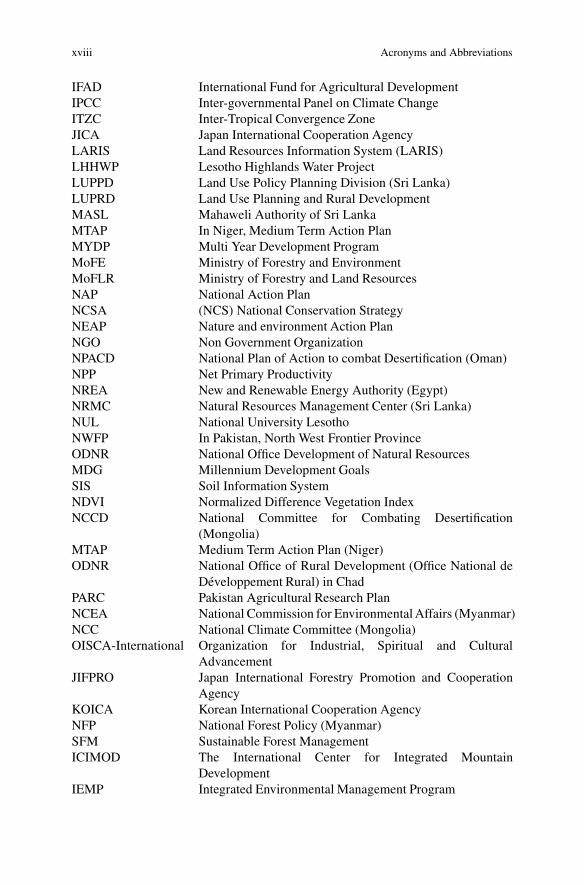
xviii Acronyms and Abbreviations
IFAD International Fund for Agricultural DevelopmentIPCC Inter-governmental Panel on Climate ChangeITZC Inter-Tropical Convergence ZoneJICA Japan International Cooperation AgencyLARIS Land Resources Information System (LARIS)LHHWP Lesotho Highlands Water ProjectLUPPD Land Use Policy Planning Division (Sri Lanka)LUPRD Land Use Planning and Rural DevelopmentMASL Mahaweli Authority of Sri LankaMTAP In Niger, Medium Term Action PlanMYDP Multi Year Development ProgramMoFE Ministry of Forestry and EnvironmentMoFLR Ministry of Forestry and Land ResourcesNAP National Action PlanNCSA (NCS) National Conservation StrategyNEAP Nature and environment Action PlanNGO Non Government OrganizationNPACD National Plan of Action to combat Desertification (Oman)NPP Net Primary ProductivityNREA New and Renewable Energy Authority (Egypt)NRMC Natural Resources Management Center (Sri Lanka)NUL National University LesothoNWFP In Pakistan, North West Frontier ProvinceODNR National Office Development of Natural ResourcesMDG Millennium Development GoalsSIS Soil Information SystemNDVI Normalized Difference Vegetation IndexNCCD National Committee for Combating Desertification
(Mongolia)MTAP Medium Term Action Plan (Niger)ODNR National Office of Rural Development (Office National de
Developpement Rural) in ChadPARC Pakistan Agricultural Research PlanNCEA National Commission for Environmental Affairs (Myanmar)NCC National Climate Committee (Mongolia)OISCA-International Organization for Industrial, Spiritual and Cultural
AdvancementJIFPRO Japan International Forestry Promotion and Cooperation
AgencyKOICA Korean International Cooperation AgencyNFP National Forest Policy (Myanmar)SFM Sustainable Forest ManagementICIMOD The International Center for Integrated Mountain
DevelopmentIEMP Integrated Environmental Management Program

Acronyms and Abbreviations xix
PACD Presidential Assistant on Community Development(The Philippines)
PAN/LCD National Action Plan to Combat Desertification and LandDegradation (Chad)
PCAARD Philippines Council for Agriculture, Forestry and NaturalResources
PDF-B Project Development File Part B for GEF submissionsPPLCD General Plan to combat desertification and land degradation
(Chad)SALT Sloping Agricultural Land TechnologySLMP Sustainable Land Management PlanningSLR Sea Level RiseSRD Strategy for Rural Development (Niger)SWC Soil and Water ConservationUNCED United Nations Conference on Environment and
DevelopmentUNFCCC See FCCCUHCF Unirrigated Highland Crop Farming Sri LankaUNSO United Nations Sudano-Sahelian OfficeWB World Bank


List of Boxes
Box 1.1 Examples of International Collaborative Effortsto Combat Desertification (Source: Wang Jihe (2006,personal communication)) . . . . . . . . . . . . . . . . . . . . . . . . . . . . . . . . . . . . . . . . . . . 16
Box 2.1 The Miracle of the Takliman Desert Highway. . . . . . . . . . . . . . . . . . . . . . 44Box 2.2 The Shapotou Experimental Station, Ningxia, China . . . . . . . . . . . . . . 45
Box 6.1 Renewable Energy Wind Power . . . . . . . . . . . . . . . . . . . . . . . . . . . . . . . . . . . . . 129Box 6.2 Role of the Desert Research Center Arab Republic
of Egypt Ministry of Agriculture and Land Reclamation . . . . . . . . . . 130
Box 7.1 Actions Taken at National and Local Level That Leadto Situation Betterment . . . . . . . . . . . . . . . . . . . . . . . . . . . . . . . . . . . . . . . . . . . . . . 150
Box 9.1 Wind Erosion Control in Bokoro .. . . . . . . . . . . . . . . . . . . . . . . . . . . . . . . . . . . 185Box 9.2 Summary of Ennedi Project in Northern Chad . . . . . . . . . . . . . . . . . . . . . 186Box 9.3 Great Green Wall to Stop Sahel Desertification . . . . . . . . . . . . . . . . . . . . 187Box 9.4 Reforestation Using Acacia albida . . . . . . . . . . . . . . . . . . . . . . . . . . . . . . . . . . 188
Box 11.1 GL-CRSP GOBI Forage Project: A Success Story . . . . . . . . . . . . . . . . . 227
Box 15.1 Use of SALT in Practice – Step by Step . . . . . . . . . . . . . . . . . . . . . . . . . . . . 315
Box 16.1 Government Agencies Involved in Dealing with LandRelated Issues in Sri Lanka . . . . . . . . . . . . . . . . . . . . . . . . . . . . . . . . . . . . . . . . . . 330
Box 16.2 Community Action Program to Reduce LandDegradation and Conserve Biodiversity in MaguruRiver Basin by Organization for Aquatic ResourcesManagement – GEF Small Grants project . . . . . . . . . . . . . . . . . . . . . . . . . . 345
Box 17.1 Carbon Sequestration in the Desertified Dryland .. . . . . . . . . . . . . . . . . . 372
Box 18.1 SuccessfulControl of Dust in the Meighan Desert,Markazi Province . . . . . . . . . . . . . . . . . . . . . . . . . . . . . . . . . . . . . . . . . . . . . . . . . . . . 387
Box 18.2 Pilot Project of Flood Spreading System . . . . . . . . . . . . . . . . . . . . . . . . . . . 393Box 18.3 Iran as Host to the UNCCD TPN3 . . . . . . . . . . . . . . . . . . . . . . . . . . . . . . . . . . 397
xxi

xxii List of Boxes
Box 20.1 Desert Development Has Been a Strongly SupportedActivity as Evidenced by the Number of InternationalConferences . . . . . . . . . . . . . . . . . . . . . . . . . . . . . . . . . . . . . . . . . . . . . . . . . . . . . . . . . . 429
Box 21.1 Eight Steps to Scaling Up. . . . . . . . . . . . . . . . . . . . . . . . . . . . . . . . . . . . . . . . . . . . 450Box 21.2 The Many Facets of Success in Scaling Up. . . . . . . . . . . . . . . . . . . . . . . . . 458

List of Figures
Fig. 1.1 There are several major climate zones with a highproportion of cold arid regions such as in theQinghai-Tibet Plateau . . . . . . . . . . . . . . . . . . . . . . . . . . . . . . . . . . . . . . . . . . . . . . 7
Fig. 1.2 China has a large area of true desert (hyper arid andother areas of arid land) as well as extensive areas ofsandy land on dry sub humid areas (Wu et al. 2007) . . . . . . . . . . . . . . 8
Fig. 1.3 Yardangs are a type of desert landscape that is shapedby wind and water. This set is from the Qaidam(Chadamupendi) Desert (Photo V. Squires) . . . . . . . . . . . . . . . . . . . . . . . 9
Fig. 1.4 Riparian areas like this one on the lower reachesof the ShiYang river in the Hexi corridor of Chinahave died as a result of over enthusiastic waterconservation projects that prevented annual floodingafter the spring snow melt and the cessation of groundwater recharge.. . . . . . . . . . . . . . . . . . . . . . . . . . . . . . . . . . . . . . . . . . . . . . . . . . . . . . 11
Fig. 1.5 Sand encroachment and accelerated desertification isforcing villagers to abandon their homes and migrateto other regions (Photos Victor Squires) . . . . . . . . . . . . . . . . . . . . . . . . . . . 13
Fig. 2.1 Relationship between mechanical and biological measures . . . . . . 23Fig. 2.2 Type of mechanical measure and its function . . . . . . . . . . . . . . . . . . . . . 24Fig. 2.3 The cross section of covering sand dune with earth .. . . . . . . . . . . . . . 25Fig. 2.4 Covering sand dunes with straw or branches .. . . . . . . . . . . . . . . . . . . . . 26Fig. 2.5 The effect of ventilation sand barrier on sand-driving wind . . . . . . 29Fig. 2.6 The effect of dense structural and windproof sand
barriers on sand-driving wind . . . . . . . . . . . . . . . . . . . . . . . . . . . . . . . . . . . . . . 30Fig. 2.7 The indication of the prevailing wind (a) is the initial
condition after stabilizing the dune with standingsand barriers (b) is the location of plantings of treesand shrubs between the dunes and (c) the reducedsize of the dune at some future time . . . . . . . . . . . . . . . . . . . . . . . . . . . . . . . 31
xxiii

xxiv List of Figures
Fig. 2.8 The run of sand barrier on the windward slope of dunes . . . . . . . . . 32Fig. 2.9 The patterns of some sand barriers . . . . . . . . . . . . . . . . . . . . . . . . . . . . . . . . . 33Fig. 2.10 The section of linear-shaped sand barrier . . . . . . . . . . . . . . . . . . . . . . . . . . 33Fig. 2.11 The disposing patterns of sand barrier of the
windward slopes of crescent dunes . . . . . . . . . . . . . . . . . . . . . . . . . . . . . . . . 34Fig. 2.12 The disposing patterns of sand barriers on the
semi-lunar dune chains . . . . . . . . . . . . . . . . . . . . . . . . . . . . . . . . . . . . . . . . . . . . . 34Fig. 2.13 The disposing patterns at the head of longitudinal dunes . . . . . . . . . 35Fig. 2.14 The disposing patterns of sand barrier on the
complicated irregular sand dune . . . . . . . . . . . . . . . . . . . . . . . . . . . . . . . . . . . 36Fig. 2.15 The relationship between the height and the row
spacing of the sand barrier . . . . . . . . . . . . . . . . . . . . . . . . . . . . . . . . . . . . . . . . . 37Fig. 2.16 The relationship between the slope of sand and the
row spacing of sand barrier . . . . . . . . . . . . . . . . . . . . . . . . . . . . . . . . . . . . . . . . . 37Fig. 2.17 The relationship of the stable surface of sand dune
and the concave part around the sand barriers . . . . . . . . . . . . . . . . . . . . . 38Fig. 2.18 The installing techniques of high standing sand barrier . . . . . . . . . . 40Fig. 2.19 The installer’s method of soft spread sand barriers . . . . . . . . . . . . . . . 41Fig. 2.20 Installation of materials in furrows . . . . . . . . . . . . . . . . . . . . . . . . . . . . . . . . 42Fig. 2.21 The section of clay sand barrier. Major barriers are
placed 2–4 m apart with a base of 15–25 cm in thelower slopes and 45–75 cm in the upper parts . . . . . . . . . . . . . . . . . . . . . 42
Fig. 2.22 A view of part of the Shapotou Desert ResearchStation showing the system of checkerboards madewith straw to increase surface roughness and reducesand movement . . . . . . . . . . . . . . . . . . . . . . . . . . . . . . . . . . . . . . . . . . . . . . . . . . . . . 46
Fig. 3.1 “The Great Green Wall” extends for hundreds of kmin northern China to reduce the impact of dust andsandstorms that originate in Mongolia and Inner Mongolia . . . . . . 51
Fig. 3.2 Planting trees in the swales where soil water relationsare better is a good way to flatten dunes over a periodof several years as sand is transported downwind .. . . . . . . . . . . . . . . . 57
Fig. 3.3 Shrubs that have a high resistance to wind erosion areplanted on the front or middle part of the windwardslopes of dunes and trees such as Populus can beplanted on the downwind side . . . . . . . . . . . . . . . . . . . . . . . . . . . . . . . . . . . . . . 58
Fig. 3.4 An integrated approach to sand fixation in an artificialoasis threatened by encroaching sand dunes . . . . . . . . . . . . . . . . . . . . . . 61
Fig. 3.5 Comprehensive Shelter system in Gaotai county, Gansu . . . . . . . . . 61Fig. 3.6 Comprehensive system for sand control near
Aydingkol Lake, Turpan county Xinjiang . . . . . . . . . . . . . . . . . . . . . . . . . 62Fig. 3.7 Flow chart for Shelter forest system to protect the
artificial oases . . . . . . . . . . . . . . . . . . . . . . . . . . . . . . . . . . . . . . . . . . . . . . . . . . . . . . . 63

List of Figures xxv
Fig. 3.8 “Blocking shifting sand dunes at front and draggingat back” a schema for successful application in theWushenqi area of the Mu Us sandy land in Inner Mongolia . . . . . . 63
Fig. 3.9 Sand fixation and afforestation on shifting sand inZhanggutai, Horqin sandy land, Laoning, NE China . . . . . . . . . . . . . 64
Fig. 3.10 Structure of a comprehensive protection systemdeveloped in the Shapotou section of Baotou-Lanzhourailway line . . . . . . . . . . . . . . . . . . . . . . . . . . . . . . . . . . . . . . . . . . . . . . . . . . . . . . . . . . 66
Fig. 3.11 Structure of sandbreaking forest in theJunkeng-Erdaogou section of the Lanzhou-Xinjiang railway . . . . 66
Fig. 3.12 Structure of the shelter belts in Ganqika section of theDalushan-Zhongjiatun railway line, Inner Mongolia . . . . . . . . . . . . . 67
Fig. 3.13 Structure and placement of wind-leading panels forhighway protection . . . . . . . . . . . . . . . . . . . . . . . . . . . . . . . . . . . . . . . . . . . . . . . . . 68
Fig. 3.14 Comprehensive Shelter system on two sides of a highway . . . . . . . 68Fig. 3.15 Mechanical barriers made of clay have proved to be
successful in some areas. Clay ‘tablets’ of varioussizes are used in mixtures (as shown) . . . . . . . . . . . . . . . . . . . . . . . . . . . . . . 69
Fig. 4.1 Map showing Libya and its neighbors and itsgeographic location in Africa . . . . . . . . . . . . . . . . . . . . . . . . . . . . . . . . . . . . . . 77
Fig. 4.2 Large-scale center pivot irrigation schemes are afeature of Libya’s agriculture . . . . . . . . . . . . . . . . . . . . . . . . . . . . . . . . . . . . . . 78
Fig. 4.3 Irrigation depends on exploitation of large aquifersthat underlie much of Libya . . . . . . . . . . . . . . . . . . . . . . . . . . . . . . . . . . . . . . . . 79
Fig. 4.4 Rehabilitation of degraded rangelands can involveplanting fodder species that provide an intake ofgreen material and also protect the soil surface. Thephoto shows a plantation in an 100 mm zone in Libya(Photo B.E. Norton) . . . . . . . . . . . . . . . . . . . . . . . . . . . . . . . . . . . . . . . . . . . . . . . . 83
Fig. 4.5 Plantations of Atriplex have been used with success.The green leaves are rich in protein and provide auseful supplement in late autumn or in drought times,if an energy source such as straw is available (PhotoB.E. Norton) . . . . . . . . . . . . . . . . . . . . . . . . . . . . . . . . . . . . . . . . . . . . . . . . . . . . . . . . 84
Fig. 4.6 Furrowing to catch water and allow germination ofwind blown seeds has been tested in Libya. Creationof surface roughness reduces run off and reduceswind velocity at or near the soil surface (Photo B.E. Norton) . . . . 85
Fig. 5.1 Map of Morocco showing its location and its neighbors.. . . . . . . . . 93Fig. 5.2 Average monthly rainfall and temperature of Fez
(lat. 34ı N and long. 5ı W). . . . . . . . . . . . . . . . . . . . . . . . . . . . . . . . . . . . . . . . . 95Fig. 5.3 Rainfall map showing that rainfall is low
(100 mm p.a.) in most inland of Morocco . . . . . . . . . . . . . . . . . . . . . . . . . 96

xxvi List of Figures
Fig. 5.4 Collection of seeds from rangeland plants, includingtrees and shrubs in Eastern Morocco . . . . . . . . . . . . . . . . . . . . . . . . . . . . . . 106
Fig. 5.5 Planting of long lived drought-resistant hardyperennials into rangeland can provide a valuableprotein supplement during the dry season and adrought reserve. Atriplex spp. perform well (PhotoB.E. Norton) . . . . . . . . . . . . . . . . . . . . . . . . . . . . . . . . . . . . . . . . . . . . . . . . . . . . . . . . 108
Fig. 5.6 A photograph of Atriplex in an alley cropping systemwith barley as the cereal crop (Photo B.E. Norton) . . . . . . . . . . . . . . . 110
Fig. 6.1 Agro-ecological zones in Egypt . . . . . . . . . . . . . . . . . . . . . . . . . . . . . . . . . . . . 116Fig. 6.2 Land use map of Egypt . . . . . . . . . . . . . . . . . . . . . . . . . . . . . . . . . . . . . . . . . . . . . 117Fig. 6.3 Satellite view of Nile Delta and part
of the Mediterranean coast . . . . . . . . . . . . . . . . . . . . . . . . . . . . . . . . . . . . . . . . . 118
Fig. 7.1 Kenya map showing Arid and Semi-Arid Lands (ASALS) . . . . . . . 142Fig. 7.2 Extensive rangelands are used by traditional
pastoralists. Much of the better land has been put intonational parks. Large areas have become degradedoutside of the reserves . . . . . . . . . . . . . . . . . . . . . . . . . . . . . . . . . . . . . . . . . . . . . . 143
Fig. 7.3 Photo sequence from (a) 2004 to (d) 2007 of a typicalsite where controlled access has resulted in vegetation recovery . 147
Fig. 8.1 Mountains occupy a large part of Lesotho . . . . . . . . . . . . . . . . . . . . . . . . . 154Fig. 8.2 Map of Lesotho, a land locked mountainous country
in southern Africa .. . . . . . . . . . . . . . . . . . . . . . . . . . . . . . . . . . . . . . . . . . . . . . . . . . 155Fig. 8.3 Severe gullying in arable terraces in Lesotho . . . . . . . . . . . . . . . . . . . . . 157Fig. 8.4 Land use Map. The areas shown in green are the
protected areas. Grazing land occupies the biggest area . . . . . . . . . . 158Fig. 8.5 Grass cover in the mountains of Lesotho . . . . . . . . . . . . . . . . . . . . . . . . . . 159Fig. 8.6 Indigenous trees of Lesotho (Leucosidia sericea) . . . . . . . . . . . . . . . . . 159Fig. 8.7 Showing gender balance in implementation of land
rehabilitation activities . . . . . . . . . . . . . . . . . . . . . . . . . . . . . . . . . . . . . . . . . . . . . 161Fig. 8.8 A watershed is all the land that water flows across or
through on its way to a specific tributary stream, or river : : : . . . . 161Fig. 8.9 Watersheds have boundaries and an outlet (mouth).
They represent a useful management unit . . . . . . . . . . . . . . . . . . . . . . . . . 162Fig. 8.10 A basic gabion before filling with stones . . . . . . . . . . . . . . . . . . . . . . . . . . 163Fig. 8.11 Section through a gabion dyke (stone filled baskets)
used to protect stream banks and prevent erosion .. . . . . . . . . . . . . . . . 163Fig. 8.12 Cross section of gully plug showing details of construction .. . . . . 164Fig. 8.13 Shows mechanical measures (Diversion furrow, stone
lines and silt-traps respectively) . . . . . . . . . . . . . . . . . . . . . . . . . . . . . . . . . . . . 165Fig. 8.14 Public participation in afforestation in Lesotho . . . . . . . . . . . . . . . . . . . 165

List of Figures xxvii
Fig. 8.15 Concrete tank to protect a spring. This projectprovided jobs and taught skills . . . . . . . . . . . . . . . . . . . . . . . . . . . . . . . . . . . . . 166
Fig. 9.1 Map of Chad showing its location as a land-lockedcountry located on the fringe of the Sahara desert . . . . . . . . . . . . . . . . 171
Fig. 9.2 Local livestock owners of livestock practicetranshumance to chase the seasonal availability offorage and water . . . . . . . . . . . . . . . . . . . . . . . . . . . . . . . . . . . . . . . . . . . . . . . . . . . . 178
Fig. 10.1 Map of Niger Republic and it neighboring countries.The country is bordered to the north by Algeria andLibya, to the west by Mali and Burkina Faso, to theeast by Chad and to the south by Benin and Nigeria . . . . . . . . . . . . . . 193
Fig. 10.2 Massifs of Air (Ing. foresters going to the steeringcommittee meeting for Sustainable Co-managementof the Natural Resources of the Air-Tenere Complex:Iferuan June 2012) .. . . . . . . . . . . . . . . . . . . . . . . . . . . . . . . . . . . . . . . . . . . . . . . . . 194
Fig. 10.3 Niger is a Sahelian country faced with manyproblems of desertification including loss of precioustopsoil that threaten food security . . . . . . . . . . . . . . . . . . . . . . . . . . . . . . . . . . 197
Fig. 10.4 (a) and (b) Pressure on marginal lands for conversionto millet farms leads to rapid land degradation .. . . . . . . . . . . . . . . . . . . 199
Fig. 10.5 Water erosion in a millet farm. . . . . . . . . . . . . . . . . . . . . . . . . . . . . . . . . . . . . . 199Fig. 10.6 Mechanical restoration of degraded land by women
at Iferuan community, June 2012 . . . . . . . . . . . . . . . . . . . . . . . . . . . . . . . . . . 202Fig. 10.7 Moving sand dune (Maine-Soroa) Sep. 2012
(Compare Fig. 10.11 to see the value of the sandfixation work) . . . . . . . . . . . . . . . . . . . . . . . . . . . . . . . . . . . . . . . . . . . . . . . . . . . . . . . 202
Fig. 10.8 Bush burning for agricultural purpose (create morearable land) . . . . . . . . . . . . . . . . . . . . . . . . . . . . . . . . . . . . . . . . . . . . . . . . . . . . . . . . . . 206
Fig. 10.9 Forest Rangers assessing the number of trees cutdown to make way for cropping.. . . . . . . . . . . . . . . . . . . . . . . . . . . . . . . . . . . 207
Fig. 10.10 Members of the steering committee of SustainableCo-management of the Natural Resources of theAir-Tenere Complex (C0GERAT in French) visitinga private site of outreach bridging (May 2012) .. . . . . . . . . . . . . . . . . . . 208
Fig. 10.11 Sand dune fixation at Maine Soroa Sep. 2012 .. . . . . . . . . . . . . . . . . . . . 209Fig. 10.12 Women harvesting Cassia tora leaf (it is delicious
food). This species has been reintroduced in 2008in land restored within the UNEP IEMP project(Dogueraoua pilot site of IEMP October 2010) . . . . . . . . . . . . . . . . . . . 209
Fig. 11.1 Geographic location of Mongolia and the location ofpopulation centers, It is the 18th largest country inthe world, 5th largest in Asia . . . . . . . . . . . . . . . . . . . . . . . . . . . . . . . . . . . . . . . 219

xxviii List of Figures
Fig. 11.2 The southern regions of Mongolia are desert whilst inthe north and north-west there are uplands with forest cover . . . . . 219
Fig. 11.3 Livestock production zones based on description bySuttie (2005) . . . . . . . . . . . . . . . . . . . . . . . . . . . . . . . . . . . . . . . . . . . . . . . . . . . . . . . . 221
Fig. 11.4 Natural zones of Mongolia showing principalvegetation types . . . . . . . . . . . . . . . . . . . . . . . . . . . . . . . . . . . . . . . . . . . . . . . . . . . . . 223
Fig. 11.5 Trends in NDVI in five different zones of Mongoliafrom 1982 to 2006 . . . . . . . . . . . . . . . . . . . . . . . . . . . . . . . . . . . . . . . . . . . . . . . . . . 223
Fig. 11.6 Over grazing is serious and often exceeds 150 % ofthe assessed carrying capacity. . . . . . . . . . . . . . . . . . . . . . . . . . . . . . . . . . . . . . 224
Fig. 12.1 Map of Pakistan showing distribution of rainfall. Thedarker areas receive higher rainfall . . . . . . . . . . . . . . . . . . . . . . . . . . . . . . . . 233
Fig. 12.2 Sprinkler irrigation for fodder production . . . . . . . . . . . . . . . . . . . . . . . . . 245Fig. 12.3 Shelterbelt technology to combat sandune shifting in
Thal Desert . . . . . . . . . . . . . . . . . . . . . . . . . . . . . . . . . . . . . . . . . . . . . . . . . . . . . . . . . . 245Fig. 12.4 Dry afforestation technology in Thal . . . . . . . . . . . . . . . . . . . . . . . . . . . . . . 246Fig. 12.5 Eucalyptus wind break in desert . . . . . . . . . . . . . . . . . . . . . . . . . . . . . . . . . . . 246Fig. 12.6 Improved community rangeland in Balochistan . . . . . . . . . . . . . . . . . . . 247Fig. 12.7 Jatropha plantation on marginal lands for biofuel production . . . . 247
Fig. 13.1 Bordering Turkmenistan to the southwest,Kazakhstan to the north, and Tajikistan andKyrgyzstan to the south and east, Uzbekistan is notonly one of the larger Central Asian states but alsothe only Central Asian state to border all of the otherfour former Soviet Republics. Uzbekistan also sharesa short border with Afghanistan to the south . . . . . . . . . . . . . . . . . . . . . . 252
Fig. 13.2 (a, b) Topographical landscape map of target researcharea in Kyzylkum desert (Karakata saline depression)The dot in the square in the large scale map (right)indicates the location in relation to the whole region.The salinity gradient on micro relief level includesthe area between two artesian thermal springs (shownas triangles). The plant community and soil wasstudied along this gradient (Source: Toderich et al. 2008) .. . . . . . . 255
Fig. 13.3 Location of the study area in Karnabchul, Uzbekistan(a), digital elevation model (DEM) (b), schematicillustration of the measurement transects laid outperpendicular to the well (c), and village (d). DEMwas obtained from Earth Remote Sensing DataAnalysis Center (ERSDAC 2009; Rajabov 2011) .. . . . . . . . . . . . . . . . 255
Fig. 13.4 Interrelation of typical fodder (Artemisia diffusa)and unpalatable species (Peganum harmala) along agrazing gradient from a fixed watering point in Karnabchul . . . . . 258

List of Figures xxix
Fig. 13.5 Dynamics of below- and above-ground biomass ofephemeroids as a response to different grazing intensities . . . . . . . 259
Fig. 13.6 Mapping of dominating (edificators) plant C4 specieson the territories of Kyzylkum desert along a gradientof salinity (1–4 soils of low salinity; 5–8 mediumsalinity; 9–12 high salinity) . . . . . . . . . . . . . . . . . . . . . . . . . . . . . . . . . . . . . . . . 263
Fig. 13.7 Ratio of species with ´3 and ´4 types ofphotosynthesis in different plant associations(a – xerophytes, b – xerohalophytes,c – haloxerophytes) during vegetation season . . . . . . . . . . . . . . . . . . . . . 265
Fig. 13.8 Ratio of perennials and annuals among desertrangelands plant associations along salinity gradient.(a) is displayed according to location in landscapeand (b) is displayed according to photosyntheticpathway (C3 or C4) . . . . . . . . . . . . . . . . . . . . . . . . . . . . . . . . . . . . . . . . . . . . . . . . . 266
Fig. 13.9 Leaf carbon isotope ratio of ´3 (T. hispida) and ´4
(H. aphyllum) species along salinity gradient . . . . . . . . . . . . . . . . . . . . . 267Fig. 13.10 Ion average concentrations detected in the
aboveground biomass of salt tolerant rangelandsspecies at the flowering stage . . . . . . . . . . . . . . . . . . . . . . . . . . . . . . . . . . . . . . 268
Fig. 13.11 (a) Natural pastures at Kyzylkesek site highly affectedby salinity (before improvement); (b) rehabilitationof saline prone lands by using Atriplex nitens(monotypic cultivated halophytic pasture after improvement) . . . 269
Fig. 14.1 Map of Myanmar, the 5th largest country in Asiashowing the location and extent of the Dry Zone incentral Myanmar (inset) . . . . . . . . . . . . . . . . . . . . . . . . . . . . . . . . . . . . . . . . . . . . 283
Fig. 14.2 Severe gullying and soil loss can follow deforestationand inappropriate cultivation methods . . . . . . . . . . . . . . . . . . . . . . . . . . . . . 290
Fig. 14.3 Severe gullying may require structural works toreduce flow and trap sediment. . . . . . . . . . . . . . . . . . . . . . . . . . . . . . . . . . . . . . 291
Fig. 14.4 Structural gully control works are an effective meansfor control of sediment movement . . . . . . . . . . . . . . . . . . . . . . . . . . . . . . . . . 291
Fig. 14.5 Earthworks such as these can reduce runoff and soilloss and retain moisture in situ . . . . . . . . . . . . . . . . . . . . . . . . . . . . . . . . . . . . . 292
Fig. 15.1 Location map of the Philippines within SE Asia . . . . . . . . . . . . . . . . . . 305Fig. 15.2 The Philippines is an island nation . . . . . . . . . . . . . . . . . . . . . . . . . . . . . . . . . 306Fig. 15.3 Soil erosion takes many different forms as this
map shows. Severe erosion (shown in red) is morecommon in the south. . . . . . . . . . . . . . . . . . . . . . . . . . . . . . . . . . . . . . . . . . . . . . . . 310
Fig. 16.1 Sri Lanka is a tropical country with a land area of 65,610 km2 . . 325Fig. 16.2 Rainfall varies from very high >5,000 mm annually
to low <1,250 mm in the so-called dry zone . . . . . . . . . . . . . . . . . . . . . . 326
xxx List of Figures
Fig. 16.3 There are extensive areas, especially in the HortonPlains area that are covered with patana grass(Chrysopogon zeylandicus) . . . . . . . . . . . . . . . . . . . . . . . . . . . . . . . . . . . . . . . . . 329
Fig. 16.4 Soil erosion control works like these are being usedto (a) control water flow and (b) create terraces. . . . . . . . . . . . . . . . . . . 334
Fig. 16.5 Erosion damages crops and makes areas of land lessproductive. Gullying in a cropped field can expose ofbare rocks . . . . . . . . . . . . . . . . . . . . . . . . . . . . . . . . . . . . . . . . . . . . . . . . . . . . . . . . . . . 336
Fig. 16.6 Soil erosion hazard map of central region of SriLanka. The severity is expressed as low (pale gray),moderate, high, very high and severe (red) . . . . . . . . . . . . . . . . . . . . . . . . 337
Fig. 16.7 Tea plantations are important but their establishmenthas contributed to deforestation .. . . . . . . . . . . . . . . . . . . . . . . . . . . . . . . . . . . 339
Fig. 16.8 Coconut plantations can provide soil protection . . . . . . . . . . . . . . . . . . 339Fig. 16.9 Rubber plantations occupy uplands. They have
replaced native forest . . . . . . . . . . . . . . . . . . . . . . . . . . . . . . . . . . . . . . . . . . . . . . . 340Fig. 16.10 Casuarina equisetifolia plantations in Hambanthota
District coast line . . . . . . . . . . . . . . . . . . . . . . . . . . . . . . . . . . . . . . . . . . . . . . . . . . . 343Fig. 16.11 Sand dune stabilization by erection of semi-permeable
(slatted) fence to change wind flow patterns andreshape dunes . . . . . . . . . . . . . . . . . . . . . . . . . . . . . . . . . . . . . . . . . . . . . . . . . . . . . . . 344
Fig. 16.12 Layout of slatted fences to stabilize sand plainsFences are about 6–80 cm high . . . . . . . . . . . . . . . . . . . . . . . . . . . . . . . . . . . . 344
Fig. 16.13 Stone walls were built by the local community tocombat erosion .. . . . . . . . . . . . . . . . . . . . . . . . . . . . . . . . . . . . . . . . . . . . . . . . . . . . . 346
Fig. 16.14 Community consultation is an important part of thedevelopment of land use plans . . . . . . . . . . . . . . . . . . . . . . . . . . . . . . . . . . . . . 347
Fig. 17.1 Geographical location and topographic features ofIran. Elburz and Alborz are alternative spellings forthe principal east-west mountain chain . . . . . . . . . . . . . . . . . . . . . . . . . . . . 357
Fig. 17.2 Natural vegetation and elevation level on differentaspects of Alborz mountain . . . . . . . . . . . . . . . . . . . . . . . . . . . . . . . . . . . . . . . . 359
Fig. 17.3 Distribution of four ecological zones of Iran . . . . . . . . . . . . . . . . . . . . . . 360Fig. 17.4 The Caspian ecoregion has a great diversity of halophytes .. . . . . . 365Fig. 17.5 Tree and shrub seedlings are produced in irrigated
nurseries that are protected by windbreaks and havewater available for supplementary irrigation . . . . . . . . . . . . . . . . . . . . . . 368
Fig. 17.6 Prevention of the wind erosion can be achieved bycovering the surface with obstacles that reduce windvelocity at the surface. . . . . . . . . . . . . . . . . . . . . . . . . . . . . . . . . . . . . . . . . . . . . . . 368
Fig. 17.7 Bulldozer towing oil/seed spraying equipment into position . . . . . 369Fig. 17.8 Dunes can be stabilized by a combination of
biological methods involving planting shrubs andgrasses inside small areas protected by pallisades . . . . . . . . . . . . . . . . 369

List of Figures xxxi
Fig. 17.9 Reclamation of desert lands with resistant speciessuch as Atriplex spp. and Haloxylon spp. . . . . . . . . . . . . . . . . . . . . . . . . . . 370
Fig. 17.10 Harsh desert environments like this pose a realchallenge to those who wish to re-vegetate . . . . . . . . . . . . . . . . . . . . . . . . 371
Fig. 17.11 Millions of plants are produced each year. Nurserieslike this one are the backbone of this effort toreproduce locally adapted plants for transplanting(Photo Behrouz Malekpour) .. . . . . . . . . . . . . . . . . . . . . . . . . . . . . . . . . . . . . . . 372
Fig. 18.1 Iran has a large arid zone. It borders on the CaspianSea, the Persian Gulf and several Central AsianCountries to the east . . . . . . . . . . . . . . . . . . . . . . . . . . . . . . . . . . . . . . . . . . . . . . . . 380
Fig. 18.2 Overgrazing leads to loss of vegetation andaccelerated run off and soil loss (Photo by author).. . . . . . . . . . . . . . . 381
Fig. 18.3 Severe gully erosion in loess area . . . . . . . . . . . . . . . . . . . . . . . . . . . . . . . . . . 382Fig. 18.4 Gully development is a kind of land degradation in
Atrak river basin . . . . . . . . . . . . . . . . . . . . . . . . . . . . . . . . . . . . . . . . . . . . . . . . . . . . 382Fig. 18.5 There are large tracts of denuded sandy land.
Overgrazing has led to formation of unstable dunesthat threaten roads, railways and settlements . . . . . . . . . . . . . . . . . . . . . . 389
Fig. 18.6 The psammophytic plant Nitraria schoberi can beused to stabilize moving sand . . . . . . . . . . . . . . . . . . . . . . . . . . . . . . . . . . . . . . 389
Fig. 18.7 Small dams allow water harvesting and assist in floodmitigation in an upland catchment of Atrak river . . . . . . . . . . . . . . . . . 390
Fig. 18.8 Biological measures involving planting of trees andshrubs for rehabilitation of degraded lands . . . . . . . . . . . . . . . . . . . . . . . . 391
Fig. 18.9 Participatory approaches are a way to involve thelocal land users in project planning, implementationand monitoring .. . . . . . . . . . . . . . . . . . . . . . . . . . . . . . . . . . . . . . . . . . . . . . . . . . . . . 392
Fig. 18.10 Community participation in tree planting andother revegetation efforts is a way to ensure thesustainability of projects . . . . . . . . . . . . . . . . . . . . . . . . . . . . . . . . . . . . . . . . . . . . 392
Fig. 18.11 Flood water spreading and utilization has beendeveloped to a high level . . . . . . . . . . . . . . . . . . . . . . . . . . . . . . . . . . . . . . . . . . . 395
Fig. 19.1 The Sultanate of Oman that lies adjacent to theArabian Sea and borders on Saudi Arabia, UAE, and Yemen . . . . 402
Fig. 19.2 There are about 120,000 camels in Oman, mostlythey are on the rangelands and rely on sparse desertforage and browse . . . . . . . . . . . . . . . . . . . . . . . . . . . . . . . . . . . . . . . . . . . . . . . . . . 412
Fig. 19.3 Low cost materials (palm fronds and other debris)have been used to stabilize sandy areas and reducethe impact of dust and sand storms . . . . . . . . . . . . . . . . . . . . . . . . . . . . . . . . 422

xxxii List of Figures
Fig. 20.1 The distribution of true desert and the areas affectedby desertification in North China. Note the locationof desertification hot spots on some desert marginswhere sand encroachment is a major concern (Maoet al. 2010) . . . . . . . . . . . . . . . . . . . . . . . . . . . . . . . . . . . . . . . . . . . . . . . . . . . . . . . . . . 430
Fig. 20.2 Projected global population density in 2015 . . . . . . . . . . . . . . . . . . . . . . 431Fig. 20.3 Trees can help to prevent sand encroachment but
trees require regular watering which is costly andimpractical. Plant spacing should not be too close . . . . . . . . . . . . . . . . 432
Fig. 20.4 Dynamics between people, livestock, cropland anddesertification . . . . . . . . . . . . . . . . . . . . . . . . . . . . . . . . . . . . . . . . . . . . . . . . . . . . . . . 434
Fig. 20.5 A schematic diagram representing the change in landuse systems in the arid regions of northwest China.Mixed farming in this context refers to areas in whichthe Han system of oasis development co-exists with aless intensive agro-pastoral system . . . . . . . . . . . . . . . . . . . . . . . . . . . . . . . . 435
Fig. 20.6 Precipitation in Xinjiang, NW China in the 50Cyears ending 2005.. . . . . . . . . . . . . . . . . . . . . . . . . . . . . . . . . . . . . . . . . . . . . . . . . . 436
Fig. 20.7 Annual rate of spread of sandification in China. Inrecent years the areas treated by the methods outlinedin Chaps. 2 and 3 of this book have exceeded theareas succumbing to sandification . . . . . . . . . . . . . . . . . . . . . . . . . . . . . . . . . 437
Fig. 20.8 Changes in the growth of human and livestockpopulations in Inner Mongolia from 1949 to 2000 .. . . . . . . . . . . . . . . 439
Fig. 20.9 Farming on the desert fringe in western GansuProvince, China . . . . . . . . . . . . . . . . . . . . . . . . . . . . . . . . . . . . . . . . . . . . . . . . . . . . . 440
Fig. 20.10 Saline and sodic soils need especially adapted plants . . . . . . . . . . . . . 440

List of Tables
Table 1.1 Major deserts and sandy lands in China . . . . . . . . . . . . . . . . . . . . . . . . . . . 9Table 1.2 Areas of desertified land in China classified by
different processes . . . . . . . . . . . . . . . . . . . . . . . . . . . . . . . . . . . . . . . . . . . . . . . . . . 10
Table 2.1 The ranges of row spacing of straw and branch sand barriers . . . . 37
Table 3.1 Sowing rate of several main sand-holding species . . . . . . . . . . . . . . . . 53Table 3.2 Suitable plant species for different sandy land types . . . . . . . . . . . . . 54
Table 4.1 Area as per aridity zones of Libya . . . . . . . . . . . . . . . . . . . . . . . . . . . . . . . . . 78Table 4.2 The water situation in Libya (1990–2025) . . . . . . . . . . . . . . . . . . . . . . . . 80Table 4.3 Important Law and Legislations regarding
environment and natural resources in Libya . . . . . . . . . . . . . . . . . . . . . . 86
Table 5.1 Land use in Morocco .. . . . . . . . . . . . . . . . . . . . . . . . . . . . . . . . . . . . . . . . . . . . . . 97Table 5.2 Donor-supported projects for combating
desertification in Morocco . . . . . . . . . . . . . . . . . . . . . . . . . . . . . . . . . . . . . . . . . 102
Table 6.1 Potential loss of area, population and land use due toSea Level Rise (SLR) over Alexandria Governorate,in the Nile Delta of Egypt . . . . . . . . . . . . . . . . . . . . . . . . . . . . . . . . . . . . . . . . . . 122
Table 6.2 Population expected to be displaced and loss ofemployment due to SLR in Alexandria Governorate . . . . . . . . . . . . . 122
Table 6.3 Areas (km2) population displaced and employmentlosses due to a SLR of 0.50 m in various districts ofPort Said Governorate, Egypt . . . . . . . . . . . . . . . . . . . . . . . . . . . . . . . . . . . . . . 122
Table 6.4 Economic evaluation of beach, urban, industry,agriculture, aqua-culture areas (km2) municipalservices and transportation network (km) losses ofPort Said Governorate in case of Sea Level Rise of 50 cm .. . . . . . 123
xxxiii

xxxiv List of Tables
Table 6.5 Model predictions of the impact of climate changeon the Nile water budget . . . . . . . . . . . . . . . . . . . . . . . . . . . . . . . . . . . . . . . . . . . 124
Table 10.1 Issues relating to desertification in the drylands of Niger . . . . . . . . 198
Table 12.1 Distribution of arid region in Pakistan (square kilometers) . . . . . . 234Table 12.2 Current land use in Pakistan based on satellite
imagery interpretation (000 ha) . . . . . . . . . . . . . . . . . . . . . . . . . . . . . . . . . . . . 236Table 12.3 Farm size distributions in Pakistan . . . . . . . . . . . . . . . . . . . . . . . . . . . . . . . . 237Table 12.4 Distribution of farms and farm area by tenure . . . . . . . . . . . . . . . . . . . . 237Table 12.5 Land utilization in Pakistan (million hectare) . . . . . . . . . . . . . . . . . . . . . 239Table 12.6 Soils affected by various types of salinity and
sodicity (000 ha) . . . . . . . . . . . . . . . . . . . . . . . . . . . . . . . . . . . . . . . . . . . . . . . . . . . . 241Table 12.7 Area affected by water erosion (000 ha). . . . . . . . . . . . . . . . . . . . . . . . . . . 241Table 12.8 Area affected by wind erosion (000 ha) . . . . . . . . . . . . . . . . . . . . . . . . . . . 242Table 12.9 Extent of water logged area (000 ha) . . . . . . . . . . . . . . . . . . . . . . . . . . . . . . 244
Table 13.1 Performance indicators of native and introduced ofC3/C4 tree and shrubs species under saline conditionsin Kyzul Kum .. . . . . . . . . . . . . . . . . . . . . . . . . . . . . . . . . . . . . . . . . . . . . . . . . . . . . . 272
Table 14.1 Areas of problem soils in Myanmar . . . . . . . . . . . . . . . . . . . . . . . . . . . . . . . 284Table 14.2 Extent of water erosion within the dry zone of Myanmar . . . . . . . . 299Table 14.3 Rate of soil erosion under different levels of soil cover . . . . . . . . . . 300
Table 15.1 The four major climate types in The Philippines . . . . . . . . . . . . . . . . . 307Table 15.2 Area distribution of erosion classes by island
grouping (in million ha) . . . . . . . . . . . . . . . . . . . . . . . . . . . . . . . . . . . . . . . . . . . . 309Table 15.3 Soil loss for various land uses and slopes (tons/hectare/year) .. . . 311Table 15.4 List of farming and other technologies adopted by
farmers in Lantapan, Bukidnon . . . . . . . . . . . . . . . . . . . . . . . . . . . . . . . . . . . . 312Table 15.5 Scope and coverage of the Philippines National
Action Plan (NAP) . . . . . . . . . . . . . . . . . . . . . . . . . . . . . . . . . . . . . . . . . . . . . . . . . 319
Table 16.1 Extent of each soil erosion hazard class within theCentral Province of Sri Lanka . . . . . . . . . . . . . . . . . . . . . . . . . . . . . . . . . . . . . 334
Table 17.1 Most of the country is arid and hyper arid . . . . . . . . . . . . . . . . . . . . . . . . 359Table 17.2 Key plant species of Hircanian zone (Heshmati 1999) . . . . . . . . . . . 362Table 17.3 Distribution of the key plant species of dryland
habitats on the basis of ecological needs in Iran . . . . . . . . . . . . . . . . . . 366
Table 18.1 A review of available desertification controltechnologies in Iran.. . . . . . . . . . . . . . . . . . . . . . . . . . . . . . . . . . . . . . . . . . . . . . . . 384

List of Tables xxxv
Table 19.1 Human population by region in Oman . . . . . . . . . . . . . . . . . . . . . . . . . . . . 412Table 19.2 Estimated livestock number 1994 and 2005.. . . . . . . . . . . . . . . . . . . . . . 413Table 19.3 Current dry matter balance .. . . . . . . . . . . . . . . . . . . . . . . . . . . . . . . . . . . . . . . . 413Table 19.4 Potential dry matter balance . . . . . . . . . . . . . . . . . . . . . . . . . . . . . . . . . . . . . . . 413
Table 21.1 Scaling-up processes (After Gillespie 2004) . . . . . . . . . . . . . . . . . . . . . . 447