Policy for Prevention of Money Laundering & Combating the ...
Upload
khangminh22Category
view
1download
0
LAND DEGRADATION AND COMBATING
DESERTIFICATION (with focus on Tunisia)
Mohamed OUESSAR, Eng., MSc., PhD.Institut des Régions Arides (IRA)4119 – Médenine – TunisieTél: 216-75633005; Fax: +216-75633006Email: [email protected] www.ira.agrinet.tn


• Drylands & desertification• Desertification in Africa• Land degradation and combating
desertification in Tunisia• Roles of IRA-Medenine and some of
its achievements (land and water resources)


• Aridity is defined as lack of moisture in average climatic conditions caused by one of the four climatic situations:– Atmospheric stability– Continentality– Topography– Cold oceanic currents
• Aridity index AI=P/PET– Dry subhumid: 0.5<AI<0.65– Semi arid: 0.2<AI<0.5– Arid: 0.05<AI<0.2– Hyperarid: AI<0.05
• More than 6.1 billion ha, 47.2 % of the earth’s land surface is dryland: Nearly 1 billion ha are naturally hyperarid deserts and the remaining (5.1 billion ha) are arid, semiarid and dry subhumid areas house of 1/5th world’s population.
Drylands

Desertification• The word desertification means an environmental crisis which produces desert-like condition in any ecosystem In ancient Egyptian hieroglyph, tesert means a place that was forsaken or left behind : desere : to abandon; desertum: waste place or wilderness; desertus: abandoned or relinquished• The word desertification was first used in west Africa in 1949 by the French forester Aubréville to describe the way in which it was perceived that the Sahara desert was expanding to engulf the desert marginal savanna grasslands.• The term was raised as a major environmental issue at the UN conference on human environment held in Stockholm in 1972. • Desertification reached a wider audience in the 1970s with the plight of the drought-stricken Sahel zone. One of the outcomes was the UN conference on desertification held in Nairobi in 1977.

• In 1984, a desertification hazard map was produced by the UNEP, FAO, UNESCO and WMO.
• The 1992 Rio UN conference on environment and development requested the UN general assembly to establish an intergovernmental committee to negotiate the convention to combat desertification which entered into force in 16 December 1996.
• More than a hundred of definitions have been used both in scientific and political circles.
• Desertification means land degradation in arid, semi-arid and dry sub-humid areas resulting from various factors, including climatic variations and human activities;
• Land in this context includes soil and local water resources, land surface and vegetation, including crops.
• Degradation implies reduction of resources potential by one or a combination of process acting on the land.
• Combating desertification includes activities which are part of the integrated development of land in arid, semi-arid and dry sub-humid areas for sustainable development.


•Overgrazing: – Affects more than 50% of the susceptible soils, especially in the arid and semi arid areas,– Vegetation removal and soil trampling,– Sedentarisation of nomad herders and expansion of cultivated lands,– Long drought periods,– Socio-economic transformations,
•Agricultural activities– Degradation is due to poor management of drylands cropping (semi arid and subhumid ) and irrigation (arid),– Increased cultivation of marginal soils, dry soil cereals, etc.– Salinization and water logging,– Declining of fallow periods to compensate for losses due to prolonged drought periods,
Causes of land degradation

• Overexploitation of vegetation– Overuse of vegetation for domestic purposes
(fuelwood, cooking, charcoal, fencing, etc.) and small rural industries (beer brewing, fish smoking, brick, baking, etc.),
– Imported fossil fuels are prohibitively expensive,– Woody biomass is the main domestic fuel in sub-
Saharan Africa,– Exodus to cities (Dakar, Ouagadougou, Niamey,
Nouakchott, etc.).
• Deforestation– Complete removal of vegetation is largely confined to
the Sahel region and the North of the Sahara,– Expansion of agriculture (irrigation, grain cultivation,
predominately in the semi arid and subhumid areas,– Fires (natural or human induced),

• Soil erosion– Water erosion– Wind erosion
• Soil deterioration– Physical (compaction/crusting, waterlogging)– Chemical (salinization, loss of nutrients, )
• Socio-economic effects– poverty, rural-urban migration (environmental
refugees), – reduced per capita agricultural production of affected
countries, – others.
Consequences of soil degradation


Desertification hazard• Due to its geographical location between the
Mediterranean and the Sahara, Tunisia is characterized by bioclimate variation in addition to landscape diversity.
• Of the 16.4 million ha, nearly 9.4 million ha are suitable to agriculture and pasture. The cultivated area is 5.4. million ha.
• It is estimated that 94% of the total lands are threatened by desertification
Desertification hazard of natural regions (1000 ha)Desertification Dorsale & tell High steppe Low steppe Meridionel tunisia Total %Lowly affected zones 667 603 700 1820 3790 24.6Moderatly affected zones 500 143 400 4220 5263 34.2Highly affected zones 1000 287 280 1250 2817 18.3Desertified zones 0 0 200 3320 3530 22.9Total 2167 1033 1580 10620 15400 100
MEAT, 1998
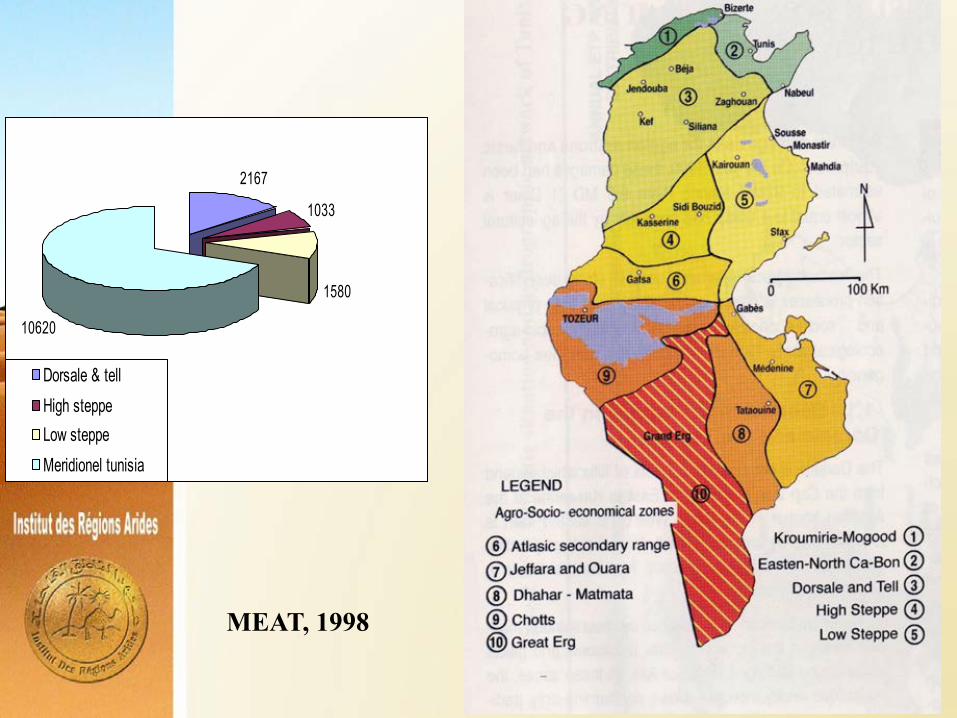
2167
1033
1580
10620
Dorsale & tellHigh steppeLow steppeMeridionel tunisia
MEAT, 1998

Combating desertification (CD)• Before the XX century: Though the concept of
desertification is relatively new but the pressure on the natural resources is an ancient practice. In fact, the Mediterranean basin was the cradle of various human civilizations: Phoenician, Greek-roman, Carthaginian, Arab-Muslim, etc.) which induced a high perturbation level of the ecosystems. However, a certain equilibrium was preserved until the beginning of the XX century through the adoption of various strategies (transhumance, water harvesting, etc.).
• After the independence: CD has been a major concern for the Tunisian Government in order to cope with increased food demand. It became more explicit after the UN conference of Nairobi in 1977.
• In the 80s there were the implementation of the PDRI (‘integrated’ rural development projects) based mainly on the sector approach and targeting the technical/physical feasibility.

• In 1985, there was the formulation of the first national strategy for CD. Tunisia encouraged the adoption of the UNCCD during the RIO conference in 1992 and ratified the convention, after its adoption in 1994, in 1995 which ended with the drafting of the UNCCD-NAP in 1998.
• For the period 1990-2000-present:– National strategy for SWC– National strategy for water resources– National strategy for combating sand encroachment– National forestry and pastoral strategy– Projects of Natural resources management and
development• In 2018: The NAP was revisited to adopt the concept of
LDN

National Action Plan (NAP)
• Preparatory steps:– Production of the ‘yellow hand’ program by the
MEAT– National consultation– Creation of the national committee for CD
• Principles:– Projects and actions for socio-economic development
and poverty alleviation,– Projects and actions for natural resources
conservation,– Institutional and legal measures.
• Monitoring and evaluation: efficiency, sustainability and impacts.

Technical Operations
• Water and soil conservation– Preventive practices: rotation, mulching, contour
ploughing, strip cropping, etc..– Curative practices: Gully correction, terracing, earth
embankments, plantations, etc.• Water mobilization
– Construction of hill lakes,– Installation of groundwater recharge units,– Installation of flood diversion units,
• Salinity control– It is mainly preventive by avoiding the use of
excessive saline water (more than 3-4 g/l).• Reuse of treated waste water and drainage water• Combating sand encroachment• Forest regeneration

• Pastoral and agricultural development– Intensify agriculture– Improve rangeland production– Diversify the agricultural and animal production– Develop agro-forestry
• Marginal lands reclamation• Horizontal projects
– Knowledge base development and Observation systems for drought and desertification,
– Elaboration of drought emergency and early warning systems,
– Energy consumption– Education and awareness– Implementation of the national strategy for
geothermal water,– Creation of the national agrarian observatory.

Accompanying measures• Institutional
–National level: CNLD (national commission for CD) supported by the CNDD. The national UNCCD coordinator is designated (ONC).–SAEZ level: Regional committee for CD made of the representatives of development, social, professionals, NGOs, labor organisms, etc.–Province level: Sub-regional committee for CD (CRDA),–Local level: extension services–Development committees: at the level of villages and douar.
•Training & extension
• Research : Research development programs: participatory approach, aridology, agro-forestry, rangelands, water resources, local know how, etc.


NameInstitut des Régions Arides (IRA – Arid Zones Research Institute)Ministry Ministry of Agriculture and EnvironmentCreation lawLaw n°6 of 1976 dated 07 January 1976HeadquartersEl Fjé 22.5 Route de Jorf-Jerba – MédenineStaff355 (53 researchers, 34 engineers, 33 technicians, 40 administration agents, 95 workmen) Contacts:Tel: +216-75-633005 ; Fax: +216-75-633006Web: www.ira.rnrt.tn
Profile

Mandates
Conduct research for development in arid agriculture, conservation of natural resources and combating desertification in the dry areas
Contribute to the extension in arid agriculture and conservation and development of natural resources
Provide backstopping and expertise for development projects in the region
Training and capacity building of technicians and specialists in dryland agriculture and combating desertification

Medenine
Tataouine Ben Guerdane
Gabes
Kebili
Intervention area
Exp. St.

Laboratory of Eremology & Combating Desertification
Objectives
Use and application of RS & GIStechniques for desertificationmonitoring and natural resourcesdevelopment and management
Development of water saving andmanagement techniques
Improvement of the physical andchemical characteristics of soils
Research programs

Laboratory of Livestock & Wildlife of the Dry and Saharan Regions
Objectives
Development of suitable methods for theuse and exploitation of feed and animalresources
Improvement of production potentialitiesof camel and goat species
Contribution to the national efforts forthe protection on endangered species

Laboratory of rainfed farming and oasis cropping
Objectives
Germplasm protection and selection ofsalinity and drought resistance species
Improvement of production practices andsystems
Resolving pest management problems inoases and under greenhouses

Laboratory of Rangeland Ecologyof the Dry and Saharan Regions
Objectives
Germplasm protection
Domestication and Improvementof the production of MAP
Improvement of rangelands andcombating desert encroachment

Laboratory of Agricultural Economics and Rural Societies
Objectives
Study of management and access modes to the natural resources in a dynamic vision which focuses on agricultural, socio-economic and environmental evolutions.
Contribute to the evaluation of the development experiences of the arid regions,
Provide decision-making tools for development actions based on the integration of the strategies of the various group actors and their regulation capacities.

Training & Capacity building
Advanced training courses.
Supervision of students (graduation and post graduation).
In addition, IRA contributes actively to the implementation
of two master degree programs:
The joint IRA/INAT national master degree program on “techniques of combating desertification and natural resources management in the dry region. This program started in October 2001,
The joint IRA/UNU/CAS/INAT international master degree program on « integrated land management in drylands ». This program started in April 2005.
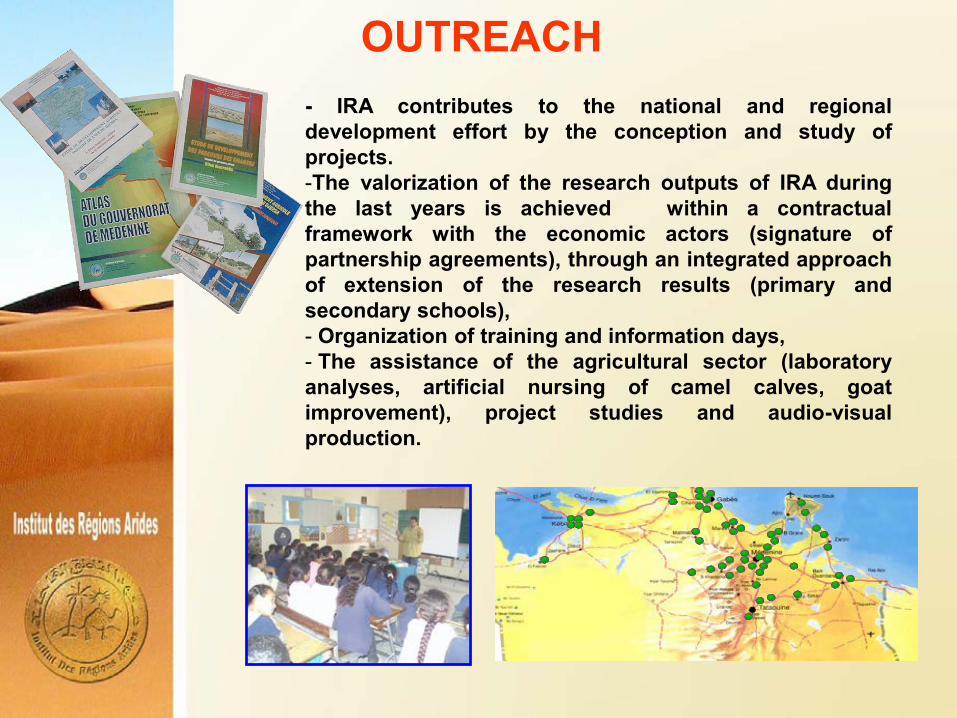
- IRA contributes to the national and regionaldevelopment effort by the conception and study ofprojects.-The valorization of the research outputs of IRA duringthe last years is achieved within a contractualframework with the economic actors (signature ofpartnership agreements), through an integrated approachof extension of the research results (primary andsecondary schools),- Organization of training and information days,- The assistance of the agricultural sector (laboratoryanalyses, artificial nursing of camel calves, goatimprovement), project studies and audio-visualproduction.
OUTREACH

IRA developed since its creation, an informationsystem including:
- Unit of computer system, statistics and dataprocessing.
- Publication unit. This Unit is responsible of theedition and publication of various IRA documents(technical bulletins, books, notes and reports,leaflets and booklets in addition to the reports ofactivities).
Since 1990 the Revue des Régions Arides (ISSN0330-7556) became the regular publication for thediffusion of new scientific and technical results ofresearch and studies relevant to aridity anddesertification.
- Documentation unit. This Unit developed agradually database. The library has more than 6000books, 500 dissertations theses, 60 periodicals.
- Organization of seminars and scientific meetings.
INFORMATION AND DOCUMENTATION

TECHNOLOGICAL PARK OF THE SOUTH
IRA
ISBAM
CFRA
ISET
PEP
CYBER Created in January 2010 to be specialized in the valorization of the biological and natural resources of the Sahara (arid and desert regions). Targeted fields are:• Biological production:• Animal production (especially camel)• Water resources• Renewable energies

Bilatral cooperationRegional & International coop.


GEOMATIC RELATED APPLICATIONS


Mapping olive groves and sand accumulations using google map and Mathematoc morphology

Mosaïque des images Google et Pixy (Venard et al., 2010)

La zone de Jeffara sur l’image satellite SPOT (1998)


N
EW
S
Image satellitale de la zone prise en 1993
19961993
1972 1975 1978
19841981 1991
1999
Menzel Habib

53

54

DeLaplace et al., 2010

N.C.S.D
M. Environment
BiodiversityRoselt Labelized Observatories
Faouar J’bil Bou Hedma Menzel
Habib Graguer JeffaraOuara
Sidi TouiOued
Dekouk
Arid Zones Observatory
UNCCD Focal point
Nat
iona
l sca
le
Cen
tres
dé
cisi
onne
ls
régi
onau
x,
cons
eils
ré
gion
aux
de
déve
lopp
emen
t, C
RD
A et
c…
Reg
iona
l S.
Cen
tres
déc
isio
nnel
s lo
caux
( c
omité
s lo
caux
de
déve
lopp
emen
t)…
Loca
l S.
Scheme of integration of the local environmental observation in the
Monitoring Evaluation national design in Tunisia
Sghaier et al., 2007

Arid zone
Observatory
(IRA, Tunisia)


(Ben Zaied, 2008)

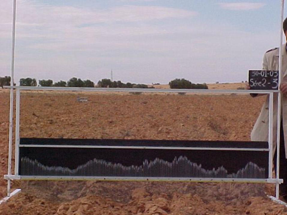
WIND EROSION & SOIL DEDRADATION CONTROL
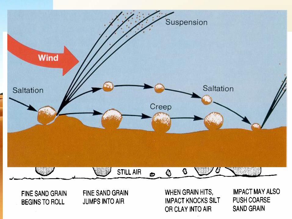
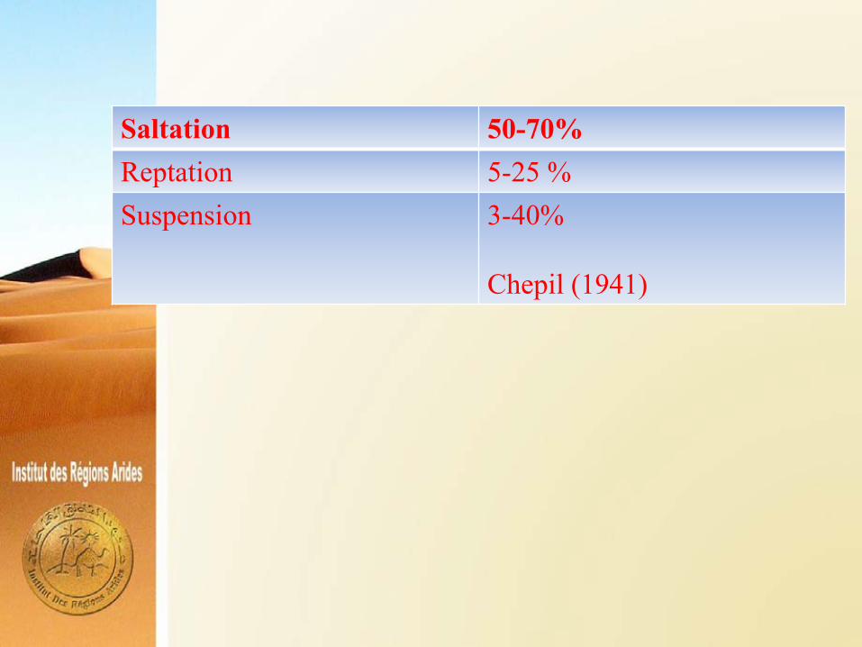
Saltation 50-70%Reptation 5-25 %Suspension 3-40%
Chepil (1941)


Atlantic Ocean
N. Africa
Sahara
SpainDust cloud

Dust bowel (USA, années 30)


Rid
ges
Hei
ght


y = -174.87x + 90.005
R= 0.961
10
20
30
40
50
60
0.1 0.2 0.3 0.4 0.5
Zo/RH
u*t (
cm.s
-1)
Kardous, 2006

Labiadh et al., 2017


Khatteli, 1996, 2002


T0 T2 T3
Témoin (0 m3/ ha)
Traitement 1 (50 m3/ ha)
Traitement 2 (100 m3/ha)
Traitement 3 (200 m3/ha)
T1

0
15
30
45
1995 1996 1997 1998 1999 2000 2001 2002 2003
% d
'ag
rég
ats
(d
> 2
mm
)
Temps (Année)
T1 (50 m3/ha)
T2 (100 m3/ha)
T3 (200 m3/ha)
T0 (Témoin)
Taamallah, 2007

WATER SAVING


Chahbani et al., 2002
comparaison de l'irrigation( par submersion, par goutteur et par diffuseur) des pots pour plantes ornementales, mis à l'extérieur, sur le
toit d'un local( laboratoire)
3570
34902990
17801430
1030570 250 240 0
2490
260140330
480720950
46005340
7830
6450
210120
41904680
5550
6640
30
59606170
433044004090390039604100426043904910514054305690
0
1000
2000
3000
4000
5000
6000
7000
8000
03/07/
02
10/07/
02
17/07/
02
24/07/
02
31/07/
02
07/08/
02
14/08/
02
21/08/
02
28/08/
02
04/09/
02
11/09/
02
18/09/
02
25/09/
02
02/10/
02
09/10/
02
16/10/
02
dates de relevé des reserves hydriques
rese
rves
hyd
riqu
es (e
n gr
amm
es)
submersion goutteur diffuseur
45%
79,6%
32 jours
31,8%
70,2%
1,5%
108 jours
Thank you
Grazie
We love deserts …. but … we combat desertification
Copyright © 2022 FDOKUMEN