Assessment of African Policies for the use of satellite remote sensing for development purposes
31
ASSESSMENT OF AFRICAN POLICIES FOR THE USE OF SATELLITE REMOTE SENSING FOR SUSTAINABLE DEVELOPMENT ASSESSMENT OF AFRICAN POLICIES FOR THE USE OF SATELLITE REMOTE SENSING FOR SUSTAINABLE DEVELOPMENT Presentation of the conclusions of a study on existing African policies for the use of satellite remote sensing for development purposes PIERRE ENGEL, PhD SIRS – AMESD Consultant ADDIS ABABA, MAY 22 2012 2010 2012 2011 Images acquired by the DMC constellation: 22 and 32 meter ground resolution
-
Upload
independent -
Category
Documents
-
view
1 -
download
0
Transcript of Assessment of African Policies for the use of satellite remote sensing for development purposes

ASSESSMENT OF AFRICAN POLICIES FOR THE USE OF SATELLITE REMOTE SENSING FOR SUSTAINABLE DEVELOPMENTASSESSMENT OF AFRICAN POLICIES FOR THE USE OF SATELLITE REMOTE SENSING FOR SUSTAINABLE DEVELOPMENT
Presentation of the conclusions of a study on existing African policies for the use of satellite remote sensing
for development purposes
PIERRE ENGEL, PhDSIRS – AMESD Consultant
ADDIS ABABA, MAY 22 2012
2010 20122011
Images acquired by the DMC constellation: 22 and 32 meter ground resolution

ASSESSMENT OF AFRICAN POLICIES FOR THE USE OF SATELLITE REMOTE SENSING FOR SUSTAINABLE DEVELOPMENTASSESSMENT OF AFRICAN POLICIES FOR THE USE OF SATELLITE REMOTE SENSING FOR SUSTAINABLE DEVELOPMENT
PLAN OF THE PRESENTATION
Pierre ENGEL:Oceanography & GeoR/S & image process.SPOT ImageSPOT Asia Pte LtdRADARSAT Int’lConsultingSIRS (France)
• INTRODUCTION: A HIGHER LEVEL OF CONSCIOUSNESS & VALUES
• CONTINENTAL LEVEL
• REGIONAL LEVEL– ECOWAS / ECCAS / IGAD
• NATIONAL LEVEL– NIGERIA / GABON / KENYA
• CONCLUSION & RECOMMENDATIONS– Proposed Strategy
ASSESSMENT OF AFRICAN POLICIES FOR THE USE OF SATELLITE REMOTE SENSING FOR SUSTAINABLE DEVELOPMENTASSESSMENT OF AFRICAN POLICIES FOR THE USE OF SATELLITE REMOTE SENSING FOR SUSTAINABLE DEVELOPMENT
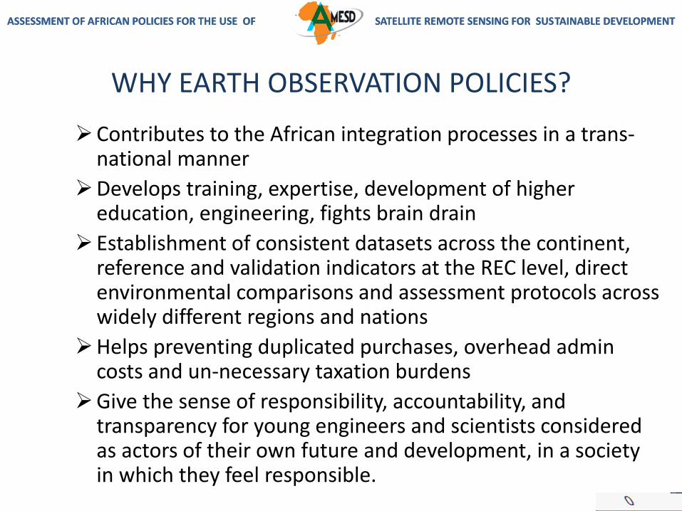
WHY EARTH OBSERVATION POLICIES?
Contributes to the African integration processes in a trans-national manner
Develops training, expertise, development of higher education, engineering, fights brain drain
Establishment of consistent datasets across the continent, reference and validation indicators at the REC level, direct environmental comparisons and assessment protocols across widely different regions and nations
Helps preventing duplicated purchases, overhead admin costs and un-necessary taxation burdens
Give the sense of responsibility, accountability, and transparency for young engineers and scientists considered as actors of their own future and development, in a society in which they feel responsible.

ASSESSMENT OF AFRICAN POLICIES FOR THE USE OF SATELLITE REMOTE SENSING FOR SUSTAINABLE DEVELOPMENTASSESSMENT OF AFRICAN POLICIES FOR THE USE OF SATELLITE REMOTE SENSING FOR SUSTAINABLE DEVELOPMENT
Source: Collège International des Sciences du Territoirehttp://www.gis-cist.fr/index.php/main-sections/le-cist/
Source: Pierre Engel, published in AfriSpace Report 2011
ProfessionalsEngineersArtistsCSOsNGOs
Science &Technology

ASSESSMENT OF AFRICAN POLICIES FOR THE USE OF SATELLITE REMOTE SENSING FOR SUSTAINABLE DEVELOPMENTASSESSMENT OF AFRICAN POLICIES FOR THE USE OF SATELLITE REMOTE SENSING FOR SUSTAINABLE DEVELOPMENT
PLAN OF THE PRESENTATION
• INTRODUCTION: A HIGHER LEVEL OF CONSCIOUSNESS & VALUES
• CONTINENTAL LEVEL
• REGIONAL LEVEL
– ECOWAS / ECCAS / IGAD
• NATIONAL LEVEL
– NIGERIA / GABON / KENYA
• CONCLUSION & RECOMMENDATIONS
ASSESSMENT OF AFRICAN POLICIES FOR THE USE OF SATELLITE REMOTE SENSING FOR SUSTAINABLE DEVELOPMENTASSESSMENT OF AFRICAN POLICIES FOR THE USE OF SATELLITE REMOTE SENSING FOR SUSTAINABLE DEVELOPMENT
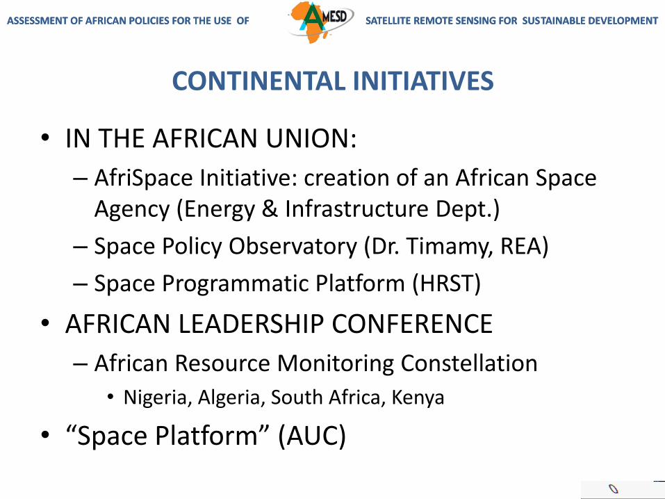
CONTINENTAL INITIATIVES
• IN THE AFRICAN UNION:
– AfriSpace Initiative: creation of an African Space Agency (Energy & Infrastructure Dept.)
– Space Policy Observatory (Dr. Timamy, REA)
– Space Programmatic Platform (HRST)
• AFRICAN LEADERSHIP CONFERENCE
– African Resource Monitoring Constellation
• Nigeria, Algeria, South Africa, Kenya
• “Space Platform” (AUC)

ASSESSMENT OF AFRICAN POLICIES FOR THE USE OF SATELLITE REMOTE SENSING FOR SUSTAINABLE DEVELOPMENTASSESSMENT OF AFRICAN POLICIES FOR THE USE OF SATELLITE REMOTE SENSING FOR SUSTAINABLE DEVELOPMENT
TRANS-SECTORIAL NATURE OF EO
EO Technologies
• Area 1: Peace & Security
• Area 2: Democratic Governance
• Area 3: Trade, Reg. integration & infrastructure
• Area 4: Millennium Development Goals
• Area 5: Energy
• Area 6: Climate Change, land degradation, desertification (AMESD is here)
• Area 7: Migration, mobility & employment
• Area 8: Science, information society & space
EU-AU STRATEGIC PARTNERSHIP (2008) -> FIRST & SECOND ACTION PLANS
ASSESSMENT OF AFRICAN POLICIES FOR THE USE OF SATELLITE REMOTE SENSING FOR SUSTAINABLE DEVELOPMENT
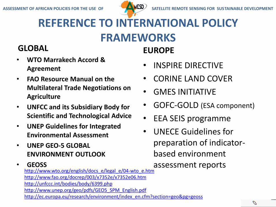
REFERENCE TO INTERNATIONAL POLICY FRAMEWORKS
GLOBAL• WTO Marrakech Accord &
Agreement
• FAO Resource Manual on the Multilateral Trade Negotiations on Agriculture
• UNFCC and its Subsidiary Body for Scientific and Technological Advice
• UNEP Guidelines for Integrated Environmental Assessment
• UNEP GEO-5 GLOBAL ENVIRONMENT OUTLOOK
• GEOSS
EUROPE
• INSPIRE DIRECTIVE
• CORINE LAND COVER
• GMES INITIATIVE
• GOFC-GOLD (ESA component)
• EEA SEIS programme
• UNECE Guidelines for preparation of indicator-based environment assessment reports
http://www.wto.org/english/docs_e/legal_e/04-wto_e.htmhttp://www.fao.org/docrep/003/x7352e/x7352e06.htmhttp://unfccc.int/bodies/body/6399.phphttp://www.unep.org/geo/pdfs/GEO5_SPM_English.pdfhttp://ec.europa.eu/research/environment/index_en.cfm?section=geo&pg=geoss

ASSESSMENT OF AFRICAN POLICIES FOR THE USE OF SATELLITE REMOTE SENSING FOR SUSTAINABLE DEVELOPMENTASSESSMENT OF AFRICAN POLICIES FOR THE USE OF SATELLITE REMOTE SENSING FOR SUSTAINABLE DEVELOPMENT
SYNERGY WITH GMES-AFRICA
GMES-Africa
GMES
INSPIRE SEIS
GEO
GEO Members• Algeria• Burkina Faso• Cameroon• Central African
Republic • Congo,
Republic of the • Cote d'Ivoire • Egypt• Ethiopia• Gabon• Ghana
• Guinea-Bissau• Guinea, Republic • Madagascar • Mali • Mauritius • Morocco • Niger • Nigeria • South Africa • Sudan• Tunisia• Uganda
+ UNECA CORE LIST OF ENVIRONMENT INDICATORS (2008)

ASSESSMENT OF AFRICAN POLICIES FOR THE USE OF SATELLITE REMOTE SENSING FOR SUSTAINABLE DEVELOPMENTASSESSMENT OF AFRICAN POLICIES FOR THE USE OF SATELLITE REMOTE SENSING FOR SUSTAINABLE DEVELOPMENT
PLAN OF THE PRESENTATION
• INTRODUCTION: A HIGHER LEVEL OF CONSCIOUSNESS & VALUES
• CONTINENTAL LEVEL
• REGIONAL LEVEL
– ECOWAS / ECCAS / IGAD
• NATIONAL LEVEL
– NIGERIA / GABON / KENYA
• CONCLUSION & RECOMMENDATIONS

ASSESSMENT OF AFRICAN POLICIES FOR THE USE OF SATELLITE REMOTE SENSING FOR SUSTAINABLE DEVELOPMENTASSESSMENT OF AFRICAN POLICIES FOR THE USE OF SATELLITE REMOTE SENSING FOR SUSTAINABLE DEVELOPMENT
REGIONAL LEVEL• ECCAS
ENVIRONMENTAL & NATURAL RESOURCE MANAGEMENT POLICY: 3 major priority axis
• Strategy Document for Disaster Risk Reduction
• COREP (Commission Régionale des Pêches du Golfe de Guinée)
• COMIFAC Convergence Plan 2005
• ECOWAS ENVIRONMENTAL POLICY
• ECOWAS PEACE & SECURITY OBSERVATION SYSTEM
• ECOWAS POLICY FOR DISASTER RISK REDUCTION
• IGAD Environment Strategy Document
• AMESD EO Policy Assessment (2012) see next slide
• IGAD Climate Prediction & Applications Centre (ICPAC)
• Regional Centre for Mapping of Resources for Development (RCMRD)

ASSESSMENT OF AFRICAN POLICIES FOR THE USE OF SATELLITE REMOTE SENSING FOR SUSTAINABLE DEVELOPMENTASSESSMENT OF AFRICAN POLICIES FOR THE USE OF SATELLITE REMOTE SENSING FOR SUSTAINABLE DEVELOPMENT
IGAD
• AMESD EO Policy Assessment (2012)
– Existing policies for Land Degradation Mitigation and Natural Habitat Conservation are weak;
– Use of EO is weak, lack of harmonisation in data providers (pricing systems, copyright & license);
– EO recognised to be an accurate tool for monitoring the environment and natural resources;
– Promote institutional arrangements, national coordination platforms, strategic partnerships…

ASSESSMENT OF AFRICAN POLICIES FOR THE USE OF SATELLITE REMOTE SENSING FOR SUSTAINABLE DEVELOPMENTASSESSMENT OF AFRICAN POLICIES FOR THE USE OF SATELLITE REMOTE SENSING FOR SUSTAINABLE DEVELOPMENT
PLAN OF THE PRESENTATION
• INTRODUCTION: A HIGHER LEVEL OF CONSCIOUSNESS & VALUES
• CONTINENTAL LEVEL
• REGIONAL LEVEL
– ECOWAS / ECCAS / IGAD
• NATIONAL LEVEL
– NIGERIA / GABON / KENYA
• CONCLUSION & RECOMMENDATIONS

ASSESSMENT OF AFRICAN POLICIES FOR THE USE OF SATELLITE REMOTE SENSING FOR SUSTAINABLE DEVELOPMENTASSESSMENT OF AFRICAN POLICIES FOR THE USE OF SATELLITE REMOTE SENSING FOR SUSTAINABLE DEVELOPMENT
NATIONAL LEVEL (3 COUNTRIES)• NIGERIA National
Space Policy (2003)• National Geo-
Information (GI) Policy
• Space Agency: NASRDA
• GABON AGEOS
• Direct Receiving Station (DRS) under construction
• Conseil National Climat & “Plan Climat”
• “Plan National Géomatique” (PNG)
• Regional mandate (ECCAS and COMIFAC offices are planned in the DRS building)
• Strong political will and support
• KENYA• VISION 2030• NSDI draft document• DRS terrain exists in
Nairobi (owned by RCMRD)
• Policy-making process very fragmented
• San Marco Space Platform (Italy)

ASSESSMENT OF AFRICAN POLICIES FOR THE USE OF SATELLITE REMOTE SENSING FOR SUSTAINABLE DEVELOPMENTASSESSMENT OF AFRICAN POLICIES FOR THE USE OF SATELLITE REMOTE SENSING FOR SUSTAINABLE DEVELOPMENT
PLAN OF THE PRESENTATION
• INTRODUCTION: A HIGHER LEVEL OF CONSCIOUSNESS & VALUES
• CONTINENTAL LEVEL
• REGIONAL LEVEL
– ECOWAS / ECCAS / IGAD
• NATIONAL LEVEL
– NIGERIA / GABON / KENYA
• CONCLUSION & RECOMMENDATIONS

ASSESSMENT OF AFRICAN POLICIES FOR THE USE OF SATELLITE REMOTE SENSING FOR SUSTAINABLE DEVELOPMENTASSESSMENT OF AFRICAN POLICIES FOR THE USE OF SATELLITE REMOTE SENSING FOR SUSTAINABLE DEVELOPMENT
CONCLUSION
Next slide: the proposed implementation strategy
• MAINSTREAMING OF EO POLICIES– LINK EO POLICIES WITH OTHER POLICY INSTRUMENTS
• EO-DERIVED INDICATORS DEFINED AND DOCUMENTED FOR:– POLICY-MAKING– POLICY ASSESSMENT– ASSESSMENT OF DEVELOPMENT PROJECTS FINANCED BY AfDB AND
REGIONAL DEVELOPMENT BANKS– LAW ENFORCEMENT MECHANISMS
– Capitalise on existing infrastructures and Techn. Centres• ECOWAS WITH NASRDA // AGRHYMET (expanded?)• ECCAS WITH AGEOS // COMIFAC (expanded?)• IGAD WITH SAN MARCO / NEW STATION ON RCMRD TERRAIN
– Free & Low-Cost EO data for higher Min Mapping Units• Sentinel (optical & radar), Landsat-8, CBERS-3, THEOS, DMC with
NigeriaSAT-1 & 2, NgSAT-X, low access cost DMC archived data

ASSESSMENT OF AFRICAN POLICIES FOR THE USE OF SATELLITE REMOTE SENSING FOR SUSTAINABLE DEVELOPMENTASSESSMENT OF AFRICAN POLICIES FOR THE USE OF SATELLITE REMOTE SENSING FOR SUSTAINABLE DEVELOPMENT
LINK EO POLICIES WITH OTHER POLICY INSTRUMENTS
+ Assessment of development projects financed by AfDB and other regional / international development banks

ASSESSMENT OF AFRICAN POLICIES FOR THE USE OF SATELLITE REMOTE SENSING FOR SUSTAINABLE DEVELOPMENTASSESSMENT OF AFRICAN POLICIES FOR THE USE OF SATELLITE REMOTE SENSING FOR SUSTAINABLE DEVELOPMENT
RECOMMENDATIONS
– LINK EO POLICIES WITH OTHER POLICY INSTRUMENTS• National EO-proficient Representatives (mixed
professionals & engineers & scientists) to elaborate EO policy instruments & parameters at the AUC level

ASSESSMENT OF AFRICAN POLICIES FOR THE USE OF SATELLITE REMOTE SENSING FOR SUSTAINABLE DEVELOPMENTASSESSMENT OF AFRICAN POLICIES FOR THE USE OF SATELLITE REMOTE SENSING FOR SUSTAINABLE DEVELOPMENT
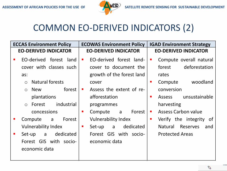
COMMON EO-DERIVED INDICATORS (FORESTRY)
ECCAS Environment Policy ECOWAS Environment Policy IGAD Environment StrategyStrategic Line n°4:Conservation and SustainableManagement of forestResources in Central Africa
Strategic Line n°2: (2.2)Promote management,conservation and sustainabledevelopment of forests…
IGAD Environment and NaturalResources Strategy – Table 2:Summary of Asset Values andKey Opportunities byEnvironmental Themes
Do the forest inventory and
ecosystem mapping
Surveillance and evaluation
of these ecosystems […]
Set-up a functional
communication and
information system on
forest resources […]
Develop re-afforestation
programmes […]
Forest cover through
classification of new forests
and extension of
afforestation to help reach
the rate of 20 to 30% of the
lands […]
Encourage and support the
development of big forest
management and re-
afforestation programmes…
Assess deforestation rates,
woodland conversion,
unsustainable harvesting,
climate change impacts,
decrease in natural forests,
[…]
Assess the forest carbon
trade value
Slide 1 of 2: next deals with related EO-derived indicators
ASSESSMENT OF AFRICAN POLICIES FOR THE USE OF SATELLITE REMOTE SENSING FOR SUSTAINABLE DEVELOPMENTASSESSMENT OF AFRICAN POLICIES FOR THE USE OF SATELLITE REMOTE SENSING FOR SUSTAINABLE DEVELOPMENT
COMMON EO-DERIVED INDICATORS (2)
ECCAS Environment Policy ECOWAS Environment Policy IGAD Environment StrategyEO-DERIVED INDICATOR
EO-derived forest land
cover with classes such
as:
o Natural forests
o New forest
plantations
o Forest industrial
concessions
Compute a Forest
Vulnerability Index
Set-up a dedicated
Forest GIS with socio-
economic data
EO-DERIVED INDICATOR
EO-derived forest land-
cover to document the
growth of the forest land
cover
Assess the extent of re-
afforestation
programmes
Compute a Forest
Vulnerability Index
Set-up a dedicated
Forest GIS with socio-
economic data
EO-DERIVED INDICATOR
Compute overall natural
forest deforestation
rates
Compute woodland
conversion
Assess unsustainable
harvesting
Assess Carbon value
Verify the integrity of
Natural Reserves and
Protected Areas

ASSESSMENT OF AFRICAN POLICIES FOR THE USE OF SATELLITE REMOTE SENSING FOR SUSTAINABLE DEVELOPMENTASSESSMENT OF AFRICAN POLICIES FOR THE USE OF SATELLITE REMOTE SENSING FOR SUSTAINABLE DEVELOPMENT
ProfessionalsEngineersArtistsCSOsNGOs
Science &Technology
THE STRATEGY IN ONE SENTENCE:
It is this process of linking environmentand sustainable development policyinstruments to EO-derived instrumentsthat will allow the mainstreaming of EOpolicies at all levels.
ASSESSMENT OF AFRICAN POLICIES FOR THE USE OF SATELLITE REMOTE SENSING FOR SUSTAINABLE DEVELOPMENTASSESSMENT OF AFRICAN POLICIES FOR THE USE OF SATELLITE REMOTE SENSING FOR SUSTAINABLE DEVELOPMENT
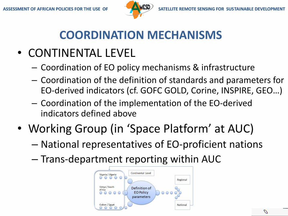
COORDINATION MECHANISMS
• CONTINENTAL LEVEL– Coordination of EO policy mechanisms & infrastructure
– Coordination of the definition of standards and parameters for EO-derived indicators (cf. GOFC GOLD, Corine, INSPIRE, GEO…)
– Coordination of the implementation of the EO-derived indicators defined above
• Working Group (in ‘Space Platform’ at AUC)– National representatives of EO-proficient nations
– Trans-department reporting within AUC

ASSESSMENT OF AFRICAN POLICIES FOR THE USE OF SATELLITE REMOTE SENSING FOR SUSTAINABLE DEVELOPMENTASSESSMENT OF AFRICAN POLICIES FOR THE USE OF SATELLITE REMOTE SENSING FOR SUSTAINABLE DEVELOPMENT
COORDINATION OF EO-DERIVED INDICATORS
The output of this coordination phase is the creation of an
EO-Indicators Reference Document,
published and distributed to all relevant parties: policy-makers, policy-assessment authorities, law-
enforcement authorities, development banks, regional technical centres, national technical
centres, CSOs and NGOs.

ASSESSMENT OF AFRICAN POLICIES FOR THE USE OF SATELLITE REMOTE SENSING FOR SUSTAINABLE DEVELOPMENTASSESSMENT OF AFRICAN POLICIES FOR THE USE OF SATELLITE REMOTE SENSING FOR SUSTAINABLE DEVELOPMENT
MAINSTREAMING STRATEGY
Working Group from National Experts
EO-Indicators Reference Document
REC endorsement & Regional Implementation + National Level
Institutional Strengthening with Regional Processing Centres / internal dedicated structures
Processing of EO-derived indicators: policy-making, policy assessment, law enforcement and development project indicators. Updates and regular reporting.
ASSESSMENT OF AFRICAN POLICIES FOR THE USE OF SATELLITE REMOTE SENSING FOR SUSTAINABLE DEVELOPMENTASSESSMENT OF AFRICAN POLICIES FOR THE USE OF SATELLITE REMOTE SENSING FOR SUSTAINABLE DEVELOPMENT
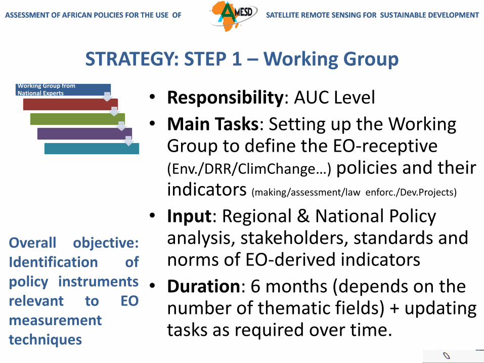
STRATEGY: STEP 1 – Working Group
• Responsibility: AUC Level
• Main Tasks: Setting up the Working Group to define the EO-receptive (Env./DRR/ClimChange…) policies and their indicators (making/assessment/law enforc./Dev.Projects)
• Input: Regional & National Policy analysis, stakeholders, standards and norms of EO-derived indicators
• Duration: 6 months (depends on the number of thematic fields) + updating tasks as required over time.
Working Group from National Experts
Overall objective:Identification ofpolicy instrumentsrelevant to EOmeasurementtechniques

ASSESSMENT OF AFRICAN POLICIES FOR THE USE OF SATELLITE REMOTE SENSING FOR SUSTAINABLE DEVELOPMENTASSESSMENT OF AFRICAN POLICIES FOR THE USE OF SATELLITE REMOTE SENSING FOR SUSTAINABLE DEVELOPMENT
STRATEGY: STEP 2 – Reference Document
EO Indicators Reference Doc • Responsibility: AUC Level
• Main Tasks: Finalisation (with RECs and Member States) & publication of the EO Indicators Reference Document
• Input: Regional & National Policy analysis, standards and norms of EO indicators
• Duration: 2 months
Overall objective:Finalisation of areferencedocument linkingpolicies and EO-derived indicators.

ASSESSMENT OF AFRICAN POLICIES FOR THE USE OF SATELLITE REMOTE SENSING FOR SUSTAINABLE DEVELOPMENTASSESSMENT OF AFRICAN POLICIES FOR THE USE OF SATELLITE REMOTE SENSING FOR SUSTAINABLE DEVELOPMENT
STRATEGY: STEP 3 – Endorsement
REC endorsement &…
Overall objective:Identification ofpolicy instrumentsrelevant to EOmeasurementtechniques
• Responsibility: REC Level
• Main Tasks: Endorse the EO Indicators Reference Document and mandate their Technical Centres for processing and to the Member States for reference
• Input: EO Indicators Reference Document
• Duration: 2 months
ASSESSMENT OF AFRICAN POLICIES FOR THE USE OF SATELLITE REMOTE SENSING FOR SUSTAINABLE DEVELOPMENTASSESSMENT OF AFRICAN POLICIES FOR THE USE OF SATELLITE REMOTE SENSING FOR SUSTAINABLE DEVELOPMENT
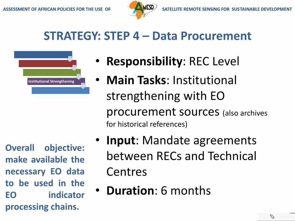
STRATEGY: STEP 4 – Data Procurement
Institutional Strengthening
Overall objective:make available thenecessary EO datato be used in theEO indicatorprocessing chains.
• Responsibility: REC Level
• Main Tasks: Institutional strengthening with EO procurement sources (also archives
for historical references)
• Input: Mandate agreements between RECs and Technical Centres
• Duration: 6 months

ASSESSMENT OF AFRICAN POLICIES FOR THE USE OF SATELLITE REMOTE SENSING FOR SUSTAINABLE DEVELOPMENTASSESSMENT OF AFRICAN POLICIES FOR THE USE OF SATELLITE REMOTE SENSING FOR SUSTAINABLE DEVELOPMENT
STRATEGY: STEP 5 - Implementation
Implementation
Overall objective:receive regular EO-derived indicatorsfor policy-making,assessment, lawenforcement &developmentproject assessment
• Responsibility: REC Level (mandating Technical Centres)
• Main Tasks: Implementation, processing of EO-derived Indicators corresponding to REC & national policies / QA support
• Input: Mandate agreements and EO data procurement
• Duration: unlimited

ASSESSMENT OF AFRICAN POLICIES FOR THE USE OF SATELLITE REMOTE SENSING FOR SUSTAINABLE DEVELOPMENTASSESSMENT OF AFRICAN POLICIES FOR THE USE OF SATELLITE REMOTE SENSING FOR SUSTAINABLE DEVELOPMENT
IMPLEMENTATION AT NATIONAL LEVEL
Working Group from National Experts
EO-Indicators Reference Document
REC endorsement
Institutional Strengthening
Implementation
EO-IRD1 = EO-Indicators Reference Document
• Key-Member States (Key-MS) send Experts to form the Working Group
• MS receive the EO-IRD1 from REC
• Technical Processing Centres, RS Centres, IP-capable infrastructures discuss, validate and adopt the EO-IRD mechanism and processes – feed-back to REC and Working Group
• Key-MS Technical Processing Centres mandated by REC to process EO-IRD; the Centres involve REC Quality Assessment designated experts (!credibility!)
• KeyMS Technical Processing Centres receive EO input data from main procurement sources (as mandated by RECs)
• Regular delivery of EO-IRD to RECs

ASSESSMENT OF AFRICAN POLICIES FOR THE USE OF SATELLITE REMOTE SENSING FOR SUSTAINABLE DEVELOPMENTASSESSMENT OF AFRICAN POLICIES FOR THE USE OF SATELLITE REMOTE SENSING FOR SUSTAINABLE DEVELOPMENT
See http://[email protected]
Thank Youand thank you to the AMESD Bureau in Addis Ababa & the interpreters at
this workshop