Assessing groundwater quality using GIS
17
Water Resour Manage (2007) 21:699–715 DOI 10.1007/s11269-006-9059-6 ORIGINAL ARTICLE Assessing groundwater quality using GIS Insaf S. Babiker · Mohamed A. A. Mohamed · Tetsuya Hiyama Received: 10 August 2005 / Accepted: 29 May 2006 C Springer Science + Business Media B.V. 2006 Abstract Assessing the quality of groundwater is important to ensure sustainable safe use of these resources. However, describing the overall water quality condition is difficult due to the spatial variability of multiple contaminants and the wide range of indicators (chemical, physical and biological) that could be measured. This contribution proposes a GIS-based groundwater quality index (GQI) which synthesizes different available water quality data (e.g., Cl − , Na + , Ca 2+ ) by indexing them numerically relative to the World Health Orga- nization (WHO) standards. Also, introduces an objective procedure to select the optimum parameters to compute the GQI, incorporates the aspect of temporal variation to address the degree of water use sustainability and tests the sensitivity of the proposed model. The GQI indicated that the groundwater quality in the Nasuno basin, Tochigi Prefecture, Japan, is generally high (GQI >90). It has also displayed the natural (depth to groundwater table, geomorphologic structures) and/or anthropogenic (land-use and population density) controls over the spatial variability of groundwater quality in the basin. Temporally, ground- water quality is more variable in the upper and lower parts of the basin (variation, V, 15–30%) compared to the middle part (V, <15%) probably attributed to the seasonality of precipitation and irrigation of rice. In the lower southeastern part of the Nasuno basin and the vicinity of the Naka and Houki rivers the sustainable use of groundwater is constrained by the relatively low and variable groundwater quality. The model sensitivity analysis indicated that parameters which reflect relatively lower water quality (high mean rank value) and those of significant spatial variability imply larger impacts on the GQI and must be carefully and accurately mapped. Optimum index factor technique allows the selection of the best combination of parameters dictating the variability of groundwater quality and enables an objective and fair representation of the overall groundwater quality. I. S. Babiker () · T. Hiyama Hydrospheric Atmospheric Research Center, Nagoya University, Furo-cho, Chikusa-ku, Nagoya 464-8601, Japan e-mail: [email protected] M. A. A. Mohamed Graduate School of Environmental Studies, Nagoya University, Furo-cho, Chikusa-ku, Nagoya 464-8601, Japan Springer
Transcript of Assessing groundwater quality using GIS

Water Resour Manage (2007) 21:699–715
DOI 10.1007/s11269-006-9059-6
ORIGINAL ART ICLE
Assessing groundwater quality using GIS
Insaf S. Babiker · Mohamed A. A. Mohamed ·Tetsuya Hiyama
Received: 10 August 2005 / Accepted: 29 May 2006C© Springer Science + Business Media B.V. 2006
Abstract Assessing the quality of groundwater is important to ensure sustainable safe use
of these resources. However, describing the overall water quality condition is difficult due to
the spatial variability of multiple contaminants and the wide range of indicators (chemical,
physical and biological) that could be measured. This contribution proposes a GIS-based
groundwater quality index (GQI) which synthesizes different available water quality data
(e.g., Cl−, Na+, Ca2+) by indexing them numerically relative to the World Health Orga-
nization (WHO) standards. Also, introduces an objective procedure to select the optimum
parameters to compute the GQI, incorporates the aspect of temporal variation to address the
degree of water use sustainability and tests the sensitivity of the proposed model.
The GQI indicated that the groundwater quality in the Nasuno basin, Tochigi Prefecture,
Japan, is generally high (GQI >90). It has also displayed the natural (depth to groundwater
table, geomorphologic structures) and/or anthropogenic (land-use and population density)
controls over the spatial variability of groundwater quality in the basin. Temporally, ground-
water quality is more variable in the upper and lower parts of the basin (variation, V, 15–30%)
compared to the middle part (V, <15%) probably attributed to the seasonality of precipitation
and irrigation of rice. In the lower southeastern part of the Nasuno basin and the vicinity of the
Naka and Houki rivers the sustainable use of groundwater is constrained by the relatively low
and variable groundwater quality. The model sensitivity analysis indicated that parameters
which reflect relatively lower water quality (high mean rank value) and those of significant
spatial variability imply larger impacts on the GQI and must be carefully and accurately
mapped. Optimum index factor technique allows the selection of the best combination of
parameters dictating the variability of groundwater quality and enables an objective and fair
representation of the overall groundwater quality.
I. S. Babiker (�) · T. HiyamaHydrospheric Atmospheric Research Center, Nagoya University, Furo-cho, Chikusa-ku, Nagoya464-8601, Japane-mail: [email protected]
M. A. A. MohamedGraduate School of Environmental Studies, Nagoya University, Furo-cho, Chikusa-ku, Nagoya464-8601, Japan
Springer

700 Water Resour Manage (2007) 21:699–715
Keywords Groundwater quality . Major ions . WHO standards . Temporal variation .
Spatial variation . GIS . Sensitivity analysis
1. Introduction
Groundwater is almost globally important for human consumption as well as for the support
of habitat and for maintaining the quality of base flow to rivers. They are usually of excellent
quality. Being naturally filtered in their passage through the ground, they are usually clear,
colorless, and free from microbial contamination and require minimal treatment. Unfortu-
nately, it seems that we can no longer take high quality groundwater for granted. A threat
is now posed by an ever-increasing number of soluble chemicals from urban and industrial
activities and from modern agricultural practices. Nevertheless, landslides, fires and other
surface processes that increase or decrease infiltration or that expose or blanket rock and soil
surfaces, which interact with downward-moving surface water, may also affect the quality of
shallow groundwater.
The chemical composition of groundwater is a measure of its suitability as a source of
water for human and animal consumption, irrigation, and for industrial and other purposes.
The definition of water quality is therefore not objective, but is socially defined depending
on the desired use of water. Different uses require different standards of water quality. Water
quality should be taken to mean the “physical, chemical, and biological characteristics of
water necessary to sustain desired water uses”. Therefore, monitoring the quality of water
is important because clean water is necessary for human health and the integrity of aquatic
ecosystems.
The chemistry (quality) of groundwater reflects inputs from the atmosphere, from soil
and water-rock reactions (weathering), as well as from pollutant sources such as mining,
land clearance, agriculture, acid precipitation, domestic and industrial wastes. The transport
of contaminants from the point of application to the groundwater system is a function of
the properties of the soil-rock strata above the aquifer and the type of pollutant (Melloul
and Collin, 1998). Accordingly, the assessment of degree of vulnerability of groundwater
has originated. Intrinsically, vulnerability is the property of the aquifer to receive and trans-
mit contamination from anthropogenic sources (Vrba and Zoporozec, 1994). A great deal
of uncertainty is associated with aquifer vulnerability assessment due to insufficient rep-
resentation of key factors such as soil media (Robins et al., 1994), uncertainty regarding
net recharge (Rosen, 1993) and hydraulic conductivity estimates (Aller et al., 1985), lack
of knowledge concerning the physical and chemical properties and attenuation processes of
pollutants (Barber et al., 1993) which require all vulnerability estimates to be validated by
accurate field testing. Describing the overall water quality condition is difficult due to the spa-
tial variability of multiple contaminants. Additionally, as in the case of surface water quality,
it is difficult to simplify to a few parameters. However, in the context of geo-indicators, five
water quality indicators can be categorized: biological (bacteria, algae), physical (tempera-
ture, turbidity and clarity, color, salinity, suspended solids, dissolved solids), chemical (pH,
dissolved oxygen, biological oxygen demand, nutrients (including nitrogen and phospho-
rus), organic and inorganic compounds (including toxicants)), aesthetic (odors, taints, color,
floating matter), and radioactive (alpha, beta and gamma radiation emitters). Thus, the range
of indicators that can be measured is wide and other indicators may be adopted in the future.
The cost of a monitoring program to assess them all would be prohibitive, so resources are
usually directed towards assessing contaminants that are important for the local environment
or for a specific use of the water.
Springer

Water Resour Manage (2007) 21:699–715 701
In this contribution the authors aim to propose a groundwater quality index (GQI) which
synthesizes different available water quality data into an easily understood format. This
index provides a way to summarize overall water quality conditions in a manner that can be
clearly communicated to different audiences, can help to understand whether overall quality
of groundwater body poses a potential threat to various uses of water, to validate cross-check
and complement aquifer vulnerability assessments and to indicate success in protection
and remediation efforts. Additionally, the authors will introduce an objective procedure to
select the optimum parameters to compute the GQI, will incorporate the aspect of temporal
variation to address the degree of water use sustainability and will test the sensitivity of
the proposed model. Here, the capabilities of geographical information system, GIS, will
be employed to implement the proposed index and to test the sensitivity of the model. GIS
are designed to collect diverse spatial data to represent spatially variable phenomena by
applying a series of overlay analysis of data that are in spatial register (Bonham-Carter,
1996).
2. Study area
The proposed index will be applied in order to evaluate the overall groundwater quality of the
alluvial Nasuno basin, Tochigi, Japan. Alluvial basinsare usually, shallow unconfined aquifers
characterized by high water holding capacity used mainly for domestic and agricultural
purposes. They are also located in densely populated areas and therefore subject to many
contamination sources. In addition to that, previous studies (Hiyama and Suzuki, 1991;
Ohashi et al., 1994) have reported considerable degree of contamination in the groundwater
of Nasuno basin mainly by nitrate leaching from non-point agricultural sources.
Nasuno basin is located on the northeastern part of Tochigi Prefecture, central Japan
(Figure 1). It represents a composite sweet potato-shape fan formed by Naka, Kuma, Sabi
and Houki rivers extending over an area of approximately 400 km2. The altitude of the area
ranges between 150 to 500 m.a.sl with an average slope of 1/75 facing the SSE direction.
The major cities are Otawara and Kuroiso with populations 56,527 and 60,145 inhabitants,
respectively. Irrigated rice cultivation is intensively practiced in the central and lower part
of the fan while stock farms are located mainly in the upper ranges of the fan. The mean
annual precipitation and temperature are 1426.5 mm and 12.4 ◦C, respectively at Otawara
city (mean of 22 years, 1987–2000). More precipitation occurs in the upper parts of the fan
than in the lower parts particularly between May and August associated with the maximum
irrigation period.
Like in most alluvial fans, the Nasuno basin is thin in the upper northwestern ridges
with an elevation of 500–320 m.a.sl growing thicker towards the southeast. The sand and
gravels of the fan have typically high hydraulic conductivity (3.3 ∼ 9.4 × 10⁻³ m/s, Choi,
1976). Depth to groundwater table is generally, shallow ranging from less than 1 m to
22.5 m. In the lower part of the basin the depth to groundwater is less variable ranging
between 5–10 m. Where the altitude is less than 200 m.a.sl, depth to groundwater ranges
between 0 and 5 m with many springs representing typical discharge zones (Choi, 1976).
Seasonal variation of water table depth ranges from a minimum of 0.07 m to a maximum
of 6.72 m. The mean infiltration rate from the ground surface to the groundwater table is
about 1 m/month (Choi, 1976). Therefore, for a median depth to water table level of 12 m
the typical lag time for surface water to recharge groundwater is one year in the study
area.
Springer

702 Water Resour Manage (2007) 21:699–715
Fig. 1 The study area and location of the groundwater samples. The dotted arrow indicates the generalgroundwater flow direction NW to SE
3. Data and methods
3.1. Groundwater quality data
This study utilizes seasonal (four seasons; spring, summer, autumn and winter) groundwater
quality data collected from the Nasuno basin from over 50 water wells. The location of
groundwater samples are displayed in Figure 1. The data set includes measurements of
several physical and chemical parameters of groundwater obtained by in situ measurements
and laboratory analytical techniques. Water temperature, electric conductivity and pH were
measured in the field using DIGIMULTI D611 of Tara industrial Co., SC82 of Yokogawa
Electric Co., and HM-10P of Toa Denpa Co., respectively. The concentration of major cations
(Ca2+, Mg2+, K+, Na+) and SiO2 were analyzed using ICP (Jarrel-Ash Plasma Atomcomp
975) of the Chemical Analysis Research Center of University of Tsukuba. The concentration
of major anions (Cl−, NO−3 , SO2−
4 ) were analyzed using QIC Ion Chromatography produced
by DIONEX Co. The concentration of HCO−3 was measured based on pH 4.8 alkalinity by
MR compound indicator, then measured in the laboratory by titration with 0.01 N sulfuric
acid.
For the purpose of implementing the index “spring data” was selected since a significant
change in water quality was observed during this season particularly the increase of nitrate
concentration in groundwater (Hiyama and Suzuki, 1991, Babiker et al., 2005). This was
Springer

Water Resour Manage (2007) 21:699–715 703
Table 1 Statistics of seven groundwater quality parameters from the Na-suno basin and the corresponding maximum threshold values according tothe WHO. Only spring data are used
Statistics of spring data
Parameter Minimum Maximum Mean WHO threshold value
Ca2+ (mg/l) 7.2 25.2 13.4 300 mg/l
Mg2+ mg/l) 2.4 8.1 4.6 300 mg/l
Na+ (mg/l) 3.9 18.7 7.6 200 mg/l
Cl− (mg/l) 2.1 20.7 8.7 200 mg/l
NO−3 (mg/l) 0.95 52.4 22.0 50 mg/l
∗
SO2−4 (mg/l) 6.5 34.4 20.8 250 mg/l
TDS (mg/l) 50.4 146.3 88.9 600 mg/l
The stared threshold value is a guideline value assigned by the WHO for thenitrate (NO−
3 ) since it might inflict potential health risk
attributed to the increase of input of nitrate with irrigation water due to the commencement
of the season of rice cultivation. Data from all seasons (spring, summer, autumn and winter)
are used to address the temporal variation of groundwater quality in the basin.
Seven parameters which are listed in the World Health Organization (WHO) guidelines
(WHO, 2004) for drinking water quality were selected from the data set to generate the
groundwater quality index. Standards for drinking water were chosen since human health
is taken as priority besides the high quality of drinking water makes it suitable for many
other kinds of purposes. Six parameters (Cl−, Na+, Ca2+, Mg2+, SO2−4 , and total dissolved
solids, TDS) fall under the category of chemically derived contaminants that could alter the
water taste, odor or appearance and affect its “acceptability” by consumers (WHO, 2004).
Fixed guidelines have not been established for these chemicals, only thresholds for max-
imum desired concentrations were discussed. One parameter (NO−3 ) was listed under the
category of chemicals that might inflict “potential health risk” and was assigned a guideline
value (50 mg/l, WHO, 2004). Table 1 summarizes the statistics of the measured concen-
trations of seven parameters in the Nasuno basin and provides the corresponding threshold
concentrations of the WHO guidelines.
3.2. Spatial analysis with GIS
In order to capture the spatial variation of groundwater quality in the Nasuno basin, spatial
analyses with GIS were conducted employing ILWIS, the GIS software of the International
Institute for Geo-Information Science and Earth Observation (ITC).
Six topographic maps of scale 1:50,000 (Nasu Dake, Shirakawa, Shiobara, Otawara, Yaita
and Kitsuregawa, Japan Geographical Survey Institute) covering the study area and including
the location of groundwater samples were scanned. All maps required geo-referencing to the
area coordinates. The geographic coordinates of some locations (tie points) were obtained
from the hard copy maps and used to register the digital maps by applying the Affine Trans-
formation method. The transformation result was accepted when the error value δ was less
than one pixel (50 m). Overall, positional errors may compensate each other. However, it is
worth mentioning that the distance computations in GIS are subject to error within a range
of ±50 m (Levallois et al., 1998). When all maps had been referenced, they were on-screen
digitized to create point and segment maps of the different geographical entities. The sample
Springer

704 Water Resour Manage (2007) 21:699–715
locations were digitized as points and were linked to an attribute table, including the seasonal
concentrations of chemical data. Because metric coordinates are more convenient in spatial
data analysis compared to geographical long/lat coordinates, the geographic coordinates were
converted to metric coordinates using the Universal Transverse Mercator (UTM) projection.
The GIS used here adopts the raster model which represents the simplest way for storing
spatial data. In this model the spatial data consists of cells or pixels (50 m in size) -organized in
rows and columns- for which information is explicitly recorded. The raster model is suitable
for the kind of overlay analysis performed in this study because it provides; a simple data
structure, easy and efficient overlaying, sufficient representation of high spatial variability and
unified grid cells for several attributes. However, some drawbacks might affect the analyses
and results of the raster model such as; the large computer storage, errors in perimeter, areas
and shape of geographical entities, inefficient projection transformations, loss of information
when using large cells and less accurate and beautiful output maps.
3.3. Spatial autocorrelation and cross correlation of groundwater quality variables
Many variables that have discrete values measured at several locations (such as the concen-
tration of chemical constituents in groundwater) can be considered as random process which
processes a certain degree of correlation with itself in space. First, pattern analysis was used
to examine the arrangement of the borehole data in space and to investigate whether they are
randomly distributed. Second, the spatial autocorrelation analysis is used to show the corre-
lation between the points for different shifts in space and to visualize the spatial variability
of the phenomenon under study (groundwater quality). Additionally, spatial autocorrelation
measures the level of interdependence between different variables and the nature and strength
of that interdependence. On the other hand, chemical constituents in groundwater are usu-
ally spatially correlated. Nonparametric Spearman Rank-Order correlation analyses were
performed between the measured parameters in order to identify correlation patterns which
control the spatial variability of the overall groundwater quality. This correlation method
was preferred since water quality data is typically not normally distributed which makes the
commonly used Pearson correlation unsuitable.
3.4. Development of the groundwater quality index, GQI
The following sub-sections describe the steps leading to the formulation of the GQI. The
process involves the generation of representations for the spatial variability of the originally
scattered measurements and the multiple transformations of groundwater quality data into a
corresponding index rating value related to groundwater quality.
3.4.1. The primary map I
Concentration maps representing the “primary map I” was constructed for each parameter
from the point data using mainly Kriging interpolation. Unlike other point interpolation
methods (nearest point or moving average) Kriging is built on a statistical method. The
Kriging method performs a weighted averaging on point values where the output estimates
equal the sum of product of point values and weights divided by the sum of weights. The
weight factors in Kriging are determined by using a user-defined semi-variogram model
based on the output of the spatial correlation operation and the pattern analysis (ITC-ILWIS,
2001) described in the previous section.
Springer

Water Resour Manage (2007) 21:699–715 705
3.4.2. The primary map II
In order to relate the data to universal norm, the measured concentration, X′, of every pixel
in the “primary map I” was related to its desired WHO standard value, X (Table 1), using a
normalized difference index:
C = (X ′ − X )/(X ′ + X ) (1)
The resultant “primary map II” thus displays for each pixel a contamination index values
ranging between −1 and 1. This is close to the contamination index approach which is
calculated as the ratio between the measured concentration of contaminant and the prescribed
maximum acceptable contaminant level (Melloul and Collin, 1998; Praharaj et al., 2002;
Babiker et al., 2004) however the normalized difference index used here provides fixed
upper and lower limits for the contamination level.
3.4.3. The rank map
The contamination index (primary map II) was then rated between 1 and 10 to generate the
“rank map”. The rate 1 indicates minimum impact on groundwater quality while the rate 10
indicates maximum impact. The minimum contamination index level (−1) was set equal to
1, the median level (0) was set equal to 5 and the maximum level (1) was set equal to 10.
The following polynomial function can thus be used to rank the contamination level (C) of
every pixel between 1 and 10:
r = 0.5 ∗ C2 + 4.5 ∗ C + 5 (2)
where C stands for the contamination index value for each pixel and r stands for the corre-
sponding rank value.
3.4.4. The GQI
The GQI was calculated as follows:
GQI = 100 − ((r1w1 + r2w2 + · · · + rnwn)/N ) (3)
r, stands for the rate of the rank map (1–10); w, stands for the relative weight of the parameter
which corresponds to the “mean” rating value (r) of each rank map (1–10) and to the “mean
r + 2” (r ≤ 8) in the case of parameters that have potential health effects (e.g. nitrate); N is
the total number of parameters used in the suitability analyses.
The main part of the GQI represents an averaged linear combination of factors. The
weight (w) assigned to each parameter indicating its relative importance to groundwater
quality, corresponds to the mean rating value of its “rank map”. Parameters that inflict higher
impact over groundwater quality (high mean rate) are assumed to be similarly more important
in evaluating the overall groundwater quality. Particular emphasis was given to contaminants
that posses potential risk to human health (w = mean r + 2). This helps to reduce subjectivity
associated with assigning weights of importance to the different parameters involved in the
index computation. Dividing by the total number of parameters involved in the computation
of the GQI averages the data and limits the index values between 1 and 100. In this way the
impact of individual parameters is greatly reduced and the index computation is never limited
Springer

706 Water Resour Manage (2007) 21:699–715
to a certain number of chemical parameters. The “100” in the first part of the formula was
incorporated to directly project the GQI value such that high index values close to 100 reflect
high water quality and index values far below 100 (close to 1) indicate low water quality. The
authors are aware of one study by Melloul and Collin (1998) who have suggested an index
for aquifer water quality (IAWQ) following a similar approach of indexing the groundwater
quality sampled at individual locations numerically relative to the WHO standards however
their basic assumptions and formulations are generally different from those introduced here.
The index scores are presented based on the classification scheme introduced by Chung
and Fabbri (2001). In this method the groundwater quality indices are classified based on
a fixed interval of area percentage in the study area. The index values were first sorted in
an ascending form and then the indices corresponding to each ten percent of the total area
were taken as thresholds for the classification. Colors were then assigned to the ranges of
the subsequent percentages of pixels. The cool colors (shades of blue) indicate “Maximum”
water quality, the shades of green indicates “Medium” water quality while the warm colors
(shades of red) indicate “Minimum” water quality. Because this representation demonstrates
the results without imposing arbitrary thresholds, it is considered free of subjectivity and
useful in comparing results from different areas.
3.5. Potential GQI
This section addresses two concerns basically originating from the spatial distribution and
association of the different groundwater quality indicators (parameters). First, many of the
water quality parameters are spatially invariable which imply that they contribute little to the
variation of the overall GQI in an area. Second, most of the major chemical constituents in
groundwater are spatially correlated which involves duplication and increases the probability
of misjudgment. Since the above mentioned data properties might affect the reliability of the
computed index we hereby suggest an objective method to select the best combination of
water quality parameters to generate a GQI that could best display the actual situation of
groundwater quality in any area. The Optimum Index Factor (OIF) (ITC-ILWIS, 2001) was
used to select the optimum combination of three rank maps with the highest amount of
information (highest sum of standard deviations) and least amount of duplication (lowest
correlation among map pairs).
OIF = SDi + SD j + SDk/|Corri, j | + |Corr j,k | + |Corri,k | (4)
where i, j and k; are any three rank maps, SD; standard deviation, Corr; correlation. The
OIF was basically developed to select the optimum combination of three bands in a satellite
image in order to create a colour composite.
3.6. Seasonal variability of groundwater quality and sustainability of water use
The multi-seasonal data set provides a tool for estimating the degree of seasonal variation
of groundwater quality in the Nasuno area. Integrated with the GQI result, this will help
delineating regions underlain by relatively fair and stable groundwater quality. Consumers
are advised to safely use groundwater of these regions for longer time periods (years–few
decades) unless intrusion of new pollutants to the groundwater system are recognized and/or
changes in regional or local precipitation patterns have occurred. The coefficient of variation
(a measure of variability in time and space expressed as: (standard deviation/mean)∗100) of
each groundwater quality parameter in the boreholes that are sampled at least three seasons
Springer
Water Resour Manage (2007) 21:699–715 707
a year was calculated. The total variation in each borehole was then calculated as:
V =N∑
n=1
Vn (5)
where Vn ; is the variation coefficient of the n parameter and N; is the total number of pa-
rameters. A seasonal variation map was generated from the point data using interpolation
technique. The seasonal variation map was then integrated with GQI such that, the sustain-
ability of water use increases when groundwater quality increases and variation decreases.
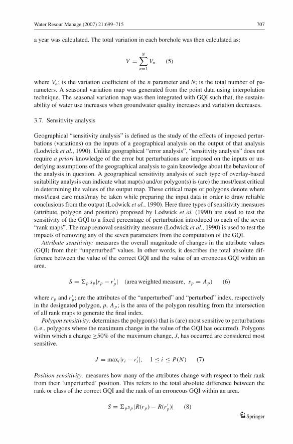
3.7. Sensitivity analysis
Geographical “sensitivity analysis” is defined as the study of the effects of imposed pertur-
bations (variations) on the inputs of a geographical analysis on the output of that analysis
(Lodwick et al., 1990). Unlike geographical “error analysis”, “sensitivity analysis” does not
require a priori knowledge of the error but perturbations are imposed on the inputs or un-
derlying assumptions of the geographical analysis to gain knowledge about the behaviour of
the analysis in question. A geographical sensitivity analysis of such type of overlay-based
suitability analysis can indicate what map(s) and/or polygon(s) is (are) the most/least critical
in determining the values of the output map. These critical maps or polygons denote where
most/least care must/may be taken while preparing the input data in order to draw reliable
conclusions from the output (Lodwick et al., 1990). Here three types of sensitivity measures
(attribute, polygon and position) proposed by Lodwick et al. (1990) are used to test the
sensitivity of the GQI to a fixed percentage of perturbation introduced to each of the seven
“rank maps”. The map removal sensitivity measure (Lodwick et al., 1990) is used to test the
impacts of removing any of the seven parameters from the computation of the GQI.
Attribute sensitivity: measures the overall magnitude of changes in the attribute values
(GQI) from their “unperturbed” values. In other words, it describes the total absolute dif-
ference between the value of the correct GQI and the value of an erroneous GQI within an
area.
S = �p sp|rp − r ′p| (area weighted measure, sp = Ap) (6)
where rp and r ′p; are the attributes of the “unperturbed” and “perturbed” index, respectively
in the designated polygon, p, Ap; is the area of the polygon resulting from the intersection
of all rank maps to generate the final index.
Polygon sensitivity: determines the polygon(s) that is (are) most sensitive to perturbations
(i.e., polygons where the maximum change in the value of the GQI has occurred). Polygons
within which a change ≥50% of the maximum change, J, has occurred are considered most
sensitive.
J = maxi |ri − r ′i |, 1 ≤ i ≤ P(N ) (7)
Position sensitivity: measures how many of the attributes change with respect to their rank
from their ‘unperturbed’ position. This refers to the total absolute difference between the
rank or class of the correct GQI and the rank of an erroneous GQI within an area.
S = �psp|R(rp) − R(r ′p)| (8)
Springer

708 Water Resour Manage (2007) 21:699–715
where R(rp) and R(r ′p) are the function that assigns the rank order (from low to high) to the
all P(N) resultant attributes rp(r ′p).
Map removal sensitivity: tests the sensitivity of the output index to the removal of one or
more of the rank maps from the analyses expressed in terms of a variation index:
V (%) = (|rp − r ′p|/rp) ∗ 100 (9)
3.8. The unique condition sub-areas
The implementation of sensitivity analysis requires a well-structured data base and a GIS
capable of manipulating large tables. Moreover, as introduced earlier the GIS used in this
study adopts the raster model which implies the representation of the data by a huge number of
elements (159337 pixels) and requires a suitable definition for the term “polygon” mentioned
in the formulations of the different sensitivity measures. To avoid analyzing the large number
of individual pixels in the study area, the idea of “unique condition sub-areas” introduced
by Napolitano and Fabbri (1996) was used. It is defined as one or more polygons (area)
consisting of pixels with a unique combination of Ai , Bi , Ci , Di , Ei , Fi and Gi where Ai ,
Bi , Ci , Di , Ei , Fi and Gi are the rating values of the seven parameters used to compute
the groundwater quality index and 1 ≤ i ≤ 10. The Cross-operation of ILWIS 3.1 was used
to obtain the sub-areas. The Cross-operation performs an overlay of two raster maps by
combining pixels at the same locations in both maps and tracking all the combinations that
occur between the different values or classes in both maps (ITC-ILWIS, 2001). All the unique
combinations between the different parameters were traced through multiple crossing. 572
unique condition sub-areas have been found in the study area however only 484 sub-areas
that are larger than 10 pixels in size (2500 m2) were considered in the statistical analysis of
the results.
4. Results and discussion
4.1. Aspects of spatial autocorrelation, spatial variability and cross correlation of
groundwater quality variables
The result of pattern analysis indicated that the point data (borehole) are arranged in a Com-
plete Spatial Randomness (CSR) with some degree of regularity. The probability of finding
one, two, three, four, five and six other point(s) within the specified distance of any point
showed an exponential growth with distance. The spatial autocorrelation analysis indicated
that Ca2+, Mg2+, Na+ and TDS have weak positive autocorrelation (close to randomness)
(autocorrelation coefficients: mean Moran’s I > 0 but is closeer to zero and mean Geary’s
0 < C < 1 but is closer to (1), Cl−, and SO2−4 have weak negative autocorrelation (close to
randomness (autocorrelation coefficients: mean Moran’s I > 0 but is closer to zero and/or
mean Geary’s C > 1 but is closer to (1) while NO−3 has a slightly stronger negative autocorre-
lation (autocorrelation coefficients: mean Moran’s I = −0.24 and mean Geary’s C = 1.54,
Table 2). The semi-variograms (experimental semi-variogram values versus distance classes)
for all parameters were characterized by the “nugget effect”. The nugget effect occurs when
the semi-variogram model shows a discontinuity (jump) to a semi-variogram value at an
extremely small distance. It generally indicates that the variable is erratic (highly variable)
Springer

Water Resour Manage (2007) 21:699–715 709
Table 2 Statistical summary of the spatial autocorrelation analysis. The Moran’s I; themeasure of spatial autocorrelation and Geary’s C; the measure of spatial variance
Moran’s I Geary’s C
Parameter Minimum Maximum Mean Minimum Maximum Mean
Ca2+ (mg/l) −0.41 1.47 0.20 0.52 1.47 0.86
Mg2+ mg/l) −0.30 1.33 0.10 0.57 1.29 0.87
Na+ (mg/l) −0.21 0.69 0.10 0.16 1.56 0.88
Cl− (mg/l) −1.30 0.80 −0.10 0.16 3.19 1.28
NO−3 (mg/l) −2.10 0.84 −0.24 0.37 4.55 1.54
SO2−4 (mg/l) −0.13 0.93 0.10 0.32 2.76 1.20
TDS (mg/l) −0.40 1.40 0.13 0.52 1.44 0.91
Fig. 2 Spearman Rank-ordercorrelation matrix of sevengroundwater quality parametersin the Nasuno basin. Single staredcorrelations are significant at P =0.05 while double staredcorrelation coefficients aresignificant at p = 0.01
over very short distances. The semi-variograms were unbounded as might be expected for a
one homogeneous unconfined aquifer.
On the other hand, the Spearman Rank-Order correlation (Figure 2) reflects the significant
spatial association between the seven groundwater quality variables. It must be noted that
spatial autocorrelation does not bias the correlation coefficients. It does, however, question
any formal statistical testing (e.g., significance level) of those coefficients.
4.2. Groundwater quality of the Nasuno basin
Figure 3a shows that the groundwater quality of the Nasuno basins is generally high (GQI
>90, maximum quality = 100). Nine groundwater quality classes are identified in the study
area at a 10% interval. The classification scale reflects the same level of detail for the eight
lowest classes corresponding to 80% of the total area. The 20% of the study area of the best
groundwater quality was considered less important and was assigned a one-class interval
(>80%). The statistics (Table 3) of the seven rank maps (parameters) used to compute the
GQI, indicate that parameters such as NO−3 , TDS, and SO2−
4 dictate the spatial pattern of
groundwater quality portrayed in Figure 3a due to their high mean rank value.
Two gradients of groundwater quality can be observed in the study area. First, a decrease
in groundwater quality from the northwest to the southeast following the general ground-
water flow direction attributed mainly to the shallow groundwater table (faster contaminant
percolation) in the southeast and the increase of pollutants (mainly nitrate) input from chem-
ical fertilizers applied to the rice fields. In addition to that the upper northwestern part of
the Nasuno basin is characterized by a very low population density which lowers the chance
of anthropogenic contamination. The lower end of the basin on the other hand is densely
populated. In a recent study of the nitrate contamination of groundwater in the Nasuno basin
(Babiker et al., 2005) a slight increasing trend of nitrate concentration along groundwater flow
Springer

710 Water Resour Manage (2007) 21:699–715
Table 3 Summary of statistics ofthe seven rank maps used togenerate the groundwater qualityindex in the Nasuno basin.
Parameter Minimum Maximum Mean SD
Ca2+ (mg/l) 1.1 1.5 1.3 0.09
Mg2+ mg/l) 1.1 1.1 1.1 0.00
Na+ (mg/l) 1.1 1.6 1.3 0.10
Cl− (mg/l) 1.1 1.6 1.3 0.14
NO−3 (mg/l) 1.7 4.5 3.2∗ 0.52
SO2−4 (mg/l) 1.5 1.9 1.6 0.06
TDS (mg/l) 1.6 2.3 1.9 0.19
SD, the standard deviation, Themean rank values are used asweighting factors for thecorresponding parameter exceptfor nitrate (stared value) wherew = meanr + 2 (r ≤ 8) (refer toSection 3.4.4.)
Fig. 3 The groundwater quality index, GQI (a) and potential groundwater quality index (b) of the Nasunobasin. The potential GQI was computed using three parameters only (NO−
3 , Mg2+ and SO2−4 )
direction was reported associated with the increase in density of irrigated rice fields. Also,
Ohashi et al. (1994) concluded from a study involving nitrate isotopes that the groundwater
nitrate in the middle part of the Nasuno basin originates mainly from animal waste while
that in the lower part of the basin originates from chemical fertilizers clearly reflecting the
effect of contamination transport by groundwater flow. The second gradient is a decrease of
groundwater quality from the central line of the basin towards the northeast (Naka River) and
southwest (Houki River) boarders of the basin. Hiyama and Suzuki (1991) have identified a
similar variation pattern in groundwater quality from NE to SW and suggested five regions
of different qualities. These groundwater quality regions seem to delineate the structural and
geomorphologic differences among the old terraces originally formed by the fan deposit.
Nevertheless, the mechanism behind this regional variation of groundwater quality in the
Nasuno basin might not be completely natural. The Houki River (southwest boarder) which
drains the densely populated area of Nasuno hot spring in the north represents a potential
Springer

Water Resour Manage (2007) 21:699–715 711
source of recharge to the groundwater beneath which might involve the transport and intru-
sion of urban pollutants to the groundwater system. Near the Naka River (northeast boarder)
the low groundwater quality might be attributed to the relatively high population density in
that region.
The potential GQI computed using three parameters; NO−3 , Mg2+ and SO2−
4 (Figure 3b)
generally reveals a similar pattern of spatial variability of groundwater quality in the study
area however the absolute value of the index is slightly lower (GQI = 93.2) indicating lower
groundwater quality compared to the result of the original GQI (GQI = 95.9). As expected
the potential GQI reveals more spatial variability than the original GQI (SD = 0.92 and 0.48,
respectively). Therefore, it must be noted that the proposed index is suitable for relative
assessment of groundwater quality rather than absolute assessment.
4.3. Seasonal variability of groundwater quality and sustainability of water use
Figure 4 indicates that temporally, groundwater quality is more variable in the upper and
lower parts of the basin (V, 15–30%) compared to the middle part (V, <15%) probably
attributed to the seasonality of precipitation in the first case and precipitation as well as
irrigation in the second case. Hiyama and Suzuki (1991) and Babiker et al. (2005) discussed
that the seasonal variability of nitrate contamination in the central and lower parts of Nasuno
basin is a function of the timing and overlap between irrigation and precipitation. In the
lower southeastern part of the Nasuno basin and the vicinity of the Naka and Houki rivers the
sustainable use of groundwater is constrained by the relatively low and variable groundwater
quality (Figure 5).
4.4. Sensitivity of the GQI
Table 4 displays the result of the “attribute”, “polygon” and “position” sensitivity analysis
while Table 5 displays the result of “map removal” sensitivity analysis. The attribute sensi-
tivity analysis indicated that perturbations introduced into NO−3 , TDS and SO2−
4 have caused
large change in the output index while perturbation introduced into Mg2+ resulted in a small
overall change of attribute in the output index. This could be directly related to the mean rank
value of the corresponding parameter and consequently the weight assigned to that parameter
(Table 3). In other words, parameters of high mean rank values induce higher impact over
the output GQI. In the case of polygon sensitivity, the number of polygons that are most sen-
sitive to perturbations introduced into the rank maps increases with the increase of the mean
rank value and/or the increase of its spatial variability (i.e., polygon sensitivity is directly
related to the mean and variation of rank value). Position sensitivity indicates that the GQI is
generally more stable with respect to perturbations in the parameters with either high mean
and variable rank value (NO−3 ) or low mean and homogeneous rank value (Mg2+). Nitrate
the parameter with the highest mean and the most spatially variable rank value dictates the
pattern of spatial variability of the GQI. Therefore, a spatially homogeneous perturbation
(like the one introduced in this analysis) will hardly cause shift in the rank order of many
sub-areas (polygons) since the thresholds of the rank orders (groundwater quality classes)
are basically defined according to a fixed interval of area percentage in the study area. In the
case of Mg2+, the low importance of that parameter in the definition of the overall GQI lies
behind the very small shift in the rank order of attributes with respect to their “unperturbed”
values.
Although the removal of NO−3 from the computation of the GQI seems to cause the highest
variation (2.2%) in the attribute of the “unperturbed” index, the GQI was rather insensitive to
Springer

712 Water Resour Manage (2007) 21:699–715
Table 4 Results of “attribute”, “polygon” and “position” sensitivity analysis ofGQI
Parameter Attribute sensitivity Polygon sensitivity Position sensitivity
Ca2+ 723.7 6 55.2
Mg2+ 671.2 5 0.7
Na+ 721.5 5 66.5
Cl− 723.8 6 41.2
NO−3 1545.9 7 31.4
SO2−4 805.8 5 50.7
TDS 894.7 6 75.8
the removal of any of the input parameter maps probably because the index was generated by
averaging (Table 5). This ensures the stability of the index and the comparability of the results
from different locations using different data sets. Generally parameters that reflect relatively
lower water quality (high mean rank value) and those of significant spatial variability (large
SD) imply larger impacts on the GQI and must be carefully and accurately mapped.
Fig. 4 Map displaying the degree of seasonal variability of groundwater quality across the Nasuno basin.Variability is expressed in terms of variation coefficient (%): (standard deviation/mean)∗100
Springer

Water Resour Manage (2007) 21:699–715 713
Table 5 Result of the “mapremoval” sensitivity analysis ofGQI
Variation index (%)
Parameter removed Minimum Maximum Mean SD
Ca2+ 0.2 0.6 0.4 0.07
Mg2+ 0.3 0.7 0.5 0.08
Na+ 0.2 0.6 0.4 0.07
Cl− 0.3 0.6 0.4 0.05
NO−3 1.0 3.2 2.2 0.40
SO2−4 0.0 0.5 0.3 0.08
TDS 0.0 0.2 0.1 0.05SD, standard deviation
5. Summary and conclusion
Recently, the globally important groundwater resources have become under great risk due to
the drastic increases in population, modern land use applications (agricultural and industrial)
and demands for water supply which endanger both water quality and quantity. Assessing
and monitoring the quality of groundwater is therefore, important to ensure sustainable safe
use of these resources for the various purposes. However, describing the overall water quality
condition is difficult due to the spatial variability of multiple contaminants and the wide range
of indicators (chemical, physical and biological) that might be measured. This contribution
Fig. 5 Sustainability of groundwater use in the Nasuno basin
Springer

714 Water Resour Manage (2007) 21:699–715
proposes a GIS-based groundwater quality index (GQI) which synthesizes different available
water quality data (Cl−, Na+, Ca2+, Mg2+, SO2−4 , NO−
3 and total dissolved solids, TDS) into
an easily understood format. This index provides a way to summarize overall water quality
conditions in a manner that can be clearly communicated to different audiences, can help to
understand whether overall quality of groundwater body poses a potential threat to various
uses of water, to validate cross-check and complement aquifer vulnerability assessments and
to indicate success in protection and remediation efforts. Regions of low groundwater quality
can then be targeted for more detailed investigation and tight monitoring programs.
The proposed GQI was able to delineate the spatial variation of groundwater quality in the
case study area (Nasuno basin, Tochigi Prefecture, Japan) indicating that the water quality of
the basin is generally high (GQI above 90). Additionally, two gradients of groundwater quality
were observed in the study area. First, a decrease in groundwater quality from the northwest
to the southeast following the general groundwater flow direction attributed mainly to the
decrease of depth to groundwater table (faster contaminant percolation) and the increase of
input of pollutants from urban and agricultural lands (mainly nitrate) from chemical fertilizers
applied to the rice fields. The second gradient is a decrease of groundwater quality from the
central line of the basin towards the northeast (Naka River) and southwest (Houki River)
boarders of the basin probably delineating the structural and geomorphological differences
among the old terraces originally formed by the fan deposit. Nevertheless, controls over this
regional variation in groundwater quality related to land use and population density are also
possible. Analysis of optimum index factor indicated that the maximum information about
groundwater quality was provided by the three parameters, NO−3 , Mg2+ and SO2−
4 .
Groundwater quality is more variable in the upper and lower parts of the basin (V, 15–30%)
compared to the middle part (V, <15%) probably attributed to the seasonality of precipitation
in the first case and precipitation as well as irrigation in the second case. Integration of GQI
and variation index indicated that in the lower southeastern part of the Nasuno basin and
vicinity of the Naka and Houki rivers the sustainable use of groundwater is constrained by
the relatively low and variable groundwater quality.
The model sensitivity analysis indicated that parameters which reflect relatively lower
water quality (high mean rank value) and those of significant spatial variability imply larger
impacts on the GQI and must be carefully and accurately mapped. Nevertheless the GQI was
found to rather be insensitive to the removal of any of the input parameter maps probably
because the index was generated by averaging. This ensures the stability of the index and the
comparability of the results from different locations using different data sets. Generally, the
proposed groundwater quality index can provide a relative assessment of the variability of
water quality based on commonly available groundwater quality data (e.g., major anions and
cations). However, specifically important water quality indicators for the local environment
can always be incorporated to address the problem of groundwater quality of any area.
Furthermore, the selection of the optimum combination of available parameters which dictate
the variability of groundwater quality enables an objective and fair representation of the
overall groundwater quality.
Acknowledgements This research was funded by the Japan Society for the Promotion of Science (JSPS) theauthors therefore, would like to express their sincere gratitude and appreciation for the unlimited financial andlogistic support. The authors would like also to express their gratitude for the anonymous reviewers for theirkind comments which helped to increase the quality of the present work.
Springer

Water Resour Manage (2007) 21:699–715 715
References
Aller L, Bennet T, Leher JH, Petty RJ, Hackett G (1987) DRASTIC: A standardized system for evaluatingground water pollution potential using hydrogeological settings. Environmental Protection Agency, EPA600/2-87-035; pp 622
Babiker IS, Hiyama T, Moahmed MAA (2005) Variability of groundwater quality in the alluvial Nasuno basin,Tochigi Prefecture, Japan. App Geochem. (under review)
Barber C, Bates LE, Barron R, Allison H (1993) Assessment of the relative vulnerability of groundwater topollution: a review and background paper for the conference workshop on vulnerability assessment. JAust Geol Geophys 14(2/3):1147–1154
Bonham-Carter GF (1996) Geographic information systems for geoscientists: modeling with GIS computermethods in the geosciences, vol 13. Elsevier Science Ltd, Pergamon, pp 1–50
Choi MW (1976) A hydrological study of the groundwater in Nasu, Tochigi Prefecture. The Tokyo Press,Tokyo, pp 21–39
Chung CF, Fabbri AG (2001) Prediction models for landslide hazard using a Fuzzy set approach. In:Marchetti M, Rivas V (eds) Geomorphology & environmental impact assessment. Balkema, Rotterdam,The Netherlands (in press)
Hiyama T, Suzuki Y (1991) Groundwater in the Nasuno basin – Spatial and seasonal changes in water quality(in Japanese), Hydrol. J Jap Assoc Hydro Scs 21(3):143–154
ITC-ILWIS (2001) Ilwis 3.0 academic user’s guide. International Institute for Aerospace Survey and EarthSciences (ITC), The Netherlands, pp 428–456
Levallois P, Theriault M, Rouffignat J, Tessier S, Landry R, Ayotte P, Girard, M,, Gingras S, Gauvin D,Chiasson C (1998) Groundwater contamination by nitrates associated with intensive potato culture inQuebec. Sci Tot Enviro 217:91–101
Lodwick WA, Monson W, Svoboda L (1990) Attribute error and sensitivity analysis of map operations ingeographical information systems: Suitability analysis, Inter J Geogr Inform Systems 4(4):413–428
Melloul A, Collin M (1994) Water quality factor identification by the ‘Principal Components’ statisticalmethod. Water Sci Technol 34:41–50
Napolitano P, Fabbri AG (1996) Single-Parameter sensitivity analysis for aquifer vulnerability assessmentusing DRASTIC and SINTACS. HydroGIS 96: Application of geographical information systems in hy-drology and water resources management (Proceedings of Vienna Conference), IAHS Pub, No. 235,pp 559–566
Ohashi M, Tase N, Hiyama T, Suzuki Y (1994) Temporal and spatial changes of nitrate concentration ofgroundwater in the Nasuno Basin (in Japanese). Hydrol (J Japa Assoc Hydro Scs) 24(4):221–232
Praharaj T, Swain SP, Powell MA, Hart BR, Tripathy S (2002) Delineation of groundwater contaminationaround an ash pond Geochemical and GIS approach. Environ Int 27:631–638
Robins NS (2002) Groundwater quality in Scotland: major ion chemistry of the key groundwater bodies. SciTot Envir 294(1–3):41–56
Rosen L (1994) A study of the DRASTIC methodology with emphasis on Swedish conditions. Gr Water32(2):278–285
Vrba J, Zoporozec A (1994) Guidebook on mapping groundwater vulnerability, IAH International Contributionfor Hydrogeology, vol 16. Heise, Hannover, pp 131
WHO, World Health Organization (2004) Guidelines for drinking-water quality, vol 1, 3rd edn, recommen-dations. WHO, Geneva, Switzerland, pp 145–220
Springer