System-level Fiscal Capacity for Funding Education ... - TN.gov
Upload
khangminh22Category
view
1download
0
HISTORICAL INFORMATION
CONCERNING THE
FORT BLOUNT-WILLIAMSBURG SITE,
JACKSON COUNTY, TENNESSEE
TENNESSEE DEPARTMENT OF CONSERVATION DIVISION OF ARCHAEOLOGY . .
REPORT OF INVESTIGATIONS NO. 6 . .
1989

3:ISTORICAL !lffORMATION CONC~IUTING ~E ?ORT E!.-CffilT-·.f::LLIAMS:CUF.G SITZ, JACXSON COUNTI, TEmlESS::!:E
by
Samuel D. Smith and Stephen T. Rogers
Tennessee Department of Conservation
Division of Archaeology
Report of Investigations No. 6
1989
Autho. no. 327236. This pub I ic document was promulgated at a cost of $1.82 ea. 05/31/89. TN ?r int ing Div . • Nashv i .1 I e, TN 37919-5208.

i
TABLE OF CONTENTS
List of Figures ii
List of Tables iii
Acknowledgements l
Introduction 3
Historical Data for Interpreting Fort Blount 10
Pre-Fort Blount Period 10
Fort Blount Period 17
Information Concerning the Location of Fort Blount 37
Historical Data for Interpreting Williamsburg and Other Periods 38
Post-Fort Blount Feriod 38
Williamsburg Pericd 40
Post Williamsburg Period (1820-1842) 43
The 1850 to 20th Century Period 46
Some Notes on Secondary Sources 47
Additional Comments on the Fort Blount-Williamsburg Site 49
Modern Interest in the Fort Blount-Williamsburg Site 49
Some Notes on the 1977 and Later Site Surveys and Some Comments on Resource Protection 50
Conclusions 54
Appendix A 58
Bibliography 59

ii
LIST OF FIGURES
Fig'ure
1 Map published in 1795 by Scott showing the Mero District of the Southwest Territory. 4
2 Map showing Tennessee as it appeared about 1796. 5
3 Map of Tennessee, 1817, showing the town of Williamburg on the west bank of the Cumberland River in Jackson County. 6
4 The Fort Blount-Williamsburg site area showing boundaries of the National Register site as defined in 1974. 9
5 The Fort Blount-Williamsburg site area showing approximate boundaries of three land tracts belonging to Sampson Williams by 1795. 14
6 Some photographs taken in 1966 at the Fort Blount-Williamsburg site . 53
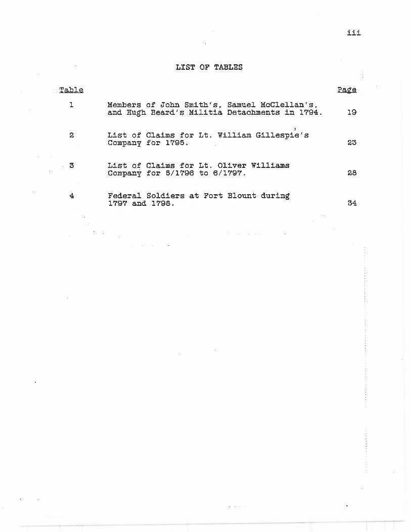
Table
1
2
3
4
LIST OF TABLES
Members of John Smith's, Samuel McClellan's, and Hugh Beard ' s Militia Detachments in 1794.
)
List of Claims for Lt. William Gillespie's Company for 1795.
List of Claims for Lt. Oliver Williams Company for 5/1796 to 6/1797 .
Federal Soldiers at Fort Blount during 1797 and 1798.
iii
19
23
28
34

ACKNOWLEDGEMENTS
The senior author of this report has a long standing interest in the Fort Blount-Williamsburg site beginning with childhood visits made to the area with his father. This same man, Ervin Smith, now the County Historian for Smith County , has provided a lifetime of inspiration concerning things of historic interest, none of them~ more fascinating than trying to imagine what once existed at the place that is the subject of this report . In the early part of 1977, when both of the authors made trips to the Fort Blount-Williamsburg site in order to carry out survey assessment type activities, Ervin Smith was on hand to provide encouragement, assistance , and an occasional hot meal. In the years since, he has continued to help search for, and has found, historic documents that have enabled us to better understand what once existed where the "Fort Blount Ferry Road" crossed the Cumberland River. All of these things are sincerely appreciated.
The 1977 survey work at the Fort Blount-Williamsburg site was part of a general survey of certain types of historic period archaeological sites in Middle Tennessee . This was conducted as a project of the Division of Archaeology, Tennessee Department of Conservation, largely funded with federal historic preservation funds administered by the Tennessee Historical Commission. Permission to conduct the Fort Blount-Williamsburg survey was granted by the Nashville District Corps of Engineers, · who have responsibility for the easement area around Cordell Hull Lake, and Henry Ford Smith, the farm manager for the adjoining private land. We were assisted during this survey work by Karen M. Johnson, then an employee of the Division of Archaeology.
Our efforts to collect historical and archival information concerning the Fort Blount-Williamsburg site began with the 1970s survey project and have continued intermittently over a period of eleven years . During this period a number of people have helped with this research , including various staff members of the Tennessee State Library and Archives . The former Smith County Historian, Carmack Key, has provided help on several occasions . More recently , Christine S. Jones of Cookeville, Tennessee (a descendant of the Jackson County Pruett family), and Bill Ragland, of Hermitage, Tennessee (whose family lived at the Fort BlountWilliamsburg site in the late 1930s), have provided help with understanding the family relationships of some of the later site residents and the lo ca ti on and use of buildings still standing in the early twentieth century . We are especially indebted to Tennessee author-historian Walter Durham who shared with us some very important information derived from his own research concerning Tennessee's Territorial Period. This information, which preceded an April, 1988, visit to the National Archives to research Fort Blount, proved to be of
1

tremendous help in terms of knowing where to concentrate our efforts.
The research at the National Archives came about as the result of a renewed interest in the location of Fort Blount on the part of various Jackson County area citizens and officials , and because of the certain knowledge that there was valuable information to be found, based on previous trips made to Washington by the senior author (and on one occasion by both authors) in connection with studies concerning the site of Fort Southwest Point in East Tennessee . A formal request that additional research concerning Fort Blount be conducted was made to the Department of Conservation by State Representative Leslie Winningham, in whose district the Fort Blount-Williamsburg site is located. The au tho rs received support for making the research trip and for compiling all information now available into a final report from George F. Fielder , Director of the Division of Archaeology, and Herbert Harper, Director of the Tennessee Historical Commission. Various members of the Jackson County Historical Society have encouraged the completion of this work , especially the society president, Ronnie West. Similar support has recently been provided by the Hull-York Lakeland R. C. & D. Association, who have approved a formal "measure" supporting research on and possible future public interpretation of the Fort BlountWilliamsburg site. We apprecia. te the interest and support that has been shown by all of these individuals and organizations.
Assistance with proofreading this report was provided by Ka.thy M. Keyes. Patricia. Coats of the Division of Archaeology assisted with computer printing the final camera-ready copy.
This report was prepared on a Tennessee Department of Conservation NCR PC8 computer using Microsoft Word 4.0 and Lotus 1-2-3 2. 01 . Camera-ready copy was prepared in Microsoft Word 4.0 and output to a QMS SmartWriter laser printer.
2
INTRODUCTION
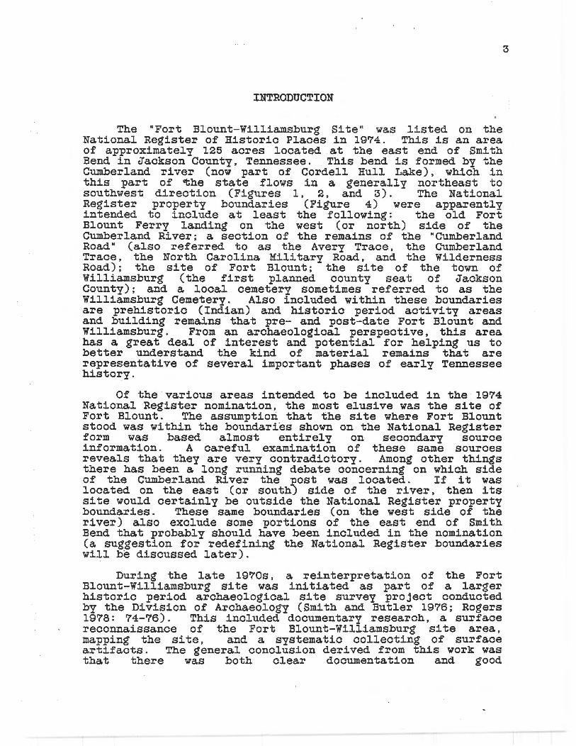
The "Fort Blount-Williamsburg Site " wa.s listed on the National Register of Historic Places in 1974. This is an area of approximately 125 acres located at the east end of Smith Bend in Jackson County, Tennessee. This bend is formed by the Cumberland :river (now part of Cordell Hull Lake), which in this part of cthe state flows in a generally northeast to sou th west direction (Figures 1 , 2, and 3) . The National Register property boundaries (Figure 4) were apparently intended to include at least the following: the old Fort Blount Ferry landing on the west (or north) side of the Cumberland River; a section of the :remains of the "Cumberland Road" (also :referred to as the Avery Trace, the Cumberland Trace, the North Carolina Mili ta:ry Road, and the Wilderness Road); the site of Fort Blount; the site of the town of Williamsburg (the first planned county seat of Jackson County); and a. local cemetery sometimes :referred to as the Williamsburg Cemetery. Also included within these boundaries a.re prehistoric (Indian) and historic period activity areas and building remains that pre- and post-date Fort Blount and Williamsburg. From an archaeological per spec ti ve, this area has a grea. t deal of interest and potential for helping us to better understand the kind of material remains that are representative of several important phases of early Tennessee history.
Of the various areas intended to be included in the 1974 National Register nomination, the most elusive was the site of Fort Blount. The a.ssumptiori that the site where Fort Blount stood was within the boundaries shown on the National Register f o:rm was based almost entirely on secondary source information. A careful examination of these same sources reveals that they are very contradictory. Among other things there has been a long running debate concerning on which side of the Cumberland River the post was located. If it was located on the east (or south) side of the river, then its site would certainly be outside the National Register property boundaries. These same boundaries (on the west side of the river) also exclude some portions of the east end of Smith Bend that probably should have been included in the nomination (a suggestion for redefining the National Register boundaries will be discussed later).
During the late 1970s, a. reinterpretation of the Fort Blount-Williamsburg site was ini tia. ted as part of a larger historic period archaeological site survey project conducted by the Division of Archaeology (Smith and Butler 1976; Rogers 1978: 74-76) . This included documentary research, a. surface reconnaissance of the Fort Blount-Williamsburg site area, mapping the site, and a systematic collecting of surf ace artifacts. The general conclusion derived from this work was that there was both clear documentation and good
3

.~ ---- ----
-.. -. . u .. • '/"' . '/ 111·:/.
--..; . -· ~.
/.•. --~ I,,,._ ._. ~ ;, -
~
.&... •
-.
·..;.
E ,\· f -~I ~- _J
,. -· 4
Figure 1. Map published in 1795 by Scott (1795: 305) showing the Mero District of the Southwest Territory. Shows road from Knoxville to Nashville that crossed the east and west boundaries of the Cherokee Indian Na ti on then crossed the Cumberland River at the "Crossing of the Cumberland."

1---------- ---- __ .:..::: ------ _:._::..__ _____ -
">
.,.,
:;;
~
"l
~
-
' "
....
Ml 11 S .\" J S S ! I" !/" I
- ----~ --=======-.....:..=:-=- -:.,·-::-;/i-"
Figure
v
----- - ~~ ----·---- --- - 4- --- .. --· , ,,·,~. ,. .....,,,._,:Ao.I·~ ... -±--·--·--~-=---=-----·- _-_- ~=-= ~----:---_~--~=:==-:-
'/' ,. (' h
I' I R r: l Y J . J
~ {I ( I n 'J ' JI
.J If fl }, J ,l' , J
,; ir: ,, n 1: I .J
-~--=- ~ ~ .:r-,., s ·r \.,,.. L· _,. ' ,/"' 'J n r .._ _,,. 1 ... 1•1 '-...
i - r - ) ~~~;:-~ ( ~-- -('l~ et!J~)~·,ec_ ·~ _/
'-....__.:.. '--- ,--~~ __.::.., ____/ '--
THllJf .f 'l'fl lf»' .\f / / , ,. .. x
''l~--t-- - ,!. - ~·--- ·...f!.'.. · -~- - ·r !' - !! -- '!-- _!, - r
,:;-----==~~=-- ~f-=· ====-======-==- ~1 .--~~ , -~-.-h_-;_-=----- ~ --r,---=-=--::----::----:--·-:-=~-----:· ·· .
2 . Map showing Tennessee as Published by Carey (1814:
it appeared 22).
about 1796.
OJ
?.! .
~ -

ID
"
/ ... . . 1. 1 ..r JrK..,. • lfA,f St• lo"i m l!.,1:..- nl" Jll:i• • I .
f.r1n1• .• .( ,1 '" ·'· '"'·' 1:.1· 11 · " '" . ' loln Arr• , J ,. •' "" ,f .1.,.,,, ,•1,1. , "' ,• I,.,.,.,.,,,. · '"' ' ·
!=:;':: j.:;t:. '.• .,·;;::.,:,!H,.;•,,,;"::;~ fwJ 1'# •
.- .. l'rn •il,..• "-'< •• ·•I;.,.,..,,,,, ,. ,-"',. · ~,, , .. . 1 ; , \11.,.1~1 1.< • • ,, ,.,, .. r,,.,
..,. ·~ ··-!
/
,,..,,,,,,. .. Ottil·, ,.. n-'• &ilM ••• ......... ~;;:;: ·
~~
I J 1l i
~I ,,,,, ~,, ,
~~ · ,, .. ,
»~· · 7iA/ L~/. r-- ·---" ~ • G1 -_,_ •. ~· ,' i - -- :_j_ --. - - / l'/ =·--=-'\.' ~rr
/"''-;~: 11 1,._ , ,._,.,,,
•II C~ d
II, I ' •!
1·.,
I
·t ~ I I. ,'
\ ,_ '
., \1 ( / .1 :rJ J I I I ~
/ h
/
1-1-i I" { / "' -\ ~ '·
fa-·-··- -· - 1 ·
J~-~~\' T , I I ' ~rf. .. ,..
JI c / ! " "
...• .. / '. - --- ----:; ~=t:-~::: --!
/
, ,....,.-.1~ ••!'lu._1,,.. ~i i , ......... .. u .. ,,, .•..• 1 ,. •••. t ... •~:' •.. 11 •• ,. 1-...1-,,,.,.,. ,
•·A,.,, ,, ,,. .,,,. ,, ,,},.. ,/,.•··· v; .. , .... _,,, ... ,_,,,.,, ,,:,, . , ·,.,, , ,; .,.,. ... ... __ , ,,,,_
·' ·"'· · ' ···•·' h r.,, .. r t i.r I '"'"' '.' . I . ~, /\, ,,.,.,.,.,,, /.:.,,,.., 1•.61
....... ,,,.,.,.,. , .•1..1.11. 11.n , " ·"·"' r ·,,. ''" ,,.,,,,_,, .i-: ... , , .,,;,,", l ;. ;, _.,, .,•, / inM; .•/.,;.,;,,., .. ,:,,., J. . ../,.,.d
,,,. ,17; • .,,oa /ito"I
I I Iii i .· , . . ,,
ll M I S f '•{, 1'1 ~ \' :•' 0' 0 ' '> ',\,---- -~ I , ., . \ ' ' i . ·; '\.
I , , 1 ' 1' , r A , ' ' , ' '1 _., , \ ,,, ' ., '.' -' ' . I
.• · • I \ " , - ' . " . - ' ' ' I :_~~k~~ _ ' ' I' • lJ.1 ---L, ~ _ ·t
I. ,. ~- " - -- -- --- r _•· - --- . - ~~ .. ~~~-
Figur e 3 . Map of Tennessee, 1817, showing the Williamsburg on the west bank of the Cumberl and River in Jackson County. Map Number 1867, Tennes see State Library a nd Archi ves, Na shvi lle .
town of
..... ~~ ,. ..... .. :;;;~ .. .. """-·-
·- ....
~ .... ·\
A-•• ~~ .l< Jj
;•:·· I I ti ~ ,,.fi .. ;
. ·;: ~~: " .~.\.
,;,_!"'" ' ,., .. ,, .. , J,,1;..,,.,. ,, .... ~. "''" "~ ""''
I ';:;:.:~ ~:1d··~'""
,, . .,. ~ .... . 11 1; ;; 1 ..
1.'. ;:·'. .... , :: • ; •1T.01..,n1k .1;,.
''"·';"
r __ , : /~ ' ~ ; _! · : 1:1
_r( . ~ I.' - .J~,
t_:r,--f _ ,
,.. ·'ii·'''"'" I\ ",,?:'::~ '· 1-· I
j ) .
\ 'i f ' ?
':"
0 r T II I " ,\ I t 0 I . I I"" ,\
y .}/;\ (" o..- ' ........._ --.:.:.:.....--
-. '"'.1'1.: HJ."f:.E 0 0:.82.FJ ', . ~
r;.11 .hH. -I .. /_ ,,;.A" ' ' ' . l i•n> •
.''/ M , /.,/; ,/fUJY .r1wn7·111'.?,..I' ""'I .>1.4,.,·
/), .,"HHl•llh'l/1
,flJll :""" :'\H: 1. 1s 11 • ...__ .. -:-=: , _./
'"iii I
= · '"Iii ,: · · -- . _ .J --·

archaeological remains for the town of Williamsburg, but that the location of the site of Fort Blount was by no means clear.
One of the problems that became apparent during the initial Fort Blount-Williamsburg site research concerned the type of historical information that was available. In modern times, most of what has been written about the Fort BlountWilliamsburg site (especially concerning Fort Blount) is simply not based on primary historical source information. It was felt desirable to begin a systematic collection of all of the primary sources that could be found and to present these separately from the various secondary interpretations that have been given over the years . A considerable amount of such information had been collected by the end of the 1970s, but due to other project commitments, a final report on this research has been delayed until now. In some ways the delay has been a blessing. There is now a much greater volume of source information than there was in the 1970s, and the ready availability of word processors has made some aspects of historic data assembly that would have been nearly impossible then relatively easy now.
The bodies of information pertaining to Fort Blount (ca. 1792-1798), Williamsburg (1807-1819), and the activities of Sampson Williams (b. 1762, d. 1841) are interrelated and entwined. As much time as possible has been spent researching each subject, and as much of the data as possible that relates to site location, former site appearance, or site remains is presented in this report. In keeping with the emphasis on primary source data, the major sections of this report are based on a chronological arrangement of quotations or para.phrased versions of contemporary sources. In addition to sources that are cited by author's name, the following abbreviations are used and a.re fully referenced in a section near the end of the Bibliography:
CC = Chancery Cqurt Case, Smith County Records DOS = Department of State, Register of Officers and
Agents DHP(D) = David Henley Papers JOP John Overton Papers JRP James Robertson Papers JSP John Sevier Papers KG Knoxville Gazette M208 Records of the Cherokee Indian Agency in
Tennessee, 1801-1835 M547 = Garland Draper Scrapbook, Tennessee State Library
and Archives M904 = War Department Collection of Post-Revolutionary
War Manuscripts M905 = Compiled Service Records of Volunteer Soldiers,
1784-1811 RG94QM = Quartermaster Accounts and Returns. Record Group
94 of the National Archives
7

8
RG94MR = Muster Rolls. Record Group 94 of the National
SC
sccc SCLR SCM SCMB SCT TG
Archives = Supreme Court Cases , Tennessee State Library and
Archives Smith County Chancery Court Case, 1870-1875 Sumner County Loose Records Sumner County , County Court Minutes Smith County Minute . Book, 1799-1804
= Sumner County Tax List, 1796 = Tennessee Gazette
The historical research on Fort Blount and Williamsburg and their various associations is like most such efforts in that there remains, and will probably long remain, some potential for finding additional sources of information that would be important for understanding the physical remains of these occupations. In addition, if any major archaeological work is ever conducted on the Fort Blount-Williamsburg site, this will undoubtedly change many of the thoughts presented as conclusions in this paper . The possibility of some future onsit~ research has provided one of the strongest motives for completing the present study.

"' ~ :;:
,,
~ I . I
fn8 ' · o ~ : v ., ':"
"' - 0 · W _J <I'. (.) (f)
~ ~ J' -4~
~ ~ -"" -= ~
~
.... ~
~
~
0
8 "'
~
~
~
§ -1
0
m
§w
~ "' ::;: g ;;<
0
Figure 4. site area showing Register site, as
9

HISTORICAL DATA FOR INTERPRETING FORT BLOUNT
Research concerning the post known as Fort Blount has revealed that there were actually two separate phases of military history associated with this location and , evidently, two installations that were used at different times, probably located on opposite sides of the river. The first of these, referred to as a "blockhouse post," was not called Fort Blount by contemporary writers. The second post, which began to be called Fort Blount about a year after its construction, seems to have been a larger facility than the first and was used for a longer period of time. It seems desirable to emphasize these separate histories by dividing t his section of the report into two subsections entitled "Pre-Fort Blount Period" and "Fort Blount Period."
Pre-Fort Blount Period
Sampson Williams was born December 2 , 1762, in Laurens District, South Carolina (Bates 1974; corresponds to the date given on his tombstone in the family cemetery at the Fort Blount-Williamsburg site).
Permanent Anglo-American settlement of what would later be the Middle Tennessee area began in 1779. The first group of settlers led by James Robertson reached the French Lick (later Nashville) by way of Cumberland Gap and Kentucky (Abernathy 1967: 155); however, according to Myer (1971: 99), there was already in existence an important Indian trail, l ater called the Cumberland Trace , which crossed the Cumberland River where Fort Blount would be established.
A 640 acre preemption land grant ( North Carolina Grant No . 416) was entered March 10 , 1784, for Simon Woodard. This was to be located near a salt lick (on an island) in the Cumberland River, near the east end of what is now Smith Bend (see 1793). The salt lick and its environs, at about this time, are described in a. deposition made by Edmond Jennings (SCLR) , who had been in the area locating land grants and hunting buffalo.
According to Clayton (1880: 370A) , Sampson Williams came from South Carolina with his father (Daniel), brothers
10

(Nimrod, Daniel, Oliver, and Wright), and one sister (Eunice) to settle in or near Nashville during this year. He also appears to have had one other brother named Turner Williams (Smith County Deed Book I, p. 359). Sampson Williams soon became a leader in the military activities carried out by the white settlers against the Indians (Haywood 1891: 256-257).
The Fort Blount-Williamsburg site Sumner County, which was carved out (Davidson County, North Carolina).
area became part of of Davidson County
Abernathy (1967: 155) gives 1788 as the date of completion of a road (the Cumberland or Avery Trace) authorized by the North Carolina legislature in 1787. This road or trail (Figure 1) traversed the Cherokee Indian territory that separated the Knoxville and Nashville area settlements. Until 1799, all overland travel between these two areas (except for those travelers who still used the old Kentucky route) was by way of Southwest Point (on the Clinch River) to what soon came to be known as the "Crossing of the Cumberland" (the location of Simon Woodard's grant).
The year 1790 witnessed the establishment of "The Territory South of the River Ohio," commonly referred to as the "Southwest Territory." A major source of information for the territorial period (1790-1796) is Volume IV of Th.a Territorial Papers Q.f. .:the. United States, edited by Clarence E. Carter (1936).
On December 15, Territorial Governor William Blount (who resided in what is now upper East Tennessee until 1792 when he moved to Knoxville) reestablished the "Mero District" of North Carolina as the "District of Mero in the Territory of the United States of America South of the River Ohio." This district was composed of Davidson, Tennessee, and Sumner counties (with the Fort Blount~Williamsburg site area located in Sumner). Sampson Williams was appointed sheriff of Davidson County (Carter 1936: 438-440). It is not certain where Williams lived at this time, but his father's residence was about three miles north of Nashville, north of the Cumberland River (Weakley 1965: 104).
By early 1791, Sampson Williams had already developed an interest in what would later be referred to as the Fort Blount area. This is indicated by a January 5, 1791, court record granting him the privilege of keeping a ferry for one year "at the upper end of the first bluff on Cumberland River, on the
11

south side, above the salt lick" (SCM, Vol. l, p. 35) . One of the tracts of land (North Carolina Grant No. 1647, consisting of 228 acres) that would later be issued to Williams (see 1792 and 1793) was located on the south (or east) side of the river at this point, and it appears from the copy of the original warrant that the rights to this tract had already been signed over to him (in 1788).
In a January 2 , 1792, letter to James Robertson, Governor William Blount mentions some Cherokees bring2.ng a letter to the "Crossing of the Cumberland" (the terms "Crossing of the Cumberland," "Passing of the Cumberland , " and "Ford of the Cumberland" were all used in reference to the area later called Fort Blount) . In this same letter (Carter 1936: 109), Governor Blount states:
... I write Sampson Williams by this Conveyance respecting some men which he will be authorized to raise to be stationed at the present crossing of Cumberland for six Month to commence on the 15th March and I intend to order more to be raised and stationed according to the Plan I recommend to the President and if any are raised your son Jona than will be appointed Ensign.
This appears to have been the beginning of territorial militia activity at this lo ca ti on. Cir cums tan tial evidence suggests that the post established at this time was located on the tract of land on the south (or east) side of the river that was under Sampson Williams' control. On June 23, Williams was in Nashville where he made an entry for this 228 acre tract (North Carolina Grant No. 1647) at the Crossing of the Cumberland, which included "the upper crossing of the River, the way the Road now goes from Bledsoes Lick to Holston." In a later court deposition (SC, p. 2), Williams stated that his ferry landing was located on this tract.
Besides his interest in the militia post and the ferry, Sampson Williams was also involved with land survey in the area during 1792. It does not appear, however, that he was here on a full-time basis, for he was again appointed sheriff of Davidson County, from July 10, 1792 to July 1793 (Carter 1936: 450) . Williams ' at traction to the area is , nevertheless, evident from the fact that he soon acquired the rights to another land grant, which gave him two tracts adjoining Simon Woodard's 1784 preemption (he also purchased half of the preemption in 1795) . Acting in his role as "District Surveyor," he was involved with surveying these grants in mid to late 1792, and into 1793 (information concerning these grants is filed at the Tennessee State Library and Archives, but original copies , which include the surveyor's maps, were obtained from North Carolina ' s Department of State).
12

Williams was also speculating in other lands at this time, such as a 640 acre tract (North Carolina Grant No. 2275), surveyed for him November 25, 1792. This was located in the west portion of Sumner County "about three miles from Bledsoe's Lick."
Perhaps the most important of the early land grants in the Fort Blount-Williamsburg site area. is Simon Woodard's 1784 North Carolina. preemption (No. 416), which was not issued until June 27, 1793. This 640 acre tract covered the ea.st end of what is now Smith Bend. It was surveyed on June 23, 1793, and signed by Sampson Williams, District Surveyor and Daniel Smith, Surveyor. The survey notes are as follow:
I have surveyed for Simon Woodard a Preemption of Six Hundred & Forty acres of Land lying in Sumner County formerly Davidson County on the north Side of Cumberland River opposite the big Salt Lick in Said River, Beginning about one Hundred yards below said Lick at a Sugartree white Oak & Beech on the bank of said River running up according to its Several Meanders five Hundred and four poles to a. Beech & poplar near the Lower End of the first Bluff above the present Crossing thence West four Hundred & thirty Six poles to three Beeches Thence Sou th three Hundred and Twenty poles to a stake thence East Seventy Seven & a half poles the beginning
It is important to note that this grant, as surveyed by Williams, seems to have included the west landing of the "present Crossing" of the Cumberland River.
Though Sampson Williams eventually owned half of the Simon Woodard grant (the portion shown in Figure 5) , the earliest property in the area. to be officially his was an adjoining 185 acre tract (North Carolina. Grant No. 1629) . This was originally a.warded to Samuel Johnson, but ca.me into Willia.ms possession and was surveyed for him in October,1792. It was issued in his name February 23, 1793. The tract is described as:
lying in the aforesaid County of Sumner the North side of Cumberland River, Beginning a. t three Beeches on the River bank upper corner to Simon Woodards Preemption running South Ninety Six poles to a Beech in S. Woodards Line thence west one Hundred and ninety four poles to a. Stake thence North one Hundred and ninety two poles to a.n a.sh the River Bluff thence the river according to its Various meanders to the Beginning - Surveyed by [?] Armstrong [also signed by S. Williams as District Surveyor].
13

Ii I§ \, ~-
1?1 I "' 1;
t
I -'\ § "'
~J: 8 ~
· o c . '<?"
)i ~ "" ~ "' -o w _J <(
I (.) (/) 0
~
J: ~c::->c ~
.~-~
~ ~
' -....:
~
::5 w :>: g ;;:
0
Figure 5. The Fort Blount-Williamsburg site area approximate boundaries of three land belonging to Sampson Williams by 1795.
showing tracts
14

While this 185 acre tract seems to have been intended to adjoin the north edge of the Simon Woodard grant, the actual calls for the two grants seem to cause them to overlap (Figure 5). This may not have mattered, or may have somehow been adjusted, once Sampson Williams also became the owner of the east half of the Woodard grant.
North Carolina Grant No. 1647, located across the river from Simon Woodard's grant, was originally assigned to Spencer Mayfield (or Rayfield), but it appears to have been signed over to Williams on August 31, 1788. It was officially issued to Sampson Williams on April 27, 1793, but it had been surveyed the previous July 13, 1792, by [?] Armstrong (Surveyor) , also signed by Sampson Williams (District Surveyor). Armstrong's notes include the following:
... I have Surveyed for Sampson Williams assignee of Spencer Mayfield Two hundred and twenty eight acres of Land situate on the South Side of Cumberland River Beginning a. small distance below the upper crossing of the River the way the Road now goes from Bledsoe' s Lick to Holston, at a. Honey locust and Buck, thence running up the river with its various meanders Two hundred and seventy four poles to a. Buck a.nd Ash a. t [Captain Samuel] Parkers Corner, thence East four hundred and thirty six poles, to a. Stake, thence South one hundred twenty five poles, to a. Stake thence West one hundred and · eig~ty two poles to the Beginning
This tract was later the subject of a. claims dispute between Sampson Williams and Thomas Perkins , and its boundaries are additionally defined in Sumner County (SCLR) and Tennessee Supreme Court (SC, pp. 1-2) records. The Supreme Court document states that this tract was the location of Willia.ms' ferry landing (probably beginning with the ferry he was licens~d to operated in 1791).
While there is evidence (see below) to suggest that a guard post was established at the Crossing of the Cumberland as ordered by Governor Blount ·in early 1792, it seems (based on official correspondence for the period) not to have been in use a.gain until the fall of 1793. Until that time, Sampson Willia.ms was probably still living in the Nashville area, as he was appointed to another term (June, 1793 to July , 1794) as Sheriff of Davidson County (Carter 1936: 456-457).
A March 20, 1793 letter from the Secretary of War to President Washington refers to a. Dr . Williamson's suggestions concerning certain posts that should be established in the Western Country.
The post which he mentions at Cumberland River would properly come under the cognizance of Governor Blount in whose territory it is. . . . If he should
15

think proper to establish it, he may do it either with Militia or regular troops one Company of which is under his orders (Carter 1936: 243).
The company of federal troops mentioned had arrived in Knoxville on February 27 (KG, March 3, 1793). On May 14, the Secretary of War, in a letter to Governor Blount concerning problems of defense of the Mero District, stated that:
Doctor Williamson has rep ea tedl y spoken of the danger of the communication between Washington and Miro district, and that it would be obviated in a degree by a small post at the crossing of Cumberland river This however, and all other points of defense must be referred to your judgment (Carter 1936: 257).
During a period of concern about a possible Indian attack on the Mero District, Governor Blount wrote to Daniel Smith (June 17, 1793), in that district, stating:
Had you not best postpone the sending of any pa.rt of Kerr's company to the Passing of Cumberland until the Time advised for the Guard to meet the families and then if nothing is done with Kerr let him and his Irishmen make a part of it - I do not see how any of the Arms can be safely got to Cumberland (Carter 1936: 274).
Apparently this Kerr was the commander of the one company of Federal regulars referred to in the Secretary of War's letter of March 20. According to Carter (1936: 283) this was Joseph Kerr, Captain lst U. S. Inf an try. His company is mentioned again in a letter written July 19 by Daniel Smith to the Secretary of War .
... I also wrote to Gen. Robertson to cause a. contra.ct to be ma.de for supplying pa.rt of Ca.pt . Kerrs company with ra. tions a. t the Crossing of the Cumberland intending to send them there in October next At that time tis expected a. number of families will remove to Cumberland to whose safety these Regulars may contribute - they will be aided I believe by a small Militia. guard from Miro District (Carter 1936: 283).
Though no subsequent mention of Captain Kerr's company has been found, there is a November 27, 1793, bill from Jason Thompson to the federal military for "boa.t.:.ng men & horses across the Cumberland at the Salt Lick" (RG94QM, Box 109) [Captain Kerr resigned on November 12, 1793, and his roll was soon being filled by William Rickard (3rd Regiment of Infantry, in Knoxville) who was promoted to Captain on January 30, 1794 (Hei tma.n 1903: 594 and 829)]. The ferry bill is signed by Sampson Williams as attorney for Jason Thompson. Thompson later sued Williams concerning a tract of land near
16

the "Great Salt Lick" ( Work's Project Administration 1938 : 174 ), and he is one of the militia. soldiers listed below .
On October 19, 1793 , Governor Blount issued the following instructions to Militia General James Robertson:
For the better security of the Frontier, you will order out twenty Infantry to perform a. three months tour of duty at a Blockhouse on Cumberland River, near the great Salt Lick under the command of Lieut. Sampson Willia.ms, to whom a Lieutenant's commission is given for that special purpose (Garrett 1898a: 76).
According to a notice concerning pay due the Territorial Militia , Williams was on active duty with the militia from November 5, 1793 to February 5 , 1794 (KG , May 22 , 1795) . The Service Records for Volunteer Soldiers (M905, Roll 32) confirms that his "detachment" was "at the Block House on Cumberland River" during this same period. Instead of 20 men, however, the service records indicate only 7 :
from 11/5/1793 to 2/5/1794 Lt. Sampson Williams 3 mos. @ $26 mo. Corp. Edmond Jennings 3 mos . @ $5 mo . Pvt . Isaac Crow 3 mos . @ $3 mo . Pvt . Jacob Crow 3 mos . @ $3 mo. Pvt . Jason Thompson 3 mos . @ $3 mo . Pvt. David White 3 mos . @ $3 mo . Pvt. Thomas Wilcox 3 mos. @ $3 mo .
In connection with the la. te 1793 sta. tioning of militia. troops, a.nd probably at least a few federal regulars , at the Crossing of the Cumberland, the references to a "Blockhouse " are quite specific a.nd indicate that this type of defensive structure was already in place. This strongly implies that a post ha.d been established in 1792, and as discussed above , it seems most likely that it was on the east side of the river.
Early 1794
As indicated by the above cited service record for Lieutenant Sampson Williams' detachment, the blockhouse post at the Crossing of the Cumberland remained in use by the militia at least through February 5 , 1 794. Short ly thereafter. various factors made it desirable to replace it with a larger post.
Fort Blount Period
Official correspondence for 1794 clearly defines the establishment of a new military post a.t the Crossing of the
17

Cumberland. This seems to have been somethi~g larger in scale than the previous blockhouse post and led to the adoption of the name "Fort Blount." Relevant correspondence begins with an April 11 report to the President (Carter 1936: 337), in which the Secretary of War addresses the problem of defense of the Mero District. The district was under considerable threat of Indian attack at this time. Citing a lack of availability of regular troops, he states that Governor Blount should be allowed to call into service until December 1 portions of the militia, and suggests:
A post and garrison to be established at the Ford at the Crossing of Cumberland River of 1 Subaltern 2 Sergeants 2 Corporals and 26 Privates
Governor Blount was given the authority to carry out this recommendation on April 14, 1794 (Carter 1936: 339). On July 28, he wrote to General James Robertson stating in part:
After much difficulty, Major Beard marches today with men to establish the post at the Cumberland River. I hope you will have address enough to induce Volunteers to join him to make up his number (Garrett 1898b: 354-355).
The person mentioned was Hugh Beard, who was several times placed in charge of companies of mounted infantry from the Washington and Hamilton Districts in what was later East Tennessee. His companies had previously been on duty in the Mero District, in the fall of 1792 and the spring of 1793 (KG, October 20, 1792 and April 18, 1793; Haywood 1891: 346, 382-383). The Compiled Service Records of Volunteer Soldiers (M905, Roll 29) identifies him as Lieutenant Hugh Beard and shows that he was in charge of one of three detachments from Hamilton District that were called into service May to July of 1794 and stationed for a few months at "the post on the Cumberland River." The other two of these detachments were under the command of Corporal John Smith (beginning May 24, 1794) and Sergeant Samuel McClellan (beginning July 26, 1794), and one of their stated du ties was "to establish a post on Cumberland River." By examining all of the individual service records on Rolls 28-31 of M905, it was possible to develop a list of most of the men who served in these three detachments. This is presented as Table 1.
The Sergeant Evans listed on Table 1 was one of 8 to 10 men left with Hugh Beard's detachment when a Knoxville mounted infantry company commanded by a Captain Evans was ordered to Mero District. This is noted in a September 8, 1794, letter by Governor Blount, which directed that these men were to be left with "Major Beard commanding in the character of Lieutenant at the Post on Cumberland River" (JRP, Box 1, Folder 10). The next month (JRP, Box 1, Folder 10, October l, 1794 ), Governor Blount again wrote to Captain Evans telling him to put Sergeant Joseph Evans in command of a small group of mounted infantry "to patrol from Beards ' s blockhouse to
18

19
TABLE 1. MEMBERS OF JOHN SMITH'S, SAMUEL McCLELLAN'S, AND HUGH BEARD'S MILITIA DETACHMENTS IN 1794.
Name Corp. John Smith Pvt. Allen Burk Pvt. Solomon Blaier Pvt. Francis Crab Pvt. Richard Findleston Pvt. Samuel Gibson Pvt. Burke Luallen Pvt. Richard Smith
Sergt. Samuel McClellan Pvt. James Arburthnot Pvt. James Cowan Pvt. Thomas Cox Pvt. James Hubbard Pvt. William Johnson Pvt. Richard Williams
Lt. Hugh Beard Sergt. Joseph Evans Corp. John Beard Corp. Thomas Smith Pvt. John Barley Pvt. Thomas Bladsaw
[Bledsoe] Pvt. John Farrol (Ferrell) Pvt. William Fowler -Pvt. Patrick Greenan Pvt. John Hamilton Pvt. Joseph Harden Pvt. James Hathorn Pvt. Obediah Hogg Pvt. William Hogg Pvt. William Holland Pvt. Blackstone Howard Pvt. Isbill Hickman Pvt. Robert Jones Pvt. Benjamin Lloyd Pvt. Henry Morris Pvt. John Morris Pvt. James Mussen Pvt. Robert Pallet Pvt. William Penny Pvt. David Rainey Pvt. Elijah Reed Pvt. Robert Stewart Pvt. David White
Remarks [detachment commander 5 / 24 to 9 / 27 , 1794 ]
(detachment commander 7/26 to 9/8, 1794] "left on command at Cumberland Ford" * "left on command at Cumberland Ford" *
"left on command at Cumberland Ford" * "left on command at Cumberland Ford" *
[detachment commander 7/26 to 10/25, 1794] "joined Capt. Evans Company 9/13/1794"
[listed only on muster roll of 10/25/1794] "killed at Cumberland Ford by Indians" 9/3/94
"deserted 7/26/1794"
[listed only on muster roll of 10/25/1794]
[listed only on muster roll of 10/25/1794]
* these men were left with Corporal Smith's detachment from September 8 to September 27

Colonel Winchesters' [Cragfont near Bledsoe' s Lick]." While i t is possible that "Beard's blockhouse" was used in reference to the previously constructed Crossing of the Cumberland blockhouse, it seems more likely that the governor was referring to a new post that had been built by the men under Beard's command.
The soldier in Lieutenant Beard's detachment who was killed by Indians is also mentioned in an October 24, 1794, letter from Governor Blount to the Secretary of War:
.. . my last accounts from Mero District are as late as the 20th instant when only 1 man was killed in that District since the 16th ultimo. The person killed was Thomas Bledsoe one of the Soldiers belonging to the post at the ford of Cumberland on the 2nd instant (Carter 1936: 360).
20
In September of 1794, approximately 550 militia soldiers had participated in the "Nickajack Expedition" ordered by General James Robertson against the Chickamauga Cherokee towns (Caldwell 1968: 73). This caused a devastating effect on the ability of the Cherokees to carry out offensive actions in their struggle against the white settlers, and in November, following a long letter to the Secretary of War concerning the "pleasing prospects of peace with the lower Cherokee Towns" (Carter 1936: 364-367), Governor Blount sent a letter of instruction to James Robertson (November 22, 1794). This letter states that all of· the active militia in the Mero District were to be discharged on the last day of December, 1794, but that:
The Post at the ford of Cumberland appears to me an essential one , and if possible under the order of the Secretary, I wish it kept up by the Militia of Mero District, until the first day of April (Carter 1936: 372).
Unfortunately , nothing has been found to clearly indicate what type of post was constructed in the summer of 1794. It seems obvious that it must have been a faci l ity large enough to accommodate at least 40 to 50 soldiers.
It is also not clear to what extent, if any, Sampson Williams was involved with the establishment of this new post. On June 13, 1794 , he was appointed Justice of the Peace for Davidson County (Carter 1936: 460). This seems to have been in lieu of reappointment as sheriff. Williams also spent a good portion of hi s time traveling between Nashville and Knoxville delivering mail or government dispatches, as well as escorting travelers, both whites and Indians (Garrett 1899c: 267). His abilities in this area were highly respected. In the fall of 1794, an individual wishing to travel from Knoxville to Nashville, who had missed the group that he planned to travel . with, inquired of Governor Blount if it would be safe to travel the wilderness alone. Governor Blount

knowing that Williams was in Knoxville and about to return to the Mero District, is reported to have responded "Sampson Williams is here and he is as good as twenty common men" (quoted in Durham 1969: 131).
In September of 1794, the General Assembly of the Southwest Territory had passed "An Act to authorize the raising a fund, for the purpose of discharging the cost of cutting and clearing a wagon road from South West Point to the Settlements on Cumberland river, in Mero district, by lottery" (Jenkins 1949a: 93). Managers were appointed and 3,000 tickets were to be sold. To the east, this improved version of the Cumberland Road was to follow a more southerly route than the 1788 trace, but it would still cross the Cumberland River at the same place (Abernathy 1967: 156).
During the early part of this year preparations continued for financing the "Cumberland Road" by lottery. One of the persons in the Mero District selling the lottery tickets was "Captain" Sampson Williams (Jenkins 1949b: 15-16; KG, May 22, 1795). It was publicly announced that on the following October 20:
... the annual escort through the wilderness, for families, will leave the block houses at South West Point, for Bledsoe' s Lick . . . At the same time and place, the contractor for cutting a wagon road thro the said wilderness , means to be in readiness to commence the opening of it, and to proceed with sufficient clerity for the families to take through their wagons and baggage to the Cumberland settlements in safety (KG, May 22, 1795)
The post at the Crossing of the Cumberland was still garrisoned. On February 27, 1795, Governor Blount wrote to General Robertson that:
The Post at the ford of Cumberland as permitted by the order of the Secretary [of War] of the 14th April appears not only essential to the Safety of the travellers but also a good advance Post for the Protection of the Frontiers, you will therefore have it kept up with Militia as permitted by the order during the present year unless you should receive an order to the contrary (Garrett 1899b: 175-176).
The militia troops stationed here were mentioned in Governor Blount' s May 4, 1795, letter to General Robertson (Garrett 1899c: 261), and a May newspaper report (KG, May 8, 1795) states that a soldier named John Wirow was killed by Indians on April 6, 1795, while "on duty at the ford of Cumberland River, two miles from the blockhouse." Only a few days earlier, John Wirow had been one of the militia soldiers mustered in the company of Lieutenant William Gillespie. An
21

examination of the collected manuscripts on National Archives Microcopy 904 (Roll 4, pp . 243 , 251 , 272 , 299, 301, 341, 348 , 358, 360, 364, and 367) established the members of Lieutenant Gillespie's company during 1795 , as shown in Table 2. For each of the three muster dates shown in Table 2 , most of these men were stationed at the post that was becoming known as "Fort Blount."
Interestingly , however , not all of these men were actually in service, as indicated by a letter filed in the Post Revolutionary War Manuscripts (M904 , Roll 4, p. 172-173). John Cotton , listed as a Private and l ater as a Corporal (Table 2) in Lieutenant Gillespie ' s company, stated in this September 26, 1797, letter that he was never even in the militia, but that two men :
came to me as they said by Capt. Gillespie's request that I should give a power of a t torney for services as by a written discharge sent to me which I did, not knowing the consequences. The two young men who came to me, made assurances it would be of no harm for me to give a power, that 30 men was allowed to be at Ft. Blount, & they was desirous to draw the pay , for as many as was all.owed at that fort, that the pay drawn for those t hat did no duty might be divided between the Captain & those that did duty at Ft. Blount. I am ready also to assert that I was wounded by the fall from a horse & ••. have been excused from military duty .
The full extent of this padding of t he Gillespie company muster rolls is unknown , but one soldier who was certainly present at Fort Blount was Corporal Joseph Brown (Table 2). Brown's life story is one of the more interesting ones recorded for the frontier period. When he was a young boy , h i s family had attempted to travel by river from the Knoxville area to · Nashville. They were taken pri soner by Chickamauga Cherokee warriors . and Brown ' s father and brothers were k i lled , his mother and sisters taken away . Brown was held captive for many months and several times t hreatened with death. He was final ly sent back to the whites in exchange for some Indian prisoners. · In 1794 he returnee. to the Lower Cherokee towns as one of the leaders of the "Nicka.jack Expedition." This was said to have fulf i lled the prophecy of an old Indian woman who had told his captors that he was old enough to remember the murder of his father a~d brothers and would someday return with an army to destroy them (Miller 1973 ; Caldwell 1968: 73). In recounting this period of his life, Brown discus-sed the "Nicka jack Expedition" then noted that "The next year [1795] I was engaged as a spy and guard at Ft. Blount for twelve months" (Brown 1852 : 77) .
The earliest known use of the term "Fort Blount " is in a July 13, 1795, letter from Governor Blount to General James Robertson:
22

23
TABLE 2. LIST OF CLAIMS FOR LT. WILLIAM GILLESPIE'S COMPANY FOR 1795.
Name 4 / 1 / 95- 7 / 1 / 95- 10 / 1/95-6 / 30 / 95 9 / 30 / 95 12 / 31 / 95
Lt. William Gillespie $78.00 $78.00 $78.00 Sergt . John Dawson $24.00 Sergt. Gideon Pillow $24.00 $24.00 $24.00 Corp. Joseph Brown $21.99 $21.99 $21.99 Pvt. Robert Allison $19.98 Pvt. Richard Anderson $19 . 98 $19 . 98 Pvt. Samuel Assleck $19.98 Pvt. Joseph Adams $19.98 Pvt. David Beard $19.98 Pvt. Thomas Blakemore $19 . 98 Pvt. Stephen Brown $19.98 $19.98 $19.98 Pvt. William Bruce $19.98 $19.98 $19 . 98 Pvt. John Burgess $19.98 Pvt . James Cage $19.98 $19.98 Pvt . Rueben Cage $19.98 $19.98 Pvt. William Cage $19 . 98 $19 . 98 Pvt. John Canady $19.98 Pvt. John Cooper $19.98 Pvt. John Cotton $19.98 Corp. II II $21.99 Pvt. Lazarus Cotton $19.98 Corp . II II $21.99 Pvt. Hugh Crawford $19.98 Pvt. Zachariah Dalton $19.98 Pvt. John Dawson $19 . 98 Pvt. William Dobbins $19.98 Pvt. Robert Dougan $19.98 Pvt. Elmore Douglas $19.98 $19.98 Pvt. Rueben Douglas $19.98 Pvt. Thomas Egnew $19.98 Pvt. David Gillespie $19 . 98 Pvt. Zachariah Green $19 . 98 Pvt. William Hall $19.98 Pvt. James Harp $19 . 98 Pvt. Elijah Hays $19.98 Pvt . James Hays $19.98 Pvt . James Holmes $19 . 98 Pvt . Thomas Jones $19 . 98 Pvt . James Latherdale $19 . 98 Pvt. William Latherdale $6.66 PYt . Charles Latimore $19.98 Pvt. Joseph Latimore $19 . 98 Pvt. Robert Latimore $19 . 98 Pvt. Thomas Latimore $19 . 98 $19 . 98 $19.98 Pvt. James Lauderdale $6 . 66 Pvt . Peter Luna (Looney) $19 . 98 $6.66 $19 . 98 Pvt. Robert Luna (Looney) $19.98 $19 . 98

24
TABLE 2 (continued).
Name 4 / 1 / 95- 7 / 1 / 95- 10/1 / 95-~ / 3Q / ~5 2/ 3Q/~5 12 / 31 / ~5
Pvt. William McAdams $19.98 Pvt. Spencer Mercer $19.98 Pvt. Berry Nolen $19.98 Pvt. William Penny Pvt. James Roberts $19.98 $19 . 98 Pvt. Hugh Rogan $19.98 $19.98 Pvt. James Scoby $19 . 98 Pvt. Joseph Sevby $19.98 Pvt. Isaac Sevet (? ) $19.98 Pvt. John Turney $19 . 98 $19.98 Pvt. Jesse Ward $19.98 Pvt. John Wirow $19.98
Number of men: 32 23 26

You will reduce the number of Militia stationed at the crossing of the Cumberland, called as I have been informed, Fort Blount, to twenty five noncommissioned and privates and continue the command in Lieutenant Gallaspie [Gillespie] (Garrett 1898b: 377).
Governor Blount's order may be reflected in the reduction in number of soldiers in Lieutenant Gillespie's company after July, 1795 (Table 2).
While stationed at Fort Blount, William Gillespie was involved with local activities other than the militia. At the beginning of the year (January 6, 1795) he had been a-µ_thorized by the County Court of Sumner County to keep a ferry and charge 25 cents for each horse and rider (SCM, Vol. II, p. 82). On October 8, 1795, he was allowed:
... to demand at his ferry on Cumberland River at Fort Blount as follows vize, $1 for wagon & team, 75 cents for cart & team, 12 1/2 cents for veal cattle, 4 cents per head for all other kind of stock; This order to continue in force until next term & no longer (SCM, Vol. II, p. 97).
The prices charged at Fort Blount for use of the ferry and for provisions were considered too high by at least one traveler, who wrote to Andrew Jackson on September 2, 1795:
I set out from [Knoxville] about the 20th. of next month. Cant somebody be at fort Blount with corn to sell at less than a. dollar a Bushel and Cant the Court of the County rate the ferry a.t less than 2/ -pray my friend inquire into a regulate this imposition (Smith and Owsley 1980: 72).
By October, relations with the Indians ha.d improved such that Governor Blount informed the public that immigrants to the Nashville area. settlements could now "pass the wilderness from South West Point to Bledsoe' s lick, without a military escort, without the least apprehension of injuries at the hands of the Cherokees or Creeks" (KG, October 23, 1795) . This same issue of the Knoxville Gazette also carried the following notice:
From the 20th inst. to the first of December Emigrants to Mero District will be furnished at the Crossing of the Cumberland, now called FORT BLOUNT with the fallowing articles a. t the several prices thereto affixed.
Indian corn, at 4 lb per bushel, Virginia money Meal, cf Beef three pence per pound Ferriages at one shilling for man and horse
October 4, 1795
25

According to a December 26, 1795, letter from the Cherokee Indian Agent, . Silas Dinsmoor, to General Robertson, Cherokees sometimes came to this location to trade skins, meat, and oil for other goods (Garrett 1899a: 81).
During 1795 , Sampson Williams continued to be involved with work on the Knoxville to Nashville road and to make frequent trips along this road carrying dispatches and escorting travelers and Indian prisoners. Much of this activity was carried out for the territorial government, and his expenses for such work were paid by the Military Agent, David Henley (DHP, November 17, 1795; RG94QM, Box 79 and 84).
On December 19, 1795, Sampson Williams (identified as a Deputy Sheriff of Sumner County) obtained the east half of the grant originally made to Simon Woodard (see 1784, 1793, and Figure 5)) . The en tire transaction was rather complicated: Amos Heaton had been awarded Woodard's grant in settlement of a debt ; meanwhile Heaton died leaving the property to his heirs; and in December, William Cage, Sheriff of Sumner County, was empowered to sell the tract for the heirs (Sumner County Will Book 2, p. 13; Sumner County Deed Book 1, p. 190). Williams purchased 320 acres for $200 described as:
. . . near the Great Salt Lick being l I 2 of a tract originally granted to Simon Woodard, Butted and bounded as follows. Beginning at a poplar & beech near the lower end of the lst bluff above the present crossing on the bank of the river running down according to its several meanders 420 poles to a stake thence North 288 poles to a stake thence east 286 poles to the beginning as more fully appears by the grant bearing the date June 27, 1793 ... (Sumner County Deed Book l, p. 191).
While Sampson Williams had spent a considerable amount of time in the area before this purchase, it appears from the court case concerning his tract on the south side of the river (SC, p. 2) that he was only now becoming an actual resident.
On January 6, 1796, the County Court of Sumner County ordered that:
· ... the Tavern & Ferry at [Fort] Blount be rated as follows vize, Dinner 25 cents, Breakfast or Supper 16 3/4 cents, Brandy pr 1/2 pint 25 cents, whiskey pr 1/2 pint 12 1/2 cents, ferriage for man & horse 12 1/2 cents, " for wagon & 4 horses $1, " for cart & horse 50 cents, " for a single person or horse 4 cents, " pack horses & load 12 1/2 cents , corn per quart 4 cents, oats per quart 3 cents (SCM, Vol. II, p . 99).
26

This is the first mention of a non-military building (a tavern) at this place. The same court order set rates that were considerably lower for all other taverns and ferries in Sumner County .
On March 1, the French from Nashville to the east, on the Cumber land River . " journal that he:
botanist Andre Michaux, traveling arrived at "Fort Blount situated The next day he recorded in his
... remained over in order to pull young Shoots of a new Sophora I had remarked in the vicinity of Fleen ' s [Flynns] creek about 12 Miles from the Fort.
Snow covered the ground and I was unable to get any young Shoots but Captain . Williams, the young [officer] stationed in the Fort cut down some trees and I found some good seeds (Williams 1928: 340) .
Michaux was the first of several travelers who left accounts of their visits to Fort Blount. Unfortunately, none of them ever clearly described the post or even clearly stated on which side of the river the fort was located. The "Captain" Williams mentioned by Michaux was probably Oliver Williams, who was Sampson Williams' brother (Clayton 1880: 370A and JOP, Box 8, Folder 8, May 18, 1817). He was in charge of the militia company stationed at Fort Blount (RG94QM , Box 80) during most of 1796 and early 1797. The structure of this company has been determined from the Post Revolutionary War Manuscripts (M904, Roll 4: pp . 241, 263, 272, 341, 344, 347, 355, 356 , 360 , 361 , 364, and 366). This information is presented in Table 3. Wright Williams , another of Sampson Williams ' brothers (JOP, Box 8, Folder 8, September 5, 1800), was a sergeant in this company during most of this period.
On April 5, 1796, the Sumner County Court reaffirmed the rate structure for the ferry at Fort Blount and granted the ferry privilege to Sampson Williams for one year (SCM , Vol II , p. 102). It is obvious that Sampson Williams and his brothers were now the persons most in control of Fort Blount and its immediate surroundings.
The numbers of men indicated in Table 3 are more or less in agreement with comments made . by another early traveler. On May 22, 1796, Thomas Dillon wrote that he had visited Tellico Blockhouse, Southwest Point, and Fort Grainger, in the east part of the Territory, and:
Fort Blount on the Cumberland River. At the respective forts are stationed about 15 men , altho not under regular discipline or subordination as might be expected , many of them being commonly absent, from which a body might be apt to infer that supporting the Garisons were useless & unnecessary ; but the fact is otherwise ; I think them highly necessary and very proper bariers between the whites
27

28
TABLE 3. LIST OF CLAIMS FOR LT . OLIVER WILLIAMS COMPANY FOR 5 / 1796 TO 6 / 1797.
Name 5 / 1/96- 7 / J. / 96- 9/1 / 96-~ / 3Q / ~~ ~ / 3J, / ~~ 1Q / 3l / ~f2
Lt. Oliver Williams $52 . 00 $52.00 $52 . 00 Sergt. Wright Williams $16.00 $16.00 Corp. Edmund Jennings $14 . 66 $14.66 $14.66 Corp . Curtis Morris Pvt. Mathew Anderson $13.32 Pvt. Ur iah Anderson Pvt. John Barton $13.32 Pvt. Isaac Caldwell $13 . 32 Pvt. Henry Chambers $13 . 32 Pvt. Timothy Chandler $13.32 $13 . 32 Pvt. Jerimiah Chapman $13 . 32 Pvt. Bristow Clark $13 . 32 $13.32 $13.32 Pvt. Thomas Clark Pvt. Vachart Clark Pvt. Francis Colby $13 . 32 $13.32 $13.32 Pvt. James Desha Pvt. Joel Echols $13 . 32 Pvt. George Fammerman Pvt. John Fletcher $13 . 32 $13.32 $13.32 Pvt. Booker Greer $13 . 32 Pvt. Joseph Greer $13 . 32 Pvt. Jerimiah Hendrick $13 . 32 $13.32 Pvt. Joseph Hendrick $13.32 $13.32 Pvt . Obediah Hendrick $13 . 32 Pvt. Eli jah Hitchcock $13.32 Pvt. Henry Hudderson Pvt. James Johnston $13.32 $13 . 32 Pvt. Richard Jones $13.32 Pvt . David McCartney $13.32 Pvt. John McCrory Pvt. Zachariah Mangum Pvt. John Martin Pvt. Joseph Martin $13.32 Pvt. Richard Mathews $13 . 32 Pvt. Joseph Miser Pvt. Clayborn Morgan Pvt. James Morinan $13.32 $13 . 32 Pvt . Curtis Morris $13 . 32 $13.32 Pvt. Booker Pate Pvt. Edward Pate Pvt . Soby Pate Pvt . Willeroy Pate Pvt . William Richards $13 . 32 Pvt . John Richardso:i $13.32 Pvt . James Roberts $13.32 Pvt . Samuel Sparks Pvt . Wi lliam Sparks $13 . 32 Pvt . Robert Stuart $13.32 $13.32 Pvt . Thomas Thomsom $13 . 32 Pvt. William Thompson $13.32 Pyt, Hen;r~ Turne;r ~13.32 ~l~.~2 ~:J.3.32 Number of men : 19 19 16

29
TABLE 3 (continued).
Name 11/1 / 96- 1 / 197- 4/1 / 97-l~ / 31 /96 3 / ::31 / 97 Q/ 21 / 97
Lt. Oliver Williams $52.00 $78.00 $70.20 Sergt. Wright Williams $16.00 $24.00 $21.60 Corp. Edmund Jennings $14.66 $21. 99 Corp. Curtis Morris $19.79 Pvt. Mathew Anderson Pvt. Uriah Anderson $19.98 $17.98 Pvt. John Barton Pvt. Isaac Caldwell $13.32 Pvt. Henry Chambers Pvt. Timothy Chandler Pvt. Jerimiah Chapm&~ $13.32 $19.98 $17.98 Pvt. Bristow Clark $13.32 Pvt. Thomas Clark $13.32 $19.98 $17.98 Pvt . Vachart Clark $13.32 Pvt. Francis Colby $13.32 $19.98 Pvt. James Desha $13.32 Pvt. Joel Echols Pvt. George Fammerman $19.98 $17.98 Pvt. John Fletcher $13.32 $19.98 $19.98 Pvt. Booker Greer Pvt. Joseph Greer Pvt. Jerimiah Hendrick $13.32 Pvt. Joseph Hendrick $19.98 $17.98 Pvt. Obediah Hendrick Pvt. Elijah Hitchcock $13.32 $19.98 $17.98 Pvt. Henry Hudderson $17.98 Pvt. James Johnston Pvt. Richard Jones $13.32 $19.98 Pvt. David McCartney Pvt. John McCrory $19.98 $17.98 Pvt. Zachariah Mangum $13.32 $19.98 $17.98 Pvt. John Martin $13.32 Pvt. Joseph Martin Pvt. Richard Mathews Pvt. Joseph Miser $13.32 $19.98 Pvt. Clayborn Morgan $19.98 $17.98 Pvt. James Morinan Pvt. Curtis Morris $19.98 Pvt. Booker Pate $17.98 Pvt. Edward Pate $19.98 $17.98 Pvt. Soby Pate $17.98 Pvt. Willeroy Pate $19.98 $17 . 98 Pvt. William Richards $17.98 Pvt. John Richardson Pvt. James Roberts $13.32 $19.98 $17 . 98 Pvt. Samuel Sparks $13 . 32 $17 . 98 Pvt. William Sparks Pvt. Robert Stuart Pvt. Thomas Thomsom Pvt. William Thompson Pyt. Hen~v !u;rne;r -Number of men: 19 20 21

& Indians. T:"l.ese Garisons are very ill supplied with provisions, owing in some measure to the economical ideas of Col. Henley, the agent of Indian affairs at Knoxville (Williams 1928: 360).
Tennessee became a separate state on June l, 1796, with the Fort Blount area remaining in Sumner County.
On July 20, the first governor of the state of Tennessee, John Sevier, wrote to William Blount (now U. S. Sena tor Blount) that:
The several posts, block houses & c. supported by Militia in the time of my predecessor will soon be unoccupied, as the time expressed in his last order will soon expire, and being few regulars left in Rickard's company, I shall be under the indispensable necessity of a renewal of similar orders to supply these places, unless I am informed the President's pleasure on the subject (Williams 1929: 113-114).
As indicated by Table 3, one of the posts that was continued by Governor Sevier was Fort Blount. Sampson Williams was also still living at Fort Blount at the close of this year and wrote to Governor Sevier (JSP, Letters Received, December 13, 1796) asking permission to take some men to Cherokee camps near the "Cumberland Road" to retrieve some stolen horses. He argued that the Indians probably would not respond to this intrusion into their territory "knowing men were kept here as a guard to the Travelers."
30
A surviving Sumner County tax list for 1796 (SCT, p. 171) provides some very interesting inf orma ti on for interpreting the location of Fort Blount. Sampson Williams was taxed on:
320 acres - Ft. Blount 185 acres - adjoining (ditto) 228 acres - South side of Cumberland 640 acres - ditto
The 320 acre portion of Simon Woodard's old grant is here clearly identified as the Fort Blount tract, while the two adjoining tracts are given other associations [the 640 acre tract was probably one that Williams purchased in 1795 on Roaring River (Murray 1988: 26) J. This seems to clearly indicate that what was called Fort Blount in 1796 was located near the river crossing on the north C or west) side of the Cumberland River.
At the beginning of 1797, Oliver Williams was still in charge of military activities at Fort Blount (Table 3), while his brother Sampson continued to have various kinds of business dealings wi th the federal military. By January of

this year the federal government had agreed to pay for provisions for "the guard of Militia stationed at Fort Blount, until relieved by regular troops" (DHPD, John Sevier to David Henley, January 13, 1797), and the contract for supplying these troops was awarded to Sampson Williams (RG94QM, Box 82 and 85) . On January 2, the Sumner County Court granted Sampson Williams the privilege of keeping an ordinary (or tavern) at this place, and he was additionally involved during this year with several projects concerned with rebuilding the road from Fort Blount to the Nashville area. (SCM, Vol. II, pp. 114, 119, 130, 136, and 139).
On January 17, 1797, Governor John Sevier wrote the Secretary of War informing him that he had "continued the militia guard at fort Blount to remain there until relieved by regular troops " (Williams 1929: 129). At this time preparations were being made for sending a large force of Federal troops to Tennessee to enforced the United States' treaty agreements with the Indians (Banker 1972: 27-51).
In April, 1797, James Hennon (a. doctor ?) submitted a bill to the federal government for $50 for "Extracting a ball, visits, attendance, medicine & cure of Samuel Sparks [see Table 3], late a. private in Captn. Oliver Williams's Militia. Company a.t Fort Blount" (RG94QM, Box 81). This bill. was forwarded to Knoxvill.e where it was approved for payment the following year (September 24, 1798) by Edward Wright, Deputy Pay Master and David Henley, Agent for the War Department. A letter that James Hennon later wrote (Hennon to David Henley, April 23, 1798, RG94QM, Box 82) concerning this matter indicates that Private Sparks was "wounded accidentally a.t Ft. Blount."
In May of 1797, Governor Sevier made what was probably his only trip from Knoxvil.le to the Cumberland settlement. On May 4 he recorded the following in his journal:
Rained in the morng. Brak. at Andersons. pd Expenses 4/6. Crossed Fort Blount to the Cumberland River pd l I . Lodged at Peter Turnys [Peter Turney the father of later Governor Peter Turney]. rained much in the night (DeWitt 1920: 235).
On May 5, 1797, the future King of France, Louis Philippe, and his traveling companions crossed the Clinch River at Southwest Point and began their journey across the "Wilderness" (the Cherokee territory tha. t separa. ted East and Middle Tennessee). On May 8, the Duke recorded in his journal that they finished their descent from the Cumberland Mountains, entered the Cumberland River Vall.ey, and:
Three miles from the Cumberland River we came to the house of a man call.ed Anderson, but he had nothing for our horses, so we pushed on as far as the river, where we hoped for better luck. We crossed it on a ferry by old Fort Blount, which they
31
say is to be ::-ebuil t. There was nothing for our horses but a gallon of corn, which we obtained after many urgent requests. To restore us from the hungers and fatigues of the desert they gave us cornbread, a little milk, and fatback of bear, salted and smoked, which we found impossible to swallow, hungry or no. Beyond Fort Blount we found large cultivate~ areas, more and more 0£ them as we pushed on (Philippe 1977: 106).
On May 10, 1797, Sampson Williams ( who was already sometimes referred to as "Captain" Williams) was made a Captain in the Tennessee Militia, Regiment of Sumner County (McBride and Robinson 1975: 797). He was again placed in charge of the militia at Fort Blount, but not for very long.
On June 8, Governor Sevier wrote to mil~tia General James Winchester that:
By instructions received from the agent of the department of war, I am under the necessity of discharging the guard stationed at Fo~t Blount. I would much ratl:..er [have] continued them longer had it been in my power . I expect a guard for that place will be shortly supplied with regular troops (JSP, Outgoing Correspondence, 6/8/1797).
On the same date, Governor Sevier sent the same basic information to Captain Sampson Williams at Fort Blount, saying that he was:
. .. sorry that I had it not in my power to continue your guard longer as I much wished to do. I expect that there will be a guard of reguliars shortly placed at Fort 3lount (JSP, Outgoing Correspondence, 6/8/1797).
The Military Agent for the War Department, mentioned in Sevier's letter to Winchester, was Colonel David Henley, headquartered in Knoxville. Based on an "Abstract of Payments made by David Henley " (RG94QM, Box 109), it is clear that some Federal troops were pladed at Fort Blount at this time. This document contains an entry for $24. 50 paid Sampson Williams "For furnishing Provisions to a detachment of Captn. William Rickard ' s Company at Fort Blount from the 23rd June to 6th July, 1797." As previously noted, Captain William Rickard was the commander of a company of the 3rd Regiment of Infantry stationed in Knoxville. Apparently in preparation for this same relocation of Federal regulars from Knoxville to Fort Blount, a Thomas Hicks was paid on July 12, 1797, "for making a pack saddle for the guard going to Fort Blount" (RG94QM, Box 111).
During the summer of 1797 (Banker 1972: 43), the major portion of a large body of Federal soldiers, principally companies of the 4th Regiment of Infantry , ~nder the command
32

of Lieutenant Colonel Thomas S. Butler, arrived in Nashville, then traveled overland to East Tennessee, where they were soon stationed at Knoxville, Fort Southwest Point, Tellico Blockhouse, and some other posts. Based on two letters (June 24 and 27, 1797, RG94QM, Box 82) that Lieu tenant Colonel Butler wrote to Colonel David Henley, while enroute from Nashville to Knoxville, these troops probably reached Fort Blount by the end of June. The length of their stay at Fort Blourit is not certain, but the entire command was probably there only a few days. However, when the main body of these troops moved on to the Knoxville area, a detachment of at least 26 men (and probably Captain Rickard's detachment of perhaps 6 men) was left at Fort Blount. Colonel Butler's troops were mustered on August 8, 1797, at a camp near Knoxville, and it is from these muster rolls (RG94MR, Box 64 and 66) that the men of the 4th Regiment who were left "sick" or "on command" at Fort Blount have been determined (Table 4).
At least one other of Captain Joseph Brock's men was sent to Fort Blount, apparently from Knoxville, a.round the first of July, 1797, but this may have only been for the purpose of returning to his company. He is identified in an abstract of payments for clothing ma.de by David Henley. The payment was to a Knoxville tailor for "making Shirt & Overalls for Wm Briant, Captn. Joseph Brocks Waiter when going on Command to Fort Blount" (RG94QM, Box 83).
The soldiers left at Fort Blount were not an entirely orderly bunch. This is indicated in a September 6, 1797, letter from Sampson Willia.ms to Colonel Henley (RG94QM, Box 82) , which concerns some long overdue ration returns from William's militia service. Willia.ms added these comments:
You may inform Colo Butler the Commissaries stores and his Boats are not as well taken care of as they might be last night the Sergeant [the John Drew on Table 4?] was drunk and lay out part of the night and the Soldiers were in the Store House when they had business or thought proper.
As noted above, a detachment of men from the 3rd Regiment of Infantry in Knoxville was sent to Fort Blount as early as June 23, 1797. The actual number or names of these men is not certain (unless they were the same men still present in early 1798), but by September, Samuel R. Davidson, a Lieutenant in the 3rd Regiment, had also been sent to Fort Blount.
During the first half of 1797, Lieutenant Davidson had served as "Issuing Commissary" for the 3rd Regiment troops constructing a new Fort Southwest Point in Ea.st Tennessee (RG94QM, Box 81 and 112). He made a trip to Philadelphia, and upon his return to Knoxville was immediately ordered to Fort Blount, arriving there on September 8, 1797. He wrote at least two letters to Colonel Henley (September 25 and November 29, 1797, RG94QM, Box 82) that are headed Fort Blount. In the first he describes a difficult journey to Fort Blount and
33

":jl t') Tf..FJLE 4. FEDERf..L SOLDIERS AT FORT BLOUNT DURING 1797 ANO 1798.
Company Commander ond Muster Period
Copto ln Robert Thompson, 4th Regiment of Infantry, Mustered 8/4/1797 for period 5/28/1797-7/31/1797
Coptoln Edward Butler, 4th Regiment of Infantry, Mustered 8/4/ 1797 for period 5/28/1797-7/31/1797
Coptoln Joseph Brock, 4th Regiment of Infantry, Mustered 8/4/1797 for period 5/27/1797-7/31/1797
Captain Henry DcButts, 4th Regiment of Infantry, Mustered 8/4/1797 for period 5/2/1797-7/31/1797
Captain Wiii iam Preston, 4th Regiment of Infantry, Mustered 8/ 4//1797 for period 5/27/1797-7/31/1797
Captain Wll llom Ri ckard, 3rd Regiment of Infantry, Mustered 2/20/1798 for period 1/1/1798- 1/31/1798
Soldler1
lieut . Hartman Leitheiser Sergt . John Drew Pvt. Thomas Burk Pvt. John Dossey Pvt . Phi I I Ip Dutch Pvt. Ludwick Fronce Pvt . Mlchoel Hore
Corp. Patrick McNottln Pvt. Dennie Rearden Pvt. John Spade Pvt. John Shorpenstlne
Corp . Chatten Dogged Pvt. Richard Cooker Pvt. Joseph Kennedy
Pvt. Jomes Cormlchoel Pvt. John Campbell Pvt. Edward Jackson Pvt. John Newell Pvt . Samuel noberts Pvt. Jacob Whelond
Corp. John Overshelr Pvt. Caleb Allen Pvt. Thomae Berry Pvt. John Brown Pvt . Christion Roades Pvt. Siivanus Taylor
CNp. Salmon Codley Pvt. Jomes Allen Pvt. Joseph Bradley Pvt. Matthew DI I lord Pvt. Lewie Rena!ds (Renolds ) Pvt. Robert Sprinkle Pvt. .lnmP.s Taylor
Remork1
"on command ot Fort Blount" "on command ot Fort Blount" "sick ot Fort Blount" "tick ot Fort Blount" "sick ot Fort Blount" "on command at Fort Blount" "on command with Lt. Leitheiser"
"sick at Fort Blount" "tick ot Fort Blount" "sick ot Fort Blount" "sick ot Fort Blount"
"left tick ot Fort Blount" "on command with . Lt. Leitheiser" "on command with Lt. Leitheiser"
"on command ot Fort Blount" "on command ot Fort Blount" "on command at Fort Blount" "on command ot Fort Blount" "on command at ~ort Blount" "on command ot Fort Blount"
"on command with Lt . Leitheiser ot Fort Blount"
" " "
"
"on command at Fort Blount" "on command ot Fort Blount" "on command ot Fort Blount" "on command ot F6rt Blount" "on command ot Fort Blount• "on command ot Fort Blount" "on command ot Fort Blount"

requests that his trunk be given to Captain Wade , at Southwest Point. Ee comments rather forlornly "I have no news - f eel myself a little lonesome but it will not do for a Soldier to complain." In the November letter he notes that "I expect in a short time to be ordered to descend the Cumberland to join my company . " He wished to receive his pay and subsistence so tha. t he could settle some debts he owed in Knoxville before leaving the state, but he was unsure how to prepare his account "as there is no Magistrate here before whom I may acknowledge a power of Attorney . "
At least some of the federal soldiers stationed at Fort Blount may have served as an escort for the commissioners who were surveying the boundary lines of the Cherokee Nation during 1797. One of the commissioners , James Winchester , requested Lieutenant Colonel Butler to provide ten soldiers to meet the survey party at Fort Blount on October 10 (Durham 1979: 67).
From the available muster rolls in Record Group 94, 1 t appears that most, if not all, of the men of the 4th Regiment of Infantry had rejoined their companies in the Knoxville area by the end of 1797. Presumably only Lieutenant Davidson and a few other soldiers of the 3rd Regiment were still at Fort Blount at the end of this year.
The primary record found for Federal troops at Fort Blount in 1798 is the January muster roll for Captain William Rickard's company of the 3rd Regiment of Infantry. The ma.in company had been moved to Fort Ada.ms on the Mississippi River, but seven of the men were listed a.s "on command a.t Fort Blount" (Table 4).
There is one other Federal record concerning Fort Blount that is dated a litt le later, but it is difficult to
· interpret. It is contained in an "Abstract of Payments" (RG94QM, Box 83) made by David Henley from January 3, 1797, to June 28, 1798 . The entry is for February 17, 1798 , for the payment of $24. 91 to Li eutenant Samuel R. Davidson "for his expenses coming from Fort Blount to Knoxville to settle his public Accounts , while at Knoxville & returning to Ft. Blount." Unless the date recorded for this payment was after the fa.ct , it probably means that Lieutenant Davidson and Captain Rickards detachment were still at Fort Blount in February. There is nothing to indica. te tha. t the Federal garrison lasted much longer, though the fort may have continued to stand for at lea.st another year.
Sometime during the previous year the road from Knoxville to Nashville had been designated a Federal Post Office route (Abernathy 1967: 158). During 1798 , this road, passing whatever remained of Fort Blount , continued to be the
35

36
state's main east-west route .
Sampson Williams remained as the best known resident of the Fort Blount area , and continued to head all of his correspondence as f rom "Fort Blount" (RG94QM. Box 82) . For 1798 , he was aga.:.n granted the privilege of opera ting the ferry and was given a license "to keep an ordinary at his dwelling at Fort 3l ount." He also continued to be involved with planning a new road from Fort Blount to Nashville (SCM , Vol. II, pp. 142-143) , and by September of this year was promoting the idea of establishing some posts or stations for travelers along the Cumberland Road (Williams to Henley, 9 / 14 / 1798, RG94QM , Box 82) . Eventually an agreement that permitted these establishments was made with the Cherokees.
There is little to suggest any conti nued military use of Fort Blount by the beginning of 1799. The deposition of James Armstrong (RG94QM, Box 80) , d i scussed below, states that he went to Fort Blount in the spring of 1799 to get help in dealing with the theft of a horse , but the persons who rendered this help are not identified and Fort Blount is not described. By the fal l of 1799, there is clear evidence that the Fort Blount garrison no longer existed .
During 1799 an improved postal route was constructed from Knoxville to Nashvi lle . William Walton was employed to build this road , which left the old Fort Blount road near Algood, Cr ossed the Cumberland River farther sou th at Carthage, and rejoined the old road. at Dixon Springs. Travelers now had the option of going by either route, but the latter would eventually supplant the former (Abernathy 1967: 158).
The new road was in use by November 25 , Brethren Abraham Steiner and Frederick C. De their journey from East to Middle Tennessee. their trip states that :
1 799 , when the Schweini tz made -The journal of
On the last mountain there is a parting of the ways. The road to the left goes to Caney Fork . [River] and the one to the right to Fort Blount. We took the l atter ·.. . [and soon crossed ] t he Cherokee l i ne into t h e Mero District of the State of Tennessee. Near at hand is the first house where a man by the name of Blackburn dwells . He and his family live , a s do the Indians, by the chase, and they make use o= t heir advantageous l ocation to sell provisions and fodder to travellers at high prices, since usuall? they reach here i n great need ( Williams 1928: 505-506) .
On November 26:
.. . we came d own Flin ' s creek between two very high hills covered t o t he top with , high cane and tall

timber. . . . In this valley we had to ride through Flin ' s Creek fourteen times ....
At noon we came to the Cumberland River, in Sumner County. It has rocky banks but is not broad. We were taken across it at Fort Blount, where during the last Indian war there had been a garrison ; now there remains a roomy house. From here we continued steadily westward on a new but very muddy road and turned in, early in the evening , on account of the bad road, at a good-sized plan ta ti on belonging to the Widow Young, not far from the river (Williams 1928: 506).
The Widow Young was Sampson Williams' mother-in-law, who lived near the present day community of Pleasant Shade (Carmack Key, former Smith County Historian, personal communication, 1977). The "roomy house" remaining at Fort Blount was, presumably, Sampson Williams' home.
Near the end of 1799, the Fort Blount area became part of Smith County, which was created from part of Sumner County.
Information Concerning the Location of Fort Blount
Though no document has been found that was actually written during the Fort Blount Period and clearly describes or locates Fort Blount, several nearly contemporary i terns were discovered that do provide its probable location. The first is the 1796 Sumner County tax record, discussed above. This document indicates that Fort Blount was within the 320 acre tract that Sampson Williams owned at the east end of Smith Bend.
A deposition recorded for James Armstrong on August 26, 1800 in Smith County, but filed at the National Archives (RG94QM, Box 80), also places Fort Blount on the west (or north) side of the river. According to the deposition, Armstrong stated that in the spring of 1799 he had borrowed a horse from "Mr. Thomas Heaton who lives near Fort Blount," and that he turned the horse out to graze that night. The next morning he could not find the horse but did find his tracts and "also found the tract of two persons which he supposed was Indians by reason that they went across the river toward the Cherokee Nation." He further stated that:
he went to Fort Blount in company with Mr. Heaton and got some more company and crossed the river and went down the opposite [side] . . . and found where they had come out ... he and the rest of the company then took the horse tract and also the tract of one person and followed the trail towards the Nation eight or nine miles and could not follow it any further.
37

Also found were two maps that support · he interpretation that Fort Blount was located near the ~est bank of the Cumberland River. One of these accompanies 1the deposition of Edmond Jennings (SCLR) taken "at the courthouse in the Town of Willi.amsburg" on the first Monday in April, 1812. This is part of the original lawsuit, which later became a Tennessee Supreme Court case (SC), concerning Sampson Williams' tract on the east side of the river. The map f iledl in Sumner County Loose Records shows this tract in relation to various natural features, with a sn:.all square on the west river bank marked "F. Blount." Another early map (circa 18+4), filed in the Library of Congress (see "Other Sources Cited"), covers a much larger area, but it shows a fort symbol labeled Fort Blount at this same relative position. I
The 1812 and 1814 maps are the earliest examples known that provide a location for Fort Blount, and they are assumed to be more reliable than various later maps that show Fort Blount on the east side of the river. I These apparently originated with an 1880s map of the Cherokee lands by C. C. Royce (Royce 1884). As discussed above, the first post at the "Crossing of the Cumberland" probably was on! the east side of the river - but not Fort Blount.
HISTORICAL DATA FOR INTERPRETING WILLIAMS~ AND OTHER PERIODS
In addition to presenting all of the pj imary source data found for Fort Blount, it is also a major intent of this report to provide data for interpreting the remains of the town of Williamsburg. There were, however, :Periods before and after the Williamsburg period when activities occurred that must have had a direct effect on the archaeological remains existing at the Fort Blount-Williamsburg site. As in the preceding section, this one is divided into several subsections. In each of these an attempt has been made to present as much as possible of the information available that would be important for site interpretation. j
Post-Fort Blount Period (1800-1806)
By the end of the eighteenth century, nothing appears to have remained of the former Fort Blount garrison, but the name Fort Blount continued to be applied to the p]ace where Sampson Williams lived. For example, Moses Fisk , a prominent early Tennessean who often stayed with Sampson Williams, headed a number of his early nineteenth-century lett
1
ers as from "Ft. Blount" (Willia.ms 1948: 21). In one of these (Fisk to David Henley, 1/18/1800, RG94QM, Box 80) he bemoans the lack of a post office at Fort Blount. The County Court for Smith County was held at "Fort Blount" several times in 1800 and 1801 (SCMB, pp. 21, 22, and 36).
38

During this early 1800s period, Sampson Williams became increasingly involved with regional politics. Between 1799 and 1813, he served as a representative to three Tennessee General Assemblies (McBride and Robinson 1975: 797). He was also a major land holder in Wilson, Smith, and Jackson counties [this interpretation is based on an issue of the Tennessee Gazette (TG, November 30, 1803, p. 3), an examination of 1799-1830s Smith County deed records, and Jackson County tax records for 1802 and 1803 (the latter are Secretary of State tax records, now in the Tennessee State Library and Archives, which indicate that he owned over 6,000 acres in Jackson County in 1803)].
Frazier (1984: 43) gives April 22, 1800, as the date of establishment of a Fort Blount postoffice, and indicates that it remained in operation until the name was changed to Williamsburg in 1819. He (Frazier 1984: 455) also lists Sampson Williams as the postmaster for this off ice (unfortunately the original source for this information is not specified).
On October 27, 1800, Bishop Francis Asbury passed through this area on his way ea.st, but his recorded comments are limited to the notation that he:
travelled through rich forests of beech. with rank undergrowth of cane or reed, and arrived at Ft. Blount: thence pursuing our way up Lynn- [Flynns] Creek, we took the ridge and reached Mrs. Blackburn' s , where we lodged, and were well accommodated (Williams 1928: 311).
Jackson County was created during this year (Jenkins 1949c: 121-122), but the Fort Blount area remained in Smith County until a change in the county line in 1805 (Roddy 1984: 18).
In a May, 1802, letter (headed Fort Blount) to John Overton, Sampson Williams refers to a deed that was destroyed "when our first store burnt" (JOP, May 13, 1802). Presumably this was a store at Fort Blount.
On September 9, 1802, F. A. Michaux (the son of an earlier French botanist/traveler), accompanied by Moses Fisk, arrived at the place then called Fort Blount and recorded the following:
Fort Blount was constructed about eighteen years ago, to protect the emigrants who came at that
39

time to settle in Cumberland, against the attacks of the natives , who declared a perpetual war against them, in order to drive them out; but peace having been concluded with them, and the population being much increased, they have been reduced to the impossibility of doing them further harm, and the Fort has been destroyed. There now exists on this spot a beau tiiul plan ta ti on, belonging to Captain Sampson Willia.ms, with whom Mr. Fisk usually resides. During the two days that we stopped at his house, I went in a canoe up the river Cumberland for several miles (Thwaites 1904: 258).
40
During 1803, Sampson Williams served as clerk of the Smith County court (Smith and Owsley 1980: 347) and continued to be involved with planning for the establishment of some way stations for travelers along the "Wilderness Road" through the Cherokee territory (Sampson Williams to Colonel Return J. Meigs, July 6, 1803 , M208, Roll 2).
By the Tellico Treaty of 1805 the Cherokee lands separating East and Middle Tennessee were ceded to the United States, opening up the entire Upper Cumberland region for white settlement (Banker 1972: 75-76). During this same year, the Fort Blount area was shifted from Smith to Jackson County.
The acts passed during the second session of the sixth Tennessee General Assembly, July, 1806 , included an a.ct to reduce the size of Jackson County and to establish a county seat town to be call ed Williamsburg (Jenkins 1949d: 71).
Williamsburg Period (1807-1819)
During Jackson County's first few years, court sessions were held at several temporary locations , but Williamsburg was the county's first planned county seat town (McGlasson 1936a). The absence of most of the early records for Jackson County (only a few records survive for the period before 1872) makes it difficult to be sure of many details concerning this town, but its general history is apparent from several acts passed by the Tennessee General Assembly. Williamsburg was established in 1807 and appears to have served a.s the county seat until 1819 , with court sessions beginning in the new county seat of Gainesboro by 1820. The approximate location of Williamsburg has never been in doubt. It is shown on a. number of contempo::-ary maps , one of them ("1st Surveyors District, " 1807-1808, Tennessee Sta. te Library and Archives) a
41
large map drawn about the same time that the town was established.
Though the establishment of Williamsburg was approved in 1806, nothing seems to have been done until the following year (in particular the courthouse appears not to have been completed in 1806 - Acts of Tennessee, 1806: 171). According to the terms of the act that provided for its creation, commissioners were appointed to purchase 60 acres of land near the center of Jackson County, and, within one month:
cause a town to be laid off thereon, to be called and known by the name of Williamsburg ... reserving two acres as near the center thereof, as may be convenient, on which shall be erected the court house, prison, and stocks ... which two acres in the plan of said town, shall be denominated the public square (Jenkins 1949d: 71).
The commissioners were authorized to sell lots on a credit of twelve months, "giving sixty days previous notice in the Tennessee Gazette." The money from the sale of these lots was to be used to construct the courthouse, prison, and stocks. The courthouse was to contain rooms for juries and the prison "two rooms at least." If the sale of lots was not enough to pay for the 60 acres and the public buildings, then the county court was authorized to levy a tax for this purpose (Jenkins 1949d: 72).
The prescribed notice in the Tennessee Gazette was placed in that newspaper in early 1807 (TG, February 7, 1807, p. 3) as follows:
ADVERTISEMENT The Commissioners appointed by Law to fix on a site for the erection of a courthouse, prison and stocks in Jackson County, have fixed the same at Fort Blount. The sale of the lots for said town, to commence on the second Thursday in April next, and to continue for three days, unless the whole should be sooner sold. Twelve months credit will be given to the purchasers, upon giving bond with approved security.
Thomas Draper William Sullivan Commissioners Ferdinand Hamilton
A deed filed in Smith County records (Deed Book K, p. 425) , for several tracts of land sold to Sampson Williams in 1823, includes the listing of seven town lots in Williamsburg "known and distinguished in the plan of said Town" by numbers 23, 49, 69, 88, 73, 77, and 121. If the town was actually no more than 60 acres in size, 121 may have been about the

maximum number of lots that it contained . A possibly similar town called Bledsoesboro, established in 1797 about 20 miles west of the Williamsburg site, also had a two-acre public square and 200 lots of one-half acre each (Roddy 1984: 4). The plan referred to in the deed was probably filed in Jackson County records, and is among numerous Jackson County documents that did not survive one or more courthouse fires. The same 1823 deed describes another tract "adjoining the South boundary of the old Town of Williamsburg" and indica. tes that the town grid was aligned 45 degrees west of north.
The construction of a courthouse a.t Williamsburg was evidently carried out by 1808. A document issued on May 4, 1808, in connection with a Chancery Court case brought against Sampson Williams (CC), states that Willia.ms was to appear before "the Justices of our next Court of Pleas and Quarter Sessions to be held for the County of Jackson a.t the courthouse in the Town of Williamsburg."
42
In 1811, the Tennessee legislature passed "An Act to Regulate the town of Williamsburg, in the County of Jackson" (Acts of Tennessee 1811: 125-127). This provided for a body of "commissioners-" who were to have control over the management of the town. Some of their duties included designating the town lots "by fixing a stone or stake of some la.sting wood at the corner of ea.ch lot," and they had the authority "to compel a.11 the inhabitants of said town (who a.re liable to work on public roads) to work on and keep in repair the streets and alleys of said town." An "overseer" was to be appointed to supervise this public work. The commissioners appointed (some reappointed) by this a.ct were: · Jacob Baker, Jonas Bedford, Henry Brooks, Nathaniel Haggard, James Raulstone, Nathaniel Ridly, James Roberts, Matthew Rogers, and Nathan Smith. It is interesting to speculate a.s to whether or not these same individuals actually lived in Williamsburg, but this will be difficult to prove without the county records for this period.
Federal documentation concerning postmasters and post offices (DOS, 1816 , p. 62) lists Sampson Williams as the 1816 postmaster for "Fort Blount or Williamsburg."
In a. May 1817 letter (JOP, May 18, 1817), Sampson Williams mentions one of his slaves by name, Derry.
In 1817, an act (Acts of Tennessee 1817: 28) was passed

requiring the sheriff of Jackson County to hold an election the following August (1818) to determine if the voters favored moving the county seat from Williamsburg to the center of the county. According to McGla.sson (1936a.), this had been proposed as early as 1815, but was not voted on until 1818 , when the proposal was approved.
In October of 1819, the Jackson County court officials were directed to adjourn their courts to the town of Gainesboro, following their November sessions (Acts of Tennessee 1819: 6). This same a.ct ordered that:
... from and after the adjournment of said court to the Town of Gainesboro, a. precinct election shall be holden at the house of George White, in Williamsburg, a. t the times appointed by law, under the same rules a.nd regulations as other general elections a.re held in this state.
Based on this inf orma. ti on, George White ' s name can be added to the small list of person for whom there is direct evidence for their having lived in Williamsburg. Besides Sampson Willia.ms, one of the few other names that probably can be included on this list is Francis Shoemaker, who is listed as the 1819 postmaster for the "Williamsburg or Ft. Blount" postoffice (DOS, 1819, p. 199).
Post-Williamsburg Period (1820 - 1842)
The removal of Williamsburg's county seat status is presumed to have had a. substantial negative impact on the population and size of Williamsburg. It is difficult to say what the exact nature of this impact was, but within a short time Williamsburg ceased to be regarded as a town. Again because of the few primary source records available, it is difficult to be sure exactly what was here either before or after 1820.
In 1820, the legislature (Acts of Tennessee 1820: 34) passed an "Act for the Relief of the Owners of Property in the Town of Williamsburg." This states that:
Whereas the seat of Justice of Jackson County has been moved from the town of Williamsburg, and a great number of inhabitants removed therefrom and whereas the lots are owned principally by the citizens of said county of ·Jackson, who are oppressed with taxes occurring on the lots in said town, for remedy whereof that the owners or holders of the lots in the town of Williamsburg, in
43

Jackson County , be hereafter exempted from payment of the state a.nd county taxes which town lots are subject to provided nevertheless that nothing herein contained shall be construed as to release the lots from taxes imposed on the same for the year 1820 . . . this act shall take effect . . . after the first day of January next.
This document suggests that a true abandonment of the town of Williamsblll:'g was rapidly occurring. Sampson Williams remained as the areas best known resident. According to the 1820 U. S. Census (Tennessee State Library and Archives, Jackson County, p. 576), Williams' household included 4 other men and boys and 7 women and girls. Presumably two of the latter were his wife, Margaret (born 1780), and his daughter, Margaret Y. (born 1818), but the identities of the other persons are not known. He also owned 30 slaves.
The "United States Register" for 1821 (DOS, 1821, pp. 37 and 117), lists both "Fort Blount" and "Williamsburg" as post offices. Seth Bed=ord is listed as postmaster for the former, Philip Myers for the latter. This probably rela. tes to a change in the post office name rather than indicating two separate offices (see 1823).
As previously noted, in 1823, Sampson Williams bought some property to adjoi n lands that he already owned in and around the Williamsburg site, and the record of this transaction has survived because it was recorded in Smith County (Deed Book K, p. 425). The property was purchased from the estate of Sa.rah Baker, formerly the wife of Jacob Baker. One of the tracts contained 109 1/2 acres, and was the northwest portion of the old Simon Woodard la.nd grant. The southwest corner ~f this tract touched the north side of the" old Fort Blount Road" and the west bank of the "Poll Bridge branch. " The purchase also included seven of Williamsburg's tow::J. lots (previously discussed), and a tract of 2 1/2 acres adjoining the south boundary of "the old Town of Williamsburg." This 2 1/2 acre tract began at the "northwest side of a new road as layed out from the end of the Main Street to cross the River at the Salt Lick Island." The same tract's west boundary was along the "Tanyard branch," and it included "the Tan Yard which was willed as aforesaid" [to Sarah Baker] .
"Williamsburg" is the only local post office listed for 1823. Philip Myers is again listed as the postmaster (DOS, 1823, P. 114).
Sampson Williams continued to use the heading
44

Williamsburg in letters written by him (e.g., Sampson Williams to General William Hall , February 20 , 1826 , loose copy, County Court Records, Smith County ).
Following a period of not being listed as a post office, "Williamsburg" was again listed, with Sampson Williams as postmaster (DOS, 1827 , p. 150).
By 1829 , "Fort Blount" was again being used as the name for the local post office. This office appears to have remained in constant use, with Sampson Williams as the only postmaster, until his death in 1841 (DOS, 1829-1841).
The 1830 U. S. Census (Jackson County) lists Sampson Williams as the head of a household that included 4 other men and boys and 3 women and girls. Two of the latter were probably his wife Margaret and his daughter Margaret Y. The number of slaves owned by Williams had increased to 46, with 17 men and boys and 29 women and girls.
l'.h.e. Tennessee Gazetteer for 1834 (Morris 1834: 157) lists Fort Blount as "a post office, in Jackson County . . . (late Williamsburg). " This same source (p. 280) identifies Williamsburg as "The former seat of justice of Jackson county, at Fort Blount."
The 1840 u. S. Census (Jackson County, p. 259) lists Sampson Williams as the head of a household of 7 people, including his wife, 2 daughters(?) , l other man, and 2 boys . He was also the owner of 31 slaves (14 males and 17 females) . Even though the number of slaves owned by Williams had decreased since 1830, an examination of Jackson County slave owners listed on the 1840 census indicates that Williams was the second largest slave owner in the county at t his time.
The death of Sampson Williams in February of 1841 marked the passing of at least two major eras of early Tennessee history. At 68, Williams had witnessed and been a major participant in both the initial settlement of the Tennessee frontier and the early statehood period, which saw the establishment of new counties, towns , farms, plantations, and early industries. The few official records of his participation in these eras (e.g . , McBride and Robinson 1975: 797) do not do credit to the full and varied rolls he played .
45

46
The 1850 to 20th Century Period
The Williams family remained on Sampson Williams property for many more years. The 1850 u. S. Census (Jackson County, p . 245) shows that the household was now headed by Andrew McClellan (age 45), who was married to Sampson Williams' s daughter Margaret (32). Their children were Sampson W. McClellan (6) and Sarah [Sally] McClellan (4), and the household was shared. with Sampson Williams ' widow, Margaret (70), and Daniel Williams (14).
In 1870, Sampson Williams McClellan filed a lengthy Bill of Complaint as part of the documentation for a lawsuit (SCCC) by him and his sister against the estate of their deceased uncle, Sampson McClellan, the brother of Andrew McClellan. This documentation provides some interesting details concerning what had happened to the heirs of Sampson Williams and his former estate.
Andrew McClellan died in 1850, leaving his widow, Margaret Y. McClellan, and their two children, Sampson and Sally, as his only heirs. Margaret McClellan soon moved to DeKalb County, taking her children with her. She died there in 1859.
In 1850, Sampson McClellan was made administrator of his brother's estate, and according to the Bil_ of Complaint, he had managed the estate poorly. It is stated in the complaint that, in 1850, Sampson McClellan took possession of all of his brother's goods and personal effects and:
took into his possession all the slaves belonging to said Andrews estate, a large number of valuable work slaves and also some time afterward took into his possession the lands belonging to his estate, several fine tracts of land in Jackson County, Tennessee , one called the Fort Blount or Williamsburg tract lying on Cumberland River, containing several hundred acres and a valuable ferry and another tract of land lying on the South side of said river immediately opposite the Fort Blount farm ... [and other tracts elsewhere] ... at the time of the death of said Andrew McClellan he had a large and valuable personal estate besides the land and negroes, consisting of stock of all kinds, wagons, farming implements, and a large amount of good and valuable debts and claims due & coming to him from a great number of persons and a considerable amount of other personal effects and assets (SCCC , Bill of Complaint, pp. 2-3).
When Margaret McClellan died in 1859, Sampson McClellan took possession of her property. There were 27 slaves

belonging to her estate. The Bill of Complaint also charged him with mismanagement of this estate.
In some of the cross examination, Sampson W. McClellan states that about 400 acres of his parents property had been given to his mother by her father, Sampson Williams.
47
In 1869, Sampson W. McClellan and his sister Sally J. (Perkey ?) and her husband sold 500 acres of their estate to Joseph A. Pruett (Jackson County Deed Book C, p. 17). This seems to have been the major, or perhaps only, remaining portion of what was earlier referred to as the Fort Blount Farm. Joseph A. Pruett lived in a house that was later known as the Fox home, but it is not known if he built it or it was already present (Christine Jones, personal communication, 1988). There is a strong oral tradition that the Fox home was on the site of, and possibly on the foundation of, the building that had earlier been the Williamsburg courthouse.
In 1879, Joseph A. Pruett deeded 168 acres of his 500 acre tract to James F. and Sarah [Sallie] F. Fox (Jackson County Deed Book C, pp. 46-47). In 1890 (Jackson County Deed Book E, pp. 313-314), Pruett deeded an additional 100 acres to "his daughters" Lassaphin Darwin and Sallie F. Fox. James and Sallie Fox eventually lived in the same house where Sallie's father had lived, and the property was later inherited by their son, Ottis Fox (Christine Jones, personal communication, 1988). The "Fox Farm" is the early twentieth-century name for the property where the town of Williamsburg was once located. A small log building said to have been the Williamsburg jail stood next to the Fox home until both buildings were torn down in the early 1970s.
A "Fort Blount" post off ice operated part of the time during the second half of the nineteenth century, until it was finally discontin'Q.ed and moved to the community of Granville in March, 1905 (Frazier 1984: 455). Postmasters for this period were: Andrew McClellan (appointed July l, 1840), Margaret McClellan (September 25, 1850 - November 16, 1852), Patrick H. Myers (February 24, . 1857), Rowland C. Williams (September 18, 1866 - May 18, 1868), and Harrie A. Whitefield (December 27, 1901 - March 31, 1905).
The operating of a ferry across the river at the Fort Blount-Williamsburg site seems to have been more or less continuous from 1791 until the 1970s. The earliest topographic quadrangle map available (Gainesboro 1929, 15 minute series, Tennessee Division of Archaeology microfilm copy) labels this the "Fort Blount Ferry," and this name continued to be used until the ferry was closed (Fig. 4).
SOME NOTES ON SECONDARY SOURCES
One of the earliest secondary sources concerning the

location of Fort Blount is also one of the most incorrect. Putnam's Histor7 Q.f Middl~ Tennessee quotes a 1794 letter form James Winchester to James Robertson concerning a possible locat ion for a "station" on the Cumberland River. The place described is a.bout 7 1 / 2 miles downriver from the Fort Blount area. The letter apparently refers to a location that was being considered for building what became known as Fort Blount, but this same location was clearly not used. Nevertheless, Putnam (1859: 474) appended a note stating that "Here 'Fort Blount' was established."
48
The cha.in of confusion has continued since that time with various writers claiming that Fort Blount was located on the east or west side of the river, or sometimes a few miles east of the river. Few of these sources provide any references for their remarks, · "but many of the comments found in relatively modern sources can be traced back to information collected in the early part of the twentieth century by R. Garland Draper and L. K. Smith. Both of these men were for.mer residents of Jackson County who had become interested in its early history. Much of the information that they collected (a. substantial portion of which was published in various forms in several regional newspapers) is contained in Garland Draper's scrapbook (M547).
The one individual found by Dr a.per who a pp ea.red to know the most about the Fort Blount area was Leighton F. Myers. In one letter (Myers to Draper, June, 1930, MS47) he spoke of seeing the Fort Blount-Williamsburg site in the 1850s and noted that he was last there in 1871. He included a map showing various residences, a hotel, a. dee:- park, a court house, a jail, and two fort:s, one on ea.ch side of the river. The one on the east side of the river is described a.s covering a square of a.bout 1 1/2 acres, with four blockhouses at ea.ch corner, and a "picket of timber" [palisade wall] connecting ea.ch blockhouse. The fort on the west or Williamsburg side of the river is not so clearly described, and though he labeled it Number l, he admitted that he was not sure a.bout the sequence.
In the same June letter, Myers states that:
My great grandfather , William White, kept the first hotel in Williamsburg. Colonel James Smith built the mill at Salt Lick Island. The mill house stood below the sulphur spring channel cut for the race water. The rock wall and top were there in 1864 .... The courthouse was l:mil t by William Whi -;e of brick and he also built the old jail .... When the county seat was moved to Gainesboro, Ca.pt. Sampson Willia.ms bought the county' property [from] William Burge and lived in the Court House a.nd after his a.nd his wife, Aunt Margaret's death, it went to his daughter, Margaret Willia.ms who married first, her cousin, Daniel Willia.ms then married Andy (Andrew) McClellan.

Various of Myer's comments and his map have been reproduced by several later writers . A redrawn version of the map is included in a recent history of Smith County ( Nash 1987). Myer's letter is also the earliest written source f ound concerning the origin of the log building t hat stood until the early 1970s and was known as the Williamsburg jail . He claimed to have first seen this building in 1855 or 1856.
A 1936 description of the "Williams Graveyard" and the Williamsburg site (McGlasson 1936b) mentions two buildings:
The building used for the drug store, size 12 x 12 x 12 feet , made of whip sawed lumber is still standing.
The old Wil liamsburg jail is also still standing, only the outside walls, as the inner walls have been torn out the past few years. This is a two room type house, size something near 16 x 20 x 8, built of logs 12 x 12 inches square, of yellow poplar, with a few oak logs .. . a small window the size of the width of one log in each room.
49
McGlasson (1936b) also indicates that the main residence at the time of her writing (the Fox home) was located on the site of the former Williamsburg courthouse. This same statement is made in several other secondary sources.
No other written source concerning a Williamsburg "drugstore" has been found, but a former resident of the Fox Farm (Bill Ragland, personal communication, 1988) remembers that his family dismantled this building around 1939. It was sometimes referred to as a "drugstore," but was also regarded as an "all purpose store." Mr. Ragland also remembers another frame building still standing at this time that was referred t _o as the "Williamsburg Trustees Office, " and in addition to the "jail, " another log building, used as a smokehouse, was said to have once been a county office building .
ADDITIONAL COMMENTS ON THE FORT BLOUNT-WILLIAMSBURG SITE
Modern Interest in the Fort Blount-Williamsburg Site
As indicated by a collection of letters and documents filed at the Tennessee Historical Commission and the Division of Archaeology, modern interest in the Fort BlountWilliamsburg site goes back more than 20 years. In July of 1965, Congressman Joe L. Evans contacted the Tennessee Historical Coltlltlission concerning local interest in "having two historic sites, Fort Blount and Williamsburg in Jackson County, Tennessee, restored. " By 1968, both the Hull-York Lakeland RC & D Association and the Jackson County Historical Society were involved with seeking funds for a "restoration" of Fort Blount.

In 1969, the Jackson County Historical Society received a small grant from the Tennessee Historical Commission to conduct a feasibility study concerning Fort Blount. On the basis of a recommendation made by National Park Service archaeologist John W. Walker to the Tennessee Historical Commission, Robert S. Neitzel, a private consulting archaeologist from Louisiana, was contracted to carry out this study.
Neitzel made a. visit to the site in March of 1970 and completed a. short report the following month (Neitzel 1970). He looked on both sides of the river for some evidence of Fort Blount and made a few small test excavations on the Williamsburg site. During his __ visit, the old Fox home was being torn down. The nearby log "jail" building, which many years before had been converted into a garage by cutting out a. large hole in one pen, was without a. roof and near the point of falling down. Neitzel' s examination of the Fort BlountWilliamsburg site area was far too short to allow any meaningful conclusions concerning the location of Fort Blount. Basically he never got beyond the quandary concerning on which side of the river something had been located. He does described in his report the destruction, a. short time before his visit, of an area that seemed a. likely location for a post on the east side of the river. This was caused by the machine removal of large quantities of dirt for road fill during rebuilding of the road leading to the east ::erry landing -work conducted by the Corps of Engineers a.s part of the completion of Cordell Hull Reservoir.
One action that was proposed during the 1970 investigation of the Fort Blount-Williamsburg site was the remo"val of the "jail" building to Federal property so that it could be restored a.nd used as an interpretive building. No action was taken on this, and within a year or two the remains were destroyed. It was not long after this that the site was listed on the National Register (1974). Photographs of the "jail" building have survived, including the ones shown in Figure 6.
Some Notes on the 1977 and Later Site Suxveys and Some Comments on Resource Protection
The 1977 survey work on the Fort Blount-Williamsburg site (mentioned in the Acknowledgements and Introduction sections) was strictly a reconnaissance level project. A main activity was the identification and mapping of all building sites that could be identified within the general site boundaries. The Fort Blount-Williamsburg site was recorded in the state-wide site file maintained by the Division of Archaeology as archaeological site number 40JK125. This covers a larger area than the National Register site (the National Register listing is for 125 acres; the present boundaries of the archaeological site contain approximately 360 acres).
50

Where possible a more or less complete collection of surface artifacts was made from all of the building sites found within the larger site boundaries , and limited test excavation was conducted on one building site. All of the artifacts collected were subsequently washed and cataloged, and are permanently curated by the Di vision of Archaeology . This now includes approximately 950 sherds from historic period ceramic vessels, and these broken pieces of chinaware and pottery provide the best indication of the approximate dates of use of the buildings with which they were once associated.
Since 1977, a few additional survey visits have been made to the area, and the total number of building sites now represented by artifact collections is six. A general conclusion derived from all of these survey visits is that the town of Williamsburg was never very large, but that there is a clear reflection of the original town plan in what survives. It may someday be possible to archaeologically redefine this plan in terms of its overall lines and lot boundaries.
While the precise location of Fort Blount is still uncertain, the process of completing this historical background report has led us to develop a much higher level of confidence concerning its probable location. There are several specific hypotheses concerning this location that are now ready for field testing.
Unfortunately, for the sake of site preservation, it is not desirable at this time to further discuss the location of individual sites or site areas. While it is illegal to remove artifacts or other archaeological or · historical remains from Federal or private property without specific permission to do so, such activity takes place frequently and has resulted in a tremendous loss of information concerning a wide variety of types of historic period sites in Tennessee. Much of the Fort Blount-Williamsburg site is on Federal property controlled by the Corps of Engineers, and it is illegal to remove artifacts from such property without a Federal archaeological permit to do so (such permits are only issued for valid research reasons).
The continued preservation of the Fort BlountWilliamsburg site should be of concern to all Tennessee citizens interested in our states history. Few places as important to the early development of Tennessee remain in as unaltered a condition as this one. One of the things that probably should be done to help insure as much protection as possible would be to increase the National Register site boundaries to take in a larger area on the west side of the river. We would recommend that the National Register site include all of the east end of Smith Bend, a tract approaching in size the area that Sampson Williams owned on the west side of the river in the 1790s (Fig. 5).
51

Figure 6.
52
Copy of a group of photographs taken in 1966 at the Fort Blount-Williamsburg site (courtesy of Ervin Smith). Upper left, view of the rear of the Fox home facing northwest. Upper right, the Fox home (right) and the log building referred to as the "Williamsburg jail" (left), facing south. Lower left, exterior view of the "jail" building, with large cutout made in one pen to convert it into a garage, facing south-southeast. Lower right, interior view of the "jail" building.


54
It is also strongly recommended that an effort be made to find some means for funding an assessment level archaeological excavation project on the Fort Blount-Williamsburg site. While the general site area has remained relatively well preserved, parts of the site have suffered damage over the years from general fa:rm cultivation and bulldozer activities, and these are likely to continue in the future. The best way to help insure the site's long term preservation is to demonstrate that it does contain important information by carrying out some properly conducted archaeological excavations followed by interpretation. Archaeological work on two other contemporary ("Federal Period") military sites in Tennessee, Tellico Blockhouse (Polhemus 1979) and Fort Southwest Point (Smi~ 1985), led to a direct interpretation of the former appearance of these installations and presented a clear picture of the day to day activities of the soldiers stationed there. Similarly, archaeological work on an early county seat town site such as Williamsburg offers many interesting _possibi:.i ties for interpretation (Smith and Davidson 1975) but is a type of research that has rarely been conducted.
CONCLUSIONS
The historical research for the Fort Blount- Williamsburg site . that is discussed in this report was conducted in a.n effort to learn as much as possible about the kinds of events and activities that previously occurred at this location, particularly as these would be expected to reflect themselves in the remaining material record. Though the view taken has been purposefully from the standpoint of historical archaeology, the information will surely be of interest to others.
At the beginning of our research on the Fort BlountWilliamsburg site in 1977, only a faint understanding of what is now seen as a complex interpretive problem was possible. Over the past eleven years the volume of primary source data. collected has led to a much better a.pprecia ti on and understanding of the events that transpired at this site. Whereas previously, Sampson Williams was the only name most writers were able to associate with Fort Blount, we now know the names of almost 200 men who were stationed here a.t different times. The activities of these same individuals a.re also now intelligible in terms of the overall history of territorial militia and federal military activity that related to this post. While the information collected concerning the town of Williamsburg does not reflect so dramatic an increase over what was previously known, the understanding of what this area of the site represents is considerably improved.
Fort Blount must now be understood in terms of at least two period~ of site history. The first, from early 1792 to mid- 1794, is actually a pre- Fort Blount period, during which a

"blockhouse post" was manned at the "Crossing of the Cumberland, " primarily by a small body of soldiers commanded by Sampson Williams (appointed Lieutenant in 1793). While most of the soldiers stationed here belonged to the Territorial Militia, a few federal soldiers may also have been present. Circumstantial evidence suggests that the "blockhouse" mentioned in several sources was probably located on a 128 acre tract that belonged to Sampson Williams on the east (or south) side of the river, the same tract identified as the location of the ferry started by Willia.ms in 1791. Additional information concerning the probable location of this early blockhouse post has not been found, and it is simply not known if any archaeological remains are still extant.
In mid-1794, militia. troops from the Hamilton District in what is now East Tennessee, under the general command of Lieutenant/Major Hugh Beard, were sent to the Crossing of the Cumberland to establish a new "post and garrison." By mid-1795 this post was being called Fort Blount. Almost no descriptive information has been found concerning the plan or appearance of Fort Blount, but it must have been large enough to accommodate 40 to 50 soldiers. During most of 1795, there were at lea.st 25 to 30 militia soldiers stationed a. t Fort Blount. The commander for this period was Lieutenant William Gillespie, who also operated the local ferry.
La. te in 1795, Sampson Willia.ms purchased the 320 acre tract of land on the west side of the Cumberland River that seems to have contained Fort Blount. Within a short time Williams became a resident of this location, and by 1796 his brothers Oliver and Wright Williams were in charge of the militia troops at Fort Blount. Lieutenant (or Captain) Oliver Williams remained in command of this 20-man garrison until June of 1797. Sampson Willia.ms again operated the Fort Blount ferry in 1796 and a tavern was present by this year. At the close of militia. activity, in June of 1797, Sampson Williams, now bearing the rank of Captain, was again indicated to be the commander of the militia "guard" stationed at Fort Blount .
In late. June of 1797, Fort Blount began to be garrisoned by Federal soldiers. Initially, this was a small detachment from Captain William Rickard's company of the 3rd Regiment of Infantry, headquartered in Knoxville, but when several companies of the 4th Regiment of Infantry, under the command of Lieutenant Colonel Thomas F. Butler, passed Fort Blount on their way to Knoxville, more men were detached to Fort Blount. Apparently this left a. total of over 30 federal soldiers stationed here for a few months. Most of these men had left by the end of 1797, but a few federal soldiers, at lea.st 7 or 8, were still at Fort Blount during early 1798. The garrison seems not to have lasted much longer than this, and Fort Blount was apparently destroyed by late 1799. During the late 1790s, a "store house" was loca. ted near the fort, as was Sampson Williams' home. Williams continued to operate the ferry and was licensed to keep an "ordinary at his dwelling."
55

The probable location of Fort Blount is now reasonably clear and can be expressed in the form of several hypotheses in need of testing by archaeological excavation. If this becomes possible , these hypotheses will be integrated into the plan for such activity. Closely related to learning the exact location of Fort Blount is the question, where was the 1790s home of Sampson Williams? One secondary source suggests that after the decline of Williamsburg he moved into the building that had served as the county courthouse. If this is true, then there must be an earlier house site , as well as sites for at least a few other buildings , that date to the Fort Blount period and may be outside the Williamsburg area.
Following the c l ose of Fort Blount, there was a transitional period during which this general location continued to be call ed "Fort Blount, " specifically in relation to the "plantation" of Sampson Williams . A "Fort Blount" postoffice may have been started by 1800 (though a primary source for this was not found) . During this period there is mention of a "store " that was evidently located near Sampson Williams' home. As just stated, it would be very interesting to try to determine the exact location of this first home ~
In 1806, the Tennessee Legislature approved an act to establish the town of Williamsburg as Jackson County seat, but the actual establishment of this town did not occur until 1807. Williamsburg was ordered to be laid off on a 60 acre tract, with a 2-acre central courthouse square. The square was to contain a courthouse, stocks, and a "prison" with at least two rooms. One of the few surviving records for Williamsburg indicates that it had at least 121 lots, which may have been about the maximum number of lots that it contained. It is very unlikely that this many lots were ever actually occupied. Besides the public buildings and an unknown number of private homes, the only other building suggested by the primary source documents is a post off ice. Secondary sources refer to a "hotel" and a "drugstore."
The demise of Williamsburg seems to have come soon after the removal of the Jackson County seat to Gainesboro in 1820. While Williamsburg survived as a place name, and perhaps as a small community , for a few more years, the area was soon returned to use as part of the large farming opera ti on of Sampson Williams and his heirs . A post office did continue to operate here periodically until 1905, and after 1829 was again called "Fort Blount. " Fort Blount continued as a place name well into the twentieth century, but aside from the ferry, and perhaps a series of country stores , it has remained predominantly a rural agricultural area until today.
Archaeological remains for the town of Williamsburg were identified and mapped in the late 1970s. A building known as the Williamsburg "jail " was still standing until the early 1970s, and may have been the same "two-room prison" ordered built in 1806. The probable site of the courthouse and the
56

sites of a few other buildings tha. t seems to date to the Williamsburg period a.re known from the earlier surveys . Surface artifact collections from these individual building sites have been ma.de, but no significant archaeological excavations have ever been conducted.
The need for an archaeological assessment of the Fort Blount-Williamsburg site (archaeological site number 40JK125) is now very apparent. Much of the activity that formerly took place at this location would have produced archaeological remains, and a ma.j or portion of this archaeological record should still be in a generally good state of preservation. The proper interpretation of this same record is the only means by which many kinds of specific information concerning both Fort Blount and Williamsburg will ever be known. Without this understanding, there will always be a major gap in our knowledge of the frontier and early settlement periods in Middle Tennessee.
Since first becoming involved with this site in 1977, the writers have witnessed eleven years of what seems like an endless acceleration in the loss of cultural resources in Tennessee. While this applies to historic buildings and both prehistoric and historic archaeological sites, the loss of important historic period archaeological sites seems to have been particularly noticeable in the la.st few yea.rs. The surge in development that has recently occurred in Middle Tennessee, has been to a large extent concentrated in those same areas where the earliest non-Indian settlement of this region occurred. At the same time, there has been a tremendous increase in the number of persons engaged in the practice of digging for the purpose of ma.king private collections of historic period artif a.cts, almost all of this done, unfortunately, in a totally non-scientific, information destroying manner . Sites such as the one being considered here have escaped some of these effects only because of the rela. ti ve remoteness of their location. This , however , is a steadily decreasing means of protection, as more and more of Middle Tennessee becomes developed in a similar manner. The purpose of this "lament" is to point out to all of us who share an interest in the preservation of the Fort BlountWilliamsburg site that time is truly critical. Only if we find the time in the near future to work toward the goals of site preservation and interpretation is there likely to be, in the long run, anything to interpret. The Fort BlountWilliamsburg site is far too important to an understanding of our pa.st to let it become pa.rt of what is already a distressingly large historic site void.
57

APPKNDIX A
TOMBSTONE TRANSCRIPTIONS FOR THE "WILLIAMSBURG CEMETERY"
The cemetery located within the Fort Blount-Williamsburg site, referred to as the "Williamsburg Cemetery" or the "Williams Graveyard," is of interest as a record for some of the former residents of the area. The following transcriptions are based on a published list of inscriptions by McGlasson (1936b) and a list compiled in 1966 by Carmack Key (former Smith County Historian, Carthage, Tennessee). In addition to the 12 stones that Mr. Key was able to transcribe, he estimated (personal communication, 1977) that there were an additional 20 to 25 unmarked graves. This same evidence is no longer clear and the number of visible marked stones is now less than it was in 1966.
Infant son of B. L. and E. L. Butler Born and Died June 12, 1925
James F. Fox Jan. -20, 1840 -Nov 13, 1916
Sallie F. Fox Sept. 12, 1849
David K. son of Jas F. & Sallie F. Fox Aug. 20, 1882 June 16, 1903
Ottis G. Fox March 6, 1868 April 5, 1936
Maria (or Marcia ?) ~obby Jan. 30, 1801 Nov. 22, 1848
Andrew McClellan April l, 1805 Sept. 7, 1850
Rena Apple Fox June 25, 1880
Margaret Y. McClellan July 14, 1818 Aug. 22, 1859
Ida A. Daughter of J. A. and L. Pruett May 5, 1856 Sept. 26, 1875
Captain Sampson Williams B. Dec. 2, 1762 D. Feb. 19, 1841
Margaret Williams Feb. 7 , 1780 June 19, 1852
58

BIBLIOGRAPHY
Authors Cited
Abernathy, Thomas P. 1967 .El:Q.m Frontier :t..Q. Plantation in Tennessee . The
University of Alabama Press .
Acts of Tennessee 1806 AQ..ta Passed at the. Second Session Q..f. .the. Sixth
General Assembly Q..f. .the. State .Q..f. Tennessee . G. Wilson, Printer, Knoxville .
1811 AQ..ta Passed .a...:t. the. First Session .Q..f. .:t..he. Ninth General Assembly Q..f. the State .Q..f. Tennessee. J. B. Hood , Printer, Knoxville.
1817 AQ..ta Passed .a...:t. .:the. First Session .Q..f. .:the. Twelfth General Assembly Q..f. :the. State Q..f. Tennessee.. George Wilson, Printer, Nashville.
1819 ~ Q..f. a Local .o..r. Private Nature Passed a:t. .:the. First Session .Q..f. :the. Thirteenth General Assembly Q..f. .th.e. State Q..f. Tennessee. George Wilson, Printer, Nashville.
1820 ~ .Q..f. a Public .o..r. General Nature Passed .il. :the. Second Session Q..f. :the. Thirteenth General Assembly Q..f. .the. State Q.f. Tennessee. George . Wilson , Printer , Nashville.
Banker, Luke 1972 Fort Southwest Point, Kingston Tennessee: The
Development of a Frontier Post 1792-1807. M. A. Thesis , University of Tennessee, reprinted in .E.Q.tl Southwest Point, Kin~ston, Tennessee , published by Roane County Heritage Commission , Kingston.
Bates , Lucy w. 1974 Roster .Q..f. Soldiers a.n.Q.. Patriots .Q..f. .the. American
Revolution Buried in Tennessee . Tennessee Society of National Society of the Daughters of the American Revolution.
Brown , Joseph 1852 Sketch of the Captivity of Colonel Joseph Brown , of
Maury County, Tennessee, by Indians. Early History of the South-West . In The. Sout h-Western Monthl y, Vol. 1 , pp. 10-16 and 72-78 . Wales and Roberts , Nashville.
59

60
Caldwell , Mary French 1968 Tennessee the Volunteer State. Richtext Press ,
Chicago , Illinois.
Carey , Mathew 1814 Map of Tennessee. Carey's General Atlas, p. 22.
Mathew Carey and Son, Philadelphia.
Carter, Clarence E . (editor) 1936 The Territory South of the River Ohio, 1790-1796.
The Territorial Papers Q.f. .:th.e. United States, vol. IV. Govermnent Printing Office , Washington, D.C.
Clayton, W. W. 1880 History .Q..f. Davidson County, Tennessee.
1971, Charles Elder, Nashville.
Department of State
Reprinted
1816 A Register Qf. Offices a.mi Agents, Civil, Military, arui Naval i.n .:the. Service Q.f. the. United States. Department of State, Washington , D.C.
1821 A Register Qi: Offices and Agents, Civil, Military, and Naval i.n .:the. Service Q.f. .:th.e. United States. Department of State, Washington, D.C.
1831 A Register Qi. Offices and Agents, Civil, Military, and Naval in :the Service Q.f. .:the. United States. Department of State, Washington, D.C.
DeWitt , John H. 1920 Journal o= Governor John Sevier (1790-1815).
Tennessee Historical Magazine, vol. 5, No. 4, pp. 232-266. Tennessee Historical Society, Nashville.
Durham , Walter T. 1969 · !he. Great~ Westward. A History Q.f. Sumner County,
Tennessee fl'..Qm I.ts Be~innings :t..o. 1.8.QQ. Sumner County Public Library Board, Gallatin, Tennessee.
1979 James Winchester Tennessee Pioneer. Sumner County Public Library Board, Gallatin, Tennessee.
Frazier , D. R. 1984 Tennessee
1789-1984. Tennessee.
Postoffices a.mi Postmaster Appointments, Published by the author, Dover,
Garrett , W. R. (editor) 1898a Corresponde3ce of General James Robertson. !he.
American Historical Magazine, Vol. 3, No. l, pp.74-83. Peabody Normal College, Nashville.
1898b Correspondence of General James Robertson. !lle American Historical Magazine, Vol. 3, No. 4, pp 348-394. Peabody Normal College, Nashville.

61
1899a Correspondence of General James Robertson. The American Historical Magazine , Vol . 4 , No . 1, pp . 79-84. Peabody Normal College , Nashville.
1899b Correspondence of General James Robertson. The American Historical Magazine , Vol . 4, No . 2 , 173-188. Peabody Normal College, Nashville.
1899c Correspondence of General James Robertson. The American Historical Magazine , Vol. 4, No. 3, 257-272. Peabody Normal College, Nashville.
Hamersly, Thomas H. S. 1880 Complete Re~ular ~ Re~ister .Q..f. :the. United States :
.EQl: Qn.e. Hundred Years (1779-1879). T. H. S. Hamersly, Washington, D. C.
Haywood, John 1891 ~ Civil a.nd Political History Qf. ~
Tennessee. Published by W. H. Haywood. 1969 by Tenase Company, Knoxville.
Heitman, Francis
State Qi. Reprinted
1903 Historical Register and Directory .Q..f. .:the. United States ~. 1789-1903. Government Printing Office, Washington, D. C.
Jenkins, William S . (editor) 1949a Acts Passed at the First Session of the General
Assembly of the Territory of the United States of America South of the River Ohio. In Records .Q..f. .:!i.h.e. States .Q..f. .:the. United States .Q..f. America. A microfilm compilation prepared by the Library of Congress in association with the University of North Carolina.
1949b Acts Passed at the Second Session of the First General Assembly of the Territory of the United States of America , South of the River Ohio . In Records .Q..f. .:the. States .Q..f. .:the. Uni ted States .Q..f. America. A microfilm compilation prepared by the Library of Congress in association with the University of North Carolina.
1949c Acts Passed at the First Session of the Fourth General Assembly of the State of Tennessee , Knoxville, September 21, 1801. In Records .Q..f. t he States Qf. ~United States Qf. America . A microfilm compilation prepared by the Library of Congress in association with the University of North Carolina .
1949d Acts Passed at the Second Session of t he Sixth General Assembly of the State of Tennessee , Knoxville, July 28, 1806. In Records .Q..f. :thsi Stat es .Q..f. .:the United States .Q..f. America. A microfilm

compilation prepared by the Library of Congress in association with the University of North Carolina.
McGlasson, Maude 1936a History of Gainesboro. In Jackson County Records,
privately published by Jim Haile , 1977 .
1936b Tombstone-Inscriptions, Williams Graveyard. In Jackson Count y Records, privately published by Jim Haile , 1977.
McBride, Robert M. and Dan M. Robinson 1975 Biographical Directory .Q.f. ~ .Tennessee General
Assembly, Vol . I. Published by the Tennessee State Library and Archives and the Tennessee Historical Commission , Nashville.
Miller, C. Somers
62
1973 The Joseph Brown Tennessee History. Vol . XXXII, No. 1, Society, Nashville .
Story: Pioneer and Indian in Tennessee Historical Quarterly,
pp. 22-41. Tennessee Historical
Morris, Eastin 1834 ~ Tennessee Gazetteer Ql: Topo~raphical Dictionary.
W. Ha.sell Hunt & Co., Nashville .
Murray, Joyce Martin 1988 Sumner County, . Tennessee D.e..eQ.. Abstracts 1793-1805.
Henington Publishing Co., Wolfe City, Texas.
Myer, William E. 1971 Indian Trails Qf. ~ Southeast. Blue and Gray
Press , Nashville.
Nash, Cathy F. 1987 Map of Fo:-t Blount area. In History Qf. Smith
County, Tennessee, p. 5. Curtis Media Corporation, Dallas, Texas, and Smith County Homecoming '86 Heritage Committee, Carthage, Tennessee.
Neitzel, Robert S. 1970 Fort Bloun~ and Williamsburg Development Project.
Manuscript f iled at the Tennessee Historical Commission, Nashville.
Philippe, Louis 1977 Diary Qf. n Travels 1n America . Delacorte Press ,
Polhemus, 1979
New York.
Richard R. Archaeolo~ical 7~~t~~ation Qf. ~ Tellico Blockhouse .s.i.t.e.5 , A Federal Military and Trade Complex. University of Tennessee. Department of Anthropology . Report of Investigations No. 26.

63
and Tennessee Valley Authority Reports in Anthropolo~y No. 16 . Knoxville.
Putnam , A. W. 1859 History .Q.f Middle Tennessee; ~ L.i.1..e. a.nQ.. Times .Q.f
G.e.n. James Robertson . Privately Printed, Nashville.
Roddy , Vernon 1984 The I&s.:t. !.mm Q.f. Bledsoesborough, Tennessee:
Be~innin~. ~ .E.nd.. Privately Published.
Rogers, Stephen T. 1978 1977 Historic Site Survey. Report prepared for
Tennessee Division of Archaeology and Tennessee Historical Commission, Nashville.
Royce, c. c. 1884 ~ .Q.f. ~ Former Territorial Limits .Q.f. ~ Cherokee
"Na ti on of" Indians, Exhibiting .t.h.e. Boundaries .Q.f ~ various Cessions Q.f. L.a.nd. ~ ~ ~ .fill the Colonies alli1 .fill .:the. United States ~ Treaty Stipulations, F.I:Qm ~ Beginning .Q.f. Their Relations R.llh .the. Whites .fill .:the. :o.a..:t.e. Q.f. Their ~o.:ra.l :w.e..s..t. .Q..f .:the. Mississippi River . Smithsonian Institution, Bureau of Ethnology, Washington, D. C.
Scott, Joseph 1795 United States Gazetteer. Printed by F. & R. Bailey ,
Philadelphia.
Smith, Sam B. and Harriet Chappel Owsley (editors) 1980 ~ Papers of Andrew Jackson, Vol . l, 1770-1803 .
The University of Tennessee Press, Knoxville.
Smith, Samuel D. 1985 Fort Southwest Point, A New View. Th.e Tennessee
Conservationist, Vol . LI, No. 6, pp. 4-5. Tennessee Department of Conservation, Nashville.
1985 Fort Southwest Point Report . Tennessee Nashville.
Archaeology Project: Interim Division of Archaeology ,
Smith , Samuel D. and Brian M. Butler 1976 A Proposal for Archaeological Site Survey in
Tennessee , 1977-1978. Proposal submitted to Tennessee Division of Archaeology and Tennessee Historical Commission, Nashville .
Samuel D. Smith and William V. Davidson 1975 County Seat Towns as Archaeological Sites : Some
Arkansas Examples. !he. Conference .Qil Hi s t oric £i..:t.e. Archaeolo~y Papers, .l..9.7.Q, Vol. 8, pp . 33-51.

64
Thwaites, 1904
Reuben Gal~ (editor) F. A. Michaux ' s Travels 1802. Alleghanies. The Arthur H. Ohio.
In Travels ~ Q.f the Clark Co. , Cleveland
Weakley , Samuel 1965 The Southern
Descendants. Yir~inia Weakley Family
Privately published. Their
Williams, Samuel Col e 1928 Early Travels in .:the Tennessee Country. The Watauga
Press, Johnson City , Tennessee.
1929 Executive Journal of Governor John Sevier. .E..afil Tennessee Historical Society Publications, No. 1, pp. 95-153. Knoxville.
1948 Moses Fisk. !he .Ea.s..:t. Tennessee Historical Society Publications, No. 20 , pp. 16-36. Knoxville.
Work's Progress Administration 1938 Tennessee Records of Davidson County. Minutes of
the Superior Court of North Carolina, Including Mero District, 1788-1803, Part I, 1788- 1798. Copied under Work's Progress Administration . Tennessee State Library and Archives, Nashville.
Abbreviated Citations ·
CC Chancery Court Case. Chancery Court for Smith, Jackson, Su.Iriner, and Wilson counties. Records filed in case of Heirs of Peter Turney, deceased, vs. Sampson Wi!.liams, Excecutor of Peter Turney, early 1800s . Smith County Records, Carthage, Tennessee.
DOS Department of State. A Register .Q.f. Officers a.nQ. Agents, Ci vil Military, and. Naval 1.n .:t.he. Service .Q.f. .:the. United States . . . (for various yea.rs, including 1816, 1819, 1821, 1823, 1825 , 1827, 1829, 1831, 1833, 1835, 1837, 1839, and 1841). Washington, D. C.
DHP David Henley Papers, 1794-1808, letters from Sampson
DHPD
Willia.ms to David Henley. Microfilm Roll 625, Tennessee State Library and Archives, Nashville.
David Henley Papers, 1791-1800. Department , Perkins Library , Duke Durham, North Carolina..
Manuscript University ,
JOP John Overton Papers , letters from Sampson Willia.ms to John Overton. Cla.ybrooke Collection, Manuscript Section, Tennessee State Library and Archives.
JRP James Rober t son Papers. Manuscript Section, Tennessee state Library and Archives.

JSP
KG
M208
M547
M904
M905
RG94QM
RG94MR
SC
sccc
SCLR
SCM
John Sevier Papers. Governors' Papers, Manuscript Section, Tennessee State Library and Archives.
Knoxville Gazette. Microfilm and original copies belonging to the Mcclung Historical Collection, Knox County Public Library, Knoxville, and the Tennessee State Library and Archives, Nashville.
Records of the Cherokee Indian Agency in Tennessee, 1801-1835. National Archives Microfilm Copy No. 208.
Garland Draper Microfilm Roll Archives.
Scrapbook. In 547, Tennessee
"Jackson County," State Library and
War Department Collection of Post-Revolutionary War Manuscripts. National Archives Microfilm Copy No. 904 (Roll 4 concerns "Territory South of the Ohio River").
Compiled Service RecorC.s of Volunteer Soldiers Who Served From 1784 to 1811. National Archives Microfilm Copy No. 905;
Quartermaster Accounts and Returns (especially boxes marked "Henley Papers"). Records of the Adjutant General's Office, 1780s-1917. Original Documents in Record Group 94 of the National Archives
Muster Rolls. Records of the Adjutant General's Office, 1780's-1917. Original Documents in Record Group 94 of the National Archives.
Sampson Williams vs. Thomas H. Perkins, October 12, 1812, Supreme Court Cases for Middle Tennessee District, Box 6, Tennessee State Library and Archives.
Smith County Chancery Court Case . Records filed in case of Sampson Williams McClellan (and others) vs. Thomas Fisher (administrator of Sampson McClellan deceased), 1870-1875. Smith County Records, Carthage, Tennessee.
Sumner County Loose Records, Box A5166, Case 12650, 1812, Sampson Williams vs. Thomas H. Perkins. Gallatin, Tennessee.
Sumner County , Volume II, Administration, Archives.
County Court Minutes, Volume I and copied under Work's Progress
Tennessee State Library and
65

SCMB Smith County Minute Book, 1799-1804. State Library and Archives.
66
Tennessee
SCT Sumner County Tax List, 1796. M.icrofilm of early Middle Tennessee tax lists , filed separately from county records, Tennessee State Library and Archives.
TG Tennessee Printed Microfilm Archives.
Gazette rulQ. Mero-District Advertiser. by Bradford and Miller, Nashville.
copy , Tennessee State Library and
Other Sources Cited
Jackson County Records Microfilm copies, Tennessee State Library and Archives, Nashville, and original copies, Gainesboro, Tennessee.
Library of Congress Map Division, "U. S. Southwest - 1814," Map of Tennessee, Mississippi Territory, and Georgia., showing "Lands which the Americans obliged the Indians to cede lately, by which means their communication is cut off from the sea. via. the Alabama River. "
Smith County Records Microfilm copies, Tennessee State Library and Archives, Nashville, and original copies, Carthage , Tennessee.
Sumner County Records Microfilm copies, Tennessee State Library and Archives, Nashville.
Copyright © 2022 FDOKUMEN