Archaeological Survey of the Lower and Upper Tofol Sites, Kosrae, Eastern Micronesia
171
Archaeological Survey of the Lower and Upper Tofol Sites Kosrae, Eastern Micronesia Adam Thompson, MA Archaeologist for the Federated States of Micronesia August 2013
-
Upload
independent -
Category
Documents
-
view
0 -
download
0
Transcript of Archaeological Survey of the Lower and Upper Tofol Sites, Kosrae, Eastern Micronesia
Archaeological Survey of the Lower and Upper Tofol SitesKosrae, Eastern Micronesia
Adam Thompson, MAArchaeologist for the Federated States of Micronesia
August 2013
!
Archaeological Survey of the Lower and Upper Tofol Sites, Kosrae, Eastern Micronesia
by Adam Thompson, MAArchaeologist for the Federated States of Micronesia
Acknowledgement of Support: The project reported here has been financed in full with the Historic Preservation Funds from the National Park Service in the U.S. Department of the Interior.
Disclaimer: The contents, opinions and interpretations expressed in the following pages do not necessarily reflect the views or policies of the U.S. Department of Interior.
Nondiscrimination and Equal Opportunity: The project recieved Federal funds form the U.S. National Park Service. Regulations of the U.S. Department of Interior strictly prohibit unlawful discrimination in departmental Federally Assisted Programs on the basis of race, color, national origin, age, sex, sexual orientation, or handicap. Any person who believes s/he has been discriminated against in any program, activity, or facility operated by a recipient of Federal assistance should write to: Director, Equal Opportunity Program, U.S. Department of the Interior, National Park Service, P.O. Box 37127, Washington, D.C. 20013-7127.
Lower and Upper Tofol Sites, Kosrae! Thompson
2
ABSTRACT
Throughout the month of March 2013 survey was conducted in the thickly vegetated low-lands of Tofol Valley to locate sites near to the museum which could be incorporated into an outdoor exhibit for the Kosrae museum. These sites were cleared, mapped, and photographed. A minimal amount of excavation was performed to expose stone alignments within the center of these platforms in order to assess their use in ancient times, while still preserving them intact for people to see in the future. These sites will show what an archaeological site looks like when it is first re-discovered by archaeologists allowing visitor’s to understand what archaeological survey is like. This outdoor exhibit is not only intended for the benefit of foreign tourists but more importantly for the benefit of students at the local high schools which lies across from the museum.
A cluster of three sites were located in a small low-land section of the valley. Each of these structures showed a unique form related to its function. Additionally, a fourth site was located in the uplands. Between these four sites there are two dominant styles that are believed to relate to the two different time periods to which radiocarbon samples have dated the valley. The contrast of these two forms suggest a change in settlement pattern from being evenly dispersed throughout the valley to a more recent concentration closer to the lower coastal areas. However, these conclusions are only tentative given the small sample size of four sites.
Subsequent to this initial intensive survey, a wider reconnaissance survey was performed in July 2013 to locate previously recorded sites. The Department of Forestry planted trees on a transect deeper in the uplands and located a larger prehistoric complex. These additional sites were added to the survey project so that all the sites could be registered as historic sites on the Kosrae state registry. In total, 8 sites representing 15 structures were registered (see letter on opposite page). These sites are clustered around five different areas throughout the valley covering roughly one kilometer.
Plans are underway to begin organizing field trips for the students at the high school and several tourists have been shown the sites already. More work will be needed to clear the sites and make them more presentable. It is hoped that restoration projects will follow in the future. For now, the project documented in this report has recorded how the sites remain as of 2013.
Lower and Upper Tofol Sites, Kosrae! Thompson
3

Acknowledgements
I would like to give special thanks to the Department of Forestry for assisting in the clearance of the lower Tofol habitation site. When we first visited the site as we were preparing for the project we found that a large eucalyptus tree had fallen upon it. The pile that was made once the tree was removed was an impressive bit of evidence of the work that went to clear the site. Later the Forestry Department provided more invaluable assistance in bringing to attention the location of a complex of sites deep within the valley. As their work brings them often to more remote parts of the island, particularly the upland environments that have been little researched by archaeologists, it is recognized that the Kosrae Historic Preservation Office should make every attempt to work alongside the Department of Forestry to locate more upland sites.
Blair P. Charley of the Kosrae Island Resource Management Authority (KIRMA) provided assistance in GIS mapping the sites located throughout the valley. His accurate maps should ensure that the sites may be easily re-located in the future.
I would also like to thank Nena Lonno for his assistance in the field in locating the sites. It is recognized that Kosrae history should be written by Kosraeans and so all of the sites described here were first identified as historic features by him. I would also like to thank Standon Andrews who shared his ideas that fostered many of the interpretations of the sites included in this report. The project itself was the brainchild of Berlin Sigrah who had felt the need to locate and clear the sites ever since the historic preservation office was at its original location on the hill closer to the sites. I am pleased that we could finally see the project through.
I must also thank the KIRMA review board and chairman, Daniel Thomson, for officially registering the sites the Kosrae state historic site registry, and thereby helping to preserve the sites for the future. The KIRMA review board recognizes the value of these sites towards preserving Kosrae’s history, as well as, the opportunity to restore the sites and provide greater access to share that history with young Kosraeans and visitors to the island.
This report follows the report guidelines presented on the American Samoa Historic Preservation Office website, which were kindly supplied by David Herdrich. Site registration forms follow the example provided by the Linda Aguon of the Guam Historic Preservation Office.
Lower and Upper Tofol Sites, Kosrae! Thompson
4

Lower and Upper Tofol Sites, Kosrae! Thompson
5

TABLE OF CONTENTS
ABSTRACT! ! ! ! ! ! ! ! ! ! ! 3
ACKNOWLEDGEMENTS ! ! ! ! ! ! ! ! ! 4
LIST OF FIGURES ! ! ! ! ! ! ! ! ! ! 7
LIST OF PHOTOGRAPHS !! ! ! ! ! ! ! ! 8
INTRODUCTION ! ! ! ! ! ! ! ! ! ! 9
ENVIRONMENTAL SETTING! ! ! ! ! ! ! 10
HISTORICAL AND PREHISTORIC BACKGROUND! ! ! ! ! 14
RESEARCH DESIGN! ! ! ! ! ! ! ! ! 22
METHODS! ! ! ! ! ! ! ! ! ! ! 23
FINDINGS! ! ! ! ! ! ! ! ! ! ! 26
CONCLUSIONS! ! ! ! ! ! ! ! ! ! 48
REFERENCES! ! ! ! ! ! ! ! ! ! 55
APPENDIX A: SITE FORMS! ! ! ! ! ! ! ! 60
APPENDIX B: HISTORIC CONTEXTS & STRATEGIES! ! ! ! 92
APPENDIX C: KOSRAE STATE SITE REGISTRATION FORMS ! ! ! 98
Lower and Upper Tofol Sites, Kosrae! Thompson
6

List of Figures
Fig. 1. Map of Micronesia showing the location of Kosrae! ! ! ! 11Fig. 2. Dates for basal sands from cores on Kosrae mainland (Athens 1995)! 13Fig. 3. Timeline of coring dates from Fig. 2! ! ! ! ! ! 13Fig. 4. Frequency plot of Kosrae main island radiocarbon dates (Athens 1995)! 15Fig. 5. Short list of Kosrae main island dates! ! ! ! ! ! 15Fig. 6. Date ranges for Tofol Valley, site A11-32 (Beardsley 2007)! ! ! 19Fig. 7. Map of Finol Tokosra showing two types of structures (Beardsley 2007)! 19Fig. 8. Double-roomed compounds in Innem Valley (Cordy 1983)! ! ! 21Fig. 9. Three-sided single room structure in Innem Valley (Cordy 1983)! ! 21Fig. 10. Site map of areas surveyed in Tofol in the late 1970s (Likiaksa 1979)! 27Fig. 11. Map of Tofol Historic sites registered within this report! ! ! 27Fig. 12. Map of the Lower Tofol double-roomed compound! ! ! ! 29Fig. 13. Map of the Lower Tofol enclosure! ! ! ! ! ! 31Fig. 14. Map of the Lower Tofol habitation site! ! ! ! ! ! 33Fig. 15. Map of the Lower Tofol ceremonial site!! ! ! ! ! 35Fig. 16. Map of central platform at the Lower Tofol ceremonial site! ! ! 37Fig. 17. Site map of A11-27, Middle Tofol platform! ! ! ! ! 41Fig. 18. A11-18: Low Enclosure (Likiaksa 1979)!! ! ! ! ! 41Fig. 19. Features continuing from A11-27! ! ! ! ! ! 43Fig. 20. Map of the Upper Tofol double-roomed compound! ! ! ! 45Fig. 21. Site map of A11-34, Upper Tofol Complex! ! ! ! ! 47Fig. 22. A11-7: Enclosure with Platform (Likiaksa 1979)! ! ! ! 47Fig. 23. Basic model for early and late prehistoric site types! ! ! ! 49Fig. 24. location of early and late prehistoric sites! ! ! ! ! 51
Lower and Upper Tofol Sites, Kosrae! Thompson
7
List of Photographs
photo 1. Central stone seat facing altar at Lower Tofol ceremonial site! ! 1photo 2. Captain Melander’s grave! ! ! ! ! ! ! 17photo 3. The first corner to be discovered at the Lower Tofol habitation site!! 23photo 4. Clearance of Lower Tofol ceremonial site at midway point! ! ! 25photo 5. Lower Tofol double-roomed compound!! ! ! ! ! 28photo 6. Lower Tofol Hilltop Enclosure! ! ! ! ! ! ! 30photo 7. Lower Tofol habitation site! ! ! ! ! ! ! 32photo 8. Lower Tofol ceremonial site! ! ! ! ! ! ! 34photo 9. Basalt vessel found at Lower Tofol ceremonial site! ! ! ! 39photo 10. Large basalt bowl from Koarom, Malem! ! ! ! ! 39photo 11. Western corner of Middle Tofol platform! ! ! ! ! 40photo 12. Japanese artifacts found at A11-27! ! ! ! ! ! 43photo 13. Upper Tofol double-roomed compound! ! ! ! ! 44photo 14. Tomb at Upper Tofol complex! ! ! ! ! ! ! 46
Lower and Upper Tofol Sites, Kosrae! Thompson
8

INTRODUCTION
The high school students of Kosrae commonly come to the museum to relax in the shade and come inside to avoid the rain giving them an opportunity to look at the displays. It is not expected that every student will take an immediate fascination with the degraded platforms and broken artifacts which only through careful interpretation tell the the history of their island. But if at least a few could be intrigued it could ensure that archaeology on the island could be continued by local archaeologists in the future and they could become spokespeople for the ancient sites around the island. The future of archaeology on Kosrae, as on other islands, really depends on some local students being able to transcend the common malaise that is exhibited by most locals for these historical sites to see what we archaeologist find so fascinating. Much as the Pohnpeian Christian priest, Narcissus, first led the mass conversion of Kosrae to Christianity in 1863, when Rev. Benjamin Snow had wasted away 11 years in futile effort, so archaeology has won few converts over the 35 years it has been practiced on the island. Archaeology needs its Narcissus, someone who can look at themselves and their people and see that the traditional ways represented by these ancient sites can teach a way by which people can live self-sustainably with their own identity.
The primary purpose of this project was to locate archaeological sites on the surface near to the Kosrae museum that could be used as outdoor exhibits. One of the sites had previously been located and it was believed that other sites would be found in the vicinity. These sites could then be shown to visiting tourists as well as to local students during field trips as the island’s high school is located across the street from the museum.
Additionally, the sites are located close to modern development within the government lands. This gives the Kosrae Historic Preservation Office (HPO) both the opportunity and the responsibility to survey the area to ensure that modern development does not disturb these sites through erosion or outright destruction. Further the site lies close to the road and near a scenic outlook and therefore could be easily incorporated into a tourist walk. It is near the museum and visitors and locals that visit the museum could be encouraged to visit the site.
The intensive survey will also provide an opportunity to learn more of the archaeological history of the area. The Finkol Tokosra site lies deeper within the same valley system. This site has provided dates of 650 AD as well as 1650 AD. It is unclear whether this was a continuous settlement or two distinct cultures as no dates have been found in between. The study of the Tofol site will help to assess its place in time in comparison to the Finkol Tokosra site. Training was given to the Kosrae HPO field staff in field methods to answer these questions.
Lower and Upper Tofol Sites, Kosrae! Thompson
9

ENVIRONMENTAL SETTING
Kosrae is a small, tropical high volcanic island in the eastern Caroline Islands of Micronesia. It is roughly 550 km east-southeast of Pohnpei the closest neighboring high island. Two small coralline atolls, Mwoakilloa and Pingelap, are situated between the two islands roughly equal distances apart. Thus spaced they provide stops between the island that turns a three-day sail between Kosrae and Pohnpei into three single-day voyages island-hopping between the atolls. At the time of contact the canoes on Kosrae were not suitable for voyaging (Ritter and Ritter 1982). However, the canoes of the neighboring atolls including the Marshall Islands which lie 600 km to the northeast are suitable for voyaging. Accordingly it appears that the intermittent atolls allowed for the sharing of distant cultures at distinct periods in time that caused major changes to the otherwise remote volcanic islands that developed their own autonomous histories.
Kosrae has a land area of 109 km2. 70% of the island is steeply-sloped mountain, with another 15% of lowlands and the remainder consisting of mangrove swamps. At present 63% of the island is naturally forested, primarily in the steeply-sloped areas, 23% is agroforest in the lowland valleys, and 11% is secondary forest, with only 3% not forested (Whitesell et al 1986).
There is only a fringing reef encircling the island due to the relatively short geological life of the island at 1-2 million years (Keating et al 1984). There is abundant rainfall (5,000 mm annually, with higher amounts in the island’s interior) and high humidity year round resulting in plentiful agricultural production. Typhoons are uncommon as they begin further to the west though large typhoons are documented to have occurred in 1891 and 1905. These large storms helped to create the large berm of coral rubble along the edge of the island that helped to create the mangrove belt encircling much of the island.
A separate 70 hectare island named Lelu may be found in the largest harbor. It is composed of a small mountain, Finol Poro, and 27 hectares of man-made islets that have since been further filled in. This was the location of the well-known megalithic temple of Lelu, which served as the residence of the high chiefs, creating a geographic division between them and the common class.
The major waterways consist of the Finkol, Malem, Yela, Okat, Innem, Tofol, Pilyuul, Utwe, Mutunte, and Yeseng rivers (Segal 1989). It is around these waterways that the villages of the common people developed.
Lower and Upper Tofol Sites, Kosrae! Thompson
10
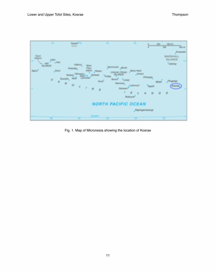
Fig. 1. Map of Micronesia showing the location of Kosrae
Lower and Upper Tofol Sites, Kosrae! Thompson
11

Changes in Sea Level and Coastal Deposition
Athens (1994, 1995) described several cores that had been taken around the island to assess environmental change based on palynological and geomorphological changes over time. If one concentrates on the cores with coral sands and gravels at their basal levels one will see a that the mainland of Kosrae has been growing over time as it changes from sandy lagoons to swampy mangrove environments. Fig. 2 shows the date ranges for the basal coral sands for those cores. Fig. 3 provides a visual timeline. One should notice two periods when those transformations were occurring. The first of these appears to be over a much longer time period of gradual change while the later period is much more concentrated. Athens postulates a lowering of sea-level from 1062-1362AD, termed the Pukusruk Te formation which shows that sea-levels did not fully stabilize until that time. It is likely that much of Kosrae’s flat arable land did not fully form until after this time. This environmental change would explain a movement of people towards the shore later on.
Previous work had focused on changes in sea-level predating this period specifically from 4100-600 BP (paludal study, Randall & Smith 1991; Fujimoto et al 1996). Athens work appears to be the first to identify changes within this more recent time period. Though it should be noted that Bath et al (1983) dated mangrove wood in subsurface deposits to 1025-1245AD at Leahp (site D2-1) which provides complimentary evidence that the mangroves formed there only at this time.
These changes in coastal deposition should mirror those seen on the outer atolls. Recent findings by Dickinson (2001, 2003, 2004) show that atolls for Micronesia rose relatively early and align with the early period of sea-level change shown in Fig. 3. The data on the later sea-level changes though has not been seen within the atolls of Micronesia though it corresponds to later atolls that arose further to the east such as Tokelau and the Tuamotus. Such large-scale environmental changes are difficult to assess but for the present study there appears to be acceptable evidence to suggest an environmental impact on cultures throughout the time periods.
Another researcher to write extensively on sea level changes within the Pacific over this time period is Nunn (1998, 2000) who proposes an additional sea-level rise between the two events of sea-level decline described above during a period termed the Little Climatic Optimum which precipitated a catastrophic event in resource depletion. The validity of this sea-level rise is still debated. The present data for Kosrae, while scant, is more representative of a steady sea-level decline that sped up from 1000-1400 AD which could have also accounted for resource depletion as shallower reefs would be warmed by the sun much more easily than changes in global sea-level temperatures. A sudden change would have more drastic effects and could account for the events Nunn describes without the such intense shifts.
Lower and Upper Tofol Sites, Kosrae! Thompson
12
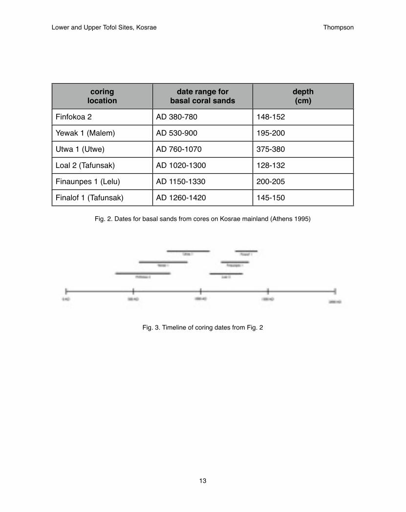
coring location
date range for basal coral sands
depth (cm)
Finfokoa 2 AD 380-780 148-152
Yewak 1 (Malem) AD 530-900 195-200
Utwa 1 (Utwe) AD 760-1070 375-380
Loal 2 (Tafunsak) AD 1020-1300 128-132
Finaunpes 1 (Lelu) AD 1150-1330 200-205
Finalof 1 (Tafunsak) AD 1260-1420 145-150
Fig. 2. Dates for basal sands from cores on Kosrae mainland (Athens 1995)
Fig. 3. Timeline of coring dates from Fig. 2
Lower and Upper Tofol Sites, Kosrae! Thompson
13
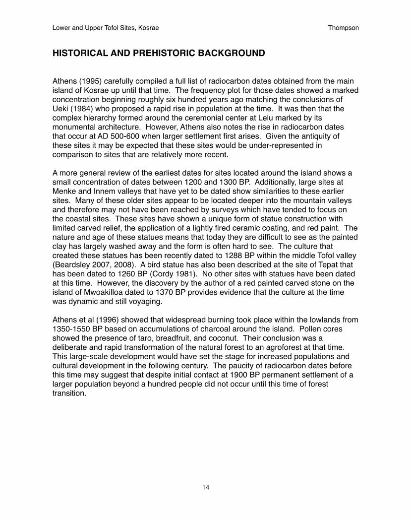
HISTORICAL AND PREHISTORIC BACKGROUND
Athens (1995) carefully compiled a full list of radiocarbon dates obtained from the main island of Kosrae up until that time. The frequency plot for those dates showed a marked concentration beginning roughly six hundred years ago matching the conclusions of Ueki (1984) who proposed a rapid rise in population at the time. It was then that the complex hierarchy formed around the ceremonial center at Lelu marked by its monumental architecture. However, Athens also notes the rise in radiocarbon dates that occur at AD 500-600 when larger settlement first arises. Given the antiquity of these sites it may be expected that these sites would be under-represented in comparison to sites that are relatively more recent.
A more general review of the earliest dates for sites located around the island shows a small concentration of dates between 1200 and 1300 BP. Additionally, large sites at Menke and Innem valleys that have yet to be dated show similarities to these earlier sites. Many of these older sites appear to be located deeper into the mountain valleys and therefore may not have been reached by surveys which have tended to focus on the coastal sites. These sites have shown a unique form of statue construction with limited carved relief, the application of a lightly fired ceramic coating, and red paint. The nature and age of these statues means that today they are difficult to see as the painted clay has largely washed away and the form is often hard to see. The culture that created these statues has been recently dated to 1288 BP within the middle Tofol valley (Beardsley 2007, 2008). A bird statue has also been described at the site of Tepat that has been dated to 1260 BP (Cordy 1981). No other sites with statues have been dated at this time. However, the discovery by the author of a red painted carved stone on the island of Mwoakilloa dated to 1370 BP provides evidence that the culture at the time was dynamic and still voyaging.
Athens et al (1996) showed that widespread burning took place within the lowlands from 1350-1550 BP based on accumulations of charcoal around the island. Pollen cores showed the presence of taro, breadfruit, and coconut. Their conclusion was a deliberate and rapid transformation of the natural forest to an agroforest at that time. This large-scale development would have set the stage for increased populations and cultural development in the following century. The paucity of radiocarbon dates before this time may suggest that despite initial contact at 1900 BP permanent settlement of a larger population beyond a hundred people did not occur until this time of forest transition.
Lower and Upper Tofol Sites, Kosrae! Thompson
14
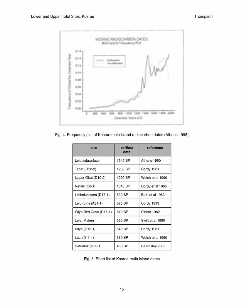
Fig. 4. Frequency plot of Kosrae main island radiocarbon dates (Athens 1995)
site earliest date
reference
Lelu subsurface 1940 BP Athens 1990
Tepat (D12-3) 1260 BP Cordy 1981
Upper Okat (D10-9) 1220 BP Welch et al 1990
Nefalil (C8-1) 1010 BP Cordy et al 1985
Likihnluhlwem (D17-1) 830 BP Bath et al 1983
Lelu ruins (A31-1) 620 BP Cordy 1993
Wiya Bird Cave (D16-1) 610 BP Sinoto 1982
Lela, Malem 560 BP Swift et al 1990
Wiya (D15-1) 548 BP Cordy 1981
Lacl (D11-1) 530 BP Welch et al 1990
Safonfok (D55-1) 450 BP Beardsley 2005
Fig. 5. Short list of Kosrae main island dates
Lower and Upper Tofol Sites, Kosrae! Thompson
15
The earliest recorded European expeditions to Kosrae were for the purposes of exploration and scientific observations: the Coquille captained by Louis Duperrey in 1824 and the Senyavin, captained by Fyedor Lütke from 1827-1828 (Ritter and Ritter 1982). Both voyages produced an accurate account of the island at the time. They estimated a population of roughly 3,000 people with at least half of these living on the small island of Lelu (Ritter 1981). Such a small population was found to be well below the carrying capacity of the island however (Athens 2007) which was likely to be at least 6,000 if not more.
The political hierarchy at that time was divided into four distinct social strata with a single paramount chief, tokosra, who was both the secular and sacred leader at the top. Beneath the paramount chief were ten high chiefs that he appointed, mostly consisting of his male relatives. The paramount chiefs and the high chiefs all lived in Lelu and administered their orders from there. These orders were then carried out by the forty to fifty low chiefs who were the land managers of the land units, or facl. Within these land units agricultural production was carried out by the commoners. Breadfruit was said to be the largest staple along with giant swamp taro (Cyrtosperma chamissonis), taro (Colocasia esulenta), bananas, yams (Dioscorea), coconuts, and sugarcane. A portion of these food crops were then given to the high chiefs of Lelu by the commoners as a tribute in exchange for rights to the land which was all owned by the high chiefs. In this way the high chiefs could live on Lelu island without having to produce any of their own food while maintaining a stronghold with which to maintain power. Athens (2007) notes a leveling of population based on the frequency plot of radiocarbon dates (see fig. 1) at 1425 AD. This date correlates with the construction of the Lelu ruins and the formation of the hierarchical system described above. It is believed that this hierarchical system acted to control population numbers.
The sites described in this report within the valley of Tofol represent at least one of those land unit, facl, where a low chief would oversee agricultural production in the lower valley where a swampland could be used to grow all of the plants described above.
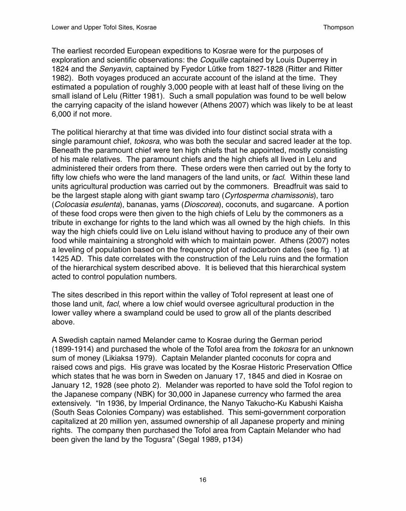
A Swedish captain named Melander came to Kosrae during the German period (1899-1914) and purchased the whole of the Tofol area from the tokosra for an unknown sum of money (Likiaksa 1979). Captain Melander planted coconuts for copra and raised cows and pigs. His grave was located by the Kosrae Historic Preservation Office which states that he was born in Sweden on January 17, 1845 and died in Kosrae on January 12, 1928 (see photo 2). Melander was reported to have sold the Tofol region to the Japanese company (NBK) for 30,000 in Japanese currency who farmed the area extensively. “In 1936, by Imperial Ordinance, the Nanyo Takucho-Ku Kabushi Kaisha (South Seas Colonies Company) was established. This semi-government corporation capitalized at 20 million yen, assumed ownership of all Japanese property and mining rights. The company then purchased the Tofol area from Captain Melander who had been given the land by the Togusra” (Segal 1989, p134)
Lower and Upper Tofol Sites, Kosrae! Thompson
16
photo 2. Captain Melander’s grave
Lower and Upper Tofol Sites, Kosrae! Thompson
17

The neighboring valley of Innem was also farmed extensively during the Japanese period by a Japanese company called Nantaku, particularly in the low flat land of the lower valley where the soil is rich and swampy. Cotton was tried at first but proved unsuccessful and it was later converted to sugar cane. Again, the harvest was unsuccessful and the valley was abandoned after five years (Cordy 1983).
Thus, one would expect extensive clearing performed at the lower flat areas of both valleys to have disturbed, if not completely destroyed any sites in the open flats. Nena Lonno who has worked throughout much of the duration of the Kosrae Historic Preservation Office reported that the main flat area of Tofol had been surveyed when it was clear and no sites had been found. This area was avoided within the present surveys so as not to repeat the same survey.
Likiaksa (1979) performed the earliest archaeological survey of the Tofol valley. That survey located 26 sites throughout the valley over the course of two weeks. However, the exact location of those sites is difficult to ascertain given that there was no GPS technology at the time and the survey was quickly performed. That survey was one of, if not the earliest, archaeological surveys performed by the Trust Territory government. While the survey proved useful in the later parts of the present project it was found that it did not meet the current standards set by the Department of Interior and did not include the necessary information to re-locate and register the sites. For this reason the present project was expanded to re-locate and register those sites within the guidelines set by the Department of the Interior.
Since the Likiaksa survey no work had been performed until that of Beardsley (2007) who concentrated on the middle of the valley in her attempt to locate the burial of Finkol Tokosra, a story from oral traditions that tells of an evil king that was assassinated by the village after he mistreated one of their women. Dr. Beardsley was successful in locating an area of dense stones that showed a pit feature within its soil profile that matched the description of the grave of Finkol Tokosra. Beardsley also located a statue-making workshop. Her work produced the first and only radiocarbon dates for the site showing a thousand year period of occupation from 650 to 1650 AD (see Fig. 6). It is still debatable whether these dates represent a continuous occupation or two distinct periods of occupation. Either way it should be expected that at least some cultural change should have taken place within the thousand years between the two time periods. Therefore part of the goal of the current project is to assess if differences in the structure of the sites may be representative of distinct time periods. Within the Finol Tokosra site two different types of structures were observed, a double-roomed enclosure and a single-roomed platform (see Fig. 7). This distinction would help to guide the interpretations of the sites found during this survey.
Lower and Upper Tofol Sites, Kosrae! Thompson
18

Fig. 6. Date ranges for Tofol Valley, site A11-32 (Beardsley 2007)
Fig. 7. Map of Finol Tokosra showing two types of structures (Beardsley 2007)
Lower and Upper Tofol Sites, Kosrae! Thompson
19
Structures from Neighboring Valley
The closest valley to Tofol, and therefore the best comparison for the nature of structures and settlement, is Innem valley where Cordy (1983) produced a rather complete description of the structures to be found. Within this report three structures showed the same double-roomed structure found at the Finol Tokosra site. Two of these three structures were located in their own region of the valley with another structure that was only partially complete and was unable to be fully mapped though it is possible that it too was of the same form. The third double-roomed structure was also found in its own area with small sleeping platforms of thick walls and a religious platform. These sites were more widely dispersed in an area deeper into the valley.
A distinction could be made between structures found in the other regions of the valley that showed thinner walls and a form more similar to the one-roomed three-sided structures also found at the Finol Tokosra site. These sites were more tightly clustered and closer to the coast. Changes in settlement pattern therefore suggest a transition from widely dispersed structures throughout the valley to tightly clustered sites nearer to the coast.
The form of the double-roomed compound may also be seen in its greatest prevalence in the valley of Menke (Beardsley 2012). It is from personal communication with Dr. Beardsley that the term compound has been used here as a means to distinguish it from the other structures. Elsewhere the term enclosure is used and may be used interchangeably. It is also this example which first led the auther to believe there was a greater focus towards the interior of the mountains at the time that these structures were being built. Menke is now in the process of being dated and we should learn its age soon. It is believed at this point to pre-date most of the sites in Kosrae and align with the 1300 year old dates based on the common characteristic of the red-painted ceramic-covered statue. Being so old it is difficult for any stories to survive that speak of the true nature of its culture. Even the stories that are told today of the goddess Sinlaku appear tinged with doubt as it was the Finkol settlement which has been dated to a more recent time that Safert (1919) claimed was the place where Sinlaku was worshipped instead of Menke. It is the belief of the author that Menke may pre-date even this great story. Regardless, the presence of double-roomed enclosures in Innem and Menke show that is is a widespread site type that should be given more attention.
Lower and Upper Tofol Sites, Kosrae! Thompson
20
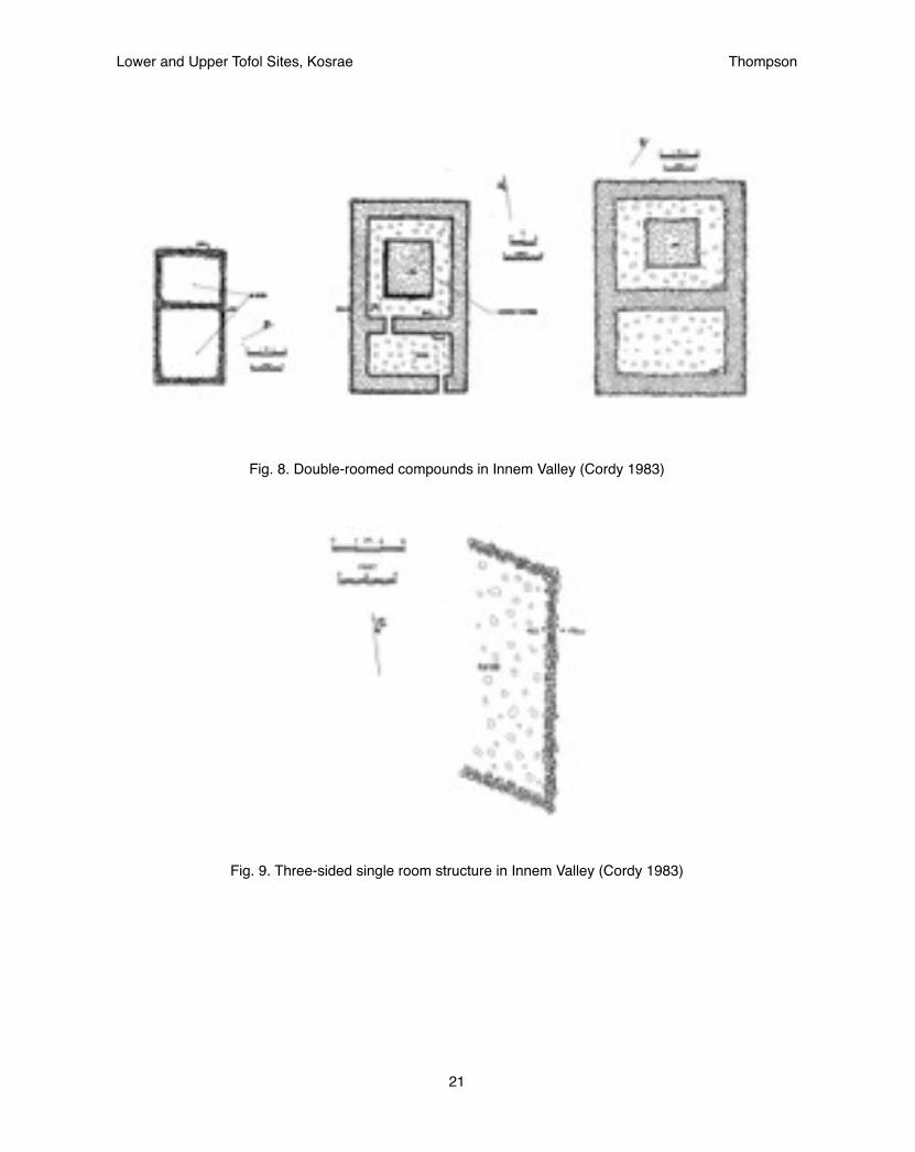
Fig. 8. Double-roomed compounds in Innem Valley (Cordy 1983)
Fig. 9. Three-sided single room structure in Innem Valley (Cordy 1983)
Lower and Upper Tofol Sites, Kosrae! Thompson
21

RESEARCH DESIGN
The purpose of this investigation was to locate sites in the upper and lower parts of the Tofol valley in order to assess potential changes in settlement pattern over the known thousand year prehistoric occupation. The presence of two distinct site types had presented themselves for the middle portion of the valley. This project was aimed at evaluating how these site types extended into the lower and upper areas. Specifically were there more examples of one type or the other within the lower versus upper valleys, which could elaborate on changes in settlement pattern over time.
This project related to the overall research goal for Kosrae in that it aimed towards better defining the prehistoric period which had previously been described as a uniform span of time covering 1800 years. Undoubtedly, much change occurred over this time including change described in the background material above. This project aimed to break that larger prehistoric period into small distinct periods with better defined site types, and strategic goals for each. This project therefore looked closely at the two site types seen within the Finol Tokosra site as well as any other site types that would present themselves within the findings of the survey.
This project follows a theory based on landscape archaeology that developed out of settlement pattern studies, which is founded on the principle that sites located across a landscape represent the cumulative histories of that landscape. Yet, sites representing distinct time periods and cultures may be found within a single landscape and these sites may still be distinguished based on shared characteristics that represent a common culture specific to a given time period. The theory behind this project begins with an acceptance that unique site structures are more likely to represent a distinct cultures from different time periods than to represent differences within a single settlement at a common timeframe. In other words greater change occurs over the course of a hundreds of years than it does over the course of a single year.
Within this framework, this project begins with the belief that double-roomed compounds originate from an early time period than single-room platforms based on the background research described above and hypothesizes that a shift occurred from upland settlement early on to a more coastal settlement later. If this hypothesis were true one would expect more single-room platforms to be found at the lower areas than in the upper areas.
Our research strategy therefore aims to give equal survey coverage to the upper and lower areas and assess the presence of the two site types while looking for additional site types that could further elucidate cultural changes over time.
This project could be further strengthened by radiocarbon dating the structures identified in the survey.
Lower and Upper Tofol Sites, Kosrae! Thompson
22

photo 3. The first corner to be discovered at the Lower Tofol habitation site
METHODS
The project began from a small corner of a site that had been found by Nena Lonno long ago and still remained in his memory. Much of the site could not be seen beneath the remains of a massive eucalyptus tree which had fallen on it with broken branches scattered everywhere. Survey was undertaken throughout the low swamplands bordering the mountains. It is in this micro-environment that sites had been found in other regions such as Lacl (Welch et al 1990) and had been described for the Tofol valley specifically (Likiaksa 1979). The thick vegetation made the location of sites difficult. When found they appeared only as a small alignment of stones, but when clearing started, opened up into a much larger area. Photo 3 shows the clearance of the Lower Tofol ceremonial site in process. The thick vegetation in the background covered the entirety of the site. When it was found it was believed that it was only a small platform, but instead, turned out to much more impressive.
Once cleared the sites were mapped using tape measures and graph paper. Each stone was drawn as it lay in the earth. Afterwards the shape was interpreted from what was drawn and outlined on the paper. Photographs were taken as well.
Particular attention was given to any stones that lay within the structure to try to determine its potential function. A minimal amount of excavation was performed to reveal more stones beneath the upper 10 centimeters of topsoil. In some cases this revealed clues to the status and nature of the structure but in other cases it still remained uncertain.
Lower and Upper Tofol Sites, Kosrae! Thompson
23

Initially, the project was intended to focus intensively on 2-4 sites and was expected to utilize special projects funds from the National Park Service to analyze radiocarbon dates from those sites to definitively test the hypothesis that the distinct style of site construction could be applied to different time periods. It became clear relatively late in the project that these funds would not be acquired. Initially, it was also planned that greater focus would be given to the Yela conservation easement reconnaissance survey. However, as the Yela Environment Landowners Authority had yet to complete the necessary contracts to establish the conservation easement it was determined to be prudent to limit the survey to a few representative sites until the agreements were settled so as not to disrupt the process. The Yela valley was also found to be difficult terrain in which to work.
Therefore, it was decided to return to the Tofol valley to perform additional reconnaissance survey to locate additional sites. This survey was prompted by reports by the Department of Forestry that they had seen sites in the upper portions of the valley that we had yet to survey. The Kosrae Historic Preservation Office (HPO) accompanied Forestry during their trip into the upper Tofol valley to plant trees along the rivers floodplain. At the very end of their transect a large complex was found half a kilometer from the end of the road through thick vegetation which could only be located with their assistance.
At the culmination of the project it was realized that many of the sites while located by the previous surveys had never been fully documented or registered. An effort was made to perform additional surveys throughout the majority of the valley. Ultimately one kilometer of the valley was surveyed focusing on the natural areas left intact and free of development where the most undisturbed sites would be located. It was realized that many of the sites had been located in the past but the poor quality of the previous survey performed over thirty years before required additional work to acquire the necessary information in order to complete site registration forms. Efforts were made to incorporate previous site designations so as to reduce the amount of confusion between the studies and the sites were registered according to the current process of registering historic sites with the Kosrae Island Resource Management Authority (KIRMA) review board.
In truth, these were the first sites to be officially registered to the State Registry. All previous work had been limited to the production of a site inventory with the completion of site forms being the end product. The absence of a state registry initially led to some confusion as State registration forms needed to be created for Kosrae for the first time. These form were modeled after those used by Guam and it is hoped will satisfy the requirements of the Department of Interior.
Lower and Upper Tofol Sites, Kosrae! Thompson
24

photo 4. Clearance of Lower Tofol ceremonial site at midway point
Lower and Upper Tofol Sites, Kosrae! Thompson
25
FINDINGS
Four sites were found in the initial survey work in March. Three were located in the lower Tofol valley below the Finol Tokosra site. These three were located in close proximity to each other within an area called the Lower Tofol complex. One site was found in the Upper Tofol valley above the Finol Tokosra site. In this way the sites located in this survey extend the overall boundary of the habitation of the Tofol valley and add to the overall understanding of the changes in settlement pattern. Though the results of Likiaksa (1979) continued to suggest the habitation of the valley extended even further.
Of these sites two, one in the Lower Tofol complex and the Upper Tofol site exhibited a two-roomed four-sided shape. The other two sites within the Lower Tofol complex exhibit a three-sided single room shape with the fourth open side bounded by the ridge-line.
As the Kosrae HPO prepared to submit the sites studied thus far for registration there was a push to register more sites within the valley. The previous survey projects were reviewed once again, specifically Likiaksa (1979). Initially, the hand-drawn maps within the report (see Fig. 18) were found to be very confusing but after the intensive survey of the Lower Tofol complex it became clear that this area was Area 7 from the previous report. This led to the identification of an additional site, the Lower Tofol hilltop enclosure A11-13.
This was followed by additional surveys in the middle and upper portions of the valley. A site was located and found to be A11-27 which was described by Beardsley (2007) but given only limited attention. Additional information was necessary in order to complete site registration forms. Most exciting was the location of a large complex deep in the upper valley which was discovered by the Department of Forestry. This complex was mapped and recorded as well.
Initially, from the small sample size it was believed that the original hypothesis was true that a shift had occurred from a settlement evenly dispersed throughout the valley to a more coastal settlement. However, with the additional discovery of the upland complex that was believed to derive from a later time the hypothesis became less clear and it appeared that an overall larger population in the later time period could account for increased settlement throughout the valley including the upper and lower areas. The upper Tofol complex is, however, believed to be a defensive location following the assassination of the tokosra and the ensuing conflict that would result. Therefore it is unclear whether the settlement patterns within Tofol valley will be true elsewhere.
See below for a more detailed description of the sites and the ultimate conclusions...
Lower and Upper Tofol Sites, Kosrae! Thompson
26

Fig. 10. Site map of areas surveyed in Tofol in the late 1970s (Likiaksa 1979)
Fig. 11. Map of Tofol Historic sites registered within this report
Lower and Upper Tofol Sites, Kosrae! Thompson
27

photo 5. Lower Tofol double-roomed compound
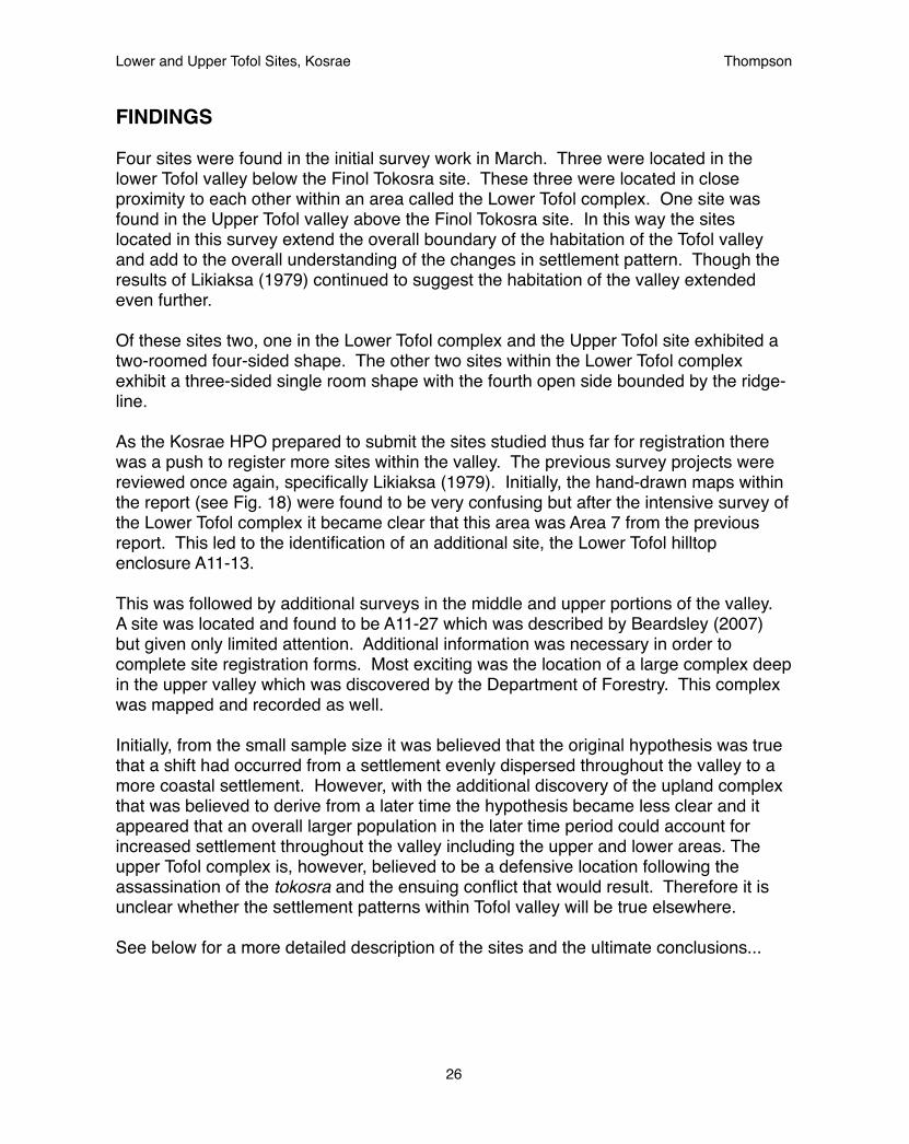
Lower Tofol double-roomed compound
Site Number: A11-12Location: N 05°19’23.8”, E 163°00’30.0”Elevation: 18 metersArea: 16 x 11 meters, 176 m2
Major Features
Brief Description:
This site was a four-sided double-roomed structure. The larger of the rooms had a well-defined wall, while the smaller room had a smaller wall. Stones were found within the center of the large room, however, they did not indicate any structure. A depression was also found within the large room. Some stones appear to indicate that the room would be entered from the center of the north side through the small room with steps leading over the center of the middle wall. This is typical of structures seen at the site of Menke.
Lower and Upper Tofol Sites, Kosrae! Thompson
28
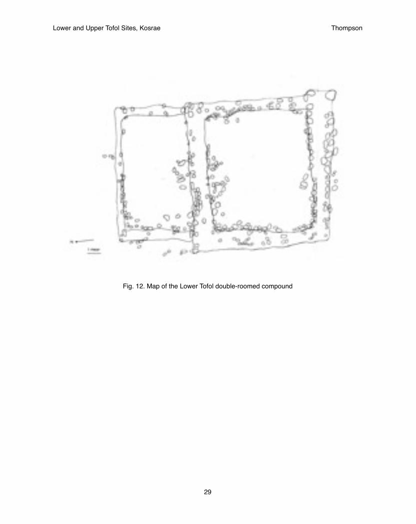
Fig. 12. Map of the Lower Tofol double-roomed compound
Lower and Upper Tofol Sites, Kosrae! Thompson
29
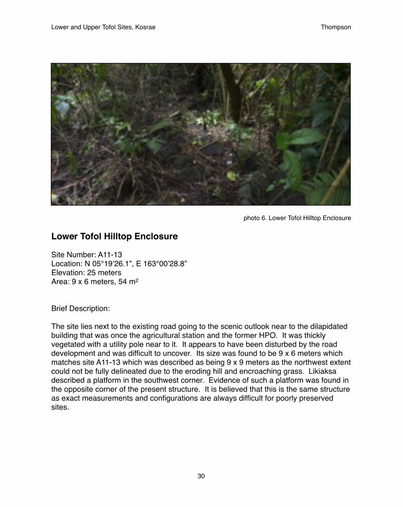
photo 6. Lower Tofol Hilltop Enclosure
Lower Tofol Hilltop Enclosure
Site Number: A11-13Location: N 05°19’26.1”, E 163°00’28.8”Elevation: 25 metersArea: 9 x 6 meters, 54 m2
Brief Description:
The site lies next to the existing road going to the scenic outlook near to the dilapidated building that was once the agricultural station and the former HPO. It was thickly vegetated with a utility pole near to it. It appears to have been disturbed by the road development and was difficult to uncover. Its size was found to be 9 x 6 meters which matches site A11-13 which was described as being 9 x 9 meters as the northwest extent could not be fully delineated due to the eroding hill and encroaching grass. Likiaksa described a platform in the southwest corner. Evidence of such a platform was found in the opposite corner of the present structure. It is believed that this is the same structure as exact measurements and configurations are always difficult for poorly preserved sites.
Lower and Upper Tofol Sites, Kosrae! Thompson
30

Fig. 13. Map of the Lower Tofol enclosure
Lower and Upper Tofol Sites, Kosrae! Thompson
31
photo 7. Lower Tofol habitation site
Lower Tofol Habitation site
Site Number: A11-15Location: N 05°19’23.1”, E 163°00’32.1”Elevation: 20 metersArea: 19 x 10 meters, 190 m2
Brief Description:
This was the largest structure, yet it was also the least elaborate. A simple wall averaging three stones high, or roughly 0.5 meter formed a terrace platform on three-sides with the open side facing the mountain ridge. There were no stones found in the center of the platform. It is believed that this was a large area for the habitation of an extended family. A possible entrance may be seen on the west side of the structure. This side faces the path leading to the other structures within the area and would make sense.
Lower and Upper Tofol Sites, Kosrae! Thompson
32
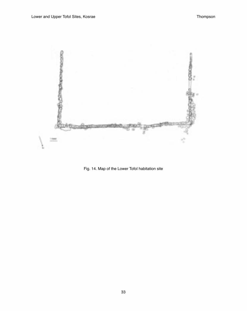
Fig. 14. Map of the Lower Tofol habitation site
Lower and Upper Tofol Sites, Kosrae! Thompson
33

photo 8. Lower Tofol ceremonial site
Lower Tofol Ceremonial site
Site Number: A11-16Location: N 05°19’25.0”, E 163°00’30.5”Elevation: 20 metersArea: 16.5 x 11 meters, 181.5 m2
Brief Description:
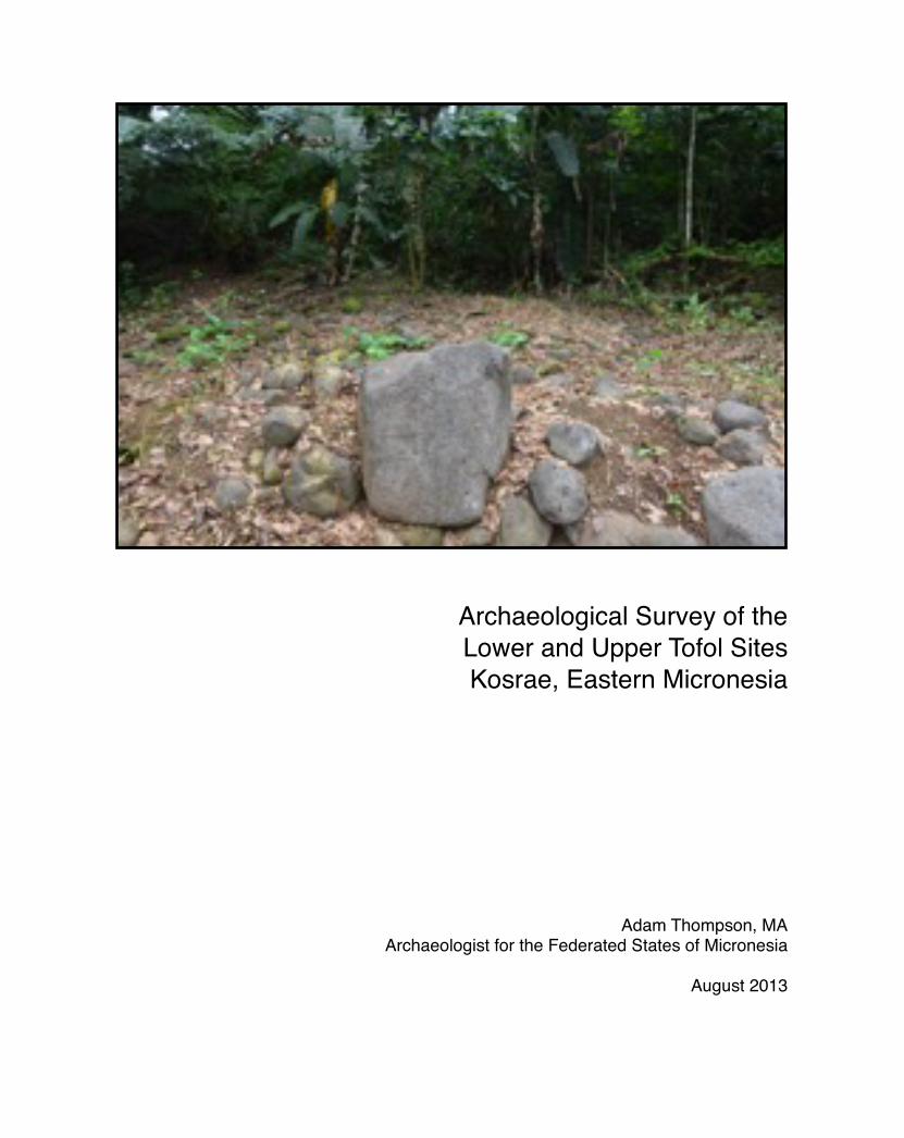
This three-sided structure was raised considerably higher than all the other structures in this survey, averaging 2-2.5 meters. The south-east corner was well-intact and showed the original design while the opposite south-west corner was considerably deflated. Several grinding stones were found at the site as well as a small basalt bowl. At the center of the structure a small platform was raised above the rest of the surface. Minor excavation of the surface was conducted to better observe the stones. It was found that six layers of stone formed multiple steps up to a small platform. It is believed that this central platform was an altar and the site would have been used for ceremonial purposes including the consumption of seka (Piper methysticum) based on the presence of the grinding stones. The basalt bowl may have been used to serve seka. A raised stone within the wall opposite of the central platform also appears to possibly be a seat facing the altar.
Lower and Upper Tofol Sites, Kosrae! Thompson
34
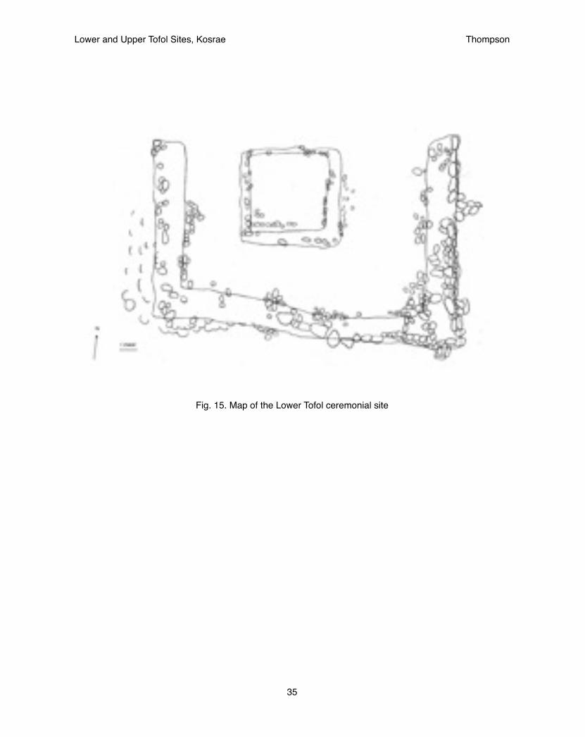
Fig. 15. Map of the Lower Tofol ceremonial site
Lower and Upper Tofol Sites, Kosrae! Thompson
35

Central platform of A11-16
After clearing of the upper layer of topsoil, the central altar of the lower tofol ceremonial site was found to have several layers of stone steps leading to the top. These multiple levels of steps would represent a special status to the person or object who sat upon the upper platform. For this reason the central platform may be seen as an altar. It is unclear whether a chiefly or priestly personage would sit upon the altar if it was intended for some spirit to be worshipped. Opposite the altar a raised stone different from the rest sat upon which a curved surface provided an ideal seat for facing the altar. It was next to this seat that a basalt vessel and grinding stone (described in the next section) was found.
“After the month of feasting and festivity, the king would go into seclusion in a special compound in Lelu...While the king was in seclusion there was priestly activity dedicated to Sinlaku. Priests from her village in Utwe on the south side walked all the way to Tofol, blowing the trumpet shell. Then they proceeded by canoe into the canal at Lelu. They carried a special kind of spear and knots of coconut leaflets, necklaces, a basket with certain kinds of shells in it and bleached taro leaves. When they arrived in Lelu, seka was pounded and ceremoniously served. The bleached taro leaves were torn into strips and tied around the king’s and queen’s wrists while the priests chanted and held the hands of the Togusra and his wife” (Segal 1989, 29)
The quotation above describes a procession from sites in Utwe, possibly those found at Menke and/or Finkol valleys that made their way to Tofol and then to Lelu. Given the elaborate nature of the central altar at the Lower Tofol ceremonial site, the profusion of pounding stones, the basalt vessel, and the presence of red-painted stones that were likely statues marking the entrance to the site (see section below), it is believed that this structure may have played an important role in that procession. It would have provided a place where the priests could have re-arranged their gifts prior to moving on to the canoes that would have taken them to Lelu. Other rituals may have also taken place but we can only guess at those today.
It was discovered as an expected, yet positive, outcome of the clearing of the topsoil that the vegetation did not grow back so plentifully and could be more easily managed. This outcome is likely due to the removal of large roots especially of ginger plants that were most prevalent and the poor quality of the underlying clay. It is recommended that future projects perform this same method, stripping the topsoil to reveal, but not disturb, the underlying stones while at the same time removing roots and soil nutrients to prevent pioneering plant species from covering the site again.
Lower and Upper Tofol Sites, Kosrae! Thompson
36
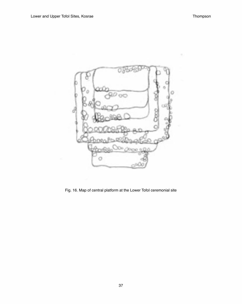
Fig. 16. Map of central platform at the Lower Tofol ceremonial site
Lower and Upper Tofol Sites, Kosrae! Thompson
37

Artifacts found at A11-16
Perhaps the most interesting single artifact to be found during the project was a broken fraction of a basalt cup. At first it was difficult to be sure it was not a highly-fired piece of pottery with calcareous inclusions as it was hard to imagine such a finely carved vessel to be able to be produced. However, Standon Andrews remembered that a large basalt bowl had been found by the Nedlic family in Koarom, Malem many years ago, which had been photographed at the time. After examining the texture of the vessel more closely it was clearly made of basalt though its color and texture was quite different from the surrounding stones used within the structure. It seems likely that it was produced at a separate site.
In addition several grinding stones were found at different sites. Three were seen at the ceremonial complex at the Lower Tofol site where the basalt vessel was found. Another was found at the habitation site. None were seen at the double-roomed structures. These grinding stones were believed to have been used for the pounding of seka (Piper methysticum). The basalt vessel is also believed to have been used for drinking seka as it lay next to a grinding stone and a large stone facing the central altar that appeared to be a seat. The close association of grinding stones with the single-roomed structures which are believed to have come later would suggest that seka was only used later in prehistory.
Also a couple stones of unusual shape were found that were covered in red-painted clay (see back cover). Stones of this nature were found in the middle of the valley as well (Beardsley 2007). Both of these stones lay at the bottom of the platform and appeared to be in secondary context. Whether they belong to an early culture and had been disturbed by later arrivals as is believed for the platform of the Lower Tofol double-roomed compound or have only recently moved is difficult to determine.
Lower and Upper Tofol Sites, Kosrae! Thompson
38

photo 9. basalt vessel found at Lower Tofol ceremonial site
photo 10. Large basalt bowl from Koarom, Malem
Lower and Upper Tofol Sites, Kosrae! Thompson
39
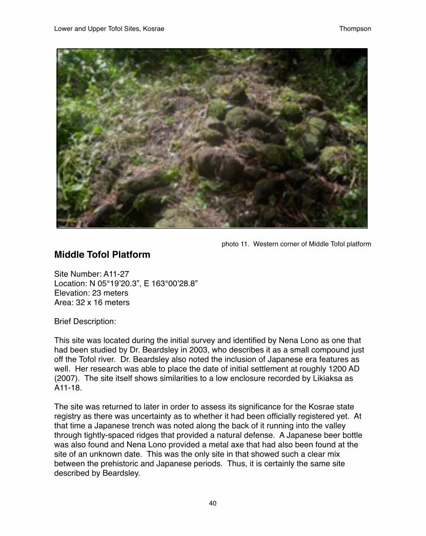
photo 11. Western corner of Middle Tofol platformMiddle Tofol Platform
Site Number: A11-27 Location: N 05°19’20.3”, E 163°00’28.8”Elevation: 23 metersArea: 32 x 16 meters
Brief Description:
This site was located during the initial survey and identified by Nena Lono as one that had been studied by Dr. Beardsley in 2003, who describes it as a small compound just off the Tofol river. Dr. Beardsley also noted the inclusion of Japanese era features as well. Her research was able to place the date of initial settlement at roughly 1200 AD (2007). The site itself shows similarities to a low enclosure recorded by Likiaksa as A11-18.
The site was returned to later in order to assess its significance for the Kosrae state registry as there was uncertainty as to whether it had been officially registered yet. At that time a Japanese trench was noted along the back of it running into the valley through tightly-spaced ridges that provided a natural defense. A Japanese beer bottle was also found and Nena Lono provided a metal axe that had also been found at the site of an unknown date. This was the only site in that showed such a clear mix between the prehistoric and Japanese periods. Thus, it is certainly the same site described by Beardsley.
Lower and Upper Tofol Sites, Kosrae! Thompson
40
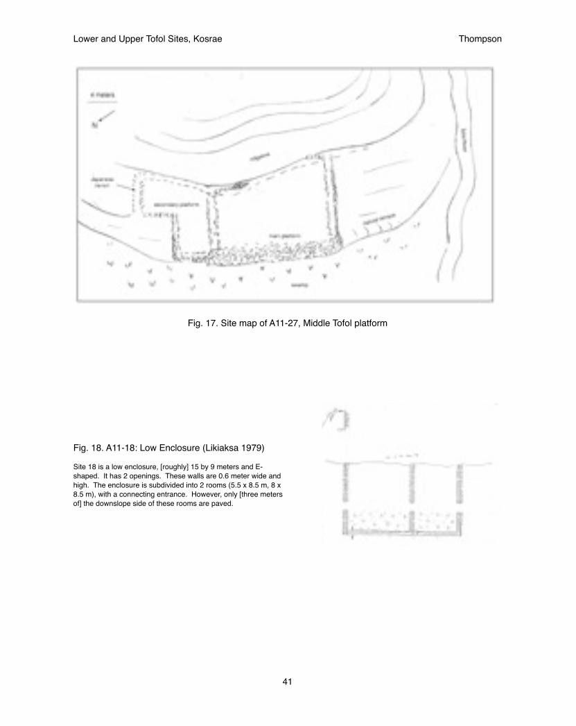
Fig. 17. Site map of A11-27, Middle Tofol platform
Fig. 18. A11-18: Low Enclosure (Likiaksa 1979)
Site 18 is a low enclosure, [roughly] 15 by 9 meters and E-shaped. It has 2 openings. These walls are 0.6 meter wide and high. The enclosure is subdivided into 2 rooms (5.5 x 8.5 m, 8 x 8.5 m), with a connecting entrance. However, only [three meters of] the downslope side of these rooms are paved.
Lower and Upper Tofol Sites, Kosrae! Thompson
41
In comparing the site to those described by Likiaksa one appeared to resemble a common form but did not match well on the map. Therefore it was believed to be a different site of a common site structure. This style of structure appeared to be a double-roomed platform that represented an intermediate form between the two described in the previous intensive survey. The date of the site at 1200 AD places it in between the periods assigned for the other two site types.
Dr. Beardsley described the site further. “More importantly, however this small compound appeared to be part of a larger array of sites within the drainage. A paved stone pathway running parallel to the river connected this site to others farther upstream, indicating in very concrete and physical features the presence of a linked network of settlements within the drainage.” (2007:32)
The Japanese trenches and prehistoric sites were found to continue into the valley. A piece of white ceramic was also found. However, some of the prehistoric features appeared to have been effected by natural erosion likely caused by the geographical bottleneck. Nevertheless, the density of the features is worth noting and continues further up the middle of the valley to site A11-32 which Beardsley describes in great detail (2007). The difference between the Lower Tofol sites and the denser habitation in this middle section of the valley may be attributed to the farming activities that occurred lower in the valley during the Japanese and Trust Territory time periods. Yet, it also appears to represent two distinct patterns of settlement: a widespread settlement in the Lower valley during times of peace associated with ceremonial processions from Utwe to Lelu Island, and dense settlements within the protected part of the valley associated with stories that describe conflict between the people of the valley and the high chiefs that lived within the Lelu ruins. These stories included a description of the Upper Tofol complex as another place of refuge deep in the mountains to escape from the wrath of the high chiefs.
Lower and Upper Tofol Sites, Kosrae! Thompson
42

Fig. 19. Features continuing from A11-27
photo 12. Japanese artifacts found at A11-27
Lower and Upper Tofol Sites, Kosrae! Thompson
43
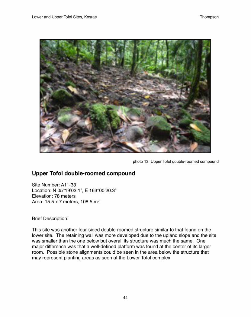
photo 13. Upper Tofol double-roomed compound
Upper Tofol double-roomed compound
Site Number: A11-33Location: N 05°19’03.1”, E 163°00’20.3”Elevation: 78 metersArea: 15.5 x 7 meters, 108.5 m2
Brief Description:
This site was another four-sided double-roomed structure similar to that found on the lower site. The retaining wall was more developed due to the upland slope and the site was smaller than the one below but overall its structure was much the same. One major difference was that a well-defined platform was found at the center of its larger room. Possible stone alignments could be seen in the area below the structure that may represent planting areas as seen at the Lower Tofol complex.
Lower and Upper Tofol Sites, Kosrae! Thompson
44
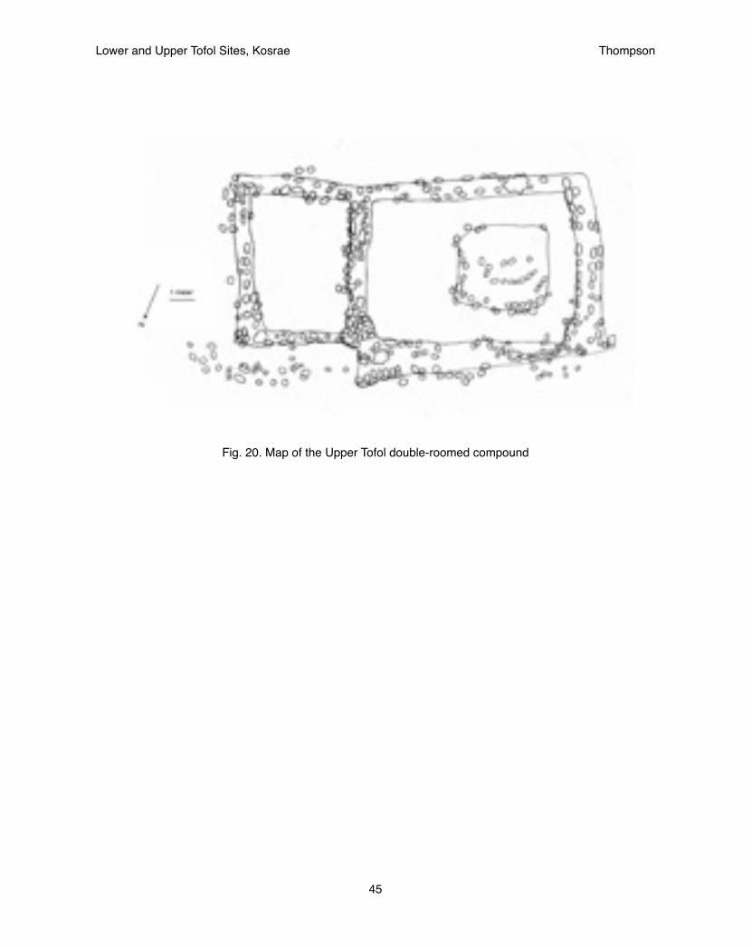
Fig. 20. Map of the Upper Tofol double-roomed compound
Lower and Upper Tofol Sites, Kosrae! Thompson
45

photo 14. Tomb at Upper Tofol complex
Upper Tofol Complex
Site Number: A11-34Location: N 05°18’53”, E 163°00’18”Elevation: 88 metersArea: 60 x 100 meters
Brief Description:
This site was located alongside the assistance of the Department of Forestry who were planting trees within the upland stream bed. Initially three structures were located and mapped however it was found that the site continued deep into the uplands with a dense concentration of features. While there was not enough time within the present project to fully outline the boundary of the site, the Kosrae HPO will continue to outline the boundary of these features in the future.
The features were dominated by large terraces meant to order the steep terrain and four-sided single room structures. This represented a new style that had not been seen before but for which examples could be found in Likiaksa. Oral history suggests that this area may have been used as a refuge from conflicts between the people of the valley and the high chiefs, which likely occurred following the assassination of Finol Tokosra.
Lower and Upper Tofol Sites, Kosrae! Thompson
46

Fig. 21. Site map of A11-34, Upper Tofol Complex
Fig. 22. A11-7: Enclosure with Platform (Likiaksa 1979)
This site overlooks the stream flat of area 3. It is 15 by 13 meters, and its walls are 1.2 meters wide and 1.5 meters high. It[s] opening is 1 meter wide. In the northwest corner of the enclosure is a free-standing platform (0.3 m high). It has a square shape, 3.5 x 3.5 meters. No surface artifacts were seen on the surace of the site. Also, the floor of the enclosure was not paved.
Lower and Upper Tofol Sites, Kosrae! Thompson
47
CONCLUSIONS
EvaluationThis project benefitted from being flexible. Initially, it was expected to be smaller in scope with an intense focus on sites within the confined Lower Tofol area. It later developed into a large-scale survey more fitting of the landscape archaeology model it intended to follow. During this transition the answers to the research questions changed showing that a larger sample size of a wider area is needed to accurately access the nature of valley settlement.
The initial conclusions of the intensive survey of the more limited sample size were of a well-defined difference in site structure that correlated with two distinct periods. The subsequent reconnaissance survey, however, revealed additional site types and a more complex history. Future projects should therefore focus on reconnaissance surveys that are capable of identifying enough sites to produce a large sample of site types to fully represent the entire valley.
The previous reconnaissance survey (Likiaksa 1979), theoretically, should have provided a wide enough survey to allow for a more intensive survey to be performed. However, the inadequacy of the 34 year old data was clear in its hand-drawn reports when compared to the USGS map which is the standard at present (see Figs p27). Therefore, this study exemplifies the need to upgrade previous reconnaissance surveys to the present standard before attempting more costly intensive surveys.
Further, confusion occurred over the funding of the project. It was believed that a large amount of funding was available for a variety of purposes with which radiocarbon dates should be able to be easily funded. It was only late in the project that this was found to not be true. The unavailability of these funds is not a problem, however. It means only that there should be a greater focus towards reconnaissance surveys which in the end will locate more sites to be registered and provide a wider look at the valley context.
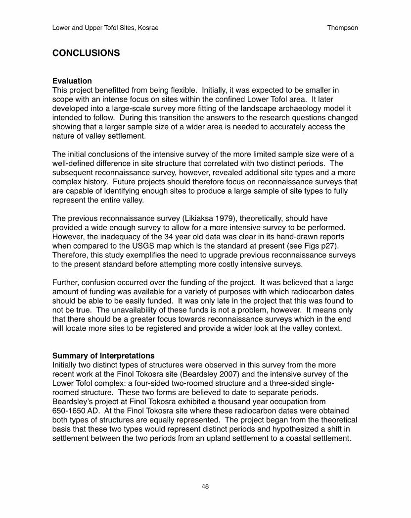
Summary of InterpretationsInitially two distinct types of structures were observed in this survey from the more recent work at the Finol Tokosra site (Beardsley 2007) and the intensive survey of the Lower Tofol complex: a four-sided two-roomed structure and a three-sided single-roomed structure. These two forms are believed to date to separate periods. Beardsley’s project at Finol Tokosra exhibited a thousand year occupation from 650-1650 AD. At the Finol Tokosra site where these radiocarbon dates were obtained both types of structures are equally represented. The project began from the theoretical basis that these two types would represent distinct periods and hypothesized a shift in settlement between the two periods from an upland settlement to a coastal settlement.
Lower and Upper Tofol Sites, Kosrae! Thompson
48
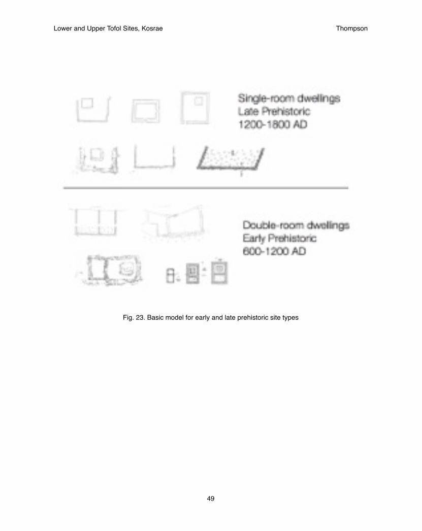
Fig. 23. Basic model for early and late prehistoric site types
Lower and Upper Tofol Sites, Kosrae! Thompson
49

The four-sided, two-roomed structures are also seen at the site of Menke which has yet to be dated but shows a shared characteristic of red-painted, clay-encased, stone statue that is also seen in Tofol as well as at Tepat and on the island of Mwokil. These sites have all been dated to 1260 BP and 1370 BP respectively. Accordingly it is believed that the four-sided, two-roomed structure and the red-painted, clay-encased stone statues are both characteristic of this early period.
Within the early part of the survey this more ancient style of structure was found at both the upper and lower reaches of the Tofol valley, suggesting a wider settlement pattern at this early time with fewer structures spread across the region.
In contrast, the three-sided, one-roomed structure was found to be more concentrated within the Lower Tofol region within a close proximity to a single older double-roomed compound. This arrangement suggested a later settlement pattern more focused on the lower coastal flats.
The late sea-level decline documented by Athens (1995) which led to the accumulation of greater lowlands would provide an environmental cause for this change in settlement pattern. Further it is possible that this change from 1062-1362 AD could also explain a lack of dates within the period representing a lowered population as the changing sea-levels may have effected reefs leading to a lowered resource base. Nevertheless the environmental history for this time is still yet to be fully understood.
However, an alternative theory presented itself later in the project, that an overall higher population occurred during the later period and that the survey suffered from a under-represented sample in the uplands. The subsequent reconnaissance survey to locate additional sites for registration revealed additional sites throughout the valley believed to be from the later time period as well.
Within the late period upland sites, at least two more types of structures were seen in the Upper Tofol complex (A11-34) and at the Middle Tofol platform (A11-27). The second of these, the Middle Tofol platform (A11-27) appears to represent an intermediate stage between the two structures types identified before. This site was dated to 1200 AD (Beardsley 2007) and fits nicely within the proposed timeframe.
Also of interest at site A11-27 is the mix of features clearly associated with the Japanese period and the prehistoric time. While prehistoric features may be found throughout the entirety of the valley it is interesting that Japanese period features are only found here in association with the World War II build-up. Beardsley (2007) noted that this particular part of the valley was characterized by a “bottleneck” where the mountain ridge comes close together with only a narrow stream bed of flat land to enter through. In this way the geography creates a natural defense that was utilized by the Japanese and prehistoric settlement alike.
Lower and Upper Tofol Sites, Kosrae! Thompson
50
Fig. 24. location of early (blue triangle) and late (yellow circle)prehistoric site types
Lower and Upper Tofol Sites, Kosrae! Thompson
51

Perhaps then the construction of the transitional style structures there can be associated with a time period of conflict. This would then be followed by a time of peace associated with the Lower Tofol ceremonial site in the later style of single-room platform. This period could then be followed by a movement into the more defensive outpost of the Upper Tofol complex. Stories told by elders have suggested that the movement deep into the valleys were defensive and the story of Finol Tokosra, the high chief who was assassinated, tells of great conflict. The history that is revealed is then on of peaceful relations marked by widespread settlement particularly into the Lower areas, and times of conflict marked by dense settlement within naturally defensive locations. While these conclusion are only tentative they provide a basis for research questions for future projects in neighboring valleys which would be expected to be similarly effected by the island-wide politics.
Regardless, the discovery of these additional sites supports the alternative conclusion that the later time period was accompanied by population gains that led to increased settlement throughout the entire valley not just the lowlands. This would suggest that results from surveys performed thus far suggesting the movement of people to the coast may be representative of a biased sample and that further studies in the uplands will reveal additional late periods sites there as well. Additional landscape archaeology studies are needed of wider valleys, however, to further assess whether these conclusions are island-wide or specific to the Tofol valley.
RegistrationThere is a long-standing debate amongst archaeologist as to whether historic structures lying close together should be lumped together as features of a single site or should be split into multiple sites within a given area. This is the debate of the lumpers and the splitters. This debate also occurred for the registration of the sites located within this survey, particularly the Lower Tofol complex. Initially, it was decided to lump the sites together into a common site as at one point in time they would have represented a common community. However, this decision was changed for several reasons. Firstly, it was found that the sites had been numbered 34 years ago and to change them would create added confusion. Secondly, it was found that each structure may have its own history. That one structure could have been built well before the others and incorporated into the group later as is believed to have occurred in Lower Tofol and elsewhere, specifically Nefalil (Cordy et al 1985). Thirdly, due to the heavy vegetation it is possible that structures within a group may be overlooked. Labeling them as individual sites allows newly discovered sites to be more easily incorporated.
Likiaksa was a splitter. Every feature whether it was an agricultural terrace or a habitation structure was given a distinct site number. Beardsley was a lumper. Sites are labeled according to villages that are composed of associated features. For the purposes of registration the numbering has tried to follow what’s been done in the past. The sites initially located by Likiaksa, A11-12, A11-15, A11-16 represent individual platforms and compounds. Those sites initially described by Beardsley, A11-27 &
Lower and Upper Tofol Sites, Kosrae! Thompson
52

A11-32, include larger areas. This difference also reflects the greater density of features in the Middle Tofol sites as compared to the Lower Tofol sites as well. Sites A11-33 & A11-34, which have been located by the present survey incorporate both strategies. A11-33 lies fairly on its own with no significant features around it. However A11-34 represents a dense complex with a boundary that is still being fully defined. Since the uplands are some of the least explored areas on the island this may prove to be a pattern.
Site forms are included in the appendix of this report. The sites were presented to the Kosrae Island Resource Management Authority (KIRMA) Board who approved the registration of the sites including sites A11-12, A11-15, A11-16, A11-27, A11-32, A11-33, A11-34. This represents a sites known at present throughout the entire Tofol valley which satisfactorily represents the different settlement zones for the Lower, Middle, and Upper Tofol valleys. It is hoped that this coverage extending throughout the entire valley will set the example for valley-wide surveys in the near future in Okat and Innem.
All of these sites fulfill criteria D on the National Register nomination form for the US Department of Interior in that they yield information on the prehistory of Kosrae, specifically the settlement of Tofol valley. Sites A11-12, A11-16, A11-27, A11-33 fulfill criteria C in that they embody a site type and a particularly style of construction particular to different time periods. A11-32 the Finol Tokosra site fulfills criteria A that is associated with a particular event in Kosrae history.
Additional investigationWork will continue at the Upper Tofol complex to further map the boundary of the site as it extends deeper into the valley. The Department of Forestry has reported the presence of historic sites within its transects in the Okat Valley as well and plans are made to survey within Okat and Innem valleys. These surveys will be modeled after the present study. Both valleys have had surveys performed in the past (Welch et al 1990; Cordy 1983). Like the present project, sites located in the past may be re-located and new sites discovered. In this way it is hoped that the historic sites of the island may be registered one valley at a time, allowing settlement patterns of each to be compared.
Across the Federated States of Micronesia, in Yap, Pohnpei, and Kosrae, the prehistoric period has been viewed as a single static historic context covering two to three thousand years. In comparison, the last two hundred years of history is divided into small periods of a few decades based on the influence of different foreign groups. This discrepancy leads to the indigenous culture being greatly overlooked in favor of Western cultures. This project has attempted to give greater detail to the ancient culture by dividing it into different periods based on archaeology and oral history. For now this report proposes a basic heuristic model that double-room dwellings represent the early prehistoric while single-room dwellings represent the late prehistoric (see Fig. 27). This model will provide guidance for future studies while still providing a testable theory to be refined as more data is acquired. (For a more complete description of the historic contexts of Kosrae see appendix B)
Lower and Upper Tofol Sites, Kosrae! Thompson
53

Attempts have been made to include many photographs, maps, and diagrams into this report to make it more intelligible to the local community and the scientific community alike. It is the authors experience that both groups depend highly on visual representations more than lengthy descriptions. Given the prevalence of computers and internet at the time of its creation it is also deemed to be more cost-effective to disseminate the report via CD, flash drive, and facebook than to create a large number of paper copies. The down-side is that such reports may suffer from being seen as not fulfilling completely the professional standard set by archaeologists of a highly-progressed academic track. However, it is deemed more important to share history with the 99.9% of people who have not achieved such a standard of learning, which includes those of Micronesia and the rest of the world.
Lower and Upper Tofol Sites, Kosrae! Thompson
54
REFERENCES CITED
Athens, J.Stephen1990! Kosrae Pottery, Clay, and Early Settlement. Micronesica. 2:17-32.
1994! Landscape Archaeology on a Micronesian High Island: Prehistoric Settlement ! and Agriculture on Kosrae. Paper presented at the 59th Annual meeting of the ! Society for American Archaeology, Anaheim, California.
1995! Landscape Archaeology: Prehistoric Settlement, Subsistence, and Environment o ! Kosrae, Eastern Caroline islands, Micronesia. International Archaeological ! Institute, Inc., Honolulu.
2007! Prehistoric Population Growth on Kosrae, Eastern Caroline Islands. In The ! Growth and Collapse of Pacific Island Societies: Archaeological and ! Demographic Perspectives, ed. by P.V. Kirch & J.L. Rallu, pp 257-277. University ! of Hawai`i Press: Honolulu.
Athens, J.S., Jerome V. Ward, & Gail M. Murakami1996! Development of an Agroforest on a Micronesian High Island: Prehistoric ! Kosraean Agriculture. Antiquity 70:834-846.
Bath, Joyce E.1984! A Tale of Two Cities: An Evaluation of Political Evolution in the Eastern Caroline ! Islands of Micronesia since AD 1000. PhD dissertation, University of Hawaii.
1986! Archaeological Salvage on Water Lines B and D, Lelu, Kosrae. Report for the ! Kosrae Office of History and Culture, Kosrae.
Bath, Joyce E. and Kanalei Shun1982! Archaeological Salvage on Water Line C, Lelu, Kosrae. Report for the Kosrae ! Office of History and Culture, Kosrae.
Bath, Joyce E., Kanalei Shun, and Ross Cordy1983! Archaeological Investigations at Likihnhluhlwem and Leap (the Kosrae Phase 2 ! Project). Report for the Kosrae Office of History and Culture, Kosrae.
Beardsley, Felicia2005! Safonfok, Kosrae, Emergence of Complexity: Archaeological Investigation of ! Prehistoric Settlement in East Micronesia. British Archaeological Reports, ! Archaeopress: Oxford.
2007! Archaeological Excavation in Tofol, Kosrae, Eastern Micronesia: Ground-Truthing ! Oral History at Site Ko-A11-32. Field Report. Report on file at Kosrae Historic ! Preservation Office.
Lower and Upper Tofol Sites, Kosrae! Thompson
55

2008! Stone Figures from the Finol Tokosra site, Kosrae, Eastern Micronesia. Antiquity ! 82(315).
2012! Phase I: Archaeological Exploration of Menke, Utwe Municipality, Kosrae, ! Federated States of Micronesia. Report on file at Kosrae Historic Preservation ! Office.
Bloom, Arthur L.1970! Paludal Stratigraphy of Truk, Ponape, and Kusaie, Eastern Caroline Islands. ! Geological Society of American Bulletin 81:1895-1904.
Christian, F.W.1899! The Caroline Islands. Charles Scribner’s Sons: New York.
Cordy, Ross1981! Archaeological Investigations in Wiya and Tepat Fal, Kosrae. Historic ! Preservation Office, U.S. Trust Territory of the Pacific Islands, Saipan.
1982a!Lelu, The Stone City of Kosrae: 1978-1981 Research. Journal of the Polynesian ! Society 91(1):103-119.
1982b !Archaeological Research on Kosrae (Eastern Caroline Islands). Bulletin of the ! Indo-Pacific Prehistory Association 3: 129-134.
1985! Investigations of Leluh’s Stone Ruins. National Geographic Research 1:255-263.
1993! The Lelu Stone Ruins (Kosrae, Micronesia): 1978-81 Historical and ! Archaeological Research. Asian and Pacific Series Nr. 10, Social Science ! Research Institute, University of Hawaii. University of Hawaii Press: Honolulu.
Cordy, Ross (ed.)1983! Archaeological Survey of Innem, Okat, and Loal, Kosrae Island. Micronesian ! Archaeological Survey Report Nr. 7. Historic Preservation Office, U.S. Trust ! Territory of the Pacific Islands, Saipan.
Cordy, Ross, Joyce Bath, Kanalei Shun, and J. Stephen Athens1985! Archaeological Data Recovery in Central Utwa, Kosrae Circumferential Road. ! Kosrae Office of History and Culture, Kosrae.
Craib, John L.1978! Archaeological Surveys for Capital Improvement Projects on Kosrae, Kosrae ! District, Eastern Caroline Islands. Report on file at Kosrae Historic Preservation ! Office.
Lower and Upper Tofol Sites, Kosrae! Thompson
56

Dickinson, William R.2001! Paleoshoreline Record of Relative Holocene Sea Levels on Pacific Islands. ! Earth-Science Reviews 55: 191-234.
2003! Impact of Mid-Holocene Hydro-Isostasic Highstand in Regional Sea Level on ! Habitability of Islands !in Pacific Oceania. Journal of Coastal Research 19(3): ! 489-502.
2004 ! Impacts of Eustasy and Hydro-Isostasy on the Evolution and Landforms of ! Pacific Atolls. Paleaogeography, Palaeoclimatology, Palaeoecology 213: ! 251-269.
Ehrlich, Paul M.1981! Historical Background of the Colonial Periods in Lelu Municipality. Historic ! Preservation Office, U.S. Trust Territory of the Pacific Islands, Saipan.
Fujimoto, Kiyoshi, Toyohiko Miyagi, Takao Kikuchi, and Toshio Kawana1996! Mangrove Habitat Formation and Response to Holocene Sea-Level Changes on ! Kosrae Island, Micronesia. Mangroves and Salt Marshes 1(1):47-57.
Graves, Michael W.1986! Late Prehistoric Complexity on Lelu: Alternatives to Cordy’s Model. Journal of the ! Polynesian Society 95: 479-489.
Hezel, Francis X. 1979! Foreign Ships in Micronesia: A Compendium of Ship Contacts with the Caroline ! and Marshall Islands, 1521-1855. Trust Territory Historic Preservation Office, ! Saipan.
Laird, William E. 1983! Soil Survey of Island of Kosrae, Federated States of Micronesia. U.S. Dept. of ! Agriculture, Soil Conservation Service, Washington D.C.
Likiaksa, Clanry1979! Archaeological Summary Report, Tofol Fal, Lelu. Report on file at Kosrae Historic ! Preservation Office.
Maxwell, Bruce D.1982! Floristic Description of Native Upland Forests on Kosrae, Eastern Caroline ! Islands. Micronesica 18: 109-120.
Merlin, Mark, Robert Taulung, and James Juvik1993! Sahk Kap ac Kain in acn Kosrae: Plants and Environments of Kosrae. The Office ! of Historic Preservation, Federated States of Micronesia.
Lower and Upper Tofol Sites, Kosrae! Thompson
57
Nunn, Patrick D.1998! Sea-Level Changes over the Past 1,000 Years in the Pacific. Journal of Coastal ! Research 14(1): 23-30.
2000! Environmental Catastrophe in the Pacific Islands around A.D. 1300. ! Geoarchaeology: An International Journal 15(7): 715-740.
Phillip, Alex1963! Kusaie Folklore of Micronesia: Expedition Around the Island. Report on file at ! Kosrae Historic Preservation Office.
Rainbird, Paul2006! The Archaeology of the Conical Clan in Micronesia. In Archaeology of Oceania: ! Australia and the Pacific Islands, ed. by Ian Lilley, pp. 302-317. Blackwell ! Publishing: Oxford.
Randall, Richard H. and Barry D. Smith1991! A Study of Recent Erosion along the Pukusruk and Panyea Coastal Regions of ! Kosrae, Eastern Caroline Islands. Miscellaneous Report No. 63, University of ! Guam Marine Laboratory: Guam.
Richards, Z.T. and J-P.A. Hobbs2011! Prehistoric Pacific Island kings entombed in truncated coral pyramids. Coral ! Reefs published on-line.
Ritter, Philip L.1981! The Population of Kosrae at Contact. Micronesica 17:11-28.
Ritter, Lynn Takata and Philip L. Ritter1982! The European Discovery of Kosrae Island: Accounts by Louis Isidore Duperrey, ! Jules Sebastian Cesar Dumont D’Urville, Rene Primevere Lesson, Fyedor Lutke, ! and Friedrich Heinrich von Kittlitz. Micronesian Archaeological Survey Report Ny. ! 13. Historic Preservation Office, U.S. Trust Territory of the Pacific Islands, ! Saipan.
Sarfert, Ernst1919! Kosrae. Vol. 1, Ethnography: General Information and Material Culture. Results ! of the South Seas Expedition 1908-1910. L. Friedrichsen, de Gruyter & Co., ! Hamburg [translated by E.A. Murphy, 1983]
1920! Kosrae. Vol. 2, Non-Material Culture. Results of the South Seas Expedition ! 1908-1910. L. Friedrichsen, de Gruyter & Co., Hamburg [translated by E.A. ! Murphy, 1983]
Lower and Upper Tofol Sites, Kosrae! Thompson
58
Segal, Harvey Gordon1989! Kosrae: The Sleeping Lady Awakens. College of Micronesia - FSM: Pohnpei.Sinoto, Yoshiko H.1982! Report on the Test Excavation of the Bird Cave, Site D-16, on Kosrae Island, ! East Caroline Islands. Bernice P. Bishop Museum, Honolulu.
Swift, Marilyn K., Randy A. Harper and J. Stephen Athens1990! Studies in the Prehistory of Malem Municipality: Kosrae Archaeology, ! Micronesian Resources Study. Micronesian Endowment for Historic Preservation, ! F.S.M. Historic Preservation Office, Pohnpei. International Archaeological ! Research Institute, Inc., Honolulu.
Ueki, Takeshi1984! Processes of Increasing Social Complexity on Kosrae, Micronesia. PhD ! Dissertation. Brown University.!
Welch, David J., Judith R. McNeill, and J. Stephen Athens1990! Intensive Archaeological Survey of the RS-3 Circumferential Road Corridor, ! Okat Valley, Kosrae, Eastern Caroline Islands, Micronesia. International ! Archaeological Research Institute, Inc., Honolulu.
Whitesell, Craig D., Colin D. MacLean, Marjorie C. Falanruw, Thomas G. Cole, and Alan H. Ambacher1986! Vegetation Survey of Kosrae, Federated States of Micronesia. Berkeley (CA): ! U.S. Dept. of Agriculture, Forest Service, Pacific Southwest Forest and Range ! Experiment Station. Resource Bulletin PSW-17.
Lower and Upper Tofol Sites, Kosrae! Thompson
59
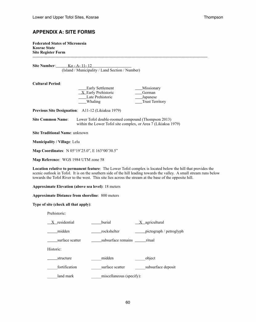
APPENDIX A: SITE FORMS
Federated States of Micronesia Kosrae State Site Register Form --------------------------------------------------------------------------------------------------------------------------------- Site Number: Ko - A- 11- 12 (Island / Municipality / Land Section / Number)
Cultural Period: Early Settlement Missionary X Early Prehistoric German Late Prehistoric Japanese Whaling Trust Territory
Previous Site Designation: A11-12 (Likiaksa 1979)
Site Common Name: Lower Tofol double-roomed compound (Thompson 2013) within the Lower Tofol site complex, or Area 7 (Likiaksa 1979)
Site Traditional Name: unknown
Municipality / Village: Lelu
Map Coordinates: N 05°19’25.0”, E 163°00’30.5”
Map Reference: WGS 1984 UTM zone 58
Location relative to permanent feature: The Lower Tofol complex is located below the hill that provides the scenic outlook in Tofol. It is on the southern side of the hill leading towards the valley. A small stream runs below towards the Tofol River to the west. This site lies across the stream at the base of the opposite hill.
Approximate Elevation (above sea level): 18 meters
Approximate Distance from shoreline: 800 meters Type of site (check all that apply):
Prehistoric:
X residential burial X agricultural midden rockshelter pictograph / petroglyph
surface scatter subsurface remains ritual
Historic:
structure _____midden _____object
_____fortification _____surface scatter _____subsurface deposit
_____land mark _____miscellaneous (specify):
Lower and Upper Tofol Sites, Kosrae! Thompson
60

Description: The Lower Tofol complex consists of a cluster of four structures found in close proximity to each other, sites A11-12, A11-13, A11-15, & A11-16.
The Lower Tofol double-roomed compound is a low thick-walled structure with two rooms. The southern wall lies close to a drop-off and has been made thicker, measuring roughly 2 m wide and of larger stones. The larger of the two rooms is on this side and measures roughly 10 x 11 m. The smaller room lies on the north side and measures 6 x 10 meters with walls only 0.5 m wide. The entrance lies through the smaller room and there is a place midway through the dividing wall for the path to continue. Within the structure some small stone alignments appeared to resemble agricultural terraces at A11-15. These are believed to be from the re-use of the site at a later time. Initially, it would have been used for habitation (Thompson 2013).
Approximate size (meter) and shape of site boundaries: The total size of the structure is 16 x 11 m. It is standard practice for a 50’, or 16 m boundary to be maintained around historic sites. Thus the boundary of the site should measure 48 x 43 meters, or more generally a 25m radius from the center of the site.
Date of Construction (if known): believed to be Early Prehistoric period 600-1200AD
Depth of Cultural Deposit: surface
Associated Cultural Material:
pottery shell midden human remains
faunal material stone/shell tools metal
glass historic ceramics
other (specify):
Type of Soil: X humus sand clay X silt other ( specify):
Type of Vegetation at Site: lowland secondary agroforest (bananas, noni tree, eucalyptus, etc)
Environmental Zone: Main Island: coastal beach coastal plain mangrove Swamp X stream / river X valleys X lower elevation secondary forest steep slope transitional zone high elevation slope, ridges and plateaus Outer Islands/Atolls : coastal beach coastal strand vegetation coastal flat lands interior swamp land rocky coral brim / coast
Lower and Upper Tofol Sites, Kosrae! Thompson
61
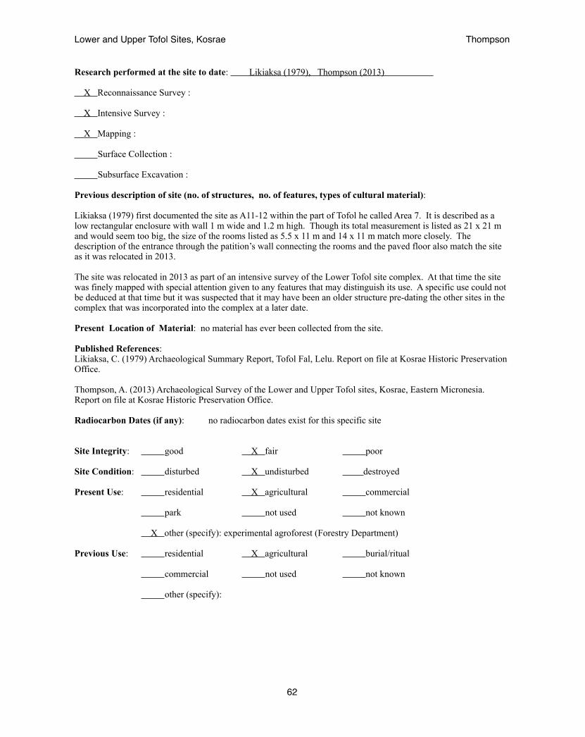
Research performed at the site to date: Likiaksa (1979), Thompson (2013) X Reconnaissance Survey : X Intensive Survey :
X Mapping :
Surface Collection :
Subsurface Excavation :
Previous description of site (no. of structures, no. of features, types of cultural material):
Likiaksa (1979) first documented the site as A11-12 within the part of Tofol he called Area 7. It is described as a low rectangular enclosure with wall 1 m wide and 1.2 m high. Though its total measurement is listed as 21 x 21 m and would seem too big, the size of the rooms listed as 5.5 x 11 m and 14 x 11 m match more closely. The description of the entrance through the patition’s wall connecting the rooms and the paved floor also match the site as it was relocated in 2013.
The site was relocated in 2013 as part of an intensive survey of the Lower Tofol site complex. At that time the site was finely mapped with special attention given to any features that may distinguish its use. A specific use could not be deduced at that time but it was suspected that it may have been an older structure pre-dating the other sites in the complex that was incorporated into the complex at a later date.
Present Location of Material: no material has ever been collected from the site.
Published References: Likiaksa, C. (1979) Archaeological Summary Report, Tofol Fal, Lelu. Report on file at Kosrae Historic Preservation Office.
Thompson, A. (2013) Archaeological Survey of the Lower and Upper Tofol sites, Kosrae, Eastern Micronesia. Report on file at Kosrae Historic Preservation Office.
Radiocarbon Dates (if any): no radiocarbon dates exist for this specific site
Site Integrity: good X fair poor
Site Condition: disturbed X undisturbed destroyed
Present Use: residential X agricultural commercial
park not used not known
X other (specify): experimental agroforest (Forestry Department)
Previous Use: residential X agricultural burial/ritual
commercial not used not known
other (specify):
Lower and Upper Tofol Sites, Kosrae! Thompson
62
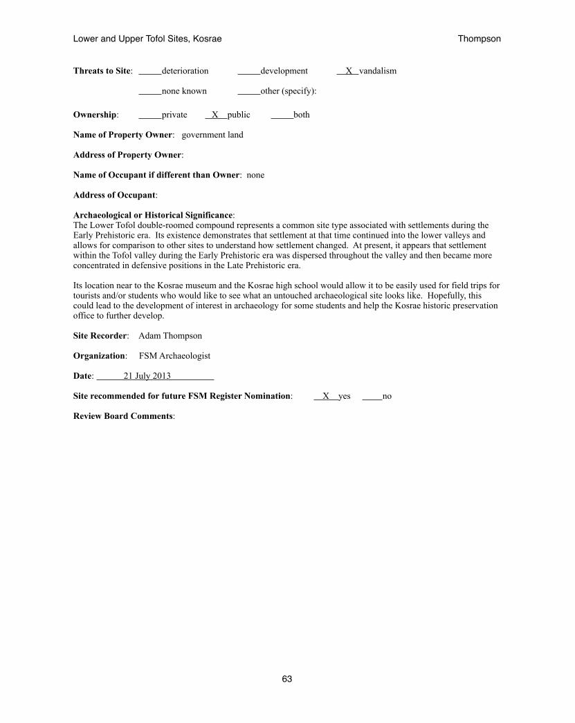
Threats to Site: deterioration development X vandalism
none known other (specify):
Ownership: private X public both
Name of Property Owner: government land
Address of Property Owner:
Name of Occupant if different than Owner: none
Address of Occupant:
Archaeological or Historical Significance: The Lower Tofol double-roomed compound represents a common site type associated with settlements during the Early Prehistoric era. Its existence demonstrates that settlement at that time continued into the lower valleys and allows for comparison to other sites to understand how settlement changed. At present, it appears that settlement within the Tofol valley during the Early Prehistoric era was dispersed throughout the valley and then became more concentrated in defensive positions in the Late Prehistoric era.
Its location near to the Kosrae museum and the Kosrae high school would allow it to be easily used for field trips for tourists and/or students who would like to see what an untouched archaeological site looks like. Hopefully, this could lead to the development of interest in archaeology for some students and help the Kosrae historic preservation office to further develop.
Site Recorder: Adam Thompson
Organization: FSM Archaeologist
Date: 21 July 2013
Site recommended for future FSM Register Nomination: X yes no
Review Board Comments:
Lower and Upper Tofol Sites, Kosrae! Thompson
63

Federated States of Micronesia Kosrae State Site Register Form --------------------------------------------------------------------------------------------------------------------------------- Site Number: Ko - A- 11- 13 (Island / Municipality / Land Section / Number)
Cultural Period: Early Settlement Missionary Early Prehistoric German X Late Prehistoric Japanese Whaling Trust Territory
Previous Site Designation: A11-13 (Likiaksa 1979)
Site Common Name: Lower Tofol hilltop enclosure (Thompson 2013) within the Lower Tofol site complex, or Area 7 (Likiaksa 1979)
Site Traditional Name: unknown
Municipality / Village: Lelu
Map Coordinates: N 05°19’26.1”, E 163°00’28.8”
Map Reference: WGS 1984 UTM zone 58
Location relative to permanent feature: The Lower Tofol complex is located below the hill that provides the scenic outlook in Tofol. It is on the southern side of the hill leading towards the valley. A small stream runs below towards the Tofol River to the west. The Lower Tofol hilltop enclosure lies at the switchback turn of the road leading up to the scenic view. There is a utility pole very close to the site. It lies a bit above the other sites in the complex.
Approximate Elevation (above sea level): 25 meters
Approximate Distance from shoreline: 750 meters Type of site (check all that apply):
Prehistoric:
X residential burial agricultural midden rock shelter pictograph / petroglyph
surface scatter subsurface remains ritual
Historic:
structure _____midden _____object
_____fortification _____surface scatter _____subsurface deposit
_____land mark _____miscellaneous(specify):
Lower and Upper Tofol Sites, Kosrae! Thompson
64

Description: The Lower Tofol complex consists of a cluster of four structures found in close proximity to each other, sites A11-12, A11-13, A11-15, & A11-16.
The Lower Tofol hilltop-enclosure is a medium-sized, four-sided, one-room structure terraced against the southwestern hill slope. Remnants of internal features remained but were difficult to fully understand given the poor preservation of the site.(Thompson 2013). The wall was roughly 0.5 to 1 m high around. Its location raised above the area provides it with a good view across the area. It believed that the site may date to a later time when conflict existed between the people of the valley and high chiefs of Lelu and provided a look out.
Approximate size (meter) and shape of site boundaries:
The total size of the structure is believed to be 9 x 7.5 m. Its western edge was not well defined in 2013 when the site was measured to be 9 x 6 m and was described as being 9 x 9 m in 1979 when it is believed to have better site integrity. It is standard practice for a 50’, or 16 m boundary to be maintained around historic sites. Thus the boundary of the site should measure 25 x 25 meters, or more generally a 25m radius from the center of the site.
Date of Construction (if known): believed to be Late Prehistoric period 1200-1800AD
Depth of Cultural Deposit: surface
Associated Cultural Material:
pottery shell midden human remains
faunal material stone/shell tools metal
glass historic ceramics
other (specify):
Type of Soil: X humus sand clay X silt other ( specify):
Type of Vegetation at Site: lowland secondary agroforest (bananas, noni tree, eucalyptus, etc)
Environmental Zone: Main Island: coastal beach coastal plain mangrove Swamp X stream / river X valleys X lower elevation secondary forest steep slope transitional zone high elevation slope, ridges and plateaus Outer Islands/Atolls : coastal beach coastal strand vegetation coastal flat lands interior swamp land rocky coral brim / coast
Lower and Upper Tofol Sites, Kosrae! Thompson
65

Research performed at the site to date: Likiaksa (1979), Thompson (2013) X Reconnaissance Survey : Intensive Survey :
X Mapping :
Surface Collection :
Subsurface Excavation :
Previous description of site (no. of structures, no. of features, types of cultural material):
Likiaksa (1979) first documented the site as A11-13 within the part of Tofol he called Area 7. It is described as a low enclosure with platform measuring 9 x 9 meters. The wall was said to be 0.8 meter high with no entrances. Within the enclosure was a rectangular platform, 1.5 x 3.5 meters, abutted against the southwest wall.
The site was relocated in 2013 as part of an reconnaissance survey of the Tofol Valley. At that time it appeared to have been impacted by erosion and road development. A utility pole had been placed near to the southwest corner preventing the identification of the internal platform. The structure was found to be 9 x 6 meters though heavy vegetation meant its western edge was not confidently defined.
Present Location of Material: no material has ever been collected from the site.
Published References: Likiaksa, C. (1979) Archaeological Summary Report, Tofol Fal, Lelu. Report on file at Kosrae Historic Preservation Office.
Thompson, A. (2013) Archaeological Survey of the Lower and Upper Tofol sites, Kosrae, Eastern Micronesia. Report on file at Kosrae Historic Preservation Office.
Radiocarbon Dates (if any): no radiocarbon dates exist for this specific site
Site Integrity: good fair X poor
Site Condition: X disturbed undisturbed destroyed
Present Use: residential agricultural X commercial
park not used not known
X other (specify): utility pole
Previous Use: residential X agricultural burial/ritual
commercial not used not known
other (specify):
Lower and Upper Tofol Sites, Kosrae! Thompson
66
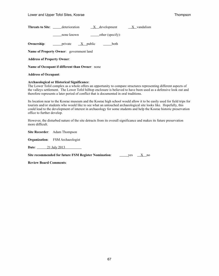
Threats to Site: deterioration X development X vandalism
none known other (specify):
Ownership: private X public both
Name of Property Owner: government land
Address of Property Owner:
Name of Occupant if different than Owner: none
Address of Occupant:
Archaeological or Historical Significance: The Lower Tofol complex as a whole offers an opportunity to compare structures representing different aspects of the valleys settlement. The Lower Tofol hilltop enclosure is believed to have been used as a defensive look out and therefore represents a later period of conflict that is documented in oral traditions.
Its location near to the Kosrae museum and the Kosrae high school would allow it to be easily used for field trips for tourists and/or students who would like to see what an untouched archaeological site looks like. Hopefully, this could lead to the development of interest in archaeology for some students and help the Kosrae historic preservation office to further develop.
However, the disturbed nature of the site detracts from its overall significance and makes its future preservation more difficult.
Site Recorder: Adam Thompson
Organization: FSM Archaeologist
Date: 21 July 2013
Site recommended for future FSM Register Nomination: yes X no
Review Board Comments:
Lower and Upper Tofol Sites, Kosrae! Thompson
67

Federated States of Micronesia Kosrae State Site Register Form --------------------------------------------------------------------------------------------------------------------------------- Site Number: Ko - A- 11- 15 (Island / Municipality / Land Section / Number)
Cultural Period: Early Settlement Missionary Early Prehistoric German X Late Prehistoric Japanese Whaling Trust Territory
Previous Site Designation: A11-15 (Likiaksa 1979)
Site Common Name: Lower Tofol habitation site (Thompson 2013) within the Lower Tofol site complex, or Area 7 (Likiaksa 1979)
Site Traditional Name: unknown
Municipality / Village: Lelu
Map Coordinates: N 05°19’25.0”, E 163°00’30.5”
Map Reference: WGS 1984 UTM zone 58
Location relative to permanent feature: The Lower Tofol complex is located below the hill that provides the scenic outlook in Tofol. It is on the southern side of the hill leading towards the valley. A small stream runs below towards the Tofol River to the west. The Lower Tofol habitation site lies across the stream within a grove of eucalyptus trees.
Approximate Elevation (above sea level): 20 meters
Approximate Distance from shoreline: 750 meters Type of site (check all that apply):
Prehistoric:
X residential burial X agricultural midden rock shelter pictograph / petroglyph
surface scatter subsurface remains ritual
Historic:
structure _____midden _____object
_____fortification _____surface scatter _____subsurface deposit
_____land mark _____miscellaneous(specify):
Lower and Upper Tofol Sites, Kosrae! Thompson
68

Description: The Lower Tofol complex consists of a cluster of four structures found in close proximity to each other, sites A11-12, A11-13, A11-15, & A11-16.
The Lower Tofol habitaiton site is the largest structure within the Lower Tofol complex, yet it is also the least elaborate. A simple wall averaging three stones high, or roughly 0.5 meter formed a terrace platform on three-sides with the open side facing the mountain ridge. There were no stones found in the center of the platform. It is believed that this was a large area for the habitation of an extended family. A possible entrance may be seen on the west side of the structure. This side faces the path leading to the other structures within the area. Small terraces around the structure appear to be the remains of gardening features (Thompson 2013).
Approximate size (meter) and shape of site boundaries:
The total size of the structure is 19 x 11 meters. It is standard practice for a 50’, or 16 m boundary to be maintained around historic sites. Thus the boundary of the site should measure 51 x 43 meters, or more generally a 25m radius from the center of the site.
Date of Construction (if known): believed to be Late Prehistoric 1200-1800AD
Depth of Cultural Deposit: surface
Associated Cultural Material:
pottery shell midden human remains
faunal material stone/shell tools metal
glass historic ceramics
other (specify): basalt vessel, grinding stones
Type of Soil: X humus sand clay X silt other ( specify):
Type of Vegetation at Site: lowland secondary agroforest (bananas, noni tree, eucalyptus, etc)
Environmental Zone: Main Island: coastal beach coastal plain mangrove Swamp X stream / river X valleys X lower elevation secondary forest steep slope transitional zone high elevation slope, ridges and plateaus Outer Islands/Atolls : coastal beach coastal strand vegetation coastal flat lands interior swamp land rocky coral brim / coast
Lower and Upper Tofol Sites, Kosrae! Thompson
69
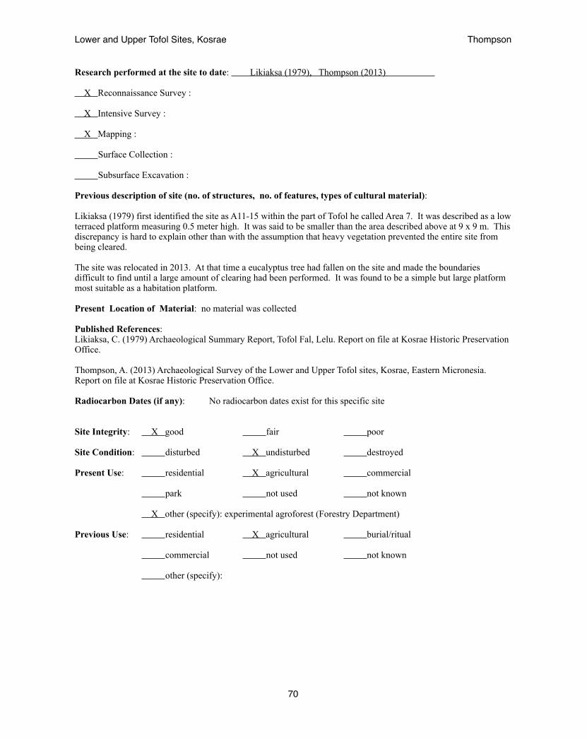
Research performed at the site to date: Likiaksa (1979), Thompson (2013) X Reconnaissance Survey : X Intensive Survey :
X Mapping :
Surface Collection :
Subsurface Excavation :
Previous description of site (no. of structures, no. of features, types of cultural material):
Likiaksa (1979) first identified the site as A11-15 within the part of Tofol he called Area 7. It was described as a low terraced platform measuring 0.5 meter high. It was said to be smaller than the area described above at 9 x 9 m. This discrepancy is hard to explain other than with the assumption that heavy vegetation prevented the entire site from being cleared.
The site was relocated in 2013. At that time a eucalyptus tree had fallen on the site and made the boundaries difficult to find until a large amount of clearing had been performed. It was found to be a simple but large platform most suitable as a habitation platform.
Present Location of Material: no material was collected
Published References: Likiaksa, C. (1979) Archaeological Summary Report, Tofol Fal, Lelu. Report on file at Kosrae Historic Preservation Office.
Thompson, A. (2013) Archaeological Survey of the Lower and Upper Tofol sites, Kosrae, Eastern Micronesia. Report on file at Kosrae Historic Preservation Office.
Radiocarbon Dates (if any): No radiocarbon dates exist for this specific site
Site Integrity: X good fair poor
Site Condition: disturbed X undisturbed destroyed
Present Use: residential X agricultural commercial
park not used not known
X other (specify): experimental agroforest (Forestry Department)
Previous Use: residential X agricultural burial/ritual
commercial not used not known
other (specify):
Lower and Upper Tofol Sites, Kosrae! Thompson
70
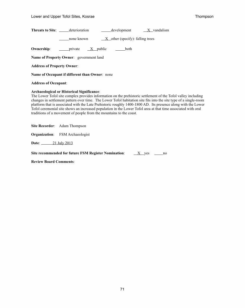
Threats to Site: deterioration development X vandalism
none known X other (specify): falling trees
Ownership: private X public both
Name of Property Owner: government land
Address of Property Owner:
Name of Occupant if different than Owner: none
Address of Occupant:
Archaeological or Historical Significance: The Lower Tofol site complex provides information on the prehistoric settlement of the Tofol valley including changes in settlement pattern over time. The Lower Tofol habitation site fits into the site type of a single-room platform that is associated with the Late Prehistoric roughly 1400-1800 AD. Its presence along with the Lower Tofol ceremonial site shows an increased population in the Lower Tofol area at that time associated with oral traditions of a movement of people from the mountains to the coast.
Site Recorder: Adam Thompson
Organization: FSM Archaeologist
Date: 21 July 2013
Site recommended for future FSM Register Nomination: X yes no
Review Board Comments:
Lower and Upper Tofol Sites, Kosrae! Thompson
71

Federated States of Micronesia Kosrae State Site Register Form --------------------------------------------------------------------------------------------------------------------------------- Site Number: Ko - A- 11- 16 (Island / Municipality / Land Section / Number)
Cultural Period: Early Settlement Missionary Early Prehistoric German X Late Prehistoric Japanese Whaling Trust Territory
Previous Site Designation: A11-16 (Likiaksa 1979)
Site Common Name: Lower Tofol ceremonial site (Thompson 2013) within the Lower Tofol site complex, or Area 7 (Likiaksa 1979)
Site Traditional Name: unknown
Municipality / Village: Lelu
Map Coordinates: N 05°19’25.0”, E 163°00’30.5”
Map Reference: WGS 1984 UTM zone 58
Location relative to permanent feature: The Lower Tofol complex is located below the hill that provides the scenic outlook in Tofol. It is on the southern side of the hill leading towards the valley. A small stream runs below towards the Tofol River to the west. The Lower Tofol ceremonial site lies just below the dilapidated building that was once the Kosrae Historic Preservation Office and the Agricultural building before that.
Approximate Elevation (above sea level): 20 meters
Approximate Distance from shoreline: 750 meters Type of site (check all that apply):
Prehistoric:
X residential burial agricultural midden rockshelter pictograph / petroglyph
surface scatter subsurface remains X ritual
Historic:
structure _____midden _____object
_____fortification _____surface scatter _____subsurface deposit
_____land mark _____miscellaneous(specify):
Lower and Upper Tofol Sites, Kosrae! Thompson
72
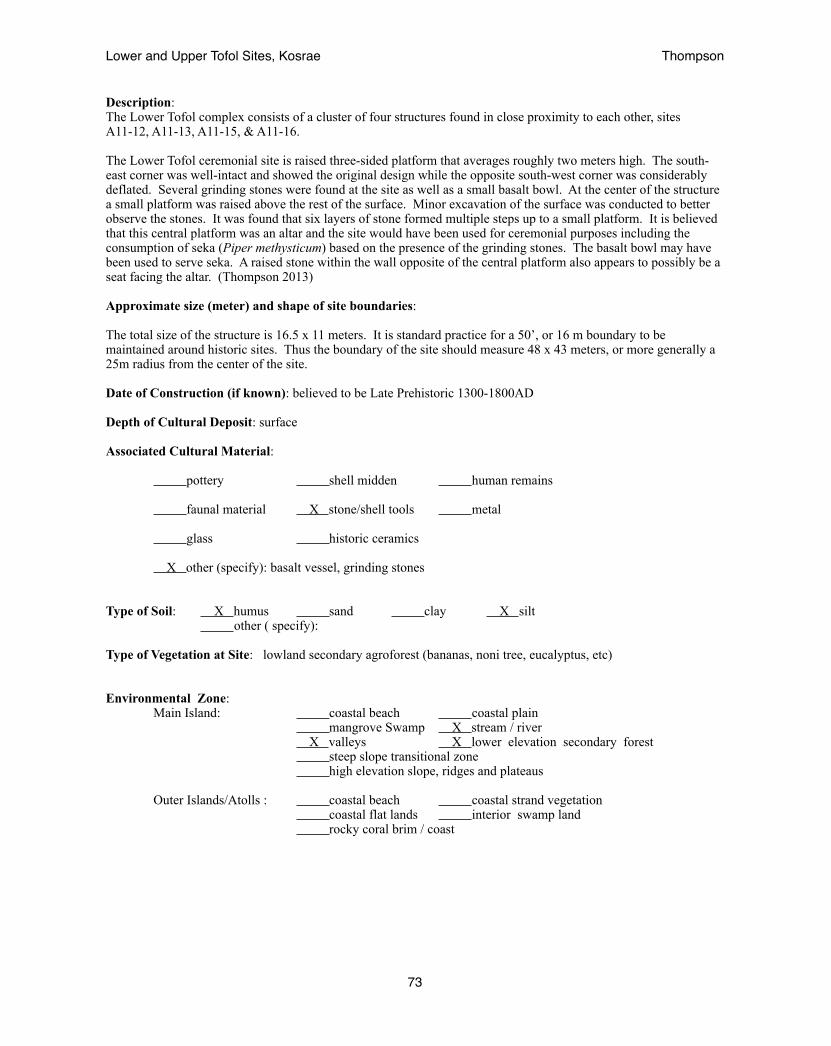
Description: The Lower Tofol complex consists of a cluster of four structures found in close proximity to each other, sites A11-12, A11-13, A11-15, & A11-16.
The Lower Tofol ceremonial site is raised three-sided platform that averages roughly two meters high. The south-east corner was well-intact and showed the original design while the opposite south-west corner was considerably deflated. Several grinding stones were found at the site as well as a small basalt bowl. At the center of the structure a small platform was raised above the rest of the surface. Minor excavation of the surface was conducted to better observe the stones. It was found that six layers of stone formed multiple steps up to a small platform. It is believed that this central platform was an altar and the site would have been used for ceremonial purposes including the consumption of seka (Piper methysticum) based on the presence of the grinding stones. The basalt bowl may have been used to serve seka. A raised stone within the wall opposite of the central platform also appears to possibly be a seat facing the altar. (Thompson 2013)
Approximate size (meter) and shape of site boundaries:
The total size of the structure is 16.5 x 11 meters. It is standard practice for a 50’, or 16 m boundary to be maintained around historic sites. Thus the boundary of the site should measure 48 x 43 meters, or more generally a 25m radius from the center of the site.
Date of Construction (if known): believed to be Late Prehistoric 1300-1800AD
Depth of Cultural Deposit: surface
Associated Cultural Material:
pottery shell midden human remains
faunal material X stone/shell tools metal
glass historic ceramics
X other (specify): basalt vessel, grinding stones
Type of Soil: X humus sand clay X silt other ( specify):
Type of Vegetation at Site: lowland secondary agroforest (bananas, noni tree, eucalyptus, etc)
Environmental Zone: Main Island: coastal beach coastal plain mangrove Swamp X stream / river X valleys X lower elevation secondary forest steep slope transitional zone high elevation slope, ridges and plateaus Outer Islands/Atolls : coastal beach coastal strand vegetation coastal flat lands interior swamp land rocky coral brim / coast
Lower and Upper Tofol Sites, Kosrae! Thompson
73
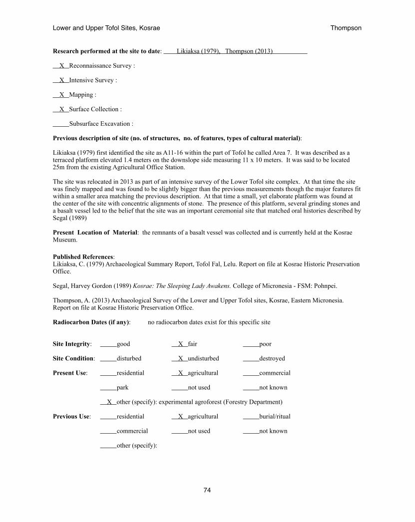
Research performed at the site to date: Likiaksa (1979), Thompson (2013) X Reconnaissance Survey : X Intensive Survey :
X Mapping :
X Surface Collection :
Subsurface Excavation :
Previous description of site (no. of structures, no. of features, types of cultural material):
Likiaksa (1979) first identified the site as A11-16 within the part of Tofol he called Area 7. It was described as a terraced platform elevated 1.4 meters on the downslope side measuring 11 x 10 meters. It was said to be located 25m from the existing Agricultural Office Station.
The site was relocated in 2013 as part of an intensive survey of the Lower Tofol site complex. At that time the site was finely mapped and was found to be slightly bigger than the previous measurements though the major features fit within a smaller area matching the previous description. At that time a small, yet elaborate platform was found at the center of the site with concentric alignments of stone. The presence of this platform, several grinding stones and a basalt vessel led to the belief that the site was an important ceremonial site that matched oral histories described by Segal (1989)
Present Location of Material: the remnants of a basalt vessel was collected and is currently held at the Kosrae Museum.
Published References: Likiaksa, C. (1979) Archaeological Summary Report, Tofol Fal, Lelu. Report on file at Kosrae Historic Preservation Office.
Segal, Harvey Gordon (1989) Kosrae: The Sleeping Lady Awakens. College of Micronesia - FSM: Pohnpei.
Thompson, A. (2013) Archaeological Survey of the Lower and Upper Tofol sites, Kosrae, Eastern Micronesia. Report on file at Kosrae Historic Preservation Office.
Radiocarbon Dates (if any): no radiocarbon dates exist for this specific site
Site Integrity: good X fair poor
Site Condition: disturbed X undisturbed destroyed
Present Use: residential X agricultural commercial
park not used not known
X other (specify): experimental agroforest (Forestry Department)
Previous Use: residential X agricultural burial/ritual
commercial not used not known
other (specify):
Lower and Upper Tofol Sites, Kosrae! Thompson
74
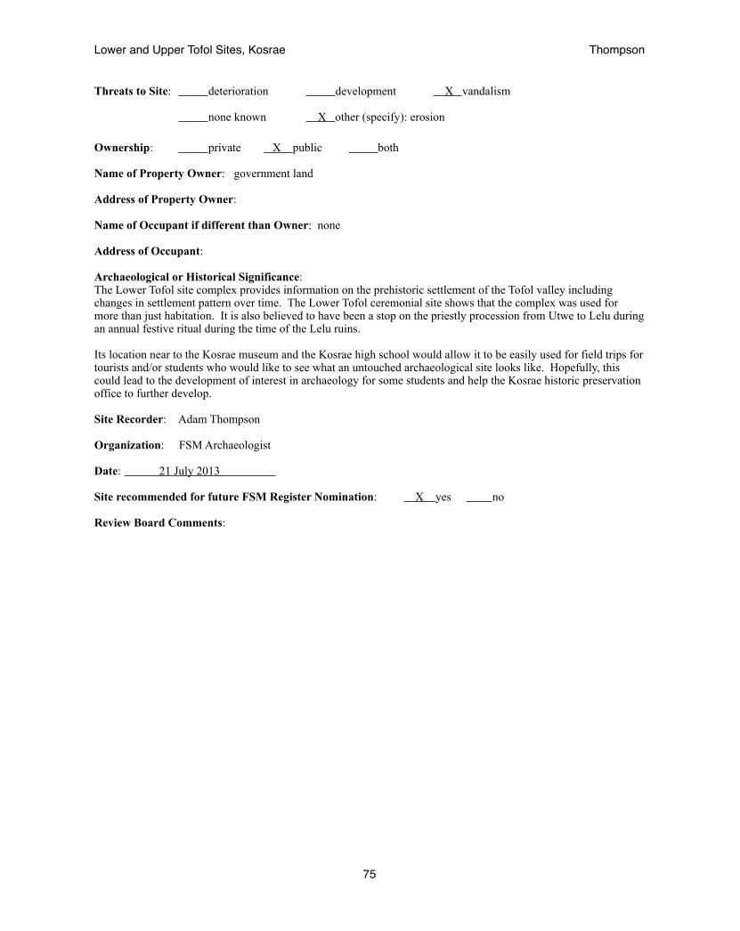
Threats to Site: deterioration development X vandalism
none known X other (specify): erosion
Ownership: private X public both
Name of Property Owner: government land
Address of Property Owner:
Name of Occupant if different than Owner: none
Address of Occupant:
Archaeological or Historical Significance: The Lower Tofol site complex provides information on the prehistoric settlement of the Tofol valley including changes in settlement pattern over time. The Lower Tofol ceremonial site shows that the complex was used for more than just habitation. It is also believed to have been a stop on the priestly procession from Utwe to Lelu during an annual festive ritual during the time of the Lelu ruins.
Its location near to the Kosrae museum and the Kosrae high school would allow it to be easily used for field trips for tourists and/or students who would like to see what an untouched archaeological site looks like. Hopefully, this could lead to the development of interest in archaeology for some students and help the Kosrae historic preservation office to further develop.
Site Recorder: Adam Thompson
Organization: FSM Archaeologist
Date: 21 July 2013
Site recommended for future FSM Register Nomination: X yes no
Review Board Comments:
Lower and Upper Tofol Sites, Kosrae! Thompson
75

Federated States of Micronesia Kosrae State Site Register Form --------------------------------------------------------------------------------------------------------------------------------- Site Number: Ko - A- 11- 27 (Island / Municipality / Land Section / Number)
Cultural Period: Early Settlement Missionary X Early Prehistoric German Late Prehistoric X Japanese Whaling Trust Territory
Previous Site Designation: A11-27 (Beardsley 2007)
Site Common Name: Middle Tofol platform (Thompson 2013)
Site Traditional Name: unknown
Municipality / Village: Lelu
Map Coordinates: N 05°19’20.3”, E 163°00’28.8”
Map Reference: WGS 1984 UTM zone 58
Location relative to permanent feature: The site is located next to the Tofol river across from where the main road running through the valley to the court house connects to the gravel road leading up to the dam. This is a narrow part of the valley described by Beardsley (2007) as a bottleneck. The site lies just outside of this bottleneck to the east of the river against the side of the ridge. Features continue upstream through the bottleneck.
Approximate Elevation (above sea level): 23 meters
Approximate Distance from shoreline: 900 meters Type of site (check all that apply):
Prehistoric:
X residential burial agricultural midden rock shelter pictograph / petroglyph
surface scatter subsurface remains X ritual
Historic:
structure _____midden _____object
X fortification _____surface scatter _____sub surface deposit
_____land mark _____miscellaneous(specify):
Lower and Upper Tofol Sites, Kosrae! Thompson
76
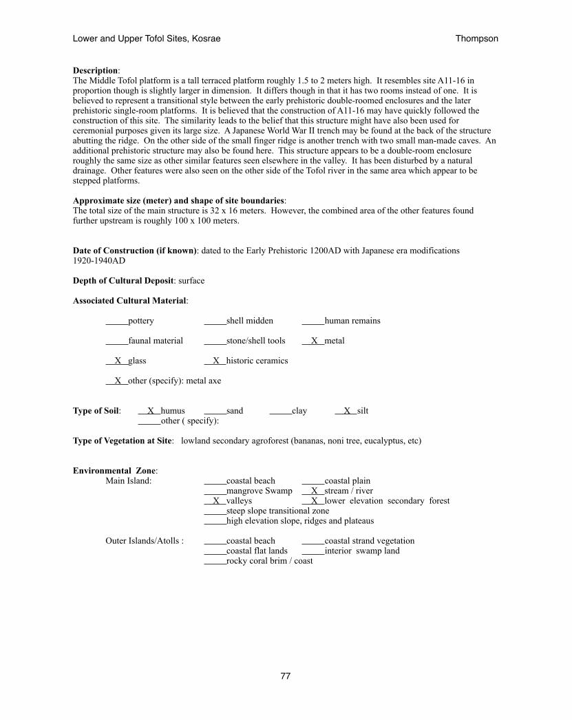
Description: The Middle Tofol platform is a tall terraced platform roughly 1.5 to 2 meters high. It resembles site A11-16 in proportion though is slightly larger in dimension. It differs though in that it has two rooms instead of one. It is believed to represent a transitional style between the early prehistoric double-roomed enclosures and the later prehistoric single-room platforms. It is believed that the construction of A11-16 may have quickly followed the construction of this site. The similarity leads to the belief that this structure might have also been used for ceremonial purposes given its large size. A Japanese World War II trench may be found at the back of the structure abutting the ridge. On the other side of the small finger ridge is another trench with two small man-made caves. An additional prehistoric structure may also be found here. This structure appears to be a double-room enclosure roughly the same size as other similar features seen elsewhere in the valley. It has been disturbed by a natural drainage. Other features were also seen on the other side of the Tofol river in the same area which appear to be stepped platforms.
Approximate size (meter) and shape of site boundaries: The total size of the main structure is 32 x 16 meters. However, the combined area of the other features found further upstream is roughly 100 x 100 meters.
Date of Construction (if known): dated to the Early Prehistoric 1200AD with Japanese era modifications 1920-1940AD
Depth of Cultural Deposit: surface
Associated Cultural Material:
pottery shell midden human remains
faunal material stone/shell tools X metal
X glass X historic ceramics
X other (specify): metal axe
Type of Soil: X humus sand clay X silt other ( specify):
Type of Vegetation at Site: lowland secondary agroforest (bananas, noni tree, eucalyptus, etc)
Environmental Zone: Main Island: coastal beach coastal plain mangrove Swamp X stream / river X valleys X lower elevation secondary forest steep slope transitional zone high elevation slope, ridges and plateaus Outer Islands/Atolls : coastal beach coastal strand vegetation coastal flat lands interior swamp land rocky coral brim / coast
Lower and Upper Tofol Sites, Kosrae! Thompson
77

Research performed at the site to date: Beardsley (2007), Thompson (2013) X Reconnaissance Survey : X Intensive Survey :
X Mapping :
X Surface Collection :
X Subsurface Excavation :
Previous description of site (no. of structures, no. of features, types of cultural material):
Beardsley (2007) tells how their initial work in the Tofol valley began with an exploratory excavation at A11-27 in 2003. She describes the site as lying next to the Tofol river and the presence of a Japanese era occupation, details that match observations made in 2013. She also states that the initial occupation was dated to about A.D. 1200. Further she describes how a large array of sites continue into the well-protected valley. In 2013 the site was relocated and mapped.
Present Location of Material: material collected is held at the Kosrae Museum
Published References: Beardsley, F. (2007) Archaeological Excavation in Tofol, Kosrae, Eastern Micronesia: Ground-Truthing Oral History at Site Ko-A11-32. Field Report. Report on file at Kosrae Historic Preservation Office.
Thompson, A. (2013) Archaeological Survey of the Lower and Upper Tofol sites, Kosrae, Eastern Micronesia. Report on file at Kosrae Historic Preservation Office.
Radiocarbon Dates (if any): 1200 AD (Beardsley 2007)
Site Integrity: good X fair poor
Site Condition: disturbed X undisturbed destroyed
Present Use: residential agricultural commercial
park X not used not known
other (specify):
Previous Use: residential X agricultural burial/ritual
commercial not used not known
other (specify):
Lower and Upper Tofol Sites, Kosrae! Thompson
78

Threats to Site: deterioration development vandalism
X none known other (specify):
Ownership: private X public both
Name of Property Owner: government land
Address of Property Owner:
Name of Occupant if different than Owner: none
Address of Occupant:
Archaeological or Historical Significance: This site is believed to represent a transitional style between the early and late prehistoric periods. Given its size it is also believed to be the location of important village-wide events in the ancient past. It marks the entrance to the more confined valley that holds a denser array of sites that has been labeled Middle Tofol, marking a transition to high populations and denser settlement patterns. Additionally the presence of Japanese World War II era trenches and caves exemplify how the naturally defensive qualities of this part of the valley were utilized during a different era.
Site Recorder: Adam Thompson
Organization: FSM Archaeologist
Date: 21 July 2013
Site recommended for future FSM Register Nomination: X yes no
Review Board Comments:
Lower and Upper Tofol Sites, Kosrae! Thompson
79
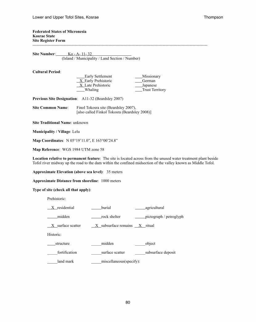
Federated States of Micronesia Kosrae State Site Register Form --------------------------------------------------------------------------------------------------------------------------------- Site Number: Ko - A- 11- 32 (Island / Municipality / Land Section / Number)
Cultural Period: Early Settlement Missionary X Early Prehistoric German X Late Prehistoric Japanese Whaling Trust Territory
Previous Site Designation: A11-32 (Beardsley 2007)
Site Common Name: Finol Tokosra site (Beardsley 2007), [also called Finkol Tokosra (Beardsley 2008)]
Site Traditional Name: unknown
Municipality / Village: Lelu
Map Coordinates: N 05°19’11.0”, E 163°00’24.8”
Map Reference: WGS 1984 UTM zone 58
Location relative to permanent feature: The site is located across from the unused water treatment plant beside Tofol river midway up the road to the dam within the confined midsection of the valley known as Middle Tofol.
Approximate Elevation (above sea level): 35 meters
Approximate Distance from shoreline: 1000 meters Type of site (check all that apply):
Prehistoric:
X residential burial agricultural midden rock shelter pictograph / petroglyph
X surface scatter X subsurface remains X ritual
Historic:
structure _____midden _____object
_____fortification _____surface scatter _____subsurface deposit
_____land mark _____miscellaneous(specify):
Lower and Upper Tofol Sites, Kosrae! Thompson
80
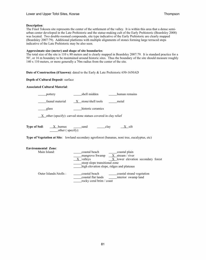
Description: The Finol Tokosra site represents the center of the settlement of the valley. It is within this area that a dense semi-urban center developed in the Late Prehistoric and the statue-making cult of the Early Prehistoric (Beardsley 2008) was located. Two double-roomed compounds, site type indicative of the Early Prehistoric are clearly mapped (Beardsley 2007:79). Additional platforms with multiple alignments of stones forming large terraced steps indicative of the Late Prehistoric may be also seen.
Approximate size (meter) and shape of site boundaries: The total size of the site is 110 x 80 meters and is clearly mapped in Beardsley 2007:79. It is standard practice for a 50’, or 16 m boundary to be maintained around historic sites. Thus the boundary of the site should measure roughly 140 x 110 meters, or more generally a 70m radius from the center of the site.
Date of Construction (if known): dated to the Early & Late Prehistoric 650-1650AD
Depth of Cultural Deposit: surface
Associated Cultural Material:
pottery shell midden human remains
faunal material X stone/shell tools metal
glass historic ceramics
X other (specify): carved stone statues covered in clay relief
Type of Soil: X humus sand clay X silt other ( specify):
Type of Vegetation at Site: lowland secondary agroforest (bananas, noni tree, eucalyptus, etc)
Environmental Zone: Main Island: coastal beach coastal plain mangrove Swamp X stream / river X valleys X lower elevation secondary forest steep slope transitional zone high elevation slope, ridges and plateaus Outer Islands/Atolls : coastal beach coastal strand vegetation coastal flat lands interior swamp land rocky coral brim / coast
Lower and Upper Tofol Sites, Kosrae! Thompson
81

Research performed at the site to date: Beardsley (2007) X Reconnaissance Survey : X Intensive Survey :
X Mapping :
X Surface Collection :
X Subsurface Excavation :
Previous description of site (no. of structures, no. of features, types of cultural material):
Beardsley concentrated her study in the Tofol valley on site A11-32 located that she associated with the oral legend of Finkol Tokosra a king who was assassinated by the people of Tofol valley. She describes the site as being composed of “extensive feasting areas, elaborate housing compounds with multiple chambers, monumental architecture, a stone-lined spring and a spring-fed bathing area, a medicine making area, several seka production areas, faa’faa making areas, kitchens with um, a boulder pavement throughout the entire site, and a defined public space linked to a private area by sweeping staircases” (2007:35).
Present Location of Material: material collected by Beardsley (2007) is held at the Kosrae Museum
Published References: Beardsley, F. (2007) Archaeological Excavation in Tofol, Kosrae, Eastern Micronesia: Ground-Truthing Oral History at Site Ko-A11-32. Field Report. Report on file at Kosrae Historic Preservation Office.
Beardsley, F. (2008) Stone Figures from the Finkol Tokosra site, Kosrae, Eastern Micronesia. Antiquity 82.
Radiocarbon Dates (if any): Wk-20594 1290-1172 BP (Beardsley 2007) Wk-20593 1295-1012 BP (Beardsley 2007) Wk-20595 504-300 BP (Beardsley 2007) Wk-20598 1135-797 BP (Beardsley 2007) Wk-20596 435-0 BP (Beardsley 2007) Wk-20597 285-0 BP (Beardsley 2007)
Site Integrity: good X fair poor
Site Condition: disturbed X undisturbed destroyed
Present Use: residential agricultural commercial
park X not used not known
other (specify):
Previous Use: residential agricultural burial/ritual
commercial not used X not known
other (specify):
Lower and Upper Tofol Sites, Kosrae! Thompson
82
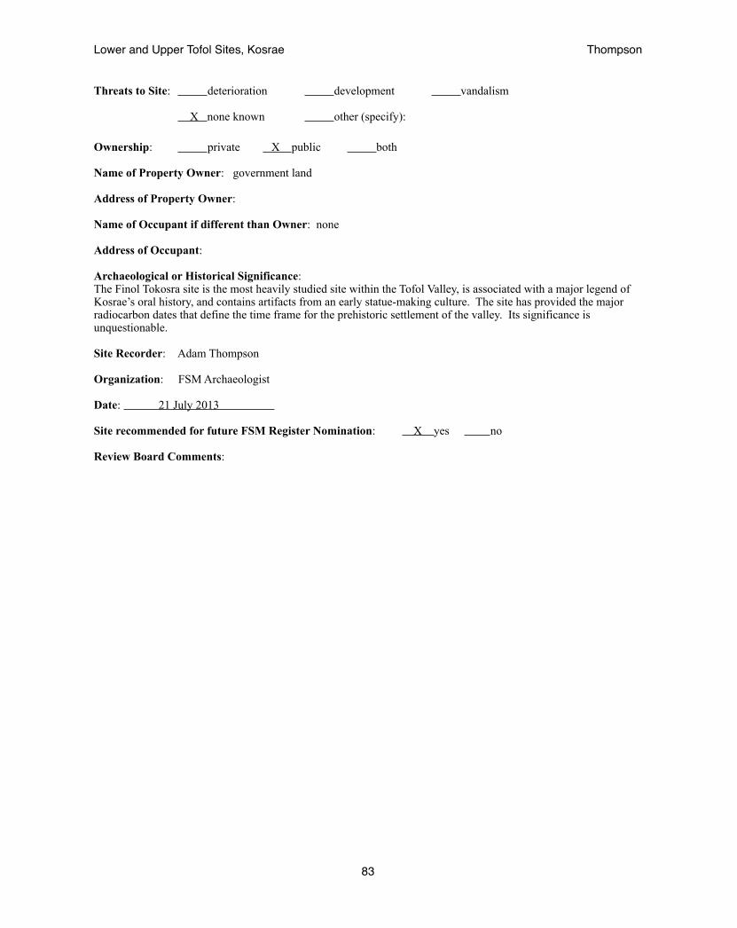
Threats to Site: deterioration development vandalism
X none known other (specify):
Ownership: private X public both
Name of Property Owner: government land
Address of Property Owner:
Name of Occupant if different than Owner: none
Address of Occupant:
Archaeological or Historical Significance: The Finol Tokosra site is the most heavily studied site within the Tofol Valley, is associated with a major legend of Kosrae’s oral history, and contains artifacts from an early statue-making culture. The site has provided the major radiocarbon dates that define the time frame for the prehistoric settlement of the valley. Its significance is unquestionable.
Site Recorder: Adam Thompson
Organization: FSM Archaeologist
Date: 21 July 2013
Site recommended for future FSM Register Nomination: X yes no
Review Board Comments:
Lower and Upper Tofol Sites, Kosrae! Thompson
83
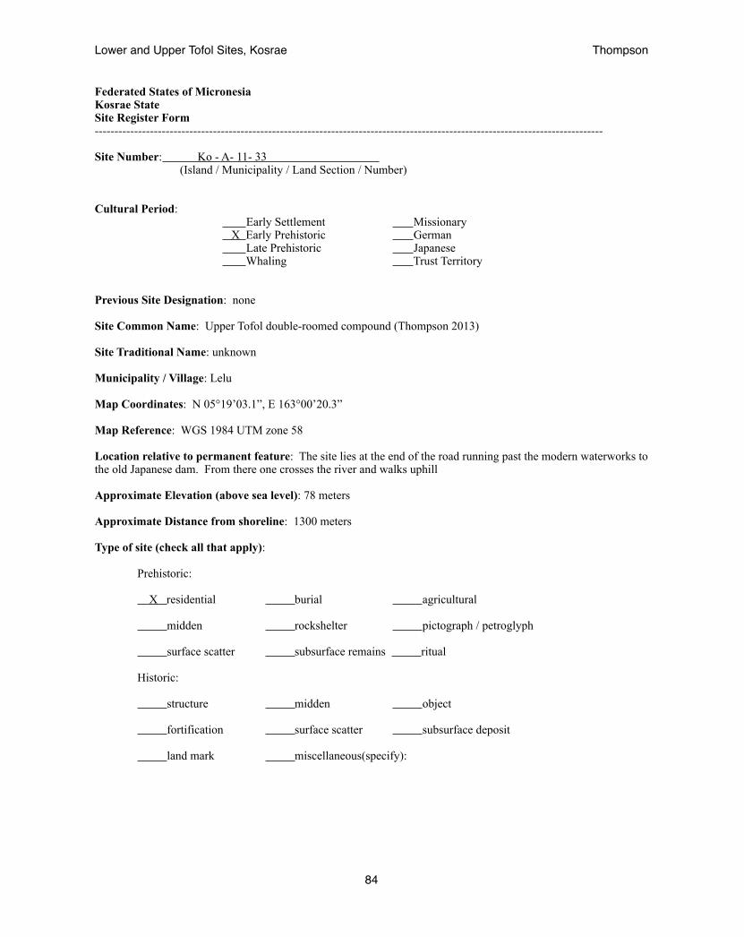
Federated States of Micronesia Kosrae State Site Register Form --------------------------------------------------------------------------------------------------------------------------------- Site Number: Ko - A- 11- 33 (Island / Municipality / Land Section / Number)
Cultural Period: Early Settlement Missionary X Early Prehistoric German Late Prehistoric Japanese Whaling Trust Territory
Previous Site Designation: none
Site Common Name: Upper Tofol double-roomed compound (Thompson 2013)
Site Traditional Name: unknown
Municipality / Village: Lelu
Map Coordinates: N 05°19’03.1”, E 163°00’20.3”
Map Reference: WGS 1984 UTM zone 58
Location relative to permanent feature: The site lies at the end of the road running past the modern waterworks to the old Japanese dam. From there one crosses the river and walks uphill
Approximate Elevation (above sea level): 78 meters
Approximate Distance from shoreline: 1300 meters Type of site (check all that apply):
Prehistoric:
X residential burial agricultural midden rockshelter pictograph / petroglyph
surface scatter subsurface remains ritual
Historic:
structure midden object
fortification surface scatter subsurface deposit
land mark miscellaneous(specify):
Lower and Upper Tofol Sites, Kosrae! Thompson
84

Description: The Upper Tofol double-roomed compound sits atop the large natural terrace above the Tofol river on its eastern side. It is upon these expansive terraces raised well above the flood zone of the river that upland sites are typically found. This site is well terraced against a fairly steep slope by a substantial retaining wall and consists of two rooms. The larger of the two rooms is on this side and measures roughly 9 x 6.5 m. The smaller room lies on the north side and measures 6 x 4 meters. The entrance lies through the smaller room and there is a place midway through the dividing wall for the path to continue. A small central platform was found at the center of the larger room (Thompson 2013).
Approximate size (meter) and shape of site boundaries: The total size of the structure is 15.5 x 7 m. It is standard practice for a 50’, or 16 m boundary to be maintained around historic sites. Thus the boundary of the site should measure 47.5 x 39 meters, or more generally a 25m radius from the center of the site.
Date of Construction (if known): believed to be Early Prehistoric 600-1200AD
Depth of Cultural Deposit: surface
Associated Cultural Material:
pottery shell midden human remains
faunal material stone/shell tools metal
glass historic ceramics
other (specify):
Type of Soil: X humus sand clay X silt X loam
other ( specify): silty loam beneath a humic layer
Type of Vegetation at Site: secondary upland forest (hibiscus, ginger, mahogany, neubergia, callophyllum, thespesia, cinnamon)
Environmental Zone: Main Island: coastal beach coastal plain mangrove Swamp X stream / river X valleys lower elevation secondary forest X steep slope transitional zone high elevation slope, ridges and plateaus Outer Islands/Atolls : coastal beach coastal strand vegetation coastal flat lands interior swamp land rocky coral brim / coast
Lower and Upper Tofol Sites, Kosrae! Thompson
85
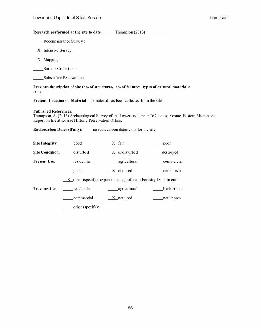
Research performed at the site to date: Thompson (2013) Reconnaissance Survey : X Intensive Survey :
X Mapping :
Surface Collection :
Subsurface Excavation :
Previous description of site (no. of structures, no. of features, types of cultural material):none
Present Location of Material: no material has been collected from the site
Published References: Thompson, A. (2013) Archaeological Survey of the Lower and Upper Tofol sites, Kosrae, Eastern Micronesia. Report on file at Kosrae Historic Preservation Office.
Radiocarbon Dates (if any): no radiocarbon dates exist for the site
Site Integrity: good X fair poor
Site Condition: disturbed X undisturbed destroyed
Present Use: residential agricultural commercial
park X not used not known
X other (specify): experimental agroforest (Forestry Department)
Previous Use: residential agricultural burial/ritual
commercial X not used not known
other (specify):
Lower and Upper Tofol Sites, Kosrae! Thompson
86

Threats to Site: X deterioration development vandalism
none known X other (specify): erosion
Ownership: private X public both
Name of Property Owner: government land
Address of Property Owner:
Name of Occupant if different than Owner: none
Address of Occupant:
Archaeological or Historical Significance: The Upper Tofol double-roomed compound is significant as it is the furthest upland site for a structure of its style within the Tofol valley to date. Thus it provides a measurement of the size of the Early Prehistoric village.
Site Recorder: Adam Thompson
Organization: FSM Archaeologist
Date: 21 July 2013
Site recommended for future FSM Register Nomination: X yes no
Review Board Comments:
Lower and Upper Tofol Sites, Kosrae! Thompson
87
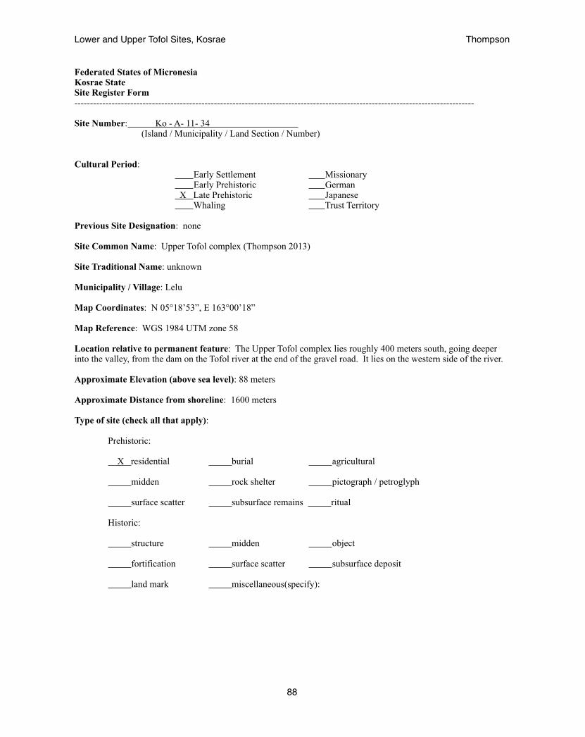
Federated States of Micronesia Kosrae State Site Register Form --------------------------------------------------------------------------------------------------------------------------------- Site Number: Ko - A- 11- 34 (Island / Municipality / Land Section / Number)
Cultural Period: Early Settlement Missionary Early Prehistoric German X Late Prehistoric Japanese Whaling Trust Territory
Previous Site Designation: none
Site Common Name: Upper Tofol complex (Thompson 2013)
Site Traditional Name: unknown
Municipality / Village: Lelu
Map Coordinates: N 05°18’53”, E 163°00’18”
Map Reference: WGS 1984 UTM zone 58
Location relative to permanent feature: The Upper Tofol complex lies roughly 400 meters south, going deeper into the valley, from the dam on the Tofol river at the end of the gravel road. It lies on the western side of the river.
Approximate Elevation (above sea level): 88 meters
Approximate Distance from shoreline: 1600 meters Type of site (check all that apply):
Prehistoric:
X residential burial agricultural midden rock shelter pictograph / petroglyph
surface scatter subsurface remains ritual
Historic:
structure midden object
fortification surface scatter subsurface deposit
land mark miscellaneous(specify):
Lower and Upper Tofol Sites, Kosrae! Thompson
88

Description: The Upper Tofol complex consists of three major features: a stepped tomb that measures 10 x 10 meters, a single-roomed enclosure measuring 17 x 14 m, and a platform, measuring 5 x 6 m surrounded by a terrace wall 17 x 13 m. These sites all lie within 24-30 meters of each other and are therefore within the 16m buffer zone surrounding each of the historic sites. They are all believed to be from a common time frame and closely associated with each other.
Approximate size (meter) and shape of site boundaries: The total area of the site measures 60 x 100 meters. However, it was found that the site continued towards the mountain. As time did not allow to delineate and record the entire site this initial portion is registered as a single site representative of the rest of it. The rest of the site should be registered in the future as a new site associated with this one.
Date of Construction (if known): believed to be Late Prehistoric 1300-1800AD
Depth of Cultural Deposit: surface
Associated Cultural Material:
pottery shell midden human remains
faunal material stone/shell tools metal
glass historic ceramics
other (specify):
Type of Soil: X humus sand clay X silt X loam
other ( specify): silty loam beneath a humic layer
Type of Vegetation at Site: secondary upland forest (hibiscus, ginger, mahogany, neubergia, callophyllum, thespesia, cinnamon)
Environmental Zone: Main Island: coastal beach coastal plain mangrove Swamp X stream / river X valleys lower elevation secondary forest X steep slope transitional zone high elevation slope, ridges and plateaus Outer Islands/Atolls : coastal beach coastal strand vegetation coastal flat lands interior swamp land rocky coral brim / coast
Lower and Upper Tofol Sites, Kosrae! Thompson
89

Research performed at the site to date: Thompson (2013) X Reconnaissance Survey : Intensive Survey :
X Mapping :
Surface Collection :
Subsurface Excavation :
Previous description of site (no. of structures, no. of features, types of cultural material):none
Present Location of Material: no material has been collected from the site
Published References: Thompson, A. (2013) Archaeological Survey of the Lower and Upper Tofol sites, Kosrae, Eastern Micronesia. Report on file at Kosrae Historic Preservation Office.
Radiocarbon Dates (if any): no radiocarbon dates exist for the site
Site Integrity: good X fair poor
Site Condition: disturbed X undisturbed destroyed
Present Use: residential agricultural commercial
park X not used not known
X other (specify): experimental agroforest (Forestry Department)
Previous Use: residential agricultural burial/ritual
commercial X not used not known
other (specify):
Lower and Upper Tofol Sites, Kosrae! Thompson
90
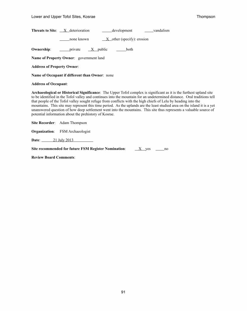
Threats to Site: X deterioration development vandalism
none known X other (specify): erosion
Ownership: private X public both
Name of Property Owner: government land
Address of Property Owner:
Name of Occupant if different than Owner: none
Address of Occupant:
Archaeological or Historical Significance: The Upper Tofol complex is significant as it is the furthest upland site to be identified in the Tofol valley and continues into the mountain for an undetermined distance. Oral traditions tell that people of the Tofol valley sought refuge from conflicts with the high chiefs of Lelu by heading into the mountains. This site may represent this time period. As the uplands are the least studied area on the island it is a yet unanswered question of how deep settlement went into the mountains. This site thus represents a valuable source of potential information about the prehistory of Kosrae.
Site Recorder: Adam Thompson
Organization: FSM Archaeologist
Date: 21 July 2013
Site recommended for future FSM Register Nomination: X yes no
Review Board Comments:
Lower and Upper Tofol Sites, Kosrae! Thompson
91

APPENDIX B: HISTORIC CONTEXTS & STRATEGIES
The following pages outline historic contexts for the island of Kosrae, their corresponding property types, preservation goals, strategies, criteria, and priority to guide present and future historic preservation projects.
Early Settlement of Kosrae (0-500 AD)
This period of Kosrae’s history is marked by a very specific and rare property type as it represents only a small colonizing population settling a specific environment. The only site to be found within this earliest period of Kosrae’s history is at Katem, a formerly walled compound on the southeast side of Lelu ruins [Layer VI of TP-9/10 of Athens subsurface deposits in deep sand including pottery (Athens 1995)]. This therefore may be considered the type site (A1-1). The settlement is marked by a specific artifact type as well in the form of the only known pottery to be discovered on Kosrae.
Cordy also obtained early dates at Wiya (D15-1) of 1855 BP (Cordy 1981a) for a tridacna shell found on the surface that was believed to have been dug up from a garbage pit and therefore out of context. This site should be offers the best opportunity to further investigate this historic context.
preservation goal: to discover additional deposits and further investigate D15-1
strategy: Given the rarity of these sites it is not practical to actively excavate for these deep sites which take considerable digging and possibly a water pump as they lie below the water table due to the subsidence of the island and as other cultural layers would be expected to lie above these deep deposits. Instead monitoring of large-scale excavations in deep sands offers a more efficient and opportunistic strategy. However, the date obtained at D15-1 offers an opportunity for further investigation that could be of interest to archaeologists at academic institutions.
criteria: radiocarbon dates within the given range and/or pottery-bearing deposits
priority: low, due to the difficulty of finding such rare sites
Lower and Upper Tofol Sites, Kosrae! Thompson
92

Early Prehistoric Kosrae (500-1300 AD)!
This period is marked by double-roomed compounds of stacked basalt rocks in a rectilinear alignment with a wall transecting its middle creating a smaller room roughly one-third the area of the whole and a larger room two-thirds the whole. Many times a low platform may be found at the center of the larger room but not necessarily always. Sites such as these may be seen in Menke, Innem and Tofol valleys. Additional sites that appear to be in this time period include agricultural terraces and stone pavings identified in the upland Tofol valley, large tiered structures identified as temples in Menke valley, and (Cordy). Previous studies have shown that these sites are likely to be found further upland though they may be evenly distributed across the valley as well. These sites are also marked by ceramic-covered stone statuary as identified in Tofol valley at site A11-32 (Beardsley 2007), at Menke (Beardsley 2011), and at Tepat (Cordy 1981). This period is marked by more dispersed populations .
preservation goal: assess the distribution of such sites
strategy: The largest area where these sites may be found yet to be fully investigated is the upland areas. Reports from the Department Forestry and the Kosrae Conservation Society have identified potential sites from this historic context in the upland mountains that are difficult to reach. The Kosrae HPO should attempt to accompany these and other departments when they go into the uplands.
Plans for climate change adaptation have recommended that future development focus more in the uplands. Monitoring of road and utility developments as they move deeper into the mountain are also recommended, including road-side surveys.
criteria: Basalt stone structures intact enough to show a clear double-roomed configuration, the presence of statuary or dates within the given time period.
priority: high, a large amount of un-surveyed land still exists
Lower and Upper Tofol Sites, Kosrae! Thompson
93
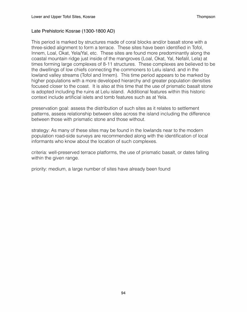
Late Prehistoric Kosrae (1300-1800 AD)
This period is marked by structures made of coral blocks and/or basalt stone with a three-sided alignment to form a terrace. These sites have been identified in Tofol, Innem, Loal, Okat, Yela/Yal, etc. These sites are found more predominantly along the coastal mountain ridge just inside of the mangroves (Loal, Okat, Yal, Nefalil, Lela) at times forming large complexes of 8-11 structures. These complexes are believed to be the dwellings of low chiefs connecting the commoners to Lelu island. and in the lowland valley streams (Tofol and Innem). This time period appears to be marked by higher populations with a more developed hierarchy and greater population densities focused closer to the coast. It is also at this time that the use of prismatic basalt stone is adopted including the ruins at Lelu island. Additional features within this historic context include artificial islets and tomb features such as at Yela. preservation goal: assess the distribution of such sites as it relates to settlement patterns, assess relationship between sites across the island including the difference between those with prismatic stone and those without.
strategy: As many of these sites may be found in the lowlands near to the modern population road-side surveys are recommended along with the identification of local informants who know about the location of such complexes.
criteria: well-preserved terrace platforms, the use of prismatic basalt, or dates falling within the given range.
priority: medium, a large number of sites have already been found
Lower and Upper Tofol Sites, Kosrae! Thompson
94
Note on Early Prehistoric and Late Prehistoric sites
Many of the sites within these two historic contexts fall within overlapping geographic areas. In fact, there is reason to believe that sites dating to the early prehistoric period continued to be used in the late prehistoric. Previous studies have treated these two time periods as the same. However, as the combined time period of these two historic contexts covers more than a thousand years and there are specific features that appear to fall within early and later contexts efforts are being made to better define these two contexts as distinct in order to understand changes in settlement pattern as they relate to environmental changes across the period including changes in sea-level and changes in culture such as within the social hierarchy.
preservation goal: to further distinguish between early and late prehistoric contexts
strategy: Surveys should attempt to focus on entire valleys to assess the frequency of sites specific to the two contexts and when the budget allows to date such sites. This strategy follows a landscape archaeology approach first developed for Pacific Island valley systems by Roger Green.
priority: medium, effort were made by the 2013 Lower and Upper Tofol project
Note on the Lelu Ruins
While Lelu ruins fits within the Late Prehistoric context it represents a unique and special site of international significance. Efforts are currently underway to nominate it along with Nan Madol as a World Heritage site. The successful nomination to the World Heritage List will require a management plan.
preservation goal: to clean-up Lelu and maintain an improved look for the site, including new signage
strategy: contact the Lelu Landowners Authority to discuss management
Lower and Upper Tofol Sites, Kosrae! Thompson
95
Whaling period (1800-1850AD)
This period is marked by underwater shipwreck such as that of Bully Hayes ship the Leonora (C31-1) in Utwe harbor, the whaling ship Waverly in Lelu harbor (A30-1) and the Lelu harbor site (shown below) where whales were harvested. preservation goal: to preserve these sites
strategy: monitoring through underwater surveys.
priority: medium, these are significant sites but are difficult to work on Missionary period (1850-1880AD) This period is represented by the Missionary school in Walung.
preservation goal: to preserve structuresstrategy: monitoring
German period (1880-1910AD)
There is a lack of sites within this period.
preservation goal: locate more sitesstrategy: seek out local informants
Japanese period (1910-1940AD)
This period is marked by two integrated contexts of the early Japanese civil government (1920-1930) and the WWII military buildup (1930-1940) which directly effected most of the previous civil sites and is now most common. The most notable site from the civil period are charcoal kilns (D6-5, D6-17). While Japanese military sites are composed of pillboxes, the radio station, Japanese stairs, and tunnels found throughout the island, a notable example of which may be found at Mt. Oma.
preservation goal: to identify the distribution of WWII sites around the island
Strategy: Most military sites have been found to be located in the Malem district and a large-scale survey project focused in this region is being planned for 2014. The previous documentation of local interviews on the subject should assist in the location of these sites. This project will also be coordinated with the activities of the Kosrae Conservation Society at Mt. Oma.
criteria: identification by local informant as a WWII site, or historic record.
priority: high, project identified for 2014
Lower and Upper Tofol Sites, Kosrae! Thompson
96
Trust Territory period 1940-1960
The one significant site within this period was the old Lelu church which was recently destroyed in the construction of the new Lelu church. Efforts were made to preserve the old church by the Kosrae Historic Preservation Office and Kosrae Island Resource Management Authority (KIRMA) board. These efforts were unsuccessful as the community of Lelu rallied against them.
preservation goal: identify if any other significant sites exist
priority: low
2013 results
In 2013, an intensive survey project was conducted in the Lower and Upper Tofol valley and a reconnaissance survey was performed in the Lower Yela Valley around the proposed conservation easement. These surveys located and registered sites within three historic contexts: the Early Prehistoric (600-1200 AD), the Late Prehistoric (1200-1800 AD), and the Japanese period (1920-1940 AD). An effort was also made within the Tofol project to identify distinguishing characteristics between the Early and Late Prehistoric periods. Theoretically, it is believed that double room structures are earlier than single-room structures.
Early Prehistoric A11-12,27,32, 33: double-roomed compoundsA11-27: double-roomed platform
Late PrehistoricA11-15, 16, 32, D6-11: single-room platformsA11-13, 34: single-rooms enclosuresD6-18: tomb structure
Japanese periodD6-17: charcoal kiln
Lower and Upper Tofol Sites, Kosrae! Thompson
97

APPENDIX C: KOSRAE STATE SITE REGISTRATION FORMS
Kosrae Register of Historic Places Nomination Form
Date: 13 August 2013 KHPI No.: Ko-A-11-12
A. PROPERTY NAME
1. Common: Lower Tofol double-roomed compound
2. Historical / Formerly Known As / Other: unknown
B. LOCATION
1. Lot / Tract / Land ID or Estate No.: 056K00-1
2. Municipality: Lelu
3. Land Square and Section: Tofol
4. Local Place Name of Area: Lower Tofol
C. GEOGRAPHIC DATA
1. Approximate Acreage: 0.5 acres
2. EASTING / NORTHING. Locate center point for property if one acre or less:
Easting 163°00’30.5” Northing 05°19’25.0”
3. Locate at least three points if property is greater than one acre:1. E ______________________ N ____________________________2. E ______________________ N ____________________________3. E ______________________ N ____________________________4. E ______________________ N ____________________________
Lower and Upper Tofol Sites, Kosrae! Thompson
98

D. CLASSIFICATION / USE / ACCESS
1. Category (check one): ____District X Site ____Building ____Structure ____Object
2. Status (check one or more): ___Occupied X Unoccupied ___Preservation work in Progress
3. Accessible to Public (check one): ____No ____Yes, Restricted X Yes, Unrestricted 4. Current Use (check one or more as appropriate):
X Agriculture _____ Industrial _____ Religious _____ Commercial _____ Military _____ Science _____ Conservation _____ Museum _____ Transportation _____ Education _____ Park _____ Unused _____ Entertainment _____ Ranch _____ Other _____ Government _____ Residence
5. Additional Comments on Present Use: Experimental Agroforest for the Forestry Department __________________________________________________________________________________________
E. PROPERTY OWNER
1. Ownership (check one or more as appropriate): X Government of Kosrae ____Private
2. Owner’s Name: Kosrae State Government - Office of the Governor
3. Physical Address Tofol, Kosrae
4. Mailing Address: PO Box 158, Tofol, Kosrae, 96944
5. Contact Numbers and Fax Number: 691-370-3002 or 691-370-3003
6. Email Address:
7. Lessee(s):
8. Lessee(s) Address:
Additional Information: Department of Resources and Economic Affairs, 691-370-2017
Lower and Upper Tofol Sites, Kosrae! Thompson
99
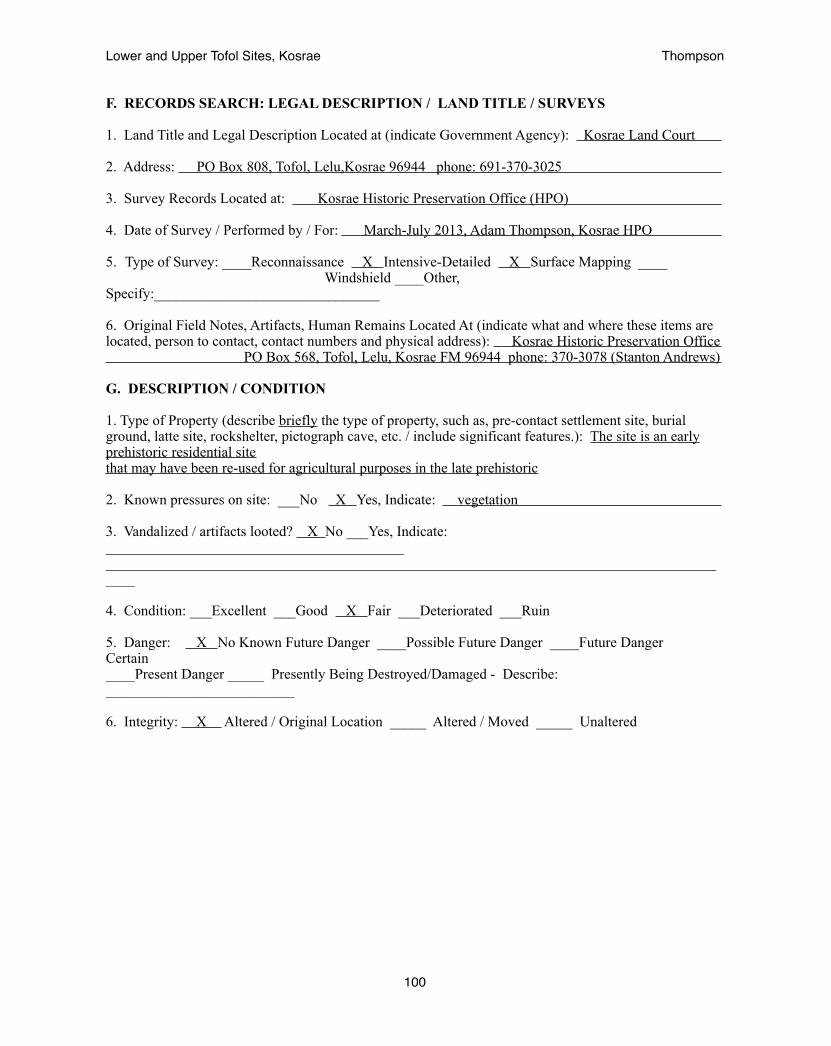
F. RECORDS SEARCH: LEGAL DESCRIPTION / LAND TITLE / SURVEYS
1. Land Title and Legal Description Located at (indicate Government Agency): Kosrae Land Court
2. Address: PO Box 808, Tofol, Lelu,Kosrae 96944 phone: 691-370-3025
3. Survey Records Located at: Kosrae Historic Preservation Office (HPO)
4. Date of Survey / Performed by / For: March-July 2013, Adam Thompson, Kosrae HPO
5. Type of Survey: ____Reconnaissance X Intensive-Detailed X Surface Mapping ____ Windshield ____Other, Specify:_______________________________
6. Original Field Notes, Artifacts, Human Remains Located At (indicate what and where these items are located, person to contact, contact numbers and physical address): Kosrae Historic Preservation Office PO Box 568, Tofol, Lelu, Kosrae FM 96944 phone: 370-3078 (Stanton Andrews)
G. DESCRIPTION / CONDITION
1. Type of Property (describe briefly the type of property, such as, pre-contact settlement site, burial ground, latte site, rockshelter, pictograph cave, etc. / include significant features.): The site is an early prehistoric residential sitethat may have been re-used for agricultural purposes in the late prehistoric
2. Known pressures on site: ___No X Yes, Indicate: vegetation
3. Vandalized / artifacts looted? X No ___Yes, Indicate: _________________________________________________________________________________________________________________________________
4. Condition: ___Excellent ___Good X Fair ___Deteriorated ___Ruin
5. Danger: X No Known Future Danger ____Possible Future Danger ____Future Danger Certain ____Present Danger _____ Presently Being Destroyed/Damaged - Describe: __________________________
6. Integrity: X Altered / Original Location _____ Altered / Moved _____ Unaltered
Lower and Upper Tofol Sites, Kosrae! Thompson
100

H. HISTORIC CONTEXT / AREAS OF SIGNIFICANCE
1. The Historic Context of this Property is best classified as (check one or more):
____ 0 – 600 A.D. Early Settlement Period X 600 – 1200 A.D. Early Prehistoric Period
____ 1200 - 1820 A.D. Late Prehistoric Period ____ 1820 – 1850 A.D. European Discovery & Whaling Period ____ 1850 – 1880 A.D. Missionization Period ____ 1880 – 1910 A.D. German Period ____ 1910 – 1940 A.D. Japanese Civil Occupation ____ 1940 – 1945 A.D. World War II / Japanese Military Occupation ____ 1945 – 1984 A.D. Trust Territory
2. Specific Dates (if known): ________________________________________________________________
3. Areas of Significance (check one or more as appropriate): X Indigenous / Prehistoric ___Indigenous / Historic ___Agriculture ___Architecture ___Art ___Commerce ___Communications ___Conservation ___Education ___Engineering ___Industry ___Invention ___Landscape ___Architecture ___Literature ___Military ___Music ___Political ___Religion ___Spiritual ___Science ___Social / Humanitarian ___Theater ___Transportation ___Other (Specify)__________________________ 4. Importance as Example of Type: ___Excellent ___Good X Fair ___Poor
5. Interpretive Value: ___Excellent ___Good X Fair ___Poor
6. Research Potential: ___Excellent ___Good ___Fair X Poor
7. Local Attitude about Site: __Valuable __Not as Valuable __Not at all Valuable X Ambivalent __Unknown
8. Suggested Themes: early prehistoric settlement patterns
Lower and Upper Tofol Sites, Kosrae! Thompson
101
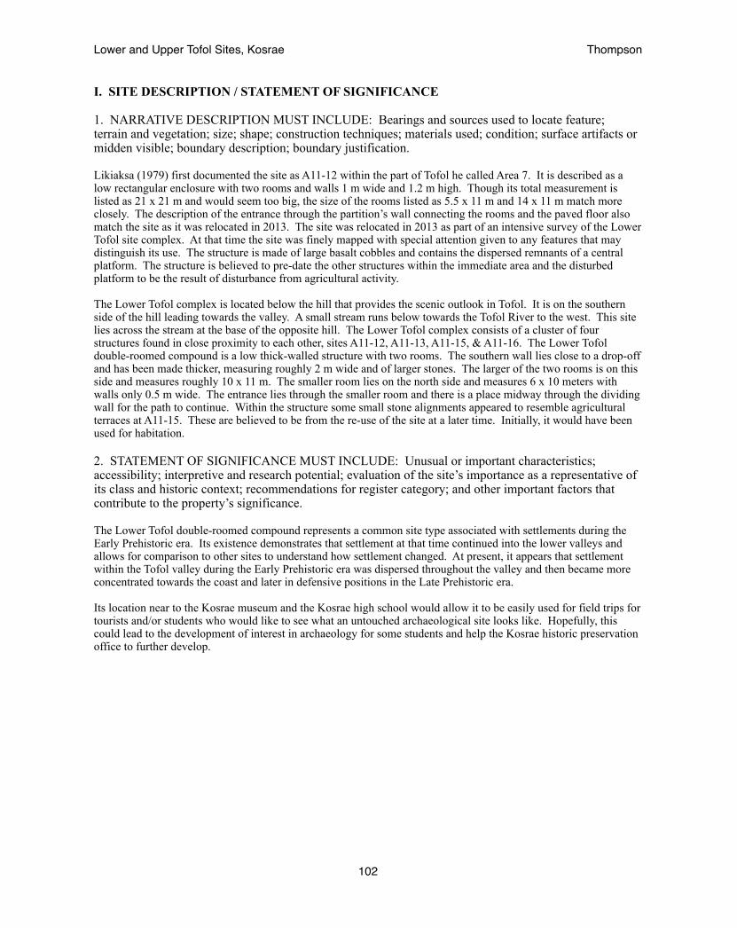
I. SITE DESCRIPTION / STATEMENT OF SIGNIFICANCE
1. NARRATIVE DESCRIPTION MUST INCLUDE: Bearings and sources used to locate feature; terrain and vegetation; size; shape; construction techniques; materials used; condition; surface artifacts or midden visible; boundary description; boundary justification.
Likiaksa (1979) first documented the site as A11-12 within the part of Tofol he called Area 7. It is described as a low rectangular enclosure with two rooms and walls 1 m wide and 1.2 m high. Though its total measurement is listed as 21 x 21 m and would seem too big, the size of the rooms listed as 5.5 x 11 m and 14 x 11 m match more closely. The description of the entrance through the partition’s wall connecting the rooms and the paved floor also match the site as it was relocated in 2013. The site was relocated in 2013 as part of an intensive survey of the Lower Tofol site complex. At that time the site was finely mapped with special attention given to any features that may distinguish its use. The structure is made of large basalt cobbles and contains the dispersed remnants of a central platform. The structure is believed to pre-date the other structures within the immediate area and the disturbed platform to be the result of disturbance from agricultural activity.
The Lower Tofol complex is located below the hill that provides the scenic outlook in Tofol. It is on the southern side of the hill leading towards the valley. A small stream runs below towards the Tofol River to the west. This site lies across the stream at the base of the opposite hill. The Lower Tofol complex consists of a cluster of four structures found in close proximity to each other, sites A11-12, A11-13, A11-15, & A11-16. The Lower Tofol double-roomed compound is a low thick-walled structure with two rooms. The southern wall lies close to a drop-off and has been made thicker, measuring roughly 2 m wide and of larger stones. The larger of the two rooms is on this side and measures roughly 10 x 11 m. The smaller room lies on the north side and measures 6 x 10 meters with walls only 0.5 m wide. The entrance lies through the smaller room and there is a place midway through the dividing wall for the path to continue. Within the structure some small stone alignments appeared to resemble agricultural terraces at A11-15. These are believed to be from the re-use of the site at a later time. Initially, it would have been used for habitation.
2. STATEMENT OF SIGNIFICANCE MUST INCLUDE: Unusual or important characteristics; accessibility; interpretive and research potential; evaluation of the site’s importance as a representative of its class and historic context; recommendations for register category; and other important factors that contribute to the property’s significance.
The Lower Tofol double-roomed compound represents a common site type associated with settlements during the Early Prehistoric era. Its existence demonstrates that settlement at that time continued into the lower valleys and allows for comparison to other sites to understand how settlement changed. At present, it appears that settlement within the Tofol valley during the Early Prehistoric era was dispersed throughout the valley and then became more concentrated towards the coast and later in defensive positions in the Late Prehistoric era.
Its location near to the Kosrae museum and the Kosrae high school would allow it to be easily used for field trips for tourists and/or students who would like to see what an untouched archaeological site looks like. Hopefully, this could lead to the development of interest in archaeology for some students and help the Kosrae historic preservation office to further develop.
Lower and Upper Tofol Sites, Kosrae! Thompson
102

Lower and Upper Tofol Sites, Kosrae! Thompson
103

USGS map indicating the location of A11-12.
Lower and Upper Tofol Sites, Kosrae! Thompson
104
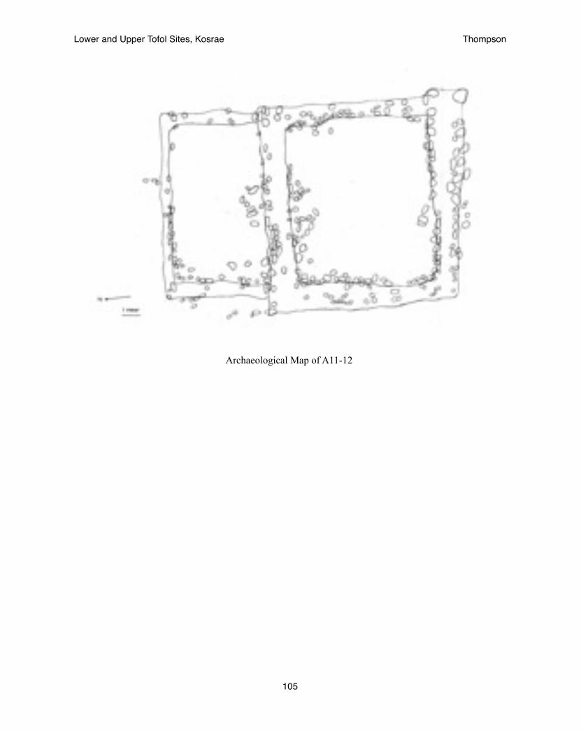
Archaeological Map of A11-12
Lower and Upper Tofol Sites, Kosrae! Thompson
105
Photograph of A11-12
Lower and Upper Tofol Sites, Kosrae! Thompson
106
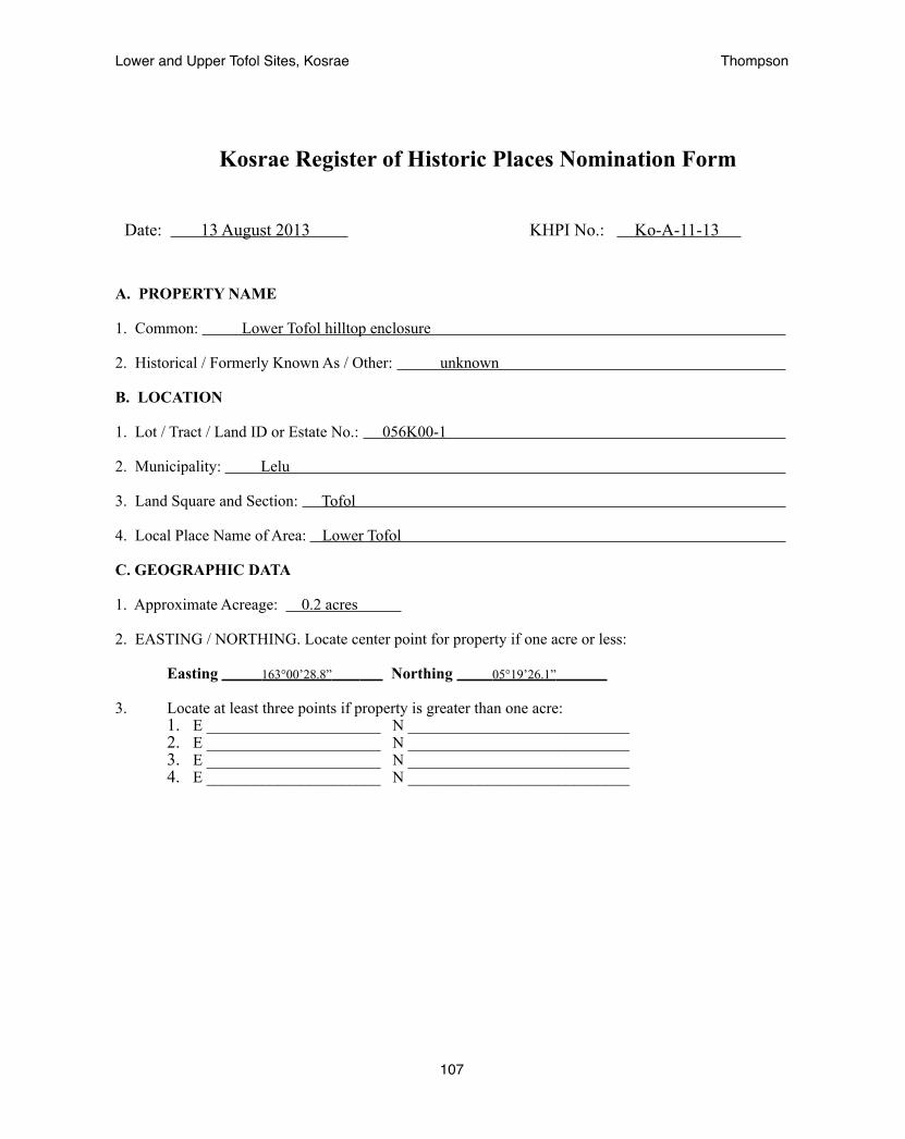
Kosrae Register of Historic Places Nomination Form
Date: 13 August 2013 KHPI No.: Ko-A-11-13
A. PROPERTY NAME
1. Common: Lower Tofol hilltop enclosure
2. Historical / Formerly Known As / Other: unknown
B. LOCATION
1. Lot / Tract / Land ID or Estate No.: 056K00-1
2. Municipality: Lelu
3. Land Square and Section: Tofol
4. Local Place Name of Area: Lower Tofol
C. GEOGRAPHIC DATA
1. Approximate Acreage: 0.2 acres
2. EASTING / NORTHING. Locate center point for property if one acre or less:
Easting 163°00’28.8” Northing 05°19’26.1”
3. Locate at least three points if property is greater than one acre:1. E ______________________ N ____________________________2. E ______________________ N ____________________________3. E ______________________ N ____________________________4. E ______________________ N ____________________________
Lower and Upper Tofol Sites, Kosrae! Thompson
107

D. CLASSIFICATION / USE / ACCESS
1. Category (check one): ____District X Site ____Building ____Structure ____Object
2. Status (check one or more): ___Occupied X Unoccupied ___Preservation work in Progress
3. Accessible to Public (check one): ____No ____Yes, Restricted X Yes, Unrestricted 4. Current Use (check one or more as appropriate):
X Agriculture _____ Industrial _____ Religious _____ Commercial _____ Military _____ Science _____ Conservation _____ Museum _____ Transportation _____ Education _____ Park _____ Unused _____ Entertainment _____ Ranch _____ Other _____ Government _____ Residence
5. Additional Comments on Present Use: Experimental Agroforest for the Forestry Department __________________________________________________________________________________________
E. PROPERTY OWNER
1. Ownership (check one or more as appropriate): X Government of Kosrae ____Private
2. Owner’s Name: Kosrae State Government - Office of the Governor
3. Physical Address Tofol, Kosrae
4. Mailing Address: PO Box 158, Tofol, Kosrae, 96944
5. Contact Numbers and Fax Number: 691-370-3002 or 691-370-3003
6. Email Address:
7. Lessee(s):
8. Lessee(s) Address:
Additional Information: Department of Resources and Economic Affairs, 691-370-2017
Lower and Upper Tofol Sites, Kosrae! Thompson
108
F. RECORDS SEARCH: LEGAL DESCRIPTION / LAND TITLE / SURVEYS
1. Land Title and Legal Description Located at (indicate Government Agency): Kosrae Land Court
2. Address: PO Box 808, Tofol, Lelu,Kosrae 96944 phone: 691-370-3025
3. Survey Records Located at: Kosrae Historic Preservation Office (HPO)
4. Date of Survey / Performed by / For: March-July 2013, Adam Thompson, Kosrae HPO
5. Type of Survey: X Reconnaissance Intensive-Detailed X Surface Mapping ____ Windshield ____Other, Specify:_______________________________
6. Original Field Notes, Artifacts, Human Remains Located At (indicate what and where these items are located, person to contact, contact numbers and physical address): Kosrae Historic Preservation Office PO Box 568, Tofol, Lelu, Kosrae FM 96944 phone: 370-3078 (Stanton Andrews)
G. DESCRIPTION / CONDITION
1. Type of Property (describe briefly the type of property, such as, pre-contact settlement site, burial ground, rockshelter, pictograph cave, etc. / include significant features.): The site is an late prehistoric platform that appears to have been used as an outlook during times of conflict
2. Known pressures on site: ___No X Yes, Indicate: vegetation, erosion
3. Vandalized / artifacts looted? X No ___Yes, Indicate: _________________________________________________________________________________________________________________________________
4. Condition: ___Excellent ___Good Fair X Deteriorated ___Ruin
5. Danger: No Known Future Danger ____Possible Future Danger ____Future Danger Certain ____Present Danger X Presently Being Destroyed/Damaged - Describe: disturbed by previous road development and utility pole construction
6. Integrity: X Altered / Original Location _____ Altered / Moved _____ Unaltered
Lower and Upper Tofol Sites, Kosrae! Thompson
109

H. HISTORIC CONTEXT / AREAS OF SIGNIFICANCE
1. The Historic Context of this Property is best classified as (check one or more):
____ 0 – 600 A.D. Early Settlement Period 600 – 1200 A.D. Early Prehistoric Period
X 1200 - 1820 A.D. Late Prehistoric Period ____ 1820 – 1850 A.D. European Discovery & Whaling Period ____ 1850 – 1880 A.D. Missionization Period ____ 1880 – 1910 A.D. German Period ____ 1910 – 1940 A.D. Japanese Civil Occupation ____ 1940 – 1945 A.D. World War II / Japanese Military Occupation ____ 1945 – 1984 A.D. Trust Territory
2. Specific Dates (if known): ________________________________________________________________
3. Areas of Significance (check one or more as appropriate): X Indigenous / Prehistoric ___Indigenous / Historic ___Agriculture ___Architecture ___Art ___Commerce ___Communications ___Conservation ___Education ___Engineering ___Industry ___Invention ___Landscape ___Architecture ___Literature ___Military ___Music ___Political ___Religion ___Spiritual ___Science ___Social / Humanitarian ___Theater ___Transportation ___Other (Specify)__________________________ 4. Importance as Example of Type: ___Excellent ___Good Fair X Poor
5. Interpretive Value: ___Excellent ___Good Fair X Poor
6. Research Potential: ___Excellent ___Good ___Fair X Poor
7. Local Attitude about Site: __Valuable __Not as Valuable __Not at all Valuable X Ambivalent __Unknown
8. Suggested Themes: conflict in the late prehistoric
Lower and Upper Tofol Sites, Kosrae! Thompson
110
I. SITE DESCRIPTION / STATEMENT OF SIGNIFICANCE
1. NARRATIVE DESCRIPTION MUST INCLUDE: Bearings and sources used to locate feature; terrain and vegetation; size; shape; construction techniques; materials used; condition; surface artifacts or midden visible; boundary description; boundary justification.
Likiaksa (1979) first documented the site as A11-13 within the part of Tofol he called Area 7. It is described as a low enclosure with platform measuring 9 x 9 meters. The wall was said to be 0.8 meter high with no entrances. Within the enclosure was a rectangular platform, 1.5 x 3.5 meters, abutted against the southwest wall. The site was relocated in 2013 as part of a reconnaissance survey of the Tofol Valley. At that time it appeared to have been impacted by erosion and road development. A utility pole had been placed near to the southwest corner preventing the identification of the internal platform. The structure was found to be 9 x 6 meters though heavy vegetation meant its western edge was not confidently defined.
The Lower Tofol complex is located below the hill that provides the scenic outlook in Tofol. It is on the southern side of the hill leading towards the valley. A small stream runs below towards the Tofol River to the west. The Lower Tofol hilltop enclosure lies at the switchback turn of the road leading up to the scenic view. There is a utility pole very close to the site. It lies a bit above the other sites in the complex. The Lower Tofol complex consists of a cluster of four structures found in close proximity to each other, sites A11-12, A11-13, A11-15, & A11-16. The Lower Tofol hilltop-enclosure is a medium-sized, four-sided, one-room structure terraced against the southwestern hill slope. Remnants of internal features remained but were difficult to fully understand given the poor preservation of the site. The wall was roughly 0.5 to 1 m high around. Its location raised above the area provides it with a good view across the area. It believed that the site may date to a later time when conflict existed between the people of the valley and high chiefs of Lelu and provided a look out.
2. STATEMENT OF SIGNIFICANCE MUST INCLUDE: Unusual or important characteristics; accessibility; interpretive and research potential; evaluation of the site’s importance as a representative of its class and historic context; recommendations for register category; and other important factors that contribute to the property’s significance.
The Lower Tofol complex as a whole offers an opportunity to compare structures representing different aspects of the valleys settlement. The Lower Tofol hilltop enclosure is believed to have been used as a defensive look out and therefore represents a later period of conflict that is documented in oral traditions.
Its location near to the Kosrae museum and the Kosrae high school would allow it to be easily used for field trips for tourists and/or students who would like to see what an untouched archaeological site looks like. Hopefully, this could lead to the development of interest in archaeology for some students and help the Kosrae historic preservation office to further develop.
However, the disturbed nature of the site detracts from its overall significance and makes its future preservation more difficult.
Lower and Upper Tofol Sites, Kosrae! Thompson
111

Lower and Upper Tofol Sites, Kosrae! Thompson
112
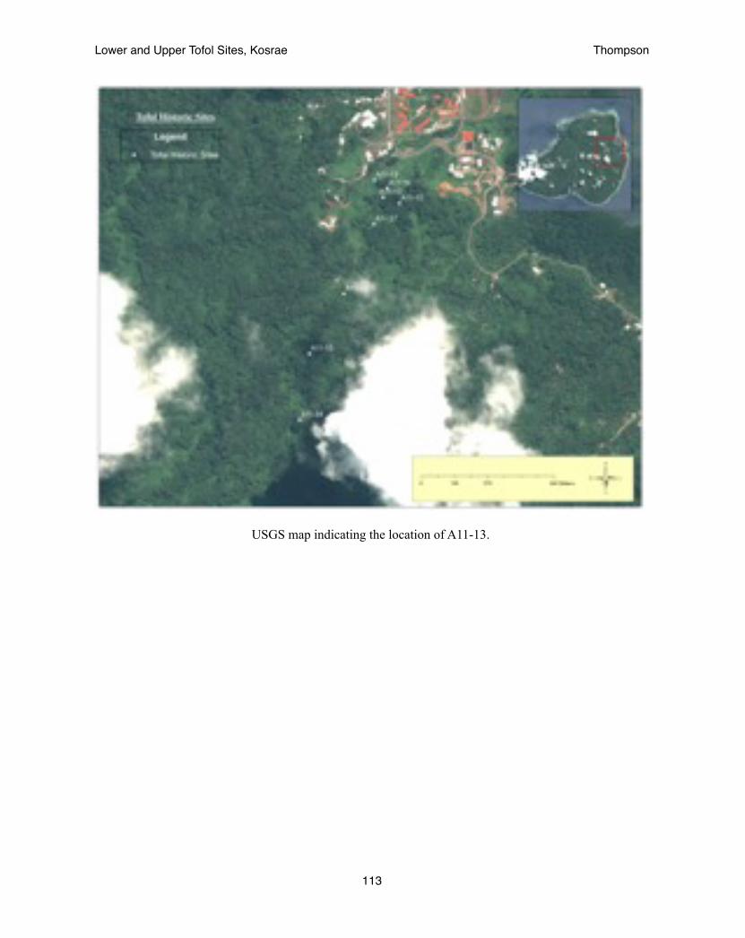
USGS map indicating the location of A11-13.
Lower and Upper Tofol Sites, Kosrae! Thompson
113
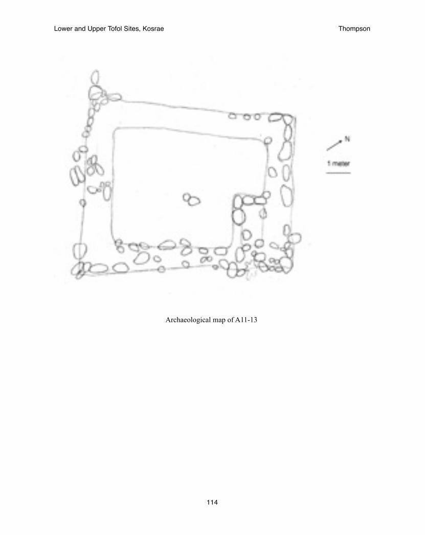
Archaeological map of A11-13
Lower and Upper Tofol Sites, Kosrae! Thompson
114
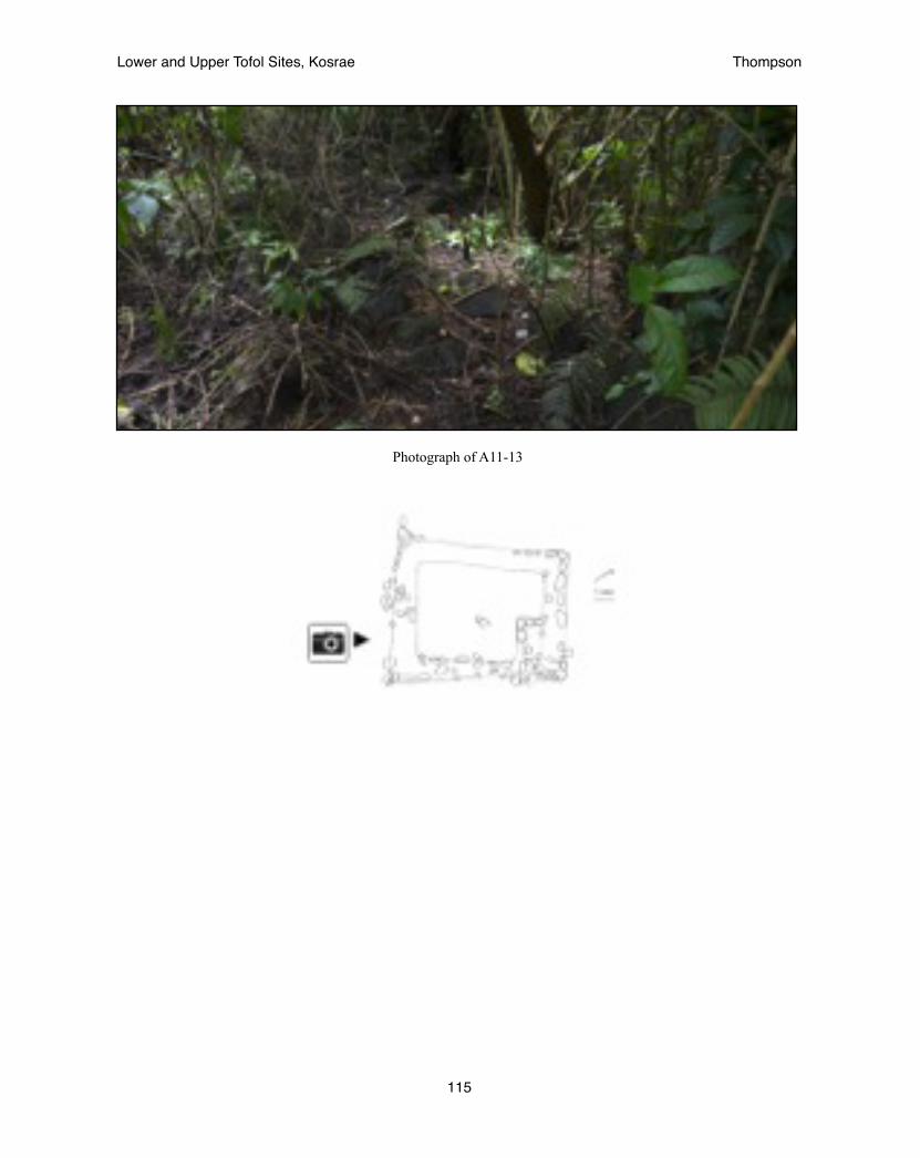
Photograph of A11-13
Lower and Upper Tofol Sites, Kosrae! Thompson
115

Kosrae Register of Historic Places Nomination Form
Date: 13 August 2013 KHPI No.: Ko-A-11-15
A. PROPERTY NAME
1. Common: Lower Tofol habitation site
2. Historical / Formerly Known As / Other: unknown
B. LOCATION
1. Parcel No.: 056K00-1
2. Municipality: Lelu
3. Land Square and Section: Tofol
4. Local Place Name of Area: Lower Tofol
C. GEOGRAPHIC DATA
1. Approximate Acreage: 0.5 acres
2. EASTING / NORTHING. Locate center point for property if one acre or less:
Easting 163°00’30.5” Northing 05°19’25.0”
3. Locate at least three points if property is greater than one acre:1. E ______________________ N ____________________________2. E ______________________ N ____________________________3. E ______________________ N ____________________________4. E ______________________ N ____________________________
Lower and Upper Tofol Sites, Kosrae! Thompson
116
D. CLASSIFICATION / USE / ACCESS
1. Category (check one): ____District X Site ____Building ____Structure ____Object
2. Status (check one or more): ___Occupied X Unoccupied ___Preservation work in Progress
3. Accessible to Public (check one): ____No ____Yes, Restricted X Yes, Unrestricted 4. Current Use (check one or more as appropriate):
X Agriculture _____ Industrial _____ Religious _____ Commercial _____ Military _____ Science _____ Conservation _____ Museum _____ Transportation _____ Education _____ Park _____ Unused _____ Entertainment _____ Ranch _____ Other _____ Government _____ Residence
5. Additional Comments on Present Use: Experimental Agroforest for the Forestry Department __________________________________________________________________________________________
E. PROPERTY OWNER
1. Ownership (check one or more as appropriate): X Government of Kosrae ____Private
2. Owner’s Name: Kosrae State Government - Office of the Governor
3. Physical Address Tofol, Kosrae
4. Mailing Address: PO Box 158, Tofol, Kosrae, 96944
5. Contact Numbers and Fax Number: 691-370-3002 or 691-370-3003
6. Email Address:
7. Lessee(s):
8. Lessee(s) Address:
Additional Information: Department of Resources and Economic Affairs, 691-370-2017
Lower and Upper Tofol Sites, Kosrae! Thompson
117
F. RECORDS SEARCH: LEGAL DESCRIPTION / LAND TITLE / SURVEYS
1. Land Title and Legal Description Located at (indicate Government Agency): Kosrae Land Court
2. Address: PO Box 808, Tofol, Lelu,Kosrae 96944 phone: 691-370-3025
3. Survey Records Located at: Kosrae Historic Preservation Office (HPO)
4. Date of Survey / Performed by / For: March-July 2013, Adam Thompson, Kosrae HPO
5. Type of Survey: ____Reconnaissance X Intensive-Detailed X Surface Mapping ____ Windshield ____Other, Specify:_______________________________
6. Original Field Notes, Artifacts, Human Remains Located At (indicate what and where these items are located, person to contact, contact numbers and physical address): Kosrae Historic Preservation Office PO Box 568, Tofol, Lelu, Kosrae FM 96944 phone: 370-3078 (Stanton Andrews)
G. DESCRIPTION / CONDITION
1. Type of Property (describe briefly the type of property, such as, pre-contact settlement site, burial ground, rockshelter, pictograph cave, etc. / include significant features.): The site is an late prehistoric residential sitethat appears to have been used by the common people
2. Known pressures on site: ___No X Yes, Indicate: vegetation, erosion
3. Vandalized / artifacts looted? X No ___Yes, Indicate: _________________________________________________________________________________________________________________________________
4. Condition: ___Excellent X Good Fair Deteriorated ___Ruin
5. Danger: X No Known Future Danger ____Possible Future Danger ____Future Danger Certain ____Present Danger Presently Being Destroyed/Damaged - Describe:
6. Integrity: X Altered / Original Location _____ Altered / Moved _____ Unaltered
Lower and Upper Tofol Sites, Kosrae! Thompson
118

H. HISTORIC CONTEXT / AREAS OF SIGNIFICANCE
1. The Historic Context of this Property is best classified as (check one or more):
____ 0 – 600 A.D. Early Settlement Period 600 – 1200 A.D. Early Prehistoric Period
X 1200 - 1820 A.D. Late Prehistoric Period ____ 1820 – 1850 A.D. European Discovery & Whaling Period ____ 1850 – 1880 A.D. Missionization Period ____ 1880 – 1910 A.D. German Period ____ 1910 – 1940 A.D. Japanese Civil Occupation ____ 1940 – 1945 A.D. World War II / Japanese Military Occupation ____ 1945 – 1984 A.D. Trust Territory
2. Specific Dates (if known): ________________________________________________________________
3. Areas of Significance (check one or more as appropriate): X Indigenous / Prehistoric ___Indigenous / Historic ___Agriculture ___Architecture ___Art ___Commerce ___Communications ___Conservation ___Education ___Engineering ___Industry ___Invention ___Landscape ___Architecture ___Literature ___Military ___Music ___Political ___Religion ___Spiritual ___Science ___Social / Humanitarian ___Theater ___Transportation ___Other (Specify)__________________________ 4. Importance as Example of Type: ___Excellent X Good Fair Poor
5. Interpretive Value: ___Excellent X Good Fair Poor
6. Research Potential: ___Excellent X Good ___Fair Poor
7. Local Attitude about Site: __Valuable __Not as Valuable __Not at all Valuable X Ambivalent __Unknown
8. Suggested Themes: late prehistoric settlement patterns
Lower and Upper Tofol Sites, Kosrae! Thompson
119

I. SITE DESCRIPTION / STATEMENT OF SIGNIFICANCE
1. NARRATIVE DESCRIPTION MUST INCLUDE: Bearings and sources used to locate feature; terrain and vegetation; size; shape; construction techniques; materials used; condition; surface artifacts or midden visible; boundary description; boundary justification.
Likiaksa (1979) first identified the site as A11-15 within the part of Tofol he called Area 7. It was described as a low terraced platform measuring 0.5 meter high. It was said to be smaller than the area described above at 9 x 9 m. This discrepancy is hard to explain other than with the assumption that heavy vegetation prevented the entire site from being cleared. The site was relocated in 2013. At that time a eucalyptus tree had fallen on the site and made the boundaries difficult to find until a large amount of clearing had been performed. It was found to be a simple but large platform most suitable as a habitation platform.
The Lower Tofol complex is located below the hill that provides the scenic outlook in Tofol. It is on the southern side of the hill leading towards the valley. A small stream runs below towards the Tofol River to the west. The Lower Tofol habitation site lies across the stream within a grove of eucalyptus trees. The Lower Tofol complex consists of a cluster of four structures found in close proximity to each other, sites A11-12, A11-13, A11-15, & A11-16. The Lower Tofol habitaiton site is the largest structure within the Lower Tofol complex, yet it is also the least elaborate. A simple wall averaging three stones high, or roughly 0.5 meter formed a terrace platform on three-sides with the open side facing the mountain ridge. There were no stones found in the center of the platform. It is believed that this was a large area for the habitation of an extended family. A possible entrance may be seen on the west side of the structure. This side faces the path leading to the other structures within the area. Small terraces around the structure appear to be the remains of gardening features.
2. STATEMENT OF SIGNIFICANCE MUST INCLUDE: Unusual or important characteristics; accessibility; interpretive and research potential; evaluation of the site’s importance as a representative of its class and historic context; recommendations for register category; and other important factors that contribute to the property’s significance.
The Lower Tofol site complex provides information on the prehistoric settlement of the Tofol valley including changes in settlement pattern over time. The Lower Tofol habitation site fits into the site type of a single-room platform that is associated with the Late Prehistoric roughly 1400-1800 AD. Its presence along with the Lower Tofol ceremonial site shows an increased population in the Lower Tofol area at that time associated with oral traditions of a movement of people from the mountains to the coast.
Lower and Upper Tofol Sites, Kosrae! Thompson
120

Lower and Upper Tofol Sites, Kosrae! Thompson
121
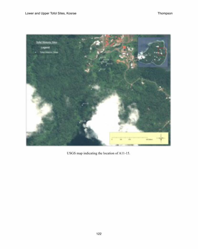
USGS map indicating the location of A11-15.
Lower and Upper Tofol Sites, Kosrae! Thompson
122

Archaeological map of A11-15
Lower and Upper Tofol Sites, Kosrae! Thompson
123

Photograph of North eastern corner of A11-15
Lower and Upper Tofol Sites, Kosrae! Thompson
124

Kosrae Register of Historic Places Nomination Form
Date: 13 August 2013 KHPI No.: Ko-A-11-16
A. PROPERTY NAME
1. Common: Lower Tofol ceremonial site
2. Historical / Formerly Known As / Other: unknown
B. LOCATION
1. Lot / Tract / Land ID or Estate No.: 056K00-1
2. Municipality: Lelu
3. Land Square and Section: Tofol
4. Local Place Name of Area: Lower Tofol
C. GEOGRAPHIC DATA
1. Approximate Acreage: 0.5 acres
2. EASTING / NORTHING. Locate center point for property if one acre or less:
Easting 163°00’30.5” Northing 05°19’25.0”
3. Locate at least three points if property is greater than one acre:1. E ______________________ N ____________________________2. E ______________________ N ____________________________3. E ______________________ N ____________________________4. E ______________________ N ____________________________
Lower and Upper Tofol Sites, Kosrae! Thompson
125

D. CLASSIFICATION / USE / ACCESS
1. Category (check one): ____District X Site ____Building ____Structure ____Object
2. Status (check one or more): ___Occupied X Unoccupied ___Preservation work in Progress
3. Accessible to Public (check one): ____No ____Yes, Restricted X Yes, Unrestricted 4. Current Use (check one or more as appropriate):
X Agriculture _____ Industrial _____ Religious _____ Commercial _____ Military _____ Science _____ Conservation _____ Museum _____ Transportation _____ Education _____ Park _____ Unused _____ Entertainment _____ Ranch _____ Other _____ Government _____ Residence
5. Additional Comments on Present Use: Experimental Agroforest for the Forestry Department __________________________________________________________________________________________
E. PROPERTY OWNER
1. Ownership (check one or more as appropriate): X Government of Kosrae ____Private
2. Owner’s Name: Kosrae State Government - Office of the Governor
3. Physical Address Tofol, Kosrae
4. Mailing Address: PO Box 158, Tofol, Kosrae, 96944
5. Contact Numbers and Fax Number: 691-370-3002 or 691-370-3003
6. Email Address:
7. Lessee(s):
8. Lessee(s) Address:
Additional Information: Department of Resources and Economic Affairs, 691-370-2017
Lower and Upper Tofol Sites, Kosrae! Thompson
126
F. RECORDS SEARCH: LEGAL DESCRIPTION / LAND TITLE / SURVEYS
1. Land Title and Legal Description Located at (indicate Government Agency): Kosrae Land Court
2. Address: PO Box 808, Tofol, Lelu,Kosrae 96944 phone: 691-370-3025
3. Survey Records Located at: Kosrae Historic Preservation Office (HPO)
4. Date of Survey / Performed by / For: March-July 2013, Adam Thompson, Kosrae HPO
5. Type of Survey: ____Reconnaissance X Intensive-Detailed X Surface Mapping ____ Windshield ____Other, Specify:_______________________________
6. Original Field Notes, Artifacts, Human Remains Located At (indicate what and where these items are located, person to contact, contact numbers and physical address): Kosrae Historic Preservation Office PO Box 568, Tofol, Lelu, Kosrae FM 96944 phone: 370-3078 (Stanton Andrews)
G. DESCRIPTION / CONDITION
1. Type of Property (describe briefly the type of property, such as, pre-contact settlement site, burial ground, rockshelter, pictograph cave, etc. / include significant features.): The site is a late prehistoric ceremonial sitebased on the presence of sakau pounding stones and a basalt drinking vessel and the strictly ceremonial use of sakau in the prehistoric time.
2. Known pressures on site: ___No X Yes, Indicate: vegetation, erosion, tree harvesting
3. Vandalized / artifacts looted? X No ___Yes, Indicate: _________________________________________________________________________________________________________________________________
4. Condition: ___Excellent X Good Fair Deteriorated ___Ruin
5. Danger: X No Known Future Danger Possible Future Danger ____Future Danger Certain ____Present Danger Presently Being Destroyed/Damaged - Describe:
6. Integrity: X Altered / Original Location _____ Altered / Moved _____ Unaltered
Lower and Upper Tofol Sites, Kosrae! Thompson
127
H. HISTORIC CONTEXT / AREAS OF SIGNIFICANCE
1. The Historic Context of this Property is best classified as (check one or more):
____ 0 – 600 A.D. Early Settlement Period 600 – 1200 A.D. Early Prehistoric Period
X 1200 - 1820 A.D. Late Prehistoric Period ____ 1820 – 1850 A.D. European Discovery & Whaling Period ____ 1850 – 1880 A.D. Missionization Period ____ 1880 – 1910 A.D. German Period ____ 1910 – 1940 A.D. Japanese Civil Occupation ____ 1940 – 1945 A.D. World War II / Japanese Military Occupation ____ 1945 – 1984 A.D. Trust Territory
2. Specific Dates (if known): ________________________________________________________________
3. Areas of Significance (check one or more as appropriate): X Indigenous / Prehistoric ___Indigenous / Historic ___Agriculture ___Architecture ___Art ___Commerce ___Communications ___Conservation ___Education ___Engineering ___Industry ___Invention ___Landscape ___Architecture ___Literature ___Military ___Music ___Political ___Religion ___Spiritual ___Science ___Social / Humanitarian ___Theater ___Transportation ___Other (Specify)__________________________ 4. Importance as Example of Type: ___Excellent X Good Fair Poor
5. Interpretive Value: ___Excellent X Good Fair Poor
6. Research Potential: ___Excellent X Good ___Fair Poor
7. Local Attitude about Site: __Valuable __Not as Valuable __Not at all Valuable X Ambivalent __Unknown
8. Suggested Themes: ceremonial platforms of the late prehistoric
Lower and Upper Tofol Sites, Kosrae! Thompson
128

I. SITE DESCRIPTION / STATEMENT OF SIGNIFICANCE
1. NARRATIVE DESCRIPTION MUST INCLUDE: Bearings and sources used to locate feature; terrain and vegetation; size; shape; construction techniques; materials used; condition; surface artifacts or midden visible; boundary description; boundary justification.
Likiaksa (1979) first identified the site as A11-16 within the part of Tofol he called Area 7. It was described as a terraced platform elevated 1.4 meters on the downslope side measuring 11 x 10 meters. It was said to be located 25m from the existing Agricultural Office Station. The site was relocated in 2013 as part of an intensive survey of the Lower Tofol site complex. At that time the site was finely mapped and was found to be slightly bigger than the previous measurements though the major features fit within a smaller area matching the previous description. At that time a small, yet elaborate platform was found at the center of the site with concentric alignments of stone. The presence of this platform, several grinding stones and a basalt vessel led to the belief that the site was an important ceremonial site that matched oral histories described by Segal (1989).
The Lower Tofol complex is located below the hill that provides the scenic outlook in Tofol. It is on the southern side of the hill leading towards the valley. A small stream runs below towards the Tofol River to the west. The Lower Tofol ceremonial site lies just below the dilapidated building that was once the Kosrae Historic Preservation Office and the Agricultural building before that. The total size of the structure is 16.5 x 11 meters. It is standard practice for a 50’, or 16 m boundary to be maintained around historic sites. Thus the boundary of the site should measure 48 x 43 meters, or more generally a 25m radius from the center of the site.
The Lower Tofol complex consists of a cluster of four structures found in close proximity to each other, sites A11-12, A11-13, A11-15, & A11-16. The Lower Tofol ceremonial site is raised three-sided platform that averages roughly two meters high. The south-east corner was well-intact and showed the original design while the opposite south-west corner was considerably deflated. Several grinding stones were found at the site as well as a small basalt bowl. At the center of the structure a small platform was raised above the rest of the surface. Minor excavation of the surface was conducted to better observe the stones. It was found that six layers of stone formed multiple steps up to a small platform. It is believed that this central platform was an altar and the site would have been used for ceremonial purposes including the consumption of seka (Piper methysticum) based on the presence of the grinding stones. The basalt bowl may have been used to serve seka. A raised stone within the wall opposite of the central platform also appears to possibly be a seat facing the altar. (Thompson 2013)
2. STATEMENT OF SIGNIFICANCE MUST INCLUDE: Unusual or important characteristics; accessibility; interpretive and research potential; evaluation of the site’s importance as a representative of its class and historic context; recommendations for register category; and other important factors that contribute to the property’s significance.
The Lower Tofol site complex provides information on the prehistoric settlement of the Tofol valley including changes in settlement pattern over time. The Lower Tofol ceremonial site shows that the complex was used for more than just habitation. It is also believed to have been a stop on the priestly procession from Utwe to Lelu during an annual festive ritual during the time of the Lelu ruins. Its location near to the Kosrae museum and the Kosrae high school would allow it to be easily used for field trips for tourists and/or students who would like to see what an untouched archaeological site looks like. Hopefully, this could lead to the development of interest in archaeology for some students and help the Kosrae historic preservation office to further develop.
Lower and Upper Tofol Sites, Kosrae! Thompson
129

Lower and Upper Tofol Sites, Kosrae! Thompson
130

USGS map indicating the location of A11-16.
Lower and Upper Tofol Sites, Kosrae! Thompson
131
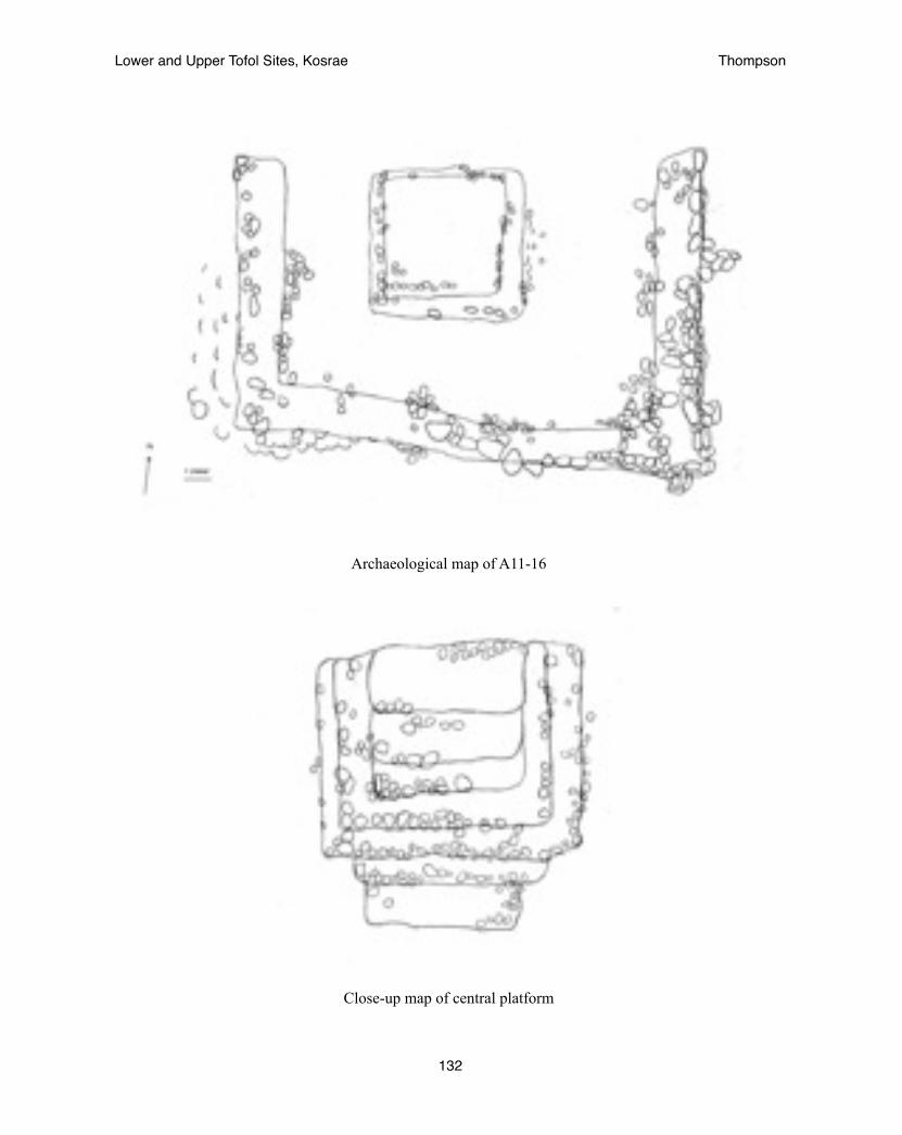
Archaeological map of A11-16
Close-up map of central platform
Lower and Upper Tofol Sites, Kosrae! Thompson
132
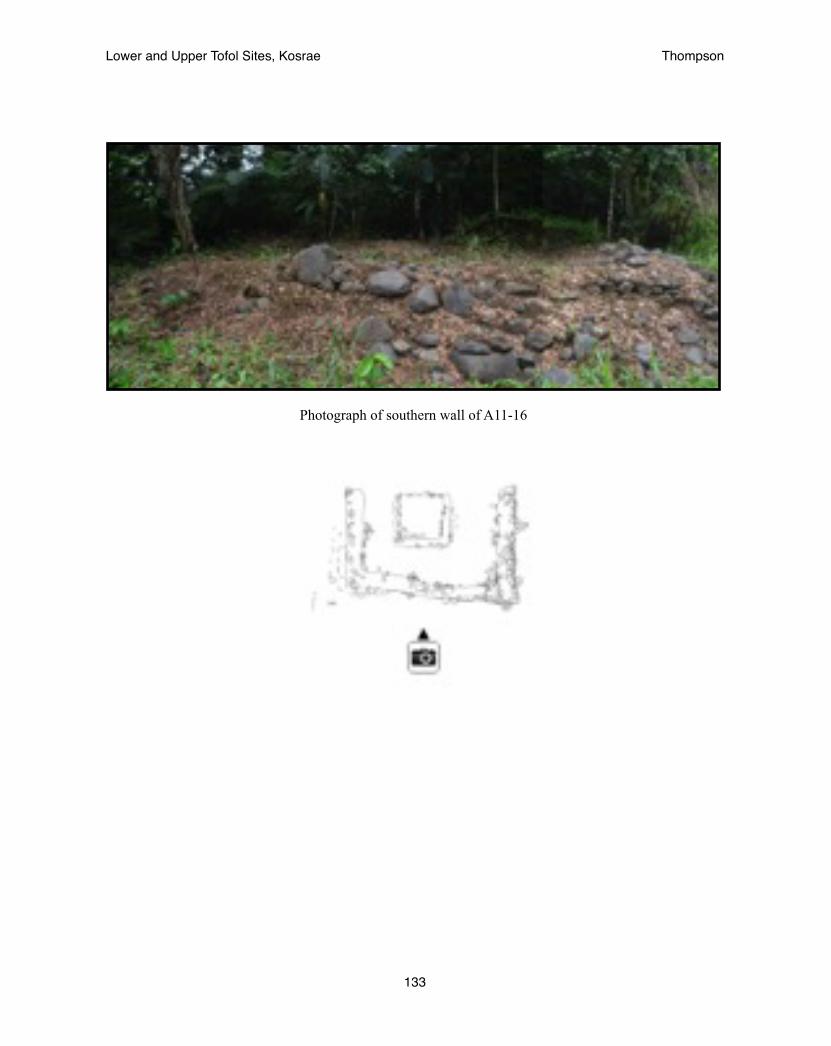
Photograph of southern wall of A11-16
Lower and Upper Tofol Sites, Kosrae! Thompson
133

Oral Historical record of ceremonial procession from Menke to Lelu through Tofol
“After the month of feasting and festivity, the king would go into seclusion in a special compound in Lelu...While the king was in seclusion there was priestly activity dedicated to Sinlaku. Priests from her village in Utwe on the south side walked all the way to Tofol, blowing the trumpet shell. Then they proceeded by canoe into the canal at Lelu. They carried a special kind of spear and knots of coconut leaflets, necklaces, a basket with certain kinds of shells in it and bleached taro leaves. When they arrived in Lelu, seka was pounded and ceremoniously served. The bleached taro leaves were torn into strips and tied around the king’s and queen’s wrists while the priests chanted and held the hands of the Togusra and his wife” (Segal 1989, 29)
Lower and Upper Tofol Sites, Kosrae! Thompson
134
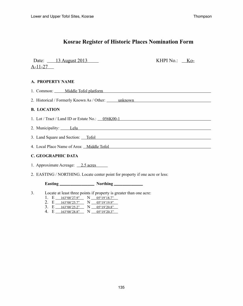
Kosrae Register of Historic Places Nomination Form
Date: 13 August 2013 KHPI No.: Ko-A-11-27
A. PROPERTY NAME
1. Common: Middle Tofol platform
2. Historical / Formerly Known As / Other: unknown
B. LOCATION
1. Lot / Tract / Land ID or Estate No.: 056K00-1
2. Municipality: Lelu
3. Land Square and Section: Tofol
4. Local Place Name of Area: Middle Tofol
C. GEOGRAPHIC DATA
1. Approximate Acreage: 2.5 acres
2. EASTING / NORTHING. Locate center point for property if one acre or less:
Easting Northing
3. Locate at least three points if property is greater than one acre:1. E 163°00’27.9” N 05°19’18.7” 2. E 163°00’25.7” N 05°19’19.9” 3. E 163°00’25.2” N 05°19’20.8” 4. E 163°00’28.8” N 05°19’20.3”
Lower and Upper Tofol Sites, Kosrae! Thompson
135

D. CLASSIFICATION / USE / ACCESS
1. Category (check one): ____District X Site ____Building ____Structure ____Object
2. Status (check one or more): ___Occupied X Unoccupied ___Preservation work in Progress
3. Accessible to Public (check one): ____No ____Yes, Restricted X Yes, Unrestricted 4. Current Use (check one or more as appropriate):
X Agriculture _____ Industrial _____ Religious _____ Commercial _____ Military _____ Science _____ Conservation _____ Museum _____ Transportation _____ Education _____ Park _____ Unused _____ Entertainment _____ Ranch _____ Other _____ Government _____ Residence
5. Additional Comments on Present Use: Experimental Agroforest for the Forestry Department __________________________________________________________________________________________
E. PROPERTY OWNER
1. Ownership (check one or more as appropriate): X Government of Kosrae ____Private
2. Owner’s Name: Kosrae State Government - Office of the Governor
3. Physical Address Tofol, Kosrae
4. Mailing Address: PO Box 158, Tofol, Kosrae, 96944
5. Contact Numbers and Fax Number: 691-370-3002 or 691-370-3003
6. Email Address:
7. Lessee(s):
8. Lessee(s) Address:
Additional Information: Department of Resources and Economic Affairs, 691-370-2017
Lower and Upper Tofol Sites, Kosrae! Thompson
136
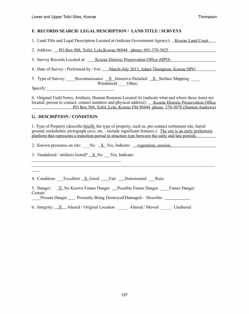
F. RECORDS SEARCH: LEGAL DESCRIPTION / LAND TITLE / SURVEYS
1. Land Title and Legal Description Located at (indicate Government Agency): Kosrae Land Court
2. Address: PO Box 808, Tofol, Lelu,Kosrae 96944 phone: 691-370-3025
3. Survey Records Located at: Kosrae Historic Preservation Office (HPO)
4. Date of Survey / Performed by / For: March-July 2013, Adam Thompson, Kosrae HPO
5. Type of Survey: ____Reconnaissance X Intensive-Detailed X Surface Mapping ____ Windshield ____Other, Specify:_______________________________
6. Original Field Notes, Artifacts, Human Remains Located At (indicate what and where these items are located, person to contact, contact numbers and physical address): Kosrae Historic Preservation Office PO Box 568, Tofol, Lelu, Kosrae FM 96944 phone: 370-3078 (Stanton Andrews)
G. DESCRIPTION / CONDITION
1. Type of Property (describe briefly the type of property, such as, pre-contact settlement site, burial ground, rockshelter, pictograph cave, etc. / include significant features.): The site is an early prehistoric platform that represents a transition period in structure type between the early and late periods.
2. Known pressures on site: ___No X Yes, Indicate: vegetation, erosion,
3. Vandalized / artifacts looted? X No ___Yes, Indicate: _________________________________________________________________________________________________________________________________
4. Condition: ___Excellent X Good Fair Deteriorated ___Ruin
5. Danger: X No Known Future Danger Possible Future Danger ____Future Danger Certain ____Present Danger Presently Being Destroyed/Damaged - Describe:
6. Integrity: X Altered / Original Location _____ Altered / Moved _____ Unaltered
Lower and Upper Tofol Sites, Kosrae! Thompson
137
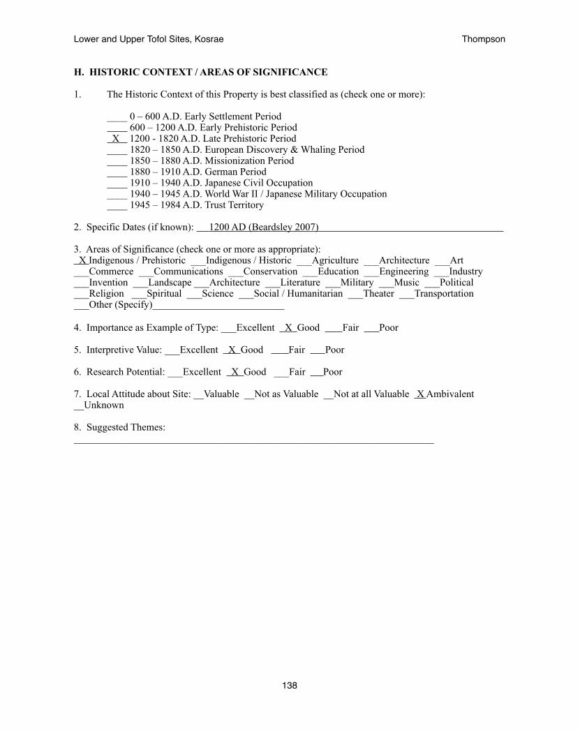
H. HISTORIC CONTEXT / AREAS OF SIGNIFICANCE
1. The Historic Context of this Property is best classified as (check one or more):
____ 0 – 600 A.D. Early Settlement Period 600 – 1200 A.D. Early Prehistoric Period
X 1200 - 1820 A.D. Late Prehistoric Period ____ 1820 – 1850 A.D. European Discovery & Whaling Period ____ 1850 – 1880 A.D. Missionization Period ____ 1880 – 1910 A.D. German Period ____ 1910 – 1940 A.D. Japanese Civil Occupation ____ 1940 – 1945 A.D. World War II / Japanese Military Occupation ____ 1945 – 1984 A.D. Trust Territory
2. Specific Dates (if known): 1200 AD (Beardsley 2007)
3. Areas of Significance (check one or more as appropriate): X Indigenous / Prehistoric ___Indigenous / Historic ___Agriculture ___Architecture ___Art ___Commerce ___Communications ___Conservation ___Education ___Engineering ___Industry ___Invention ___Landscape ___Architecture ___Literature ___Military ___Music ___Political ___Religion ___Spiritual ___Science ___Social / Humanitarian ___Theater ___Transportation ___Other (Specify)__________________________ 4. Importance as Example of Type: ___Excellent X Good Fair Poor
5. Interpretive Value: ___Excellent X Good Fair Poor
6. Research Potential: ___Excellent X Good ___Fair Poor
7. Local Attitude about Site: __Valuable __Not as Valuable __Not at all Valuable X Ambivalent __Unknown
8. Suggested Themes: _______________________________________________________________________
Lower and Upper Tofol Sites, Kosrae! Thompson
138
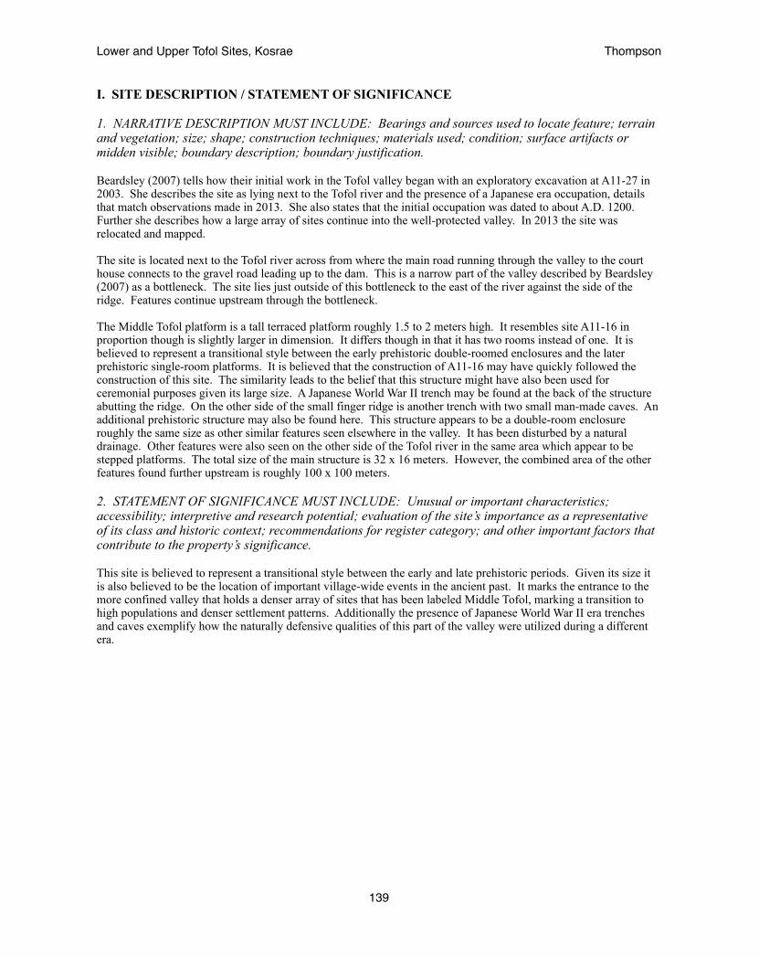
I. SITE DESCRIPTION / STATEMENT OF SIGNIFICANCE
1. NARRATIVE DESCRIPTION MUST INCLUDE: Bearings and sources used to locate feature; terrain and vegetation; size; shape; construction techniques; materials used; condition; surface artifacts or midden visible; boundary description; boundary justification.
Beardsley (2007) tells how their initial work in the Tofol valley began with an exploratory excavation at A11-27 in 2003. She describes the site as lying next to the Tofol river and the presence of a Japanese era occupation, details that match observations made in 2013. She also states that the initial occupation was dated to about A.D. 1200. Further she describes how a large array of sites continue into the well-protected valley. In 2013 the site was relocated and mapped.
The site is located next to the Tofol river across from where the main road running through the valley to the court house connects to the gravel road leading up to the dam. This is a narrow part of the valley described by Beardsley (2007) as a bottleneck. The site lies just outside of this bottleneck to the east of the river against the side of the ridge. Features continue upstream through the bottleneck.
The Middle Tofol platform is a tall terraced platform roughly 1.5 to 2 meters high. It resembles site A11-16 in proportion though is slightly larger in dimension. It differs though in that it has two rooms instead of one. It is believed to represent a transitional style between the early prehistoric double-roomed enclosures and the later prehistoric single-room platforms. It is believed that the construction of A11-16 may have quickly followed the construction of this site. The similarity leads to the belief that this structure might have also been used for ceremonial purposes given its large size. A Japanese World War II trench may be found at the back of the structure abutting the ridge. On the other side of the small finger ridge is another trench with two small man-made caves. An additional prehistoric structure may also be found here. This structure appears to be a double-room enclosure roughly the same size as other similar features seen elsewhere in the valley. It has been disturbed by a natural drainage. Other features were also seen on the other side of the Tofol river in the same area which appear to be stepped platforms. The total size of the main structure is 32 x 16 meters. However, the combined area of the other features found further upstream is roughly 100 x 100 meters.
2. STATEMENT OF SIGNIFICANCE MUST INCLUDE: Unusual or important characteristics; accessibility; interpretive and research potential; evaluation of the site’s importance as a representative of its class and historic context; recommendations for register category; and other important factors that contribute to the property’s significance.
This site is believed to represent a transitional style between the early and late prehistoric periods. Given its size it is also believed to be the location of important village-wide events in the ancient past. It marks the entrance to the more confined valley that holds a denser array of sites that has been labeled Middle Tofol, marking a transition to high populations and denser settlement patterns. Additionally the presence of Japanese World War II era trenches and caves exemplify how the naturally defensive qualities of this part of the valley were utilized during a different era.
Lower and Upper Tofol Sites, Kosrae! Thompson
139
Lower and Upper Tofol Sites, Kosrae! Thompson
140

USGS map indicating the location of A11-27.
Lower and Upper Tofol Sites, Kosrae! Thompson
141
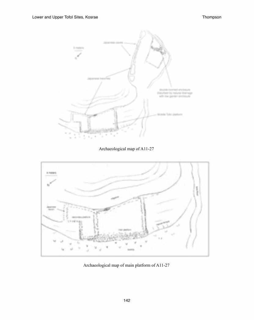
Archaeological map of A11-27
Archaeological map of main platform of A11-27
Lower and Upper Tofol Sites, Kosrae! Thompson
142
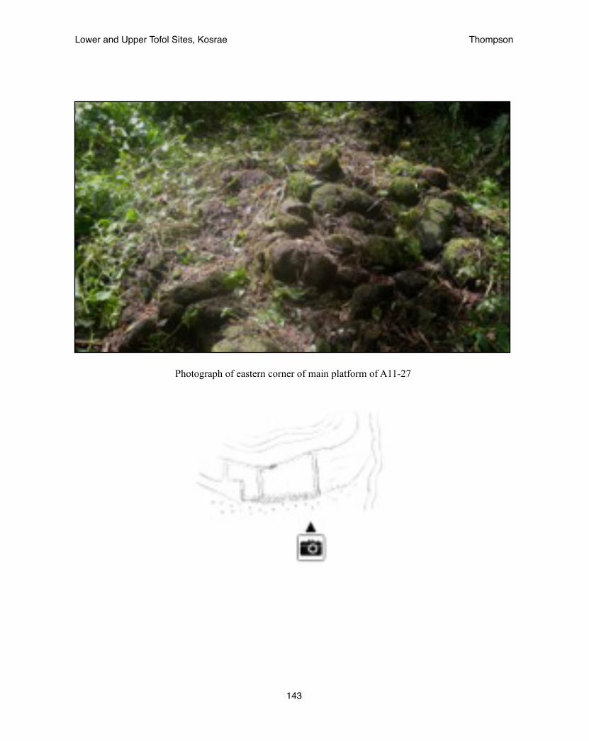
Photograph of eastern corner of main platform of A11-27
Lower and Upper Tofol Sites, Kosrae! Thompson
143
Kosrae Register of Historic Places Nomination Form
Date: 13 August 2013 KHPI No.: Ko-A-11-32
A. PROPERTY NAME
1. Common: Finol Tokosra site
2. Historical / Formerly Known As / Other: unknown
B. LOCATION
1. Lot / Tract / Land ID or Estate No.: 056K00-1
2. Municipality: Lelu
3. Land Square and Section: Tofol
4. Local Place Name of Area: Middle Tofol
C. GEOGRAPHIC DATA
1. Approximate Acreage: 3.8 acres
2. EASTING / NORTHING. Locate center point for property if one acre or less:
Easting Northing
3. Locate at least three points if property is greater than one acre:1. E 163°00’24.6” N 05°19’11.1” 2. E 163°00’27.0” N 05°19’10.0” 3. E 163°00’28.0” N 05°19’12.4” 4. E 163°00’26.0” N 05°19’13.3”
Lower and Upper Tofol Sites, Kosrae! Thompson
144

D. CLASSIFICATION / USE / ACCESS
1. Category (check one): ____District X Site ____Building ____Structure ____Object
2. Status (check one or more): ___Occupied X Unoccupied ___Preservation work in Progress
3. Accessible to Public (check one): ____No ____Yes, Restricted X Yes, Unrestricted 4. Current Use (check one or more as appropriate):
X Agriculture _____ Industrial _____ Religious _____ Commercial _____ Military _____ Science _____ Conservation _____ Museum _____ Transportation _____ Education _____ Park _____ Unused _____ Entertainment _____ Ranch _____ Other _____ Government _____ Residence
5. Additional Comments on Present Use: Experimental Agroforest for the Forestry Department __________________________________________________________________________________________
E. PROPERTY OWNER
1. Ownership (check one or more as appropriate): X Government of Kosrae ____Private
2. Owner’s Name: Kosrae State Government - Office of the Governor
3. Physical Address Tofol, Kosrae
4. Mailing Address: PO Box 158, Tofol, Kosrae, 96944
5. Contact Numbers and Fax Number: 691-370-3002 or 691-370-3003
6. Email Address:
7. Lessee(s):
8. Lessee(s) Address:
Additional Information: Department of Resources and Economic Affairs, 691-370-2017
Lower and Upper Tofol Sites, Kosrae! Thompson
145

F. RECORDS SEARCH: LEGAL DESCRIPTION / LAND TITLE / SURVEYS
1. Land Title and Legal Description Located at (indicate Government Agency): Kosrae Land Court
2. Address: PO Box 808, Tofol, Lelu,Kosrae 96944 phone: 691-370-3025
3. Survey Records Located at: Kosrae Historic Preservation Office (HPO)
4. Date of Survey / Performed by / For: March-July 2013, Adam Thompson, Kosrae HPO
5. Type of Survey: ____Reconnaissance X Intensive-Detailed X Surface Mapping ____ Windshield ____Other, Specify:_______________________________
6. Original Field Notes, Artifacts, Human Remains Located At (indicate what and where these items are located, person to contact, contact numbers and physical address): Kosrae Historic Preservation Office PO Box 568, Tofol, Lelu, Kosrae FM 96944 phone: 370-3078 (Stanton Andrews)
G. DESCRIPTION / CONDITION
1. Type of Property (describe briefly the type of property, such as, pre-contact settlement site, burial ground, rockshelter, pictograph cave, etc. / include significant features.): The site spans the early and late prehistoric periods and is the location of the assassination of a high chief as told in the oral record roughly three hundred years ago.
2. Known pressures on site: ___No X Yes, Indicate: vegetation, erosion
3. Vandalized / artifacts looted? X No ___Yes, Indicate: _________________________________________________________________________________________________________________________________
4. Condition: ___Excellent X Good Fair Deteriorated ___Ruin
5. Danger: X No Known Future Danger Possible Future Danger ____Future Danger Certain ____Present Danger Presently Being Destroyed/Damaged - Describe:
6. Integrity: X Altered / Original Location _____ Altered / Moved _____ Unaltered
Lower and Upper Tofol Sites, Kosrae! Thompson
146
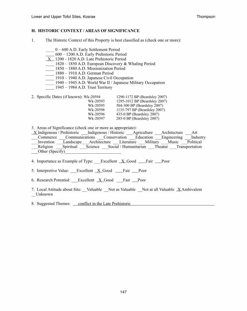
H. HISTORIC CONTEXT / AREAS OF SIGNIFICANCE
1. The Historic Context of this Property is best classified as (check one or more):
____ 0 – 600 A.D. Early Settlement Period 600 – 1200 A.D. Early Prehistoric Period
X 1200 - 1820 A.D. Late Prehistoric Period ____ 1820 – 1850 A.D. European Discovery & Whaling Period ____ 1850 – 1880 A.D. Missionization Period ____ 1880 – 1910 A.D. German Period ____ 1910 – 1940 A.D. Japanese Civil Occupation ____ 1940 – 1945 A.D. World War II / Japanese Military Occupation ____ 1945 – 1984 A.D. Trust Territory
2. Specific Dates (if known): Wk-20594 1290-1172 BP (Beardsley 2007) Wk-20593 1295-1012 BP (Beardsley 2007) Wk-20595 504-300 BP (Beardsley 2007) Wk-20598 1135-797 BP (Beardsley 2007) Wk-20596 435-0 BP (Beardsley 2007) Wk-20597 285-0 BP (Beardsley 2007)
3. Areas of Significance (check one or more as appropriate): X Indigenous / Prehistoric ___Indigenous / Historic ___Agriculture ___Architecture ___Art ___Commerce ___Communications ___Conservation ___Education ___Engineering ___Industry ___Invention ___Landscape ___Architecture ___Literature ___Military ___Music ___Political ___Religion ___Spiritual ___Science ___Social / Humanitarian ___Theater ___Transportation ___Other (Specify)__________________________ 4. Importance as Example of Type: ___Excellent X Good Fair Poor
5. Interpretive Value: ___Excellent X Good Fair Poor
6. Research Potential: ___Excellent X Good ___Fair Poor
7. Local Attitude about Site: __Valuable __Not as Valuable __Not at all Valuable X Ambivalent __Unknown
8. Suggested Themes: conflict in the Late Prehistoric
Lower and Upper Tofol Sites, Kosrae! Thompson
147

I. SITE DESCRIPTION / STATEMENT OF SIGNIFICANCE
1. NARRATIVE DESCRIPTION MUST INCLUDE: Bearings and sources used to locate feature; terrain and vegetation; size; shape; construction techniques; materials used; condition; surface artifacts or midden visible; boundary description; boundary justification.
Beardsley concentrated her study in the Tofol valley on site A11-32 located that she associated with the oral legend of Finkol Tokosra a king who was assassinated by the people of Tofol valley. She describes the site as being composed of “extensive feasting areas, elaborate housing compounds with multiple chambers, monumental architecture, a stone-lined spring and a spring-fed bathing area, a medicine making area, several seka production areas, faa’faa making areas, kitchens with um, a boulder pavement throughout the entire site, and a defined public space linked to a private area by sweeping staircases” (2007:35).
The site is located across from the unused water treatment plant beside Tofol river midway up the road to the dam within the confined midsection of the valley known as Middle Tofol. The Finol Tokosra site represents the center of the settlement of the valley. It is within this area that a dense semi-urban center developed in the Late Prehistoric and the statue-making cult of the Early Prehistoric (Beardsley 2008) was located. Two double-roomed compounds, site type indicative of the Early Prehistoric are clearly mapped (Beardsley 2007:79). Additional platforms with multiple alignments of stones forming large terraced steps indicative of the Late Prehistoric may be also seen. The total size of the site is 110 x 80 meters and is clearly mapped in Beardsley 2007:79. It is standard practice for a 50’, or 16 m boundary to be maintained around historic sites. Thus the boundary of the site should measure roughly 140 x 110 meters, or more generally a 70m radius from the center of the site.
2. STATEMENT OF SIGNIFICANCE MUST INCLUDE: Unusual or important characteristics; accessibility; interpretive and research potential; evaluation of the site’s importance as a representative of its class and historic context; recommendations for register category; and other important factors that contribute to the property’s significance.
The Finol Tokosra site is the most heavily studied site within the Tofol Valley, is associated with a major legend of Kosrae’s oral history, and contains artifacts from an early statue-making culture. The site has provided the major radiocarbon dates that define the time frame for the prehistoric settlement of the valley. Its significance is unquestionable.
Lower and Upper Tofol Sites, Kosrae! Thompson
148
Lower and Upper Tofol Sites, Kosrae! Thompson
149

USGS map indicating the location of A11-32
Lower and Upper Tofol Sites, Kosrae! Thompson
150

Archaeological map of A11-32 (Beardsley 2007)
Lower and Upper Tofol Sites, Kosrae! Thompson
151

Photograph of excavation into burial pit of Finol Tokosra and large basalt stone to cover the area
Lower and Upper Tofol Sites, Kosrae! Thompson
152

The Legend of Finol Tokosra
One day a woman was fishing along the shore. She saw the king and his men coming near her, so she wrapped her fish in a mat. She did not want to give her fish to him, but in those days, if a king [chief] asked for something, you were obliged to provide it, or suffer the penalty, which was usually death. When the king and his men arrived, the fish were still alive and wiggling, making the mat move around in very odd ways. The woman told the king her baby was wrapped in the mat . But soon, the fish broke through the mat and revealed themselves. Angry at having been lied to, the king cut off her head.
Her family, who lived in Tofol, wanted revenge. The people of Tofol wanted to remove this king from power too (he was particularly demanding of them and they were tired of fulfilling all his requests), so they were in full support of the plot for revenge. They decided to invite the king and his men to a large celebratory feast. Then, they proceeded to dig a very large hole and gather food for the feast.
On the appointed day, the people of the village called for the king and his men. When they arrived, all the people of Tofol were already celebrating. They picked up the two canoes with the king and his men still in them, hoisted them above their heads and passed them to the front of the crowd. There, the canoes, the king and his men were thrown into the big hole and every one from Tofol picked up a stone and threw it into the hole, stoning the king and his men to death and filling the hole completely with stones. Then, the had their feast.
When the king and his men were killed, the people of Tofol smashed the site to hide the grave, then they fled to the southern end of the island, to Walung and Malem, in fear of reprisal form the king’s supporters in Leluh, the lagoon islet just offshore from Tofol. From Walung and MAlem we have stories about the sudden arrival of refugees running from the king. In Malem, they are given land and construct the village of Lela. According to Clain George (the oldest storyteller on the island), Malem continues to harbor the only known family on the island from Tofol, the Talley family, descended from those who escaped Tofol at that time.
When the king and his men were killed, they were covered up and a large basalt stone was moved in to cover the area and confuse the king’s relatives [see photograph above]. The woman killed by the king and his men had two grown sons. It is they who planned the revenge of their mother’s death.
-story from Beardsley (2007)
Lower and Upper Tofol Sites, Kosrae! Thompson
153
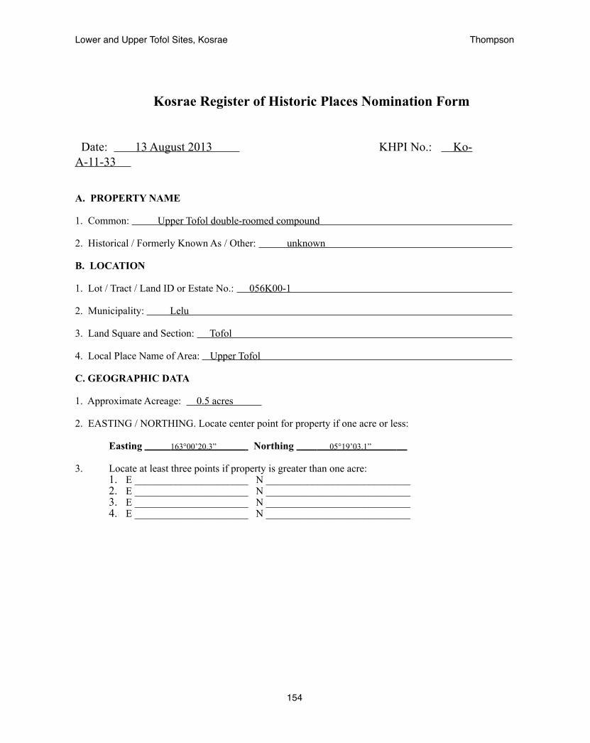
Kosrae Register of Historic Places Nomination Form
Date: 13 August 2013 KHPI No.: Ko-A-11-33
A. PROPERTY NAME
1. Common: Upper Tofol double-roomed compound
2. Historical / Formerly Known As / Other: unknown
B. LOCATION
1. Lot / Tract / Land ID or Estate No.: 056K00-1
2. Municipality: Lelu
3. Land Square and Section: Tofol
4. Local Place Name of Area: Upper Tofol
C. GEOGRAPHIC DATA
1. Approximate Acreage: 0.5 acres
2. EASTING / NORTHING. Locate center point for property if one acre or less:
Easting 163°00’20.3” Northing 05°19’03.1”
3. Locate at least three points if property is greater than one acre:1. E ______________________ N ____________________________2. E ______________________ N ____________________________3. E ______________________ N ____________________________4. E ______________________ N ____________________________
Lower and Upper Tofol Sites, Kosrae! Thompson
154

D. CLASSIFICATION / USE / ACCESS
1. Category (check one): ____District X Site ____Building ____Structure ____Object
2. Status (check one or more): ___Occupied X Unoccupied ___Preservation work in Progress
3. Accessible to Public (check one): ____No ____Yes, Restricted X Yes, Unrestricted 4. Current Use (check one or more as appropriate):
X Agriculture _____ Industrial _____ Religious _____ Commercial _____ Military _____ Science _____ Conservation _____ Museum _____ Transportation _____ Education _____ Park _____ Unused _____ Entertainment _____ Ranch _____ Other _____ Government _____ Residence
5. Additional Comments on Present Use: Experimental Agroforest for the Forestry Department __________________________________________________________________________________________
E. PROPERTY OWNER
1. Ownership (check one or more as appropriate): X Government of Kosrae ____Private
2. Owner’s Name: Kosrae State Government - Office of the Governor
3. Physical Address Tofol, Kosrae
4. Mailing Address: PO Box 158, Tofol, Kosrae, 96944
5. Contact Numbers and Fax Number: 691-370-3002 or 691-370-3003
6. Email Address:
7. Lessee(s):
8. Lessee(s) Address:
Additional Information: Department of Resources and Economic Affairs, 691-370-2017
Lower and Upper Tofol Sites, Kosrae! Thompson
155

F. RECORDS SEARCH: LEGAL DESCRIPTION / LAND TITLE / SURVEYS
1. Land Title and Legal Description Located at (indicate Government Agency): Kosrae Land Court
2. Address: PO Box 808, Tofol, Lelu,Kosrae 96944 phone: 691-370-3025
3. Survey Records Located at: Kosrae Historic Preservation Office (HPO)
4. Date of Survey / Performed by / For: March-July 2013, Adam Thompson, Kosrae HPO
5. Type of Survey: X Reconnaissance Intensive-Detailed X Surface Mapping ____ Windshield ____Other, Specify:_______________________________
6. Original Field Notes, Artifacts, Human Remains Located At (indicate what and where these items are located, person to contact, contact numbers and physical address): Kosrae Historic Preservation Office PO Box 568, Tofol, Lelu, Kosrae FM 96944 phone: 370-3078 (Stanton Andrews)
G. DESCRIPTION / CONDITION
1. Type of Property (describe briefly the type of property, such as, pre-contact settlement site, burial ground, rockshelter, pictograph cave, etc. / include significant features.): The site is an early prehistoric residential site
2. Known pressures on site: ___No X Yes, Indicate: vegetation, erosion
3. Vandalized / artifacts looted? X No ___Yes, Indicate: _________________________________________________________________________________________________________________________________
4. Condition: ___Excellent X Good Fair Deteriorated ___Ruin
5. Danger: X No Known Future Danger Possible Future Danger ____Future Danger Certain ____Present Danger Presently Being Destroyed/Damaged - Describe:
6. Integrity: X Altered / Original Location _____ Altered / Moved _____ Unaltered
Lower and Upper Tofol Sites, Kosrae! Thompson
156
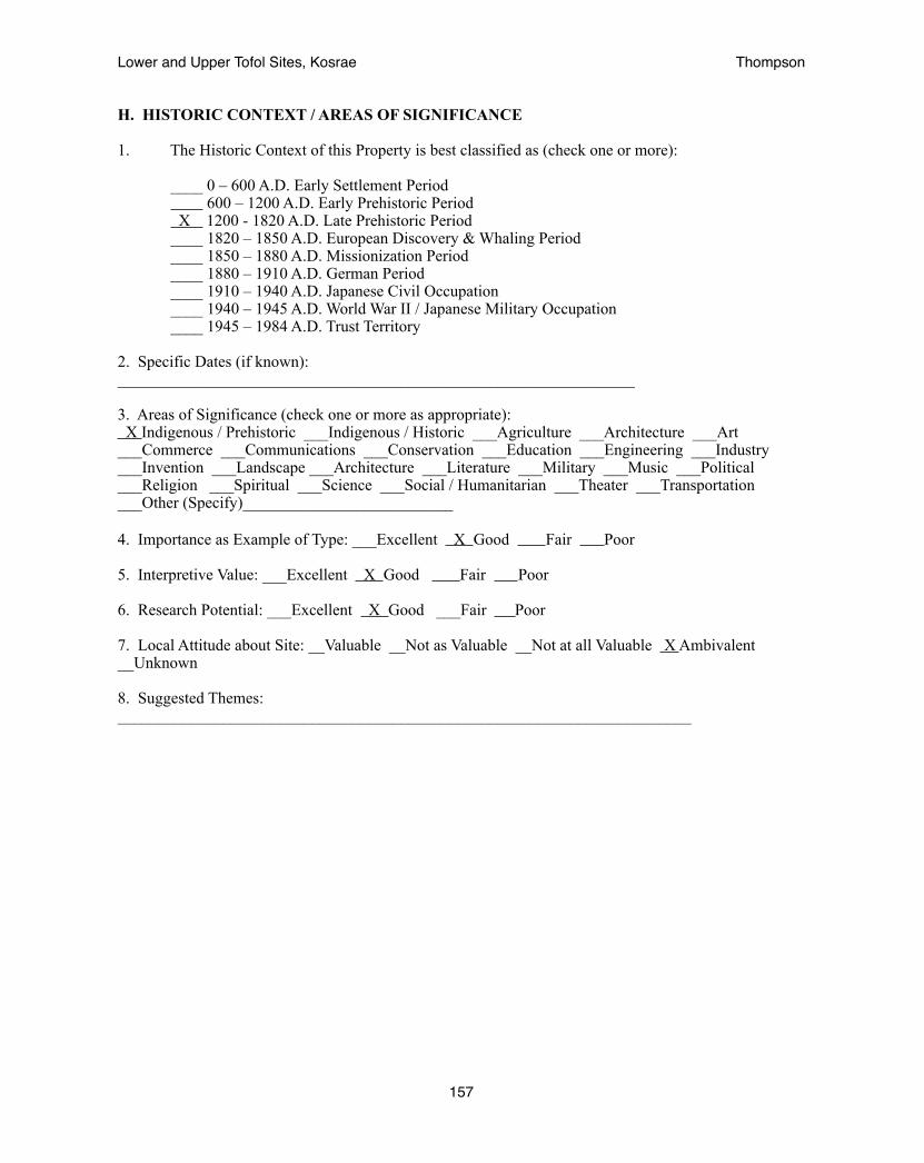
H. HISTORIC CONTEXT / AREAS OF SIGNIFICANCE
1. The Historic Context of this Property is best classified as (check one or more):
____ 0 – 600 A.D. Early Settlement Period 600 – 1200 A.D. Early Prehistoric Period
X 1200 - 1820 A.D. Late Prehistoric Period ____ 1820 – 1850 A.D. European Discovery & Whaling Period ____ 1850 – 1880 A.D. Missionization Period ____ 1880 – 1910 A.D. German Period ____ 1910 – 1940 A.D. Japanese Civil Occupation ____ 1940 – 1945 A.D. World War II / Japanese Military Occupation ____ 1945 – 1984 A.D. Trust Territory
2. Specific Dates (if known): ________________________________________________________________
3. Areas of Significance (check one or more as appropriate): X Indigenous / Prehistoric ___Indigenous / Historic ___Agriculture ___Architecture ___Art ___Commerce ___Communications ___Conservation ___Education ___Engineering ___Industry ___Invention ___Landscape ___Architecture ___Literature ___Military ___Music ___Political ___Religion ___Spiritual ___Science ___Social / Humanitarian ___Theater ___Transportation ___Other (Specify)__________________________ 4. Importance as Example of Type: ___Excellent X Good Fair Poor
5. Interpretive Value: ___Excellent X Good Fair Poor
6. Research Potential: ___Excellent X Good ___Fair Poor
7. Local Attitude about Site: __Valuable __Not as Valuable __Not at all Valuable X Ambivalent __Unknown
8. Suggested Themes: _______________________________________________________________________
Lower and Upper Tofol Sites, Kosrae! Thompson
157

I. SITE DESCRIPTION / STATEMENT OF SIGNIFICANCE
1. NARRATIVE DESCRIPTION MUST INCLUDE: Bearings and sources used to locate feature; terrain and vegetation; size; shape; construction techniques; materials used; condition; surface artifacts or midden visible; boundary description; boundary justification.
The Upper Tofol double-roomed compound lies at the end of the road running past the modern waterworks to the old Japanese dam. From there one crosses the river and walks uphill. The site sits atop the large natural terrace above the Tofol river on its eastern side. It is upon these expansive terraces raised well above the flood zone of the river that upland sites are typically found. The surrounding vegetation is typical of the secondary upland forest and includes mahogany, callophyllum, thespesia, cinnamon, neubergia, and the like. This site is well terraced against a fairly steep slope by a substantial retaining wall and consists of two rooms. The larger of the two rooms is on this side and measures roughly 9 x 6.5 m. The smaller room lies on the north side and measures 6 x 4 meters. The entrance lies through the smaller room and there is a place midway through the dividing wall for the path to continue. A small central platform was found at the center of the larger room. The total size of the structure is 15.5 x 7 m. It is standard practice for a 50’, or 16 m boundary to be maintained around historic sites. Thus the boundary of the site should measure 47.5 x 39 meters, or more generally a 25m radius from the center of the site.
2. STATEMENT OF SIGNIFICANCE MUST INCLUDE: Unusual or important characteristics; accessibility; interpretive and research potential; evaluation of the site’s importance as a representative of its class and historic context; recommendations for register category; and other important factors that contribute to the property’s significance.
The Upper Tofol double-roomed compound is significant as it is the furthest upland site for a structure of its style within the Tofol valley to date. Thus it provides a measurement of the size of the Early Prehistoric village.
Lower and Upper Tofol Sites, Kosrae! Thompson
158
Lower and Upper Tofol Sites, Kosrae! Thompson
159

USGS map indicating the location of A11-33
Lower and Upper Tofol Sites, Kosrae! Thompson
160

Archaeological map of A11-33
Lower and Upper Tofol Sites, Kosrae! Thompson
161
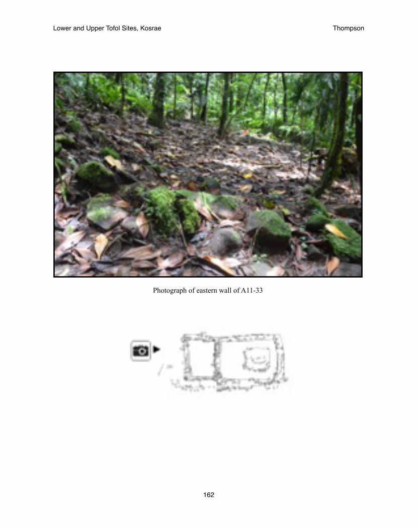
Photograph of eastern wall of A11-33
Lower and Upper Tofol Sites, Kosrae! Thompson
162
Kosrae Register of Historic Places Nomination Form
Date: 13 August 2013 KHPI No.: Ko-A-11-34
A. PROPERTY NAME
1. Common: Upper Tofol complex
2. Historical / Formerly Known As / Other: unknown
B. LOCATION
1. Lot / Tract / Land ID or Estate No.: 056K00-2
2. Municipality: Lelu
3. Land Square and Section: Tofol
4. Local Place Name of Area: Upper Tofol
C. GEOGRAPHIC DATA
1. Approximate Acreage: 1.5 acres
2. EASTING / NORTHING. Locate center point for property if one acre or less:
Easting Northing
3. Locate at least three points if property is greater than one acre:1. E 163°00’18” N 05°18’53”2. E 163°00’12” N 05°18’49”3. E 163°00’10” N 05°18’48”
Lower and Upper Tofol Sites, Kosrae! Thompson
163

D. CLASSIFICATION / USE / ACCESS
1. Category (check one): ____District X Site ____Building ____Structure ____Object
2. Status (check one or more): ___Occupied X Unoccupied ___Preservation work in Progress
3. Accessible to Public (check one): ____No ____Yes, Restricted X Yes, Unrestricted 4. Current Use (check one or more as appropriate):
X Agriculture _____ Industrial _____ Religious _____ Commercial _____ Military _____ Science _____ Conservation _____ Museum _____ Transportation _____ Education _____ Park _____ Unused _____ Entertainment _____ Ranch _____ Other _____ Government _____ Residence
5. Additional Comments on Present Use: Experimental Agroforest for the Forestry Department __________________________________________________________________________________________
E. PROPERTY OWNER
1. Ownership (check one or more as appropriate): X Government of Kosrae ____Private
2. Owner’s Name: Kosrae State Government - Office of the Governor
3. Physical Address Tofol, Kosrae
4. Mailing Address: PO Box 158, Tofol, Kosrae, 96944
5. Contact Numbers and Fax Number: 691-370-3002 or 691-370-3003
6. Email Address:
7. Lessee(s):
8. Lessee(s) Address:
Additional Information: Department of Resources and Economic Affairs, 691-370-2017
Lower and Upper Tofol Sites, Kosrae! Thompson
164
F. RECORDS SEARCH: LEGAL DESCRIPTION / LAND TITLE / SURVEYS
1. Land Title and Legal Description Located at (indicate Government Agency): Kosrae Land Court
2. Address: PO Box 808, Tofol, Lelu,Kosrae 96944 phone: 691-370-3025
3. Survey Records Located at: Kosrae Historic Preservation Office (HPO)
4. Date of Survey / Performed by / For: March-July 2013, Adam Thompson, Kosrae HPO
5. Type of Survey: ____Reconnaissance X Intensive-Detailed X Surface Mapping ____ Windshield ____Other, Specify:_______________________________
6. Original Field Notes, Artifacts, Human Remains Located At (indicate what and where these items are located, person to contact, contact numbers and physical address): Kosrae Historic Preservation Office PO Box 568, Tofol, Lelu, Kosrae FM 96944 phone: 370-3078 (Stanton Andrews)
G. DESCRIPTION / CONDITION
1. Type of Property (describe briefly the type of property, such as, pre-contact settlement site, burial ground, rockshelter, pictograph cave, etc. / include significant features.): The site is a late prehistoric village site within a defensive refuge believed to be associated with later conflicts mentioned in the oral record.
2. Known pressures on site: ___No X Yes, Indicate: vegetation, erosion
3. Vandalized / artifacts looted? X No ___Yes, Indicate: _________________________________________________________________________________________________________________________________
4. Condition: ___Excellent X Good Fair Deteriorated ___Ruin
5. Danger: X No Known Future Danger Possible Future Danger ____Future Danger Certain ____Present Danger Presently Being Destroyed/Damaged - Describe:
6. Integrity: X Altered / Original Location _____ Altered / Moved _____ Unaltered
Lower and Upper Tofol Sites, Kosrae! Thompson
165

H. HISTORIC CONTEXT / AREAS OF SIGNIFICANCE
1. The Historic Context of this Property is best classified as (check one or more):
____ 0 – 600 A.D. Early Settlement Period 600 – 1200 A.D. Early Prehistoric Period
X 1200 - 1820 A.D. Late Prehistoric Period ____ 1820 – 1850 A.D. European Discovery & Whaling Period ____ 1850 – 1880 A.D. Missionization Period ____ 1880 – 1910 A.D. German Period ____ 1910 – 1940 A.D. Japanese Civil Occupation ____ 1940 – 1945 A.D. World War II / Japanese Military Occupation ____ 1945 – 1984 A.D. Trust Territory
2. Specific Dates (if known): ________________________________________________________________
3. Areas of Significance (check one or more as appropriate): X Indigenous / Prehistoric ___Indigenous / Historic ___Agriculture ___Architecture ___Art ___Commerce ___Communications ___Conservation ___Education ___Engineering ___Industry ___Invention ___Landscape ___Architecture ___Literature ___Military ___Music ___Political ___Religion ___Spiritual ___Science ___Social / Humanitarian ___Theater ___Transportation ___Other (Specify)__________________________ 4. Importance as Example of Type: ___Excellent X Good Fair Poor
5. Interpretive Value: ___Excellent X Good Fair Poor
6. Research Potential: ___Excellent X Good ___Fair Poor
7. Local Attitude about Site: __Valuable __Not as Valuable __Not at all Valuable X Ambivalent __Unknown
8. Suggested Themes: conflict in the late prehistoric
Lower and Upper Tofol Sites, Kosrae! Thompson
166
I. SITE DESCRIPTION / STATEMENT OF SIGNIFICANCE
1. NARRATIVE DESCRIPTION MUST INCLUDE: Bearings and sources used to locate feature; terrain and vegetation; size; shape; construction techniques; materials used; condition; surface artifacts or midden visible; boundary description; boundary justification.
The Upper Tofol complex lies roughly 400 meters south, going deeper into the valley, from the dam on the Tofol river at the end of the gravel road. It lies on the western side of the river. The Upper Tofol complex consists of three major features: a stepped tomb that measures 10 x 10 meters, a single-roomed enclosure measuring 17 x 14 m, and a platform, measuring 5 x 6 m surrounded by a terrace wall 17 x 13 m. These sites all lie within 24-30 meters of each other and are therefore within the 16m buffer zone surrounding each of the historic sites. They are all believed to be from a common time frame and closely associated with each other. The total area of the site measures 60 x 100 meters. However, it was found that the site continued towards the mountain. As time did not allow to delineate and record the entire site this initial portion is registered as a single site representative of the rest of it. The rest of the site should be registered in the future as a new site associated with this one. The site is difficult to get to due to the narrow river pass and the significant change in elevation. These characteristics place it in a protective position within the environment.
2. STATEMENT OF SIGNIFICANCE MUST INCLUDE: Unusual or important characteristics; accessibility; interpretive and research potential; evaluation of the site’s importance as a representative of its class and historic context; recommendations for register category; and other important factors that contribute to the property’s significance.
The Upper Tofol complex is significant as it is the furthest upland site to be identified in the Tofol valley and continues into the mountain for an undetermined distance. Oral traditions tell that people of the Tofol valley sought refuge from conflicts with the high chiefs of Lelu by heading into the mountains. This site may represent this time period. As the uplands are the least studied area on the island it is a yet unanswered question of how deep settlement went into the mountains. This site thus represents a valuable source of potential information about the prehistory of Kosrae.
Lower and Upper Tofol Sites, Kosrae! Thompson
167

Lower and Upper Tofol Sites, Kosrae! Thompson
168

USGS map indicating the location of A11-34.
Lower and Upper Tofol Sites, Kosrae! Thompson
169

Archaeological map of A11-34
Lower and Upper Tofol Sites, Kosrae! Thompson
170
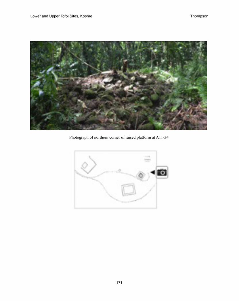
Photograph of northern corner of raised platform at A11-34
Lower and Upper Tofol Sites, Kosrae! Thompson
171