Sierra de Atapuerca archaeological sites
28
PLEISTOCENE AND HOLOCENE HUNTER-GATHERERS IN IBERIA AND THE GIBRALTAR STRAIT: THE CURRENT ARCHAEOLOGICAL RECORD 534 Introduction Sierra de Atapuerca (Burgos, Spain) is a mid- altitude karst range characterised by the subter- ranean morphology concentrated on its south- western flank (San Vincente Hill, 1085 m asl). This multilevel karst system, an inactive legacy of old base levels formed during the Plio-Pleistocene, is linked to palaeo-upwelling of the Pico River. It consists of three main levels of sub-horizontal ducts which are interconnected by spaces and sinkholes, now hanging +90 m, +70 m and +60 m above the present bed of the Arlanzón River (Ortega et al., 2013, 2014). Only 4.7 km of the accessible ducts in this system are known at pre- sent. Around 50 completely infilled cavities have been identified (Ortega, 2009), some of which became exposed when a cutting for a mine rail- way line between Monterrubio de la Demand and Sierra de Atapuerca archaeological sites Carbonell, E. a,b,c ; Huguet, R. b,a,c, *; Cáceres, I. a,b ; Lorenzo, C .a,b,d ; Mosquera, M. a,b ; Ollé, A. b,a ; Rodríguez, X.P. a,b ; Saladié, P.b, a ; Vergès, J.M. b,a ; García-Medrano, P. b ; Rosell, J. a,b ; Vallverdú, J. b,a,c ; Carretero, J.M. e,d ; Navazo, M. f,g ; Ortega, A.I. g,h; Martinón-Torres, M.g; Morales, J.I. b,a ; Allué; E. b,a ; Aramburu, A. i ; Canals, A. a,b,n, Carrancho,A. f ; Castilla, M. e ; Expósito, I. b,a ; Fontanals, M. b,a ; Francés, M. e ; Galindo-Pellicena, M. d,j ; García-Antón, D. a,b ; García, N. d,j ; Gracia, A. d,k ; García, R. e ; Gómez- Merino, G. b,a ; Iriarte, E. e ; Lombera- Hermida, A. b,a ; López-Polín, L. b,a ; Lozano, M. b,a ; Made van der, J. l ; Martínez, I. d,k ; Mateos, A. g ; Pérez- Romero, A. e ; Poza, E. d,j ; Quam, R. m,d ; Rodriguez-Hidalgo, A. b,a,n ; Rodríguez, J. g Rodríguez, L. e ; Santos, E. e,d ; Terradillos, M. k ; Bermúdez de Castro, J.M. g ; Arsuaga, J.L. d,j a Àrea de Prehistòria, Universitat Rovira i Virgili (URV), Avinguda de Catalunya 35, 43002 Tarragona, Spain. b Institut Català de Paleoecologia Humana i Evolució Social (IPHES), C/ Marcel.lí Domingo s/n e Campus Sescelades URV (Edifici W3), 43007 Tarragona, Spain. c. Unidad asociada al CSIC. Departamento de Paleobiología, Museo Nacional de Ciencias Naturales. Calle José Gutierrez Abas- cal, 2. 28006 Madrid, Spain. d Centro Mixto UCM-ISCIII de Investigación sobre Evolución y Comportamiento Humanos, c/Monforte de Lemos, 5, 28029 Madrid, Spain. e Laboratorio de Evolución Humana (LEH), Dpto. de Ciencias Históricas y Geografía, Universidad de Burgos, Edificio I+D+i, Plaza Misael Bañuelos s/n, 09001 Burgos, Spain. f Área de Prehistoria. Dpto. de Ciencias Históricas y Geografía, Universidad de Burgos, Edificio I+D+i, Plaza Misael Bañuelos s/n, 09001 Burgos, Spain. g Centro Nacional de Investigación sobre la Evolución Humana (CENIEH), Paseo Sierra de Atapuerca, 09002 Burgos, Spain h Grupo Espeleológico Edelweiss, Excma, Diputación Provincial de Burgos, Paseo del Espolón s/n, 09071 Burgos, Spain i Departamento de Mineralogía y Petrología, Facultad de Ciencia y Tecnología, Universidad del País Vasco/EHU, c/ Sarriena, s/n, 48940 Leioa, Spain j Departamento de Paleontología, Universidad Complutense de Madrid, Avenida Complutense s/n, 28040 Madrid, Spain. k Área de Paleontología, Departamento de Geología, Universidad de Alcalá de Henares, 28871 Alcalá de Henares, Spain. l Museo Nacional de Ciencias Naturales (MNCN). Calle José Gutierrez Abascal, 2. 28006 Madrid, Spain. m. Department of Anthropology, Binghamton University (SUNY), Binghamton, NY 13902-6000, USA. n. Equipo Primeros Pobladores de Extremadura, Casa de la Cultura Rodríguez Moñino. Avda. Cervantes s/n, 10003 Cáceres, Spain * Corresponding autor: Institut Català de Paleoecologia Humana i Evolució Social (IPHES), C/ Marcel.lí Domingo s/n e Cam- pus Sescelades URV (Edifici W3), 43007 Tarragona, Spain. E-mail address: [email protected]
Transcript of Sierra de Atapuerca archaeological sites

PLEISTOCENE AND HOLOCENE HUNTER-GATHERERS IN IBERIA AND THE GIBRALTAR STRAIT:
THE CURRENT ARCHAEOLOGICAL RECORD534
Introduction
Sierra de Atapuerca (Burgos, Spain) is a mid-altitude karst range characterised by the subter-ranean morphology concentrated on its south-western flank (San Vincente Hill, 1085 m asl). This multilevel karst system, an inactive legacy of old base levels formed during the Plio-Pleistocene, is linked to palaeo-upwelling of the Pico River. It consists of three main levels of sub-horizontal
ducts which are interconnected by spaces and sinkholes, now hanging +90 m, +70 m and +60 m above the present bed of the Arlanzón River (Ortega et al., 2013, 2014). Only 4.7 km of the accessible ducts in this system are known at pre-sent. Around 50 completely infilled cavities have been identified (Ortega, 2009), some of which became exposed when a cutting for a mine rail-way line between Monterrubio de la Demand and
Sierra de Atapuerca
archaeological sites
Carbonell, E.a,b,c; Huguet, R.b,a,c,*; Cáceres, I.a,b; Lorenzo, C.a,b,d; Mosquera, M.a,b; Ollé, A.b,a;
Rodríguez, X.P.a,b; Saladié, P.b,a ; Vergès, J.M.b,a; García-Medrano, P.b;
Rosell, J.a,b; Vallverdú, J.b,a,c; Carretero, J.M.e,d; Navazo, M.f,g; Ortega, A.I.
g,h; Martinón-Torres, M.g; Morales, J.I.b,a; Allué; E.b,a; Aramburu, A.i;
Canals, A.a,b,n, Carrancho,A.f; Castilla, M.e; Expósito, I.b,a; Fontanals, M.b,a;
Francés, M.e; Galindo-Pellicena, M.d,j; García-Antón, D.a,b; García, N.d,j; Gracia, A.d,k; García, R.e; Gómez-
Merino, G.b,a; Iriarte, E.e; Lombera-Hermida, A.b,a; López-Polín, L.b,a;
Lozano, M.b,a; Made van der, J.l; Martínez, I.d,k ; Mateos, A.g; Pérez-
Romero, A.e; Poza, E. d,j; Quam, R.m,d; Rodriguez-Hidalgo, A.b,a,n; Rodríguez,
J. g Rodríguez, L.e; Santos, E.e,d; Terradillos, M.k; Bermúdez de Castro,
J.M.g; Arsuaga, J.L.d,j
a Àrea de Prehistòria, Universitat Rovira i Virgili (URV), Avinguda de Catalunya 35, 43002 Tarragona, Spain.b Institut Català de Paleoecologia Humana i Evolució Social (IPHES), C/ Marcel.lí Domingo s/n e Campus Sescelades URV
(Edifici W3), 43007 Tarragona, Spain.c. Unidad asociada al CSIC. Departamento de Paleobiología, Museo Nacional de Ciencias Naturales. Calle José Gutierrez Abas-
cal, 2. 28006 Madrid, Spain.d Centro Mixto UCM-ISCIII de Investigación sobre Evolución y Comportamiento Humanos, c/Monforte de Lemos, 5, 28029
Madrid, Spain.e Laboratorio de Evolución Humana (LEH), Dpto. de Ciencias Históricas y Geografía, Universidad de Burgos, Edificio I+D+i,
Plaza Misael Bañuelos s/n, 09001 Burgos, Spain.f Área de Prehistoria. Dpto. de Ciencias Históricas y Geografía, Universidad de Burgos, Edificio I+D+i, Plaza Misael Bañuelos
s/n, 09001 Burgos, Spain.g Centro Nacional de Investigación sobre la Evolución Humana (CENIEH), Paseo Sierra de Atapuerca, 09002 Burgos, Spainh Grupo Espeleológico Edelweiss, Excma, Diputación Provincial de Burgos, Paseo del Espolón s/n, 09071 Burgos, Spaini Departamento de Mineralogía y Petrología, Facultad de Ciencia y Tecnología, Universidad del País Vasco/EHU, c/ Sarriena,
s/n, 48940 Leioa, Spainj Departamento de Paleontología, Universidad Complutense de Madrid, Avenida Complutense s/n, 28040 Madrid, Spain.k Área de Paleontología, Departamento de Geología, Universidad de Alcalá de Henares, 28871 Alcalá de Henares, Spain.l Museo Nacional de Ciencias Naturales (MNCN). Calle José Gutierrez Abascal, 2. 28006 Madrid, Spain.m. Department of Anthropology, Binghamton University (SUNY), Binghamton, NY 13902-6000, USA.n. Equipo Primeros Pobladores de Extremadura, Casa de la Cultura Rodríguez Moñino. Avda. Cervantes s/n, 10003 Cáceres,
Spain* Corresponding autor: Institut Català de Paleoecologia Humana i Evolució Social (IPHES), C/ Marcel.lí Domingo s/n e Cam-
pus Sescelades URV (Edifici W3), 43007 Tarragona, Spain. E-mail address: [email protected]

CENTRAL PLATEAU 535
Villafría was dug in the late 19th century (Ortega et al., 2012). Other cavities remained hidden, al-though in the course of hundreds of thousands of years, they have been visited by successive settlers in the Sierra de Atapuerca area. Apart from the sites within the karst system, open air campsites with evidence of activity by human groups have been recorded on the slopes and moors around this low mountain range. Sierra de Atapuerca and its occupations are one of Europe’s most impor-tant sources of ancient human fossils. They were declared a World Heritage Site by UNESCO in 2000. In this chapter, we will review the research that has been underway at the Sierra de Atapuerca
sites for more than thirty years. The excavations and subsequent analysis of several sites, both caves and open air campsites, have found evidence of oc-cupations by hominins groups in different periods, from 1.3 million BP to less than 3,000 years ago. Digs at Sierra de Atapuerca have focused on four different sectors: Trinchera del Ferrocarril, Cueva Mayor, Cueva del Mirador and the open air karst zone. Listed in chronological order of human oc-cupation, the cave sites are Sima del Elefante, Gran Dolina, Galería, Sima de los Huesos, Portalón and Mirador. The outdoor sites include Hotel Califor-nia, Hundidero, Fuente Mudarra and Valle de las Orquídeas (Fig. 1).
Figure 1. Location of Sierra de Atapuerca sites. Karst map based on original topography by Edelweiss Speleological Group, adapted from Ortega (2009). Green: top level of karst, purple: middle level, pink: bottom level.

PLEISTOCENE AND HOLOCENE HUNTER-GATHERERS IN IBERIA AND THE GIBRALTAR STRAIT:
THE CURRENT ARCHAEOLOGICAL RECORD536
Trinchera del Ferrocarril
As its name suggests, the Trinchera del Fer-rocarril (Railway Trench) is an artificial trench dug during the construction of a mine railway. In plan, the trench is a 500 metre long arc run-ning N-S through the southern part of the Sier-ra. The primarily limestone walls of the cutting, no more than 20 metres high, contain sectioned cavities which had been filled with sediment of different origin. Three of these cavities –from
pit to determine the characteristics of the infill, its archaeological potential and a rough chronology for the sedimentary deposits. Systematic excava-tion of the site began in 1996, and has continued uninterrupted down to the present day across a 32 m2 excavation area.
The stratigraphic succession at Sima del Ele-fante is 15 m wide, with a 25 metre thick and with high degree of heterogeneity due to lateral and vertical lithological changes. The sedimentary de-posit is divided into 21 units, grouped in turn into three sedimentary phases. Phase I is the lowest in the sequence, from TE7 to TE14. Phase II contains units TE15 to TE19, inclusive. Finally, the most recent Phase III comprises Units TE20 and TE21 (Rosas et al., 2001, 2006) (Fig. 2).
Palaeomagnetic analysis has detected polar-ity changes at the basis of unit TE17. Sediments below this unit from TE16 to TE7 have reversed polarity and have been assigned to the Matuyama subchron (> 780 ky) (Parés et al., 2006). This is consistent with the results from the analysis of the U/Th uranium series of a stalagmite sample in the TE16-TE17 contact area, which shows a chronol-ogy of more than 400,000 years. Analysis of cos-mogenic cores shows that the age of sublevel TE9c in Sima del Elefante is 1.22 ± 0.16 Myr (Carbonell et al., 2008). These dates are consistent with bio-chronological data (Rofes and Cuenca-Bescós, 2006; Cuenca-Bescós and García 2007; García et al., 2008).
On the basis of biochronological material, more recent units containing archaeo-palaeontological records of the site (TE18-TE19) have been attrib-uted to the second half of the Middle Pleistocene, around 250-350 ky (OIS 9-8) (Rosas et al., 2006, Lopez-García et al., 2011). However, uranium se-ries (U/Th) analysis of a stalagmitic crust from the roof of level TE18 has yielded two datings, 307 ± 19 ky and 255 ± 12 ky (Bischoff pers. comm.). These results suggest that level TE18 was formed during OIS 9 and 7, and that the chronology of TE19 is more recent than 255,000 ky.
Lower levels have yielded a rich faunal asso-ciation including small animals such as birds, lago-morphs and beavers, as well as medium and large sized animals (Sánchez Marco, 2004; Cuenca-Bescós and García, 2007; García et al., 2008; Van der Made, 2013) (Tab.1). The climatic and envi-ronmental reconstruction on the basis of faunal
Figure 2. Stratigraphic section of Sima del Elefante. As-terisk marks position of Matuyama-Brunhes inversion. Height in metres from Trinchera del Ferrocarril floor. Syn-thetic stratigraphy shows location of U-Th and cosmogenic nuclide datings (Rosas et al., 2006; Carbonell et al., 2008).
south to north Sima del Elefante, Gran Dolina and Galería– have been defined as archaeologi-cal sites.
Sima del Elefante
The Sima del Elefante site is the southernmost cave in the Trinchera del Ferrocarril. The first archaeo-palaeontological work here was in 1986 under Prof. Emiliano Aguirre, consisting of a test

CENTRAL PLATEAU 537
analysis indicates that the landscape around Sima del Elefante through the lower sequence (Lower Pleistocene) included open habitats dominated by moist, wooded areas, large areas with permanent water (Rosas et al., 2006, Blain et al., 2010 ;). In the upper units, equids remains are predominant, although remains of other herbivores and carni-vores have also been found (Rosas et al., 2001; Van der Made, et al., 2003, 2013. Cuenca-García and Bescós, 2007) (Tab.1). For these units, the sug-gested landscape is a moist forest with open spac-es and possibly drier and colder conditions than the Lower Pleistocene units (Rosas et al., 2006; López-García et al., 2011).
Evidence of human activity has been docu-mented in the Middle Pleistocene units and also in the oldest units of Sima del Elefante. By 2013, 127 lithic artefacts had been located (Fig. 3).
To date, 86 stone artefacts have been recov-ered from the Lower Pleistocene Phase I units (TE7-TE14). The main raw material is chert (72.1%) of both Cretaceous and Neogene origin. Three quartz objects and some artefacts in Cre-taceous limestone have also been found. All the raw materials could have been found within a 2 km radius of the site. The most represented cat-egories are related to knapped products (flakes and flake fragments). However, there is a signifi-cant percentatge (34.9%) indeterminable objects. due to the poor preservation of the Neogene chert. Only four cores (one of them a core frag-ment) have been found amongst the Lower Pleis-tocene assemblage. These cores bear evidence of short knapping sequences, based on longitudinal removals. The knapped products have different morphologies but are generally small, averaging 32 x 30 x 9 mm for complete flakes. We have also found a few knapping products with centripetal removals. Retouched tools have only been found in units TE13 (n=3) and TE14 (n=1). These re-touched flakes are slightly larger than the average non-retouched items, and have been classified as sidercrapers (n=2) and notches (n=2). In 2013, a chert flake was unearthed in unit TE8, the oldest evidence of human activity found to date in Ata-puerca. In the Lower Pleistocene units, no pebble tools, handaxes or cleavers have been found. This assemblage has been assigned to Mode 1 (Car-bonell et al., 2008; Ollé et al., 2013). Some of the faunal remains (0.6%) from these lower units (TE7-TE14) bear signs of anthropogenic modifi-
cations (cut marks and breakage). Most of the re-mains with cut marks are from ungulates, specifi-cally deer and bison. We have also identified hu-man activity on small animals such as birds, rabbits and turtles (Blasco et al., 2011, Huguet, 2013). These marks are found in all anatomical areas, from the appendicular skeleton through the axial skeleton to the skull. Some ungulate long bones were fractured by hominins in order to access nu-tritional resources inside the bone. The distribu-
Figure 3. Archaeo-palaentological material from Sima del Elefante. 1: Cleaver-like tool (Unit TE18, Sandstone). 2: Sandstone handaxe (Unit TEsup), 3: Quartzite point (TE-sup), 4: Retouched flake (sidescraper) of Neogene chert (TE19), 5: Retouched flake (sidescraper) of Cretaceous chert (TE13), 6: Cretaceous chert core (TE9c), 7: Creta-ceous chert flake (TE9c), 8: Cretaceous chert flake (knap-ping debris) (TE9c), 9: Homo sp. mandible (TE9c), 10: Macromammal bone with evidence of fresh fracture (ar-rows) (TE9c), 11: Left, cut marked bovid vertebra (TE9c); right, electron microscope detail of cut marked bovid man-dible (TE9c)(Photos: A. Ollé/J.Mestre/R.Huguet/IPHES).

PLEISTOCENE AND HOLOCENE HUNTER-GATHERERS IN IBERIA AND THE GIBRALTAR STRAIT:
THE CURRENT ARCHAEOLOGICAL RECORD538
Ursus dolinensis
Vulpes cf.V. alopecoides
Canis sp.(arnensis/mosbachensis)
Pannonictis cf. nestii
Lynx sp.
Lynx cf. issiodorensis
cf. Baranogale antiqua
Mustela palerminea
Panthera gombaszoegensis
Crocuta crocuta
Vulpes praeglacialis
Canis mosbachensis
Homoterium sp.
Meles meles
Lynx pardinus spelaeus
Ursus deningeri
Hyaena sp.
Ursus sp.
Vulpes vulpes
Panthera leo
Panthera sp.
Felis sylvestris
Canis lupus
Cuon alpinus europaes
Canidae indet.
Muestela nivalis
Mestela putorius
Martes martes
Mustelidae indet.
Dama vallonnetensis
Equus altidens
Macaca
Bison cf. voigtstedtensis
Sus scrofa
Stephanorhinus etruscus
Hippopotamus
Eucladoceros giulii
Cervus elpahus cf. acoronatus
Cervidae indet.
Mammuthus sp.
Praeovibos cf. priscus
Bison schoetensacki
Megaloceros solilhacus sspp.
Hemitragus bonali
Dama dama clactoniana
Equus ferus
Cervus elaphus priscus
Bison sp. (small)
Stephanorinus cf. hemioechus
Capreolus priscus
Equus cf. hydruntinus
TE1
9
sp.
x
sp.
x
x
ssp.
x
ssp.
x
GII
I
x
cf.
x
x
x
x
x
x
x
x
x
x
x
x
x
x
GII
b
x
x
x
x
x
x
x
x
x
x
x
x
x
x
x
GII
a
x
x
x
x
x
x
x
x
x
x
x
x
x
x
x
TD
10.1
x
x
x
x
x
x
x
x
x
x
x
x
x
x
x
x
TD
10.2
x
x
x
x
cf.
x
x
x
x
x
x
x
x
x
TD
10.3
x
x
x
x
x
x
x
x
x
x
SH
x
x
x
x
x
x
x
x
x
x
TD
8
x
x
x
x
x
x
x
x
x
x
x
x
x
x
TD
7
x
x
x
x
x
cf.
x
x
TD
6.1
sp.
x
cf.
x
x
x
TD
6.2
sp.
x
x
x
x
x
x
x
x
x
x
x
x
x
x
TD
6.3
sp.
x
x
x
x
x
x
x
x
x
x
TD
5
x
x
sp.
x
x
sp.
x
x
sp.
x
x
x
x
TD
3-4-
5?
x
cf.
x
cf.
x
x
TD
3-T
D4
x
x
x
ssp.
sp.
x
x
x
x
x
x
x
TE1
4
x
x
x
cf.
x
cf.
sp.
cf.
x
TE1
3
x
cf.
TE1
2
x
x
x
x
x
sp.
x
TE1
1
x
x
x
x
TE1
0
x
x
x
x
x
TE9
x
x
x
x
x
x
x
x
x
cf.
x
sp.
sp.
x
cf.
TE8
x
TE7
x
x
cf.
x
cf.
Table 1. Stratigraphic distribution of carnivores, ungulates, sub-ungulates and primates at Atapuerca Pleistocene sites (from Rodríguez et al., 2011; van der Made, 2013).

CENTRAL PLATEAU 539
tion and location of the cut marks and fractures indicate that human groups had different activi-ties in the butchering chain. The identification of these activities shows that hominins had primary access to some of the animals that they consumed. The bird, rabbit and carnivore remains found in anatomic connection in the lower units of Sima del Elefante indicate an excellent state of conser-vation of the fossils found in this cave. However, macromammal remains are scarce and fragmen-tary. If hominins had processed their prey inside the cave, we would expect to find a large number of anatomical elements of their prey, but the ana-tomical representation of animals indicates oth-erwise. The faunal remains thus suggest that most of the anatomical assemblage is the result of low intensity occupations, possibly located near the cave entrance (Huguet et al., 2007).
The units in Phase I of the sedimentary infill generally have similar dynamics to the anthropic record recovered to date. However, special men-tion must be made of level TE9c (1.22 ± 0.16 Ma). At this level, in addition to indirect evidence of human presence, three hominin fossils were found: a mandible, a phalanx and a humerus fragment. These remains were provisionally attributed to H. antecessor (Carbonell et al., 2008, Bermúdez de Castro et al., 2010a), however after a comparative morphological analysis of the mandible, Bermúdez de Castro et al., (2011) concluded that its attri-bution to any known taxon is unclear, and thus suggested that it should be referred to as Homo sp. Along with these human remains, faunal remains with signs of anthropic intervention and 33 stone objects were found.
Units TE18-TE19 at this site (Middle Pleisto-cene) have yielded 41 artefacts, the majority from unit TE19 (n=36). Only one stone tool has been found on TE18, along with four objects whose exact origin is unknown, as they were taken from the stratigraphic section in this part of the se-quence. Middle Pleistocene material includes a considerable use of sandstone (39.3%) followed by quartzite (34.1%) and Neogene chert (24.4%). Knapped products, retouched flakes and ham-merstones predominate in this lithic assemblage, along with four cores. The predominant knap-ping strategies are unifacial and unidirectional, but there is also evidence of centripetal knap-ping in some products. To date no evidence has been found on these levels of the use of knapping
methods involving a predetermined morphology of the products, such as Levallois or discoidal, for example. Most of the configured tools were found in unit TE19. The largest proportion of morpho-types are sidescrapers and denticulates. There is also a large unifacial pebble tool from TE18, with a similar morphology to a cleaver. A sandstone handaxe was found on TE Sup, as well as a point and a cleaver, both knapped with quartzite. The lithic industry found on the Middle Pleistocene levels has been tentatively ascribed to Mode 2 (Acheulean). The faunal remains found in these upper units have not been analyzed in depth due to the poor state of the material, although a pre-liminary list of fauna has been drafted (Table 1). However, Rosas et al., (2004) have presented sev-eral working hypotheses concerning the origin of the fossil assemblage in unit TE19, including the possibility that this unit acted as a trap for ani-mals attracted by water or fresh grass. The pres-ence of the taxon Ursidae might be related to the use of the cave for hibernation.
Gran Dolina
The Gran Dolina site (TD) is an 18 metre thick cave infill. Its stratigraphic succession was initially divided into 11 units, TD1 to TD11 from base to top (Gil and Hoyos, 1987; Parés and Pérez-González, 1999. Pérez-González et al., 2001), which were later revised slightly (Rodríguez et al., 2011) (Fig. 4). The first system-atic archaeological excavations were carried out between 1981 and 1989 in a 30 m2 area on level TD10 level. Between 1990 and 1991, work fo-cused on TD3-4, the earliest levels with evidence of human activity. A 9 m2 test pit initiated in 1993 confirmed the presence of palaeontological material at every level of Gran Dolina, except for endo-karstic infills on TD1-2.
The results of this test pit led to the start of the horizontal excavation of Gran Dolina from 1996 onwards, which covered an area of more than 95 m2 (Fig. 5). In 2001, excavation began on a series of overhangs in the western part of this site due to the threat of their collapse. This work recovered material from levels TD4 to TD10. At present, level TD10.3 (approx. 90 m2) is being ex-cavated horizontally along with the overhang of TD3-4 (approx. 8 m2).

PLEISTOCENE AND HOLOCENE HUNTER-GATHERERS IN IBERIA AND THE GIBRALTAR STRAIT:
THE CURRENT ARCHAEOLOGICAL RECORD540
Figure 4. a. Stratigraphic section of Gran Dolina. Asterisk marks position of Matuyama-Brunhes boundary. Height in metres from Trinchera del Ferrocarril floor; b. Synthetic stratigraphy shows location of TL, IRSL and ESR/UTh dat-ings, from Falguères et al., (1999); Berger et al., (2008) and Falguères et al., (2013). Legend: (1) Mesozoic limestone from Gran Dolina roof; (2) speleothem (3) mudstone, clayey silt/terra rossa; (4) bat guano; (5) laminated silty clay; (6) calcilutites and calcarenites; (7) gravel and cobbles and clast flow (8) position of fallen cobbles; (9) principal stratigraphic discontinuity; (10) secondary discordance and silt-sand-clay infill; (11) Matuyama-Brunhes boundary; (12) disappearance of Mimomys savini and first appearance of Iberomys brecciensis; (13) Position of Aurora stratum; c, Palaeolatitude of virtual geomagnetic pole of Gran Dolina stratigraphic section. Each point is a mean Fisher direction of individual samples. The Matuyama-Brunhes boundary is in stratigraphic unit TD7 (Parés and Pérez-González, 1999). Figure modified from Ollé et al., (2013).
The Lower Pleistocene record
Over 1,300 faunal remains of herbivores and carnivores (Table 1) have been recovered from unit TD3-4. Amongst the latter, the most fre-quent is the bear species Ursus dolinensis (García and Arsuaga, 2001). These animals used the cave regularly for hibernation, as evidenced by numer-ous remains and claw marks on the walls. Howev-er, this pit was a natural trap for ungulates which died when they fell in. Predator activity around these herbivore carcasses was uncommon. Some of the faunal remains show cut marks, and an-thropogenic fractures suggest that human groups entered the cave to exploit the fallen ungulates and thus had primary access. Carnivore tooth marks have also been documented. Remains of felines (Panthera gombaszoegensis) and small dogs (Canis sp.) suggests that these predators may have been responsible for the tooth marks (Rosell, 1998; Huguet et al., 2013). A small col-lection of tools, primarily quartzite, has been re-covered from this sedimentary deposit. The ob-jects show simple working sequences, essentially reduced to obtain flakes from unipolar strate-gies and rough configuration of cobble choppers (Carbonell et al., 2001, Rodríguez, 2004). Unit TD5 shows different types of operation. The re-mains documented from this unit have different origins. On the one hand, carnivores were quite active. One of the most important taxa are hy-aenids, which occupied the unit as a den, with documented remains of their prey and also some coprolites. In unit TD5, some of the remains also arrived by gravitational processes (Huguet, 2007; Saladié, 2009). In subunit TD6.3, remains of hyena (Crocuta crocuta) and their prey bearing numerous tooth marks and modifications during digestion permit the inference that these animals used the site as a den (Fernández-Díaz, 2013). In both units (TD5 and TD6.3) occupation by hyaenids alternated with ursids, which used the cave to hibernate. Hominins also occupied the cave, alternating with both carnivores to a lesser extent than at the next level up (Saladié, 2009, Fernández-Díaz, 2013).
Subunit TD6.2 is the result of an anthro-pogenic assemblage where a large collection of archaeo-palaeontological remains was found, in-cluding more than 180 hominin remains. Ther-moluminescence and simulated infrared lumi-nescence dating for this assemblage is 960 ± 120

CENTRAL PLATEAU 541
ky (Berger et al., 2008). Palaeoenvironmental and palaeoclimatic studies indicate that overall, unit TD6 corresponded to a period with an in-terglacial climate, holartic vegetation and abun-dant resources (García Antón, 1998; Cuenca-Bescós et al., 1999. Burjachs, 2002; Rodríguez et al., 2011).
The human remains found in unit TD6 at Gran Dolina were assigned to a newly described species, Homo antecessor, which was proposed as the last common ancestor of modern humans and Neanderthals (Bermúdez de Castro et al., 1997). During the last decade, the TD6 human hypodigm has increased, permitting advances in the taxonomic and phylogenetic characteriza-tion of this species. H. antecessor has a number of features suggesting its “modernity”, such as a cranial capacity of more than 1,000 cc, a mod-ern tooth growth pattern (Bermúdez de Castro et al., 2010b) and a modern face in both its aspect and its growth forms (Bermúdez de Castro et al., 1997, Lacroix et al., 2013.). The TD6 hominins also shared some features of the postcranial skel-
eton with Homo sapiens (Carretero et al., 1999). Several features which were hitherto considered typical and unique to the Neanderthal lineage have been identified in the TD6 human remains, including humerus (Bermudez de Castro et al., 2012) and, more particularly, teething (Martinón-Torres et al., 2006, 2007; Gomez-Robles et al., 2007, Martinón-Torres et al., 2007). Recent stud-ies suggest that H. antecessor may be a European lineage of Asian origin, close to the divergence point between H. sapiens and H. neanderthalensis (Martinón-Torres et al., 2007, 2011, , Bermúdez de Castro and Martinón-Torres 2013).
Zooarchaeological analyses have detected fre-quent cut marks and anthropogenic bone break-age on the remains found at this level (Fig. 6), in-dicating that the hominins who occupied TD6.2 actively accessed the prey that they brought to Gran Dolina (Saladié et al., 2011). Remains of H. antecessor are amongst their prey. This is the old-est case of anthropogenic cannibalism known to date (Fernández-Jalvo et al., 1996), which current stratigraphic evidence suggests took place over a
Figure 5. Horizontal excavation of level TD10, 2007 dig (Photos: J. Mestre/IPHES).

PLEISTOCENE AND HOLOCENE HUNTER-GATHERERS IN IBERIA AND THE GIBRALTAR STRAIT:
THE CURRENT ARCHAEOLOGICAL RECORD542
long time sequence (Carbonell et al., 2010). An-thropogenic modifications to H. antecessor and deer on level TD6.2 suggest that the butcher-ing process was the same for both taxa, and that the remains were also discarded on the floor of the habitat in the same way. In this context, the consumption of infants and immature individuals was common. This age profile is similar to the one associated with episodes of intergroup aggression in chimpanzees. These parallels permit cannibal-ism in TD6 to be linked to low-risk attacks on in-dividuals, possibly in order to defend and expand the resource provisioning territory against other neighbouring groups (Saladié et al., 2012).
The H. antecessor remains also show certain peculiarities, such as the lack of activity by car-nivores and better preserved axial and brittle bones than the other animals in the assemblage. This feature seems related to the different types of occupation that took place during the for-mation of TD6.2 and the episodes of cannibal-ism. This investigation suggests that the Lower Pleistocene hominins were at the top of the food chain and were able to control the competition that might arise from other groups of congeners
or other predators in the same ecological niche (Saladié et al., 2014). In this regard, Huguet et al., (2013) propose that the groups of hominins which inhabited Sierra de Atapuerca during the Lower Pleistocene had a high degree of control over their territory and its resources.
Evidence of the stone tools in this assemblage is much more representative numerically than the above-mentioned units (Fig. 7) (Carbonell et al., 1999, Rodríguez, 2004, Ollé et al., 2013.). For the first time, there is a full range of suitable rocks for working in the Atapuerca area. Chert -both Neogene and Cretaceous- is the predomi-nant material, followed by quartzite, quartzaren-ite, sandstone, quartz and limestone. A degree of planning can be observed in the way these resources were managed, with all stages of the lithic production chains present (hammerstones, cores, flakes, retouched flakes and knapping de-bris). The reduction strategies are varied (longitu-dinal unipolar, centripetal and occasionally bipo-lar on anvil), and all seem to be aimed at the sys-tematic production of small and medium format artefacts. This is the first point in the Atapuerca sequence where retouch is used systematically to make tools in the form of denticulates, notches and, to a much lesser extent, sidescrapers. To date, the only evidence of large-format tools is a single sandstone chopper.
Level TD7 marks a major shift in the dynam-ics of the cave. This level consists of limestone gravel, giving way laterally to silt. The action of water thus seems to mark the overall dynamics of the cave in this period. This level has only yielded remains of Stephanorhinus etruscus and Praeovi-bos in anatomical connection, suggesting that the natural trap in the roof of the cave was reacti-vated (Rosell and Blasco, 2009). The only lithic item recovered is a small quartz flake.
The Middle Pleistocene record
In the Gran Dolina sedimentary succession, the Matuyama-Brunhes palaeomagnetic boundary is located at the top of unit TD7 (Parés and Pérez-González, 1995, 1999). The Middle Pleistocene archaeo-palanteological fossil record in Gran Do-lina therefore consists of units TD8, TD8-9, TD9 and TD10. Each of these units has specific features which show that the cave was sometimes used by
Figure 6. a) Homo antecessor jaw with percussion stigma. b) H. antecessor proximal phalanx with cut marks. c) H. ante-cessor rib processed during corpse defleshing. d) Striations on H. antecessor tibia fragment produced while Achilles heel was being cut. e) Equine phalanx with cut marks pro-duced during skinning. f) Deer radius with removals dur-ing fracturing to access bone marrow (Photos: P. Saladié/IPHES).

CENTRAL PLATEAU 543
carnivores as a den and in others, as a base for Preneandertal occupations.
The palaeomagnetic data combined with ESR and uranium series situate unit TD8 at the be-ginning of the Middle Pleistocene, circa 600 ky BP (Falguères et al., 1999, 2013; Parés and Pérez-González, 1999). This unit contains a large, di-verse range of ungulates and carnivores, predomi-nantly fallow deer (Dama vallonnetensis) and occasional remains of carnivores (Table 1). The sample of fallow deer remains is characterized by the presence of appendicular and cranial items, with abundant carnivore tooth marks. They bear no signs of anthropogenic action and there is no lithic industry. According to Blasco et al., (2011) these features suggest that the primary agent in-volved in this accumulation of ungulates were hyaenids. However, several factors do not fully correlate with some of the features traditional-ly used to define these carnivores’ dens. In TD8 there are no immature carnivores, marks related to the final stages of carnivore consumption (e.g., intensive bone chewing, diaphyseal cylinders or hollowing), there is a low proportion of copro-lites, an absence of an attritional mortality profile, and also many whole bones. According to Blasco et al., (2011), this variation in the composition of the assemblage from what might be expected in a den is because the assemblage in TD8 might not be the exclusive result of the cave’s use as a hyae-nid den, but rather the product of the combina-tion of several types of occupations, in the course of which it was occasionally accessed by other carnivores as well. Units TD8 and TD8/9 are cur-rently a hiatus in the presence of anthropic activ-ity in Gran Dolina. This is the only section with no evidence of material culture, as four lithic in-dustry items have been found in the unit imme-diately above (TD9) (Ollé et al., 2013), making this the first unit in Gran Dolina with evidence of human activity in the Middle Pleistocene, dated by TL at 480 ± 130ka.
TD10 has the largest accumulation of ar-chaeological remains in the entire Atapuerca complex. This unit is divided into 4 lithostrati-graphic sub-units, identified from base to top as TD10.4 to TD10.1. The top two units (TD10.1 and TD10.2) are now fully excavated. Both sub-units have yielded large concentrations of archaeo-palaeontological material, with approxi-mately 120,000 faunal remains and 35,000 lithic
items recovered to date. This density of material shows an intense occupation of Sierra de Atapu-erca by Preneandertal groups. The high level of activity by these hominins is confirmed by the different assemblages generated by occupations with a similar chronology at the nearby Galería and Sima de los Huesos sites. Geochronologi-cal tests of TD10 to date include a TL dating of 430 ± 59 ky for the top of subunit TD10.3, and
Figure 7. Lithic industry from TD4 (a-c) and TD6.2 (d-l). a) quartzite unipolar core; b) quartzite flake; c) quartzite chopper; d, e, f) quartzite flakes; g, h, i) retouched flakes (denticulates) in Cretaceous chert; j) quartzite retouched flake -refit of 2 items-; k) sandstone chopper; l) large Neo-gene chert core, with refit of 2 flakes (white flecks) (Photos A. Ollé/IPHES).

PLEISTOCENE AND HOLOCENE HUNTER-GATHERERS IN IBERIA AND THE GIBRALTAR STRAIT:
THE CURRENT ARCHAEOLOGICAL RECORD544
a series of ESR/UTh datings including two for TD10.2 (418 ± 63 and 337 ± 51 ky), one for the base of TD10.1 (379 ± 57ka) and an average of 337 ± 29 ky for its top. However, a slightly dis-cordant average TL date (244 ± 26 ky) has also been obtained for the lower part of unit TD10.2. The archaeo-stratigraphic sequence ends with an archaeologically sterile unit (TD11) dated between 240 ± 44 ky and 55 ± 14 ky (Falguères et al., 1999. 2013, Berger et al., 2008).
The technology of subunits TD10.2 and TD10.1 is characterized by diverse, standardized operating sequences and tool configuration (Fig. 8). Centripetal flake removal methods are pre-dominant, along with some hierarchical cores and a somewhat predetermined size and shape in the products. The presence and degree of configura-tion of large standardized tools (handaxes and cleavers) is less than the assemblage documented at the Galería site, and instead there is a high-er incidence of tools on small flakes which are moreover morphologically diverse and standard-ized. The rich archaeological level documented at TD10.1 could therefore reflect a local evolution from Mode 2 (Acheulean) to Mode 3 (Mouste-rian) in Sierra de Atapuerca. Finally, the top sec-tion of TD10.1 clearly shows a gradual decrease in the use of Gran Dolina. Technologically, it seems to follow the transitional trends identified in the rest of TD10.1.
In fauna, TD10.2 is a clear case of special-ized hunting focused on the exploitation of bi-son (Bison sp.), as approximately 95% of the NISP (Number of Identified Specimens) and MNE (Minimum Number of Elements) corre-spond to these animals. In contrast, in sub-unit TD10.1 there is a broad spectrum of prey (Blas-co et al., 2013, Rodríguez-Hidalgo, in progress), with a predominance of ungulates such as deer and horses (Table 1) and also other animals such as small prey and a few carnivores (Blasco et al., 2010, 2013). The information gathered from the analysis of the sub-units in TD10 excavated in their entirety to date suggests a wide variety of preneandertals’ subsistence strategies at the end of the Acheulean.
Galería
The Galería site is 50 m south of Gran Dolina. It is divided into three sections: the central section (TG) linked to the north with a hall known as Co-vacha de los Zarpazos (TZ) and to the south with a vertical conduct known as Trinchera Norte (TN). The first archaeological works at the Galería site began in 1976. Systematic, excavations were de-veloped from 1982 to 1995. From 2002 until 2010 the works were focused on TZ. Since then, the excavations have focused on sector TG-TN. Nowadays, the excavation area affects to more than 40m2. The sedimentary infill at Galería
Figure 8. Lithic industry from TD10. a) centripetal chert core (TD10.2); b) unifacial centripetal core in quartzite (TD10.1); c) large bifacial tool in sandstone (TD10-2); d) small quartzite handaxe (TD10-1); e) quartzite double sidescraper (TD10-1); f) quartzite sidescraper (TD10-1); g) Cretaceous chert sidescraper (TD10-1); h) sandstone denticulate (TD10-1); i) Cretaceous chert denticulate; j) quartzite point (TD10-1) (Photos: A.Ollé/IPHES).

CENTRAL PLATEAU 545
consists of five lithostratigraphic units, identified from bottom to top as GI to GV (Pérez-González et al., 1995, 2001). Archaeologically sterile Unit GI is the oldest, and consists of facies from the interior. Units GII and GIII are rich in lithic and faunal remains. Units GIV and GV ultimately clogged this cave. While the latter were initially sterile, in the latest work phase GIV has yielded over 100 items including stone tools and faunal remains (Fig. 9).
The Matuyama-Brunhes transition has been detected in GI, at the base of Galería (Pérez-González et al., 1999). TL, IRSL and ESR dat-ings for units GII to GIV (Berger et al., 2008, Fal-guères et al., 2013) suggest that it was formed be-tween 500 and 250 ky. The speleothem that seals unit GIV in the central sector of TG has been
dated at 118 +71/-49 ky and 200 ky by means of uranium-series and ESR respectively (Grün and Aguirre, 1987, Falguères et al., 2013).
Galería has provided important evidence of human occupation, with a rich Mode 2 or Acheu-lean lithic assemblage associated with abundant faunal remains (Ollé et al., 2005, 2013, Cáceres et al., 2010, Cuenca-Bescós et al., 2010, Rodríguez et al., 2011, García-Medrano et al., 2013). Two human fossils, a mandible and a skull fragments have been attributed to H. heidelbergensis (Ber-múdez de Castro and Rosas, 1992; Arsuaga et al., 1999a). (Fig. 10).
The lithic items in Galería were produced from 7 types of raw material, all found within 2 to 5 km of the site (García-Antón et al., 2002.
Figure 9. Galería stratigraphic sequence, showing location of luminescence, ESR and Useries samples. Legend: 1) Upper Cretaceous limestones and dolomites (Galería cave wall); 2) Speleothems; 3) Limestone blocks and cobbles; 4) Main stratigraphic unconformities 5) Lateral facies variations, from clay loam to gravels (left side of figure) and from gravels to breccia (right); 6) Cut and fill; 7) Limit of GII Unit layers; 8) Bat guano level; 9) Luminescence samples (Berger et al., 2008); 10) ESR samples (Falguères et al., 2013); 11) U/Th samples (Bischoff, published in Falguères et al., 2013); 12) U/Th and ESR samples (Grün and Aguirre, 1987); 13) Matuyama-Bhrunes reversal (Pérez-González et al., 1999); 14) Soil; 15) Allostratigraphic levels; 16) Archaeopalaeontological levels.

PLEISTOCENE AND HOLOCENE HUNTER-GATHERERS IN IBERIA AND THE GIBRALTAR STRAIT:
THE CURRENT ARCHAEOLOGICAL RECORD546
García-Antón and Mosquera, 2007). Neogene chert is most abundant, followed by quartzite and sandstone. Other material such as Creta-ceous chert, limestone, quartz and schist, have a minority presence. The operative chains are highly fragmented and the knapping sequences are mainly allochthonous. The knapping inside the cave was aimed to solve specific require-ments, and was highly expeditious. Most of the artefacts were produced outside the cave (Mos-quera, 1995, Carbonell et al., 2001, Ollé, 2003;
Ollé et al., 2005, 2013, García-Medrano, 2011, García-Medrano et al., 2013, 2014; Terradillos, 2010; Terradillos and Rodríguez, 2012). The best represented exploitation methods are multipolar centripetal and unipolar longitudinal, reflected by products and cores. Also, other strategies such as multipolar orthogonal have been document-ed. Knapped products are the most common structural catergory. Large cutting tools are well represented, although the small and medium formats are predominant (scrapers, denticulate and tips) (Carbonell et al., 2001). In the earli-est levels (GIIa), the large tools are mainly made on quartzite cobbles, while from GIIb onwards, the large tools are made on Neogene chert and sandstone flakes (García-Medrano, 2011, García-Medrano, et al., 2014).
The main uses of the tools were for butcher-ing, although work on hides and, to a lesser extent, plant material has also been identified (Márquez et al., 2001. Ollé, 2003). The majority of the fau-nal remains in Galería are from herbivores, with a major presence of deer, horses and, in smaller numbers, bovines and rhinoceros. Carnivore re-mains are scarce, (Rodríguez et al., 2011) (Table 1). Galería also has a good representation of mi-cromammals (Cuenca-Bescós et al., 2010) and birds (Sánchez Marco, 1999).
The most part of herbivores anatomical repre-sentation are axial and cranial elements, with few remains from the appendicular skeleton. These skeletons are from 219 individuals of all ages, with a slightly greater abundance of immature than adult and senile individuals.
These remains show abundant evidence of carnivore intervention (tooth marks) and less human intervention (cut marks and fractures). Nevertheless, the faunal association at Galería does not match the expected pattern of an as-semblage originated by hominins or carnivores. The taphonomic features suggest that Galería did not meet the environmental conditions ap-propriated to the establishment of human oc-cupations, nor was it used as a carnivore den (Cáceres et al., 2010). The origin of this accu-mulation was the vertical conduct in TN, which acted as a natural trap for herbivores. Fallen ani-mals attracted the attention of carnivores and hominins alike to exploit these meat resources (Díez et al., 1999. Huguet et al., 2001. Cáceres,
Figure 10. Above: General view of renewed Galería ex-cavation (J.Mestre/IPHES). Centre (left to right: quartzite handaxe from TG07; quartzite cleaver from TN2B; quartz-ite sidescraper from GSU11 (Photo: P. García-Medrano/A. Ollé/IPHES). Below (left to right): Long bone fragment of medium-sized animal from GSU10 with cut marks inter-rupted by carnivore tooth marks; deer sacrum with carni-vore tooth marks from TN6 (Photos: I. Cáceres/IPHES).
CENTRAL PLATEAU 547
2002; Cáceres et al., 2010). Carnivores, mainly canids, prioritized the in situ carcass consump-tion, sometimes with secondary access to the carcasses left by the humans. On the other hand, hominins usually had a primary access and pro-cessed the animals in order to transport them out from Galería in either skeletal segments in the case of large animals or whole animals when permitted by their weight. This type of strategy suggests that these preneandertals had a deep knowledge of the environment and a good plan-ning and organizational capacity.
Cueva Mayor
The entrance to the complex known as Cueva Mayor-Cueva del Silo (Martín-Merino, 1981) is less than a kilometre from the Trinchera del Fer-rocarril sites. There have been several sedimentary infill chronologies in this complex which have yielded archaeo-palaeontological remains.
Sima de los Huesos
The Sima de los Huesos site lies inside the Cueva Mayor-Cueva del Silo karst system (Ar-suaga et al., 1997a). Sima de los Huesos (SH) is roughly 500 metres from the entrance to Cue-va Mayor, at the bottom of a 13 metre verti-cal shaft. There are two parts to this cave: the
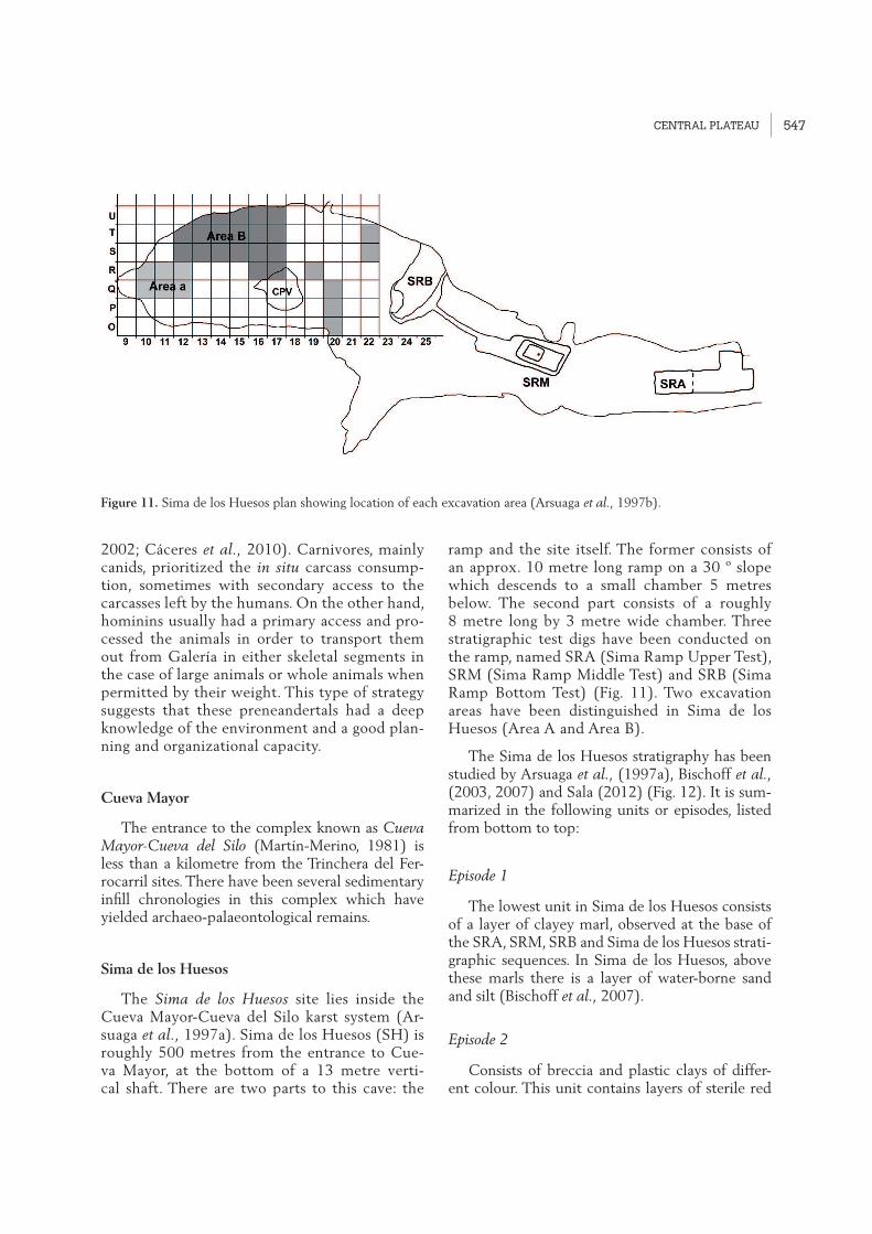
ramp and the site itself. The former consists of an approx. 10 metre long ramp on a 30 º slope which descends to a small chamber 5 metres below. The second part consists of a roughly 8 metre long by 3 metre wide chamber. Three stratigraphic test digs have been conducted on the ramp, named SRA (Sima Ramp Upper Test), SRM (Sima Ramp Middle Test) and SRB (Sima Ramp Bottom Test) (Fig. 11). Two excavation areas have been distinguished in Sima de los Huesos (Area A and Area B).
The Sima de los Huesos stratigraphy has been studied by Arsuaga et al., (1997a), Bischoff et al., (2003, 2007) and Sala (2012) (Fig. 12). It is sum-marized in the following units or episodes, listed from bottom to top:
Episode 1
The lowest unit in Sima de los Huesos consists of a layer of clayey marl, observed at the base of the SRA, SRM, SRB and Sima de los Huesos strati-graphic sequences. In Sima de los Huesos, above these marls there is a layer of water-borne sand and silt (Bischoff et al., 2007).
Episode 2
Consists of breccia and plastic clays of differ-ent colour. This unit contains layers of sterile red
Figure 11. Sima de los Huesos plan showing location of each excavation area (Arsuaga et al., 1997b).

PLEISTOCENE AND HOLOCENE HUNTER-GATHERERS IN IBERIA AND THE GIBRALTAR STRAIT:
THE CURRENT ARCHAEOLOGICAL RECORD548
clay, clay breccia with bear and human bones, and fossil-bearing yellowish brown clay breccia. These are the levels where human remains were found alongside carnivore remains.
Episode 3
The final sedimentary unit consists of a spele-othem on the ramp which covered the previous deposits. Throughout the ramp, the speleothem is covered by a layer of dark brown clay up to 20 cm thick, which includes a dark layer of bat dung. Bischoff et al., (2003, 2007) conducted several SRA datings of the speleothems in Epi-sode 3, which covers the entire fossil assemblage. Bischoff et al., (2007) estimated a minimum age of 530,000 years for the speleothem. New analyses are currently underway to confirm this chronology and the stratigraphic relationship be-tween the speleothem and the human fossils.
Sima de los Huesos has yielded the world’s largest and most comprehensive assemblage of human fossils from the Middle Pleistocene, with approximately 5,000 items recovered to date from at least 28 individuals. Most are adolescents or young adults, with very few children or se-
nile individuals. The human representation from Sima de los Huesos includes every part of the skeleton (Arsuaga et al., 1997b). These fossils have been attributed to a single biological popu-lation inserted amongst the hominin ancestors of the Neanderthals, the species Homo heidelbergen-sis (Arsuaga et al., 1993, 1997b).
Morphologically, the fossils from Sima de los Huesos exhibit many primitive features that are not present in Neanderthals (Arsuaga et al., 1993, 1997b). They also bear some derived Ne-anderthal traits in the facial skeleton (Arsuaga et al., 1997b), teeth (Martinón-Torres et al., 2012) and postcranial bones (Carretero et al., 1997; Ar-suaga et al., 1999b, Bonmatí et al., 2010).
Mitochondrial DNA analysis of samples from a Sima de los Huesos H. heidelbergensis femur shows that this group of hominins is genetically closer to the Denisovan population that lived in Siberia 40,000 BP than the Neanderthals (Meyer et al., 2013).
The current working hypothesis is that the Sima de los Huesos site was generated by a delib-erate accumulation of corpses by other humans (Arsuaga et al., 1997a, Arsuaga and Martínez,
Figure 12. Stratigraphic diagram of Sima de los Huesos and stratigraphic column of Upper Sima Ramp (SRA) (Bischoff et al., 2007).

CENTRAL PLATEAU 549
2004). Although the distribution of these indi-viduals’ ages at death does not show the attri-tional profile expected of a cemetery, there are many feasible explanations for the deliberate ac-cumulation of corpses with the age distribution found here (Arsuaga and Martínez, 2004). In Sima de los Huesos, no herbivore remains have been found alongside the human and carnivore fossils, and only one lithic item has been recov-ered (Carbonell et al., 2003). Due to the unique context of this handaxe, Carbonell et al., (2003) argue that this might be evidence of symbolic behaviour in this Middle Pleistocene popula-tion (Carbonel and Mosquera, 2006). In addition to the human remains, Sima de los Huesos has also yielded numerous remains of carnivores and mammals (Cuenca-Bescós et al., 1997, Cuenca-Bescós and García 2007, García et al., 1997, García, 2003) (Tab.1).
El Portalón
El Portalón is one of the current entrances to the Cueva Mayor-Cueva del Silo karst system, approx. 1040 m asl. It never became fully clogged by external sediment. The large, well-preserved stratigraphic sequence (over 9 metres) of this en-trance porch is an exceptional site for the study of recent prehistory (the last 10,000 years) as it documents a wide range of human activities dur-ing this period. Almost nothing has been pub-lished about the excavations in the late 1960’s and 70’s. Fresh work by the Atapuerca Research Team in 2000 discovered a much broader strati-graphic sequence than the previously known strata, which has been divided into two major sedimentary units (Fig. 13). The lower unit (Up-per Pleistocene) contains a significant palaeonto-logical record but very few traces of human ac-tivity in the form of small flakes. The upper unit
Figure 13: Stratigraphic column of Portalón South profile showing radiocarbon dates and associated cultural periods (modified from Carretero et al., 2008).

PLEISTOCENE AND HOLOCENE HUNTER-GATHERERS IN IBERIA AND THE GIBRALTAR STRAIT:
THE CURRENT ARCHAEOLOGICAL RECORD550
(Holocene) has a homogeneous sediment with abundant evidence of material culture. Its hu-man occupations are Medieval, Roman, Iron Age, different stages of the Bronze Age, Chalcolithic, Neolithic and Mesolithic. The relevance of this new sequence in Portalón is due to the paucity of information about the Upper Palaeolithic, Meso-lithic and Neolithic in inland Iberia, particularly on the Northern Plateau (Carretero et al., 2008).
Although Portalón occupations in the Middle Ages, the Roman Empire and the Iron Age were sporadic, surprising material has been found, including an Almohad gold coin from the 13th century, the only one known is this region (Pé-rez-Romero et al., 2010, 2013). The Bronze Age occupation (2nd millennium BC) was intense, with thousands of pottery shards from everyday materials- plates, bowls, pots, large jars, cheese containers and pitchers. Some of the items were etched and decorated with great care, an indica-tion of the intentions and identity of the manu-facturer and the special nature of the ceramics, probably related to prestige or ritual. There are also dozens of items in bone, antler and ivory (Alday et al., 2011) used in everyday activities (spatulas, spoons, astonishing needles and awls) and personal or ritual adornments (buttons, necklace beads of various types, awls with special features, arrowheads and others). Polished, perfo-rated shells have also been found amongst these ornaments. There are many stone items manu-factured for agricultural purposes such as sickle blades, grindstones, flakes, small cutters, polished stone axes, loom weights and hammerstones for carving. Not many metal (bronze) items were found, apart from some square headed punch-es and a magnificent flat axe. The economy was based on livestock grazing, agriculture, and to a lesser degree hunting, hence the thousands of re-mains of domestic and wild animals (e.g. horse, cow, sheep, goat, dog, deer, pig wild boar, fox, beaver, and a few birds) (Galindo-Pellicena et al., 2014) (Fig. 14).
During the Chalcolithic (3rd millennium BC), Portalón was used as a “Sanctuary” or bur-ial ground for humans. The numerous large-for-mat stones in the cave were rearranged to form burial mounds in which the corpses and ritual objects were placed. Although many of these burials were later disturbed by Bronze Age peo-ples, the intact body of a 6.5-7 year old child
buried in a pit-like structure made from stones was found in 2012. Ceramic objects were placed around the head, chest, knees and feet, and a near-complete skeleton of an immature ungulate lay at its foot. The excellent state of preserva-tion facilitated the detailed study of the teeth and bones in the skull, face, arms and legs (Cas-tilla et al., 2014). Anthropological analysis has revealed that this child might have suffered from both rickets and scurvy in at least two different periods of his/her short life. The signs of these diseases on the teeth and bones identify the first episode between the age of 18m months and 3 years, precisely the period when children are be-ing weaned and start to add other food sources to breast milk. Abnormal curvature of the long bones may be related to rickets at an age when the subject was still crawling or learning to walk. Other signs on the bones show a second episode at 4-5 years which cannot be linked to weaning. It might be related to a lack of vitamin C due to a monotonous diet based on cereals and lack of vitamin-rich food such as fruit and vegetables. Analysis of old DNA from human and animal remains found in Portalón is making a signifi-cant contribution to major scientific debates. A recent genetic analysis of adult human bones from Portalón (Sverrisdóttir et al., 2014) has re-vealed, much to our surprise, that these Bronze Age shepherds still lacked the genetic mutation which now allows us to properly digest milk lac-tose as adults, and thus use it as a source of calci-um and vitamins. Since the current populations on the Iberian Peninsula have a high frequency of this mutation, it follows that this trait was probably selected very quickly in populations which did not have it. This study has allowed us to look a little further into the causes of selec-tion of this adaptation, perhaps related to famine periods which were probably frequent in prehis-tory. When crops failed, the heavy consumption of dairy products would have been a good alter-native, which may have led to episodes of strong natural selection for lactose tolerant individuals, i.e. people who could properly and comfortably digest these products. Genetic analysis of cow re-mains from Portalón (Anderung et al., 2005) has corroborated ancient contacts between the peo-ples of North Africa and Iberia across the Strait of Gibraltar. A typical mitochondrial genetic strain of African cattle (Haplotype T1), which was thought to have arrived in Europe during

CENTRAL PLATEAU 551
the Muslim expansion in the 8th century, found in an early Bronze Age cow from Portalón, shows that the arrival of this haplotype is much older than previously thought, thus corroborating ar-chaeological evidence of contact between the two continents across the Strait in recent prehis-toric times at least. Remains from Portalón ini-tially attributed to domestic cattle on the basis of size and shape include one which contains Uro (wild bull) DNA, which might also be evidence that these animals were not only hunted but also that there was deliberate cross-breeding between wild and domestic animals. Genetic analysis of horse remains from Portalón has also contrib-uted to the debate about possible local episodes of domestication of these animals on the Iberian Peninsula (Lira et al., 2010).
Although the Neolithic levels (IV-V millen-nium BC) are yet to be fully excavated, they
will no doubt yield surprising results. At present, information is only available from one test pit, which has nevertheless yielded a wide range of typically Neolithic ceramic typologies with Bo-quique decorations, incised motifs filled with red paste, bottles with conical bases and broad han-dles, personal adornments including a ring and two bracelets in marble, bone tools including an awl made from a deer metapodial, geometric im-plements and flint backed blades.
Portalón’s large stratigraphic sequence and its long palaeontological and archaeological record is also being used in major studies of the climate and environmental patterns in the Upper Pleis-tocene and Holocene (Ruiz-Zapata et al., 2003, López-García et al., 2010; Martínez-Caught et al., 2014), as well as geophysics and new ge-ochronology techniques applied to the archaeo-logical record (Carrancho et al., 2013).
Figure 14. Examples of archaeological remains found on some of the Portalón levels. (Photos and montage L.E.H.).

PLEISTOCENE AND HOLOCENE HUNTER-GATHERERS IN IBERIA AND THE GIBRALTAR STRAIT:
THE CURRENT ARCHAEOLOGICAL RECORD552
the cavities along Trinchera del Ferrocarril is yet to be confirmed. It is probably an old karst win-dow filled by sediment which collapsed when the slope retreated. Outside there is a rockfall of large blocks, indicating ongoing degradation of the lip until quite recently. In 1970, a small test pit dug by the Edelweiss Caving Group (Ortega and Mar-tín, 2012) unearthed Bronze Age remains. This work was not continued, and the site was looted by poachers in the following years. Excavation by the Atapuerca Research Team began in 1999. In the following 9 years, a 20 metre deep test pit was dug in a 6 m2 area in the centre of the zone now sheltered by the roof, in order to ascertain the ar-chaeological potential of the site. In 2009, excava-tion began in two new sectors, 100 and 200, at the NW and NE ends of the cave respectively, in contact with the current wall. These sectors are
The abundance, richness and variety of mate-rials from Portalón is indicative of the diversity of activities and events that took place at this ex-ceptional site during recent prehistory. (Fig. 15)
El Mirador cave
El Mirador cave (Ibeas de Juarros, Burgos) over-looks the southernmost flank of Sierra de Atapuer-ca at an altitude of 1,033 m asl, with commanding southerly views across the Arlanzón River valley. The mouth of this karst cavity is now approxi-mately 23 m wide and 4 m high, penetrating some 15 m inwards. Its current shelter-like form is due to the collapse of part of the roof. It is part of the Sierra de Atapuerca karst system, although a pos-sible connection to the Cueva Mayor system and
Figure 15. General view of excavation on Portalón level 7/8 in 2012. (Photos J. Trueba/Madrid Scientific Films).

CENTRAL PLATEAU 553
not being dug vertically but in steps, following the line of the cave roof. The main aim of this work is to document the inward retreat of the cave and also the stratigraphic variations between its differ-ent areas.
The 20 m profile explored in the 1999-2008 survey consists of 14 metres of Pleistocene depos-its and 6 metres of Holocene material. The Pleis-tocene deposit (MIR51) has the following strati-graphic succession, listed from base to top (Fig. 16):
MIR51/4. 12 metres of metric and decimetric blocks with virtually no sedimentary matrix in be-tween. The result of the collapsed roof.
MIR51/3. A shallow, archaeologically sterile level composed of wind-borne sediment, mainly lying on the limestone blocks. This level has been dated at 12,480 ± 40 BP (15,060-14,700 cal. BP 95%).
MIR51/2. This centimetric deep level covers MIR51/2, and differs basically in its archaeological contents: remains of a hearth, lithic and fauna ma-terial along with evidence of human activity. It has two datings, 11,470 ± 40 BP (13,510-13,230 cal. BP 95%), and 11,610 ± 40 BP (13,640-13,360 cal. BP 95%), from charcoal samples extracted from material burned in the hearth.
MIR51/1. Roughly 2 metres deep, formed by large blocks fallen from the roof. This level only contains palaeontological remains, mainly wolf.
A Holocene sedimentary layer rests directly on top of MIR51/1, four metres of which correspond to Neolithic occupations between the last third of the 6th millennium and the first half of the 4th cal BC11, MIR24 to MIR6 (Vergès et al., 2008), while the remaining two metres are from the Mid-dle Bronze Age, MIR4 and MIR3A (Vergès et al., 2002), between the 2nd and 4th quarter of the 2nd millennium cal BP. This part of the Bronze Age is also represented in sector 100 by levels MIR103 to MIR105. All these levels were essentially formed as a result of the cave’s use as a livestock pen. They contain items from domestic and agricultural ac-
1 The dates for the Pleistocene levels are shown in years BP, while those for the Holocene are presented in calibrated years BC. This lack of uniformity reflects the annotation system used most frequently by researchers for each of the periods.
tivities and areas use as habitats. Intense livestock farming left a sedimentary layer, basically dung, which was piled together and burned at regular intervals in order to reduce the volume and elimi-nate parasites. This left an alternation between un-burned layers of manure and nodules of ash from burned dung, a feature of this type of site.
In the central test pit, archaeologically ster-ile level MIR5 is only a few centimetres deep, generated by natural sedimentation between the middle of the 4th millennium BC and the second quarter of the 2nd millennium cal BC. Burials from the same period as MIR5 have been found in sec-tors 100 and 200, in contact with the cave wall, showing that in fact the cave was not abandoned but rather transformed into a burial site. (Fig. 17).
Figure 16. El Mirador: cross-section of the Holocene se-quence, south wall of test pit. 1 squares, 2: unit names, 3: unit boundaries, 4: facies boundaries, 5: top of Pleistocene succession, 6: charcoal accumulations, 7: ash accumulation (distinct facies), 8: ash layers, 9 burnt sediment (rubefac-tion); 10: limestone fragments, 11: potsherds; 12: lithic artefacts; 13: bones; 14: sub-current burrows; 15: ancient burrows.

PLEISTOCENE AND HOLOCENE HUNTER-GATHERERS IN IBERIA AND THE GIBRALTAR STRAIT:
THE CURRENT ARCHAEOLOGICAL RECORD554
The oldest evidence of burials has been dated at around the second quarter of the 3rd millennium cal BC, during the Chalcolithic. Remains of at least 22 individuals have been identified (MIR203), laid in a small natural chamber and accompanied by a small num-ber of objects: smooth hemispherical bowls, fractured deer antlers and river shell valves. Cannibalism, probably of a ritual nature, has been documented in relation to this phase of the cave’s use for burials in the final third of the 3rd millennium cal BC, i.e., at the start of the Bronze Age. Skeletal remains of six individuals bear evidence of having been defleshed, frac-tured, cooked and eaten (Cáceres et al., 2007). The remains were found in a small hole dug in the middle Bronze Age levels (MIR4), indicating that they were collected and buried hundreds of years after their death, once livestock farming resumed here.
The final stage of this site’s use as a burial cave is marked by a single burial (MIR106) of a young male who was placed on one of the rock ledges inside the cave, contextualised chrono-logically in the second quarter of the 2nd millen-nium cal BC, i.e., the Middle Bronze Age.
A large part of the cave roof collapsed in a relatively short period, probably at the start of the Late Glacial. As a result, a 12 metre deep level (minimum, since the excavation did not reach the base) was deposited without time for exogenous sediment to become lodged be-tween the rocks. We do not know whether it was connected to the outside prior to this point, or whether the cave had been occupied. Exogenous input of essentially wind-borne sediment began after this massive collapse, and formed a level (MIR51/3) which covered the layer of blocks. Upper/Late Magdalenian hunt-er-gatherer groups established sites on top of
Figure 17. Upper left: aerial view of El Mirador cave (J.Mestre/IPHES). Upper right: stratigraphic section of Neolithic series. Lower left: ovicaprine remains in partial anatomic connection from level MIR-14. Lower right: Individual Bronze Age burial (MIR-106) (J.Vergès/IPHES).

CENTRAL PLATEAU 555
this level (MIR51/2). Their occupations left a minor archaeological record, perhaps because of their brevity, and had no continuity. A new epi-sode of rockfalls from the cave roof (MIR51/1) covered these remains and left an uneven floor with many gaps. From this point until the arrival of Neolithic settlers, the cave was occupied by wolves which used these gaps between the rocks as dens.
The first documented occupations of the cave by Neolithic groups were around the last third of the 6th millennium cal BC. From the outset and throughout the Neolithic (MIR24 to MIR6), it was repeatedly used as a habitat and a livestock pen, primarily for sheep and goats (Vergès et al., 2008). This dynamic continued until the middle of the 4th millennium cal BC, with only varia-tions in the material culture, primarily ceramics. The use of El Mirador as a pen then ceased and a period of apparent abandonment began.
Between the second quarter of the 3rd millen-nium and the second quarter of the 2nd millen-nium cal BC, El Mirador was used once again as a burial cave. Group burials, ritual cannibalism and individual burials associated with different periods have been documented. Extensive ex-cavation will allow us to discover whether the differential treatment of the corpses and the different types of burial reflect different funeral traditions, or whether they evolved together.
Immediately after the last documented buri-al, the use of El Mirador as a pen resumed with exactly the same livestock handling features as the Neolithic period. This continued until at least the last quarter of the 2nd millennium cal BC (Vergès et al., 2002), when the stratigraphic succession was interrupted, most probably by the removal of sedimentary material from the cave. Decontextualized items point to the con-tinuation of human activity in the late Bronze and Iron Ages, and also most probably in historic times as well. In fact, the cave was still used by shepherds in the 20th century.
Open air sites
The Upper Pleistocene in Sierra de Atapuer-ca is well documented outside the above-men-tioned caves. Archaeological surveys conducted between 1999 and 2003 (Navazo and Carbonell,
2014) discovered 31 open air campsites. Dur-ing this work, 314 km2 were inspected around the Trinchera del Ferrocarril sites to ascertain how Upper Pleistocene groups of hunters and gatherers organized their daily lives. Once the campsites were discovered, the area and loca-tion of each one was analysed in depth to define those which contained archaeological material in a good state and analyse their stratigraphy. The most recent open air site in Sierra de Atapuerca, Valle de las Orquídeas -Orchid Valley- (Mosquera et al., 2007) was excavated in 2000 and 2001. In 2004, work commenced on the Hundidero site (HU) in 2004 (Navazo et al., 2011.), where up to four different occupation levels were identi-fied. In 2006 a test pit was excavated at another site, Hotel California (HC) which ended in 2010 with five detected archaeological levels. Work is currently under way at Fuente Mudarra, where three archaeological levels have been found so far. The data obtained to date show that Sierra de Atapuerca was occupied by groups of Pleis-tocene hunter-gatherers from at least 70 ky until to 27 ky BP. Datings from Hundidero are 70.556 +11,011 BP (TL) for the oldest level and 30,221 + 3,636 BP for the most recent (Benito-Calvo, et al., 2005). Middle Palaeolithic stone implements have been found on each of the four archaeologi-cal levels, with more than 50 tools made from local raw material. (Fig. 18).
Hotel California datings (Arnold, et al., 2013) show that the oldest occupation in this area was around 71.0 ++5.6 ky and the most recent 48.2 ky +3.3 ky BP. A 24 m2 test pit –larger than Hun-didero– was dug at this site, which obviously yielded much more lithic material: up to 2,000 items, all manufactured from local raw material. Material from the first test pit at Fuente Mudarra in 2011 yielded datings which match the most recent period at Hotel California.
As a result of the work done so far, we know that Neanderthal groups lived in Sierra de Atapu-erca during Isotope stages 4 and 3. The chronol-ogy of the assemblages under excavation in the Trinchera del Ferrocarril is older than the Nean-derthal open air sites. This space should be in-terpreted as a large archaeological site in which each campsite is a location interrelated with the rest, i.e., like a house with several rooms. Hunt-er-gatherers controlled and occupied all the Si-erra environments. Sites have been found in the

PLEISTOCENE AND HOLOCENE HUNTER-GATHERERS IN IBERIA AND THE GIBRALTAR STRAIT:
THE CURRENT ARCHAEOLOGICAL RECORD556
lowest-lying areas on river terraces, on hillsides and above, on the moors. It stands to reason that different activities were done in each one, with the hillsides most likely to have the greatest habi-tational stability.
Local raw materials were used to make the stone tools (Navazo et al., 2008). The most wide-ly used material at Hundidero, Hotel California and Fuente Mudarra is overwhelmingly Neogene chert (generally more than 90% of all assemblag-es), followed by Cretaceous chert and quartzite. The sources of the Neogene chert were second-ary deposits in the Sierra. In fact, almost all the campsites around Sierra de Atapuerca are located on secondary deposits of Neogene chert.
The technological features observed at all three sites show that the main aim was to manufacture products through the reduction of a core. The flakes were used directly or in the configuration of series. The most widely employed structural cat-egory is flake (BP), followed by retouched flake (BN2GC). Cores only outnumber retouched flakes at 3 of the 31 sites. Typometric analysis shows a predominance of small-sized flakes (Bagolini, 1968). As with the retouched flakes, in most cases
these flakes have non-cortical, unifaceted platform butts and non-cortical dorsal faces. Retouched flakes are larger than simple flakes, although both are small-format. Denticulates are the best rep-resented morphotype, followed by sidescrapers and many abrupts. A few more points and burins were found at sites on high ground than on ter-races, where more points were found. Orthogonal knapping was the predominant reduction system in the case of pebble cores, and centripetal knap-ping in the case of cores on flake. In general, there was little or no preparation of cores prior to the removal process, and little complexity in the knap-ping strategies. The minimal presence or absence of cortex on the butts and dorsal faces of items seems to be due to the type of raw material avail-able at these locations. Since these were secondary deposits, the chert blocks were already broken and in many cases lacked a patina. Moreover, the fact that the vast majority of butts were platform and unifaceted seems to be due to the predominant weight of the initial knapping sequences in these assemblages.
Visits to the Pleistocene settlements in this study area, located in all the geomorphological
Figure 18. View of Hundidero site during excavations (Photos: M. Navazo).

CENTRAL PLATEAU 557
units, coincided with the formation of terraces T9 (+19-30 m) to T12 (+8-10 m) (Pérez- González and Benito-Calvo, 2014). There were sites on high ground, associated with sinkholes, on col-luvions, river terraces and caves. This diversity shows that the campsites were chosen on basis of the availability of basic subsistence resources, and that the groups adapted their movements to the distribution of food and other resources. The re-sources required for these groups’ survival were animals, plants, stone and water. During the final third of the Upper Pleistocene, Atapuerca Nean-derthals lived in an altitude range between 902 and 1,086 m asl, where the climate was not ex-cessively harsh, and exploited both the moors and the river terraces. We have documented 15 sites on moors and upland zones, 12 on river terraces (some associated with ponds, etc.), and four on hillsides (Fig. 19). Our analysis of the assemblag-es suggests that all sites seem to have been visited for short but recurrent periods of time, except for the four sites on steep hillsides which may have had a more stable occupation pattern. Several oc-cupation levels have been identified at the Hun-didero and Hotel California campsites, corrobo-rating their reoccupation during thousands of years. Most of these sites are spread across a large area, which may be due to several factors. Firstly, the dynamics of the occupations, with repeatedly visited sites. Secondly we must bear in mind the disturbances to the assemblages caused by farm-ing practices. Experimental observations of dis-turbance by ploughing in the same area (Navazo and Díez, 2008) have found that the surface area of archaeological sites on tilled farmland tends to expand while the density of their archaeological record decreases. They also completely lose their spatial and stratigraphic matrix.
Valle de las Orquídeas is an open air site from the end of the Upper Pleistocene (Mosquera et al., 2007). It is located at the top of Sierra de Atapuerca, south of Alto de Matagrande (1,078 m), at the head of a valley connected to a broad exokarst formation somewhat like a sinkhole, with water at the base available to the wildlife and humans who inhabited this area.
During the 2000 and 2001 field seasons, we excavated an 18 m2 area which yielded 306 lithic items associated with terra-rossa deposits (Fig. 20). Two TL dating of this terra-rossa, the base of the analysed stratigraphic sequences, showed
an age of 27,507 ± 2,295 years BP and 29,955 ± 2,319 years BP. Most of the items are in Cre-taceous chert, which is found in the form of small nodules encrusted in the Sierra crevasses. Highlights include four quartzite hammerstones, 56 cores, 44 retouched cores on flake and 158 simple flakes. Reduction was predominantly uni-facial centripetal, primarily aimed at producing denticulates, notches and sidescrapers, although other curious discoveries include two denticulate points, two atypical scrapers, one possible burin and two retouched blades. This industrial assem-blage is technologically homogeneous and reflects a typical Middle Palaeolithic technical undercur-rent, as well as some Upper Palaeolithic features.
Valle de las Orquídeas may well represent the last of the stages in human evolution that has re-mained undiscovered in Sierra de Atapuerca: the cultural and biological transition between Nean-derthals –the presumed occupants of the upper levels of Sima del Elefante and Galería de las Estatuas– and modern humans, the early settlers of the stage represented by the Mirador and Por-talón caves.
Conclusions
This chapter is an overview of more than 30 years of research at the Sierra de Atapuerca sites. This work has proved the importance of this large archaeological-palaeontological com-plex for the study of human evolution, not only in Europe but also at the global scale. Europe’s longest Pleistocene stratigraphic sequence has been documented at two of the sites in the Trinchera del Ferrocarril, Sima del Elefante and Gran Dolina. The archaeo-palaeontological re-mains found at these sites deposits prove that groups of hominins (Homo sp.) inhabited West-ern Europe at least 1.3 M years ago. The homi-nin remains found on more recent levels of the Lower Pleistocene sequence (TD6.2) led to the proposal and profiling of H. antecessor, a hu-man species which inhabited Western Europe at the end of the Lower Pleistocene. Analysis of these human remains has also detected evidence of the oldest known episode of cannibalism. A Mode 1 lithic assemblage has been found in as-sociation with these H. antecesor remains, where the full range of workable lithic resources avail-able in the Atapuerca area was used and, for the

PLEISTOCENE AND HOLOCENE HUNTER-GATHERERS IN IBERIA AND THE GIBRALTAR STRAIT:
THE CURRENT ARCHAEOLOGICAL RECORD558
first time in the sequence of these sites, the sys-tematic use of retouch in tool manufacture. The archaeological remains recovered from the vari-ous Lower Pleistocene levels at Atapuerca pro-vide evidence that the human groups from these chronologies were active hunters, that they were at the top of the food chain and that they had
a high degree of control over their territory and
its resources.
After a gap in the evidence of human pres-
ence –but not the palaeontological record–, a
new phase in the human occupation of the Si-
erra began approx. 500,000 years ago, evidenced
Figure 19. Geomorphological map of the study area (1): Cambrian (metasandstones and slates); (2): Carboniferous (con-glomerates, sandstones and slates); (3): Triassic (conglomerates and sandstones); (4): Lower Cretaceous (limestones and quartzite conglomerates); (5): Lower Cretaceous siliciclastic detritic sediments; (6): Upper Cretaceous (limestones and dolostones); (7): Middle Miocene sediments with quartzite conglomerates; (8): Middle Miocene limestone with chert nodules; (9): Lower Pleistocene terraces; (10): Middle Pleistocene terraces; (11): Upper Pleistocene terraces; (12): colluvial deposits; (13): cones; (14): floodplain and valley floor; (15): drainage network; (16): Palaeo-archaeological sites in Sierra de Atapuerca endokarst system [1. Gran Dolina, 2. Galería, 3. Sima del Elefante, 4. Cueva Mayor]; (17): sampling in primary chert outcrops; (18): archaeological occurrences. (From Navazo and Carbonell 2014; produced by A. Benito-Calvo).

CENTRAL PLATEAU 559
in Galería, Sima de los Huesos and the upper section of Gran Dolina. The record from these sites has proved essential for the study of the hominins (H.heidelbergensis-Preneandertals) who inhabited Europe between 500 and 200 ky BP. Sima de los Huesos has yielded the world’s larg-est, most extensive and complete collection of human fossils. These remains from a single popu-lation have provided the oldest genetic material of a fossilized human species sequenced to date. The presence of this population at the bottom of Sima de los Huesos has been interpreted as a deliberate accumulation of corpses by other hu-mans, and also as the oldest recorded symbolic behaviour. The density of the material retrieved from the sites in the Trinchera del Ferrocarril sug-gests an intense occupation of Sierra de Atapu-
erca by H. heidelbergensis-Preneandertal groups, a wide range of developed subsistence strategies, and good capacity for planning and organization, reflected in the features of their Mode 2-Acheu-lean lithic tools.
Outside the karst caves, our work at Sierra de Atapuerca has made a significant contribution to knowledge of the human groups which inhabited the area during the Upper Pleistocene. Some of these open air sites –Hundidero, Hotel California and Fuente Mudarra– have provided information about the lives of the Neanderthals groups which lived in the Sierra during Isotope stages 4 and 3. Campsites have been found in low lying areas and river terraces, on hillsides and on moors, and it stands to reason that different activities were done at each one, with the hillsides most likely
Figure 20. El Valle de las Orquideas site (Sierra de Atapuerca, Burgos). 1: Convex denticulate, 2: Épine 3: Possible burin. (Photo: EIA).

PLEISTOCENE AND HOLOCENE HUNTER-GATHERERS IN IBERIA AND THE GIBRALTAR STRAIT:
THE CURRENT ARCHAEOLOGICAL RECORD560
to have had the greatest habitational stability. At one of the open air campsites –Valle de las Orquídeas–, some of the retrieved stone mate-rial has been linked to the cultural and biologi-cal transition between Neanderthals and modern humans.
In recent decades, studies of the Portalón and Mirador sites have contributed important infor-mation about the human groups which inhabited the Sierra during the Holocene, due to the scarce information about the Mesolithic and Neolithic on the Iberian Peninsula’s Northern Plateau or Meseta.
The archaeological record from both sites (Portalón and Mirador) has shed light on the eve-ryday lives of the Bronze Age groups (2nd millen-nium BC) in this area. Their domestic chores and agriculture and livestock-based livelihoods are re-flected in the archaeological record and the use of the cave as a pen. During the Chalcolithic, both caves began to be used as burial chambers. Canni-balism, probably ritual, has been documented at the Mirador Cave, in connection with this burial phase. Analysis of old DNA from Portalón has shown that the Bronze Age shepherds still lacked the necessary genetic mutation to properly digest lactose in milk. This site has also yielded archaeo-
logical records from the Neolithic, Iron Age, Late Roman Empire and the Middle Ages.
The almost constant presence of human groups in this range of hills since the Lower Pleistocene (1.3 Ma) shows that the area has been a rich source of resources necessary for the reproduction and survival as groups of several hominin species which lived in and around Sierra de Atapuerca.
Acknowledgements
We thank everyone who has collaborated in any capacity in the excavation and research work at the Sierra de Atapuerca sites. Our fieldwork is funded by the Castilla-León Regional Government and the Atapuerca Foundation, and our research work is supported by the Spanish Government’s Minis-try of Economy and Competitiveness (MINECO) under the “Sierra de Atapuerca V Pleistocene and Holocene” Project CGL2012-38434-C03, as well as by the Government of Catalonia, under projects SGR 2014-899; SGR 2014-901 and SGR 2014-900. J.I.M. has a pre-doctoral grant (FI) from the Govern-ment of Catalonia; A.H.L, M.G.P., M.T.B. and L.R. have all received pre-doctoral grants from the Ata-puerca Foundation. A.R-H has a pre-doctoral grant (FPI) from MINECO CGL2009-12703-C03-02).

ROBERT SALA RAMOS (EDITOR)
EUDALD CARBONELL | JOSÉ MARÍA BERMÚDEZ DE CASTRO | JUAN LUIS ARSUAGA(COORDINATORS)
PLEISTOCENE AND HOLOCENE HUNTER-GATHERERS IN IBERIA AND THE GIBRALTAR STRAIT:THE CURRENT ARCHAEOLOGICAL RECORD
The book we are introducing, Pleistocene and Holocene hunter – gatherers in Iberia and the Gibraltar Strait: the current archaeological record, aims to be an updating of the current
knowledge on human predatory societies settled in Iberia. The archaeological record of
that region is essential for the reconstruction of Human Evolution in Europe in biological,
behavioural and cultural domains thus it preserves the earliest and more significant records
of the humanization in the continent and because it allows the recovery of the main trends
in that process. This is possible thanks to a rich, large and complete record, encompassing
all the stages on that development and all the adaptive and cultural modes. Moreover, the
discovery of that record is amongst the earliest known archaeological occurrences in the
history of our discipline, materialized already during the XIX century.
The main aim of that volume is the systematic presentation of the current empirical
data written by the same research teams already on work every year on the excavation
and analysis of the sites. We have included the current knowledge on the main archaeo-
palaeontological sites, those bearing the more significant record. These sites are arranged
in eight physiographic and geological regions with the aim of making clear the adaptive
ways of human societies to similar environments. Beyond these eight regions it seemed
important to us to present the heritage of symbolic behaviour on the caves of the two
regions bearing the more extensive record of that cultural trait: the Cantabrian and the
Levantine regions. The cave paintings coming from outside these two regions are presented
in their own region.
Finally, beyond the empirical data, we would like to highlight the main research lines
in which the modern Iberian Archaeology is currently engaged in the field of Human
Evolution and Palaeoecology.
ISBN 978-84-92681-87-7
9 788492 681877
RO
BE
RT
SA
LA
RA
MO
S (
ED
ITO
R)
EU
DA
LD
CA
RB
ON
EL
L |
JO
SÉ
MA
RÍA
BE
RM
ÚD
EZ
CA
ST
RO
| J
UA
N L
UIS
AR
SU
AG
A (C
OO
RD
INA
TOR
S)
PL
EIS
TOC
EN
E A
ND
HO
LO
CE
NE
HU
NT
ER
-GA
TH
ER
ER
S I
N I
BE
RIA
A
ND
TH
E G
IBR
ALT
AR
ST
RA
IT: T
HE
CU
RR
EN
T A
RC
HA
EO
LO
GIC
AL
RE
CO
RD
Acknoledgements: