Applications Recommended for Approval - Rhondda Cynon ...
108
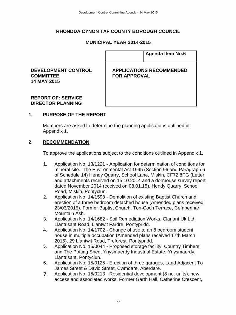
RHONDDA CYNON TAF COUNTY BOROUGH COUNCIL MUNICIPAL YEAR 2014-2015 Agenda Item No.6 DEVELOPMENT CONTROL COMMITTEE 14 MAY 2015 REPORT OF: SERVICE DIRECTOR PLANNING APPLICATIONS RECOMMENDED FOR APPROVAL 1. PURPOSE OF THE REPORT Members are asked to determine the planning applications outlined in Appendix 1. 2. RECOMMENDATION To approve the applications subject to the conditions outlined in Appendix 1. 1. Application No: 13/1221 - Application for determination of conditions for mineral site. The Environmental Act 1995 (Section 96 and Paragraph 6 of Schedule 14) Hendy Quarry, School Lane, Miskin, CF72 8PG (Letter and attachments received on 15.10.2014 and a dormouse survey report dated November 2014 received on 08.01.15), Hendy Quarry, School Road, Miskin, Pontyclun. 2. Application No: 14/1598 - Demolition of existing Baptist Church and erection of a three bedroom detached house (Amended plans received 23/03/2015), Former Baptist Church, Ton-Coch Terrace, Cefnpennar, Mountain Ash. 3. Application No: 14/1682 - Soil Remediation Works, Clariant Uk Ltd, Llantrisant Road, Llantwit Fardre, Pontypridd. 4. Application No: 14/1702 - Change of use to an 8 bedroom student house in multiple occupation (Amended plans received 17th March 2015), 29 Llantwit Road, Treforest, Pontypridd. 5. Application No: 15/0044 - Proposed storage facility, Country Timbers and The Potting Shed, Ynysmaerdy Industrial Estate, Ynysmaerdy, Llantrisant, Pontyclun. 6. Application No: 15/0125 - Erection of three garages, Land Adjacent To James Street & David Street, Cwmdare, Aberdare. 7. Application No: 15/0213 - Residential development (8 no. units), new access and associated works, Former Garth Hall, Catherine Crescent, Development Control Committee Agenda - 14 May 2015 77
-
Upload
khangminh22 -
Category
Documents
-
view
1 -
download
0
Transcript of Applications Recommended for Approval - Rhondda Cynon ...
RHONDDA CYNON TAF COUNTY BOROUGH COUNCIL
MUNICIPAL YEAR 2014-2015
Agenda Item No.6
DEVELOPMENT CONTROL COMMITTEE 14 MAY 2015 REPORT OF: SERVICE DIRECTOR PLANNING
APPLICATIONS RECOMMENDED FOR APPROVAL
1. PURPOSE OF THE REPORT
Members are asked to determine the planning applications outlined in Appendix 1.
2. RECOMMENDATION
To approve the applications subject to the conditions outlined in Appendix 1.
1. Application No: 13/1221 - Application for determination of conditions for mineral site. The Environmental Act 1995 (Section 96 and Paragraph 6 of Schedule 14) Hendy Quarry, School Lane, Miskin, CF72 8PG (Letter and attachments received on 15.10.2014 and a dormouse survey report dated November 2014 received on 08.01.15), Hendy Quarry, School Road, Miskin, Pontyclun.
2. Application No: 14/1598 - Demolition of existing Baptist Church and erection of a three bedroom detached house (Amended plans received 23/03/2015), Former Baptist Church, Ton-Coch Terrace, Cefnpennar, Mountain Ash.
3. Application No: 14/1682 - Soil Remediation Works, Clariant Uk Ltd, Llantrisant Road, Llantwit Fardre, Pontypridd.
4. Application No: 14/1702 - Change of use to an 8 bedroom student house in multiple occupation (Amended plans received 17th March 2015), 29 Llantwit Road, Treforest, Pontypridd.
5. Application No: 15/0044 - Proposed storage facility, Country Timbers and The Potting Shed, Ynysmaerdy Industrial Estate, Ynysmaerdy, Llantrisant, Pontyclun.
6. Application No: 15/0125 - Erection of three garages, Land Adjacent To James Street & David Street, Cwmdare, Aberdare.
7. Application No: 15/0213 - Residential development (8 no. units), new access and associated works, Former Garth Hall, Catherine Crescent,
Development Control Committee Agenda - 14 May 2015
77

Cymmer, Porth. 8. Application No: 15/0347 - Domestic garage and hard-stand to rear, Ynys
House, Maindy Crescent, Ton Pentre, Pentre.
Development Control Committee Agenda - 14 May 2015
78
APPLICATIONS RECOMMENDED FOR APPROVAL
APPLICATION NO: 13/1221/10 (DB) APPLICANT: Lafarge Tarmac Ltd DEVELOPMENT: Application for determination of conditions for mineral
site. The Environmental Act 1995 (Section 96 and Paragraph 6 of Schedule 14) Hendy Quarry, School Lane, Miskin, CF72 8PG (Letter and attachments received on 15.10.2014 and a dormouse survey report dated November 2014 received on 08.01.15)
LOCATION: HENDY QUARRY, SCHOOL ROAD, MISKIN, PONTYCLUN, CF72 8JQ
DATE REGISTERED: 20/11/2013 ELECTORAL DIVISION: Pontyclun
RECOMMENDATION: Approve updated conditions REASONS:
This application is required by Schedule 13 of the Environment Act 1995 to review the existing mineral permissions at Hendy Quarry to ensure that the quarry site operates with up to date conditions to reflect present day environmental standards and guidance. No objections have been raised by statutory consultees with respect to the potential impacts upon the amenity of nearby residential properties, highway safety, landscape, ecology matters, drainage and archaeology and cultural heritage, subject to the imposition of updated conditions. It is considered that the proposed updated conditions should apply in substitution of the previous conditions to ensure that the environmental impact of the continued quarrying activities are limited, allow for appropriate supervision, ensure planning enforcement and comply with national guidance and the policies of the Local Development Plan.
APPLICATION DETAILS This is an application for a First Periodic Review of the existing mining permissions at Hendy Quarry. The Review of Old Mining Permissions is commonly referred to by the acronym "ROMP" Review, and is required by Schedule 13 of the Environment Act 1995, at 15 year intervals from the date of a previous review or, if no review has taken place, from the date of the latest mineral permission relating to the site. The Review process is designed to ensure that active quarry sites operate with up to date conditions which reflect present day environmental standards and guidance.
Development Control Committee Agenda - 14 May 2015
79

An initial review of the 1950, 1963 and 1982 mineral permissions at Hendy Quarry was undertaken by the previous quarry operator, Tarmac, via an application Ref T/97/2165, which was determined on 18 May 1998 with 22 conditions. It is these conditions which now form the subject of the First Periodic Review. Subsequent to the determination of the Initial Review, planning permission was granted on 14 September 2001 for the progressive restoration of the quarry using inert infilling materials and the operation of an associated inert recycling facility, Ref T/01/2376. The quarrying operations were planned to be carried out concurrently with the infill restoration operations. Condition 9 requires the mineral operations to be undertaken in accordance with the conditions imposed on the Initial Review T/97/2165. The planning permission for quarrying at the site expires on 21 February 2024 (Condition 1 of T/97/2165 refers) and the landfill restoration development is subject to the same time limitation within Condition 2 of T/01/2376. This application therefore considers the effects of quarrying over the remaining time period of the planning permissions to provide a context for the schedule of conditions which will regulate the mineral development over that period. It is also assumed that the quarrying and landfill restoration developments will be completed within that timescale. The principles of the quarry development scheme were established at the time of the 1997 Initial Review. This involved the development of the quarry in a series of benches and faces, to include the deepening of the floor of the quarry to 20m AOD in the south central area, developing the faces and benches in a northerly direction and allowing the quarry to flood due to quarrying below the water table. During the processing of the application for the inert landfill restoration, (T/01/2376) the applicants confirmed that the quarry development scheme was to be amended to limit quarrying to a base level of 45m AOD. This would ensure that there would be no quarrying below the natural water table (at circa 40m AOD) and thus all inert landfill would take place above the water table. In doing so it was acknowledged that this would sterilise some 1.24 million tonnes of permitted reserves, albeit creating a better restoration strategy for the site. However, in all other respects the principles of the quarry development were not changed and the quarrying was proposed to occur through the central/southern area of the quarry (to 45m AOD), with inert landfill/restoration proceeding from west to east and south to north towards the north eastern corner of the quarry. The application includes an updated schedule of suggested conditions. (But does not include restoration conditions which the applicant considers have been superseded by the requirements of a landfill restoration planning permission Ref T/01/2376). The Council is not obliged to accept the planning conditions proposed by the applicant and can impose different conditions or additional conditions. However, where a Planning Authority determines conditions different from those submitted by
Development Control Committee Agenda - 14 May 2015
80

the applicant and the effect of the new conditions, other than restoration or aftercare, as compared with the effect of the existing conditions, is to impose a restriction on working rights, then the Applicants whose interests have been adversely affected by the restrictions may be entitled to claim compensation (Schedule 14, Paragraph 13 of the Environment Act 1995, refers). The application proposes an updated quarry development scheme which seeks to exploit the remaining permitted reserves in 3 phases. This confines quarrying operations to the north/north eastern area of the quarry, restricts the depth of quarrying to a base of 45m AOD and develops 3 faces and benches at circa 45, 59 and 70m AOD levels. The updated scheme does not propose any further quarrying within three existing woodland belts around the perimeter of the quarry located along the south eastern, north eastern and north western areas of the site, in order to provide a continued screen to the quarrying operations. However, a small area of TPO Woodland Block W3 would be removed extending to an area of 0.2ha. The plans reflect the intention to extract the remaining reserves of some 756,000 tonnes at an assumed rate of 100,000 tonnes per annum over the remaining life of the permission. Production in 2014 has been 50,000 tonnes, which coincided with a temporary shut down of the operations. However, the applicant is confident that the permitted reserves will be exploited within the timescale of the permission, in view of improving economic conditions together with development and infrastructure projects planned for the area. The plant at the site extends to mobile crushing and screening plant which are brought in as required and located within the quarry void at the 45m AOD level, to crush excavated limestone and to produce stockpiles of various size stone products for sale. These operations are regulated by an Environment Permit. No changes are proposed to these established procedures. Some of the site buildings comprising a series of portacabins adjoining the weighbridge would be affected by Phase 2 of the proposed extraction operations. These are proposed to be repositioned outside the extraction area, but still in the vicinity of the weighbridge. No changes are proposed to the established working hours, which are set out within
Condition 5 of T/97/2165/10, as follows:-
Mon – Fri 0700 – 1900
Sat 0700 – 1300
No quarrying operations are to take place on Saturday afternoons, Sundays
or Statutory Public bank Holidays, except for essential maintenance.
For the purposes of this condition, quarrying operations are defined as the
“winning and working of stone from the quarry face, the haulage of stone from
Development Control Committee Agenda - 14 May 2015
81
the face and the operations of the primary crusher/or other mechanical
means of stone breakage.”
In terms of output and traffic movements, there were no restrictions on the rate of output imposed as part of the Initial Review and there are no restrictions on traffic movements in terms of either number of vehicles or routing. Production rates at the quarry have previously ranged from 100,000 and 250,000 tonnes per annum. It has been assumed that future production will average some 100,000 tonnes per annum for the remaining life of the permission. Based upon the remaining reserves of 756,000 tonnes, an average load size of 20 tonnes, and a notional 275 day working year, this equates to an average of 18 loads per day (36 movements). The established existing site entrance would be utilised on to School Road/ B4264. With the exception of local deliveries, all traffic is routed to and from the east, along the B4264 to the A4119, either southbound to the M4 Junction 34 or north towards Talbot Green, to avoid the village of Miskin. It is normal practice in undertaking a review of mineral planning permissions to include a restoration scheme for the quarry and for the implementation of that scheme or restoration strategy to be controlled by planning conditions. This was the approach taken at the time of the Initial Review (T/97/2165) when conditions were imposed requiring the submission of a scheme detailing the general principles of restoration and requiring proposals for the after use of the overall site to be submitted for the approval of the Local Planning Authority, with a requirement for the approved scheme to be reviewed at minimum of 5 year intervals. However, the applicant considers that this requirement has been superseded by the permission for the progressive restoration of the quarry using inert infilling materials (Ref T/01/2376). Condition 11A of the permission requires the phasing of tipping, limits of tipping and the finished levels to be “generally carried out in accordance with the submitted restoration concept plan Reference HY4/1A, unless otherwise agreed in writing with the Local Planning Authority”. Condition 17 requires an amended restoration scheme in the event of cessation of delivery of waste to the site prior to the achievement of the completion of the approved restoration scheme and Condition 14 requires a detailed revised restoration and aftercare management scheme in such circumstances. The applicant therefore considers that the restoration of the quarry is fully catered for by the separate planning permission for this by inert landfill operations and that the restoration does not need to be addressed further as part of this Periodic Review. This matter is considered in more detail later on in this report. The application is accompanied by an Environmental Statement (ES) which has been informed by the Scoping Opinion issued by the Council in June 2013, and a Schedule of Conditions. Further environmental information regarding various issues
Development Control Committee Agenda - 14 May 2015
82
was received on 15 October 2014 and 8 January 2015. A copy of the ES and associated documentation is available for inspection. SITE APPRAISAL The total site area at Hendy Quarry extends to some 21.46 hectares. The quarrying operations are confined to some 14.09ha within the southern part of the site and the area of future quarrying within the current Review application relates to an area of some 5ha which lies within the north eastern part of the quarry area. The northern part of the site is not used for any quarrying activities at present. Within this area there is a builders merchant premises known as Bracey’s (Ref 02/0770), offices of the regional headquarters of the applicant ( most recent permission Ref 99/2143), an area used by Smith’s (Gloucester) Ltd for the storage of building materials ( Ref 08/1537) and offices with car and lorry parking (Ref 07/1966) which are located near the site entrance. A large section of this part of the site, covering an area of some 3.62 ha, consists of four woodland blocks which are protected by a Tree Protection Order–TPO No. 81 dated 2006, which identifies blocks numbered W1 to W4.
The quarry is believed to have produced limestone since the late 19th century and this has continued intermittently up to the Second World War. On 13.12.47 an Interim Development Order was issued granting permission for quarrying on the site and a series of extensions have subsequently been permitted in 1950, 1963 and 1982. The quarry is bounded by the B4264 School Road onto which access is gained, and to the east by the A4119 link to the M4 at Junction 34. The southern boundary is bounded by a wooded ridgeline which defines the edge of the permitted area beyond which lies the extensive grounds of Miskin Manor Hotel. Land to the west is similarly bounded by a wooded ridgeline, beyond which lies agricultural land and the village centre of Miskin. To the north west of the site lying on elevated ground lies the residential area of Cefn Yr Hendy. Within the quarry void area there is a ramp which runs from the quarry weighbridge area located in the north central part of the quarry, in a south easterly direction to the floor of the quarry at 45m AOD. To the north east of the quarry floor are two benches at average elevations of 50m AOD and 70m AOD. The remainder of the quarry void consists of the inert recycling facility and its associated mobile screening and crushing plant, together with the inert infilling operations which are in the process of restoring the remainder of the quarry via the separately approved landfill restoration scheme (01/2376). Substantial progress has been made with backfilling the western and southern parts of the quarry, which have been filled to levels of between 63m AOD and 65m AOD.
Development Control Committee Agenda - 14 May 2015
83
The overall site is served by a direct access in the form of a priority T junction on the south side of the B4264 School Road which incorporates a ghost island right turn lane. The use of the existing site access for HGV traffic has been occurring at a lower level in recent years since the temporary suspension of mineral extraction and the cessation of concrete production. However, it is also used by the ongoing inert infilling operations (01/2376), deliveries to/from the builders merchant premises known as Bracey’s and the earth moving and construction company known as Smith Gloucester Ltd, which continue to attract regular HGV movements on a daily basis. The access is also used by staff of the offices of the regional headquarters of the applicant, which is located near the site entrance. Within a 1km boundary of the site lies the Cadw Registered Historic Park and Garden of Special Historic Interest in Wales: Miskin Manor Grade II and the Grade II Listed Building of Miskin Manor. There are also a number of features within or just beyond the 1km radius of the quarry which appear on the GGAT Historic Environment Record, the key feature being the site of the former St Cawdraf’s medieval monastery, located to the south east of the site. In addition, within 1km lies the centre of Miskin village which is designated as a conservation area. PLANNING HISTORY The applications relating to the winning and working of minerals, deposition of mineral waste or the restoration of the site are as follows:- 01/2376/10 Progressive restoration of
quarry using inert infilling materials and the operation of an associated inert recycling facility
Approved 14.09.01
56/97/2165 Application under the provisions of Schedule 13 of the Environment Act 1995 for the determination of planning conditions relating to the working of Hendy Quarry.
Approved 18.05.98.
56/93/0906 Determination of conditions relating to the IDO Registration
Approved 26.09.94
56/92/0221
IDO Registration Approved 08.06.92
56/77/1050 Quarry extension Approved
Development Control Committee Agenda - 14 May 2015
84
02.10.82 Revocation Order relating to two
areas of land of permission E17699/6467 - agreed by Secretary of State 19.10.82
E17699/6467 Extension of quarry Approved 20.12.63.
E11678 Tipping of quarry waste Approved 20.7.60
S8670 Quarrying Approved 13.7.55
S51 Quarry extension Approved 10.5.50
Interim Development Order
Approved 13.12.47
PUBLICITY The application has been the subject of neighbourhood notification, site notices and press notices. These have all been undertaken again following the receipt of the further environmental information submitted in October 2014 and January 2015. No responses have been received as a result of this publicity. CONSULTATION As part of the application process a number of statutory and non-statutory consultations with both internal sections within the Council and external organisations have been undertaken. A summary of the responses is provided below. Dwr Cymru/Welsh Water – raises no adverse comments. Advises of apparatus in the locality which needs to be protected. Glamorgan Gwent Archaeological Trust Ltd (GGAT) – raises no objections to the positive determination of the application. Transportation Section - raises no highway objection subject to conditions relating to the provision of an adequate vision splay, sheeting of lorries and an annual condition survey of the road surface in the vicinity of the access serving the site.
Development Control Committee Agenda - 14 May 2015
85
Pontyclun Community Council – raises no objections but requests a condition is imposed to prohibit quarry vehicles using the eastern B4264 approach road and that access is to be via the A4119 only. Public Health and Protection Division – raises no objections to the ROMP and the proposed conditions regarding hours of operation, noise and blasting and provides recommendations regarding the dust conditions. Natural Resources Wales (NRW) – raises no objections based on the additional information received in relation to groundwater levels on the site and the dormouse survey work. Supports the comments of the Council’s ecologist in relation to local biodiversity issues. Countryside Section – raises no objection on ecological grounds subject to conditions requiring a habitats and species protection plan, re-survey for badgers prior to any woodland clearance, positive management of retained woodland as mitigation for the loss of woodland/scrub. Raises no objections on landscape grounds subject to the perimeter woodland and existing topography being safeguarded to sustain their existing visual screen and conditions for the treatment of invasive species. Advises that there are no relevant SEWBREC Records of Statutory Protected Species from immediate vicinity. Land Reclamation & Drainage Engineering - raises comments in relation to surface water and flooding matters, and has agreed wording of proposed conditions. POLICY CONTEXT Rhondda Cynon Taf Local Development Plan The principal planning policy considerations relating to this application can be summarised as follows: Hendy Quarry is identified in the Local Development Plan, as being within the countryside and outside defined settlement boundaries. Policy AW14.5 safeguards a 200 metre buffer zone around the quarry from development that would adversely affect its operations. Policy AW8.214 identifies land within the site known as “Hendy/Miskin Quarry” as a Regionally Important Geological Site (RIGS). Policy AW8.153 identifies the woodland areas within the northern part of the quarry and land to the south, west and east of the quarry as “Hendy Quarry and Miskin Manor Slopes Site of Importance for Nature Conservation” (SINC). Policy SSA 23.3 identifies land to the south and west of the quarry as “Ely Valley at Miskin Special Landscape Area”. Policy CS10 - outlines the strategic aim relating to the safeguarding of a continuous supply of minerals, without compromising environmental and social issues. Points 4 and 6 are of particular relevance to the application, regarding the restoration and
Development Control Committee Agenda - 14 May 2015
86
after care and also ensuring that impacts from operations upon residential and sensitive land uses and the transportation of minerals are limited to acceptable proven safe limits. Policy AW5 - supports development subject to certain amenity and accessibility criteria. Policy AW7 – only permits proposals which would preserve or enhance the character and appearance of sites of archaeological and/or historic merit. Policy AW8 – gives guidance on the preservation and enhancement of the natural environment, particularly Sites of Importance for Nature Conservation (SINC) or Regionally Important Geological Sites (RIGS). Policy AW10 – does not permit proposals where they would cause an unacceptable risk to public health, safety, and amenity or to the environment. Policy AW14 - ensures the long term safeguarding of mineral resources and also identifies a specific 200m buffer zone around Hendy Quarry, which is also shown on the proposals map. National Guidance In the determination of planning applications regard should also be given to the requirements of National Planning Policy (which are not duplicated in the Local Development Plan) particularly where National Planning Policy provides a more up to date and comprehensive policy on certain topics. Planning Policy Wales (PPW7) Chapter 4 (Planning for Sustainability), Chapter 5 ( Conserving and Improving Natural Heritage and the Coast), Chapter 6 (Historic Environment), Chapter 7 (Economy), Chapter 8 (Transport), Chapter 12 (Infrastructure and Services) and Chapter 13 (Minimising and Managing Environmental Risks and Pollution) set out the Welsh Government’s policy on planning issues that are relevant to the determination of the application. Minerals Planning Policy Wales (MPPW) Para’s 34 to 47 provide advice to ensure that the environmental impact of mineral extraction is limited. Issues that must be addressed include access and traffic generation; noise, dust and blasting, land drainage, prevention of pollution of water supplies; visual intrusion and general landscaping; impacts on sites of nature conservation, historic and cultural importance; land instability, promotion of the use and treatment of unstable, derelict or contaminated land; cumulative impact, restoration, after care and after-use. Para’s 48 to 54 provide advice in order to achieve a high standard of restoration and provide for beneficial after-use when mineral working has ceased. Restoration and after care should provide the means to maintain and preferably enhance the long-term quality of land and landscapes taken for mineral extraction. It is considered
Development Control Committee Agenda - 14 May 2015
87

essential that progressive restoration is introduced at the earliest opportunity, where appropriate and practicable Other relevant policy guidance consulted: Minerals Planning Guidance (MPG) 2 Applications, Permissions and Conditions This guidance covers planning applications for minerals development, planning permissions and the imposition of planning conditions. Minerals Planning Guidance (MPG) 11 The Control of Noise at Surface Mineral Workings. Minerals Planning Guidance (MPG) 14 Environment Act 1995: Review of Mineral Planning Permissions Provides guidance on the statutory procedures for preparing and considering updated planning conditions in the review process. Minerals Technical Advice Note 1: Aggregates Section C outlines a number of measures of control to reduce the impact of aggregates production including the provision of buffer zones, planning conditions regarding dust, blasting operations, noise and visual impact. It also states that regular environmental audits should be carried out and that community liaison should occur where there are regular complaints or local concern about specific impacts. Section D outlines the means to achieve a high standard of restoration and after care and provide for a beneficial after-use. TAN5 Nature Conservation and Planning Para 1.4.1 states that Section 40 (1) of the Natural Environment and Rural Communities Act 2006 (NERC) places a duty on every public authority, in exercising its functions to “have regard, so far as is consistent with the proper exercise of those functions, to the purpose of conserving biodiversity. TAN 5 sets out the manner in which planning authorities should comply with this duty. Section 2 sets out the key principles of positive planning for nature conservation. REASONS FOR REACHING THE RECOMMENDATION Section 38(6) of the Planning and Compulsory Purchase Act 2004 requires that, if regard is to be had to the Development Plan for the purposes of any determination to be made under the Planning Acts, the determination must be made in accordance with the plan unless material considerations indicate otherwise.
Development Control Committee Agenda - 14 May 2015
88
Furthermore, applications that are not in accordance with relevant policies in the plan should not be allowed, unless material considerations justify the grant of planning permission. Main Issues: The primary purpose of this application is to provide for updated conditions in respect of the mineral permissions at the site to limit the environmental impact of the continued quarrying activities permitted up to 21 February 2024. It is considered that the conditions should ensure that the permitted quarrying activities comply with national and local planning policies, respect the SINC and TPO designations within the northern part of the quarry site with its habitats and protected species issues, and that the restoration and after use secures natural generation that compliments the SINC and respects the character of the surrounding area which is designated a Special Landscape Area, within the LDP. It is also considered that the new conditions should consider matters of residential amenity and the quality of life of local residents (noise, dust, blasting, public health), transportation, drainage and flooding, archaeology and cultural heritage. Time Limits and Working Programme Consideration has been given as to whether the proposed conditions in relation to the time limits for the mining and working of minerals, the depositing of mineral waste and the working programme are appropriate. The Initial Review Ref T/97/2165 provided for the development to expire no later than 21 February 2024, consistent with the previous conditions imposed on the IDO Permission and the limits set out in the Environment Act 1995. There appears to be no good reason why the operations would be completed before that date. Therefore, the same end date has been agreed with the quarry operator. The removal of all plant, machinery and structures, any ancillary manufacturing activities and the cessation of the sale and transportation of any residual stocks, within a further 12 month period, is also proposed. The limits of quarrying are defined by the 1963 and 1982 planning permissions. The red line of the planning permission boundary reflects the restrictions which are in place via the Revocation Order of the 1982 permission which removed an area of land to the south eastern and south western boundaries of the defined area. The footprint of the quarry development was updated for the purposes of the 1998 Initial Review and involved limiting the deepening of the quarry to a final base level of 20m AOD followed by the progressive development of the faces and benches in a northerly direction. It also illustrated the final development of the quarry faces north westwards and northwards within the central area of the site, consistent with the limits of quarrying approved by the 1963 planning permission.
Development Control Committee Agenda - 14 May 2015
89
In September 2001, planning permission was granted for the progressive restoration of the quarry using inert filling materials together with the operation of an associated inert recycling facility (Ref T/01/2376/10. The permission limits the quarrying to a depth of 45m AOD in order to avoid any issues associated with land filling below the groundwater level. The landfill planning permission cross references to the Initial Review Decision Notice to the effect that all mineral operations should be undertaken in accordance with the conditions imposed on the ROMP Review Decision Notice Ref T/97/2165/10. At present infill operations are progressing in accordance with the conceptual phasing plans and quarrying operations have been restricted to a base level of 45m AOD. Remaining limestone reserves are primarily confined to the north eastern area of the quarry but permitted reserves are located within the quarry footprint. This First Periodic Review proposes an updated quarry development scheme to exploit the remaining permitted reserves but excludes quarrying within the woodland belts along the perimeter of the quarry. However, consistent with the 1963 permission and the 1998 ROMP Review, the development would include part of a TPO (Ref 81 dated 2006 area W3) the effect of which is considered later in this report. The proposed phased quarry development scheme has therefore been updated and is illustrated on plans numbered HQ ROMP 4 and 5. T he quarry development scheme illustrates the development of 3 x faces and benches at the circa 45, 59 and 70m AOD bench levels, as illustrated on the Phase 1 Development Plan. Final quarry operations would then extract the remaining reserves in the north central area of the quarry, as a single bench at the 45m AOD level as shown on the Phase 2 Development Plan. The conditions regarding the phasing of working have therefore been amended to reflect the updated quarry phasing plans. The sequence of mineral extraction should be undertaken in accordance with these approved plans but the condition allows some flexibility for the Local Planning Authority to vary the working programme if required, at a later date and this is considered good practice. In addition, the condition requires the location of all plant, machinery, the weighbridge and ancillary buildings to take place within the quarry development limits, as shown on plan HQ ROMP 2. The condition requiring no extraction of minerals below 45m AOD (other than these works necessary of the construction of the quarry sump) is retained. Additional conditions are also proposed. One requires a copy of the consent of the approved plans to be displayed in the operator's site office at all times in order to ensure that the developer and site operatives are aware of the working programme and conditions. Also, a condition permits a review of the working programme and phasing plans five years from the date of consent, in order to formally review the working plan if necessary.
Development Control Committee Agenda - 14 May 2015
90

The previous Initial Review (T/97/2165) included a condition regarding the removal of vegetation and soils and storage of soil for restoration purposes. The applicant accepts that any soils/soil forming material within the undisturbed area of the quarry which would be affected by Phase 1 of the development scheme should be conserved and used as part of the restoration works. A condition is therefore proposed to secure a scheme to be submitted for approval for the storage and utilisation of soil resources. The previously imposed condition securing the protection of vegetation adjacent to the excavation area is now provided for in the proposed Wildlife Protection Plan condition (see Landscape, Restoration, Aftercare and Ecology later in this section). Public Health and Amenity Considerations The quarry is located in the countryside but in near proximity to the outskirts of the residential areas of Miskin and Cefn Yr Hendy to the north west and north of the site. The nearest residential properties to the quarry are located outside the 200 metre buffer zone around the quarry and are located within 400 - 500m of the site workings in School Road, Beachlea Close and The Chestnuts, Miskin Village and along Parc Ifor Hen within the southern part of the Cefn Hendy Residential Estate. To the east the closest residential unit is associated with the Castell Mynach Public House, some 100m from the site but separated by topography, woodland and the A4119 dual carriageway. Isolated properties at Croffta lie some 500m to the east with the outskirts of Groesfaen some 850m further to the east. To the south, the Miskin Manor Hotel lies at a distance of some 700m from the quarry area, separated by topography and woodland. Other sensitive receptors comprise the Lafarge Tarmac regional office and offices of Smith’s (Gloucester) Ltd within the northern area of the quarry. Issues relating to noise, air pollution, dust, public health, safety and residential amenity are therefore relevant for these sensitive receptors. The Council’s Public Health and Protection Division have been consulted on the application as it is recognised that the continuation of mineral activities at the quarry may have the potential to impact upon residential amenity and/or cause nuisance. Advice has been given in relation to the form and wording for the updated conditions. The Public Health and Protection Division have raised no objections to the proposed conditions in relation to the hours of operation, noise and blasting and have advised that the dust condition should be include a dust management plan for approval. Air Quality An air quality assessment has considered the potential dust and PM10 emissions as a result of extraction, storage, processing, haulage of materials and off site distribution and the potential exposure of sensitive receptors, including local residents and ecological receptors. Works associated with the inert backfill restoration are subject to a separate planning permission and permit but the potential
Development Control Committee Agenda - 14 May 2015
91
for cumulative/additional dust emissions has been considered for completeness. An assessment of traffic emissions for the HGV movements related to the quarrying activities has not been considered necessary as the level of traffic to be generated falls below that required to undertake such an assessment. The continued operation of quarrying activities at the remaining part of the site are not considered to significantly change the sources of dust, as the existing methods of extraction and processing would continue. Processing of the limestone is regulated by an Environmental Permit and would be carried out intermittently with mobile crushing and screening plant to produce single sized chippings which would be stored at the base of the quarry for off-site marketing. In addition, the rate of extraction and haulage would remain the same. The existing topography and vegetation around the quarry perimeter would remain as a screen and barrier to prevent the offsite movement of dust. In considering the sources of dust, the low frequency of winds from the east and south east and the distance to the receptors, the assessment considers that dust impacts would continue to be insignificant. The closest receptor when the wind is within the prevailing direction to the west, is the Castell Mynach Public House. However, due to the intervening features and established mitigation measures the assessment states that there should be no adverse dust effects from quarrying operations at this property. With regards to PM10 emissions, the background levels within the vicinity of the quarry are shown to be well below the national air quality levels. As there are no residential receptors within the 200m buffer zone of the site and the background levels are low and the dust concentration would remain “well below” national air quality strategy objectives, no further assessment has been undertaken. The air quality assessment has concluded that all receptors would have an insignificant risk of impact from deposited dust and PM10 emissions, and that the existing dust control measures would continue to be employed in accordance with the existing Environmental Permit and best practice, as set out in Table 11-6 of the ES, in order to reduce dust impact further. Conditions have therefore been included to secure the submission of a dust management plan for approval. Blast Vibration As consistent with other similar quarries containing carboniferous limestone, the rock at Hendy Quarry is extracted by controlled blasts from the quarry faces. This activity generates ground vibration which is calculated in terms of “peak particle velocity” (PPV) and is measured in millimetres per second (mms). Vibration is also generated within the atmosphere where it is measured in terms of “air over pressure”. MTAN1 provides guidance on suitable planning conditions to control the environmental impact of blasting operations at quarries. Para 83 of MTAN1 states that planning conditions should only relate to those aspects of environmental management that are under the control of the operator, directly relevant to environmental issues and should not be in conflict with existing health and safety
Development Control Committee Agenda - 14 May 2015
92
legislation. Consequently, planning conditions should provide for the desired objectives rather than the methods by which the objectives are to be achieved and should focus on the acceptable days and times for blasting operations, allowable ground vibration limits and schemes for the management of air over pressure control and vibration monitoring. All blasts are monitored by the quarry operator with the most recent blast having taken place on 14.11.2013. Records for the period since 2004 have shown that generally the blast vibration levels have been below 6mms PPV and that in all but 4 blasts the ground vibration levels have been below 10mms PPV. The ES considers that the blast design can therefore adhere to the limits as recommended by MTAN1. The application is accompanied by updated conditions to regulate blast vibration which accord with modern standards and the advice in MTAN1. These conditions are considered acceptable subject to additional conditions regarding audible warning of blasting at the site boundary and no secondary breakage of stone, which can cause problems such as fly rock, and the setting of a trigger level for air overpressure in order that any exceedance would initiate a review of the blast design. It is considered that these conditions should ensure that blasting can continue to take place within the remaining part of the site in a safe manner and without detriment to the amenities of the receptors in the locality. Noise In terms of noise, a detailed noise assessment, has been undertaken in accordance with standard guidance BS5228. The assessment measured noise levels at representative properties in the vicinity of the quarry – at Castell Mynach, Miskin Manor, Beachlea Close and at All Hallows Church, based on a worst case scenario. It considered the effects of the continued extraction operations on these properties in the context of MTAN1. The assessment concluded that noise emissions for all temporary and normal operations at the quarry would lead to slight, barely perceptible impacts on the ambient noise levels and would comply with MTAN1 guidance. There are however a number of mitigation measures and restrictions proposed in order to further reduce the risk of any potential adverse noise impacts and these are detailed in Section 9.7 and 9.8 of the E.S. such as restricting activities to the quarry floor, use of regularly maintained plant which complies with noise emission levels and acoustic enclosures for pumps, generators and compressors. It is therefore proposed to impose conditions to control the hours of operation, establish limits on noise levels for normal and temporary operations to ensure that the noise levels comply with MTAN1 and is not a source of nuisance to the local area. The provision of a condition regarding a Noise Monitoring Scheme is also proposed as an additional noise control mechanism. Access and traffic
Development Control Committee Agenda - 14 May 2015
93
The existing site access is proposed to be used for the remainder of the site’s active life, in accordance with the existing mineral permissions. None of the mineral permissions restrict the rate of output from the quarry or restrict the number of vehicles entering or leaving the site during the prescribed working hours. The existing access has a width of 27.7m and forms a bellmouth junction with 9m corner junction radius with a gated entrance located 10m from the edge of the carriageway. A tracking assessment shows that a large tipper lorry measuring 10.2m long can successfully enter and leave the site. The visibility at the site entrance is 2.4m x 89m each way which exceeds the required visibility of 2.4m x 70m within Table A of TAN18. It has been assumed that future production will average some 100,000 tonnes per annum for the remaining life of the permission and that vehicles serving the site would be predominantly rigid HGV tippers. Based on a 5.5 working day (consistent with the existing permissions) and allowing for holiday periods, 275 working days would result in 18 loads or 36 two way movements per day. The accompanying traffic survey reveals that an average of 36 HGV daily movements would represent 0.46% of the existing average weekday traffic flow. Based on the design capacity of the width of the B4264 School Road of 7.3m the hourly design capacity would be between 1900 to 2650 movements. The highest recorded hourly flow during the traffic survey of 940 movements represents 49.5% of the design capacity and therefore adding the entire HGV flow during the busiest hour would not compromise the capacity of the network. Collision data was obtained from the Council covering the most recent 5 year period available ( 2008 – 2012) within the vicinity of the site entrance along the entire length of School Road into Miskin and along the A4119 extending 0.8km to the north and south of the B4264 School Road junction. There were 17 collisions of which 15 resulted in slight and 2 serious injury. None occurred on School Road and none involved HGV’s. In addition, accident analysis data between the site access and the junction of the A4222 with the B4264 has shown that there were 4 accidents resulting in 3 slight injury and 1 serious injury and that none involved HGV traffic. The Transportation Section have considered the application and in light of the assessment have raised no objections subject to conditions to retain the vision splays at the site entrance and for the sheeting of all lorries leaving the site. These conditions are considered reasonable to impose, however, the Transportation Section has also requested an annual condition of the road surface, in the vicinity of the access, until the expiry of the permission and additional damage to be rectified at the quarry operator's expense. It is considered that such measures would not be relevant to impose in this case, as this application relates to the review of conditions for the quarrying operations where the traffic entering and leaving the site is likely to remain the same for its active life. In addition, there are other means of protecting the public highway in terms of securing wheel washing, road screening and lorry
Development Control Committee Agenda - 14 May 2015
94
sheeting. These measures are included in the proposed conditions to ensure that vehicles do not deposit mud and other detritus onto the public highway. Concern has been expressed from Pontyclun Community Council about the route of quarry vehicles through the village of Miskin and a condition is requested to be imposed to prohibit quarry vehicles using the eastern B4264 approach road and that access should be via the A4119 only. Traffic routeing is a common concern with mineral applications. However, Paragraph 4.25 of Circular 16/2014 (The Use of Planning Conditions for Development Management) advises that “planning conditions are not an appropriate means of controlling the rite of passage over public highways ...Where it is essential to prevent traffic from using particular routes, the correct mechanism for doing so is an Order under the Traffic Management Act 2004.” The Planning Officers Society For Wales Minerals & Waste Topic Group “Good Practice Guide For Mineral Planning Conditions, advises that “There may be merit in formulating routeing arrangements with operators by way of advice given in MPG11, Paragraph 70, which encourages the establishment of voluntary mineral site transport plans in consultation with local communities. It is therefore considered that the route of HGV’s leaving the site should not be restricted by condition but could be pursued by the Community Council in seeking a Traffic Order and a note can be attached to the decision notice encouraging the applicant to agree a route voluntarily to avoid Miskin village. Landscape, Restoration, Aftercare and Ecology In terms of landscape, restoration, aftercare and ecology, the conditions should ensure that the quarrying activities and restoration proposals retain and protect the natural environment adjacent to the quarry which largely consists of SINC, complements the character of the surrounding land, which is designated as a Special Landscape Area and respects the TPO within the site and the designation of Hendy/Miskin Quarry as a Regionally Important Geological Site. The Landscape and Visual Impact Assessment within the ES includes a desktop assessment including an assessment relating to CCW Landmap and the SLA designation adjacent to the site. There is also a visual assessment from six various locations in the vicinity of the site as representative of views visual receptors gain of the site and the proposed quarry development. It concludes that the proposed future excavations together with the removal of the 0.2ha of woodland area covered by block W3 of the TPO would have a minimal adverse effect due to the safeguarding of the perimeter woodland and existing topography which provide a visual screen of the quarry void area with visual effects being generally limited to the confines of the quarry itself and views of the entrance to the quarry from School Road. As set out in the application details above, the applicant maintains that the restoration of the quarry void and the quarry site is provided for within planning permission 01/2376. This consent commenced in 2002 and at the time of the submission of this application (November 2013) 984,000 cubic metres had been
Development Control Committee Agenda - 14 May 2015
95

placed within the quarry as part of the backfill operations. A further volume of just over 1.4 million cubic metres will be required to complete the restoration to the approved contour levels. The topographic survey accompanying the application confirms that the backfill operations has progressed within the western, central and south eastern areas consistent with stages 1,2 and 3 of the permission. However, it does not appear that final levels or restoration materials have been placed on these areas. The remaining area to be land filled is stage 4 which is located within the north eastern area of the quarry. The restoration concept plan Ref HY4/1A, proposes that the quarry area of the site would be restored to a bowl shaped ground profile with the central area restored to pasture and managed by grazing with steeper slopes proposed for rough grassland managed to promote natural regeneration of a calcareous grassland with additional tree and scrub planting. The existing areas of tree and scrub vegetation around the periphery of the quarry would be retained. Soils for restoration would be made up of existing stockpiles of soil forming materials and from imported infill materials. There are some minor inconsistencies between the quarry development scheme which accompanied the 1998 Initial Review and the restoration concept plan which accompanied the infilling restoration consent, 01/2376. The approved quarry development scheme indicates the removal of the woodland belt along the north eastern edge of the quarry whereas the restoration concept plan shows this area of woodland to be retained. However, the proposed quarry development scheme within this application proposes to update the quarry limits in order to largely preserve this woodland area. The only woodland area which would be removed (consistent with the 1998 ROMP Review), would be a 0.2ha section within the north central area of the quarry. In consideration of the final restoration of the quarry void, it is accepted that there are conditions imposed on the landfill restoration permission which requires full details of the final restoration materials and also provides some flexibility to allow for a revised restoration scheme to be submitted to reflect final quarrying limits and the volumes of infill material imported. It also includes details of the restoration of the remainder of the site outside the quarry void. Notwithstanding planning permission 01/2376, and its restoration obligations, it is considered that there would be no additional requirements in imposing restoration conditions which require restoration in accordance with the approved Restoration Concept Plan HY4/1A, on this review, for completeness. Since the 1998 Initial Review, the quarry has been designated a Regional Important Geological Site (RIGS No. 214) as defined in the LDP. The Restoration Strategy recognises the potential to retain rock outcrops in the north eastern area as a means of enhancing the geo-diversity value of the site, in order to respect the RIGS designation. However, this opportunity could only be catered for in the event of a lack of infill material regarding 01/2376, which would necessitate a review of the currently approved restoration scheme. This matter is therefore reflected in the
Development Control Committee Agenda - 14 May 2015
96
proposed condition requiring a final restoration scheme and in the notes to accompany the decision notice. The ecological assessment shows that the impacts on habitats and species are localised to the north eastern area of the quarry which is the remaining extraction area associated with the continued working of the quarry. There will be loss of 0.2 ha of broadleaved woodland which forms part of the wider Hendy Quarry and Miskin Manor Slopes SINC and equates to less than 1% of the SINC designated area. This is assessed as insignificant as it would not affect the wider integrity or functioning of the retained woodland area. The bat survey found evidence of bats using the site but no roost sites. Whilst the 0.2 ha of woodland areas to be lost is considered to be useful bat habitat the proposals are not considered to have any significant impact on bat populations of the area due to the remaining foraging resource available. There has been a dormouse assessment of the woodland area affected by the continued working of the quarry. A survey undertaken between September 2013 and October 2014 concludes that there is no evidence of dormouse being present within the areas affected by the ROMP review. The badger survey recorded a subsidiary active badger outside the ROMP boundary. The habitats within the site have been assessed as having low potential for the presence of reptiles and amphibians. In terms of birds, the assessment recognises the potential for the 0.2ha woodland area to be a potential nesting resource and the presence of nesting peregrine falcon outside but close to the ROMP review area with the potential to nest inside in the ROMP area as suitable ledges arise. The Council’s Ecologist has considered the assessment and has raised no objection subject to conditions to secure the proposed mitigation measures which include a positive woodland management plan for the areas of retained woodland, controlled clearance outside the bird nesting period, minimise disturbance to peregrine falcon and proposals for the control and eradication of invasive plant species. The Council’s ecologist has requested additional conditions to mitigate for the loss of the woodland area, including the provision of bat roost boxes, translocation of purple orchids, an updated badger survey (prior to woodland removal), utilisation of all soil resources within the undisturbed area of the quarry and a Habitat and Species Protection Plan for Construction to ensure that the quarrying activities employ precautionary measures to protect adjacent habitats and to recognise that species may take up occupancy in the near future. NRW have raised no objections to the application, and have advised that the submitted information, including the Dormouse Survey work is acceptable. NRW support the Council’s Ecologist’s comments in relation to the various local biodiversity issues raised. It is concluded that the continued quarrying operations and restoration proposals together with the mitigation measures referred to above, secured by conditions
Development Control Committee Agenda - 14 May 2015
97
would respect the existing landscape and ecological designations, habitats and species and offset the removal of the 0.2ha of woodland block W3 of the TPO. Drainage and Water Pollution The prime considerations in relation to conditions here is to prevent pollution to groundwater and water courses, control any potential effects of derogation and the prevention of flooding. The ES provides an overview of ground and surface water conditions at the quarry. It confirms that all quarrying will take place above 45m AOD which is above the groundwater level and that there are no surface water drainage courses within the immediate vicinity of the site. The site collects surface water in a sump at the base of the quarry which is used for dust suppression and wheel washing facilities. Water is discharged from the sump via a soakaway infrequently and is monitored and regulated via an Environmental Permit from NRW. The Permit is also subject to a Groundwater Management and Monitoring Plan which monitors existing boreholes within the quarry, the discharge from the quarry and also involves the preparation of an annual report. No changes are proposed to this established regime. Water monitoring and management conditions were imposed on the Initial Review but no planning conditions have been proposed by the applicant regarding this First Periodic Review in order not to duplicate the regulatory controls already in place via the Environmental Permitting Regime. However, a number of standard conditions are proposed regarding the storage of fuel and oils as a preventative measure to minimise the risk of ground and surface water contamination. NRW have been consulted on the proposals and have raised no objections to the submission. This response followed the provision of an additional plan which illustrated the ground water contours within the remaining area to be worked. Under the Flood and Water Management Act 2010, the Council is now the lead Local Flood Authority, and therefore the Council needs to ensure that adequate measures to minimise flood risk are incorporated into the quarry proposals. There are no surface water courses within the immediate vicinity of the site. The Land Drainage and Engineering Section has therefore advised that standard precautionary conditions should be imposed to safeguard any features and prevent any potential future flood risk. Conditions numbered 27 and 28 are therefore recommended to be imposed to minimise any flood risk. Archaeology and cultural heritage The ES indicates that the large majority of the site comprises of already worked or disturbed land such that any previously unrecorded features of archaeological interest will have been removed by historic quarrying activities.
Development Control Committee Agenda - 14 May 2015
98
In terms of indirect impacts, the ES states that within a 1km boundary of the site lies the CADW Register of Historic Parks and Gardens of Special Historic Interest in Wales: Miskin Manor Grade II and the Grade II Listed Building of Miskin Manor. There are also a number of features within or just beyond the 1km radius of the quarry which are held by GGAT Historic Environment Record, the key feature being the site of the former St Cawdraf’s medieval monastery, located to the south east of the site. The centre of Miskin village is a conservation area but the ES considers that there is no intervisibility with the quarry such that there would be no effect on the setting of the Conservation Area. The ES provides no mitigation measures in relation to potential direct impacts on archaeological resources and the potential indirect effects to the historic features mentioned above are stated to result in no change to the current situation due to the continued retention of the perimeter ridgeline topography and wooded landscape which ensures there is no inter-visibility between Miskin Manor Historic Park and Garden, which would protect the setting of these features. In addition, the quarrying operations are confined to the north eastern part of existing quarry footprint such that there are no visual or landscape effects associated with the quarry operations, and the effects of noise and blast vibration would not be discernible within the Historic Park. The ES concludes that no specific conditions are necessary to protect cultural heritage interest. GGAT advise that in view of the assessment within the ES the works are unlikely to cause an adverse impact to the historic environment and raise no objection to the application. However as their current knowledge of the archaeological resource in the area is incomplete and remains may be disturbed during the course of the work, then a note is proposed to be added to contact the Trust for further guidance. It is therefore considered that the proposed condition referred to above would ensure
that the continuing quarrying operations would be in keeping with the provisions of
Policy AW7 of the LDP.
Other matters Community Infrastructure Levy (CIL) Liability
The Community Infrastructure Levy (CIL) was introduced in Rhondda Cynon Taf from 31 December 2014. The application is a kind that is not CIL liable under the CIL Regulations 2010 (as amended). Conclusion In conclusion, it is considered that the proposed attached conditions which take into account the matters raised above and update those suggested by the applicant
Development Control Committee Agenda - 14 May 2015
99

should ensure that the environmental impact of the continued quarrying activities are limited, and allow for appropriate supervision and planning enforcement.
RECOMMENDATION: Grant 1. Planning permission for the winning and working of minerals within the Site
shall cease no later than 21st February 2024. Reason: To define the consent granted.
2. Following the expiry of the mineral permissions all extraction, processing, treatment and stockpiling of minerals within the Site shall cease. Reason: To ensure that all forms of mineral development cease.
3. No later than 12 months following the expiry of the planning permissions, or the earlier permanent cessation of winning and working of minerals, as agreed between the mineral operator and Local Planning Authority, all plant, machinery, hard standings, ancillary buildings, structures or other works associated with the development shall be dismantled and removed from the Site, unless otherwise agreed in writing with the Local Planning Authority. Reason: To ensure that all works associated with the development are removed, in the interests of the amenities of the local area, in accordance with policy CS10 of the Rhondda Cynon Taf Local Development Plan.
4. No later than 12 months following the expiry of the mineral permissions or the earlier permanent cessation of winning and working of minerals, as agreed between the mineral operator and Local Planning Authority, the sale and transportation of minerals to and from the site together with all ancillary manufacturing activities shall cease.
Reason: To ensure that all mineral activities cease in the interests of the amenities of the local area in accordance with policy CS10 of the Rhondda Cynon Taf Local Development Plan.
5. A copy of this consent and the approved plans showing the method and direction of working and restoration shall be displayed in the operator’s site office at all times during the life of the site. Any subsequent approved amendments shall also be displayed. Reason: To ensure the operator and site contractors are aware of the working programme and the conditions attached to carrying out the development.
6. Unless otherwise agreed in writing by the Local Planning Authority,
Development Control Committee Agenda - 14 May 2015
100

development shall take place in accordance with the details illustrated on plan reference HQ ROMP 4 and 5. The quarry shall be developed to achieve but not exceed the approved limits of excavation shown on plan HQ ROMP 5. In addition, the location of all plant, machinery, weighbridge and ancillary buildings shall be located on the quarry floor and take place within the quarry development limits as shown on plan HQ ROMP 2.
Reason: To enable the Local Planning Authority to control the development and to minimise its impact on the amenities of the local area in accordance with policy CS10 of the Rhondda Cynon Taf Local Development Plan.
7. The developer shall submit a revised working programme and phasing plans for the approval of the Local Planning Authority five years from the date of this consent, unless otherwise agreed in writing by the Local Planning Authority, should the Working Programme as previously agreed by the virtue of Condition 6 be proposed to be changed within this time. Reason: To enable the Local Planning Authority to control the development and to minimise its impact on the amenities of the local area in accordance with policy CS10 of the Rhondda Cynon Taf Local Development Plan.
8. Other than for the purposes of surface water drainage, no quarrying shall take place below a level of 45m AOD. Reason: To define the consent granted.
9. Except in the case of emergencies, or unless the Local Planning Authority has previously agreed otherwise in writing, quarrying operations shall take place only between the hours of :
0700 - 1900 Mondays to Friday
0700 - 1300 Saturday.
No quarry operations shall take place on Saturday afternoons, Sundays or Statutory / Public Bank Holidays except for essential maintenance.
NB For the purpose of this condition, quarrying operations shall be defined as winning and working of stone from the quarry face, the haulage of stone from the face, and the operations of the mobile crusher and screening plant or other mechanical means of stone breaking. Reason: To protect the amenities of local residents in accordance with policies CS10 and AW10 of the Rhondda Cynon Taf Local Development Plan.
10. Except in the case of Emergency, blasting operations shall only be carried
Development Control Committee Agenda - 14 May 2015
101

out between the hours of: 10:00 – 16:00 Monday – Friday, and not at any time on Saturdays, Sundays or Bank/ Public holidays. Reason: To protect the amenities of local residents in accordance with policies CS10 and AW10 of the Rhondda Cynon Taf Local Development Plan.
11. Any emergency works, or operations which take place outside the permitted hours as specified in Condition 9 above shall be notified in writing, with reasons to the Local Planning Authority on the next working day following their occurrence. Reason: To protect the amenities of local residents in accordance with policies CS10 and AW10 of the Rhondda Cynon Taf Local Development Plan.
12. No HGV’s shall leave the Site unless their wheels have been cleaned and their loads shall be secured and fully covered in such a condition as to avoid the deposition of slurry, mud or other material upon the public highway. Reason: To ensure that dust emitted is not a source of nuisance so as to protect the amenities of local residents in accordance with policies CS10 and AW10 of the Rhondda Cynon Taf Local Development Plan.
13. The vehicular access to the site shall have vision splays of 2.4m x 70m to the centre line to the left and 2.4m x 70m to the nearside of the carriageway to the right onto the B4264 School Road. No obstruction or planting when mature, exceeding 0.9 metres in height shall be placed within the required vision splay areas during the life of the permission. Reason: In the interests of highway safety in accordance with policy AW5 of the Rhondda Cynon Taf Local Development Plan.
14. Except for temporary operations, the free-field Equivalent Continuous Noise Level LAeq (1 hour) due to operations at the site shall not exceed 55LAeq (1 hour) measured at any existing noise sensitive property in the vicinity of the site. Reason: To ensure that the noise emitted is not a source of nuisance, and to protect the amenities of local residents in accordance with policies CS10 and AW10 of the Rhondda Cynon Taf Local Development Plan.
15. The free-field Equivalent Continuous Noise Level Laeq (1 hour) due to
Development Control Committee Agenda - 14 May 2015
102
temporary operations such as site preparation and soil and overburden stripping shall not exceed 67 dBLAeq (1 hour) at any existing noise sensitive property in the vicinity of the site. The duration of such temporary operations shall not exceed a total of 8 weeks in any calendar year for work close to any individual noise sensitive property where the suggested noise limit for routine operations is likely to be exceeded. Reason: To ensure that the noise emitted is not a source of nuisance, and to protect the amenities of local residents in accordance with policies CS10 and AW10 of the Rhondda Cynon Taf Local Development Plan.
16. Within 6 months of the date of this consent, a noise monitoring scheme shall be submitted to and approved in writing by the Local Planning Authority. The scheme shall include the details of noise monitoring to be undertaken at representative properties to be agreed with the Local Planning Authority, annually for the first two years from the date of this consent. Thereafter, the frequency of any further monitoring shall be submitted to and approved in writing by the Local Planning Authority. The results of monitoring shall be submitted to the Local Planning Authority within two months of the monitoring survey and shall confirm any action which is to be taken to remedy any noise levels exceeding the limits set out in conditions 14 and 15 above. In the event of noise levels exceeding the specified limits, further noise monitoring shall be undertaken within three months of that event to assess the success of the remedial action. All site operations and noise monitoring shall be carried out in accordance with the approved details unless otherwise agreed in writing by the Local Planning Authority. Reason: To ensure that the noise emitted is not a source of nuisance, and to protect the amenities of local residents in accordance with policies CS10 and AW10 of the Rhondda Cynon Taf Local Development Plan.
17. Ground vibration as a result of blasting shall not exceed a peak particle
velocity of 6mms-1 in 95% of all blasts measured over any continuous six month period, and no individual blast shall exceed a peak particle velocity
of 10mms-1 measured at any vibration sensitive location, which is defined as any residential property in the vicinity of the quarry existing at the date of this consent. The measurements shall be the maximum of three perpendicular directions taken at the ground surface.
Reason: To limit ground vibration from blasting operations so as to protect the amenities of local residents and the structure of buildings in accordance with policies CS10 and AW10 of the Rhondda Cynon Taf Local Development Plan.
18. All individual blasts shall be designed, managed and implemented to
Development Control Committee Agenda - 14 May 2015
103
ensure that the extent of air overpressure resulting from blasts does not exceed 120dB at any residential property. Reason: To limit air overpressure from blasting operations so as to protect the amenities of local residents and the structure of buildings in accordance with policies CS10 and AW10 of the Rhondda Cynon Taf Local Development Plan.
19. Each individual blast shall be monitored by the Operators, to include provision for recording the details and location of the monitoring station; the location of the blast holes within the Mining Site; weather conditions; specification of the blast in terms of MIC; ppv data and total charge weight. Records of blast monitoring shall be made available to the Local Planning Authority upon request. In the event that monitoring indicates that the vibration levels set out in condition 17 above have been exceeded, then the Operator shall inform the Local Planning Authority within two working days, with written confirmation of the steps to be taken to ensure compliance with Condition 17. Reason: To limit air overpressure from blasting operations so as to protect the amenities of local residents and the structure of buildings in accordance with policies CS10 and AW10 of the Rhondda Cynon Taf Local Development Plan.
20. Blasting times shall be clearly advertised at the entrance to the Quarry, and a warning audible at the site boundary shall be sounded prior to any blasting operations taking place, and shall be sounded again immediately after blasting has finished. Reason: To give reasonable warning of blasting operations in the interests of public safety and the amenities of local residents in accordance with policies CS10 and AW10 of the Rhondda Cynon Taf Local Development Plan.
21. There shall be no secondary breakage of stone by the use of explosives. Reason: To limit blasting operations so as to protect the amenities of local residents in accordance with policies CS10 and AW10 of the Rhondda Cynon Taf Local Development Plan.
22. The best practicable means shall be used to restrict the generation of dust within the Site, and shall include provision for haul roads and access roads to be watered during dry weather to lay any surface dust.
Reason: To limit blasting operations so as to protect the amenities of local residents in accordance with policies CS10 and AW10 of the Rhondda
Development Control Committee Agenda - 14 May 2015
104

Cynon Taf Local Development Plan.
23. At all times during the carrying out of operations, a water bowser or similar
equipment shall be available on site, and be used to minimise the emission of dust from haul roads within the Site. Reason: To ensure that dust emitted is not a source of nuisance so as to protect the amenities of local residents in accordance with policies CS10 and AW10 of the Rhondda Cynon Taf Local Development Plan.
24. Within 6 months of the date of this consent, a dust management plan scheme shall be submitted to and approved in writing by the Local Planning Authority. The scheme shall include measures to minimise dust emissions from quarrying operations, to include the following matters:-
(i) Soils and overburden shall not be handled during dry conditions unless the working areas are first dampened down;
(ii) Drilling of shot holes shall be undertaken using drilling rigs fitted with a suitable dust collection system;
(iii) Site roads within the quarry shall be dampened down as appropriate, in accordance with the requirement of Conditions 22 and 23;
(iv) The site entrance road shall be maintained by use of a road sweeper which shall operate as required to maintain the surface of the road free of mud and other detritus.
(v) All lorries, once loaded, shall be sheeted prior to leaving the site, with the exception of any load carrying plus 75mm size stone.
(vi) The speed of haulage vehicles at the site will be restricted to 10mph.
(vii) All site vehicles will be fitted with upswept exhausts and radiator fan shields.
(viii) Lorries will be loaded so as to avoid spillages.
(ix) All site traffic will be kept to the designated haul routes
(x) Any product or waste spillages will be cleared to avoid accumulations.
(xi) Drop heights will be minimised at loading and discharge points.
(xii) Regular compaction, grading and maintenance of all on site non metalled roads used as a consequence of the
Development Control Committee Agenda - 14 May 2015
105

quarrying operations.
(xiii) All product and waste stockpiles shall be watered as and when necessary to minimise the suspension of dust.
Reason: To ensure that dust emitted is not a source of nuisance so as to protect the amenities of local residents in accordance with Policies CS10 and AW10 of the Rhondda Cynon Taf Local Development Plan.
25. Any facilities for storage of oils, fuels or chemicals on the site shall be sited
in impervious bases and surrounded by impervious bund walls. The volume of the bunded compound shall be at least equivalent to the capacity of the tank plus 10%. If there is multiple tankage, the compound shall be at least equivalent to the capacity of the largest tank, or the combined capacity of inter-connective tanks, plus 10%. All filling points, vents, gauges and site glasses shall be located within the bund. The drainage system of the bund shall be sealed with no discharge to any water course, land or underground strata. Associated pipe-work shall be located above ground and protected from accidental damage. All filling points and tank overflow pipe outlets shall be detailed to discharge downwards into the bund. Reason: To prevent pollution of nearby watercourses and drainage systems in accordance with policy AW10 of the Rhondda Cynon Taf Local Development Plan.
26. Measures shall be taken to minimise the risk of groundwater pollution from quarrying operations, in accordance with the following protocol:
All fuel and chemicals should be stored in bunded areas in accordance with Natural Resources Wales guidelines.
Drip trays should also be appropriately placed under all relevant plant.
An incident reporting procedure should be maintained for reporting all site incidents, including pollution events. Suitable emergency responses should also be in place in the event of an incident.
Appropriate spill kits or other means of controlling accidental spills should be made available on site. Adequate training in the use of such equipment should also be provided.
A maintenance and inspection programme should be followed in order to check the condition of site equipment and provide early warning of any potential leaks or spills.
Suitable waste management procedures should be followed to prevent surface pollution resulting from any
Development Control Committee Agenda - 14 May 2015
106
waste products, fuel containers, chemical drums etc.
During site restoration all hazardous plant and equipment should be removed from the quarry.
The use of herbicides and other related chemicals should be restricted both during quarry working and post restoration. Chemical applications should be made at appropriate times, in suitable quantities, so to avoid sub surface contamination.
Reason: To prevent pollution of nearby watercourses and drainage systems in accordance with policy AW10 of the Rhondda Cynon Taf Local Development Plan.
27. Settlement ponds at the site shall be regularly emptied, kept clear of mud and silt as necessary so as to keep them in good and effective order, and the discharge of waste, oil or other pollutant to any settlement pond, ditch, steam, watercourse or other culvert is not permitted. Reason: To prevent pollution of nearby watercourses and drainage systems in accordance with policy AW10 of the Rhondda Cynon Taf Local Development Plan.
28. Throughout the period of working, restoration and aftercare, the operator shall protect and support any ditch, stream, water course or culvert passing through the site and neither impair the flow nor render less effective drainage onto and from adjoining land. Reason: To prevent pollution of nearby watercourses and drainage systems in accordance with policy AW10 of the Rhondda Cynon Taf Local Development Plan.
29. Any clearance of trees and scrub shall only take place outside the main bird nesting season of March to August or whilst under the supervision of a suitably qualified ecologist, to minimise the risk of accidental destruction or disturbance of nests, eggs, and nestlings.
Reason: In the interests of nature conservation in accordance with policies AW5 and AW8 of the Rhondda Cynon Taf Local Development Plan.
30. During operational periods of quarry development that take place within the
bird breeding season, a cliff nesting bird survey shall be conducted to determine the status and location of cliff nesting birds, in particular peregrine falcon. Where nest site(s) are identified, measures shall be implemented to minimise disturbance to the nesting site until such a time that an ecologist confirms nesting has ended and any young have fully fledged.
Development Control Committee Agenda - 14 May 2015
107

Reason: In the interests of nature conservation in accordance with policies AW5 and AW8 of the Rhondda Cynon Taf Local Development Plan.
31. Within 6 months of the date of this consent a scheme shall be submitted to and approved in writing by the Local Planning Authority setting out proposals and the timescales for the control and eradication of invasive plant species. The scheme shall be implemented as approved. Reason: To ensure compliance with the Wildlife and Countryside Act 1981 and in accordance with policy AW10 of the Rhondda Cynon Taf Local Development Plan.
32. Within 6 months of the date of this permission a Habitat and Species Protection Plan for the protection of existing habitats and potential species within (or immediately adjoining the site), shall be submitted to and approved in writing by the Local Planning Authority. The plan shall include the following matters:
a) An appropriate scale plan showing 'Habitat Protection Zones' where site works are restricted and where protective measures will be installed or implemented to protect retained adjacent habitats;
b) Details of any protective measures necessary (either physical measures and/or sensitive working practices) to avoid unacceptable impacts;
c) A timetable to show phasing of site works to avoid periods of the year when sensitive wildlife could be harmed ( such as nesting birds, amphibians and reptiles);
d) Details of the implementation of specific species mitigation measures to include peregrine falcons and early purple orchid and precautionary measures for dormouse, badger, nesting birds, reptiles and amphibians;
e) Details of compensatory habitat management mitigation, in particular works to compensate for the loss of woodlands/scrub habitat and to implement invasive plant control in retained areas;
f) Persons responsible for:
compliance with legal statutory provisions relating to nature conservation, planning conditions relating to nature
Development Control Committee Agenda - 14 May 2015
108

conservation, installation of physical protection measures, implementation of any sensitive working practices, regular inspection and maintenance of any physical protection measures and monitoring of working practices, provision of training and information about the importance of the 'Habitat Protection Zones' to all personnel on site.
The approved Habitat and Species Protection Plan shall be implemented for the duration of the permission unless otherwise approved in writing by the Local Planning Authority.
Reason: To afford protection to animal and plant species in accordance with policies AW5 and AW8 of the Rhondda Cynon Taf Local Development Plan.
33. Within 6 months of the Date of Determination, a Landscape/Woodland Management scheme for all the trees, woodland and scrub vegetation which shall be retained within the Site, as shown on Plan Ref HQ ROMP 5 shall be submitted to and approved in writing by the Local Planning Authority. The scheme shall include the following matters:-
a) the design objectives, management responsibilities and maintenance schedules,
b) bat roost provision within the retained woodland; and;
c) translocation of the early purple orchids.
The Landscape/Woodland Management scheme shall be implemented as approved for the duration of the permission unless otherwise approved in writing by the Local Planning Authority.
Reason: To afford protection to animal and plant species in accordance with policies AW5 and AW8 of the Rhondda Cynon Taf Local Development Plan.
34. Within 6 months of the date of this consent, a detailed scheme for the recovery, storage, recording and management of all overburden or soil making materials (until such time as they shall be used in the restoration proposals for the site to be approved in accordance with Condition 36 below) shall be submitted to and approved in writing by the Local Planning Authority. All suitable overburden and soil making materials shall be retained on site for use in the landscaping and restoration of the site. All works shall be carried out in accordance with the approved scheme, unless otherwise approved in writing by the Local Planning Authority.
Development Control Committee Agenda - 14 May 2015
109
Reason: To ensure the satisfactory restoration and aftercare of the site in accordance with policies CS10, AW5 and AW8 of the Rhondda Cynon Taf Local Development Plan.
35. Unless otherwise agreed in writing by the Local Planning Authority or as modified by conditions and schemes under this consent the restoration of the site shall be undertaken in accordance with the Restoration Concept Plan Ref HY4/1A. Within 6 months of the date of this consent a scheme together with timescales for the interim restoration of benches located outside active quarrying or restoration infilling area and details of the restoration of the northern part of the site outside the quarry void shall be submitted to and approved in writing by the Local Planning Authority. The restoration works shall be carried out in accordance with the approved schemes and timescales, unless otherwise agreed in writing by the Local Planning Authority.
Reason: In the interests of the amenity of the local area in accordance with policy CS10 the Rhondda Cynon Taf Local Development Plan.
36. Not later than 31st December 2023 or the expiry of 6 months following the permanent cessation of the winning and working of minerals or the depositing of infilling materials, whichever is the sooner, the operator shall submit for the written approval of the Local Planning Authority a detailed final restoration scheme, including drawings to illustrate the proposals for the final restoration of the quarry. The final restoration scheme shall be based upon the restoration concept plan Ref HY4/1A and include, inter alia the following matters:
a) the nature of the intended after use of the site; b) the location, depth and treatment of any dust/fine aggregate on the
site; c) the retention of any rock outcrops in the north eastern area to
enhance geodiversity value; d) the re-spreading over the floor of the excavated area of any
overburden, subsoil and topsoil previously stripped from the site, in that order;
e) the ripping of any compacted layers of final cover to ensure adequate drainage and aeration; such ripping should normally take place before placing of the topsoil;
f) the machinery to be used in soil re-spreading operations; g) the final proposed levels of the site on a contour plan at 5m intervals
and the gradient of the restored slopes which shall be graded to prevent ponding of, or erosion by surface water and to conform with the surrounding land;
h) the drainage of the restored land including the formation of suitably graded contours to promote natural drainage and the installation of
Development Control Committee Agenda - 14 May 2015
110
artificial drainage where necessary, the position and design of ditches and watercourses where all such features shall be designed to achieve maximum ecological diversification;
i) the reinstatement of the land taken up by the access roads by clearing plant, buildings, machinery and concrete or brickwork, and other obstructions, replacing of subsoil and then topsoil previously stripped from the site;
j) details of the spreading of soils previously stripped and stored on the site including depths and placement areas;
k) the method of soil replacement and soil handling; l) the provision of site security; m) position and erection of boundary fencing; n) The position of any roadways and bridleways to be provided linked
with any existing Public Rights of Way, including the crossing and surfacing of such routes.
Unless otherwise approved in writing by the Local Planning Authority, the restoration works shall be carried out in accordance with the approved restoration scheme.
Reason: In the interests of the amenity of the local area in accordance with policy CS10 the Rhondda Cynon Taf Local Development Plan.
37. The scheme detailed in Condition 36 above shall be fully implemented within two years of the date of approval of the scheme or by 31 December 2026, whichever is the sooner, unless otherwise agreed in writing by the Local Planning Authority. Reason: In the interests of the amenity of the local area in accordance with policy CS10 the Rhondda Cynon Taf Local Development Plan.
38. An aftercare scheme, for amenity after use that promotes the use of the site for nature conservation through a restoration strategy shall be submitted for the approval of the Local Planning Authority not less than 6 months prior to 31 December 2026. The aftercare scheme shall include the following elements: i) A five year period of aftercare following restoration;
ii) The inclusion of all areas affected by the quarrying activities, and areas outside the extraction area that have been used to store soil or overburden and areas subject to trafficking by mobile plant and equipment;
iii) The steps to be taken and the period during which they are to be undertaken and who shall be responsible for taking those steps;
Development Control Committee Agenda - 14 May 2015
111
iv) The timing and pattern of vegetation establishment (including grass seeding of restored areas with a suitable herbage mixture and application rates to achieve species rich grassland and heath land restoration, the distribution of native tree and shrub planting including stock types, sizes, spacing, method and position of planting;
v) cultivation practices for the preparation of soils; vi)fertilising and lime application based on soil analysis, weed control; vii) land management techniques; viii) the provision of boundary treatment;
ix) Entry onto the site shall be granted to officials of the Welsh Government at all times during soil stripping or replacement operations, restoration and aftercare of the site; and,
x) A habitat management plan which shall include:
a) The details of the provision of areas to be restored to nature conservation and their application to local biodiversity objectives (to include nesting sites for peregrine falcon and raven, roosting and hibernation areas for bats, native woodland restoration, natural species – rich grassland and heath land restoration;
b) Description and evaluation of features to be managed; c) Ecological trends and constraints that may influence management; d) Aims and objectives of management; e) Appropriate management options for achieving aims and objectives; f) Prescription for management actions; g) Work Schedule; h) Personnel responsible for implementation of plan; and i) Monitoring and remedial/contingency measures triggered by monitoring.
Aftercare operations shall be carried out in accordance with the approved aftercare scheme, unless otherwise approved in writing by the Local Planning Authority.
Reason: In the interests of the amenity of the local area in accordance with policy CS10 the Rhondda Cynon Taf Local Development Plan.
39. Before 31st March of every year during the aftercare period, unless
Development Control Committee Agenda - 14 May 2015
112

otherwise agreed in writing with the Local Planning Authority, the site operator shall arrange a formal site meeting to review the aftercare operations which have taken place on the site during the previous year, and also the programme of management for the following year. The parties invited to this meeting shall include the site operator, the owners of the land (if not the operator), any other relevant occupiers, the Local Planning Authority and such relevant advisors and/or representatives of the Local Planning Authority as it shall nominate. At least one month before the date of each annual review meeting, the site operator shall provide a written report to the Local Planning Authority. The report shall contain details of the management and other operations carried out on the site in the previous year and those which are planned for the ensuing year. Reason: In the interests of the amenity of the local area in accordance with policy CS10 the Rhondda Cynon Taf Local Development Plan.
============================================================================
APPLICATION NO: 14/1598/10 (GW) APPLICANT: Babis Homes DEVELOPMENT: Demolition of existing Baptist Church and erection of a
three bedroom detached house (Amended plans received 23/03/2015).
LOCATION: FORMER BAPTIST CHURCH, TON-COCH TERRACE, CEFNPENNAR, MOUNTAIN ASH
DATE REGISTERED: 23/03/2015 ELECTORAL DIVISION: Mountain Ash East
RECOMMENDATION: Grant REASONS: Outline permission (07/1957) has previously been approved for the demolition of the former church and its replacement with a dwelling. The building has a low potential for bats and there would not be a significant impact on ecology from its demolition. Whilst its loss would be unfortunate, it is considered acceptable taking into account the previous planning history and no objections having been raised from statutory consultees subject to a photographic record being made. The size scale and design of the proposed dwelling would be acceptable. Overlooking to the properties opposite would be similar to other situations in the street and is considered not significant enough to warrant a refusal.
Development Control Committee Agenda - 14 May 2015
113

Off street parking would be provided and no objection has been raised by the Transportation Section. The adjacent Public Right of Way would not be affected by the development.
Full planning permission is sought for the erection of a detached residential dwelling. A former church would be demolished to make way for the development. Following concerns raised with the applicant with regard the visual impact and the impact on residential amenity; the plans being assessed have been amended from those originally submitted. The proposed dwelling would be two-storey with three bedrooms and would be sited towards the rear of the plot and to the side opposite to the adjacent dwelling (Toncoch House). It would measure 10m in width, 6.8m in depth and with a maximum height of 7.2m. The elevations would be finished with a render and the roof would be covered with tiles. Ground levels would be reduced and an approximately 1m high retaining wall would be constructed on the rear boundary. A lawn and a hard surfaced parking area would be provided to the front of the dwelling. The drive would be directly accessed from Ton Coch Terrace and would provide parking for 2no. cars. The application is accompanied by the following:
Design and Access Statement. SITE APPRAISAL The site is located opposite nos. 17-20 Toncoch Terrace which is a traditional residential terrace on the main road in Cefnpennar. The site is rectangular in shape with dimensions of 17m x 14m and is raised above street level by approximately 1m. A former Baptist Church occupies the majority of the site. This building is rectangular in shape and constructed with corrugated metal sheeting. The property to the south of the site is a former school building that has been converted to residential use. A modern dwelling is located to the north of the site on the opposite side of a track, which is a Public Right of Way.
PLANNING HISTORY 11/1064 English Baptist
Church, Ton-Coch Terrace, Cefnpennar,
Application for variation of condition 2 & 3 of application 07/1957 to allow a further three years for submission of reserved matters and the commencement of development to occur within two years.
Granted 22/11/2011
Development Control Committee Agenda - 14 May 2015
114

07/1957 English Baptist
Church, Ton-Coch Terrace, Cefnpennar
Demolition of existing premises and erection of new residential premises (outline)
Refused 28/05/2008 Appeal: Allowed 08/10/2008
PUBLICITY Initially the application has been advertised via the erection of a site notice and by direct neighbour notification. Three objections from residents of Toncoch Terrace were received and the contents are summarised below:
There will be a loss of light to the houses directly opposite.
The height will be obstructing any view which can be seen.
The proposed property would look directly into my bedroom windows.
There is only one parking space and it would result in extra traffic and noise. Following the submission of amended plans the application was re-advertised. One objection has been received from one of the original objectors and re-iterates their original comments, which are summarised below.
There will be a loss of light to the houses directly opposite.
The proposed property would look directly into my bedroom windows.
It would result in extra traffic and noise. CONSULTATION Conservation Officer – no objection. This “tin tabernacle” has some unusual features and a photographic record would be required. Countryside, Landscape and Ecology – there is a low potential for bats. No objection subject to a bat informative. Dwr Cymru/Welsh Water – no objection subject to drainage conditions. Glamorgan Gwent Archaeological Trust – a building on the site is likely to date from 1880 to 1900. As a building of importance to the religious and cultural lie of the community it has some historical importance and is of a type that is disappearing from the local street scene. As such a photographic record is required to mitigate. Land Reclamation and Engineering – if permission is granted a condition requiring full drainage details would be required. Natural Resources Wales – no objection.
Development Control Committee Agenda - 14 May 2015
115
Public Health and Protection – no objection subject to conditions on the demolition of existing dwellings, hours of operation, noise, dust and waste. Royal Commission on the Ancient and Historical Monuments of Wales – the church building should be photographed internally and externally, prior to demolition, by our photographer. Transportation Section – no objection subject to conditions requiring a visibility splay, footway crossing, no surface water to discharge to public highway, a restriction on HGV movements and traffic management and wheel washing facilities. Wales and West Utilities – no objection. POLICY CONTEXT Rhondda Cynon Taf Local Development Plan
The site is inside the settlement boundary as defined by the Rhondda Cynon Taf Local Development Plan and is unallocated. Policy CS1 - sets out criteria for achieving strong sustainable communities including, promoting residential development in locations which support the role of principal towns and settlements and provide high quality, affordable accommodation that promotes diversity in the residential market. Policy AW1 - supports new housing inside the settlement boundaries and allocated sites. Policy AW2 - advises that development proposals on non-allocated sites will only be supported in sustainable locations. Policy AW5 - sets out criteria for new development in relation to amenity and accessibility. Policy AW6 - requires development to involve a high quality design and to make a positive contribution to place making, including landscaping. Policy AW8 - sets out criteria for the protection and enhancement of the natural environment. Policy AW10 - development proposals must overcome any harm to public health, the environment or local amenity from pollution, land instability, contamination and/or flooding. Policy NSA10 – residential development should be a minimum of 30 dwellings per hectare unless it can be demonstrated otherwise. Policy NSA12 – details criteria for development within and adjacent to settlement boundaries. Supplementary Planning Guidance Access, Circulation & Parking Design and Placemaking
Development Control Committee Agenda - 14 May 2015
116
Nature Conservation National Guidance Planning Policy Wales In the determination of planning applications regard should also be given to the requirements of National Planning Policy which are not duplicated in the Local Development Plan, particularly where National Planning Policy provides a more up to date and comprehensive policy on certain topics. Chapter 2 (Development Plans), Chapter 3 (Making and Enforcing Planning Decisions), Chapter 4 (Planning for Sustainability), Chapter 5 (Conserving and Improving Natural Heritage and the Coast), Chapter 8 (Transport) and Chapter 9 (Housing) set out the Welsh Government’s policy on planning issues relevant to the determination of the application. Other relevant policy guidance consulted: PPW Technical Advice Note 5: Nature Conservation and Planning PPW Technical Advice Note 12: Design; PPW Technical Advice Note 18: Transport; Manual for Streets REASONS FOR REACHING THE RECOMMENDATION Section 38(6) of the Planning and Compulsory Purchase Act 2004 requires that, if regard is to be had to the development plan for the purposes of any determination to be made under the Planning Acts, the determination must be made in accordance with the plan unless material considerations indicate otherwise. Furthermore, applications that are not in accordance with relevant policies in the plan should not be allowed, unless material considerations justify the grant of planning permission. Main issues: Principle of the proposed development. Outline planning permission has previously been granted for residential development of the site including demolition of the existing church building (Reference 11/1064). The time to submit reserved matters has however expired. It is noted the former church is of historic and social importance to the area. However, no objection to its demolition has been raised by statutory consultees, subject to a photographic record being made prior to demolition.
Development Control Committee Agenda - 14 May 2015
117

The site is located inside the settlement boundary identified in the Rhondda Cynon Taf Local Development Plan and is unallocated. Therefore the principle of residential development would be acceptable subject to material considerations which are assessed below. Impact on the character and appearance of the area The former church building has a unique historical character, which is emphasised by its setting adjacent to the former school and its higher level relative to the adjacent road and Toncoch Terrace. Whilst the development would result in the loss of this character, no objection has been raised on these grounds from consultees. The replacement dwelling would change the character of the site somewhat. However it is considered this would not be a significant enough issue to warrant a refusal reason. Some features of the site, including the majority of the front stone boundary wall, would be retained and is considered beneficial to the character of the site. The size, scale and design of the proposed dwelling would be acceptable. As such it is considered the proposed dwelling would not result in a significant detrimental impact on the character of the street scene and wider area. Impact on residential amenity and privacy The proposed dwelling would face directly towards the dwellings on Ton Coch Terrace with a distance of approximately 16m between the two front elevations. Originally, the plans detailed a gap of only 13m and three objections were received from residents opposite the site, detailing that the development would result in a loss of privacy, light and views. Members are advised the loss of a view is not a planning issue that would warrant a refusal reason. Furthermore the existing building already results in the loss of some views to the open land behind and it is not considered the development would be of such a size and scale that its impact would be significantly greater. With regard the impact on sun light, the proposed dwelling would be to the west of the objectors’ dwellings. As a result there may be some impact on sunlight in the late afternoon/evening due to the low height of the sun in the sky at this time of day. However the former church building already has some impact on sun light. Notwithstanding this the proposed dwelling would only be 1m higher and the resulting difference would not be significant enough to warrant a refusal reason. Turning to overlooking, it is considered the original proposal would have resulted in overlooking to the properties opposite, particularly by views from the first floor windows looking down at a distance of only 13m. The amended proposal has reduced the site levels to reduce the impact and the dwelling has been set back by a further 3m. Following a period of further consultation with local residents on the amended plans one objection has been submitted on this issue. In assessing this,
Development Control Committee Agenda - 14 May 2015
118
the level of the first floor windows would now be more akin to each other. In addition the distances between the two are similar to other dwellings in the area that face each other on opposite sides of the street. The converted school building (adjacent) has first floor windows which are closer to the affected terrace dwellings than being proposed. As such it is considered the overlooking would not be significant enough to warrant a refusal reason. The dwelling is also sited close to the side boundary with Toncoch House and at a raised level. Ton Coch House benefits from two large windows serving what was described as a study on the plans for its conversion (98/4190). The original plans had the dwelling positioned very close to the boundary, which is considered would have resulted in an overbearing impact. The amended plans detail the side of the dwelling would be further away and reduced in size. It is considered as a result of the amendments there would not be a significant overbearing impact. Furthermore there would be little impact on sun light, reaching these windows, as the proposed dwelling is to the north. Finally, Mountain Ash Golf Club and a related teeing ground is situated to the rear of the proposed dwelling. Whilst there could be some noise and disturbance and overlooking to the residents of the new dwelling from the adjacent use; it is considered the occupiers would be aware of this. As such it is considered this would not justify a reason to refuse the application. Therefore, taking the above into account it is considered the development would not have a significant detrimental impact on the amenity of surrounding residents. Access and highway safety Two off-street parking spaces would be provided. It is considered this is an acceptable amount of parking to serve the dwellings. No objection has been raised by the Transportation Section and as such it is considered the application would be acceptable in these terms. However, the condition recommending a wheel wash facility and traffic management scheme is considered not necessary due to the small scale of the development. Finally the development would not affect the path of the adjacent Public Right of Way. Ecology The existing building has potential as a roost for bats. The applicant has submitted photographs of the interior to aid in assessing the issue. The Council’s Ecologist considers there is a low potential for bats and no objection is raised by Natural Resources Wales. A bat informative is required if permission were to be granted. Other Issues The following other material considerations have been taken into account in considering the application, though were not the key determining factors in reaching the recommendation:
Development Control Committee Agenda - 14 May 2015
119

Public Health Whilst the comments raised by the Public Health and Protection Section are appreciated, it is considered dust and waste matters can be more efficiently controlled by other legislation. An appropriate note can be added to any permission concerning waste and dust issues. Community Infrastructure Levy (CIL) Liability The Community Infrastructure Levy (CIL) was introduced in Rhondda Cynon Taf from 31 December 2014. The application is for development of a kind that is liable for a charge under the CIL Regulations 2010 as amended however, the application lies within Zone 1 of Rhondda Cynon Taf’s Residential Charging Zones, where a nil charge is applicable and therefore no CIL is payable. Conclusion The application is considered to comply with the relevant policies of the Local Development Plan in respect of the impact on the character and appearance of the area, the impact on residential amenity, access and highway safety and the impact on ecology (Policies AW5, AW6, AW8 and Policy NSA12).
RECOMMENDATION: Grant 1. The development hereby permitted shall be begun before the expiration of
five years from the date of this permission. Reason: To comply with Sections 91 and 93 of the Town and Country Planning Act 1990.
2. Prior to the commencement of development, a photographic survey of the existing building shall be carried out in accordance with details that have first been submitted to and approved in writing by the Local Planning Authority. The resulting photographs shall be submitted to the Local Planning Authority before works commence.
Reason: To facilitate recording of the sites archaeology so as to accord with Policy AW7 of the Rhondda Cynon Taf Local Development Plan.
3. The development hereby approved shall be carried out in accordance with the approved plans:
Elevation and Cross section received on 23rd March 2015
Block Plan, Floor Plans and Elevations received on 23rd March 2015
and documents received by the Local Planning Authority on 5th December
2014 and 19th January 2015, unless otherwise to be approved and
Development Control Committee Agenda - 14 May 2015
120
superseded by details required by any other condition attached to this consent. Reason: To ensure compliance with the approved plans and documents and to clearly define the scope of the permission.
4. Notwithstanding the provisions of the Town and Country Planning (General Permitted Development) Order 1995 (or any Order revoking and re-enacting that Order) no windows or roof lights (other than any hereby permitted) shall be installed above ground floor ceiling height on the side elevations without the prior express permission of the Local Planning Authority. Reason: To safeguard the privacy of residents in the locality in accordance with policy AW5 of the Rhondda Cynon Taf Local Development Plan.
5. Building operations shall not be commenced until samples of the finishing materials for the dwellings elevations, roof coverings and the retaining wall proposed to be used have been submitted to and approved in writing by the Local Planning Authority and all materials used shall conform to the sample(s) so approved. Reason: To ensure that the external appearance of the proposed development will be in keeping with the character of the area and adjoining buildings in the interests of visual amenity in accordance with policies AW5 and AW6 of the Rhondda Cynon Taf Local Development Plan.
6. No development shall take place until there has been submitted to and approved in writing by the Local Planning Authority a plan indicating the positions, design, materials and type of boundary treatment to be erected. The boundary treatment shall be completed before the dwelling is occupied. Development shall be carried out in accordance with the approved details. Reason: To ensure that the new development will in keeping with the surrounding area and to protect residential amenity in accordance with policies AW5 and AW6 of the Rhondda Cynon Taf Local Development Plan.
7. No development shall take place until there has been submitted to and approved by the Local Planning Authority a comprehensive scheme of landscaping, which shall include indications of all existing trees (including spread and species) and hedgerows on the land and details of any to be retained together with measures for their protection during the course of development. Reason: To ensure that the new development will be visually attractive in the interests of amenity in accordance with policies AW5 and AW6 of the
Development Control Committee Agenda - 14 May 2015
121
Rhondda Cynon Taf Local Development Plan.
8. All planting, seeding or turfing in the approved details of landscaping shall be carried out in the first planting and seeding season following the occupation of the building(s) or completion of the development, whichever is the sooner, and any trees or plants which within a period of five years from the completion of the development die, are removed or become seriously damaged or diseased shall be replaced in the next planting season with others of similar size and species, unless the Local Planning Authority gives written consent to any variation. Reason: To ensure that the new development will be visually attractive in the interests of amenity in accordance with policies AW5 and AW6 of the Rhondda Cynon Taf Local Development Plan.
9. No development shall take place until drainage arrangements have been submitted to and approved in writing by the Local Planning Authority. Reason: To ensure adequate disposal of foul and surface water drainage in accordance with policy AW10 of the Rhondda Cynon Taf Local Development Plan.
10. The dwelling hereby approved shall not be occupied until the drainage works have been completed in accordance with the approved plans. Reason: To ensure adequate disposal of foul and surface water drainage in accordance with policy AW10 of the Rhondda Cynon Taf Local Development Plan.
11. Notwithstanding the details shown on the submitted plans, development shall not commence until details of the car parking area for two cars including boundary wall splayed by 1.0m x 45 degrees either side have been submitted to and approved in writing by the Local Planning Authority. The approved details shall be implemented prior to beneficial occupation of the dwelling hereby approved.
Reason: In the interests of highway and pedestrian safety and free flow of traffic in accordance with policy AW5 of the Rhondda Cynon Taf Local Development Plan.
12. Notwithstanding the submitted plans and prior to the commencement of development, details of a vehicular footway crossing shall be submitted to and approved in writing by the Local Planning Authority. The approved details shall be implemented prior to the first beneficial occupation of the dwelling hereby approved.
Development Control Committee Agenda - 14 May 2015
122
Reason: To ensure that vehicles are parked off the highway, in the interests of road safety in accordance with policy AW5 of the Rhondda Cynon Taf Local Development Plan.
13. HGV’s used as part of the development shall be restricted to 09:30am to 16:00pm weekdays, with no deliveries on Sundays and Bank Holidays unless otherwise agreed in writing with the Local Planning Authority. Reason: In the interests of the safety and free flow of traffic in accordance with policy AW5 of the Rhondda Cynon Taf Local Development Plan.
14. Construction works on the development shall not take place other than during the following times:
i) Monday to Friday 0800 to 1800 hours; ii) Saturday 0800 to 1300 hours; iii) Not at any time on Sundays, Bank or Public holidays, unless
otherwise agreed in writing by the Local Planning Authority. Reason: To ensure that the noise emitted from this development is not a source of nuisance to occupants of nearby residential properties in accordance with policy AW5 of the Rhondda Cynon Taf Local Development Plan.
============================================================================
APPLICATION NO: 14/1682/10 (PB) APPLICANT: Clariant Production (UK) Ltd DEVELOPMENT: Soil Remediation Works. LOCATION: CLARIANT UK LTD, LLANTRISANT ROAD,
LLANTWIT FARDRE, PONTYPRIDD, CF38 2SN DATE REGISTERED: 24/12/2014 ELECTORAL DIVISION: Llantwit Fardre
RECOMMENDATION: Approve REASONS: The development aims to remediate contaminated land on parts of the site arising from past use for chemical processing and manufacture, something the applicant is obliged to do under the terms of the environmental permits issued by Natural Resources Wales. A detailed strategy accompanies the application and demonstrates the work will not have undue consequences for human and environmental health and local amenity and will, as a matter of fact, achieve betterment by remediating an existing hazard. Nor will the works have any unacceptable consequences for the character and appearance of the
Development Control Committee Agenda - 14 May 2015
123
site and surroundings and for highway safety because they will be for a temporary duration and have no long lasting effects.
APPLICATION DETAILS Planning permission is sought to undertake soil remediation works following the closure of industrial and manufacturing activities at the Clariant (UK) Productions Ltd plant, Llantrisant Road, Llantwit Fardre. Chemical manufacturing operations at the site ended in August 2012 and have been followed by a programme of site equipment decontamination, decommissioning and infrastructure demolition. All chemical manufacturing process infrastructure has been drained, flushed and decommissioned to make chemically safe and the above ground structures have been demolished to slab level. During the pre-closure and post-closure periods, Clariant commissioned extensive investigation and assessment work to understand the history of manufacturing at the site and to understand the condition of the underlying land. Contamination has been identified within shallow soils and is mainly located beneath the former chemical production areas and former effluent treatment plant. Some contamination has migrated along former underground service trenches, including effluent and surface water drainage routes. A variety of chemicals has been identified within the ground and within shallow ground water. Risk assessments undertaken by the applicant indicates that these pose no risk to the health of neighbouring communities, but do present a risk of contamination to the underlying ground water and to surface water streams to the south of the site. The planning application therefore seeks consent to excavate the contaminated soils and remove the worst areas of contamination from the site, specifically those areas that pose the highest risk to surface watercourses and shallow groundwater. The proposal is to excavate approximately 7565 cubic metres of soil from four separate areas of the site. The depths of these excavations are planned to be between 1 metre and 5 metres below ground level. The main remediation works will involve using construction equipment to break out approximately 1500 to 2000 square metres of concrete hardstanding in the areas occupied by the former production buildings and effluent treatment plant. The excavated materials will be tested to establish the degree of contamination, and contaminated soils will be transported off-site to an appropriate waste treatment or waste disposal facility. Soils that are suitable for re-use (as demonstrated by chemical testing) will be used to backfill the excavations. The applicant's conservative estimate is that up to 50% (approx. 3790 cubic metres) of the total soil could require off-site disposal, though is more optimistic the actual volume will be closer to 20% (approx.1500 cubic metres). Additional material will be transported to the site to reinstate ground levels to provide a safe and stable landform. Based on the potential for re-use of site-won material, including crushed concrete, the applicant has factored in an allowance for 500 cubic metres of fill to come to site. Construction activities that might result in noise or other
Development Control Committee Agenda - 14 May 2015
124

nuisance will only be undertaken between 08.00 and 17.00 hours Monday to Friday. No work will be undertaken on weekends, public holidays or during the hours of darkness. Soil that is transported from the site will be carried in covered lorries and they will pass through a wheel wash before accessing the B4595 Llantrisant Road using the established Clariant site entrance. Lorry movement will only occur during the hours stated above. The maximum number of vehicles dispatched per day will depend upon the total volume of material to be disposed, though is currently estimated to be from 200 to 425 loads (up to 12 loads daily over 7 weeks). A programme of environmental monitoring will be undertaken by the applicant to manage and mitigate the environmental impacts during the works, including nuisance to neighbouring communities. The applicant will also collect and compile a detailed evidence record to demonstrate that the remediation work has been completed to agreed standards, to be presented as a Verification report on completion of the work. The remedial excavation works are expected to take from 7 to 10 weeks, commencing in June 2015. A further 6 – 12 months of monitoring will follow, to assess the benefits of the remediation works. The application is accompanied by a Remediation Design Strategy Report (dated December 2014), which incorporates a Non-Technical Summary. SITE APPRAISAL The application site comprises a 3 hectare former industrial complex situated between Newtown Industrial Estate and the access road to Dyffryn Dowlais housing estate. The site lies in comparatively close proximity to residential areas either side of Llantrisant Road at this location. The site is currently vacant and all structures, equipment and infrastructure above ground have been demolished, removed and made chemically safe, leaving a secured, fenced-off compound accessed via Llantrisant Road. The site was originally developed from the 1970s by NIPA Laboratories for speciality chemical manufacture. Clariant acquired the site in 2000 and continued to manufacture speciality chemical products for the pharmaceutical, personal care and reprographic industries until closure in 2012. PLANNING HISTORY The most recent planning history of the premises is set as follows: 12/0942 Clariant UK Ltd,
Llantrisant Road, Llantwit Fardre,
Prior notification of proposed demolition of chemical manufacturing
Permission not required 11/09/12
Development Control Committee Agenda - 14 May 2015
125
Pontypridd
buildings.
12/0787 Clariant UK Ltd, Llantrisant Road, Llantwit Fardre, Pontypridd
Demolition of chemical manufacturing buildings.
PRQ 17/08/12
05/0706 Clariant UK Ltd, Llantrisant Road, Llantwit Fardre, Pontypridd.
Proposed two floor steel framed building for chemical manufacture of preservatives (reduction in height of building - amended plans received 21/07/05).
Granted 19/08/05
04/2049 Clariant UK Ltd Llantrisant Road, Llantwit Fardre, Pontypridd
Extend the height of an existing building
Granted 17/12/04
04/0945 Clariant UK Ltd, Llantrisant Road, Llantwit Fardre, Pontypridd
Single storey steel framed building for storage, industrial type building with steel profiled cladding.
Granted 24/09/04
01/2662 Clariant UK Ltd, Functional Chemical Division, Llantwit Fardre
Polymer manufacturing plant.
Granted 24/09/01
01/2547 Nipa’s Informal Hazardous substances consent no longer storing phenol, dim ethyl sulphate, chlorosulphoric acid, biethyl sulphate and thionyl chloride. Will store 4 – chlorophenyl isocyanate.
N/D
01/2193 Nipa’s Informal Temporary siting of portakabin.
N/D
00/2132 Nipa’s To site two skid mounted units onto existing concreted area, relocate two storage tanks into this location and elevate a
Granted 10/04/00
Development Control Committee Agenda - 14 May 2015
126
portion of the roof on a building.
00/2046 Land to the rear of NIPA Lab, Llantrisant Road.
Outline application for industrial development within use classes b1 (offices and light industry), b2 (general industrial process), and b8 (storage).
Granted 10/04/00
99/2585 NIPA Laboratories, Llantwit Fardre.
Installation of bulk storage tank and associated building for liquid nitrogen tank.
Granted 13/01/00
PUBLICITY Neighbouring properties have been notified and the application publicised via notices erected on site and published in the Press. No response received from members of the public. CONSULTATION Transportation Section - no objection subject to conditions. Land Reclamation & Engineering - no objection from flood risk perspective. Public Health & Protection - no objection subject to:
Remediation being carried out in accordance with Remediation Design Strategy Report;
Works being subject to environmental monitoring in accordance with the agreed Environmental Monitoring Plan;
Remediation works being carried out to be the subject of appropriate validation in accordance with the approved Verification Report;
Upon completion of the remedial works, a Verification Report containing all verification data and environmental monitoring data prepared and submitted to the Local Planning Authority.
Natural Resources Wales - have not responded as their considerations are covered under the PPC permitting regime. Dwr Cymru/Welsh Water - no response received.
Development Control Committee Agenda - 14 May 2015
127

Parks & Countryside Section - effective measures will need to be in place to ensure no polluted or degraded site drainage enters the Nant Dowlais. Health & Safety Executive - does not advise, on safety grounds, against the granting of planning permission in this case. POLICY CONTEXT Rhondda Cynon Taf Local Development Plan
Policy CS2 - sets out criteria for achieving sustainable growth including, promoting and enhancing transport infrastructure services. Policy AW2 - advises that development proposals on non-allocated sites will only be supported in sustainable locations. Policy AW5 - sets out criteria for new development in relation to amenity and accessibility. Policy AW6 - requires development to involve a high quality design and to make a positive contribution to place making, including landscaping. Policy AW10 - development proposals must overcome any harm to public health, the environment or local amenity as a result of flooding. National Guidance In the determination of planning applications regard should also be given to the requirements of National Planning Policy which are not duplicated in the Local Development Plan, particularly where National Planning Policy provides a more up to date and comprehensive policy on certain topics. Planning Policy Wales Chapter 2 (Development Plans), Chapter 5 (Conserving and Improving Natural Heritage and the Coast), Chapter 13 (Minimising and Managing Environmental Risks and Pollution), set out the Welsh Government’s policy on planning issues relevant to the determination of the application. Other relevant policy guidance consulted: PPW Technical Advice Note 5: Nature Conservation and Planning; PPW Technical Advice Note 21: Waste; REASONS FOR REACHING THE RECOMMENDATION Section 38(6) of the Planning and Compulsory Purchase Act 2004 requires that, if regard is to be had to the development plan for the purposes of any determination to
Development Control Committee Agenda - 14 May 2015
128
be made under the Planning Acts, the determination must be made in accordance with the plan unless material considerations indicate otherwise. Furthermore, applications that are not in accordance with relevant policies in the plan should not be allowed, unless material considerations justify the grant of planning permission. Main issues: The application site comprises vacant industrial land and lies within the settlement boundary of Llantwit Fardre and Church Village, as defined in the Local Development Plan, where new development is encouraged as a matter of principle provided no other material considerations indicate to the contrary. This application is a little unusual in that it does not involve the construction of a new development on the site nor does it propose an material change in the use of the land. Instead, the proposal solely involves operational development to remediate the contamination on the land arising from the past operation of manufacturing processes involving chemicals. These works necessitate significant engineering operations to excavate, test and, where necessary, to remove contaminated soils from the site and backfill with imported materials to restore the original landform. The rationale for the application is that under Clariant’s ownership, it is understood the site operated under two Pollution Prevention and Control (PPC) permits issued by the Environment Agency Wales (now Natural Resources Wales – NRW). These permits required Clariant to operate under specified conditions to maintain operational safety and environmental protection standards. The closure of the site requires the permits to be surrendered to NRW, as the environmental regulatory authority. Surrender of the permits requires that the areas of the site that have been contaminated by the chemical manufacturing activities undertaken while the permits were in force, must be cleaned up to a standard agreed with NRW. A permit holder is normally required to remediate the site to the condition that it was prior to the issue of the PPC permit. Therefore, the main issues in the determination of this application are the consequences of the operational works and associated activities for:
human and environmental health and local amenity;
the character and appearance of the site and its surroundings; and,
highway safety. Human and Environmental Health and Local Amenity Issues For an application of this kind, the consequences of the remediation proposals for human and environmental health and local amenity will almost certainly be the foremost consideration. LDP Policy AW10 does not permit development proposals where they would cause or result in a risk unacceptable harm to health and/or local amenity because of factors including contamination and water, noise and dust
Development Control Committee Agenda - 14 May 2015
129
pollution, unless it can be demonstrated that measures can be taken to overcome any significant risks of these kinds. In this context it is important to emphasise that the application proposal is specifically targeted at remediating contamination identified at the site as a consequence of past activities on the land. The Remediation Design Strategy has been carefully worked up in close consultation with the Natural Resources Wales and the Council’s Public Health and Protection Division, the chief regulatory authorities with regards to land contamination. In that neither of these consultees has objected to the scheme, and given the strict regulatory regime they exercise over this kind of activity which the applicant will be required to adhere to, it is considered that the proposals are unlikely to pose a significant risk to human and public health. In addition it is acknowledged that the remediation works will operate within measures set down in a programme of Environmental Monitoring to manage and mitigate the environmental impacts of the works on neighbouring residents and property from issues such as noise, dust, odours, surface water pollution, etc. Subject to adherence to the Remediation Design Strategy Report and the Environmental Management Plan during the works, and subject to submission of a satisfactory Verification Report upon completion of the works, it is considered the proposal will not cause or leave a legacy of undue risk to human and environmental health and to local amenity, in fact, if the proposal meets its objectives it will achieve considerable betterment by remediating an existing potential hazard. Character and appearance In terms of the consequences of the proposal for the character and appearance of the site and its surroundings, the primary physical and visual manifestations of the development will be those associated with excavations up to a depth of 5 metres in those parts of the site where ground contamination has been identified. Not only will these operation result in potentially quite deep pits in the site, but also stockpiling of excavated material above ground while it is tested and either declared fit to be returned as backfill or removed from for disposal at an appropriate waste facility. These works might be unsightly, but they will have a relatively short term temporary impact as the remedial excavation works are expected to take no more than 10 weeks. Moreover, the site is comparatively well-screened and sufficiently physically separated from its neighbours such that these short terms impacts will be largely out of view and of little consequence. Once the excavation is completed excavated soil that has passed the acceptability criteria will be re-used to partially re-fill the remediation areas, with imported materials brought to site to make up any deficit balance. The volume of imported material will depend on the agreed profile for completion of the works, and while it is currently envisaged the finished profiles will not vary greatly from those existing at the site, this is a matter that requires greater certainty which is capable of being controlled by submission of final re-instated ground profiles for approval prior to the completion of those works. In the event of planning permission being granted a condition (number 7) is suggested to this effect.
Development Control Committee Agenda - 14 May 2015
130
Overall, it is concluded that the development will not be detrimental to the character and appearance of the site and surrounding areas. Highway safety The proposed use of the existing site access on Llantrisant Road is considered acceptable. Adequate parking and circulation areas can be accommodated within the site to cater for waiting, loading and turning of vehicles to allow access and egress in forward gear. There are concerns in relation to the volume of HGV traffic generated by the development, which are likely to exceed the applicant’s original estimate of 200 lorry movements over the period of the remedial excavation and importation of replacement backfill depending on the actual volume of material to be disposed of and imported. However, the situation will be for a limited duration and has to be balanced against the benefits and statutory obligation to allow remediation works to be undertaken. On this basis there is no objection on highway grounds though the Transportation Section considers it appropriate a condition (number 10) restricting the time of heavy goods vehicle movements to time outside the peak hours would be acceptable. Other issues Future development proposals for the site The current planning application is focussed at remediation of contamination to meet the applicant’s obligations to clean up the site under the terms of the Pollution and Prevention and Control permits issued by NRW. There are no proposals at this stage to redevelop the site at this time. Nevertheless, remediation is likely to facilitate opportunities for redevelopment at an appropriate point in the future, which will be the subject of consideration and control as part of the planning process at that time Community Infrastructure Levy (CIL) Liability The Community Infrastructure Levy (CIL) was introduced in Rhondda Cynon Taf from 31 December 2014. The application development is of a kind not CIL liable. Conclusion The application is considered to comply with the relevant policies of the Local Development Plan in respect of its consequences for human and environmental health, the character and appearance of the site and its surroundings, and for highway safety. Accordingly, planning permission is recommended subject to the conditions suggested below.
RECOMMENDATION: Grant 1. The development hereby permitted shall be begun before the expiration of
Development Control Committee Agenda - 14 May 2015
131
five years from the date of this permission. Reason: To comply with Section 92 of the Town and Country Planning Act 1990.
2. Remediation works shall be carried out in accordance with the approved Clariant Llantwit Fardre Remediation Design Strategy Report prepared by URS Ltd for Clariant Production UK Ltd dated December 2014 (report reference 46353018/CRRP0006rev1/FINAL).
Reason: To ensure compliance with the approved strategy and plans and in the interests of public and environmental health and safety and so as to accord with policy AW10 of the Rhondda Cynon Taf Local Development Plan.
3. The remediation works hereby approved shall be subject of a programme of environmental monitoring in accordance with the approved Environmental Monitoring Plan prepared by URS Ltd for Clariant Production UK Ltd dated 2014 (ref: 46353018/CRRP0007).
Reason: In the interests of public and environmental health and safety and so as to accord with policy AW10 of the Rhondda Cynon Taf Local Development Plan.
4. The remediation works hereby approved shall be subject of validation in accordance with the approved Verification Plan prepared by URS Ltd for Clariant Production UK Ltd dated 2014 (ref: 46353018/CRRP0008). Reason: In the interests of public and environmental health and safety and so as to accord with policy AW10 of the Rhondda Cynon Taf Local Development Plan.
5. Upon completion of the remedial works hereby approved a Verification Report containing all verification data and environmental monitoring data shall be prepared and submitted to and approved by the Local Planning Authority before the commencement of any beneficial after use of the land. Reason: In the interests of public and environmental health and safety and so as to accord with policy AW10 of the Rhondda Cynon Taf Local Development Plan.
6. If during development works any contamination is encountered which was not previously identified and is derived from a different source and/or of a different type to those included in the contamination proposals then work shall cease and revised contamination proposals shall be submitted to the
Development Control Committee Agenda - 14 May 2015
132

Local Planning Authority. The development shall not re-commence until the additional proposals have been agreed in writing by the Local Planning Authority.
Reason: In the interest of public and environmental health and safety and so as to accord with policy AW10 of the Rhondda Cynon Taf Local Development Plan.
7. Prior to the completion of the remediation works hereby approved and in accordance with a timescale to be agreed with the Local Planning Authority, details of the proposed final profile for the completion of the site shall be submitted and approved by the Local Planning Authority. The remediation works shall be carried out in accordance with approved final profile for the site.
Reason: In the interests of the visual amenity of the site and its surroundings in accordance with policy AW5 of the Rhondda Cynon Taf Local Development Plan.
8. Prior to the commencement of development facilities for wheel washing shall be provided on site in accordance with details to be submitted to approved in writing by the Local Planning Authority. The approved wheel washing facilities shall operate for the duration of the development period.
Reason: To prevent debris and mud from being tracked and deposited on the public highway in the interests of highway safety in accordance with policy AW5 of the Rhondda Cynon Taf Local Development Plan.
9. Prior to the commencement of development details of the method of sheeting lorries shall be submitted to and approved in writing by the Local Planning Authority. Before leaving the site all lorries shall be sheeted in accordance with the approved details. Reason: To prevent debris and mud from being deposited on the public highway in the interests of highway safety in accordance with policy AW5 of the Rhondda Cynon Taf Local Development Plan.
10. No HGV movements shall take place to and from the site between the hours of 08.00 – 09.00 and 15.00 – 16.00 weekdays for the duration of the works.
Reason: In the interests of the safety and free flow of traffic in accordance with policy AW5 of the Rhondda Cynon Taf Local Development Plan.
Development Control Committee Agenda - 14 May 2015
133
============================================================================
APPLICATION NO: 14/1702/10 (GW) APPLICANT: Mr A Tugnet DEVELOPMENT: Change of use to an 8 bedroom student house in multiple
occupation. LOCATION: 29 LLANTWIT ROAD, TREFOREST, PONTYPRIDD,
CF37 1TY DATE REGISTERED: 02/02/2015 ELECTORAL DIVISION: Treforest
RECOMMENDATION: Grant REASONS: The proposal involves the conversion of a relatively large dwelling into an 8 bedroom House in Multiple Occupation, which is already in use as student accommodation. Although the proposal will further intensify the residential use of the dwelling, it will not impact significantly on the character of the area which is now predominantly characterised by student housing. The proposal might result in greater demand for on-street parking in an area that already experiences high demand for such parking. Additional off-street parking could be provided in the curtilage of the dwelling, but the property is in close proximity to the University and to shops, services and public transport links in Treforest, therefore the occupants of the dwelling would not necessarily require a car. In any event, it could be argued that not providing off-street parking would be beneficial in retaining garden space within the property and act as a disincentive to car ownership amongst occupants in an otherwise highly accessible location where on-street parking is at a premium, therefore on balance the proposal is considered acceptable.
APPLICATION DETAILS Full planning permission is sought for the conversion of an existing dwelling to a ‘House In Multiple Occupation’ (HMO) for students. Eight bedrooms would be provided across two floors. The ground floor would have three bedrooms (one with an en-suite), a toilet/shower room, living room and kitchen. Five bedrooms and two toilet/shower rooms would be provided on the first floor. Following an initial objection from the Transportation Section an amended site plan has been submitted detailing a hardstand area in the garden providing 3no. parking spaces. This would be accessed via a rear lane.
Development Control Committee Agenda - 14 May 2015
134
It is noted a previous application (92/0056) for a change of use of the house to 9 bedsits, with a two storey extension and a rear parking area, was refused in 1992. Members are advised that this application was only refused on the impact of the proposed rear extension and parking area and not the principle of a HMO. The extension was considered to result in a loss of daylight to neighbouring properties. The rear parking area was refused as it would have resulted in: noise and disturbance to neighbours; the loss of the entire garden area and this would be detrimental to the residential character of the area and inadequate space for 4no. cars to successfully leave and enter the spaces. The application is accompanied by the following:
Design and Access Statement. Councillor Powderhill has requested the application be determined by Development Control Committee to look at the impact of the development on the area. SITE APPRAISAL The site is a detached property on a main road (Llantwit Road) on the edge of Treforest. It is situated between the side streets of Birchwood Avenue and Oakwood Street. Llantwit Road contains larger type properties, in an elevated position and on only one side, and from the application site the road leads towards the university and centre of Treforest. Either side of the property are similar large dwellings. The property benefits from a rear garden, which has a stone rear wall. There is a rear lane access to the two side streets either side. These side streets are relatively short and contain traditional terraced dwellings. The university is less than 400m away along Llantwit Road. This road contains single yellow lines on both sides, with a parking restriction Monday to Friday between 8am and 4pm. PLANNING HISTORY 92/0056/10 29 Llantwit Road,
Pontypridd Two-storey rear extension, car park and change of use of house to 9 bedsits.
Refused 11/03/92
PUBLICITY The application has been advertised via the erection of site notices and by direct neighbour notification. One letter of objection has been received from Treforest Residents Association. The contents are summarised below:
Development Control Committee Agenda - 14 May 2015
135
Treforest is overwhelmed with student accommodation, and a transient student population.
Family and affordable housing has been lost on a huge scale in the community, whilst the borough has an urgent need for family and affordable housing.
As a result, the character and amenity and social structure of the community has been seriously damaged. National and Local planning policy calls for planning authorities to create balanced, sustainable, inclusive and mixed communities.
There is an excessively large overabundance of student HMOs in Treforest that threatens the very existence of the community.
A student HMO is certain to cause problems for adjoining properties. This view is based on past evidence with noise, anti social behaviour, and alcohol and drug abuse a frequent problem with HMOs in the area.
CONSULTATION Countryside, Landscape and Ecology - no objection. A bat informative note must be provided on any planning permission. Land, Reclamation and Engineering - no objection. Police Authority – no objection. Public Health and Protection – no objection subject to demolition of existing dwellings, hours of operation, noise, dust and waste. Transportation Section – no objection subject to the provision of a parking area to the rear of the property and that surface water of the parking area shall not run on to the public highway. POLICY CONTEXT Rhondda Cynon Taf Local Development Plan The site is within settlement boundaries as defined by the Rhondda Cynon Taf Local Development Plan and is unallocated. Policy CS2 – emphasises sustainable development. It promotes residential development with a sense of place which respects the character and context of Principal Towns and key settlements of the Southern Strategy Area. It aims to protect the culture and identify of communities by focusing development within defined settlement boundaries and promoting the reuse of under used and previously developed land and buildings. Policy AW1 - residential development proposals will be expected to contribute to meeting local housing needs and the supply of new housing will include the conversion of suitable structures to provide housing.
Development Control Committee Agenda - 14 May 2015
136

Policy AW2 - development proposals will only be supported in sustainable locations, including sites within the defined settlement boundary, which would not unacceptably conflict with surrounding uses, have good accessibility by a range of sustainable transport options, have good access to key services and facilities and support the roles and functions of the Principal Towns. Policy AW5 - sets out criteria for new development and requires the scale, form and design of new development to have an acceptable effect on the character and appearance of the site and surrounding area and existing features of the built environment to be retained. Development must have no significant impact on the amenities of neighbouring properties, be compatible with other uses in the locality and to design out the opportunity for crime and anti social behaviour. Development must be sustainable, have safe access and provide car parking in accordance with the Council’s Supplementary Planning Guidance (SPG). Policy AW10 - development proposals must overcome any harm to public health, the environment or local amenity. Policy SSA13 - permits development within the defined settlement boundaries provided it does not adversely affect the provision of open space and car parking in the surrounding area, the land is not contaminated or subject to land instability and is accessible to local services by a range of modes of sustainable transport, on foot or by cycle. Supplementary Planning Guidance Access Circulation and Parking Design and Placemaking Development of Flats – Conversions and New Build (Draft) National Guidance In the determination of planning applications regard should also be given to the requirements of National Planning Policy which are not duplicated in the Local Development Plan, particularly where National Planning Policy provides a more up to date and comprehensive policy on certain topics. Planning Policy Wales: Chapter 2 (Development Plans), Chapter 3 (Making and Enforcing Planning Decisions), Chapter 4 (Planning for Sustainability), Chapter 7 (Economic Development) and Chapter 8 (Transport), sets out the Welsh Government’s policy on planning issues relevant to the determination of the application. Other relevant policy guidance consulted: PPW Technical Advice Note 11: Noise; PPW Technical Advice Note 18: Transport; Manual for Streets
Development Control Committee Agenda - 14 May 2015
137
REASONS FOR REACHING THE RECOMMENDATION Section 38(6) of the Planning and Compulsory Purchase Act 2004 requires that, if regard is to be had to the development plan for the purposes of any determination to be made under the Planning Acts, the determination must be made in accordance with the plan unless material considerations indicate otherwise. Furthermore, applications that are not in accordance with relevant policies in the plan should not be allowed, unless material considerations justify the grant of planning permission. Principle of the proposed development Planning permission to convert to a House In Multiple Occupation (HMO) is normally required where a dwelling is occupied by more than 6 people living together. However case law suggests it is a matter of fact and degree whether a material change of use has occurred even with numbers higher than 6. Members should also note that separate Building Regulations and a HMO license from the Council’s Public Health Housing section are required. Public Health Housing is aware of the current planning application and has not raised any objections to the submitted plans detailing the standard of the proposed accommodation. The proposal is for the conversion of existing residential accommodation to an 8 bedroom student HMO. Members should note the existing dwelling already has multiple occupations. It contains a 1 bedroom self-contained flat and the rest of the dwelling has three bedrooms that share communal living facilities. This proposal, is considered, would increase the properties current capacity from 4-5 persons to 8 persons and would be an intensive use of the property that requires the splitting of some rooms to relatively small bedrooms. Members are advised Draft Supplementary Planning Guidance produced by the Council on the conversion of existing buildings to more intensive residential developments requires such accommodation be of a high quality. Whilst this issue is a matter of judgement, in relation to the proposed accommodation, the floor space identified for each bedroom would meet the requirements of a HMO License through the Council’s Housing Section (i.e. a minimum of 6.5m²). Furthermore, case law on such issues, suggests sub-standard internal standards, whilst maybe a concern to other sections of the Council, would only be a planning reason for refusal if it impacts on wider amenity or land use issues. In this case it is argued, as detailed within this report, that the accommodation being proposed would not have such a significant detrimental impact on these issues so as to warrant a refusal. It is also worth noting that the property could have been used even more intensively in the past than it currently is. The existing plans for a planning application from 1992, which proposed to convert the dwelling to a 9 bed HMO indicated it previously contained 7 bedsits (Ref 92/0056). In policy terms, the building is located within the settlement boundary as identified in the Rhondda Cynon Taf Local Development Plan (LDP). Policies AW1 and AW2
Development Control Committee Agenda - 14 May 2015
138

encourages residential development in these areas. It is also easily accessible to and from Treforest town centre, the University and nearby transport links (railway station and bus stops). This fulfils a number of the policy criteria required for a sustainable location. One issue that is often raised with this type of application, and has been highlighted by Treforest Residents Association in their objection, is the affect on community balance. They argue the increasing amount of student accommodation in the area has resulted in the loss and lack of family and affordable homes, which they detail, is much needed in the area. Outside the University term time, it is considered, if a significant proportion of the community is vacated this may also lead to impacts on local businesses and services. Notwithstanding this it is also considered that students also add a significant amount to the local economy during the term time. Policy CS2 aims to protect the culture and identity of communities and the LDP also looks to promote family and affordable housing. However there are no specific policies in the LDP that controls this type of HMO development. National guidance also aims to balance social, economic and environmental issues. In assessing the principle of the proposal, it is apparent there is an existing large student population living near to the University within the Treforest residential area. The property is already used as a more intensive use and as detailed above, up to 6 students living together as a single household at the property would not require planning permission. Furthermore the Inspector for a recent appeal for student accommodation above Hoffi Coffi in Treforest (Ref 13/1215) covered the same argument. He stated, “There is large amount of student accommodation in the area of the appeal site. I note that the LDP promotes the provision of family and affordable housing in balanced and sustainable communities. However, there is no detailed evidence before me to explain how the proposal would have a negative impact, if indeed it would, on those members of the local community who are not students. I therefore give limited weight to the point.” As such it is considered the provision of additional bedrooms within this property would not have a significant impact on the issue of community imbalance to warrant a refusal. Therefore, taking into account the above assessment, it is considered the proposed residential use of this land in principle would be acceptable subject to an assessment of the following other material planning considerations. Impact on the character and appearance of the area There are no proposed physical changes to the building externally. However the main concern with this type of development is how an intensified residential use of
Development Control Committee Agenda - 14 May 2015
139

the property would visually impact on the surrounding character of the area. Llantwit Road contains a number of larger houses and is considered an attractive residential street. The property has previously been used as a relatively intensive student accommodation and the proposal would result in 8 people living in a single dwelling and sharing communal facilities. This would not require additional door bells and rubbish bins that sometimes affect the character of the area. Furthermore the division of rooms, particularly within the bay at the front (Bedrooms 1, 2, 6 and 7) would be carried out in a sympathetic manner and would not have a significant visual impact. It is considered the property would most likely look like it currently does. One issue that would have some impact on the character of the area is the proposed open hardstanding area for car parking at the rear, which would require the removal of an attractive rear stone wall. Members should note the previous application (92/0053) was refused on the impact of the loss of the garden on the character of the area. In these terms, it is considered the loss of the wall and the use of the land for parking would detract from visual qualities of the rear garden and boundary treatment. The need for the parking area is however further discussed in the ‘Parking and Highway Safety’ section below. As such this issue could be acceptable. In conclusion the proposal (without the hardstanding) is considered would not result in a significant visual impact on the character of the building or surroundings. Therefore this issue would not warrant a refusal reason. Impact on residential amenity The property is located in a predominantly residential area; however it has previously been used as a more intensive residential use i.e. flat and separate shared dwelling. It is also noted the existing plans for the previous application (92/0056) indicated the property had 7 bedsit rooms. As such the property has seemingly already been used for a more intensive residential use and this would have some impact on the surrounding residents in these terms. The objection raised by Treforest Residents Association points to a student house giving rise to noise and disturbance issues and drink and drug issues. Whilst greater noise and disturbance issues may rise from more intensive forms of housing, however, as detailed above the residential premise has been used intensively in the past. No objections have been raised from the Public Health and Protection Section and no neighbouring residents have written in separately objecting or indicating that there have been previous issues at the property. This seemingly points to its existing use not having been a significant concern to local residents in these terms. It is considered the additional bedrooms (over its previous use) while it would intensify the use would not result in a significant difference in the impact to that being proposed. The comments raised, relating to drug and drink abuse, from other HMO in the area are considered unsubstantiated. Whilst such issues could occur in residential areas and it could be argued they are more prevalent in student areas or areas with more intensive residential accommodation; there is no direct evidence to
Development Control Committee Agenda - 14 May 2015
140

suggest previous or proposed occupiers of the application premise would have such issues or that the proposal would exacerbate the issue in the area. Therefore, it is considered, no substantiated evidence demonstrates the development would result in any significant noise and disturbance issues or drink and drug related issues. However, if these arise as they could within any residential area they could be dealt with under other legislation or by the relevant law enforcement agencies. Members should note the previous application (92/0053) was refused as the proposed hard standing area for car parking could result in noise and disturbance to the detriment of neighbouring amenity from coming and going of cars. It is noted the previous proposal detailed 4 parking spaces whilst this proposal details 3. Notwithstanding this, the coming and going is likely to be more intensive from the type of accommodation being proposed (if they have cars) than from a family use. The need for the parking area is further discussed in the ‘Parking and Highway Safety’ section below. As such it is considered this issue could be acceptable. Taking into account the above assessment, it is therefore considered that the development (without the hardstanding) would not have a significant detrimental impact on the amenity of surrounding residents. Access and highway safety The application details a hard standing could be provided to the rear of the property. This would accommodate 3 vehicles. The Transportation Section would not object if this is provided. Whilst this may be a benefit, it would also result in the loss of the majority of outside amenity space and would introduce vehicle parking to the rear of the property which could impact on neighbouring residential amenity with the coming and goings of residents (as discussed above). Members will note this was a concern in the previous application (92/0056) and was used in the refusal reasons. It is considered students are less likely to own cars and there may be a reduced need to provide off-street parking. In addition, the property is located within a short walk of the university campus and close to public transport links and shops and services in Treforest. Members are advised that the Transportation Section have not suggested a condition requiring that the accommodation is restricted to students. Furthermore, as the Transportation Section detail, the area has a high parking demand and providing parking facilities may encourage greater car use that could spill into the on-street parking areas. It is envisaged that residents, if they have cars, would most likely park in the most convenient place, i.e. on the streets surrounding the property. As such this could exacerbate on-street parking and the off-street parking area may not be used. In summing up, it is recognised that the proposed intensified residential use could increase on-street parking in the area. However, on balance and taking into account
Development Control Committee Agenda - 14 May 2015
141
the above argument, it is considered the impact of the development would not be significant enough to warrant a refusal reason. In addition, it is recognised the proposed off-street parking could be a benefit in these terms. However based on the argument that the open parking area would have a detrimental visual impact and could result in potential noise and disturbance, it is recommended that if permission were to be granted, that the off-road parking should not be required. Members are advised that if permission were granted there are no permitted development rights to provide the hard standing, as the proposed use does not benefit from such rights. Other issues The following other material considerations have been taken into account in considering the application, though were not the key determining factors in reaching the recommendation: Public Health Whilst the comments raised by the Public Health and Protection Section are appreciated, it is considered dust and waste matters can be more efficiently controlled by other legislation. An appropriate note can be added to any permission concerning waste and dust issues. With regard to the requirement of a restriction on hours of construction it is considered a condition would not be necessary as limited works would be required in the change of use highlighted on the plans. Conclusion The application is considered to comply with the relevant policies of the Local Development Plan in respect of the principle of the development, the impact on the character and appearance of the area, the impact on residential amenity and access and highway safety. (policies AW1, AW2, AW5 and AW10).
RECOMMENDATION: Grant 1. The development hereby permitted shall be begun before the expiration of
five years from the date of this permission. Reason: To comply with Sections 91 and 93 of the Town and Country Planning Act 1990.
2. The development hereby approved shall be carried out in accordance with the approved plan(s) no(s):
Drawing No. 04 – Proposed First Floor Plan received 17th March 2015.
Drawing No. 03-A – Proposed Ground Floor Plan received 17th March 2015.
and documents received by the Local Planning Authority on 2nd February 2015, unless otherwise to be approved and superseded by details required by any other condition attached to this consent.
Development Control Committee Agenda - 14 May 2015
142
Reason: To ensure compliance with the approved plans and documents and to clearly define the scope of the permission.
3. The proposed off-street parking area identified on Drawing no. 5, received
on the 17th March 2015, is not to be provided as part of this permission. Reason: In the interest of visual and residential amenity in accordance with policy AW5 of The Rhondda Cynon Taf Local Development Plan.
============================================================================
APPLICATION NO: 15/0044/10 (LE) APPLICANT: Country Timbers and Potting Shed DEVELOPMENT: Proposed storage facility LOCATION: COUNTRY TIMBERS AND THE POTTING SHED,
YNYSMAERDY INDUSTRIAL ESTATE, YNYSMAERDY, LLANTRISANT, PONTYCLUN, CF72 8LP
DATE REGISTERED: 05/02/2015 ELECTORAL DIVISION: Town (Llantrisant)
RECOMMENDATION: Grant REASONS: The proposed storage building is considered to represent an appropriate and compatible commercial development; utilising a vacant, underused area of land that appears well related to the existing Country Timbers site.
APPLICATION DETAILS Full planning permission is sought for the erection of a storage building at land immediately to the north-east of Country Timbers, Llantrisant Business Park, Llantrisant. The existing unused area of land is enclosed by perimeter fencing and benefits from a gravel/hardcore surface. The proposed storage building would have a rectangular footprint measuring 13.0 metres by 23.5 metres. It would have a pitched roof design extending to a maximum height of 6.9 metres falling to 5.7 metres at eaves level. It would have a lower brick section with profiled metal cladding above. Vehicle access to the building would be gained via a 5.4 metre wide roller shutter, positioned within the south facing elevation of the building.
Development Control Committee Agenda - 14 May 2015
143

The applicant has highlighted the building would be used for the storage of clean timber in association with the existing use of the site. The existing site is fully utilised by the business; being used for car parking, manoeuvring, external goods storage and the display of goods. It is stated the proposed siting of the new building is considered the most appropriate position to allow the applicant to expand the business as there is not sufficient free space for the applicant to expand the business within the confines of the existing site. Importantly, the proposed development would potentially expand the range of products for the business which is seen as a step to enabling existing staffing levels to be maintained. Apart from maintaining existing staff levels, it is anticipated that one new full time job will be created as a direct result of the development. The applicant anticipates that this has the potential to be increased further by two more staff members should the business trade as successfully as is hoped. The planning application is also accompanied by a Design and Access Statement. SITE APPRAISAL The application site comprises an area of land located toward the rear of Country Timbers that is located on Llantrisant Business Park, Llantrisant. The site comprises a relatively flat and unused ‘compound style’ enclosure that is defined by green, paladin type fencing. The site immediately abuts the curtilage of the existing business that sits to the southwest. Access gates within the perimeter fencing allow access between the application site and the existing Country Timbers site. The area of land subject to the application is bounded to the north and east by banks of mature trees, and by the Nant Muchudd to the west. Beyond the tree line to the east of the site, is a large industrial unit and storage compound/yard area that is elevated above the level of the application site. A PROW is identified as running through the boundaries of the application site. Country Timbers operates as an existing timber storage and distribution business and encompasses existing buildings which house the treating and cutting of timber and land which accommodates external timber storage. The site also includes a timber framed building known as the Potting Shed which lies in the southern part of the site. The nearest residential property, known as Glanmychydd Fach Farm House, lies approximately 120m to the northwest of the application site. The Council has recently granted planning permission on land alongside the residential property for a recycling facility (ref no: 12/0037). PLANNING HISTORY (most relevant) 13/0509 County Timbers
and The Potting Extension to existing timber treatment building to provide office and additional
Granted 04/07/13
Development Control Committee Agenda - 14 May 2015
144
Shed, Llantrisant Business Park.
storage areas in connection with the existing timber business.
12/0385 Country Timbers, The Old Timber Yard Llantrisant Business Park.
Alteration to route of watercourse at Nant Muchudd, retention of the existing retail unit known as "The Potting Shed", extension of retail unit to provide tea room and toilet facilities, new open sided storage building and additional parking facilities that have evolved as a result of the alteration to the alignment of the watercourse (revised plans and additional details submitted 17/12/12).
Refused 05/04/13
12/0037 Land adjacent to Glanmychydd Fach Farm House
Recycling facility for the storage and processing of inert materials from construction and demolition activities and the operation of a community recycling centre (revised description, amended details, amended plans and environmental information received 16 & 30/12/12).
Granted 24/03/14
PUBLICITY The application has been advertised by means of direct neighbour notification, site notice and press notice. No letters of representation or objection have been received. CONSULTATION Transportation Section - raise no objection. Wales & West Utilities - raise no objection. Public Health and Protection Division - raise no objection. It is however advised that given the proximity of the site to a former landfill site there is a potential for ground gasses to accumulate at the site, particularly given the proposed building would be an enclosed structure. The non-residential use of the proposed building is noted. However, a condition ensuring a level of ground contamination investigations are undertaken should be attached to any approved planning application. Such investigations are likely to establish suitable gas protection measures/appropriate membranes will need to be incorporated into the building fabric. A condition is also suggested to limit the hours of construction activity.
Development Control Committee Agenda - 14 May 2015
145
Dwr Cymru/Welsh Water – raise no objection. It is advised the applicant should contact Dwr Cymru/Welsh Water direct to establish the presence of any public sewers at the application site that may affect the proposal. Public Rights of Way Officer - advise Public Right of Way (PROW) 222/223 runs through the proposed development site and the applicant should be advised that these routes must be protected at all times. The applicant should be advised to contact the PROW Officer before any construction works that may impinge the PROW are undertaken and it also advised a Diversion Order may need to be applied for by the applicant. On this basis, no objections have been raised against the planning application. Countryside Landscape, Ecology - given the characteristics of the development site, with the land previously being cleared, there are no significant ecology concerns raised with the development. Given the proximity to the river any external lighting scheme should be sensitive to the river location and a condition ensuring the management of water run-off during construction is also recommended. Land Reclamation and Engineering - advise the imposition of conditions regarding the detailed drainage of the development should planning permission be granted, which will need to indicate protection measures for the nearby watercourse during and after construction. Natural Resources Wales - raise no objection. It is advised the application site lies within a Zone C1 Flood Risk area although given the nature of the proposed development it is considered the flood risk could be acceptable subject to the developer being made aware of the potential flood risks; advisory notes are recommended accordingly. It is also noted the applicant’s intentions are to only store clean timber rather than any chemicals/paints or preservatives within the building. POLICY CONTEXT Rhondda Cynon Taf Local Development Plan
The proposed siting of the building would be outside the settlement boundary, the existing facility/storage yard and buildings are inside the settlement boundary. The site is also within a Special Landscape Area and a Sandstone Mineral Resource Safeguarding Area. Policy CS2 - sets out criteria for achieving sustainable growth that benefits the Borough as a whole including the promotion of Llantrisant as an area of social and economic growth. Policy AW2 - supports development in sustainable locations. Policy AW5 - lists amenity and accessibility criteria that will be supported in new development proposals.
Development Control Committee Agenda - 14 May 2015
146

Policy AW6 - lists design and place making criteria that will be supported in new development proposals. Policy AW7 - aims to protect and enhance the built environment including public rights of way. Policy AW8 - aims to protect the distinct natural heritage of Rhondda Cynon Taf. Policy AW10 - states that development will not be permitted where they would cause or result in a risk of unacceptable harm to health and/or local amenity because of issues including air, noise or water pollution. Policy AW11 - discusses the need to maintain employment uses and employment land within employment sites. Policy AW14 - aims to safeguard mineral resources. Policy SSA23 - highlights development within Special Landscape Areas, will be expected to conform to the highest standards of design. National Guidance In the determination of planning applications regard should also be given to the requirements of National Planning Policy that are not duplicated in the Local Development Plan, particularly where National Planning Policy provides a more up to date and comprehensive policy on certain topics. Planning Policy Wales, Chapter 2 (development plans), Chapter 3 (making and enforcing planning decisions), Chapter 4 (planning for sustainability), Chapter 7 (economic development) and Chapter 8 (transport) set out the Welsh Government’s policy on planning issues relevant to the determination of this planning application. REASONS FOR REACHING THE RECOMMENDATION
Section 38(6) of the Planning and Compulsory Purchase Act 2004 requires that, if regard is to be had to the development plan for the purposes of any determination to be made under the Planning Acts, the determination must be made in accordance with the plan unless material considerations indicate otherwise.
Furthermore, applications that are not in accordance with relevant policies in the plan should not be allowed, unless material considerations justify the grant of planning permission.
Main issues: Principle of the proposed development The proposed siting of the new storage building would be outside the settlement boundary although it is acknowledged the existing boundaries of the business are sited within the settlement boundary (the settlement boundary running immediately to the south of the proposed siting of the building). However, the existing characteristics of the plot where the new building would be sited, do have a distinct relationship to the existing business use, being devoid of vegetation with defined boundaries and boundary fencing separating the ‘compound style’ site from the more
Development Control Committee Agenda - 14 May 2015
147
rural, tree planted embankments and open countryside to the north of the site. The site, arguably lends itself well to the proposed storage use that would be used in conjunction with the existing business. The proposal would allow the expansion and consolidation of the business in economic terms. The plot appears visually contained, and appears as a logical space to reasonably accommodate the new storage building whilst having limited impact on the integrity of the surrounding countryside. The proposal would also aid a key aim of the Local Development Plan that seeks to realise the importance of Llantrisant as an area of social and economic growth, the Council seeking to support the local economy where appropriate to ensure businesses flourish and maintain their viability. It is noted the planning history of the site highlights the A1 (shop) and A3 (tea room/cafe) use associated with the ‘Potting Shed building’ that sits within the curtilage of the wider site has been refused planning permission and enforcement action is being pursued in relation to this matter. However, a proposed storage building to expand and reinforce the main timber business use, is considered an appropriate and compatible use for the site (a recommended condition ensuring the use of the building is restricted to B8 storage purposes only in association with the existing Country Timbers business (condition no.7)). Overall, when carefully balancing the key aims of planning policy with due regard to the economic benefits of the scheme and the onsite characteristics in this instance, there is no ‘in principle’ objection raised against the proposal. Compatibility of the use and the impact on the amenity of adjacent land users. The application site, although currently vacant, appears as a well related space to the existing commercial use of the site and the wider Llantrisant Business Park, rather than the more defined countryside setting to the north of the site. To the south of the existing timber yard is the main carriageway and access road serving the site and the wider business park. Further to the east and west of the site are predominantly industrial units and their associated yard/loading areas. The nearest residential property to the site is Glanmychydd Fach Farm House that lies approximately 120m to the northwest of the application site and is screened from the site by mature hedge rows. It is also noted the Council has granted planning permission for the construction of a recycling facility on land partially between the application site and the nearest residential property. Furthermore, following the advertisement of the planning application no objections have been raised against the scheme. In summary, given the site context and relationship of the development site to adjacent land uses, the siting of such a storage building in this location is considered compatible with surrounding uses and unlikely to harmfully impact on the predominantly industrial/employment nature of the locality.
Development Control Committee Agenda - 14 May 2015
148
Highway safety The Transportation Section, as earlier detailed, has raised no objection to the application. It is detailed the means of access to and within the site and the existing unloading/turning areas would remain unaffected by the proposal. The proposal would therefore have no detrimental impact on highway and pedestrian safety and is therefore considered acceptable.
Impact on the visual amenity of the area The application site appears visually contained and well related to the existing buildings and general operations undertaken at the existing commercial site. The proposed storage unit, although relatively large in scale is comparable to the appearance and design of numerous other industrial and storage style units scattered throughout the adjoining business park. The design of the building is typical of a storage unit of this nature and integrates well with neighbouring industrial buildings. Effective screening is provided from wider countryside views of the site by the mature trees and woodlands flanking the rear, north of the site and it is not considered the proposed development would harm the visual amenity value of the existing site or the wider countryside beyond (Special Landscape Area).
Ecology
The Councils Ecologist has reviewed the application and concluded the scheme is unlikely to have a negative impact on ecology. It is stated the site has been cleared and has no significant ecological value. Given the proximity of the site to a water course any external lighting scheme should be sensitive to the river location and a water pollution control condition, to manage run-off during construction, is also recommended as also advised by Land Reclamation and Engineering (recommended conditions no’s. 3 & 4 ). Natural Resources Wales has also raised no objections against the scheme. The scheme is therefore considered acceptable in terms of the impact on ecology. Public Right of Way (PROW) The Public Rights of Way Officer has considered the proposal and advised a Public Right of Way (Llantrisant 222/223) runs through the development site. A Diversion Order may be necessary in this instance and the applicant should be made aware of this and advised to contact the Public Rights of Way Officer accordingly. The applicant has been made aware of the position and status of the Public Right of Way in terms of the Definitive Map. In response the applicants have advised this would be addressed at a later stage, should planning permission be granted. On site there appears an obvious route alongside the site adjacent to the river corridor that appears to be used by the public and therefore subject to advisory notes to the applicant, the proposal is considered acceptable in this regard.
Development Control Committee Agenda - 14 May 2015
149

Other issues The following other material considerations have been taken into account in considering the application, though were not the key determining factors in reaching the recommendation: Drainage The relevant drainage bodies raise no objections against the scheme subject to the imposition of appropriate drainage conditions. Public Health and Protection The Public Health and Protection Division has raised no objections against the scheme subject to condition. Safeguarding of Minerals The application site is situated within a sandstone mineral resource area although is situated within an area that is already sterilised by surrounding development. As such there is no policy objection against the scheme in this regard. Community Infrastructure Levy (CIL) The Community Infrastructure Levy (CIL) was introduced in Rhondda Cynon Taf from 31 December 2014. The application is for development of a kind that is liable for a charge under the CIL Regulations 2010 (as amended), however, the CIL rate for this type of development as set out in the Charging Schedule is £nil and therefore no CIL is payable. Conclusion The determination of this application requires careful judgement of the key issues that the case raises, with particular regard to the principle of the development that would breach the boundaries of the defined settlement boundary for the locality. However, on the basis of the information presented and due regard to the merits of the scheme including the economic benefits, the compatible nature of the site and the existing visual characteristics of the plot, on balance, the scheme is considered acceptable. Approval of the planning application is therefore recommended.
RECOMMENDATION: Grant 1. The development hereby permitted shall be begun before the expiration of
five years from the date of this permission.
Development Control Committee Agenda - 14 May 2015
150
Reason: To comply with Sections 91 and 93 of the Town and Country Planning Act 1990.
2. The development hereby approved shall be carried out in accordance with the following approved plans and documents, unless otherwise to be approved and superseded by details required by any other condition attached to this consent:
OS, scale 1:1250, red line location plan – received 12/01/2015.
Proposed Block Plan, Drawing no: P03 – received 05/02/2015.
Proposed Site Plan, Drawing no: P04 – received 05/02/2015.
Proposed Floor Plan, Drawing no: P05 – received 12/01/2015.
Proposed Roof Plan, Drawing no: P06 – received 12/01/2015.
Proposed Elevations Sheet 01, Drawing no: P07 – received 12/01/2015.
Proposed Elevations Sheet 02, Drawing no: P08 – received 12/01/2015.
Proposed Elevations Sheet 03, Drawing no: P09 – received 12/01/2015.
Proposed Cross Section, Drawing no: P07 – received 12/01/2015. Reason: To ensure compliance with the approved plans and clearly define the scope of the permission.
3. No development shall take place until drainage arrangements have been submitted to and approved in writing by the Local Planning Authority. The development shall not be brought into beneficial use until the drainage works have been completed in accordance with the approved plans.
Reason: To ensure the adequate drainage of the development in accordance with policy AW10 of the Rhondda Cynon Taf Local Development Plan.
4. No development should be allowed to commence until the Planning Authority has received and approved in writing a Hydrological Impact Assessment, including proposed mitigation, design details and a development program with respect to: a) Protection of open and culverted sections of the existing watercourse
during and after construction. b) Protection of properties downstream of the development from increased
flood risk during and after construction owing to the development. c) Protection of properties within the development from flood risk. Reason: To ensure that the proposed development does not cause or
Development Control Committee Agenda - 14 May 2015
151
exacerbate any adverse condition on the development site, adjoining properties and the environment with respect to flood risk or pollution in accordance with policy AW10 of the Rhondda Cynon Taf Local Development Plan.
5. Before works commence on site a detailed report shall be prepared and submitted for the approval of the Local Planning Authority. This report shall incorporate a detailed investigation of potential hazards and levels of contamination within the site and methods for dealing with the same. Prior to the commencement of the development thereby approved, such remediation measures as are recommended and specified in the report shall be undertaken and completed. Reason: The land may be contaminated due to its location and close proximity to a former land fill site.
6. Notwithstanding the provisions of the Town and Country Planning (General Permitted Development) Order 1995, (or any Order revoking and re-enacting that Order) no external lighting equipment shall be erected or installed at the site unless details have first been submitted to and approved in writing by the Local Planning Authority. Reason: To limit the impact on wildlife in accordance with policy AW8 of the Rhondda Cynon Taf Local Development Plan.
7. The development hereby approved shall be used for storage purposes only (Use Class B8) in association with the existing Country Timbers business and for no other purpose (including any other purpose in Class B8 of the Schedule to the Town and Country Planning (Use Classes) Order 1987, or in any provision equivalent to that class in any statutory instrument revoking and re-enacting that Order). Reason: To allow the Local Planning Authority to retain control over the future use of the premises and for the avoidance of doubt as to the extent of this consent.
8. Construction works on the development shall not take place other than during the following times:
1. Monday to Friday 0800 to 1800 hours 2. Saturday 0800 to 1300 hours 3. Not at any time on Sundays, Bank or Public holidays, unless
otherwise agreed in writing by the Local Planning Authority. Reason: To ensure that the noise emitted from this development is not a source of nuisance to occupants of nearby residential properties in
Development Control Committee Agenda - 14 May 2015
152
accordance with policy AW10 of the Rhondda Cynon Taf Local Development Plan.
============================================================================
APPLICATION NO: 15/0125/10 (MF) APPLICANT: Mr M Agostini DEVELOPMENT: Erection of three garages. LOCATION: LAND ADJACENT TO JAMES STREET & DAVID
STREET, CWMDARE, ABERDARE. DATE REGISTERED: 11/03/2015 ELECTORAL DIVISION: Aberdare West/Llwydcoed
RECOMMENDATION: Approve
REASONS: The application is considered to comply with the relevant policies of the Local Development Plan in respect of its visual impact, its impact upon the amenity and privacy of the neighbouring residential properties, and its impact upon highway safety.
APPLICATION DETAILS Full planning permission is sought for the erection of a block of 3 no. domestic garages on land between James Street and David Street, Cwmdare. The garages would be set back from Dare Road, 1 metre from the rear, eastern boundary, of the site having a paved driveway/apron to the front from which they would be accessed. The block would measure 11.2 metres in width by 5.6 metres in depth, incorporating a fibreglass, mono-pitched roof to 3 metres in height. 3 roller shutter doors would be installed along the front elevation and 3 wooded pedestrian doors would be installed along the rear to allow front and rear access to each individual garage. It is proposed the structure be finished in fined down sand/cement render and painted magnolia. The application is accompanied by the following:
Design and Access Statement. SITE APPRAISAL The application site is a roughly rectangular parcel of land located between two short rows of terraced dwellings, James Street to the north and David Street to the south
Development Control Committee Agenda - 14 May 2015
153

respectively. The site fronts and is accessed from Dare Road which links the settlement of Cwmdare with the Dare Valley Country Park. It is bounded by rear gardens of two properties within David Street to the south and directly abuts James Street along the northern boundary. The topography of the area falls from north to south and as such the site is set at two separate terraced levels. The northern section is located at the same level as James Street with the southern section being located at a slighter higher level than the adjacent highway, but at a higher level than the properties along David Street to the south. The site is enclosed by a mixture of boundary treatments including walls, fencing and hedgerows. It is overgrown with various shrubs/bushes sited throughout and two disused caravans have been left on site. PLANNING HISTORY
A number of previous planning applications have been submitted at the site: 11/0790 Land between
James Street and David Street, Cwmdare
Detached two bedroom dwelling with car space
Refused 19/08/11
06/2253 Residential development – one dwelling (outline)
Refused 02/01/12
02/0096 Bungalow Refused 29/03/02
90/0148 Bungalow Granted 05/06/90
PUBLICITY The application has been advertised by means of direct neighbour notification and site notices. Five letters of objection have been received from occupiers of the surrounding dwellings, making the following comments (summarised):
The proposed garages would increase traffic movements in the locality having a detrimental impact upon highway and pedestrian safety.
Access/egress to and from the site is inadequate along a country lane.
Further traffic movements along Dare Road would increase pollution emissions in the locality.
Car headlights would shine directly into the property opposite, Tyn y Waun.
Development Control Committee Agenda - 14 May 2015
154
The use of the garages will cause general noise and disturbance to the surrounding residents.
The plot has not been maintained for some time. There is concern that any future development at the site would also not be maintained.
Residents in the vicinity of the site already have parking spaces. Therefore the new garages may be used by people outside of the immediate locality.
The proposed garages would overlook the neighbouring properties.
The proposal would overshadow the adjacent properties.
The site is not used for caravan storage as suggested by the applicant. The previous owner simply left two caravans on site before it was sold on.
Two planning applications for a detached dwelling have been refused at the site. There are concerns that if approval is granted for the garages, it will set a precedent for a dwelling to be constructed in future.
The proposed garages would exacerbate the existing drainage issues on and around the site.
The proposed garages would be out of keeping with the character and appearance of the surrounding locality.
CONSULTATION Transportation Section – no objection, subject to conditions. Countryside, Landscape and Ecology – no objections. Land Reclamation and Engineering – no objection, subject to conditions. Public Health and Protection – no objection, subject to conditions. POLICY CONTEXT Rhondda Cynon Taf Local Development Plan The application site lies within the settlement boundary for Aberdare but is not allocated any specific purpose. Policy CS1 – sets out the criteria for development in the Northern Strategy Area.
Development Control Committee Agenda - 14 May 2015
155

Policy AW2 – states that development on non-allocated sites will only be supported in sustainable locations, which includes sites that are within the defined settlement boundary. Policy AW5 – sets out criteria for new development in relation to amenity and accessibility. Policy AW6 – requires development to involve a high quality design and to make a positive contribution to place making, including landscaping and biodiversity. Policy NSA12 – identifies the criteria for assessment of development proposals within and adjacent to settlement boundaries. National Guidance In the determination of planning applications regard should also be given to the requirements of National Planning Policy which are not duplicated in the Local Development Plan, particularly where National Planning Policy provides a more up to date and comprehensive policy on certain topics. Planning Policy Wales Chapter 2 (Development Plans), Chapter 3 (Making and Enforcing Planning Decisions), Chapter 4 (Planning for Sustainability) and Chapter 8 (Transport) set out the Welsh Government’s policy on planning issues relevant to the determination of the application. Other relevant policy guidance consulted: PPW Technical Advice Note 12: Design; PPW Technical Advice Note 18: Transport. REASONS FOR REACHING THE RECOMMENDATION Section 38(6) of the Planning and Compulsory Purchase Act 2004 requires that, if regard is to be had to the development plan for the purposes of any determination to be made under the Planning Acts, the determination must be made in accordance with the plan unless material considerations indicate otherwise. Furthermore, applications that are not in accordance with relevant policies in the plan should not be allowed, unless material considerations justify the grant of planning permission. Principle of the Proposed Development As set out above, the application proposes the erection of a block of 3 no. domestic garages at a vacant plot between James Street and David Street, Cwmdare. The site is located within the settlement boundary and the parcel of land forms an undeveloped infill plot within a residential area. It is noted that a number of applications for a two-storey dwelling on the site have been previously refused due
Development Control Committee Agenda - 14 May 2015
156
to the potential impact upon the character and appearance of the locality and the amenity of the surrounding residents. However, it is considered that the previous refusals have been taken into account by the applicant and the erection of a single storey, domestically scaled garage structure onsite would be compatible with surrounding land uses. As such, the principle of the development is considered acceptable, subject to an assessment of its potential impact upon the character and appearance of the surrounding area, the amenity and privacy of the neighbouring properties, and upon highway safety. Visual Impact In terms of visual amenity, whilst it is acknowledged that the proposed garage block would form a prominent feature along Dare Road, the site is currently disused, overgrown and in a poor visual condition. It is therefore considered that the redevelopment of the plot would improve its current character and appearance. Additionally, the rear and side boundaries of the site benefit from existing boundary treatments that would screen the proposed building from the adjacent properties on both James Street and David Street. It is also noted that the proposed structure is of a domestic scale, single storey nature and would utilise acceptable finishing materials (that could be further controlled through condition) that would arguably enhance the existing visual amenity of the locality. It is therefore considered that the proposal would essentially tidy up the site and would have no significant, adverse affect upon the character and appearance of the surrounding locality. Residential Amenity It is noted that there has been a number objections received from local residents in this regard, however, it is not considered that the proposed garage block would have a significant impact upon the levels of amenity and privacy currently enjoyed by neighbouring properties. The garages would be sited towards the north east corner of the site, set back from the highway by over 5 metres. Therefore, given the relationship they would have with the closest properties along both James Street and David Street, and the fact that they would be of an acceptable domestic design, scale and height, there would be no undue impact from issues such as loss of sunlight and overbearing affects. Further objections have been raised with regard to the potential of the garages being used for commercial purposes that could result in noise and disturbance and a loss of privacy. Members are advised that the application details the garages are proposed for domestic use for the parking of motor vehicles. Furthermore, if permission were to be granted, a condition requiring the garages are only used for the parking of vehicles or storage for domestic purposes could be attached. It is acknowledged that domestic use of the garages could also result in some noise and
Development Control Committee Agenda - 14 May 2015
157
disturbance from the comings and goings of their users, however, it is considered the impact would not be significantly greater than the existing use of the road for access to the nearby Country Park. It is noted the residents of Ty’n y Waun opposite the application site have commented that the use of the garages may lead to car headlights shining into their property when it is dark. However, given the fact that the property opposite is sited over 25 metres from the application site, is enclosed by a mature hedgerow, and the limited domestic use of the use of the proposed garages, it is not considered that there would be a significant impact in this respect. Therefore, taking this into account, it is not considered the development would result in a loss of amenity to neighbouring residents significant enough to warrant refusal of the application. Highway Safety A number of concerns have been raised by local residents in respect of the potential impact of the development upon highway safety. However, following consultation with the Transportation Section, no objections have been raised subject to the imposition of a number of standard conditions. The Transportation Section commented that the site is served off Dare Road, an adopted highway 4.5 metres in width leading to the Dare Valley Country Park. There are no footways leading to the plot which means pedestrians share the same surface as moving motor vehicles which is of concern. However, given that there is sufficient width of carriageway for vehicles to pass pedestrians and vehicular movements at this location are limited, no highway objection is raised. Furthermore, there are limited off-street car parking facilities available in the vicinity of the site leading to on-street car parking narrowing the available width of carriageway to single file traffic to the detriment of safety of all highway users. Therefore, the proposal will provide off-street car parking in an area where there is considerable demand which is acceptable. However, taking into account the sub-standard nature of the road leading to the site with regards to the lack of pedestrian facilities and width of carriageway, a condition has been suggested limiting the use to that associated with a domestic use with no trade or business use permitted. Consequently the development is considered acceptable in this regard. Drainage It is acknowledged that a number of objectors have stated that the proposed development may exacerbate existing drainage issues in the locality. Following consultation, the Land Reclamation and Engineering Section has examined the proposed scheme of drainage and commented that whilst it is difficult to assess the full impact of the proposal based on the information provided, no objections are
Development Control Committee Agenda - 14 May 2015
158

raised, subject to a condition being added to any consent requesting full drainage details be submitted to and approved by the Local Planning Authority prior to the commencement of any works on site. Consequently, although drainage may be an issue, it is considered that satisfactory drainage can be provided at the site, subject to conditions. Other Issues Following consultation with the Public Health and Protection Division and Countryside Landscape and Ecology Section, no adverse comments have been raised subject to a number of standard conditions being added to any consent. A number of the objectors have commented that they would not want the approval of garages on the site to set an unwanted precedent for future residential development. As detailed above, it has been previously considered that a two-storey dwelling would not be acceptable on the site due to its potential impact upon the character and appearance of the locality and the amenity of surrounding residents. Whilst the objectors concerns are noted, this application seeks consent for the erection of 3 garages and any future application for residential development would be considered and determined on its own individual merits. It is also noted that the objectors have raised concerns regarding the past and future maintenance of the site and the use of the proposed garages by people who do not live in the immediate vicinity of the site, however these points are not material to the planning application and cannot be taken into consideration during its determination. Community Infrastructure Levy (CIL) Liability The Community Infrastructure Levy (CIL) was introduced in Rhondda Cynon Taf
from 31st December 2014. This application relates to the erection of a block of domestic garages. As such, the application is for development of a kind that cannot be CIL liable under the CIL regulations 2010 (as amended). Conclusion It is not considered the proposal would have a significant impact upon the character and appearance of the locality, the residential amenity of the surrounding neighbouring properties, or upon highway safety. As such, the application is considered to comply with the relevant policies of the Local Development Plan and is recommended for approval. RECOMMENDATION: Grant 1. The development hereby permitted shall be begun before the expiration of
Development Control Committee Agenda - 14 May 2015
159
five years from the date of this permission. Reason: To comply with Sections 91 and 93 of the Town and Country Planning Act 1990.
2. The development hereby approved shall be carried out in accordance with the approved plans ref. Site Location Plan and 2014/01 and documents received by the Local Planning Authority on 28/01/15 and 24/02/15, unless otherwise to be approved and superseded by details required by any other condition attached to this consent. Reason: To ensure compliance with the approved plans and documents and to clearly define the scope of the permission.
3. No development shall take place until drainage arrangements have been submitted to and approved in writing by the Local Planning Authority. Reason: To ensure adequate disposal of foul and surface water drainage in accordance with policy AW10 of the Rhondda Cynon Taf Local Development Plan.
4. The garages shall not be brought into use until the drainage works have been completed in accordance with the approved plans. Reason: To ensure adequate disposal of foul and surface water drainage in accordance with policy AW10 of the Rhondda Cynon Taf Local Development Plan.
5. Before the development is brought into use the means of access, together with the parking and turning facilities, shall be laid out in accordance with the submitted plan 2014/01 and approved by the Local Planning Authority. Reason: In the interests of highway safety in accordance with policy AW 5 of the Rhondda Cynon Taf Local Development Plan.
6. The vehicular access to the site shall be laid out, constructed and retained thereafter with 2.4m x site frontage vision splays. No obstruction or planting when mature, exceeding 0.9m metres in height shall be placed within the required vision splay areas. Reason: To ensure that adequate visibility is retained, in the interests of highway safety in accordance with policy AW5 of the Rhondda Cynon Taf Local Development Plan.
7. Surface water run-off from the proposed development shall not discharge onto the public highway or connected to any highway drainage system
Development Control Committee Agenda - 14 May 2015
160
unless otherwise agreed in writing by the Local Planning Authority.
Reason: In the interests of highway safety and to prevent overcapacity of the existing highway drainage system and potential flooding in accordance with policy AW5 of the Rhondda Cynon Taf Local Development Plan.
8. The use of the garages hereby approved, shall at all times be restricted to purposes normally associated with a domestic use and no trade or business shall be carried out therein.
Reason: For the avoidance of doubt as to the extent of this consent, in the interests of the safety of all highway users in accordance with policy AW5 of the Rhondda Cynon Taf Local Development Plan.
9. Construction works on the development shall not take place other than during the following times:
(i) Monday to Friday 0800 to 1800 hours (ii) Saturday 0800 to 1300 hours (iii) Nor at any time on Sundays, Bank or Public holidays, unless
otherwise agreed in writing by the Local Planning Authority. Reason: To ensure that the noise emitted from this development is not a source of nuisance to occupants of nearby residential properties in accordance with policy AW10 of the Rhondda Cynon Taf Local Development Plan.
============================================================================
APPLICATION NO: 15/0213/10 (GD) APPLICANT: RCT Homes DEVELOPMENT: Residential development (8 no. units), new access and
associated works. LOCATION: FORMER GARTH HALL, CATHERINE CRESCENT,
CYMMER, PORTH DATE REGISTERED: 18/02/2015 ELECTORAL DIVISION: Cymmer
RECOMMENDATION: Approve REASONS: The principle of the proposed development is considered acceptable and the proposals offer the opportunity to bring a derelict site back into beneficial use
Development Control Committee Agenda - 14 May 2015
161

APPLICATION DETAILS The current proposal seeks full planning permission for the redevelopment of the site as 8no. flats, a new access and associated car parking and associated works (new retaining walls garden area etc). The apartments will comprise 6no. one bedroom units and 2no. two bedroom units. The main building is formed in an L-shaped block located to turn the corner between Catherine Crescent and Catherine Terrace. The building will be two storeys in height and will display variation in the ridge line reflecting the topography of the area in the same manner as much of the established housing. The proposed building will be finished in through colour render walls with feature cladding around key areas such as doorways and an artificial slate roof covering. windows will be in grey uPVC with rainwater goods and fascias in grey/black uPVC. Access to the site will be created to the west of the proposed building (uphill) directly from Catherine Crescent. This will lead into a courtyard area which will accommodate 8no. parking spaces along with turning facilities, cycle storage, amenity area and bin storage facilities. The application is accompanied by the following:
Planning Statement;
Design and Access Statement,
Transport Statement,
Tree Survey,
Phase 1 Ecology Assessment,
Noise Assessment,
Drainage Strategy, and
Engineering Strategy. SITE APPRAISAL The application site is located approximately 50m west of High Street (A4233) the principal route through Cymmer which Links Porth with Tonyrefail. The site is comprised in a rectangle of land of some 0.08 hectare, with street frontage on to Catherine Crescent and Catherine Terrace. The site is elevated above Catherine Terrace by a stone retaining wall of varying height between 1m and 1.5m high and slopes upward in an even manner towards the western boundary of the site. The site was formerly occupied by a large three storey house – Garth Hall – which prior to its demolition in 2011 functioned as three flats. The property also had the benefit of its own vehicular access on to Catherine Crescent.
Development Control Committee Agenda - 14 May 2015
162

The wider area is residential in character and is dominated by a mixture of traditional
stone built terraced houses and more recent mid 20th century social housing. However, the site also lies within comfortable walking distance of neighbourhood shops, local schools, sports pitches and Porth Park. PLANNING HISTORY 10/1237 Demolition of former mine managers three storey
residence, currently three flats (now vacant) No objection 06/01/11
PUBLICITY The proposal has been advertised by means of site notices and neighbour notification letters and this has lead to the submission of 9 letters of objection raising the following concerns: – Japanese Knotweed Residents are aware of the presence of this nuisance weed on the site. Should Members be minded to approve the current application, residents demand sight of the treatment schedule and an assurance from the developer that they would accept liability for its treatment should it establish itself elsewhere in the locality during the redevelopment of the site or for an agreed period thereafter. Traffic The Highway Infrastructure along High Street and in the immediate vicinity of the development site is already heavily congested and oversubscribed and the proposed development would in the view of residents add substantially to this which would make it unacceptable as it would have an adverse impact on highway safety. This not only relates to the use by the residents who live there, but also to the parents bringing their children to and from the three schools at the other end of Graigwen Road, and the users of the ”fan” sports ground at the top of Catherine Crescent. Residents take the view that should the proposal be granted planning permission that the condition of the roads on the one way system should be brought up to specification to offset the likely effects of the proposed development. Parking The existing level of congestion leads to parking in and around the site at present being particularly difficult for residents. The level of parking proposed for the site is below standard and there is no provision at all for parking for visitors to the site. Some residents suggest that the site would be better used as an overspill car parking area or garaging to alleviate the situation on the surrounding streets,
Development Control Committee Agenda - 14 May 2015
163

particularly as High Street residents’ park on Graigwen Road and historically, the latter believe that the introduction of the one way system should also have brought the provision of parking bays. Residents see no resolution of the parking problem for the wider area and would welcome suggestions to resolve this. Access Residents are concerned that moving the point of access into the site will result in an increase in accidents at this location (there have been a number of unreported minor incidents) and that the severity will increase due to the proposed change. The suggestion to move double yellow lines will also serve to reduce on street parking opportunities for existing residents Residents also point out the junction between Catherine Crescent and High Street is a particularly difficult one to manoeuvre in any event There is also concern that the type of plant machinery and vehicles that would be associated with the development of the site would lead to traffic chaos given the nature of the roads and junctions around the development site. Previous developments in the area have lead to vehicles grounding and highway damage. Residents are of the view that should planning permission be granted for the proposed development that there should be an assurance from the developer that any damage to the road and any infrastructure also affected would be repaired. Atmospheric Pollution Dust and fumes normally associated with development can have a deleterious impact on established property. Should consent be granted for the proposed development then residents seek assurance that pollution emanating from the site will be appropriately controlled and that health conditions will be monitored and addressed when appropriate. Roads and property in the vicinity of the site should be controlled and cleaned in a timely manner. Noise Pollution Residents are concerned that the development of the site will result in higher noise levels in and around the site as a result of the use of heavy plant and machinery and increased use of the roads by heavy goods vehicles. If consent for the development is granted, hours of operation and noise levels should be the subject of suitable control. Drainage
Development Control Committee Agenda - 14 May 2015
164
There is general concern that the existing foul and storm water drainage system is incapable of accommodating any new development. Further, on earlier occasions the sewers in Catherine Crescent have collapsed or failed as a result of their age. Residents are concerned that the redevelopment of the site, should planning permission be granted, will result in the storm and surface water drainage systems being brought up to current specification to prevent the problems that residents previously experienced. Children There is concern for the health and safety of children attending the local schools should this development gain consent. Residents take the view that the developer should provide safe and clear means of crossing the road through the course of construction works. The Elderly The area has a number of elderly residents who do not drive, when these people pass on it is likely that their homes will be occupied by people who do and this will serve to exacerbate the on street parking problems that already exist for this reason as well as those above the residents oppose the redevelopment of Garth Hall. Proximity to Established Dwellings One resident has suggested that the proposed flats are too close to the established properties on High Street and that a better arrangement could be achieved by siting the buildings on the western side of the site rather than on its eastern boundary. Other Issues Residents had hoped that the site could be redeveloped as a safe play area for local children given a perceived lack in the locality and if this cannot be done then the developer should make a contribution to provision elsewhere in the locality. One resident complains over the lack of availability of detail of the application on the Council website. Concern is also expressed that the site should be developed for houses rather than flats as there is no local demand for flats and a less dense form of development could prove more acceptable. One resident is of the view that the original building was demolished as a result of asbestos being found on the land and expresses concern that if this is the case then development could disturb this material placing residents at risk.
Development Control Committee Agenda - 14 May 2015
165

CONSULTATION Transportation Section – no objections subject to conditions. Drainage – no objection subject to conditions. Public Health & Protection – no objection subject to conditions. Natural Resources Wales – have no comment to make on the proposed development. Dwr Cymru/Welsh Water – no objections subject to conditions. Western Power Distribution – no response received within the statutory consultation period. Wales & West Utilities – raise no objection to the proposed development and advise in respect of the presence of their apparatus in the vicinity of the application site and safe working practices to be adopted when working in the vicinity of it. Countryside Section – SEWBREC records indicated the presence of bat droppings around the original Garth Hall, however as the building has been demolished no objection or further requirement is raised in this instance. Education – no objections. Housing Strategy - the unit mix and tenure proposed is in accordance with the local housing market assessment 2014 – 15 and therefore no objection is raised to the proposals. Glamorgan Gwent Archaeological Trust – no response received. Parks - the proposed development lies below the threshold set out in the strategic planning guidance on planning obligations for a contribution towards outdoor recreational facilities and therefore no comment is offered with regard to the proposals. POLICY CONTEXT Rhondda Cynon Taf Local Development Plan
Policy CS1 - sets out criteria for achieving strong sustainable communities and regeneration in the northern strategy area. Policy AW2 - advises that development proposals on non-allocated sites will only be supported in sustainable locations.
Development Control Committee Agenda - 14 May 2015
166

Policy AW5 - sets out criteria for new development in relation to amenity and accessibility. Policy AW6 - requires development to involve a high quality design and to make a positive contribution to place making, including landscaping. Policy AW10 - development proposals must overcome any harm to public health, the environment or local amenity as a result of flooding. Policy NSA12 – sets criteria for the consideration of housing proposals in the northern strategy area National Guidance In the determination of planning applications regard should also be given to the requirements of National Planning Policy which are not duplicated in the Local Development Plan, particularly where National Planning Policy provides a more up to date and comprehensive policy on certain topics. Planning Policy Wales Chapter 2 (Development Plans), Chapter 3 (Making and Enforcing Planning Decisions), Chapter 4 (Planning for Sustainability), Chapter 8 (Transport), Chapter 9 (Housing), Chapter 12 (Infrastructure and Services), Chapter 13 (Minimising and Managing Environmental Risks and Pollution), set out the Welsh Government’s policy on planning issues relevant to the determination of the application. Other relevant policy guidance consulted: PPW Technical Advice Note 2: Planning and Affordable Housing; PPW Technical Advice Note 11: Noise; PPW Technical Advice Note 12: Design; PPW Technical Advice Note 18: Transport; Manual for Streets REASONS FOR REACHING THE RECOMMENDATION
Section 38(6) of the Planning and Compulsory Purchase Act 2004 requires that, if regard is to be had to the development plan for the purposes of any determination to be made under the Planning Acts, the determination must be made in accordance with the plan unless material considerations indicate otherwise.
Furthermore, applications that are not in accordance with relevant policies in the plan should not be allowed, unless material considerations justify the grant of planning permission.
Development Control Committee Agenda - 14 May 2015
167
Main Issues:
In this instance, the key issues in the determination of the current application are considered to be the principle of proposed development. The impact of the proposed development on the character and appearance of the area, access, parking and highway related issues and the drainage of the site. Principle of the proposed development The current proposals involve the redevelopment of previously developed land within defined settlement limits for a use that conforms with the land uses that surround the site. The provision of modern, social housing facilities that specifically meet local needs on a brownfield site in a sustainable location is considered acceptable in planning policy terms. The proposal is therefore considered satisfactory in the context of Local Development Plan policy CS1 in terms of its relevance to providing high quality affordable housing that adds diversity to the market in the northern strategy area, and in the removal of dereliction and promoting regeneration and in the context of policy AW2 supporting new development in sustainable locations. Impact on the character and appearance of the area The wider area around the application site is not characterized by any one design style and this is largely a product of the way in which the community of Cymmer has developed over a considerable period of time. Though traditional valley terraces, some of very early origin dominate the locality, there are also the more recent houses located along Heol Horeb, whilst the converted chapel and factory lend further diversity to the area. There is consequently no requirement for any particular design type or material finish to be applied in this case and the area is clearly capable of absorbing those currently proposed by the applicant. However, the siting of the building and its scale do need to respond to the surrounding area. This the proposal largely achieves through its design with the creation of a building that turns the corner in a coherent way, promoting active frontage on Catherine Crescent whilst taking a less dominant approach to the Catherine Terrace frontage through the reversal of the entrance points on to the rear courtyard and the creation of a plain façade. The proposed building would prove successful in the creation of an appropriate building at a relatively prominent location in the area that at the same time is not overly dominant in relation to surrounding development and as such its effect on the character and appearance of the area would be positive, particularly as it involves the redevelopment of a currently derelict site. As such the proposal is considered compliant with those elements of local development plan policies AW5 and AW6 that are relevant to character and appearance of the area. Impact on residential amenity and privacy
Development Control Committee Agenda - 14 May 2015
168
In designing the proposed development the architect has used a combination of working with the levels of the site and a clearly thought through layout to ensure that the proposed development respects the privacy and amenity of the locality and this is achieved despite the fact that the site sits centrally within a densely developed area of Cymmer. Good distances are maintained between the proposed development and established residential development in the area, a distance well in excess of 21m. will be maintained between the houses on High Street and this reduces to 16m in the case of the Chapel conversion whilst the distance between the development and the houses in Catherine Crescent would be generous in comparison to those in any traditional terraced street at a distance of 14m. wall to wall. The scale and overall design ensures that the development would maintain a successful balance between providing a building that has the right degree of prominence for the corner plot whilst at the same time not having an overbearing impact on its neighbours. As such the proposed development is considered to comply with those elements of local development plan policies AW5 and AW6 that are relevant to the issues of amenity and privacy. Some residents have expressed concern that there is no need for flats of this kind in the area and that the redevelopment of the site for housing would be more appropriate. Notwithstanding that the Councils own housing market study contains clear evidence to the contrary, the proposal has to be determined on its planning merits and not on what residents might prefer to see developed on the site. Access, parking and highway safety Issues related to access parking and highway safety have in the context of the current proposal, been those of paramount concern to the local residents. In responding to the current proposal the Transportation Section have acknowledged that the junction of Catherine Crescent with High Street has substandard visibility that the applicants can do nothing about. They also have concerns regarding the proximity of the site access to the junction of Catherine Crescent with Graigwen Road. However, having regard to the low trip generation that would be associated with the proposed development no objections are raised. A development of eight affordable apartments would generate two trips at the a.m. peak and two trips at the p.m. peak. The new access into the site as currently shown is substandard in width; however this along with the nature of its alignment radius kerbing and vehicular crossover are issues that can routinely be dealt with through the judicious use of planning conditions. Pedestrian access to the proposed development is considered acceptable and the existing footway crossover will need to be reinstated in full footway construction.
Development Control Committee Agenda - 14 May 2015
169
Many residents have expressed concern at the potential for the proposed development to exacerbate the potential for accidents in the locality. This to some extent is addressed above in the comments in respect of the location of the proposed access. The most up to date accident data which runs up to December 2013 records five reported incidents on High Street in the vicinity of the site comprising three pedestrian, one cycle and one vehicular accident. None of the accidents were the result of the sub standard junction of Catherine Crescent with High Street and in particular none were associated with the sub standard vision splay. Another area of concern for residents has been the amount of off street car parking that the proposed development would provide. The maximum amount of car parking that eight flats would require would be 12 spaces and under the current planning application 8 spaces are offered. Taking into account the fact that the proposal is located in a sustainable location with public transport routes and many local amenities close by and the fact that levels of car ownership amongst social housing tenants is lower than those associated with privately owned housing, the level of car parking provided is considered acceptable. Residents have suggested that to offset the effects of the proposed development that the roads of the one way system around Heol Horeb and Graigwen Road should be brought up to specification. They give no indication of what their expectations are in this regard or why they consider it necessary or proportionate to the type of development to be provided. Given the views of the Transportation Section on the proposed development it would be extremely difficult to insist on improvements above and beyond those required by the planning conditions suggested below. In light of the above the proposed development is considered complaint with those elements of local development plan policies AW5 and NSA12 that are relevant to the consideration of the issues of access, parking and highway safety. Drainage Many members of the public have been concerned at the potential impact of the proposed development of the site on the drainage system in the area. This is a result of the fact that previous development in the area lead to a collapse of these services. The applicants have indicated on the planning application form that storm and surface water drainage will be taken to the main sewer as would have been the case when Garth Hall occupied the site and the Council’s drainage engineers have not objected to this approach. Dwr Cymru/ Welsh Water similarly have raised no objection to the application being positively determined subject to conditions. There is no concern from either body at the capacity of the system to accommodate the new development though Dwr Cymru/Welsh Water do express an expectation that any drainage scheme designed for the proposed development should not be discharging storm drainage into the public sewer. As such it is considered that the
Development Control Committee Agenda - 14 May 2015
170

proposed development is compliant with the requirements of local development plan policy AW10 insofar as it is relevant to this particular issue. Other Issues: The following other material considerations have been taken into account in considering the application, though were not the key determining factors in reaching the recommendation. The presence of Japanese knotweed on the site would never form a basis for resisting the planning application though if the site is to be redeveloped then it is incumbent upon the developer to deal with it in an appropriate manner. This would typically involve its excavation and removal to an appropriately licensed waste facility or its treatment in situ over a period of time. In any event the suggested agreement on liability or otherwise as promoted by residents would be an entirely private matter outside of the scope of the planning process. Issues relating to atmospheric and noise pollution during the course of construction works are matters that can be dealt with through the imposition of appropriate planning conditions. Concern for the safety of children in the area through the development process is entirely understandable and the development of the site would have to comply with health and safety requirements in that regard. Concerns regarding the elderly were expressed in the context that future residents of the area would own more cars than current residents and that this at some point in the future would exacerbate congestion. The fact that something (acceptable or not) may happen at some indeterminate point in the future cannot in this context, sustain an objection to a planning application that is under consideration now. A number of residents have suggested that the site could or should be put to an alternative use, such as a playground, or would be better if it is developed as housing rather than flats. However, the application currently before members has to be determined on its own planning merits and not on the basis of what local residents regard as preferable. One resident has suggested that the site may be contaminated with asbestos and that this is the reason that the original building on the site was demolished. Whilst the demolition schedule indicates that there was some asbestos within the building (lagging on pipes etc) this would have been stripped out and removed from the site to a suitable waste disposal facility as part of the demolition process. Should Members be minded to approve this planning application it will given its previous use be subject to conditions that deal with contamination and if there is residual asbestos present on the site then it will be dealt with appropriately as contamination.
Development Control Committee Agenda - 14 May 2015
171

Section 106 Contributions/Planning Obligations Section 106 of the Town and Country Planning Act (as amended) enables local planning authorities and developers to agree to planning obligations to require operations or activities to be carried out on land (in-kind obligations) or require payments to be made (financial contributions), to mitigate any unacceptable impacts of development proposals. The Community Infrastructure Levy (CIL) Regulations 2010, with effect from 6 April 2010, state that a planning obligation (under S.106) may only legally constitute a reason for granting planning permission if it is:
1. necessary to make the development acceptable in planning terms; 2. directly related to the development; and, 3. fairly and reasonably related in scale and kind to the development.
Planning Policy Wales (Chapter 3) advises that contributions from developers may be used to offset negative consequences of development, to help meet local needs, or to secure benefits which will make development more sustainable. Further guidance regarding what types of obligations developers may be expected to contribute towards is also contained within Policy AW4 of the Local Development Plan and the Council's SPG on Planning Obligations, however it is made clear that this is intended to form the basis of negotiations between all parties. The Section 106 requirements in this case In this instance, as the proposal seeks consent for only a small amount of affordable housing the only requirement in respect of Section 106 is that the developer enter into an agreement to secure the development as affordable housing in perpetuity. Conclusion The application is considered to comply with the relevant policies of the Local Development Plan in respect of all key requirements. The proposed development is acceptable in terms of its appearance and design and in its impact on established residential development around the site. The proposals are also acceptable in terms of general highway considerations, access and car parking and would occupy an entirely sustainable location. Accordingly, a supportive recommendation is made in this case.
RECOMMENDATION: Grant 1. The development hereby permitted shall be begun before the expiration of
five years from the date of this permission. Reason: To comply with Sections 91 and 93 of the Town and Country Planning Act 1990.
Development Control Committee Agenda - 14 May 2015
172
2. Prior to the commencement of development, a detailed site investigations report shall be submitted to and approved in writing by the Local Planning Authority. The report should be sufficiently detailed to establish if any ground precautions are necessary in relation to the proposed development and the precautions that should be adopted in the design and construction of the proposed development in order to minimise any damage which might arise as a result of ground condition. The development, herby permitted, shall be carried out in accordance with the approved site investigations report. Reason: The site may be unstable and as such a stability report is required in accordance with policy AW10 of the Rhondda Cynon Taf Local Development Plan.
3. Notwithstanding the provisions of the Town and Country Planning (General Permitted Development) Order 1995 (or any Order revoking and re-enacting that Order), no private car garages, extensions, garden sheds, gates, fences, walls, other means of enclosure, satellite antennae or structures of any kind (other than any hereby permitted) shall be erected or constructed on this site without the prior express permission of the Local Planning Authority. Reason: To preserve and enhance the visual amenities of the locality in accordance with policies AW5 and AW6 of the Rhondda Cynon Taf Local Development Plan.
4. No development shall take place until there has been submitted to and approved by the Local Planning Authority a comprehensive scheme of landscaping, which shall include indications of all existing trees (including spread and species) and hedgerows on the land and details of any to be retained together with measures for their protection during the course of development. Reason: To ensure that the new development will be visually attractive in the interests of amenity in accordance with policies AW5 and AW6 of the Rhondda Cynon Taf Local Development Plan.
5. All planting, seeding or turfing in the approved details of landscaping shall be carried out in the first planting and seeding season following the occupation of the building(s) or completion of the development, whichever is the sooner, and any trees or plants which within a period of five years from the completion of the development die, are removed or become seriously damaged or diseased shall be replaced in the next planting season with others of similar size and species, unless the Local Planning Authority gives written consent to any variation.
Development Control Committee Agenda - 14 May 2015
173
Reason: To ensure that the new development will be visually attractive in the interests of amenity in accordance with policies AW5 and AW6 of the Rhondda Cynon Taf Local Development Plan.
6. Before any works start on site, existing and proposed levels (including relevant sections) shall be submitted to and approved in writing by the Local Planning Authority. The development shall be carried out in accordance with the approved details. Reasons: To protect residential and visual amenity in accordance with policies AW5 and AW6 of the Rhondda Cynon Taf Local Development Plan.
7. Full details of a scheme for the eradication of Japanese Knotweed (Fallonica japonica, Rouse decraene, Polygonum cuspidatum) shall be submitted to and approved by the Local Planning Authority prior to the commencement of work on site. The approved scheme shall be implemented prior to the occupation of any dwelling/building. Reason: To ensure compliance with the Wildlife and Countryside Act 1981.
8. The development hereby permitted shall not begin until a scheme to deal with contamination has been submitted to and approved in writing by the Local Planning Authority. The scheme shall include all of the following measures unless otherwise agreed in writing by the Local Planning Authority:
1. A desk-top study to identify and evaluate all potential sources and impacts of contamination relevant to the site. The desk top study should contain a conceptual site model.
2. A site investigation shall be carried out to fully and effectively
characterise the nature and extent of any contamination and its implications. The site investigation shall not be commenced until a desk-top study has been agreed in writing with the Local Planning Authority.
3. A written method statement for the remediation of contamination
affecting the site Reason: In the interest of health and safety and environmental amenity and so as to accord with policy AW10 of the Rhondda Cynon Taf Local Development Plan.
9. No dwelling, hereby permitted, shall not be occupied until the measures approved in the scheme (referred to in Condition 8) have been implemented and a suitable validation report of the proposed scheme has been
Development Control Committee Agenda - 14 May 2015
174
submitted to and approved in writing by the Local Planning Authority. Reason: In the interest of health and safety and environmental amenity and so as to accord with policy AW10 of the Rhondda Cynon Taf Local Development Plan.
10. If during development works any contamination is encountered which was not previously identified and is derived from a different source and/or of a different type to those included in the contamination proposals then work shall cease and revised contamination proposals shall be submitted to the Local Planning Authority. The development shall not re-commence until the additional proposals have been agreed in writing by the Local Planning Authority. Reason: In the interest of health and safety and environmental amenity and so as to accord with policy AW10 of the Rhondda Cynon Taf Local Development Plan.
11. Construction works on the development shall not take place other than during the following times:
i) Monday to Friday 0800 to 1800 hours; ii) Saturday 0800 to 1300 hours; iii) Not at any time on Sundays, Bank or Public holidays, unless
otherwise agreed in writing by the Local Planning Authority. Reason: To ensure that the noise emitted from this development is not a source of nuisance to occupants of nearby residential properties in accordance with policy AW5 of the Rhondda Cynon Taf Local Development Plan.
12. No development shall take place until drainage arrangements have been submitted to and approved in writing by the Local Planning Authority. Reason: To ensure adequate disposal of foul and surface water drainage in accordance with policy AW10 of the Rhondda Cynon Taf Local Development Plan.
13. No dwelling shall be occupied until the drainage works have been completed in accordance with the approved plans. Reason: To ensure adequate disposal of foul and surface water drainage in accordance with policy AW10 of the Rhondda Cynon Taf Local Development Plan.
14. Notwithstanding the submitted plans, other than for works of site clearance
Development Control Committee Agenda - 14 May 2015
175
and decontamination, development shall not commence until full engineering design and details of the private shared access widened to a minimum width of 4.5m, including sections and surface water drainage details have been submitted to and approved in writing by the Local Planning Authority. The development shall be carried out in accordance with the approved details. Reason: To ensure the adequacy of the proposed development in the interests of highway safety.
15. The vehicular access to the site shall be laid out constructed and retained thereafter with 2.4m x 25m visibility splays with no planting or obstruction above 9090mm permitted within the required visibility splay. Reason: To ensure that adequate visibility is provided in the interests of highway safety.
16. Prior to the development being brought into beneficial use a vehicular footway crossing shall be provided in accordance with details to be submitted to and approved in writing by the Local Planning Authority. Prior to any development commencing (other than works of site clearance and decontamination). Reason: In the interests of highway and pedestrian safety.
17. Prior to the development being brought into beneficial use the existing vehicular access shall be reinstated in full footway construction in accordance with details to be submitted to and approved in writing with the Local Planning Authority prior to any development of the site commencing (other than for works of site clearance and decontamination). Reason: In the interests of highway and pedestrian safety.
18. Notwithstanding the details shown on the submitted plans, development shall not commence until details of an area for the relocation of the grit bin off the adjacent footway have been submitted to and approved in writing by the Local Planning Authority. The approved details shall be fully implemented prior to the first occupation of the development hereby approved. Reason: In the interests of highway safety.
19. Surface water runoff from the proposed development shall not discharge on to the public highway or be connected to any highway drainage system unless otherwise agreed in writing with the Local Planning Authority.
Development Control Committee Agenda - 14 May 2015
176
Reason: In the interests of highway safety and to prevent over capacity of the existing highway drainage system and potential flooding.
20. No development shall take place, including any works of site clearance and decontamination, until a construction method statement has been submitted to and approved in writing by the Local Planning Authority to provide for - a) The means of access into the site for all construction traffic. b) The parking of vehicles of site operatives and visitors. c) The management of vehicular and pedestrian traffic. d) Loading and unloading of plant and materials. e) Storage of plant and materials used in constructing the development. f) Wheel cleansing facilities. g) The sheeting of lorries arriving at and leaving the site The approved construction method statement shall be adhered to throughout the development process unless otherwise agreed in writing by the Local Planning Authority. Reason: In the interests of safety and the free flow of traffic.
21. The consent hereby granted relates to the following plans: a) The site location plan drawing no. EX002. b) The proposed site layout drawing no. PL001Rev E. c) The floor plans drawing no. PL0400Rev B. d) The elevations drawing no. PL0500 Rev E. e) The boundary treatment detail drawings no. PL9100 Rev A. f) The bike store plan and elevations drawing no. PL0802 Rev A. g) The refuse area plan and elevations drawing no. PL0801 Rev A. Reason: For the avoidance of doubt as to the approved plans.
22. Further details of the finished slab levels for the development along with sectional details shall be submitted to and approved in wring by the Local Planning Authority prior to the commencement of building works on site and the site shall be developed in accordance with the approved details Reason: To ensure that the impact of the proposed development on the amenity of established residential property is acceptable in the context of Local Development Plan policy AW5.
============================================================================
APPLICATION NO: 15/0347/10 (KL) APPLICANT: Mr R C Coombs
Development Control Committee Agenda - 14 May 2015
177

DEVELOPMENT: Domestic garage and hard-stand to rear. LOCATION: YNYS HOUSE, MAINDY CRESCENT, TON PENTRE,
PENTRE, CF41 7ES DATE REGISTERED: 10/03/2015 ELECTORAL DIVISION: Pentre
RECOMMENDATION: Approve REASONS: The application is considered to be acceptable in respect of its visual impact, the impact it has upon the amenity and privacy of the neighbouring residential properties and highway safety.
APPLICATION DETAILS Full planning permission is sought for the construction of a garage and hard stand within the rear garden of the property known as Ynys House in Maindy Crescent, Ton Pentre. The proposed garage would be sited adjacent to the footway at The Parade which bounds the rear of the garden curtilage. It would measure 4.7 metres in width by 6.9 metres in depth and would incorporate a pitched roof design which would measure a maximum of 3.5 metres from ground level with an eaves height of 2.5 metres. The garage would be externally finished with render and concrete roof tiles with a roller shutter door incorporated into the south-western facing front elevation. It would have a pedestrian access door and window within the south-eastern facing side elevation which would provide access into the garage off the hard standing proposed. The garage would provide off-road parking for 1 vehicle. The proposed hardstand would be sited adjacent to the proposed garage with access off The Parade to the south. It would measure 5 metres in width by 6.9 metres in depth and would provide off-road parking for 2 vehicles. SITE APPRAISAL The application site is located within a predominantly residential area of Ton Pentre and consists of a large, detached property which has been externally finished with stonework (to the front), render (to the rear), slate roof tiles and white uPVC windows and doors. It is set back approximately 7.2 metres from the footway at Maindy Road to the north-east with an enclosed garden to the rear which extends approximately 15 metres to the footway at The Parade to the south-west. Due to changes in ground level at the site, the property is elevated above the footway at Maindy Road with the rear garden sloping up towards the rear boundary.
Development Control Committee Agenda - 14 May 2015
178
The property is bound by adjacent properties to the north-west and south-east with no. 1 Maindy Crescent (to the north-west) being at a higher ground level to the application property and the property known as ‘The Grove’ (to the south-east) being at a lower level. They both vary in scale and design to the application property however, they both have domestic style garages within their respective rear gardens, with access being provided off The Parade. PLANNING HISTORY No previous planning applications have been submitted at the application site in the last 10 years. PUBLICITY The application has been advertised by means of direct neighbour notification. Three letters of objection have been received from residents residing in The Parade. The letters are summarised as follows:
The proposal will remove on street parking for up to 3 cars in The Parade. Off street parking is not currently available to residents of The Parade and on-street parking is already fully taken up by not only the residents of The Parade but occupants and visitors of Ton Pentre Police Station, residents of Maindy Road which have to cope with double yellow lines along one side of the road, and overspill parking from residents in Upper Canning Street. Losing these on-street parking spaces as a result of the development would exacerbate an already overloaded parking situation.
The hill at The Parade is very busy as it serves as an access point to a working farm, properties in adjoining streets and a rear access lane serving a dozen or more private garages. The lane enters The Parade almost directly next to the proposed development, hence it is theoretically a junction.
The Parade is particularly busy at certain times of the day as there is a school nearby with parents using the hill to pick up and drop off children. It would only be a matter of time before an accident would occur.
Traffic entering or exiting the development will have to do so in a reverse gear in at least one direction and will compromise safety at an already dangerous pinch point on the hill. The bend in The Parade is ‘blind’ for traffic travelling up or down the hill and has been the location of several ‘near miss’ traffic accidents. Cars parked in The Parade have already been subject to a number of hits from oncoming traffic.
The introduction of a building and associated hardstand will detract from and reduce the overall visual amenity within the street which has enjoyed a pleasant avenue-like existence.
CONSULTATION
Development Control Committee Agenda - 14 May 2015
179
Countryside and Parks – no objection subject to an appropriate bat informative being added to any grant of planning permission. Transportation – no objection subject to 3 conditions being added to any consent. POLICY CONTEXT Rhondda Cynon Taf Local Development Plan
The application site lies within the settlement boundary for Pentre and is not allocated for any specific purpose. Policy AW5 - sets out criteria for new development in relation to amenity and accessibility. Policy AW6 - requires development to involve a high quality design and to make a positive contribution to place making, including landscaping. National Guidance In the determination of planning applications, regard should also be given to the requirements of National Planning Policy which are not duplicated in the Local Development Plan, particularly where National Planning Policy provides a more up to date and comprehensive policy on certain topics. Planning Policy Wales Chapter 4 (Planning for Sustainability), sets out the Welsh Government’s policy on planning issues relevant to the determination of the application. Other relevant policy guidance consulted: PPW Technical Advice Note 12: Design; REASONS FOR REACHING THE RECOMMENDATION
Section 38(6) of the Planning and Compulsory Purchase Act 2004 requires that, if regard is to be had to the development plan for the purposes of any determination to be made under the Planning Acts, the determination must be made in accordance with the plan unless material considerations indicate otherwise.
Furthermore, applications that are not in accordance with relevant policies in the plan should not be allowed, unless material considerations justify the grant of planning permission.
Main Issues: Principle of the proposed development
Development Control Committee Agenda - 14 May 2015
180
The application relates to the construction of a domestic garage and hardstand within the curtilage of an existing residential dwelling and the principle of development is therefore acceptable subject to the criteria set out below. Impact on the character and appearance of the area The proposed garage would be visible from the front elevations of properties in The Parade, however, it would be of an acceptable scale and design which would be in-keeping with other garage developments in the area. There are two existing domestic garages at the rear of the adjoining neighbouring properties which both have access off The Parade and it is therefore not considered that the proposed garage would have such a significant impact on the overall visual appearance of the street scene, or the visual amenity of surrounding properties, that it would warrant the refusal of the application. In addition to this, the garage would be finished with materials which would be appropriate to the main dwelling and would therefore ensure that it is not an overly prominent feature of the street scene at The Parade. The proposed hard stand would be sited adjacent to the proposed garage and would be acceptable in terms of its scale and design. Whilst the existing boundary wall would be removed to accommodate the proposed works, this is not considered to have a significant impact on the character and appearance of surrounding area. Consequently, the proposal is considered to be acceptable in terms of the impact it would have on the character and appearance of the existing dwelling and wider historic landscape and it is therefore considered to comply with policies AW5 and AW6 of the Rhondda Cynon Taf Local Development Plan. Impact on residential amenity and privacy The proposed garage and hardstand would be sited at the most south-western part of the rear garden and would be of a limited height at a maximum of 3.5 metres to the ridge. Whilst it is acknowledged that it would be sited at a higher ground level to the rear elevations of adjacent properties at Maindy Crescent, it is not considered that it would have a significant overbearing or overshadowing impact on the nearest neighbouring property (no. 1 Maindy Road). It would be sited to the north of properties in The Parade therefore having no overbearing or overshadowing impact on those properties. The limited scale and domestic nature of the proposal would ensure that there would be no adverse impact in terms of the level of overlooking on surrounding properties. As such, the application is considered to be acceptable in terms of the impact it would have on the residential amenity and privacy of surrounding properties and is therefore considered to comply with Policy AW5 of the Rhondda Cynon Taf Local Development Plan. Highway and Pedestrian Safety
Development Control Committee Agenda - 14 May 2015
181
It is acknowledged that the proposal would be located in close proximity to the bend in the road at The Parade and the objections received raise concern with regard to the implications this might have on highway safety. Whilst the garage and hardstand would be accessed via The Parade, it would be off-set from the main carriageway with existing road markings allowing for a wide junction off the rear lane. Following consultation with the Council’s Highways Department, no objection has been raised to the application in this regard (subject to conditions). Whilst it is accepted that 3 on-street parking spaces would be lost at The Parade, 3 off-street parking spaces would be provided which would reduce on-street car parking demand in an area where there is considerable demand. The application is therefore considered to be acceptable in terms of the impact it would have on highway and pedestrian safety. Community Infrastructure Levy Liability The Community Infrastructure Levy (CIL) was introduced in Rhondda Cynon Taf
from 31st December 2014. The application is for development of a kind that is not CIL liable under the CIL regulations 2010 (as amended). Conclusion It is not considered the proposal would have a significant impact on the character and appearance of the locality, the residential amenity of the surrounding neighbouring properties or highway safety. As such, the application is considered to comply with the relevant policies of the Local Development Plan (Policies AW5 and AW6).
RECOMMENDATION: Grant 1. The development hereby permitted shall be begun before the expiration of
five years from the date of this permission. Reason: To comply with Sections 91 and 93 of the Town and Country Planning Act 1990.
2. The development hereby approved shall be carried out in accordance with the approved plan and documents received by the Local Planning Authority on 10 March 2015, unless otherwise to be approved and superseded by details required by any other condition attached to this consent. Reason: To ensure compliance with the approved plans and documents and to clearly define the scope of the permission.
Development Control Committee Agenda - 14 May 2015
182
3. Details of the materials proposed for the hardstand, hereby approved, shall be submitted to and approved in writing by the Local Planning Authority prior to any construction works taking place.
Reason: To ensure that it is in keeping with the surrounding area in accordance with Policies AW5 and AW6 of the Rhondda Cynon Taf Local Development Plan.
4. The use of the garage, hereby approved, shall at all times be restricted to purposes normally associated with a domestic use and no trade or business shall be carried out therein. Reason: For the avoidance of doubt as to the extent of this consent, in the interests of the safety of all highway users.
5. Prior to the development being brought into use, a vehicular footway crossing shall be provided in accordance with details to be submitted to and approved in writing by the Local Planning Authority. Reason: To prevent damage to the public highway, in the interests of highway safety.
6. Surface water run-off from the proposed development shall not discharge onto the public highway or connect to any highway drainage system unless otherwise agreed in writing by the Local Planning Authority.
Reason: In the interests of highway safety and to prevent overcapacity of the existing highway drainage system and potential flooding.
============================================================================
Development Control Committee Agenda - 14 May 2015
183
LOCAL GOVERNMENT ACT 1972
as amended by
LOCAL GOVERNMENT (ACCESS TO INFORMATION) ACT 1985
RHONDDA CYNON TAF COUNTY BOROUGH COUNCIL
LIST OF BACKGROUND PAPERS
DEVELOPMENT CONTROL COMMITTEE
14 MAY 2015 REPORT OF: SERVICE DIRECTOR PLANNING REPORT OFFICER TO CONTACT APPLICATIONS RECOMMENDED MR J BAILEY FOR APPROVAL (Tel: 01443 425004) See Relevant Application File
Development Control Committee Agenda - 14 May 2015
184