APPENDIX M PUBLIC OUTREACH SUMMARY - RTC ...
62
| ACCESS2040 – APPENDIX M – PUBLIC OUTREACH SUMMARY | APPENDIX M PUBLIC OUTREACH SUMMARY
-
Upload
khangminh22 -
Category
Documents
-
view
1 -
download
0
Transcript of APPENDIX M PUBLIC OUTREACH SUMMARY - RTC ...
| ACCESS2040 – APPENDIX M – PUBLIC OUTREACH SUMMARY |
APPENDIX M
PUBLIC OUTREACH SUMMARY
| ACCESS2040 – APPENDIX M – PUBLIC OUTREACH SUMMARY |
This Page Intentionally Left Blank

| ACCESS2040 – APPENDIX M – PUBLIC OUTREACH SUMMARY |
This Appendix provides a summary of the public outreach process
that the RTC conducted as part of developing Access2040, media
coverage of the Plan, and documentation of all public comments
received and RTC’s disposition for each comment.
TABLE OF CONTENTS
Public Outreach Summary 1
Public Comment Period 1
Announcements 2
Public Meetings 6
Media Coverage 6
Stakeholder/Agency Meetings 13
Public Comments and RTC Disposition 13
Public Outreach Summary
Public involvement in the planning of transportation projects is
mandated by federal regulation, but is also a core principle of the
Regional Transportation Commission of Southern Nevada, which
serves as the Metropolitan Planning Organization (MPO) for the
region. Therefore, since the first quarter of 2016, the MPO engaged
in a continuous process of outreach associated with the
development and adoption of the Access2040 Regional
Transportation Plan (RTP).
Public involvement anchored the development of Access2040,
beginning with conducting a vision survey that engaged nearly 7000
Southern Nevadans to identify transportation-related priorities. (A
full summary of results from the RTC Transportation Vision Survey is
provided in Appendix N of Access2040.)This public engagement
effort directly influenced the development and content of
Access2040. After the Plan was developed, the RTC conducted an
extensive outreach process to encourage public comments during a
45-day public comment process executed in accordance with the
RTC’s adopted public participation plan. At the conclusion of the
public comment period, RTC staff responded to comments, which
generated a range of changes or revisions to Access2040.
Public Comment Period
The Regional Transportation Commission of Southern Nevada (RTC)
conducted a 45-day public comment period from November 28,
2016 to January 12, 2017 during which Southern Nevadans and
transportation stakeholders in the region were encouraged to
review the draft Access2040 Regional Transportation Plan and
provide feedback and comments.
Access2040 Public Outreach Summary Page 1

| ACCESS2040 – APPENDIX M – PUBLIC OUTREACH SUMMARY |
Announcements
The RTC made two main announcements about the Access2040
Public Comment Period initiating. Both announcements were sent
via email to a master list of interested stakeholders, the RTC’s media
distribution list, and approximately 1,500 participants from the RTC
Vision Survey who had provided email addresses and requested
updates as the project advanced.
First Announcement (sent November 21, 2016):
November 2016 Planning for our valley’s transportation future: the Regional
Transportation Plan (RTP)
As the
designated
metropolita
n planning
organization
(MPO) for
Southern
Nevada, the
Regional
Transportati
on
Commission of Southern Nevada (RTC) is finalizing Access 2040, a
federally mandated regional transportation plan (RTP) that outlines
transportation priorities for the Las Vegas Valley through 2040.
This year, the RTC heard from nearly 7,000 Southern Nevada
residents via an online survey seeking input on projects focusing on
safety, congestion, maintenance and multimodal transportation.
This critical public feedback was factored into the development of
the long-range RTP.
Specifically, Access 2040 outlines a new process for transportation
project selection and criteria for local jurisdictions to follow based
on a unified vision for Southern Nevada. It also focuses on ensuring
that Southern Nevada has the proper transportation infrastructure
in place to enhance connectivity and ensure mobility for the valley’s
residents as our community continues to grow.
The current draft of Access 2040 does not include proposed Fuel
Revenue Indexing (FRI) projects that will be funded locally per the
ballot initiative that passed on Nov. 8. The public will have another
opportunity in summer 2017 to provide feedback on an amended
plan that will include projects identified on the FRI project list.
Beginning Nov. 28, the RTC will hold a 45-day comment period on
the RTP, and community input is requested on the plan that will
shape the valley’s future transportation infrastructure. Comments
can be submitted until 5 p.m. on Jan. 12, 2017, via e-mail to
[email protected]; telephone at (702) 676-1749; TDD at (702)
676-1834; fax at (702) 676-1589; online at www.rtcsnv/rtp.com;
and in person or U.S. mail: RTC, 600 S. Grand Central Parkway, Las
Vegas, Nev. 89106.
To submit comments and more information on Access 2040, please
visit www.rtcsnv.com/rtp.
Access2040 Public Outreach Summary Page 2
| ACCESS2040 – APPENDIX M – PUBLIC OUTREACH SUMMARY |
Areas: Southern Nevada
More information for the above is available via the RTC’s website. To
receive or discontinue receiving this regular e-blast, e-mail your request
to Catherine Lu at: [email protected]. For news inquiries or more details, contact the RTC’s Government Affairs
& Media Relations Department: Angela Castro – [email protected], 702.676.1552 Sue Christiansen – [email protected], 702.676.1891 Catherine Lu – [email protected], 702.676.1788 Kelley Waynert– [email protected], 702.676.1623 Monika Bertaki – [email protected], 702.676.1749
Note: RTC’s administrative offices are closed on Fridays.
Second Announcement (Sent November 28, 2016):
[next two pages]
Access2040 Public Outreach Summary Page 3
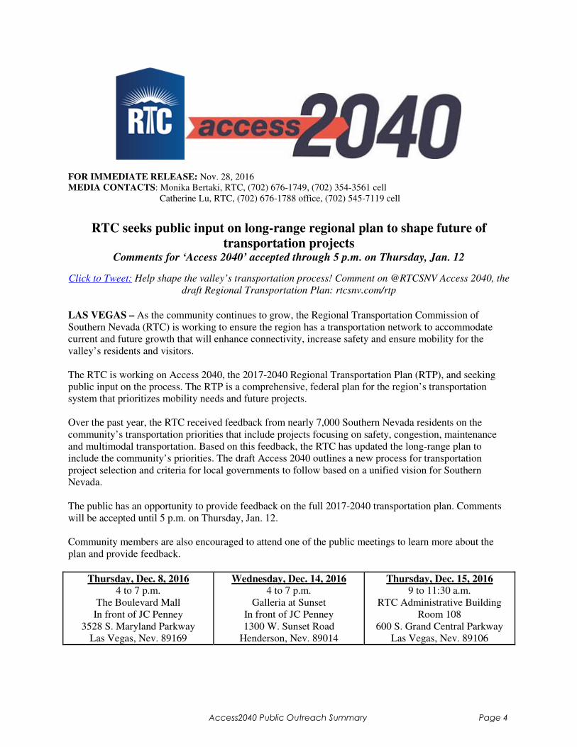
FOR IMMEDIATE RELEASE: Nov. 28, 2016
MEDIA CONTACTS: Monika Bertaki, RTC, (702) 676-1749, (702) 354-3561 cell
Catherine Lu, RTC, (702) 676-1788 office, (702) 545-7119 cell
RTC seeks public input on long-range regional plan to shape future of
transportation projects Comments for ‘Access 2040’ accepted through 5 p.m. on Thursday, Jan. 12
Click to Tweet: Help shape the valley’s transportation process! Comment on @RTCSNV Access 2040, the
draft Regional Transportation Plan: rtcsnv.com/rtp
LAS VEGAS – As the community continues to grow, the Regional Transportation Commission of
Southern Nevada (RTC) is working to ensure the region has a transportation network to accommodate
current and future growth that will enhance connectivity, increase safety and ensure mobility for the
valley’s residents and visitors.
The RTC is working on Access 2040, the 2017-2040 Regional Transportation Plan (RTP), and seeking
public input on the process. The RTP is a comprehensive, federal plan for the region’s transportation
system that prioritizes mobility needs and future projects.
Over the past year, the RTC received feedback from nearly 7,000 Southern Nevada residents on the
community’s transportation priorities that include projects focusing on safety, congestion, maintenance
and multimodal transportation. Based on this feedback, the RTC has updated the long-range plan to
include the community’s priorities. The draft Access 2040 outlines a new process for transportation
project selection and criteria for local governments to follow based on a unified vision for Southern
Nevada.
The public has an opportunity to provide feedback on the full 2017-2040 transportation plan. Comments
will be accepted until 5 p.m. on Thursday, Jan. 12.
Community members are also encouraged to attend one of the public meetings to learn more about the
plan and provide feedback.
Thursday, Dec. 8, 2016 4 to 7 p.m.
The Boulevard Mall
In front of JC Penney
3528 S. Maryland Parkway
Las Vegas, Nev. 89169
Wednesday, Dec. 14, 2016 4 to 7 p.m.
Galleria at Sunset
In front of JC Penney
1300 W. Sunset Road
Henderson, Nev. 89014
Thursday, Dec. 15, 2016 9 to 11:30 a.m.
RTC Administrative Building
Room 108
600 S. Grand Central Parkway
Las Vegas, Nev. 89106
Access2040 Public Outreach Summary Page 4
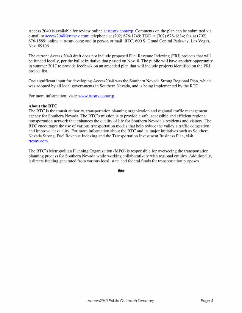
Access 2040 is available for review online at rtcsnv.com/rtp. Comments on the plan can be submitted via
e-mail to [email protected]; telephone at (702) 676-1749; TDD at (702) 676-1834; fax at (702)
676-1589; online at rtcsnv.com; and in person or mail: RTC, 600 S. Grand Central Parkway, Las Vegas,
Nev. 89106.
The current Access 2040 draft does not include proposed Fuel Revenue Indexing (FRI) projects that will
be funded locally, per the ballot initiative that passed on Nov. 8. The public will have another opportunity
in summer 2017 to provide feedback on an amended plan that will include projects identified on the FRI
project list.
One significant input for developing Access2040 was the Southern Nevada Strong Regional Plan, which
was adopted by all local governments in Southern Nevada, and is being implemented by the RTC.
For more information, visit: www.rtcsnv.com/rtp.
About the RTC
The RTC is the transit authority, transportation planning organization and regional traffic management
agency for Southern Nevada. The RTC’s mission is to provide a safe, accessible and efficient regional
transportation network that enhances the quality of life for Southern Nevada’s residents and visitors. The
RTC encourages the use of various transportation modes that help reduce the valley’s traffic congestion
and improve air quality. For more information about the RTC and its major initiatives such as Southern
Nevada Strong, Fuel Revenue Indexing and the Transportation Investment Business Plan, visit
rtcsnv.com.
The RTC’s Metropolitan Planning Organization (MPO) is responsible for overseeing the transportation
planning process for Southern Nevada while working collaboratively with regional entities. Additionally,
it directs funding generated from various local, state and federal funds for transportation purposes.
###
Access2040 Public Outreach Summary Page 5
| ACCESS2040 – APPENDIX M – PUBLIC OUTREACH SUMMARY |
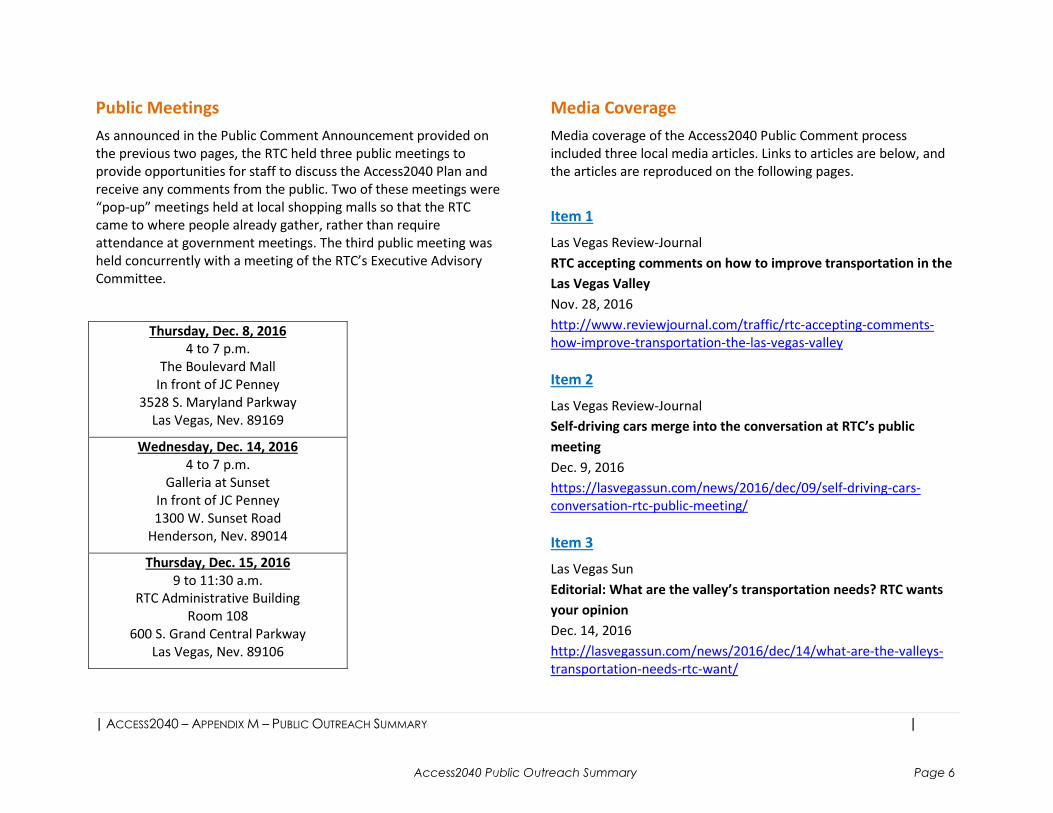
Public Meetings
As announced in the Public Comment Announcement provided on
the previous two pages, the RTC held three public meetings to
provide opportunities for staff to discuss the Access2040 Plan and
receive any comments from the public. Two of these meetings were
“pop-up” meetings held at local shopping malls so that the RTC
came to where people already gather, rather than require
attendance at government meetings. The third public meeting was
held concurrently with a meeting of the RTC’s Executive Advisory
Committee.
Thursday, Dec. 8, 2016
4 to 7 p.m.
The Boulevard Mall
In front of JC Penney
3528 S. Maryland Parkway
Las Vegas, Nev. 89169
Wednesday, Dec. 14, 2016
4 to 7 p.m.
Galleria at Sunset
In front of JC Penney
1300 W. Sunset Road
Henderson, Nev. 89014
Thursday, Dec. 15, 2016
9 to 11:30 a.m.
RTC Administrative Building
Room 108
600 S. Grand Central Parkway
Las Vegas, Nev. 89106
Media Coverage
Media coverage of the Access2040 Public Comment process
included three local media articles. Links to articles are below, and
the articles are reproduced on the following pages.
Item 1
Las Vegas Review-Journal
RTC accepting comments on how to improve transportation in the
Las Vegas Valley
Nov. 28, 2016
http://www.reviewjournal.com/traffic/rtc-accepting-comments-
how-improve-transportation-the-las-vegas-valley
Item 2
Las Vegas Review-Journal
Self-driving cars merge into the conversation at RTC’s public
meeting
Dec. 9, 2016
https://lasvegassun.com/news/2016/dec/09/self-driving-cars-
conversation-rtc-public-meeting/
Item 3
Las Vegas Sun
Editorial: What are the valley’s transportation needs? RTC wants
your opinion
Dec. 14, 2016
http://lasvegassun.com/news/2016/dec/14/what-are-the-valleys-
transportation-needs-rtc-want/
Access2040 Public Outreach Summary Page 6
Email alerts e-Edition Apps Subscriptions Recent Stories
Sandy Valley man dies of...Man hit by city bus in...
Home » Traffic SUBMIT A NEWS TIP
Most Popular
NFL Commissioner Roger Goodell: No
compromises if Raiders’ Las Vegas move
approved
Chick-fil-A fans are ready, waiting for restaurants
to open in Las Vegas tomorrow
Eligibility of Henderson mayoral candidate
challenged
DREAMers encouraged, worried by White House
statement about DACA
Las Vegas doctor, 92, on trial in federal drug
case
Columnists Features
Wayne Allyn Root
COMMENTARY: With Donald
Trump in charge, let’s get Congress
on Trump Time
KATS!
Dinner. Show. Magic! Coming from
Jarrett & Raja at Hooters
Jane Ann Morrison
Why not move 2 Las Vegas courts
to 1 building?
Ron Kantowski
Wrestling coach, homeless
community team up to honor former
Centennial athlete
33°F Sunny
Las Vegas NV
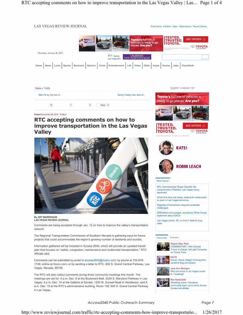
LAS VEGAS REVIEW-JOURNAL
By ART MARROQUIN
LAS VEGAS REVIEW-JOURNAL
Comments are being accepted through Jan. 12 on how to improve the valley’s transportation
network.
The Regional Transportation Commission of Southern Nevada is gathering input for future
projects that could accommodate the region’s growing number of residents and tourists.
Information gathered will be included in Access 2040, which will provide an updated transit
plan that focuses on “safety, congestion, maintenance and multimodal transportation,” RTC
officials said.
Comments can be submitted by email to [email protected]; by phone at 702-676-
1749; online at rtcsnv.com; or by sending a letter to RTC, 600 S. Grand Central Parkway, Las
Vegas, Nevada, 89106.
The RTC will also collect comments during three community meetings this month. The
meetings are set for: 4 p.m. Dec. 8 at the Boulevard Mall, 3528 S. Maryland Parkway in Las
Vegas; 4 p.m. Dec. 14 at the Galleria at Sunset, 1300 W. Sunset Road in Henderson; and 9
a.m. Dec. 15 at the RTC’s administrative building, Room 108, 600 S. Grand Central Parkway
in Las Vegas.
Posted November 28, 2016 - 8:45pm
RTC accepting comments on how to improve transportation in the Las Vegas Valley
A pedestrian walks by a new bike-sharing station near Fremont Street and Maryland Parkway in downtown Las
Vegas on Friday, Sept. 23, 2016. (Daniel Clark/Las Vegas Review-Journal Follow @DanJClarkPhoto)
14 3 2 0Share
Thursday, January 26, 2017
Home News Local Sports Business Opinion Crime Entertainment Life Video Obits Autos Homes Jobs Classifieds
Page 1 of 4RTC accepting comments on how to improve transportation in the Las Vegas Valley | Las...
1/26/2017http://www.reviewjournal.com/traffic/rtc-accepting-comments-how-improve-transportatio...
Access2040 Public Outreach Summary Page 7

Sandy Valley man dies of...Man hit by city bus in...
More Columnists
THU
26
FRI
27
SAT
28
SUN
29
MON
30
TUE
31
WED
1
A
All Week
TOPGOLF LAS VEGAS
Topgolf Las Vegas
Thursday, Jan 26, 9:00 am-2:00 am
LAUGH FACTORY
Tropicana
Thursday, Jan 26, 8:30 pm
PURPLE REIGN: THE PRINCE
TRIBUTE SHOW
Westgate Las Vegas
Thursday, Jan 26, 9:00 pm
The Living Room
Gold Spike
Thursday, Jan 26, 10:00 pm
CALENDAR
Search for...
Contact Art Marroquin at [email protected] or 702-383-0336. Find
@AMarroquin_LV on Twitter.
Trending Today
14 Times Lotto Winner:Do This Every Time You Buy A Lotto Ticket (Win 1/12 Times)Lotto News Tips
(1) Easy Trick "Removes" Your Teeth Stains (Do This Now!)Fit Daily
30 Absolutely Adorable Pets Of CelebritiesFrank151
Congress Urges Homeowners to Claim Their $4,264 Rebate (Before It Expires)Better Finance Today
Learn More About The 2017 Corvette With Kelley Blue BookKelley Blue Book
Penny Marijuana Companies to Explode Thursday?Agorafinancial
More videos:
Already Viewed...
Inside Edition
Search
Ads by Revcontent
Page 2 of 4RTC accepting comments on how to improve transportation in the Las Vegas Valley | Las...
1/26/2017http://www.reviewjournal.com/traffic/rtc-accepting-comments-how-improve-transportatio...
Access2040 Public Outreach Summary Page 8
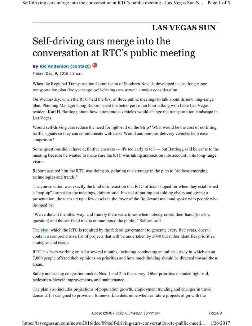
LAS VEGAS SUN
Self-driving cars merge into the conversation at RTC’s public meetingBy Ric Anderson (contact)
Friday, Dec. 9, 2016 | 2 a.m.
When the Regional Transportation Commission of Southern Nevada developed its last long-range
transportation plan five years ago, self-driving cars weren't a major consideration.
On Wednesday, when the RTC held the first of three public meetings to talk about its new long-range
plan, Planning Manager Craig Raborn spent the better part of an hour talking with Lake Las Vegas
resident Karl H. Battlogg about how autonomous vehicles would change the transportation landscape in
Las Vegas.
Would self-driving cars reduce the need for light-rail on the Strip? What would be the cost of outfitting
traffic signals so they can communicate with cars? Would autonomous delivery vehicles help ease
congestion?
Some questions didn't have definitive answers — it's too early to tell — but Battlogg said he came to the
meeting because he wanted to make sure the RTC was taking automation into account in its long-range
vision.
Raborn assured him the RTC was doing so, pointing to a strategy in the plan to "address emerging
technologies and trends."
The conversation was exactly the kind of interaction that RTC officials hoped for when they established
a "pop-up" format for the meetings, Raborn said. Instead of putting out folding chairs and giving a
presentation, the team set up a few easels in the foyer of the Boulevard mall and spoke with people who
dropped by.
"We've done it the other way, and frankly there were times when nobody raised their hand (to ask a
question) and the staff and media outnumbered the public," Raborn said.
The plan, which the RTC is required by the federal government to generate every five years, doesn't
contain a comprehensive list of projects that will be undertaken by 2040 but rather identifies priorities,
strategies and needs.
RTC has been working on it for several months, including conducting an online survey in which about
7,000 people offered their opinions on priorities and how much funding should be directed toward those
areas.
Safety and easing congestion ranked Nos. 1 and 2 in the survey. Other priorities included light-rail,
pedestrian-bicycle improvements, and maintenance.
The plan also includes projections of population growth, employment trending and changes in travel
demand. It's designed to provide a framework to determine whether future projects align with the
Page 1 of 5Self-driving cars merge into the conversation at RTC's public meeting - Las Vegas Sun N...
1/26/2017https://lasvegassun.com/news/2016/dec/09/self-driving-cars-conversation-rtc-public-meeti...
Access2040 Public Outreach Summary Page 9
community's needs. Input from the public comment sessions will be recorded and will be used to
continue shaping the plan.
The other meetings in the series are scheduled for 4-7 p.m. Dec. 14 at Galleria at Sunset mall, and
9-11:30 a.m. Dec. 15 at the RTC Administrative Building, 600 S. Grand Central Parkway.
You May Like by TaboolaSponsored Links
Learn How to Integrate Salesforce to Anything
Dell Boomi
How To Fix Cracked Feet
DermalMedix Skin Care
This Article Will Change The Way You Buy Glasses Forever
GlassesUSA.com
It's Scary What This Site Knows About You
Truthfinder
The Top 3 Credit Cards On The Market Revealed
NextAdvisor
Nearing Retirement? – 9 Reasons Not to Consider Annuities
Fisher Investments
Sponsored Links More From Las Vegas Sun
• Men Discover a Snoring Cure
That Really Works (My Snoring Solution)
• Kamiyah Mobley, kidnapped as
baby 18 years ago, reunites …
(TODAY)
• How To Fix Cracked Feet
(DermalMedix Skin Care)
Page 2 of 5Self-driving cars merge into the conversation at RTC's public meeting - Las Vegas Sun N...
1/26/2017https://lasvegassun.com/news/2016/dec/09/self-driving-cars-conversation-rtc-public-meeti...
Access2040 Public Outreach Summary Page 10
LAS VEGAS SUNEDITORIAL:
What are the valley’s transportation needs? RTC wants your opinionBy Sun Staff (contact)
Wednesday, Dec. 14, 2016 | 2 a.m.
According to a forecast issued last year by the UNLV Center for Economic and Business Research, the
population of the Las Vegas Valley will grow by about 700,000 people by 2040.
That’s a lot of people — it’s about the size of the Colorado Springs metro area population today — and
it raises some weighty questions about the future of the valley.
A big one is: How are we all going to get around?
This month, the Regional Transportation Commission of Southern Nevada is asking local residents to
help answer that question.
The RTC has drafted a long-range transportation plan and is seeking community input on it through a
series of public meetings. The first was conducted last week at Boulevard mall, but the final two
meetings will be this week: from 4 to 7 p.m. today at the Galleria at Sunset mall in Henderson; and from
9 to 11:30 a.m. Thursday at the RTC Administrative Building, 600 S. Grand Central Parkway.
The plan is not a collection of specific projects, but rather a guiding document that outlines needs,
priorities, strategies and projections. Future transportation projects will be measured against it to
determine if they are in line with the community’s needs and, if so, how they should be prioritized.
The RTC has already conducted a community survey to identify priorities, gathering results from about
7,000 respondents who listed increasing safety and easing congestion as Nos. 1 and 2 on the list. Other
priorities include expanding bike/pedestrian lanes, enhancing bus service and building a light-rail
system.
The priorities identified in the survey are all important, but light-rail development is a must for the
community. Not only that, but adding a rail system would help boost safety and reduce congestion on
valley roads.
Beyond question, the Strip has maxed out its capacity to handle cars. For proof, try driving there on a
night when a major concert or sporting event is being staged. For that matter, give it a try on most any
Friday or Saturday night and see what happens.
Creating a light-rail system that would connect McCarran International Airport to the Strip and then
travel up Las Vegas Boulevard would give visitors an easy and convenient way to get around, which
would eliminate the need for so many taxis, rental cars and ride-share vehicles to cycle between the
airport and the tourist corridor. Given that some proponents believe that a first phase could be built for
about $400 million, and would travel all the way north to Sahara Avenue, it’s a cost-effective way to
vastly improve the transportation system.
Page 1 of 6What are the valley's transportation needs? RTC wants your opinion - Las Vegas Sun News
1/26/2017https://lasvegassun.com/news/2016/dec/14/what-are-the-valleys-transportation-needs-rtc-w...
Access2040 Public Outreach Summary Page 11
Meanwhile, the system could also include park-and-ride areas that would allow Strip workers to avoid
driving on or near Las Vegas Boulevard, further easing congestion. And by connecting to downtown and
North Las Vegas through additional phases, a light-rail system could eliminate even more traffic.
It’s an idea whose time is overdue, given that other communities that compete with Las Vegas for
visitors have already built light-rail systems.
Are we agreed, Las Vegas? Regardless, the RTC would like to hear from you.
Given that we’re about to absorb the equivalent of a city’s worth of population in the next 25 years, this
is a plan that will be important to all of us.
You May Like by TaboolaSponsored Links
7 Key Factors to Consider When Buying Glasses Online
GlassesUSA.com
How To Fix Cracked Feet
DermalMedix Skin Care
This Simple Skin Fix May Surprise You
Primal Plants Supplement - Gundry MD
Is This Tiny $2 Gold Miner About To Soar?
The Crux
Rated the most luxurious mattress of 2017!
SleepSherpa | Brentwood Home
Why These 10 SUVs are the Cream of the Crop
Kelley Blue Book
Sponsored Links More From Las Vegas Sun
• Moms Can’t Get Enough of These
Affordable Baby Clothes (PatPat)
Page 2 of 6What are the valley's transportation needs? RTC wants your opinion - Las Vegas Sun News
1/26/2017https://lasvegassun.com/news/2016/dec/14/what-are-the-valleys-transportation-needs-rtc-w...
Access2040 Public Outreach Summary Page 12
| ACCESS2040 – APPENDIX M – PUBLIC OUTREACH SUMMARY |
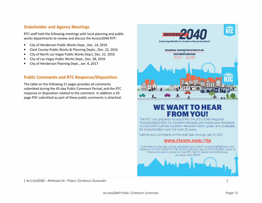
Stakeholder and Agency Meetings
RTC staff held the following meetings with local planning and public
works departments to review and discuss the Access2040 RTP:
• City of Henderson Public Works Dept., Dec. 14, 2016
• Clark County Public Works & Planning Depts., Dec. 22, 2016
• City of North Las Vegas Public Works Dep.t, Dec. 22, 2016
• City of Las Vegas Public Works Dept., Dec. 28, 2016
• City of Henderson Planning Dept., Jan. 4, 2017
Public Comments and RTC Response/Disposition
The table on the following 21 pages provides all comments
submitted during the 45-day Public Comment Period, and the RTC
response or disposition related to the comment. In addition a 29-
page PDF submitted as part of these public comments is attached.
Access2040 Public Outreach Summary Page 13
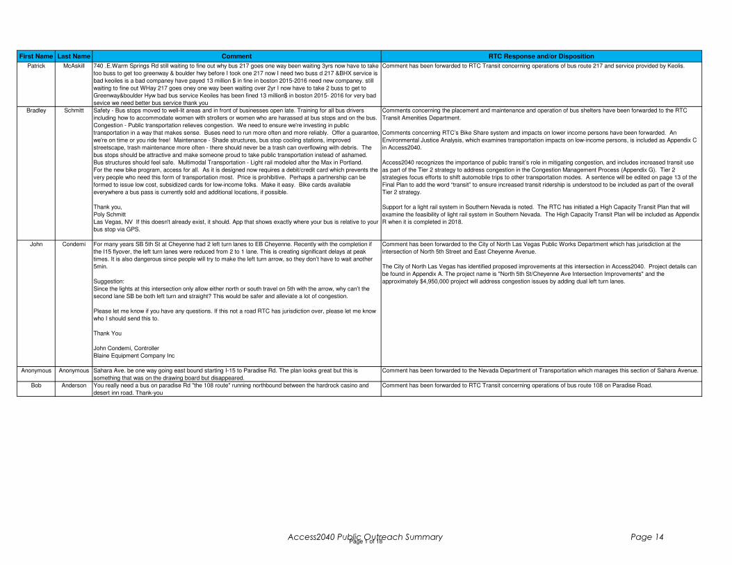
First Name Last Name Comment RTC Response and/or Disposition
Patrick McAskill 740 .E.Warm Springs Rd still waiting to fine out why bus 217 goes one way been waiting 3yrs now have to take
too buss to get too greenway & boulder hwy before I took one 217 now I need two buss d 217 &BHX service is
bad keoiles is a bad companey have payed 13 million $ in fine in boston 2015-2016 need new companey. still
waiting to fine out WHay 217 goes oney one way been waiting over 2yr I now have to take 2 buss to get to
Greenway&boulder Hyw bad bus service Keoiles has been fined 13 million$ in boston 2015- 2016 for very bad
sevice we need better bus service thank you
Comment has been forwarded to RTC Transit concerning operations of bus route 217 and service provided by Keolis.
Bradley Schmitt Safety - Bus stops moved to well-lit areas and in front of businesses open late. Training for all bus drivers
including how to accommodate women with strollers or women who are harassed at bus stops and on the bus.
Congestion - Public transportation relieves congestion. We need to ensure we're investing in public
transportation in a way that makes sense. Buses need to run more often and more reliably. Offer a guarantee,
we're on time or you ride free! Maintenance - Shade structures, bus stop cooling stations, improved
streetscape, trash maintenance more often - there should never be a trash can overflowing with debris. The
bus stops should be attractive and make someone proud to take public transportation instead of ashamed.
Bus structures should feel safe. Multimodal Transportation - Light rail modeled after the Max in Portland.
For the new bike program, access for all. As it is designed now requires a debit/credit card which prevents the
very people who need this form of transportation most. Price is prohibitive. Perhaps a partnership can be
formed to issue low cost, subsidized cards for low-income folks. Make it easy. Bike cards available
everywhere a bus pass is currently sold and additional locations, if possible.
Thank you,
Poly Schmitt
Las Vegas, NV If this doesn't already exist, it should. App that shows exactly where your bus is relative to your
bus stop via GPS.
Comments concerning the placement and maintenance and operation of bus shelters have been forwarded to the RTC
Transit Amenities Department.
Comments concerning RTC’s Bike Share system and impacts on lower income persons have been forwarded. An
Environmental Justice Analysis, which examines transportation impacts on low-income persons, is included as Appendix C
in Access2040.
Access2040 recognizes the importance of public transit’s role in mitigating congestion, and includes increased transit use
as part of the Tier 2 strategy to address congestion in the Congestion Management Process (Appendix G). Tier 2
strategies focus efforts to shift automobile trips to other transportation modes. A sentence will be edited on page 13 of the
Final Plan to add the word “transit” to ensure increased transit ridership is understood to be included as part of the overall
Tier 2 strategy.
Support for a light rail system in Southern Nevada is noted. The RTC has initiated a High Capacity Transit Plan that will
examine the feasibility of light rail system in Southern Nevada. The High Capacity Transit Plan will be included as Appendix
R when it is completed in 2018.
John Condemi For many years SB 5th St at Cheyenne had 2 left turn lanes to EB Cheyenne. Recently with the completion if
the I15 flyover, the left turn lanes were reduced from 2 to 1 lane. This is creating significant delays at peak
times. It is also dangerous since people will try to make the left turn arrow, so they don’t have to wait another
5min.
Suggestion:
Since the lights at this intersection only allow either north or south travel on 5th with the arrow, why can’t the
second lane SB be both left turn and straight? This would be safer and alleviate a lot of congestion.
Please let me know if you have any questions. If this not a road RTC has jurisdiction over, please let me know
who I should send this to.
Thank You
John Condemi, Controller
Blaine Equipment Company Inc
Comment has been forwarded to the City of North Las Vegas Public Works Department which has jurisdiction at the
intersection of North 5th Street and East Cheyenne Avenue.
The City of North Las Vegas has identified proposed improvements at this intersection in Access2040. Project details can
be found in Appendix A. The project name is "North 5th St/Cheyenne Ave Intersection Improvements" and the
approximately $4,950,000 project will address congestion issues by adding dual left turn lanes.
Anonymous Anonymous Sahara Ave. be one way going east bound starting I-15 to Paradise Rd. The plan looks great but this is
something that was on the drawing board but disappeared.
Comment has been forwarded to the Nevada Department of Transportation which manages this section of Sahara Avenue.
Bob Anderson You really need a bus on paradise Rd "the 108 route" running northbound between the hardrock casino and
desert inn road. Thank-you
Comment has been forwarded to RTC Transit concerning operations of bus route 108 on Paradise Road.
Page 1 of 18Access2040 Public Outreach Summary Page 14
First Name Last Name Comment RTC Response and/or Disposition
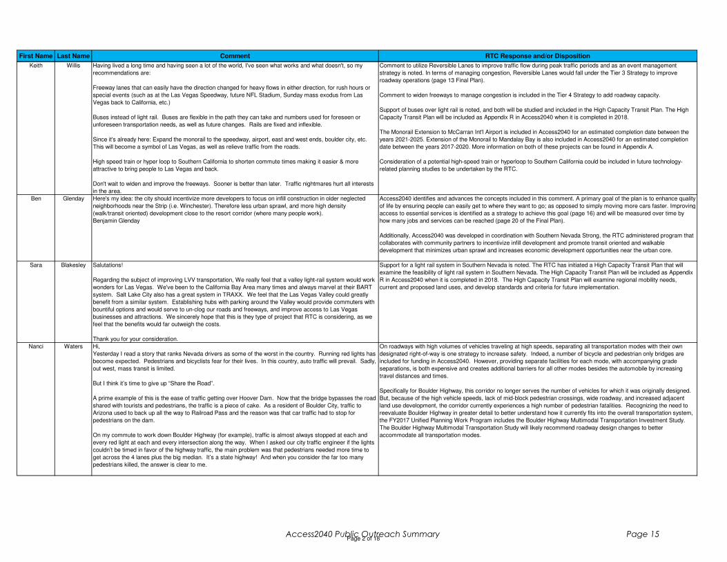
Keith Willis Having lived a long time and having seen a lot of the world, I've seen what works and what doesn't, so my
recommendations are:
Freeway lanes that can easily have the direction changed for heavy flows in either direction, for rush hours or
special events (such as at the Las Vegas Speedway, future NFL Stadium, Sunday mass exodus from Las
Vegas back to California, etc.)
Buses instead of light rail. Buses are flexible in the path they can take and numbers used for foreseen or
unforeseen transportation needs, as well as future changes. Rails are fixed and inflexible.
Since it's already here: Expand the monorail to the speedway, airport, east and west ends, boulder city, etc.
This will become a symbol of Las Vegas, as well as relieve traffic from the roads.
High speed train or hyper loop to Southern California to shorten commute times making it easier & more
attractive to bring people to Las Vegas and back.
Don't wait to widen and improve the freeways. Sooner is better than later. Traffic nightmares hurt all interests
in the area.
Comment to utilize Reversible Lanes to improve traffic flow during peak traffic periods and as an event management
strategy is noted. In terms of managing congestion, Reversible Lanes would fall under the Tier 3 Strategy to improve
roadway operations (page 13 Final Plan).
Comment to widen freeways to manage congestion is included in the Tier 4 Strategy to add roadway capacity.
Support of buses over light rail is noted, and both will be studied and included in the High Capacity Transit Plan. The High
Capacity Transit Plan will be included as Appendix R in Access2040 when it is completed in 2018.
The Monorail Extension to McCarran Int'l Airport is included in Access2040 for an estimated completion date between the
years 2021-2025. Extension of the Monorail to Mandalay Bay is also included in Access2040 for an estimated completion
date between the years 2017-2020. More information on both of these projects can be found in Appendix A.
Consideration of a potential high-speed train or hyperloop to Southern California could be included in future technology-
related planning studies to be undertaken by the RTC.
Ben Glenday Here's my idea: the city should incentivize more developers to focus on infill construction in older neglected
neighborhoods near the Strip (i.e. Winchester). Therefore less urban sprawl, and more high density
(walk/transit oriented) development close to the resort corridor (where many people work).
Benjamin Glenday
Access2040 identifies and advances the concepts included in this comment. A primary goal of the plan is to enhance quality
of life by ensuring people can easily get to where they want to go; as opposed to simply moving more cars faster. Improving
access to essential services is identified as a strategy to achieve this goal (page 16) and will be measured over time by
how many jobs and services can be reached (page 20 of the Final Plan).
Additionally, Access2040 was developed in coordination with Southern Nevada Strong, the RTC administered program that
collaborates with community partners to incentivize infill development and promote transit oriented and walkable
development that minimizes urban sprawl and increases economic development opportunities near the urban core.
Sara Blakesley Salutations!
Regarding the subject of improving LVV transportation, We really feel that a valley light-rail system would work
wonders for Las Vegas. We've been to the California Bay Area many times and always marvel at their BART
system. Salt Lake City also has a great system in TRAXX. We feel that the Las Vegas Valley could greatly
benefit from a similar system. Establishing hubs with parking around the Valley would provide commuters with
bountiful options and would serve to un-clog our roads and freeways, and improve access to Las Vegas
businesses and attractions. We sincerely hope that this is they type of project that RTC is considering, as we
feel that the benefits would far outweigh the costs.
Thank you for your consideration.
Support for a light rail system in Southern Nevada is noted. The RTC has initiated a High Capacity Transit Plan that will
examine the feasibility of light rail system in Southern Nevada. The High Capacity Transit Plan will be included as Appendix
R in Access2040 when it is completed in 2018. The High Capacity Transit Plan will examine regional mobility needs,
current and proposed land uses, and develop standards and criteria for future implementation.
Nanci Waters Hi,
Yesterday I read a story that ranks Nevada drivers as some of the worst in the country. Running red lights has
become expected. Pedestrians and bicyclists fear for their lives. In this country, auto traffic will prevail. Sadly,
out west, mass transit is limited.
But I think it’s time to give up “Share the Road”.
A prime example of this is the ease of traffic getting over Hoover Dam. Now that the bridge bypasses the road
shared with tourists and pedestrians, the traffic is a piece of cake. As a resident of Boulder City, traffic to
Arizona used to back up all the way to Railroad Pass and the reason was that car traffic had to stop for
pedestrians on the dam.
On my commute to work down Boulder Highway (for example), traffic is almost always stopped at each and
every red light at each and every intersection along the way. When I asked our city traffic engineer if the lights
couldn’t be timed in favor of the highway traffic, the main problem was that pedestrians needed more time to
get across the 4 lanes plus the big median. It’s a state highway! And when you consider the far too many
pedestrians killed, the answer is clear to me.
On roadways with high volumes of vehicles traveling at high speeds, separating all transportation modes with their own
designated right-of-way is one strategy to increase safety. Indeed, a number of bicycle and pedestrian only bridges are
included for funding in Access2040. However, providing separate facilities for each mode, with accompanying grade
separations, is both expensive and creates additional barriers for all other modes besides the automobile by increasing
travel distances and times.
Specifically for Boulder Highway, this corridor no longer serves the number of vehicles for which it was originally designed.
But, because of the high vehicle speeds, lack of mid-block pedestrian crossings, wide roadway, and increased adjacent
land use development, the corridor currently experiences a high number of pedestrian fatalities. Recognizing the need to
reevaluate Boulder Highway in greater detail to better understand how it currently fits into the overall transportation system,
the FY2017 Unified Planning Work Program includes the Boulder Highway Multimodal Transportation Investment Study.
The Boulder Highway Multimodal Transportation Study will likely recommend roadway design changes to better
accommodate all transportation modes.
Page 2 of 18Access2040 Public Outreach Summary Page 15
First Name Last Name Comment RTC Response and/or Disposition
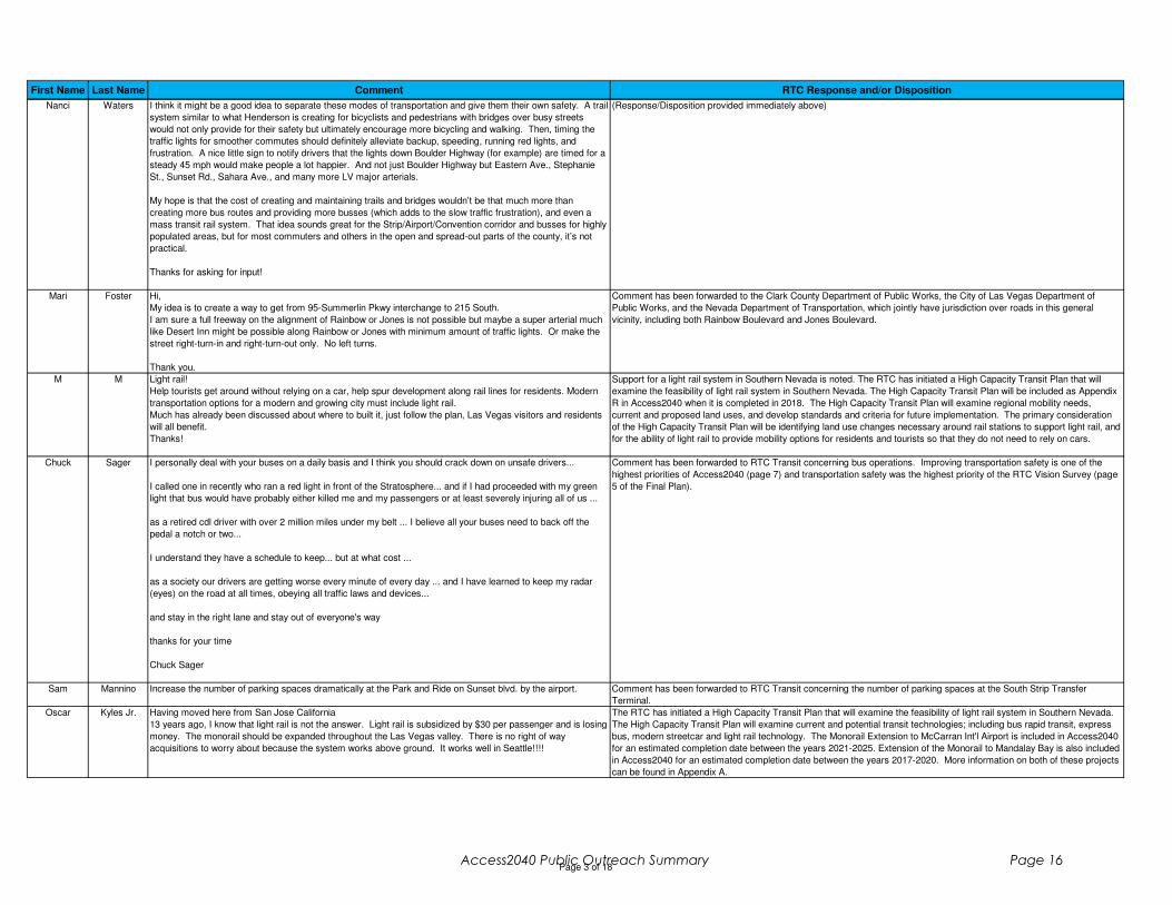
Nanci Waters I think it might be a good idea to separate these modes of transportation and give them their own safety. A trail
system similar to what Henderson is creating for bicyclists and pedestrians with bridges over busy streets
would not only provide for their safety but ultimately encourage more bicycling and walking. Then, timing the
traffic lights for smoother commutes should definitely alleviate backup, speeding, running red lights, and
frustration. A nice little sign to notify drivers that the lights down Boulder Highway (for example) are timed for a
steady 45 mph would make people a lot happier. And not just Boulder Highway but Eastern Ave., Stephanie
St., Sunset Rd., Sahara Ave., and many more LV major arterials.
My hope is that the cost of creating and maintaining trails and bridges wouldn’t be that much more than
creating more bus routes and providing more busses (which adds to the slow traffic frustration), and even a
mass transit rail system. That idea sounds great for the Strip/Airport/Convention corridor and busses for highly
populated areas, but for most commuters and others in the open and spread-out parts of the county, it’s not
practical.
Thanks for asking for input!
(Response/Disposition provided immediately above)
Mari Foster Hi,
My idea is to create a way to get from 95-Summerlin Pkwy interchange to 215 South.
I am sure a full freeway on the alignment of Rainbow or Jones is not possible but maybe a super arterial much
like Desert Inn might be possible along Rainbow or Jones with minimum amount of traffic lights. Or make the
street right-turn-in and right-turn-out only. No left turns.
Thank you.
Comment has been forwarded to the Clark County Department of Public Works, the City of Las Vegas Department of
Public Works, and the Nevada Department of Transportation, which jointly have jurisdiction over roads in this general
vicinity, including both Rainbow Boulevard and Jones Boulevard.
M M Light rail!
Help tourists get around without relying on a car, help spur development along rail lines for residents. Modern
transportation options for a modern and growing city must include light rail.
Much has already been discussed about where to built it, just follow the plan, Las Vegas visitors and residents
will all benefit.
Thanks!
Support for a light rail system in Southern Nevada is noted. The RTC has initiated a High Capacity Transit Plan that will
examine the feasibility of light rail system in Southern Nevada. The High Capacity Transit Plan will be included as Appendix
R in Access2040 when it is completed in 2018. The High Capacity Transit Plan will examine regional mobility needs,
current and proposed land uses, and develop standards and criteria for future implementation. The primary consideration
of the High Capacity Transit Plan will be identifying land use changes necessary around rail stations to support light rail, and
for the ability of light rail to provide mobility options for residents and tourists so that they do not need to rely on cars.
Chuck Sager I personally deal with your buses on a daily basis and I think you should crack down on unsafe drivers...
I called one in recently who ran a red light in front of the Stratosphere... and if I had proceeded with my green
light that bus would have probably either killed me and my passengers or at least severely injuring all of us ...
as a retired cdl driver with over 2 million miles under my belt ... I believe all your buses need to back off the
pedal a notch or two...
I understand they have a schedule to keep... but at what cost ...
as a society our drivers are getting worse every minute of every day ... and I have learned to keep my radar
(eyes) on the road at all times, obeying all traffic laws and devices...
and stay in the right lane and stay out of everyone's way
thanks for your time
Chuck Sager
Comment has been forwarded to RTC Transit concerning bus operations. Improving transportation safety is one of the
highest priorities of Access2040 (page 7) and transportation safety was the highest priority of the RTC Vision Survey (page
5 of the Final Plan).
Sam Mannino Increase the number of parking spaces dramatically at the Park and Ride on Sunset blvd. by the airport. Comment has been forwarded to RTC Transit concerning the number of parking spaces at the South Strip Transfer
Terminal.
Oscar Kyles Jr. Having moved here from San Jose California
13 years ago, I know that light rail is not the answer. Light rail is subsidized by $30 per passenger and is losing
money. The monorail should be expanded throughout the Las Vegas valley. There is no right of way
acquisitions to worry about because the system works above ground. It works well in Seattle!!!!
The RTC has initiated a High Capacity Transit Plan that will examine the feasibility of light rail system in Southern Nevada.
The High Capacity Transit Plan will examine current and potential transit technologies; including bus rapid transit, express
bus, modern streetcar and light rail technology. The Monorail Extension to McCarran Int'l Airport is included in Access2040
for an estimated completion date between the years 2021-2025. Extension of the Monorail to Mandalay Bay is also included
in Access2040 for an estimated completion date between the years 2017-2020. More information on both of these projects
can be found in Appendix A.
Page 3 of 18Access2040 Public Outreach Summary Page 16
First Name Last Name Comment RTC Response and/or Disposition
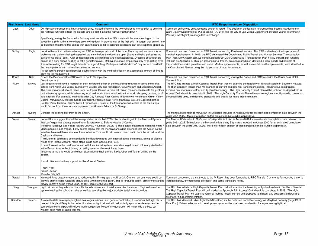
Jack Oliver On highway entrances that have a double entry, instead of forcing the two vehicles to merge prior to entering
the highway, why not extend the outside lane so that it joins the highway further down?
Specifically, joining the Summerlin Parkway eastbound from the 215, most vehicles are speeding up to the
speed limit, (65), while a few others are slowing down in order to exit at the first exit. I suggest that an exit lane
be built from the 215 to this exit so that cars that are going to continue eastbound can get/keep their speed up.
Comment on freeway entrance ramp design is noted. The design of the location referenced has been forwarded to the
Clark County Department of Public Works (CC-215) and the City of Las Vegas Department of Public Works (Summerlin
Parkway) which jointly manage this interchange.
Shirley Eagle I work with medical patients who rely on RTC for transportation all of the time. From my end we have a lot of
problems with patients being dropped off too early before the doors are open (7am) and being picked up too
late after we close (5pm). A lot of these patients are handicap and need assistance. Dropping off a weak old
person at a dark closed building is not a good thing ever. Making one of our employees stay over getting over
time while waiting for RTC to get there is not a good thing. Perhaps a "elderly/Medical" only service could help
the needy patients with more of a customized service.
A scheduling person could perhaps double check with the medical office on an appropriate amount of time to
allow for the medical visit.
Comment has been forwarded to RTC Transit concerning Paratransit service. The RTC understands the importance of
medical appointments. In 2015, the RTC developed the Coordinated Public Transit and Human Services Transportation
Plan (http://www.rtcsnv.com/wp-content/uploads/2012/06/Coordinated-Transportation-Plan-FINAL-031215.pdf) which is
included as Appendix T. Through stakeholder outreach, this specialized plan identified current needs and barriers of
transportation service providers and users. Medical appointments, as well as mental health appointments, were identified in
the Coordinated Plan as being the trip purpose of most importance.
Bouch Nakri Extend the Deuce and the SDX route to South Point please!
Very important!
Comment has been forwarded to RTC Transit concerning routing the Duece and SDX to service the South Point Hotel,
Casino & Spa.
Ruby McKoy Las Vegas should have a monorail or train integrated either on the expanding freeways or along them, that
extend from North Las Vegas, Summerlyn Boulder City and Henderson, to Downtown and McCarran Airport.
The current monorail should reach from Southpoint Casino to Fremont Street. This could eliminate the gridlock
on the freeway system, while enhancing local and tourist transportation to either work, shopping centers, or off
strip casinos. For example, leaving Boulder City Railroad Pass Casino to downtown Henderson, Green Valley
Casino, McCarran, M Resort, turn to Southpoint, Premium Mall North, Mandalay Bay...etc...second path is
Boulder Pass, Galleria , Sam's Town, Fremont etc... buses at the transportation Centers at the train stops
would fan out from there. A layer expansion could reach Primm or St George.
The RTC has initiated a High Capacity Transit Plan that will examine the feasibility of light rail system in Southern Nevada.
The High Capacity Transit Plan will examine all current and potential transit technologies; including bus rapid transit,
express bus, modern streetcar and light rail technology. The High Capacity Transit Plan will be included as Appendix R in
Access2040 when it is completed in 2018. The High Capacity Transit Plan will examine regional mobility needs, current and
proposed land uses, and develop standards and criteria for future implementation.
Donald Nyberg Connect the existing Rail tram to the airport. The Monorail Extension to McCarran Int'l Airport is included in Access2040 for an estimated completion date between the
years 2021-2025. More information on this project can be found in Appendix A.
Verne Stewart I would like to suggest that all the transportation funds that RTC collects should go into the Monorail System
that Las Vegas has already started from Sahara Ave. to Balleys Hotel and Casino.
Reading Tuesdays Las Vegas Review-Journal, November 29, 2016 article about Macarran's ridership hitting 4
Million people in Las Vegas, it only seems logical that the monorail should be extended into the Airport so the
travelers have a different mode of transportation. This would cut down so much traffic from the airport to all the
Casinos and Hotels.
The Monorail could also be extended to the downtown area with ease all above the streets. Being all electric
would even let the Monorail make stops inside each Casino and Hotel.
I have traveled to the Boston area and with their lite rail system I was able to get on and off to any destination
in the Boston Area without driving or renting a car for the week I was there.
It seems to me this would be the best alternative to having more Taxis, Uber and Tourist driving on the
streets.
I would like to submit my support for the Monorail System.
Thank You
Verne Stewart
Boulder City, NV.
The Monorail Extension to McCarran Int'l Airport is included in Access2040 for an estimated completion date between the
years 2021-2025. Extension of the Monorail to Mandalay Bay is also included in Access2040 for an estimated completion
date between the years 2017-2020. More information on both of these projects can be found in Appendix A.
Gerald Simons We need three drastic measures to reduce traffic. Driving age should be 21. Only current year cars sould be
allowed on the roads. Gasoline should be a $10 minimum a gallon. This is for public safety, environment and to
greatly improve public transit. Also, an RTC route to the M resort.
Comment concerning a transit route to the M Resort has been forwarded to RTC Transit. Comments for reducing travel to
increase safety, environmental protection and public transit are noted.
Craig Younger Light rail connecting suburban transit hubs to business and tourist areas plus the airport. Regional streetcar
system feeding the suburban hubs as well as servicing the major tourist/entertainment corridors.
The RTC has initiated a High Capacity Transit Plan that will examine the feasibility of light rail system in Southern Nevada.
The High Capacity Transit Plan will be included as Appendix R in Access2040 when it is completed in 2018. The High
Capacity Transit Plan will examine regional mobility needs, current and proposed land uses, and develop standards and
criteria for future implementation.
Brandon Stavros As a real estate developer, longtime Las Vegas resident, and general contractor, it is obvious that light rail is
needed. Maryland Pkwy is the perfect location for light rail and will undoubtedly spur more development. A
connection to the airport will relieve much congestion. Most of my generation will never ride the bus, but
wouldnt blink twice at using light rail.
The RTC has identified Urban Light Rail (Streetcar) as the preferred transit technology on Maryland Parkway (page 23 of
Final Plan). Enhanced economic development opportunities are one consideration for implementing light rail.
Page 4 of 18Access2040 Public Outreach Summary Page 17

First Name Last Name Comment RTC Response and/or Disposition
Ward Black Thank you for allowing email feedback to your request.17-yr Valley resident who has used RTC for 100% of
Vegas' transportation. Retired professional, college educated. Have lived all over the country.
Most importantly, RTC has vastly improved !!!! However, I still believe most RTC decision-makers are
members of the car culture. I doubt many executives take a bus to work. This is not true elsewhere where
urban transit executives use public transportation daily. Thus enabling them to digest the pros and cons of the
evolution of their occupation.
Population is a key to your future evolution. The Valley is 2M+ now. If one believes the reported tourist
numbers to be 42M+ .. divided by 52-weeks ... (800,000 per week) ... one can say the Valley is actually 3M.
Looking forward -- the population number to anticipate as per public transportation and growth is 4M.
Light rail.
If the NFL comes to LV ... make the new stadium area a no car zone ... make the stadium area a giant hub of
light rail and buses and subway and monorail !!!!!
Vegas monorail is a joke. Disney World has had a monorail for 30+ years that works. and ties all hotels and
attractions together .... LV must tie downtown, Strip, and airport together -- monorail, light rail, bus !!!
The population and jobs forecast for the years 2014-2040 is included on page 26 of the Access2040 Final Draft. This
information is included in the Travel Demand Model to help understand potential transportation improvement projects and
their anticipated affect.
The RTC has initiated a High Capacity Transit Plan that will examine the feasibility of light rail system in Southern Nevada.
The High Capacity Transit Plan will be included as Appendix R in Access2040 when it is completed in 2018. The High
Capacity Transit Plan will also examine other technologies (bus rapid transit, express bus, modern streetcar and light rail)
and large land use developments; including a potential new stadium.
Comment on installing more bus shelters has been forwarded to RTC Transit Amenities.
Comment on more express buses, more frequent service on the Strip, transit security, and wheelchairs on fixed route
buses have been forwarded to RTC Transit.
Ward Black How many major world cities have subways? Moscow, London, New York etc have had subways for over 100
years. Nevada can dig Yukka Mountain, but can't build a Strip (airport) subway !!!!
More bus shelters !!!! 115+ degree summer heat.
More security on buses. The homeless and crime demand this if you want a safe urban transit city.
Express / crosstown buses. Sahara "express" is a joke !!!!! The NW Centennial express to airport should be a
model for future routes -- because it WORKS !!!
The Strip buses are also a joke. THE CROWDS OF TOURISTS DEMANDS more frequent buses. The
convention business DEMANDS this. The days of the Vegas cabs is DEAD no matter how powerful they have
been !!!!!
As much as the para-transit is very helpful ... the NUMBER of wheelchairs on all standard routes is blowing
your system timetables .... and the number of wheelchair customers will only INCREASE !!!! And continue to
clog your best efforts. Must be addressed.
Thank you !!!! I remain available for any feedback or volunteer to assist your planners.
Ward Black
4588 McMillan Rd
Las Vegas, NV 89112
(Response/Disposition provided immediately above)
Page 5 of 18Access2040 Public Outreach Summary Page 18

First Name Last Name Comment RTC Response and/or Disposition
Paul Grasewicz I retired from the Virginia Transportation Dept. and moved to Las Vegas recently. Being on the 43rd floor of
Turnberry Towers I witness every week day the incredible back up of traffic traveling east and west on Sahara
at its Las Vegas Blvd & Paradise intersections.
Between 4pm - 6:00pm the east stoppage on Sahara at the Las Vegas Blvd intersection can reach the I-15
north/south off ramps. Motorists traveling west on Sahara similarly wait a long time. There is much less traffic
on Las Vegas Blvd. The signal timing needs recalibration.
I recommend that the signal timing for Sahara traffic at its Las Vegas Blvd and Paradise Rd intersections be
doubled/tripled between 4pm and 6:00 pm. And that the two signals be synchronized to accommodate the
Sahara traffic flow.
This will help prevent the huge platoon of vehicles on Sahara waiting multiple signals to get through the
intersections. The benefits include:
• Reduced vehicular idling leading to lower air pollution.
• Prevent dangerous situations on I-15 off ramps.
• A higher quality of life for the thousands of motorists traveling home every day on Sahara.
• Little impact to the much less traveled Las Vegas Blvd during this time period.
• A better impression of Las Vegas from the out of state visitors exiting I-15 to Sahara.
I hope increasing the Sahara signal timing at these two intersections can be made an immediate priority.
Best regards
Comment has been forwarded to the RTC's Freeway and Arterial System of Transportation (FAST) division. FAST
coordinates signal timing and ITS systems throughout Southern Nevada.
Michele Addington Please ensure that:
A bike corridor along Ft. Apache between Blue Diamond and Sunset so that cyclists can safely get to/from
Red Rock from Summerlin/Mtns Edge/So. Highlands/Rhodes Ranch areas.
Sincerely,
Michele Addington
The Regional Bicycle and Pedestrian Plan (RBPP) is included as Appendix V in Access2040. The RBPP identifies future
proposed bike facilities. An update to the RBPP is currently underway, and the draft map identifies a proposed ‘enhanced
bike facility’ on the segment of Fort Apache between Cactus and CC-215. This ‘enhanced bike facility’ could be a separated
bike lane or a buffered bike lane (details on these facilities types are available here: http://bikepedplanfeedback.com/design-
guidelines). More information on the RBPP can be found here: www.rtcsnv.com/bikepedplan.
Shelly Hofer Hello,
I would like to say that the new bus/bicycle lanes added throughout the city are a waste of tax dollars as they
are holding up traffic and are a possible safety issue. I both drive and use the RTC bus service. When going
east on Flamingo riding the bus, they are now driving in what is the turn lane and several times cars come
speeding up to Flamingo from a side street and I have seen several near misses. Also, driving behind the
same bus who is stopped at a red light, prohibits the cars behind from making a right-hand turn until the light
turns green and the bus proceeds through the intersection.
I live in Henderson and do not like the new upgrade to Sunset Road between Green Valley Parkway and
Mountain Vista. A lane has been eliminated in each direction causing traffic to back up with only two lanes.
When going east on Sunset Road and then taking the curve to continue on Sunset Road, I have seen near
accidents and was almost broadsided. The right-hand lane, which used to be the correct lane to be in to make
this turn, is now a bus/bicycle lane. In order to make that turn, a vehicle is required to cross over lines. Just
yesterday, I saw a car nearly hit another car trying to maneuver this curve.
On a side note, I have sent two emails to RTC and two emails to NDOT asking for the asphalt to be repaired
near Sunset and Pecos. When going south on Pecos and making a left-hand turn onto Sunset, there is a bus
stop right after the Rebel Station. There is a huge safety issue at this bus stop! There is a heave in the asphalt
in the south lane right before the bus stop. I hit this when driving our car and it jolted the vehicle to the right. If a
vehicle was speeding and hit this heave, it would propel the vehicle right into the bus stop. Please have
someone inspect this area for the public's safety.
The automobile congestion impacts and safety concerns of the dedicated bus/bike lanes on Flamingo Road are noted.
Comment concerning the recent project on Sunset Road between Green Valley Parkway and Mountain Vista Street has
been forwarded to the Clark County Department of Public Works, which owns and maintains this section of Sunset Road.
Comment concerning the safety of roadway pavement near Sunset Road and Pecos Road has been forwarded to the
NDOT, which owns and maintains this section of Sunset Road.
Rosie Mirage All bus stops should have more seating and shade. Extra lighting and light colored paints should be used on all
seating and coverings.
This would make it more visible for drivers and improve the safety of everyone concerned.
Comments concerning the design of bus shelters to increase passenger safety and comfort have been forwarded to the
RTC Transit Amenities Department.
Gerald Simons We need three drastic measures to include public transit. Having the age being under 21, only same year cars
to drive on the road and the gas being a minimum of $10 a gallon. {does not have computer - offered to mail
him a copy of the RTP} [ 4180 E. Bonanza Rd. #405, Las Vegas, NV 89110]
Public transit comments are noted.
James Guthrie This link takes you to a video on how Vancouver created protected bike lines, a light rail system, closed down
certain streets for only rail, buses, taxis; walking and biking only or through traffic for others.
This is what I feel Las Vegas needs to get down.
http://www.vox.com/science-and-health/2016/12/9/13897078/walkable-vancouver-video
Thank you for the web link, it has been viewed by RTC staff. Some of the concepts implemented in Vancouver B.C. have
been studied and recommended for implementation in Access2040 as part of the Regional Bicycle and Pedestrian Plan,
which will be incorporated into Access2040 when it is adopted, currently anticipated for April 2017. Protected bike lanes are
among the recommendations in the Regional Bicycle and Pedestrian Plan draft. Light rail and other transit technologies will
continue to be studied in depth in the High Capacity Transit Plan. The High Capacity Transit Plan will be included as
Appendix R in Access2040 when it is completed in 2018. The High Capacity Transit Plan will examine regional mobility
needs, current and proposed land uses, and develop standards and criteria for future implementation.
Page 6 of 18Access2040 Public Outreach Summary Page 19

First Name Last Name Comment RTC Response and/or Disposition
Paul Siwiec I wasn't able to attend your more recent public forums this DECEMBER 2016.
I wanted to suggest to the RTC about Airport express transportation in the Green Valley area.You do have the
successful WAX from the Northwest. Here in Green Valley we have nothing for express transportation.
Consider the 215 southern Beltway as a route from Green Valley to the Airport or the Southern Terminal at
Gillespie.
I Thank-You for hearing my comment.
Comment has been forwarded to RTC Transit concerning express routes to the airport from Henderson.
Donald Williamsen Hello,
I wish to submit a few of my suggestions to improve traffic flow around Las Vegas:
1. Build/finish the 215-east corridor along the east side of the valley so that traffic is not so congested and
choked on and near Charleston Blvd and US 95 right before US95 turns to the west.
2. Complete the Hollywood Blvd artery between Sahara and Russell Road. I contacted Commissioner Chris G
about this idea, and she replied that the wetlands on the east side of town prevent any such construction. Being
from Florida, I can tell you many bridges have been completed over wetlands/swamps with little to no impact to
the environment. A less myopic view that the one presented by the commissioner would connect residents in
the NE valley with the shopping and entertainment options in Henderson and alleviate traffic on US95. There
are few such restaurants and shops in the NE valley, so this would perform a tremendous public service.
3. Build an elevated light-rail train above existing roadways, like Charleston Blvd.
Don Williamsen
Comment concerning completion of the east beltway has been forwarded to the NDOT. NDOT is currently evaluating the
needs of the region’s freeway system, including a potential new roadway on the east side of the valley, in the “Southern
Nevada Traffic Study”.
Comment concerning Hollywood Boulevard has been forwarded to the Clark County Department of Public Works.
Light Rail and other transit technologies will be studied for Charleston Boulevard and other routes in the High Capacity
Transit Plan. The High Capacity Transit Plan will be included as Appendix R in Access2040 when it is completed in 2018.
N/A N/A Would have been nice to have an online version/survey for those of us who can't make either of the two
remaining upcoming meetings.
Comment is noted. The RTC makes a concerted effort to engage the public and enable comment opportunities outside of
traditional public meetings. All plan documents were available for review and comment online during the public comment
period. Further, during development of Access2040, an online survey was conducted from January to July 2016 of our
region’s transportation priorities. Participants ranked priorities, selected trade-off preferences, and identified broad
investment strategies. With nearly 7,000 people participating, the Regional Transportation Commission Vision Survey is the
largest-ever review of Southern Nevadans’ attitudes about transportation.
Mike Korn To continue in building southern Nevada's efforts in becoming a truly sustainable area, light rail is A MUST.
One of the chief complaints about living in the valley still remains to be lack of accessible public transportation.
Public transportation has become extremely popular for travelers as it provides an affordable option to get
around, with little threat of getting lost, and no threat of being long-hauled.
Thank you for your time.
The sustainability and mobility benefits of light rail are noted. Light rail and other transit technologies will continue to be
studied in depth in the High Capacity Transit Plan. The High Capacity Transit Plan will be included as Appendix R in
Access2040 when it is completed in 2018.
Larry Fosgate It is time that we have scheduled service to Laughlin and Mesquite! These could be buses that leave from
central points with few pickups and stops in the villages enroute to each destination. The tickets could be
unique with monthly passes available. A one way fare of $10 or less with a roundtrip fare of $15 or so would
mean we could get a number of vehicles off the roads and provide a much needed service to those who wish to
use the airport or medical services. It would also give L.V. residents the opportunity to visit those places on a
day trip without the cost of driving and parking. A service to Pahrump should also be explored with the added
difficulty of having to expand the "region" for the RTC.
Comment has been forwarded to RTC Transit concerning service to Laughlin, Mesquite and Pahrump. The Southern
Nevada Transit Coalition currently coordinates with the RTC and provides service between the Las Vegas Valley and both
Laughlin and Mesquite.
Crystal Bomar Please invest money into building a light rail/subway that provides alternative transportation for locals. Every
discussion about light rail always begins with the Strip and the airport. Tourists have plenty of transportation
options currently available, lets invest in locals!
The RTC has initiated a High Capacity Transit Plan that will examine the feasibility of light rail system in Southern Nevada.
The High Capacity Transit Plan will be included as Appendix R in Access2040 when it is completed in 2018. The High
Capacity Transit Plan will examine current and proposed land uses and identify corridors in which light rail could potentially
be successful. The High Capacity Transit Plan will study the entire urban region and numerous routes serving residents of
Southern Nevada.
Page 7 of 18Access2040 Public Outreach Summary Page 20
First Name Last Name Comment RTC Response and/or Disposition
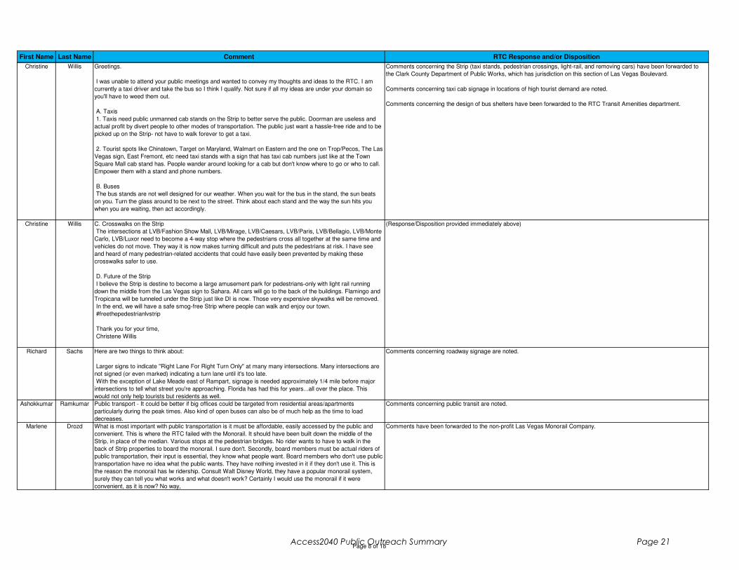
Christine Willis Greetings.
I was unable to attend your public meetings and wanted to convey my thoughts and ideas to the RTC. I am
currently a taxi driver and take the bus so I think I qualify. Not sure if all my ideas are under your domain so
you'll have to weed them out.
A. Taxis
1. Taxis need public unmanned cab stands on the Strip to better serve the public. Doorman are useless and
actual profit by divert people to other modes of transportation. The public just want a hassle-free ride and to be
picked up on the Strip- not have to walk forever to get a taxi.
2. Tourist spots like Chinatown, Target on Maryland, Walmart on Eastern and the one on Trop/Pecos, The Las
Vegas sign, East Fremont, etc need taxi stands with a sign that has taxi cab numbers just like at the Town
Square Mall cab stand has. People wander around looking for a cab but don't know where to go or who to call.
Empower them with a stand and phone numbers.
B. Buses
The bus stands are not well designed for our weather. When you wait for the bus in the stand, the sun beats
on you. Turn the glass around to be next to the street. Think about each stand and the way the sun hits you
when you are waiting, then act accordingly.
Comments concerning the Strip (taxi stands, pedestrian crossings, light-rail, and removing cars) have been forwarded to
the Clark County Department of Public Works, which has jurisdiction on this section of Las Vegas Boulevard.
Comments concerning taxi cab signage in locations of high tourist demand are noted.
Comments concerning the design of bus shelters have been forwarded to the RTC Transit Amenities department.
Christine Willis C. Crosswalks on the Strip
The intersections at LVB/Fashion Show Mall, LVB/Mirage, LVB/Caesars, LVB/Paris, LVB/Bellagio, LVB/Monte
Carlo, LVB/Luxor need to become a 4-way stop where the pedestrians cross all together at the same time and
vehicles do not move. They way it is now makes turning difficult and puts the pedestrians at risk. I have see
and heard of many pedestrian-related accidents that could have easily been prevented by making these
crosswalks safer to use.
D. Future of the Strip
I believe the Strip is destine to become a large amusement park for pedestrians-only with light rail running
down the middle from the Las Vegas sign to Sahara. All cars will go to the back of the buildings. Flamingo and
Tropicana will be tunneled under the Strip just like DI is now. Those very expensive skywalks will be removed.
In the end, we will have a safe smog-free Strip where people can walk and enjoy our town.
#freethepedestrianlvstrip
Thank you for your time,
Christene Willis
(Response/Disposition provided immediately above)
Richard Sachs Here are two things to think about:
Larger signs to indicate "Right Lane For Right Turn Only" at many many intersections. Many intersections are
not signed (or even marked) indicating a turn lane until it's too late.
With the exception of Lake Meade east of Rampart, signage is needed approximately 1/4 mile before major
intersections to tell what street you're approaching. Florida has had this for years...all over the place. This
would not only help tourists but residents as well.
Comments concerning roadway signage are noted.
Ashokkumar Ramkumar Public transport - It could be better if big offices could be targeted from residential areas/apartments
particularly during the peak times. Also kind of open buses can also be of much help as the time to load
decreases.
Comments concerning public transit are noted.
Marlene Drozd What is most important with public transportation is it must be affordable, easily accessed by the public and
convenient. This is where the RTC failed with the Monorail. It should have been built down the middle of the
Strip, in place of the median. Various stops at the pedestrian bridges. No rider wants to have to walk in the
back of Strip properties to board the monorail. I sure don't. Secondly, board members must be actual riders of
public transportation, their input is essential, they know what people want. Board members who don't use public
transportation have no idea what the public wants. They have nothing invested in it if they don't use it. This is
the reason the monorail has lw ridership. Consult Walt Disney World, they have a popular monorail system,
surely they can tell you what works and what doesn't work? Certainly I would use the monorail if it were
convenient, as it is now? No way,
Comments have been forwarded to the non-profit Las Vegas Monorail Company.
Page 8 of 18Access2040 Public Outreach Summary Page 21
First Name Last Name Comment RTC Response and/or Disposition
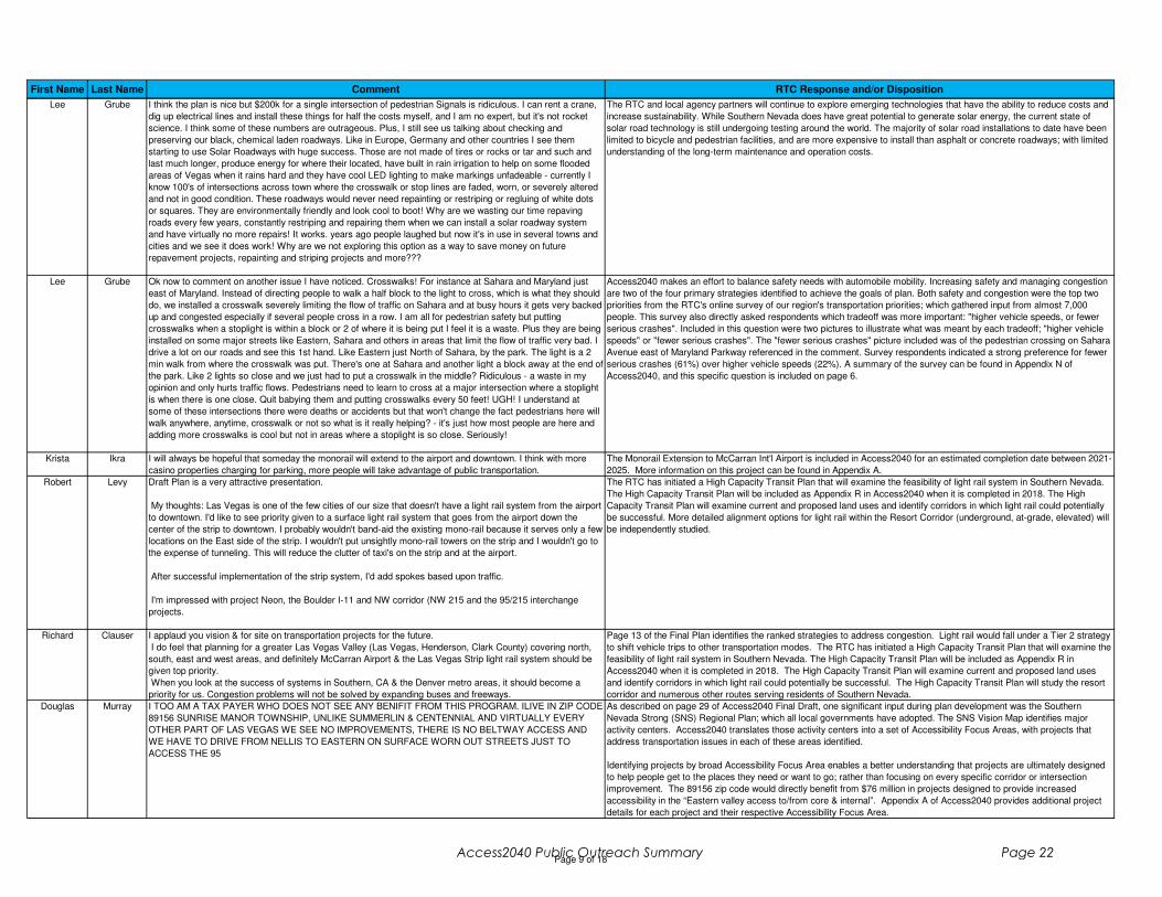
Lee Grube I think the plan is nice but $200k for a single intersection of pedestrian Signals is ridiculous. I can rent a crane,
dig up electrical lines and install these things for half the costs myself, and I am no expert, but it's not rocket
science. I think some of these numbers are outrageous. Plus, I still see us talking about checking and
preserving our black, chemical laden roadways. Like in Europe, Germany and other countries I see them
starting to use Solar Roadways with huge success. Those are not made of tires or rocks or tar and such and
last much longer, produce energy for where their located, have built in rain irrigation to help on some flooded
areas of Vegas when it rains hard and they have cool LED lighting to make markings unfadeable - currently I
know 100's of intersections across town where the crosswalk or stop lines are faded, worn, or severely altered
and not in good condition. These roadways would never need repainting or restriping or regluing of white dots
or squares. They are environmentally friendly and look cool to boot! Why are we wasting our time repaving
roads every few years, constantly restriping and repairing them when we can install a solar roadway system
and have virtually no more repairs! It works. years ago people laughed but now it's in use in several towns and
cities and we see it does work! Why are we not exploring this option as a way to save money on future
repavement projects, repainting and striping projects and more???
The RTC and local agency partners will continue to explore emerging technologies that have the ability to reduce costs and
increase sustainability. While Southern Nevada does have great potential to generate solar energy, the current state of
solar road technology is still undergoing testing around the world. The majority of solar road installations to date have been
limited to bicycle and pedestrian facilities, and are more expensive to install than asphalt or concrete roadways; with limited
understanding of the long-term maintenance and operation costs.
Lee Grube Ok now to comment on another issue I have noticed. Crosswalks! For instance at Sahara and Maryland just
east of Maryland. Instead of directing people to walk a half block to the light to cross, which is what they should
do, we installed a crosswalk severely limiting the flow of traffic on Sahara and at busy hours it gets very backed
up and congested especially if several people cross in a row. I am all for pedestrian safety but putting
crosswalks when a stoplight is within a block or 2 of where it is being put I feel it is a waste. Plus they are being
installed on some major streets like Eastern, Sahara and others in areas that limit the flow of traffic very bad. I
drive a lot on our roads and see this 1st hand. Like Eastern just North of Sahara, by the park. The light is a 2
min walk from where the crosswalk was put. There's one at Sahara and another light a block away at the end of
the park. Like 2 lights so close and we just had to put a crosswalk in the middle? Ridiculous - a waste in my
opinion and only hurts traffic flows. Pedestrians need to learn to cross at a major intersection where a stoplight
is when there is one close. Quit babying them and putting crosswalks every 50 feet! UGH! I understand at
some of these intersections there were deaths or accidents but that won't change the fact pedestrians here will
walk anywhere, anytime, crosswalk or not so what is it really helping? - it's just how most people are here and
adding more crosswalks is cool but not in areas where a stoplight is so close. Seriously!
Access2040 makes an effort to balance safety needs with automobile mobility. Increasing safety and managing congestion
are two of the four primary strategies identified to achieve the goals of plan. Both safety and congestion were the top two
priorities from the RTC's online survey of our region's transportation priorities; which gathered input from almost 7,000
people. This survey also directly asked respondents which tradeoff was more important: "higher vehicle speeds, or fewer
serious crashes". Included in this question were two pictures to illustrate what was meant by each tradeoff; "higher vehicle
speeds" or "fewer serious crashes". The "fewer serious crashes" picture included was of the pedestrian crossing on Sahara
Avenue east of Maryland Parkway referenced in the comment. Survey respondents indicated a strong preference for fewer
serious crashes (61%) over higher vehicle speeds (22%). A summary of the survey can be found in Appendix N of
Access2040, and this specific question is included on page 6.
Krista Ikra I will always be hopeful that someday the monorail will extend to the airport and downtown. I think with more
casino properties charging for parking, more people will take advantage of public transportation.
The Monorail Extension to McCarran Int'l Airport is included in Access2040 for an estimated completion date between 2021-
2025. More information on this project can be found in Appendix A.
Robert Levy Draft Plan is a very attractive presentation.
My thoughts: Las Vegas is one of the few cities of our size that doesn't have a light rail system from the airport
to downtown. I'd like to see priority given to a surface light rail system that goes from the airport down the
center of the strip to downtown. I probably wouldn't band-aid the existing mono-rail because it serves only a few
locations on the East side of the strip. I wouldn't put unsightly mono-rail towers on the strip and I wouldn't go to
the expense of tunneling. This will reduce the clutter of taxi's on the strip and at the airport.
After successful implementation of the strip system, I'd add spokes based upon traffic.
I'm impressed with project Neon, the Boulder I-11 and NW corridor (NW 215 and the 95/215 interchange
projects.
The RTC has initiated a High Capacity Transit Plan that will examine the feasibility of light rail system in Southern Nevada.
The High Capacity Transit Plan will be included as Appendix R in Access2040 when it is completed in 2018. The High
Capacity Transit Plan will examine current and proposed land uses and identify corridors in which light rail could potentially
be successful. More detailed alignment options for light rail within the Resort Corridor (underground, at-grade, elevated) will
be independently studied.
Richard Clauser I applaud you vision & for site on transportation projects for the future.
I do feel that planning for a greater Las Vegas Valley (Las Vegas, Henderson, Clark County) covering north,
south, east and west areas, and definitely McCarran Airport & the Las Vegas Strip light rail system should be
given top priority.
When you look at the success of systems in Southern, CA & the Denver metro areas, it should become a
priority for us. Congestion problems will not be solved by expanding buses and freeways.
Page 13 of the Final Plan identifies the ranked strategies to address congestion. Light rail would fall under a Tier 2 strategy
to shift vehicle trips to other transportation modes. The RTC has initiated a High Capacity Transit Plan that will examine the
feasibility of light rail system in Southern Nevada. The High Capacity Transit Plan will be included as Appendix R in
Access2040 when it is completed in 2018. The High Capacity Transit Plan will examine current and proposed land uses
and identify corridors in which light rail could potentially be successful. The High Capacity Transit Plan will study the resort
corridor and numerous other routes serving residents of Southern Nevada.
Douglas Murray I TOO AM A TAX PAYER WHO DOES NOT SEE ANY BENIFIT FROM THIS PROGRAM. ILIVE IN ZIP CODE
89156 SUNRISE MANOR TOWNSHIP, UNLIKE SUMMERLIN & CENTENNIAL AND VIRTUALLY EVERY
OTHER PART OF LAS VEGAS WE SEE NO IMPROVEMENTS, THERE IS NO BELTWAY ACCESS AND
WE HAVE TO DRIVE FROM NELLIS TO EASTERN ON SURFACE WORN OUT STREETS JUST TO
ACCESS THE 95
As described on page 29 of Access2040 Final Draft, one significant input during plan development was the Southern
Nevada Strong (SNS) Regional Plan; which all local governments have adopted. The SNS Vision Map identifies major
activity centers. Access2040 translates those activity centers into a set of Accessibility Focus Areas, with projects that
address transportation issues in each of these areas identified.
Identifying projects by broad Accessibility Focus Area enables a better understanding that projects are ultimately designed
to help people get to the places they need or want to go; rather than focusing on every specific corridor or intersection
improvement. The 89156 zip code would directly benefit from $76 million in projects designed to provide increased
accessibility in the “Eastern valley access to/from core & internal”. Appendix A of Access2040 provides additional project
details for each project and their respective Accessibility Focus Area.
Page 9 of 18Access2040 Public Outreach Summary Page 22

First Name Last Name Comment RTC Response and/or Disposition
Wesley Church I generally like the Draft Plan. No real input at this time. Thank you for reviewing the plan.
Adele Solomon Draft plan
My impression of the plan is build, build, build and if we have to think of community keep it small.
I see an incredible amount of information on and plans for construction. This seems to be your main focus.
I only see a passing nod to pollution, stating it is something to look into. But the plans are in place so changes
will be extremely difficult.I believe to make an impact the methods to deal with pollution and mitigate potential
environmental impact should already be in place.
Except for a comment regarding seniors and disabled I don't see anything regarding the at risk and under-
served populations. If you believe in Health in All Policies, this is a field that needs to be addressed a lot more.
The under-served and at risk populations are extremely isolated even if they live near a bus route. I do not see
any mention or consideration of this.
Also the plan is huge and difficult to follow. Again the focus seems to be on construction and it seems like a
great report for construction vendors but absolutely not the public or those with needs.
Comment that Access2040 is too large and focused on construction projects is noted. RTC staff made an effort to create a
concise document that focuses on broad goals and strategies to address transportation needs, not simply a long listing of
projects. Per federal regulations, the RTC must create a Regional Transportation Plan that identifies transportation
revenues reasonably expected to be available over the next 20-years and how they will be invested.
Comment on a lack of focus on pollution is noted. Access2040 analyzed air quality impacts of the proposed transportation
projects to be implemented over 20-years on page 35 of the Final Plan. Additionally, a dedicated Environmental Mitigation
report was prepared and included as Appendix H in Access2040.
Comment on an absence of consideration for at-risk and under-served populations is noted. Included as Appendix C in
Access2040 is an Environmental Justice Analysis, which also includes the RTC’s Title VI requirements. Environmental
justice is the fair treatment and meaningful involvement of all people regardless of race, color, national origin, or income
with respect to the development plans, programs and policies.
Shirley Betonio Can you please include in your plan the shed for all bus stops. Our bus stop in Nellis near Sahara cross street
has no waiting shed and it's very hot in the summer, no trees to hide us from heat. Also, during this winter time,
it's cold outside while waiting for the bus to arrive and sometimes it comes late or none at all. Can you add
heater installed at the roof of the shed to make us warm? I know it will be costly, but this will protect the
commuters from cold.
Thank you so much. I hope you take this suggestion seriously.
Comments concerning the design of bus shelters to increase passenger comfort have been forwarded to the RTC Transit
Amenities Department.
Kurt Goebel With sucessfil continuation of indexing in Clark County, congestion relief on freeways needs to be #1 priority.
While some congestion is expected on surface streets, it is always frustrating on freeways. As example, the
southern 215 beltway from I-15 to Charleston could easily be widened to avoid the increasing delays. There are
many other choke points where on-ramps and freeways join which need attention also. As example, the 215
traffic merging onto 15 north ends up merging in a sigle lane. Very congested and dangerous. Thank you for
your consideration.
As identified on page 7 of the Final Plan, managing congestion is identified as one of the four primary strategies to
implement the plan's goals. Comments concerning these specific locations where congestion occurs on freeways have
been forwarded to the Nevada Department of Transportation which controls these facilities.
Debs Schrimmer To Whom it May Concern:
On behalf of Lyft, I am pleased to provide comments on the Regional Transportation Commission of Southern
Nevada's 2017-2040 Regional Transportation plan. In particular, I would like to provide comment on the
Congestion Mitigation Process Report.
With regards to Tier 1: Strategies to Reduce Person Trips or Vehicle Miles Traveled, we commend RTC for so
prominently featuring Transportation Demand Management at the top of the list of strategies. We agree that
finding more sustainable ways to commute and travel around the region is the biggest lever in reducing
congestion, vehicle miles traveled, and greenhouse gas emissions. In particular, RTC's "Club Ride" Commuter
services is an innovative approach to incentivize alternative modes of transportation to get to and from work.
However, we noticed that ridesharing services, which share the same goals of carpooling and van pooling,
were not included as a program option. We urge you to consider expanding ridesharing services (such as Lyft
Line) into the program, as a way to help stay current with consumer preferences for mobile-based and on-
demand transportation services. Lyft Line launched in the Las Vegas region in November 2016, and is quickly
becoming a popular service for people living car-free and car-light lifestyles.
With regards to Section 3.7.2- Tier 2: Strategies to Shift Automobile Trips to Other Modes Improving Transit
Accessibility: We commend RTC's astute recognition for the need to "go beyond fleet renewal and
maintenance of the present operations" to make "transit as an option more attractive to a wider range of
people". Especially in congested regions like Southern Nevada, investing in frequent and high-capacity transit
is paramount to reducing single occupancy vehicle trips. RTC's creation of bus rapid transit routes, and
recommendations to create exclusive right-of-ways for buses will surely make transit rides faster and more
convenient.
We suggest that an equally important measure to support increasing transit accessibility is leveraging
ridesharing services to help solve "first and last mile" challenges. Over the last year, Lyft has launched
partnerships with transit agencies focused on expanding transit access by using Lyft to bridge the gap and
bring even more people within reach of transit. By partnering with Lyft, RTC can effectively grow transit
ridership to include those who do not live within walking or biking distance of a stop.
Thank you for the opportunity to provide comment. We look forward to continue engaging on important
transportation issues, and finding more opportunities to work together to reduce congestion.
Comment concerning support for the Tier 1 congestion management strategy (reduce trips or VMT) is noted.
Comment concerning including ridesharing services as part of the RTC’s Transportation Demand Management Program,
Club Ride, has been forwarded.
Comment concerning support for the Tier 2 congestion management strategy (shift vehicle trips to other modes) is noted.
Comment concerning partnering with Lyft to help solve the “first and last mile” transit access challenge has been forwarded
to RTC Transit.
Page 10 of 18Access2040 Public Outreach Summary Page 23
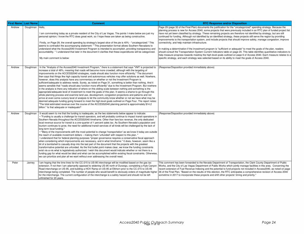
First Name Last Name Comment RTC Response and/or Disposition
Andrew Doughman Hello,
I am commenting today as a private resident of the City of Las Vegas. The points I make below are just my
personal opinion; I know the RTC does great work, so I hope these are taken as being constructive.
Firstly, on Page 29, the overall spending by strategy's largest slice of the pie is 40% - "uncategorized." This
seems to contradict the accompanying statement: " This presentation format allows Southern Nevadans to
understand what the Access2040 Investment Program is intended to accomplish, providing transparency and
accountability. " I understand that later in the document it clarifies that these expenditures will be categorized.
My main comment is below:
Page 29 (page 32 of the Final Plan) documents the justification for the "uncategorized" spending strategy. Because the
planning process is new for Access 2040, some projects that were previously included in an RTC plan of funded project list
have not yet been classified by strategy. These remaining projects are therefore not identified by strategy, but are still
continued for funding. Although not identified by an identified strategy, these projects still serve the region by providing
improvements to the transportation system, and include projects that should improve safety, manage congestion, improve
connectivity, and help maintain infrastructure.
In making a determination if the investment program is "sufficient or adequate" to meet the goals of the plan, readers
should consult the Transportation System Current Indicators table on page 20. This table identifies quantitative indicators to
help measure progress towards meeting the high-level goals outlined on page 6 of Access 2040. Each measure relates to a
specific strategy, and each strategy was selected based on its ability to meet the goals of Access 2040.
Andrew Doughman In the "Analysis of the Access2040 Investment Program," there is a statement that says "VMT is projected to
increase a total of 48%, meaning that roads will become more crowded, although with the targeting of
improvements on the ACCESS2040 strategies, roads should also function more efficiently." The document
then says that things like high capacity transit and autonomous vehicles may offer solutions as well. Nowhere,
however, does this analysis have any commentary on whether or not the Investment Program is
sufficient/adequate to address needs. Surely, as noted on Page 31, something is better than nothing. And it
seems sensible that "roads should also function more efficiently" due to the Investment Program. But nowhere
in the analysis is there any indication of where on this sliding scale between nothing and something is the
appropriate/adequate level of investment to meet the goals of this plan. It seems a shame to go through this
whole planning process and examine land use, development, congestion projections and patterns and not
arrive at even some cursory level of analysis to let the community know whether or not we have what may be
deemed adequate funding going forward to meet the high-level goals outlined on Page Four. The report notes:
"The total estimated revenue over the course of the ACCESS2040 planning period is approximately $14.2
billion." Is that adequate or inadequate?
(Response/Disposition provided immediately above)
Andrew Doughman It would seem to me that the funding is inadequate, as the two statements below appear to indicate:
• "Funding is usually a challenge for transit operators, and will probably continue to impact transit operations in
Southern Nevada throughout the ACCESS2040 timeframe. Other than fare box revenue, the only dedicated
local revenue source for transit is a one-quarter of 1 percent sales tax. As Southern Nevada’s population and
tourism continues to grow, the need for additional transit services of all kinds will be challenged by the lack of
long term local funding."
• "Many of the improvements with the most potential to change 'transportation' as we know it today are outside
the reach of available investment dollars – making them 'unfunded' with respect to this plan. "
I understand that for federal planning purposes "proper governance requires a conservative fiscal approach
when considering which improvements are necessary, and in what timeframe." It does, however, seem like a
bit of a bombshell to casually drop into the last part of the document that the projects with the greatest
transformative potential are unfunded. As the first bullet point makes clear, we know the funding constraints
exist vis-a-vis what is legislatively authorized. I wish this document would indicate whether or not there is a
funding gap for what would be ideal and what can be accomplished within existing fiscal constraints. Otherwise,
we can prioritize and plan all we want without ever addressing the overall need.
(Response/Disposition provided immediately above)
Peter Janney I am hoping that the time lines for the CC-215 to US-95 interchange will be modified based on the gas tax
extension. If not then I am adamantly opposed to widening US-95 north of Durango, completing a Kyle Canyon
Road interchange on US-95, and building a HOV Ramp on US-95 at Elkhorn prior to the CC-215 to US-95
interchange being completed. The number of people who would benefit is obviously orders of magnitude higher
for the interchange. The current configuration of the interchange is a safety hazard and should not be left
unfinished for 20 years.
This comment has been forwarded to the Nevada Department of Transportation, the Clark County Department of Public
Works, and the City of Las Vegas Department of Public Works which jointly manage facilities in this area. Concerning the
recent extension of Fuel Revenue Indexing and the potential to fund projects not included in Access2040, as noted on page
36 of the Final Plan, "Based on the results of this election, the RTC anticipates a comprehensive revision of Access 2040
sometime in 2017 to incorporate these projects and shift other projects' timing and priority."
Page 11 of 18Access2040 Public Outreach Summary Page 24

First Name Last Name Comment RTC Response and/or Disposition
Edie K Transportation Improvements: 1. Intersection of Las Vegas Blvd. South and Hidden Well Road (i.e., 215),
driving west on Hidden Well Rd. approaching L.V. BLVD S. from the east. At present, there are three lanes on
Hidden Well: the left lane for left turns onto LV BLVD; the middle lane for through access to the I-15 and I-215
on-ramp as well as for left turns; and the right lane for right turns onto LV BLVD. Traffic backs up badly in the
middle lane being the only access lane through to the freeways. A fourth lane is needed for two access lanes to
the freeways. 2. The intersection of Bermuda Rd. and Eldorado Lane: Due to the rental car facility on Bermuda
Rd. there is increased traffic on Bermuda going through the residential neighborhood to the south. Some of this
traffic is misdirected. This problem has directly resulted in one death. There needs to be a four-way stop at this
intersection. Note that these two problem intersections will become much more egregious with the proposed
resort and shopping development on Bermuda Rd. between Sunset and the I-215 re: Clark County land use
application UC-0877-16. P.S. Make the Las Vegas Strip a pedestrian promenade. Thanks
Comment has been forwarded to the Clark County Department of Public Works which manages roadways in this area.
Shondra Summers-
Armstrong
I am writing to express my opposition to project number Project# CLV – 17–135 – XX – L, I-15 Frontage Rd.,
Washington Avenue to Lake Mead Drive Road Improvement. Yet here we are, two years later, with a draft
regional transportation plan that includes the I-15 Frontage Rd., Washington Avenue to Lake Mead Drive Road
Improvement project.
I do not believe the West Las Vegas community needs or wants another high speed road. This is a community
that has been the victim of racial segregation and redlining for decades. I believe we need public works
projects and infrastructure investments that will revive a community that has been sorely neglected.
Infrastructure that will encourage and facilitate new development and amenities that beautify and strengthen our
neighborhoods.
Martin Luther King Jr. Blvd. is an object lesson of the fallacy that high speed thoroughfares equate to business
and residential investment.
I strongly object to the I-15 Frontage Rd. project. I hope the RTC will encourage the City of Las Vegas to
remove this project from its master plan.
During the spring and summer of 2015, I and many members of the West Las Vegas community, attended the
UNLV Downtown Design Charrette & Workshops. Over the course of several weeks we listened to lectures
from architects and planners hired by the City of Las Vegas, and worked with UNLV students and staff to
devise the community based preliminary concept for the Historic Urban Neighborhood Redevelopment
(HUNDRED) Plan for the Westside Community.
During these planning sessions, it was brought to our attention that the City of Las Vegas was conducting a
study to build a frontage road parallel to the I-15 freeway to Washington Avenue. During a public meeting held
by the City of Las Vegas on July 16, 2015, the community expressed its opposition to the plan for the frontage
road. It was made clear that construction of this road would be in conflict with the concept for the Historic Urban
Neighborhood
Redevelopment (HUNDRED) Plan for the Westside Community. The final draft of the Hundred plan does not
include the frontage road because it conflicts with the concepts of the plan and because of the opposition from
the community.
Individual projects are proposed by RTC's member agencies. RTC Staff provided this comment to the City of Las Vegas
and received the following response from Las Vegas Councilman Ricky Barlow on behalf of the City. Based on this
response, the project referenced in this comment is included in the Plan.
"Thank you for sharing the concerns of a resident’s opinion pertaining to the proposed I-15 frontage road project. Please know
community comments are important to good public policy and constructive feedback is always welcome.
Over this 3 year process, I’ve carefully evaluated many comments received concerning the I-15 Frontage Road project and the great
majority have been proponents of economic vitality for a community ripe for redevelopment specifically associated with intermodal
transportation. Throughout the summer of 2014 through 2015, City of Las Vegas personnel in conjunction with the University of
Nevada Las Vegas Design Center held more than 20 neighborhood meetings, to include workshops as we worked toward a master
plan entitled “100th Plan” which the City of Las Vegas plans to adopt within its 2045 Downtown Master Plan the first quarter of 2017.
Ostensibly, my objective is to honor the majority of concerns from those constituents who worked long and hard with the City of Las
Vegas who overwhelmingly approve the plans which will indeed improve traffic access within the Historic West Las Vegas community.
The I-15 Frontage road project is solely intended to relieve persistent congestion and gridlock for commuters traveling through I-15
south/northbound directions and Interstates I-15/515 interchanges. This stretch of highway represents to me and the majority of my
constituents, a matter of unfettered access for Las Vegas Fire Rescue, Las Vegas Metro Police, and commuters desiring to drive along
a “new” frontage road thoroughfare. Safety and ease of access is the concern and the frontage project fulfills this objective.
The frontage project will make life much better for the community and the City of Las Vegas at large. There are also other inherent and
existential benefits aligned with social and economic growth.
It is my conclusion, the Regional Transportation Commission continue moving forward with the I-15 Frontage Road project as planned
through the Fuel Revenue Indexing."
Lou Ragland Why cant there be a continuation of the Bus that services the Las Vegas outlets, to include a several block
small loop ( north on "D" street to Ovens, west to "H" and South on "H" to Bonanza then back to city Parkway
then continue the route from there? We have history and services At Edmond Town center, Nucleolus Plaza
ETC.
Comment has been forwarded to RTC Transit concerning the SDX service area.
Michael McKenna Would you please consider expanding bus service near my house? I have a suggestion on how to do it. Have
the 121 continue down buffalo to mountains edge parkway. Make a right, and continue to Fort Apache. Then,
make a left on Gomer and continue down to Durango. Make a left on Durango and continue up to Cheyenne.
From there, start the loop again. As for the 120, you can put it back to what it was doing before. Going up fort
apache to warm Springs, turning, continuing to rainbow, then going up north. Please consider this! It would be
much more convenient for me. I have already pitched in over $6000 to keep my brother's car in good condition
so I have some kind of transportation. I am struggling to learn to drive, and even when I do, I would rely on the
buses more because it's cheaper. It would save me money, it would save me hassle, and it would open up a lot
more doors for me. There are already bus stops along this suggested route that are not being used right now.
All you have to do is go a little further. Please consider this suggestion!
Comment has been forwarded to RTC Transit concerning the service area for transit routes 120 and 121.
Page 12 of 18Access2040 Public Outreach Summary Page 25
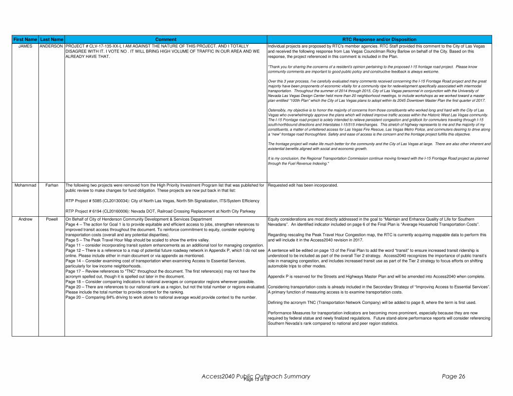
First Name Last Name Comment RTC Response and/or Disposition
JAMES ANDERSON PROJECT # CLV-17-135-XX-L I AM AGAINST THE NATURE OF THIS PROJECT. AND I TOTALLY
DISAGREE WITH IT. I VOTE NO . IT WILL BRING HIGH VOLUME OF TRAFFIC IN OUR AREA AND WE
ALREADY HAVE THAT.
Individual projects are proposed by RTC's member agencies. RTC Staff provided this comment to the City of Las Vegas
and received the following response from Las Vegas Councilman Ricky Barlow on behalf of the City. Based on this
response, the project referenced in this comment is included in the Plan.
"Thank you for sharing the concerns of a resident’s opinion pertaining to the proposed I-15 frontage road project. Please know
community comments are important to good public policy and constructive feedback is always welcome.
Over this 3 year process, I’ve carefully evaluated many comments received concerning the I-15 Frontage Road project and the great
majority have been proponents of economic vitality for a community ripe for redevelopment specifically associated with intermodal
transportation. Throughout the summer of 2014 through 2015, City of Las Vegas personnel in conjunction with the University of
Nevada Las Vegas Design Center held more than 20 neighborhood meetings, to include workshops as we worked toward a master
plan entitled “100th Plan” which the City of Las Vegas plans to adopt within its 2045 Downtown Master Plan the first quarter of 2017.
Ostensibly, my objective is to honor the majority of concerns from those constituents who worked long and hard with the City of Las
Vegas who overwhelmingly approve the plans which will indeed improve traffic access within the Historic West Las Vegas community.
The I-15 Frontage road project is solely intended to relieve persistent congestion and gridlock for commuters traveling through I-15
south/northbound directions and Interstates I-15/515 interchanges. This stretch of highway represents to me and the majority of my
constituents, a matter of unfettered access for Las Vegas Fire Rescue, Las Vegas Metro Police, and commuters desiring to drive along
a “new” frontage road thoroughfare. Safety and ease of access is the concern and the frontage project fulfills this objective.
The frontage project will make life much better for the community and the City of Las Vegas at large. There are also other inherent and
existential benefits aligned with social and economic growth.
It is my conclusion, the Regional Transportation Commission continue moving forward with the I-15 Frontage Road project as planned
through the Fuel Revenue Indexing."
Mohammad Farhan The following two projects were removed from the High Priority Investment Program list that was published for
public review to make changes for fund obligation. These projects are now put back in that list:
RTP Project # 5085 (CL20130034): City of North Las Vegas, North 5th Signalization, ITS/System Efficiency
RTP Project # 6194 (CL20160006): Nevada DOT, Railroad Crossing Replacement at North City Parkway
Requested edit has been incorporated.
Andrew Powell On Behalf of City of Henderson Community Development & Services Department
Page 4 – The action for Goal 1 is to provide equitable and efficient access to jobs, strengthen references to
improved transit access throughout the document. To reinforce commitment to equity, consider exploring
transportation costs (overall and any potential disparities).
Page 5 – The Peak Travel Hour Map should be scaled to show the entire valley.
Page 11 – consider incorporating transit system enhancements as an additional tool for managing congestion.
Page 12 – There is a reference to a map of potential future roadway network in Appendix P, which I do not see
online. Please include either in main document or via appendix as mentioned.
Page 14 – Consider examining cost of transportation when examining Access to Essential Services,
particularly for low income neighborhoods.
Page 17 – Review references to "TNC" throughout the document. The first reference(s) may not have the
acronym spelled out, though it is spelled out later in the document.
Page 18 – Consider comparing indicators to national averages or comparator regions wherever possible.
Page 20 – There are references to our national rank as a region, but not the total number or regions evaluated.
Please include the total number to provide context for the ranking.
Page 20 – Comparing 84% driving to work alone to national average would provide context to the number.
Equity considerations are most directly addressed in the goal to “Maintain and Enhance Quality of Life for Southern
Nevadans”. An identified indicator included on page 6 of the Final Plan is “Average Household Transportation Costs”.
Regarding rescaling the Peak Travel Hour Congestion map, the RTC is currently acquiring mappable data to perform this
and will include it in the Access2040 revision in 2017.
A sentence will be edited on page 13 of the Final Plan to add the word “transit” to ensure increased transit ridership is
understood to be included as part of the overall Tier 2 strategy. Access2040 recognizes the importance of public transit’s
role in managing congestion, and includes increased transit use as part of the Tier 2 strategy to focus efforts on shifting
automobile trips to other modes.
Appendix P is reserved for the Streets and Highways Master Plan and will be amended into Access2040 when complete.
Considering transportation costs is already included in the Secondary Strategy of “Improving Access to Essential Services”.
A primary function of measuring access is to examine transportation costs.
Defining the acronym TNC (Transportation Network Company) will be added to page 8, where the term is first used.
Performance Measures for transportation indicators are becoming more prominent, especially because they are now
required by federal statue and newly finalized regulations. Future stand-alone performance reports will consider referencing
Southern Nevada’s rank compared to national and peer region statistics.
Page 13 of 18Access2040 Public Outreach Summary Page 26

First Name Last Name Comment RTC Response and/or Disposition
Andrew Powell Page 25 – Consider including a summary table displaying the referenced demographics compared to national
averages.
Page 25 – Please include time horizon for Population and Employment Change maps.
Page 25 – Consider normalizing on a per acre or per square mile basis for the Population and Employment
Change maps. The lack of normalization make large TAZs appear poised for more aggressive growth than
would be shown on a per acre basis.
Page 26 – Please include time horizon for travel demand map.
More detailed summary tables displaying the referenced demographics and more can be found in Appendix C of
Access2040; Environmental Justice Analysis (Including Title VI Reporting). However, there are no comparisons to national
averages in the summary tables.
Normalizing the population and employment percent change maps on a per acre basis, and not use the TAZ structure, will
be included in the planned 2017 amendment to Access2040.
The time horizon for the population and employment change maps, and the percent change in travel demand map will be
added.
Christina Leach The document is well written …Thank you
Page 2, Coordination with Jurisdictional and Regional Land Use Planning: What is the definition for Projects of
Regional Significance for the RTPSN?
Page 3: Was the information reported in “Figure XX-3: Flood Washes” coordinated with the Local office for the
US Corps of Engineers as jurisdictional waters?
Page 5, Air quality: Please add the reference to the information about Children living or going to school within
500 feet of a freeway to have problems with their lungs!!
Page 23: Should include some reference to the State Freight Plan
Appendix H- I didn’t see any discussion of natural disaster- flooding mitigation
Appendix B – High Priority Investment Program
Page 1 - Change "Plan" to "Program" here
But no maps that show all the project locations?
Page 3 - Where do the remaining phases of previously approved projects fall - in the new CIP category if we
have not authorized Construction yet? - like the rest of NEON, US 95 NW or I-15 South. Those phases will be
screened through the new process, and when?
Access2040 implements the federal regulatory definition for projects of regional significance (Title 40 CFR Part 93.101): “a
transportation project (other than an exempt project) that is on a facility which serves regional transportation needs (such as
access to and from the area outside of the region, major activity centers in the region, major planned developments such as
new retail malls, sports complexes, etc., or transportation terminals as well as most terminals themselves) and would
normally be included in the modeling of a metropolitan area's transportation network, including at a minimum all principal
arterial highways and all fixed guide way transit facilities that offer an alternative to regional highway travel.” All regionally
significant projects are included in Access2040’s air quality conformity determination and project listing regardless of its
funding source.
The Flood Washes map contained in Appendix H was not created in coordination with the local office of the United States
Army Corps of Engineers and is not intended to identify all jurisdictional waters subject to regulation or make any such
determinations. The map is intended to provide broad context of the environmental issues, and potential mitigation
measures, to be aware of as transportation projects are implemented at a regional level.
A reference to the recently adopted Nevada State Freight Plan was added to page 23 (page 25 Final Plan).
Appendix H discusses standard flooding mitigation strategies and includes a map of flood washes on pages 3-4.
Appendix B was edited to change "Plan" to "Program".
Christina Leach This still sounds like there is an RTC process and an NDOT Process that are not really coordinated. How does
NDOT compete for RTC money, and vice versa?
Do we have a good handle on how much this has really brought to the table in recent years? Does "private"
include LVCVA money from hotel room taxes? The figure below is a very good start.
...maybe not "selecting", but does RTC have some role?
Page 7 - These footnotes are telling - but do not tell the whole truth. Federal money is not state money.
Page 11 - NDOT sold bonds for NEON in 2016 and may sell more. Nothing is shown?
Looks like a big jump in SGT in 2018, and then a big drop?
Page 12 - They could add the North Fifth Street project in North Las Vegas - a very good one that opened in
2016 (especially if they want to show each jurisdiction).
Page 14 - The key point for NEON is the current project is only part of the ultimate, NEPA-approved solution.
That also applies to I-15 South and US 95 NW - more phases to come..and hopefully in the RTP project list.
There is not a map of project locations in this document. The project descriptions in Appendix A include descriptions of
project location (facility name and project limits); these descriptions serve as the adopted project list. However, the RTC is
working on an online mapping tool that will list all projects included in the RTP (HPP, CIP, RTP). That will not be a formally-
adopted map, but instead a communication tool. It’s expected to be online during 2017.
Projects listed in the HPP do not include previously-initiated projects. Details for those projects can be found in previous
RTC Transportation Improvement Program and/or Capital Improvement Program documents available from the RTC.
The RTC and NDOT coordinate project selection processes through NDOT’s Annual Work Program.
The RTC does not receive full information on the level of privately funded transportation improvements. However, if the
proposed privately funded project is regionally significant, then the RTC will incorporate that project into the RTP and HPP.
Funds generated from hotel room taxes typically fund projects sponsored by local public agencies, and therefore would not
be considered a privately funded project.
The RTC’s role in privately-funded transportation projects is limited beyond including regionally significant projects in the
HPP and air quality modeling for transportation conformity purposes. However, through the RTC’s recent efforts
administering Southern Nevada Strong, greater regional land use planning may begin to occur that will better help guide the
location of private transportation investments.
Page 14 of 18Access2040 Public Outreach Summary Page 27
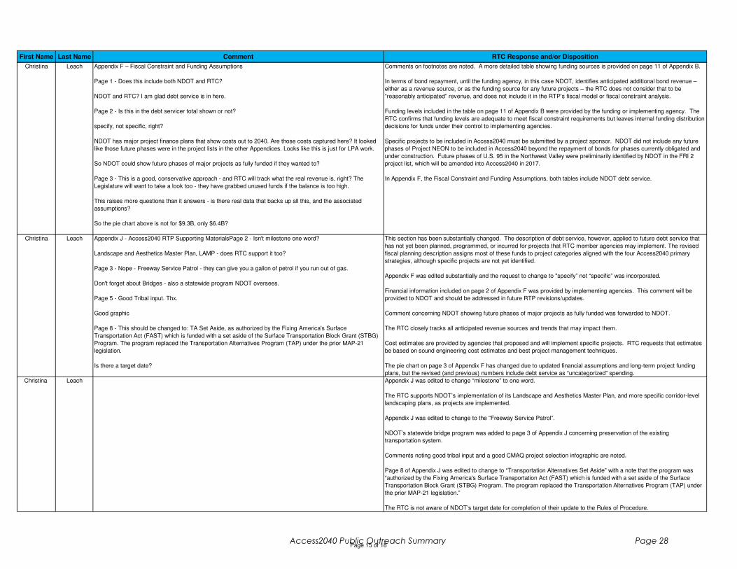
First Name Last Name Comment RTC Response and/or Disposition
Christina Leach Appendix F – Fiscal Constraint and Funding Assumptions
Page 1 - Does this include both NDOT and RTC?
NDOT and RTC? I am glad debt service is in here.
Page 2 - Is this in the debt servicer total shown or not?
specify, not specific, right?
NDOT has major project finance plans that show costs out to 2040. Are those costs captured here? It looked
like those future phases were in the project lists in the other Appendices. Looks like this is just for LPA work.
So NDOT could show future phases of major projects as fully funded if they wanted to?
Page 3 - This is a good, conservative approach - and RTC will track what the real revenue is, right? The
Legislature will want to take a look too - they have grabbed unused funds if the balance is too high.
This raises more questions than it answers - is there real data that backs up all this, and the associated
assumptions?
So the pie chart above is not for $9.3B, only $6.4B?
Comments on footnotes are noted. A more detailed table showing funding sources is provided on page 11 of Appendix B.
In terms of bond repayment, until the funding agency, in this case NDOT, identifies anticipated additional bond revenue –
either as a revenue source, or as the funding source for any future projects – the RTC does not consider that to be
“reasonably anticipated” revenue, and does not include it in the RTP’s fiscal model or fiscal constraint analysis.
Funding levels included in the table on page 11 of Appendix B were provided by the funding or implementing agency. The
RTC confirms that funding levels are adequate to meet fiscal constraint requirements but leaves internal funding distribution
decisions for funds under their control to implementing agencies.
Specific projects to be included in Access2040 must be submitted by a project sponsor. NDOT did not include any future
phases of Project NEON to be included in Access2040 beyond the repayment of bonds for phases currently obligated and
under construction. Future phases of U.S. 95 in the Northwest Valley were preliminarily identified by NDOT in the FRI 2
project list, which will be amended into Access2040 in 2017.
In Appendix F, the Fiscal Constraint and Funding Assumptions, both tables include NDOT debt service.
Christina Leach Appendix J - Access2040 RTP Supporting MaterialsPage 2 - Isn't milestone one word?
Landscape and Aesthetics Master Plan, LAMP - does RTC support it too?
Page 3 - Nope - Freeway Service Patrol - they can give you a gallon of petrol if you run out of gas.
Don't forget about Bridges - also a statewide program NDOT oversees.
Page 5 - Good Tribal input. Thx.
Good graphic
Page 8 - This should be changed to: TA Set Aside, as authorized by the Fixing America's Surface
Transportation Act (FAST) which is funded with a set aside of the Surface Transportation Block Grant (STBG)
Program. The program replaced the Transportation Alternatives Program (TAP) under the prior MAP-21
legislation.
Is there a target date?
This section has been substantially changed. The description of debt service, however, applied to future debt service that
has not yet been planned, programmed, or incurred for projects that RTC member agencies may implement. The revised
fiscal planning description assigns most of these funds to project categories aligned with the four Access2040 primary
strategies, although specific projects are not yet identified.
Appendix F was edited substantially and the request to change to "specify” not “specific” was incorporated.
Financial information included on page 2 of Appendix F was provided by implementing agencies. This comment will be
provided to NDOT and should be addressed in future RTP revisions/updates.
Comment concerning NDOT showing future phases of major projects as fully funded was forwarded to NDOT.
The RTC closely tracks all anticipated revenue sources and trends that may impact them.
Cost estimates are provided by agencies that proposed and will implement specific projects. RTC requests that estimates
be based on sound engineering cost estimates and best project management techniques.
The pie chart on page 3 of Appendix F has changed due to updated financial assumptions and long-term project funding
plans, but the revised (and previous) numbers include debt service as “uncategorized” spending.
Christina Leach Appendix J was edited to change “milestone” to one word.
The RTC supports NDOT’s implementation of its Landscape and Aesthetics Master Plan, and more specific corridor-level
landscaping plans, as projects are implemented.
Appendix J was edited to change to the “Freeway Service Patrol”.
NDOT’s statewide bridge program was added to page 3 of Appendix J concerning preservation of the existing
transportation system.
Comments noting good tribal input and a good CMAQ project selection infographic are noted.
Page 8 of Appendix J was edited to change to “Transportation Alternatives Set Aside” with a note that the program was
“authorized by the Fixing America's Surface Transportation Act (FAST) which is funded with a set aside of the Surface
Transportation Block Grant (STBG) Program. The program replaced the Transportation Alternatives Program (TAP) under
the prior MAP-21 legislation.”
The RTC is not aware of NDOT’s target date for completion of their update to the Rules of Procedure.
Page 15 of 18Access2040 Public Outreach Summary Page 28

First Name Last Name Comment RTC Response and/or Disposition
Marco Velotta Cover Page - Through the document I don't see any reference to project Neon. Is this deliberately? Should it
not be mentioned in some way, if we look at the 2017-2040 lifespan of this document?
I feel like there could be a more in-depth analysis of vulnerable populations, minorities, and lower-income, as
well as a few specific directions towards improving their access specifically. This also has to do with the fact
that I noticed Area A as being the one with lowest amount of projected spending, but is also one that often has
neighborhoods in a transportation limbo and hosts vulnerable populations.
Page 1 - How do the goals, policies, strategies, etc from these other reports and plans specifically relate to the
ones developed for the RTP?
What about the TBIP?
Only scant discussion of ridesharing, taxis, etc and their impact (good and bad) within this document - for
something
Page 2 - Isn't it 2.2 already? Update to reflect recent census
42.9 million - 2016
Visually crowded, push text downwards.
Project NEON was included in previous Regional Transportation Plans and is currently obligated and under construction;
therefore it is not included in the narrative of Access2040. However, debt service related to Project NEON is included in
Appendix A, as is a City of Las Vegas project related to NEON; the “MLK/GC Pkwy/Industrial Connector”.
An Environmental Justice Analysis that analyzes impacts on low-income and minority populations is included in Appendix C
of Access2040. As displayed in the table on page 32 of the Final Plan, Focus Area A comparatively receives the highest
level of investment; a reflection of its importance to the economy of Southern Nevada.
Access2040 contains the region’s overall transportation, policies, and strategies, and will be reflected in later reports that
aim to implement Access2040.
The TIBP development process and recommendations are not a required element of Regional Transportation Plans, and it
will not be included as an Appendix. However, some of the projects identified in TIBP are included in Access2040, and
additional projects willl be amended into Access2040 in 2017 to reflect the voter approved extension of Fuel Revenue
Indexing.
Discussion and consideration of Transportation Network Companies is primarily located on page 19 of the Final Plan, under
the secondary strategy to “Use Innovative Planning to Address Emerging Technologies & Trends”
The population and visitation figures citied in Access2040 are intended to be more general to enhance readability.
Marco Velotta Page 3 - Is this map based on ZIP codes of survey participants? It could be mistaken as a map of what are the
priorities in specific areas of the valley. You could argue it's a thin line, if you want, but still different.
Page 4 - Goals, indicators, and strategies are spread out over a few pages - why not combine them together?
Instead of repeating the goals twice in one page, can we graphically include the indicators in one image, along
with the "2040 Goals" table?
Page 5 - Would seem appropriate to have a metric/indicator that have a better connection between goal,
strategy, and indicator - congestion has a clear nexus.
Page 6 - Are there current baselines for any of these indicators? It would be useful to know what they measure
at to understand (in the future) how successful the RTP strategies are at meeting the goals; ie, what is the
current commute mode split? What would the target be for 2040? -- the table on page 18 seems like it would
be better suited closer to the beginning.
The entire document has been edited for formatting.
The word “Survey” will be added to the title of the map to ensure understanding that these are the investment priorities of
respondents within these zip codes.
Access2040 goals, indicators, and strategies are currently within the same section of the document spanning multiple
pages. This information cannot fit onto a single page.
The goals are repeated in two tables on the same page because two different concepts are being presented. The first goal
table describes the goal and the qualitative direction desired, while the purpose of the second goal table is to operationalize
the indicators.
The proposed safety indicators have a clear nexus and borrow from national best practices, federal guidance/regulations,
and coordination with NDOT and local stakeholders.
As displayed in the table on page 20 of the Final Plan, some indicators have baseline data available (current measures),
while other indicators still need to be refined and data gathered to understand existing conditions. Federal regulations
regarding performance measures were recently finalized in January 2017 (after the close of the Access2040 public
comment period). Although not yet required in Regional Transportation Plans, Access2040 is progressive in the level of
detail provided in tracking transportation system performance indicators. The target setting process will continue to occur
with stakeholders, and for some indicators must be set in conjunction with the NDOT.
Page 16 of 18Access2040 Public Outreach Summary Page 29
First Name Last Name Comment RTC Response and/or Disposition
Marco Velotta Page 7 - Why not consolidate all strategies together? Why are these "Secondary?"
Why 45 minutes? Is that related to an average commute time or is it just what EPA's database provides?
I feel like having a breakpoint from 0 to 35,000 does not really give an idea of what's going on. I understand the
point, but, maybe we could add a breakpoint at 0 to 10k or 15k if possible? I went on the EPA arcgis map and it
looks like some layers changed, but there still is good (and updated) data on this.
Cannot read these maps - Would help to see at least where the freeways are.
Page 8 - Maps on page 7 have 45 minutes...
Page 9 - Chapter 8 of Mobility Master Plan.
Concur, we have the whole section: "Looking to the Future: Autonomous and Connected Vehicle Technologies"
This is mentioned in Mobility Master Plan.
Strategies are prioritized into Primary and Secondary groups to enable a meaningful project selection process (page 17
Final Plan) that accurately implements the feedback received from the almost 7,000 respondents to the transportation
visioning survey and from RTC boards and commissions. "Secondary" strategies are not less important than "Primary"
strategies, but are less measurable on a project-by-project basis.
Maps in the Access2040 Public Comment Draft were developed using the available EPA Smart Location Database, which
only provides a 45-minute analysis. Both the transit and automobile job accessibility maps have been replaced with data
and maps prepared by the University of Minnesota using 30-minute access times. Further information on the University of
Minnesota reports can be found here: http://access.umn.edu/research/america/transit/2015/.
Transportation system indicators referenced on page 10 of the Final Plan will be edited for consistency with those indicators
included on page 20 of the Final Plan.
The table on page 11 of the Final Plan that compares Access2040 goals and strategies with local agency transportation
plans will be edited to show that the City’s Mobility Master Plan directly relates to the secondary strategy to use innovative
planning to address emerging technologies and trends. The Mobility Master Plan contains a section titled, "Looking to the
Future: Autonomous and Connected Vehicle Technologies".
Marco Velotta Page 11 - I noticed that all of these examples are either Tier 3 or Tier 4 strategies related to congestion, and
those 2 fall into the categories that do not disincentivize VMTs. What about the Tier 1 and Tier 2 strategies,
which supposedly are "higher ranked"? Are they, really? How does the Tier reflect future level investment
forecasts, and priorities?
Concur- there's little demand management or mode shifting examples. Adding lanes and asphalt are
expensive, yet provide only little or temporary relief. Any Tier 1 or 2 examples for comparison?
Page 12 - No discussion on the impact to land use (TOD)?
Not so much Plan-related comment, but this table says "example"; however, is there more detailed information
on Rainbow?
Page 13 - What about FRI?
Projects and costs table doesn't appear on this page as it does on others -- something to include?
Table on page 13 of the Final Plan that includes example congestion management projects will be edited to include an
Access2040 Tier 1 and Tier 2 project. RTC’s Transportation Demand Management: Club Ride Program (Tier 1), and a
bicycle and pedestrian enhancement project (Tier 2), will be included.
Land use considerations, and the positive impacts of TOD, are principally included in the secondary strategy “Improve
Access to Essential Services”. This strategy states, “because economic and land use development and transportation
infrastructure have a symbiotic relationship, the RTC and Southern Nevada communities will expand work to coordinate
transportation decisions with economic and community development decisions. With the RTC’s role in leading
implementation of the SNS Regional Plan, coordinating these activities helps advance that effort. Transportation
investments can alter patterns of development, attracting new construction or encouraging efficient infill for under-utilized
land areas already surrounded by built-up areas.”
More information on the Rainbow Blvd Improvements project can be found Appendix A. The project will design and
construct widened sidewalks, street trees, dedicated transit lanes, intersection improvements and ADA upgrades on
Rainbow Blvd. from U.S. 95 to Sahara Ave.
Marco Velotta Page 17 - ....but are autonomous vehicles really the magic bullet to transportation problems? A lot of weight is
being given to this when just as many researchers are saying "don't count on it" for the same practical reasons
we don't have cars that fly. User control and driver psychology are major factors; interaction with non-
autonomous/connected vehicles is another. Perhaps if anything, we'll see a continued growing trend of semi-
autonomous technology that solves some problems (safety) but leaves control to the user...
None of these are really explained as to what they are or why they're needed.
Page 18 - Why are these "Future?" Why not set the Targets now??
Page 19 - Why not include some identifiers as to what some of these roads are (ie, label I-15, 215, 95, etc.
Page 20 - Road, not Blvd.
Page 21 - but lacks (suburban) coverage and convenience for choice riders.
A table of example Access2040 maintenance projects was not included on page 15 of the Final Plan because maintenance
projects are typically included as a broad spending category; not a specific project list. This practice allows project
sponsors greater flexibility to implement projects as dynamic maintenance needs arise. Since, transportation infrastructure
maintenance is inevitable, a portion of anticipated revenue is typically set-aside for maintenance needs. Since maintenance
projects do not add automobile capacity, they do not need to be included in the Travel Demand Model for an analysis of air
quality impacts.
The impacts of autonomous vehicles (AV) are not fully understood, which is why Access2040 identifies additional planning
needs on page 19 of the Final Plan. In terms of being the “magic bullet” to solve transportation problems, the graph
included on page 19 of the Final Plan highlights some potential technology-related trends (overall VMT growth, more sprawl,
increased trip distances, increased travel times) that may need to be further addressed by smart policies and strategies to
ensure adequate implementation of the Access2040 vision and goals.
The purpose and need of future technology-related planning needs will be refined as those respective studies move towards
implementation. Future RTC studies will help identify if AVs are viable, and answer questions about user control and the
interaction between AVs and non-AVs.
Page 17 of 18Access2040 Public Outreach Summary Page 30
First Name Last Name Comment RTC Response and/or Disposition
Marco Velotta Ie - valuing time is the challenge; priorities on providing service that's time competitive with other modes.
Uber and Lyft can't shape land use like rail based transit can.
Page 22 - Shouldn't it just be the 215 Beltway Trail? There were new segments added in Henderson...
Page 25 - Both of these maps (and on the following pages) could use reference points (ie freeways, McCarran,
etc), rather than just a SNPLMA boundary.
Page 28 - This is a realistic but grim forecast! What are some of the things that we can act upon to solve the
revenue issue, or changes that need to occur/be vetted at other government levels? Shall we list them?
Page 29 - What does uncategorized mean?
I understand the approach that focuses on the 4 strategies, however this visualization does not give a clear
picture of how much, in percentage, will be spent on A) freeways b) Arterials/Collectors, c)Public
Transportation. This approach, which I think could be useful, implies an additional breakdown/level of analysis, I
understand, but it might be helpful.
Targets for transportation system indicators are not included in Access2040 because they are federally required to be
included in future Regional Transportation Plans. Federal regulations regarding performance measures were recently
finalized in January 2017. Targets are required to be set in coordination with the NDOT, which has not yet set overall
statewide targets.
Maps have been updated to ease understanding by including major roads.
Edit completed on page 22 of the Final Plan concerning “Flamingo Road”.
Comment concerning RTC Transit lacks suburban coverage and convenience for choice for riders has been forwarded. A
common tradeoff when deploying transit resources is increasing frequency or coverage area. Increasing frequency on
existing transit routes typically results in higher ridership and a more productive transit system than serving new areas with
lower frequencies.
The challenge of providing transit travel times that are competitive with the automobile is noted.
Comment on the inability of Transportation Network Companies to shape land use development like rail-based transit is
noted.
Edit completed on page 24 of the Final Plan concerning the “215 Beltway Trail”
Access2040 is mandated to identify all transportation revenues anticipated to be reasonably available throughout the
planning period. Access2040 will not identify the numerous potential funding or financing resources available at the federal
or state level to increase available transportation resources.
Marco Velotta Is there a way you can visualize what past spending (10-15 years) has been, categorized by strategy areas and
also by Freeway/Transit/Arterial/Bike/Ped?
Page 32 - This map needs help! Boundaries, identifiers, something to clarify what/where these areas are.
Page 34 - How will we know the success of the RTP's goals and indicators?
Page 32 of the Final Plan documents the justification for the "uncategorized" spending strategy. Because the planning
process is new for Access 2040, some projects that were previously included in an RTC plan of funded project list have not
yet been classified by strategy. These remaining projects are therefore not identified by strategy, but are still continued for
funding. Although not identified by an identified strategy, these projects still serve the region by providing improvements to
the transportation system, and include projects that should improve safety, manage congestion, improve connectivity, and
help maintain infrastructure.
Access2040 does not identify the share of spending by the functional classification of roadways (freeway or arterial). The
purpose of the charts on page 31 of the Final Plan is to document how the four primary strategies are being implemented by
the plan. Further, as described on pages 29-32 of Access2040, one significant input during plan development was the SNS
Regional Plan. The SNS Vision Map identifies major activity centers. Access2040 translates those activity centers into a
set of Accessibility Focus Areas, with projects that address transportation issues in each of these areas identified.
Identifying projects by broad Accessibility Focus Area enables a better understanding that projects are ultimately designed
help people get to the places they need or want to go; rather than focusing on improvement projects by functional
classification or transportation mode.
Access2040 is a plan for the future and does not include an analysis of historical transportation spending. Further, the
strategies identified in Access2040 were developed specifically for this plan from feedback received from the public and
stakeholders; therefore past projects already completed were not assigned to a particular type of strategy.
Marco Velotta Regional progress towards attaining the agreed upon targets will occur in future RTPs and stand-alone performance
reports. Indicators to be tracked and monitored will be continuously reevaluated as new data becomes available, and to
ensure each indicator is implementing a strategy that helps achieve attainment of the overall regional goals.
Karl Battlogg Gentlemen:
It was a pleasure meeting and talking to you on 12/8 and 12/14.
Happy New Year.
In the meantime we made it through CES 2017. Enclosed please find my input to Access 2040 with an
emphasis on Autonomous Vehicles and V2I infrastructure. None of my material is new. I’m just sharing and
making aware of issues that should become priority in Access 2040 – in my opinion. Included internet URL links
are pointing to the original content adapted for this paper.
Feel free to call me any time for further input.
Thanks for your service.
Comments on Access2040 and the ability of emerging technology to increase safety and reduce congestion are noted.
The 29 page report prepared and submitted to the RTC will be included in Appendix M, the “Public Outreach Summary”.
Page 18 of 18Access2040 Public Outreach Summary Page 31
By Karl H Battlogg
Lake Las Vegas, NV
12 Jan 2017
Access2040 Public Outreach Summary Page 32

Road to ZERO In lockstep with the USDoT, we in Las Vegas should embark on an ambitious quest, called the “Road to Zero.” This means zero roadway fatalities. Absolutely zero.
Too many people die on Las Vegas roads, drivers, riders, and pedestrians. These victims are not just simple statistics. In reality, each one of them was a person – someone’s son, daughter, parent, co-
worker, neighbor, friend, or loved one.
Each of these people was on a journey, whether in a car, truck, motorcycle, bus, bike or on foot – and
failed to reach their destination safely.
Our “Road to Zero” should be more than a slogan. It’s a mission (with a budget) that RTC should make
their number one priority. While zero deaths is an ambitious goal, it is the only acceptable one.
It’s a goal that will take time to reach, and it will require significant effort (and money) – but we should
be prepared to do whatever it takes to succeed.
As Steve Jobs once said, “good enough is never good enough.”
Working together, we can reach a day when there are no fatalities on Las Vegas roadways, sidewalks
and bicycle paths.
Let the Road to Zero begin Now! Make it an essential part of Access 2040.
https://www.transportation.gov/fastlane/road-zero-begins-now
Las Vegas Citizens and Visitors deserve safer roads. RTC should take the initiative to create the future
as opposed to just letting it happen. We stand on the brink of a technological revolution that will
fundamentally alter the way we live, work, and relate to one another. In its scale, scope, and complexity, the transformation will be unlike anything humankind has experienced before. We do not yet know just
how it will unfold, but one thing is clear: the response to it must be integrated and comprehensive,
involving all stakeholders from the public and private sectors to academia.
The First Industrial Revolution used water and steam power to mechanize production.
The Second used electric power to create mass production. The Third used electronics and information technology to automate production.
Now a Fourth Industrial Revolution is building on the Third, the digital revolution that has been
occurring since the middle of the last century. It is characterized by a fusion of technologies that is
blurring the lines between the physical, digital, and biological spheres.
The fusion of technologies related to RTC includes Autonomous Vehicles, Analytics, and NextGen
Wireless Communication (5G). Advanced Vehicle Safety Technologies will revolutionize roadway safety
by preventing crashes from ever occurring. Automated and connected driving systems will pioneer a new
world of vehicle operation and safety. Safety technology research has advanced for decades and USDoT
recently released the Federal Automated Vehicles Policy, an unprecedented, proactive measure to safely
test and deploy automated vehicles while encouraging innovation. USDoT also just issued a proposed rule on Connected Vehicles, which could transform roadway safety by allowing vehicles to “talk” to each
other as well as to RTC infrastructure to avoid deadly crashes.
Human Factors like drunk, drugged, distracted, and drowsy driving account for 94% of fatal crashes.
Let’s eliminate human weakness by introducing autonomous vehicles as soon as possible. The Road to Zero should be part of RTC’s proactive call to action within Access 2040 to not just increase
safety, reduce fatalities and injuries, but help drive us to zero fatalities. I hope you’ll share it, and look
for opportunities to help Las Vegas drive, ride and walk safely.
https://www.nhtsa.gov/press-releases/traveling-three-lanes-road-zero
Access2040 Public Outreach Summary Page 33
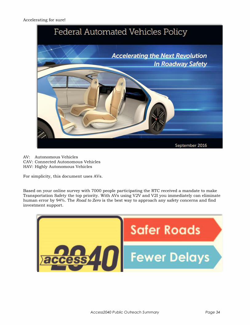
Accelerating for sure!
AV: Autonomous Vehicles
CAV: Connected Autonomous Vehicles HAV: Highly Autonomous Vehicles
For simplicity, this document uses AVs.
Based on your online survey with 7000 people participating the RTC received a mandate to make
Transportation Safety the top priority. With AVs using V2V and V2I you immediately can eliminate human error by 94%. The Road to Zero is the best way to approach any safety concerns and find
investment support.
Access2040 Public Outreach Summary Page 34
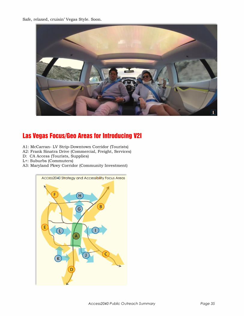
Safe, relaxed, cruisin’ Vegas Style. Soon.
Las Vegas Focus/Geo Areas for Introducing V2I
A1: McCarran- LV Strip-Downtown Corridor (Tourists)
A2: Frank Sinatra Drive (Commercial, Freight, Services) D: CA Access (Tourists, Supplies)
L+: Suburbs (Commuters)
A3: Maryland Pkwy Corridor (Community Investment)
Access2040 Public Outreach Summary Page 35

How will Las Vegas have to adapt for AVs?
Access2040 Public Outreach Summary Page 36
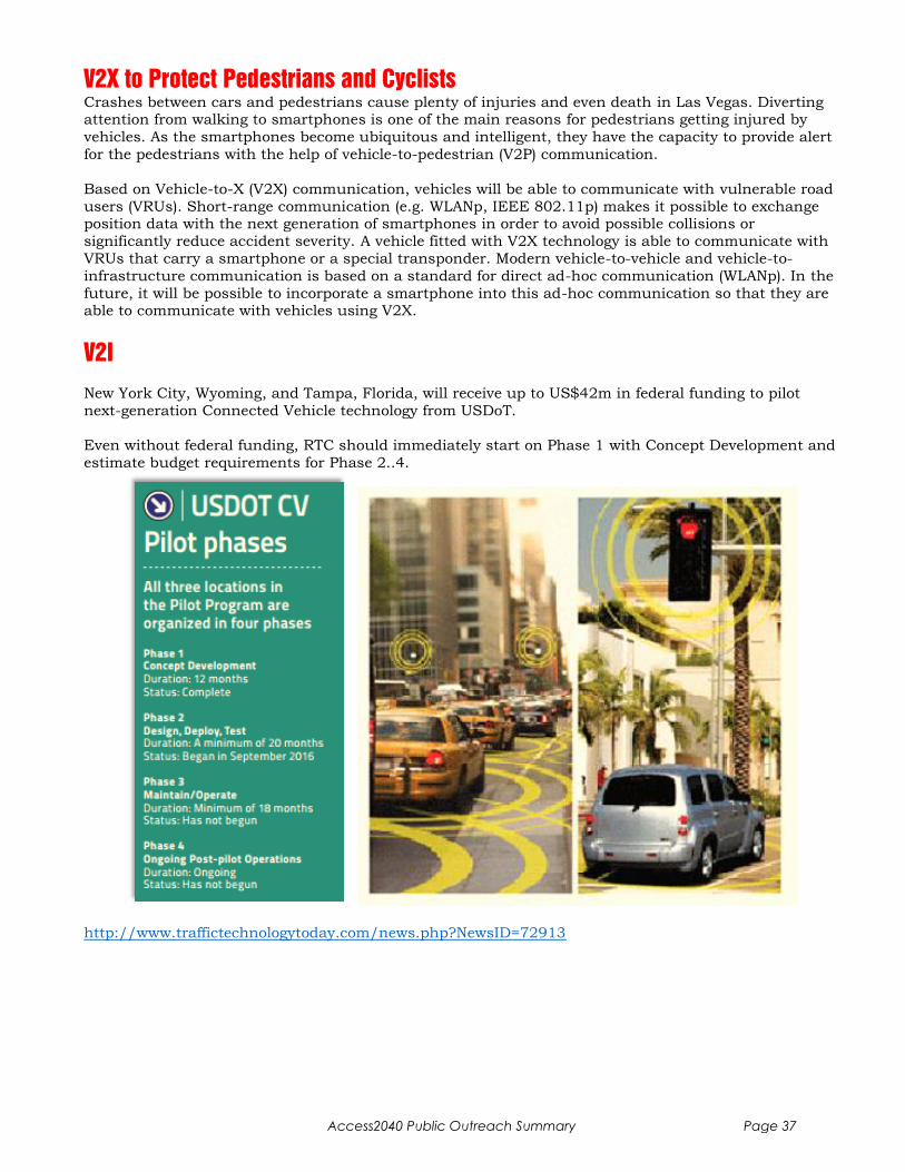
V2X to Protect Pedestrians and Cyclists
Crashes between cars and pedestrians cause plenty of injuries and even death in Las Vegas. Diverting attention from walking to smartphones is one of the main reasons for pedestrians getting injured by
vehicles. As the smartphones become ubiquitous and intelligent, they have the capacity to provide alert
for the pedestrians with the help of vehicle-to-pedestrian (V2P) communication.
Based on Vehicle-to-X (V2X) communication, vehicles will be able to communicate with vulnerable road
users (VRUs). Short-range communication (e.g. WLANp, IEEE 802.11p) makes it possible to exchange position data with the next generation of smartphones in order to avoid possible collisions or
significantly reduce accident severity. A vehicle fitted with V2X technology is able to communicate with
VRUs that carry a smartphone or a special transponder. Modern vehicle-to-vehicle and vehicle-to-
infrastructure communication is based on a standard for direct ad-hoc communication (WLANp). In the
future, it will be possible to incorporate a smartphone into this ad-hoc communication so that they are able to communicate with vehicles using V2X.
V2I
New York City, Wyoming, and Tampa, Florida, will receive up to US$42m in federal funding to pilot
next-generation Connected Vehicle technology from USDoT.
Even without federal funding, RTC should immediately start on Phase 1 with Concept Development and
estimate budget requirements for Phase 2..4.
http://www.traffictechnologytoday.com/news.php?NewsID=72913
Access2040 Public Outreach Summary Page 37
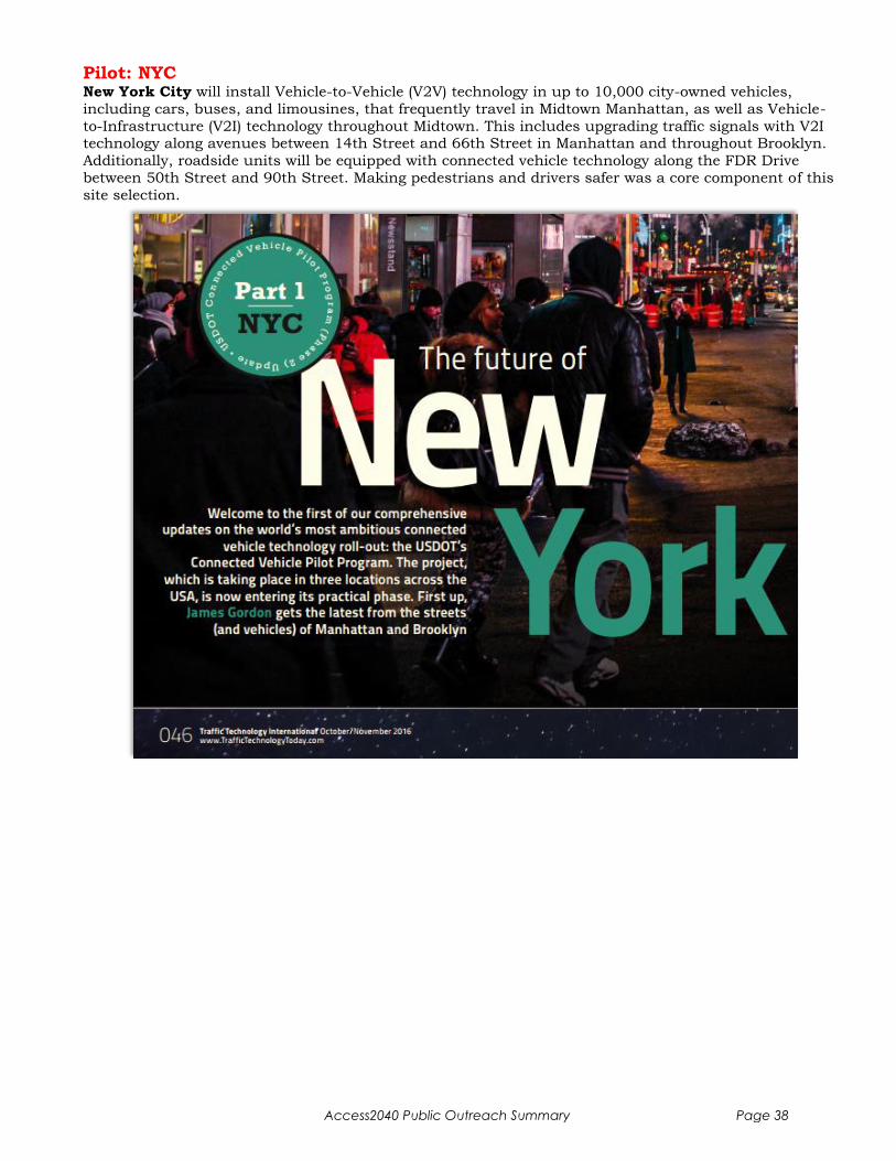
Pilot: NYC New York City will install Vehicle-to-Vehicle (V2V) technology in up to 10,000 city-owned vehicles,
including cars, buses, and limousines, that frequently travel in Midtown Manhattan, as well as Vehicle-
to-Infrastructure (V2I) technology throughout Midtown. This includes upgrading traffic signals with V2I technology along avenues between 14th Street and 66th Street in Manhattan and throughout Brooklyn.
Additionally, roadside units will be equipped with connected vehicle technology along the FDR Drive
between 50th Street and 90th Street. Making pedestrians and drivers safer was a core component of this
site selection.
Access2040 Public Outreach Summary Page 38
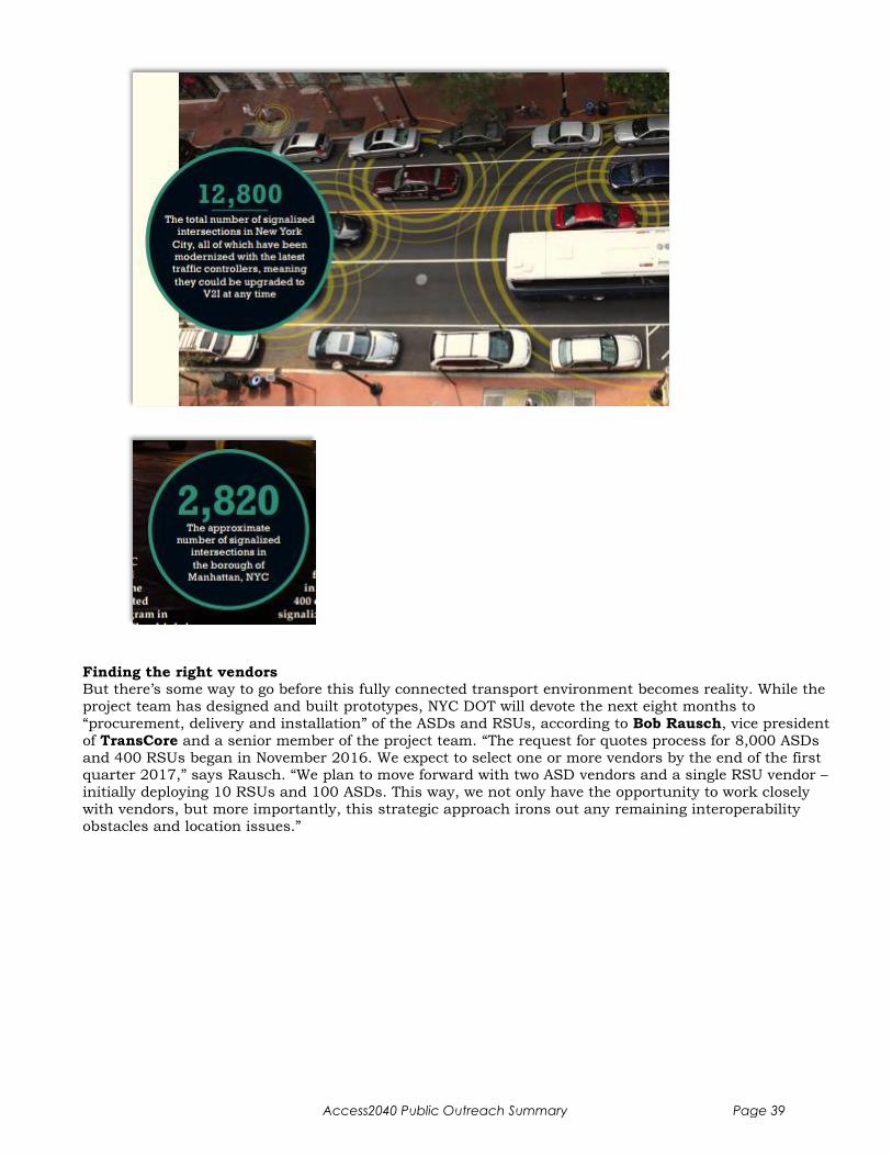
Finding the right vendors But there’s some way to go before this fully connected transport environment becomes reality. While the
project team has designed and built prototypes, NYC DOT will devote the next eight months to
“procurement, delivery and installation” of the ASDs and RSUs, according to Bob Rausch, vice president
of TransCore and a senior member of the project team. “The request for quotes process for 8,000 ASDs
and 400 RSUs began in November 2016. We expect to select one or more vendors by the end of the first quarter 2017,” says Rausch. “We plan to move forward with two ASD vendors and a single RSU vendor –
initially deploying 10 RSUs and 100 ASDs. This way, we not only have the opportunity to work closely
with vendors, but more importantly, this strategic approach irons out any remaining interoperability
obstacles and location issues.”
Access2040 Public Outreach Summary Page 39
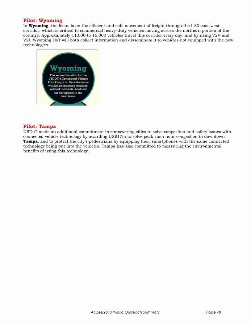
Pilot: Wyoming In Wyoming, the focus is on the efficient and safe movement of freight through the I-80 east-west
corridor, which is critical to commercial heavy-duty vehicles moving across the northern portion of the
country. Approximately 11,000 to 16,000 vehicles travel this corridor every day, and by using V2V and V2I, Wyoming DoT will both collect information and disseminate it to vehicles not equipped with the new
technologies.
Pilot: Tampa USDoT made an additional commitment to empowering cities to solve congestion and safety issues with connected vehicle technology by awarding US$17m to solve peak rush hour congestion in downtown
Tampa, and to protect the city’s pedestrians by equipping their smartphones with the same connected
technology being put into the vehicles. Tampa has also committed to measuring the environmental
benefits of using this technology.
Access2040 Public Outreach Summary Page 40

Pilot: Columbus, OH
Access2040 Public Outreach Summary Page 41

RSU Vendor Example: NXP Semiconductor At CES 2017 searching for V2I technology, I had a lengthy conversation with NXP about Intelligent
Roadside Units (RSUs). They recommend 2 RSU’s per intersection, one each N-S and E-W direction. We
discussed how to secure school zones and came to the conclusion to put a RSU instead onto each school bus. Probably the same applies to First Responder Units. Also mobile RSUs for roadside working
crews. You get the drift…
Your ITS vendor hopefully knows best
http://www.nxp.com/pages/roadlink:ROADLINK-TECH?fsrch=1&sr=2&pageNum=1
Access2040 Public Outreach Summary Page 42

http://www.nxp.com/applications/solutions-for-the-iot-and-adas/automotive/adas-autonomous-driving/intelligent-roadside-unit:INTELLIGENTRSU
Access2040 Public Outreach Summary Page 43
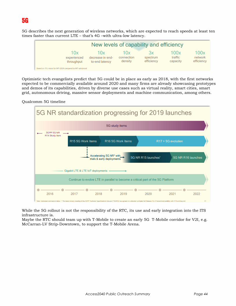
5G
5G describes the next generation of wireless networks, which are expected to reach speeds at least ten
times faster than current LTE – that’s 4G –with ultra-low latency.
Optimistic tech evangelists predict that 5G could be in place as early as 2018, with the first networks
expected to be commercially available around 2020 and many firms are already showcasing prototypes
and demos of its capabilities, driven by diverse use cases such as virtual reality, smart cities, smart
grid, autonomous driving, massive sensor deployments and machine communication, among others.
Qualcomm 5G timeline
While the 5G rollout is not the responsibility of the RTC, its use and early integration into the ITS
infrastructure is.
Maybe the RTC should team up with T-Mobile to create an early 5G T-Mobile corridor for V2I, e.g.
McCarran-LV Strip-Downtown, to support the T-Mobile Arena.
Access2040 Public Outreach Summary Page 44
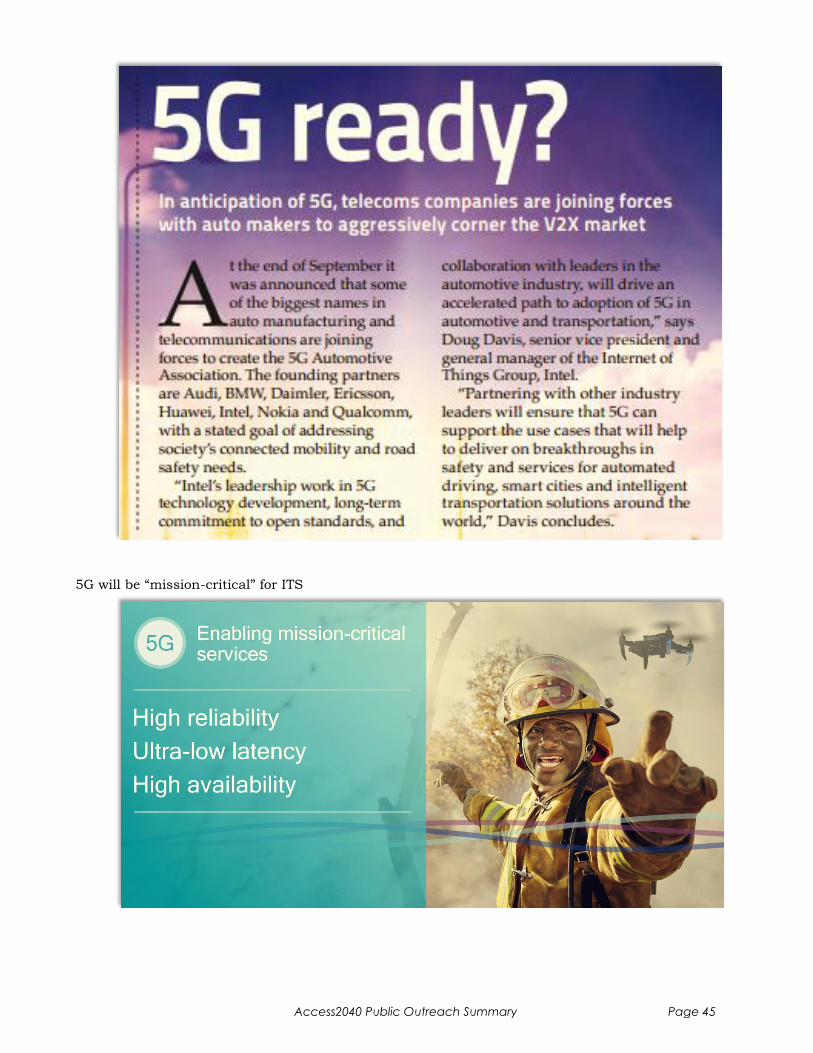
5G will be “mission-critical” for ITS
Access2040 Public Outreach Summary Page 45
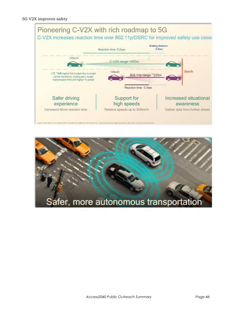
5G V2X improves safety
Access2040 Public Outreach Summary Page 46
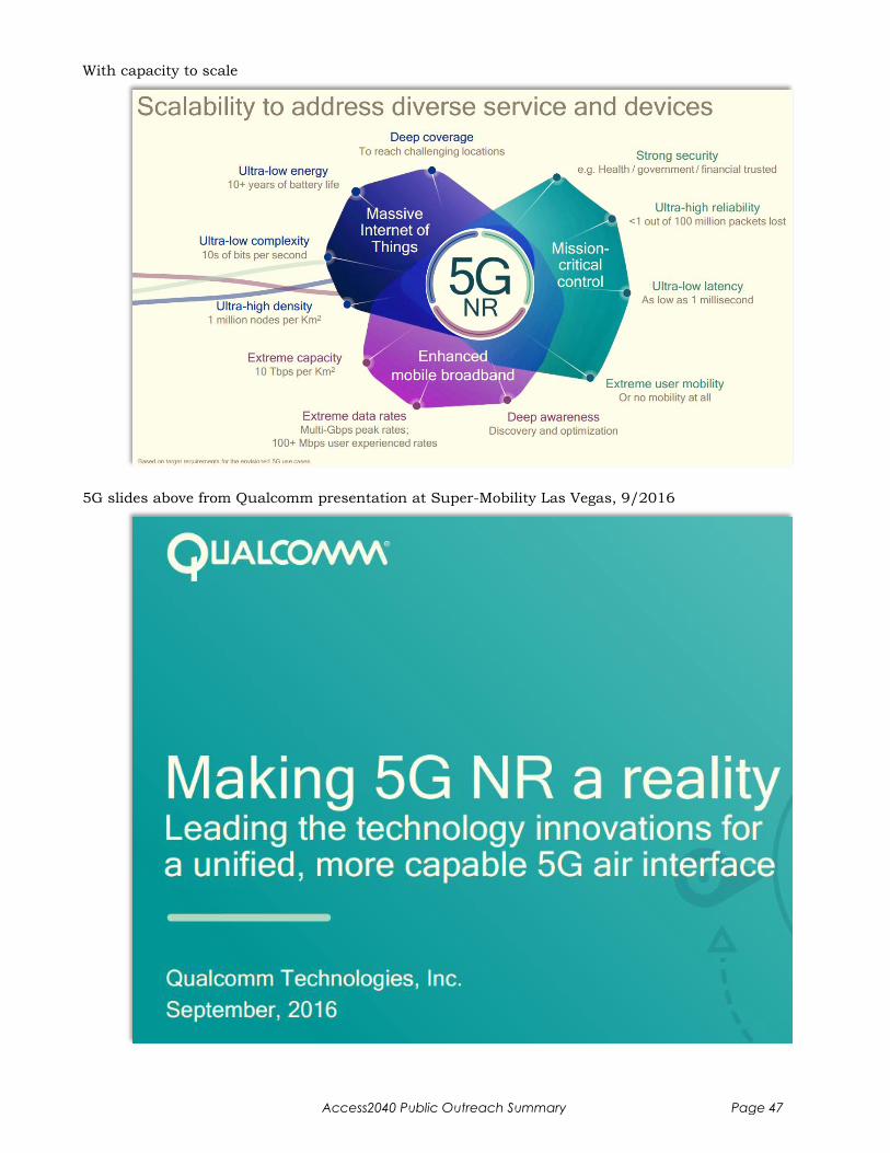
With capacity to scale
5G slides above from Qualcomm presentation at Super-Mobility Las Vegas, 9/2016
Access2040 Public Outreach Summary Page 47
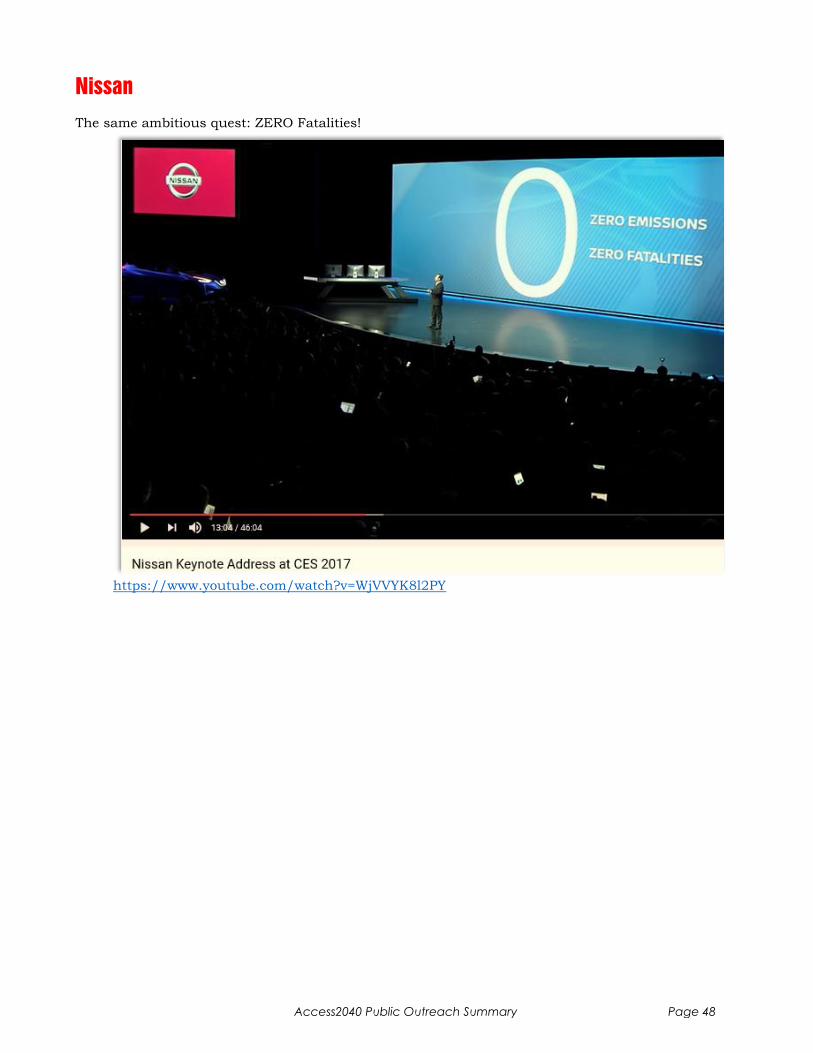
Nissan
The same ambitious quest: ZERO Fatalities!
https://www.youtube.com/watch?v=WjVVYK8l2PY
Access2040 Public Outreach Summary Page 48
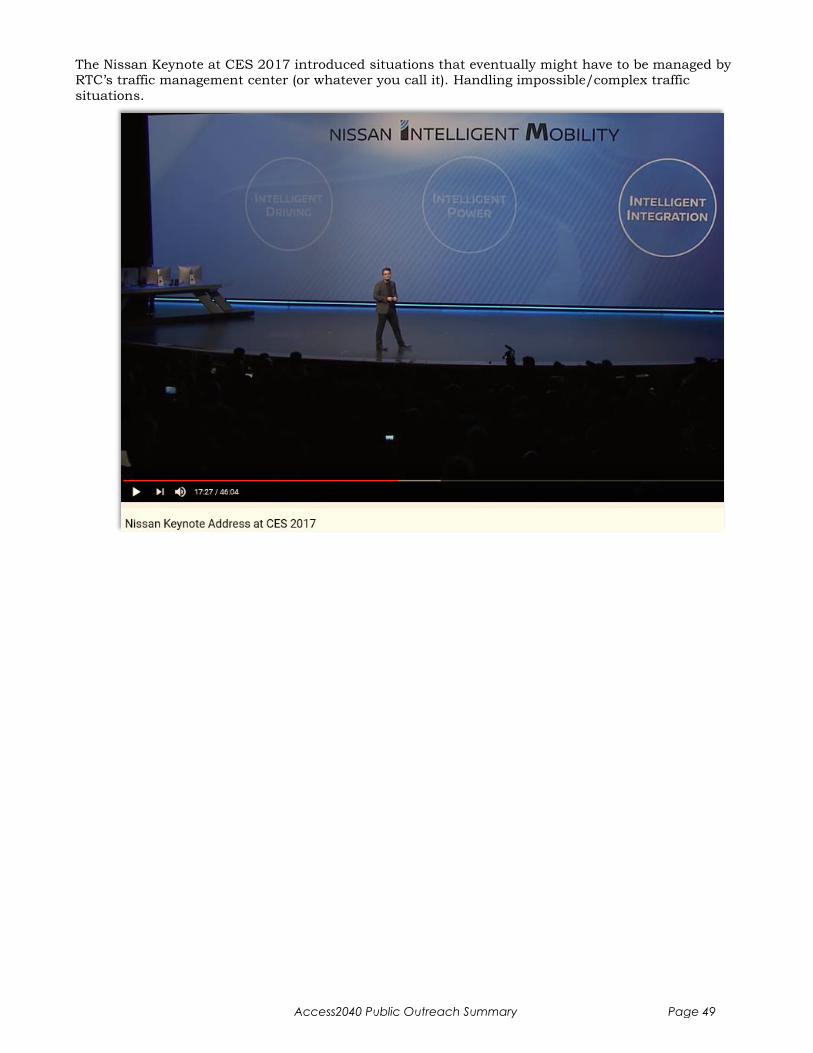
The Nissan Keynote at CES 2017 introduced situations that eventually might have to be managed by RTC’s traffic management center (or whatever you call it). Handling impossible/complex traffic
situations.
Access2040 Public Outreach Summary Page 49

Example: Blocking Truck & Double Yellow Line (AV won’t cross double line)
Example: Manually waved through Red Light
Access2040 Public Outreach Summary Page 50
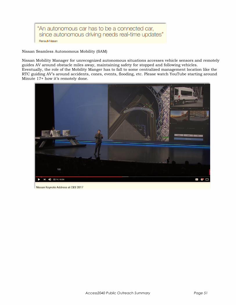
Nissan Seamless Autonomous Mobility (SAM)
Nissan Mobility Manager for unrecognized autonomous situations accesses vehicle sensors and remotely
guides AV around obstacle miles away, maintaining safety for stopped and following vehicles.
Eventually, the role of the Mobility Manger has to fall to some centralized management location like the
RTC guiding AV’s around accidents, cones, events, flooding, etc. Please watch YouTube starting around
Minute 17+ how it’s remotely done.
Access2040 Public Outreach Summary Page 51
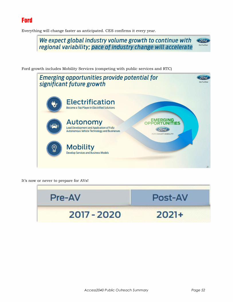
Ford
Everything will change faster as anticipated. CES confirms it every year.
Ford growth includes Mobility Services (competing with public services and RTC)
It’s now or never to prepare for AVs!
Access2040 Public Outreach Summary Page 52
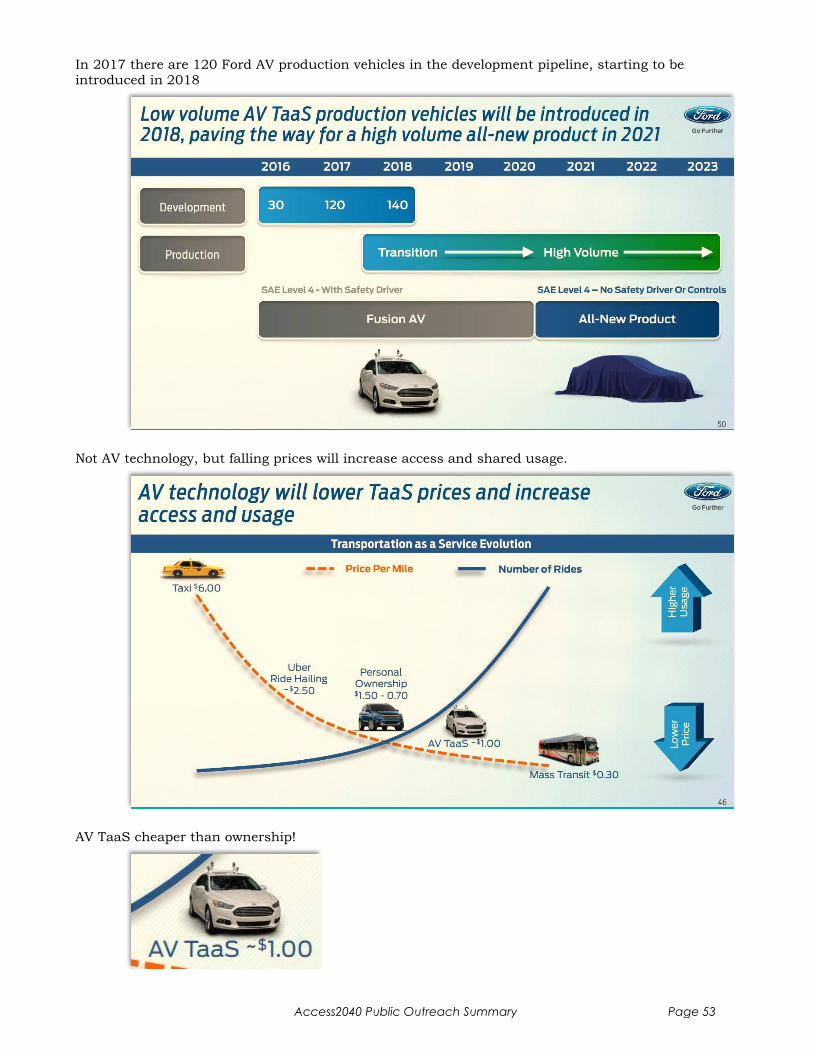
In 2017 there are 120 Ford AV production vehicles in the development pipeline, starting to be introduced in 2018
Not AV technology, but falling prices will increase access and shared usage.
AV TaaS cheaper than ownership!
Access2040 Public Outreach Summary Page 53

Ford will PLAY and WIN - with Dynamic Shuttle Services!
Ford will offer City Solutions
Access2040 Public Outreach Summary Page 54
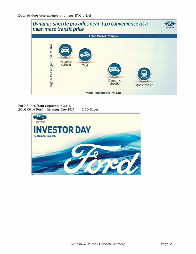
Door-to-door convenience at a near-RTC price!
Ford Slides from September 2016
2016 0914 Ford - Investor-Day.PDF (130 Pages)
Access2040 Public Outreach Summary Page 55
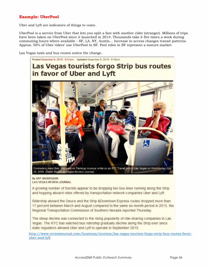
Example: UberPool
Uber and Lyft are indicators of things to come.
UberPool is a service from Uber that lets you split a fare with another rider (stranger). Millions of trips
have been taken on UberPool since it launched in 2014. Thousands take it five times a week during
commuting hours where available - SF, LA, NY, Austin… Increase in access changes transit patterns.
Approx. 50% of Uber riders’ use UberPool in SF. Pool rides in SF represent a mature market.
Las Vegas taxis and bus routes notice the change.
http://www.reviewjournal.com/business/tourism/las-vegas-tourists-forgo-strip-bus-routes-favor-
uber-and-lyft
Access2040 Public Outreach Summary Page 56

Uber Example: Bellagio to Fremont St, 1/12 12:45pm
UberPool: $7..$10, pick up in 6 min
http://uberestimate.com/costs.php
With Uber, Lyft, Ford Shuttle and other services to come, it’s my opinion that the LV Strip will not
need any public transportation expansion, beyond a top notch V2I infrastructure between McCarran
and downtown.
With so many new mobility solutions in the development pipeline, eBuses, driverless shuttles, my
recommendation for MD Pkwy is to wait-and-see, before committing to a major investment like light-rail.
Therefore Maryland Parkway light-rail should not be a priority.
Access2040 Public Outreach Summary Page 57
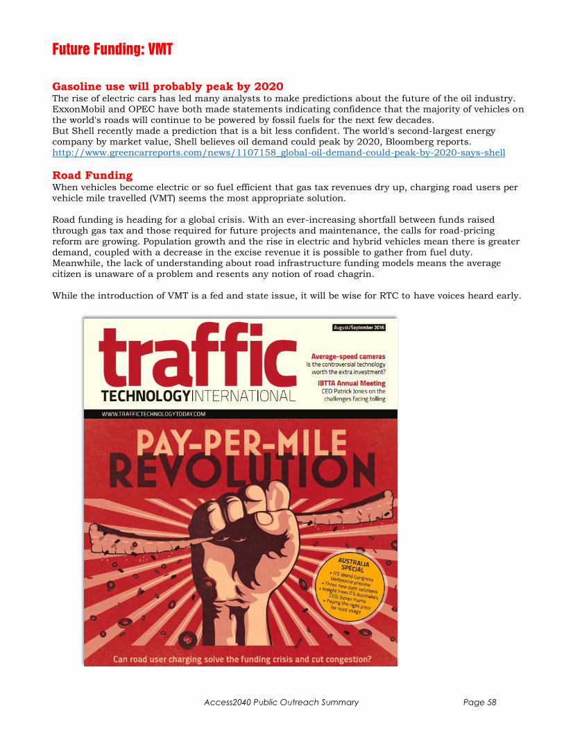
Future Funding: VMT
Gasoline use will probably peak by 2020 The rise of electric cars has led many analysts to make predictions about the future of the oil industry. ExxonMobil and OPEC have both made statements indicating confidence that the majority of vehicles on
the world's roads will continue to be powered by fossil fuels for the next few decades.
But Shell recently made a prediction that is a bit less confident. The world's second-largest energy
company by market value, Shell believes oil demand could peak by 2020, Bloomberg reports.
http://www.greencarreports.com/news/1107158_global-oil-demand-could-peak-by-2020-says-shell
Road Funding When vehicles become electric or so fuel efficient that gas tax revenues dry up, charging road users per
vehicle mile travelled (VMT) seems the most appropriate solution.
Road funding is heading for a global crisis. With an ever-increasing shortfall between funds raised
through gas tax and those required for future projects and maintenance, the calls for road-pricing
reform are growing. Population growth and the rise in electric and hybrid vehicles mean there is greater
demand, coupled with a decrease in the excise revenue it is possible to gather from fuel duty. Meanwhile, the lack of understanding about road infrastructure funding models means the average
citizen is unaware of a problem and resents any notion of road chagrin.
While the introduction of VMT is a fed and state issue, it will be wise for RTC to have voices heard early.
Access2040 Public Outreach Summary Page 58

Timing
Chicken & Egg Problem Who will be first: Car or Infrastructure?
In most places cars will be first, but in the interest of economic development (Steve Hill), Las Vegas together with CES should be a trailblazer for V2I infrastructure and demonstrate to the annual CES
world audience and 6500 journalists how smart city infrastructure development is being done.
SmartCity Las Vegas - How Soon a CES Trendsetter? At CES 2017, I recommended a Las Vegas V2I leadership role with the major car manufacturers like
Mercedes and found open ears. What I have not found is competent leadership in Las Vegas to carry
the flag, get everyone on the same page, negotiate participation and make us a world class Smart City
with a ZERO fatality objective. It’s a multi-agency undertaking but with CES we are in a unique position to advance the state of technology year-by-year in January and save lives doing it. We should be leaders,
not followers. CES 2018 should have a Las Vegas Infrastructure conference track for all the visiting city
decision makers.
USDoT V2V Mandate Citing an enormous potential to reduce crashes on U.S. roadways, the USDoT issued a proposed rule
12/13/2016 that would advance the deployment of connected vehicle technologies throughout the U.S.
light vehicle fleet. The Notice of Proposed Rulemaking would enable vehicle-to-vehicle (V2V) communication technology on all new light-duty vehicles, enabling a multitude of new crash-avoidance
applications that, once fully deployed, could prevent hundreds of thousands of crashes every year by
helping vehicles “talk” to each other.
Separately, the Department’s Federal Highway Administration plans to soon issue guidance for Vehicle-to-Infrastructure (V2I) communications, which will help transportation planners integrate the
technologies to allow vehicles to “talk” to roadway infrastructure such as traffic lights, stop signs and
work zones to improve mobility, reduce congestion and improve safety.
NHTSA estimates that safety applications enabled by V2V and V2I could eliminate or mitigate the
severity of up to 80 percent of non-impaired crashes, including crashes at intersections or while changing lanes.
For the first two years (2017, 2018), car OEMs don’t have to do anything.
By Year 3 (2019), 50% of the fleet needs V2V.
By Year 4 (2020), 75% does.
By Year 5 (2021), it’s all V2V or nothing.
So at least by 2021 every new car has V2V. Crashes should start trickling off after that, if not sooner.
Based on the NHTSA’s scenario, 80% of crashes are gone by 2029, assuming RTC’s V2I rolls out as
aggressively - depending on how high-tech the RTC infrastructure will be. The earlier we implement V2I the more Las Vegas lives we safe. Based on CES indicators car OEMs will introduce V2V and V2I
technology sooner. Even without self-driving cars Advanced Driver Assistance Systems (ADAS) will
change the collision repair ecosystem within 3 years (2019).
https://www.nhtsa.gov/press-releases/us-dot-advances-deployment-connected-vehicle-technology-
prevent-hundreds-thousands
Access2040 Public Outreach Summary Page 59
Timeline Summary
It’s impossible to predict what will happen the next five years. There are too many unknowns,
thousands of technology companies racing for progress. AVs will accelerate and introduced faster than we anticipate. By 2019 V2I should be ready in selected areas, saving lives.
2018 5G trials
2019 5G launch
V2V mandate for 50% of new cars
2020 Ford AV without Driver or Controls Gasoline use peaks
V2V mandate for 75% of new cars
2021 Ford High Volume AV Production
V2V mandate for 100% of new cars
Since everything happens within a 5 year timeframe it should be part of your Access 2040 Primary
Strategy!
About Karl H Battlogg
Senior Business Executive with over 40 years of corporate experience planning, developing and
executing policy impact, corporate growth, M&A and R&D strategies. Initiated, negotiated and closed
mergers, private equity, venture capital, and licensing transactions with a combined value exceeding $1 billion, completing over 200 deals in more than 20 countries throughout the world, in a wide range of
industries, including IT, aerospace, automotive, consumer, defense, industrial, media, and government
entities. Advising Fortune 100 Boards, as well as state and national governments.
Semi-Retired at Lake Las Vegas.
+1 (702) 518-8822
Mailing Address: 631 N Stephanie St #251, Henderson, NV 89014
Access2040 Public Outreach Summary Page 60