REGIONAL TRANSPORTATION PLAN - RTC Washoe
322
2050 REGIONAL TRANSPORTATION PLAN
-
Upload
khangminh22 -
Category
Documents
-
view
1 -
download
0
Transcript of REGIONAL TRANSPORTATION PLAN - RTC Washoe

2050
REGIONAL TRANSPORTATION PLAN


RTP TABLE OF CONTENTS
LETTER FROM THE EXECUTIVE DIRECTOR ....... 18
A SPECIAL THANK YOU ................................................ 19
EXECUTIVE SUMMARY ................................................22
PROGRAMMATIC INVESTMENTS .................................22
TRANSIT INVESTMENTS ................................................23
UNFUNDED VISION FOR TRANSIT ...............................24
Transit Service Vision .......................................................24CONCLUSION ...................................................................26
RESUMEN EJECUTIVO ..................................................27
INVERSIONES PROGRAMÁTICAS ................................28
VISIÓN SIN FONDOS PARA EL TRANSPORTE PÚBLICO ...........................................30
INVERSIONES PARA CALLES COMPLETAS ...............32
CONCLUSIÓN ...................................................................32
CHAPTER 1 – INTRODUCTION ..................................33
1.1 – ABOUT THE RTC ....................................................34
1.2 – TRANSPORTATION PLANNING FACTORS ........40
1.3 – GUIDING PRINCIPLES ...........................................43
1.4 – GOALS ......................................................................45
1.5 – 2013-2017 ACCOMPLISHMENTS ..........................47
CHAPTER 2 – COMMUNITY-BASED PLANNING .............................................49
2.1 – RTP AGENCY WORKING GROUPS ......................51
2.2 – RTC CITIZENS MULTIMODAL ADVISORY COMMITTEE ........................................51
2.3 – RTC TECHNICAL ADVISORY COMMITTEE .........51
2.4 – INTER-COUNTY WORKING GROUP .....................51
2.5 – COMMUNITY PLANNING WORKSHOPS .............53
Community Planning Workshop #2: ...............................53Community Planning Workshop #3: ...............................542.6 – COMMUNITY FORUMS ...........................................54
Washoe County School District ......................................54Sparks Industrial Forum ...................................................54Economic Development Forum ........................................55Downtown Reno Circulation Virtual Workshop ..............562.7 – COORDINATED HUMAN SERVICES
TRANSPORTATION PLAN (CTP) .........................56
2.8 – RTC BOARD OF COMMISSIONERS .....................56
2.9 – ELECTED OFFICIALS, BOARDS, & COMMISSIONS ........................................................56
3.0 – BROADCAST & DIGITAL MEDIA OUTREACH ....57
RTC Website ......................................................................57Online Surveys ..................................................................57Social Media .......................................................................57RTC eNews .........................................................................57MyRTC Email Updates ......................................................57Media Outreach..................................................................57The Road Ahead with RTC Segments .............................58News Releases...................................................................58
CHAPTER 3 – IMPROVING SAFETY .........................59
3.1 – VISION ZERO TRUCKEE MEADOWS ..................60
3.2 – SAFETY PLANNING ................................................61
Nevada SHSP .....................................................................61Complete Streets Master Plan ..........................................61
3.3 – COMMUNITY AWARENESS & EDUCATION ........62
Safe Routes to School ......................................................64RTC SMART TRIPS ............................................................64
3.4 – OPERATIONS ..........................................................65
Safe Transit Operations ....................................................65NV TIM ................................................................................66Emergency Management Plan..........................................66Washoe County Regional Resiliency Study ...................67
3.5 – SAFETY DESIGN IMPROVEMENTS .....................67
3.6 – RTP SAFETY PROJECTS ......................................70

CHAPTER 4 – INTEGRATING LAND-USE & ECONOMIC PROSPERITY ............71
Transit-Supportive Development .....................................72
4.1 – REGIONAL PLANNING ..........................................73
Reno Housing Authority ...................................................73Reno-Tahoe International Airport .....................................73Truckee Meadows Regional Planning Agency ...............74Washoe County Health District ........................................75Community Heath Improvement Plan ..............................76Washoe County School District .......................................76Washoe County Senior Services .....................................79Truckee River Flood Management Project ......................79Floodplain Management ...................................................79
4.2 – LOCAL GOVERNMENT PLANNING .....................79
City of Reno .......................................................................80City of Sparks ....................................................................81Washoe County .................................................................814.3 – TRIBAL GOVERNMENTS ......................................82
Pyramid Lake Paiute Tribe (PLPT) ..................................82Reno-Sparks Indian Colony (RSIC) ..................................834.4 – OTHER REGIONAL PARTNERS ...........................83
Nevada Governor’s Office of Economic Development ...................................................83Nevada Center for Advanced Mobility .............................85

University of Nevada, Reno (UNR) ...................................854.5 – TRAVEL & TOURISM ..............................................86
4.6 – RTP PROJECTS SUPPORTING LAND-USE PLANS ..................................................88
CHAPTER 5 – HEALTHY COMMUNITIES & SUSTAINABILITY ............................89
5.1 – SUSTAINABILITY ....................................................90
RTC Sustainability Plan ....................................................90RTC Facilities and Vehicles ..............................................90APTA Sustainability Commitment ....................................91Nevada State Climate Strategy.........................................91Nevada Climate Action ......................................................91
5.2 – AIR QUALITY .........................................................92
5.3 – ACTIVE LIVING & COMMUNITY DESIGN ............95
2018-2020 Community Health Improvement Plan (CHP) ..........................................................................95Washoe County Senior Services .....................................95Safe Routes to School ......................................................96Food Deserts and Transit Access ....................................96Chronic Disease Prevention .............................................98
5.4 – NATURAL RESOURCES ........................................98
Washoe County Open Space and Natural Resource Plan .....................................................98Bureau of Land Management Nevada .............................99
Southern Washoe County Urban Interface Plan ...........100US Forest Service ............................................................100Lake Tahoe Basin Management Unit Land Resource Management Plan (LTBMU) ...........................100Humboldt-Toiyabe National Forest Climate Change Vulnerability Report ..........................................102Department of Conservation and Natural Resources: Nevada State Parks.....................................102State of Nevada Division of Water Resources ..............102Washoe County Protected Species ...............................103
5.5 – RESILIENCY & STORMWATER MANAGEMENT .....................................................104
Truckee River Flood Project ...........................................105
CHAPTER 6 – MANAGING EXISTING SYSTEMS EFFICIENTLY .................. 107
6.1 – TRAFFIC OPERATIONS .......................................108
6.2 – PAVEMENT PRESERVATION ...............................112
6.3 – TRANSIT OPERATIONS .......................................115
CHAPTER 7 – INTEGRATING ALL TYPES OF TRANSPORTATION ...........................119
7.1 – COMPLETE STREETS ..........................................120
Major Projects ..................................................................1217.2 – WALKING & BIKING ..............................................122
Vision Zero Truckee Meadows Task Force ...................122
The Bicycle Pedestrian Plan and ADA Transition Plan .................................................123Bus Stop Improvement and Connectivity Program .....123Spot Improvements .........................................................123Bicycle Friendly America ................................................1247.3 – TRANSIT .................................................................125
The SRTP ..........................................................................125RTC RAPID Expansion ....................................................126RTC to Have 80% Alternative-Fuel Transit Fleet in 2021 ...............................................................126Maintenance Facility Infrastructure ...............................127RTC ACCESS ...................................................................129RTC FlexRIDE ..................................................................129Supplemental Mobility Services.....................................130CTP ...................................................................................130Not-for-Profit Partnerships .............................................130Washoe Senior Ride/Taxi Bucks ....................................131RTC SMART TRIPS ..........................................................131RTC VANPOOL Program .................................................131RTC REGIONAL CONNECTOR .......................................132Privately Operated Intercity Bus Service ......................132Token Transit – Smart Phone Fare Payment .................132Joint Development Through the Federal Transit Administration Program .....................................132Park and Ride Facilities ..................................................133Unfunded Vision for Transit ...........................................134
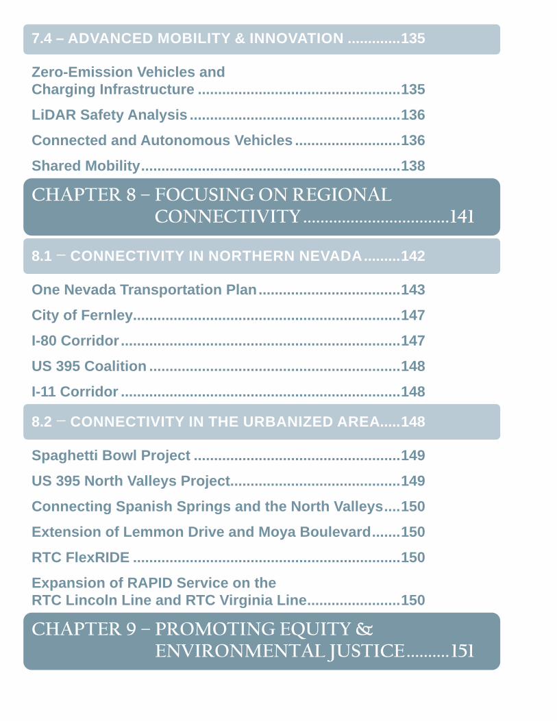
7.4 – ADVANCED MOBILITY & INNOVATION .............135
Zero-Emission Vehicles and Charging Infrastructure ..................................................135LiDAR Safety Analysis ....................................................136Connected and Autonomous Vehicles ..........................136Shared Mobility ................................................................138
CHAPTER 8 – FOCUSING ON REGIONAL CONNECTIVITY ..................................141
8.1 – CONNECTIVITY IN NORTHERN NEVADA .........142
One Nevada Transportation Plan ...................................143City of Fernley..................................................................147I-80 Corridor .....................................................................147US 395 Coalition ..............................................................148I-11 Corridor .....................................................................148
8.2 – CONNECTIVITY IN THE URBANIZED AREA .....148
Spaghetti Bowl Project ...................................................149US 395 North Valleys Project..........................................149Connecting Spanish Springs and the North Valleys ....150Extension of Lemmon Drive and Moya Boulevard .......150RTC FlexRIDE ..................................................................150Expansion of RAPID Service on the RTC Lincoln Line and RTC Virginia Line .......................150
CHAPTER 9 – PROMOTING EQUITY & ENVIRONMENTAL JUSTICE .......... 151
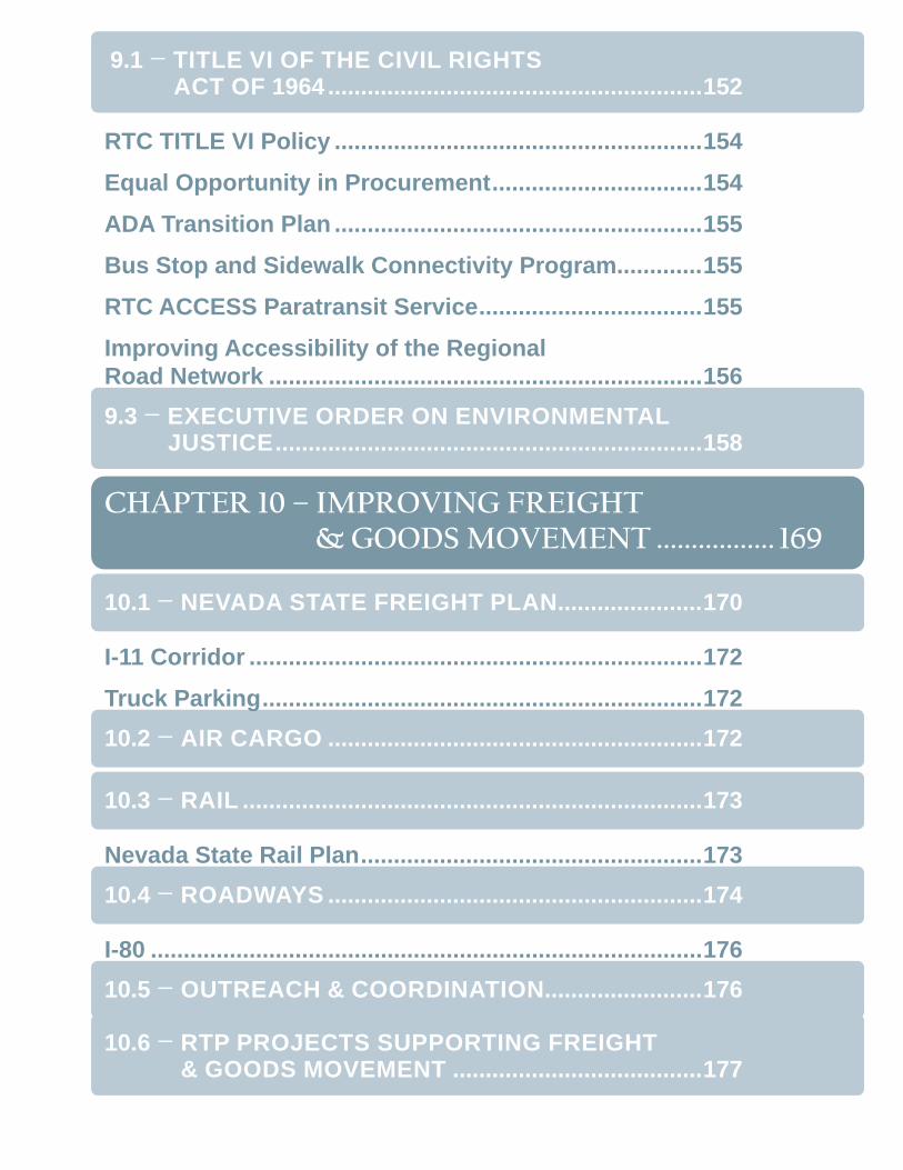
9.1 – TITLE VI OF THE CIVIL RIGHTS ACT OF 1964 .........................................................152
RTC TITLE VI Policy ........................................................154Equal Opportunity in Procurement ................................154ADA Transition Plan ........................................................155Bus Stop and Sidewalk Connectivity Program.............155RTC ACCESS Paratransit Service ..................................155Improving Accessibility of the Regional Road Network ..................................................................1569.3 – EXECUTIVE ORDER ON ENVIRONMENTAL
JUSTICE .................................................................158
CHAPTER 10 – IMPROVING FREIGHT & GOODS MOVEMENT ................. 169
10.1 – NEVADA STATE FREIGHT PLAN ......................170
I-11 Corridor .....................................................................172Truck Parking ...................................................................17210.2 – AIR CARGO .........................................................172
10.3 – RAIL ......................................................................173
Nevada State Rail Plan ....................................................17310.4 – ROADWAYS .........................................................174
I-80 ....................................................................................17610.5 – OUTREACH & COORDINATION........................176
10.6 – RTP PROJECTS SUPPORTING FREIGHT & GOODS MOVEMENT ......................................177
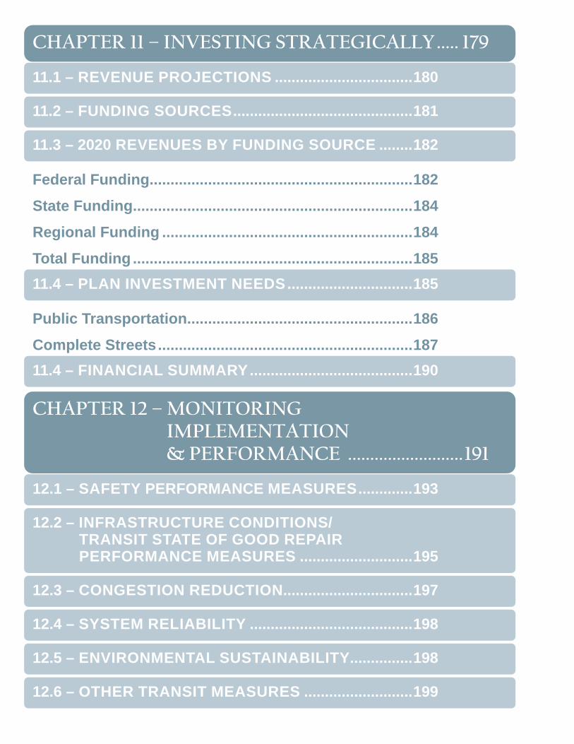
CHAPTER 11 – INVESTING STRATEGICALLY ..... 179
11.1 – REVENUE PROJECTIONS .................................180
11.2 – FUNDING SOURCES ...........................................181
11.3 – 2020 REVENUES BY FUNDING SOURCE ........182
Federal Funding ...............................................................182State Funding ...................................................................184Regional Funding ............................................................184Total Funding ...................................................................18511.4 – PLAN INVESTMENT NEEDS ..............................185
Public Transportation ......................................................186Complete Streets .............................................................18711.4 – FINANCIAL SUMMARY .......................................190
CHAPTER 12 – MONITORING IMPLEMENTATION & PERFORMANCE ..........................191
12.1 – SAFETY PERFORMANCE MEASURES .............193
12.2 – INFRASTRUCTURE CONDITIONS/ TRANSIT STATE OF GOOD REPAIR PERFORMANCE MEASURES ...........................195
12.3 – CONGESTION REDUCTION...............................197
12.4 – SYSTEM RELIABILITY .......................................198
12.5 – ENVIRONMENTAL SUSTAINABILITY ...............198
12.6 – OTHER TRANSIT MEASURES ..........................199

Safety ................................................................................200 Infrastructure Condition/Transit State of Good Repair .................................................................202Congestion Reduction ....................................................203System Reliability ............................................................204Environmental Sustainability .........................................204
APPENDIX A – COMPLETE STREETS PROJECT LISTING ...........................207
APPENDIX B – CONGESTION MANAGEMENT PROCESS .............................................232
1. CONGESTION MANAGEMENT OBJECTIVES ........232
2. IDENTIFY AREA OF APPLICATION .........................233
3. DEFINE SYSTEM OR NETWORK OF INTEREST ...233
4. DEVELOP PERFORMANCE MEASURES................237
5. INSTITUTE SYSTEM PERFORMANCE MONITORING PLAN ...................................................238
6. IDENTIFY & EVALUATE STRATEGIES ....................239
7. IMPLEMENT SELECTED STRATEGIES & MANAGE TRANSPORTATION SYSTEM ..............240
Evaluation Criteria for Projects on Existing Regional Roads ...............................................................241Evaluation Criteria for New Road Construction ...........241Methodology ....................................................................241Criteria for New Road Construction ..............................243
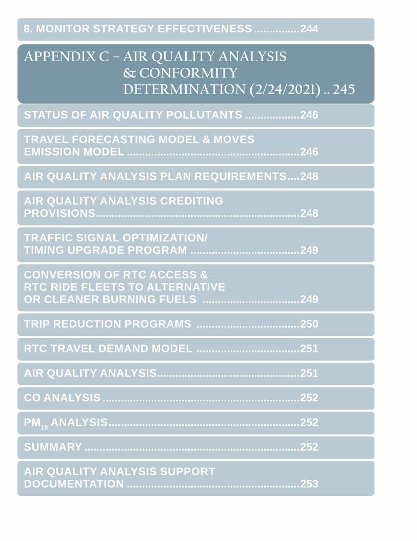
8. MONITOR STRATEGY EFFECTIVENESS ...............244
APPENDIX C – AIR QUALITY ANALYSIS & CONFORMITY DETERMINATION (2/24/2021) .. 245
STATUS OF AIR QUALITY POLLUTANTS ..................246
TRAVEL FORECASTING MODEL & MOVES EMISSION MODEL .........................................................246
AIR QUALITY ANALYSIS PLAN REQUIREMENTS ....248
AIR QUALITY ANALYSIS CREDITING PROVISIONS ...................................................................248
TRAFFIC SIGNAL OPTIMIZATION/ TIMING UPGRADE PROGRAM ....................................249
CONVERSION OF RTC ACCESS & RTC RIDE FLEETS TO ALTERNATIVE OR CLEANER BURNING FUELS ................................249
TRIP REDUCTION PROGRAMS ..................................250
RTC TRAVEL DEMAND MODEL ..................................251
AIR QUALITY ANALYSIS ...............................................251
CO ANALYSIS .................................................................252
PM10 ANALYSIS ...............................................................252
SUMMARY .......................................................................252
AIR QUALITY ANALYSIS SUPPORT DOCUMENTATION .........................................................253
APPENDIX D – ACCESS MANAGEMENT ............ 259
APPENDIX E – TECHNICAL DOCUMENTATION FOR THE POPULATION/ EMPLOYMENT & TRAVEL DEMAND MODELS & LEVEL OF SERVICE STANDARDS ...........278
POPULATION & EMPLOYMENT MODEL ....................278
TRAVEL DEMAND MODEL ............................................279
Level of Service ...............................................................282
APPENDIX F – REVENUE ASSUMPTIONS .......... 285
ASSUMPTIONS ...............................................................285
FUNDING SOURCES ......................................................286
The FAST Act ...................................................................286Indexing ............................................................................287RRIF ..................................................................................287FINANCIAL ASSUMPTIONS – REVENUE SOURCES .....................................................287
Street and Highway Revenue .........................................287Public Transportation Revenue......................................289Federal Funding Sources ............................................................289State Revenue ..................................................................290Regional Revenue ...........................................................290Sales and Use Tax ........................................................................290Other Revenue Sources ...............................................................290
APPENDIX G – DOWNTOWN RENO CIRCULATION STUDY .................. 291
Introduction ......................................................................291COMMUNITY ENGAGEMENT .......................................291
EXISTING CONDITIONS & NEEDS ASSESSMENT ................................................................292
Downtown Reno Action Plan ..........................................292Planned Development .....................................................292Traffic Analysis ................................................................293Parking .............................................................................301NEXT STEPS ...................................................................301
APPENDIX H – SPARKS INDUSTRIAL STUDY ... 302
SPARKS INDUSTRIAL TRANSPORTATION STUDY ....................................................................... 302
Introduction ......................................................................302Community Engagement ................................................302Existing Conditions and Needs Assessment ...............303Traffic and Safety Analysis .........................................................304Recommendations ..........................................................305
APPENDIX I – COMMON TRANSPORTATION PLANNING ACRONYMS ...............308
ACRONYMS.....................................................................308

APPENDIX J – RTC ORGANIZATIONAL CHART ................................................... 312
APPENDIX K – COORDINATED HUMAN SERVICES PUBLIC TRANSPORTATION PLAN EXECUTIVE SUMMARY ................ 313
18 ] 2050 RTP
LETTER FROM THE EXECUTIVE DIRECTOR
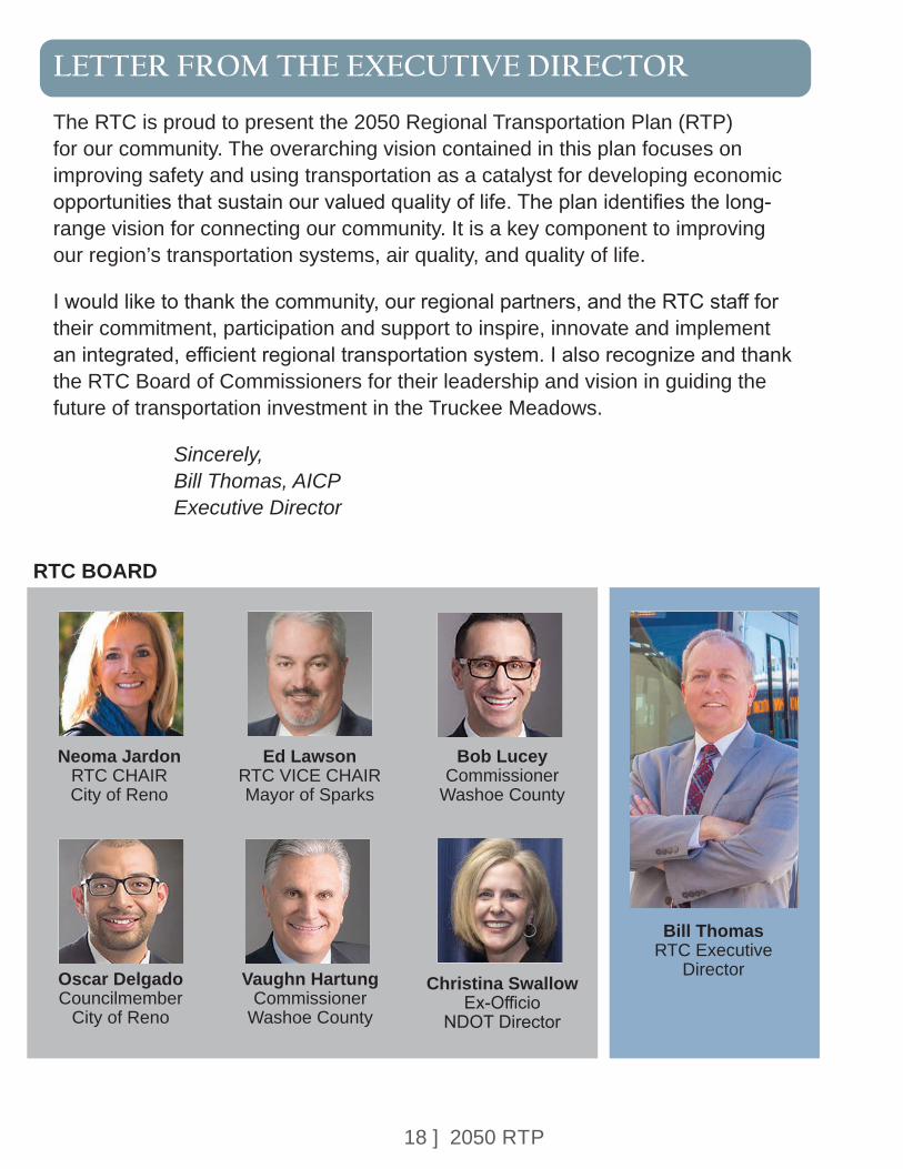
The RTC is proud to present the 2050 Regional Transportation Plan (RTP) for our community. The overarching vision contained in this plan focuses on improving safety and using transportation as a catalyst for developing economic opportunities that sustain our valued quality of life. The plan identifies the long-range vision for connecting our community. It is a key component to improving our region’s transportation systems, air quality, and quality of life.
I would like to thank the community, our regional partners, and the RTC staff for their commitment, participation and support to inspire, innovate and implement an integrated, efficient regional transportation system. I also recognize and thank the RTC Board of Commissioners for their leadership and vision in guiding the future of transportation investment in the Truckee Meadows.
Sincerely, Bill Thomas, AICP Executive Director
Bill Thomas RTC Executive
Director
Neoma Jardon RTC CHAIR City of Reno
Oscar Delgado Councilmember
City of Reno
Ed Lawson RTC VICE CHAIR Mayor of Sparks
Vaughn Hartung Commissioner
Washoe County
Bob Lucey Commissioner
Washoe County
Christina Swallow Ex-Officio
NDOT Director
RTC BOARD
19 ] 2050 RTP
A SPECIAL THANK YOU
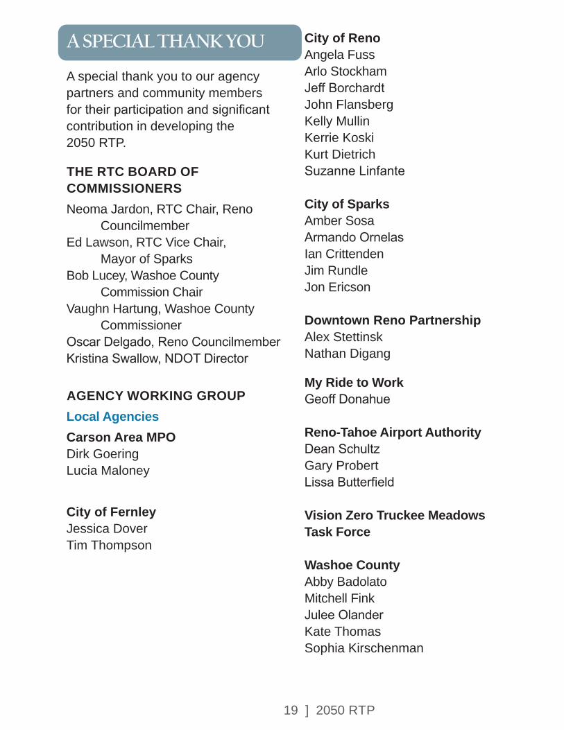
A special thank you to our agency partners and community members for their participation and significant contribution in developing the 2050 RTP.
THE RTC BOARD OF COMMISSIONERS Neoma Jardon, RTC Chair, Reno Councilmember Ed Lawson, RTC Vice Chair, Mayor of Sparks Bob Lucey, Washoe County Commission Chair Vaughn Hartung, Washoe County Commissioner Oscar Delgado, Reno Councilmember Kristina Swallow, NDOT Director
AGENCY WORKING GROUPLocal AgenciesCarson Area MPO Dirk Goering Lucia Maloney
City of Fernley Jessica Dover Tim Thompson
City of Reno Angela Fuss Arlo StockhamJeff BorchardtJohn FlansbergKelly MullinKerrie KoskiKurt DietrichSuzanne Linfante
City of SparksAmber SosaArmando OrnelasIan CrittendenJim RundleJon Ericson Downtown Reno Partnership Alex Stettinsk Nathan Digang
My Ride to Work Geoff Donahue
Reno-Tahoe Airport AuthorityDean SchultzGary ProbertLissa Butterfield
Vision Zero Truckee Meadows Task Force
Washoe CountyAbby Badolato Mitchell FinkJulee OlanderKate ThomasSophia Kirschenman
20 ] 2050 RTP
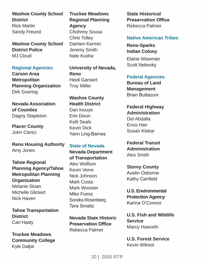
Washoe County School DistrictRick Martin Sandy Freund
Washoe County School District PoliceMJ Cloud Regional AgenciesCarson Area Metropolitan Planning OrganizationDirk Goering
Nevada Association of CountiesDagny Stapleton
Placer County John Clerici
Reno Housing AuthorityAmy Jones
Tahoe Regional Planning Agency/Tahoe Metropolitan Planning OrganizationMelanie SloanMichelle Glickert Nick Haven
Tahoe Transportation DistrictCarl Hasty
Truckee Meadows Community CollegeKyle Dalpe
Truckee Meadows Regional Planning AgencyChohnny Sousa Chris Tolley Damien Kermin Jeremy Smith Nate Kusha University of Nevada, RenoHeidi GansertTroy Miller
Washoe County Health District Dan Inouye Erin DixonKelli SealsKevin Dick Yann Ling-Barnes
State of NevadaNevada Department of TransportationAlex WolfsonKevin Verre Nick JohnsonMark CostaMark WoosterMike FuessSondra RosenbergTara Smaltz
Nevada State Historic Preservation OfficeRebecca Palmer
State Historical Preservation OfficeRebecca Palmer
Native American TribesReno-Sparks Indian Colony Elaine Wiseman Scott Nebesky
Federal AgenciesBureau of Land ManagementBrian Buttazoni
Federal Highway AdministrationDel AbdallaEnos HanSusan Klekar
Federal Transit AdministrationAlex Smith
Storey County Austin Osborne Kathy Canfield
U.S. Environmental Protection Agency Karina O’Connor
U.S. Fish and Wildlife ServiceMarcy Haworth
U.S. Forest Service Kevin Wilmot
21 ] 2050 RTP
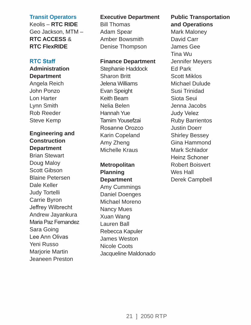
Transit OperatorsKeolis – RTC RIDEGeo Jackson, MTM – RTC ACCESS & RTC FlexRIDE
RTC StaffAdministration Department Angela Reich John Ponzo Lon Harter Lynn Smith Rob Reeder Steve Kemp
Engineering and Construction DepartmentBrian Stewart Doug Maloy Scott GibsonBlaine Petersen Dale KellerJudy Tortelli Carrie ByronJeffrey Wilbrecht Andrew Jayankura Maria Paz Fernandez Sara GoingLee Ann Olivas Yeni RussoMarjorie Martin Jeaneen Preston
Executive Department Bill Thomas Adam Spear Amber Bowsmith Denise Thompson
Finance DepartmentStephanie Haddock Sharon Britt Jelena WilliamsEvan SpeightKeith Beam Nelia BelenHannah YueTamim YousefzaiRosanne Orozco Karin Copeland Amy ZhengMichelle Kraus
Metropolitan Planning Department Amy Cummings Daniel Doenges Michael Moreno Nancy Mues Xuan Wang Lauren Ball Rebecca Kapuler James Weston Nicole Coots Jacqueline Maldonado
Public Transportation and Operations Mark Maloney David Carr James Gee Tina Wu Jennifer Meyers Ed Park Scott Miklos Michael Dulude Susi Trinidad Siota SeuiJenna JacobsJudy Velez Ruby Barrientos Justin Doerr Shirley Bessey Gina Hammond Mark SchladorHeinz Schoner Robert Boisvert Wes Hall Derek Campbell
22 ] 2050 RTP
EXECUTIVE SUMMARY
The 2050 RTP identifies the long-term transportation investments that will be made in the urbanized area of Reno, Sparks, and Washoe County, Nevada, also known as the Truckee Meadows. The plan was founded on a people-based approach, which included extensive collaboration with the community and federal, state and local partner agencies. The RTP process was shaped by the guiding principle that RTC will strive to support:
• Safe and Healthy Communities
• Economic Prosperity, Equity, and Innovation
• Sustainability and Climate Action
• Travel Choices
The projects in this RTP (see Appendix A) support the vision that the Truckee Meadows is the best place to live, work, recreate, visit, and invest. The plan includes transportation projects, programs and services for walking, biking, driving, and riding transit. In addition, the plan provides for maintaining existing infrastructure in good condition and improving the operation of existing services.
The goals of the RTP, which are discussed further in each chapter of the plan, include the following:
• Improve and promote safety.
• Integrate all types of transportation.
• Promote healthy communities and sustainability.
• Promote and foster equity and environmental justice.
• Integrate land-use and economic development.
• Manage existing systems efficiently.
• Enhance regional connectivity.
• Improve freight and goods movement.
• Invest strategically.
• Engage the public and encourage community involvement.
PROGRAMMATIC INVESTMENTS
In support of these guiding principles and goals, the RTP includes four programmatic investments that will be ongoing throughout the life of the plan.
• Spot improvement for bicycle, pedestrian and ADA needs — Ongoing implementation of the ADA Transition Plan and RTC Bicycle and Pedestrian Master Plan is a priority for the RTC. Annual funding will be programmed for spot improvements through-out the region to upgrade sidewalks, cross-walks, curb ramps, and improve bicycle network connectivity.
EXECUTIVE SUMMARY
23 ] 2050 RTP
• Traffic Signals and Intelligent Transportation Systems (ITS) Operations – Technology and traffic operations strategies promote faster travel times on the existing roadway network. Investments in ITS have proven to be a cost-effective alternative to adding road capacity. The plan identifies annual funding to upgrade traffic signals and associated communications technologies.
• Pavement Preservation – Maintaining roads and bridges in good condition and extending the useful life of pavement on regional roads is a proven way to minimize long-term costs. The RTP identifies annual funding to apply the appropriate pavement preservation treatment to regional roads and bridge decks, which can include surface seals, resurfacing, or reconstruction. RTC partners with the NDOT Highway Bridge Program to provide funding to replace or rehabilitate substandard bridges.
TRANSIT INVESTMENTS
Transit is recognized as an essential part of the local economy that helps thousands of Washoe County residents access essential jobs and services each day. The environmental benefits of transit are also well recognized: reducing the number of cars on the road reduces traffic congestion and air pollution.
With the aging of the population, the public is also concerned with mobility issues that will face many residents over the next 20 years. A clear message expressed during the community outreach process is the need to plan, build, and operate services such as accessible bus stops and sidewalks, transit lines, and roadways that support an aging population.
Transit helps shape development patterns and is an economic development tool that supports a higher-density, mixed-use urban form. The Virginia Street RTC RAPID project is an example where a transit investment is helping spur new and revitalized investments from Downtown to Midtown and Meadowood Mall. Similarly, the Lincoln Line connecting Downtown Reno and Downtown Sparks supports economic vitality in this important corridor.
The Short Range Transit Plan (SRTP) outlines a strategy for transit service over the next five years. The short-term, fiscally constrained transit program includes existing service plus the following modifications to the extent that funding is available:
• Reallocation of service hours to achieve greater efficiency.
• Increase service hours to high ridership corridors where feasible.
• Expand FlexRIDE Program.
EXECUTIVE SUMMARY

24 ] 2050 RTP
• Increase subsidy and expand eligibility for taxi bucks/Washoe Senior Ride Program.
• Continuation of grant program for not-for-profit transportation services, as identified in the Coordinated Human Services Transportation Plan (CTP).
In addition to providing transit service, RTC is currently undertaking the following passenger facility improvements:
• Expand RTC 4TH STREET STATION to construct four additional bus bays, electric bus chargers, and parking spaces.
• Installation of electric bus charging infrastructure at RTC CENTENNIAL PLAZA STATION.
• Upgrade the northbound Virginia Line station at Peppermill to provide full ADA accessibility, additional seating capacity, and full RAPID amenities.
• Bus stop accessibility improvements throughout the region, in support of the ADA Transition Plan.
• Park and ride facilities to support RTC VANPOOL passengers.
UNFUNDED VISION FOR TRANSIT
The RTP outreach process provided an opportunity to develop a vision for transit in the Truckee Meadows through 2050. This vision is not constrained by available financial resources. Based on community input, the vision includes the following elements:
Transit Service Vision• Increased Frequency and Span
of Service on Existing High-Productivity Routes in The Urban Core – Investments in existing routes will improve convenience and service levels in areas with well-established transit ridership that have the greatest potential for increased growth.
• Expand FlexRIDE Service Areas – FlexRIDE offers a tool to serve some outlying suburban areas, providing increased convenience to potential customers where fixed-route transit would not be effective. Potential areas for future expansions include South Meadows and Incline Village.
EXECUTIVE SUMMARY
25 ] 2050 RTP
• Extend Virginia Line RAPID to Mt. Rose Highway – Providing transit connectivity to employment, education, commercial, and residential centers in South Reno would improve access to opportunities, expand travel options, and encourage transit supportive development along South Virginia Street. The RAPID extension could be supported by a FlexRIDE zone to provide increased connectivity to surrounding neighborhoods.
• Extend Lincoln Line RAPID to Stoker Avenue – This extension along West 4th Street would support safety and other multimodal improvements planned for the corridor. It would also encourage transit supportive development that is anticipated in the West 4th Street corridor.
• Improved Transit Connectivity to the Lake Tahoe Region – Develop new transit solutions to better connect the existing transit systems in Reno/Sparks, Carson City, and Lake Tahoe. This would improve access to the treasured resources in the Lake Tahoe Basin and reduce the environmental impact of vehicle travel.
• Truckee to TRI Center Commuter Bus Service – Develop new transit solutions to better connect residential and employment centers along the I-80 corridor, extending from the Town of Truckee to Reno/Sparks, and Storey County.
Transit Facilities Vision
• Bus Maintenance Facility – Construct a larger maintenance facility for long-term expansion that can accommodate a diverse zero-emission fleet, including electric and hydrogen fuel cell operations.
• New Transfer Facility at Meadowood Mall – Relocate the Meadowood Mall transfer facility and explore opportunities for joint development.
• Mobility Hubs – The need for Mobility Hubs was identified through the Downtown Reno Circulation Study, Sparks Industrial Area analysis, and planning initiatives in Midtown District of Reno. They would include parking for automobiles, bikes, RTC VANPOOL participants, and offer connectivity to public transit and private employer shuttles. Structured parking would be considered.
With this vision for transit, the RTC hopes to continue the conversation about the role of transit in the community and the need for sustainable funding for transit operations.
Complete Streets Investments
This RTP includes a package of roadway investments that promote livability and regional connectivity.
26 ] 2050 RTP
All of these projects incorporate a Complete Streets design concept, which addresses the needs of all roadway users in a way that is sensitive to the local land-use context and travel demand. The primary purpose of Complete Streets projects are to provide safe access and travel for pedestrians, bicyclists, motorists and transit users of all ages and abilities. Safety is an important aspect of all project planning, with high-crash locations being improved through many of the recommended projects. Complete Streets designs have reduced crashes up to 46% on regional roads in Washoe County.
Projects that focus on regional connectivity link major concentrations of employment and housing across the Truckee Meadows. Major capacity investments include the Spaghetti Bowl, US 395 North Widening, I-80 Widening, the Pyramid Highway/US 395 Connector, and other corridors to better connect the North Valleys and Spanish Springs.
CONCLUSION
This RTP was driven by the feedback from local residents, businesses, and partner agencies, as well as the recognition that transportation plays a critical role in the region’s efforts to improve safety and sustain long-term opportunities. This plan identifies a path to improve the quality of life in the Truckee Meadows. Roadways are an important part of the local community and shape the daily experience of the people that travel them, whether on bus, bike, foot, or in a car. This plan supports the economic vitality of the region by promoting safety, providing accessible places to walk and bike, improving connectivity between where people live and work, and conserving resources through environmentally and fiscally sustainable practices.
EXECUTIVE SUMMARY

27 ] 2050 RTP
RESUMEN EJECUTIVO
El Plan de Transporte Regional 2050 (RTP, por sus siglas en inglés) identifica las inversiones de transporte a largo plazo que se realizarán en el área urbana de Reno, Sparks y el Condado de Washoe, Nevada, también conocido como Truckee Meadows. El plan se basa en un enfoque basado en las personas, que incluye una amplia colaboración con la comunidad y agencias asociadas federales, estatales y locales. El proceso del plan RTP fue moldeado por el principio rector de que la empresa RTC se esfuerza por apoyar lo siguiente:
• Comunidades seguras y sanas
• Vitalidad e innovación económica
• Sustentabilidad
• Opciones de viaje
Los proyectos de este plan (ver Apéndice A) respaldan la visión de que Truckee Meadows es el mejor lugar para vivir, trabajar, divertirse, visitar e invertir. El plan incluye proyectos de transporte, programas y servicios para caminar, andar en bicicleta, conducir y usar transporte público. Además, el plan proporciona el mantenimiento de la infraestructura existente en buenas condiciones y mejoras en la operación de los servicios ya existentes.
Los objetivos del RTP, que se discuten más a fondo en cada capítulo del plan, incluyen lo siguiente:
• Mejorar y promover la seguridad
• Integrar todo tipo de transporte
• Promover comunidades sanas y sustentables
• Promover y fomentar la igualdad y la justicia ambiental
• Integrar el uso de la tierra y el desarrollo económico
• Manejar los sistemas existentes con eficacia
• Aumentar la conectividad regional
• Mejorar el movimiento de bienes y mercancías
• Invertir con estrategia
• Involucrar al público en general y fomentar la participación de la comunidad
RESUMEN EJECUTIVO
28 ] 2050 RTP
INVERSIONES PROGRAMÁTICAS
En apoyo de estos principios y objetivos rectores, el plan RTP incluye cuatro inversiones programáticas que estarán en curso durante la vigencia del plan:
• Puntualiza las mejoras para las necesidades de ciclistas, peatones y ADA (Servicios para discapacitados) La implementación continua del Plan de Transición ADA y el Plan Maestro para Ciclistas y Peatones RTC, es una prioridad para la empresa RTC. Se programarán fondos anuales para mejoras puntuales en toda la región para mejorar las aceras, los cruces peatonales, las rampas en las aceras y mejorar la conectividad de la red de ciclistas.
• Señales de Tráfico y Operaciones de Sistemas para el Transporte Inteligente (ITS)
La tecnología y las estrategias de operaciones de tráfico promueven tiempos de viaje más rápidos en la red vial existente. Las inversiones en ITS han demostrado ser una alternativa rentable para agregar a la capacidad vial. El plan identifica el financiamiento anual para actualizar señales de tráfico y tecnologías de comunicación asociadas.
• Preservación del pavimento
El mantenimiento de caminos y puentes en buen estado y la ampliación de vida útil del pavimento en carreteras regionales es una forma probada de minimizar los costos a largo plazo. El plan RTP identifica el financiamiento anual para aplicar el tratamiento adecuado de conservación del pavimento a carreteras regionales y cubiertas de puentes, que puede incluir sellos de superficie, repavimentación o reconstrucción. La empresa RTC se asocia con el Programa de Puentes de Carreteras NDOT para proporcionar financiamiento para reemplazar o rehabilitar puentes deficientes.
• Inversiones en el Transporte Público
El transporte público es reconocido como una parte esencial de la economía local que ayuda a miles de residentes en el área del Condado de Washoe para poder tener acceso a trabajos y servicios esenciales cada día.
Los beneficios ambientales del transporte público también son bien reconocidos: la reducción del número de automóviles en las carreteras reduce la congestión del tráfico y la contaminación del aire.
RESUMEN EJECUTIVO
29 ] 2050 RTP
Con el avance en la edad de la población, el público también se preocupa por los problemas de movilidad que enfrentarán muchos residentes durante los próximos 20 años. Un mensaje claro expresado durante el proceso de comunicación con la comunidad es la necesidad de planificar, construir y operar servicios, tales como paradas de autobuses y aceras accesibles, líneas de autobuses y caminos que apoyen a la población de edad avanzada.
El transporte público ayuda a dar forma a los patrones de desarrollo y es una herramienta de desarrollo económico que apoya una forma urbana de uso mixto y de mayor densidad. El proyecto Virginia Street RTC RAPID es un ejemplo en el que una inversión en el transporte público está ayudando a impulsar nuevas y revitalizadas inversiones desde el centro de la ciudad hasta el Meadowood Mall. De manera similar, la línea Lincoln que conecta el centro de Reno y el centro de Sparks respalda la vitalidad económica en este importante corredor.
El Plan de Transporte Público a Corto Plazo (SRTP) describe una estrategia para el servicio del transporte público para los próximos cinco años. El programa de transporte publico restringido fiscalmente a corto plazo incluye el servicio existente, además de las siguientes modificaciones en la medida en que los fondos estén disponibles:
• Reubicación de horas de servicio para lograr mayor eficacia.
• Aumento de horas de servicio a los corredores con alto número de pasajeros, donde sea posible.
• Ampliación del Programa FlexRIDE.
• Aumento al subsidio y ampliación a la elegibilidad para taxi bucks/Programa de Viajes para Adultos Mayores de Washoe.
• Continuación del programa de subvenciones para servicios de transporte sin fines de lucro, como se identifica en el Plan de Transporte de Servicios Humanos Coordinados (CTP).
Además de proporcionar servicio de transporte público, la empresa RTC está llevando a cabo actualmente las siguientes mejoras para sus pasajeros:
• Ampliación de la ESTACION RTC DE LA CALLE 4ª para construir dos módulos adicionales para autobuses, cargadores de autobuses eléctricos y espacios de estacionamiento
• Instalación de la infraestructura para cargadores de autobuses eléctricos en la ESTACION RTC CENTENNIAL PLAZA
RESUMEN EJECUTIVO
30 ] 2050 RTP
• Actualización de la estación hacia el norte de la Línea Virginia en el Peppermill para proporcionar acceso completo de ADA, capacidad adicional de asientos y amenidades completas en RAPID.
• Mejoras de accesibilidad a las paradas del autobús en toda la región, en apoyo al Plan de Transición ADA.
• Instalaciones para estacionamiento en apoyo a los pasajeros del RTC VANPOOL.
VISIÓN SIN FONDOS PARA EL TRANSPORTE PÚBLICO
El proceso de divulgación de RTP brindó la oportunidad de desarrollar una visión para el transporte público en el área de Truckee Meadows hasta el año 2050. Esta visión no está limitada por los recursos financieros disponibles. Según los comentarios de la comunidad, la visión incluye los siguientes elementos:
Visión para el Servicio de Transporte Público
• Mayor frecuencia y alcance del servicio en las rutas de alta productividad existentes en el núcleo urbano – Las inversiones en las rutas existentes mejorarán la comodidad y los niveles de servicio en áreas con un número de pasajeros de transporte bien establecido que tienen el mayor potencial para un mayor crecimiento.
• Ampliación de las áreas de servicio de FlexRIDE – FlexRIDE ofrece una herramienta para atender algunas áreas suburbanas periféricas, lo que brinda mayor comodidad a los clientes potenciales donde el transporte público de ruta fija no sería efectivo. Las áreas potenciales para futuras expansiones incluyen South Meadows e Incline Village.
• Ampliación de la Línea Virginia RAPID hasta la Carretera Mt. Rose – Proporciona conectividad de transporte público a centros de empleo, educación, comerciales y residenciales en el sur de Reno que mejorará el acceso a oportunidades, ampliará las opciones de viaje y alentará el desarrollo de apoyo al transporte público a lo largo de la Calle South Virginia.
RESUMEN EJECUTIVO
31 ] 2050 RTP
La extensión RAPID podrá ser compatible con una zona FlexRIDE para proporcionar una mayor conectividad a las áreas circundantes.
• Ampliación de la Línea Lincoln RAPID hasta Stoker Avenue – Esta extensión a lo largo de la Calle West 4th respaldará la seguridad y otras mejoras multimodales planificadas para el corredor. También alentará el desarrollo de apoyo al transporte público que se anticipa en el corredor de la Calle West 4ª.
• Mejora de la conectividad del transporte público a la región de Lake Tahoe – Desarrolla nuevas soluciones de transporte público para conectar mejor los sistemas de transporte existentes en Reno/Sparks, Carson City y Lake Tahoe. Esto mejorará el acceso a los valiosos recursos en la cuenca de Lake Tahoe y reducirá el impacto ambiental de los viajes en vehículo.
• Servicio de Autobús de Truckee al TRI Center – Desarrolla nuevas soluciones de transporte público para mejorar la conexión entre zonas residenciales y centros de empleo a lo largo del corredor de la autopista I-80, desde Truckee hasta las ciudades de Reno/Sparks y el Condado de Storey.
Visión de las Instalaciones del Transporte Público
• Instalaciones para el mantenimiento de autobuses – Construcción de una instalación de mantenimiento más grande para una ampliación a largo plazo que pueda albergar una flota diversa de autobuses de cero emisiones, incluyendo las operaciones de pilas de combustible eléctricas y de hidrógeno.
• Nueva instalación de transferencia en Meadowood Mall – Reubicar las instalaciones de transferencia de Meadowood Mall y explorar oportunidades para el desarrollo conjunto.
• Módulos de Movilidad – La necesidad de los Módulos de Movilidad se identificó a través del Estudio de Circulación en el Centro de Reno, el Análisis del Área Industrial de Sparks y las iniciativas de planificación en el Distrito Midtown de Reno. Incluirán estacionamiento para automóviles, bicicletas, participantes de RTC VANPOOL y ofrecerán conectividad al transporte público y a los servicios de transporte privado de empleadores. Se considerará el estacionamiento estructurado.
RESUMEN EJECUTIVO
32 ] 2050 RTP
Con esta visión para el transporte público, la empresa RTC espera continuar el diálogo sobre el papel del transporte en la comunidad y la necesidad de financiamiento sustentable para las operaciones del mismo.
INVERSIONES PARA CALLES COMPLETAS
Este plan RTP incluye un paquete de inversiones viales que promueven la habitabilidad y la conectividad regional. Todos estos proyectos incorporan un concepto de diseño de Calles Completas, que aborda las necesidades de todos los usuarios de las carreteras de una manera que es sensible al contexto de uso del suelo local y la demanda de viajes. El propósito principal de los proyectos de Calles Completas es proporcionar acceso y viajes seguros para peatones, ciclistas, automovilistas y usuarios del transporte público de todas las edades y habilidades. La seguridad es un aspecto importante de la planificación de todos los proyectos y las ubicaciones de alto impacto se mejoran mediante muchos de los proyectos recomendados. Los diseños de Calles Completas han reducido los choques hasta en un 46% en las carreteras regionales del Condado de Washoe.
Los proyectos que se centran en la conectividad regional vinculan las principales concentraciones de empleo y vivienda a través de Truckee Meadows.
Las principales inversiones en capacidad incluyen Spaghetti Bowl, US 395 North Widening, I-80 Widening, Pyramid Highway/US 395 Connector y otros corredores para conectar mejor los Valles del Norte y Spanish Springs.
CONCLUSIÓN
Este plan RTP fue impulsado por los comentarios de los residentes locales, empresas y agencias asociadas, así como con el reconocimiento de que el transporte juega un papel fundamental en los esfuerzos de la región para mejorar la seguridad y mantener oportunidades a largo plazo. Este plan identifica un camino para mejorar la calidad de vida en Truckee Meadows. Las carreteras son una parte importante de la comunidad local y dan forma a la experiencia diaria de la gente que las recorren, ya sea en autobús, bicicleta, a pie o en automóvil. Este plan apoya la vitalidad económica de la región promoviendo la seguridad, proporcionando lugares accesibles para caminar y andar en bicicleta, mejorando la conectividad entre el lugar donde la gente vive y trabaja y la conservación de los recursos a través del medio ambiente y prácticas fiscales sostenibles.
RESUMEN EJECUTIVO
33 ] 2050 RTP
CHAPTER 1 – INTRODUCTION
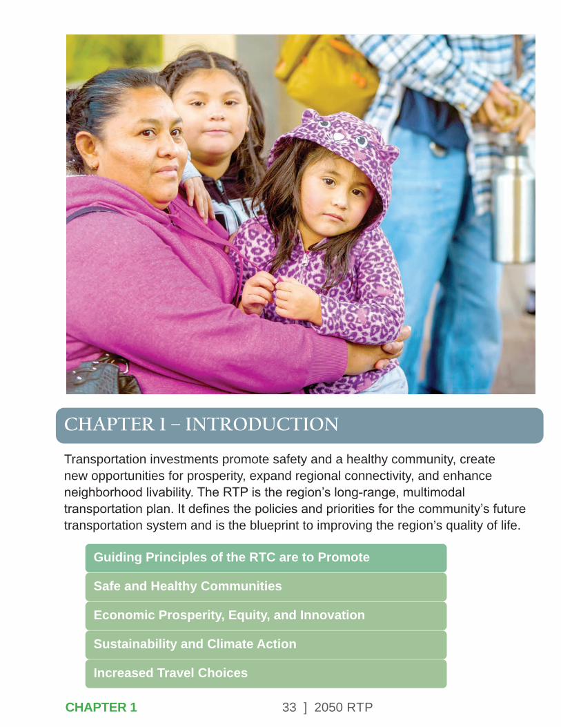
Transportation investments promote safety and a healthy community, create new opportunities for prosperity, expand regional connectivity, and enhance neighborhood livability. The RTP is the region’s long-range, multimodal transportation plan. It defines the policies and priorities for the community’s future transportation system and is the blueprint to improving the region’s quality of life. ABOUT THE RTC
Guiding Principles of the RTC are to Promote
Safe and Healthy Communities
Economic Prosperity, Equity, and Innovation
Sustainability and Climate Action
Increased Travel Choices
CHAPTER 1
34 ] 2050 RTP
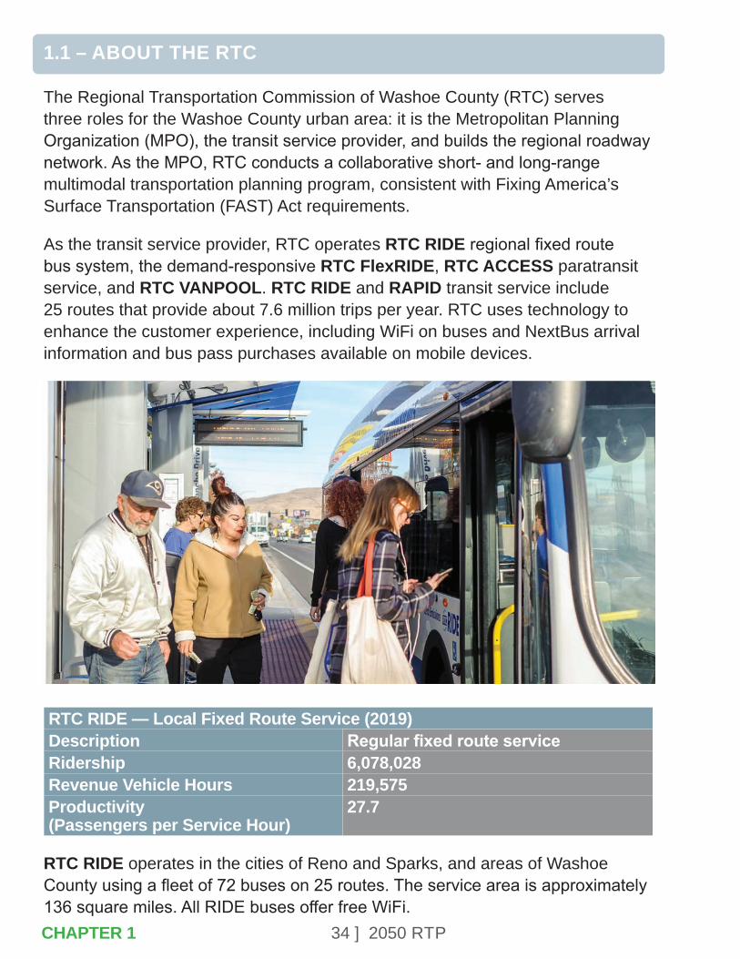
1.1 – ABOUT THE RTC
The Regional Transportation Commission of Washoe County (RTC) serves three roles for the Washoe County urban area: it is the Metropolitan Planning Organization (MPO), the transit service provider, and builds the regional roadway network. As the MPO, RTC conducts a collaborative short- and long-range multimodal transportation planning program, consistent with Fixing America’s Surface Transportation (FAST) Act requirements.
As the transit service provider, RTC operates RTC RIDE regional fixed route bus system, the demand-responsive RTC FlexRIDE, RTC ACCESS paratransit service, and RTC VANPOOL. RTC RIDE and RAPID transit service include 25 routes that provide about 7.6 million trips per year. RTC uses technology to enhance the customer experience, including WiFi on buses and NextBus arrival information and bus pass purchases available on mobile devices.
RTC RIDE — Local Fixed Route Service (2019)Description Regular fixed route serviceRidership 6,078,028Revenue Vehicle Hours 219,575Productivity (Passengers per Service Hour)
27.7
RTC RIDE operates in the cities of Reno and Sparks, and areas of Washoe County using a fleet of 72 buses on 25 routes. The service area is approximately 136 square miles. All RIDE buses offer free WiFi. CHAPTER 1
35 ] 2050 RTP
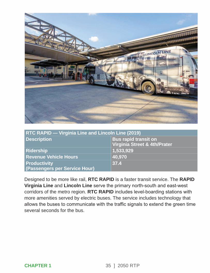
RTC RAPID — Virginia Line and Lincoln Line (2019)Description Bus rapid transit on
Virginia Street & 4th/PraterRidership 1,533,929Revenue Vehicle Hours 40,970Productivity (Passengers per Service Hour)
37.4
Designed to be more like rail, RTC RAPID is a faster transit service. The RAPID Virginia Line and Lincoln Line serve the primary north-south and east-west corridors of the metro region. RTC RAPID includes level-boarding stations with more amenities served by electric buses. The service includes technology that allows the buses to communicate with the traffic signals to extend the green time several seconds for the bus.
CHAPTER 1
36 ] 2050 RTP
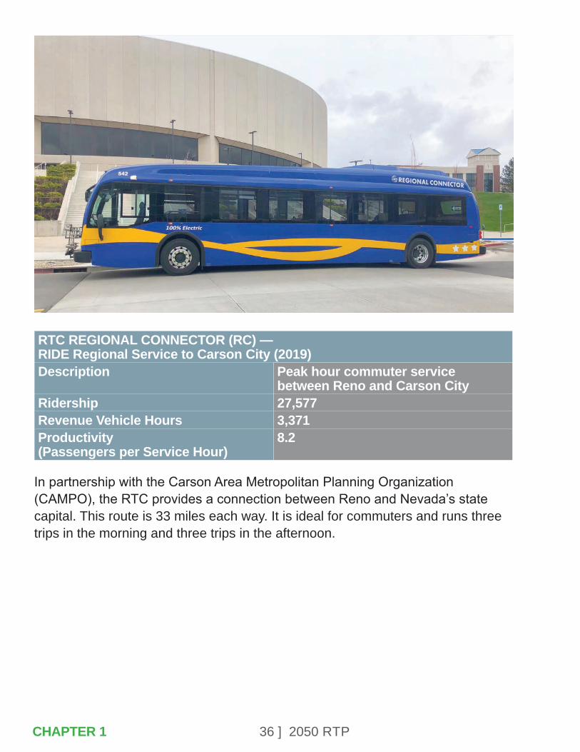
RTC REGIONAL CONNECTOR (RC) — RIDE Regional Service to Carson City (2019)Description Peak hour commuter service
between Reno and Carson CityRidership 27,577Revenue Vehicle Hours 3,371Productivity (Passengers per Service Hour)
8.2
In partnership with the Carson Area Metropolitan Planning Organization (CAMPO), the RTC provides a connection between Reno and Nevada’s state capital. This route is 33 miles each way. It is ideal for commuters and runs three trips in the morning and three trips in the afternoon.
CHAPTER 1
37 ] 2050 RTP
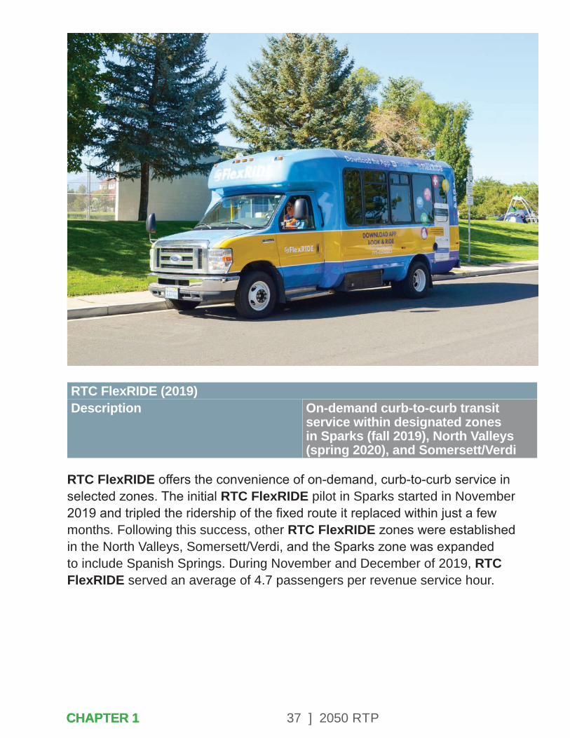
RTC FlexRIDE (2019)Description On-demand curb-to-curb transit
service within designated zones in Sparks (fall 2019), North Valleys (spring 2020), and Somersett/Verdi
RTC FlexRIDE offers the convenience of on-demand, curb-to-curb service in selected zones. The initial RTC FlexRIDE pilot in Sparks started in November 2019 and tripled the ridership of the fixed route it replaced within just a few months. Following this success, other RTC FlexRIDE zones were established in the North Valleys, Somersett/Verdi, and the Sparks zone was expanded to include Spanish Springs. During November and December of 2019, RTC FlexRIDE served an average of 4.7 passengers per revenue service hour.
CHAPTER 1CHAPTER 1
38 ] 2050 RTP
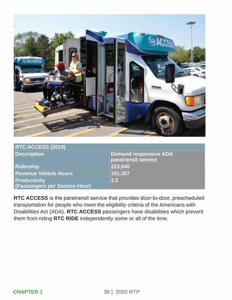
RTC ACCESS (2019)Description Demand responsive ADA
paratransit serviceRidership 223,640Revenue Vehicle Hours 101,357Productivity (Passengers per Service Hour)
2.2
RTC ACCESS is the paratransit service that provides door-to-door, prescheduled transportation for people who meet the eligibility criteria of the Americans with Disabilities Act (ADA). RTC ACCESS passengers have disabilities which prevent them from riding RTC RIDE independently some or all of the time.
CHAPTER 1
39 ] 2050 RTP
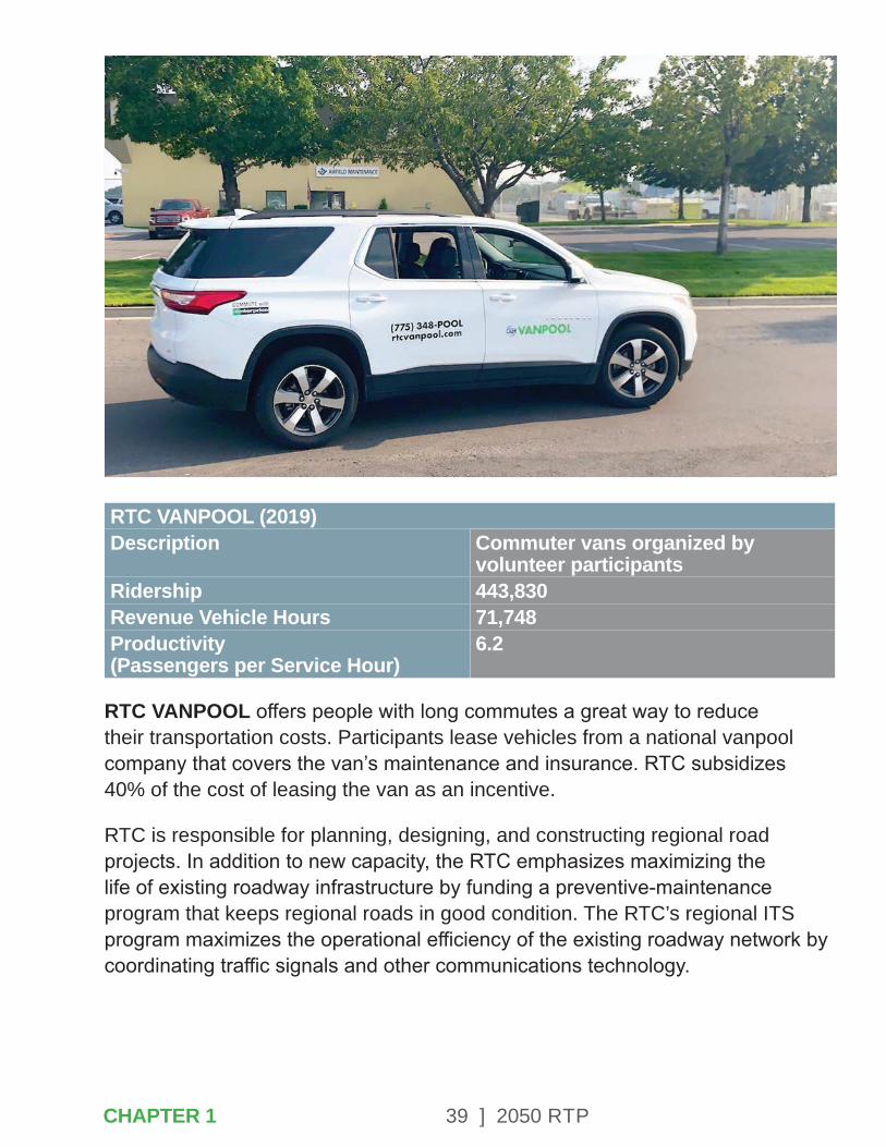
RTC VANPOOL (2019)Description Commuter vans organized by
volunteer participants Ridership 443,830Revenue Vehicle Hours 71,748Productivity (Passengers per Service Hour)
6.2
RTC VANPOOL offers people with long commutes a great way to reduce their transportation costs. Participants lease vehicles from a national vanpool company that covers the van’s maintenance and insurance. RTC subsidizes 40% of the cost of leasing the van as an incentive.
RTC is responsible for planning, designing, and constructing regional road projects. In addition to new capacity, the RTC emphasizes maximizing the life of existing roadway infrastructure by funding a preventive-maintenance program that keeps regional roads in good condition. The RTC’s regional ITS program maximizes the operational efficiency of the existing roadway network by coordinating traffic signals and other communications technology.
CHAPTER 1
40 ] 2050 RTP
The RTC was formed in July 1979 by the Nevada State Legislature through the consolidation of the Regional Street and Highway Commission, the Regional Transit Commission, and the Washoe County Area Transportation Study Policy Committee. The agency is governed by the RTC Board of Commissioners, which consists of five voting members: two representatives from the Washoe County Board of County Commissioners, two representatives from the Reno City Council, and one representative from the Sparks City Council. The Nevada Department of Transportation (NDOT) Director is an ex-officio member of the RTC Board. The RTC has three standing advisory committees that provide recommendations to the RTC Board: the Technical Advisory Committee, which consists of staff from partner jurisdictions and agencies, the Citizens Multimodal Advisory Committee, and the Regional Road Impact Fee Technical Advisory Committee.
1.2 – TRANSPORTATION PLANNING FACTORS
This RTP was developed through a continuous, cooperative, and comprehensive planning process. Federal regulations require that the metropolitan planning process include consideration of eight planning factors.
These factors, listed below, illustrate the need for transportation plans to recognize and address the inter-relationship of transportation, land-use and economic development planning. The factors are considered and integrated throughout the 2050 RTP.
• Support the economic vitality of the metropolitan area, especially by enabling global competitiveness, productivity, and efficiency.
• Increase the safety of the transportation system for motorized and non-motorized users.
• Increase the security of the transportation system for motorized and non-motorized users.
• Increase the accessibility and mobility of people and for freight.
• Protect and enhance the environment, promote energy conservation, improve the quality of life, and promote consistency between transportation improvements and state and local planned growth and economic development patterns.
• Enhance the integration and connectivity of the transportation system, across and between modes, for people and freight.
• Promote efficient system management and operation.
CHAPTER 1
41 ] 2050 RTP
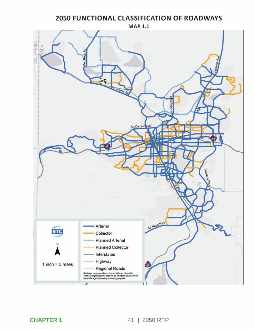
2050 FUNCTIONAL CLASSIFICATION OF ROADWAYSMAP 1.1
CHAPTER 1

42 ] 2050 RTP
• Emphasize the preservation of the existing transportation system.
• Improving transportation system resiliency and reliability.
• Reducing storm water impacts of surface transportation.
• Enhancing travel and tourism.
• Consideration of bus service between cities in the region.
Recognizing the special nature of transportation problems within major metropolitan areas with more than 200,000 residents, these areas – including the Reno-Sparks, NV-CA metropolitan area – have been designated as “Transportation Management Areas,” or TMAs, within which MPOs are given expanded responsibilities in planning for the safe and efficient movement of people, including motorists, transit customers, pedestrians, and bicyclists. The TMA is located in the urbanized area as defined by the U.S. Census and is smaller than the metropolitan planning-area boundary. The planning area boundary encompasses all of Washoe County, with the exception of Incline Village, which is in the Tahoe Regional Planning Agency boundary.
2020 2050 Percent ChangeWashoe County Population
461,858 591,294 28.0%
Washoe County Employment
290,100 389,688 34.3%
TRI Center Employment
16,050 40,749 153.9%
The Reno-Sparks metropolitan region is expecting to gain more than 129,000 new residents over the next 30 years, increasing from 461,858 residents to 591,294. The number of jobs in the region is expected to grow from 290,100 to 389,688 during the same period. The increase in population will result in growing travel demand. The regional travel demand model forecasts that daily vehicle miles of travel will increase from 10.3 million in 2020 to 14.8 million in 2050. The multimodal projects in this RTP are expected to reduce the future average daily traffic delay by about 112,000 hours per day compared to a no-action alternative.
CHAPTER 1

43 ] 2050 RTP
1.3 – GUIDING PRINCIPLES
The RTC worked closely with the community to develop guiding principles for the RTP at the beginning of plan development. The guiding principles are the overarching themes that recur throughout the RTP and on which the goals and selection of transportation investments are based. A description of the guiding principles is below.
• Safe and Healthy Communities
Community safety and health are closely tied to transportation infrastructure in many ways.
RTC is part of the Vision Zero coalition that seeks to eliminate traffic-related fatalities. Safety for bicyclists and pedestrians can be enhanced by providing safe and accessible space for all roadway users.
Offering safe and convenient infrastructure for active transportation, such as walking and biking, provides the opportunity for many other health benefits. Including physical activity as part of a daily routine helps prevent some chronic diseases. Providing opportunities to walk, bike, and use transit also reduces the need for some auto trips, and subsequently vehicle emissions and air pollution. Cleaner air promotes respiratory health for all Washoe County residents.
• Economic Prosperity, Equity, and Innovation
Transportation infrastructure investments can position Washoe County for sustained economic prosperity for every Washoe County resident in several ways.
Construction of roadway, transit, sidewalk, and other multimodal improvements creates immediate jobs for local residents. The increased access and mobility provided by efficient transportation infrastructure systems and services allows for increased investment and job growth by local businesses. The quality of life improvements, like wider sidewalks, new bicycle lanes, and corridor beautification, create a unique sense of place making the region more attractive to residents, businesses, and visitors. The multimodal investments in this plan improve regional connections, further strengthening the Northern Nevada economy.
By using a needs-based approach, RTC can identify and implement investments that will support prosperity in areas of the greatest need, including lower income communities. Transportation services and infrastructure improvements can increase access to essential services as well as education and employment opportunities.
CHAPTER 1CHAPTER 1
44 ] 2050 RTP
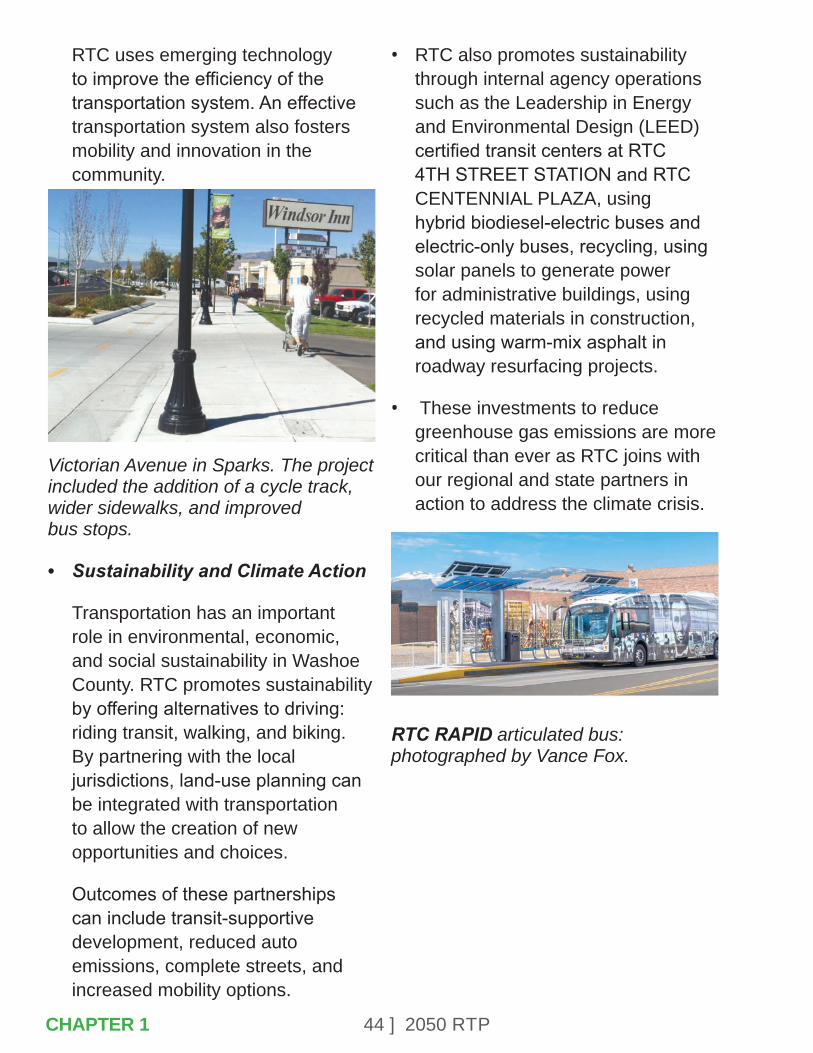
RTC uses emerging technology to improve the efficiency of the transportation system. An effective transportation system also fosters mobility and innovation in the community.
Victorian Avenue in Sparks. The project included the addition of a cycle track, wider sidewalks, and improved bus stops.
• Sustainability and Climate Action
Transportation has an important role in environmental, economic, and social sustainability in Washoe County. RTC promotes sustainability by offering alternatives to driving: riding transit, walking, and biking. By partnering with the local jurisdictions, land-use planning can be integrated with transportation to allow the creation of new opportunities and choices.
Outcomes of these partnerships can include transit-supportive development, reduced auto emissions, complete streets, and increased mobility options.
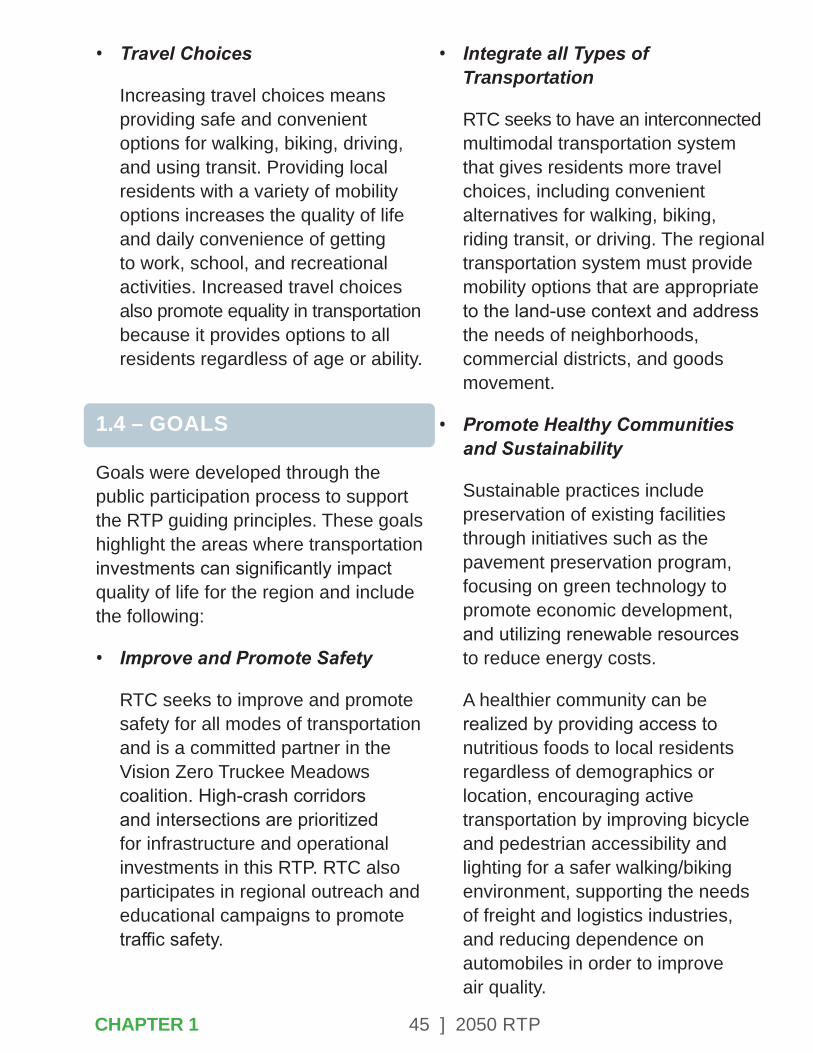
• RTC also promotes sustainability through internal agency operations such as the Leadership in Energy and Environmental Design (LEED) certified transit centers at RTC 4TH STREET STATION and RTC CENTENNIAL PLAZA, using hybrid biodiesel-electric buses and electric-only buses, recycling, using solar panels to generate power for administrative buildings, using recycled materials in construction, and using warm-mix asphalt in roadway resurfacing projects.
• These investments to reduce greenhouse gas emissions are more critical than ever as RTC joins with our regional and state partners in action to address the climate crisis.
RTC RAPID articulated bus: photographed by Vance Fox.
CHAPTER 1
45 ] 2050 RTP
• Travel Choices
Increasing travel choices means providing safe and convenient options for walking, biking, driving, and using transit. Providing local residents with a variety of mobility options increases the quality of life and daily convenience of getting to work, school, and recreational activities. Increased travel choices also promote equality in transportation because it provides options to all residents regardless of age or ability.
1.4 – GOALS
Goals were developed through the public participation process to support the RTP guiding principles. These goals highlight the areas where transportation investments can significantly impact quality of life for the region and include the following:
• Improve and Promote Safety
RTC seeks to improve and promote safety for all modes of transportation and is a committed partner in the Vision Zero Truckee Meadows coalition. High-crash corridors and intersections are prioritized for infrastructure and operational investments in this RTP. RTC also participates in regional outreach and educational campaigns to promote traffic safety.
• Integrate all Types of Transportation
RTC seeks to have an interconnected multimodal transportation system that gives residents more travel choices, including convenient alternatives for walking, biking, riding transit, or driving. The regional transportation system must provide mobility options that are appropriate to the land-use context and address the needs of neighborhoods, commercial districts, and goods movement.
• Promote Healthy Communities and Sustainability
Sustainable practices include preservation of existing facilities through initiatives such as the pavement preservation program, focusing on green technology to promote economic development, and utilizing renewable resources to reduce energy costs.
A healthier community can be realized by providing access to nutritious foods to local residents regardless of demographics or location, encouraging active transportation by improving bicycle and pedestrian accessibility and lighting for a safer walking/biking environment, supporting the needs of freight and logistics industries, and reducing dependence on automobiles in order to improve air quality.
CHAPTER 1

46 ] 2050 RTP
• Promote and Foster Equity and Environmental Justice
Work toward a more equitable and balanced transportation system that can be safely used by all regardless of age, race, economic status, or ability. It is a priority of RTC to ensure that transportation and mobility benefits are equitably shared among residents of the region.
• Integrate Land-Use and Economic Development
RTC is partnering with local jurisdictions and economic development agencies to identify how transportation investments can support regional development goals. This can be achieved by providing connectivity between communities and economic centers, supporting access to local businesses in transit-supportive development districts and other areas, lowering transportation costs, and encouraging density and land-use that supports walking, bicycling, and transit.
• Manage Existing Systems Efficiently
It is imperative that RTC minimize the life-cycle costs of area roadways and maximize the utilization of existing infrastructure. By making the most of current transportation resources, RTC can stretch limited revenues farther.
Examples of this include the RTC pavement preservation, annual traffic signal retiming, ITS, and bus maintenance programs.
Bike racks at RTC 4TH STREET STATION.
Bike repair station at RTC 4TH STREET STATION.
School crosswalk on Mayberry Drive.
CHAPTER 1

47 ] 2050 RTP
• Enhance Regional Connectivity
Economic and transportation linkages tie Northern Nevada communities together, including Carson City, the Lake Tahoe region, Virginia City, Pyramid Lake, Storey County, and other nearby areas. The community desires regional connectivity for residents, businesses, and visitors alike to have multimodal travel options and freight mobility between these regions and into California.
• Improve Freight and Goods Movement
Freight and goods movement contribute to the economic success of this region and play a role in diversifying the employment base.
Because of the strategic location of Reno and Sparks, the manufacturing, air cargo, freight rail, e-commerce, and trucking industries bring significant opportunities for economic growth.
• Invest Strategically
Funding is essential to provide a quality transportation system. RTC has limited state, local, and federal resources available and must maximize the positive impact of each transportation dollar. A top priority of investing strategically is to help the community realize that transportation is an investment in our future.
• Engage the Public and Encourage Community Involvement
A robust community engagement process is the foundation of all RTC initiatives. It is our commitment to go to the public early and often to seek input, and to consider and incorporate this input when feasible.
These guiding principles and goals are the cornerstone of planning for the future of the community. These goals were an important part of the project selection process.
1.5 – 2013-2017 ACCOMPLISHMENTS
The 2040 Regional Transportation Plan, adopted in 2017, guided transportation investments over the last four years. These transportation improvements have generated significant benefits for the region, including the following:
• SouthEast Connector, now known as Veterans Parkway Extension – Completed a 5.5-mile six-lane arterial with adjacent multi-use path, which included flood mitigation and water quality improvement features.
CHAPTER 1
48 ] 2050 RTP
• 4th Street/Prater Way Bus RAPID Transit Project – Constructed new RTC RAPID Lincoln Line extension between downtown Reno and Sparks, including safety improvements, bike lanes, and construction of ADA compliant sidewalks.
• Virginia Street RAPID Extension Project – Extended RAPID from 4TH STREET STATION to the University of Nevada Reno, including the construction of eight new RAPID stations, sidewalk improvements, shared bus-bicycle lanes, and full reconstruction of Virginia Street in Midtown.
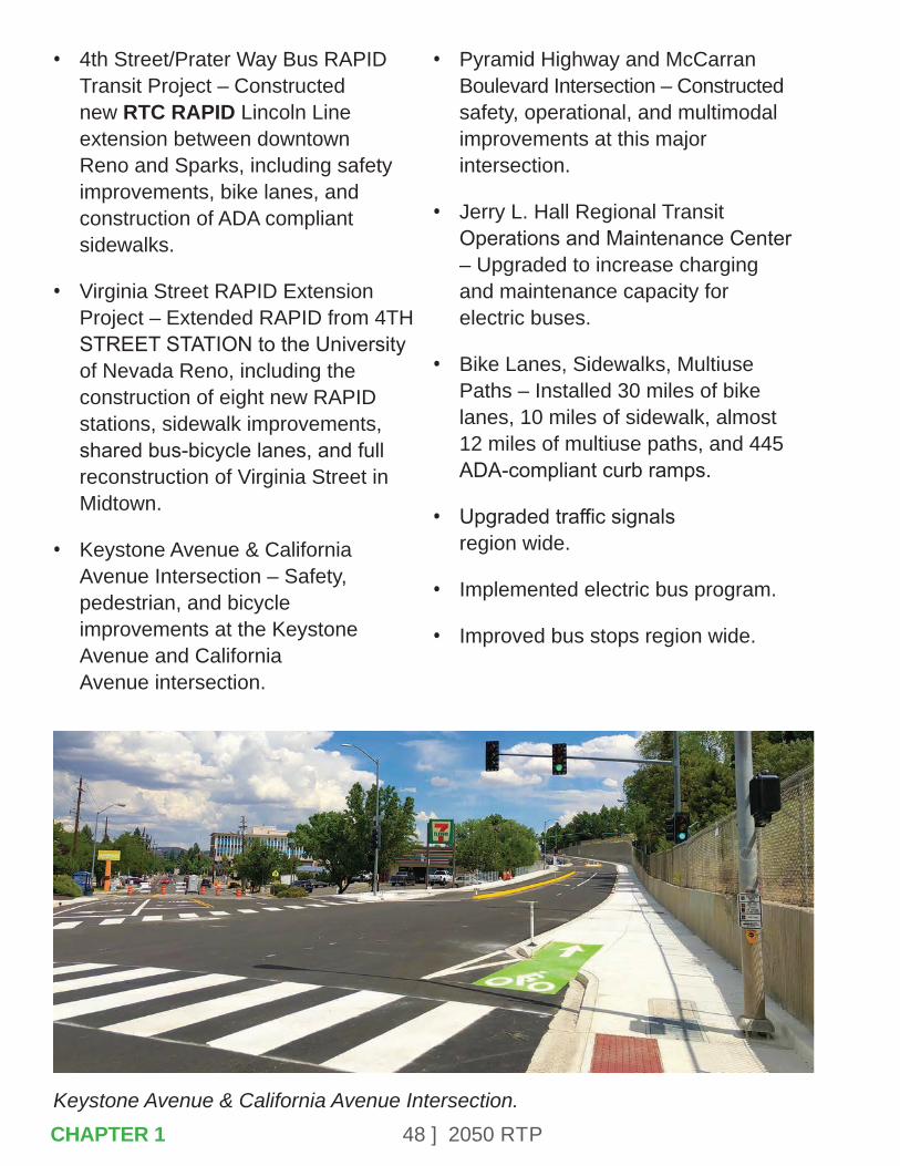
• Keystone Avenue & California Avenue Intersection – Safety, pedestrian, and bicycle improvements at the Keystone Avenue and California Avenue intersection.
• Pyramid Highway and McCarran Boulevard Intersection – Constructed safety, operational, and multimodal improvements at this major intersection.
• Jerry L. Hall Regional Transit Operations and Maintenance Center – Upgraded to increase charging and maintenance capacity for electric buses.
• Bike Lanes, Sidewalks, Multiuse Paths – Installed 30 miles of bike lanes, 10 miles of sidewalk, almost 12 miles of multiuse paths, and 445 ADA-compliant curb ramps.
• Upgraded traffic signals region wide.
• Implemented electric bus program.
• Improved bus stops region wide.
Keystone Avenue & California Avenue Intersection.CHAPTER 1

49 ] 2050 RTP
CHAPTER 2 – COMMUNITY-BASED PLANNING
The RTP is founded on a community outreach process designed to more fully understand the region’s diverse and complex transportation needs with a people-based approach. Effective transportation planning requires involvement from community stakeholders, elected officials, business owners, schools, economic development groups, and area residents. Collaboration with the public encourages innovative ideas to emerge that address complex transportation issues.
CHAPTER 2
50 ] 2050 RTP
Ensuring a broad base of participation helps develop a cohesive effort in planning region-wide. It also allows RTC’s priorities to interline with those of other groups and agencies who are working to enrich quality of life and create a more-livable community. Strong community support for the planning process will also greatly enhance implementation of specific projects and programs in the plan.
The 2050 RTP process was formed around the following outreach types:
• Participation of advisory groups that guided the planning process:
- Agency Working Group
- RTC Citizens Multimodal Advisory Committee
- RTC Technical Advisory Committee
- Inter-County Working Group
• Community planning workshops and virtual meetings held at strategic points during the plan-development process: identifying the vision and goals, developing alternatives, and evaluating/prioritizing alternatives.
• Use of online surveys.
• Forums that brought local residents together to focus on specific special topics important to the plan, including economic development, safety for school students, the Downtown Reno Circulation Study, and the Sparks Industrial Area Study.
• Integration with the Coordinated Human Services Transportation Plan outreach process.
• Presentations to the RTC Board.
• Involvement of other elected officials, boards, commissions, and community organizations.
• Digital and traditional media to reach a broad audience, including the RTC website, news releases, interviews, videos, the RTC YouTube channel, Facebook and Twitter, The Road Ahead with RTC (a television news segment on KOLO 8 News Now), and meeting announcements in English- and Spanish-language publications.
RTC held traditional public meetings in the early phases of plan development. The 2050 RTP process adapted to the unexpected onset of the COVID-19 pandemic in March of 2020, which restricted the ability to hold in-person meetings. The innovative use of technology allowed advisory committee meetings to transition to an online format. Virtual public meetings replaced in-person events.
CHAPTER 2
51 ] 2050 RTP
Public comments were received using online surveys, phone calls, and emails. A robust community engagement continued to occur in a digital format.
2.1 – RTP AGENCY WORKING GROUPS
The Agency Working Group (AWG) helped to guide, inform, and provide technical expertise in all areas of the plan. The AWG collaborated with the RTC to ensure consistency with other planning strategies, initiatives, and policies in the region. This group has a more-expansive membership than the RTC Technical Advisory Committee.
This group contributed significantly to:
• Coordinating regional planning efforts.
• Identifying the impacts of transportation on other agencies.
• Providing a forum to present innovative ideas at a regional level.
2.2 – RTC CITIZENS MULTIMODAL ADVISORY COMMITTEE
The Citizens Multimodal Advisory Committee (CMAC) is a standing committee that provides feedback to staff and the RTC Board of Commissioners.
The group meets monthly and is made up of residents from throughout the region with an interest in the transportation system. This diverse group represents community needs and concerns related to all modes of transportation. CMAC provided input regarding priorities for projects and services in the 2050 RTP.
2.3 – RTC TECHNICAL ADVISORY COMMITTEE
The Technical Advisory Committee (TAC) is a standing committee that provides feedback to staff and the RTC Board of Commissioners. The group meets monthly and is made up of staff members from partner agencies. This diverse group represents community needs and concerns related to all modes of transportation for local jurisdictions and agencies. CMAC provided input regarding priorities for projects and services in the 2050 RTP.
2.4 – INTER-COUNTY WORKING GROUP
It is important that the RTP is comprehensive and illustrates the vision for transportation planning efforts and challenges in Northern Nevada and the Lake Tahoe Region. Inter-regional collaboration with other nearby cities, counties, and MPOs ensures that RTC is able to build on transportation linkages and economic ties, as well as reduce the duplication of efforts attempting to accomplish the same goal.
CHAPTER 2
52 ] 2050 RTP
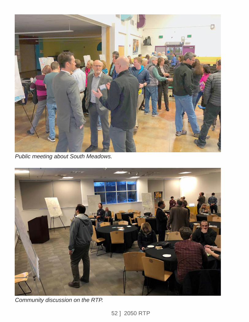
Public meeting about South Meadows.
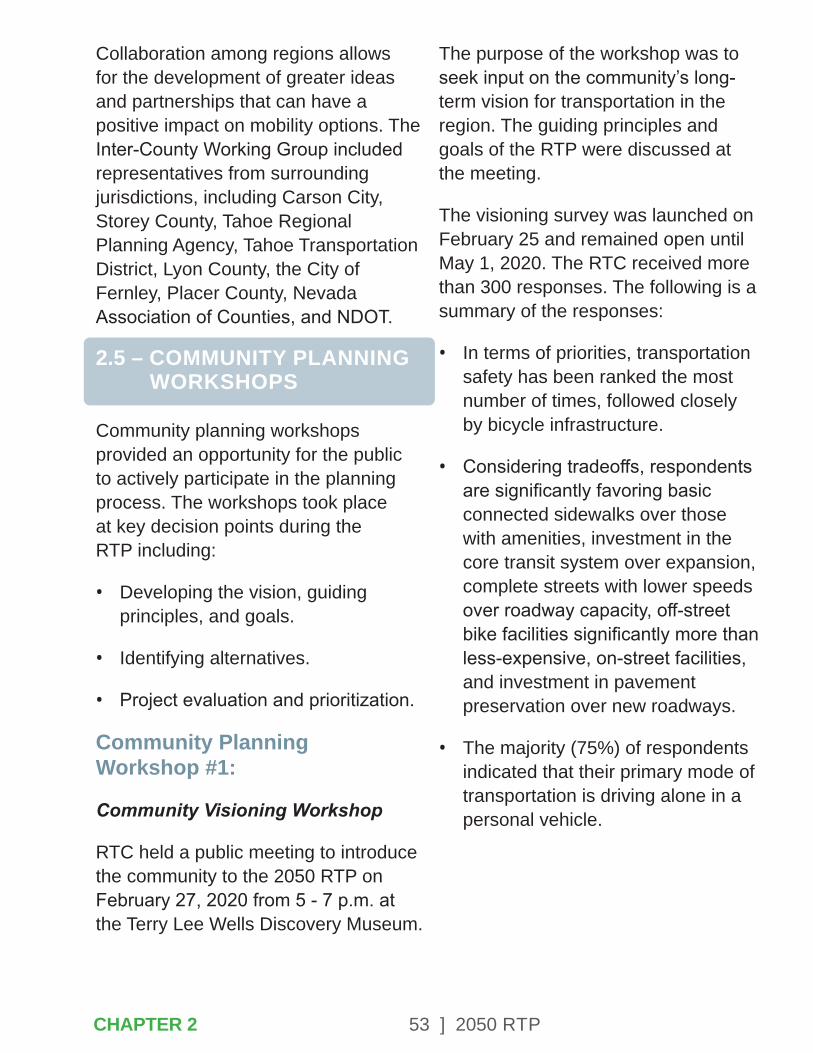
Community discussion on the RTP.
53 ] 2050 RTP
Collaboration among regions allows for the development of greater ideas and partnerships that can have a positive impact on mobility options. The Inter-County Working Group included representatives from surrounding jurisdictions, including Carson City, Storey County, Tahoe Regional Planning Agency, Tahoe Transportation District, Lyon County, the City of Fernley, Placer County, Nevada Association of Counties, and NDOT.
2.5 – COMMUNITY PLANNING WORKSHOPS
Community planning workshops provided an opportunity for the public to actively participate in the planning process. The workshops took place at key decision points during the RTP including:
• Developing the vision, guiding principles, and goals.
• Identifying alternatives.
• Project evaluation and prioritization.
Community Planning Workshop #1:
Community Visioning Workshop
RTC held a public meeting to introduce the community to the 2050 RTP on February 27, 2020 from 5 - 7 p.m. at the Terry Lee Wells Discovery Museum.
The purpose of the workshop was to seek input on the community’s long-term vision for transportation in the region. The guiding principles and goals of the RTP were discussed at the meeting.
The visioning survey was launched on February 25 and remained open until May 1, 2020. The RTC received more than 300 responses. The following is a summary of the responses:
• In terms of priorities, transportation safety has been ranked the most number of times, followed closely by bicycle infrastructure.
• Considering tradeoffs, respondents are significantly favoring basic connected sidewalks over those with amenities, investment in the core transit system over expansion, complete streets with lower speeds over roadway capacity, off-street bike facilities significantly more than less-expensive, on-street facilities, and investment in pavement preservation over new roadways.
• The majority (75%) of respondents indicated that their primary mode of transportation is driving alone in a personal vehicle.
CHAPTER 2
54 ] 2050 RTP
Community Planning Workshop #2: Alternatives Development
The Alternatives Development Workshop was launched in June 22, 2020 as a virtual public meeting and online survey. This included a video presentation and a survey that allowed people to identify any multimodal transportation concerns or ideas that they might have within the planning area. The survey was open through the end of July, 2020. All projects suggested during the call for projects were analyzed for consideration in the 2050 RTP.
Community Planning Workshop #3: Alternatives Evaluation and Prioritization
The Alternatives Evaluation and Prioritization Workshop was available as a virtual public meeting and online survey from December 17, 2020 through January 14, 2021. This included a video presentation about the alternatives under consideration and an online survey that encouraged members of the public to identify their top-priority projects. Survey results were incorporated into the alternatives analysis and project-prioritization process.
2.6 – COMMUNITY FORUMS
Also critical to the development of the RTP was a series of community forums held on various topics including schools, specific regional areas, and the regional economy. A summary of these outreach events is provided below.
Washoe County School District RTC staff participated in the Student Leadership Council meeting to gather input about youth transportation safety and other concerns.
Sparks Industrial ForumAn in-person workshop with businesses and members of the public was held on February 26, 2020, to identify needs in the Sparks Industrial Area. The Sparks Industrial area is generally defined as the area between I-80 and the Truckee River. Participants identified needs related to pedestrian and bicycle access to employment opportunities. This area includes strong transit ridership that remained high even during the COVID-19 shutdown. The high-pedestrian activity that accompanies transit ridership further supports the need for increased sidewalk connectivity to provide walking access to jobs.
Safety for all modes of transportation was identified as a priority, with particular focus the unique needs created by high-truck-traffic volumes.
CHAPTER 2

55 ] 2050 RTP
The land use in this area is transitioning from primarily industrial to including recreation and commercial uses. City land-use plans indicate a vision for making the Truckee River more accessible to the public and encouraging residential uses.
Economic Development ForumThe Economic Development Forum was held online on May 27, 2020. It included presentation by Mike Kazmierski of the Economic Development Authority of Western Nevada (EDAWN), Ann Silver of the Reno+Sparks Chamber, and Jennifer Cunningham of the Reno-Sparks Convention and Visitor Authority. These speakers provided insights into the ways transportation can support economic prosperity.
Employment Growth: The region is targeting advanced manufacturing, technology, ecommerce, and logistics as sectors for future economic expansion and job growth. Industrial development is occurring in Washoe County as well as the larger region, including TRI Center, Fernley, and Silver Springs. Priority corridors for freight movement and commuting to these emerging employment centers include:
• I-80 from Reno to Fernley.
• US 395 from Reno into the North Valleys.
• Pyramid Highway.
• Spaghetti Bowl.
• New corridor to connect the North Valleys, Spanish Springs, and USA Parkway.
Business-friendly transportation: Transportation investment that support the unique quality of life in Washoe County will benefit local business activity. Components of this include ease of commuting, reliable transportation, and mobility through various types of transportation such as walking, biking, and transit. A vibrant local economy will support the mobility needs of seniors, disabled residents, and youth, who may be less reliant on driving. Clean transportation infrastructure will also support the local economy, including zero-emission transit and an expansion of electric vehicle charging options for residents.
Supporting travel and tourism: Reno and Sparks attract visitors to resort casino destinations as well as outdoor recreation opportunities. Travel and tourism trends are shifting as a result of COVID-19, with a greater reliance on the drive-up market. Supporting highway infrastructure improvements will encourage visitors to drive to Washoe County from surrounding states. Expanding the transit system’s connectivity to the Reno-Sparks Convention Center will also support the convention industry.
CHAPTER 2
56 ] 2050 RTP
Of particular importance is the connection between the University, Downtown, Midtown, and the Convention Center. More than 4,000 hotel rooms are located in the Downtown Reno corridor and the Virginia Line RAPID transit service provides essential connectivity to the Convention Center.
Downtown Reno Circulation Virtual WorkshopThe RTP process included a Downtown Reno Circulation Study to focus on mobility in the central core. Staff from the City of Reno and RTC analyzed a series of transportation alternatives that were presented through this virtual workshop. The workshop included a video presentation and provided an option for individuals to submit comments about the alternatives as well as other suggestions or ideas. The virtual meeting was available from November 13 through December 11, 2020. A presentation of the concept was also made to the Downtown Reno Partnership.
2.7 – COORDINATED HUMAN SERVICES TRANSPORTATION PLAN (CTP)
The CTP was developed in coordination with the RTP. The CTP process included a series of virtual public meetings and stakeholder outreach.
Interviews with representatives of human services agencies and non-profits were the initial steps. This included human service transportation providers, medical providers, veteran’s services, and transportation network companies. A community transportation survey was conducted to identify issues to consider in the plan. The CTP was adopted by the RTC Board in December 2020.
2.8 – RTC BOARD OF COMMISSIONERS
The RTC provided regular reports to the RTC Board of Commissioners throughout the development process. The Board provided direction at strategic points, including adoption of the guiding principles and goals, the list of projects to be considered, the transit vision, and evaluation of alternatives.
2.9 – ELECTED OFFICIALS, BOARDS, & COMMISSIONS
The RTC also sought input about the 2050 RTP from local elected officials and appointed boards and commissions. Presentations were made to the following:
• Reno City Council
• Sparks City Council
• Washoe County Commission
• Regional Planning Governing Board
CHAPTER 2
57 ] 2050 RTP
• Reno Planning Commission
• Sparks Planning Commission
• Washoe County Planning Commission
• Regional Planning Commission
3.0 – BROADCAST & DIGITAL MEDIA OUTREACH
RTC used a variety of tools to reach a broad spectrum of the community. In addition to workshops and other meetings, both traditional and electronic media were instrumental in sharing information and gathering feedback.
RTC WebsiteThe RTC website was employed to encourage public participation, and as a method to store documents, presentations, and other materials related to the 2050 RTP.
Online SurveysThe RTC engaged the community with online surveys to help guide the RTP process.
Social MediaPublic participation opportunities were promoted through social media outlets. These messages included links to the online surveys and information about participating in virtual public presentations and workshops.
Facebook, Twitter, and YouTube all featured content.
RTC eNewsInformation about the 2050 RTP was included in the RTC’s monthly electronic newsletter which is distributed to elected and government officials, businesses, community leaders, and stakeholders.
MyRTC Email UpdatesMembers of the community who subscribe to MyRTC were also invited to participate. MyRTC enables internet users to sign up for updates on topics of interest to them.
Media OutreachAnother important component of the outreach program included news coverage, in newspapers, television, and radio. The RTC issued press releases to local media outlets and participated in media interview to inform the public about the RTP process, its topics, ways to get involved, and the importance of the RTP to the region. The RTC utilized its weekly broadcast segment, “The Road Ahead with RTC,” which airs on KOLO 8 News Now, to further promote the RTP planning process including meetings and workshops (see schedule below).
• Advertisements for the community workshops were placed in local English and Spanish language newspapers.
CHAPTER 2

58 ] 2050 RTP
The Road Ahead with RTC Segments• February 25, 26, and 27, 2020:
Regional Transportation Plan Kick-Off Meeting.
• March 17, 18, and 19, 2020: Regional Transportation Plan MetroQuest Survey.
• June 30, July 1 and 2, 2020: Regional Transportation Plan Alternatives Analysis Virtual Public Meeting and Survey.
• December 1, 2, and 3: Regional Transportation Plan Process Continues.
• January 12, 13, and 14: Regional Transportation Plan Virtual Public Meeting and Survey to Prioritize Programs and Projects.
News Releases• February 6, 2020: RTC invites
Sparks Industrial Businesses to 2050 Regional Transportation Plan Community Meeting on February 26.
• February 20, 2020: RTC Launches 2050 Regional Transportation Plan with Community Meeting on February 27.
• April 20, 2020: RTC Encourages the Community to Take Two Quick Surveys.
• June 22, 2020: RTC Launches Community Survey for 2050 Regional Transportation Plan.
• November 12, 2020: RTC Launches Virtual Presentation for Downtown Reno Circulation Study.
• December 17, 2020: RTC Launches Virtual Presentation, Survey for Input on Future Projects.
CHAPTER 2

59 ] 2050 RTPCHAPTER 3
CHAPTER 3 – IMPROVING SAFETY
Planning and building a safe multimodal transportation system is the most critical goal of the RTC. Safety is involved in all types of transportation: driving, walking, cycling, and riding transit. RTC engages in innovative planning and data analysis, public education, interdisciplinary collaboration, operations, and design, with the purposeful goal of reducing the number of crashes, injuries, and fatalities in Washoe County. In addition, RTC is a partner with local emergency response teams and law enforcement agencies, in an effort to provide evacuation assistance and coordination during regional disasters.

60 ] 2050 RTP
Safety Priorities Include:
• Continue building stakeholder and multi-agency partnerships.
• Promote safety awareness and education through community outreach.
• Implement a Complete Streets approach.
• Enhance the accessibility and safety of transit stops.
• Implement ITS technologies.
3.1 – VISION ZERO TRUCKEE MEADOWS
In 2017, RTC led the creation of the Vision Zero Truckee Meadows task force. The task force was established to take equitable, data-driven, and transparent actions to improve safety throughout the community. By working together to make roads and sidewalks safer for pedestrians, the task force will make the roads safer for everyone. The task force has a goal of zero pedestrian fatalities by 2030. The only acceptable number of traffic deaths in our community is zero.
Through the shared regional commitment to safety, Vison Zero Truckee Meadows is committed to changing the rising trend of traffic deaths in the region.
The RTC recognizes the importance of pedestrian safety in addressing equity concerns in underserved parts of our community.
The Vision Zero Truckee Meadows task force members include:
• City of Reno
• City of Sparks
• Washoe County
• Regional Transportation Commission of Washoe County
• Washoe County Health District
• Federal Highway Administration
• Nevada Department of Transportation
• Office of Traffic Safety
• Reno Bike Project
• Reno-Sparks Chamber of Commerce
• Renown Health
• Safe Kids, Washoe County
• University of Nevada, Las Vegas
• University of Nevada, Reno
• Washoe County School District
• Members of the community
CHAPTER 3

61 ] 2050 RTP
The task force created an action plan to bring the number of traffic fatalities to zero. Regional collaboration is vital to achieving this goal. The plan unites the region around a common goal to make the community a stronger and safer place for everyone.
Resolutions have been signed by the City of Reno, City of Sparks, Regional Transportation Commission, Washoe County Board of Health, and Washoe County to adopt the goal of zero pedestrian fatalities by 2030 as well as to support that action plan. Visit VisionZeroTruckeeMeadows.com to see the entire plan.
3.2 – SAFETY PLANNING
Nevada SHSPThe SHSP is produced by NDOT in cooperation with many agencies, including the RTC. The SHSP is a state-wide plan that covers six critical-emphasis areas and suggests many safety improvement strategies using the 5E approach, which focuses on education, enforcement, engineering, and emergency response. This plan is incorporated in the RTP and includes goals and objectives of the Vision Zero Truckee Meadows Task Force in the pedestrian goals of the plan.
Nevada’s 2015 SHSP identifies seven Critical Emphasis Areas (CEA): impaired driving, intersections, lane departures, motorcycles, occupant protection, pedestrians, and teen drivers. NDOT has implemented strong public awareness campaigns regarding impaired driving and seat belt use. Because intersection crashes and incidents involving pedestrians and bicyclists are the most common on roads in the RTC planning areas, these CEAs receive the greatest focus in the RTP.
Complete Streets Master PlanAdopted in 2016, the Complete Streets Master Plan identifies a long-range strategy to improve safety for all users on regional roadways. The plan is based on extensive community outreach and identifies corridors where multimodal infrastructure investments will improve safety and connectivity.
Complete Streets can include a variety of elements and are designed to improve safety and accommodate local land-use characteristics. Potential components of Complete Streets can include sidewalks, bike lanes, shared-use paths, enhanced crosswalks, reduction in the number of travel lanes, and bus stops.
Because each Complete Streets design is customized to meet corridor needs, not all designs will include the same elements.
CHAPTER 3
62 ] 2050 RTP
Data Analysis
The collection and analysis of crash data is important for continuous safety planning. RTC works closely with NDOT to analyze and publish information about safety trends over time as well as the specific safety impacts of particular projects. RTC staff serves on the SHSP data team and receives weekly updates about data available from NDOT and the Nevada Office of Traffic Safety (OTS).
Corridor and Area Plans
Corridor planning is used to identify safety concerns and infrastructure solutions. The RTC has conducted plans for several regional corridors that have been incorporated into the investments shown in the RTP project listing. These plans incorporate safety analysis, needs for multimodal investments such as bicycle lanes and sidewalks, and other operational needs. Area plans have been completed for the North Valleys, South Meadows, and University Area.
Projects in several corridor and area plans have advanced to design and delivery, including Keystone Avenue and Sun Valley Boulevard.
In a continued effort to reduce the severity of crashes and improve roadway safety, transportation and safety experts take part in NDOT’s Road Safety Assessments (RSA) and Safety Management Plans (SMP) along with various corridors within the region. The assessments and plans are conducted in partnership with NDOT, RTC, local government agencies, emergency responders, and bicycle and pedestrian experts.
RSAs and SMPs are formal safety performance reviews of existing or future road or intersections by multidisciplinary teams which are performed to support corridor studies and identify short-, medium-, and long- term safety improvements.
3.3 – COMMUNITY AWARENESS & EDUCATION
Raising public awareness about safety concerns and providing educational materials is an important tool in improving safety. Of particular importance is awareness of pedestrian and bicycle safety best practices.
RTC attends various outreach events and provides the community with safety materials and information.
CHAPTER 3
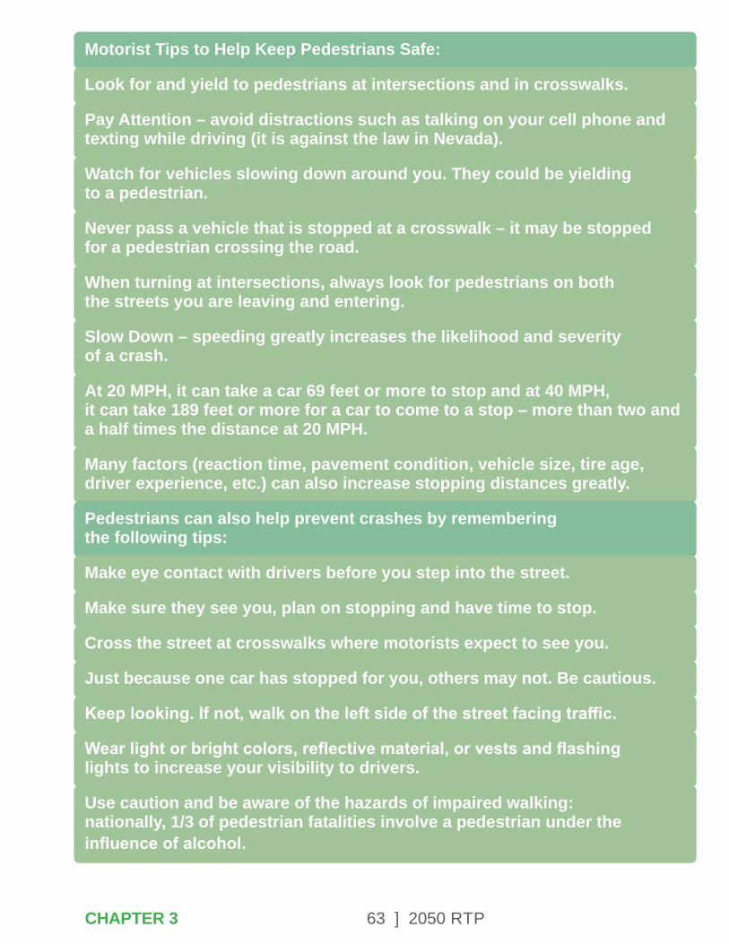
63 ] 2050 RTP
Motorist Tips to Help Keep Pedestrians Safe:
Look for and yield to pedestrians at intersections and in crosswalks.
Pay Attention – avoid distractions such as talking on your cell phone and texting while driving (it is against the law in Nevada).
Watch for vehicles slowing down around you. They could be yielding to a pedestrian.
Never pass a vehicle that is stopped at a crosswalk – it may be stopped for a pedestrian crossing the road.
When turning at intersections, always look for pedestrians on both the streets you are leaving and entering.
Slow Down – speeding greatly increases the likelihood and severity of a crash.
At 20 MPH, it can take a car 69 feet or more to stop and at 40 MPH, it can take 189 feet or more for a car to come to a stop – more than two and a half times the distance at 20 MPH.
Many factors (reaction time, pavement condition, vehicle size, tire age, driver experience, etc.) can also increase stopping distances greatly.
Pedestrians can also help prevent crashes by remembering the following tips:
Make eye contact with drivers before you step into the street.
Make sure they see you, plan on stopping and have time to stop.
Cross the street at crosswalks where motorists expect to see you.
Just because one car has stopped for you, others may not. Be cautious.
Keep looking. If not, walk on the left side of the street facing traffic.
Wear light or bright colors, reflective material, or vests and flashing lights to increase your visibility to drivers.
Use caution and be aware of the hazards of impaired walking: nationally, 1/3 of pedestrian fatalities involve a pedestrian under the influence of alcohol.
CHAPTER 3
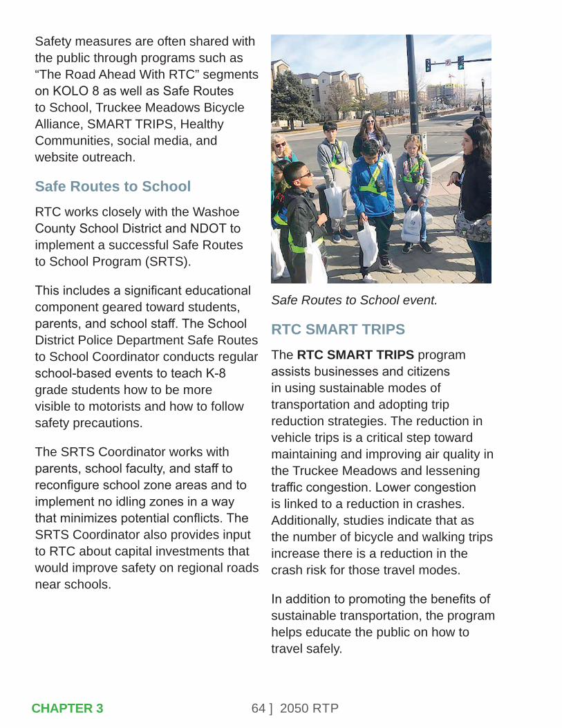
64 ] 2050 RTP
Safety measures are often shared with the public through programs such as “The Road Ahead With RTC” segments on KOLO 8 as well as Safe Routes to School, Truckee Meadows Bicycle Alliance, SMART TRIPS, Healthy Communities, social media, and website outreach.
Safe Routes to SchoolRTC works closely with the Washoe County School District and NDOT to implement a successful Safe Routes to School Program (SRTS).
This includes a significant educational component geared toward students, parents, and school staff. The School District Police Department Safe Routes to School Coordinator conducts regular school-based events to teach K-8 grade students how to be more visible to motorists and how to follow safety precautions.
The SRTS Coordinator works with parents, school faculty, and staff to reconfigure school zone areas and to implement no idling zones in a way that minimizes potential conflicts. The SRTS Coordinator also provides input to RTC about capital investments that would improve safety on regional roads near schools.
Safe Routes to School event.
RTC SMART TRIPSThe RTC SMART TRIPS program assists businesses and citizens in using sustainable modes of transportation and adopting trip reduction strategies. The reduction in vehicle trips is a critical step toward maintaining and improving air quality in the Truckee Meadows and lessening traffic congestion. Lower congestion is linked to a reduction in crashes. Additionally, studies indicate that as the number of bicycle and walking trips increase there is a reduction in the crash risk for those travel modes.
In addition to promoting the benefits of sustainable transportation, the program helps educate the public on how to travel safely.
CHAPTER 3
65 ] 2050 RTP
Safety messages for motorists, bicyclists, and pedestrians are distributed throughout the year at public events and employee benefit fairs. Safety lights that can be worn on clothing or placed on bikes are also given to members of the public at these events. Safety brochures can be downloaded from the RTC website in the Public Transportation section on the Bicycling page (https://www.rtcwashoe.com/public-transportation/bicycling).
3.4 – OPERATIONS
Operations are another key component of the RTC safety program. Safety is a vital priority of the RTC RIDE and RTC ACCESS transit services. Safety operations include RTC’s partnership in the Nevada Traffic Incident Management (NV TIM) program as well as emergency management.
Safe Transit OperationsThe Short-Range Transit Plan identifies the provision of safe and secure transit service as a primary goal. The standard practices that address this goal include the following:
• The RTC shall pursue specific programs to enhance the safety of public transportation and minimize the number of avoidable accidents involving transit vehicles.
• The RTC shall work with local, state, national, and private law enforcement agencies to eliminate security incidents in the RTC public transportation system.
• The RTC will inspect equipment and facilities biweekly based on industry-defined condition performance standards. Deficiencies shall be corrected immediately and before placing equipment and facilities into service.
• The RTC follows state requirements and national best practices to reduce the spread of COVID-19 on transit.
• Maintain visible level of system-wide security presence and surveillance coverage throughout the operating periods of the system.
RTC works with the local jurisdictions to improve pedestrian safety at bus stops by enhancing ADA accessibility, installing solar-powered lights where feasible, installing security cameras at RTC RAPID stations and at RTC 4TH STREET STATION and RTC CENTENNIAL PLAZA, and promoting general roadway safety.
Research by the Federal Transit Administration and the US DOT Federal Motor Carrier Safety Administration indicates that riding a bus is 26 times safer than driving an automobile.
CHAPTER 3

66 ] 2050 RTP
Fatality rates per 100-million passenger miles are .93 for motor vehicles and .10 for bus travel.
NV TIMThe Nevada TIM program is a partnership of agencies and organizations working together toward a common objective: to reduce roadway and incident clearance times and to reduce secondary crashes.
It is a systematic, state-wide, multi-agency effort to improve the management of highway incidents (crashes), disabled or abandoned vehicles, debris in the roadway, work zones, adverse weather, and any other events and emergencies that impact the transportation system. A unified goal of the NV TIM is to restore roadways quickly and safely following an incident and to save lives.
NV TIM partners include:
• Law Enforcement
• Federal Highway, Homeland Security, and Federal Transit
• Fire and Rescue
• Emergency Medical Services
• Transportation Agencies
• Towing and Recovery Companies
• Emergency Managers
• Hazardous Materials Responders and Environmental Agencies (private and public)
• Media and Agency Public Information Officers
• Medical Examiner and Coroner’s Office
• University Systems
Emergency Management PlanThe RTC Emergency Management Plan (EMP) is the framework for emergency response and preparedness throughout Washoe County. The EMP is intended to support a comprehensive, all- hazards approach to emergency response management.
The plan will respond to a region-wide spectrum of emergencies as warranted by external professional emergency response organizations. The purpose of the plan is to protect life, minimize damage, and ensure continuity of operations so essential services may continue to be provided to the community.
The EMP applies to all emergencies that could impact Northern Nevada. Planned training, exercises, and drills are part of the EMP.
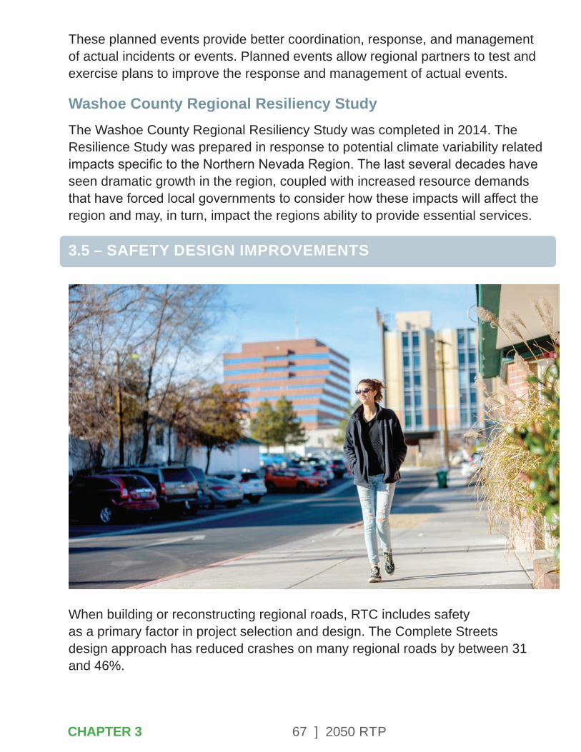
67 ] 2050 RTP
These planned events provide better coordination, response, and management of actual incidents or events. Planned events allow regional partners to test and exercise plans to improve the response and management of actual events.
Washoe County Regional Resiliency StudyThe Washoe County Regional Resiliency Study was completed in 2014. The Resilience Study was prepared in response to potential climate variability related impacts specific to the Northern Nevada Region. The last several decades have seen dramatic growth in the region, coupled with increased resource demands that have forced local governments to consider how these impacts will affect the region and may, in turn, impact the regions ability to provide essential services.
3.5 – SAFETY DESIGN IMPROVEMENTS
When building or reconstructing regional roads, RTC includes safety as a primary factor in project selection and design. The Complete Streets design approach has reduced crashes on many regional roads by between 31 and 46%.
CHAPTER 3

68 ] 2050 RTP
The range of improvements, which are selected based on corridor land-use characteristics and transportation patterns, include the following:
• Installing or upgrading sidewalks and crosswalks.
• Adding bicycle lanes, shared paths, buffered bike lanes, or bike boulevards.
• Providing a center turn lane or median, or other access management treatments.
• Adding concrete bus pads that allow for passengers to safely load and unload.
• Providing intersection and traffic signal upgrades.
• Reducing the number of or width of travel lanes.
• Roundabouts to reduce speed and crash severity.
• Installation of Flashing Yellow Arrows and retroreflective backplates at traffic signals.
• Modifying signal timing to accommodate pedestrians and cyclists.
• Installing pedestrian crossing/waiting areas in median islands.
• Road right of way, pedestrian walkways, and intersection lighting.
• Use of rumble strips on shoulders and centerlines along curves.
• Shoulder widening, slope flattening, and use of pavement safety edge.
• Street lighting.
Roundabouts along Eagle Canyon Drive and La Posada Drive.
CHAPTER 3
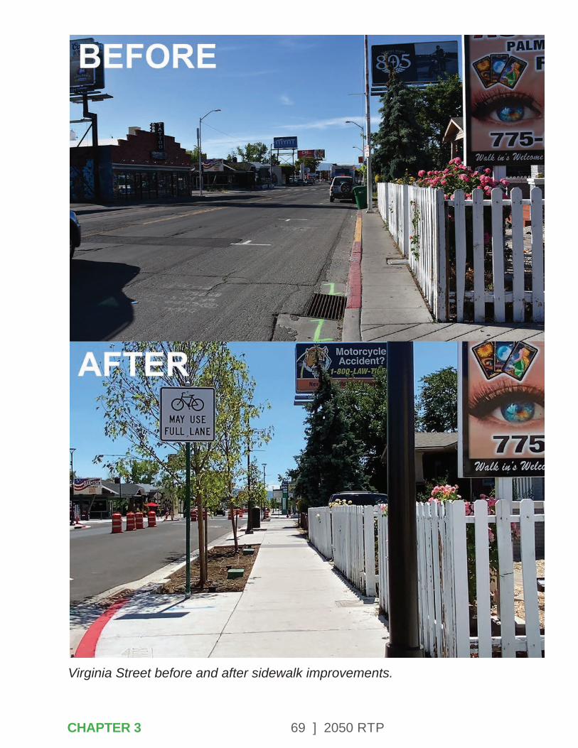
69 ] 2050 RTPCHAPTER 3
Virginia Street before and after sidewalk improvements.
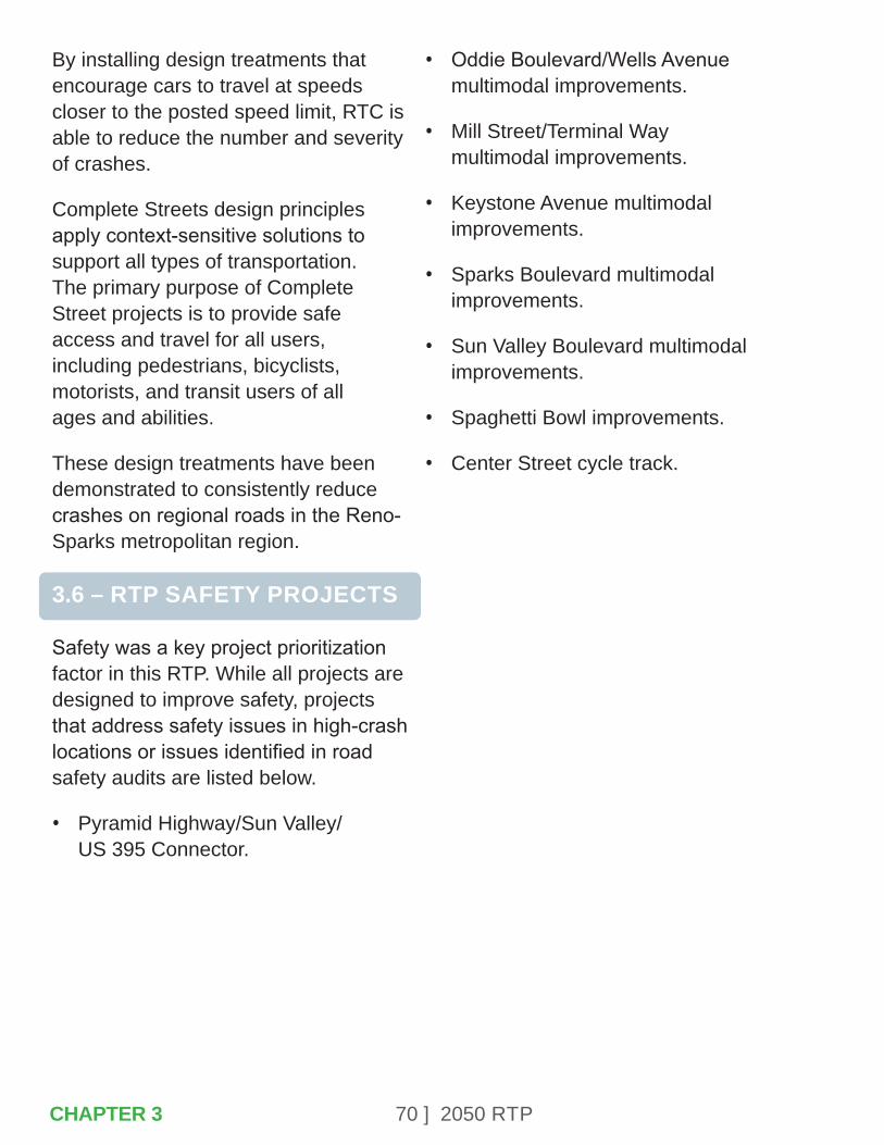
70 ] 2050 RTP
By installing design treatments that encourage cars to travel at speeds closer to the posted speed limit, RTC is able to reduce the number and severity of crashes.
Complete Streets design principles apply context-sensitive solutions to support all types of transportation. The primary purpose of Complete Street projects is to provide safe access and travel for all users, including pedestrians, bicyclists, motorists, and transit users of all ages and abilities.
These design treatments have been demonstrated to consistently reduce crashes on regional roads in the Reno-Sparks metropolitan region.
3.6 – RTP SAFETY PROJECTS
Safety was a key project prioritization factor in this RTP. While all projects are designed to improve safety, projects that address safety issues in high-crash locations or issues identified in road safety audits are listed below.
• Pyramid Highway/Sun Valley/US 395 Connector.
• Oddie Boulevard/Wells Avenue multimodal improvements.
• Mill Street/Terminal Way multimodal improvements.
• Keystone Avenue multimodal improvements.
• Sparks Boulevard multimodal improvements.
• Sun Valley Boulevard multimodal improvements.
• Spaghetti Bowl improvements.
• Center Street cycle track.
CHAPTER 3
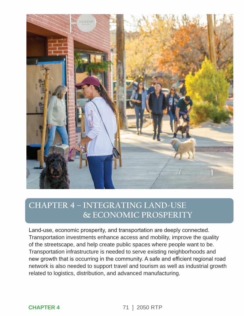
71 ] 2050 RTP
CHAPTER 4 – INTEGRATING LAND-USE & ECONOMIC PROSPERITY
Land-use, economic prosperity, and transportation are deeply connected. Transportation investments enhance access and mobility, improve the quality of the streetscape, and help create public spaces where people want to be. Transportation infrastructure is needed to serve existing neighborhoods and new growth that is occurring in the community. A safe and efficient regional road network is also needed to support travel and tourism as well as industrial growth related to logistics, distribution, and advanced manufacturing.
CHAPTER 4

72 ] 2050 RTP
Integration of Land Use, Transportation, and Economic Development
Figure 4.1
Integra�on of Land Use, Transporta�on,and Economic Development
Land-UseLand DevelopmentGenerates Travel
Transporta�onTravel Generates
the Need forNew Facili�es
EconomicDevelopment
Further Development is A�racted as
AccessibilityIncreases
Source: This graphic is based on a document produced by the US Department of Federal Highway Administration called An Overview: Land-use and Economic Development in Statewide Transportation Planning.
Transit-Supportive DevelopmentOne of the best ways to increase transit ridership is to encourage high-density housing and employment near transit stops. Providing convenient, enjoyable, and accessible pedestrian connections to bus stops is essential.
Land-use policies established by Reno, Sparks, and the Truckee Meadows Regional Planning Agency have incentivized this type of development in the Virginia Street, 4th Street/Prater Way, and other key transit corridors. As an example, Midtown has emerged as a major shopping and dining destination with a growing residential and office component. Victorian Square in downtown Sparks has also experienced a resurgence, as evidenced by the housing development near RTC CENTENNIAL PLAZA. Affordable housing and essential services are best suited to locations near transit lines to promote accessibility.
Multimodal infrastructure provides more options to get to work, school, recreational activities and provides access to necessary goods and services. High-capacity transit combined with Complete Streets design elements that provide pedestrian and bicycle access support a vibrant urban environment.
Transit supports regional tourism and economic development initiatives. It plays an important role in getting people to conventions, athletic venues, and other special events. As an example, RTC RAPID Virginia Line connects the Reno-Sparks Convention Center to downtown and major resorts supporting the tourism and convention industries. The RAPID extension to UNR will provide access to education and employment opportunities, as well as football, basketball, and other sporting events.
CHAPTER 4

73 ] 2050 RTP
4.1 – REGIONAL PLANNING
The RTC collaborates with other regional agencies that influence land-use, quality of life, and economic development. These organizations include the Reno-Tahoe Airport Authority, Truckee Meadows Regional Planning Agency, the Washoe County Health District, Washoe County School District, Washoe County Senior Services, the Truckee River Flood Management Authority, and the Reno Housing Authority. A summary of planning policies that influence transportation investments are described below.
Reno Housing AuthorityThe Housing Authority of the City of Reno (Reno Housing Authority or RHA), was founded in 1943. RHA has been appointed as the Public Housing Authority for the City of Sparks and Washoe County as well. RHA owns and manages public housing in the City of Reno and Sparks under the Public Housing programs.
Through the use of the Neighborhood Stabilization Programs and other funding, RHA owns rental properties specifically targeted for low-income households. RHA also provides housing subsidies to low-income families in Reno, Sparks, and Washoe County through Rental Assistance programs.
Reno-Tahoe International AirportOwned and operated by the Reno-Tahoe Airport Authority, the Reno-Tahoe International Airport (RTIA) is located in the core of the Reno-Sparks metropolitan area and is essential to the economic growth of the region. The RTIA is an important asset to the region, generating a total annual economic impact of $3.1 billion. The airport functions like a small city with more than 2,400 employees working for a variety of companies. It serves 4.1 million passengers per year. In 2019, approximately 147 million pounds of cargo arrived/departed RTIA. The airport is crucial to the success of tourism and cargo-related industries in Northern Nevada.
The Reno-Tahoe Airport Authority also operates the Reno-Stead Airport. The Reno-Stead Airport is a 5,000 acre general aviation facility and is home to the National Championship Air Races and contains an FAA-designated Unmanned Autonomous Systems (UAS) test range.
CHAPTER 4
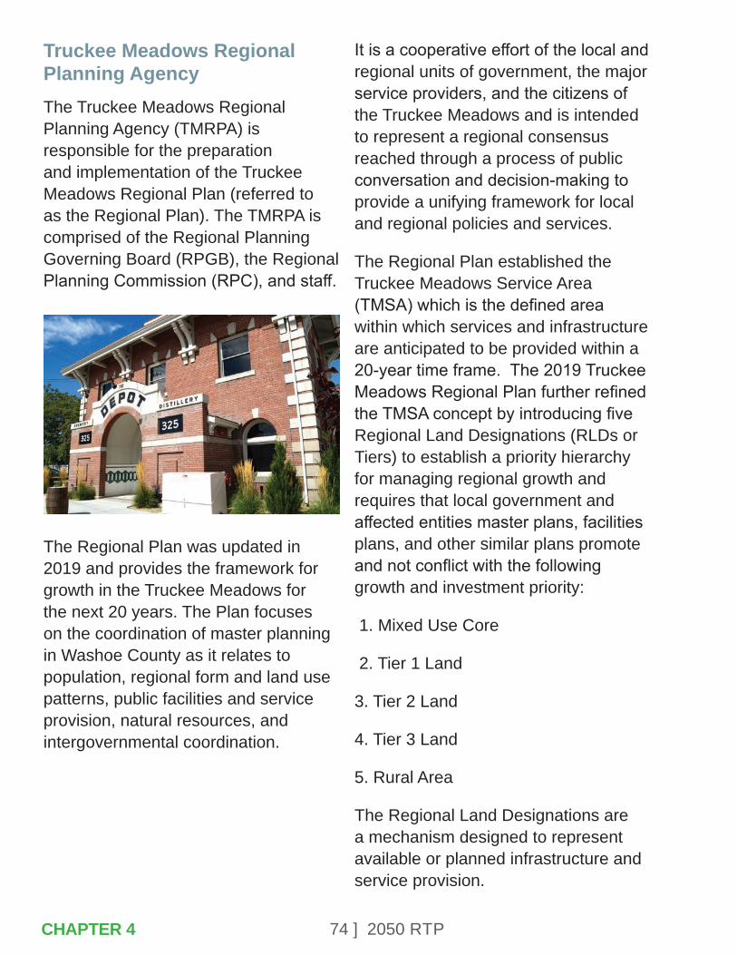
74 ] 2050 RTP
Truckee Meadows Regional Planning AgencyThe Truckee Meadows Regional Planning Agency (TMRPA) is responsible for the preparation and implementation of the Truckee Meadows Regional Plan (referred to as the Regional Plan). The TMRPA is comprised of the Regional Planning Governing Board (RPGB), the Regional Planning Commission (RPC), and staff.
The Regional Plan was updated in 2019 and provides the framework for growth in the Truckee Meadows for the next 20 years. The Plan focuses on the coordination of master planning in Washoe County as it relates to population, regional form and land use patterns, public facilities and service provision, natural resources, and intergovernmental coordination.
It is a cooperative effort of the local and regional units of government, the major service providers, and the citizens of the Truckee Meadows and is intended to represent a regional consensus reached through a process of public conversation and decision-making to provide a unifying framework for local and regional policies and services.
The Regional Plan established the Truckee Meadows Service Area (TMSA) which is the defined area within which services and infrastructure are anticipated to be provided within a 20-year time frame. The 2019 Truckee Meadows Regional Plan further refined the TMSA concept by introducing five Regional Land Designations (RLDs or Tiers) to establish a priority hierarchy for managing regional growth and requires that local government and affected entities master plans, facilities plans, and other similar plans promote and not conflict with the following growth and investment priority:
1. Mixed Use Core
2. Tier 1 Land
3. Tier 2 Land
4. Tier 3 Land
5. Rural Area
The Regional Land Designations are a mechanism designed to represent available or planned infrastructure and service provision.
CHAPTER 4
75 ] 2050 RTP
The Facilities and Services standards table in the 2019 Regional Plan outlines the expected availability both within and outside of the TMSA. In order to align regional efforts, the 2050 RTP recognizes this priority hierarchy and the RTC has utilized the hierarchy to inform the projects list and their time frames. The RTC also consistently coordinates with TMRPA and the local jurisdictions to ensure the priorities in the Regional Plan as well as the master plans are reflected in the RTP.
Further, TMRPA works closely with the local jurisdictions to develop population and employment projections by Traffic Analysis Zone (TAZ), which are assigned in the RTC travel demand forecast model. In accordance with RPGB policy, the Washoe County population and employment projections, called the Consensus Forecast, uses a number of leading forecasts, which has several advantages over using a single source for forecasting population. RTC and TMRPA collaborate closely on a wide range of data management and analytical issues. Through a Shared Work Program, the two agencies are able to access data on a common server and undertake joint technical analysis.
Washoe County Health DistrictThe Washoe County Health District is a strong partner with RTC in promoting a healthy community.
The District’s Air Quality Management Division (AQMD) and Chronic Disease Prevention Program actively support transportation investments that improve community health.
The World Health Organization defines a healthy community as “one that is safe with affordable housing and accessible transportation systems, work for all who want to work, a healthy and safe environment with a sustainable ecosystem, and offers access to health care services which focus on prevention and staying healthy.”
The Health District sponsors several healthy community initiatives based on the concept that health is more than the absence of disease, and is defined broadly to include the full range of quality of life issues.
Air Quality Management Division (AQMD)The AQMD implements clean air solutions that protect the quality of life for residents of Washoe County through community partnerships and programs such as air monitoring, permitting and enforcement, planning, and education. The Division monitors ambient air quality for the determination of compliance with National Ambient Air Quality Standards (NAAQS).
Additional information about air quality is provided in Section 5.2.
CHAPTER 4

76 ] 2050 RTP
Chronic Disease Prevention ProgramIn addition to the link between auto emissions and respiratory health, RTC collaborates with the Washoe County Health District to promote active transportation and awareness of its associated health benefits. Active transportation includes walking, biking, and riding transit (which generally begins or ends with walking to or from a bus stop). Including physical activity as a part of daily activities helps to reduce obesity and the resulting chronic conditions such as heart disease and diabetes. However, this will occur only if safe and accessible sidewalks and bicycle facilities are readily available. GetHealthyWashoe.com is a website that includes information about active living and biking to work was sponsored by the Health District and in coordination with RTC.
Community Heath Improvement PlanThe Health District, in partnership with Truckee Meadows Healthy Communities, developed a Community Health Improvement Plan in 2016.
This plan developed priorities and action plans to improve health in the region with a focus on access to healthcare and social services, behavioral health, education, and food security.
The plan included a goal to expand public and private transportation options that support access to transportation for essential services, such as medical appointments and social services, and allow seniors to live independently.
Washoe County School DistrictRTC works closely with the Washoe County School District and the Nevada Department of Transportation on the SRTS.
CHAPTER 4

77 ] 2050 RTP
The School District Police Department implements this program, which includes a combination of capital investments, organization of parent volunteers at school zones, development of operational plans, and student education. The School District’s SRTS Coordinator participates in RTC plans and studies to identify important student safety and accessibility issues.
The program is funded by RTC through Surface Transportation Block Group grant funds.
RTC also works closely with the School District regarding school siting and associated transportation infra-structure needs.
The regional school population is significantly growing. In 2019 there were four new schools that opened and two additional new schools opened in 2020. During the 2019-2020 school year, the walk zones were expanded in the community, which resulted in more youth walking and bicycling to school.
SRTS focuses on K-8 grades; therefore, RTC, NDOT, and local jurisdictions work together to evaluate school zone safety for the region’s high schools.
GIS map access is being constructed to provide tools to find safe routes to get to school. In addition to the GIS mapping tool, additional electronic and media platforms are being utilized for expansion of home-based and remote learning. This is significant because with more families choosing in-home learning, the number of students walking and bicycling to school is reduced.
Safe Routes to School is a Vision Zero Truckee Meadows partner and is exploring the Vision Youth program moving forward. Vision Youth utilizes the same mindset that fatalities are not acceptable and sets the goal of zero fatalities for students walking and biking to and from school.
CHAPTER 4
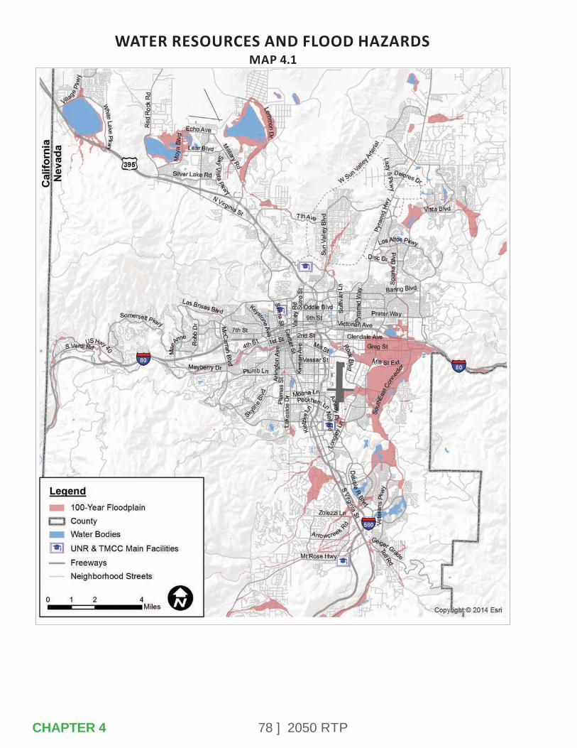
78 ] 2050 RTP
WATER RESOURCES AND FLOOD HAZARDSMAP 4.1
CHAPTER 4

79 ] 2050 RTP
Washoe County Senior ServicesWashoe County Senior Services assists older adults in the community so they can maintain independence and quality in their lives. Washoe County Senior Services offers a nutrition program, legal services, social services, adult day care, and recreational activities at the Washoe County Senior Center and Sparks Senior Citizens Center. The Strategic Plan for Washoe County Senior Citizens identifies the short- and long- term issues facing the region’s aging population, including mobility and accessibility.
The Strategic Plan highlights the importance of locating senior housing developments and other services near existing transit routes and improving the sidewalk network to promote active, healthy lifestyles. Senior Services is a partner with RTC in providing transportation information and other resources to local senior citizens.
Truckee River Flood Management ProjectThe mission of the Truckee River Flood Management Project is to reduce the impact of flooding in the Truckee Meadows, restore the Truckee River ecosystem, and improve recreational opportunities by managing the development and implementation of the Truckee River Flood Management Project.
The Truckee River Flood Project developed an action plan that provided a forum for residents, businesses, community leaders, regulatory agencies and government officials to conduct an analysis of flooding issues and evaluate possible solutions.
Floodplain ManagementWashoe County has been a member of the National Flood Insurance Program (NFIP) since 1984 reviewing all new development in special flood hazard areas (Flood Zones).
All development in the flood zones are controlled by Washoe County Flood Hazard Ordinance 416, and Federal Emergency Management Agency (FEMA) regulations. In May 2009, Washoe County qualified to be part of the FEMA Community Rating System (CRS). A map of the flood plains can be found in Map 4-1.
4.2 – LOCAL GOVERNMENT PLANNING
The City of Reno, City of Sparks, and Washoe County are responsible for local land-use planning in the region. A summary of key land-use policies as they relate to transportation for each entity is provided below.
CHAPTER 4

80 ] 2050 RTP
In addition, RTC participates in the development review processes with each local government to provide input on access management, transit, pedestrian and bicycle facility improvements, and to ensure consistency with long range transportation plans. Additional coordination occurs at a local and regional level between all agencies when needed for specific projects or activities.
City of RenoThe Reno City Council adopted their Master Plan, titled ReImagine Reno, on December 13, 2017.
This Master Plan is the result of the widest public engagement effort in Reno’s history. The Plan reflects the ideas, values, and desires of the community, aligning these with a range of plans, policies, and initiatives in place or underway in both Reno and the wider region.
The guiding principles are the first level of policy guidance included in the Master Plan.
Each reflects one aspect of the community’s visions and values and articulates the type of place desired for Reno. Together, they address a range of topics, providing the framework for Master Plan goals and policies that will help to guide decision making across the City. Guiding Principle 5, a Well-Connected City and Region, is supported by the following goals:
• Continue to develop a safe, balanced, and well-connected transportation system that enhances mobility for all modes.
• Actively manage transportation systems and infrastructure to improve reliability, efficiency, and safety.
• Facilitate the movement of goods and services throughout the region via truck, air, and rail.
• Encourage the use of transit, car or van pools, bicycling, walking, and other forms of alternative transportation.
• Anticipate and plan for the implications and opportunities associated with connected vehicles, autonomous vehicles (AVs), and the expected transition from personal car ownership to mobility-as-a-service.
CHAPTER 4
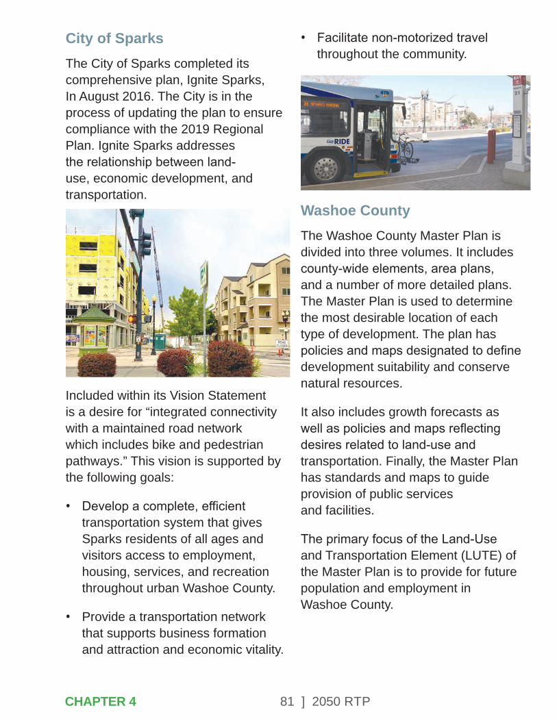
81 ] 2050 RTP
City of SparksThe City of Sparks completed its comprehensive plan, Ignite Sparks, In August 2016. The City is in the process of updating the plan to ensure compliance with the 2019 Regional Plan. Ignite Sparks addresses the relationship between land-use, economic development, and transportation.
Included within its Vision Statement is a desire for “integrated connectivity with a maintained road network which includes bike and pedestrian pathways.” This vision is supported by the following goals:
• Develop a complete, efficient transportation system that gives Sparks residents of all ages and visitors access to employment, housing, services, and recreation throughout urban Washoe County.
• Provide a transportation network that supports business formation and attraction and economic vitality.
• Facilitate non-motorized travel throughout the community.
Washoe CountyThe Washoe County Master Plan is divided into three volumes. It includes county-wide elements, area plans, and a number of more detailed plans. The Master Plan is used to determine the most desirable location of each type of development. The plan has policies and maps designated to define development suitability and conserve natural resources.
It also includes growth forecasts as well as policies and maps reflecting desires related to land-use and transportation. Finally, the Master Plan has standards and maps to guide provision of public services and facilities.
The primary focus of the Land-Use and Transportation Element (LUTE) of the Master Plan is to provide for future population and employment in Washoe County.
CHAPTER 4
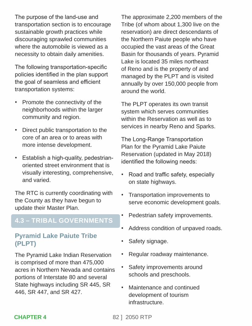
82 ] 2050 RTP
The purpose of the land-use and transportation section is to encourage sustainable growth practices while discouraging sprawled communities where the automobile is viewed as a necessity to obtain daily amenities.
The following transportation-specific policies identified in the plan support the goal of seamless and efficient transportation systems:
• Promote the connectivity of the neighborhoods within the larger community and region.
• Direct public transportation to the core of an area or to areas with more intense development.
• Establish a high-quality, pedestrian-oriented street environment that is visually interesting, comprehensive, and varied.
The RTC is currently coordinating with the County as they have begun to update their Master Plan.
4.3 – TRIBAL GOVERNMENTS
Pyramid Lake Paiute Tribe (PLPT) The Pyramid Lake Indian Reservation is comprised of more than 475,000 acres in Northern Nevada and contains portions of Interstate 80 and several State highways including SR 445, SR 446, SR 447, and SR 427.
The approximate 2,200 members of the Tribe (of whom about 1,300 live on the reservation) are direct descendants of the Northern Paiute people who have occupied the vast areas of the Great Basin for thousands of years. Pyramid Lake is located 35 miles northeast of Reno and is the property of and managed by the PLPT and is visited annually by over 150,000 people from around the world.
The PLPT operates its own transit system which serves communities within the Reservation as well as to services in nearby Reno and Sparks.
The Long-Range Transportation Plan for the Pyramid Lake Paiute Reservation (updated in May 2018) identified the following needs:
• Road and traffic safety, especially on state highways.
• Transportation improvements to serve economic development goals.
• Pedestrian safety improvements.
• Address condition of unpaved roads.
• Safety signage.
• Regular roadway maintenance.
• Safety improvements around schools and preschools.
• Maintenance and continued development of tourism infrastructure.
CHAPTER 4
83 ] 2050 RTP
Reno-Sparks Indian Colony (RSIC)The Reno-Sparks Indian Colony is a federally recognized Native American Tribe located within the Reno/Sparks metropolitan area. The Reno-Sparks Indian Colony was established in 1917 and was formally recognized in 1936 under the Indian Reorganization Act. Currently, the tribal membership consists of over 1,100 members from three Great Basin Tribes – the Paiute (Numu), the Shoshone (Newe), and the Washoe (Wa She Shu).
The reservation lands primarily consist of the original 28-acre residential Colony and another 15,263 acres in Hungry Valley, which is 19 miles north of the Colony nestled in scenic Eagle Canyon.
Over the past three decades the Colony has assembled various development sites in Reno, Sparks, and Washoe County, representing 83 acres of commercial property. The redevelopment of Reno’s East Second Street neighborhood, where half the Colony’s residents live, consists of the development of the Three Nations Plaza (Wal-Mart), relocation of the Northern Nevada Transitional Center and the RSIC Health Center.
The development of the 65,000 square foot outpatient Health Care facility was constructed from the proceeds of the Colony’s economic development projects for the benefit of its community members and more than 9,000 Native Americans residing in the region.
The Reno-Sparks Indian Colony operates a fixed-route transit system between the Reno and Hungry Valley communities. The transit system runs Monday through Saturday and includes nine stops to connect Tribal Members with Tribal Government services, the RSIC Health Center, residential neighborhoods, and Tribal Enterprises.
4.4 – OTHER REGIONAL PARTNERS
Nevada Governor’s Office of Economic Development The Nevada Governor’s Office of Economic Development has a vision for a vibrant, innovative, and sustainable economy with high-paying jobs for Nevadans. Objectives, as identified in the State Plan for Economic Development are:
• Increase opportunity through education and workforce development.
• Catalyze innovation in core and emerging industries.
• Advance targeted sectors and opportunities in the region.
CHAPTER 4
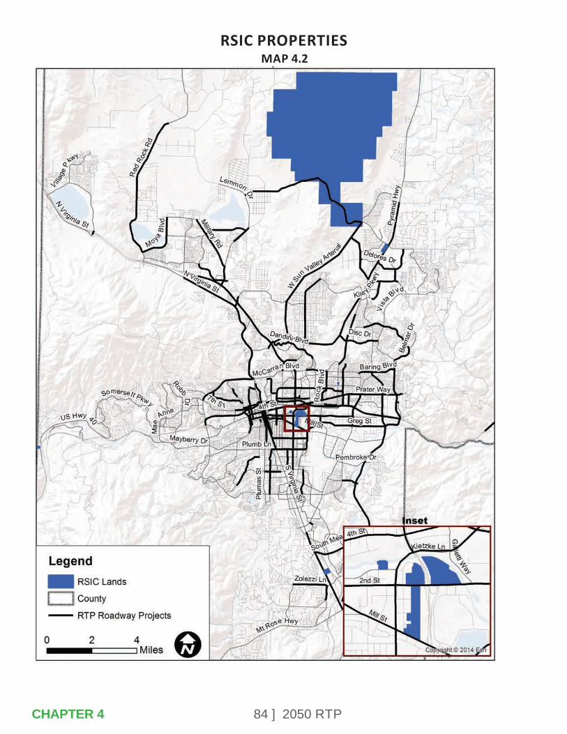
84 ] 2050 RTP
RSIC PROPERTIESMAP 4.2
CHAPTER 4
85 ] 2050 RTP
RSIC PROPERTIESMAP 4.2
• Expand global engagement.
Business IT ecosystems, such as E-commerce operations and headquarters, and logistics businesses such as warehousing and distribution, advanced logistics, air cargo, integrated manufacturing-distribution, and freight transport, are targeted industries for Northern Nevada. RTC is partnering with the State of Nevada to invest in infrastructure that supports these strategic economic development sectors.
Nevada Center for Advanced MobilityThe Nevada Center for Advanced Mobility (CAM) provides the contact point bringing together industry, government and academia to develop and deploy policy, standards and technology around advanced mobility including electric, connected, autonomous vehicles, and related infrastructure. RTC is a partner with the Nevada CAM in outreach activities.
In 2011, Google worked with Nevada DMV to pass the first ever autonomous vehicle law and create the first autonomous testing and consumer regulations. Nevada maintains leadership in regulation and policy development at the city, regional, and state levels, serving as a reference for other cities and states.
Nevada CAM works with partner agencies such as RTC, industry representatives, and other stakeholders to gather input and help shape the future.
University of Nevada, Reno (UNR)UNR was established in Reno in 1891 and as of fall 2019 had more than 21,000 students. The University is one of the largest activity centers in the region. RTC often partners with UNR staff and students to conduct research related to engineering and planning projects.
UNR works closely with RTC to promote safe multimodal transportation for its students especially in the downtown and campus areas. The RAPID Virginia Line extension to UNR and the EdPass Program that allows students, faculty, and staff to ride transit free with their university identification card, will reduce the need for cars on campus and greatly expand the traveling convenience for the student population. The partnership with UNR also extended to development of the University Area Multimodal Transportation Study, which identifies planned safety and mobility improvements in the campus area.
CHAPTER 4
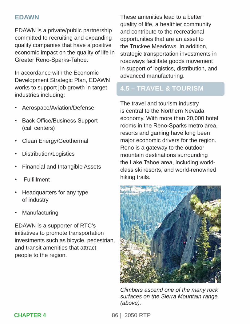
86 ] 2050 RTP
EDAWN
EDAWN is a private/public partnership committed to recruiting and expanding quality companies that have a positive economic impact on the quality of life in Greater Reno-Sparks-Tahoe.
In accordance with the Economic Development Strategic Plan, EDAWN works to support job growth in target industries including:
• Aerospace/Aviation/Defense
• Back Office/Business Support (call centers)
• Clean Energy/Geothermal
• Distribution/Logistics
• Financial and Intangible Assets
• Fulfillment
• Headquarters for any type of industry
• Manufacturing
EDAWN is a supporter of RTC’s initiatives to promote transportation investments such as bicycle, pedestrian, and transit amenities that attract people to the region.
These amenities lead to a better quality of life, a healthier community and contribute to the recreational opportunities that are an asset to the Truckee Meadows. In addition, strategic transportation investments in roadways facilitate goods movement in support of logistics, distribution, and advanced manufacturing.
4.5 – TRAVEL & TOURISM
The travel and tourism industry is central to the Northern Nevada economy. With more than 20,000 hotel rooms in the Reno-Sparks metro area, resorts and gaming have long been major economic drivers for the region. Reno is a gateway to the outdoor mountain destinations surrounding the Lake Tahoe area, including world-class ski resorts, and world-renowned hiking trails.
Climbers ascend one of the many rock surfaces on the Sierra Mountain range (above).
CHAPTER 4
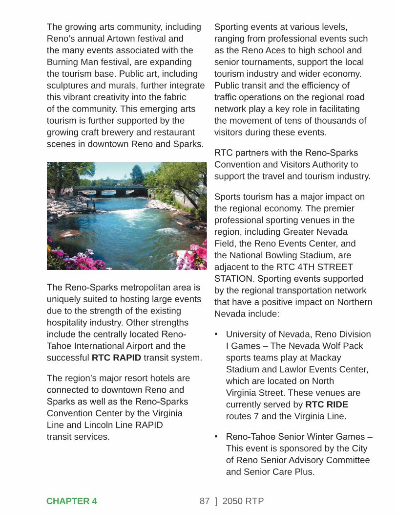
87 ] 2050 RTP
The growing arts community, including Reno’s annual Artown festival and the many events associated with the Burning Man festival, are expanding the tourism base. Public art, including sculptures and murals, further integrate this vibrant creativity into the fabric of the community. This emerging arts tourism is further supported by the growing craft brewery and restaurant scenes in downtown Reno and Sparks.
The Reno-Sparks metropolitan area is uniquely suited to hosting large events due to the strength of the existing hospitality industry. Other strengths include the centrally located Reno-Tahoe International Airport and the successful RTC RAPID transit system.
The region’s major resort hotels are connected to downtown Reno and Sparks as well as the Reno-Sparks Convention Center by the Virginia Line and Lincoln Line RAPID transit services.
Sporting events at various levels, ranging from professional events such as the Reno Aces to high school and senior tournaments, support the local tourism industry and wider economy. Public transit and the efficiency of traffic operations on the regional road network play a key role in facilitating the movement of tens of thousands of visitors during these events.
RTC partners with the Reno-Sparks Convention and Visitors Authority to support the travel and tourism industry.
Sports tourism has a major impact on the regional economy. The premier professional sporting venues in the region, including Greater Nevada Field, the Reno Events Center, and the National Bowling Stadium, are adjacent to the RTC 4TH STREET STATION. Sporting events supported by the regional transportation network that have a positive impact on Northern Nevada include:
• University of Nevada, Reno Division I Games – The Nevada Wolf Pack sports teams play at Mackay Stadium and Lawlor Events Center, which are located on North Virginia Street. These venues are currently served by RTC RIDE routes 7 and the Virginia Line.
• Reno-Tahoe Senior Winter Games – This event is sponsored by the City of Reno Senior Advisory Committee and Senior Care Plus.
CHAPTER 4
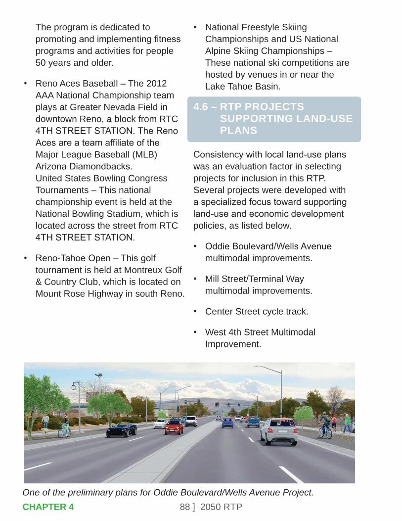
88 ] 2050 RTPOne of the preliminary plans for Oddie Boulevard/Wells Avenue Project.CHAPTER 4
The program is dedicated to promoting and implementing fitness programs and activities for people 50 years and older.
• Reno Aces Baseball – The 2012 AAA National Championship team plays at Greater Nevada Field in downtown Reno, a block from RTC 4TH STREET STATION. The Reno Aces are a team affiliate of the Major League Baseball (MLB) Arizona Diamondbacks. United States Bowling Congress Tournaments – This national championship event is held at the National Bowling Stadium, which is located across the street from RTC 4TH STREET STATION.
• Reno-Tahoe Open – This golf tournament is held at Montreux Golf & Country Club, which is located on Mount Rose Highway in south Reno.
• National Freestyle Skiing Championships and US National Alpine Skiing Championships – These national ski competitions are hosted by venues in or near the Lake Tahoe Basin.
4.6 – RTP PROJECTS SUPPORTING LAND-USE PLANS
Consistency with local land-use plans was an evaluation factor in selecting projects for inclusion in this RTP. Several projects were developed with a specialized focus toward supporting land-use and economic development policies, as listed below.
• Oddie Boulevard/Wells Avenue multimodal improvements.
• Mill Street/Terminal Way multimodal improvements.
• Center Street cycle track.
• West 4th Street Multimodal Improvement.
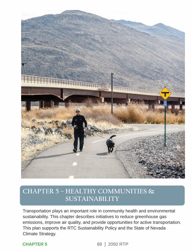
89 ] 2050 RTP
CHAPTER 5 – HEALTHY COMMUNITIES & SUSTAINABILITY
Transportation plays an important role in community health and environmental sustainability. This chapter describes initiatives to reduce greenhouse gas emissions, improve air quality, and provide opportunities for active transportation. This plan supports the RTC Sustainability Policy and the State of Nevada Climate Strategy.
CHAPTER 5
90 ] 2050 RTP
5.1 – SUSTAINABILITY
The RTC is committed to providing Washoe County with sustainable multimodal transportation options. The Complete Streets program advanced through this RTP will continue to provide infrastructure that supports active transportation. As a part of this commitment, the RTC adopted a Sustainability Policy in September 2011. This policy affirms RTC’s initiatives to promote, continually improve upon, and implement sustainable practices within the agency.
RTC Sustainability Policy
The RTC shall provide a safe, effective, and efficient transportation system that addresses environmental, social, and economic sustainability issues. By providing sustainable transportation, the RTC can actively play a role in improving the health and economic competitiveness of the region as well as reduce costs by using resources more efficiently.
RTC Sustainability PlanIn 2017, RTC completed its Sustainability Plan, which serves as a guideline for conducting operations more efficiently by implementing sustainable practices and continuing to provide sustainable and reliable transportation options. The plan created a benchmark of the current sustainability initiatives in which the RTC engages. It also includes a comprehensive organizational vision of sustainability to guide the agency’s future planning and construction efforts, operations and maintenance, and internal activities.
RTC Facilities and VehiclesThe RTC incorporates sustainable practices at all of its facilities. Some examples of these efforts include upgrades to improve the efficiency of HVAC systems, installation of external LED lighting, reduction in water usage for landscaping, and solar lighting at several bus shelters. In addition, RTC purchases sustainable products for use in daily maintenance and operations.
The RTC operates a mixed fleet of alternatively fueled fixed-route buses, including 100% electric (zero emission) and hybrid-electric buses, and is exploring hydrogen fuel cell technologies for consideration in future bus purchases. Additional information is available in Chapter 7.
CHAPTER 5
91 ] 2050 RTP
APTA Sustainability CommitmentThe RTC signed the American Public Transportation Association (APTA) Sustainability Commitment in October 2012. This requires signatories to enact core sustainability principles throughout their organizations and to develop sustainability action plans.
Nevada State Climate StrategyUnder Governor Sisolak’s executive order on climate change, state agencies were directed to develop Nevada’s first-ever State Climate Strategy establishing a framework to advance Nevada-wide climate action for a healthy, sustainable, resilient future. The State Climate Strategy was developed using the best available science, combined with robust input from thousands of Nevadans through a series of listening sessions on a full range of climate topics, a climate survey, consultation with subject-matter experts, stakeholder meetings, webinars, and more.
Nevada climate strategies, as they relate to transportation, include the following:
• Adopt low- and zero-emissions vehicle standards.
• Implement clean truck program.
• Adopt low-carbon fuel standards.
• Implement state car allowance rebate system, such as a Cash for Clunkers Program.
• Close emissions inspection loopholes for classic cars license plates.
RTC fully supports addressing the climate crisis through strategic transportation investments. Reducing greenhouse gas emissions from the transportation sector improves air quality and community health. This RTP contains investments in public transportation, sidewalks, and bicycle facilities that give people a wide range of mobility options. The investments in sidewalk, crosswalks, and lighting in underserved communities will further promote transportation choices and support equity by addressing pedestrian safety. RTC staff will continue to work with the State on the many important aspects of climate action.
Nevada Climate ActionThe overarching goals of the 2020 Climate Strategy are to:
1. Provide a framework for reducing Nevada’s Greenhouse Gas (GHG) emissions across all economic sectors.
2. Lay the groundwork for climate adaptation and resilience.
3. Establish a structure for continued, ongoing climate action across the state.
92 ] 2050 RTP
The 2020 State Climate Strategy builds a foundation for future climate action under the State of Nevada Climate Initiative.
With the vision of ensuring a vibrant, climate-resilient future for Nevada, the State of Nevada Climate Initiative (NCI) was launched in the summer of 2020. As the home of Nevada-wide climate action, the NCI is committed to reducing Nevada’s GHG emissions and dedicated to achieving resilient communities that are prepared to successfully adapt to a changing environment and climate.
Climate Justice
Across the United States and in Nevada, low-income communities, people of color, and Indigenous populations have disproportionately borne the burden of climate change impacts. As temperatures continue to rise and climate-related challenges expand and intensify, particular attention must be paid to these vulnerable populations. Through climate action, there is the opportunity to reconcile the social justice challenges Nevadans face.
Nevada is committed to reducing GHG emissions, which contribute directly to climate change. With the passage of SB 254 in 2019, Nevada adopted aggressive GHG emissions-reduction targets: 28% by 2025, 45% by 2030, and net-zero (near-zero) by 2050.
The 2020 State Climate Strategy informs policymaking on how Nevada will achieve the ambitious targets established by SB 254 and provides an integrated framework for evaluating climate policies that make sense for Nevada. Given the complexities of climate change, it is imperative that policies to reduce GHG emissions be approached systematically so there is a clear understanding of the benefits and tradeoffs.
5.2 – AIR QUALITY
Initiatives to improve air quality benefit both cardiovascular and respiratory health and can help to conserve resources. Through the promotion of active transportation and use of alternative fuels, RTC is working to improve air quality. By increasing the number of passengers who utilize transit there will be fewer single- occupant vehicles on the road, leading to reduced air pollutants.
Complete Streets are roadways that accommodate multiple modes of transportation, which could include transit, bicycles, pedestrians, and automobiles. Data collected at recent RTC projects indicates that people are more likely to utilize alternate modes of travel if there are safe facilities such as bike amenities and wide sidewalks.
CHAPTER 5

93 ] 2050 RTP
RTC data demonstrates that the proportion of people walking in a corridor increases 10 times when sidewalks are provided and the proportion of people biking doubles when bike lanes are provided. Walking and bicycling not only promote improved air quality, but can lead to a healthier and more active community.
RTC works closely with the AQMD to promote efforts that improve air quality. The Truckee Meadows is approximately 200 square miles in size and includes Hydrographic Area 87 (HA 87) as defined by the State of Nevada Division of Water Resources. This geographic area is subject to air quality monitoring. The U.S. Environmental Protection Agency (EPA) has set health and welfare based on NAAQS for the following pollutants:
• Ozone (O3).
• Particulate Matter less than or equal to 2.5 microns (PM2.5).
• Particulate Matter less than or equal to 10 microns (PM10).
• Carbon Monoxide (CO).
• Nitrogen Dioxide (NO2).
• Sulfur Dioxide (SO²).
• Lead (Pb).
The mission of the AQMD Monitoring Program is to monitor and assure the accuracy of the ambient air quality data collected for the determination of compliance with the NAAQS.
In the 1980s and 90s, Washoe County failed to meet air quality standards for carbon monoxide and particulate matter (PM10) and was designated “non-attainment” for those pollutants. Due to successful efforts to improve air quality over recent decades, the region now meets current standards and has plans in place to maintain or further improve air quality. The EPA redesignated HA 87 to “attainment” in 2008 for CO and 2016 for PM10. Additional information about air quality measurements, state implementation plans, and maintenance plans are available at the Health District’s website, OurCleanAir.com.
CHAPTER 5CHAPTER 5

94 ] 2050 RTP
Transportation has a substantial impact on air quality in Washoe County, as outlined below.
• Motor vehicles, trucks, and buses on our roadways cause 57% of nitrogen oxides (NOX) pollution, which are precursors to ozone, during the summer when ozone is usually at its highest levels.
• Motor vehicles cause 24% of volatile organic compound (VOC) pollution, another ozone precursor.
• They cause 6% of small particulate pollution (PM2.5) during the wintertime PM2.5 pollution season.
• They cause 2% of large particulate pollution (PM10) during the wintertime particulate pollution season.
• Vehicles traveling on our roadways also create air pollution from the re-entrained road dust.
• In addition, air pollution is created from road construction activities and from non-road mobile equipment used for roadway construction, as well as from other transportation sources such as railroad locomotives and aircraft.
The EPA regularly reviews each air quality standard to ensure they are set at levels that protect public health. In 2015, EPA strengthened the eight-hour ozone standard from 0.075 to 0.070 ppm.
This revision was based on dozens of health-based studies showing that lower levels of ozone are harmful to the public. Monitoring data through 2019 indicates that the southern portion of Washoe County is at 0.070 ppm, or 100% of the NAAQS. The AQMD is participating in EPA’s Ozone Advance program, which includes voluntary initiatives to improve ozone levels. The initiatives focus on three categories of strategies – technology, behavior, and the built environment. Resolutions supporting the Ozone Advance program have been adopted by the District Board of Health, Board of County Commissioners, City of Reno, City of Sparks, Regional Planning Governing Board, and the RTC. This program supports additional transportation options to reduce motor vehicle trips and Vehicle Miles Traveled (VMT) and a clean and efficient motor vehicle fleet mix in Washoe County.
A key, long-term Ozone Advance initiative is to incorporate smart-growth elements into the built environment to reduce our region’s per capita trips and VMT. Providing transportation choices improves air quality and public health. To date the RTC has implemented or achieved 40 different strategies to help the RTC significantly reduce its carbon footprint and reduce pollution.
CHAPTER 5
95 ] 2050 RTP
5.3 – ACTIVE LIVING & COMMUNITY DESIGN
Community design influences access to physical activity opportunities, healthy foods, jobs, schools, and other essential services. Many neighborhoods, shopping centers, and employment centers are designed to require a car to access services, thus leading to a lack of daily physical activity associated with mobility/transportation. This lack of activity has contributed to an increase of chronic diseases. In Washoe County only 21% of high school and 32% of middle school students are getting the recommended amounts of physical activity and 57% of adults report being overweight or obese. More information is available at GetHealthyWashoe.com.
One way to encourage active living is to create a community with mixed land-uses that allow residents to walk to school, work, parks, and shopping. As demonstrated in the RTC Bicycle and Pedestrian Count Program, providing sidewalks and bike lanes correlates to an increase in the proportion of people walking and biking on regional roads.
2018-2020 Community Health Improvement Plan (CHP)RTC participated in development of the CHIP in 2017, a process that was led by the Washoe County Health District. Three primary areas of focus for the plan included housing, behavioral health, and nutrition/physical activity.
Nutrition and physical activity was selected as a focus area as it plays a critical role in preventing a wide array of chronic diseases. While diabetes, heart disease and stroke are diseases of concern, they are all diseases that can be decreased by improving nutrition and physical activity. Providing infrastructure for active transportation such as walking and biking can help improve community health.
Washoe County Senior ServicesThe Strategic Plan for Washoe County Senior Citizens identifies transportation as one of the most significant challenges for people that care for seniors. In a survey of care providers conducted for the strategic plan, transportation needs follow finding medical/dental care and obtaining necessary medication in importance. Public transportation and walkable neighborhoods are both top transportation priorities that contribute to the plan’s mobility goals for seniors. This is especially true for seniors who live in isolation and would benefit from links to resource centers and other services.
The plan also includes a goal for healthy aging, or increasing the percentage of seniors living in the setting of their choice with support to remain as independent and healthy as possible.
CHAPTER 5
96 ] 2050 RTP
Community design and infrastructure that provide access to services and a sidewalk network that promotes walking will support healthy aging and allow seniors to reside in their homes longer. To further support this goal, new senior housing developments and other services targeted to seniors should be located in areas with existing transit service.
Safe Routes to SchoolRTC has partnered with the Washoe County School District Safe Routes to School Program. The goal of the program is to improve the health of school age children and build life-long habits of walking and bicycling. The program provides encouragement for walking and biking as well as safety education and awareness training throughout the school year. Additional information is provided in Chapter 3.
Food Deserts and Transit AccessAccess to fresh and nutritious foods is an important part of community health. The U.S. Department of Agriculture (USDA) had identified areas where convenient access to healthy food is limited. Food deserts are defined as low-income census tracts where a substantial number of residents have low access to a supermarket or large grocery store.
Low access to a healthy food retail outlet is defined as more than one mile from a supermarket or large grocery store in urban areas and as more than 10 miles from a supermarket or large grocery store in rural areas.
RTC has studied transit access in food desert census tracts and identified the routes serving these areas, as shown below. The ridership on routes through these census tracts is strong, highlighting the need to provide regional mobility to areas with limited auto ownership. Transit provides a vital service to low income residents in these areas, offering connectivity to areas with grocery stores.
CHAPTER 5
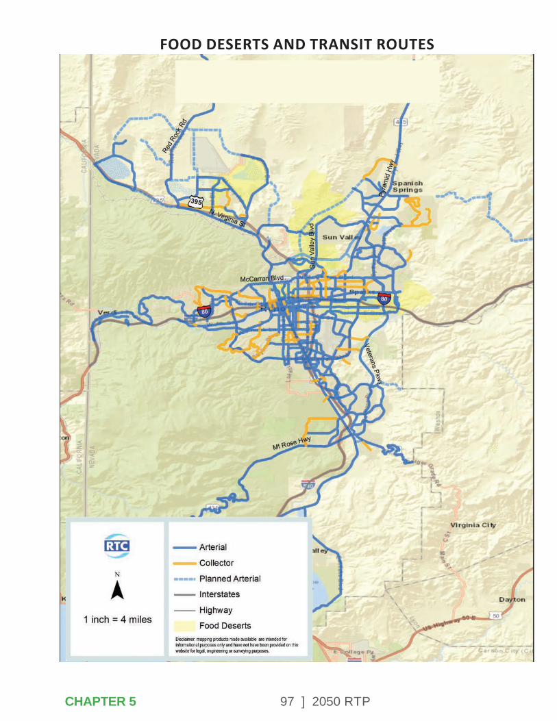
97 ] 2050 RTP
FOOD DESERTS AND TRANSIT ROUTES
CHAPTER 5

98 ] 2050 RTP
Chronic Disease PreventionThree of the top 11 leading causes of death in Washoe County can be influenced by physical activity and air quality: heart disease, chronic respiratory disease, and diabetes. The Washoe County Chronic Disease Coalition brings together agencies that can have a positive impact on the health of our local community, including transportation, emergency response, medical, and regulatory sectors.
5.4 – NATURAL RESOURCES
Quality of life in Northern Nevada is greatly enhanced by the natural resources that are available all around the region. The community is well known for its trails with stunning views of the Sierra Nevada Mountains and the Truckee River. Many agencies and organizations contribute to the preservation and quality of these recreational opportunities, and the regional transportation network provides access to these resources.
Identifying natural resources is an important step toward avoiding, minimizing, or mitigating adverse environmental impacts on sensitive resources. RTC considers environmental resources as transportation projects are developed in the early planning stages.
Planning and Environmental Linkages
Planning and Environment Linkages (PEL) represents a collaborative and integrated approach to transportation decision-making that 1) considers environmental, community, and economic goals early in the transportation planning process, and 2) uses the information, analysis, and products developed during planning to inform the environmental review process. Linking the planning process with analysis and documentation under the National Environmental Policy Act (NEPA) will improve project design and expedite delivery. An integrated process will assist in gaining regional consensus, getting public support, and responding to community needs early in the project. NDOT has adopted PEL guidance, which RTC has incorporated into projects on NDOT facilities as well as RTC-led planning studies.
Washoe County Open Space and Natural Resource Plan Open space is a critical component of the quality of life in Washoe County. This includes access to world-class recreation, defining views of the ridges and peaks of the region, and a unique landscape of natural and human history. Open space also serves to define the many local communities.
CHAPTER 5
99 ] 2050 RTP
Ridges, hills, and open space areas shape each community’s unique character. The geology of the region provides special places, including springs, geological structures, playas, and canyons. This region is also home to numerous wildlife and plant species that are found only in Washoe County, and these species depend on the natural functions of open space.
The 2008 Washoe County Open Space and Natural Resource Plan seeks to maintain, conserve, and restore the open spaces and natural resources of the region. The plan creates an inventory of unique geological features, areas of critical environmental concern, unique water resources, cultural resources, recreational opportunities, and urban open space.
Unique water resources in Washoe County include the Truckee River, Steamboat Creek, floodplains, wetlands, and the network of irrigation ditches in the urban area. In addition, Washoe Lake, Pyramid Lake, and Lake Tahoe are identified as valuable environmental resources.
Bureau of Land Management NevadaTo ensure the best balance of uses and resource protections for America’s public lands, the BLM undertakes extensive land-use planning through a collaborative approach with local, state and tribal governments, the public, and stakeholder groups. Based on this collaboration, the BLM establishes Resource Management Plans that provide the framework to guide decisions for every action and approved use on the National System of Public Lands. In Nevada, the BLM administers nearly 48 million acres of public lands. BLM public lands make up about 67% of Nevada’s land base. BLM lands are adjacent to the Reno-Sparks urbanized area.
The BLM of Nevada provides public land statistics, manages the wild horse and burro program, administers permits to ranchers who raise livestock on public lands and plays a leading role in the goal for new energy such as production of solar, wind, geothermal, and biomass energy. The BLM also assists wild land fire management efforts. Another responsibility of the BLM is to regulate outdoor recreational activities and oversee the 310,000-acre Black Rock Desert Wilderness. The Black Rock Desert-High Rock Canyon Emigrant Trails National Conservation Area (NCA) is located approximately 100 miles northeast of Reno.
CHAPTER 5
100 ] 2050 RTP
Southern Washoe County Urban Interface PlanThe objective of this plan is to improve management of public lands in the southern portion of Washoe County, where public lands are in proximity to urbanized areas. The plan identifies 160,020 acres that will be retained in public ownership under the administration of the BLM. These lands will be managed to protect open space, visual, recreation, watershed, and wildlife resources. Public lands are an important natural resource for open space for the people of the Reno-Sparks metropolitan area. The plan designated 4,390 acres for use by state and local governments for recreation purposes and 2,140 acres for potential disposal into private ownership.
US Forest ServiceThe US Forest Service manages the Humboldt-Toiyabe National Forest lands adjacent to the Reno-Sparks urbanized area. These National Forest lands in the Carson Ranger District include nearby attractions such as the Mount Rose Wilderness Area, Galena Creek area trails, and Tahoe Meadows trails. These resources are popular recreation places for residents of the metropolitan region as well as tourist destinations.
Lake Tahoe Basin Management Unit Land Resource Management Plan (LTBMU)The LTBMU was established in 1973, to facilitate unified management of Forest Service lands within the Lake Tahoe Basin watershed. The LTBMU encompasses over 154,000 acres of Forest Service lands (78% of the land in the Lake Tahoe Basin), and ranges in altitude from approximately 6,225 feet at lake level to 10,881 feet. Projects and programs include habitat management, fire management, and urban forest parcel management.
Additionally, the LTBMU provides and maintains high quality recreational opportunities for millions of visitors and residents annually. Many common forest activities such as mining or grazing are either not a part of LTBMU management or play a very small role. The LTBMU manages Forest Services lands within a mix of forest and urban communities that surround Lake Tahoe. The work of the Forest Service supports (and is supported by) many partners.
The plan focuses on watershed health, forest health, sustainable recreation, and access to National Forests.
CHAPTER 5
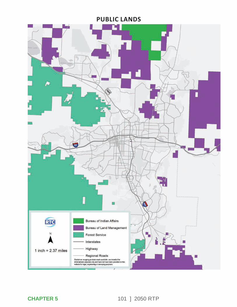
101 ] 2050 RTP
PUBLIC LANDS
CHAPTER 5

102 ] 2050 RTP
It supports the use of alternative transportation options such as public transit, pedestrian, and bike trails to access Forest Service lands. Reducing automobile dependence for site access will alleviate pollution and crowding, thereby protecting sensitive environmental resources.
Humboldt-Toiyabe National Forest Climate Change Vulnerability ReportClimate change is expected to have significant impacts on the Great Basin by the mid-21st century. Since about 1980, western U.S. winter temperatures have been consistently higher than long-term values and average winter snow packs have declined.
Since 1986, the length of the active wildfire season has increased by 78 days and the average burn duration of large fires has increased from 7.5 days to 37.1 days. Forest wildfire frequency is nearly four times higher and the total area burned by these fires is more than six and a half times its previous levels.
Department of Conservation and Natural Resources: Nevada State ParksThe Division of State Parks manages and maintains 24 parks in the State Parks system, including the Lake Tahoe Nevada State Park and Washoe Lake State Park in Washoe County.
The purpose of the Division is to plan, develop and maintain a system of parks and recreation areas for the use and enjoyment of residents and visitors. The Division also preserves areas of scenic, historic and scientific significance in Nevada.
State of Nevada Division of Water ResourcesThe mission of the Nevada Division of Water Resources (NDWR) is to conserve, protect, manage, and enhance the State’s water resources for Nevada’s citizens through the appropriation and reallocation of the public waters.
In addition, the Division is responsible for quantifying existing water rights, monitoring water use, distributing water in accordance with court decrees, reviewing water availability for new subdivisions and condominiums, reviewing the construction and operation of dams. appropriating geothermal water, licensing and regulation of well drillers and water rights surveyors, reviewing flood control projects, monitoring water resource data and records, and providing technical assistance to the public and governmental agencies.
CHAPTER 5
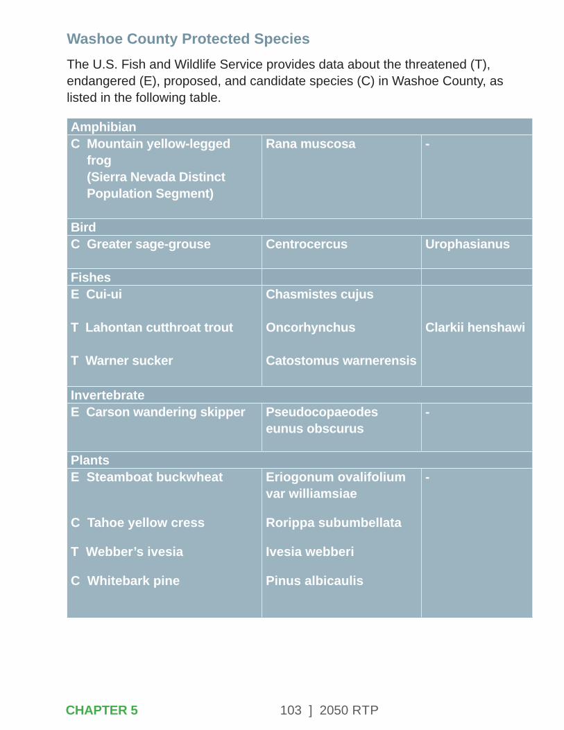
103 ] 2050 RTP
Washoe County Protected SpeciesThe U.S. Fish and Wildlife Service provides data about the threatened (T), endangered (E), proposed, and candidate species (C) in Washoe County, as listed in the following table.
AmphibianC Mountain yellow-legged
frog (Sierra Nevada Distinct Population Segment)
Rana muscosa -
BirdC Greater sage-grouse
Centrocercus Urophasianus
FishesE Cui-ui
T Lahontan cutthroat trout
T Warner sucker
Chasmistes cujus
Oncorhynchus
Catostomus warnerensis
Clarkii henshawi
InvertebrateE Carson wandering skipper Pseudocopaeodes
eunus obscurus-
PlantsE Steamboat buckwheat
C Tahoe yellow cress
T Webber’s ivesia
C Whitebark pine
Eriogonum ovalifolium var williamsiae
Rorippa subumbellata
Ivesia webberi
Pinus albicaulis
-
CHAPTER 5
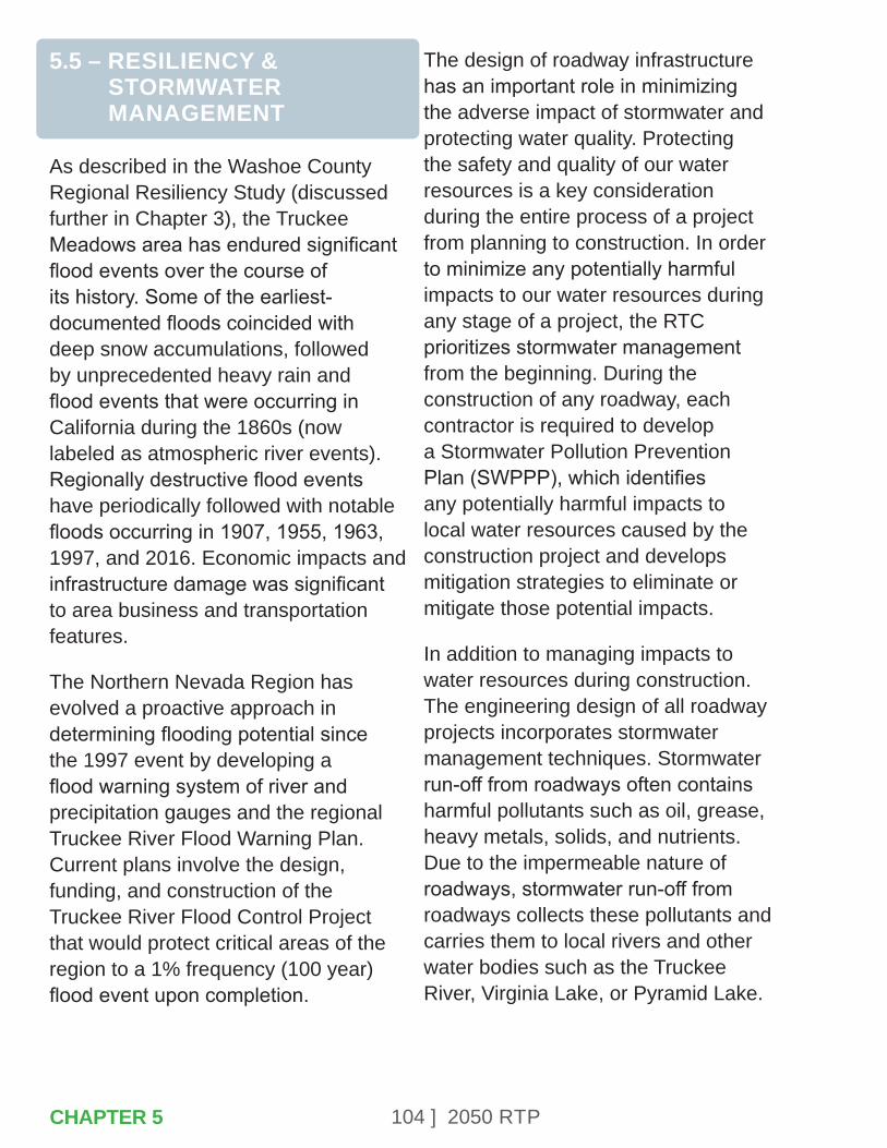
104 ] 2050 RTP
5.5 – RESILIENCY & STORMWATER MANAGEMENT
As described in the Washoe County Regional Resiliency Study (discussed further in Chapter 3), the Truckee Meadows area has endured significant flood events over the course of its history. Some of the earliest-documented floods coincided with deep snow accumulations, followed by unprecedented heavy rain and flood events that were occurring in California during the 1860s (now labeled as atmospheric river events). Regionally destructive flood events have periodically followed with notable floods occurring in 1907, 1955, 1963, 1997, and 2016. Economic impacts and infrastructure damage was significant to area business and transportation features.
The Northern Nevada Region has evolved a proactive approach in determining flooding potential since the 1997 event by developing a flood warning system of river and precipitation gauges and the regional Truckee River Flood Warning Plan. Current plans involve the design, funding, and construction of the Truckee River Flood Control Project that would protect critical areas of the region to a 1% frequency (100 year) flood event upon completion.
The design of roadway infrastructure has an important role in minimizing the adverse impact of stormwater and protecting water quality. Protecting the safety and quality of our water resources is a key consideration during the entire process of a project from planning to construction. In order to minimize any potentially harmful impacts to our water resources during any stage of a project, the RTC prioritizes stormwater management from the beginning. During the construction of any roadway, each contractor is required to develop a Stormwater Pollution Prevention Plan (SWPPP), which identifies any potentially harmful impacts to local water resources caused by the construction project and develops mitigation strategies to eliminate or mitigate those potential impacts.
In addition to managing impacts to water resources during construction. The engineering design of all roadway projects incorporates stormwater management techniques. Stormwater run-off from roadways often contains harmful pollutants such as oil, grease, heavy metals, solids, and nutrients. Due to the impermeable nature of roadways, stormwater run-off from roadways collects these pollutants and carries them to local rivers and other water bodies such as the Truckee River, Virginia Lake, or Pyramid Lake.
CHAPTER 5
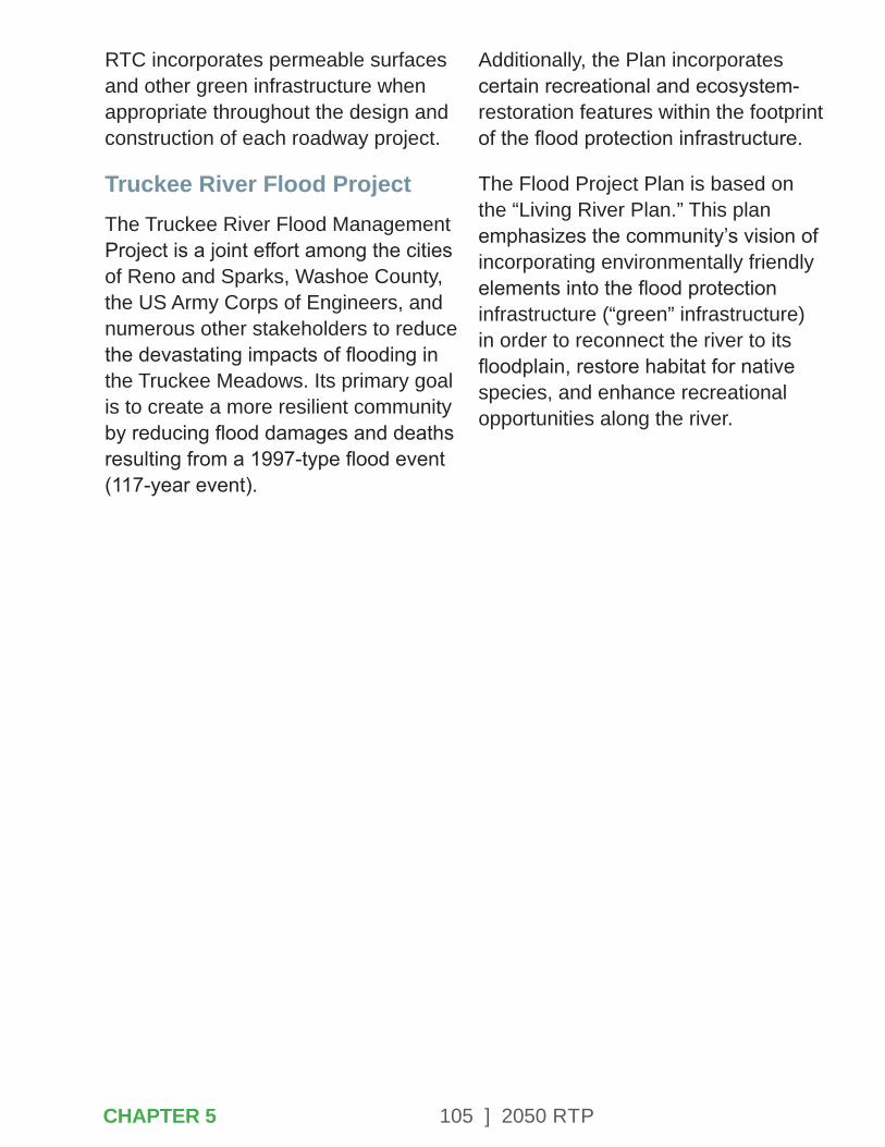
105 ] 2050 RTP
RTC incorporates permeable surfaces and other green infrastructure when appropriate throughout the design and construction of each roadway project.
Truckee River Flood ProjectThe Truckee River Flood Management Project is a joint effort among the cities of Reno and Sparks, Washoe County, the US Army Corps of Engineers, and numerous other stakeholders to reduce the devastating impacts of flooding in the Truckee Meadows. Its primary goal is to create a more resilient community by reducing flood damages and deaths resulting from a 1997-type flood event (117-year event).
Additionally, the Plan incorporates certain recreational and ecosystem-restoration features within the footprint of the flood protection infrastructure.
The Flood Project Plan is based on the “Living River Plan.” This plan emphasizes the community’s vision of incorporating environmentally friendly elements into the flood protection infrastructure (“green” infrastructure) in order to reconnect the river to its floodplain, restore habitat for native species, and enhance recreational opportunities along the river.
CHAPTER 5
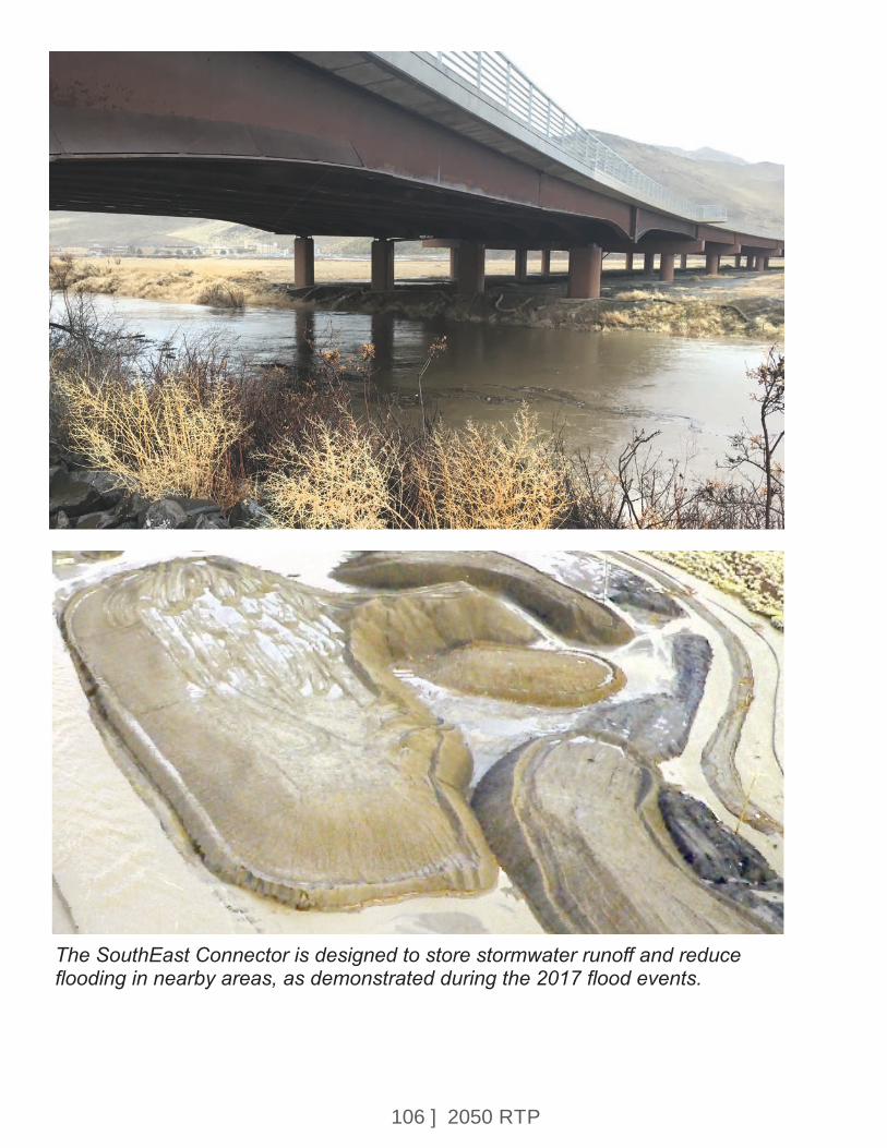
106 ] 2050 RTP
The SouthEast Connector is designed to store stormwater runoff and reduce flooding in nearby areas, as demonstrated during the 2017 flood events.
107 ] 2050 RTP
CHAPTER 6 – MANAGING EXISTING SYSTEMS EFFICIENTLY
The RTC strives to maximize the use of limited resources by maintaining existing systems in good repair and continuously seeking operational improvements. This is most apparent in the RTC’s transit, traffic operations, intelligent transportation systems (ITS), and pavement preservation programs. These programs provide a framework for obtaining the best and most-efficient use of existing resources, minimizing life-cycle costs, and in some cases reducing the need for costly capital investments.
CHAPTER 6
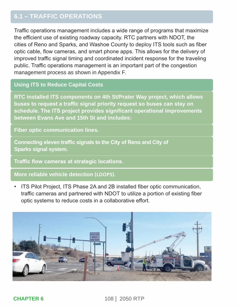
108 ] 2050 RTP
6.1 – TRAFFIC OPERATIONS
Traffic operations management includes a wide range of programs that maximize the efficient use of existing roadway capacity. RTC partners with NDOT, the cities of Reno and Sparks, and Washoe County to deploy ITS tools such as fiber optic cable, flow cameras, and smart phone apps. This allows for the delivery of improved traffic signal timing and coordinated incident response for the traveling public. Traffic operations management is an important part of the congestion management process as shown in Appendix F.
Using ITS to Reduce Capital Costs
RTC installed ITS components on 4th St/Prater Way project, which allows buses to request a traffic signal priority request so buses can stay on schedule. The ITS project provides significant operational improvements between Evans Ave and 15th St and includes:
Fiber optic communication lines.
Connecting eleven traffic signals to the City of Reno and City of Sparks signal system.
Traffic flow cameras at strategic locations.
More reliable vehicle detection (LOOPS).
• ITS Pilot Project, ITS Phase 2A and 2B installed fiber optic communication, traffic cameras and partnered with NDOT to utilize a portion of existing fiber optic systems to reduce costs in a collaborative effort.
CHAPTER 6
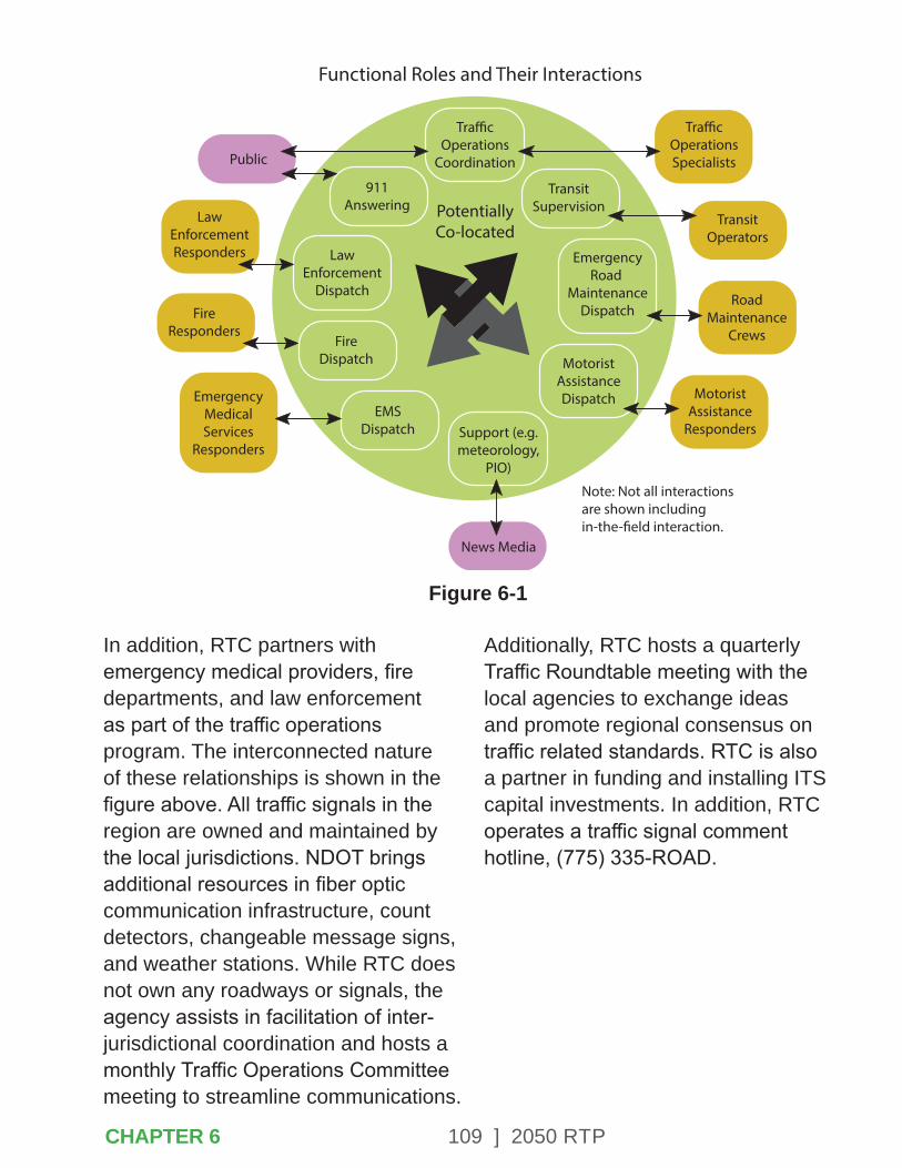
109 ] 2050 RTP
Public
News Media
LawEnforcementResponders
Tra�cOperationsSpecialists
Tra�cOperations
Coordination
LawEnforcement
Dispatch
EmergencyRoad
MaintenanceDispatch
MotoristAssistanceDispatch
Support (e.g.meteorology,
PIO)
RoadMaintenance
Crews
MotoristAssistance
Responders
TransitOperators
911Answering
TransitSupervision
EMSDispatch
FireDispatch
EmergencyMedicalServices
Responders
FireResponders
Note: Not all interactionsare shown including in-the-�eld interaction.
Functional Roles and Their Interactions
PotentiallyCo-located
Figure 6-1
In addition, RTC partners with emergency medical providers, fire departments, and law enforcement as part of the traffic operations program. The interconnected nature of these relationships is shown in the figure above. All traffic signals in the region are owned and maintained by the local jurisdictions. NDOT brings additional resources in fiber optic communication infrastructure, count detectors, changeable message signs, and weather stations. While RTC does not own any roadways or signals, the agency assists in facilitation of inter-jurisdictional coordination and hosts a monthly Traffic Operations Committee meeting to streamline communications.
Additionally, RTC hosts a quarterly Traffic Roundtable meeting with the local agencies to exchange ideas and promote regional consensus on traffic related standards. RTC is also a partner in funding and installing ITS capital investments. In addition, RTC operates a traffic signal comment hotline, (775) 335-ROAD.
CHAPTER 6
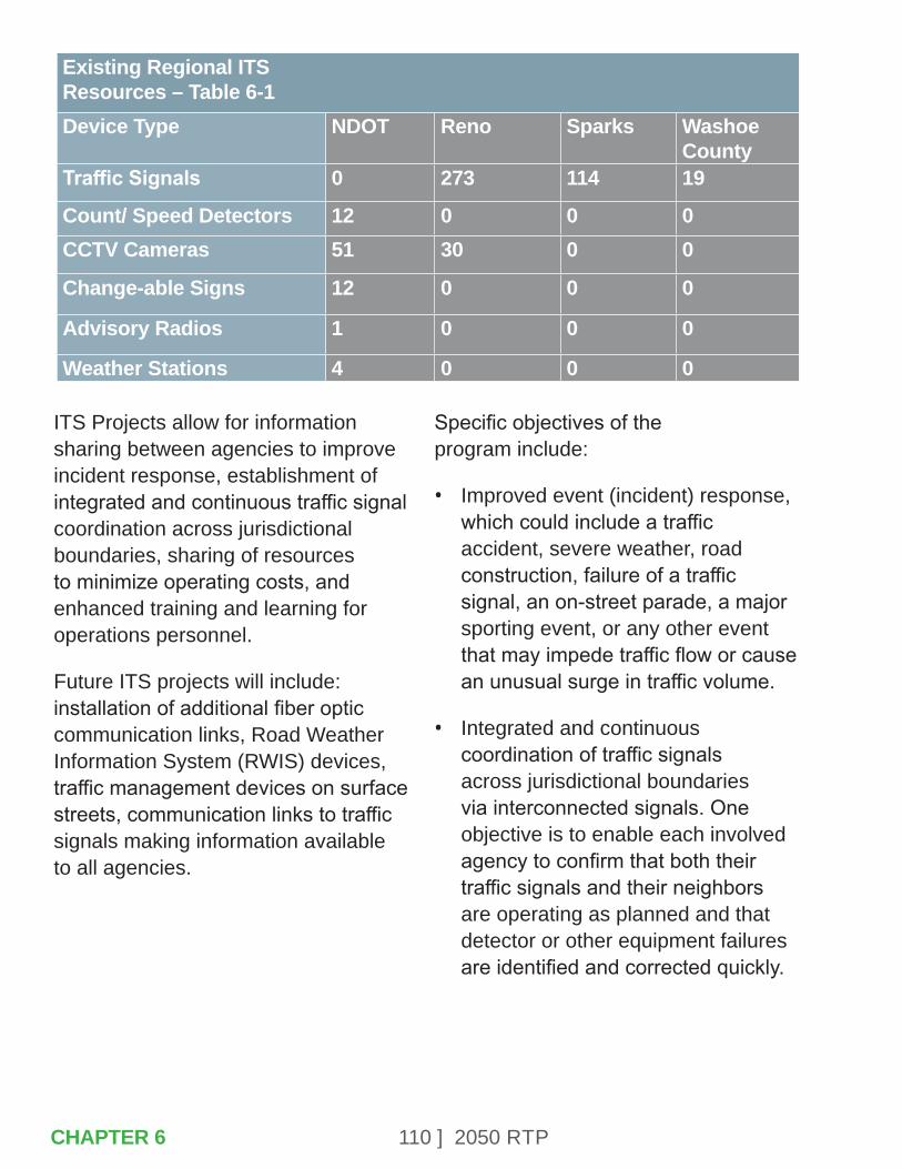
110 ] 2050 RTP
ITS Projects allow for information sharing between agencies to improve incident response, establishment of integrated and continuous traffic signal coordination across jurisdictional boundaries, sharing of resources to minimize operating costs, and enhanced training and learning for operations personnel.
Future ITS projects will include: installation of additional fiber optic communication links, Road Weather Information System (RWIS) devices, traffic management devices on surface streets, communication links to traffic signals making information available to all agencies.
Specific objectives of the program include:
• Improved event (incident) response, which could include a traffic accident, severe weather, road construction, failure of a traffic signal, an on-street parade, a major sporting event, or any other event that may impede traffic flow or cause an unusual surge in traffic volume.
• Integrated and continuous coordination of traffic signals across jurisdictional boundaries via interconnected signals. One objective is to enable each involved agency to confirm that both their traffic signals and their neighbors are operating as planned and that detector or other equipment failures are identified and corrected quickly.
Existing Regional ITSResources – Table 6-1Device Type NDOT Reno Sparks Washoe
CountyTraffic Signals 0 273 114 19
Count/ Speed Detectors 12 0 0 0CCTV Cameras 51 30 0 0
Change-able Signs 12 0 0 0
Advisory Radios 1 0 0 0
Weather Stations 4 0 0 0
CHAPTER 6
111 ] 2050 RTP
• Access to more information by the traveling public, and more consistent and seamless information about current travel conditions regardless of the mixture of agencies responsible for portions of their planned journey.
• Sharing resources to enable agencies to perform their missions at a lower cost. Shared resources could include specialized equipment, fiber optic communication or joint maintenance contracts.
• Providing the data needed to assess region-wide transportation and incident management performance measures.
Fiber optic cables used by traffic operation agencies for ITS device communication can be interconnected to provide communication links between agencies.
The highest priority infrastructure improvements needed to support improved traffic operations are as follows:
• Communication links between ITS networks operated by different agencies.
• Communication links to traffic signals on major surface streets that are currently not connected to a central system.
• Closed Caption Television (CCTV) cameras on major surface streets.
• CCTV cameras, vehicle detectors, and associated communication links on all urban area freeway segments.
• The RTC leads the traffic signal timing program in Washoe County. In partnership with the cities of Reno, Sparks and Washoe County, and the University of Nevada, Reno, the program aims to retime the more than 400 traffic signals in the region on a three year basis. Using the technology employed through the ITS Program, retiming and maintenance of all signal timing are done efficiently.
1. The purpose of this program is to reassess the signal timing due to changes in traffic patterns and volumes throughout the road network.
2. Improve travel times and fuel savings.
3. Reduce emissions and air pollution.
4. Improve traffic safety by reducing frustration from drivers experiencing excessive delays.
5. Update various timing settings to current federal standards.
CHAPTER 6
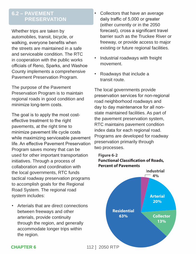
112 ] 2050 RTP
6.2 – PAVEMENT PRESERVATION
Whether trips are taken by automobiles, transit, bicycle, or walking, everyone benefits when the streets are maintained in a safe and serviceable condition. The RTC in cooperation with the public works officials of Reno, Sparks, and Washoe County implements a comprehensive Pavement Preservation Program.
The purpose of the Pavement Preservation Program is to maintain regional roads in good condition and minimize long-term costs.
The goal is to apply the most cost-effective treatment to the right pavements, at the right time to minimize pavement life cycle costs while maximizing serviceable pavement life. An effective Pavement Preservation Program saves money that can be used for other important transportation initiatives. Through a process of collaboration and coordination with the local governments, RTC funds tactical roadway preservation programs to accomplish goals for the Regional Road System. The regional road system includes:
• Arterials that are direct connections between freeways and other arterials, provide continuity through the region, and generally accommodate longer trips within the region.
• Collectors that have an average daily traffic of 5,000 or greater (either currently or in the 2050 forecast), cross a significant travel barrier such as the Truckee River or freeway, or provide access to major existing or future regional facilities.
• Industrial roadways with freight movement.
• Roadways that include a transit route.
The local governments provide preservation services for non-regional road neighborhood roadways and day to day maintenance for all non-state maintained facilities. As part of the pavement preservation system, RTC maintains pavement condition index data for each regional road. Programs are developed for roadway preservation primarily through two processes.
Industrial 4%
Residential63%
Arterial20%
Figure 6-2Functional Classi�cation of Roads, Percent of Pavements
Collector13%
CHAPTER 6
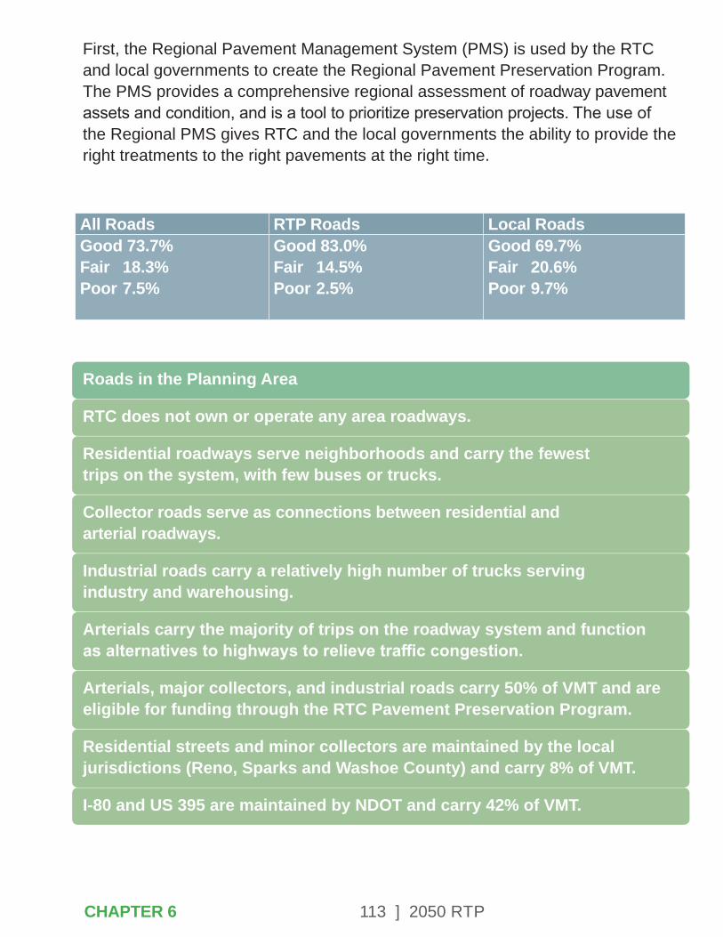
113 ] 2050 RTP
First, the Regional Pavement Management System (PMS) is used by the RTC and local governments to create the Regional Pavement Preservation Program. The PMS provides a comprehensive regional assessment of roadway pavement assets and condition, and is a tool to prioritize preservation projects. The use of the Regional PMS gives RTC and the local governments the ability to provide the right treatments to the right pavements at the right time.
Roads in the Planning Area
RTC does not own or operate any area roadways.
Residential roadways serve neighborhoods and carry the fewest trips on the system, with few buses or trucks.
Collector roads serve as connections between residential and arterial roadways.
Industrial roads carry a relatively high number of trucks serving industry and warehousing.
Arterials carry the majority of trips on the roadway system and function as alternatives to highways to relieve traffic congestion.
Arterials, major collectors, and industrial roads carry 50% of VMT and are eligible for funding through the RTC Pavement Preservation Program.
Residential streets and minor collectors are maintained by the local jurisdictions (Reno, Sparks and Washoe County) and carry 8% of VMT.
I-80 and US 395 are maintained by NDOT and carry 42% of VMT.
All Roads RTP Roads Local RoadsGood 73.7%Fair 18.3%Poor 7.5%
Good 83.0%Fair 14.5%Poor 2.5%
Good 69.7%Fair 20.6%Poor 9.7%
CHAPTER 6
114 ] 2050 RTP
This proactive maintenance strategy relies on preventive and corrective maintenance methods to maintain good pavements in good condition. In turn, this slows the rate of pavements falling into poor condition which would require costly major reconstruction. It is six to 10 times less expensive to properly maintain streets than to allow them to fail and pay for costly reconstruction treatments.
RTC’s Pavement Preservation Program has significantly improved driving conditions and reduced the region’s backlog of pavement reconstruction needs. Since initiation of the program the average Pavement Condition Index (PCI) for regional roadways (excluding NDOT maintained roads) has been raised above the goal of 80 and is currently 83 which is optimal for minimizing costs and maximizing performance life. Two percent of the regional network are in poor condition (PCI below 50).d
The NDOT PMS monitors state-maintained facilities in Washoe County. The NDOT PMS also quantifies the backlog of pavement repairs on the state highway system and identifies project priorities. The NDOT PMS is used to identify NDOT’s long-range funding needs to maintain the state highway network at a serviceable level. NDOT conducts a pavement condition survey annually.
The RTC’s Pavement Preservation Program is central to implementation of Complete Streets strategies. Through the preventative maintenance slurry seal program and close coordination with the local jurisdictions, RTC is narrowing travel lanes, adding bicycle lanes, and in some cases eliminating travel lanes. The effects of these Complete Streets strategies are to slow traffic to the designated posted speed, reduce vehicle crashes, and provide a safe space for other non-auto users. Crash reductions ranging from 25-45% have been documented on regional roads that have undergone these reconfigurations.
The program is implemented in coordination with the Pavement Preservation Committee, which consists of public works and maintenance staff of Reno, Sparks, and Washoe County. The committee identifies projects based on need, including pavement condition and average daily traffic levels. It does not consider jurisdiction and prioritizes projects to maximize benefits to the network as a whole.
Despite the overall “good rating” of the region’s pavements, challenges do exist in maintaining our existing roadway system. More efficient cars that use less fuel and electric cars are affecting the amount of fuel sold and taxed.
CHAPTER 6

115 ] 2050 RTP
The reduction in revenue will challenge RTC and local jurisdictions to maintain the “good rating” for the next few years.
The local jurisdictions’ and NDOT’s ability to fund and operate an effective maintenance program continues to be a challenge. For the non-regional and residential system of roads, the Cities of Sparks and Reno in particular have a significant reconstruction backlog. However, through the effective use of their available resources, the local agencies have reduced the amount of residential roads in poor condition from 12% to 10% since 2012. While these roads account for approximately two-thirds of the pavement network, they carry only 8% of the VMT in the region. Limited expansion of the RTC Pavement Preservation Program to include neighborhood collectors is under consideration and will be evaluated.
6.3 – TRANSIT OPERATIONS
Public transit is a valuable community asset that provides:
• Access to essential jobs and supports economic growth through improved mobility and access to opportunity.
• Access to important resources such as medical services, colleges and universities, and government services.
• Health benefits through improved air quality and active transportation options.
Operational efficiency is one of the goals for the regional transit system. Because transit funding sources are limited, it is essential that cost effectiveness be a consideration in transit planning. RTC publishes monthly reports about the system’s operational performance. RTC operates RTC RIDE fixed route, RAPID bus rapid transit, REGIONAL CONNECTOR intercity, ACCESS paratransit, and FlexRIDE on-demand services.
The RTC operates 23 fixed routes in the Reno-Sparks metropolitan area as well as areas of unincorporated Washoe County. The system operates in a 90 square-mile service area. Existing service offers the greatest frequency in the urban core, reflecting the goal of maximizing the number of passengers per service hour. With two separate central business districts in Reno and Sparks, RTC operates a high-frequency connector between the two cities with less-frequent or on-demand feeder service increasing the coverage area.
Both downtown Reno and Sparks are serviced by transit transfer terminals: RTC 4TH STREET STATION and RTC CENTENNIAL PLAZA.
CHAPTER 6
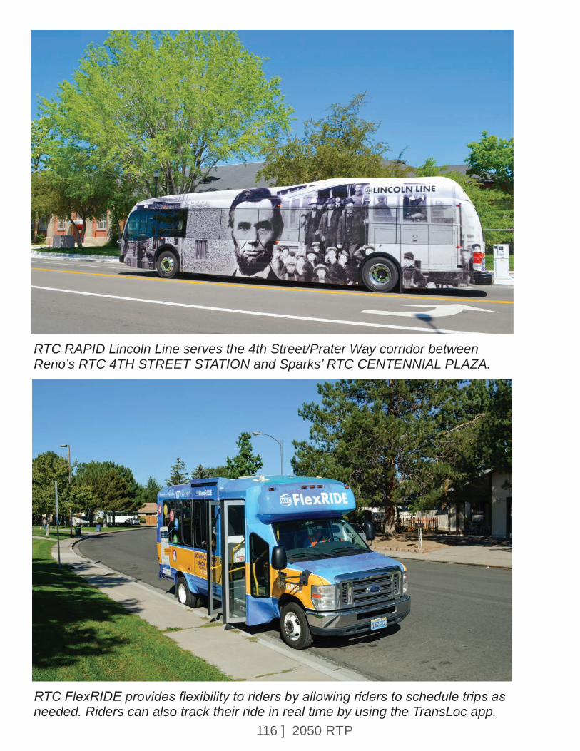
116 ] 2050 RTP
RTC RAPID Lincoln Line serves the 4th Street/Prater Way corridor between Reno’s RTC 4TH STREET STATION and Sparks’ RTC CENTENNIAL PLAZA.
RTC FlexRIDE provides flexibility to riders by allowing riders to schedule trips as needed. Riders can also track their ride in real time by using the TransLoc app.
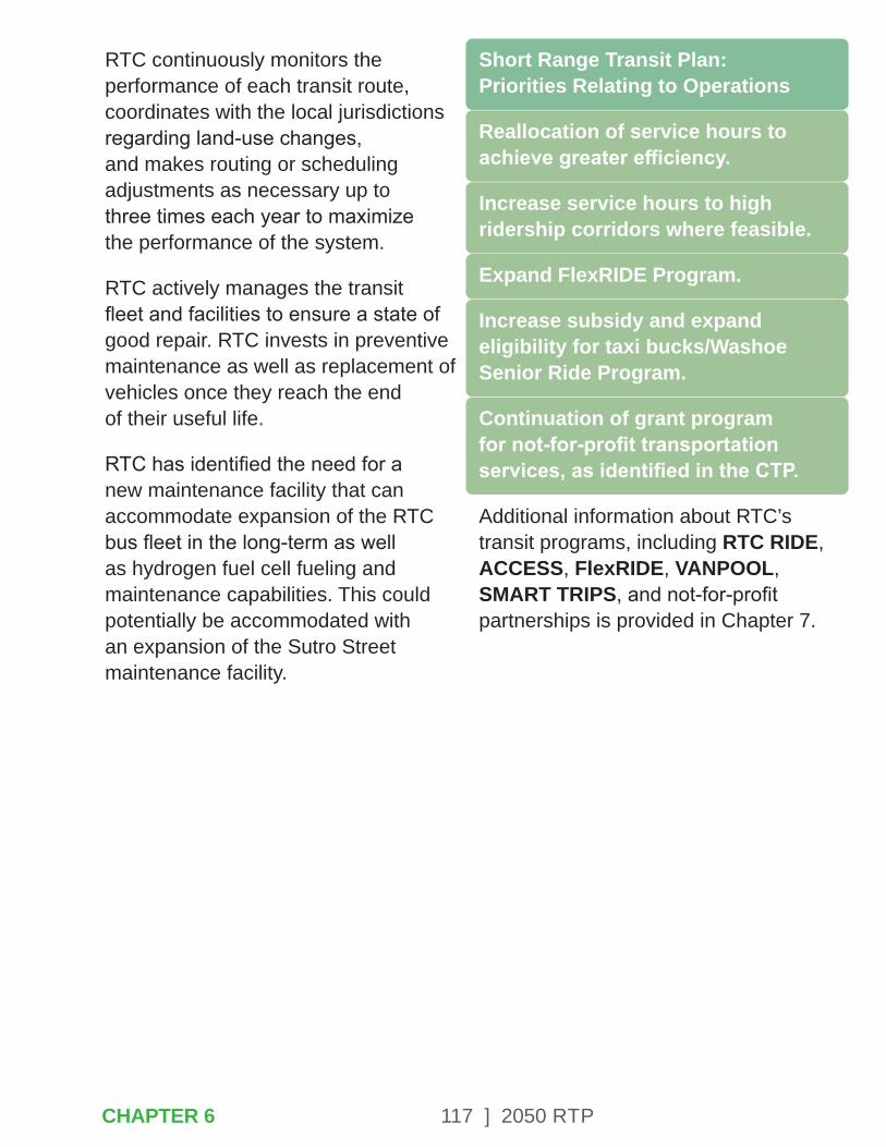
117 ] 2050 RTP
RTC continuously monitors the performance of each transit route, coordinates with the local jurisdictions regarding land-use changes, and makes routing or scheduling adjustments as necessary up to three times each year to maximize the performance of the system.
RTC actively manages the transit fleet and facilities to ensure a state of good repair. RTC invests in preventive maintenance as well as replacement of vehicles once they reach the end of their useful life.
RTC has identified the need for a new maintenance facility that can accommodate expansion of the RTC bus fleet in the long-term as well as hydrogen fuel cell fueling and maintenance capabilities. This could potentially be accommodated with an expansion of the Sutro Street maintenance facility.
Short Range Transit Plan: Priorities Relating to Operations
Reallocation of service hours to achieve greater efficiency.
Increase service hours to high ridership corridors where feasible.
Expand FlexRIDE Program.
Increase subsidy and expand eligibility for taxi bucks/Washoe Senior Ride Program.
Continuation of grant program for not-for-profit transportation services, as identified in the CTP.
Additional information about RTC’s transit programs, including RTC RIDE, ACCESS, FlexRIDE, VANPOOL, SMART TRIPS, and not-for-profit partnerships is provided in Chapter 7.
CHAPTER 6
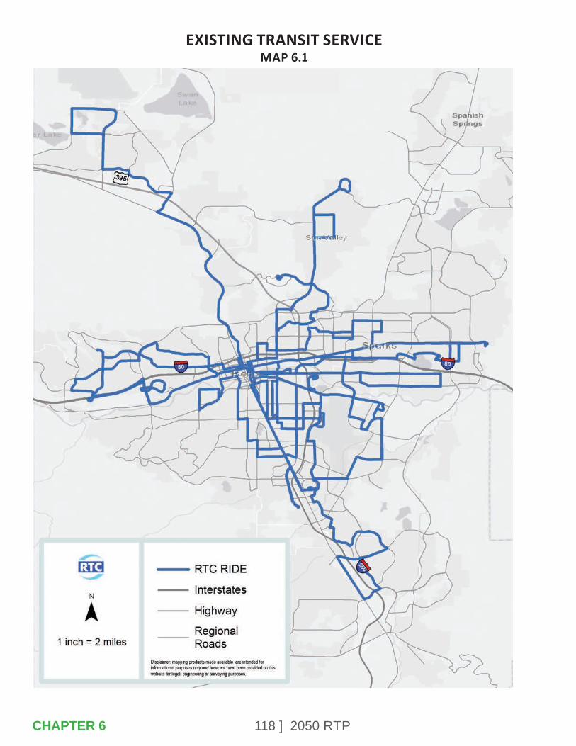
118 ] 2050 RTPCHAPTER 6
EXISTING TRANSIT SERVICEMAP 6.1
119 ] 2050 RTP
CHAPTER 7 – INTEGRATING ALL TYPES OF TRANSPORTATION
A goal of the RTP is to integrate all types of transportation. RTC seeks to have an interconnected multimodal transportation system that gives residents more travel choices. Local residents have expressed a desire to have transportation options, which include convenient alternatives for walking, biking, riding transit, or driving. An integrated regional transportation system must provide mobility options that are appropriate to the land-use context and address the needs of neighborhoods, commercial districts, and the movement of goods.
CHAPTER 7

120 ] 2050 RTP
Complete Street designs have reduced crashes up to 46% on regional roads in Washoe County.
7.1 – COMPLETE STREETS
Complete Streets design principles apply context-sensitive solutions to support all types of transportation. The primary purpose of Complete Streets projects is to provide safe access and travel for all users, including pedestrians, bicyclists, motorists and transit users of all ages and abilities. These design treatments have been demonstrated to consistently reduce crashes on regional roads in the Reno-Sparks metropolitan region. The range of improvements, which are selected based on corridor land-use characteristics and transportation patterns, include the following:
• Roundabouts.
• Narrow (less than 12-foot) travel lanes.
• Reducing vehicle and pedestrian conflict points by reducing underutilized travel lanes.
• Adding center turn lanes.
• Adding bicycle lanes, multiuse paths, buffered bike lanes, or sharrows.
• Installing or upgrading sidewalks and crosswalks.
• Installing pedestrian crossing/waiting areas in median islands.
• Installing or upgrading transit stops.
Complete Streets designs in many instances can slow traffic to about the speed limit, which reduces the number and severity of crashes, making the roadway safer for all users. Roadway designs that encourage motorists to drive at posted speeds and provide designated space for walking and biking will improve safety.
Bicyclists and joggers on Plumas Street after Complete Street project.
CHAPTER 7
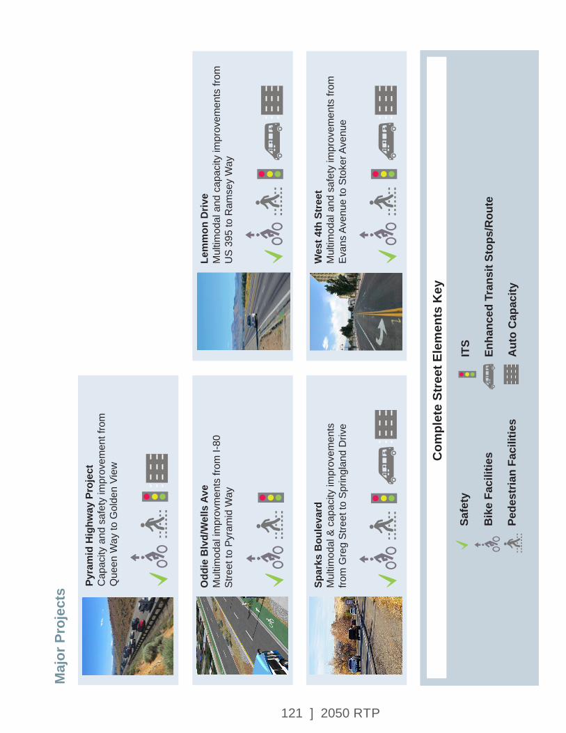
121 ] 2050 RTP
Odd
ie B
lvd/
Wel
ls A
veM
ultim
odal
impr
ovm
ents
from
I-80
St
reet
to P
yram
id W
ay
Spar
ks B
oule
vard
Mul
timod
al &
cap
acity
impr
ovem
ents
fro
m G
reg
Stre
et to
Spr
ingl
and
Driv
e
Lem
mon
Driv
eM
ultim
odal
and
cap
acity
impr
ovem
ents
from
U
S 39
5 to
Ram
sey
Way
Wes
t 4th
Str
eet
Mul
timod
al a
nd s
afet
y im
prov
emen
ts fr
om
Evan
s Av
enue
to S
toke
r Ave
nue
Safe
ty
Com
plet
e St
reet
Ele
men
ts K
ey
Bik
e Fa
cilit
ies
Pede
stria
n Fa
cilit
ies
ITS
Enha
nced
Tra
nsit
Stop
s/R
oute
Aut
o C
apac
ity
Pyra
mid
Hig
hway
Pro
ject
Cap
acity
and
saf
ety
impr
ovem
ent f
rom
Q
ueen
Way
to G
olde
n Vi
ew
Maj
or P
roje
cts

122 ] 2050 RTP
The projects in this RTP support Complete Streets design objectives, including projects that focus on community livability as well as regional connectivity.
Multimodal projects address the safety and mobility needs of all corridor travelers, but generally do not add additional lane capacity for automobiles. These types of projects are closely linked with community land-use and economic development plan objectives. Additional information about specific projects and design objectives is available in the Complete Streets Master Plan, adopted in 2016.
Regional connectivity projects also incorporate Complete Streets design concepts. With the exception of freeway projects, all regional road widenings will include upgrades to the sidewalk network, as well as transit stops and bicycle lanes where it is consistent with applicable plans and policies. The need for these regional connections or road widenings are identified by the regional transportation demand model, land-use planning (see Appendix G), and community input.
7.2 – WALKING & BIKING
Vision Zero Truckee Meadows Task ForceBetween 2008 and 2018, 327 traffic fatalities occurred in Washoe County. Eighty-seven of these were pedestrian fatalities. Even one fatality is too many. The foundation of the Vision Zero Truckee Meadows (VZTM) task force, which was established in 2018, is to explore a different approach to eliminate pedestrian fatalities in Washoe County. The VZTM is working together to keep everyone safe on our roads. The regional task force, with the support of local leaders, has made a commitment to change our culture regarding safety in the Truckee Meadows. Vision Zero Truckee Meadows is working together to bring the number of fatalities on our roadways to zero; following the principle that if you make a road safer for a pedestrian, the most vulnerable road user, the road will be safer for everyone.
Vision Zero Truckee Meadows Task Force has evaluated crash trends in the region. Crash data for the region indicates that, between 2012-2017, 28% of the fatalities on our roadways were pedestrian fatalities. The highest year of pedestrian fatalities during this 5-year period was 2013 with 37% of the fatalities in Washoe County.
CHAPTER 7

123 ] 2050 RTP
The commitment to be pedestrian- fatality free by 2030 has been made by the regional leaders and VZTM. The Vision Zero Truckee Meadows action plan is located at VisionZeroTruckeeMeadows.com.
The Bicycle Pedestrian Plan and ADA Transition PlanThe Reno-Sparks Bicycle Pedestrian Master Plan was adopted in June 2017 and ADA Transition Plan was completed in January 2020. The two plans establish a well-connected walking and bicycling network that provides residents and visitors a more livable and healthier community. It also created an opportunity to plan for safe access to transit stops throughout the region. The ADA Transition Plan Update included evaluation of RTC transit stops and assessable connectivity to transit. The Bicycle Pedestrian Master Plan was coordinated concurrently with the Complete Streets Master Plan in an effort to update the project lists for bicycle and pedestrian infrastructure on regional roads, to increase connectivity, and provide the community with multimodal transportation options.
Bus Stop Improvement and Connectivity ProgramThe RTC Board made a commitment to accessibility and walkability in our community by increasing funding for ADA improvements at existing bus stops. This program, called the Bus Stop Improvement and Connectivity Program (Bus Stop ICP), also includes constructing sidewalks that provide improved connectivity to transit. Bus stop improvements have been prioritized based on the following factors: overall operational safety, boarding/alighting activity, (particularly among seniors and persons with disabilities), available right-of-way, and frequency of service. $2 million in fuel tax funding, are programmed for bus stop and pedestrian connectivity improvements for FY 2020 for the first of three phases of this project.
Spot ImprovementsThe RTC programs funds each year to implement spot improvements for ADA, other pedestrian and bicycle improvements. A prioritization framework was developed as part of the Bicycle and Pedestrian Master Plan, which includes safety, transit ridership, and proximity to schools, medical facilities, public services, and senior housing. A summary of recent bicycle and pedestrian improvements is provided in the following table.
CHAPTER 7
124 ] 2050 RTP
Bicycle Friendly AmericaThe Bicycle Friendly America program administered by the League of American Bicyclists provides guidance and recognition for communities working toward the creation of a bicycling culture and environment. A Bicycle Friendly Community, Business, or University welcomes bicyclists by providing safe accommodations for bicycling and encouraging people to bike for transportation and recreation. A bicycle-friendly place makes bicycling safe, comfortable, and convenient for people of all ages and abilities. In 2015, the Reno, Sparks, and Washoe County region was re-designated a bronze level Bicycle Friendly Community by the League of American Bicyclists. The community received this designation based on local efforts to improve and expand the bicycle network.
The League of American Bicyclists also highlighted the benefit of local bicycle events such as the Bike Swap, Bike to Work Week and the work done through the Reno Sparks Kiwanis Bike Program, Reno Bike Project, and SRTS.
Also in 2015, University of Nevada, Reno was the first University in the state of Nevada to be awarded a Bicycle Friendly University.
Bicycle Friendly Community Sign
In December 2016, the RTC was awarded a silver level Bicycle Friendly Business designation by the League of American Bicyclists. The Bicycle Friendly Business award recognizes local businesses and corporations for creating a bicycle friendly environment for customers and bicycle commuting employees.
RTC was recognized for encouraging employees and customers to bicycle through participation in Bike Month, SRTS, and in working with advocacy groups.
Bicycle and Pedestrian Infrastructure Added 2016-2019Bike
Lanes (miles)
Side-Walks (miles)
Cross-Walks
Pedestrian Ramps
Multi Use Path
(miles)
Cross-Walk
Warning Devices
New Cross-Walk
Lighting
Cross-Walks
Replaced
30.4 9.7 179 445 11.7 11 19 29
CHAPTER 7
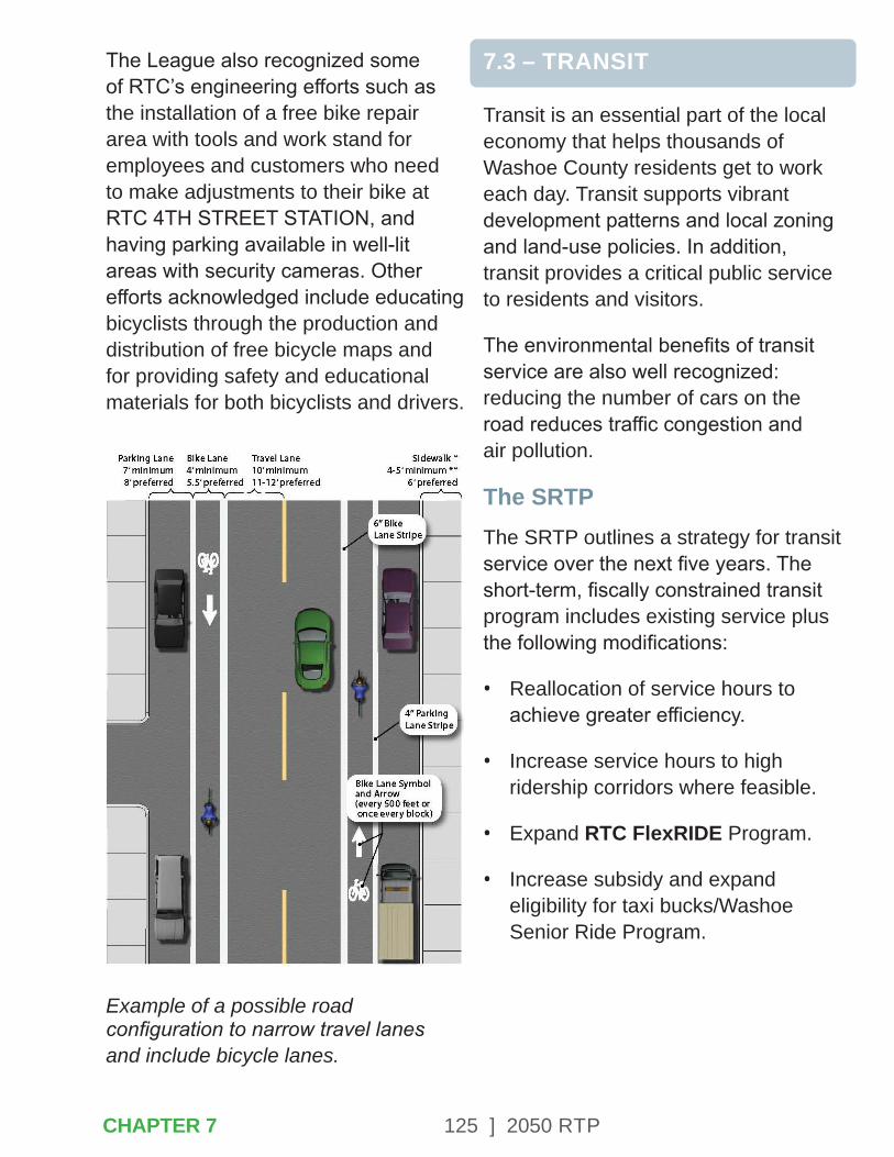
125 ] 2050 RTP
The League also recognized some of RTC’s engineering efforts such as the installation of a free bike repair area with tools and work stand for employees and customers who need to make adjustments to their bike at RTC 4TH STREET STATION, and having parking available in well-lit areas with security cameras. Other efforts acknowledged include educating bicyclists through the production and distribution of free bicycle maps and for providing safety and educational materials for both bicyclists and drivers.
Example of a possible road configuration to narrow travel lanes and include bicycle lanes.
7.3 – TRANSIT
Transit is an essential part of the local economy that helps thousands of Washoe County residents get to work each day. Transit supports vibrant development patterns and local zoning and land-use policies. In addition, transit provides a critical public service to residents and visitors.
The environmental benefits of transit service are also well recognized: reducing the number of cars on the road reduces traffic congestion and air pollution.
The SRTPThe SRTP outlines a strategy for transit service over the next five years. The short-term, fiscally constrained transit program includes existing service plus the following modifications:
• Reallocation of service hours to achieve greater efficiency.
• Increase service hours to high ridership corridors where feasible.
• Expand RTC FlexRIDE Program.
• Increase subsidy and expand eligibility for taxi bucks/Washoe Senior Ride Program.
CHAPTER 7
126 ] 2050 RTP
• Continuation of grant program for not-for-profit transportation services, as identified in the CTP.
The SRTP will be updated in 2021-2022.
RTC RAPID ExpansionRAPID is RTC’s premier bus rapid transit service. It offers high-frequency service through the heart of Reno and Sparks on the Virginia Line and Lincoln Line. The successful RTC RAPID transit service that debuted on Virginia Street in 2009 was extended to the University of Nevada, Reno in 2021.
The Virginia Line extension included eight new RAPID stations, construction of wide sidewalks, extensive safety improvements, and bicycle facilities. The 4th Street/Prater Way RAPID corridor, known as the Lincoln Line, began operating in 2018. This RTC RAPID service operates five zero-emission, all electric buses and provides eight enhanced stations. This corridor links the Reno and Sparks downtowns and provide enhanced access to employment centers and opportunities for higher education. By constructing wide sidewalks and bike lanes, the Lincoln Line project provides for improved safety and multimodal access to transit stops.
These RAPID investments have made significant contributions to the economic vitality of both corridors, supporting increased density and mixed-use development.
RTC to Have 80% Alternative-Fuel Transit Fleet in 2021
The RTC is a leader in the adoption of electric bus technology. The RTC electric buses significantly reduce diesel fuel use. This improves air quality in the Truckee Meadows and reduces operating costs for the RTC transit system.
The RTC has added an additional 19 new hybrid and electric buses to its fleet in 2021. Seventeen of the 19 new buses are New Flyer Hybrid electric/biodiesel buses and two buses are Proterra 100% electric buses. The new hybrid buses are already running on various RTC bus routes as part of RTC’s transit system.
The two Proterra all-electric buses debuted on the RTC’s extended RAPID Virginia Line during its launch in early March 2021. The hybrid buses are replacing aging, end-of-life vehicles. Now that the new buses have been deployed, 55 out of the 68 buses in RTC’s fleet, or more than 80%, are hybrid or electric alternative-fuel vehicles. The RTC’s goal is to have an all-alternative-fuel transit fleet by the year 2035. The RTC used federal funds to purchase the buses.
CHAPTER 7

127 ] 2050 RTP
Importance of Transit in the Community
Supporting the Economy – Getting people to work, including essential jobs and services.
Shaping Development – Economic revitalization.
Public Service – Mobility for people that do not drive.
Environmental Benefit – Reducing traffic congestion and air pollution.
Access to Essential Services – Providing service to healthcare, pharmacies, groceries, and other public services.
Maintenance Facility InfrastructureExisting Infrastructure
RTC currently has two transit maintenance facilities:
• Jerry L. Hall Regional Transit Operations and Maintenance Center: Located at Villanova Drive under the I-580 viaduct, this facility is used to store and maintain the fixed route transit fleet. Major improvements were completed in 2018 to expand electric bus fueling and maintenance capabilities at this site.
This 6.8 acre property has the capacity to store 78 buses and contains a bus wash, body repair bay, chassis inspection, vehicle inspection area, and RIDE dispatch.
• Sutro Paratransit Maintenance Facility: Located at Sutro Street and 6th Street near downtown Reno, this facility is used to store and maintain the ACCESS paratransit and FlexRIDE fleet. It contains infrastructure to fuel the Compressed Natural Gas (CNG) fleet and administrative offices house ACCESS dispatch. The Sutro facility has also been identified as a back-up office location for RTC administrative staff for operations in the event of an emergency that renders the Terminal Way building inaccessible.
Maintenance Facility Needs
RTC has established a goal of transitioning to a 100% alternative fuels transit fleet. The first four electric buses purchased by RTC in 2014 have a range of about 30 miles per charge. The latest generation of Proterra Catalyst buses purchased in 2020 have a range of up to 150 miles, depending on conditions. RTC is currently exploring options to establish a hydrogen fuel cell bus program.
CHAPTER 7
128 ] 2050 RTP
The 300 mile range of hydrogen fuel cell buses could allow RTC to transition the rest of the fixed-route fleet to zero emissions with minimal impact to route scheduling and operations. However, the location of the Jerry L. Hall Regional Transit Operations and Maintenance Center under I-580 precludes the use of this facility for hydrogen fuel cell maintenance. Expansion of the Sutro Maintenance Facility would provide a suitable location to initiate a hydrogen fuel cell program. RTC would also pursue opportunities to transition the ACCESS and FlexRIDE fleet to hydrogen fuel cell technology when it becomes available for the paratransit vehicle type.
In addition, NDOT has adopted the Spaghetti Bowl Project, which is a plan for safety, operational, and capacity improvements on I-80 and I-580. Phase 4 of the Spaghetti Bowl Project, currently planned for the year 2035, would involve reconstruction of the Villanova/Plumb Lane interchanges at I-580 and would require relocation of RTC’s fixed-route transit facility. RTC is coordinating with NDOT on identifying a suitable relocation site.
To accommodate planned growth in the transit system as well as electric, hydrogen fuel cell, and diesel charging and maintenance needs, the facility would need to include:
• Approximately 10 acres.
• 30,000 square feet for maintenance bays.
• 45,000 square feet for covered outdoor storage.
• 40 bus parking spaces with capacity for 80 buses.
• 100 employee and 12 service vehicle parking spaces.
• 20 electric bus chargers with 4,000 amp service.
• Bus wash, body repair bay, chassis inspection and vehicle inspection pit.
Expansion of the Sutro Maintenance Facility has been identified as an optimal location that could accommodate these infrastructure requirements and still provide a central location that meets transit operational needs.
CHAPTER 7
129 ] 2050 RTP
Passenger Facility Needs
RTC is currently undertaking the following passenger facility improvements:
• Expand RTC 4TH STREET STATION to construct four additional bus bays, electric bus chargers, and parking spaces.
• Installation of electric bus charging infrastructure at RTC CENTENNIAL PLAZA STATION.
• Upgrade the northbound Virginia Line station at Peppermill to provide full ADA accessibility, additional seating capacity, and full RAPID amenities.
• Bus stop accessibility improvements throughout the region, in support of the ADA Transition Plan.
• Park and ride facilities to support RTC VANPOOL passengers.
RTC ACCESSParatransit service is a civil right required under the Americans with Disabilities Act (ADA). This requirement is met through the provision of RTC ACCESS service, which provides mobility for people whose disability prevents them from using fixed-route transit service. Rides are reserved one to three days in advance on demand though a call center.
RTC ACCESS passenger trips are made using a combination of full-size accessible cut-away buses, mini-vans, and taxis. The service operates 24 hours a day, seven days a week. In 2019, about 224,000 rides were provided, with an average of 2.2 rides per service hour. Approximately 3,700 individuals are certified as ADA paratransit eligible in Washoe County. The ADA requires paratransit service to be provided within 3/4 of a mile of fixed-route transit service. The one-way fare is $3.
RTC FlexRIDERTC FlexRIDE is a curbside-to-curbside transit service available by requesting a ride through an app or by phone. Rides can be scheduled at your desired travel time and can be expected to arrive to the curbside closest to your location within 8 to 15 minutes. Fares are the same as the standard RTC RIDE fares.
RTC initiated the first FlexRIDE pilot program in Sparks in 2019 and added additional FlexRIDE zones in the North Valleys, Spanish Springs, and Somersett/Verdi in 2020. The convenience of this service has made it very popular with customers, and resulted in strong increases over previously offered fixed route services in those areas.
CHAPTER 7
130 ] 2050 RTP
Supplemental Mobility ServicesBecause RTC does not have the resources to provide fixed-route, FlexRIDE, and paratransit service to all residences in Washoe County, the agency is pursuing innovative services and partnerships with not-for-profit providers that can serve other specialized transportation needs.
CTPThe CTP is required by the Federal Transit Administration (FTA) as a part of the Section 5310 grant funding program. To be funded, projects must be contained in the CTP and be intended to improve transportation options for senior citizens and persons with disabilities above and beyond the requirements of the Americans with Disabilities Act. The CTP was updated in 2020 and contains the following primary goals:
• Create a Local Coordinated Council to facilitate coordination and recommend Section 5310 funding activities.
• Continue to enhance mobility and accessible transportation options.
• Establish a One-Call/One-Click Center.
Not-for-Profit PartnershipsThe Section 5310 Program, funded by the FTA, allows RTC to offer competitive grant funding to organizations that provide enhanced mobility. Mobility services currently funded by this program include the following:
• Non-Emergency Medical Related Transportation through Access to Healthcare Network (AHN).
• Neighbor Network of Northern Nevada (N4) and the purchase of non-ADA Paratransit rides.
• Seniors in Service volunteer program to provide social support for seniors, including transportation to doctor appointments, grocery stores, pharmacy’s etc.
• Senior Outreach Services volunteer program at the Sanford Center for Aging at UNR to provide transportation for frail, homebound, and below-poverty seniors.
• Washoe County Human Services Agency.
CHAPTER 7
131 ] 2050 RTP
Washoe Senior Ride/Taxi BucksThe Washoe Senior Ride/Taxi Bucks program provides a subsidy for eligible participants to hail a cab. This program extends a mobility option to people who do not live within the RTC RIDE and ACCESS service area. This program is currently available to veterans, residents 60 years of age or older, and ACCESS clients with annual incomes under $45,000. As part of the Short Range Transit Plan, RTC is considering options to expand eligibility and increase the subsidy for this program.
RTC SMART TRIPSThe RTC’s trip reduction program, RTC SMART TRIPS, encourages the use of sustainable travel modes and trip-reduction strategies such as telecommuting, compressed work weeks, and trip chaining. Major components of the program include a bus pass subsidy program in which the RTC matches an employer’s contribution to their employees’ 31-day transit passes up to 20%; a subsidized vanpool program, RTC VANPOOL; and an online trip matching program that makes it quick, easy, and convenient to look for carpool partners and also bus, bike, and walking buddies for either recurring or one time trips. One of the most common deterrents to ridesharing is the fear of being “stranded.”
Consequently, people who either carpool or vanpool to work can sign up for the guaranteed ride home program and be reimbursed for a taxi ride home up to four times a year if an unexpected event prevents normal ridesharing arrangements from working.
Making trips on foot and by bicycle are promoted by the RTC SMART TRIPS program throughout the year in various manners such as participation on the Truckee Meadows Bicycle Alliance, which implements the Bike to Work Week campaign each spring, and maintaining the Street Smart website that educates the public about the benefits of walking and how to do it safely.
RTC VANPOOL ProgramRTC VANPOOL is the fastest-growing component of the trip-reduction program and now represents the RTC’s largest transit vehicle fleet. This program provides an opportunity to reduce auto trips and serve long- commute distances effectively. The program grew to 227 vehicles in 2020 , with vans traveling to Carson City, the Tahoe-Reno Industrial Center, North Spanish Springs, Stead, Herlong, and Susanville. Participants share the costs of the vehicle lease and gas, with RTC providing a subsidy to encourage participation based on the distance traveled. The RTC VANPOOL program eliminated over 6,000 metric tons of CO2 in 2019.
CHAPTER 7
132 ] 2050 RTP
RTC REGIONAL CONNECTORRTC currently provides REGIONAL CONNECTOR transit between Reno and Carson City. This premium service carried over 27,000 passengers in 2019.
Privately Operated Intercity Bus ServiceRTC supports private intercity bus transportation where feasible and appropriate. RTC leases bus bay access at RTC CENTENNIAL PLAZA to My Ride to Work, which provides privately operated transit access to employees at the Tahoe-Reno Industrial Center. An estimated 2,000 employees use this service every day. Greyhound, which provides intercity transit access with nation-wide connectivity, also leases bus bay access as well as a waiting room space at RTC CENTENNIAL PLAZA.
The North Lake Tahoe Express offers service from the Reno airport to Truckee and North Lake Tahoe area. The South Tahoe Airporter provides service from Stateline to the Reno airport.
Token Transit – Smart Phone Fare Payment
RTC has partnered with Token Transit to provide riders the option of using their smart phone to purchase and board buses. Riders simply download the Token Transit app from the app store or text “TOKEN” to 41411 for a download link. The user can store or activate a ticket on their phone. To board, riders simply show the driver the animated ticket on their phone.
Joint Development Through the Federal Transit Administration ProgramThe Reno-Sparks region is facing a significant challenge relating to housing affordability. Public transportation is an important resource for area residents and provides access to essential services. Affordable housing in close proximity to transit routes offers improved access to services and increases transit ridership. RTC conducted an Affordable Housing Study that identified opportunities for the development of affordable housing in transit corridors.
CHAPTER 7
133 ] 2050 RTP
RTC coordinated the study with staff at the Truckee Meadows Regional Planning Agency, City of Reno, City of Sparks, Washoe County, and Reno Housing Authority, as well as representatives of Truckee Meadows Healthy Communities initiative regarding ongoing analysis of regional housing needs.
Joint Development as defined by the FTA refers to a public transportation project that integrally relates to and often co-locates with commercial, residential, mixed-use or other non-transit development. The RTC study evaluated vacant parcels throughout the region and then identified potential locations for more detailed analysis. The report includes a market analysis and conceptual site plans for consideration at these locations. There could be a potential opportunity for private or public sector partners to develop affordable housing in conjunction with future RTC transit facility improvements. The sites considered include the following:
• Clear Acre Lane Site – Owned by RTC, no longer needed for future roadway project.
• South Virginia Street Site – Construction of full-sized RAPID station planned for this site.
• Neil Road Site – Relocation of Meadowood Mall transit transfer station under study for this site.
Park and Ride FacilitiesPark and rides are multimodal transfer points where people typically transfer from an individual mode of transportation, such as walking or driving alone, to a shared transportation mode, like public transportation or a carpool. Park and ride lots can be used for many trip types but are most typically oriented towards commuter trips.
Park and rides can either be exclusively owned and operated by a public agency or under contract with a private owner. The latter type of park and ride facility is often called a shared facility because parking is shared between park and ride users and other users of the facility. Shared facilities are often located at large faith institutions, major retailers, or other locations that may have a surplus of weekday, daytime parking.
Publicly owned park and ride facilities in the region are currently operated by NDOT. These park and rides are primarily designed to serve long-distance commutes or recreation opportunities in the Lake Tahoe Basin.
Park and ride facilities are a critical element of the RTC VANPOOL program.
CHAPTER 7
134 ] 2050 RTP
Due to the continued success of the RTC VANPOOL program, there is an increased demand for park and ride facilities. As a result, the RTC is currently evaluating options to expand the availability of these types of facilities within the region. These options include improving vacant properties that the RTC currently owns and working with major retailers and faith institutions to enter into agreements for shared use facilities. In addition, RTC has previously considered locations for park and rides as a component to other projects such as the planned Pyramid Highway-US 395 Connector.
Unfunded Vision for TransitThe RTP outreach process provided an opportunity to develop a vision for transit in the Truckee Meadows through 2050. This vision is not constrained by available financial resources. Based on community input, the vision includes the following elements:
Transit Service Vision
• Increased Frequency and Span of Service on Existing High-Productivity Routes in the Urban Core – Investments in existing routes will improve convenience and service levels in areas with well-established transit ridership that have the greatest potential for increased growth.
• Expand FlexRIDE Service Areas – FlexRIDE offers a tool to serve some outlying suburban areas, providing increased convenience to potential customers where fixed-route transit would not be effective. Potential areas for future expansions include South Meadows and Incline Village.
• Extend Virginia Line RAPID to Mt. Rose Highway – Providing transit connectivity to employment, education, commercial, and residential centers in South Reno would improve access to opportunities, expand travel options, and encourage transit supportive development along South Virginia Street. The RAPID extension could be supported by a FlexRIDE zone to provide increased connectivity to surrounding neighborhoods.
• Extend Lincoln Line RAPID to Stoker Avenue – This extension along West 4th Street would support safety and other multimodal improvements planned for the corridor. It would also encourage transit supportive development that is anticipated in the West 4th Street corridor.
• Improved Transit Connectivity to the Lake Tahoe Region – Develop new transit solutions to better connect the existing transit systems in Reno/Sparks, Carson City, and Lake Tahoe.
CHAPTER 7
135 ] 2050 RTP
This would improve access to the treasured resources in the Lake Tahoe Basin and reduce the environmental impact of vehicle travel.
• Truckee to TRI Center Commuter Bus Service – Develop new transit solutions to better connect residential and employment centers along the I-80 corridor, extending from the Town of Truckee to Reno/Sparks, and Storey County.
Transit Facilities Vision
• Bus Maintenance Facility – Construct a larger maintenance facility for long-term expansion that can accommodate a diverse zero-emission fleet, including electric and hydrogen fuel cell operations.
• New Transfer Facility at Meadowood Mall – Relocate the Meadowood Mall transfer facility and explore opportunities for joint development.
• Mobility Hubs – The need for Mobility Hubs was identified through the Downtown Reno Circulation Study, Sparks Industrial Area analysis, and planning initiatives in Midtown District of Reno. They would include parking for automobiles, bikes, RTC VANPOOL participants, and offer connectivity to public transit and private employer shuttles. Structured parking would be considered.
With this vision for transit, the RTC hopes to continue the conversation about the role of transit in the community and the need for sustainable funding for transit operations.
7.4 – ADVANCED MOBILITY & INNOVATION
Zero-Emission Vehicles and Charging InfrastructureIncreasing the proportion of zero-emission vehicles in use throughout the region, including both electric and hydrogen fuel cell vehicles, will have benefits to air quality and reduce greenhouse gas emissions. The growth of zero-emission vehicles will require the development of fueling/charging infrastructure as well. RTC is developing an Advanced Mobility Study that includes the evaluation of existing electric vehicle charging resources and identification of strategies for long-term development of alternative charging technologies. In addition to supporting the needs of local zero emission vehicle operators, charging infrastructure, along with the Nevada Electric Highway initiative, would encourage zero emission vehicle owners in other states to visit our region and support the tourism economy.
CHAPTER 7
136 ] 2050 RTP
LiDAR Safety AnalysisThe RTC received a grant from the U.S. Department of Transportation to develop a tool, called Automatic Road Feature Extraction from LiDAR (ARFEL), that automatically extracts highly accurate road geometric features from mobile light-detection-and-ranging (LiDAR) data collected on roads.
RTC will collaborate with NDOT, which collects and manages statewide mobile LiDAR data using their own data collection vehicle and will also be a user of the ARFEL tool. The development team includes researchers and programmers from UNR and Texas Tech University (TTU). RTC will use this tool to:
• Analyze relationships between crashes and road factors.
• Identify locations and characteristics of crashes using network screening.
• Select appropriate countermeasures and strategies.
• Evaluate safety improvement projects.
Other applications for LiDAR under development include flashing lights at crosswalks that could be activated by LiDAR when pedestrians approach the intersection.
Connected and Autonomous VehiclesThe concept of fully autonomous (also called self-driving, driverless, or robotic) vehicles has gone from being a distant possibility to a near-term reality. Vehicles of all types are becoming more autonomous as this technology continues to improve at a rapid rate.
Nevada has been leading the way for autonomous cars and trucks by becoming one of the first states in the nation to pass regulations regarding the safety requirements and licensing for autonomous vehicles. Nevada was also the first state in the nation to provide a license to an autonomous commercial truck.
RTC is collaborating with the University of Nevada, Reno on research into intelligent mobility. The University’s Nevada Center for Applied Research integrates expertise in advanced autonomous systems, computer sciences, synchronized transportation, and robotics with community needs. The Center is creating a Living Lab to allow the texting of mobility technologies in urban environments. The Center and RTC are partnering to research autonomous bus technologies and applications using zero-emission electric vehicles.
CHAPTER 7

137 ] 2050 RTPUsing the latest in LiDAR technology – a field worker makes adjustments.CHAPTER 7
138 ] 2050 RTP
In addition to individual vehicles becoming autonomous, some concepts have proposed a fully connected transportation system in which vehicles would communicate with each other and with the surrounding infrastructure in order to improve both safety and operational efficiency.
A fully integrated transportation system may have other impacts as well, including reduced car ownership, demand response ride-sharing, and modified land-use needs. This technology is expected to increase the need for expanded broadband and internet connectivity.
Autonomous aircraft are also beginning to emerge as a transportation option of the future. Drones are small aircraft which are piloted remotely and do not require a human to be seated within the aircraft itself. Nevada has been on the forefront of regulating and providing resources to this new technology. In 2015, UNR opened the Nevada Advanced Autonomous Systems Innovation Center as a catalyst for innovation in the field of autonomous systems.
Shared MobilityShared-use mobility describes transportation services that multiple users can access on demand, including public transit, taxis and limos, bikesharing, carsharing (round-trip, one-way, and personal vehicle sharing), ridesharing (carpooling, vanpooling), ridesourcing (Transportation Network Companies or TNCs), scooter sharing, shuttle services, and commercial delivery vehicles providing flexible goods movement. Shared-use transportation is becoming increasingly common in urban areas and utilizes wireless technology to improve the options and ease of access for users.
The Shared-Use Mobility Center states that these new services represent innovative responses to the demand for new options and offer an opportunity to:
• Provide more mobility choices.
• Address last mile and first mile solutions.
• Reduce traffic congestion and pollution.
• Reduce transportation costs.
• Reduce fossil fuel consumption.
• Reduce pressures on parking spaces.
• Improve efficiency.
CHAPTER 7

139 ] 2050 RTP
• Identify choices for those who cannot afford to purchase and maintain a vehicle.
By utilizing wireless technology to easily access shared-use mobility options, companies are offering downloadable applications for cell phone and/or tablet users to create convenient shared-use transportation choices.
Ride Sourcing
Ridesourcing became available in the Truckee Meadows through Uber and Lyft in the fall of 2015.
RTC is exploring the viability of using public-private partnerships with ridesourcing services to expand mobility opportunities in outlying areas, similar to the Taxi Bucks program.
The impact of ridesourcing on mobility will require additional analysis as its use continues to increase. These services have the potential to increase traffic congestion and may draw customers away from traditional public transportation. Due to costs that are typically higher than transit fares, equity concerns should also be given consideration.
Bike Share
Early in 2016, RTC completed the Truckee Meadows Bike Share Feasibility Study. The study researched the possibility of launching a bike share program in the Reno and Sparks areas. The study revealed that a successful bike share would likely require a public-private partnership. The study recommended a hybrid system utilizing both smart bike systems and station-based systems. Smart bikes can be rented from any location and all of the necessary equipment to facilitate the rental is physically located on the bike.
A station-based system utilizes a fixed number of racks at a given location and the user must return the rented bike at one of these locations.
In April 2018 the City of Reno executed the Exclusive Agreement for a pilot dockless (smart bike) bike share program between the City of Reno and City of Sparks, Washoe County, University of Nevada, Reno, and The Reno-Sparks Indian Colony. This pilot project was the first in the country that included a tribal government. RTC had a support role in the dockless bike share pilot, which involved no public capital infrastructure investment. The pilot project ended and the local jurisdictions determined not to continue with dockless bike share.
CHAPTER 7
140 ] 2050 RTP
While there may still be interest in bike share for the region, the local jurisdictions and other partner entities would need to revisit the type and structure of any future system. Lastly, the smart bike companies have incorporated electric scooters into their business models. The region would need to determine if electric scooters were appropriate and desired for the Truckee Meadows.
CHAPTER 7
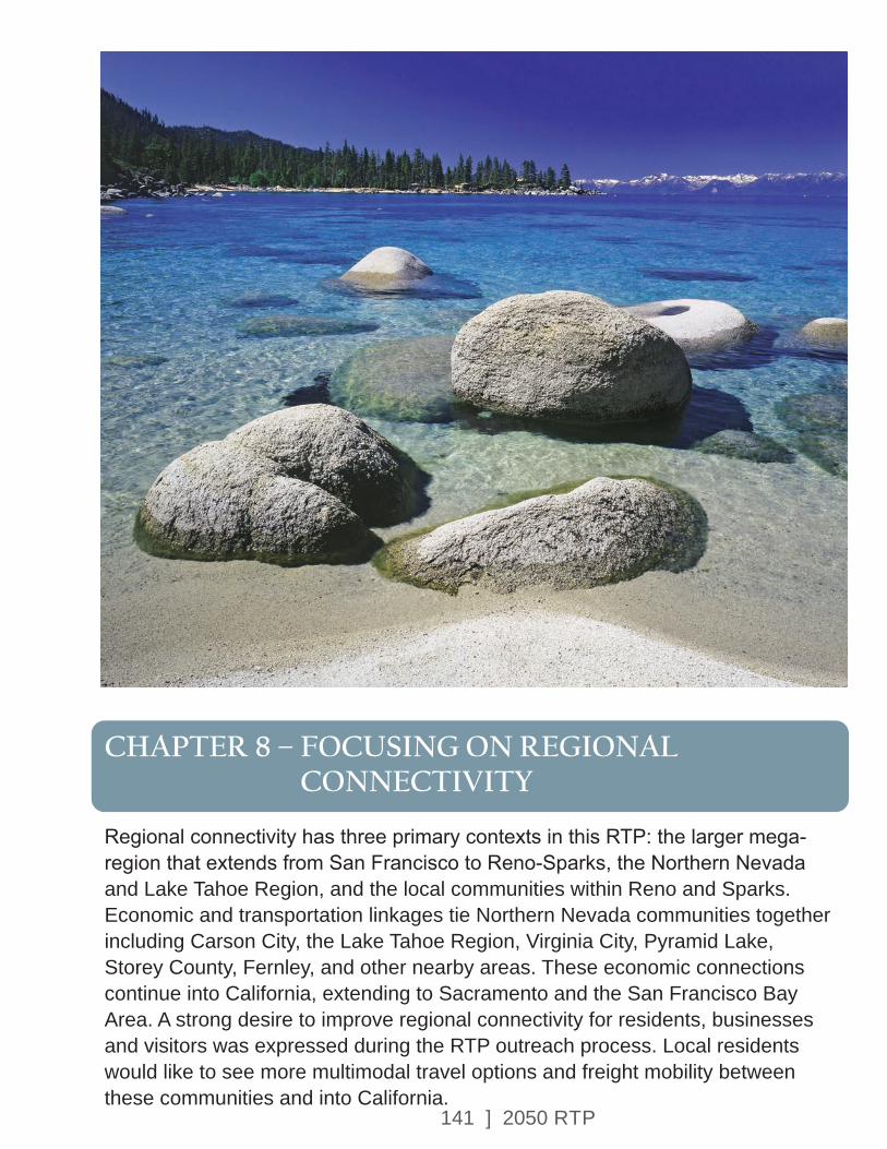
141 ] 2050 RTP
CHAPTER 8 – FOCUSING ON REGIONAL CONNECTIVITY
Regional connectivity has three primary contexts in this RTP: the larger mega-region that extends from San Francisco to Reno-Sparks, the Northern Nevada and Lake Tahoe Region, and the local communities within Reno and Sparks. Economic and transportation linkages tie Northern Nevada communities together including Carson City, the Lake Tahoe Region, Virginia City, Pyramid Lake, Storey County, Fernley, and other nearby areas. These economic connections continue into California, extending to Sacramento and the San Francisco Bay Area. A strong desire to improve regional connectivity for residents, businesses and visitors was expressed during the RTP outreach process. Local residents would like to see more multimodal travel options and freight mobility between these communities and into California.

142 ] 2050 RTP
Northern Nevada is directly impacted by the economic activity surrounding the San Francisco metropolitan region and the Port of Oakland. This relationship is reflected in the concept of Megapolitan Regions, as defined by Arthur Nelson and Robert Lang. Megapolitan Regions share a number of attributes including environmental systems, infrastructure systems, economic linkages, culture, and history. Reno and Sparks are part of the Sierra-Pacific region, which extends from San Francisco to Reno. The Megaregion is connected by the approximately 225-mile-long I-80 corridor, which is generally parallel to a Union Pacific mainline railroad. Intercity bus transit is provided between these metropolitan areas by Greyhound and other operators. Amtrak provides passenger rail service in the corridor on the California Zephyr route between San Francisco and Chicago.
Amtrak provides passenger rail service from San Jose to Auburn, California on the Capital Corridor route. RTC joins the Lake Tahoe Region and Town of Truckee in support of extending the Capital Corridor service to Reno/Sparks and continuing to Storey County and Fernley.
This larger region is important because economic activity in one city has a direct impact on the economy in other cities within the region.
For example, if the number of ships increases in the Port of Oakland there is a subsequent increase in traffic on I-80. More trucks and trains pass through Reno, where they unload cargo for redirection to all points throughout the Intermountain West. Reno, Sparks, and Washoe County have become an increasingly significant warehouse, distribution, and advanced manufacturing hub in the megapolitan region. This impacts the transportation network and indicates there is a need to coordinate not only with entities in Washoe County, but also with other regional partners.
8.1 – CONNECTIVITY IN NORTHERN NEVADA
The transportation networks and economies of Northern Nevada and the Lake Tahoe Region are even more closely linked. The catchment area for the Reno-Tahoe International Airport, shown in Figure 8-1, encompasses a population of 1.3 million. Support has been expressed through the RTP process for increasing transit connectivity between the Reno, Sparks, Carson City and Lake Tahoe regions. Strengthening these transit linkages will support sustainable economic development in the region. The RTC collaborated with NDOT and the other Northern Nevada Metropolitan Planning Organizations (MPO’s) in developing the 2050 RTP.
CHAPTER 8
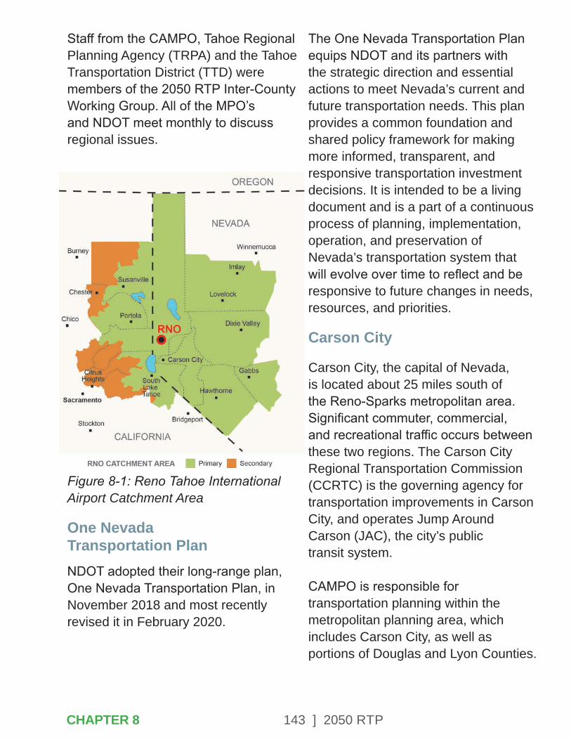
143 ] 2050 RTP
Staff from the CAMPO, Tahoe Regional Planning Agency (TRPA) and the Tahoe Transportation District (TTD) were members of the 2050 RTP Inter-County Working Group. All of the MPO’s and NDOT meet monthly to discuss regional issues.
Figure 8-1: Reno Tahoe International Airport Catchment Area
One Nevada Transportation PlanNDOT adopted their long-range plan, One Nevada Transportation Plan, in November 2018 and most recently revised it in February 2020.
The One Nevada Transportation Plan equips NDOT and its partners with the strategic direction and essential actions to meet Nevada’s current and future transportation needs. This plan provides a common foundation and shared policy framework for making more informed, transparent, and responsive transportation investment decisions. It is intended to be a living document and is a part of a continuous process of planning, implementation, operation, and preservation of Nevada’s transportation system that will evolve over time to reflect and be responsive to future changes in needs, resources, and priorities.
Carson City
Carson City, the capital of Nevada, is located about 25 miles south of the Reno-Sparks metropolitan area. Significant commuter, commercial, and recreational traffic occurs between these two regions. The Carson City Regional Transportation Commission (CCRTC) is the governing agency for transportation improvements in Carson City, and operates Jump Around Carson (JAC), the city’s public transit system. CAMPO is responsible for transportation planning within the metropolitan planning area, which includes Carson City, as well as portions of Douglas and Lyon Counties.
CHAPTER 8

144 ] 2050 RTP
CAMPO is the designated recipient and grantee of urbanized area public transportation funding received directly from the FTA. Carson City Public Works provides staffing for both CAMPO and the CCRTC. The RTC of Washoe County partners with CCRTC to provide the REGIONAL CONNECTOR transit service between Reno and Carson City.
Lake Tahoe Region
The Lake Tahoe Region and surrounding area are recognized for their unique beauty, environmental resources, and recreational amenities. Reno is a gateway for visitors traveling to Lake Tahoe, with many entering the region at the Reno-Tahoe International Airport. In addition, Lake Tahoe is a popular recreation destination for residents of the Reno-Sparks metropolitan region. Primary vehicle access is from I-80, Mount Rose Highway, and US 50 via I-580. Millions of visitors travel to Lake Tahoe each year. Commuting patterns between the urbanized area and towns such as Truckee, South Lake Tahoe, and Kings Beach are also substantial.
In 1969, California and Nevada legislators agreed to a unique Compact for protecting Lake Tahoe and sharing responsibility for that protection. The two states and the U.S. Congress amended the Compact in 1980, with public law 96-551, and at that time also established the TTD.
The TTD is responsible for facilitating and implementing safe, environmentally positive, multimodal projects for the Lake Tahoe Basin, including transit operations.
The TRPA is the federally designated Metropolitan Planning Organization (Tahoe MPO) for the Lake Tahoe Basin. In 2015, the FAST Act identified the Lake Tahoe Region as a TMA. Staff at TRPA work with TTD, the RTC, and other local implementing agencies to plan for and implement a transportation system that serves the transportation needs of residents, commuters, and visitors of Lake Tahoe while reducing the environmental impact of transportation in the region and enhancing quality of life.
The South Lake Tahoe area’s coordinated transit system is operated by the TTD and provides fixed-route service through the South Shore as well as the East Shore Express, which includes transfer service to Tahoe Area Regional Transit (TART), providing access to the North Shore and the Town of Truckee.
TTD also operates commuter bus service to Carson City and Minden and Gardnerville in Douglas County (the Carson Valley). In addition, TTD provides ADA paratransit and on-demand service within the city of South Lake Tahoe, northern El Dorado County and western Douglas County.
CHAPTER 8

145 ] 2050 RTP
REGIONAL MAP OF TRANSIT SYSTEMS IN CARSON, TAHOE AND RENO/SPARKS
MAP 8.1
CHAPTER 8
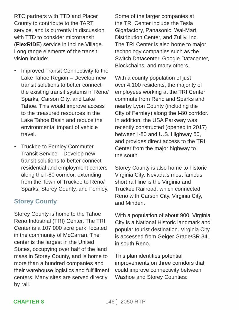
146 ] 2050 RTP
RTC partners with TTD and Placer County to contribute to the TART service, and is currently in discussion with TTD to consider microtransit (FlexRIDE) service in Incline Village. Long range elements of the transit vision include:
• Improved Transit Connectivity to the Lake Tahoe Region – Develop new transit solutions to better connect the existing transit systems in Reno/Sparks, Carson City, and Lake Tahoe. This would improve access to the treasured resources in the Lake Tahoe Basin and reduce the environmental impact of vehicle travel.
• Truckee to Fernley Commuter Transit Service – Develop new transit solutions to better connect residential and employment centers along the I-80 corridor, extending from the Town of Truckee to Reno/Sparks, Storey County, and Fernley.
Storey County
Storey County is home to the Tahoe Reno Industrial (TRI) Center. The TRI Center is a 107,000 acre park, located in the community of McCarran. The center is the largest in the United States, occupying over half of the land mass in Storey County, and is home to more than a hundred companies and their warehouse logistics and fulfillment centers. Many sites are served directly by rail.
Some of the larger companies at the TRI Center include the Tesla Gigafactory, Panasonic, Wal-Mart Distribution Center, and Zulily, Inc. The TRI Center is also home to major technology companies such as the Switch Datacenter, Google Datacenter, Blockchains, and many others.
With a county population of just over 4,100 residents, the majority of employees working at the TRI Center commute from Reno and Sparks and nearby Lyon County (including the City of Fernley) along the I-80 corridor. In addition, the USA Parkway was recently constructed (opened in 2017) between I-80 and U.S. Highway 50, and provides direct access to the TRI Center from the major highway to the south.
Storey County is also home to historic Virginia City. Nevada’s most famous short rail line is the Virginia and Truckee Railroad, which connected Reno with Carson City, Virginia City, and Minden.
With a population of about 900, Virginia City is a National Historic landmark and popular tourist destination. Virginia City is accessed from Geiger Grade/SR 341 in south Reno.
This plan identifies potential improvements on three corridors that could improve connectivity between Washoe and Storey Counties:
CHAPTER 8
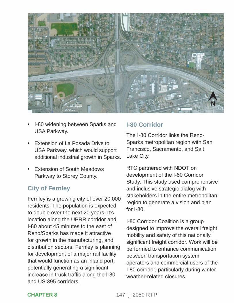
147 ] 2050 RTP
• I-80 widening between Sparks and USA Parkway.
• Extension of La Posada Drive to USA Parkway, which would support additional industrial growth in Sparks.
• Extension of South Meadows Parkway to Storey County.
City of FernleyFernley is a growing city of over 20,000 residents. The population is expected to double over the next 20 years. It’s location along the UPRR corridor and I-80 about 45 minutes to the east of Reno/Sparks has made it attractive for growth in the manufacturing, and distribution sectors. Fernley is planning for development of a major rail facility that would function as an inland port, potentially generating a significant increase in truck traffic along the I-80 and US 395 corridors.
I-80 CorridorThe I-80 Corridor links the Reno-Sparks metropolitan region with San Francisco, Sacramento, and Salt Lake City.
RTC partnered with NDOT on development of the I-80 Corridor Study. This study used comprehensive and inclusive strategic dialog with stakeholders in the entire metropolitan region to generate a vision and plan for I-80.
I-80 Corridor Coalition is a group designed to improve the overall freight mobility and safety of this nationally significant freight corridor. Work will be performed to enhance communication between transportation system operators and commercial users of the I-80 corridor, particularly during winter weather-related closures.
N
CHAPTER 8
148 ] 2050 RTP
The Coalition includes NDOT, Caltrans, Wyoming DOT, and Nebraska DOT. Data interfaces are already in place for Nevada and Utah and will require that additional elements from the I-80 corridor be integrated.
NDOT has also developed the Nevada State Freight Plan and is in the process of updating the Nevada State Rail Plan, both which address freight-specific issues on the I-80 corridor. More information on those plans can be found in Chapter 10 of this RTP.
US 395 CoalitionThe US 395 Coalition is a group created to raise awareness about safety and mobility needs on the highway between Hallelujah Junction and Susanville, California.
This corridor is used for commuting from the Reno/Sparks area to Herlong and Susanville and is also a heavily used truck freight corridor. This segment is currently one lane in each direction with no center median. The US 395 Coalition advocates for constructing additional lanes and safety improvements in the corridor. Short term improvements would include segments of passing lanes. Although located in California, RTC and NDOT are participating in this regionally important planning initiative.
I-11 CorridorI-11 is envisioned as a continuous north-south high-capacity transportation corridor that has the potential to enhance movement of people and freight, and to facilitate regional connectivity, trade, communications, and technology. This Corridor could provide needed connectivity, offer alternative routes for freight and passenger traffic, and improve reliability for better trade and commerce opportunities. Developing a north-south multimodal corridor through Nevada provides the foundation for a renewed, stronger, diversified economy.
Construction of the roughly 450-mile long future I-11 could be phased over future decades as environmental impact reviews are completed and funding is prioritized.
I-11 is currently being analyzed as a limited access four-lane divided highway designed to accommodate future traffic.
8.2 – CONNECTIVITY IN THE URBANIZED AREA
Regional connections are also needed to tie together the neighborhoods and employment centers in the urbanized area of Reno, Sparks, and Washoe County. Topography and historic development patterns limit direct roadway connections in many areas.
CHAPTER 8
149 ] 2050 RTP
While the historic core of the metropolitan region is centered on the axis of Virginia Street and 4th Street/Prater Way, recent decades have seen large concentrations of both jobs and housing emerge in outlying areas such as South Meadows, Spanish Springs, and the North Valleys. These newer neighborhoods and employment districts are generally not connected by a grid network and cross-regional mobility is limited.
Spaghetti Bowl ProjectNDOT completed the Reno-Sparks Freeway Traffic Study, which identifies solutions to the safety and congestion concerns at the I-80/I-580/U.S. 395 system-to-system interchange, known to local residents as the Spaghetti Bowl.
This system-to-system interchange is the highest-crash interchange in Nevada. The project limits extend along the corridors from the Keystone Avenue interchange to the Pyramid Highway interchange on I-80 and from the McCarran Boulevard/Clear Acre Lane interchange to the Virginia Street/Kietzke Lane interchange on U.S. 395/I-580.
NDOT received a Record of Decision (ROD) on Final Environmental Impact Statement (FEIS) in July 2019.
Through this process, NDOT identified a preferred alternative and has since initiated construction on Phase 1 of the project, referred to as the Spaghetti Bowl Xpress (SBX). This early action project addresses the areas most critical for safety within the Spaghetti Bowl system-to-system interchange. SBX and other future phases of improvements to the Spaghetti Bowl are included in this plan.
US 395 North Valleys ProjectUS 395 from North McCarran Boulevard to Golden Valley experiences some of the most severe traffic congestion in the region, resulting from rapid residential and industrial growth in the North Valleys. This project would improve safety and mobility by constructing additional travel lanes and interchange improvements.
Pyramid-US 395 Connector
The Pyramid-US 395 Connector will convert six miles of existing Pyramid Highway from an arterial to a high access controlled arterial and add one lane in each direction. A new four lane high access controlled arterial (connector) from US 395 to Pyramid Highway would be added. This project will reduce current and future congestion in Spanish Springs, serve future growth areas, provide additional east/west connectivity and create better overall mobility in the region.
CHAPTER 8CHAPTER 8

150 ] 2050 RTP
Connecting Spanish Springs and the North ValleysThe high levels of existing and projected traffic congestion on roadways in the Spanish Springs and North Valleys areas indicate the need for increased connectivity across the northern portion of the urbanized area.
Multiple projects, including the extension of Eagle Canyon and the West Sun Valley Arterial, have the objective of developing a roadway network that will improve access, connectivity, and fire evacuation options in these communities.
Extension of Lemmon Drive and Moya BoulevardThe combination of these roadway extensions would support connectivity in the North Valleys and improve access to the Reno-Stead Airport, providing alternate routes for freight movement.
RTC FlexRIDERTC FlexRIDE is RTC’s on-demand, curbside-to-curbside transit service that provides connection within select zones as well as connections to the fixed-route transit network. The first pilot project was launched in Sparks in 2019 and more than doubled transit ridership in the area. During 2020, RTC initiated additional RTC FlexRIDE zones the North Valleys, Spanish Springs, and Verdi/Somersett.
This service provides convenient access to transit and improves mobility throughout the region by connecting to the fixed route system.
Expansion of RAPID Service on the RTC Lincoln Line and RTC Virginia LineThe high-frequency transit service on RAPID would continue to improve regional connectivity through future extensions along West 4th Street to Stoker Avenue and on South Virginia Street to Mt. Rose Highway. The projects would improve access to jobs and essential services. In addition, these extensions have the potential to shape the urban form of these corridors and encourage high-density, mixed-use development, in support of local land use policies and the Truckee Meadows Regional Plan.
CHAPTER 8
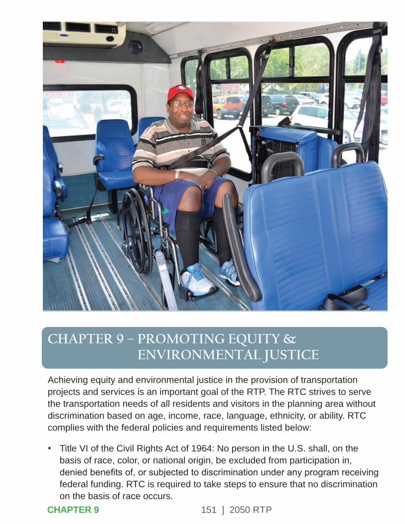
151 ] 2050 RTP
CHAPTER 9 – PROMOTING EQUITY & ENVIRONMENTAL JUSTICE
Achieving equity and environmental justice in the provision of transportation projects and services is an important goal of the RTP. The RTC strives to serve the transportation needs of all residents and visitors in the planning area without discrimination based on age, income, race, language, ethnicity, or ability. RTC complies with the federal policies and requirements listed below:
• Title VI of the Civil Rights Act of 1964: No person in the U.S. shall, on the basis of race, color, or national origin, be excluded from participation in, denied benefits of, or subjected to discrimination under any program receiving federal funding. RTC is required to take steps to ensure that no discrimination on the basis of race occurs.
CHAPTER 9
152 ] 2050 RTP
Title VI requires reporting about how transit services are implemented and what measures the RTC is taking to provide equal access to public transportation.
• Americans with Disabilities Act (ADA) of 1990 – Requires that disabled persons have equal access to transportation facilities and services. This includes wheelchair accessible accommodations in the transit system.
• Executive Order on Environmental Justice – Executive Order 12898 requires the identification and assessment of disproportionately high and adverse impacts on minority and low-income populations.
9.1 – TITLE VI OF THE CIVIL RIGHTS ACT OF 1964
Transportation projects and services are implemented in conformance with the RTC Title VI Policy. RTC submits a Title VI Report to the Federal Transit Administration every three years, with the most recent developed in 2020.
As identified in the report, the following measures are in place to comply with Title VI requirements:
• Minority, low-income, and Limited English Proficiency (LEP) persons are able to provide meaningful input into the planning process through participating in public meetings held in locations near transit routes and where translators and materials are provided in Spanish and English.
• RTC has a complaint procedure in place to investigate and track Title VI concerns.
• RTC submits an annual Title VI Certification and Assurance report to the US Department of Transportation.
RTC engages low-income, disabled, minority, and LEP persons in a meaningful public participation process. The RTC works with senior centers, assisted living facilities and senior organizations within the RTC RIDE service area to reach out to seniors and those with disabilities. The program involves a presentation about RTC RIDE and a field trip allowing the participants to experience riding the bus. The goal of the program is to make the participants more comfortable using public transportation as well as to solicit input from them about RTC services.
CHAPTER 9
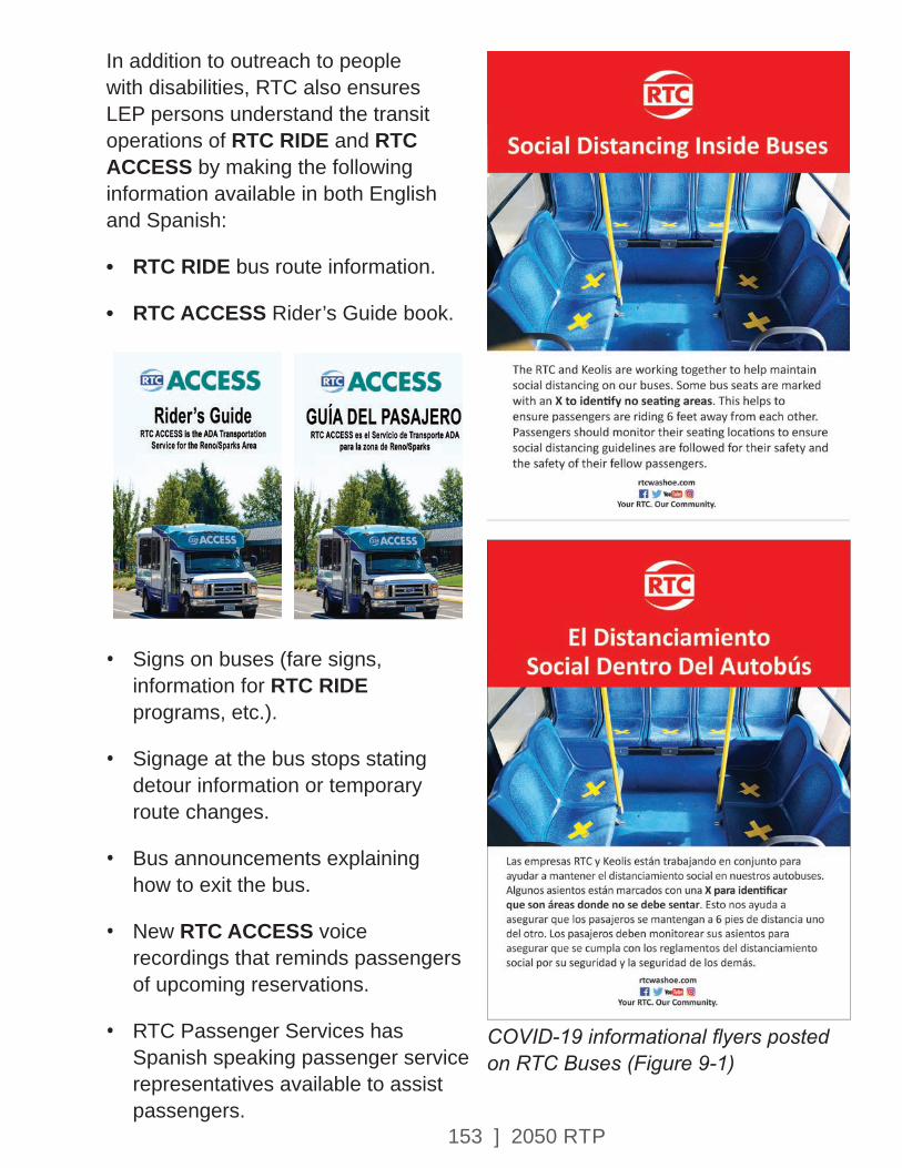
153 ] 2050 RTP
In addition to outreach to people with disabilities, RTC also ensures LEP persons understand the transit operations of RTC RIDE and RTC ACCESS by making the following information available in both English and Spanish:
• RTC RIDE bus route information.
• RTC ACCESS Rider’s Guide book.
• Signs on buses (fare signs, information for RTC RIDE programs, etc.).
• Signage at the bus stops stating detour information or temporary route changes.
• Bus announcements explaining how to exit the bus.
• New RTC ACCESS voice recordings that reminds passengers of upcoming reservations.
• RTC Passenger Services has Spanish speaking passenger service representatives available to assist passengers.
COVID-19 informational flyers posted on RTC Buses (Figure 9-1)
154 ] 2050 RTP
RTC TITLE VI PolicyThe RTC is committed to ensuring that no person is excluded from participation in, or denied the benefits of, its services on the basis of race, color, or national origin as protected by Title VI of the Civil Rights Act of 1964, as amended.
No person or group of persons will be discriminated against with regard to fares, routing, scheduling, or quality of transportation service that the RTC furnishes on the basis of race, color, or national origin. Frequency of service, age, and quality of RTC vehicles assigned to routes, quality of RTC stations serving Washoe County, and location of routes will not be determined on the basis of race, color, or national origin.
Equal Opportunity in ProcurementRTC procurement activities are conducted in accordance with RTC Board-adopted policies and the RTC Disadvantaged Business Enterprise (DBE) Program. Objectives of the RTC DBE Program are to ensure nondiscrimination, create a level playing field, remove barriers to DBE participation, and assist in the development of DBE firms that can compete successfully in the market place. RTC has a race-neutral DBE goal of 1.0% and race-conscious goal of 0.9%.
RTC has also developed a Fostering Small Business Participation Program.
RTC conducts outreach to educate DBEs and small businesses about the procurement process and ways they can participate. RTC has provided information and resources to the Hispanic Chamber of Commerce, Veterans Affairs, and at other community forums. RTC participates in Nevada Unified Certification Program for DBEs. RTC is committed to: providing technical assistance, providing information and communication programs on contracting procedures and specific contracting opportunities, assisting DBEs and small businesses to develop their capability to utilize emerging technology, and unbundling larger contracts when feasible.
The purpose of the RTC Fostering Small Business Participation Program is to provide full and fair opportunities for equal participation by small businesses in federally-funded contracting and procurement opportunities. RTC procurement policies comply with all applicable civil rights and equal opportunity laws, to ensure that all individuals – regardless of race, gender, age, disability, and national origin – benefit from federal funding programs.
9.
CAN
CHAPTER 9
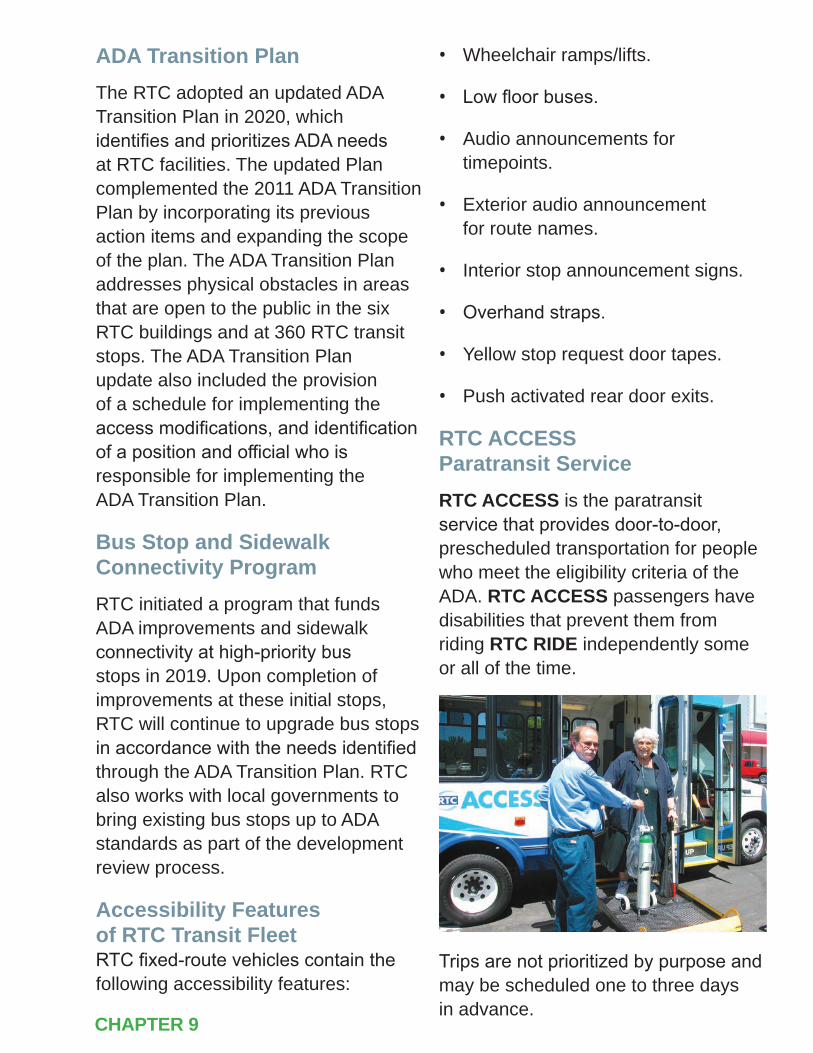
155 ] 2050 RTPCHAPTER 9
ADA Transition PlanThe RTC adopted an updated ADA Transition Plan in 2020, which identifies and prioritizes ADA needs at RTC facilities. The updated Plan complemented the 2011 ADA Transition Plan by incorporating its previous action items and expanding the scope of the plan. The ADA Transition Plan addresses physical obstacles in areas that are open to the public in the six RTC buildings and at 360 RTC transit stops. The ADA Transition Plan update also included the provision of a schedule for implementing the access modifications, and identification of a position and official who is responsible for implementing the ADA Transition Plan.
Bus Stop and Sidewalk Connectivity ProgramRTC initiated a program that funds ADA improvements and sidewalk connectivity at high-priority bus stops in 2019. Upon completion of improvements at these initial stops, RTC will continue to upgrade bus stops in accordance with the needs identified through the ADA Transition Plan. RTC also works with local governments to bring existing bus stops up to ADA standards as part of the development review process.
Accessibility Features of RTC Transit Fleet RTC fixed-route vehicles contain the following accessibility features:
• Wheelchair ramps/lifts.
• Low floor buses.
• Audio announcements for timepoints.
• Exterior audio announcement for route names.
• Interior stop announcement signs.
• Overhand straps.
• Yellow stop request door tapes.
• Push activated rear door exits.
RTC ACCESS Paratransit ServiceRTC ACCESS is the paratransit service that provides door-to-door, prescheduled transportation for people who meet the eligibility criteria of the ADA. RTC ACCESS passengers have disabilities that prevent them from riding RTC RIDE independently some or all of the time.
Trips are not prioritized by purpose and may be scheduled one to three days in advance.
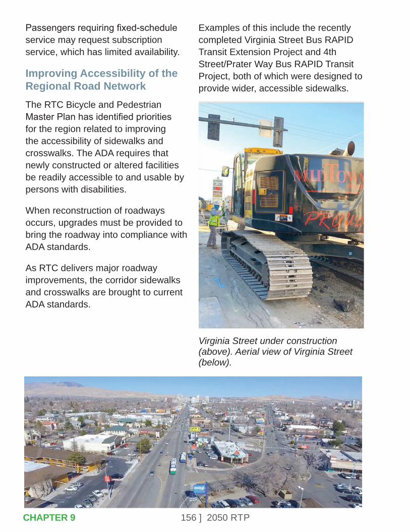
156 ] 2050 RTP
Passengers requiring fixed-schedule service may request subscription service, which has limited availability.
Improving Accessibility of the Regional Road NetworkThe RTC Bicycle and Pedestrian Master Plan has identified priorities for the region related to improving the accessibility of sidewalks and crosswalks. The ADA requires that newly constructed or altered facilities be readily accessible to and usable by persons with disabilities.
When reconstruction of roadways occurs, upgrades must be provided to bring the roadway into compliance with ADA standards.
As RTC delivers major roadway improvements, the corridor sidewalks and crosswalks are brought to current ADA standards.
Examples of this include the recently completed Virginia Street Bus RAPID Transit Extension Project and 4th Street/Prater Way Bus RAPID Transit Project, both of which were designed to provide wider, accessible sidewalks.
Virginia Street under construction (above). Aerial view of Virginia Street (below).
CHAPTER 9

157 ] 2050 RTP
Virginia Street: Safety improvements, like widened sidewalks, provide ample space for social distancing during the 2020 COVID-19 pandemic.
Passengers enjoy the afternoon sun at an RTC Lincoln Line RAPID station on 4th Street/Prater Way (left). Buses provide service on Route 11 on 4th Street/Prater Way (right).
CHAPTER 9

158 ] 2050 RTP
9.3 – EXECUTIVE ORDER ON ENVIRONMENTAL JUSTICE
A 1994 Presidential Executive Order directed every federal agency to identify and address the effects of all programs, policies, and activities on minority populations and low-income populations.
Effective transportation decision making depends upon understanding and properly addressing the unique needs of different socioeconomic groups. RTC considers the potential adverse impacts of projects on environmental justice populations. This includes impacts to neighborhood cohesiveness, regional accessibility, neighborhood quality of life, and health impacts. RTC also implements outreach strategies targeted toward minority residents and households with LEP. These strategies include outreach in Spanish-language media, bilingual meeting and transit notices, and the availability of bilingual staff at public meetings. These strategies are important considering the population of Washoe County consists of 35.5% minority and 4.6% of households with LEP .
When the RTC alters transit service, staff ensures that no disproportionately high or adverse impacts on minority and low-income populations occur.
Passengers on-board RTC REGIONAL CONNECTOR.
When a service change is being considered, staff holds open houses to receive input from passengers including many people who are part of minority and low-income populations. In addition, the RTC holds a formal public hearing for substantial changes to service (any changes that affect 25% or more of a route’s revenue vehicle miles), and analyzes how these changes will impact all passengers within the RTC service area. RTC transit activities are continually reviewed and results summarized once every three years in a Title VI Report, which is described in Section 9.1.
CHAPTER 9
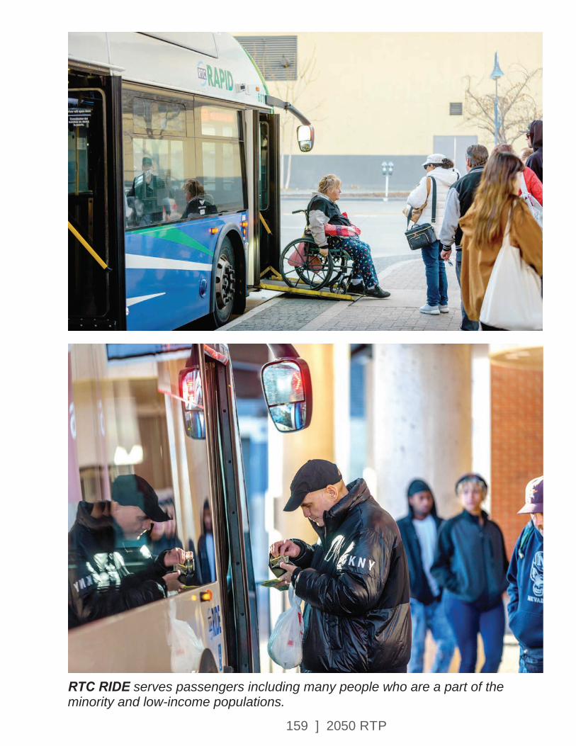
159 ] 2050 RTP
RTC RIDE serves passengers including many people who are a part of the minority and low-income populations.
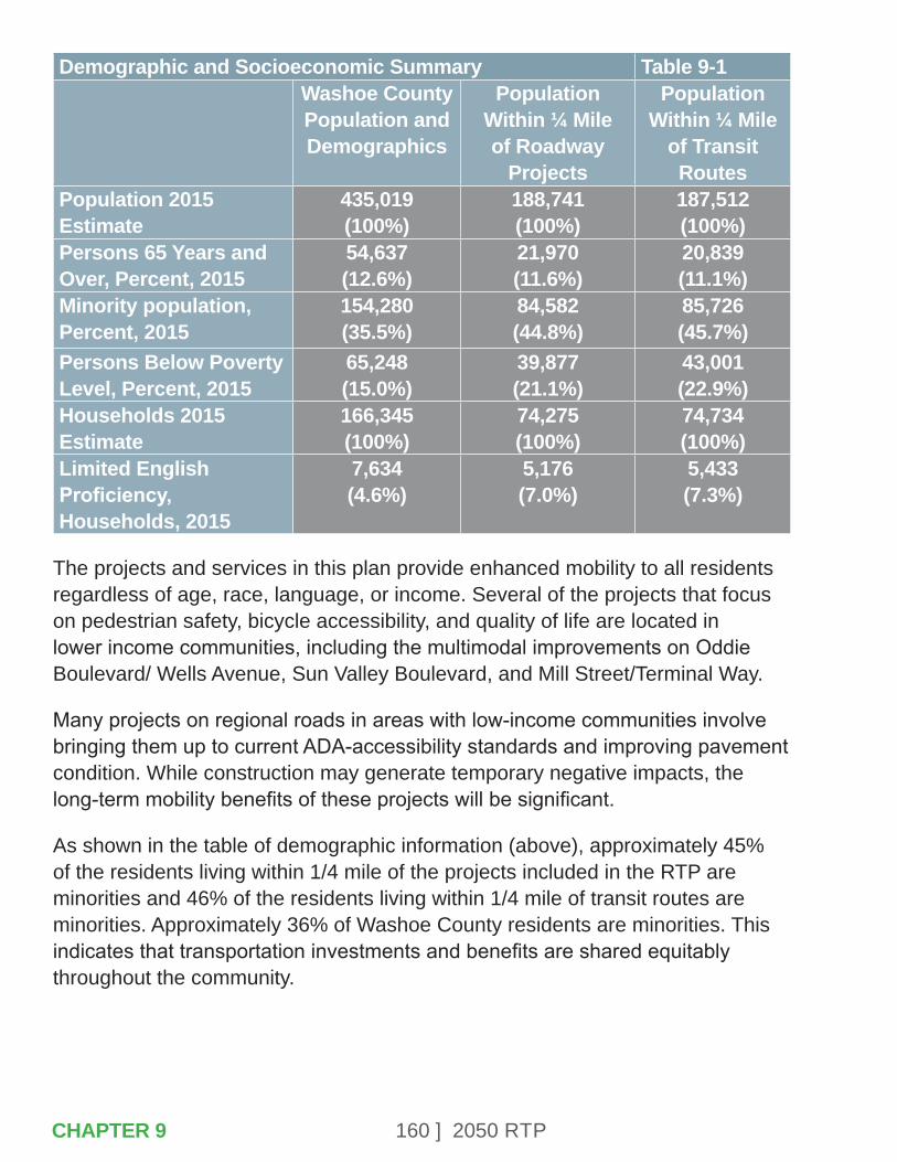
160 ] 2050 RTP
Demographic and Socioeconomic Summary Table 9-1Washoe County Population and Demographics
Population Within ¼ Mile of Roadway
Projects
Population Within ¼ Mile
of Transit Routes
Population 2015 Estimate
435,019(100%)
188,741(100%)
187,512(100%)
Persons 65 Years and Over, Percent, 2015
54,637(12.6%)
21,970(11.6%)
20,839(11.1%)
Minority population, Percent, 2015
154,280(35.5%)
84,582(44.8%)
85,726(45.7%)
Persons Below Poverty Level, Percent, 2015
65,248(15.0%)
39,877(21.1%)
43,001(22.9%)
Households 2015 Estimate
166,345(100%)
74,275(100%)
74,734(100%)
Limited English Proficiency, Households, 2015
7,634(4.6%)
5,176(7.0%)
5,433(7.3%)
The projects and services in this plan provide enhanced mobility to all residents regardless of age, race, language, or income. Several of the projects that focus on pedestrian safety, bicycle accessibility, and quality of life are located in lower income communities, including the multimodal improvements on Oddie Boulevard/ Wells Avenue, Sun Valley Boulevard, and Mill Street/Terminal Way.
Many projects on regional roads in areas with low-income communities involve bringing them up to current ADA-accessibility standards and improving pavement condition. While construction may generate temporary negative impacts, the long-term mobility benefits of these projects will be significant.
As shown in the table of demographic information (above), approximately 45% of the residents living within 1/4 mile of the projects included in the RTP are minorities and 46% of the residents living within 1/4 mile of transit routes are minorities. Approximately 36% of Washoe County residents are minorities. This indicates that transportation investments and benefits are shared equitably throughout the community.
CHAPTER 9

161 ] 2050 RTP
Similarly, 15% of the Washoe County population have incomes below the poverty level. About 21% of the residents near roadway projects and 23% of residents near transit routes have incomes below the poverty level. The proportion of seniors served by the projects and services in the RTP is lower than the county average; this is because of the high senior populations in lower density outlying areas such as Cold Springs and southwest Reno, which are not served by transit.
The RTC’s outreach includes numerous efforts to support transportation for economically disadvantaged populations. The RTC also provides bus passes to charitable organizations at discounted rates, or for free. For example, bus passes are provided to the Reno Works program, which transitions homeless individuals in Washoe County into jobs and housing.
The RTC participates in, and organizes, numerous events for seniors, disabled individuals, and students of all ages. These events help residents connect with transportation services that are often a lifeline for social activities, medical appointments, access to educational opportunities and the ability to earn an income. Notably, the RTC organizes the Stuff-A-Bus for Seniors drive, which collects needed donations of clothing and other essentials.
Thousands of seniors also interact with the RTC at the annual Senior Fest event. In addition to incorporating seniors and disabled individuals on standing committees, these populations are also offered free mobility travel training. This training instills confidence and builds skills in using transit and navigating the community.
Seniors gather information at the RTC Senior Fest booth.
CHAPTER 9
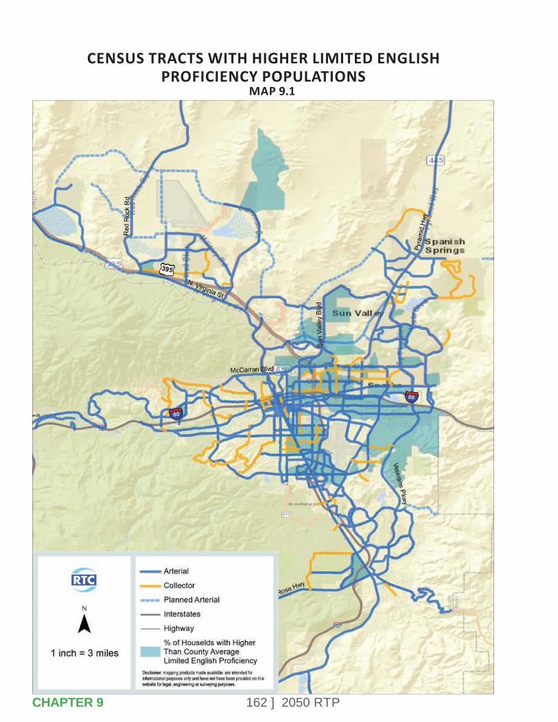
162 ] 2050 RTP
CENSUS TRACTS WITH HIGHER LIMITED ENGLISH PROFICIENCY POPULATIONS
MAP 9.1
CHAPTER 9
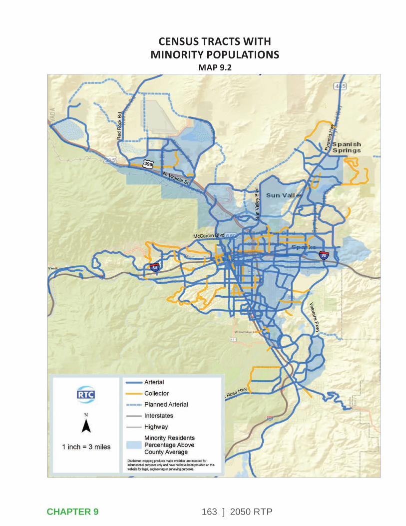
163 ] 2050 RTP
CENSUS TRACTS WITH MINORITY POPULATIONS
MAP 9.2
CHAPTER 9
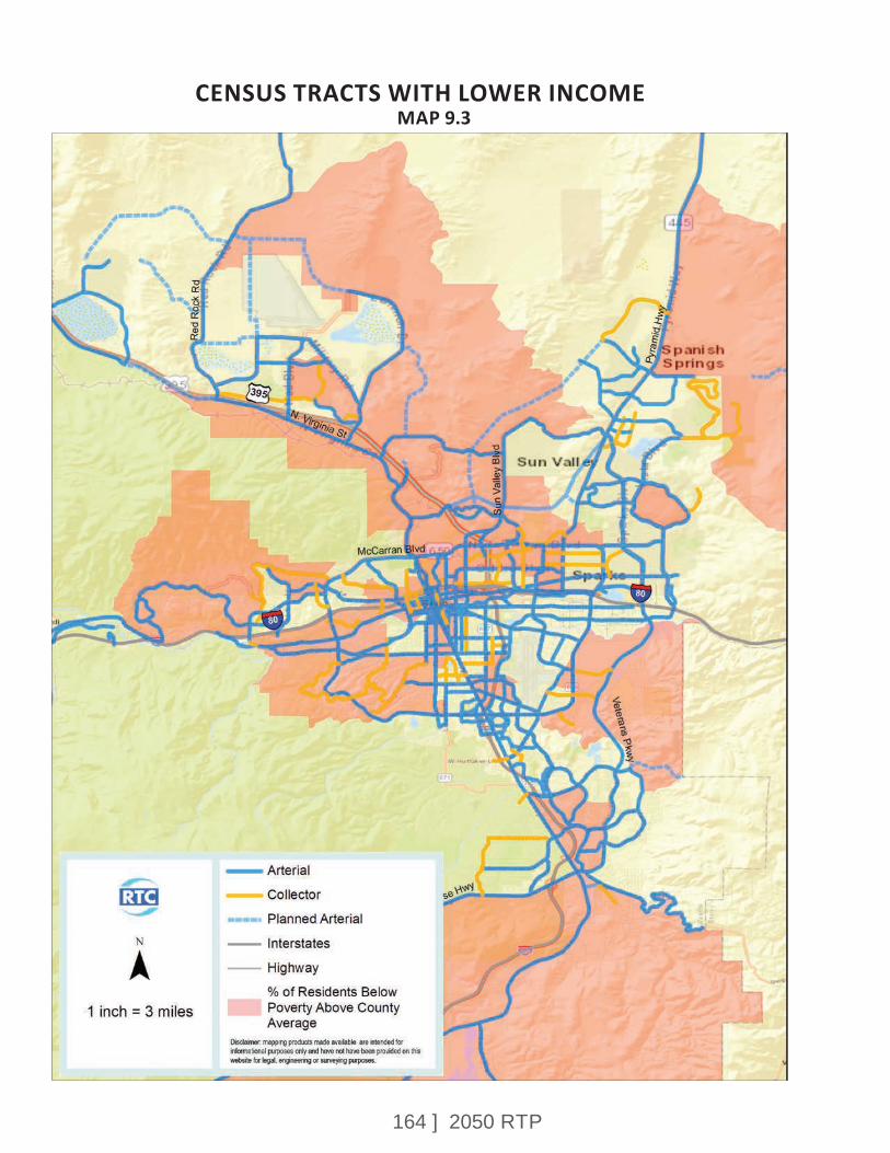
164 ] 2050 RTP
CENSUS TRACTS WITH LOWER INCOMEMAP 9.3
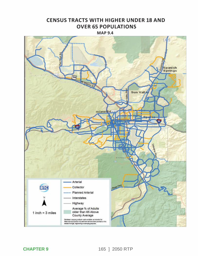
165 ] 2050 RTP
CENSUS TRACTS WITH HIGHER UNDER 18 AND OVER 65 POPULATIONS
MAP 9.4
CHAPTER 9
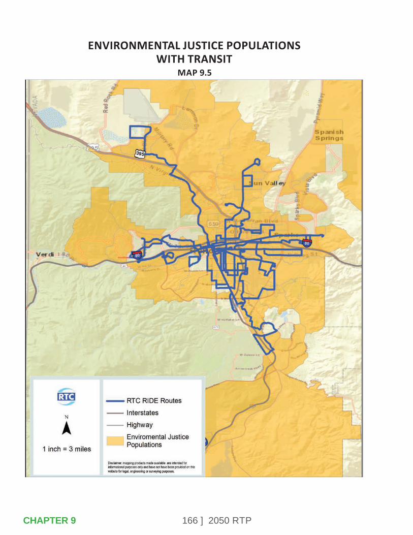
166 ] 2050 RTP
ENVIRONMENTAL JUSTICE POPULATIONS WITH TRANSIT
MAP 9.5
CHAPTER 9
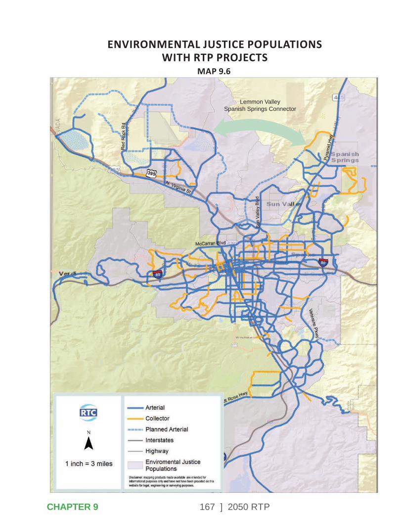
167 ] 2050 RTP
ENVIRONMENTAL JUSTICE POPULATIONSWITH RTP PROJECTS
MAP 9.6
CHAPTER 9
Lemmon Valley Spanish Springs Connector

168 ] 2050 RTP
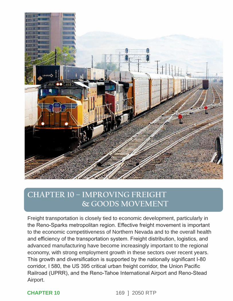
169 ] 2050 RTP
CHAPTER 10 – IMPROVING FREIGHT & GOODS MOVEMENT
Freight transportation is closely tied to economic development, particularly in the Reno-Sparks metropolitan region. Effective freight movement is important to the economic competitiveness of Northern Nevada and to the overall health and efficiency of the transportation system. Freight distribution, logistics, and advanced manufacturing have become increasingly important to the regional economy, with strong employment growth in these sectors over recent years. This growth and diversification is supported by the nationally significant I-80 corridor, I 580, the US 395 critical urban freight corridor, the Union Pacific Railroad (UPRR), and the Reno-Tahoe International Airport and Reno-Stead Airport.
CHAPTER 10
170 ] 2050 RTP
Centers of freight distribution activities include:
• Sparks industrial area and Sparks rail yard.
• North Valleys, including the Reno-Stead Airport and US 395 corridor.
• South Meadows industrial areas.
• Pyramid Highway industrial areas.
• Reno-Tahoe International Airport.
MAP-21 established a policy to improve the condition and performance of the national freight network. The purpose of the policy is to provide a foundation for the United States to compete in the global economy and achieve goals related to economic competitiveness and efficiency, congestion, productivity, safety, security, and resilience of freight movement. This is particularly significant in Northern Nevada, through which a significant amount of national freight movement occurs.
The passage of the current transportation bill, the FAST Act, further reinforces the importance of freight to the national economy. Specifically, the FAST Act established grant programs, such as INFRA, to fund critical transportation projects that benefit freight movements. The FAST Act emphasizes the importance of coordination between local governments and freight transportation providers.
10.1 – NEVADA STATE FREIGHT PLAN
The 2050 RTP supports the vision and goals described in the Nevada State Freight Plan (NSFP), which was adopted in 2017. The following strategic goals were identified in the NSFP with supporting objectives and performance measures:
• Economic Competitiveness
• Mobility and Reliability
• Safety
• Infrastructure Preservation
• Advanced Innovative Technology
• Environmental Sustainability and Livability
• Sustainable Funding
• Collaboration, Land-Use, and Community Values
These goals provide the context for the implementation of 18 strategies listed in the NSFP that will collectively address improvements to Nevada’s freight network to achieve the desired vision.
CHAPTER 10
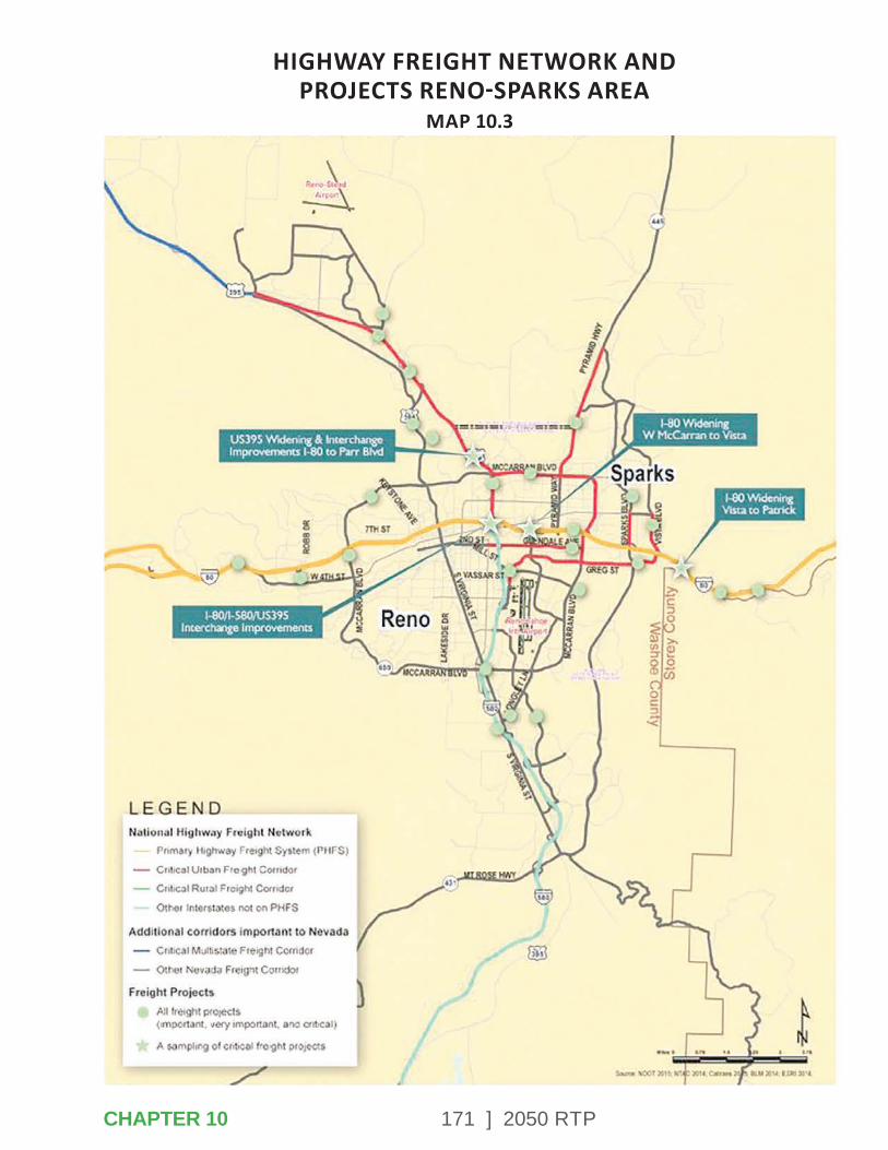
171 ] 2050 RTP
HIGHWAY FREIGHT NETWORK AND PROJECTS RENO-SPARKS AREA
MAP 10.3
CHAPTER 10

172 ] 2050 RTP
I-11 CorridorThe Nevada State Freight Plan promotes development of the proposed I-11 corridor. This continental corridor would link Nevada and other western states to Mexico and Canada.
The plan highlights the benefits to the state of creating a north-south freight corridor. This added connectivity would increase synergy between Nevada’s major hubs and improve their access to western US markets, eventually to Canada, and Mexico.
Truck ParkingAccording to the Federal Highway Administration, truck parking shortages are a national safety concern. Washoe County has a deficit of approximately 250 truck parking spaces. The Nevada Truck Parking Implementation Plan was developed in 2019. This plan identifies opportunities to expand and improve existing facilities and integrate truck parking technology in response to rising demand, changing hours of service requirements and safety standards noted in Jason’s Law, and rapid advancements in technology.
When implemented, these improve-ments will help truck drivers by providing adequate and safe public truck parking where it is most needed and enhanced by real-time truck parking availability information.
The RTC has been an active participant in developing and implementing the Nevada Truck Parking Implement- ation Plan.
10.2 – AIR CARGO
Reno’s proximity to major West Coast ports provide next day capability for movement of cargo back and forth for import and export as well as domestic spoke and hub services via air, truck, or rail. Reno has customs facilities and personnel to handle import and export needs, while Reno-Tahoe International Airport (RNO) is capable of handling a variety of international and domestic services and flights. In 2019, RNO handled more than 66,621 tons or nearly 147 million pounds of cargo shipments.
Approximately 402,465 pounds of cargo arrives or departs the airport each day. Companies handling air cargo at RNO include DHL, FedEx, and UPS (Reno-Tahoe Airport Authority, 2019). RNO is within a designated foreign trade zone and is located within 2 miles of two major highway corridors, I-80 and US 395, and less than one mile from the Union Pacific (UP) Sparks Intermodal Facility.
CHAPTER 10
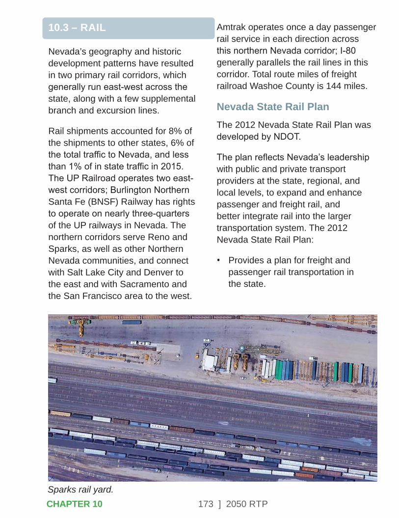
173 ] 2050 RTP
10.3 – RAIL
Nevada’s geography and historic development patterns have resulted in two primary rail corridors, which generally run east-west across the state, along with a few supplemental branch and excursion lines.
Rail shipments accounted for 8% of the shipments to other states, 6% of the total traffic to Nevada, and less than 1% of in state traffic in 2015. The UP Railroad operates two east-west corridors; Burlington Northern Santa Fe (BNSF) Railway has rights to operate on nearly three-quarters of the UP railways in Nevada. The northern corridors serve Reno and Sparks, as well as other Northern Nevada communities, and connect with Salt Lake City and Denver to the east and with Sacramento and the San Francisco area to the west.
Amtrak operates once a day passenger rail service in each direction across this northern Nevada corridor; I-80 generally parallels the rail lines in this corridor. Total route miles of freight railroad Washoe County is 144 miles.
Nevada State Rail PlanThe 2012 Nevada State Rail Plan was developed by NDOT.
The plan reflects Nevada’s leadership with public and private transport providers at the state, regional, and local levels, to expand and enhance passenger and freight rail, and better integrate rail into the larger transportation system. The 2012 Nevada State Rail Plan:
• Provides a plan for freight and passenger rail transportation in the state.
Sparks rail yard.CHAPTER 10
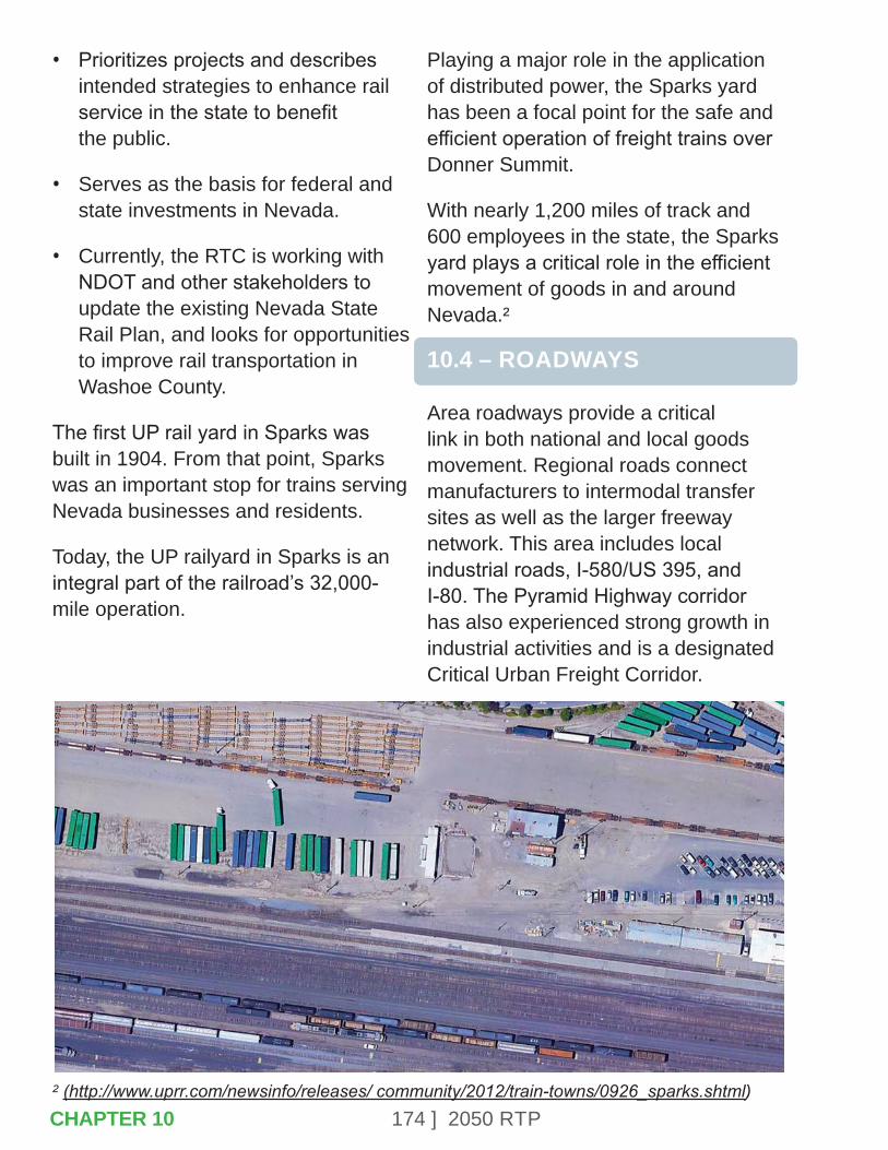
174 ] 2050 RTP
• Prioritizes projects and describes intended strategies to enhance rail service in the state to benefit the public.
• Serves as the basis for federal and state investments in Nevada.
• Currently, the RTC is working with NDOT and other stakeholders to update the existing Nevada State Rail Plan, and looks for opportunities to improve rail transportation in Washoe County.
The first UP rail yard in Sparks was built in 1904. From that point, Sparks was an important stop for trains serving Nevada businesses and residents.
Today, the UP railyard in Sparks is an integral part of the railroad’s 32,000-mile operation.
Playing a major role in the application of distributed power, the Sparks yard has been a focal point for the safe and efficient operation of freight trains over Donner Summit.
With nearly 1,200 miles of track and 600 employees in the state, the Sparks yard plays a critical role in the efficient movement of goods in and around Nevada.²
10.4 – ROADWAYS
Area roadways provide a critical link in both national and local goods movement. Regional roads connect manufacturers to intermodal transfer sites as well as the larger freeway network. This area includes local industrial roads, I-580/US 395, and I-80. The Pyramid Highway corridor has also experienced strong growth in industrial activities and is a designated Critical Urban Freight Corridor.
² (http://www.uprr.com/newsinfo/releases/ community/2012/train-towns/0926_sparks.shtml)CHAPTER 10

175 ] 2050 RTP
FREIGHT RAIL FACILITIESMAP 10.5
CHAPTER 10

176 ] 2050 RTP
Industrial roads accommodate significant freight movement through the Reno-Sparks metropolitan planning area. They connect major freight traffic generators, including industrial areas, inter-modal rail and air facilities, and the regional freeway network. The industrial road network defines critical connections for freight movement throughout the area and these roadways need to maintain the function of and capacity for truck movements. Industrial roads generally carry heavier loads and at least 6% trucks.
I-80I-80, designated as a part of the nation’s Primary Highway Freight System, is a heavily used goods movement corridor through the western states. States have implemented key strategies to mitigate the impacts of truck traffic on the roadways while still providing a good route for trucks to travel for their commercial needs, even during winter months when truck holds at the Nevada/California state line can be frequent.
Along some sections of I-80 in Washoe County, trucks can reach as high as 30% of the total volume of traffic on the roadways.
I-580/US 395
I-580 exists today from I-80 in Reno south to US 50 just south of Carson City. US 395 in Nevada is a major freeway from I-80 north to the state line and has been designated as a critical urban freight corridor. It serves significant freight traffic generated by the industrial and warehousing developments in the North Valleys area. These routes are absolutely vital to the state’s freight network, serving as the state’s primary truck routes connecting Nevada to the national freight network.
10.5 – OUTREACH & COORDINATION
The Freight Advisory Committee (FAC) is a group formed during the development of the Nevada State Freight Plan to coordinate and collect input from a range of public and private sector stakeholders. FAC meetings are held quarterly. RTC has been participating in the meetings and working closely with NDOT and other partners to develop and prioritize freight projects.
The RTC participated in the Northern Nevada Truck Parking Workshop. On September 17, 2019, the Federal Highway Administration (FHWA), in cooperation with NDOT, hosted a 1-day roundtable, focused on truck parking in the Northern Nevada region.
CHAPTER 10

177 ] 2050 RTP
I-80 and I-580/US 395 converge at the Spaghetti Bowl.
Truck parking challenges and potential solutions specific to Northern Nevada were discussed. This workshop provided the RTC an opportunity to engage with public and private sector partners on potential shared solutions. Topics included:
• Truck parking situation throughout the US and within Northern Nevada.
• Current truck parking assessments and needs.
• Best practices and possible solutions.
• Development of truck parking actions, strategies, and priorities.
10.6 – RTP PROJECTS SUPPORTING FREIGHT & GOODS MOVEMENT
Several projects in the RTP focus on improving freight and goods movement through Northern Nevada. A summary of these projects are listed below.
• System wide ITS improvements on I-80 and US 395/I-580.
• Pyramid Highway/US 395 Connector.
• Spaghetti Bowl Project and US 395 Widening.
CHAPTER 10

178 ] 2050 RTP

179 ] 2050 RTP
CHAPTER 11 – INVESTING STRATEGICALLY
Federal transportation legislation (FAST Act) requires that the 2050 RTP be based on a financial plan that demonstrates how the program of projects can be paid for and implemented. The program of projects incorporates all modes of transportation improvements, including transit (both operations and maintenance), roadway capacity, new roadways, Intelligent Transportation Systems (ITS)/operations, pavement preservation, and bicycle and pedestrian facilities.
CHAPTER 11
180 ] 2050 RTP
The financial plan must:
• Demonstrate how the adopted transportation plan can be implemented/funded.
• Identify resources from public and private sources that are reasonably expected to be made available to carry out the plan.
• Recommend any additional financing strategies for needed projects and programs.
The financial plan is shown in Year-of-Expenditure (YOE) dollars. Converting all costs and revenues to YOE dollars assumes a more accurate depiction of all costs, revenues and deficits with long-range transportation plans.
This chapter outlines the revenue projections with a brief discussion on the methods of developing the projections and then further discusses each funding source including federal, state, and local and regional sources. Additional data on the methods for developing the revenue projections are included in Appendix H. The plan addresses public transportation and roadway needs.
11.1 – REVENUE PROJECTIONS
The financial assumptions have been developed in a coordinated effort with state and federal agencies and the other MPO’s in the state. Partners in this effort included:
• Federal Highway Administration
• Federal Transit Administration
• Nevada Department of Transportation
• Nevada Department of Motor Vehicles
• Carson Area Metropolitan Planning Organization
• Tahoe Regional Planning Agency
• Regional Transportation Commission of Southern Nevada
RTC participated in a series of meetings with these partner agencies to develop consistent future revenue growth factors statewide to be used by all the MPOs in estimating federal and state revenues. Revenue forecast assumptions identified through this process are outlined below:
• State revenues for vehicle registration fees, motor carrier fees, driver’s license fees, and petroleum cleanup funds will increase by 2% annually.
CHAPTER 11
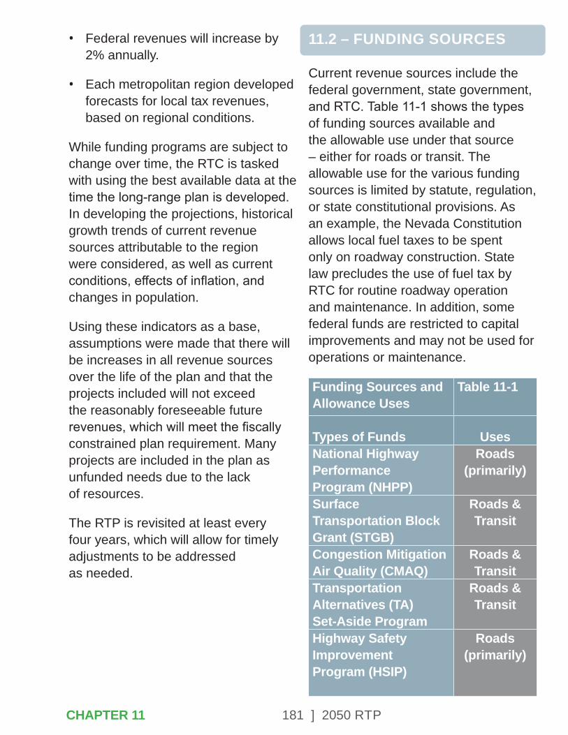
181 ] 2050 RTP
• Federal revenues will increase by 2% annually.
• Each metropolitan region developed forecasts for local tax revenues, based on regional conditions.
While funding programs are subject to change over time, the RTC is tasked with using the best available data at the time the long-range plan is developed. In developing the projections, historical growth trends of current revenue sources attributable to the region were considered, as well as current conditions, effects of inflation, and changes in population.
Using these indicators as a base, assumptions were made that there will be increases in all revenue sources over the life of the plan and that the projects included will not exceed the reasonably foreseeable future revenues, which will meet the fiscally constrained plan requirement. Many projects are included in the plan as unfunded needs due to the lack of resources.
The RTP is revisited at least every four years, which will allow for timely adjustments to be addressed as needed.
11.2 – FUNDING SOURCES
Current revenue sources include the federal government, state government, and RTC. Table 11-1 shows the types of funding sources available and the allowable use under that source – either for roads or transit. The allowable use for the various funding sources is limited by statute, regulation, or state constitutional provisions. As an example, the Nevada Constitution allows local fuel taxes to be spent only on roadway construction. State law precludes the use of fuel tax by RTC for routine roadway operation and maintenance. In addition, some federal funds are restricted to capital improvements and may not be used for operations or maintenance.
Funding Sources and Allowance Uses
Table 11-1
Types of Funds UsesNational Highway Performance Program (NHPP)
Roads (primarily)
Surface Transportation Block Grant (STGB)
Roads & Transit
Congestion Mitigation Air Quality (CMAQ)
Roads & Transit
Transportation Alternatives (TA) Set-Aside Program
Roads & Transit
Highway Safety Improvement Program (HSIP)
Roads (primarily)
CHAPTER 11

182 ] 2050 RTP
FTA Section 5307 TransitSection 5309 Discretionary
Roads & Transit
FTA Section 5339 TransitGas and Special Fuel Tax
Roads
Driver’s License, Vehicle Registration and Motor Carrier Fees
Roads
Regional Road Impact Fee (RRIF)
Roads (capacity)
Sales and Use Tax Roads & Transit
Revenues in 2020 were approximately $186 million. Figure 11-1 shows the funding sources for that revenue. In 2020, 35% of revenues were used for transit and 65% were used for roadways.
Figure 11-1 2016 Revenues by Funding Source
Fuel Tax50%
RRIF2%
Fares5% Investment
Income2%
Other1%
Federal Tax21%
Sales Tax19%
11.3 – 2020 REVENUES BY FUNDING SOURCE
Federal FundingFederal funds for transportation are collected nationally and allocated back to the states through a series of formulas and grants. A Continuing Resolution (CR) extends the expired federal surface transportation legislation, the FAST Act, passed in December 2015 by one year at FY 2020 authorization levels. The FAST Act was the first federal law in over a decade to provide long-term funding certainty for surface transportation infrastructure planning and investment. The FAST Act authorized $305 billion over fiscal years 2016 through 2020 for highway and motor vehicle safety, public transportation, motor carrier safety, hazardous materials safety, rail, and research, technology, and statistics programs.
The primary funding source provided by the federal government is the Highway Trust Fund (HTF) through the programs in the FAST Act. The HTF is comprised of the Highway Account (funds highway and intermodal programs) and the Mass Transit Account. Federal motor fuel taxes are the major source of income into the HTF.
CHAPTER 11
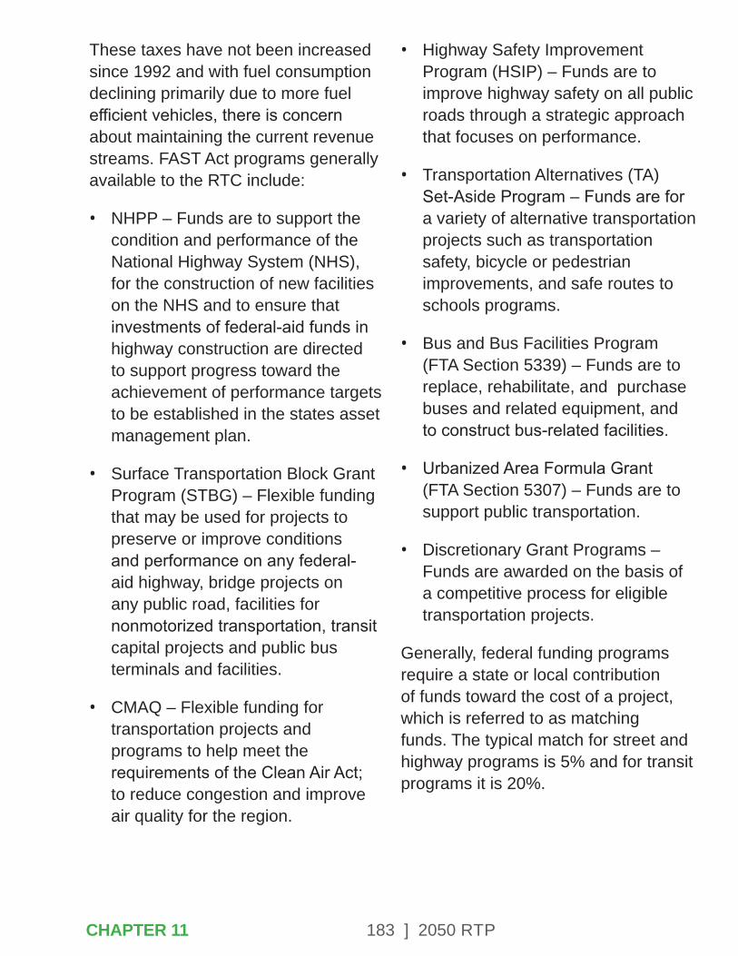
183 ] 2050 RTP
These taxes have not been increased since 1992 and with fuel consumption declining primarily due to more fuel efficient vehicles, there is concern about maintaining the current revenue streams. FAST Act programs generally available to the RTC include:
• NHPP – Funds are to support the condition and performance of the National Highway System (NHS), for the construction of new facilities on the NHS and to ensure that investments of federal-aid funds in highway construction are directed to support progress toward the achievement of performance targets to be established in the states asset management plan.
• Surface Transportation Block Grant Program (STBG) – Flexible funding that may be used for projects to preserve or improve conditions and performance on any federal-aid highway, bridge projects on any public road, facilities for nonmotorized transportation, transit capital projects and public bus terminals and facilities.
• CMAQ – Flexible funding for transportation projects and programs to help meet the requirements of the Clean Air Act; to reduce congestion and improve air quality for the region.
• Highway Safety Improvement Program (HSIP) – Funds are to improve highway safety on all public roads through a strategic approach that focuses on performance.
• Transportation Alternatives (TA) Set-Aside Program – Funds are for a variety of alternative transportation projects such as transportation safety, bicycle or pedestrian improvements, and safe routes to schools programs.
• Bus and Bus Facilities Program (FTA Section 5339) – Funds are to replace, rehabilitate, and purchase buses and related equipment, and to construct bus-related facilities.
• Urbanized Area Formula Grant (FTA Section 5307) – Funds are to support public transportation.
• Discretionary Grant Programs – Funds are awarded on the basis of a competitive process for eligible transportation projects.
Generally, federal funding programs require a state or local contribution of funds toward the cost of a project, which is referred to as matching funds. The typical match for street and highway programs is 5% and for transit programs it is 20%.
CHAPTER 11
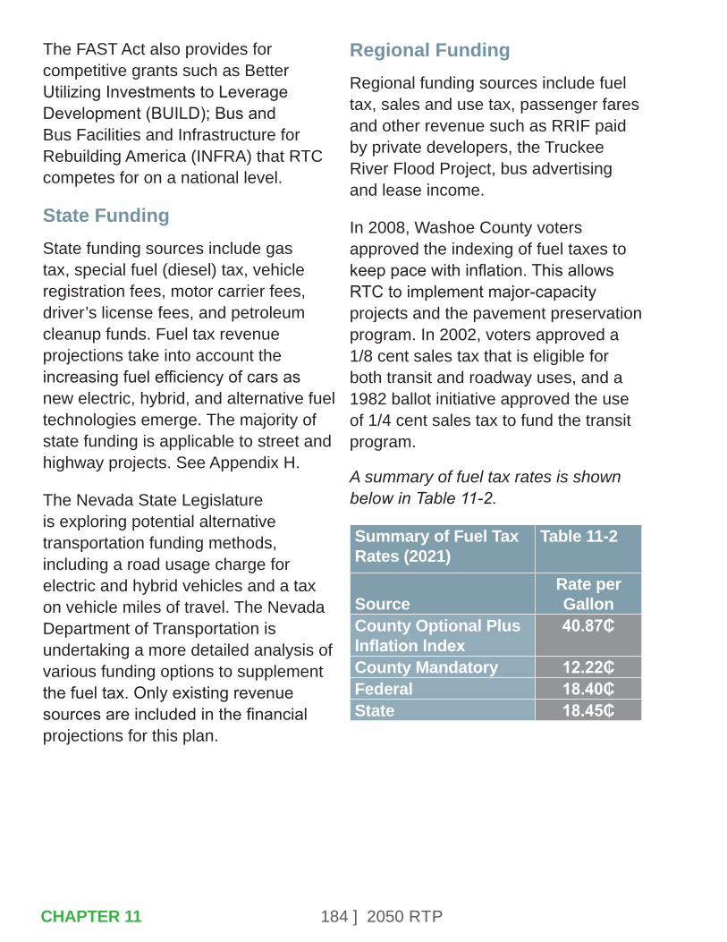
184 ] 2050 RTP
The FAST Act also provides for competitive grants such as Better Utilizing Investments to Leverage Development (BUILD); Bus and Bus Facilities and Infrastructure for Rebuilding America (INFRA) that RTC competes for on a national level.
State FundingState funding sources include gas tax, special fuel (diesel) tax, vehicle registration fees, motor carrier fees, driver’s license fees, and petroleum cleanup funds. Fuel tax revenue projections take into account the increasing fuel efficiency of cars as new electric, hybrid, and alternative fuel technologies emerge. The majority of state funding is applicable to street and highway projects. See Appendix H.
The Nevada State Legislature is exploring potential alternative transportation funding methods, including a road usage charge for electric and hybrid vehicles and a tax on vehicle miles of travel. The Nevada Department of Transportation is undertaking a more detailed analysis of various funding options to supplement the fuel tax. Only existing revenue sources are included in the financial projections for this plan.
Regional FundingRegional funding sources include fuel tax, sales and use tax, passenger fares and other revenue such as RRIF paid by private developers, the Truckee River Flood Project, bus advertising and lease income.
In 2008, Washoe County voters approved the indexing of fuel taxes to keep pace with inflation. This allows RTC to implement major-capacity projects and the pavement preservation program. In 2002, voters approved a 1/8 cent sales tax that is eligible for both transit and roadway uses, and a 1982 ballot initiative approved the use of 1/4 cent sales tax to fund the transit program.
A summary of fuel tax rates is shown below in Table 11-2.
Summary of Fuel Tax Rates (2021)
Table 11-2
SourceRate per Gallon
County Optional Plus Inflation Index
40.87₵
County Mandatory 12.22₵Federal 18.40₵State 18.45₵
CHAPTER 11

185 ] 2050 RTP
Total FundingA complete description of the methods for determining the future funding for each source is included in Appendix H. Table 11-3 outlines the revenue projections by timeframe and it identifies whether the funding is eligible for roadway projects or public transportation. This table indicates anticipated revenues in YOE dollars. No new funding sources were considered for the timeframe covered by this document.
Revenue Projections Table 11-3Fund Source 2021-2025 2026-2030 2031-2050 TotalComplete Street FundingFederal $235,132,000 $338,840,000 $1,746,682,000 $2,320,654,000State $208,593,000 $294,349,000 $1,214,037,000 $1,716,980,000Regional $554,344,000 $646,338,000 $3,910,007,000 $5,110,689,000 Total $998,070,000 $1,279,527,000 $6,870,726,000 $9,148,323,000Public Transportation FundingFederal $96,709,000 $118,119,000 $608,891,000 $823,719,000State $0 $0 $0 $0Regional $160,268,000 $174,362,000 $864,870,000 $1,199,501,000Fares & Other Revenues
$27,412,000 $28,545,000 $137,860,000 $193,817,000
Total $284,390,000 $321,026,000 $1,611,621,000 $2,217,037,000
11.4 – PLAN INVESTMENT NEEDS
The RTP contains the community’s vision for the transportation system. The projects, programs and activities identified in the RTP are necessary to make the long-range vision a reality. The needs assessment includes all jurisdictions (local, regional and state) and includes all activities, projects and programs on regional roads. A discussion of unfunded needs is also included.
The transportation needs for this plan have been divided into two major categories – public transportation and Complete Streets. The projects/programs are identified in Appendix A. Needs were placed into the following planning horizons and are shown in YOE dollars:
• 2021-2025
• 2026-2030
• 2031-2050CHAPTER 11

186 ] 2050 RTP
Public TransportationA vision for the future of transit in the Truckee Meadows was developed through the RTP, as described in Chapter 7, and incorporates the adopted SRTP. Recommendations have been implemented as a result of the SRTP that have reallocated service hours to achieve greater efficiencies on several routes. In addition, the RTC has implemented FlexRIDE, a microtransit service, in several sub-areas of the region, which provides an on-demand curb-to-curb service within specified zones. This service provides residents previously outside of the transit service area a direct connection to several destinations and established fixed routes.
Existing transit-eligible revenues are being utilized for current transit operations. Should additional revenues become available, effective uses for these funds would include increased frequency and span of service on productive routes, as identified in the SRTP, and potential expansions of FlexRIDE service areas. The RAPID transit service provided on the Lincoln Line and Virginia Line is the core of the regional transit system. This plan includes expansions of these routes as part of the unfunded vision for transit. Also included in the unfunded vision are the creation of an inter-regional transit route between Truckee and the Tahoe Reno Industrial Center, development of a new bus transfer facility, a new or expanded bus maintenance facility, and parking/mobility hubs. Due to the significant costs of these projects, they are listed as unfunded needs in the transit vision. Table 11-4 lists some of the projects that were identified along with their estimated costs.
Unfunded Transit Vision Table 11-4 Initial Capital Cost (2020 $)
Annual Operating Cost (2020 $)
Increased frequency and span of service on existing high-productivity routes
$2.4 million $1.5 million per year
Expand FlexRIDE service areas $500,000 $1 million per year (for 2 additional zones)
Extend Virginia Line RAPID to Mt. Rose Highway $12.7 million $2.7 million per yearExtend Lincoln Line RAPID to Stoker Avenue $4.2 million $620,000 per year Improved Transit Connectivity to the Lake Tahoe Region
$1 million $1.9 million per year
Truckee to TRI Center Commuter Bus Service $5.9 million $886,000 per yearTotal Unfunded Operating Costs $26.7 million $8.6 million per year Bus Maintenance Facility $50 million -New Transfer Facility at Meadowood Mall $16 million -Mobility Hubs $50 million -Total Unfunded Facility Needs $116 million -
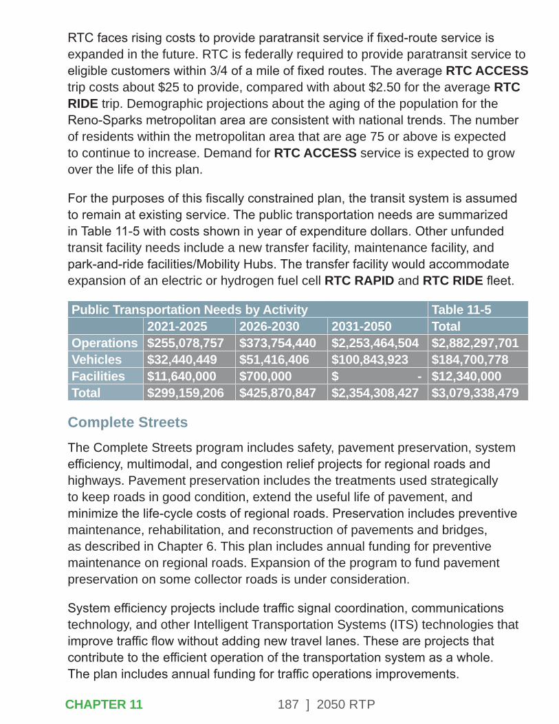
187 ] 2050 RTP
RTC faces rising costs to provide paratransit service if fixed-route service is expanded in the future. RTC is federally required to provide paratransit service to eligible customers within 3/4 of a mile of fixed routes. The average RTC ACCESS trip costs about $25 to provide, compared with about $2.50 for the average RTC RIDE trip. Demographic projections about the aging of the population for the Reno-Sparks metropolitan area are consistent with national trends. The number of residents within the metropolitan area that are age 75 or above is expected to continue to increase. Demand for RTC ACCESS service is expected to grow over the life of this plan.
For the purposes of this fiscally constrained plan, the transit system is assumed to remain at existing service. The public transportation needs are summarized in Table 11-5 with costs shown in year of expenditure dollars. Other unfunded transit facility needs include a new transfer facility, maintenance facility, and park-and-ride facilities/Mobility Hubs. The transfer facility would accommodate expansion of an electric or hydrogen fuel cell RTC RAPID and RTC RIDE fleet.
Public Transportation Needs by Activity Table 11-52021-2025 2026-2030 2031-2050 Total
Operations $255,078,757 $373,754,440 $2,253,464,504 $2,882,297,701 Vehicles $32,440,449 $51,416,406 $100,843,923 $184,700,778 Facilities $11,640,000 $700,000 $ - $12,340,000 Total $299,159,206 $425,870,847 $2,354,308,427 $3,079,338,479
Complete StreetsThe Complete Streets program includes safety, pavement preservation, system efficiency, multimodal, and congestion relief projects for regional roads and highways. Pavement preservation includes the treatments used strategically to keep roads in good condition, extend the useful life of pavement, and minimize the life-cycle costs of regional roads. Preservation includes preventive maintenance, rehabilitation, and reconstruction of pavements and bridges, as described in Chapter 6. This plan includes annual funding for preventive maintenance on regional roads. Expansion of the program to fund pavement preservation on some collector roads is under consideration.
System efficiency projects include traffic signal coordination, communications technology, and other Intelligent Transportation Systems (ITS) technologies that improve traffic flow without adding new travel lanes. These are projects that contribute to the efficient operation of the transportation system as a whole. The plan includes annual funding for traffic operations improvements.
CHAPTER 11
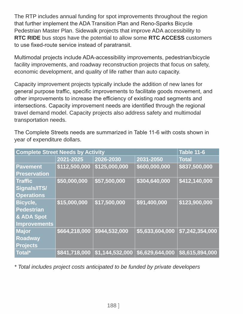
188 ] 2050 RTP
The RTP includes annual funding for spot improvements throughout the region that further implement the ADA Transition Plan and Reno-Sparks Bicycle Pedestrian Master Plan. Sidewalk projects that improve ADA accessibility to RTC RIDE bus stops have the potential to allow some RTC ACCESS customers to use fixed-route service instead of paratransit.
Multimodal projects include ADA-accessibility improvements, pedestrian/bicycle facility improvements, and roadway reconstruction projects that focus on safety, economic development, and quality of life rather than auto capacity.
Capacity improvement projects typically include the addition of new lanes for general purpose traffic, specific improvements to facilitate goods movement, and other improvements to increase the efficiency of existing road segments and intersections. Capacity improvement needs are identified through the regional travel demand model. Capacity projects also address safety and multimodal transportation needs.
The Complete Streets needs are summarized in Table 11-6 with costs shown in year of expenditure dollars.
Complete Street Needs by Activity Table 11-62021-2025 2026-2030 2031-2050 Total
Pavement Preservation
$112,500,000 $125,000,000 $600,000,000 $837,500,000
Traffic Signals/ITS/Operations
$50,000,000 $57,500,000 $304,640,000 $412,140,000
Bicycle, Pedestrian & ADA Spot Improvements
$15,000,000 $17,500,000 $91,400,000 $123,900,000
Major Roadway Projects
$664,218,000 $944,532,000 $5,633,604,000 $7,242,354,000
Total* $841,718,000 $1,144,532,000 $6,629,644,000 $8,615,894,000
* Total includes project costs anticipated to be funded by private developers
189 ] 2050 RTP
The program of projects in this RTP does not bring all regional roads up to level of service standards. The capacity projects included in the plan reflect the prioritization of the most severely congested corridors and the bottleneck locations that have wide-ranging impacts on the regional network. The unfunded needs listing includes projects for which no funding is available. These are projects that would be included in the RTP if additional funding resources were available.
Including this listing of projects provides an opportunity to identify additional projects for future consideration in the event additional funding becomes available. The total unfunded needs is estimated at approximately $4,012,000,000 for roadway projects (see Appendix A).
CHAPTER 11
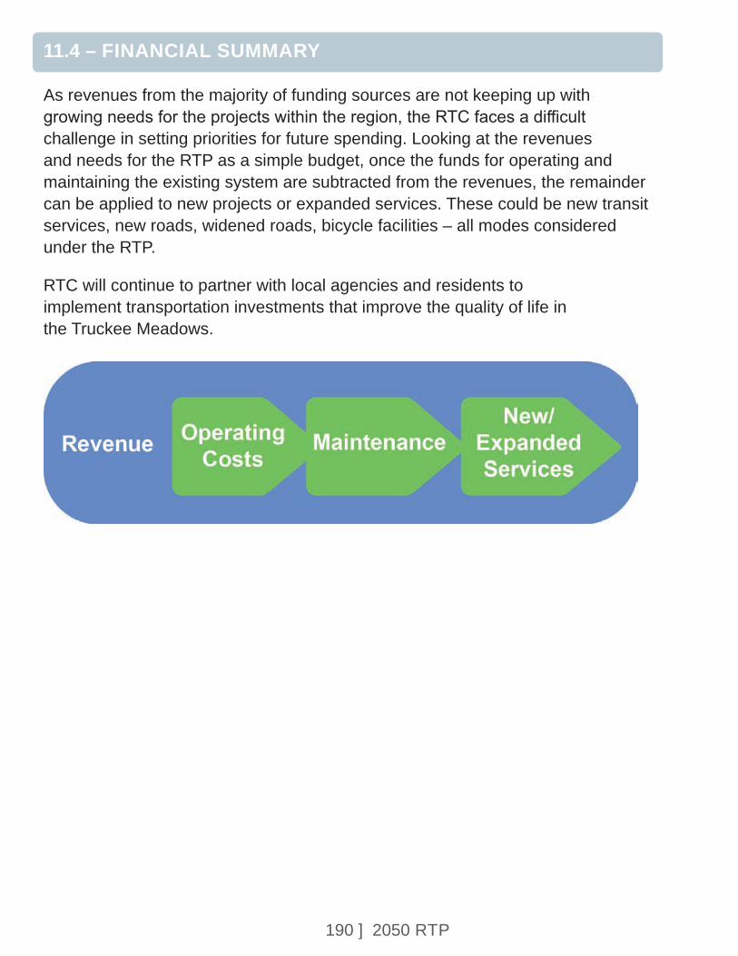
190 ] 2050 RTP
11.4 – FINANCIAL SUMMARY
As revenues from the majority of funding sources are not keeping up with growing needs for the projects within the region, the RTC faces a difficult challenge in setting priorities for future spending. Looking at the revenues and needs for the RTP as a simple budget, once the funds for operating and maintaining the existing system are subtracted from the revenues, the remainder can be applied to new projects or expanded services. These could be new transit services, new roads, widened roads, bicycle facilities – all modes considered under the RTP.
RTC will continue to partner with local agencies and residents to implement transportation investments that improve the quality of life in the Truckee Meadows.
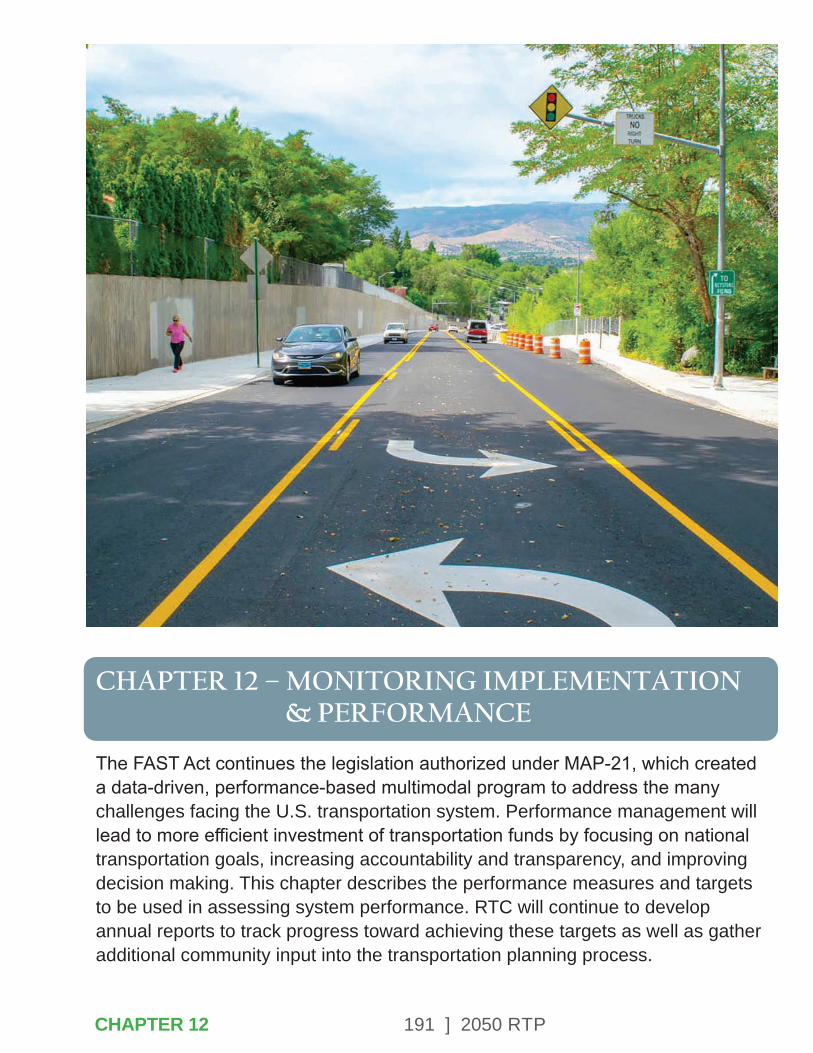
191 ] 2050 RTP
CHAPTER 12 – MONITORING IMPLEMENTATION & PERFORMANCE
The FAST Act continues the legislation authorized under MAP-21, which created a data-driven, performance-based multimodal program to address the many challenges facing the U.S. transportation system. Performance management will lead to more efficient investment of transportation funds by focusing on national transportation goals, increasing accountability and transparency, and improving decision making. This chapter describes the performance measures and targets to be used in assessing system performance. RTC will continue to develop annual reports to track progress toward achieving these targets as well as gather additional community input into the transportation planning process.
CHAPTER 12
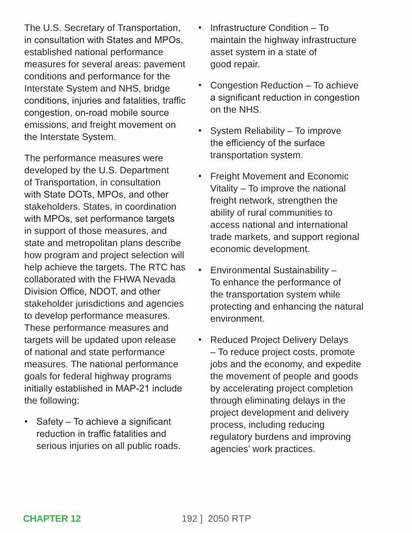
192 ] 2050 RTP
The U.S. Secretary of Transportation, in consultation with States and MPOs, established national performance measures for several areas: pavement conditions and performance for the Interstate System and NHS, bridge conditions, injuries and fatalities, traffic congestion, on-road mobile source emissions, and freight movement on the Interstate System.
The performance measures were developed by the U.S. Department of Transportation, in consultation with State DOTs, MPOs, and other stakeholders. States, in coordination with MPOs, set performance targets in support of those measures, and state and metropolitan plans describe how program and project selection will help achieve the targets. The RTC has collaborated with the FHWA Nevada Division Office, NDOT, and other stakeholder jurisdictions and agencies to develop performance measures. These performance measures and targets will be updated upon release of national and state performance measures. The national performance goals for federal highway programs initially established in MAP-21 include the following:
• Safety – To achieve a significant reduction in traffic fatalities and serious injuries on all public roads.
• Infrastructure Condition – To maintain the highway infrastructure asset system in a state of good repair.
• Congestion Reduction – To achieve a significant reduction in congestion on the NHS.
• System Reliability – To improve the efficiency of the surface transportation system.
• Freight Movement and Economic Vitality – To improve the national freight network, strengthen the ability of rural communities to access national and international trade markets, and support regional economic development.
• Environmental Sustainability – To enhance the performance of the transportation system while protecting and enhancing the natural environment.
• Reduced Project Delivery Delays – To reduce project costs, promote jobs and the economy, and expedite the movement of people and goods by accelerating project completion through eliminating delays in the project development and delivery process, including reducing regulatory burdens and improving agencies’ work practices.
CHAPTER 12

193 ] 2050 RTP
National transit goals and performance measures are developed by the Federal Transit Administration.
These include state of good repair (SGR) standards for measuring the condition of transit capital assets:
• Equipment – Non-revenue support-service and maintenance vehicles.
• Rolling Stock – Revenue vehicles by mode.
• Infrastructure – Only rail fixed-guideway, track signals and systems. RTC does not own or operate any assets in this category, therefore, this is not applicable to RTC.
• Facilities – Maintenance and administrative facilities; and passenger stations (buildings) and parking facilities.
The FAST Act and MAP-21 provide a framework for linking goals and performance targets with project selection and implementation. Performance plans will track the progress toward achieving these targets and will be used to facilitate a community conversation about the track record of the RTC’s transportation program. RTC will develop the following performance plans:
• Metropolitan Transportation Plan, to be updated every four years, which will include a discussion of:
- Anticipated effects of the improvement program toward achieving the performance targets.
- How investment priorities are linked to performance targets.
• Annual Metropolitan System and Transit Performance Report, which will include:
- Evaluation of the condition and performance of the transportation system.
- Progress achieved in meeting performance targets.
- Evaluation of how transportation investments have improved conditions.
• Transit Asset Management (TAM) Plan.
• Public Transportation Safety Plan.
The performance measures build upon existing and planned data collection efforts. Both transit and roadway performance measures are included in Table 12-1. Additional description of the performance measures is below.
12.1 – SAFETY PERFORMANCE MEASURES
The RTC’s aspirational vision is that zero fatalities on our region’s roadways is the only acceptable goal and RTC recognizes that reaching that goal will require time and significant effort by all stakeholders.
CHAPTER 12
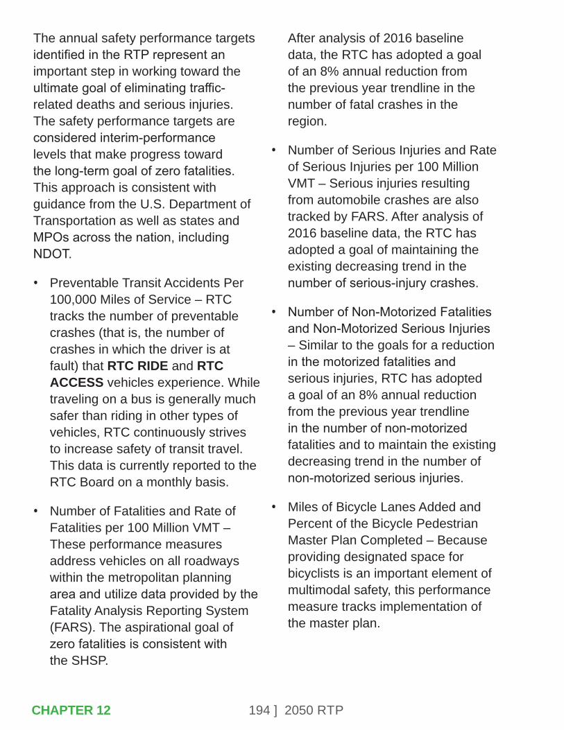
194 ] 2050 RTP
The annual safety performance targets identified in the RTP represent an important step in working toward the ultimate goal of eliminating traffic-related deaths and serious injuries. The safety performance targets are considered interim-performance levels that make progress toward the long-term goal of zero fatalities. This approach is consistent with guidance from the U.S. Department of Transportation as well as states and MPOs across the nation, including NDOT.
• Preventable Transit Accidents Per 100,000 Miles of Service – RTC tracks the number of preventable crashes (that is, the number of crashes in which the driver is at fault) that RTC RIDE and RTC ACCESS vehicles experience. While traveling on a bus is generally much safer than riding in other types of vehicles, RTC continuously strives to increase safety of transit travel. This data is currently reported to the RTC Board on a monthly basis.
• Number of Fatalities and Rate of Fatalities per 100 Million VMT – These performance measures address vehicles on all roadways within the metropolitan planning area and utilize data provided by the Fatality Analysis Reporting System (FARS). The aspirational goal of zero fatalities is consistent with the SHSP.
After analysis of 2016 baseline data, the RTC has adopted a goal of an 8% annual reduction from the previous year trendline in the number of fatal crashes in the region.
• Number of Serious Injuries and Rate of Serious Injuries per 100 Million VMT – Serious injuries resulting from automobile crashes are also tracked by FARS. After analysis of 2016 baseline data, the RTC has adopted a goal of maintaining the existing decreasing trend in the number of serious-injury crashes.
• Number of Non-Motorized Fatalities and Non-Motorized Serious Injuries – Similar to the goals for a reduction in the motorized fatalities and serious injuries, RTC has adopted a goal of an 8% annual reduction from the previous year trendline in the number of non-motorized fatalities and to maintain the existing decreasing trend in the number of non-motorized serious injuries.
• Miles of Bicycle Lanes Added and Percent of the Bicycle Pedestrian Master Plan Completed – Because providing designated space for bicyclists is an important element of multimodal safety, this performance measure tracks implementation of the master plan.
CHAPTER 12

195 ] 2050 RTP
RTC tracks the number of bicycle lane miles added each year and will identify the percentage of projects in the plan that have been completed. Implementing between three and 7% of the plan each year will keep the region on track to complete the initial goal of implementation of the master plan by 2035. Currently, approximately 30% of the Bicycle Pedestrian Master Plan has been completed.
• Miles of Sidewalk Added or Enhanced and Percent of the ADA Transition Plan Completed – As described previously, making sidewalks more accessible will promote pedestrian safety. RTC will track the implementation of projects in the transition plan. Over the past few years, the RTC has been exceeding the annual goal for constructing new sidewalks.
12.2 – INFRASTRUCTURE CONDITIONS/TRANSIT STATE OF GOOD REPAIR PERFORMANCE MEASURES
• Pavement Condition Index (PCI) for Regional Roads – RTC has an established management system to monitor pavement condition and determine resource allocation, as described in Chapter 6.
An average PCI rating of 80 will be maintained, and no more than 3% of Regional Roads as determined in Table E-3 will have a condition index rating of less than 50. The PCI for Regional Roads was reported as 83.3 in the 2019 Annual Report.
• One of the initial MAP-21 performance areas also addressed pavement and bridge performance. Six national performance measures were developed under this area, and include the percentage of pavements in good condition and percentage of pavements in poor condition on both the Interstate System and non-Interstate NHS, as well as the percentage of bridges in good condition and the percentage of bridges in poor condition. The national performance measures for assessing pavement condition differ from the RTC measures in that they won’t apply to all Regional Roads and that the condition will be assessed using a different methodology. The FHWA requires measures that reflect data elements in the Highway Performance Monitoring System (HPMS), including: International Roughness Index (IRI), rutting for asphalt surfaced pavements, faulting for jointed concrete surface pavements, and cracking percent.
CHAPTER 12
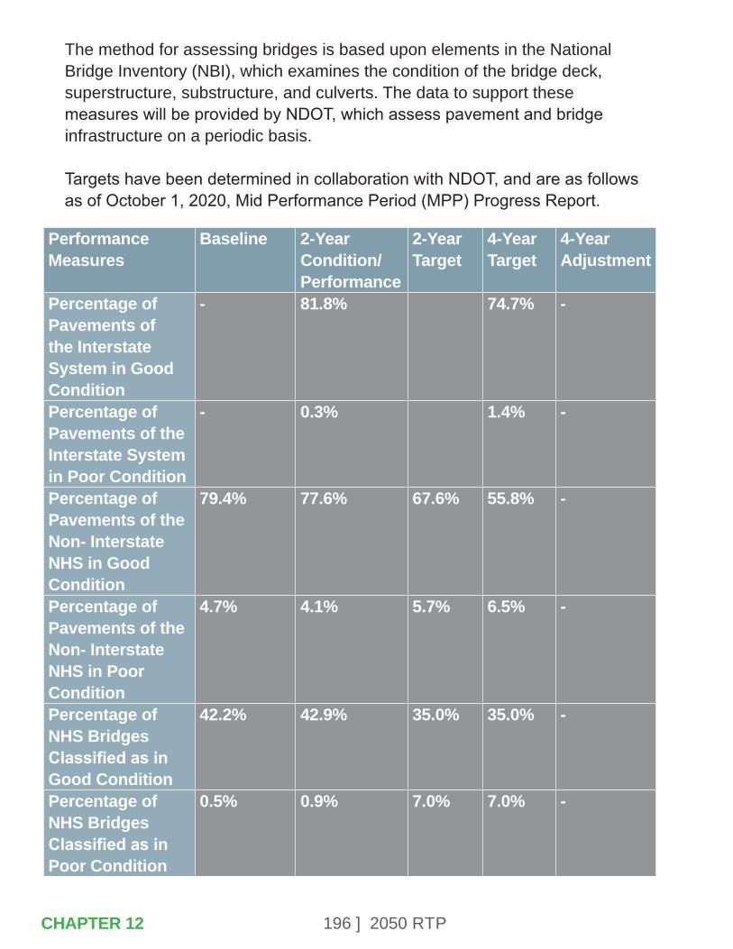
196 ] 2050 RTP
The method for assessing bridges is based upon elements in the National Bridge Inventory (NBI), which examines the condition of the bridge deck, superstructure, substructure, and culverts. The data to support these measures will be provided by NDOT, which assess pavement and bridge infrastructure on a periodic basis. Targets have been determined in collaboration with NDOT, and are as follows as of October 1, 2020, Mid Performance Period (MPP) Progress Report.
Performance Measures
Baseline 2-Year Condition/ Performance
2-Year Target
4-Year Target
4-Year Adjustment
Percentage of Pavements of the Interstate System in Good Condition
- 81.8% 74.7% -
Percentage of Pavements of the Interstate System in Poor Condition
- 0.3% 1.4% -
Percentage of Pavements of the Non- Interstate NHS in Good Condition
79.4% 77.6% 67.6% 55.8% -
Percentage of Pavements of the Non- Interstate NHS in Poor Condition
4.7% 4.1% 5.7% 6.5% -
Percentage of NHS Bridges Classified as in Good Condition
42.2% 42.9% 35.0% 35.0% -
Percentage of NHS Bridges Classified as in Poor Condition
0.5% 0.9% 7.0% 7.0% -
CHAPTER 12

197 ] 2050 RTP
• Preventive Maintenance of Transit Rolling Stock and Facilities – The Short Range Transit Plan identifies an inspection and maintenance schedule for transit capital resources. This performance measure tracks the timeliness of implementation of inspections and corrective actions. As of the most recent annual report, 100% of preventative maintenance is being performed on time.
• Maintain Industry Standard Vehicle Life Cycle – RTC will maintain vehicles in good repair to the expected life cycle for transit rolling stock. The RTC follows FTA standards, which vary by type of vehicle. This measure, as well as related measures, will be further developed through the TAM Plan, which will address the applicable asset categories described previously.
12.3 – CONGESTION REDUCTION
• Level of Travel Time Reliability (LOTTR) – Defined as the ratio of the longer travel times (80th percentile) of a reporting segment to a “normal” travel time (50th percentile), using data from FHWA’s National Performance Management Research Data Set (NPMRDS). Data are collected in 15-minute segments during all time periods between 6 a.m. and 8 p.m.
• The measures are the percent of person-miles traveled on the relevant Interstate System and Non-Interstate NHS that are reliable. Person-miles take into account the users of the NHS. Data to reflect the users can include bus, auto, and truck occupancy levels.
• Truck Travel Time Reliability (TTTR) Ratio – Determined by dividing the 95th percentile time by the normal time (50th percentile) for each segment. Then, the TTTR Index is generated by multiplying each segment’s largest ratio from defined time periods by its length, then dividing the sum of all length-weighted segments by the total length of the Interstate. In addition to the national measures, NDOT has identified performance measures through their State Freight Plan. Some of these measures address truck speeds on I-80, I-580, and US 395; fatal crashes involving trucks; and the registration of trucks in Nevada with an engine model year of 2010 or newer (for air quality purposes).
• Transit Passengers per Service Hour – Transit operating efficiency is a priority of the RTC. An RTC RIDE system-wide average of 30 passengers per service hour is the performance target. RTC currently tracks this data and provides regular reports to the RTC Board.
CHAPTER 12
198 ] 2050 RTP
• VMT per Person – This performance measure uses the regional travel demand model to estimate the number of VMT per person. The performance target is that VMT will not exceed 27 VMT per person by 2040.
12.4 – SYSTEM RELIABILITY
• Peak Hour Excessive Delay – This measure applies to mainline highway segments on the NHS that cross any part of an urbanized area with a population of more than 200,000 and that is part of a nonattainment or maintenance area for any one of the criteria pollutants listed under the NAAQS. Excessive delay will be based on travel time at 20 miles per hour or 60% of the posted speed limit travel time, whichever is greater, during 15 minute intervals per vehicle. The RTC is required to begin reporting on this measure in 2022. As with other measures, NDOT will be responsible for reporting once targets have been identified through collaboration.
• Percent Non-SOV Travel – Non-Single Occupancy Vehicle (SOV) travel is defined as any travel mode other than driving alone in a motorized vehicle, including travel avoided by telecommuting.
The FHWA has provided three different options for calculating this measure, and the RTC has opted to use the American Community Survey (ACS) method (Method A). This method utilizes the most recent ACS 5-year estimates for “Percent; COMMUTING TO WORK - Workers 16 years and over.” As with the Peak Hour Excessive Delay measure, the RTC is required to begin reporting in 2022, and will collaborate with NDOT.
• Transit System On-Time Performance – The goal of the RTC RIDE system is to have 90% of all transit departures occur on schedule. This data is currently collected and reported to the RTC Board.
12.5 – ENVIRONMENTAL SUSTAINABILITY
• CMAQ Program Performance Measures – These measures track reductions for each applicable criteria pollutant and precursor in areas designated as nonattainment or maintenance for NAAQS as it relates to the CMAQ Improvement Program. The RTC reports these measures directly to FHWA.
CHAPTER 12
199 ] 2050 RTP
• Alternative Mode Share by Corridor – In 2013, the RTC initiated a systematic program to document bicycle and pedestrian activity in key transit-oriented development (TOD) corridors. Combined with vehicle counts and transit ridership data, this allows the comparison of mode share changes over time. The target for the Virginia Street and 4th Street/Prater Way TOD corridors is 40% by 2040.
• Alternative Mode Share in the Transit Service Area – Similar to the mode share by corridor, the RTC also tracks mode share by transit service area, which requires use of regional data about pedestrian and bicycle activity as well as analysis of transit ridership and VMT. The performance target is 15% alternative mode use by 2040.
• Transit Fleet Mix – The long-term performance target is to have 100% of the fleet operating on other cost-effective alternative fuels such as electric by 2035. This will require development of an alternative fuel maintenance facility. The RTC continues to work toward this target by replacing diesel vehicles that have reached the end of their useful lives with new vehicles that run on alternative fuels. RTC is pursuing hydrogen fuel cell bus technology as well. In 2015, RTC ACCESS was operating on a 100% CNG fleet.
• Auto Emissions – RTC, in partnership with the Washoe County Health District Air Quality Management Division, monitors the emissions generated by on-road mobile sources. The performance target is that auto emissions remain under the emissions budget established in the State Implementation Program.
12.6 – OTHER TRANSIT MEASURES
The RTC reports on a variety of other performance measures related to transit operations for metrics such as ridership, farebox recovery rate, passengers per revenue vehicle hour and revenue vehicle miles, and several others. The RTC reports these performance measures on a monthly basis, as well as provides annual reports for a year-to-year comparison. These reports help RTC monitor the efficiency of the variety of transportation services offered and performance of individual routes to make informed decisions for future projects and demand for services.
CHAPTER 12
200 ] 2050 RTP
Safety
RTP GoalImprove Safety
Perfomance Measures
Performance Target
2020 Performance Measures Status
2020 Performance Target Status
Preventable transit crashes per 100,000 miles of service
0 RTC RIDE 1.36 per 100,000 miles RTC ACCESS 0.84 per 100,000 miles
Working towards goal
Number of fatal crashes (5-year Average)
8% annual reduction from previous year trend line (41 for 2018)
42 Working towards aspirational goal of Zero Fatalities
Number of fatal crashes per 100 million VMT (5-year Average)
1.11 for 2018 based on fatal crashes target
1.12 Working towards aspirational goal of Zero Fatalities
Number of serious injury crashes (5-year Average)
Maintain existing decreasing trend (157 for 2018)
157 Met 2018 goal and working towards aspirational goal
Number of serious injury crashes per 100 million VMT (5-year Average)
4.24 base on serious injury crashes target
4.13 Met 2018 goal and working towards aspirational goal
Number of non-motorized fatalities (5-year Average)
8% annual reduction from previous year trend line - (14 for 2018)
14 Met 2018 goal and working towards aspirational goal of Zero Fatalities
CHAPTER 12
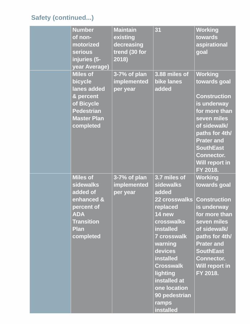
201 ] 2050 RTP
Safety (continued...)
Number of non-motorized serious injuries (5-year Average)
Maintain existing decreasing trend (30 for 2018)
31 Working towards aspirational goal
Miles of bicycle lanes added & percent of Bicycle Pedestrian Master Plan completed
3-7% of plan implemented per year
3.88 miles of bike lanes added
Working towards goal Construction is underway for more than seven miles of sidewalk/paths for 4th/Prater and SouthEast Connector. Will report in FY 2018.
Miles of sidewalks added of enhanced & percent of ADA Transition Plan completed
3-7% of plan implemented per year
3.7 miles of sidewalks added 22 crosswalks replaced 14 new crosswalks installed 7 crosswalk warning devices installed Crosswalk lighting installed at one location 90 pedestrian ramps installed
Working towards goal Construction is underway for more than seven miles of sidewalk/paths for 4th/Prater and SouthEast Connector. Will report in FY 2018.

202 ] 2050 RTP
Infrastructure Condition/Transit State of Good Repair
RTP GoalManage Existing Systems Efficiently
Performance Measures
Performance Target
2019 Performance Measure Status
2019 Performance Target Status
Pavement condition index for Regional Roads
80 83.3 Exceeded goal
Preventive maintenance of transit rolling stock and facilities
100% of transit preventive maintenance performed on time
100% of preventive maintenance performed on time for RTC RIDE and RTC ACCESS
Met goal
Maintain industry standard vehicle life cycle
Varies per vehicle
Vehicle life cycle: Access paratransit vehicles = 7 yearsRIDE fixed route vehicles = 12 years.
RTC ACCESS paratranist met, RIDE fixed route not met. 95% vehicles at less than 12 years useful life
CHAPTER 12
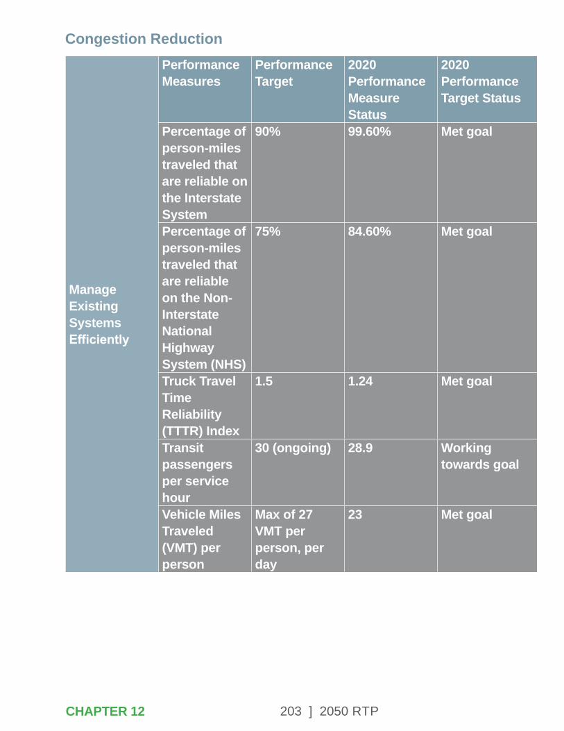
203 ] 2050 RTP
Congestion Reduction
Manage Existing Systems Efficiently
Performance Measures
Performance Target
2020 Performance Measure Status
2020 Performance Target Status
Percentage of person-miles traveled that are reliable on the Interstate System
90% 99.60% Met goal
Percentage of person-miles traveled that are reliable on the Non-Interstate National Highway System (NHS)
75% 84.60% Met goal
Truck Travel Time Reliability (TTTR) Index
1.5 1.24 Met goal
Transit passengers per service hour
30 (ongoing) 28.9 Working towards goal
Vehicle Miles Traveled (VMT) per person
Max of 27 VMT per person, per day
23 Met goal
CHAPTER 12
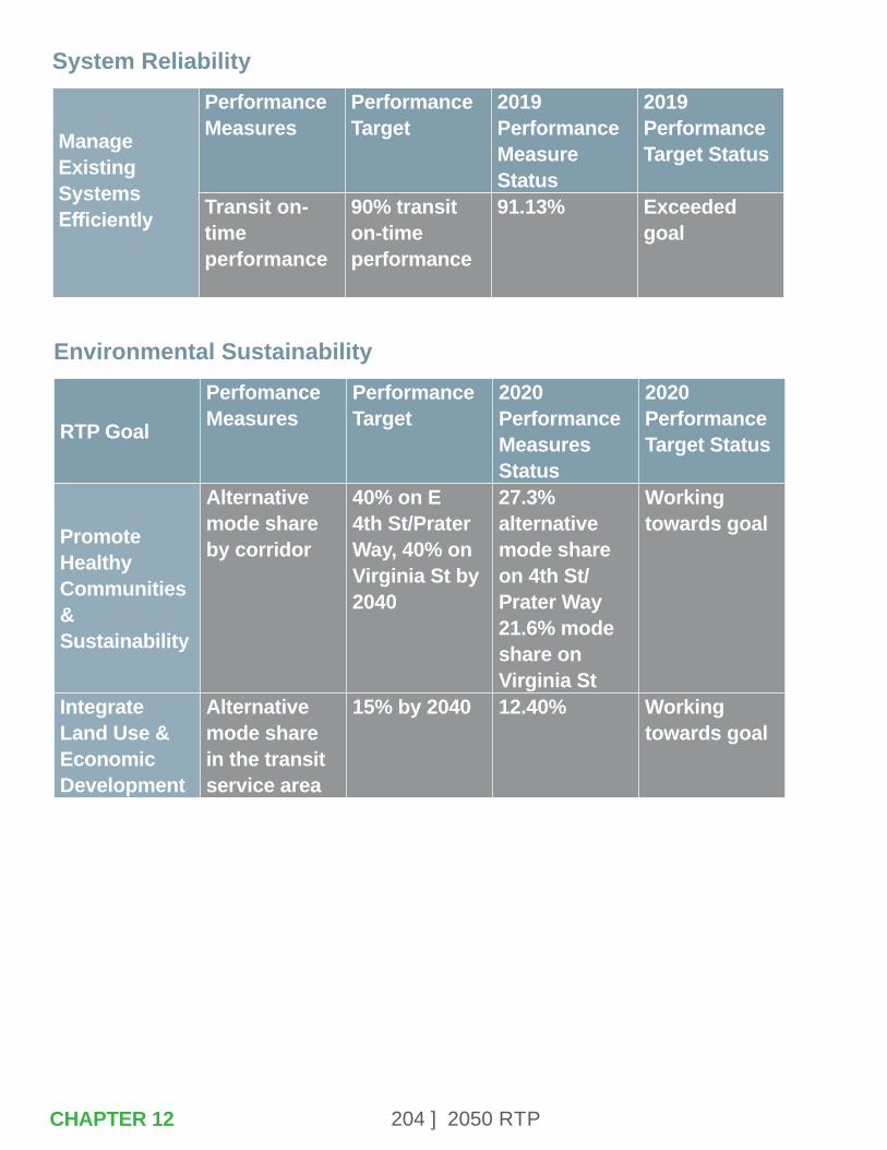
204 ] 2050 RTP
System Reliability
Manage Existing Systems Efficiently
Performance Measures
Performance Target
2019 Performance Measure Status
2019 Performance Target Status
Transit on-time performance
90% transit on-time performance
91.13% Exceeded goal
Environmental Sustainability
RTP Goal
Perfomance Measures
Performance Target
2020 Performance Measures Status
2020 Performance Target Status
Promote Healthy Communities & Sustainability
Alternative mode share by corridor
40% on E 4th St/Prater Way, 40% on Virginia St by 2040
27.3% alternative mode share on 4th St/Prater Way 21.6% mode share on Virginia St
Working towards goal
Integrate Land Use & Economic Development
Alternative mode share in the transit service area
15% by 2040 12.40% Working towards goal
CHAPTER 12
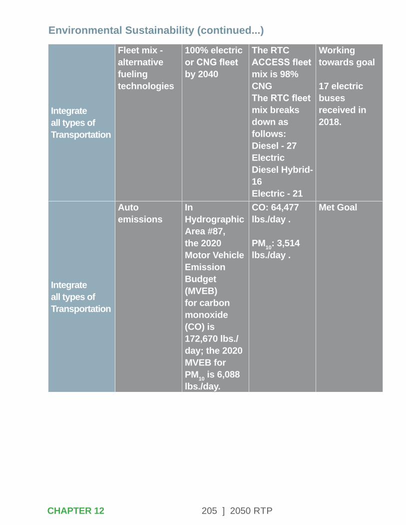
205 ] 2050 RTPCHAPTER 12
Integrate all types of Transportation
Fleet mix - alternative fueling technologies
100% electric or CNG fleet by 2040
The RTC ACCESS fleet mix is 98% CNG The RTC fleet mix breaks down as follows: Diesel - 27 Electric Diesel Hybrid- 16 Electric - 21
Working towards goal 17 electric buses received in 2018.
Integrate all types of Transportation
Auto emissions
In Hydrographic Area #87, the 2020 Motor Vehicle Emission Budget (MVEB) for carbon monoxide (CO) is 172,670 lbs./day; the 2020 MVEB for PM10 is 6,088 lbs./day.
CO: 64,477 lbs./day . PM10: 3,514 lbs./day .
Met Goal
Environmental Sustainability (continued...)

206 ] 2050 RTP

207 ] 2050 RTP
APPENDIX A – COMPLETE STREETS PROJECT LISTING
The roadway projects in the 2050 RTP are presented in three time periods: the first five years of the plan (2021-2025), the second five years of the plan (2026-2030), and the remaining years of the plan (2031-2050). These projects include a combination of sidewalk accessibility, bicycle and other pedestrian facilities, operations and maintenance, pavement preservation, other multimodal investments to promote safety and livability, and capacity improvements and new roadway connection to address long term mobility needs. The projects for each time period are illustrated in a map and described in the following tables. The tables also include the estimated project cost in year of expenditure dollars and potential funding sources. All of the roadway projects incorporate Complete Street design principles. The safety needs of all roadway travelers, including pedestrians, cyclists, and transit customers, will be addressed in the design of these projects.
The delivery of some projects will occur over multiple years and may be shown in two or more time periods. For example, construction of Sparks Boulevard improvements would be initiated in the 2021-2025 time period but completed in 2026. The design for projects may be identified in one time period while construction may occur in a subsequent time period.
Projected funding levels are not sufficient to address all of the transportation needs identified in the region over the next 30 years. A listing of unfunded roadway needs totaling approximately $4 billion is available at the end of this section.
APPENDIX A
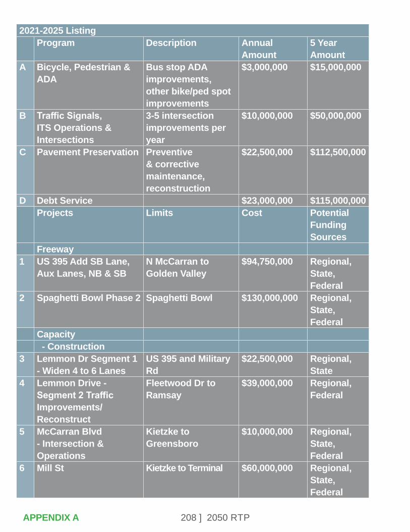
208 ] 2050 RTPAPPENDIX A
2021-2025 ListingProgram Description Annual
Amount5 Year Amount
A Bicycle, Pedestrian & ADA
Bus stop ADA improvements, other bike/ped spot improvements
$3,000,000 $15,000,000
B Traffic Signals, ITS Operations & Intersections
3-5 intersection improvements per year
$10,000,000 $50,000,000
C Pavement Preservation Preventive & corrective maintenance, reconstruction
$22,500,000 $112,500,000
D Debt Service $23,000,000 $115,000,000 Projects Limits Cost Potential
Funding Sources
Freeway1 US 395 Add SB Lane,
Aux Lanes, NB & SBN McCarran to Golden Valley
$94,750,000 Regional, State, Federal
2 Spaghetti Bowl Phase 2 Spaghetti Bowl $130,000,000 Regional, State, Federal
Capacity - Construction
3 Lemmon Dr Segment 1 - Widen 4 to 6 Lanes
US 395 and Military Rd
$22,500,000 Regional, State
4 Lemmon Drive - Segment 2 Traffic Improvements/Reconstruct
Fleetwood Dr to Ramsay
$39,000,000 Regional, Federal
5 McCarran Blvd - Intersection & Operations
Kietzke to Greensboro
$10,000,000 Regional, State, Federal
6 Mill St Kietzke to Terminal $60,000,000 Regional, State, Federal

209 ] 2050 RTP
7 Pyramid Hwy (Phase 1) - Widen & Safety improvements
Queen Way to Golden View
$54,100,000 Regional, State, Federal
8 Sky Vista Pkwy - Widen 2 to 4 Lanes
Silver Lake Rd to Lemmon Dr
$15,800,000 Regional
9 Sparks Blvd Greg St to I-80 WB On Ramps
$17,500,000 Regional, State, Federal
- Design10 Damonte Ranch Pkwy -
WidenDouble R to I 580 $400,000 Regional
11 Geiger Grade - New 4 Lane Rd
Virginia St to Toll Rd $5,000,000 Regional, State, Federal
12 North Virginia St - Widening
Panther to Stead Blvd
$5,000,000 Regional, State, Federal
13 Pembroke Dr - Widen McCarran to Veterans
$2,000,000 Regional
14 Pyramid Hwy - Add Southbound Lane
Egyptian Dr to Ingenuity Ave
$1,500,000 Regional, State
15 S. Virginia St - Add NB Lane
Longley Ln to I-580 $2,000,000 Regional, State, Federal
16 Steamboat Pkwy and Damonte Ranch Pkwy - Widen
Veterans Pkwy to Promenade Way
$400,000 Regional
Multimodal17 3rd St Bike Facility Vine St - Evans St $7,500,000 Regional18 4th St - Multimodal Stoker Ave to Evans
Ave$25,900,000 Regional,
State, Federal
19 5th St - Multimodal Keystone to Evans $1,676,000 Regional20 Arlington Ave - Replace
Existing BridgesAt Truckee River $25,500,000 Regional,
State, Federal
21 Center St - Widen Sidewalks & Add Bike Lanes
9th St to Moran $10,000,000 Regional
APPENDIX A
2021-2025 Listing (continued)
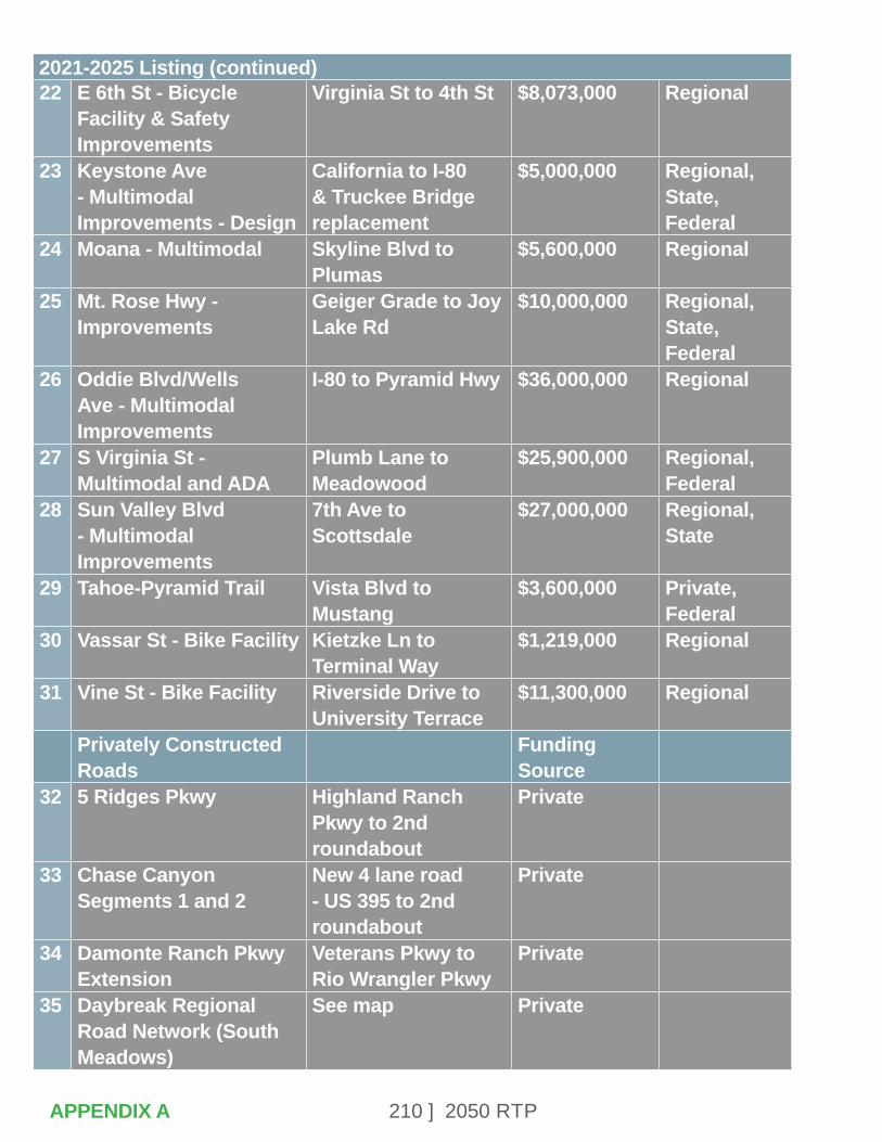
210 ] 2050 RTP
22 E 6th St - Bicycle Facility & Safety Improvements
Virginia St to 4th St $8,073,000 Regional
23 Keystone Ave - Multimodal Improvements - Design
California to I-80 & Truckee Bridge replacement
$5,000,000 Regional, State, Federal
24 Moana - Multimodal Skyline Blvd to Plumas
$5,600,000 Regional
25 Mt. Rose Hwy - Improvements
Geiger Grade to Joy Lake Rd
$10,000,000 Regional, State, Federal
26 Oddie Blvd/Wells Ave - Multimodal Improvements
I-80 to Pyramid Hwy $36,000,000 Regional
27 S Virginia St - Multimodal and ADA
Plumb Lane to Meadowood
$25,900,000 Regional, Federal
28 Sun Valley Blvd - Multimodal Improvements
7th Ave to Scottsdale
$27,000,000 Regional, State
29 Tahoe-Pyramid Trail Vista Blvd to Mustang
$3,600,000 Private, Federal
30 Vassar St - Bike Facility Kietzke Ln to Terminal Way
$1,219,000 Regional
31 Vine St - Bike Facility Riverside Drive to University Terrace
$11,300,000 Regional
Privately Constructed Roads
Funding Source
32 5 Ridges Pkwy Highland Ranch Pkwy to 2nd roundabout
Private
33 Chase Canyon Segments 1 and 2
New 4 lane road - US 395 to 2nd roundabout
Private
34 Damonte Ranch Pkwy Extension
Veterans Pkwy to Rio Wrangler Pkwy
Private
35 Daybreak Regional Road Network (South Meadows)
See map Private
APPENDIX A
2021-2025 Listing (continued)
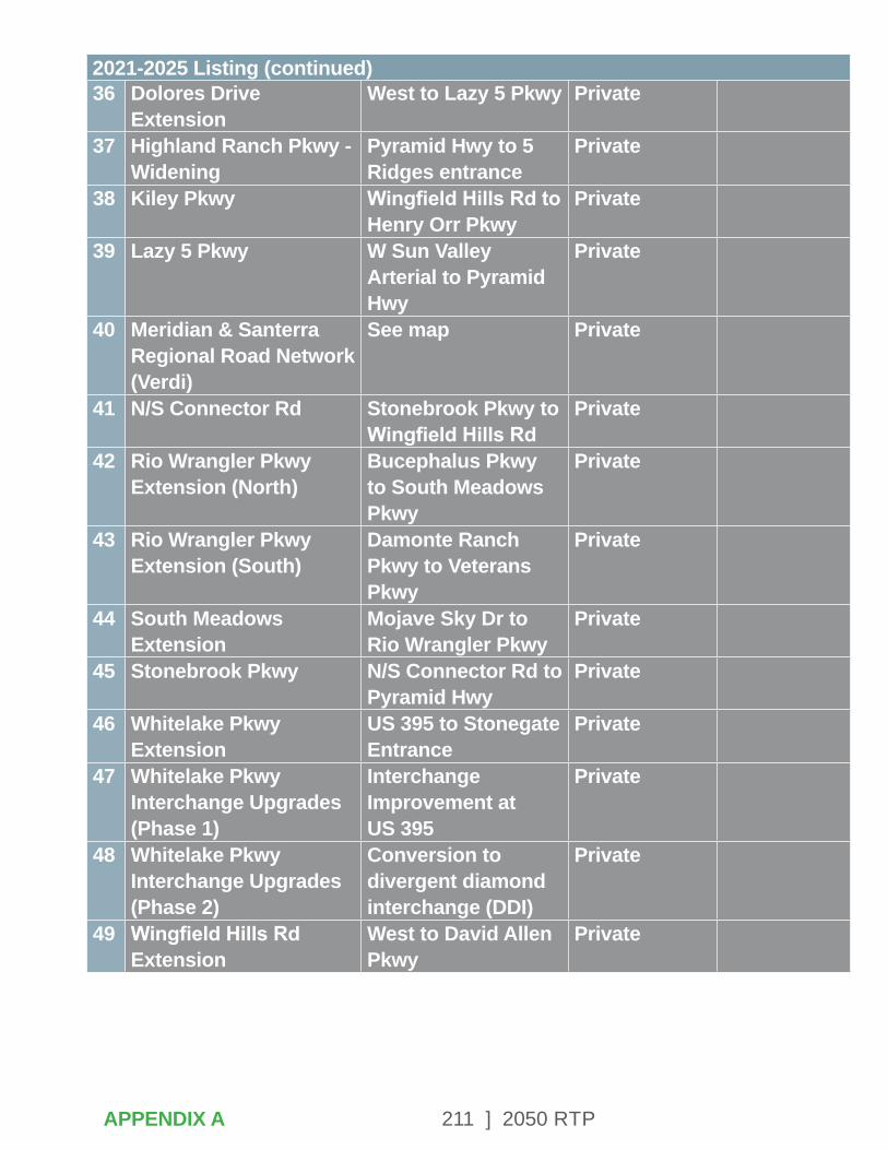
211 ] 2050 RTP
36 Dolores Drive Extension
West to Lazy 5 Pkwy Private
37 Highland Ranch Pkwy - Widening
Pyramid Hwy to 5 Ridges entrance
Private
38 Kiley Pkwy Wingfield Hills Rd to Henry Orr Pkwy
Private
39 Lazy 5 Pkwy W Sun Valley Arterial to Pyramid Hwy
Private
40 Meridian & Santerra Regional Road Network (Verdi)
See map Private
41 N/S Connector Rd Stonebrook Pkwy to Wingfield Hills Rd
Private
42 Rio Wrangler Pkwy Extension (North)
Bucephalus Pkwy to South Meadows Pkwy
Private
43 Rio Wrangler Pkwy Extension (South)
Damonte Ranch Pkwy to Veterans Pkwy
Private
44 South Meadows Extension
Mojave Sky Dr to Rio Wrangler Pkwy
Private
45 Stonebrook Pkwy N/S Connector Rd to Pyramid Hwy
Private
46 Whitelake Pkwy Extension
US 395 to Stonegate Entrance
Private
47 Whitelake Pkwy Interchange Upgrades (Phase 1)
Interchange Improvement at US 395
Private
48 Whitelake Pkwy Interchange Upgrades (Phase 2)
Conversion to divergent diamond interchange (DDI)
Private
49 Wingfield Hills Rd Extension
West to David Allen Pkwy
Private
APPENDIX A
2021-2025 Listing (continued)
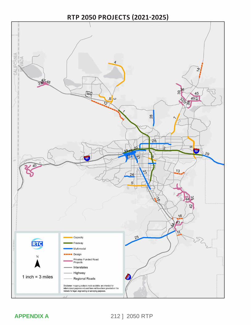
212 ] 2050 RTP
RTP 2050 PROJECTS (2021-2025)
APPENDIX A
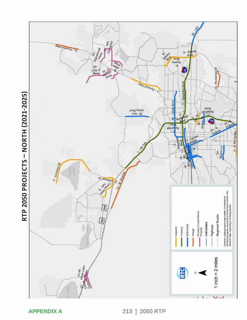
213 ] 2050 RTP
RTP
2050
PRO
JECT
S –
NO
RTH
(202
1-20
25)
APPENDIX A
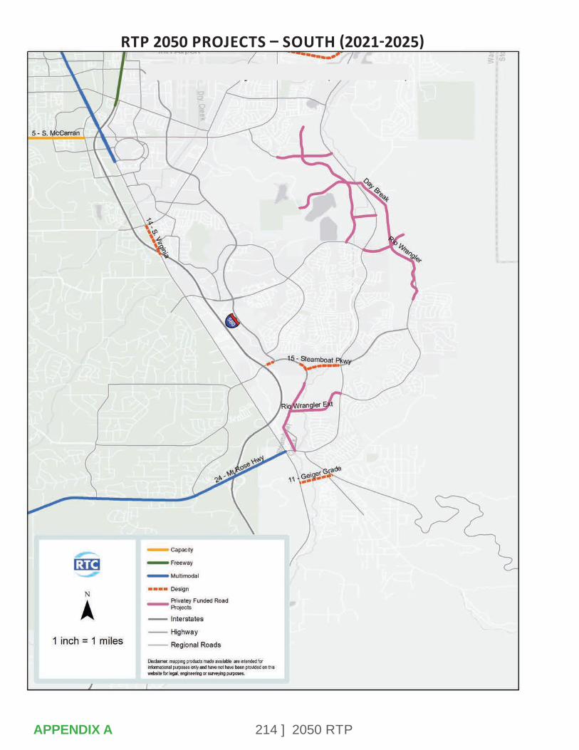
214 ] 2050 RTP
RTP 2050 PROJECTS – SOUTH (2021-2025)
APPENDIX A
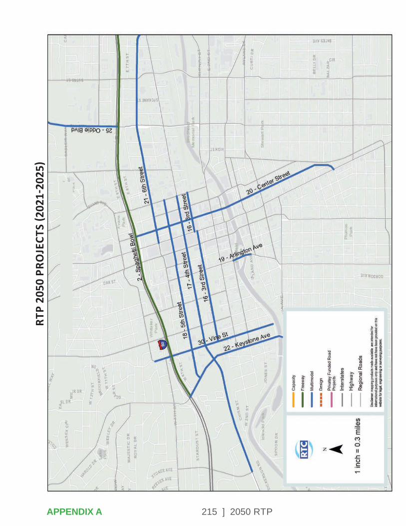
215 ] 2050 RTP
RTP
2050
PRO
JECT
S (2
021-
2025
)
APPENDIX A

216 ] 2050 RTP
2026-2030 Listing Program Description Annual
Amount (est)5 Year Amount
A Bicycle, Pedestrian & ADA
Bus stop ADA improvements, other bike/ped spot improvements
$3,500,000 $17,500,000
B Traffic Signals, ITS Operations & Intersections
3-5 intersection improvements per year
$11,500,000 $57,500,000
C Pavement Preservation Preventive & corrective maintenance, reconstruction
$25,000,000 $125,000,000
D Debt Service $23,000,000 $115,000,000 Projects Limits YOE Cost
RoundedPotential Funding Sources
Freeway1 US 395 - Additional
Lane in Each DirectionGolden Valley to Stead Blvd
$79,177,000 Regional, State, Federal
2 US 395 - Additional Northbound Lane - Design
Clear Acre to Parr $19,115,000 Regional, State, Federal
3 Spaghetti Bowl Phase 2 Spaghetti Bowl $103,088,000 Regional, State, Federal
Capacity4 Buck Dr - Widen 2 to 4
LanesLemmon Dr to N Hills Blvd
$1,912,000 Regional
5 Damonte Ranch Pkwy - Widen
Double R to I 580 $4,723,000 Regional, Private
6 Eagle Canyon - Widen 2 to 4 Lanes - Design
Pyramid Hwy to W Calle de la Plata
$2,000,000 Regional, State, Federal
7 Geiger Grade - New 4 Lane Rd
Virginia St to Toll Rd $84,445,000 Regional, State, Federal
APPENDIX A
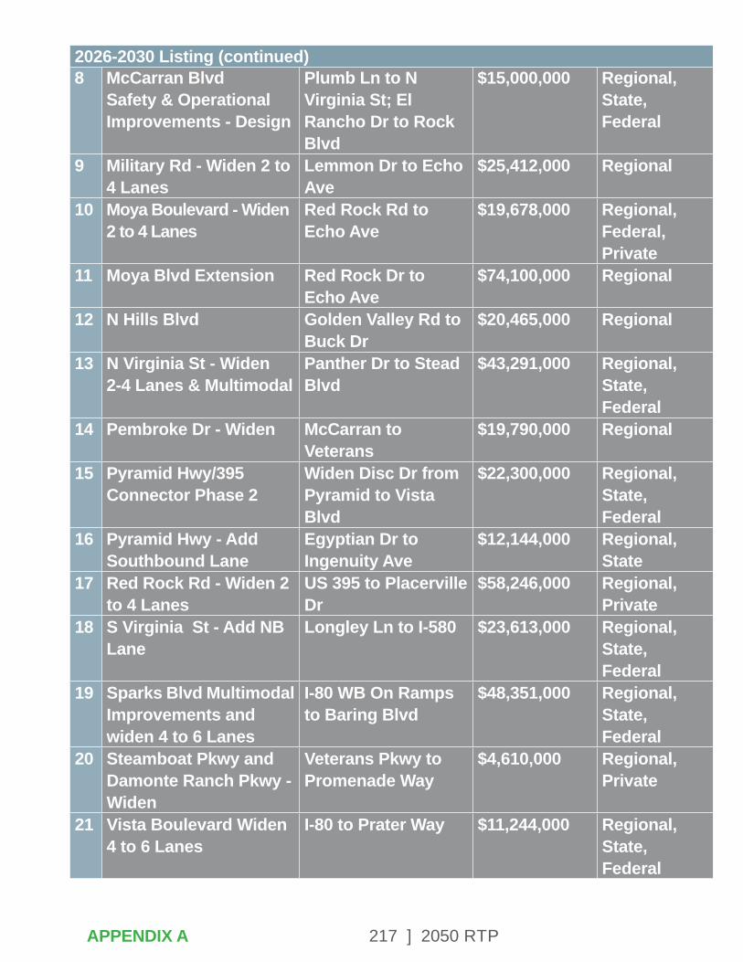
217 ] 2050 RTP
8 McCarran Blvd Safety & Operational Improvements - Design
Plumb Ln to N Virginia St; El Rancho Dr to Rock Blvd
$15,000,000 Regional, State, Federal
9 Military Rd - Widen 2 to 4 Lanes
Lemmon Dr to Echo Ave
$25,412,000 Regional
10 Moya Boulevard - Widen 2 to 4 Lanes
Red Rock Rd to Echo Ave
$19,678,000 Regional, Federal, Private
11 Moya Blvd Extension Red Rock Dr to Echo Ave
$74,100,000 Regional
12 N Hills Blvd Golden Valley Rd to Buck Dr
$20,465,000 Regional
13 N Virginia St - Widen 2-4 Lanes & Multimodal
Panther Dr to Stead Blvd
$43,291,000 Regional, State, Federal
14 Pembroke Dr - Widen McCarran to Veterans
$19,790,000 Regional
15 Pyramid Hwy/395 Connector Phase 2
Widen Disc Dr from Pyramid to Vista Blvd
$22,300,000 Regional, State, Federal
16 Pyramid Hwy - Add Southbound Lane
Egyptian Dr to Ingenuity Ave
$12,144,000 Regional, State
17 Red Rock Rd - Widen 2 to 4 Lanes
US 395 to Placerville Dr
$58,246,000 Regional, Private
18 S Virginia St - Add NB Lane
Longley Ln to I-580 $23,613,000 Regional, State, Federal
19 Sparks Blvd Multimodal Improvements and widen 4 to 6 Lanes
I-80 WB On Ramps to Baring Blvd
$48,351,000 Regional, State, Federal
20 Steamboat Pkwy and Damonte Ranch Pkwy - Widen
Veterans Pkwy to Promenade Way
$4,610,000 Regional, Private
21 Vista Boulevard Widen 4 to 6 Lanes
I-80 to Prater Way $11,244,000 Regional, State, Federal
APPENDIX A
2026-2030 Listing (continued)

218 ] 2050 RTP
Multimodal22 4th St - Bike lanes
(Sparks)Victorian Ave to Queen Way
$6,747,000 Regional
23 4th St - Pedestrian & Safety Improvements (Reno)
Stoker to McCarran $20,240,000 Regional, State, Federal
24 El Rancho Dr/Dandini Blvd - Sidewalks
Raggio Pkwy to Sullivan Ln
$20,690,000 Regional
25 Greg St - Sidewalks and Bike lanes
Mill Street to Vista Blvd
$29,123,000 Regional, Federal, Private
26 Keystone Ave - Multimodal Improvements
California to I-80 & Truckee Bridge replacement
$61,169,000 Regional, State, Federal
27 Keystone Ave - Sidewalks and Bike Lanes
Coleman Dr to Peavine Rd
$1,012,000 Regional
28 McCarran - Pedestrian Improvements
Baring to Pyramid Hwy
$12,594,000 Regional, State, Federal
29 McCarran Blvd - Multimodal & Safety Improvements
Greg to Prater Way $10,682,000 Regional, State, Federal
30 Mill St/Terminal Way - Multimodal Improvements
Airport to downtown Reno
$27,436,000 Regional, State, Federal
31 N Virginia St - Sidewalks and buffered bike lanes
Panther Dr to McCarran Blvd
$17,878,000 Regional, State, Federal
32 NW McCarran - Safety and Bike Lanes
4th Street to N Virginia
$10,570,000 Regional, State, Federal
33 Rock Blvd - Enhanced Sidewalks and Bike Lanes
Victorian Ave to McCarran Blvd
$7,309,000 Regional, Federal
APPENDIX A
2026-2030 Listing (continued)
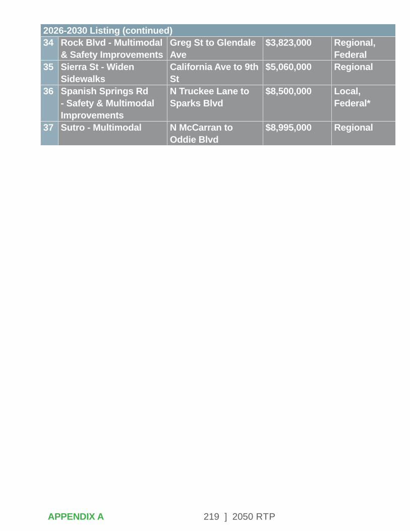
219 ] 2050 RTP
34 Rock Blvd - Multimodal & Safety Improvements
Greg St to Glendale Ave
$3,823,000 Regional, Federal
35 Sierra St - Widen Sidewalks
California Ave to 9th St
$5,060,000 Regional
36 Spanish Springs Rd - Safety & Multimodal Improvements
N Truckee Lane to Sparks Blvd
$8,500,000 Local, Federal*
37 Sutro - Multimodal N McCarran to Oddie Blvd
$8,995,000 Regional
APPENDIX A
2026-2030 Listing (continued)

220 ] 2050 RTP
RTP 2050 PROJECTS (2026-2030)
APPENDIX A
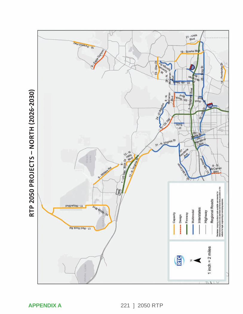
221 ] 2050 RTP
RTP
2050
PRO
JECT
S –
NO
RTH
(202
6-20
30)
APPENDIX A

222 ] 2050 RTPAPPENDIX A
RTP 2050 PROJECTS – SOUTH (2026-2030)
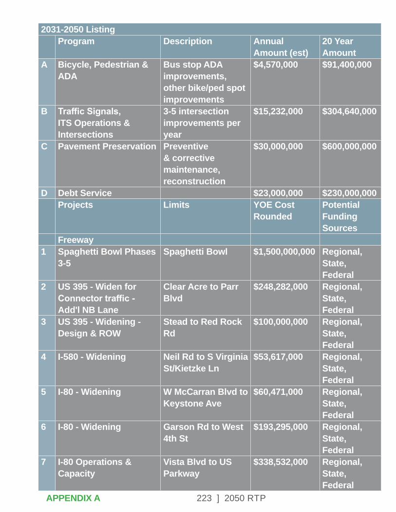
223 ] 2050 RTPAPPENDIX A
2031-2050 ListingProgram Description Annual
Amount (est)20 Year Amount
A Bicycle, Pedestrian & ADA
Bus stop ADA improvements, other bike/ped spot improvements
$4,570,000 $91,400,000
B Traffic Signals, ITS Operations & Intersections
3-5 intersection improvements per year
$15,232,000 $304,640,000
C Pavement Preservation Preventive & corrective maintenance, reconstruction
$30,000,000 $600,000,000
D Debt Service $23,000,000 $230,000,000 Projects Limits YOE Cost
RoundedPotential Funding Sources
Freeway1 Spaghetti Bowl Phases
3-5Spaghetti Bowl $1,500,000,000 Regional,
State, Federal
2 US 395 - Widen for Connector traffic - Add'l NB Lane
Clear Acre to Parr Blvd
$248,282,000 Regional, State, Federal
3 US 395 - Widening - Design & ROW
Stead to Red Rock Rd
$100,000,000 Regional, State, Federal
4 I-580 - Widening Neil Rd to S Virginia St/Kietzke Ln
$53,617,000 Regional, State, Federal
5 I-80 - Widening W McCarran Blvd to Keystone Ave
$60,471,000 Regional, State, Federal
6 I-80 - Widening Garson Rd to West 4th St
$193,295,000 Regional, State, Federal
7 I-80 Operations & Capacity
Vista Blvd to US Parkway
$338,532,000 Regional, State, Federal
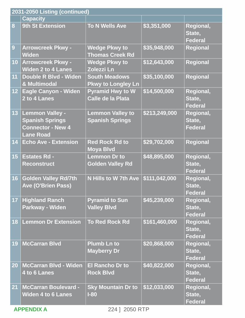
224 ] 2050 RTP
Capacity8 9th St Extension To N Wells Ave $3,351,000 Regional,
State, Federal
9 Arrowcreek Pkwy - Widen
Wedge Pkwy to Thomas Creek Rd
$35,948,000 Regional
10 Arrowcreek Pkwy - Widen 2 to 4 Lanes
Wedge Pkwy to Zolezzi Ln
$12,643,000 Regional
11 Double R Blvd - Widen & Multimodal
South Meadows Pkwy to Longley Ln
$35,100,000 Regional
12 Eagle Canyon - Widen 2 to 4 Lanes
Pyramid Hwy to W Calle de la Plata
$14,500,000 Regional, State, Federal
13 Lemmon Valley - Spanish Springs Connector - New 4 Lane Road
Lemmon Valley to Spanish Springs
$213,249,000 Regional, State, Federal
14 Echo Ave - Extension Red Rock Rd to Moya Blvd
$29,702,000 Regional
15 Estates Rd - Reconstruct
Lemmon Dr to Golden Valley Rd
$48,895,000 Regional, State, Federal
16 Golden Valley Rd/7th Ave (O'Brien Pass)
N Hills to W 7th Ave $111,042,000 Regional, State, Federal
17 Highland Ranch Parkway - Widen
Pyramid to Sun Valley Blvd
$45,239,000 Regional, State, Federal
18 Lemmon Dr Extension To Red Rock Rd $161,460,000 Regional, State, Federal
19 McCarran Blvd Plumb Ln to Mayberry Dr
$20,868,000 Regional, State, Federal
20 McCarran Blvd - Widen 4 to 6 Lanes
El Rancho Dr to Rock Blvd
$40,822,000 Regional, State, Federal
21 McCarran Boulevard - Widen 4 to 6 Lanes
Sky Mountain Dr to I-80
$12,033,000 Regional, State, Federal
APPENDIX A
2031-2050 Listing (continued)
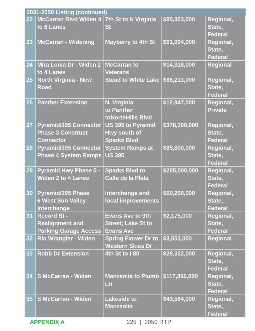
225 ] 2050 RTP
22 McCarran Blvd Widen 4 to 6 Lanes
7th St to N Virginia St
$95,353,000 Regional, State, Federal
23 McCarran - Widening Mayberry to 4th St $61,994,000 Regional, State, Federal
24 Mira Loma Dr - Widen 2 to 4 Lanes
McCarran to Veterans
$14,318,000 Regional
25 North Virginia - New Road
Stead to White Lake $86,213,000 Regional, State, Federal
26 Panther Extension N. Virginia to Panther toNorthHills Blvd
$12,947,000 Regional, Private
27 Pyramid/395 Connector Phase 3 Construct Connector
US 395 to Pyramid Hwy south of Sparks Blvd
$378,300,000 Regional, State, Federal
28 Pyramid/395 Connector Phase 4 System Ramps
System Ramps at US 395
$85,800,000 Regional, State, Federal
29 Pyramid Hwy Phase 5 - Widen 2 to 4 Lanes
Sparks Blvd to Calle de la Plata
$205,500,000 Regional, State, Federal
30 Pyramid/395 Phase 6 West Sun Valley Interchange
Interchange and local improvements
$60,200,000 Regional, State, Federal
31 Record St - Realignment and Parking Garage Access
Evans Ave to 9th Street; Lake St to Evans Ave
$2,175,000 Regional, State, Federal
32 Rio Wrangler - Widen Spring Flower Dr to Western Skies Dr
$3,503,000 Regional
33 Robb Dr Extension 4th St to I-80 $28,332,000 Regional, State, Federal
34 S McCarran - Widen Manzanita to Plumb Ln
$117,896,000 Regional, State, Federal
35 S McCarran - Widen Lakeside to Manzanita
$43,564,000 Regional, State, Federal
APPENDIX A
2031-2050 Listing (continued)
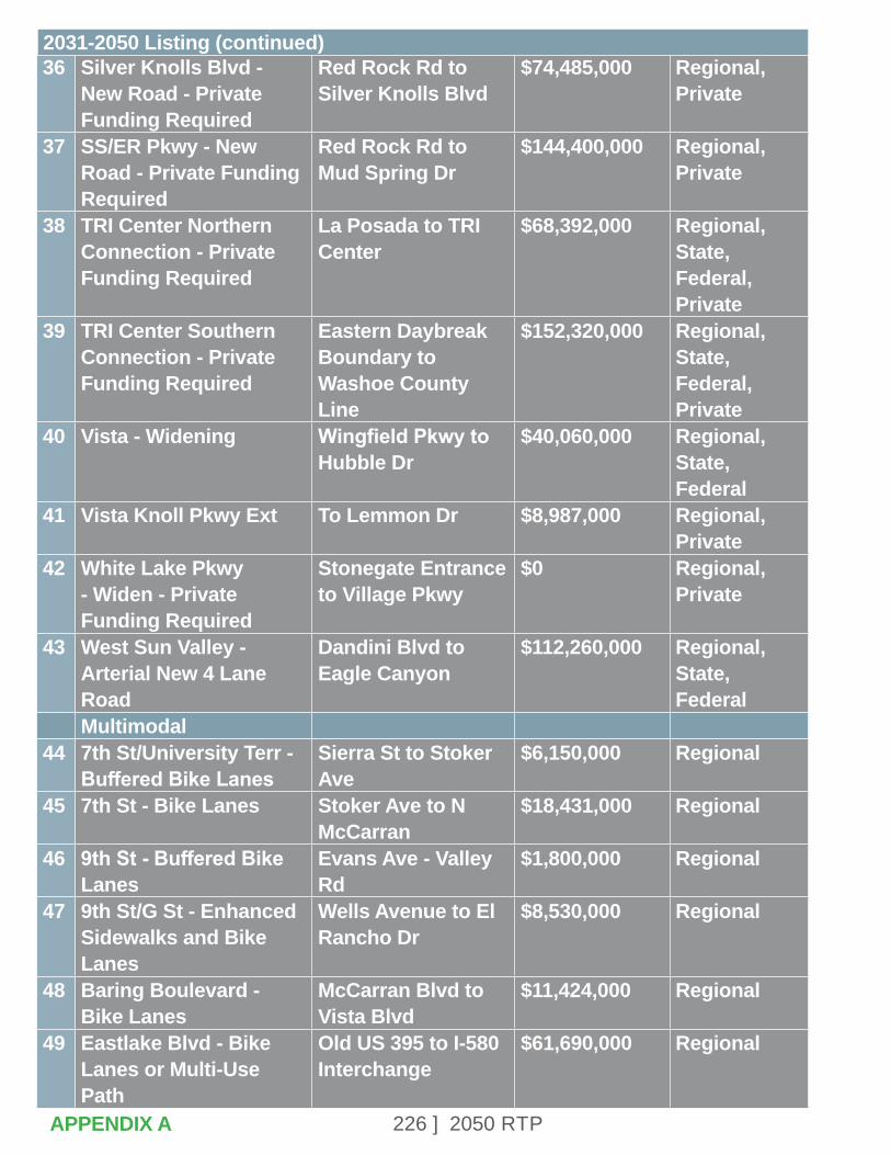
226 ] 2050 RTP
36 Silver Knolls Blvd - New Road - Private Funding Required
Red Rock Rd to Silver Knolls Blvd
$74,485,000 Regional, Private
37 SS/ER Pkwy - New Road - Private Funding Required
Red Rock Rd to Mud Spring Dr
$144,400,000 Regional, Private
38 TRI Center Northern Connection - Private Funding Required
La Posada to TRI Center
$68,392,000 Regional, State, Federal, Private
39 TRI Center Southern Connection - Private Funding Required
Eastern Daybreak Boundary to Washoe County Line
$152,320,000 Regional, State, Federal, Private
40 Vista - Widening Wingfield Pkwy to Hubble Dr
$40,060,000 Regional, State, Federal
41 Vista Knoll Pkwy Ext To Lemmon Dr $8,987,000 Regional, Private
42 White Lake Pkwy - Widen - Private Funding Required
Stonegate Entrance to Village Pkwy
$0 Regional, Private
43 West Sun Valley - Arterial New 4 Lane Road
Dandini Blvd to Eagle Canyon
$112,260,000 Regional, State, Federal
Multimodal44 7th St/University Terr -
Buffered Bike LanesSierra St to Stoker Ave
$6,150,000 Regional
45 7th St - Bike Lanes Stoker Ave to N McCarran
$18,431,000 Regional
46 9th St - Buffered Bike Lanes
Evans Ave - Valley Rd
$1,800,000 Regional
47 9th St/G St - Enhanced Sidewalks and Bike Lanes
Wells Avenue to El Rancho Dr
$8,530,000 Regional
48 Baring Boulevard - Bike Lanes
McCarran Blvd to Vista Blvd
$11,424,000 Regional
49 Eastlake Blvd - Bike Lanes or Multi-Use Path
Old US 395 to I-580 Interchange
$61,690,000 Regional
APPENDIX A
2031-2050 Listing (continued)
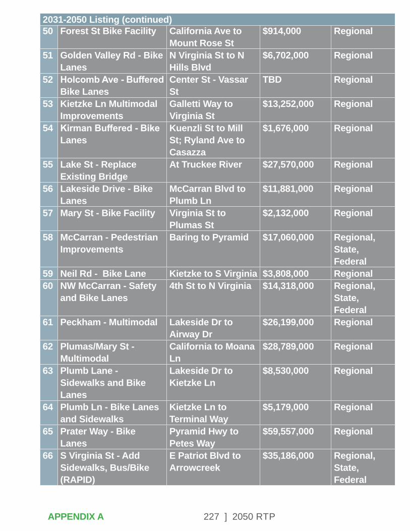
227 ] 2050 RTP
50 Forest St Bike Facility California Ave to Mount Rose St
$914,000 Regional
51 Golden Valley Rd - Bike Lanes
N Virginia St to N Hills Blvd
$6,702,000 Regional
52 Holcomb Ave - Buffered Bike Lanes
Center St - Vassar St
TBD Regional
53 Kietzke Ln Multimodal Improvements
Galletti Way to Virginia St
$13,252,000 Regional
54 Kirman Buffered - Bike Lanes
Kuenzli St to Mill St; Ryland Ave to Casazza
$1,676,000 Regional
55 Lake St - Replace Existing Bridge
At Truckee River $27,570,000 Regional
56 Lakeside Drive - Bike Lanes
McCarran Blvd to Plumb Ln
$11,881,000 Regional
57 Mary St - Bike Facility Virginia St to Plumas St
$2,132,000 Regional
58 McCarran - Pedestrian Improvements
Baring to Pyramid $17,060,000 Regional, State, Federal
59 Neil Rd - Bike Lane Kietzke to S Virginia $3,808,000 Regional60 NW McCarran - Safety
and Bike Lanes4th St to N Virginia $14,318,000 Regional,
State, Federal
61 Peckham - Multimodal Lakeside Dr to Airway Dr
$26,199,000 Regional
62 Plumas/Mary St - Multimodal
California to Moana Ln
$28,789,000 Regional
63 Plumb Lane - Sidewalks and Bike Lanes
Lakeside Dr to Kietzke Ln
$8,530,000 Regional
64 Plumb Ln - Bike Lanes and Sidewalks
Kietzke Ln to Terminal Way
$5,179,000 Regional
65 Prater Way - Bike Lanes
Pyramid Hwy to Petes Way
$59,557,000 Regional
66 S Virginia St - Add Sidewalks, Bus/Bike (RAPID)
E Patriot Blvd to Arrowcreek
$35,186,000 Regional, State, Federal
APPENDIX A
2031-2050 Listing (continued)

228 ] 2050 RTP
67 SE McCarran - Multiuse Path
Longley Ln to Neil Rd
$11,576,000 Regional, State, Federal
68 Sierra St - Multimodal 9th St to N Virginia $20,411,000 Regional69 Sierra St - Replace
Existing BridgeTruckee River $29,093,000 Regional
70 Skyline Blvd - Bike Lanes
Cashill Blvd to Arlington Ave
$17,974,000 Regional
71 South Meadows Pkwy - Bike Lanes
I-580 NB Ramps to Double Diamond Pkwy
$10,205,000 Regional
72 Sutro St - Buffered Bike Lanes
4th St to Kuenzli $609,000 Regional
73 Sutro/Kirman - Sidewalks
Truckee River to Plumb Ln
$2,742,000 Regional
74 Vassar St - Bike Facility Holcomb to Kietzke $4,300,000 Regional75 Vista Blvd - Sidewalks
and Bike LanesGreg St to S Los Altos Pkwy
$13,709,000 Regional
76 Wells Ave - Bike Lanes, Bike/Ped Facilities Over Truckee River
Moran St to E 9th St $12,338,000 Regional
77 West 4th St - Multimodal
S McCarran to I-80 $43,411,000 Regional, State, Federal
78 Yori Ave - Sidewalks and Bike Lanes
Moana Ln to Plumb Ln
$10,205,000 Regional
79 Zolezzi Ln - Sidewalks S Virginia St to Thomas Creek Rd
$10,205,000 Regional
APPENDIX A
2031-2050 Listing (continued)
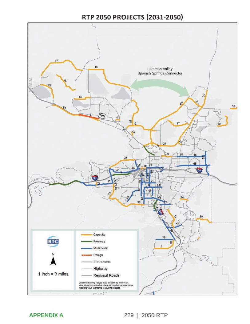
229 ] 2050 RTPAPPENDIX A
RTP 2050 PROJECTS (2031-2050)
Lemmon Valley Spanish Springs Connector
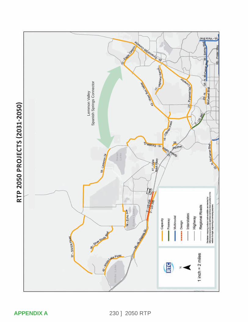
230 ] 2050 RTP
RTP
2050
PRO
JECT
S (2
031-
2050
)
Lem
mon
Val
ley
Span
ish
Sprin
gs C
onne
ctor
APPENDIX A

231 ] 2050 RTP
Unfunded Needs Description CostUS 395 - Widening Stead to Red Rock Rd $1,157,640,000I-580 - Widening S Virginia St @ Mt Rose
to South Meadows Pkwy
$163,744,000
I-580 - Widening South Meadows Pkwy to Neil Rd
$242,799,000
US 395 - Widening Stead to Red Rock Rd $1,097,925,000Spaghetti Bowl Phase 5 (partial)
Spaghetti Bowl $685,442,000
I-80 - Widening (partial) Vista Blvd to USA Pkwy $664,878,000
APPENDIX A
232 ] 2050 RTP
APPENDIX B – CONGESTION MANAGEMENT PROCESS
The purpose of the Congestion Management Process (CMP) is to identify how RTC selects and prioritizes projects to reduce traffic congestion. This process was developed in coordination with the 2050 RTP Agency Working Group, Technical Advisory Committee, and Citizens Multimodal Advisory Committee. The process was used to select projects included in this RTP. The CMP is a systematic approach that is collaboratively developed for the region and provides safe and effective management of new and existing transportation facilities.
Congestion management, as defined by the FHWA, is the application of strategies to improve transportation system performance and reliability by reducing the adverse impacts of congestion on the movement of people and goods. A CMP is a regionally-accepted approach that provides information on performance and assesses strategies for congestion management. The performance management metrics identified in Chapter 12, as well as the Transportation Conformity requirements regarding air quality, play an important role in the CMP. Flexibility in the development of the CMP allows the RTC to design their own process that will best serve the region. The CMP is an on-going process, adjusting over time as goals and objectives change, new congestion issues arise, new resources become available, and new strategies are identified and evaluated. The RTP identifies a well-balanced project selection process across all modes of transportation and outlines the implementation schedule and anticipated funding sources for a truly multimodal program.
1. CONGESTION MANAGEMENT OBJECTIVES
Traffic congestion is an impediment to economic activity, degrades air quality, and has an adverse impact on quality of life in the Truckee Meadows. Traffic congestion on freeway facilities, particularly I-80, has an adverse impact on national freight movement in addition to local traffic operations. Significant proportions of traffic congestion are non-recurring. This type of congestion is caused by crashes, work zones, weather, and special events. The objectives of this CMP are to reduce both recurring and non-recurring traffic congestion. An important component to this process is the implementation of operations and management strategies that improve signal timing coordination and communications between traffic operations engineers at RTC, NDOT, City of Reno, City of Sparks, and Washoe County.
APPENDIX B
233 ] 2050 RTP
NV TIM is another important program that addresses incident response. A guiding principle of the RTP is to improve safety on area roadways for all users, including pedestrians and cyclists. Selecting projects that reduce crashes on regional roads will also reduce congestion that results from incidents.
The CMP also provides an opportunity to address freight issues. RTC regularly participates in Freight Advisory Committee meetings facilitated by NDOT that involved regional partners in freight and logistics, economic development, and infrastructure development. RTC will continue to coordinate with regional stakeholders as freight needs evolve.
2. IDENTIFY AREA OF APPLICATION
The CMP applies to the Reno-Sparks urbanized area in Washoe County, Nevada. This is the planning area addressed in the 2050 RTP. It addresses project prioritization for roadway capacity, safety, and operations.
3. DEFINE SYSTEM OR NETWORK OF INTEREST
The CMP addresses congestion issues on regional roads and freeways in the Reno-Sparks metropolitan area. Regional roads generally include facilities with 5,000+ average daily trips. Roads with fixed-route bus service or corridors identified as industrial roads are also included.
RTC identified existing traffic congestion hotspots using INRIX data provided by NDOT. The INRIX roadway network includes freeways and major roads in the region. The congestion analysis focuses on AM and PM peak hours when congestion is the most severe. Congestion is measured as observed speed as a percentage of the free flow speed. The INRIX data used for existing congestion analysis is from weekdays of January 2021 (Figure B-1 & 2). Note that this was during a “pause” in business openings as mandated by Governor Sisolak in response to the COVID-19 pandemic. Projected 2050 traffic levels under a no-build scenario is provided in Figure B-3.
APPENDIX B
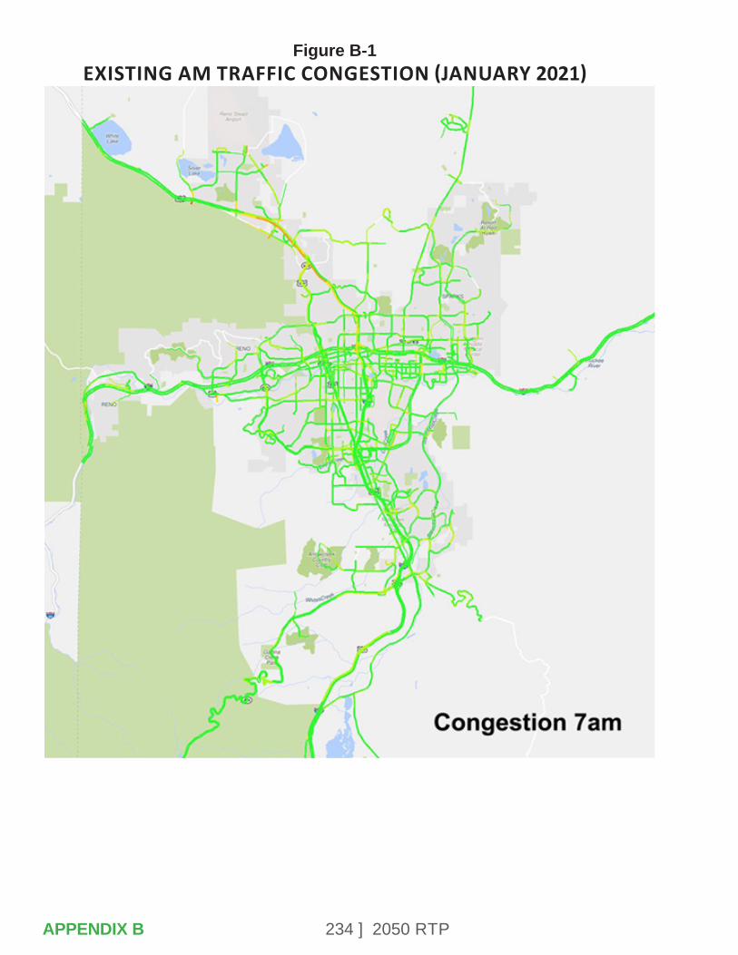
234 ] 2050 RTP
Figure B-1 EXISTING AM TRAFFIC CONGESTION (JANUARY 2021)
APPENDIX B

235 ] 2050 RTP
Figure B-2 EXISTING PM TRAFFIC CONGESTION (JANUARY 2021)
APPENDIX B
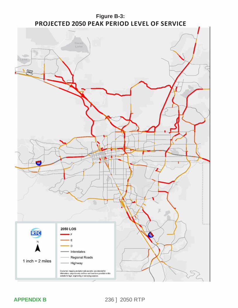
236 ] 2050 RTPAPPENDIX B
Figure B-3: PROJECTED 2050 PEAK PERIOD LEVEL OF SERVICE
237 ] 2050 RTP
4. DEVELOP PERFORMANCE MEASURES
The FAST Act continues the legislation authorized under MAP-21, which created a data-driven, performance-based multimodal program to address the many challenges facing the U.S. transportation system. Performance management will lead to more efficient investment of transportation funds by focusing on national transportation goals, increasing accountability and transparency, and improving decision-making. This section describes the performance measures and targets to be used in assessing system performance. RTC will continue to develop annual reports to track progress toward achieving these targets and will continue to gather additional community input into the transportation planning process.
The U.S. Secretary of Transportation, in consultation with states, MPOs, and other stakeholders, established national performance measures for several areas: pavement conditions and performance for the Interstate and NHS, bridge conditions, injuries and fatalities, traffic congestion, on-road mobile source emissions, and freight movement on the Interstate System.
States, in coordination with MPOs, set performance targets in support of those measures, and state and metropolitan plans describe how program and project selection will help achieve the targets. The RTC has collaborated with the FHWA Nevada Division Office, NDOT, and other stakeholder jurisdictions and agencies to develop performance measures.
The national performance goals for federal highway programs initially established in MAP-21 include the following:
• Safety – To achieve a significant reduction in traffic fatalities and serious injuries on all public roads.
• Infrastructure Condition – To maintain the highway infrastructure asset system in a state of good repair.
• Congestion Reduction – To achieve a significant reduction in congestion on the NHS.
• System Reliability – To improve the efficiency of the surface transportation system.
• Freight Movement and Economic Vitality – To improve the national freight network, strengthen the ability of rural communities to access national and international trade markets, and support regional economic development.
APPENDIX B
238 ] 2050 RTP
• Environmental Sustainability –To enhance the performance of the transportation system while protecting and enhancing the natural environment.
• Reduced Project Delivery Delays – To reduce project costs, promote jobs and the economy, and expedite the movement of people and goods by accelerating project completion through eliminating delays in the project development and delivery process, including reducing regulatory burdens and improving agencies’ work practices.
The national transportation goals that have been identified are contained in Chapter 12 – Monitoring Implementation and Performance. Also identified is how these national goals link to the RTP goals and applicable performance measures. The zero fatalities goal and crash reduction goals are consistent with the Nevada Strategic Highway Safety Plan.
5. INSTITUTE SYSTEM PERFORMANCE MONITORING PLAN
MAP-21 also provided a framework for linking goals and performance targets with project selection and implementation. Performance plans will track the progress toward achieving these targets and will be used to facilitate a community conversation about the track record of the RTC’s transportation program.
RTC develops the following performance plans:
• Metropolitan (Regional) Transportation Plan, to be updated every four years, which will include a discussion of:
- Anticipated effects of the improvement program toward achieving the performance targets.
- How investment priorities are linked to performance targets.
• Annual Metropolitan System & Transit Performance Report, which will include:
- Evaluation of the condition and performance of the transportation system.
- Progress achieved in meeting performance targets.
- Evaluation of how transportation investments have improved conditions.
• Transit Asset Management Plan.
• Public Transportation Safety Plan.
These performance plans will inform the congestion management process, which will be ongoing throughout the life of the RTP.
APPENDIX B
239 ] 2050 RTP
As projects in the five-year Regional Transportation Improvement Plan (RTIP) are completed, the CMP framework and evaluation criteria will be used to select projects from the RTP for inclusion in future years of the RTIP and future updates of the RTP. The CMP evaluation criteria for safety, congestion, and multimodal integration are part of the RTP performance measures that will be reported in the Annual Metropolitan System Performance Report.
6. IDENTIFY & EVALUATE STRATEGIES
RTC gathered information about priorities for operational strategies and capacity improvements from stakeholders, the general public, and partner agencies. This included the 2050 RTP Agency Working Group, Inter-County Working Group, RTC Technical Advisory Committee, and RTC Citizens Multimodal Advisory Committee. Input was gathered at meetings of the committees listed above, as well as at RTC Board meetings. Survey were made available online and public feedback was obtained through a series of several outreach events. The evaluation criteria were developed based on the guiding principles and goals (see list below and Chapter 1 of the RTP for more details) for the RTP, which emerged from the public and agency participation process.
RTC also considered national performance measures and the availability of data in development of the evaluation criteria.
• RTP Guiding Principles are to promote:
- Safe and Healthy Communities
- Economic Vitality and Innovation
- Sustainability
- Increase Travel Choices
• RTP Goals:
- Improve and promote safety.
- Integrate all types of transportation.
- Promote healthy communities and sustainability.
- Promote and foster equity and environmental justice.
- Integrate land use and economic development.
- Manage existing systems efficiently.
- Enhance regional connectivity.
- Improve freight and goods movement.
- Invest strategically.
- Engage the public and encourage community involvement.
APPENDIX B
240 ] 2050 RTP
7. IMPLEMENT SELECTED STRATEGIES & MANAGE TRANSPORTATION SYSTEM
The RTP project prioritization framework is a crucial element in the CMP. The projects identified in the 2050 RTP were compiled from a variety of sources, including:
• The 2040 RTP (developed in 2017).
• Corridor plans and studies such as the South Meadows Multimodal Transportation Study, University Area Transportation Study, and other corridor plans.
• Road Safety Assessments and Safety Management Plans.
• Community workshops and other public comments.
• A series of online surveys.
• Input from local governing bodies.
• Input from the 2050 RTP Agency Working Group, RTC Citizens Multimodal Advisory Committee, RTC Technical Advisory Committee, and RTC Regional Road Impact Fee Advisory Committee.
After all project suggestions were reviewed for feasibility and any inconsistencies, each project was evaluated based on a series of criteria developed in support of the RTP Guiding Principles and CMP.
Projects were distributed into one of the following four categories in an effort to establish a basis for comparison amongst similar project types.
• Freeway projects.
• Capacity projects (widening or expansion of existing roadways, inclusive of multimodal amenities where feasible and appropriate).
• New roadways.
• Multimodal projects (transportation infrastructure improvements exclusive of new capacity).
The framework described in the following sections was developed to assist in the prioritization process for regional roadway projects. It provided input and data for the RTC Board to consider during the project evaluation and selection process. It is important to note that a mathematical formula did not provide the final determination on project rankings and that professional judgement and community/agency staff input was considered by the RTC staff and Board in making final recommendations and decisions. Separate evaluation frameworks were applied to projects on existing roadways and construction of new roads. The factors for evaluating projects on existing roadways consists of the criteria below.
APPENDIX B
241 ] 2050 RTP
Evaluation Criteria for Projects on Existing Regional Roads• Safety – Crash Frequency, Rate,
Severity
• Congestion – Travel Demand Model Existing/Forecasted Level of Service (LOS)
• Bike/Pedestrian Score – Criteria in Bicycle & Pedestrian Master Plan
• Equity
• Project Readiness
• Regional Plan Land Use Priority – TMRPA Tier System
• Pavement Condition Index (PCI)/Bridge Rating
• Flood Mitigation
• Private/Other Agency Funding
• Public Input
• Agency Working Group Input
For analysis of new roads, a different methodology was developed because safety, congestion, pavement condition, and other data used to evaluate projects on existing roads would not be available for new construction.
RTC developed cost estimates for each proposed new road project, identified the projected average daily traffic (ADT) that would use the road, and developed an estimate for cost per ADT.
Evaluation Criteria for New Road Construction• Average Daily Traffic
• Cost per ADT
• Project Readiness
• Regional Plan Land Use Priority – TMRPA Tier System
• Private/Other Agency Funding
• Flood Mitigation
• Emergency Response/Fire Evacuation
• Public Input
• Agency Working Group Input
MethodologySafety
An analysis of all regional roads and freeways was conducted based on the three most recent years of crash data available from the Nevada Department of Transportation. Projects were scored based on a combination of crash frequency, rate, and severity.
APPENDIX B
242 ] 2050 RTP
Traffic Congestion
Traffic congestion is derived from 2020 (existing) traffic level of service as well as from the 2050 “no build” level of service obtained through the RTC Travel Demand Model.
Bicycle & Pedestrian Score
The bicycle and pedestrian score for each project was provided by the rating identified in the RTC Bicycle and Pedestrian Master Plan when applicable.
Project Readiness
This criteria is intended to reflect the analysis, community input, and vetting of projects that occurs through other stages of the planning process. It recognizes a commitment to completing a project that has progressed to the design phase, and the level of community support for projects that have been adopted into the Program of Projects (POP) or Regional Transportation Improvement Program (RTIP).
Equity
Higher priority is given to the extent to which a project improves transportation in an underserved community. Additional emphasis on equity in the 2050 RTP was requested during the RTC Citizens Multimodal Advisory Committee, and the following factors were considered in determining the level of equity a project has.
Is the project located in or in proximity to the following areas:
• Food desert as identified by the USDA.
• Census track with higher than Washoe County average proportion of disabled residents.
• Census track with higher than Washoe County average proportion of low income households.
• Census track with higher than Washoe County average proportion of zero vehicle households.
• Census track with higher than Washoe County average proportion of minority residents.
• Census track with higher than Washoe County average proportion of residents age 65 and older.
• Within 1/4 mile of a school or hospital.
Regional Land Designations (i.e., Tiers)
The Regional Land Designations were established by the 2019 Truckee Meadows Regional Plan, and refine the Truckee Meadows Service Area to prioritize growth and investment in the core of the region. For the 2050 RTP, this criteria is based on the tiered land use system identified in the TMRPA Regional Plan.
APPENDIX B
243 ] 2050 RTP
Pavement/Bridge Condition
This criteria recognizes the benefit of investing in the state of good repair for regional roads and bridges. Projects with a lower pavement condition index (PCI) or bridge rating receive higher priority.
Flood Impact
Projects that address a critical need for flood mitigation are given a higher priority. An example of this would be road access that was cut off by flood waters for extended period. Other projects that are identified as Truckee River Flood Projects are given medium priority.
Private or Other Agency Funding
The purpose of this criteria is to recognize that the opportunity to maximize RTC revenues through public-private partnerships or financial participation of other agencies is a benefit to the region.
Criteria for New Road ConstructionFor construction of roads on new locations, the following additional criteria were evaluated.
• Projected ADT.
• Cost per ADT.
• Emergency Response/Fire Evacuation – This need was identified by both members of the public and the Truckee Meadows Fire Protection District. Proposed roadways that improve regional connectivity or provide a secondary route to isolated areas received higher priority. Projects that provide improved access within a neighborhood or community received medium priority.
• Projects Identified in a Plan or Study – Similar to Project Readiness for projects on existing roads, this criteria is intended to reflect the analysis, community input, and vetting of projects that occurs through other stages of the planning process. It recognizes a commitment to completing a project that has been identified as a recommendation in an individual corridor or area study, apart from the RTP.
Following the project screening, RTC staff developed a draft fiscally constrained project listing for review by the RTC Agency Working Group, RTC advisory committees, and ultimately the RTC Board. The list was also provided for public comment prior to finalizing the RTP.
244 ] 2050 RTP
8. MONITOR STRATEGY EFFECTIVENESS
As described in the RTP, RTC monitors impacts of capacity projects on an on-going basis. In addition to the Annual Report, RTC also develops before and after studies of specific projects that currently address safety and operations impacts. The regional travel demand model, combined with updates from our traffic count program, will further be used to monitor impacts on regional traffic congestion. An additional tool is the creation of annual progress reports to document implementation of the RTP.
The performance measures in the RTP, which will be tracked on an annual basis, are consistent with the CMP evaluation criteria. Monitoring crash and injury data, construction of multimodal elements such as sidewalks and bicycle facilities, and changes in travel delay will assist RTC in continuously evaluating the suitability of projects in the RTP and RTIP for effectiveness.
APPENDIX B
245 ] 2050 RTP
APPENDIX C – AIR QUALITY ANALYSIS & CONFORMITY DETERMINATION (2/24/2021)
The Clean Air Act Amendments (CAAA) of 1990 require that each state environmental agency develop a State Implementation Plan (SIP). The SIP shows how the state will implement measures designed to improve air quality to meet NAAQS for each criteria air pollutant, according to the schedules included in the CAAA.
Since emissions from motor vehicles make a significant contribution to air pollution, the CAAA also requires that transportation officials make a commitment to programs and projects that will help achieve air quality goals including:
• Providing for greater integration of the transportation and air quality process.
• Ensuring that transportation plans, programs and projects conform with the SIP.
• Reduction in the growth in VMT and congestion in areas that have not attained the Environmental Protection Agency’s (EPA) air quality standards.
Conformity for the RTP and the Transportation Improvement Program (TIP) are demonstrated when projected regional emissions generated by the plan and TIP do not exceed the region’s motor vehicle emissions budgets as established by the SIP. While the MPO is ultimately responsible for making sure a conformity determination is made, the conformity process depends on federal, state and local transportation and air quality agencies working together to meet the transportation conformity requirements. The roles and responsibilities of the partner agencies involved in the air quality conformity analysis are defined in the Washoe County Transportation Conformity Plan. The plan was adopted by RTC and the Washoe County District Board of Health in January 2013.
APPENDIX C

246 ] 2050 RTP
Transportation Conformity
Transportation Plan/TIP
Emissions Below Motor Vehicle Budget in State
Improvement PlanYes
Provide for TimelyImplementation of
TransportationControl Measures
Yes
Proceed
STATUS OF AIR QUALITY POLLUTANTS
Criteria pollutants are considered on a county-wide basis if actual pollutant levels are exceeded outside of the core area of the Truckee Meadows. The core area of the Truckee Meadows is designated as the Hydrographic Area #87 which is shown in Figure D-1. The current status of the various pollutants in Washoe County is listed below:
CO (8-hr): Attainment/Maintenance for Hydrographic Area #87.
Attainment/Unclassifiable for the rest of Washoe County.
PM10 (24-hr): Attainment/Maintenance for Hydrographic Area #87.
Attainment/Unclassifiable for the rest of Washoe County.
All other pollutants (all averaging times): Attainment/Unclassifiable for the entire county.
In 2015, EPA strengthened the 8-hour ozone standard from 0.075 to 0.070 ppm. EPA formally designated the entire county as Attainment/Unclassifiable in 2018.
In 2006, EPA strengthened the 24-hour PM2.5 in aerodynamic diameter from 65 micrograms per cubic meter (μg/m3) to 35 μg/m3. This final rule became effective on December 18, 2006 and Washoe County was designated as Attainment/Unclassifiable.
Regional emissions analyses were performed for CO and PM10 to demonstrate document conformity with Motor Vehicle Emissions Budgets in the CO and PM10 State Implementation Plans. The RTC, in collaboration with the local agencies, has also been implementing programs that reduce motor vehicle emissions in the region.
TRAVEL FORECASTING MODEL & MOVES EMISSION MODEL
The RTC’s travel demand model was developed on the TransCAD platform. The model uses the 2020 Consensus Forecast population and employment provided by the Truckee Meadows Regional Planning Agency.
APPENDIX C
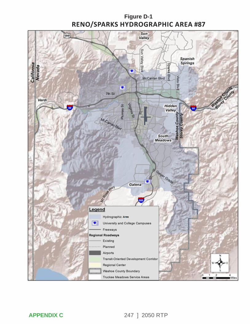
247 ] 2050 RTP
Figure D-1 RENO/SPARKS HYDROGRAPHIC AREA #87
APPENDIX C
248 ] 2050 RTP
EPA’s MOtor Vehicle Emission Simulator (MOVES) is a state-of-the-science emission modeling system that estimates emissions for mobile sources at the national, county, and project level for criteria air pollutants, greenhouse gases, and air toxics. MOVES3 is now the latest official version of MOVES. The analysis uses MOVES3 to calculate emission data.
AIR QUALITY ANALYSIS PLAN REQUIREMENTS
Federal regulations are specific in defining the level of air quality analysis necessary for incorporation into the RTP. Section 93, Title 40 of Code of Federal Regulations (CFR) dated August 15, 1997 (effective September 15, 1997), pertains to the criteria and procedures necessary to analyze the air quality impacts of the RTP. For the purposes of an air quality determination, the analysis years are 2020, 2025, 2030, 2040, and 2050. No air quality analysis is required for the street and highway projects identified as unfunded needs. A summary of requirements is listed below:
A. The RTP must contribute to emission reductions in CO non attainment/maintenance areas.
B. Air quality analysis years must be no more than 10 years apart.
C. In CO and PM10 non-attainment/maintenance areas, analysis must be performed for both pollutants.
D. The last year of the RTP (2050) shall also be an analysis year.
E. An analysis must be performed for each year contained in the motor vehicle emission budget (MVEB) for the Hydrographic Area #87 for both CO and PM10, as budgets have been established for these pollutants.
F. For both CO and PM10, the analysis of emissions for the required years cannot exceed the MVEB.
AIR QUALITY ANALYSIS CREDITING PROVISIONS
Federal regulations also allow for crediting procedures over the life of the RTP for the implementation of Transportation Control Measures (TCMs) in which emissions reductions can be quantified. These TCMs are critical to areas such as Washoe County that have and are expected to have continued growth in population and VMT. Several specific TCM measures are in progress or planned in Washoe County that will have quantifiable emissions reductions. These include:
A. Traffic Signal Optimization Program
B. Conversion of the Public Transit Fleet Cleaner Fuels
C. Implementation of Trip Reduction Programs
APPENDIX C

249 ] 2050 RTP
These TCMs have been the focus of studies to quantify the air quality benefit of each. The TCMs are described below. The RTC is not taking any credit for reduced emissions associated with these TCMs but may choose to take credit in the future, if conditions warrant.
TRAFFIC SIGNAL OPTIMIZATION/TIMING UPGRADE PROGRAM
Traffic signal coordination and improvements seek to achieve two primary objectives: 1) improved traffic flow resulting in improved level of service and 2) mobile source emission reductions through decreased delay, fewer accelerations/decelerations and a decreased number of stops. The RTC has reviewed several studies and federally accepted models to quantify the reduction of mobile emissions from signal coordination programs. These include signal coordination studies conducted by several cities in southern California and the California Department of Transportation (CALTRANS). A comparison of before and after field studies was conducted and the improvements in all three peak periods were noted. Examples included a statewide average reduction of 14 seconds in stop delay and a 12% reduction in the number of stops per mile in the afternoon peak period. Several methodologies were used to take the results of studies to quantify the emission reductions from signal coordination programs.
The pollution reduction results (tons/per day or percentage reduction) from each model vary as some models focus on corridor specific reductions while the others are more of an area-wide reduction projection. Pollutant reductions ranged from 11% along specific corridors to 3% to 4% on a regional level.
The RTC has initiated a region-wide traffic signal optimization and improvements program to enhance the capacity of the existing system and reduce traffic congestion in the region. This is an ongoing program that will allow nearly 400 intersections in the Truckee Meadows to be coordinated.
CONVERSION OF RTC ACCESS & RTC RIDE FLEETS TO ALTERNATIVE OR CLEANER BURNING FUELS
Almost 8 million annual passengers with 2.9 million miles are provided service by the RTC RIDE public transit and RTC ACCESS paratransit. While this is a small percentage of total daily travel, it is important in terms of air quality. All RTC RIDE buses are comprised of electric, hybrid diesel-electric and bio-diesel vehicles. RTC ACCESS cut-away vehicles are fueled by Compressed Natural Gas (CNG). These vehicles can reduce mobile emission totals.
250 ] 2050 RTP
Estimates by the California Air Resources Board between standard urban diesel and biodiesel or CNG determined that NOx emissions from vehicles with CNG or cleaner burning diesels were reduced approximately 60%.
RTC currently has 23 zero emission electric buses and will be adding 8 more to the Virginia Line RAPID corridor over the coming years. In addition, RTC is exploring hydrogen fuel cell technology for the next generation of zero emission vehicles.
TRIP REDUCTION PROGRAMS
The RTC’s trip reduction program, RTC SMART TRIPS, encourages the use of sustainable travel modes and trip reductions strategies such as telecommuting, compressed work weeks, and trip chaining. Major components of the program include a bus pass subsidy program in which the RTC matches an employer’s contribution to their employees’ 31-day transit passes up to 20%; a subsidized vanpool program, RTC VANPOOL; and an on-line trip matching program, RTC TRIP MATCH, that makes it quick, easy, and convenient to look for carpool partners as well as bus, bike, and walking buddies for either recurring or one time trips. One of the most common deterrents to ridesharing is the fear of being “stranded.”
Consequently, people who either carpool or vanpool to work can sign up for the Guaranteed Ride Home program and be reimbursed for a taxi ride home up to four times a year if an unexpected event prevents normal ridesharing arrangements from working. Making trips safely on foot and by bicycle are also promoted by the RTC SMART TRIPS program throughout the year.
The goals of these programs are to promote trip reduction on a region-wide level, improve air quality, and reduce vehicle miles of travel and traffic congestion. During the period from July through September 2020 the air quality benefits of the program were substantial, as shown in Table C-1. The data included the number of people in each vanpool and the average daily trip mileage. The air pollution calculation was obtained by multiplying the number of passenger trips for each vanpool per month by the average daily trip mileage for each vanpool per month and totaling those results to estimate the total VMT eliminated through the program due to the vanpool passengers not driving alone to work. The reduction in VMT was then multiplied by the pollutant factors per mile with those results outlined in the chart below. The emissions factors per mile for each pollutant were provided by WCHD-AQMD.
APPENDIX C
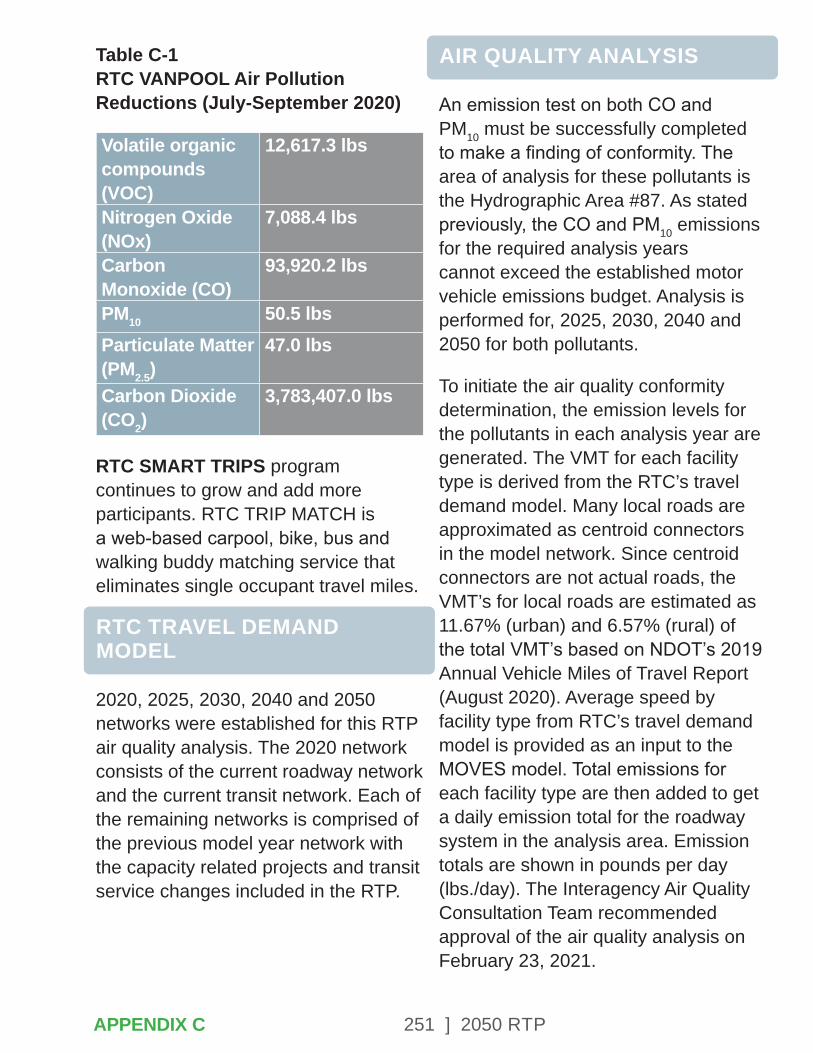
251 ] 2050 RTP
Table C-1 RTC VANPOOL Air Pollution Reductions (July-September 2020)
Volatile organic compounds (VOC)
12,617.3 lbs
Nitrogen Oxide (NOx)
7,088.4 lbs
Carbon Monoxide (CO)
93,920.2 lbs
PM10 50.5 lbsParticulate Matter (PM2.5)
47.0 lbs
Carbon Dioxide (CO2)
3,783,407.0 lbs
RTC SMART TRIPS program continues to grow and add more participants. RTC TRIP MATCH is a web-based carpool, bike, bus and walking buddy matching service that eliminates single occupant travel miles.
RTC TRAVEL DEMAND MODEL
2020, 2025, 2030, 2040 and 2050 networks were established for this RTP air quality analysis. The 2020 network consists of the current roadway network and the current transit network. Each of the remaining networks is comprised of the previous model year network with the capacity related projects and transit service changes included in the RTP.
AIR QUALITY ANALYSIS
An emission test on both CO and PM10 must be successfully completed to make a finding of conformity. The area of analysis for these pollutants is the Hydrographic Area #87. As stated previously, the CO and PM10 emissions for the required analysis years cannot exceed the established motor vehicle emissions budget. Analysis is performed for, 2025, 2030, 2040 and 2050 for both pollutants.
To initiate the air quality conformity determination, the emission levels for the pollutants in each analysis year are generated. The VMT for each facility type is derived from the RTC’s travel demand model. Many local roads are approximated as centroid connectors in the model network. Since centroid connectors are not actual roads, the VMT’s for local roads are estimated as 11.67% (urban) and 6.57% (rural) of the total VMT’s based on NDOT’s 2019 Annual Vehicle Miles of Travel Report (August 2020). Average speed by facility type from RTC’s travel demand model is provided as an input to the MOVES model. Total emissions for each facility type are then added to get a daily emission total for the roadway system in the analysis area. Emission totals are shown in pounds per day (lbs./day). The Interagency Air Quality Consultation Team recommended approval of the air quality analysis on February 23, 2021.
APPENDIX C

252 ] 2050 RTP
CO ANALYSIS
The MVEB for carbon monoxide (CO), effective October 31, 2016, is shown in Table D-2, which also includes the CO emissions for all analysis years of the RTP. All RTP analysis years are within the MVEB. The tables supporting this analysis are contained at the end of this chapter.
Table C-2 CO Emissions Analysis (lbs. /day)
Analysis Year
MVEB RTP Analysis
2020 172,670 64,4772025 171,509 55,7082030 169,959 47,3472040 169,959 40,3912050 169,959 44,143
PM10 ANALYSIS
The MVEB for PM10, effective January 6, 2016, is shown in Table D-3, which also includes the PM10 emissions for all analysis years of the RTP. All RTP analysis years are within the MVEB. The tables supporting this analysis are contained at the end of this chapter.
Table C-3 PM10 Total Emissions (lbs/day)
Analysis Year
MVEB RTP Analysis
2020 6,088 3,5142025 6,473 3,5542030 6,927 3,7582040 6,927 4,0302050 6,927 4,501
SUMMARY
A strong commitment to fund and implement feasible TCM measures must be made if acceptable air quality standards are to be sustained. The local jurisdictions and NDOT, through the RTP process, have made the commitment to fund TCMs such as ridesharing, traffic flow improvements, signal coordination, and conversion of public transit fleet to cleaner burning fuels. The 2050 RTP includes significant investments in bicycle and pedestrian infrastructure, consistent with the Complete Streets Master Plan adopted by RTC in 2016. Based on existing and planned commitments, the air quality analysis conducted in this chapter demonstrates that the required air quality conformity determination can be made and the RTP shown to be in conformance with federal air quality regulations.
APPENDIX C

253 ] 2050 RTP
AIR QUALITY ANALYSIS SUPPORT DOCUMENTATION
Table C-4 Paved Road Fugitive Emission Factors (lb/VMT)
Facility Type
2020 2020-2050
Interstate 0.00013 0.00012Other Fwys
0.00013 0.00012
Major Arterial
0.00013 0.00012
Minor Arterial
0.00034 0.00033
Collector 0.00083 0.00080Local 0.00209 0.00201
Table C-5 VMT by Facility Type by Analysis Year (Hydrographic Area #87)
Facility Type
2020 2025 2030 2040 2050
Interstate 2,563,692 2,692,797 2,837,972 3,097,296 3,273,895 Other Fwys
498,488 562,971 590,273 690,736 817,509
Major Arterial
1,861,219 1,969,198 2,110,987 2,234,577 2,534,221
Minor Arterial
789,911 830,142 891,093 941,642 1,106,089
Collector 237,424 246,998 264,034 269,764 293,922 Local 777,981 823,918 875,200 945,753 1,049,247 Total
6,728,714 7,126,024
7,569,559
8,179,769
9,074,882
APPENDIX C
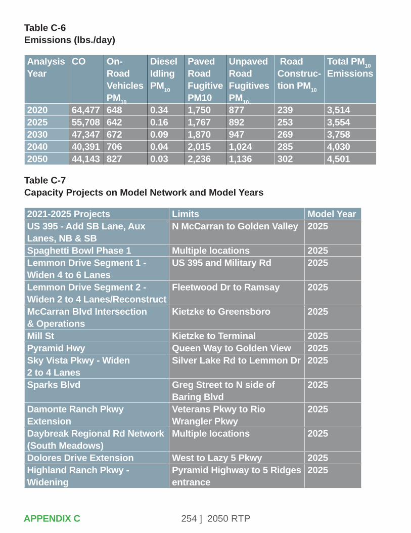
254 ] 2050 RTP
Table C-6 Emissions (lbs./day)
Analysis Year
CO On-Road Vehicles PM10
Diesel Idling PM10
Paved Road Fugitive PM10
Unpaved Road Fugitives PM10
Road Construc-tion PM10
Total PM10 Emissions
2020 64,477 648 0.34 1,750 877 239 3,5142025 55,708 642 0.16 1,767 892 253 3,5542030 47,347 672 0.09 1,870 947 269 3,7582040 40,391 706 0.04 2,015 1,024 285 4,0302050 44,143 827 0.03 2,236 1,136 302 4,501
Table C-7 Capacity Projects on Model Network and Model Years
2021-2025 Projects Limits Model YearUS 395 - Add SB Lane, Aux Lanes, NB & SB
N McCarran to Golden Valley 2025
Spaghetti Bowl Phase 1 Multiple locations 2025Lemmon Drive Segment 1 - Widen 4 to 6 Lanes
US 395 and Military Rd 2025
Lemmon Drive Segment 2 - Widen 2 to 4 Lanes/Reconstruct
Fleetwood Dr to Ramsay 2025
McCarran Blvd Intersection & Operations
Kietzke to Greensboro 2025
Mill St Kietzke to Terminal 2025Pyramid Hwy Queen Way to Golden View 2025Sky Vista Pkwy - Widen 2 to 4 Lanes
Silver Lake Rd to Lemmon Dr 2025
Sparks Blvd Greg Street to N side of Baring Blvd
2025
Damonte Ranch Pkwy Extension
Veterans Pkwy to Rio Wrangler Pkwy
2025
Daybreak Regional Rd Network (South Meadows)
Multiple locations 2025
Dolores Drive Extension West to Lazy 5 Pkwy 2025Highland Ranch Pkwy - Widening
Pyramid Highway to 5 Ridges entrance
2025
APPENDIX C
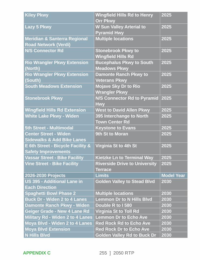
255 ] 2050 RTP
Kiley Pkwy Wingfield Hills Rd to Henry Orr Pkwy
2025
Lazy 5 Pkwy W Sun Valley Arterial to Pyramid Hwy
2025
Meridian & Santerra Regional Road Network (Verdi)
Multiple locations 2025
N/S Connector Rd Stonebrook Pkwy to Wingfield Hills Rd
2025
Rio Wrangler Pkwy Extension (North)
Bucephalus Pkwy to South Meadows Pkwy
2025
Rio Wrangler Pkwy Extension (South)
Damonte Ranch Pkwy to Veterans Pkwy
2025
South Meadows Extension Mojave Sky Dr to Rio Wrangler Pkwy
2025
Stonebrook Pkwy N/S Connector Rd to Pyramid Hwy
2025
Wingfield Hills Rd Extension West to David Allen Pkwy 2025White Lake Pkwy - Widen 395 Interchange to North
Town Center Rd2025
5th Street - Multimodal Keystone to Evans 2025Center Street - Widen Sidewalks & Add Bike Lanes
9th St to Moran 2025
E 6th Street - Bicycle Facility & Safety Improvements
Virginia St to 4th St 2025
Vassar Street - Bike Facility Kietzke Ln to Terminal Way 2025Vine Street - Bike Facility Riverside Drive to University
Terrace2025
2026-2030 Projects Limits Model YearUS 395 - Additional Lane in Each Direction
Golden Valley to Stead Blvd 2030
Spaghetti Bowl Phase 2 Multiple locations 2030Buck Dr - Widen 2 to 4 Lanes Lemmon Dr to N Hills Blvd 2030Damonte Ranch Pkwy - Widen Double R to I 580 2030Geiger Grade - New 4 Lane Rd Virginia St to Toll Rd 2030Military Rd - Widen 2 to 4 Lanes Lemmon Dr to Echo Ave 2030Moya Blvd - Widen 2 to 4 Lanes Red Rock Rd to Echo Ave 2030Moya Blvd Extension Red Rock Dr to Echo Ave 2030N Hills Blvd Golden Valley Rd to Buck Dr 2030
APPENDIX C
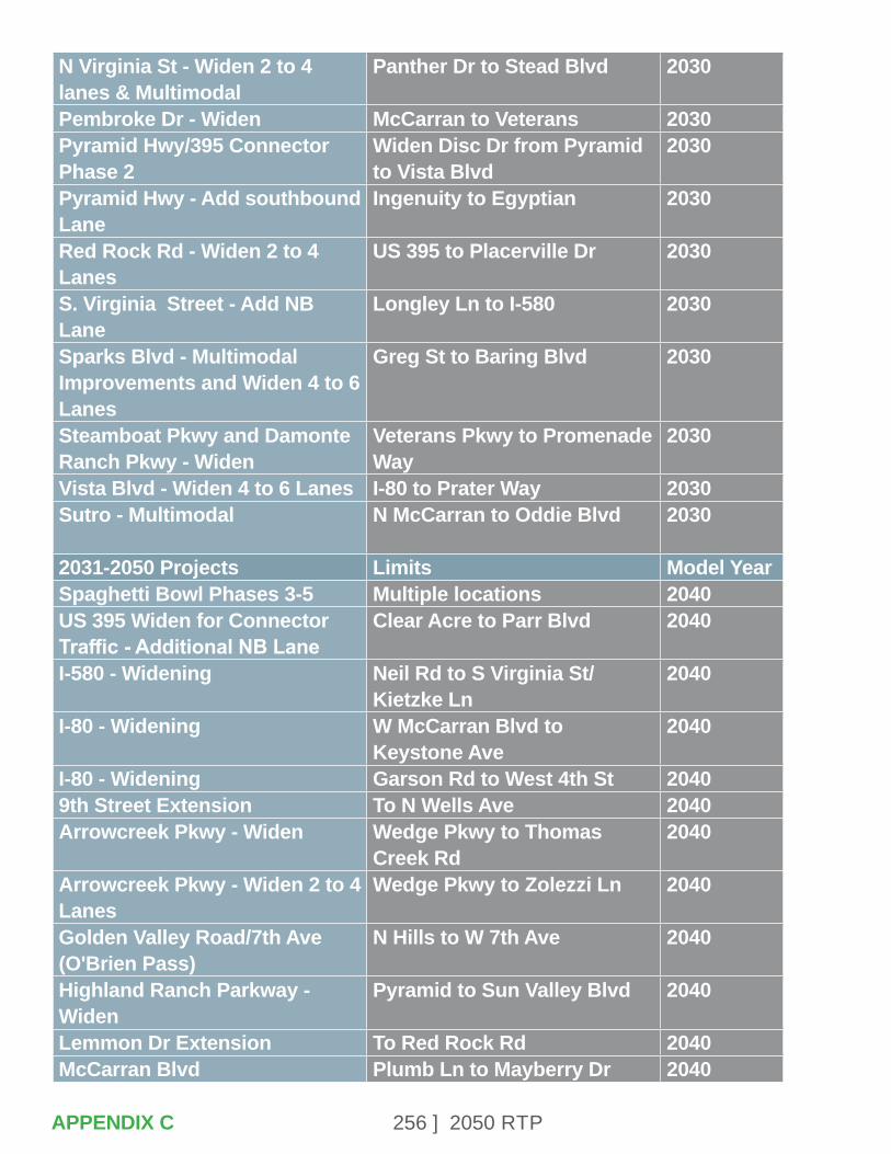
256 ] 2050 RTP
N Virginia St - Widen 2 to 4 lanes & Multimodal
Panther Dr to Stead Blvd 2030
Pembroke Dr - Widen McCarran to Veterans 2030Pyramid Hwy/395 Connector Phase 2
Widen Disc Dr from Pyramid to Vista Blvd
2030
Pyramid Hwy - Add southbound Lane
Ingenuity to Egyptian 2030
Red Rock Rd - Widen 2 to 4 Lanes
US 395 to Placerville Dr 2030
S. Virginia Street - Add NB Lane
Longley Ln to I-580 2030
Sparks Blvd - Multimodal Improvements and Widen 4 to 6 Lanes
Greg St to Baring Blvd 2030
Steamboat Pkwy and Damonte Ranch Pkwy - Widen
Veterans Pkwy to Promenade Way
2030
Vista Blvd - Widen 4 to 6 Lanes I-80 to Prater Way 2030Sutro - Multimodal N McCarran to Oddie Blvd 2030
2031-2050 Projects Limits Model YearSpaghetti Bowl Phases 3-5 Multiple locations 2040US 395 Widen for Connector Traffic - Additional NB Lane
Clear Acre to Parr Blvd 2040
I-580 - Widening Neil Rd to S Virginia St/Kietzke Ln
2040
I-80 - Widening W McCarran Blvd to Keystone Ave
2040
I-80 - Widening Garson Rd to West 4th St 20409th Street Extension To N Wells Ave 2040Arrowcreek Pkwy - Widen Wedge Pkwy to Thomas
Creek Rd2040
Arrowcreek Pkwy - Widen 2 to 4 Lanes
Wedge Pkwy to Zolezzi Ln 2040
Golden Valley Road/7th Ave (O'Brien Pass)
N Hills to W 7th Ave 2040
Highland Ranch Parkway - Widen
Pyramid to Sun Valley Blvd 2040
Lemmon Dr Extension To Red Rock Rd 2040McCarran Blvd Plumb Ln to Mayberry Dr 2040
APPENDIX C
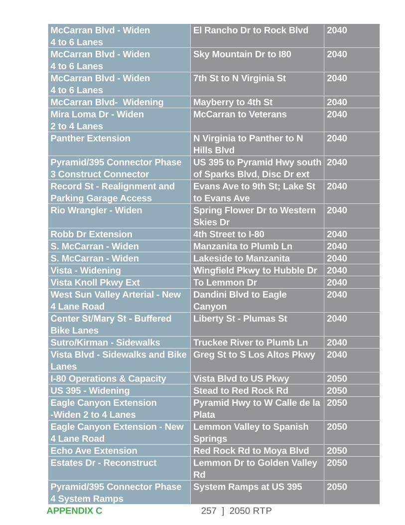
257 ] 2050 RTP
McCarran Blvd - Widen 4 to 6 Lanes
El Rancho Dr to Rock Blvd 2040
McCarran Blvd - Widen 4 to 6 Lanes
Sky Mountain Dr to I80 2040
McCarran Blvd - Widen 4 to 6 Lanes
7th St to N Virginia St 2040
McCarran Blvd- Widening Mayberry to 4th St 2040Mira Loma Dr - Widen 2 to 4 Lanes
McCarran to Veterans 2040
Panther Extension N Virginia to Panther to N Hills Blvd
2040
Pyramid/395 Connector Phase 3 Construct Connector
US 395 to Pyramid Hwy south of Sparks Blvd, Disc Dr ext
2040
Record St - Realignment and Parking Garage Access
Evans Ave to 9th St; Lake St to Evans Ave
2040
Rio Wrangler - Widen Spring Flower Dr to Western Skies Dr
2040
Robb Dr Extension 4th Street to I-80 2040S. McCarran - Widen Manzanita to Plumb Ln 2040S. McCarran - Widen Lakeside to Manzanita 2040Vista - Widening Wingfield Pkwy to Hubble Dr 2040Vista Knoll Pkwy Ext To Lemmon Dr 2040West Sun Valley Arterial - New 4 Lane Road
Dandini Blvd to Eagle Canyon
2040
Center St/Mary St - Buffered Bike Lanes
Liberty St - Plumas St 2040
Sutro/Kirman - Sidewalks Truckee River to Plumb Ln 2040Vista Blvd - Sidewalks and Bike Lanes
Greg St to S Los Altos Pkwy 2040
I-80 Operations & Capacity Vista Blvd to US Pkwy 2050US 395 - Widening Stead to Red Rock Rd 2050Eagle Canyon Extension -Widen 2 to 4 Lanes
Pyramid Hwy to W Calle de la Plata
2050
Eagle Canyon Extension - New 4 Lane Road
Lemmon Valley to Spanish Springs
2050
Echo Ave Extension Red Rock Rd to Moya Blvd 2050Estates Dr - Reconstruct Lemmon Dr to Golden Valley
Rd2050
Pyramid/395 Connector Phase 4 System Ramps
System Ramps at US 395 2050
APPENDIX C
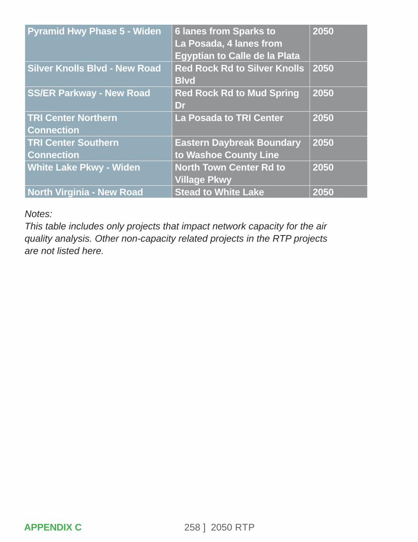
258 ] 2050 RTP
Pyramid Hwy Phase 5 - Widen 6 lanes from Sparks to La Posada, 4 lanes from Egyptian to Calle de la Plata
2050
Silver Knolls Blvd - New Road Red Rock Rd to Silver Knolls Blvd
2050
SS/ER Parkway - New Road Red Rock Rd to Mud Spring Dr
2050
TRI Center Northern Connection
La Posada to TRI Center 2050
TRI Center Southern Connection
Eastern Daybreak Boundary to Washoe County Line
2050
White Lake Pkwy - Widen North Town Center Rd to Village Pkwy
2050
North Virginia - New Road Stead to White Lake 2050
Notes: This table includes only projects that impact network capacity for the air quality analysis. Other non-capacity related projects in the RTP projects are not listed here.
APPENDIX C
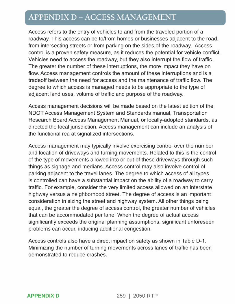
259 ] 2050 RTP
APPENDIX D – ACCESS MANAGEMENT
Access refers to the entry of vehicles to and from the traveled portion of a roadway. This access can be to/from homes or businesses adjacent to the road, from intersecting streets or from parking on the sides of the roadway. Access control is a proven safety measure, as it reduces the potential for vehicle conflict. Vehicles need to access the roadway, but they also interrupt the flow of traffic. The greater the number of these interruptions, the more impact they have on flow. Access management controls the amount of these interruptions and is a tradeoff between the need for access and the maintenance of traffic flow. The degree to which access is managed needs to be appropriate to the type of adjacent land uses, volume of traffic and purpose of the roadway.
Access management decisions will be made based on the latest edition of the NDOT Access Management System and Standards manual, Transportation Research Board Access Management Manual, or locally-adopted standards, as directed the local jurisdiction. Access management can include an analysis of the functional rea at signalized intersections.
Access management may typically involve exercising control over the number and location of driveways and turning movements. Related to this is the control of the type of movements allowed into or out of these driveways through such things as signage and medians. Access control may also involve control of parking adjacent to the travel lanes. The degree to which access of all types is controlled can have a substantial impact on the ability of a roadway to carry traffic. For example, consider the very limited access allowed on an interstate highway versus a neighborhood street. The degree of access is an important consideration in sizing the street and highway system. All other things being equal, the greater the degree of access control, the greater number of vehicles that can be accommodated per lane. When the degree of actual access significantly exceeds the original planning assumptions, significant unforeseen problems can occur, inducing additional congestion.
Access controls also have a direct impact on safety as shown in Table D-1. Minimizing the number of turning movements across lanes of traffic has been demonstrated to reduce crashes.
APPENDIX D
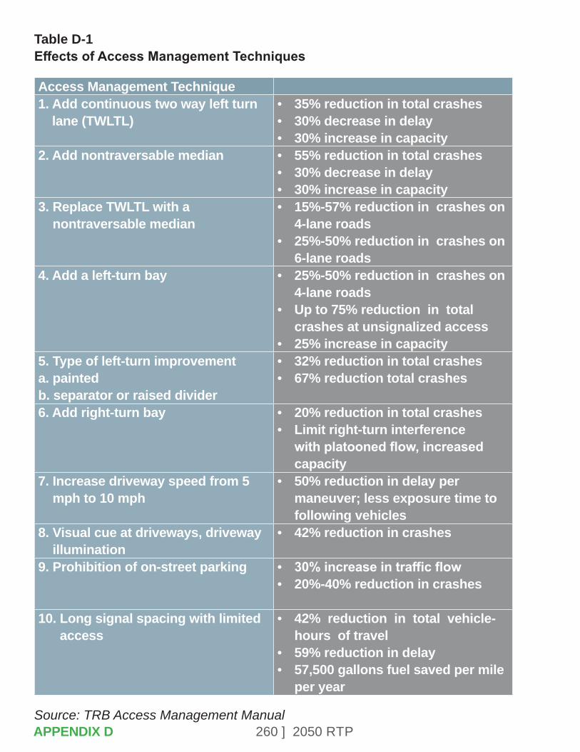
260 ] 2050 RTP
Table D-1 Effects of Access Management Techniques
Access Management Technique1. Add continuous two way left turn
lane (TWLTL)• 35% reduction in total crashes• 30% decrease in delay• 30% increase in capacity
2. Add nontraversable median • 55% reduction in total crashes• 30% decrease in delay• 30% increase in capacity
3. Replace TWLTL with a nontraversable median
• 15%-57% reduction in crashes on 4-lane roads
• 25%-50% reduction in crashes on 6-lane roads
4. Add a left-turn bay • 25%-50% reduction in crashes on 4-lane roads
• Up to 75% reduction in total crashes at unsignalized access
• 25% increase in capacity5. Type of left-turn improvementa. paintedb. separator or raised divider
• 32% reduction in total crashes• 67% reduction total crashes
6. Add right-turn bay • 20% reduction in total crashes• Limit right-turn interference
with platooned flow, increased capacity
7. Increase driveway speed from 5 mph to 10 mph
• 50% reduction in delay per maneuver; less exposure time to following vehicles
8. Visual cue at driveways, driveway illumination
• 42% reduction in crashes
9. Prohibition of on-street parking • 30% increase in traffic flow• 20%-40% reduction in crashes
10. Long signal spacing with limited access
• 42% reduction in total vehicle-hours of travel
• 59% reduction in delay• 57,500 gallons fuel saved per mile
per year
Source: TRB Access Management ManualAPPENDIX D

261 ] 2050 RTP
If a street is identified as being a regional road, certain design standards and operational standards (agreed to by implementing jurisdictions) can help facilitate regional trip movements. Additional roadway design access elements that influence safety and traffic flow include the following:
• Number of through lanes.
• Minimum signal spacing.
• Left turn from a major street.
• Right deceleration lanes at driveways.
• Driveway spacing.
• Number of signalized intersections per mile.
• Design speed.
• Bicycle facilities.
• Left turn lanes.
• Left turn from minor street or driveway.
• Median type or existence of median.
The Access Management Standards shown Table D-2 (shown on the following page) will be used in the design of future improvements to regional roads and the classification of existing improvements for planning purposes.
APPENDIX D

262 ] 2050 RTP
Tabl
e D
-2
Acc
ess
Man
agem
ent S
tand
ards
Acce
ss
Man
age-
men
t Cl
ass
Post
ed
Spee
dsSi
gnal
s Pe
r M
ile a
nd
Spac
ing2
Med
ian
Type
Left
From
Maj
or
Stre
et?
(Spa
cing
fro
m
sign
al)
Left
From
M
inor
St
reet
or
Driv
eway
?
Righ
t De
cel
Lane
s at
Dr
ivew
ays
Driv
eway
Sp
acin
g3
High
Ac
cess
Co
ntro
l
45-5
5m
ph2
or le
ss
Min
imum
sp
acin
g 23
50
Rais
ed w
/ch
anne
lized
turn
po
cket
s
Yes
75
0 ft.
min
imum
Onl
y at
si
gnal
ized
lo
catio
ns
Yes4
250
ft./5
00
ft
Mod
erat
e Ac
cess
Co
ntro
l
40-4
5 m
ph3
or le
ss
Min
imum
sp
acin
g 15
90 fe
et
Rais
ed o
r pai
nted
w/
turn
poc
kets
Yes
50
0 ft.
min
imum
No, o
n 6-
or
8- l
ane
road
way
s w
/o s
igna
l
Yes5
200
ft./3
00
ft
Low
Ac
cess
Co
ntro
l
35-4
0 m
ph5
or le
ss
Min
imum
sp
acin
g 90
0 fe
et
Rais
ed o
r pai
nted
w
/turn
poc
kets
or
undi
vide
d w
/pai
nted
tu
rn p
ocke
ts o
rtw
o-w
ay,
left-
turn
lane
Yes
35
0 ft.
min
imum
Yes
No15
0 ft.
/200
ft.
Ultra
-Lo
w
Acce
ss
Cont
rol
30-3
5 m
ph8
or le
ss
Min
imum
sp
acin
g 56
0 fe
et
Rais
ed o
r pai
nted
w
/turn
poc
kets
or
undi
vide
d w
/pai
nted
tu
rn p
ocke
ts o
rtw
o-w
ay le
ft-tu
rn
lane
Yes
35
0 ft.
min
imum
Yes
No15
0 ft.
/200
ft. 10
0 ft.
/100
ft.
6
APPENDIX D
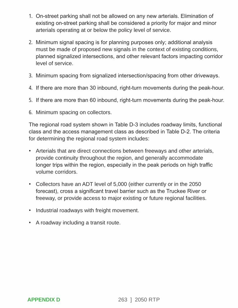
263 ] 2050 RTP
1. On-street parking shall not be allowed on any new arterials. Elimination of existing on-street parking shall be considered a priority for major and minor arterials operating at or below the policy level of service.
2. Minimum signal spacing is for planning purposes only; additional analysis must be made of proposed new signals in the context of existing conditions, planned signalized intersections, and other relevant factors impacting corridor level of service.
3. Minimum spacing from signalized intersection/spacing from other driveways.
4. If there are more than 30 inbound, right-turn movements during the peak-hour.
5. If there are more than 60 inbound, right-turn movements during the peak-hour.
6. Minimum spacing on collectors.
The regional road system shown in Table D-3 includes roadway limits, functional class and the access management class as described in Table D-2. The criteria for determining the regional road system includes:
• Arterials that are direct connections between freeways and other arterials, provide continuity throughout the region, and generally accommodate longer trips within the region, especially in the peak periods on high traffic volume corridors.
• Collectors have an ADT level of 5,000 (either currently or in the 2050 forecast), cross a significant travel barrier such as the Truckee River or freeway, or provide access to major existing or future regional facilities.
• Industrial roadways with freight movement.
• A roadway including a transit route.
APPENDIX D
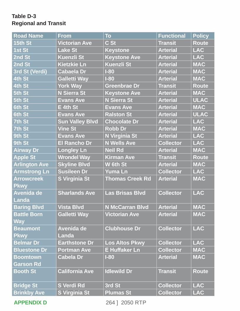
264 ] 2050 RTP
Table D-3 Regional and Transit
Road Name From To Functional Policy15th St Victorian Ave C St Transit Route1st St Lake St Keystone Arterial LAC2nd St Kuenzli St Keystone Ave Arterial LAC2nd St Kietzkie Ln Kuenzli St Arterial MAC3rd St (Verdi) Cabaela Dr I-80 Arterial MAC4th St Galletti Way I-80 Arterial MAC4th St York Way Greenbrae Dr Transit Route5th St N Sierra St Keystone Ave Arterial MAC5th St Evans Ave N Sierra St Arterial ULAC6th St E 4th St Evans Ave Arterial MAC6th St Evans Ave Ralston St Arterial ULAC7th St Sun Valley Blvd Chocolate Dr Arterial LAC7th St Vine St Robb Dr Arterial MAC9th St Evans Ave N Virginia St Arterial LAC9th St El Rancho Dr N Wells Ave Collector LACAirway Dr Longley Ln Neil Rd Arterial MACApple St Wrondel Way Kirman Ave Transit RouteArlington Ave Skyline Blvd W 6th St Arterial MACArmstrong Ln Susileen Dr Yuma Ln Collector LACArrowcreek Pkwy
S Virginia St Thomas Creek Rd Arterial MAC
Avenida de Landa
Sharlands Ave Las Brisas Blvd Collector LAC
Baring Blvd Vista Blvd N McCarran Blvd Arterial MACBattle Born Way
Galletti Way Victorian Ave Arterial MAC
Beaumont Pkwy
Avenida de Landa
Clubhouse Dr Collector LAC
Belmar Dr Earthstone Dr Los Altos Pkwy Collector LACBluestone Dr Portman Ave E Huffaker Ln Collector MACBoomtown Garson Rd
Cabela Dr I-80 Arterial MAC
Booth St California Ave Idlewild Dr Transit Route
Bridge St S Verdi Rd 3rd St Collector LACBrinkby Ave S Virginia St Plumas St Collector LAC
APPENDIX D
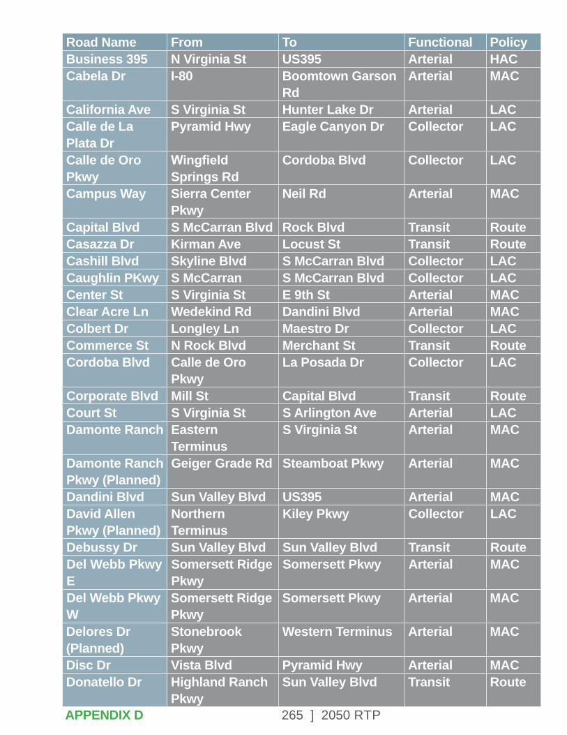
265 ] 2050 RTP
Road Name From To Functional PolicyBusiness 395 N Virginia St US395 Arterial HACCabela Dr I-80 Boomtown Garson
RdArterial MAC
California Ave S Virginia St Hunter Lake Dr Arterial LACCalle de La Plata Dr
Pyramid Hwy Eagle Canyon Dr Collector LAC
Calle de Oro Pkwy
Wingfield Springs Rd
Cordoba Blvd Collector LAC
Campus Way Sierra Center Pkwy
Neil Rd Arterial MAC
Capital Blvd S McCarran Blvd Rock Blvd Transit RouteCasazza Dr Kirman Ave Locust St Transit RouteCashill Blvd Skyline Blvd S McCarran Blvd Collector LACCaughlin PKwy S McCarran S McCarran Blvd Collector LACCenter St S Virginia St E 9th St Arterial MACClear Acre Ln Wedekind Rd Dandini Blvd Arterial MACColbert Dr Longley Ln Maestro Dr Collector LACCommerce St N Rock Blvd Merchant St Transit RouteCordoba Blvd Calle de Oro
PkwyLa Posada Dr Collector LAC
Corporate Blvd Mill St Capital Blvd Transit RouteCourt St S Virginia St S Arlington Ave Arterial LACDamonte Ranch Eastern
TerminusS Virginia St Arterial MAC
Damonte Ranch Pkwy (Planned)
Geiger Grade Rd Steamboat Pkwy Arterial MAC
Dandini Blvd Sun Valley Blvd US395 Arterial MACDavid Allen Pkwy (Planned)
Northern Terminus
Kiley Pkwy Collector LAC
Debussy Dr Sun Valley Blvd Sun Valley Blvd Transit RouteDel Webb Pkwy E
Somersett Ridge Pkwy
Somersett Pkwy Arterial MAC
Del Webb Pkwy W
Somersett Ridge Pkwy
Somersett Pkwy Arterial MAC
Delores Dr (Planned)
Stonebrook Pkwy
Western Terminus Arterial MAC
Disc Dr Vista Blvd Pyramid Hwy Arterial MACDonatello Dr Highland Ranch
PkwySun Valley Blvd Transit Route
APPENDIX D
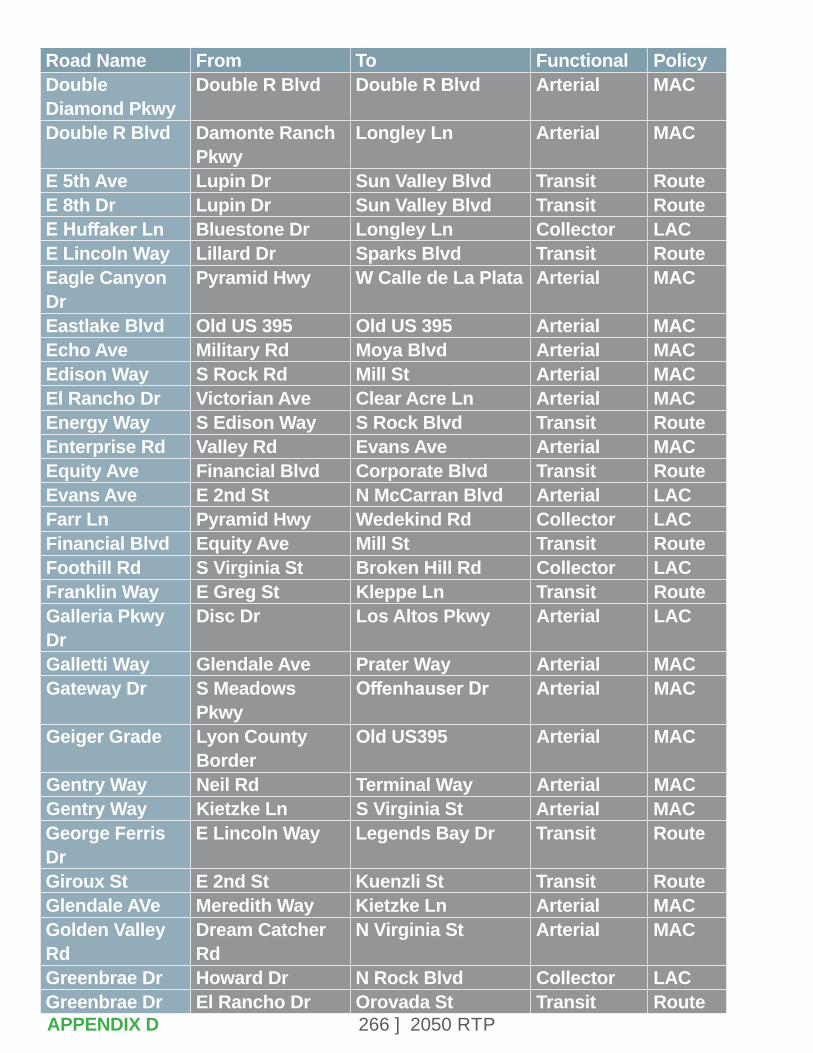
266 ] 2050 RTP
Road Name From To Functional PolicyDouble Diamond Pkwy
Double R Blvd Double R Blvd Arterial MAC
Double R Blvd Damonte Ranch Pkwy
Longley Ln Arterial MAC
E 5th Ave Lupin Dr Sun Valley Blvd Transit RouteE 8th Dr Lupin Dr Sun Valley Blvd Transit RouteE Huffaker Ln Bluestone Dr Longley Ln Collector LACE Lincoln Way Lillard Dr Sparks Blvd Transit RouteEagle Canyon Dr
Pyramid Hwy W Calle de La Plata Arterial MAC
Eastlake Blvd Old US 395 Old US 395 Arterial MACEcho Ave Military Rd Moya Blvd Arterial MACEdison Way S Rock Rd Mill St Arterial MACEl Rancho Dr Victorian Ave Clear Acre Ln Arterial MACEnergy Way S Edison Way S Rock Blvd Transit RouteEnterprise Rd Valley Rd Evans Ave Arterial MACEquity Ave Financial Blvd Corporate Blvd Transit RouteEvans Ave E 2nd St N McCarran Blvd Arterial LACFarr Ln Pyramid Hwy Wedekind Rd Collector LACFinancial Blvd Equity Ave Mill St Transit RouteFoothill Rd S Virginia St Broken Hill Rd Collector LACFranklin Way E Greg St Kleppe Ln Transit RouteGalleria Pkwy Dr
Disc Dr Los Altos Pkwy Arterial LAC
Galletti Way Glendale Ave Prater Way Arterial MACGateway Dr S Meadows
PkwyOffenhauser Dr Arterial MAC
Geiger Grade Lyon County Border
Old US395 Arterial MAC
Gentry Way Neil Rd Terminal Way Arterial MACGentry Way Kietzke Ln S Virginia St Arterial MACGeorge Ferris Dr
E Lincoln Way Legends Bay Dr Transit Route
Giroux St E 2nd St Kuenzli St Transit RouteGlendale AVe Meredith Way Kietzke Ln Arterial MACGolden Valley Rd
Dream Catcher Rd
N Virginia St Arterial MAC
Greenbrae Dr Howard Dr N Rock Blvd Collector LACGreenbrae Dr El Rancho Dr Orovada St Transit RouteAPPENDIX D
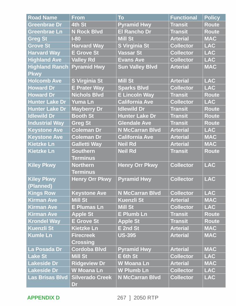
267 ] 2050 RTP
Road Name From To Functional PolicyGreenbrae Dr 4th St Pyramid Hwy Transit RouteGreenbrae Ln N Rock Blvd El Rancho Dr Transit RouteGreg St I-80 Mill St Arterial MACGrove St Harvard Way S Virginia St Collector LACHarvard Way E Grove St Vassar St Collector LACHighland Ave Valley Rd Evans Ave Collector LACHighland Ranch Pkwy
Pyramid Hwy Sun Valley Blvd Arterial MAC
Holcomb Ave S Virginia St Mill St Arterial LACHoward Dr E Prater Way Sparks Blvd Collector LACHoward Dr Nichols Blvd E Lincoln Way Transit RouteHunter Lake Dr Yuma Ln California Ave Collector LACHunter Lake Dr Mayberry Dr Idlewild Dr Transit RouteIdlewild Dr Booth St Hunter Lake Dr Transit RouteIndustrial Way Greg St Glendale Ave Transit RouteKeystone Ave Coleman Dr N McCarran Blvd Arterial LACKeystone Ave Coleman Dr California Ave Arterial MACKietzke Ln Galletti Way Neil Rd Arterial MACKietzke Ln Southern
TerminusNeil Rd Transit Route
Kiley Pkwy Northern Terminus
Henry Orr Pkwy Collector LAC
Kiley Pkwy (Planned)
Henry Orr Pkwy Pyramid Hwy Collector LAC
Kings Row Keystone Ave N McCarran Blvd Collector LACKirman Ave Mill St Kuenzli St Arterial MACKirman Ave E Plumas Ln Mill St Collector LACKirman Ave Apple St E Plumb Ln Transit RouteKrondel Way E Grove St Apple St Transit RouteKuenzli St Kietzke Ln E 2nd St Arterial MACKumle Ln Firecreek
CrossingUS-395 Arterial MAC
La Posada Dr Cordoba Blvd Pyramid Hwy Arterial MACLake St Mill St E 6th St Collector LACLakeside Dr Ridgeview Dr W Moana Ln Arterial MACLakeside Dr W Moana Ln W Plumb Ln Collector LACLas Brisas Blvd Silverado Creek
DrN McCarran Blvd Collector LAC
APPENDIX D
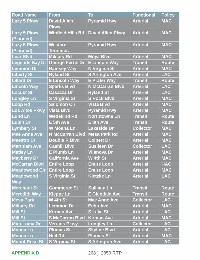
268 ] 2050 RTP
Road Name From To Functional PolicyLazy 5 Pkwy David Allen
PkwyPyramid Hwy Arterial MAC
Lazy 5 Pkwy (Planned)
Winfield Hills Rd David Allen Pkwy Arterial MAC
Lazy 5 Pkwy (Planned)
Western Terminus
Pyramid Hwy Arterial MAC
Lear Blvd Military Rd Moya Blvd Arterial MACLegends Bay Dr George Ferris Dr E Lincoln Way Transit RouteLemmon Dr Ramsey Way N Virginia St Arterial MACLiberty St Ryland St S Arlington Ave Arterial LACLillard Dr E Lincoln Way E Prater Way Transit RouteLincoln Way Sparks Blvd N McCarran Blvd Arterial LACLocust St Casazza Dr Ryland St Arterial LACLongley Ln S Virginia St S Rock Blvd Arterial MACLoop Rd Salomon Cir Vista Blvd Arterial MACLos Altos Pkwy Vista Blvd Pyramid Hwy Arterial MACLund Ln Wedekind Rd Northtowne Ln Transit RouteLupin Dr E 5th Ave E 8th Ave Transit RouteLymbery St W Moana Ln Lakeside Dr Collector MACMae Anne Ave N McCarran Blvd Mesa Park Rd Arterial MACMaestro Dr Double R Blvd Colbert Dr Arterial MACMarthiam Ave Cashill Blvd Susileen Dr Collector LACMatley Ln E Plumb Ln Vilanova Dr Arterial MACMayberry Dr California Ave W 4th St Arterial MACMcCarran Blvd Entire Loop Entire Loop Arterial HACMeadowood Cir Entire Loop Entire Loop Arterial MACMeadowood Way
S Virginia St Kietzke Ln Arterial LAC
Merchant St Commerce St Sullivan Ln Transit RouteMeredith Way Kleppe Ln E Glendale Ave Transit RouteMesa Park W 4th St Mae Anne Ave Collector LACMilitary Rd Lemmon Dr Echo Ave Arterial MACMill St Kirman Ave S Lake St Arterial LACMill St S McCarran Blvd Kirman Ave Arterial MACMira Loma Dr Vetrans Pkwy Longley Ln Collector LACMoana Ln Plumas St Skyline Blvd Arterial LACMoana Ln Neil Rd Plumas St Arterial MACMount Rose St S Virginia St S Arlington Ave Arterial LAC
APPENDIX D
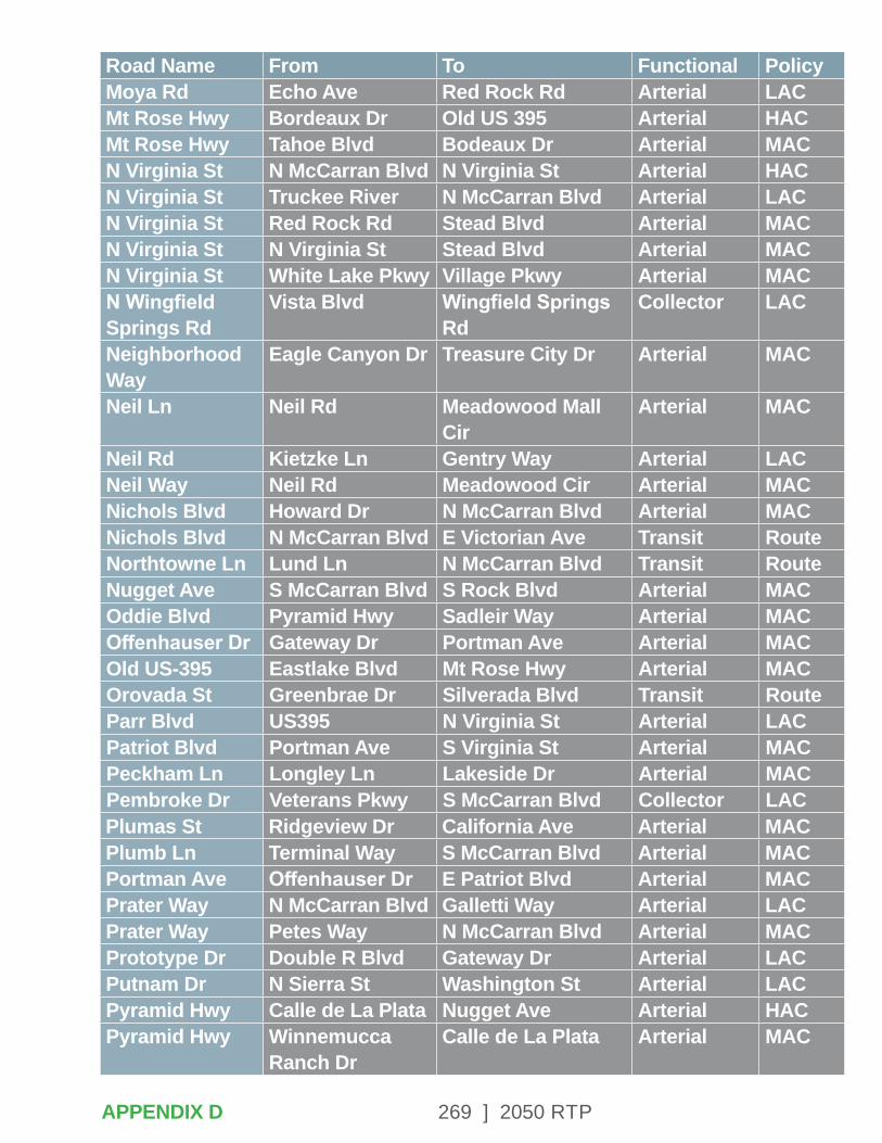
269 ] 2050 RTP
Road Name From To Functional PolicyMoya Rd Echo Ave Red Rock Rd Arterial LACMt Rose Hwy Bordeaux Dr Old US 395 Arterial HACMt Rose Hwy Tahoe Blvd Bodeaux Dr Arterial MACN Virginia St N McCarran Blvd N Virginia St Arterial HACN Virginia St Truckee River N McCarran Blvd Arterial LACN Virginia St Red Rock Rd Stead Blvd Arterial MACN Virginia St N Virginia St Stead Blvd Arterial MACN Virginia St White Lake Pkwy Village Pkwy Arterial MACN Wingfield Springs Rd
Vista Blvd Wingfield Springs Rd
Collector LAC
Neighborhood Way
Eagle Canyon Dr Treasure City Dr Arterial MAC
Neil Ln Neil Rd Meadowood Mall Cir
Arterial MAC
Neil Rd Kietzke Ln Gentry Way Arterial LACNeil Way Neil Rd Meadowood Cir Arterial MACNichols Blvd Howard Dr N McCarran Blvd Arterial MACNichols Blvd N McCarran Blvd E Victorian Ave Transit RouteNorthtowne Ln Lund Ln N McCarran Blvd Transit RouteNugget Ave S McCarran Blvd S Rock Blvd Arterial MACOddie Blvd Pyramid Hwy Sadleir Way Arterial MACOffenhauser Dr Gateway Dr Portman Ave Arterial MACOld US-395 Eastlake Blvd Mt Rose Hwy Arterial MACOrovada St Greenbrae Dr Silverada Blvd Transit RouteParr Blvd US395 N Virginia St Arterial LACPatriot Blvd Portman Ave S Virginia St Arterial MACPeckham Ln Longley Ln Lakeside Dr Arterial MACPembroke Dr Veterans Pkwy S McCarran Blvd Collector LACPlumas St Ridgeview Dr California Ave Arterial MACPlumb Ln Terminal Way S McCarran Blvd Arterial MACPortman Ave Offenhauser Dr E Patriot Blvd Arterial MACPrater Way N McCarran Blvd Galletti Way Arterial LACPrater Way Petes Way N McCarran Blvd Arterial MACPrototype Dr Double R Blvd Gateway Dr Arterial LACPutnam Dr N Sierra St Washington St Arterial LACPyramid Hwy Calle de La Plata Nugget Ave Arterial HACPyramid Hwy Winnemucca
Ranch DrCalle de La Plata Arterial MAC
APPENDIX D
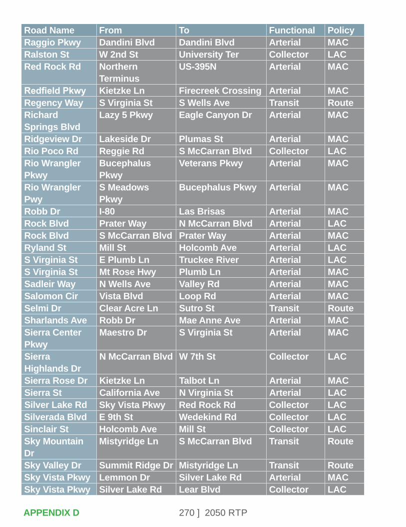
270 ] 2050 RTP
Road Name From To Functional PolicyRaggio Pkwy Dandini Blvd Dandini Blvd Arterial MACRalston St W 2nd St University Ter Collector LACRed Rock Rd Northern
TerminusUS-395N Arterial MAC
Redfield Pkwy Kietzke Ln Firecreek Crossing Arterial MACRegency Way S Virginia St S Wells Ave Transit RouteRichard Springs Blvd
Lazy 5 Pkwy Eagle Canyon Dr Arterial MAC
Ridgeview Dr Lakeside Dr Plumas St Arterial MACRio Poco Rd Reggie Rd S McCarran Blvd Collector LACRio Wrangler Pkwy
Bucephalus Pkwy
Veterans Pkwy Arterial MAC
Rio Wrangler Pwy
S Meadows Pkwy
Bucephalus Pkwy Arterial MAC
Robb Dr I-80 Las Brisas Arterial MACRock Blvd Prater Way N McCarran Blvd Arterial LACRock Blvd S McCarran Blvd Prater Way Arterial MACRyland St Mill St Holcomb Ave Arterial LACS Virginia St E Plumb Ln Truckee River Arterial LACS Virginia St Mt Rose Hwy Plumb Ln Arterial MACSadleir Way N Wells Ave Valley Rd Arterial MACSalomon Cir Vista Blvd Loop Rd Arterial MACSelmi Dr Clear Acre Ln Sutro St Transit RouteSharlands Ave Robb Dr Mae Anne Ave Arterial MACSierra Center Pkwy
Maestro Dr S Virginia St Arterial MAC
Sierra Highlands Dr
N McCarran Blvd W 7th St Collector LAC
Sierra Rose Dr Kietzke Ln Talbot Ln Arterial MACSierra St California Ave N Virginia St Arterial LACSilver Lake Rd Sky Vista Pkwy Red Rock Rd Collector LACSilverada Blvd E 9th St Wedekind Rd Collector LACSinclair St Holcomb Ave Mill St Collector LACSky Mountain Dr
Mistyridge Ln S McCarran Blvd Transit Route
Sky Valley Dr Summit Ridge Dr Mistyridge Ln Transit RouteSky Vista Pkwy Lemmon Dr Silver Lake Rd Arterial MACSky Vista Pkwy Silver Lake Rd Lear Blvd Collector LAC
APPENDIX D
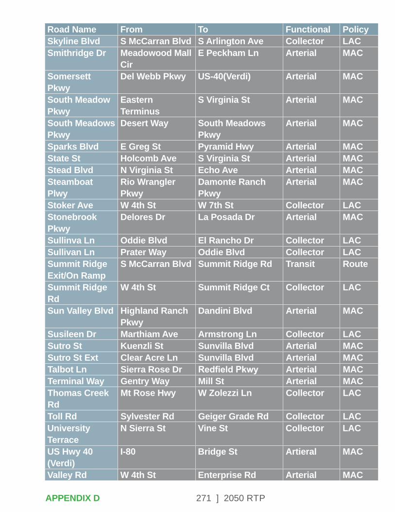
271 ] 2050 RTP
Road Name From To Functional PolicySkyline Blvd S McCarran Blvd S Arlington Ave Collector LACSmithridge Dr Meadowood Mall
CirE Peckham Ln Arterial MAC
Somersett Pkwy
Del Webb Pkwy US-40(Verdi) Arterial MAC
South Meadow Pkwy
Eastern Terminus
S Virginia St Arterial MAC
South Meadows Pkwy
Desert Way South Meadows Pkwy
Arterial MAC
Sparks Blvd E Greg St Pyramid Hwy Arterial MACState St Holcomb Ave S Virginia St Arterial MACStead Blvd N Virginia St Echo Ave Arterial MACSteamboat Plwy
Rio Wrangler Pkwy
Damonte Ranch Pkwy
Arterial MAC
Stoker Ave W 4th St W 7th St Collector LACStonebrook Pkwy
Delores Dr La Posada Dr Arterial MAC
Sullinva Ln Oddie Blvd El Rancho Dr Collector LACSullivan Ln Prater Way Oddie Blvd Collector LACSummit Ridge Exit/On Ramp
S McCarran Blvd Summit Ridge Rd Transit Route
Summit Ridge Rd
W 4th St Summit Ridge Ct Collector LAC
Sun Valley Blvd Highland Ranch Pkwy
Dandini Blvd Arterial MAC
Susileen Dr Marthiam Ave Armstrong Ln Collector LACSutro St Kuenzli St Sunvilla Blvd Arterial MACSutro St Ext Clear Acre Ln Sunvilla Blvd Arterial MACTalbot Ln Sierra Rose Dr Redfield Pkwy Arterial MACTerminal Way Gentry Way Mill St Arterial MACThomas Creek Rd
Mt Rose Hwy W Zolezzi Ln Collector LAC
Toll Rd Sylvester Rd Geiger Grade Rd Collector LACUniversity Terrace
N Sierra St Vine St Collector LAC
US Hwy 40 (Verdi)
I-80 Bridge St Artieral MAC
Valley Rd W 4th St Enterprise Rd Arterial MAC
APPENDIX D
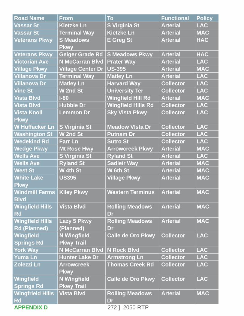
272 ] 2050 RTP
Road Name From To Functional PolicyVassar St Kietzke Ln S Virginia St Arterial LACVassar St Terminal Way Kietzke Ln Arterial MACVeterans Pkwy S Meadows
PkwyE Greg St Arterial HAC
Veterans Pkwy Geiger Grade Rd S Meadows Pkwy Arterial HACVictorian Ave N McCarran Blvd Prater Way Arterial LACVillage Pkwy Village Center Dr US-395 Arterial MACVillanova Dr Terminal Way Matley Ln Arterial LACVillanova Dr Matley Ln Harvard Way Collector LACVine St W 2nd St University Ter Collector LACVista Blvd I-80 Wingfield Hill Rd Arterial MACVista Blvd Hubble Dr Wingfield Hills Rd Collector LACVista Knoll Pkwy
Lemmon Dr Sky Vista Pkwy Collector LAC
W Huffacker Ln S Virginia St Meadow VIsta Dr Collector LACWashington St W 2nd St Putnam Dr Collector LACWedekind Rd Farr Ln Sutro St Collector LACWedge Pkwy Mt Rose Hwy Arrowcreek Pkwy Arterial MACWells Ave S Virginia St Ryland St Arterial LACWells Ave Ryland St Sadleir Way Arterial MACWest St W 4th St W 6th St Arterial MACWhite Lake Pkwy
US395 Village Pkwy Arterial MAC
Windmill Farms Blvd
Kiley Pkwy Western Terminus Arterial MAC
Wingfield Hills Rd
Vista Blvd Rolling Meadows Dr
Arterial MAC
Wingfield Hills Rd (Planned)
Lazy 5 Pkwy (Planned)
Rolling Meadows Dr
Arterial MAC
Wingfield Springs Rd
N Wingfield Pkwy Trail
Calle de Oro Pkwy Collector LAC
York Way N McCarran Blvd N Rock Blvd Collector LACYuma Ln Hunter Lake Dr Armstrong Ln Collector LACZolezzi Ln Arrowcreek
PkwyThomas Creek Rd Collector LAC
Wingfield Springs Rd
N Wingfield Pkwy Trail
Calle de Oro Pkwy Collector LAC
Wingfrield Hills Rd
Vista Blvd Rolling Meadows Dr
Arterial MAC
APPENDIX D
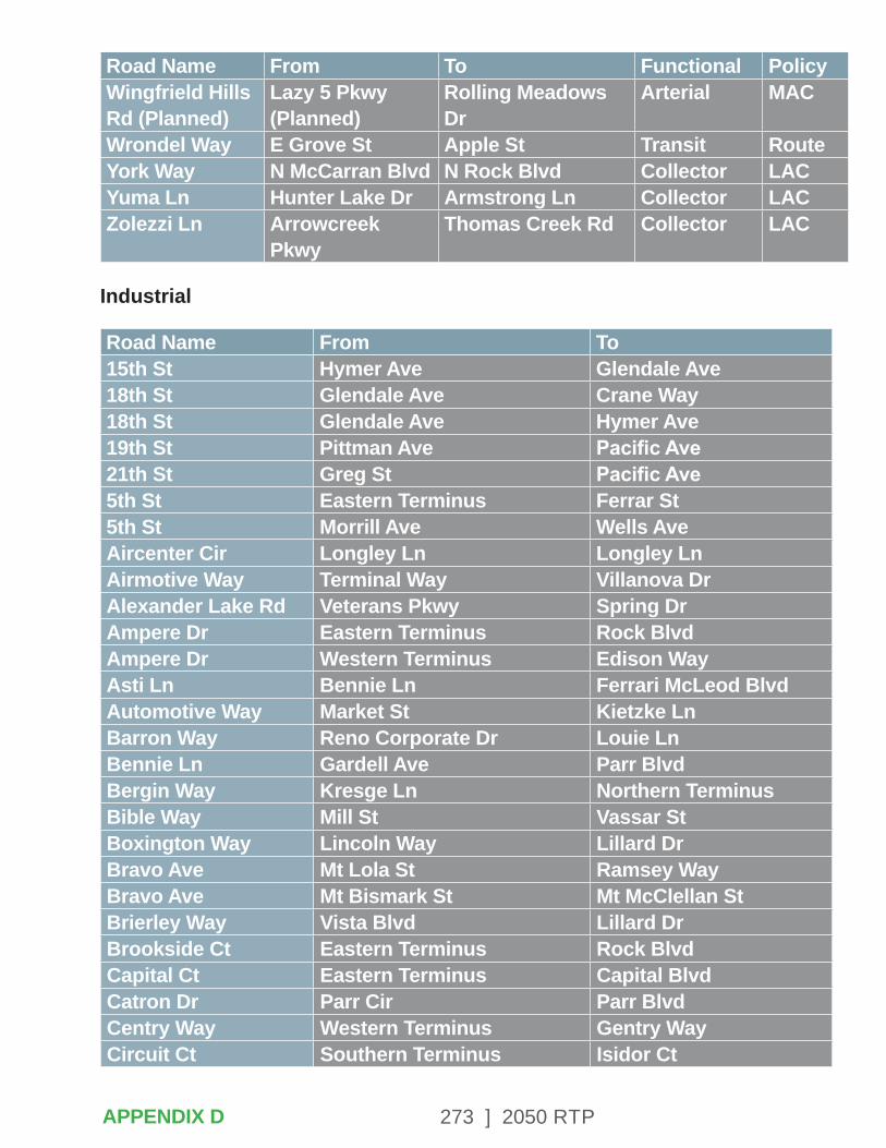
273 ] 2050 RTP
Road Name From To Functional PolicyWingfrield Hills Rd (Planned)
Lazy 5 Pkwy (Planned)
Rolling Meadows Dr
Arterial MAC
Wrondel Way E Grove St Apple St Transit RouteYork Way N McCarran Blvd N Rock Blvd Collector LACYuma Ln Hunter Lake Dr Armstrong Ln Collector LACZolezzi Ln Arrowcreek
PkwyThomas Creek Rd Collector LAC
Industrial
Road Name From To15th St Hymer Ave Glendale Ave18th St Glendale Ave Crane Way18th St Glendale Ave Hymer Ave19th St Pittman Ave Pacific Ave21th St Greg St Pacific Ave5th St Eastern Terminus Ferrar St5th St Morrill Ave Wells AveAircenter Cir Longley Ln Longley LnAirmotive Way Terminal Way Villanova DrAlexander Lake Rd Veterans Pkwy Spring DrAmpere Dr Eastern Terminus Rock BlvdAmpere Dr Western Terminus Edison WayAsti Ln Bennie Ln Ferrari McLeod BlvdAutomotive Way Market St Kietzke LnBarron Way Reno Corporate Dr Louie LnBennie Ln Gardell Ave Parr BlvdBergin Way Kresge Ln Northern TerminusBible Way Mill St Vassar StBoxington Way Lincoln Way Lillard DrBravo Ave Mt Lola St Ramsey WayBravo Ave Mt Bismark St Mt McClellan StBrierley Way Vista Blvd Lillard DrBrookside Ct Eastern Terminus Rock BlvdCapital Ct Eastern Terminus Capital BlvdCatron Dr Parr Cir Parr BlvdCentry Way Western Terminus Gentry WayCircuit Ct Southern Terminus Isidor Ct
APPENDIX D
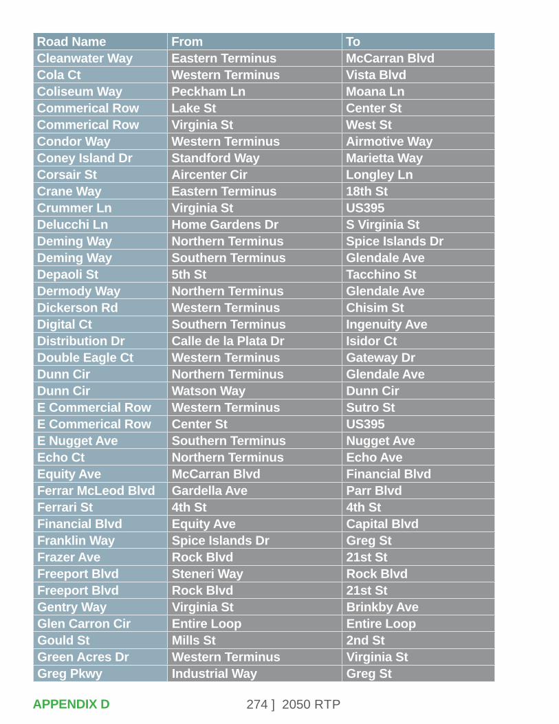
274 ] 2050 RTP
Road Name From ToCleanwater Way Eastern Terminus McCarran BlvdCola Ct Western Terminus Vista BlvdColiseum Way Peckham Ln Moana LnCommerical Row Lake St Center StCommerical Row Virginia St West StCondor Way Western Terminus Airmotive WayConey Island Dr Standford Way Marietta WayCorsair St Aircenter Cir Longley LnCrane Way Eastern Terminus 18th StCrummer Ln Virginia St US395Delucchi Ln Home Gardens Dr S Virginia StDeming Way Northern Terminus Spice Islands DrDeming Way Southern Terminus Glendale AveDepaoli St 5th St Tacchino StDermody Way Northern Terminus Glendale AveDickerson Rd Western Terminus Chisim StDigital Ct Southern Terminus Ingenuity AveDistribution Dr Calle de la Plata Dr Isidor CtDouble Eagle Ct Western Terminus Gateway DrDunn Cir Northern Terminus Glendale AveDunn Cir Watson Way Dunn CirE Commercial Row Western Terminus Sutro StE Commerical Row Center St US395E Nugget Ave Southern Terminus Nugget AveEcho Ct Northern Terminus Echo AveEquity Ave McCarran Blvd Financial BlvdFerrar McLeod Blvd Gardella Ave Parr BlvdFerrari St 4th St 4th StFinancial Blvd Equity Ave Capital BlvdFranklin Way Spice Islands Dr Greg StFrazer Ave Rock Blvd 21st StFreeport Blvd Steneri Way Rock BlvdFreeport Blvd Rock Blvd 21st StGentry Way Virginia St Brinkby AveGlen Carron Cir Entire Loop Entire LoopGould St Mills St 2nd StGreen Acres Dr Western Terminus Virginia StGreg Pkwy Industrial Way Greg St
APPENDIX D
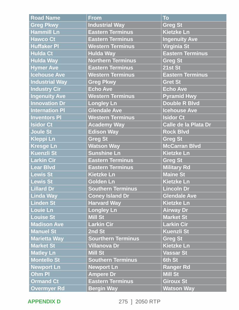
275 ] 2050 RTP
Road Name From ToGreg Pkwy Industrial Way Greg StHammill Ln Eastern Terminus Kietzke LnHawco Ct Eastern Terminus Ingenuity AveHuffaker Pl Western Terminus Virginia StHulda Ct Hulda Way Eastern TerminusHulda Way Northern Terminus Greg StHymer Ave Eastern Terminus 21st StIcehouse Ave Western Terminus Eastern TerminusIndustrial Way Greg Pkwy Gret StIndustry Cir Echo Ave Echo AveIngenuity Ave Western Terminus Pyramid HwyInnovation Dr Longley Ln Double R BlvdInternation Pl Glendale Ave Icehouse AveInventors Pl Western Terminus Isidor CtIsidor Ct Academy Way Calle de la Plata DrJoule St Edison Way Rock BlvdKleppi Ln Greg St Greg StKresge Ln Watson Way McCarran BlvdKuenzli St Sunshine Ln Kietzke LnLarkin Cir Eastern Terminus Greg StLear Blvd Eastern Terminus Military RdLewis St Kietzke Ln Maine StLewis St Golden Ln Kietzke LnLillard Dr Southern Terminus Lincoln DrLinda Way Coney Island Dr Glendale AveLinden St Harvard Way Kietzke LnLouie Ln Longley Ln Airway DrLouise St Mill St Market StMadison Ave Larkin Cir Larkin CirManuel St 2nd St Kuenzli StMarietta Way Sourthern Terminus Greg StMarket St Villanova Dr Kietzke LnMatley Ln Mill St Vassar StMontello St Southern Terminus 6th StNewport Ln Newport Ln Ranger RdOhm Pl Ampere Dr Mill StOrmand Ct Eastern Terminus Giroux StOvermyer Rd Bergin Way Watson Way
APPENDIX D
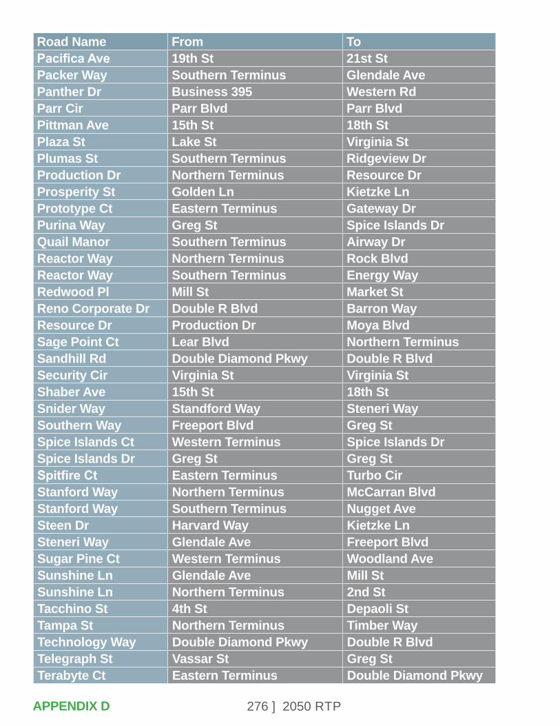
276 ] 2050 RTP
Road Name From ToPacifica Ave 19th St 21st StPacker Way Southern Terminus Glendale AvePanther Dr Business 395 Western RdParr Cir Parr Blvd Parr BlvdPittman Ave 15th St 18th StPlaza St Lake St Virginia StPlumas St Southern Terminus Ridgeview DrProduction Dr Northern Terminus Resource DrProsperity St Golden Ln Kietzke LnPrototype Ct Eastern Terminus Gateway DrPurina Way Greg St Spice Islands DrQuail Manor Southern Terminus Airway DrReactor Way Northern Terminus Rock BlvdReactor Way Southern Terminus Energy WayRedwood Pl Mill St Market StReno Corporate Dr Double R Blvd Barron WayResource Dr Production Dr Moya BlvdSage Point Ct Lear Blvd Northern TerminusSandhill Rd Double Diamond Pkwy Double R BlvdSecurity Cir Virginia St Virginia StShaber Ave 15th St 18th StSnider Way Standford Way Steneri WaySouthern Way Freeport Blvd Greg StSpice Islands Ct Western Terminus Spice Islands DrSpice Islands Dr Greg St Greg StSpitfire Ct Eastern Terminus Turbo CirStanford Way Northern Terminus McCarran BlvdStanford Way Southern Terminus Nugget AveSteen Dr Harvard Way Kietzke LnSteneri Way Glendale Ave Freeport BlvdSugar Pine Ct Western Terminus Woodland AveSunshine Ln Glendale Ave Mill StSunshine Ln Northern Terminus 2nd StTacchino St 4th St Depaoli StTampa St Northern Terminus Timber WayTechnology Way Double Diamond Pkwy Double R BlvdTelegraph St Vassar St Greg StTerabyte Ct Eastern Terminus Double Diamond Pkwy
APPENDIX D
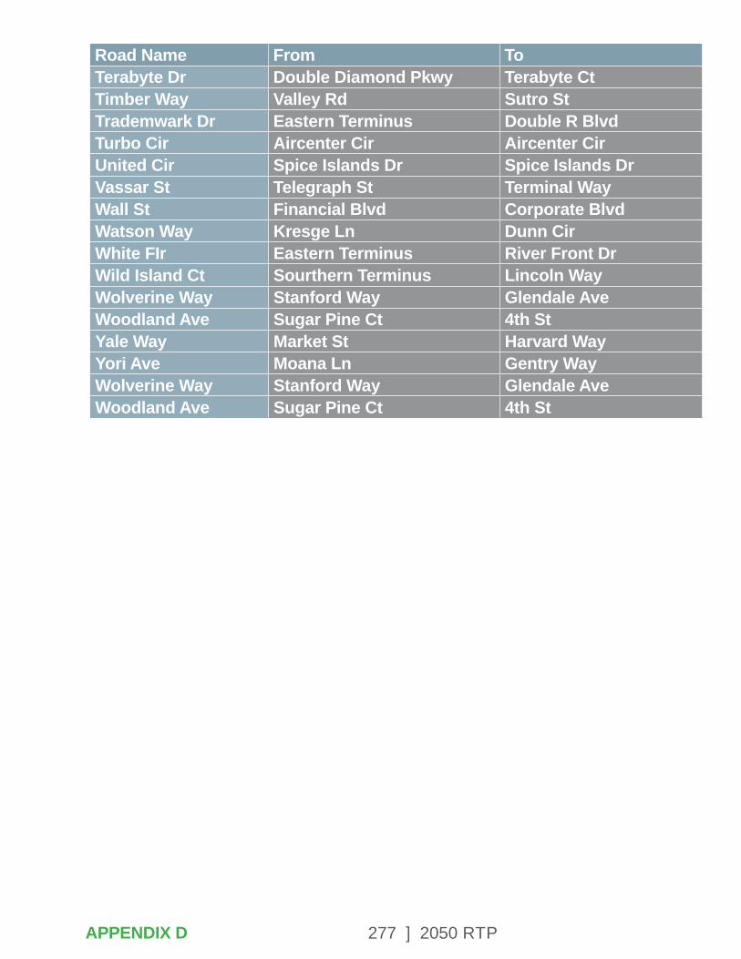
277 ] 2050 RTP
Road Name From ToTerabyte Dr Double Diamond Pkwy Terabyte CtTimber Way Valley Rd Sutro StTrademwark Dr Eastern Terminus Double R BlvdTurbo Cir Aircenter Cir Aircenter CirUnited Cir Spice Islands Dr Spice Islands DrVassar St Telegraph St Terminal WayWall St Financial Blvd Corporate BlvdWatson Way Kresge Ln Dunn CirWhite FIr Eastern Terminus River Front DrWild Island Ct Sourthern Terminus Lincoln WayWolverine Way Stanford Way Glendale AveWoodland Ave Sugar Pine Ct 4th StYale Way Market St Harvard WayYori Ave Moana Ln Gentry WayWolverine Way Stanford Way Glendale AveWoodland Ave Sugar Pine Ct 4th St
APPENDIX D

278 ] 2050 RTP
APPENDIX E – TECHNICAL DOCUMENTATION FOR THE POPULATION/ EMPLOYMENT & TRAVEL DEMAND MODELS & LEVEL OF SERVICE STANDARDS
The regional travel demand model is an essential tool for long-range planning, engineering, and public transportation operations. The model projects future travel demand and conditions on regional roads, which is essential data for scenario studies and policy analysis. The RTC TransCAD activity-based travel demand model incorporates demographic data from the 2010 U.S. Census, 2015 American Community Survey, 2015 Washoe County Travel Characteristics Survey, and 2020 Washoe County Consensus Forecasts for population and employment developed by the TMRPA.
POPULATION & EMPLOYMENT MODEL
TMRPA developed the population and employment forecasts used in the regional travel demand model in partnership with RTC, NDOT, Washoe County, Reno, and Sparks. TMRPA developed an allocation -based model to visually display a variety of population growth scenarios. The Washoe County Consensus Forecasts were developed in 2020 and establish the long range total population projections for Reno, Sparks, and unincorporated Washoe County. Full documentation of the Consensus Forecasts is available on the TMRPA website at https://www.tmrpa.org/files/WCConsensusForecast/2020/2020WC-ConsensusForecastFINAL.pdf.
The geographic distribution of future population and employment growth was based on issues such as approved building permits, existing land use, zoning, topography, existing and planned infrastructure, and public services. Historical growth trends and the Regional Plan Land Use Tier policies that seek to direct future growth to the urban center were incorporated. Land use forecasts in the travel demand model were developed based on the Consensus Forecast distribution. Table E-1 shows the total numbers of households, population, and employment in the travel demand model.
APPENDIX E

279 ] 2050 RTP
Table E-1. 2020 Consensus Forecast Totals
Model Year 2020 2025 2030 2040 2050Households 187,558 199,384 209,470 224,738 238,244Population 473,721 504,914 528,136 565,931 599,684Employment 291,431 307,510 325,913 360,562 392,228
TRAVEL DEMAND MODEL
The RTC travel demand model uses the tour-based or activity-based travel demand modeling (ABM) approach, which provides better model reliability. In contrast to the traditional, aggregated, and 4-step modeling procedures developed beginning in the 1950s Urban Transportation Planning Package, the ABM focuses primarily on trip behaviors and travel patterns of disaggregated individuals.
To better capture and explain regional traffic patterns, ABM incorporates sub-procedures such as choice of travel time of day, destination and mode selection of travel, and choice of activity patterns. Those sub-procedures are based on individual travel characteristics. As a result, this modeling tool provides better model predictability with more realistic, individual traffic patterns.
This travel demand model requires a wide variety of data inputs. The major data categories that fed the construction of the model are shown in Table E-2.
APPENDIX E
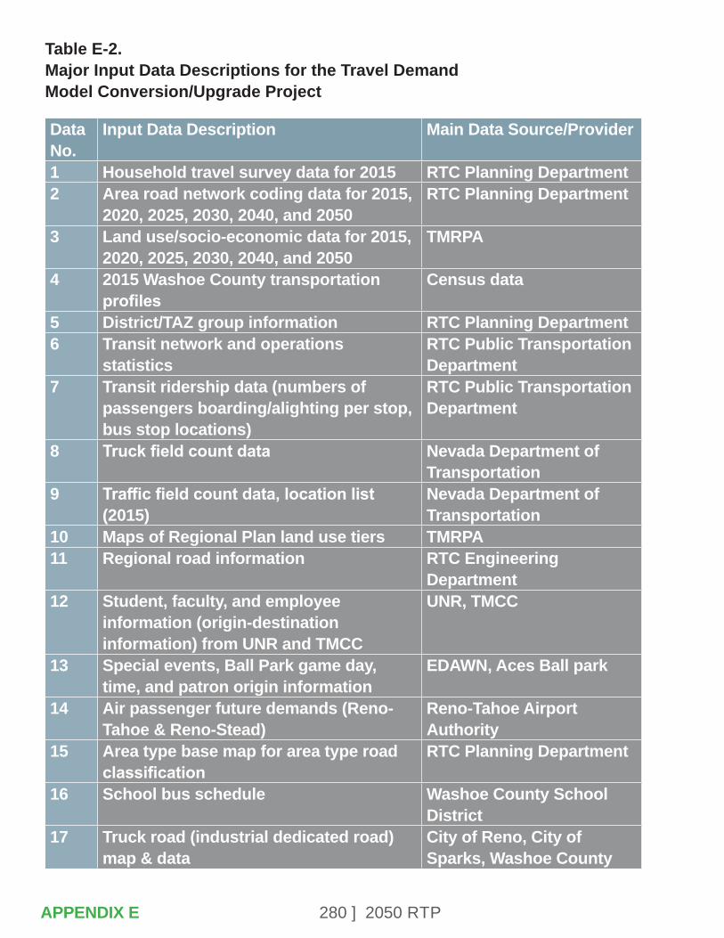
280 ] 2050 RTP
Table E-2. Major Input Data Descriptions for the Travel Demand Model Conversion/Upgrade Project
Data No.
Input Data Description Main Data Source/Provider
1 Household travel survey data for 2015 RTC Planning Department2 Area road network coding data for 2015,
2020, 2025, 2030, 2040, and 2050RTC Planning Department
3 Land use/socio-economic data for 2015, 2020, 2025, 2030, 2040, and 2050
TMRPA
4 2015 Washoe County transportation profiles
Census data
5 District/TAZ group information RTC Planning Department6 Transit network and operations
statisticsRTC Public Transportation Department
7 Transit ridership data (numbers of passengers boarding/alighting per stop, bus stop locations)
RTC Public Transportation Department
8 Truck field count data Nevada Department of Transportation
9 Traffic field count data, location list (2015)
Nevada Department of Transportation
10 Maps of Regional Plan land use tiers TMRPA11 Regional road information RTC Engineering
Department12 Student, faculty, and employee
information (origin-destination information) from UNR and TMCC
UNR, TMCC
13 Special events, Ball Park game day, time, and patron origin information
EDAWN, Aces Ball park
14 Air passenger future demands (Reno-Tahoe & Reno-Stead)
Reno-Tahoe Airport Authority
15 Area type base map for area type road classification
RTC Planning Department
16 School bus schedule Washoe County School District
17 Truck road (industrial dedicated road) map & data
City of Reno, City of Sparks, Washoe County
APPENDIX E
281 ] 2050 RTP
For data item No. 1 in Table E-2, RTC provided the latest, comprehensive and area-wide transportation survey, which was conducted in 2015. The Washoe County Travel Characteristics Study consists of four sub-surveys: Household Travel Survey, Transit On-board Survey, Visitor Travel Survey, and External Station Study. The survey data was utilized as major input data for development of parameters and coefficients of the model calibrations as well as field data to validation of model estimations. In the model development process, the model was calibrated with the 2015 base year. The RTC defined five study years for this RTP: 2020, 2025, 2030, 2040, and 2050.
TMRPA provided land use and socio-economic data. The agency developed a socio-economic and land use forecasting model to allocate the Consensus Forecast population and employment totals by jurisdiction to parcels and traffic analysis zones as shown below. TMRPA also provided future estimates for the socio-economic data. These socio-economic data include:
• Number of households within the TAZ during the year specified.
• Number of people (not living in group quarters) within the TAZ during the year specified.
• Number of people living in group quarters within the TAZ during the year specified.
• Number of households by size in the TAZ for the model year.
• Numbers of people in age groups 0 to 19, 20 to 54, and 55 and older living within the TAZ during the year specified.
• Number of students enrolled in elementary school and middle school within the TAZ during the year specified.
• Number of students enrolled in high school within the TAZ during the year specified.
• Number of students enrolled in college (UNR and TMCC) within the TAZ during the year specified.
• Numbers of households with income in the low range (less than or equal to $35,000), medium range ($35,000 to $75,000), and high range (greater than $75,000) within the TAZ during the year specified.
• Number of employees within the TAZ during the specified year, in categories of:
- Agriculture, Mining, and Construction
- Manufacturing, Transportation, Communications, Utilities, and Wholesale
- Retail
APPENDIX E
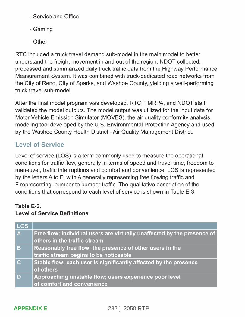
282 ] 2050 RTP
- Service and Office
- Gaming
- Other
RTC included a truck travel demand sub-model in the main model to better understand the freight movement in and out of the region. NDOT collected, processed and summarized daily truck traffic data from the Highway Performance Measurement System. It was combined with truck-dedicated road networks from the City of Reno, City of Sparks, and Washoe County, yielding a well-performing truck travel sub-model.
After the final model program was developed, RTC, TMRPA, and NDOT staff validated the model outputs. The model output was utilized for the input data for Motor Vehicle Emission Simulator (MOVES), the air quality conformity analysis modeling tool developed by the U.S. Environmental Protection Agency and used by the Washoe County Health District - Air Quality Management District.
Level of ServiceLevel of service (LOS) is a term commonly used to measure the operational conditions for traffic flow, generally in terms of speed and travel time, freedom to maneuver, traffic interruptions and comfort and convenience. LOS is represented by the letters A to F; with A generally representing free flowing traffic and F representing bumper to bumper traffic. The qualitative description of the conditions that correspond to each level of service is shown in Table E-3. Table E-3. Level of Service Definitions
LOSA Free flow; individual users are virtually unaffected by the presence of
others in the traffic streamB Reasonably free flow; the presence of other users in the
traffic stream begins to be noticeableC Stable flow; each user is significantly affected by the presence
of othersD Approaching unstable flow; users experience poor level
of comfort and convenience
APPENDIX E
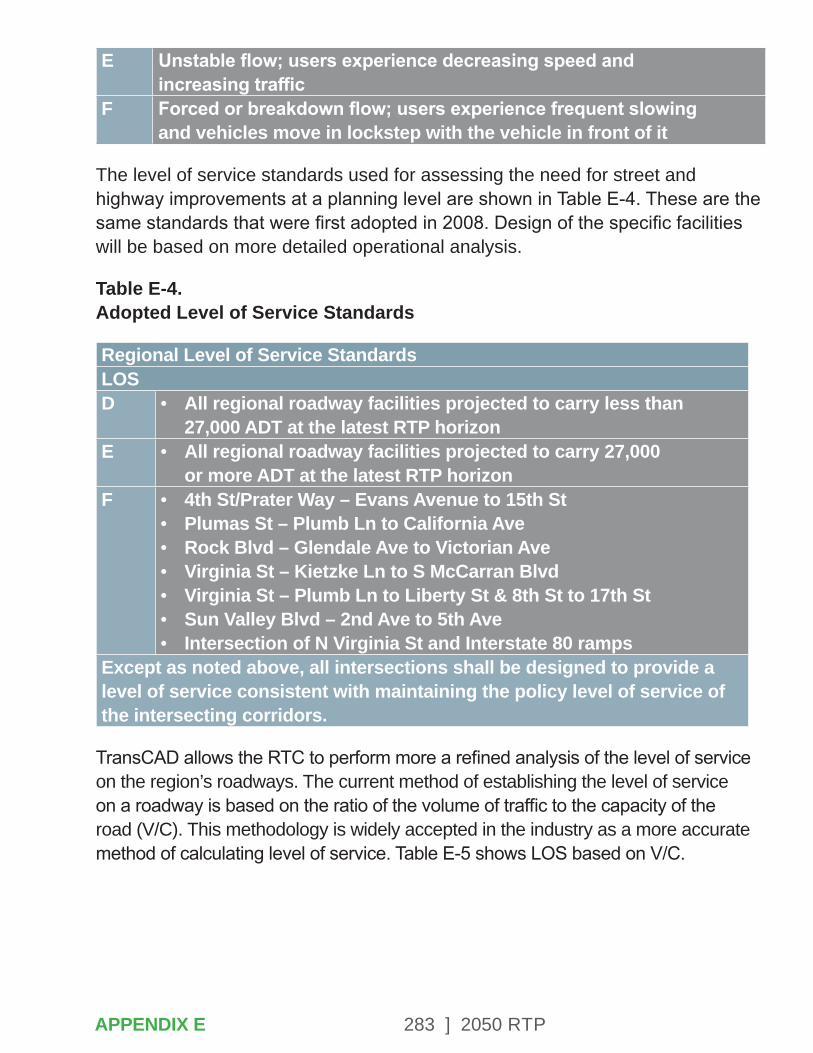
283 ] 2050 RTP
E Unstable flow; users experience decreasing speed and increasing traffic
F Forced or breakdown flow; users experience frequent slowing and vehicles move in lockstep with the vehicle in front of it
The level of service standards used for assessing the need for street and highway improvements at a planning level are shown in Table E-4. These are the same standards that were first adopted in 2008. Design of the specific facilities will be based on more detailed operational analysis.
Table E-4. Adopted Level of Service Standards
Regional Level of Service StandardsLOSD • All regional roadway facilities projected to carry less than
27,000 ADT at the latest RTP horizonE • All regional roadway facilities projected to carry 27,000
or more ADT at the latest RTP horizonF • 4th St/Prater Way – Evans Avenue to 15th St
• Plumas St – Plumb Ln to California Ave• Rock Blvd – Glendale Ave to Victorian Ave• Virginia St – Kietzke Ln to S McCarran Blvd• Virginia St – Plumb Ln to Liberty St & 8th St to 17th St• Sun Valley Blvd – 2nd Ave to 5th Ave• Intersection of N Virginia St and Interstate 80 ramps
Except as noted above, all intersections shall be designed to provide a level of service consistent with maintaining the policy level of service of the intersecting corridors.
TransCAD allows the RTC to perform more a refined analysis of the level of service on the region’s roadways. The current method of establishing the level of service on a roadway is based on the ratio of the volume of traffic to the capacity of the road (V/C). This methodology is widely accepted in the industry as a more accurate method of calculating level of service. Table E-5 shows LOS based on V/C.
APPENDIX E
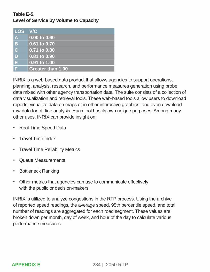
284 ] 2050 RTP
Table E-5. Level of Service by Volume to Capacity
LOS V/CA 0.00 to 0.60B 0.61 to 0.70C 0.71 to 0.80D 0.81 to 0.90E 0.91 to 1.00F Greater than 1.00
INRIX is a web-based data product that allows agencies to support operations, planning, analysis, research, and performance measures generation using probe data mixed with other agency transportation data. The suite consists of a collection of data visualization and retrieval tools. These web-based tools allow users to download reports, visualize data on maps or in other interactive graphics, and even download raw data for off-line analysis. Each tool has its own unique purposes. Among many other uses, INRIX can provide insight on:
• Real-Time Speed Data
• Travel Time Index
• Travel Time Reliability Metrics
• Queue Measurements
• Bottleneck Ranking
• Other metrics that agencies can use to communicate effectively with the public or decision-makers
INRIX is utilized to analyze congestions in the RTP process. Using the archive of reported speed readings, the average speed, 95th percentile speed, and total number of readings are aggregated for each road segment. These values are broken down per month, day of week, and hour of the day to calculate various performance measures.
APPENDIX E
285 ] 2050 RTP
APPENDIX F – REVENUE ASSUMPTIONS
As part of the development of the 2050 Regional Transportation Plan, federal regulations require the total cost of projects in the financially constrained list of projects not exceed the total revenues reasonably expected to be available to the Washoe County Region over the life of the plan. This document outlines the assumptions used to project these revenues for the Washoe County Region through the year 2050.
Under rules and direction from FHWA and FTA, the financial constraint of the RTP must be shown in YOE dollars. Converting all costs and revenues to YOE dollars assumes a more accurate depiction of all costs, revenues and deficits associated with long-range transportation plans.
ASSUMPTIONS
This document describes the assumptions the Regional Transportation Commission of Washoe County adopted to meet the regulatory requirements as it concerns federal, state, regional and local funding sources and the distribution and use of revenue expected from these sources.
Once the assumptions were determined, an estimate of how much revenue was available for debt service, street and highway routine maintenance and operations, system preservation and highway modernization, facilities, transit, and other infrastructure and overhead cost and reserves was developed.
While it is difficult to forecast transportation revenues over a long period especially in this time of uncertainty; when developing these projections RTC examined and relied on historical growth trends of current revenue sources attributable to the Reno-Sparks urban area. RTC also considered current conditions, the effects of inflation, changes in population and made thoughtful decisions about what is expected to occur in this region over the next thirty years. Using these indicators as a base; it seems reasonable to assume that there will be increases in all revenue sources over this plan period and that the program of projects adopted will not exceed these reasonable foreseeable future revenues. Since these plans are reviewed every three to four years, timely adjustments can be addressed when and as needed.
These assumptions were developed with input and collaboration from many parties including the FHWA, the FTA, NDOT, and Nevada MPOs.
APPENDIX F
286 ] 2050 RTP
FUNDING SOURCES
The Reno-Sparks Regional Financial Plan includes multiple funding sources. The timing of this plan happens to coincide with the beginning of a new Presidential administration, and there is a degree of uncertainty regarding the types of transportation programs as well as associated funding that will continue under the current administration. There continues to be concern about maintaining the current revenue streams at the federal and state levels. Money that funds the Federal Highway trust fund (includes Highway Account and the Mass Transit Account) primarily comes from gas tax which has not been increased since 1993. Fuel consumption is declining primarily due to more fuel efficient vehicles. In Washoe County, the fuel tax is dedicated by law for street and highway purposes. It was indexed to inflation in 2010 following voter approval and the enactment of Senate Bill 201.Conversely, the primary source of revenue for transit is the local sales tax which fluctuates with changes in the economy.
Initiatives having the biggest impact on the revenue assumptions are in three critical categories; a future surface transportation bill, fuel indexing, and the RRIF program.
The FAST ActThe FAST Act was set to expire in September 2020, but has been extended to the end of federal fiscal year 2021 through a continuing resolution (CR) authorized by Congress. The FAST Act authorized $305 billion over fiscal years 2016 through 2020 for highway, highway and motor vehicle safety, public transportation, motor carrier safety, hazardous materials safety, rail, and research, technology, and statistics programs. Talks of a comprehensive funding package has been on-going for the last few years. While a consensus has not been reached on a final bill, some short-term funding methods have been implemented beyond the FAST Act. It is expected that a long-term solution will be passed in 2021 to maintain current funding levels. Any changes in programs or funding levels provided in the next reauthorization legislation will be incorporated into updated financial assumptions in the next major plan update in four years.
At the federal level, there is a significant shortfall of funding. This coupled with recent changes, in the regulatory framework means that RTC must use local resources more sparingly. This financial plan reflects the most current data available at the time these revenue assumptions were prepared.
APPENDIX F
287 ] 2050 RTP
Revenue projections for federal transportation programs were made based on the structure of federally funded programs identified through the FAST Act. The base year for revenue projections in this document is FY 2020. The FAST Act provided for an annual increase of approximately 2% per year across the board for all funding categories over the five-year life of the bill; that same increase is assumed over the next 30 years.
IndexingA strong revenue component of the plan is that local fuel tax rates have been adjusted to inflation when Senate Bill 201 (indexing of local, State and Federal fuel taxes) was approved by the Legislature in June 2009. The Street and Highway program received a substantial revenue boost from this initiative. The purpose is to recapture the lost purchasing power on the federal and state fuel taxes being paid in Washoe County by indexing the federal and state taxes on gas, alternative fuels and diesel. Collections of the producer price indexed (PPI) fuel taxes began on January 1, 2010. The RTC received the first proceeds in March 2010. It has also allowed the Commission greater flexibility in programming capital improvements and maintenance activities by easing cash flow constraints.
RRIFBeginning in 1995, RRIFs have been levied on all new development to capture the costs of capacity consumed by new traffic on the defined Regional Road System. Since the adoption of the previous plan, development has continued to steadily increase, and the RRIF program is anticipated to alleviate a portion of the cost of necessary transportation infrastructure improvements to support that development.
FINANCIAL ASSUMPTIONS – REVENUE SOURCES
Revenue sources relevant to this section are those received from the federal government; received from the State of Nevada; those generated by Regional and Local fuel and sales tax; and other revenue sources related to both the street and highway and the public transportation programs.
APPENDIX F
288 ] 2050 RTP
Street and Highway RevenueFederal Funding Sources
As previously stated, through the recently expired FAST Act, core federal programs including the NHPP, STBG, HSIP, CMAQ and the Transportation Alternatives Set-Aside program are assumed to grow at a rate of 2% annually. The RTC of Washoe County is projected to receive a proportionate share of the amount allocated to Nevada based on taxable gallons of gasoline/gasohol fuel sold. Based on population, Washoe County’s percentage is assumed at 15.2%.
State Highway Fund Revenue
Projections for future state contributions were based on historic data and forecast trends. RTC staff met with NDOT staff during the development of this plan to review the assumptions included in this document. Based on this and earlier discussion with NDOT staff, with the exception of gas and diesel tax (see fuel tax section) all state revenue are also assumed to grow at a rate of 2% annually. The principal sources of state transportation funding are:
• Gas Taxes
• Special Fuel (Diesel) Taxes
• Vehicle Registration Fees
• Motor Carrier Fees
• Driver’s License Fees
• SBS Petroleum Cleanup Funds
Fuel Tax (Local, State and Indexed)
Per NRS, this revenue source must be used exclusively for street and highway projects. The indexed portion of this revenue source was approved by Washoe County voters in November 2008. Key assumptions used to forecast local gas and state gas tax (including diesel) are as follows:
• Continued adjustments to gas tax to recapture buying power lost to inflation at an average annual change in CPI of 3%.
• Gasoline use will increase proportionate to population growth based on Washoe County consensus forecast.
• Per Capita consumption of gas changes at a rate consistent with a combination of the SAFE Average Fuel Economy (SAFE) standard and the Corporate Average Fuel Economy (CAFÉ) standard over the 30 year period.
APPENDIX F
289 ] 2050 RTP
• Vehicle turnover rate is projected at .055. The rate used accounts for baby boomers retiring and downsizing of vehicles per household.
Sales and Use Tax
• 1/8% dedicated to either Roads or Transit as approved by voters in 2002. By policy, the RTC Board has authorized a proportional split between Roads and Transit based on program budget need.
• Based on historic trends, revenue is expected to grow at an annual rate of 3% for the base year of 2020.
Public Transportation RevenueFederal Funding Sources
FTA Urbanized Area Formula Program (5307)
As previously mentioned, with the FAST Act extension, some short-term funding methods were implemented and it is expected that a long-term solution will be put in place to maintain current funding levels. Some modifications could be made to this program but the basic structure is expected to be maintained. The FTA provides these funds to urban areas to support public transportation planning, capital and operating projects.
These funds are projected to grow at a rate of 2% annually. For this plan, it is assumed that 70% of these funds will be used for operating assistance and 30% for capital assistance.
FTA Bus and Bus Facilities Program (5339)
Under the FAST Act, these funds were put in place to replace, rehabilitate and purchase buses, vans and related equipment, and to construct bus-related facilities. Funding was provided through formula allocations and competitive grants. Under the FAST Act, two discretionary components were added to this program: A bus and bus facilities competitive program based on asset age and condition, and a low or no emissions bus deployment program. This program is assumed to continue as structured under the FAST Act. These funds are projected to grow at a rate of 2% annually.
CMAQ
CMAQ funds can only be used for projects that reduce, delay or make significant improvements to overall regional air quality. These funds can be used for both capital and operating assistance and for both street and highway and transit projects. These funds are projected to grow at a rate of 2% annually.
APPENDIX F
290 ] 2050 RTP
These funds are flexed between the transit and road program based on the projects that support the purpose of this funding category requirement.
State RevenueAll current funding for public transportation is generated at the federal, regional and local levels with a very small amount from state resources.
Regional RevenueSales and Use Tax
• 1/4% dedicated to Public Transportation as approved by voters in 1982.
• 1/8% dedicated to either Roads or Transit as approved by voters in 2002. By policy, the RTC Board has authorized a proportional split between Roads and Transit program based on budget need.
• Based on historic trends, revenue is expected to grow at an annual rate of 3% for the base year of 2020.
Passenger Fares
• Fares will be continually evaluated based on current performance levels before implementing a new fare.
• This plan includes a slight increase in Fare Revenue annually based on a projected increase in ridership.
Other Revenue Sources
• Other revenue sources include bus advertising revenue; which is calculated based on a fleet of 71 active coaches with a 2.1% annual growth rate.
• Other revenue sources also include rental income.
APPENDIX F
291 ] 2050 RTP
APPENDIX G – DOWNTOWN RENO CIRCULATION STUDY
IntroductionAn evaluation of the Downtown Reno area was conducted in conjunction with the 2050 Regional Transportation Plan (RTP). The purpose of the Study is to:
• Address transportation safety, operations, and mobility needs in Downtown Reno.
• Support a vibrant Downtown through transportation investments.
• Connect surrounding neighborhoods and the University of Nevada, Reno, to Downtown.
• Identify potential projects to consider in the 2050 RTP.
The study area extends from Keystone Avenue in the west to Wells Avenue in the east and from Liberty Street in the south to University Terrace/9th Street in the north.
This analysis was conducted as part of the RTP at the request of the City of Reno.
COMMUNITY ENGAGEMENT
Staff from the City of Reno and RTC collaborated to analyze a series of transportation alternatives. These options were presented to the public and stakeholders through a virtual workshop. The workshop included a video presentation and provided an opportunity for individuals to submit comments about the alternatives as well as other suggestions or ideas. The virtual meeting was available from November 13 through December 11, 2020. Presentations of the concept were also made to the Downtown Reno Partnership. The concepts for Downtown were presented to the Reno City Council on January 27, 2021 as part of the larger 2050 RTP.
APPENDIX G
292 ] 2050 RTP
EXISTING CONDITIONS & NEEDS ASSESSMENT
Downtown Reno Action PlanThe 2017 Downtown Circulation Study builds on the work completed previously by the City of Reno in the Downtown Reno Action Plan. The core values of this plan support a Downtown that is:
• Prosperous
• Safe & Clean
• Connected
• Vibrant
• Livable
For transportation, the Action Plan calls for improving walking, biking, and transit options to UNR, the Truckee River, close in neighborhoods, and other destinations. Specific transportation recommendations in the Action Plan are listed below.
• Bike lanes on Evans Street from 2nd Street to UNR (completed).
• Bike lanes on Arlington Avenue from W. 1st Street to the I-80 pedestrian bridge (completed).
• Bike lanes on Washington Street from Riverside Drive beyond I-80 up to San Rafael Park (the Downtown Circulation Study recommends Vine Street, due to the signalized intersection at 4th Street that improves crossing safety).
• Bike lanes on 4th Street (the Downtown Circulation Study recommends 3rd Street for a protected bike facility due to lower traffic volumes).
• Bike lanes on 5th Street from Keystone Avenue to Evans Avenue (recommended in the Downtown Circulation Study).
• Bike lanes on Liberty Street from Arlington to Holcomb Avenue.
• A major consideration for Sierra Street in the long term is to reduce it from 3 lanes to 2 lanes with the remaining space dedicated to pedestrians and bicycles.
Planned DevelopmentRTC collaborated with the City of Reno and Truckee Meadows Regional Planning Agency to identify potential new development in the Downtown area that could increase population and employment. This information was included in the RTC travel demand model to estimate a build-out scenario and ensure adequate transportation capacity is provided for long-term growth.
Safety
Using crash data provided by the Nevada Department of Transportation for the years 2015-2017, RTC identified high crash corridors throughout the region.
293 ] 2050 RTP
The analysis considered crash rate, crash severity, and crash frequency. Several roads in the Downtown Reno area were identified as high-crash corridors:
• W 2nd Street
• W 4th Street
• W 5th Street
• E 6th Street
• Center Street
• Sierra Street
• Arlington Avenue
• Virginia Street
• Lake Street
The majority of these roadways have very low traffic volumes, which contributes to high travel speeds. The Downtown area also has high levels of pedestrian activity, with minimal separation from the roadway in many locations. High travel speeds are a leading cause of the crashes in Downtown. Speed increases the severity of crashes, particularly crashes that involve pedestrians and bicyclists. The lack of designated space for active transportation modes increases potential conflict points.
Traffic AnalysisThe Downtown area benefits from an interconnected grid street network that provides multiple access points and travel options. The primary barriers to accessing downtown are I-80 and the Truckee River. Based on existing and projected traffic patterns and in consultation with the City of Reno, the primary corridors for auto access were identified on 4th Street, Sierra Street, and 2nd Street. Center Street and Liberty Street from Holcomb Avenue to Arlington Avenue are also important for vehicular movement to and through Downtown. Existing traffic volumes on several corridors are very low, resulting in high travel speeds that contribute to pedestrian and bicycle-involved crashes. Even under build-out scenarios, the majority of downtown streets have low traffic volumes and all are below the capacity of the roadways.
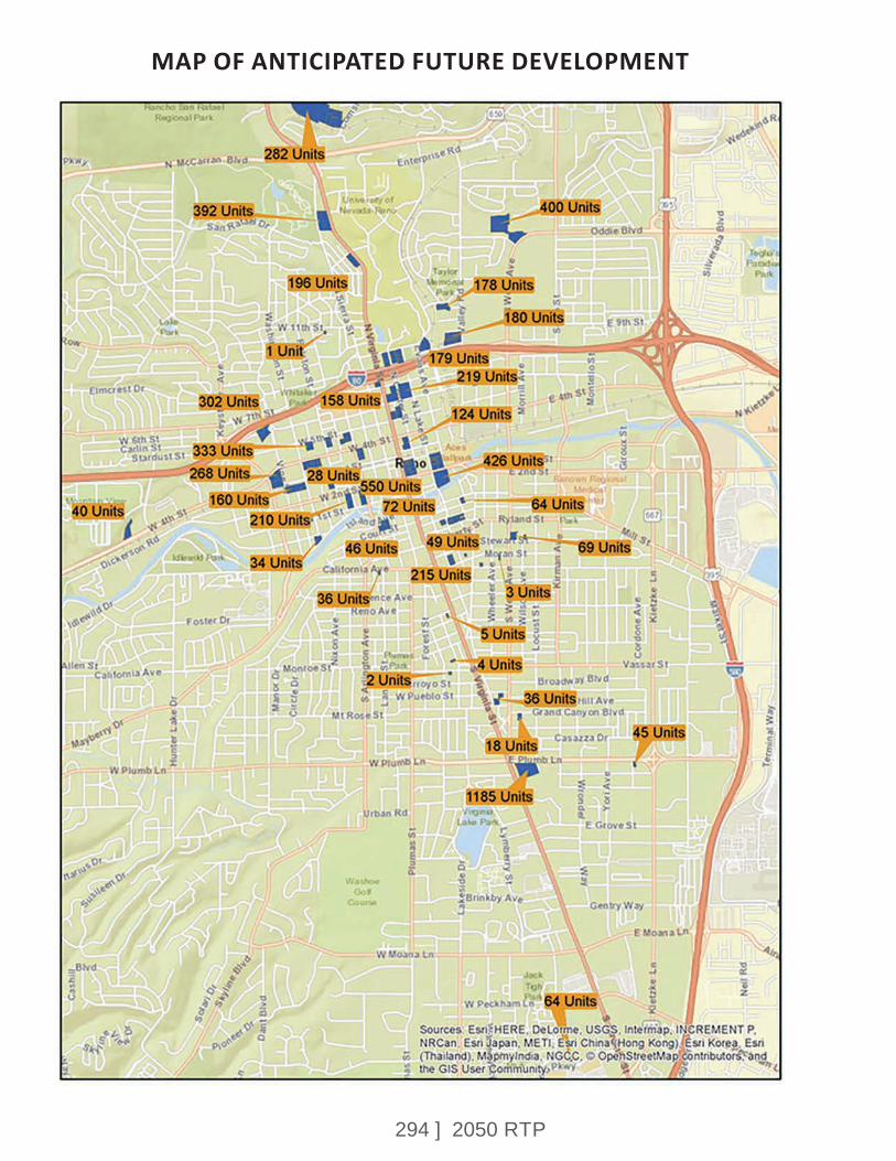
294 ] 2050 RTP
MAP OF ANTICIPATED FUTURE DEVELOPMENT
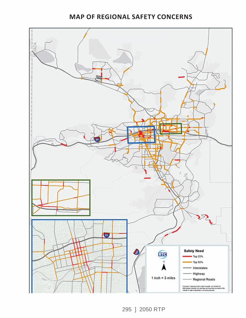
295 ] 2050 RTP
MAP OF REGIONAL SAFETY CONCERNS

296 ] 2050 RTP
The recommended scenario includes converting some streets with two lanes in each direction into streets with one lane in each direction with a center turn lane and bike lanes. This configuration reduces crashes by allowing left turn movements to pull out of the flow of traffic and into a center turn lane. It also results in motorists travelling closer to the posted speed limit. The addition of bike lanes provides a separate space for cyclists and improves sight distance and intersections. A summary table is provided below:
Street 2019 ADT Build-Out ADT with Recommended Alternative
Roadway Capacity (ADT)
W 4th St 12,200 21,154 35,200 W 5th St 5,600 6,983 13,400 E 6th St 7,200 9,458 13,400Vine St 2,000 2,904 13,400 Sierra St 10,200 10,187 20,900 Virginia St 8,900 13,096 13,400 Center St 9,750 12,188 13,400
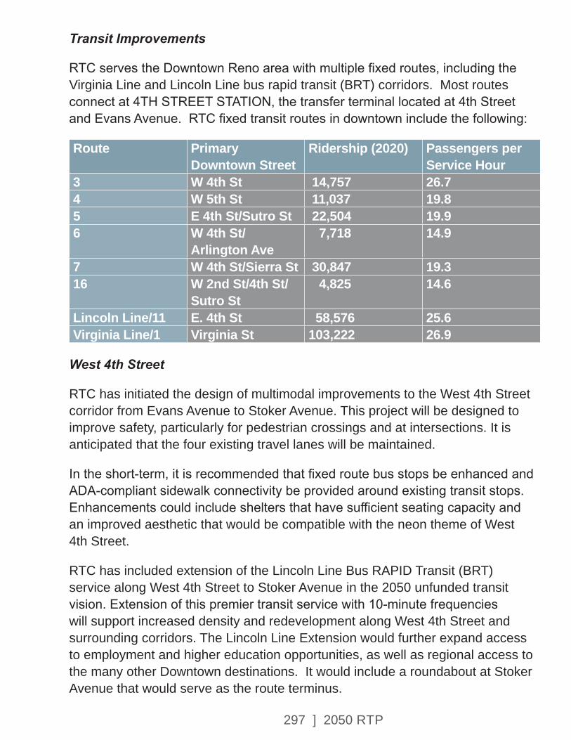
297 ] 2050 RTP
Transit Improvements
RTC serves the Downtown Reno area with multiple fixed routes, including the Virginia Line and Lincoln Line bus rapid transit (BRT) corridors. Most routes connect at 4TH STREET STATION, the transfer terminal located at 4th Street and Evans Avenue. RTC fixed transit routes in downtown include the following:
Route Primary Downtown Street
Ridership (2020) Passengers per Service Hour
3 W 4th St 14,757 26.74 W 5th St 11,037 19.85 E 4th St/Sutro St 22,504 19.96 W 4th St/
Arlington Ave 7,718 14.9
7 W 4th St/Sierra St 30,847 19.316 W 2nd St/4th St/
Sutro St 4,825 14.6
Lincoln Line/11 E. 4th St 58,576 25.6Virginia Line/1 Virginia St 103,222 26.9
West 4th Street
RTC has initiated the design of multimodal improvements to the West 4th Street corridor from Evans Avenue to Stoker Avenue. This project will be designed to improve safety, particularly for pedestrian crossings and at intersections. It is anticipated that the four existing travel lanes will be maintained.
In the short-term, it is recommended that fixed route bus stops be enhanced and ADA-compliant sidewalk connectivity be provided around existing transit stops. Enhancements could include shelters that have sufficient seating capacity and an improved aesthetic that would be compatible with the neon theme of West 4th Street.
RTC has included extension of the Lincoln Line Bus RAPID Transit (BRT) service along West 4th Street to Stoker Avenue in the 2050 unfunded transit vision. Extension of this premier transit service with 10-minute frequencies will support increased density and redevelopment along West 4th Street and surrounding corridors. The Lincoln Line Extension would further expand access to employment and higher education opportunities, as well as regional access to the many other Downtown destinations. It would include a roundabout at Stoker Avenue that would serve as the route terminus.
298 ] 2050 RTP
Sidewalk & Crosswalk Improvements
While sidewalks are present along most streets in Downtown, many are in a deteriorated condition or have ADA deficiencies. This study recommends spot improvements to enhance crosswalks and accessibility throughout Downtown, in addition to major corridor reconstruction in the West 4th Street corridor. Potential improvements for crosswalks include sidewalk bulb-outs, center median pedestrian refuges, ADA accessible pedestrian crossing buttons, and lighting.
Roadway and Bicycle Infrastructure Improvements
Safe and convenient bicycle connectivity is an important component of linking Downtown to the University and surrounding neighborhoods. This study identified corridors with lower traffic volumes that could be suitable for bicycle facilities and would encourage families and commuters surrounding downtown to bike into the center city. Corridors recommended for bicycle facility improvements include:
• Vine Street – Vine Street provides north-south connectivity on the west side of Downtown. The low traffic volumes make this a good candidate for conversion to one travel lane in each direction, a center turn lane, parking on one side of the street and buffered (separated) bike lanes.
This configuration would be feasible from 6th Street to 2nd Street. The segment between 2nd Street and Riverside Drive would be a bike boulevard with “sharrow” pavement markings and lower speed limit. It is recommended that the bridge over I-80 be converted to one-way southbound with buffered bike lanes.
• Center Street – Multimodal improvements on Center Street are currently under design and include a two-way buffered bike lane and sidewalk improvements. This critical corridor connects the University directly to Downtown and offers improved north-south connectivity in central Downtown. The project would provide a safer connection over I-80 for bicyclists, including for residents of student housing being constructed on the south side of I-80 at Center Street. Additional analysis is currently being conducted regarding bicycle improvements on Center Street compared with opportunities on Virginia Street.
• West 3rd Street/Commercial Row – This corridor has very low traffic volumes and is recommended for a buffered bike facility to provide east-west connectivity across Downtown. It would begin at Vine Street and connect to Center Street, providing access to other premier bike facilities.

299 ] 2050 RTP

300 ] 2050 RTP
In the blocks between Arlington Avenue and Virginia Street, this project would be coordinated and integrated with planned landscape and arts enhancements over the railroad tracks.
• West 5th Street – This corridor has low traffic volumes and is recommended for conversion to one travel lane in each direction, a center turn lane, on-street parking, and bike lanes. This design would calm traffic and improve safety in this high crash corridor.
• East 6th Street – This high crash corridor on the east side of Downtown is being studied for safety and multimodal improvements. It currently experiences high travel speeds as a result of low traffic volumes.
Virginia Street
Virginia Street is the heart of Downtown and home to many of the region’s premier resort destinations and special events. RTC recommends participating with the City of Reno on a more in-depth study of opportunities to revitalize this important corridor. RTC received comments during the outreach process about the need to bring more activity to Virginia Street, activate sidewalks, increase parking options, include buffered bike lanes, enhance aesthetics, close the street to cars, and develop new public plaza spaces.
Because many of these items are under the authority of the City of Reno, it is recommended that the City lead this study effort with RTC having a supporting role.
In 2012 RTC invested $2.5 million to widen sidewalks on Virginia Street and install lighting and landscaping. The wide sidewalks provide space for pedestrian activity and outdoor dining or retail. The narrow roadway width, which is 32 feet in some locations, limits the ability to add buffered bicycle facilities to Virginia Street without removing general-purpose travel lanes. RTC will provide the City with data about the potential traffic operations impacts of lane closures and participate in analysis about future bicycle facilities on Virginia Street
Truckee River Crossings
The Truckee River is an asset to the Downtown and a critical resource to the region, but also forms a barrier to transportation into Downtown. This study focuses on three primary river crossing locations:
• Arlington Bridges - RTC is currently designing replacement structures for the Arlington Avenue bridges over the Truckee River, which are structurally deficient. These structures have the lowest bridge rating of any Truckee River crossings in the region. The new bridges will include ample space for bicycle and pedestrian access.
301 ] 2050 RTP
• Booth Street Bridge – This bridge has low traffic volumes but provides an important connection for access to Reno High School and Idlewild Park. The current structure is being studied by the Truckee River Flood Management Authority, which is considering options to remove or raise the structure to reduce flooding risks. If removed, consideration could be given to a new bicycle/pedestrian bridge. If raised, consideration could be given to expanding facilities for walking and biking.
• Dickerson Road/Chism Street – The addition of a bicycle and pedestrian bridge over the Truckee River near the intersection of Dickerson Road/2nd Street and Chism Street is recommended to provide improved access to Idlewild Plark and into Downtown. This structure would need to be coordinated with the Truckee River Flood Management Authority.
• Keystone Bridge – Replacement of the Keystone Avenue bridge over the Truckee River has been identified for replacement in the RTP, with design for this project beginning within the next five years. The bridge is structurally deficient and functionally obsolete. This project is integrated with safety and access management improvements on Keystone Avenue between California Avenue and I-80.
• Sierra Street Bridge – This bridge is structurally deficient and replacement is included in both the RTP and plans of the Truckee River Flood Management Authority.
ParkingCommunity input into the Downtown Circulation Study identified the need for additional structured parking to serve growing commercial, residential, and entertainment uses. Additional analysis regarding the location and size of a potential parking structure will be conducted by RTC. This follow-on study will also explore opportunities for a public-private partnership to build and operate a future parking facility.
NEXT STEPS
Following adoption of the 2050 RTP, RTC will identify strategies to advance the projects included in the Downtown Reno Circulation Study. The projects range in levels of complexity, from primarily signage and striping to larger scale reconstruction. Design and engineering will be required prior to construction.
302 ] 2050 RTP
APPENDIX H – SPARKS INDUSTRIAL STUDY
SPARKS INDUSTRIAL TRANSPORTATION STUDY
IntroductionA comprehensive evaluation of the Sparks Industrial area was completed in conjunction with the 2050 RTP. The goal of the Sparks Industrial Study is to address the safety, mobility, connectivity and traffic-operations issues that are resulting from increased population and employment growth in the region. The study area included Rock Boulevard, Greg Street, and Glendale Avenue. RTC transit Route 18 serves this area and is heavily utilized by people commuting to work.
This analysis was conducted as part of the RTP at the request of the City of Sparks. The Sparks Industrial area is a major employment center, generally experiences high truck traffic, and is a heavily used transit corridor.
Community EngagementAn in-person public meeting specifically addressing the Sparks Industrial Area was held on February 26, 2020. Invitees included business owners and employees of industrial businesses. Participants were provided with the opportunity to share their vision for transportation improvements in the Sparks Industrial Area by sharing transportation needs on maps. The maps included existing conditions, serious and fatal crash locations, transit in the area, and average daily traffic totals. Meeting participants evaluated gaps in the transportation network and provided input on future needs. Concerns expressed at the meeting included the following:
• Lack of pedestrian facilities.
• Lack of bicycle connectivity into the industrial area.
• Safety concerns regarding large trucks.
• Traffic operations over the long term.
• Lack of connectivity between industrial area and Downtown Sparks across I-80 and railroad barriers.
APPENDIX H
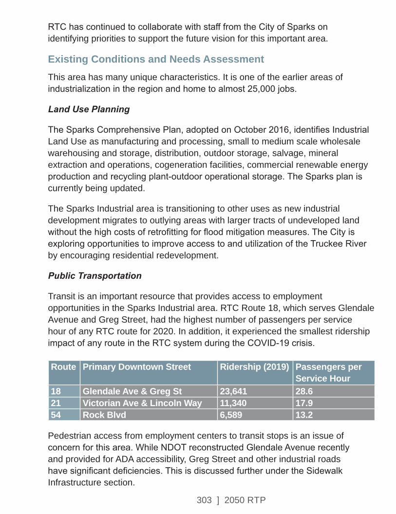
303 ] 2050 RTP
RTC has continued to collaborate with staff from the City of Sparks on identifying priorities to support the future vision for this important area.
Existing Conditions and Needs AssessmentThis area has many unique characteristics. It is one of the earlier areas of industrialization in the region and home to almost 25,000 jobs.
Land Use Planning
The Sparks Comprehensive Plan, adopted on October 2016, identifies Industrial Land Use as manufacturing and processing, small to medium scale wholesale warehousing and storage, distribution, outdoor storage, salvage, mineral extraction and operations, cogeneration facilities, commercial renewable energy production and recycling plant-outdoor operational storage. The Sparks plan is currently being updated.
The Sparks Industrial area is transitioning to other uses as new industrial development migrates to outlying areas with larger tracts of undeveloped land without the high costs of retrofitting for flood mitigation measures. The City is exploring opportunities to improve access to and utilization of the Truckee River by encouraging residential redevelopment.
Public Transportation
Transit is an important resource that provides access to employment opportunities in the Sparks Industrial area. RTC Route 18, which serves Glendale Avenue and Greg Street, had the highest number of passengers per service hour of any RTC route for 2020. In addition, it experienced the smallest ridership impact of any route in the RTC system during the COVID-19 crisis. Route Primary Downtown Street Ridership (2019) Passengers per
Service Hour18 Glendale Ave & Greg St 23,641 28.621 Victorian Ave & Lincoln Way 11,340 17.954 Rock Blvd 6,589 13.2
Pedestrian access from employment centers to transit stops is an issue of concern for this area. While NDOT reconstructed Glendale Avenue recently and provided for ADA accessibility, Greg Street and other industrial roads have significant deficiencies. This is discussed further under the Sidewalk Infrastructure section.
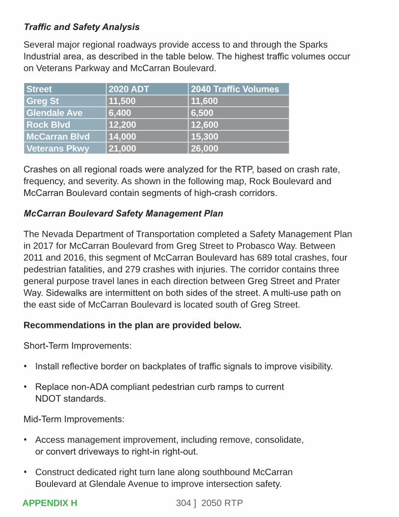
304 ] 2050 RTP
Traffic and Safety Analysis
Several major regional roadways provide access to and through the Sparks Industrial area, as described in the table below. The highest traffic volumes occur on Veterans Parkway and McCarran Boulevard.
Street 2020 ADT 2040 Traffic VolumesGreg St 11,500 11,600Glendale Ave 6,400 6,500Rock Blvd 12,200 12,600McCarran Blvd 14,000 15,300Veterans Pkwy 21,000 26,000
Crashes on all regional roads were analyzed for the RTP, based on crash rate, frequency, and severity. As shown in the following map, Rock Boulevard and McCarran Boulevard contain segments of high-crash corridors.
McCarran Boulevard Safety Management Plan
The Nevada Department of Transportation completed a Safety Management Plan in 2017 for McCarran Boulevard from Greg Street to Probasco Way. Between 2011 and 2016, this segment of McCarran Boulevard has 689 total crashes, four pedestrian fatalities, and 279 crashes with injuries. The corridor contains three general purpose travel lanes in each direction between Greg Street and Prater Way. Sidewalks are intermittent on both sides of the street. A multi-use path on the east side of McCarran Boulevard is located south of Greg Street.
Recommendations in the plan are provided below.
Short-Term Improvements:
• Install reflective border on backplates of traffic signals to improve visibility.
• Replace non-ADA compliant pedestrian curb ramps to current NDOT standards.
Mid-Term Improvements:
• Access management improvement, including remove, consolidate, or convert driveways to right-in right-out.
• Construct dedicated right turn lane along southbound McCarran Boulevard at Glendale Avenue to improve intersection safety.
APPENDIX H

305 ] 2050 RTP
• Improve right turn lanes along southbound McCarran Boulevard at Greg Street to enhance sight distances and reduce turning vehicle speeds and accommodate semi-tractor trailer trucks.
Long-Term Improvements:
• Convert existing interchange at I-80 and McCarran Boulevard to Diverging Diamond Interchange.
• Construct dedicated right turn lane for westbound I-80 on-ramp, including new bridges over McCarran Boulevard for additional lane width.
• Construct continuous flow intersection at Glendale Avenue to move left turn conflict out of the intersection and synchronize with the signal cycle of the intersecting road.
• Construct multi-use path on west side of McCarran Boulevard from Glendale Avenue to Nugget Avenue to reduce bike and pedestrian conflicts with vehicular traffic.
• Provide sidewalk along the east side of McCarran Boulevard from Greg Street to Glendale Avenue to provide pedestrian connectivity between intersections.
RecommendationsRegional Road Capital Improvements
Recommendations from the Industrial Study include major projects in the 2050 RTP such as Greg Street, McCarran Boulevard, and Rock Boulevard, as described below.
Bus Stop ADA and Connectivity Project
RTC is implementing a Bus Stop Improvement and Connectivity Program. This multi-year effort is upgrading existing public transit stops to comply with state and federal requirements, including the Americans with Disabilities Act (ADA). The first phase of bus stop improvements were located within public right-of-way (12 bus stops) and has been completed. The process of obtaining necessary easements for other locations is ongoing. The overarching goal of the Bus Stop Improvement and Connectivity Program is to provide the public with accessible transit stops and access to the nearest intersection or cross street. Bus stops on Greg Street are included in early phases of the bus stop improvement program.
APPENDIX H
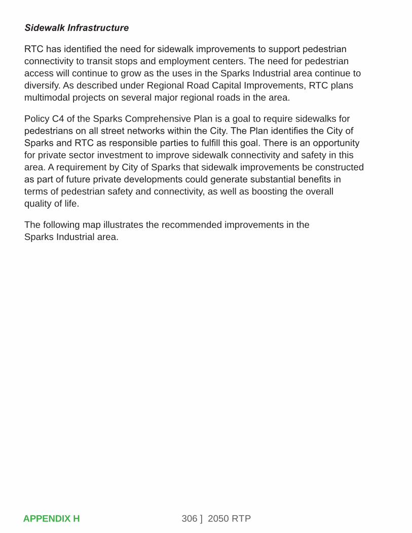
306 ] 2050 RTP
Sidewalk Infrastructure
RTC has identified the need for sidewalk improvements to support pedestrian connectivity to transit stops and employment centers. The need for pedestrian access will continue to grow as the uses in the Sparks Industrial area continue to diversify. As described under Regional Road Capital Improvements, RTC plans multimodal projects on several major regional roads in the area.
Policy C4 of the Sparks Comprehensive Plan is a goal to require sidewalks for pedestrians on all street networks within the City. The Plan identifies the City of Sparks and RTC as responsible parties to fulfill this goal. There is an opportunity for private sector investment to improve sidewalk connectivity and safety in this area. A requirement by City of Sparks that sidewalk improvements be constructed as part of future private developments could generate substantial benefits in terms of pedestrian safety and connectivity, as well as boosting the overall quality of life.
The following map illustrates the recommended improvements in the Sparks Industrial area.
APPENDIX H
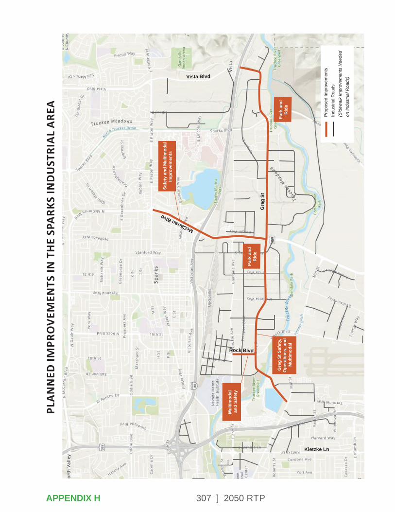
307 ] 2050 RTP
PLA
NN
ED IM
PRO
VEM
ENTS
IN T
HE
SPA
RKS
IND
UST
RIA
L A
REA
Safe
ty a
nd M
ultim
odal
Impr
ovem
ents
Park
and
Rid
e
Park
and
Rid
e
Gre
g St
Saf
ety,
Ope
ratio
ns, a
nd
Mul
timod
al
Mul
timod
al
and
Safe
ty
Kietzke Ln
Rock Blvd
McCarran Blvd
Prop
osed
Impr
ovem
ents
Indu
stria
l Roa
ds(S
idew
alk
Impr
ovem
ents
Nee
ded
on In
dust
rial R
oads
)
Gre
g St
Vista Blvd
APPENDIX H
308 ] 2050 RTP
APPENDIX I – COMMON TRANSPORTATION PLANNING ACRONYMS
ACRONYMS
AADT – Annual Average Daily Traffic
AASHTO – American Association of Street and Highway Transportation Officials
ACEC – Areas of Critical Environmental Concern
ADA – Americans with Disabilities Act of 1990
ADT – Average daily trips
APTA – American Public Transportation Association
AQMD – Air Quality Management Division
AWG – Agency Working Group
BCA – Benefit cost analysis
BLM – Bureau of Land Management
BPMP – Bicycle-Pedestrian Master Plan
BRT – Bus rapid transit
CMAC – Citizens Multimodal Advisory Committee
CALTRANS – California Department of Transportation
CAMPO – Carson Area Metropolitan Planning Organization
CCRTC – Carson City Regional Transportation Commission
CEA – Critical Emphasis Areas
CFR – Code of Federal Regulations
CMAQ – Congestion Mitigation/ Air Quality
CMP – Congestion Management Process
CNG – Compressed Natural Gas
CO – Carbon monoxide
CPI – Consumer Price Index
CTP – Coordinated Human Services Transportation Plan
DOT – Department of Transportation
EDAWN – Economic Development Authority of Western Nevada
EMP – Emergency Access Management Plan
EPA – Environmental Protection Agency
ETR – Employer Trip Reduction
APPENDIX I
309 ] 2050 RTP
FAA – Federal Aviation Administration
FAST Act – Fixing America’s Surface Transportation Act
FEIS – Final Environmental Impact Statement
FHWA – Federal Highway Administration
FRR – Farebox Recovery Ratio
FTA – Federal Transit Administration
GHG – Greenhouse Gas
HA #87 – Hydrographic Area #87
HOV – High Occupancy Vehicle
HSIP – Highway Safety Improvement Program
ITS – Intelligent Transportation System
JAC – Jump Around Carson
LEED – Leadership in Energy and Environmental Design
LOS – Level of Service
LTBMU – Lake Tahoe Basin Management Unit Land Resource Management Plan
MAP-21 – Moving Ahead for Progress in the 21st Century Act
MOVES – Motor Vehicle Emission Simulator (Air quality model)
MPO – Metropolitan Planning Organization
MUTCD – Manual of Uniform Traffic Control Devices
MVEB – Motor Vehicle Emission Budget
NAAQS – National Ambient Air Quality Standards
NARC – National Association of Regional Councils
NCA – National Conservation Area
NDOT – Nevada Department of Transportation
NDWR – Nevada Division of Water Resources
NEPA – National Environmental Policy Act
Nevada CAM – Center for Advanced Mobility
NHPP – National Highway Performance Program
NHS – National Highway System
NOX – Nitrogen Oxides
NRS – Nevada Revised Statutes
NV TIM – Nevada Traffic Incident Management
PCI – Pavement Condition Index
APPENDIX I
310 ] 2050 RTP
PD&E – Project Development and Environmental Activities
PSAP – Pedestrian Safety Action Plan
PM2.5 – Particulate Matter of less than or equal to 2.5 microns
PM10 – Particulate Matter of less than or equal to 10 microns
PMS – Pavement Management System
POP – Program of Projects
PPP – Public Participation Plan
PTN – Primary Transit Network
ROD – Record of Decision
ROW – Right-of-Way
RPC – Regional Planning Commission
RPGB – Regional Planning Governing Board
RRIF – Regional Road Impact Fee
RRIF CIP – Regional Road Impact Fee Capital Improvement Plan
RRS – Regional Road System
RSA – Road Safety Assessment
RTAA – Reno-Tahoe Airport Authority
RTC – Regional Transportation Commission of Washoe County
RTIP – Regional Transportation Improvement Program
RTP – Regional Transportation Plan
SGR – State of Good Repair
SHSP – Strategic Highway Safety Plan
SIP – State Implementation Plan
SMP – Safety Management Plan
SOV – Single Occupancy Vehicle
SRTP – Short Range Transit Plan
SRTS – Safe Routes to School
STB – State Transportation Board
STIP – Statewide Transportation Improvement Program
STBG – Surface Transportation Block Grant
TA Set-Aside – Transportation Alternatives
TAC – RTC Technical Advisory Committee
TAMP – Transit Asset Management Plan
TART – Tahoe Area Regional Transit
TAZ – Traffic Analysis Zone
TCM – Transportation Control Measure
TDM – Transportation Demand Management
TMA – Transportation Management Association
APPENDIX I
311 ] 2050 RTP
TMC – Traffic/Transportation Management Center
TMRP – Truckee Meadows Regional Plan
TMRPA – Truckee Meadows Regional Planning Agency
TMWA – Truckee Meadows Water Authority
TPAC – Transportation Planning Advisory Committee
TRI Center – Tahoe Reno Industrial Center
TRPA – Tahoe Regional Planning Agency
TSM – Transportation System Management
TSP – Transit Signal Priority
TTD – Tahoe Transportation District
UNR – University of Nevada, Reno
UPRR – Union Pacific Railroad
UPWP – Unified Planning Work Program
USDA – U.S. Department of Agriculture
USDOT – U.S. Department of Transportation
V/C Ratio – Volume to Capacity Ratio
VHD – Vehicle Hours of Delay
VHT – Vehicle Hours of Travel
VMT – Vehicle Miles Traveled
VOC – Volatile Organic Compounds
WCHD-AQMD – Washoe County Health District-Air Quality Management Division
YOE – Year of Expenditure
APPENDIX I
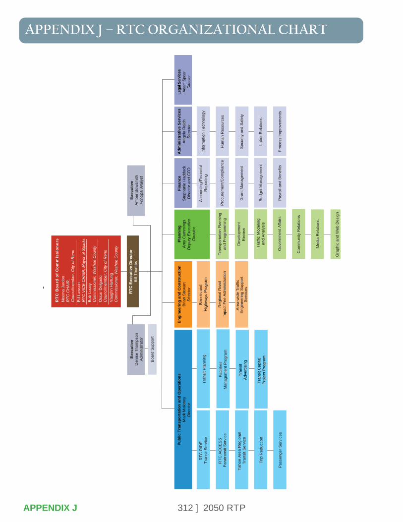
312 ] 2050 RTP
APPENDIX J – RTC ORGANIZATIONAL CHART
APPENDIX J
RT
C B
oard
of
Com
mis
sion
ers
Neo
ma
Jard
onR
TC C
HA
IR,
Cou
ncilm
embe
r, C
ity o
f Ren
oEd
Law
son
RTC
VIC
E C
HA
IR, M
ayor
of S
park
sBo
b Lu
cey
Com
mis
sion
er, W
asho
e C
ount
yO
scar
Del
gado
Cou
ncilm
embe
r, C
ity o
f Ren
oVa
ughn
Har
tung
Com
mis
sion
er, W
asho
e C
ount
y
RTC
Exe
cutiv
e D
irect
orBi
ll Th
omas
Exec
utiv
eD
enis
e Th
omps
onAd
min
istra
tor
Exec
utiv
eAm
ber B
owsm
ithPr
inci
pal A
naly
st
Boar
d Su
ppor
t
Engi
neer
ing
and
Con
stru
ctio
nBr
ian
Stew
art
Dire
ctor
Plan
ning
Amy
Cum
min
gsD
eput
y E
xecu
tive
Dire
ctor
Fina
nce
Step
hani
e H
addo
ckD
irect
or a
nd C
FO
Adm
inis
trat
ive
Serv
ices
Ange
la R
eich
Dire
ctor
Lega
l Ser
vice
sAd
am S
pear
Dire
ctor
Stre
ets
and
Hig
hway
s Pr
ogra
m
R
egio
nal R
oad
Impa
ct F
ee A
dmin
istra
tion
Area
-wid
e Tr
affic
En
gine
erin
g Su
ppor
t Se
rvic
es
Tran
spor
tatio
n Pl
anni
ngan
d Pr
ogra
mm
ing
Dev
elop
men
tR
evie
w
Traf
fic M
odel
ing
and
Anal
ysis
Acco
untin
g/Fi
nanc
ial
Rep
ortin
g
Proc
urem
ent/C
ompl
ianc
e
Gra
nt M
anag
emen
t
Budg
et M
anag
emen
t
Payr
oll a
nd B
enef
its
Com
mun
ity R
elat
ions
Med
ia R
elat
ions
Gra
phic
and
Web
Des
ign
Info
rmat
ion
Tech
nolo
gy
Hum
an R
esou
rces
Secu
rity
and
Safe
ty
Labo
r Rel
atio
ns
Proc
ess
Impr
ovem
ents
Gov
ernm
ent A
ffairs
Publ
ic T
rans
port
atio
n an
d O
pera
tions
Mar
k M
alon
eyD
irect
or
RTC
RID
E Tr
ansi
t Ser
vice
RTC
AC
CES
S Pa
ratra
nsit
Serv
ice
Taho
e Ar
ea R
egio
nal
Tran
sit S
ervi
ce
Trip
Red
uctio
n
Pass
enge
r Ser
vice
s
Tran
sit P
lann
ing
Faci
litie
sM
anag
emen
t Pro
gram
Tran
sit
Adve
rtisi
ng
Tran
sit C
apita
l Pr
ojec
t Pro
gram
RTC
Org
aniz
atio
nal C
hart
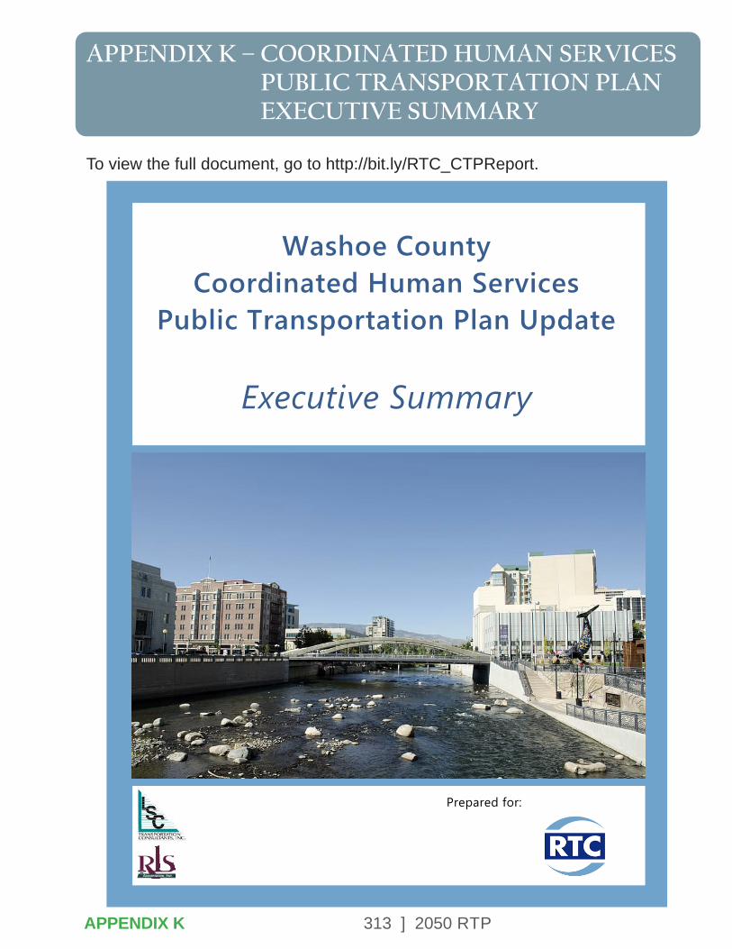
313 ] 2050 RTP
APPENDIX K – COORDINATED HUMAN SERVICES PUBLIC TRANSPORTATION PLAN EXECUTIVE SUMMARY
To view the full document, go to http://bit.ly/RTC_CTPReport.
Washoe CountyCoordinated Human Services
Public Transportation Plan Update
Executive Summary
Prepared for:
APPENDIX K
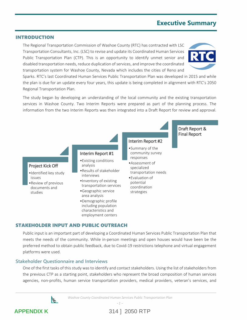
314 ] 2050 RTP
Washoe County Coordinated Human Services Public Transportation Plan
-- 1 --
Executive Summary
INTRODUCTION The Regional Transportation Commission of Washoe County (RTC) has contracted with LSC Transportation Consultants, Inc. (LSC) to revise and update its Coordinated Human Services Public Transportation Plan (CTP). This is an opportunity to identify unmet senior and disabled transportation needs, reduce duplication of services, and improve the coordinated transportation system for Washoe County, Nevada which includes the cities of Reno and Sparks. RTC’s last Coordinated Human Services Public Transportation Plan was developed in 2015 and while the plan is due for an update every four years, this update is being completed in alignment with RTC’s 2050 Regional Transportation Plan.
The study began by developing an understanding of the local community and the existing transportation services in Washoe County. Two Interim Reports were prepared as part of the planning process. The information from the two Interim Reports was then integrated into a Draft Report for review and approval.
STAKEHOLDER INPUT AND PUBLIC OUTREACH Public input is an important part of developing a Coordinated Human Services Public Transportation Plan that meets the needs of the community. While in-person meetings and open houses would have been be the preferred method to obtain public feedback, due to Covid-19 restrictions telephone and virtual engagement platforms were used.
Stakeholder Questionnaire and Interviews One of the first tasks of this study was to identify and contact stakeholders. Using the list of stakeholders from the previous CTP as a starting point, stakeholders who represent the broad composition of human services agencies, non-profits, human service transportation providers, medical providers, veteran’s services, and
PPrroojjeecctt KKiicckk OOffff•Identified key study issues
•Review of previous documents and studies
IInntteerriimm RReeppoorrtt ##11•Existing conditions analysis
•Results of stakeholder interviews
•Inventory of existing transportation services
•Geographic service area analysis
•Demographic profile including population characteristics and employment centers
IInntteerriimm RReeppoorrtt ##22•Summary of the community survey responses
•Assessment of specialized transportation needs
•Evaluation of potential coordination strategies
DDrraafftt RReeppoorrtt && FFiinnaall RReeppoorrtt
APPENDIX K
315 ] 2050 RTP
Washoe County Coordinated Human Services Public Transportation Plan
-- 2 --
transportation network companies were contacted and asked to participate in the study. The stakeholder questionnaire asked participants to identify current and future unmet transportation needs, as well as existing coordination efforts and ideas for improving coordination.
Identified unmet transportation needs included:
Lack of Affordable Transportation
Need for Door-to-Door or Door-through-Door Service
Limited Service Area
Lack of Wheelchair Accessible Vehicles
Advanced Reservation Requirements
Limited service hours (need for 24/7 service)
Identified coordination issues included:
Lack of information about services
Difficulty matching resources with needs of the passenger
Agencies are focused on their own clients and services
The 2015 Coordinated Transportation Plan identified a number of client services transportation gaps through discussions in public meetings and from other sources. Upon comparison, many of the issues raised by the public as part of the 2015 CTP still remain, including:
Affordability of transportation
Expanded service area boundaries and service hours
Need for additional help to/from the vehicle
Reservation requirements
Need for a centralized information directory
Community Transportation Survey As part of an effort to obtain input from Washoe County residents and stakeholders, an online community survey was created. The survey was publicized and distributed through a variety of means, and a total of 155 survey responses were received. Key findings from the survey included:
Nearly 62 percent of respondents are not able to drive and do not possess a driver’s license.
Approximately 65 percent of those surveyed do not have a personal vehicle available for their use.
Approximately 48 percent of respondents find themselves not having a reliable form of transportation when needed.
About 36 percent of respondents indicated that they have a mobility limitation that limits their ability to walk to or board a vehicle without assistance.
Respondents were given a list of current transportation options and asked to select all of the services that they currently use. Taxis, Uber, and Lyft services are used the most frequently (48 percent), followed by RTC ACCESS paratransit services (42 percent), and RTC RIDE fixed-route services (30 percent).
APPENDIX K
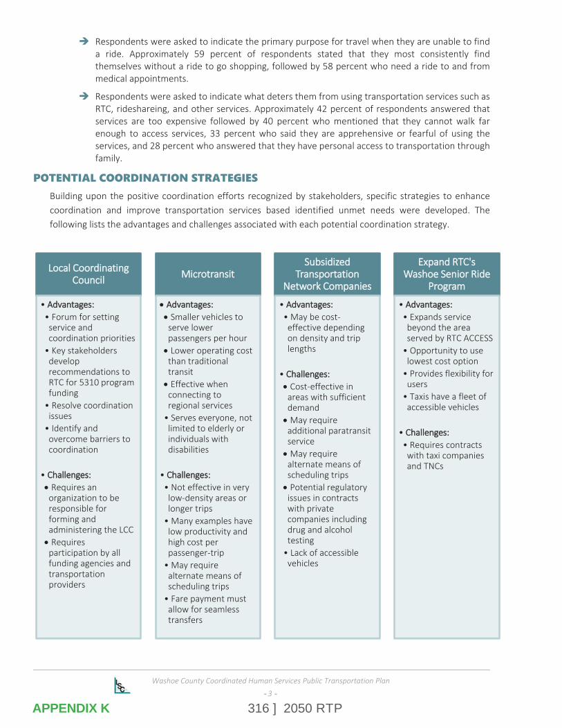
316 ] 2050 RTP
Washoe County Coordinated Human Services Public Transportation Plan
-- 3 --
Respondents were asked to indicate the primary purpose for travel when they are unable to find a ride. Approximately 59 percent of respondents stated that they most consistently find themselves without a ride to go shopping, followed by 58 percent who need a ride to and from medical appointments.
Respondents were asked to indicate what deters them from using transportation services such as RTC, rideshareing, and other services. Approximately 42 percent of respondents answered that services are too expensive followed by 40 percent who mentioned that they cannot walk far enough to access services, 33 percent who said they are apprehensive or fearful of using the services, and 28 percent who answered that they have personal access to transportation through family.
POTENTIAL COORDINATION STRATEGIES Building upon the positive coordination efforts recognized by stakeholders, specific strategies to enhance coordination and improve transportation services based identified unmet needs were developed. The following lists the advantages and challenges associated with each potential coordination strategy.
LLooccaall CCoooorrddiinnaattiinngg CCoouunncciill
• AAddvvaannttaaggeess::• Forum for setting service and coordination priorities
• Key stakeholders develop recommendations to RTC for 5310 program funding
• Resolve coordination issues
• Identify and overcome barriers to coordination
• CChhaalllleennggeess::• Requires an organization to be responsible for forming and administering the LCC• Requires participation by all funding agencies and transportation providers
MMiiccrroottrraannssiitt
• AAddvvaannttaaggeess::• Smaller vehicles to serve lower passengers per hour• Lower operating cost than traditional transit• Effective when connecting to regional services
• Serves everyone, not limited to elderly or individuals with disabilities
• CChhaalllleennggeess::• Not effective in very low-density areas or longer trips
• Many examples have low productivity and high cost per passenger-trip
• May require alternate means of scheduling trips
• Fare payment must allow for seamless transfers
SSuubbssiiddiizzeedd TTrraannssppoorrttaattiioonn
NNeettwwoorrkk CCoommppaanniieess
• AAddvvaannttaaggeess::• May be cost-effective depending on density and trip lengths
• CChhaalllleennggeess::• Cost-effective in areas with sufficient demand• May require additional paratransit service• May require alternate means of scheduling trips• Potential regulatory issues in contracts with private companies including drug and alcohol testing
• Lack of accessible vehicles
EExxppaanndd RRTTCC''ss WWaasshhooee SSeenniioorr RRiiddee
PPrrooggrraamm
• AAddvvaannttaaggeess::• Expands service beyond the area served by RTC ACCESS
• Opportunity to use lowest cost option
• Provides flexibility for users
• Taxis have a fleet of accessible vehicles
• CChhaalllleennggeess::• Requires contracts with taxi companies and TNCs
APPENDIX K
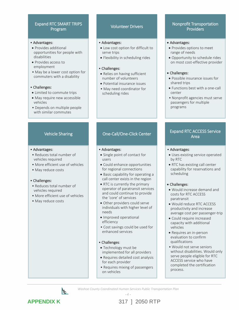
317 ] 2050 RTP
Washoe County Coordinated Human Services Public Transportation Plan
-- 4 --
EExxppaanndd RRTTCC SSMMAARRTT TTRRIIPPSS PPrrooggrraamm
• AAddvvaannttaaggeess::• Provides additional opportunities for people with disabilities• Provides access to employment
• May be a lower cost option for commuters with a disability
• CChhaalllleennggeess::• Limited to commute trips• May require new accessible vehicles
• Depends on multiple people with similar commutes
VVoolluunntteeeerr DDrriivveerrss
• AAddvvaannttaaggeess::• Low cost option for difficult to serve trips• Flexibility in scheduling rides
• CChhaalllleennggeess::• Relies on having sufficient number of volunteers• Potential insurance issues• May need coordinator for scheduling rides
NNoonnpprrooffiitt TTrraannssppoorrttaattiioonn PPrroovviiddeerrss
• AAddvvaannttaaggeess::• Provides options to meet range of needs• Opportunity to schedule rides on most cost-effective provider
• CChhaalllleennggeess::• Possible insurance issues for shared trips• Functions best with a one-call center
• Nonprofit agencies must serve passengers for multiple programs
VVeehhiiccllee SShhaarriinngg
• AAddvvaannttaaggeess::• Reduces total number of vehicles required
• More efficient use of vehicles• May reduce costs
• CChhaalllleennggeess::• Reduces total number of vehicles required
• More efficient use of vehicles• May reduce costs
OOnnee--CCaallll//OOnnee--CClliicckk CCeenntteerr
• AAddvvaannttaaggeess:• Single point of contact for users• Could enhance opportunities for regional connections• Basic capability for operating a call center exists in the region• RTC is currently the primary operator of paratransit services and could continue to provide the ‘core’ of services• Other providers could serve individuals with higher level of needs• Improved operational efficiency
• Cost savings could be used for enhanced services
• CChhaalllleennggeess: • Technology must be implemented for all providers• Requires detailed cost analysis for each provider
• Requires mixing of passengers on vehicles
EExxppaanndd RRTTCC AACCCCEESSSS SSeerrvviiccee AArreeaa
• AAddvvaannttaaggeess:• Uses existing service operated by RTC• RTC has existing call center capability for reservations and scheduling
• CChhaalllleennggeess:• Would increase demand and costs for RTC ACCESS paratransit• Would reduce RTC ACCESS productivity and increase average cost per passenger-trip• Could require increased capacity with additional vehicles• Requires an in-person evaluation to confirm qualifications
• Would not serve seniors without disabilities. Would only serve people eligible for RTC ACCESS service who have completed the certification process.
APPENDIX K

318 ] 2050 RTP
Washoe County Coordinated Human Services Public Transportation Plan
-- 5 --
IMPLEMENTATION PLAN Chapter X of the report presents the implementation plan, which consists of three primary goals supported by the input provided by participants, including the general public, private and public entities, participating organizations, and local stakeholders.
Goal #1: Create a Local Coordinating Council The first priority goal is to create a Local Coordinating Council (LCC). The LCC should have representation from RTC, each human services transportation provider, other human services agencies which serve people with transportation needs, local governments, and consumers. The LCC would have two primary functions. The first would be to facilitate coordination of transportation services, which may include identifying barriers to coordination and developing approaches to overcome the barrier, identifying opportunities to improve coordination, identifying service enhancements, and implementing the coordination strategies contained in this plan. The second role will be for the LCC to recommend program and funding activities to the RTC as part of the grant review processes.
Goal #2: Enhance Mobility and Accessible Transportation Options Community input and the assessment of transportation needs identified ongoing issues and gaps in transportation service. These include the affordability of transportation for users, areas of Washoe County with limited transportation options, and the need for assistance for many users. Enhanced mobility options may include expansion of microtransit, extension of RTC RIDE service to new areas, and specialized transportation services. One of the roles for the LCC is to identify specific activities to enhance mobility and determine the priorities for funding enhanced services. RTC will continue to work with local transportation providers and human services agencies to identify opportunities to enhance service and provide funding to implement enhanced service options.
Goal #1: Creating a
Local Coordinating
Council
Implementation Strategy 1.1:Develop the LCC membership
Implementation Strategy 1.2:Establish the LCC structure, mission, and mobility goals
Implementation Strategy 1.3:Lead coordinated efforts to achieve mobility goals
Goal #2: Enhance
Mobility and Accessible
Transportation Options
Implementation Strategy 2.1:Encourage human services agencies to apply for enhanced transportation services that support the coordinated transportation plan
Implementation Strategy 2.2:Announce opportunities for grant applications and provide funding to implement enhanced transportation services
APPENDIX K
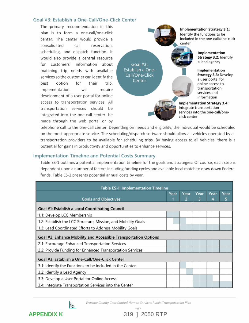
319 ] 2050 RTP
Washoe County Coordinated Human Services Public Transportation Plan
-- 6 --
Goal #3: Establish a One-Call/One-Click Center The primary recommendation in this plan is to form a one-call/one-click center. The center would provide a consolidated call reservation, scheduling, and dispatch function. It would also provide a central resource for customers’ information about matching trip needs with available services so the customer can identify the best option for their trip. Implementation will require development of a user portal for online access to transportation services. All transportation services should be integrated into the one-call center. be made through the web portal or by telephone call to the one-call center. Depending on needs and eligibility, the individual would be scheduled on the most appropriate service. The scheduling/dispatch software should allow all vehicles operated by all transportation providers to be available for scheduling trips. By having access to all vehicles, there is a potential for gains in productivity and opportunities to enhance services.
Implementation Timeline and Potential Costs Summary Table ES-1 outlines a potential implementation timeline for the goals and strategies. Of course, each step is dependent upon a number of factors including funding cycles and available local match to draw down Federal funds. Table ES-2 presents potential annual costs by year.
Table ES-1: Implementation Timeline
Goals and Objectives Year
1 Year
2 Year
3 Year
4 Year
5
Goal #1: Establish a Local Coordinating Council 1.1: Develop LCC Membership 1.2: Establish the LCC Structure, Mission, and Mobility Goals 1.3: Lead Coordinated Efforts to Address Mobility Goals
Goal #2: Enhance Mobility and Accessible Transportation Options 2.1: Encourage Enhanced Transportation Services 2.2: Provide Funding for Enhanced Transportation Services
Goal #3: Establish a One-Call/One-Click Center 3.1: Identify the Functions to be Included in the Center 3.2: Identify a Lead Agency 3.3: Develop a User Portal for Online Access 3.4: Integrate Transportation Services into the Center
Goal #3: Establish a One-Call/One-Click
Center
Implementation Strategy 3.1:Identify the functions to be included in the one-call/one-click center
Implementation Strategy 3.2: Identify a lead agency
Implementation Strategy 3.3: Develop a user portal for online access to transportation services and information
Implementation Strategy 3.4:Integrate transportation services into the one-call/one-click center
APPENDIX K
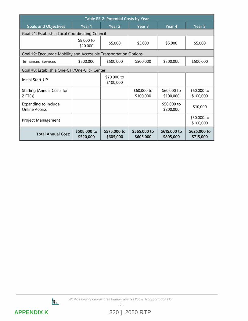
320 ] 2050 RTP
Washoe County Coordinated Human Services Public Transportation Plan
-- 7 --
Table ES-2: Potential Costs by Year
Goals and Objectives Year 1 Year 2 Year 3 Year 4 Year 5
Goal #1: Establish a Local Coordinating Council
$8,000 to $20,000 $5,000 $5,000 $5,000 $5,000
Goal #2: Encourage Mobility and Accessible Transportation Options
Enhanced Services $500,000 $500,000 $500,000 $500,000 $500,000
Goal #3: Establish a One-Call/One-Click Center
Initial Start-UP $70,000 to $100,000
Staffing (Annual Costs for 2 FTEs)
$60,000 to $100,000
$60,000 to $100,000
$60,000 to $100,000
Expanding to Include Online Access
$50,000 to $200,000 $10,000
Project Management $50,000 to $100,000
Total Annual Cost: $508,000 to $520,000
$575,000 to $605,000
$565,000 to $605,000
$615,000 to $805,000
$625,000 to $715,000
APPENDIX K

321 ] 2050 RTP
Your RTC. Our Community.
rtcwashoe.com