Appendix B - Historical Thematic Analysis - Niagara Region
152
NEW NIAGARA OFFICIAL PLAN Niagara Region Archaeological Management Plan: APPENDIX B – Historical Thematic Analysis Niagara Region 17 September 2021
-
Upload
khangminh22 -
Category
Documents
-
view
2 -
download
0
Transcript of Appendix B - Historical Thematic Analysis - Niagara Region
NEW NIAGARA OFFICIAL PLAN
Niagara Region Archaeological Management Plan:
APPENDIX B – Historical Thematic Analysis
Niagara Region
17 September 2021
Niagara Region Archaeological Management Plan
Appendix B: Historical Thematic Analysis Page 1
Table of Contents
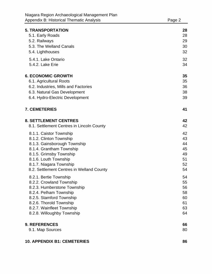
TABLE OF CONTENTS 1
1. INTRODUCTION 4
1.1. The French Colonial Period in Niagara Region 4
1.2. Early British Presence 6
2. TREATY HISTORY 7
2.1. The Niagara Purchase (1764 / 1781) 8
2.2. The Between the Lakes Purchase and the Haldimand Grant (1784) 9
2.3. Renegotiation of Treaty 3 and the Simcoe Patent/Treaty 4 (1793) 10
3. EARLY IMMIGRATION AND SETTLEMENT 11
3.1. Early Settlement and Surveys 1780-1820 11
3.2. Population Growth 1820-1860 12
4. MILITARY HISTORY 14
4.1. The War of 1812 14
4.2. Surviving Pre-1812 Structures in the Niagara Region 15
4.2.1. Bertie Township (including the Town of Fort Erie) 16
4.2.2. Clinton Township (Town of Lincoln) 16
4.2.3. Crowland Township (including the City of Welland) 17
4.2.4. Gainsborough Township 17
4.2.5. Grantham Township 17
4.2.6. North Grimsby Township (Town of Grimsby) 17
4.2.7. Humberstone Township (including Port Colborne) 18
4.2.8. Louth Township (including St. Catharines and the Town of Lincoln) 18
4.2.9. Niagara Township (Town of Niagara-on-the-Lake) 19
4.2.10. Pelham Township (Town of Pelham) 22
4.2.11. Stamford Township (City of Niagara Falls) 22
4.2.12. Thorold Township (City of Thorold) 24
4.2.13. Wainfleet Township 25
4.2.14. West Lincoln Township (formerly South Grimsby, Caistor, Gainsborough
Townships) 25
4.2.15. Willoughby Township 25
4.3. The Fenian Raids of 1866 26
4.4. Niagara Commons and Camp Niagara 27
Niagara Region Archaeological Management Plan
Appendix B: Historical Thematic Analysis Page 2
5. TRANSPORTATION 28
5.1. Early Roads 28
5.2. Railways 29
5.3. The Welland Canals 30
5.4. Lighthouses 32
5.4.1. Lake Ontario 32
5.4.2. Lake Erie 34
6. ECONOMIC GROWTH 35
6.1. Agricultural Roots 35
6.2. Industries, Mills and Factories 36
6.3. Natural Gas Development 38
6.4. Hydro-Electric Development 39
7. CEMETERIES 41
8. SETTLEMENT CENTRES 42
8.1. Settlement Centres in Lincoln County 42
8.1.1. Caistor Township 42
8.1.2. Clinton Township 43
8.1.3. Gainsborough Township 44
8.1.4. Grantham Township 45
8.1.5. Grimsby Township 49
8.1.6. Louth Township 51
8.1.7. Niagara Township 52
8.2. Settlement Centres in Welland County 54
8.2.1. Bertie Township 54
8.2.2. Crowland Township 55
8.2.3. Humberstone Township 56
8.2.4. Pelham Township 58
8.2.5. Stamford Township 60
8.2.6. Thorold Township 61
8.2.7. Wainfleet Township 63
8.2.8. Willoughby Township 64
9. REFERENCES 66
9.1. Map Sources 80
10. APPENDIX B1: CEMETERIES 86
Niagara Region Archaeological Management Plan
Appendix B: Historical Thematic Analysis Page 3
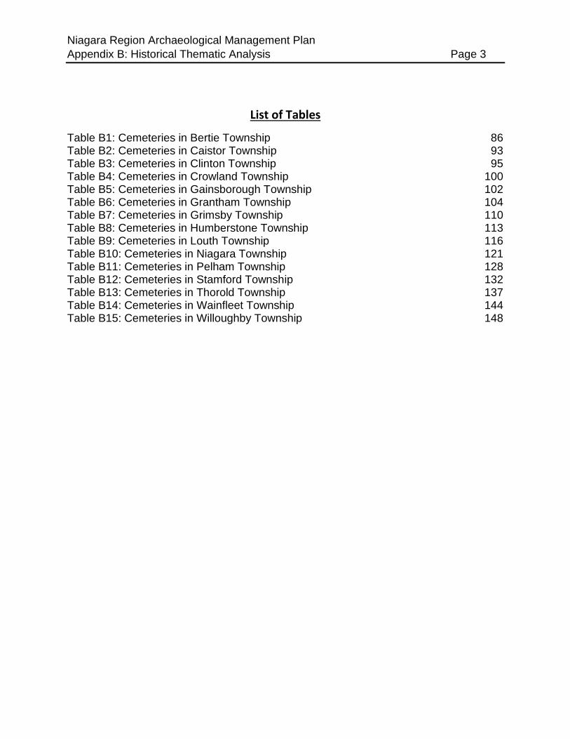
List of Tables
Table B1: Cemeteries in Bertie Township 86 Table B2: Cemeteries in Caistor Township 93 Table B3: Cemeteries in Clinton Township 95 Table B4: Cemeteries in Crowland Township 100
Table B5: Cemeteries in Gainsborough Township 102 Table B6: Cemeteries in Grantham Township 104 Table B7: Cemeteries in Grimsby Township 110 Table B8: Cemeteries in Humberstone Township 113
Table B9: Cemeteries in Louth Township 116 Table B10: Cemeteries in Niagara Township 121
Table B11: Cemeteries in Pelham Township 128 Table B12: Cemeteries in Stamford Township 132
Table B13: Cemeteries in Thorold Township 137 Table B14: Cemeteries in Wainfleet Township 144 Table B15: Cemeteries in Willoughby Township 148

Niagara Region Archaeological Management Plan
Appendix B: Historical Thematic Analysis Page 4
1. Introduction
This document is not intended to be an exhaustive history of Niagara Region, although
the main focus of the text is historical in terms of subject matter. Rather, it serves to
identify the extant or formerly present historical features that might yield associated
archaeological deposits and that were mapped for the GIS layer of historical features.
To standardize the documentation process, maps ranging in date from 1815 to 1924
were consulted, although the prime sources, in terms of their level of detail are
Tremaine’s Map of the Counties of Lincoln and Welland, Canada West (Tremaine
1862), Stotherd’s Niagara Frontier, Plan 2 (Stotherd 1865), and the Illustrated Historical
Atlas of the Counties of Lincoln & Welland (Page 1876). The boundaries of the
settlement centres were plotted based on the above maps, as well as specific plans of
select centres (see Section 11.1 for a more detailed list of maps consulted) and serve to
indicate those areas where most of the building activity was concentrated at the time the
source maps were produced. Individual public buildings and homes were not mapped
within these centres, although the settlement centre overlay is indicative of those areas
that exhibit potential for the presence of meeting halls, schoolhouses, blacksmith shops,
stores, grain warehouses, hotels, taverns, and other commercial service buildings. All
schools, places of worship and commercial buildings, such as inns, that occur outside of
the major settlement centres have also been mapped individually, if their locations were
shown on the historical maps.
1.1. The French Colonial Period in Niagara Region
The Niagara Peninsula and Lake Ontario and Lake Erie were known to French explorer
Samuel de Champlain as early as 1615, and Etienne Brûlé (Champlain’s interpreter)
may have visited the peninsula in 1625. It is known that a Recollet missionary named
Daillon spent three months visiting various Indigenous villages in the area in the fall and
winter of 1626-1627. By the early 1630s, this large geographical area had been mapped
by explorers, traders, and missionaries. Lake Ontario was named “Lake St. Louis” or
“Lake of Saint Louys” (Lacus Sancti Ludovici) by the French and was referred to by this
name on the Champlain map (1632), as well as on the Sanson (1656) and Bressani
(1657) maps. By the 1670s, Lake Ontario had been re-named Lac Frontenac in honour
of the Governor of New France. Lake Erie appears to have always retained its present
name, derived from the native word Erieehronons or “Nation of the Cat.” The Niagara
River was known to the early French Jesuit missionaries by the native name of
Onguiaahra. These early French maps clearly show many of the creeks that drain into
Lake Ontario, as well as the Niagara and Grand rivers. The French did not establish any
permanent settlements within the Niagara Peninsula, despite their contact with the
peoples of the area.
Niagara Region Archaeological Management Plan
Appendix B: Historical Thematic Analysis Page 5
As early as 1671-1672, the French proposed erecting a fort at or near the mouth of the
Niagara River. The purpose of this establishment was to hinder, as much as possible,
the fur trade between the Iroquois and the British and Dutch merchants at New
Amsterdam/New York. Construction on this stronghold, which was named Fort
Denonville, commenced in late July 1687 on the present site of Fort Niagara. The fort
was abandoned in 1689 after most of the garrison died from scurvy (Robinson 1933:55).
In 1679, it is known that the French established a shipyard at the mouth of Cayuga
Creek in Niagara County, New York. This creek and a small island by the same name
are situated a short distance upstream from the Horseshoe Falls, opposite to Grand
Island. It was there that LaSalle’s ill-fated barque, Le Griffon, was built.
In May 1720, the French constructed a Magasin Royal in what is now the village of
Lewiston, New York. This was succeeded in 1725, with the construction of the “stone
house” or “stone castle” at Fort Niagara. This fortification was fully completed and
surrounded by palisades by mid-October 1727. The older Magasin at Lewiston was then
refitted for use as a blockhouse and was shown on maps from the 1750s named “Little
Fort Niagara.” It seems unusual that the French did not make greater attempts to
establish a settlement on the west bank of the river, opposite to Fort Niagara, based
upon a similar system which had been laid out at Detroit and Windsor two decades
earlier. This may not have been possible due to the fact that during the late seventeenth
and early eighteenth centuries, Niagara Region was occupied by the Mississaugas, an
Algonquian people whose subsistence economy was based on garden farming, as well
as hunting, fishing and gathering wild plants. The Mississauga, who were on friendly
trade terms with the British, may not have welcomed a permanent French settlement on
the east bank of the Niagara River.
Maps of the mouth of the Niagara River and of its west bank produced during the period
1755-1760, show that the point of land now occupied by the Town of Niagara-on-the-
Lake was known as Pointe du Montreal while other contemporary maps showed that it
referred to as Pointe Amascou. The west bank of the river, a short distance to the south
was marked la Prairie, and beyond that the names Pointe au Mascoutin or Pointe au
Mascouten are shown. British maps produced in 1759 show that a large, rectangular
plot of “plough’d land” had been laid out on the higher, flat ground on the west bank of
the river. Other contemporary British maps show this same feature which was described
as a “Garden Plott.” This land was situated in the vicinity of the Military Reserve or
Garrison Common at Niagara, approximately between the spot where Fort George
would be constructed during the 1790s and the top of the bank near the point of
termination of Byron and Ricardo streets (overlooking the former Niagara Dockyards).
This land, approximately five acres or more in extent, may have been used as a garden
which supplied the garrison at Fort Niagara with additional seasonal produce. The rich,
alluvial mud flats along the river slightly to the southeast are shown on the early British
maps labelled as “garden over the river” (Fort Niagara 25 July 1759; Plan of Niagara,
1762).

Niagara Region Archaeological Management Plan
Appendix B: Historical Thematic Analysis Page 6
The French occupation of the Niagara Frontier came to an abrupt conclusion in July
1759, when Fort Niagara was captured by Sir William Johnson (Robinson 1933:72, 77,
81, 138-139, 143; Dunnigan 1996:13, 14, 72, 89). The British crown recognized the
Mississaugas as the “owners” of the west shore of the Niagara River and later entered
into negotiations to facilitate the settlement of Loyalists and the Six Nations allies after
the American Revolution.
1.2. Early British Presence
The first British presence on the west bank of the Niagara River was established during
the siege of Fort Niagara in 1759. At that time, the British set up a gun “Battery over the
River” on “Montreal Point” within the limits of the present Town of Niagara-on-the-Lake.
This battery mounted four cannons, trained on Fort Niagara. It was located a short
distance away from the “Garden Plott,” probably somewhere between St. Mark’s
(Anglican) Churchyard and Queen’s Landing Hotel in the present-day community of
Niagara-on-the-Lake (Dunnigan 1996:66,67, 72).
Between 1763 and 1783, the British continued to garrison Fort Niagara, but did little on
the east bank of the Niagara River. The period was, however, marked by the
construction of the “first” or “old” Fort Erie in July 1764, which was built to safeguard the
head of the Niagara River at Lake Erie. The official instructions called for the
construction of “a proper Entrepot for Provisions for facilitating the supplying the vessels
for Detroit,” i.e., it was to serve as a fortified depot and terminus point on the westerly
Niagara Portage route. This fort was hastily built and located close to the lake on low-
lying, marshy ground. Part of the “public land” on the west side of the fort was leased to
local merchants, who constructed stores and warehouses there. These storekeepers
traded in goods to and from the Upper Great Lakes, and particularly with merchants at
Detroit such as John Askin and Jacques Duperon Baby. The fort was damaged by
winter weather in 1779, and a severe winter storm in 1803 eroded 25 feet (7.62 m) of
shoreline “destroying the entire north-east face of the fort.” A new, nearby location for
the “second” Fort Erie was selected behind the first fort on higher ground, and
construction of that timber and stone fortification began in 1804. Work on the new fort
continued until 1807, but it remained in an unfinished state when the War of 1812
commenced in June 1812.

Niagara Region Archaeological Management Plan
Appendix B: Historical Thematic Analysis Page 7
2. Treaty History
Niagara Region is covered by several treaties related to the earliest period of land
cessions in southern Ontario, beginning in in 1764 with the purchase of a narrow strip of
land on either side of the Niagara River and continuing to 1793 with the ratification of
Treaty #4. These treaties describe the historical groups with whom the Crown
negotiated the transfer of land and in some cases the rights that are assured to these
groups within the lands.
The advent and significance of historical treaties are rooted in the Royal Proclamation of
1763, issued by King George III. The Proclamation affirmed that Indigenous people
lived under the protection of the Crown and that they were not to be “molested or
disturbed in the Possession of such Parts of Our Dominions and Territories as, not
having been ceded to, or purchased by Us, are reserved to them, or any of them, as
their Hunting Grounds....” This statement recognized the existence of Aboriginal rights
and title to vast areas within North America. In particular, the Royal Proclamation
identified the lands west of the Appalachian Mountains, not including Rupert’s Land in
the north, as being Indigenous land, and therefore subject to land acquisition
agreements between the Crown and the affected nations. Between 1764 and 1815, the
government acquired the lands of the shoreline of the upper St. Lawrence as well as the
lower Great Lakes. While the earliest treaties were related to the use of land for military
and defensive purposes, following the American Revolutionary War many treaties were
for the purposes of settling the roughly 30,000 United Empire Loyalists who refused to
accept American rule. After the War of 1812, the colonial administration of Upper
Canada focused on greater settlement of the colony, and land purchases were then
concerned with those lands beyond this first range of settlement. These involved a
swath of about 7 million acres from the Ottawa River to the eastern shores of Georgian
Bay. After 1836, many portions of the northern and northwestern sections of the
province were acquired, including the Saugeen Peninsula, Manitoulin Islands and the
north shores of Lake Huron and Lake Superior (Department of Indigenous and Northern
Affairs 2010; Hall 2018; Surtees 1984).
Niagara Region has some of the earliest treaties in the province and is evidence of the
importance of the region to the Colonial Administration during and immediately after the
American Revolutionary War.
Niagara Region Archaeological Management Plan
Appendix B: Historical Thematic Analysis Page 8
2.1. The Niagara Purchase (1764 / 1781)
The first formal treaty negotiated after the Royal Proclamation was for a narrow strip of
land on either side of the Niagara River in order to allow for the secure movement of
supplies and troops along the river.
After the British capture of Fort Niagara in July 1759, the contract for transporting goods
along the portage on the east bank of the Niagara River was awarded to John Stedman.
This caused conflict with the local Seneca community who had historically been
employed by the French government for transporting goods between the lakes along
the Niagara River. On September 14, 1763, John Stedman and convoy were attacked
by an estimated 500 Seneca as retaliation to British control in the area. As a result of
this affair, a peace treaty was negotiated with the Seneca and several other Indigenous
communities by Sir William Johnson in April 1764. Under the terms of this treaty, a six-
mile-wide strip of land was ceded to the British. This strip measured two miles in width
on the west bank of the Niagara River and four miles in width along the east bank, and
fourteen miles in depth (e.g., to a point just above the “Great Cataract”) and included
the islands within the river. In August 1764, a similar sized tract of land was ceded to
the Crown which extended from the Falls to the mouth of the Niagara River at Lake Erie
(Brodhead 1856:562, 621, 647-649, 652-653). The Treaty of Niagara was signed by Sir
William Johnson and Seneca representatives. The Treaty was concluded on August 1,
1764.
This treaty was renegotiated in 1781 for the areas to the west of the Niagara River. The
original document stipulated that this land was only to be used by the Crown for the
movement of goods and troops and was not to be set aside for settlement. Furthermore,
the Mississaugas of the Credit First Nation claimed that the area west of the Niagara
River was within their Traditional Territory but were not included in the original 1764
treaty. The Niagara Purchase, registered as Crown Treaty 381, was signed on 9, May,
1781, between representatives of the Crown and representatives of Mississauga and
Chippewa peoples. The land under negotiation consisted of a four-mile strip on the west
side of the Niagara River from Lake Ontario to Lake Erie. This area included the current
communities of Niagara Falls, Niagara-on-the-Lake, and Fort Erie. In payment for these
lands, the Crown provided 300 “suits of clothing” to the Mississauga. The signees of the
treaty on the side of the British included Colonel Guy Johnson, Superintendent General
of Indian Affairs, Captain Andrew Parke, Captain William Potts, and John Dease and
Alexander McKee, Deputy Agents of Indian Affairs. The signees of the treaty on the side
of the Chippewa and Mississauga included Nanibizure, Paghquan, Wabicanine, and
Minaghquat (Department of Indigenous and Northern Affairs 2016; Surtees 1984).
This renegotiated treaty allowed for the settlement of these lands for agricultural
purposes, which was necessary in order to provide food for the growing military in the
area. This treaty also recognized Mississauga sovereignty in the region and became the
Niagara Region Archaeological Management Plan
Appendix B: Historical Thematic Analysis Page 9
basis for future negotiations between the Crown and the Mississauga (Department of
Indigenous and Northern Affairs 2016; Surtees 1984).
2.2. The Between the Lakes Purchase and the Haldimand
Grant (1784)
Following the American Revolutionary War, the British Crown needed to find lands on
which to settle United Empire Loyalists, including approximately 2,000 members of the
Six Nations confederacy who had fought alongside British troops. Led by Sir Frederick
Haldimand, who was the governor of Quebec at that time, the Crown was initially
planning on providing lands for Loyalist settlers in Quebec and southeastern Ontario,
including providing land in the Bay of Quinte for Six Nations refugees. This was not
suitable for many of the members of Six Nations and a contingent of approximately
1,800 community members, led by Chief Joseph Brant, requested land north of Lake
Erie along the Grand River. Brant felt that the location in the Bay of Quinte was too
isolated and that his followers could be better served by being closer to the Six Nations
communities that chose to remain in the United States in western New York (Surtees
1984:21).
Recognizing that, under the terms of the Royal Proclamation, the land needed to be
purchased prior to settlement, Colonel John Butler was sent to negotiate with the
Mississaugas of the Credit for lands east of Lake Ontario and north of Lake Erie. On
May 22, 1784, the Mississaugas of the Credit agreed to cede approximately 3,000,000
acres of land containing all or part of Brant, Elgin, Middlesex, Oxford, and Wellington
Counties as well as the Regions of Haldimand-Norfolk, Halton, Hamilton-Wentworth,
Niagara, and Waterloo. In exchange for these lands, the Mississaugas received
£1180.74 worth of trade goods (Department of Indigenous and Northern Affairs 2016;
Surtees 1984). Of the 3,000,000 acres, approximately 550,000 acres was set aside for
the settlement of Six Nations people.
On October 25, 1784, Haldimand signed a proclamation that allotted land six miles (10
km) on either side of the Grand River from its mouth at Lake Erie to its headwaters near
Dundalk, Ontario. This land was to be used solely by the people of Six Nations, who
were also granted the right to sell or lease the land within this territory providing the
Crown was first offered to purchase the land. The present-day communities of Six
Nations of the Grand River First Nation and Mississaugas of the Credit First Nation are
within these lands (Filice 2018; Surtees 1984).

Niagara Region Archaeological Management Plan
Appendix B: Historical Thematic Analysis Page 10
2.3. Renegotiation of Treaty 3 and the Simcoe Patent/Treaty 4
(1793)
Due to uncertainties with the description of the lands in the original surrender, Treaty 3
was renegotiated on December 7, 1792, to clarify what was ceded. The signees of the
treaty on the side of the British included Lieutenant Governor John Graves Simcoe,
John Butler, Robert Kerr, Peter Russell, John McGill, and Davie William Smith. The
signees of the treaty on the side of the Mississauga included Chiefs Wabakyne,
Wabanip, Kautabus, Wabaniship and Mottotow (Department of Indigenous and
Northern Affairs 2016; Surtees 1984).
As part of the 1792 renegotiation of Treaty #3, the Crown also redefined the boundaries
of the Haldimand Tract. Upon review of the Haldimand Proclamation, politician and
Indian Department official Sir John Johnson noted an error involving the location of the
northern boundary of the tract. Haldimand had mistakenly assumed in 1784 that the
headwaters of the Grand River resided within the area negotiated under Treaty #3.
However, the northern reach of the Haldimand Tract was within lands that were not
negotiated until 1818 under treaties #18 and 19 (Department of Indigenous and
Northern Affairs 2016; Filice 2018; Surtees 1984). In order to clarify the boundaries of
the tract, the Crown appointed surveyor Augustus Jones to complete a survey of the
Haldimand Tract in 1791. In so doing, Jones redefined the borders of the Six Nations’
land parcel. This included defining the northern limit of the Haldimand Tract as Jones
Base Line near the Town of Fergus in the Township of Centre Wellington. In addition,
Jones established straight-lined boundaries, rather than sinuous boundaries following
every curve in the river, which can still be seen in today’s municipal boundaries. Six
Nations and Joseph Brant were not in agreement with this new definition and petitioned
the government for control over the tract. This eventually led to the 1793 Simcoe Patent
(Treaty 4) which defined the rules of land ownership and leasing within the revised
30,000 acres of land provided to Six Nations. This 1793 patent did not address those
lands northeast of the Jones Base Line and continues to be a source of dispute
between Six Nations and the Crown.

Niagara Region Archaeological Management Plan
Appendix B: Historical Thematic Analysis Page 11
3. Early Immigration and Settlement
At the conclusion of the Seven Years War in 1763, the British Crown asserted
sovereignty over land in North America previously claimed by France but was owned by
a diverse number of First Nations (Careless 1970:97). Initially, no attempt was made by
the British Colonial government to colonize land west of the St. Lawrence valley in order
not to upset the ecosystem of the lucrative fur trade in the Great Lakes region (Harris
and Warkentin 1974:110; Turner 1994:183-186). This attitude changed towards the end
of the American Revolutionary War when it became necessary to settle United Empire
Loyalist farmers on the west bank of the Niagara River to provision Fort Niagara, which
was the base of Butler’s Rangers. The Rangers were a provincial military unit formed by
wealthy landowner John Butler of the Mohawk Valley in New York State. The British
government provided seed and farm implements and under the direction of Butler, in
1780 the first disbanded Rangers and their families began to settle a strip of land west
of the Niagara River acquired from the Mississaugas under the Niagara Purchase
(Cruikshank 1893b; Ormsby 1991:16; Surtees 1994:97).
3.1. Early Settlement and Surveys 1780-1820
After a treaty of peace was signed between Great Britain and the United States of
America in 1782, it quickly became apparent that extra land would be required for the
growing number of Loyalists who arrived at Fort Niagara seeking restitution for the loss
of their homes. In May 1784, the British purchased a tract of land from the Mississaugas
that extended westward from the new international boundary of the Niagara River
towards Burlington (Wilson 1981:82). This large tract was surveyed into 14 townships
for the purpose of granting land by surveyor Philip Frey between 1787 and 1788
(Hughes 1994). It should be noted that Caistor, which today is one of the 15
geographical townships of the Niagara Region, was not part of Frey’s survey. The
survey pattern was variable, with rectangular townships measuring 12 by 9 miles on
navigable waterways, and ten miles square townships placed in the interior (Harris and
Warkentin 1974:123). Within the townships, 100- or 200-acre farm lots were bounded
by road allowances. The early economic development of each township depended upon
grantees making improvements to their property as per the settlement duties imposed
by the land grant system in Ontario, including clearing obstructions and keeping open
the road allowance surveyed in front of their lot in each concession (Weaver 1968:14).
A district land board composed of civic leaders was established in 1788 to select town
sites, grant land to Loyalists with a claim, and lay out other roads deemed necessary for
communication. The amount of land awarded to each person depended upon their
service to the Crown and/or military rank during the late war. The land board continued
to operate in Niagara until it was abolished in 1794 (Wilson 1991:62). The American-

Niagara Region Archaeological Management Plan
Appendix B: Historical Thematic Analysis Page 12
born Loyalists primarily originated from New York and Pennsylvania, with a lesser
number from other states like Connecticut and New Jersey. Settlement of the townships
commenced in 1787-88, and by 1792, many farms were cleared of timber and under
cultivation (Burtniak and Dirk 1981).
In 1791, the British Parliament passed the Canada Constitutional Act that established
Upper Canada (Ontario) by dividing the old province of Quebec into two entities. Lower
Canada retained its French laws and language while Upper Canada received English
law and institutions to accommodate the Loyalists. Present day Niagara-on-the Lake
(NOTL), also known as Niagara, was chosen as the first capital of the new province
(Careless 1970:144). The new province included the townships in the Niagara Region
that comprise the geographic counties of Lincoln and Welland. In 1795, the Upper
Canadian government decided that a freehold system of land tenure based upon the
English model was preferred, and a Land Registry Act was passed. In 1796, the first
lands were patented from the Crown by private owners. To increase the population of
the province, and to bring more land under cultivation, during the mid-1790s and early
1800s, the Upper Canadian government offered grants of land to attract new settlers
and replaced the oath of allegiance to the King with a Christian oath (Wilson 1981:102).
Historians sometimes call the Americans who responded to this offer “Late Loyalists” to
distinguish them from the people who arrived from the United States before 1788 (Wood
1988:56). During this period, many Quakers took up land in Pelham Township, and
Mennonites settled in parts of Louth and Clinton Townships (Groh 1977; Coffman 1979,
1982).
3.2. Population Growth 1820-1860
The population of Upper Canada remained largely that of Loyalist and later American
immigrants and their children until the end of the War of 1812. The colony at that time
was not the prime concern of the home government back in Britain. America’s
declaration of war on Great Britain changed that attitude and emigration from the United
States was discouraged (Turner 1994:195). Instead, the emigration of people from the
British Isles was encouraged, many of whom were landless veterans of the Napoleonic
Wars. Between circa 1815 and 1830, the majority of the new immigrants were from
Northern Ireland, England or Scotland (Wood 1988:56). During the construction of the
first Welland Canal, and continuing into the 1840s, there was an increased number of
immigrants from Ireland. The number of Irish increased substantially during the late
1840s following the Great Hunger. Immigration to the Niagara area from other European
countries was relatively low during much of the nineteenth century (Burtniak and Dirks
1981; VanAsten 1983).
During the early period of settlement, some Loyalist immigrants brought enslaved
African Americans with them. Legislation passed by the government of Upper Canada
Niagara Region Archaeological Management Plan
Appendix B: Historical Thematic Analysis Page 13
in 1793 called for the gradual abolition of slavery within the province, and fugitive slaves
who made it across the border from the United States as well as free blacks such as
Richard Pierpoint were attracted to Canada for that reason. By the 1820s, black
settlements were flourishing in many parts of the province including St. Catharines,
which was a safe distance away from the border (Anon. 1974; Wood 2000:47).
In the period leading up to the American Civil War, the black population swelled in
Niagara following the passage of the Fugitive Slave Act in the United States in 1850. St.
Catharines in particular was one of the final destinations or stops on the Underground
Railroad for fugitive slaves and free blacks alike. St. Catharines also provided more
employment opportunities than in border towns such as Niagara, Niagara Falls, or Fort
Erie, and there was a large and well-established black community centred around North
and Geneva Streets. Moreover, there were two churches that served their spiritual
needs (Salem Chapel BME, and Zion Baptist) as well as a resident black preacher, the
Reverend Anthony Burns. Harriet Tubman lived on North Street in St. Catharines for
about a decade before returning to the United States (Jackson 1976).

Niagara Region Archaeological Management Plan
Appendix B: Historical Thematic Analysis Page 14
4. Military History
4.1. The War of 1812
An uneasy peace existed between Great Britain and the United States at the conclusion
of the American Revolutionary War. Hostility erupted again when President James
Madison declared war on Great Britain in June of 1812. Little fighting took place in the
United States, however, as it was chiefly a war in the Canadas (Careless 1974:131). In
particular, the Niagara peninsula witnessed a great number of battles and skirmishes
between 1812 and 1814 (Turner 1990). The War of 1812 has been chronicled by
scholars such as Lossing (1869), Cruikshank (n. d.), Wood (n. d.), and Dale (2011).
Significant War of 1812 sites have been marked by the Canadian government, the
Ontario Heritage Trust, the Niagara Historical Society, and by the Lundy’s Lane
Historical Society. A guidebook to these sites was published by Gilbert Collins (2006).
The action in the region was confined largely to the geographic townships of Bertie,
Willoughby, Stamford, and Niagara that bordered on the Niagara River. The main battle
in the first year of the conflict was the Battle of Queenston Heights on October 13, 1812,
in which the British Major-General Isaac Brock lost his life (Malcomson 1994, 2003;
Riley 2011). A lesser-known engagement related to the American invasion of the
Niagara peninsula is the Battle of Frenchman’s Creek (November 28, 1812), in which an
American force attempted to capture and dislodge a British gun battery and earthworks
located north of Fort Erie (Davies 1996).
In the second campaign season, the Americans were victorious at the Battle of Fort
George on May 27, 1813 (Cruikshank 1904; Last 2105). On that day they also captured
the Town of Newark (NOTL) and afterwards established advance piquets along the
Niagara River Road to the vicinity of McFarland House and as far west as the Two Mile
Creek. The Americans were reluctant to advance their lines too far inland; their base of
operations at Fort George and the protective buffer zone of the town provided them with
a position that was easily defended and in close proximity to the safety of Fort Niagara
on the American side of the river. Small skirmishes were fought between the British and
Americans during the course of the year, such as the Battle of Butler’s Farm
(MacDonald and Narhi 2015), and raiding and scouting parties were despatched from
Niagara into the neighbouring townships, particularly Grantham. Residents in Louth,
Clinton, and Grimsby were also plundered by armies from both sides, as well as by the
First Nations allies of Great Britain, while marching towards Burlington Heights
(Cruikshank n. d.).
One of the main objectives for the Americans was to capture the supply depot at
DeCew House in Thorold. Laura Ingersoll Secord, wife of UE Loyalist James Secord,
overheard the American plans and she set out on her epic walk to warn James
Niagara Region Archaeological Management Plan
Appendix B: Historical Thematic Analysis Page 15
Fitzgibbon about the attack. The result was the Battle of Beaverdams on June 24, 1813,
sometimes known as the Fight in the Beechwoods (Cruikshank 1895; Dewar and
Taillefer 1991). The campaign season ended in December when the Americans
withdrew to the New York side of the Niagara River, but not before setting the Town of
Niagara ablaze (Merritt 2005).
The action during the third and final year of the war along the Niagara frontier saw a
shift of events to the south end of the Niagara Peninsula (Anger 2008). The Americans
secured their position when they captured Fort Erie (Cruikshank n. d.). From there they
staged manoeuvres in July 1814 that resulted in the Battle of Chippawa (Graves 1994),
the Battle of Lundy’s Lane (Cruikshank 1893a; Graves 1993, 1997; Feltoe 2014), and
the burning of Bridgewater Mills (Cruikshank n. d.). In particular, the location of the
Battle of Chippawa is a largely undisturbed site, believed to contain the remains of
soldiers who fell there, and therefore, is of major significance (Graves 1991). During the
Siege of Fort Erie, the British fought to regain the fort (Litt 1991; Pfeiffer and Williamson
1991). The last engagement fought before the Americans withdrew from the Fort Erie
area was the Battle of Cook’s Mills on October 19, 1814 (Cruikshank n. d.).
4.2. Surviving Pre-1812 Structures in the Niagara Region
Most of the heritage structures in the Niagara Region date to the period of
reconstruction after the War of 1812. There are relatively few known structures that
were built prior to the War of 1812 that survived either the conflict, accidental fire, or
later changes in land use. In Niagara, for example, it was recorded that only one house
survived intact the burning of the town in December 1813, that of Ralf Clench, but it was
destroyed accidently a few months later (Stokes and Montgomery 1971). A number of
heritage buildings in NOTL are known to have been rebuilt on older pre-war foundations
and may have incorporated salvaged building materials within their structural fabric.
Some of the houses with a pre-War of 1812 core have been enlarged or modified at a
later date and are not easily recognized as a house from the early period of settlement
in the region (Flemming 1971; Stokes and Montgomery 1971; Dunn and Romanowich
1995; Bernat and Ormsby 2003).
Buildings in other settlements were burned or damaged during the war, but Niagara and
the village of St. David’s sustained the greatest losses in property. The further away a
settlement was from the Niagara River and the American lines ensured greater safety.
The following list of structures is organized by geographical township and is partially
informed by properties listed on heritage inventories maintained by the relevant
municipality.
Niagara Region Archaeological Management Plan
Appendix B: Historical Thematic Analysis Page 16
4.2.1. Bertie Township (including the Town of Fort Erie)
Four structures in the geographical township of Bertie pre-date the War of 1812. The
three domestic structures are listed on the Town of Fort Erie’ s Municipal Register of
Properties of Cultural Heritage Value and Interest, and one is designated under Part IV
of the Ontario Heritage Act (Town of Fort Erie 2017). Fort Erie is recognized as a place
of national historic significance under the Historic Sites and Monuments Act (RSC
1985).
Fort Erie (350 Lakeshore Road). The present Fort Erie is the second fort that was built
near the confluence of the Niagara River and Lake Erie. The earlier structure built 1764
was constructed closer to the water’s edge and was badly damaged by ice in 1803. The
present stone fortification was built by the British between 1805 and 1808. The fort was
attacked and captured by the Americans during the War of 1812, and it was partly
destroyed by an explosion in August 1814 and further destroyed by the retreating
American forces in November 1814. The British occupied the site until 1823, after which
it was gradually allowed to decay. Maps from the mid-nineteenth century show the ruins
of the old fort. Ownership of the site was transferred to the Niagara Parks Commission
in 1901. Like Fort George, it was restored by the Niagara Parks Commission in 1937-39
to reflect the War of 1812 period. It is presently operated as a museum (Owen 1986).
Haun-Lawson House (3555 Yacht Harbour Road). This house is believed to have been
built circa 1812. It is on the Town of Fort Erie’s municipal register of heritage properties
(Town of Fort Erie 2017).
Miller Farm log cabin (2029 Ridge Road North). This log cabin is believed to have
been built circa 1803, on part Lot 8, Concession 8 NR, Bertie Township. It is designated
as a property of cultural heritage value or interest under Part IV of the Ontario Heritage
Act (Town of Fort Erie 2017).
Wintermute House (487 Niagara Boulevard). This two-storey, three-bay clapboard
house is believed to have been built sometime during the early 1800s. It is more likely
the structure dates from the late first quarter or from second quarter of the nineteenth
century. It was enlarged at a later period and has been heavily renovated during the last
few years. It is on the Town of Fort Erie’s municipal register of heritage properties
(Town of Fort Erie 2017).
4.2.2. Clinton Township (Town of Lincoln)
There are no known pre-War of 1812 structures in the geographical township of Clinton.
Niagara Region Archaeological Management Plan
Appendix B: Historical Thematic Analysis Page 17
4.2.3. Crowland Township (including the City of Welland)
There are no known pre-War of 1812 structures in the geographical township of
Crowland (Duff 1928; Morris 1967).
4.2.4. Gainsborough Township
There are no known pre-War of 1812 structures in the geographical township of
Gainsborough (Narlatt n. d.).
4.2.5. Grantham Township
There are no known pre-War of 1812 structures within the geographical boundary of the
township (Grantham Women’s Institute 1946).
4.2.6. North Grimsby Township (Town of Grimsby)
North Grimsby Township contains three pre-War of 1812 structures, all of which are
designated under Part IV of the Ontario Heritage Act as properties with cultural heritage
value or interest by the Town of Grimsby (2020).
Stone Shop (271 Main Street West). This one-storey, four-bay stone structure was built
by Allan Nixon around 1800 and was used as a blacksmith shop by his family during the
War of 1812. It was later known as the Van Buskirk blacksmith shop. In the late
twentieth century it was known as the Stone Shop Museum. A vintage photograph taken
in the 1880s showed that the building contained a second storey, constructed out of
frame and clapboard, with a “boom town” front. This has since been removed (Turcotte
1995, 2007; Town of Grimsby 2020).
Nelles-Fitch House (125 Main Street West). This 1½-storey, five-bay, Georgian-style
frame dwelling is believed to have been constructed by the UEL Colonel Robert Nelles
(1761-1842) around 1785 or 1787, while other sources attribute a date to the house of
1791. It was built by him as a temporary dwelling while his main home, Nelles Manor,
was under construction across the street. Part of this house contains a log section,
while the rest is timber frame covered in clapboard. The house was inherited by Henry
Nelles, and then sold to the village physician, Dr. William Fitch (Turcotte 1995, 2007;
Town of Grimsby 2020).
Nelles Manor (126 Main Street West). This large, 2½-storey, five-bay Georgian-style
stone house was constructed by Robert Nelles sometime around 1788. Other sources
attribute a construction date to the dwelling as 1798, although that may be when the
Niagara Region Archaeological Management Plan
Appendix B: Historical Thematic Analysis Page 18
house was completed. It is a designated structure, and now operates as a museum
(Turcotte 1995, 2007; Town of Grimsby 2020).
4.2.7. Humberstone Township (including Port Colborne)
There are no known pre-War of 1812 structures within the geographical boundary of
Humberstone township (Ott 1967; Smy n. d., 1996).
4.2.8. Louth Township (including St. Catharines and the
Town of Lincoln)
A number of contextual histories have been written about the geographical township of
Louth (Duquemin n. d.; Rennie 1967a) and the Town of Lincoln (Rannie 1974, 1975,
1986). Only one pre-War of 1812 structure, the Fry House, has been designated under
Part IV of the Ontario Heritage Act as a property with cultural heritage value or interest
by the Town of Lincoln (2020).
Fry House (3802 Main Street). This log house covered in clapboard was the home of
the Mennonite weaver Samuel Fry. It is believed to have been constructed sometime
around 1815 and is one of the oldest buildings in the Town of Lincoln. It was moved to
this site beside the old stone schoolhouse and cemetery (Coffman 1982; Jansen and
Rittenhouse 2007).
Ball Grist Mill (3292 Sixth Avenue). Located in the former village of Glen Elgin on the
Twenty Mile Creek at Ball’s Falls, this mill was constructed sometime around 1807-09. It
was of such importance that a detachment of troops was stationed there to guard the
building during the War of 1812. Part of the building was demolished during the late
1800s leaving just the east half of the original structure. Today the structure sits in the
Ball’s Falls Conservation Area (Goldring 1972).
Brown-Jouppien House (1317 Pelham Road). This two-storey, five-bay Georgian-style
house was built in two stages by John Brown, a UEL and member of Butler’s Rangers.
The rear or north kitchen wing was the original stone settlers house constructed around
1796. The front or brick portion of the house was added a few years later, possibly
around 1802-04. The house is believed to have served as a tavern as well as a family
farm dwelling.
Schram-Gregory House (1258 Lakeshore Road West). This two-storey, three-bay,
Dutch Colonial-style house is believed to have been built by Frederick Schram, UEL, a
Butler’s Ranger, sometime during the 1790s. The original structure was probably a
symmetrical, Georgian style house, which was renovated during the 1870s. The Dutch
Colonial elements may have been added to the house at that time.
Niagara Region Archaeological Management Plan
Appendix B: Historical Thematic Analysis Page 19
4.2.9. Niagara Township (Town of Niagara-on-the-Lake)
Numerous contextual histories have been written about Niagara (Kirby 1896;
Carnochan 1914; King 1981; Merritt 2005). The Town of Niagara-on-the Lake maintains
a heritage inventory of properties with cultural heritage or interest that includes pre-War
of 1812 structures (NOTL 2019).
Fort George (51 Queen’s Parade). This fortification, mainly of wood construction, was
built near the mouth of the Niagara River between 1796 and 1799 (Desloges 1980).
Prior to 1796, there was no need of a fort to defend the Town of Niagara and the west
side of the mouth of the Niagara River since the British still held possession of Fort
Niagara on the opposite shore. Fort George was besieged by the American forces
during the War of 1812 and held by them between May and December 1813. The fort
was later allowed to fall into decay, but it was restored by Parks Canada in 1937
(Haldorson 19910. The stone powder magazine is the only authentic, pre-1812 structure
within the walls of the fort (Merritt 2012:79).
Fort Mississauga (223 Queen Street). This fortification, of brick and stone construction,
was built on Mississauga Point where the old Niagara lighthouse stood between 1803
and 1814. Fort Mississauga was intended to be a stronger and more easily defended
site than nearby Fort George. This structure was built using the stone from the
demolished lighthouse and from the rubble of the recently burned town of Niagara. The
fort has unique, star shaped earthworks surrounding it. The work at the site was
completed around 1816 (Flemming 1982).
St. Mark’s Anglican Church (41 Byron Street). The congregation of St. Mark’s was
established in 1792 and originally met in the nearby Masonic Hall. Construction of the
church commenced in 1804 and it is the oldest Anglican Church in the Niagara Region
(Garret 1892). It fell behind the American lines during the War of 1812, and the building
was occupied by troops and used as a hospital during May-December 1813. The
building was burned in late 1813 when the American forces retreated across the river,
leaving the stone walls standing. The church was repaired after the war and it was
rededicated and used for divine services in the 1820s. The structure was enlarged to its
present form in the 1840s (Stokes and Montgomery 1971). The block of land occupied
by the church appears to have been used as a cemetery from the earliest period of
settlement, as the oldest recorded tombstone is that of “Lenerd Blanck,/ Deseaced/ 5
Aug./ 1782” (Carnochan 1912). It is listed as a property with cultural heritage value or
interest by the Town of NOTL but is not designated under Part IV of the Ontario
Heritage Act (NOTL 2019).
The Wilderness (407 King Street). Opinions differ as to the age of this one storey
frame and stucco “L” shaped house that is located in the centre of a large block of land
that retains many of its original trees, from which the name is derived. The grounds
were a meeting place between William Claus, the deputy superintendent of the colonial
Niagara Region Archaeological Management Plan
Appendix B: Historical Thematic Analysis Page 20
Indian Department, and the First Nations allies of the British Crown. The yard once
contained a large pear tree said to have been planted by Isaac Brock, as well as a very
large Gingko tree. The house either was constructed by Claus in 1799 and partly
survived the burning of the town of Niagara or was constructed (not rebuilt) in 1816
(Carnochan 1914; Stokes and Montgomery 1971). It is designated as a property with
cultural heritage value or interest under Part IV of the Ontario Heritage Act by the Town
of NOTL (NOTL 2019).
McFarland House (15927 Niagara River Parkway). This two-storey, five-bay Georgian-
style brick house was built by John McFarland, a boat builder, in 1800. The bricks used
in its construction were fired across the road from the site. The house was occupied by
American troops and used as a field hospital by them in 1813. The house and
surrounding farm were partly ruined during the war, but later restored by the family. The
house is now operated as a museum by the Niagara Parks Commission (Hemmings
2011).
The Halfway House (15540 Niagara River Parkway). This house is believed to have
been built around 1800. It is a two-storey, five bay, stucco-covered brick structure built
in the Georgian style. The house contains four large chimneys and a covered entrance
portico. Stagecoaches running between Niagara and Queenston would stop to change
horses here. It is listed as a property with cultural heritage value or interest by the Town
of NOTL but is not designated under Part IV of the Ontario Heritage Act (NOTL 2019).
Field House (15284 Niagara River Parkway). This two-storey, five-bay, Georgian-style
Flemish bond brick house was built by Gilbert Field in 1800. The structure narrowly
escaped destruction during the War of 1812 when it was struck by a cannon ball fired
from the American shore. It is designated as a property with cultural heritage value or
interest under Part IV of the Ontario Heritage Act by the Town of NOTL (NOTL 2019).
Stone barn (17 Queenston Street). This barn in the village of Queenston is believed to
have been built around 1805 (Stokes and Smith 2012).
Laura Secord House (29 Queenston Street). This house in the village of Queenston is
a 1½-storey, three-bay frame house that was built by James Secord for his family
around 1803. The building was restored by the Laura Secord Candy Company in 1971
and gifted to the Niagara Parks Commission in 1998. It now operates as a museum
(Stokes and Smith 2012).
Hamilton-Kormos House (93 Queenston Street). This house in Queenston is a two-
storey, five-bay Georgian-style red brick structure. It is said that it was built by the
prominent merchant-entrepreneur Robert Hamilton in 1808 as a wedding gift to his son
Robert F. Hamilton (Stokes and Smith 2012). It is designated as a property with cultural
heritage value or interest under Part IV of the Ontario Heritage Act by the Town of
NOTL (NOTL 2019).
Niagara Region Archaeological Management Plan
Appendix B: Historical Thematic Analysis Page 21
36 Princess Street. This 1½-storey, three-bay limestone house in the village of
Queenston may have been built in 1812 or earlier. It may have housed prisoners during
the War of 1812 and was a storehouse for illegal liquor during the Prohibition era
(Stokes and Smith 2012). It is listed as a property with cultural heritage value or interest
by the Town of NOTL but is not designated under Part IV of the Ontario Heritage Act
(NOTL 2019).
Lake Lodge (1122 Lakeshore Road). This frame house overlooking Lake Ontario was
the home of the Reverend Robert Addison, the first Anglican rector at St. Mark’s
Church, and where he resided from 1792 until his death in 1829. It was then occupied
by his descendants until it was acquired by the Onslow family in the late nineteenth
century. The house is thought to have been built around 1790 and is believed to be the
oldest standing structure between Niagara and Grimsby (Carnochan 1914). It remained
the home of Miss Valentine Onslow until her death in the 1980s. It was then bought and
restored by Ed Werner, the inventor of the board game Trivial Pursuit. It is listed as a
property with cultural heritage value or interest by the Town of NOTL but is not
designated under Part IV of the Ontario Heritage Act (NOTL 2019).
James Clement House (1126 Four Mile Creek Road). This two-storey, five-bay frame
house was built circa 1805. It is said that the Americans spared the house during the
occupation of Niagara in 1813 because Catherine Clement was pregnant and had a
young family. It is designated as a property with cultural heritage value or interest under
Part IV of the Ontario Heritage Act by the Town of NOTL (NOTL 2019).
Secord-Paxton House (46 Paxton Lane). This house was built circa 1785-95 in the
village of St. Davids. It is a 1½-storey, three-bay, Georgian-style limestone structure. It
is thought to have been built by David Secord. The house was modified through the
addition of a dormer at a later period. It is designated as a property with cultural heritage
value or interest under Part IV of the Ontario Heritage Act by the Town of NOTL (NOTL
2019).
Secord Mill (137 Four Mile Creek Road). This building was constructed by Peter
Secord on Lot 91, Niagara Township, in the village of St. David’s circa 1790. It was one
of the original “King’s Mills” on the Four Mile Creek. It is a two-storey, three-bay
structure. It was operated by members of the Secord family until 1833 when it was sold
to John Murray. It was converted into a restaurant briefly but was purchased in 1989
and renovated for use as a private residence. It is designated as a property with cultural
heritage value or interest under Part IV of the Ontario Heritage Act by the Town of
NOTL (NOTL 2019).
Secord-Murdoch House (215 Four Mile Creek Road). This building was constructed in
St. David’s circa 1790 and enlarged around 1830. It is a 1½-storey, five-bay, Georgian-
style limestone building. The house was probably constructed by Peter Secord, and
ownership of it remained in the possession of his family until the 1860s. It was
purchased by the Murdoch family in the 1920s. It is now operated as an inn and is
Niagara Region Archaeological Management Plan
Appendix B: Historical Thematic Analysis Page 22
designated as a property with cultural heritage value or interest under Part IV of the
Ontario Heritage Act by the Town of NOTL (NOTL 2019).
James Clement House (290 Four Mile Creek Road). This house was constructed circa
1805 in St. David’s by James Clement (1764-1813), who served with Butler’s Rangers
and was an officer with the Lincoln militia during the War of 1812. It is a Georgian house
with five bays and two storeys. Due to the presence of charred timbers it is believed that
the house was partially burned in July 1814. A central dormer was added at a later date,
as well as an enclosed entrance portico It is designated as a property with cultural
heritage value or interest under Part IV of the Ontario Heritage Act by the Town of
NOTL (NOTL 2019).
De Puisaye House (15506 Niagara River Parkway, at Line 3). This 1½-storey, five-bay
frame house with dormers was said to have been constructed in 1799 by Joseph
Genevieve, Comte de Puisaye, a refugee French Royalist. He planted fruit trees on the
property and composed a vindication of his role in the French Revolution which was
later published. He returned to England in 1802. The original house was cut in half, and
one part was removed and believed to have been used as a barn. The present house
contains a later brick addition built on its south side, which is a two-storey, five-bay,
Georgian-style structure. There is a stone monument on the Parkway, placed there by
the Niagara Historical Society, commemorating the significance of the house
(Carnochan 1914:285). It is listed as a property with cultural heritage value or interest
by the Town of NOTL but is not designated under Part IV of the Ontario Heritage Act
(NOTL 2019).
4.2.10. Pelham Township (Town of Pelham)
There are no known pre-War of 1812 structures within the geographical boundary of
Pelham township (Grol 1980; Hansler 1993).
4.2.11. Stamford Township (City of Niagara Falls)
Numerous contextual histories have been written about the geographical township of
Stamford and its largest city, Niagara Falls, including surveys of historic buildings (Ferris
1967; Seibel 1967; Didemus 1970; Long and Jay 1981; Burton 1992). The inventory of
buildings with cultural heritage value or interest prepared by the Niagara Falls Heritage
Advisory Committee (NFHAC 2020) lists 14 structures that are believed to pre-date the
War of 1812, four of which are designated under Part IV of the Ontario Heritage Act.
Whirlpool House (3011 Portage Road). This building was constructed in 1796 for
Andrew Rorback, a Loyalist from New Jersey, who first operated a saddlery, and later a
tavern at this location. The main floor ballroom was a popular venue for social and
Niagara Region Archaeological Management Plan
Appendix B: Historical Thematic Analysis Page 23
political meetings. It is a rare example of lath and plaster construction of the late
eighteenth century. It is designated under Part IV of the Ontario Heritage Act (NFHAC
2020).
Buchner House (6172 Buchner Place). The core of this house is a two-bay frame
structure built in 1799 for the Buchner family. It was central to the Battle of Lundy’s Lane
on July 25, 1814. It is designated under Part IV of the Ontario Heritage Act (NFHAC
2020).
Lemon Homestead (6993 Thorold Stone Road). Loyalist Lawrence Lemon, originally
from Pennsylvania, was granted Lot 71 of Stamford Township in 1798. He constructed
his stucco over frame house in 1800 and it served as an army barracks during the War
of 1812 (NFHAC 2020).
Niagara Parks Commission School of Horticulture Building (2565 Niagara River
Parkway). The core of the school is a two-storey stone house constructed in 1800
(NFHAC 2020).
Collard House (3369 St. Paul Avenue). This house was constructed for the Collard
family in 1805 (NFHAC 2020).
Mitchell Cottage (3360 St. Paul Avenue). The core of the house is a log cabin
constructed in 1805 by John Mitchell on Crown land granted to the Presbyterian Church
to assist early settlers. It is designated under Part IV of the Ontario Heritage Act
(NFHAC 2020).
Toad Hall (3357 St. Paul Avenue). This house was constructed in 1805. It is designated
under Part IV of the Ontario Heritage Act (NFHAC 2020).
Karn-Brown-Gauld House (8865 Mountain Road). The house was constructed in 1809
by Andrew Karn, who used heavy oak and walnut beams, and built the walls of local
limestone nearly three feet thick (NFHAC 2020).
Corwin House (4751 Montrose Road). This house was constructed in 1810 for the
Corwin family (NFHAC 2020).
Danner-Sherk House (12549 Niagara River Parkway). This house is designated under
Part IV of the Ontario Heritage Act as an example of the early Georgian-Loyalist style of
Upper Canada, with a central hall plan, massive stone walls, and a low-pitched gable
roof. The original owner was Ulrich Strickler and during the War of 1812 the house was
used by the British army as a headquarters and commissary for officers (NFHAC 2020).
Munson Church Residence (3000 Portage Road). This two-storey house was
constructed in 1810 for Matilda and Andrew Rorback, whose tavern was located across
the road. It is designated under Part IV of the Ontario Heritage Act (NFHAC 2020).
5810 Drummond Road. The core of this small house was constructed in 1812 (NFHAC
2020).
Niagara Region Archaeological Management Plan
Appendix B: Historical Thematic Analysis Page 24
6270 Dunn Street. This house was constructed for Frank Heximer in 1812 (NFHAC
2020).
Cole House (5837 Main Street). Also known as the Johnson Inn, this structure was built
in 1812 (NFHAC 2020).
4.2.12. Thorold Township (City of Thorold)
Numerous contextual histories have been written about Thorold (Thompson 1897;
Harvie 1950; Michael 1967; Lorriman 1968; Orr 1978). Heritage Thorold LACAC (2020)
maintains a list of cultural heritage properties designated under Part IV of the Ontario
Heritage Act. Three of these are included in the list below.
Decou House Monument (2350 DeCew Road.) The foundations for a stone house built
by Captain John DeCew (also spelled DeCou) in 1808 have been made into a
monument on DeCew Road just west of the channel that connects Lakes Gibson and
Moodie. They are designated under Part IV of the Ontario Heritage Act. The house was
used as a supply depot by the British forces after the Town of Niagara was captured in
May 1813 during the War of 1812. It was the American objective to capture the house in
the following month and Laura Secord made her famous walk to warn the British of the
American plans. The Battle of Beaverdams was fought nearby. The house was
occupied by subsequent families until 1950, when the interior of the building was heavily
damaged by fire. The heavy stone walls were demolished, but the lower courses of
masonry were repaired and reset. The original house was a two-storey, five-bay
Georgian-style structure, similar in appearance to the Jacob Upper house in Allanburg,
and the nearby John Brown house in Louth (Heritage Thorold LACAC 2020).
DeCew-Young House (2440 DeCew Road). The exact date of construction for this
frame house known as Morningstar Cottage is not known, but the east wing is thought
to date from circa 1815 while the rest of the house was built around 1830 or later. It is
designated under Part IV of the Ontario Heritage Act (Heritage Thorold LACAC 2007,
2020).
Hagar House (2432 Seburn Road.) This 1½-storey, five bay Georgian-style brick house
was built on part of Thorold Township Lot 82. The exact date of this house has not been
determined. Some sources attribute a construction date for it circa 1813, while others
list circa 1818-1837. It was probably built by one of the children of Jonathan (1765-
1813) and Azubah Hopkins Hagar (1770-1847). The house remained in the possession
of the family until 1853 when it was sold to Levi Swayze (Thompson 1897; Thorold
LACAC 2007).
St. John’s Common Schoolhouse (Hollow and Hill Roads.) This one-storey, two-bay,
log structure is believed to be the oldest common school building within the province. It
was originally a log cabin built by John Darling around 1799 and converted into a school

Niagara Region Archaeological Management Plan
Appendix B: Historical Thematic Analysis Page 25
in 1804. It was used until a new school was built in 1844 (Thompson 1897; Timlock
n.d.). It is still used by the Niagara South Board of Education as an outdoor education
site (Duquemin 1980).
Summers House (1922 Beaverdams Road). The core of this house on Thorold
Township Lot 54 is believed to have been built by Israel Swayze prior to the War of
1812. It was later enlarged and renovated by the Summers family during the 1880s
(Thompson 1897).
Carroll-Tracy House (14 Carlton Street North). This two-storey, three-bay Georgian
style stone house may have been constructed as early as 1810 according to family
tradition (Thompson 1897; Thorold LACAC 2007). Stylistic details suggest that it may
have been constructed slightly later, with the date of 1865 listed on its designation
under Part IV of the Ontario Heritage Act (Heritage Thorold 2020).
Jacob Upper House (13252 Lundy’s Lane). This two-storey, five-bay stone house is
located in the Allanburg neighbourhood. It was the home of Jacob Upper and family
tradition relates that it was under construction circa 1809 but work was halted on it
during the War of 1812. It is believed to have been completed around 1817, when
Upper was rated with the second highest assessment for Thorold Township at £2.19.6.
Some sources refer to it as the Anthony Upper house (Thompson 1897; Timlock n.d.).
4.2.13. Wainfleet Township
There are no known pre-1812 structures within the geographical township of Wainfleet
(Michener 1967; Moore 1967; Gawlina and Hanuska 1986).
4.2.14. West Lincoln Township (formerly South Grimsby,
Caistor, Gainsborough Townships)
There are no known pre-1812 structures within the geographical townships included
within the West Lincoln municipal boundaries (Powell and Coffman 1956; Finn 1985).
4.2.15. Willoughby Township
There are no known pre-1812 structures within the geographical township of Willoughby
(Ort 1967).

Niagara Region Archaeological Management Plan
Appendix B: Historical Thematic Analysis Page 26
4.3. The Fenian Raids of 1866
In the spring of 1866, a number of Irish immigrants, many of whom were discharged
American Civil War veterans (Rescher 2003), put together a plan to invade Canada.
They were members of the Fenian Brotherhood, an Irish Republican organization based
in the United States. Their goal was to capture Canada, and then to exchange it with
Britain in order to gain independence for Ireland. It was estimated that the Fenian
membership may have numbered between 10,000-14,000 at its peak. The Canadian
government, through a small network of spies working in the United States, were aware
of the Fenian plot and small militia detachments were stationed at various points along
the border (including the crossing points at Niagara) as a precaution.
Fewer men than expected joined the Fenian army, and it was decided that the force of
approximately 850 under the command of John O’Neill would cross the Niagara River
from Buffalo to Fort Erie on June 1, 1866. The Fenians marched west on June 2, where
it was rumored that they planned to destroy the Welland Canal lock at Port Colborne.
Telegraph lines were cut along the way to interrupt communications. The Fenians
encountered the British and Canadian militia forces that had been despatched at
Ridgeway where a sharp battle ensued.
The history of the Battle of Ridgeway has been chronicled in various published
eyewitness accounts (Taylor 1866; Beatty 1910; Macdonald 1910; Davies and Scott
2016) and has formed the subject of articles and books by modern historians (Quealey
1961; Plato 1991; Chipp 2016), one of whom has termed it the “battle that created
Canada” (Vronsky 2011). The Fenians retreated towards Fort Erie where another battle
was fought before they retreated across the river where O’Neill was arrested. In total,
the Fenians suffered 19 deaths and 14 wounded, while the Canadian and British militia
lost 15 men and 38 wounded. Another 36 men were taken captive during the day. Some
of the wounded men were transported to St. Catharines where a temporary hospital was
established in the County building (the old Lincoln County Courthouse), before being
released to return home.
The events at Ridgeway were captured in a series of 23 water-colour paintings
executed by the artist Alexander von Erichson around the time of the battle. They are on
exhibit at the Fort Erie Museum. Period photographs exist of some of the militiamen
who took part in the action on that day. The battlefield was declared a National Historic
Site in 1921, and a memorial cairn was erected on the battlefield. In 1976 a small
house, owned by the Roadhouse family, was moved to the site and is used as a
museum. The house stood on Ridge Road at the time of the battle.
Niagara Region Archaeological Management Plan
Appendix B: Historical Thematic Analysis Page 27
4.4. Niagara Commons and Camp Niagara
The Niagara Commons is a large tract of land originally located just outside the original
Town of Niagara on the west bank of the Niagara River. The colonial use of the
Commons probably began with the French, who grew crops to supply their garrison at
Fort Niagara with fresh produce. During the early British period it was set aside by the
British Crown as a 444-acre (179 ha) military reserve for Fort George that encompassed
the fort, Navy Hall adjacent to the river (Flemming 1976), and the barracks built for
Butler’s Rangers in advance of Loyalist resettlement (Merritt 2012:11). The Commons
also contained a military hospital, the colonial Indian Department’s Council House
(McConnell 1976), and quarters for officers in the Indian Department; the Indian
Department had been created by the British government in the 1750s as the Crown’s
military liaison with First Nations allies in North America (Merritt 2012:33). The centrality
of these places to the founding of Ontario and its defence during the War of 1812
prompted historian Janet Carnochan to assert that the Commons are as important as
the Plains of Abraham and the battlefields of Waterloo and Bannockburn (Merritt
2012:7).
Records show that a “commodious dwelling” had been constructed on the Niagara
Commons during the 1790s for Peter Russell, the Receiver General and President of
Upper Canada, and his wife Elizabeth prior to the colonial government’s relocation from
Niagara to York (Merritt 2012:32). Part of the original Commons was subdivided in the
early 1820s to extend the limits of the Town of Niagara. Today, it is roughly bounded by
King, Wellington and Melville Streets, the Niagara River, and John Street East. The
centre of the Commons is bisected by the Queen’s Parade, once known as the
Queenston Road.
A fair ground and racetrack were set up on the Common in 1850 to host the annual
Provincial Agricultural Exhibition that rotated through various towns and cities. Fall fairs
and horse racing continued at this location for another 150 years (Merritt 2012:181).
The far south end of the Commons contains a wooded area, long known as a beauty
spot, named Paradise Grove. The “Grove” is a savannah that contains many ancient
oak trees and rare examples of native plants (Carnochan 1914).
The Commons was used for military training exercises from the 1850s until the 1960s
(Merritt 2012, 2015). Between 1917 and 1919 the Commons was also the site of a
Polish Army training camp; several of these men died during the Spanish Influenza
epidemic in 1918-19 and were interred in a special plot at St. Vincent de Paul Cemetery
(Skrzeszewski 2015). In 1969, the site was transferred by the Department of National
Defence to Parks Canada.

Niagara Region Archaeological Management Plan
Appendix B: Historical Thematic Analysis Page 28
5. Transportation
5.1. Early Roads
The newcomers found utility in the ancient trail network established by the Indigenous
inhabitants of the Niagara peninsula. The roads based on these trails are distinct from
the geometric grid system imposed by colonial surveyors and follow natural topography
to overcome obstacles (Hughes 2019). Examples include Lakeshore Road, Niagara
Street, Queenston Street, Oakdale Avenue, Pelham Road, and Beaverdams Road.
Other roads followed along creeks and rivers, such as the Niagara River Road and Four
Mile Creek Road.
During the late 1780s, the survey grid of townships was laid down to provide for a
network of concession and sideline roads that gave access to the emerging settlements.
The roads were intended to follow the straight lines and right angles of the survey
(Wood 2000:20). Surveying the great forested tracts of land was difficult and the results
sometimes were far from perfect. While not a huge problem during the nineteenth
century, the fact that concession and sideline roads do not meet at right angles in the
geographical township of Grantham, now part of St. Catharines, is a cause of
annoyance to modern motorists. Still other roads are man-made features known as
“forced roads” that were constructed to avoid obstacles in the landscape such as deep
ravines or steep hillsides. Examples are Highway 55 formerly known as the Black
Swamp or Niagara Stone Road, and the various roads that provide access up the slope
of the Niagara Escarpment. Other early pre-canal era roads include Lundy’s Lane,
Canborough Road, Forks Road, Lyons Creek Road, Ridge Road, Garrison Road,
Sherk’s Road, and many others.
The early roads came under the jurisdiction of township officials named Path Masters
who were elected to serve each year. Each township was divided into sections, and it
was the responsibility of the Path Master to ensure that all able-bodied men performed
their share of annual “statute labour” on maintaining the roads. Failure to perform
statute labour would result in a fine that was paid to the magistrates at the Niagara
District Quarter Sessions. The money collected in fines would then be applied to other
infrastructure projects such as bridge construction. The roads were often impassable for
a time following a rain, and therefore travel by water was preferred by many. Sleighing
during the winter made long distance travel possible and more convenient when the
road surface was frozen (Crysler 1943).
During the second quarter of the nineteenth century, some roads were improved as
macadamised roads (i.e, a form of hard-packed gravel was applied), while others were
turned into plank roads. The money required to maintain them was collected through
tolls, and nineteenth-century maps show the location of some of the early tollgates in
Niagara Region Archaeological Management Plan
Appendix B: Historical Thematic Analysis Page 29
the area. During the late nineteenth century, larger communities such as St. Catharines,
Thorold and Niagara Falls began to pave their roads with alternate types of material,
such as bricks or tarred wooden blocks that were still susceptible to frost heave. Poured
concrete came into use during the Good Roads movement in the early 1900s, as well
as asphalt surfaces (Krueger 2002).
5.2. Railways
The Niagara Region is crossed by a number of railway corridors (some still active, some
abandoned) that provided freight and passenger service during the nineteenth century
(Andreae 1997). The earliest railway was a horse drawn line that was constructed from
Chippawa to Queenston between 1835 and 1839. Service was extended from
Queenston to the Town of Niagara in 1854, when the line was converted to steam
service. This railway was known as the Erie and Ontario (E&O), which was later
acquired by the Michigan Central. It continued to provide rail service to NOTL until 1959
(Mulcaster 2019).
The Great Western Railway (GWR) was constructed across the north end of the
peninsula across Grimsby, Clinton, Louth, and Grantham Townships, then it ascended
the escarpment into Thorold and Stamford. Service commenced in 1853 (Andreae
1997). The cut stone piers that carried the line of track across the Twenty Mile Creek at
Bridgeburg in Louth Township are still extant and are a conspicuous heritage landmark.
Construction of the Buffalo and Lake Huron (B&LH) railway commenced in 1852 and
about 80 miles of track was completed by 1856. This railway ran from Fort Erie across
parts of Bertie, Humberstone and Wainfleet Townships. This line was acquired by the
Grand Trunk in 1870 (Andreae 1997).
In 1853, construction was started on the Port Dalhousie and Thorold (PD&T) railway.
This line was later extended south to Port Colborne. Its terminal was on the east side of
the old canal in Port Dalhousie. The name was changed to the Welland Railway in 1857
(Andreae 1997). One of the bridge abutments, which carried this railway across the third
Welland Canal, may still be seen in John Page Park in St. Catharines.
The Fort Erie railway was constructed between Fort Erie and Chippawa in 1860. This
line provided a connection to the Buffalo ferry. It was consolidated with the Erie &
Ontario in 1863 to become the Erie and Niagara (E&N) railway (Andreae 1997). A
branch was constructed to the town of Niagara in the late nineteenth century (Ross
1888).
In 1869, the Canada Southern Railway was opened for service. The line of track was
built across parts of Wainfleet, Crowland, Humberstone and Bertie Townships (Andreae
1997).

Niagara Region Archaeological Management Plan
Appendix B: Historical Thematic Analysis Page 30
A popular tourist attraction known as the Great Gorge route was constructed along the
Niagara River between Queenston and Chippawa. The Niagara Falls Park and River
Railway was granted a charter to build a single line of electrified track in 1891.
Completed in 1893, it offered passengers a breathtaking close-up view of the lower river
and rapids when the train descended into the gorge. This attraction was marred by a
few accidental deaths and injuries sustained in the 1915 and 1917 tourist seasons. The
line remained in service until 1932 when declining ridership forced the closure of service
on the Canadian side of the river. The land was transferred to the Niagara Parks
Commission and the tracks were removed (Way 1946; Greenhill and Mahoney 1969).
Inter-urban railway service was started in St. Catharines in 1879. Trains ran from the
city to Port Dalhousie, Thorold, Niagara Falls and Niagara-on-the-Lake. The NS&T
service to NOTL ceased in 1931, and the final trains on all lines were replaced by bus
service in 1959. Sections of the NS&T line have been converted into a network of
walking trails (Mills 1967, 2007).
Special railway lines were laid down in 1913 during the construction phase of the
Welland Ship Canal. These lines were used to transport construction materials to
various points on the project and carried excavation debris away from the site which
was then used in the construction of the Lake Ontario piers (Stryan and Taylor 2016).
The bed of the construction railway still exists in Mary Malcolmson Park, and runs
parallel with Cumberland Avenue in the north end of St. Catharines.
5.3. The Welland Canals
During the early 1820s, construction was started in New York state on the Erie Canal
that linked Buffalo to Albany and the Hudson River, which provided a direct route for
freight and passenger service between New York and the Upper Great Lakes. This
prompted William Hamilton Merritt to organize a similar project in Niagara, which would
create a navigational link between Lakes Erie and Ontario, and thereby eliminate the
costly transportation of goods up the escarpment along the old Niagara Portage. In
particular, the construction of a canal following the Welland River valley would be
beneficial to his mills on the Twelve Mile Creek at St. Catharines. The additional water
from the Welland River would augment the hydraulic power at the Twelve, which often
experienced a reduced flow during the hot summer months (Coombs 1930; Greenhill
and Maloney 1969; Seibel 1990; Jackson et al. 2003; Stryan and Taylor 2001, 2012;
Percy 2007).
In 1824, Merritt received a government charter to establish the Welland Canal Company
(Aitken 1954). Construction was started on the canal following the line of the Twelve
Mile Creek and the Welland River and it was opened for navigation between Port
Dalhousie and Chippawa in 1829. The first Welland Canal contained 40 wooden locks.
The route was later extended to Port Colborne in 1833. A “feeder canal” from the Grand
Niagara Region Archaeological Management Plan
Appendix B: Historical Thematic Analysis Page 31
River was constructed across parts of the geographic townships of Wainfleet and
Humberstone that provided additional water for the canal. During the early 1830s, a
series of hydraulic raceways were built, which allowed for the establishment of
additional mills and factories in canal-side communities such as St. Catharines,
Merritton, Thorold, Welland and Port Colborne. Other businesses such as shipyards
and drydocks were quickly established along the canal (Jones and Meighan 1967;
Michael 1979; Shipley 1987; Burtniak and Hughes 1990; Burtniak 1992; Jackson and
Wilson 1992).
By the late 1830s, larger steam ships were being constructed that could not navigate
through the canal due to the size of the locks. This, as well as a government inquest
into mismanagement of the Welland Canal Company, prompted the government to
acquire ownership of the canal and to plan for a new, enlarged canal. Construction of
the second Welland Canal commenced in 1842 and was completed in 1845. This canal
followed the same route as the first but was wider and deeper with larger stone locks
(27 in number) that required less maintenance. The greatest number of locks was
required at the escarpment and is nicknamed Neptune’s Staircase (Stryan and Taylor
2012).
Construction was undertaken on a third Welland Canal in 1872, which was completed in
1881. This canal started in Port Dalhousie and ended in Port Colborne and contained
26 stone locks. The main difference was that this canal was built in a south-easterly
direction across Grantham Township to the escarpment below Thorold and the Ten Mile
Creek, at which point the canal climbed the escarpment. This canal remained
operational until 1932. Lock 1 at Port Dalhousie remained in use (providing access to
the drydock) and was not decommissioned until 1969 (Stryan and Taylor 2012).
Construction started on the fourth canal, known as the Welland Ship Canal, in 1913 but
was interrupted during the Great War in 1916-18. Work resumed on the project in 1919
and was completed in 1932. This canal followed the line of the Ten Mile Creek from Port
Weller to Thorold, and then paralleled the routes of the earlier canals to Port Colborne.
This canal was much wider and deeper than the others and contains just eight
reinforced concrete locks (Duff 1930; Stryan and Taylor 2016).
There are a few remains from the first canal, including the submerged entrance piers
and entrance lock at Port Dalhousie (Jouppien 2008); part of the channel on the west
side of the old Welland Vale site (below and just north of Welland Avenue in St.
Catharines); Lock 6 in Centennial Gardens Park below Gale Crescent between Geneva
Street and Oakdale Avenue in St. Catharines; and Lock 24 in Mountain Locks Park in
Merritton where ribs from a sunken barge are visible in the buried canal channel (Pihl
and Shipley 1990; Bradshaw 2019). Other buried portions of the channel, and wooden
locks, may still exist in situ.
There are more extensive remains from the second Welland Canal, which is still open
and watered between Merritton and Port Dalhousie. The stone locks are generally in

Niagara Region Archaeological Management Plan
Appendix B: Historical Thematic Analysis Page 32
good repair, and sections of the timber floor and gate sills are partially extant. Sections
of this canal are buried but features such as locks and waste weirs remain partially
visible (e.g., Mountain Locks Park, Beaver Dams park in Thorold, the Aqueduct at
Welland, and Lock 27 in Port Colborne.) A few stone houses, used by the lock tenders,
are still standing. Traces of the hydraulic mill races may be discerned below St. Paul
Street in St. Catharines (Pihl and Shipley 1990; Bradshaw 2019).
The third Canal has been almost entirely filled in along its route through St. Catharines.
Parts of Locks 1 and 2 at Port Dalhousie are still watered. Stone bridge abutments that
carried the Welland Railway across the canal are visible in John Page Park in St.
Catharines, on the south side of Scott Street mid-way between Lake and Geneva
Streets. The locks at the escarpment at Thorold are still open and watered and serve as
additional waste weirs and reservoirs for the present Welland Ship Canal. Portions of
the gates and sills are visible at these sites, and Lock 21 contains the remnants of a
sunken barge within the lock chamber. Lock 26 of the canal is still watered at Port
Colborne (Pihl and Shipley 1990; Bradshaw 2019).
5.4. Lighthouses
5.4.1. Lake Ontario
Lighthouses have been a navigational aid in many parts of the world for centuries,
safely guiding ships into ports after dark and during stormy weather. In 1803, the
government of Upper Canada passed legislation which established the first three
lighthouses on Lake Ontario at Kingston, Toronto and at Niagara-on-the-Lake. The cost
of construction was supported through tariffs collected on goods shipped to Upper
Canadian ports. Although the invading American forces destroyed various private and
public buildings during the War of 1812, the lighthouses were spared.
Mississauga Point. This lighthouse was constructed in 1803-04 just outside the Town
of Niagara on the bluffs overlooking Lake Ontario near the mouth of the Niagara River.
The structure was a 45-foot tall (13.17 m), hexagonal stone tower with an adjoining log
house for the keeper who was named Dominic Henry. Since the tower was useful for
both sides during the War of 1812 it was spared the burning of the town in December
1813. However, the British decided in early 1814 that a stronger fortification was
required at Niagara and Mississauga Point was the site that was selected. The
lighthouse was demolished and the stones were used in the construction of Fort Riall,
later renamed as Fort Mississauga. After the demolition of this structure, mariners on
Lake Ontario were reliant upon a light located behind Fort Niagara that was not always
clearly visible which resulted in a number of ships being wrecked or grounded (Wright
and Wright 2006:58).

Niagara Region Archaeological Management Plan
Appendix B: Historical Thematic Analysis Page 33
Niagara River Range Lights. These two lighthouses and a foghorn were constructed
at the mouth of the Niagara River between June and October 1904. The Front Range
light is 21 feet (6.40 m) in height and was built at the dockyard on the Canada
Steamship Lines wharf. The Rear Range light, 33 feet (10.05 m) in height, was built 685
feet (208 m) to the south, adjacent to the waterworks pumphouse on Collingwood
Street. Both lighthouses are squared, white structures clad in clapboard siding (Wright
and Wright 2006:59).
Port Dalhousie Range Lights. It was necessary that a lighthouse be established at
Port Dalhousie since it was located on the Lake Ontario terminus of the first three
Welland Canals. It is not known for certain whether a lighthouse existed on the first
Welland Canal piers, but a light was in existence for the second canal by 1852. This
was a 44 foot (13.4 m) white wooden tower which stood on the east pier. In 1879, a
second “outer range” lighthouse was built 289 feet (88 m) to the north at the end of the
pier. This four-sided, frame tower stood 38 feet (11.6 m) in height. The older rear or
inner range lighthouse was replaced with a new tower in 1893, which was unfortunately
struck by lightning in August 1898 and set ablaze. Construction commenced
immediately on a new inner range lighthouse which was nearly completed by November
of the same year. It was not officially relit until August 1899. The inner range is an
octagonal tower, covered in cedar shake shingles, standing 54 feet (16.5 m) in height. A
foghorn was added to the outer range light in the early twentieth century. The outer
range light is still used but the rear or inner range light was extinguished in 1988. Both
lighthouses received heritage designation in 1997, and afterwards ownership of the
structures was turned over to the City of St. Catharines (Wright and Wright 2006:66-67).
Port Weller Lighthouse. Port Weller is located at the Lake Ontario end of the present
day or fourth Welland Ship Canal. The harbour is man-made, created by widening and
deepening the mouth of the original streambed of the Ten Mile Creek. The harbour is
protected by two long piers extending 1.5 miles (2.4 km) into the lake and built up using
cribbing and material excavated during the construction of the canal channel. The
distance between the piers is only 400 feet (121 m), therefore, a navigational light was a
necessity. Between 1921 and 1931, the end of the pier and entrance to the canal was
marked by a wooden mast with electric lights and a foghorn, which was later replaced
by a concrete mast. The new lighthouse was a skeletal, steel structure which stood 95
feet (29 m) in height built on the west pier in 1931. The upper part of the tower was
enclosed to protect the equipment from the elements. A concrete, art deco style house
was built a short distance away which served as a residence for the keeper. A foghorn
and pierhead light were constructed at the end of the west pier in 1947. A new pebble
dash bungalow was added to the complex of structures in 1953. It then served as the
primary residence for the keeper, and the older structure was used for equipment. In
1969 it was announced that the lighthouse would be closed, and the structure was
demolished about a year later. The 1931 and 1953 houses remain standing, used by
the Canadian Coast Guard as a Search and Rescue station, and the pierhead light and

Niagara Region Archaeological Management Plan
Appendix B: Historical Thematic Analysis Page 34
foghorn remain operational. Cyril Williamson was employed as the lighthouse keeper for
25 years and was an avid ham radio operator. His wife, Ethel, published a book called A
Light on the Seaway chronicling their years at this station (Williamson 1972; Wright and
Wright 2006:68-69).
5.4.2. Lake Erie
Prior to 1917, the location of some of the dangerous hidden reefs and shoals on the
north shore of Lake Erie were marked by navigational beacons. In that year, the
Dominion Government made the decision to replace some of the beacons with actual
lighthouses.
Point Abino Lighthouse. This lighthouse and foghorn was built by the Dominion
Government in 1917 on a rock shelf in Lake Erie. The structure was placed where it was
due to the fact that the land at the point itself had been held in private ownership since
1892 by Allen Holloway of Buffalo. Holloway had established the Point Abino
Association, a real estate company, which marketed the land as a site for cottages
which were privately held by vacationing Americans. The Dominion Government
entered into an agreement with the Association that the lighthouse would only be
accessible by water. Around 1920 an agreement was reached which permitted road
access to the site by the keeper and his family. The tower is approximately 98 feet
(29.87 m) in height and is built upon a raised concrete platform. It rises four levels with
the light being at the fifth level. An on-shore, Tudor-style residence was constructed for
the keeper around 1920. The light was fully automated in 1989 and does not require the
presence of a full-time keeper at the site. The building was restored/repaired by the
government in 1987, new windows were installed in 1991 and the delivery doors were
bricked over (Wright and Wright 2006:144-145).
Port Colborne Lighthouses. The first lighthouse at Port Colborne is thought to have
been built in 1829 at the end of a 1,200 foot (365 m) long pier that extended into Lake
Erie from the entrance of the first Welland Canal. This date may be in error since the
canal was not extended to Port Colborne until 1833. A second light was added on the
east pier in 1844 thereby forming a range light. One of these lights was a wooden tower
that stood 26 feet (8 m) in height, while the other was 44 feet (13.4 m). Both structures
were decaying by the late 1870s and replaced by a new tower 80 feet (24.5 m) in height
constructed south of Sugarloaf Street in 1879. This building was demolished in 1930
following the construction of a new lighthouse and keeper’s residence. In 1903, a 42
foot (12.8 m) tall, square lighthouse was built out of concrete at the end of a new west
break wall. It was the main or inner range light. The break wall was extended in 1927-
28, at which time a smaller square light or beacon was built to serve as an outer or front
range light. The main light became a meteorological observation station in 1966, and
the light and foghorn were later fully automated. The last full-time keeper left the station
in 1986 (Wright and Wright 2006:148-150).
Niagara Region Archaeological Management Plan
Appendix B: Historical Thematic Analysis Page 35
6. Economic Growth
6.1. Agricultural Roots
Upper Canada was destined to be a settler colony based on agriculture as the Loyalists
who arrived in the 1780s had been engaged in farming before the disruption of the
Revolutionary War (Gentilcore 1963; Wood 2000:6). Indeed, some farms have
remained in the possession of descendants of the original Crown grantees to the
present day (Powell n. d.) and during the year that marked the centennial of Canadian
Confederation, “Century Farms” were recognized by the Junior Farmers Association of
Ontario.
The early period before the development of a market economy (circa 1780-1820) is
characterised as subsistence farming. The earliest census record for Niagara compiled
in 1782 by John Butler recorded the number of acres cleared by 16 families, livestock
such as horses, cattle, sheep and hogs and the amount of buckwheat, maize, oats, and
potatoes that had been produced on each farm (Ormsby 1991:17). It should be noted
that the cultivation of maize, called “Indian corn” in the census document, was adopted
from the cultural practices of the First Nations by colonists in North America, who
quickly added corn and other native cultigens and plants to their diet and medicine
cabinet (Duncan 1991:143). Records show that tender fruit production had commenced
in the Niagara district at a very early period. Elizabeth Simcoe referred to local peaches
and cherries in her diary in 1793, and in 1794, Queenston merchant Robert Hamilton
sent money to an agent in New York for “fruit trees from the nursery of Mr. Prince on
Long Island.” Cherries, plums and pears were all referred to in records between the
1790s and 1820s. Apple trees were being cultivated in the region by the 1780s, and a
variety of Russet named Swayze appears to have been a locally developed cultivar in
Thorold in the early 1800s.
Given the importance of agricultural to the success of the new province, an agricultural
society was formed in Niagara in 1792 to promote good husbandry. The membership
dues were used to purchase a reference library that included titles such as Young’s
Agriculturalist and the Gentleman Farmer. These volumes were donated to the public
library in Niagara in 1805. This formative organization eventually lapsed and was
replaced by the Niagara District Agricultural Society established in 1831. Other local
township societies were established afterwards. The district agricultural fall fair was held
in rotation in various communities such as Niagara, St. David’s, Queenston, St.
Catharines, and Chippawa (Merritt 2012:181). By 1854-55, there were branches of the
Lincoln County Agricultural Society in Caistor, Gainsborough, Grantham, Grimsby,
Louth and Niagara townships, and in Welland County at Bertie, Crowland,
Humberstone, Stamford and Thorold townships (Dodds 1967).

Niagara Region Archaeological Management Plan
Appendix B: Historical Thematic Analysis Page 36
Settlement centres that provided goods and services to the farming communities
developed throughout the Niagara peninsula (Burtniak and Turner 1980). The
agricultural census returns from the period between 1851 and 1871 showed that a wide
variety of grain, root, and vegetable crops were being produced in the Niagara region.
The census frequently referred to bushels of wheat, rye, oats, peas, Indian corn, turnip,
potatoes, mangel wurtzel (a form of turnip), carrots, beans, and hops. Flax was also
grown to be spun into linen thread. The fruit that was enumerated in the census returns
was limited to apples, pears, plums, and grapes. Other varieties of fruits and vegetables
appear to have been included in a category simply referred to as orchard/garden
produce. Livestock included horses, oxen, cattle, “horned” cattle, sheep and pigs. Dogs
were listed in some records. Many farmers maintained beehives, and honey was listed
in the census returns.
Grape growing became a significant industry in the Niagara peninsula starting in the
middle of the nineteenth century. These were table grapes such as the Concord and
Niagara, which were suitable for eating out of hand and making jams and jellies. Local
grape growers also made wine for their own consumption, but the first commercial
winery was not established until 1874. Although based at first in Toronto, the Niagara
Falls Wine Company changed its name to T. B. Bright & Company Ltd. when it moved
its operations to Niagara Falls in 1911; the Brights wine label is still in use today
(Duncan 1991:156). Specialty vinifera grapes such as those used in fine wines, ice
wine, and champagne were not introduced into the region on a large scale until the
1970s.
Nurseries were established in the mid-nineteenth century to supply local growers with
choice fruit trees, flower and vegetable seeds, ornamental shrubs, and annual and
perennial plants. One of the oldest was the St. Catharines Nursery, established by the
Beadle family in 1854. In 1872, Delos W. Beadle (1872) published the Canadian Fruit,
Flower, and Kitchen Gardener, an important book to the history of gardening that drew
upon his family’s knowledge and experience (Martin 2000:67).
6.2. Industries, Mills and Factories
The first industries that developed in Niagara during the late eighteenth century were
the grist and saw mills. These were of vital importance to the early settlers. The first
mills were water-powered and therefore had to be constructed on rivers or streams that
had a sufficient flow of water to run the machinery efficiently. In 1792, D.W. Smith
compiled a list of not less than 18 saw and grist mills that had been built, or which were
under construction, in the Niagara District. These mills were located in the geographical
township of Niagara (n=4), Grantham (n=1), Louth (n=1), Grimsby (n=4), Bertie (n=2),
Pelham (n=1), Stamford (n=2), Thorold (n=2), and Humberstone (n=1) (Burtniak and
Hughes 2001).

Niagara Region Archaeological Management Plan
Appendix B: Historical Thematic Analysis Page 37
Several of the first mills were constructed on the Four Mile Creek, which was referred to
as the Mill Creek in an early census document. A few mills were located at St. Davids
and were operated by members of the Secord family, and another mill was located
further north near Lakeshore Road and operated by the Servos family. The machinery
and stones for some of these early mills were supplied by the Crown, and therefore they
were referred to in some sources as the “King’s Mills.” In Grantham Township a Loyalist
named Duncan Murray built a saw and grist mill on the Twelve Mile Creek in the area
now known as Power Glen. The Ball grist and sawmills at Glen Elgin were constructed
at a slightly later date, between 1807 and 1809. Another early mill was built in 1786 on
the Niagara River above the falls which was known as the Bridgewater Mills. It was
operated by John Burch but destroyed by the retreating American army in 1814.
The construction of the first Welland Canal in the 1820s meant that additional mills and
factories could be established that were no longer reliant on natural streams of a certain
size. The addition of mill races in the 1830s, fed by water drawn from the canal, meant
that factories did not have to be located directly on the canal bank itself. In a survey of
the corridor of the first and second Welland Canals, between St. Catharines and
Thorold, it was found that at least 109 assorted mills and factories had been established
in direct relation to the canal in the period between 1816 and 1946. They included grist
and saw mills, breweries, shipyards, a macaroni factory, paper mills, vinegar works,
cooperages, tanneries, woollen mills, cast iron works, distilleries, gas works, cement
and plaster mills, wheel works, knife works, biscuit manufacturer, hair cloth factory,
electric generating plants, and the REO Motor Car Company in 1909 (Pihl and Shipley
1990).
Significant visible remains are still standing in situ in the old canal valley in St.
Catharines at the Taylor and Bate brewery site (1834), as well as at the Collier saw mill
site (circa 1851), and buried remains are presently being excavated at the largely
undisturbed Shickluna shipyard site. Remnants of other mills, factories, and the
hydraulic raceways exist at other locations along the old canal corridor.
Plans of subdivision found in the Land Registry Office showed that mills and factories
were similarly established along the old Welland Canals in Thorold, Welland, and Port
Colborne. It was recorded that George Keefer constructed his first mill in Thorold in the
1820s before the Welland Canal had been constructed, under the assumption that the
canal would be built in proximity to the structure. A later mill, the 3½ story, 5 bay, stone
structure known as the Welland Mills, was built by Jacob Keefer in 1846. This structure
on Pine Street north of Albert remains a landmark building in downtown Thorold (Orr
1978).
Smaller industrial sites were established in villages such as St. John’s in the Short Hills.
Located on the headwaters of the Twelve Mile Creek, this village contained a tannery
and three mills by the mid-1830s.

Niagara Region Archaeological Management Plan
Appendix B: Historical Thematic Analysis Page 38
During the second half of the nineteenth century, a number of steam mills were
established. These mills were not reliant on the power provided by streams and many
only ceased operations when the supply of inexpensive, local wood for fuel was
exhausted.
Records indicate that brothers John P. and James E. Abbey, originally from Port
Dalhousie, established the Abbey Shipyard in Port Robinson circa 1850. This
shipyard/drydock was located adjacent to the old Welland Canal, near two disused
wooden locks (Locks 38 and 39) from the first canal and near a stone lock of the second
Welland Canal. This site is immediately south of the intersection of Canby and South
Streets. The shipyard remained in business until circa 1876 when it was closed.
The Niagara Harbour and Dockyard company was established in 1831 in front of the
Town of Niagara. The company dredged out a marshy area that was a hindrance where
slips, wharves and a foundry were built. The company annually employed between 150
and 300 men; 28 ships (schooners and steamers) and 18 barges were built there
between 1832 and 1845. During the 1840s, this company also issued its own bank
notes. The company remained in business until at least 1864. One of the offices from
the company remains standing, and the site is commemorated by a provincial plaque.
6.3. Natural Gas Development
The existence of natural gas was first recorded in 1817, when Robert Gourlay referred
to the curiosity known as the Burning Spring above Niagara Falls. This phenomenon
later became one of the must-see Victorian-era tourist attractions in the area (Seibel
1967).
Natural gas on a large scale was first discovered in Welland County in May 1866, when
wells were drilled on the David Steele farm (Lot 31 Concession 1, Humberstone) in
search of petroleum. In August 1866, gas was discovered on the Lemon Dell farm (Lot 5
Concession 11, Crowland). A small well was drilled near Point Abino which did not
produce large volumes of gas. At that time, the gas and accompanying salt water were
viewed as products of little value, and wells that yielded no petroleum were simply
abandoned. In 1889, however, the discovery of large pockets of natural gas in Essex
County and improvements in technology (e.g. improved gasometers, regulators, and
burners) showed that natural gas production would become a viable industry (WCHS
1926).
Natural gas was discovered when a well was drilled on Lot 35 Concession 3 in Bertie
Township in May 1889. The gas in what became known as the Welland Field was found
at a depth of 836 feet (254 m) in the White Medina Sandstone layer, and the first well
yielded 1,700,000 cubic feet of gas per day. The Provincial Natural Gas and Fuel
Company of Ontario was established shortly thereafter, and pipes were laid which
Niagara Region Archaeological Management Plan
Appendix B: Historical Thematic Analysis Page 39
supplied gas to the City of Buffalo. An additional 25 wells had been drilled by 1890. The
village of Bridgeburg (now part of the Town of Fort Erie) was first piped for gas in 1891.
The Bertie Natural Gas Co. was founded in 1891 which provided gas to customers in
Ridgeway, and the Mutual Natural Gas Co. supplied gas to homes and businesses in
Port Colborne, Humberstone village, and Welland. In 1903, natural gas was being piped
to the City of Niagara Falls (WCHS 1926).
By 1926, there were at least 466 natural gas wells in production in various parts of
Welland County, and perhaps an addition 150-200 privately owned wells. Records in
the Land Registry Office showed that gas has been discovered in other locations such
as Caistor Township, and farmers often entered into agreements with gas companies
which permitted drilling on their lands (WCHS 1926).
6.4. Hydro-Electric Development
The earliest hydro-electric development in the Niagara area commenced in 1886 when
the St. Catharines Electric Light and Power Company set up a small generator below
Lock 5 of the second Welland Canal, near the Westchester-Oakdale intersection. The
facility provided direct current which illuminated lights on St. Paul Street and provided
power for the electrified streetcar system. Other small generators were set up at the
Canada Hair Cloth factory which utilised waterpower from the canal raceway to produce
power for the factory and a few homes, and a small plant was established below Lock 3
on the Second Canal. A steam-powered generator was set up by Cooke & Sons in
1897. In 1898, the Cataract Power Co. constructed the first power plant at DeCew Falls
which provided electricity for the City of Hamilton. Water for the plant was diverted from
the third Welland Canal along a power canal that was named the Klondyke by local
residents and stored in large reservoirs now named Lakes Gibson and Moodie. A
subsidiary company, the Lincoln Electric Light & Power Co., provided St. Catharines
with power that was generated at DeCew. The DeCew plant was enlarged in 1900 and
again in 1912. DeCew I and DeCew II remain operational.
The first electricity was not generated at Niagara Falls until 1902, since the legislation
that created the Queen Victoria Parks Commission in 1885 deemed the lands along the
river under its jurisdiction to be park land. In 1902-04, two small turbines were installed
which generated power to run the electric Great Gorge Railway trains. Other power
generating stations were operational in 1905-06 (Canadian Niagara Power Co., the
Ontario Power Co., and the Toronto Electric Light and Toronto Power Generating
Station plants). These plants were decommissioned in 1973 and 1999.
In 1921, the Queenston-Chippawa Hydroelectric Plant was completed. It drew water
from the Chippawa Creek (Welland River) along an open cut hydro canal. Water is
stored in a large reservoir constructed immediately to the west of the power plant. This
station was renamed Sir Adam Beck 1 in 1950. A second generating station was

Niagara Region Archaeological Management Plan
Appendix B: Historical Thematic Analysis Page 40
completed in 1954 that draws its water from the Niagara River through underground
tunnels. It was named Sir Adam Beck 2. A new underground tunnel with larger capacity
was the most recent upgrade to the Sir Adam Beck plants. The work was undertaken by
the Ontario Power Commission using a tunnel boring machine named “Big Becky” in
honour of Adam Beck. The work commenced in 2006 and was completed in 2013.
Niagara Region Archaeological Management Plan
Appendix B: Historical Thematic Analysis Page 41
7. Cemeteries
The locations of most historic period internments are known and a database with over
200 entries for the Regional Municipality of Niagara has been compiled by the Niagara
Branch of the Ontario Genealogical Society (n. d.). The list includes War of 1812
battlefield sites, small private family plots, church yards, and municipal cemeteries.
Some of the cemeteries are detailed in published accounts (Carnochan 1912; Green
1912; Rittenhouse 1922; Ronnow 1987; Reive 1991; Robbins 1991; Habermehl and
Combe 1995; McKendry 2003; Anger 2004a; Hemmings 2010). Some cemeteries are
known from historical map sources (Gardiner 1871, 1896; Ross 1886, 1893, 1898,
1900, 1902, 1906a, 1906b, 1913a, 1913b, 1919, 1920; Ross & McCaw 1910; Steele
1891; Ross & Scott 1922; Scott 1924). A McMaster University PhD graduate has
explored the history of Niagara settlement through the changing patterns of burial and
commemoration visible in historical family cemeteries (Paterson 2013).
Other cemeteries are known to have existed, but their exact location was not fully
described. An example of this is the Benjamin Pawling burial plot in St. Catharines,
which was referred to in Pawling’s will in 1818 as being “on his farm.” The question
remains, which township lot was it on? Some of the small plots with few or no remaining
tombstones have been marked by commemorative plaques; some examples being the
Darby, the Hostetter-Cooke, May, and the TenBroeck family plots in north-end St.
Catharines.
Other burial plots are unmarked and to the casual observer there is no visual clue that
the site contains burials. An example of this is the site known as “Negro Point” on the
east side of the Eight Mile Creek in Grantham, where the enslaved African-Americans
brought to Ontario by the McNab family and other early black residents of the township
were buried. Some local legend relates that the site was washed away into Lake
Ontario, whereas several area residents have clearly identified the site on the east bank
of the Eight Mile Creek, on the west side of McNab Road, and well set back from the
lake (Hemmings 2010, 2013).
Other small family burial plots remain in situ but were levelled by later landowners and
used for agricultural purposes. A number of family burial plots were located near the
lakeshore in Louth Township. Some of the graves (but not all) are known to have been
moved to larger municipal cemeteries, whereas local tradition maintains that some of
these small plots had been destroyed due to the encroachment of Lake Ontario. A
number of graves found in family burial plots and in at least one instance part of a
churchyard were moved to municipal cemeteries during the construction of the present
Welland Canal. The affected cemeteries were located in Grantham, Thorold, Crowland,
and Humberstone Townships.
For a complete descriptive inventory of the cemeteries for the region, please refer to the
database of cemeteries listed geographically by township (Appendix B1).
Niagara Region Archaeological Management Plan
Appendix B: Historical Thematic Analysis Page 42
8. Settlement Centres
There were a number of small towns and villages established in Niagara Region during
the Victorian era, some of which were merely crossroads settlements that have since
vanished. These places were given various names (often after the first settler, or the
most prominent individual in the community); these names could (and did) change, but
settlements acquired permanent names once they were selected to become post office
villages. A few of the settlements became major centres, due to their location (e.g., on
a railway, or a harbour), or on account of local industries (milling, manufacturing, etc.).
Today they may be classified as examples of rural service centres, post office villages,
crossroads hamlets, and industrial/commercial centres. Others are vanished or “ghost”
settlements that appear on historic maps but no longer exist today. Some of these
communities contain many significant examples of nineteenth-century built heritage.
While every effort was made to identify the historical limits of the following settlement
centres, such as in regional maps, town plans and patent plans, some were only
identified on published summaries of the County, such as Lovell’s Gazetteer of British
North America (Crossby 1873). For these particular settlement centres, the assumption
is that the historic roads network which forms part of the historical potential model will
capture the limits of these smaller settlement centres.
8.1. Settlement Centres in Lincoln County
8.1.1. Caistor Township
Abingdon. This village was located on part Lots 15 and 16 in Concessions 4 and 5,
around the intersection of present-day Abingdon Road and Silver Street. It contained
two stores, a post office, church, two sawmills and a shingle factory. The post office was
opened in December 1856 when Andrew Wilson was appointed to serve as the first
postmaster. The office was closed in September 1915 when A.M. Snyder was the
postmaster. By the 1870s the population was estimated to number approximately 150
inhabitants (Crossby 1873:15).
Attercliffe. This village is located in the south-east corner of Caistor Township, on part
Lots 1 and 2 in Concession 1. It contained a sawmill, post office, and three stores. Due
to its proximity to the Canada Southern Railway, “considerable quantities of lumber and
railroad ties are shipped from this point” (Crossby 1873:23).
Basingstoke. This community is located on the Twenty Road just west of Smithville.
The post office in this community was opened in July 1882 when James Heaslip was

Niagara Region Archaeological Management Plan
Appendix B: Historical Thematic Analysis Page 43
appointed to serve as the first postmaster. The office was closed in December 1914
when Robert Quinlan held the appointment (Carruthers 2009).
Caistor Centre. This village is located on the centre of the township, on part Lots 10
and 11 in Concessions 4 and 5, Caistor Township.
Caistorville. This post office village is located in the south-west corner of the township,
on part Lots 20 and 21 in Concessions 1 and 2. The earliest registered plans of the
village were surveyed by Edmund DeCew (1855, 1856) in July 1852, September 1854
and April 1856. The population numbered approximately 100 inhabitants during the
1870s (Crossby 1873:53).
Warner. This post office village is located on part Lots 9 and 10 in Concessions l and 2,
Caistor Township (Crossby 1873:351).
Wilcox Corners. This community is located on part Lot 1 in Concessions 6 and 7,
Caistor Township, at the intersection of Sixteen Road and Smithville Road (Niagara
Road 14). In the 1870s, there was a school there, and a church was located just to the
east in Gainsborough Township. The place was undoubtedly named in honour of the
family of Ramsay Wilcox (born circa 1832), a farmer who owned much of the land on
the west side of the intersection at the time of the 1871 Census of Caistor Township.
8.1.2. Clinton Township
Beamsville. This village is located on the Queenston-Grimsby Road (Highway 8) on
part Lots 16 and 17 in Concession 3 as shown on Registered Plans 60 and 62
(Brownjohn 1881; Law 1884). By the mid-1840s this village contained a population of
about 250 inhabitants and a variety of businesses: one physician and surgeon, four
general stores, two hardware stores, two taverns, two foundries, a bookseller, druggist,
tannery, chair maker, baker, saddler, two blacksmiths, cabinet maker, two tailors, two
shoemakers, and three wagon makers. The village then had a post office, and three
churches (Presbyterian, Methodist, and Baptist). By the 1870s, the businesses included
three sawmills, a distillery, a potash factory, carriage factories and a telegraph office.
The population had increased to approximately 1,000 residents (Smith 1846:12;
Crossby 1873:29).
Campden. This post office village is located on part Lots 8 and 9 in Concessions 6 and
7. One of the early registered plans for the village showed that it contained two main
streets: Ontario Street North and South and Main Street East and West (Brownjohn
1875) The village then contained a school (SS No. 6.) In the 1870s the population
numbered approximately 90 inhabitants (Crossby 1873:55).
Pelham Union. This community is located near the intersection of Victoria Avenue and
Twenty Road, near the point where the Townships of Pelham, Louth, Clinton, and
Gainsborough meet. During the early 1870s, this post office village contained a

Niagara Region Archaeological Management Plan
Appendix B: Historical Thematic Analysis Page 44
population of approximately 50 inhabitants. It contained a schoolhouse that served the
local School Section at the south-west corner of Lot 20 Concession 1 in Pelham
(Crossby 1873:246).
Tintern. This village is located in the south-east part of Clinton township on part Lots 6
and 7 in Concessions 9 and 10.
8.1.3. Gainsborough Township
Bismarck. This post office village is located on part Lots 10 and 11 in Concessions 3
and 4, Gainsborough Township (Crossby 1873:36).
Boyle. This community is located on part Lots 24 and 25 in Concessions 1 and 2,
Gainsborough Township, around the intersection of Boyle Road and Canborough Road
(Niagara Road 63).
Candasville. This post office village is located on part Lots 24 and 25 in Concession 1,
Gainsborough Township, around the intersection of Boyle Road, Wiley Road, and East
Chipawa Road (Crossby 1873:71).
Elcho. This village is located on part Lots 4 and 5 in Concessions 1 and 2,
Gainsborough Township.
Pelham Union. This community is located near the intersection of Victoria Avenue and
Twenty Road, near the point where the geographic townships of Pelham, Louth, Clinton,
and Gainsborough meet. During the early 1870s, this post office village contained a
population of approximately 50 inhabitants. It contained a schoolhouse that served the
local School Section at the south-west corner of Lot 20 Concession 1 in Pelham
(Crossby 1873:246).
Port Davidson. This community is located on or around part Lot 3, Concession 1,
Gainsborough Township.
Rosedene. This post office village, also known as Vienna, is located on part Lot 6,
Concession 5, Gainsborough Township. The population numbered approximately 100
during the 1870s (Crossby 1873:281).
Silverdale. This community is located at the intersection of Silverdale and Sixteen
Roads, around Lots 13 and 14, Concession 5 and 6, Gainsborough Township. It
contained a church and school, now used as a community centre.
St. Ann’s. This village is located on part Lot 22, Concession 6, Gainsborough
Township. During the 1870s it contained several stores and mills as well as a post
office. The post office was opened in October 1851 with Jacob Upper appointed to
serve as postmaster. The population then numbered approximately 200 inhabitants
(Crossby 1873:284).

Niagara Region Archaeological Management Plan
Appendix B: Historical Thematic Analysis Page 45
Vienna. (see Rosedene).
Wellandport. This village is located in the south part of the township on part Lots 14, 15
and 16 in Concession 1. The first registered plan to show the village was surveyed in
1857, and showed the location of the “school house lot,” a “wheat store,” a “steam saw
mill” and a bridge across the Welland River (McFall 1857). It was described as a
“thriving” post office village during the 1870s, with several stores, hotels, and a saw mill;
the population numbered approximately 300 inhabitants (Crossby 1873:353). The 1876
map of the village showed the school, three hotels, post office and Presbyterian church
(Page 1876:34).
Winslow. This community is located on part Lot 1, Concession 4, Gainsborough
Township, at the intersection of the Caistor-Gainsborough Townline Road and Silver
Street (Niagara Road 65).
8.1.4. Grantham Township
Centreville (see Slabtown).
DeCew Falls. This spot was selected as a milling site by John DeCew during the early
years following the end of the War of 1812 and a small settlement was established
nearby. The original route of the first Welland Canal caused a reduction in waterpower
to the DeCew mill. DeCew received compensation for damages to his business caused
by the canal but moved to Cayuga where he established new businesses. One of
DeCew’s sons remained in the Niagara area and managed the family farms. The mill
built by DeCew was offered for sale in 1837 but appears to have been in ruins by 1860.
Robert Chappell built a new stone grist mill at the site in 1872. The site also contained a
sawmill on the opposite side of the Twelve Mile Creek.
DeCew Town (see DeCew Falls).
Homer. This village was located at the point where the Ten Mile Creek crossed the
Queenston-Grimsby Road, on part Lots 5-8 in Concessions 7 and 8, Grantham
Township. It was originally known as the Upper Ten and settled at a very early date.
Land was donated here for an Anglican church and burial ground in 1795. By the mid-
1870s, Homer had a population of about 200 inhabitants and contained a post office,
school, two or three stores, an Anglican church, and a couple of hotels (Crossby
1873:146). Part of the village was razed during construction of the present Welland Ship
Canal, and other structures were demolished when the QEW was built during the
1930s. A few brick construction Victorian era homes remain standing there today, as
well as the historic cemetery and cairn. The Homer hospital, a temporary facility used to
treat injured workers during the construction of the Welland Canal, stood on the east
side of the village near the junction of Dunkirk Road and Queenston Street (Ferguson
2015).

Niagara Region Archaeological Management Plan
Appendix B: Historical Thematic Analysis Page 46
McNab. This village was located on the banks of the Eight Mile Creek, on Lots 4 and 5,
Concessions 1 and 2, Grantham Township. This small community grew up at the
intersection of Lakeshore and McNab Roads. The polychrome brick Anglican church
was constructed on lands donated to the congregation in 1853. The surrounding
cemetery has been in use since that time and remains open for burials. McNab school
was located on the south-west side of the intersection and is used today as a private
residence. In the 1870s there was a blacksmith shop located at the south-west corner of
township Lot 4, near the north-east corner of the intersection (Hemmings 2013).
Merritton. This former town, now part of the City of St. Catharines, is located on part
Lots 11 and 12, Concession 9, and on part Lots 9-12, Concession 10, Grantham
Township. It was also known as Welland City and Thorold Station. The community was
established during the late 1820s at the mountain descent between Thorold and
Grantham Townships during the construction of the first Welland Canal. A number of
mills and industries were able to take advantage of the hydraulic power provided by the
canal and so were attracted to the area. One of the oldest homes in the city, a Georgian
style stone residence, was built by the Ball family sometime around 1820. It still stands
part way up the escarpment just off Mountain Street. The land upon which a formal
settlement was laid out (500 acres/202 ha) was acquired by the Welland Canal Loan
Co. headed by William Hamilton Merritt in 1851. Merritton was incorporated as a town in
1874 and was amalgamated with the City of St. Catharines in 1961 (Leeson 1974). The
first consolidated, registered plan of subdivision for the town was made by George Z.
Rykert (1867). The Rykert map and others (Anon. n. d.; Gibson 1875b) featured a
number of structures such as the canals, locks, pondage areas, waste weirs, raceways,
water tanks, the Welland Railway, bridges, taverns, the cotton factory, and a cooperage.
Merritton was by-passed by the third Welland Canal, which took a more direct route
across Grantham Township rather than following the older lines along Dick’s Creek and
the Twelve Mile Creek. At its peak in the 1870s, when the population numbered 1,000
inhabitants, Merritton contained numerous businesses and factories, including a grist
mill, spoke factory, two cotton factories, a woollen mill, sawmill, paper mill, telegraph
office, carriage bent stuff” factory. The village also contained three churches, a school, a
Great Western and Welland railway stations, seven taverns, leather works, an oil
refinery, and a knife factory (Crossby 1873:192). There are still a number of Victorian
era structures (both residential and commercial) in Merritton, as well as well-defined
remains from the first and second Welland Canals and ruins of industrial structures that
were built along the lines of those canals.
Port Dalhousie. This town, now part of the City of St. Catharines, is located on part
Lots 21-23 in the Broken Front and in Concession 1 in Grantham, and on part Lots 1
and 2 in the Broken Front Concession in Louth. The village was first laid out on the land
owned by the Pawling family around 1826 and it was originally known simply as
Dalhousie. It acquired its present name following the construction of the first Welland
Canal. Port Dalhousie was connected by the Welland railway and the NS&T railway to

Niagara Region Archaeological Management Plan
Appendix B: Historical Thematic Analysis Page 47
other communities in Niagara during the 1850s. Three steamers (Lakeside, Dalhousie
City, Garden City, Northumberland) provided service to Toronto from the late 1880s
until 1958. The community was officially incorporated as a village in 1862, and it
retained its status as an independent municipal corporation until it was amalgamated by
the City of St. Catharines in 1961 (Aloian 1978). The village owed its prosperity due to
the presence of the first three Welland Canals. A variety of businesses were established
here that were directly connected with the canal, such as dry docks and shipyards (Muir
and Donaldson), stores, and a government works yard for repairing the lock gates. A
custom’s office was located beside Lock 1 of the second canal. Industries such as saw
and grist mills (Lawrie’s grist mill, Smiley’s sawmill), and the Maple Leaf Rubber Factory
took advantage of the hydraulic power provided by the canal (Turcotte 1986; Caplan
1999). By the mid-1840s, the population of the village numbered about 200, and
businesses included two stores, two taverns, and two blacksmiths (Smith 1846:149). A
mid-century Plan of the Town of Port Dalhousie (Anon. 1851) and several registered
plans of subdivision (Rykert 1864b; Gibson 1870) detail the economic development. A
grain elevator was built on the east (Michigan) side of the harbour during the third
quarter of the nineteenth century. The village contained two telegraph offices during the
1870s, and the population had increased to approximately 1,000 inhabitants (Crossby
1873:256). The religious needs of the community were met by three churches: St.
John’s (Anglican), St. Andrew’s (Presbyterian) and the Star of the Sea (Roman
Catholic.) There were two schools in the village (public and separate). Port Dalhousie
became a popular summertime destination for vacationers and day-trippers following
the opening of Lakeside Park in the late 1890s, and the waters of the old canal provided
an ideal site for the Royal Canadian Henley rowing regatta established in 1903
(Robertson and Serafino 1999; Burtniak and Bradshaw 2019).
Port Weller. This proposed townsite, now part of the City of St. Catharines, was located
on either side of the Welland Ship Canal. Port Weller East also called Jones’ Beach is
located on part Lot 10 in the Broken Front and in Concession 1, Grantham Township.
Port Weller West is located on part Lots 12 and 13 in the Broken Front and in
Concession 1, Grantham Township. There was an early settlement at this place that
was known as the Lower Ten in order to distinguish it from Homer or the Upper Ten.
During the nineteenth century there was an early log school and store in the area, and
worshippers could attend the nearby Anglican church at McNab. There were at least
four private family burial grounds in the vicinity of Port Weller, three of which remain in
situ. The fourth, known as the Hodgkinson Family Plot, was removed in 1913 in order to
allow for construction of the present Welland Ship Canal. Port Weller Drydocks has
provided employment in the area since the 1940s. Port Weller was connected by rail to
St. Catharines and Niagara-on-the-Lake, but the lines have been removed and now
form part of a network of walking trails. Port Weller was subdivided for building
purposes in 1913, and it was envisioned that it would grow to become a port town or city
not unlike Port Colborne at the south end of the canal (Rauberford 1913).
Niagara Region Archaeological Management Plan
Appendix B: Historical Thematic Analysis Page 48
Power Glen (see Reynoldsville).
Reynoldsville. This village was located in the southwest corner of the township, on part
Lots 22 and 23 in Concessions 9 and 10, Grantham Township. The village site was
located just off Pelham Road on the Twelve Mile Creek. An early grist mill was
established there by a Loyalist named Duncan Murray sometime around 1786, which
was followed by the Crown Mills in 1810. Some well-defined ruins of stone walls from
the mills remain in the creek valley, as well as part of the walls which formed part of the
dam for the mills. The mills may have been operated for a time by Samuel Beckett of
Pelham and were known for a time as the Crown Mills. The complex became the
property of Benjamin Franklin Reynolds during the 1850s after whom the settlement
was named. The frame house constructed by Reynolds still stands today. The DeCew
hydro generating plant was constructed on the escarpment on the south side of the site
in the 1890s, after which time the area acquired its present name. During the 1870s, the
population numbered approximately 60 inhabitants, the majority of whom were
undoubtedly mill employees. The settlement included a sawmill, blacksmith shop, and a
carriage shop (Crossby 1873:274). Reynolds retired from business following an
accident in 1886, and his mills were shut down in 1893. The mills were destroyed by fire
around 1895 and the ruins remained standing in situ. The sandstone walls have been
clandestinely utilized as a source of building materials by local inhabitants for a number
of years. The Cataract Power Company began construction on a hydro-electric
generating station at DeCew Falls in 1896, and the first electricity was generated at the
new facility in August 1898. Two new reservoirs (Lakes Moodie and Gibson) were
created in 1904, and additional penstocks were added which increased the capacity of
the station. During this period of expansion, the area on top of the escarpment was
nicknamed “the Klondike.” The post office at Reynoldsville was re-named Power Glen in
June 1904.
St. Catharines. The historical, pre-amalgamation boundaries for the City of St.
Catharines were defined by Carlton Street to the north, Grantham Avenue to the east,
Vansickle Road and the Twelve Mile Creek to the west, and Rykert Street to the south.
St. Catharines was initially settled by disbanded soldiers from Butler’s Rangers who
took up their lands during the late 1780s. One of the major land owners was Robert
Hamilton, a Queenston merchant, who had constructed some warehouses along the
bank of the Twelve Mile Creek. Early names for the settlement included The Twelve and
possibly Shipman’s Corners. When the first church was constructed in the settlement in
early 1796 it was referred to as the church “at St. Catharines.” It is believed by most
historians that the place was named in honor of Catharine, the wife of Robert Hamilton.
The settlement saw limited action during the War of 1812, and the place began to
flourish during the 1820s following the construction of the first Welland Canal. It became
a post office village in 1826 and was incorporated as a town in 1845. By the 1870s, the
population of St. Catharines had reached 7,864. At that time the town contained seven
churches, a convent, three banks, post office, insurance agencies, public and separate
Niagara Region Archaeological Management Plan
Appendix B: Historical Thematic Analysis Page 49
schools, a grammar school, commercial college, hospital, printing offices, two
newspapers, stores, flour and saw mills, planing mills, foundries, machine shops,
sewing machine factory, tanneries, a brewery, soap and candle factories, woollen mills,
shipyards, and a few spa hotels that were famed for the curative properties of their
mineral waters (Crossby 1873:287). St. Catharines was incorporated as a city in May
1876. The construction of the third Welland Canal encouraged new development as
shown on numerous plans of subdivision from the 1870s and 1880s (Gardiner 1872;
Gibson 1875a, 1875c, 1876, 1886).
Shipman’s Corners (see St. Catharines).
Slabtown. This small settlement, also known as Centreville, was located between
Merritton and St. Catharines on the Thorold Road or present-day Oakdale Avenue. The
community was near the farm of Oliver Phelps, an American contractor who became
wealthy through his work on the Welland Canal. The settlement acquired its name from
the wooden shanties that housed the itinerant canal workers. The community also
contained a tavern. Slabtown is now generally considered to be a part of Merritton.
The Twelve, Twelve Mile Creek (see St. Catharines).
8.1.5. Grimsby Township
Adam’s Corner. This community was shown on the 1862 Tremaine map, on part Lot 17
in Concession 8 in South Grimsby. It was named after the family of George Adams who
owned the land around the intersection.
Allen’s Corners. This community is located near the intersection of Grimsby Road 12
and Highway 20, between Kimbo and Smithville.
Buckbee Settlement. This community may have been named in honour of the family of
Almer Buckbee, who was an early settler near Smithville.
Fulton. This former post office village is located near the intersection of Highway 20
and South Grimsby Road (Niagara Road 18). It was shown on a map of Grimsby in
1876, around part Lot 33 Concession 9, South Grimsby. This post office was opened on
June 1, 1853 with L. C. Greenman appointed to serve as the first postmaster. The
Fulton office was permanently closed on November 30, 1915. In the 1870s, Fulton had
a population of approximately 150 inhabitants (Crossby 1873:122).
Grassie. This community is located around the intersection of Mud Street West and
Woolverton Road (Niagara Roads 8 and 73).
Grimsby. The main core of this town is located on the Forty Mile Creek, on part Lots 8-
12 (inclusive) in the Broken Front Concession and in Concessions 1 and 2, North
Grimsby Township. This place was originally called Forty Mile Creek and it was settled
by Loyalists, many from New Jersey, during the 1780s (Bromley 1976). Some early
Niagara Region Archaeological Management Plan
Appendix B: Historical Thematic Analysis Page 50
industries such as mills were built here. One of the first plans for part of the village was
surveyed by George A. Ball (1833). By the mid-1840s, the village contained a
population of about 200 inhabitants, and the businesses included two physicians and
surgeons, two grist mills, two sawmills, brewery, distillery, foundry, two wagon makers,
three blacksmiths, two shoemakers, cabinet maker, three tailors, saddler, three stores
and two taverns (Smith 1846:72). The village then contained two churches: St.
Andrew’s (Anglican) and another that was “free to all denominations.” By the 1870s,
there was a cheese factory at Grimsby and the population had then increased to
approximately 1,000 inhabitants (Crossby 1873:134). Several nineteenth-century plans
chart the economic development of the town (Rykert 1858; Brownjohn 1873, 1877).
Grimsby Beach. This neighbourhood, now within the Town of Grimsby, originated with
a park on Lake Ontario (DeCew 1875; Gardiner 1880, 1885) that was laid out like one
founded in Chautauqua, New York, the purpose of which was to provide religious
instruction as well as recreation (Turcotte 1985).
Grimsby Centre. This community is located around the intersection of Mountain Road
and Mud Street East (Niagara Roads 12 and 73).
Kimbo. This post office community is located around the intersection of Grassie Road
and Highway 20, possibly on part Lots 21 and 22, Concession 8, South Grimsby. The
post office was opened on July 1, 1892 with Mrs. Mary Newnham appointed to serve as
the postmistress. She held this appointment until the office was permanently closed on
March 1, 1913.
Merritt Settlement. This settlement, located near the townline between Grimsby and
Caistor, was named in honour of Joseph Merritt (1741-1813), a Loyalist from New York
State who took up his land grant (Lot 5, Concession 9) circa 1787. The settlement once
contained a school and Methodist Church. The Merritt family donated the land upon
which the cemetery was established.
Smithville. The main core of this village was located on the banks of the Twenty Mile
Creek on part Lots 7-9 (inclusive) in Concession 9, South Grimsby. It was established
by Smith Griffin who was the namesake for the community (Page 1923). By the mid-
1840s the, village contained a population of about 150 inhabitants, and several
industries that took advantage of the hydraulic power provided by the headwaters of the
Twenty Mile Creek: grist mill, saw mill, carding machine, cloth factory, iron foundries,
machine shop, and tannery (Smith 1846:174). Other businesses included the post
office, telegraph, four stores, two blacksmiths, two tailors, and two shoemakers. The
village then contained two churches, Episcopal Methodist and British Wesleyan. By the
1870s the population had increased to approximately 350 inhabitants (Crossby
1873:316).
Niagara Region Archaeological Management Plan
Appendix B: Historical Thematic Analysis Page 51
8.1.6. Louth Township
Ball’s Falls (see Glen Elgin).
Bridgeport. This village is located where the Great Western Railway crossed the
Twenty Mile Creek, on part Lots 17 and 18 in Concession 2, Louth Township. This
community was established on the east bank of the creek in the 1850s following the
construction of the railway; the land belonged to Solomon Secord (Gardiner 1874). The
railway depot was located on the south side of the tracks between Maiden Lane and
Martha Street. There was a small Roman Catholic Church (St. Mary’s) here during the
1860s and 1870s, located directly opposite to the depot on the north side of the tracks
(south side of Chestnut Street, between Park Lane and John Street). Most of the graves
were removed from the site after the church burned down. A few tombstones and
burials were uncovered when the site was redeveloped; they were removed to nearby
St. John’s Anglican Church in Jordan. The limestone stone piers that were built in the
1850s to carry the railroad across the Twenty Mile Creek remain in situ and are a
landmark feature in the area. In the 1870s, the village contained five stores, a post
office, hotel, and tannery. The population numbered approximately 150 inhabitants
(Crossby 1873:154).
Glen Elgin. This community was located at Ball’s Falls on part Lots 19 and 20,
Concession 5, Louth Township. It was a milling centre, established in 1809 on land that
was granted by the Crown to the Ball family. The grist mill, which still stands on Twenty
Mile Creek, was of vital importance to the area and it was guarded by a detachment of
troops from the Lincoln Militia during the War of 1812. Other industries established here
included an adjacent lime kiln.
Jordan. This village is located on part Lot 19, Concession 4, Louth Township. By the
mid-1840s, the population had increased to about 200 inhabitants. It then contained
several businesses: three stores, post office, two taverns, saddler, cabinetmaker, two
wagon makers, four blacksmiths, two shoemakers, a tailor, tannery, a carding machine
and cloth factory (Smith 1846:89). Jordan contained four churches: St. John’s
(Anglican), British Wesleyan, Canadian Wesleyan, and Presbyterian. At least one small
cemetery was located near the village core on the south side of Church Lane west of
Main Street. The location of this cemetery was shown on an early untitled and undated
registered plan for the village (Registered Plan 3). The stone schoolhouse was
constructed in 1859. By the 1870s, the population was estimated to number 200
inhabitants (Crossby 1873:154).
Jordan Station (see Bridgeport).
Pelham Union. This community is located near the intersection of Victoria Avenue and
Twenty Road, near the point where the Townships of Pelham, Louth, Clinton, and
Gainsborough meet. During the early 1870s, this post office village contained a
population of approximately 50 inhabitants. It contained a schoolhouse that served the
Niagara Region Archaeological Management Plan
Appendix B: Historical Thematic Analysis Page 52
local School Section at the south-west corner of Lot 20 Concession 1 in Pelham
(Crossby 1873:246).
Rockway. This community is located where Pelham Road crosses the Fifteen Mile
Creek, around Lot 10, Concession 8, Louth Township. The spot is best known for its
waterfall. During the 1870s, there was a mill at this location, as well as two lime kilns on
either side of the falls near the base of the escarpment. There was also a nearby
schoolhouse, church, and cemetery.
St. Mary’s (see Bridgeport).
8.1.7. Niagara Township
Crossroads (see Virgil).
Lawrenceville (see Virgil).
Town of Niagara. This town is located in the north-east corner of the township at the
confluence of the Niagara River and Lake Ontario, on part of the former Fort George
Military Reserve. The survey for the original town site was made in 1790, and the town
was later enlarged when the area south of the dockyard and east of King Street was laid
out into building lots. The town was originally named Lennox, but other early names
included Butlersburg, West Niagara, and Newark. The first settlers took up their town
lots prior to 1794, and Niagara was the provincial capital between 1792 and 1796
(Merritt et al. 1991). It then served as the county seat for the Niagara District until 1866
when the court, jail, and other local offices (Land Registry, sheriff, surrogate court &c)
were moved to St. Catharines. The town was captured by the invading American forces
in May 1813 and occupied by them until December 1813. The town was almost
destroyed when the retreating American forces set fire to the place (Cruikshank n. d.).
Reconstruction commenced in 1815, and many of the fine houses date from the second
and third quarters of the nineteenth century (Stokes and Montgomery 1971). Niagara
was incorporated as a town in 1845. The prosperity of the town was eclipsed following
the completion of the first Welland Canal, since much of the trade that Niagara
merchants enjoyed was diverted to St. Catharines. Niagara retained some major
businesses, most notably the Niagara Harbour and Dock Company, which was
chartered in 1830 (Ridgway 1989). This company built many schooners and steam
vessels during its existence. The town contained a number of trades and professions:
physicians and surgeons, lawyers, druggists, booksellers and stationers, telegraph
office, watchmakers, saddlers, wagon makers, gunsmiths, merchants, printers, two
newspapers, cabinet makers, hatter, bakers, tallow chandlers, marble works, cabinet
makers, livery stables, tinsmiths, blacksmiths, tailors, shoemakers, tobacconist, a
branch of the Bank of Upper Canada, two hotels, a foundry, public school, grammar
school, post office, court house and jail, fire hall, Masonic Lodge, Customs House, and
five churches (St. Mark’s Anglican, St. Andrew’s Presbyterian, St. Vincent de Paul
Niagara Region Archaeological Management Plan
Appendix B: Historical Thematic Analysis Page 53
Catholic, Methodist and Baptist. Niagara was protected by two forts (Fort George and
Fort Mississauga), and bounded by part of the Military Reserve. The lighthouse at
Mississauga Point was destroyed during the War of 1812 and Fort Mississauga was
built on that site. Niagara was connected to other communities on the lake by ship, and
railway service was extended into the town at a later date. By the 1870s, the population
numbered approximately 1,600 inhabitants (Crossby 1873:221). The name of the town
was changed to Niagara-on-the-Lake in 1904, following the establishment of the City of
Niagara Falls. The military reserve was actively used to train soldiers during the Great
War (1914-18) and again during the Second World War (1939-45).
Queenston. This village is located at the base of the Niagara Escarpment on the west
bank of the Niagara River, on part of Niagara Township Lots 4, 5 and 6. It is opposite to
Lewiston, New York, and was connected by ferry to Lewiston until a suspension bridge
was constructed here. This place marked the start of the Niagara Portage on the west
bank of the Niagara River, and it was a place of considerable trade prior to the
completion of the first Welland Canal in 1829. A visitor named John Maude noted that
the village contained 20-30 houses in 1800, the layout of the which was determined by
the course of the Niagara River. By 1807-08, Christian Schultz noted that Queenston
contained “about a hundred houses and a small garrison of twenty-eight men” (Dow
1921:1186-1187, 1207). During the War of 1812, Queenston Heights was fortified and
was the scene of one of the major battles in which Major General Isaac Brock and his
Aide-de-Camp John McDonell were killed (Malcolmson 2003). Two monuments have
been erected in their memory. The first one (1824) was blown up in 1841 and replaced
by the present monument in 1853. William Lyon Mackenzie set up his printing press
here in 1824 where the first issues of the Colonial Advocate newspaper were printed.
By 1846, the population of the village had reached about 300 (Smith 1846:155) and it
had increased to just 350 by the 1870s. Businesses included: stores, taverns, post
office, telegraph office, lawyer, baker, shoemaker, tailor, lawyer, tannery, wagon maker
and blacksmith (Crossby 1873:271-272). The village also contained a school, and four
churches (Anglican, Baptist, Presbyterian and Methodist. Surveys of the village were
compiled as early as the 1820s, which showed a few houses, the “shop lot” and a
school. Later maps for part of the Ordnance Reserve lands showed the location of the
wharf, a steamboat landing, several houses, and “fishing stations” (Ball [n.d]; Rykert
1823; Gossage 1859; Rykert 1864a).
St. David’s. The core of this village is located on York Road at the base of the Niagara
Escarpment, on parts of Township Lots 89, 90 and 91. The village later expanded to
include parts of Lots 92-96. This place was settled at an early date and became a
milling centre on the Four Mile Creek. It was named after Major David Secord. The
village was the scene of action during the War of 1812, and several buildings including
30 or 40 homes were destroyed there in July 1814. Several businesses were
established there that utilized the hydraulic power of the creek: three or four grist mills
(one was steam powered), sawmill, distillery, tannery, brewery (St. David’s Spring Mill
Niagara Region Archaeological Management Plan
Appendix B: Historical Thematic Analysis Page 54
Distillery and Brewery), ashery, cloth factory, shoe maker, soap and candle factory,
cooperage, and carding machine. Other businesses included stores, tavern, the
Spectator newspaper, and blacksmith. There was a Methodist Church and cemetery on
York Road in the town. By the mid-1840s, the population had reached about 150
inhabitants, and it had increased to approximately 270 by the 1870s (Smith 1846:178;
Crossby 1873:288). A canning factory was opened in 1886 once tender fruit growing
became established in the area. This factory became part of Canadian Canners Ltd. in
1903-04. Additional employment was provided for the men at the nearby Queenston
Quarry, and at the cement plant. St. David’s was officially incorporated as a police
village in July 1923 and was amalgamated with the Town of Niagara-on-the-Lake in
1970 (Walker 2018).
Virgil. This village is located at the intersection of Highway 55 (Niagara Stone Road)
and Four Mile Creek Road, on part of Township Lots 112-113. It was originally named
“Crossroads” due to its location at the intersection of the Niagara Stone Road and Four
Mile Creek Road. It was also known as Lawrenceville after George Lawrence who was
a prominent, early settler (Rennie 1967b). This place saw some action during the War of
1812. It contained a few stores, post office, and churches. By the 1870s, the population
numbered approximately 100 inhabitants (Crossby 1873:349).
8.2. Settlement Centres in Welland County
8.2.1. Bertie Township
Bertie (see Ridgeway).
Bridgeburg. This former village is now included within the boundaries of the Town of
Fort Erie. It is shown on various registered plans (Plans 525-531).
Fort Erie. This town is located on the west bank of the Niagara River on land surveyed
originally as a military reserve because of an early British fort that was constructed in
1763. Various registered plans (Plans 502-505, 990-993) pertain to Fort Erie.
Historically, it was joined to Buffalo, then called Black Rock, by means of a ferry. It
contained a grist mill, two general stores, a grocery store, post office, customs house,
hotels, taverns, Episcopal Church, tailor, shoemakers, cooper, blacksmiths, and a
wagon maker. By 1846, the population was estimated to number 180 inhabitants (Smith
1846:60, 206). Fort Erie was captured by the Americans in October 1812 and occupied
by them until August 1814. The fort was scene of a major battle in August 1814 when
the British recaptured it. Unfortunately, some gunpowder stored there was accidentally
ignited. The fort was partially destroyed with the loss of some Canadian and British
troops. By the 1870s, Fort Erie contained an office for an American consulate. The
population then numbered approximately 835 inhabitants (Crossby 1873:118, 352).
Niagara Region Archaeological Management Plan
Appendix B: Historical Thematic Analysis Page 55
Little Africa. This village, which flourished circa 1840-1875, was a black settlement
opposite to St. John’s Anglican Church in Fort Erie (Davies 1996).
Point Abino (see Ridgeway).
Ridgemount. This post office was opened in August 1887 when Jacob Lee was
appointed to serve as the first postmaster. The office was closed in February 1915
when William Willick held the appointment.
Ridgeway. This village, also known as Port Abino and Bertie, is located on part Lot 23
in Concessions 1 and 2 Fronting Lake Erie. This place was described as a “thriving”
village during the 1870s as it contained a number of businesses: sawmill, iron foundry,
cheese factory, telegraph office, stores, and a post office. The population then
numbered approximately 600 inhabitants (Crossby 1873:252, 276). The Battle of
Ridgeway, fought between the local militia and the Fenians, took place near here in
1866 (Macdonald 1910). Registered Plan 349 pertains to Ridgeway.
Snyder Depot. This post office was opened in October 1888 when Samuel Campbell
was appointed to serve as the first postmaster. It was closed in June 1895 during the
tenure of his appointment.
Stevensville. This village is located on part Lots 11 and 12, Concessions 11 and 12,
Bertie Township. During the 1870s, this place contained two stores, a post office, two
sawmills and a grist mill. The population numbered approximately 100 inhabitants
(Crossby 1873:322). Registered Plan 415 pertains to Stevensville.
Victoria. This village is located north of Fort Erie on the Military Reserve.
Waterloo (see Fort Erie).
8.2.2. Crowland Township
Aqueduct (see Welland).
Brookfield Station. This post office was opened in June 1876 when Emmanuel W.
Brookfield was appointed to serve as the first postmaster. The office was closed in
November 1914 when Mrs. Matilda Topp held the appointment.
Crowland. Also known as Crowlandville or Cook’s Mills, this village was located on
part Lots 11-13 in Concession 4 and 5, Crowland Township. It was settled at an early
date and was the site of a battle between British and American forces in 1814. By the
1870s it contained two stores, a post office, sawmill, grist mill, and tannery. The
population was then estimated at approximately 250 inhabitants (Crossby 1873:97).
Cook’s Mills (see Crowland).
Coyle. A residential neighbourhood in the southwest part of the City of Welland.
Niagara Region Archaeological Management Plan
Appendix B: Historical Thematic Analysis Page 56
Crowlandville (see Crowland).
Helmsport (see Junction).
Junction. The Junction was located slightly to the east of the point where the Welland
Canal feeder joined the 1833 extension to Port Colborne. It contained a tavern in 1837,
as well as a wharf operated by John Hellems, hence its alternate names Port Hellems,
Hellemsport, and Helmsport. It acquired a salacious reputation as a hive of bootleggers
and lawlessness. The City of Welland made an unsuccessful bid in 1917 to amalgamate
Helmsport within its municipal boundaries, which it eventually did in 1961.
Lyon’s Creek. This village was first settled by Benjamin Lyon. Other early settlers
included the Buchner and Lemon families. This place contained a blacksmith shop,
livery, meeting house (built 1808), Wesleyan Methodist Church (built 1861) and
cemetery, and an inn.
Merrittsville or Merrittville (see Welland).
Port Hellems. (see Junction).
Welland. This city is located on the Welland River (Chippawa Creek) on part Lots 23-27
in Concessions 4 and 5, Crowland Township. The first structures were worker’s
shanties erected during the construction of the Welland Canal and the community was
known as Aqueduct due to the wooden structure that carried the feeder canal across
the Welland River (Lewis 1997). It soon prospered due to its location on the Welland
Canal. The first mills were built in the village during the construction of the second
Welland Canal in the mid-1840s. The settlement was first named Merrittsville in honour
of William Hamilton Merritt. It was incorporated as a village and re-named Welland in
July 1858. It was elevated to the status of a city in 1917 (Koyama 2000; Lewis 2003).
When Welland County was separated from Lincoln County in 1856, Merrittsville
(Welland) was selected as the capital town. By the 1870s, it contained several
businesses: stores, post office, two telegraph offices, printing offices, a newspaper,
three churches, dry dock, iron foundry, woollen factory, and a saw mill (Crossby
1873:353). Registered Plans 5490-570 pertain to Welland.
White Pigeon. The alternate name for Lyon’s Creek. Local legend relates that the
innkeeper’s daughter always dressed in white and so the place was named White
Pigeon after her. The name remained in use by local residents until at least the early
1930s.
8.2.3. Humberstone Township
Bethel. This settlement is located on Yager/Carl Road, near its intersection with
Chippawa Road.

Niagara Region Archaeological Management Plan
Appendix B: Historical Thematic Analysis Page 57
Gasline. This settlement was named after the early natural gas industry that developed
in the township during the latter half of the nineteenth century.
Gravelly Bay. (see Port Colborne).
Humberstone. This village is located on part Lots 28 and 29 in Concession 2,
Humberstone Township. It was originally named Stonebridge. It was first settled in the
late 1780s, and the names of early settlers included Neff and Stoner. The name
Stonebridge is said to have originated when early settlers sank rocks into the creek in
order to facilitate the crossing. A wooden swing bridge was later constructed here in
1833 to span the first Welland Canal. The actual village plan was laid out by Jacob
Augustine and Peter Neff in the early 1830s and named Petersburgh in honour of Neff.
This village contained a windmill, machine shop, foundry, blacksmiths, wagon makers,
brewery, and distillery. Other businesses included: physician, stores, a druggist,
taverns, butchers, shoemakers, saddlers, tailors, and tinsmith (Anger 2003a).
Stonebridge was the site of a riot staged by disgruntled canal workers on Christmas
Day in 1831. Some of the early buildings were demolished or moved to new locations
during the construction of the first Welland Canal. Several fatalities occurred in the
village due to an outbreak of cholera in 1832. By the mid-1840s, the population
numbered approximately 200 inhabitants, many of whom were employed on the canal
works (Smith 1846:176-177). A detachment of the Coloured Corps from Port Robinson
was stationed here to maintain order on the canal. A post office, named Humberstone,
was opened here in 1851. By the 1870s, the population had increased to approximately
400 inhabitants (Crossby 1873:147). The village of Humberstone was incorporated in
June 1911, and the first village council was elected in January 1912 (Anger 2003b). It
was amalgamated as part of Port Colborne in 1952.
Petersburg/Petersburgh. (see Humberstone).
Port Colborne. This city is located on Lake Erie at the mouth of the Welland Canal, on
part Lots 25-29 in Concession 1, Humberstone Township. It was originally named
Steeles’ Bay after an early settler, and then Gravelly Bay. The settlement was renamed
Port Colborne in the early 1830s in honour of Sir John Colborne who was the Lieutenant
Governor of Upper Canada (Anger 2006). The village contained a general store,
grocery store, bakery, three taverns, hotels, brewery, telegraph office, churches,
shoemaker, blacksmith, post office and customs house. There was also a steam grist
mill and a sawmill and a large grain elevator (Killaly 1837). By 1846, the population had
reached about 150 inhabitants (Smith 1846:148). Port Colborne was also connected to
other communities by the Grand Trunk and Welland railways. By the 1870s, the
population numbered approximately 1,500 inhabitants (Crossby 1873:255-256). Port
Colborne acquired village status in 1870 and was incorporated as a town in 1918 and
finally became a city in 1967. Registered Plans 829-845, 987-989 pertain to Port
Colborne.
Niagara Region Archaeological Management Plan
Appendix B: Historical Thematic Analysis Page 58
Sherk’s Crossing. This settlement was located on Highway 3 between Wilhelm and
Empire Roads, on part Lots 3-5 in Concession 1, Humberstone Township. By the
1820s, the settlement contained a school, store, and a few houses. A church was built
at a later time (Anger 2004b).
Sherk’s Mills. This site was located on Black Creek, north of Sherk’s Crossing, on part
Lots 3 and 4 in Concessions 2 and 3, Humberstone Township. The bridge over the
creek on present day Learn Road marks the approximate location of the mill dam. The
operations at this site were established by Casper Sherk, and contained a sawmill, grist
mill, mill pond and dam, and a few houses. The operation of the mills was later taken
over by Jacob Sherk, the son of Casper Sherk (Anger 2004b).
Sherkston. This post office village was located near the Grand Trunk Railway. In the
1870s, it contained a population of approximately 100 inhabitants (Crossby 1873:313).
Shisler Point. This post office was opened in November 1904 when Ward A. Winger
was appointed to serve as the first postmaster. The office was closed in March 1916
when Alfred Edward Beyer held the appointment.
Steeles’ Bay (see Port Colborne).
Stonebridge (see Humberstone).
Sugarloaf Settlement. This early settlement was located within what is now Port
Colborne, on Gravelly Bay, east of Sugarloaf Hill, on part Lots 26 to 33, Concession 1,
Humberstone Township. The settlement was situated in the vicinity of Killaly and Steele
Streets. It once contained a log school (1835), log church used by the Mennonites, a
tannery owned by Henry Hoover, the Zavitz grist mill (1788-circa 1885), a sawmill, and
Steele’s tavern (Anger 2006).
8.2.4. Pelham Township
Beckett Town (see Effingham).
Beckett’s Bridge. This place is located approximately where Victoria Avenue (Regional
Road 24) crosses the Welland River or Chippawa Creek at Regional Road 27. The river
also marks the boundary between Pelham and Wainfleet Townships.
Chantler. This post office was opened in April 1898 when Elwood Chantler was
appointed to serve as the first postmaster. It was closed in June 1940 when Mrs. Rose
Alma Miller held the appointment. It is now a rural residential area on Chantler Road
between Poth and Cream Streets.
Effingham. This village, also once known as “Beckett Town.” is located on part Lots 4
and 5 in Concession 4. In the 1870s it contained a woollen factory, cheese factory,

Niagara Region Archaeological Management Plan
Appendix B: Historical Thematic Analysis Page 59
sawmill, two grist mills and a post office. The population then numbered approximately
50 inhabitants (Crossby 1873:109).
Fenwick. This village is located on part Lots 15 and 16 in Concessions 9 and 10
(Comfort n. d.). During the 1870s, the population numbered approximately 100
inhabitants (Crossby 1873:115). Registered Plan 703 pertains to Fenwick.
Fonthill. This village is located on part Lots 2 and 3 in Concession 8, Pelham
Township. It was first laid as a village in quarter-acre (0.101 ha) building lots in 1843.
Fonthill was called Osborne’s Corners for a short time after Jacob Osborne built the
Temperance House (Hotel) at the corner of Pelham Street and Highway 20. In 1841, the
Pelham post office was moved down the hill to the village, which some called
Temperanceville. The name Fonthill, however, had come into general use by 1848
(Fonthill Women’s Institute 1963). Registered Plan of Subdivision 715 for the village
was laid out in early 1852 by the surveyor C. K. Fell. It showed 23 building lots bounded
by Pelham, West Canborough and Church Streets (Fell 1852). In the 1870s, Fonthill
contained a number of businesses: stores, post office, telegraph office, insurance
agencies, “a couple of factories and mills,” an “extensive nursery,” and two churches;
the population then numbered approximately 500 inhabitants (Crossby 1873:117). The
Fonthill Nursery, a major business in the community, was established by Samuel Taylor
in 1837 and remained in business until 1968 (Fonthill Women’s Institute 1963; Snow
1994).
North Pelham. This post office village is located on part Lots 12 and 13 in Concession
5, Pelham Township. In the early 1870s, it contained a population of about 150
inhabitants (Crossby 1873:223).
Osborne’s Corners (see Fonthill).
Pelham Centre. This place was named due to its central location within the township,
near the intersection of Canborough Road and Centre Street. The community is mainly
residential and contains a school and some nearby churches. This place also contains
the Victorian era, red brick and cut stone Pelham Townhall and cenotaph at 491
Canborough Road.
Pelham Corners. This settlement is located on part Lots 2 and 3 in Concessions 9 and
10, on South Pelham Road near the intersection of Quaker and Welland Roads. It is
mainly a residential district now, a short distance from Welland.
Pelham Heights (see Riceville).
Pelham Union. This community is located near the intersection of Victoria Avenue and
Twenty Road, near the point where the Townships of Pelham, Louth, Clinton, and
Gainsborough meet. During the early 1870s, this post office village contained a
population of approximately 50 inhabitants. It contained a schoolhouse that served the
Niagara Region Archaeological Management Plan
Appendix B: Historical Thematic Analysis Page 60
local School Section at the southwest corner of Lot 20, Concession 1 in Pelham
(Crossby 1873:246).
Riceville. This community, also known as Pelham and Pelham Heights was located
west of Fonthill. A post office was established here in 1836. The first Pelham Township
Agricultural Society fair was held there in 1856. This fair, later known as the Fenwick
Fair, was to be an annual event, held at various locations in the township, until 1933.
Ridgeville. This village is located on part Lots 5 and 6 in Concession 8, Pelham
Township. In the 1870s, this village contained three stores, a post office, and a sawmill.
The population numbered approximately 100 inhabitants (Crossby 1873:275).
Temperanceville (see Fonthill).
8.2.5. Stamford Township
Chippawa. The north part of this village is located in the south-west corner of the
township, on part of Stamford Township Lots 192, 222-224. The south part is located on
part Lots 21-23 in the Broken Front Concession of Willoughby Township. This place
was referred to by early travellers such as Isaac Weld, John Milton Holley, and the Duke
de la Rochefoucault Liancourt, all of whom stopped here in 1796. Weld in particular
noted the “remarkably well-built houses,” which were “sheathed with boards, painted
white” and “kept in a state of great neatness.” Some engagements were fought here
during the War of 1812, notably in July 1814. The north half of the village was laid out
circa 1816, whereas the south part of the community was surveyed in the mid-1830s
(Dow 1921:99, 110-111, 1183, 1195-1196). Chippawa was one of the largest villages in
the region during the nineteenth century, which boasted of a population around 1,000
inhabitants in the mid-1840s (Smith 1846:32-33). One of the major employers in the
community during that time was a branch of the Niagara Harbour and Dock Company.
Businesses included: steam grist mill, steam saw mill, shipyard, three distilleries, two
tanneries, iron and brass foundry, tin and sheet iron foundry, seven stores, six
groceries, six taverns, post office, druggist, two physicians, wagon makers, blacksmiths,
saddler, hatter, tailors, shoemakers, bakers, cabinet makers, gunsmith, and a branch of
the Bank of Upper Canada. It later had a sash and door factory, shingle mill, and
telegraph office (Bond n. d.). Chippawa was the terminus of the first Welland Canal from
1829 until 1833 when the line was straightened and extended to Port Colborne.
Chippawa contained three churches (Episcopal, Presbyterian and Methodist). A
detachment of a militia Rifle Company was stationed there. In later years, the Canadian
heroine of the War of 1812, Laura Ingersoll Secord, resided in Chippawa. By the 1870s,
the population had reached 922 inhabitants (Crossby 1873:86).
City of the Falls. This formed part of a tract of land that was subdivided into building
lots during the mid-nineteenth century. It now forms part of the City of Niagara Falls.

Niagara Region Archaeological Management Plan
Appendix B: Historical Thematic Analysis Page 61
Clifton. This town (also known as Suspension Bridge) is located on part of Stanford
Township Lots 91-94, 109-112 and 127-129. This community grew around the point
where the Suspension Bridge was constructed that connected the Great Western
Railway with various rail lines in New York State. The town was a port of entry, and
contained several stores, hotels, churches, two telegraph offices, and a museum. By the
1870s, it had attained a population of approximately 1,610 inhabitants (Crossby
1873:88).
Drummondville. This village is located on part of Stamford Township Lots 130-131,
142-143, 146-147, and159-160. The Battle of Lundy’s Lane was fought here in July
1814. The village contained two stores, two taverns, tailors, shoemakers, and a
blacksmith. In the mid-1840s, the population numbered about 130 inhabitants (Smith
1846:48). By the 1870s, it contained “about a dozen stores,” a post office, telegraph
office, two hotels, four churches, and two observatories overlooking the Lundy’s Lane
battlefield. The population was estimated at approximately 1,000 inhabitants (Crossby
1873:104). The Stamford Townhall was built nearby in 1874. In 1881, the name was
changed to Niagara Falls Village.
Elgin (sometimes referred to as Suspension Bridge; see Clifton).
Niagara Falls. This part of Stamford Township was settled by Loyalists and disbanded
soldiers from Butler’s Rangers in the 1780s. This area saw some of the heaviest fighting
during the War of 1812. In 1904, the villages of Drummondville, Clifton, the City of the
Falls, and Elgin were amalgamated with it to form the City of Niagara Falls. To avoid
confusion with the new municipal entity, the name of the Town of Niagara was changed
to Niagara-on-the-Lake at that time. The area of the city was increased in 1963 when
the nearby rural portions of Stamford Township were amalgamated to become part of
the city. In 1970, parts of Willoughby, Crowland and Humberstone were annexed to the
city (Zavitz 1996a, 1996b, 2005, 2008). A number of Registered Plans in the Niagara
South Land Registry Office show the development of the city from the 1850s to the
present.
Niagara Falls Village (see Drummondville).
Stamford. This village is located on part of Stamford Township Lots 43, 44, 55 and 56.
It was settled in the first quarter of the nineteenth century and now comprises part of the
City of Niagara Falls.
8.2.6. Thorold Township
Allanburg. This village (sometimes spelled Allenburg or Allanburgh) is located on part
of Thorold Township Lots 95-96 and 118-119. It was originally named Deep Cut (after a
section on the first Welland Canal) and it was also been known as Holland or New
Holland. This village developed approximately where the first Welland Canal crossed

Niagara Region Archaeological Management Plan
Appendix B: Historical Thematic Analysis Page 62
Lundy’s Lane and was laid out as a village sometime between 1827 and 1830
(Vanderburgh 1967). A landmark structure was the nearby Black Horse Tavern.
Allanburg contained a grist mill, sawmill, carding machine, cloth factory, candle factory
and pipe factory. Businesses included: stores, post office (established 1827), telegraph
office, taverns, baker, wagon maker, cabinet maker, and blacksmith. The village
contained a town hall for public meetings. The population had reached 500 by the mid-
1840s but had declined to about 300 inhabitants by the 1870s (Smith 1846:4; Crossby
1873:17). Registered Plan 1003 pertains to Allanburg.
Allanburg Junction. This village is located on part of Thorold Township Lot 141.
Beaver Dams. This settlement (also spelled Beaverdam or Beverdams in documents)
developed around the point where Beaverdams Creek crossed the intersection of
DeCew/Marlatts Road and Beaverdams Road. The area was named in reference to a
large beaver dam, the remains of which were still discernible in the late nineteenth
century but subsequently submerged beneath the waters of Lake Gibson in 1904 (King
Head 2017). There was a cemetery established at Beaverdams during the late
eighteenth century, and the first documentary record of the name was in 1804. The
Battle of Beaverdams was fought between the British/Canadian, First Nations, and
American forces a short distance away in June 1813. The first post office in Thorold
Township was established at Beaverdams in 1826 but was relocated to Allanburg in
1827. The village also contained a tavern known as the McClellan Beaver Dams Tavern
Stand. The first Welland Canal was constructed in close proximity to the settlement,
which caused some damage (e. g. flooded meadows) to the neighbouring farms.
Beaverdams dwindled in importance after the 1830s when it was eclipsed by other
centres located directly on the canal such as the town of Thorold, Allanburg and Port
Robinson.
Beverley (see Port Robinson).
Centreville. This village is located on part of Thorold Township Lots 106-107 and 129-
130. It was shown on the Page’s Atlas map of Thorold in 1876.
Deep Cut (see Allanburg).
Holland or New Holland (see Allanburg).
Port Robinson. This village is located on the line of the Welland Canal on part of
Thorold Township Lots 202-203 and the Broken Fronts of Lots 202, 203 and 204. It was
originally called Beverley in honour of John Beverley Robinson who was the Attorney
General of Upper Canada and a director of the Welland Canal Company. The village
contained a variety of businesses: grist mill, blacksmith, tinsmith, stores, post office, the
Welland Herald newspaper (1852), taverns, baker, grocery stores, saddler, wagon
makers, blacksmiths, tinsmith, tailors, shoemakers, and watchmaker. There were also
two drydocks located there as well as two telegraph offices. The Coloured Corps, in
charge of maintaining order on the Welland Canal, was stationed at Port Robinson. The

Niagara Region Archaeological Management Plan
Appendix B: Historical Thematic Analysis Page 63
village contained two churches (Episcopal and Presbyterian) and a cemetery. By the
mid-1840s, the village population had reached 300 inhabitants (Smith 1846:151). By the
1870s, the population had increased to about 600 residents (Crossby 1873:258).
St. John’s. This village is located on part of Thorold Township Lots 110-111 and 133-
134. It was once a thriving community of about 400 inhabitants. The village was
established at an early date and contained a store, post office, log school, Methodist
Church, tavern, carriage factory, wagon maker, blacksmiths, tannery, four grist mills,
saw mill, woollen mill, foundry, machine shop, and two cloth factories. By the 1870s, the
population had declined to about 150 inhabitants (Smith 1846:181; Crossby 1873:299;
Burtniak 1981).
Thorold. This city is located on top of the Niagara Escarpment at the north end of the
township on part of Thorold Township Lots 1-10 and 14-19. The core of the village was
laid out around 1826 in anticipation of the construction of the first Welland Canal. The
village contained a number of industries and businesses: physicians, two grist mills, saw
mills, planing mills, cement mill, cotton mill, paper mill, “iron castings” factory,
agricultural implement factory, brewery, stores, post office, two telegraph offices,
schools, taverns, tannery, saddler, druggist, printers, the Thorold Post newspaper,
banks, wagon makers, blacksmiths, painters, cabinet makers, tinsmiths, shoe makers,
baker, hatter, barbers and tailors. There were four churches in the village (St. John’s
Anglican, Catholic, and Methodist). By the mid-1840s, the population had reached 1,000
inhabitants, and by the 1870s this number had increased to 1,635 (Smith 1846:191;
Crossby 1873:334). Each of the four Welland Canals have passed through Thorold. The
first two canals passed through the downtown, whereas the third and fourth canals
climbed the escarpment to the east at the Ten Mile Creek. Thorold was incorporated as
a village in 1850, then it was elevated to the status of a town in 1870, and then became
a city in 1975. Registered Plans 889-911 pertain to Thorold.
8.2.7. Wainfleet Township
Chamber’s Corners. This place is located at the intersection of Victoria Avenue
(Regional Road 24) and Forks Road West (Regional Road 23).
Marshville. This village is located on part Lots 19 and 20 in Concession 3, Wainfleet
Township. Its settlement commenced in 1827 when construction started on the Welland
Canal feeder that carried additional water to the main canal from the Grand River.
Construction commenced on a second feeder, which was to have extended between
Big Forks Creek and the Welland River, but was quickly abandoned. The abandoned
feeder is known today as Mill Race Creek. The village contained a grist mill, blacksmith
shop, two stores, post office, telegraph office and tavern. By the mid-1840s, the
population numbered about 60 inhabitants, which had increased by the 1870s to about
200 residents (Smith 1846:112; Crossby 1873:189).

Niagara Region Archaeological Management Plan
Appendix B: Historical Thematic Analysis Page 64
Marshville Station. This place is located on the old “Air Line” railway, on part Lots 21-
23 in Concession 5, Wainfleet Township.
Montagne. This community is located south of Wellandport and west of the Marshville
and Perry Stations, in the vicinity of Lots 38 and 39 in Concessions 5 and 6, Wainfleet
Township.
Perry Station. This place is located on the old “Canada” railway on Lots 29 and 30 in
Concession 6, Wainfleet Township.
Sugar Loaf Hill. This place is located in the southeast corner of the township on part
Lot 1, Concession 1, Wainfleet Township.
Wainfleet Station. This village is located in the south part of the township on part Lots
19-21 in Concession 1, Wainfleet Township.
Winger. This post office village is located on part Lots 31 and 32 in Concession 5,
Wainfleet Township (Crossby 1873:360).
8.2.8. Willoughby Township
Black Creek. This post office village contained a population of approximately 150
inhabitants by the early 1870s (Crossby 1873:36).
Chippawa. The south part of this village is located on part Lots 21-23 in the Broken
Front. The north part of the village is located on the opposite bank of the Welland River
in Stamford Township. It began to develop in the mid-1780s adjacent to Fort Chippawa,
which served as a storehouse and blockhouse on the portage road between Queenston
and Fort Erie. During the late 1820s and early 1830s, Chippawa served as the Niagara
River terminus on the first Welland Canal. The route of the canal was later straightened
and extended to Gravelly Bay (Port Colborne) in 1833.
Douglastown. This place is located directly south of Black Creek, east of Netherby
Road and the QEW.
Netherby. This village contained a store, post office and sawmill. The post office was
opened in June 1862 when Joshua Fares was appointed to serve as the first
postmaster. The office was closed in October 1914 when Jacob Bauer held the
appointment. By the 1870s, the population was estimated at approximately 100
inhabitants (Crossby 1873:208).
New Germany. This village is located at the south end of Willoughby Township on part
Lots 5 and 6. By the 1870s, this place contained a population of approximately 75
inhabitants (Crossby 1873:218).

Niagara Region Archaeological Management Plan
Appendix B: Historical Thematic Analysis Page 65
Snyder. This post office village is located at the intersection of Stevensville and
Netherby Roads. The post office was opened in November 1886 with T. Snyder
appointed to serve as the first postmaster. The office was closed in February 1915
when Nicholas F. Critz held the appointment.
Niagara Region Archaeological Management Plan
Appendix B: Historical Thematic Analysis Page 66
9. References
Anonymous
1974 The Evolution of St. Catharines Before the 1st Welland Canal 1790-1824. Lincoln County Board of Education.
Aitken, H.
1954 The Welland Canal Company. A Study in Canadian Enterprise. Harvard University Press, Boston.
Aloian, C.
1978 A History Outline of Port Dalhousie 1650-1960. Port Dalhousie Quorum Inc. Printed by Lincoln Graphics Ltd., St. Catharines, Ontario.
Andreae, C.
1997 Lines of Country: An Atlas of Railway and Waterway History in Canada. Boston Mills Press, Erin, Ontario.
Anger, D.
2003a The ‘Golden Age’ of Old Humberstone Village (1790-1912) and its ‘Early Inns and Taverns.’ Port Colborne Historical and Marine Museum, Port Colborne, Ontario.
2003b The ‘A to Z’ Documentary History of Old Humberstone Village (c. 1830-1912) Research Guide. Port Colborne Historical and Marine Museum, Port Colborne, Ontario.
2004a David Sherk (1782-1828+) And Descendants. ‘Lumber Merchants Since 1810.’ And ‘Sherk Family Cemetery Mystery.’ Port Colborne Historical and Marine Museum, Port Colborne, Ontario.
2004b Casper Sherk (1750-1813) and the Story of ‘Sherk’s Mills.’ Port Colborne Historical and Marine Museum, Port Colborne, Ontario.
2006 Port Colborne. Tales from ‘The Age of Sail.’ Port Colborne Historical and Marine Museum, Port Colborne, Ontario.
2008 ‘Scruples of Conscience.’ The War of 1812 in the Sugarloaf Settlement, Niagara District, Upper Canada. Port Colborne Historical and Marine Museum, Port Colborne.
Beadle, Delos W.
1872 Canadian Fruit, Flower, and Kitchen Gardener. James Campbell & Son, Toronto.
Beatty, S.
1910 Fenian Raid of 1866. With Lieut. Colonel J. Stoughton Dennis at Fort Erie, June 2. Printed by the Star Journal, St. Catharines, Ontario.
Bernat, C., and J. Ormsby
2003 Looking Back: Niagara-on-the-Lake, Ontario. Looking Back Press, St. Catharines, Ontario.
Bond, R.
n. d. Peninsula Village: The Story of Chippawa. No publisher cited.

Niagara Region Archaeological Management Plan
Appendix B: Historical Thematic Analysis Page 67
Bradshaw, R.
2019 Historic Welland Canals. Revised. No publisher cited.
Bromley, A., editor
1976 Once Upon a Little Town…Grimsby 1876-1976. Grimsby Historical Society. Printed by Rannie Publishing, Grimsby, Ontario.
Burtniak, J., editor
1981 Thorold and Neighbouring Villages and Hamlets. Proceedings of the 3rd Annual Niagara Peninsula History Conference. Brock University, St. Catharines, Ontario.
1992 Chronicles of Wainfleet Township. 200 Years of History. Wainfleet Historical Society. Printed by Niagara Yearbook Services Ltd., Fonthill, Ontario.
Burtniak, J., and W. Turner
1980 Villages in the Niagara Peninsula. Proceedings of the 2nd Annual Niagara Peninsula History Conference. Brock University, St. Catharines, Ontario.
Burtniak, J., and P. Dirks, editors
1981 Immigration and Settlement in the Niagara Peninsula. Proceedings of the 3rd Annual Niagara Peninsula History Conference. Brock University, St. Catharines, Ontario.
Burtniak, J., and A. Hughes, editors
1990 Port Colborne and Dunnville: An Introductory Appreciation. Proceedings of the 12th Annual Niagara Peninsula History Conference. Brock University, St. Catharines.
2001 A Glance Back at Niagara’s History. Proceedings of the 23rd Annual Niagara Peninsula History Conference. Brock University, St. Catharines, Ontario.
Burtniak, J., and R. Bradshaw
2019 Postcards from Port Dalhousie. No publisher cited.
Burton, P.
1992 Niagara: A History of the Falls. McClelland-Stewart, Toronto.
Caplan, F.
1999 Footsteps Through Time: A History of Port Dalhousie, Ontario, Canada. St. Catharines Heritage Committee, St. Catharines, Ontario.
Careless, J. M. S.
1970 Canada: A Story of Challenge. Third Edition. McMillan of Canada, Toronto.
Carnochan, J.
1912 Inscriptions and Graves in the Niagara Peninsula. Niagara Historical Society Pamphlet 10. Niagara Historical Society, Niagara-on-the-Lake, Ontario.
1914 History of Niagara (In Part). William Briggs, Toronto.
Carruthers, I.
2009 Memories of Smithville 1787 to 1950. West Lincoln Historical Society. Printed by Carruthers Printing Inc., Smithville, Ontario.

Niagara Region Archaeological Management Plan
Appendix B: Historical Thematic Analysis Page 68
Chipp, J.
2016 Duty and Honour. The Stand Against the Fenians in Fort Erie. First Choice Books, Victoria, B. C.
Coffman, B.
1979 Canadian German Folklore. Tales of the Twenty. Canadian-German Folklore 7. Pennsylvania German Folklore Society of Ontario.
1982 Samuel Fry the Weaver and Mennonites of the Twenty. Canadian-German Folklore 8. Pennsylvania German Folklore Society of Ontario.
Collins, G.
2006 Guide Book to the Historic Sites of the War of 1812. Dundurn Press, Toronto.
Comfort, M.
n.d. Intertwined Through Time: Fenwick and North Pelham. No date or publisher cited.
Coombs, A.
1930 History of the Niagara Peninsula and the New Welland Canal. Historical Publisher’s Association, Toronto.
Crossby, P.
1873 Lovell’s Gazetteer of British North America; Containing the Latest and Most Authentic Descriptions of Over Six Thousand Cities, Towns and Villages. John Lovell, Montreal.
Cruikshank, E. A.
n.d. The Documentary History of the Campaign Upon the Niagara Frontier. Multiple volumes printed for the Lundy’s Lane Historical Society by the Welland Tribune between 1896 and 1908.
1893a The Battle of Lundy’s Lane: An Historical Perspective. Lundy’s Lane Historical Society, Welland, Ontario.
1893b The Story of Butler’s Rangers and the Settlement of Niagara. Lundy’s Lane Historical Society, Welland, Ontario.
1895 The Fight in the Beechwoods: A Study in Canadian History. Lundy’s Lane Historical Society, Welland, Ontario.
1904 The Battle of Fort George. Niagara Historical Society Pamphlet No. 12.
Crysler, J.
1943 A Short History of the Township of Niagara. Touching Upon Transportation, Education, and Municipal Affairs from 1793 to 1893. Niagara Advance Press, Niagara-on-the-Lake, Ontario.
Dale, R.
2011 The Invasion of Canada. Battles of the War of 1812. James Lorimer & Co. Ltd., Toronto.
Davies, J., editor
1996 Many Voices: A Collective History of Greater Fort Erie. Fort Erie Museum Board. Printed by Maracle Press, Oshawa, Ontario.

Niagara Region Archaeological Management Plan
Appendix B: Historical Thematic Analysis Page 69
Davies, J., and J. Scott
2016 First Hand Accounts of the 1866 Fenian Raid and the Battle of Ridgeway. Fort Erie Museum Services, Fort Erie, Ontario.
Department of Indigenous and Northern Affairs
2010 A History of Treaty-Making in Canada.
<https://www.aadnc-aandc.gc.ca/eng/1314977704533/1314977734895>.
2016 Treaty Texts – Upper Canada Land Surrenders
<https://www.aadnc-aandc.gc.ca/eng/1370372152585/1370372222012#ucls18>.
Desloges, Y.
1980 Structural History of Fort George. History & Archaeology 3. National Historic Parks & Sites Branch, Environment Canada, Ottawa.
Dewar, K., and J. Taillefer
1991 The Battle of Beaverdams. The Story of Events that Occurred in Thorold, Ontario, on June 24th 1813. No publisher cited, Thorold, Ontario.
Didemus, F., editor
1970 Stamford Township: Our Old Buildings. Mount Dorchester, Niagara Falls. Lundy’s Lane Historical Society, Niagara Falls, Ontario.
Dodds, P.
1967 The Story of Ontario Agricultural Fairs and Exhibitions 1792-1967. Picton Gazette, Picton, Ontario.
Dow, C.
1921 Anthology and Bibliography of Niagara Falls. State of New York. Printed by J. B. Lyon Co., Albany, NY.
Duff, L.
1928 Crowland. Baskerville Press, Welland, Ontario.
1930 Welland Ship Canal Inauguration. Commercial Press St. Catharines, Ontario.
Duncan, D.
1991 Victuals and Viands in the New Province of Upper Canada. In, The Capital Years, Niagara-on-the-Lake 1792-1796, edited by R. Merritt, N. Butler, and M. Powers, pp. 143-164. Dundurn Press, Toronto and Oxford.
Dunn, M., and M. Romanowich
1995 Historic Niagara-on-the-Lake. A Pictorial Discovery. Book Art Inc., Markham, Ontario.
Dunnigan, B.L.
1991 “Military Life at Niagara 1792-96,” The Capital Years: Niagara-on-the-Lake
1792-1796., edited by R. Merritt, N. Butler and M. Power, pp. 67-102.
Dundurn Press, Toronto.
1996 Siege—1759. The Campaign against Niagara. Printed by Princeton
Academic Press for the Old Fort Niagara Association, Youngstown, New
York.

Niagara Region Archaeological Management Plan
Appendix B: Historical Thematic Analysis Page 70
Duquemin, C.
n.d. Sequent Occupence in the Lower Valley of the Twenty Mile Creek, Louth Township, 1800-1905. Niagara Peninsula Conservation Authority.
1980 A Short History of St. John’s West. St. John’s Outdoor Studies Centre Pamphlet 3. Niagara South Board of Education, Thorold, Ontario.
Filice, M.
2018 Treaties with Indigenous Peoples in Canada. In The Canadian Encyclopedia. <https://www.thecanadianencyclopedia.ca/en/article/haldimand-proclamation>.
Feltoe, R.
2014 A Crucible of Fire: The Battle of Lundy’s Lane, July 25, 1814. Toronto: Dundurn Press.
Ferguson, M.
2015 Homer: The Vanishing Village. Bygones Publishing, Niagara-on-the-Lake, Ontario.
Ferris, H., editor
1967 Niagara Falls Through the Years. No publisher cited.
Finn, V., editor
1985 West Lincoln. Our Links with the Past 1784-1984. West Lincoln Historical Society. Printed by Niagara Yearbook Services Ltd., Pelham, Ontario.
Flemming, D.
1971 A History of the Town of Niagara-on-the-Lake, 1791-1970. Niagara Historic Sites Service, NOTL, Ontario.
1976 Navy Hall (Niagara-on-the-Lake). History & Archaeology 8. Parks Canada/Department of Indian Affairs, National Historic Parks & Sites Branch, Ottawa.
1982 Fort Mississauga, Ontario (1814-1972). History & Archaeology 37. Parks Canada/Environment Canada, National Historic Parks & Sites Branch, Ottawa.
Fonthill Women’s Institute
1963 History of the Village of Fonthill, Feb. 7, 1963. Prepared in Celebration of the 50th Anniversary of the Fonthill Women’s Institute. No publisher cited.
Garret, J.
1892 Centennial. St. Mark’s Church, Niagara, 1792-1892. John Bain & Son, Toronto.
Gawlina, M., and D. Hanuska
1986 Stories of Wainfleet’s Early Settlers. Wainfleet Township Public Library, Wainfleet, Ontario.
Gentilcore, R.
1963 The Beginnings of Settlement in the Niagara Peninsula (1782-1792). Canadian Geographer 7(2):72-82.
Niagara Region Archaeological Management Plan
Appendix B: Historical Thematic Analysis Page 71
Goldring, F.
1972 Balls Falls Conservation Area. Scenic and Historic Heritage. Advance Press, St. Catharines.
Grantham Women’s Institute
1946 Tweedsmuir History of Grantham. Grantham Women’s Institute, Lincoln County, Ontario.
Graves, D.
1991 The Human Remains of the Battle of Chippawa, 5 July 1814. Directorate of History, Department of National Defence, Ottawa.
1993 The Battle of Lundy’s Lane: On the Niagara in 1814. Nautical & Aviation Publishers, Baltimore.
1994 Redcoats and Grey Jackets: The Battle of Chippawa, 5 July 1814. Dundurn Press, Toronto.
1997 Where Right and Glory Lead! The Battle of Lundy’s Lane. Robin Brass Studio, Toronto.
Green, E.
1912 Some Graves on Lundy’s Lane. Niagara Historical Society Pamphlet 22. No publisher cited.
Greenhill, R., and T. Mahoney
1969 Niagara. University of Toronto Press, Toronto.
Groh, I.
1977 The Swiss-Palatine-German-Pennsylvania “Dutch” Pioneers of the Niagara Peninsula. Self published, St. Catharines, Ontario.
Grol, L.
1980 Pelham As It Was and Is. Trillium Books. Printed by Pelham Printing & Promotions Ltd., Fonthill, Ontario.
Habermehl, F., and D. Combe
1995 Saints, Stones and Sinners. Walking Tours of Niagara-on-the-Lakes’ Large Historic Cemeteries. The Niagara Historical Society. Printed by Paul Heron Publishing Ltd., Niagara-on-the-Lake, Ontario.
Haldorson, W.
1991 The Reconstruction of Fort George and Navy Hall, 1937-40. Paul Heron Publishing Ltd., Niagara-on-the-Lake, Ontario.
Hansler, A.
1993 A History of the Town of Pelham, 1786-1993. No publisher cited.
Harris, R., and J. Warkentin
1974 Canada Before Confederation: A Study in Historical Geography. Oxford University Press, London.
Harvie, F.
1950 Town of Thorold Centennial 1850-1950. No publisher cited.

Niagara Region Archaeological Management Plan
Appendix B: Historical Thematic Analysis Page 72
Hemmings, D.
2010 Disappearing History of Niagara. The Graveyards of a Frontier Township. Bygones Publishing, Niagara-on-the-Lake, Ontario.
2011 The House of McFarland: A Master Shipwright’s Legacy. Bygones Publishing, Niagara-on-the-Lake, Ontario.
2013 Country Air: A Portrait of McNab. Bygones Publishing, Niagara-on-the-Lake, Ontario.
Heritage Thorold LACAC
2007 Thorold: A Walk Through History. A Selection of Heritage Buildings & Sites. Brochure published by Thorold LACAC, Thorold, Ontario.
2020 Heritage Thorold List of Properties Designated Under Part IV of the Ontario Heritage Act. Accessed September 4, 2020. http://www.heritagethorold.com/designatedproperties.html.
Hughes, A.
1994 The Early Surveys of Township No. 1 and the Niagara Peninsula. In Niagara’s Changing Landscapes, edited by H. Gaylor, pp. 209-239. Carlton University Press, Ottawa.
2019 History Made in Niagara. Elbow Island Publishers, St. Catharines, Ontario.
Jackson, J.
1976 St. Catharines, Ontario. Its Early Years. Mika Publishing Co., Belleville, Ontario.
Jackson, J., J. Burtniak, and G. Stein
2003 The Mighty Niagara: One River, Two Frontiers. Prometheus Books, Amherst, NY.
Jackson, J., and S. Wilson
1992 St. Catharines: Canada’s Canal City. St. Catharines Standard, St. Catharines, Ontario.
Jansen, B., and L. Rittenhouse
2007 Early Life and Times in the Twenty including the Life and Legacy of Samuel Fry. Canadian-German Folklore 18. Pennsylvania German Folklore Society of Ontario. Printed by Stewart Publishing & Printing, Markham.
Jones, V., and H. Meighan
1967 St. Catharines Centennial History. Advance Print, St. Catharines, Ontario.
Jouppien, J.
2008 The Location of the North Entrance Channel of the 1st Welland Canal 1824-29 (AhGt-20). Stage 1-3 Archaeological Excavation Report on file with the City of St. Catharines.
King, N. F.
1981 Niagara-on-the-Lake 1781-1981. Acton Press Publications, Niagara-on-the-Lake, Ontario.

Niagara Region Archaeological Management Plan
Appendix B: Historical Thematic Analysis Page 73
King Head, S.
2017 Where the Beavers Built Their Dams. The Evolution of a Unique Cultural Heritage Landscape in Thorold, Ontario. Heritage Thorold LACAC, Thorold, Ontario.
Kirby, W.
1896 Annals of Niagara. Lundy’s Lane Historical Society. Printed by the Welland Tribune, Welland, Ontario.
Koyama, K., editor
2000 Welland at 150. Welland Tribune, Welland, Ontario.
Krueger, P., editor
2002 A Journey Through History: A Guide to the Niagara Parkway from Chippawa to Black Creek. Willoughby Historical Museum. Pinted by DESUB, Allanburg, Ontario.
Last, J.
2105 What We Have Learned: A Retrospective on Parks Canada War of 1812 Military Sites Archaeology. Northeast Historical Archaeology 44:5-34.
Leeson, M.
1974 Merritton Centennial 1874-1974. St. Catharines Standard, St. Catharines, Ontario.
Lewis, W.
1997 Aqueduct, Merrittsville and Welland, A History of the City of Welland: Volume 1. AMW Publications, Welland, Ontario.
2003 Aqueduct, Merrittsville and Welland, A History of the City of Welland: Volume 3 The 20th Century. AMW Publications, Welland, Ontario.
Litt, P.
1991 Death at Snake Hill: Secrets from a War of 1812 Cemetery. Dundurn Press, Toronto.
Long, J., and E. B. Jay
1981 Historic Buildings of Niagara Falls. Johnson Press Ltd., Niagara Falls, Ontario.
Lorriman, F.
1968 Thorold, Its Past and Present. Lincoln Graphics. St. Catharines, Ontario.
Lossing, B.
1869 The Pictorial Field-Book of the War of 1812. Harper & Brothers Publishers, New York.
MacDonald, E., and B. Narhi
2015 Occupied by the Enemy: The Skirmishes at the Butler Farm During the War of 1812. Northeast Historical Archaeology 44:85-102.
Macdonald, J.
1910 Troublous Times in Canada: A History of the Fenian Raids of 1866 and 1870. W. S. Johnston & Co., Toronto.
Niagara Region Archaeological Management Plan
Appendix B: Historical Thematic Analysis Page 74
Malcolmson, R.
1994 The Battle of Queenston Heights. Friends of Fort George, Niagara-on-the-Lake, Ontario.
2003 A Very Brilliant Affair: The Battle of Queenston Heights. Robin Brass Studio, Toronto.
Martin, C.
2000 A History of Canadian Gardening. McArthur & Company, Toronto.
Marlatt, V.
n. d. The Gainsborough Story. Self published, Kitchener, Ontario.
McConnell, D.
1976 The Indian Council House. Parks Canada Research Bulletin 40. Parks Canada/Department of Indian Affairs, National Historic Parks & Sites Branch, Ottawa.
McKendry, J.
2003 Into the Silent Land. Historic Cemeteries & Graveyards in Ontario. Self-published, Kingston, Ontario.
Merritt, R.
2005 Old Town Niagara: A History. Friends of Fort George, Niagara-on-the-Lake, Ontario.
2012 On Common Ground. The Ongoing Story of the Commons in Niagara-on-the-Lake. Dundurn Press, Toronto.
2015 Training for Armageddon: Niagara Camp in the Great War. 1914-1919. Niagara Historical Society. Printed by Friesen Press, Victoria, B. C.
Merritt, R., N. Butler, and M. Powers, editors
1991 The Capital Years, Niagara-on-the-Lake 1792-1796. Dundurn Press, Toronto and Oxford.
Michael, B.
1967 Township of Thorold 1793-1867. The Reeve and Council of the Township of Thorold. Printed by Armath Associates Ltd., Toronto.
1979 Port Robinson: Welland Canal 150th Anniversary, Aug. 24th, 25th, 26th, 1979. No publisher cited.
Michener, D.
1967 Wainfleet: Story of a Township. Township of Wainfleet. Printed by Rewbury Printing Co.
Mills, J.
1967 History of the Niagara, St. Catharines & Toronto Railway. Upper Canada Railway Society and the Ontario Electric Railway Historical Association, Toronto.
2007 Niagara, St. Catharines & Toronto Railway. A Canadian National Electric Railways Subsidiary. Railfare DC Books, Toronto.
Moore, O.
1967 Wainfleet Township 1867-1967. No publisher cited.
Niagara Region Archaeological Management Plan
Appendix B: Historical Thematic Analysis Page 75
Morris, J.
1967 Centennial Yearbook: History of Crowland Township 1867-1967. Port Colborne Citizen Press Ltd., Port Colborne, Ontario.
Mulcaster, P.
2019 Off to Paradise Grove. A Railway History of Niagara-on-the-Lake 1854-1959. Peninsula Press Ltd., St. Catharines, Ontario.
NFHAC (Niagara Falls Heritage Advisory Committee
2020 Register of Municipal Heritage Properties. Accessed September 4, 2020. https://niagarafalls.ca/living/heritage/listing.aspx.
NOTL (Town of Niagara-on-the-Lake)
2019 Town of Niagara-on-the-Lake Municipal Register of Properties of Cultural Heritage Value or Interest. Accessed September 4, 2020. https://notl.civicweb.net/document/17657.
OGS (Ontario Genealogical Society)
n. d. Cemetery transcripts. The Ontario Genealogical Society, Niagara Branch, has published transcripts for most of the known cemeteries in the Niagara Region.
Ormsby, J.
1991 Building a Town: Plans, Surveys, and the Early Years of Niagara-on-the Lake. In, The Capital Years, Niagara-on-the-Lake 1792-1796, edited by R. Merritt, N. Butler, and M. Powers, pp. 15-43. Dundurn Press, Toronto and Oxford.
Orr, P.
1978 “The New City of Thorold.” A Study of Its Past and Its Buildings. Brock University, St. Catharines, Ontario.
Ort, C.
1967 Historical Writings of Willoughby Township in Commemoration of Canada’s Centennial. Evening Review Printers, Niagara Falls, Ontario.
Ott, E.
1967 A Condensed History of the Township of Humberstone in the County of Welland to Commemorate Canada’s Centennial. No publisher cited.
Owen, D.
1986 Fort Erie (1764-1823): An Historic Guide. No publisher cited.
Page, H. R.
1876 Illustrated Historical Atlas of the Counties of Lincoln & Welland, Ont. Compiled, Drawn, and Published from Personal Examinations and Surveys. H. R. Page, Toronto.
Page, F.
1923 The Story of Smithville. Welland Tribune-Telegraph Press, Welland, Ontario.
Paterson, C.
2013 The Heritage of Life and Death in Historical Family Cemeteries of Niagara, Ontario. PhD thesis, School of Graduate Studies, McMaster University, Hamilton, Ontario.

Niagara Region Archaeological Management Plan
Appendix B: Historical Thematic Analysis Page 76
Percy, J.
2007 Buffalo-Niagara Connections. A New Regional History of the Niagara Link. Geography’s Impact on the History of Western New York and Ontario’s Niagara Peninsula. WNY Heritage Press Inc., Buffalo, NY.
Pfeiffer, S., and R. Williamson, editors
1991 Snake Hill: An Investigation of a Military Cemetery from the War of 1812. Dundurn Press, Toronto.
Pihl, R., and R. Shipley
1990 A Survey of Historic Structures: The Welland Canal Industrial Corridor. Welland Canal Society. Welland, Ontario.
Plato, E.
1991 Terror at Snake Hill: the Fenian Raid at Ridgeway. Vanwell Publishing, St. Catharines, Ontario.
Powell, R. J. editor
n.d. Annals of the Forty. Loyalist and Pioneer Families of West Lincoln 1783-1833. Grimsby Historical Society. Nine volumes printed 1950-58 by the Grimsby Independent, Grimsby, Ontario.
Powell, R. J., and B. Coffman
1956 Lincoln County 1856-1956. Lincoln County Council. Printed by the Beamsville Express and Grimsby Independent.
Quealey, F.
1961 The Fenian Invasion of Canada West June 1st and 2nd 1866. Ontario Historical Society Papers and Records 1961(1):37-66.
Rannie, W.
1974 Lincoln: The Story of an Ontario Town. Rannie Publishing Ltd., Beamsville, Ontario.
1975 Names in Lincoln. Rannie Publishing Ltd., Beamsville, Ontario.
1986 The Lady and the Manor: Stories About the Town of Lincoln. Rannie Publishing Ltd., Beamsville, Ontario.
Reive, W.
1991 Cemeteries and Graves in the Niagara District, Ontario. Archives of Ontario, fonds F281, accession 6498. Manuscript transcribed and published by Douglas A. Robbins, St. Catharines, Ontario.
Rennie, A. J.
1967a Louth Township: Its People and Past. Advance Print, St. Catharines, Ontario.
1967b Niagara Township: Centennial History. Advance Print, St. Catharines, Ontario.
Rescher, N.
2003 Niagara-on-the-Lake as a Confederate Refuge (1866-1869.) Niagara Historical Society. Printed by NAP Publications Inc., Fox Chapel, PA.

Niagara Region Archaeological Management Plan
Appendix B: Historical Thematic Analysis Page 77
Riley, J.
2011 A Matter of Honour: The Life, Campaigns and Generalship of Isaac Brock. Frontline Books, Barnsley UK.
Ridgway, I.
1989 Sailing Out of Niagara…Since 1833. Niagara-on-the-Lake Sailing Club, Niagara-on-the-Lake, Ontario.
Rittenhouse, W.
1922 Vineland Cemetery. Historic Sketch Trust Deed and Rules and Regulations. Vineland, Ontario, 1791-1922. No publisher cited.
Robbins, D.
1991 Burial Records and Notations of William Dalton 1845 to 1916. Self published, St. Catharines, Ontario.
Robertson, C., and D. Serafino
1999 A Nickel a Ride. A Folk History of Port Dalhousie During the Past Century. Dalpeer Productions. Printed by Skyway Reprographics, St. Catharines, Ontario.
Robinson, P.J.
1933 Toronto During the French Regime: A History of the Toronto Region from
Brûlé to Simcoe, 1615-1793. The Ryerson Press, Toronto.
Ronnow, V.
1987 Inventory of Cemeteries in Ontario. A Genealogical Research Guide. Ontario Genealogical Society. Printed by Dye & Durham Co. Ltd., Toronto.
Seibel, G., editor
1967 Niagara Falls, Canada. A History of the City and the World Famous Beauty Spot: An Anthology. Kiwanis Club of Stamford, Ontario Inc. Printed by Ryerson Press Ltd., Toronto.
1990 The Niagara Portage Road. 200 Years 1790-1990. City of Niagara Falls. Printed by the John Deyell Co., Lindsay, Ontario.
Shipley, R.
1987 St. Catharines: Garden on the Canal. An Illustrated History. Windsor Publishing (Canada) Ltd., Burlington, Ontario.
Skrzeszewski, S.
2015 The Daily Life of Polish Soldiers, Niagara Camp, 1917-1919. No publisher cited.
Smith, W.
1846 Smith’s Canadian Gazetteer. H. & W. Rowsell, Toronto
Smy, W.
n.d. Looking Back. No publisher cited.
1996 Pioneering in Humberstone Township. The First Fifty Years: 1784-1834. Port Colborne Historical and Marine Museum, Port Colborne, Ontario.
Snow, A.
1994 Fonthill 1920-30. A Glimpse of the Glory Years. No publisher cited.

Niagara Region Archaeological Management Plan
Appendix B: Historical Thematic Analysis Page 78
Stokes, P., and R. Montgomery
1971 Old Niagara-on-the-Lake. University of Toronto Press, Toronto.
Stokes, P., and J. Smith
2012 Early Architecture of the Town and Township of Niagara: Commemorative Edition. The Niagara Foundation. Printed by Transcontinental, Quebec.
Stryan, R., and R. Taylor
2001 The “Great Swivel Link”: Canada’s Welland Canal. Champlain Society Volume LXIV. University of Toronto Press, Toronto.
2012 This Great National Object: Building the 19th Century Welland Canals. McGill-Queen’s University Press, Montreal and Kingston.
2016 This Colossal Project: Building the Welland Ship Canal, 1913-1932. McGill-Queen’s University Press, Montreal and Kingston.
Surtees, R.
1984 Indian Land Surrenders in Ontario 1763-1867. Research Branch, Corporate
Policy: Indian and Northern Affairs Canada.
1994 Land Cessions 1763-1830. In, Aboriginal Ontario: Historical Perspectives on the First Nations, edited by E. Rogers and D. Smith, pp. 92-121. Dundurn Press, Toronto.
Taylor, G.
1866 The Fenian Raid on Fort Erie: With an Account of the Battle of Ridgeway, June 1866. Rollo & Adam, Toronto.
Thompson, J. H.
1897 Jubilee History of Thorold Township and Town from the Time of the Red Man to the Present. Thorold and Beaverdams Historical Society. Printed by the Thorold Post, Thorold, Ontario.
Timlock, B.
n.d. Thorold and Thorold Township. Old Historic Homes and Architecture Including Allenburg and Port Robinson. St. Catharines Downtown Library, Special Collections Department, two binders, 971.338 Tim.
Town of Fort Erie
2017 Municipal Register of Properties of Cultural Heritage Value and Interest, September 2017. Accessed September 8, 2020. https://www.forterie.ca/resource/files/6B58D1148ACC408A8525830800630F68/%24File/Municipal%20Heritage%20Register%20%20September%202017.pdf
Town of Grimsby
2020 Designated Heritage Properties, Buildings, Landmarks and Structures. Accessed September 8, 2020. https://www.grimsby.ca/en/parks-recreation-culture/heritage-properties.aspx.
Town of Lincoln
2020 Designated Heritage Properties in Lincoln. Accessed September 9, 2020. https://lincoln.ca/heritage-culture/heritage-properties.

Niagara Region Archaeological Management Plan
Appendix B: Historical Thematic Analysis Page 79
Tremaine, G.R., and G.M. Tremaine.
1862 Tremaine’s Map of the Counties of Lincoln and Welland, Canada West. Compiled and Drawn from Actual Surveys. Toronto: Tremaine.
Turcotte, D.
1985 Greetings from Grimsby Park: The Chautauqua of Canada. Grimsby Historical Society. Printed by Boston Mills Press, Erin, Ontario.
1986 Port Dalhousie: Shoes, Ships & Sealing Wax. Boston Mills Press, Erin, Ontario.
1995 People and Places from Grimsby’s Past. Ampersand Printing. Guelph, Ontario.
2007 Gleanings from Grimsby. Grimsby Historical Society. Printed by Premier Impressions, Grimsby, Ontario.
Turner, W., editor
1990 The Military in the Niagara Peninsula. Proceedings of the 8th Annual Niagara Peninsula History Conference. Brock University and the Niagara Peninsula History Conference Board. Printed by Vanwell Publishing Ltd., St. Catharines, Ontario.
1994 The Early Settlement of Niagara. In Niagara’s Changing Landscapes, edited by H. Gaylor, pp. 179-207. Carlton University Press, Ottawa.
VanAsten, P.
1983 The Peopling of the Niagara Peninsula. Welland Historical Museum, Welland, Ontario.
Vanderburgh, H.
1967 A History of Allanburg and Area. Allanburg Women’s Institute. No printer cited.
Vronsky, P.
2011 Ridgeway: The American Fenian Invasion and the 1866 Battle that Made Canada. Penguin Group, Toronto.
Walker, D.
2018 A Village in the Shadows: The Remarkable Story of St. David’s, Ontario. Friesen Press, Victoria, BC.
Way, R.
1946 Ontario’s Niagara Parks: A History. Niagara Parks Commission. Printed by the Fort Erie Review, Fort Erie, Ontario.
Weaver, W.
1968 Crown Surveys in Ontario. Revised. Ontario Department of Lands and Forests, Toronto.
WCHS (Welland County Historical Society)
1926 Welland County Historical Society Papers and Records II:94-123.
Williamson, E.
1972 A Light on the Seaway. Advance Printing Ltd., St. Catharines, Ontario.

Niagara Region Archaeological Management Plan
Appendix B: Historical Thematic Analysis Page 80
Wilson, B.
1981 As She Began: An Illustrated Introduction to Loyalist Ontario. Dundurn Press, Toronto.
1991 Patronage and Power: The Early Political Culture of the Niagara Peninsula. In, The Capital Years, Niagara-on-the-Lake 1792-1796, edited by R. Merritt, N. Butler, and M. Powers, pp. 45-66. Dundurn Press, Toronto and Oxford.
Wood, D.
1988 Population Change on an Agricultural Frontier: Upper Canada 1796 to 1841. In, Patterns of the Past: Interpreting Ontario’s History, edited by R. Hall, W. Westfall, and L. MacDowell, pp. 55-77. Dundurn Press, Toronto.
2000 Making Ontario: Agricultural Colonization and Landscape Re-creation Before the Railway. McGill-Queen’s University Press, Montreal and Kingston.
Wood, W.
n. d. Select British Documents of the Canadian War of 1812. The Champlain Society, Toronto. Four volumes published between 1920-26.
Wright, L., and P. Wright
2006 Great Lakes Lighthouses Encyclopedia. Boston Mills Press, Erin, Ontario.
Zavitz, S.
1996a It Happened at Niagara: 1st Series. Lundy’s Lane Historical Society and Kiwanis Club Stamford Inc., Niagara Falls, Ontario.
1996b Niagara Then and Now. Niagara at the Turn of the Century and How It Has Changed. Avenue Park Publishing, Niagara-on-the-Lake, Ontario.
2005 Then and Now. Niagara Falls, Ontario. Looking Back Press, St. Catharines, Ontario.
2008 Looking Back. Niagara Falls Historic Notes. Looking Back Press, St. Catharines, Ontario.
9.1. Map Sources
Anonymous
n. d. Plan of the Village of Meritton in the County of Lincoln, Province of Ontario. Plan filed in the Niagara North Land Registry Office as RP56A. Detailed map showing railways, Welland Canal locks, waste weirs, bridges, GWR station, shed and freight house, and cotton mill.
1851 Plan of the Town of Port Dalhousie in the County of Lincoln (1851.) Plan filed in the Niagara North Land Registry Office as RP13.
Ball, G.
n. d. Copy of North End of the Village of Queenston as Taken from the Map of George A. Ball. Undated plan, filed in the Niagara North Land Registry Office as RP37.

Niagara Region Archaeological Management Plan
Appendix B: Historical Thematic Analysis Page 81
1833 A Map of Village Lots Laid Out on the Stony Flat 40 Mile Creek. (Grimsby.) Plan dated Dec. 20, 1833, and filed in the Niagara North Land Registry Office as RP36.
Brownjohn, T.
1873 Plan of Town Lots Forming an Addition to the Village of Grimsby, Being part of Lots No. 9 in the Broken Front and 1st Concession, Township of Grimsby, County of Lincoln. Plan dated May 4, 1873 and filed in the Niagara North Land Registry Office as RP27 on July 28, 1877.
1875 Plan of the Village of Campden in the Township of Clinton in the County of Lincoln in the Province of Ontario. Plan dated Nov. 16, 1875 and filed in the Niagara North Land Registry Office as RP58 on May 10, 1880.
1877 Map of the Incorporated Village of Grimsby in the County of Lincoln, Ontario. Plan dated December 1877, and filed in the Niagara North Land Registry Office as RP52 on Mar. 18, 1878.
1881 Map of DeWitt Fleming’s Survey of Lots in the Village of Beamsville, Comprising part of Lot 16 in the 3rd Concession of the Township of Clinton, County of Lincoln, Province of Ontario. Plan dated Nov. 2, 1881 and filed in the Niagara North Land Registry Office as RP60 in November 1881.
DeCew, E.
1855 Plan of the Village of Caistorville, Situated upon Lots Numbers 20 in the 1st and 2nd Concessions of the Township of Caistor. Surveyed July 6, 1852 and Sept. 21, 1854. Plan filed in the Niagara North Land Registry Office as RP26 on Sept. 25, 1855.
1856 Plan of that Part of the Village of Caistorville, Situated upon the East half of Lot No. XX in the 1st Concession of the Township of Caistor. W.J. Stevenson, proprietor. Plan dated April 28, 1856 and filed in the Niagara North Land Registry Office as RP25 on Jan. 29, 1857.
1875 Plan of the Ontario Methodist Camp Ground, Situate Upon Lots No. 3 in the Broken Front and 1st Concession of the Township of Grimsby. Plan dated May 25, 1875 and filed in the Niagara North Land Registry Office as RP45 on July 12, 1875.
Fell, C.
1852 Plan of Temperanceville (Font Hill.) Plan dated Mar. 11, 1852, plan filed in the Niagara South Land Registry Office as RP715 on Mar. 13, 1852.
Gardiner, E.
1871 Plan of the Additions to Doan’s Ridge Cemetery. Composed of Part Lot No. 12 in the 7th Concession of the Township of Crowland. Plan dated Mar. 16, 1871 and filed in the Niagara South Land Registry Office as RP927 on Mar. 27, 1871.
1872 Plan of the Clifford Property, Part Lots 12 & 13 in the 8th Concession of Grantham as Subdivided and Laid Out into Building Lots by S.D. Woodruff,
Niagara Region Archaeological Management Plan
Appendix B: Historical Thematic Analysis Page 82
Esq., March 1872. Plan filed in the Niagara North Land Registry Office as RP51 on Jan. 26, 1878. Plan shows Haigh, Disher and Smyth Streets, a house, store, part of the Welland Canal and bridge.
1874 Map of the Village of Bridgeport as Subdivided and Sold by Solomon Secord, Esq., Part of Lots 17 & 18 in the 2nd Concession of Louth. Plan filed in the Niagara North Land Registry Office as RP41A on Feb. 14, 1874.
1880 Plan Showing the Subdivision into Lots of Blocks B & C with parts of Blocks A. D, F and a portion of the Park as Laid Down on a Map of the Lands of the Ontario Methodist Camp Ground made by Edmund DeCew, Esq., PLS. and Registered in the Registry Office for the County of Lincoln 12 July 1875. Plan filed in the Niagara North Land Registry Office as RP45A on Feb. 16, 1880.
1885 Grimsby Park New Survey 1885. Part of Lots 3 & 4 in the Broken Front and 1st Concession of Grimsby. Plan dated Nov. 30, 1885 and filed in the Niagara North Land Registry Office as RP64 on Dec. 10, 1885.
1896 Plan Shewing the Addition to Jordan Cemetery, Part of Lot No. 18, Concession No. 3, Township of Louth, County of Lincoln. Plan dated Dec. 1, 1896 and filed in the Niagara North Land Registry Office as RP75 on Jan. 30, 1897. Survey of the Methodist Church Cemetery on Main Street.
Gibson, G.
1870 Plan of Part of the Village of Port Dalhousie North of Lock Street and the Welland Canal. Plan dated December 1870 and filed in the Niagara North Land Registry Office as RP31 on Mar. 24, 1871.
1875a Plan of Part of Park Lot No. 1 of the Shenstone Farm, Being Part of Lot No. 16 in the 4th Concession of Grantham. Property of James McCourt and Annie Potter. Plan dated June 19, 1875 and filed in the Niagara North Land Registry Office as RP50 on Jan. 17, 1878. Plan shows Carlton and Munro Streets, the line of the “new” canal, Lock 7 at Carlton Street.
1875b Plan of Building Lots in the Village of Merritton, Being parts of Lots No. 8 & 9 in the 10th Concession of the Township of Grantham, the Property of John Brown. Plan filed in the Niagara North Land Registry Office as RP46 on Aug. 4, 1875.
1875c Plan of Parts of Park Lots No. 1 & 2, Subdivision of Lot No. 16 in the 4th Concession of the Township of Grantham. Property of J.M. Potter. Plan dated October 1875 and filed in the Niagara North Land Registry Office as RP49 on Aug. 31, 1876. Plan shows Geneva, Carlton, Grote and Munro Streets, the line of the “New” Welland Canal, and Lock 7 at Carlton Street.
1876 Plan of Building Lots Being Part of Lot No. 10 in the 7th Concession of Grantham. The Property of W.H. Emmett. Plan dated Oct. 24, 1876 and filed in the Niagara North Land Registry Office as RP53 on Feb. 6, 1877. Plan shows streets, building lots, the line of the “new” Welland Canal, Lock 9, a swing bridge and abutments at the Queenston and Spring Street crossing.

Niagara Region Archaeological Management Plan
Appendix B: Historical Thematic Analysis Page 83
1886 Plan of Subdivision of Part of Lot 19 in the 3rd Concession of Grantham on Lake Avenue. Plan filed in the Niagara North Land Registry Office as RP65A on July 10, 1886. Plan shows the intersection of present-day Lake and Carlton Streets, as well as Wood Street and Patrick Street. The corner of Lake and Carlton is shown as the “Roman Catholic Church Lot,” and the “Welland Canal enlargement” is shown at the top of the map.
Gossage, B.
1859 Plan of Part of the Ordnance Reserve Fronting on the Niagara River at Queenston 1859. Plan dated Sept. 23, 1859 and filed in the Niagara North Land Registry Office as RP6 on April 15, 1871.
Killaly, H.
1837 Map of the Village of Port Colborne.
Lawe, H.
1884 Plan of Beamsville in the Township of Clinton, County of Lincoln. Plan dated April 14, 1884 and filed in the Niagara North Land Registry Office as RP62 on Oct. 4, 1884.
McFall, J.
1857 Plan of Wellandport. Part of Lots Nos. 15 & 16 in the 1st Concession of Gainsborough, County of Lincoln, Canada West. William Fitch, proprietor, Oct. 1857. Plan filed in the Niagara North Land Registry Office as RP4 on Oct. 15, 1859.
Page, H. R.
1876 Illustrated Historical Atlas of the Counties of Lincoln & Welland, Ont. Compiled, Drawn, and Published from Personal Examinations and Surveys. H. R. Page, Toronto.
Rauberford, F.
1913 The Port Weller Original Townsite. Plan No. 1, Being a Subdivision of part of Lots 12 & 13 Concession 1, and part Lots 12 & 13 Broken Front in front of Concession 1, Township of Grantham. Plan dated July 18, 1913 and filed in the Niagara North Land Registry Office as RP111 on Dec. 20, 1913.
Ross & McCaw
1910 Plan of an Addition to Oak Lawn Cemetery (Jordan Station Methodist Church), Part Lot 18 Concession 3, Louth. Plan dated Apr. 14, 1910 and filed in the Niagara North Land Registry Office as RP83 on Nov. 30, 1910.
Ross, G.
1886 Plan of Addition to Doan’s Ridge Cemetery. Composed of Part of Lot 12 Con. VII in the Township of Crowland. Plan dated Feb. 2, 1886 and filed in the Niagara South Land Registry Office as RP929 on Feb. 2, 1886.

Niagara Region Archaeological Management Plan
Appendix B: Historical Thematic Analysis Page 84
1893 Plan of Oakwood Cemetery, Being of Part of Lots Nos. 6 & 7 in the 1st Concession of the Township of Wainfleet. Plan dated Feb. 14, 1893 and filed in the Niagara South Land Registry Office as RP729 on June 10, 1893.
1898 Plan of Fonthill Cemetery, Being of Part of Lot No. 1, 8th Concession in the Township of Pelham. Plan dated Mar. 7, 1898 and filed in the Niagara South Land Registry Office as RP697 on Mar. 7, 1898.
1900 Plan of Part of Oakwood Cemetery, Being of Part of Lot No. 6 in the 1st Concession of the Township of Wainfleet. Plan dated Jan. 26, 1900 and filed in the Niagara South Land Registry Office as RP731 on Feb. 7, 1900.
1902 Plan of Mrs. Boardman’s Addition to Doan’s Ridge Cemetery, Being Part of Lot No. 12 in the 7th Concession of the Township of Crowland. Plan dated June 19, 1902 and filed in the Niagara South Land Registry Office as RP930 on June 24, 1902.
1906a Young’s Plan of Part of Ridgeway Cemetery, Being Subdivision of Part of Lots Nos. 23 & 24 in 1st Concession from Lake Erie, Township of Bertie. Plan dated May 22, 1906 and filed in the Niagara South Land Registry Office as RP390 on Sept. 25, 1906.
1906b Shisler’s Plan of Addition to Ridgeway Cemetery, Being Subdivision of Part of Lot 24 in 1st Concession from Lake Erie, Township of Bertie. Plan dated Aug. 8, 1906 and filed in the Niagara South Land Registry Office as RP389 on Aug. 27, 1906.
1913a Plan of Woodlawn Cemetery, Being Subdivision of Part of Lot 239 Township of Thorold. Plan dated June 30, 1913 and filed in the Niagara South Land Registry Office as RP651 on Aug. 1, 1913.
1913b Plan of Armitage’s Addition to Fonthill Cemetery, Being of Part of Lot No. 2, 8th Concession in the Township of Pelham. Plan dated June 30, 1913 and filed in the Niagara South Land Registry Office as RP700 on Aug. 1, 1913.
1919 Plan of Emmanuel Lutheran Cemetery, part Lots 3 & 4 Concession 1. Plan dated May 8, 1919 and filed in the Niagara South Land Registry Office as RP794 on Mar. 31, 1920.
1920 Plan of Hansler’s Addition to Fonthill Cemetery, Being of Part of Lot No. 2, 8th Concession in the Township of Pelham. Plan dated Aug. 18, 1920 and filed in the Niagara South Land Registry Office as RP701 on Feb. 22, 1921.
Ross, R.
1888 Erie & Niagara Railway Extension to Niagara Assembly Grounds, Right-of-Way in the Town of Niagara, County of Lincoln. Plan dated at St. Thomas June 4, 1888 and filed in the Niagara North Land Registry Office as Railway Plan #1, ---- 1888.

Niagara Region Archaeological Management Plan
Appendix B: Historical Thematic Analysis Page 85
Ross & Scott
1922 Plan of Part of Dawdy’s Burying Ground, Being of Part of Lot No. 8, Concession 8, in the Township of Pelham. Plan dated May 2, 1922 and filed in the Niagara South Land Registry Office as RP702 on May 26, 1922.
Rykert, G.
1823 Copy of a Plan of Land Belonging to the Estate of the late Robert Hamilton, Esq., in Queenston. Plan dated July 12, 1823 and filed in the Niagara North Land Registry Office as Registered Plan 35.
1858 Plan of Part of the Village of Grimsby, Property of the Messrs. Nelles. Plan filed in the Niagara North Land Registry Office as RP20 on May 18, 1858.
1864a Plan of the Estate of the late Robert Hamilton at Queenston. Being Composed of Lots Nos. 5, 6, 31, 52, Township of Niagara. Surveyed after October 1858, plan filed in the Niagara North Land Registry Office as RP1 on Jan. 27, 1864.
1864b Plan of the Village of Port Dalhousie in the County of Lincoln. Plan dated Aug. 1, 1864 and filed in the Niagara North Land Registry Office as RP7 on May 25, 1872.
1867 Plan of Merritton, formerly Welland City, North and East of the Welland Canal. The Property of the Welland Canal Loan Co. in the Township of Grantham, County of Lincoln, 1867. Plan filed in the Niagara North Land Registry Office as RPXX on Jan. 1, 1868.
Scott, J.
1924 Plan of Part of Morgan’s Point Cemetery, Being Part of Township Lot No. 14 Con. 1, of the Township of Wainfleet. Plan dated Sept. 29, 1923 and filed in the Niagara South Land Registry Office as Registered Plan 742 on Aug. 15, 1924.
Steele, E.
1891 Plan of St. Mark’s Church Cemetery, Niagara, Ontario. Being Designated as Block C, Capt. Vavasour’s Plan, Town of Niagara, County of Lincoln. Plan dated Sept. 30, 1891 and filed in the Niagara North Land Registry Office as RP72 on Oct. 3, 1891. Detailed plan showing the location of the Church, adjacent school house, layout of the cemetery to the east of the Church. Several early 19th century burials and family plots were included as reference points within the “old section,” eg. The tombstones for Forsyth and Morrison described as “marble slabs hacked by soldiers during war.”
Stotherd, R.H.
1865 Niagara Frontier, Plan 2. Topographical Department of the War Office, Southampton. http://dr.library.brocku.ca/handle/10464/10532.
Tremaine, G.R., and G.M. Tremaine.
1862 Tremaine’s Map of the Counties of Lincoln and Welland, Canada West. Compiled and Drawn from Actual Surveys. Toronto: Tremaine.

Niagara Region Archaeological Management Plan
Appendix B: Historical Thematic Analysis Page 86
10. Appendix B1: Cemeteries
Table B1: Cemeteries in Bertie Township
Cemetery Name Address Lot/Concession Date Range Religious Affiliation
Number of Burials Remarks
All Saints Memorial Gardens (OGS 8473)
149 South Mill Street (west side), between Highland Drive and Farr Ave., Ridgeway
Part Lot 23 & 24, Concession 1 Lake Erie
Unknown Anglican Unknown Not transcribed by OGS
Barnhart (Carver) Cemetery (OGS 4603)
North side of Fox Road near Point Abino Road
Part Lot 13 Concession 14; plot approximately 25 x 30 feet in size (7.62 x 9.144 m)
Ca. 1849-1892; Eliza Barnhart (1780-Jan. 30, 1849); Catherine Carver (1804-Sept. 15, 1892)
n/a 6 marked burials, indeterminate number of unmarked burials
Names include Barnhart, Carver and House
Battle of Fort Erie, American Soldiers Burial Site 1812-1814 (OGS 7152)
Lakeshore Road near Bardol Avenue
Part of the Military Reserve
1812-14 n/a 28; indeterminate number of unmarked graves
Snake Hill site; all bones believed to have been removed from site, repatriated to the United States for burial in June 1988
Benner Cemetery (OGS 4605)
3803 Nigh Road; South side of Nigh Road between Gorham Road (Regional Road 116) and Ridge Road North, Ridgeway; Town of Fort Erie lists address as 3777 Nigh Road, in a field behind 3803 Nigh Road
Part Lot 24 Concession 2
Ca. 1817-1881; Jacob Benner (ca. 1750-June 3, 1817); Susannah Benner (ca. 1723-Mar. 15, 1822); William Teal (1866-Oct. 4, 1881)
n/a 10 marked graves, indeterminate number of unmarked burials
Names include Benner, Foster and Teal
Black Creek Pioneer Cemetery (Bolden Cemetery, Brillinger Cemetery, Tunker Church Cemetery, Winger Cemetery, Winger Tunkard Black Creek Pioneer Cemetery) OGS 4622
South side of College Road between Winger and Sider Roads near Stevensville; east side of Black Creek “where the [College Road] bridge crosses the creek, the cemetery is to the left or south side on a further bend of the creek”
Part Lot 14 Concession 10
Ca. 1805-1945; Johan Heinrich Climenhage (1758-1805) is said to be buried in a now unmarked grave beside his son; grave of Maria Catherine (Wenger) Seider (1755-1808) and her husband are marked by a recently carved tombstone; John Nigh (1827-Nov. 11, 1834); Bethia P. Beam (1839-May 11, 1923); Melissa Zimmerman Nigh (1861-June 4, 1945) appears to be the last marked burial
Tunker 59 marked burials, indeterminate number of unmarked graves
Site enclosed with a fence, identified by name in a sign on site, as well as by the name in an arch over the main entrance; this cemetery appears to have been transcribed as the “Bolden Cemetery” with reference to 80 tombstones, referred to as being located on the “Bolden property”

Niagara Region Archaeological Management Plan
Appendix B: Historical Thematic Analysis Page 87
Cemetery Name Address Lot/Concession Date Range Religious Affiliation
Number of Burials Remarks
Brethren in Christ Cemetery (OGS 4607)
North side of Church Road, between Burger Road and Point Abino Road North; beside 4942 Church Road
Part Lot 11 Concession 15; 2 acres deeded to the church by Samuel Sherk in May 1828; sold to the Tunkers in October 1931, then to the Brethren in Christ in July 1990 (Bertie deeds #7466, 31904)
Ca. 1805-present; Fanny S. [Sherk?] (d. Dec. 1805), Eliza Sherk (1785-Oct. 21, 1827), Chrystena Sherk (Jan. 5, 1829); Roscoe “Rockie” House (1925-1996), William Lynch (d. 1998), Daisy M. Riseing (1909-1998)
Originally Mennonite; now Brethren in Christ
271 marked burials, indeterminate number of unmarked graves
Site identified by a sign; stone cairn and two other monuments across the road at 4943 Church Road
Foreman Burial Ground (OGS 6068)
2530 Bowen Road (north side of Bowen, or Regional Road 21), between Ridgemount and Shisler Roads, nearly opposite to Ridge Road, Fort Erie
Part Lot 9 Concession 8 NR
Ca. 1816?-1845; Christina Foreman (d. July 18, 1816? Aged 2 years); Jacob Foreman (1796-Oct. 11, 1845)
n/a 2+; indeterminate number of unmarked graves
Date for Christina may have been transcribed in error, possibly it should read “1846”?
Fort Erie Aboriginal Cemetery (Aboriginal People’s Burying Ground) OGS 7153
123-125 Niagara Boulevard
Unknown n/a Indeterminate number of unmarked graves
Not transcribed by the OGS
Fretz Cemetery (OGS 4611)
North side of Bertie Road, between Burger and Point Abino Roads, Fort Erie
Part Lot 3 Concession 15
Ca. 1815-1962; John Fretz (1749-Aug. 30, 1815); Charles Henry Ford (1896-Sept. 18, 1962)
n/a 57 marked graves plus a pile of broken stones; indeterminate number of unmarked graves
Plot measures 66 x 230 feet in size (20.11 x 70.10 m)
Friends Cemetery (Friends Burying Ground) OGS 4621
South side of Dominion Road, near Prospect Road; between numbers 3633 and 3653 Dominion Road, Fort Erie (east of Ridgeway Memorial United Church)
Part Lot 23 Concession 1; cemetery shown on Registered Plan 349 (dated July 1869)
Ca. 1833-1897; William Tuttle (March 11, 1833? Aged 21 days); Jeremiah Tuttle (1764-Oct. 24, 1835); Charlotte Cutler (1846-Jan. 29, 1897)
Friends, Quaker 22 marked burials, indeterminate number of marked burials; may contain pre-1833 burials
Land donated to the Society of Friends by Daniel Pound in April 1805; originally 3- acre (1.21 ha) site included a Meeting House; cemetery site approximately 85 x 100 feet (25.9 x 30.48 m) but the Registered Plan 349 showed 3.30 by 4 chains (217.8 x 264 feet, or 66.38 x 80.46 m); names include Cutler, Learn, Pound, Schooley, Zavitz and others; Wesleyan Methodist Church parsonage located immediately beside the cemetery at the corner of Ridge Road and Dominion Street
Graham Cemetery (Graham Family Burying Ground) OGS 4604
West side of Rosehill Road, north of Nigh Road
Part Lot 9 Concession 3, near Rosehill Estates subdivision
Ca. 1812-1929; Richard Graham (1759-Dec. 15, 1812); Sarah Hobson Graham (1844-June 11, 1929)
n/a 47 marked burials, indeterminate number of unmarked graves; Reive noted 78 individuals buried here
Visited by Reive in Nov. 1928 who noted the deplorable condition of the site; had a “handsome stone wall” surrounding it that was broken down, tombstones broken or fallen over, site overgrown; Cemetery willed by Richard Graham (d. 1899) to his children and descendants; cemetery 95 x 185 feet in size (28.95 x 56.33 m)
Niagara Region Archaeological Management Plan
Appendix B: Historical Thematic Analysis Page 88
Cemetery Name Address Lot/Concession Date Range Religious Affiliation
Number of Burials Remarks
Greenwood Cemetery (Greenwood Municipal Cemetery) OGS 4612
1900 Thompson Road (east side, between CNR line and Bowen Road intersection and Industrial Drive)
Part Lot 7 Concession 2; land purchased by the village of Bridgeburg from Robert George Barrett of Toronto in May 1897
1897-present; Remains of Richard Clark transferred here from Fonthill on Sept. 20, 1897; Mrs. Hunter (Nov. 3, 1897) the first regular burial; the first five burials in 1897 were transferred from other sites
Non-denominational
5,000+ burials by 1997 In the “Bridgeburg” section of Fort Erie; site fenced in, approximately 435 feet (132.5 m) along the front of the cemetery
Hanna Burial Site (OGS 2246)
529 Ridge Road Part Lot 23 Concession 2 Lake Erie
unknown n/a 1; indeterminate number of unmarked graves
Single burial site? On private property, not transcribed
Haun Cemetery (OGS 4602)
South of Fox Road, west of Ott Road (Fort Erie)
Part Lot 12 Concession 13 NR
Ca. 1825-1956; Matthias Haun (1767-Feb. 4, 1825); Charles Haun (1887-Sept. 17, 1956)
n/a 51 marked burials, indeterminate number of unmarked graves
Site said to contain burial of Wilson Haun (d. 1820 aged 69) but this appears to be an error in transcription, the actual date is probably 1879
Hershey Cemetery (Centralia Cemetery) OGS 4613
East side of Centralia Avenue south of Garrison Road (between Garrison and Nigh Roads, Fort Erie)
Part Lot 16 Concession 3; one acre (0.404 ha) site deeded by Abraham C. Hershey to “that Society called Mennonists” in March 1857; another deed in March 1862 reserved the church and burial ground site (Bertie Memorial deeds #5777, 12295)
Ca. 1831-1967; Benjamin Hershey (1776-Nov. 26, 1831); Florence A. (Ogden) Embleton (1895-1967)
n/a 19 marked burials, indeterminate number of unmarked graves
Site possibly started as a private family burial plot?
Indian Ossuary Not known ? Not known n/a Indeterminate number of burials
Referred to by Boyle in 1901 as a “low lying site”
Little Cemetery Around the Corner (Coloured Cemetery, Curtis Road Cemetery, Dennahower Cemetery, Dennahower Coloured Cemetery) OGS 5463
North side of Curtis Road, east of Ridgemount Road
Part Lot 10 Concession 7
Ca. 1830-1912; Eliza Foreman (1798-Sept. 12, 1830); Slema A. Bright (1895-Feb. 20, 1912)
n/a 46 marked burials, indeterminate number of unmarked graves
Cemetery named due to the location “around the corner” from St. John’s Anglican Church; the only blacks believed to be interred at this site are Eliza, the wife of Benjamin Russell (1814-Sept. 30, 1866) and their five children who died between 1861 and 1864
McAffee Cemetery (OGS 4614)
2600 and 2601 Thompson Road (both sides of Thompson Road, between Mackenzie and
Part Lots 4 and 5 Concessions 2 and 3
1819-present; John Palmer (1772-1819); Lewis Maybee (1740-1825); A.
Methodist 1,280+ marked graves Names include Root, Young, House, Stockdale and others
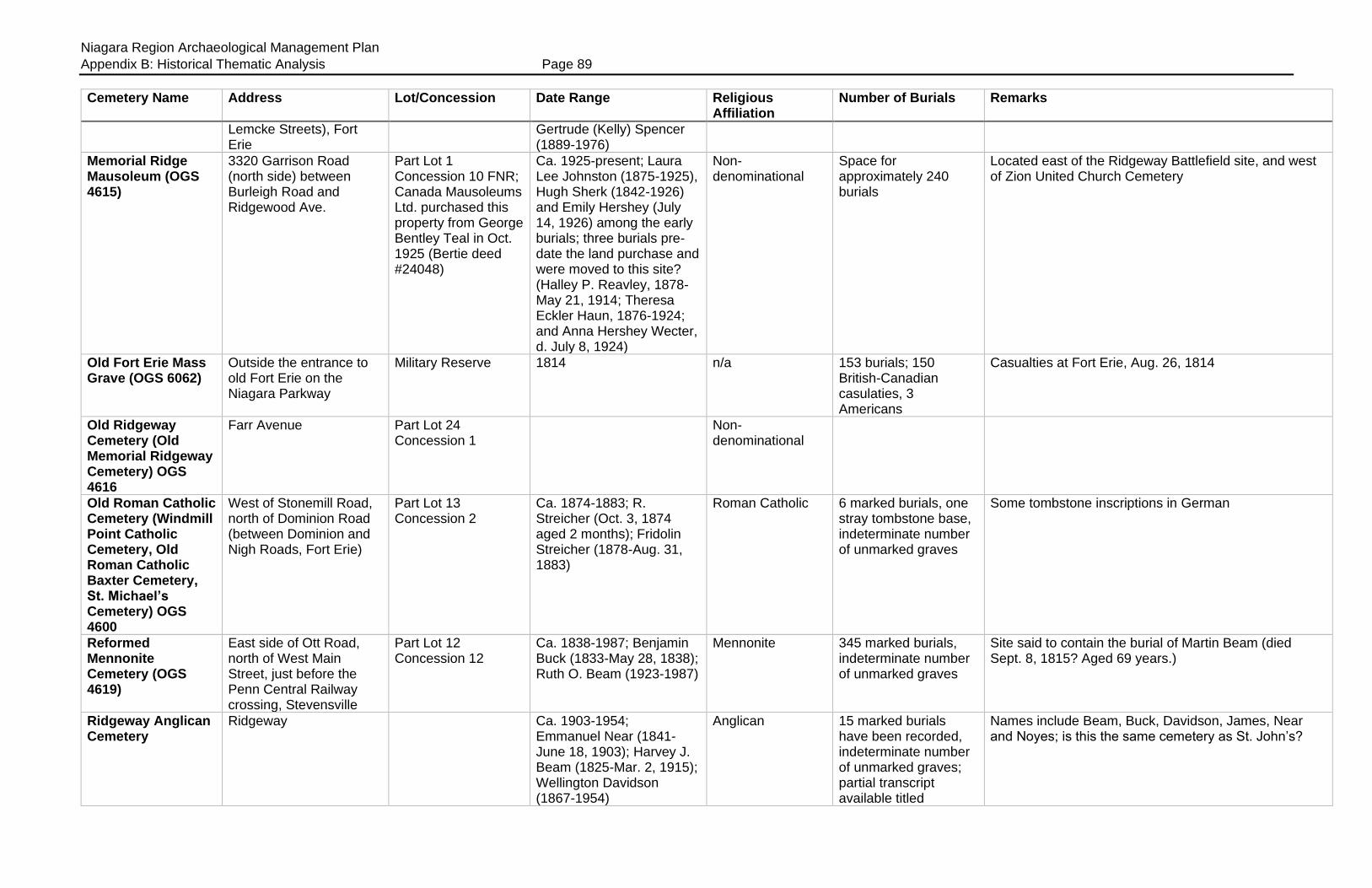
Niagara Region Archaeological Management Plan
Appendix B: Historical Thematic Analysis Page 89
Cemetery Name Address Lot/Concession Date Range Religious Affiliation
Number of Burials Remarks
Lemcke Streets), Fort Erie
Gertrude (Kelly) Spencer (1889-1976)
Memorial Ridge Mausoleum (OGS 4615)
3320 Garrison Road (north side) between Burleigh Road and Ridgewood Ave.
Part Lot 1 Concession 10 FNR; Canada Mausoleums Ltd. purchased this property from George Bentley Teal in Oct. 1925 (Bertie deed #24048)
Ca. 1925-present; Laura Lee Johnston (1875-1925), Hugh Sherk (1842-1926) and Emily Hershey (July 14, 1926) among the early burials; three burials pre-date the land purchase and were moved to this site? (Halley P. Reavley, 1878-May 21, 1914; Theresa Eckler Haun, 1876-1924; and Anna Hershey Wecter, d. July 8, 1924)
Non-denominational
Space for approximately 240 burials
Located east of the Ridgeway Battlefield site, and west of Zion United Church Cemetery
Old Fort Erie Mass Grave (OGS 6062)
Outside the entrance to old Fort Erie on the Niagara Parkway
Military Reserve 1814 n/a 153 burials; 150 British-Canadian casulaties, 3 Americans
Casualties at Fort Erie, Aug. 26, 1814
Old Ridgeway Cemetery (Old Memorial Ridgeway Cemetery) OGS 4616
Farr Avenue Part Lot 24 Concession 1
Non-denominational
Old Roman Catholic Cemetery (Windmill Point Catholic Cemetery, Old Roman Catholic Baxter Cemetery, St. Michael’s Cemetery) OGS 4600
West of Stonemill Road, north of Dominion Road (between Dominion and Nigh Roads, Fort Erie)
Part Lot 13 Concession 2
Ca. 1874-1883; R. Streicher (Oct. 3, 1874 aged 2 months); Fridolin Streicher (1878-Aug. 31, 1883)
Roman Catholic 6 marked burials, one stray tombstone base, indeterminate number of unmarked graves
Some tombstone inscriptions in German
Reformed Mennonite Cemetery (OGS 4619)
East side of Ott Road, north of West Main Street, just before the Penn Central Railway crossing, Stevensville
Part Lot 12 Concession 12
Ca. 1838-1987; Benjamin Buck (1833-May 28, 1838); Ruth O. Beam (1923-1987)
Mennonite 345 marked burials, indeterminate number of unmarked graves
Site said to contain the burial of Martin Beam (died Sept. 8, 1815? Aged 69 years.)
Ridgeway Anglican Cemetery
Ridgeway Ca. 1903-1954; Emmanuel Near (1841-June 18, 1903); Harvey J. Beam (1825-Mar. 2, 1915); Wellington Davidson (1867-1954)
Anglican 15 marked burials have been recorded, indeterminate number of unmarked graves; partial transcript available titled
Names include Beam, Buck, Davidson, James, Near and Noyes; is this the same cemetery as St. John’s?

Niagara Region Archaeological Management Plan
Appendix B: Historical Thematic Analysis Page 90
Cemetery Name Address Lot/Concession Date Range Religious Affiliation
Number of Burials Remarks
“Ridgeway Anglican Cemetery,” which does not provide an address or reference to a Lot and Concession
Ridgeway Memorial Cemetery
Bounded by Farr Avenue, Ridgeway Road, Derby Road and Michener Road, Fort Erie
Part Lot 25 Concession 1 (Registered Plan 360, originally Plan 6622)
Ca. 1940-present; early burial Edward Bambridge (1894-1941)
Non-denominational
Unknown Bounded by Farr Avenue, and Derby, Ridgeway and Michener Roads; contains grave and marker for 10 early settlers, interred on part Lot 32 BF Concession LE, ca. 1790s-1800s, exhumed in August 2010 and reinterred here in May 2012
Ridgeway Old Memorial Cemetery (Ridgeway Old Cemetery, Old Ridgeway Cemetery, Old Memorial Ridgeway Cemetery) OGS 4616
125 Mill Street South (north side of Farr Avenue, west side of Mill Street)
Part Lot 23 Concession 1 (OGS states part Lot 24, other genealogical websites state part Lot 25); 3- acre site deeded by Daniel Pound to the Society of Friends in April 1805 (Bertie Memorial deed #871); Registered Plans 389 and 389 show the cemetery was enlarged in 1906
Ca. 1816?-present; Asa Schooley (1739-1816) a prominent Quaker said to be buried here; Thomas Disher (1791-June 1848); Phillip B. Harkins (1949-2011); Janet B. Truckenbrodt (1926-2012)
Quaker/Society of Friends
203+ marked burials; indeterminate number of unmarked graves
1876 Page’s Atlas showed a cemetery on the south-west corner of the Ralph Disher farm, part Lot 23 Concession 1
St. John’s Anglican Church Cemetery (OGS 4620)
2231 Ridgemount Road between Curtis and Bowen Roads, Fort Erie
Part Lot 9 Concession 8; ½ acre (0.202 ha) purchased for the church and cemetery from Charles Hibbard in July 1836; additional land purchased in 1874 and 1926
1841-present; Eliza Miller (d. 1841) is the first recorded burial
Anglican 44 marked burials, indeterminate number of unmarked graves
Some genealogical website transcripts include the names from the “Little Cemetery Around the Corner” under St. John’s; cemetery enclosed with wrought iron fence with stone gate posts on Ridgemount Road; frame church on site built in 1840
St. Joseph’s Cemetery (OGS 4633)
South side of Garrison Road, between King Street and Legion Way (opposite Douglas Street), Fort Erie
Roman Catholic School and Church Lot, Registered Plan 992; plan showed that the lot was approximately 2 chains by 5 chains in size (132 x 330 feet, 40.23 x 100.58 m)
Ca. 1919-present; Carmine Passero (1915-Mar. 21, 1919); Jeanne Marie Dawson (1928-Nov. 15, 2017)
Roman Catholic Unknown number of burials
Plan 992 was dated June 23, 1862, but did not indicate the presence of a cemetery on the lot; newspaper article reported that the cemetery was closed in 1960; later re-opened? Located beside 172 Garrison Road; cemetery fenced, well maintained
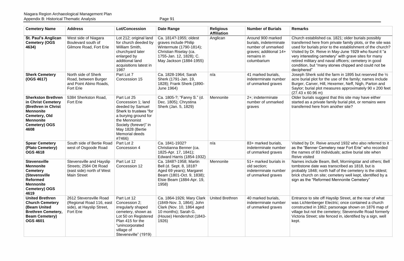
Niagara Region Archaeological Management Plan
Appendix B: Historical Thematic Analysis Page 91
Cemetery Name Address Lot/Concession Date Range Religious Affiliation
Number of Burials Remarks
St. Paul’s Anglican Cemetery (OGS 4634)
West side of Niagara Boulevard south of Gilmore Road, Fort Erie
Lot 212; original land for church deeded by William Smith, churchyard later enlarged by additional land acquisitions latest in 1987
Ca. 1814?-1955; oldest graves include Philip Wintermute (1790-1814); Christian Riselay (ca. 1755-Jan. 12, 1828); C. May Jackson (1884-1955)
Anglican Around 900 marked burials, indeterminate number of unmarked graves; additional 14+ remains in columbarium
Church established ca. 1821; older burials possibly transferred here from private family plots, or the site was used for burials prior to the establishment of the church? Visited by Dr. Reive in May-June 1929 who found it “a very interesting cemetery” with grave sites for many retired military and naval officers; cemetery in good condition, but “many stones chipped and could not be deciphered”
Sherk Cemetery (OGS 4617)
North side of Sherk Road, between Burger and Point Abino Roads, Fort Erie
Part Lot 7 Concession 15
Ca. 1828-1964; Sarah Sherk (1791-Jan. 19, 1828); Frank Sherk (1890-June 1964)
n/a 41 marked burials, indeterminate number of unmarked graves
Joseph Sherk sold the farm in 1895 but reserved the ½ acre burial plot for the use of the family; names include Burger, Carver, Hill, Hexemer, Neff, Nigh, Parton and Saylor; burial plot measures approximately 90 x 200 feet (27.43 x 60.96 m)
Sherkston Brethren in Christ Cemetery (Brethren in Christ Mennonite Cemetery, Old Mennonite Cemetery) OGS 4608
5384 Sherkston Road, Fort Erie
Part Lot 25 Concession 1; land deeded by Samuel Sherk to trustees “for a burying ground for the Mennonist Society (forever)” in May 1828 (Bertie Memorial deeds #7466)
Ca. 1805-?; “Fanny S.” (d. Dec. 1805); Chrystina Sherk (Jan. 5, 1829)
Mennonite 2+; indeterminate number of unmarked graves
Older burials suggest that this site may have either started as a private family burial plot, or remains were transferred here from another site?
Spear Cemetery (Plato Cemetery) OGS 4618
South side of Bertie Road west of Osgoode Road
Part Lot 2 Concession 4
Ca. 1841-1932? Christianna Benner (ca. 1825-Apr. 17, 1841); Edward Harris (1854-1932)
n/a 83+ marked burials, indeterminate number of unmarked graves
Visited by Dr. Reive around 1932 who also referred to it as the “Benner Cemetery near Fort Erie” who recorded the names of 83 individuals; active burial site when Reive visited
Stevensville Mennonite Cemetery (Stevensville Reformed Mennonite Cemetery) OGS 4619
Stevensville and Hayslip Streets; 2584 Ott Road (east side) north of West Main Street
Part Lot 12 Concession 12
Ca. 1848?-1958; Martin Bell (d. Sept. 8, 1818? Aged 69 years); Margaret Beam (1801-Oct. 9, 1838); Elsie Beam (1884-Apr. 19, 1958)
Mennonite 51+ marked burials in old section; indeterminate number of unmarked graves
Names include Beam, Bell, Morningstar and others; Bell tombstone date was transcribed as 1818, but is probably 1848; north half of the cemetery is the oldest; brick church on site; cemetery well kept, identified by a sign as the “Reformed Mennonite Cemetery”
United Brethren Church Cemetery (Beam United Brethren Cemetery, Beam Cemetery) OGS 4601
2612 Stevensville Road (Regional Road 116, east side), at Hayslip Street, Fort Erie
Part Lot 12 Concession 2; irregularly shaped cemetery, shown as Lot 50 on Registered Plan 415 for the “unincorporated village of Stevensville” (1919)
Ca. 1864-1926; Mary Clark (1849-Nov. 3, 1864); John Clark (Nov. 10, 1864 aged 10 months); Sarah G. (House) Hendershot (1843-1926)
United Brethren 40 marked burials, indeterminate number of unmarked graves
Entrance to site off Hayslip Street, at the rear of what was Lichtenberger Electric; once contained a church constructed in 1862; parsonage shown on 1876 map of village but not the cemetery; Stevensville Road formerly Victoria Street; site fenced in, identified by a sign, well kept.

Niagara Region Archaeological Management Plan
Appendix B: Historical Thematic Analysis Page 92
Cemetery Name Address Lot/Concession Date Range Religious Affiliation
Number of Burials Remarks
Unnamed Burial Plot
Point Abino Road South Part Lot 32 Broken Front Concession LE
Ca. 1790s-1820s? n/a 10+; indeterminate number of unmarked graves
Ten early settlers uncovered August 2010, reinterred at Ridgeway Memorial Cemetery in May 2012; land originally belonged to Timothy Skinner (1797), then part sold to Isaac and Abraham Laing (1802), Michael Sherk (1803) and Thomas Otway Page (1806); family burial plot, or a community cemetery? All remains removed from site?
Unnamed Methodist Burial Plot
South-east corner of Dominion and Ridge Roads, Ridgeway
Part Lot 23 Concession 1; Charles Hill and Enos Disher conveyed ¾ acres (0.303 ha) to the trustees of the Wesleyan Methodist Church in April 1848 (Bertie Memorial deed #641)
Not known Wesleyan Methodist
Not known; indeterminate number of unmarked graves
Site now occupied by the People’s Memorial United Church; Page’s Atlas map of 1876 shows a “+” symbol at this site suggesting it was used as a cemetery; not transcribed by OGS
Windmill Point Church of Christ (Disciples) Cemetery (Windmill Point Cemetery, Church of Christ Cemetery) OGS 4609
100 feet (30.48 m) east of Stonemill Road opposite to Johnston Road
Part Lot 12 Concession 2
Ca. 1830-1980; Emaline Edsall (1821-Sept. 26, 1830); Mary Edsall (1821-Apr. 19, 1844); Myrtle Baxter (1894-1980)
Church of Christ (Disciples)
36 marked burials, indeterminate number of unmarked graves
Cemetery measures approximately 90 x 136½ feet (27.43 x 41.60 m)
Zion United Cemetery (Teal Cemetery) OGS 5745
North side of Garrison Road east of Ridge Road, Fort Erie
Part Lot 1 Concession 10; land deeded by Zechariah Teal to church trustees for use as burial ground in April 1865
Ca. 1827-1979; Charles Anger (ca. 1825-June 2, 1827); Lloyd Glenford Sherk (1907-Nov. 1, 1979)
Originally Methodist Episcopal, now United
279 marked burials, indeterminate number of unmarked graves
Located immediately east of the Memorial Ridge Mausoleum; Zion Chapel was located across the street; older stones suggest that this site was either used for burials prior to 1865, or that remains were transferred here from other burial plots after the land was deeded to the trustees

Niagara Region Archaeological Management Plan
Appendix B: Historical Thematic Analysis Page 93
Table B2: Cemeteries in Caistor Township
Cemetery Name Address Lot/Concession Date Range Religious Affiliation
Number of Burials Remarks
Abingdon Presbyterian (OGS 3364)
South side Niagara Road 65, west of Abingdon Road, in Abingdon; 9222 Silver Street
Part Lot 16 Concession 4
Ca. 1864-present; John Clough (1862-1864); Annie Jean (McQueen) Senn (1923-Nov. 23, 2018); one stone transcribed, possibly in error, Andrew Jackson (d. May 21, 1860?)
Presbyterian 151 marked burials, 175 names transcribed
Site marked by a large stone with the name of the cemetery and its establishment date
Bethel Cemetery (Bridgeman Cemetery) OGS 3365
South side of Twenty Road West, east of Regional Road 6 (Caistor Centre Road)
Part Lot 10 Concession 7
Ca. 1841-present; Sarah C. Merritt (ca. 1834-Apr. 24, 1841); Joseph M. Bridgeman (ca. 1815-Dec. 12, 1842); Norman Browning (1928-June 10, 1980)
Not known 102 marked burials, indeterminate number of unmarked graves
Site partly fenced in, identified by a name sign; still presently in use
Caistor Baptist Cemetery (Abingdon Baptist Churchyard, Jackson Cemetery) OGS 3367
9178 Concession 5 Road (south-east corner Abingdon Road and 5th Concession Road)
Part Lot 15 Concession 5
Ca. 1861-present; Robert Henry Miller (1858-Dec. 27, 1861); Samuel Arthur Miller (1859-Sept. 16, 1862); Lilli Hardt (1928-1998), Albert W. Griffin (1911-1998)
Baptist 64 marked burials; indeterminate number of unmarked graves, recent transcripts list 150 names
Chapel built 1864; stone identifies name of cemetery with establishment date 1864; white frame church
Caistorville United Church and Cemetery (OGS 3374)
South side of York Road (Regional Road 9) between Canborough Street and Broman Court; across the street from the Caistorville Public Library
Part Lot 20 Concession 1; part Lots 1, 8 and 9 (York Street) in the village of Caistorville
Ca. 1839-present; Edward Jennings (ca. 1818-Sept. 11, 1839); twins Dudrice and Dudley Johnson, died Nov. 22, 1846 aged 11 days; Viola Susan Fearns (1923-Jan. 2, 2017)
Wesleyan Methodist, United
OGS transcripts record 629 names, recent transcripts list 681 names; indeterminate number of unmarked graves
Land deeded to the congregation by David Tice in September 1857; Methodist services held in township as early as 1822, school at Caistor Corners used for services in 1830s; frame church built 1855, replaced by brick church 1895; entered Church Union 1925; church located on site
Cosby Family Cemetery (OGS 3366)
South side of Regional Road 65 (Bismark Road) west of Attercliffe Road
Part Lot 2 Concession 4
Ca. 1866-1896; earliest stone transcribed Minnie B. Cosby (Oct. 6 1856 aged 1 month); Melinda Jane Cosby (1838-July 6, 1896); transcriptions listed Minnie’s death date in error as 1826
n/a 5-6 marked burials; indeterminate number of unmarked burials
Other names found here include Canby; this appears to be the site visited by Dr. Reive in May 1932 who referred to it as “Cosby Family Graves” located “on a farm between Bismark and Binbrook”
Dockstader/ Dochstader Cemetery (Bristol Cemetery; Chadborne
North side of South Chippawa Road between Church and Attercliffe Roads
Part Lot 3 Concession 2; 1 acre (0.404 ha)
Ca. 1830-1922; Henry Lymburner (1826-Feb. 16, 1830) and Susanna Miller (ca. 1797-Apr. 28, 1830) earliest marked burials;
Non denominational?
101 marked burials (118 names recorded); indeterminate number of unmarked graves
Land donated by Henry Dockstader for use as a public burial ground; former name in honour of Rev. Bristol

Niagara Region Archaeological Management Plan
Appendix B: Historical Thematic Analysis Page 94
Cemetery Name Address Lot/Concession Date Range Religious Affiliation
Number of Burials Remarks
Cemetery) OGS 3368
Lafferty Lymburner (ca. 1842-June 26, 1922)
Hallet Burial Plot (OGS 6069)
East side of Regional Road 6, north-east of Caistor Centre
North-west corner of Lot 9 Concession 5
Ca. 1833-?; John C. Hallet (ca. 1783-1833); Frederick Hallet (ca. 1831-1833)
n/a Unknown; 2+ burials
Ker United Church Cemetery (OGS 3370)
North side of Regional Road 20, west of Abingdon Road
Part Lot 18 Concession 7
Ca. 1851 to present Methodist, United 111 marked burials including vault
Congregation established ca. 1845, church built 1862 and replaced in 1900
Lymburner Cemetery (OGS 3369)
North side of South Chippawa Road between Church and Attercliffe Roads
Part Lot 4 Concession 2
Ca. 1832-1979; Matt Lymburner (ca. 1765-Dec. 1832); Merle Arthur Ross Lymburner (1909-Sept. 26, 1979)
n/a 75 marked burials, indeterminate number of unmarked burials
Family plot
Merritt’s United Church Cemetery (OGS 3371)
North-east corner of Church Road and South Chippawa Road
Part Lot 5 concession 2; land deeded by David Merritt in 1855
Ca. 1850-present Wesleyan Methodist, United
116 marked graves Church built 1855, renovated 1901; entered Church Union in 1925
Roy Cemetery (OGS 3372)
Located on the Binbrook-Haldimand County Line
South-west corner of Lot 25 Concession 1
Ca. 1838-1854 Methodist Episcopal
10 marked burials, indeterminate number of unmarked burials
Site may have contained a small ME Chapel
Waite Cemetery (Waite Burial Ground) OGS 3376
South side of Regional Road 65 (Bismark Road) west of Abingdon Road, 1 mile west of Abingdon
Part Lot 16 Concession 4
Ca. 1863-present; Jacob Packham (July 14, 1863 aged 9 months); John Waite (Mar. 22, 1864 aged 2 months); Fern Mary (Packham) Bird (1918-Mar. 14, 2019)
Methodist Episcopal
113 marked burials, indeterminate number of unmarked graves; 130 names were transcribed from all tombstones prior to 1973
Land purchased from John Waite in 1863; Sunday School established 1860; new church built on Lot 15 in 1882; entered church union in 1925, church closed 1981
Zion Cemetery (Springsted or Burkholder Cemetery) OGS 3373
2298 Abingdon Road (south-west corner of Abingdon and Bismark Roads)
Part Lot 16 Concession 6
Ca. 1864-2010; William M. Nelson (1863-Dec. 24, 1864); Daniel Burkholder (1805-May 1868); Mairi Paterson Birr (1966-208), John A. Boyko (1930-2010)
Not known 31 marked burials; indeterminate number of unmarked graves
Site identified by a sign

Niagara Region Archaeological Management Plan
Appendix B: Historical Thematic Analysis Page 95
Table B3: Cemeteries in Clinton Township
Cemetery Name Address Lot/Concession Date Range Religious Affiliation
Number of Burials Remarks
Abandoned Cemetery (OGS 6017)
unknown Part Lot 7 Concession 5
Not known n/a Indeterminate number of burials
Cemetery located north-west of Mountainview Cemetery “in a grove of locust trees,” the stones were later taken up
Abandoned Cemetery (OGS 6018)
unknown South-west corner of Lot 7 Concession 6
Not known n/a Indeterminate number of burials
Site found by Mr. P. Neufeld, directly opposite to Mountainview Cemetery; location now occupied by housing
Abandoned Cemetery
Unknown Part Lot 7 Concession 8; 200 feet (60.96 m) west of Tintern Road, south side of a ditch, on the old Hipple farm
Not known n/a Indeterminate number of burials
Cemetery located near a tree in the field, believed to contain the graves of several infants, one tombstone existed for an infant child of the Moote family; not listed in the OGS database?
Beamsville Baptist Church Cemetery (First Baptist Church Cemetery, Baptist Cemetery, Beamsville Baptist Churchyard) OGS 3379
4264 Mountain Street, Beamsville
Lot 268, Corporation Plan 3 (CP3)
Ca. 1806-1896; Lemuel Covell (1764-1806); Patrick McGaw (1745-June 8, 1806); Christopher Boughner (1744-1810); David Adair (1734-1811); Jacob Beam (1723-1812); Mahala Boughner (1814-1896); Leah (Snyder) Rott (1804-1896)
Baptist 234 marked graves; 713 burials by 1857
Congregation established 1788; stones gathered to a central location; a few others mounted into a low cairn, while some remain in situ; some stones are believed to have been broken for use in a sidewalk; several unmarked graves; Jacob Beam (Boehm) the founder of Beamsville interred here. He donated the land for the church and school in 1808.
Bucknall Farm Cemetery (Bucknall Farm Burial Plot) OGS 6025
Not known Part Lot 9 Concession 5; plot measures 10 x 10 feet (3.048 x 3.048 m)
Ca. 1836-?; Anna Smith (1800-Aug. 15, 1836); Delby Bucknall thought to be buried here
n/a 1 marked grave, indeterminate number of unmarked graves
Three graves? One stone in a cherry tree grove, another stone said to be in the barn but of unknown origin, possibly another burial for a woman who also died in the 1830s
Campden Mennonite Burying Ground (Mennonite Mountain Burial Ground, Mennonite Cemetery Campden, Mount Hope Cemetery) OGS 3380
South-west corner of Fly Road (Regional Road 73) and Tintern Road
Part Lot 7 Concession 7
Ca. 1840-2005; C.H. Bushey’s daughter buried here Feb. 2, 1843; Magdalena Moyer (1801-June 10, 1845); Catherine Houser (1780-1849); Jeremiah Putman (1890-1960); Margaret Reed (1918-2002)
Mennonite 240+ marked burials, indeterminate number of unmarked graves
Once called Mount Hope; congregation established 1840, disbanded 1909 and church sold 1915; site is fenced (iron fence with stone gate posts), identified by a sign and well maintained; heritage plaque
Christopher Culp Cemetery (OGS 6019)
Not known Part Lot 6 Broken Front Concession
Ca. 1833-1878; Christopher Culp (1747-
n/a 9 burials, indeterminate number of unmarked burials
Site presently contains 4 tombstones; located near the creek
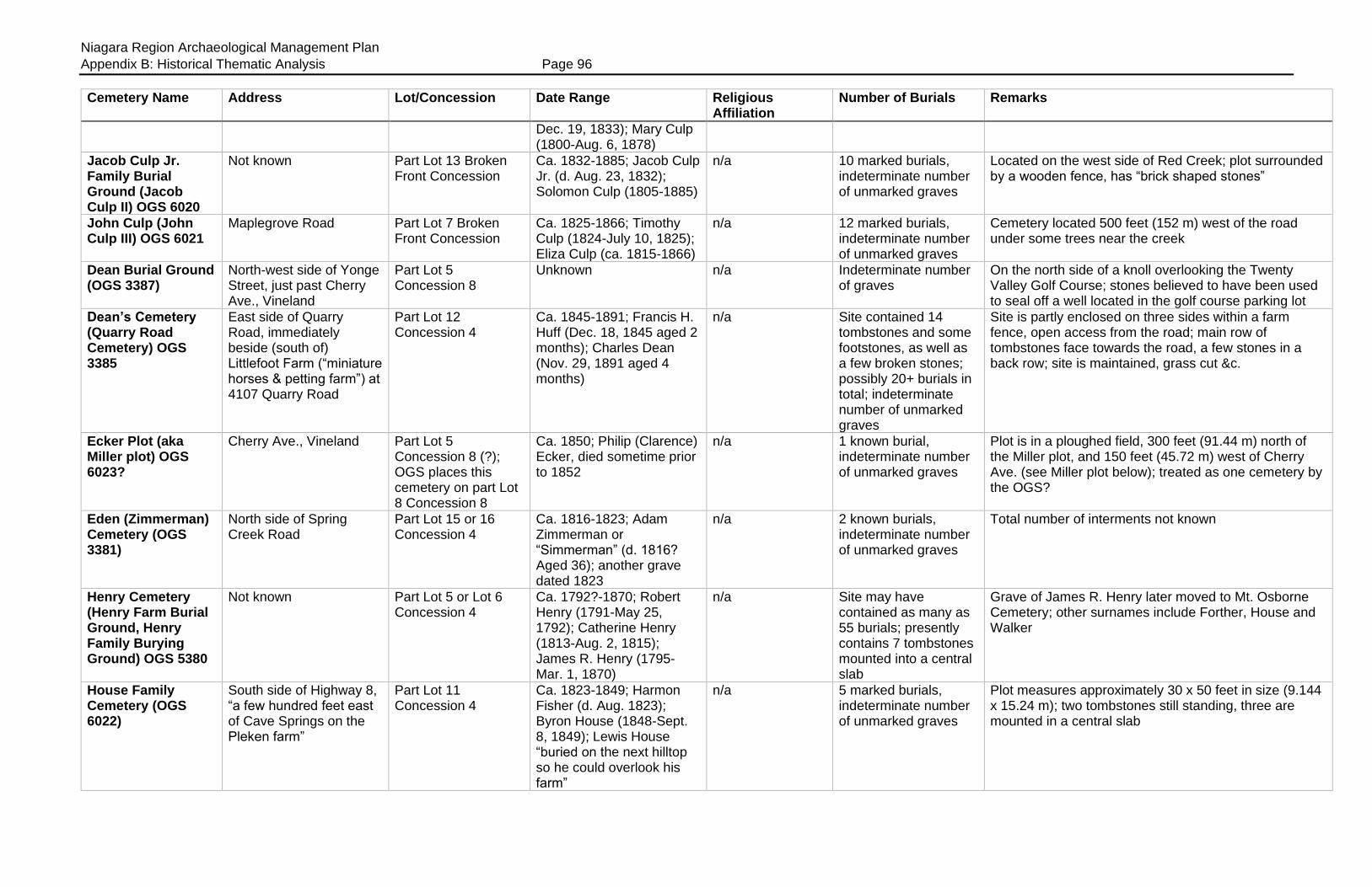
Niagara Region Archaeological Management Plan
Appendix B: Historical Thematic Analysis Page 96
Cemetery Name Address Lot/Concession Date Range Religious Affiliation
Number of Burials Remarks
Dec. 19, 1833); Mary Culp (1800-Aug. 6, 1878)
Jacob Culp Jr. Family Burial Ground (Jacob Culp II) OGS 6020
Not known Part Lot 13 Broken Front Concession
Ca. 1832-1885; Jacob Culp Jr. (d. Aug. 23, 1832); Solomon Culp (1805-1885)
n/a 10 marked burials, indeterminate number of unmarked graves
Located on the west side of Red Creek; plot surrounded by a wooden fence, has “brick shaped stones”
John Culp (John Culp III) OGS 6021
Maplegrove Road Part Lot 7 Broken Front Concession
Ca. 1825-1866; Timothy Culp (1824-July 10, 1825); Eliza Culp (ca. 1815-1866)
n/a 12 marked burials, indeterminate number of unmarked graves
Cemetery located 500 feet (152 m) west of the road under some trees near the creek
Dean Burial Ground (OGS 3387)
North-west side of Yonge Street, just past Cherry Ave., Vineland
Part Lot 5 Concession 8
Unknown n/a Indeterminate number of graves
On the north side of a knoll overlooking the Twenty Valley Golf Course; stones believed to have been used to seal off a well located in the golf course parking lot
Dean’s Cemetery (Quarry Road Cemetery) OGS 3385
East side of Quarry Road, immediately beside (south of) Littlefoot Farm (“miniature horses & petting farm”) at 4107 Quarry Road
Part Lot 12 Concession 4
Ca. 1845-1891; Francis H. Huff (Dec. 18, 1845 aged 2 months); Charles Dean (Nov. 29, 1891 aged 4 months)
n/a Site contained 14 tombstones and some footstones, as well as a few broken stones; possibly 20+ burials in total; indeterminate number of unmarked graves
Site is partly enclosed on three sides within a farm fence, open access from the road; main row of tombstones face towards the road, a few stones in a back row; site is maintained, grass cut &c.
Ecker Plot (aka Miller plot) OGS 6023?
Cherry Ave., Vineland Part Lot 5 Concession 8 (?); OGS places this cemetery on part Lot 8 Concession 8
Ca. 1850; Philip (Clarence) Ecker, died sometime prior to 1852
n/a 1 known burial, indeterminate number of unmarked graves
Plot is in a ploughed field, 300 feet (91.44 m) north of the Miller plot, and 150 feet (45.72 m) west of Cherry Ave. (see Miller plot below); treated as one cemetery by the OGS?
Eden (Zimmerman) Cemetery (OGS 3381)
North side of Spring Creek Road
Part Lot 15 or 16 Concession 4
Ca. 1816-1823; Adam Zimmerman or “Simmerman” (d. 1816? Aged 36); another grave dated 1823
n/a 2 known burials, indeterminate number of unmarked graves
Total number of interments not known
Henry Cemetery (Henry Farm Burial Ground, Henry Family Burying Ground) OGS 5380
Not known Part Lot 5 or Lot 6 Concession 4
Ca. 1792?-1870; Robert Henry (1791-May 25, 1792); Catherine Henry (1813-Aug. 2, 1815); James R. Henry (1795-Mar. 1, 1870)
n/a Site may have contained as many as 55 burials; presently contains 7 tombstones mounted into a central slab
Grave of James R. Henry later moved to Mt. Osborne Cemetery; other surnames include Forther, House and Walker
House Family Cemetery (OGS 6022)
South side of Highway 8, “a few hundred feet east of Cave Springs on the Pleken farm”
Part Lot 11 Concession 4
Ca. 1823-1849; Harmon Fisher (d. Aug. 1823); Byron House (1848-Sept. 8, 1849); Lewis House “buried on the next hilltop so he could overlook his farm”
n/a 5 marked burials, indeterminate number of unmarked graves
Plot measures approximately 30 x 50 feet in size (9.144 x 15.24 m); two tombstones still standing, three are mounted in a central slab

Niagara Region Archaeological Management Plan
Appendix B: Historical Thematic Analysis Page 97
Cemetery Name Address Lot/Concession Date Range Religious Affiliation
Number of Burials Remarks
Indian Communal Burial Site (Dean, Dean’s Mills) OGS 3305
Unknown Part Lot 5 Concession 8, “in a low, level field” approximately 300 yards (900 feet/274 m) north of Mud Creek and 500 yards (1,500 feet/457 m) west of the Twenty Mile Creek; OGS incorrectly places this site on part Lot 8 Concession 8
Unknown, believe to be pre-contact
n/a Possibly 250 individuals?
Site was discovered on the Andrew Dean farm; heavily plundered in 1900 or 1901 by local inhabitants when news was made public of its discovery; some artifacts and specimens (skulls, femurs) were collected by Boyle, others were donated by collectors to the ROM. A number of nearby surface finds were believed by Boyle to have been “camping sites” from which artifacts were collected.
Johnson-Spiece Cemetery (Johnson Methodist Cemetery; Dawdy, Lampman & Spiece Cemetery) OGS 3378
West side of 20 Mile Creek, south of Spring Creek Road, north of 20 Mile Road, between Campden and Tintern Roads (“formerly known as Haberley Road”?) ; south of 4042 Spring Creek Road
Part Lots 7-8 Concession 10
Ca. 1820-1886; Susannah Johnson (Aug. 14, 1820 aged 1 day); Ida Melick (1878-Nov. 11, 1886)
Wesleyan Methodist
42 marked burials, indeterminate number of unmarked graves
Stones moved to a central location; church was on the site; other surnames include Bartron, Dawdy, Johnson, Melick, Reece
Konkle II Cemetery (OGS 5935)
Lincoln Avenue Part Lot 17 or 18 Broken Front Concession
Ca. 1813-1883; Adam Konkle (1747-Sept. 17, 1813); Henry Konkle (1795-Mar. 23, 1883)
n/a 4 or more marked burials, several fragments; indeterminate number of unmarked graves
Located 175 feet (53.34 m) east of the pumphouse at the end of Lincoln Ave., on the top of the east bank of the creek, surrounded by walnut trees; Adam Konkle directed in his will that he be buried in the orchard on his farm
Mennonite Burying Ground (Moyer Cemetery, Vineland Mennonite, Vineland I Old Mennonite) OGS 3386
4025 Martin Road, Vineland (corner of King Street or Regional Road 81/Old Highway 8, at Martin Road)
Part Lot 2 Concession 4
1798-1976; oldest marked grave appears to be Diana (Fretz) Rittenhouse (1768-Sept. 7, 1801); other early burials include Mary Claus (1759-1803), D. High (1808), Mary (Kolb) Fretz (1730-Mar. 7, 1810), Daniel High (1773-1812), Barbara Albright (1812) and Peter Couse (1767-1812); last burials Josiah P. Albright (1857-1940); Rev. C. Raymond Albright (1888-1969), Jenny L. Albright (1887-1976) last burials
Mennonite Reive recorded the names of 537 individuals interred in this cemetery prior to 1929; indeterminate number of unmarked graves
Visited by Dr. Reive in October 1929; plot surrounded by a stone wall built in 1833; well maintained cemetery; site designated by the Town of Lincoln LACAC (plaqued); wall contains a metal plaque which identifies the site as the “Mennonite Burying Ground 1798.” Some early markers are field stones with initials and the date, a few are inscribed in German.
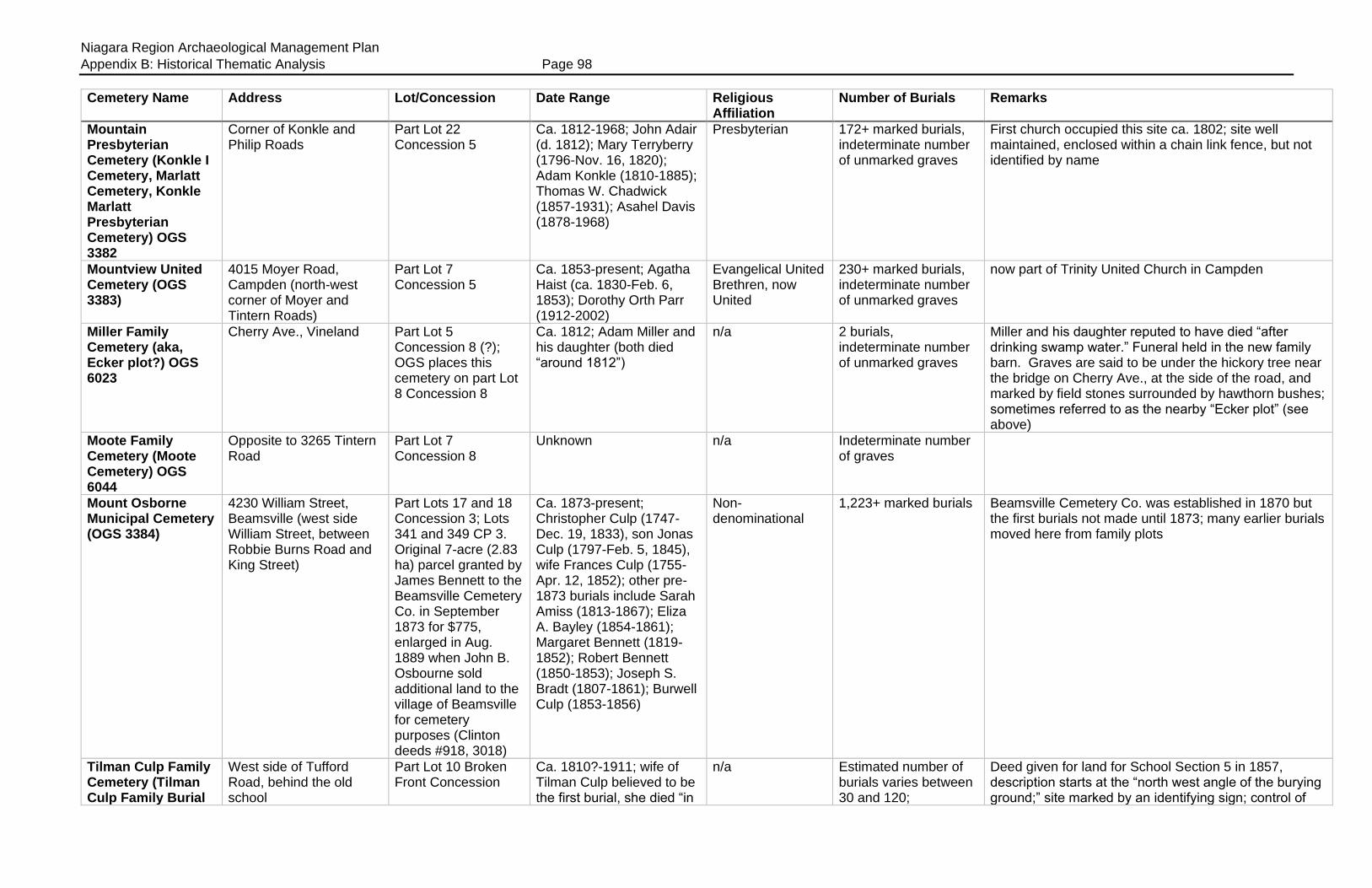
Niagara Region Archaeological Management Plan
Appendix B: Historical Thematic Analysis Page 98
Cemetery Name Address Lot/Concession Date Range Religious Affiliation
Number of Burials Remarks
Mountain Presbyterian Cemetery (Konkle I Cemetery, Marlatt Cemetery, Konkle Marlatt Presbyterian Cemetery) OGS 3382
Corner of Konkle and Philip Roads
Part Lot 22 Concession 5
Ca. 1812-1968; John Adair (d. 1812); Mary Terryberry (1796-Nov. 16, 1820); Adam Konkle (1810-1885); Thomas W. Chadwick (1857-1931); Asahel Davis (1878-1968)
Presbyterian 172+ marked burials, indeterminate number of unmarked graves
First church occupied this site ca. 1802; site well maintained, enclosed within a chain link fence, but not identified by name
Mountview United Cemetery (OGS 3383)
4015 Moyer Road, Campden (north-west corner of Moyer and Tintern Roads)
Part Lot 7 Concession 5
Ca. 1853-present; Agatha Haist (ca. 1830-Feb. 6, 1853); Dorothy Orth Parr (1912-2002)
Evangelical United Brethren, now United
230+ marked burials, indeterminate number of unmarked graves
now part of Trinity United Church in Campden
Miller Family Cemetery (aka, Ecker plot?) OGS 6023
Cherry Ave., Vineland Part Lot 5 Concession 8 (?); OGS places this cemetery on part Lot 8 Concession 8
Ca. 1812; Adam Miller and his daughter (both died “around 1812”)
n/a 2 burials, indeterminate number of unmarked graves
Miller and his daughter reputed to have died “after drinking swamp water.” Funeral held in the new family barn. Graves are said to be under the hickory tree near the bridge on Cherry Ave., at the side of the road, and marked by field stones surrounded by hawthorn bushes; sometimes referred to as the nearby “Ecker plot” (see above)
Moote Family Cemetery (Moote Cemetery) OGS 6044
Opposite to 3265 Tintern Road
Part Lot 7 Concession 8
Unknown n/a Indeterminate number of graves
Mount Osborne Municipal Cemetery (OGS 3384)
4230 William Street, Beamsville (west side William Street, between Robbie Burns Road and King Street)
Part Lots 17 and 18 Concession 3; Lots 341 and 349 CP 3. Original 7-acre (2.83 ha) parcel granted by James Bennett to the Beamsville Cemetery Co. in September 1873 for $775, enlarged in Aug. 1889 when John B. Osbourne sold additional land to the village of Beamsville for cemetery purposes (Clinton deeds #918, 3018)
Ca. 1873-present; Christopher Culp (1747-Dec. 19, 1833), son Jonas Culp (1797-Feb. 5, 1845), wife Frances Culp (1755-Apr. 12, 1852); other pre-1873 burials include Sarah Amiss (1813-1867); Eliza A. Bayley (1854-1861); Margaret Bennett (1819-1852); Robert Bennett (1850-1853); Joseph S. Bradt (1807-1861); Burwell Culp (1853-1856)
Non-denominational
1,223+ marked burials Beamsville Cemetery Co. was established in 1870 but the first burials not made until 1873; many earlier burials moved here from family plots
Tilman Culp Family Cemetery (Tilman Culp Family Burial
West side of Tufford Road, behind the old school
Part Lot 10 Broken Front Concession
Ca. 1810?-1911; wife of Tilman Culp believed to be the first burial, she died “in
n/a Estimated number of burials varies between 30 and 120;
Deed given for land for School Section 5 in 1857, description starts at the “north west angle of the burying ground;” site marked by an identifying sign; control of
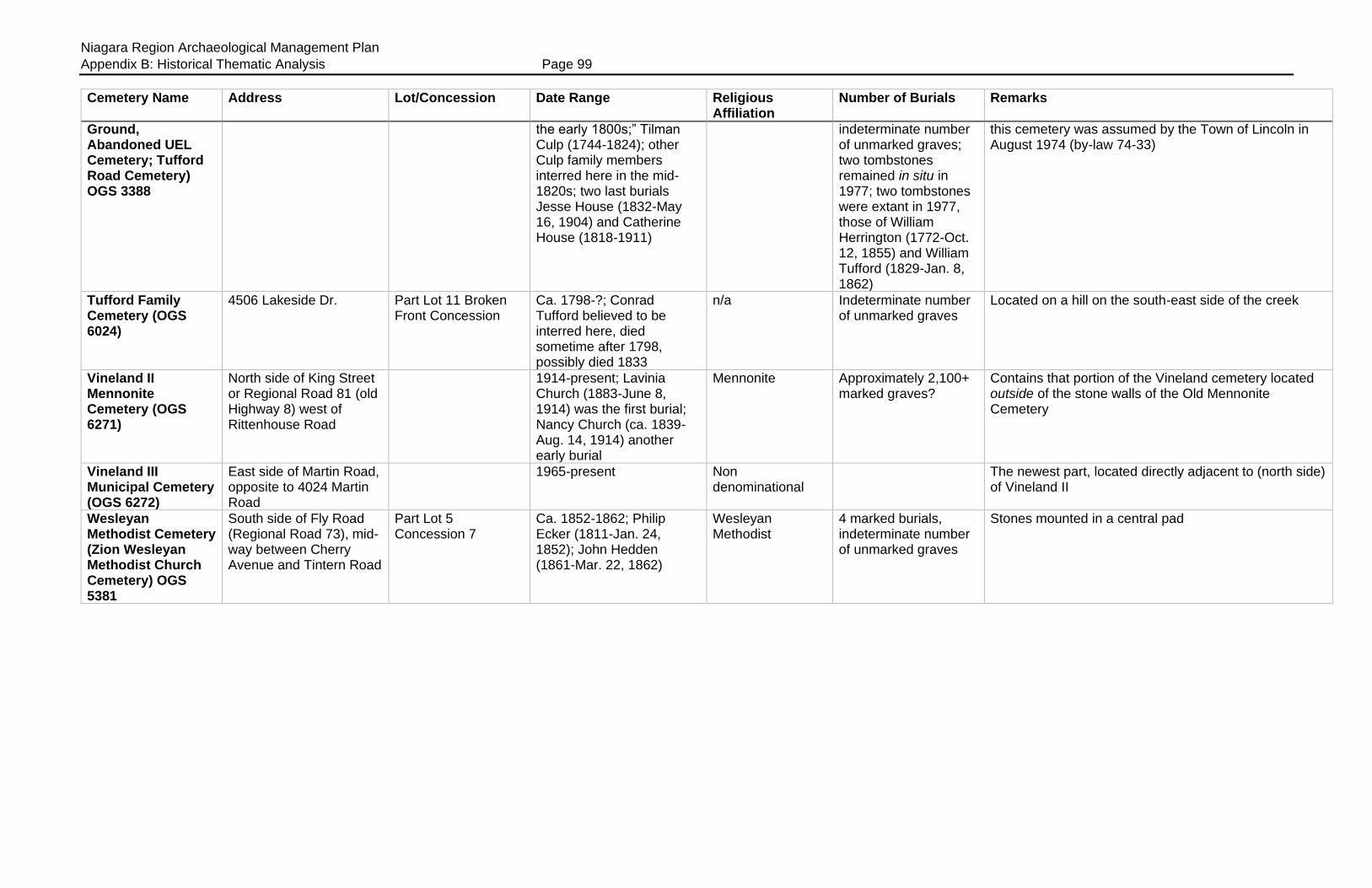
Niagara Region Archaeological Management Plan
Appendix B: Historical Thematic Analysis Page 99
Cemetery Name Address Lot/Concession Date Range Religious Affiliation
Number of Burials Remarks
Ground, Abandoned UEL Cemetery; Tufford Road Cemetery) OGS 3388
the early 1800s;” Tilman Culp (1744-1824); other Culp family members interred here in the mid-1820s; two last burials Jesse House (1832-May 16, 1904) and Catherine House (1818-1911)
indeterminate number of unmarked graves; two tombstones remained in situ in 1977; two tombstones were extant in 1977, those of William Herrington (1772-Oct. 12, 1855) and William Tufford (1829-Jan. 8, 1862)
this cemetery was assumed by the Town of Lincoln in August 1974 (by-law 74-33)
Tufford Family Cemetery (OGS 6024)
4506 Lakeside Dr. Part Lot 11 Broken Front Concession
Ca. 1798-?; Conrad Tufford believed to be interred here, died sometime after 1798, possibly died 1833
n/a Indeterminate number of unmarked graves
Located on a hill on the south-east side of the creek
Vineland II Mennonite Cemetery (OGS 6271)
North side of King Street or Regional Road 81 (old Highway 8) west of Rittenhouse Road
1914-present; Lavinia Church (1883-June 8, 1914) was the first burial; Nancy Church (ca. 1839-Aug. 14, 1914) another early burial
Mennonite Approximately 2,100+ marked graves?
Contains that portion of the Vineland cemetery located outside of the stone walls of the Old Mennonite Cemetery
Vineland III Municipal Cemetery (OGS 6272)
East side of Martin Road, opposite to 4024 Martin Road
1965-present Non denominational
The newest part, located directly adjacent to (north side) of Vineland II
Wesleyan Methodist Cemetery (Zion Wesleyan Methodist Church Cemetery) OGS 5381
South side of Fly Road (Regional Road 73), mid-way between Cherry Avenue and Tintern Road
Part Lot 5 Concession 7
Ca. 1852-1862; Philip Ecker (1811-Jan. 24, 1852); John Hedden (1861-Mar. 22, 1862)
Wesleyan Methodist
4 marked burials, indeterminate number of unmarked graves
Stones mounted in a central pad

Niagara Region Archaeological Management Plan
Appendix B: Historical Thematic Analysis Page 100
Table B4: Cemeteries in Crowland Township
Cemetery Name Address Lot/Concession Date Range Religious Affiliation
Number of Burials Remarks
Denistoun Street Cemetery (Methodist Episcopal Church Cemetery; Former Methodist Episcopal Church Site; Gonder farm plot; Stoner farm plot) OGS 5895
East Side of Denistoun Street at Mill Street, south of the Welland River, north of Main Street, City of Welland
Part Lot 26 Concession 5; 1 acre (0.404 ha), 210 feet (64 m) on Denistoun Street; shown on Registered Plan 556 (dated August 1857)
Ca. 1813-1876; Michael Gonder buried there 1813; David Price, died Feb. 26, 1841 aged 91 years.
Methodist Episcopal
5 known, indeterminate number of unmarked graves
Cemetery began as a Gonder family burial plot, then used by the Price family; land deeded to trustees of the ME Church by John Price in July 1863 (Crowland deed #11046); land sold by church to Joseph Thorne in June 1876; no bodies known to have been moved, now occupied by houses; other names associated with this cemetery are thought to include Stoner and Ellsworth
Doan’s Ridge Cemetery (OGS 4627)
South of Ridge Road, east of Doan’s Ridge Road
Part Lot 11 or 12 Concession 7; Registered Plans 7, 220, and 1676 (now known as Plans 927, 929 and 930)
Ca. 1894; Agnes F. Carl interred here September 1894; Hiram Doan (1819-1819); Christianna Yokom (1790-1828); Wilson Doan (1762-1837);
n/a 159 marked burials, indeterminate number of unmarked burials; Reive recorded the burials of 591 individuals by 1928
Sections A.B and D transcribed by OGS; Dr. Reive visited Doan’s Ridge several times in 1928, and noted that it had a full-time caretaker and was “being carefully preserved.” He noted that it was “the largest cemetery in Crowland Township” with many early names
Islamic Cemetery of Niagara
9553 Yokom Road (north side, between Crowland Avenue and McKenney Road), Welland
Part Lot 7 Concession 4
Ca. 1993-present; Hassan Karachi (1924-1993) appears to have been the first burial at this location
Muslim, Islamic 41 marked burials, indeterminate number of unmarked burials
Site enclosed within a fence and clearly marked by a sign, an austere but well-maintained cemetery
Japanese Martyrs Cemetery (Welland Roman Catholic Churchyard) OGS 4690
Aqueduct Street, bounded by Church and Elizabeth Streets, Welland; bounded on the west side by numbers 46-48 Church Street and 49-51 Elizabeth Street
Lot 76, Registered Plan 549 & 550; part of Lock Street (closed) RP 549 & 550; land sold by John Dunigan to the Roman Catholic Diocese of Toronto for $620 in September 1861; Lock Street (west side of the cemetery) was stopped up and closed, and sold by the Town of Welland to the RC Diocese in November 1915 (Welland deeds #9644/1861 and 3971/1915)
Ca. 1863-1922; Ann Freel (1801-1863); John Brown (1797-1865); John Shanahan (August 1865); “Baby Hucic” possibly the last interment, Feb. 1922
Roman Catholic 127 marked graves, records suggest 550 unmarked graves?
Japanese Martyrs was the first permanent Catholic Church in Welland, built in 1871; some burials pre-date the church, possibly moved here from another site? Church burned in 1913, some church records destroyed; Holy Cross used later; some tombstones in Italian, Hungarian, Cyrillic; site enclosed by a wrought iron fence, well maintained
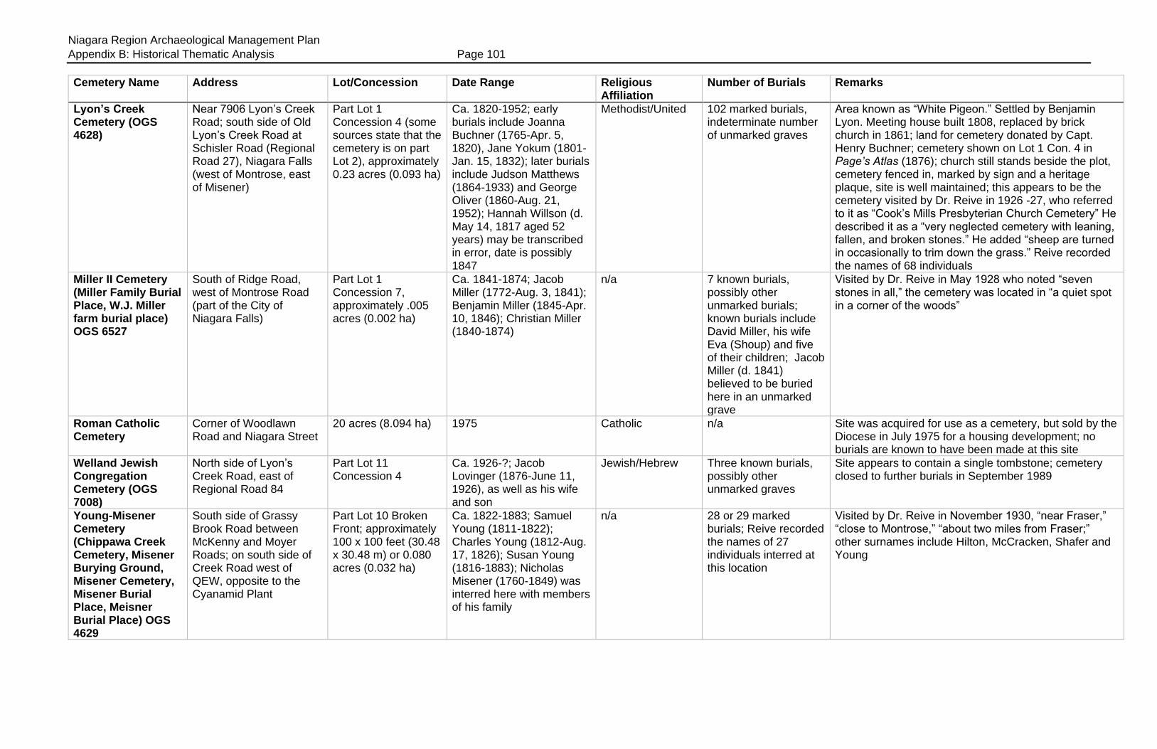
Niagara Region Archaeological Management Plan
Appendix B: Historical Thematic Analysis Page 101
Cemetery Name Address Lot/Concession Date Range Religious Affiliation
Number of Burials Remarks
Lyon’s Creek Cemetery (OGS 4628)
Near 7906 Lyon’s Creek Road; south side of Old Lyon’s Creek Road at Schisler Road (Regional Road 27), Niagara Falls (west of Montrose, east of Misener)
Part Lot 1 Concession 4 (some sources state that the cemetery is on part Lot 2), approximately 0.23 acres (0.093 ha)
Ca. 1820-1952; early burials include Joanna Buchner (1765-Apr. 5, 1820), Jane Yokum (1801-Jan. 15, 1832); later burials include Judson Matthews (1864-1933) and George Oliver (1860-Aug. 21, 1952); Hannah Willson (d. May 14, 1817 aged 52 years) may be transcribed in error, date is possibly 1847
Methodist/United 102 marked burials, indeterminate number of unmarked graves
Area known as “White Pigeon.” Settled by Benjamin Lyon. Meeting house built 1808, replaced by brick church in 1861; land for cemetery donated by Capt. Henry Buchner; cemetery shown on Lot 1 Con. 4 in Page’s Atlas (1876); church still stands beside the plot, cemetery fenced in, marked by sign and a heritage plaque, site is well maintained; this appears to be the cemetery visited by Dr. Reive in 1926 -27, who referred to it as “Cook’s Mills Presbyterian Church Cemetery” He described it as a “very neglected cemetery with leaning, fallen, and broken stones.” He added “sheep are turned in occasionally to trim down the grass.” Reive recorded the names of 68 individuals
Miller II Cemetery (Miller Family Burial Place, W.J. Miller farm burial place) OGS 6527
South of Ridge Road, west of Montrose Road (part of the City of Niagara Falls)
Part Lot 1 Concession 7, approximately .005 acres (0.002 ha)
Ca. 1841-1874; Jacob Miller (1772-Aug. 3, 1841); Benjamin Miller (1845-Apr. 10, 1846); Christian Miller (1840-1874)
n/a 7 known burials, possibly other unmarked burials; known burials include David Miller, his wife Eva (Shoup) and five of their children; Jacob Miller (d. 1841) believed to be buried here in an unmarked grave
Visited by Dr. Reive in May 1928 who noted “seven stones in all,” the cemetery was located in “a quiet spot in a corner of the woods”
Roman Catholic Cemetery
Corner of Woodlawn Road and Niagara Street
20 acres (8.094 ha) 1975 Catholic n/a Site was acquired for use as a cemetery, but sold by the Diocese in July 1975 for a housing development; no burials are known to have been made at this site
Welland Jewish Congregation Cemetery (OGS 7008)
North side of Lyon’s Creek Road, east of Regional Road 84
Part Lot 11 Concession 4
Ca. 1926-?; Jacob Lovinger (1876-June 11, 1926), as well as his wife and son
Jewish/Hebrew Three known burials, possibly other unmarked graves
Site appears to contain a single tombstone; cemetery closed to further burials in September 1989
Young-Misener Cemetery (Chippawa Creek Cemetery, Misener Burying Ground, Misener Cemetery, Misener Burial Place, Meisner Burial Place) OGS 4629
South side of Grassy Brook Road between McKenny and Moyer Roads; on south side of Creek Road west of QEW, opposite to the Cyanamid Plant
Part Lot 10 Broken Front; approximately 100 x 100 feet (30.48 x 30.48 m) or 0.080 acres (0.032 ha)
Ca. 1822-1883; Samuel Young (1811-1822); Charles Young (1812-Aug. 17, 1826); Susan Young (1816-1883); Nicholas Misener (1760-1849) was interred here with members of his family
n/a 28 or 29 marked burials; Reive recorded the names of 27 individuals interred at this location
Visited by Dr. Reive in November 1930, “near Fraser,” “close to Montrose,” “about two miles from Fraser;” other surnames include Hilton, McCracken, Shafer and Young
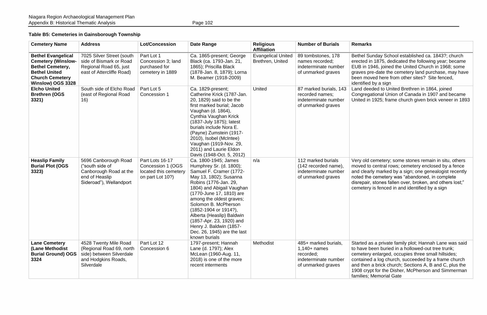
Niagara Region Archaeological Management Plan
Appendix B: Historical Thematic Analysis Page 102
Table B5: Cemeteries in Gainsborough Township
Cemetery Name Address Lot/Concession Date Range Religious Affiliation
Number of Burials Remarks
Bethel Evangelical Cemetery (Winslow-Bethel Cemetery, Bethel United Church Cemetery Winslow) OGS 3328
7025 Silver Street (south side of Bismark or Road Regional Road 65, just east of Attercliffe Road)
Part Lot 1 Concession 3; land purchased for cemetery in 1889
Ca. 1865-present; George Black (ca. 1793-Jan. 21, 1865); Priscilla Black (1878-Jan. 8, 1879); Lorna M. Beamer (1918-2009)
Evangelical United Brethren, United
89 tombstones, 178 names recorded; indeterminate number of unmarked graves
Bethel Sunday School established ca. 1843?; church erected in 1875, dedicated the following year; became EUB in 1946, joined the United Church in 1968; some graves pre-date the cemetery land purchase, may have been moved here from other sites? Site fenced, identified by a sign
Elcho United Brethren (OGS 3321)
South side of Elcho Road (east of Regional Road 16)
Part Lot 5 Concession 1
Ca. 1829-present; Catherine Krick (1787-Jan. 20, 1829) said to be the first marked burial; Jacob Vaughan (d. 1864), Cynthia Vaughan Krick (1837-July 1875); latest burials include Nora E. (Payne) Zumstein (1917-2010), Isobel (McIntee) Vaughan (1919-Nov. 29, 2011) and Laurie Eldon Davis (1948-Oct. 5, 2012)
United 87 marked burials, 143 recorded names; indeterminate number of unmarked graves
Land deeded to United Brethren in 1864, joined Congregational Union of Canada in 1907 and became United in 1925; frame church given brick veneer in 1893
Heaslip Family Burial Plot (OGS 3323)
5696 Canborough Road (“south side of Canborough Road at the end of Heaslip Sideroad”), Wellandport
Part Lots 16-17 Concession 1 (OGS located this cemetery on part Lot 10?)
Ca. 1800-1945; James Humphrey Sr. (d. 1800); Samuel F. Cramer (1772-May 13, 1802); Susanna Robins (1776-Jan. 29, 1804) and Abigail Vaughan (1770-June 17, 1810) are among the oldest graves; Solomon B. McPherson (1852-1904 or 1914?), Alberta (Heaslip) Baldwin (1857-Apr. 23, 1920) and Henry J. Baldwin (1857-Dec. 26, 1945) are the last known burials
n/a 112 marked burials (142 recorded name), indeterminate number of unmarked graves
Very old cemetery; some stones remain in situ, others moved to central rows; cemetery enclosed by a fence and clearly marked by a sign; one genealogist recently noted the cemetery was “abandoned, in complete disrepair, stones fallen over, broken, and others lost;” cemetery is fenced in and identified by a sign
Lane Cemetery (Lane Methodist Burial Ground) OGS 3324
4528 Twenty Mile Road (Regional Road 69, north side) between Silverdale and Hodgkins Roads, Silverdale
Part Lot 12 Concession 6
1797-present; Hannah Lane (d. 1797); Alex McLean (1960-Aug. 11, 2018) is one of the more recent interments
Methodist 485+ marked burials, 1,140+ names recorded; indeterminate number of unmarked graves
Started as a private family plot; Hannah Lane was said to have been buried in a hollowed-out tree trunk; cemetery enlarged, occupies three small hillsides; contained a log church, succeeded by a frame church and then a brick church; Sections A, B and C, plus the 1908 crypt for the Disher, McPherson and Simmerman families; Memorial Gate
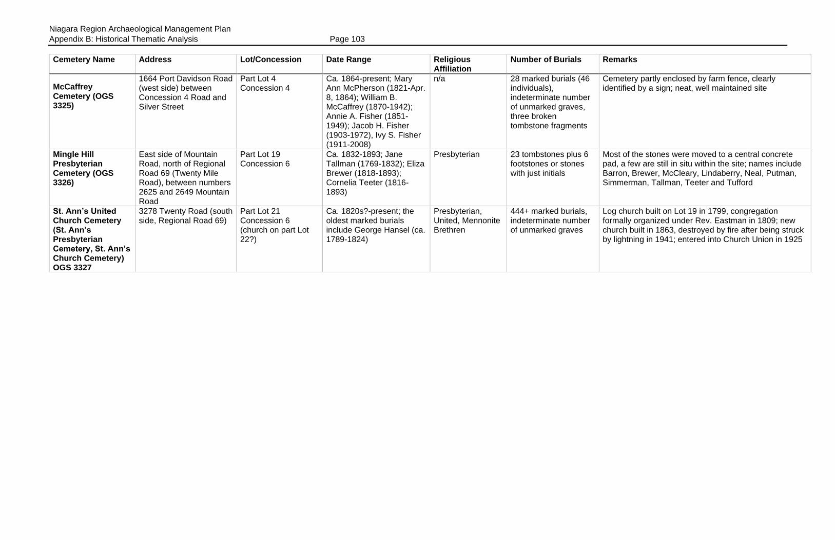
Niagara Region Archaeological Management Plan
Appendix B: Historical Thematic Analysis Page 103
Cemetery Name Address Lot/Concession Date Range Religious Affiliation
Number of Burials Remarks
McCaffrey Cemetery (OGS 3325)
1664 Port Davidson Road (west side) between Concession 4 Road and Silver Street
Part Lot 4 Concession 4
Ca. 1864-present; Mary Ann McPherson (1821-Apr. 8, 1864); William B. McCaffrey (1870-1942); Annie A. Fisher (1851-1949); Jacob H. Fisher (1903-1972), Ivy S. Fisher (1911-2008)
n/a 28 marked burials (46 individuals), indeterminate number of unmarked graves, three broken tombstone fragments
Cemetery partly enclosed by farm fence, clearly identified by a sign; neat, well maintained site
Mingle Hill Presbyterian Cemetery (OGS 3326)
East side of Mountain Road, north of Regional Road 69 (Twenty Mile Road), between numbers 2625 and 2649 Mountain Road
Part Lot 19 Concession 6
Ca. 1832-1893; Jane Tallman (1769-1832); Eliza Brewer (1818-1893); Cornelia Teeter (1816-1893)
Presbyterian 23 tombstones plus 6 footstones or stones with just initials
Most of the stones were moved to a central concrete pad, a few are still in situ within the site; names include Barron, Brewer, McCleary, Lindaberry, Neal, Putman, Simmerman, Tallman, Teeter and Tufford
St. Ann’s United Church Cemetery (St. Ann’s Presbyterian Cemetery, St. Ann’s Church Cemetery) OGS 3327
3278 Twenty Road (south side, Regional Road 69)
Part Lot 21 Concession 6 (church on part Lot 22?)
Ca. 1820s?-present; the oldest marked burials include George Hansel (ca. 1789-1824)
Presbyterian, United, Mennonite Brethren
444+ marked burials, indeterminate number of unmarked graves
Log church built on Lot 19 in 1799, congregation formally organized under Rev. Eastman in 1809; new church built in 1863, destroyed by fire after being struck by lightning in 1941; entered into Church Union in 1925
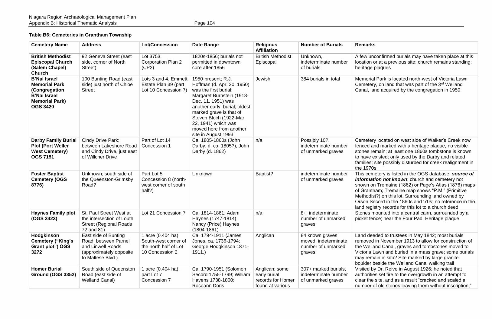
Niagara Region Archaeological Management Plan
Appendix B: Historical Thematic Analysis Page 104
Table B6: Cemeteries in Grantham Township
Cemetery Name Address Lot/Concession Date Range Religious Affiliation
Number of Burials Remarks
British Methodist Episcopal Church (Salem Chapel) Church
92 Geneva Street (east side, corner of North Street)
Lot 3753, Corporation Plan 2 (CP2)
1820s-1856; burials not permitted in downtown core after 1856
British Methodist Episcopal
Unknown, indeterminate number of burials
A few unconfirmed burials may have taken place at this location or at a previous site; church remains standing; heritage plaques
B’Nai Israel Memorial Park (Congregation B’Nai Israel Memorial Park) OGS 3420
100 Bunting Road (east side) just north of Chloe Street
Lots 3 and 4, Emmett Estate Plan 39 (part Lot 10 Concession 7)
1950-present; R.J. Hoffman (d. Apr. 20, 1950) was the first burial; Margaret Burnstein (1918-Dec. 11, 1951) was another early burial; oldest marked grave is that of Steven Bloch (1922-Mar. 22, 1941) which was moved here from another site in August 1993
Jewish 384 burials in total Memorial Park is located north-west of Victoria Lawn Cemetery, on land that was part of the 3rd Welland Canal, land acquired by the congregation in 1950
Darby Family Burial Plot (Port Weller West Cemetery) OGS 7151
Cindy Drive Park; between Lakeshore Road and Cindy Drive, just east of Willcher Drive
Part of Lot 14 Concession 1
Ca. 1805-1860s (John Darby, d. ca. 1805?), John Darby (d. 1862)
n/a Possibly 10?, indeterminate number of unmarked graves
Cemetery located on west side of Walker’s Creek now fenced and marked with a heritage plaque, no visible stones remain; at least one 1860s tombstone is known to have existed; only used by the Darby and related families; site possibly disturbed for creek realignment in the 1970s
Foster Baptist Cemetery (OGS 8776)
Unknown; south side of the Queenston-Grimsby Road?
Part Lot 5 Concession 8 (north-west corner of south half?)
Unknown Baptist? indeterminate number of unmarked graves
This cemetery is listed in the OGS database, source of information not known; church and cemetery not shown on Tremaine (1862) or Page’s Atlas (1876) maps of Grantham; Tremaine map shows “P.M.” (Primitive Methodist?) on this lot. Surrounding land owned by Orson Secord in the 1860s and ‘70s; no reference in the land registry records for this lot to a church deed
Haynes Family plot (OGS 3423)
St. Paul Street West at the intersection of Louth Street (Regional Roads 72 and 81)
Lot 21 Concession 7 Ca. 1814-1861; Adam Haynes (1747-1814), Nancy (Price) Haynes (1804-1861)
n/a 8+, indeterminate number of unmarked graves
Stones mounted into a central cairn, surrounded by a picket fence; near the Four Pad. Heritage plaque
Hodgkinson Cemetery (“King’s Grant plot”) OGS 3272
East side of Bunting Road, between Parnell and Linwell Roads (approximately opposite to Maltese Blvd.)
1 acre (0.404 ha) South-west corner of the north half of Lot 10 Concession 2
Ca. 1794-1911 (James Jones, ca. 1736-1794; George Hodgkinson 1871-1911.)
Anglican 84 known graves moved, indeterminate number of unmarked graves
Land deeded to trustees in May 1842; most burials removed in November 1913 to allow for construction of the Welland Canal, graves and tombstones moved to Victoria Lawn and buried in a mass grave; some burials may remain in situ? Site marked by large granite boulder beside the Welland Canal walking trail
Homer Burial Ground (OGS 3352)
South side of Queenston Road (east side of Welland Canal)
1 acre (0.404 ha), part Lot 7 Concession 7
Ca. 1790-1951 (Solomon Secord 1755-1799; William Havens 1738-1800; Roseann Doris
Anglican; some early burial records for Homer found at various
307+ marked burials, indeterminate number of unmarked graves
Visited by Dr. Reive in August 1926; he noted that authorities set fire to the overgrowth in an attempt to clear the site, and as a result “cracked and scaled a number of old stones leaving them without inscription;”

Niagara Region Archaeological Management Plan
Appendix B: Historical Thematic Analysis Page 105
Cemetery Name Address Lot/Concession Date Range Religious Affiliation
Number of Burials Remarks
Haroutunian 1950-1951.) Oldest burial may be that of Tryphe Nawalt (pre- 1799?)
local churches (St. Mark’s, St. George’s) also see McIntyre’s “Coffin Register” at St. Catharines
Site contained a log or frame church built 1795; land deeded to the congregation by William Read in May 1799 (Grantham Memorial deed #135, 8680); many old burials including 1812 casualties; many unmarked graves; cairn; heritage plaque on site
Honsinger Family Burial Ground (OGS 3287)
Located “to the rear of a house near the corner of First Street Louth and the Old No. 8 Highway” House was numbered as 357 St. Paul Street West (Kala residence) Plot is slightly north of the hydro ROW.
Part Lot 23 Concession 7; located at south-west corner of a 10 acre (4.047 ha) parcel. South-west corner approximately 349 feet (106 m) east of First Street Louth, and 1,260 feet (384 m) south of St. Paul Street West (Highway 8)
Ca. 1837-1850; John Honsinger (d. btn. 1837 and 1841); Catherine Honsinger (d. 1850?)
n/a 4+, indeterminate number of unmarked graves
Cemetery referred to in the will of John Honsinger; plot reserved to the family when the farm was sold in October 1854; recitals note “save and except the burial ground” when the land was mortgaged in May 1864 (Grantham Memorial deeds #531, 2423, 5917, 14530) Tombstones were visible in the 1930s
Hostetter-Cooke Burial Ground (OGS 3289)
Jarrow Road (west of number 57 Jarrow)
Broken Front Lot 13; Lots 601-604 Registered Plan 111
1812-1873; Herman Hostetter (1753-1812); Thomas Miller (1834-1873); Johnny Miller (1870-1873); possibly an earlier pre-1812 burial, Joel Austin, a Butler’s Ranger?
n/a 12-15, indeterminate number of unmarked graves
Seven marked graves, several unmarked; tombstone fragments in situ; heritage plaque; names include Ball, Cooke, possibly Westover; veteran of the Battle of Waterloo interred here; cemetery “reserved” out of later sale in 1862 for the use of the family (Grantham Memorial deed #12411)
“Indian Burial” Unknown Part Lot 21 Concession 9
Unknown n/a 1 unconfirmed burial “An Indian burial was seen by Elsie Moore around 1901” in or near the Turney Cemetery
Lincoln County Industrial Home Burials (Linhaven Cemetery, Linwell Industrial Home), OGS 3290
375 Ontario Street (west side) at the rear (west end) of the Ed Learn Ford dealership lot beside a garage (OGS database lists address in error as 315 Ontario)
Part Lot 22 Concession 3; plot measures 94 x 210 feet (28.65 x 64 m)
1887-1916?; Edward Brock (d. August 1887); Alfred Lewis (July 31, 1910); Louis House (1841-Jan. 28, 1916) one of the last deaths at the Industrial Home was possibly interred at this site.
n/a 79 known burials, possibly as many as 95 graves; burial records exist
Site marked by low iron fence; no tombstones; grave identification number tags removed about 40 years ago; indigents formerly buried at Homer; less expensive to bury inmates on the Industrial Home property; bodies with no known relations “claimed” by County Council so they would be buried here, rather than being sent to the medical school for dissection
May Family Burial Ground (OGS 3291)
Ziraldo Road (north side), nearly opposite to Deanna Crescent
Part Lot 21 Concession 2 “parcel 4,” land and right-of-way reserved out of Grantham deed to Ziraldo #19353 (1942)
Ca. 1805-1845; Eve (Clendenning) May (ca. 1768-bef. 1805); William May (ca. 1737-1827); Peter May (1765-1827); Agnes May (d. 1840s); John Pawling (d. 1834)
n/a 10+, indeterminate number of unmarked graves
Fenced enclosure, surrounded by honey locust trees, access via cedar hedge lined path; one tombstone remains in the middle of the plot, not on its original site; heritage plaque

Niagara Region Archaeological Management Plan
Appendix B: Historical Thematic Analysis Page 106
Cemetery Name Address Lot/Concession Date Range Religious Affiliation
Number of Burials Remarks
McCoomb (McCoombs, McCombs) Family Burying Ground (OGS 3292)
Woodgate Park, behind (east of) Denis Morris High School, between Glen Morris Drive and Radcliffe Road
East half Lot 16 Concession 9 (Farm lot bought by John McCombs in Jan. 1830, deed #7893; parcel 2, inherited by son Timothy McCoombs in September 1865)
Ca. 1851-1868; possibly used to 1903; Isabella McCoomb(s) d. 1856; Robert Parrey (1811-1863); Eliza Parrey (1806-1868); Timothy McCoombs died in May 1903 and was probably interred in the plot with his wife
n/a
6+; indeterminate number of unmarked graves
Site is on a knoll of a tree covered hill, enclosed by a wrought iron fence. Contained 22 tombstone fragments (11 were inscribed) in 1961; three tombstone fragments and footstones found on site in the 1970s, which the city’s parks department workers are reported to have buried beneath the sod within the enclosure; two intact tombstones (with the surname Parrey) found in the basement of a house in Vineland, then donated to the Niagara Historical Museum in 1975, and possibly returned to St. Catharines in 1978
Methodist Church Cemetery
366 St. Paul Street (at the rear of the Silver Spire Church property) bounded on the east side by Geneva Street
Lot 133, Corporation Plan 2 (“CP2”)
Ca. 1822?-1856; no burials permitted in the downtown core after 1856
Methodist Unknown, indeterminate number of unmarked burials
Site used for burials by the congregation; no visible tombstones; most burials believed to have been removed to Victoria Lawn; congregation established 1816, land purchased ca. 1822, earlier burials made at the St. Catharines Cemetery site on St. Paul Street
Christ Church (McNab Anglican) Cemetery (OGS 3422)
1294 McNab Road (north-west corner of Lakeshore and McNab Roads), RR5
Part Lot 5, Concession 1; land donated by William B. Servos
Ca. 1850-present Anglican 291+ marked burials (538+ names), indeterminate number of unmarked graves
Located on the east side of the Eight Mile Creek; contains 1853 polychrome brick church; burial register exists; visited by Dr. Reive in April 1930 who remarked “not so old but many old names;” believed to contain a small plot for early black settlers at the rear (west side) of the churchyard
Negro Point Burial plot
West side of McNab Road (Firelane 14), and approximately 100 feet (30.48 m) south of the west end of Firelane 14A; directly behind 1406 McNab Road
Part Lot 5, Concession 1
Unknown, ca. 1800-1830? n/a 4+; indeterminate number of unmarked graves
Located approximately 650 feet (200 metres) south of Lake Ontario, on promontory overlooking the lake and the Eight Mile Creek pond, at the mid-point where the creek/pond makes a “C” curve; depressions in ground are believed to mark the burial places of slaves who were owned by Colin McNabb. (“Cuff William” and his wife Ann, married 1797; this may be “Old Cuff” or “Cuffee,” a black pauper, alive during the War of 1812.) Site may also have been used for burial by some of the free blacks from the “Grantham settlement”
Benjamin Pawling Burial plot
Unknown; possibly near the intersection of Lake Street and Lakeshore Road, in or near Orchard Creek Park
Part Lot 18 Concession 1?
Ca. 1802-1827; Susan Pawling (1802-1802); Capt. Benjamin Pawling (d. 1818); wives Susan (d. before 1814) and Sarah (d. 1827)
n/a Possibly four; indeterminate number of unmarked graves
Burial plot was mentioned in the will of Benjamin Pawling; located between Lakeshore Road and the lake?
First Presbyterian Churchyard, St. Catharines
95-97 Church Street (corner of Church and Clarke Streets)
Lot 538 Corporation Plan 2 (CP2); Town of St. Catharines “Church Street” abstracts; previously part Lot 17
1834-1856; no burials permitted in the downtown core after 1856
Presbyterian Unknown, indeterminate number of unmarked graves
This church may have had a burial ground, and remains would have been moved to Victoria Lawn in 1856; a second smaller Presbyterian Church was located nearby at the corner of Academy and Centre Streets. It is not known if it had a burial ground

Niagara Region Archaeological Management Plan
Appendix B: Historical Thematic Analysis Page 107
Cemetery Name Address Lot/Concession Date Range Religious Affiliation
Number of Burials Remarks
Concession 6 Grantham; land deeded from the Phelps family to the congregation in Oct. 1856 (Grantham Memorial deeds #7680 and 8010)
St. Andrew’s (Presbyterian) Cemetery, Port Dalhousie (OGS 3293)
East end of Johnson Street, Port Dalhousie, on bank overlooking Twelve Mile Creek (Martindale Pond)
Lot 30 on RCP701; formerly described as Port Dalhousie “New Lot” 514; appears to have been an assemblage of various properties, such as part Lot 23 Concession 1 (Grantham), part of Block “B” Springwater Section (Port Dalhousie), and possibly part of Johnson (formerly Church) Street (stopped up and closed)
1849-present; earliest marked grave appears to be that of John Davidson (1780-Aug. 16, 1850); other early burials Mary Powell Abbey (1790-Apr. 25, 1851), John Lawrie Craise (1841-June 23, 1852) and Rebecca A. Wells (1828-Dec. 8, 1853.) One notable burial is that of James Sampson Smiley (1884-1948) a famous theatrical sharpshooter and policeman who died in a house fire.
Presbyterian 541+ marked burials, indeterminate number of unmarked graves
Original church built 1850 stood in the middle of the road allowance, surrounded by the cemetery; replaced by brick church in Main Street in 1884; heritage plaque; site still used for burials for plot holders only; some burial records exist; NOTE: the church and cemetery grounds were incorrectly shown on Welland Street (now Christie Street) on the Page’s Atlas map of 1876. Land donated to the congregation by Nathan Pawling in 1849, deed dated Mar. 25, 1859 (Grantham Memorial deed #9935) Cemetery contains 1.5 acres (0.607 ha), metes and bounds 158.5 x 200 x 396 x 187 x 172.5 feet (48.3 x 60.96 x 120.7 x 56.99 x 52.57 m); ownership transferred by the trustees to the City of St. Catharines in Feb. 1974 (Registry deed #302763)
St. Barnabas Anglican Church Columbarium (OGS 3286)
31 Queenston Street, St. Catharines
Part Lot 16 Concession 6; Lot 3656 CP 2
Ca. 1985-present; Charles Alfred Hill (1902-1985); Phyllis Emma (Carr) Hirons (1917-2000)
Anglican 7 inurnments made by 2001
Located inside the church
St. Catharines Cemetery (Church at the Twelve)
St. Paul Street West (bounded by St. Paul Crescent, Ontario, St. Paul, and McGuire Streets)
Two-acre site (0.8094 ha), part Lot 18 Concession 6; now part of Lots 1197-1199, 1207-1209 on CP2 (site may have also included Lots 1201-1206, 1210-1217, 1224 and 1224A on CP2)
Ca. 1796-1856; no burials permitted in downtown core after 1856
Anglican, Methodist and others
Indeterminate number of unmarked burials; at least 25 tombstones from this cemetery are now found behind St. George’s (Anglican) Church; some early burial records found at St. Mark’s
The “first” cemetery in downtown St. Catharines, on either side of St. Paul Street; used by various denominations; church burned 1836; most burials (but not all) moved to other locations between 1837 and 1856; burial of a female that was uncovered was moved to Pelham in the early 1900s; a few remains found on the garage property beside the cenotaph in the 1960s; site subdivided and built upon by 1852; heritage plaque
St. Catharine of Alexandria (Roman
3 Lyman Street, corner of Church and James Street (bounded by Raymond
Part Lots 515-523, Corporation Plan 2 (CP2)
Ca. 1832-1856; no burials permitted in downtown core after 1856
Roman Catholic Unknown; indeterminate number of unmarked graves;
Cemetery closed to burials in 1856; most graves moved to Victoria Lawn; some graves remain in situ under the

Niagara Region Archaeological Management Plan
Appendix B: Historical Thematic Analysis Page 108
Cemetery Name Address Lot/Concession Date Range Religious Affiliation
Number of Burials Remarks
Catholic) Cemetery (OGS 10245)
Street at rear and Lyman Street at the side)
no burial register kept until 1922.
parking lot area; some tombstones that were removed are in private possession
St. George’s (Anglican) Churchyard + Columbarium (OGS 3294)
83 Church Street (between Lyman and Clark Streets)
One-acre lot (0.4047 ha), part Lots 536, 540-541 Corporation Plan 2 (CP2)
Ca. 1835-1856; no burials permitted in downtown after 1856; columbarium used from 1984 to the present
Anglican Unknown; many burials from the first “Church at the Twelve” moved here in 1837; 67 tombstones remain in situ at the church, several have been moved inside the church (eg, Paul Shipman died 1825.) Two iron fenced enclosures contain known burials. Burial register commences 1840; some earlier records at St. Mark’s
The cemetery extended from the rear of the church to Raymond Street in the rear; some graves (but not all) were moved to Victoria Lawn Cemetery; other graves moved to allow for construction of the church hall; some burials remain in situ; columbarium contains 27 inurnments made between 1984 and 2000, others made since that time
St. Thomas’ Anglican Church Columbarium (OGS 4734)
99 Ontario Street Part Lot 1025, CP2 1961-present; Rev. Canon Christopher John Loat (1915-1961); Ross Charles Junke (1919-1997)
Anglican 37 inurnments made between 1961 and 1997
Servos Grave, Servos Burial Plot (OGS 3300)
North side of Northrop Crescent (near Happy Rolph CA, between Peacock Bay and Read Road); located directly beside Norwood Stairs & Railings Inc., 10 Northrop Cr.
Part Lot 31 Corporation Plan 5 (CP5), formerly part Lot 9 Concession 1
1862; William S. Servos (ca. 1810-Jan. 21, 1862)
n/a 1 Single grave for enclosed by a Victorian era fence; heritage plaque. Land bought by Servos in April 1858 (Grantham Memorial deed #9570)
Silver Spire United Church Columbarium (OGS 6651)
366 St. Paul Street Lot 133 CP 2 1966-present; Rev. George Forsey (1909-1966); Claude Ray McCumber (1926-2001)
United 72 inurnments made by 2001; space for an additional 304 urns
Formerly St. Paul Street Methodist Church
TenBroeck Cemetery (OGS 3296)
East side of the Twelve Mile Creek (Martindale Pond), north of Linhaven Court, at the rear of the Linhaven Senior Citizen’s Home property
Part Lot 22 Concession 3
1804-1851; Capt. Peter TenBroeck (1730-1804); Jacob Wessell TenBroeck (1832-1851)
n/a 4+, indeterminate number of unmarked graves
Site is accessed through a gate in the fence from the Linhaven property; site is heavily overgrown; no extant tombstones; heritage plaque
Turney Cemetery (Turney-Christie-Boyd, Boyd Cemetery, Turney
Located directly behind (south of) 16 Addison Drive
Part Lot 21 Concession 9
1796?-1882; John Turney (ca. 1744- 1796); John Turney (1809-1882)
n/a 12+; indeterminate number of unmarked graves
Cemetery on the knoll of a hill behind 16 Addison and above the old “power road” now known as Trail Race Road; access along right-of-way between 16 and 18

Niagara Region Archaeological Management Plan
Appendix B: Historical Thematic Analysis Page 109
Cemetery Name Address Lot/Concession Date Range Religious Affiliation
Number of Burials Remarks
Cemetery) OGS 3421
Addison; 8 inscribed tombstones as well as uninscribed field stones remain in situ; heritage plaque
Victoria Lawn Cemetery (St. Catharines Cemetery) OGS 3424)
480 Queenston Street Part Lot 9 Concessions 7 and 8 and part Lot 10 (170 acres or 68.79 ha) bounded by Spring Street to the west and Emmett Road to the east, and located on either side of Queenston Street
1856-present Non-denominational, public cemetery although sections were allotted to the various downtown churches
79,000+ Cemetery contains many pre-1856 burials that were moved to the site; Burial register exists commenced 1855; original plans held by the Lock 3 Museum; site contains mausoleums and a Columbarium; carillon tower; early landscaped “garden” or “lawn” Cemetery; contains 1856 gate lodge; heritage plaques
Zion Baptist Church cemetery
East side of Geneva Street between Church and North Streets
Corporation Plan 2 (CP 2)
Ca. 1840-1856; burials no longer permitted in town limits in 1856
Baptist Unknown, indeterminate number of unmarked graves
Church served the Black community; unconfirmed burials may have taken place at this site

Niagara Region Archaeological Management Plan
Appendix B: Historical Thematic Analysis Page 110
Table B7: Cemeteries in Grimsby Township
Cemetery Name Address Lot/Concession Date Range Religious Affiliation
Number of Burials Remarks
Black cemetery (unnamed) OGS 10187
South side of Highway 20 Part Lot 21 Concession 8 (OGS lists this site as part Lot 21 Con. 9)
19th century n/a Unknown, indeterminate number of burials
Site known to area residents in the early 1900s, located across the road from Kimbo Free Methodist Cemetery: “across the highway, on the south side, in a farmer’s field, is an old cemetery where some early negro settlers were buried”
Fulton Stone (United) Church Cemetery (Grove United, Stone Church Burying Grounds) OGS 3336
2906 Highway 20 (north side), west side of South Grimsby Road 20
East half of Lot 38 Concession 8
Ca. 1842-present; Abraham Griffin (ca. 1799-Oct. 29, 1842); Joseph Halsted (ca. 1801-Oct. 6, 1843); Ken Marsh (1926-Oct. 3, 2013), Gerald Raymond Young (1928-Apr. 30, 2014)
Methodist 280+; indeterminate number of unmarked graves
Referred to as the Stone Church Burying Ground, Buckbee Settlement, Fulton’s Corners; church built 1866; Isaac Nelson sold land to Methodist Episcopal Church of Canada in April 1860 for $10. Deed described plot as 60 perches in extent at the south-east corner of the lot (0.375 acres or 0.151 ha) Grimsby deeds #11697
Kimbo Free Methodist Church Cemetery (OGS 3337)
North side of Highway 20, just east of the intersection of Kimbo Road and Highway 20; directly opposite to numbers 7574-7596 Highway 20, and beside 7585 Kimbo Road, Smithville
Part Lot 21 Concession 8
Ca. 1896-present; Frances Goward (ca. 1810-1896); Henrietta Fevez (1910-2008); Phyllis Georgina Knoll (1922-2008)
Methodist 63+, indeterminate number of unmarked graves
1 acre (0.404 ha) site for church and cemetery bought by Daniel W. Eastman from Eli White in March 1856 for £25 (Grimsby deeds #7888); church on site demolished; cemetery enclosed by frost fence, stones located in rear or north-west corner of the plot
Merritt Settlement Burying Ground (Merritt Settlement Cemetery; Bassingstoke Cemetery) OGS 3338
Address listed as 7900 Range Road 2, Bassingstoke; cemetery is on the north side of the road, east of the Twenty Road, between houses numbered 7782 (south side, west of cemetery) and 7627 (north side, east of cemetery) on Range Road 2.
Part Lot 4, West Gore, 2nd Range (South of the 20 Mile Creek) “1 acre and 16 rods” in extent
Ca. 1797-present; William Merritt (d. 1797?); Joseph Merritt (1742-1813); Isaac Shaw (1780-1822)
Methodist 433+, indeterminate number of unmarked graves
Church stood on one acre on Lot 5, the property deeded to congregation in March 1864 for $100 (Grimsby deeds #15340); church closed ca. 1910 and demolished in the 1920s; cemetery property deeded by Robert C. Merritt to trustees in Feb. 1848 for £10 (Grimsby deeds #12561); described as “one of the oldest cemeteries” in the Niagara Region; enclosed along front by a frost fence and wrought iron gate, identified by a large name sign
Neutral Indian Burying Ground (The “Grimsby Site”) OGS 6205
Centennial Park, 108 Main Street East (south side, Old Highway 8); site was to comprise part of a road in a subdivision to be known as Peachwood Crescent, east of Anderson Dr.)
Part Lot 7 Concession 2
Ca. 1640-1650 n/a 374+ Remains plus grave goods found in 63 graves; site cleared by Walter A. Kenyon (ROM) in 1976-77; Provincial Heritage plaque
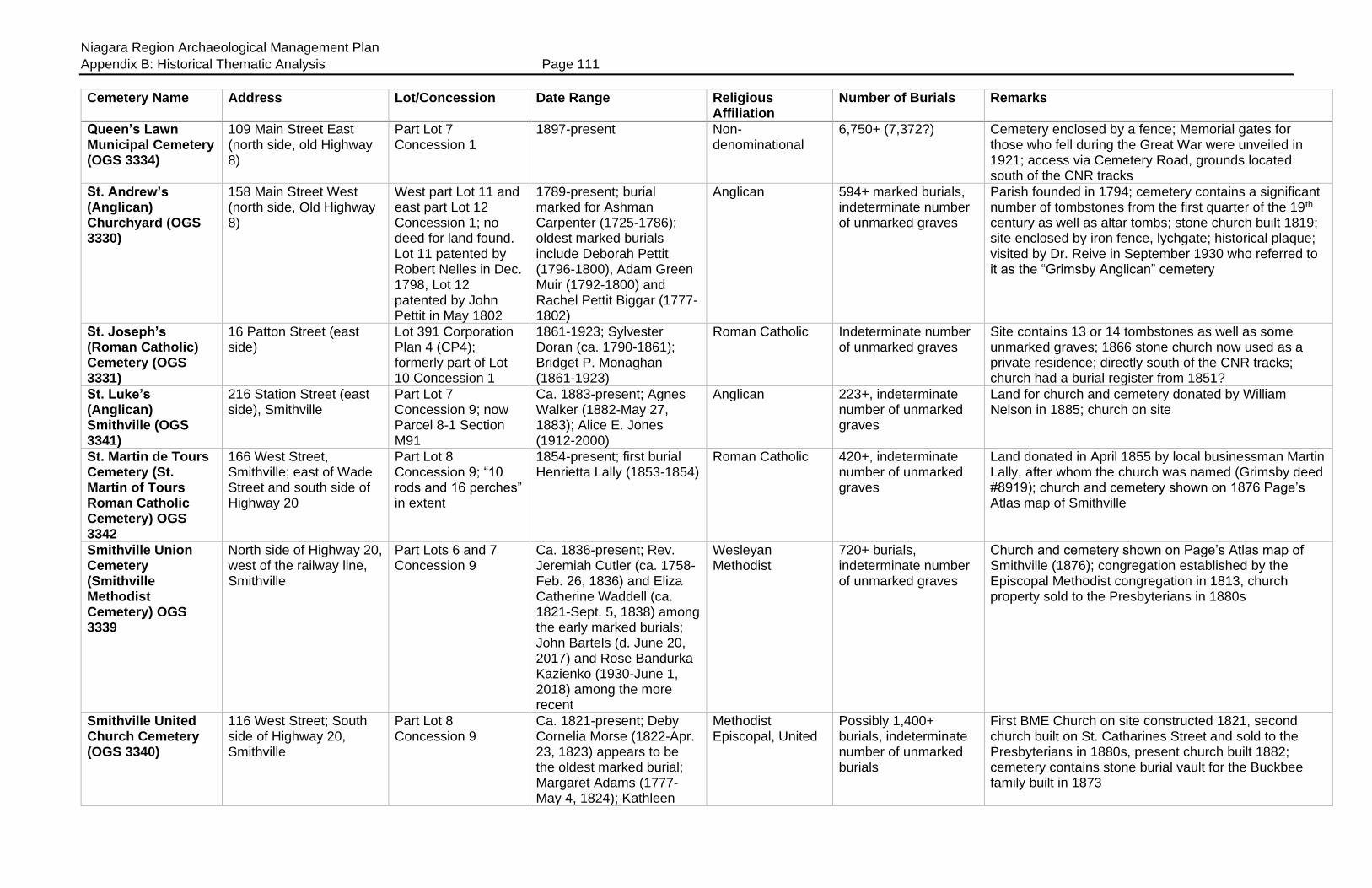
Niagara Region Archaeological Management Plan
Appendix B: Historical Thematic Analysis Page 111
Cemetery Name Address Lot/Concession Date Range Religious Affiliation
Number of Burials Remarks
Queen’s Lawn Municipal Cemetery (OGS 3334)
109 Main Street East (north side, old Highway 8)
Part Lot 7 Concession 1
1897-present Non-denominational
6,750+ (7,372?) Cemetery enclosed by a fence; Memorial gates for those who fell during the Great War were unveiled in 1921; access via Cemetery Road, grounds located south of the CNR tracks
St. Andrew’s (Anglican) Churchyard (OGS 3330)
158 Main Street West (north side, Old Highway 8)
West part Lot 11 and east part Lot 12 Concession 1; no deed for land found. Lot 11 patented by Robert Nelles in Dec. 1798, Lot 12 patented by John Pettit in May 1802
1789-present; burial marked for Ashman Carpenter (1725-1786); oldest marked burials include Deborah Pettit (1796-1800), Adam Green Muir (1792-1800) and Rachel Pettit Biggar (1777-1802)
Anglican 594+ marked burials, indeterminate number of unmarked graves
Parish founded in 1794; cemetery contains a significant number of tombstones from the first quarter of the 19th century as well as altar tombs; stone church built 1819; site enclosed by iron fence, lychgate; historical plaque; visited by Dr. Reive in September 1930 who referred to it as the “Grimsby Anglican” cemetery
St. Joseph’s (Roman Catholic) Cemetery (OGS 3331)
16 Patton Street (east side)
Lot 391 Corporation Plan 4 (CP4); formerly part of Lot 10 Concession 1
1861-1923; Sylvester Doran (ca. 1790-1861); Bridget P. Monaghan (1861-1923)
Roman Catholic Indeterminate number of unmarked graves
Site contains 13 or 14 tombstones as well as some unmarked graves; 1866 stone church now used as a private residence; directly south of the CNR tracks; church had a burial register from 1851?
St. Luke’s (Anglican) Smithville (OGS 3341)
216 Station Street (east side), Smithville
Part Lot 7 Concession 9; now Parcel 8-1 Section M91
Ca. 1883-present; Agnes Walker (1882-May 27, 1883); Alice E. Jones (1912-2000)
Anglican 223+, indeterminate number of unmarked graves
Land for church and cemetery donated by William Nelson in 1885; church on site
St. Martin de Tours Cemetery (St. Martin of Tours Roman Catholic Cemetery) OGS 3342
166 West Street, Smithville; east of Wade Street and south side of Highway 20
Part Lot 8 Concession 9; “10 rods and 16 perches” in extent
1854-present; first burial Henrietta Lally (1853-1854)
Roman Catholic 420+, indeterminate number of unmarked graves
Land donated in April 1855 by local businessman Martin Lally, after whom the church was named (Grimsby deed #8919); church and cemetery shown on 1876 Page’s Atlas map of Smithville
Smithville Union Cemetery (Smithville Methodist Cemetery) OGS 3339
North side of Highway 20, west of the railway line, Smithville
Part Lots 6 and 7 Concession 9
Ca. 1836-present; Rev. Jeremiah Cutler (ca. 1758-Feb. 26, 1836) and Eliza Catherine Waddell (ca. 1821-Sept. 5, 1838) among the early marked burials; John Bartels (d. June 20, 2017) and Rose Bandurka Kazienko (1930-June 1, 2018) among the more recent
Wesleyan Methodist
720+ burials, indeterminate number of unmarked graves
Church and cemetery shown on Page’s Atlas map of Smithville (1876); congregation established by the Episcopal Methodist congregation in 1813, church property sold to the Presbyterians in 1880s
Smithville United Church Cemetery (OGS 3340)
116 West Street; South side of Highway 20, Smithville
Part Lot 8 Concession 9
Ca. 1821-present; Deby Cornelia Morse (1822-Apr. 23, 1823) appears to be the oldest marked burial; Margaret Adams (1777-May 4, 1824); Kathleen
Methodist Episcopal, United
Possibly 1,400+ burials, indeterminate number of unmarked burials
First BME Church on site constructed 1821, second church built on St. Catharines Street and sold to the Presbyterians in 1880s, present church built 1882; cemetery contains stone burial vault for the Buckbee family built in 1873
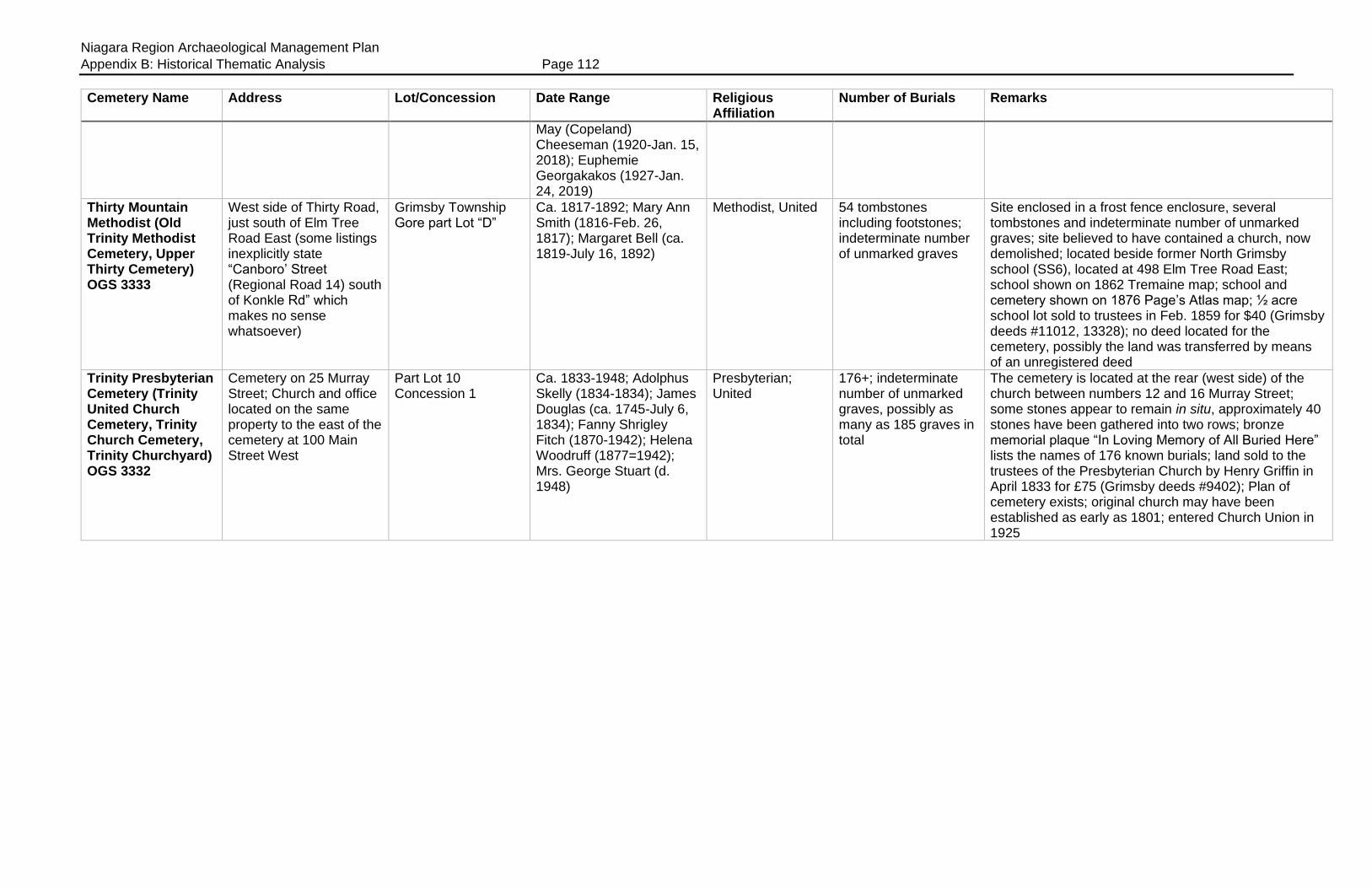
Niagara Region Archaeological Management Plan
Appendix B: Historical Thematic Analysis Page 112
Cemetery Name Address Lot/Concession Date Range Religious Affiliation
Number of Burials Remarks
May (Copeland) Cheeseman (1920-Jan. 15, 2018); Euphemie Georgakakos (1927-Jan. 24, 2019)
Thirty Mountain Methodist (Old Trinity Methodist Cemetery, Upper Thirty Cemetery) OGS 3333
West side of Thirty Road, just south of Elm Tree Road East (some listings inexplicitly state “Canboro’ Street (Regional Road 14) south of Konkle Rd” which makes no sense whatsoever)
Grimsby Township Gore part Lot “D”
Ca. 1817-1892; Mary Ann Smith (1816-Feb. 26, 1817); Margaret Bell (ca. 1819-July 16, 1892)
Methodist, United 54 tombstones including footstones; indeterminate number of unmarked graves
Site enclosed in a frost fence enclosure, several tombstones and indeterminate number of unmarked graves; site believed to have contained a church, now demolished; located beside former North Grimsby school (SS6), located at 498 Elm Tree Road East; school shown on 1862 Tremaine map; school and cemetery shown on 1876 Page’s Atlas map; ½ acre school lot sold to trustees in Feb. 1859 for $40 (Grimsby deeds #11012, 13328); no deed located for the cemetery, possibly the land was transferred by means of an unregistered deed
Trinity Presbyterian Cemetery (Trinity United Church Cemetery, Trinity Church Cemetery, Trinity Churchyard) OGS 3332
Cemetery on 25 Murray Street; Church and office located on the same property to the east of the cemetery at 100 Main Street West
Part Lot 10 Concession 1
Ca. 1833-1948; Adolphus Skelly (1834-1834); James Douglas (ca. 1745-July 6, 1834); Fanny Shrigley Fitch (1870-1942); Helena Woodruff (1877=1942); Mrs. George Stuart (d. 1948)
Presbyterian; United
176+; indeterminate number of unmarked graves, possibly as many as 185 graves in total
The cemetery is located at the rear (west side) of the church between numbers 12 and 16 Murray Street; some stones appear to remain in situ, approximately 40 stones have been gathered into two rows; bronze memorial plaque “In Loving Memory of All Buried Here” lists the names of 176 known burials; land sold to the trustees of the Presbyterian Church by Henry Griffin in April 1833 for £75 (Grimsby deeds #9402); Plan of cemetery exists; original church may have been established as early as 1801; entered Church Union in 1925
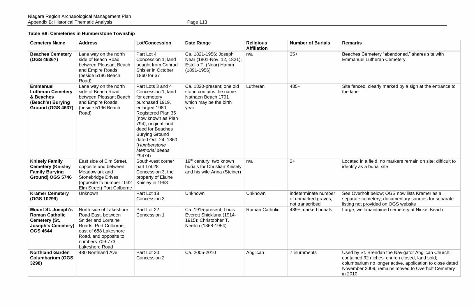
Niagara Region Archaeological Management Plan
Appendix B: Historical Thematic Analysis Page 113
Table B8: Cemeteries in Humberstone Township
Cemetery Name Address Lot/Concession Date Range Religious Affiliation
Number of Burials Remarks
Beaches Cemetery (OGS 4636?)
Lane way on the north side of Beach Road, between Pleasant Beach and Empire Roads (beside 5196 Beach Road)
Part Lot 4 Concession 1; land bought from Conrad Shisler in October 1860 for $7
Ca. 1821-1956; Joseph Near (1801-Nov. 12, 1821); Estella T. (Near) Hamm (1891-1956)
n/a 35+ Beaches Cemetery “abandoned,” shares site with Emmanuel Lutheran Cemetery
Emmanuel Lutheran Cemetery & Beaches (Beach’s) Burying Ground (OGS 4637)
Lane way on the north side of Beach Road, between Pleasant Beach and Empire Roads (beside 5196 Beach Road)
Part Lots 3 and 4 Concession 1; land for cemetery purchased 1919, enlarged 1980; Registered Plan 35 (now known as Plan 794); original land deed for Beaches Burying Ground dated Oct. 24, 1860 (Humberstone Memorial deeds #9474)
Ca. 1820-present; one old stone contains the name Nathaen Beach 1791 which may be the birth year.
Lutheran 485+ Site fenced, clearly marked by a sign at the entrance to the lane
Knisely Family Cemetery (Knisley Family Burying Ground) OGS 5746
East side of Elm Street, opposite and between Meadowlark and Stonebridge Drives (opposite to number 1032 Elm Street) Port Colborne
South-west corner part Lot 28 Concession 3, the property of Elaine Knisley in 1963
19th century; two known burials for Christian Knisely and his wife Anna (Steiner)
n/a 2+ Located in a field, no markers remain on site; difficult to identify as a burial site
Kramer Cemetery (OGS 10299)
Unknown Part Lot 18 Concession 3
Unknown Unknown indeterminate number of unmarked graves, not transcribed
See Overholt below; OGS now lists Kramer as a separate cemetery; documentary sources for separate listing not provided on OGS website
Mount St. Joseph’s Roman Catholic Cemetery (St. Joseph’s Cemetery) OGS 4644
North side of Lakeshore Road East, between Snider and Lorraine Roads, Port Colborne; east of 688 Lakeshore Road, and opposite to numbers 709-773 Lakeshore Road
Part Lot 22 Concession 1
Ca. 1915-present; Louis Everett Shickluna (1914-1915); Christopher T. Neelon (1868-1954)
Roman Catholic 489+ marked burials Large, well-maintained cemetery at Nickel Beach
Northland Garden Columbarium (OGS 3298)
480 Northland Ave. Part Lot 30 Concession 2
Ca. 2005-2010 Anglican 7 inurnments Used by St. Brendan the Navigator Anglican Church; contained 32 niches; church closed, land sold; columbarium no longer active, application to close dated November 2009, remains moved to Overholt Cemetery in 2010
Niagara Region Archaeological Management Plan
Appendix B: Historical Thematic Analysis Page 114
Cemetery Name Address Lot/Concession Date Range Religious Affiliation
Number of Burials Remarks
Old Gravelly Bay Cemetery
South side of Sugarloaf Street, between Elm and David Streets; across the street from H.H. Knoll Lakeview Park
South of Lots 11, 12 and 13, above the high-water mark
Ca. 1830s-? Non-denominational?
Unknown, indeterminate number of burials
Cemetery established on the land of William Hamilton Merritt; shown on 1876 Page’s Atlas map of Port Colborne; was in a “neglected state” by the early 1900s; heirs of the Merritt estate donated the land for use as a park if the graves were removed; most graves believed to be moved to Oakwood Cemetery, some graves may remain in situ (see Anger 2006:69-71)
Overholt Cemetery (Overholts and St. Pauls Lutheran; Bethel Cemetery, Kramer Cemetery) OGS 4637
1675 3rd Concession Road, south side, between Yager and Miller Roads, Port Colborne (between numbers 1661 and 1795 3rd Concession Road)
Part Lots 17 and 18 Concession 3
Ca. 1823(?)-present; Joseph Dennis (infant, died 1823); Jacob Weaver (1801-1828); John Bradner (infant, died 1840)
Originally Lutheran Possibly 4008+ (number includes St. Paul’s) Overholt has 1,500+ burials
Two cemeteries side by side; divided into Sections A to E (inclusive); opposite to Bethel United (M.E.) Church (1883-1925); visited by Dr. Reive in May 1927-May 1928, many older stones broken and illegible, some small cemeteries moved to this site during Welland Canal construction; he noted the cemetery was “very large” and was being restored; a mixture of “well kept plots amid sections grown wild” with “a large settlement of grass snakes.” Some stones broken and illegible, others inscribed in German; also see “Kramer” above
Peter Neff Family Cemetery (OGS 6228)
No address given; Port Colborne
South-east corner part Lot 28 Concession 3
Ca. 1866-1897; Peter Neff (1806-1866); Clarence Neff (Nov. 24, 1897 aged 8 days)
n/a 8+ Names found in this cemetery also inscribed on memorial obelisk in the Stoner Cemetery
St. John’s Lutheran Cemetery (Gasline) OGS 4642
East side of Pinecrest Road “near the lake”; between Firelane 3 and number 457 Pinecrest Road, and directly opposite to 426 Pinecrest
Part Lot 14 Concession 1 BF
Ca. 1798-1953; one stone transcribed as “Noghsel 1798 aged 29”; John L. Near (1828-1830); Rebecca K. Near (1861-Apr. 4, 1953)
Lutheran 82+ Indeterminate number of unmarked burials; site clearly identified named on sign
St. Paul’s Lutheran Cemetery (Overholt’s & St. Paul’s Lutheran; Bethel Cemetery; Port Colborne Cemetery) OGS 4647
1675 3rd Concession Road, south side, between Miller and Yager Roads (between 1661 and 1795 3rd Concession Rd)
Part Lots 17 and 18 Concession 3
Ca. 1870-present; Louis F. North (1859-Sept. 21, 1870)
Lutheran 4008+ (number includes the Overholt Cemetery)
Across the street from Bethel United (M.E.) Church (1883-1925); two cemeteries side by side
Sherk Family Cemetery (OGS 4638)
North side of Highway 3, between Sherk and Brookfield Roads (between numbers 3164 and 3222 Highway 3)
Part Lot 12 Concession 2; plot is approximately 50 x 50 feet (15.24 m x 15.24 m)
Ca. 1828-1907; David Sherk (b. 1782, d. btn. 1828-34); Lydia Geady (1818-1849); Christian Sherk (1819-1907); Eliza (Springer) Sherk (d. 1907)
n/a 8+; some area residents think this cemetery contains as many as 24 burials
Site contains one tombstone, other unmarked burials; easement granted in 1907 for access to site (Humberstone deed #7564)
Sherk Family Plot Unknown South part Lot 4 Concession 3
Ca. 1813-1847; Casper Sherk (1750-1813); Feronica “Fanny” (Groff)
n/a Three suspected burials, indeterminate number of burials
Unmarked plot (see Anger 2004a)
Niagara Region Archaeological Management Plan
Appendix B: Historical Thematic Analysis Page 115
Cemetery Name Address Lot/Concession Date Range Religious Affiliation
Number of Burials Remarks
Sherk (1753-1827); Jacob Sherk (1785-1847)
Sherkston Cemetery (Sherk Cemetery, Strauth Cemetery, United Brethren Cemetery) OGS 4639
South side of Highway 3, between Empire and Pleasant Beach Roads; between numbers 5091 and 5187 Highway 3 (other databases incorrectly list the address as 5348 Sherkston Road which is in the front yard of private family homes)
Part Lot 4 Concession 2
1904-2002; Nancy Snider (1846-1904); Dorothy Esther Jansen (1928-2002)
n/a 73+ Active burial site? Many local names including Bearss, Benner, Burger, Sherk, Shisler, Strauth &c.
Shisler Cemetery (Forest Valley Burying Ground) OGS 4640
At the intersection of Turtle Pond Road and Quarry Ridge Premiums EWS, Port Colborne
Part Lot 5 Concession 1
Ca. 1824-1955; earliest burial was a child of Amos Sherk died April 23, 1824; Arthur Climeni (1902-1955)
n/a 27+ In Sherkston Beaches Park, just south of the old quarry (north of Shisler Point); site fenced in, contains 35 tombstones or fragments of stones; plot measures 140 x 140 feet (42.67 m)
Steele’s Cemetery (Doan Cemetery, Steele Cemetery near Bethel) OGS 4641
2146 Second Concession Road (north side), east of Miller Road
Part Lot 16 Concession 3
Ca. 1802-1974? Silvia Doan (1825-Apr. 26, 1827); Brenda Eileen Bernard (1904-1974); one marker was transcribed for Caleb Doan (d. Jan. 1815, aged 7 years) but the date according to Reive was 1845; Dr. Reive recorded one stone for Martha Bearss (1803-1803)
n/a 95+ (may possibly contain 200 interments); Reive recorded the names of 88 individuals in 1929
Names include Doan, Douthit, Perlet and others; quarter acre plot reserved by Aaron Doan for use as a family cemetery for the burial plot; Doan’s infant children were the first burials in 1802-03; Aaron Doan buried there in 1844; name changed to Doan Cemetery, site clearly identified by a name sign; visited by Dr. Reive in October 1929 who noted that many graves had been moved from this site to the Bethel Cemetery
Stoner Family Cemetery (Stoner Family Burying Ground) OGS 4645
East side of Highway 58 (East Side Road), south side Windsor Terrace
Part Lot 30 Concession 3; situated on the south side of the first house on Windsor Terrace, Hawthorne Heights subdivision
Ca. 1782-1835; David Stoner (1782-1782); Jacob Stoner (1794-1794); Peter Neff (1780-1832); Christian Stoner (1753-1835)
n/a 36+ No tombstones visible; site contains an obelisk with the names of those buried there inscribed on it; commemorates David Stoner (1782) who probably died in Pennsylvania; site fenced in, but can be accessed from Highway 58
Sugarloaf Graveyard
North side of Sugarloaf Street near Isabel Street; across the street from the Port Colborne General Hospital
Unknown; L.G. Carter’s plan of subdivision
Ca. 1830s-1863? Non-denominational
Unknown, indeterminate number of burials
Graves remained in situ until this area was subdivided in 1863; shown on 1876 Page’s Atlas map of Port Colborne immediately beside the “school lot” (east of Steele Street); most remains believed to have been moved to Oakwood Cemetery (see Anger 2006:60-61)
Niagara Region Archaeological Management Plan
Appendix B: Historical Thematic Analysis Page 116
Table B9: Cemeteries in Louth Township
Cemetery name Address Lot/Concession Date Range Religious affiliation
Number of burials Remarks
Beebee (Beebe, Bebee, Bebie, Beby) Burial plot (OGS 6016)
East side of 13th Street Louth (Troup Road), between the QEW and Honsberger Road, west side of the 18 Mile Creek
Part Lot 12 Concession 1
Not known; ca. 1840-1850?; Sergeant Adin (Aden, Edin, Edwin) Beebee (1764-Nov. 7, 1843) and his wife Dorothy (Margaret) Chrysler Beebee (1764-1840?) and son Solomon (1798-Jan. 27, 1847) may have been interred at this site
n/a 3+ Farm lot of Adin Beebee (1764-1843); “disappeared in the 1900s.” Possibly used by members of the Campbell family (Solomon Beebe’s widow married a Campbell)
Bethel Congregation (Smith Farm, Smith-Bethel; Queenston Road Cemetery) OGS 3302
Across the street (south of) 1415 St. Paul Street West (Old Highway 8), between 3rd and 5th Streets, St. Catharines
Part Lot 4 Concession 5
Ca. 1815-1887; Samuel Smith (1800-1815); Joseph Smith (1763-1835); W.D. Smith, Sr. (1814-1887)
Congregational 36+; indeterminate number of unmarked graves
Site located in the middle of a horse paddock, approximately 50 m east of a large horse barn; once contained a church; 35 tombstones gathered and mounted into a central wall in July 1977, work performed by men sponsored by the John Howard Society; stones laid horizontally on the ground sometime between 2016 and 2018; visited by Dr. Reive in October 1929, who noted that it was on a knoll in a farm and “livestock roams over it”
Bradt Family Burying Ground (Arent Bradt Burial Ground) OGS 3317
South side of King Street (Old Highway 8, or Regional Road 81), on the east side of the Sixteen Mile Creek (or south side once the creek bends westward after crossing Highway 8)
Part Lot 12 Concession 6 (some transcriptions place this cemetery on part Lot 13.)
Ca. 1813-1821; Aaron Bradt (1794-1813); Peter Bradt (1764-1821)
n/a Unknown; 2 tombstones presently exist
Site contained 25-30 tombstones around 1950; site leveled and ploughed for farm land, two tombstones extant
Collver/Colver Cemetery (Cartmer Cemetery) OGS 3304
South side of St. Paul Street West (old Highway 8 or Regional Road 81), west side of 15 Mile Creek, on the west side of 9th Street Louth (“the road to Rockway Presbyterian Church, in front of the Orlando residence”) Across the street or west of 3513 9th Street
Part Lot 9 or 10 Concession 7; surrounding land sold by Augustus P.M. Collver to John C. Rykert in October 1861 (Louth deeds #12100.) No reference to the burial plot which continued to be used by the family for a few years
Ca. 1804-1868; Ebenezer Collver (1756-1837); Albert Collver (d. 1863); Herbert A. Collver (d. 1863 or 1868 aged 7 years); other early burials believed to be those of Capt. Benjamin Fralick (1747-Dec. 1804) and his wife Rosina Catrina (Schafer) Fralick
n/a 8 or 9 stones, possibly 11 or 12 burials; indeterminate number of unmarked graves
West side of the Fifteen Mile Creek; site originally contained 12 or more tombstones and footstones; formerly surrounded by a low stone wall; site was being leveled and ploughed for farm land
Gregory (OGS 3308) West side of 7th Street Louth, north of the CNR
Part Lot 8 Concession 3 (Doug
Ca. 1802-1878; Jane Foster (ca. 1788-1802);
n/a 10+ Site contains 10 tombstones and fragments, several footstones; stones gathered into a central location,

Niagara Region Archaeological Management Plan
Appendix B: Historical Thematic Analysis Page 117
Cemetery name Address Lot/Concession Date Range Religious affiliation
Number of burials Remarks
line on east side of 15 Mile Creek (turn west off 7th Street at HEPC pole #4013-13-3A52) at the Workman Farm driveway, follow the track past the house and orchard until the track turns away from the creek, the cemetery is about 100 feet (30.48 m) beyond this point; other descriptions locate the cemetery between 3rd and 4th Avenues Louth, north of CNR tracks, on east side of 15 Mile Creek; another access is from the driveway of #1923 Seventh St. at Henk Sikking farm to the house. Then follow the tractor path along the top of the ravine onto Backus Farm. Just beyond the gate leading down the hill to Fifteen Mile Creek, the cemetery is to the right (north)
Backus farm, 3925 9th Street)
Philip Gregory (1782-1803); Nancy Jane Gregory McMillan (ca. 1833-1852); one stone fragment has death date July 15, 1875 aged 84 years; George W. Haynes (d. 1878) was the last burial
some free standing, others mounted into cement slab in 1967 by William L. Backus and Clarke S. Haynes. Some graves and markers were transferred to the “White Churchyard just down the road” after ground hogs “started bringing up the skulls”
High Family Burial plot
Unknown Unknown Unknown n/a Unknown Cemetery unconfirmed, rumored to exist; some area residents suspect it may have been a family plot later incorporated within a larger cemetery
Jones Cemetery (OGS 3314)
Unknown Part Lot 8 Concession 5
Unknown n/a Two or more burials, possibly William Jones and his wife; indeterminate number of unmarked burials; other Jones family members interred at Rockway
Located on a hillside north of Highway 8 and west of the 15 Mile Creek; no tombstones, exact location of the site cannot be determined
Jordan Mennonite (aka, Haines Cemetery) OGS 3306
West side of Main Street, Jordan Village
Part Lot 19 Concession 4
Ca. 1845-1878; Samuel Grob (1845-1845); Agnes Wismer (1809-1878); some stones badly weathered, dates deciphered as 1815,
Mennonite Unknown; 38 stones Site located beside the Fry House at the rear of the Jordan Historical Museum, overlooking the Twenty Mile Creek; some stones remain standing and in situ? Names include Eve Clendennan, Lewis Haines, Hare, High, Overholt, Price, Secord, Wismer and others

Niagara Region Archaeological Management Plan
Appendix B: Historical Thematic Analysis Page 118
Cemetery name Address Lot/Concession Date Range Religious affiliation
Number of burials Remarks
1818 but probably 1845, 1848
Maple Lawn (Louth United; White Church Cemetery; Louth Methodist Church Cemetery) OGS 3307
1429 3rd Avenue (north side) west of 3rd Street, Louth
Part Lot 3 Concession 2
1878-present; Mary Haynes (Apr. 20, 1878); Mary Grass (July 7, 1878)
Methodist, United; this cemetery also contains burials for members of other Protestant denominations as well as a few Roman Catholics
329 marked graves in 1988; indeterminate number of unmarked graves
A “bee” was organized for levelling the cemetery grounds in October 1877; older graves were moved here from private family plots (ie, Daniel Gregory and Adam Haynes plots); Margaret Haynes (1829-Sept. 30, 1831) was one of the graves moved here in 1878, also Ann Haynes Gregory (1833-Apr. 8, 1854); some tombstones recently recovered from the side of the hill and replaced within the cemetery
Oaklawn (Jordan Station United, Jordan Station Cemetery) OGS 3309
4100 Bridgeport Drive (near Main Street and Third Avenue Louth) Jordan Station; across the street from Jordan Station United Church at 4105 Bridgeport Dr.
Part Lot 18 Concession 3
Ca. 1848 to present; James O’Connelly (1745-1848); Wilhelmina Shunn (1825-1848); Clarissa Harris (1824-1848)
Methodist, United 346 tombstones, 600+ burials
Church built 1859, later moved to opposite side of street and area then used for burials; cemetery re-named as Oaklawn in March 1907; cemetery was enlarged in 1910, plan of the addition filed in the Land Registry office as Registered Plan 83 (shows new lots 84-194); burial register extant from 1882 to the present; visited by Dr. Reive in June 1929 who noted that it was well kept except for an area near the rear where the grass was not cut and “some fallen stones are lying”
Nicholas Smith (OGS 5889)
Corner of Fifth Street Louth and Pelham Road, (Regional Road 25), north of the Henry of Pelham parking lot
Part Lot 6 Concession 8
Ca. 1814-1864; Catherine Smith (d. 1814?); Catherine Smith (ca. 1820-1864)
n/a Unknown; 12 inscribed stones and fragments (total of 34 stones and fragments)
Site also contains several uninscribed field stones thought to be grave markers
Old Price Farm Plot (Price Family Burying Ground, William Price Burying Ground) OGS 5890
Lakeshore Road (Jordan Harbour)
Part Lot 15 Broken Front
Ca. 1797-1832; Wilhelm Pries or Price (ca. 1730-1797); Mary (Tousack) Price, died sometime between 1798 and 1803; Barbara Overholt Price (ca. 1775-1822); Christian Price (1757-1832)
n/a 4+ Two tombstones survived from this cemetery in 1972, but located on the edge of the creek bluff which was eroding into Jordan Harbour; the other stones and burials may have been washed into the harbour
Purdy Family Burying Ground (Purdy-Foster-Geisbrecht Cemetery) OGS 3310
West side of 13th Street Louth (Troup Road), on west bank of 16 Mile Creek, between the railway line and 4th Avenue, Jordan Station; access at 4019 13th Street east of Boekestyn’s Greenhouses
Part Lot 12 Concession 3
Ca. 1830-1882; Eliza Purdy (ca. 1808-1830); William Purdy (ca. 1802-1882)
Used by Baptist Church
14+; area residents remember more than 30 tombstones, only 14 of which remain today
Stones gathered together and mounted horizontally into a cement base; names include Dean, Foster, Purdy and Tufford
Niagara Region Archaeological Management Plan
Appendix B: Historical Thematic Analysis Page 119
Cemetery name Address Lot/Concession Date Range Religious affiliation
Number of burials Remarks
Rockway Cemetery (Rockway Presbyterian Churchyard; Union Church Burial Grounds) OGS 3311
2050 Pelham Road, south side (Regional Road 69) at the intersection of 9th Street Louth, just west of Rockway Falls
Part Lot 11 Concession 8
Ca. 1805-present; oldest tombstone said to have been dated 1805; Charity Disher (d. Dec. 26, 1816 aged 3 months); Abigail Hyatt (1825-Sept. 5, 1827); several stones date from the 1830s
Originally used by the Presbyterian and Episcopal Churches; United
130+ marked burials; site may contain 500-700+ burials
Land sold to congregation by John Clarke in 1830 for £100; became known as Rockway Cemetery in 1905; modern granite marker commemorates “Rockway Union Church 1824-1892, Presbyterian Episcopal Congregation established 1809 by Rev. Daniel Ward Eastman”
St. John’s (Anglican) Churchyard (Jordan) OGS 3315
2878 St. John’s Drive, Jordan
Part Lot 18 Concession 5
1841-present; “poor unknown woman from Jordan” died Aug. 1, 1842 and an “unbaptized male child” surname Perry, the church stone mason’s son, d. Aug. 17, 1842 aged 8 years, were among the first burials on site; John Atkinson Armstrong (July 31, 1846 aged 7 months) was the first marked burial? Lawrence E. McClelland (1941-2016) and Kathleen Edna Zubriski (1927-Apr. 16, 2016) among the more recent burials
Anglican 160+ marked graves, 517+ burials? OGS transcript records 306 names
Parish established 1836; burial register exists from 1842-1899
St. John’s (Anglican) Cemetery (Port Dalhousie) OGS 3295
320 Main Street, St. Catharines (at Cole Farm Blvd.)
Part Lots 1 and 2, Broken Front
1834-present; oldest marked burial appears to be that of Delilah Read (1836-1841)
Anglican 458+ marked burials; indeterminate number of unmarked burials; parish burial register exists from 1841
Site once contained a frame church (St. James’ Louth) that was shipped on the old Welland Canal to Merritton. Site enclosed by iron fencing, and the name clearly identified in an overhead arch at the main gate; Heritage plaque
Schram-Tinlin Cemetery (OGS 3312)
South side of Lakeshore Road West, St. Catharines, east of Fifteen Mile Creek, between Gregory Road and 7th Street Louth; nearly directly opposite the original Schram homestead at 1258 Lakeshore Road West
Part Lot 7 Concession 1; cemetery reserved in a deed
1834-1875; Frederick Schram (1746-1834); Frederick Augustus Schram (1790-1872)
n/a 17 marked burials, stones gathered into a central area
Located on the knoll of a hill; several tombstones are broken lying flat, collected into a central area; heritage plaque; names include Chisholm, Ryckman, Patterson, Caskey, Dell, Crumb, Tinlin, Schram, and a child from the May family; unmarked graves may include adult daughters of Richard Hainer
Schram Burial Plot North side of Lakeshore Road West, north of the Schram homestead at
Part Lot 7 Broken Front Concession
Ca. 1795 n/a 1 unconfirmed Burial plot of Angelica Schram, died ca. 1795, located on a bluff near the lake, north of the Schram house; plot may have been washed away, exact location not known.
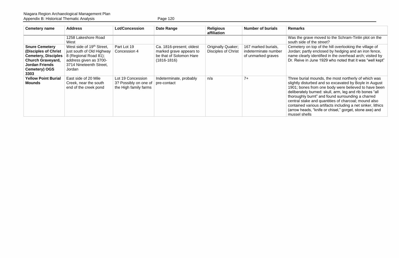
Niagara Region Archaeological Management Plan
Appendix B: Historical Thematic Analysis Page 120
Cemetery name Address Lot/Concession Date Range Religious affiliation
Number of burials Remarks
1258 Lakeshore Road West
Was the grave moved to the Schram-Tinlin plot on the south side of the street?
Snure Cemetery (Disciples of Christ Cemetery, Disciples Church Graveyard, Jordan Friends Cemetery) OGS 3303
West side of 19th Street, just south of Old Highway 8 (Regional Road 81); address given as 3700-3714 Nineteenth Street, Jordan
Part Lot 19 Concession 4
Ca. 1816-present; oldest marked grave appears to be that of Solomon Hare (1816-1816)
Originally Quaker; Disciples of Christ
167 marked burials, indeterminate number of unmarked graves
Cemetery on top of the hill overlooking the village of Jordan; partly enclosed by hedging and an iron fence, name clearly identified in the overhead arch; visited by Dr. Reive in June 1929 who noted that it was “well kept”
Yellow Point Burial Mounds
East side of 20 Mile Creek, near the south end of the creek pond
Lot 19 Concession 3? Possibly on one of the High family farms
Indeterminate, probably pre-contact
n/a 7+ Three burial mounds, the most northerly of which was slightly disturbed and so excavated by Boyle in August 1901; bones from one body were believed to have been deliberately burned: skull, arm, leg and rib bones “all thoroughly burnt” and found surrounding a charred central stake and quantities of charcoal; mound also contained various artifacts including a net sinker, lithics (arrow heads, “knife or chisel,” gorget, stone axe) and mussel shells
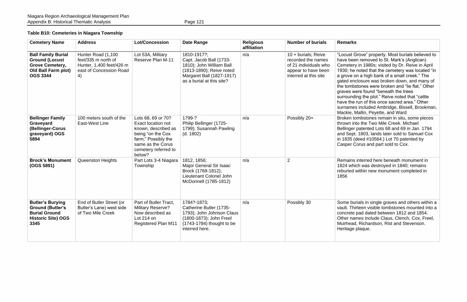
Niagara Region Archaeological Management Plan
Appendix B: Historical Thematic Analysis Page 121
Table B10: Cemeteries in Niagara Township
Cemetery Name Address Lot/Concession Date Range Religious affiliation
Number of burials Remarks
Ball Family Burial Ground (Locust Grove Cemetery, Old Ball Farm plot) OGS 3344
Hunter Road (1,100 feet/335 m north of Hunter, 1,400 feet/426 m east of Concession Road 4)
Lot 53A, Military Reserve Plan M-11
1810-1917?; Capt. Jacob Ball (1733-1810); John William Ball (1813-1890); Reive noted Margaret Ball (1827-1917) as a burial at this site?
n/a 10 + burials; Reive recorded the names of 21 individuals who appear to have been interred at this site
“Locust Grove” property. Most burials believed to have been removed to St. Mark’s (Anglican) Cemetery in 1980s; visited by Dr. Reive in April 1930; he noted that the cemetery was located “in a grove on a high bank of a small creek.” The gated enclosure was broken down, and many of the tombstones were broken and “lie flat.” Other graves were found “beneath the trees surrounding the plot.” Reive noted that “cattle have the run of this once sacred area.” Other surnames included Ambridge, Bissell, Brookman, Mackie, Mallin, Peyette, and Ward
Bellinger Family Graveyard (Bellinger-Corus graveyard) OGS 5894
100 meters south of the East-West Line
Lots 68, 69 or 70? Exact location not known, described as being “on the Cox farm;” Possibly the same as the Corus cemetery referred to below?
1799-? Philip Bellinger (1725-1799); Susannah Pawling (d. 1802)
n/a Possibly 20+ Broken tombstones remain in situ, some pieces thrown into the Two Mile Creek. Michael Bellinger patented Lots 68 and 69 in Jan. 1794 and Sept. 1803, lands later sold to Samuel Cox in 1835 (deed #10564.) Lot 70 patented by Casper Corus and part sold to Cox.
Brock’s Monument (OGS 5891)
Queenston Heights Part Lots 3-4 Niagara Township
1812, 1856; Major General Sir Isaac Brock (1769-1812); Lieutenant Colonel John McDonnell (1785-1812)
n/a 2 Remains interred here beneath monument in 1824 which was destroyed in 1840; remains reburied within new monument completed in 1856
Butler’s Burying Ground (Butler’s Burial Ground Historic Site) OGS 3345
End of Butler Street (or Butler’s Lane) west side of Two Mile Creek
Part of Butler Tract, Military Reserve? Now described as Lot 214 on Registered Plan M11
1784?-1873; Catherine Butler (1735-1793); John Johnson Claus (1800-1873); John Freel (1743-1784) thought to be interred here.
n/a Possibly 30 Some burials in single graves and others within a vault. Thirteen visible tombstones mounted into a concrete pad dated between 1812 and 1854. Other names include Claus, Clench, Cox, Freel, Muirhead, Richardson, Rist and Stevenson. Heritage plaque.

Niagara Region Archaeological Management Plan
Appendix B: Historical Thematic Analysis Page 122
Cemetery Name Address Lot/Concession Date Range Religious affiliation
Number of burials Remarks
Clement Family Burying Ground #1; Col. Joseph Clement; (OGS 3347)
Located on the north side of York Road, on the west side of a gravel lane, between the Presbyterian Church (1436 York Rd) and the St. David’s Lion’s Club Park grounds (1462 York Rd.)
South east corner of Lot 88
1867-1880; Joseph Clement (1790-1867); Anne Caughell Clement (1800-1880)
n/a Possibly 5 Two stones and a small obelisk in a walled enclosure; the will of Joseph Clement (deed #124, 1867) provided for the establishment of this plot: "I hereby retain thirty feet square for a family burying ground on the points of the hill in front of my son George Clement's house in the most convenient place and my body to lie at the centre of the west side and a monument of marble to be raised to my memory, the shaft to be ten feet high and a stone wall to be built around the burying ground except the gateway at the centre of east side the wall to be two feet high. A large stone placed in the ground to support the said gate with holes drilled for the gate posts and an iron railing two feet high to cover the top and surround the said burying ground, which is to be paid by the Executors of my Estate by money coming into their hands. Should any persons apply for the privilege of Burying their dead it shall not be complied with other than my own family."
Clement Family Burying Ground #2; Sterling Cemetery; Sixth Line Cemetery (OGS 5724)
South side Line 6 on Sterling Farm, directly beside the driveway at 773 Line 6; about 1,500 feet west (457 m) west of Four Mile Creek Road (east side of Four Mile Creek)
Part Lot 103 1813-1828; James Clement (1764-1813); Catherine Clement (1770-1813); Martha Pettit Clement (1769-1828)
n/a 6+ Six tombstones and fragments of others remain in situ; plot is directly beside the road, surrounded by a cedar hedge on three sides; visited by Dr. Reive but he did not record the date when he transcribed the tombstones
Corus Family Graveyard
Accessed via laneway west of 969 East-West Line, 10 meters west of Two Mile Creek; same as Bellinger-Corus?
Part Lot 70 1835-1847; Casper Corus (1739-1835); William Casselman (1793-1847)
n/a 3+ Some tombstones were stored in a shed in the 1940s; site was covered with additional fill to create additional orchard space; visited by Dr. Reive but he did not record the date when he transcribed the tombstones

Niagara Region Archaeological Management Plan
Appendix B: Historical Thematic Analysis Page 123
Cemetery Name Address Lot/Concession Date Range Religious affiliation
Number of burials Remarks
Crysler Family Graveyard (OGS 3348)
300 yards (274 m) from the north side of Line 8, west side of Four Mile Creek
Part Lot 85 1793-1839; Adam Crysler (1732-1793); Ann Mary Crysler (1728-1793); John J.F. Crysler (1765-1839)
n/a Possibly 10 Within a fenced enclosure; six tombstones remain in situ
Field-Brown-Vrooman Graveyard; “River Road Cemetery at Brown’s Point” (OGS 3349)
West side Niagara River Road (Niagara Parkway), on the north side of a driveway at 15242-15248 Niagara Parkway
Part Lot 15 1808-1942? Rebecca Brown (1763-1808); Gilbert Field (1765-1815); Nancy Vrooman (1807-1808); Ida H. Weir (1861-1942)
n/a 38+ Just south of the Field house on a knoll, site readily visible from the road; names include Field, Brown, Vrooman, Forsythe, Gabriel, Hopkins, Matthews, Raney, Scott, Weir; visited by Dr. Reive in June 1928; he noted that it was on the Rumsby farm, and was “more or less a private cemetery,” part kept in order and part “grown wild” and thus “disgraceful” condition for an historic cemetery
Grace United (Methodist) Church (OGS 3350)
Gate Street (between Centre and Gage Street)
Niagara Town Lot 154
1823-1997; Sarah Lawrence (1760-1823); Martha Theodora (Currie) Arnold (1900-1997)
Methodist, United 170+ Fenced enclosure, with commemorative plaque; 49 marked graves; lot deeded to Methodist Episcopal Church in January 1830 (deed #7840); plan of cemetery held by the church on Victoria Street
Hamilton Family Graveyard (Hamilton Burial Place, Queenston) OGS 3351
Access through a gate in a frost fence, beside a yellow hydrant, on the east side of the Niagara River Road (Niagara Parkway), nearly opposite to, and slightly south of, Huebel Farms Estates at 14510 Niagara Parkway
Niagara Township Lot 4; Lot 138 on Registered Plan CP1 (Queenston)
1796-2006; Catharine (Askin) Hamilton (1763-1796); A. Nathalie Newry (1911-2006); General Brock and his Aide-de-Camp, John McDonell, were temporarily buried here during the 1840s
n/a 82+ North-west of Willowbank, on a ravine, within a fenced enclosure. Private family plot still in use. Names include Butler, Dee, Dickson, Duff, Durand, Hamilton, Jarvis, Mewburn, Tench, Townsend, Wainwright and others. Visited by Dr. Reive in June 1928
Hostetter farm plot 1755 Highway 55 (Niagara Stone Road)
Part Lot 170-171 Ca. 1850s n/a 1 Family tradition maintained that a black farm hand (a fugitive slave) was interred along the fence towards the rear of the farm, once marked by a pile of stones

Niagara Region Archaeological Management Plan
Appendix B: Historical Thematic Analysis Page 124
Cemetery Name Address Lot/Concession Date Range Religious affiliation
Number of burials Remarks
Lawrence Family Graveyard (“unnamed plot at the end of Pine Street”) OGS 7150
Pine Street, Virgil; between the end of the north side of Pine Street and the west side of the Four Mile Creek
Part Lot 5, Registered Plan 438; formerly part of Township Lot 118
1820s-1850s?; possible burial site of the family of George B.[Ball?] Lawrence (ca. 1790-1823) and his daughter (?) Elizabeth
n/a 2+ Some broken tombstone fragments remain in situ.; the plan of subdivision (dated September 1955) does NOT indicate the presence of a burial plot on Pine Street; the Lawrence family were early members of the Methodist church, therefore these tombstone pieces may have been removed from the Virgil United (Methodist) Cemetery to the south on Creek Road
Negro Burial Ground (Niagara Baptist Chapel Cemetery; Negro Baptist Burial Ground) OGS 3353
East side of Highway 55 (Niagara Stone Road), 75 meters south of the intersection of Mississauga and Mary Streets
½ acre (0.202 ha), north-east part of Lot 315
1830-1893; Susan Augusta Oakley (1830-1832); George Wesley (1817-1893)
Baptist 3 marked burials; indeterminate number of unmarked graves
Site once contained a chapel now moved to a new site; Provincial heritage plaque; “Slave riot” victims of 1837, and a few white congregants are buried here; land sold for £2 by George Ball to the trustees of the Baptist Church in Dec. 1830 (deed #9356); “Burying Ground” shown on Land Registry office “Railway Plan #1” (dated June 4, 1888)
Niagara Lakeshore Cemetery (Niagara Lakeshore Municipal Cemetery) OGS 5893
1483 Lakeshore Road (south side) between Four Mile Creek and Niven Roads
Part Lot 193 (Military Reserve, north of the East-West Line)
1966-present Non-denominational
2,800+ marked burials Cemetery contains sufficient space for 6,000 burials
Pickard Family Burial Plot (Pickard Cemetery) OGS 10259
Located off the west side of Four Mile Creek Road, on the Four Mile Creek
Part Lot 193 (Military Reserve) immediately north of the East-West Line
Ca. 1809-?; William Pickard (ca. 1727, d. 1804 or 1809) and wife Eliza (Wintemute) Pickard (ca. 1735-died after 1799) probably the first burials at this site; also James Cobus Pickard (ca. 1761- 1804) and wife Hannah (ca. 1762-?)
n/a Probably 4 burials; indeterminate number of unmarked burials
Name also spelled as “Picard” and “Pickhard”
St. Andrew’s Presbyterian Churchyard (OGS 3355)
323 Simcoe Street Town Lots 157, 158, 183, 184 (bounded by Mississauga, Gage, Simcoe and Centre Streets)
1833-present; John Crooks (1797-1833) was the first interment
Presbyterian 1.020+ Congregation established in 1794 when the first church was built; destroyed in 1813, rebuilt 1831. Land patented by church in July 1824. Cemetery not used until 1831, prior burials took place at St. Mark’s or in private plots. Prominent inhabitants of the town interred here; visited by Dr. Reive in 1929

Niagara Region Archaeological Management Plan
Appendix B: Historical Thematic Analysis Page 125
Cemetery Name Address Lot/Concession Date Range Religious affiliation
Number of burials Remarks
St. David’s United Church Cemetery (OGS 3356)
South side of York Road, east of Four Mile Creek Road and Paxton Lane
Part Lot 90 Pre 1823-present; Solomon Quick (1755-Oct. 17, 1823) was the first marked burial; Major David Secord (1759-1844) after whom the village was named is interred at this site
Methodist, United 1,100+ Site was probably used for burials before the War of 1812; Reive noted many wooden markers now rotted; prominent Queenston and St. David’s residents interred here (Secord, Woodruff, Wynn and others); burial register extant from 1918; visited by Dr. Reive in April 1927 who noted that the churchyard was being restored, ground levelled with sand where needed, stones being reset and some inscriptions being re-cut
St. Mark’s Anglican Church Cemetery (OGS 3357)
41 Byron Street Block “C,” Captain Vavasour’s Plan, St. Mark’s Church and Cemetery, “Protestant E. Church and Burying Ground” block, 4½ acres, patented May 20, 1823. Originally bounded by Byron, King, Ricardo and Wellington Streets. (A strip of land along the north-west side of Wellington Street was severed from the block and subdivided for housing.) Now known as Registered Plan 72.
1782?-present; oldest known tombstone in the Niagara Region found here for “Lenerd Blanck, deceased 5 Aug. 1782.”
Anglican 2,400+ marked burials; indeterminate number of unmarked graves
Site may have been used as early as 1782; church built 1805, occupied by Americans in 1813 and destroyed; American trenches run through churchyard, and some stones hacked by the Americans; church rebuilt using standing walls. Some burials covered over beneath the church when enlarged in 1843. Family plots and vaults for prominent parishioners. Some old burials moved here from smaller graveyards. Cemetery enlarged 1891. Site contains former school and 1850s Italianate Rectory; cemetery plan and abstract index for cemetery found in Land Registry office
St. Vincent De Paul Roman Catholic Churchyard (OGS 3358)
73 Picton Street Roman Catholic Church Block, Lot 3 (New Survey), bounded by Byron, Davy, Picton and Wellington Streets
Ca. 1834-present Roman Catholic 1,069+ marked burials; indeterminate number of unmarked burials
Site includes a “Polish Soldiers Plot” at the north-west corner of the site where 25 soldiers were buried 1917-1919. Some Catholic burials prior to 1834 made at St. Mark’s
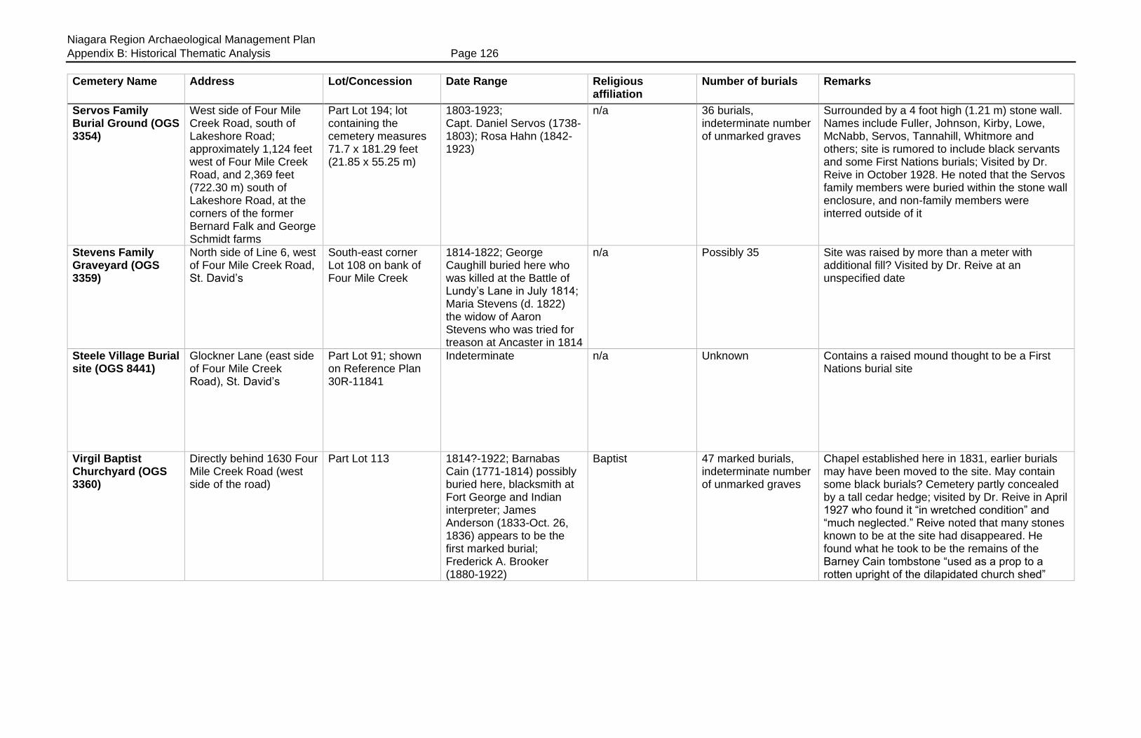
Niagara Region Archaeological Management Plan
Appendix B: Historical Thematic Analysis Page 126
Cemetery Name Address Lot/Concession Date Range Religious affiliation
Number of burials Remarks
Servos Family Burial Ground (OGS 3354)
West side of Four Mile Creek Road, south of Lakeshore Road; approximately 1,124 feet west of Four Mile Creek Road, and 2,369 feet (722.30 m) south of Lakeshore Road, at the corners of the former Bernard Falk and George Schmidt farms
Part Lot 194; lot containing the cemetery measures 71.7 x 181.29 feet (21.85 x 55.25 m)
1803-1923; Capt. Daniel Servos (1738-1803); Rosa Hahn (1842-1923)
n/a 36 burials, indeterminate number of unmarked graves
Surrounded by a 4 foot high (1.21 m) stone wall. Names include Fuller, Johnson, Kirby, Lowe, McNabb, Servos, Tannahill, Whitmore and others; site is rumored to include black servants and some First Nations burials; Visited by Dr. Reive in October 1928. He noted that the Servos family members were buried within the stone wall enclosure, and non-family members were interred outside of it
Stevens Family Graveyard (OGS 3359)
North side of Line 6, west of Four Mile Creek Road, St. David’s
South-east corner Lot 108 on bank of Four Mile Creek
1814-1822; George Caughill buried here who was killed at the Battle of Lundy’s Lane in July 1814; Maria Stevens (d. 1822) the widow of Aaron Stevens who was tried for treason at Ancaster in 1814
n/a Possibly 35 Site was raised by more than a meter with additional fill? Visited by Dr. Reive at an unspecified date
Steele Village Burial site (OGS 8441)
Glockner Lane (east side of Four Mile Creek Road), St. David’s
Part Lot 91; shown on Reference Plan 30R-11841
Indeterminate n/a Unknown Contains a raised mound thought to be a First Nations burial site
Virgil Baptist Churchyard (OGS 3360)
Directly behind 1630 Four Mile Creek Road (west side of the road)
Part Lot 113 1814?-1922; Barnabas Cain (1771-1814) possibly buried here, blacksmith at Fort George and Indian interpreter; James Anderson (1833-Oct. 26, 1836) appears to be the first marked burial; Frederick A. Brooker (1880-1922)
Baptist 47 marked burials, indeterminate number of unmarked graves
Chapel established here in 1831, earlier burials may have been moved to the site. May contain some black burials? Cemetery partly concealed by a tall cedar hedge; visited by Dr. Reive in April 1927 who found it “in wretched condition” and “much neglected.” Reive noted that many stones known to be at the site had disappeared. He found what he took to be the remains of the Barney Cain tombstone “used as a prop to a rotten upright of the dilapidated church shed”

Niagara Region Archaeological Management Plan
Appendix B: Historical Thematic Analysis Page 127
Cemetery Name Address Lot/Concession Date Range Religious affiliation
Number of burials Remarks
Virgil United (Methodist) Cemetery (OGS 3361)
East side of Four Mile Creek Road, directly beside Gateway Community Church at 1665 Four Mile Creek Road, and opposite 1642 Four Mile Creek Road
Part Lot 113; 0.724 acres in extent (0.293 ha)
1818?-1934; William Cain (d. 1818 aged 3 months) first transcribed tombstone, date may be in error?; Eliza Caughill (1754-1831); Frederick Clement (1841-1842), Edwy Wesley Corus (1850-1929); Verdun Casick (1916-1934) last burial
Methodist, United 53 marked burials, indeterminate number of unmarked graves
George Lawrence (1757-1848), Methodist class leader, may be buried here (moved from Lawrence plot?) Many old area families buried here. Church demolished. Heritage plaque on site; Dr. Reive visited the “Framed Church” cemetery at Virgil in April 1927, he described it as being “wretchedly kept” and “much neglected”
Warner (Methodist) Cemetery (Warner Burying Ground) OGS 3362
South side of Warner Road, on the east side of the QEW
South half of Lot 139 1808?-present; Stephen Secord (1757-1808); McKinley infants buried here 1811, 1813; Obadiah Hopkins (1767-June 19, 1816); Christian Warner (1754-1833), Methodist class leader and land donor; J. Lloyd Oliver (1922-2009.)
Methodist Episcopal
200+ burials, indeterminate number of unmarked graves
Visited by Dr. Reive in September 1926, who noted “the cemetery is in very poor repair and a reproach to the descendants of the early pioneers who lie here.” Log meeting house stood on site, replaced by frame Meeting House in 1801, its foundations may be discerned beside the cemetery; this was the first Methodist church in the peninsula, and the first west of the Bay of Quinte; replaced by new meeting house in 1870; cemetery grounds partly enclosed by stone wall. Many prominent early settlers buried here.
Weir grave (OGS 5892)
116 Queenston Street, Queenston
Part Lot 6, CP1 1981; Samuel Edward Weir (1898-1981)
n/a 1 Burial in the front yard at Riverbrink Art Gallery
William VanEvery Graveyard
n/a Lot 183 1786-1862; McGregor VanEvery (1723-1786); John VanEvery (1794-1862)
n/a Unknown; possibly 14 burials
Several graves were moved from this site to the nearby Warner Cemetery in 1930s during construction of the QEW; some VanEvery tombstones mounted into a wall at the Warner Cemetery
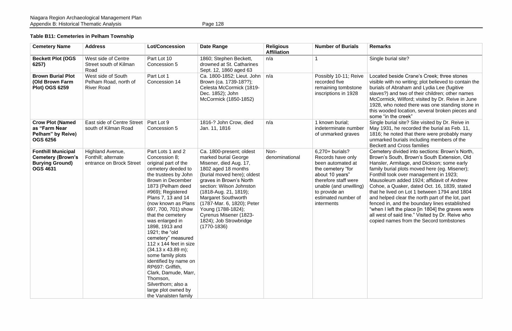
Niagara Region Archaeological Management Plan
Appendix B: Historical Thematic Analysis Page 128
Table B11: Cemeteries in Pelham Township
Cemetery Name Address Lot/Concession Date Range Religious Affiliation
Number of Burials Remarks
Beckett Plot (OGS 6257)
West side of Centre Street south of Kilman Road
Part Lot 10 Concession 5
1860; Stephen Beckett, drowned at St. Catharines Sept. 12, 1860 aged 63
n/a 1 Single burial site?
Brown Burial Plot (Old Brown Farm Plot) OGS 6259
West side of South Pelham Road, north of River Road
Part Lot 1 Concession 14
Ca. 1800-1852; Lieut. John Brown (ca. 1739-18??); Celesta McCormick (1819-Dec. 1852); John McCormick (1850-1852)
n/a Possibly 10-11; Reive recorded five remaining tombstone inscriptions in 1928
Located beside Crane’s Creek; three stones visible with no writing; plot believed to contain the burials of Abraham and Lydia Lee (fugitive slaves?) and two of their children; other names McCormick, Wilford; visited by Dr. Reive in June 1928, who noted there was one standing stone in this wooded location, several broken pieces and some “in the creek”
Crow Plot (Named as “Farm Near Pelham” by Reive) OGS 6256
East side of Centre Street south of Kilman Road
Part Lot 9 Concession 5
1816-? John Crow, died Jan. 11, 1816
n/a 1 known burial; indeterminate number of unmarked graves
Single burial site? Site visited by Dr. Reive in May 1931, he recorded the burial as Feb. 11, 1816; he noted that there were probably many unmarked burials including members of the Beckett and Cross families
Fonthill Municipal Cemetery (Brown’s Burying Ground) OGS 4631
Highland Avenue, Fonthill; alternate entrance on Brock Street
Part Lots 1 and 2 Concession 8; original part of the cemetery deeded to the trustees by John Brown in December 1873 (Pelham deed #969); Registered Plans 7, 13 and 14 (now known as Plans 697, 700, 701) show that the cemetery was enlarged in 1898, 1913 and 1921; the “old cemetery” measured 112 x 144 feet in size (34.13 x 43.89 m); some family plots identified by name on RP697: Griffith, Clark, Damude, Marr, Thomson, Silverthorn; also a large plot owned by the Vanalsten family
Ca. 1800-present; oldest marked burial George Misener, died Aug. 17, 1802 aged 18 months (burial moved here); oldest graves in Brown’s North section: Wilson Johnston (1818-Aug. 21, 1819); Margaret Southworth (1787-Mar. 6, 1820); Peter Young (1788-1824); Cyrenus Misener (1823-1824); Job Strowbridge (1770-1836)
Non-denominational
6,270+ burials? Records have only been automated at the cemetery “for about 10 years” therefore staff were unable (and unwilling) to provide an estimated number of interments
Cemetery divided into sections: Brown’s North, Brown’s South, Brown’s South Extension, Old Hansler, Armitage, and Dickson; some early family burial plots moved here (eg. Misener); Fonthill took over management in 1923; Mausoleum added 1924; affidavit of Andrew Cohoe, a Quaker, dated Oct. 16, 1839, stated that he lived on Lot 1 between 1794 and 1804 and helped clear the north part of the lot, part fenced in, and the boundary lines established “when I left the place [in 1804] the graves were all west of said line.” Visited by Dr. Reive who copied names from the Secord tombstones

Niagara Region Archaeological Management Plan
Appendix B: Historical Thematic Analysis Page 129
Cemetery Name Address Lot/Concession Date Range Religious Affiliation
Number of Burials Remarks
(21 x 72.5 feet in size (6.4 x 22.09 m)
Hansler Cemetery (OGS 4653)
North side of Highway 20; “Metler Road below Lookout Point Golf Course”
Part Lot 4 Concession 5
Ca. 1813-present; John Hansler (1813-1815); infant child of Robert Kellman (d. 1816)
Non-denominational
140 tombstones transcribed in 1981-82; Reive recorded the names of 156 burials in 1927
Site visited by Dr. Reive in 1926-7, his transcriptions provide an important corrective to the 1980s OGS transcript (eg. OGS recorded Peter W. Guinter, died 1800 aged 7, Reive recorded the same burial as 1880 aged 7); he noted that the older part of the cemetery was “overgrown with rank grass and shrubs gone wild,” and the older stones were weathered and “almost worn smooth”
Hillside Cemetery (Dawdy Burial Ground, Dawdy’s Burying Ground, Dawdy Hillside Cemetery, Beckett’s Graveyard) OGS 4654
Canboro’ Road, Ridgeville
Part Lot 8 Concession 8; surrounding land sold to William and Hannah Beckett in August 1835 “less the burying ground;” Pelham deeds #3795 and 4314; Registered Plan 15 (now known as Plan 702) show that the cemetery was enlarged in May 1922
Ca. 1816-present; cemetery noted in property deed to Isaac Nunn who purchased two acres “due south of the burying ground” in 1816; first recorded burial that of Jeremiah Dawdy in 1829
Non-denominational
Dr. Reive recorded the names of more than 970 individuals in 1929; indeterminate number of unmarked graves
Site visited by Dr. Reive in 1928-29; he noted that three small family farm burial plots were moved here that were in the way of the 4th Welland Canal construction; Reive described Jeremiah Dawdy tombstone as “very old” but did not record or could not read the date; grave and tombstone for Cynthia Armstrong (1775-1859) and for as many as 27 others (Bradt, Burgar, Durham, Shotwell, Shrigley, Sweet, and Southworth) were “removed from old Burgar plot near Welland;” the cemetery was enlarged in 1891, 1895, 1921; named “Hillside” in 1934
Misener Family Plot Unknown Unknown Ca. 1802-?; George Misener (ca. 1801-1802)
n/a 1+; indeterminate number of burials
Burial moved to Fonthill Municipal Cemetery; other burials may remain in situ?
Solomon Moore Family Burial Plot
Unknown Exact location unknown; Moore owned various farm properties in Pelham, possibly around Lots 7 and 8 in Concessions 7 and 8
Ca. 1820s-1883?; Martha Moore (1809-1850); Solomon Moore Jr. (1804-1883); earlier burials may have been made in this family plot (Solomon Moore Sr., and his wife Eleanor Stephenson Moore, UEL, formerly of Louth)
n/a Indeterminate number of unmarked graves, possibly 7 burials in total
Members of this Quaker family were interred on the family farm “near Ridgeville” in unmarked graves; part of the land was later purchased by the TH&B for use as a gravel pit and ran a siding to it. “When their employees got into action with a steam shovel, and raised several caskets, a halt was called…the family moved the remains to the Quaker Cemetery.” Were all remains moved?
North Pelham First Presbyterian Church Cemetery (North Pelham Burying Ground) OGS 4655
South-east corner of Metler Road and Cream Street
Part Lot 11 Concession 6; surrounding land sold in September 1829 to Oliver Hodgins “except the burial ground” which was not to be cultivated;
Ca. 1813-present; earliest marked burials as noted by Reive: E.M. Waite (1812-1813); Whitson M. Disher (1756-1823); early Killman family burials date from 1832-1847; oldest burial thought to date from 1800,
Presbyterian 631 marked burials Daniel Ward Eastman first preached in Pelham in 1823; congregation organized 1828, church built 1832. Visited by Reive in July 1926, who noted “many bodies and memorials have been removed from burial places on the farms to this place”

Niagara Region Archaeological Management Plan
Appendix B: Historical Thematic Analysis Page 130
Cemetery Name Address Lot/Concession Date Range Religious Affiliation
Number of Burials Remarks
cemetery was 1 acre (0.404 ha) in size. Part of the lot was used for burials at an early date and deeded to trustees by Christian Brown in Jan. 1845, site enlarged in Oct. 1905 and Mar. 1970
possibly moved from an earlier family plot; Christian Brown plot contained 7 burials, now part of the North Pelham Cemetery?
Pelham Evangelical Friends Church Cemetery (Pelham Quaker Cemetery, Quaker Brick Church Cemetery, Friends Brick Church Grounds, ) OGS 4656
940 Haist Road South (west side, south of Quaker Road), Pelham Corners (Fonthill)
Part Lot 4 Concession 10
Ca. 1824-present; oldest marked burial Charles H. Russell (1823-Jan. 3, 1824); Eliza Carl (1770-1826); Martha Giles (1794-1828); John Carl (1755-1836)
Quaker 102+ marked burials, indeterminate number of unmarked graves; Reive recorded the names of 287 individuals buried at this site; total number of known burials appears to be 348
Visited by Dr. Reive in July 1926; he noted it was “kept like a garden in even rows” with small, plain stones; several burials were moved here from the Solomon Moore farm near Ridgeville; cemetery name clearly identified by a sign; UEL Association marker notes that it is a Loyalist burial site; brick church still stands on the grounds
Pelham Hicksite Quaker Cemetery (Friends Frame Church Cemetery, Friends Cemetery) OGS 5896
East side of Effingham Street south side of Welland Road
Part Lot 5 Concession 10
Ca. 1836-present; oldest marked grave Phebe Willson (1804-Apr. 9, 1836); stone marked “S.B., Apr. 7, 1779-June 18, 1844;” Thomas Page (1784-1849); Reive did not record any of these earliest burials, the earliest graves that he noted were those of Thomas Priestman (1840-1862), Jeremiah Cohoe (1845-1863), and Hannah C. Willson (1844-1864)
Quaker; monthly meetings held between the Pelham and Black Creek Quakers as early as October 1799
176 marked burials; Reive recorded the names of 104 individuals interred here prior to 1926
Meeting House constructed during the 1790s, plaque notes that this was the site of the first Monthly Meeting of the Society of Friends in Canada in 1799; by 1800 the Meeting House was “small and crowded.” New frame meeting house was built in 1807, at 591 Canboro’ Road; meeting house later moved to Fenwick, used by the “Railroading hobbyists” in 1986; visited by Dr. Reive in July 1926, he noted that the grounds “had the appearance of having had several bodies removed” while sunken graves made the ground “very irregular.” Reive noted that “little or no care” was provided at the site
Schram Family Cemetery (OGS 5751)
South-west corner of Centre Street and Sawmill Road
Part Lot 9 Concession 2
Ca. 1834-1851; William Schram (ca. 1789-1834); John Schram Sr. (ca. 1755-1851)
n/a 2+
Swayze Family Cemetery (OGS 5752)
South side of Effingham Street (Regional Road 28)
North-east corner part Lot 4 Concession 2 at “Hangman’s Corners”
Ca. 1798?-1863; oldest burial marked by broken stone, death date Apr. 4, 1798; Freeman Swayze (d. Oct. 7, 1818); Mary Johnson Swayze (1788-1863)
n/a 10 tombstones, 2 footstones
Some stones broken and difficult to decipher

Niagara Region Archaeological Management Plan
Appendix B: Historical Thematic Analysis Page 131

Niagara Region Archaeological Management Plan
Appendix B: Historical Thematic Analysis Page 132
Table B12: Cemeteries in Stamford Township
Cemetery Name Address Lot and Concession Date Range Religious Affiliation
Number of Burials Remarks
All Saint’s Anglican Church Cemetery (All Saints Drummondville) OGS4649
5680 Robinson Street (south side of Robinson, between Stanley Ave. and Portage Road)
Land deeded to the congregation by Mrs. Murray
Ca. 1848?-present; Eliza McGarvey (1781-Nov. 15, 1848) is the first entry noted in the burial register, but possibly buried at Chippawa; cemetery laid out in 1854, earlier burials may have been moved to this site? Ellener Robinson (ca. 1786-Jan. 8, 1862) one of the earliest burials at this site
Anglican 300+ marked burials Parish established 1820; Burial register exists 1848-present; cemetery “laid out in 1854.” Church once connected to Trinity Church (Chippawa) and St. John’s (Stamford); church designed by William Hay, constructed by William Russell in 1856-7, dedicated on Nov. 1, 1857; visited by Dr. Reive in March 1929 who noted that it was an “interesting” cemetery containing the names of the “old aristocracy” of Niagara
Drummond Hill Cemetery (Drummond Hill Burying Grounds, Lundy’s Lane Burial Ground) OGS 6008
6110 Lundy’s Lane (South side of Lundy’s Lane, between Drummond Road and Main Street or Portage Road), access off Buchner Place
Part Lot 143; ½ acre (0.202 ha) deeded to the congregation by Christopher Buchner in 1799, later enlarged to 4 acres (1.61 ha)
Ca. 1799-present; John Burch (1742-Mar. 7, 1797) was the first burial at this site, but moved here from his farm burial plot; James and Laura (Ingersoll) Secord interred here, also Karel Soucek (1947-1985) who survived a dare-devil plunge over the Horseshoe Falls in a barrel in 1984
Originally Presbyterian, now non-denominational
2,523+ marked burials; Indeterminate number of unmarked burials
Visited by Dr. Reive in August-September 1929 who noted that the Niagara Parks Commission was in charge of the site and as a result it was “of course well kept” Location of an early church built 1785 and replaced in 1836; site of part of the Battle of Lundy’s Lane in 1814, remains of 255 British and American soldiers interred here; site contains heritage plaques; name of the cemetery in an arch over the main entrance gate; 1814 cremation areas still said to be visible where grass refuses to grow
Fairview Mausoleum (OGS 8474)
4764 Portage Road (near Morrison Street)
Located near the south-west corner of Fairview Municipal Cemetery
Ca. 1992-present; Girardo Guzzo (1918-May 23, 1992); Rita DiGeremia Madia (1922-May 9, 2019)
Non-denominational At least 62 burials
Fairview Municipal Cemetery (OGS 4658)
4501 Stanley Avenue, Niagara Falls
Lots 90-95; 77 acres (31.16 ha); original cemetery established on the Adam Shugg farm; bounded by Stanley Avenue, Morrison Street and the Queenston-Chippawa Hydro Canal
1883-present; Thomas Whittaker (1827-July 20, 1883) believed to be the first burial
Non-denominational Approximately 37,000 interments
Some burials recorded in All Saint’s burial register; cemetery has burial register and burial permits transcribed 1897-1907 by the OGS; cemetery contains the first “green burial” section (“Willow’s Rest”) in the region
Holy Trinity Cemetery Chippawa (Chippawa Anglican Cemetery) OGS 4659
7820 Portage Road (east side), Chippawa
Lot 192 Ca. 1821-present; Alexander Conklin (ca. 1826-Oct. 7, 1828); Helen Kirkpatrick (1828-Dec. 29,
Anglican Reive recorded the names of at least 335 individuals interred here before 1929; Indeterminate
Congregation established in 1820 when Rev. William Leeming sent out by the SPGFP; white frame Gothic style church built 1821 but burned in 1837; present brick and stone church designed by John George Howard and built in 1841. Some
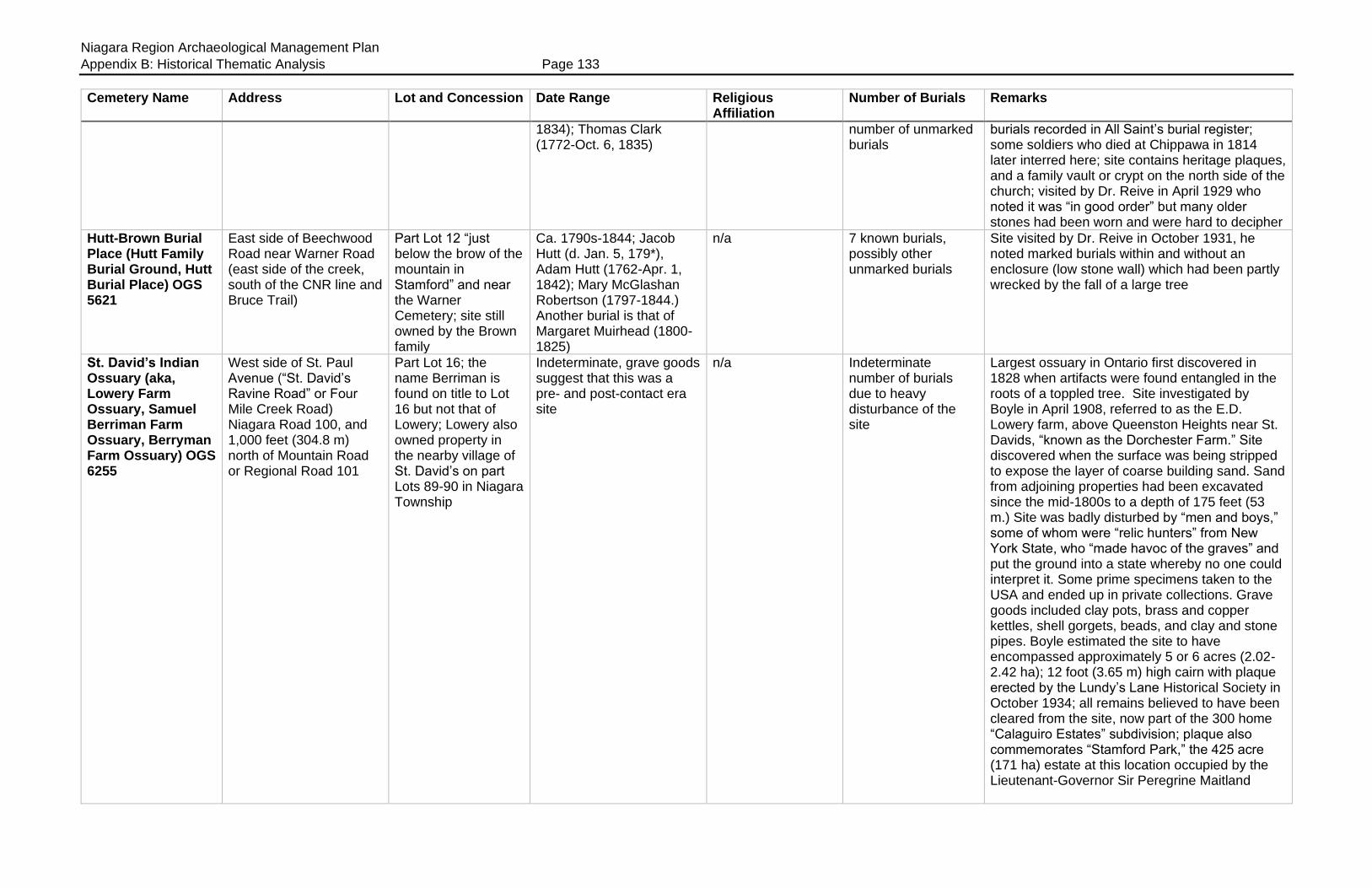
Niagara Region Archaeological Management Plan
Appendix B: Historical Thematic Analysis Page 133
Cemetery Name Address Lot and Concession Date Range Religious Affiliation
Number of Burials Remarks
1834); Thomas Clark (1772-Oct. 6, 1835)
number of unmarked burials
burials recorded in All Saint’s burial register; some soldiers who died at Chippawa in 1814 later interred here; site contains heritage plaques, and a family vault or crypt on the north side of the church; visited by Dr. Reive in April 1929 who noted it was “in good order” but many older stones had been worn and were hard to decipher
Hutt-Brown Burial Place (Hutt Family Burial Ground, Hutt Burial Place) OGS 5621
East side of Beechwood Road near Warner Road (east side of the creek, south of the CNR line and Bruce Trail)
Part Lot 12 “just below the brow of the mountain in Stamford” and near the Warner Cemetery; site still owned by the Brown family
Ca. 1790s-1844; Jacob Hutt (d. Jan. 5, 179*), Adam Hutt (1762-Apr. 1, 1842); Mary McGlashan Robertson (1797-1844.) Another burial is that of Margaret Muirhead (1800-1825)
n/a 7 known burials, possibly other unmarked burials
Site visited by Dr. Reive in October 1931, he noted marked burials within and without an enclosure (low stone wall) which had been partly wrecked by the fall of a large tree
St. David’s Indian Ossuary (aka, Lowery Farm Ossuary, Samuel Berriman Farm Ossuary, Berryman Farm Ossuary) OGS 6255
West side of St. Paul Avenue (“St. David’s Ravine Road” or Four Mile Creek Road) Niagara Road 100, and 1,000 feet (304.8 m) north of Mountain Road or Regional Road 101
Part Lot 16; the name Berriman is found on title to Lot 16 but not that of Lowery; Lowery also owned property in the nearby village of St. David’s on part Lots 89-90 in Niagara Township
Indeterminate, grave goods suggest that this was a pre- and post-contact era site
n/a Indeterminate number of burials due to heavy disturbance of the site
Largest ossuary in Ontario first discovered in 1828 when artifacts were found entangled in the roots of a toppled tree. Site investigated by Boyle in April 1908, referred to as the E.D. Lowery farm, above Queenston Heights near St. Davids, “known as the Dorchester Farm.” Site discovered when the surface was being stripped to expose the layer of coarse building sand. Sand from adjoining properties had been excavated since the mid-1800s to a depth of 175 feet (53 m.) Site was badly disturbed by “men and boys,” some of whom were “relic hunters” from New York State, who “made havoc of the graves” and put the ground into a state whereby no one could interpret it. Some prime specimens taken to the USA and ended up in private collections. Grave goods included clay pots, brass and copper kettles, shell gorgets, beads, and clay and stone pipes. Boyle estimated the site to have encompassed approximately 5 or 6 acres (2.02-2.42 ha); 12 foot (3.65 m) high cairn with plaque erected by the Lundy’s Lane Historical Society in October 1934; all remains believed to have been cleared from the site, now part of the 300 home “Calaguiro Estates” subdivision; plaque also commemorates “Stamford Park,” the 425 acre (171 ha) estate at this location occupied by the Lieutenant-Governor Sir Peregrine Maitland

Niagara Region Archaeological Management Plan
Appendix B: Historical Thematic Analysis Page 134
Cemetery Name Address Lot and Concession Date Range Religious Affiliation
Number of Burials Remarks
Lampman Burial Plot (OGS 5959)
4491 Garner Road at Shriner’s Creek (east side of Garner Road, south of Thorold Stone Road, between Beaver Dams Road and the railway)
Lot 100; approximately 0.020 acres (0.008 ha)
Ca. 1789-1811; Frederick Lampman (d. 1789), wife Catherine (d. 1811) and infant child
n/a 3 marked burials, possibly other unmarked graves
Lundy’s Lane Municipal Cemetery (Garner Cemetery, Garner Burying Ground, Green’s Corners Cemetery, Lundy’s Lane Methodist Cemetery, Methodist Burying Ground, Stamford Township Cemetery) OGS 4660
7467 Lundy’s Lane (Lundy’s Lane and Montrose Road)
Lot 132, approximately 23 acres (9.30 ha)
Ca. 1816-present; Jacob Lemon (1740-1816) and Thomas Lemon (1810-1820) the oldest burials
Originally Methodist, now non-denominational; section A-2 used by the B’Nai Tikvah Congregation
Some burials recorded in All Saint’s burial register; cemetery enlarged 1934; visited by Dr. Reive in August 1928 who recorded the names of 20 individuals between 1816 and 1887
Lundy’s Lane Cemetery “Old Red Meeting House” (OGS 3299)
North side of Lundy’s Lane, east side of Montrose Road
Lot 132; 1½ acres conveyed by Charles Green to the Methodist Episcopal Church in 1832, and another 2 acres deeded to the church by Catherine Lundy in the same year (Stamford deed #8826); maps show the “Methodist Church Burial Area” at the south end of the cemetery, on the north side of Lundy’s Lane
Ca. 1817?-1889; Joseph Corwin (d. April 19, 1820 aged 19 years) is the first marked burial; Isaac Williams (1808-May 4, 1821); Jonah Howey (1752-Jan. 1822); Alexander Spencer (1813-Nov. 28, 1889); Reive transcribed the Corwin inscription as 1826, and the Howey inscription as 1827
Methodist Episcopal 74+; indeterminate number of unmarked burials
Visited by Reive in February 1927 who noted that it was neglected with many broken stones; later “restored” and Reive wrote that many old stones had disappeared, covered over by a new lawn. Reive recorded about 74 marked burials, including one wooden marker; Old Red Meeting House built ca. 1817, closed in 1857; School Section 5 established 1832 at the corner of Lundy’s Lane and Montrose; new church built 1845, and in 1871 the School trustees bought the Old Red Meeting House, but not the cemetery; grounds “restored” by the Lundy’s Lane Historical Society in 1923; Township of Stamford enlarged the cemetery in 1934, and the site taken over by the City of Niagara Falls in 1963; section A2 is used by the Congregation B’Nai Tikvah
Lundy’s Lane United Church Cemetery (Lemon Family Burial Grounds, Wesleyan Methodist
Lundy’s Lane (north side) at the end of Lowell Avenue near Latshaw Street; church address 5825 Lowell Ave.
0.255 acres (0.103 ha)
Ca. 1802-1887; John Lemon (ca. 1798-Feb. 24, 1802); Jacob Lemon (1743-Feb. 13, 1816); architect John Latshaw
Methodist; later United
25 tombstones or fragments of stones remain; indeterminate number of unmarked graves
Drummondville Methodist Church built in 1845-46 on the site of the present church; site visited by Dr. Reive in August 1928 who transcribed 20 stones; other names include the family of Haggai Cook; Dell, Durham, Everingham, Willson; OGS has transcribed the Lemon graves as if it was a
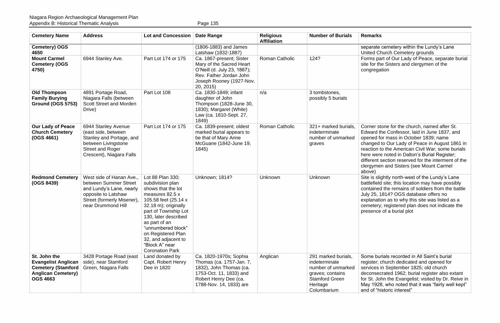
Niagara Region Archaeological Management Plan
Appendix B: Historical Thematic Analysis Page 135
Cemetery Name Address Lot and Concession Date Range Religious Affiliation
Number of Burials Remarks
Cemetery) OGS 4650
(1806-1883) and James Latshaw (1832-1887)
separate cemetery within the Lundy’s Lane United Church Cemetery grounds
Mount Carmel Cemetery (OGS 4750)
6944 Stanley Ave. Part Lot 174 or 175 Ca. 1867-present; Sister Mary of the Sacred Heart O’Neill (d. July 23, 1867); Rev. Father Jordan John Joseph Rooney (1927-Nov. 20, 2015)
Roman Catholic 124? Forms part of Our Lady of Peace, separate burial site for the Sisters and clergymen of the congregation
Old Thompson Family Burying Ground (OGS 5753)
4891 Portage Road, Niagara Falls (between Scott Street and Morden Drive)
Part Lot 108 Ca. 1830-1849; infant daughter of John Thompson (1828-June 30, 1830); Margaret (White) Law (ca. 1810-Sept. 27, 1849)
n/a 3 tombstones, possibly 5 burials
Our Lady of Peace Church Cemetery (OGS 4661)
6944 Stanley Avenue (east side, between Stanley and Portage, and between Livingstone Street and Roger Crescent), Niagara Falls
Part Lot 174 or 175 Ca. 1839-present; oldest marked burial appears to be that of Mary Anne McGuane (1842-June 19, 1845)
Roman Catholic 321+ marked burials, indeterminate number of unmarked graves
Corner stone for the church, named after St. Edward the Confessor, laid in June 1837, and opened for mass in October 1839; name changed to Our Lady of Peace in August 1861 in reaction to the American Civil War; some burials here were noted in Dalton’s Burial Register; different section reserved for the interment of the clergymen and Sisters (see Mount Carmel above)
Redmond Cemetery (OGS 8439)
West side of Hanan Ave., between Summer Street and Lundy’s Lane, nearly opposite to Latshaw Street (formerly Misener), near Drummond Hill
Lot 88 Plan 330; subdivision plan shows that the lot measures 82.5 x 105.58 feet (25.14 x 32.18 m); originally part of Township Lot 130, later described as part of an “unnumbered block” on Registered Plan 32, and adjacent to “Block A” near Coronation Park
Unknown; 1814? Unknown Unknown Site is slightly north-west of the Lundy’s Lane battlefield site; this location may have possibly contained the remains of soldiers from the battle July 25, 1814? OGS database offers no explanation as to why this site was listed as a cemetery; registered plan does not indicate the presence of a burial plot
St. John the Evangelist Anglican Cemetery (Stamford Anglican Cemetery) OGS 4663
3428 Portage Road (east side), near Stamford Green, Niagara Falls
Land donated by Capt. Robert Henry Dee in 1820
Ca. 1820-1970s; Sophia Thomas (ca. 1757-Jan. 7, 1832), John Thomas (ca. 1753-Oct. 11, 1833) and Robert Henry Dee (ca. 1788-Nov. 14, 1833) are
Anglican 291 marked burials, indeterminate number of unmarked graves; contains Stamford Green Heritage Columbarium
Some burials recorded in All Saint’s burial register; church dedicated and opened for services in September 1825; old church deconsecrated 1962; burial register also extant for St. John the Evangelist; visited by Dr. Reive in May 1928, who noted that it was “fairly well kept” and of “historic interest”
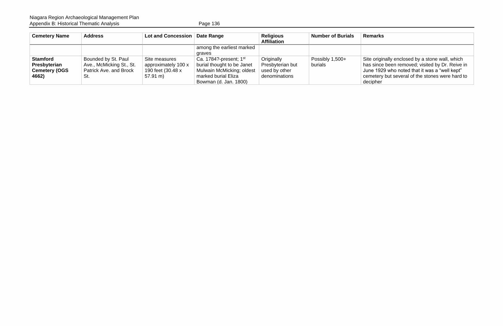
Niagara Region Archaeological Management Plan
Appendix B: Historical Thematic Analysis Page 136
Cemetery Name Address Lot and Concession Date Range Religious Affiliation
Number of Burials Remarks
among the earliest marked graves
Stamford Presbyterian Cemetery (OGS 4662)
Bounded by St. Paul Ave., McMicking St., St. Patrick Ave. and Brock St.
Site measures approximately 100 x 190 feet (30.48 x 57.91 m)
Ca. 1784?-present; 1st burial thought to be Janet Mulwain McMicking; oldest marked burial Eliza Bowman (d. Jan. 1800)
Originally Presbyterian but used by other denominations
Possibly 1,500+ burials
Site originally enclosed by a stone wall, which has since been removed; visited by Dr. Reive in June 1929 who noted that it was a “well kept” cemetery but several of the stones were hard to decipher

Niagara Region Archaeological Management Plan
Appendix B: Historical Thematic Analysis Page 137
Table B13: Cemeteries in Thorold Township
Cemetery Name Address Lot/Concession Date Range Religious Affiliation
Number of Burials Remarks
“Old” Allanburg Cemetery (OGS 4667)
Centre Street in Allanburg (east side of the Welland Ship Canal, directly beside number 2392 Centre Street); at the bend of Centre Street directly opposite to an unnamed section of Seaway haulage road (site is west of Highway 20 or Lundy’s Lane)
Lot 118; ¼ acre (0.101 ha) donated for use as a cemetery by Harmonius Vanderburgh in March 1844
Ca. 1813-1876; Noah Davis (1792-Dec. 29, 1813); Mary Crysler (1763-Dec. 14, 1815); Clarissa Hall (1783-Feb. 2, 1821); Isaac Radcliffe (1828-Oct. 14, 1874); Mary Radcliffe (d. Dec. 1876)
Non-denominational 50+; indeterminate number of unmarked graves; site presently contains 31 stones and five tombstone fragments
Shown on 1876 map of Thorold; Jubilee History of Thorold, p. 33; Carnochan; visited by Dr. Reive in July 1926 who noted that it was in “deplorable condition” with many stones that were difficult to decipher; some graves and monuments had been moved to the “new cemetery a short distance away.” Site fenced in, contains a heritage plaque
Beaverdams Cemetery (United Methodist Beaver Dams Church and Cemetery) OGS 4668
South side of Marlatts Road east of Beaverdams Road (1,000 feet or 304.8 m from Beaverdams Road)
Part Lots 51 and 52, 1 acre (0.404 ha); map of cemetery showing plots and owners names compiled by Keefer in 1860
Ca. 1828-1929; Nancy Swayze (1800-Dec. 7, 1828) appears to be the oldest marked burial; Hannibel Swayze (1830-Jan. 26, 1831); Margaret More (1832-Apr. 24, 1833); Adelaide Dexter (d. 1929)
Methodist, United 72 marked burials as well as a few footstones; indeterminate number of unmarked graves
Land conveyed to the congregation by Hiram Swayze in June 1832, laid out into 100 family burial plots; site contains two story frame chapel built 1832; regular services discontinued in 1890; entered Church Union in 1925, still used for special services; church undergoing restoration; heritage plaque on site; Jubilee History of Thorold, p. 32
Bouk Farm Cemetery
Unknown Part Lot 102? Part of this lot (½ acre) was “reserved” for a schoolhouse in a deed dated May 1849, and later deeded to the trustees of School Section 7 in February 1882 (Thorold deeds #1712/1849, 2245/1882)
Unknown n/a 1 unconfirmed burial Referred to in a funeral invitation, on the Bouk farm “near Bouk School;” location probably in Thorold, possibly on the Simon Bouk farm where there was a schoolhouse; Invitation in the collection at the Mayholme Foundation; cemetery not in the OGS database
Carl Misener Burying Ground (Muisenor Burial Place “near Port Robinson on the Welland Canal”, Carl Misener/Bald Cemetery) OGS 6558
North-west side of Carl Street and the Towpath Road in Port Robinson (“400 yards south of Port Robinson”)
Part Lot 213 Ca. 1798-1840; Leonard Muisenor Sr. (1744-Sept. 3, 1806); Thomas Bald (ca. 1817-July 6, 1832); Hannah Misener (ca. 1788-Sept. 13, 1840); presently one stone remains in situ, Barbara Misener (ca. 1741-Apr. 23, 1821)
n/a 5 marked burials; indeterminate number of unmarked burials; Reive noted “the depressed surfaces of the ground would indicate many unmarked graves”
Site located on a knoll overlooking the Welland Canal; one stone standing, the rest laid flat on the ground and may have been covered over; see Jubilee History of Thorold, p. 32; site visited by Dr. Reive in May 1930, he referred to it as being “near Port Robinson on Welland Canal,” and that it may have been part of a larger cemetery destroyed “during the building of the canal.”
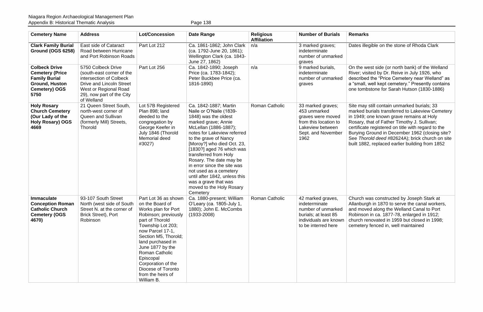
Niagara Region Archaeological Management Plan
Appendix B: Historical Thematic Analysis Page 138
Cemetery Name Address Lot/Concession Date Range Religious Affiliation
Number of Burials Remarks
Clark Family Burial Ground (OGS 6258)
East side of Cataract Road between Hurricane and Port Robinson Roads
Part Lot 212 Ca. 1861-1862; John Clark (ca. 1792-June 20, 1861); Wellington Clark (ca. 1843-June 27, 1862)
n/a 3 marked graves; indeterminate number of unmarked graves
Dates illegible on the stone of Rhoda Clark
Colbeck Drive Cemetery (Price Family Burial Ground, Huston Cemetery) OGS 5750
5750 Colbeck Drive (south-east corner of the intersection of Colbeck Drive and Lincoln Street West or Regional Road 29), now part of the City of Welland
Part Lot 256 Ca. 1842-1890; Joseph Price (ca. 1783-1842); Peter Buckbee Price (ca. 1816-1890)
n/a 9 marked burials, indeterminate number of unmarked graves
On the west side (or north bank) of the Welland River; visited by Dr. Reive in July 1926, who described the “Price Cemetery near Welland” as a “small, well kept cemetery.” Presently contains one tombstone for Sarah Hutson (1830-1886)
Holy Rosary Church Cemetery (Our Lady of the Holy Rosary) OGS 4669
21 Queen Street South, north-west corner of Queen and Sullivan (formerly Mill) Streets, Thorold
Lot 57B Registered Plan 898; land deeded to the congregation by George Keefer in July 1846 (Thorold Memorial deed #3027)
Ca. 1842-1887; Martin Naile or O’Naile (1839-1848) was the oldest marked grave; Annie McLellan (1886-1887); notes for Lakeview referred to the grave of Nancy [Moroy?] who died Oct. 23, [1830?] aged 76 which was transferred from Holy Rosary. The date may be in error since the site was not used as a cemetery until after 1842, unless this was a grave that was moved to the Holy Rosary Cemetery
Roman Catholic 33 marked graves; 453 unmarked graves were moved from this location to Lakeview between Sept. and November 1962
Site may still contain unmarked burials; 33 marked burials transferred to Lakeview Cemetery in 1949; one known grave remains at Holy Rosary, that of Father Timothy J. Sullivan; certificate registered on title with regard to the Burying Ground in December 1962 (closing site? See Thorold deed #82624A); brick church on site built 1882, replaced earlier building from 1852
Immaculate Conception Roman Catholic Church Cemetery (OGS 4670)
93-107 South Street North (west side of South Street N. at the corner of Brick Street), Port Robinson
Part Lot 36 as shown on the Board of Works plan for Port Robinson; previously part of Thorold Township Lot 203; now Parcel 17-1, Section M5, Thorold; land purchased in June 1877 by the Roman Catholic Episcopal Corporation of the Diocese of Toronto from the heirs of William B.
Ca. 1880-present; William O’Leary (ca. 1805-July 1, 1880); John E. McCombs (1933-2008)
Roman Catholic 42 marked graves, indeterminate number of unmarked burials; at least 85 individuals are known to be interred here
Church was constructed by Joseph Stark at Allanburgh in 1870 to serve the canal workers, and moved along the Welland Canal to Port Robinson in ca. 1877-78, enlarged in 1912; church renovated in 1959 but closed in 1998; cemetery fenced in, well maintained

Niagara Region Archaeological Management Plan
Appendix B: Historical Thematic Analysis Page 139
Cemetery Name Address Lot/Concession Date Range Religious Affiliation
Number of Burials Remarks
Hendershot for $100 (Thorold deeds #1527)
John Brown Family Burial Plot (“Brown graveyard at the Gore,” aka “Smith Cemetery”)
Short Hills Provincial Park, near the intersection of Scout Camp Road and the Black Walnut Trail, west of the creek
Part of Thorold Gore Lot 64 or 65
Ca. 1804-1855; contains burials of John Brown (d. Apr. 20, 1804), wife Magdalena (Zeh) Brown (1750-Apr. 18, 1804); son Adam Brown (1784-Mar. 19, 1855), and possibly David Brown (d. 1812)
n/a 4+; the cemetery appears to have contained multiple burials since an area resident recalled in 1960 that several tombstones were removed unbroken and placed face down to form a sidewalk in front of a house near the road opposite to Jackson’s Flats west of Power Glen
Family burial plot, on the knoll of a low hill, near the creek, on the south side of the old “Brown-DeCew Road.” In Short Hills Park, near Scout Camp Road and Black Walnut trail. (before reaching Camp Wetaskiwin.) The Jubilee History of Thorold (1897) mentions this cemetery. It contained at least two tombstones, one is still extant and removed by a neighbour for safekeeping; Jubilee History of Thorold, p. 32; also described in 1960 as being in the vicinity of the “Hog’s Back,” a short distance from the Jackson’s Hill Road and the road from Power Glen
Lakeview Cemetery (OGS 4665)
East side of Welland Canal, north of Highway 58, just south of the brow of the escarpment
Part of Thorold Township Lot 12; land transferred to the Town of Thorold in April 1887, but “Old” Lakeview property was expropriated by the Seaway for canal expansion in 1966; City of Thorold given a 99-year lease on the site in 1999
1886-present; older burials found here which were moved from other sites (eg, St. Peter’s Cemetery) and from private family plots (eg, George Keefer and his four wives, dating from 1813-1871)
Non-denominational 7,000+ “Old” Lakeview divided into lettered sections A-H (inclusive) and L.M and N; section “A” only used for burials since 1966; Lakeview contains 246 burials moved here in 1923-26 from the Old German Church (St. Peter’s), located in Section “N.” Dr. Reive visited the “Thorold Old Cemetery” and transcribed the various tombstones which appear to have been found in Section “N.” He referred to the removal of these graves from the “old cemetery on the banks of the Welland Canal” and that this section was “not as carefully kept as the cemetery proper”
Overholt Cemetery (Goldspink Farm Plot) OGS 5897
“on the road to St. John’s,” or north side of Hollow Road just east of the Thorold-Pelham townline; “Anger Hill Road north of Hollow Road”
South-west corner township Lot 157; land referred to in the will of Abraham Overholt (1746-1840), will dated Sept. 1839, as a place reserved to his family “for the repose of the dead” (Thorold Memorial deed #379); cemetery
Ca. 1813-1878; Rebecca (Disher) Overholt (1786-1813); Eliza Wells (1780-1877); Charity Acker (1814-Oct. 13, 1878); Abraham Overholt, the Crown patentee in Dec. 1796, was buried here. He established an early saw mill in the Short Hills area
n/a 18+ Site visited by Dr. Reive in May 1928 who erroneously located this cemetery on the Pelham side of the townline; located “in a grove near the farm house” and noted as well maintained, but some stones were then old, broken and undecipherable; thought to have originated as a private burial plot for the Overholt family; names include Disher, Gilmore, Overholt, Wills and Winger; plot shown on Thorold map in Page’s Atlas 1876 ; fenced in plot measures approximately 15 x 15 feet (4.572 m x 4.572 m)

Niagara Region Archaeological Management Plan
Appendix B: Historical Thematic Analysis Page 140
Cemetery Name Address Lot/Concession Date Range Religious Affiliation
Number of Burials Remarks
mentioned in subsequent deeds; land bought by Charles A. Goldspink in May 1916 (Thorold deed #7531)
located in the property owner’s front yard beside the house and garage
Pleasantview Memorial Gardens (OGS 4671)
2250 Highway 20 (west of Highway 406) between Merrittville Highway (Regional Road 50) and Hansler Road, in Fonthill
Part Lots 149-150; 50 acres (20.23 ha); lands purchased by Pleasantview Memorial Gardens Ltd. in Jan. 1953 from Frank Hardy, May 1959 (Kenneth J. Jenter) and April 1959 (Bruce M. Brent; Thorold Township deeds #21021, 25745A, 53354A)
Ca. 1952-present; William H. Hammell (1904-1955)
Non-denominational Approximately 21,500 burials
Port Robinson Presbyterian Cemetery (OGS 5742)
North-east corner of Allanport and Canby Roads, Port Robinson
Part Lot 201 Ca. 1822-1981; Reive noted the oldest burial was that of Jane Elliott (1786-Nov. 8, 1819); latest burials Annie Rose (1894-1973) and Ethyle Munroe Stark (Dec. 5, 1981)
Presbyterian 133 marked burials; indeterminate number of unmarked graves
Church dates from 1822; site visited by Dr. Reive in Nov. 1930
St. John’s West Cemetery (St. John’s Old Cemetery) OGS 4674
South side of Holland Road, east of the Pelham-Thorold Townline
Part Lot 111 Ca. 1826-1885; Harriett Weaver (1796-Jan. 8, 1826) and Adam Uline (ca. 1770-Aug. 6, 1827) appear to be the oldest marked burials; Reive and others recorded John Leonard Street (June 27, 1813 aged 3) as the oldest gravestone but that of his sister, Anna M. Street (May 18, 1848 aged 2 months) throws the 1813 date into question; Lydia Davis (1800-Dec. 20, 1884) and Philip Reilly (ca. 1817-Dec. 5, 1885) are the last marked burials
n/a 20 marked (decipherable) graves recorded by Reive; OGS recorded the existence of 27 tombstones and/or fragments; indeterminate number of unmarked graves
Site visited by Dr. Reive in July 1926. He noted “many stones are broken and the inscriptions hard to decipher” and that the grass was “scythed occasionally”
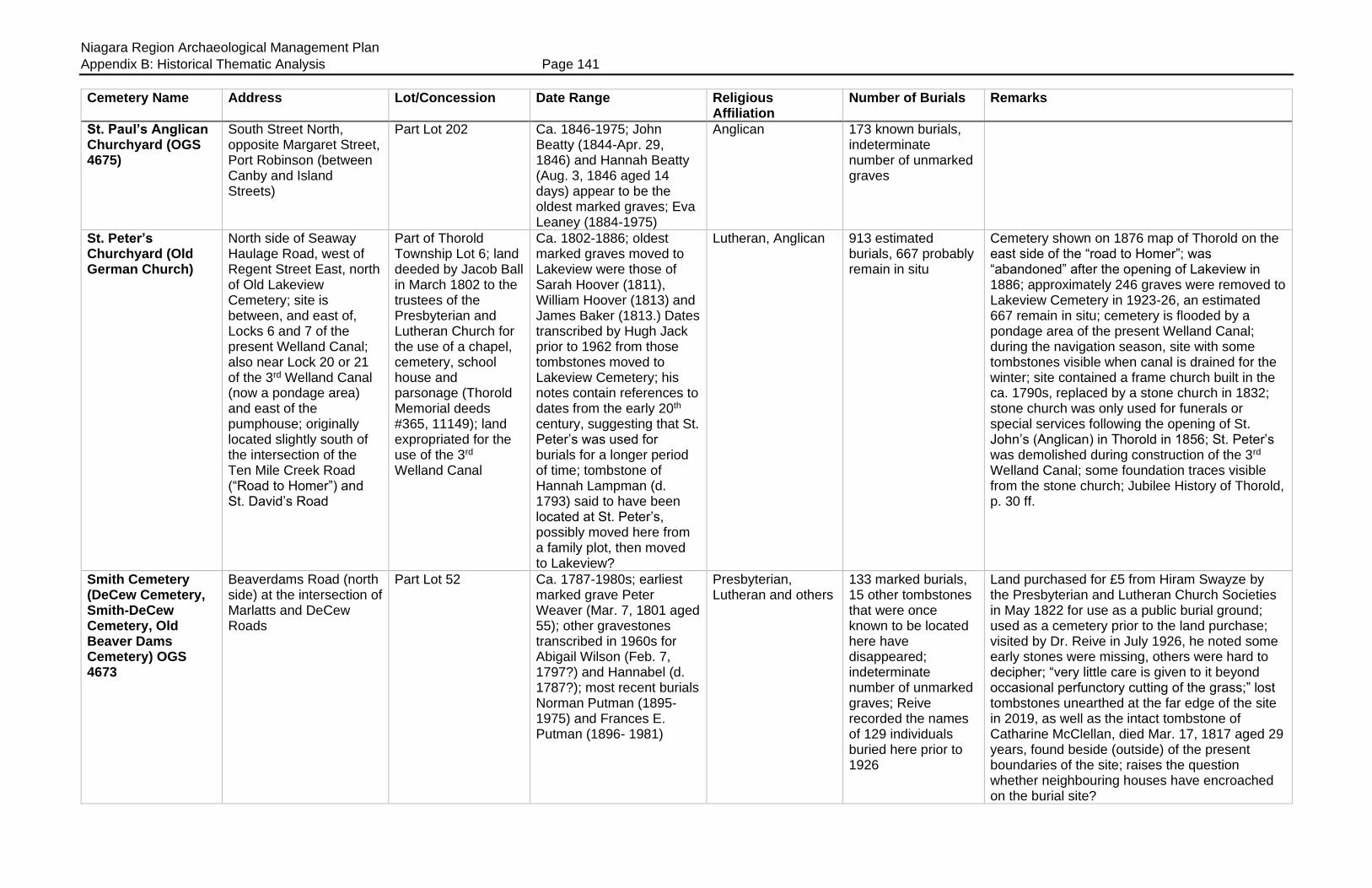
Niagara Region Archaeological Management Plan
Appendix B: Historical Thematic Analysis Page 141
Cemetery Name Address Lot/Concession Date Range Religious Affiliation
Number of Burials Remarks
St. Paul’s Anglican Churchyard (OGS 4675)
South Street North, opposite Margaret Street, Port Robinson (between Canby and Island Streets)
Part Lot 202 Ca. 1846-1975; John Beatty (1844-Apr. 29, 1846) and Hannah Beatty (Aug. 3, 1846 aged 14 days) appear to be the oldest marked graves; Eva Leaney (1884-1975)
Anglican 173 known burials, indeterminate number of unmarked graves
St. Peter’s Churchyard (Old German Church)
North side of Seaway Haulage Road, west of Regent Street East, north of Old Lakeview Cemetery; site is between, and east of, Locks 6 and 7 of the present Welland Canal; also near Lock 20 or 21 of the 3rd Welland Canal (now a pondage area) and east of the pumphouse; originally located slightly south of the intersection of the Ten Mile Creek Road (“Road to Homer”) and St. David’s Road
Part of Thorold Township Lot 6; land deeded by Jacob Ball in March 1802 to the trustees of the Presbyterian and Lutheran Church for the use of a chapel, cemetery, school house and parsonage (Thorold Memorial deeds #365, 11149); land expropriated for the use of the 3rd Welland Canal
Ca. 1802-1886; oldest marked graves moved to Lakeview were those of Sarah Hoover (1811), William Hoover (1813) and James Baker (1813.) Dates transcribed by Hugh Jack prior to 1962 from those tombstones moved to Lakeview Cemetery; his notes contain references to dates from the early 20th century, suggesting that St. Peter’s was used for burials for a longer period of time; tombstone of Hannah Lampman (d. 1793) said to have been located at St. Peter’s, possibly moved here from a family plot, then moved to Lakeview?
Lutheran, Anglican 913 estimated burials, 667 probably remain in situ
Cemetery shown on 1876 map of Thorold on the east side of the “road to Homer”; was “abandoned” after the opening of Lakeview in 1886; approximately 246 graves were removed to Lakeview Cemetery in 1923-26, an estimated 667 remain in situ; cemetery is flooded by a pondage area of the present Welland Canal; during the navigation season, site with some tombstones visible when canal is drained for the winter; site contained a frame church built in the ca. 1790s, replaced by a stone church in 1832; stone church was only used for funerals or special services following the opening of St. John’s (Anglican) in Thorold in 1856; St. Peter’s was demolished during construction of the 3rd Welland Canal; some foundation traces visible from the stone church; Jubilee History of Thorold, p. 30 ff.
Smith Cemetery (DeCew Cemetery, Smith-DeCew Cemetery, Old Beaver Dams Cemetery) OGS 4673
Beaverdams Road (north side) at the intersection of Marlatts and DeCew Roads
Part Lot 52 Ca. 1787-1980s; earliest marked grave Peter Weaver (Mar. 7, 1801 aged 55); other gravestones transcribed in 1960s for Abigail Wilson (Feb. 7, 1797?) and Hannabel (d. 1787?); most recent burials Norman Putman (1895-1975) and Frances E. Putman (1896- 1981)
Presbyterian, Lutheran and others
133 marked burials, 15 other tombstones that were once known to be located here have disappeared; indeterminate number of unmarked graves; Reive recorded the names of 129 individuals buried here prior to 1926
Land purchased for £5 from Hiram Swayze by the Presbyterian and Lutheran Church Societies in May 1822 for use as a public burial ground; used as a cemetery prior to the land purchase; visited by Dr. Reive in July 1926, he noted some early stones were missing, others were hard to decipher; “very little care is given to it beyond occasional perfunctory cutting of the grass;” lost tombstones unearthed at the far edge of the site in 2019, as well as the intact tombstone of Catharine McClellan, died Mar. 17, 1817 aged 29 years, found beside (outside) of the present boundaries of the site; raises the question whether neighbouring houses have encroached on the burial site?
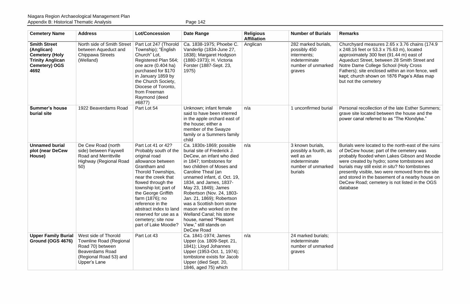
Niagara Region Archaeological Management Plan
Appendix B: Historical Thematic Analysis Page 142
Cemetery Name Address Lot/Concession Date Range Religious Affiliation
Number of Burials Remarks
Smith Street (Anglican) Cemetery (Holy Trinity Anglican Cemetery) OGS 4692
North side of Smith Street between Aqueduct and Chippawa Streets (Welland)
Part Lot 247 (Thorold Township); “English Church” Lot, Registered Plan 564; one acre (0.404 ha) purchased for $170 in January 1859 by the Church Society, Diocese of Toronto, from Freeman Raymond (deed #6877)
Ca. 1838-1975; Phoebe C. Vanderlip (1834-June 27, 1838); Margaret Hodgson (1880-1973); H. Victoria Forster (1887-Sept. 23, 1975)
Anglican 282 marked burials, possibly 450 interments; indeterminate number of unmarked graves
Churchyard measures 2.65 x 3.76 chains (174.9 x 248.16 feet or 53.3 x 75.63 m), located approximately 300 feet (91.44 m) east of Aqueduct Street, between 28 Smith Street and Notre Dame College School (Holy Cross Fathers); site enclosed within an iron fence, well kept; church shown on 1876 Page’s Atlas map but not the cemetery
Summer’s house burial site
1922 Beaverdams Road Part Lot 54 Unknown; infant female said to have been interred in the apple orchard east of the house; either a member of the Swayze family or a Summers family child
n/a 1 unconfirmed burial Personal recollection of the late Esther Summers; grave site located between the house and the power canal referred to as “The Klondyke.”
Unnamed burial plot (near DeCew House)
De Cew Road (north side) between Faywell Road and Merrittville Highway (Regional Road 50)
Part Lot 41 or 42? Probably south of the original road allowance between Grantham and Thorold Townships, near the creek that flowed through the township lot; part of the George Griffith farm (1876); no reference in the abstract index to land reserved for use as a cemetery; site now part of Lake Moodie?
Ca. 1830s-1869; possible burial site of Frederick J. DeCew, an infant who died in 1847; tombstones for two children of Moses and Caroline Theal (an unnamed infant, d. Oct. 19, 1834, and James, 1837-May 23, 1849); James Robertson (Nov. 24, 1803-Jan. 21, 1869); Robertson was a Scottish born stone mason who worked on the Welland Canal; his stone house, named “Pleasant View,” still stands on DeCew Road
n/a 3 known burials, possibly a fourth, as well as an indeterminate number of unmarked burials
Burials were located to the north-east of the ruins of DeCew house; part of the cemetery was probably flooded when Lakes Gibson and Moodie were created by hydro; some tombstones and burials may still exist in situ? No tombstones presently visible, two were removed from the site and stored in the basement of a nearby house on DeCew Road; cemetery is not listed in the OGS database
Upper Family Burial Ground (OGS 4676)
West side of Thorold Townline Road (Regional Road 70) between Beaverdams Road (Regional Road 53) and Upper’s Lane
Part Lot 43 Ca. 1841-1974; James Upper (ca. 1809-Sept. 21, 1841); Lloyd Johannes Upper (1953-Oct. 1, 1974); tombstone exists for Jacob Upper (died Sept. 20, 1846, aged 75) which
n/a 24 marked burials; indeterminate number of unmarked graves

Niagara Region Archaeological Management Plan
Appendix B: Historical Thematic Analysis Page 143
Cemetery Name Address Lot/Concession Date Range Religious Affiliation
Number of Burials Remarks
some transcriptions have recorded as “1816”
Upper Family Cemetery (private), (“New” Allanburg Cemetery) OGS 4677
East side of Seaway haulage road on the east side of the present Welland Canal, directly north of Centre Street and the “Old Allanburgh” Cemetery
Part Lot 95 Ca. 1875-2013; oldest marked burials are those of Anna Upper (ca. 1735-Mar. 10, 1809) and George Upper (died 1817) moved here from Beaver Dams; Catherine, wife of Major Anthony Upper (1777-1835), moved here from the “Old Allanburg” Cemetery; Carole Ann Mitchell Upper Gilligan (1963-2013); difficult to determine which was the first actual interment made in situ following the establishment of the cemetery
n/a 54 tombstones for 72 burials as well as footstones; some transcriptions list 87 burials; indeterminate number of unmarked burials; some graves moved here from the “Old Allanburg” Cemetery, as well as from a burial plot on the “old Upper Farm” on Lundy’s Lane and from the Smith-DeCew Cemetery at Beaver Dams
Visited by Dr. Reive in July 1926 who simply referred to it as the “New Allanburg Cemetery” which was located “behind a knoll across the road from the old one.” He noted that it was “established about forty or fifty years ago” when some burials were moved there from older graveyards; shown on the 1876 Page’s Atlas map of Thorold on the J.W. Upper farm; access from the haulage road off Centre Street
Woodlawn Municipal Cemetery (OGS 4693)
South-east corner of Niagara Street (Highway 58) and Woodlawn Road, across from Holy Cross
Part Lot 239; land sold by George Davidson to the Woodlawn Cemetery Co. Ltd. in 1913; Registered Plan 17, now known as Plan 651, show that the cemetery was enlarged in June 1913
1913-present; Emma Warrington Ross (ca. 1846-Sept. 5, 1891); Margaret Johnstone Maccomb (1874-1912); Rev. Gabriel Johnstone (1842-Jan. 5, 1913); George Herbert Johnstone (1889-Nov. 24, 1913); Rebecca A. Brown (1829-1914); Phoebe Jane Pitman (1851-1914)
Non-denominational 4,000+ burials? Now part of the City of Welland but located in the former Township of Thorold; Cemetery lands sold to the Woodlawn Cemetery Co. Ltd. by George Davidson in 1913; cemetery sold to the City of Welland for $1 in 1970; laid out in lettered sections “A” to “U” inclusive; many Serbian, Ukrainian and Hungarian burials, as well as a few Chinese; by the cemetery; some burials pre-date the land purchase date, possibly moved here from other locations?
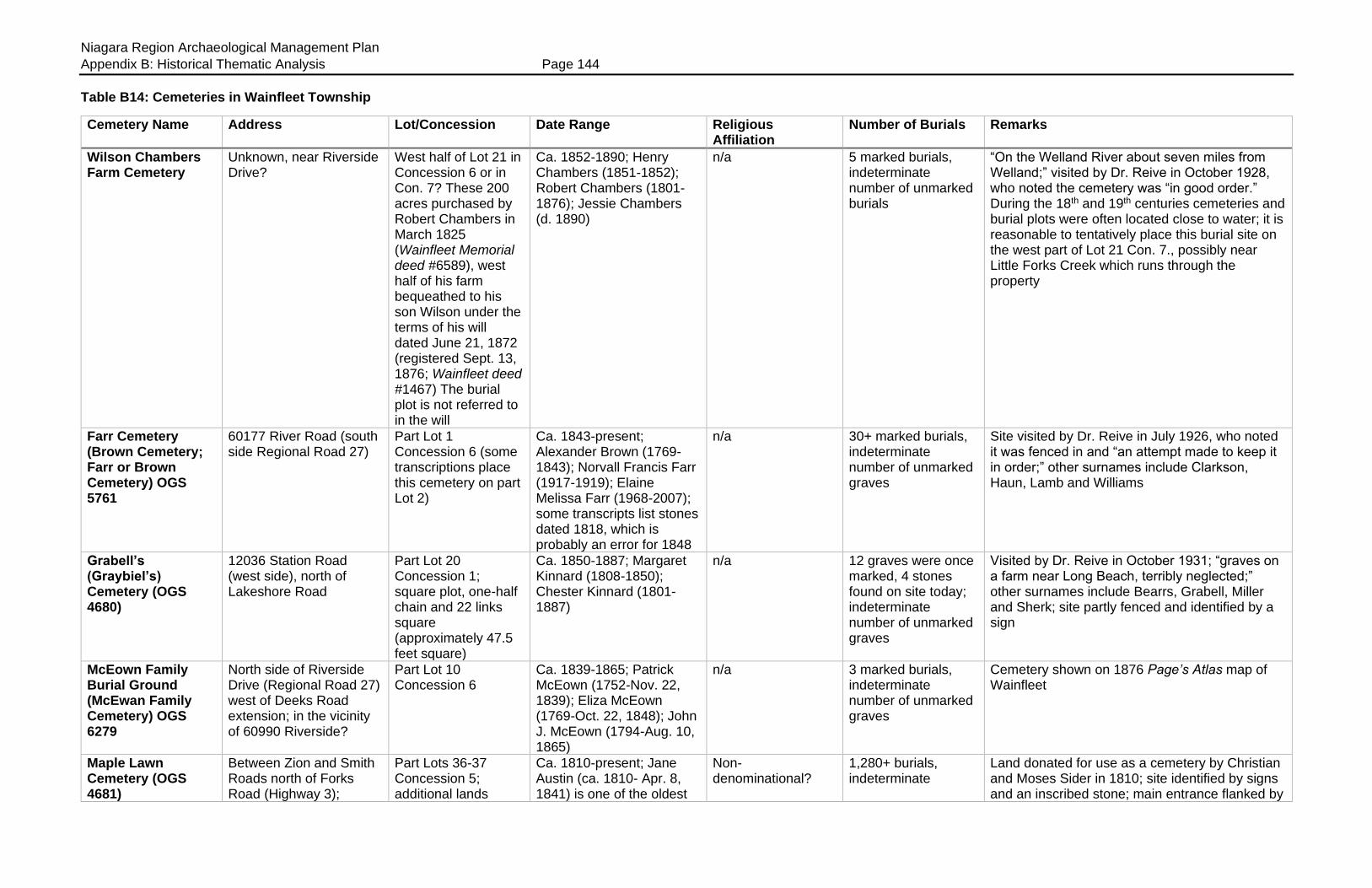
Niagara Region Archaeological Management Plan
Appendix B: Historical Thematic Analysis Page 144
Table B14: Cemeteries in Wainfleet Township
Cemetery Name Address Lot/Concession Date Range Religious Affiliation
Number of Burials Remarks
Wilson Chambers Farm Cemetery
Unknown, near Riverside Drive?
West half of Lot 21 in Concession 6 or in Con. 7? These 200 acres purchased by Robert Chambers in March 1825 (Wainfleet Memorial deed #6589), west half of his farm bequeathed to his son Wilson under the terms of his will dated June 21, 1872 (registered Sept. 13, 1876; Wainfleet deed #1467) The burial plot is not referred to in the will
Ca. 1852-1890; Henry Chambers (1851-1852); Robert Chambers (1801-1876); Jessie Chambers (d. 1890)
n/a 5 marked burials, indeterminate number of unmarked burials
“On the Welland River about seven miles from Welland;” visited by Dr. Reive in October 1928, who noted the cemetery was “in good order.” During the 18th and 19th centuries cemeteries and burial plots were often located close to water; it is reasonable to tentatively place this burial site on the west part of Lot 21 Con. 7., possibly near Little Forks Creek which runs through the property
Farr Cemetery (Brown Cemetery; Farr or Brown Cemetery) OGS 5761
60177 River Road (south side Regional Road 27)
Part Lot 1 Concession 6 (some transcriptions place this cemetery on part Lot 2)
Ca. 1843-present; Alexander Brown (1769-1843); Norvall Francis Farr (1917-1919); Elaine Melissa Farr (1968-2007); some transcripts list stones dated 1818, which is probably an error for 1848
n/a 30+ marked burials, indeterminate number of unmarked graves
Site visited by Dr. Reive in July 1926, who noted it was fenced in and “an attempt made to keep it in order;” other surnames include Clarkson, Haun, Lamb and Williams
Grabell’s (Graybiel’s) Cemetery (OGS 4680)
12036 Station Road (west side), north of Lakeshore Road
Part Lot 20 Concession 1; square plot, one-half chain and 22 links square (approximately 47.5 feet square)
Ca. 1850-1887; Margaret Kinnard (1808-1850); Chester Kinnard (1801-1887)
n/a 12 graves were once marked, 4 stones found on site today; indeterminate number of unmarked graves
Visited by Dr. Reive in October 1931; “graves on a farm near Long Beach, terribly neglected;” other surnames include Bearrs, Grabell, Miller and Sherk; site partly fenced and identified by a sign
McEown Family Burial Ground (McEwan Family Cemetery) OGS 6279
North side of Riverside Drive (Regional Road 27) west of Deeks Road extension; in the vicinity of 60990 Riverside?
Part Lot 10 Concession 6
Ca. 1839-1865; Patrick McEown (1752-Nov. 22, 1839); Eliza McEown (1769-Oct. 22, 1848); John J. McEown (1794-Aug. 10, 1865)
n/a 3 marked burials, indeterminate number of unmarked graves
Cemetery shown on 1876 Page’s Atlas map of Wainfleet
Maple Lawn Cemetery (OGS 4681)
Between Zion and Smith Roads north of Forks Road (Highway 3);
Part Lots 36-37 Concession 5; additional lands
Ca. 1810-present; Jane Austin (ca. 1810- Apr. 8, 1841) is one of the oldest
Non-denominational?
1,280+ burials, indeterminate
Land donated for use as a cemetery by Christian and Moses Sider in 1810; site identified by signs and an inscribed stone; main entrance flanked by
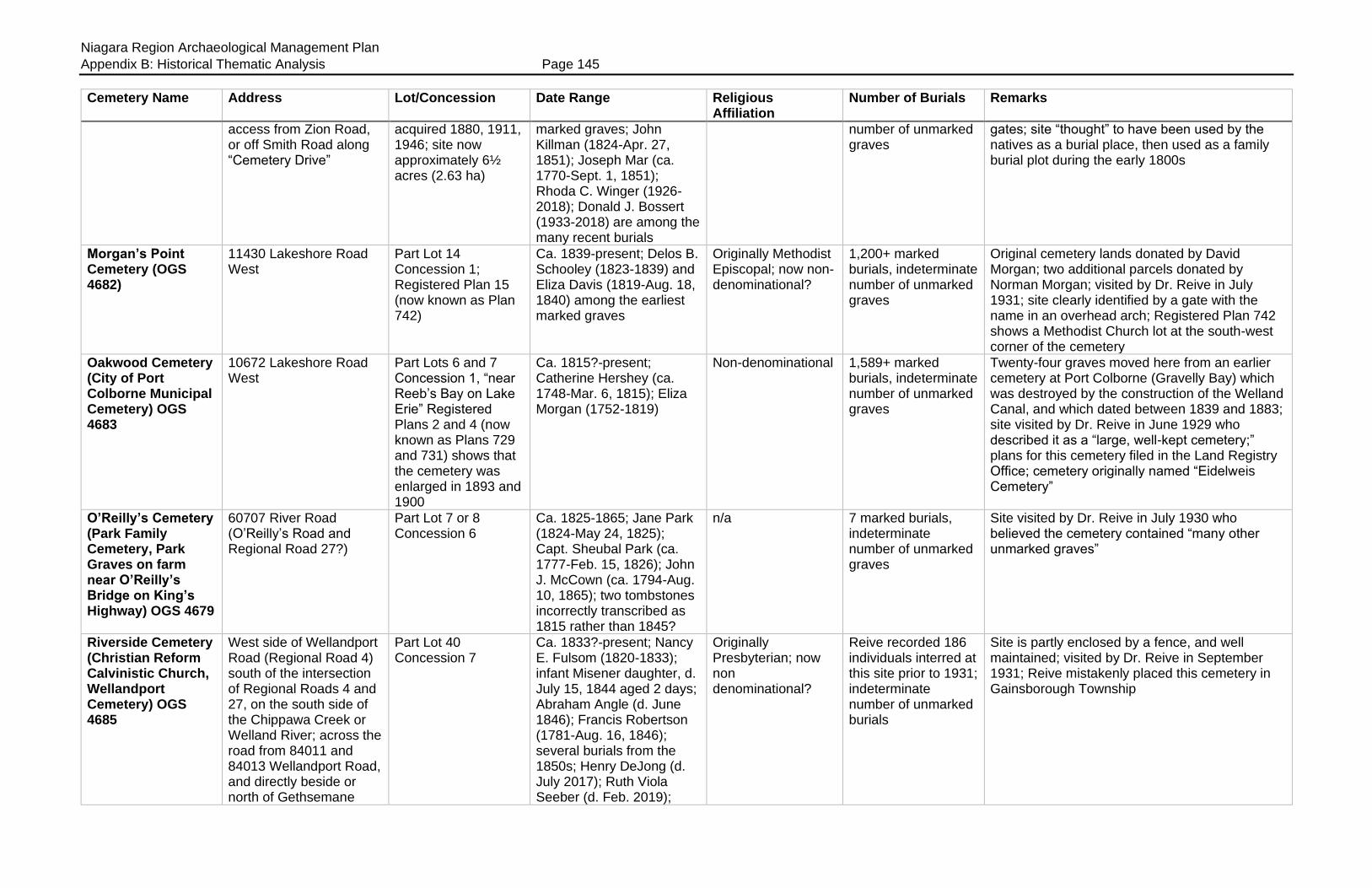
Niagara Region Archaeological Management Plan
Appendix B: Historical Thematic Analysis Page 145
Cemetery Name Address Lot/Concession Date Range Religious Affiliation
Number of Burials Remarks
access from Zion Road, or off Smith Road along “Cemetery Drive”
acquired 1880, 1911, 1946; site now approximately 6½ acres (2.63 ha)
marked graves; John Killman (1824-Apr. 27, 1851); Joseph Mar (ca. 1770-Sept. 1, 1851); Rhoda C. Winger (1926-2018); Donald J. Bossert (1933-2018) are among the many recent burials
number of unmarked graves
gates; site “thought” to have been used by the natives as a burial place, then used as a family burial plot during the early 1800s
Morgan’s Point Cemetery (OGS 4682)
11430 Lakeshore Road West
Part Lot 14 Concession 1; Registered Plan 15 (now known as Plan 742)
Ca. 1839-present; Delos B. Schooley (1823-1839) and Eliza Davis (1819-Aug. 18, 1840) among the earliest marked graves
Originally Methodist Episcopal; now non-denominational?
1,200+ marked burials, indeterminate number of unmarked graves
Original cemetery lands donated by David Morgan; two additional parcels donated by Norman Morgan; visited by Dr. Reive in July 1931; site clearly identified by a gate with the name in an overhead arch; Registered Plan 742 shows a Methodist Church lot at the south-west corner of the cemetery
Oakwood Cemetery (City of Port Colborne Municipal Cemetery) OGS 4683
10672 Lakeshore Road West
Part Lots 6 and 7 Concession 1, “near Reeb’s Bay on Lake Erie” Registered Plans 2 and 4 (now known as Plans 729 and 731) shows that the cemetery was enlarged in 1893 and 1900
Ca. 1815?-present; Catherine Hershey (ca. 1748-Mar. 6, 1815); Eliza Morgan (1752-1819)
Non-denominational 1,589+ marked burials, indeterminate number of unmarked graves
Twenty-four graves moved here from an earlier cemetery at Port Colborne (Gravelly Bay) which was destroyed by the construction of the Welland Canal, and which dated between 1839 and 1883; site visited by Dr. Reive in June 1929 who described it as a “large, well-kept cemetery;” plans for this cemetery filed in the Land Registry Office; cemetery originally named “Eidelweis Cemetery”
O’Reilly’s Cemetery (Park Family Cemetery, Park Graves on farm near O’Reilly’s Bridge on King’s Highway) OGS 4679
60707 River Road (O’Reilly’s Road and Regional Road 27?)
Part Lot 7 or 8 Concession 6
Ca. 1825-1865; Jane Park (1824-May 24, 1825); Capt. Sheubal Park (ca. 1777-Feb. 15, 1826); John J. McCown (ca. 1794-Aug. 10, 1865); two tombstones incorrectly transcribed as 1815 rather than 1845?
n/a 7 marked burials, indeterminate number of unmarked graves
Site visited by Dr. Reive in July 1930 who believed the cemetery contained “many other unmarked graves”
Riverside Cemetery (Christian Reform Calvinistic Church, Wellandport Cemetery) OGS 4685
West side of Wellandport Road (Regional Road 4) south of the intersection of Regional Roads 4 and 27, on the south side of the Chippawa Creek or Welland River; across the road from 84011 and 84013 Wellandport Road, and directly beside or north of Gethsemane
Part Lot 40 Concession 7
Ca. 1833?-present; Nancy E. Fulsom (1820-1833); infant Misener daughter, d. July 15, 1844 aged 2 days; Abraham Angle (d. June 1846); Francis Robertson (1781-Aug. 16, 1846); several burials from the 1850s; Henry DeJong (d. July 2017); Ruth Viola Seeber (d. Feb. 2019);
Originally Presbyterian; now non denominational?
Reive recorded 186 individuals interred at this site prior to 1931; indeterminate number of unmarked burials
Site is partly enclosed by a fence, and well maintained; visited by Dr. Reive in September 1931; Reive mistakenly placed this cemetery in Gainsborough Township

Niagara Region Archaeological Management Plan
Appendix B: Historical Thematic Analysis Page 146
Cemetery Name Address Lot/Concession Date Range Religious Affiliation
Number of Burials Remarks
Ministries at 84008 Wellandport Road
David William Souter (d. May 2019)
Sensabaugh Cemetery (OGS 4684)
South side of Canboro’ Road, between Robinson Road and Regional Road 45, near the Chippawa Creek
Part Lot 58 Concession 7; ½ acre (0.202 ha) donated by Christian Sensabaugh for use as a cemetery in 1842
Ca. 1838-present; Christian Sensabaugh (1752-May 13, 1838) and wife Jane (Hammond) Sensabaugh (1762-Mar. 8, 1849) among the early graves; Edna Joyce Harrington (d. Dec. 3, 2008) and Beverly Harrington Dougher (1944-2010) among the more recent burials
n/a Possibly 265 burials; indeterminate number of unmarked graves
One transcription referred to Eli Bristol (1767-1816?) as being interred here; site clearly marked by a sign
Wills’ Cemetery (OGS 4686)
East side of Winger Road north of Highway 3 (to the east or rear of 53217 Winger Road)
Part Lot 31 Concession 5; land donated by George Wills
Ca. 1849-1948; Gordon Wilson (1846-Mar. 23, 18[4]9); Eliza Beachim (1822-Sept. 4, 1862); William Arthur House (1875-1948)
Non-denominational 39 marked burials, possibly 46 burials in total; indeterminate number of unmarked graves
OGS database places this cemetery in Concession 7
Willson (Willson’s or Wilson’s) Cemetery (OGS 4687)
42346 King Street East (Highway 3) near the intersection of Highways 3 and 24
Part Lots 22-23 Concession 5; original land grant made in June 1837 by Hiram Willson “as a free burying ground without prejudice of class or creed;” cemetery enlarged 1937
Ca. 1841-present; Eliza Marsh Bradshaw (ca. 1794-Feb. 12, 1841); Eliza Muir Gilmore (1813-Dec. 28, 1844); Gerrit Jan ‘Gerry’ Evers (1935-May 8, 2016); Olga Annie Lovell (1924-May 9, 2017)
Society of Friends (Quaker); now non-denominational?
59+ marked burials, indeterminate number of unmarked graves
One transcription listed Sarah Brown Bradshaw who died in “1815” aged 36 years, the year is clearly 1845
Zion Cemetery (Marrs’ Cemetery, Marr’s Hill Cemetery, Zion United Cemetery) OGS 4688
53819 Zion Road (Highway 3) north of Forks Road and east of Winger Road
Part Lot 37 Concession 5; Enos Marr reserved a ½ acre of land around the Dunn burial plot in 1892; Peter Barrick sold additional land to the trustees (north side of the cemetery) in 1897; cemetery enlarged again in 1934 and 1936
1831-present; Ellen Dunn (died 1831 aged 5 months)
United 2,208 marked burials, indeterminate number of unmarked graves
Site began as a private family burial plot for the Dunn family; partly enclosed by a fence, well maintained grounds
Niagara Region Archaeological Management Plan
Appendix B: Historical Thematic Analysis Page 147

Niagara Region Archaeological Management Plan
Appendix B: Historical Thematic Analysis Page 148
Table B15: Cemeteries in Willoughby Township
Cemetery Name Address Lot/Concession Date Range Religious Affiliation
Number of Burials Remarks
Battle of Chippawa National Historic Site
West side of Niagara Parkway, between Service Road 30 and Edgworth Road, just north of Ussher’s Creek
Part Lots 21 and 22 Broken Front
1814 n/a 168+; estimated casualties 108 British (includes 16 First Nations warriors), 60 Americans
British and American casualties likely remain in situ from the Battle of Chippawa, July 5, 1814; site contains National Historic Site monument
Bossert Road Cemetery (Byer Burial Ground) OGS 5756
South side of Bossert Road, west side of the Niagara Parkway
Part Lot 8 Concession 1; approximately 20 x 60 feet (6.096 x 18.28 m) or 0.30 acres (0.121 ha)
Ca. 1839-1895; John Byer (1839), Mary Byer (1855) and Jacob Byer (1895)
n/a 3 known burials, possibly other unmarked graves
Site located in a pine grove
Chippawa Presbyterian Church Cemetery (OGS 4625)
8280 Willoughby Dr. (Chippawa)
Part Lot 22 Concession 2; “Presbyterian Church Lot,” east side Church Street, Plan 251; land deeded to the church trustees by James Cummings in November 1845 (Willoughby Memorial deeds #246.)
Ca. 1841-1953; Isabella Orr (ca. 1839-Aug. 13, 1841); Ellen M. (Sloggett) Kister (1869-1953)
Presbyterian 68 marked burials, indeterminate number of unmarked burials; Reive recorded the names of 117 individuals interred at this site prior to 1929
Congregation organized 1821, church erected between Dec. 1842 and May 1843 at cost of $700; replaced by brick edifice in 1891, enlarged 1933 and 1950, closed in Jan. 1961; visited by Dr. Reive in June 1929, who noted that the front portion was well kept “but that at the rear of the church is disgraceful and entirely uncared for---graves sunken, stones fallen, and generally grown wild, in bad shape, many stones broken and unreadable;” cemetery is at the rear of the church, access from Niagara Street, opposite Bond Street
Dell Cemetery (Dell Methodist Burial Ground) OGS 4696
Rexinger and Dell Roads (between Welland River and QEW)
Part Lots 7 and 8; 1 acre (0.404 ha) donated by Henry Dell in 1851 and known as the “Dell Chapel and Cemetery” property
Ca. 1826-1964; Mary Jane (Dell) Burns (d. June 16, 1826? aged 36); Ellis Burns (1834-Apr. 13, 1835); Thomas D. Dell (1873-Mar. 17, 1964); Reive recorded the oldest stone that he found as that of Mary Dell (1805-1840)
Methodist Episcopal/United
98 marked burials, site thought to contain at least 110 burials; indeterminate number of unmarked graves; Reive recorded the names of 73 individuals interred at this location prior to 1929
Site once contained a chapel “Dell Church near Lyon’s Creek”; visited by Dr. Reive in August 1929 who noted the condition of the stones, and the “veritable wilderness” of weeds and thickets which made some stones inaccessible.
Gonder Cemetery (Gonder Graveyard, Gonder Burial Ground) OGS 4698
South of Sherk Road, east side of Gonder Creek (east of Willoughby Drive, south of Sherk Road)
Part Lot 6 Concession 1; 0.4 acres (0.16 ha)
Ca. 1813-1895; Michael Gonder (1742-1813) believed to be the first burial; Thomas Gonder (1833-1895)
n/a Site thought to contain 18 or 20 burials, indeterminate number of unmarked graves; site contained 14 tombstones and 8 footstones when transcribed in 1957,
Site originally enclosed with a brick wall, now contained within a metal, farm fence with a gate; difficult access, site heavily wooded; referred to by Janet Carnochan as the “burial place on the old Gonder farm;” also noted in the History of Welland County (1887) p. 545; surnames include Gonder, Price, Thompson and Fares.
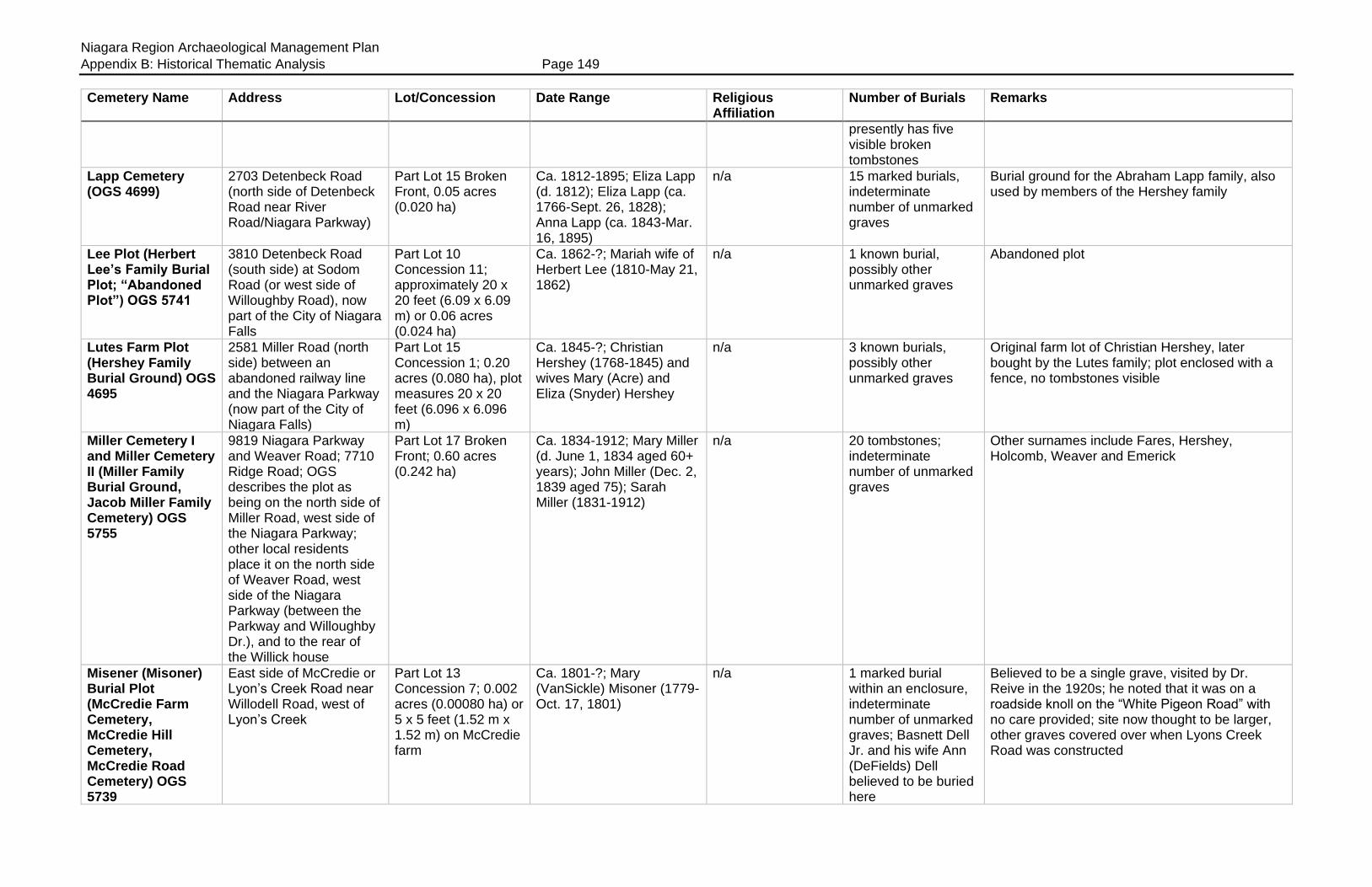
Niagara Region Archaeological Management Plan
Appendix B: Historical Thematic Analysis Page 149
Cemetery Name Address Lot/Concession Date Range Religious Affiliation
Number of Burials Remarks
presently has five visible broken tombstones
Lapp Cemetery (OGS 4699)
2703 Detenbeck Road (north side of Detenbeck Road near River Road/Niagara Parkway)
Part Lot 15 Broken Front, 0.05 acres (0.020 ha)
Ca. 1812-1895; Eliza Lapp (d. 1812); Eliza Lapp (ca. 1766-Sept. 26, 1828); Anna Lapp (ca. 1843-Mar. 16, 1895)
n/a 15 marked burials, indeterminate number of unmarked graves
Burial ground for the Abraham Lapp family, also used by members of the Hershey family
Lee Plot (Herbert Lee’s Family Burial Plot; “Abandoned Plot”) OGS 5741
3810 Detenbeck Road (south side) at Sodom Road (or west side of Willoughby Road), now part of the City of Niagara Falls
Part Lot 10 Concession 11; approximately 20 x 20 feet (6.09 x 6.09 m) or 0.06 acres (0.024 ha)
Ca. 1862-?; Mariah wife of Herbert Lee (1810-May 21, 1862)
n/a 1 known burial, possibly other unmarked graves
Abandoned plot
Lutes Farm Plot (Hershey Family Burial Ground) OGS 4695
2581 Miller Road (north side) between an abandoned railway line and the Niagara Parkway (now part of the City of Niagara Falls)
Part Lot 15 Concession 1; 0.20 acres (0.080 ha), plot measures 20 x 20 feet (6.096 x 6.096 m)
Ca. 1845-?; Christian Hershey (1768-1845) and wives Mary (Acre) and Eliza (Snyder) Hershey
n/a 3 known burials, possibly other unmarked graves
Original farm lot of Christian Hershey, later bought by the Lutes family; plot enclosed with a fence, no tombstones visible
Miller Cemetery I and Miller Cemetery II (Miller Family Burial Ground, Jacob Miller Family Cemetery) OGS 5755
9819 Niagara Parkway and Weaver Road; 7710 Ridge Road; OGS describes the plot as being on the north side of Miller Road, west side of the Niagara Parkway; other local residents place it on the north side of Weaver Road, west side of the Niagara Parkway (between the Parkway and Willoughby Dr.), and to the rear of the Willick house
Part Lot 17 Broken Front; 0.60 acres (0.242 ha)
Ca. 1834-1912; Mary Miller (d. June 1, 1834 aged 60+ years); John Miller (Dec. 2, 1839 aged 75); Sarah Miller (1831-1912)
n/a 20 tombstones; indeterminate number of unmarked graves
Other surnames include Fares, Hershey, Holcomb, Weaver and Emerick
Misener (Misoner) Burial Plot (McCredie Farm Cemetery, McCredie Hill Cemetery, McCredie Road Cemetery) OGS 5739
East side of McCredie or Lyon’s Creek Road near Willodell Road, west of Lyon’s Creek
Part Lot 13 Concession 7; 0.002 acres (0.00080 ha) or 5 x 5 feet (1.52 m x 1.52 m) on McCredie farm
Ca. 1801-?; Mary (VanSickle) Misoner (1779-Oct. 17, 1801)
n/a 1 marked burial within an enclosure, indeterminate number of unmarked graves; Basnett Dell Jr. and his wife Ann (DeFields) Dell believed to be buried here
Believed to be a single grave, visited by Dr. Reive in the 1920s; he noted that it was on a roadside knoll on the “White Pigeon Road” with no care provided; site now thought to be larger, other graves covered over when Lyons Creek Road was constructed

Niagara Region Archaeological Management Plan
Appendix B: Historical Thematic Analysis Page 150
Cemetery Name Address Lot/Concession Date Range Religious Affiliation
Number of Burials Remarks
Morningstar Cemetery (OGS 5622)
East side of Switch Road between Netherby Rd and the Niagara Parkway
Part Lot 17 Broken Front
Ca. 1848-1873; John Morningstar (ca. 1771-Feb. 28, 1848); Anna Morningstar (ca. 1835-Mar. 23, 1873)
n/a 8 tombstones and footstones; indeterminate number of unmarked graves
Access via 3999 Niagara Parkway
St. John’s Lutheran Church (Snyder) OGS 4700
East side of Sodom Road, north of Netherby Road (Fort Erie), across the road from St. John’s United Church (14789 Sodom Road) but directly beside (north) of 3354 Sodom Road
Appears to form part Lot 5 in the Cross Concession of Willoughby; deed for the use of a “school and meeting house” was dated August 1837, with a subsequent trust deed in May 1845 (Willoughby Memorial deeds #201, 2661); the Page’s Atlas map of Willoughby (1876) placed the cemetery in error on part Lot 25 adjoining the Cross Concession, some cemetery transcripts therefore place the cemetery on Lot 25; the Tremaine map (1862) correctly placed the church on Lot 5 in the Cross Concession but did not indicate the location of the cemetery across the road
1846-present; Michael Kronmueller (1825-Apr. 18, 1846); at least one Fenian Raid casualty buried here in 1866; June Bernice Detenbeck (1933-July 31, 2017) one of the latest burials
Lutheran indeterminate number of unmarked graves
St. Johannes Evangelische Kirche congregation established 1834; land purchased from the Kronmueller family for use as a cemetery in May 1845, cemetery enlarged 1894; forms the south part of the cemetery; log church replaced by present building in 1861; name changed to St. John’s Evangelical Church in 1928, and then to St. John’s United in 1956; some tombstones in German, eg, Magdalena Lentz (1828-July 26, 1848); site clearly marked by sign, enclosed by fence and stone pillars on Sodom Road; separated by a strip of land from the newer United Church cemetery; well maintained cemetery
St. John’s United Church Cemetery, Snyder (St. John’s Stevensville United Church Cemetery) OGS 4701
East side of Sodom Road, north of Netherby Road (Fort Erie); across the road from St. John’s United Church (14789 Sodom Road)
Appears to form part Lot 5, Cross Concession in Willoughby
Ca. 1846-present; United 356 marked burials, indeterminate number of unmarked graves
Cemetery located across the road from the original 1861 brick church; forms the north half of the site; divided into four sections A, B, C and D; cemetery partly enclosed by a fence and stone pillars on Sodom Road; separated by a strip from the older Lutheran cemetery; well maintained cemetery
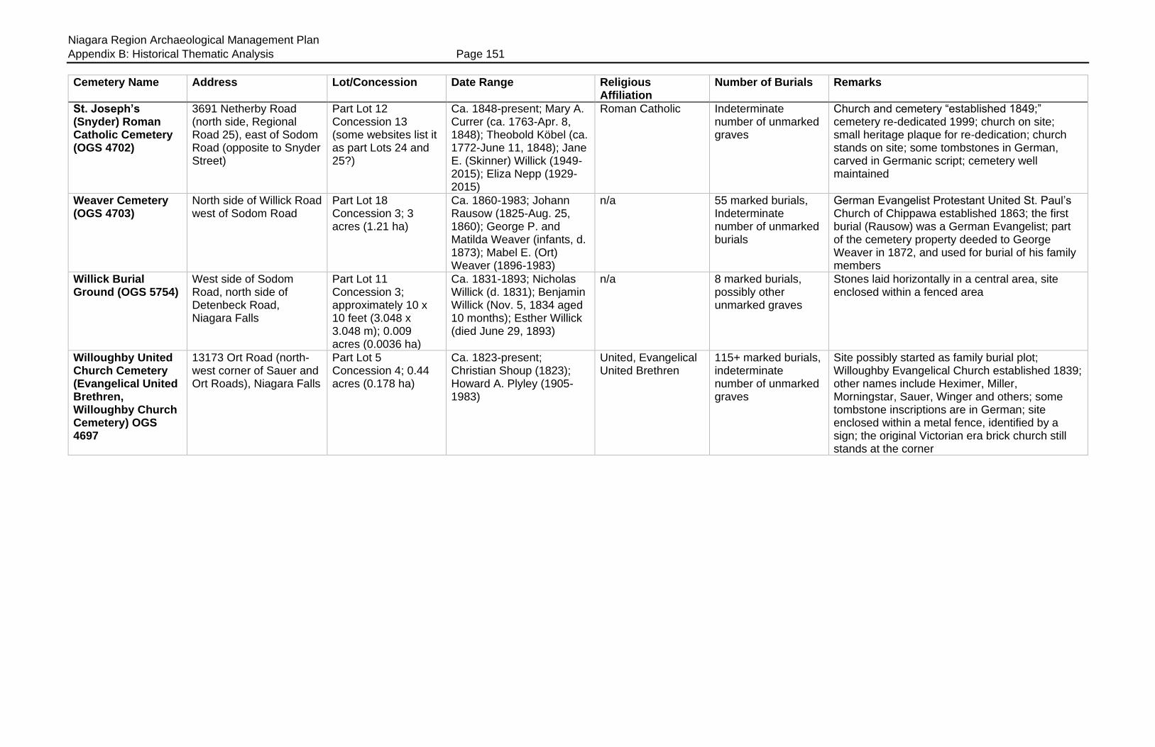
Niagara Region Archaeological Management Plan
Appendix B: Historical Thematic Analysis Page 151
Cemetery Name Address Lot/Concession Date Range Religious Affiliation
Number of Burials Remarks
St. Joseph’s (Snyder) Roman Catholic Cemetery (OGS 4702)
3691 Netherby Road (north side, Regional Road 25), east of Sodom Road (opposite to Snyder Street)
Part Lot 12 Concession 13 (some websites list it as part Lots 24 and 25?)
Ca. 1848-present; Mary A. Currer (ca. 1763-Apr. 8, 1848); Theobold Köbel (ca. 1772-June 11, 1848); Jane E. (Skinner) Willick (1949-2015); Eliza Nepp (1929-2015)
Roman Catholic Indeterminate number of unmarked graves
Church and cemetery “established 1849;” cemetery re-dedicated 1999; church on site; small heritage plaque for re-dedication; church stands on site; some tombstones in German, carved in Germanic script; cemetery well maintained
Weaver Cemetery (OGS 4703)
North side of Willick Road west of Sodom Road
Part Lot 18 Concession 3; 3 acres (1.21 ha)
Ca. 1860-1983; Johann Rausow (1825-Aug. 25, 1860); George P. and Matilda Weaver (infants, d. 1873); Mabel E. (Ort) Weaver (1896-1983)
n/a 55 marked burials, Indeterminate number of unmarked burials
German Evangelist Protestant United St. Paul’s Church of Chippawa established 1863; the first burial (Rausow) was a German Evangelist; part of the cemetery property deeded to George Weaver in 1872, and used for burial of his family members
Willick Burial Ground (OGS 5754)
West side of Sodom Road, north side of Detenbeck Road, Niagara Falls
Part Lot 11 Concession 3; approximately 10 x 10 feet (3.048 x 3.048 m); 0.009 acres (0.0036 ha)
Ca. 1831-1893; Nicholas Willick (d. 1831); Benjamin Willick (Nov. 5, 1834 aged 10 months); Esther Willick (died June 29, 1893)
n/a 8 marked burials, possibly other unmarked graves
Stones laid horizontally in a central area, site enclosed within a fenced area
Willoughby United Church Cemetery (Evangelical United Brethren, Willoughby Church Cemetery) OGS 4697
13173 Ort Road (north-west corner of Sauer and Ort Roads), Niagara Falls
Part Lot 5 Concession 4; 0.44 acres (0.178 ha)
Ca. 1823-present; Christian Shoup (1823); Howard A. Plyley (1905-1983)
United, Evangelical United Brethren
115+ marked burials, indeterminate number of unmarked graves
Site possibly started as family burial plot; Willoughby Evangelical Church established 1839; other names include Heximer, Miller, Morningstar, Sauer, Winger and others; some tombstone inscriptions are in German; site enclosed within a metal fence, identified by a sign; the original Victorian era brick church still stands at the corner