Thematic Heritage Study of Wellington
164
January 2013 THEMATIC HERITAGE STUDY OF WELLINGTON
-
Upload
khangminh22 -
Category
Documents
-
view
0 -
download
0
Transcript of Thematic Heritage Study of Wellington

January 2013
ThemaTic heriTage STudy of WellingTon

Produced by:Wellington City Council101 Wakefield StreetWellingtonNew Zealand
Wellington.govt.nz
ISBN 978-1-877232-72-5
Thematic Heritage Study of Wellington by Wellington City Council is licensed under a Creative Commons Attribution 3.0 New Zealand License. To view a copy of this license, visit http://creativecommons.org/licenses/by/3.0/nz
PDWCC92733

Contents
THEME A People & the environment page 6
Migration / ImmigrationSettlement patternsPeople & the natural environmentResource use
GardeningTrade & commerceTransportMaritime safetyCommunicationsTechnology & engineeringLabourHealth
Government institutionsSecurity & the lawMilitary & defenceWellington & the World
Belief systemsEducation & learningArtsSport & leisureScienceCommunities of special interestSocialisingPublic entertainmentInformation providers/mediaNation building
THEME B Developing economies page 38
THEME C Governing page 82
THEME D Building social & cultural life page 104
1 Introduction page 4
2 Themes

4
Introduction
Background
This report presents the results of a thematic heritage study of Wellington city. The study was initiated, planned and project managed by the Heritage team of Wellington City Council. Boffa Miskell was commissioned to undertake the research and prepare a draft report. The Boffa Miskell team included expertise in urban and landscape planning, mapping, historical research, archaeology and Maori cultural heritage. The draft report has been designed and published by Wellington City Council.
Thematic heritage in the context of this study means the “themes” in the history of the city that have shaped it physically, culturally, socially and politically such that it has become the place that it is. The themes are overlapping and change over time.
The study has produced:
[a] a thematic heritage framework which summarises the themes and examples of the types of places that relate to the themes;
[b] a set of brief narratives that outline the ‘story’ for each of the themes, including examples of the types of places associated with these; and
[c] mapping of some aspects of the themes that have spatial elements to them.
The concept of using themes to generate a framework of understanding of the heritage of a place is now well recognised in New Zealand. It is used elsewhere by Councils to enable them to undertake their responsibilities - both statutory under the Resource Management Act (1991), as well as non-statutory such as in relation to understanding and promoting a city’s identity.
Acknowledgement is due to the input and support of Wellington City Archives, Alexander Turnbull Library (ATL), staff from Ministry for Culture and Heritage, and the heritage professionals consulted at various times in the process of the study.
Objectives
The objectives for the study were:
• To assist with thinking more widely about the processes which have created the context and framework of the city as it is today, which will
assist in identifying and assessing places that
contribute to the city’s heritage.
• To identify the factors which have been the drivers to development of different areas of the city and how and why they have influenced growth and development, or decline.
• To understand the contribution of all the factors which go into making up the heritage attributes and characteristics of the city.
Process
The process for the study took several months and was to:
• Establish a thematic model that is appropriate to the objectives for the study and the context of the city. Various models were explored in a workshop with heritage professionals.
• Develop themes and sub-themes. The headings were confirmed and sub-themes beneath these were developed by the project team. The outcome was four high-level themes (People and the Environment, Developing Economies, Governing, and Social and Cultural Life). The sub-themes (of which there are 26) under each theme were also developed.
• Workshop with heritage group. A diverse group of Wellington-based heritage professionals was called on to discuss and refine the themes and sub-themes as well as to identify the type and examples of places that would relate to these. The sub-themes were refined from that workshop.
• Research, narrative and mapping development. The 26 sub-themes were researched and written up, with several trials provided to WCC for review, to establish the level and pitch of content. The input of several of the team was made to some narratives where this was required. The research of spatial information was also undertaken and the approach of geo-referenced original map images as well as GIS map layers was confirmed with WCC.

5
• Study Reporting. The narrative and mapping was produced to a draft report and supplied to WCC for comment. Formatting and other changes to the report were made and draft publication by WCC.
Study Parameters
The thematic framework itself provides a robust basis for WCC to examine its current knowledge of the city’s heritage resources as well as its management of those resources (in heritage policy, District Plan, strategic planning and advocacy).
The framework can be used to see where there are gaps in knowledge and where further research and documentation or management may be needed. This will occasion additions to the narratives and mapping as more knowledge comes to light or is discovered through further research.
This study and the resultant narratives are not a comprehensive historical account of the city – that is an undertaking well beyond the limits of the project. The aim has been to set a platform with the framework to enable the WCC to prioritise its resources for heritage management into the areas where it is most needed. The narratives and mapping can be added to as further work is undertaken. It is intended that the work will be utilised widely and will be maintained and updated over time.
The nature of heritage is such that many of the themes in Wellington city’s history have regional as well as national connections. Due to the nature of the study the regional connections have not been overtly explored, such as in narratives or mapping.
The study has used GIS to examine spatial patterns of change, rather than to identify specific heritage sites. Accordingly the mapping will not be accurate at a site-specific scale.
How to use this document
Researchers identified four themes, each represented by a colour. Within each theme (or colour) a number of sub-themes are identified and are briefly set in context with examples. Not every field is completed; this does not mean an example is absent in the region, it simply means it has not yet been identified. This document is intended to encourage debate about heritage places, sites, objects and buildings, particularly around the ‘gaps’ in our knowledge.
Acknowledgements
All images are credited individually. Map graphics were created by Boffa Miskell Limited and while reduced in size from their draft version, they remain the same. Permission to use images from Alexander Turnbull Library was obtained, but all other images have come from Wellington City Council’s own archive, Wellington City Archive. We have cited these images at WCC Archives to assist directing readers clearly. Lastly, their patience and assistance with this project is gratefully acknowledged.
Heritage Team Wellington City Council November 2012

6

7
THEME A
People and the Environment
MIGRATION / IMMIGRATIONSETTLEMENT PATTERNS
PEOPLE & THE NATURAL ENVIRONMENTRESOURCE USE
Map of Wellington. WCC Archives 2008:23-9-53

8 PEOPLE AND THE ENVIRONMENT
Migration / ImmigrationSub-theme Type Examples of placesMāori migration Pa Rangitatau Pa, Makara Pa, Te Ika a Maru Pa, Te Aro Pa, Pipitea Pa, Maupuia Pa
Settlements (kainga) Lyall Bay, Island Bay, Seatoun, Karaka Bay, Tarakena Bay, Owhiro Bay, Owhario Bay, Opuawe, Kau Bay
Urupa Oteranga Bay, Waiariki Stream mouth, Karori Stream mouth
Midden Kau Bay, Tarakena Bay, Makara Beach, Oteranga Bay, Karaka Bay, etc
Moa hunting Makara, Seatoun and Lyall Bay Gardens Makara, Te Ika a Maru Bay, Karaka Bay (19th Century), Kaiwharawhara (19th Century), Mt CookPathways Thorndon to Owhariu, Korokoro ro PoriruaStreams and waters (settlement) Kaiwharawhara Stream, Makara Stream, Waitangi Stream
Named navigational landmarks Kupe namings - Steeple Rock, Matiu/Somes
Karaka groves Miramar Peninsula, Wellington south coast, Wellington west coast
Whalers and flax merchants Whaling stations
Flax plantations, warehouses Kumutoto
Villages / kainga Te Aro, PipiteaEarly colonists 1840-1869 Wharves Queens Wharf
Immigration barracks
Houses or cottages Colonial Cottage (Nairn St), Spinks Cottage, Thorndon cottagesReclamations Provincial reclamations - Willis St (1852), Lambton Quay (1862)
Public works Old Porirua Road (1843) Old Coach Road (J’ville, 1858)Public buildings including churches Old St Paul’s (Thorndon)
Vogel-era assisted immigration (1871-1882) Wharves Queens Wharf (and subsequent wharves) Immigration centres Matiu Somes Island
Railways and roads Wellington-Petone Railway (begun in 1872), improvements to Hutt RoadPublic buildings Government BuildingsEarly speculator housing Thorndon cottages, Te Aro workers’ housing, Taitville houses
Other 19th century / early 20th century migrations and ethnicities
Immigrant enclaves Chinese - Haining and Frederick Streets (Seyip Association building, 21-15 Ghuznee Street & Anglican Chinese Mission Hall, 40-46 Frederick Street), Courtenay Place restaurants, Italians (Island Bay & Makara), The Parade, Roma House, Trent St, Island Bay
Gathering placesChurchesShops
Restaurants / cafes / hotels Shamrock Hotel (1893, then in Molesworth St, frequented by the Irish)
Buckle St Police Station built in 1898 to keep an eye on immigrants (mostly Australian) in Te AroImmigrant association premises
Other - law and order

PEOPLE AND THE ENVIRONMENT 9
Migration / ImmigrationSub-theme Type Examples of placesMāori migration Pa Rangitatau Pa, Makara Pa, Te Ika a Maru Pa, Te Aro Pa, Pipitea Pa, Maupuia Pa
Settlements (kainga) Lyall Bay, Island Bay, Seatoun, Karaka Bay, Tarakena Bay, Owhiro Bay, Owhario Bay, Opuawe, Kau Bay
Urupa Oteranga Bay, Waiariki Stream mouth, Karori Stream mouth
Midden Kau Bay, Tarakena Bay, Makara Beach, Oteranga Bay, Karaka Bay, etc
Moa hunting Makara, Seatoun and Lyall Bay Gardens Makara, Te Ika a Maru Bay, Karaka Bay (19th Century), Kaiwharawhara (19th Century), Mt CookPathways Thorndon to Owhariu, Korokoro ro PoriruaStreams and waters (settlement) Kaiwharawhara Stream, Makara Stream, Waitangi Stream
Named navigational landmarks Kupe namings - Steeple Rock, Matiu/Somes
Karaka groves Miramar Peninsula, Wellington south coast, Wellington west coast
Whalers and flax merchants Whaling stations
Flax plantations, warehouses Kumutoto
Villages / kainga Te Aro, PipiteaEarly colonists 1840-1869 Wharves Queens Wharf
Immigration barracks
Houses or cottages Colonial Cottage (Nairn St), Spinks Cottage, Thorndon cottagesReclamations Provincial reclamations - Willis St (1852), Lambton Quay (1862)
Public works Old Porirua Road (1843) Old Coach Road (J’ville, 1858)Public buildings including churches Old St Paul’s (Thorndon)
Vogel-era assisted immigration (1871-1882) Wharves Queens Wharf (and subsequent wharves) Immigration centres Matiu Somes Island
Railways and roads Wellington-Petone Railway (begun in 1872), improvements to Hutt RoadPublic buildings Government BuildingsEarly speculator housing Thorndon cottages, Te Aro workers’ housing, Taitville houses
Other 19th century / early 20th century migrations and ethnicities
Immigrant enclaves Chinese - Haining and Frederick Streets (Seyip Association building, 21-15 Ghuznee Street & Anglican Chinese Mission Hall, 40-46 Frederick Street), Courtenay Place restaurants, Italians (Island Bay & Makara), The Parade, Roma House, Trent St, Island Bay
Gathering placesChurchesShops
Restaurants / cafes / hotels Shamrock Hotel (1893, then in Molesworth St, frequented by the Irish)
Buckle St Police Station built in 1898 to keep an eye on immigrants (mostly Australian) in Te AroImmigrant association premises
Other - law and order

10 PEOPLE AND THE ENVIRONMENT
Sub-theme Type Examples of placesInter-war assisted immigration
Meeting places
Restaurants / cafes / hotels Matterhorn
Houses
World War II and post-war refugees and migrants (e.g. Polish & British children, Greeks, other Europeans)
Austrian architecturally designed buildings Plischke houses, public buildings and town centre designs (e.g. Sutch House, Massey House) Cultural association buildings Polish Association Building, Riddiford St
Hostels ‘Ngaroma’, the Apostolic Nunciature, Queens Drive, Lyall Bay (former Polish childrens’ hostel)
Housing enclaves Salisbury Garden Court, Wadestown (1929-1930) – home to a number of Polish families in the 1950sChurches and halls Greek Orthodox Church (1971) and Parthenon Hall (1962-63), Hania Street, Greek-NZ Memorial, Cambridge/
Kent Terraces, Romanian Orthodox Church of St Mary of Wellington and Hall, Adelaide Rd, BerhamporePost-war assisted immigration from Britain, Netherlands Society clubrooms Netherlands Society of Wellington
Sporting clubs Soccer clubs
Pacific Islanders (from 1950s onwards) Council flats Te Ara Hou Flats
Pacific Island businesses
Specialist shops
Meeting placesCafés and pubs
Churches and halls Newtown Congregational Christian Church of Samoa, 180 Owen St (1984);
Wellington Samoan Assembly of God, 193 Rintoul StreetLate 20th century immigration (e.g. Asian, Middle Eastern, Somalian, South African)
Migration / Immigration

PEOPLE AND THE ENVIRONMENT 11
Sub-theme Type Examples of placesInter-war assisted immigration
Meeting places
Restaurants / cafes / hotels Matterhorn
Houses
World War II and post-war refugees and migrants (e.g. Polish & British children, Greeks, other Europeans)
Austrian architecturally designed buildings Plischke houses, public buildings and town centre designs (e.g. Sutch House, Massey House) Cultural association buildings Polish Association Building, Riddiford St
Hostels ‘Ngaroma’, the Apostolic Nunciature, Queens Drive, Lyall Bay (former Polish childrens’ hostel)
Housing enclaves Salisbury Garden Court, Wadestown (1929-1930) – home to a number of Polish families in the 1950sChurches and halls Greek Orthodox Church (1971) and Parthenon Hall (1962-63), Hania Street, Greek-NZ Memorial, Cambridge/
Kent Terraces, Romanian Orthodox Church of St Mary of Wellington and Hall, Adelaide Rd, BerhamporePost-war assisted immigration from Britain, Netherlands Society clubrooms Netherlands Society of Wellington
Sporting clubs Soccer clubs
Pacific Islanders (from 1950s onwards) Council flats Te Ara Hou Flats
Pacific Island businesses
Specialist shops
Meeting placesCafés and pubs
Churches and halls Newtown Congregational Christian Church of Samoa, 180 Owen St (1984);
Wellington Samoan Assembly of God, 193 Rintoul StreetLate 20th century immigration (e.g. Asian, Middle Eastern, Somalian, South African)
Migration / Immigration

12 PEOPLE AND THE ENVIRONMENT
Migration / Immigration
Māori migration
The Māori history of Te Upoko o te Ika a Maui, The Head of the Fish of Maui, or the Wellington region, is complex with many changes over the last 750 years. All those who lived here migrated from somewhere else with waves of migration first from the East Coast, and later from the West Coast of the North Island. Many who migrated to Wellington were to continue on, usually further south or even to the east. The earliest Māori said to be living in the region were pre-tribal people who were also gardeners, traders and good navigators. They also hunted the moa, giving rise to the now rarely-used name of Moa Hunters.
Some oral traditions state that the first person to visit and name places in Wellington was the Polynesian explorer Kupe, who left a heritage of names which are still in use today. Kupe was the forerunner of many who migrated from Polynesia, although few of these came directly to Te Upoko o Te Ika.
Many iwi today claim descent from Kupe. One of those was Whatonga who lived at Mahia in the Hawke’s Bay. Whatonga had two sons to two different wives, Tara and Tautoki. Tara had a close association with Wellington, with the harbour called Te Whanganui a Tara (the great harbour of Tara). The Ngai Tara people occupied areas around the south coast of Wellington.
The first tribal settlers in Wellington were the descendants Tara-nohu or Tara-Ika, the son of
View from Miramar Peninsula. WCC Archives 00161-0-20-2
Whatonga and half brother of Tautoki. The early settlements of the Wellington region were often connected to the descendants of these two half-brothers. It is said that the area was divided along the Heretaunga/Hutt River, with the Tara people to the west from Otaki southwards to around Turakirae, and Tautoki having the east, excluding the coastal area of Fitzroy Bay (Parangarehu). It is noted that Rangitane was the son of Tautoki.
Traditional History of Wellington
The Waitangi Tribunal found that at 1840 the iwi groups that had taken raupatu, or rights of conquest over all the lands within the Port Nicholson block, were: Te Ātiawa, Ngāti Ruanui, Taranaki, Ngāti Tama and Ngāti Toa Rangatira. However, the Tribunal also found that these iwi each had their own ahi kā over particular areas as follows:
• Te Ātiawa at Te Whanganui ā Tara and parts of the south-west coast
• Taranaki and Ngāti Ruanui at Te Aro
• Ngāti Tama at Kaiwharawhara and environs, and parts of the south-west coast
• Ngāti Toa at parts of the south-west coast
From 1840, when the first New Zealand Company ships began to arrive at Port Nicholson (Wellington), conflict quickly escalated between local Māori (mana

PEOPLE AND THE ENVIRONMENT 13
whenua ) and new settlers. Land inhabited by mana whenua was invalidly ‘purchased by the New Zealand Company and sold to settlers’. As settler numbers increased, mana whenua were forcibly displaced and their lands taken.
Following their initial displacement and the subsequent loss of almost all their land, mana whenua struggled to obtain the return of their lands through legal means, e.g. the McCleverty Award.
For more than 150 years little progress was made to resolve the grievances of mana whenua and address the historical deprivation they had experienced. This changed in 2003, following the release of the Waitangi Tribunal report Te Whanganui ā Tara me ōna Takiwā on the Wellington District . In this report, the Tribunal concluded that serious breaches of the Treaty of Waitangi by the Crown occurred in the Port Nicholson Block. The Tribunal recommended that representatives of these groups enter into negotiation with the Crown to settle these grievances.
Following the publication of the 2003 report (also known as Wai 145), the Crown entered into negotiations with the claimants representing the descendants of tūpuna of Te Ātiawa, Taranaki, Ngāti
Ruanui and, Ngāti Tama. The Crown mandated claimant collective was named Taranaki Whānui ki te Upoko o te Ika. After six years of negotiation, the Port Nicholson Block (Taranaki Whānui ki te Upoko o te Ika) Claims Settlement Act 2009 came into force on 2 September 2009 following a signing between the Crown and representatives of Taranaki Whānui ki te Upoko Ika.
The Crown is currently negotiating with Ngāti Toa for the settlement of their claims in relation to the Port Nicholson Block. The Crown also found that in regards to Ngati Toa the Crown failed to act reasonably and in good faith and failed to protect the customary interests of Ngati Toa in and over the Port Nicholson block.
At present, Wellington City Council’s relationship with mana whenua is managed through Memoranda of Understanding (MOU) with the Port Nicholson Block Settlement Trust and Te Rūnanga o Toa Rangatira Incorporated. Council acknowledges there are other iwi interests in the region. As these interests are identified and recognised by future relevant legislation or future deed of settlement Council will have particular regard to the mana whenua view.
Miramar panorama with Māori names. WCC Archives 00138-0-3554

14 PEOPLE AND THE ENVIRONMENT
Migration to cities
In the 1930s rural Māori migration started. Māori, predominantly from the east coasts moved to the Wellington district to housing developments such as those at Miramar, but more moved to the Hutt Valley and the Porirua Basin. They came to work in industries such as the freezing works at Ngauranga and the woollen mills of Kaiwharawhara. Māori Affairs Department housing schemes did not start until 1948.
The migration of Māori from the rural areas to urban centres really accelerated in the period after World War II. Before WWII, 80% of Māori were living in rural areas; however, by 1956 35% of Māori lived in urban areas. By 1966 this had reached 62% and then by 1986 was 80%. This was a massive demographic shift for Māori although relatively small numbers lived in Wellington city.
Early Pakeha colonists
Among the earliest of Pakeha colonists were the whalers and flax merchants who arrived in Port Nicholson to make a quick return from these industries. There was at least one significant base of the Māori-dominated flax industry, at Kumutoto, while a large operation was later based at Miramar. The first shipments of organised colonists from 1840 onwards were predominantly British, originating from a few counties in the south of England and brought out under the auspices of the New Zealand Company. After three months at Petone the first settlers moved to Lambton Harbour.
Further immigration and ethnicities
Wellington’s development was relatively modest until Treasurer Julius Vogel’s ambitious public works and immigration scheme brought a big influx of immigrants from the early 1870s, mostly of British and Irish stock, with many recruited to work on the railway projects. The influx of the 1870s slowed considerably during the recession-hit 1880s. A number of Australians moved to Wellington, as well as Chinese immigrants, and the city’s first Indians arrived during the early 1900s. Assisted immigration was revived during the period 1921-27, when thousands of British immigrants were offered assisted passages, with many ending up in Wellington.
This scheme ended with another recession.
Prior to World War II, Jewish refugees from Austria fled to western countries like New Zealand to escape the Nazis. An intellectual elite coalesced in Wellington and in the period following World War II it had a big influence on transforming Wellington architecture, arts, the hospitality trade and much more. In the wake of World War II a number of displaced ethnic groups were unable to return to their countries of origin and were forced to emigrate to countries that would take them. Others left post-war Europe behind them to start a new life. Greeks, in particular, favoured Wellington, settling near the city centre, especially in Mt Victoria. Other nationalities arrived, such as Poles (both orphans and adults) and other eastern Europeans, including NZ’s only substantial population of Romanians.
Young Greek women arriving at Wellington Airport in 1962. Dominion Post Collection, Alexander Turnbull Library, Wellington, NZ (ATL) EP/1962/2905.
Group of young men and women from the Tokelau Islands who came to live in Wellington in 1964. Dominion Post Collection, ATL, EP/1964/1760.

PEOPLE AND THE ENVIRONMENT 15
In 1946, another assisted passage scheme for British migrants began. In the 30 years that followed, over 100,000 came to New Zealand, many settling in Wellington. The other significant source of migrants was the Netherlands and many Dutch came to Wellington. Post-war, many Māori moved to the cities and Wellington was no exception.
Pacific Islanders
New Zealand’s close association with the Pacific Islands led to small numbers of migrants in the early first half of the 20th century. This all changed in the 1960s and 70s, with Samoans, and to a lesser extent Tokelaus and Niueans arriving in big numbers. Pacific Islanders initially settled in and around Newtown, occupying council housing or cheap old houses. They still retain a strong presence there but have moved to other suburbs since.
Late 20th century migration
On the back of a liberal immigration policy many other nationalities arrived in Wellington. Refugees from South-East Asia arrived in the 1970s and after the institution of a points system in 1991, there were no barriers to anyone with the right attributes. In Wellington, a variety of ethnicities began to arrive, including refugees from Somalia, Iraq, Iran and Afghanistan. There were many Chinese – from Hong Kong and the mainland – and South Africans, leaving behind the post-apartheid era.
SourcesTe Ara Encyclopedia of New Zealand.
New Zealand Peoples a. www.teara.govt.nz/en/peoples
New Zealand Peoples – origins and arrivals at www.teara.govt.nz/en/origins-and-arrivals [viewed at 23 November 2009]
Oliver, William H. ed. 1981, Oxford History of New Zealand, The Clarendon Press, Oxford and Oxford University Press, Wellington
Paul Meredith. ‘Urban Māori - Urbanisation’, Te Ara - the Encyclopedia of New Zealand, updated 4-Mar-09
Reel 15B, Wellington M.B. 1C, p.86 evidence of Te Manihera te Toru re Ngauranga
Smith, S. Percy, Journal of Polynesian Society, v18, 1909.
The stern of Te Rerenga Kotāre (waka taua), front right, and Te Hononga (waka tētēkura) rear. Te Rerenga Kotara means ‘flight of the kingfisher’ and Te Hononga means ‘to bind together and form alliances’. Shown here in the wharewaka in September 2011. WCC Heritage

16 PEOPLE AND THE ENVIRONMENT
Sub-theme Type Examples of placesMāori settlement Pa, urupa, settlements (kainga), canoe landing places,
gardens, midden
Te Aro; Pipitea; Ngauranga; Kaiwharawhara; Kumutoto
Colonisation NZ Co. survey (Mein Smith) / town and country acres Premier House - last three un-subdivided acres in Wellington City
Road alignment Lambton Quay/Willis St/Manners St
Staging posts / accommodation Halfway House, GlensideEarly public works Reclamations (e.g. 1852, 1857)Early commercial ventures Plimmer’s ArkHousing Workers housingRoads Old Porirua Road (Ngauranga to Porirua), Old Coach Road (Ohariu), Makara RoadSurvey marks Mt Cook survey mark (in former National Museum building), Survey chain measurement, Government BuildingsTrig stations Mt Cook survey mark, Tinakori Hill, Mt Kaukau
Suburban expansion Speculator housing Newtown housing (1880-1900)Street formationStreet furniture Lamps, kerbs, rails (painted and unpainted), cast iron wareTunnels Karori tunnel (1899), Hataitai bus tunnel (1907), Seatoun Tunnel (1907)Cuttings Lennel Street Cutting (Wadestown, 1911), Miramar cutting (1910)Electric tram / cable car / railway/ bus Kelburn Cable Car (winding house, cars, track formation, bridges); Electric tramway (alignment, eased corners
or modified buildings; Kilbirnie Tram Barn (1924), Historic bus shelters (e.g. Highland Park, Wadestown)Road buildingShopping centres Newlands Shopping Centre. Public toilets Te Aro, corner Taranaki St and Courtenay PlaceHousing Workers’ dwellings (Liberal govt), Coromandel St and environs; Railway houses, Ngaio and Kaiwharawhara;
State houses – Miramar, Wilton, Khandallah, NgaioPost-WWII flight to outer suburbs and changing desirability of inner-city suburbs
Improved / expanded roading and transport facilities Tawa flat deviation and Johnsonville branch line Wellington urban motorwayHousing development Multi-unit state housing (Berhampore Flats, Dixon St Flats) State housing New suburbs – Wilton, Chartwell, Crofton Downs, Paparangi, Newlands, Grenada North,
Gentrification / protection of heritage housing District Plan protection Suburban Centre Heritage AreasInner-city residents’ associations / societies Thorndon Society; Mt Victoria; Newlands-Paparangi; BrooklynRestored houses / precincts Ascot Terrace; Sydney St; Glenbervie Terrace; Poplar Grove; Aorangi Terrace. Mt Cook and Mt Victoria streets
and housesReturn to city living / apartment dwelling Subdivision of old sections for new housing Papawai Terrace development
Buildings modified for use as apartments Hannah Buildings, Eva StNew apartment buildings Soho; Tattoo; Overseas Passenger Terminal, Clyde Quay
Government recruitment Hostels Antrim House, Boulcott StFlats Clyde Quay boat harbour buildings
Settlement patterns

PEOPLE AND THE ENVIRONMENT 17
Sub-theme Type Examples of placesMāori settlement Pa, urupa, settlements (kainga), canoe landing places,
gardens, midden
Te Aro; Pipitea; Ngauranga; Kaiwharawhara; Kumutoto
Colonisation NZ Co. survey (Mein Smith) / town and country acres Premier House - last three un-subdivided acres in Wellington City
Road alignment Lambton Quay/Willis St/Manners St
Staging posts / accommodation Halfway House, GlensideEarly public works Reclamations (e.g. 1852, 1857)Early commercial ventures Plimmer’s ArkHousing Workers housingRoads Old Porirua Road (Ngauranga to Porirua), Old Coach Road (Ohariu), Makara RoadSurvey marks Mt Cook survey mark (in former National Museum building), Survey chain measurement, Government BuildingsTrig stations Mt Cook survey mark, Tinakori Hill, Mt Kaukau
Suburban expansion Speculator housing Newtown housing (1880-1900)Street formationStreet furniture Lamps, kerbs, rails (painted and unpainted), cast iron wareTunnels Karori tunnel (1899), Hataitai bus tunnel (1907), Seatoun Tunnel (1907)Cuttings Lennel Street Cutting (Wadestown, 1911), Miramar cutting (1910)Electric tram / cable car / railway/ bus Kelburn Cable Car (winding house, cars, track formation, bridges); Electric tramway (alignment, eased corners
or modified buildings; Kilbirnie Tram Barn (1924), Historic bus shelters (e.g. Highland Park, Wadestown)Road buildingShopping centres Newlands Shopping Centre. Public toilets Te Aro, corner Taranaki St and Courtenay PlaceHousing Workers’ dwellings (Liberal govt), Coromandel St and environs; Railway houses, Ngaio and Kaiwharawhara;
State houses – Miramar, Wilton, Khandallah, NgaioPost-WWII flight to outer suburbs and changing desirability of inner-city suburbs
Improved / expanded roading and transport facilities Tawa flat deviation and Johnsonville branch line Wellington urban motorwayHousing development Multi-unit state housing (Berhampore Flats, Dixon St Flats) State housing New suburbs – Wilton, Chartwell, Crofton Downs, Paparangi, Newlands, Grenada North,
Gentrification / protection of heritage housing District Plan protection Suburban Centre Heritage AreasInner-city residents’ associations / societies Thorndon Society; Mt Victoria; Newlands-Paparangi; BrooklynRestored houses / precincts Ascot Terrace; Sydney St; Glenbervie Terrace; Poplar Grove; Aorangi Terrace. Mt Cook and Mt Victoria streets
and housesReturn to city living / apartment dwelling Subdivision of old sections for new housing Papawai Terrace development
Buildings modified for use as apartments Hannah Buildings, Eva StNew apartment buildings Soho; Tattoo; Overseas Passenger Terminal, Clyde Quay
Government recruitment Hostels Antrim House, Boulcott StFlats Clyde Quay boat harbour buildings
Settlement patterns

18 PEOPLE AND THE ENVIRONMENT
Settlement Patterns
Māori settlement
The settlement pattern for Māori varied with the era. Early Māori were apparently peaceful and had no need for fortifications. They were gardeners, traders, navigators, who also hunted and ate moa when they were available. Sites with remains of moa once existed at Makara, Te Ika a Maru Bay, and Seatoun. Other early sites, inferred from the archaeological remains found, but without moa hunting being evident, were much more widely spread, being around Miramar Peninsula, the eastern harbour shores from Gracefield to Turakirae Head, and the Wellington south coast from Lyall Bay to Oterongo Bay.
Ngai Tara were probably the first settlers with pa chosen largely for their defensive locations to enable the people to protect themselves. These forts were located near reliable water sources with ample food supplies. The Ngai Tara Pa formed a line along the ridgeline Te Ranga a Hiwi, extending from Omaru-kai-kuru (Point Jerningham) through Mount Victoria/Matairangi to Uruhau above Island Bay. This was probably a primary defensive line in combination with other pa, primarily Te Whetu-kai-rangi and Rangitatau at Miramar Peninsula (what was Te Motu Kairangi when the area was an island). The coast was an important source of food; of shellfish such as paua, fish, and marine mammals like the New Zealand fur seal/kekeno. The people would have had small fishing camps in many of the bays.
Thought to be the work of Edmund Norman, this is a sketch of Te Aro Pa, looking towards the Hutt River, circa 1842.ATL A-049-001
Ngati Ira settlements were more widely spread than Ngai Tara. They were again coastal settlements at places such as Te Ika a Maru and Opau, with others around the south coast. Many old Ngai Tara sites were abandoned for various reasons, particularly those that had been sacked and probably largely destroyed. Those that were not close enough to food stocks were moved to better improve their prospects. Places around Wellington Harbour were less used in pre-European times than later, as the marine resources were richer around the cold waters of Cook Strait/Raukawa Moana. Consequently, the Cook Strait coast attracted both seasonal villages and more permanent settlements.
The early 19th century saw the occupation of Wellington Harbour/Te Whanganui a Tara with the pa of Ngauranga, Kaiwharawhara, Pipitea, Kumutoto and Te Aro. These were not the fortified Pa of the past but were fenced villages to keep animals in or out, and to contain the village. Numerous waka gave access to the marine resources around the coast as well as up the rivers of the Hutt Valley/Te Awakairangi. This was largely the pattern of occupation that the New Zealand Company surveyors found when they arrived to establish the new colony. After their arrival, events in the Hutt Valley focussed the colony on the Thorndon Flats/Haukawakawa and the Te Aro flats. Colonisation saw the eventual abandonment of the harbour pa as

PEOPLE AND THE ENVIRONMENT 19
surely as they would have been abandoned in ancient Māori times for other reasons.
Māori attempted pastoral farming but, increasingly, they found themselves becoming urban dwellers in the Hutt Valley. Some Māori had market gardens, some retreated to their remaining rural lands, while others simply left the district. By 1857, the Māori population had declined from over 1000 in 1839 to less than 100.
Colonisation
The pattern of Pakeha settlement at Wellington was initially dictated by two factors – the growth of population and the distance that settlers were willing to live from the town. Following the settlement’s establishment in 1840, most arrivals understandably chose to live in Te Aro, where commercial and industrial activity was based, or Thorndon, where the government was housed. One notable exception to this was in Wadestown, where, high on the hill, cheap sections were offered to workers and, remarkably, some chose to live there – until the 1848 earthquake. People of means, with horses or horse-drawn carts or carriages, could also live further afield if they so chose.
As the city developed, Te Aro and Thorndon remained popular for workers’ housing and, with the vast majority of residents choosing to live within walking distance of their employment, Te Aro and Thorndon became packed. Small-scale farmers and those happy to walk or ride distances lived in outlying areas along the few public roads, such as the Porirua Road, begun in the early 1840s. An influx of people in the 1870s, following the government’s massive immigration and public works scheme, added to the congestion.
Suburban expansion
The first public transport in Wellington (apart from horse-drawn cabs) was steam trams, which ran for the first time in 1878. Initially they ran only to the city margins but, in 1880, shortly before the service was changed to horse-drawn, the first suburban service was started – to Newtown. Although that suburb grew as a result, it did not lead to a large-scale move out of the city. Likewise, the construction of the railway lines out of the city (the Wairarapa Line, begun in 1872 and the Wellington-Manawatu line begun in 1882) did not lead to an upsurge in growth in places on those lines as no regular commuter service was provided. By the late 19th century, the city was bulging and a reliable
Map of Poneke / Wellington. WCC Archives 2008:23-9-53
Intersection of Willis and Manners Street, 1858WCC Archives 00138-0-481
Overlooking Te Aro, looking north towards the harbour and Mount Victoria, 1870. WCC Archives 00138-0-11599
public transport system was needed to release the pressure.
The electric tram was the answer and where the tram went, the population followed.
It opened routes to termini (and places between) in southern and eastern suburbs such as Island Bay

20 PEOPLE AND THE ENVIRONMENT
Johnsonvillle Railway Station, c.1937. WCC Archives 00508-1-4800
Johnsonville in 1894; mostly undeveloped land. WCC Archives 00138-0-13155
Tawa subdivision. WCC Archives Tawa 2003:36
(1905), Miramar (1907), Seatoun (1907) and Lyall Bay (1911), inner suburbs like Aro Valley (1904), Brooklyn (1906), Hataitai, via tramway tunnel (1907), and western suburbs such as Wadestown (1911) and Karori Park (1911). Many of these places were remote, semi-rural localities with small populations but the arrival of the tram drew them into the city and they prospered. Along these routes, residential speculator-led development flourished, with proximity to the tram a key determinant in housing intensity.
The city’s first buses followed in the 1920s and these augmented the tram system, helping to spread the city into other places such as Kaiwharawhara, where the tram did not go and, later, Khandallah. The trolley bus arrived in 1949 and eventually took over. The rise in the use of cars meant that outlying areas without public transport became very accessible. Motor vehicles allowed access to steep and awkward places and changed the nature of roading. This was particularly evident in the construction of wider, multi-lane, sealed roads that allowed cars to get to outer suburbs more quickly. This coincided with an intensification of the flight to the suburbs in the period following World War II, facilitated by the construction of motorways, with the Tawa-Johnsonville motorway opening in 1951 and the Wellington urban motorway completed in 1972.
Most of Wellington’s suburban growth came courtesy of speculators, either selling sections or selling combined sections and houses. Some of Wellington’s growth was also spurred by central government, such as with railway housing at Kaiwharawhara and Ngaio in the 1920s, or state housing at Miramar, Wilton or Ngaio from the late 1930s. The Wellington City Council built large housing units in inner-city suburbs such as Newtown, Johnsonville, Brooklyn and Mt Cook.
Return to city living
In more recent years, the movement of people back into the central city and inner suburbs has seen intense subdivision, multi-unit developments and the proliferation of apartment buildings.
SourcesKelly, Michael 2008, ‘Thorndon – a history’ in Black, Jane, Michael Kelly and Chris Cochran, Thorndon Heritage Project, Wellington City Council.
Stewart, Graham 1993, 2nd ed. End of the Penny Section, Grantham House Publishing, Wellington
Makara Beach, before 1900. WCC Archives 00340027

PEOPLE AND THE ENVIRONMENT 21
New subdivisions of Johnsonville, Newlands & Paparangi in 1966. WCC Archives 00158-7-229
Elevated view of Strathmore Park, 'New Garden Suburb', 1934. WCC Archives 00138-0-5666

22 PEOPLE AND THE ENVIRONMENT
Sub-theme Type Examples of placesResponse to topography Māori uses Pa, gardens, kainga, waahi tapu, tracks
Zig-zags, tracks Tinakori Road / Thorndon Quay zig-zag. Newman Tce, Crieff St, Coromandel St, Orchard St, Upper Watt St
Houses and streets on difficult sites Orangi Kaupapa Road, Hargreaves / Wright St cutting, Mt Cook, Ascot Tce, Thorndon formation and house platforms, retaining walls on Upland Road, Wallace Street, Chaytor Street, The Wedge, Glenbervie Tce
Reclamation Harbour reclamations – Queens wharf, Lambton Quay The response to earthquakes Timber commercial / industrial buildings constructed post
1848 and 1855 earthquakes
Construction of earthquake resistant infrastructure (pipes etc.)
Earthquake resistant buildings and structures Departmental Building (1940), Te Papa (1998)Removal of exterior decoration following Napier earthquake
and 1942 earthquake
Wellington Town Hall (removal of clock tower and formal entrance)
Base isolated buildings Parliamentary Buildings, Museum of City & Sea, Thorndon oneScientific recording of earthquakes Scientific buildings, Botanic GardensConstruction of earthquake resistant infrastructure
The response to wind Tree planting as windbreaks Makara Hill windbreakPhysical windbreaks Ohariu farm windbreaksPublic sculpture Evans Bay wind installations
Forest clearance Early access roads Ohariu Roads, Makara RoadEarly timber structures
Harbour / other water bodies management Harbour reclamation Te Aro 1886, 1904; 1886 sea wall; Lambton Quay, Willis Street (1852, 1857)Wharves Queens Wharf
Dredging DredgesReclamations from fill Te Aro; Evans Bay
Street and subdivisional earthworks Early pick and shovel subdivisional earthworks Ascot Terrace, Thorndon formation and house platformsRetaining walls Retaining walls on Upland Road, Wallace Street, Chayter StreetCuttings Hargreaves / Wright St cutting, Mt Cook; Miramar
People & the natural environment

PEOPLE AND THE ENVIRONMENT 23
Sub-theme Type Examples of placesResponse to topography Māori uses Pa, gardens, kainga, waahi tapu, tracks
Zig-zags, tracks Tinakori Road / Thorndon Quay zig-zag. Newman Tce, Crieff St, Coromandel St, Orchard St, Upper Watt St
Houses and streets on difficult sites Orangi Kaupapa Road, Hargreaves / Wright St cutting, Mt Cook, Ascot Tce, Thorndon formation and house platforms, retaining walls on Upland Road, Wallace Street, Chaytor Street, The Wedge, Glenbervie Tce
Reclamation Harbour reclamations – Queens wharf, Lambton Quay The response to earthquakes Timber commercial / industrial buildings constructed post
1848 and 1855 earthquakes
Construction of earthquake resistant infrastructure (pipes etc.)
Earthquake resistant buildings and structures Departmental Building (1940), Te Papa (1998)Removal of exterior decoration following Napier earthquake
and 1942 earthquake
Wellington Town Hall (removal of clock tower and formal entrance)
Base isolated buildings Parliamentary Buildings, Museum of City & Sea, Thorndon oneScientific recording of earthquakes Scientific buildings, Botanic GardensConstruction of earthquake resistant infrastructure
The response to wind Tree planting as windbreaks Makara Hill windbreakPhysical windbreaks Ohariu farm windbreaksPublic sculpture Evans Bay wind installations
Forest clearance Early access roads Ohariu Roads, Makara RoadEarly timber structures
Harbour / other water bodies management Harbour reclamation Te Aro 1886, 1904; 1886 sea wall; Lambton Quay, Willis Street (1852, 1857)Wharves Queens Wharf
Dredging DredgesReclamations from fill Te Aro; Evans Bay
Street and subdivisional earthworks Early pick and shovel subdivisional earthworks Ascot Terrace, Thorndon formation and house platformsRetaining walls Retaining walls on Upland Road, Wallace Street, Chayter StreetCuttings Hargreaves / Wright St cutting, Mt Cook; Miramar
People & the natural environment

24 PEOPLE AND THE ENVIRONMENT
People & the natural environment
Response to topography
Māori cleared forest and scrub in order to establish their settlements, pa, and gardens. Earthworks were minimal, largely being terraces to establish gardens, or flat places to live on sloping ground. Trees were removed in some areas to stimulate the growth of fern root/aruhe and in other areas for the growth of kumara, and later potatoes, melons, corn and then wheat. In later times, ridge tops cleared for gardens may well have been free of forest, with grasslands also being cleared and planted.
A sign that Māori pā and kāinga existed are the karaka groves which still dot the coastal areas of Wellington. The groves, or even individual trees, are a very important marker of past settlements, although in more recent times, karaka have also been spread by birds. Wellington’s south and west coasts feature karaka groves at intervals, and they are often near the remains of old seasonal camps, fishing villages, or more permanent kainga. The designation ‘fern ground’ can be seen in many places on early maps, showing where forest was cleared to encourage the growth of fern root. Birds and the fruits of trees were important food sources, and having these near where people lived was an advantage
The Māori system of gardening required areas used to grow crops to lie fallow after use for up to 9 years. This changed the environment most significantly in the early 19th century as the methods used by incoming Taranaki people featured the clearance of large areas of vegetation. In earlier times, Ngāti Ira occupied the area only sparsely, and they cleared less land for cultivation.
Forest clearance
Māori intervention in the landscape and its forms were minor compared with what occurred when Pākeha arrived. Vegetation was removed in a systematic fashion to make way for settlement and farming and, in the case of the abundant trees, for use as firewood and as a construction material. By the 1860s, Wellington and its hinterland were all but denuded, although substantial pockets of forest remained. Gradually, through private and public work, particularly from the late 19th century onwards, a general greening began to take place. Some remnant
Ngauranga gorge just below Newlands Road, 1920s. WCC Archives 00138-0-13158
Grey Street and Queen’s Wharf, 1870s. WCC Archives 00138-0-3961
The railway at Kaiwharawhara, 1875. WCC Archives 00138-0-3965
Glenbervie cutting, western access, 1929 WCC Archives 00127-0-1

PEOPLE AND THE ENVIRONMENT 25
forest was protected (such as at Wilton’s Bush) and plantings of (mainly) exotic trees began to take place, particularly in rural areas or on public reserves. By the end of the 20th century, Wellington’s established suburbs were covered in mature plantings.
Harbour
To offset the lack of flat land in Wellington and to bring the settlement closer to deeper water, reclamation was undertaken, initially in small private efforts and then (post 1855 earthquake) in a much more substantial way with schemes funded by central and regional government and the Wellington Harbour Board. The spoil for the early government reclamations was taken from excavating the cliffs that backed on to Lambton Quay and Willis Street. The laborious work was done largely by hand. Later, spoil was brought by train and truck from further afield. Reclamation only ended in earnest in the mid-1970s, by which time some 360 hectares had been reclaimed from the harbour. Allied to reclamation, dredging of the harbour floor was (and still is) undertaken to enable ships to berth in the inner harbour.
The response to earthquakes
Early settlers had to deal with two of the biggest earthquakes in living memory – in 1848 and 1855 – both of which led to loss of life and much destruction. Brick and stone construction was temporarily abandoned in favour of timber, the first of many responses to the constant threat of earthquakes in this place. When confidence returned the use of brick was revived. However, the threat was never far from people’s minds and an architect such as Thomas Turnbull could tout his experience in San Francisco in designing earthquake resistant buildings to good effect. Steel framed buildings were introduced in the early 1900s and concrete buildings began to be reinforced in the 1930s. In the wake of the Napier earthquake (1931), decoration and protuberances began to be removed from Wellington’s buildings and the first national engineering standards were introduced in 1935. Successively stricter provisions (1965, 1978, 1984, 1992, 2004 and 2006) have continued to demand an ever-stronger requirement to perform well during an earthquake a 2nd revision is expected since the Canterbury quakes of 2011/12. Many older buildings were demolished or changed to a considerable extent. New buildings have to meet more exacting requirements. DIC department store under construction; steel frame,1928.
WCC Archives 00138-0-11043
Kaiwharawhara in 1930. WCC Archives 00138-0-2782
Queen’s wharf and waterfront. WCC Archives 00138-0-3962
Queen’s wharf and waterfront. WCC Archives 00138-0-13169

26 PEOPLE AND THE ENVIRONMENT
Response to wind
The frequency and strength of the winds and the early denudation of the city’s vegetation made Wellington a sometimes unpleasant place to live. To mitigate this, and to improve their property’s appearance, homeowners planted trees against the prevailing winds. In outlying areas, farmers planted shelter belts to protect their houses and animals. On exposed roads wind was a particular hazard for horse-drawn traffic. On the summit of the Makara Hill Road, the Makara Road Board built a timber windbreak on the north side of the road in 1894. In 1913 the rotting structure was replaced in concrete. It remains in place.
Street and subdivisional earthworks
Wellington’s topography and shortage of flat land required some innovative approaches to street and house construction and the provision of access. Cuttings (e.g. Miramar, 1911), benches (e.g. Raroa Road, 1890), tunnels (e.g. Karori, 1899) and retaining walls (e.g. Wallace Street, 1925) are examples of the kind of structures that were needed to provide access to the city’s outer suburbs. As early as the 1860s houses were built on steep, small sections in Thorndon and these remain a common sight there and in other places in Wellington. Early houses were designed to utilise the slope to avoid excessive site preparation by pick and shovel. Likewise, many early streets in inner-suburbs were narrow, to allow more houses on small subdivisions or where access was tight. To link streets or even suburbs, a network of zig-zag pathways was established, mostly through common usage before a right-of-way was formalised. These are now a significant, if over-looked, feature of the city.
SourcesCyclopedia of New Zealand, Vol.1 Wellington Provincial District, Cyclopedia Company Ltd., Wellington, 1897
Karori Historical Society 2001, Karori Heritage Trail, Wellington City Council, Wellington.
Shepherd, Winsome and Walter Cook, 1988, The Botanic Garden Wellington, Millwood Press, Thorndon
Shepherd, Winsome 2001, Wellington’s Heritage, Te Papa Press, Wellington
www.dbh.govt.nz/bomd-earthquake-prone-buildings [viewed 20 February 2010]
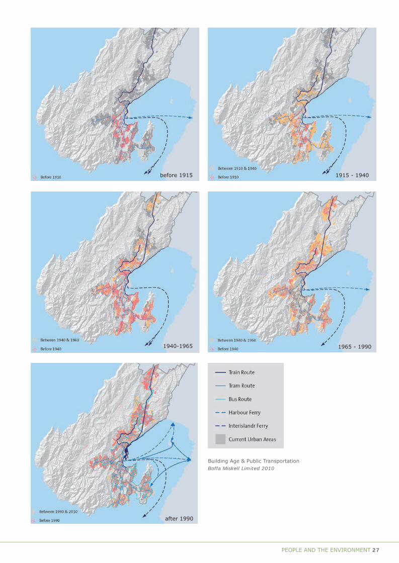
PEOPLE AND THE ENVIRONMENT 27
before 1915
1940-1965
after 1990
1915 - 1940
1965 - 1990
Building Age & Public Transportation Boffa Miskell Limited 2010

28 PEOPLE AND THE ENVIRONMENT
Sub-theme Type Examples of placesQuarrying Quarries Ngauranga Quarry; Horokiwi Quarry; Oriental Bay/Clyde Quay
Reclamations (land fills) Wellington Hospital, Kelburn Park. Nairn St Park, Houghton Bay, Berhampore
Reclamations (Harbour) Lambton Quay, Willis Street (1852, 1857), Te Aro (1886, 1904), Thorndon Quay
Clay extraction (for bricks) Sites of clay extraction, kilns Mt Cook, Wellington High (government), Webb St (Tonks), Rolleston/Hargreaves Sts (Hutson, Murphy), John Morrison’s kilns (Wallace St)
Gold prospecting and mining Shafts, adits, machinery Tinakori Hill, Karori Reservoir/sanctuary, Terawhiti Fishing Bait Sheds Island Bay; Makara beach Forestry and forest clearance Remnant forest Otari Native Botanic Garden and Wilton’s Bush Reserve, Botanic Gardens
Rural tree planting Makara; Glenside; Ohariu tree plantings
Government backed reforestation Government nurseries Town Belt plantingsWater supply infrastructure Dams, culverts, pipes Karori dams; Polhill Gully reservoir; other service reservoirs; Grosvenor Terrace pumphouse; old mining, gold
mining dams and piping; water tunnel at Karori (1872)
Wind farming Wind turbines Brooklyn wind generator, West Wind wind farmFarming Farm buildings, fences, sheds, tracks Ohariu or Makara farm buildings
Resource use

PEOPLE AND THE ENVIRONMENT 29
Sub-theme Type Examples of placesQuarrying Quarries Ngauranga Quarry; Horokiwi Quarry; Oriental Bay/Clyde Quay
Reclamations (land fills) Wellington Hospital, Kelburn Park. Nairn St Park, Houghton Bay, Berhampore
Reclamations (Harbour) Lambton Quay, Willis Street (1852, 1857), Te Aro (1886, 1904), Thorndon Quay
Clay extraction (for bricks) Sites of clay extraction, kilns Mt Cook, Wellington High (government), Webb St (Tonks), Rolleston/Hargreaves Sts (Hutson, Murphy), John Morrison’s kilns (Wallace St)
Gold prospecting and mining Shafts, adits, machinery Tinakori Hill, Karori Reservoir/sanctuary, Terawhiti Fishing Bait Sheds Island Bay; Makara beach Forestry and forest clearance Remnant forest Otari Native Botanic Garden and Wilton’s Bush Reserve, Botanic Gardens
Rural tree planting Makara; Glenside; Ohariu tree plantings
Government backed reforestation Government nurseries Town Belt plantingsWater supply infrastructure Dams, culverts, pipes Karori dams; Polhill Gully reservoir; other service reservoirs; Grosvenor Terrace pumphouse; old mining, gold
mining dams and piping; water tunnel at Karori (1872)
Wind farming Wind turbines Brooklyn wind generator, West Wind wind farmFarming Farm buildings, fences, sheds, tracks Ohariu or Makara farm buildings
Resource use

30 PEOPLE AND THE ENVIRONMENT
Resource use
Vegetation
When Māori first arrived in Te Upoko o te Ika/Wellington the indigenous forest cover would have extended over most of the land, probably interspersed with areas of grasslands. Māori learned to use the new forest resources they encountered, and continued to use them until the arrival of Europeans. They collected seeds and berries in season from a wide variety of indigenous plants. All building materials were obtained locally, with structural timbers coming from the forest, and raupo and harakeke/flax for thatching being gathered from the swamps. The larger totara trees were used to build waka, which were used for transporting goods, for fishing, and for transporting people in migrations. The bush was the habitat for many birds, which formed an important part of the Māori diet, from the large and clumsy kereru/wood pigeon to the large flightless birds such as the many species of moa, the weka/pakura, whio/blue duck
and others. Coastal soils in warm, sheltered localities were used to grow crops such as kumara and, where necessary, they were altered by the addition of sand and gravel to improve growing conditions. There were no high-quality rocks in the area for making tools, with obsidian and metamorphosed argillite being imported from elsewhere. However, limited use was made of the local greywacke for tools, and greywacke was widely used as stones in the hangi or earth oven. Along the shore there were shellfish to be gathered and fish to be caught. Many early settlements were located close to sandy beaches such as Island Bay, Lyall Bay and Seatoun, where canoes could be easily landed, where there was fresh water available, and where there was a good supply of food.
The first European settlers to Wellington set about utilising the area’s resource in a fashion that would
Current indigenous landcover Predicted potential natural vegetation of New Zealand
Derived from Land Environments of New Zealand and Landcare Research. Boffa Miskell Limited 2010

PEOPLE AND THE ENVIRONMENT 31
have astonished Māori. Vegetation was cleared for farming, timber, heating and cooking. The immediate area around Lambton Harbour was denuded within a few years.
By the late 1850s, there were few stands of timber within sight of the town. Likewise, the removal of the bush and a wholesale plunder of the once numerous birdlife by settlers armed with shotguns removed much of the fauna from the periphery of the settlement. It took a visit to the outer margins of the settlement to see what remained of a once remarkable swathe of forest. The New Zealand Gazette noted in May 1859 that ‘to the lover of the picturesque there is scenery on the Nga-uranga (sic), Ohariu and Makara roads which it would repay many miles of laborious travel to see. Unfortunately the freshness will not last any great length of time’. Within a short period of time, those roads were no longer flanked by trees. By the beginning of the 20th century there were only a few pockets of native forest left. One of these was at Wilton, where farmer Job Wilton and his family kept a portion of first growth forest as a relic of what had once been. Today that remnant is the heart of the Otari / Wilton’s Bush Reserve, a significant mainland ecological ‘island’.
The loss of Wellington’s forests prompted a response from both city dwellers, who planted trees and gardens on their properties, and rural dwellers who, from the 1870s, used exotic plantings to shelter from the prevailing winds and add variety and colour to the landscape. The plantings – mainly conifers – came from seedlings held by the Botanic Garden in Wellington. Places such as Makara, Ohariu and Glenside all benefited from these plantings as well as planting undertaken by farmers who had their own sources.
Clay extraction
Brick making was one of Wellington’s first industries; the local clay was more than suitable for brick making and constructing permanent buildings was an early priority. Sinclair and Millar began making bricks in Thorndon in 1840. Brick was not in particularly wide use and but the industry declined after the big 1848 earthquake and was nearly moribund after a great many brick buildings were destroyed by the huge
Enoch Tonk’s brickworks on Webb Street, opposite the top of Cuba Street, in 1896. These family brickworks were taken over by Enoch in 1875. They were closed and demolished in 1925. ATL F-15511-1/4.
1855 earthquake. Although timber then became the favoured building material, bricks remained in some use and the centre of brick making was Mt Cook, where particularly good clay was in abundance.
There were brickworks on Wallace Street, between Rolleston and Hargreaves Streets, from the 1860s. These were taken over by Hill Bros. in the 1870s. After the Hills moved to Newtown in 1917 (their kiln there still stands), the works were taken over by Peter Hutson and Overend & Clarke and, later still, by Murphy’s in the 1920s. The last owner of the works was Amalgamated Brick and Tile Co. Extant relics of this industry are the workers’ cottages on the north side of Rolleston Street (particularly no.s 24-54) and the lime kilns at 42 Wallace Street.
On Taranaki Street the brickyard was established in the 1860s and was taken over by William Murphy in 1889. The TANERA brickworks were in Brooklyn, on the slopes of the hill and this was replaced by the bowling green. At Webb Street, William Tonks established a brick works in 1847 and he built up a substantial business before the 1855 earthquake. The family remained in the brick working business until well into the 20th century and a number of houses the family owned remain in the upper Cuba Street area. Some

32 PEOPLE AND THE ENVIRONMENT
were relocated for the construction of the inner-city bypass in the 2000s. Descendant Enoch Tonks created Nairn Street Park in the late 1890s by taking the clay for brick making and then levelling it for recreational purposes.
Mt Cook prison brickyard (now Wellington High School’s car park) served until the 1920s, getting its clay from the surrounding hillsides. One of the Wellington High School’s grounds was created from an excavated hillside. The prisoners made superb bricks – identified by the prison’s broad arrow – and can be found in many buildings, including the Mt Cook Police Station (1894) and adjacent wall.
Quarrying
Quarrying has been carried out for nearly as long as Wellington has been settled by Europeans. Wellington rock is greywacke and rather soft – even rotten in places – but was put to use metalling roads and for a period was also used for paving stones, footsteps and sills.
In the 19th century and early 20th century there were a number of substantial quarries, some owned by the Wellington Town Board or, later, the Wellington City Corporation. Locations included Red Rocks (owned by Tonks), Mt Victoria (at the end of Ellice Street), Tinakori Hill (also known as the Grant Road Quarry), Lyall Bay, Kaiwharawhara, Karori (Lancaster’s Quarry), Newtown (the Luxford Quarry) and Ngauranga. The latter is now the site of the city’s one remaining quarry, run by the Wellington City Council and producing materials used for road and building construction. Well over 100 years of quarrying has utterly altered the landscape at Ngauranga, which was once a narrow gorge. A quarry was operated at Owhiro Bay from approximately 1920 until 2000, when it was bought by the Wellington City Council for a reserve.
There was a direct link between reclamation and quarrying. Room for the city to expand was created in the late 1850s by excavating part of the cliff beneath The Terrace and moving the fill (on Wellington’s first railway) to reclaim land at Lambton Harbour. Government Buildings, near the northern end of Lambton Quay, was constructed on land reclaimed in 1873 using fill from an excavation at Parliament. At Oriental Bay, near Point Jerningham, a quarry was created to partly fill the Te Aro reclamation in the 1880s, but it attracted considerable criticism for being an eyesore at the time. The site is now occupied,
Kiwi Point Quarry, Ngauranga, 1961. WCC Archives 00158-3-126b
in part, by an apartment building. Wellington’s subsequent reclamations, some of them very substantial, were all created by the movement of excavated material to the harbour.
Other forms of quarrying involved the creation of sporting grounds using material from somewhere adjacent. Among two of the best examples of this are Kelburn Park and Anderson Park. The latter was completed in 1905 as a result of the levelling of ridges and gullies adjacent to Salamanca Road and to the south of Gladstone Terrace. Even Richard Seddon was on hand at a ceremony marking the end of work on the new park. The creation of Anderson Park was begun in 1906 and completed in 1910. It required the removal of part of a ridge immediately to the west and the filling of part of a valley. Later, the remainder of
Kiwi Point Quarry, Ngauranga, 1961. WCC Archives 00158-3-132

PEOPLE AND THE ENVIRONMENT 33
the valley, which now contains the Lady Norwood Rose Garden and Begonia House, was filled in between 1931 and 1934 as part of a Depression-era work scheme.
Gold prospecting and mining
Gold mining had a brief but eventful history in Wellington. There were regular, if ultimately unsatisfactory, discoveries in the early decades of the settlements. A discovery at South Makara in 1867 for instance, started considerable interest. In June 1869, alluvial gold was discovered in the Kaiwharawhara Stream (close to where the Karori Tunnel is today), before the stream was culverted. A rush of sorts followed, with considerable prospecting and mining in the environs of the lower and upper water reservoirs. Within days, there were huts and tents dotted over the hills. By July 1869 a company – Bakers Hill Mining – was formed and more followed. The companies financed quartz mining – the removal of rock and then its crushing to extract gold. They constructed drives and shafts, many of which still survive, although some are under water. There was considerable infrastructure built to service the larger operations. However, demand for a safe water supply put an end to the mining, as the city wanted to dam the Kaiwharawhara Stream to create a reservoir. In 1872, the Wellington City Council purchased the land and compensated land owners. The dam did not open until 1878, although water from the Kaiwharawhara Stream flowed through a tunnel to the Aro Valley and on to the city.
Gold mining was also prominent at Terawhiti in the 1870s and 1880s and there was mining activity at Glenside, Ohariu and Tawa. Spurred on by the Wellington Provincial Council’s offer of a reward to any person who could locate a paying goldfield, there was no shortage of people willing to try. However, Wellington turned out to be largely barren and little money was made by anyone.
Water supply infrastructure
Before any attempt was made to organise a water supply, Wellington’s settlers took their water from where they could – springs, streams, wells and collection tanks. Central government built a pipe from springs at Tinakori Road to Parliament. Concerns about contaminated springs and wells forced the Wellington City Council to seek answers and it resolved to dam the Kaiwharawhara Stream at Karori. However, the first reservoir was actually at Polhill Gully and it was fed via a tunnel from Kaiwharawhara Stream, opening in 1874. The first Karori Dam did not open until 1878, by which time demand was already outstripping supply.
In 1884, a dam was completed in Wainuiomata to augment the town supply. A second dam was added at Karori in 1908 and then a second at Wainuiomata, in 1911. In 1919, with a growing population needing more water, work began on a weir and intakes in the Orongorongo River. The work was finished in 1926. The following year the Wellington City and Suburban Water
Streetworks Depot, Northland. WCC Archives 00158-1-333 Water Tower, Karori, 1957. WCC Archives 00158-1-419

34 PEOPLE AND THE ENVIRONMENT
Board was established but the co-operative venture did not last, with Lower Hutt and Petone leaving in 1929. Wellington tapped into artesian water in the Hutt Valley in the 1930s and gained more water from a Hutt River Scheme undertaken in the 1950s.
In 1973 the Wellington Regional Water Board was formed after an Act of Parliament required that water resources had to be managed on a regional basis. It was followed by the formation of the Wellington Regional Council in 1980, which assumed responsibility for greater Wellington’s water needs. In 1987, a complex of treatment plant, pumping station and storage lakes was completed at Te Marua and supplied the region. In 1992, the upper Karori Reservoir and then, in 1997, the lower Karori Reservoir were decommissioned after concerns were raised about their safety.
Water has also been supplied to Wellington’s households through local reservoirs built at high points to provide decent pressure. Many of these are buried underground to reduce their visual impact.
Fishing
With the lack of land mammals and the large coastline of Aotearoa, fish and shell fish formed a large part of the diet for Māori. Wellington’s abundance of the large black- foot paua sustained Māori for much of the year and also sustained the early European coastal settlers who called them mutton-shell. Māori brought their fishing skills with them from Polynesia and adapted them to the colder and stormier environment. Matau/fishhooks were made and were much prized. The rivers and streams were a source of tuna/eel, kokopu and other fish which were harvested in season, particularly in the larger streams such as Makara/Ohariu, but even in the likes of Waitangi Stream in Wellington. Seasonal kainga/villages were located around the coast and they provided for the harvesting and drying of fish. Seaweeds or algae were used for storage vessels, footwear and for food with karenoa/sea lettuce being commonly eaten raw and cooked.
Like Māori, Europeans came to rely on the coast’s abundant fishing stocks. Local fishermen began operating from the start of settlement, although not in any organised fashion. Operating in Wellington’s fickle winds was a significant issue for many and capsizings and drownings were common events. Wellingtonians also fished recreationally from the shore, or from small boats, as they still do.
Eel spears, matarau. Image from The Māori As He Was. A Brief Account of Life as it Was in Pre-European Days, Elsdon Best, Dominion Museum, 1934. NZETC http://www.nzetc.org/tm/scholarly/BesMaor-fig-BesMaor-f134.html
An implement employed in detaching shell fish (Haliotis) from rocks, and termed a ripi paua. This specimen is of [moa] bone. The Māori – Volume 2, Elsdon Best , 1941, Polynesian Society, Wellington. NZETC http://www.nzetc.org/tm/scholarly/tei-Bes02Maor-t1-body-d9.html
Large Wooden fish hook. Image from The Māori as He Was: A Brief Account of Life as it Was in Pre-European Days, Elsdon Best, Dominion Museum, 1934. NZ Electronic Text Centre (NZETC) http://www.nzetc.org/tm/scholarly/BesMaor-fig-BesMaor-f126.html

PEOPLE AND THE ENVIRONMENT 35
Island Bay was established as a fishing station as early as 1870, having (thanks to Taputeranga Island, the reef and small but deep bay) the only tolerably sheltered anchorage on Wellington’s south coast. However, the consumption of local fish by Wellingtonians was surprisingly small. An unfamiliarity with local fish led to the importation of canned fish from Britain, while dried fish from other parts of New Zealand also competed with fresh catches. The latter were not abundant, with the lack of regular supplies a difficulty.
In 1880, the Wellington City Corporation opened the country’s first municipal fish market, which was aimed at supplying consistent and cheap supplies to the public and reducing waste. It is not known how long this initiative lasted but it was not uncommon for municipal authorities to try and control the fishing market. Later, outlets such as the auctioneers Townsend and Paul, had a large market where the catch of the day was sold to fishmongers, restaurants and clubs. Fishmongers were a common sight in 19th century Wellington. In 1897 there were at least seven in central Wellington including two businesses owned by Greeks. Nicholas Fernandos had his shop and processing factory on Lambton Quay and even had his own steam trawler. One fishmonger was celebrated for his gimmicks. At Hurcomb’s in Cuba Street. ‘a penguin was stationed at the door and fed fish, which would disappear in one neat gulp’.
The advent of refrigeration in the 1880s allowed fish to be processed and exported from Wellington and some
product went to places like Sydney. As the technology improved, refrigeration took on a greater role in allowing the export of fish to the rest of the world. The abundance of fish in Cook Strait made Wellington a significant base of the industry.
The influence of European immigrants on Wellington’s fishing became pronounced in the 20th century. Italians and Greeks arrived in larger numbers and many settled in Island Bay (and to a lesser extent Makara) and fished for a living. They were joined by Scots and Shetland Islanders. Attracted by Island Bay’s natural facility, it soon became the centre of Wellington’s fishing industry. Some 120 Italian families settled in Island Bay, with the first influx prior to World War I. The heyday of the industry was the decades after World War I although the Depression was a considerable setback. This led to the establishment of the Wellington Fisherman’s Cooperative Ltd with various nationalities participating. The Cooperative stabilised the market by managing the entire process from catching to selling. The Cooperative had a well known outlet in Cuba Street. Fishing dominated Island Bay life for most of the 20th century. The celebrated sight of fishing boats in Island Bay continues to this day but the fleet is much smaller.
Wellington has been a port of call for a number of commercial fishing companies since they first began arriving in the 1950s. The local fishing industry was mainly inshore and with New Zealand’s territorial limits just three miles prior to 1970, and only 12 miles after that, the seas beyond were available to everyone. It
Hinaki waharua. Eel pot with two entrances. Image from: The Māori – Volume 2, Elsdon Best , 1941, Polynesian Society, Wellington. NZETC http://www.nzetc.org/tm/scholarly/Bes02Maor-fig-Bes02Maor435a.html
Eel pot with net attached. Image fro. The Māori – Volume 2, Elsdon Best , 1941, Polynesian Society, Wellington. NZETC http://www.nzetc.org/tm/scholarly/Bes02Maor-fig-Bes02Maor434a.html

36 PEOPLE AND THE ENVIRONMENT
was only after New Zealand gained a territorial limit of 200 nautical miles in 1978 that control over foreign fishing vessels was achieved.
Recreational fishing remains a major activity in and around Wellington. Two significant fishing clubs are the Wellington Surfcasting and Angling Club and the Port Nicholson Sport Fishing Club and there is also a Wellington Recreational Marine Fishers Association to represent the rights of local recreational fishers. Individuals and families fishing on Wellington’s wharves and bays remain a common sight.
Wind farming
The first wind turbine in New Zealand was erected high on the hills above Brooklyn in 1993. Wind power was adopted in many parts of the country after that but it took until 2010 for Wellington’s first wind farm to open. The controversial West Wind project, undertaken by state-owned power generator and retailer Meridian Energy, was granted resource consent by the Wellington City Council, which was then appealed in the Environment Court by, among others, groups of Makara residents. The appeal was lost and the construction of the farm went ahead. The farm covers 55 square kilometres and includes 62 turbines, all of which are 80 metres high. At the time of writing, two more wind farms are planned for Wellington – one in Ohariu and the other in the valley behind Brooklyn.
Farming
Māori were gardeners and hunter gatherers, however, when European settlers arrived they started to change their activities and started to become farmers. First they grew crops such as wheat and potatoes for local supplies and also for export. Some, who had been awarded sufficient land, also farmed sheep and dairy cattle; this was rare in Wellington but more common in the Hutt Valley. Māori often became shepherds and farm workers, often on European farm land that once was part of the tribal estate. Land was leased to Pakeha farmers out of the remaining Māori reserves and when the Native Land Court was introduced in 1865 land was converted from Māori reserve to general freehold land.
Farming was a necessity for many of Wellington’s early settlers. Land close to town and not allocated to housing or commercial activities was put to use for crops or the grazing of cows or horses and, within
Elevated view of Wellington harbour, from Brooklyn Hill, c.1925. WCC 00138-0-6212
a few years, sheep. One notable exception was land owned by absentee landlords that was not leased out. Nevertheless, as McLean points out, despite the need to feed themselves, settlers were put off by the difficulties of the land and climate, the need to remove the bush, and the uncertainties of tenure. The New Zealand Company had allocated 100-acre country
Elevated view of Karori. Cows grazing in foreground 1930s.WCC 00138-0-7870
Buildings, Fitchett’s dairy farm, Brooklyn, c.1910.WCC Archives 00122-0-38

PEOPLE AND THE ENVIRONMENT 37
sections to settlers in the land sale of 1840 but they were very slow to be put to use.
Nevertheless, as Wellington grew, two things happened. Land close to the town that had been farmed was subdivided for housing, and farming began to take off as settlers started occupying land alongside the roads out of the city. Farming began in Karori in the 1840s while the Porirua Road gave access to the northern suburbs. In the late 1850s roads were opened to Makara and Ohariu. This led to the removal of the remaining forest cover and beginning of 150 years of farming in Wellington’s hinterland. Sheep farming was particularly well suited to Wellington’s topography and it became the primary activity. Tiny rural settlements in the Ohariu Valley and Makara appeared in the late 19th century.
One industry that remained close to the city was dairy farming, which provided the town milk supply. In the 19th century much of the milk came from Fitchett’s farm in what later became Brooklyn. When private provision came in for criticism the Wellington City Corporation took control of the industry in 1918, and built a treatment plant in Tory Street. Although much of the milk came from the Horowhenua, even into the 1930s, parts of the Wellington Town Belt were used for dairy farming. The building used to process the municipal milk still stands in Tory Street.
Farming continued in the outer margins of the city for many decades. Locations such as Island Bay, the
Miramar Peninsula, the hills above Wilton, Ngaio, Khandallah and Tawa were all still being farmed well into the 20th century. Some of these places ended up as Outer Town Belt or as reserves. As the city expanded, farming slowly ended and today it is confined to the hills of Makara and Ohariu. In those areas there has been some subdivision and the abandonment of marginal land.
SourcesBrodie, James 1986, Terawhiti and the Goldfields, Karori Historical Society, Wellington
Cook, Walter n.d., ‘The Lady Norwood Rose Garden’, Friends of Wellington Botanic Garden
Cooke, Peter, 2006, Our Water History – On Tap, Greater Wellington Regional Council, Wellington
Coutts, Rose and Jim, ‘The Shetland Islanders and their contribution to the fishing industry in Island Bay’, Wellington Southern Bays Historical Society [www.southernbayshistory.wellington.net.nz/shetlanders.html]
Elsdon Best Scrapbook Vol.9, MSX-3196, Alexander Turnbull Library. Best quotes directly from the New Zealand Gazette of 1859.
Evening Post, 27 July 1876, 12 November 1880, 10 December 1867, 18 May 1871
McLean, Gavin 2000, Wellington: The first years of European Settlement 1840-1850, Penguin, Auckland
Tonks, H. Gary, 2007, Tonks and The Bypass, 1847-2007 160 Years, The Author, Wellington
Yska, Redmer 2006, Wellington: Biography of a City, Reed Publishing, Auckland
http://www.teara.govt.nz/en/fishing-industry/1 [viewed 30 March 2010]


THEME B
Developing EconomiesGARDENING
TRADE AND COMMERCETRANSPORT
MARITIME SAFETY COMMUNICATIONS
TECHNOLOGY AND ENGINEERINGLABOURHEALTH
Elevated view of formal garden, Glenmore Street, Botanic Garden, 1934. WCC Archives 00138-0-12300

40 DEVELOPING ECONOMIES
Sub-theme Type Examples of placesMāori Cultivation areas Ngauranga; Waiariki; Haewai; Pipitea; Te Aro; Te Motu Kairangi
Domestic (European) Mt Victoria; Pipitea; Te Aro; Evans Bay
Gardening

DEVELOPING ECONOMIES 41
Sub-theme Type Examples of placesMāori Cultivation areas Ngauranga; Waiariki; Haewai; Pipitea; Te Aro; Te Motu Kairangi
Domestic (European) Mt Victoria; Pipitea; Te Aro; Evans Bay
Gardening

42 DEVELOPING ECONOMIES
GardeningMāori gardening
Māori gardening in Wellington probably started with the first settlers. Traditional evidence recorded by Best and others indicates that settlement occurred when Te Motu Kairangi (Miramar Peninsula) was an island, prior to an earthquake around 1450 that uplifted the island and turned it into a peninsula. Kumara and other garden plants were close to their southern margins for successful crops in much of Wellington, and they were much less important for food than in places further north. Fern root/aruhe was an alternative, and its growth was encouraged by clearing forest and scrub and allowing the fern to grow, resulting in large areas of clearings/ngakinga. Fruits from trees and bushes were harvested, including food like the root of the cabbage tree/ti kouka, harvested and eaten as a source of starch. Māori did not use fertilizers although there was some soil improvement in places by the addition of sand and gravel and sometimes shells.
After European contact, crops such as white potatoes, corn, gourds and melons replaced the kumara and aruhe (root of rauaruhe – bracken fern). With the arrival of the Taranaki people in the early 19th century, the areas cleared for gardens increased. These gardens/clearings became an issue in sorting out what was to be excluded from the New Zealand Company purchase in Wellington. Cultivation areas assigned in McCleverty’s final arrangements for the Company Grant and land allocated to Māori were more generous in the rural areas and quite restricted within the Town of Wellington.
“In his initial report to [George] Grey of April 1847 which was then forwarded to Earl Grey, [Colonel] McCleverty supplied a table showing a population census for each pa. He initially estimated that 2 acres of land would be necessary for each Māori in the district. At that time 633 Māori were involved. He noted that in the long run, greater amounts of land would be necessary because of the ‘imperfect mode of agriculture’ of the Māori which mean that Māori ‘wear out their land in three or four years ...”
Areas of the Town Belt were awarded to Māori such as Tinakore Hill/Ahumairangi and Orangi-kaupapa in part because Māori continued to use them for food production. Gardening on hill tops did not use the best land, however, they were chosen for strategic reasons as lookout points, for maximising sunlight and maybe because the areas were easier to clear. In many places in the new colonial town of Wellington, the Māori gardens were rapidly taken over by other uses
Elevated view of formal garden, Glenmore Street, Botanic Garden, 1934. WCC Archives 00138-0-12300
House near Patent Slip, Kilbirnie. WCC Archives 000138-0-1354
Henry and Reginald Wright in the garden of Henry Wright’s house, Britomart Street, Berhampore, 1892. Henry Wright Collection, ATL G-66324-1/2
Whare at Karaka Bay, Wellington, 1879. Evening Post Collection, ATL, F-9027-1/4
such Puke Ahu/Mt Cook where military barracks were established, and the Kumutoto ngakinga where the Wellington Botanic Garden is now located.

DEVELOPING ECONOMIES 43
The demise of Māori gardening in Wellington was rapid after 1850 and had largely disappeared by 1870. Māori gardening was replaced in some areas by Māori agriculture producing sheep and wheat.
Domestic gardening
The first European immigrants arrived to find that, courtesy of some forethought by the New Zealand Company, large vegetable gardens had been sown at Kaiwharawhara the previous year and were ready for harvesting when the ships arrived early in 1840. Settlers brought seed with them but with no permanent infrastructure to support them they were quickly dependent on the food grown by local Māori, who joined the new economy by selling their produce to the hungry Pākehā.
For the first decade or two thereafter, the fortunes of settlers depended on their ability to come to terms with the new environment. Growing crops was relatively straightforward in the alluvium of the Hutt Valley (notwithstanding the regular flooding) but Wellington’s clay based soils made gardening more difficult. Another early problem was getting access to a range of seeds and plantings but supplies from Sydney soon eased that. The Wellington Horticultural and Botanical Society was formed in 1841 and its first exhibition was January 1842. It was a great success; evidence that some settlers had quickly learned how to grow vegetables, fruits and berries. Nurseries were established and these also sold seed. By way of a contrast, some settlers were so hungry that the resources of the Town Belt – the buffer of public land around the settlement, established and initially protected by the New Zealand Company – had to be opened up for general exploitation.
As the settlement matured, many people kept at least a ‘kitchen garden’. Market gardens were developed, mainly in the Hutt Valley (and later on the Kapiti Coast), but there were some in Wellington, located in places such as Newtown, Hataitai and Island Bay, where a major Chinese run market garden dominated the western side of the Island Bay valley around the turn of the 20th century.
As food supplies became more consistent, attention increasingly turned from vegetables and fruit to ornamental gardens. For the well off, landscaping and improving the appearance of their properties was an
important activity. To protect gardens (and houses) from the wind, and to soften the denuded landscape, much tree planting took place. However, it was not until the 1870s that the work of early gardeners began to pay off.
In Wellington’s growing suburbs, particularly after the turn of the 20th century, the middle class were able to build villas and incorporate relatively substantial gardens into their layout – ornamental in the front and vegetables to the rear. The role of self-sufficiency was only enhanced by the rise of the Depression, which forced many people back to the land to avoid starvation. The impact of the Depression lasted long into the 20th century and vegetable gardens, tended by people with long memories, remained a feature of suburban houses for a long period.
Allied to private beautification of the city was the development of gardens, open spaces and reserves as places for public use. Chief amongst these was the Botanic Garden, first separately allocated land in 1844. A Crown Grant in 1848, and the purchase of Wesleyan Reserves in 1874, brought the area of the garden largely to its present extent. Development and maintenance of the gardens began in earnest in the 1850s but it did not really assume its present form until the late 19th century.
From the 1970s, the rise of supermarkets helped give access to cheaper fruit and vegetables, and backyard vegetable gardening waned. Many were converted into lawns and ornamental gardens, tapping into the country’s increasing love of amenity gardens and gardening, and Wellington was no exception. Garden centres appeared in suburbs and books and magazines catered for what had become a major leisure activity.
SourcesCook W. ‘A Colonial Legacy: Thorndon’s Historic Landscape’ in Thorndon News, Newsletter 87, October 1992
Quinn, Stephen, ‘Report on the McCleverty Arrangements and McCleverty Reserves’, November 1997, Doc I8 evidence for claim Wai 145, Waitangi Tribunal.
Shepherd, Winsome and Walter Cook, 1988, The Botanic Garden Wellington, Millwood Press, Thorndon
Shepherd, Winsome 2001, Wellington’s Heritage, Te Papa Press, Wellington
Waitangi Tribunal, Te Whanganui a Tara me ona Takiwa, Report on the Wlgtn District, Wai 45

44 DEVELOPING ECONOMIES
Sub-theme Type Examples of placesPort unloading and loading Wharves Queens Wharf, Sheds 3, 5, 11, 13, 21, 22, Plimmer’s Ark
Wharf cranes
Wharf sheds / bond stores Wharf Offices, Head Office and Bond Store
Railways Railway stations Wellington Railway Station
Rail formation Wellington-Manawatu Railway (Johnsonville line)
Tunnels See Johnsonville line; Tawa Flat Deviation
Yards Wellington Railway Station
Goods sheds
Producer boards Meat Board Massey House, Agriculture House
Dairy Board Massey House
Wool Board Wool House
Harbour administration Harbour boards Wharf Offices (Shed 7), Head Office and Bond Store
Port companies
Commercial offices Head offices EBI; NZ Post Office; Racing Conference
Insurance NZI; Tower Insurance
Banking
Shipping Huddart Parker
Agriculture Federated Farmers – Featherston Street
Retail Whitcoulls (Whitcombe & Tombs); Farmers/DIC
Trade & commerce

DEVELOPING ECONOMIES 45
Sub-theme Type Examples of placesPort unloading and loading Wharves Queens Wharf, Sheds 3, 5, 11, 13, 21, 22, Plimmer’s Ark
Wharf cranes
Wharf sheds / bond stores Wharf Offices, Head Office and Bond Store
Railways Railway stations Wellington Railway Station
Rail formation Wellington-Manawatu Railway (Johnsonville line)
Tunnels See Johnsonville line; Tawa Flat Deviation
Yards Wellington Railway Station
Goods sheds
Producer boards Meat Board Massey House, Agriculture House
Dairy Board Massey House
Wool Board Wool House
Harbour administration Harbour boards Wharf Offices (Shed 7), Head Office and Bond Store
Port companies
Commercial offices Head offices EBI; NZ Post Office; Racing Conference
Insurance NZI; Tower Insurance
Banking
Shipping Huddart Parker
Agriculture Federated Farmers – Featherston Street
Retail Whitcoulls (Whitcombe & Tombs); Farmers/DIC
Trade & commerce

46 DEVELOPING ECONOMIES
Trade & commerceWellington’s prosperity was tenuous in its earliest years. With settlers trying to find ways to live and exporting almost negligible, the economy was functioning at barely beyond the subsistence level, with trade between Māori and Pakeha the main driver, assisted by regular immigration and government activity. The settlement was hampered by poor wharfage and a spluttering colonial economy, and this remained the case until the late 1860s.
The earliest businessmen included flax traders, such as Luke Nattrass, who founded a flax mill on the Miramar Peninsula. Entrepreneurs took advantage of the shipping traffic and built retail outlets close to the harbour. In 1849, John Plimmer converted a beached hulk into a retail warehouse and wharf, which was quickly nicknamed Noah’s Ark. The city’s first banks were Australian; the Union Bank of Australia was established in 1840 and had an office in Wellington from the settlement’s founding. Later, in 1862, the Bank of New Zealand, the country’s first national bank, opened its first Wellington branch on a triangular site at the intersection of Lambton Quay and Featherston Street. Wellington later became the home of the BNZ’. head office, on this same site in the heart of the CBD.
Several catalysts helped boost Wellington’s economic fortune. The first of these was the completion of Queens Wharf in 1862, which allowed larger vessels to berth at the port. It was built at the tip of the first major reclamation of Lambton Harbour. Wellington’s
commercial district was founded almost entirely on reclaimed land and this became strongly linked to the city’s wharves and harbour administration. Over the course of the remainder of the 19th and early 20th centuries, the port expanded dramatically.
The second was the move of central government from Auckland to Wellington in 1865. It immediately stimulated the local economy, and this only increased after the end of provincial government in 1876. Although it was not the basis of a long-term security – trade would fulfil that objective – central government still makes the biggest single contribution to the city’s prosperity through its location.
The third great boon was the construction of railways from Wellington to its hinterland. Construction first began in 1872 (with the laying of track to Petone) and by 1886 Wellington had rail links to the hinterland of Manawatu and Wairarapa/Hawkes Bay. These connections brought wool and meat to the city in much greater quantities than could be moved on the region’s rudimentary roads. Benefiting from its central location, expanding trade helped make Wellington the country’s busiest port by the 1890s.
With the city booming, courtesy of its port, Wellington enjoyed a period of economic prosperity from the late 1890s to late 1920s. On the back of this, a wave of new buildings – in brick rather than timber – was erected, partly by the government (to house
‘Tamahine’, moored at Patent Slip, Kilbirnie. View from waterside of slip, 1930s. WCC Archives 00138-0-13855

DEVELOPING ECONOMIES 47
Tip Top ice cream factory, Main Road, Johnsonville, 1966. WCC Archives 00158-7-118
departments) but mainly by banks, insurance firms, retailers (particularly department stores) and other businesses, many of whom had their head offices in Wellington.
Wellington’s economic fortunes nose-dived with the arrival of the Great Depression and without council and government-funded initiatives the city’s economy would have suffered even more severely. A programme of government-funded building works helped reinvigorate the local economy and as the world pulled out of recession, trade picked up and Wellington’s port was back to its previous strength.
Wellington became home to the country’s producer boards, set up by the government to manage the supply and marketing of the primary produce the country’s economy depended on. The three big boards, dairy, meat and wool had their origins in the government’s efforts to manage exports to Britain in the early 20th century but really came into their own post-World War II. Both the Dairy Board and Wool Board built head offices which were considerable statements at the time. The very modern Massey House – the Dairy Board’s new home from 1958 – was designed by the noted Austrian architect Ernst Plishcke.
Many of the city’s traditional economic foundations shifted considerably during the later decades of the 20th century. The port remained busy but trade in primary produce fell dramatically (with the exception of logs), with container traffic becoming the main driver of port activity. The city’s reputation as the home of head offices ebbed as many moved to Auckland or overseas. The producer boards were all dissolved. The National government of the 1990s shrunk the size of the public service, although this was offset the following decade when the Labour-led government of the 2000s boosted public service numbers and helped stoke an economic boom that lasted until 2008.
Sources‘Dairy Exports’ in www.teara.govt.nz/en/dairying-and-dairy-products/11 [viewed 13 April 2010]
Johnson, David 1996, Wellington Harbour, Wellington Maritime Museum Trust Board, Wellington
Hamer, David ‘Wellington on the Urban Frontier’, in Hamer, David and Roberta Nicholls eds., The Making of Wellington 1800-1914, Victoria University Press, Wellington
‘Meat and Wool’ in www.teara.govt.nz/en/meat-and-wool [viewed 13 April 2010]
On the left is South British Insurance and the Bank of New South Wales (built as the Supreme Court ). Martin’s Fountain stands in front of the Union Bank of Australia. The corner of the building on the extreme right is the Central Hotel, c.1900WCC Archives 00148-0-50
Manners Stree. lined by retail premises. A ‘ Strike and Hamilton’ horse and cart are delivering to the Bank Hotel ( later known as the Clarendon ), beyond that is Wilkins and Field’s Arcade, between Farish Street and Lombard Street. WCC Archives 00148-0-70

48 DEVELOPING ECONOMIES
Sub-theme Type Examples of placesRail transport links and routes Railway alignment / infrastructure Wellington-Manawatu railway (tunnels and alignment from Kaiwharawhara to Johnsonville); Wellington-
Wairarapa railway and deviations, Belmont Viaduct abutments, Tawa Flat deviation (tunnel and approaches); Te Aro Branch; Wellington Railway Station
Tramway alignment / infrastructure Steam / horse-drawn tramway, electric tramway (Hataitai Bus Tunnel); Lennel St cutting (Wadestown); Kilbirnie Tram Barn; altered street building formations for trams and buses; Kelburn Cable Car (winding house, cars, track formation, bridges)
Electric tramway (alignment, eased corners or modified buildings); Hataitai bus tunnel (1907), Seatoun Tunnel (1907), Lennel Street Cutting (Wadestown, 1911), Brooklyn Hill
Miramar cutting (1910), Kilbirnie Tram Barn (1924)Bus routes / infrastructure Barnard St, Wadestown, Miramar Bus Shelters
Road transport links and routes Pre-motor vehicular roads Old Porirua Road; Old Coach Road (Ohariu)Motor vehicle roads Various, in current useStables, smiths, horse troughs Hutt Road and Khandallah horse troughsTunnels Mt Victoria, Seatoun, Karori, Terrace Bridges Wellington Urban MotorwayState highways SH1, SH2Motorways Wellington Motorway out to PoriruaParking buildings Lombard Parking BuildingPark and drive car parks
Air transport links Airport terminal Wellington Airport terminalRunway Former NW-SE runway (ended at Rongotai College)Hangers / aircraft maintenance structuresAero club buildings Wellington Aero club buildingAir traffic control towersFlying boat services Evans Bay flying boat service anchors / foundations, Flying Boat base
Water transport links Ferry buildings Roll-on roll-off ferry terminal, Waterloo Quay; Eastbourne Ferry Building
Wharves Ferry wharf; Shelly Bay wharfJetties Assorted jetties
Transport

DEVELOPING ECONOMIES 49
Sub-theme Type Examples of placesRail transport links and routes Railway alignment / infrastructure Wellington-Manawatu railway (tunnels and alignment from Kaiwharawhara to Johnsonville); Wellington-
Wairarapa railway and deviations, Belmont Viaduct abutments, Tawa Flat deviation (tunnel and approaches); Te Aro Branch; Wellington Railway Station
Tramway alignment / infrastructure Steam / horse-drawn tramway, electric tramway (Hataitai Bus Tunnel); Lennel St cutting (Wadestown); Kilbirnie Tram Barn; altered street building formations for trams and buses; Kelburn Cable Car (winding house, cars, track formation, bridges)
Electric tramway (alignment, eased corners or modified buildings); Hataitai bus tunnel (1907), Seatoun Tunnel (1907), Lennel Street Cutting (Wadestown, 1911), Brooklyn Hill
Miramar cutting (1910), Kilbirnie Tram Barn (1924)Bus routes / infrastructure Barnard St, Wadestown, Miramar Bus Shelters
Road transport links and routes Pre-motor vehicular roads Old Porirua Road; Old Coach Road (Ohariu)Motor vehicle roads Various, in current useStables, smiths, horse troughs Hutt Road and Khandallah horse troughsTunnels Mt Victoria, Seatoun, Karori, Terrace Bridges Wellington Urban MotorwayState highways SH1, SH2Motorways Wellington Motorway out to PoriruaParking buildings Lombard Parking BuildingPark and drive car parks
Air transport links Airport terminal Wellington Airport terminalRunway Former NW-SE runway (ended at Rongotai College)Hangers / aircraft maintenance structuresAero club buildings Wellington Aero club buildingAir traffic control towersFlying boat services Evans Bay flying boat service anchors / foundations, Flying Boat base
Water transport links Ferry buildings Roll-on roll-off ferry terminal, Waterloo Quay; Eastbourne Ferry Building
Wharves Ferry wharf; Shelly Bay wharfJetties Assorted jetties
Transport

50 DEVELOPING ECONOMIES
Transport
Shipping / Water transport links
Before roads and railways made travel across the land feasible, boats and ships offered the only way to travel between places any distance apart. Sea was also the only means by which information could travel over long distances and the likes of letters and newspapers were months old by the time they arrived from overseas. Sea travel remained important even after the arrival of the telegraph in the 1860s. It took the improvement in road and rail network and telecommunications in the late 19th and early 20th centuries for that to change. Ships still carry, by far, most of the country’s exports and imports.
Ships brought immigrants and goods from overseas and took exports to overseas markets, while coastal traders linked the country’s ports. The biggest and most successful of the coastal freighting businesses was the Union Steam Ship Company, begun in Dunedin by James Mills in 1875. It had a considerable presence in Wellington, with its main facility at Greta Point, Evans Bay. Its best-known service was the overnight Wellington-Lyttelton ‘steamer express’ service, which ended in 1976. One of the ships on that service was the Wahine, which foundered on Barrett’s Reef in 1968 with the loss of 51 lives.
In Wellington Harbour, up until about 1890, ‘watermen’ were licensed to run small craft to ferry goods and passengers, for set fees, between the waterfront and vessels anchored in the harbour.
Cook Strait ferries Aratika (in harbour), Arahanga (left foreground), Aramoana (centre foreground), and Aranui (right, at Aotea Quay) in Wellington Harbour, 3 September 1974. Dominion Post Collection, ATL EP/1974/4911/15A.
Ferries operated to various parts of the city shoreline from the late 19th century. The Seatoun Roads Board was an early promoter of ferries, and helped build wharves at Karaka Bay, Worser Bay and Miramar. The Miramar Ferry Co. was formed by local residents and its service ran for the first time in October 1901. The arrival of the tram eventually ended these services.
Shipping merchant James William began a day-excursion only service to Eastbourne in 1890. It later became a fully-fledged ferry service. The Eastbourne Borough Council took over the ferry service in 1913, the first local authority in the country to do so, and built a famous ticket office at Customhouse Quay. The service ended in 1948. The proliferation of the motor car and the consequent traffic problems saw the ferry service revived under new owners in the late 1980s.
One of the most enduring features of Wellington’s recent shipping transport history has been the roll-on roll-off freight and passenger ferries that have travelled between Picton and Wellington since 1962. Government-owned and operated, then privately owned and now back in the government’s hands, the ferries have been a crucial contributor to the Wellington economy and a vital link between the two islands.

DEVELOPING ECONOMIES 51
Tracks and roads
An Evening Post editorial in 1914 described roads as ‘the arteries and veins of the social system of a country’. Wellington’s roads began in the most rudimentary way, and their development was not helped by the city’s topography.
Movement across the land was originally via Māori tracks, some of which were turned into bridle tracks so that riders on horseback could use them. The first road out of Wellington was the Porirua Road, which left the harbour at Kaiwharawhara, travelled through what would become Wellington’s northern suburbs and finished at Porirua Harbour. Completed in 1843 and upgraded later that decade, it was very rough and needed regular maintenance. Forts were built to guard the road from Māori who were unhappy at the road’s construction. During the 1840s and 50s, the government, and later the provincial council, built roads within the township to meet the needs of the growing settlement, but they were often poorly maintained.
During the 1850s, roads were built to the city’s nearby rural areas to open them up for farming. A road was built up the Ngauranga Gorge in 1859, and this met the Old Porirua Road at Johnsonville, a point from where a road had been formed into Ohariu Valley (1858). A road was also built from Karori to the Makara Valley at the same time. The Hutt Road, which was begun in a rudimentary way in the 1840s, was made much more viable by the uplift caused by the 1855 earthquake. This road ultimately led to the Rimutaka Hill Road and to the provinces of Wairarapa and Hawke’s Bay.
Roading gradually improved through the 19th century, although it remained built for the movement of horse-drawn traffic, characterised by easy grades on hills. The introduction of more scientific methods of road making (particularly the use of macadamised profiles), improved their reliability and longevity. However, until road surfaces were properly sealed, dust, dirt, mud and the like plagued Wellington’s streets. The introduction of regular metalling helped but it was undermined by the poor quality of the local greywacke. In 1897 it was reported that the city’s streets and roads were in a shocking state – poorly constructed and maintained and not of a ‘macadamised’ standard.
The arrival of the motor vehicle allowed roads to take more direct routes over steep terrain and altered
Staff standing outside Burke’s Garage, Coutts Street, Kilbirnie, 1940s. S C Smith Collection, ATL, G-48936-1/2. This was reputedly the first station in Wellington to use petrol bowsers (pumps).
Construction of motorway over Bowen Street, Thorndon 1973. WCC Archives 00138-0-7662
Construction of Alexandra Road, Mount Victoria, in 1930. Workmen are clearing area for new road, using pick, shovel and wheelbarrow. WCC Archives 00157-1-46
the engineering required. But as roads had to take larger and more heavily laden vehicles, they began to break down under the strain. Timber blocks made of Australian hardwood soaked in creosote were laid down on major intersections in the city during the 1910s but this was an expensive approach to take. The first tar-sealed road in New Zealand was laid in 1906

52 DEVELOPING ECONOMIES
but it was not until the 1920s that Wellington’s streets began to be sealed.
With a growing population, and a high car ownership, Wellington’s roads came under increasing use. As a response, major city streets were widened, such as Taranaki Street (from the 1930s), while significant arterial routes and highways were widened and realigned, such as the Hutt Road and the Ngauranga Gorge section of the Centennial Highway (1940). Suburban and rural roads began to be sealed and new roads that provided access to Wellington’s expanding fringe were built to a much higher standard.
The most significant roads to be built in the 20th century were the motorways, introduced to alleviate the congestion on major routes out of the city. The first was the section built from Johnsonville to Porirua, which opened in 1951. The Wellington Urban Motorway, from Ngauranga to the city, was begun in 1967 and completed in 1972. Although destructive in its impact on the suburb of Thorndon, the urban motorway was a key element in facilitating the suburbanisation of Wellington.
Railways, trams and buses
A key part of Treasurer Julius Vogel’s ambitious programme of public works and immigration, begun in 1870, was the aim to link the country’s provinces via a railway network. Wellington, a terminus, was linked to the Hutt Valley by the construction of a line begun in 1872, which ultimately linked to the Wairarapa and Hawke’s Bay. A government line to the Manawatu was begun in 1879 but was finally completed in 1886 by private investors. Both of these lines, which had separate termini, later became a key part of Wellington’s commuter train services. In the case of the latter, it became a local railway service after the completion of the Tawa Flat diversion in 1936. This was followed by the amalgamation of the city’s termini into one station, the present station, which opened in 1937. It has been the country’s busiest station for much of the period since.
The first public transport in Wellington (apart from horse-drawn cabs) was steam trams, which ran for the first time in 1878. Initially they ran only to the city margins but, in 1880, shortly before the service was changed to horse-drawn, the first suburban service was started – to Newtown.
The horse-drawn trams had a limited service and they were replaced by the electric tram in 1904. Routes
Aro Street, workmen pouring concrete out of tipper on Lister truck, between newly laid tram rails, 1930. WCC Archives 00146-1-30
Interior of tram barn, Thorndon, c.1900. WCC Archives 00137-0-10 (00138-0-9836)
Trackless tram, Kaiwharawhara. 1924. WCC Archives 00138-0-13093
Opening of the Seatoun Tram line 1907. WCC Archives 00138-0-3160

DEVELOPING ECONOMIES 53
were opened to southern and eastern suburbs such as Island Bay (1905), Miramar (1907), Seatoun (1907) and Lyall Bay (1911), inner suburbs like Aro Valley (1904), Brooklyn (1906) and Hataitai, via tramway tunnel (1907), and western suburbs such as Wadestown (1911) and Karori Park (1911). Many of these places were remote, semi-rural localities with small populations but the arrival of the tram drew them into the city and they prospered. A huge tram barn was built in Kilbirnie to house most of the city’s trams.
The city’s first buses came remarkably early. The first services were offered in 1914 between Kelburn, Karori and Northland and were intended to augment existing tram and cable car services. However, the service folded within months. More services followed in the 1920s and helped to spread the city into other places such as Kaiwharawhara, where the tram did not go, and later Khandallah. The trolley bus arrived in 1949 and eventually took over from the trams, the last of which ran in 1964. Trolley buses were augmented by diesel buses and today – albeit modernised – that mix of bus types remains in use.
Air transport
Wellington’s sandy Lyall Bay was long considered an ideal place for an airport. The first plane flew there in 1911, when Arthur Schaef briefly flew a homemade monoplane. In 1921, Rudolph Wrigley of the New Zealand Aero Transport Company (later Mount Cook Airlines) fashioned a runway and built a hangar. In 1928 a group of prominent Wellingtonians, led by Mayor Sir George Troup, formed the Wellington Aero
Club and the Wellington City Council levelled 45 acres of dunes to form a grass runway for the club. It acquired a temporary hanger in early 1930. The Aero Club’s clubhouse still stands.
Rongotai Airport officially opened in 1935. During World War II the Royal New Zealand Air Force set up a recruitment centre and initial training school at Rongotai. In 1947 the airport was closed because the grass runway was often unusable through winter months. Paraparaumu became the hub of commercial aviation in the region. Planning for a new and much larger airport at Rongotai began and, in 1952, work began on the project. Some 135 acres were reclaimed from Lyall Bay, roads were built and a sewer outfall moved. About 180 houses had to be moved to complete the runway. The project cost £5 million to build and officially opened on 24 October 1959. The original terminal was an old aircraft hanger converted for the purpose. This was not finally replaced until 1999. The airport is today almost unrecognisable from its origins. More than 5 million passengers a year use the airport.
Sources‘246 Coutts Street - Wellington Aero Club Clubhouse’, a draft heritage assessment for Wellington City Council, 1999
Atkinson, Neill 2007, Trainland: How Railways Made New Zealand, Random House, Auckland
Evening Post, 5 July 1897, 14 January 1914 and 8 May 1914
Stewart, Graham 1993, The End of the Penny Section, Grantham House, Wellington
Wilson, Tony and Michael Kelly 2005, Maritime Heritage Trail, Wellington City Council
Yska, Redmer 2007, Biography of a City, Reed Books, Auckland
View of Rongotai Airport, Wellington, on the day of the opening pageant, 16 November 1929. Evening Post Collection, ATL G-762-1/2-EP.

54 DEVELOPING ECONOMIES
Sub-theme Type Examples of placesMaritime Safety Lighthouses
Navigational lights
Navigational aids Barrett’s BuoySignal stations Beacon Hill Signal Station
Maritime safety

DEVELOPING ECONOMIES 55
Sub-theme Type Examples of placesMaritime Safety Lighthouses
Navigational lights
Navigational aids Barrett’s BuoySignal stations Beacon Hill Signal Station
Maritime safety

56 DEVELOPING ECONOMIES
Maritime safetyAs a maritime nation New Zealand has always depended on the sea for external needs. Sea travel was also the only effective way of travelling around New Zealand during the period before rail and road were developed. The sea was New Zealand’s highway.
Wellington, like many of New Zealand’s harbours, was at best awkward to enter and as navigation was nearly impossible at night in early years, it made shipping a tricky business. Much of the sea traffic was in small vessels that plied their trade between ports but, regardless of the size of vessel, the absence of complete charts, and the vagaries of tidal shifts and wind directions made the lack of navigational lights a significant problem.
Wellington’s first pilots – there were two of them – began work in 1842. The main difficulty was navigating through the heads and there were enough early shipwrecks to cause alarm. An early offer by the New Zealand Co. to build a lighthouse came to nothing. In 1842, settlers raised a public subscription to erect two wooden beacons, one on either side of the harbour entrance. The beacon on Pencarrow Head, an open three-sided timber pyramid, stood 21 metres high but was soon demolished in a gale. It was replaced with another beacon, this time funded by Governor Robert FitzRoy, in 1844. Nine metres high, it was painted white and surmounted by a red flag. Unfortunately the beacons were not visible at night and did not bring an end to the loss of shipping. The calls for a light continued, especially after 30 people were lost in the Maria off Terawhiti in July 1851.
Following representations from members of the Wellington settlement, Governor George Grey agreed to meet the cost of a lighthouse at Pencarrow Head. In the meantime, a temporary keeper’s house was built in which a light and reflectors were placed in an enlarged front window. In the end, the Wellington Provincial Council funded the construction of what became known as Pencarrow Lighthouse; it was finally completed late in 1858 and was opened on 1 January 1859. It was augmented with a second lighthouse, at sea level, in 1906.
Eight years after building its first lighthouse, the Wellington Provincial Council constructed its second lighthouse, the harbour light at Matiu Somes Island, which was inaugurated on 1 February 1866. It was later rebuilt in 1900 and is still in use. The formation
of the Wellington Harbour Board did much to focus attention on maritime safety, including the provision of better harbour lighting and buoys, and improving towage services, including tug operation.
On the evening of 12 February 1909, the SS Penguin, carrying 102 people, struck Thoms Rock off Terawhiti. Seventy-five people died in what was the country’s worst maritime disaster of the 20th century. As a result an automatic light was placed on Karori Rock in 1915; it was only removed in 1996. For a period after the Karori Rock lighthouse was built, more automatic lights were built or manned lights were automated. A marker buoy / light was built on Steeple Rock, at the entrance to the harbour, in 1930. The first new watched lighthouse for 22 years opened at Baring Head, south-east of Pencarrow, near the entrance to Wellington Harbour, on 17 June 1935.
The sinking of the inter-island ferry Wahine off Steeple Rock in 1968, with the loss of 51 passengers, was a
Floating crane Hikitia in Wellington Harbour taking the Steeple Rock lighthouse out to site, circa 1930. Evening Post Collection, ATL, G-779-1/2-EP.

DEVELOPING ECONOMIES 57
salutary reminder of the danger that Barrett’s Reef posed, even in the second half of the 20th century when technology had lessened the risks. One legacy of that event was the construction of a memorial at Seatoun Beach, where survivors came ashore.
Lighthouses have been supplanted, to some extent, by GPS systems but inner-harbour markers and lights still play a considerable role in ensuring maritime safety. Piloting has played a significant part in maritime safety since the 1840s and, to this day, pilots are compulsory for vessels over 500 tonnes within the piloting area.
The 1900 lighthouse on Matiu Somes Island, automated in 1924. WCC Heritage
Sources:Johnson, David 1996, Wellington Harbour, Wellington Maritime Museum, Wellington
Beaglehole, Helen 2008, Lighting the Coast, Victoria University Press, Wellington
Kelly, Michael 2003, ‘New Zealand Lighthouses: A national heritage identification study’, Department of Conservation, Wellington
Cummack, Paul, Helen McCracken and Alison Dangerfield, 2009, ‘Pencarrow Lighthouse Conservation Plan’, New Zealand Historic Places Trust / Pouhere Taonga and the Department of Conservation, Wellington

58 DEVELOPING ECONOMIES
Sub-theme Type Examples of placesTelecommunications Telephone exchanges Khandallah Automatic Telephone Exchange
Telegraph Stations Tinakori Hill Telegraph Station
Radio Station Makara
Communications

DEVELOPING ECONOMIES 59
Sub-theme Type Examples of placesTelecommunications Telephone exchanges Khandallah Automatic Telephone Exchange
Telegraph Stations Tinakori Hill Telegraph Station
Radio Station Makara
Communications

60 DEVELOPING ECONOMIES
CommunicationsThe first telegraph cable was laid across Cook Strait in 1865 and connected Wellington to a network of cables already laid in the South Island. By 1876 the telegraph was completed as far as Auckland and a cable was laid to Australia that same year. The next technological advancement – the telephone – arrived in earnest in Wellington when the first exchange was opened in 1883, six years after the first telephone call was made in New Zealand. Use was initially confined to a small number of businesses and wealthy individuals, but the new device soon took off. By 1930 the first automatic exchange was installed and the first international calls were made.
In the meantime, wireless telegraphy was finding its way into the country, following its invention by Marconi in 1896. The government began investigating wireless radio from as early as 1903. In 1911, under the auspices of the Post Office, it planned a chain of five ‘wireless’ radio stations at various locations around New Zealand – Bluff, Christchurch, Gisborne, Awanui (near Auckland) and Wellington. The first Wellington transmission was in July 1911 from the General Post Office. A year later, in October 1912, a purpose-built station opened on top of Tinakori Hill. It still stands today. Via this station, the first radio-telephone call between New Zealand and Australia took place in 1930 and the first radio-telephone call between the United Kingdom and New Zealand in 1931.
Wellington’s first manual telephone exchange, pictured in 1894. J M Lander Collection, ATL F-115589-1/2.
In 1921 private use of radio in New Zealand arrived through the pioneering efforts of a Wellington businessman, Charles Forrest, who began transmitting gramophone recordings from a room in the Hope Gibbons building. The first private radio station was established in Wellington in 1922. In 1927 a transmitter building was built on Mt Victoria to carry the station 2YA, now National Radio, and this building still stands. Following the Broadcasting Act in 1936, all broadcasting was nationalised.
A major telecommunication breakthrough came with the invention of radar during World War II and VHF radio soon followed. The Makara Radio Station was built in 1945 and served as the main station for sending and receiving radio traffic between New Zealand and overseas before the advent of satellite technology.
Television pictures were first transmitted in 1960 and in 1965 the huge transmission tower was built on top of 445 metre high Mt Kaukau. Wellington became of the home of the New Zealand Broadcasting Corporation until it was moved to Auckland (as Television New Zealand) in 1980. Some television programmes continue to be made in Wellington – by Television New Zealand, TV3 (established in 1989) and private companies.

DEVELOPING ECONOMIES 61
In 1984 the first fibre optic cable was laid in New Zealand – between Wellington and the Hutt Valley. In 1986, the Wellington City Council established an internal email system and later that year hooked up with Victoria University to broaden email service. These were part of tentative steps to establishing what would later connect New Zealand to the internet. This came in 1989 when Waikato University established a national hub and linked with Victoria University.
In 1987 the New Zealand Post Office was split up and its telecommunications arm was formed into a state owned enterprise, known as Telecom, which was later sold. Amidst this, in 1988, cell phones were introduced to the country. Telecommunications and broadcasting were deregulated in 1989. The radio and television spectrum were also opened up to greater private ownership and Sky Television and a host of private radio stations were formed.
In 1991 the Wellington City Council launched Citynet, a community network offering every citizen free dial-up access to council information. It was only the second local authority outside the United States to offer such a service. In 1995 the Internet Society of New Zealand was formed; it later (1997) formed the New Zealand Internet Registry based in Wellington, to manage domain names.
The following year, major firms Telecom and Clear established themselves as internet service providers, signalling the end of internet provision by educational institutions. The first moves toward established broadband service were made by Telecom in 1997. During the 2000s increased competition, greater broadband coverage and dramatic improvements in technology saw many more changes, including a shift to digital television, more people connected on-line and in a variety of ways (through wireless technology and cell phones), and a merging of cell phones, computers and televisions.
Sourceshttp://www.pyenet.co.nz/familytrees/zlw-history/ [viewed 10 March 2010]
Keith Newman, ‘Taming the Lightning’, a history of New Zealand telecommunications at www.wordworx.co.nz/Telecommhist.html
Kelly, Michael 2008, ‘Former Caretaker’s House, Wellington Radio (ZLW), Tinakori Hill’, an unpublished heritage assessment for Wellington City Council
Broadcasting House 1964. WCC Archives 00158-4-343
Municipal Electricity Department - telephonist. WCC Archives 00158-7-244
Television test, Traffic House. WCC Archives 00158-6-149

62 DEVELOPING ECONOMIES
Sub-theme Type Examples of placesTechnology and engineering Schools of architecture/ design VUW Schools of Architecture & Design, Vivian Street
Residences of important engineersSignificant engineering achievements Total Energy Centre, Wellington Hospital 1981; Barmac (rock) Crusher 1970Centres of research and development
Technology & engineering

DEVELOPING ECONOMIES 63
Sub-theme Type Examples of placesTechnology and engineering Schools of architecture/ design VUW Schools of Architecture & Design, Vivian Street
Residences of important engineersSignificant engineering achievements Total Energy Centre, Wellington Hospital 1981; Barmac (rock) Crusher 1970Centres of research and development
Technology & engineering

64 DEVELOPING ECONOMIES
Technology & engineering
Engineering
Wellington’s earliest engineers were typically resourceful Victorians who were capable of making do in a colonial society. Most were not formally educated but served lengthy apprenticeships in suitable firms. Samuel Brees, the New Zealand Company’s second surveyor and a notable early painter, trained as an architect and spent most of his career (back in England) as a civil engineer. Engineers often turned their hands to designing buildings. The designer of the Wellington Provincial Council Building (1856), George Single, was an engineer.
The first structures that required engineering expertise were roads, bridges, jetties and wharves, reclamations and lighthouses. Acting Colonial Engineer Edward Roberts, designer of the Pencarrow Lighthouse (1859), had a hand in the design of sea walls and then the 1852 provincial reclamation off Willis Street. Wellington Provincial Engineer John Tiffin designed Queen’s Wharf (1862), the Patent Slip at Evans Bay, as well as various reclamations and seawalls in Lambton Harbour. Later, from the 1870s, the provision of water works required considerable engineering expertise, as did sewerage from the 1890s. The first foray into water reticulation – the design of a tunnel from Karori to a reservoir at Polhill Gully and from there to Wellington – was the work of consulting engineers Nicholas Marchant (also an architect and surveyor) and John Blackett, who was also acting chief engineer for the Public Works Department. Work was finished in 1874.
Belmont Viaduct soon after completion in 1885. ATL, PA1-f-239-07
The first Karori Dam followed in 1878. Engineers went on to design all aspects of Wellington’s complicated and extensive water supply and it continues to expand to this day.
Engineering played a big part in the development of the port of Wellington. Reclamation continued well into the 20th century and designs were required for breastwork and the movement of spoil, while there was also dredging and even the partial construction of a dry dock. The Wellington Harbour Board’s chief engineers, among them William Ferguson and James Marchbanks, oversaw major public works during a period of great activity by the Board, including the design of many important buildings. Marchbanks’ son D.S.G. succeeded his father as chief engineer.
During their careers, both Ferguson and Marchbanks worked on railway construction, as did many other engineers. Even close to Wellington, this provided great engineering challenges. The building of the line to the Hutt Valley, begun in 1872, was via the narrow bench of Hutt Road. The railway to Johnsonville (and on to the Manawatu) was initially started by the government and then picked up by private interests. It required the design and construction of numerous tunnels and bridges, much of it the work of engineer James Fulton, who was on the company’s staff. The greatest of the bridges was the huge timber Belmont Viaduct (1885), which was the work of engineer Harry Higginson.

DEVELOPING ECONOMIES 65
Other significant rail-related engineering achievements at the time were the construction of the Kelburn cable car, which opened in 1902. Again, it was the work of James Fulton, while the electric tram system, which opened in 1904 and took public transport out to Wellington’s suburbs, was the design of electrical engineer R.W. Wright.
In the 19th century small-scale mechanical engineering firms and foundries were established. Among them was the Lion Foundry, established by W.E. Mills in Aurora Terrace in 1854. It moved premises several times and in 1883 was taken over by William Cable, a managing partner in the firm. W. Cable and Co., as it became, later moved to Kaiwharawhara and from there merged with A and G Price of Thames in 1951, becoming Cable Price. S. Luke and Son established a foundry in Manners Street which received a number of big commissions, including for ships, lighthouses and hydraulic cranes. They also made cooking ranges which sold in vast numbers.
Engineering challenges continued into the 20th century. Regionally, along with water supply, which was undertaken by various water boards, there were more transport linkages to forge. Tunnels were built for the tram to Hataitai (1907), and to provide access to various suburbs (Northland, Seatoun and Karori). A road tunnel was built through Mt Victoria in 1931.
The construction of the huge Wellington Railway Station, incorporating seismic resistance, was a milestone when it opened in 1937. The work of the New Zealand Railways chief engineers F.C. Widdop, E. Casey and G.J. Bertinshaw and consultant Peter Holgate, it was completed as part of the construction of the Tawa Flat Deviation, which included the long tunnel from Ngauranga to Glenside.
In the late 1930s, a planned major improvement to Wellington’s western regional highway was adopted as a centennial project. The Centennial Highway opened in 1940 to general acclaim as part of it was a huge upgrade of the Ngauranga Gorge Road. The work of Public Works Department engineers J. Wood, (Engineer in Chief), H. Watkinson (District Engineer) and H. L. Hume (Engineer in Charge), the road was ‘designed and constructed to the highest standards of the day.'
The next great transport project was the Wellington Urban Motorway, between Ngauranga and Wellington Airport. First mooted in the 1950s, it was redesigned several times and endured considerable controversy
Construction of underground pumping station, railway station, 1954. [columns of station in background, men in foreground directing concrete pourer into wooden formwork]. WCC Archives 00158-1-70
Lambton Quay, showing early attempts at reclamation. 1860sWCC Archives 00138-0-4802
Construction of drainage channels, Wellington airport, 1957.WCC Archives 00158-2-88
Karori Tunnel 1954. WCC Archives 00158-1-191

66 DEVELOPING ECONOMIES
before (and after) work finally began in 1967. The first stage was finished in 1972. The motorway opened as far as Willis Street in 1978 via the Terrace Tunnel. The design was the work of the Ministry of Works, with much of it overseen by civil engineer Hugh Fullarton, then district commissioner of works. The Terrace Tunnel was designed by engineer John Rutledge.
Wellington’s susceptibility to earthquakes makes the city’s buildings vulnerable to demolition or at least the removal of external protuberances such as decoration. Responses to earthquakes began as early as the 1840s as builders sought refuge in timber. Later, designs used rudimentary steel reinforcing and ties. As the 20th century wore on engineers had to develop various ways of propping up old buildings and designing new buildings to meet progressively more difficult codes. Many buildings constructed only 30 years ago do not meet existing standards. Wellington engineer Bill Robinson has gained considerable recognition for helping protect buildings and structures by inventing lead dampers and lead and rubber bearings that reduce the motion caused by ground shaking. Both Te Papa Tongarewa (the Museum of New Zealand, completed 1998) and the restrengthened Parliament Buildings (1992-1994) have been fitted with these devices.
A significant corollary to any discussion of the role of engineering in Wellington is the function of the Institution of Professional Engineers of New Zealand. Based in Wellington, it has existed in one form or another since 1912, when the Institute of Local Government Engineers of New Zealand, was formed. The following year the New Zealand Society of Civil Engineers was formed. The two bodies merged in 1914 and in 1937 the name was changed to the New Zealand Institution of Engineers. The present name was adopted in 1982. The Institution covers a broad range of activities but alongside its usual role in maintaining professional standards it also advocates very strongly for engineering heritage, thereby acknowledging the considerable contribution that earlier engineers made in forming this country.
Architecture
After Māori, Wellington’s earliest designers were the people who landed on the beach in 1840. At Petone and then at Lambton Quay, settlers built basic shelters to keep out the elements, often with the help of local Māori, who showed them how to build a structure using local materials, that is, without nails and large
timbers. When bricks and sawn timber became available in the early 1840s, better housing and public buildings were constructed.
The status of Wellington’s first architect has been given to Robert Stokes, a survey assistant on the Cuba, who arrived in 1840. (architecture was often linked with surveying and engineering). He is known to have designed the brick Wesleyan Church on Manners Street that subsequently fell down in the 1848 earthquake. Another early architect was H.J. Cridland, who did
Karori Reservoir, empty of water, taken soon after construction, c.1874. Zoe Martin-Carter Collection, ATL, PA1-f-171-75.
Motorway on ramp, Johnsonville, 1961. WCC Archives 00158-3-181
Workmen laying tram tracks corner of Vivian and Cuba streets, 1904. WCC Archives 00138-0-3187

DEVELOPING ECONOMIES 67
quite well for himself before leaving for Christchurch in 1849. He designed the first St Peter’s Church on Willis Street.
Despite the presence of architects in early Wellington, the houses and churches that have survived from the 1850s and 60s (the second generation of buildings) were not generally architect-designed. They were sometimes not even designed by a builder. The general skills held by practical men (they were never women) were sufficient to get the job done.
Four of the ‘second generation’ architects made a big impression on Wellington. The first was Frederick Thatcher who designed one building – Old St Paul’s (1864). So skillfully did he accomplish it and so well was it added to later by other architects that it can be regarded today as the city’s greatest piece of architecture. Christian Toxward, a Dane, added to Old St Paul’s early in its history, and he prospered during the 1860s and 70s and became one of the city’s most successful architects. It is likely that he is responsible for the design of 22 The Terrace (1866), which still stands. The third was William Clayton, Colonial Architect from 1869 to his death in 1877 and the architect of Government Buildings. The last was Thomas Turnbull, a Scot who had been practising in San Francisco. He arrived in Wellington in 1871 full of ideas for combating earthquakes and a capacity for designing with ease in Classical and Gothic Study. He went on to design three magnificent inner-city timber churches that still stand.
Toxward and Turnbull began to build in brick in the mid-1870s and gradually memories of the great earthquakes faded. In the wake of the influx of immigrants in the 1870s a building boom ensued, although the 1880s depression put a dampener on things. By this time, almost all new building in central Wellington was in brick. It signalled the end of the use of a building material which had defined Wellington like no other New Zealand city, although timber houses continued to be built (as they still are).
Another boom in the 1890s saw central Wellington come of age. Within a decade most of Wellington’s principal street, Lambton Quay, was made up of ornate, brick rendered commercial buildings. Edwardian Wellington was an elegant place. Many of these buildings were head offices of major companies who had set up to be near the seat of government.
A feature of the city’s built form is the way the classical grid street pattern has intersected with the ‘natural’
landform of the old coastline. The curved form of Lambtons Quay’s built edge and the triangular shaped sites have made for some striking architectural form, including the BNZ buildings (1901 - 1904), John Chambers building (1918), MLC building (1939-1940) and the State Insurance building (1942).
Amidst this, in 1904 the city’s new town hall opened on Wakefield Street. All this activity was keeping a city full of architects in business and this only increased after the arrival of the electric tram in 1904, which opened up Wellington’s dormitory suburbs.
A range of traditional styles remained in vogue for some period into the 20th century. One predominant influence, though, was the government. The government architect, John Campbell, favoured what is today known as Edwardian Baroque as the style for many of his public buildings, and during the Liberal government’s term of office many new buildings were constructed. Campbell did not design many buildings in Wellington but those that he did were significant. The Public Trust Building on Lambton Quay (1908) is the most elaborate example of his work, while his winning entry for Parliament Buildings (1912-21, with Claude Paton), although unfinished, is another masterpiece in this genre.
The city’s housing stock changed only slowly. The formal Victorian cottages and villas eventually gave way to bungalow-style houses in the 1920s. Wellington’s suburbs expanded rapidly but they were still laid out in a very formal fashion. Local architects often had little to do with mass-produced housing developments beyond drawing one or two stock designs. Many houses were taken from pattern books or were designed by the builders themselves. Builder-developers were responsible for the vast majority of Wellington’s housing in the first half of the 20th century. The advent of mass state housing did little to change this, although state house designs increasingly brought in contemporary ideas. There was a considerable shift from the formal Railway housing of the 1920s, for example in Tarikaka Street in Ngaio, to the state houses of the late 1940s built in places like Wilton or Ngaio.
The inter-war period was a rich time for Wellington architecture. Between 1919 and 1939 some 200 new buildings were built in central Wellington. It was the city’s biggest building boom. New styles arrived from overseas that shed the decorative past. However, their arrival coincided with the biggest economic
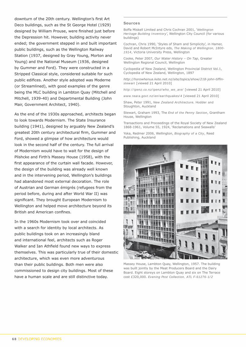
68 DEVELOPING ECONOMIES
downturn of the 20th century. Wellington’s first Art Deco buildings, such as the St George Hotel (1929) designed by William Prouse, were finished just before the Depression hit. However, building activity never ended; the government stepped in and built important public buildings, such as the Wellington Railway Station (1937, designed by Gray Young, Morton and Young) and the National Museum (1936, designed by Gummer and Ford). They were constructed in a Stripped Classical style, considered suitable for such public edifices. Another style adopted was Moderne (or Streamlined), with good examples of the genre being the MLC building in Lambton Quay (Mitchell and Mitchell, 1939-40) and Departmental Building (John Mair, Government Architect, 1940).
As the end of the 1930s approached, architects began to look towards Modernism. The State Insurance building (1941), designed by arguably New Zealand’s greatest 20th century architectural firm, Gummer and Ford, showed a glimpse of how architecture would look in the second half of the century. The full arrival of Modernism would have to wait for the design of Plishcke and Firth’s Massey House (1958), with the first appearance of the curtain wall facade. However, the design of the building was already well known and in the intervening period, Wellington’s buildings had abandoned most external decoration. The role of Austrian and German émigrés (refugees from the period before, during and after World War II) was significant. They brought European Modernism to Wellington and helped move architecture beyond its British and American confines.
In the 1960s Modernism took over and coincided with a search for identity by local architects. As public buildings took on an increasingly bland and international feel, architects such as Roger Walker and Ian Athfield found new ways to express themselves. This was particularly true of their domestic architecture, which was even more adventurous than their public buildings. Both men were also commissioned to design city buildings. Most of these have a human scale and are still distinctive today.
Massey House, Lambton Quay, Wellington, 1957. The building was built jointly by the Meat Producers Board and the Dairy Board. Eight storeys on Lambton Quay and six on The Terrace cost £320,000. Evening Post Collection, ATL F-61276-1/2
Sources Boffa Miskell Limited and Chris Cochran 2001, ‘Wellington Heritage Building Inventory’, Wellington City Council (for various buildings)
Cochran, Chris 1990, ‘Styles of Sham and Simplicity’, in Hamer, David and Robert McIntyre eds, The Making of Wellington, 1800-1914, Victoria University Press, Wellington
Cooke, Peter 2007, Our Water History – On Tap, Greater Wellington Regional Council, Wellington
Cyclopedia of New Zealand, Wellington Provincial District Vol.1, Cyclopedia of New Zealand, Wellington, 1897
http://horowhenua.kete.net.nz/site/topics/show/218-john-tiffin-stewart [viewed 21 April 2010]
http://ipenz.co.nz/ipenz/who_we_are/ [viewed 21 April 2010]
www.teara.govt.nz/en/earthquakes/4 [viewed 21 April 2010]
Shaw, Peter 1991, New Zealand Architecture, Hodder and Stoughton, Auckland
Stewart, Graham 1993, The End of the Penny Section, Grantham House, Wellington
Transactions and Proceedings of the Royal Society of New Zealand 1868-1961, Volume 55, 1924, ‘Reclamations and Seawalls’
Yska, Redmer 2006, Wellington, Biography of a City, Reed Publishing, Auckland

DEVELOPING ECONOMIES 69
Part of Wellington War Memorial: General Plans and Elevations, by Grierson, Aimer & Draffin of Auckland, Architects, 1929. WCC Archives B7660.

70 DEVELOPING ECONOMIES
Sub-theme Type Examples of placesUnions / union federations Union headquarters Trades Hall, Vivian St
Working men’s clubs Working Men’s Club, Cuba StGuilds / professional societies Offices Colleges of Physicians
Labour

DEVELOPING ECONOMIES 71
Sub-theme Type Examples of placesUnions / union federations Union headquarters Trades Hall, Vivian St
Working men’s clubs Working Men’s Club, Cuba StGuilds / professional societies Offices Colleges of Physicians
Labour

72 DEVELOPING ECONOMIES
Labour
The Labour movement
A truly conspicuous event in New Zealand’s labour history took place in Wellington soon after the colony was founded. Early in 1840, on Petone beach, English immigrant Samuel Parnell (1810-1890) was asked to construct a store for his fellow passenger, George Hunter, soon to be Wellington’s first mayor. He accepted, but on the condition that he only worked eight hours per day. This was a radical suggestion considering that a 12 to 14 hour working day was the norm at that time in England. Due to the scarcity of labour, Hunter was forced to accept the conditions. Parnell met immigrants as they arrived in the harbour and gained the support of workmen for his eight-hour day. It eventually became widespread through the country and enshrined in legislation. Parnell remained in Wellington for the rest of his life – he built a house in Karori that still stands – and in 1890, just before his death, he was the guest of honour at the first Labour Day march in Auckland. He was buried at Karori Cemetery.
In the wake of Parnell’s success, collectives were formed (such as the Wellington Benevolent Society of Carpenters and Joiners) and, from 1848, ‘eight-hour associations’, included a branch in Wellington. The first Trades and Labour Council was formed in Auckland in 1876. The
A crowd on Jervois Quay during the 1913 strike, with men climbing the wharf gates. S C Smith Collection, ATL, G-19675-1/1.
Samuel Duncan Parnell, who initiated the eight hour working day, just before his death in 1890. Henry Wright Collection, ATL G-20462-1/1.
first nationwide strike, by workers at the Electric Telegraph Department, took place in 1880.
The first National Congress of Unions was held in Dunedin in 1885, by which time there were about 2500 union members in the country. The first Labour Day celebration was held in 1890 and in 1899 the government made the day a national holiday. The increasing influence of the labour movement and a sympathetic Liberal government saw the passing of
landmark legislation – the Industrial Conciliation and Arbitration Act – in 1895. If a union, registered under the Act, could not settle an argument with an employer, the Arbitration Court ruled on the matter.
By the following decade increasing union membership saw more confrontation with employers, culminating with a series of great strikes. The first was the Blackball Strike of 1908; the successful miners’ union went on to form the Federation of Labour in 1911. The bitter Waihi Strike followed in 1912 and, in 1913, the waterfront strike in Wellington had a particular resonance. In October
that year 1600 ‘wharfies’ went on strike in support of shipwrights denied paid travelling time to the Patent Slip in Evans Bay. The dispute escalated into one of the worst industrial confrontations in the country’s history.

DEVELOPING ECONOMIES 73
Troops were brought in to work on the waterfront and the Government enrolled farmers as special mounted police, nicknamed “Cossacks”. There were riots and altercations on Wellington’s streets. After a month the strike was settled but the resentment lingered.
In 1916 the Labour Party was formed, primarily to represent the interests of workers, and it was immediately successful, winning 25% of the vote in the 1919 election. It remains one of the country’s premier political parties nearly 100 years later. During the Depression the unemployed rioted in various centres, including Wellington, over the economic conditions. The election of the first Labour government in 1935 saw the introduction of a minimum wage, the 40 hour week and compulsory unionism. Following this, in 1937, the Federation of Labour was reconstituted and remained the primary voice of non-state unions until 1989.
In February 1951, the Waterside Workers Union banned its members from doing overtime. This was partly as a response to employers refusing to pass on a 5% wage increase that had been granted by the Arbitration Court but also in support of a 40 hour week. The Wellington Harbour Board refused to let the watersiders on the wharves and a five month standoff began. The National government brought its full range of powers to the fight, including the use of troops to load ships and a heavy police presence. Under enormous pressure from the Government, the union finally capitulated in July that year and the most militant of the country’s unions was broken.
In 1973 the Labour government introduced the Industrial Relations Act to replace the Industrial Conciliation and Arbitration Act (and other acts). Ten years later the National government ended compulsory unionism. The following year, on 27 March 1984, the Wellington Trades Hall on Vivian Street was bombed and Ernie Abbott (the caretaker) was killed in the blast. The Trades Council Executive was scheduled to meet in the building to organise a campaign against wage freeze provisions introduced by the National government.
In 1987 Labour passed the Labour Relations Act. In 1989 the Federation of Labour and Combined State Unions joined forces to form the Combined Trade Unions (CTU). However, in 1993, 11 unions broke away to form the Trade Union Federation. They subsequently returned to the fold in 2000. The CTU,
based in Wellington, remains (in 2009) the umbrella organisation for most New Zealand unions. Many unions amalgamated during the latter part of the 20th century to give them more clout.
In 1991 the National government replaced the Labour Relations Act, with the Employment Contracts Act, which was later replaced by the Industrial Relations Act (in 2000) by the new Labour government. The latter introduced a raft of new labour-friendly measures including 12 weeks paid parental leave, increases to the minimum wage and new health and safety laws.
Guilds and professional associations
There are a great many guilds and professional associations (as opposed to unions), covering a wide range of working activity, which have played a considerable part in Wellington and New Zealand.
Many of these are based or have branches in Wellington and among the better known of these are in the medical area, including the Royal Australian Colleges of Physicians (founded 1930) and Surgeons (1927), and the Royal Australian and New Zealand Colleges of Obstetricians and Gynaecologists (founded 1998), Ophthalmologists (1997), Psychiatrists (1946) and Radiologists (1935).
The Institution of Professional Engineers of New Zealand (founded in 1914) has its offices in Wellington, as do a plethora of other Institutes. in many fields, including the Arbitrator, Mediators, Building Officials, Chartered Management Accountants, Human Resources, Directors, Registered Music Teachers, Quantity Surveyors, Project Management, Real Estate and Tax agents, among others. The great many member-based organisations in Wellington is testimony, among other things, to the city’s central location and the proximity to government.
SourcesJohnson, David 1996, Wellington Harbour, Wellington Maritime Museum Trust, Wellington
Oliver, William H. ed. 1981, The Oxford History of New Zealand, The Clarendon Press, Oxford and Oxford University Press, Wellington
Roth, Herbert. ‘Parnell, Samuel Duncan 1810 - 1890’. Dictionary of New Zealand Biography, updated 22 June 2007, http://www.dnzb.govt.nz/
www.awunz.org.nz/history.htm [Timeline of New Zealand Union history, viewed 26 January 2010]

74 DEVELOPING ECONOMIES
Sub-theme Type Examples of placesPublic health Hospitals Wellington Hospital; Mt View asylumHealth administration Ministerial offices
Health board officesPrivate practice Private hospitals, doctor’s rooms / surgeries Wakefield Hospital; John Street Doctors (Newtown); former Willis St medical precinctCharitable organisations Red Cross
Sisters of Compassion Creche, Buckle StBarnado'sCity MissionNZ Kids FoundationMission to SeamenChinese MissionSalvation Army
Health

DEVELOPING ECONOMIES 75
Sub-theme Type Examples of placesPublic health Hospitals Wellington Hospital; Mt View asylumHealth administration Ministerial offices
Health board officesPrivate practice Private hospitals, doctor’s rooms / surgeries Wakefield Hospital; John Street Doctors (Newtown); former Willis St medical precinctCharitable organisations Red Cross
Sisters of Compassion Creche, Buckle StBarnado'sCity MissionNZ Kids FoundationMission to SeamenChinese MissionSalvation Army
Health

76 DEVELOPING ECONOMIES
HealthEarly Wellington’s medical needs were attended to, as best they could, by the settlement’s first doctors, who arrived as part of immigrant shipments or as ship’s surgeons assigned by the New Zealand Company. Facilities in the new settlement were primitive. There was a building set aside for the mentally ill next to the gaol in Thorndon, while British soldiers at Mt Cook had their own hospital.
Wellington Hospital
The first public hospital in Wellington was the 16-bed Colonial Hospital, built in 1847 on a site in Pipitea Street in Thorndon, gifted by local Māori, where Wellington Girls’ College is now located. Dr John Fitzgerald was the hospital’s physician. Commissioned by Governor George Grey and available for use by both Māori and Pakeha, the hospital was damaged in the 1848 earthquake and rebuilt in timber in 1855.
The hospital was soon too small for the city’s needs and in 1875 land was set aside by the government for a new hospital in Newtown. Work began in 1876 using prisoner-made bricks and, after a number of delays, the new north-facing building opened in 1881 off Revans (now Riddiford) Street. This building formed the centrepiece of the hospital and a series of additions and stand-alone structures were constructed over the following 40 or more years. During this period, the hospital grew dramatically and took up much of the available land, with the exception of a large park-like frontage to the north. This was then partly occupied by a big new administration building, completed in 1927 and, behind it, a large three-ward block built at the same time.
By 1946 more of the spare space was gone, with temporary buildings constructed to relieve pressure at the overcrowded hospital. From the late 1950s, the old hospital began to be replaced, firstly by a series of buildings constructed near the margins of the hospital to update facilities. Although a 1960s plan to rebuild almost the entire hospital did not proceed,
the remainder of the hospital was gradually rebuilt from the 1970s onwards, with buildings added as funding and necessity would permit.
Demolition even included the removal of the Seddon Wing, built as recently as 1966. Most recently the demolition of the administration building and the wings to its rear was followed by the construction of the new regional hospital, completed in 2009.
Private facilities / practitioners
Augmenting the services offered by Wellington’s public hospital were (and still are) private hospitals, general practitioners (GPs) and specialists. One particular area that became well known as a hub of medical activity was in and around upper Willis Street. As early as 1843 there were already two doctors out of the eight settlers resident there. Medical people continued to gravitate there, to the extent that it was dubbed Wellington’s equivalent of Harley Street. Upper Willis Street was an accessible location on the northern edge of Te Aro; the vast majority of the 19th century population lived in or close to town and the arrival of the electric tram in 1904 made travel around the city even easier. Upper Willis Street and environs evolved into an attractive and leafy area with broad streets and fine houses. It remained the centre of medical practice well into the 20th century; it took Wellington’s post-war suburban boom to end its dominance.
The area contained a plethora of private hospitals and maternity hospitals. The latter were often established and run by midwives and the majority of Wellington’s children were born in them, at least until the 1960s when such institutions found it hard to compete against free public facilities. The area also contained the rooms of general practitioners and specialists, many of whom split their time between their private practices and Wellington Hospital, as is still the case.
There were, of course, GPs in practice in many other parts of Wellington, as they still are, and private hospitals were similarly to be found elsewhere. Examples include a maternity hospital at the south end of Hanson Street (the Alexandra Maternity Hospital, built in 1926 and taken over by the Wellington Hospital Board in 1968), and the Wakefield Hospital, formerly a private hospital established by the sisters of the Little Company of Mary in 1929 and still in operation today. Private hospitals remain a prominent part of the heath care landscape.
Dentistry
Early dentistry in Wellington, like everywhere else, was crude by modern standards. Until the 1880s, dentists did little more than pull out teeth or insert rudimentary
A 1945 New Zealand “Health” stamp charging 2 pence for postage and a premium of 1 pence for charity. http://en.wikipedia.org/wiki/Health_stamp

DEVELOPING ECONOMIES 77
artificial replacements. Dentists and chemists were registered from 1880 (when there were about 50 in the country) and dental practice was brought under some measure of control. Dentists benefited from advances in technology and materials, particularly in the use of drills, which allowed decay to be removed more efficiently, and in pain relief, using nitrous oxide.
The New Zealand Dental Association was formed in 1905 and, from 1907, dental education was under the control of the University of New Zealand. In 1913 Dr Norman Cox championed the idea of creating a state-funded school dental service and four years later a new profession of ‘dental nurse’ was first proposed. The first draft of 35 students began training as dental nurses in 1921 in the former Base Records building, adjoining Government Buildings, in Stout Street (demolished in 1969). They were the first batch of dental nurses sent to the country’s schools to care for children’s teeth.
Following the election of the first Labour government in 1935, a rapid expansion of the School Dental Service was envisioned. Two years later work began on plans for a purpose-built dental school in Willis Street. The foundation stone was laid in 1938 and the building opened on 14 May 1940. It remained the country’s foremost dental school until it was sold for apartments in the late 1990s. Many Wellington children were sent to the school and a comparable facility in Premier House (now the Prime Minister’s residence) in Tinakori Road.
Dental practices improved markedly throughout the 20th century. The advent of better pain relief and hygiene, high speed drills, higher quality fillings and dentures, fluoridation, and education on preventative practices all contributed to better general dental health care. Post-primary dental care in Wellington, as is the case throughout New Zealand, has been predominantly undertaken privately, with only a relatively small number of procedures being done at Wellington Hospital.
As with general medical practitioners, dentists have surgeries both in the central city and in most suburban centres.
Mental Health
The first ‘lunatic’ asylum was built alongside the Wellington jail in 1840. The city’s first dedicated institution was the Karori Asylum, which opened in 1853. Following a Parliamentary inquiry into the lunatic
View of the interior of the main clinic of the Children’s Dental Clinic, Willis Street, 1940. Dominion Post Collection, ATL EP-Health-Hospitals-Dental-01.
asylums of the colony in 1871, a new facility opened in Newtown in 1873. The Mt View Asylum occupied what is today the site of the Governor-General’s residence. In 1884, land was purchased at Porirua for a Hospital Farm for ‘work therapy’ and, two years later, a ward opened there to relieve overcrowding at Mt View. A main block at Porirua followed in 1891. Mt View was closed down in the early 1900s and was redeveloped for the vice-regal residence. Some physical elements of the former asylum are still extant in the grounds of the house. Porirua Hospital remains the centre of mental health provision in the Wellington region. Wellington Hospital has had its own mental health ward to service the needs of the city since 1973.
SourcesCoote, Philip, “A History of Dentistry in Nelson”, Nelson Historical Society Journal, Volume 6, Issue 4, 2001
http://www.poriruahospitalmuseum.org.nz/chronology-of-events [viewed 9 February 2009]
McLean, Gavin 2000, Wellington: The First years of European Settlement 1840-1850, Penguin, Auckland
Pollock, Kerryn and Natasha Naus 2006, Heritage of Health, The Authors, Wellington.
Saunders, John Llewellyn, The New Zealand School Dental Service: Its Initiation and Development 1920-1960, Wellington, New Zealand: Government Printer, [1964?] www.ccdhb.org.nz/hhist/index.html [viewed 27/1/2010]

78 GOVERNING

GOVERNING 79
THEME C
GoverningGOVERNMENT INSTITUTIONS
SECURITY & THE LAWMILITARY & DEFENCE
WELLINGTON & THE WORLD

80 GOVERNING
Sub-theme Type Examples of placesNational government Parliamentary buildings Parliamentary Precinct, Government Buildings, Lambton Quay
Departmental buildings Departmental Building, Stout StreetState-owned enterprises’ buildings Wellington Railway Station (KiwiRail headquarters)
Provincial government Council chambersAdministration buildingsResidences of significant political figures
Local government Council administration buildings WCC Offices, Wakefield St; former Johnsonville Town Board Offices (relocated)Town Halls Wellington Town HallService centres Khandallah Town Hall
Ngaio Town Hall
Government inst itutions

GOVERNING 81
Sub-theme Type Examples of placesNational government Parliamentary buildings Parliamentary Precinct, Government Buildings, Lambton Quay
Departmental buildings Departmental Building, Stout StreetState-owned enterprises’ buildings Wellington Railway Station (KiwiRail headquarters)
Provincial government Council chambersAdministration buildingsResidences of significant political figures
Local government Council administration buildings WCC Offices, Wakefield St; former Johnsonville Town Board Offices (relocated)Town Halls Wellington Town HallService centres Khandallah Town Hall
Ngaio Town Hall
Government inst itutions

82 GOVERNING
Government InstitutionsWellington has been the capital city of New Zealand since 1865. It owes its status to its central location, being a hub of the country’s transport movements, particularly after the arrival of the railway in the 1870s.
Provincial government
Wellington was first administered by the New Zealand Co., and was briefly run by a borough (1842-43) under the first mayor, George Hunter. In 1846, Governor Grey appointed Edward Eyre as Lieutenant-Governor of the provinces of New Ulster and New Munster and sent him to Wellington to undertake his duties.
The New Zealand Constitution Act 1852 (passed by the British parliament) established a system of government consisting of a Governor, a Legislative Council, a House of Representatives and six provinces, of which Wellington was one. The first elected assembly of the Wellington Provincial Council took office in 1853 under Superintendent Isaac Featherston. In 1857, it built a large assembly and offices; firstly on the site of the present Parliament and secondly (after the arrival of central government in 1865) on Customhouse Quay. The Wellington Provincial Council acted partly as a local authority, having jurisdiction over both provincial issues and town matters, at least until the Wellington Town Board was instituted in 1862. Provincial government was dissolved in 1876.
Central government
Wellington’s future shape and prosperity was largely determined by the decision, taken in 1864, to move the capital from Auckland. The following year, politicians and officials arrived and took over the Provincial Council chambers, beginning a significant adaptation and expansion of the timber buildings. Many of the additions were designed by William Clayton, the first Colonial Architect. In 1870, a Clayton-designed Government House was completed on the site of what is now occupied by The Beehive on the south side of Sydney Street.
In 1876, eleven years after the move to Wellington, provincial government was abolished. In anticipation of this, central government began planning a large building at the foot of Molesworth Street to house the then Wellington-based civil service. Land was reclaimed in 1873 and Government Buildings opened in 1876. The building was used by ministers when the
House of Representatives was in recess. It still stands today, although it is no longer in departmental use. In 1899, the General Assembly Library was completed.
In 1907, a huge fire destroyed the timber Parliament buildings. Parliament was temporarily held in the nearby Government House. An architectural competition was held in 1911 and the design by John Campbell (then Government Architect) and his assistant Claude Paton was chosen as the winner. The original design was for a building nearly twice its present size but the south wing and central dome were never built, due to World War I and building and material shortages. The partly completed building opened in 1922. The new building swallowed up Sydney Street and left the road as two separate parts. Government House was temporarily moved to Palmerston North while a new residence was planned for the Mt View Asylum site in Newtown and completed in 1912. When Parliament reopened, Government House was converted into the Parliamentary restaurant Bellamy’s. The Legislative Council, an appointed upper house, was abolished in 1950, nearly 100 years after it was established.
The former Government House was finally demolished in 1970 to make way for the planned construction of the new Executive Wing, or Beehive as it became known, designed by Sir Basil Spence, the well known British Modernist architect, and completed in 1984. In 1992 work began on a four-year project to restore, refurbish and strengthen the Parliamentary buildings.
Since 1865, Wellington has supported numerous central Government functions. After the civil service was brought together in Government Buildings in
Wellington Town Hall, Cuba Street. c.1910. WCC Archives 00138-0-817

GOVERNING 83
1876, buildings were erected for core government activities, such as courts, police stations, hospitals and departmental buildings, as well as offices for state agencies such as New Zealand Railways, Government Print, State Insurance and Government Life Insurance. A number of these buildings still stand, although these days, as a rule, the government itself does not own the buildings it occupies.
Local government
After Wellington’s brief foray into local government in 1842, the city was run by the Provincial Council. The difficulties of that approach were soon obvious and, in 1862, the Council passed the Wellington Town Board Act, which established a board of works to manage ‘basic civic services and amenities’ paid for by a newly introduced rate. Elected by ratepayers, the Town Board met in the just completed Oddfellows Hall on Lambton Quay, on newly reclaimed land. The Town Board was soon superceded by the Wellington City Corporation (WCC) in 1870. Formed under the Municipal Corporations Act 1867, the corporation was to be run by a council, with the chairman of the Town Board now replaced by a mayor and councillors.
The Corporation’s boundaries were subject to much revision over the following decades. In that period, the city’s outlying districts were managed by various roads boards and the Hutt District Council and Makara County Council. As the city grew, independently minded localities on the margins of the city formed themselves into town boards and boroughs, managed their affairs for a while and were then wound up and subsumed into the WCC. These included: Melrose Borough (established 1888, disestablished 1903), which took in Mitchelltown, Taitville, Brooklyn, Vogeltown, Island Bay, Melrose, Kilbirnie, Roseneath and Oriental Bay; Onslow Borough (1890 – 1918), incorporating Khandallah, Ngaio and Kaiwharawhara (a legacy of this council are two historic town halls – Ngaio and Khandallah); Karori Borough Council (1891-1920); Miramar Borough (1904 – 1922), incorporating the Miramar Peninsula; and Johnsonville Town Board (1874 – 1953).
From 1876 to 1908, Tawa was part of the Porirua Riding of Hutt County. From 1908 to 1951 it was part of Makara County. That year, the Town Board was formed and it (together with Linden) became a borough in 1953, a response to its rapidly increasing population. At this stage it was still known as Tawa Flat
but, in 1959, the name was changed to the Borough of Tawa. In 1989, despite the overwhelming opposition of Tawa residents, the amalgamation of the borough with Wellington City took place. The boundaries of the WCC reached their present extent at that time. Accompanying this was a change of name, from Wellington City Corporation to Wellington City Council.
During its history the Wellington City Council administration has been associated with two inner-city sites. The first was on the sea side of Featherston Street, between Johnston and Waring Taylor Streets, where the Corporation’s first offices were built. The second was what is now known as Civic Square; three blocks of land that were bounded or intersected by Mercer, Wakefield, Harris and Cuba Streets and Jervois Quay. A series of buildings was constructed over a period of 100 years, some of which have gone, but those remaining include the Wellington Town Hall (1904), Administration Building (1951) and the present and former City Libraries (1940 and 1991 respectively).
SourcesCook, Rod 1988, Parliament: The Land and Buildings from 1840, Parliamentary Service, Wellington
Cyclopedia of New Zealand, Vol.1, Wellington Provincial District, Cyclopedia Publishing Co., Wellington, 1897
Kelly M. 2006, ‘Tawa and its reserves’, unpublished report for Wellington City Council
Yska R. 2006, Wellington – Biography of a City, Reed Publishing, Auckland
Johnsonville Town Board Office, built 1912. Relocated to Newlands in 1994. WCC Heritage

84 GOVERNING
Sub-theme Type Examples of placesPolicing Police stations Former Taranaki Police Station; former Central Police Station façades, Johnston/Waring Taylor streets Justice Courthouses, jails, Supreme Court; Buckle St Police Station, Mt Cook
Security & the law

GOVERNING 85
Sub-theme Type Examples of placesPolicing Police stations Former Taranaki Police Station; former Central Police Station façades, Johnston/Waring Taylor streets Justice Courthouses, jails, Supreme Court; Buckle St Police Station, Mt Cook
Security & the law

86 GOVERNING
Security & the law
Policing
In 1840, when Lieutenant-Governor William Hobson arrived in Auckland, he was accompanied by five mounted troopers of the New South Wales police. Although little more than a guard for Hobson, they constituted New Zealand’s first police. In 1846, the Armed Police Forces were established, as a response to the first conflict between Māori and Pakeha. Initially administered by the two provinces of New Ulster and New Munster, they were passed to the six (later ten) provincial councils after they were established in 1853.
At the tail end of the New Zealand Wars, the New Zealand Constabulary Force, or the Armed Constabulary as it was known, was founded in 1867. A combined military and police force, it was placed under the authority of the Minister of Defence and took over the majority of the fighting from the imperial troops and loyal Māori. This force was demilitarised in 1869 and in 1877 the Armed Constabulary and the various police forces around the country were amalgamated into the New Zealand Constabulary Force. In 1886 the forces were drafted either into the military (the Permanent Militia) or into a new police force, set up under the Police Force Act. The New Zealand Police
Protesters on Hill Street, Wellington, during a demonstration against the 1981 Springbok tour. Dominion Post Collection, Alexander Turnbull Library, EP/1981/2884/11a. . . . . .
Force, as it was called, was still under the jurisdiction of the Minister of Defence. New recruits were sent to the army depot at Mt Cook for training. The police gradually disarmed, as society stabilised and relations between Māori and Pakeha improved. In 1896 the force was transferred to the Justice Department.
The first Police Commissioner – John Tunbridge of Scotland Yard - was appointed in 1897 and he set about reforming the police and improving its performance. The following year, a Royal Commission investigated allegations of police corruption and inadequate service. The brief of the commission inquiry was wide-ranging and, among its many recommendations, was for the establishment of a central depot at Wellington for the training of recruits. The recently built Mt Cook Police Station was chosen for the purpose. It was also felt that Mt Cook, being located next to the “slums” of Wellington, was a good training ground for new recruits. To illustrate the extent of police strength, in 1897 Wellington had 49 police officers, with 39 of them based at the main station on Lambton Quay. There were stations at Manners Street (replaced by the Taranaki Street

GOVERNING 87
station in 1916), Thorndon, Clyde Quay and Wellington South (Rintoul Street), the latter of which became the training centre after 1921.
An event in Wellington in 1905 signalled greatly improved crime resolution. John Clancy became the first man in New Zealand arrested and charged with an offence using fingerprints. The crime – breaking and entering – was subsequently proven and Clancy was sentenced to three years’ jail.
The process of improvement for the force was a long one and it was not until the Police Force Act in 1913 that the changes were entrenched. However, World War I intervened and by its end, a combination of staff shortages and declining working conditions had worsened morale. The government responded by improving wages and conditions.
In 1922, poor economic conditions led to a cut in police wages. These were reinstated later in the decade, but the Depression kept police working and housing conditions in a poor state. The election of the Labour government in 1935 improved matters, with the basic working week (56 hours) reduced to 48, and a new building programme began to replace older police stations. The New Zealand Police Association was established in 1936 and the first policewomen entered the force in 1941.
Following World War II, a public perception of inefficiency and poor morale put more pressure back on the police. In the 1950s, reform and modernisation followed, with better working hours, pay and allowance increases, a reduction in the retirement age to 60, better training and more effective public relations. In 1958, the word ‘Force’ was dropped from the title.
In the following decade, policing changed markedly, as a response to an increasingly permissive society, more
Group of policemen posed for photograph at Mount Cook Barracks. WCC Archives 00138-0-829
sophisticated offending and more energetic political protesting. A number of one-person stations closed, traditional beat policing was reduced and mobile patrols were set up. The 1960s also saw familiar staples of modern policing introduced, including special squads or units for dealing with armed offenders, drugs, vice, criminal intelligence, search and rescue etc. Community constables were introduced in 1973.
Arguably the biggest single challenge to the New Zealand Police came with the Springbok rugby tour of 1981. Although approved by the government, it proved to be extraordinarily divisive. The outcome led to a reflection on the role of the police in keeping public order and on the actions of the police during the tour. Pay and conditions were improved to reflect the increasingly difficult role played by police.
In 1992, traffic control was integrated into police, although staffing is now largely specialised. By the turn of the new century, increasingly sophisticated technology in the likes of communications, traffic safety and DNA detection had transformed policing.
In the early 21st century, New Zealand Police is administered from the Office of the Commissioner of Police in Wellington, but is largely decentralised, with twelve districts managing the country, including Wellington. Wellington City is managed from the Wellington Central Police Station on Victoria Street, which is also the district headquarters. There are seven other stations. Parts of former stations remain intact, including Mt Cook Police Station, Buckle Street (1893), the Taranaki Street Police Station (1916) and the two facades of the former Wellington Central Police Station (1918), which still stand on Johnston and Waring Taylor Streets.
Justice
The first chief justice, Sir William Martin, arrived in the colony of New Zealand in 1841. He established the first Supreme Court in Auckland, and Courts of General and Quarter sessions were established in Russell, Auckland and Wellington. All were modelled on English courts. The country’s first prisons followed; a gaol was built in Thorndon in 1840. The first administrator of the justice system was the Colonial Secretary’s office.
Resident magistrates’ courts were created in 1846 and district courts were introduced in 1858. By 1862, a Court of Appeal had been established, although from 1840 to 2004 the Privy Council in London was

88 GOVERNING
the country’s highest court. By 1866 the seat of government had moved to Wellington and there was a Courts Division and a Prison Service administered by the Judicial Section of the Colonial Secretary’s office. The first separate Minister of Justice, W. Sewell, was appointed in 1870 and the Department of Justice was inaugurated in 1873.
The Community Corrections Service (then known as Probations) was established in 1886 under the First Offenders Probation Act of that year. Prisons remained a core part of the Justice Department’s work for much of the next 100 or more years.
The Resident Magistrates’ Courts assumed the responsibilities of the District Courts during the latter part of the 20th century. In 1893 the word ‘Resident’ was dropped from the title. Later still, in 1980. Magistrates’ Courts were renamed District Courts. At the same time, the Supreme Court became the High Court.
By 1995, the Department of Justice, had over 7000 staff. Its size and myriad roles led to the decision by the government to restructure the department and, among other things, divest the responsibility for prisons to a new organisation – the Department of Corrections. Courts were also devolved to a new ministry – the Department of Courts. The Department became a Ministry and among its primary functions was offering policy advice to the government on matters across the justice sector. Later, in 2003, Courts returned to the fold.
From 2004, the Privy Council was replaced as New Zealand’s highest appellate court by the Supreme Court of New Zealand. The new Supreme Court began hearing cases in July 2004 and moved into a new building directly in front of the earlier Supreme Court in 2009.
Wellington has been the home of a number of courts and prisons, some of them significant structures. The city’s second purpose-built Supreme Court (1879) still stands on Stout Street and backs on to the new Supreme Court. A portion of the facade of the District Court building remains on the corner of Stout and Whitmore Streets, incorporated into a new courts building. The Terrace Gaol and Mt Cook Gaol have long been demolished but the Mt Crawford Prison (constructed in 1927 to replace the Terrace Gaol), is still in use.
SourcesEvening Post, 7 March 1905
Hill, Richard 1994 ‘Policing in New Zealand – a short history’ in Young S. ed., 1994, With Confidence and Pride: Policing the Wellington Region 1840-1992, Wellington Police Trust, Wellington
Kelly, Michael and Helen McCracken 1998, ‘A history of Mt Cook Police Station’, prepared for ‘Mt Cook Police Station Conservation Plan’ (principal author I. Bowman)
Cochran, Chris et al 2004, ‘Supreme Court Conservation Plan’, Ministry of Justice, Wellington
www.courtsofnz.govt.nz/about/system/history/overview [viewed 18 February 2010]

GOVERNING 89
The Armed Constabulary outside Government buildings before 1900. WCC Archives 00138-0-13180
Mounted ‘specials’ – mainly farmers brought in to help maintain law and order during the 1913 Maritime Strike – pass Mt Cook Police Station while on patrol. S C Smith Collection, ATL G-4905901/2
Police examining the rubble and glass in the wake of the bombing of the Trades Hall building, Vivian Street Wellington, 1984. Dominion Post Collection, ATL EP-Crime-Bombs-01

90 GOVERNING
Sub-theme Type Examples of placesMāori defences (pre- and post-contact) Pa sites Te Motu Kairangi (Miramar). Makara; Precincts - Te Ika a Maru, Rimurapa; Te Ranga a Hiwi, Tapu te Ranga -
Haewai, Akatarawera Matairangi, Mataki kai Poinga, Rangitatau - Poito & Oruaiti - Te Tangihanga o KupeMilitia sites Stockades Karori, Sentry [BMiddelton, Cliffords, McCoys, Fort ElliottNew Zealand Wars Fortifications / gun emplacements Mt Cook military reserve
Barracks Thorndon Barracks, Mt Cook BarracksDefensive earthworks
Responses to external threats (Russian Scare, South African War, World War I, World War II, Korean War, Vietnam War
Forts and batteries Fort Buckley, Wadestown; Wrights Hill; Miramar Peninsula coastal defencesCamps, bases, naval depots Clyde Quay Board Harbour (US Marines harbour); Kaiwharawhara Park Pavilion (former mess building, US
Marines camp); Shelly Bay Naval Base (later RNZAF base) and armament depotArmament factoriesArmament depots Shelly Bay; Belmont Regional ParkPillboxes / tank traps MakaraRadar stations Palmer Head radar stationAir raid shelters Former National Museum, Plimmer StepsSocialising Green Parrot CaféWar memorials Cenotaph; Rolls of Honour (many); National War Memorial
Military & defence

GOVERNING 91
Sub-theme Type Examples of placesMāori defences (pre- and post-contact) Pa sites Te Motu Kairangi (Miramar). Makara; Precincts - Te Ika a Maru, Rimurapa; Te Ranga a Hiwi, Tapu te Ranga -
Haewai, Akatarawera Matairangi, Mataki kai Poinga, Rangitatau - Poito & Oruaiti - Te Tangihanga o KupeMilitia sites Stockades Karori, Sentry [BMiddelton, Cliffords, McCoys, Fort ElliottNew Zealand Wars Fortifications / gun emplacements Mt Cook military reserve
Barracks Thorndon Barracks, Mt Cook BarracksDefensive earthworks
Responses to external threats (Russian Scare, South African War, World War I, World War II, Korean War, Vietnam War
Forts and batteries Fort Buckley, Wadestown; Wrights Hill; Miramar Peninsula coastal defencesCamps, bases, naval depots Clyde Quay Board Harbour (US Marines harbour); Kaiwharawhara Park Pavilion (former mess building, US
Marines camp); Shelly Bay Naval Base (later RNZAF base) and armament depotArmament factoriesArmament depots Shelly Bay; Belmont Regional ParkPillboxes / tank traps MakaraRadar stations Palmer Head radar stationAir raid shelters Former National Museum, Plimmer StepsSocialising Green Parrot CaféWar memorials Cenotaph; Rolls of Honour (many); National War Memorial
Military & defence

92 GOVERNING
Military and defenceThe earliest fortified pa of the Māori were largely located on elevated sites such as headlands and ridges, which could be effectively defended by palisades. Their character can still be seen at places such as Rangitatau Pa at Tarakina Bay, Uruhau at Island Bay or even Te Akatarewa Pa above Wellington College. Three of the best preserved pa today are to be seen at Te Ika a Maru Bay and at Makara. Pa were defensive places often close to settlements, with gardens outside them. Many battles were fought in Wellington over the centuries, however, invasions by other tribes did not often result in the taking of land by conquest. The changing of tangata whenua tribes was more usually achieved through migration and intermarriage.
The arrival of the New Zealand Company settlers in 1840, and the signing of the Treaty of Waitangi the same year, saw the arrival of the British military early in the development of Wellington. It was no coincidence that stockades such as Te Aro and Thorndon were placed adjacent to the pa of Te Aro and Pipitea, with the Thorndon Barracks close to Raurimu Kainga and Tiakiwai Pa. The incidents in 1843 at Wairau and then in 1846 at Boulcott Farm in the Hutt Valley made the settlers distinctly nervous, and they sought protection from possible Māori attack.
The military was the beneficiary of the use of the Māori Tenths reserve land. The military had a significant presence at Puke Ahu/Mount Cook with the Mount Cook barracks being located there early in the history of the colony and the military eventually getting two ‘town acres’ of Tenths reserve on the corner of Taranaki and Buckle Streets. Mount Cook was also the place where Māori prisoners from the Taranaki wars were held, usually before being shipped further south. The prisoners were often the fencers and ploughmen from Parihaka using non-violent methods to object to the confiscation of land from the so-called rebels. The prisoners worked making bricks at the brickworks at Mount Cook.
Some coastal defence gun emplacements were located on the site of the ancient Oruaiti Pa on the headland above Point Dorset.
The first guns emplaced in Wellington were two New Zealand Company 18-pounders, mounted on carriages and emplaced on Matiu/Somes Island in
Basin Reserve 1920s, with buildings on Mt Cook behind it. WCC Archives 00157-1-112
Looking east at Scorching Bay, Wellington, showing Fort Balance, circa 1887. Henry Wright Collection, ATL, G-20667-1/1.
Cannon on Mount Victoria, Wellington, ca. 1880. An elevated view of areas around the Basin Reserve (centre). Wellington College is to the left. The cannon was hauled up the mountain by the Artillery and Volunteers, with the idea of being used as a signal gun. WCC Archives 00148:0:63.

GOVERNING 93
Buildings at the Kaiwharawhara Military Camp which were to be turned into temporary housing. 25 September 1945. Evening Post Collection, ATL. PAColl-8557-15
1840. Three years later, after a force of Ngati Toa, led by Te Rauparaha and Te Rangihaeata, overwhelmed settlers occupying land at Wairau near Nelson, the guns were removed to fortifications at either end of the settlement and barracks were built on Mt Cook to accommodate imperial troops brought in to defend the settlement. Barracks were also erected in Thorndon and occupied for a period.
Mt Cook became the centre of military activity in Wellington until 1865, when the troops left. Very little else was done to defend the city thereafter, despite the fact that Parliament was moved to Wellington in 1865. The army was mainly composed of armed militia with a small cadre of regular troops.
The situation changed in the 1870s, when diplomatic relations between Britain and Russia were strained and at times, near to war. During the Russo-Turkish War of 1878, 22 guns were sent to New Zealand to defend the country’s shores but were never emplaced. Following the Russian expansion into Afghanistan in 1885, and urged on by Governor Sir William Jervois, an ambitious programme of coast defence battery construction began at Wellington, Auckland, Lyttelton and Port Chalmers, initially in great haste and then comparatively leisurely as the apparent threat receded. New ‘disappearing’ guns were paired with the old guns sent to the country the previous decade. A submarine mining depot was set up at Shelly Bay and some buildings still remain.
By 1896, new quick-firing 6-pounder guns had been mounted at most batteries, and a controlled minefield could be laid in an emergency from Point Gordon to
Ward Island, serviced from a depot at Fort Ballance. By 1898, Wellington boasted seven fortresses, Forts Ballance, Gordon, Buckley and Kelburne, as well as batteries at the Botanic Garden, Halswell and Kau Point. At about the same time, New Zealand embarked on its first overseas foray in support of Britain’s imperial interests – to the South African War in 1899. Camps were established at Newtown and Karori for troops assembling for the voyage to South Africa.
By 1904 the older ordnance at the forts was disposed of and Fort Buckley and Garden Battery were abandoned. A new battery to mount a modern armament, the 6-inch Mk VII, was planned at Dorset Point. Work began in 1906 and the battery was completed by early 1910. Fort Dorset, as it was known, also included a military camp. At about this time, major reforms in the army were introduced under the Defence Acts of 1909 and 1910. Overnight (on 28 February 1910), all army volunteers were turned into territorials, with units dissolved and restarted. The intention was to raise a division-sized expeditionary force. Full-time soldiers up to that time were members of the New Zealand Permanent Force but then became the permanent core of the territorial units. To equip and provide for this large expansion of the territorials (and compulsory military training that went with it), the army expanded its facilities at many sites, including at Mt Cook. In 1913, a Defence Stores Building was constructed as part of this build-up and this building still stands. It was later the Army’s General Headquarters (from 1931 to 1938).
At the advent of World War I, the defences were redeployed in anticipation of an attack by the German East Asiatic Squadron. However, the destruction of the squadron and the hunting down of other German surface raiders meant that Wellington’s defences were soon be reduced to reserve status.
Coastal defence was a relatively low priority from the end of World War I in 1918 until 1933. Only essential maintenance was done and facilities were turned over to other uses, like munitions stores. As tensions in Europe increased, minds turned to increasing capability. A report in 1933 recommended a modernisation programme for the New Zealand Army. A programme of capital works was approved, at a proposed cost of £840,000, of which £309,200 was to be set aside for new coast defence batteries at Wellington and Auckland.

94 GOVERNING
In 1933 a number of sites in the Wellington area were investigated and a site at Palmer Head was chosen for a counter bombardment 6-inch battery. Completed in 1939, it had two guns, with a third added in 1942. In 1934, the army proposed building 9.2-inch counter bombardment batteries to protect New Zealand’s major ports. Government approval finally came in 1939 but delays in production meant that work on the fortresses did not begin until late 1942. Three fortresses were built, on Whangaparaoa Peninsula, Waiheke Island and Wright’s Hill, but the threat from Japan eased before they were completed. Two of the Wright’s Hill guns were not properly installed until after the war. The third was never emplaced. The guns were test-fired in 1946 and 1947 and then never fired again. Wright’s Hill was abandoned by the army in 1957 and the guns scrapped in 1960. It was later cleaned up and restored by the Wright’s Hill Fortress Restoration Society. Palmer Head was abandoned after the war and the emplacements later destroyed by the army. During World War II there was a smaller emplacement built at Opau, near Ohariu, using 6-inch guns. Anti-aircraft batteries were also fixed at positions around the city.
World War II saw a host of other military related activity in Wellington. US Marines trained in Wellington and lived at camps at Central Park, Anderson Park and Kaiwharawhara Park. Their vessels were moored at the Clyde Quay Boat Harbour and temporary facilities were built there for their use. There were camps at various recreation grounds for local troops e.g. Newtown Park and Hataitai Park, and for workers engaged on fortification or gun emplacement construction. Pill boxes, road blocks and air raid shelters were also built. Shelly Bay was turned into a naval depot and a complex of buildings constructed for that purpose.
Along with the former General Headquarters building, the Mt Cook reserve contained a plethora of military buildings, on both sides of Buckle Street. The front wing of the grim former Mt Cook prison, building of which began in 1882, stood on top of the hill. The Army took over the partly-completed building in 1902 and occupied it until 1931, when the Government embarked on building a National Museum and War Memorial on the site. Over time, military occupation of land at Buckle Street was reduced to the southern corner of Taranaki Street. In early 1942 a new building opened for the use of the Central Military District command and that building, known today as HMNZS Olphert, is used by the local naval volunteers. The rest of the compound is used by military security. With the closing of Fort Dorset in 1991, this is now the only place in Wellington where military operations of any kind are based.
The New Zealand Defence Force, as it became known, moved its headquarters into the Departmental Building on Stout Street in 1941 and remained there until a purpose-built structure was completed on Mulgrave Street in 2007.
SourcesBest, Elsdon 1921, ‘Old Redoubts, Blockhouses, and Stockades of the Wellington District’, Transactions and Proceedings of the Royal Society of New Zealand, Volume 53, 1921
Cooke, Peter 2000, Defending New Zealand, Wellington
Kelly, Michael and Ian Bowman 1997, Wrights Hill Fortress Conservation Plan, Wellington City Council
Kelly, Michael and Chris Cochran 2003, ‘Former General Headquarters Building, An assessment of heritage values’, New Zealand Defence Force

GOVERNING 95
Plimmer Steps, public air raid shelter (1960s) WCC Archives 00138-0-6064

96 GOVERNING
Sub-theme Type Examples of placesMeeting international leaders Ceremonial / social meeting places Parliament; Governor-General’s Residence; Premier House; St Paul’s CathedralDiplomacy Embassies Italian Embassy; British Ambassador’s residence; Papal Nuncio’s residence; Chinese Cultural Centre, Tinakori
RoadBi-cultural connections Physical memorials / places of memory Ataturk Memorial, Tarakena Bay; Greek-New Zealand Monument, Cambridge/Kent Terraces; Old St Paul’s (US
Marines), Cenotaph; Civic Square
Wellington & the World

GOVERNING 97
Sub-theme Type Examples of placesMeeting international leaders Ceremonial / social meeting places Parliament; Governor-General’s Residence; Premier House; St Paul’s CathedralDiplomacy Embassies Italian Embassy; British Ambassador’s residence; Papal Nuncio’s residence; Chinese Cultural Centre, Tinakori
RoadBi-cultural connections Physical memorials / places of memory Ataturk Memorial, Tarakena Bay; Greek-New Zealand Monument, Cambridge/Kent Terraces; Old St Paul’s (US
Marines), Cenotaph; Civic Square
Wellington & the World

98 GOVERNING
Wellington and the WorldThe first representation for any country in New Zealand was the appointment of James Busby as the official British resident in 1833. An honorary American consul was appointed in 1838. In 1840, Russell (modern Okiato) was made the country’s first capital, before the capital was shifted a few months later to Auckland, where it remained until 1865. That year, it moved, to Wellington, where the seat of government has remained ever since.
After Parliament was first established in Thorndon, a residence was built alongside the parliament buildings for the governor in 1870 and this brought together the country’s key institutional buildings. This arrangement stood until fire destroyed most of the parliamentary buildings in 1907, leaving the vice-regal residence untouched. It was converted for use as a temporary debating chamber and was later used as the home of Parliament’s caterers, Bellamy’s. A new governor-general’s residence opened in 1910 in Newtown at the site of the old Mt View Asylum. Since then, successive governors-general have conducted their role as the King or Queen’s representative from the Newtown house, receiving heads of state and diplomatic representatives from abroad, hosting state dinners, investitures and ceremonial events. A number of important dignitaries have stayed in Government House, including members of the royal family and state leaders.
The top table at the opening of the Ministerial Council of SEATO at Parliament Buildings, Wellington. … the Prime Minister (Mr Keith Jacka Holyoake, later Sir, [the] elected chairman of the council, is seated fourth from left. Dominion Post Collection, ATL EP/1968/1428/20A
The revamped Parliamentary complex, which reopened in 1922, included a substantial landscaped frontage. This, along with the spaces within (including, in 1984, The Beehive or Executive Wing), became a focus of ceremony, with official welcomes, inspections of the guard, international conferences, banquets and commemorations – as well as political protests. Most heads of states are received at Parliament. Additionally, Premier House, a former prime ministerial and ministerial residence, was restored in 1990, and became the official residence for the country’s prime minister.
Although diplomacy had been a significant part of world trade and international affairs for centuries, New Zealand, as part of the British Empire (later Commonwealth), relied on Britain to manage most of its external affairs. Britain had a strong diplomatic corps in many parts of the world and it was a simple matter to enlist its support when necessary. New Zealand’s overseas representation was limited to trade officials, beginning in 1871 with the agent-general (or high commissioner from 1905) to London. As an exporting nation, New Zealand relied upon a network of trade representatives and honorary consuls – many of whom were expatriates – to represent its interest in the absence of full diplomatic missions.
A significant catalyst for change came in the lead-up to World War II. In 1939 Britain sent its first high

GOVERNING 99
commissioner to Wellington, taking some of the duties formerly undertaken by the governor-general. In 1941, Deputy Prime Minister Walter Nash was appointed to Washington as ‘Special Minister’ to the United States. By then, New Zealand was aware that it had to change its strategic outlook and that the dependence on Britain would have to end. The first United States legation was established in New Zealand in 1 April 1942. By the end of the war, New Zealand had full diplomatic relations with five countries.
Two more important events followed that encouraged the government to establish more bilateral relations: the formation of the United Nations in 1945 and then the belated adoption of the Statute of Westminster in 1947, which made New Zealand a largely independent country. Thereafter, other countries established consulates or permanent embassies in Wellington. Among these were Italy in 1948, Germany in 1953, Indonesia in 1958, Korea in 1962, Singapore in 1965, Chile in 1972, Mexico in 1991 and Brazil in 1997. A considerable number of these embassies or consulates are in Thorndon, in the area in or around Hobson Street. A number occupy important heritage buildings, including the Papal Nuncio (at the former Hope Gibbons residence in Queens Drive, Lyall Bay) and the British high commissioner’s residence, Homewood, in Karori.
Leaders from most of the countries that New Zealand shares diplomatic relations with have visited Wellington, including some significant world leaders. Among the most important have been the visits of United States President Lyndon Johnson in 1966; Pope
John Paul II in 1986; President Mandela of South Africa in 1995; and from China, Premier Win Jiabao in 2006 and President Hu Jintao in 2003 and 2009.
SourcesMcLean, Gavin 2006, The Governors: New Zealand’s Governors and Governors-General, Otago University Press, Dunedin
Government House, Wellington, 1912. S C Smith Collection, ATL G-22804-1/1
Rugby World Cup Banners and Carnival Festival program. 2011 WCC Heritage

100 BUILDING SOCIAL & CULTURAL LIFE
THEME D
Building Social & Cultural Life
BELIEF SYSTEMSEDUCATION & LEARNING
ARTSSPORT & LEISURE
SCIENCECOMMUNITIES OF SPECIAL INTEREST
PUBLIC ENTERTAINMENTINFORMATION PROVIDERS / MEDIA
NATION-BUILDING

BUILDING SOCIAL & CULTURAL LIFE 101
THEME D
Building Social & Cultural Life
BELIEF SYSTEMSEDUCATION & LEARNING
ARTSSPORT & LEISURE
SCIENCECOMMUNITIES OF SPECIAL INTEREST
PUBLIC ENTERTAINMENTINFORMATION PROVIDERS / MEDIA
NATION-BUILDING
Hunter Building, Victoria University, Kelburn Parade [1940]. WCC Archives 00138-0-169

102 BUILDING SOCIAL & CULTURAL LIFE
Sub-theme Type Examples of placesReligion Churches Old St Paul’s
Church halls Northland Church HallReligious communities Mercy Convent, Thorndon; St Gerard’s Monastery; Home of Compassion, Island BayCemeteries Bolton St Cemetery, Mount St CemeteryMosques Mosque, KilbirnieSynagogues Bethsaida Synagogue, Webb StTemples Hindu Temple, KilbirnieCitadels (Salvation Army) Salvation Army Citadel, Vivian St; William Booth Memorial CollegeNon-conformist Christians Quaker Meeting House, Moncrieff St; Primitive Methodist, Webb St
Philosophy Philosophical societies Former William Booth Memorial College (School of Philosophy); Theosophical Society Building, Marion St
Belief systems

BUILDING SOCIAL & CULTURAL LIFE 103
Sub-theme Type Examples of placesReligion Churches Old St Paul’s
Church halls Northland Church HallReligious communities Mercy Convent, Thorndon; St Gerard’s Monastery; Home of Compassion, Island BayCemeteries Bolton St Cemetery, Mount St CemeteryMosques Mosque, KilbirnieSynagogues Bethsaida Synagogue, Webb StTemples Hindu Temple, KilbirnieCitadels (Salvation Army) Salvation Army Citadel, Vivian St; William Booth Memorial CollegeNon-conformist Christians Quaker Meeting House, Moncrieff St; Primitive Methodist, Webb St
Philosophy Philosophical societies Former William Booth Memorial College (School of Philosophy); Theosophical Society Building, Marion St
Belief systems

104 BUILDING SOCIAL & CULTURAL LIFE
Belief systems
Organised religions
Organised religion has been a pervasive part of Wellington life since the arrival of the first European immigrants in 1840. Wesleyan missionaries, Messrs J.H. Bumby and John Hobbs, have been credited as giving the first Christian service in Wellington, at Te Aro Pa in 1839, although they may simply have been proselytising. A basic church followed in 1840. The present Wesleyan Church (1879), a short distance away in Taranaki Street, is the successor of that first chapel.
Thereafter, missionaries and clergy from various churches arrived in quick succession and, by 1845, four mainstream churches had set up shop in the settlement – Anglican, Wesleyan, Catholic and Scottish Presbyterians. By far the greatest number of adherents belonged to the Church of England. In the succeeding decade, several churches were established on sites that remain occupied to this day. The first of four churches on the site of the present St Peter’s Anglican Church in Willis Street (1887) was built in 1847. St John’s Presbyterian Church (1885), also on Willis Street, was the third church on a site first occupied in 1856. The most celebrated of Wellington’s churches, Old St Paul’s, was opened in 1866. The principal Baptist church was in Vivian Street and was erected in 1896. The first Catholic Church in Wellington was constructed in 1842 in Boulcott Street and the same site is today occupied by St Mary’s of the Angels (1922). Sacred Heart Cathedral in Hill Street, Thorndon (1901), replaced a timber cathedral built by Bishop Viard in 1851, which burnt down. Wellington’s Catholics had their own cemetery at Mount Street, away from the main cemetery at Bolton Street.
Along with schools, the Catholic Church also built and maintained convents and monasteries for religious communities, including the Mercy Convent in Guildford Terrace in Thorndon, St Gerard’s Monastery in Mt Victoria and the Home of Compassion in Island Bay, which was founded by the famous French-born nun, Mother Suzanne Aubert. By a small margin, the largest denomination in Wellington is that of the Catholics.
Wellington was also home to a number of other churches, many non-conformist. The first Congregational Church service was held in 1842 and a church was built in Woodward Street in 1849. It was replaced by a substantial, timber-built church on the
View of St Johns Presbyterian church, Wellington, 1880s. ATL F-50341-1/2.
corner of Bowen Street and The Terrace (later replaced by the Reserve Bank building) in 1888. Another Congregational Church was built in Cambridge Terrace in 1916 and still stands. A Church of Christ was built in 1883 on Dixon Street. The church was converted into a commercial building and is still standing today. A Gospel Hall was erected in Vivian Street in the 1880s and a satellite church was built in Newtown in 1909. Both buildings still stand today.
As Wellington expanded, churches followed, or in some cases led the way. Churches were often among the first structures built in outer areas, as places of worship for farming communities. Places like Karori, Ohariu and Makara had churches built relatively early in their history, some of which still stand. In the 20th century, Wellington suburbs grew dramatically and the principal religions were represented in most suburbs. A decline in church attendance over the past half century has seen many churches close or unite or pass to more active communities.
Wellington was home to other branches of non-Conformism including the Quakers or the Religious Society of Friends. The Society began meeting in

BUILDING SOCIAL & CULTURAL LIFE 105
Wellington early in the city’s history, mainly in private houses, but it did not become more formally organised until about 1900. Funds were raised for a purpose-built Meeting House, but it was not until 1929 that a building was constructed in Moncrieff Street in Mt Victoria. It remains the centre of Society activity.
The Salvation Army became active in Wellington in 1883. It built a citadel between Vivian Street and Jessie Street and personnel still worship there, The present building was constructed in 1990. The Army had a strong presence in Cuba Street, where its national headquarters, Booth House, still stands opposite a hotel it once ran. In Aro Valley, the Army built a training centre in 1913 which it ran until 1982, when it moved to Upper Hutt when it sold the building to the Philosophical Society.
The Congregational Church is Samoa’s most popular, with about 43% of the population there members. The large influx of Samoan migrants to New Zealand saw many Samoan churches established in New Zealand and one of the biggest is in Owen Street, Newtown, which was dedicated in 1984. It is noted for its distinctive double dome, in the shape of two giant fale. It reflects the large Samoan presence in Newtown, which is home to a great many ethnic communities. There are many Samoan churches (and other Pacific churches) in Wellington. It is particularly noteworthy that over the past 50 years many Pacific Island communities (and some other ethnic groups) have taken over older churches originally built for traditional churches.
Wellington’s orthodox Jewish congregation was formed in 1843 and Bolton Street Cemetery, Wellington’s earliest cemetery, has a special Jewish section containing the graves of a number of early migrants. The first Beth El Synagogue in Wellington was consecrated in 1870, on The Terrace. In 1929 a new synagogue was built on the same site on The Terrace but, after the Ministry of Works decided it needed the land for the motorway, a new site was found in Webb Street. The foundation stone was laid in 1974 and, when it opened in 1977, both the Jewish Social Club and the Beth El Synagogue were combined in the one complex.
Greek migration to New Zealand began after the Balkan Wars of 1912 and 1913, with the vast majority coming in the years following World War II. Most settled in Wellington, particularly Mt Victoria. Hania
Indian Association Wellington (Inc), Kilbirnie. WCC Heritage
Street, named for the principal Crete settlement and a city sister of Wellington, is dominated by the traditional Greek Orthodox Church. The Orthodox community was formally established in 1945. Despite its traditional appearance, the present church was only completed in 1971. St Andrew’s Church on Broadway, Miramar, is that of the Archbishop of New Zealand.
Post-World War II, Wellington’s Romanian Orthodox congregation was very small but by 1971 it had grown to the point where it could seek the services of a Romanian priest from the General Assembly of the Church. A former Masonic hall in Adelaide Road, Berhampore, built in 1909, was acquired by the congregation and, in 1974, Fr. Gheorghe Speranta was appointed the first parish priest to the renamed Romanian Orthodox Church of St Mary. The congregation remains active to this day.
Other religions that have left their mark on Wellington, spiritually and physically, include the Open and Exclusive Brethren, the Church of the Latter Day Saints, and Church of Christian Science, all of whom have built places of worship in the capital.

106 BUILDING SOCIAL & CULTURAL LIFE
The influx of immigrant groups from a variety of places has led to many new types of religious worship in Wellington. Chief amongst these are Buddhism, Hindu and Islam and regular worship in these faiths takes place in various parts of the city.
The most recent trend in Christian worship in Wellington has been the rise of evangelical churches, such as The Rock and Arise. These operate from buildings that are not conventional ecclesiastical spaces and blend modern music and social interaction with a Christian message.
Other belief systems
Belief systems are not confined to religion. Wellington has a number of societies that practice other philosophies, including the School of Philosophy, a non-profit teaching organisation established in Wellington in 1956. It provides courses in practical philosophy that offer discovery through study, discussion and reflection. The Theosophical Society built a lodge in Marion Street in 1918 and it still stands. The Society, which is a hybrid of spiritualism, freemasonry and east and west occultism, began in Wellington in the 1880s. Their building remains in regular use.
The Wellington Islamic Centre in Kilbirnie. WCC Heritage 231110 006
Futuna Chapel, Karori. (mad2cv’s photostream)
Sources:Boffa Miskell and Chris Cochran, 2001, Wellington Heritage Inventory, Wellington City Council, Wellington
Cyclopedia of New Zealand, Vol.1 Wellington Provincial District, Cyclopedia Company Ltd., Wellington, 1897
McLean, Gavin 2000, Wellington: The First Years of European Settlement 1840-1850, Penguin Books, Auckland
Kelly, Michael 2002, ‘Wellington Ethnic Trail’, unpublished commentary for UNESCO for the Year of Cultural Heritage

BUILDING SOCIAL & CULTURAL LIFE 107
Friends hostel in the Glen, Kelburn [circa 1920]. WCC Archives 00138-0-13217
Makara Settlers Church is a Non-denominational Community Church in Makara. Previously St Patricks Catholic Church it is now operated by the community of Makara. WCC Archives

108 BUILDING SOCIAL & CULTURAL LIFE
Sub-theme Type Examples of placesPre-school Creches Home of Compassion Creche, Buckle St
Pre-schools Te Kahanui, Tasman StKindergartens Newtown Kindergarten (former show kindergarten at NZ Exhibition 1940); Berhampore Kindergarten (1930s)Day-care facilities Hill St Early Childhood CentrePlay centres / play groups Khandallah Town HallPlaygrounds
Primary, secondary Schools Firth Hall, Wellington College, Tower building, Queen Margaret’s CollegeCorrespondence school Portland Cres Correspondence School
Tertiary Universities/ Polytechnics Hunter Building, Stout Building, Government Buildings (Victoria University); Former National Museum building (Massey University)
Continuing education Night schools Wellington High School; Newlands CollegeUniversity of the third age
Intellectual resources AthenaumsMechanics’ InstitutesPublic libraries Wellington Public Library (former and present); National LibraryParliamentary libraries Parliamentary Library (former General Assembly Library) University libraries Victoria University LibraryPrivate libraries Alexander Turnbull Library (1918, later incorporated into National Library)
Other – drama, music, art, Art schools Inverlochy Art School, Inverlochy House (1878); Learning Connexion, Erskine College (1905)Dance Schools School of Dance, Wellington Show Buildings
Education & learning

BUILDING SOCIAL & CULTURAL LIFE 109
Sub-theme Type Examples of placesPre-school Creches Home of Compassion Creche, Buckle St
Pre-schools Te Kahanui, Tasman StKindergartens Newtown Kindergarten (former show kindergarten at NZ Exhibition 1940); Berhampore Kindergarten (1930s)Day-care facilities Hill St Early Childhood CentrePlay centres / play groups Khandallah Town HallPlaygrounds
Primary, secondary Schools Firth Hall, Wellington College, Tower building, Queen Margaret’s CollegeCorrespondence school Portland Cres Correspondence School
Tertiary Universities/ Polytechnics Hunter Building, Stout Building, Government Buildings (Victoria University); Former National Museum building (Massey University)
Continuing education Night schools Wellington High School; Newlands CollegeUniversity of the third age
Intellectual resources AthenaumsMechanics’ InstitutesPublic libraries Wellington Public Library (former and present); National LibraryParliamentary libraries Parliamentary Library (former General Assembly Library) University libraries Victoria University LibraryPrivate libraries Alexander Turnbull Library (1918, later incorporated into National Library)
Other – drama, music, art, Art schools Inverlochy Art School, Inverlochy House (1878); Learning Connexion, Erskine College (1905)Dance Schools School of Dance, Wellington Show Buildings
Education & learning

110 BUILDING SOCIAL & CULTURAL LIFE
Education & learningGeorge MacMorran, an early historian of Wellington education, identified a Miss Tilke as the first person to open a school in Wellington, in 1840, “in a long clay-built house with thatched roof, a little to the west of the corner of Mulgrave and Pipitea Streets, in Thorndon”. Other early Thorndon schools included Mrs Buxton’s on the corner of Poplar Grove and Tinakori Road in the 1850s, and, from the 1860s, Granny Cooper’s, at 30 Ascot Street, in a small timber cottage that still stands. Thorndon remains the home of many of the city’s secondary schools (see below).
In 1852, the Church of England Education Society built a school room a short distance from St Paul’s Church, in Sydney Street (later Sydney Street East and, later still, Kate Sheppard Place). It came under the auspices of the Wellington Education Board and formed the basis of Thorndon School, which moved to its present site in Turnbull Street in 1880. Following a fire in 1895, a new St Paul’s school room was built in 1897 in Sydney Street. Its educational role ended in the 1950s and in 1999 the building was, fittingly, moved to Thorndon School.
In Te Aro, a school, that later formed part of Te Aro School was started in upper Willis Street in the late 1850s by the Episcopalian Church. Other early Wellington schools that continue to this day include
Karori Normal School (1857), Mt Cook School (1875), Newtown School (1879) and Clyde Quay School (1889). A key role in establishing standards and formalising curriculum was played by the Wellington Education Board, which was established in 1872.
Catholic education began at about the same time as Anglican initiatives. Governor Grey set aside some land off Hill Street and convent schools for boys and girls, both named after St Mary, were established in 1852. In 1914, the Marist brothers opened a school on Hawkestone Street (later demolished for the motorway) that catered for boys aged 9-12. It moved to Wilton in 1970. St Mary’s College grew out of the convent school and was registered in 1926. Its distinctive red brick buildings were built in 1931. Today, those buildings have been much changed and demolished in parts, but the school remains on its original site. The primary school remains on its Guilford Street site, just to the south.
St Patrick’s College, for boys, was established in 1885 by Marist fathers on a site just to the north of the Basin Reserve. The school remained there until 1979 when it moved to Kilbirnie to make way for anticipated changes to State Highway 1. Two girls’ schools were established in Wellington’s southern suburbs, Erskine College in Island Bay, and St Catherine’s in Kilbirnie.
Clifton Terrace School Children. WCC Archives 00138-0-7868

BUILDING SOCIAL & CULTURAL LIFE 111
Hunter Building, Victoria University, Kelburn Parade [1940]. WCC Archives 00138-0-169
Pupils and teachers outside Mount Cook Infant School, Wellington. Original evening Post caption reads: “Mt Cook Infant School, in its earliest days – this photograph is dated 1877. The first Mt Cook School was three semi-separate entities, the earliest of which was the Mt Cook Girls’ School in Buckle Street. Mt Cook Infants’ School was on the corner of Tory and Buckle Streets, and Mt Cook Boys’ School was in Taranaki Street. At about the turn of the century the three schools came under joint control, and in 1926 they were amalgamated into one co-educational school.” Dominion Post Collection, ATL, EP/1975/3057/21.
The former was established in 1906 by the Society of the Sacred Heart (Sacré Coeur) as a boarding school. It closed in 1985. St Catherine’s opened in 1950 under the auspices of the Sisters of Mercy nuns and it continues to this day.
The provision of secondary education was less of a priority than primary, but Wellington College traces its origins back to the establishment, in 1867, of the Wellington Grammar School in Woodward Street. It moved to a new building in Clifton Terrace, by which time the school was known as Wellington College and Grammar School. It then moved to land set aside for a secondary school on the slopes of Mt Victoria in 1874. It remains at this location although none of its original buildings survive.
Wellington Girls’ College (originally Wellington Girls’ High School) was founded in 1883 in a small building in Abel Smith Street. The school was private but it was quickly full so the school moved to a site bounding Pipitea and Moturoa Streets and its first building was completed there in 1887. The school had a roll of 150 by the end of the 19th century. The school became public and later took over properties on its eastern boundary to extend its grounds. Wellington Girls’ College is today the city’s largest girls’ secondary school.
Queen Margaret College was founded in 1919 on a property in Hobson Street once owned by Colonial Architect William Clayton. The lease of a house on the property was secured by the Presbyterian Church which opened two schools in succession. The first was Scots College, which began in 1916. After three years the college moved to a new building in Strathmore where it remains to this day. Its place was taken by Queen Margaret College, a girls’ school. It opened on 19 February 1919, and since then, there have been many additions to the buildings.
Wellington High School began as the Wellington College of Design in 1886, a school that taught practical subjects and was situated in the inner-city. It gradually evolved into the Wellington Technical School and moved to bigger premises in Wakefield Street. There it became the country’s first co-educational daytime technical college. It moved to its present site in Taranaki Street in 1922; the buildings that date from that period have now been replaced. In 1964, the polytechnic was separated from the school although it retained its community education and this continues to this day. The school dropped uniforms in 1986.
Samuel Marsden Collegiate, named for New Zealand’s first Christian missionary, the infamous Samuel Marsden, had its origins in a school established on The Terrace (then Wellington Terrace) by Mary Swainson in 1869. The school later transferred to Fitzherbert Terrace in Thorndon. In 1920 the Riddiford family offered 4.5 hectares of land in Karori to the Anglican diocese on the condition that a school was established there under the authority of the diocese. The diocese bought the Fitzherbert Terrace School and commissioned designs for a school on the new site. Originally a combined day and boarding school, it is now solely a day school.

112 BUILDING SOCIAL & CULTURAL LIFE
The growth in population in Wellington’s eastern suburbs in the first few decades of the 20th century, put considerable pressure on Wellington Boys’ and Girls’ Colleges, then the only government-run colleges in the city. Wellington East Girls’ College was established in 1924 on land owned by Wellington College but only used, until then, for grazing cows. The school grew steadily but had its greatest period of development during the 1950s and 60s. In 1928, Rongotai College opened in Kilbirnie. It originally provided both intermediate and secondary education; in 1964 the school became solely secondary.
In the wake of World War II and the flight to Wellington’s suburbs, a booming population required the construction of new primary and secondary schools in the city’s outer margins. In Wellington’s northern suburbs, Onslow College (1956), Tawa College (1961) and Newlands College (1970), all co-educational, were schools that were markedly less traditional in their approach than their older counterparts in the city.
Wellington’s first tertiary institution was Victoria University, established by an act of Parliament – the Victoria College Act of 1897 – in commemoration of the 60th year of Queen Victoria’s reign. After considerable negotiation, and difficulties in raising the necessary funding, a site for the university was chosen above Salamanca Road, near the recently opened Kelburn Cable Car. The first of the buildings (later named Hunter Building after the first principal of Victoria College), opened in 1906. This building was extended and other buildings were added, but it was not until the 1960s that the university grew in earnest. In the period since, the university has expanded considerably, taking over many of the properties in the vicinity, building large multi-storey structures and establishing other campuses. It now has three other campuses: at Karori (the former Wellington Teachers’ College, originally established in 1881, and almost certainly the first tertiary institution in Wellington): at Vivian Street (Architecture School); and in Thorndon at its Pipitea Campus, which encompasses Government Buildings, Rutherford House and the west wing of the Wellington Railway Station, where law, government and commerce are taught.
Wellington Polytechnic was formed out of the Wellington School of Design, established in 1886, which also spawned Wellington High School. The Polytechnic separated from the school in 1964 but continued to share the site at Mt Cook behind the former National Museum. In 1999 the Wellington Polytechnic merged with Massey University to establish the College of Creative Arts, as it is now known. This was the first time in New Zealand that a polytechnic’s programmes had achieved university status. The university leased the former museum buildings from their owners, the Port Nicholson Block Settlement Trust.
Sources:Black, Jane, Michael Kelly and Chris Cochran, 2008, ‘Thorndon Heritage Project’, Wellington City Council, Wellington
Boffa Miskell Limited and Chris Cochran 2001, ‘Wellington Heritage Building Inventory’, Wellington City Council (for various building histories)
Cyclopedia of New Zealand Vol.1 Wellington Provincial District, Cyclopedia of New Zealand Co., Wellington 1897
MacMorran, George 1900, Some Schools and Schoolmasters of Early Wellington, Wellington: S & W Mackay.
Stace H. 2002, ‘Thorndon School 1852-2002: a School Reunion and Public History’, a paper presented to PHANZA conference ‘Historywork: Practice, Process and Presentation of Public History’, November 2002
Ward, Louis 1928, Early Wellington, Whitcombe and Tombs, Wellington

BUILDING SOCIAL & CULTURAL LIFE 113
The Tawa schoolhouse, built around 1860, in 1938. WCC Archives 2003:36 Tawa School Folder
Cycle rally, Miramar School, 1968. WCC Archives 00158-10-8288A
Saint Francis de Sales School, Mersey Street, Island Bay. WCC Archives 00158-1-1051

114 BUILDING SOCIAL & CULTURAL LIFE
Sub-theme Type Examples of placesVisual Arts Galleries City Gallery, former Wellington Public Library (1936); Peter McLeavy Gallery, Cuba St
StudiosArt schools Inverlochy Art School; Learning Connexion (see above)Public art Milan Mrkusich muralGraffiti
Performing Arts Concert halls Wellington Town Hall; St James Theatre; Michael Fowler CentreLive music venues Bar Bodega (former and present), Parthenon Hall, Hania St, San Francisco BathhouseOutdoor venues Soundshell, Botanic Garden; Basin Reserve; Westpac StadiumStudiosRadio stations Radio Active, ZMFM, Kiwi FM, Radio New ZealandPractice facilities (bands, orchestras etc.)Theatres Wellington Performing Arts Centre, Vivian St; Circa Theatre; Downstage TheatreDrama schools Toi Whakaari NZ Drama School, Show Buildings, John St
Literature Writers’ residences Pat Lawlor, Hawker Street; Katherine Mansfield Birthplace; Robin Hyde House, NorthlandBookshops Parsons’ BookshopPublishing Victoria University Press; Government Print (now Archives NZ)Newspapers / journalism Evening Post Building; Fairfax Building
Arts

BUILDING SOCIAL & CULTURAL LIFE 115
Sub-theme Type Examples of placesVisual Arts Galleries City Gallery, former Wellington Public Library (1936); Peter McLeavy Gallery, Cuba St
StudiosArt schools Inverlochy Art School; Learning Connexion (see above)Public art Milan Mrkusich muralGraffiti
Performing Arts Concert halls Wellington Town Hall; St James Theatre; Michael Fowler CentreLive music venues Bar Bodega (former and present), Parthenon Hall, Hania St, San Francisco BathhouseOutdoor venues Soundshell, Botanic Garden; Basin Reserve; Westpac StadiumStudiosRadio stations Radio Active, ZMFM, Kiwi FM, Radio New ZealandPractice facilities (bands, orchestras etc.)Theatres Wellington Performing Arts Centre, Vivian St; Circa Theatre; Downstage TheatreDrama schools Toi Whakaari NZ Drama School, Show Buildings, John St
Literature Writers’ residences Pat Lawlor, Hawker Street; Katherine Mansfield Birthplace; Robin Hyde House, NorthlandBookshops Parsons’ BookshopPublishing Victoria University Press; Government Print (now Archives NZ)Newspapers / journalism Evening Post Building; Fairfax Building
Arts

116 BUILDING SOCIAL & CULTURAL LIFE
ArtsWhen the settlement of Wellington was founded, art of any kind was not a high priority for settlers, but even colonial backwaters were visited by travelling entertainers, and amateur theatre and musicals were common events.
From the very earliest, New Zealand’s artists, amateur or professional, painted or drew what they saw. The work of New Zealand Company artists in Wellington defined the nature of the settlement’s earliest years, even if they did not always render the landscape as it might have been. Likewise, the drawings and paintings of the first settlers today provide both an artistic and historical window on the past.
Visual arts
The first effort at formalising art exhibitions was the establishment of a Fine Arts Association (later the Academy of Fine Arts) in 1883, chaired by the landscape artist C.D. Barraud. Within a year there were 122 members, who exhibited at a rented space. In 1892 the city’s first art gallery, a hall in Whitmore Street, was built. Run by the Association, it was sparingly used and was very soon hired by artist James Nairn who established the Wellington Art Club in the building. The building remained the Academy’s home until 1936. During that period many significant artists exhibited in the building, including Nairn, Petrus van der Velden, Frances Hodgkins, Dorothy Kate Richmond, Raymond McIntyre, Charles Goldie and Girolamo Nerli, among a number of others.
From early in the 20th century it had been proposed that, if a new national museum was built (the existing building was an old timber structure behind Parliament), it should incorporate a National Art Gallery. The Academy, which was fundraising for its own building, became closely involved in the lobbying and planning for the gallery. Under the National Art Galley and Dominion Museum Act 1930, the Academy was guaranteed accommodation in perpetuity in return for the donation of its property, art works and building fund.
From the time the building opened in 1936, the Academy’s members’ work was prominently displayed, sharing space with the National Art Gallery’s own exhibitions. The exception was the seven years the gallery was in the hands of the military during and after World War II, when the Academy exhibited in
Mayor of Wellington Michael Fowler (later Sir), property developer Bob Jones (later Sir), art dealer Peter McLeavy, and a 1978 painting by Sir Toss Woolaston ‘Mounts Owen, Arthur and Campbell from Motueka’ at the Peter McLeavey Gallery, Cuba Street, Wellington. Bob Jones bought the painting for the soon to be opened City Gallery in Wellington. Dominion Post Collection, ATL EP/1979/2782/4.
the DIC building. In 1962, exhibitions moved beyond painting to include sculpture, pottery and graphic art.
The Academy and the National Art Gallery were faced with another move when a competition was held in 1989 to design a new Museum of New Zealand (Te Papa) on Wellington’s waterfront. The old building closed in 1995 and collections were transferred to the new building, which opened in February 1998. However, the National Art Gallery failed to materialise, at least initially, and it took a concerted public campaign to finally get the country’s art treasures exhibited. During this period there was talk of creating
Laying of the foundation stone, National Art Gallery and Dominion Museum. Stone laid by Governor General Lord Bledisloe. WCC Archives 00155-0-113

BUILDING SOCIAL & CULTURAL LIFE 117
a purpose-built National Art Gallery but nothing came of it. In the meantime, the Academy settled the issue of the deed in perpetuity with Te Papa and compensation of $1.2 million was paid to the Academy. This allowed it to purchase part of the ground floor of the Wharf Offices on Wellington’s waterfront in 1998.
The Academy was also instrumental in acquiring Inverlochy House (off Palmer Street) and setting up a school of art in the historic house in 1984. The school grew out of summer art schools held from the 1960s and, in time, acquired a full-time director, with many Academy members providing tuition. It continues to this day.
Artists struggled to make a living and most had other jobs, particularly teaching or working in organisations like the School Publications Branch of the Education Department (as artists Juliet Peter and Mervyn Taylor did). Outside the Academy, few other options existed for exhibiting works. Noted modernist Helen Stewart, for instance, exhibited her work in the Wellington Central Library in 1949 and many others followed suit as the Library did what it could to foster local art.
From the late 1940s onwards new outlets opened for artists to sell their work. The 'French Maid Coffee Shop' was an early venue, followed by private galleries. In 1949, New Zealand’s first independent dealer-gallery was opened by Helen Hitchings in Bond Street, Wellington. It lasted just two years but artists who became prominent, like Colin McCahon and Toss Woollaston, exhibited there. It was followed by the 'Architectural Centre Gallery', set up by local artists under the auspices of the Architectural Centre and run, for a period, by Elva Bett, who became a significant figure in the post-war Wellington art scene. It was an important outlet for many artists. Elva Bett set up the Bett-Duncan Gallery (later Elva Bett Gallery) in 1968, the same year that Peter McLeavey’s gallery opened. Both were in Cuba Street and they set the scene for a vibrant period in the 1970s when new dealers came on the scene and many galleries opened. Peter McLeavey Gallery is still operating in Cuba Street.
During the 1970s new galleries emerged, including 'The Antipodes' and 'The Settlement' (also a noted café, among other things). The 1970s also saw the emergence of photography as a significant art form in its own right. Prior to this, photography had been seen more as a device to chronicle life. Later, Wellington became home to the country’s first School
Katherine Mansfield House, No 25 Tinakori Road.WCC Archives 00158-6-178
of Photography, now part of Massey University’s School of Fine Arts.
The dealer galleries remain a strong feature of the Wellington art scene and to them can be added two significant other facilities. The City Art Gallery was founded in 1980 under the auspices of the Wellington City Council and moved to its present home (the former City Library) in 1993. The Adam Art Gallery opened on 21 September 1999 after major fundraising by the Victoria University of Wellington Foundation and the gifting of a major donation by Wellington art patrons, Denis and Verna Adam. The gallery is named after them. Both institutions, like Te Papa, bring major exhibitions to the city and exhibit local artists.
Literature
Wellington has been a source of significant New Zealand literature since the 19th century. Most 19th century writers were concerned with describing life in New Zealand and novels and poems from this period were self-consciously English in their outlook, an indigenous voice still some way off.
The first, and still most significant, New Zealand-born writer, Katherine Mansfield, emerged in the late 19th century. She found fame in London mainly for her short stories, many of which drew on her childhood in Wellington. Her birthplace has been restored and is open to the public to visit. The first real flowering of Wellington (and New Zealand) literature came in the 1920s and 30s when writers such as Robyn Hyde wrote novels and poetry that resonated with a home-grown

118 BUILDING SOCIAL & CULTURAL LIFE
sensibility. Poet Eileen Duggan published her first volume of poetry in 1921, having moved to Wellington to study after being born and educated in Marlborough. She taught for a short period but then decided to write full-time, which she did for the next 50 years. She published poetry throughout her life, becoming particularly popular during the 1930s and 40s. She fell out of fashion later in her career but remains an early literature pioneer.
Post-war Wellington saw a gathering literary scene. A literary fund was established in 1946 and, by the 1950s there were more outlets for writers, including The Listener and the periodical Landfall, published in Dunedin. Poets James K. Baxter, Bill Oliver, Brian Bell, Alistair Campbell, Louis Johnson, Anton Vogt, Peter Bland and others formed a loose association called the Wellington Group. Baxter, Campbell and Johnson are among the country’s greatest poets. Some of the above and other younger writers gathered in a flat at 301 Willis Street, which still stands. Among those who lived in the flat was David Ballantyne, journalist and novelist, who later moved to Auckland. Ian Cross, later editor of The Listener and the author of The God Boy (1959), also lived at 301 Willis Street. Living right next door at 299 were writer John Reece Cole and his wife, journalist Christine, who later become a significant figure in New Zealand publishing.
Older writers like Denis Glover and Pat Lawlor (the latter acted as something of a mentor to younger writers) were prominent too. Lawlor was a great champion of the city of Wellington, which he wrote about in a series of nostalgic books. Bruce Mason (1921-1983), arguably New Zealand’s finest playwright, was born in Wellington and spent much
Elevated view of the frontage of the Wellington Public Library. The City Art Gallery is now in this buiilding. WCC Archives 00508-1-5370
of his life there. He wrote 34 plays, mostly during the 1950s and 60s, and many of them are still studied at schools and universities.
Other significant writers emerged during the 1960s. These included Vincent O’Sullivan, who began as a poet and has gone on to write fiction, biography and plays, mixed in with periods as an academic at Victoria University. Although born in Auckland, he has mostly been domiciled in Wellington. Maurice Gee is one of the country’s finest novelists, having written over 40 books and short stories, including children’s literature, in a career that stretches back to the 1960s. Born in Whakatane, Gee is an adopted Wellingtonian and the city features frequently in his work. Much honoured, Gee was named among ten Arts Foundation of New Zealand Icon Artists in 2003.
Bill Manhire was born in Invercargill but has lived in Wellington since the mid-1970s. He is primarily a poet but has also written short stories. He has won the New Zealand Book Awards poetry prize five times. His most recent work, Lifted, won the 2006 Montana New Zealand Book Awards poetry prize. He was New Zealand’s inaugural Poet Laureate in 1997. Manhire is also well known as the long-term director of Victoria University’s creative writing course, which has produced some of the country’s best recent writers.
Marilyn Duckworth (née Adcock) was born in Auckland but has lived most of her life in Wellington. A novelist, poet, and a writer of short stories and memoirs, her first book was published in 1959. Her sister, Fleur Adcock, a poet, lived for a period in Wellington and had two marriages to significant New Zealand literary figures (Alistair Campbell and Barry Crump) before moving to England permanently in 1963. Fleur has become a major English poet.
Lauris Edmond wrote all her life but did not publish anything until she was 51, in 1975. She went on to publish poetry, a novel, an autobiography and a number of plays and achieved considerable fame and plaudits. She was an inspiration to a generation of women writers that followed. Likewise Barbara Anderson, a native of Hawke’s Bay, took to writing later in her life, publishing her first novel in 1989 when she was 63, having done Bill Manhire’s creative writing course at Victoria University in 1983. She has published ten books since her debut, with some of them set in Wellington.

BUILDING SOCIAL & CULTURAL LIFE 119
Jenny Bornholdt is a born and bred Wellingtonian, who studied at Victoria University before completing Bill Manhire’s creative writing course in 1984. An award winning poet, and the fifth New Zealand Poet Laureate in 2005, she has published six books of poetry and three anthologies.
Performing arts
Early Wellington had many musical recitals and events. Hotels and halls were often used for such entertainment although it was generally of a rudimentary level. Wellington’s first notable musical organisation was a choral society formed in 1860. There were visiting opera companies from the 1860s onwards and, from the mid-1870s, Wellington had an Opera House, although it soon burnt down. In 1879 the Wellington Orchestral Society was founded. The Wellington Opera Company was formed in 1892 and it ran until 1999 when it merged with the Auckland Opera Company to form New Zealand Opera, which is partly based in Wellington.
Visiting performers remained a staple into the 20th century and, in common with other centres, Wellingtonians favoured musical comedy and comic opera, particularly the Gilbert and Sullivan shows brought by impresario J. C. Williamson (1845–1913), who held the Australasian rights. Also popular were choirs and concert singers, who converged on New Zealand after visiting Australia. The Wellington Town Hall was an important performance venue and its large organ was played in recitals by highly skilled organists such as Harold Temple White and Maxwell Fearnley. Churches, too, had good organs and equally good choirs and gave a musical grounding to many Wellingtonians.
Town Hall, interior of Concert Chamber.WCC Archives 00137-0-4 (00138-0-379)
Harold Temple White had a remarkable and long career. He formed, or was the leader of, an extraordinary number of choirs, including the Royal Wellington Choral Union, Wesleyan Methodist Church choir, the Wellington Harmonic Society, the Wellington Commercial Travellers’ Male Voice Choir, the Wellington Apollo Singers, the Wellington Boys’ Choir, the Wellington Girls’ junior and senior choirs, and the Tudor Singers from 1936 until 1941.
Temple White was also musical director of the radio station 2YA, which, in the period before World War II, had its own orchestra. This was probably the first substantial orchestra formed in Wellington, although there were orchestras associated with the cinema. The Adelphic Ladies’ Orchestra, for instance, played for Hayward’s Pictures in Wellington in 1912.
Combined choirs celebrating 25 years of music - a tribute to H Temple White. WCC Archives 00138-0-3662
In 1940, the Centennial Festival Orchestra was formed for the duration of the Centennial Exhibition. It encouraged the government to form a permanent national orchestra. World War II intervened but New Zealand Symphony Orchestra (then the National Symphony Orchestra of the Broadcasting Service of New Zealand) was finally formed in 1946. Based in Wellington, as it always has been, it held its first concert in early 1947. It was the country’s first full orchestra and remains its premier classical ensemble, playing concerts and supporting other arts on a regular basis.
In 1954, the New Zealand Opera Company was founded. Again, it was established in Wellington. However, the difficulties of making such a venture succeed meant that it ultimately failed to last the distance and folded in the early 1970s. Its successor, in a national sense, is New Zealand Opera.

120 BUILDING SOCIAL & CULTURAL LIFE
Wellington was home to two of New Zealand’s greatest composers – Alfred Hill (1870-1960) and Douglas Lilburn (1915-2001). Hill was a scion of the Hill family, which was probably the country’s most successful hat maker. On the back of a strong musical education, Alfred went on to become one of Australasia’s greatest early composers, musicians and conductors. He spent the greater part of his working life in Sydney but is recognised on both sides of the Tasman for his contribution to the development of the musical life of both countries. Lilburn was born in Wanganui but moved to Wellington in 1947 to take up a position at Victoria University as a part-time tutor in music. He rose through the ranks to eventually become a Professor of Music in 1970. Along the way, he composed some of the country’s most important pieces of 20th century music. Both Hill House (in Island Bay) and Lilburn House (in Thorndon) remain intact, although the former is rather more associated with Alfred Hill’s father.
The Wellington Orchestra has its origins in the ‘Alex Lindsay String Orchestra’, formed in 1948 by Alex Lindsay. It folded in 1973 and its loss was keenly felt for the support it had given opera, ballet and choral performances. Into the void stepped the Wellington Sinfonia in 1975, with funding from the Arts Council (now Creative New Zealand) and it continues to this day as the Vector Wellington Orchestra, playing a large part in events such as the biennial New Zealand Festival of the Arts. This event, begun in 1986, is based in Wellington, the self-styled arts capital of New Zealand.
Music tuition at an advanced level is a strong feature of tertiary education in Wellington. Victoria University’s School of Music (where Lilburn taught for many years) and Massey University’s Conservatorium of Music (previously part of Wellington Polytechnic) were combined in 2004 to form the New Zealand School of Music.
New Zealand’s indigenous popular music came of age in 1949 with the release of Blue Smoke, a song written by Ruru Karaitiana and sung by Pixie Williams. It was the first song written, recorded and pressed in New Zealand. It was recorded in a studio in Wellington built for the Radio Corporation of New Zealand by sound engineer Stanley Dallas. Jazz, folk music and, more particularly, rock’n’roll from America in the 1950s, changed the music scene in Wellington dramatically.
Musicians, mostly jazz, started playing in cafés. There were dance halls and clubs, and early rock’n’roll bands cut their teeth in such venues.
The impact of the Beatles’ tour in 1964 was a little delayed but significant all the same. By the mid-1960s Wellington had no fewer than 19 clubs, mostly unlicensed, featuring live music. Venues included the like of 'The Platter Rack', 'The Place', 'The Oracle' and 'The Psychedelic Id'.
After licensing changes in 1967 extended opening hours, the scene changed and pubs took more of the business of hosting live music. This did not really take off in earnest until the mid-1970s, when larger venues were built. Playing live gave bands the opportunity to hone their work and some gained recording contracts, although local recording artists made up a tiny part of the music market. There were other specialist music venues too, as well as student gigs at Victoria University, particularly during Orientation (as is still the case). Among the local bands that gained prominence in the 1960s was Formyula from Upper Hutt and their
1966 Concert advertisement. WCC archives 01 AD003-1-1

BUILDING SOCIAL & CULTURAL LIFE 121
composition, ‘Nature’, written by Wayne Mason, was voted by the public as the best New Zealand song of all time in 2001.
New Zealand popular music stagnated during the 1970s but at the end of the decade, in the wake of the punk revolution in Britain, local bands began emerging in greater number and their music started being played on the radio. Bands recorded at studios such as Crescendo and Marmalade, as well as Radio New Zealand’s studios in the former Broadcasting House on Bowen Street. Live music became a significant part of Wellington’s night life as the local bands proved their pulling power and followers sought suitable venues beyond brewery-controlled pubs. However, there were still relatively few places to play and it would take until the 1990s for a confluence of regular radio play and reliable venues to lift the status of local music. In Wellington, bars were established specifically for live music and the best known of these was Bar Bodega, which continues in its second location on Ghuznee Street. Today, Wellington boasts some ten specialist music venues, along with pubs and cafés.
Doug Roche ‘ De Luxe ‘ band. WCC Archives 00138-0-10321
Eastbourne and Days Bay Pavillion, combines shop, dance hall and tea rooms. WCC Archives 00138:0:13223
In common with many other performing arts, Wellington was somewhat starved of live theatre up until the 1960s. Although there were many possible venues, there was no professional company in the city and theatre attendees relied upon touring companies or amateur organisations. Among the latter, and still operating today, were Drama Christi, established at the Wesley Methodist Church in Taranaki Street in 1948, and Stagecraft Theatre, formed in 1958 and now based in the Gryphon Theatre in Ghuznee Street.
The first initiative to establish a professional company came in 1964, when actors and theatre enthusiasts, including Bruce Mason, Martyn Sanderson and Peter Bland, got together to form Downstage Theatre. It was based in a number of places, including Star Boating Club and an old building, which housed the Walkabout Coffee Bar on the corner of Courtenay Place and Cambridge Terrace. The latter became the theatre’s permanent home when a purpose-built building was opened there in 1973. Partly funded by a bequest from Sheila Wynn (daughter of shoe magnate Robert Hannah) the Hannah Playhouse was designed by James Beard and Ron Parker. The building remains the home of what is the country’s longest running professional theatre. It was followed by Unity Theatre, which operated from the site of what is now Bats Theatre on Kent Terrace, from the late 1960s to 1975.
Wellington has supported a number of other theatres over the years. Circa Theatre, established in 1976 by a cooperative of actors and directors, has occupied a permanent home in a building to the west of Te Papa since 1994. Bats Theatre began operating in 1979 in the premises formerly occupied by Unity Theatre. Bats is an acronym for the Bane and Austin Touring Society, (named after Rodney Bane and David Austin, who founded BATS). It continues to this day in the same venue.
Dancing, as a social and cultural event, has been part of Wellington life since the city’s establishment. However, performance dancing was more the preserve of visiting attractions. Professional ballets visited infrequently and there were no local professional troupes of any kind. Organised dances to live music were a staple of colonial and post-colonial life. By way of an example, American troops organised large dance events with live music during World War II, in places like the Majestic Cabaret.

122 BUILDING SOCIAL & CULTURAL LIFE
In 1953, Danish ballet dancer Poul Gnatt established the New Zealand Ballet Company in Auckland, with Gnatt himself, three female dancers and a pianist. They toured all over the North Island, playing in places small and large to cover their costs. In 1958, the company moved to Wellington and practised in premises in Adelaide Road. In 1984 it became only the third ballet company in the Commonwealth to gain royal status. The Royal New Zealand Ballet (RNZB) acquired its first permanent base in 1998 when it moved into the refurbished St James Theatre in Courtenay Place. A ‘Friends’ of the RNZB has been a hallmark of the company virtually since its establishment.
The National School of Ballet was established in Wellington in 1967 by the Queen Elizabeth II Arts Council (now Creative New Zealand). It was primarily intended to prepare those aspiring to join the RNZB. The first director was Sara Neil, and classes took place in the now demolished Empire Theatre on Marion Street. This was the first of many homes, before the school found a permanent home at the Wellington Show Buildings on John Street. The school opened there in 1998 (alongside the New Zealand Drama School). By this time, the school was known as the New Zealand School of Dance (the name change took place in 1982) and this reflected the broadening of the curriculum to incorporate contemporary dance. Limbs Dance Company, New Zealand’s first professional contemporary dance company, benefited from the first graduates from the course.
Wellington has been home for many decades to dance studios and schools, freelance teachers, choreographers and performers, and recreational and social dance clubs, including those run by ethnic groups e.g. Irish, Polish, Indian, Scottish etc. Among Wellington’s better known dance tutors / performers are Footnote Dance, established by Deidre Tarrant in 1985, and Paula Hunt Dance where ballet has been taught for many years.
The first moving pictures were shown in New Zealand in 1896 and the first motion picture was shot in 1914. Although the country embraced the ‘movies’ with passion, and Wellington had dozens of picture theatres by the 1930s, the New Zealand film industry
was slow to develop. It relied on a few pioneers and entrepreneurs and, up until the 1970s, full-length feature films were only shot sporadically.
That all changed in the wake of the release of Sleeping Dogs, a film by Roger Donaldson starring Sam Neill, in 1977. The Film Commission was established in 1978 and its various incarnations have remained in Wellington. Since that time, more than 200 feature films have been made. Wellington’s involvement in that renaissance was partly due to the Government’s involvement in film making, which began on a regular basis in 1923. That year a publicity office attached to the Department of Internal Affairs began producing short films for local and overseas tourist promotion. The films were made by Filmcraft Ltd, a private company, and in 1928 it built the Miramar Film Studios. In 1930, the publicity office was subsumed into a new department - Industry and Commerce, Tourist and Publicity. This department bought the Miramar Studios from Filmcraft and these became the home of the National Film Unit (NFU) when it was established in 1941.
With film makers and associated skills based in Wellington, it became virtually the only place where film making skills could be acquired. The NFU moved to Lower Hutt in 1978 and ten years later it was sold. The legacy of the NFU, where people like Sam Neill worked, were the skilled practitioners who provided the basis of the New Zealand film industry.
Miramar, including the Miramar Studios, later became the base of Peter Jackson’s movie making empire. An enthusiastic film maker from his youth, Jackson started out making cult horror pictures, such as Braindead, before directing more internationally-orientated movies, such as Heavenly Creatures and The Frighteners. He made his reputation with the Lord of the Rings trilogy, an ambitious three-part adaptation of Tolkien’s classic books. On the back of his success, and that of his special effects collaborators, Miramar (and Wellington) became the home of New Zealand movie making. Today, large parts of Miramar are used for Wellington’s film industry, including Jackson’s Camperdown studios, Weta Workshop’s facilities and many other associated facilities.

BUILDING SOCIAL & CULTURAL LIFE 123
Downstage took over the premises of the Walkabout Coffee Bar in 1967 and used it for live performances. This is now the site of the Hannah Playhouse. ATL, PAColl-0854-1-01
Sources ‘127 years: A long and proud history’, in www.nzafa.com/site/history [viewed 23 February 2009]
Ballentine, Phillippa 2000, ‘History of New Zealand Film’, at Suite101. See
www.suite101.com/article.cfm/new_zealand_history/40569/1#ixzz0hizabpOz [viewed 10 March 2009]
Bolwell, Jan 2001, ‘Royal New Zealand Ballet Dance Education Resource’
Brunton, Allan 1977, ‘Art People: Dealing Court Cards in Cuba Street’, Art New Zealand, Number 4, February / March 1977
Dix, John 1988, Stranded in Paradise, Paradise Publications, Auckland
‘General History’ [of NZ music] and ‘Music and the Films’, from An Encyclopaedia of New Zealand, edited by A. H. McLintock, originally published in 1966. Te Ara - the Encyclopedia of New Zealand
‘History of Bats Theatre’ in www.bats.co.nz [viewed 10 March 2009]
‘History of the New Zealand School of Dance’ in www.nzschoolofdance.co.nz [viewed 10 March 2009]
http://audiovisual.archives.govt.nz/nationalfilmunit/ [viewed 10 March 2009]
Reid, Bryan 2004, After the Fireworks: A Life of David Ballantyne, Auckland University Press, Auckland
Skinner, Damian 2000, ‘Making Modernism: Helen Stewart and the Wellington Art Scene 1946-1960’, Art New Zealand 96, pp.102-106
Maurice Gee in the 1990s. (ATL, PAColl-6458-1-08)t.nz/culture/literature-in-new-zealand-1930-1960, (Ministry for Culture and Heritage), updated 8-Aug-2008
Thomson, John M. 1980, A distant music: the life and times of Alfred Hill 1870-1960, Oxford University Press, Auckland
Watkins, Roger, When Rock Got Rolling; the Wellington Scene, 1958-1970, Hazard Press 198.
White, Judith 1996, ‘White, Harold Temple 1881 - 1972’ in Dictionary of New Zealand Biography, Vol.3, 1901-1920, Bridget Williams Books
www.bookcouncil.org.nz/writers/ [viewed 17 March 2010]
www.filmnz.com/introducing-nz/film-industry-history.html [viewed 10 March 2009]

124 BUILDING SOCIAL & CULTURAL LIFE
Sub-theme Type Examples of placesRecreational facilities Sporting grounds Basin Reserve; Athletic Park; Newtown Park; Westpac Stadium
GymnasiumsIndoor arenasGolf courses Mornington Golf LinksBowling clubs Miramar Bowling Club; Mt Victoria Bowling ClubClubrooms Royal Port Nicholson Yacht ClubMarinas / boat harbours Clyde Quay boat harbourWalking / cycling tracks Town Belt (Mt Victoria / Tinakori Hill)Rifle clubs Aro Valley Rifle club
Walking Tracks, paths Town Belt; Miramar; South CoastOpen spaces Recreational reserves Town Belt; Otari Reserve
Beaches / promenades Oriental Parade; Island Bay esplanadePastimes, crafts and hobbies Clubrooms/ Markets
Sport & leisure

BUILDING SOCIAL & CULTURAL LIFE 125
Sub-theme Type Examples of placesRecreational facilities Sporting grounds Basin Reserve; Athletic Park; Newtown Park; Westpac Stadium
GymnasiumsIndoor arenasGolf courses Mornington Golf LinksBowling clubs Miramar Bowling Club; Mt Victoria Bowling ClubClubrooms Royal Port Nicholson Yacht ClubMarinas / boat harbours Clyde Quay boat harbourWalking / cycling tracks Town Belt (Mt Victoria / Tinakori Hill)Rifle clubs Aro Valley Rifle club
Walking Tracks, paths Town Belt; Miramar; South CoastOpen spaces Recreational reserves Town Belt; Otari Reserve
Beaches / promenades Oriental Parade; Island Bay esplanadePastimes, crafts and hobbies Clubrooms/ Markets
Sport & leisure

126 BUILDING SOCIAL & CULTURAL LIFE
Sport & leisureRecreation was not a high priority for Wellington’s early settlers as they struggled to organise food and shelter for themselves. Nevertheless, some pastimes were pursued and within weeks of the settlement’s relocation from Petone to Lambton Harbour, in early 1840, a cricket club and a horse racing club had been founded. Horse racing took place on Te Aro Flat in January 1841, while another early event was the Wellington Anniversary Day Regatta, which began in 1841 and continues to this day. Wellington’s breezes have helped make sailing a significant local activity.
Horse racing was a popular attraction in 19th century Wellington. Racecourses were set up at Burnham Water in Miramar (run by the Wellington Racing Club) and at Island Bay under the Island Bay Racing Club. However, by the end of the 19th century all horse racing was taking place in the Hutt Valley. Gambling and betting – legal and illegal – were significant pastimes for Wellingtonians and the betting was mainly on horses via bookmakers. Bookmakers were banned from race meetings from 1910 and after 1950 the Totalisator Agency Board took over all forms of betting. Later in the 20th century, the expansion of lotteries, casino gambling (introduced from 1989), ‘one-arm bandits’, and the introduction of sports betting changed gambling and betting significantly.
The first recorded game of cricket was in 1842. Thorndon Flat, which had a number of reasonably level paddocks, hosted games of cricket during the 1840s and 50s. Cricket was played on various undeveloped lots in the city until a permanent home was found at the Basin Reserve, formerly a swamp raised by the 1855 earthquake. The first game was played there in 1868. It has gone on to become the city’s most important sporting venue, having hosted not only significant cricket games but an extraordinary variety of activities – sporting and otherwise.
Another early sport was rowing. The Star Boating Club was founded in 1866 as the Star Regatta Club and must be one of the oldest surviving sporting clubs in the country. It was originally formed by whaling boat owners keen on racing. The present clubhouse was built in 1885-86, although it has been moved a few times since it was constructed. Another early rowing club – still extant – is the Wellington Rowing Club, formed out of the Independent Rowing Club, established in 1887.
Island Bay race course, 1884. WCC Archives 00138-0-465
Basin Reserve from the Buckle Street / Sussex Street corner in 1910. Behind is Wellington College, Government House and the lower end of Adelaide Road. WCC Archives 00138-0-13464
Elevated view of playing fields, rugby game in progress, 1962. WCC Archives 00158-3-300

BUILDING SOCIAL & CULTURAL LIFE 127
The first game of rugby played in Wellington was at Petone in 1870, between a team from Nelson and local enthusiasts. The Wellington Club was formed the following year and the Athletic Club followed. The Wellington Rugby Football Union was formed in 1879, the second to do so. The game grew quickly, being picked up keenly in schools. The first visit from an overseas team was in 1882 and the New Zealand Native Team toured the United Kingdom in 1888, well before the New Zealand Rugby Union was formed in Wellington in 1892. By the turn of the 20th century, rugby had become entrenched as the national game and Wellington shared that passion with the rest of the country, with much local pride invested in the city’s many clubs. Although interest in the game has waned in recent years, with participation in schools and clubs considerably reduced from the game’s heyday, rugby remains a significant part of Wellington’s sporting life.
Almost from the start of its history in 1868, the Basin Reserve was home to the popular Caledonian Games, which had a considerable athletic component. The Wellington Amateur Athletics Club was founded in February 1875. It was the oldest and one of the most successful athletic clubs until it folded in 1965. (It was revived in 1996). Another important club is Scottish Harriers, founded in 1915. The NZAA was founded in 1888 and the first Wellington centre championships were held in 1907. The Basin Reserve was the home of athletics in Wellington for many years. Athletics later moved to Newtown Park, along with the famous competition between four of Wellington’s boys’ schools – the McEvedy Shield.
The Wellington Soccer Association was formed in 1890 but soccer was being played on a casual basis well before this. In 1879 a match was played, remarkably, under lights at the Basin Reserve. The popularity of soccer grew steadily either side of the turn of the century, with participation at school and club level, but at a time when rugby was pre-eminent. The regular influx of immigrants, particularly from the United Kingdom, kept the game in good heart and today it enjoys the highest participation rates for any school sport. Wellington is also the home of New Zealand’s only fully professional soccer team – the Phoenix.
Golf enjoyed an increase of interest in the first few decades of the 20th century. The city’s first golf club – the Wellington Golf Club – leased land at Miramar from J.C. Crawford and opened a 12 hole course in
Opening of golf links at Berhampore. WCC Archives 00157-1-113.
Unidentified players during a test between the Prince of Manavadar’s Indian team and the New Zealand at the Basin Reserve, Wellington, 1938. Making New Zealand Collection, ATL F-2341-1/2-MNZ
1895. The club moved to Heretaunga in 1908 and the following year the Miramar Golf Club opened on the same land, having previously played for a few years at Karori. The present Karori Golf Club was established in 1968, but it is the fourth club established in the area, the first having been begun in 1905 before the move to Miramar. The Berhampore Golf Course was established by the Wellington City Council in 1915. It is now one of the few public courses in New Zealand. Other courses were established at Tawa (Ranui Golf Club) in the 1930s (now occupied by housing), the nine-hole Ohariu Golf Club in 1962 and still operating, and the Makara Golf Club (date unknown).

128 BUILDING SOCIAL & CULTURAL LIFE
Hockey (field hockey, to distinguish it from ice hockey) developed internationally in the late 19th century and this was when Wellington’s first clubs were formed. The Wellington Association was formed in the early 1900s. Hockey got a boost from the visit of overseas teams, particularly the Indian hockey team, in the 1920s. Until the development of the all weather artificial surface at the National Hockey Stadium in Mt Albert in the late 1980s, hockey was played on uneven grass surfaces.
Rugby League was established in New Zealand in 1907 after a split from rugby in England in 1895 over professionalism. Initially, Wellington was a little slow to join the New Zealand Rugby League, which was formed in 1910. The split from union was a bitter one, and left league a poorer cousin, but it remained a popular sport among Wellington’s working classes. Wellington has supported a club competition and a representative team since its origins and many of the players who begin their careers in these teams end up playing in the Australian-based National Rugby League.
Netball (a variation on basketball, which it was called until 1970) arrived in New Zealand from England in the early 1900s. It was picked up in earnest in Wellington in the 1920s, when a number of clubs were set up and Wellington played its first representative match. Netball grew in popularity before World War II and it became the favoured sport for girls, which it remains. Standardisation of rules in the late 1950s and the inauguration of world championships in 1961 helped its popularity. Wellington became the home of the national association in 1968. Netball remains entrenched as the most popular girls’ sport in Wellington schools, helped by television exposure. The home of netball in Wellington is Hataitai Park, where hundreds of games are played each weekend.
Softball was founded in the USA in the 1880s as an offshoot of baseball. It was introduced to New Zealand by visiting American sailors in 1935. The Wellington Softball Association was formed in November 1937 and the first organised competitions took place that summer. The game was taken to by New Zealanders, and associations were formed in other centres. The national softball council was formed in Wellington in 1938, by which time there were 32 teams in Wellington alone. In 2009, the Wellington Softball Association had 20 affiliated clubs covering 92 senior and 177 junior teams.
Other sports and pastimes worthy of mention, that Wellingtonians have historically been interested in, include watching sport, walking, tramping and climbing (challenging walks can be found within the city’s boundaries), swimming, surfing and surf lifesaving, boxing, bowls. bridge, fishing, mountain biking, working out in gyms, and many others.
Sources:The New Zealand Railways Magazine, Volume 12, Issue 11 (February 1, 1938)
Yska, Redmer 2006, Wellington: Biography of a City, Reed Books, Auckland
Neely, Don and Joseph Romanos 2003, The Basin, Canterbury University Press, Christchurch
McLintock, Alexander H. ed. 1966, An Encyclopaedia of New Zealand, Government Printer, Wellington
The New Zealand Yachtsman, August 14, 1915, p.282
www.athletics.org.nz/Article.aspx?ID=969 [viewed 18 February 2010]
www.TeAra.govt.nz [viewed 18 February 2010]
www.mynetball.co.nz/netball-nz/about-netball/111-history.html [viewed 18 February 2010]

BUILDING SOCIAL & CULTURAL LIFE 129
Te Aro public baths, 1910. WCC Archives 00122-0-36. The Freyberg Pool now stands on the site.

130 BUILDING SOCIAL & CULTURAL LIFE
Sub-theme Type Examples of placesNon-government organisations Administration buildings, laboratories Royal Society buildingsUniversities Administration buildings, laboratories Victoria; Massey
Applied sciences / commercially funded research Private laboratories Lawrence Laboratory, Hardy StResearch institutes Malaghan Institute, Victoria University
Government funded science research Government science research institutions DSIR; GNS; NIWA; Dominion Observatory; Carter Observatory; Met Service building; Dominion Museum, Museum of New Zealand / Te Papa
Science

BUILDING SOCIAL & CULTURAL LIFE 131
Sub-theme Type Examples of placesNon-government organisations Administration buildings, laboratories Royal Society buildingsUniversities Administration buildings, laboratories Victoria; Massey
Applied sciences / commercially funded research Private laboratories Lawrence Laboratory, Hardy StResearch institutes Malaghan Institute, Victoria University
Government funded science research Government science research institutions DSIR; GNS; NIWA; Dominion Observatory; Carter Observatory; Met Service building; Dominion Museum, Museum of New Zealand / Te Papa
Science

132 BUILDING SOCIAL & CULTURAL LIFE
ScienceThe Victorians who settled in Wellington were, like their counterparts elsewhere, intensely interested in the world around them, but the city’s main role in the history of science in New Zealand has been as the home of many of the country’s principal scientific institutions.
From the mid-1860s onwards, coinciding with the move of the seat of government from Auckland to Wellington, significant institutions were established and learned societies created. The first important step was the establishment of the New Zealand Geological Survey in 1865. Its first director was James (later Sir James) Hector (1834-1907), who went on to become one of the country’s greatest scientists. Hector founded the Colonial Museum in 1868 (the forerunner to Te Papa) and built a home for it behind Parliament Buildings in what was called Museum Street. Hector was also responsible for the Colonial Laboratory. He took over meteorological observations at the same time.
The year 1868 also saw the establishment of the Government Time Service, soon renamed the Colonial Observatory. Its first location was in Bolton Street Cemetery Reserve, on a site later occupied by the Seddon Memorial. When it had to be moved, a new location was found at the top of the Botanic Garden, on the site of the Garden Battery coastal defence. The Dominion Observatory, as it became known, opened in 1907.
The Royal Society of New Zealand was established in 1867 under an Act of Parliament and was modelled on
The Government Time Service, on the edge of the Bolton Street Cemetery, probably late 1890s or early 1900s. ATL F-044047-1/2
The Colonial Service Observatory, Wellington, 1906. ATL F-44047-1/2
the Royal Society in London. Fostered by Sir George Grey, it was originally known as the New Zealand Institute and its primary mission was (and is) the development and support of science and technology in New Zealand. Hector was its first manager and he held the position for 35 years. The Society gained its present name in 1933 and today consists of an academy and a membership made up of various societies, fellows and individuals. Some of the country’s foremost scientists have been members.
In 1897 Victoria College, later Victoria University, was founded in Wellington. Its foundation professors were Thomas Easterfield (Chemistry) and Richard Maclaurin (Mathematics), closely followed by Harry (Biology) and Thomas Laby (Physics). These British born academics then went on to train Wellington’s first generation of home-grown scientists.
Wellington was home to some significant scientists. Among them was British-born Leonard Cockayne, who had already established himself as the country’s leading botanist before he arrived in Wellington in 1914. He established the Otari Open Air Native Plant Museum in Wilton, a national collection of native plants, and built a house there. Cockayne and his wife are buried in the grounds and the entire place is a memorial to Cockayne’s role as a pioneering scientist.
The next significant Government initiative came when the Government established the Department of Science and Research (DSIR) in 1926, after New Zealand manufacturers lobbied for a body to do industrial research. They even offered to help fund

BUILDING SOCIAL & CULTURAL LIFE 133
it. The DSIR brought together disparate scientific entities and focussed its attentions on the support of industry and economic development. The breadth of the DSIR’s work was vast. Science historian Ross Galbreath, in his book on the DSIR, described the organisation as having “surveyed, identified and classified the country’s animal, vegetable and mineral resources; worked on ways of increasing the utilisation of natural resources and reducing the risks of natural disasters; bred better plant varieties and developed better pest and disease control methods for agriculture and horticulture; and provided advice for industrial developments, standards for commerce and industry, and analyses for the maintenance of public health and the administration of justice”.
In 1989 the Labour government separated the DSIR into three parts - policy, provider and purchaser. The Ministry of Research, Science and Technology and the Foundation for Research, Science and Technology were created, funding become contestable and costs were recovered under a ‘user pays’ system. In 1992 the DSIR was disbanded and ten Crown Research Institutes (CRI) were established, incorporating some of the science and research capability in other government departments such as Health and Agriculture and Forestry. One of the ten, the Institute for Social Research and Development, was closed in August 1995 after it proved to be commercially unviable. Many of the CRIs have a presence in Wellington or the Hutt Valley. Among these CRIs are the Institute of Geological and Nuclear Sciences Ltd, formed out of the Institute of Nuclear Sciences (a part of the DSIR) and the earth science components of the DSIR, National Institute of Water and Atmospheric Research Ltd (NIWA).
Another important Wellington-based science organisation was the Meteorological Office. Weather forecasting began in 1861 under the Marine Department as a response to the many shipwrecks on the New Zealand coastline. In 1928 forecasting passed to the newly formed DSIR. At the outbreak of World War II in 1939, it moved to the Royal New Zealand Air Force. It stayed with aviation after a move to the Department of Civil Aviation, later subsumed into the new Ministry of Transport in 1968. That same year, a
Formerly the National Film Unit, now the Institute of Geological and Nuclear Science. Image by Tom Beard fromhttp://www.flickr.com/photos/37534757@N00/3458199093
new multi-storey headquarters was built in Kelburn, near the collection of science buildings alongside the Botanic Garden. In 1992, along with the significant changes to the DSIR, a new state-owned enterprise, MetService, was established.
Near the MetService head office is the Carter Observatory, named after Charles Rooking Carter, who left his estate to the Royal Society of New Zealand with instructions to establish an observatory in Wellington. The Carter Observatory opened in 1941. After becoming a base for astronomical research, the observatory became the country’s National Observatory in 1977. After a review in 2005, the observatory’s role was changed and in 2010 it reopened as a visitor attraction and education facility.
Sources:McLintock A.H. ed. 1966, An Encyclopaedia of New Zealand, Government Printer, Wellington
Galbreath, Ross 1998, DSIR- Making Science Work for New Zealand, Victoria University Press, Wellington
‘First Professional Scientists’, ‘20th Century Scientists’ and ‘Contemporary Scientists’ by Rebecca Priestly and Veronica Meduna in www.natlib.govt.nz/collections/online-exhibitions

134 BUILDING SOCIAL & CULTURAL LIFE
Sub-theme Type Examples of placesLodges Masonic and other similar lodges Brooklyn Freemasons’ Centre; BATS TheatreFriendly Societies UFS pharmacies UFS pharmacy, Courtenay PlaceEthnic societies e.g. Irish, Italian, Polish, Scottish Society clubrooms Garibaldi ClubSocial clubs Gentlemen’s clubs Wellington Club; Wellesley Club
United Industries Club Willis StRotary; Lions; Jaycees Willis StRed Cross Willis StLadies' Clubs Lyceum Club, Tory StWomen's Christian Temperance Union (WCTU) Constable St, Newtown; Council Chambers, Wellington Town HallYWCA Lambton Quay (originally)YMCA Willis StMāori Women's Welfare League ThorndonNational Council of Women Brandon StPioneer ClubUnited Services Club
Communities of special interest

BUILDING SOCIAL & CULTURAL LIFE 135
Sub-theme Type Examples of placesLodges Masonic and other similar lodges Brooklyn Freemasons’ Centre; BATS TheatreFriendly Societies UFS pharmacies UFS pharmacy, Courtenay PlaceEthnic societies e.g. Irish, Italian, Polish, Scottish Society clubrooms Garibaldi ClubSocial clubs Gentlemen’s clubs Wellington Club; Wellesley Club
United Industries Club Willis StRotary; Lions; Jaycees Willis StRed Cross Willis StLadies' Clubs Lyceum Club, Tory StWomen's Christian Temperance Union (WCTU) Constable St, Newtown; Council Chambers, Wellington Town HallYWCA Lambton Quay (originally)YMCA Willis StMāori Women's Welfare League ThorndonNational Council of Women Brandon StPioneer ClubUnited Services Club
Communities of special interest

136 BUILDING SOCIAL & CULTURAL LIFE
Communities of special interest Amongst the sporting clubs, political organisations, unions and professional societies, Wellington was (and is) home to a variety of other organisations formed to accommodate the specific interests and aspirations of their members.
Masonic & Friendly Societies
Freemasonry began in Wellington (and New Zealand) soon after the very start of settlement. The origins of Freemasonry are thought to have been linked to the stonemasons who built the cathedrals and castles of Europe. The skills required to build such structures were considerable, and the masons organised societies to maintain the skills of their trade and to pass their knowledge on to others considered worthy enough. The word ‘free’ refers to the fact that the tradesmen were not bonded. As the building of the great stone structures began to slow, the masons admitted other men considered suitable for membership and the modern Masonic movement was born. The first Grand Lodge was established in England in 1717.
By the time Europeans arrived in New Zealand in numbers, freemasonry was a significant force in British life and, not surprisingly, freemasons were quick to get organised in their new country. The first lodge in Wellington (and in the whole of New Zealand) was the New Zealand Pacific Lodge founded in 1842. It is still operating and must be one of the oldest formed societies in New Zealand. The Manchester Unity Oddfellows Society was founded in Wellington in 1843
Group photograph of Wellington City Council Tramways Band, 1914. WCC Archives 00138-0-8694
and it built the Oddfellows Hall on Lambton Quay (a site now occupied by the T & G building) in 1859.
Over the next 60 or more years, many lodges were established in Wellington. By 1897, a comprehensive chronicle of Wellington-based Masonic Orders and Friendly Societies by the Cyclopedia of New Zealand in 1897 revealed 40 such organisations in existence, grouped under titles such as Ancient Order of the Forresters, Independent Order of Rechabites and Orange Lodges. A significant aspect of freemasonry in Wellington is that most of the lodges operating at the end of the 19th century have since disappeared or been amalgamated into other lodges, while new ones have been created.
Among these were Lodge Waterloo No.13, established in 1866, Lodge Otari No.190 in 1912 and Lodge Aroha No.293 in 1928. These three amalgamated into the United Lodge of Wellington, which in turn joined New Zealand Pacific Lodge (then Pacific Leinster Lodge). Leinster Lodge, formed in 1882, was subsumed into the New Zealand Pacific Lodge in 1989, although it had the name of Pacific Leinster Lodge until 2007.
Hinemoa Lodge No.122 was formed some time around 1900 and built premises in Daniell Street in 1904 that still stand, although they left the building in 1950. Hinemoa Lodge still holds meeting in the Wellington’s main lodge facility on Ohiro Road.
The first New Zealand branch of the United Ancient Order of the Druids, founded in Australia, was

BUILDING SOCIAL & CULTURAL LIFE 137
established in Wellington in 1879 as the Excelsior Lodge No. 11. Lodge Whetu-Kairangi No.201 was formed in 1914 and still meets in Kilbirnie at the Taia Freemasons Hall, as does the Taia-Raukawa Lodge No. 229. Lodge Homewood No. 447 was established in September 1983. It followed a merger of Lodge Karori No. 247 with Lodge Endeavour No. 368.
A significant component of freemasonry has been the benevolent society, providing support for needy member families through the contributions made by members. This was particularly important in the days before the introduction of government social security. Each society was different, but payments were made for medical, hospital and pharmaceutical expenses, maternity benefits, funerals and death benefits. The United Ancient Druids Lodge had a substantial benevolent fund but, after it was embezzled by its lawyer it was forced to sell the building it owned (the Druids Chambers) in 1994 and a year later was wound up.
Social clubs
Since the founding of Wellington, its citizenry has chosen to organise themselves into social clubs of many varieties. Perhaps the best known of these is the Wellington Club, formed in 1841 and still the best known and most successful of all the city’s social clubs. Many of Wellington’s most important public figures and businessmen belonged to the club, which is now in its third building on its present site on The Terrace. It originally had premises on Lambton Quay.
The Wellesley Club was formed in 1891 as a counterpoint to the Wellington Club. It was originally
Pan-Hellenic Association building, Wakefield Street. WCC Heritage
known as the Junior Wellington Club as some of its founders were the sons or employees of the Wellington Club. Concerns that the name of the club was too close to that of the Wellington Club led to the decision to change it in 1898 to Wellesley, the family name of the Duke of Wellington. The club built the present building, in Ballance Street, in 1926. The club generally had waiting lists up until the early 1990s, more latterly because of a boost in numbers via the entry of members from the defunct Central Club (in 1987) and United Services Officers’ Club (in 1989). In 1993, women were accepted as members. As membership has declined new businesses have been welcomed into the building; it is now a boutique hotel and restaurant.
The Wellington Women’s Club was founded in 1924 and the first president was Lady Pomare, wife of Sir Maui Pomare. From 1928 the club was based in the T & G Building. It was a traditional club, set up to complement rather than compete with Wellington’s men’s clubs. After occupying the T & G Building since 1928, from 1959, it occupied the Hamilton Chambers, next door. It had left the latter building by 1989 and subsequently folded.
The Commercial Traveller’s and Warehousemen’s Club was established in 1890 and such was its early success that the club was able to build a multi-storey building on Customhouse Quay in 1929. This still stands, although it was sold in 1978 and the club later folded.
The Savage Club was a benevolent society that organised entertainment and social events. Named after English poet and satirist, Richard Savage, (1697 to 1743) it was founded in Wellington in 1904, and in the 1940s and 50s ran events in the Savage Club
The Wellington Club, on Aurora Terrace, when it was a three storey wooden building. WCC Archives 00158:3:61

138 BUILDING SOCIAL & CULTURAL LIFE
Hall in Kent Terrace, now the home of BATS Theatre. The Savage Club’s spirit and purpose continues to this day with Capital Performing Arts, which has regular concerts at The Pines, Houghton Bay.
The Wellington Working Men’s Club and Literary Institute was established in 1877 as a club specifically aimed at those in trades and manual work. Premises were moved a number of times but since the 1960s the club has been based in the historic former Hannah Buildings on Cuba Street (built between 1904 and 1908). It combined two buildings together and occupied the upper floors. Falling membership means the building has since been leased out and the club now only occupies the second floor.
The Returned Services Association (RSA), apart from being an advocate for returned servicemen, is a place where veterans can socialise amongst their peers and comrades. The RSA was established in 1916 as a response to the first major casualties from World War I. Within four years, some 50,000 out of the 80,000 enlisted men were members. The Wellington RSA was also established in 1916 and the branch and head office occupied the same premises in Brandon Street until 1995. The Wellington RSA has also overseen a number of suburban branches, some of which have fallen into sharp decline or closed as a result of falling rolls.
The Rotary Club was established in Wellington in 1921, the first in New Zealand. The first meeting was held in the YWCA on 7 June that year. Rotary was established by American Ryan Harris in 1905 and mixes socialising with an ethos of community service. The Wellington Rotary Club is composed of eight clubs, of varying ages. It has had significant businessmen and public figures as members and office holders. Inner Wheel, for women members, and Probus, for older or retired members, are allied clubs of significance that have branches in Wellington.
Likewise, the Lions Club of Wellington is part of an international organisation, begun in 1917 in Chicago by Melvin Jones, a Chicago businessman, who asked his fellow businessmen to use their talents to improve their communities. Among the Lions Club’s aims are to foster the civic, cultural, social and moral welfare of society. Wellington’s Lions Club began in 1959 and is probably best known for installing and running the Wellington Zoo train from 1966 to 1996. It continues to mix social events with community initiatives.
Immigrant clubs
Another type of social club was that devoted to immigrant groups. There was a time when everyone in Wellington, with the exception of most Māori, was an immigrant. As the city (and country) matured, immigrants from other countries arrived and coalesced into defined groups, different from the prevailing ‘British’ orientation of the majority.
Probably the first formal grouping of immigrants was the Garibaldi Club, founded in 1882 by the city’s earliest Italian immigrants. The founding of the club in advance of the main flow of immigrants in the early 20th century is significant. It remains a strong presence in the Italian community.
Greek migration to New Zealand began after the Balkan Wars of 1912 and 1913. A Pan-Hellenic association, established in Wellington in 1929, is the first record of a Greek association in New Zealand. More immigrants followed between the two world wars, but the majority came in the years following World War II. Wellington remains the home of many Greeks, including Greek Cypriots. The Greek Orthodox community was well established by the end of World War II, and a temporary church was erected in Hania Street. The present Greek Orthodox Church, the centre of activity for the Greek community, was not completed until 1971. The Parthenon Hall was built earlier, in 1962/63.
Wellington’s Chinese first arrived in the city following the Otago gold rushes. Over time, various organisations were established to serve the needs of their community; this was particularly important at a time when they were under pressure from social prejudice and anti-Chinese government policy. One of these organisations is the Tung Jung Association, established in 1926 by Chinese who originated from the districts of Jungsen and Doon Guan in Southern China. It continues to this day, serving those people and their descendants resident in New Zealand. The New Zealand Chinese Association was subsequently established in Wellington in 1935 and brought together the separate associations to speak as one voice.
The Wellington Irish Society was founded in 1939, although there had always been an Irish presence in Wellington, particularly from late 19th century onwards.

BUILDING SOCIAL & CULTURAL LIFE 139
Group of men standing outside the Oddfellows hall, 1860s. WCC Archives 00138-0-11607
The first Poles to arrive in New Zealand came as assisted immigrants in the 1870s to work on public works schemes. The second wave came as a result of World War II; refugees who found themselves outside Poland at war’s end and couldn’t get back after the Soviet Union took control of Eastern Europe. Included in this was a substantial number of orphaned children. With such an influx, the Polish Association was founded in 1948 and Dom Polski building in Adelaide Road in Newtown was constructed then or soon afterwards. The association has remained a staunch and successful promoter of Polish language and customs.
Most of Wellington’s early Indian settlers came from the Gujurat province. Once enough had arrived, a Wellington Indian Association (WIA) was formed – in 1925 with 64 members. It had no clubrooms and it was not until 1958 that it was able to build its first clubrooms. The Bharat Bhavan, literally ‘Abode’ or ‘Home of India’ was constructed in Tasman Street, Mt Cook. In 1992, a new Bharat Bhavan was built in Kemp Street, designed in a strikingly decorative, distinctively Indian style. The WIA is closely associated with the Indian Sports Club, which was established in 1935 which many of its cricket, hockey, netball and soccer teams now going under the title ‘Indian Sporting’.
There were and are many other clubs set up to cater for the social, cultural and interest needs of Wellingtonians. The list is too numerous to cover in its entirety in this essay.
Sources: Boffa Miskell and Chris Cochran 2001, Wellington Heritage Building Inventory, Wellington City Council, Wellington (various inventory entries relating to Masonic buildings)
www.capitalperformingarts.org.nz/info/info%20history.htm [Savage Club, viewed 11 April 2009]
Cyclopedia of New Zealand, Wellington Provincial District Vol.1, Cyclopedia of New Zealand, Wellington, 1897
‘History of the Tung Jung Association’ at www.tungjung.org.nz [viewed 11 April 2010]
Kelly, Michael 2002, ‘Wellington Ethnic Heritage Trail – Sites of Cultural Significance’, UNESCO
Lions Club of Wellington www.wellingtonlions.org.nz/club_history.htm
Rotary Club of Wellington www.rcw.org.nz/rw/pages/achievements.en.do
Te Ara Encyclopedia of New Zealand.
New Zealand Peoples a. www.teara.govt.nz/en/peoples
New Zealand Peoples – origins and arrivals at www.teara.govt.nz/en/origins-and-arrivals [viewed at 23 November 2009]
Ward, Louis E. 1928, Early Wellington, Whitcombe and Tombs, Wellington

140 BUILDING SOCIAL & CULTURAL LIFE
Sub-theme Type Examples of placesSocialising Pubs Thistle Inn; Backbencher; Shepherd’s Arms
Restaurants Orsinis; CoachmanCafe Suzi’s; Seresin’s Cafe (Parsons’); Matterhorn; Skyline ; The Green ParrotOyster barsMilk barsTea gardensMeeting places Perrett’s corner; Stewart Dawson’s corner; Cenotaph
Socialising

BUILDING SOCIAL & CULTURAL LIFE 141
Sub-theme Type Examples of placesSocialising Pubs Thistle Inn; Backbencher; Shepherd’s Arms
Restaurants Orsinis; CoachmanCafe Suzi’s; Seresin’s Cafe (Parsons’); Matterhorn; Skyline ; The Green ParrotOyster barsMilk barsTea gardensMeeting places Perrett’s corner; Stewart Dawson’s corner; Cenotaph
Socialising

142 BUILDING SOCIAL & CULTURAL LIFE
Socialising
Hotels and taverns
Within a few months of its establishment at Lambton Harbour, Wellington had become somewhat feral; with few distractions to entertain them, the citizenry turned to hotels for their diversions. And there were plenty of licensed (and unlicensed) premises to get a drink and something to eat. By October 1840 there were seven hotels in Thorndon alone. The best known and most popular of those places was Dicky Barrett’s. New Zealand Company representative and early settler Edward Jerningham Wakefield described the hotel as follows.
The house was always full of hungry natives and white men who had wandered from the whaling stations, and the large iron pot and spacious table constantly extended his too underdistinguishing hospitality to all applicants.
Barrett was a settler who arrived before the main body of immigrants and he married a local Māori woman. He expanded the hotel and then sold it in 1841 but it remained the focus of town socialising. The building was later purchased by the government but the hotel carried on in a new location. Although he owned the hotel for only a short time, Barrett’s name remained associated with a succession of Wellington pubs for the next 150 years.
Hotels have been a constant through the city’s history but they played a particularly important role in Victorian Wellington after the seat of government moved south. Politicians used Barrett’s for various reasons. Sir George Grey lived in the Princess Hotel in Molesworth Street and was said to have conducted cabinet meetings in the building when he was in his second term as governor. There were other hotels near Parliament and, Thorndon, unlike other parts of Wellington, never went dry. Four of its old hotels (all but one of which is over 100 years old) still stand in the suburb, including the Thistle Inn, originally constructed in 1840 and rebuilt after a fire in 1866. One pub still closely associated with Parliament is the Wellington Hotel, built in 1912 and extended in 1917. It is today known as the Backbencher.
As the 19th century wore on, a growing temperance movement, alarmed by what they saw as the threat alcohol posed to general social and economic stability, sought prohibition through local polls and national
elections. Requiring two-thirds of the vote to pass prohibition, the movement came close to delivering a total national ban in an election in 1911. In Wellington in 1908, two electorates – Wellington South and Wellington Suburbs – voted to go dry and remained that way for many decades.
Prohibition gradually lost public support but a legacy of that period in history was restrictive rules on drinking hours. Introduced as a temporary wartime measure in 1917, the closing of bars at 6pm was intended to get men home earlier to their wives. It led to the famous ‘six o’clock swill’, where drinkers (almost exclusively men) would consume huge amounts of beer between the end of work and the close of the bar. Only hotel guests could drink outside normal licensing hours. Wellington’s hotels were not spared this ritual; bars in the centre of public service working district, such as the De Bretts in Lambton Quay, were famous for the feverish activity and the efficiency of the pouring of beer. A national referendum in 1967 approved the extension of opening hours to 10pm and Wellington’s bars quickly adopted the new hours.
In 1989, further reform removed barriers to creating new licensed premises, with the link between liquor and accommodation ended. Hotels that did not provide liquor opened, while new bars and cafés put pressure on traditional hotels. In Wellington city, where many older hotels had already been pulled down for being seismically unsafe, the traditional hotel became rare. Bars opened in refurbished spaces, ironically often
The Tramway Hotel, 1899. WCC Archives 00053-50-3223.

BUILDING SOCIAL & CULTURAL LIFE 143
in older strengthened buildings. During the 1990s, Courtenay Place became the centrepiece of the Courtenay Quarter, an area devoted almost entirely to drinking and eating establishments and now widely recognised as the entertainment centre of Wellington.
Restaurants, cafés, oyster bars and tea rooms
Eating out in Wellington was generally regarded as a staid and unadventurous experience for the first century or more. Many 19th century eating establishments were incorporated in hotels and were primarily aimed at guests. In the 1860s the Mechanics Boarding House offered beds and food, including “rump steak and oyster sauce, Poached eggs and toast, Sweet omelettes, Mutton chops, Ham and eggs, Steak and onions, Deviled kidneys, Scalloped oysters and Fried fish."
There were cafés and restaurants catering for patrons from off the street and their opening hours were very generous. Many of them seemed to be offering 24 hour food, or close to it. J.C. Marter, who opened the City Buffet on Lambton Quay in 1865, was certainly offering food all hours, day or night. Again his menu was dominated by meat.
‘Café’ and ‘restaurant’ were often interchanged as descriptors and were often used together. Later in the 19th century, cafés were often combined with places like bakeries or pie shops. Oyster saloons – the term refers to places which specialise in selling fresh oysters that are shucked on site for the customer – were very common in 19th century Wellington. Oysters were certainly a commonly offered delicacy and were frequently featured as a specialty of a restaurant.
Tea rooms appear not to have been common until the late 1890s. They became particularly associated with large department stores, which began to appear in the late 19th century. They had their heyday in the first half of the 20th century and the tea rooms they provided in their shops became a place for women, particularly, to socialise around a shopping expedition. Another meeting place was the tea garden. Higgenbotham’s Tea Gardens and the Karori Pleasure Gardens both offered refreshments in a specially constructed garden setting. The ‘Tea Gardens’ is also the name given to the refreshment area in the former Dominion Museum (1936). It operated as a popular tea rooms until it was converted into gallery space in the 1960s.
By the 1890s restaurant opening hours had retreated from 30 years earlier but a well known restaurant in a place like the Trocadero Hotel in Willis Street was still open until at least 10pm at night and offering breakfast seven days a week. In 1894 the Trocadero held a vegetarian banquet, a novelty noteworthy enough to feature in a local newspaper. The entire menu was in French.
The extent to which cafés and restaurants catered for casual diners is not really known but the quantity of advertising for lunches and dinners does indicate that a number of people did fraternise over food. Lacklustre and an imitation of British cuisine it may have been but perhaps it was not as bad as pronounced. One commentator in NZ Truth wrote in 1920 that, “It has always been a subject of comment from visitors from other parts of the world as to the excellent fare to be obtained in New Zealand restaurants, particularly in
Part of Luke Nattrass’s sketch of the City of Wellington, 1841. Some of the numbers are: Durham Arms (28), Public Library (31), Barrett’s Hotel (32), Hay & Co Store etc etc (34), Thistle (Hotel)(35). WCC Archives AL002-2-1

144 BUILDING SOCIAL & CULTURAL LIFE
Wellington. A glimpse into the kind of food offered in Wellington at the time is still available at the Green Parrot, a restaurant opened in 1926, which has had much the same kind of menu, dominated by large meat meals. Some contrast began to be offered by Chinese restaurants, which appeared later. This was probably the first non-English food many Wellingtonians tasted.
In the 1930s, the milk bar arrived. An American influenced establishment, they were characterised by long counters and served refreshments based on milkshakes. They were particularly popular with American troops during World War II and could still be found in Wellington in the 1970s.
In the period after World War II, a great shift occurred. Immigrants from Europe, somewhat dismayed by what they had moved to, opened cafés and restaurants, installed Italian espresso machines and offered interesting new food. Harry Seresin opened a coffee shop on the mezzanine floor of Massey House, up the stairs from Parson’s Bookshop. Born in Hamburg in 1919 of Russian Jewish parents, Seresin was the first person to introduce a European style coffee shop to Wellington. Dutch born Suzy van der Kwast opened a café in Wellington in the early 1960s called Suzy’s Coffee Lounge, which offered European style food and coffee in a bright modern interior. It was a very popular place for Wellington’s young, who could meet there (as they could at some of the other new cafés) until midnight and listen to live music. These early cafés set the scene for the revival of Wellington’s café culture in the 1990s.
At about the same time, in 1958, Valerie and Philip Littlejohn opened their first restaurant, Orsini’s, on Cuba Street. It offered a package of fine food and ambience not seen in Wellington before. They were followed by other fine dining restaurants such as Le Normandie (1961), owned and operated by the formidable Madame Louise (Renee Charlton, 1914-1994), who set even higher standards for fine dining. Des Britten, who worked at Le Normandie, opened the Coachman Restaurant in 1964.
After licensing laws changed in 1967 and especially after ‘bring your own’ licences were granted, there was much more interest in matching wine and food. This coincided with the flowering of the New Zealand wine industry. Quality restaurants appeared throughout the central city and inner-suburbs. A growing affluence,
and the influence of those returning from their overseas experience fuelled Wellingtonians’ love of socialising and eating out. Today there are some 300 restaurants in the city, a remarkable number for such a small city.
The period from the early-1990s saw the rise of Wellington’s café culture. In a short period of time, Wellingtonians educated themselves in coffee and began meeting for coffee, particularly mid-morning. Business practices changed to adapt. Coffee – its importation, roasting, marketing and consumption – has become a substantial industry in Wellington.
Meeting places
Another tradition that was established as early as the founding of the city is the business of picking places to meet. In the days when communication was much more sporadic and unreliable, meeting places played a crucial role in socialising. It was at this time that the more obvious landmarks were identified as meeting places. Such places may have been buildings, street corners, objects, clocks and towers, parks or even something mundane such as a pole or even a toilet.
Obvious landmarks still in regular use are the Cenotaph on Lambton Quay, Parliament Buildings or the street entrance to the Cable Car. More recent additions to this list are Civic Square or the main entrance to Te Papa. Famous landmarks that were used for meet ups and that have long gone are the Athenaeum and Mechanics’ Institute on Lambton Quay (now occupied by the former Prudential Building, 1933) and the Central Post Office, Featherston Street, now demolished and now occupied by the Intercontinental Hotel. The Basin Reserve was a popular meeting place from the late 19th century onwards, particularly in summer, and to an extent it is still sometimes used for that same purpose. Oriental Parade filled the same purpose but was not in use for promenading until the early 20th century.
Stewart Dawson’s corner has been used as a meeting place for a long time, but its use may predate the construction of the jewellers in 1900. Clay Point, the windswept promontory, effectively marked a division between Te Aro and Thorndon and likely played its part as a meeting place even before the first building was constructed there. Perrott’s Corner is losing currency as a place name but it relates to a chemist shop that occupied the south-eastern corner of Willis and

BUILDING SOCIAL & CULTURAL LIFE 145
Newtown Park, public gathering in 1934 during a visit by the Duke of Gloucester. WCC Archives 00508-1-10993
Monde Marie (coffee shop and bistro) on the corner of Roxburgh Street and Majoribanks Street, 1967 WCC Archives 00138-0-10188
Kelburn Tea Kiosk at top of cable car, 1905. WCC Archives 00138-0-13715
Manners Streets for many years. Some places have lost their original purpose but have kept their unofficial name, such as James Smith’s corner on Manners and Cuba Streets.
Buildings containing cafes or tea rooms also served as meeting places, such as Kirkcaldie and Stains, the former DIC building or Farmers, all on Lambton Quay. Well known hotels, bars or taverns serve a similar purpose, particularly those on popular corners, like Molly Malone’s (occupying the former Clarendon Hotel of 1908) and Hummingbird, corner of Courtenay Place and Blair Street.
Sources:Evening Post, 10 July 1865, 3 August 1865, 13 May 1867, 21 June 1897, 26 November 1894, 24 October 1994 (obituary of Renee Louise Charlton)
‘Food in 20th century New Zealand’ in www.nzhistory.net.nz/culture/no-pavlova-please/food-and-drink [viewed 4 April 2010]
Kelly, Michael 1998, Thorndon Heritage Trail, Wellington City Council, Wellington
Kelly, Michael 2009, ‘Thorndon – A History’ in Black, Jane, Chris Cochran and Michael Kelly, ‘Thorndon Heritage Project’, Wellington City Council, Wellington NZ Truth, 11 September 1920

146 BUILDING SOCIAL & CULTURAL LIFE
Sub-theme Type Examples of placesPublic entertainment Cinema Embassy Theatre
Theatre, shows, opera, musical performances St James TheatreBand rotunda Oriental Parade Band Rotunda
Skating rinksBowling alleysIndoor shooting rangesEntertainment parks Wonderland, Island Bay
Basin Reserve
Public entertainment

BUILDING SOCIAL & CULTURAL LIFE 147
Sub-theme Type Examples of placesPublic entertainment Cinema Embassy Theatre
Theatre, shows, opera, musical performances St James TheatreBand rotunda Oriental Parade Band Rotunda
Skating rinksBowling alleysIndoor shooting rangesEntertainment parks Wonderland, Island Bay
Basin Reserve
Public entertainment

148 BUILDING SOCIAL & CULTURAL LIFE
Public entertainmentSettlements such as Wellington, on the outer margins of the British Empire, were somewhat bereft of entertainment during their early years. In such a vacuum, the town’s settlers found ways to entertain themselves, some of which fell foul of the law. Much social life revolved around the settlement’s pubs. However, Wellington’s first settlers were not entirely without distractions. They held banquets and balls, horse racing and sailing events and cricket matches, along with the general socialising that any small settlement indulged in. Wellington’s first theatrical entertainment was the performance of two plays at the Ship Hotel on 11 May 1843. The organiser, James Marriott, soon opened the city’s first theatre, the Royal Victoria. Marriott went on to present 300 productions in four years, to some 68,000 people.
As the town grew, public entertainment grew more sophisticated. More performers visited as part of a trip through Australasia. There were public lectures, recitals and sporadic theatre, a mixture of local amateur and visiting players. The opening of the Oddfellows Hall on reclaimed land on Lambton Quay in 1860 was a boost to local entertainment. It was also put to use as a skating rink in the 1870s. The Theatre Royal also became a major performance venue during the 1870s.
The Basin Reserve opened in 1868 and a long tradition of cricket sharing the ground with a range of sports
View from tower, overlooking Centennial exhibition 1940. WCC Archives 00146-1-426
and other activities began. Wellington’s vacant lots came in useful too. In 1866 the Evening Post reported that the acrobat Pablo Fanque, (born William Darby, (1796-1871), and later cited in a Beatles song) was performing, at the age of 69 or 70, in the dead of winter in ‘the paddock adjoining Host Sommerville’s Victorian Hotel, Abel Smith street, on Saturday evening..
Generally, public taste and expectation was neither modest nor pretentious. As an example, the planned activities (presumably by the civic authorities) for New Year’s Day in Wellington in 1886 were races, athletics, steamer and train excursions during the day, and theatre, balls, and soirees in the evening.
Touring circuses were expensive to run but they became a more common sight as the century wore on, as did operas and musicals. By the early 20th century Wellingtonians could enjoy a considerable array and variety of public performances in a given week. For example, in 1907 there were generally five or six separate events – concerts, plays, recitals and the like – for Wellingtonians to attend. A big boon to indoor entertainment was the completion of the Wellington Town Hall in 1904, including a 3000 seat auditorium and, from 1906, an organ. The Town Hall instantly became the ‘hub of the city’s social and cultural life.. More than 100 years later it is still one of the most used and important buildings in the city.

BUILDING SOCIAL & CULTURAL LIFE 149
In the late 19th century and early 20th century Australian impresario J. C. Williamson (1845–1913), who held the Australasian rights to Gilbert and Sullivan’s works, brought musical comedy and comic opera to Wellington. It was hugely popular.
Organised sport became a common feature of Wellington life in the decades before the turn of the 20th century. Cricket was already well established, but rugby, soccer, tennis, golf and other sports started to occupy Wellingtonians’ leisure time. Large crowds attended important games and, in 1904, Athletic Park hosted New Zealand’s first home rugby test, against Great Britain, in front of 20,000 spectators. Rugby’s pre-eminence in the country’s sporting interests meant that it invariably attracted the biggest crowds but public attendance at sporting events was high by today’s standards, with even local derbies attracting good crowds.
From the late 19th century, Wellington was home to a great many band rotundas which were used for performances by the likes of brass and pipe bands. The ubiquity of the rotundas was evidence of their popularity. They were erected in Central Park, in front of the Wellington Town Hall, in the Basin Reserve, Newtown Park, Shorland Park Reserve, Botanic Garden, Wellington Hospital and many others. Some of these rotunda still stand. A relatively ‘modern’ equivalent of the band rotunda was the strikingly modern Botanic Garden Sound Shell, built in 1954, and more recent outdoor venues at Frank Kitts Park. These venues, along with the civic square, are today used for free concerts organised by the Wellington City Council.
In November 1907, in little developed Miramar, an amusement park called “Wonderland” opened. Operated by the Miramar Park and Wonderland Company, and based on the attractions of the same name offered at the 1906 Christchurch Exhibition, it was an instant success. It was sited with some care as it benefited from the tram’s extension to Miramar and from a public hungry for a different kind of fun. With novelty rides, a miniature railway, galleries and extensive gardens. It was a forerunner of the annual shows at the Wellington Show Association buildings and the Centennial Exhibition of 1939-1940, which took place at nearby Rongotai and attracted some two million people. Wonderland’s popularity did not last and it was sold for removal in 1913.
Now known as the Penthouse, in 1939 it was 'under construction' in Ohiro Road, Brooklyn 1939. [Surveyor's] Field Book 3388 p68a, available from Land Information New Zealand (LINZ). Hamilton Office
Another very important 20th century entertainment devoured by Wellingtonians was the motion picture, or movie. The first movies in Wellington were shown at vaudeville shows or temporary premises such as halls and theatres. The public demand was huge and the first purpose-built picture theatres arrived during the 1910s. Among the first flush of theatres built during this period – and still standing – is the Paramount Theatre, which opened in 1917. Twelve years later, it was the first venue in New Zealand to show a “talking picture”, on 6 March 1929. The heyday of the movies was after World War I and before the arrival of television in the early 1960s. Going to the movies was arguably Wellington’s most popular form of entertainment for the majority of the 20th century

150 BUILDING SOCIAL & CULTURAL LIFE
and dozens of picture theatres were built to satisfy demand, both in the city and suburbs. Many of these have been demolished.
One of the early movie venues was the Palace Skating Rink, in Vivian Street, which was a popular attraction in its own right from the 1890s. Skating was then roller skating rather than ice. The first ice skating rink in Wellington did not open until 1964. The Palace was also the largest indoor venue in Wellington so it was pressed into action for other purposes such as public meetings. There were other places of entertainment such as the popular shooting galleries (short indoor ranges), billiard parlours (which can still be found today) and a bowling alley. One of these establishments opened in 1877 on Lambton Quay.
In the 1920s the Wellington Show Association, a collective of entrepreneurs and businessmen, raised funding and built a huge stadium building on what had been a rubbish tip on Town Belt land alongside John and Hutchinson Streets. Also known as the Winter Show Buildings, it was intended as a permanent home for exhibitions and events. The complex opened in 1928 and was a big success, with the building used for a variety of events, particularly the Winter Show in the May holidays, which drew huge crowds. The Wellington Show Association carried on until the early 1990s.
In the second half of the 20th century, Wellington became the home of a series of national music and performance companies, beginning with the New Zealand Symphony Orchestra in 1946, followed by the New Zealand Opera Company in 1954. In 1958 the New Zealand Ballet Company moved to Wellington and the Royal New Zealand Ballet was founded in
'Old' Tea Kiosk in 1919, on the site of Wonderland. Subdivision of the site lead to name changes for some of the surrounding streets LT Fieldbook 65 p81a, LINZ
1967. After decades of touring productions and overseas actors, local theatre took off in 1964 with the establishment of Downstage. Local live theatre has been offered almost continuously since then.
The arrival of new music from America – particularly jazz and, later, rock’n’roll – transformed Wellington’s music scene. Cafés hosted live music by jazz and folk ensembles, and dance halls and clubs were turned over to bands. The arrival of important overseas acts, such as the Beatles in 1964, also played a key role in bringing youth culture into the mainstream of cultural life. In his book on the emerging music scene of the 1960s Roger Watkins estimated that Wellington boasted no fewer than 19 clubs featuring live music and other ‘groovy’ teenage haunts, virtually all unlicensed. Inner city venues like 'The Platter
Evans Bay Picture Theatre, 1937 WCC Archives 00138-0-10180

BUILDING SOCIAL & CULTURAL LIFE 151
Wonderland amusement park north Miramar, 1907. WCC Archives 00138-0-8559
Rack', 'The Place', 'The Oracle' and 'The Psychedelic Id' pulsed till the small hours. The end of 6 o’clock closing ended the long 1960s party as newer city hotels began offering live music to attract younger patrons. By the 1980s Wellington’s live music scene was active again as many sought suitable venues beyond brewery-controlled pubs.
In 1986 Wellington began to capitalise on its strong arts and culture scene by establishing an International Festival of the Arts, held every two years in February and March. In 2005, the hugely popular ‘World of Wearable Art’ moved from Nelson to Wellington.
The completion of the Westpac Stadium in 2000 gave the city a modern facility to host a range of sports, including rugby test matches, an annual round of the IRB 7s, Super 14 and provincial rugby, limited over
cricket internationals, soccer and rugby league. It was also pressed into action as an events centre as a concert venue for major overseas acts and as a venue for Rugby World Cup 2011 matches.
SourcesCyclopedia of New Zealand, Wellington Provincial District Vol 1, Cyclopedia Company Ltd., Wellington, 1897
Evening Post, 28 June 1866, 7 October 1876, 8 September 1877, 31 December 1884, 29 August 1907, 5 September 1913
McLean, Gavin 2000, Wellington: The first years of European Settlement 1840-1850, Penguin Books, Auckland
McLintock, A.H. ed. 1966, An Encyclopaedia of New Zealand, Government Printer, Wellington
Watkins, Roger, When Rock Got Rolling; the Wellington Scene, 1958-1970, Hazard Press 198.
Yska, Redmer 2006, Wellington, Biography of a City, Reed Publishing, Auckland

152 BUILDING SOCIAL & CULTURAL LIFE
Sub-theme Type Examples of placesInformation providers / media Radio stations Radio New Zealand House
Television stations Television New Zealand; Television 3 premisesNewspapers Evening Post BuildingInternet sites
Information providers/media

BUILDING SOCIAL & CULTURAL LIFE 153
Sub-theme Type Examples of placesInformation providers / media Radio stations Radio New Zealand House
Television stations Television New Zealand; Television 3 premisesNewspapers Evening Post BuildingInternet sites
Information providers/media

154 BUILDING SOCIAL & CULTURAL LIFE
Information providers/media
Newspapers
The earliest organs of information were newspapers and Wellington’s press was a strong influence on the city’s life and history from the very beginning.
The city’s first newspaper, a weekly, was published by Samuel Revans on 18 April 1840 and was called The Gazette, shortly to be renamed the New Zealand Gazette and Britannia Spectator and, later still, the New Zealand Gazette and Wellington Spectator. The paper became bi-weekly and continued until 1844, when it was renamed the New Zealand Spectator and Cook Strait Guardian. That year, the Wellington Independent was published for the first time. Wellington’s first newspapers were characterised by their strong editorial line and keen advocacy for all things Wellington, particularly for some sort of self-government.
In 1859 the first copies of the New Zealand Advertiser appeared. Tri-weekly, it lasted until 1868. On 8 February 1865, the city’s first evening and daily paper was published by Irishman Henry Blundell. The Evening Post, came to prominence later that decade and went on to be the city’s most successful newspaper. It was run by the Blundell family until 1972. In 2002, it was amalgamated with Wellington’s other longstanding newspaper The Dominion to create The Dominion Post.
In 1868, another paper, the New Zealand Times, began and this lasted well into the 20th century as the bastion of liberal politics. The following decade,
in 1877, the New Zealander began and it lasted until it merged with the Times. The late 19th century was a rich period for newspapers and some of the other ventures that began (and soon folded) were the Tribune (later the Argus), the Wellington Advertiser, Evening Press, the Weekly Herald, The People (a weekly), Daybreak (a paper for women), and the Newtown Advocate.
The popular but short-lived weekly New Zealand Freelance was first published in Wellington in 1900 by Geddis and Blomfield, and was an adjunct of their successful Auckland weekly, the New Zealand Observer and Freelance. The publishers then reduced the Auckland paper to the New Zealand Observer and the Wellington paper became simply the Freelance. It closed in 1909.
In 1905 the New Zealand Truth was launched, in Wellington, by Australian newspaper publisher John Norton. Modelled on the successful paper of the same name in Sydney, Truth was a paper that has been consistently controversial and populist over its history. It moved to Auckland in the 1980s.
In 1907, the first issue of The Dominion appeared. It celebrated the country gaining Dominion status and was partly formed to support the views of farmers and businessmen, a contrast with the liberal views of the New Zealand Times, with which it was later merged in the 1920s.
The Southern Cross taking off from Rongotai Aerodrome, 1933. A large crowd has gathered to watch the event. WCC Archives 00155-0-156 (00138-0-8640)

BUILDING SOCIAL & CULTURAL LIFE 155
An important voice in the 20th century was The Listener, founded in 1939 and still going strong. It was originally a magazine given free to the Government’s 380,000 radio licence holders, and listed programme schedules, firstly for radio and then television. A cover charge was added later. Circulation peaked at 375,885 in 1982 but, after it lost its monopoly on programme schedules in the 1980s, The Listener was sold to New Zealand Magazines, now part of APN News and Media Limited. Although it has lost readership over the years, it remains the country’s most popular magazine.
The 20th century was dominated by the two newspapers, The Dominion, managed by the Wellington Publishing Company, and the Evening Post, with the former coming out in the morning and the latter in the afternoon. For a brief period (1946-1951) the Labour Party newspaper, the Southern Cross, was also published. Eventually the two dailies were bought by the same proprietor and the element of competition ended. They came under one proprietor in 1972, when Blundell Bros and the Wellington Publishing Co merged. The other notable change to the newspaper at this time was the launch of the Sunday Times in 1965 by the Wellington Publishing Company. It followed the ending of a ban on Sunday newspapers. It was later merged into the Sunday Star Times.
By the 1990s Wellington had the only afternoon newspaper in the country. The papers remained separate concerns until 2002 when falling subscriptions and rising costs saw the two dailies merged as the Dominion Post. The paper is now owned by Australian firm, Fairfax Media, publishers of The Age and Sydney Morning Herald.
Wellington was, and still is, served by a plethora of smaller community newspapers. Mostly weeklies and delivered free, these papers have generally been aimed at specific localities, such as the eastern suburbs, southern suburbs and northern suburbs. One paper, Contact, begun in the 1970s, and, now known as the The Wellingtonian, is delivered to over 68,000 homes every week.
Radio
In 1921 Wellington businessman Charles Forrest began transmitting gramophone recordings from a room in the Hope Gibbons building and radio broadcasting in New Zealand had begun. Amateurs were responsible for most early initiatives and the country’s first private radio station was established in Wellington in 1922. In
1927 the Reform government began taking a closer interest in the medium and it hired a Christchurch firm, Radio Broadcasting Company (RBC), to build a transmitter building on Mt Victoria to carry the station 2YA, now National Radio. (RBC operated as the state’s partner in developing stations in the main centres.) Studios were built in the Wellesley Club on Maginnity Street and the station opened on 9 July 1927. Alongside that was the private radio station, Dominion Radio, on 2YK. Wellington had just two stations for some time.
Radio broadcasting was not as news-oriented as newspapers but the medium slowly developed. News bulletins were a common feature of most radio stations, while local stations were community focussed and regular providers of information of interest to local listeners.
Following the Broadcasting Act in 1936, all broadcasting was nationalised. The Mt Victoria transmitter was subsequently used by 2ZB (now Newstalk ZB) in 1937, 2YD (later 2ZM and ZM/FM) and 2YC (later Concert FM), as well as early TV broadcasting. Although nationalised, only certain stations were commercial free. This demarcation established the spectrum of Wellington radio broadcasting until the arrival of Radio Windy in the 1970s, after pirate radio stations in the 1960s forced the government’s hand to open up the airwaves.
In 1975, the New Zealand Broadcasting Corporation’s National Radio began what became its flagship news programme, Morning Report. From this point on, news assumed a greater part of the state broadcaster’s on-air time. Before the turn of the 21st century, Morning Report was competing in Wellington with the news and talk format of Newstalk ZB. By the 2000s Wellingtonians had up to ten radio stations to choose from, covering a broad spectrum of public tastes.
Television
Television was begun in New Zealand in 1960 by the state-owned New Zealand Broadcasting Corporation (NZBC) although experiments in television production went back at least to 1951. There was one channel playing for three hours and only in Auckland. Christchurch and Wellington followed in 1961. There was no network and any news had to be fashioned on a local basis. It was not until 1969 that the first national news bulletin was read, but in the absence of satellite receivers it was not possible for news bulletins

156 BUILDING SOCIAL & CULTURAL LIFE
to show, for instance, the landing of Apollo 11 on the moon until it was flown from Australia. At this stage, television production was largely based in Wellington and a purpose-built television complex was later built in Avalon to accommodate the growing medium.
The opening of the Warkworth Satellite Station in 1971 allowed the almost immediate broadcasting of footage from overseas. Colour television arrived in 1974 and the following year a second television channel began broadcasting. In 1980 television news was moved from Avalon to Auckland and Wellington ceased being the hub of television in New Zealand, although local news (including Wellington’s) was available for some years as part of TV1’s news bulletins. In the 1980s videotape replaced film and from 1985 constant access to satellites meant that international news footage was available when wanted. In 1988 TV1 and TV2 became a state-owned enterprise (SOE) known as Television New Zealand.
Competition with the SOE arrived in 1989 with the launch of TV3 and Sky Television arrived the following year. With its multiple channels, Sky offered a glimpse of the digital age that was coming. Today, with the technology available, all terrestrial channels will move to a digital platform.
In the late 1990s a new local television service, known as Saturn, began to offer locally based news and sport on a cable platform in Wellington (and the Kapiti Coast and Christchurch). It only lasted a few years before Telstra bought Saturn and the cable subscribers were sold Sky’s product instead, but the cable infrastructure remains in place.
Internet
The mass use of the internet in New Zealand began in the 1990s and it ushered in a revolution in information provision, transmission and consumption. Overnight, the way that organisations and individuals communicated changed. Most newspapers, radio stations and television networks in New Zealand saw the significant value of the world-wide web and began putting up versions of their copy on the web on a daily basis during the 1990s. Initially, those sites were simply content to put up news stories generated for their medium and gave little thought to making
the internet work on its own merits. Independent Newspapers Limited (INL) created a site called Stuff, which conglomerated stories generated by its newspapers from around the country, but after Fairfax took over INL in 2003, the development of individual websites (such as those for local newspapers the Dominion Post and Wellingtonian) became a higher priority.
As the first decade of the 21st century began, newspapers began to embrace the commercial opportunities offered by the internet. Content was prepared solely for the web and information provision became much more sophisticated, with everything from the weather to live sport being updated regularly on-line. Programmes on radio and television were streamed to computers and sites were established to bring different news feeds together. The 2000s also saw the rise of the blog, following on from its huge success in America, where bloggers – right and left – gained a considerable influence in American politics and other social and commercial arenas. Pundits in more traditional media had columns put on line, or even began blogging themselves, while specialist sites competed for the attention of internet users.
In a country as small as New Zealand, most of the internet services provided by public or commercial outlets are aimed at the general population, but many sites are today focussed on the Wellington market, including blogs, newspapers, on-line media, clubs of various kinds, and many others.
SourcesBoffa Miskell Limited and Chris Cochran 2001, ‘Wellington Heritage Building Inventory’, Wellington City Council (for building history of Former 2YA Transmitter Building)
Cyclopedia of New Zealand, Wellington Provincial District Vol.1, Cyclopedia of New Zealand, Wellington, 1897
‘First issue of NZ Listener published’ at New Zealand History Online www.nzhistory.net.nz/first-issue-of-the-em-new-zealand-listener-em-published [viewed 11 March 2010]
http://www.radioheritage.net/ [viewed 9 March 2010]
http://www.pyenet.co.nz/familytrees/zlw-history/ [viewed 10 March 2010]
Ward, Louis 1928, Early Wellington, Whitecombe and Tombs Limited, Wellington
Keith Newman, ‘Taming the Lightning’, a history of New Zealand telecommunications at www.wordworx.co.nz/Telecommhist.html

BUILDING SOCIAL & CULTURAL LIFE 157

158 BUILDING SOCIAL & CULTURAL LIFE
Sub-theme Type Examples of placesNation-building Centennial Exhibition buildings Newtown Kindergarten, Hospital Road, Miramar Bowling Club, Puriri St
National War Memorial National War MemorialNational Museum Dominion Museum and National Art Gallery, Te Papa / Museum of NZCeremonial routes Civic Square to Parliament (and vice versa), Parliament to National War MemorialParade and demonstration gathering points Civic Square, Parliamentary grounds, Cenotaph
Nation building

BUILDING SOCIAL & CULTURAL LIFE 159
Sub-theme Type Examples of placesNation-building Centennial Exhibition buildings Newtown Kindergarten, Hospital Road, Miramar Bowling Club, Puriri St
National War Memorial National War MemorialNational Museum Dominion Museum and National Art Gallery, Te Papa / Museum of NZCeremonial routes Civic Square to Parliament (and vice versa), Parliament to National War MemorialParade and demonstration gathering points Civic Square, Parliamentary grounds, Cenotaph
Nation building

160 BUILDING SOCIAL & CULTURAL LIFE
Nation buildingAs a relatively new nation, New Zealand did not think of itself as a separate country for many decades. Even after the turn of the 20th century it retained its close ties to Britain, only shedding its colonial status in 1907 when it became a Dominion. It was only when the Statute of Westminster was passed in 1947 that New Zealand became fully independent. In successive 20th century wars – South African, World Wars I and II – New Zealand loyally followed Britain into the fight.
It has been persuasively argued that New Zealand’s sense of national identity arrived, albeit in a nascent way, in the aftermath of World War I and, in particular, the Gallipoli campaign. The plan to take the strategic Straits of the Dardanelles via the Gallipoli Peninsula ended up a failure, marred by poor planning and co-ordination. It was the first time the country had committed, and lost, a large number of soldiers in war in a very short space in time. Some 600 soldiers were killed on the very first day (15 April 1915), 2,721 were killed overall and 4752 wounded – out of 8,556 men who landed. That first day – 25 April 1915 – was (and is) seen as of such importance that a national day has commemorated the event ever since. Subsequent battles involving New Zealanders during World War I were just as bloody.
The construction of parliamentary buildings are evidence of a country’s pride in its democracy but perhaps the first grand statement of this kind in New Zealand arrived with the opportunity to rebuild the parliamentary complex in the wake of the 1907 fire that destroyed all but a few buildings. When work finished in 1922, only just over half the building had been completed and it remains that way to this day.
Parliament approved £100,000 for the construction of a national war memorial in 1919, just a year after World War I ended. It took another decade before the government chose the top of Mount Cook as a suitable place to build. Included in the plans was a Carillon, utilising bells funded by the Wellington War Memorial Carillon Society, which was founded as early as 1917. Along with the National War Memorial (complete with 49 bell Carillon), the government also planned a new National Museum, incorporating the National Art Gallery and Academy of Fine Arts. The combined complex was designed by William Gummer of Gummer and Ford. The National War Memorial was completed first, in 1932, in time for ANZAC Day, while
the National Museum opened in 1936. As part of the construction of these prestigious buildings, on such a prominent site, a grand boulevard / ceremonial route was proposed from the waterfront at Te Aro to the Memorial. It never proceeded. In 2004 a Tomb of the Unknown Warrior was placed in the forecourt of the National War Memorial and, more recently, room has been cleared on the north side of Buckle Street for a park linked to the Memorial.
Wellington’s Railway Station was the largest and grandest of New Zealand’s railway stations. Completed in 1937, at the apex of the railway’s role in New Zealand’s economy and social life, the station was (and still is) the busiest in the country. It was also the head office of New Zealand Railways. It was built close to the city centre, within sight of Parliament and was a terminus for travellers from all parts of the country. The construction of the station, and other associated structures, took place during the height of the Depression and offered a much needed boost to the local economy.
The country’s centennial was 1940 and the government spent five years planning an exhibition to celebrate the milestone and the country’s gathering confidence in its own future. It ran from 8 November 1939 to 4 May 1940 and pride of place was the Centennial Exhibition in Wellington. Built on 22 hectares, it incorporated a series of dazzling modern buildings, along with a large amusement park. An extraordinary 2.5 million people went to the exhibition, which meant that many in the entertainment starved population went multiple times. As a commentary on the times, Britain still played a considerable part in proceedings and much was made of the connection between the two countries. Allied to the exhibition, the government funded centennial projects around the country. In Wellington this included the upgrade of the Ngauranga Gorge road into the Centennial Highway. A series of historical publications were produced, including the Making New Zealand series, and these gave work to many Wellington -based historians and writers.
Post-World War II, the National Museum’s collections grew substantially and eventually they exceeded the available capacity. The situation grew steadily worse and, after much debate and planning, a competition was held in 1989 to design a new Museum on Wellington’s waterfront. The competition was won by the Auckland-based architectural firm

BUILDING SOCIAL & CULTURAL LIFE 161
of Jasmax. The old museum closed in 1995 and collections were transferred to the new building and new displays developed. The new Museum of New Zealand – Tongarewa, Te Papa opened in February 1998 to great fanfare. Although opinion was mixed on the architectural merits of the building, its size and location always meant that it would make a strong statement on Wellington’s waterfront; overnight it became a huge tourist attraction. It remains a much visited place and a source of national pride.
In the early 1990s, conscious of the somewhat shabby state of the Parliamentary Buildings (Parliament Buildings and the Parliamentary Library), the government decided to restore and refurbish them, in what was the largest conservation project in the country’s history. During the work, which lasted three years, Parliament moved to temporary accommodation across the road. The buildings were reoccupied in 1996.
The first attempt to plan a Government Centre aligned to the Parliamentary Buildings came in 1935 but it would be at least two decades before much more effort went into the concept. From the 1960s onwards, the old houses and shops near Molesworth Street were replaced with modern government buildings, beginning with ICI House and Aorangi House, Molesworth Street and Vogel House, in Aitken Street, from mid to late 1960s. Buildings are still being added to the government centre. Although never planned with any particular coherence, the change to the area represented a clear attempt to gather many of the state’s agencies in close proximity to the seat of power. It adds lustre to the role of the state in Wellington city and helps define Wellington’s status as the home of the country’s government.
SourcesMaclean, Chris 1998, For whom the bells toll : a history of the National War Memorial, Heritage Group, Department of Internal Affairs, Wellington
‘The Centennial and progress - New Zealand Centennial, 1940’, www.nzhistory.net.nz/culture/centennial/the-centennial-and-progress, (Ministry for Culture and Heritage), updated 16 December 2009
Wilson, John ed., Zeal and Crusade, The Modern Movement in Wellington, Te Waihora Press, Christchurch
Elevated view of the Wellington railway station, Bunny Street frontage, 1930s [1937?]. WCC Archives 00138-0-865-
National war memorial and Carillion 1932. WCC Archives 00137-0-9
Elevated view of Kilbirnie, Centennial exhibition 1940WCC Archives 00146-1-426


Part of Luke Nattrass's sketch of the City of Wellington in 1841.Nos 44-58 are of the Britannia Coffee House (44), Pipitea Pa (48-9), and the NZ Company's Houses for Emigrants (51).WCC Archives AL002-2-1