ANSIG/1 - REPORT INTERNATIONAL CIVIL AVIATION ...
318
ANSIG/1 - REPORT INTERNATIONAL CIVIL AVIATION ORGANIZATION REPORT OF THE FIRST MEETING OF THE AIR NAVIGATION SYSTEMS IMPLEMENTATION GROUP ANSIG/1 (Cairo, Egypt, 10 – 12 February 2015) The views expressed in this Report should be taken as those of the ANSIG/1 Meeting and not of the Organization. This Report will, however, be submitted to the MIDANPIRG and any formal action taken will be published in due course as a Supplement to the Report Approved by the Meeting and published by authority of the Secretary General
-
Upload
khangminh22 -
Category
Documents
-
view
4 -
download
0
Transcript of ANSIG/1 - REPORT INTERNATIONAL CIVIL AVIATION ...

ANSIG/1 - REPORT
INTERNATIONAL CIVIL AVIATION ORGANIZATION
REPORT OF THE FIRST MEETING OF THE AIR NAVIGATION SYSTEMS
IMPLEMENTATION GROUP
ANSIG/1
(Cairo, Egypt, 10 – 12 February 2015)
The views expressed in this Report should be taken as those of the ANSIG/1 Meeting and not of the Organization. This Report will, however, be submitted to the MIDANPIRG and any formal action taken will be published in due course as a Supplement to the Report
Approved by the Meeting and published by authority of the Secretary General

The designations employed and the presentation of material in this publication do not imply the expression of any opinion whatsoever on the part of ICAO concerning the legal status of any country, territory, city or area or of its authorities, or concerning the delimitation of its frontier or boundaries.


TABLE OF CONTENTS Page PART I - HISTORY OF THE MEETING 1. Place and Duration ........................................................................................................ 1
2. Opening ......................................................................................................................... 1
3. Attendance ..................................................................................................................... 1
4. Officers and Secretariat ................................................................................................. 1
5. Language ....................................................................................................................... 2
6. Agenda .......................................................................................................................... 2
7. Conclusion and Decisions – Definition ......................................................................... 2
8. List of Conclusions and Decisions ............................................................................. 2/3
PART II - REPORT ON AGENDA ITEMS Report on Agenda Item 1 ........................................................................................... 1-1 Report on Agenda Item 2 ........................................................................................... 2-1 Appendix 2A & 2B Report on Agenda Item 3 ..................................................................................... 3-1/3-2 Appendix 3A – 3F Report on Agenda Item 4 .................................................................................. 4-1/4-23 Appendix 4A – 4W Report on Agenda Item 5 ..................................................................................... 5-1/5-3 Appendix 5A Report on Agenda Item 6 ..................................................................................... 6-1/6-2 Appendix 6A Report on Agenda Item 7 ........................................................................................... 7-1 Report on Agenda Item 8 ........................................................................................... 8-1 List of Participants .................................................................................... Attachment A
---------------------

ANSIG/1-REPORT - 1 -
PART I - HISTORY OF THE MEETING
1. PLACE AND DURATION
1.1 The First meeting of the Air Navigation Systems Implementation Group (ANSIG/1) was held at the Meeting Room of the ICAO Middle East Regional Office in Cairo, Egypt, from 10 – 12 February 2015. 2. OPENING 2.1 The meeting was opened by Mr. Mohamed Khonji, Regional Director, ICAO Middle East Office, Cairo. Mr. Khonji welcomed all the participants to Cairo and thanked them for their attendance. He recalled that taking into consideration the global developments related to air navigation planning, implementation and performance monitoring of the air navigation systems, MIDANPIRG/14 agreed to a new MIDANPIRG Organizational Structure and revised Terms of Reference of the different Subsidiary Bodies, including the newly established ANSIG, which is a Group responsible mainly of the implementation issues. 2.2 Mr. Khonji emphasized that ANSIG should, inter-alia, monitor the status of implementation of the MID Region Air Navigation Systems and related ASBU Modules included in the MID Region Air Navigation Plan/Strategy as well as other required Air Navigation facilities and services, identify the associated difficulties and deficiencies and provide progress reports, as required. ANSIG should also ensure that the implementation of Air Navigation Systems in the MID Region is coherent and compatible with developments in adjacent Regions, and is in line with the ATM Operational Concept (Doc 9854), Global Air Navigation Plan (GANP), the Aviation System Block Upgrades (ASBU) methodology and the MID Region Air Navigation Plan/Strategy. He highlighted that the outcomes of the MIDANPIRG subsidiary bodies related to implementation issues, as endorsed by the ANSIG/1 meeting, will be presented to the MIDANPIRG/15 meeting (Bahrain, 8-11 June 2015). 3. ATTENDANCE 3.1 The meeting was attended by a total of thirty two (32) participants from seven (7) States (Bahrain, Egypt, Iran, Kuwait, Qatar, Saudi Arabia and United Arab Emirates) and two (2) Organizations/Industries (IATA and MIDRMA). The list of participants is at Attachment A. 4. OFFICERS AND SECRETARIAT 4.1 The meeting was chaired by Mr. Adel H. Al-Aufi, Air Navigation Systems Engineer, General Authority of Civil Aviation (GACA), Saudi Arabia. 4.2 Mr. Mohamed Smaoui, ICAO Middle East Deputy Regional Director acted as the Secretary of the Meeting supported by:
Mr. Raza A. Gulam - Regional Officer, Communications, Navigation and
Surveillance (CNS)
Mr. Adel Ramlawi - Regional Officer, Aerodrome and Ground Aids (AGA)
Mr. Elie El Khoury - Regional Officer, Air Traffic Management and Search and Rescue (ATM/SAR)

ANSIG/1-REPORT - 2 -
Mr. Abbas Niknejad - Regional Officer, Aeronautical Information Management/Air Traffic Management (AIM/ATM)
5. LANGUAGE 5.1 The discussions were conducted in English. Documentation was issued in English. 6. AGENDA 6.1 The following Agenda was adopted:
Agenda Item 1: Adoption of the Provisional Agenda and election of Chairpersons Agenda Item 2: Follow-up on the outcome of MIDANPIRG/14 and MSG/4
Conclusions and Decisions Agenda Item 3: Air Navigation Global and Regional Developments
Agenda Item 4: Performance Framework for Regional Air Navigation
Implementation Agenda Item 5: Air Navigation Safety Matters and Coordination with RASG-MID
Agenda Item 6: Air Navigation Deficiencies Agenda Item 7: Future Work Programme Agenda Item 8: Any other Business
7. CONCLUSIONS AND DECISIONS – DEFINITION 7.1 The MIDANPIRG records its actions in the form of Conclusions and Decisions with the following significance:
a) Conclusions deal with matters that, according to the Group’s terms of reference, merit directly the attention of States, or on which further action will be initiated by the Secretary in accordance with established procedures; and
b) Decisions relate solely to matters dealing with the internal working arrangements
of the Group and its Sub-Groups
8. LIST OF CONCLUSIONS AND DECISIONS
DRAFT CONCLUSION 1/1: MID CIVIL/MILITARY SUPPORT TEAM DRAFT CONCLUSION 1/2: REGIONAL PERFORMANCE DASHBOARDS DRAFT CONCLUSION 1/3: PROPOSAL FOR AMENDMENT TO THE MID BASIC ANP
TABLE ATS 1

ANSIG/1-REPORT - 3 -
DRAFT CONCLUSION 1/4: LETTER OF AGREEMENT TEMPLATE TO BE USED BY ATS
UNITS IN THE MID REGION DRAFT CONCLUSION 1/5: MID SSR CODE MANAGEMENT PLAN (CMP) DRAFT CONCLUSION 1/6: SECOND MID REGION AIR NAVIGATION ENVIRONMENTAL
REPORT DRAFT CONCLUSION 1/7: SINGLE ENGINE TAXI OPERATIONS DRAFT DECISION 1/8: MID REGIONAL/SUB-REGIONAL SEARCH AND RESCUE
TRAINING EXERCISES DRAFT CONCLUSION 1/9: AFTN/CIDIN AFS CONNECTIVITY AND AMHS
IMPLEMENTATION DRAFT CONCLUSION 1/10: PROPOSAL FOR AMENDMENT TO THE MID FASID – AFTN
PLAN DRAFT CONCLUSION 1/11: SUPPORT ICAO POSITION TO WRC-15 DRAFT CONCLUSION 1/12: WORKSHOP ON THE USE OF THE ICAO FREQUENCY
FINDER DRAFT CONCLUSION 1/13: GNSS RADIO FREQUENCY INTERFERENCE ISSUES
-----------------

ANSIG/1-REPORT 1-1
PART II: REPORT ON AGENDA ITEMS REPORT ON AGENDA ITEM 1: ADOPTION OF THE PROVISIONAL AGENDA AND ELECTION
OF CHAIRPERSONS 1.1 The meeting reviewed and adopted the Provisional Agenda as at Para 6 of the History of the Meeting. 1.2 Mr. Adel H. Al-Aufi, Air Navigation Systems Engineer, General Authority of Civil Aviation (GACA), Saudi Arabia, and Mr. Ehab Raslan Abdel Galil, ATCO and R & D Specialist, National Air Navigation Services Company (NANSC), Egypt, were unanimously elected as the Chairperson and Vice-Chairperson of the Air Navigation Systems Implementation Group (ANSIG), respectively.
-------------------

ANSIG/1-REPORT 2-1
REPORT ON AGENDA ITEM 2: FOLLOW-UP ON MIDANPIRG/14 AND MSG/4 CONCLUSIONS
AND DECISIONS
2.1 The meeting reviewed the progress made with regard to the implementation of the MIDANPIRG/14 and MSG/4 Conclusions and Decisions as reflected in the Follow up Action Plans at Appendices 2A and 2B, respectively. The meeting urged States and concerned stakeholders to take necessary measures to expedite the implementation of those Conclusions which have not yet been closed.
--------------------

ANSIG/1-REPORT 3-1
REPORT ON AGENDA ITEM 3: AIR NAVIGATION GLOBAL AND REGIONAL DEVELOPMENTS MID REGION AIR NAVIGATION STRATEGY 3.1 The meeting recalled that further to the MIDANPIRG/14 Conclusion 14/6, the MSG/4 meeting (Cairo, Egypt, 24-26 November 2014) endorsed the final version of the MID Region Air Navigation Strategy at Appendix 3A, which was consolidated based on the outcome of the different MIDANPIRG subsidiary bodies and other inputs from States and concerned international organizations. Accordingly, the MSG/4 meeting agreed to the following MSG Conclusion:
MSG CONCLUSION 4/3: MID REGION AIR NAVIGATION STRATEGY That, a) the MID Air Navigation Strategy at Appendix 4B is endorsed as the framework
identifying the regional air navigation priorities, performance indicators and targets; and
b) MID States be urged to:
i. develop their National Air Navigation Performance Framework, ensuring the alignment with and support to the MID Region Air Navigation Strategy; and
ii. provide the ICAO MID Regional Office, on annual basis (by end of November), with relevant data necessary for regional air navigation planning and monitoring.
3.2 The meeting urged States to implement the provisions of the above MSG/4 Conclusion. ASBU IMPLEMENTATION IN THE DIFFERENT ICAO REGIONS 3.3 The meeting was apprised of some of the activities related to air navigation capacity and efficiency in the other ICAO Regions, in particular, the performance indicators, metrics and targets developed in the APAC, ESAF, EUR/NAT, NACC and SAM Regions as at Appendices 3B, 3C, 3D, 3E and 3F, respectively. 3.4 The meeting appreciated the update on the experience of the different ICAO Regions related to ASBU implementation and underlined the need for inter-regional coordination to achieve the implementation of seamless ATM.
GLOBAL AND REGIONAL DEVELOPMENTS RELATED TO ENVIRONMENT
3.5 The meeting was apprised of the global developments related to environment, in particular the provisions of the ICAO 38th General Assembly Resolutions A38-17 and A38-18. In this respect, it was highlighted that States are encouraged to voluntarily submit more complete and robust data in their action plans to facilitate the compilation of global emissions data by ICAO. The level of information contained in an action plan should be sufficient to demonstrate the effectiveness of actions and to enable ICAO to measure progress towards meeting the global goals set by Assembly Resolution A38-18.
ANSIG/1-REPORT 3-2
3.6 The meeting noted that Bahrain, Iraq, Jordan, Sudan and UAE have provided their action plans. In this respect and taking into consideration MIDANPIRG Conclusion 14/29, the meeting encouraged States to develop/update their Action Plans for CO2 emissions and submit them to ICAO through the APER website on the ICAO Portal: http://www.icao.int/environmentalprotection/Pages/action-plan.asp with a copy to the ICAO MID Regional Office. In this regard, it was highlighted that States are invited to update and submit their action plans at least once every three years.
3.7 In connection with the above, the meeting encouraged States to attend the Seminar on International Aviation Environment and States’ Action Plans, planned to be held in Dubai, UAE, 10-12 March 2015. The meeting noted also that as a follow-up action to Assembly Resolution A38-18 related to the development of a global Market-Based Measures (MBM) scheme for international aviation, Global Aviation Dialogues (GLADs) are being held at five ICAO Regional Offices throughout April 2015. Accordingly, the meeting encouraged States to attend the GLAD which will be held in the ICAO MID Office in Cairo, Egypt, 20-21 April 2015.
3.8 The meeting recalled that ICAO Headquarters issued State Letters Ref AN 1/17 – 14/57 and AN 1/17 - 14/56 dated 10 September 2014, which include questionnaires related to environment benefits that would be accrued from the implementation of the ASBU Block 0 Modules; Noise certification of Unmanned Aircraft System, certification of fuel availability and composition of commercial fuel, in addition to two requests related to information on radar data and alternative fuels. The meeting noted that only Egypt, Sudan, and UAE replied to the questionnaire related to the environment benefits that would be accrued from the implementation of the ASBU Block 0 Modules; and encouraged States to send their replies to the above-mentioned questionnaires, as soon as possible, if not already done.
3.9 Based on the replies received from Egypt, Sudan and UAE, the meeting noted that States were unable to answer several questions due to the lack of required information (difficulty to measure).
3.10 The meeting recognized the difficulty faced by many States in assessing the environmental benefits and urged Sates and Users to use the ICAO Fuel Savings Estimation Tool (IFSET) for the estimation of the CO2 emissions accrued from the planned/implemented operational improvements.
3.11 The meeting noted with appreciation that ICAO developed the Operational Opportunities to Reduce Fuel Burn and Emissions Manual (ICAO Doc 10013) and the Guidance on Environmental Assessment of Proposed Air Traffic Management Operational Changes Manual (ICAO Doc 10031); and encouraged States and Users to use the guidelines provided in these Documents when planning for the implementation of operational improvements and developing their associated environmental assessments.
-------------------

ANSIG/1-REPORT
4-1 REPORT ON AGENDA ITEM 4: PERFORMANCE FRAMEWORK FOR REGIONAL AIR NAVIGATION
IMPLEMENTATION ASBU Implementation 4.1 The meeting recalled that, in accordance with its Terms of Reference (TORs), the ANISIG is required to monitor the status of implementation of the different ASBU Module elements included in the MID Air Navigation Plan/Strategy and ensure that the associated performance targets are met. B0-APTA, B0-CDO, AND B0-CCO 4.2 The meeting recalled that MIDANPIRG/14 agreed that the PBN Sub-Group be responsible for PBN implementation for Terminal and Approach, while the responsibility for PBN implementation for Enroute is assigned to the ATM Sub-Group. 4.3 The meeting noted that the implementation of GBAS Landing System (GLS) has not been considered as a priority for the short term (2014-2017) in the MID Region. Accordingly, it was agreed that the implementation of GLS would be required at some identified runway ends starting 2018 and beyond. 4.4 It was highlighted that the MID Region PBN Implementation Plan (Version 1, November 2014), endorsed by the MSG/4 meeting, is available on the ICAO MID website: https://portal.icao.int/RO_MID/Pages/eDocs.aspx . 4.5 The meeting reviewed and updated the status of implementation of the different elements of the ASBU Modules B0-APTA, B0-CCO and B0-CDO included in the MID Air Navigation Strategy, as reflected in the following Tables:
B0 – APTA: Optimization of Approach Procedures including vertical guidance
Elements Applicability Performance Indicators/Supporting Metrics
Targets Status
States’ PBN Implementation Plans
All Indicator: % of States that provided updated PBN implementation Plan Supporting metric: Number of States that provided updated PBN implementation Plan
80 % by Dec. 2014 100% by Dec. 2015
53% Jan.2015 (8 States)
LNAV All RWYs Ends at International Aerodromes
Indicator: % of runway ends at international aerodromes with RNAV(GNSS) Approach Procedures (LNAV) Supporting metric: Number of runway ends at international aerodromes with RNAV (GNSS) Approach Procedures (LNAV)
All runway ends at Int’l Aerodromes, either as the primary approach or as a back-up for precision approaches by Dec. 2016
46% Jan.2015 (83 out of 180 RWY Ends)
LNAV/VNAV All RWYs ENDs at International Aerodromes
Indicator: % of runways ends at international aerodromes provided with Baro-VNAV approach procedures (LNAV/VNAV)
All runway ends at Int’l Aerodromes, either as the primary approach or as a back-
21% Jan.2014 (37 out of 180 RWY Ends)

ANSIG/1-REPORT
4-2
Supporting metric: Number of runways ends at international aerodromes provided with Baro-VNAV approach procedures (LNAV/VNAV)
up for precision approaches by Dec. 2017
B0 – CCO: Improved Flexibility and Efficiency Departure Profiles ‐ Continuous Climb Operations (CCO)
Elements Applicability Performance Indicators/Supporting
Metrics
Targets Status
PBN SIDs in accordance with States’ implementation Plans
Indicator: % of International Aerodromes/TMA with PBN SID implemented as required. Supporting Metric: Number of International Aerodromes/ TMAs with PBN SID implemented as required.
100% by Dec. 2016 for the identified Aerodromes/TMAs 100% by Dec. 2018 for all the International Aerodromes/TMAs
To be determined by PBN SG/2 Nov. 2015 30% Jan. 2015 (21 out of 71 int’l Aerodromes) 31% Jan. 2015 (56 out of 180 RWY Ends)
International aerodromes/TMAs with CCO
in accordance with States’ implementation Plans
Indicator: % of International Aerodromes/TMA with CCO implemented as required. Supporting Metric: Number of International Aerodromes/TMAs with CCO implemented as required.
100% by Dec. 2018 for the identified Aerodromes/TMAs
To be determined by PBN SG/2 Nov. 2015
B0 – CDO: Improved Flexibility and Efficiency in Descent Profiles (CDO)
Elements Applicability Performance Indicators/Supporting
Metrics
Targets Status
PBN STARs In accordance with States’ implementation Plans
Indicator: % of International Aerodromes/TMA with PBN STAR implemented as required. Supporting Metric: Number of International Aerodromes/TMAs with PBN STAR implemented as required.
100% by Dec. 2016 for the identified Aerodromes/TMAs 100% by Dec. 2018 for all the International Aerodromes/TMAs
To be determined by PBN SG/2 Nov. 2015 34% Jan. 2015 (24 out of 71 int’l Aerodromes) 38% Jan. 2015 (69 out of 180 RWY Ends)

ANSIG/1-REPORT
4-3
International aerodromes/TMAs with CDO
In accordance with States’ implementation Plans
Indicator: % of International Aerodromes/TMA with CDO implemented as required. Supporting Metric: Number of International Aerodromes/TMAs with CDO implemented as required.
100% by Dec. 2018 for the identified Aerodromes/TMAs
To be determined by PBN SG/2 Nov. 2015
4.6 The meeting noted that the source used for the collection of data is the States’ Aeronautical Information Publications (AIPs). The detailed status of implementation of the elements related to B0-APTA, B0-CCO and B0-CDO is at Appendix 4A. 4.7 The meeting commended Qatar, Sudan and UAE for the provision of their updated National PBN Implementation Plan. However, the meeting noted with concern that Iran, Iraq, Lebanon and Libya have not yet submitted their National PBN Implementation Plan and that the Plans of Bahrain, Egypt, Jordan, Kuwait, Oman, Saudi Arabia, Syria and Yemen are outdated (developed 5 to 6 years ago). Accordingly, the meeting urged States to implement the provisions of the MSG/4 Conclusion 4/11- “STATES’ PBN IMPLEMENTATION PLANS”. 4.8 It was highlighted that only Qatar and Sudan included plans for the implementation of CCO and CDO in their PBN Implementation Plans. 4.9 The meeting noted with concern that the implementation of PBN in the MID Region, including the implementation of Approach Procedures with Vertical Guidance (APVs), RNAV SIDs, RNAV STARs, CCOs and CDOs is far below expectation. Accordingly, the meeting identified the main challenges facing the implementation of PBN in the MID Region and recommended measures that would overcome these challenges as indicated at Appendix 4B. In this regard, the meeting encouraged all Stakeholders to collaborate together in order to foster the PBN implementation in the MID Region to meet the agreed targets. B0-SURF 4.10 The meeting noted that the ANSIG is the main Regional monitoring body for the collection of data related to the B0-SURF implementation in the MID Region. 4.11 The meeting recalled that B0-SURF aims at enhancing safety and efficiency of surface operations through implementation of Advanced Surface Movement Guidance and Control System (A-SMGCS Level 1-2). In this respect, it was highlighted that Basic A-SMGCS provides surveillance and alerting of movements of both aircraft and vehicles on the aerodrome thus improving runway/aerodrome safety. 4.12 The meeting noted with appreciation Egypt’s experience related to the implementation of A-SMGCS Levels 1 and 2 at Cairo International Airport. The need for coordination with various suppliers was underlined, due to the nature of A-SMGCS (system of systems). It was highlighted that in the case of Cairo International Airport, the System Data Fusion (SDF), the Surface Movement Radar (SMR) and the Multilateration System (MLAT) were supplied by different companies. Therefore, integration of the different systems was a challenging task.

ANSIG/1-REPORT
4-4 4.13 The meeting noted also that Bahrain is in the process of implementing A-SMGCS at Bahrain international airport. The project is expected to be completed by the third quarter of 2015. 4.14 The meeting noted that the following aerodromes have already implemented A-SMGCS Levels 1 & 2: OMDB, OMAA, OMDW, OTBD, OTHH, and HECA. 4.15 The meeting reviewed and updated the status of implementation of the different elements of the ASBU Module B0-SURF included in the MID Air Navigation Strategy, as reflected in the Table below:
B0-SURF: Safety and Efficiency of Surface Operations (A-SMGCS Level 1-2)
Elements Applicability Performance Indicators/Supporting
Metrics
Targets Status
A-SMGCS Level 1*
OBBI, HECA, OIII, OKBK, OOMS, OTBD, OTHH, OEDF, OEJN, OERK, OMDB, OMAA, OMDW
Indicator: % of applicable international aerodromes having implemented A-SMGCS Level 1 Supporting Metric: Number of applicable international aerodromes having implemented A-SMGCS Level 1
70% by Dec. 2017 46% (6 ADs out of 13)
A-SMGCS Level 2*
OBBI, HECA, OIII, OKBK, OOMS, OTBD, OTHH, OEDF, OEJN, OERK, OMDB, OMAA, OMDW
Indicator: % of applicable international aerodromes having implemented A-SMGCS Level 2 Supporting Metric: Number of applicable international aerodromes having implemented A-SMGCS Level 2
50% by Dec. 2017 46%
*Reference: Eurocontrol Document – “Definition of A-SMGCS Implementation Levels, Edition 1.2, 2010”. 4.16 The meeting reviewed and updated the B0-SURF Implementation Monitoring Table at Appendix 4C. 4.17 The meeting appreciated the progress made in implementation of this module and agreed that the targets are achievable by 2017. It was also noted that some aerodromes in the Region are planning to implement A-SMGCS Level 3 and Level 4, although they are not part of B0-SURF (it’s part of B2-SURF elements).

ANSIG/1-REPORT
4-5 B0-ACDM 4.18 The meeting noted that the ANSIG is the main Regional monitoring body for the collection of data related to the B0-ACDM implementation in the MID Region. 4.19 The meeting recalled that B0-ACDM aims at Improved Airport Operation through Airport Collaborative Decision Making (A-CDM). It was highlighted that A-CDM implementation will enhance surface operations and safety by making airspace users, ATC and airport operators better aware of their respective situation and actions on a given flight.
4.20 The meeting noted that Airport-CDM is a set of improved processes supported by the interconnection of various airport stakeholders information systems. It includes application designed to “Implement collaborative procedures that will allow the sharing of surface operations data among the different stakeholders at the airport”. The following A-CDM implementation elements have been underlined: Information Sharing, Milestone Approach, Variable Taxi Time, Pre-departure Sequencing, Adverse Conditions, and Collaborating Management of Flight Updates. 4.21 The meeting noted that the following aerodromes have plans to implement B0-ACDM: OBBI, OMDB, OMAA, OMDW, OTBD, and OTHH. However, none of the MID aerodromes has implemented yet A-CDM. 4.22 The meeting reviewed and updated the status of implementation of the different elements of the ASBU Module B0-ACDM included in the MID Air Navigation Strategy, as reflected in the Table below:
B0 – ACDM: Improved Airport Operations through Airport-CDM
Elements Applicability Performance Indicators/Supporting
Metrics
Targets Status
A-CDM OBBI, HECA, OIII, OKBK, OOMS, OTBD, OTHH, OEJN, OERK, OMDB, OMAA, OMDW
Indicator: % of applicable international aerodromes having implemented improved airport operations through airport-CDM Supporting metric: Number of applicable international aerodromes having implemented improved airport operations through airport-CDMimplemented as required.
40% by Dec. 2017As None
4.23 The meeting reviewed and updated the B0-ACDM Implementation Monitoring Table at Appendix 4D. 4.24 The meeting noted that the difficulties/challenges in implementation of this module include lack of guidance material and awareness, lack of coordination procedures, financial constraints, unavailability of IT supporting systems in the airports, lack of qualified human resources and training.

ANSIG/1-REPORT
4-6 4.25 In connection with the above, the meeting noted that the ICAO MID Regional Office will organize a Workshop on A-CDM implementation in October 2015. B0-FICE 4.26 The meeting noted that three (3) elements have been included in the MID Region Air Navigation Strategy under B0-FICE, as follows: 4.26.1 AMHS Capability: The meeting noted that AMHS is already implemented in: Bahrain, Egypt, Jordan, Kuwait, Lebanon, Libya, Oman, Qatar, Saudi Arabia, Sudan and UAE. 4.26.2 AMHS Implementation/interconnection: The AMHS is already implemented and interconnected in Six (6) States (Egypt, Jordan, Oman, Qatar, Saudi Arabia, and UAE). It was highlighted that the 20% gap with the agreed performance target, is expected to be achieved as soon as Bahrain, Kuwait and Sudan complete the interconnection. The meeting urged States, that have not yet done so, to complete the interconnection and request support from the MIDAMC, as deemed necessary. 4.26.3 Implementation of AIDC/OLDI between adjacent ACCs: The meeting noted with concern that the status of implementation of AIDC/OLDI is far below the agreed target. The meeting recalled that the ICAO MID Regional Office conducted a Seminar in March 2014 to assist States in implementing AIDC/OLDI (Ground-Ground Integration) and the MSG/4 meeting endorsed the MID Region Strategy for the implementation of AIDC/OLDI, which is a comprehensive package to support implementation. 4.27 The meeting agreed that in order to achieve the target, States need to follow the steps in MID Region Strategy for the implementation of AIDC/OLDI. Accordingly, the meeting urged States to work closely with the focal points to expedite the implementation and provide the ICAO MID Regional Office with regular progress reports. It was also highlighted that bilateral meetings/workshops could also expedite the implementation, since most of the States have the necessary capabilities in the systems. 4.28 The meeting reviewed and updated the status of implementation of the B0-FICE as at Appendix 4E and agreed to include it in Volume III of the MID eANP. It was highlighted that the CNS SG is the main Regional monitoring body for the collection of data related to the B0-FICE implementation in the MID Region.
4.29 The meeting reviewed and updated the status of implementation of the different elements of the ASBU Module B0-FICE included in the MID Air Navigation Strategy, as reflected in the Table below:
Elements Applicability Performance Indicators/Supporting Metrics Targets Status AMHS capability
All States Indicator: % of States with AMHS capability Supporting metric: Number of States with AMHS capability
70% of States with AMHS capability by Dec. 2017
60% (9 States)
AMHS implementation /interconnection
All States Indicator: % of States with AMHS implemented (interconnected with other States AMHS) Supporting metric: Number of States with AMHS implemented (interconnections with other States AMHS)
60% of States with AMHS interconnected by Dec. 2017
40% (6 States)

ANSIG/1-REPORT
4-7
Implementation of AIDC/OLDI between adjacent ACCs
All ACCs Indicator: % of FIRs within which all applicable ACCs have implemented at least one interface to use AIDC/OLDI with neighboring ACCs Supporting metric: Number of AIDC/OLDI interconnections implemented between adjacent ACCs
70% by Dec. 2017
29% (4 FIRs out of 14 FIRs)
4.30 The meeting noted with appreciation that in addition to the implementation of AIDC/OLDI between ACCs, the following States have implemented AIDC/OLDI between ACCs and Approaches (Qatar, Saudi Arabia and UAE). The meeting encouraged States to continue this type of implementation, since the transfer of communication in a data link environment improves efficiency and reduces ATC workload. B0-DATM 4.31 The meeting recalled that the MIDANPIRG AIM Sub-Group is the main Regional monitoring body for the collection of data related to the B0-DATM implementation in the MID Region. The main data collection mechanism on the implementation would be through the MID eANP and the AIM Sub-Group. 4.32 The meeting noted that, as a follow-up action to MIDANPIRG/14 Conclusion 14/19, the MSG/4 meeting, through MSG Conclusion 4/17, urged States to develop their National AIM implementation Roadmap. In this respect, it was highlighted that, so far, eleven (11) States have provided their AIM National Plans and/or Roadmap to the ICAO MID Regional Office. 4.33 The meeting noted that based on a survey which was carried out by the ICAO MID Regional Office in 2011 (State Letter Ref.: AN 8/4 – 11/091 dated 14 April 2011) and as per agreed by AIM SG/1 meeting (Cairo, Egypt, 6-8 May 2014), competent Human Resource and the Financial Issues are the most critical challenges faced by the States in the Transition from AIS to AIM.
4.34 The meeting reviewed and updated the status of implementation of the different elements of the ASBU Module B0-DATM included in the MID Air Navigation Strategy, as reflected in the Table below:
B0 – DATM: Service Improvement through Digital Aeronautical Information Management
Elements Applicability Performance Indicators/Supporting Metrics
Targets Status
1- National AIM Implementation Plan/Roadmap
All States Indicator: % of States that have National AIM Implementation Plan/Roadmap Supporting Metric: Number of States that have National AIM Implementation Plan/Roadmap
80% by Dec. 2016 90% by Dec. 2018
73% (11 States)
2-AIXM All States Indicator: % of States that have implemented an AIXM-based AIS database Supporting Metric: Number of States that have implemented an AIXM-based AIS database
60% by Dec. 2015 80% by Dec. 2017 100% by Dec. 2019
47% (7 States)

ANSIG/1-REPORT
4-8
3-eAIP All States Indicator: % of States that have implemented an IAID driven AIP Production (eAIP) Supporting Metric: Number of States that have implemented an IAID driven AIP Production (eAIP)
60% by Dec. 2016 80% by Dec. 2018 100% by Dec. 2020
27% (4 States)
4-QMS All States Indicator: % of States that have implemented QMS for AIS/AIM Supporting Metric: Number of States that have implemented QMS for AIS/AIM
70% by Dec. 2016 90% by Dec. 2018
53% (8 States)
5-WGS-84 All States Indicator: % of States that have implemented WGS-84 for horizontal plan (ENR, Terminal, AD) Supporting Metric: Number of States that have implemented WGS-84 for horizontal plan (ENR, Terminal, AD) Indicator: % of States that have implemented WGS-84 Geoid Undulation Supporting Metric: Number of States that have implemented WGS-84 Geoid Undulation
Horizontal: 100% by Dec. 2017 Vertical: 90% by Dec. 2018
87% (13 States) 80% (12 States)
6-eTOD All States Indicator: % of States that have implemented required Terrain datasets Supporting Metric: Number of States that have implemented required Terrain datasets Indicator: % of States that have implemented required Obstacle datasets Supporting Metric: Number of States that have implemented required Obstacle datasets
Area 1 : Terrain: 50% by Dec. 2015, 70% by Dec. 2018 Obstacles: 40% by Dec. 2015, 60% by Dec. 2018 Area 4: Terrain: 50% by Dec. 2015, 100% by Dec. 2018 Obstacles: 50% by Dec. 2015, 100% by Dec. 2018
Area 1: Terrain: 40% (6 States) Obstacles: 33% (5 States) Area 4: Terrain: 40% (6 States) Obstacles: 33% (5 States)
7-Digital NOTAM*
All States Indicator: % of States that have included the implementation of Digital NOTAM into their National Plan for the transition from AIS to AIM Supporting Metric: Number of States that have included the implementation of Digital NOTAM into their National Plan for the transition from AIS to AIM
80% by Dec. 2016 90% by Dec. 2018
60% (9 States)

ANSIG/1-REPORT
4-9 4.35 The MID eANP Volume III Tables related to B0-DATM, as updated by the meeting, are at Appendix 4F. B0-AMET 4.36 The meeting noted that the MIDANPIRG MET Sub-Group is the main Regional monitoring body for the collection of data related to the B0-AMET implementation in the MID Region. The main data collection mechanism on the implementation would be through the MET Sub-Group and the MID eANP.
4.37 With reference to the implementation of QMS for MET, the meeting noted that, implementation challenges may include human resource constraints and the need for QMS to be placed as a priority by the responsible Administration/Organization.
4.38 The meeting reviewed and updated the status of implementation of the different elements of the ASBU Module B0-AMET included in the MID Air Navigation Strategy, as reflected in the Table below:
B0 – AMET: Meteorological information supporting enhanced operational efficiency and safety Elements Applicability Performance Indicators/Supporting
Metrics Targets Status
1- SADIS 2G and Secure SADIS FTP
All States Indicator: % of States that have implemented SADIS 2G satellite broadcast or Secure SADIS FTP service Supporting Metric: Number of States that have implemented SADIS 2G satellite broadcast or Secure SADIS FTP service
90% by Dec. 2015 100% by Dec. 2017
87% (13 States)
2-QMS All States Indicator: % of States that have implemented QMS for MET Supporting Metric: Number of States that have implemented QMS for MET
60% by Dec. 2015 80% by Dec. 2017
53% (8 States)
4.39 The MID eANP Volume III Tables related to B0-AMET, as updated by the meeting, are at Appendix 4G. B0-FRTO 4.40 The meeting recognized that the monitoring of the implementation of B0-FRTO has been a difficult task, which requires effective cooperation and contribution from all concerned stakeholders. In this regard, the meeting reviewed the Draft Monitoring and Reporting Table for the implementation of B0-FRTO at Appendix 4H, which was developed by the ANP WG/2 meeting. Accordingly, the meeting agreed that the Table be included in Volume III of the MID eANP and to be used by the ATM SG/2 meeting for the determination of the status of implementation of the B0-FRTO. 4.41 The meeting reviewed the outcome of the ATM SG/1 meeting (Cairo, Egypt, 9-12 June 2014) related to Civil/Military Cooperation and Flexible Use of Airspace (FUA). The meeting recalled that the 38th ICAO General Assembly, through Resolution A38-12, emphasized that the

ANSIG/1-REPORT
4-10 airspace is a resource common to both Civil and Military Aviation. Moreover, the 38th Assembly recalled that the ICAO Global ATM Operational Concept States that all airspace should be a usable resource, any restriction on the use of any particular volume of airspace should be considered transitory, and all airspace should be managed flexibly.
4.42 The meeting recalled that MIDANPIRG/14, through Conclusions 14/12 and 14/13, urged States to take necessary measures to foster the implementation of Civil/Military Cooperation and to implement the FUA concept through strategic Civil/Military Coordination and dynamic interaction, in order to open up segregated airspace when it is not being used for its originally-intended purpose and allow for better airspace management and access for all users.
4.43 Based on the above, the meeting urged States to take necessary measures to implement the provisions of the Resolution A38-12 and MIDANPIRG/14 Conclusions 14/12 and 14/13 and provide the ICAO MID Regional Office with an update on the action(s) undertaken before 1 May 2015.
4.44 The meeting recalled that MIDANPIRG/14, through Conclusion 14/14, established the MID Civil/Military Go-Team. Based on the outcome of the ATM SG/1 meeting, it was agreed to “Support Team” is more appropriate than “Go-Team”. The meeting reviewed the Draft Objective and Working Arrangements for the MID Civil/Military Support Team at Appendix 4I. 4.45 Based on the above, the meeting agreed to the following Draft Conclusion which is proposed to replace and supersede the MIDANPIRG/14 Conclusion 14/14:
DRAFT CONCLUSION 1/1: MID CIVIL/MILITARY SUPPORT TEAM That, a MID Civil/Military Support Team be established with a view to expedite the implementation of the Flexible Use of Airspace (FUA) Concept in the MID Region.
4.46 The meeting recognized the need for an awareness campaign to promote the implementation of the FUA Concept in the MID Region. Accordingly, the meeting encouraged States to request the ICAO MID Regional Office to arrange for a Civil/Military Support Team visit, whose programme would include a Workshop on Civil/Military Cooperation and FUA. B0-NOPS 4.47 The meeting noted that the MSG/4 meeting recalled that Air Traffic Flow Management (ATFM) has been identified as one of the global air navigation priorities and agreed that the ASBU Block 0 NOPS be added to the list of priority 1 ASBU Block 0 Modules in the MID Region Air Navigation Strategy. The meeting agreed also that the subject be further addressed by the ATM Sub Group with a view to reach a final decision with regard to the necessity, feasibility, cost benefit analysis and timelines related to the eventual implementation of a regional/sub-regional ATFM system, which might be considered by the MAEP Board. 4.48 The meeting noted that the First meeting of the MAEP Steering Committee (MAEP SC/1) (Dubai, UAE, 20-22 January 2015) agreed to include in the MAEP Master Plan a project related to a regional/sub-regional ATFM system. 4.49 The meeting agreed that the ATM SG develop a Table for the reporting and monitoring of the implementation of the B0-NOPS elements.

ANSIG/1-REPORT
4-11 4.50 Based on the above, the meeting urged States to provide the ICAO MID Regional Office with their plans related to the implementation of the B0-NOPS. B0-ACAS 4.51 The meeting noted that for the implementation of B0-ACAS the States need to mandate the carriage of the TCAS version 7.1 through appropriate regulations. 4.52 The meeting reviewed and updated the status of implementation of the ASBU Module B0-ACAS element included in the MID Air Navigation Strategy, based on the data collected using the Table at Appendix 4J. The meeting agreed that this Table be included in Volume III of the MID eANP and be used by the CNS SG for monitoring purpose.
Elements Applicability Performance Indicators/Supporting Metrics Targets Status
Avionics All States Indicator: % of States requiring carriage of ACAS (TCAS v 7.1) for aircraft with a max certificated take-off mass greater than 5.7 tons Supporting metric: Number of States requiring carriage of ACAS (TCAS v 7.1) for aircraft with a max certificated take-off mass greater than 5.7 tons
80% by Dec. 2015 100% by Dec.
2016
40% (6 States)
4.53 The meeting urged States to follow-up with the aircraft operators the implementation of the necessary avionics for their aircraft as described in B0-ACAS and develop/maintain a database related to the carriage of the TCAS v7.1, in accordance with their national regulations, since it will be needed in the near future for the performance dashboards. B0-TBO 4.54 The meeting noted that the first element of the B0-TBO Module is the transmission of aircraft position information, forming the automatic dependent surveillance contract (ADS-C), principally for use over oceanic and remote areas where radar cannot be deployed. 4.55 The second element is Controller Pilot Data Link Communications (CPDLC) comprising a first set of data link applications allowing pilots and controllers to exchange ATC messages concerning communications management and ATC clearances. 4.56 The meeting reiterated that the implementation of the B0-TBO concerns initially Muscat and Sana’a Flight Information Regions (FIRs) to enhance the exchange of information and communications between air traffic controllers and pilots over the Indian Ocean. 4.57 The meeting was expected to update the status of implementation of the B0-TBO, but due to the absence of Oman and Yemen, the meeting agreed that the ICAO MID Regional Office to follow-up with the concerned States the provision of their plans related to the implementation of the B0-TBO.

ANSIG/1-REPORT
4-12 Dashboards 4.58 The meeting recalled that the ICAO 38th Assembly approved the regional performance dashboards, since transparency and sharing of information are fundamental to a safe and efficient global air transportation system. These dashboards aim to provide a glance of both Safety and Air Navigation Capacity and Efficiency strategic objectives, using a set of indicators and targets based on the regional implementation of the Global Aviation Safety Plan (GASP) and the Global Air Navigation Plan (GANP). It was highlighted that the dashboards form a framework of nested reporting of results with an increased focus on implementation. 4.59 The meeting was provided with an online demonstration of the performance dashboards that can be accessed on the ICAO website at http://www.icao.int/safety/Pages/Regional-Targets.aspx. The meeting noted that the dashboards currently show the globally agreed indicators and targets related to the global priorities and their status at the regional level. 4.60 The meeting noted that the initial version of the Regional performance dashboards shows, for harmonization purpose, five global core indicators in both safety and air navigation, with either regional or global targets; and does not include, necessarily, all the regional indicators.
4.61 The meeting agreed that the dashboard should reflect also the status of implementation of the regionally agreed priority 1 Block 0 modules. Accordingly, the meeting urged States to provide the ICAO MID Regional Office with necessary data on the implementation of all the priority 1 Block 0 modules and requested ICAO to expedite the upgrade of the dashboards to include all the MID Region-specific indicators, metrics and targets. 4.62 Based on the above, agreed to the following Draft Conclusion:
DRAFT CONCLUSION 1/2: REGIONAL PERFORMANCE DASHBOARDS
That,
a) States be urged to provide the ICAO MID Regional Office with necessary data related to the implementation of all the priority 1 Block 0 modules by 15 April 2015; and
b) ICAO expedite the upgrade of the dashboards to include all the MID Region-specific indicators, metrics and targets.
Non-ASBU ATM/SAR Implementation Issues ATS Routes 4.63 The meeting recalled that the effective inter-regional coordination and collaboration between all stakeholders is essential in order to achieve seamless Air Traffic Management and more optimum routes through the airspace. Moreover, the implementation of Performance Based Navigation (PBN) routes can have significant efficiency benefits on flight operations in the Enroute environment. 4.64 The meeting noted that a number of States were still implementing changes to the Regional ATS Route Network without complying with the established procedures for the amendment of the MID Air Navigation Plan (ANP).

ANSIG/1-REPORT
4-13 4.65 In connection with the above, the meeting noted with concern that the Proposal for Amendment (PfA) Serial No. MID Basic ANP 13/01 – ATM, which was approved by the President of the ICAO Council on 2 August 2013, has not yet been implemented by Egypt and Jordan. Accordingly, the meeting urged the concerned States to take necessary measures in order to resolve this pending issue. 4.66 The meeting commended Bahrain for being the first State in the Region that completed, on 9 January 2014, the implementation of a full RNAV 1 ATS route structure. 4.67 The meeting noted that Bahrain and Iraq are ready to implement the proposed RNAV 1 routes between Bahrain and Iraq through Kuwait FIR (Top Ten Routes TPR 9 and TPR 10, refers). The meeting noted that coordination is ongoing for the implementation of new RNAV routes between Bahrain, Kuwait and Iraq. 4.68 The meeting noted that Iran and Iraq restricted the use of G202 to certain airlines, which obliged Users to fly longer routes via Kuwait or Turkey. Accordingly, the meeting urged the concerned States to remove the restriction on the use of the Route G202. 4.69 In accordance with MIDANPIRG/14 Conclusion 14/11, the meeting reviewed the Top Ten Routes at Appendix 4K. The meeting agreed to include TPR 2, TPR5, TPR 6 and TPR 7 in the MID Basic ANP Table ATS 1- ATS Route Network. 4.70 Based on the above, the meeting urged concerned States to implement the Top Ten Routes and provide the ICAO MID Regional Office with an update on the actions undertaken by 1 May 2015. 4.71 The meeting reviewed and updated the Draft Proposal for Amendment of the MID Basic ANP -Table ATS 1 at Appendix 4L, and agreed accordingly to the following Draft Conclusion:
DRAFT CONCLUSION 1/3: PROPOSAL FOR AMENDMENT TO THE MID BASIC ANP TABLE ATS 1
That, the ICAO MID Regional Office issue a Proposal for Amendment to the MID Basic ANP (Doc 9708) in order to update the Table ATS 1, as at Appendix 4L.
4.72 The meeting noted that the MID ATS Route Catalogue, as updated by the ATM SG/1 meeting, is available on the ICAO MID website: (https://portal.icao.int/RO_MID/Pages/eDocs.aspx). 4.73 The meeting invited States to take into consideration the proposed routes contained in the routes Catalogue in their planning process for the improvements of the ATS route structure. 4.74 The meeting emphasized the importance of a regional solution to enhance the MID Region ATS route network, rather than to concentrate on local improvements. In this regard, the meeting agreed that this could be achieved through the MID Region ATM Enhancement Programme (MAEP) with the implementation of the MID ATS Route Network Optimization Project (ARNOP). 4.75 The meeting noted that the third meeting of the Ad-hoc Afghanistan Contingency Group (AHACG/3) will be held in Muscat, Oman, from 11 to 14 May 2015. The meeting urged concerned States to attend this meeting, which will provide an opportunity to discuss inter-regional issues and agreement on necessary contingency arrangements for implementation in the event of the discontinuation of the ATS in Kabul FIR.

ANSIG/1-REPORT
4-14 ACC LoA Template 4.76 The meeting recognized that the main purpose of the Letter of Agreement (LOA) Template between the adjacent Air Traffic Services Units (ATSUs) is the achievement of a high level of uniformity in respect of operational requirements throughout the MID Region, which will ensure the harmonization of the coordination procedures to be applied between two Area Control Centres (ACCs). Moreover, The LoA Template will assist the MID Air Traffic Service Providers in drafting their operational LoAs. 4.77 The meeting noted that the Draft LoA Template, at Appendix 4M, was prepared based on the Eurocontrol guidelines “Common Format Letter of Agreement between Air Traffic Service Units” Edition 4, which are available on EUROCONTROL website: (http://www.eurocontrol.int/sites/default/files/field_tabs/content/documents/nm/airspace/airspace-atmprocedures-common-format-loa-4.0.pdf). 4.78 The meeting reviewed the proposed Draft LoA Template and agreed to the following Draft Conclusion:
DRAFT CONCLUSION 1/4: LETTER OF AGREEMENT TEMPLATE TO BE USED BY ATS UNITS IN THE MID REGION
That, States be urged to provide the ICAO MID Regional Office with their inputs and comments related to the Draft Letter of Agreement Template at Appendix 4M by 1 April 2015, in order to consolidate the final version of the Template for endorsement by MIDANPIRG/15.
SSR Codes 4.79 The meeting recalled that the Middle East Secondary Surveillance Radar (SSR) Code Management Plan (CMP) was endorsed by MIDANPIRG/13 through Conclusion 13/7, based on the outcome of the SSR Code Allocation Study Group (SSRCA SG). 4.80 The meeting reviewed a revised version of the MID SSR CMP and the MID eANP, Volume II, Table ATM II-MID-2 – MID SSR Code Allocation List, at Appendices 4N and 4O, respectively, reflecting the SSR codes allocated to Libya and Sudan. Potential conflicts were identified as follows:
‒ 0100-0177: allocated for Transit use to Sudan and for Domestic use to Saudi Arabia;
‒ 4000-4077: allocated for Transit use to Libya and Oman;
‒ 5200-5277: allocated for Transit use to Saudi Arabia and for Domestic use to Sudan; and
‒ 5300-5377: should be reserved for temporary Transit use, it was allocated to Sudan for Domestic use.
4.81 Based on the above the meeting agreed to the following Draft Conclusion:
DRAFT CONCLUSION 1/5: MID SSR CODE MANAGEMENT PLAN (CMP) That,

ANSIG/1-REPORT
4-15
a) States (regulator and service provider) be urged to take necessary measures to ensure strict compliance with the procedures included in the MID SSR CMP; and
b) ICAO prepare a revised version of the MID SSR CMP, for endorsement by
MIDANPIRG/15, to solve the conflicts identified subsequent to the transfer of Libya and Sudan from the AFI to the MID ANP.
Second MID Air Navigation Environmental Report
4.82 The meeting recalled that the implementation of operational improvements will generally have benefits in areas such as improved airport and airspace capacity, shorter cruise, climb and descent times through the use of more optimized routes and an increase of unimpeded taxi times. These improvements have the potential to reduce fuel burn and lower levels of pollutants. 4.83 The meeting was apprised of the outcome of the APM TF/2 meeting and the progress report on the development of the Draft Second MID Air Navigation Environmental Report. 4.84 The meeting noted with concern that the provisions of the MIDANPIRG/14 Conclusion 14/29 have not been implemented, despite the follow-up actions undertaken by the ICAO MID Regional Office, in particular the issuance of the State Letter Ref: AN 6/15-14/247 dated 23 September 2014, urging States and Users to provide the ICAO MID Regional Office with their data related to the environmental benefits accrued from the implementation of operational improvements, before 20 October 2014, in order to be incorporated in the Second MID Air Navigation Environmental Report, which was supposed to be developed by the APM TF/2 meeting. 4.85 In connection with the above, the meeting raised concern related to the low level of attendance to the APM TF meetings by the MID States. 4.86 It was highlighted that only Bahrain, Jordan, Kuwait, Lebanon, and UAE provided a list of their planned/implemented operational improvements. Nevertheless, it was underlined that the IFSET Reports related to these operational improvements should have been generated, which necessitates additional information to be provided by the concerned States. 4.87 Based on the above, the meeting emphasized that the contribution of States and Users to the work programme of the APM TF is essential in particular for the development of the Air Navigation Environmental Report. Accordingly, the meeting urged Sates and Users to support the Task Force and ensure the implementation of the provisions of the MIDANPIRG Conclusion 14/29. 4.88 Due to the low level of inputs received, the meeting agreed that the Draft Second MID Region Air Navigation Environmental Report would be consolidated by the Secretariat and presented to the MIDANPIRG/15 meeting for endorsement. Accordingly, the meeting agreed to the following Draft Conclusion:
DRAFT CONCLUSION 1/6: SECOND MID REGION AIR NAVIGATION ENVIRONMENTAL REPORT
That, States and Users be urged to provide their inputs/IFSET Reports to the ICAO MID Regional Office, before 1 April 2015, for the development of the Second MID Region Air Navigation Environmental Report to be consolidated by the Secretariat for presentation to the MIDANPIRG/15 meeting, for endorsement.

ANSIG/1-REPORT
4-16 4.89 The meeting agreed that the reporting period for the development of the MID Region Air Navigation Environmental Report should be as follows:
a) 2009-2011: just a listing of the operational improvements which have been
implemented during this period and which had environmental benefits;
b) 2012-2014: period to be used for the generation of the Second Regional IFSET Report; and
c) 2015 and beyond: listing of planned operational improvements which will have environmental benefits.
4.90 The meeting noted with appreciation that Bahrain issued AIP SUP Nr. 17/14 effective date 14 November 2014, related to the implementation of Single Engine Taxi Operations at Bahrain International Airport. In accordance with the survey conducted by Bahrain, emissions may vary between 22,000kg for medium category two engines aircraft and 88,000kg for heavy four engines aircraft. Accordingly, the meeting encouraged States to implement, as practicable, Single Engine Taxi Operations at their International Aerodromes and agreed to the following Draft Conclusion emanating from the APM TF/2 meeting:
DRAFT CONCLUSION 1/7: SINGLE ENGINE TAXI OPERATIONS That,
a) States be encouraged to implement Single Engine Taxi Operations at their International Aerodromes, as practicable; as a possible measure for the reduction of CO2 emissions; and
b) Bahrain be encouraged to share their experience on the subject with other States, as required.
4.91 The meeting encouraged States to organize at national level workshops related to the estimation of environmental benefits accrued from operational improvements with the support of ICAO and other interested stakeholders. Outcome of the MAEP SC/1 meeting 4.92 The meeting was apprised of the outcome of the First Meeting of the MID Region ATM Enhancement Programme Steering Committee (MAEP SC/1), held in Dubai, UAE, from 20 to 22 January 2015. 4.93 The meeting noted that the MAEP SC/1meeting reviewed and updated the Scope and Strategic Objective of MAEP and recognized the need for the development of a MAEP Master Plan to drive the modernization and enhancement of the ATM operations in the MID Region for the period 2016-2028. The MAEP Master Plan will be a high level document providing essential information on the programme including the identified/agreed projects and associated outcomes, benefits, timelines, etc. 4.94 The MAEP SC/1 meeting reviewed the Draft MAEP Memorandum of Agreement (MOA), consolidated based on the inputs and comments received from all Stakeholders. In this regard, the meeting recognized that the current version of the MOA is mature enough to be presented, for endorsement by the DGCA-MID/3 meeting (Doha, Qatar, 27-29 April 2015). However, considering that several States have not yet provided their comments on the MOA (pending release by

ANSIG/1-REPORT
4-17 their Legal Departments), the meeting agreed that the deadline to provide comments to the ICAO MID Regional Office be extended to 1 April 2015, with the understanding that “no reply means no comment” and concurrence with the current version of the MOA. 4.95 The meeting noted that the ICAO MID Regional Office issued State Letter Ref: AN 6/31 – 15/049 dated 9 February 2015, as a follow-up action to the MAEP SC/1 Draft Conclusion 1/1 and urged States to follow-up with their relevant authorities the review of the MAEP MOA and the provision of their comments, if any, to the ICAO MID Regional Office, before 1 April 2015. 4.96 The meeting noted that the MAEP SC/1 meeting discussed options related to the funding of the MAEP projects. The meeting agreed that securing funds through indirect or direct contribution would support and ensure the implementation of the agreed MAEP projects in an expeditious manner. The meeting agreed that this should be further explored by the MAEP Board. 4.97 The MAEP SC/1 meeting reviewed the Draft MAEP Management Service Agreement (MSA) and the Draft MAEP Project Document (ProDoc), prepared by the Secretariat based on the templates provided by the ICAO Technical Cooperation Bureau (TCB). The meeting did not have major comments on the Draft MSA, however, it was highlighted that the Draft ProDoc needs further review, inputs and enhancements. Accordingly, the meeting agreed, through Draft Decision 1/2, to establish an Action Group, to review and finalize the Draft MAEP ProDoc and eventually the Draft MSA, before 1 April 2015. The meeting noted with appreciation that Bahrain, Egypt, Iran, Kuwait, Oman, Saudi Arabia and UAE will support the Action Group. 4.98 The meeting noted that the MAEP SC/1 meeting agreed to include in the MAEP Master Plan the following projects:
• MID ATS Route Network Optimization project (ARNOP) • MID Flight Procedure Programme (MID FPP); • MID Integrated Flight Plan Processing System (MID IFPS); • MID IP Network; and • MID Regional/Sub-regional ATFM system.
4.99 The MAEP SC/1 meeting was apprised of the progress of the MID Region AIM Database (MIDAD) project. In this respect, the meeting noted that a contract was signed with ITV on 10 February 2014 for the development of the specifications for the MIDAD Detailed Study. It was also highlighted with appreciation that Bahrain, Qatar, Saudi Arabia and UAE covered the cost of the mentioned contract on the basis of equal contribution. The meeting agreed that based on the results of the MIDAD detailed study, the MAEP SC would consider the inclusion of MIDAD (implementation phase) as a project under the framework of MAEP. 4.100 It was highlighted that in order to move forward with the agreed projects, detailed business plans should be developed by the MAEP PMO. 4.101 The meeting noted that the MAEP SC/1 meeting agreed that in addition to the above projects some “quick-wins” initiatives need to be identified and implemented in the short-term. In this respect, the meeting received with appreciation a proposal by IATA related to an initiative to reduce call sign confusion in the MID Region. The meeting agreed that an implementation outline should be developed for this initiative in coordination with relevant MIDANPIRG and RASG-MID subsidiary bodies.

ANSIG/1-REPORT
4-18 4.102 The MAEP SC/1 meeting recognized that the process of establishment of the MAEP PMO might take long time. In order not to lose momentum and based on a proposal made by AACO/IATA, the meeting agreed that, until the formal establishment of the MAEP PMO, a MAEP Core Team should be established to act as an Interim PMO. 4.103 The MAEP SC/1 meeting noted with appreciation that AACO, CANSO and IATA are willing to support the Interim PMO. Accordingly, the meeting agreed to the following Draft Decision:
DRAFT DECISION 1/3: MAEP INTERIM PMO That, until the formal establishment of the MAEP PMO: a) the MAEP Core Team composed of IATA, AACO, CANSO, ICAO, the MAEP
Board Chairperson and MAEP SC Co-Chairpersons, act as an Interim PMO; and
b) IATA is designated as the Team Leader of the MAEP Core Team.
4.104 The MAEP SC/1 meeting agreed that the first set of tasks to be performed by the Interim PMO includes mainly:
• development of an initial version of the MAEP Master Plan, for presentation to DGCA-MID/3 meeting;
• identification of additional quick-wins initiatives;
• exploration of viable options for the funding of MAEP and its projects;
• support and monitor the implementation of the call sign initiative; and
• coordination with all concerned stakeholders to initiate Phase 1 of the ARNOP project.
4.105 Based on the above, the meeting encouraged States to support the MAEP Interim PMO in executing its tasks, mainly through the provision of required information in a timely manner. 4.106 It was highlighted that the MAEP Board/2 meeting could not be convened before the signature of the MAEP MOA by at least eight (8) States. Accordingly, the MAEP SC/1 meeting agreed that based on the outcome of the DGCA-MID/3 meeting and the number of States that will sign the MOA, ICAO and the MAEP Board and SC Chairpersons will decide if the meeting planned to be held in Cairo, Egypt, 20-22 October 2015, will be a Board or SC meeting or a combination of both. Search and Rescue Issues 4.107 The meeting reviewed the outcome of the ATM SG/1 meeting related to Search and Rescue (SAR). 4.108 The meeting noted that through Draft Decision 1/8, the ATM SG/1 meeting established a MID SAR Action Group composed of SAR Experts from volunteer States and ICAO.
ANSIG/1-REPORT
4-19 4.109 The meeting noted with appreciation that the SAR AG developed a draft SAR bilateral Arrangements Template to be used by the adjacent ACCs in the MID Region. The Template is attached to the ACC Letter of Agreement Template. The meeting also reviewed and updated the Draft Matrix at Appendix 4P developed by the SAR AG for the consolidation and analysis of the status of SAR services in the MID Region. 4.110 The meeting noted that the SAR deficiencies in the MID Region concern mainly the:
a) lack of signature of SAR agreements; b) lack of plans of operations for the conduct of SAR operations and SAR exercises; c) training of SAR personnel and SAR inspectorate staff; d) lack of provision of required SAR services; and e) non-compliance with the carriage of Emergency Locator Transmitter (ELT)
requirements. 4.111 The meeting was apprised of the outcome of the ICAO/IMO Search and Rescue-Global Maritime Distress and Safety System Conference (ICAO/IMO SAR GMDSS Conference), held in Bahrain 21-22 October 2014. The Conference was hosted by Bahrain and dedicated to the Gulf Cooperation Council (GCC) States. The Conference Recommendations are at Appendix 4Q. 4.112 The meeting noted that ACAC and ICAO are planning to organize a joint SAR Workshop in Morocco, in May 2015, back-to-back with a full scale exercise that will be conducted by the Moroccan relevant authorities. Accordingly, the meeting encouraged States to attend this Workshop and share their experience related to SAR. 4.113 The meeting emphasized the importance of the conduct of regional/sub-regional SAR training exercises. Accordingly the meeting agreed to the following Draft Decision:
DRAFT DECISION 1/8: MID REGIONAL/SUB-REGIONAL SEARCH AND RESCUE TRAINING EXERCISES
That, the ATM Sub-Group develop an action plan for the conduct of regional/sub-regional SAR training exercises.
4.114 The meeting reviewed and updated the status of SAR bilateral arrangements between ANSPs/ACCs, the list of the MID SAR Point of Contact (SPOC) for the reception of the COSPAS-SARSAT messages and the List of MID SAR Focal Points, at Appendices 4R, 4S and 4T, respectively. 4.115 The meeting was apprised of the global developments related to SAR, such as the recommendations emanating from the Multidisciplinary Meeting on Global Flight Tracking (MMGFT) (Montreal, Canada, 12-13 May 2014) related to flight tracking issues, and the outcome of the Second High Level Safety Conference 2015 (HLSC 2015) (Montreal, Canada, 2-5 February 2015) related to SAR. 4.116 The meeting noted the developments related to global flight tracking, which were initiated during the MMGFT following the disappearance of the Malaysia Airlines Flight MH370. The MMGFT meeting concluded that global flight tracking should be pursued as a matter of urgency and as a result, two groups were formed; the ICAO ad hoc Working Group, which developed a concept of operations to support future development of a Global Aeronautical Distress and Safety System (GADSS) and the Aircraft Tracking Task Force (ATTF), an industry-led group under the ICAO framework that identified near-term capabilities for normal flight tracking using existing technologies.

ANSIG/1-REPORT
4-20 4.117 The meeting encouraged States to take into consideration the recommendations of the MMGFT meeting and the HLSC 2015. Non-ASBU CNS Implementation Issues 4.118 The meeting was apprised of the CNS SG/6 meeting outcome related to non-ASBU CNS implementation issues. MID Aeronautical Fixed Services
4.119 The meeting recalled that in accordance with MIDANPIRG/14, Conclusion 14/21, the CNS SG/6 meeting, through Draft Conclusion 6/1, agreed that the first AIRAC date following the training of the MID States key users be officially declared as the date of operation of the MIDAMC. 4.120 The meeting noted that the MIDAMC training was successfully conducted from 5 to 7 January 2015 at the IATA premises in Amman, Jordan. Accordingly, the ICAO MID Regional Office issued State letter Reference AN 7/5.1–15/041, dated 04 February 2015 announcing the official operation of the MIDAMC, effective 05 February 2015. 4.121 The meeting urged States to expedite their AMHS implementation and discouraged the implementation of AFTN and CIDIN Circuits specially at International level and agreed that the replacement of the AFTN or CIDIN connections between States by AMHS links shall be based on ICAO Standards and Guidance Material (ICAO Doc 9880 and the ICAO EUR DOCs 020 and 021). Accordingly, the meeting agreed to the following Draft Conclusion:
DRAFT CONCLUSION 1/9: AFTN/CIDIN AFS CONNECTIVITY AND AMHS IMPLEMENTATION
That State be urged to: a) refrain establishing new AFTN and CIDIN connections at the International
level;
b) gradually phase out the current connections based on AFTN or CIDIN standards; and
c) to expedite their AMHS implementation. 4.122 The meeting noted that some circuits in the MID Regional AFTN plan contained in the MID FASID Doc 9708, had not been implemented since long time and these connections were replaced by other circuits to meet the AFTN requirements in the MID Region. 4.123 The meeting reviewed and updated, the MID FASID Table CNS 1A as at Appendix 4U and agreed that the ICAO MID Regional Office process a proposal for amendment to the MID ANP, Volume II (FASID), to amend the Table CNS1A, in accordance with standard procedure. Accordingly, the meeting agreed to the following Draft Conclusion: DRAFT CONCLUSION 1/10: PROPOSAL FOR AMENDMENT TO THE MID FASID –
AFTN PLAN
That, the ICAO MID Regional Office process a proposal for amendment to the MID ANP, Volume II (FASID), to amend the Table CNS1A as at Appendix 4U, in accordance with standard procedure.

ANSIG/1-REPORT
4-21 Aeronautical Frequency Issues 4.124 The meeting noted that the ITU WRC-15 meeting is scheduled to be held in Geneva at the end of 2015. In this regard, the ICAO position to WRC-15 was sent to States and concerned Organization as Attachment B to State letter E 3/5.15-13/57. 4.125 The meeting noted that the DGCA-MID/2 meeting urged States to ensure continuous coordination with their Radio Frequency Spectrum Regulatory Authorities (telecommunications authorities) and the regional groupings such as the Arab Spectrum Management Group (ASMG) for the support of the ICAO position at WRC and its preparatory meetings. 4.126 The meeting reiterated the importance that the Civil Aviation Authorities coordinate with their respective Frequency Regulatory Authorities and attend the regional preparatory meetings and the WRC-15 to ensure that the approved ICAO Position is supported. In view of the foregoing, the meeting agreed to the following Draft Conclusion:
DRAFT CONCLUSION 1/11: SUPPORT ICAO POSITION TO WRC-15 That, States be urged to:
a) support the ICAO Position to the WRC-15;
b) make necessary arrangements for the designated Civil Aviation Personnel to
participate actively in the preparatory work for WRC-15 at the national level; and
c) attend the preparatory regional spectrum management groups meetings and
WRC-15 to support and protect aviation interests. 4.127 The meeting noted that the ICAO MID Regional Office with support from ICAO HQ will organize “Aeronautical Frequency Spectrum Workshop -WRC-15 preparation” in Cairo, 16- 17 February 2015, and back-to-back there will be the AFSM WG-F/32 meeting from 18 to 24 February 2015. In this regard, the meeting urged States to attend the Workshop along with their Telecommunication Regulatory Authorities (TRAs) in order to gain in-depth knowledge on aeronautical frequency spectrum issues and be prepared to support the ICAO Position at the WRC-15.
4.128 The meeting was apprised of the program for managing, assessing compatibility and presenting frequency assignments called Frequency Finder developed by ICAO. The meeting recognized the necessity for training on the use of the new program. Accordingly, the meeting agreed to the following Draft Conclusion:
DRAFT CONCLUSION 1/12: WORKSHOP ON THE USE OF THE ICAO FREQUENCY FINDER
That, ICAO consider the inclusion of a Workshop on the use of the new Frequency Finder in the work programme of 2016.
Use of Flight Plan “Converters” to Process the ICAO New FPL 4.129 The meeting noted that as a follow-up action to MIDANPIRG/14 Conclusion 14/25, the ICAO MID Regional Office issued State Letter Ref.: AN 6/2B –14/122 dated 4 May 2014 requesting concerned States to take necessary measures to upgrade their systems and provide the ICAO MID Regional Office with an update on the action(s) undertaken not later than 30 June 2014.

ANSIG/1-REPORT
4-22 In this respect, the meeting noted with concern that the following States (Egypt, Iran, Iraq, Libya, Saudi Arabia, Syria and Yemen) are still using converters. 4.130 The meeting noted that, as a follow-up action to the CNS SG/6 Draft Conclusion 6/10, the ICAO MID Regional Office issued a second follow-up State Letter Ref.: AN 6/2B – 15/039 dated 3 February 2015 requesting the concerned States to provide their action plans. The meeting reiterated the importance of upgrading the Flight Data Processing Systems (FDPS) to take full benefit from the information included in the INFPL and urged the concerned States to take necessary actions. GNSS Implementation in the MID Region 4.131 The meeting recognized that the introduction of GNSS multi-constellation, multi-frequency will entail number of new technical and regulatory challenges beyond those already associated with current GNSS implementation. 4.132 The meeting noted a GNSS Seminar would be organized jointly by ACAC and ICAO tentatively from 20 to 21 April 2015, to address the augmentation systems (ABAS, GBAS and SBAS), and Multi-constellations. Accordingly, the meeting encouraged States and IATA to participate actively in the Seminar. It was highlighted that coordination is still going on with ACAC to agree on the exact date and venue. 4.133 The meeting recognized that frequency interference-free operation of GNSS is essential, and that the frequency band 1 559 - 1 610 MHz, is used for elements of GNSS and recalled that the International Telecommunication Union (ITU) process, allows under footnotes No. 5.362B and 5.362C the operation of fixed service in some States on a secondary basis until 1 January 2015. 4.134 The meeting noted that the following States (Iraq, Jordan, Qatar, Saudi Arabia, Sudan, Syria and Yemen) still have their names in the footnotes 5.362B and/or 5.362C. In this regard, the meeting recalled MIDANPIRG/13, Conclusion 13/44: Protection of GNSS Signal, and urged the concerned States to delete their name from these footnotes. 4.135 The meeting was informed that EUR FMG carried out a review of potential sources of non-intentional GNSS Radio Frequency Interference (RFI) that may affect GNSS frequencies. It was noted that future GNSS multi-constellation/dual-frequency receivers are expected to provide significant mitigation against GNSS vulnerability. However, it will not provide a full mitigation and it is important to assess and address all vulnerabilities to threats that may impact safety of GNSS-based operations. 4.136 In view of the above, the FMG conducted a review of existing and new material on GNSS vulnerabilities. As a result, some guidance material was collated as at Appendix 4V, that would provide guidance to States when establishing and enforcing their regulatory provisions on the use of GNSS, in particular regulating the use of pseudolites and GNSS repeaters that may have potential safety impact on GNSS. In addition, GNSS jammers and spoofers are seen as significant threats to GNSS. 4.137 Based on the above, the meeting agreed to the following Draft Conclusion:
DRAFT CONCLUSION 1/13: GNSS RADIO FREQUENCY INTERFERENCE ISSUES
That, States be invited to use the guidance at Appendix 4V for the development/amendment of their regulatory provisions related to the use of GNSS in particular those related to pseudolites and GNSS repeaters.

ANSIG/1-REPORT
4-23 ADS-B Implementation in the MID Region
4.138 The meeting recognized that ADS-B is one of the key technologies included in the GANP which supports many ASBU Modules in particular ASUR, SNET, ASEP, and OPFL. 4.139 The meeting noted that, in accordance with MIDANPIRG/14 Conclusion 14/27, the MSG/4 meeting reiterated that States share surveillance data and mainly the ADS-B when available to enhance safety, increase efficiency and achieve seamless surveillance. Accordingly, as a follow-up action to the MSG Conclusion 4/15, the ICAO MID Regional Office issued State Letter Ref.: AN 8/4.2.1-14/345 dated 29 December 2014, requesting States to provide their plans/progress reports related to ADS-B implementation. The meeting noted that Sudan and UAE are the only States that provided replies. 4.140 The meeting reviewed the Draft Template at Appendix 4W and agreed that it should be included in the MID eANP Volume III for the monitoring of the ADS-B out implementation.
--------------------

ANSIG/1-REPORT 5-1
REPORT ON AGENDA ITEM 5: AIR NAVIGATION SAFETY MATTERS AND COORDINATION WITH
RASG-MID RVSM 5.1 The meeting was apprised of the outcome of the MIDRMA Board/13 meeting (Bahrain, 9-12 March 2014). 5.2 The meeting noted with appreciation that the MIDRMA completed the validation of LHD Reports necessary for the development of the MID RVSM Safety Monitoring Report (SMR) 2014. 5.3 The meeting noted with concern that some States with high volume of traffic have been still reporting “NIL LHDs”, and that the level of reporting of some States has been unsatisfactory, despite the implementation of the Online LHD Reporting Tool. Accordingly, the meeting agreed that Egypt, Iran, Iraq, Kuwait and Yemen be included in the MIDANPIRG list of air navigation deficiencies. 5.4 The meeting reviewed the Draft MID SMR 2014 and noted that the safety objectives as set out by MIDANPIRG continue to be met. In this regard, the meeting encouraged States to review the MID RVSM SMR 2014 at Appendix 5A, and provide their comments, if any, to the MIDRMA. It was highlighted that the Final Report will be presented to MIDNAPIRG/15 for endorsement. 5.5 The meeting noted with appreciation that further to the MIDRMA Board/13 meeting, the MIDRMA purchased two new Enhanced GMU Units, which will improve the monitoring capabilities in the Region. 5.6 In the same vein, it was highlighted that for the first time the Horizontal Overlap Frequency (HOF) was calculated for all the MID RVSM airspace and not only within the congested airspaces, using the MID Risk Analysis Software (MIDRAS), which is developed based on the ICAO methodology. 5.7 The meeting noted the concerns raised by the MIDRMA related to the difficulties they are facing when conducting GMU missions. In this regard, the meeting reiterated the following MIDANPIRG/14 Conclusion:
CONCLUSION 14/37: ARRANGEMENTS FOR THE CONDUCT OF GMU MONITORING MISSIONS
That, prior to the conduct of any GMU monitoring mission: a) the MIDRMA notify the concerned MIDRMA Board Member; and b) the MIDRMA Board member is to undertake necessary arrangements at the
national level with concerned authorities (CAA, Customs, Security, etc.) to facilitate the MIDRMA Team mission.

ANSIG-REPORT 5-2
5.8 Based on the above, the meeting urged Sates to implement the provisions of the above Conclusion and agreed that this issue should be raised at the DGCA-MID/3 meeting, for appropriate action. RASG-MID ACTIVITIES AND COORDINATION WITH MIDANPIRG 5.9 The meeting recalled that while RASGs have been established to initially deal with safety issues directly related to flight operations, planning should be initiated as soon as circumstances permit to adopt a systems approach so that RASGs address safety issues from an integrated perspective that includes flight operations, aerodrome and ATM safety. 5.10 The meeting was apprised of the RASG-MID activities. It was highlighted that the second edition of the MID Annual Safety Report (MID-ASR), which was endorsed by the RASG-MID/3 meeting (Kuwait, 27 - 29 January 2014), demonstrated that the top three Focus Areas (FAs) in the MID Region are Runway Safety (RS) including Ground Safety, LOC-I and CFIT (in line with the global priorities). 5.11 The meeting noted that the third meeting of the RASG-MID Steering Committee (RSC/3, Cairo, Egypt, 9 – 11 December 2014) reviewed the third edition of the MID-ASR which will be endorsed by the RASG-MID/4 meeting (Jeddah, Saudi Arabia, 30 March – 1 April 2015). It was highlighted that:
• the MID Region witnesses a stable and continuous growth in traffic volume (1.09 million departures in 2013 comparing to 0.877 million departure in 2009);
• the accident rate in the MID Region has been decreasing continuously since 2009 to 2012 from 14.8 accidents per million departures to 1.9, which is below the global rate 3.1;
• in 2013, the accident rate in the MID Region increased to 3.7 (approximately twice the rate in 2012), which is above the global rate 2.9; and
• the MID Region is the safest Region in terms of fatalities (no fatal accident in 2012 and 2013).
5.12 The following Emerging Risks have been identified: System/Component Failure or Malfunction-Non-Powerplant (SCF-NP); Near miss (Airprox/TCAS Alert or Loss of Separation); and laser attacks. It’s to be highlighted that the RSC/3 meeting recognized the need to review, analyze and categorize the accidents and incidents at regional level and agreed that, subject to the RASG-MID/4 approval, an Accidents and Incidents Analysis Working Group (AIAWG) be established under the MID Annual Safety Report Team (MID-ASRT) to review, analyze and categorize on annual basis the accidents and incidents. The AIA WG should be composed of experts from the safety and ATM fields with grounded knowledge and experience in Accident and Incident Investigation. 5.13 The meeting noted that revised/final version of the MID Region Safety Strategy was endorsed by the DGCAs and CEOs during the High-Level Briefing/Meeting, which was held on the third day of the Second MID Region Safety Summit (Muscat, Oman, 27-29 April 2014). 5.14 The meeting recalled that RASG-MID and MIDANPIRG have been coordinating some safety-related issues such as mitigation measures for CFIT (un-stabilized approaches) and call sign confusion and similarity. Other subjects of interest to both Groups have been identified, in particular those related to ATM safety such as SMS implementation for ANS/ATM, Language Proficiency for Air Traffic Controllers, RVSM safety monitoring, etc.

ANSIG/1-REPORT 5-3
5.15 With respect to CFIT, it was highlighted that coordination is taking place with IATA to identify the top 10 airports/runways in the MID Region with the highest risk of Runway Excursion and CFIT due to the high number of un-stabilized approaches. This information will be used to implement the Detailed Implementation Plan (DIP) related to the implementation of PBN Approach procedures to all runways not currently served by precision approach procedures. Additional DIP is also being developed on specific training for pilots and air traffic controllers and promotion of pilot adherence to Standard Operating Procedures to reduce the number of un-stabilized approaches. 5.16 The meeting recalled that the MSG/4 meeting (Cairo, Egypt, 24 - 26 November 2014) recognized the urgency of implementing mitigation measures for the call sign confusion and similarity and agreed accordingly to the following Conclusion and Decision:
MSG CONCLUSION 4/22: CALL-SIGN CONFUSION That, a) a survey based on the questionnaire at Appendix 5A related to the
acceptance/processing of flight plans containing “alphanumeric” call signs ending with letter(s) be conducted;
b) States that have not yet done so be invited to take necessary measures to comply with ICAO Annex 10 and Doc 4444 provisions related to the acceptance of the alphanumeric call signs; and
c) States be invited to inform the ICAO MID Regional Office of the preferred option for the mitigation of the risks associated with the call sign confusion before 31 January 2015.
MSG DECISION 4/23: CALL-SIGN CONFUSION AD-HOC WORKING GROUP That, a Call Sign Confusion ad-hoc Working Group be established in order to: a) analyze the results of the survey on the acceptance/processing of flight plans
containing “alphanumeric” call signs ending with letter(s); and b) develop solutions to mitigate the risk associated with call sign confusion and
similarity. 5.17 The meeting noted that the First meeting of the Call Sign Confusion ad-hoc Working Group (CSC WG/1) will be held in Abu Dhabi, 16-18 February 2015 and encouraged States to attend. 5.18 The meeting emphasized that coordination between RASG-MID and MIDANPIRG is key for the improvement of safety in the MID Region and should be further promoted.
----------------------

ANSIG/1-REPORT 6-1
REPORT ON AGENDA ITEM 6: AIR NAVIGATION DEFICIENCIES REVIEW OF AIR NAVIGATION DEFICIENCIES 6.1 The meeting noted with concern that the use of the MID Air Navigation Deficiency Database (MANDD) is far below expectation. 6.2 The meeting recalled that MIDANPIRG/14 recognized the need for a formal procedure to be used for the elimination of deficiencies from the MANDD. Accordingly, it was agreed that a deficiency would be eliminated only when a State submit a formal Letter to the ICAO MID Regional Office containing the evidence(s) that mitigation measures have been implemented for the elimination of this deficiency. Accordingly, the meeting agreed to the following Conclusion:
CONCLUSION 14/32: ELIMINATION OF AIR NAVIGATION DEFICIENCIES IN
THE MID REGION That, States be urged to: a) use the MID Air Navigation Deficiency Database (MANDD) for the
submission of requests for addition, update, and elimination of Air Navigation Deficiencies; and
b) submit a Formal Letter to the ICAO MID Regional Office containing the evidence(s) that mitigation measures have been implemented for the elimination of deficiency(ies) when requesting the elimination of deficiency(ies) from the MANDD.
6.3 The meeting recalled that MIDANPIRG/14 underlined the need to reduce, to the extent possible, the interference between the air navigation deficiencies and USOAP-CMA findings. 6.4 The meeting was apprised of the outcome of the different MIDANPIRG subsidiary bodies related to air navigation deficiencies. It was highlighted that in accordance with MIDANPIRG/14 directives, special consideration was given to the methodology used for the prioritization of the air navigation deficiencies and the interference/overlapping between the air navigation deficiencies and USOAP-CMA findings:
6.4.1 AIM SG/1 meeting:
- agreed that all the priority “U” deficiencies in the AIM field (i.e. QMS, WGS-84 and
AIRAC adherence) should be changed to priority “A”; - noted that the overlap between the USOAP-CMA findings and the air navigation
deficiencies concerns only the non-compliance with the AIRAC and QMS systems. The meeting further recalled that two (2) States in the MID Region have not yet been audited. Accordingly, the meeting agreed to maintain the current AIM deficiencies in the MANDD and to add in the Remarks column of the deficiencies related to AIRAC adherence and QMS a note referring to the USOAP-CMA finding; and
- agreed to add new deficiencies related to the lack of provision of eTOD data for Area 1 and Area 4.
6.4.2 ATM SG/1 meeting:
- agreed that all the priority “U” deficiencies in the ATM field related to RVSM to be
changed to priority “A”; and

ANSIG/1-REPORT 6-2
- agreed that the air navigation deficiencies related to the SAR Agreements and the lack of plans of operations for the conduct of SAR operations and SAR exercises, be removed from the MANDD since they are fully addressed under USOAP-CMA framework. In addition, the meeting recognized that the signature of SAR agreements is far beyond the scope of the ANSPs or Civil Aviation Authorities and is addressed as such within the framework of USOAP-CMA.
6.4.3 CNS SG/6 meeting:
- agreed that all the priority “U” deficiencies in the CNS field to be changed to priority
“A”; and - agreed that the deficiencies related to old AFTN connections be deleted from MANDD,
pending the approval of the amendment to the MID ANP which will propose the removal of these connections.
6.4.4 MET SG/5 meeting:
- with reference to quality management system, 8 out of 15 States in the MID Region (Iran,
Iraq, Jordan, Lebanon, Libya, Oman, Syrian Arab Republic, and Yemen) have not yet met the relevant requirements in Annex 3, paragraph 2.2.3. The meeting agreed that these States be included in the list of deficiencies; and
- noted that the remarks section in the MANDD would indicate a reference to USOAP audits (excluding Iraq and Yemen).
6.5 The meeting recalled that the MSG/4 meeting supported the outcome of the MIDANPIRG subsidiary bodies with regard to the review and update of air navigation deficiencies and emphasized that States should develop a Corrective Action Plan (CAP) for each air navigation deficiency. In this respect, it was highlighted that the majority of the CAPs were not specifying a set of clear actions from States with specific timelines for the elimination of the deficiencies. Accordingly, the meeting agreed that the ICAO MID Regional Office delete all the current information reflected in the CAP column and urge States to use the MANDD to propose specific CAP for each deficiency. In this respect, the meeting noted that as a follow-up action to the above, the ICAO MID Regional Office issued State Letter Ref. AN 2/2 - 15/035 dated 2 February 2015 requesting States to use the MANDD for the submission of requests for addition, update, and elimination of Air Navigation deficiencies including the submission of a specific CAP for each deficiency not later than 1 April 2015. 6.6 The meeting reviewed and updated the list of deficiencies in the AIS/MAP, AOP, ATM, CNS, MET and SAR fields as reflected in MANDD, which can be accessed through the following link: http://www.cairo.icao.int/. The Table at Appendix 6A shows the number of air navigation deficiencies by State and by field.
6.7 The meeting urged States to implement the provisions of the MIDANPIRG/14 Conclusion 14/32 and provide updates on the status of their deficiencies using MANDD, including the submission of a specific CAP for each deficiency.
--------------------

ANSIG/1-REPORT 7-1
REPORT ON AGENDA ITEM 7: FUTURE WORK PROGRAMME 7.1 The meeting recalled that, through Decision 14/2, MIDANPIRG/14 endorsed the Seventh Edition of the MIDANPIRG Procedural Handbook, which included the new MIDANPIRG Organizational Structure and an updated version of the Terms of Reference (TORs) of the different subsidiary bodies including those of the ANSIG. The meeting agreed that the ANSIG TOR are still current and do not need any amendment. 7.2 Taking into consideration, the date of the MIDANPIRG/15 meeting (Bahrain, 8-11 June 2015) and the planned ICAO MID Regional events which are of relevance to the activity of ANSIG, it was agreed that the ANSIG/2 meeting be held during the second half of 2016; the venue will be Cairo, unless a State is willing to host the meeting.
--------------------

ANSIG/1-REPORT 8-1
REPORT ON AGENDA ITEM 8: ANY OTHER BUSINESS 8.1 Nothing has been discussed under this Agenda Item.
--------------------

APPENDICES

ANSIG/1-REPORT APPENDIX 2A
APPENDIX 2A
FOLLOW-UP ACTION PLAN ON MIDANPIRG/14 CONCLUSIONS AND DECISIONS
CONCLUSIONS AND DECISIONS FOLLOW-UP TO BE INITIATED BY DELIVERABLE TARGET DATE REMARKS
CONCLUSION 14/1: CONTINUED SUPPORT FOR CAPSCA-MID Actioned
That, a) the ICAO MID Regional Office and MID States promote the
development and growth of CAPSCA in the MID Region at local, national and international levels;
b) MID States,
i. that have not yet done so, join the CAPSCA-MID Project;
ii. request a CAPSCA State and Airport Assistance Visit; and
iii. be encouraged to provide voluntary contributions to the CAPSCA-MID project.
Implement the Conclusion ICAO States
State Letter Feedback
Apr. 2014 Sep. 2014
SL ME 6-14/133 dated 12 May 14
DECISION 14/2: UPDATED OF THE MIDANPIRG PROCEDURAL
HANDBOOK Completed
That, the Seventh Edition of the MIDANPIRG Procedural Handbook be endorsed as at Appendix 4.1B to the Report on Agenda Item 4.1.
Update the MIDANPIRG Procedural Handbook and post it on the web
ICAO Seventh edition of the Procedural Handbook
Feb. 2014
DECISION 14/3: TERMS OF REFERENCE OF THE ATM
PERFORMANCE TASK FORCE (APM TF) Completed
That, the Air Traffic Management Measurement Task Force (ATM-M TF) be renamed Air Traffic Management Performance Measurement Task Force (APM TF) with Terms of Reference as at Appendix 4.1C to the Report on Agenda Item 4.1.
Implement the work programme of the APM TF
MIDANPIRG/14 TOR of the APM TF endorsement
Dec. 2013
CONCLUSION 14/4: ASSISTANCE FOR THE DEVELOPMENT/UPDATE OF
THE NATIONAL AIR NAVIGATION PERFORMANCE
FRAMEWORK
Actioned
That, ICAO, in coordination with concerned States and Stakeholders (IATA, CANSO, ACI, etc): a) develop a plan for joint missions to identified States to support the
development/update of the National Air Navigation Performance
Implement the Conclusion ICAO States
State Letter Missions to States/ development of
Feb. 2014 Dec. 2014
SL AN 1/7-14/124 dated 6 May 2014 One mission was conducted to

ANSIG/1-REPORT APPENDIX 2A
2A-2
CONCLUSIONS AND DECISIONS FOLLOW-UP TO BE INITIATED BY DELIVERABLE TARGET DATE REMARKS
Framework in an effective and timely manner; and
b) agree on the priorities and plans of action to be reflected in the National Air Navigation Performance Framework to improve the efficiency of air navigation at national and regional level, in accordance with the MID Air Navigation Strategy.
National Performance Framework
assist Iran on 7-8 Sep. 2014
CONCLUSION 14/5: MID REGION AIR NAVIGATION PRIORITIES Actioned
That, a) the ASBU Block 0 Modules prioritization Table at Appendices 4.1E
to the Report on Agenda Item 4.1 be endorsed as the initial version of the MID ASBU Implementation Plan; and
b) the ASBU Block 0 Modules prioritization Table be reviewed on
regular basis and be extended to cover Block 1 Modules, as appropriate.
Regular Review MIDANPIRG/14 MIDANPIRG Subsidiary bodies
ASBU prioritization Table
Dec. 2013 Sep. 2014
Completed Ongoing
CONCLUSION 14/6: DRAFT MID REGION AIR NAVIGATION
STRATEGY Completed
That,
a) the Draft MID Region Air Navigation Strategy at Appendix 4.1F to the Report on Agenda Item 4.1 be:
i. endorsed as the initial version of the MID Region Air Navigation Strategy; and
ii. further reviewed and completed by the different MIDANPIRG
subsidiary bodies
b) MID States be urged to: i. develop their National Air Navigation Performance
Framework, ensuring the alignment with and support to the MID Region Air Navigation Strategy;
ii. incorporate the agreed MID Region Performance Metrics into their National reporting and monitoring mechanisms; and
Implement the Strategy MIDANPIRG/14 MIDANPIRG Subsidiary bodies ICAO States
States
Initial version of the Strategy Review and Update Strategy State Letter National Performance Framework
Feedback
Dec. 2013 Sep. 2014 Feb. 2014 May 2014
Dec. 2014
(Replaced and superseded by MSG Conclusion 4/3) Strategy endorsed by MSG/4 SL AN 1/7-14/123 dated 6 May 2014 SL AN 1/7– 15/036 dated 2 Feb. 2015

ANSIG/1-REPORT APPENDIX 2A
2A-3
CONCLUSIONS AND DECISIONS FOLLOW-UP TO BE INITIATED BY DELIVERABLE TARGET DATE REMARKS
iii. provide the ICAO MID Regional Office, on annual basis, with relevant data necessary for regional air navigation planning and monitoring.
CONCLUSION 14/7: SECOND REGIONAL RUNWAY SAFETY SEMINAR
(MID-RRSS/2) Completed
That, a) the Second MID REGIONAL RUNWAY SAFETY SEMINAR (RRSS) be
organised by ICAO in partnership with IATA and other interested safety partners;
b) the agenda of the RRSS take into account the RASG-MID work
programme related to Runway Safety, in particular the SEIs and DIPs related to RSTs; and
c) MID States, Service Providers and International/Regional
Organizations be encouraged to support and actively participate in the Seminar.
Convene the Seminar ICAO Seminar June 2014
CONCLUSION 14/8: SEMINAR ON HELIPORTS Ongoing
That, a) ICAO consider organising a Seminar on Heliports; and b) MID States and International/Regional Organizations be
encouraged to host and support the Seminar and to invite Service Providers and Safety Partners for attendance and active participation.
Convene the Seminar ICAO Seminar 2015 Planned for December 2015
CONCLUSION 14/9: PROVISIONS FOR PRIOR APPROVAL TO
AERODROME DEVELOPMENT Actioned
That, MID States, that have not yet done so, be urged to: a) make a requirement for a prior approval of any development or
change to the physical characteristics of an aerodrome;
Implement the Conclusion ICAO
State Letter
Feb. 2014
SL AN 5/3-14/134 dated 12 May 14
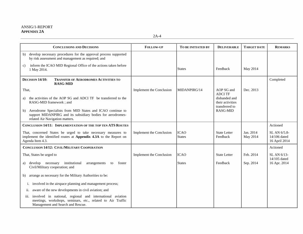
ANSIG/1-REPORT APPENDIX 2A
2A-4
CONCLUSIONS AND DECISIONS FOLLOW-UP TO BE INITIATED BY DELIVERABLE TARGET DATE REMARKS
b) develop necessary procedures for the approval process supported by risk assessment and management as required; and
c) inform the ICAO MID Regional Office of the actions taken before 1 May 2014.
States
Feedback
May 2014
DECISION 14/10: TRANSFER OF AERODROMES ACTIVITIES TO
RASG-MID Completed
That, a) the activities of the AOP SG and ADCI TF be transferred to the
RASG-MID framework ; and b) Aerodrome Specialists from MID States and ICAO continue to
support MIDANPIRG and its subsidiary bodies for aerodromes-related Air Navigation matters.
Implement the Conclusion MIDANPIRG/14 AOP SG and ADCI TF disbanded and their activities transferred to RASG-MID
Dec. 2013
CONCLUSION 14/11: IMPLEMENTATION OF THE TOP TEN ATS ROUTES Actioned
That, concerned States be urged to take necessary measures to implement the identified routes at Appendix 4.3A to the Report on Agenda Item 4.3.
Implement the Conclusion ICAO States
State Letter Feedback
Jan. 2014 May 2014
SL AN 6/5.8-14/106 dated 16 April 2014
CONCLUSION 14/12: CIVIL/MILITARY COOPERATION Actioned
That, States be urged to a) develop necessary institutional arrangements to foster
Civil/Military cooperation; and b) arrange as necessary for the Military Authorities to be:
i. involved in the airspace planning and management process;
ii. aware of the new developments in civil aviation; and
iii. involved in national, regional and international aviation meetings, workshops, seminars, etc., related to Air Traffic Management and Search and Rescue.
Implement the Conclusion ICAO States
State Letter Feedback
Feb. 2014 Sep. 2014
SL AN 6/13-14/105 dated 16 Apr. 2014

ANSIG/1-REPORT APPENDIX 2A
2A-5
CONCLUSIONS AND DECISIONS FOLLOW-UP TO BE INITIATED BY DELIVERABLE TARGET DATE REMARKS
CONCLUSION 14/13: FLEXIBLE USE OF AIRSPACE Actioned
That, States be urged to take necessary: a) follow-up actions to implement the provisions of Recommendation
4/5 of the AN-Conf/12; and
b) measures to implement the Flexible Use of Airspace (FUA) Concept through strategic Civil/Military coordination and dynamic interaction, in order to open up segregated airspace when it is not being used for its originally-intended purpose and allow for better airspace management and access for all users.
Implement the Conclusion ICAO States
State Letter Feedback
Feb. 2014 May. 2014
SL AN 6/13-14/105 dated 16 Apr. 2014
CONCLUSION 14/14: MID CIVIL/MILITARY GO-TEAM Over taken by events
That, a) a MID Civil/Military Go-Team be established to expedite the
implementation of the Flexible Use of Airspace (FUA) Concept in the MID Region; and
b) the details related to the scope, Tasks, Pre-Go-Team Visit
arrangements, on-site activities, and outcomes of the Civil/military Go-Teams be discussed during the next ATM Sub-Group meeting.
Implement the Conclusion MIDANPIRG/14 ATM SG
Civil/Military Go-Team established Go-Team scope, scope, tasks, activities, etc.
Dec. 2013 May 2014
(To be replaced and superseded by ATM SG/1 Draft Conclusion 1/5)
CONCLUSION 14/15: MID REGION ATM CONTINGENCY PLAN Completed
That, the MID Region ATM Contingency Plan be endorsed as at Appendix 4.3B to the Report on Agenda Item 4.3.
Implement the Conclusion MIDANPIRG/14 MID Region ATM Contingency Plan
Dec. 2013
DECISION 14/16: SEARCH AND RESCUE COOPERATION Actioned
That, the ATM Sub-Group develops a simplified MID Region Model of SAR Agreement/Bilateral Arrangements to foster the implementation of Annex 12 provisions related to SAR cooperation in a step-wise approach.
Implement the Conclusion ATM SG SAR Agreement/ Bilateral Arrangements Template
May 2014 (MID SAR AG established through ATM SG/1 Draft Decision 1/7)

ANSIG/1-REPORT APPENDIX 2A
2A-6
CONCLUSIONS AND DECISIONS FOLLOW-UP TO BE INITIATED BY DELIVERABLE TARGET DATE REMARKS
CONCLUSION 14/17: MID REGION ATM ENHANCEMENT PROGRAMME
(MAEP) – SPECIAL COORDINATION MEETING
Completed
That, States and Users be urged to provide the ICAO MID Regional Office with their proposals related to MAEP by 25 January 2014, for presentation to the MAEP-SCM scheduled for 18-20 February 2014.
Implement the Conclusion ICAO States/Users
State Letter Proposals related to MAEP
Jan. 2014 Feb. 2014
Meeting held on 18-20 Feb. 2014
CONCLUSION 14/18: NATIONAL AIS/AIM REGULATIONS Completed
That, States be urged to: a) include in the national plans for the transition from AIS to AIM
actions related to the amendment of national AIS/AIM regulations as a consequence to the Amendment of Annex 4, Annex 15 and other AIM developments;
b) take necessary action for a timely amendment of the national
AIS/AIM regulations as a consequence to Amendment 37 to Annex 15; and
c) inform the ICAO MID Regional Office of the actions taken before
1 March 2014.
Implement the Conclusion ICAO States
State Letter Feedback
Feb. 2014 Mar. 2014
SL AN 8/4-14/055 dated 20 Feb. 2014 Six (6) States replied
CONCLUSION 14/19: NATIONAL PLANS FOR THE TRANSITION FROM
AIS TO AIM Completed
That, in order to keep pace with the AIM/SWIM developments and support seamless ATM in a SWIM environment, States be urged to: a) develop/update their national plans for the transition from AIS to
AIM; and b) provide the ICAO MID Regional Office with an updated version of
their national plans for the transition from AIS to AIM, before 1 March 2014.
Implement the Conclusion ICAO States
State Letter Feedback
Feb. 2014 Mar. 2014
SL AN 8/4-14/055 dated 20 Feb. 2014 Six (6) States replied. (Replaced and superseded by MSG Conc. 4/17)

ANSIG/1-REPORT APPENDIX 2A
2A-7
CONCLUSIONS AND DECISIONS FOLLOW-UP TO BE INITIATED BY DELIVERABLE TARGET DATE REMARKS
DECISION 14/20: MIDAD SUPPORT TEAM Completed
That, the MIDAD Support Team (MIDAD ST)
a) be composed of members from Jordan, Iran, Kuwait and the ICAO MID Regional Office; and
b) provide necessary support to Bahrain, Qatar, Saudi Arabia and UAE as well as to the MIDAD Study Group to successfully complete Phase 2 of the MIDAD Project.
MIDAD ST to provide necessary support
MIDANPIRG/14 MIDAD ST composition
Dec.2013
DECISION 14/21: ESTABLISHMENT OF MID-AMC STEERING
GROUP Completed
That, a) a MID-AMC Steering Group is established with TOR as at
Appendix 4.5A to the Report on Agenda Item 4.5; and
b) States appoint a Member and Alternate for the MID-AMC Steering Group.
Implement the work programme of the MID-AMC STG
MIDANPIRG/14 MID-AMC STG established
Dec. 2013 SL AN 7/5.1-14/084 dated 16 April 2014
CONCLUSION 14/22: MID-AMC OPERATION Actioned
That, a) States be urged to:
i. provide their AFTN/AMHS/CIDIN Routing tables to MID-AMC by 30 March 2014;
ii. register users to MID-AMC according to the accreditation procedure defined at Appendix 4.5B to the report on Agenda Item 4.5;
iii. complete testing of all MID-AMC functions by 30 June 2014; and
b) the operation date of the MID-AMC be determined by the MID-AMC Steering Group.
Implement the Conclusion ICAO States States MID-AMC STG
State Letter Routing Tables Testing/ feedback Operation date
Jan. 2014 Mar. 2014 Jun. 2014 Jun. 2014
SL AN 7/5.1-14/084 dated 16 April 2014 Reference MSG Conclusion 4/9) Training for MIDAMC conducted in Amman, Jan.2015

ANSIG/1-REPORT APPENDIX 2A
2A-8
CONCLUSIONS AND DECISIONS FOLLOW-UP TO BE INITIATED BY DELIVERABLE TARGET DATE REMARKS
CONCLUSION 14/23: MID AIDC/OLDI IMPLEMENTATION SEMINAR Completed
That States, a) support ICAO in organising a Seminar on implementation of
AIDC/OLDI;
b) participate actively in the Seminar; and
c) with the support of ICAO develop the MID AIDC/OLDI Implementation Plan.
Convene the Seminar ICAO Seminar Mar. 2014
DECISION 14/24: DEVELOPMENT AND ENDORSEMENT OF THE
MID eANP Completed
That, in support to the ICAO efforts to align the regional Air Navigation Plans (ANP) with the Fourth Edition of the Global Air Navigation Plan (GANP) (Doc 9750):
a) the development of the MID eANP based on the Council-approved ANP Template, be included in the work programme of the different MIDANPIRG subsidiary bodies; and
b) the relevant Parts of the MID eANP be presented, as soon as available, to MSG/4 and/or MIDANPIRG/15 for endorsement.
Implement the Conclusion MIDANPIRG subsidiary bodies MSG/4 and MIDANPIRG/15
MID eANP Parts
TBD Sep 2014 May 2015
(Replaced and superseded by MSG Conclusion 4/4)
CONCLUSION 14/25: INFPL POST IMPLEMENTATION-SYSTEM
UPGRADES Actioned
That, concerned States be urged to upgrade their systems to ensure the full handling of the ICAO New Flight Plan format before 30 June 2015.
Implement the Conclusion ICAO States
State Letter Feedback
Jan. 2014 Jun. 2015
SL AN 6/2B-14/122 dated 4 May 2014 (Refer also to CNS SG/6 Draft Conclusion 6/10) and SL AN 6/2B – 15/039 dated 3 February 2015
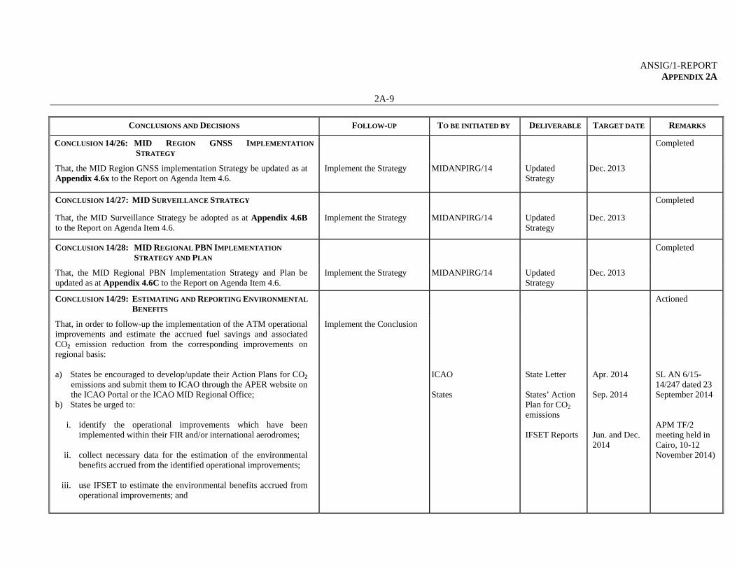
ANSIG/1-REPORT APPENDIX 2A
2A-9
CONCLUSIONS AND DECISIONS FOLLOW-UP TO BE INITIATED BY DELIVERABLE TARGET DATE REMARKS
CONCLUSION 14/26: MID REGION GNSS IMPLEMENTATION
STRATEGY Completed
That, the MID Region GNSS implementation Strategy be updated as at Appendix 4.6x to the Report on Agenda Item 4.6.
Implement the Strategy MIDANPIRG/14 Updated Strategy
Dec. 2013
CONCLUSION 14/27: MID SURVEILLANCE STRATEGY Completed
That, the MID Surveillance Strategy be adopted as at Appendix 4.6B to the Report on Agenda Item 4.6.
Implement the Strategy MIDANPIRG/14 Updated Strategy
Dec. 2013
CONCLUSION 14/28: MID REGIONAL PBN IMPLEMENTATION
STRATEGY AND PLAN Completed
That, the MID Regional PBN Implementation Strategy and Plan be updated as at Appendix 4.6C to the Report on Agenda Item 4.6.
Implement the Strategy MIDANPIRG/14 Updated Strategy
Dec. 2013
CONCLUSION 14/29: ESTIMATING AND REPORTING ENVIRONMENTAL
BENEFITS Actioned
That, in order to follow-up the implementation of the ATM operational improvements and estimate the accrued fuel savings and associated CO2 emission reduction from the corresponding improvements on regional basis: a) States be encouraged to develop/update their Action Plans for CO2
emissions and submit them to ICAO through the APER website on the ICAO Portal or the ICAO MID Regional Office;
b) States be urged to:
i. identify the operational improvements which have been implemented within their FIR and/or international aerodromes;
ii. collect necessary data for the estimation of the environmental
benefits accrued from the identified operational improvements;
iii. use IFSET to estimate the environmental benefits accrued from operational improvements; and
Implement the Conclusion ICAO States
State Letter States’ Action Plan for CO2 emissions IFSET Reports
Apr. 2014 Sep. 2014 Jun. and Dec. 2014
SL AN 6/15-14/247 dated 23 September 2014 APM TF/2 meeting held in Cairo, 10-12 November 2014)

ANSIG/1-REPORT APPENDIX 2A
2A-10
CONCLUSIONS AND DECISIONS FOLLOW-UP TO BE INITIATED BY DELIVERABLE TARGET DATE REMARKS
iv. send the IFSET reports/the accrued environmental benefits to ICAO on bi-annual basis; and
c) IATA to:
i) encourage users to support the APM TF in the development of
the MID Region Air Navigation Environmental Reports; and
ii) consolidate users’ inputs and report the accrued environmental benefits to the ICAO MID Regional Office on bi-annual basis.
IATA
Inputs from users
Jun. and Dec. 2014
CONCLUSION 14/30: ESTABLISHMENT OF MID REGIONAL OPMET
CENTRE Actioned
That, a) Saudi Arabia in coordination with ICAO establish a MID Regional
OPMET Centre (ROC) by the first half of 2015 to improve the regional and inter-regional OPMET efficiency;
b) Bahrain in coordination with ICAO establish a back-up Regional
OPMET Centre (ROC); and c) MID States be encouraged to continue cooperation in the exchange
of OPMET data in the MID Region.
Implement the Conclusion Saudi Arabia in coordination with ICAO Bahrain in coordination with ICAO
Establishment of MID ROC
Establishment of back-up MID ROC
Jun. 2015
Jun. 2015
Implementation plan for the establishment of ROC endorsed by MSG/4.
DECISION 14/31: UPDATE TO BULLETIN MANAGEMENT GROUP
TERMS OF REFERENCE Completed
That, the Terms of Reference and future work programme of the Bulletin Management Group of the MET Sub-Group be updated as at Appendix 4.7A to the Report on Agenda Item 4.7.
Implement the Work Programme of the BMG
MIDANPIRG/14 BMG TOR Dec. 2013
CONCLUSION 14/32: ELIMINATION OF AIR NAVIGATION DEFICIENCIES
IN THE MID REGION Actioned
That, States be urged to: a) use the MID Air Navigation Deficiency Database (MANDD) for
the submission of requests for addition, update, and elimination of Air Navigation Deficiencies; and
Implement the Conclusion ICAO
State Letter
Mar. 2014
SL 2/2-14/109 dated 17 Apr. 2014 SL AN 2/2 -

ANSIG/1-REPORT APPENDIX 2A
2A-11
CONCLUSIONS AND DECISIONS FOLLOW-UP TO BE INITIATED BY DELIVERABLE TARGET DATE REMARKS
b) submit a Formal Letter to the ICAO MID Regional Office containing the evidence(s) that mitigation measures have been implemented for the elimination of deficiency(ies) when requesting the elimination of deficiency(ies) from the MANDD.
States CAP and necessary updates/ evidences
When necessary
15/035 dated 2 Feb. 2015
CONCLUSION 14/33: TRAINING ON RVSM SAFETY ASSESSMENT Ongoing
That, with a view to raise the awareness related to the requirements for sustained RVSM safety assessment activity and improve the knowledge of the ATC, RVSM approval Authority and Air Operators personnel, the MIDRMA include in its work programme training activity/briefings on RVSM safety assessment requirements to be provided to concerned personnel either through missions to concerned States or through familiarization visits organized in the MIDRMA premises, when and where appropriate.
Implement the Conclusion MIDRMA
Training on RVSM Safety Assessment
2014-2015
DECISION 14/34: SCRUTINY GROUP WORK PROGRAMME Completed
That, in order to improve the efficiency of the MID RVSM Scrutiny Group, its work programme be included in the agenda of the MIDRMA Board meetings.
Implement the Decision MIDANPIRG/14 Scrutiny Group work programme included in the Agenda of MIDRMA Board meetings
Dec. 2013
CONCLUSION 14/35: PROVISION OF REQUIRED DATA TO THE
MIDRMA Actioned
That, considering the on-going requirement for RVSM safety monitoring in the MID Region:
a) States provide the required data to the MIDRMA on a regular basis and in a timely manner. The data is to include, but is not necessarily limited to:
i) approval of operators and aircraft for RVSM operations (on monthly basis or whenever there’s a change);
ii) Large Height Deviations (LHD) (on monthly basis);
Implement the Conclusion States
Provision of necessary data to the MIDRMA
When necessary (as required)
AN 6/5.10.15A 14/007 dated 9 January 2014

ANSIG/1-REPORT APPENDIX 2A
2A-12
CONCLUSIONS AND DECISIONS FOLLOW-UP TO BE INITIATED BY DELIVERABLE TARGET DATE REMARKS
iii) traffic data (as requested by the MIDRMA Board);
iv) radar data as, when and where required; and
v) airway structure (above FL 290) and waypoints.
b) States not providing the required data to the MIDRMA on a regular basis and in a timely manner:
i) be included in the MIDANPIRG list of air navigation deficiencies; and
ii) might not be covered by the MID RVSM Safety Monitoring Report (SMR).
CONCLUSION 14/36: RVSM MINIMUM MONITORING REQUIREMENTS Completed
That, States that have not yet done so, be urged to: a) take necessary measures to ensure that their aircraft operators fully
comply with Annex 6 provisions related to long term height monitoring requirements, based on the MIDRMA MMR Tables; and
b) provide feedback to the ICAO MID Regional Office before 1 March 2014.
Implement the Conclusion ICAO Concerned States
State Letter Action and Feedback
Jan. 2014 Mar. 2014
AN 6/5.10.15A 14/005 and 14/006 dated 9 January 2014
CONCLUSION 14/37: ARRANGEMENTS FOR THE CONDUCT OF GMU
MONITORING MISSIONS Actioned
That, prior to the conduct of any GMU monitoring mission: a) the MIDRMA notify the concerned MIDRMA Board Member; and b) the MIDRMA Board member is to undertake necessary
arrangements at the national level with concerned authorities (CAA, Customs, Security, etc.) to facilitate the MIDRMA Team mission.
Implement the Conclusion MIDRMA States
Notification Necessary arrangements/ support
When planning a GMU mission
AN 6/5.10.15A-13/240 dated 13 September 2013

ANSIG/1-REPORT APPENDIX 2A
2A-13
CONCLUSIONS AND DECISIONS FOLLOW-UP TO BE INITIATED BY DELIVERABLE TARGET DATE REMARKS
CONCLUSION 14/38: MID RVSM SMR 2014 Actioned
That,
a) the FPL/traffic data for the period 15 January – 15 February 2014 be used for the development of the MID RVSM Safety Monitoring Report (SMR 2014);
b) only the appropriate Flight Data form available on the MIDRMA website (www.midrma.com) should be used for the provision of FPL/traffic data to the MIDRMA;
c) the initial results of the MID RVSM SMR 2014 be ready before 15/05/2014; and
d) the final version of the MID RVSM SMR 2014 be ready for presentation to and endorsement by MIDANPIRG/15.
Implement the Conclusion ICAO States MIDRMA
State Letter FPL/traffic data MID RVSM SMR 2014
Jan. 2015 Mar. 2014 May 2015
AN 6/5.10.15A 14/007 dated 9 January 2014
--------------------

ANSIG/1-REPORT APPENDIX 2B
APPENDIX 2B
FOLLOW-UP ACTION PLAN ON MSG/4 CONCLUSIONS AND DECISIONS
CONCLUSIONS AND DECISIONS FOLLOW-UP TO BE INITIATED BY DELIVERABLE TARGET DATE REMARKS
MSG CONCLUSION 4/1: GLOBAL AIR NAVIGATION PLAN (DOC (9750)
REVIEW AND UPDATE Completed
That, States and air navigation stakeholders in the MID Region be urged to: a) review and provide inputs to the questionnaire at Appendix 3A; and
b) provide feedback on the use of the fourth edition of the
GANP and its possible improvement before 15 January 2015.
Implement the Conclusion ICAO States
State Letter Feedback
Dec 2014 15 January 2015
SL AN 1/5-14/339 dated 23 Dec. 2014
MSG CONCLUSION 4/2: MID REGION CONTINGENCY PLAN Completed
That, the MID Region ATM Contingency Plan (Edition November 2014) is endorsed as a Regional Document to be available on the ICAO MID website.
Implement the Conclusion MSG/4 MID Region ATM Contingency Plan
Nov. 2014
MSG CONCLUSION 4/3: MID REGION AIR NAVIGATION STRATEGY Actioned
That, a) the MID Air Navigation Strategy at Appendix 4B is endorsed as the
framework identifying the regional air navigation priorities, performance indicators and targets; and
b) MID States be urged to:
i. develop their National Air Navigation Performance Framework, ensuring the alignment with and support to the MID Region Air Navigation Strategy; and
ii. provide the ICAO MID Regional Office, on annual basis (by end of November), with relevant data necessary for regional air navigation planning and monitoring.
Implement the Conclusion
MSG/4 ICAO States States
AN Strategy State Letter National Plans Feedback
Nov. 2014 Jan. 15 On annual basis (Nov.)
SL AN 1/7 - 15/035 dated 2 Feb. 2015

ANSIG/1-REPORT APPENDIX 2B
2B-2
CONCLUSIONS AND DECISIONS FOLLOW-UP TO BE INITIATED BY DELIVERABLE TARGET DATE REMARKS
MSG CONCLUSION 4/4: DEVELOPMENT OF THE MID eANP Completed
That, a) the ANP WG/2 finalize the MID eANP for endorsement by
MIDANPIRG/15; and b) States be urged to review the MID eANP Volumes I, II and III
available on the ICAO MID website, and provide updates/inputs to the ANP WG/2 meeting.
Implement the Conclusion ANP WG/2 States
Draft MID eANP VOL I, II and III
Dec 2014 Dec 2014
(Refer to ANP WG/2 Draft Conclusion 2/1)
MSG CONCLUSION 4/5: MAEP ESTABLISHMENT Ongoing
That, MAEP be established as an ICAO TCB project with a Project Management Office (PMO) hosted by the ICAO MID Regional Office.
Implement the Conclusion MSG/4 MAEP establishment
Nov. 2014
MSG DECISION 4/6: MAEP STEERING COMMITTEE (MSC) Completed
That, the MAEP Steering Committee (MSC) is established with Terms of Reference as at Appendix 4C.
Implement the Conclusion MSG/4 MAEP SC establishment
Nov. 2014
MSG CONCLUSION 4/7: MAEP FUNDING MECHANISM Completed
That, a) the running cost of the MAEP PMO be ensured through
contributions from all MAEP Member States; b) the annual amounts to be paid by the MAEP Member States are, as
follows:
i. Bahrain, Iran, Oman, Qatar, Saudi Arabia and UAE annual contribution is US$ 30,000 each;
ii. Egypt, Iraq, Kuwait and Libya annual contribution is US$ 20,000
each; and
iii. Jordan, Lebanon, Sudan, Syria and Yemen annual contribution is US$ 10,000 each.
Implement the Conclusion MSG/4 MAEP Funding Mechanism
Nov. 2014

ANSIG/1-REPORT APPENDIX 2B
2B-3
CONCLUSIONS AND DECISIONS FOLLOW-UP TO BE INITIATED BY DELIVERABLE TARGET DATE REMARKS
c) the funding of the projects/working packages:
i. be addressed by the Board, on case-by-case basis; and ii. be ensured through contribution (cash or in-kind) by concerned
States, stakeholders and sponsors/donors. d) the MAEP funding mechanism be revised by the MAEP Board,
when necessary.
MSG CONCLUSION 4/8: REGIONAL IFPS STUDY Actioned
That, States be urged to provide the Flight Plan Data/Difficulties to the ICAO MID Regional Office before 31 December 2014, in order for Bahrain to carry out further analyses for the Region, necessary for the IFPS project.
Implement the Conclusion ICAO States
State Letter Dec 2014 SL AN 8/4.2.1-14/344
MSG CONCLUSION 4/9: LAUNCHING OF THE MID-AMC SERVICE Completed
That, a) States, that have not yet done so, be urged to assign their
MIDAMC STG members before 30 December 2014; and b) the first AIRAC date following the training of the MID States
key users (5 February 2015) be officially declared as the date of operation of the MIDAMC application.
Implement the Conclusion ICAO States
State Letter Dec 2014 SL AN 7/5.1-15/041 dated 4 Feb 2015
MSG CONCLUSION 4/10: MID REGION PBN IMPLEMENTATION PLAN Completed
That, the endorsed MID Region PBN Implementation Plan (Version 1, November 2014) be posted on the ICAO MID website.
Implement the Conclusion MSG/4 MID Region PBN Implementation Plan
Nov. 2014

ANSIG/1-REPORT APPENDIX 2B
2B-4
CONCLUSIONS AND DECISIONS FOLLOW-UP TO BE INITIATED BY DELIVERABLE TARGET DATE REMARKS
MSG CONCLUSION 4/11: STATES PBN IMPLEMENTATION PLANS Actioned
That, States be urged to: a) develop/update their PBN implementation Plan taking into
consideration the MID Region PBN Implementation Plan, the MID Air Navigation Strategy and the Users requirements; and
b) provide the ICAO MID Regional Office with their updated PBN
Implementation Plan on an annual basis (by end of December).
Implement the Conclusion ICAO States
State Letter Feedback
Dec. 2014 25 January 2015 thereafter on annual basis (by end of December)
SL AN 6/28-14/334 dated 21 Dec. 2014
MSG CONCLUSION 4/12: STRATEGY FOR IMPLEMENTATION OF
AIDC/OLDI Completed
That, the endorsed MID Region Strategy for the implementation of AIDC/OLDI (Version 1, November 2014) be posted on the ICAO MID website.
Implement the Conclusion MSG/4 Strategy for Implementation of AIDC/OLDI
Nov. 2014
MSG CONCLUSION 4/13: REGIONAL ICD FOR AIDC Completed
That, the PAN Regional ICD for AIDC version 1.0 endorsed as the official ICD for use in the MID Region be posted on the ICAO MID website.
Implement the Conclusion MSG/4 Regional ICD for AIDC
Nov. 2014
MSG CONCLUSION 4/14: MID REGION PROCESS FOR MODE S IC
CODES ALLOCATION Completed
That, the endorsed MID Region process for Mode S IC codes allocation be posted on the ICAO MID website.
Implement the Conclusion MSG/4 MID Region Process for Mode S IC Codes Allocation
Nov. 2014
MSG CONCLUSION 4/15: ADS-B PLANNING AND IMPLEMENTATION Actioned
That, recognizing the importance of ADS-B technology, States be encouraged to plan/implement ADS-B and provide the ICAO MID Regional Office with their plans/progress reports by 15 January 2015.
Implement the Conclusion ICAO States
State Letter Dec 2014 AN 8/4.2.1-14/345

ANSIG/1-REPORT APPENDIX 2B
2B-5
CONCLUSIONS AND DECISIONS FOLLOW-UP TO BE INITIATED BY DELIVERABLE TARGET DATE REMARKS
MSG CONCLUSION 4/16: DRAFT METHODOLOGY FOR REPORTING
AND ASSESSING THE PROGRESS RELATED TO
THE TRANSITION FROM AIS TO AIM
Ongoing
That, States be urged to provide the ICAO MID Regional Office with their comments/inputs related to the “Methodology for reporting and assessing the progress related to the transition from AIS to AIM” and the Finalization/Compliance Criteria, at Appendices 4I and 4J, respectively.
Implement the Conclusion ICAO States
State Letter Feedback
TBD
MSG CONCLUSION 4/17: NATIONAL AIM IMPLEMENTATION
ROADMAP Actioned
That, States: a) be invited to take into consideration the “MID Region
AIM implementation Roadmap” at Appendix 4L in planning for the transition from AIS to AIM in a prioritized manner; and
b) that have not yet done so, be urged to provide the ICAO
MID Regional Office with their National AIM Implementation Roadmap using the Template at Appendix 4K, before 1 March 2015.
Implement the Conclusion ICAO States
State Letter Feedback
Mar 2015 ME 3/1-15/034 dated 1 Feb 2015
MSG CONCLUSION 4/18: MIDAD FOCAL POINTS Actioned
That, for an improved coordination between all Stakeholders related to the MIDAD Project, States that have not yet done so, be urged to designate MIDAD Focal Points (FPPs) before 31 December 2014.
Implement the Conclusion ICAO States
State Letter Feedback
Dec 2014 AN 8/4.2.1-14/341 dated 24 Dec 2014
MSG DECISION 4/19: TERMS OF REFERENCE OF THE MIDAD
TASK FORCE Completed
That, the Terms of Reference of the MIDAD Task Force be updated as at Appendix 4O.
Implement the work programme of the MIDAD TF
MSG/4 TOR of the MIDAD TF endorsement
Nov 2014
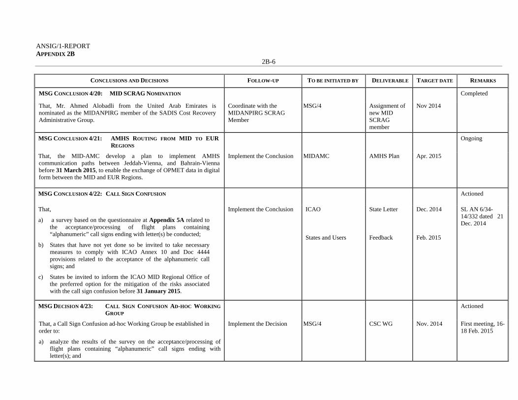
ANSIG/1-REPORT APPENDIX 2B
2B-6
CONCLUSIONS AND DECISIONS FOLLOW-UP TO BE INITIATED BY DELIVERABLE TARGET DATE REMARKS
MSG CONCLUSION 4/20: MID SCRAG NOMINATION Completed
That, Mr. Ahmed Alobadli from the United Arab Emirates is nominated as the MIDANPIRG member of the SADIS Cost Recovery Administrative Group.
Coordinate with the MIDANPIRG SCRAG Member
MSG/4 Assignment of new MID SCRAG member
Nov 2014
MSG CONCLUSION 4/21: AMHS ROUTING FROM MID TO EUR
REGIONS Ongoing
That, the MID-AMC develop a plan to implement AMHS communication paths between Jeddah-Vienna, and Bahrain-Vienna before 31 March 2015, to enable the exchange of OPMET data in digital form between the MID and EUR Regions.
Implement the Conclusion MIDAMC AMHS Plan Apr. 2015
MSG CONCLUSION 4/22: CALL SIGN CONFUSION Actioned
That,
a) a survey based on the questionnaire at Appendix 5A related to the acceptance/processing of flight plans containing “alphanumeric” call signs ending with letter(s) be conducted;
b) States that have not yet done so be invited to take necessary measures to comply with ICAO Annex 10 and Doc 4444 provisions related to the acceptance of the alphanumeric call signs; and
c) States be invited to inform the ICAO MID Regional Office of the preferred option for the mitigation of the risks associated with the call sign confusion before 31 January 2015.
Implement the Conclusion ICAO States and Users
State Letter Feedback
Dec. 2014 Feb. 2015
SL AN 6/34-14/332 dated 21 Dec. 2014
MSG DECISION 4/23: CALL SIGN CONFUSION AD-HOC WORKING
GROUP Actioned
That, a Call Sign Confusion ad-hoc Working Group be established in order to:
a) analyze the results of the survey on the acceptance/processing of flight plans containing “alphanumeric” call signs ending with letter(s); and
Implement the Decision MSG/4 CSC WG Nov. 2014 First meeting, 16-18 Feb. 2015

ANSIG/1-REPORT APPENDIX 2B
2B-7
CONCLUSIONS AND DECISIONS FOLLOW-UP TO BE INITIATED BY DELIVERABLE TARGET DATE REMARKS
b) develop solutions to mitigate the risk associated with call sign
confusion and similarity.
DRAFT CONCLUSION 4/1: AVIATION STATISTICS AND TRAFFIC
FORECASTS Pending
MIDANPIRG endorsement
That, a) States be urged to:
i. nominate Focal Points for aviation statistics;
ii. provide the statistics required by ICAO in a timely manner and to the extent possible in an electronic format
b) ICAO organise a Second Aviation Data Analyses Seminar in 2016 to
keep the momentum and further enhance the technical knowledge of States.
Implement the Conclusion ICAO States ICAO
State Letter Focal Point Seminar
Aug. 2015
DRAFT DECISION 4/2: AIR TRAFFIC FLOW MANAGEMENT Pending MIDANPIRG endorsement
That, the ATM Sub-Group develop a Draft Project Proposal addressing the necessity, feasibility, cost benefit analysis and timelines related to the eventual implementation of a regional/sub-regional ATFM system, to the MSC/2 meeting for consideration.
Implement the Conclusion ATM SG/2 meeting ATFM Draft Project Proposal
Dec. 2015
DRAFT CONCLUSION 4/3: DRAFT MID REGION HIGH LEVEL
AIRSPACE CONCEPT Actioned
That, States be urged to provide the ICAO MID Regional Office with their comments related to the Draft MID Region High Level Airspace Concept, at Appendix 4E, by 1 March 2015, in order to present the final version to MIDANPIRG/15 for endorsement.
Implement the Conclusion ICAO States and Users
State Letter Feedback
Dec. 2014 1 March 2015
SL AN 6/35-14/333 dated 21 Dec. 2014

ANSIG/1-REPORT APPENDIX 2B
2B-8
CONCLUSIONS AND DECISIONS FOLLOW-UP TO BE INITIATED BY DELIVERABLE TARGET DATE REMARKS
DRAFT DECISION 4/4: REVISED TORS OF THE MSG, CNS SG AND
PBN SG Ongoing
That, the MIDANPIRG Procedural Handbook be updated to include the revised version of the MSG, CNS SG and PBN SG Terms of Reference (TORs) at Appendices 7A, 7B and 7C, respectively.
Implement the Decision MIDANPIRG/15 Eighth edition of MIDANPIRG Procedural Handbook
Jun..2015
------------------

M
MID Region Air N
VerNovem
Navigation Strat
INTE
MA
rsion 1 mber, 2014
tegy
ERNATIO
MIDDLE AND IMP
AI
ONAL CIV
EAST AIPLEMENT
(M
M
IR NAVIG
VIL AVIA
IR NAVIGTATION R
MIDANPIR
MID REGI
GATION
ATION OR
GATION PREGIONARG)
ION
STRATE
RGANIZA
PLANNINAL GROU
EGY
Nove
ATION
NG UP
ANSIG A
ember 2014
G/1-REPORTAPPENDIX 3A
T A

MID Region Air Navigation Strategy November 2014
The designations employed and the presentation of material in this publication do not imply the expression of any opinion whatsoever on the part of ICAO concerning the legal status of any country, territory, city or area or of its authorities, or concerning the delimitation of its frontier or boundaries.

MID Region Air Navigation Strategy November 2014
TABLE OF CONTENTS 1. Introduction ....................................................................................................... 1 2. Strategic Air Navigation Capacity and Efficiency Objective ............................ 1 3. MID Air Navigation Objectives ........................................................................ 1
Near Term Objectives ............................................................................... 1
MID Term Objectives ............................................................................... 2
Long Term Objectives .............................................................................. 2 4. MID Region ASBU Modules prioritization ...................................................... 2 5. Measuring and monitoring air navigation performance .................................... 3 6. Governance ....................................................................................................... 4

MID Region Air Navigation Strategy - 1 - November 2014
MID REGION AIR NAVIGATION STRATEGY 1. Introduction
1.1 As traffic volume increases throughout the world, the demands on air navigation service providers in a given airspace increase, and air traffic management becomes more complex. 1.2 It is foreseen that the implementation of the components of the ATM operational concept will provide sufficient capacity to meet the growing demand, generating additional benefits in terms of more efficient flights and higher levels of safety. Nevertheless, the potential of new technologies to significantly reduce the cost of services will require the establishment of clear operational requirements.
1.3 Taking into account the benefits of the ATM operational concept, it is necessary to make many timely decisions for its implementation. An unprecedented cooperation and harmonization will be required at both global and regional level.
1.4 ICAO introduced the Aviation System Block Upgrades (ASBU) methodology as a systemic manner to achieve a harmonized implementation of the air navigation services. An ASBU designates a set of improvements that can be implemented globally from a defined point in time to enhance the performance of the ATM system.
1.5 Through Recommendation 6/1 - Regional performance framework – planning methodologies and tools, AN-Conf/12 urged States and PIRGs to harmonize the regional and national air navigation plans with the ASBU methodology in response to this, the MID region is developing MID Region Air Navigation Strategy that is aligned with the ASBU methodology.
1.6 Stakeholders including service providers, regulators, airspace users and manufacturers are facing increased levels of interaction as new, modernized ATM operations are implemented. The highly integrated nature of capabilities covered by the block upgrades requires a significant level of coordination and cooperation among all stakeholders. Working together is essential for achieving global harmonization and interoperability.
2. Strategic Air Navigation Capacity and Efficiency Objective
2.1 To realize sound and economically-viable civil aviation system in the MID Region that continuously increases in capacity and improves in efficiency with enhanced safety while minimizing the adverse environmental effects of civil aviation activities. 3. MID Air Navigation Objectives
3.1 The MID Region air navigation objectives are set in line with the global air navigation objectives and address specific air navigation operational improvements identified within the framework of the Middle East Regional Planning and Implementation Group (MIDANPIRG). Near-term Objective (2013 - 2018): ASBU Block 0 3.2 Block ‘0’ features Modules characterized by operational improvements which have already been developed and implemented in many parts of the world today. It therefore has a near-term implementation period of 2013–2018. The MID Region near-term priorities are based on the implementation of an agreed set of Block 0 Modules as reflected in Table 1 below. 3.3 The MID Region Air Navigation Strategy is aimed to maintain regional harmonisation. The States should develop their national performance framework, including action plans for the implementation of relevant priority 1 ASBU Modules and other modules according to the State operational requirements.

MID Region Air Navigation Strategy - 2 - November 2014
Mid-term Objective (2018 - 2023): ASBU Block 1 3.4 Blocks 1 through 3 are characterized by both existing and projected performance area solutions, with availability milestones beginning in 2018, 2023 and 2028, respectively. Associated timescales are intended to depict the initial deployment targets along with the readiness of all components needed for deployment. Long-term Objective (2023 - 2028): ASBU Block 2 3.5 The Block Upgrades incorporate a long-term perspective matching that of the three companion ICAO Air Navigation planning documents. They coordinate clear aircraft- and ground-based operational objectives together with the avionics, data link and ATM system requirements needed to achieve them. The overall strategy serves to provide industry wide transparency and essential investment certainty for operators, equipment manufacturers and ANSPs. 4. MID Region ASBU Block 0 Modules Prioritization and Monitoring
4.1 On the basis of operational requirements and taking into consideration the associated benefits, Table 1 below shows the priority for implementation of the 18 Block “0” Modules, as well as the MIDANPIRG subsidiary bodies that will be monitoring and supporting the implementation of the Modules: Table 1. MID REGION ASBU BLOCK 0 MODULES PRIORITIZATION AND MONITORING
Module Code Module Title Priority Monitoring Remarks
Main Supporting Performance Improvement Areas (PIA) 1: Airport Operations
B0-APTA Optimization of Approach Procedures including vertical guidance
1 PBN SG
ATM SG, AIM SG, CNS SG
B0-WAKE
Increased Runway Throughput through Optimized Wake Turbulence Separation
2
B0-RSEQ Improve Traffic flow through Runway Sequencing (AMAN/DMAN)
2
B0-SURF Safety and Efficiency of Surface Operations (A-SMGCS Level 1-2)
1 ANSIG CNS SG Coordination with RGS WG
B0-ACDM Improved Airport Operations through Airport-CDM
1 ANSIG CNS SG, AIM SG, ATM SG
Coordination with RGS WG
Performance Improvement Areas (PIA) 2 Globally Interoperable Systems and Data Through Globally Interoperable System Wide Information Management
B0-FICE
Increased Interoperability, Efficiency and Capacity through Ground-Ground Integration
1 CNS SG ATM SG
B0-DATM Service Improvement through Digital Aeronautical Information Management
1 AIM SG -
B0-AMET
Meteorological information supporting enhanced operational efficiency and safety
1 MET SG -

MID Region Air Navigation Strategy - 3 - November 2014
Priority 1: Modules that have the highest contribution to the improvement of air navigation safety and/or efficiency in the MID Region. These modules should be implemented where applicable and will be used for the purpose of regional air navigation monitoring and reporting for the period 2013-2014. Priority 2: Modules recommended for implementation based on identified operational needs and benefits. 5. Measuring and monitoring air navigation performance
5.1 The monitoring of air navigation performance and its enhancement is achieved through identification of relevant air navigation Metrics and Indicators as well as the adoption and attainment of air navigation system Targets. 5.2 MIDANPIRG through its activities under the various subsidary bodies will continue to update and monitor the implementation of the ASBU Modules to achieve the air navigation targets.
5.3 The priority 1 Modules along with the associated elements, applicability, performance Indicators, supporting Metrics, and performance Targets are shown in the Table 2 below.
Note: The different elements supporting the implementation are explained in detail in the ASBU Document which is attached to the Global Plan (Doc 9750).
Performance Improvement Areas (PIA) 3 Optimum Capacity and Flexible Flights – Through Global Collaborative ATM
B0-FRTO Improved Operations through Enhanced En-Route Trajectories
1 ATM SG
B0-NOPS Improved Flow Performance through Planning based on a Network-Wide view
1
B0-ASUR Initial capability for ground surveillance 2
B0-ASEP Air Traffic Situational Awareness (ATSA)
2
B0-OPFL
Improved access to optimum flight levels through climb/descent procedures using ADS-B
2
B0-ACAS ACAS Improvements 1 CNS SG
B0-SNET Increased Effectiveness of Ground-Based Safety Nets 2
Performance Improvement Areas (PIA) 4 Efficient Flight Path – Through Trajectory-based Operations
B0-CDO Improved Flexibility and Efficiency in Descent Profiles (CDO)
1 PBN SG
B0-TBO
Improved Safety and Efficiency through the initial application of Data Link En-Route
1 ATM SG CNS SG
B0-CCO
Improved Flexibility and Efficiency Departure Profiles - Continuous Climb Operations (CCO)
1 PBN SG

MID Region Air Navigation Strategy - 4 - November 2014
6. Governance
6.1 Progress report on the status of implementation of the different priority 1 Modules should be developed by the Air Navigation System Implemenation Group (ANSIG) and presented to the MIDANPIRG Steering Group (MSG) and/or MIDANPIRG on regular basis. 6.2 The MIDANPIRG and its Steering Group (MSG) will be the governing body responsible for the review and update of the MID Region Air Navigation Strategy.
6.3 The MID Region Air Navigation Strategy will guide the work of MIDANPIRG and its subsidary bodies and all its member States and partners.
6.4 Progress on the implementation of the MID Region Air Navigation Strategy and the achievement of the agreed air navigation targets will be reported to the ICAO Air Navigation Commission (ANC), through the review of the MIDANPIRG reports; and to the stakeholders in the Region within the framework of MIDANPIRG.
--------------------

MID Region Air Navigation Strategy November 2014
Table 2. MONITORING THE IMPLEMENTATION OF THE ASBU BLOCK 0 MODULES IN THE MID REGION
B0 – APTA: Optimization of Approach Procedures including vertical guidance Description and purpose The use of performance-based navigation (PBN) and ground-based augmentation system (GBAS) landing system (GLS) procedures will enhance the reliability and predictability of approaches to runways, thus increasing safety, accessibility and efficiency. This is possible through the application of Basic global navigation satellite system (GNSS), Baro vertical navigation (VNAV), satellite-based augmentation system (SBAS) and GLS. The flexibility inherent in PBN approach design can be exploited to increase runway capacity. Main performance impact: KPA- 01 – Access and Equity KPA-02 – Capacity KPA-04 – Efficiency KPA-05 – Environment KPA-10 – Safety
Y Y Y Y Y Applicability consideration: This module is applicable to all instrument, and precision instrument runway ends, and to a limited extent, non-instrument runway ends. B0 – APTA: Optimization of Approach Procedures including vertical guidance
Elements Applicability Performance Indicators/Supporting Metrics Targets
States’ PBN Implementation Plans
All Indicator: % of States that provided updated PBN implementation Plan Supporting metric: Number of States that provided updated PBN implementation Plan
80 % by Dec. 2014 100% by Dec. 2015
LNAV All RWYs Ends at International Aerodromes
Indicator: % of runway ends at international aerodromes with RNAV(GNSS) Approach Procedures (LNAV) Supporting metric: Number of runway ends at international aerodromes with RNAV (GNSS) Approach Procedures (LNAV)
All runway ends at Int’l Aerodromes, either as the primary approach or as a back-up for precision approaches by Dec. 2016
LNAV/VNAV All RWYs ENDs at International Aerodromes
Indicator: % of runways ends at international aerodromes provided with Baro-VNAV approach procedures (LNAV/VNAV) Supporting metric: Number of runways ends at international aerodromes provided with Baro-VNAV approach procedures (LNAV/VNAV)
All runway ends at Int’l Aerodromes, either as the primary approach or as a back-up for precision approaches by Dec. 2017

MID Region Air Navigation Strategy November 2014
Module N° B0-SURF: Safety and Efficiency of Surface Operations (A-SMGCS Level 1-2) Description and purpose Basic A-SMGCS provides surveillance and alerting of movements of both aircraft and vehicles on the aerodrome thus improving runway/aerodrome safety. ADS-B information is used when available (ADS-B APT). Main performance impact: KPA- 01 – Access and Equity KPA-02 – Capacity KPA-04 – Efficiency KPA-05 – Environment KPA-10 – Safety
Y Y Y Y Y
Applicability consideration: A-SMGCS is applicable to any aerodrome and all classes of aircraft/vehicles. Implementation is to be based on requirements stemming from individual aerodrome operational and cost-benefit assessments. ADS-B APT, when applied is an element of A-SMGCS, is designed to be applied at aerodromes with medium traffic complexity, having up to two active runways at a time and the runway width of minimum 45 m.
B0-SURF: Safety and Efficiency of Surface Operations (A-SMGCS Level 1-2) Elements Applicability Performance Indicators/Supporting Metrics Targets
A-SMGCS Level 1* OBBI, HECA, OIII, OKBK, OOMS, OTBD, OTHH, OEDF, OEJN, OERK, OMDB, OMAA, OMDW
Indicator: % of applicable international aerodromes having implemented A-SMGCS Level 1 Supporting Metric: Number of applicable international aerodromes having implemented A-SMGCS Level 1
70% by Dec. 2017
A-SMGCS Level 2* OBBI, HECA, OIII, OKBK, OOMS, OTBD, OTHH, OEJN, OERK, OMDB, OMAA, OMDW
Indicator: % of applicable international aerodromes having implemented A-SMGCS Level 2 Supporting Metric: Number of applicable international aerodromes having implemented A-SMGCS Level 2
50% by Dec. 2017
*Reference: Eurocontrol Document – “Definition of A-SMGCS Implementation Levels, Edition 1.2, 2010”.

MID Region Air Navigation Strategy November 2014
B0 – ACDM: Improved Airport Operations through Airport-CDM
Description and purpose To implement collaborative applications that will allow the sharing of surface operations data among the different stakeholders on the airport. This will improve surface traffic management reducing delays on movement and manoeuvring areas and enhance safety, efficiency and situational awareness. Main performance impact: KPA- 01 – Access and Equity KPA-02 – Capacity KPA-04 – Efficiency KPA-05 – Environment KPA-10 – Safety
N Y Y Y N
Applicability consideration: Local for equipped/capable fleets and already established airport surface infrastructure.
B0 – ACDM: Improved Airport Operations through Airport-CDM Elements Applicability Performance Indicators/Supporting Metrics Targets A-CDM OBBI, HECA, OIII,
OKBK, OOMS, OTBD, OTHH, OEJN, OERK, OMDB, OMAA, OMDW
Indicator: % of applicable international aerodromes having implemented improved airport operations through airport-CDM Supporting metric: Number of applicable international aerodromes having implemented improved airport operations through airport-CDM
40% by Dec. 2017

MID Region Air Navigation Strategy November 2014
B0 – FICE: Increased Interoperability, Efficiency and Capacity through Ground‐Ground Integration Description and purpose To improve coordination between air traffic service units (ATSUs) by using ATS Interfacility Data Communication (AIDC) defined by the ICAO Manual of Air Traffic Services Data Link Applications (Doc 9694). The transfer of communication in a data link environment improves the efficiency of this process particularly for oceanic ATSUs. Main performance impact: KPA- 01 – Access and Equity KPA-02 – Capacity KPA-04 – Efficiency KPA-05 – Environment KPA-10 – Safety
N Y Y N Y
Applicability consideration: Applicable to at least two area control centres (ACCs) dealing with enroute and/or terminal control area (TMA) airspace. A greater number of consecutive participating ACCs will increase the benefits.
B0 – FICE: Increased Interoperability, Efficiency and Capacity through Ground‐Ground Integration
Elements Applicability Performance Indicators/Supporting Metrics Targets AMHS capability All States Indicator: % of States with AMHS capability
Supporting metric: Number of States with AMHS capability
70% of States with AMHS capability by Dec. 2017
AMHS implementation /interconnection
All States Indicator: % of States with AMHS implemented (interconnected with other States AMHS) Supporting metric: Number of States with AMHS implemented (interconnections with other States AMHS)
60% of States with AMHS interconnected by Dec. 2017
Implementation of AIDC/OLDI between adjacent ACCs
All ACCs Indicator: % of FIRs within which all applicable ACCs have implemented at least one interface to use AIDC/OLDI with neighboring ACCs Supporting metric: Number of AIDC/OLDI interconnections implemented between adjacent ACCs
70% by Dec. 2017

MID Region Air Navigation Strategy November 2014
B0 – DATM: Service Improvement through Digital Aeronautical Information Management Description and purpose The initial introduction of digital processing and management of information, through aeronautical information service (AIS)/aeronautical information management (AIM) implementation, use of aeronautical information exchange model (AIXM), migration to electronic aeronautical information publication (AIP) and better quality and availability of data Main performance impact: KPA- 01 – Access and Equity KPA-02 – Capacity KPA-04 – Efficiency KPA-05 – Environment KPA-10 – Safety
N N Y Y Y
Applicability consideration: Applicable at State level, with increased benefits as more States participate
B0 – DATM: Service Improvement through Digital Aeronautical Information Management Elements Applicability Performance Indicators/Supporting Metrics Targets
1- National AIM Implementation Plan/Roadmap
All States Indicator: % of States that have National AIM Implementation Plan/Roadmap Supporting Metric: Number of States that have National AIM Implementation Plan/Roadmap
80% by Dec. 2016 90% by Dec. 2018
2-AIXM All States Indicator: % of States that have implemented an AIXM-based AIS database Supporting Metric: Number of States that have implemented an AIXM-based AIS database
60% by Dec. 2015 80% by Dec. 2017 100% by Dec. 2019
3-eAIP All States Indicator: % of States that have implemented an IAID driven AIP Production (eAIP) Supporting Metric: Number of States that have implemented an IAID driven AIP Production (eAIP)
60% by Dec. 2016 80% by Dec. 2018 100% by Dec. 2020
4-QMS All States Indicator: % of States that have implemented QMS for AIS/AIM Supporting Metric: Number of States that have implemented QMS for AIS/AIM
70% by Dec. 2016 90% by Dec. 2018
5-WGS-84 All States Indicator: % of States that have implemented WGS-84 for horizontal plan (ENR, Terminal, AD) Supporting Metric: Number of States that have implemented WGS-84 for horizontal plan (ENR, Terminal, AD) Indicator: % of States that have implemented WGS-84 Geoid Undulation Supporting Metric: Number of States that have implemented WGS-84 Geoid Undulation
Horizontal: 100% by Dec. 2017 Vertical: 90% by Dec. 2018

MID Region Air Navigation Strategy November 2014
6-eTOD All States Indicator: % of States that have implemented required Terrain datasets Supporting Metric: Number of States that have implemented required Terrain datasets Indicator: % of States that have implemented required Obstacle datasets Supporting Metric: Number of States that have implemented required Obstacle datasets
Area 1 : Terrain: 50% by Dec. 2015, 70% by Dec. 2018 Obstacles: 40% by Dec. 2015, 60% by Dec. 2018 Area 4: Terrain: 50% by Dec. 2015, 100% by Dec. 2018 Obstacles: 50% by Dec. 2015, 100% by Dec. 2018
7-Digital NOTAM* All States Indicator: % of States that have included the implementation of Digital NOTAM into their National Plan for the transition from AIS to AIM Supporting Metric: Number of States that have included the implementation of Digital NOTAM into their National Plan for the transition from AIS to AIM
80% by Dec. 2016 90% by Dec. 2018

MID Region Air Navigation Strategy November 2014
B0 – AMET: Meteorological information supporting enhanced operational efficiency and safety Description and purpose Global, regional and local meteorological information: a) forecasts provided by world area forecast centres (WAFC), volcanic ash advisory centres (VAAC) and tropical
cyclone advisory centres (TCAC); b) aerodrome warnings to give concise information of meteorological conditions that could adversely affect all
aircraft at an aerodrome including wind shear; and c) SIGMETs to provide information on occurrence or expected occurrence of specific en-route weather
phenomena which may affect the safety of aircraft operations and other operational meteorological (OPMET) information, including METAR/SPECI and TAF, to provide routine and special observations and forecasts of meteorological conditions occurring or expected to occur at the aerodrome.
This module includes elements which should be viewed as a subset of all available meteorological information that can be used to support enhanced operational efficiency and safety. Main performance impact: KPA- 01 – Access and Equity KPA-02 – Capacity KPA-04 – Efficiency KPA-05 – Environment KPA-10 – Safety
N Y Y Y Y Applicability consideration: Applicable to traffic flow planning, and to all aircraft operations in all domains and flight phases, regardless of level of aircraft equipage.
B0 – AMET: Meteorological information supporting enhanced operational efficiency and safety Elements Applicability Performance Indicators/Supporting Metrics Targets
SADIS 2G and Secure SADIS FTP
All States Indicator: % of States having implemented SADIS 2G satellite broadcast or Secure SADIS FTP service Supporting metric: number of States having implemented SADIS 2G satellite broadcast or Secure SADIS FTP service
90% by Dec. 2015 100% by Dec. 2017
QMS All States Indicator: % of States having implemented QMS for MET Supporting metric: number of States having implemented QMS for MET
60% by Dec. 2015 80% by Dec. 2017

MID Region Air Navigation Strategy November 2014
B0 – FRTO: Improved Operations through Enhanced En‐Route Trajectories Description and purpose To allow the use of airspace which would otherwise be segregated (i.e. special use airspace) along with flexible routing adjusted for specific traffic patterns. This will allow greater routing possibilities, reducing potential congestion on trunk routes and busy crossing points, resulting in reduced flight length and fuel burn. Main performance impact: KPA- 01 – Access and Equity KPA-02 – Capacity KPA-04 – Efficiency KPA-05 – Environment KPA-10 – Safety
Y Y Y Y N/A Applicability consideration: Applicable to en-route and terminal airspace. Benefits can start locally. The larger the size of the concerned airspace the greater the benefits, in particular for flex track aspects. Benefits accrue to individual flights and flows. Application will naturally span over a long period as traffic develops. Its features can be introduced starting with the simplest ones. B0 – FRTO: Improved Operations through Enhanced En‐Route Trajectories
Elements Applicability Performance Indicators/Supporting Metrics Targets Flexible use of airspace (FUA)
All States Indicator: % of States that have implemented FUA Supporting metric*: number of States that have implemented FUA
40% by Dec. 2017
Flexible routing
All States Indicator: % of required Routes that are not implemented due military restrictions (segregated areas) Supporting metric 1: total number of ATS Routes in the Mid Region Supporting metric 2*: number of required Routes that are not implemented due military restrictions (segregated areas)
60% by Dec. 2017
* Implementation should be based on the published aeronautical information

MID Region Air Navigation Strategy November 2014
B0 – NOPS: Improved Flow Performance through Planning based on a Network-Wide view Description and purpose Air Traffic Flow Management (ATFM) is used to manage the flow of traffic in a way that minimizes delay and maximizes the use of the entire airspace. ATFM can regulate traffic flows involving departure slots, smooth flows and manage rates of entry into airspace along traffic axes, manage arrival time at waypoints or Flight Information Region (FIR)/sector boundaries and re-route traffic to avoid saturated areas. ATFM may also be used to address system disruptions including crisis caused by human or natural phenomena. Experience clearly shows the benefits related to managing flows consistently and collaboratively over an area of a sufficient geographical size to take into account sufficiently well the network effects. The concept for ATFM and demand and capacity balancing (DCB) should be further exploited wherever possible. System improvements are also about better procedures in these domains, and creating instruments to allow collaboration among the different actors. Guidance on the implementation of ATFM service are provided in the ICAO Doc 9971– Manual on Collaborative Air Traffic Flow Management Main performance impact: KPA- 01 – Access and Equity KPA-02 – Capacity KPA-04 – Efficiency KPA-05 – Environment KPA-10 – Safety
Y Y Y Y N/A Applicability consideration: Applicable to en-route and terminal airspace. Benefits can start locally. The larger the size of the concerned airspace the greater the benefits. Application will naturally span over a long period as traffic develops.
B0 – NOPS: Improved Flow Performance through Planning based on a Network-Wide view Elements Applicability Performance Indicators/Supporting Metrics Targets
ATFM Measures implemented in collaborative manner
All States Indicator: % of States that have established a mechanism for the implementation of ATFM Measures based on collaborative decision Supporting metric: number of States that have established a mechanism for the implementation of ATFM Measures based on collaborative decision
100% by Dec. 2017

MID Region Air Navigation Strategy November 2014
B0 – ACAS: ACAS Improvements
Description and purpose To provide short-term improvements to existing airborne collision avoidance systems (ACAS) to reduce nuisance alerts while maintaining existing levels of safety. This will reduce trajectory deviations and increase safety in cases where there is a breakdown of separation Main performance impact: KPA- 01 – Access and Equity KPA-02 – Capacity KPA-04 – Efficiency KPA-05 – Environment KPA-10 – Safety
N/A N/A Y N/A Y Applicability consideration: Safety and operational benefits increase with the proportion of equipped aircraft.
B0 – ACAS: ACAS Improvements Elements Applicability Performance Indicators/Supporting Metrics Targets
Avionics All States Indicator: % of States requiring carriage of ACAS (TCAS v 7.1) for aircraft with a max certificated take-off mass greater than 5.7 tons Supporting metric: Number of States requiring carriage of ACAS (TCAS v 7.1) for aircraft with a max certificated take-off mass greater than 5.7 tons
80% by Dec. 2015 100% by Dec. 2016

MID Region Air Navigation Strategy November 2014
B0 – CDO: Improved Flexibility and Efficiency in Descent Profiles (CDO) Description and purpose To use performance-based airspace and arrival procedures allowing aircraft to fly their optimum profile using continuous descent operations (CDOs). This will optimize throughput, allow fuel efficient descent profiles and increase capacity in terminal areas. Main performance impact: KPA- 01 – Access and Equity KPA-02 – Capacity KPA-04 – Efficiency KPA-05 – Environment KPA-10 – Safety
N Y Y Y Y Applicability consideration: Regions, States or individual locations most in need of these improvements. For simplicity and implementation success, complexity can be divided into three tiers: a) least complex – regional/States/locations with some foundational PBN operational experience that could
capitalize on near term enhancements, which include integrating procedures and optimizing performance;
b) more complex – regional/States/locations that may or may not possess PBN experience, but would benefit from introducing new or enhanced procedures. However, many of these locations may have environmental and operational challenges that will add to the complexities of procedure development and implementation; and
c) most complex – regional/States/locations in this tier will be the most challenging and complex to introduce integrated and optimized PBN operations. Traffic volume and airspace constraints are added complexities that must be confronted. Operational changes to these areas can have a profound effect on the entire State, region or location.
B0 – CDO: Improved Flexibility and Efficiency in Descent Profiles (CDO)
Elements Applicability Performance Indicators/Supporting Metrics
Targets
PBN STARs In accordance with States’ implementation Plans
Indicator: % of International Aerodromes/TMA with PBN STAR implemented as required. Supporting Metric: Number of International Aerodromes/TMAs with PBN STAR implemented as required.
100% by Dec. 2016 for the identified Aerodromes/TMAs 100% by Dec. 2018 for all the International Aerodromes/TMAs
International aerodromes/TMAs with CDO
In accordance with States’ implementation Plans
Indicator: % of International Aerodromes/TMA with CDO implemented as required. Supporting Metric: Number of International Aerodromes/TMAs with CDO implemented as required.
100% by Dec. 2018 for the identified Aerodromes/TMAs

MID Region Air Navigation Strategy November 2014
B0 –TBO: Improved Safety and Efficiency through the initial application of Data Link En-Route Description and purpose To implement an initial set of data link applications for surveillance and communications in ATC, supporting flexible routing, reduced separation and improved safety. Main performance impact:
KPA- 01 – Access and Equity KPA-02 – Capacity KPA-04 – Efficiency KPA-05 – Environment KPA-10 – Safety
N/A Y N/A N/A Y
Applicability consideration: Requires good synchronization of airborne and ground deployment to generate significant benefits, in particular to those equipped. Benefits increase with the proportion of equipped aircraft.
B0 –TBO: Improved Safety and Efficiency through the initial application of Data Link En-Route
Elements Applicability Performance Indicators/Supporting Metrics Targets
ADS-C and CPDLC
Muscat and Sanaa FIRs
Indicator: % of FIRs having implemented data link en-route, as and where required Supporting Metric: Number of FIRs having implemented data link en-route, as and where required
50% by Dec. 2017

MID Region Air Navigation Strategy November 2014
B0 – CCO: Improved Flexibility and Efficiency Departure Profiles ‐ Continuous Climb Operations (CCO) Description and purpose To implement continuous climb operations in conjunction with performance-based navigation (PBN) to provide opportunities to optimize throughput, improve flexibility, enable fuel-efficient climb profiles and increase capacity at congested terminal areas. Main performance impact:
KPA- 01 – Access and Equity
KPA-02 – Capacity KPA-04 – Efficiency KPA-05 – Environment KPA-10 – Safety
N/A N/A Y Y Y
Applicability consideration: Regions, States or individual locations most in need of these improvements. For simplicity and implementation success, complexity can be divided into three tiers:
a) least complex: regional/States/locations with some foundational PBN operational experience that could capitalize on near-term enhancements, which include integrating procedures and optimizing performance;
b) more complex: regional/States/locations that may or may not possess PBN experience, but would benefit from introducing new or enhanced procedures. However, many of these locations may have environmental and operational challenges that will add to the complexities of procedure development and implementation; and
c) most complex: regional/States/locations in this tier will be the most challenging and complex to introduce integrated and optimized PBN operations. Traffic volume and airspace constraints are added complexities that must be confronted. Operational changes to these areas can have a profound effect on the entire State, region or location.
B0 – CCO: Improved Flexibility and Efficiency Departure Profiles ‐ Continuous Climb Operations (CCO)
Elements Applicability Performance Indicators/Supporting Metrics
Targets
PBN SIDs in accordance with States’ implementation Plans
Indicator: % of International Aerodromes/TMA with PBN SID implemented as required. Supporting Metric: Number of International Aerodromes/ TMAs with PBN SID implemented as required.
100% by Dec. 2016 for the identified Aerodromes/TMAs 100% by Dec. 2018 for all the International Aerodromes/TMAs
International aerodromes/TMAs with CCO
in accordance with States’ implementation Plans
Indicator: % of International Aerodromes/TMA with CCO implemented as required. Supporting Metric: Number of International Aerodromes/TMAs with CCO implemented as required.
100% by Dec. 2018 for the identified Aerodromes/TMAs
---------------------

APPENDIX 3B
APANPIRG Regional Priorities, Targets and Metrics
Priority ASBU module or SeamlessElement Targets
Target date (Seamless
ATM Phase 1 Plan)
Metric
PBN B0-APTA
1. Approach: Where practicable, all high- density aerodromes with instrument runways serving aeroplanes
should have precision approaches or APV or LNAV.
Note 1: High density aerodrome is defined by Asia-Pacific Seamless ATM Plan as aerodromes with scheduled operations in
excess of 100,000/year.
Note 2: the Asia/Pacific PBN Plan Version 3 required RNP APCH with Baro-VNAV or APV in 100% of instrument runways
by 2016
12 November 2015
% of high density aerodromes with precision approaches or APV
or LNAV.
Network Operations B0-NOPS
2. All High Density FIRs supporting the busiest Asia/Pacific traffic flows and high-density aerodromes should implement ATFM incorporating CDM using operational ATFM platform/s.
Note: High Density FIRs are defined as: a) South Asia: Delhi, Mumbai; b) Southeast Asia: Bangkok, Hanoi, Ho Chi
Minh, Jakarta, Kota Kinabalu, Manila, Sanya, Singapore, Vientiane; and
c) East Asia: Beijing, Fukuoka, Guangzhou, Hong Kong, Kunming, Incheon, Shanghai, Shenyang, Taibei, Wuhan.
[APANPIRG Conclusion 22/8 and 23/5 refer]
12 November 2015
% of High Density FIRs supporting the busiest Asia/Pacific
traffic flows and high density aerodromes using operational
ATFM platforms incorporating CDM
Aeronautical Information Management
B0-DATM 3. ATM systems should be supported by digitally-based
AIM systems through implementation of Phase 1 and 2 of the AIS-AIM Roadmap
12 November 2015
% of Phase 1 and 2 AIS-AIM elements completed
ANSIG/1-REPORT Appendix 3B

A-2
Flight and Flow Information for a
Collaborative Environment (FF-
ICE)
B0-FICE 4. All States between ATC units where transfers of control
are conducted have implemented the messages ABI, EST, ACP, TOC, AOC as far as practicable.
12 November 2015
% of FIRs within which all applicable ACCs have implemented at least one interface to use AIDC /
OLDI with neighbouring ACCs
Civil/Military B0-FRTO
5. Enhanced En-Route Trajectories: All States should ensure that SUA are regularly reviewed by the
appropriate Airspace Authority to assess the effect on civil air traffic and the activities affecting the airspace.
12 November 2015
% of States in which FUA is implemented
Civil/Military Strategic Civil
Military coordination (Regional)
6. Enhanced En-Route Trajectories: All States should ensure that a national civil/military body coordinating
strategic civil-military activities is established.
12 November 2015
% of States which have established a national civil/military body that performs strategic civil-military
coordination
Civil/Military Tactical Civil Military
coordination (Regional)
7. Enhanced En-Route Trajectories: All States should ensure that formal civil military liaison for tactical
response is established.
12 November 2015
% of States which have established a formal civil military liaison for
tactical response
Ground Surveillance B0-ASUR
8. All Category S upper controlled airspace and Category T airspace supporting high density aerodromes should be designated as non-exclusive or exclusive as appropriate
ADS-B airspace requiring operation of ADS-B.
12 November 2015
% of FIRs where Category S airspace and Category T airspace
supporting high density aerodromes are designated as ADS-B airspace
Ground Surveillance B0-ASUR
9. ADS-B or MLAT or radar surveillance systems should be used to provide coverage of all Category S-capable airspace as far as practicable, with data integrated into
operational ATC aircraft situation displays.
12 November 2015
% of ACCs with ATS Surveillance using ADS-B, MLAT or radar in Category S airspace, and having
data integrated into the ATC system situation display

A-3
Trajectory-Based Operations-Data Link
En-Route B0-TBO
10. Within Category R airspace, ADS-C surveillance and CPDLC should be enabled to support PBN-based
separations.
12 November 2015
% of FIRs using data link applications to support PBN-based separations in Category R airspace
Note 1: high density aerodromes: based on 2012 ICAO data, as per Seamless Plan v1.0, the 21 busiest Asia/Pacific aerodromes were: • Australia (Sydney, Melbourne); • China (Beijing, Shanghai Pudong and Hong Jiao, Guangzhou, Hong Kong, Xi’an, Shenzhen, Chengdu, Kunming); • India (New Delhi, Mumbai); • Indonesia (Jakarta); • Japan (Haneda, Narita); • Malaysia (Kuala Lumpur); • Philippines (Manila); • Republic of Korea (Incheon); • Singapore (Changi); and • Thailand (Suvarnabhumi).
ICAO definition for Aerodrome traffic density included in Annex 14 is: c) Heavy. Where the number of movements in the mean busy hour is of the order of 26 or more per runway or typically more than 35 total aerodrome movements. Note 1.— The number of movements in the mean busy hour is the arithmetic mean over the year of the number of movements in the daily busiest hour. Note 2.— Either a take-off or a landing constitutes a movement.
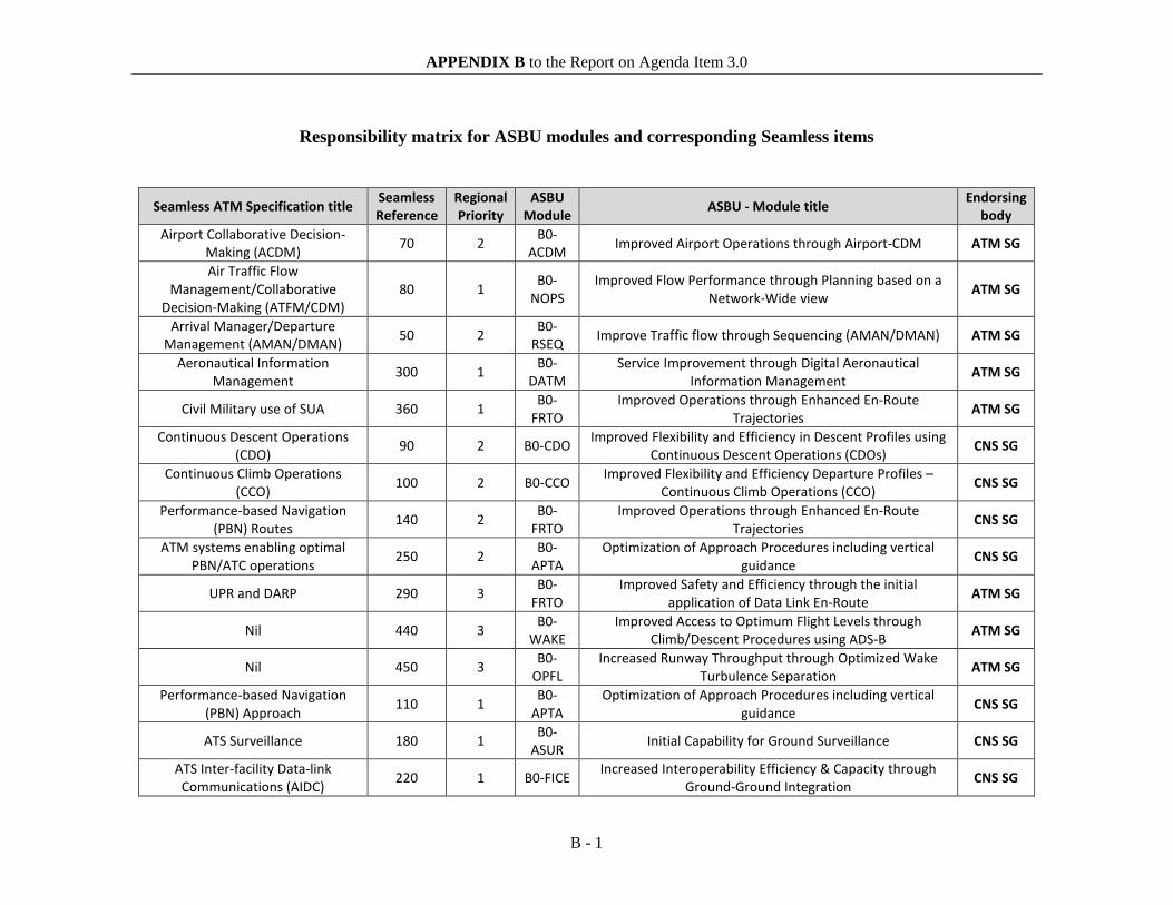
APPENDIX B to the Report on Agenda Item 3.0
B - 1
Responsibility matrix for ASBU modules and corresponding Seamless items
Seamless ATM Specification title Seamless Reference
Regional Priority
ASBU Module ASBU - Module title Endorsing
body Airport Collaborative Decision-
Making (ACDM) 70 2 B0-ACDM Improved Airport Operations through Airport-CDM ATM SG
Air Traffic Flow Management/Collaborative
Decision-Making (ATFM/CDM) 80 1 B0-
NOPS Improved Flow Performance through Planning based on a
Network-Wide view ATM SG
Arrival Manager/Departure Management (AMAN/DMAN) 50 2 B0-
RSEQ Improve Traffic flow through Sequencing (AMAN/DMAN) ATM SG
Aeronautical Information Management 300 1 B0-
DATM Service Improvement through Digital Aeronautical
Information Management ATM SG
Civil Military use of SUA 360 1 B0-FRTO
Improved Operations through Enhanced En-Route Trajectories ATM SG
Continuous Descent Operations (CDO) 90 2 B0-CDO Improved Flexibility and Efficiency in Descent Profiles using
Continuous Descent Operations (CDOs) CNS SG
Continuous Climb Operations (CCO) 100 2 B0-CCO Improved Flexibility and Efficiency Departure Profiles –
Continuous Climb Operations (CCO) CNS SG
Performance-based Navigation (PBN) Routes 140 2 B0-
FRTO Improved Operations through Enhanced En-Route
Trajectories CNS SG
ATM systems enabling optimal PBN/ATC operations 250 2 B0-
APTA Optimization of Approach Procedures including vertical
guidance CNS SG
UPR and DARP 290 3 B0-FRTO
Improved Safety and Efficiency through the initial application of Data Link En-Route ATM SG
Nil 440 3 B0-WAKE
Improved Access to Optimum Flight Levels through Climb/Descent Procedures using ADS-B ATM SG
Nil 450 3 B0-OPFL
Increased Runway Throughput through Optimized Wake Turbulence Separation ATM SG
Performance-based Navigation (PBN) Approach 110 1 B0-
APTA Optimization of Approach Procedures including vertical
guidance CNS SG
ATS Surveillance 180 1 B0-ASUR Initial Capability for Ground Surveillance CNS SG
ATS Inter-facility Data-link Communications (AIDC) 220 1 B0-FICE Increased Interoperability Efficiency & Capacity through
Ground-Ground Integration CNS SG

APPENDIX B to the Report on Agenda Item 3.0
B - 2
ATS surveillance with data integrated 270 1 B0-
ASUR Initial Capability for Ground Surveillance CNS SG
ADS-C and CPDLC 280 1 B0-TBO Improved Safety and Efficiency through the initial application of Data Link En-Route CNS SG
Standard Instrument Departures/Standard Terminal
Arrivals (SID/STAR) 120 2 B0-CCO
B0-CDO Optimization of Approach Procedures including vertical
guidance CNS SG
Safety Nets 160 2 B0-SNET Increased effectiveness of ground-based safety nets CNS SG
Airborne Safety Systems 170 2 B0-ACAS Airborne Collision Avoidance Systems (ACAS) Improvements CNS SG
Nil 430 2 B0-ASEP Air Traffic Situational Awareness (ATSA) CNS SG
Safety and Efficiency of Surface Operations 40 3 B0-
SURF Safety and Efficiency of Surface Operations (A-SMGCS Level
1-2) CNS SG
Meteorological Information 310 2 B0-AMET
Meteorological information supporting enhanced operational efficiency and safety MET SG

ANSIG/1-REPORT APPENDIX 3C
APPENDIX 3C Air Navigation Capacity and Efficiency: ANS Indicators adopted by the AFI Plan Steering Committee (October 2014) Objective Performance indicators/Metrics
(Targets to be established by APIRG/20) 1. Implement Performance Based Navigation
(PBN) ASBU Module B0-APTA
• Number of PBN routes • Number of International Aerodromes/TMAs
with PBN SIDs implemented • Number of International Aerodromes/TMAs
with PBN STARs implemented • Number of International Aerodromes with
Approach Procedures with vertical guidance (APV)
• Number of International Aerodromes with Approach Procedures with lateral guidance (LNAV)
2. Implement Continuous Descent Operations (CDO) and Continuous Climb Operations (CCO)
ASBU Modules B0-CDO and CCO
• Number of International Aerodromes/TMA with CDO implemented
• Number of International Aerodromes/TMAs with CCO implemented
• Annual environmental benefits attained (reduced fuel consumption/GHG emissions)
3. Reduce Aircraft Proximity incidents (AIRPROX) due to ANS deficiencies
• Number of Aircraft Proximity incidents (AIRPROX) due to ANS
• Number of ACAS Resolution Advisory (RA) events due to ATS deficiencies
• Number of States with training programmes for ANS personnel implemented on yearly basis
4. Reduce risk of accidents related to ATM safety • Number of accidents related to ATM safety 5. Implement Digital ATS Coordination/Transfer
ASBU Module B0-FICE • Number of FIRs within which all applicable
ACCs have implemented at least one interface to use ATS Inter-facility Data Communications (AIDC) with neighboring ACCs
• Number of reported incidents related to lack of coordination between ACCs
6. Establish effective and operational SAR Organization.
• Number of States with SAR Organization • Number of States with SAR Plans • Number of States with SAR Agreements
7. Implement en route Data Link Applications ASBU Module B0-TBO
• Number of FIRs having implemented Data Link (ADS-C/CPDLC, ADS-B) for en-route operations
8. Implement Aeronautical Information Management (AIM) Quality Management System (QMS)
• Number of States with AIM QMS implemented

ANSIG/1-REPORT APPENDIX 3C
3C-2
Objective Performance indicators/Metrics (Targets to be established by APIRG/20)
ASBU Module B0-DATM 9. Implement Aeronautical Meteorology (MET)
Quality Management System (QMS) ASBU Module B0-AMET
• Number of States with MET QMS implemented
• Number of incidents/accidents with MET conditions as a sole or contributory factor

3C-3
ANSIG/1-REPORT APPENDIX 3C
ASBU Modules – Planning Targets and Implementation Progress (APIRG/19)
ASBU B0-APTA: Planning Targets and Implementation Progress
Elements Targets and Implementation Progress
(Ground and Air)
1. APV with Baro-VNAV December 2016 – Service Providers and users
2. APV with SBAS December 2017 – As per AFI-GNSS Strategy.
3. APV with GBAS December 2018 – Initial implementation at some States (service providers)
ASBU B0-ASUR: Planning Targets and Implementation Progress Elements Targets and Implementation Progress
(Ground and Air) 1. Implementation of ADS-B June 2018 – Users and service provider 2. Implementation of Multilateration June 2018 – Users and service provider 3. Automation system (Presentation) June 2017 – Users and service provider
ASBU B0-SURF: Planning Targets and Implementation Progress
Elements Targets and Implementation Progress
(Ground and Air)
1. Surveillance system for ground surface movement (PSR, SSR, ADS-B or Multilateration)
December 2017 Service provider
2. Surveillance system on board (SSR transponder, ADS-B capacity)
December 2017 Service provider
3. Surveillance system for vehicle December 2017 Service provider
4. Visual aids for navigation December 2015 Service provider
5. Wildlife strike hazard reduction December 2015 Aerodrome operator / Wildlife Committee
6. Display and processing information December 2017 Service Provider
ASBU B0-ACAS: Planning Targets and Implementation Progress Elements Targets and Implementation Progress
(Ground and Air) ACAS II (TCAS Version 7.1) 2013-2018

ANSIG/1-REPORT APPENDIX 3C
3C-4
ASBU B0-FICE: Planning Targets and Implementation Progress
Elements Targets and Implementation Progress
(Ground and Air)
1. Complete AMHS implementation at States still not counting with this system
December 2015 – Services provider
2. AMHS interconnection December 2015 – Services provider
3. Implement AIDC/OLDI at some States automated centres
June 2014 – Services provider
4. Implement operational AIDC/OLDI between adjacent ACCs
June 2015 – Services provider
5. Implement the AFI Integrated Telecommunication Network
June2015– Services provider
ASBU B0-SNET: Planning Targets and Implementation Progress Elements Targets and Implementation Progress
(Ground and Air) 1. Short Term Conflict Alert (STCA) June 2014 / Service provider 2013-2018 2. Area Proximity Warning (APW) June 2014 / Service provider 2013-2018 3. Minimum Safe Altitude Warning (MSAW)
June 2014
4. Dangerous Area Infringement Warning (DAIW)
2013-2018
ASBU B0-AMET: Planning Targets and Implementation Progress
Elements Targets and Implementation Progress
(Ground and Air)
1. WAFS In process of implementation
2. IAVW In process of implementation
3. Tropical cyclone watch In process of implementation
4. Aerodrome warnings In process of implementation
5. Wind shear warnings and alerts 50% by December 2014
6. SIGMET 80% by December 2014
7. QMS/MET 75% by December 2014
8. Other OPMET Information (METAR, SPECI, TAF)
In process of improvement

Results:
1. QMS
2. e-TOD
3. WGS-
4. AIXM
5. e-AIP
6. Digita
ASB
Ele
for AIM
D implement
-84 impleme
M implementa
implementa
al NOTAM
BU B0-DATM
ements
tation
ntation
ation
ation
: Planning Ta
3C-5
argets and Im
Targ
December
December
Implement
December
December
December
mplementati
gets and Imp
(Grou
2014
2016
ted
2016
2014
2017
AN
ion Progress
plementation
und and Air)
NSIG/1-REPOAPPENDIX
n Progress
ORT X 3C

ANSIG/APPEND
1-REPORT DIX 3C
-
3C-6
----------------
-
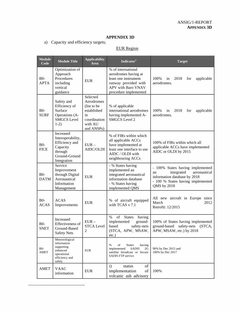
ANSIG/1-REPORT APPENDIX 3D
APPENDIX 3D
a) Capacity and efficiency targets;
EUR Region
Module Code
Module Title Applicability
Area Indicator1 Target
B0-APTA
Optimization of Approach Procedures including vertical guidance
EUR
% of international aerodromes having at least one instrument runway provided with APV with Baro VNAV procedure implemented
100% in 2018 for applicable aerodromes.
B0-SURF
Safety and Efficiency of Surface Operations (A-SMGCS Level 1-2)
Selected Aerodromes (list to be established in coordination with AU and ANSPs)
% of applicable international aerodromes having implemented A-SMGCS Level 2
100% in 2018 for applicable aerodromes.
B0-FICE
Increased Interoperability, Efficiency and Capacity through Ground-Ground Integration
EUR – AIDC/OLDI
% of FIRs within which all applicable ACCs have implemented at least one interface to use AIDC / OLDI with neighbouring ACCs
100% of FIRs within which all applicable ACCs have implemented AIDC or OLDI by 2015
B0-DATM
Service Improvement through Digital Aeronautical Information Management
EUR
- % States having implemented an integrated aeronautical information database - % States having implemented QMS
- 100% States having implemented an integrated aeronautical information database by 2018 - 100 % States having implemented QMS by 2018
B0-ACAS
ACAS Improvements
EUR % of aircraft equipped with TCAS v 7.1
All new aircraft in Europe since March 2012Retrofit: 12/2015
B0-SNET
Increased Effectiveness of Ground-Based Safety Nets
EUR – STCA Level 2
% of States having implemented ground-based safety-nets (STCA, APW, MSAW, etc.)
100% of States having implemented ground-based safety-nets (STCA, APW, MSAW, etc.) by 2018
B0-AMET
Meteorological information supporting enhanced operational efficiency and safety
EUR % of States having implemented SADIS 2G satellite broadcast or Secure SADIS FTP service
90% by Dec 2015 and 100% by Dec 2017
AMET
VAAC information
EUR i) status of implementation of volcanic ash advisory
100%

ANSIG/1-REPORT APPENDIX 3D
3D-2 Module
Code Module Title
Applicability Area
Indicator1 Target
information including in graphical format (EUR includes London, Toulouse, Tokyo and Anchorage Volcanic Ash Advisory Centers)
NAT Region
Module Code
Module Title Applicability Area
Indicator2 Target
B0-FRTO (RLongSM)
5min longitudinal separation between data link equipped a/c
Phase I - Shanwick and Gander OCA- validation trials 2012 Phase 2 -Full operations (TBD)
Increased capacity Reduced average fuel burn and CO2 per a/c compare to current separation
B0-FRTO (RLatSM)
½ degree lateral separation between data link and RNP 4 a/c
Phase 1 – Nov 2015(validation trial, 2 tracks) Phase 2 – approx. 2016, all OTS Phase 3- TBD all NAT
Increased capacity 100% OTS capacity increase in Phase 2
B0-TBO B0-SNET (FANS data link impl)
FANS 1/A data link implementation
Phase 1-2013(2 tracks) Phase 2a –Feb 2015 (all OTS FL350-390) Phase 2b – dec 2017 all NAT FL 35-390 Phase 2 c- Jan 2020 All NAT FL290 above
Reduced GNEs and LHDs (see safety targets)
100% equipage
B0-FICE (AIDC)
AIDC implementation
Phase 1 – 2013 Phase 2 -
Reduced GNEs and LHDs (see safety targets)
100% implementation

ANSIG/1-REPORT APPENDIX 3D
3D-3
Module Code
Module Title Applicability Area
Indicator2 Target
B0-FRTO (MNPS to PBN transition)
MNPS to PBN transition plan
B0-AMET
Meteorological information supporting enhanced operational efficiency and safety
NAT
% of States having implemented SADIS 2G satellite broadcast or Secure SADIS FTP service or WAFS Internet File Service (WIFS)
100% by Dec 2015
AMET
VAAC information
NAT
i) status of implementation of volcanic ash advisory information including in graphical format (EUR includes London, Toulouse, Tokyo and Anchorage Volcanic Ash Advisory Centers)
100%
b) Capacity and efficiency dashboard.
EUR Region
Module Code Module Title Current status (assessment)
B0-APTA Optimization of Approach Procedures including vertical guidance
30% at applicable aerodromes.(CNS 4b Table of the EUR ANP)
B0-SURF Safety and Efficiency of Surface Operations (A-SMGCS Level 1-2)
TBD (list for applicable aerodromes TBD)
B0-FICE Increased Interoperability, Efficiency and Capacity through Ground-Ground Integration
80% of FIRs (AFS Table of EUR ANP)
B0-DATM Service Improvement through Digital Aeronautical Information Management
TBD
B0-ACAS ACAS Improvements TBD

ANSIG/1-REPORT APPENDIX 3D
3D-4
Module Code Module Title Current status (assessment)
B0-AMET Meteorological information supporting enhanced operational efficiency and safety
86.8% WAFS implementation
B0-SNET Increased Effectiveness of Ground-Based Safety Nets
TBD
AMET VACC
i) status of implementation of volcanic ash advisory information including in graphical format (EUR includes London, Toulouse, Tokyo and Anchorage Volcanic Ash Advisory Centers)
100% - 2014 N/A- 2013
NAT Region
Module Code Module Title Current status
B0-FRTO (RLongSM)
5min longitudinal separation between data link equipped a/c
Validation trial ongoing
B0-FRTO (RLatSM)
½ degree lateral separation between data link and RNP 4 a/c
Planned Nov 2015
B0-TBO B0-SNET (FANS data link impl)
FANS 1/A data link implementation 70%
B0-FICE (AIDC)
AIDC implementation 100%
B0-FRTO (MNPS to PBN transition)
MNPS to PBN transition plan RNAV 10 and RNP 4 equipage assessment ongoing
B0-AMET Meteorological information supporting enhanced operational efficiency and safety
100% WAFS implementation
AMET VAAC Status of implementation of volcanic ash advisory information including in graphical format (NAT includes London, Toulouse, Montréal and Washington Volcanic Ash Advisory Centers)
100%- 2014 N/A - 2013
-----------------

ANSIG/1-REPORT APPENDIX 3E
APPENDIX 3E
a) Capacity and efficiency targets The Port-of-Spain Declaration (under 2014 – Safety, paragraph 1 item a) includes the Regional Safety and Air Navigation targets that will be presented in the ICAO Regional Performance Dashboard as follows:
1. Approach - Performance-Based Navigation (PBN)
• 80% of instrument approach runways to have Approach Procedures with Vertical Guidance (APV) with Barometric Vertical Navigation (Baro VNAV) implemented by service providers and users by December 2016
2. Air Traffic Flow Management (ATFM)
• 100% of Flight Information Regions (FIRs) within which all Area Control
Centres (ACCs) to have ATFM measures available by December 2018
3. Aeronautical Information Management Transition (AIM)
• 100% of Aeronautical Information Services (AIS) to implement AIM Roadmap - Phase I required elements by December 2016
4. Ground-Ground Digital Coordination/Transfer
• 50% of FIRs within which all applicable ACCs to have implemented at least one
interface to use Air Traffic Services Inter-Facility Data Communication (AIDC)/On-Line Data Interchange (OLDI) with neighbouring ACCs by December 2016
5. Environmental Benefit
• Reduce regional CO2 emissions by 40,000 tons per year through
PBN implementation by December 2016 Similarly, with the approval of the NAM/CAR Regional Performance-based Air Navigation Implementation Plan (RPBANIP) version 3.1 by the North American, Central American and Caribbean Directors of Civil Aviation, other ASBU-based key air navigation targets were adopted to accomplish the identified AN regional priorities as follows:
1. B0-65/APTA: Optimization of Approach Procedures Including Vertical Guidance
• 20% of instrument runways to have APV with SBAS/WAAS implemented
by December 2018– Service Providers and users • 20% of instrument runways to have APV with GBAS by December 2018 –
Initial implementation at some States (services providers)

ANSIG/1-REPORT APPENDIX 3E
3E-2
• 60% of instrument runways to have LNAV procedure implemented by December 2016 – Service Providers and users as per Assembly Resolution A37-11
2. B0-15/RSEQ: Improve Traffic Flow Through Runway Sequencing
(AMAN/DMAN)
• 10% of selected aerodromes with AMAN and time based metering by Dec. 2016
• 10% of selected aerodromes with DMAN by Dec. 2016 • 20% of selected aerodromes with Airport-capacity calculated by Dec. 2016
3. B0-75/SURF Safety and Efficiency of Surface Operations (A-SMGCS Level 1-2)
• 30% of selected aerodromes with SMR/ SSR Mode S/ ADS-B/
Multilateration for ground surface movement by June 2018 • 20% of aircraft on the NAM/CAR State registries to have surveillance
system on board (SSR transponder, ADS B capacity) by June 2018 • 20% of vehicles at selected aerodromes with a cooperative transponder
systems by June 2018 • 70% of selected aerodromes complying with visual aid requirements as per
Annex 14 by December 2015 • 70% of selected airports with an aerodrome bird/wildlife organization and
control programme by December 2018
4. B0-80/ACDM Improved Airport Operations through Airport - CDM
• 60% of selected aerodromes with Airport-CDM by Dec. 2018 • 48% of international aerodromes to be certified in the CAR Region by
December 2016 • 30% of selected Heliports with operational approval by Dec. 2018
5. B0-25/FICE: Increased Interoperability, Efficiency and Capacity through Ground-
Ground Integration
• 100% implementation of MEVA III IP Network by MEVA Member States by August 2015
• 4 States with Air Traffic Services Message Handling Services (AMHS) interconnected with other AMHS by December 2014
• 70% of ATN router structure implemented by June 2016
6. B0-30/DAIM: Service Improvement through Digital Aeronautical Information Management
• 10 % of States e-TOD Implemented by Dec.2018 • 40 % of States with AIXM 5.1 implemented by Dec.2018 • 45 % of States with e-AIP implemented by Dec.2018 • 35 % of States with Digital NOTAM implemented by Dec. 2018

3E-3
ANSIG/1-REPORT APPENDIX 3E
7. B0-105/AMET: Meteorological Information Supporting Enhanced Operational
Efficiency and Safety
• 100% of States implementation of WAFS Internet File Service (WIFS) by December 2014
• 70% of MWOs with IAVW procedures implemented by December 2014. • 100% of MWOs with tropical cyclone watch procedures implemented by
December 2014. • 50% of selected aerodromes/AMOs with Aerodrome warnings
implemented by December 2014 • 20% of selected aerodromes/AMOs with wind shear warnings procedures
implemented (MET provider services) by December 2015 • 90% of selected aerodromes/MWOs with SIGMET procedures
implemented (MET provider services) by Dec. 2014
8. B0-10/FRTO: Improved Operations through Enhanced En-Route Trajectories
• 100% of States to have completed a PBN plan by Dec. 2018 • 50% of selected segregated airspaces available for civil operations by Dec.
2016
9. B0-84/ASUR: Initial Capability for Ground Surveillance
• 30% of selected aerodromes with ADS-B implemented by Dec 2018 • 80% of multilateration system implemented in selected aerodromes by June
2018 10. B0-101/ACAS: ACAS Improvements
• 10% of aircraft on NAM/CAR State registries equipped with ACAS II (TCAS Version 7.1) by Dec 2018
11. B0-102/SNET: Increased Effectiveness of Ground-Based Safety Nets
• 80% of selected ATS units with ground based safety nets (STCA) implemented by Dec 2015
• 70% of selected ATS units with ground based safety nets (APW) implemented / 70% of selected ATS units with ground based safety nets (MSAW) implemented by Dec 2015
• 80% of selected ATS units with ground based safety nets (MTCA) implemented by Dec 2016
12. B0-05/CDO: Improved Flexibility and Efficiency in Continuous Descent
Operations (CDOs)
• 50% of selected. Aerodromes with continuous descent operations (CDO) implemented by Dec.2016
• 80% of selected. Aerodromes with PBN STARs implemented by Dec.2016

ANSIG/1-REPORT APPENDIX 3E
3E-4
13. B0-40/TBO: Improved Safety and Efficiency through the initial application of En-Route Data Link
• 80% of selected FIRs with ADS-C implemented by December 2016 • 80% of selected FIRs with CPDLC implemented by June 2018
14. B0-20/CCO: Improved Flexibility and Efficiency Departure Profiles - Continuous
Climb Operations (CCOs)
• 60% of selected aerodromes with continuous climb operations (CCO) implemented by Dec.2016
• 60% of selected aerodromes with PBN SIDs implemented by Dec.2016
------------------

ANSIG/1-REPORT APPENDIX 3F
APPENDIX 3F
a) Capacity and efficiency targets
The Bogota Declaration (Bogota, 6 December 2013); issued by SAM States; set ten regional goals for capacity and efficiency for the period 2014 – 2016. In this context the targets are:
− PBN terminal: Full compliance with goals established in ICAO Assembly Resolution A37-11 regarding approach procedure with vertical guidance (APV).
− PBN en-route: 60% of the international aerodromes with standard instrument departure (SID) /standard instrument arrival (STAR) PBN.
− 60% of the routes/airspaces with performance based navigation (PBN).
− CDO: 40% of the international aerodromes / terminal control areas (TMA) with continuous descent operation (CDO).
− CCO: 40% of the international aerodromes / TMAs with continuous climb operations (CCO).
− ATFM: 100% of the area control centre (ACCs) providing air traffic flow management (ATFM).
− AIM: 100% of the required elements in PHASE I (aeronautical information services (AIS) to aeronautical information management (AIM) Roadmap).
− AMHS interconnection: 100% of the Air Traffic Services Message Handling Services (AMHS) regionally interconnected (Total: 26 interconnections)

ANSIG/1-REPORT APPENDIX 3F 3F-2
− Interconnection of automated systems (ATS interfacility data communications (AIDC) exchange): 100% of the automated systems interconnected (Total: 15 interconnections)
− Implementation of national Internet protocol (IP) networks: 80% of the States with national IP communications networks implemented.
− Estimated fuel savings/ C02 emissions reduction based on the ICAO fuel savings estimation tool (IFSET) Reach 40,000 tons of regional CO2 emissions reduction per year in en-route PBN implementation.
-----------------

PBN PLAN
xLS CAT Update dateBAHRAIN
OBBI 12L ILS I VORDME Y SIDs and STARs withdrawn
30R ILS I VORDME Y SIDs and STARs withdrawn
Total 2 2 2 Draft 2 0 0 0 0 0% 100 100 Nov 2009 100 0 0 0 0 0
EGYPTHEAX 4 VORDME Y
1822 VORDME Y36 VORDME
HEBA 1432 ILS I Y Y
HESN 17 VORDME Y Y Y35 ILS I VORDME Y Y Y
HEAT 13 Y Y Y31 ILS I VORDME Y Y Y
HECA 05L ILS I VORDME Y05C ILS II VORDME Y05R ILS I23L ILS I VORDME23C ILS II VORDME Y23R ILS I VORDME Y
HEAR 1634 VORDME
HEGN 16 VORDME Y Y Y34 ILS I VORDME Y Y Y
MID REGION TMAs PROCEDURES Implementation Status as of July 2014
CDORNAV SID CCO RNAV STAR
Int’l Aerodrome
(Ref. MID ANP)RWY
CCO CDO
RemarksPrecision
APTAConventional Approaches
VOR or NDB LNAV LNAV / VNAV
ANSIG/1-REPORT APPENDIX 4A

PBN PLAN
xLS CAT Update dateCDORNAV SID CCO RNAV STAR
Int’l Aerodrome
(Ref. MID ANP)RWY
CCO CDO
RemarksPrecision
APTAConventional Approaches
VOR or NDB LNAV LNAV / VNAV
HELX 2 ILS I VORDME Y Y Y20 ILS I VORDME Y Y Y
HEMA 15 VORDME33 VORDME
HEPS 10 VORDME28
HEOW 1 NDB19
HESH 04L ILS I VORDME Y Y Y04R VORDME Y Y Y22L VORDME Y Y Y22R VORDME Y Y Y
HESC 17 NDB35 NDB
HETB 4 ILS I VORDME Y Y Y22 VORDME Y Y Y
HEAL 13 VORDME Y31 VORDME Y
HESG 15 VORDME
33 VORDME
Total 40 14 32 Y 23 0 15 0 14 0% 35 80 Jan. 2015 58 0 38 0 35 0 Plan needs update

PBN PLAN
xLS CAT Update dateCDORNAV SID CCO RNAV STAR
Int’l Aerodrome
(Ref. MID ANP)RWY
CCO CDO
RemarksPrecision
APTAConventional Approaches
VOR or NDB LNAV LNAV / VNAV
I.R. IRAN
OIKB 03L
03R VORDME / NDB
21L ILS I VORDME / NDB
21R
OIFM 08L VORDME / NDB
08R VORDME / NDB
26L VORDME / NDB
26R ILS I VORDME / NDB
OIMM 13L VORDME
13R VORDME
31L VORDME / NDB
31R ILS I VORDME / NDB
OISS 11L11R
29L ILS I VORDME / NDB
29R VORDME / NDB
OITT 12L12R30L ILS I VORDME 30R ILS I VORDME

PBN PLAN
xLS CAT Update dateCDORNAV SID CCO RNAV STAR
Int’l Aerodrome
(Ref. MID ANP)RWY
CCO CDO
RemarksPrecision
APTAConventional Approaches
VOR or NDB LNAV LNAV / VNAV
OIIE 11L ILS I VORDME / NDB
11R VORDME / NDB
29L VORDME
29R ILS II VORDME / NDB Y Y
OIII 11L VORDME11R VORDME29L ILS I VORDME29R
OIZH 17
35 ILS I VORDME
Total 30 10 22 N 1 1 0 0 0 0% 33 73 3 3 0 0 0 0
IRAQORBI 15L ILS I VORDME
15R Y33L Y33R ILS I VORDME
ORMM 14 VORDME32 ILS I VORDME
ORER 18 ILS II Y Y36 ILS I Y Y
ORSU 13 ILS I VOR31 ILS I VOR
ORNI 1028 ILS VOR
ORBM NO DATA
Total 12 8 7 N 4 0 0 0 2 0% 67 58 33 0 0 0 17 0

PBN PLAN
xLS CAT Update dateCDORNAV SID CCO RNAV STAR
Int’l Aerodrome
(Ref. MID ANP)RWY
CCO CDO
RemarksPrecision
APTAConventional Approaches
VOR or NDB LNAV LNAV / VNAV
JORDAN
OJAM 6 Y Y Y Y
24 ILS I VORDME / NDB Y Y Y Y
OJAI 08L ILS I NDB DME Y Y Y Y08R NDB DME Y Y Y Y26L ILS II VOR / NDB Y Y Y Y
26R ILS I VORDME / NDB Y Y Y
OJAQ 1 ILS I VORDME Y Y Y Y
19 N/A N/A Y N/A Y Y LNAV/VNAV not feasible
Total 8 6 6 Y 8 8 8 0 8 0% 75 75 July 2009 100 100 100 0 100 0 Plan needs update
KUWAITOKBK 15L ILS II Y Y Y Y
15R ILS II VORDME Y Y Y Y33L ILS II VORDME Y Y Y Y
33R ILS II Y Y Y Y
Total 4 4 2 Y 4 4 4 0 4 0% 100 50 Jan. 2010 100 100 100 0 100 0 Plan needs update
LEBANON
OLBA 3 ILS I VORDME Y Y16 ILS I VORDME Y Y
17 ILS I VORDME / NDB Y Y
21 Y Y34 N/A N/A N/A N/A Not used for landing
35 N/A N/A N/A N/A Not used for landing
Total 6 5 5 N 6 0 0 0 6 0% 83 83 100 0 0 0 100 0

PBN PLAN
xLS CAT Update dateCDORNAV SID CCO RNAV STAR
Int’l Aerodrome
(Ref. MID ANP)RWY
CCO CDO
RemarksPrecision
APTAConventional Approaches
VOR or NDB LNAV LNAV / VNAV
LIBYAHLLB 15R VORDME VOR not flight checked
15L VORDME VOR not flight checked33R VORDME VOR not flight checked33L ILS I VORDME ILS not flight checked
HLLS 13 ILS I VORDME ILS not flight checked31 VORDME VOR not flight checked
HLLT 9 VORDME VOR not flight checked
27 ILS I VORDME ILS not flight checked
Total 8 3 8 N 0 0 0 0 0 0% 38 100 0 0 0 0 0 0
OMANOOMS 08R ILS I VORDME
26L ILS I VORDMEOOSA 7 ILS I VORDME Y Y Y Y
25 ILS I VORDME Y Y Y Y
Total 4 4 4 Y 2 2 2 0 2 0% 100 100 50 50 50 0 50 0 Plan needs update
QATAROTBD 15 ILS I VORDME Y N/A Y Y LNAV/VNAV not feasible
33 ILS II/III VORDME/NDB Y Y Y Y
OTHH 16L ILS I/II/III VORDME Y Y Y Y
16R ILS I/II/III VORDME Y Y Y Y
34L ILS I/II/III VORDME Y Y Y Y
34R ILS I/II/III VORDME Y Y Y Y
Total 6 6 6 Y 6 6 6 0 6 0% 100 100 Aug. 2014 100 100 100 0 100 0

PBN PLAN
xLS CAT Update dateCDORNAV SID CCO RNAV STAR
Int’l Aerodrome
(Ref. MID ANP)RWY
CCO CDO
RemarksPrecision
APTAConventional Approaches
VOR or NDB LNAV LNAV / VNAV
SAUDI ARABIAOEDF 16L ILS II VORDME
16R ILS II VORDME 34L ILS II VORDME34R ILS II VORDME
OEJN 16L ILS I VORDME Y Y16C ILS II Y16R ILS II Y Y34L ILS II Y Y34C ILS II VORDME Y34R ILS I VORDME Y Y
OEMA 17 ILS I VORDME Y Y Y18 VORDME Y Y Y35 ILS I VORDME Y Y Y36 ILS I VORDME Y Y Y
OERK 15L ILS I VORDME15R ILS I33L ILS I
33R ILS I VORDME
Total 18 17 13 Y 8 0 5 0 10 0% 94 72 May 2012 44 0 28 0 56 0 Plan needs update

PBN PLAN
xLS CAT Update dateCDORNAV SID CCO RNAV STAR
Int’l Aerodrome
(Ref. MID ANP)RWY
CCO CDO
RemarksPrecision
APTAConventional Approaches
VOR or NDB LNAV LNAV / VNAV
SUDANHSKA 2 Charts are Not Published
20HSSS 18 ILS I VORDME Y Y
36 ILS I VORDME Y Y
HSPN 17 VORDME / NDB Y Y
35 ILS I VORDME / NDB Y Y
Total 6 3 4 Y 4 4 0 0 0 0% 50 67 Apr. 2014 67 67 0 0 0 0
SYRIAOSAP 9 VORDME
27 ILS II VORDME / NDB
OSLK 17 ILS I VORDME / NDB
35OSDI 05L VOR
05R ILS II VORDME / NDB
23L VORDME / NDB DME
23R ILS II VORDME Y Y
Total 8 4 7 Draft 1 1 0 0 0 0% 50 88 Dec. 2009 13 13 0 0 0 0

PBN PLAN
xLS CAT Update dateCDORNAV SID CCO RNAV STAR
Int’l Aerodrome
(Ref. MID ANP)RWY
CCO CDO
RemarksPrecision
APTAConventional Approaches
VOR or NDB LNAV LNAV / VNAV
UNITED ARAB EMIRATESOMAA 13L ILS II Y Y
13R ILS I VOR Y Y31L ILS II/III VOR Y Y31R ILS II Y Y
OMAD 13 VORDME Y Y31 ILS I VORDME Y Y
OMAL 1 ILS I VOR19 VOR
OMDB 12L ILS I/II/III VOR Y Y Y Y
12R ILS I/II/III VOR Y Y Y Y
30L ILS I/II/III Y Y Y Y
30R ILS I/II/III VOR Y Y Y Y
OMDW 12 ILS II/III Y Y Y Y30 ILS II/III Y Y Y Y
OMFJ 11 Y29 ILS I VOR Y Y Y
OMRK 16 VOR34 ILS I VOR
OMSJ 12 ILS I Y Y Y Y
30 ILS II Y Y Y Y
Total 20 16 12 Y 11 9 14 0 14 0% 80 60 Jan. 2015 55 45 70 0 70 0
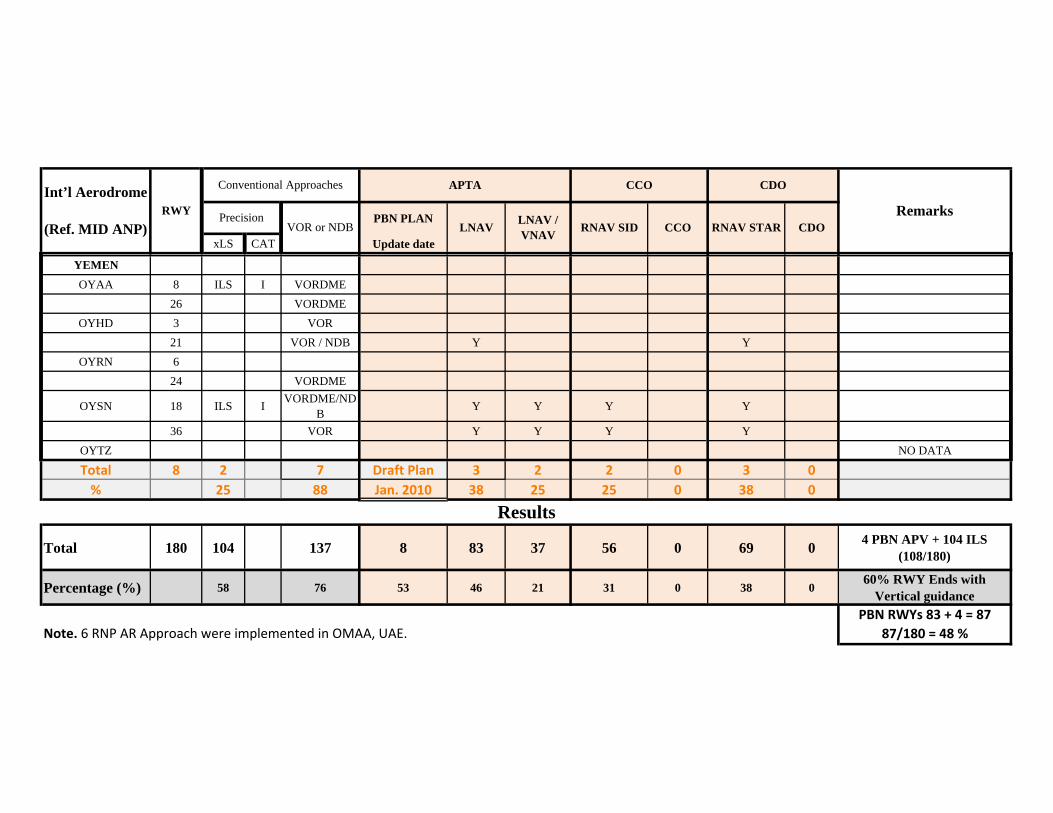
PBN PLAN
xLS CAT Update dateCDORNAV SID CCO RNAV STAR
Int’l Aerodrome
(Ref. MID ANP)RWY
CCO CDO
RemarksPrecision
APTAConventional Approaches
VOR or NDB LNAV LNAV / VNAV
YEMENOYAA 8 ILS I VORDME
26 VORDMEOYHD 3 VOR
21 VOR / NDB Y YOYRN 6
24 VORDME
OYSN 18 ILS I VORDME/NDB Y Y Y Y
36 VOR Y Y Y YOYTZ NO DATA
Total 8 2 7 Draft Plan 3 2 2 0 3 0% 25 88 Jan. 2010 38 25 25 0 38 0
Total 180 104 137 8 83 37 56 0 69 0 4 PBN APV + 104 ILS (108/180)
Percentage (%) 58 76 53 46 21 31 0 38 060% RWY Ends with
Vertical guidancePBN RWYs 83 + 4 = 87
87/180 = 48 %
Results
Note. 6 RNP AR Approach were implemented in OMAA, UAE.
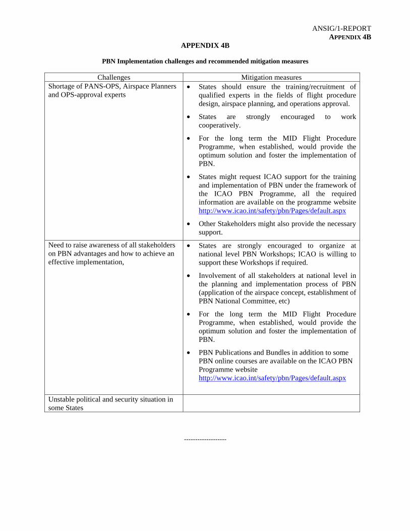
ANSIG/1-REPORT APPENDIX 4B
APPENDIX 4B
PBN Implementation challenges and recommended mitigation measures
Challenges Mitigation measures Shortage of PANS-OPS, Airspace Planners and OPS-approval experts
• States should ensure the training/recruitment of qualified experts in the fields of flight procedure design, airspace planning, and operations approval.
• States are strongly encouraged to work cooperatively.
• For the long term the MID Flight Procedure Programme, when established, would provide the optimum solution and foster the implementation of PBN.
• States might request ICAO support for the training and implementation of PBN under the framework of the ICAO PBN Programme, all the required information are available on the programme website http://www.icao.int/safety/pbn/Pages/default.aspx
• Other Stakeholders might also provide the necessary support.
Need to raise awareness of all stakeholders on PBN advantages and how to achieve an effective implementation,
• States are strongly encouraged to organize at national level PBN Workshops; ICAO is willing to support these Workshops if required.
• Involvement of all stakeholders at national level in the planning and implementation process of PBN (application of the airspace concept, establishment of PBN National Committee, etc)
• For the long term the MID Flight Procedure Programme, when established, would provide the optimum solution and foster the implementation of PBN.
• PBN Publications and Bundles in addition to some PBN online courses are available on the ICAO PBN Programme website http://www.icao.int/safety/pbn/Pages/default.aspx
Unstable political and security situation in some States
-------------------

ANSIG/1-REPORT APPENDIX 4C
APPENDIX 4C
Table B0-SURF Implementation
EXPLANATION OF THE TABLE
Column: 1 Name of the State
2 Name of City/Aerodrome and Location Indicator
3 Non-cooperative Surveillance Sensors (NCSS): e.g. Surface Movement Radar (SMR).
This is required for Level 1 and Level 2. Implementation status of (NCSS) is indicated by:
Y – Yes, implemented N – No, not implemented
4 Cooperative Surveillance Sensor (CSS): e.g.; Multilateration and ADS-B. This is required for Level 1 and Level 2. Implementation status of (CSS) is indicated by:
Y – Yes, implemented N – No, not implemented
5 Data Fusion (FS): The process of combining surveillance information from two or more
sensor systems or sources. This is required for Level 1 and Level 2. Implementation status of (FS) is indicated by:
Y – Yes, implemented N – No, not implemented
6 Alert: Conflict/infringement detection. This is required for Level 2
Implementation status of Alert is indicated by: Y – Yes, implemented N – No, not implemented
7 Action Plan: short description of the State’s Action Plan with regard to the
implementation of A-SMGCS.
8 Remarks — additional information (e.g. case of difference between level 1 and level 2 applicability)

ANSIG/1-REPORT APPENDIX 4C
4C-2
TABLE B0-SURF Monitoring of A-SMGCS Elements Implementation
State
City/Aerodrome Location Indicator
NCSS CSS DF Alert
CAction Plan Remarks
1 2 3 4 5 6 7 8 BAHRAIN
Bahrain/Bahrain (OBBI)
N N N N A-SMGCS Level 1-2 Project is under Execution phase. expected completion on Sep 2015
EGYPT Cairo/Cairo Intl (HECA) Y Y Y Y
IRAN Tehran/Mehrabad (OIII)
KUWAIT Kuwait/Kuwait Intl (OKBK)
OMAN Muscat/Muscat Intl (OOMS)
QATAR Doha/Doha Intl (OTBD)
QATAR Doha/Hamad Intl (OTHH)
SAUDI ARABIA
JEDDAH/King Abdulaziz Intl (OEJN)
SAUDI ARABIA
Riyadh/King Khalid Intl (OERK)
UAE
Abu Dhabi/Abu Dhabi (OMAA)
Y Y N Y Level 2 – Current Level 4 - 2017
Alert - RIMCAS
UAE Dubai/Dubai Intl (OMDB)
Y Y N Y Level 2 – Current Level 4 - 2016
Alert - RIMCAS
UAE DUBAI/Al Maktoum (OMDW)
Y Y N Y Level 1 – Current Level 4 - 2018
Alert - RIMCAS
-----------------

ANSIG/1-REPORT APPENDIX 4D
APPENDIX 4D
Table B0 A-CDM Implementation
EXPLANATION OF THE TABLE
Column: 1 Name of the State.
2 Name of City/Aerodrome and Location Indicator
3 Information Sharing (IS): The Information Sharing Element defines the sharing of
accurate and timely information between the Airport CDM Partners in order to achieve common situational awareness and to improve traffic event predictability. The Airport CDM Information Sharing Platform (ACISP), together with defined procedures agreed by the partners, is the means used to reach these aims. Implementation status of (IS) is indicated by:
Y – Yes, implemented N – No, not implemented
4 Milestone Approach (MA) : The Milestone Approach Element describes the progress of a flight from the initial planning to the take off by defining Milestones to enable close monitoring of significant events. The aim is to achieve a common situational awareness and to predict the forthcoming events for each flight with off-blocks and take off as the most critical events. The Concept Element Information Sharing needs to be implemented at the airport before it can successfully implement the Milestone Approach The Milestone Approach combined with the Information Sharing element is the foundation for all other Concept Elements. Implementation status of (MA) is indicated by:
Y – Yes, implemented N – No, not implemented
5 Variable Taxi Time (VTT): The Variable Taxi Time Element consists of calculating
and distributing to the Airport CDM Partners accurate estimates of taxi-in and taxi-out times to improve the estimates of in-block and take off times. The complexity of the calculation may vary according to the needs and constraints at the CDM Airport. The aim is to improve the traffic predictability. Implementation status of (VTT) is indicated by:
Y – Yes, implemented N – No, not implemented
6 Pre-departure Sequencing (PDS): The pre-departure sequencing is the order that
aircraft are planned to depart from their stands (push off-blocks) taking into account partners’ preferences. It should not be confused with the pre-take off order where ATC organise aircrafts at the holding point of a runway. The aim is to enhance flexibility, increase punctuality and improve slot-adherence while allowing the airport partners to express their preferences. Implementation status of (PDS) is indicated by:

ANSIG/1-REPORT APPENDIX 4D
4D-2 Y – Yes, implemented N – No, not implemented
7 Adverse Conditions (AC) : Adverse Conditions Element consists of collaborative management of the capacity of an airport during periods of a predicted or unpredicted reduction of capacity. The aim is to achieve a common situational awareness for the Airport CDM Partners, including better information for the passengers, in anticipation of a disruption and expeditious recovery after the disruption. Implementation status of (AC) is indicated by:
Y – Yes, implemented N – No, not implemented
8 Management of Flight Updates (MFU): The Collaborative Management of Flight
Updates Element consists of exchanging Flight Update Messages (FUM) and Departure Planning Information (DPI) messages with the CDM Airport, to provide estimates for arriving flights and improve the ATFM slot management process for departing flights. The aim is to improve the coordination between Air Traffic Flow and Capacity Management (ATFCM) and airport operations at a CDM Airport. Implementation status of (MFU) is indicated by:
Y – Yes, implemented N – No, not implemented
9 Action Plan: short description of the State’s Action Plan with regard to the provision of
A-CDM elements and services.
10 Remarks — additional information,.

ANSIG/1-REPORT APPENDIX 4D
4D-3
TABLE B0-ACDM Provision of A-CDM Elements
State
City/Aerodrome Location Indicator
IS MA VTT PDS AC MFU
CAction Plan Remarks
1 2 3 4 5 6 7 8 9 10 BAHRAIN
Bahrain/Bahrain (OBBI)
N N N N N N Steering Committee has been establish, and MOA is under process between concern entities to establish different project frames such as milestones, cost, and deadlines.
EGYPT Cairo/Cairo Intl (HECA)
N N N N N N TBD
IRAN, Tehran/Mehrabad (OIII)
KUWAIT Kuwait/Kuwait Intl (OKBK)
OMAN Muscat/Muscat Intl (OOMS)
QATAR Doha/Doha Intl (OTBD)
QATAR Doha/Hamad Intl (OTHH)
SAUDI ARABIA
JEDDAH/King Abdulaziz Intl (OEJN)

ANSIG/1-REPORT APPENDIX 4D
4D-4
NAME ANP, Volume III Part I May 2014
SAUDI ARABIA
RIYADH/King Khalid Intl (OERK)
UAE
Abu Dhabi/Abu Dhabi (OMAA)
N N N N N N Project in progress with full implementation of A-CDM Q3 2017
UAE Dubai/Dubai Intl (OMDB)
N N N N N N Project in progress with full implementation of A-CDM Q4 2016
UAE DUBAI/Al Maktoum (OMDW)
N N N N N N Project in progress with full implementation of A-CDM Q4 2017
----------------

ANSIG/1-REPORT APPENDIX 4E
APPENDIX 4E
TABLE B0-FICE
EXPLANATION OF THE TABLE Column
1 Name of the State 2, 3, 4 Status of AMHS Capability and Interconnection and AIDC/OLDI Capability, where:
Y – Fully Implemented N – Partially Implemented
5 Status of AIDC/OLDI Implementation, where: FI – Fully Implemented PI – Partially Implemented NI – Not Implemented
6 Action plan — short description of the State’s Action Plan with regard to the implementation of B0-FICE.
7 Remarks
State
AMHS Capability
AMHS Interconnection
AIDC/OLDI Capability
AIDC/OLDI Implementation
Action Plan Remarks
1 2 3 4 5 6 7 Bahrain Y N Y NI Sep 2015 for
AMHS Int.
Egypt Y Y Y PI
Iran N N Y NI Contract signed for
AMHS Iraq N N N NI
Jordan Y Y Y NI
Kuwait Y N Y NI Dec 2015 for AMHS Int.
Lebanon Y N Y PI
Libya Y N Y NI
Oman Y Y Y NI
Qatar Y Y Y PI
Saudi Arabia Y Y Y PI
Sudan Y Y Y NI AMHS Int. Feb 2015
Syria N N N NI
UAE Y Y Y PI
Yemen N N N NI Dec 2015 for AMHS
Contract signed for
AMHS Total Percentage

ANSIG/1-REPORT APPENDIX 4E
4E-2
Monitoring and reporting the status of Implementation of AIDC/OLDI between Adjacent ACCs
State
Location of AIDC/OLDI end system
Adjacent ACCs Implementation
Status (YES/NO)
Report for MID AN Strategy
1 2 3 4 5
Bahrain Bahrain ACC
Jeddah ACC NO
NO
Riyadh ACC NO
Kuwait ACC NO
SZC Abu Dhabi ACC NO
Tehran ACC NO
Egypt Cairo ACC
Athens ACC YES
YES
Jeddah ACC NO Khartoum ACC NO
Tripoli ACC NO Nicosia ACC NO Amman ACC NO
Iran
Tehran ACC
Bahrain ACC NO
NO
SZC Abu Dhabi ACC NO Ankara ACC NO Kabul ACC NO
Kuwait ACC NO Baghdad ACC NO
Turkmenistan ACC NO
Iraq Baghdad ACC
Kuwait ACC NO
NO Tehran ACC NO Amman ACC NO Ankara ACC NO
Jordan Amman ACC
Baghdad ACC NO
NO Damascus ACC NO
Cairo ACC NO Jeddah ACC NO
Kuwait Kuwait ACC
Bahrain ACC NO
NO
Jeddah ACC NO
Tehran ACC NO
Damascus ACC NO Nicosia ACC NO
Lebanon Beirut ACC Nicosia ACC NO
NO Damascus ACC NO
Libya
Tripoli ACC
Tunis ACC NO
NO Malta ACC NO Cairo ACC NO
Khartoum ACC NO

ANSIG/1-REPORT APPENDIX 4E
4E-3
State
Location of AIDC/OLDI end system
Adjacent ACCs Implementation
Status (YES/NO)
Report for MID AN Strategy
1 2 3 4 5 N'Djamena ACC NO
Oman Muscat ACC
SZC Abu Dhabi ACC NO
NO
Jeddah ACC NO Mumbai ACC NO Bahrain ACC NO Sanaa ACC NO
Saudi Arabia
Jeddah ACC
Bahrain ACC NO
YES
Cairo ACC NO Amman ACC NO
SZC Abu Dhabi ACC NO Muscat NO
Khartoum ACC NO Sanaa ACC NO
Riyadh ACC YES
Riyadh ACC
Jeddah ACC YES Bahrain ACC NO
NO
Sudan Khartoum ACC
Cairo ACC NO
YES
Jeddah ACC NO N'Djamena ACC YES
Kigali ACC YES Tripoli ACC NO
Syria Damascus ACC Beirut ACC NO
NO Amman ACC NO Baghdad ACC NO
UAE SZC Abu Dhabi ACC
Bahrain ACC NO
NO Jeddah ACC NO Tehran ACC NO Muscat ACC NO
Yemen Sanaa ACC
Jeddah ACC NO
NO Muscat ACC NO Djibouti ACC NO
Mogadishu ACC NO
-------------------

ANSIG/1-REPORT APPENDIX 4F
APPENDIX 4F
Table B0-DATM 3-1
Provision of AIS/AIM products and services based on the Integrated Aeronautical Information Database (IAID)
EXPLANATION OF THE TABLE
Column: 1 Name of the State or territory for which the provision of AIS/AIM products and services
based on the IAID is required. 2 Requirement for the implementation and designation of the authoritative IAID, shown by:
FI – Fully Implemented PI – Partially Implemented NI – Not Implemented
Note 1 — The IAID of a State is a single access point for one or more databases (AIS, Terrain, Obstacles, AMDB, etc.). The minimum set of databases which should be integrated is defined in Annex 15.
Note 2 — Information providing detail of “PI” should be given in the Remarks column (the implemented components of the IAID).
Note 3 — The information related to the designation of the authoritative IAID should be published in the AIP (GEN 3.1)
3 Requirement for an IAID driven AIP production, shown by: FC – Fully compliant (eAIP: Text, Tables and Charts) PC – Partially compliant NC – Not compliant
Note 4 — AIP production includes, production of AIP, AIP Amendments and AIP Supplements
4 Requirement for an IAID driven NOTAM production, shown by: FC – Fully Compliant NC – Not compliant
5 Requirement for an IAID driven SNOWTAM production, shown by: FC – Fully Compliant NC – Not compliant
6 Requirement for an IAID driven PIB production, shown by: FC – Fully compliant NC – Not compliant
7 Requirement for Charting systems to be interoperable with the IAID, shown by: FC – Fully compliant PC – Partially compliant NC – Not compliant
8 Requirement for Procedure design systems to be interoperable with the IAID, shown by: FI – Fully Implemented PI – Partially Implemented NI – Not Implemented

ANSIG/1-REPORT APPENDIX 4F
4F-2
Note 5 — full implementation includes the use of the IAID for the design of the procedures and for the storage of the encoded procedures in the IAID
9 Requirement for ATS systems to be interoperable with the IAID, shown by: FI – Fully Implemented PI – Partially Implemented NI – Not Implemented
10 Action Plan — short description of the State’s Action Plan with regard to the provision of AIM products and services based on the IAID, especially for items with a “PC”, “PI”, “NC” or “NI” status, including planned date(s) of full compliance, as appropriate.
11 Remarks — additional information, including detail of “PC”, “NC”, “PI” and “NI”, as appropriate.

ANSIG/1-REPORT APPENDIX 4F
4F-3
TABLE B0-DATM-3-1 Provision of AIS/AIM products and services based on the Integrated Aeronautical Information Database (IAID)
State IAID AIP NOTAM SNOWTAM PIB
ChartingProcedure
Design ATS Action Plan
Remarks
1 2 3 4 5 6 7 8 9 10 11 BAHARAIN PI FC FC - FC FC PI FI Bahrain AIM Roadmap &
Strategy (2014) Update to AIXM 5.1 by end 2015
EGYPT PI PC NC - FC NC NI NI 3 by 2015, 4-9 by 2016
IRAN, ISLAMIC REPUBLIC OF
NI NC NC NC NC NC NI NI AIM National Plan (2009) / Roadmap Template (2014)
IRAQ NI NC NC - NC NC NI NI Roadmap Template (2014)
JORDAN PI NC FC - FC PC NI NI Roadmap Template (2014)
KUWAIT PI NC FC - PC NC NI NI AIS to AIM Roadmap (2009)
LEBANON NI NC NC NC NC NC NI NI Roadmap Template (2014)
LIBYA NI NC NC - NC NC NI NI No Action Plan
OMAN NI NC NC - NC NC NI NI Roadmap Template (2014)
QATAR PI PC FC - FC PC PI NI Roadmap transition AIS to AIM (2015) / Roadmap Template (2015)
SAUDI ARABIA
FI FC FC - FC FC FI FI
SUDAN PI NC FC FC FC PC PI PI National AIM Plan (2014) / Roadmap Template (2014)
1.AIS DB integrated with MET & ATM 2. Contract Signed for eAIP, AIXM connected with Charting SYS. 7. Contract signed. 8. Ongoing project
SYRIAN ARAB REPUBLIC
NI NC NC - NC NC NI NI No Action Plan
UNITED ARAB EMIRATES
PI FC NC - PC PC NI PI Transition AIS to AIM (2011) / Roadmap Template (2014)
AMDB: 2016-2021 eTOD integration: 2016 PIB: AVBL at OMMA, OMDB, OMDW; other ADs 2020 Charing: 2016

ANSIG/1-REPORT APPENDIX 4F
4F-4
Procedure Design 2020 ATS: ACC AVBL, ADs 2020 Digital NOTAM 2016-2021
YEMEN NI NC NC - NC NC NI NI No Action Plan

ANSIG/1-REPORT APPENDIX 4F
4F-5
Table B0-DATM-3-2 Aeronautical Data Quality
EXPLANATION OF THE TABLE Column: 1 Name of the State or territory. 2 Compliance with the requirement for implementation of QMS for Aeronautical
Information Services including safety and security objectives, shown by: FC – Fully compliant
PC – Partially compliant NC – Not compliant
3 Compliance with the requirement for the establishment of formal arrangements with approved data originators concerning aeronautical data quality, shown by:
FC – Fully compliant PC – Partially compliant NC – Not compliant
4 Implementation of digital data exchange with originators, shown by: FI – Implemented PI – Partially Implemented NI – Not implemented
Note 1 — Information providing detail of “PI” and “NI” should be given in the Remarks column (percentage of implementation).
5 Compliance with the requirement for metadata, shown by: FC – Fully compliant PC – Partially compliant NC – Not compliant
6 Compliance with the requirements related to aeronautical data quality monitoring (accuracy, resolution, timeliness, completeness), shown by:
FC – Fully compliant PC – Partially compliant NC – Not compliant
7 Compliance with the requirements related to aeronautical data integrity monitoring, shown by:
FC – Fully compliant PC – Partially compliant NC – Not compliant
8 Compliance with the requirements related to the AIRAC adherence, shown by: FC – Fully compliant PC – Partially compliant NC – Not compliant
9 Action Plan — short description of the State’s Action Plan with regard to aeronautical data quality requirements implementation, especially for items with a “PC”, “PI”, “NC” or “NI” status, including planned date(s) of full compliance, as appropriate.
10 Remarks — additional information, including detail of “PC”, “NC”, “PI” and “NI”, as appropriate.

ANSIG/1-REPORT APPENDIX 4F
4F-6
TABLE B0-DATM-3-2 Aeronautical Data Quality
State
QMS Establishment of formal
agreements
Digital data exchange
with originators
Metadata Data quality
monitoring
Data integrity
monitoring
AIRAC adherence
Action Plan Remarks
1 2 3 4 5 6 7 8 9 10 BAHARAIN FC FC PI PC PC PC FC Bahrain AIM Roadmap &
Strategy (2014)
EGYPT FC PC PI FC PC PC FC 3, 4, 6 and 7 by 2016
IRAN, ISLAMIC REPUBLIC OF
FC PC NI NC NC NC FC AIM National Plan (2009) / Roadmap Template (2014)
IRAQ NC NC NI NC NC NC FC Roadmap Template (2014)
JORDAN FC NC NI PC FC FC FC Roadmap Template (2014)
KUWAIT FC PC NI NC NC NC FC AIS to AIM Roadmap (2009)
LEBANON NC NC NI NC NC NC FC Roadmap Template (2014)
LIBYA NC NC NI NC NC NC NC No Action Plan
OMAN PC NC NI NC NC NC FC Roadmap Template (2014)
QATAR FC FC PI FC PC PC FC
Roadmap transition AIS to AIM (2015) / Roadmap Template (2015)
SAUDI ARABIA FC PC NI FC FC FC FC
Roadmap transition AIS to AIM (2014) / Roadmap Template (2014)
SLA will be completed end 2015
SUDAN NC FC NI NC FC FC FC National AIM Plan (2014) / Roadmap Template (2014)
SYRIAN ARAB REPUBLIC
NC NC NI NC NC NC NC No Action Plan
UNITED ARAB EMIRATES FC PC NI FC FC FC FC
Transition AIS to AIM (2011) / Roadmap Template (2014)
Digital data exchange with originator: planned (2016-2021) CAAP 56 details of agreements
YEMEN NC NC NI PC NC NC NC No Action Plan
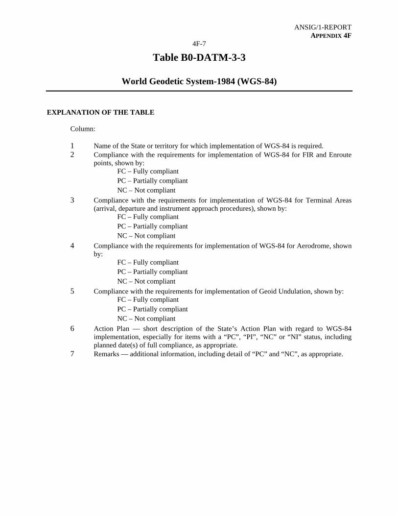
ANSIG/1-REPORT APPENDIX 4F
4F-7
Table B0-DATM-3-3
World Geodetic System-1984 (WGS-84)
EXPLANATION OF THE TABLE
Column: 1 Name of the State or territory for which implementation of WGS-84 is required. 2 Compliance with the requirements for implementation of WGS-84 for FIR and Enroute
points, shown by: FC – Fully compliant PC – Partially compliant NC – Not compliant
3 Compliance with the requirements for implementation of WGS-84 for Terminal Areas (arrival, departure and instrument approach procedures), shown by:
FC – Fully compliant PC – Partially compliant NC – Not compliant
4 Compliance with the requirements for implementation of WGS-84 for Aerodrome, shown by:
FC – Fully compliant PC – Partially compliant NC – Not compliant
5 Compliance with the requirements for implementation of Geoid Undulation, shown by: FC – Fully compliant PC – Partially compliant NC – Not compliant
6 Action Plan — short description of the State’s Action Plan with regard to WGS-84 implementation, especially for items with a “PC”, “PI”, “NC” or “NI” status, including planned date(s) of full compliance, as appropriate.
7 Remarks — additional information, including detail of “PC” and “NC”, as appropriate.

ANSIG/1-REPORT APPENDIX 4F
4F-8
TABLE B0-DATM-3-3
World Geodetic System-1984 (WGS-84)
State FIR/ENR Terminal AD GUND Action Plan Remarks
1 2 3 4 5 6 7 BAHARAIN FC FC FC FC Plan to be updated by 2016
EGYPT FC FC FC FC
IRAN, ISLAMIC REPUBLIC OF
FC NC FC FC AIM National Plan (2009) / Roadmap Template (2014)
IRAQ PC PC PC NC Roadmap Template (2014)
JORDAN FC FC FC FC KUWAIT FC FC FC FC Last survey FEB 2015
LEBANON FC FC FC NC Roadmap Template (2014)
LIBYA PC PC NC NC No Action Plan
OMAN FC FC FC FC
QATAR FC FC FC FC Annual Validation/Survey Updates planned up to 2017
SAUDI ARABIA FC FC FC FC SUDAN FC FC FC FC SYRIAN ARAB REPUBLIC
FC FC FC NC No Action Plan
UNITED ARAB EMIRATES
FC FC FC FC
YEMEN FC FC FC FC

ANSIG/1-REPORT APPENDIX 4F
4F-9
Table B0-DATM-3-4-1 Provision of Terrain and Obstacle data sets for Areas 1 and 4
EXPLANATION OF THE TABLE
Column
1 Name of the State or territory for which Terrain and Obstacle data sets forAreas 1 and 4 are required.
2 Compliance with requirement for the provision of Terrain data sets for Area 1,shown by:
FC – Fully Compliant PC – Partially Compliant NC – Not Compliant
3 Compliance with requirement for the provision of Terrain data sets for Area 4,shown by:
FC – Fully Compliant PC – Partially Compliant NC – Not Compliant
4 Compliance with requirement for the provision of Obstacle data sets for Area 1, shown by:
FC – Fully Compliant PC – Partially Compliant NC – Not Compliant
5 Compliance with requirement for the provision of Obstacle data sets for Area 4,shown by:
FC – Fully Compliant PC – Partially Compliant NC – Not Compliant
6 Action plan — short description of the State’s Action Plan with regard tocompliance with the requirements for provision of Terrain and Obstacle datasets for Areas 1 and 4, especially for items with a “PC” or “NC” status, including planned date(s) of full compliance, as appropriate.
7 Remarks— additional information, including detail of “PC” and “NC”, asappropriate.

ANSIG/1-REPORT APPENDIX 4F
4F-10
NAME ANP, Volume III Part I May 2014
TABLE B0-DATM-3-4-1
Provision of Terrain and Obstacle data sets for Areas 1 and 4
State
Terrain data sets Obstacle data sets Action Plan Remarks
Area 1 Area 4 Area 1 Area 4 1 2 3 4 5 6 7
BAHARAIN FC FC FC FC EGYPT FC FC PC PC No Action Plan IRAN, ISLAMIC REPUBLIC OF
FC FC FC FC
IRAQ NC NC NC NC Roadmap Template (2014) JORDAN NC NC NC NC Roadmap Template (2014)
KUWAIT NC NC NC NC AIS to AIM Roadmap (2009) LEBANON NC NC NC NC Roadmap Template (2014) LIBYA NC NC NC NC No Action Plan OMAN NC NC NC NC Roadmap Template (2014) QATAR FC FC FC FC SAUDI ARABIA
FC FC FC FC
SUDAN NC NC NC NC National AIM Plan (2014) / Roadmap Template (2014)
SYRIAN ARAB REPUBLIC
NC NC NC NC No Action Plan
UNITED ARAB EMIRATES
PC FC PC FC
YEMEN NC NC NC NC No Action Plan
---------------

ANSIG/1-REPORT APPENDIX 4G
APPENDIX 4G
Table B0-AMET 3-1
SADIS 2G and Secure SADIS FTP
EXPLANATION OF THE TABLE
Column: 1 Name of the State 2, 3 Status of implementation of SADIS 2G and/or Secure SADIS FTP, where:
Y – Yes, Implemented N – No, not implemented
State
Implementation
SA
DIS
2G
Secu
re SA
DIS
FT
P
1 2 3 BAHRAIN Y Y EGYPT Y Y IRAN (ISLAMIC REPUBLIC OF) Y N IRAQ Y Y JORDAN N Y KUWAIT Y Y LEBANON N N LIBYA Y Y OMAN Y Y QATAR Y N SAUDI ARABIA Y Y SUDAN N N SYRIAN ARAB REPUBLIC Y N UNITED ARAB EMIRATES Y Y YEMEN Y N

ANSIG/1-REPORT APPENDIX 4G
4G-2
Table B0-AMET 3-4 Quality Management System
EXPLANATION OF THE TABLE
Column: 1 Name of the State 2,3,4,5 Status of implementation of Quality Management System of meteorological information
– QMS: not started/ planning, ongoing/ partially implemented, Implemented/ISO 9001 Certified, Date of Certification.
6 Action Plan 7 Remarks
State
Not started/ planning
Ongoing/ partially
implemented
Implemented/ ISO 9001 Certified
Action Plan Remarks
Status Date of Certification
1 2 3 4 5 6 7 BAHARAIN √ 2008 EGYPT √ 23 May 2012 IRAN, ISLAMIC REPUBLIC OF
√ No Action Plan submitted by State
IRAQ √
No Action Plan submitted by State
JORDAN √ 2 Apr 2014 KUWAIT √ 23 Aug 2013 LEBANON √ No Action Plan
submitted by State
LIBYA √ No Action Plan submitted by State
OMAN √ TBD QATAR √ Dec 2011 SAUDI ARABIA
√ Aug 2014
SUDAN √ 5 June 2014 SYRIAN ARAB REPUBLIC √
No Action Plan submitted by State
UNITED ARAB EMIRATES
√ 19 Dec 2012
YEMEN √
No Action Plan submitted by State
-----------------
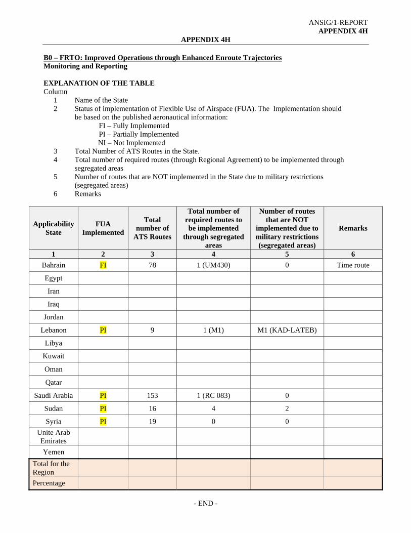
ANSIG/1-REPORT APPENDIX 4H
APPENDIX 4H B0 – FRTO: Improved Operations through Enhanced Enroute Trajectories Monitoring and Reporting EXPLANATION OF THE TABLE Column
1 Name of the State 2
3 4
Status of implementation of Flexible Use of Airspace (FUA). The Implementation should be based on the published aeronautical information:
FI – Fully Implemented PI – Partially Implemented NI – Not Implemented
Total Number of ATS Routes in the State. Total number of required routes (through Regional Agreement) to be implemented through segregated areas
5 Number of routes that are NOT implemented in the State due to military restrictions (segregated areas)
6 Remarks
Applicability State
FUA Implemented
Total number of
ATS Routes
Total number of required routes to be implemented
through segregated areas
Number of routes that are NOT
implemented due to military restrictions (segregated areas)
Remarks
1 2 3 4 5 6
Bahrain FI 78 1 (UM430) 0 Time route
Egypt
Iran
Iraq
Jordan
Lebanon PI 9 1 (M1) M1 (KAD-LATEB)
Libya
Kuwait
Oman
Qatar
Saudi Arabia PI 153 1 (RC 083) 0
Sudan PI 16 4 2
Syria PI 19 0 0
Unite Arab Emirates
Yemen
Total for the Region
Percentage
- END -

ANSIG/1-REPORT APPENDIX 4I
APPENDIX 4I
MID CIVIL/MILITARY SUPPORT TEAM
Objective and Working Arrangements
I. Objective
The overall objective of the MID Civil/Military Support Team is to provide States with high-level guidance and recommendations to enhance the civil/military cooperation and expedite the implementation of the Flexible Use of Airspace (FUA) Concept.
II. MID Civil/Military Support Team Composition The MID Civil/Military Support Team will be composed of experts from ICAO, IATA and other representatives/subject matter experts from States and Stakeholders, as appropriate.
III. State Civil Aviation Authority Responsibilities
• Provide facilities and all kind of support for a successful conduct of the visit.
• Ensure that all stakeholders (civil and military) involved in the FUA implementation are represented during the visit.
• Provide required information and documentation.
IV. Working Arrangements
Phase 1 – Coordination for the Visit
• Identification of the candidate States in need of a MID Civil/Military Support Team by IATA, ICAO, or through the relevant MIDANPIRG subsidiary bodies.
• ICAO to coordinate with the candidate State the dates and pre-acceptance of the visits.
• Hosting State to formally confirm, to the ICAO MID Regional Office, the acceptance of the MID Civil/Military Support Team visit.
• Hosting State to appoint a Point of Contact (POC).
• Agenda, Work Programme, activities and expected outcomes of the visit to be communicated with the State.
• Teleconference(s) to be conducted with the POC jointly by IATA and ICAO to ensure good preparation for the visit.

ANSIG/1-REPORT APPENDIX 4I
4I-2
PHASE III –Team Coordination
• IATA and ICAO to coordinate the establishment of the Team (call for experts).
• Team members to agree on the States to be visited.
• The team should prepare the Work Programme for the visit with the assigned tasks for each member.
• Priority work areas to be identified by the Team.
• The Team members should share the required information.
• The coordination between the Team members will be mainly through emails and teleconferences.
a) PHASE IV – Support Team Tasks Utilizing best practices and available ICAO provisions, the MID Civil/Military Support Team will assist States through the following process:
• Assessment of the existing ATS route network.
• Assessment of the existing airspace structure.
• Review the status of CNS infrastructure.
• Identify potential gaps and develop a list of recommended actions.
• Assist States in the development of measures to implement the FUA through strategic Civil/Military coordination and dynamic interaction, in order to open up segregated airspace when it is not being used for its originally-intended purpose and allow for better airspace management and access for all users.
• Address with the relevant authorities the ICAO provisions related to civil/military cooperation and FUA, as well as the recommendations emanating from the ICAO General Assembly, DGCA-MID and MIDANPIRG.
• Organize Workshop(s) as deemed necessary.
PHASE IV – Follow-up Activities.
• The MID Civil/Military Support Team will provide a report with a list of Recommendations/Action Plan, which would foster the FUA Implementation, within 30 days after the completion of the visit.
• State visited is requested to provide the ICAO MID Regional Office with a periodic update on the implementation of the Recommendations (Action Plan).
---------------

ANSIG/1-REPORT APPENDIX 4J
APPENDIX 4J
ACAS V7.1 Status and regulation reference
State ACAS V7.1 requirement Regulation Reference Remarks
1 2 3 4
Bahrain All fixed - wing turbine - engine aircraft having maximum take - off mass in excess of 5700 KG or approved passenger seating configuration of more than 19, will be required to be equipped with ACAS II
1.5.1.5 in Bahrain AIP
Air Navigation Technical Regulations (ANTR) – will be updated to reflect Annex 10 (Volume IV)
Egypt ACAS II mandated
Need to update regulation
Iran 4.3.5.3.1. New ACAS installations after 1 January 2014 shall monitor own aircraft’s vertical rate to verify compliance with the RA sense. If non-compliance is detected, ACAS shall stop assuming compliance, and instead shall assume the observed vertical rate. 4.3.5.3.2. After 1 January 2017, all ACAS units shall comply with the requirements stated in 4.3.5.3.1.
Aeronautical Telecommunications bylaw, articles 3 and 4
According to articles 3 and 4 of Iran aeronautical telecommunications by law, ratified by board of ministers, Airborne collision avoidance systems are categorized as aeronautical telecommunications systems and should be manufactured, installed and maintained according to standards of Annex 10. -Since no difference to ICAO annex 10 is notified, ACAS V 7.1 is mandatory according to provisions of annex 10 amendment 85. -Airworthiness directives issued by FAA and EASA shall to be implemented by Iranian AOC holders.
Iraq
Jordan
Kuwait
Lebanon
Libya
Oman
Qatar 3.5.3.1 New ACAS installations after 1 January 2014 shall monitor own aircraft’s vertical rate to verify compliance with the RA sense. If non-compliance is detected, ACAS shall stop assuming compliance, and instead shall assume the observed vertical rate. Note 1.— This overcomes the retention of an RA sense that would work only if followed. The revised vertical rate assumption is more
QCAR – OPS 1, Subpart K, QCAR – OPS 1.668 – Airborne collision avoidance system
References: http://www.caa.gov.qa/en/safety_regulations

ANSIG/1-REPORT APPENDIX 4J
4J-2
State ACAS V7.1 requirement Regulation Reference Remarks
1 2 3 4 likely to allow the logic to select the opposite sense when it is consistent with the non-complying aircraft’ s vertical rate. Note 2.— Equipment complying with RTCA/DO-185 or DO-185A standards (also known as TCAS Version 6.04A or TCAS Version 7.0) do not comply with this requirement. Note 3.— Compliance with this requirement can be achieved through the implementation of traffic alert and collision avoidance system (TCAS) Version 7.1 as specified in RTCA/DO-185B or EUROCAE/ED143. 4.3.5.3.2 QCAR CNS Note: All ACAS shall be compliant with the requirement in 4.3.5.3.1. 4.3.5.3.3 After 1 January 2017, all ACAS units shall comply with the requirements stated in 4.3.5.3.1.
QCAR Part 10 - Volume 4 Chapter 4 Airborne Collision Avoidance System
Saudi Arabia
Sudan
Syria
UAE CAR-OPS 1.668 Airborne Collision Avoidance System (See IEM OPS 1.668) and CAAP 29 An operator shall not operate a turbine powered aeroplane: (a) Having a MCTOM (maximum certificated take-off mass) in excess of 5700 kg or a MAPSC (maximum approved passenger seating configuration) of more than 19 unless it is equipped with an airborne collision avoidance system (ACAS) II Change 7.0 . From 31 January 2015 such aeroplanes shall be equipped with ACAS II, Change 7.1. (b) Manufactured after 31 December 2012 and having a MCTOM in excess of 5700 kg or a MAPSC of more than 19 unless it is equipped with ACAS II, Change 7.1."
CAR-OPS 1.668 Airborne Collision Avoidance System (See IEM OPS 1.668) and CAAP 29 And AIP 1.5.6.6
https://www.gcaa.gov.ae/en/ePublication/Pages/CARs.aspx?CertID=CARs
Yemen From 31 January 2015 such aeroplanes shall be equipped with ACAS II, Change 7.1
Reference need to be provided
-------------------

ANSIG/1-REPORT APPENDIX 4K
APPENDIX 4K
MID TOP 10 PROPOSED ATS ROUTES
TPR ATS Route Catalogue Reference
ATS Route
Affected
States Concerned Status Remarks
Reviewed by Date Changed
(a) (b) (c) (d) (e) (f) (g) (h)
1 RC-035 UL602 Iraq – Syria-Turkey ATM SG/1 June 2014
Yes Pending for Syria approval
2 RC-045 New Saudi Arabia-Sudan ATM SG/1 June 2014
Yes Moved to ANP
3 RC-055 L315 Egypt-Saudi Arabia ATM SG/1 June 2014
Yes Saudi proposed SOBEL-DEDLI
4 RC-056 New Egypt ATM SG/1 June 2014
Yes
5 RC-070 New Egypt-Libya ATM SG/1 June 2014
Yes Moved to ANP
6 RC-082 New Jordan-Saudi Arabia ATM SG/1 June 2014
Yes Route amended and moved to ANP
7 RC-083 New Egypt-Libya-Saudi Arabia
ATM SG/1 June 2014
Yes Route amended and moved to ANP
8 Eurocontrol Proposal 1
New Egypt ATM SG/1 June 2014
New
9 UKMUG-SIDAD
New Bahrain-Iraq-Kuwait ATM SG/1 June 2014
New RNAV 1 Routes
10 SIDNA-ASLAN
New Bahrain-Iraq-Kuwait ATM SG/1 June 2014
New RNAV 1 Routes
Table explanation
a) TPR used as reference for the proposed Top 10 routes to be considered for implementation, numbers do not reflect the level of priority.
b) Source of the proposed routes. c) Affected ATS Routes by the implementation of the new proposed routes. d) States Concerned with the implementation. e) The Group, Sub-Group or Task Force that had reviewed and updated the status of implementation of these top 10 routes. f) Date of last status update. g) Indicates if the status is changed or Not. h) Remarks

ANSIG/1-REPORT APPENDIX 4K
4K-2
MID/RC-035 (TPR 1)
ATS Route Name: UL602
Entry-Exit: TUMAK (OB-OM) – KUKSI (OS-LT) MAKOL (LT) END
Inter-Rgional Cross Reference if any
Users Priority URGENT
Originator of Proposal
Iraq
Date of Proposal RDGE/11 (Oct 2009)
Route Description States
Concerned Expected Impl. date
Implementation Status ANP Status Action Taken / Required Deadline for each Action
GEPAP 334906N 0422851E ELEXI 344130N 0410900E DRZ 351724N 0401124E GAZ 365701N 0372824E SULAK 375439N 0361712E
Iraq Syria Turkey
Entire route Westbound Suspended in the Damascus FIR GEPAP (OR) to SULSAK (LT) not implemented
Syria requested additional time to examine the communication requirements by concerned FIR’s.
Once the communication issues are resolved it is expected that the ATS route will be implemented. Iraq has no objection
Conditional on Communication Pending acceptance by Syria, based on the status of communication infrastructure
Flight Level Band: FL240-FL460
Potential City Pairs:
Conclusions/Remarks Last updated ATM SG/1 June 2014
MID/RC-035 - (TPR 1)

ANSIG/1-REPORT APPENDIX 4K
4K-3
MID/RC-045 (TPR 2)
ATS Route Name: New Route
Entry-Exit:
PSD- KITAP
Inter-Regional Cross Reference if any
Users Priority
Originator of Proposal
IATA
Date of Proposal ARN TF/2
Route Description States
Concerned Expected Impl. date
Implementation Status ANP Status Action Taken / Required Deadline for each Action
Port Sudan (PSD)
BOGUM
Al BAHA (BHA)
KITAP
Saudi Arabia, Sudan
Not implemented
Moved to ANP August 2014
Sudan has no objection
from Port Sudan to SALWA (CDR)
KSA suggest Port Sudan BHA-KITAP (Normal route) will avoid CDR
KSA needs more time for studying.
Flight Level Band:
Potential City Pairs: DGAA, DNMM, HSSS, OEJN, SBGR to OBBI, OMAA, OMDB, OTBD (Central and Eastern Arabian Peninsula to Sudan, West Africa, South America)
Conclusions/Remarks Saves 58 miles and 3196 Kg of CO2 to recalculate Last updated ATM SG/1 June 2014
MID/RC-045 - (TPR 2)

ANSIG/1-REPORT APPENDIX 4K
4K-4
MID/RC-055 (TPR 3)
ATS Route Name: New Route L315
Entry-Exit:
HEMA-CVO
Inter-Regional Cross Reference if any
Users Priority
Originator of Proposal
IATA
Date of Proposal ARN TF/2
Route Description MAK-CVO
States Concerned
Expected Impl. date
Implementation Status ANP Status Action Taken / Required Deadline for each Action
GIBAL
HGD
CVO
Egypt Saudi Arabia
Implemented with opposite direction
CVO-HGD Eastbound
GIBAL-HGD Westbound
Already in ANP
Saudi Arabia proposed L315 westbound and new Segment HDG or SOBEL-DEDLI for eastbound.
This requires that CVO-HGD to be bi-directional.
Pending Egypt approval
Flight Level Band: Upper
Potential City Pairs: North-western Red Sea to HECA and Europe
Conclusions/Remarks Saves 9 miles Last updated ATM SG/1 June 2014

ANSIG/1-REPORT APPENDIX 4K
4K-5
MID/RC-056 (TPR 4)
ATS Route Name: New Route
Entry-Exit:
HEMA-SHM
Inter-Regional Cross Reference if any
Users Priority
Originator of Proposal
IATA
Date of Proposal ARN TF/2
Route Description HEMA-SHM
States Concerned
Expected Impl. date
Implementation Status ANP Status Action Taken / Required Deadline for each Action
Egypt
No progress reported
IATA to provide further details
Tied with L315 await further discussions from Egypt.
Flight Level Band: Upper
Potential City Pairs: HESH, Eastern Mediterranean, Europe to Western Red Sea Coast
Conclusions/Remarks Saves 17 miles Last updated ATM SG/1 June 2014
MID/RC-056- (TPR 4)

ANSIG/1-REPORT APPENDIX 4K
4K-6
MID/RC-070 (TPR 5)
ATS Route Name:
New Route
Entry-Exit: BNA-KATAB-SEMRU
Inter-Regional Cross Reference if any
Users Priority
High
Originator of Proposal
IATA
Date of Proposal ARN TF/1
Route Description States
Concerned Expected Impl. date
Implementation Status ANP Status Action Taken/Required Deadline for each Action
BNA (N32 07.5 E020 15.2) –
KATAB (N29 25.0 E029 05.1)
Egypt Libya
New ATS route.
Moved to ANP
Differed for the future
Implement if possible
Priority Routes
Requires further coordination with concerned States
Egypt and Libya to implement the route
Flight Level Band: FL290 – FL410
Potential City Pairs: CMN/ALG/TUN/TIP-DOH
Conclusions/Remarks This AWY would save considerable track miles BNA – KATAB – SEMRU Libya FIR to Egypt FIR
Last updated ATM SG/1 June 2014
MID TPR 5

ANSIG/1-REPORT APPENDIX 4K
4K-7
MID/RC-082 (TPR 6)
ATS Route Name:
New Route UQ597 Eastbound
Entry-Exit: DANAD - METSA – ASH – ULOVO
Inter-Regional Cross Reference if any
Users
Priority High
Originator of Proposal
IATA iFLEX Proposal
Date of Proposal 17 May 2011
Route Description States
Concerned Expected Impl. date
Implementation Status ANP Status Action Taken/Required Deadline for each Action
DEESA
ENABI
TAMRO
LOTOK
Jordan Saudi Arabia
Moved to ANP
Connecting to UP559.
Implement if possible
Priority Routes
Saudi Arabia to implement the route
TBD
Flight Level Band:
Potential City Pairs: Dakar FIR, Algiers FIR, Tripoli FIR, Cairo FIR, Jeddah FIR
Conclusions/Remarks Proposals agreed to by some State during the iFLEX workshop Dubai Last updated ATM/AIM/SAR SG/13 SEP 2013
MID TPR 6

ANSIG/1-REPORT APPENDIX 4K
4K-8
MID/RC-083 (TPR 7)
ATS Route Name:
New Route UQ598 Westbound
Entry-Exit: DITAR – NABED – PASAM – HIL - ANTER - KUTEM
Inter-Regional Cross Reference if any
Users Priority
High
Originator of Proposal
IATA iFLEX Proposal
Date of Proposal 17 May 2011
Route Description States
Concerned Expected Impl. date
Implementation Status ANP Status Action Taken/Required Deadline for each Action
HIL
PASAM
HGD
Egypt Saudi Arabia
Moved to ANP
Implement if possible
Priority Routes
Important Segment
HGD-PASAM
It’s a west bound direction
(FUA)
N697 - HIL-PASAM-HGD -V608
RC 083 amended to include segment AST-DITAR only
Concerned States to implement the route
TBD
Flight Level Band:
Potential City Pairs:
Conclusions/Remarks Last updated ATM SG/1 June 2014
MID (TPR 7)

Reference TPR 8
Notes: 1. AAAAA 2. Shorter b3. Shorter b
ObjectivObjective To imple
- crossing poinby 9.2NM optioby 28.6NM opt
ve and Propoe: To further
ement bi-direc
t between new on compare to eion compare to
Euroco
sal improve ATS
ctional ATS ro
TBA - KITOT aexisting TBA - N
o existing TBA -
4K-9
ontrol propo
(TPR 8)
S route networ
oute TBA - A
and existing ATNWB - KITOT.- NWB - METSA
osals
rk within Cairo
AAAA - KIT
TS route W733 a
A.
Sto FIR.
TOT.
EOE
allowing connec
ANS
tate(s) concerEGY Originator EUROCONTR
ction to/from M
SIG/1-REPOAPPENDIX
rned
ROL
METSA.
RT 4K

ANSIG/1-REPORT APPENDIX 4K
4K-10
Reference Objective and Proposal State(s) concerned TPR 9 Objective: To further improve ATS route network between Baghdad and
Kuwait FIRs. To implement ATS route UKMUG-SIDAD- New Point East of RABAP then join the ATS Route network within Bahrain.
Bahrain-Iraq-Kuwait
Originator ATM/AIM/SAR SG13 Oct 2013
Notes: 1. RNAV 1 Routes, target date of implementation second quarter of 2014.
Reference Objective and Proposal State(s) concerned TPR 10 Objective: To further improve ATS route network between Baghdad and
Kuwait FIRs. To implement ATS route SIDNA-New point West of ASLAN-RABAP.
Bahrain-Iraq-Kuwait
Originator ATM/AIM/SAR SG13 Oct 2013
Notes: 2. RNAV 1 Routes, target date of implementation second quarter of 2014.
TPR 9 and 10
------------------

ANSIG/1-REPORT APPENDIX 4L
APPENDIX 4L
PROPOSAL FOR AMENDMENT OF THE ICAO MID AIR NAVIGATION PLAN (DOC 9708), VOLUME I BASIC ANP
(Serial No. MID Basic ANP 15/XX - ATM)
a) Plan: MID Basic Air Navigation Plan b) Proposed amendment: Editorial note: Amendments are arranged to show “deleted text” using
strikeout (text to be deleted), and “added text” with grey shading (text to be inserted)
Amend requirement for ATS routes: A453/UA453, B415/UB415, B416/UB416, B419/UB419, B458/UB457, G663/UG663, L305/UL305, L564/UL564, L602/UL602, L604/UL604, L768/UL768, M318/UM318, M430/UM430, M557/UM557, M600/UM600, M677/UM677, N300/UN300, N318/UN318, N685/UN685, N687/UN687, N697/UN697, P425/UP425, P430/UP430, P559/UP559, P699/UP699 and P975/UP975 as follows:
LOWER AIRSPACE UPPER AIRSPACE
Designator Significant Points Designator Significant Points 1 2 1 2
A453 PIRAN 2934.1N 06128.1E ZAHEDAN (ZDN) BANDAR ABBAS (BND) GHESHM (KHM) BANDAR LENGEH (LEN) KISH MIDSI 264142N0515242E BOTOB 263350N 0514505E ALMOK 262832N 0513840E SOLOB 262241N 0513132E TOBLI 262134N0512301E SOGAT 262029N 0511443E ASTAD 261811N 0505646E OTATA 261843N0510052E BAHRAIN * Note 7 (OB, OI) ELOSO 262409N 0503550E EGMOR 264210N 0502906E LOTOR 264854N 0502200E RAMSI 270249N 0500714E ORNAK 272853N 0493248E PEBOS 262722N0503043E RULEX 264529N0501745E ALVUN 271028N0494455E SOLEM 275229N0491136E KUMBO 281705N0495526E AWADI 2834.5N 04843.9E DEBTI 2844.1N 04829.4E KUA 2913.1N 04759.1E
UA453 PIRAN 2934.1N 06128.1E ZAHEDAN (ZDN) BANDAR ABBAS (BND) GHESHM (KHM) BANDAR LENGEH (LEN) KISH MIDSI 264142N0515242E BOTOB 263350N 0514505E ALMOK 262832N 0513840E SOLOB 262241N 0513132E TOBLI 262134N0512301E SOGAT 262029N 0511443E ASTAD 261811N 0505646E OTATA 261843N0510052E BAHRAIN * Note 7 (OB, OI) ELOSO 262409N 0503550E EGMOR 264210N 0502906E LOTOR 264854N 0502200E RAMSI 270249N 0500714E ORNAK 272853N 0493248E PEBOS 262722N0503043E RULEX 264529N0501745E ALVUN 271028N0494455E SOLEM 275229N0491136E KUMBO 281705N0495526E AWADI 2834.5N 04843.9E DEBTI 2844.1N 04829.4E KUA 2913.1N 04759.1E

ANSIG/1-REPORT APPENDIX 4L
4L-2
LOWER AIRSPACE UPPER AIRSPACE
Designator Significant Points Designator Significant Points 1 2 1 2
B415 DOHA (DOH) HAMAD INTERNATIONAL (DOH) 251459N 0513634E *Note 8 (DOH-BUNDU) KUPSA 250445N 0521151E AFNAN 2508.9N 05155.9E BUNDU 2500.4N 05229.4E *Note 7 (BUNDU-ADV) GADVO 2441.4N 05343.0E KUNGU 2437.9N 05356.4E ABU DHABI ADV 2425.1N 05440.4E
UB415 DOHA (DOH) HAMAD INTERNATIONAL (DOH) 251459N 0513634E *Note 8 (DOH-BUNDU) KUPSA 250445N 0521151E AFNAN 2508.9N 05155.9E BUNDU 2500.4N 05229.4E *Note 7 (BUNDU-ADV) GADVO 2441.4N 05343.0E KUNGU 2437.9N 05356.4E ABU DHABI ADV 2425.1N 05440.4E
B416 KUWAIT (KUA)
AMBIK 283222N 0492025E *Note 8 (AMBIK-KUVER) TESSO 282852N0492723E GEVAL 283625N0492722E 282101N 0494300E GOGMA 281421N 0495612E KUVER 280924N0500600E IMDAT 2741.0N 05111.0E ORSAR 2604.5N 05357.5E PEBAT 2551.9N 05423.9E DESDI 2536.0N 05442.5E
UB416 KUWAIT (KUA) AMBIK 283222N 0492025E *Note 8 (AMBIK-KUVER) TESSO 282852N0492723E GEVAL 283625N0492722E 282101N 0494300E GOGMA 281421N 0495612E KUVER 280924N0500600E IMDAT 2741.0N 05111.0E ORSAR 2604.5N 05357.5E PEBAT 2551.9N 05423.9E DESDI 2536.0N 05442.5E
B419 (DHA) 261538N 0500824E
* Note 8 (DHA-RAMSI) KING FAHD (KFA) * Note 7 (KFA-RAMSI) METLA (FIR BDRY) 265645.21 0500432.59E ASTOM 265552N 0500408E RAMSI 270249N 0500714E
UB419 (DHA) 261538N 0500824E * Note 8 (DHA-RAMSI) KING FAHD (KFA) * Note 7 (KFA-RAMSI) METLA (FIR BDRY) 265645.21 0500432.59E ASTOM 265552N 0500408E RAMSI 270249N 0500714E
B457 NARMI 261802N 0501939E
(OEJD FIR BDRY) BAH 261551 0503855 DENVO 260452N 0510509E PATOM 255821N 0511836E EMISA 254658N 0514206E BAHRAIN (BAH) * Note7 ELOSA 2548.8N 05142.6E
UB457 NARMI 261802N 0501939E (OEJD FIR BDRY) BAH 261551 0503855 DENVO 260452N 0510509E PATOM 255821N 0511836E EMISA 254658N 0514206E BAHRAIN (BAH) * Note7 ELOSA 2548.8N 05142.6E

ANSIG/1-REPORT APPENDIX 4L
4L-3
LOWER AIRSPACE UPPER AIRSPACE
Designator Significant Points Designator Significant Points 1 2 1 2
G663 KING KHALID (KIA) SILNO 2640.4N 04757.7E *Note 7 (KIA-KFA) GIBUS 255724N 0472829E *Note 8 (GIBUS-ALSER) KING FAHD (KFA) ULADA 264526N0501623E (OEJD FIR BDRY) LOTOR 264854N 0502200E RAKAK 265221N 0502618E TOLMO 265504N 0502927E KOBOK 265839N 0503349E ITIXA 270141N 0503735E GETAL 270409N 0504039E VEDOR 270855N 0504630E ALSER 271100N 0504900E ALSER 2710.8 05049.5E SHIRAZ (SYZ) YAZD (YZD) NODLA 3253.3N 05458.8E TABAS (TBS) MASHAD (MSD)
UG663 KING KHALID (KIA) SILNO 2640.4N 04757.7E *Note 7 (KIA-KFA) GIBUS 255724N 0472829E *Note 8 (GIBUS-ALSER) KING FAHD (KFA) ULADA 264526N0501623E (OEJD FIR BDRY) LOTOR 264854N 0502200E RAKAK 265221N 0502618E TOLMO 265504N 0502927E KOBOK 265839N 0503349E ITIXA 270141N 0503735E GETAL 270409N 0504039E VEDOR 270855N 0504630E ALSER 271100N 0504900E ALSER 2710.8 05049.5E SHIRAZ (SYZ) YAZD (YZD) NODLA 3253.3N 05458.8E TABAS (TBS) MASHAD (MSD)
L305 DOHA /(DOH)
HAMAD INTL (DOH) 251459N 0513634E ORMAL 252303N 0522200E ENANO 252348N 0522558E ALSEM 252703N 0524322E ASTOG 252822N 0525025E FIR BDRY *Note 7 (DOH-ITITA) *Note 8 (DOH-ASTOG) ASTOG 252822N 0525025E ITITA 2544.2N 05418.7E
UL305 DOHA / (DOH) HAMAD INTL (DOH) 251459N 0513634E ORMAL 252303N 0522200E ENANO 252348N 0522558E ALSEM 252703N 0524322E ASTOG 252822N 0525025E FIR BDRY *Note 7 (DOH-ITITA) *Note 8 (DOH-ASTOG) ASTOG 252822N 0525025E ITITA 2544.2N 05418.7E
L564 DOHA (DOH)
DOHA/HAMAD INTL DVOR/DME (DOH ) 251459N 0513634E PASOM 245545N 0513713E DATRI 244239N 0513407E FIR BDRY DENSI 242519N 0512959E DENSI 242519N 0512959E *Note 8 (DOH-PURDA) NAJMA 250346N 0513908E BATHA (BAT) 241257N 0512707E MIGMA 225035N 0512749E PURDA 210805N 0510329N ASTIN 200410N 0495320E SHARURAH (SHA) ATBOT 171418N 0464706E LOTOS 2200.0N 05039.2E ALNUG 213009N 0500453E NONGA 2050.8N 04920.2E DENKU 201123N 0484331E GERUG 185530N 0473402E
UL564 DOHA (DOH) DOHA/HAMAD INTL DVOR/DME ( DOH ) 251459N 0513634E PASOM 245545N 0513713E DATRI 244239N 0513407E FIR BDRY DENSI 242519N 0512959E DENSI 242519N 0512959E *Note 8 (DOH-PURDA) NAJMA 250346N 0513908E BATHA (BAT) 241257N 0512707E MIGMA 225035N 0512749E PURDA 210805N 0510329N ASTIN 200410N 0495320E SHARURAH (SHA) ATBOT 171418N 0464706E LOTOS 2200.0N 05039.2E ALNUG 213009N 0500453E NONGA 2050.8N 04920.2E DENKU 201123N 0484331E GERUG 185530N 0473402E

ANSIG/1-REPORT APPENDIX 4L
4L-4
LOWER AIRSPACE UPPER AIRSPACE
Designator Significant Points Designator Significant Points 1 2 1 2
ASKET 181905N 0470113E PATOG 180241N 0464631E VUVOD 173941N 0463200E TULIS 173033N 0462616E ULBON 171425.318N 0461514.915E (Jeddah / Sana’a FIR BDRY POINT) RAGNI 163454N 0454815E LOPAD 161651N 0453738E ITOLI 152825N 0450927E OBNAM 144541N 0444448E GEVEL 141229N 0442547E NOPVO 135436N 0441536E TAZ 134149.53N 0440818.98E PARIM 123142N 0432712E
ASKET 181905N 0470113E PATOG 180241N 0464631E VUVOD 173941N 0463200E TULIS 173033N 0462616E ULBON 171425.318N 0461514.915E (Jeddah / Sana’a FIR BDRY POINT) RAGNI 163454N 0454815E LOPAD 161651N 0453738E ITOLI 152825N 0450927E OBNAM 144541N 0444448E GEVEL 141229N 0442547E NOPVO 135436N 0441536E TAZ 134149.53N 0440818.98E PARIM 123142N 0432712E
L602 TUMAK 255031N 0531108E
(OMAE FIR BDRY) VEDOM 260109N 0524456E VELAK 261307N 0521821E LABOP 261907N 0520429E ALTOM 262230N 0515639E DASOS 262429N 0515043E ALMOK 262832N 0513840E VEDOS 264105N 0510044E NABOS 264354N 0505145E MEMKO 264611N 0504427E MOGAS 264759N 0503909E TOLMO 265504N 0502927E EGLIT 270255N 0502005E TOKMA 270938N 0501159E ORSOL 272135N 0500207E ITNAS 274643N 0493957E ENAVI 275552N 0493151E DAMUR 280137N 0492637E DAVUS 2823468N 0490622E (OKAC FIR BDRY)
UL602 TUMAK 255031N 0531108E (OMAE FIR BDRY) VEDOM 260109N 0524456E VELAK 261307N 0521821E LABOP 261907N 0520429E ALTOM 262230N 0515639E DASOS 262429N 0515043E ALMOK 262832N 0513840E VEDOS 264105N 0510044E NABOS 264354N 0505145E MEMKO 264611N 0504427E MOGAS 264759N 0503909E TOLMO 265504N 0502927E EGLIT 270255N 0502005E TOKMA 270938N 0501159E ORSOL 272135N 0500207E ITNAS 274643N 0493957E ENAVI 275552N 0493151E DAMUR 280137N 0492637E BAHRAIN (BAH) *Note 7 PEBOS 262722N0503043E RULEX 264529N 0501745E RAMSI 270249N 0500714E IVONI 275911N 0492131E DAVUS 282346N 0490622 DARVA 284814N 0484734E ALVIX 2919.3N04824.2E FALKA 292611N 0481819E TASMI 300120N 0475505E LOVEK322206N 0444000E DELMI331911N 0431731E ELEXI 344237N 0411054E DRZ 351724N 0401124E KUKSI 364508N 0374910E GAZ 365701N 0372824E

ANSIG/1-REPORT APPENDIX 4L
4L-5
LOWER AIRSPACE UPPER AIRSPACE
Designator Significant Points Designator Significant Points 1 2 1 2
L604 PLH 3513.7N 02340.9E SALUN 340000N 0242700E * BRN 3134.5N 02600.3E KHG 2526.9N 03035.4E LUXOR (LXR) 254458 N 0324607E IMRAD 260500N 0354400E WEJH (WEJ) 261048.8N 0362918.3E HLF 262600N 03916.1E GASSIM (GAS) 2617.9N 04346.8E *Note 7 (GAS-KFA) PUSLA 261758N 0461706E *Note 8 to TOSNA MGA 2617.3N 04712.4E ALMAL 2615.9N 04821.1E KING FAHD (KFA) 2621.9N 04949.2E NARMI 261802N 0501939E FIR BDRY BAHRAIN DVOR/DME (BAH) 261551N 0503855E DENVO 260452N 0510509E ASNIX 260452N 0510509E PATOM 255821N 0511836E EMISA 254658N 0514207E KAPAX 254218N 0515118E ORSIS 252801N 0521636E ENANO 252348N 0522559E TOSNA 251612N 0524116E
UL604 PLH 3513.7N 02340.9E SALUN 340000N 0242700E * BRN 3134.5N 02600.3E KHG 2526.9N 03035.4E LUXOR (LXR) 254458 N 0324607E IMRAD 260500N 0354400E WEJH (WEJ) 261048.8N 0362918.3E HLF 262600N 03916.1E GASSIM (GAS) 2617.9N 04346.8E *Note 7 (GAS-KFA) PUSLA 261758N 0461706E *Note 8 to TOSNA MGA 2617.3N 04712.4E ALMAL 2615.9N 04821.1E KING FAHD (KFA) 2621.9N 04949.2E NARMI 261802N 0501939E FIR BDRY BAHRAIN DVOR/DME (BAH) 261551N 0503855E DENVO 260452N 0510509E ASNIX 260452N 0510509E PATOM 255821N 0511836E EMISA 254658N 0514207E KAPAX 254218N 0515118E ORSIS 252801N 0521636E ENANO 252348N 0522559E TOSNA 251612N 0524116E
L768 ALPOB 254218N 0530055E * Note 7 to FIRAS * Note 8 (ALPOB-COPPI) ROTAG 255353N 0523621E SOLEG 260159N 0521756E MODOG 261012N 0515935E RAMKI 261138N 0515625E RABLA 261506N 0514834E SOLOB 262241N 0513132E MEDMA 263421N 0505454E TOTLA 263806N 0504301E EGMOR 264210.81N 0502906.73E ULADA 264526.72N 0501623.55E (OEJD FIR BDRY) JBL 270222N 0492426E COPPI 2750.6N 04744.0E
UL768 ALPOB 254218N 0530055E * Note 7 to FIRAS * Note 8 (ALPOB-COPPI) ROTAG 255353N 0523621E SOLEG 260159N 0521756E MODOG 261012N 0515935E RAMKI 261138N 0515625E RABLA 261506N 0514834E SOLOB 262241N 0513132E MEDMA 263421N 0505454E TOTLA 263806N 0504301E EGMOR 264210.81N 0502906.73E ULADA 264526.72N 0501623.55E (OEJD FIR BDRY) JBL 270222N 0492426E COPPI 2750.6N 04744.0E HFR VATIM 2851.6N 04444.7E RAFHA (RAF) ARAR (AAR) OVANO3148.0N 03909.9E OTILA 3201.5N 03901.9E MODAD 3235.7N 03841.6E SOKAN 3308.1N 03822.1E RAFIF 3312.8N 03819.3E SULAF 3327.3N 03810.4E FIRAS 3352.3N 03755.2E

ANSIG/1-REPORT APPENDIX 4L
4L-6
LOWER AIRSPACE UPPER AIRSPACE
Designator Significant Points Designator Significant Points 1 2 1 2
M318 DARAX 260942N 0555300E *Note 8 (DARAX-MUXIT) SERSA 251945N 0553118E MIADA 245112N 0545736E ABU DHABI (ADV) 242508N 0544023E ATUDO 241708N 0543532E MUSEN 241429N 0543336E GOLGU 231151N 0523109E MUXIT 230230N 0523024E KITAP 224928N 0522923E PURDA 210805N 0510329E SHARURAH (SHA) NADKI 171418N 0464706E SAA 153059.6N 0441310.6E HDH 144622N 0425911E
UM318 DARAX 260942N 0555300E *Note 8 (DARAX-MUXIT) SERSA 251945N 0553118E MIADA 245112N 0545736E ABU DHABI (ADV) 242508N 0544023E ATUDO 241708N 0543532E MUSEN 241429N 0543336E GOLGU 231151N 0523109E MUXIT 230230N 0523024E KITAP 224928N 0522923E PURDA 210805N 0510329E SHARURAH (SHA) NADKI 171418N 0464706E SAA 153059.6N 0441310.6E HDH 144622N 0425911E
M430 *Note 5 (KIA-DOH)
KING KHALID (KIA) KOBOX 250716N 0475046E KIREN 251447.0N 0490724.0E *Note 8 (KIREN-TOSNA) HAS 2516.7N 04929.0E ULIKA 251545N 0503848E (OEJD FIR BDRY) GINTO 251605N 0510415E LAGNO 251613N 0511518E DOHA/HAMAD INTL DVOR/DME (DOH ) 251459N 0513630E BOVIP 251554N 0523135E TOSNA 251612N 524116E (OMAE FIR BDRY) *Note 7 (DOH-KISAG) KISAG 251834N 0541408E
UM430 *Note 5 (KIA-DOH) KING KHALID (KIA) KOBOX 250716N 0475046E KIREN 251447.0N 0490724.0E *Note 8 (KIREN-TOSNA) HAS 2516.7N 04929.0E ULIKA 251545N 0503848E (OEJD FIR BDRY) GINTO 251605N 0510415E LAGNO 251613N 0511518E DOHA/HAMAD INTL DVOR/DME (DOH ) 251459N 0513630E BOVIP 251554N 0523135E TOSNA 251612N 524116E (OMAE FIR BDRY) *Note 7 (DOH-KISAG) KISAG 251834N 0541408E
M557
ATBOR 251007N 0551947E *Note7 & 8 to MIDSI NADIL 252252N 0544717E NABOP 252607N 0540405E EMAGO 253456N 0535751E VUVOK 254408N 0533024E TUMAK 255031N 0531108E ALTOM 262230N 0515639E TOXEL 263020N 0515553E MIDSI 264142N 0515442E
UM557
ATBOR 251007N 0551947E *Note7 & 8 to MIDSI NADIL 252252N 0544717E NABOP 252607N 0540405E EMAGO 253456N 0535751E VUVOK 254408N 0533024E TUMAK 255031N 0531108E ALTOM 262230N 0515639E TOXEL 263020N 0515553E MIDSI 264142N 0515442E
M600 RANBI 251908N 0544500E
KISAG 251834N 0541408E TUMAK 255031N 0531108E (OMAE FIR BDRY) VEDOM 260109N 0524456E VELAK 261307N 0521821E LABOP 261907N 0520429E ALTOM 262230N 0515639E DASOS 262429N 0515043E ALMOK 262832N 0513840E VEDOS 264105N 0510044E
UM600 RANBI 251908N 0544500E KISAG 251834N 0541408E TUMAK 255031N 0531108E (OMAE FIR BDRY) VEDOM 260109N 0524456E VELAK 261307N 0521821E LABOP 261907N 0520429E ALTOM 262230N 0515639E DASOS 262429N 0515043E ALMOK 262832N 0513840E VEDOS 264105N 0510044E

ANSIG/1-REPORT APPENDIX 4L
4L-7
LOWER AIRSPACE UPPER AIRSPACE
Designator Significant Points Designator Significant Points 1 2 1 2
NABOS 264354N 0505145E MOGAS 264759N 0503909E RAKAK 265221N 0502618E RAMSI 270249N 0500714E ORNAK 272853N 0493248E SOLEM 275229N 0491136E KUMBO 281705N 0485526E (OKAC FIR BDRY) SINGU 253706N 052570E NOBLA 255111N 0522740E TOBLI 262134N 0512301E RULEX 264529N 0501745E
NABOS 264354N 0505145E MOGAS 264759N 0503909E RAKAK 265221N 0502618E RAMSI 270249N 0500714E ORNAK 272853N 0493248E SOLEM 275229N 0491136E KUMBO 281705N 0485526E (OKAC FIR BDRY) SINGU 253706N 052570E NOBLA 255111N 0522740E TOBLI 262134N 0512301E RULEX 264529N 0501745E
M677 SESRA 2908.0N 04854.9E
RABAP 283625N 0492722E (OKAC FIR BDRY) PASAK 282459N 0494846E GOGMA 281421N 0495612E IVIVI 273734N 0502437E VEDOR 270855N 0504630E TOSDA 270004N 0505629E TORBO 265222N 0511024E SOGAN 263915N 0515408E DEGSO 261054N 0531946E OBNET 260032N 0534514E (OMAE FIR BDRY) GEVAL 282101N 0494300E UMAMA 265831N 0504648E
UM677 SESRA 2908.0N 04854.9E RABAP 283625N 0492722E (OKAC FIR BDRY) PASAK 282459N 0494846E GOGMA 281421N 0495612E IVIVI 273734N 0502437E VEDOR 270855N 0504630E TOSDA 270004N 0505629E TORBO 265222N 0511024E SOGAN 263915N 0515408E DEGSO 261054N 0531946E OBNET 260032N 0534514E (OMAE FIR BDRY) GEVAL 282101N 0494300E UMAMA 265831N 0504648E
N300 DOHA/HAMAD INTL DVOR/DME
(DOH ) 251459N 0513634E *Note 7 & 8 to TONVO ELOBI 250752N 0521721E
NAMLA 2505.5N 05233.3E BOXAK 244536N 0540032E MIADA 245112N 0545736E TONVO 250500N 0563200E
UN300 DOHA/HAMAD INTL DVOR/DME (DOH ) 251459N 0513634E
*Note 7 & 8 to TONVO ELOBI 250752N 0521721E
NAMLA 2505.5N 05233.3E BOXAK 244536N 0540032E MIADA 245112N 0545736E TONVO 250500N 0563200E

ANSIG/1-REPORT APPENDIX 4L
4L-8
LOWER AIRSPACE UPPER AIRSPACE
Designator Significant Points Designator Significant Points 1 2 1 2
N318 QAA 314423N 0360926E ALNOR 313955N 0362507E KINUR 313626N 0363714E ELOXI 313359N 0364536E GENEX 3129.6N 3700.9E GURIAT (GRY) ORKAS 3047.4N 03846.3 E NEVOL 3024.7N 03938.6E VELAL2946.0N 04038.4E TAMRO 2838.6N 04240.8E * Note7 (OE, OB, OM, OO) MOGON 2738.8N 04445.9E TAGSO 272744N 0454510E *Note 8 (OB, OO) EGNOV 270301N 0474713E KUSAR 264741N 0490218E ASPAN 263255N 0494903E DEDAS 263011N 0501427E LADNA OEJD FIR BDRY 262749.34N 0502244.63E ELOSO 262409.19N 0503550.70E DAVOV 262255.00N 0504012.54E GOLKO 262149.22N 0504404.35E ASTAD 261811.64N 0505646.41E TOTIS 261119.11N 0511026.91E RASDI 260425.38N 0512407.37E VELAM 255426.12N 0514347.13E VUTAN 255015.91N 0515218.39E RESAR 253707.00N 0522328.00E ALSEM 252703.45N 0524322.04E OVONA FIR BDRY 252443.00N 0524739.00E ASTAD 261812N 0505646E VUTAN 255016N 0515218E RESAR 253707N 0522328E UMABA 252703N 0524322E (segment LOXAT - REXOD KATIK 2517.1N 05315.2E KANIP 2410.7N 05520.7E LABRI 240344N 0553842E EGROK 235253N 0560126E LAKLU 232235N 0570401E GEVED 230105N 0575111E TOLDA 223720N 0583503E REXOD211230N 0613830E
UN318 QAA 314423N 0360926E ALNOR 313955N 0362507E KINUR 313626N 0363714E ELOXI 313359N 0364536E GENEX 3129.6N 3700.9E GURIAT (GRY) ORKAS 3047.4N 03846.3 E NEVOL 3024.7N 03938.6E VELAL2946.0N 04038.4E TAMRO 2838.6N 04240.8E * Note7 (OE, OB, OM, OO) MOGON 2738.8N 04445.9E TAGSO 272744N 0454510E *Note 8 (OB, OO) EGNOV 270301N 0474713E KUSAR 264741N 0490218E ASPAN 263255N 0494903E DEDAS 263011N 0501427E LADNA OEJD FIR BDRY 262749.34N 0502244.63E ELOSO 262409.19N 0503550.70E DAVOV 262255.00N 0504012.54E GOLKO 262149.22N 0504404.35E ASTAD 261811.64N 0505646.41E TOTIS 261119.11N 0511026.91E RASDI 260425.38N 0512407.37E VELAM 255426.12N 0514347.13E VUTAN 255015.91N 0515218.39E RESAR 253707.00N 0522328.00E ALSEM 252703.45N 0524322.04E OVONA FIR BDRY 252443.00N 0524739.00E ASTAD 261812N 0505646E VUTAN 255016N 0515218E RESAR 253707N 0522328E UMABA 252703N 0524322E (segment LOXAT-REXOD) KATIK 2517.1N 05315.2E KANIP 2410.7N 05520.7E LABRI 240344N 0553842E EGROK 235253N 0560126E LAKLU 232235N 0570401E GEVED 230105N 0575111E TOLDA 223720N 0583503E REXOD211230N 0613830E
N685 TAGSO 272744N 0454510E
*Note 7 (TAGSO-KUSAR) *Note 8 (TAGSO-TOSNA) DEBOL 272116N 0461843E TORTA 271906N 0462911E ALSAT 270611N 0473118E EGNOV 270301N 0474713E KUSAR 264741N 0490218E KING FAHAD (KFA) NARMI 261802N 0501939E (OEJD FIR BDRY)
UN685 TAGSO 272744N 0454510E *Note 7 (TAGSO-KUSAR) *Note 8 (TAGSO-TOSNA) DEBOL 272116N 0461843E TORTA 271906N 0462911E ALSAT 270611N 0473118E EGNOV 270301N 0474713E KUSAR 264741N 0490218E KING FAHAD (KFA) NARMI 261802N 0501939E (OEJD FIR BDRY)

ANSIG/1-REPORT APPENDIX 4L
4L-9
LOWER AIRSPACE UPPER AIRSPACE
Designator Significant Points Designator Significant Points 1 2 1 2
BAHRAIN (BAH) 261551N 0503856E ASNIX 260452N 0510509E PATOM 255821N 0511836E EMISA 254658N 0514207E *Note 7 to LAKLU KAPAX 254218N 0515118E ORSIS 252801N 0521636E ENANO 252348N 0522558E TOSNA 251612N 0524116E TOPSI 250910N 0531200E BOXAK 244536N 0540032E ADV 242508N 0544024 RETAS 235754N 0553423E *Note 8 (OO) PUTSO 232037N 0565322E LAKLU 232235N 0570401E
BAHRAIN (BAH) 261551N 0503856E ASNIX 260452N 0510509E PATOM 255821N 0511836E EMISA 254658N 0514207E *Note 7 to LAKLU KAPAX 254218N 0515118E ORSIS 252801N 0521636E ENANO 252348N 0522558E TOSNA 251612N 0524116E TOPSI 250910N 0531200E BOXAK 244536N 0540032E ADV 242508N 0544024 RETAS 235754N 0553423E *Note 8 (OO) PUTSO 232037N 0565322E LAKLU 232235N 0570401E
N687 KING KHALID (KIA)
KINIB 254108N 0482317E *Note 5 & 7 & 8 KING FAHAD (KFA) ROTEL 264015N 0502149E (OEJD FIR BDRY) EGMOR 264210N 0502906E MUTAR 263611N 0500627E MEMKO 264611N 0504427E DAVRI 264936N 0505732E TORBO 265223N 0511024E
UN687 KING KHALID (KIA) KINIB 254108N 0482317E *Note 5 & 7 & 8 KING FAHAD (KFA) ROTEL 264015N 0502149E (OEJD FIR BDRY) EGMOR 264210N 0502906E MUTAR 263611N 0500627E MEMKO 264611N 0504427E DAVRI 264936N 0505732E TORBO 265223N 0511024E
N697 MENLI 2947.0N 03152.1E
SISIK 2936.0N 03241.E NUWEIBAA * Note 7 (NWB-KITOT below FL350) KITOT 2902.1N 03450.8E SOBAS 2756.0N 03904.9E HAIL (HIL) *Note 7 (HIL–KFA) BPN 2703.2N 04526.7E *Note 8 (BPN-TORBO) KING FAHD (KFA) NARMI 261802N 0501939E (OEJD FIR BDRY) BAHRAIN DVOR/DME (BAH) 261551N 0503855E *Note 7 GOLKO 262149N 0504404E TOSTA 262746N 0504912E MEDMA 263421N 0505454E VEDOS 264105N 0510044E SODAK 264634N 0510530E TORBO 265223N 0511024E
UN687 MENLI 2947.0N 03152.1E SISIK 2936.0N 03241.E NUWEIBAA * Note 7 (NWB-KITOT below FL350) KITOT 2902.1N 03450.8E SOBAS 2756.0N 03904.9E HAIL (HIL) *Note 7 (HIL–KFA) BPN 2703.2N 04526.7E *Note 8 (BPN-TORBO) KING FAHD (KFA) NARMI 261802N 0501939E (OEJD FIR BDRY) BAHRAIN DVOR/DME (BAH) 261551N 0503855E *Note 7 GOLKO 262149N 0504404E TOSTA 262746N 0504912E MEDMA 263421N 0505454E VEDOS 264105N 0510044E SODAK 264634N 0510530E TORBO 265223N 0511024E

ANSIG/1-REPORT APPENDIX 4L
4L-10
LOWER AIRSPACE UPPER AIRSPACE
Designator Significant Points Designator Significant Points 1 2 1 2
P425 DAHRAN (DHA) *Note 8 to ALSER BAHRAIN DVOR/DME (BAH) 261551N 0503855E DAVOV 262255N 0504012E DATGO 262957N 0504130E TOTLA 263806N 0504301E MEMKO 264611N 0504427E BOXOG 265403N 0504553E ALSER 271100N 0504900E (OIIX FIR BDRY)
UP425 DAHRAN (DHA) *Note 8 to ALSER BAHRAIN DVOR/DME (BAH) 261551N 0503855E DAVOV 262255N 0504012E DATGO 262957N 0504130E TOTLA 263806N 0504301E MEMKO 264611N 0504427E BOXOG 265403N 0504553E ALSER 271100N 0504900E (OIIX FIR BDRY)
P430 DOHA/HAMAD INTL DVOR/DME
(DOH ) 251459N 0513634E *Note 8 to MIDSI BAYAN 252926N 0514849E *Note 7 to MIDSI KAPAX 254218N 0515118E VUTAN 255016N 0515218E ALVEN 255418N 0515315E BONAN 260201N 0515505E RAMKI 261138N 0515625E ALTOM 262230N 0515639E TOXEL 263020N 0515553E MIDSI 264142N 05155442E
UP430 DOHA/HAMAD INTL DVOR/DME (DOH ) 251459N 0513634E *Note 8 to MIDSI BAYAN 252926N 0514849E *Note 7 to MIDSI KAPAX 254218N 0515118E VUTAN 255016N 0515218E ALVEN 255418N 0515315E BONAN 260201N 0515505E RAMKI 261138N 0515625E ALTOM 262230N 0515639E TOXEL 263020N 0515553E MIDSI 264142N 05155442E
P559 TURAIF (TRF)
*Note 7 to DESDI KAVID 3035.9N 04011.8E TOKLU 2942.1N 04202.4E RASMO 2857.2N 04331.3E KMC ULOVO 274830N 0455420E *Note 8 (ULOVO-NAPLO) MUSKO 2726.7N 04737.1E KEDAT 2721.8N 04759.0E JUBAIL (JBL) DAROR 270244N 0495815E (OEJD FIR BDRY) RAMSI 270249N 0500714E GASSI 270257N 0502229E KOBOK 265839N 0503349E BOXOG 265403N 0504553E DAVRI 264936N 0505731E SODAK 264634N 0510530E DANOB 263946N 0512640E BOTOB 263350N 0514505E ROSAN 263129N 0515220E KUMLA 262609N 0520822E ASPAK 262115N 0522257E TOMSO 260611N 0530214E NALPO 255602N 0532945E (OMAE FIR BDRY) RAPSA 253700N 0541700E DESDI 253603N 0544230E
UP559 TURAIF (TRF) *Note 7 to DESDI KAVID 3035.9N 04011.8E TOKLU 2942.1N 04202.4E RASMO 2857.2N 04331.3E KMC ULOVO 274830N 0455420E *Note 8 (ULOVO-NAPLO) MUSKO 2726.7N 04737.1E KEDAT 2721.8N 04759.0E JUBAIL (JBL) DAROR 270244N 0495815E (OEJD FIR BDRY) RAMSI 270249N 0500714E GASSI 270257N 0502229E KOBOK 265839N 0503349E BOXOG 265403N 0504553E DAVRI 264936N 0505731E SODAK 264634N 0510530E DANOB 263946N 0512640E BOTOB 263350N 0514505E ROSAN 263129N 0515220E KUMLA 262609N 0520822E ASPAK 262115N 0522257E TOMSO 260611N 0530214E NALPO 255602N 0532945E RAPSA 253700N 0541700E DESDI 253603N 0544230E

ANSIG/1-REPORT APPENDIX 4L
4L-11
LOWER AIRSPACE UPPER AIRSPACE
Designator Significant Points Designator Significant Points 1 2 1 2
P699 ATBOR 251007N 0551947E *Note 7 (ATBOR-BAH) SITAT 251105N 0544500E KISAG 251834N 0541408E ITMUS 252322N 0535429E ALSOK 252607N 0533904E RUBAL 252957N 0531723E ORMID 253354N 0525434E *Note 8 (ORMID-KFA) DASLO 254537N 0523029E NAGOG 255214N 0521614E BONAN 260200N 0515505E VEDED 260558N 0514627E KUNDO 261631N 0512325E SOGAT 262029N 0511443E ASTAD 261811N 0505646E BAHRAIN DVOR/DME(BAH) 261551N 0503855E NARMI 261802N 0501939E (OEJD FIR BDRY) KING FHAD (KFA) 262153N 0494910E
UP699 ATBOR 251007N 0551947E *Note 7 (ATBOR-BAH) SITAT 251105N 0544500E KISAG 251834N 0541408E ITMUS 252322N 0535429E ALSOK 252607N 0533904E RUBAL 252957N 0531723E ORMID 253354N 0525434E *Note 8 (ORMID-KFA) DASLO 254537N 0523029E NAGOG 255214N 0521614E BONAN 260200N 0515505E VEDED 260558N 0514627E KUNDO 261631N 0512325E SOGAT 262029N 0511443E ASTAD 261812N 0505646E BAHRAIN DVOR/DME(BAH) 261551N 0503855E NARMI 261802N 0501939E (OEJD FIR BDRY) KING FHAD (KFA) 262153N 0494910E
P975 NOLDO 324932N 0452129E
*Note7 KATUT 323737N 0453439E DENKI 322228N 0455122E ILMAP 312133N 0465702E PEBAD 305023N 0472958E SIDAD 295231N 0482944E LOVAR 2924.4N 04846.1E SESRA 2908000N 004854.9E DANAL 2851.5N 04904.8E IMDOX 2834.9N 04914.6E LONOS 283027N 0491713E (OKAC FIR BDRY) ORGEL 281312N 0494614E DATEN 273118N 0501832E REVAX 272026N 0502651E GETAL 270409N 0504039E LOSIS 270118N 0504208E BOXOG 265403N 0504553E NABOS 264354N 0505145E TOTIS 261119N 0511026E DETKO 280550N 0493130E TOLMO 2655.1N 05029.4E TORNA 2633.6N 05042.2E MEMBO 262425N 0504737E
UP975 (ELAZIG) EZS
*Note7 (DYB) 384225N 0391328E LESRI 370420N 0411348E SIDNA 3634.0N 04141.0E TUBEN 351724N 0425434E MUTAG 343003N 0433834E SOGUM 341212N 0435454E SINKA 332137N 0444753E NOLDO 324932N 0452129E KATUT 323737N 0453439E DENKI 322228N 0455122E ILMAP 312133N 0465702E PEBAD 305023N 0472958E SIDAD 295231N 0482944E LOVAR 2924.4N 04846.1E SESRA 2908000N 004854.9E DANAL 2851.5N 04904.8E IMDOX 2834.9N 04914.6E LONOS 283027N 0491713E (OKAC FIR BDRY) ORGEL 281312N 0494614E DATEN 273118N 0501832E REVAX 272026N 0502651E GETAL 270409N 0504039E LOSIS 270118N 0504208E BOXOG 265403N 0504553E NABOS 264354N 0505145E TOTIS 261119N 0511026E DETKO 280550N 0493130E TOLMO 2655.1N 05029.4E TORNA 2633.6N 05042.2E MEMBO 262425N 0504737E

ANSIG/1-REPORT APPENDIX 4L
4L-12
LOWER AIRSPACE UPPER AIRSPACE
Designator Significant Points Designator Significant Points 1 2 1 2
Add requirement for ATS routes: L319/UL319, L438/UL438, L443/UL443, M444/UM444, P560/UP560, P531/UP561, P562/UP562 and P563/UP563 as follows: L319
BAH DVOR/DME 261551N 0503855E DAVRI 264936N 0505731E OBTAR 265934N 0510309E (OIIX FIR BDRY)
UL319
BAH DVOR/DME 261551N 0503855E DAVRI 264936N 0505731E OBTAR 265934N 0510309E (OIIX FIR BDRY)
L438 LONOS 283027N 491713E
FIR BDRY LOPOL 281849N 0492845E ATBAG 280842N 0493844E GODRI 280256N 0494307E RAKSO 275326N 0495032E GOGRA 274918N 0495344E OBNAX 272650N 0501103E DEKTA 271605N 0501946E VELOG 270215N 0503055E KOBOK 265839N 0503349E MOGAS 264759N 0503909E TOSTA 262746N 0504912E ASTAD 261811N 0505646E
UL438 LONOS 283027N 491713E FIR BDRY LOPOL 281849N 0492845E ATBAG 280842N 0493844E GODRI 280256N 0494307E RAKSO 275326N 0495032E GOGRA 274918N 0495344E OBNAX 272650N 0501103E DEKTA 271605N 0501946E VELOG 270215N 0503055E KOBOK 265839N 0503349E MOGAS 264759N 0503909E TOSTA 262746N 0504912E ASTAD 261811N 0505646E
L443 RABAP 283625N 0492722
FIR BDRY TESSO 282852N 0492723E LOPOL 281849N 0492845E ENAVI 275552N 0493151E GIRSI 274126N 0493310E ORDAN 271706N 0495442E RAMSI 270249N 0500714E GASSI 270257N 0502229E
UL443 RABAP 283625N 0492722 FIR BDRY TESSO 282852N 0492723E LOPOL 281849N 0492845E ENAVI 275552N 0493151E GIRSI 274126N 0493310E ORDAN 271706N 0495442E RAMSI 270249N 0500714E GASSI 270257N 0502229E
M444
DOHA/HAMAD INTL DVOR/DME (DOH ) 251459N 0513634E EMISA 254658N 0514206E PATOM 255821N 0511836E DENVO 260452N 0510509E BAHRAIN DVOR/DME (BAH) 261551N 0503855E ELOSO 262409N 0503550E EGMOR 264210N 0502906E LOTOR 264854N 0502200E RAMSI 270249N 0500714E ORDAN 271706N 0495442E GIRSI 274126N 0493310E ENASO 275706N 0491911E DAVUS 282346N 0490622E (OKAC FIR BDRY)
UM444
DOHA/HAMAD INTL DVOR/DME ( DOH ) 251459N 0513634E EMISA 254658N 0514206E PATOM 255821N 0511836E DENVO 260452N 0510509E BAHRAIN DVOR/DME (BAH) 261551N 0503855E ELOSO 262409N 0503550E EGMOR 264210N 0502906E LOTOR 264854N 0502200E RAMSI 270249N 0500714E ORDAN 271706N 0495442E GIRSI 274126N 0493310E ENASO 275706N 0491911E DAVUS 282346N 0490622E (OKAC FIR BDRY)

ANSIG/1-REPORT APPENDIX 4L
4L-13
P560 PORT SUDAN (PSD) 311743N 0321416E
BOGUM 200736N 0380360E AL BAH (BHA) 201832.9N 0413844.9E KITAP 224928N 0522923E
UP560 PORT SUDAN (PSD) 311743N 0321416E BOGUM 200736N 0380360E AL BAH (BHA) 201832.9N 0413844.9E KITAP 224928N 0522923E
P561 BENINA (BNA) 320728N 0201513E
KATAB 292501N 0290506E UP561 BENINA (BNA) 320728N 0201513E
KATAB 292501N 0290506E P562 DEESA 294509N 0364102E
ENABI 290739N 0385650E TAMRO 283938N 0424147E LOTOK 280857N 0450512E
UP562 DEESA 294509N 0364102E ENABI 290739N 0385650E TAMRO 283938N 0424147E LOTOK 280857N 0450512E
P563 HAIL (HIL) 272630N 0414158E
PASAM 273145N 0345642E HURGHADA (HGD) 271139.9N 0334847E
UP563 HAIL (HIL) 272630N 0414158E PASAM 273145N 0345642E HURGHADA (HGD) 271139.9N 0334847E
c) Originated by: The First meeting of the Air Navigation Systems Implementation Group
(ANSIG/1). d) Originator’s reasons for
amendment: The ANSIG/1 meeting reviewed and updated the Table ATS 1-ATS Routes of the MID Basic ANP, based on the outcome of the ATM SG/1 meeting and the inputs received from States.
e) Intended date of
implementation: As soon as practicable after approval.
f) Proposal circulated to following States and organizations:
Bahrain Egypt Islamic Republic of Iran Iraq Jordan Kuwait Lebanon Oman Qatar
Saudi Arabia Syrian Arab Republic United Arab Emirates Yemen CANSO EUROCONTROL IACA IATA IFALPA
g) Secretariat’s comments: The changes proposed herein are the result of work undertaken by
the MIDANPIRG ANSIG/1; the ICAO MID Regional Office and individual MID States to enhance MID Region ATS route network efficiency.
---------------------

ANSIG/1-REPORT APPENDIX 4M
APPENDIX 4M
TEMPLATE FOR
LETTER OF AGREEMNT
BETWEEN
AREA CONTROL CENTRES Draft version 2 Date, February 2015

UNIT 1 LOGO UNIT 2 LOGO
LETTER OF AGREEMENT
between
[Authority] and [Authority]
[ATS Unit 1]
[ATS Unit 2]
Revision: [Nr.] Effective: [date] Revised: [date] 1 General 1.1 Purpose
The purpose of this Letter of Agreement is to define the co-ordination procedures to be applied
between [Unit 1] and [Unit 2] when providing ATS to General Air Traffic (IFR/VFR) and/or Operational Air Traffic. These procedures are supplementary to those specified in ICAO, Community Regulations, inter-State or inter air traffic services provider’s agreements and/or National Documents.
1.2 Operational Status
Both ATS units shall keep each other advised of any changes in the operational status of the facilities and navigational aids which may affect the procedures specified in this Letter of Agreement.
2 Areas of Responsibility for the Provision of ATS 2.1 Areas of Responsibility The lateral and vertical limits of the respective areas of responsibility are as follows: 2.1.1 [Unit 1] Lateral limits: Vertical limits:
ICAO airspace classification for the area of responsibility of [Unit 1] along the common boundary of the areas of responsibility of [Unit 1] and [Unit 2] is described in Appendix B to this Letter of Agreement.

UNIT 1 LOGO UNIT 2 LOGO
LoA between Unit 1 and Unit 2 - Effect on (xxx xxxx xxxx) Page 3
2.1.2 [Unit 2] Lateral limits: [………….] Vertical limits: […………]
ICAO airspace classification for the area of responsibility of [Unit 2] along the common boundary of the areas of responsibility of [Unit 1] and [Unit 2] is described in Appendix B to this Letter of Agreement.
2.2 Areas for Cross Border Provision of ATS
The areas defined as a result of the: - An inter-State Level Agreement for the delegation of the responsibility for the provisions of ATS; or - A direct designation by a Member State of an air traffic service provider holding a valid certificate in the Community; or - An air traffic service provider availing itself of the services of another service provider that has been certified in the Community are to be considered areas for cross border provision of ATS. These areas defined in other agreements as shown above will be described in this section. The description should address physical dimension as well as the rules and regulations applicable to those areas.
3 Procedures 3.1 The procedures to be applied by [Unit 1] and [Unite 2] are detailed in the Appendices to this Letter
of Agreement:
Appendix A: Definitions and Abbreviations Appendix B: Area of Common Interest Appendix C: Exchange of Flight Data Appendix D: Procedures for Co-ordination Appendix E: Transfer of Control and Transfer of Communications Appendix F: ATS Surveillance Based Co-ordination Procedures Appendix G: Air Traffic Flow Management Appendix H: Contingency Procedures Appendix I: SAR Bilateral Arrangements
3.2 These procedures shall be promulgated to the operational staff of the ATS units concerned. 4 Revisions and Deviations
When deemed necessary by the signatories, the content of the present Letter of Agreement can be reviewed at regular intervals to assess the need for revisions of the Letter of Agreement and its Appendixes.
4.1 Revision of the Letter of Agreement The revision of the present Letter of Agreement, excluding Appendices and their Attachments,
requires the mutual written consent of the signatories. 4.2 Revision of the Appendices to the Letter of Agreement

UNIT 1 LOGO UNIT 2 LOGO
The revision of Appendices to the present Letter of Agreement requires mutual consent of the respective authorities as represented by signatories.
4.3 Temporary Deviations Where special situations or unforeseen developments arising at short notice require immediate
action, the Supervisors of the two ATS units may, by mutual agreement, effect temporary provisions to meet such requirements.
Such provisions shall, however, not exceed 48 hours in duration unless sanctioned by signatories to this LoA.
4.4 Incidental Deviations 4.4.1 Instances may arise where incidental deviations from the procedures specified in the Appendices to
this Letter of Agreement may become necessary. Under these circumstances air traffic controllers and operational supervisors are expected to exercise their best judgement to ensure the safety and efficiency of air traffic.
5 Cancellation 5.1 Cancellation of the present Letter of Agreement may take place by mutual agreement of the
respective Approving Authorities. 6 Interpretation and Settlement of Disputes 6.1 Should any doubt or diverging views arise regarding the interpretation of any provision of the
present Letter of Agreement or in case of dispute regarding its application, the parties shall endeavour to reach a solution acceptable to both of them.
6.2 Should no agreement be reached, each of the parties shall refer to a higher level of its national
aviation administration, to which the dispute shall be submitted for settlement. 7 Validity
This Letter of Agreement becomes effective [date]and supersedes previous Letter of agreement between [Unit 1] and [Unit 2].
Date: Date:
__________________________ __________________________
Name Title
Authority 1
Name Title
Authority 2

UNIT 1 LOGO UNIT 2 LOGO
LoA between Unit 1 and Unit 2 – Appendix A - Effect on (xxx xxxx xxxx) Page A 1
Appendix A.
Definitions and Abbreviations.
[Unit 1] [Unit 2] Revision: [Nr.] Effective: [date] Revised: [date] A.1 Definitions
The Definitions in this Annex have been developed since there are no corresponding ICAO definitions and, as such, no common interpretation exists. The definitions so defined should result in a common interpretation and application. The definitions may change based on the ATS units requirements
A.1.1 ATS Area of Responsibility
An Airspace of defined dimensions where a sole ATS unit has responsibility for providing air traffic services.
A.1.2 Area of Common Interest
A volume of airspace as agreed between 2 ATS Units, extending into the adjacent/subjacent Areas of Responsibility, within which airspace structure and related activities may have an impact on air traffic co-ordination procedures.
A.1.3 General Air Traffic (GAT) All flights which are conducted in accordance with the rules and procedures of ICAO and/or the
national civil aviation regulations and legislation. A.1.4 Operational Air Traffic (OAT) All flights which do not comply with the provisions stated for GAT and for which rules and
procedures have been specified by appropriate national authorities. A.1.5 Reduced Vertical Separation Minimum (RVSM) A vertical separation minimum of 300 m (1 000 ft) which is applied between FL 290 and FL 410
inclusive, on the basis of regional air navigation agreements and in accordance with conditions specified therein.
A.1.5.1 RVSM Approved Aircraft Aircraft that have received State approval for RVSM operations. A.1.6 Release A.1.6.1 Release for Climb An authorization for the accepting unit to climb (a) specific aircraft before the transfer of control.

UNIT 1 LOGO UNIT 2 LOGO
Note: The transferring unit/sector remains responsible within its Area of Responsibility for separation between the transferred aircraft and other aircraft unknown to the accepting unit/sector, unless otherwise agreed.
A.1.6.2 Release for Descent An authorization for the accepting unit to descend (a) specific aircraft before the transfer of control.
Note: The transferring unit/sector remains responsible within its Area of Responsibility for separation between the transferred aircraft and other aircraft unknown to the accepting unit/sector, unless otherwise agreed.
A.1.6.3 Release for Turn An authorization for the accepting unit to turn (a) specific aircraft away from the current flight path
by not more than 45 o before the transfer of control.
Note: The transferring unit/sector remains responsible within its Area of Responsibility for separation between the transferred aircraft and other aircraft unknown to the accepting unit/sector, unless otherwise agreed.
A.1.7 State Aircraft For the purposes of RVSM, only aircraft used in military, customs or police services shall qualify
as State aircraft. A.1.8 Transfer of Control Point (TCP) A TCP is a defined point, located along a flight path of an aircraft, at which the responsibility for
providing ATS to the aircraft is transferred from one ATC unit of control position of the next.

UNIT 1 LOGO UNIT 2 LOGO
LoA between Unit 1 and Unit 2 – Appendix A - Effect on (xxx xxxx xxxx) Page A 3
A.2 Abbreviations. (Should be review at last) ABI Advance Boundary Information ICAO International Civil Aviation
Organization ACC Area Control Centre IFR Instrument Flight Rules
ACI* Area of Common Interest LAM Logical Acknowledge (Message Type Designator)
ACT Activation Message LoA* Letter of Agreement
ACP Acceptance LOF* Logon Forward Message (OLDI)
AIDC ATS Inter-Facility Data Communication MAC* Message for Abrogation of Coordination
AIP Aeronautical Information Publication MFC* Multi Frequency Coding (telephone system)
AOC Acceptance of Control NAN* Next Authority Notified Message (OLDI)
AoR* Area of Responsibility NM Nautical Mile
APP Approach Control OAT Operational Air Traffic
ATC Air Traffic Control OLDI On Line Data Interchange
ATCA Air Traffic Control Assistant PAC Preliminary Activate
ATCO Air Traffic Control Officer RCC Rescue Coordination Centre
ATS Air Traffic Services REV* Revision Message
CBA* Cross Border Area REJ Rejection
CDN Coordination Negotiation RTF Radio Telephony
CDR* Conditional Route RVSM Reduced Vertical Separation Minimum
COP* Coordination Point SAR Search and Rescue
CPL Current Flight Plan SRR Search and Rescue Region
EST Coordination Estimate SID Standard Instrument Departure
ETO Estimated Time Over Significant Point
SSR Secondary Surveillance Radar
FDPS Flight Data Processing System STAR Standard Terminal Arrival Route
FIC Flight Information Centre TSA* Temporary Segregated Airspace
FIR Flight Information Region TCP Transfer of Control Point
FMP* Flow Management Position TOC Transfer of Control
GAT* General Air Traffic UIR Upper flight information region
Note: Abbreviations marked with an * are non-ICAO abbreviations.

UNIT 1 LOGO UNIT 2 LOGO
A.3 Validity
This Appendix to the LoA takes effect on [xxx xxxx xxxx] and supersedes previous Appendix to Letter of arrangements between [Unit 1] and [Unit 2].
Date: Date:
__________________________ __________________________
Name Title
Authority 1
Name Title
Authority 2

LoA between Unit 1 and Unit 2 – Appendix B - Effect on (xxx xxxx xxxx) Page B 1
Appendix B.
Area of Common Interest.
[Unit 1] [Unit 2] Revision: [Nr.] Effective: [date] Revised: [date]
Controllers are required to be familiar with the airspace structure and restrictions existing immediately beyond the area of responsibility. This airspace has been called the Area of Common Interest (ACI). The extent to which that airspace will be described will be determined at the level of development of a particular Letter of Agreement. The description of the ACI is a mandatory element of a Letter of Agreement. The ACI, as a minimum, shall contain all of the cross-border ATS Routes.
B.1 Airspace Structure and Classification within the Area of Common Interest. B.1.1 [Unit 1] FIR/UIR
Area Vertical limits Airspace Classification
B.1.2 [Unit 1] FIR/UIR
Area Vertical limits Airspace Classification
B.2 Sectorisation within the Area of Common Interest The sectorisation within the ACI is shown in Attachment 1 of Appendix B. B.3 Special Areas within the Area of Common Interest
[This section should describe the special areas within the area of common interest]
B.3.1 Areas for Cross-Border Provision of ATS defined with other ATS Units within the ACI B.3.2 Other Areas
Those areas that can directly influence the exchange of traffic, such as CBAs, TSAs, AMC-manageable Restricted or Danger Areas and Prohibited Areas, shall be depicted here.

B.4 Non-published Co-ordination Points.
COPs that are not related to significant points published in relevant AIPs
COP Coordinate
B.5 Validity
This Appendix to the LoA takes effect on[ xxx xxxx xxxx] and supersedes previous Appendix to Letter of arrangements between the [Unit 1] and [Unit 2]. Date: Date:
__________________________ __________________________
Name Title
Authority 1
Name Title
Authority 2

LoA between Unit 1 and Unit 2 – Appendix B - Effect on (xxx xxxx xxxx) Page B 3
Attachment 1 of Appendix B
Sectorisation.
Not to scale
A Map detailing the sectors boundaries shall be added


ATM SG/1-REPORT APPENDIX 5C
5C-1 UNIT 1 LOGO UNIT 2 LOGO
LoA between Unit 1 and Unit 2 - Appendix C - Effect on (xxx xxxx xxxx) Page C 1
Appendix C (1).
Exchange of Flight Data. (With automatic data exchange)
[Unit 1] [Unit 2] Revision: [Nr.] Effective: [date] Revised: [date]
C.1 General. C.1.1 Basic Flight Plans Basic flight plan data should normally be available at both ATS Units. C.1.2 Current Flight Plan Data Messages, including current flight plan data, shall be forwarded by the transferring ATS unit to the
accepting ATS unit either by automatic data exchange or by telephone to the appropriate sector/position.
C.1.2.1 Automatic Data Exchange The agreed exchange messages for OLDI [and/or] AIDC between the two ATS units are at Attachment 1
[and/or] Attachment 2 to Appendix C. C.1.2.2 Verbal Estimates
For conditions that are not supported by the automatic data exchange, verbal estimates will be exchanged.
A verbal estimate shall be passed to the appropriate sector at the accepting ATS unit at least [value] minutes prior, but not earlier than 30 minutes before the aircraft is estimated to pass the transfer of control point.
A verbal estimate shall contain:
a) Callsign.
Note: To indicate that the flight plan is available, the accepting ATS unit should state aircraft type and destination after having received the callsign.
b) SSR code:
Note: Normally, the notification of a SSR code indicates that the selection of that code by the aircraft was verified.
c) ETO for the appropriate COP as laid down in Appendix D to this LoA.
d) Cleared level, specifying climb or descent conditions if applicable, at the transfer of control point.
Requested level if different from cleared level.

e) Other information, if applicable.
Normally, verbal estimates will not be passed in parallel with ACT messages.
In all cases, verbally passed data shall take precedence over data exchanged automatically. C.1.2.3 Failure of Automatic Data Exchange
In the event of a failure which prevents the automatic transfer of data, the Supervisors shall immediately decide to revert to the verbal exchange of estimates.
After recovery from a system failure, the Supervisors shall agree as to when they will revert to automatic data exchange.
C.1.3 Non-availability of Basic Flight Plan Data
If the accepting ATS unit does not have basic flight plan data available, additional information may be requested from the transferring ATS unit to supplement the ACT message or a verbal estimate.
Within the context of RVSM, such additional information should include: a. the RVSM approval status of the aircraft; and b. whether or not a non-RVSM approved aircraft is a State aircraft.
C.1.4 Revisions.
Any significant revisions to the flight data are to be transmitted to the accepting ATS unit.
Time differences of [value] minutes or more are to be exchanged.
Any levels which different than describe in Appendix D of this LOA are subject to an Approval Request.
C.1.5 Expedite Clearance and Approval Requests
Whenever the minimum time of [value] minutes for a verbal estimate, or those prescribed in Attachment 1 to Appendix C for ACT messages, cannot be met, either an expedite clearance request, an approval request (or a PAC), as appropriate, shall be initiated.
C.2 Means of Communications and their Use

ATM SG/1-REPORT APPENDIX 5C
5C-3 UNIT 1 LOGO UNIT 2 LOGO
LoA between Unit 1 and Unit 2 - Appendix C - Effect on (xxx xxxx xxxx) Page C 3
C.2.1 Equipment. The following lines are available between [Unit 1] and [Unit 2]:
Line Type Amount Additional Information
Data Line
Telephone Lines “Additional Information” column should indicate if telephone lines meet the requirements for Direct Controller-Controller Voice Communication (DCCVC) or Instantaneous Direct Controller-Controller Voice Communication (ICCVC)
C.2.2 Verbal Co-ordination All verbal communications between non-physically adjacent controllers should be terminated with
the initials of both parties concerned.
Exchange of flight plan data, estimates and control messages by voice shall be carried out in accordance with the following tables:
C.2.2.1 Messages from [Unit 1] to [Unit 2]:
Receiving Sector/COPs Message Position
Sector Name
COPs
Flight Plan Data and Estimates
Control Messages, Expedite Clearances, Approval Requests and
Revisions
Surveillance Co-ordination
C.2.2.2 Messages from [Unit 1] to [Unit 2]:
Receiving Sector/COPs Message Position
Sector Name
COPs
Flight Plan Data and Estimates
Control Messages, Expedite Clearances, Approval Requests and Revisions
Surveillance Co-ordination
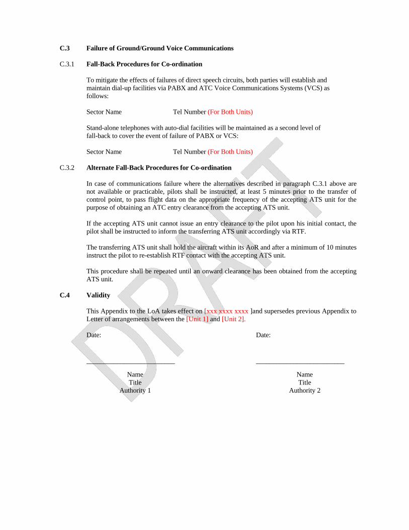
C.3 Failure of Ground/Ground Voice Communications C.3.1 Fall-Back Procedures for Co-ordination
To mitigate the effects of failures of direct speech circuits, both parties will establish and maintain dial-up facilities via PABX and ATC Voice Communications Systems (VCS) as follows: Sector Name Tel Number (For Both Units) Stand-alone telephones with auto-dial facilities will be maintained as a second level of fall-back to cover the event of failure of PABX or VCS: Sector Name Tel Number (For Both Units)
C.3.2 Alternate Fall-Back Procedures for Co-ordination
In case of communications failure where the alternatives described in paragraph C.3.1 above are not available or practicable, pilots shall be instructed, at least 5 minutes prior to the transfer of control point, to pass flight data on the appropriate frequency of the accepting ATS unit for the purpose of obtaining an ATC entry clearance from the accepting ATS unit.
If the accepting ATS unit cannot issue an entry clearance to the pilot upon his initial contact, the
pilot shall be instructed to inform the transferring ATS unit accordingly via RTF. The transferring ATS unit shall hold the aircraft within its AoR and after a minimum of 10 minutes
instruct the pilot to re-establish RTF contact with the accepting ATS unit. This procedure shall be repeated until an onward clearance has been obtained from the accepting
ATS unit. C.4 Validity
This Appendix to the LoA takes effect on [xxx xxxx xxxx ]and supersedes previous Appendix to Letter of arrangements between the [Unit 1] and [Unit 2].
Date: Date:
__________________________ __________________________
Name Title
Authority 1
Name Title
Authority 2

ATM SG/1-REPORT APPENDIX 5C
5C-5 UNIT 1 LOGO UNIT 2 LOGO
LoA between Unit 1 and Unit 2 - Appendix C - Effect on (xxx xxxx xxxx) Page C 5
Attachment 1 to Appendix C (1)
Automatic Data Exchange related to OLDI
ABI/ACT/LAM messages are exchanged between the two ATS units in accordance with the table below:
Time and/or Distance Parameters
Messages COPs Messages from Unit 1
To Unit 2
Messages from Unit 1
To Unit 2
ABI
ACT
LAM
REV
PAC
MAC
LOF
NAN

Attachment 2 to Appendix C Automatic Data Exchange related to AIDC
(Guidelines on the implementation of AIDC/OLDI in the MID Region are provided in the MID Region Strategy for the implementation of AIDC/OLDI available on the ICAO MID website: http://www.icao.int/MID/Pages/meetings.aspx) AIDC messages are exchanged between the two ATS units in accordance with the table below:
Messages Parameter Notes ABI ATSU1: [Sends ABI approx. 80 minutes prior
to boundary (73 minutes prior to the 50 nm expanded sector boundary).] ATSU2: [Sends ABI approx. 87 minutes prior to boundary (80 minutes prior to the 50 nm expanded sector boundary). (Note: An updated ABI will not be sent once a CPL has been sent.)]
ATSU1 : ATSU2 [Updated ABI’s will be sent automatically if there is any change to profile. ABI is sent automatically and is transparent to the controller. ABI automatically updates the receiving unit’s flight data record.]
CPL ATSU1 : ATSU2 [Send CPL messages approx. 37 minutes prior to the boundary (30 minutes prior to the 50 nm expanded sector boundary).]
ATSU1 : ATSU2 [CPL messages should be sent by the transferring controller in sufficient time to allow the completion of coordination at least 30 minutes prior to the boundary or 30 minutes prior to the aircraft passing within 50nmof the FIR boundary for information transfers.]
CDN ATSU1 : ATSU2 [CDN messages are sent by either the transferring or receiving facility to propose a change once the coordination process has been completed, i.e., CPL sent and ACP received. CDN’s must contain all applicable profile restrictions (e.g. weather deviations, speed assignment, block altitude). If the use of a CDN does not support this requirement, then verbal coordination is required.]
ATSU1 : ATSU2 [The APS will display a flashing “DIA” until receipt of ACP. If ACPJ not received within ten (10) minutes, controller is alerted with a message to the queue. CDN messages are not normally used for coordination of reroutes; however, with the receiving facilities approval a CDN may be used to coordinate a reroute on a critical status aircraft such as in an emergency.]
PAC ATSU1 : ATSU2 [PAC messages will normally be sent when the time criteria from the departure point to the boundary is less than that stipulated in the CPL.]
ATSU1 : ATSU2 [Will respond to a PAC message with an ACP. PAC messages should be verbally verified with receiving facility.]
ACP ATSU1 : ATSU2 [……..]
ATSU1 : ATSU2 [The APS will display a flashing “DIA” until receipt of ACP. If ACP not received within ten (10) minutes, controller is alerted with a message to the queue.]
TOC ATSU1 : ATSU2
AOC ATSU1 : ATSU2
MAC ATSU1 : ATSU2 [MAC messages are sent when a change to the route makes the other facility no longer the “next” responsible unit.]
ATSU1 : ATSU2 [Receipt of a MAC message must not be interpreted as meaning that the flight plan has been cancelled. Voice coordination must be conducted by the transferring controller to confirm the status of the flight.]
REJ ATSU1 : ATSU2 [REJ messages are sent in reply to a CDN message when the request change is unacceptable]
ATSU1 : ATSU2 [REJ messages are sent only as a response to a CDN message.]

ATM SG/1-REPORT APPENDIX 5C
5C-7 UNIT 1 LOGO UNIT 2 LOGO
LoA between Unit 1 and Unit 2 - Appendix C - Effect on (xxx xxxx xxxx) Page C 7
Appendix C (2).
Exchange of Flight Data. (Without automatic data exchange)
[Unit 1] [Unit 2] Revision: [Nr.] Effective: [date] Revised: [date]
C.1 General. C.1.1 Basic Flight Plans Basic flight plan data should normally be available at both ATS Units. C.1.2 Current Flight Plan Data Messages, including current flight plan data, shall be forwarded by the transferring ATS unit to the
accepting ATS unit by telephone to the appropriate sector/position. C.1.2.1 Verbal Estimates.
A verbal estimate shall be passed to the appropriate sector at the accepting ATS unit at least [value] minutes prior, before the aircraft is estimated to pass the transfer of control point.
A verbal estimate shall contain:
a) Callsign.
Note: To indicate that the flight plan is available, the accepting ATS unit should state aircraft type and destination after having received the Callsign.
b) SSR code:
Note: Normally, the notification of a SSR code indicates that the selection of that code by the aircraft was verified.
c) ETO for the appropriate COP as laid down in Appendix D to this LoA.
d) Cleared level, specifying climb or descent conditions if applicable, at the transfer of control point.
Requested level if different from cleared level.
e) Other information, if applicable.
C.1.3 Non-availability of Basic Flight Plan Data
If the accepting ATS unit does not have basic flight plan data available, additional information may be requested from the transferring ATS unit to supplement verbal estimate. Within the context of RVSM, such additional information should include:
a. the RVSM approval status of the aircraft; and

b. whether or not a non-RVSM approved aircraft is a State aircraft. C.1.4 Revisions
Any significant revisions to the flight data are to be transmitted to the accepting ATS unit.
Time differences of [value] minutes or more are to be exchanged.
Any levels which different than describe in Appendix D of this LOA are subject to an Approval Request.
C.1.5 Expedite Clearance and Approval Requests
Whenever the minimum time of [value] minutes for a verbal estimate, cannot be met, either an expedite clearance request, an approval request, as appropriate, shall be initiated.
C.2 Means of Communications and their Use C.2.1 Equipment The following lines are available between [Unit 1] and [Unit 2]:
Line Type Amount Additional Information
Telephone Lines “Additional Information” column should indicate if telephone lines meet the requirements for Direct Controller-Controller Voice Communication (DCCVC) or Instantaneous Direct Controller-Controller Voice Communication (ICCVC)
C.2.2 Verbal Co-ordination All verbal communications between non-physically adjacent controllers should be terminated with
the initials of both parties concerned.
Exchange of flight plan data, estimates and control messages by voice shall be carried out in accordance with the following tables:
C.2.2.1 Messages from [Unit 1] to [Unit 2]
Receiving Sector/COPs Message Position
Sector Name
COPs
Flight Plan Data and Estimates
Control Messages, Expedite Clearances, Approval Requests and
Revisions
Surveillance Co-ordination

ATM SG/1-REPORT APPENDIX 5C
5C-9 UNIT 1 LOGO UNIT 2 LOGO
LoA between Unit 1 and Unit 2 - Appendix C - Effect on (xxx xxxx xxxx) Page C 9
C.2.2.2 Messages from [Unit 2] to [Unit 1]
Receiving Sector/COPs Message Position
Sector Name
COPs
Flight Plan Data and Estimates
Control Messages, Expedite Clearances, Approval Requests and Revisions
Surveillance Co-ordination
C.3 Failure of Ground/Ground Voice Communications C.3.1 Fall-Back Procedures for Co-ordination
To mitigate the effects of failures of direct speech circuits, both parties will establish and maintain dial-up facilities via PABX and ATC Voice Communications Systems (VCS) as follows: Sector Name […………….] Tel Number (For Both Units) Stand-alone telephones with auto-dial facilities will be maintained as a second level of fall-back to cover the event of failure of PABX or VCS: Sector Name [………………….] Tel Number (For Both Units)
C.3.2 Alternate Fall-Back Procedures for Co-ordination
In case of communications failure where the alternatives described in paragraph C.3.1 above are not available or practicable, pilots shall be instructed, at least 5 minutes prior to the transfer of control point, to pass flight data on the appropriate frequency of the accepting ATS unit for the purpose of obtaining an ATC entry clearance from the accepting ATS unit.
If the accepting ATS unit cannot issue an entry clearance to the pilot upon his initial contact, the
pilot shall be instructed to inform the transferring ATS unit accordingly via RTF. The transferring ATS unit shall hold the aircraft within its AoR and after a minimum of 10 minutes
instruct the pilot to re-establish RTF contact with the accepting ATS unit. This procedure shall be repeated until an onward clearance has been obtained from the accepting
ATS unit. C.4 Validity
This Appendix to the LoA takes effect on [xxx xxxx xxxx] and supersedes previous Appendix to Letter of arrangements between the [Unit 1] and [Unit 2].
Date: Date: __________________________ _____________________

Name Title
Authority 1
Name Title
Authority 2

LoA between Unit 1 and Unit 2 - Appendix D - Effect on (xxx xxxx xxxx) Page D 1
Appendix D.
Procedures for Co-ordination.
[Unit 1] [Unit 2] Revision: [Nr.] Effective: [date] Revised: [date] D.1 General Conditions for Acceptance of Flights. D.1.1 Co-ordination of flights shall take place by reference to the coordination point (COP) and in
accordance with the appropriate levels specified for the relevant route (see paragraphs D.2 and D.3).
D.1.2 Flights shall be considered to be maintaining the co-ordinated level at least (value ) prior to
transfer of control point unless climb or descent conditions have been clearly stated by use of crossing conditions in the PAC/ACT(OLDI) or by verbal co-ordination, except if otherwise described in paragraphs D.2 or D.3.
D.1.3 If the accepting ATS unit cannot accept a flight offered in accordance with the conditions specified
above, it shall clearly indicate its inability and specify the conditions under which the flight will be accepted.
D.1.4 For any proposed deviation from the conditions specified in this Appendix (e.g. COP, route or
level) the transferring unit shall initiate an Approval Request. D.1.5 The accepting ATS unit shall not notify the transferring ATS unit that it has established ground-air
communications with the transferred aircraft unless specifically requested to do so. The Accepting Unit shall notify the transferring Unit in the event that communication with the aircraft is not established as expected.
Reference to: ICAO Doc 4444, Chapter 10, Paragraph 10.1.2.4.3
D.2 ATS-Routes, Co-ordination Points and Level Allocation. Available ATS-routes, COPs to be used and level allocation to be applied, unless otherwise
described in paragraph D.3, are described in the tables below.

D.2.1 Flights from [Unit 1] to [Unit 2] D.2.1.1 General
D.2.1.1.1 All information regarding transfer procedures shall be included.
ATS-Route COP Receiving
Sector Level
Allocation Special
Conditions
D.2.2 Flights from [Unit 2] to [Unit 1] D.2.2.1. General D.2.2.1.1 Same shall be applied
ATS-Route COP Receiving
Sector Level
Allocation Special
Conditions
D.3 Special Procedures
All special procedures which cannot be accommodated in the “Special Conditions” column of paragraph D.2 shall be outlined in this section
D.3.1 Flights from [Unit 1] to [Unit 2] D.3.2 Flights from [Unit 2] to [Unit 1] D.4 Co-ordination of Status of Special Areas in the Area of Common Interest. Both ATS units shall keep each other advised on any changes of the activation times of CDRs and
of activation times for the following CBAs, TSAs and AMC-manageable restricted or danger areas:
D.4.1 [Unit 1] shall inform [Unit 2] about changes for the following areas: D.4.2 [Unit 2] shall inform [Unit 1] about changes for the following areas:

LoA between Unit 1 and Unit 2 - Appendix D - Effect on (xxx xxxx xxxx) Page D 3
D.5 VFR flights D.5.1 Flights from [Unit 1] to [Unit 2] D.5.2 Flights from [Unit 2] to [Unit 1] D.6 Validity
This Appendix to the LoA takes effect on [xxx xxxx xxxx] and supersedes previous Appendix to Letter of arrangements between the [Unit 1] and [Unit 2]. Date: Date:
__________________________ __________________________ Name Title
Authority 1
Name Title
Authority 2


LoA between Unit 1 and Unit 2 - Appendix E - Effect on (xxx xxxx xxxx) Page E 1
Appendix E
Transfer of Control and Transfer of Communications.
[Unit 1] [Unit 2] Revision: [Nr.] Effective: [date] Revised: [date]
In order to optimize the provision of ATS, it is recommended that the Transfer of Communication takes place before the Transfer of Control, at a point/time/distance as agreed upon between the transferring and accepting ATS Units.
E.1 Transfer of Control The transfer of control takes place at the AoR-boundary, unless otherwise specified in paragraph
E.3. E.2 Transfer of Communications E.2.1 The transfer of communications shall take place not later than [(time, distance or level
parameter)], and not sooner than [(time, distance or level parameter)] before the transfer of control and as specified in paragraph E.3, unless otherwise co-ordinated. A parameter (time, distance or level) should be specified for the transfer of communications, whenever it is operationally significant. (e.g. for protection of a communication channel).
E.2.2 Frequencies E.2.2.1 [Unit 1]
Sectors Frequencies
Primary Secondary
E.2.2.2 [Unit 2]
Sectors Frequencies
Primary Secondary
E.3 Specific Points for Transfer of Control and Transfer of Communications
ATS Route Transfer of Control Point Transfer of Communications Unit 1 to Unit 2 Unit 2 to Unit 1
E.4 Validity

This Appendix to the LoA takes effect on [xxx xxxx xxxx] and supersedes previous Appendix to Letter of arrangements between the [Unit 1] and [Unit 2]. Date: Date:
__________________________ __________________________
Name Title
Authority 1
Name Title
Authority 2

LoA between Unit 1 and Unit 2 - Appendix F - Effect on (xxx xxxx xxxx) Page F 1
Appendix F.
ATS Surveillance Based Co-ordination Procedures.
[Unit 1] [Unit 2] Revision: [Nr.] Effective: [date] Revised: [date] F.1 General
F.1.1. Transfer of identification and transfer of control between [Unit 1] and [Unit 2] will be subject to the
serviceability of the respective surveillance systems and two-way direct speech facilities between the controller working positions.
F1.2 In case of any doubt about the identity of an aircraft, nothing in the provisions of this Appendix,
prevents the use of others methods for the identification of an aircraft F.2 Transfer of Aircraft Identification
Subject to the surveillance technology available to both units concerned, the transfer of identification should be effected preferably by one of the methods described below: • Designation of the position indication by automated means, provided that only one position
indication is thereby indicated and there is no possible doubt of correct identification; • Notification of the aircraft discrete SSR code; • Notification that the aircraft identification transmitted by a Mode S equipped aircraft has
been verified; • Notification that the aircraft identification transmitted by an ADS B equipped aircraft has
been verified.
F.2.1 Transfer of aircraft identification between [Unit 1] and [Unit 2] is normally performed by [one or more methods for the transfer of identification].
It is recommended that in cases when multiple surveillance technologies are available to both ATS units concerned, paragraph F2.1 should illustrate one or more preferred methods for the transfer of aircraft identification, the conditions in which those apply and the alternatives to be used when the conditions are not met. For example, at an interface between two ATS units using radar Mode S and MSSR the transfer of identification should normally be performed:
• by notification of A1000 indicating that the Mode S aircraft identification feature transmitted by the transponder has been verified;
• or, in case that the aircraft identification is not correct or has not been verified or the aircraft is not Mode S equipped:
• by notification of the aircraft discrete SSR code.
F.2.2 When discrete SSR codes are used for transfer of identification, they shall be assigned in accordance with ORCAM.
F.2.3 Any change of SSR code by the accepting ATS Unit may only take place after the transfer of
control point.
F.2.4 The accepting ATS Unit shall be notified of any observed irregularity in the operation of SSR transponders or ADS-B transmitters.

Such irregularities should cover at least the following cases:
• transponders transmitting erroneous aircraft identification; • transponders transmitting SSR codes different then the selection of which have been
confirmed by the pilots; • transponders transmitting erroneous Mode C information.
F.3 Transfer of Control. F.3.1 All traffic must be transferred “clean” – i.e. clear of all conflicting traffic under control of the
transferring unit. F.3.2 Where separation is based on the use of surveillance as per ICAO DOC 4444, a minimum of
5NM shall be used during transfer. F.3.3 Transfer of identification of IFR flights shall be accomplished in accordance with ICAO DOC
4444. F.3.4 If it becomes necessary to reduce or suspend transfers of control, a value prior notification shall
be observed, except in emergency situations. F.3.5 A minimum distance of value NM to the boundary line of responsibility shall be observed when
vectoring aircraft, except when a transfer of radar control has previously been coordinated. F.3.6 Transfer of Control without systematic use of the bi-directional speech facilities (Silent
Transfer of Control) F.3.6.1 Transfer of control of IFR flights without voice coordination will be in accordance with ICAO
DOC 4444 Chapter 8 provided that:
a) [Value] surveillance in trail spacing exists, and is constant or increasing.
b) [Value] minutes notice, when possible, is required for an increase in in-trail spacing. Note: “Transfer” is defined as transfer of communications and control.
F.3.6.2 The transferring controller shall inform the accepting controller of any level, speed or vectoring instructions given to aircraft prior to its transfer and which modify its anticipated flight progress at the point of transfer.
Note: When using Mach-number speed control, pilots concerned shall be instructed to report their assigned mach-number to the accepting ATS Unit upon initial contact.
F.3.6.3 The accepting controller may terminate the silent transfer of control at any time, normally with an advance notice of [value] minutes.

LoA between Unit 1 and Unit 2 - Appendix F - Effect on (xxx xxxx xxxx) Page F 3
F.3.7 Transfer of Control with use of the bi-directional speech facilities.
Transfer of control may be effected with the use of bi-directional speech facilities, provided the minimum distance between the aircraft does not reduce to less than [value to be specified] NM, and:
• identification has been transferred to or has been established directly by the accepting
controller; • the accepting controller is informed of any level, speed or vectoring instructions
applicable to the aircraft at the point of transfer; • communication with the aircraft is retained by the transferring controller until the
accepting controller has agreed to assume responsibility for providing ATS surveillance service to the aircraft. Thereafter, the aircraft should be instructed to change over to the appropriate frequency and from that point is the responsibility of the accepting controller.
F.4 Validity
This Appendix to the LoA takes effect on [xxx xxxx xxxx] and supersedes previous Appendix to Letter of arrangements between the [Unit 1] and [Unit 2]. Date: Date:
__________________________ __________________________
Name Title
Authority 1
Name Title
Authority 2


LoA between Unit 1 and Unit 2 - Appendix G - Effect on (xxx xxxx xxxx) Page G 1
Appendix G.
Air Traffic Flow Management
Unit 1 Unit 2
Revision: [Nr.] Effective: [date] Revised: [date]
G.1 General G.1.1 This Appendix to the Letter of Agreement (LOA) between the [Unit 1] and [Unit 2] sets out the
details of tactical Air Traffic Flow Management (ATFM) measures for application at times of traffic congestion.
G.1.2 Only tactical ATFM operations will be implemented.
G.1.3 The accepting unit determines the flow rate for transfer. G.1.4 The general provisions contained in ICAO Appendix 11 and Doc 4444 shall apply to handling of
traffic subject to flow control.
G.2 ATFM Procedures G.2.1 Flow control measures shall, when possible, be implemented in such a manner as to avoid
affecting flights already airborne.
G.2.2 Notification
The [Unit 1] shall notify [Unit 2] not less than [value] minutes prior to the time ATFM measures will affect departing aircraft. [Unit 2] shall inform the [Unit 1] about flights which have already started and flight planned on affected ATS Routes. The notification shall detail the ATS Routes and levels being subject to ATFM as well as the expected duration.
G.2.3 Implementation
The accepting unit shall, to the widest possible extent, address limitations in capacity for given routes or destinations by specifying restrictions on available levels and longitudinal separation to enable the transferring unit to forecast delays and plan traffic flows accordingly.
G.3 Reporting
Flow reporting is required for all ATFM measures.

G.4 Validity
This Appendix to the LoA takes effect on [xxx xxxx xxxx] and supersedes previous Appendix to Letter of arrangements between the [Unit 1] and [Unit 2]. Date: Date:
__________________________ __________________________
Name Title
Authority 1
Name Title
Authority 2

LoA between Unit 1 and Unit 2 - Appendix H - Effect on (xxx xxxx xxxx) Page H 1
Appendix H.
Contingency Procedures [Unit 1] [Unit 2]
Revision: [Nr.] Effective: [date] Revised: [date] H. 1 General H.1.2 In case of technical or catastrophic outage resulting in the disruption of the provision of ATS at
[Unit 1] or at [Unit 2], the adjacent coordinating partners are expected to assist the failing ATS-unit as far as possible in order to ensure the safe evacuation of air traffic from the AoR of the failing ATS-unit.
H.1.3 In case of contingency the regulations of this chapter take precedence over the respective
provisions of Appendices A to G to this LoA. H.1.4 In case of activation of contingency plans ATSU’s should send the associated Contingency
NOTAM. H.2 Contingency Contact Points: [Unit 1]
.... [Unit 2] ...
H.3 Definition of Contingency phases H.3.1 Phase 1 - Immediate Action (30 min)
A dangerous situation has been identified. Focuses on the safe handling of aircraft in the airspace of failing unit, using all technical means still operationally available. During this phase all traffic will be evacuated and failing unit AoR will be No-Fly Zone until phase 2 is activated.
H.3.2 Phase 2 - Short/ Medium Term Actions (< 48 hours)
Focused on stabilising the situation and, if necessary, preparing for longer term contingency agreements. During this phase AoR of failing unit will be delegated to appropriate units and simplified route structure may be used.
H.3.3 Phase 3 - Initiation of the option
This phase may start when staff of failing unit arrives to emergency facility and focused on recovery from contingency.
The following will be applied during phase 3: - Termination of delegation of airspace - Flow control measurements - Increased separation minimum

The following may be applied during phase 3: - Combining ATC sectors or creating new contingency sector - Simplified route structure
H.3.4 Phase 4 – Optimisation
The aim of Phase 4 is to optimize capacity gradually up to maximum potential within published or ICAO route and sectorisation structure in line with previously agreed end-user and regulator expectation. During this phase minimum separation and flow control measurements may still be in force.
H.3.5 Phase 5 - Recovery
The aim of Phase 5 is to revert back to the original unit and working position in a safe and orderly manner. Appropriate Flow control measurement will be cancelled and separation will be reverted to standard minimums.
H.3.6 Phase 1 lasts approximately 30 minutes. Immediate Action can overlap with Phase 2. H.3.7 The passage from one phase to another is possible directly from any Contingency Phase. H.4 Disruption of the provision of ATS at [Unit 1] H.4.1 Contingency Phase 1- Immediate Action H.4.1.1 When the operational status of Unit 1 becomes impaired to such an extent, that ATS can no longer
be provided, the Unit 1 Supervisor shall initiate the immediate actions to be taken in Phase 1.
H.4.1.2 Evacuation of Unit 1 AoR H.4.1.2.1 When Phase 1 is active the AoR of Unit 1 shall be called the Contingency Area (CA) until full
serviceability of Unit 1 is recovered. H.4.1.2.2 All traffic in Unit 1 AoR will be evacuated and CA will be No-Fly-Zone, entry is prohibited
until contingency Phase 2 is activated. H.4.1.2.3 Phraseology to be used: Unit 1 is out of service; stop ALL entries into the Contingency Area
(CA), start evacuation of the CA. H.4.2 Contingency Phase 2- Short/Medium term actions H.4.2.1 When the operations of Unit 1 have ceased and all traffic has been transferred to the appropriate
agency, the Supervisor in charge of operations may declare Contingency Phase 2 for Unit 1. H.4.2.2 Delegation of Unit 1 AoR (As appropriate)
The delegation of Unit 1 AoR is shown in Attachment 1 of Appendix H. H.4.2.3 Simplified route structure
(As appropriate)
H.4.2.4 Contingency Flight Level Allocation System - CFLAS (As appropriate)

LoA between Unit 1 and Unit 2 - Appendix H - Effect on (xxx xxxx xxxx) Page H 3
H.4.3 Contingency Phase 3 – Initiation of the option H.4.3.1 In Contingency Phase 3 Unit 1 re-establishes the provision of ATS within its AoR by combining
ATC sectors (or new contingency sectors may be created). These Contingency sectors will be re-located to Unit 1 emergency sector.
H.4.3.2 Contingency sectors H.4.3.2.1The Contingency Sectors will correspond to existing sectors at Unit 1 ACC:
(As appropriate) To Unit 1 Contingency Sector 1
H.4.3.2.2 Activation / Deactivation
Unit 1 operational Supervisor shall inform Unit 2 about the activation and deactivation of the Contingency Sectors.
H.4.3.2.3 Contingency sectors and communications
Unit 1 Contingency Sectors
Message Position Phone/
Frequency
Flight Plan Data and Estimates
Control Messages, Expedite Clearances, Approval Requests
and Revisions
Surveillance Co-ordination
H.4.3.2.4 Voice Communication Systems All coordination partners of Unit 1 shall make sure that they are able to reach the Unit 1 contingency working positions via prescribed phone lines, taking into consideration that Unit 1 is completely off, including the technical systems. Public Phone shall be used as back up system.
H.4.3.2.5 Callsign
Telephone call sign for Unit 1 in case of contingency: Unit 1 + name of working position (e.g. Contingency 1)
H.4.3.3 ATFM Procedures
Necessary ATFM-measures to be applied during Contingency Phase 3 will be initiated by the Unit 1 Supervisor.
H.4.3.4 Exchange of Flight Data
(As appropriate)
H.4.3.5 Control Procedures H.4.3.5.1 Deviations from published ATS-routes shall be coordinated only to prevent dangerous situations
or in case of emergencies.

H.4.3.5.2 Separation minima between succeeding aircraft on transfer shall be a minimum of value constant or increasing.
H.4.3.6 SSR Code Assignment
During contingency, Unit 1 may not be able to transfer aircraft on discrete SSR codes, or on code 1000, assigned in accordance with ORCAM.
H.4.4 Contingency Phase 4 – Optimisation
Appropriate associated Phase 3 actions to take place. H.4.5 Contingency Phase 5 – Long-term Response and Recovery
H.4.5.1 Unit 1 will inform Unit 2 of intention to “Normal” operations and will co-ordinate the time at which
normal operation will be resumed. H.4.5.2 Once Unit 1 notifies Unit 2 the end of contingency:
• Unit 1 and Unit 2 will cancel any operational restrictions and will resume the standard ATS.
• Both units will apply the standard operational procedures stated in Appendices A to G of this LoA.
H.5 Disruption of the provision of ATS at Unit 2 H.5.1 Contingency Phase 1- Immediate Action H.5.1.1 When the operational status of Unit 2 becomes impaired to such an extent, that ATS can no longer
be provided, the Unit 2 Supervisor shall initiate the immediate actions to be taken in Phase 1.
H.5.1.2 Evacuation of Unit 2 AoR H.5.1.2.1 When Phase 1 is active the AoR of Unit 2 shall be called the Contingency Area (CA) until full
serviceability of Unit 2 is recovered. H.5.1.2.2 All traffic in Unit 2 AoR will be evacuated and CA will be No-Fly-Zone, entry is prohibited
until contingency Phase 2 is activated. H.5.1.2.3 Phraseology to be used: Unit 2 is out of service; stop ALL entries into the Contingency Area
(CA), start evacuation of the CA. H.5.1.2.4 Contingency Flight Level Allocation System - CFLAS (As appropriate)
H.5.2 Contingency Phase 2- Short/Medium term actions H.5.2.1 When the operations of Unit 2 have ceased and all traffic has been transferred to the appropriate
agency, the Supervisor in charge of operations may declare Contingency Phase 2 for Unit 2. H.5.2.2 Delegation of Unit 2 AoR (As appropriate)
The delegation of Unit 2 AoR is shown in Attachment 1 of Appendix H.

LoA between Unit 1 and Unit 2 - Appendix H - Effect on (xxx xxxx xxxx) Page H 5
H.5.2.3 Simplified route structure (As appropriate) H.5.3 Contingency Phase 3 – Initiation of the option H.5.3.1 In Contingency Phase 3 Unit 2 re-establishes the provision of ATS within its AoR by combining
ATC sectors (or new contingency sectors may be created). These Contingency sectors will be re-located to Unit 2 emergency sector.
H.5.3.2 Contingency sectors H.5.3.2.1The Contingency Sectors will correspond to existing sectors at Unit 2 ACC:
(As appropriate) To Unit 2 Contingency Sector 1
H.5.3.2.2 Activation / Deactivation
Unit 2 operational Supervisor shall inform Unit 1 about the activation and deactivation of the Contingency Sectors.
H.5.3.2.3 Contingency sectors and communications
Unit 2 Contingency Sectors
Message Position Phone/
Frequency
Flight Plan Data and Estimates
Control Messages, Expedite Clearances, Approval Requests
and Revisions
Surveillance Co-ordination
H.5.3.2.4 Voice Communication Systems
All coordination partners of Unit 2 shall make sure that they are able to reach the Unit 2 contingency working positions via prescribed phone lines, taking into consideration that Unit 2 is completely off, including the technical systems. Public Phone shall be used as back up system.
H.5.3.2.5 Callsign
Telephone call sign for Unit 2 in case of contingency: Unit 2 + name of working position (e.g. Contingency 1)
H.5.3.3 ATFM Procedures
Necessary ATFM-measures to be applied during Contingency Phase 3 will be initiated by the Unit 2 Supervisor.
H.5.3.4 Exchange of Flight Data
(As appropriate)
H.5.3.5 Control Procedures

H.5.3.5.1 Deviations from published ATS-routes shall be coordinated only to prevent dangerous situations or in case of emergencies.
H.5.3.5.2 Separation minima between succeeding aircraft on transfer shall be a minimum of value
constant or increasing. H.5.3.6 SSR Code Assignment
During contingency, Unit 2 may not be able to transfer aircraft on discrete SSR codes, or on code 1000, assigned in accordance with ORCAM.
H.5.4 Contingency Phase 4 – Optimisation
Appropriate associated Phase 3 actions to take place. H.5.5 Contingency Phase 5 – Long-term Response and Recovery
H.5.5.1 Unit 2 will inform Unit 1 of intention to “Normal” operations and will co-ordinate the time at which
normal operation will be resumed. H.5.5.2 Once Unit 2 notifies Unit 1 the end of contingency:
• Unit 2 and Unit 1 will cancel any operational restrictions and will resume the standard ATS.
Both units will apply the standard operational procedures stated in Appendices A to G of this LoA. H.4 Validity
This Appendix to the LoA takes effect on [xxx xxxx xxxx] and supersedes previous Appendix to Letter of arrangements between the [Unit 1] and [Unit 2]. Date: Date:
__________________________ __________________________
Name Title
Authority 1
Name Title
Authority 2

LoA between Unit 1 and Unit 2 - Appendix H - Effect on (xxx xxxx xxxx) Page H 7
Attachment 1 of Appendix H
[Unit 1] Contingency Delegation Map
A Map detailing the sectors boundaries shall be added

Attachment 2 of Appendix H
[Unit 2] Contingency Delegation Map
A Map detailing the sectors boundaries shall be added

LoA between Unit 1 and Unit 2 - Appendix H - Effect on (xxx xxxx xxxx) Page H 9
APPENDIX I
SEARCH AND RESCUE BILATERAL ARRANGEMENTS
[Unit 1] [Unit 2]
Revision: [Nr.] Effective: [date] Revised: [date]
I.1. AREA OF RESPONSIBILITY FOR SAR PROVISION I.1.1. [UNIT1] Search and Rescue Regions (SRRs) Description:
I.1.2. [UNIT2] Search and Rescue Regions (SRRs) Description:
I.1.3. Each State’s Rescue Coordination Centre RCC is responsible for its respective SRR.
I.2. AGREEMENT I.2.1. Pursuant to the Standards and Recommended Practices of Annex 12 to the Convention on International Civil Aviation, supplemented by the International Aeronautical and Maritime Search and Rescue (IAMSAR) Manual, (Doc 9731) for the coordination of Search and rescue operations, in particular when an alert phase is declared related to an aircraft on emergency situation; the two Units agree to mutually coordinate and assist each other in the provision of SAR services in their respective Search and Rescue Regions (SRRs).
I.2.2. This operational Bilateral Arrangements supplements the relevant ICAO documents and shall apply equally on both parties.
I.2.3. The two Units recognized the importance of co-operation within [………] SRR and […….] SRR, for
the provision of expeditious and effective SAR services, through the use of available resources. I.3. SCOPE OF AGREEMENT Both Air Navigation Service Providers (ANSPs)/ACCs hereby agree that they shall: I.3.1. Promptly exchange SAR alerting information concerning a distress situation or a potential distress
situation. I.3.2. Coordinate with and assist national SAR agencies to the extent possible. I.3.3. Assist each other, to the extent possible, in coordinating SAR Operations in their respective SRRs. I.3.4. Coordinate with their respective national RCC for participation in SAR activities when requested by
other States.
I.4. STANDARD OPERATING PROCEDURES FOR THE ACCs The following procedures are agreed upon:

I.4.1. The responsibility for declaring an emergency phase and initiating local action rests with the ATS Units (ATSUs) in coordination with their respective RCCs.
I.4.2. ATSUs shall coordinate with their RCC:
a) When the accident position is known, action shall be initiated by the RCC in whose SRR the accident is located.
b) When the accident position is not known, SAR alerting action shall be initiated by:
i. The ATSU first becoming aware of an aircraft needing assistance; ii. The ATSU in whose area of responsibility the aircraft was operating when the last radio
contact was made; or
iii. The ATSU in whose area of responsibility the aircraft was proceeding to if the last radio contact was made on the common SRR boundary.
I.4.3. The two ACCs should ensure appropriate coordination in the event of joint SAR operations.
I.5. LIAISON DURING A SAR MISSION
During the course of a SAR mission, the ANSP/ACC concerned shall maintain close liaison in order to ensure the smooth and successful execution of the SAR mission. If required, the RCC in charge of the mission should periodically keep the ANSP/ACC informed of the number of SAR Units engaged in the SAR mission, areas to be searched, actions taken and the decision to suspend or terminate the SAR mission.
I.6. POINT OF CONTACT
UNIT 1 UNIT 2
Name: XXXXX centre….. YYYYY
AFTN
Phone(s)
Fax
Email(s)
Other
I.7. VALIDITY
This Appendix to the LoA takes effect on [xx xxxxxx xxxx] and supersedes previous Appendix to the Letter of
Agreement between [Unit 1] and [Unit 2].
Date: Date:
__________________________ __________________________
Name Title
Authority 1
Name Title
Authority 2
-----------------
ANSIG/1-REPORT APPENDIX 4N
APPENDIX 4N
INTERNATIONAL CIVIL AVIATION ORGANIZATION
MIDDLE EAST SECONDARY SURVEILLANCE RADAR CODE MANAGEMENT PLAN
(SSR CMP)
Second Edition NOVEMBER, 2014

THE DESIGNATIONS AND THE PRESENTATION OF MATERIAL IN THIS PUBLICATION
DO NOT IMPLY THE EXPRESSION OF ANY OPINION WHATSOEVER ON THE PART OF
ICAO CONCERNING THE LEGAL STATUS OF ANY COUNTRY, TERRITORY, CITY OR
AREA OF ITS AUTHORITIES, OR CONCERNING THE DELIMITATION OF ITS FRONTIERS
OR BOUNDARIES.

MIDDLE EAST SSR CODE MANAGEMENT PLAN
NOVEMBER 2014
TABLE OF CONTENTS 1 SCOPE ............................................................................................................................................ 1
1.1 Relationship to MID Air Navigation Plan (Doc 9708) ......................................................... 1
2 DEFINITIONS AND ABBREVIATIONS ..................................................................................... 2
2.1 Definitions............................................................................................................................. 2
2.2 Abbreviations ........................................................................................................................ 3
3 INTRODUCTION ........................................................................................................................... 4
3.1 Objectives of the Middle East SSR Code Management Plan ............................................... 4
3.2 General Principles To Meet The Objectives ......................................................................... 4
3.3 Monitoring of the Plan .......................................................................................................... 5
4 PERMANENT CODE DISTRIBUTION AND CATEGORIES .................................................... 5
4.1 Distribution of codes ............................................................................................................. 5
4.2 Special purpose codes ........................................................................................................... 6
4.3 Transit codes ......................................................................................................................... 7
4.4 Domestic codes ..................................................................................................................... 7
5 ORCAM .......................................................................................................................................... 8
5.1 OUTLINE OF ORCAM OBJECTIVES ............................................................................... 8
6 ORCAM SYSTEM REQUIREMENTS .......................................................................................... 9
6.1 Introduction ........................................................................................................................... 9
6.2 General System Considerations ............................................................................................ 9
6.3 Essential Capabilities for Automated ATC Ground Systems ............................................. 10
APPENDIX A - PARTICIPATING AREAS ......................................................................................... i
APPENDIX B - GENERAL PROCEDURES FOR SSR CODE ASSIGNMENT .............................. iii
APPENDIX C - IMPLICATIONS FOR AUTOMATION ................................................................. vii
APPENDIX D - DEVELOPMENT OF AUTOMATED SSR CODE ASSGNEMENT SYSTEMS ... xi


MIDDLE EAST SSR CODE MANAGEMENT PLAN
Page 1 NOVEMBER 2014
1 SCOPE
1.1 RELATIONSHIP TO MID AIR NAVIGATION PLAN (DOC 9708)
1.1.1 The Middle East Secondary Surveillance Radar Code Management Plan has been produced on behalf of the Middle East Air Navigation Planning and Implementation Regional Group (MIDANPIRG).
1.1.2 The purpose of MID CMP is to detail the requirements to be met by the States of the ICAO Middle East (MID) Region in order to comply with the provisions of the Middle East Basic Air Navigation Plan (MID ANP) (Doc 9708, Volume I) and the Middle East Facilities and Services Implementation Document (MID FASID) (Doc 9708, Volume II) as they pertain the management of Secondary Surveillance Radar (SSR) codes in the ICAO MID Region. This document incorporates text that currently comprises Attachment B to the MID FASID along with new material to document the management of the regional SSR Code pool.
1.1.3 The technical requirements and associated procedures may also be adopted by States in adjoining ICAO Regions which elect to participate in the Originating Region Code Assignment Methodology (ORCAM) for the management of SSR codes.
1.1.4 All references to SSR Codes are confined to Mode 3/A. The use and allocation of Mode S Interrogator Codes is covered by Appendix 4A to Table CNS 4 to the MID FASID.

2 DEFINITIONS AND ABBREVIATIONS
2.1 DEFINITIONS
Assigned Secondary Surveillance Radar code (ASSR)
The SSR code assigned by an ATS Unit (ATSU) to a departing aircraft or to an aircraft entering the airspace of the ATSU. Note: In cases where the Previous Secondary Surveillance Radar code (PSSR) can be retained, PSSR and ASSR can be the same code
(SSR) Code
The number assigned to a particular multiple pulse reply signal transmitted by a transponder in Mode A or Mode C.
Code allocation The distribution of SSR Codes to a State, unit or service.
Code assignment The distribution of SSR codes to aircraft.
Code block A continuous series of four-digit codes from the same code series.
Code series A group of 64 four-digit codes having the same first two digits.
Direction of flight The direction shall be defined as a combination of one or more: a) exit points or receiving Areas of Responsibility (AOR); and b) destinations (defined by the first, the first two, the first three or all
four letters of an ICAO location indicator).
Directional assignment
Assignment of an SSR code based on the direction of the flight.
Discrete code A four-digit code with the last two digits not being “00”.
Domestic code A code allocated to a specific AOR for use by designated ATC unit(s) within that AOR or, subject to certain conditions, across AOR boundaries.
Expectation window A window of variable size around a 4D position, defined by flight plan information, at which a flight is expected to enter the AOR.
Four-digit code An SSR identity code containing combinations of A, B, C and D pulses (any reply generated by a 4096-code transponder where the digits fall in the range 0-7).
Geographical correlation
Correlation of a flight with its flight plan using the geographical position of the flight by means of “Expectation Windows” in cases where the SSR code is already in use by one or more other flights within the same AOR.
Mode S Conspicuity Code
In order to maximise SSR code savings through Mode S Elementary Surveillance (ELS), all aircraft identified via the down linked Aircraft Identification (ACID) use the same SSR code, the Mode S Conspicuity Code A1000.
Octal block A block of 8 four-digit codes from the Same Series and having the first three digits common. They may be identified by indicating their third digit when referring to the Code Series e.g. Codes 0010-0017 may be referred to as Codes 00(1).
Participating area (PA)
An area of specified dimensions comprising the areas of ATS unit responsibility of one or more States.
Previous Secondary Surveillance Radar code (PSSR)
The SSR code transmitted by an aircraft when entering the airspace of an ATSU or when being transferred by the transferring unit. Note: In cases where the PSSR can be retained, PSSR and ASSR can be the same code.
MIDDLE EAST SSR CODE MANAGEMENT PLAN
Page 3 NOVEMBER 2014
Simultaneous code use
Assignment of an SSR code, which is already in use within the same AOR, to an aircraft in accordance with procedures which ensure that the two aircraft will be exiting the AOR in opposite or nearly opposite directions.
Retention of an SSR code
Accepting an aircraft from the transferring unit without changing the SSR code. A code can be retained if no other aircraft within the AOR uses the same code and if the retention of the code is in accordance with the Code Allocation List (CAL).
Transit code A code allocated to a State for a specified ACC for assignment to an aircraft engaged in transit flights within the originating PA or, subject to certain conditions, to specified locations in succeeding PAs.
2.2 ABBREVIATIONS
ABI Advance Boundary Information
ACID Aircraft Identification
ADEP Aerodrome of Departure
ADES Aerodrome of Destination
AOR Area of Responsibility
ASSR Assigned Secondary Surveillance Radar code
ATC Air Traffic Control
ATS Air Traffic Services
ATSU Air Traffic Services Unit
CAL Code Allocation List for the Middle East Region
CMP Code Management Plan
COD SSR Code Assignment Message
MIDANPIRG Middle East Air Navigation Planning and Implementation Regional Group
ELS Elementary Surveillance
FDPS Flight Data Processing System
FIR Flight Information Region
NM Nautical Mile
ORCAM Originating Region Code Assignment Method
PA Participating Area
PSSR Previous Secondary Surveillance Radar code
RDPS Radar Data Processing System
SSR Secondary Surveillance Radar
VSP Variable System Parameter

3 INTRODUCTION
3.1 OBJECTIVES OF THE MIDDLE EAST SSR CODE MANAGEMENT PLAN
3.1.1 The Middle East SSR Code Management Plan (MID SSR CMP) has been established to provide States in the ICAO MID Region with means to coordinate the use of SSR codes based on the principles of the Originating Region Code Assignment Method (ORCAM), which provides for the most efficient and economical use of codes.
3.1.2 The MID SSR CMP will foster the implementation of ORCAM which will ultimately allow for an assigned discrete code which would, whenever possible, be retained throughout the flight.
3.1.3 For the development of automated SSR code assignment systems, reference should be made to Paragraph 6 below.
3.1.4 On the basis of the above, a detailed Code Allocation List (CAL) for the MID Region Participating Area (PA) and certain adjacent areas was developed. The CAL is maintained by the ICAO MID Regional Office as a Supplement to MID Doc 9708.
3.1.5 The agreed allocation of SSR codes to States and ATS units are documented in Part A of the CAL. The detailed listing of codes serving both transit and domestic purposes is shown in Part B of the CAL. The CAL is at Attachment B to the MID FASID, Part V.
3.2 GENERAL PRINCIPLES TO MEET THE OBJECTIVES
3.2.1 The detailed principles governing the use of SSR codes in the MID Region are based on the following general principles which are provided by or are complementary to the worldwide provisions detailed in Procedures for Air Navigation Services — Air Traffic Management (PANS-ATM, Doc 4444), Chapter 8:
a) codes shall be allocated to States in accordance with regional air navigation agreements, taking into account overlapping radar coverage over adjacent airspace;
b) codes are allocated to Air Traffic Services Units (ATSU) on the basis of duly justified operational requirements; their number is primarily established by taking into account the number of aircraft to be handled simultaneously and the system capabilities;
c) the appropriate ATS authority shall establish a plan and procedures for the allocation of codes to ATSUs;
d) the plan and procedures for the allocation of codes to ATSUs shall be compatible with those practised in adjacent States;
e) codes shall be assigned to aircraft in accordance with the plan and procedures laid down by the appropriate ATS authority;
f) whenever there is a need for individual aircraft identification, each aircraft shall be assigned a discrete code which should, whenever possible, be retained throughout the flight;
g) the assignment of a code should preclude the use of this code for any other function within the area of coverage of the same SSR for a prescribed time period; and
h) to reduce pilot/controller workload and the need for communications, the number of code changes required shall be kept to the minimum.
3.2.2 SSR codes should be used for ATS purposes only.

MIDDLE EAST SSR CODE MANAGEMENT PLAN
Page 5 NOVEMBER 2014
3.2.3 Code allocations are expressed in terms of complete code series or specified parts thereof. In special cases, such requirements may even cover designated discrete codes.
3.2.4 Codes intended to be used for transit purposes are allocated to States for use by specified ATSUs within the MID PA. Where provided for in the Middle East SSR Code Management Plan and under clearly defined circumstances, such codes may also be designated for use across PA boundaries.
3.2.5 Codes intended to be used for domestic purposes are allocated to States for use by specified ATSUs requiring limited geographical protection for such codes. Where provided for in the MID SSR CMP and under clearly defined circumstances, such codes may also be designated for use across national boundaries.
3.3 MONITORING OF THE PLAN
3.3.1 Provisions regarding the progressive implementation and monitoring of the MID SSR CMP have been agreed by the MIDANPIRG. In this connection, the management of the MID SSR CMP is exercised by the ICAO MID Regional Office. States expecting to introduce or change SSR facilities are requested to advise the ICAO MID Regional Office at least six months in advance, in order to provide sufficient time to carry out any necessary coordination.
3.3.2 To be effective, the MID SSR CMP must be kept up to date. While its contents will be reviewed regularly, it is the responsibility of all States to inform the ICAO MID Regional Office promptly of any variations proposed or considered necessary with respect to their code allocations, relevant to ATS infrastructure developments and/or the guidance material provided in the MID SSR CMP.
3.3.3 In order to serve their purposes it is imperative that the MID SSR CMP and the CAL are kept up to date. States are therefore required to inform the MID Office of ICAO promptly of any requests for changes, additions or deletions in regard to the use of specific codes, as follows:
ICAO MID Regional Office
Subject: SSR Code Management E-mail: [email protected] Fax: +2 (02) 22674843
4 PERMANENT CODE DISTRIBUTION AND CATEGORIES
4.1 DISTRIBUTION OF CODES
4.1.1 Certain codes are reserved for special purposes on a worldwide scale or have been put in a common pool for use in the MID Region. The remaining code series for use in the ICAO MID Region are divided into two distinct types: transit codes and domestic codes. Both domestic and transit codes may be used as directionally assigned codes beyond their normal application under clearly defined and published circumstances, and appropriately coordinated through ORCAM.
4.1.2 The number of codes used for transit purposes has to take account of the extended geographical protection required, in order to reduce to a minimum the chances of confusion between the identities of two different aircraft assigned with the same discrete code. The MIDANPIRG has agreed that the retention time should normally be two hours.

4.1.3 The number of codes used for domestic purposes can be kept relatively small as they may be repeated within the same State or they can be used by other States provided a buffer is established. In some cases, by agreement, they can be used across national boundaries.
4.1.4 Furthermore, the allocation possibilities can be increased significantly by dividing specific code series into smaller contiguous codes. When this method is used for transit flights bilateral agreement may be required.
4.2 SPECIAL PURPOSE CODES
4.2.1 Specific codes in certain series are reserved for special purposes as follows:
Series 00 Code 0000 is available as a general purpose code for domestic use by any of the following States:
Bahrain, Egypt, Iran, Iraq, Jordan, Kuwait, Lebanon, Oman, Qatar, Saudi Arabia, Syria, United Arab Emirates, Yemen.
Series 10 Code 1000 reserved for use as a conspicuity code for Mode S
Series 20 Code 2000 shall be used by flight crews in the absence of any Air Traffic Control (ATC) instructions or regional agreements unless the conditions for the use of codes: 7000,7500, 7600 and 7700 apply.
Series 70 Code 7000 shall be used by flight crews not receiving ATS service in order to improve detection of suitably equipped aircraft in areas specified by States, unless otherwise instructed by ATS.
Series 75 Code 7500 is reserved for use in the event of unlawful interference.
Series 76 Code 7600 is reserved for use in the event of radio communications failure.
Series 77 Code 7700 is reserved for use in the event of emergencies and interception*. Code 7776 and Code 7777 are reserved for SSR ground transponder monitoring.
Codes 7601-7612
Are reserved for humanitarian flights.
Common SSR Code Pool
The following code blocks have been reserved for tactical allocation to States on a temporary basis to support large scale activities:
4.2.2 Discrete codes in the series 00 are allocated to States for use for domestic purposes. States in the MID Region are generally allocated two octal blocks of four-digit codes per State in such a manner that code duplication is avoided at FIR boundaries. The allocation of octal blocks is shown in the CAL.
*Note.— The word “interception” in this context does not include intercept and escort service provided, on request, to an aircraft in distress, in accordance with Volumes II and III of the International Aeronautical and Maritime Search and Rescue Manual (Doc 9731).

MIDDLE EAST SSR CODE MANAGEMENT PLAN
Page 7 NOVEMBER 2014
4.3 TRANSIT CODES
4.3.1 Transit codes are allocated for assignment to transit flights. Aircraft will retain the assigned code within the geographical limits of the MID PA or, in the case of an agreement between States concerned, across the PA boundary.
4.3.2 The allocation of transit codes in the MID Region is based on one PA1 which has been determined on the basis of the flow of air traffic in the region. It is shown on the Chart at Appendix A and includes the following States:
PA MID Bahrain, Egypt, Iran, Iraq, Jordan, Kuwait, Lebanon, Oman, Qatar, Saudi Arabia, Syria, United Arab Emirates, Yemen.
4.3.3 Transit codes shall be assigned in accordance with the following principles:
a) when an aircraft enters the MID PA (either on departure or in flight), it will be assigned a discrete code by the first ATSU concerned at a Variable System Parameter (VSP) of not less than 30 minutes prior to activation of the flight entering the MID PA or when departing, upon ATC clearance delivery or at start up, whichever is later;
b) each aircraft will keep the original code assigned on entering the MID PA for the entire flight within the PA. Appropriate code protection criteria have to be applied in order to avoid duplication by too early reassignment of the same code. Efforts should be made to reduce the “protection period” while retaining adequate protection. It has been agreed that the normal retention value shall be two hours; and
c) a code change will be required at the time an aircraft crosses the MID PA boundary, unless special provision has been made for retention beyond the PA boundary.
4.3.4 In establishing the number and series of transit codes for both omni-directional and directional application, account is taken of the following factors:
a) the air traffic flows and main sources of transit traffic in the MID Region and likely trends;
b) the requirement for code series for a given ATC Unit. This requirement is derived from the total number of aircraft requiring assignment of a specific code during the busiest period of activity of that ATC Unit, taking into account a “protection period” after which any specific code assigned to an aircraft by an ATC Unit is normally available for reuse; and
c) the assignment of a specific code to an aircraft is ideally made, as late as possible before take-off, normally on start up or upon ATC clearance delivery, whichever is later or, when an aircraft in flight is imminently due to come under control, normally a VSP value of not less than 30 minutes.
4.3.5 The distribution of the available code series for transit purposes is shown in the CAL.
4.3.6 Specific arrangements are required to ensure that no conflicting situations will arise in border areas.
4.4 DOMESTIC CODES
4.4.1 Domestic codes are allocated for use by aircraft remaining within the boundaries of the agreed area of responsibility (AOR) (normally within one State) or, in the case of agreement between States concerned, across agreed AORs. Domestic codes can also be used for transit
1 The actual number of PAs to be established will depend on the results of the Secretariat study.

aircraft entering the MID PA and landing at an aerodrome within the AOR of the ATSU that has assigned the SSR code. The relevant code series for domestic purposes are shown in the CAL.
4.4.2 Domestic codes should be used so that utmost economy in the number of codes required is achieved. Domestic codes used for terminal purposes or within specified portions of the airspace (sectors) or across national boundaries will be assured protection in these functions from other uses of the same code through suitable systematic or procedural methods.
4.4.3 More detailed information concerning the procedures to be used for SSR code assignment can be found in Appendix B.
5 ORCAM
5.1 OUTLINE OF ORCAM OBJECTIVES
5.1.1 The objectives of ORCAM are:
a) to ensure safety by uniqueness and continuity;
b) enhance safety;
c) reduce workload;
d) improve system capacity; and
e) increase efficiency.
5.1.2 Uniqueness and continuity criteria are intended to provide permanent perceptibility and identification of aircraft with a minimum of errors and interruptions.
5.1.3 Uniqueness. Depending on system functionality, only one aircraft should respond using a given code in any particular area and at any given time. This provides an unambiguous code/callsign correlation and consequently an easy identification of aircraft.
5.1.4 Continuity. A code assigned to an aircraft should, whenever possible, be retained throughout the flight. This secures permanent display of aircraft identification.
5.1.5 The uniqueness and continuity criteria of ORCAM enhance safety by limiting the likelihood of identification errors. They also assist traffic flows since radar identification and all aspects connected with transfers are facilitated. This results in a reduction of workload (radiotelephony, identification monitoring, etc.) and substantially improves the overall system capacity.
5.1.6 In some areas the number of flights could exceed the number of SSR codes available. Some rationalization according to the nature of the flight (short-, medium- or long-haul, domestic, international or transit) and of the capabilities of the system is necessary for the most intensive possible use of codes.
5.1.7 Permanent code assignments and allocations based on the aircraft callsign, control position or any other systematic distinguishing features cannot be accepted because of the wasteful effects on the efficiency in use of codes required.

MIDDLE EAST SSR CODE MANAGEMENT PLAN
Page 9 NOVEMBER 2014
6 ORCAM SYSTEM REQUIREMENTS
6.1 INTRODUCTION
6.1.1 Middle East States are relying on the extensive use of SSR in automated ATC ground systems to ensure uninterrupted aircraft identification and maintenance of radar/flight plan correlation.
6.1.2 They have recognized the common availability of specified capabilities in automated ATC ground systems as being essential for:
a) participation of individual automated ATC units in a cooperative environment;
b) application of a common SSR Code assignment method in accordance with the ICAO principles;
c) efficient utilization of codes in automated ATC ground systems.
6.1.3 This “Statement of essential common capabilities for automated ATC ground systems in relation to the use of SSR” shown in paragraph 6.3 below, lists the capabilities concerned. It should be used by States as the basis to determine the minimum operational specifications for automated ground systems.
6.2 GENERAL SYSTEM CONSIDERATIONS
6.2.1 The application of automatic data processing in ATC ground systems allows for great freedom in the definition of system capabilities. This freedom should be exploited to:
a) provide for all essential capabilities related to the use of SSR in the most simple manner having due regard to operational requirements; and
b) enable individual automated ATC ground systems to function as part of an inter-operable environment and to comply with agreed conventions facilitating such cooperation (e.g. principles and basic rules for code assignment, code assignment methods etc.).
6.2.2 Individual automated ATC ground systems should, as part of an inter-operable environment, be capable of making the maximum use of codes previously assigned by other units controlling the aircraft concerned; i.e. they should not introduce any code changes or if this is impossible in some circumstances, require only the minimum of changes.
6.2.3 Taking into account inter-operability of ATC ground systems within the MID Region with others outside that area and the range of codes which may be utilized under such arrangements, automated ATC ground systems should be capable of performing all system functions related to the use of SSR for any 4-digit identity code.
6.2.4 Automated ATC ground systems should be designed to allow the use of a minimum number of codes. The application of sophisticated code correlation methods may reduce the number of codes needed in comparison with those required when simpler methods are used.
6.2.5 The processing of SSR data in automated ATC ground systems should be aimed at reducing the need for controller intervention.
6.2.6 Appendix C and Appendix D provide greater detail regarding the implications for automation and the development of automated SSR code assignment systems respectively.

6.3 ESSENTIAL CAPABILITIES FOR AUTOMATED ATC GROUND SYSTEMS
6.3.1 It is essential that automated ATC ground systems be designed to have certain capabilities in common, based on the assumption that:
a) the maximum use will be made of previously assigned codes;
b) only where continuing use of previously assigned codes would give rise to ambiguity, new codes will be assigned in accordance with a suitable common SSR code assignment method;
c) the prime use of codes will be to facilitate automatic identification, automatic tracking and automatic radar/flight plan data correlation; and
d) the differentiation of aircraft essential for the execution of these functions can be achieved through the use of a single, adequately protected code per aircraft.
6.3.2 In detail, automated ATC ground systems should be capable of automatic:
a) Exchange of codes: in particular of timely transmission to adjacent centres concerned of information on the code previously assigned to flights to be transferred.
b) Assignment of codes: in all instances where no previous code assignment has been made or where previous assignments are found to be unsuitable.
c) Processing of SSR code information, including:
i) initiation of automatic tracking of SSR responses;
Note.— This does not exclude tracking on the basis of primary radar returns in areas where adequate primary coverage is available;
ii) determination for each code whether it meets the criteria to be established for unambiguous correlation;
iii) recognition of any code duplications affecting correlation;
iv) proposing action to controllers to resolve code duplications affecting correlation;
v) establishment of initial correlation between real-time radar information and current flight plan information on the basis of decoded SSR replies (including Mode C information). Correlation should be achieved sufficiently in advance of the time at which an aircraft enters the area of responsibility of a centre;
vi) maintenance of correlation between real-time radar information and current flight plan information on the basis of decoded SSR replies and/or coincidence of flight plan information (route, heading, altitude) or other distinguishing criteria and radar information;
vii) storage of code information until a VSP time at which its activation and protection is desired; and
viii) activation of stored information for correlation at a given VSP time and/or within a given airspace.

MIDDLE EAST SSR CODE MANAGEMENT PLAN
Page 11 NOVEMBER 2014
d) Display of information including:
i) presentation in a suitable manner of decoded SSR replies and/or correlated flight plan information;
ii) filtering of information to be displayed on the basis of SSR-derived data (Mode A/C); and
iii) indication of code duplications.
e) Special codes: immediate recognition of special codes, as specified on a regional or world-wide basis, as well as maintenance of tracking and correlation of aircraft using these codes.
f) Recovery from ground system degradation: in cases of ground system degradation (excluding display component failure) to the extent that essential SSR-derived information is not displayed, automated ATC ground systems should be capable of restoring all essential information within the shortest possible time. Until full serviceability can be restored, the above aim may necessitate suppression of functions of secondary importance.


Appendix A MIDDLE EAST SSR CODE MANAGEMENT PLAN Appendix A
Page i NOVEMBER 2014
APPENDIX A - PARTICIPATING AREAS

SSR Code Allocation List
STATE FIR Domestic Code Domestic Code Transit Code Transit Code Amman 0400 – 0477
1101 – 1177 2400 – 2477 0700 – 0777
Baghdad 7400 – 7477 1300 – 1377 1001 – 1077 7200 – 7277 Bahrain 2100 – 2177
2700 – 2777 1200 – 1277 2200 – 2277
4400 – 4477 2600 – 2677 3200 – 3277
Beirut 2500 – 2577 4300 – 4377 Cairo 0600 – 0677
2700 – 2777 2300 – 2377 1600 – 1677
7300 – 7377 3300 – 3377
Damascus 3000 – 3077 5700 – 5777 Emirates 0400 – 0477
6000 – 6077 0600 – 0677 6100 – 6177
0500 – 0577 3400 – 3477
1700 – 1777 6200 – 6277
Jeddah 0100 – 0177 3500 – 3577 3000 – 3077
0200 – 0277 5000 – 5077 4100 – 4177
3100 – 3177 5200 – 5277
4500 – 4577 4200 – 4277
Khartoum 1200 – 1277
5200 – 5277 5300 – 5377 0100 – 0177
Kuwait 0600 – 0677 1400 – 1477 Muscat 6600 – 6677
4600 – 4677 6500 – 6577 4000 – 4077 4700 – 4777
Sana’a 3700 – 3777 7001 – 7077 Tehran 1101 – 1177
1500 – 1577 5600 – 5677
4100 – 4177 6300 – 6377
3600 – 3677 5400 – 5477
5100 – 5177
Tripoli 1300 – 1377 4000 – 4077
SSR Code Reserve list Domestic Transit
0001 – 0077 2001 – 2077 0300 – 0377 5300 – 5377 6700 – 6777 5500 – 5577 7100 – 7177 6400 – 6477 7501 – 7577
7601 – 7612 Red Cross/humanitarian 7613 – 7677 7701 – 7777

Appendix B MIDDLE EAST SSR CODE MANAGEMENT PLAN Appendix B
Page iii NOVEMBER 2014
APPENDIX B - GENERAL PROCEDURES FOR SSR CODE ASSIGNMENT
B.1 Retention of previous code
B.1.1 Every endeavour shall be made to retain the code already assigned to the aircraft. This assumes that the code is known at the time of coordination (either by voice coordination or by transmission of an Air Traffic Services (ATS) Interfacility Data Communications (AIDC) message, or an On- Line Data-Interchange (OLDI) or via the pilot) and input into the system if automated. If a code is not already being used by another aircraft flying in an unprotected area and if the code assigned to the aircraft is acceptable for the flight category2, the code shall be retained.
Note.— This should apply if the aircraft comes from an ATSU belonging to the same PA or a unit in another PA, but it may be retained in an area which has no conflicts with the other units in the area.
B.2 Code assignment or re-assignment
B.2.1 The following rules will be applied to departing aircraft within the area of the control unit, or to aircraft whose previously assigned code failed to comply with the rules stated in B.1.1 above and consequently could not be retained:
B.2.2 Where an aircraft remains inside a defined area of the AOR
Directional assignment of a domestic code - Code C1 can be assigned simultaneously to aircraft A1A2 and A3A4. C1 is protected for zone 1 and zone 2:
Note.— Domestic code allocation may be protected by buffer zones of at least 60 NM or separated by another unit. This rule is applicable within States, and also by arrangement between adjacent States. In order to make economic use of this type of allocation the same codes should preferably be disseminated (at most every 120 NM) in different small areas instead of having recourse to allocating codes belonging to an excessive number of different series.
2 Flight category refers to transit, domestic or common pool codes.
State A
A1
A2
A3
A4
C1 C1
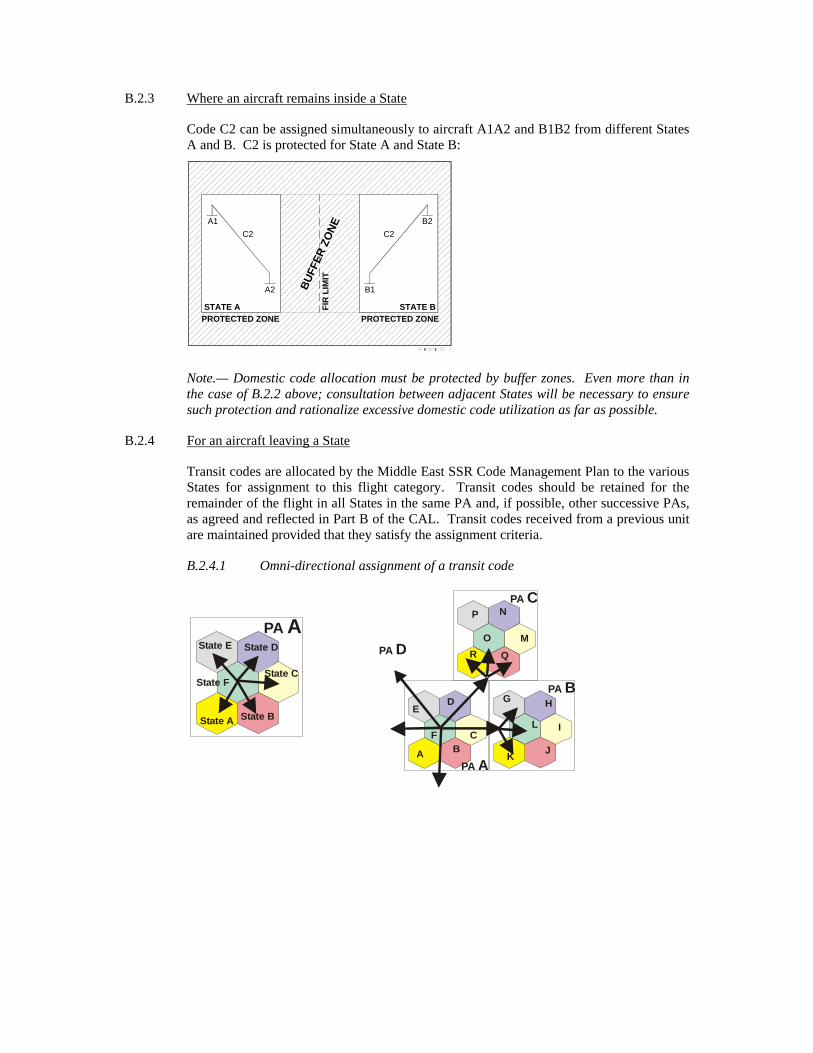
B.2.3 Where an aircraft remains inside a State
Code C2 can be assigned simultaneously to aircraft A1A2 and B1B2 from different States A and B. C2 is protected for State A and State B:
Note.— Domestic code allocation must be protected by buffer zones. Even more than in the case of B.2.2 above; consultation between adjacent States will be necessary to ensure such protection and rationalize excessive domestic code utilization as far as possible.
B.2.4 For an aircraft leaving a State
Transit codes are allocated by the Middle East SSR Code Management Plan to the various States for assignment to this flight category. Transit codes should be retained for the remainder of the flight in all States in the same PA and, if possible, other successive PAs, as agreed and reflected in Part B of the CAL. Transit codes received from a previous unit are maintained provided that they satisfy the assignment criteria.
B.2.4.1 Omni-directional assignment of a transit code
PROTECTED ZONE
BUFF
ER Z
ONE
STATE A
A1
A2
C2
STATE B
B1
B2C2
PROTECTED ZONEFI
R L
IMIT
State A
State EPA A
State B
State D
State CState F
PA A
PA B
PA C
PA D
A BC
DE
F
G H
I
JK
L
M
N
O
P
QR

Appendix B MIDDLE EAST SSR CODE MANAGEMENT PLAN Appendix B
Page v NOVEMBER 2014
B.2.4.2 Directional assignment of a transit code
Allocated by the Middle East SSR Code Management Plan to the various States for assignment to aircraft under specific conditions: to specific destinations in the same PA or in different PAs; to specific directions of aircraft and/or via specific areas. Special attention shall be given in ensuring that when applying directional assignment of a transit code, no code conflict could occur.
B.2.4.3 Close to PA border, retention of transit codes of other PA
Codes C1, C2 and C3, which belong to R2 transit series are retained until landing at an airport A1 near the border between the two PAs, which is located in a protection area for the codes in question.
B.3 Code occupancy times
B.3.1 In order to ensure uniqueness of the code in the systems concerned by an aircraft, the ICAO MID Regional Office based its calculations on a “protection period” of approximately two hours, when establishing the number and series of transit codes (please see paragraph 4.3.4). At the same time, the protection period should be reduced when possible, while providing adequate protection (please see paragraph 4.3.3 b). Certain suggestions along these lines will be found below.
B.3.2 Point of time for code assignment to aircraft
PA A PA B PA C
PROTECTED ZONE
A1
C1
C2
C3
PARTICIPATING AREA R1PARTICIPATING AREA R2

In order to economize codes as much as possible, it is recommended that codes be assigned to flights which will be performed in the very near future (when ready for departure, or in flight, about to come under control).
Note.— The ideal moment is the flight activation point in the case of automated systems.
B.3.3 Assignment procedures
Codes are normally assigned according to the earliest time of release (a VSP). However, in units assigning codes manually such sophistication may be cumbersome. When sophisticated systems are not available, cyclical assignment of the codes released should be preferred instead of a systematic return to the beginning of the category.
B.3.4 Release of a code by an aircraft
When a system records an aircraft landing or passing a distant MID PA exit point, the code assigned to the aircraft may be regarded as released and be re-used. In the case of distant MID PA exit point, an additional VSP waiting time, normally thirty minutes, shall be added before re-use. In the event that a code has been assigned to flight that has been cancelled or which will not take place, the code assigned should be released for immediate re-use.
B.3.5 Saturation
When the traffic load is such that no code is available for a given flight category it may be necessary to assign codes in accordance with relaxed rules:
a) reduced protection times – (see B.3.4);
b) using a different code category – using an omni-directional assignment if no more codes for directional assignment

Appendix C MIDDLE EAST SSR CODE MANAGEMENT PLAN Appendix C
Page vii NOVEMBER 2014
APPENDIX C - IMPLICATIONS FOR AUTOMATION
C.1 As stated in Appendix B, B.1.1, retention of the code assigned by the previous unit requires foreknowledge, implying capture of the data by the system in the event of automated assignment (direct capture by an AIDC or OLDI message, or indirect by manual input on coordination).
C.2 Assignment according to flight category implies that the system is capable of analysing the origin and destination of flights. If not, capture of units transferring and accepting, where applicable, may be used. For some cases one may need to process all four data items.
C.3 As in the case of any problem involving the “queuing management”, it is abundantly clear in the light of the previous remarks that the more centralized the allocation-assignment system, the more economical it will be. In other words, the less call there will be for allotment type solutions (provision of sub-banks to decentralized units), and the greater the use made of central assignment in accordance with overall criteria the more economical the system will be.
C.4 Likewise it has been seen that proper management of the assignment system presupposes knowledge of the actual traffic situation (entry into the system, route, exit from the system-landing etc.). Consequently, it is desirable that the assignment machinery should be linked with the real-time system.
C.5 A number of examples given in Appendix B show that despite the uniqueness by zone criterion, two codes may be found to be in use simultaneously in the same system (radar range is greater than the 60 NM buffer zone). Accordingly, the correlation systems should at least be capable of accommodating and unambiguously identifying two aircraft responding on the same code separated at the time of correlation by a designated geographical distance which will be a function of the automated system.
Note.— A geographical correlation filter should exist such that correlation will not be achieved if the calculated distance between the flight plan derived position based on estimate information and the SSR response corresponding to the SSR code in the flight plan is more than 30 NM.

C.6 Illustrative diagram for general code allocation and assignment
C1
Zone
1
C1
Zone
2
60 N
M
C2
C5 d
> 60
NM
C1
or C
2
C3
C7
C4
C6
C6
Prot
ectio
n>
60 N
M
C3
Ret
aine
d
FIR
1FI
R 2
FIR
3FI
RFI
R 4
Lim
itN
atio
nal
and
Reg
iona
lLi
mit
Nat
iona
lLi
mit
FIR
Lim
itS
TATE
AST
ATE
BS
TATE
C
PAR
TIC
IPA
TIN
G A
REA
YPA
RTI
CIP
ATI
NG
AR
EA Z

Appendix C MIDDLE EAST SSR CODE MANAGEMENT PLAN Appendix C
Page ix NOVEMBER 2014
The following notes relate to the diagram:
Code C1: Domestic code for PA Y (Domestic in STATE A Domestic in STATE B)
These codes can be used inside zone 1, inside zone 2, inside other zones of STATE B, and even inside the whole territory of STATE B if a buffer zone of 60 NM or a FIR separates them.
These codes could be used in PA Z under the same condition of protection against the allocation in STATE B.
Code C2: Domestic code for PA Y (Domestic in STATE A and STATE B)
Condition: a 60 NM buffer zone should be provided between these two assignments.
Code C3: Transit code for PA Y (STATE A)
In general such a code should be assigned to any aircraft originated in STATE A and leaving its boundaries, for overflying STATE B or landing in B.
In general this code may be changed at the entry in PA Z, but it could be retained for an arrival at an aerodrome close to the border and having a protection area of at least 60 NM against any other use in PA Z.
If C3 is planned for transit use from PA Y to PA Z it could be retained inside the whole PA Z.
Code C4: Transit code for PA Z (STATE C)
Such a code will be assigned to any flight whose code cannot be retained and overflying STATE C for a further destination in PA Z.
Code C5: Directional transit code between STATE A FIR2 and STATE B FIR3
C5 should be simultaneously protected in the two FIRs though domestic for PA Y. Such an allocation has the advantage of avoiding assignment of a transit code for such short middle-range flights.
Code C6: Transit code for PA Y
The example given with C6 is a duplication where the directional assignment by STATE A gives a guarantee of no conflicts occurring with the following units.
Code C7: Transit code for use for PA Y (STATE A) and PA Z
C7 which is at least transit in PA Y and having no domestic use in PA Z will be retained in the two areas.
Management of the code baskets for STATE A:
General: Domestic basket : C1, C2
Transit basket : C3, C6
Special: Domestic State A FIR 2 — State B FIR 3 : C5
Transit State A — PA Z : C7
Directional assignment FIR 2 — State B
FIR 1 — Other State of PA Y : C6

C.7 Flow Chart
The following chart outlines the retention/assignment procedures described above:
Knowledge of theprevious code?
Codealready in use
by another aircraftwith insufficient
protection?
Flight Category
SpecificConditions?
SpecificConditions?
RETAIN?
- OLDI- Verbal Coordination- Pilot report
- departure- upstream with no SSR- uncoordinated flight
Yes
Yes
Yes
No
No
No
Transit Local
Dire
ctio
nal
Dire
ctio
nal
Om
ni-d
irect
iona
l
Omni-dire
ctional
Code retentionCode Category
Directional Transit
Code CategoryOmni-directional
Transit
Code CategoryDirectional
Local
Code CategoryOmni-directional
Local
Code (Re) Assignment

Appendix D MIDDLE EAST SSR CODE MANAGEMENT PLAN Appendix D
Page xi NOVEMBER 2014
APPENDIX D - DEVELOPMENT OF AUTOMATED SSR CODE ASSIGNEMENT SYSTEMS
D.1 As computer capabilities could be a limiting factor in code assignment and thus reflect on the code allocation, the following principles for the development of automated SSR code assignment systems should be observed:
a) automated systems shall be capable of using code blocks (part of a code series) without getting confused if, in a neighbouring system, other blocks of the same code series (with the same first and second digits) are used;
b) automated equipment shall be capable of coping with a limited number of code conflicts rather than preventing code duplications by means of more complicated and less economical code allocation and assignment methods;
Note.— It is expected that this feature will become even more important as traffic increases.
c) automated systems shall be capable of assigning codes with reference to the category of a flight, i.e. transit codes shall be assigned to an aircraft engaged in transit flights and domestic codes to an aircraft confined within the smaller area of use reserved for such codes;
d) automated systems shall permit the addition of a sophisticated capability of assigning codes with reference to the routing or special code protection required for specific aircraft, especially when this will permit economies in the number of codes required;
e) the code assignment logic of an automated system shall not impose any restriction on the free choice of any specific additional codes if this is required to satisfy new requirements;
f) automated code assignment systems shall be designed to conform to international cooperative principles and essential capabilities described in this Document.
------------------

ANSIG/1-REPORT APPENDIX 4O
APPENDIX 4O
Allocation and Assignment of Secondary Surveillance Radar (SSR) Codes in the MID Region
3.1. The Middle East SSR Code Management Plan (MID SSR CMP), endorsed by MIDANPIRG, provides States in the ICAO MID Region with means to coordinate the use of SSR codes based on the provisions of the ICAO Doc 4444 and the principles of the Originating Region Code Assignment Method (ORCAM). 3.2. Certain codes are reserved for special purposes on a world-wide scale. The remaining codes series for use in the Region are divided into two distinct categories: Transit codes (T) for international use and Domestic codes (D) for national use 3.3. The MID Code Allocation List (CAL) at Table ATM II-MID-2 reflects the assignment of SSR codes to the MID States among the series of codes allocated to the MID Region, based on the number of aircraft to be handled simultaneously within a specified area and for a determined period of protection during traffic peaks. 3.4. The MID SSR CMP, available on the ICAO MID website, under eDocuments (https://portal.icao.int/RO_MID/Pages/eDocs.aspx), should be managed and maintained up-to-date by the ICAO MID Regional Office. 3.5. States should inform the ICAO MID Regional Office promptly of any deviation from the Plan or proposed changes considered necessary with respect to their code allocations, relevant to ATS infrastructure developments and/or the guidance material provided in the MID SSR CMP. Special purpose codes Series 00 Code 0000 is available as a general purpose code for domestic use by any of the MID States.
Series 10 Code 1000 reserved for use as a conspicuity code for Mode S
Series 20 Code 2000 shall be used by flight crews in the absence of any Air Traffic Control (ATC) instructions or regional agreements unless the conditions for the use of codes: 7000, 7500, 7600 and 7700 apply.
Series 70 Code 7000 shall be used by flight crews not receiving ATS service in order to improve detection of suitably equipped aircraft in areas specified by States, unless otherwise instructed by ATS.
Series 75 Code 7500 is reserved for use in the event of unlawful interference.
Series 76 Code 7600 is reserved for use in the event of radio communications failure.
Series 77 Code 7700 is reserved for use in the event of emergencies and interception*. Code 7776 and Code 7777 are reserved for SSR ground transponder monitoring.
Codes 7601-7612
Are reserved for humanitarian flights.

ANSIG/1-REPORT APPENDIX 4O
4O-2
Table ATM II-MID-2 – MID SSR Code Allocation List
Code
AM
MA
N
BA
GH
DA
D
BA
HR
AIN
BE
IRU
T
CA
IRO
DA
MA
SC
US
EM
IRA
TE
S
JED
DA
H
KH
AR
TO
UM
KU
WA
IT
MU
SC
AT
SA
NA
'A
TE
HR
AN
TR
IPO
LI
0001-00772
0101-01771 D T
0200-02771 D
0300-03772
0400-04772 D D
0500-05771 T
0600-06771 D D D
0700-07771 T
1000-10771 T
1101-11771 D
D
1200-12771 D D
1300-13771 D D
1400-14771 T
1500-15771 D
1600-16771 T
1700-17771 T
2001-20773
2100-21771 D
2200-22771 T
2300-23771 D
2400-24771 D
2500-25771 D
2600-26771 T
2700-27771 D D
3000-30771 D D
3100-31771 T
3200-32771 T
3300-33771 T
3400-34771 T
3500-35771 D
3600-36771 T
3700-37771 D
4000-40771 T T
4100-41771 D D
4200-42771 T

ANSIG/1-REPORT APPENDIX 4O
4O-3
Code
AM
MA
N
BA
GH
DA
D
BA
HR
AIN
BE
IRU
T
CA
IRO
DA
MA
SC
US
EM
IRA
TE
S
JED
DA
H
KH
AR
TO
UM
KU
WA
IT
MU
SC
AT
SA
NA
'A
TE
HR
AN
TR
IPO
LI
4300-43771 T
4400-44771 T
4500-45771 T
4600-46771 D
4700-47771 T
5000-50771 D
5100-51771 T
5200-52771 T D
5300-53773 D
5400-54771 T
5500-55773
5600-56771 D
5700-57771 T
6000-60771 D
6100-61771 D
6200-62771 T
6300-63771 D
6400-64773
6500-65771 D
6600-66771 D
6700-67772
7001-70771 T
7100-71772
7200-72771 T
7300-73771 T
7400-74771 D
7501-75772
7613-76772
7701-77752
T: codes allocated for Transit use D: codes allocated for Domestic use
1 Series allocated to the MID Region and Assigned to MID States 2 MID Region SSR Reserve List for Domestic use 3 MID Region SSR Reserve List for Transit use
------------------

ANSIG/1-REPORT APPENDIX 4P
APPENDIX 4P
MID SAR Capability Matrix (Last Update: 2015)
Leg
isla
tion
Ove
rsig
ht
SA
R C
omm
itte
e
Tra
inin
g
Ale
rtin
g
SA
R A
gree
men
ts
Inte
rnal
co
oper
atio
n/
coor
din
atio
n
Com
mu
nic
atio
ns
Qu
alit
y A
ssu
ran
ce
Civ
il/M
ilit
ary
Res
ourc
es
SA
RE
X
Lib
rary
Com
pu
teri
zati
on
SA
R P
lan
SA
R a
ircr
aft ELTs
SP
OC
Reg
ula
tion
Reg
istr
atio
n
Tes
t
Bahrain Egypt Iran
Iraq Jordan Kuwait
Lebanon Libya Oman Qatar
Saudi Arabia Sudan Syria UAE
Yemen A = Fully meets Annex 12 requirements B = Meets Annex 12 requirements in most areas C = Meets Annex 12 requirements in some areas D = Initial implementation E = Not implemented Blank = No response

ANSIG/1-REPORT APPENDIX 4P
4P-2
SAR Matrix Element Descriptions
Training: The appropriate level and type of training provide to RCCs and RSCs and SAR Inspectorate Staff. Availability of training programme and training plans Oversight: the effectiveness of the States’ oversight activities conducted over the RCC and RSCs Alerting: Fast and reliable means for the rescue coordination center to receive distress alerts. (IAMSAR Manual Vol. 1, Chapter 2) Legislative: Provisions that establish a legal foundation for establishing a SAR organization and its resources, policies, and procedures. (IAMSAR Manual Vol. I, Chapter 1) SAR Committee: Typically established under a national SAR plan, the SAR coordinating committee is comprised of SAR stakeholders. (IAMSAR Manual Vol. 1, Chapter 6 and Appendix J) Agreements : States should enter into agreements with neighboring States to strengthen SAR cooperation and coordination. (Chapter 3 – Cooperation, in both Annex 12 – Search and Rescue, and the International Convention on Maritime SAR) Internal cooperation/ coordination: Close cooperation between services and organizations which may contribute to improving SAR service in areas such as operations, planning, training, exercises and research and development. Communications: Communication capability for receipt of distress alerts and operational coordination among the SAR mission coordinator, the on-scene coordinator and SAR facilities. (IAMSAR Manual Vol. 1, Chapter 3) Quality Assurance: Procedures to focus on improving the quality of SAR services so as to improve results and reduce costs. (IAMSAR Manual Vol. 1, Chapter 6) Civil/Military: Close cooperation between the various civilian and military organizations. Resources: The primary operational facilities made available to the national SAR system by various authorities and arrangements with others. (IAMSAR Manual Vol. 1, Chapter 5 and Appendix C) SAR Exercise: Exercise to test and improve operational plans, provide learning experience and improve liaison and coordination skills. (IAMSAR Manual Vol. 1, Chapter 3; Annex 12, and Annex 14 regarding Airport Emergency Plan) Library: RCC/RSCs Quick access to the applicable international, national, and agency SAR publications that provide standards, policy, procedures and guidance. Computerization: RCC/RSCs use of or access to output of various computer resources including databases, computer aids for SAR system management, search planning software, etc. (IAMSAR Manual Vol. 1, Chapter 2) SAR Plan: National structure to establish, manage and support the provision and coordination of SAR services. (IAMSAR Manual Vol. 1, Chapter 1) SAR aircraft: Number of aircraft provided with specialized equipment suitable for the efficient conduct of SAR missions (Annex 12, Chapter 2 - Organization) ELT: National regulations for carriage of ELTs, and arrangements for registration of the 406 MHz beacon and rapid access to the beacon registration database. (Annex 6 – Operation of Aircraft and Annex 10 - Aeronautical Telecommunications; and IAMSAR Manual Vol. 1, Chapter 4) and if testing is carried out to ensure proper serviceability.

ANSIG/1-REPORT APPENDIX 4P
4P-3 SPOC: A SAR Point of Contact (SPOC) designated for receipt of Cospas-Sarsat distress data, and arrangements for efficient routing of the distress data to the appropriate SAR authority (the aeronautical emergency locator transmitter ELT), maritime emergency position-indicating beacon (EPIRB), and personal locator beacon (PLB)). (Annex 12, paragraph 3.2.5 and Section 2.4; and, IAMSAR Manual Vol. 1, Chapter 4)
-----------------

ANSIG/1-REPORT APPENDIX 4Q
APPENDIX 4Q
The main Recommendations emanating for the ICAO/IMO SAR GMDSS Conference related to Civil Aviation, inviting GCC States to:
• provide IMO and ICAO with information related to the availability of SAR services, including
information on the areas of responsibility, taking into account IMO’s and ICAO provisions, as soon as possible if not already done so, and keep the information up to date on a regular basis;
• noting that close cooperation between maritime and aeronautical SAR services is essential, establish a national SAR Coordinating Committee;
• develop a national SAR Plan, to the extent possible, ensuring harmonization with SAR Plans of the neighboring States, for the benefit of effective and efficient SAR cooperation;
• consider the development of a multilateral agreement on the cooperation of aeronautical and maritime SAR and the establishment of a Regional SAR Coordinating Committee, in the framework of the GCC;
• sign the SAR Letters of Agreement (LoAs) to facilitate and expedite the efficient conduct of SAR operations;
• evaluate SAR and GMDSS facilities and identify actions to be taken to improve the existing situation, including the establishment of Rescue Coordination Centres, as appropriate;
• keep record of all SAR activities and as such built up statistics for national use as well to be used in communication with IMO and ICAO, as appropriate;
• share lessons learned related to SAR activities;
• develop a short and long term programme for training of SAR personnel, including those involved in the oversight of SAR;
• conduct national, bilateral and multilateral SAR exercises and use lessons learned to identify capacity building needs; and
• request, as appropriate, either individually or in cooperation with other GCC States, IMO and/or ICAO to provide technical assistance, in particular to:
a) assess the existing situation and provide recommendations for improvement; and
b) support the training of personnel involved in SAR.
-------------------

ANSIG/1-REPORT APPENDIX 4R
APPENDIX 4R
MID REGION SAR AGREEMENT STATUS BETWEEN ANSPS/ACCS
February 2015
STATE CORRESPONDING STATES REMARKS
BAHRAIN IRAN SAUDI ARABIA
KUWAIT UAE
QATAR
0/5
EGYPT CYPRUS JORDAN SUDAN
GREECE LYBIA
Israel SAUDI ARABIA
1/7
IRAN
ARMENIA BAHRAIN OMAN TURKMANISTAN
AZERBAIJAN IRAQ PAKISTAN UAE
AFGHANISTAN KUWAIT TURKEY
1/11
IRAQ IRAN JORDAN
KUWAIT SAUDI ARABIA
SYRIA TURKEY
1/6
JORDAN EGYPT IRAQ
ISRAEL SAUDI ARABIA
SYRIA 1/5
KUWAIT BAHRAIN IRAN
IRAQ SAUDI ARABIA 0/4
LEBANON CYPRUS SYRIA
1/2
LIBYA ALGERIA CHAD EGYPT
MALTA NIGER
SUDAN TUNIS 0/7
OMAN INDIA IRAN
SAUDI ARABIA PAKISTAN
UAE YEMEN
1/6
QATAR BAHRAIN SAUDI ARABIA UAE 0/3
SAUDI ARABIA
BAHRAIN IRAQ OMAN UAE
EGYPT JORDAN Qatar YEMEN
ERITREA KUWAIT SUDAN
1/11
SUDAN CENTRAL AFRICAN CHAD EGYPT
ERITREA ETHIOPIA LIBYA
SAUDI ARABIA SOUTH SUDAN 0/8
SYRIA IRAQ JORDAN
LEBANON CYPRUS
TURKEY 2/5
UAE BAHRAIN IRAN
OMAN SAUDI ARABIA
QATAR 1/5
YEMEN DJIBOUTI ERITREA ETHIOPIA
INDIA OMAN SAUDI ARABIA
SOMALIA 0/7
Agreement Signed Agreement NOT Signed Signed Agreements / Total No. of required Agreements
------------------

ANSIG/1-REPORT APPENDIX 4S
APPENDXI 4S
MID REGION SAR POINT OF CONTACT (SPOC) – COSPAS-SARSAT
STATE SPOC NAME ADDRESS EMAIL TEL FAX AFTN ASS.
MCC/ STATE
1
LAST
REVISION REMARK
Bahrain RCC ATC Bahrain
Bahrain CAA, Air Navigation Directorate P.O. Box 586 Kingdom of Bahrain
[email protected] (973) 17321081 17321080
(973) 17321905
OBBISARX SAMCC Saudi Arabia
16-April-2013
Egypt SAR Centre SAR Centre Almaza Air Base Heliopolis, Cairo, Egypt
[email protected] [email protected] [email protected]
(202) 24184537 24184531
(202) 24184537 24184531
HECCYCYX ALMCC Algeria
22-OCT-2013
TELEX: (91) 21095 RCCC RUN
Iran RCC Tehran Civil Aviation Organization SAR Coordination Centre Mehrabad Airport Tehran, Iran
[email protected] [email protected] [email protected]
(9821) 44544107 44544116 44544060 (9891)24176881
(9821) 44544117 44544106
OIIIZRZX TRMCC Turkey
14-Jan-2013
Iraq RCC ATC Baghdad
Baghdad ACC, Baghdad International Airport
[email protected] (974) 7901654653
(974) ) 15430764
TRMCC Turkey
18 Mar. 2015
Jordan RCC ATC Amman
RCC Civil Aviation Authority Amman Airport, Jordan
(9626) 4451672
(9626) 4451667
OJACZQZX SAMCC Saudi Arabia
16-Apr-2013
Kuwait RCC ATC Kuwait
RCC DGCA Kuwait International Airport, P.O.Box 17, Kuwait
(965) 24760463 24762994
(965) 24346515 24346221
OKBKZQZX OKBKNSAR
SAMCC Saudi Arabia
16-Apr-2013
Lebanon RCC Beirut RCC, DGCA Lebanon, Hariri Int’l Airport- Beirut, Lebanon
(961) 1628161
(961) 1628186 1629035
OLBIZQZX SAMCC Saudi Arabia
16-Apr-2013
Libya CAA CAA, Tripoli Int’l Airport, Libya
[email protected] (218.21) 5632332 4446799
(218.21) 563 0257 360 6868
HLLTYCYX ALMCC Algeria
16-May-2013
TELEX (218.21) 5632332
1 Associated COSPAS-SARSAT Mission Control Center / State where it is located

ANSIG/1-REPORT APPENDIX 4S
4S-2
STATE SPOC NAME ADDRESS EMAIL TEL FAX AFTN ASS.
MCC/ STATE
1
LAST
REVISION REMARK
3606868
Oman RCC Muscat Air Force
RCC, HQ RAFO P.O.Box 730 Central Post Office Muscat Int’l Airport, Oman
(968) 24519209 24519332
(968) 24334776 24338692
OOMSYAYX SAMCC Saudi Arabia
16-Apr-2013
Qatar RCC ATC
(974) 44616332 44651001 44616429
(974) 44622078 44678512
OTBDZTZX SAMCC Saudi Arabia
16-Apr-2013
Saudi Arabia
SAMCC KSA.GACA / Air Navigation services P.O.Box 929 Jeddah 21421 Saudi Arabia
(96602) 6150170 6855812 (96650) 4601445
(96602) 6150171 6402855
OEJNJSAR SAMCC Saudi Arabia
28-Jun-2013
TEL 3 & FAX 2 for Head of SAMCC
Sudan ACC Khartoum
Khartoum Airport, Sudan (249.183) 788192 784925
(249.183) 528323
HSSSYCYX ITMCC
Italy 16-Apr-
2013
Thuraya +8821655524296
Syria RCC ATC General Civil Aviation Authority
(963.11) 5400540
(963.11) 5400312
OSDIZQZX SAMCC Saudi Arabia
16-Apr-2013
UAE AEMCC SAR Coordination Center P.O.Box 906 GHQ Armed Forces UAE
[email protected] (971.2) 4056144 4496866
(971.2) 4496844
OMADYCYX AEMCC
UAE
23-Sep-2011
Yemen RCC Sanaa RCC Department of Civil Aviation Sanaa, Yemen
(967) 1344673
(967) 1345916
OYSNYCYX SAMCC Saudi Arabia
16-April-2013
------------------
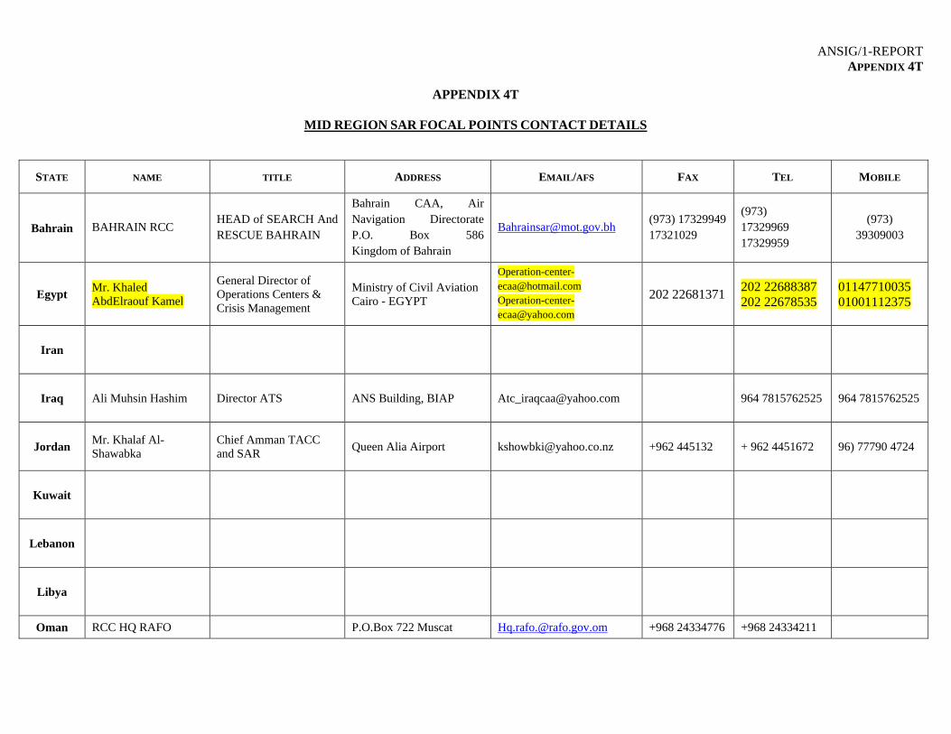
ANSIG/1-REPORT APPENDIX 4T
APPENDIX 4T
MID REGION SAR FOCAL POINTS CONTACT DETAILS
STATE NAME TITLE ADDRESS EMAIL/AFS FAX TEL MOBILE
Bahrain BAHRAIN RCC HEAD of SEARCH And RESCUE BAHRAIN
Bahrain CAA, Air Navigation Directorate P.O. Box 586Kingdom of Bahrain
[email protected] (973) 17329949 17321029
(973) 17329969 17329959
(973) 39309003
Egypt Mr. Khaled AbdElraouf Kamel
General Director of Operations Centers & Crisis Management
Ministry of Civil Aviation Cairo - EGYPT
[email protected] [email protected]
202 22681371 202 22688387 202 22678535
01147710035 01001112375
Iran
Iraq Ali Muhsin Hashim Director ATS ANS Building, BIAP [email protected] 964 7815762525 964 7815762525
Jordan Mr. Khalaf Al-Shawabka
Chief Amman TACC and SAR
Queen Alia Airport [email protected] +962 445132 + 962 4451672 96) 77790 4724
Kuwait
Lebanon
Libya
Oman RCC HQ RAFO P.O.Box 722 Muscat [email protected] +968 24334776 +968 24334211

ANSIG/1-REPORT APPENDIX 4T
4T-2
STATE NAME TITLE ADDRESS EMAIL/AFS FAX TEL MOBILE
P.C. 111, Oman AFS:- OOMSYCYX +968 24334212
Qatar
Saudi Arabia
Mr. Ahmad B. Altunisi
Manager SAR Head of SAMCC
General Authority of Civil Aviation
[email protected] 966-2 671 9041 966-2 671 7717/1840
966-50 460 1445
Sudan Hashim Mohamed Ahmed
Head RCC Sudan CAA PO BOX 165 [email protected] 249183528323 249183528323 24912327797 249912382433
Syria Mr. Monif Abdulla
Head of S.A.R. Department Syrian Civil Aviation Authority
Damascus Airport [email protected] 963-11 540 0312
963-11 540 0312 963 932 710351
UAE UAE ATC Duty Supervisor
[email protected] 971 2 599 6850 971 2 599 6969
Yemen
--------------------
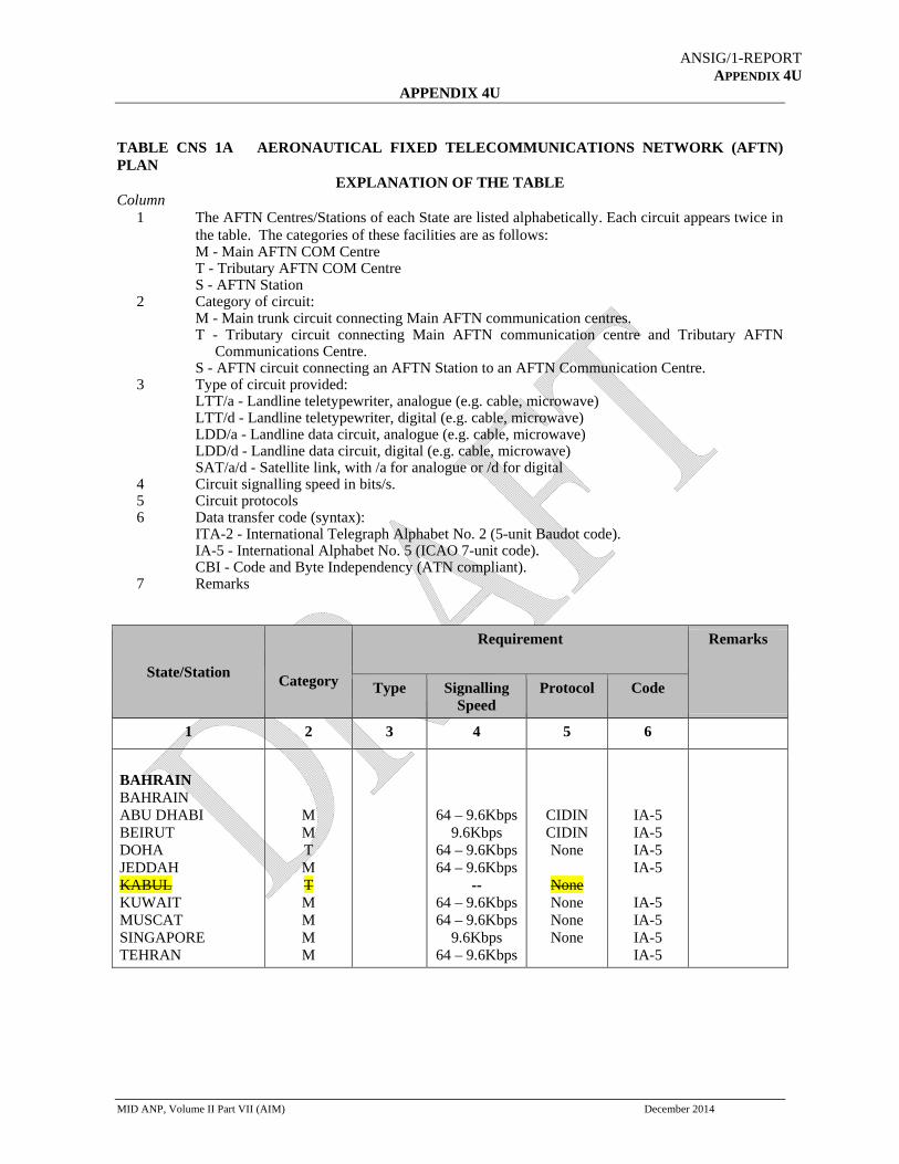
ANSIG/1-REPORT APPENDIX 4U
APPENDIX 4U
MID ANP, Volume II Part VII (AIM) December 2014
TABLE CNS 1A AERONAUTICAL FIXED TELECOMMUNICATIONS NETWORK (AFTN) PLAN
EXPLANATION OF THE TABLE Column 1 The AFTN Centres/Stations of each State are listed alphabetically. Each circuit appears twice in
the table. The categories of these facilities are as follows: M - Main AFTN COM Centre T - Tributary AFTN COM Centre S - AFTN Station 2 Category of circuit: M - Main trunk circuit connecting Main AFTN communication centres. T - Tributary circuit connecting Main AFTN communication centre and Tributary AFTN
Communications Centre. S - AFTN circuit connecting an AFTN Station to an AFTN Communication Centre. 3 Type of circuit provided: LTT/a - Landline teletypewriter, analogue (e.g. cable, microwave) LTT/d - Landline teletypewriter, digital (e.g. cable, microwave) LDD/a - Landline data circuit, analogue (e.g. cable, microwave) LDD/d - Landline data circuit, digital (e.g. cable, microwave) SAT/a/d - Satellite link, with /a for analogue or /d for digital 4 Circuit signalling speed in bits/s. 5 Circuit protocols 6 Data transfer code (syntax): ITA-2 - International Telegraph Alphabet No. 2 (5-unit Baudot code). IA-5 - International Alphabet No. 5 (ICAO 7-unit code). CBI - Code and Byte Independency (ATN compliant). 7 Remarks
State/Station
Category
Requirement Remarks
Type Signalling Speed
Protocol Code
1 2 3 4 5 6
BAHRAIN BAHRAIN ABU DHABI BEIRUT DOHA JEDDAH KABUL KUWAIT MUSCAT SINGAPORE TEHRAN
M M T M T M M M M
64 – 9.6Kbps 9.6Kbps
64 – 9.6Kbps 64 – 9.6Kbps
-- 64 – 9.6Kbps 64 – 9.6Kbps
9.6Kbps 64 – 9.6Kbps
CIDIN CIDIN None
None None None None
IA-5 IA-5 IA-5 IA-5
IA-5 IA-5 IA-5 IA-5

ANSIG/1-REPORT APPENDIX 4U
4U-2
State/Station
Category
Requirement Remarks
Type Signalling Speed
Protocol Code
1 2 3 4 5 6
EGYPT CAIRO AMMAN ATHENS BEN GURION BEIRUT JEDDAH KHARTOUM NAIROBI TUNIS TRIPOLI TRIPOLI DAMASCUS
M M T M M T M M M M M
64 – 9.6Kbps 64 – 9.6Kbps 64 – 9.6Kbps
9.6Kbps 128–9.6Kbps
9.6Kbps 9.6Kbps
64 – 9.6Kbps 64–19.2Kbps
9.6Kbps 64 – 9.6Kbps
None CIDIN None
CIDIN CIDIN None None None None None None
IA-5 IA-5 IA-5 IA-5 IA-5 IA-5 IA-5 IA-5 IA-5 IA-5 IA-5
IRAN TEHRAN BAHRAIN KABUL KUWAIT ABU-DHABI
T M T M
64 Kbps -
64 Kbps
None
None
IA-5
IA-5
IRAQ BAGHDAD AMMAN BEIRUT KUWAIT ANKARA
T T
- -
None None
IA-5 IA-5
JORDAN AMMAN ABU DHABI BAGHDAD BEIRUT BEN GURION CAIRO DAMASCUS JEDDAH
T T T M T T M
2M 2- -
9.6 Kbps 64 – 9.6Kbps 64 – 9.6Kbps 64–19.2Kbps
AMHS - -
None None None None
- -
IA-5 IA-5 IA-5

ANSIG/1-REPORT APPENDIX 4U
4U-3
State/Station
Category
Requirement Remarks
Type Signalling Speed
Protocol Code
1 2 3 4 5 6
KUWAIT KUWAIT BAHRAIN DAMASCUS BEIRUT DOHA (EUR) KARACHI TEHRAN BAGHDAD
M T M M -
M M T
LDD/d LDD/a LDD/a LDD/a
LDD/d LDD/d SAT/ad
64 – 9.6Kbps 50 BD 100 BD
64 – 9.6Kbps
64 Kbps 64 – 9.6Kbps
9.6Kbps
None None None None
None None None
I A-5 ITA-2 ITA-2 IA- 5
IA-5 IA-5 IA- 5
LEBANON BEIRUT AMMAN BAGHDAD BAHRAIN CAIRO DAMASCUS JEDDAH KUWAIT NICOSIA
M T M M T M M M
- -
9.6Kbps 9.6Kbps
2 x 50 BD 9.6Kbps 100 BD 9.6Kbps
-
None CIDIN CIDIN None
CIDIN None
CIDIN
- -
IA-5 IA-5
ITA-2
ITA-2 IA-5
LIBYA TRIPOLI MALTA TUNIS BENGHAZI CAIRO KHARTOUM
T T M T M T
64 – 9.6Kbps 9.6Kps
None X21
IA-5 IA-5
OMAN MUSCAT ABU DHABI BAHRAIN MUMBAI JEDDAH SANA'A
T M M M T
9.6Kbps 300 BD 9.6Kbps 300 BD 100 BD
AMHS None None None None
IA-5 ITA-2 ITA-2 ITA-2
QATAR DOHA BAHRAIN KUWAIT ABU DHABI
M M T
9.6Kbps 64-9.6 Kps
6Kbps
None None
AMHS
IA-5 ITA-2

ANSIG/1-REPORT APPENDIX 4U
4U-4
State/Station
Category
Requirement Remarks
Type Signalling Speed
Protocol Code
1 2 3 4 5 6
SAUDI ARABIA JEDDAH ADDIS-ABABA BAHRAIN BEIRUT CAIRO MUSCAT SANA'A AMMAN
M M M M M T
9.6Kbps 64 – 9.6Kbps
9.6Kbps 128–9.6Kbps 300BD64Kbps
9.6Kbps
None CIDIN CIDIN CIDIN None None
IA-5 IA-5 IA-5 IA-5
ITA-2 IA-5
SUDAN KHARTOUM ADDIS ABABA ASMARA CAIRO JEDDAH TRIPOLI NDJAMENA
M M T M M T M
9.6Kbps 9.6Kbps 9.6Kbps 9.6Kbps 9.6Kbps 9.6Kbps
X21 X21 X21 X21 X21 X21
IA-5 IA-5 IA-5 IA-5 IA-5 IA-5
SYRIA DAMASCUS ATHENS AMMAN BEIRUT CAIRO KUWAIT TEHRAN
M T M M M T
2 X 50 BD 64 – 9.6Kbps
2 X 50 BD 50 BD 50 BD 50 BD
None None None None None None
ITA-2
ITA-2 ITA-2 ITA-2 ITA-2
UAE ABU DHABI BAHRAIN AMMAN MUSCAT QATAR TEHRAN
M T M
M
64 – 9.6Kbps 2 Mbps
9.6Kbps
64 – 9.6Kbps
CIDIN AMHS
None
None
IA-5
IA-5
IA-5
YEMEN SANA'A JEDDAH MUSCAT
M M
9.6Kbps 9.6Kbps
None None
IA-5 IA-5
-----------------

CNS SG/6-REPORT APPENDIX 5EAppendix D-1
Interference to GNSS signals
Use of GNSS pseudolites and repeaters
1. Introduction
1.1 As for all systems using the radio frequency spectrum, GNSS is vulnerable to interference
and measures (radio regulatory) are in place through the provisions of the ITU Radio Regulations to protect
GNSS systems from harmful interference. Technical measures such as the specification of the GNSS
receiver interference mask are in Annex 10.
1.2 Despite various regulatory mechanisms being in place, including those agreed at European
(CEPT) level. In the recent years harmful interference that was either caused intentionally or unintentionally
has been experienced to GNSS systems.
1.3 In addition to interference caused by RF emissions, GNSS signals are also vulnerable to
ionospheric scintillation which may cause loss of GNSS signals in particular in equatorial and auroral
regions.
1.4 Detailed material on GNSS vulnerability and GNSS interference is in the ICAO GNSS
Manual (Doc. 9849) which is currently being revised by the Navigation Systems Panel. Relevant (draft)
material on interference from this Manual is reproduced in Appendix A
1.5 Of concern to aviation is the protection of the frequency bands 1559 – 1610 MHz, used by
GLONASS and GPS and the band 1164 – 1215 MHz which is foreseen to be used by GLONASS and GPS.
Also the European Galileo system and the Chinese BEIDOU system are planning to use these bands to
provide GNSS signals for use by aviation. Various satellite based augmentation systems are operating in the
frequency band 1559 – 1610 MHz.
2. Interference
2.1 Unintentional interference.
2.1.1 Unintentional interference is normally caused by equipment authorized to operate on GNSS
frequencies under strict conditions that are aimed at not causing harmful interference to the reception of
GNSS signals. Problematic is that not in all cases such equipment is being used in accordance with these
conditions, thus resulting in causing harmful interference.
Equipment that can cause such interference include GNSS repeaters and GNSS Pseudolites
2.1.2 In Europe provisions were developed by the ECC/CEPT to avoid harmful interference by
inappropriate use of GNSS pseudolites and GNSS repeaters. These provisions and other relevant material is
available from the website of the European Communications Office (ECO) in the following Reports and
Recommendation:
ECC Report 129: Technical and operational provisions required for the use of GNSS repeaters
ECC Report 145: Regulatory framework for Global Navigation Satellite System (GNSS) repeaters
ECC Recommendation (10)02, A framework for authorization regime of Global Navigation
Satellite System
ECC Report 128: Compatibility Studies between Pseudolites and Services in the frequency bands
1164-1215 MHz, 1215-1300 MHz and 1559-1610 MHz
ECC REC (04)01, which declares jammers as illegal.
ECC Report 183, Regulatory Framework for Outdoor Pseudolites
ANSIG/1-REPORT
APPENDIX 4V

Interference to GNSS signals
2.1.3 In addition various ITU-R Recommendations provide relevant information on the compatibility and
use of RNSS networks, including:
Recommendation ITU-R M.1904: Characteristics, performance requirements and protection
criteria for receiving stations of the radionavigation-satellite service (space-to-space) operating in the
frequency bands 1 164-1 215 MHz, 1 215-1 300 MHz and 1 559-1 610 MHz
Recommendation ITU-R M.1901: Guidance on ITU-R Recommendations related to systems and
networks in the radionavigation-satellite service operating in the frequency bands 1 164-1 215 MHz,
1 215-1 300 MHz, 1 559-1 610 MHz, 5 000-5 010 MHz and 5 010-5 030 MHz
Recommendation ITU-R M.1787: Description of systems and networks in the radionavigation-
satellite service (space-to-Earth and space-to-space) and technical characteristics of transmitting
space stations operating in the bands 1 164-1 215 MHz,1 215-1 300 MHz and 1 559-1 610 MHz
Recommendation ITU-R M.1903: Characteristics and protection criteria for receiving earth stations
in the radionavigation-satellite service (space-to-Earth) and receivers in the aeronautical
radionavigation service operating in the band 1 559-1 610 MHz
Recommendation ITU-R M.1318: Evaluation model for continuous interference from radio sources
other than in the radionavigation-satellite service to the radionavigation-satellite service systems and
networks operating in the 1 164-1 215 MHz, 1 215-1 300 MHz, 1 559-1 610 MHz and 5 010-5 030
MHz bands
Recommendation ITU-R M.2030: Evaluation method for pulsed interference from relevant radio
sources other than in the radionavigation-satellite service to the radionavigation-satellite service
systems and networks operating in the 1 164-1 215 MHz, 1 215-1 300 MHz and 1 559-1 610 MHz
frequency bands
ITU R M.2220 which provides criteria to determine compatibility between DME and GNSS L5.
2.1.4 States are invited to consult this material with the view to develop national regulations that will
enforce the operation of GNSS Pseudolites and Repeater in a manner that harmful; interference to the
reception of GNSS signals by aviation is prevented. Particular attention should be given to the practicality to
enforce these provisions.
2.2 Intentional interference
Intentional interference is caused by equipment of which the user has the intention to cause harmful
interference to the reception of GNSS signals, either on a local (e.g. less than 100 m) scale or a large scale
(e.g. in the order of 100 – 200 NM).
Equipment used to cause intentional interference includes jammers and spoofers (intentional interference that
may result in an aircraft to follow a false flight path).
The sale and use for jammers developed to cause Intentional interference, (e.g. to avoid tracking of vehicles)
and spoofers should be forbidden. Although difficult, these systems should not be allowed on any market
(national or international).
2.3 ICAO Electronic Bulletin on Interference to GNSS Signals.
ICAO has drawn the attention of States to the need to ensure protection of GNSS signals from interference
and point to the need of cooperation between national aeronautical and telecommunication authorities in the
introduction and enforcement of appropriate regulations (Electronic Bulletin EB 2011/56 from 21 November
refers). This Electronic Bulletin is, for the ease of reference, reproduced in Appendix B
3. Cooperation with ITU
3.1 Interference to GNSS systems can affect international civil aviation and [in some cases]
international coordination may be required to solve such interference. A framework for cooperation in the

Interference to GNSS signals
format of a Memorandum of Understanding between the ITU and ICAO has been established with the prime
view to maximize the joint efforts of the ITU and ICAO to eliminate cases of harmful interference. This
Memorandum is reproduced in Appendix C
4. Fixed Service
4.1 The frequency band 1559 – 1610 MHz is shared with the (terrestrial) Fixed Service. Use of
this band by both the Radionavigation Satellite Service and the Fixed service in a compatible manner is not
feasible. Although the allocation to the Fixed Service is on a secondary basis, attention is drawn to the fact
that the Fixed Service may cause harmful interference to the reception of GNSS signals. In 2015 the
allocation to the Fixed Service is expected to be withdrawn from the Radio Regulations and attention should
be given to the need to secure that any operation of the Fixed Service in this band will cease by that time.
5. Summary
5.1 This information material highlights a number of cases where harmful interference can be
caused to the reception of GNSS signals by aviation. Measures to prevent such interference are
recommended together with an operational evaluation of the interference risks.
Work on the assessment of RF interference (intentional and unintentional) is ongoing in the Navigation
Systems Panel.
---------------

APPENDIX A of the ICAO GNSS Manual (Doc. 9849)
Source: GNSS Manual – Chapter 5
5.8 GNSS VULNERABILITY
5.8.1 General
5.8.1.1. The most notable GNSS vulnerability lies in the potential for interference, which exists in all
radionavigation bands. As with any navigation system, the users of GNSS navigation signals should be
protected from harmful interference resulting in the degradation of navigation performance.
5.8.1.2 The GNSS SARPs require a specified level of performance in the presence of levels of
interference as defined by the receiver interference mask. These interference levels are generally consistent
with the International Telecommunication Union (ITU) regulations. Interference at levels above the mask
may cause degradation or even loss of service, but such interference is not allowed to result in hazardously
misleading information (HMI).
5.8.1.3 GPS and Global Navigation Satellite System (GLONASS) have filings with the ITU to operate,
using spectrum allocated to the Radionavigation Satellite Service (RNSS) in the 1 559 – 1 610 MHz and 1
164 – 1 215 MHz bands. The RNSS allocation in these bands is shared with the Aeronautical
Radionavigation Service (ARNS). SBAS also has a filing under the RNSS allocation in the former band.
GBAS is operated in the 108 – 117.975 MHz band, shared with ILS and VOR (ARNS).
5.8.2 Sources of Vulnerability
5.8.2.1 There are a number of sources of potential interference to GNSS from both in-band and out-of-
band sources. Of particular concern is the use of the 1 559 – 1 610 MHz band by point-to-point microwave
links that are allowed by a number of States. The use of these links, as stated in footnotes 5.362B and 5.362C
in the Radio Regulations of the ITU, is due to be phased out starting in 2005 and completed by no later than
2015. In addition, no new links should be permitted.
5.8.2.2 Unintentional interference. The likelihood and operational effect of interference vary with the
environment. Unintentional interference is not considered a significant threat provided that States exercise
proper control and protection over the electromagnetic spectrum for both existing and new frequency
allocations. Furthermore, the introduction of GNSS signals on new frequencies will ensure that unintentional
interference does not cause the complete loss of GNSS service (outage) although enhanced services
depending upon the availability of both frequencies might be degraded by such interference.
5.8.2.3 Intentional interference. The risk of intentional interference depends upon specific issues that
must be addressed by States. For States that determine that the risk is unacceptable in specific areas,
operational safety and efficiency can be maintained by adopting an effective mitigation strategy through a
combination of on-board mitigation techniques (e.g. use of inertial navigation system (INS)), procedural
methods and terrestrial navigation aids.
5.8.2.4 Ionosphere. Scintillation can cause loss of GNSS satellite signals in the equatorial and auroral
regions, but is unlikely to cause complete loss of GNSS service and will be mitigated with the addition of
new GNSS signals and satellites. Ionospheric changes may limit the SBAS and GBAS services that can be

provided in the equatorial region using a single GNSS frequency. These changes must be considered when
designing operations based on the augmentation systems.
5.8.2.5 Other vulnerabilities. System failure, operational errors and discontinuation of service could be
significantly mitigated by independently managed constellations, funding and robust system design.
Spoofing, the intentional corruption of signals to cause an aircraft to deviate and follow a false flight path, is
mitigated through normal procedures and independent ground and collision avoidance systems.
5.8.2.6 States should assess the GNSS vulnerability in their airspace and select appropriate mitigations
depending on the airspace in question and the operations that must be supported. These mitigations can
ensure safe operations and enable States to avoid the provision of new terrestrial navigation aids, reduce
existing terrestrial navigation aids, and discontinue them in certain areas. Fault detection features such as
RAIM are built into GNSS receivers, which eliminate the risk of position errors posing threat to navigation
availability. To date, no vulnerabilities have been identified that compromise the ultimate goal of a transition
to GNSS as a global system for all phases of flight. The assessment of GNSS vulnerability aspects and
mitigation alternatives should continue.
5.8.3 Evaluating GNSS vulnerabilities
5.8.3.1 There are three principal aspects to be considered in the evaluation of GNSS vulnerabilities.
a) Interference and atmospheric (ionosphere) effects are of primary concern. Operational
experience is the best way to assess the likelihood of unintentional interference. Each State
must consider the motivation to intentionally interfere with GNSS based on the potential
safety and economic impacts on aviation and non-aviation applications. Atmospheric
effects are unlikely to cause a total loss (outage) of GNSS but may impact some services
(e.g. approaches with vertical guidance in equatorial regions). The likelihood of specific
effects can be categorized as negligible, unlikely or probable.
b) All operations and services dependent on GNSS should be identified and considered
together, since GNSS interference can potentially disrupt all GNSS receivers at the same
time over a certain area. GNSS is used for navigation services as well as other services
such as precision timing with communications and radar systems, and may also be used for
ADS services. In these cases, GNSS represents a potential common point of failure.
c) The impact of a GNSS outage on an operation or service should be assessed by considering
the types of operations, traffic density, availability of independent surveillance and
communications and other factors. The impact can be categorized as none, moderate or
severe.
5.8.3.2 By considering these aspects as a function of airspace characteristics, air navigation service
providers can determine whether mitigation is required and, if so, at what level. Appendix D provides
examples of assessments. Mitigation is most likely to be required for vulnerabilities with major impacts that
have a moderate to high likelihood of occurrence.
5.8.4 Reducing the Likelihood of Unintentional Interference
5.8.4.1 On-aircraft interference can be prevented by proper installation of GNSS equipment, its
integration with other aircraft systems (e.g. shielding, antenna separation and out-of-band filtering) and
restrictions on the use of portable electronic devices on board aircraft.

5.8.4.2 Spectrum management. Effective spectrum management is the primary means of mitigating
unintentional interference from man-made transmitters. Operational experience has indicated that the threat
of unintentional interference can be virtually eliminated by applying effective spectrum management. There
are three aspects of effective spectrum management, namely:
a) creation of regulations/laws that control the use of spectrum;
b) enforcement of those regulations/laws; and
c) vigilance in evaluating new radio frequency (RF) sources (new systems) to ensure that
they do not interfere with GNSS.

APPENDIX B of the ICAO GNSS Manual (Doc. 9849)
ELECTRONIC BULLETIN EB 2011/56 AN 7/5 FROM 21 NOVEMBER 2011
INTERFERENCE TO GLOBAL NAVIGATION SATELLITE SYSTEM (GNSS) SIGNALS
1. Aviation operations increasingly rely on the global navigation satellite system (GNSS) to improve
navigation performance and to support air traffic control surveillance functions.
2. However, the full benefits of GNSS can only be achieved if GNSS signals are adequately protected from
electromagnetic interference which can cause loss or degradation of GNSS services.
3. Potential sources of interference to GNSS include both systems operating within the same frequency
bands as GNSS and systems operating outside those bands. Interference can be intentional (“jamming”) or unintentional.
4. ICAO Member States have an essential role in ensuring protection of GNSS signals from interference.
This can be achieved through cooperation of national aviation and telecommunication authorities in the
introduction and enforcement of appropriate regulations controlling the use of the radio spectrum.
5. Attachment A briefly describes some sources of interference to GNSS and discusses regulatory means
available to States to deal with them. Attachment B contains a list of documents that can be used as guidance
for States in developing a regulatory framework.
Enclosures:
A — Sources of interference to GNSS
B — References

ATTACHMENT A to EB 2011/56
SOURCES OF INTERFERENCE TO THE GLOBAL NAVIGATION SATELLITE SYSTEM
(GNSS)
1. INTERFERENCE TO GNSS CAUSED BY SYSTEMS TRANSMITTING IN GNSS FREQUENCY
BANDS
1.1 GNSS repeaters and pseudolites
1.1.1 Certain non-aeronautical systems transmit radio signals intended to supplement GNSS coverage in
areas where GNSS signals cannot be readily received (e.g. inside buildings). These systems include GNSS
repeaters and pseudolites.
1.1.2 GNSS repeaters (also known as “re-radiators”) are systems that amplify existing GNSS signals and re-
radiate them in real-time. Pseudolites are ground-based systems that generate ranging signals similar to those
transmitted by GNSS satellites.
1.1.3 When these systems do not operate under appropriate conditions, harmful interference may be caused
to the reception of the original GNSS signals by aircraft and other aeronautical systems (such as the
reference receivers used in augmentation systems). This may disrupt a wide range of GNSS applications.
1.1.4 To prevent this disruption, a State needs to create a regulatory framework for the sale, ownership and
operation of these systems. The framework must include regulations to ensure that use of the systems be
permitted only where they have a legitimate application and their operation is not harmful to existing
primary users of GNSS-based services. Additional measures may be necessary when repeaters and
pseudolites are used on or in the vicinity of airports (e.g. in hangars, for testing/maintenance purposes).
1.1.5 Attachment B contains a list of documents that can be used as guidance for States developing a
regulatory framework. They include interference analyses and examples of regulations currently in force in
Europe and the United States.
1.2 GNSS jammers
1.2.1 GNSS jammers are devices which intentionally generate harmful interference to GNSS signals to
impair or deny their reception. They may be employed for various reasons, typically with the intent of
disabling devices that record and/or relay GNSS position information (e.g. for tracking or fee collection
purposes). However, the interference they generate can potentially affect all users of GNSS, not only the
intended targets of the jamming. Thus, they may have an impact far greater than intended by their operator.
1.2.2 Usage of GNSS jammers may proliferate further if GNSS-based fee collection or tracking services are
not adequately designed, e.g. if the simple use of a jamming device enables the avoidance of the charge or
tracking.
1.2.3 To prevent degradation of GNSS services due to GNSS jammers, States should implement and enforce
policies and regulations that forbid the sale, export, purchase, ownership and use of GNSS jammers, and they
should prohibit all actions that lead to an interruption of GNSS signals1.
Adequate means of enforcement of such policies and regulations require the availability of GNSS signal
monitoring capabilities. Furthermore, GNSS-based services should be designed in such a way that simple
jamming does not result in denial of the service.
2. INTERFERENCE TO GNSS CAUSED BY SYSTEMS TRANSMITTING OUTSIDE THE GNSS
FREQUENCY BANDS

2.1 In addition to the threats described above, systems operating outside the GNSS frequency bands that are
not properly designed or are inappropriately regulated and operated may interfere with GNSS.
2.2 GNSS frequencies are protected by international agreements (ICAO Convention on International Civil
Aviation and ITU Radio Regulations), and enable aviation services that have significant economical and
societal benefits. However, there is also significant demand for electromagnetic spectrum for new
applications, such as mobile phone and broadband data services, which may compromise spectrum
compatibility. States should require that any such application will not interfere with GNSS signals through
execution of adequate spectrum management practices.
— — — — — — — —1 In some States, military authorities test their equipment by occasionally transmitting jamming signals that deny service in a specific
area. This activity should be coordinated with State spectrum authorities and air navigation service providers to enable them to
determine the airspace affected, advise aircraft operators and develop any required contingency procedures.

ATTACHMENT B to EB 2011/56
REFERENCES
ECC Report 129: “Technical and operational provisions required for the use of GNSS repeaters”, Dublin,January 2009 (available at: http://www.ecodocdb.dk/, see under “ECC Reports”)ECC Report 145: “Regulatory framework for Global Navigation Satellite System (GNSS) repeaters”, St.Petersburg, May 2010 (available at: http://www.ecodocdb.dk/, see under “ECC Reports”)ECC Recommendation (10)02, “A framework for authorization regime of Global Navigation SatelliteSystem (GNSS) repeaters” (available at: http://www.ecodocdb.dk/, see under “ECC Recommendations”)
United States National Telecommunications and Information Administration (NTIA) Manual of
Regulations and Procedures for Federal Radio Frequency Management (Redbook), sections 8.3.28 –8.3.30 (available at: http://www.ntia.doc.gov/page/2011/manual-regulations-and-procedures-federalradio-
frequency-management-redbook)
Note.— The relevant sections of the NTIA Redbook only apply to the United States Federal Government
users. Use of repeaters by non-government users is prohibited in the United States.
HGabriel
Typewritten Text
-END-

ANSIG/1-REPORT APPENDIX 4W
APPENDIX 4W
ADS-B OUT implementation
State Mandate Ground Station
Capabilities Flight Level
ATC Procedure
Data sharing Protocol
Data sharing States
Bahrain
Egypt
Iran
Iraq
Jordan
Kuwait April 2016
ADS-B GS Accept DO260,DO260A,DO260B
Will Be Implemented by April 2016
Will be Published by April 2016
ASTERIX (Cat 21 Ver 0.26)
N/A
Lebanon
Libya
Oman
Qatar
Saudi Arabia
Sudan
Syria
UAE
Yemen
------------------

MID RVSM SMR 2014
ANSIG/1 Technical Review Edition Version 0.1 Page 1
ANSIG/1-REPORT APPENDIX 5A
THE MID RVSM SAFETY
MONITORING REPORT 2014
ANSIG/1 Technical Review Edition.
February 2015

Page
MID R
2
RVSM SMR 20014
A
PAG
ANSIG/1 Tech
GE INTENT
hnical Review
TIONAL LE
w Edition
EFT BLANKK
Version 0.1

Page
MID R
3
Repo
Produ
Focus
Perio
EditiRevi
Thisthe rThe the i
MID MID
RVSM SMR 20
ort Title: The
uced By: MID
s Area : Mid
od : Sep
on Number: 0iew Edition
s document coreporting periaim of this dmplementatio
RMA Manage
RMA Officer
014
A
Doc
MID RVSM
DRMA ddle East Re
ptember 201
0.1 – ANSIG/
onstitutes theod Septembe
document is ton of RVSM i
er: Fareed Al
: Fathi Al-T
ANSIG/1 Tech
ument C
SAFTY MO
egion RVSM
3 – April 20
Docum
1 Technical
A
RVSM Safeter 2013 – Aprto highlight byn the Middle
MIDR
-Alawi
hawadi
hnical Review
Characte
ONITORING
Airspace
15
ment Identifi Edition
Abstract
ty Monitoring ril 2015 y means of aEast is accep
RMA Contact TelephoFax: Post OfKingdom Email: mWebsite
w Edition
eristic
REPORT
er
Date: 1st Feb
Report for th
argument andptably safe.
ts
one: +973 17 +973 17ffice: 50468 m of Bahrain
midrma@mide: www.midrm
bruary 2015
he MID RVSM
d supporting e
7 329054 7 329956
drma.com ma.com
Version 0
M Airspace fo
evidence tha
.1
r
t

Page 4
MID R
4
RVSM SMR 20014
A
PAG
ANSIG/1 Tech
GE INTENT
hnical Review
TIONAL LE
w Edition
EFT BLANKK
Version 0.1

Page
MID R
5
RVSM SMR 20014
A
ACK
ANSIG/1 Tech
KNOW
hnical Review
WLEDGM
w Edition
MENTSTS
Version 0.1

Page
MID R
6
DOCU
DOCU
EXEC
1 IN
1
1
1
1
2 M
2
2
3 T
3
3
3
3.2.1.( )
3
3
4 A10-9 F
RVSM SMR 20
UMENT CHA
UMENT CHA
CUTIVE SUM
NTRODUCTI
1.1 Backg
1.2 Aim ...
1.3 Scope
1.4 Structu
MID RVSM SA
2.1 Consid
2.2 The C
TECHNICAL H
3.1 Direct
3.2 Suppoperform
3.2.1 Calcul
2 METHOD ....................
3.2.2 Pz(100
3.3 Evolut
ASSESSMENFATAL ACCID
014
A
ARACTERIST
ANGE RECOR
MARY ..........
ON ...............
round ...........
.....................
e ....................
ure of the Doc
AFETY OBJE
derations on t
ollision Risk M
HEIGHT KEE
evidence of c
orting evidencmance ..........ating the Pro
D USED FOR.....................00) complianc
tion of Techni
NT OF OVERADENTS PER
ANSIG/1 Tech
Table
TIC .................
RD .................
.....................
.....................
.....................
.....................
.....................
cument .........
ECTIVES ......
the RVSM Sa
Model (CRM)
EPING PERFO
compliance w
ce of complian.....................bability of Lat
R CALCULAT.....................ce .................
cal Risk Estim
ALL RISK DUFLIGHT HOU
hnical Review
of Conte
......................
......................
......................
......................
......................
......................
......................
......................
......................
afety Objectiv
.....................
ORMANCE R
with TLS for te
nce with TLS ......................teral Overlap
TING THE PR............................................
mate ..............
UE TO ALL CUR .................
w Edition
ents
.....................
.....................
.....................
.....................
.....................
.....................
.....................
.....................
.....................
ves ................
.....................
RISK ASSES
echnical heigh
for technical .....................(Py (0)) ........
ROBABILITY..........................................
.....................
CAUSES AGA.....................
.....................
.....................
.....................
.....................
.....................
.....................
.....................
.....................
.....................
.....................
.....................
SSMENT ........
ht-keeping err
height-keepin..........................................
Y OF LATERA..........................................
.....................
AINST THE T.....................
Version 0
.....................
.....................
................... 1
................... 1
................... 1
................... 1
................... 1
................... 1
................... 1
................... 1
................... 1
................... 1
ror .............. 1
ng ................... 1................... 1
AL OVERLAP................... 1................... 1
................... 1
TLS OF 5 X ................... 2
.1
3
9
10
12
12
12
12
13
14
14
15
16
16
16 16
P 17 18
18
20

Page
MID R
7
4
4
5 A
5
5
5
6 C
6
6
6
6
6
6
HANG
EXEC
1 IN
1
1
1
1
2 M
2
2
3 T
3
RVSM SMR 204.1 Evolut
4.2 Effects
ASSESSMEN
5.1 Metho
5.2 Conclu
5.3 Recom
CONCLUSION
6.1 Appen
6.2 Appen
6.3 Appen2014)
6.4 Appen
6.5 Appen
6.6 Appen
GE RECORD
CUTIVE SUM
NTRODUCTI
1.1 Backg
1.2 Aim ...
1.3 Scope
1.4 Structu
MID RVSM SA
2.1 Consid
2.2 Vertica
TECHNICAL H
3.1 Direct
014
A
tion of the ove
s of future traf
NT OF SAFET
dology ..........
usions ...........
mmendations
NS AND REC
ndix A – Mem
ndix B – MID S
ndix C - RVSM.....................
ndix D – MIDR
ndix E – Defin
ndix F – Abbre
D ....................
MARY ..........
ON ...............
round ...........
.....................
e ....................
ure of the Doc
AFETY OBJE
derations on t
al-collision ris
HEIGHT KEE
evidence of c
ANSIG/1 Tech
erall Risk Esti
ffic growth ....
TY-RELATED
.....................
.....................
Applicable To
COMMENDAT
ber States Tr
States Regist
M MINIMUM M.....................
RMA Duties a
nitions and Ex
eviations .......
.....................
.....................
.....................
.....................
.....................
.....................
cument .........
ECTIVES ......
the RVSM Sa
sk – general c
EPING PERFO
compliance w
hnical Review
imate.............
......................
D ISSUES RA
......................
......................
o Safety Obje
TIONS ..........
raffic Data An
tered ACFT R
MONITORING......................
and Responsib
xplanations of
......................
......................
......................
......................
......................
......................
......................
......................
......................
afety Objectiv
concept ..........
ORMANCE R
with TLS for te
w Edition
.....................
.....................
AISED IN THI
.....................
.....................
ective 3 .........
.....................
alysis: ..........
Required Mon
G REQUIREM.....................
bilities ..........
f RVSM Term
.....................
.....................
.....................
.....................
.....................
.....................
.....................
.....................
.....................
ves ................
.....................
RISK ASSES
echnical heigh
.....................
.....................
S REPORT ..
.....................
.....................
.....................
.....................
.....................
nitoring ..........
MENTS (Upd.....................
.....................
ms ..................
.....................
.....................
.....................
.....................
.....................
.....................
.....................
.....................
.....................
.....................
.....................
SSMENT ........
ht-keeping err
Version 0
................... 2
................... 2
................... 2
................... 2
................... 2
................... 2
................... 2
................... 3
................... 3
ated on June................... 4
................... 4
................... 4
................... 5
.....................
................... 1
................... 1
................... 1
................... 1
................... 1
................... 1
................... 1
................... 1
................... 1
................... 1
ror .............. 1
.1
20
22
23
23
23
24
25
31
34
e 41
48
49
50
9
10
12
12
12
12
13
14
14
15
16
16

Page
MID R
8
3
333
3
4 A10-9 F
4
4
5 A
5
5
5
6 C
6
6
6
6
6
6
RVSM SMR 203.2 Suppo
perform3.2.1 Horizo3.2.2 Measu3.2.3 Pz(100
3.3 Evolut
ASSESSMENFATAL ACCID
4.1 Evolut
4.2 Effects
ASSESSMEN
5.1 Metho
5.2 Conclu
5.3 Recom
CONCLUSION
6.1 Appen
6.2 Appen
6.3 Appen29/06/
6.4 Appen
6.5 Appen
6.6 Appen
014
A
orting evidencmance ..........ontal Frequenuring of Horizo00) complianc
tion of Techni
NT OF OVERADENTS PER
tion of the ove
s of future traf
NT OF SAFET
dology ..........
usions ...........
mmendations
NS AND REC
ndix D – Mem
ndix E – MID S
ndix F - RVSM/2010) ...........
ndix G – MIDR
ndix H – Defin
ndix I – Abbre
ANSIG/1 Tech
ce of complian.....................cy Overlap ...ontal Overlapce .................
cal Risk Estim
ALL RISK DUFLIGHT HOU
erall Risk Esti
ffic growth ....
TY-RELATED
.....................
.....................
Applicable To
COMMENDAT
ber States Tr
States Regist
M MINIMUM M.....................
RMA Duties a
nitions and Ex
viations ........
hnical Review
nce with TLS ............................................p Frequency (......................
mate ..............
UE TO ALL CUR .................
imate.............
......................
D ISSUES RA
......................
......................
o Safety Obje
TIONS ..........
raffic Data An
tered ACFT R
MONITORING......................
and Responsi
xplanations of
......................
w Edition
for technical ..........................................(HOF) ................................
.....................
CAUSES AGA.....................
.....................
.....................
AISED IN THI
.....................
.....................
ective 3 .........
.....................
nalysis: ..........
Required Mon
G REQUIREM.....................
bilities ..........
f RVSM Term
.....................
height-keepin....................................................................................
.....................
AINST THE T.....................
.....................
.....................
S REPORT ..
.....................
.....................
.....................
.....................
.....................
nitoring ..........
MENTS (Upda.....................
.....................
ms ..................
.....................
Version 0
ng ................... 1................... 1................... 1................... 1
................... 1
TLS OF 5 X ................... 2
................... 2
................... 2
................... 2
................... 2
................... 2
................... 2
................... 2
................... 3
................... 3
ated on ................... 4
................... 4
................... 4
................... 5
.1
16 16 16 18
18
20
20
22
23
23
23
24
25
31
34
41
48
49
50

Page
MID R
9
VN
0
RVSM SMR 20
VERSION NUMBER
ED
0.1 0
014
A
DOCU
EDITION DATE
1/02/2015
ANSIG/1 Tech
UMENT C
REASON FO
Draft versio
hnical Review
CHANGE
OR CHANGE
on presented
w Edition
E RECO
to the ANSIG
ORD
G/1 Meeting
Version 0.1

Page 1
MID R
10
The MAgencImple
The robjectcontin
To coby MI
Obje
Obje
Obje
RVSM SMR 20
MID RVSM Scy (MIDRMAmentation Re
report presentives set out inue to be met
onclude on theDANPIRG ha
ctive 1 Thpeac10
ctive 2 Thall air
ThOb
ctive 3 Adproanpoasrou
014
A
Safety MonitoA) for endoegional Group
nts evidence n the MID RVt in operationa
e current safeave to be met
he risk of collisrformance mcidents per fl-12 This mee
he overall riskrisk due to
rspace meets
he value combjective 2.
ddress any saocedures andy identified
ossible, that surance that ute mid-air co
ANSIG/1 Tech
EXECUT
oring Report orsement by p (MIDANPIR
that accordiVSM Safety Pal service in t
ety of RVSM t:
sion in MID Rmeets the ICAlight hour. Thets RVSM Saf
k of collision doperational ethe ICAO ov
mputed for ove
afety-related isd practices; aserious or rthey decreathe operatio
ollision over th
hnical Review
IVE SUMM
is issued bythe Middle
G).
ng to the daPolicy in accorhe Middle Ea
operations, t
RVSM airspacAO target le
he value comfety Objective
due to all causerrors and inerall TLS of 5
erall risk is
ssues raised nd propose sisk-bearing s
ase. This shon of RVSM he years.
w Edition
MARY
y the Middlee East Air
ata and methrdance with IC
ast RVSM air
the three key
ce due solely evel of safetyputed for tece 1.
ses which incn-flight contin5 x 10-9 fatal a
4.91 x 10⁻¹¹
in the SMR bsafety level imsituations do hould set thewill not adve
e East RegioNavigation
hods used, tCAO Doc 957rspace .
safety object
to technical hy (TLS) of 2hnical height
cludes the tecgencies in thaccidents per
This meets
by recommenmprovements
not increase basis for
ersely affect t
Version 0
nal MonitorinPlanning an
the key safe74 (2nd Edition
tives endorse
height-keepin2.5 x 10-9 fatrisk is 3.18
chnical risk anhe MID RVSr flight hour.
RVSM Safe
nding improveto ensure tha
se and, whera continuou
the risk of en
.1
ng nd
ty n)
ed
ng tal x
nd M
ty
ed at re us n-

Page 1
MID R
11
Conc
RVSM SMR 20
clusions
(i)
(ii)
(iii)
014
A
The estimperformancaccidents p
The estimatechnical ris 4.91 x per flight h
Based on evidence aRVSM adv
ANSIG/1 Tech
mated risk ofce is 3.18 xper flight hou
ated overall risk and all ris10-11 and mour (RVSM S
currently-avaavailable to
versely affects
hnical Review
f collision asx 10-12 and mr (RVSM Safe
risk of collisiok due to oper
meets the ICASafety Objecti
ailable informathe RMA to
s the overall v
w Edition
ssociated witmeets the ICety Objective
on due to all rational errors
AO overall TLSive 2).
ation (Except state that tvertical risk of
th aircraft heAO TLS of 21).
causes whics and in-flightS of 5 x 10⁻⁹
t for Tripoli FIthe continuedf collision.
Version 0
eight- keepin2.5 x 10-9 fat
ch includes tht contingenciefatal acciden
R), there is nd operation o
.1
ng al
he es ts
no of

Page 1
MID R
12
1
1.1
1.2
1.3
T-1
T
RVSM SMR 20
INTRODU
BackgroReduced Vairspace oprovisionsmonitoringrepresentsperiod from
Aim This Repoargument East Regio
This draft before it is
Scope The geogrAirspace w
Amman
Jeddah
1: FIRs/UIRs
he Data Sam
R Traf Ope
014
A
UCTION
ound Vertical Sepaon 27th Nove, a monitorin
g report is prs the first dram 01st Septem
ort responds and supportinon satisfies th
version of thes officially end
raphic scope which compris
Bahrain
Kuwait K
of the Middls
mpling periods
Report Eleme
ffic Sample D
erational Error
T-2:
ANSIG/1 Tech
aration Minimmber 2003. ng programmresented to eaft version ofmber 2013 un
to the officiang evidence the safety obje
e report is issdorsed by MID
of the MID RVses the follow
Baghdad
Khartoum
M
le East RVSMafety analys
s covered by t
ent
ata
rs
01
Will rem01/0
: Time period
hnical Review
a (RVSM) waIn complianc
me was estaeach MIDANf the Safety
ntil 31st Decem
al ICAO requthat the imple
ectives define
sued for the teDANPIRG.
VSM Safety Mwing FIRs/UIR
Beirut Ca
Muscat San
M Airspace/ *is due to lac
the SMR 2014
Ti
15/01/20
1/09/2012 – 3
be updated iaining repor
01/2015 until 3
for the report
w Edition
as introducedce with Annexblished by th
NPIRG meetinMonitoring R
mber 2014.
uest to MIDRementation ofed in Section 2
echnical revie
Monitoring ReRs:
airo Damas
na'a Tehr
* Tripoli FIR ck of data.
4 are as disp
me Period
014 – 15/02/2
31/12/2014 (th
in the final verting period 31/05/2915
rted elements
d in the Middx 11 and ICAhe MIDRMA ng. The presReport which
RMA to showf RVSM in the2 of this Repo
ew by the AN
eport covers t
scus Emi
ran Trip
was exclude
layed in the b
2014
his version)
ersion for theto include
Version 0
dle East RVSAO Doc. 957
and a safesent docume
will cover th
w by means oe ICAO Middort.
SIG/1 meetin
the MID RVS
irates
poli *
ed from the
below table
.1
M 74 ty nt he
of le
ng
M

Page 1
MID R
13
1.4
RVSM SMR 20
Structure
The Repooperationsobjectivesclaim to bdiscussed
• Seind
• SeEaas
• Seprgo
• Ap
014
A
e of the Doc
ort is construcs are accept, which reprebe true. Theand assesse
ection 2 of thdividual comp
ections 3, 4,ach Section cssociated safe
ection 6 sumrevious sectiooing RMA ope
ppendices
Ap
Ap
Ap
Ap
Ap
Ap
ANSIG/1 Tech
cument
cted using antably safe. Tesent necessaese principal ed in Section 3
his document ponents that r
, 5 details thcontains Conety objective.
mmarises all tons together erations.
ppendix A:
ppendix B:
ppendix C:
ppendix D:
ppendix E:
ppendix F:
hnical Review
n approach tThis claim isary and sufficsafety objec
3,4,5 and 6 o
describes threlate directly
he assessmenclusion(s) an
he Conclusiowith addition
Member Sta
Provides In
Provides Monitoring
Includes the
Provides dterms.
Provides Ab
w Edition
that claims ths broken dowcient conditioctives are lisof this report.
e three RVSMy to the on-go
ent made agand Recomme
ons and Reconal Recomme
ates Traffic D
nformation on
Information Requirement
e MIDRMA du
definitions an
bbreviations.
hat the Middlwn into threens to be met
sted in Secti
M safety objeing safety of M
ainst the safeendation(s) p
ommendationendations ar
Data Analysis
the MID MM
on RVSts (Updated o
uties and res
nd explanatio
Version 0
le East RVSe main safet for the abovon 2 and ar
ectives and thMID RVSM.
ety objectiveertinent to th
s raised in thrising from on
.
R.
SM Minimuon 29/06/2014
ponsibilities.
ons of RVS
.1
M ty ve re
he
s. he
he n-
m 4)
M

Page 1
MID R
14
2
2.1
RVSM SMR 20
MID RVS
A key issuobjectives endorsed
Objective
Objective
Objective
ConsideWhen conshould be
1. Thesveplarecoiss
2. Thgrwicone(Mind
014
A
SM SAFET
ue for the assdefined in th
by MIDANPIR
e 1 The riskkeeping2.5 x 10
e 2 The overisk andMID Racciden
e 3 Addresimproveimprovesituatioshould RVSM the yea
erations onnsidering the borne in mind
he assessmestimates, relieertical plane aane. There aliability of th
ontained in Sesues.
he Aircraft peroup. A monitoth identical
ompliant usinecessary to vMASPS) for thdividual basis
ANSIG/1 Tech
TY OBJEC
sessment of Rhe Safety PoRG are direct
k of collision ig performanc0-9 fatal accid
erall risk of cod all risk due
RVSM airspacnts per flight h
s any safety-ed procedurements to ens do not incset the basiwill not adve
ars.
n the RVSMthree safety
d:
ent of risk ages on height and studies oare a numberhe risk asseection 3 which
erformance isoring group cperformanceg a common
verify that thehat group is vs are termed n
hnical Review
CTIVES
RVSM safety licy for RVSMly relevant to
in MID RVSMce meets theents per fligh
ollision due toto operationace meets thhour.
-related issueres and prensure that crease and, ws for a contirsely affect th
M Safety Oy objectives f
gainst the TLkeeping perf
of traffic densr of assumptiessment. Theh deals prima
s assessed bconsists of aire characteristn compliancee Minimum Avalid. Aircraftnon-group.
w Edition
is the satisfaM. The followthe on-going
M airspace due ICAO targeht hour.
o all causes wal errors and ihe ICAO ove
es raised in tractices; anany identifie
where possiblinuous assurhe risk of en-
bjectivesfor RVSM, th
LS, both for formance datsity to calculaions that muse verification arily with mon
by individual arcraft that are tics that are
e method. MoAviation Systet that are ma
action of a nuwing three sag safety of RV
ue solely to teet level of sa
which includen-flight contin
erall TLS of
the SMR by rnd propose ed serious ole, that they drance that th-route mid-air
he following
technical anta to assess
ate the risk inst be verified
of these anitoring aircra
airframe and nominally of
e made techonitoring groem Performanade RVSM co
Version 0
mber of safeafety objectiveVSM:
chnical heighafety (TLS) o
es the technicngencies in th
5 x 10⁻⁹ fat
recommendinsafety lev
or risk-bearindecrease. The operation or collision ove
consideration
nd overall risthe risk in th the horizont
d to satisfy thassumptions ft performanc
by monitorinthe same typ
hnically RVSup analysis nce Standardompliant on a
.1
ty es
ht-of
al he tal
ng el
ng is of er
ns
sk he tal he is
ce
ng pe M is
ds an

Page 1
MID R
15
2.2
RVSM SMR 20
3. ThteIn reco
4. RVidebesh
The Coll
2.2.1 The separationcollision becollision dethe system 2.2.2 The system thaloss of proterms of qin order toopposite dindividual alongitudina
2.2.3 Thre
a.
b.
c.
014
A
he RVSM Sachnical risk ppractice this lies on adequ
orrect interpre
VSM Safety Oentify potentiearing incidenhould be carri
lision Risk
risk of collisn between airetween two aepends both
m characterist
CRM providat might occuocedural vertiuantifiable pao separately directions at aand intersectial separation.
ee parameter
The Vertical O
The Lateral O
The aircraft determining tis the most im
ANSIG/1 Tech
fety Objectivepresented in S
relates to theuate reporting
etation of even
Objective 3 ral future safents for the cued forward as
k Model (CR
ion to be morcraft flying aaircraft is couon the total nics.
des an estimr per aircraft cal separatio
arameters. In model a sing
adjacent flighting routes, th
rs used within
Overlap Prob
Overlap Proba
Passing Fthe vertical comportant para
hnical Review
e 2, dealing Section 3 togee human influg of Large Hnts for input to
equires the Rety issues. Turrent reportins recommend
RM)
odelled is thabove FL 290nted as the onumber and t
ate of the nflight hour dun in an RVSMthe vertical d
gle route on wt levels, pairsis model is ap
n the CRM :
bability, denot
ability, denote
Frequency arollision risk. O
ameter to calc
w Edition
with overall rether with theuence and as
Height Deviatio the CRM.
RMA to monitThis Section ng period. It
dations to be a
at due to the 0 in a given poccurrence oftypes of aircr
umber of acue to aircraft M environmedimension thewhich aircraf
s of crossing pplied equiva
ted as Pz(1 00
ed as Py(0).
re the mosOf these, theculate.
risk, takes inte risk from allsessment of on (LHD) Re
tor long termcompares thalso highligh
adopted for fu
loss of procportion of an f two acciden
raft flying in th
ccidents withicollisions resnt analysis, is
e CRM can beft are flying inroutes and co
alently to verti
00).
st important e vertical over
Version 0
to account thl other causethis paramete
eports, and th
m trends and the level of rishts issues thauture reports.
cedural verticairspace. On
nts. The risk ohe system an
n an airspacsulting from ths expressed e broken down the same oombinations ocal, lateral an
quantities rlap probabili
.1
he s. er he
to sk at
al ne of
nd
ce he in
wn or of
nd
in ty

Page 1
MID R
16
3
3.1
3.2
3.2.1
TwP
RVSM SMR 20
TECHNIC
RVSM SaThe risk performanflight hour
Direct ev
The resultestimated of 2.5 x 10
Supportiperforma
To demonassumptio
a. Thco
b. Pzpe3.2
c. AllHe
d. AllICA
e. Thgo
f. Th
g. Antec
Calculati
The probabilitwhich are nomPy (0) for the
a. DuMiof caan
014
A
CAL HEIGH
afety Objecof collision i
nce meets the.
vidence of c
t shows that tto be 3.18 x
0-9.
ng evidencance
strate that theons are true:
he estimated mputations of
z(1000) – therformance, be
28 x 10-9 val
aircraft flyingeight Keeping
aircraft flyinAO performan
he monitoring oing process.
he input data u
n adequate pchnical height
ng the Prob
ty of lateral ovminally flying SMR 2014 h
ue to lack of riddle East Relateral overla
alculate the prnd not only the
ANSIG/1 Tech
HT KEEPIN
ctive 1 n MID RVSM
e ICAO target
compliance
the risk of colx 10-12 fatal
e of compli
e result is reli
value of tf vertical-colli
e probability etween aircraid and is less
g 1000ft sepa Performance
ng 1000ft sepnce specifica
target for the
used by the C
rocess is in t-keeping per
bability of L
verlap P (0) ison (adjacent as the followi
radar data avaegion were caap ( ) is furobability of lae congested a
hnical Review
G PERFOR
M airspace t level of safe
with TLS fo
lision due to accidents pe
ance with T
able, it is nec
he frequencysion risk, is v
of vertical oaft flying 1000s than the ICA
aration in MIDe specification
paration in Mtion for the co
e MID RVSM
CRM is valid.
place to inveformance.
Lateral Over
s the probabilflight levels ong to conside
ailable for molculating the pndamental fo
ateral overlap airspace by a
w Edition
RMANCE R
due solely toety (TLS) of 2
or technical
technical heir flight hour, w
TLS for tech
cessary to de
y of horizonvalid;
overlap due t0 ft. separatioAO requireme
D RVSM airspn for RVSM;
MID RVSM aiomponents of
M height-monit
estigate and c
rlap (Py (0))lity of two airc
of) the same rer:
ost of the congprobability of
or the SMR, th ( ) for all
adopting the IC
RISK ASSE
o technical h2.5 x 10-9 fata
l height-kee
ght-keeping pwhich meets
hnical heigh
monstrate tha
ntal overlap,
to technical hon in MID RVSent of 1.7 x 10
pace meet the
rspace meetf total vertical
toring progra
correct proble
craft being in route. The ca
gested airspalateral overla
he MIDRMA dl the MID RVSCAO method
Version 0
ESSMENT
height-keepinl accidents pe
eping error
performance the ICAO TL
ht-keeping
at the followin
used in th
height-keepinSM airspace 0-8.
e ICAO Glob
t the individul error (TVE).
mme is an on
ems in aircra
lateral overlalculation of th
ace in the ap probability decided to SM airspace ology
.1
ng er
is LS
ng
he
ng is
al
al
n-
aft
ap he

Page 1
MID R
17
3.2.1 To coY bi.e. Y This pused MIDRstarte This navigaircra
WherσGNSSregionVOR/
FollowVOR/the G
With tby co
,
RVSM SMR 20 deSo
b. Th
MI
c. Ov
.2 Metho
ompute the petween the tY Y is
probability dein the airspa
RMA Region ed to use sate
is calculatedation (GNSS
aft being in a s
( )e, α is the p
S are the stann it is assume/DME for navi
wing the RVS/DME navigatNSS. i.e. σVO
this probabilitnvoluting the
( ) (1 )
014
A
eveloped for thoftware (MIDR
he MIDRMA cID RVSM airs
verall, the res
d Used For
robability of ltwo aircrafts computed.
ensity denotedace under coconsists of N
ellite-based na
d by taking t) versus radspecific latera
(1 ) VORproportion of ndard deviatied that 75% gation.
SM global systion is taken aOR/DME 0.3 Nty distribution two together
1VOR/DME 2√1GNSS √ANSIG/1 Tech
his purpose aRAS).
calculated thespace 5.04 x
sults are cons
Calculating
ateral overlaflying with la
d by f (y)is donsideration. NDBs and Vavigation (GN
the proportioio navigation
al position by
1R/DME √2flights flying ons for radioof flights (α =
tem performaas 0.3 NM andNM and σGNSS
function for o;
√ VOR/DME
√ GNSS
hnical Review
and by adding
e probability 10-9.
idered to be v
g the Proba
pP (0), the pateral deviati
dependent onThe ground
VOR/DMEs. HNSS).
n of time th (VOR/DME)a normal dist
VOR/DME
with satelliteo and satellite=0.75) are us
ance specificad a standard dS 0.06123 None aircraft, th
2 (1 )
w Edition
g this feature
of lateral ov
valid.
ability of Lat
probability denons Y and
the type of nd-based navigHowever, mo
hat an airpla). By represetribution, the f
1GNSSe navigation e navigation, sing GNSS a
ation, the standeviation of 0NM.
he function fo
1VOR/DME GN
in the MID Ri
verlap ( )
teral Overla
nsity of the laY from the
navigation eqgation infrast
ore and more
ne is flying enting the profollowing equ
1 √2 G
(GNSS) andrespectively.
nd 23% of fli
ndard deviatio0.06123 NM w
or two aircraft
NSS √2
Version 0
isk Analysis
for the whol
ap ( ( ))
ateral distancnominal rout
quipment beintructure in the aircraft hav
using satellitobability of aation is found
GNSS
σVOR/DME an. For MIDRAghts are usin
on for will be used fo
can be found
VOR/DME GNSS
.1
e
ce te
ng he ve
te an d:
nd M
ng
or
d

Page 1
MID R
18
This f
where
Yea
6.9
3.2.2
3.3
Yea
2.1
AccorincreaMIDRuntil D
RVSM SMR 20
function then
e is the ave
ar 2006 Y
99x10-3
Pz(1000)
The Pz(10vertical severtical ovestimated Specificatiof 1000ft s
Evolution
ar 2006 Y
7x10-14 1
rding to the teasing, the MI
RMA member December 20
014
A
allows the pro
erage wingsp
Fr
Year 2008
5.1x10⁻¹¹
compliance
000) is the preparation due verlap Pz(100
to be of 3.2ion that the pshould be no
n of Technic
Year 2008
1.93x10⁻¹³
echnical risk vDRMA issuedstates accord14, these tab
ANSIG/1 Tech
obability of la(0)pan of the airc
requency o
Year 2010
2.88x10⁻⁶
The Freque
e
robability thatto technical
00), based on28 x 10-9 . probability thagreater than
cal Risk Es
Techni
Year 2010
3.96x10⁻¹⁵
The Tech
values as shod an updatedding to the latles are availa
hnical Review
teral overlap 2 , (0craft within the
f Horizonta
Year 2011
6.49 x 10⁻⁵
ency of HOF
t two aircraft height keepinn the actual This value m
at two aircraft1.7x10-8.
timate
cal Risk Valu
Year 2011
5.08 x 10⁻¹
hnical Risk va
own in the abod minimum mtest RVSM apable in Appen
w Edition
to be calcula0)
e region.
al Overlap
Year 201
5 6.49 x 1
Values
at adjacent Rng errors. Theobserved ASmeets the Gt will lose pro
ues
1 Year 201
4 6.37x1
alues
ove table themonitoring reqpprovals recedix B.
ted as:
12/13 Y
10-5 5
RVSM flight e value of the
SE and typicalobal Systemocedural vert
12/13 Y
10-12 3.
TLS values iquirements (Mived from all
Version 0
Year 2014
5.04 x 10⁻⁹
levels will lose probability oal AAD data
m Performancical separatio
Year 2014
.18 x 10-12
is continuousMMR) for eacmembers val
.1
se of is
ce on
sly ch id

Page 1
MID R
19
RVSM SMR 20014
A
PAG
ANSIG/1 Tech
GE INTENT
hnical Review
TIONAL LE
w Edition
EFT BLANKK
Version 0.1

Page 2
MID R
20
4
4.1
N
RVSM SMR 20
ASSESSTHE TLS
RVSM SaThe overadue to opeICAO over
The objectof collisionoperationavalue is 4flight hour.
Evolution
The verticacontributorconclusionreporting ofrom someis reiterativolume of
Year 2006
Not calculate
014
A
SMENT OF S OF 5 X 10
afety Objecll risk of collis
erational errorrall TLS of 5 x
tive of this Sen due to all al errors and .91 x 10-11 w.
n of the ove
al risk estimar in the overans of the datof Large Heige members whng the importraffic.
Year 20
d 4.19x10
ANSIG/1 Tech
OVERALL0-9 FATAL A
ctive 2 sion due to alrs and in-flighx 10-9 fatal ac
ection is to secauses whi
in-flight contiwhich meets t
erall Risk E
tion due to atall vertical-rista processedght Deviationhich does notrtance of sub
Over
008 Year 2
0-13 6.92x1
hnical Review
L RISK DUEACCIDENT
l causes whicht contingenciccidents per fl
t out the arguch includes ngencies in tthe ICAO ove
Estimate
typical errors sk estimation d have been ns (LHDs) ant support a higbmitting such
rall Risk Val
010 Year
0-12 1.04x
w Edition
E TO ALL TS PER FL
ch includes thes in the MIDight hour.
uments and ethe technica
the MID RVSerall TLS of
has been defor the MID severely lim
nd Coordinatigh confidencereports espe
lues
2011 Year
x10-11 3.6
CAUSES ALIGHT HOU
he technical rD RVSM airsp
evidence that al risk and aSM airspace.
5 x 10⁻⁹ fatal
emonstrated tRVSM airsp
mited by the on Failure Re in the resultecially from F
r 2012/13
3 x 10-11
Version 0
AGAINST UR
risk and all rispace meets th
the overall risall risk due tThe computeaccidents pe
to be the majopace, The fincontinued N
Reports (CFRst, the MIDRMFIRs with hig
Year 2014
4.91 x 10⁻¹¹
.1
sk he
sk to
ed er
or al IL s)
MA gh

Page 2
MID R
21
RVSM SMR 20
The followStates for t
MI
Months2013
1 Bahrain2 Egypt3 Iran4 Iraq5 Jordan6 Kuwait7 Lebanon8 Oman9 Qatar
10 Saudi11 Syria 12 UAE13 Yemen
Months2014
1 Bahrain2 Egypt3 Iran4 Iraq5 Jordan6 Kuwait7 Lebanon8 Oman9 Qatar
10 Saudi11 Syria 12 UAE13 Yemen14 Sudan15 Libya
014
A
ing Tables prthe period Se
MID State
ID States LHD
CFR RVSM
LHD RVSM√ -- √√ -- √- √√ √- √- -
N/A √- -√ √- √- √- -- -
Jan
ANSIG/1 Tech
resent the staeptember 201
es LHDs & RV
Ds & RVSM Ap
CFR RVSM L
N
LHD RVSM L√ √- -√ √- √√ √- -- -√ -
N/A √ N- -- -√ √√ √- -- -
Feb
hnical Review
tus of provisio3 – Decembe
VSM Approval
pprovals status
LHD RVSM L√ -- -- -√ √- -√ √- -- -
N/A √ N- √- √- √√ √
Sep
LHD RVSM L√ √√ -√ √- -√ -- √- -√ -
N/A √ N- √- √√ √- -- -- -
MAR
w Edition
on of LHDs aer 2014.
ls status report
s report for yea
LHD RVSM LH- √ √- √- -- √- -√ √ √- -√ - √
N/A √ N/- √- √ √- √√ √ √
Oct
HD RVSM LH√ - √- √ √√ - -√ √ -√ - √- √ -√ √ √√ - √
N/A √ N/√ √ √√ √ -√ √ √- - -- - √- - -
AprOn
and RVSM Ap
t for year 2013
ar 2014 (1/2)
HD RVSM LH√ √ √- - √- - √- √ -- √ -√ √ √- - -√ √ -/A √ N/- √ -√ √ √- √ √√ √ -
Nov
HD RVSM LH√ √ √√ - √- √ -- - -√ - √- √ -√ √ √√ - √/A - N/√ - √- √ -√ - √- - -√ - √- - -
MayLine LHD System
Version 0
pprovals by
HD RVSM√ -√ √√ -
√√
√ √--
/A √-
√ √√ √
√
Dec
D RVSM√√-√√√-√
A √-√√-√-
Junm (Report)
.1

Page 2
MID R
22
4.2
RVSM SMR 20
MI
Effects o
The effectassumptiooverlap, wheight-kee
It is clear collision wover trafficreturn to m
Months2014
1 Bahrain2 Egypt3 Iran4 Iraq5 Jordan6 Kuwait7 Lebanon8 Oman9 Qatar
10 Saudi11 Syria 12 UAE13 Yemen14 Sudan15 Libya
014
A
ID States LHD
of future traf
t of future traon of a linearwhich will direceping perform
that even fowill continue tc growth this more normal g
LHD RVSM√ √√ √- -- -√ √- √√ -√ √
N/A √√ -- √√ √- -√ -- -
July
ANSIG/1 Tech
Ds & RVSM Ap
ffic growth
affic growth or relationship ctly affect the
mance and due
or the most oto meet the Tissue will be
growth.
LHD RVSM L√ √- √- -- √√ -- √√ -√ √
N/A √ N√ -- √√ √- -√ -- -
On Line LHAug
hnical Review
pprovals status
on the verticabetween tra
e two compone to atypical o
optimistic foreTLS at least revisited whe
LHD RVSM L√ √- -- -- -√ -- -√ -√ √
N/A √ N√ √- -√ √- -- -- -
HD System (ReSep
w Edition
s report for yea
al collision risaffic growth anents of the rioperational er
ecast range until 2017. Wen the Middle
LHD RVSM LH√ √ √- √- -- -√ √ √- -√ - √√ -
N/A √ N/√ - √- -√ √ √- -√ - √- -
eport)Oct
ar 2014 (2/2)
sk can be evaand frequencysk: the risk drrors.
of 13%, the With the curree East econo
HD RVSM LH√ - √- √ -- - -- - -√ √ √- - -√ - √- √ √/A √ N/√ - -- - -√ √ -- - -√ - √- - -
Nov
Version 0
aluated on thy of horizontue to technic
overall risk oent uncertainomic condition
HD RVSM√ √
√--
√ -√
√ -√ √/A √
-√√-
√ --
Dec
.1
he tal cal
of ty
ns

Page 2
MID R
23
5
5.1
5.2
RVSM SMR 20
ASSESSREPOR
RVSM SaAddress aprocedureidentified sdecrease. RVSM will
Methodo
The identif
a. Con10).
b. Accudete
c. Idenmon
ReferenceMiddle Easa new MMmonitoring
Conclusi
a. Currensure resScrutiny Gpotential m
b. The expedite th
c. Thebriefings oRVSM app
Therefore,
014
A
SMENT ORT
afety Objecany safety-res and practicserious or risk
This should l not adversel
logy
fied safety-re
firmation of t
uracy contenermination of o
ntification of nitoring requir
c. the recomst region whic
MR for all me in the MID R
ions
rent risk-bearsolving all v
Group meetingmitigations.
MIDRMA hahe LHD repor
e MIDRMA con RVSM saproval Authori
it is conclude
ANSIG/1 Tech
F SAFETY
ctive 3 elated issuesces; and prok-bearing situ
set the basly affect the ri
lated issues a
the approval
nts and quaoperational ri
operators rements to all
mmended prach required cember states.Region.
ring situationiolations andg on 10th Ma
as developed rting process
ontinue to wafety assessmities and Air O
ed that this Sa
hnical Review
Y-RELATE
s raised in tpose safety
uations do notis for a contisk of en-route
are:
status of airc
antity of supsk assessme
requiring moMIDRMA me
actice in this conducting he. Appendix-
s have beend information arch 2014 in
the LHD on
will include inment requiremOperators per
afety Objectiv
w Edition
ED ISSUE
the SMR bylevel improvet increase andinuous assure mid-air colli
craft filling R
pplied data ent.
onitoring anember states.
case is addreight monitori-B shows all
n identified anwas collecte
order to iden
line reportin
its work proments to raisrsonnel.
ve is currently
S RAISED
y recommendements to end, where posrance that thision over the
RVSM flight p
is detaining
d address
ressing all opng; the MIDR operators re
nd actions wed during thntify operation
g tools which
ogram traininse the aware
y met.
Version 0
D IN THIS
ding improvensure that ansible, that thee operation o
e years.
lan (W in fie
the accurat
the minimu
perators in thRMA publisheequiring heig
will be taken the MID RVSnal issues an
h facilitate an
ng activity aneness of ATC
.1
ed ny ey of
ld
te
m
he ed ht
to M nd
nd
nd C,

Page 2
MID R
24
5.3
RVSM SMR 20
Recomm
(i) MIRVrereq
(ii) MIreq
(iii) MIsta
(iv) ThAgve
014
A
mendations
IDRMA to coVSM airspaceports from tquirements a
IDRMA shall questing to co
IDRMA to adates.
he MIDRMA wgencies Coorerification of R
ANSIG/1 Tech
s Applicab
ontinue monie over the mhe participats detailed in t
coordinate wonduct GMU
ddress the M
will continue rdination GroRVSM approv
hnical Review
ble To Safe
toring RVSMmonths by theting States ithe MIDRMA
with all membmonitoring.
Minimum Mo
to coordinateup) to conduals.
w Edition
ety Objectiv
M operations e collection tn accordancmanual
er states to a
onitoring Req
e with the RMuct a global a
ve 3
in the wholethe Large Hece with the
assist their ai
quirements fo
MACG (Regioaudit of flight
Version 0
e Middle Eaeight Deviationew MIDRM
rline operato
or all membe
onal Monitorint plans for th
.1
st on
MA
rs
er
ng he

Page 2
MID R
25
6
RVSM SMR 20
Conclus
a. Tmfl
b. Ttethx
c. Tovtwg
d. TmcM9
e. Ttha
f. TD
g. Tinp
h. CeRo
i. TbA
014
A
sions and
The 2014 valmeets the ICAlight hour.
The computeechnical risk he MID RVSMx 10-9 fatal acc
The value of observed ASEvalue meets thwo aircraft wgreater than 1
The MIDRMAmonitoring caconduct heighMiddle East R95% from the
The MIDRMA he number aairspace.
The MIDRMADeviation Rep
The MIDRMAnclude hot sproject.
Current risk-bensure resolvRVSM Scrutioperational iss
The MIDRMAbriefings on RATC, RVSM a
ANSIG/1 Tech
d Recomm
ue computedAO Target Le
d overall riskand all risk dM airspace iscidents per fli
the probabilitE and typical he Global Syswill lose proc.7x10-8.
A purchasedapabilities andht monitoring Region to achtotal number
shall continuand causes o
A will continueports using the
A will continupot and othe
earing situativing all violatny Group msues and pote
A will continueRVSM safety approval Auth
hnical Review
mendation
d for technicaevel of Safety
k of collisionue to operati
s 4.91 x 10⁻¹¹
ight hour.
ty of vertical AAD data is
stem Performcedural vertic
d two Enhad will expeditduring 2015
hieve the perfof the RVSM
ue to carry ouof non-approv
e to encourae MIDRMA o
ue to enhaner visualizatio
ons have beetions and infomeeting on ential mitigati
e to include iassessment
horities and A
w Edition
s
al height risky (TLS) of 2.5
due to all conal errors a which meets
overlap Pz(1s estimated to
mance Specificcal separatio
nced GMUste the monitofor all airline formance targ
M approved ai
t continuous ved aircraft o
age States tonline reportin
nce the (MIDon features in
en identified aormation was10th March ons.
in its work prrequirementsir Operators p
k is 3.18 x 105 x 10-9 fatal
causes whichnd in-flight cos the ICAO ov
1000), basedo be of 3.28cation that th
on of 1000ft
s which will oring process
operators reget for heightrcraft in the r
survey and inperating in th
o submit theirng tool.
DRAS) Softwn phase 2 o
and actions ws collected d2014 in ord
rogram trainins to raise thepersonnel.
Version 0
0-12, this valu accidents pe
h includes thontingencies verall TLS of
d on the actu8 x 10-9 . The probability oshould be n
improve ths. and plan tegistered in tht monitoring oegion.
nvestigation ohe MID RVS
r Large Heig
ware and shaof the softwar
will be taken tduring the MIder to identi
ng activity ane awareness o
.1
ue er
he in 5
al is of
no
he to
he of
on M
ht
all re
to D fy
nd of

Page 2
MID R
26
C.3.1
RVSM SMR 20
1.2 ScrutinyThe MID MIDRMA attended bSudan, Omand QatarMIDRAS Sthe ICAO M The MIDRRVSM Scroutcome aadverse trdue to ope
The MIDRand Largeduring the and endor2014.
The lack oMIDRMA Mfiling of “NconsecutivThe MIDRacceptable In responsreporting tStates, theMIDRMA wMember S The MIDRmore the Reports (Aapproved CFRs or A
A total of 2of the repo2014. Thefrom the launits failedLHD reporRVSM in collision ris
014
A
y Group TecRVSM ScrutBoard 13 M
by representaman and Yemr and monitoSoftware fromMID Office.
RMA Board drutiny Group and to ensurerends can be erational error
RMA presentee Height Devi
period of 1srsed the rest
of reporting LMember State
NIL LHDs” esve SMRs whicRMA reportede and must be
se to the reqtool for the sue MIDRMA anwebsite and ptates to start
MA reported old format o
ADRs) as thmethod for r
ADRs anymore
29 LHD repororts filed for the meeting notast SMR as thd to coordinatrts filed duringthe Middle Esk estimation
ANSIG/1 Tech
chnical Obsiny Group co
Meeting (09-1atives from 7men) , also pored by reprem the Univers
ecided to incto improve its
e States involvidentified an
rs will not be i
ed to the Scruation Reportst September of the reports
arge Height Des was addrespecially by Fch has a nega
d to the meete improved.
uest made bubmission of nnounced duprovided the for the subm
to the meetinof Coordinatihe online LHreporting LHDe.
rts contributedhe period folloticed the samhe extreme mte their trafficg that period
East region a.
hnical Review
servations: onvened on 2 March 201Member Staarticipated byesentatives fsity of New S
clude in its ws efficiency aved in contrib
nd remedial aincreased and
utiny Group as (LHDs) rec2013 until 08
s received fro
Deviations anessed again dFIRs with highative effect oting concerni
by MIDRMA BLHD reports ring this meenecessary traission of LHD
ng that with efion Failure R
HD reporting D and all Me
d in the risk aowed the Scrume main reasajority of the
c to the accepand discusse
and determine
w Edition
10th March 214) and cha
ates (Bahrain,y Airworthinefrom Euro RSouth Wales
work programmand to facilitatbuting large hactions can bd can be redu
all Coordinaticeived from a8th March 20om 09th Marc
nd Coordinatiduring this mh volume of tn the computng the overa
Board 12 meand to impro
eting the avaiaining and theD reports via t
ffect of 01st MReports (CFR
tool will be mber States
analysis, the Mutiny Group m
sons for filingreports were
pting units, thed their impaed paramete
2014 in Bahraired by the , Egypt, Iran,ss Inspectors
RMA, the devin Canberra-
me the agente the implemheight deviatiobe taken to euced or elimin
ion Failure Rall MIDRMA m14. The MIDRh 2014 until 3
on Failures bmeeting, also t
traffic continuted Targets Lall reporting o
eeting to deveove the level lability of thise instructionsthis tool.
May 2014 will Rs) and Altit the only reare NOT req
MIDRMA evameeting until g the LHD rep
because of the participantsct on the impr values nec
Version 0
rain during thMIDRMA an Saudi Arabias from Bahraveloper of th-Australia an
nda of the MImentation of ion reports thansure that risnated.
Reports (CFRsmember stateRMA validate31st Decembe
by some of ththe continuou
ued for the fiftLevel of Safetof LHDs is no
elop an onlinof reporting b
s system in ths manual for a
not accept antude Deviatioecognised anquired to sen
aluated the re31st Decembeports still exithe transferrins analysed th
plementation ocessary for th
.1
he nd a, in
he nd
D ts at sk
s) es ed er
he us th ty. ot
ne by he all
ny on nd nd
st er st
ng he of
he

Page 2
MID R
27
RVSM SMR 20
The total AMID Regio
The follow
a. Du
rema(FBobo NoKUto RV NoKuRethaLHLH NoococACconewiMI
b. ThnuancoattMIlev
c. Th
foutheimATre
Nofrothe
014
A
Altitude Deviaon airspace =
ing observatio
uring this replated to all tajority of thesIR boundary
oundary Poinoundary points
ote 1: The MUVER (Bahraact immediat
VSM operatio
ote 2: The nuwait and Jedegion (Jeddahat some repoHD report thaHD Report.
ote 3 :The Mccurrences whccurrences weCC well in advoncerned ATCecessary meath each otheIDRMA consi
he LHD reportumber of LHDnd Egypt MIDoncerned ATCtempts to remIDRMA didn’tvel of reportin
he Scrutiny Gund most theere were a
mprovement cTCU comparported from M
ote 1: The MIom Tehran, the last Scrutiny
ANSIG/1 Tech
ation period ga= 38.33 minut
ons were add
porting periodhe neighbouse reports wepoints with K
nts with Jedds with Emirate
MIDRMA noticain/Tehran FItely and revie
ons always ex
umber of LHddah/Riyadh Fh & Riyadh A
orts are NOT Vat the occurre
MIDRMA exclhich has direere observedvance, but thC Units involasures to recter to eliminateder the level
ts received froD reports subDRMA BoardC Authority tomind the conct see any impng LHD by Eg
Group evaluae reports wer
few at SOoncerning theing to the la
Muscat ATCU
IDRMA didn’this conclude y Group mee
hnical Review
athered from tes.
dressed and d
d, Bahrain sring FIRs, there concentrauwait) and NA
dah & Riyadhes and Tehra
ced the LHD R boundary Wew the reasonxist.
HD reports at FIRs found toATCUs reportValid) Bahraience is valid
uded all the ect impact to d and rectifiedhat does not mlved in thesetify the problee or reduce of reporting L
om Egypt webmitted by Egd Member po improve thecerned focal pprovement at gypt is Unsatis
ated the repore related to OKAM and Pe reports filedast reporting
U side at the s
t receive any the problemsting have bee
w Edition
the validated
discussed dur
ubmitted LHhe Scrutiny Gated at waypARMI, LADNAh FIR), also an FIRs.
reports startWaypoint), bns for these o
t the Bahraino be the higheted after inven ATC must and meets t
non-relevantthe RVSM od by the conmean the situe LHD reporems at thesethese errors
LHD by Bahra
ere very few , gypt were dispromised to e level of reppoint to submall, therefore
sfactory.
orts received Kabul ATCU PIRAN, the d at position period altho
same position
y LHD reportss addressed en resolved.
d LHD occurre
ring the meet
D reports to Group noticedpoints RABAPA, DAROR asome other
ted to build uoth ATC unitoccurrences
n FIR boundaest in the ICA
estigated thesmake sure bethe condition
t reports andperations as
ntrollers workation is safe
rts are require waypoints a
as soon as ain is Satisfac
the sudden dscussed durinaddress this
porting , but dmit the requiree the MIDRMA
from the I.Rat position Cmeeting noDENDA rela
ough there w.
s related to Bbetween the
Version 0
ences in the
ting:
the MIDRMd the extremP and LONOnd ULIKA (FIreports at th
up at waypoits are requireto ensure saf
ary points witAO Middle Ease LHD reporefore filing ans for filing th
d validated thmost of thes
king in Bahraall the time. Ared to take aand must wo
possible. Thctory.
decrease in thng the meetins issue to thdespite severed reports, thA consider th
R. of Iran anCHARAN, alsoticed a gooated to Muscawere very fe
Baghdad ATCtwo ATCUs
.1
MA me OS
R he
nt ed fe
th st
rts ny he
he se in
All all rk he
he ng he ral he he
nd so od at
ew
CU in

Page 2
MID R
28
RVSM SMR 20 Noforthewhfreneop NoIraIra
d. DuRiweATocwhcoprTh Noco LAUNesan KIacpureg MIonOEpoforreqan
e. Sutimunco
f. Yebeco
014
A
ote 2: The Mr Asia Regioneir serious cohich is a traequency seemecessary meaperations exis
ote 3: Since Man focal pointan is Unsatisfa
uring this repyadh ATCUs ere filed at pTCU. The sccurrences arhich is a coonverging at sior coordinati
he MIDRMA c
ote 1: Jeddahoncerned ATC
ADNA: This N318 which sspecially durinnd FL 290 by
TOT: This is ccepting ATCut the controgulate traffic a
IPOL: This isnly) this point EJN is causinoint landing Or landing OEJquired to con
ny difficulties.
udan MIDRMAme and becaunable to discuonfirm that the
emen filed LHeen receivedoncentrated at
ANSIG/1 Tech
MIDRMA recen) filed by Kaboncern in the ansfer of conms to have incasures must t all the time.
May 2014, thet, therefore thactory.
orting periodbut not relate
position KITOame problem
re critical for Ronverging posame flight levon or approv
consider the le
h addressed sCU to improve
is a transferserves traffic ng peak hourprior approva
a transfer coU accept onellers in Jeddat this point.
s a transfer colocated 82 N
ng serious prOEJN as KharJN especially
nsider another
A Board memuse there weruss any issuese level of repo
HD reports for from Marct position NAD
hnical Review
ived LHD repbul ATCU relnumber of L
ntrol point becreased quitebe taken b
e MIDRMA dhe MIDRMA
, the MIDRMed to all their
OT which is tms exist at RVSM operatoint west of vels transferrval from Jeddevel of report
several safetye safety in han
r control poinlanding Qata
rs as Bahrainal.
ntrol point one westbound dah at treme
ontrol point oNM west of Jeroblems to Jertoum ATC usy during perior flight levels
mber attendedre no reportss related to Korting LHD by
r the month och until DecDKI north of S
w Edition
ports through ated to Tehra
LHD occurrenetween Tehrae a lot in 2014by both ATC
idn’t receive consider the
MA received Lneighbouring
the transfer this point s
tions due to tKITOT insid
red by Cairo tdah ATCU cating LHD by S
y issues requindling traffic w
nt with Bahraar airports, thn ATC accep
n AWY UN697flight level fro
endous press
on AWY G660eddah VOR, teddah ATC fse FL330 ONods with stron
to facilitate t
d the Scrutinys filed during Khartoum FIRy Sudan focal
of February 20cember 2014Sanaa FIR wh
MAAR (Monan ATCU andnces near posan and Kabu4 and immedUs to ensur
any LHD repe level of rep
LHD reports fg FIRs, half oof control posince last mthe close prode Cairo FIto Jeddah at an cause serSaudi Arabia i
red to be conwithin their RV
ain ATC, lochis WP can gpt FL 310 on
7 with Cairo Aom Jeddah Asure during p
0 (used for ethe proximity for traffic tran
NLY, this is a ng tail wind, Kraffic landing
y Group meetthe meeting
R, the MIDRMApoint is Satis
014 ONLY an4. The filed hich is the tra
Version 0
nitoring Agencd MAAR raisesition GADERul ACCs. Thiate action an
re safe RVS
ort from I.R. oporting LHD b
from Jeddah of these reporoint with Cairmeeting, thesoximity to NWR. The traffKITOT witho
rious incidentis Satisfactory
nsidered by thVSM airspace
cated on AWgets very busly at this poi
ATC where thATC which capeak hours t
eastbound TFof this point t
nsferred at thvery high levKhartoum AT OEJN witho
ting for the firthe group waA would like t
sfactory.
nd nothing hareports wer
ansfer control
.1
cy ed R, he nd M
of by
& rts ro se
WB fic ut ts. y.
he e:
WY sy nt
he an to
FC to is el
TC ut
rst as to
as re

Page 2
MID R
29
RVSM SMR 20
poenfrotra
No20thethe
g. OmexfocDE(trreOmvoTh
h. Th
Stanmereimbyovthe
No NoSa NoUAreg NoJeKucotheTh No
014
A
oint with Jeddtering Sanaa
om Jeddah ATaffic under the
ote 1 : Yeme014, despite te MIDRMA erefore the le
man regularxperienced ancal point. ThENDA (transansfer controports filed atman focal po
olume as Mushe level of rep
he Scrutiny Gates which di
nd Kuwait) , theeting for thports from th
mplementationy the absent vercome the le total deviati
ote 1: The lev
ote 2: The leatisfactory.
ote 3: The MIAE found to gularity and r
ote 4: Kuwait eddah/Riyadh uwait also fileoncentrated ae situation behe level of rep
ote 5: Libya w
ANSIG/1 Tech
dah ATCU, tFIR without c
TC, this kind oeir control with
en MIDRMA fthe remindersdidn’t receivvel of reportin
ly submits ny difficultiese LHD reporfer control p
ol point with t DENDA redoint reported scat ATC stillporting LHD b
Group could nidn’t attend thhe MIDRMA e reported Lhose are inf
n of RVSM, amember statack of endorsons period by
vel of reporting
evel of repor
DRMA reportbe the best easons for fil
reports receiand Tehran
ed reports relat position SID
ecause both Mporting LHD b
was excluded
hnical Review
the meeting coordination wof coordinatiohin the RVSM
focal point sts sent for su
ve any respong LHD by Ye
LHD reports for obtainingrts received point with TeKarachi ATCduced a lot cthe same p
l working verby Oman is Sa
not evaluate ahe meeting (Irfollowed the
LHDs by theluence in thelthough this ptes , the MIDsing the repoy themselves
g LHD by Iraq
rting LHD by
ted to the mein the ICAO ing these rep
ved from SepFIRs filed by
ated to BaghdDAD, the ScrMIDRMA boaby Kuwait is U
from the safe
w Edition
discussed thwith the preseon failures caM airspace .
topped sendiubmitting the onse from themen LHD fo
s on time g the requirefrom Oman
ehran ATCUCU), the meecomparing toroblems still
ry hard to redatisfactory.
all the reportsraq, Lebanonsame evalua
e absent state risk of coprocess was DRMA could orts other tha.
q is Unsatisfa
y Lebanon, J
eting that theMiddle East orts.
p 2013 until Jy Kuwait werdad FIR and rutiny Groupard members Unsatisfactory
ety analysis
hese occurreence of repren cause risk t
ing LHD reporequired datahe concerneund to be Un
and the Med data fromwere distribu) and at poting noticed
o the last repexist but no
duce the LHD
s submitted bn, Jordan, Libyation mechanites and detellision assocsupposed to not find any
n validating a
actory.
Jordan, Syria
e LHD reportsregion in te
an 2014 relatre discussed most of theswas unable did not atten
y.
Version 0
ences of traffesentatives to other know
orts since Fea each mont
ed focal poinsatisfactory.
IDRMA nevem the MIDRM
uted mainly aosition TAPDthe number oporting period
ot in the samD occurrence
by the Membeya, Syria, UAism during thermined whiciated with thbe carried o
y other way tand calculatin
a and UAE
s received frorms of qualit
ted to Bahraiand validatede reports werto comment d the meeting
.1
fic
wn
eb h, nt,
er MA
at O of d,
me s.
er AE his ch he ut to
ng
is
m ty,
n, d. re in g.

Page 3
MID R
30
RVSM SMR 20014
A
PAG
ANSIG/1 Tech
GE INTENT
hnical Review
TIONAL LE
w Edition
EFT BLANKK
Version 0.1

Page 3
MID R
31
6.1
RVSM SMR 20
Appendi
The qualityto anothercontents a
SN MID
1 Jedda2 Musca3 Cairo 4 Bahra5 Tehra6 Emira7 Baghd8 Kuwai9 Sana'a
10 Kharto11 Amma12 Dama13 Beirut14 Tripol T
014
A
ix A – Mem
y of the SMR r. The MIDR
and fill all miss
MID Sta
D States
h/Riyadh at FIR FIR in FIR n FIR tes FIR
dad FIR it FIR a FIR oum FIR an FIR scus FIR
t FIR i FIR Total
ANSIG/1 Tech
mber States
traffic data reRMA monitorising fields,
ates RVSM T
Jun. 2009
22422 22520 19228 24285 10479 15868
0 3570 3490
0 8554 9774 2949
0 143,139 1
hnical Review
s Traffic D
eceived from ng team spe
Traffic Data us
Jan. 2011
25499 328224 314270 230099 310638 21076 2
0 10364 4305
0 10689 11719 3845
0 170,728 2
w Edition
ata Analys
all State mement a consid
sed for the SM
Oct. J2012
30944 30357 26332 39345 17523 24676 10496 13596 5170
0 6857 8027 1286
0 214,609
sis:
mbers varies ferable time
MRs
an - Feb 2014
32351 31735 27271 25442 -24727 424369 12694 210666 -5620 4776 4546 -4095 -105 -
0 28,397
Version 0
from one Statto correct th
2012 vs.2014
4.55% 4.54% 3.57%
-35.34% 41.11% -1.24% 20.94% -21.55% 8.70%
-33.70% -48.98% -91.84%
-2.89%
.1
te he

Page 3
MID R
32
DA
T
RA
RU
DA
RVSM SMR 20
MID Sta
The Busie
KABAN (Iraq/
AVUS (Bahrain/
TUMAK (Bahra
SIDAD (Iraq/
NINVA (Iraq/
OBNET (Bahra
TASMI (Iraq/
ABAP (Bahrain/
ULEX (Bahrain/
AROR (Bahrain/
014
A
ates FIRs Tot
est 10 Report
0
/Ankara)
/Kuwait)
ain/UAE)
/Kuwait)
/Ankara)
ain/UAE)
/Kuwait)
/Kuwait)
/Jeddah)
/Jeddah)
ANSIG/1 Tech
tal Flights N
ting Points i
1000
hnical Review
umber for SM
n the MID Re
2000 3
w Edition
MR 2014 (15
egion FIRs (1
3000 400
Jan. Till 15 F
15 Jan. Till 1
00 5000
Version 0
Feb)
5 Feb)
6000
.1

Page 3
MID R
33
0
100
200
300
400
500
600
RVSM SMR 20
0
0
0
0
0
0
0
014
A
MID S
MID S
ANSIG/1 Tech
States RVSM
States RVSM A
hnical Review
Approvals Si
Approvals Sin
w Edition
nce Year 200
nce Year 2006
06
6
Version 0
2006
2008
2010
2011
2012
2014
.1
6
8
0
1
2
4

Page 3
MID R
34
6.2
RVSM SMR 20
Appendi
The follow
monitoring
Bahrai
Seq.# 1
TOTAL
Egypt
Seq.#
1 2 3 4 5 6 7 8 9
10
TOT
014
A
ix B – MID
wing tables sho
g due to the a
n – Minimum
#
Delmun Av
L NUMBER OF
t – Minimum M
#
AIR ARABIAIR LEISURAIRGO EGYAVIATOR CAIRO AVIEGYPTAIR EGYPTAIR EGYTPTIANFLY EGYPTEXECUTIVE
TAL NUMBER
ANSIG/1 Tech
States Re
ow all Middle
bsence of mo
Monitoring R
Operator
viation Servic
F ACFT REQU
Monitoring Re
Operato
A EGYPT RE YPT
ATION AIRLINES CARGO
N AIRFORCET E WINGS AVIA
OF ACFT REQU
hnical Review
gistered A
e East registe
onitoring resu
Requirements
r
ces
UIRED TO BE M
equirements f
r
ATION
UIRED TO BE M
w Edition
ACFT Requ
red ACFT req
lts during the
for RVSM He
ACFTTypeB732
MONITORED
for RVSM He
ACFTType A320A342A320B735 T204 A342A30BGLF3 B738 C680
MONITORED
uired Monit
quiring either
e period of dat
eight Monitor
RequiredMonitorin
1
1
ight Monitorin
RequiredMonitorin
1 2 1 1 1 2 1 1 1 1
12
Version 0
toring
HMU or GMU
ta analysis.
ring
d ng
ng
d ng
.1
U

Page 3
MID R
35
R
RVSM SMR 20
Republic o
eq.# 1 2 3 4 5 6 7 8 9
10 11 12 13 14 15 16 17 18 19 20 21 22 23 24 25 26 27 28 29 30 31 32
TOTA
014
A
of Iran – Min
ATA AIR ATRAK AIR Caspian AirCivil AviatioIran Air Iran Air Iran Air Iran Air Iran Air Iran Air Iran Air Iran AirtouIran AsemaIran AsemaIranian Air Kish Air Mahan Air Mahan Air Mahan Air Mahan Air Mahan Air Mahan Air Mahan Air MERAJ AIRMERAJ AIRQESHM AIRQESHM AIRQESHM AIRPouya Air Taban Air ZAGROS ZAGROS
AL NUMBER OF
ANSIG/1 Tech
nimum Monito
Operator
rlines on
r an Airlines an Airlines Transport Co
R R R
F ACFT REQUIR
hnical Review
oring Require
r
ompany
RED TO BE MO
w Edition
ments for RV
ACFT Type A320 A320 MD80F2TH A30B A320 B722 B732 B742 B74S F100
MD82B722 F100 F100 F100 A30B A320 A310 A343 B744 B743 A30B A30B A320 A320 F100 A306 IL76
MD80MD80A320
ONITORED
VSM Height M
Required Monitoring
2 2 2 1 2 1 2 1 2 2 1 1 2 2 1 2 2 2 2 2 2 2 1 1 1 2 1 2 2 1 1 2
52
Version 0
Monitoring
g
.1

Page 3
MID R
36
RVSM SMR 20
Iraq
Seq.# 1 2
TOTA
Jordan
Seq.# 1 2
TOTA
Kuwai
Seq.#
Lebano
Seq.# 1 2 3
TOTAL
014
A
– Minimum M
#
Zagros JeAl-Naser A
L NUMBER OF
n - Minimum
#
PETRA AIRROYAL JO
AL NUMBER OF
it - Minimum
#
on - Minimum
#
Emerald JeIBEX Air ChWings of L
L NUMBER OF A
ANSIG/1 Tech
Monitoring Re
Operato
et Airlines
F ACFT REQUIR
Monitoring Re
Operato
RLINES ORDANIAN
F ACFT REQUIR
Monitoring R
Operato
Full
m Monitoring R
Operato
ets s.a.l harter Lebanon
ACFT REQUIRE
hnical Review
quirements fo
r
RED TO BE MON
equirements f
r
RED TO BE MO
equirements
r
y Compliant
Requirements
or
ED TO BE MON
w Edition
or RVSM Heig
ACFT Type A321 B732
NITORED
for RVSM He
ACFT Type A320 B788
ONITORED
for RVSM He
ACFT Type
s for RVSM H
ACFTTypeCL60H25BB737
NITORED
ght Monitorin
RequiredMonitorin
1 1
2
eight Monitorin
Required Monitoring
1 2
3
eight Monitori
RequiredMonitorin
Height Monitor
RequiredMonitorin
1 1 1
3
Version 0
g
d g
ng
g
ng
d g
ring
d ng
.1

MID RVSM SMR 2014
ANSIG/1 Technical Review Edition Version 0.1 Page 37
ANSIG/1-REPORT APPENDIX 5A
Oman – Minimum Monitoring Requirements for RVSM Height Monitoring
Seq.# Operator ACFT Required Type Monitoring
Fully Compliant
Qatar – Minimum Monitoring Requirements for RVSM Height Monitoring
Seq.# Operator ACFT Required Type Monitoring
Fully Compliant
Saudi Arabia - Minimum Monitoring Requirements for RVSM Height Monitoring
Seq.# Operator ACFT Required
Type Monitoring 1 Aeromedical Evacuation GLF5 1 2 Aviation Knights GLF3 1 3 Najd Aviation C560 1 4 NAS 91 C550 2 5 Saudi Arabian Airlines E170 2 6 Saudi Arabian Airlines B748 1 7 SPA-EM F900 1 8 SPA-EM BE40 2 9 Alpha Star A332 1
10 AIRASIA X BERHAD A343 1 11 Orient Thai Airlines B763 2 12 Orient Thai Airlines B744 1 13 Wallan Aviation C650 1 14 Glamor Aviation LJ60 1
TOTAL NUMBER OF ACFT REQUIRED TO BE MONITORED 18

MID RVSM SMR 2014
ANSIG/1 Technical Review Edition Version 0.1 Page 38
ANSIG/1-REPORT APPENDIX 5A
Syria – Minimum Monitoring Requirements for RVSM Height Monitoring
Seq.# Operator ACFT Required Type Monitoring
Fully Compliant
Yemen – Minimum Monitoring Requirements for RVSM Height Monitoring
Seq.# Operator ACFT Required Type Monitoring 1 Yemen Airways A310 2 2 Felix Airways CRJ7 2
TOTAL NUMBER OF ACFT REQUIRED TO BE MONITORED 4
UAE – Minimum Monitoring Requirements for RVSM Height Monitoring
Seq.# Operator ACFT Required Type Monitoring 1 Al Jaber Aviation H25B 1 2 Eastern Sky Jets B733 2 3 Empire Aviation CL60 1 4 Gulf Wings RA40 1 5 Presidential Flight B748 1
TOTAL NUMBER OF ACFT REQUIRED TO BE MONITORED 6

Page 3
MID R
39
RVSM SMR 20
Sudan
Seq.# 1 2 3 4 5
TOTA
014
A
n – Minimum
#
Air Sudan Air Sudan Air Sudan Nova AirliBard Airlin
AL NUMBER OF
ANSIG/1 Tech
Monitoring R
Operato
ne ne
F ACFT REQUIR
hnical Review
Requirements
or
RED TO BE MO
w Edition
for RVSM He
ACFT Type A300 A320 E135 CRJ2 IL76
ONITORED
eight Monitori
Required Monitoring
2 1 2 2 2
9
Version 0
ing
g
.1

Page 4
MID R
40
RVSM SMR 20014
A
ANSIG/1 Tech
PAGE INT
hnical Review
TENTIONAL
w Edition
LEFT BLANKK
Version 0.1

Page 4
MID R
41
6.3
1. UPmonitoMIDRM 2. MOairspaTable regionoperatcomplRegiswhich heightper ae 3. AIRreceivexcept 4. APwith Rrequireto monstatus 5. MOREQUto the carried 6. AIgroup in Tab 7. TAtogeth 8. TRcollectdocum 9. Mnew Rcomplnot rewhich monito
RVSM SMR 20
Appendi(Updated
PDATE OF MOoring requiremMA will advise
ONITORING Pce where RVS1 addresses ral safety objetors must showeted as soon a
stry that had isensures that a
t-keeping perfoeroplane, which
RCRAFT STAe RVSM airwtion to this rule
PPLICABILITY RVSM monitoements. The Rnitoring data frof individual o
ONITORING UIREMENT. O
MIDRMA that d out in accord
RCRAFT GROis not listed in
ble 1 will probab
ABLE OF MONher for operator
RAILING CONted during RV
mented, howeve
ONITORING ORVSM compliaeted monitoringquired to be mit has NOT p
oring in accorda
014
A
ix C - RVSd on June
ONITORING REents for speciall State memb
PROGRAM. ASM is applied arequirements foectives. In thw a plan for meas possible butssued an RVSa minimum of
ormance monitohever period is
ATUS FOR MOworthiness appe will be coordin
OF MONITORring programmRMAs, which arom other Regiperator monito
PRIOR TO TOperators shoushow how theance with this t
OUPS NOT LISTable 1 or for
bly be subject t
NITORING GRr monitoring pu
NE DATA. AlVSM certificatioer, that aircraft
OF AIRFRAMEnt airframes og requirements
monitored. If apreviously receance with the a
ANSIG/1 Tech
M MINIMU2014)
EQUIREMENTfic aircraft typbers. The upda
All operators thaare required toor monitoring teir application
eeting the applit not later than
SM approval totwo aeroplaneored, at least olonger.
ONITORING. Aroval must benated with the S
RING FROM Omes from othare responsibleions and will c
oring requireme
THE ISSUE uld submit mony intend to metable.
STED IN TABclarification of to Category 2 o
ROUPS. Tablerposes.
ltimetry Systemon flights can RVSM system
ES THAT AREof a type for ws for the type inan operator adeived RVSM oattached table.
hnical Review
M MONITO
S TABLE ANDes may changated table will b
at operate or io participate inhe height-keep
n to the approicable monitori 6 months aftean operator w
es of each aircronce every two
Aircraft engineee completed pState authority
OTHER REGIOer Regions c
e for administeroordinate with
ents.
OF RVSM Onitoring plans tet the requirem
LE 1. Contaother monitorinor Category 3 m
e 2 shows the
m Error estimabe used to f
ms were in the a
RVSM COMPwhich it alreadyn accordance wdds new RVSMoperational ap
w Edition
ORING REQ
D WEBSITE. Age. When Tabe posted on th
intend to opera the regional Rping performanopriate State ang requiremen
er the issue of would be requiraft type group
o years or withi
ering work thaprior to the aiy.
ONS. Monitorincan be used ring the monitoStates and op
OPERATIONAto the responsments specified
ct the MIDRMng related issumonitoring requ
e aircraft types
ations developfulfill monitorinapproved RVS
PLIANT ON DEy has RVSM
with the attacheM compliant aipproval, then t
QUIREMEN
As significant dable 1 below, ihe MIDRMA w
ate in the MiddRVSM monitornce of aircraft authority for Rnts. Initial moniRVSM approvred to establisping of the open intervals of 1
at is required foircraft being m
ng data obtaineto meet regio
oring programmperators to info
AL APPROVAible civil aviatiod in Table1. M
A for clarificates. An aircraftuirements.
s and series th
ped using Trang requiremenM configuratio
ELIVERY. If aoperational ap
ed table, the nerframes of an the operator s
Version 0
NTS
data is obtaineis updated, Th
website.
dle East Regioring programmin order to me
RVSM approvatoring should b
val, the State oh a requireme
erator have the1000 flight hou
or the aircraft monitored. An
ed in conjunctioonal monitorin
me, have accesorm them on th
AL IS NOT on authority an
Monitoring will b
tion if an aircrat group not liste
hat are groupe
ailing Cone dants. It must bn for the flight.
an operator addpproval and haew airframes aaircraft type f
should comple
.1
d, he
on e. et al, be of nt
eir rs
to ny
on ng ss he
A nd be
aft ed
ed
ta be
ds as re
for ete

Page 4
MID R
42
1 GDCT
2 GIDAA
3 N
RVSM SMR 20
T
M
NOTE: MO
CATEGORY
GROUP APPRDATA INDICCOMPLIANCE THE RVSM MA
GROUP APPRNSUFFICIENT
DATA APPROVED AIRCRAFT
Non-Group
014
A
Table 1: MON
MONITORING
ONITORING PRIO
Y
ROVED: CATES
WITH ASPS
A124A320AVRB747B764C25BC750DC1F900800, MD9
ROVED: T
ON
OtheincluA148ASTB744BE30SII, DC9FA20GLF6IL62LJ23MU3SU95
AircrmethA225B74SPAY
ANSIG/1 Tech
NITORING R
IS REQUIRED
OR TO THE ISS
AIR
4, A300, A300, A330, A34
RO, B712, B727CL, B74S, B4, B767, B772B, C510, C520, CARJ, CL600, E135-145, 0, FA7X, GALJ328, LJ40, L
90, PRM1, T154
er group aircrading:
8, A158, A35R, ASTR-SPX4-LCF, B748, 0, C25C, C441CRJ10, D328,4 DC95, E1200, FA50, G1506, H25B-700, , IL76, IL86, I
3, LJ24, LJ2530, P180, PAY5, T134, T204,
raft types for hod exists: 5, AN12, AN2S-SOFIA, BA13, R721, R722
hnical Review
REQUIREMEN
D IN ACCORDA
UE OF RVSM A
CRAFT GRO
06, A310-GE, 40, A345, A3427, B737C, BB744-5, B744-2, B773, BD1
25, C560, C500, CL604, CLE170-190, E5
LX, GLEX, GLLJ45, LJ60, MD4
aft other than t
0, AC90, ACX, B701, B70
B787, BCS11, C500, C550- DC85, DC86-, E45X, EA50, 0, G280, GLFH25B-750, H2L96, L101, L
5, LJ28, LJ31Y4, PC12, SB2 T334, TBM, W
which no ge
26, B190, B41, BE9L, GS
2, SJ30, STAR
w Edition
NTS TABLE (
ANCE WITH TH
APPROVAL IS NO
OUP
A310-PW, A346, A380, A3
B737CL, B737-10, B752, B700, BE40, C2
56X, C650, C6605, CRJ7, CR50P, E55P, FLF4, GLF5, H2D10, MD11, MD
those listed ab
C95, AJ27, AN03, B731, B71, BD700, BE-B, C550-II, C5-87, DC91, DCF2TH, F70, FA
F2, GLF2B, GL25C, HA4T, HDL29B-2, L29B-7, LJ35-36, L20, SBR1, SB
WW24, YK42
eneric complia
462, B463, B7PN, H25A, L2
(Civilian)
HIS TABLE
OT A REQUIREM
MOP
MONFOAI
G318, 3ST, 7NX, 753, 25A, 680, RJ9, 100, 25B-D80,
Two aeach operatomonitor
bove
N72, 732, E20, 550-C93, A10, LF3, DJT, 731, J55,
BR2,
60% (round from eaoperatomonitor
ance
720, 29A,
100% obe mon
Version 0
MENT
MINIMUM PERATOR NITORING
OR EACH RCRAFT GROUP
airframes from
fleet of anor to bered
of airframesup if fractional)ach fleet of anor or individuaring
of aircraft shalnitored
.1
m n e
s ) n l
l

Page 4
MID R
43
Mo
A124 A148 A300
A306 A310-A310-A318 A320
A330
A340
A345 A346 A380 A3STAC95
AN72
ASTRASTR
AVRO
B701
B703 B703-
B712 B727
B731 B732 B737C
RVSM SMR 20
Table 2: MON
onitoring Group
-GE -PW
T 5
2
R R-SPX
O
-E3
CL
014
A
NITORING GRO
A/C ICAO
A124 ANA148 ANA30B A3
A306 A3A310 A3A310 A3A318 A3A319 A320 A321
A3A3A3
A332 A333
A3A3
A342 A343
A3A3
A345 A3A346 A3A388 A3A3ST A3AC95 AE
69AN72 AN
ANASTR 11ASTR 11
G1RJ1H RJ70 RJ85
AVAVAV
B701 B7
B703 B7B703 B7
B712 B7B721 B722
B7B7
B731 B7B732 B7B733 B734 B735
B7B7B7
ANSIG/1 Tech
OUPS FOR AIREQ
A/C Ty
N-124 RUSLAN-148 300
300 310 310 318 319 320 321 330 330 340 340 340 340 380 300 ERO COMMA5
N-72 N-74 25 ASTRA 25 ASTR SPX
100 VRO VRO VRO 707
707 707
717 727 727 737 737 737 737 737
hnical Review
RCRAFT CERQUIREMENTS
pe
AN AL10B212C4602022ALCJ11112030213150608060
ANDER A
AL
ALX, AL
RJRJRJ10
32E-
2010201020304050
w Edition
RTIFIED UNDE
LL SERIES 00 2-100, B2-20020, B4-200, B4-200 00, 600F, 60000, 200F, 30020, 220F,320LL SERIES J , 110, 130 10, 210, 23010, 130, 210, 00, 220, 24000, 320, 34010 10 00, 540 00, 640 00, 840, 86000R ST BELU
LL SERIES
LL SERIES LL SERIES
J100 J70 J85 00, 120B
20, 320B, 320-3
00 00, 100C, 10000, 200F 00 00, 200C 00 00 00
ER GROUP AP
A/C Series
0, B4-100, B4B4-200F, B4-2
0R, 620, 620R0, 300F
230
UGA
0C
0F,100QF
Version 0
PROVAL
4-100F, B4-220, B4-220F
R, 620RF
.1
F,

Page 4
MID R
44
Mo
B737N
B737CB747C
B74SB744-
B744-
B744-B748 B752 B753 B767
B764 B772 B773 BD10BD70BE20BE30
BE40
C130 C17 C441 C5 C500
C510 C525
C25AC25B
RVSM SMR 20onitoring Group NX
C
CL
-5
-10
-LCF
00 00
A B
014
A
A/C ICAO
B736 B737 B738 B739
B7B7B7B7
B737 B7B741 B742 B743
B7B7B7
B74S B7B744 B7
B744 B7
B744 B7B748 B7B752 B7B753 B7B762 B763
B7B7
B764 B7B772 B7B773 B7CL30 CHGL5T GLBE20 20BE30 B3
B335
BE40 BEBEBEHA
C130 HEC17 C-C441 COC5 C5C500 50
5050PIL
C510 MUC525 52
5252
C25A 52C25B CIT
ANSIG/1 Tech
A/C Ty
737 737 737 737
737 747 747 747 747 747
747
747 747 757 757 767 767 767 777 777 HALLENGER LOBAL 500000 KINGAIR 300 SUPER K300 SUPER K50 EECHJET 400EECHJET 400EECHJET 400AWKER 400XERCULES 17 GLOBEMA
ONQUEST II5 0 CITATION0 CITATION 1 CITATION LOT USTANG 5 CITATIONJ5 CITATIONJ5 CITATIONJ5A CITATIONTATIONJET I
hnical Review
pe
60708090
70102030SR40SN40froLC8F20302030402030
300 ALALAL
KINGAIR KINGAIR
AL
0 0A 0XP XP
AL
H,ASTER 3 AL
ALAL
I I SINGLE
AL
ALJET JET I JET PLUS
AL
NJET II ALIII AL
w Edition
00 00, BBJ 00, BBJ2 00
00C 00, 100B, 10000B, 200C, 2000 R, SP 00, 400D, 400N 25350) 00, 400D, 400om SN 25351CF F, 81 00, 200PF, 2000 00, 200EM, 2000, 300ER, 3000ER 00, 200ER, 2000, 300ER LL SERIES LL SERIES LL SERIES LL SERIES
LL SERIES
, J LL SERIES LL SERIES LL SERIES LL SERIES
LL SERIES LL SERIES
LL SERIES LL SERIES
A/C Series
0F 00F, 200SF
0F (With 5 inc
0F (With 10 in1)
00SF
00ER, 200ER00ERF
00LR, 200LR
Version 0
ch Probes up
nch Probes
RM,
RF
.1
to

Page 4
MID R
45
Mo
C25CC550C550C550
C550
C560
C56XC650
C680
C750 CARJ
CRJ7CRJ9CL60
CL604CL60DC10D328 DC85DC86
DC93DC95E135-
E170-
E120 E50PEA50F100
RVSM SMR 20onitoring Group
C -552 -B -II
-SII
X
J
7 9 0
4
5 0
5 6-87
3 5 -145
-190
014
A
A/C ICAO
52C25C 52C550 55C550 55C550 55
55PIL
C550 S5II
C560 565656EN
C56X 56C650 65
6565
C680 68SO
C750 75CRJ1 CRJ2 CRJ2 CRJ2
RERECHCH
CRJ7 RECRJ9 RECL60 CL
CLCL60 CLCL60 CLDC10 DCD328 32DC85 DCDC86 DC87
DCDC
DC93 DCDC95 DCE135 E145
EMEM
E170 E170 E190 E190
EMEMEMEM
E120 EMW50P PHEA50 ECF100 FO
ANSIG/1 Tech
A/C Ty
5B CITATION5C CITATION2 CITATION 0 CITATION 0 CITATION 1 CITATION LOT 550 CITATION
0 CITATION 0 CITATION 0 CITATION
NCORE 0 CITATION 0 CITATION 0 CITATION 0 CITATION 0 CITATION
OVEREIGN 0 CITATION
EGIONALJETEGIONALJETHALLENGER HALLENGER EGIONALJETEGIONALJETL-600 L-601 L-604 L-605 C-10 8 TURBOPR
C-8 C-8 C-8 C-9 C-9 MB-135 MB-145 MB-170 MB-175 MB-190 MB-195 MB-120 BRASHENOM 100CLIPSE OKKER 100
hnical Review
pe
NJET III NJET IV ALII (USN) ALBRAVO ALII II SINGLE
AL
N SUPER AL
V V ULTRAV
AL
EXCEL ALIII VI VII
AL
X ALT T
800 850
1020ALAL
T 70T 90
CLCLCLCL10
OP 105061713051AL
AL
SILIA ALALALAL
w Edition
LL SERIES LL SERIES LL SERIES LL SERIES
LL SERIES
LL SERIES
LL SERIES LL SERIES
LL SERIES 00, 100ER, 00, 200ER, 20LL SERIES LL SERIES 00, 700ER, 7000, 900ER, 90L-600-ALL SEL-601- ALL SL-604- ALL SL-605- ALL S0, 10F, 15, 3000 0, 50F 1, 62, 63 1, 72, 73 0, 30F 1 LL SERIES
LL SERIES
LL SERIES LL SERIES LL SERIES LL SERIES
A/C Series
00LR
00LR 00LR ERIES
SERIES, SERIES SERIES 0, 30F, 40, 40
Version 0
0F
.1

Page 4
MID R
46
Mo
F2TH
F70 F900
FA10 FA20
FA50
FA7XG150GALX
GLEX
GLF2
GLF2
GLF3
GLF4
GLF5
H25BH25BH25B
H25CHA4TIL62 IL76 IL86 IL96
RVSM SMR 20onitoring Group
X
X
X
2
2B
3
4
5
B-700 B-750 B-800
C T
014
A
A/C ICAO
F2TH FAFAFA
F70 FOF900 FA
FAFA
FA10 FAFA20 FA
FAFA50 FA
FAFA7X FAG150 G1GALX 11
G2GLEX BD
EXGLF2 GU
11GLF2 GU
11GLF3 GU
11GLF4 GU
11G3G3G4G4
GLF5 GU11G5G5
H25B BAH25B HAH25B BA
HAHAHAHAHAHA
H25C HAHA4T HAIL62 ILYIL76 ILYIL86 ILYIL96 ILY
ANSIG/1 Tech
A/C Ty
ALCON 2000ALCON 2000-ALSON 2000LOKKER 70 ALCON 900 ALCON 900DXALCON 900EXALCON 10 ALCON 20 ALCON 200 ALCON 50 ALCON 50EXALCON 7X 150 26 GALAXY
200 D-700 GLOBAXPRESS ULFSTREAM 59)
ULFSTREAM 59B)
ULFSTREAM 59A)
ULFSTREAM 59C)
300 350 400 450 ULFSTREAM 59D)
500 550 AE 125 / HS12AWKER 750AE 125 / HS12AWKER 800XAWKER 800XAWKER 800AWKER 850XAWKER 900XAWKER 950XAWKER 1000AWKER 4000YUSHIN-62 YUSHU-76 YUSHIN-86 YUSHIN-96
hnical Review
pe
EX LX
AL
AL
X X
AL
ALAL
AL
ALALAL
AL AL
II (G- AL
IIB (G- AL
III (G- AL
IV (G- AL
V (G- AL
25 70AL
25 XP XPI
XP XP XP
80AL
AL AL
ALALALAL
w Edition
LL SERIES
LL SERIES LL SERIES
LL SERIES LL SERIES
LL SERIES
LL SERIES LL SERIES LL SERIES
LL SERIES
LL SERIES
LL SERIES
LL SERIES
LL SERIES
LL SERIES
00A, 700B LL SERIES 00A, 800B LL SERIES
LL SERIES LL SERIES LL SERIES LL SERIES LL SERIES LL SERIES
A/C Series
Version 0.1

Page 4
MID R
47
Mo
J328 KC13L101 L29B-L29B-LJ31 LJ35-
LJ40
LJ45 LJ55 LJ60 MD10MD11MD80
MD90MU30P180 PC12PRM1SB20SBR1
SBR2T134 T154 T204
T334 TBM
WW2YK42
RVSM SMR 20onitoring Group
35
-2 -731
-36
0 1 0
0 0
2 1
2
4
014
A
A/C ICAO
J328 32B703 KCL101 L-1L29B L-1L29B L-1LJ31 LELJ35 LJ36
LELE
LJ40 LE
LJ45 LELJ55 LELJ60 LEMD10 MDMD11 MDMD81 MD82 MD83 MD87 MD88
MDMDMDMDMD
MD90 MDMU30 MUP180 P-1PC12 PCPRM1 PRSB20 SASBR1 SA
SASA
SBR2 SAT134 TUT154 TUT204 T224 T234
TUTUTU
T334 TUTBM7 TBM8
TBTB
WW24 11YK42 YA
ANSIG/1 Tech
A/C Ty
8JET C-135 1011 TRISTA1329 JETSTA1329 JETSTA
EARJET 31 EARJET 35 EARJET 36 EARJET 40
EARJET 45 EARJET 55 EARJET 60 D-10 D-11 D-80 D-80 D-80 D-80 D-80 D-90 U-300 DIAMO180 AVANTI
C-12 REMIER 1 AAB 2000 ABRELINER 4ABRELINER 6ABRELINER 6ABRELINER 8U-134 U-154 U-204 U-224 U-234 U-334 BM-700 BM-850 24 WESTWIN
AK-42
hnical Review
pe
ALAL
AR ALAR 2 ALAR 731 AL
ALALALAL
ALALALALCO818283878830
OND 1AALALALAL
40 60 65
AL
80 ALA,A,1020
ALAL
ND ALAL
w Edition
LL SERIES LL SERIES LL SERIES LL SERIES LL SERIES LL SERIES LL SERIES LL SERIES LL SERIES
LL SERIES LL SERIES LL SERIES LL SERIES OMBI, ER, FR1 2 3 7 8 0, 30ER A LL SERIES LL SERIES LL SERIES LL SERIES LL SERIES
LL SERIES , B , B, M, S 00, 100C, 12000, 214, C
LL SERIES LL SERIES
LL SERIES LL SERIES
A/C Series
REIGHTER, P
0RR
Version 0
PASSENGER
.1
R

Page 4
MID R
48
6.4
RVSM SMR 20
Appendi The Middle
responsibi
1- To estand ai
2- To initairspanotify accord
3- To esperformEast Rrequeslarge h
4- Provid
classif
5- To asswith Rintrodu
6- To fac
Monito 7- To es
monito 8- To co
RVSMRMA B
9- To con
for RV 10- To car 11- Based
routesthe saf
12- To liai
implem
014
A
ix D – MID
e East Region
lities:
tablish and mrcraft using th
tiate checks oce, identify nthe appropri
dingly.
stablish and mance monitRegion airspsts to operatoheight deviatio
e timely inffications to St
sume overall RVSM heightuction in the M
cilitate the toring Agencie
tablish and oring.
nduct safety M Safety MoniBoard.
nduct readineVSM implemen
rry out post-im
d on informat structure, adfe RVSM ope
ise with othementation stra
ANSIG/1 Tech
RMA Dutie
nal Monitoring
maintain a cehe Middle Eas
of the “approvnon-approvediate State of
maintain a doring and aace, and to ors and Stateons.
formation ontate Authoritie
responsibilityt keeping peMiddle East R
ransfer of aes.
maintain a d
analysis for itoring Repor
ess and safetntation in thos
mplementation
tion provided dvise States erations in the
r Regional Mategies.
hnical Review
es and Res
g Agency (MI
ntral registry st Region airs
val status” of d operators af Registry/Sta
database coll altitude devinclude in t
es for informa
n changes oes and operat
y for assessirformance re
Region.
approval data
database con
RVSM operrts (SMR) as
y assessmense FIRs wher
n safety asse
by States reand MIDANP
e MID Region
Monitoring Ag
w Edition
sponsibiliti
DRMA) has t
of State RVspace where
aircraft operand aircraft uate of the O
ntaining the viations of 30the databaseation explaini
of monitorintors.
ng compliancequirements
a to and fro
ntaining the
rations in theinstructed by
nts to aid decre RVSM is no
essments, as a
elated to plaPIRG on the e.
gencies and o
ies
the following d
VSM approvalRVSM is app
rating in the rusing RVSM
Operator and
results of h00 ft or moree the results ng the cause
g status of
ce of operatoin conjunctio
om other RV
results of na
e MID Regiony MIDANPIRG
cision-making ot yet implem
appropriate.
anned changeeffects of suc
organizations
Version 0
duties and
ls of operatoplied.
relevant RVS airspace an other RMA
height keepine within Midd
of MID RMes of observe
aircraft typ
ors and aircraon with RVS
VSM Region
avigation erro
n and preparG and the MI
in preparatiomented.
es to the ATch changes o
s to harmonis
.1
rs
M nd
As,
ng le
MA ed
pe
aft M
al
or
re D
on
TS on
se

Page 4
MID R
49
6.5
RVSM SMR 20
Appendi
Note: The Manual onFL290 and
Collision The expeca specific n Flight tech The differecontrol the Height-ke The observ Probabilit The probaare in factcan be cal Target lev A generic circumstan Technical That part combinatio Total vert The verticaand its asaltimetry s Vertical-co That expeca specific collision is
014
A
ix E – Defi
following den Implementad FL410 inclus
Risk
cted number onumber of flig
hnical error (
ence betweee aircraft and t
eping Perfor
ved performa
ty of vertical
ability that twot within a distculated from
vel of safety
term represences.
height-keep
of the heigon of ASE and
ical error (TV
al geometric dsigned pressystem error (A
ollision risk
cted number number of flconsidered t
ANSIG/1 Tech
nitions and
efinitions are ation of a 30sive.
of mid-air aircght hours due
(FTE)
en the altitudthe assigned
rmance
ance of an airc
overlap (Pz(
o aircraft nomtance of λz othe distributio
enting the leve
ping perform
ht-keeping pd autopilot pe
VE)
difference betsure altitude (ASE) and flig
of mid-air airight hours duo produce tw
hnical Review
d Explanat
taken from IC00m (1000ft)
craft accidentse to loss of pla
e indicated baltitude/flight
craft with resp
(1000))
minally separaof each otheron of total ver
el of risk whic
ance (or erro
performance erformance in
tween the act(flight level). ht technical e
craft accidentue to loss of o accidents.
w Edition
tions of RV
CAO Docume) vertical sep
s in a prescribanned separa
by the altimet level.
pect to adher
ated by the vr, i.e. in verticrtical error.
ch is conside
or)
(or error) w the vertical d
tual pressure TVE can be
error (FTE). T
ts in a prescrf planned ver
VSM Terms
ent 9574 (2nd
paration mini
bed volume oation.
eter display
rence to clear
vertical separacal overlap. T
red acceptab
which is attribdimension.
altitude flownsplit into two
TVE=ASE + F
ribed volume rtical separat
Version 0
s
d Edition) [1]mum betwee
of airspace for
being used t
red flight level
ation minimuThis probabili
ble in particula
butable to th
n by an aircrao component
FTE.
of airspace foion. Note: on
.1
- en
r
to
l.
m ty
ar
he
aft s,
or ne

Page 5
MID R
50
6.6
AADACAACCAD ADRASEATCATMATSCAACFL CFRCRACRMDE FIR FL FPL FTE GATGDEGMUGPSHMUHOFICAOJAALHDMASMIDRMMRMTCOATOLDOVRPISCPSSRMARVS
RVSM SMR 20
Appendi
D AssignAS AirborC Area c
AltitudR AltitudE AltimeC Air traM Air tra
Air traA Civil a
CleareR CoordA CollisiM Collisi
DoubleFlight Flight Flight Flight
T GenerE GaussU GPS hS GlobaU HeightF HorizoO Interna
A Joint AD Large SPS MinimRAS R
MID RMinim
CD MediuT OperaDI On-linR OveraC Pre-imA Prelim
A RegioSM Reduc
014
A
ix F – Abbr
ned altitude drne collision acontrol centerde deviation de deviation reetry system erffic control ffic managemffic services
aviation authoed flight level ination failureon risk asseson risk modee exponentiainformation relevel plan technical erroral air traffic sian double exheight-monitol positioning st-monitoring uontal overlap fational Civil AAviation Authoheight deviatum aircraft sy
Risk Analysis Sum Monitorinm term confli
ational air traffe data interch
all vertical riskmplementationminary system
nal Monitoringced vertical se
ANSIG/1 Tech
reviations
eviation avoidance sysr
eport rror
ment
rity
e report ssment l l density egion
or
xponential deoring unit system unit frequency
Aviation Organorities tions ystem performSoftware g Requiremect detection fic hange k n safety case safety assesg Agency eparation min
hnical Review
stem
ensity
nization
mance specifi
ent
ssment
nimum w Edition
cation
Version 0.1

Page 5
MID R
51
SMRTCATLS TVE TVRUACUIR VSM
RVSM SMR 20
R SafetyAS Traffic
TargetTotal v
R TechnC Upper
UpperM Vertica
014
A
y Monitoring Rc Alert and Cot level of safevertical error nical vertical rr Area Contror Flight Informal Separation
ANSIG/1 Tech
Report ollision Avoidaety
isk l Center
mation Region Minimum
hnical Review
ance System
w Edition Version 0.1
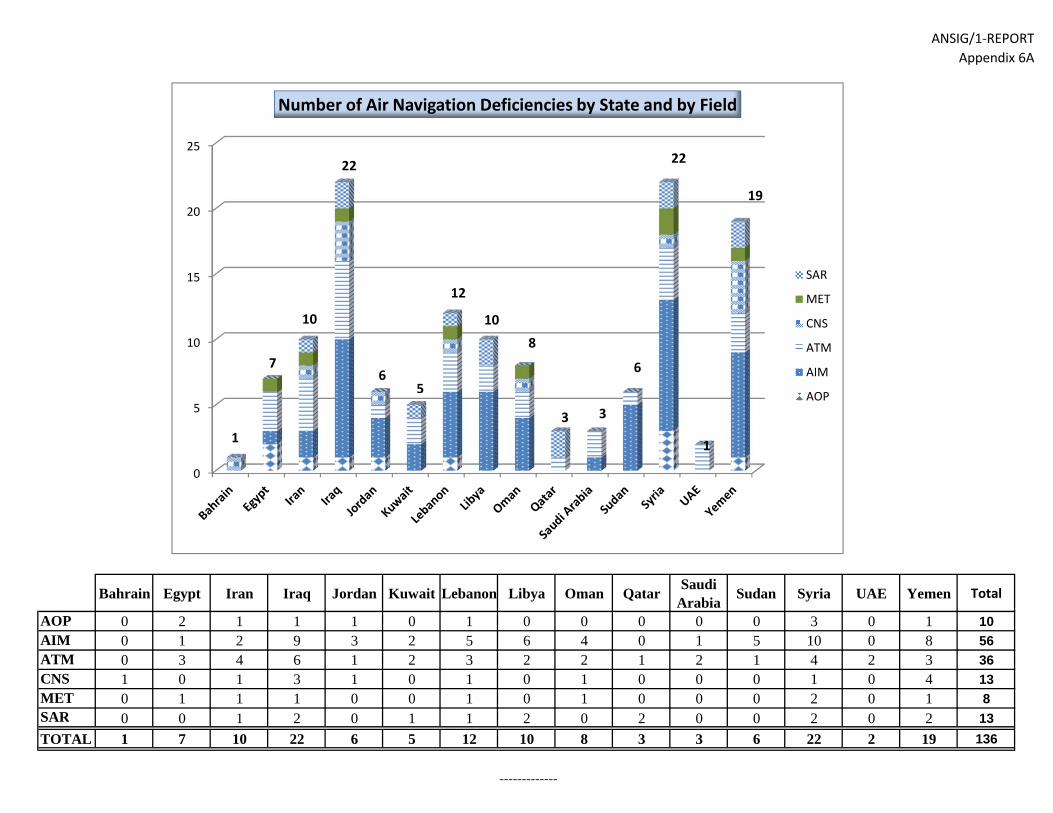
ANSIG/1-REPORTAppendix 6A
Bahrain Egypt Iran Iraq Jordan Kuwait Lebanon Libya Oman QatarSaudi
ArabiaSudan Syria UAE Yemen Total
AOP 0 2 1 1 1 0 1 0 0 0 0 0 3 0 1 10AIM 0 1 2 9 3 2 5 6 4 0 1 5 10 0 8 56ATM 0 3 4 6 1 2 3 2 2 1 2 1 4 2 3 36CNS 1 0 1 3 1 0 1 0 1 0 0 0 1 0 4 13MET 0 1 1 1 0 0 1 0 1 0 0 0 2 0 1 8SAR 0 0 1 2 0 1 1 2 0 2 0 0 2 0 2 13TOTAL 1 7 10 22 6 5 12 10 8 3 3 6 22 2 19 136
Air Navigation deficiencies by State and by field
-------------
0
5
10
15
20
25
Number of Air Navigation Deficiencies by State and by Field
SAR
MET
CNS
ATM
AIM
AOP
1
7
10
22
65
12
108
3 3
6
22
1
19

ATTACHMENT A ANSIG/1
Attachment A to the Report
LIST OF PARTICIPANTS
NAME TITLE & ADDRESS
STATES
BAHRAIN
Mr. Ali Ahmed Mohammed
Director Air Navigation Civil Aviation Affairs KINGDOM OF BAHRAIN
Mr. Ahmed Ali Al Sayed
Head Air Navigation Projects Civil Aviation Affairs KINGDOM OF BAHRAIN
EGYPT
Mr. Ahmed Saied Abdel Monsef
CNS Inspector Engineer Egyptian Civil Aviation Authority Cairo - EGYPT
Mr. Bassel Mohamed Badr Eldin
Air Traffic Controller Egyptian Civil Aviation Authority Cairo - EGYPT
Mr. El Sayed Abdullah Zeidan
Senior Inspector of Air Navigation Egyptian Civil Aviation Authority Cairo - EGYPT
Mr. Essam Said Mohamed
ACC Supervisor – Director of Local Competency Examiner Egyptian Civil Aviation Authority Cairo - EGYPT
Eng. Hisham Mohamed Ismail
ATC Automation Engineering Programs Manager National Air Navigation Services Company (NANSC) Cairo-EGYPT
Mr. Kamal Moustafa Aly
Radar Systems Engineer Egyptian Civil Aviation Authority Cairo - EGYPT
Mr. Khaled Mohamed Reda Ahmed
CNS/ATM Inspector Ministry of Civil Aviation Egyptian Civil Aviation Authority Cairo - EGYPT
Mr. Mahmoud Mohammed Aly Ibrahim
Air Traffic Controller R & D Manager National Air Navigation Services Company Cairo-EGYPT

A-2
NAME TITLE & ADDRESS
Mr. Mohamed Ahmed Elcotamy
Senior MET Inspector Egyptian Civil Aviation Authority Cairo - EGYPT
Mr. Mohamed Ismail Essawy M. Rady
Deputy Head of Air Traffic Control Sector National Air Navigation Services company (NANSC) Control Tower Cairo - EGYPT
Mr. Sayed Mohamed Ahmed Ali
CNS Engineer Egyptian Civil Aviation Authority Cairo Airport Road Cairo - EGYPT Fax: (202) 2268 0627 Tel: (202) 2265 7814 Mobile: (20100) 9454 150 Email: [email protected]
Mr. Tayseer Mohamed Abdel Karim
General Director of ATS Inspectorate Egyptian Civil Aviation Authority Cairo Airport Road Cairo - EGYPT
Mr. Amir Aly Mohamed Eid
CNS Engineer National Air Navigation Services Company Cairo International Airport Road Cairo - EGYPT
Mr. Ehab Raslan Abdel Galil
ATCO and R & D Specialist National Air Navigation Services Company Ministry of Civil Aviation Cairo - EGYPT
Mr. Samer Said Sallam
Airways Planning Director National Air Navigation Services Company Ministry of Civil Aviation Cairo - EGYPT
Mr. Adel Abdel Mohny Khalief
Flow Management Director National Air Navigation Services Company Ministry of Civil Aviation Cairo - EGYPT
Mr. Abdel Aziz M. Abou Elmal
Air Navigation Branch/Lt. Col. NAV Dept Air Navigation Dept EAF Egyptian Air Force - Armed Forces Cairo – EGYPT

A-3
NAME TITLE & ADDRESS
Mr. Taher Mohamad Hosni
Chief of Air Navigation Branch (Col.) Air Navigation Dept EAF Egyptian Air Force - Armed Forces Cairo - EGYPT
ISLAMIC REPUBLIC OF IRAN
Mr. Alireza Asgari
Director General of ATM Tehran Mehrabad International Airport Iran Airports Company Tehran - ISLAMIC REPUBLIC OF IRAN
KUWAIT
Mr. Ali H. Al-Abdullah
AIS Officer Director General of Civil Aviation Kuwait International Airport State of KUWAIT
Mr. Saleem Ali Almarri
AIS Officer Directorate General of Civil Aviation Kuwait International Airport State of KUWAIT
QATAR Mr. Ahmed Mohamed Al-Eshaq
Director Air Navigation Qatar Civil Aviation Authority Doha – QATAR
Mr. Ali Mohammed Al Hail
Electronics Engineer Qatar Civil Aviation Authority Doha - QATAR
SAUDI ARABIA
Eng. Adel H. Al-Aufi
Air Navigation Systems Engineer General Authority of Civil Aviation Jeddah 21444 - SAUDI ARABIA
Eng. Adnan Abdel Latif Al Hendi
CNS Planning General Authority of Civil Aviation Jeddah 21444 - SAUDI ARABIA
UNITED ARAB EMIRATES
Mr. Ahmed Al Jallaf
Assistant Director Air Navigation Services General Civil Aviation Authority Abu Dhabi UNITED ARAB EMIRATES
Mr. Ronald Rigney
Aviation Consultant Department of Transport Abu Dhabi UNITED ARAB EMIRATES

A-4
NAME TITLE & ADDRESS
ORGANIZATIONS/INDUSTRIES
IATA
Mr. George Rhodes
Assistant Director Infrastructure IATA, MENA Amman 11194, JORDAN
MIDRMA
Mr. Fareed Abdullah Al Alawi
MIDRMA Manager MIDRMA KINGDOM OF BAHRAIN
Mr. Fathi Ibrahim Al-Thawadi
MIDRMA Officer MIDRMA KINGDOM OF BAHRAIN
- END -