AIP - Civil Aviation Authority of Singapore
67
1. SIGNIFICANT INFORMATION AND CHANGES 1.1 Singapore FIR a) Use of appropriate radiotelephony phraseology for notification of low fuel state ENR 1.1-4 b) Introduction of enroute Waypoint SABKA for ATS Route A457 ENR 3.1-1 ENR 2.1-9 / Chart ENR 3.6-5 / Chart ENR 3.6-7 / Chart ENR 3.6-9 / Chart ENR 5.1-7 / Chart ENR 6-1 / Chart 1.2 Singapore Changi Airport (WSSS) a) Inclusion of RVR minima for CAT II ILS operations WSSS AD 2-1 WSSS AD 2-22 b) Update to Singapore Changi Aerodrome Obstacle Chart - ICAO Type A, RWY 20R/02L WSSS AD 2-37 / Chart c) Installation of frangible poles for the purpose of identifying 90m away from the centreline of RWY 02L/20R and RWY 02C/20C WSSS AD 2-1 1.3 Tengah Aerodrome (WSAT) a) Update to Aerodrome Plan WSAT AD 2-11 2. INSERT THE ATTACHED REPLACEMENT PAGES WHICH ARE MARKED WITH ASTERISKS IN THE CHECKLIST OF PAGES - GEN 0.4-1 TO GEN 0.4-4. 3. NEW OR REVISED INFORMATION IS INDICATED EITHER BY A HORIZONTAL ARROW OR A VERTICAL LINE. 4. RECORD ENTRY OF AMENDMENT ON PAGE GEN 0.2-1. 5. THIS AMENDMENT INCORPORATES INFORMATION CONTAINED IN THE FOLLOWING WHICH ARE HEREBY SUPERSEDED: NOTAM: A1916/13 dated 15 AUG 13 A0767/14 dated 24 APR 14 A0916/14 dated 16 MAY 14 AIP Supplement: 87/14 dated 20 MAR 14 AIP REPUBLIC OF SINGAPORE AERONAUTICAL INFORMATION SERVICES CIVIL AVIATION AUTHORITY OF SINGAPORE SINGAPORE CHANGI AIRPORT P.O. BOX 1, SINGAPORE 918141 AMENDMENT NR 3/14 29 MAY 2014 TEL : (65) 6595 6051 FAX : (65) 6441 0221 AFS : WSSSYNYX [email protected] www.caas.gov.sg
-
Upload
khangminh22 -
Category
Documents
-
view
12 -
download
0
Transcript of AIP - Civil Aviation Authority of Singapore
1. SIGNIFICANT INFORMATION AND CHANGES
1.1 Singapore FIR
a) Use of appropriate radiotelephony phraseology for notification of low fuel state ENR 1.1-4
b) Introduction of enroute Waypoint SABKA for ATS Route A457 ENR 3.1-1ENR 2.1-9 / ChartENR 3.6-5 / ChartENR 3.6-7 / ChartENR 3.6-9 / ChartENR 5.1-7 / ChartENR 6-1 / Chart
1.2 Singapore Changi Airport (WSSS)
a) Inclusion of RVR minima for CAT II ILS operations WSSS AD 2-1WSSS AD 2-22
b) Update to Singapore Changi Aerodrome Obstacle Chart - ICAO Type A, RWY 20R/02L
WSSS AD 2-37 / Chart
c) Installation of frangible poles for the purpose of identifying 90m away from the centreline of RWY 02L/20R and RWY 02C/20C
WSSS AD 2-1
1.3 Tengah Aerodrome (WSAT)
a) Update to Aerodrome Plan WSAT AD 2-11
2. INSERT THE ATTACHED REPLACEMENT PAGES WHICH ARE MARKED WITH ASTERISKS IN THE CHECKLIST OF PAGES - GEN 0.4-1 TO GEN 0.4-4.
3. NEW OR REVISED INFORMATION IS INDICATED EITHER BY A HORIZONTAL ARROW OR A VERTICAL LINE.
4. RECORD ENTRY OF AMENDMENT ON PAGE GEN 0.2-1.
5. THIS AMENDMENT INCORPORATES INFORMATION CONTAINED IN THE FOLLOWING WHICH ARE HEREBY SUPERSEDED:NOTAM: A1916/13 dated 15 AUG 13A0767/14 dated 24 APR 14A0916/14 dated 16 MAY 14
AIP Supplement:87/14 dated 20 MAR 14
AIPREPUBLIC OF SINGAPORE
AERONAUTICAL INFORMATION SERVICESCIVIL AVIATION AUTHORITY OF SINGAPORE
SINGAPORE CHANGI AIRPORT
P.O. BOX 1, SINGAPORE 918141
AMENDMENT NR 3/1429 MAY 2014
TEL : (65) 6595 6051
FAX : (65) 6441 0221
AFS : WSSSYNYX

AIP GEN 0.3-1SINGAPORE 29 MAY 14
GEN 0.3 RECORD OF CURRENT AIP SUPPLEMENTS
NR/Year
Subject AIP sectionaffected
Period of validity(from / to)
Cancellation record
90/13 Paya Lebar AP - Hammerhead Cranes AD WIE / 1 JAN 16
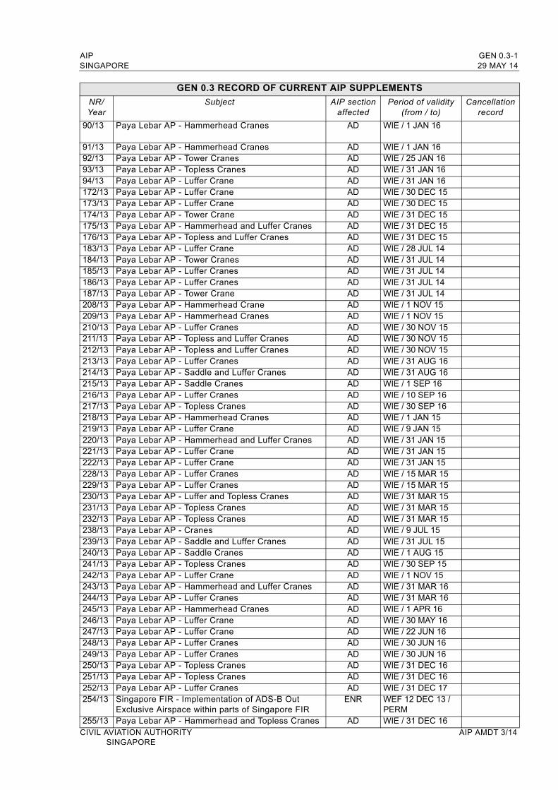
91/13 Paya Lebar AP - Hammerhead Cranes AD WIE / 1 JAN 1692/13 Paya Lebar AP - Tower Cranes AD WIE / 25 JAN 1693/13 Paya Lebar AP - Topless Cranes AD WIE / 31 JAN 1694/13 Paya Lebar AP - Luffer Crane AD WIE / 31 JAN 16172/13 Paya Lebar AP - Luffer Crane AD WIE / 30 DEC 15173/13 Paya Lebar AP - Luffer Crane AD WIE / 30 DEC 15174/13 Paya Lebar AP - Tower Crane AD WIE / 31 DEC 15175/13 Paya Lebar AP - Hammerhead and Luffer Cranes AD WIE / 31 DEC 15176/13 Paya Lebar AP - Topless and Luffer Cranes AD WIE / 31 DEC 15183/13 Paya Lebar AP - Luffer Crane AD WIE / 28 JUL 14184/13 Paya Lebar AP - Tower Cranes AD WIE / 31 JUL 14185/13 Paya Lebar AP - Luffer Cranes AD WIE / 31 JUL 14186/13 Paya Lebar AP - Luffer Cranes AD WIE / 31 JUL 14187/13 Paya Lebar AP - Tower Crane AD WIE / 31 JUL 14208/13 Paya Lebar AP - Hammerhead Crane AD WIE / 1 NOV 15209/13 Paya Lebar AP - Hammerhead Cranes AD WIE / 1 NOV 15210/13 Paya Lebar AP - Luffer Cranes AD WIE / 30 NOV 15211/13 Paya Lebar AP - Topless and Luffer Cranes AD WIE / 30 NOV 15212/13 Paya Lebar AP - Topless and Luffer Cranes AD WIE / 30 NOV 15213/13 Paya Lebar AP - Luffer Cranes AD WIE / 31 AUG 16214/13 Paya Lebar AP - Saddle and Luffer Cranes AD WIE / 31 AUG 16215/13 Paya Lebar AP - Saddle Cranes AD WIE / 1 SEP 16216/13 Paya Lebar AP - Luffer Cranes AD WIE / 10 SEP 16217/13 Paya Lebar AP - Topless Cranes AD WIE / 30 SEP 16218/13 Paya Lebar AP - Hammerhead Cranes AD WIE / 1 JAN 15219/13 Paya Lebar AP - Luffer Crane AD WIE / 9 JAN 15220/13 Paya Lebar AP - Hammerhead and Luffer Cranes AD WIE / 31 JAN 15 221/13 Paya Lebar AP - Luffer Crane AD WIE / 31 JAN 15222/13 Paya Lebar AP - Luffer Crane AD WIE / 31 JAN 15228/13 Paya Lebar AP - Luffer Cranes AD WIE / 15 MAR 15229/13 Paya Lebar AP - Luffer Cranes AD WIE / 15 MAR 15230/13 Paya Lebar AP - Luffer and Topless Cranes AD WIE / 31 MAR 15231/13 Paya Lebar AP - Topless Cranes AD WIE / 31 MAR 15232/13 Paya Lebar AP - Topless Cranes AD WIE / 31 MAR 15238/13 Paya Lebar AP - Cranes AD WIE / 9 JUL 15239/13 Paya Lebar AP - Saddle and Luffer Cranes AD WIE / 31 JUL 15240/13 Paya Lebar AP - Saddle Cranes AD WIE / 1 AUG 15241/13 Paya Lebar AP - Topless Cranes AD WIE / 30 SEP 15242/13 Paya Lebar AP - Luffer Crane AD WIE / 1 NOV 15243/13 Paya Lebar AP - Hammerhead and Luffer Cranes AD WIE / 31 MAR 16244/13 Paya Lebar AP - Luffer Cranes AD WIE / 31 MAR 16245/13 Paya Lebar AP - Hammerhead Cranes AD WIE / 1 APR 16246/13 Paya Lebar AP - Luffer Crane AD WIE / 30 MAY 16247/13 Paya Lebar AP - Luffer Crane AD WIE / 22 JUN 16248/13 Paya Lebar AP - Luffer Cranes AD WIE / 30 JUN 16249/13 Paya Lebar AP - Luffer Cranes AD WIE / 30 JUN 16250/13 Paya Lebar AP - Topless Cranes AD WIE / 31 DEC 16251/13 Paya Lebar AP - Topless Cranes AD WIE / 31 DEC 16252/13 Paya Lebar AP - Luffer Cranes AD WIE / 31 DEC 17254/13 Singapore FIR - Implementation of ADS-B Out
Exclusive Airspace within parts of Singapore FIRENR WEF 12 DEC 13 /
PERM255/13 Paya Lebar AP - Hammerhead and Topless Cranes AD WIE / 31 DEC 16
CIVIL AVIATION AUTHORITY AIP AMDT 3/14SINGAPORE
GEN 0.3-2 AIP29 MAY 14 SINGAPORE
GEN 0.3 RECORD OF CURRENT AIP SUPPLEMENTS
NR/Year
Subject AIP sectionaffected
Period of validity(from / to)
Cancellation record
256/13 Paya Lebar AP - Topless Cranes / A Frames AD WIE / 31 DEC 16257/13 Paya Lebar AP - Topless Cranes AD WIE / 31 DEC 16258/13 Paya Lebar AP - Luffer and Hammerhead Canes AD WIE / 31 DEC 16259/13 Paya Lebar AP - Topless and Hammerhead Cranes AD WIE / 31 DEC 16260/13 Paya Lebar AP - Luffer Cranes AD WIE / 1 DEC 15261/13 Paya Lebar AP - Hammerhead Cranes AD WIE / 20 DEC 15262/13 Paya Lebar AP - Luffer Crane AD WIE / 31 DEC 15263/13 Paya Lebar AP - Luffer Cranes AD WIE / 31 DEC 15264/13 Paya Lebar AP - Luffer Crane AD WIE / 31 DEC 151/14 Paya Lebar AP - Luffer Cranes AD WIE / 31 DEC 162/14 Paya Lebar AP - Luffer Cranes AD WIE / 31 DEC 163/14 Paya Lebar AP - Luffer Crane AD WIE / 31 DEC 164/14 Paya Lebar AP - Topless Cranes AD WIE / 31 DEC 165/14 Paya Lebar AP - Topless Cranes AD WIE / 31 DEC 166/14 Paya Lebar AP - Luffer Cranes AD WIE / 30 JUN 147/14 Paya Lebar AP - Hammerhead Cranes AD WIE / 30 JUN 148/14 Paya Lebar AP - Hammerhead Cranes AD WIE / 30 JUN 149/14 Paya Lebar AP - Tower Cranes AD WIE / 30 JUN 1410/14 Paya Lebar AP - Cranes AD WIE / 30 JUN 1411/14 Paya Lebar AP - Hammerhead Crane AD WIE / 1 DEC 1512/14 Paya Lebar AP - Luffer Crane AD WIE / 15 DEC 1513/14 Paya Lebar AP - Luffer Crane AD WIE / 27 DEC 1514/14 Paya Lebar AP - Luffer Cranes AD WIE / 31 DEC 1515/14 Paya Lebar AP - Topless Cranes AD WIE / 31 DEC 1516/14 Paya Lebar AP - Tower Cranes AD WIE / 25 JUN 1517/14 Paya Lebar AP - Hammerhead Cranes AD WIE / 30 JUN 1518/14 Paya Lebar AP - Hammerhead Cranes AD WIE / 30 JUN 1519/14 Paya Lebar AP- Cranes AD WIE / 30 JUN 1520/14 Paya Lebar AP - Luffer Cranes AD WIE / 30 JUN 1530/14 Paya Lebar AP - Mobile Cranes AD WIE / 1 JAN 1731/14 Paya Lebar AP - Cranes AD WIE / 31 DEC 1432/14 Paya Lebar AP - Tower Crane AD WIE / 31 DEC 1433/14 Paya Lebar AP - Topless Cranes AD WIE / 31 DEC 1434/14 Paya Lebar AP - Hammerhead Cranes AD WIE / 31 DEC 1435/14 Paya Lebar AP - Luffer Cranes AD WIE / 31 DEC 1436/14 Paya Lebar AP - Hammerhead Cranes AD WIE / 30 DEC 1437/14 Paya Lebar AP - Topless Cranes AD WIE / 31 DEC 1438/14 Paya Lebar AP - Luffer Crane AD WIE / 31 DEC 1439/14 Paya Lebar AP - Hammerhead Cranes AD WIE / 31 DEC 1440/14 Paya Lebar AP - Cranes AD WIE / 31 DEC 1441/14 Paya Lebar AP - Hammerhead Cranes AD WIE / 31 DEC 1442/14 Paya Lebar AP - Luffer Crane AD WIE / 31 DEC 1443/14 Paya Lebar AP - Topless Cranes AD WIE / 31 DEC 1444/14 Paya Lebar AP - Saddle Tower Cranes AD WIE / 31 DEC 1445/14 Paya Lebar AP - Hammerhead Cranes AD WIE / 31 DEC 1446/14 Paya Lebar AP - Hammerhead Cranes AD WIE / 31 DEC 1447/14 Paya Lebar AP - Luffer Crane AD WIE / 31 DEC 1448/14 Paya Lebar AP - Luffer Cranes AD WIE / 31 DEC 1449/14 Paya Lebar AP - Luffer Cranes AD WIE / 31 DEC 1450/14 Paya Lebar AP - Luffer Cranes AD WIE / 31 DEC 1451/14 Paya Lebar AP - Cranes AD WIE / 31 DEC 1552/14 Paya Lebar AP - Luffer Crane AD WIE / 31 DEC 15AIP AMDT 3/14 CIVIL AVIATION AUTHORITY
SINGAPORE

AIP GEN 0.3-3SINGAPORE 29 MAY 14
GEN 0.3 RECORD OF CURRENT AIP SUPPLEMENTS
NR/Year
SubjectAIP section
affectedPeriod of validity
(from / to)Cancellation
record
53/14 Paya Lebar AP - Topless Cranes AD WIE / 31 DEC 1554/14 Paya Lebar AP - Topless Cranes AD WIE / 31 DEC 1555/14 Paya Lebar AP - Luffer Cranes AD WIE / 31 DEC 1556/14 Paya Lebar AP - Luffer Crane AD WIE / 30 JUN 1457/14 Paya Lebar AP - Tower and Topless Cranes AD WIE / 30 JUN 1458/14 Paya Lebar AP - Luffer Crane AD WIE / 30 JUN 1459/14 Paya Lebar AP - Crawler Crane AD WIE / 30 JUN 1460/14 Paya Lebar AP - Hammerhead Cranes AD WIE / 30 JUN 1461/14 Paya Lebar AP - Topless Cranes AD WIE / 31 DEC 1562/14 Paya Lebar AP - Topless Cranes AD WIE / 31 DEC 1563/14 Paya Lebar AP - Cranes AD WIE / 31 DEC 1564/14 Paya Lebar AP - Topless Cranes AD WIE / 31 DEC 1565/14 Paya Lebar AP - Luffer Cranes AD WIE / 31 DEC 1566/14 Paya Lebar AP - Saddle Cranes AD WIE / 30 DEC 1567/14 Paya Lebar AP - Luffer Crane AD WIE / 31 DEC 1568/14 Paya Lebar AP - Luffer Crane AD WIE / 31 DEC 1569/14 Paya Lebar AP - Luffer Cranes AD WIE / 31 DEC 1570/14 Paya Lebar AP - Hammerhead Cranes AD WIE / 31 DEC 1576/14 Paya Lebar AP - Luffer Crane AD WIE / 30 DEC 1477/14 Paya Lebar AP - Luffer Cranes AD WIE / 31 DEC 1479/14 Paya Lebar AP - Luffer Crane AD WIE / 31 DEC 1480/14 Paya Lebar AP - Luffer Cranes AD WIE / 31 DEC 1482/14 Paya Lebar AP - Topless Cranes AD WIE / 12 JUN 1486/14 Singapore Changi AP - Work activities due to
construction of new water retention pond at south end reservoir
AD WIE / 31 DEC 14
88/14 Paya Lebar AP - Luffer Crane AD WIE / 31 AUG 1489/14 Paya Lebar AP - Luffer Cranes AD WIE / 31 AUG 1490/14 Paya Lebar AP - Tower Cranes AD WIE / 31 AUG 1491/14 Paya Lebar AP - Topless Cranes AD WIE / 31 AUG 1492/14 Paya Lebar AP - Tower Crane AD WIE / 31 AUG 1493/14 Paya Lebar AP - Luffer Crane AD WIE / 1 SEP 1494/14 Paya Lebar AP - Topless Cranes AD WIE / 30 SEP 1495/14 Paya Lebar AP - Topless Cranes AD WIE / 30 SEP 1496/14 Paya Lebar AP - Luffer Crane AD WIE / 30 SEP 1497/14 Paya Lebar AP - Cranes AD WIE / 30 SEP 1498/14 Paya Lebar AP - Luffer Crane AD WIE / 30 JUN 1499/14 Paya Lebar AP - Luffer Cranes AD WIE / 30 JUN 14100/14 Paya Lebar AP - Hammerhead Crane AD WIE / 31 JUL 14101/14 Paya Lebar AP - Flat Top Cranes AD WIE / 29 AUG 14102/14 Paya Lebar AP - Luffer Crane AD WIE / 30 SEP 14103/14 Paya Lebar AP - Cranes AD WIE / 10 OCT 14104/14 Paya Lebar AP - Tower Cranes AD WIE / 30 NOV 14105/14 Paya Lebar AP - Luffer Crane AD WIE / 30 NOV 14106/14 Paya Lebar AP - Cranes AD WIE / 2 DEC 14107/14 Paya Lebar AP - Topless Cranes AD WIE / 29 DEC 14108/14 Paya Lebar AP - Luffer Cranes AD WIE / 24 FEB 15109/14 Paya Lebar AP - Flat Top Cranes AD WIE / 28 FEB 15110/14 Paya Lebar AP - Luffer Crane AD WIE / 28 FEB 15111/14 Paya Lebar AP - Hammerhead and Luffer Cranes AD WIE / 28 FEB 15112/14 Paya Lebar AP - Topless Cranes AD WIE / 28 FEB 15113/14 Paya Lebar AP - Cranes AD WIE / 1 MAR 15
CIVIL AVIATION AUTHORITY AIP AMDT 3/14SINGAPORE

GEN 0.3-4 AIP29 MAY 14 SINGAPORE
GEN 0.3 RECORD OF CURRENT AIP SUPPLEMENTS
NR/Year
SubjectAIP section
affectedPeriod of validity
(from / to)Cancellation
record
114/14 Paya Lebar AP - Cranes AD WIE / 15 MAR 15
115/14 Paya Lebar AP - Luffer Cranes AD WIE / 31 MAY 15
116/14 Paya Lebar AP - Mobile Cranes AD WIE / 6 JUN 15
118/14 Paya Lebar AP - Crane AD WIE / 28 FEB 17
119/14 Paya Lebar AP - Cranes AD WIE / 1 MAR 16
120/14 Paya Lebar AP - Cranes AD WIE / 1 MAR 16
121/14 Paya Lebar AP - Cranes AD WIE / 30 MAR 16
122/14 Paya Lebar AP - Luffer Crane AD WIE / 30 SEP 16
124/14 Paya Lebar AP - Luffer Crane AD WIE / 31 JAN 17
125/14 Paya Lebar AP - Luffer Cranes AD WIE / 1 FEB 17
126/14 Paya Lebar AP - Hammerhead Cranes AD WIE / 1 FEB 17
127/14 Paya Lebar AP - Hammerhead Cranes AD WIE / 28 FEB 17
128/14 Paya Lebar AP - Tower Cranes AD WIE / 1 MAR 17
129/14 Paya Lebar AP - Hammerhead Cranes AD WIE / 4 MAR 17
130/14 Paya Lebar AP - Luffer Cranes AD WIE / 30 DEC 17
131/14 Paya Lebar AP - Hammerhead and Luffer Cranes AD WIE / 31 DEC 17
132/14 Paya Lebar AP - Luffer Crane AD WIE / 31 DEC 17
133/14 Paya Lebar AP - Luffer Cranes AD WIE / 31 DEC 17
134/14 Paya Lebar AP - Mobile Crane AD WIE / 11 MAY 15
135/14 Paya Lebar AP - Tower and Topless Cranes AD WIE / 14 MAY 15
136/14 Paya Lebar AP - Luffer Crane AD WIE / 20 MAY 15
137/14 Paya Lebar AP - Luffer Cranes AD WIE / 31 MAY 15
138/14 Paya Lebar AP - Luffer Crane AD WIE / 31 MAY 15
139/14 Paya Lebar AP - Luffer Crane AD WIE / 31 JUL 14
140/14 Paya Lebar AP - Luffer Cranes AD WIE / 30 SEP 14
141/14 Paya Lebar AP - Hammerhead Cranes AD WIE / 31 OCT 14
142/14 Paya Lebar AP - Luffer Crane AD WIE / 1 NOV 14
143/14 Paya Lebar AP - Hammerhead Cranes AD WIE / 31 DEC 14
144/14 Paya Lebar AP - Crawler Cranes AD WIE / 15 NOV 14
145/14 Paya Lebar AP - Tower Cranes AD WIE / 31 DEC 14
146/14 Paya Lebar AP - Tower Crane AD WIE / 15 JAN 15
147/14 Paya Lebar AP - Luffer Crane AD WIE / 14 FEB 15
148/14 Paya Lebar AP - Crawler Crane AD WIE / 15 MAR 15
149/14 Paya Lebar AP - Mobile Crane AD WIE / 14 MAR 15
150/14 Paya Lebar AP - Topless Cranes AD WIE / 30 APR 15
151/14 Paya Lebar AP - Topless Cranes AD WIE / 30 APR 15
152/14 Paya Lebar AP - Luffer Crane AD WIE / 30 APR 15
153/14 Paya Lebar AP - Topless Cranes AD WIE / 30 SEP 14
154/14 Paya Lebar AP - Hammerhead Cranes AD WIE / 1 JUN 15
155/14 Paya Lebar AP - Mobile Crane AD WIE / 6 JUN 15
156/14 Paya Lebar AP - Cranes AD WIE / 30 JUN 15
157/14 Paya Lebar AP - Tower Cranes AD WIE / 3 JUL 15
158/14 Paya Lebar AP - Luffer Cranes AD WIE / 4 JUL 15
159/14 Paya Lebar AP - Luffer Cranes and Tower Crane AD WIE / 28 JUL 15
160/14 Paya Lebar AP - Luffer Crane AD WIE / 30 SEP 15
161/14 Paya Lebar AP - Topless Cranes AD WIE / 31 OCT 15
162/14 Paya Lebar AP - Luffer Cranes AD WIE / 30 NOV 15
163/14 Paya Lebar AP - Luffer Cranes AD WIE / 31 DEC 15
164/14 Sembawang AD - Luffer Cranes AD WIE / 28 FEB 16
AIP AMDT 3/14 CIVIL AVIATION AUTHORITYSINGAPORE
AIP GEN 0.3-5SINGAPORE 29 MAY 14
GEN 0.3 RECORD OF CURRENT AIP SUPPLEMENTS
NR/Year
SubjectAIP section
affectedPeriod of validity
(from / to)Cancellation
record
165/14 Paya Lebar AP - Topless Cranes AD WIE / 31 DEC 15166/14 Paya Lebar AP - Luffer Crane AD WIE / 30 JUN 16167/14 Paya Lebar AP - Luffer Cranes AD WIE / 30 AUG 16168/14 Paya Lebar AP - Crane AD WIE / 30 NOV 16169/14 Singapore FIR - RSAF Aerial Flypast prior to and on
Singapore’s National Day, 9th August 2014ENR WEF 4 JUN 14
/ 16 AUG 14170/14 Paya Lebar AP - Luffer Cranes AD WIE / 30 SEP 14171/14 Paya Lebar AP - Topless Cranes AD WIE / 30 SEP 14172/14 Paya Lebar AP - Topless Cranes and Luffer Cranes AD WIE / 31 DEC 14173/14 Paya Lebar AP - Crawler Tower Cranes AD WIE / 31 DEC 14174/14 Paya Lebar AP - Luffer Cranes AD WIE / 31 DEC 14175/14 Paya Lebar AP - Hammerhead Cranes AD WIE / 31 DEC 14176/14 Sembawang AD - Luffer Cranes AD WIE / 1 MAY 15177/14 Paya Lebar AP - Crawler Crane AD WIE / 30 JUN 15178/14 Paya Lebar AP - Luffer Crane AD WIE / 30 SEP 15179/14 Paya Lebar AP - Luffer Crane and Saddle Crane AD WIE / 31 DEC 15180/14 Paya Lebar AP - Topless Cranes AD WIE / 31 MAR 16181/14 Paya Lebar AP - Luffer Cranes AD WIE / 31 DEC 16182/14 Paya Lebar AP - Topless Cranes AD WIE / 31 DEC 16183/14 Paya Lebar AP - Hammerhead Cranes AD WIE / 29 APR 17184/14 Paya Lebar AP - Topless Cranes AD WIE / 10 MAY 17
CIVIL AVIATION AUTHORITY AIP AMDT 3/14SINGAPORE

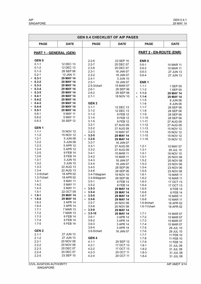
AIP GEN 0.4-1SINGAPORE 29 MAY 14
GEN 0.4 CHECKLIST OF AIP PAGES
PAGE DATE PAGE DATE PAGE DATE
GEN 00.1-10.1-20.1-30.2-10.3-10.3-20.3-30.3-40.3-50.4-10.4-20.4-30.4-40.5-10.6-10.6-20.6-3
GEN 11.1-11.1-21.2-11.2-21.2-31.2-41.2-51.2-61.3-11.3-21.3-31.3-41.3-5/chart1.3-7/chart1.4-11.4-21.4-31.5-11.6-11.6-21.6-31.6-41.7-11.7-21.7-31.7-41.7-5
GEN 22.1-12.1-22.2-12.2-22.2-32.2-42.2-5
12 DEC 1312 DEC 1328 SEP 0613 JAN 11
29 MAY 1429 MAY 1429 MAY 1429 MAY 1429 MAY 1429 MAY 1429 MAY 1429 MAY 1429 MAY 1429 MAY 14
5 MAY 115 MAY 11
20 SEP 12
15 NOV 1215 NOV 12
5 JUN 085 JUN 085 APR 125 APR 126 FEB 146 FEB 143 JUN 103 JUN 10
22 AUG 1322 AUG 1318 APR 0218 APR 02
5 MAY 115 MAY 115 MAY 11
22 OCT 0929 MAY 1429 MAY 14
3 APR 143 APR 147 MAR 137 MAR 136 FEB 146 FEB 146 FEB 14
27 JUN 1327 JUN 1320 NOV 0820 NOV 0820 DEC 0720 DEC 0723 SEP 10
2.2-62.2-72.2-82.3-12.3-22.4-12.5-12.5-3/chart2.6-12.6-22.7-1
GEN 33.1-13.1-23.1-33.1-43.1-53.2-13.2-23.2-33.2-53.2-63.2-73.3-13.3-23.4-13.4-23.4-33.4-43.4-53.4-63.4-7/diagram3.4-9/diagram3.5-13.5-23.5-33.5-43.5-53.5-63.5-73.5-83.5-93.5-103.6-13.6-23.6-33.6-43.6-5/chart
GEN 44.1-14.2-14.2-24.2-34.2-4
23 SEP 1020 DEC 0720 DEC 0718 JAN 0718 JAN 073 JUN 10
18 JAN 0715 MAR 0728 SEP 0628 SEP 0618 NOV 10
12 DEC 1312 DEC 13
9 FEB 129 FEB 129 FEB 12
27 AUG 0927 AUG 0910 MAY 0729 MAY 1429 MAY 1418 JAN 07
27 AUG 0927 AUG 0910 MAR 1110 MAR 1118 JAN 0718 JAN 0728 SEP 0628 SEP 0618 NOV 1028 SEP 06
6 FEB 146 FEB 14
29 MAY 1429 MAY 14 29 MAY 1429 MAY 1420 NOV 0820 NOV 0829 MAY 1429 MAY 14
3 APR 143 APR 143 APR 143 APR 14
18 JAN 07
20 SEP 1217 OCT 1317 OCT 1320 OCT 1120 OCT 11
ENR 00.6-10.6-20.6-30.6-4
ENR 11.1-11.1-21.1-31.1-41.1-51.1-61.1-71.1-81.1-91.1-101.1-111.1-121.1-131.1-141.1-151.1-16
1.2-11.3-11.4-11.5-11.5-21.5-31.5-41.5-51.6-11.6-21.6-31.6-41.6-51.6-61.6-71.6-81.6-9/chart1.6-11/chart
1.7-11.7-21.7-31.7-41.7-51.7-61.7-71.7-81.7-91.8-11.8-21.8-31.8-4
10 MAR 1110 MAR 1127 JUN 1327 JUN 13
1 SEP 051 SEP 05
29 MAY 1429 MAY 14
8 JUN 068 JUN 06
28 SEP 0628 SEP 0628 SEP 0628 SEP 0627 AUG 0927 AUG 0915 NOV 1215 NOV 1215 NOV 1215 NOV 12
10 MAY 0729 JUL 10
18 NOV 1020 NOV 0820 NOV 0823 NOV 0623 NOV 0623 NOV 0610 MAR 1110 MAR 1117 OCT 1317 OCT 13
6 FEB 146 FEB 14
10 MAR 1110 MAR 1118 APR 0218 APR 02
15 MAR 0715 MAR 0715 MAR 0715 MAR 0729 JUL 1029 JUL 1011 FEB 1011 FEB 1011 FEB 1031 JUL 0831 JUL 0831 JUL 0831 JUL 08
CIVIL AVIATION AUTHORITY AIP AMDT 3/14SINGAPORE
PART 1 - GENERAL (GEN) PART 2 - EN-ROUTE (ENR)
**********
**
**
****
**
**
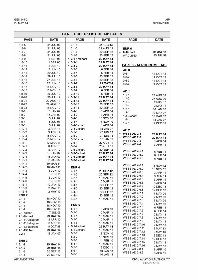
GEN 0.4-2 AIP29 MAY 14 SINGAPORE
GEN 0.4 CHECKLIST OF AIP PAGES
PAGE DATE PAGE DATE PAGE DATE
1.8-51.8-61.8-71.8-81.8-91.8-101.8-111.8-121.8-131.8-141.8-151.8-161.8-171.8-181.8-191.8-201.8-211.8-221.8-231.9-11.9-21.9-31.9-41.9-51.10-11.10-21.10-31.10-41.11-11.12-11.12-21.12-31.12-41.13-11.14-11.14-21.14-31.14-41.14-51.14-61.15-11.15-31.15-4ENR 22.1-12.1-22.1-32.1-42.1-7/chart2.1-9/chart2.1-11A/diagram2.1-11B/diagram2.1-13/diagram2.1-15/chart2.2-1
ENR 33.1-13.1-23.1-33.1-4
31 JUL 0831 JUL 0831 JUL 0831 JUL 081 SEP 051 SEP 053 JUN 103 JUN 10
29 JUL 1029 JUL 1027 JUN 1327 JUN 1318 NOV 1018 NOV 1026 JUL 1226 JUL 12
22 AUG 1322 AUG 1315 NOV 1215 JAN 0915 JAN 09
5 JUL 075 JUL 075 JUL 073 APR 143 APR 14
15 NOV 1215 NOV 1210 MAR 11
8 APR 108 APR 10
18 JAN 0718 JAN 0718 JAN 0710 MAR 1110 MAR 11
3 JUN 103 JUN 103 JUN 103 JUN 10
10 JAN 132 MAY 132 MAY 13
18 NOV 1018 NOV 1018 NOV 1018 NOV 10
7 JUL 0529 MAY 14
8 APR 108 APR 108 OCT 98
29 MAY 1418 JAN 07
29 MAY 1429 MAY 1420 SEP 1220 SEP 12
3.1-53.1-63.1-73.1-83.1-17/chart3.3-13.3-23.3-33.3-43.3-53.3-63.3-73.3-83.3-93.3-103.3-113.3-123.3-133.3-143.4-13.4-23.4-33.4-43.4-5/chart3.4-7/chart3.5-13.5-23.5-3/chart3.6-13.6-23.6-3/chart3.6-5/chart3.6-7/chart3.6-9/chart
ENR 44.1-14.1-24.2-14.3-14.4-14.4-24.4-34.4-44.5-1
ENR 55.1-15.1-35.1-45.1-55.1-65.1-7/chart5.1-9/chart5.2-15.2-25.3-15.4-15.5-15.6-15.6-3
22 AUG 1322 AUG 1320 SEP 1220 SEP 1229 MAY 1429 MAY 1429 MAY 14
6 FEB 146 FEB 14
20 SEP 1220 SEP 1229 MAY14
29 MAY 146 FEB 146 FEB 14
29 MAY 1429 MAY 1420 SEP 1220 SEP 123 APR 143 APR 14
18 NOV 1018 NOV 10
3 APR 1418 JAN 0727 JUN 1327 JUN 1313 JAN 1120 OCT 1120 OCT 1120 SEP 1229 MAY 1429 MAY 1429 MAY 14
20 SEP 1220 SEP 1210 MAR 1110 MAR 1120 SEP 1220 SEP 1220 SEP 1220 SEP 1210 MAR 11
8 APR 1010 MAR 1110 MAR 1110 MAR 1110 MAR 1129 MAY 1410 MAR 1118 NOV 1018 NOV 1011 FEB 1010 MAR 1115 DEC 1110 JAN 1310 JAN 13
ENR 66-1/chartWAC 2860
AD 00.6-10.6-20.6-30.6-4
AD 11.1-11.1-21.1-31.1-41.2-11.3-11.3-3/chart1.4-11.5-1
AD 2WSSS AD 2-1WSSS AD 2-2WSSS AD 2-3WSSS AD 2-4
WSSS AD 2-5.1WSSS AD 2-5.2WSSS AD 2-5.3
WSSS AD 2-6.1WSSS AD 2-6.2WSSS AD 2-6.3WSSS AD 2-6.4WSSS AD 2-6.5WSSS AD 2-6.6WSSS AD 2-6.7WSSS AD 2-6.8WSSS AD 2-7.1WSSS AD 2-7.2WSSS AD 2-7.3WSSS AD 2-7.4WSSS AD 2-7.5WSSS AD 2-7.6WSSS AD 2-7.7WSSS AD 2-7.8WSSS AD 2-7.9WSSS AD 2-7.10WSSS AD 2-7.11WSSS AD 2-7.12WSSS AD 2-7.13WSSS AD 2-7.14WSSS AD 2-7.15WSSS AD 2-7.16WSSS AD 2-8.1WSSS AD 2-8.2
29 MAY 1415 JUL 99
17 OCT 1317 OCT 1317 OCT 1317 OCT 13
27 AUG 0927 AUG 09
2 MAY 132 MAY 13
18 JAN 0710 MAY 0715 MAR 0718 JAN 0717 DEC 09
29 MAY 1429 MAY 14
3 APR 143 APR 14
6 FEB 146 FEB 146 FEB 14
15 NOV 1215 NOV 12
3 APR 143 APR 143 APR 143 APR 14
12 DEC 1312 DEC 13
7 MAY 097 MAY 097 MAY 097 MAY 096 FEB 146 FEB 142 MAY 132 MAY 132 MAY 132 MAY 132 MAY 132 MAY 13
12 DEC 1312 DEC 13
2 MAY 132 MAY 138 APR 108 APR 10
AIP AMDT 3/14 CIVIL AVIATION AUTHORITYSINGAPORE
*
*
**
***
**
**
***
*
*
**
PART 3 - AERODROME (AD)
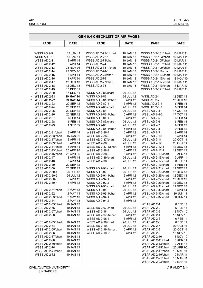
AIP GEN 0.4-3SINGAPORE 29 MAY 14
GEN 0.4 CHECKLIST OF AIP PAGES
PAGE DATE PAGE DATE PAGE DATE
WSSS AD 2-9WSSS AD 2-10WSSS AD 2-11WSSS AD 2-12WSSS AD 2-13WSSS AD 2-14WSSS AD 2-15WSSS AD 2-16WSSS AD 2-17WSSS AD 2-18WSSS AD 2-19 WSSS AD 2-20WSSS AD 2-21WSSS AD 2-22WSSS AD 2-23WSSS AD 2-24WSSS AD 2-25WSSS AD 2-26WSSS AD 2-27WSSS AD 2-28WSSS AD 2-29
WSSS AD 2-31/chartWSSS AD 2-33/chartWSSS AD 2-37/chartWSSS AD 2-39/chartWSSS AD 2-41/chartWSSS AD 2-43/chartWSSS AD 2-45/chartWSSS AD 2-47WSSS AD 2-48WSSS AD 2-49WSSS AD 2-50WSSS AD 2-50-1WSSS AD 2-50-2WSSS AD 2-50-3WSSS AD 2-50-4
WSSS AD 2-51/chartWSSS AD 2-52 WSSS AD 2-53/chartWSSS AD 2-54 WSSS AD 2-55/chartWSSS AD 2-56 WSSS AD 2-57/chartWSSS AD 2-58
WSSS AD 2-63/chartWSSS AD 2-64 WSSS AD 2-65/chartWSSS AD 2-66 WSSS AD 2-67/chartWSSS AD 2-68 WSSS AD 2-69/chartWSSS AD 2-70 WSSS AD 2-71/chartWSSS AD 2-72
13 JAN 1113 JAN 113 APR 143 APR 14
23 NOV 0623 NOV 06
3 APR 143 APR 14
12 DEC 1312 DEC 1315 DEC 1115 DEC 1129 MAY 1429 MAY 1420 SEP 1220 SEP 1220 SEP 1220 SEP 12
6 FEB 146 FEB 141 SEP 05
3 APR 1415 JAN 093 APR 143 APR 143 APR 14
25 APR 9625 APR 963 APR 143 APR 14
20 SEP 1220 SEP 1226 JUL 1226 JUL 125 APR 125 APR 12
2 MAY 132 MAY 132 MAY 132 MAY 13
10 JAN 1310 JAN 1310 JAN 1310 JAN 13
10 JAN 1310 JAN 1310 JAN 1310 JAN 1310 JAN 1310 JAN 1310 JAN 1310 JAN 1310 JAN 1310 JAN 13
WSSS AD 2-71-1/chartWSSS AD 2-72-1 WSSS AD 2-73/chartWSSS AD 2-74 WSSS AD 2-73-1/chartWSSS AD 2-74-1 WSSS AD 2-75/chartWSSS AD 2-76 WSSS AD 2-77/chartWSSS AD 2-78
WSSS AD 2-81/chartWSSS AD 2-82WSSS AD 2-81-1/chartWSSS AD 2-82-1WSSS AD 2-83/chartWSSS AD 2-84 WSSS AD 2-83-1/chartWSSS AD 2-84-1WSSS AD 2-85/chartWSSS AD 2-86 WSSS AD 2-85-1/chartWSSS AD 2-86-1WSSS AD 2-86-2WSSS AD 2-87/chartWSSS AD 2-88 WSSS AD 2-87-1/chartWSSS AD 2-88-1WSSS AD 2-88-2WSSS AD 2-89/chartWSSS AD 2-90
WSSS AD 2-91/chartWSSS AD 2-92 WSSS AD 2-91-1/chartWSSS AD 2-92-1WSSS AD 2-92-2WSSS AD 2-93/chartWSSS AD 2-94WSSS AD 2-93-1/chartWSSS AD 2-94-1WSSS AD 2-94-2
WSSS AD 2-97/chartWSSS AD 2-98WSSS AD 2-97-1/chartWSSS AD 2-98-1WSSS AD 2-99/chartWSSS AD 2-100 WSSS AD 2-99-1/chartWSSS AD 2-100-1
10 JAN 1310 JAN 1310 JAN 1310 JAN 1310 JAN 1310 JAN 1310 JAN 1310 JAN 1310 JAN 1310 JAN 13
26 JUL 1226 JUL 125 APR 125 APR 1226 JUL 1226 JUL 125 APR 125 APR 1226 JUL 1226 JUL 125 APR 125 APR 125 APR 1226 JUL 1226 JUL 125 APR 125 APR 125 APR 1226 JUL 1226 JUL 12
26 JUL 1226 JUL 125 APR 125 APR 125 APR 1226 JUL 1226 JUL 125 APR 125 APR 125 APR 12
26 JUL 1226 JUL 125 APR 125 APR 1226 JUL 1226 JUL 125 APR 125 APR 12
WSSS AD 2-101/chartWSSS AD 2-103/chartWSSS AD 2-105/chartWSSS AD 2-107/chartWSSS AD 2-109/chartWSSS AD 2-111/chartWSSS AD 2-113/chartWSSS AD 2-115/chartWSSS AD 2-117/chartWSSS AD 2-119/chartWSSS AD 2-121/chart
WSSL AD 2-1WSSL AD 2-2WSSL AD 2-3-1WSSL AD 2-3-2WSSL AD 2-4-1WSSL AD 2-4-2WSSL AD 2-5WSSL AD 2-6WSSL AD 2-7WSSL AD 2-8WSSL AD 2-9WSSL AD 2-10WSSL AD 2-11WSSL AD 2-12WSSL AD 2-12-1WSSL AD 2-12-2WSSL AD 2-13/chartWSSL AD 2-15/chartWSSL AD 2-17/chartWSSL AD 2-19/chartWSSL AD 2-21/chartWSSL AD 2-23/chartWSSL AD 2-25/chartWSSL AD 2-27/chartWSSL AD 2-29/chartWSSL AD 2-31/chartWSSL AD 2-33/chartWSSL AD 2-35/chartWSSL AD 2-37/chart
WSAP AD 2-1WSAP AD 2-2WSAP AD 2-3WSAP AD 2-4WSAP AD 2-5WSAP AD 2-6WSAP AD 2-7WSAP AD 2-8WSAP AD 2-9WSAP AD 2-10WSAP AD 2-11/chartWSAP AD 2-13/chartWSAP AD 2-15/chartWSAP AD 2-17/chartWSAP AD 2-19/chartWSAP AD 2-21/chartWSAP AD 2-23/chart
10 MAR 1110 MAR 1110 MAR 1110 MAR 1110 MAR 1110 MAR 1110 MAR 1118 NOV 1010 MAR 117 MAR 13
10 MAR 11
12 DEC 1312 DEC 13
6 FEB 146 FEB 14
17 OCT 1317 OCT 13
6 FEB 146 FEB 149 FEB 129 FEB 123 APR 143 APR 14
20 OCT 1120 OCT 1112 DEC 1312 DEC 13
3 APR 143 APR 146 FEB 146 FEB 14
12 DEC 1312 DEC 1312 DEC 1312 DEC 1312 DEC 1312 DEC 13
3 APR 1430 JUN 1130 JUN 11
6 FEB 146 FEB 14
18 NOV 1018 NOV 10
6 FEB 146 FEB 14
20 OCT 1120 OCT 1118 NOV 1018 NOV 10
3 APR 143 APR 14
25 APR 9610 MAR 1110 MAR 1110 MAR 1110 MAR 11
CIVIL AVIATION AUTHORITY AIP AMDT 3/14SINGAPORE
**
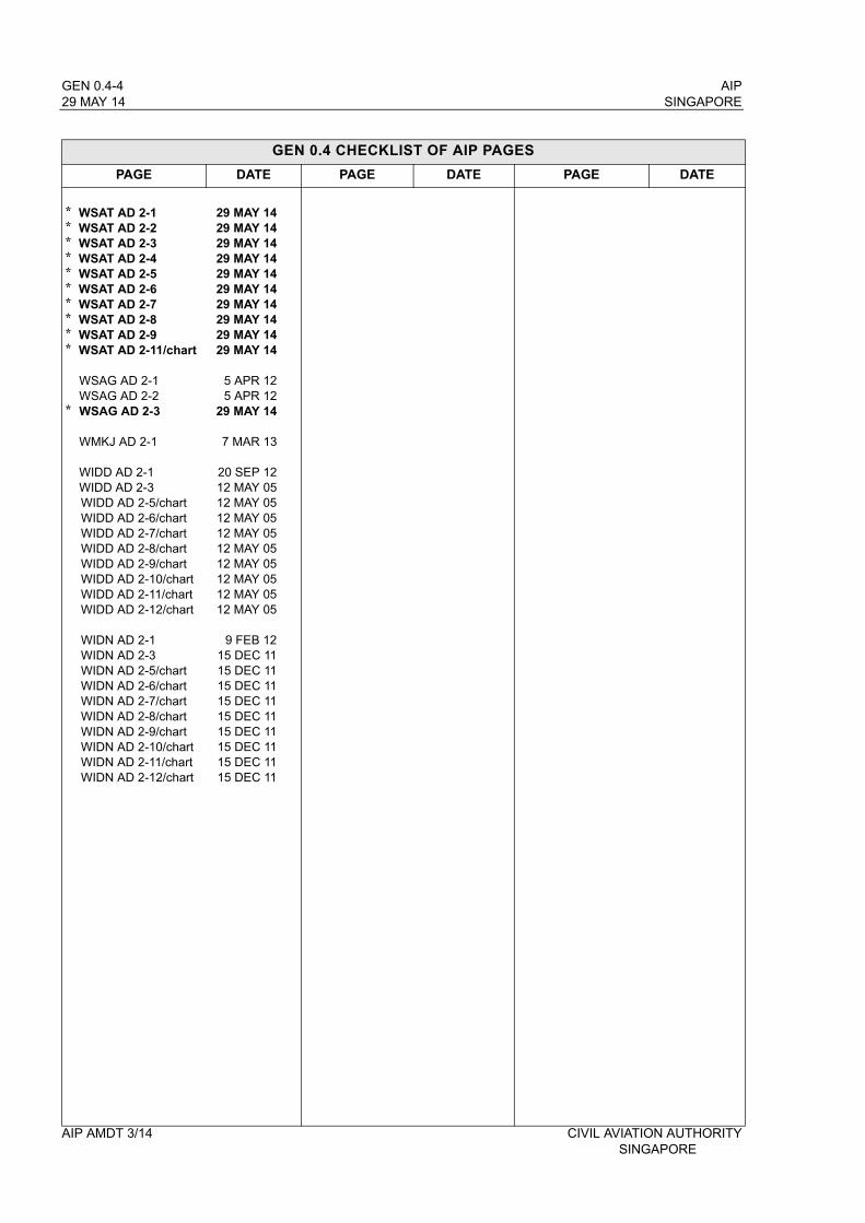
GEN 0.4-4 AIP29 MAY 14 SINGAPORE
GEN 0.4 CHECKLIST OF AIP PAGES
PAGE DATE PAGE DATE PAGE DATE
WSAT AD 2-1WSAT AD 2-2WSAT AD 2-3WSAT AD 2-4WSAT AD 2-5WSAT AD 2-6WSAT AD 2-7WSAT AD 2-8WSAT AD 2-9WSAT AD 2-11/chart
WSAG AD 2-1WSAG AD 2-2WSAG AD 2-3
WMKJ AD 2-1
WIDD AD 2-1WIDD AD 2-3WIDD AD 2-5/chartWIDD AD 2-6/chartWIDD AD 2-7/chartWIDD AD 2-8/chartWIDD AD 2-9/chartWIDD AD 2-10/chartWIDD AD 2-11/chartWIDD AD 2-12/chart
WIDN AD 2-1WIDN AD 2-3WIDN AD 2-5/chartWIDN AD 2-6/chartWIDN AD 2-7/chartWIDN AD 2-8/chartWIDN AD 2-9/chartWIDN AD 2-10/chartWIDN AD 2-11/chartWIDN AD 2-12/chart
29 MAY 1429 MAY 1429 MAY 1429 MAY 1429 MAY 1429 MAY 1429 MAY 1429 MAY 1429 MAY 1429 MAY 14
5 APR 125 APR 12
29 MAY 14
7 MAR 13
20 SEP 1212 MAY 0512 MAY 0512 MAY 0512 MAY 0512 MAY 0512 MAY 0512 MAY 0512 MAY 0512 MAY 05
9 FEB 1215 DEC 1115 DEC 1115 DEC 1115 DEC 1115 DEC 1115 DEC 1115 DEC 1115 DEC 1115 DEC 11
**********
*
AIP AMDT 3/14 CIVIL AVIATION AUTHORITYSINGAPORE
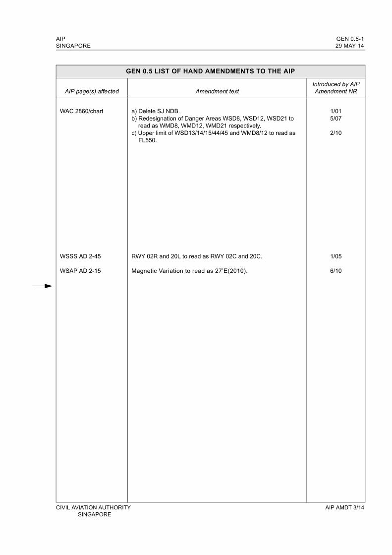
AIP GEN 0.5-1SINGAPORE 29 MAY 14
GEN 0.5 LIST OF HAND AMENDMENTS TO THE AIP
AIP page(s) affected Amendment textIntroduced by AIPAmendment NR
WAC 2860/chart
WSSS AD 2-45
WSAP AD 2-15
a) Delete SJ NDB.b) Redesignation of Danger Areas WSD8, WSD12, WSD21 to
read as WMD8, WMD12, WMD21 respectively.c) Upper limit of WSD13/14/15/44/45 and WMD8/12 to read as
FL550.
RWY 02R and 20L to read as RWY 02C and 20C.
Magnetic Variation to read as 27’E(2010).
1/015/07
2/10
1/05
6/10
CIVIL AVIATION AUTHORITY AIP AMDT 3/14 SINGAPORE

AIP SINGAPORE
INTENTIONALLY
LEFT
BLANK
CIVIL AVIATION AUTHORITY SINGAPORE

AIP GEN 1.6-1SINGAPORE 29 MAY 14
GEN 1.6 SUMMARY OF NATIONAL REGULATIONS AND INTERNATIONAL AGREEMENTS/CONVENTIONS
1. LIST OF CIVIL AVIATION LEGISLATION, AIR NAVIGATION REGULATIONS AND ORDERS
The following is a list of legislation (Acts and subsidiary legislation) affecting aviation and air navigation in the Republic of Singapore together with the International Agreements/Conventions acceded to by the Republic of Singapore. It is essential that anyone engaged in air operations be acquainted with the relevant legal documents.
Copies of the legislation may be obtained as follows:
Electronic versions of the legislation may be freely accessed athttp://statutes.age.gov.sghttp://www.caas.gov.sg
Electronic versions of all Singapore legislation may be accessed via subscription to Lawnet athttp://www.lawnet.com.sg
Print copies of all the legislation may be purchased from:Toppan Leefung Pte. Ltd.,No. 1 Kim Seng Promenade, #18-01,Great World City, East TowerSingapore 237994.
TEL: (65) 68269600FAX: (65) 68203341Website: www.toppanleefung.com
1.1 CIVIL AVIATION LEGISLATION
No Legislation Citation
1 Civil Aviation Authority of Singapore Act 2009 No. 17 of 2009
2 Civil Aviation Authority of Singapore (Aviation Levy) 2009 S459/2009
3 Civil Aviation Authority of Singapore (Changi Airport) By-laws 2009 S313/2009
4 Civil Aviation Authority of Singapore (Changi Airport) Notification 2009 S293/2009
5 Civil Aviation Authority of Singapore (Composition of Offences) Regulations 2009 S315/2009
6 Civil Aviation Authority of Singapore (Licensing of Airport Operators) Regulations 2009
S311/2009
7 Civil Aviation Authority of Singapore (Seletar Airport) By-laws 2009 S314/2009
8 Civil Aviation Authority of Singapore (Seletar Airport) Notification 2009 S294/2009
9 Civil Aviation Authority of Singapore (Service Charge) Order 2009 S310/2009
10 Air Navigation Act Cap. 6 (1985 Rev Ed.)
11 Air Navigation Order Cap. 6, O2 (1990 Rev Ed.)
12 Air Navigation (Aviation Security) Order Cap. 6, O5
13 Air Navigation (Composition of Offences) Rules Cap. 6, R1
14 Air Navigation (Delegation of Powers) Notification Cap. 6, N3
15 Air Navigation (Investigation of Accidents and Incidents) Order 2003 Cap. 6, O7
16 Air Navigation (Licensing of Air Services) Regulations Cap. 6, Rg 2
17 Air Navigation (Paya Lebar and Tengah Aerodrome Fees) Order Cap. 6, O1
18 Air Navigation (Prohibited Flights) Order Cap. 6, O6
CIVIL AVIATION AUTHORITY AIP AMDT 3/14SINGAPORE
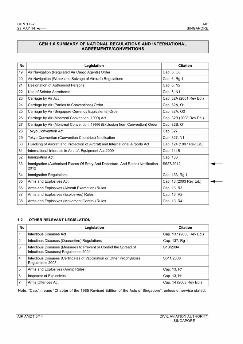
GEN 1.6-2 AIP29 MAY 14 SINGAPORE
GEN 1.6 SUMMARY OF NATIONAL REGULATIONS AND INTERNATIONAL AGREEMENTS/CONVENTIONS
No Legislation Citation
19 Air Navigation (Regulated Air Cargo Agents) Order Cap. 6, O8
20 Air Navigation (Wreck and Salvage of Aircraft) Regulations Cap. 6, Rg 1
21 Designation of Authorised Persons Cap. 6, N2
22 Use of Seletar Aerodrome Cap. 6, N1
23 Carriage by Air Act Cap. 32A (2001 Rev Ed.)
24 Carriage by Air (Parties to Conventions) Order Cap. 32A, O1
25 Carriage by Air (Singapore Currency Equivalents) Order Cap. 32A, O2
26 Carriage by Air (Montreal Convention, 1999) Act Cap. 32B (2008 Rev Ed.)
27 Carriage by Air (Montreal Convention, 1999) (Exclusion from Convention) Order Cap. 32B, O1
28 Tokyo Convention Act Cap. 327
29 Tokyo Convention (Convention Countries) Notification Cap. 327, N1
30 Hijacking of Aircraft and Protection of Aircraft and International Airports Act Cap. 124 (1997 Rev Ed.)
31 International Interests in Aircraft Equipment Act 2009 Cap. 144B
32 Immigration Act Cap. 133
33 Immigration (Authorised Places Of Entry And Departure, And Rates) Notification 2012
S627/2012
34 Immigration Regulations Cap. 133, Rg 1
35 Arms and Explosives Act Cap. 13 (2003 Rev Ed.)
36 Arms and Explosives (Aircraft Exemption) Rules Cap. 13, R3
37 Arms and Explosives (Explosives) Rules Cap. 13, R2
38 Arms and Explosives (Movement Control) Rules Cap. 13, R4
1.2 OTHER RELEVANT LEGISLATION
No Legislation Citation
1 Infectious Diseases Act Cap. 137 (2003 Rev Ed.)
2 Infectious Diseases (Quarantine) Regulations Cap. 137, Rg 1
3 Infectious Diseases (Measures to Prevent or Control the Spread of Infectious Diseases) Regulations 2004
S13/2004
4 Infectious Diseases (Certificates of Vaccination or Other Prophylaxis) Regulations 2008
S611/2008
5 Arms and Explosives (Arms) Rules Cap. 13, R1
6 Inspector of Explosives Cap. 13, N1
7 Arms Offences Act Cap. 14 (2008 Rev Ed.)
Note: “Cap.” means “Chapter of the 1985 Revised Edition of the Acts of Singapore”, unless otherwise stated.
AIP AMDT 3/14 CIVIL AVIATION AUTHORITYSINGAPORE

AIP GEN 3.2-5SINGAPORE 29 MAY 14
GEN 3.2.5 LIST OF AERONAUTICAL CHARTS AVAILABLE
Title of Chart Series Scale Name and/or number Price ($) Date
World Aeronautical Chart ICAO (WAC)
1:1 000 000 WAC 2860 In AIP 15 JUL 99
Enroute Chart ICAO (ENRC)
ENR 6-1 In AIP 29 MAY 14
Instrument Approach Chart ICAO (IAC) 1:400 000
1:400 0001:400 0001:400 0001:400 0001:400 0001:400 0001:400 0001:400 0001:400 000
1:400 0001:400 0001:400 0001:400 000
Singapore ChangiRWY 02L - ICW ILS/DME RWY 02C - ICE ILS/DME RWY 02C - VTK DVOR/DME RWY 02R - ICX ILS/DME RWY 20R - ICH ILS/DME RWY 20C - ICC ILS/DME RWY 20C - VTK DVOR/DME RWY 20L - ICZ ILS/DME RWY 02L - RNAV(GNSS) RWY 20R - RNAV(GNSS)
Paya LebarRWY 20 - PU DVOR/DME RWY 02 - PU DVOR/DME RWY 20 - IPS ILS/DME RWY 02 - IPN ILS/DME
WSSS AD 2-101WSSS AD 2-103WSSS AD 2-105WSSS AD 2-107WSSS AD 2-109WSSS AD 2-111WSSS AD 2-113WSSS AD 2-115WSSS AD 2-117WSSS AD 2-119
WSAP AD 2-17WSAP AD 2-19WSAP AD 2-21WSAP AD 2-23
In AIPIn AIPIn AIPIn AIPIn AIPIn AIPIn AIPIn AIPIn AIPIn AIP
In AIPIn AIPIn AIPIn AIP
10 MAR 1110 MAR 1110 MAR 1110 MAR 1110 MAR 1110 MAR 1110 MAR 1110 MAR 1110 MAR 117 MAR 13
10 MAR 1110 MAR 1110 MAR 1110 MAR 11
Visual Approach ChartICAO (VAC)
1:400 000
1:100 0001:100 0001:100 0001:100 000
Singapore Changi
SeletarRWY 03RWY 21RWY 03RWY 21
WSSS AD 2-121
WSSL AD 2-21WSSL AD 2-23WSSL AD 2-25WSSL AD 2-27
In AIP
In AIPIn AIPIn AIPIn AIP
10 MAR 11
9 FEB 129 FEB 12 9 FEB 129 FEB 12
Visual Departure Chart1:100 0001:100 000
SeletarRWY 03RWY 21
WSSL AD 2-29WSSL AD 2-31
In AIPIn AIP
9 FEB 129 FEB 12
Aerodrome Chart ICAO (AC)
Singapore ChangiSeletarPaya Lebar
WSSS AD 2-31WSSL AD 2-13WSAP AD 2-11
In AIPIn AIPIn AIP
3 APR 143 APR 143 APR 14
Aerodrome Obstacle Chart ICAO TYPE A (AOC) 1:10 000
1:10 000
1:10 000
1:20 000
Singapore ChangiRWY 20R/02LRWY 20C/02C
SeletarRWY 03/21
Paya LebarRWY 20/02
WSSS AD 2-37WSSS AD 2-39
WSSL AD 2 -17
WSAP AD 2-15
In AIPIn AIP
In AIP
In AIP
3 APR143 APR 14
6 FEB 14
25 APR 96
Aerodrome Obstacle Chart ICAO TYPE B (AOC) 1:25 000
1:12 500
Singapore ChangiRWY 02L/20R and 02C/20C
SeletarRWY 03/21
WSSS AD 2-41
WSSL AD 2-19
In AIP
In AIP
3 APR 14
6 FEB 14
Precision Approach Terrain Chart - ICAO (PATC) 1:2 500
1:2 500
Singapore Changi RWY 02LRWY 02C
WSSS AD 2-43WSSS AD 2-45
In AIPIn AIP
25 APR 9625 APR 96
CIVIL AVIATION AUTHORITY AIP AMDT 3/14 SINGAPORE

GEN 3.2-6 AIP29 MAY 14 SINGAPORE
GEN 3.2.6 INDEX TO THE WORLD AERONAUTICAL CHART (WAC) - ICAO 1:1 000 000
AIP AMDT 3/14 CIVIL AVIATION AUTHORITY SINGAPORE

AIP GEN 3.5-3SINGAPORE 29 MAY 14
4. TYPES OF SERVICES
4.1 The Meteorological Office and Meteorological Watch Office at Singapore Changi Airport operate H24 and provide the following services for civil aviation:
a) Full meteorological documentation and briefing for current operational planning for all flights operating out of Singapore Changi Airport;
b) Area meteorological watch over the Singapore FIR with the supply of meteorological information including SIGMET information to aircraft in flight through the Singapore ATS radio channels (see subsection AD 2.11);
c) HF RTF VOLMET broadcasts of meteorological information (see page GEN 3.5-7), Aviation weather report with trend statement, strong low level vertical wind shear report and aerodrome warnings are also included in VHF ATIS broadcasts for Singapore Changi Airport (see page GEN 3.4-3);
d) Meteorological information for ATS
4.2 Weather briefing by a forecaster is available H24 to qualified flight operations personnel at the Meteorological Office at Singapore Changi Airport or via telephone at (65)65425059 / (65)65422837. Weather information is available online via our Aviation Intranet at URL http://www.weather.gov.sg/ (see paragraph 9.2 for further details).
4.3 The Meteorological Office at Seletar Aerodrome operates H24 and provides meteorological documentation without briefing for international and general aviation flights operating out of Seletar Aerodrome.
4.4 Details of documentation supplied for each flight are determined by arrangement between the operator and the Meteorological Office. In general, the pilot-in-command is provided with documentation comprising one or more fixed-time prognostic streamline/istotach/spot temperature charts of standard isobaric surfaces appropriate to the cruising level (ICAO model IS), one of fixed-time prognostic significant weather chart code form. Alternatively, he may be provided with a tabular forecast of en-route conditions with wind and temperature conditions for climb and descent and for one or more standard levels appropriate to the cruising level (ICAO model TA), and appropriate aerodrome forecasts in TAF code form.
4.5 Routine aerodrome forecasts received from other Meteorological Offices are normally included in meteorological documentation without modification. When a required aerodrome forecast is not received, a provisional forecast may be issued by the Meteorological Office providing the documentation.
4.6 After documentation has been issued and until take-off (i.e. the latest ETD notified to the Meteorological Office), the Meteorological Office at Singapore Changi Airport makes available amendments to the documentation. It is the responsibility of the operator’s local representative or the pilot-in-command to obtain any pre-departure amendment(s) from the Meteorological Office at Singapore Changi Airport. The pilot-in-command may request pre-departure amendment(s) through the Singapore Changi Airport Control Tower.
4.7 Climatological Summaries for Singapore Changi (WSSS-48698) are available from the Meteorological Service Singapore. For enquiry, please email to [email protected]
CIVIL AVIATION AUTHORITY AIP AMDT 3/14SINGAPORE

GEN 3.5-4 AIP29 MAY 14 SINGAPORE
4.8 OBSERVING SYSTEMS AND OPERATING PROCEDURES AT SINGAPORE CHANGI AIRPORT AND SELETAR AERODROME
4.8.1 SINGAPORE CHANGI AIRPORT
4.8.1.1 RWY 02L/20R (Runway 1)
4.8.1.1.1 Surface wind is measured by three cup anemometers and wind vanes located as follows:
DIST FROM END OF RWY DIST FROM RWY CENTRELINE (i) One set at 470 metres north of RWY 02L 130 metres(ii) One set at middle of runway 130 metres(iii) One set at 470 metres south of RWY 20R 130 metres
4.8.1.1.2 RVR observations are made by means of three sets of transmissometers, located as follows:
DIST FROM END OF RWY DIST FROM RWY CENTRELINE 1st set 370 metres north of RWY 02L 110 metres2nd set Middle of runway 110 metres3rd set 360 metres south of RWY 20R 110 metres
RVR is reported in steps of 25 metres between 0 and 400 metres, 50 metres between 400 and 800 metres and 100 metres between 800 and 1,500 metres.
4.8.1.2 RWY 02C/20C (Runway II)
4.8.1.2.1 Surface wind is measured by three cup anemometers and wind vanes located as follows:
DIST FROM END OF RWY DIST FROM RWY CENTRELINE (i) One set at 450 metres north of RWY 02C 130 metres(ii) One set at middle of runway 130 metres(iii) One set at 450 metres south of RWY 20C 130 metres
4.8.1.2.2 RVR observations are made by means of three sets of transmissometers, located as follows:
DIST FROM END OF RWY DIST FROM RWY CENTRELINE 1st set 400 metres north of RWY 02C 110 metres2nd set Middle of runway 110 metres3rd set 400 metres south of RWY 20C 110 metres
RVR is reported in steps of 25 metres between 0 and 400 metres, 50 metres between 400 and 800 metres and 100 metres between 800 and 1,500 metres.
4.8.1.2.3 Surface wind is also measured by an ultrasonic wind sensor located at the meteorological station, which is situated at 345 metres west of middle of RWY 02L/20R. Surface wind report in METAR and SPECI is taken from this measurement.
4.8.1.3 Wind Shear Observations (Singapore Changi Airport)
4.8.1.3.1 Horizontal low level wind shear observations are measured continuously by a system of 13 wind sensors located in Singapore Changi airport and its vicinity.
4.8.1.3.2 ATC will pass to all aircraft taking off or landing for the next 1/2 hour from the time of report whenever microburst or wind shear of intensity 10 knots or greater is observed/reported.
4.8.1.3.3 The phraseology used by ATC to warn pilots of the presence of wind shear of intensity between 10 and 30 knots is:
“.................. (callsign) WIND SHEAR WARNINGSTRONG LOW LEVEL WIND SHEAR OBSERVED IN THE VICINITY OF CHANGI AIRPORT AT ....... (time)”
AIP AMDT 3/14 CIVIL AVIATION AUTHORITY SINGAPORE

AIP GEN 3.5-5SINGAPORE 29 MAY 14
4.8.1.3.4 The phraseology used by ATC to warn pilots of the presence of wind shear of intensity greater than 30 knots is:
“...........(callsign) WIND SHEAR WARNING SEVERE LOW LEVEL WIND SHEAR OBSERVED IN THE VICINITY OF CHANGI AIRPORT AT ........(time)”
4.8.1.3.5 The presence of wind shear will also be broadcast in the ATIS for the next half an hour.
4.8.2 SELETAR AERODROME
4.8.2.1 Surface wind is measured by cup anemometers and wind vanes at ends of runway. Surface wind report in METAR and SPECI is taken from measurements of cup anemometer and wind vane at RWY 03.
4.8.2.2 Wind Shear Observations (Seletar Aerodrome)
4.8.2.1 ATC will pass to all aircraft taking off or landing for the next 1/2 hour from the time of report
whenever microburst or windshear of intensity 10 knots or greater is observed/reported.
4.8.2.2.2 The phraseology used by ATC to warn pilots of the presence of wind shear of intensity between 10 and 30 knots is:
“...........(callsign) WIND SHEAR WARNING STRONG LOW LEVEL WIND SHEAR OBSERVED IN THE VICINITY OF SELETAR AIRPORT AT ........(time)”
4.8.2.2.3 The phraseology used by ATC to warn pilots of the presence of wind shear of intensity greater than 30 knots is:
“...........(callsign) WIND SHEAR WARNING SEVERE LOW LEVEL WIND SHEAR OBSERVED IN THE VICINITY OF SELETAR AIRPORT AT ........(time)”
5. NOTIFICATION REQUIRED FROM OPERATORS
5.1 It is the responsibility of the operator or the pilot-in-command to notify the meteorological office of any flight for which meteorological documentation is required (ref. ICAO Annex 3, paragraph 2.3). As much prior notice as possible should be given, and at least one hour notice at Singapore Changi Airport and two hours at Seletar Aerodrome would be required for non-scheduled flights.
6. AIRCRAFT REPORTS REQUIRED FROM OPERATORS
6.1 AIREP
6.1.1 Routine aircraft meteorological observations shall be made and the reports transmitted at ATS/MET reporting points listed on page GEN 3.5-6 and as indicated in subsection ENR 3.1 - ATS ROUTES.
6.1.2 Special aircraft observations and aircraft observations during climb-out and approach shall be made and the reports transmitted as necessary.
6.1.3 Special aircraft observations of pre-eruption volcanic activity, volcanic eruption or volcanic ash cloud shall be recorded on the special Air-Report of Volcanic Activity form which can be downloaded from URL https://fpl-1.caasaim.gov.sg/. A copy of the completed Volcanic Activity Report shall be delivered by the operator or a flight crew member, without delay, either personally or by telephone facsimile (TEL: 65425026 or 65429978) to the Meteorological Office, Singapore Changi Airport.
CIVIL AVIATION AUTHORITY AIP AMDT 3/14SINGAPORE
GEN 3.5-6 AIP29 MAY 14 SINGAPORE
6.2 REPORTING OF LOW LEVEL WIND SHEAR
6.2.1 Pilots encountering wind shear shall report to ATC as soon as possible.
6.2.2 When reporting wind shear on radiotelephony, the information should be transmitted in this order:
a) Aircraft callsign;b) WIND SHEAR report;c) Time (of wind shear occurrence);d) Position (of wind shear);e) Intensity (moderate, strong or severe);f) Average height of wind shear layer.
6.2.3 On receipt of a wind shear report from a pilot, ATC will pass it to other aircraft in the vicinity. The following phraseology will be used:
“WIND SHEAR WARNINGARRIVING (or DEPARTING) ........... (type of aircraft)REPORTED ...................... (moderate, strong, severe)WIND SHEAR IN APPROACH (or DEPARTURE)RUNWAY ................ (number) AT ..................... (time)HEIGHT OF WIND SHEAR LAYER ................... (feet)”
6.2.4 The presence of wind shear as reported by a pilot will also be broadcast in the ATIS for the next half an hour unless subsequent reports indicate that wind shear no longer exists.
6.3 AIRCRAFT ATS/MET REPORTING POINTS IN THE SINGAPORE FIR
6.3.1. Aircraft Meteorological Observations shall be made in relation to and transmitted in flight by all aircraft at the following selected Air Traffic Services position reporting points within the Singapore FIR except when:
a) The flight duration is less than 2 hours, or b) The altitude of the flight path is less than 5 000ft, orc) The aircraft is less than 1 hour’s flying time from the next intended point of landing.
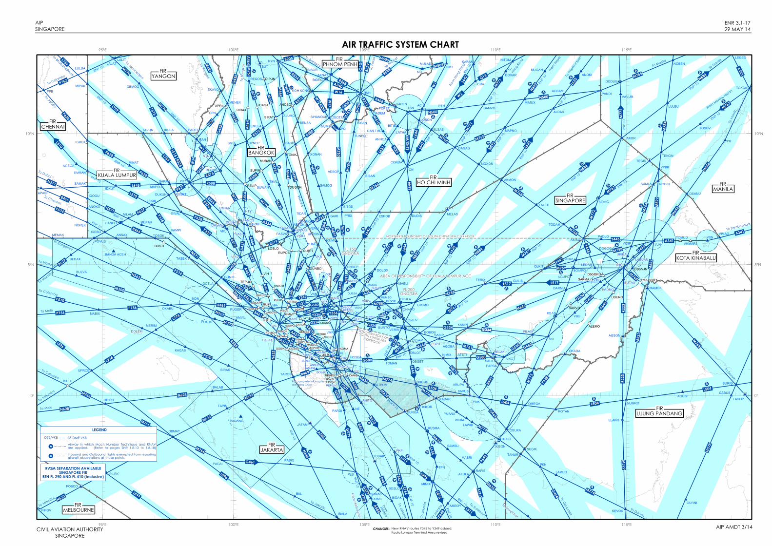
6.3.2. The aircraft ATS/MET reporting points listed below are indicated in chart page ENR 3.1-17.
6.3.3. The position of the mean wind or spot wind, to the nearest whole degree latitude and longitude, shall be recorded and transmitted in flight.
ATS ROUTE
AIRCRAFT ATS/MET REPORTING POINTS IN THE SINGAPORE FIR
G580 NIMIX
L642 ESPOB
L644 KIKOR
M635 SURGA
M758/M767 TERIX
M767 TEGID
M774 KADAR
M774/L504 BAVUS
N875 ARUPA
N892 MELAS
AIP AMDT 3/14 CIVIL AVIATION AUTHORITYSINGAPORE
AIP GEN 3.5-9SINGAPORE 29 MAY 14
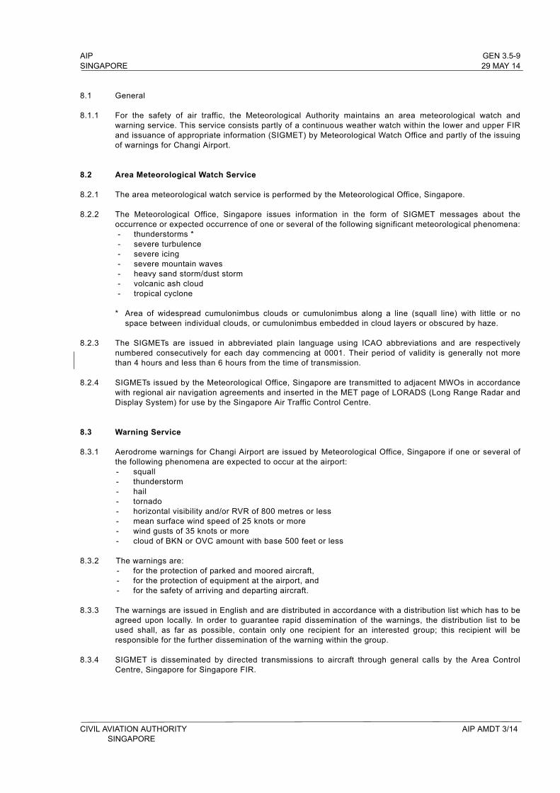
8.1 General
8.1.1 For the safety of air traffic, the Meteorological Authority maintains an area meteorological watch and warning service. This service consists partly of a continuous weather watch within the lower and upper FIR and issuance of appropriate information (SIGMET) by Meteorological Watch Office and partly of the issuing of warnings for Changi Airport.
8.2 Area Meteorological Watch Service
8.2.1 The area meteorological watch service is performed by the Meteorological Office, Singapore.
8.2.2 The Meteorological Office, Singapore issues information in the form of SIGMET messages about the occurrence or expected occurrence of one or several of the following significant meteorological phenomena:- thunderstorms *- severe turbulence- severe icing - severe mountain waves- heavy sand storm/dust storm- volcanic ash cloud- tropical cyclone
* Area of widespread cumulonimbus clouds or cumulonimbus along a line (squall line) with little or no space between individual clouds, or cumulonimbus embedded in cloud layers or obscured by haze.
8.2.3 The SIGMETs are issued in abbreviated plain language using ICAO abbreviations and are respectively numbered consecutively for each day commencing at 0001. Their period of validity is generally not more than 4 hours and less than 6 hours from the time of transmission.
8.2.4 SIGMETs issued by the Meteorological Office, Singapore are transmitted to adjacent MWOs in accordance with regional air navigation agreements and inserted in the MET page of LORADS (Long Range Radar and Display System) for use by the Singapore Air Traffic Control Centre.
8.3 Warning Service
8.3.1 Aerodrome warnings for Changi Airport are issued by Meteorological Office, Singapore if one or several of the following phenomena are expected to occur at the airport:- squall- thunderstorm- hail- tornado- horizontal visibility and/or RVR of 800 metres or less- mean surface wind speed of 25 knots or more - wind gusts of 35 knots or more- cloud of BKN or OVC amount with base 500 feet or less
8.3.2 The warnings are:- for the protection of parked and moored aircraft,- for the protection of equipment at the airport, and- for the safety of arriving and departing aircraft.
8.3.3 The warnings are issued in English and are distributed in accordance with a distribution list which has to be agreed upon locally. In order to guarantee rapid dissemination of the warnings, the distribution list to be used shall, as far as possible, contain only one recipient for an interested group; this recipient will be responsible for the further dissemination of the warning within the group.
8.3.4 SIGMET is disseminated by directed transmissions to aircraft through general calls by the Area Control Centre, Singapore for Singapore FIR.
CIVIL AVIATION AUTHORITY AIP AMDT 3/14SINGAPORE
GEN 3.5-10 AIP29 MAY 14 SINGAPORE
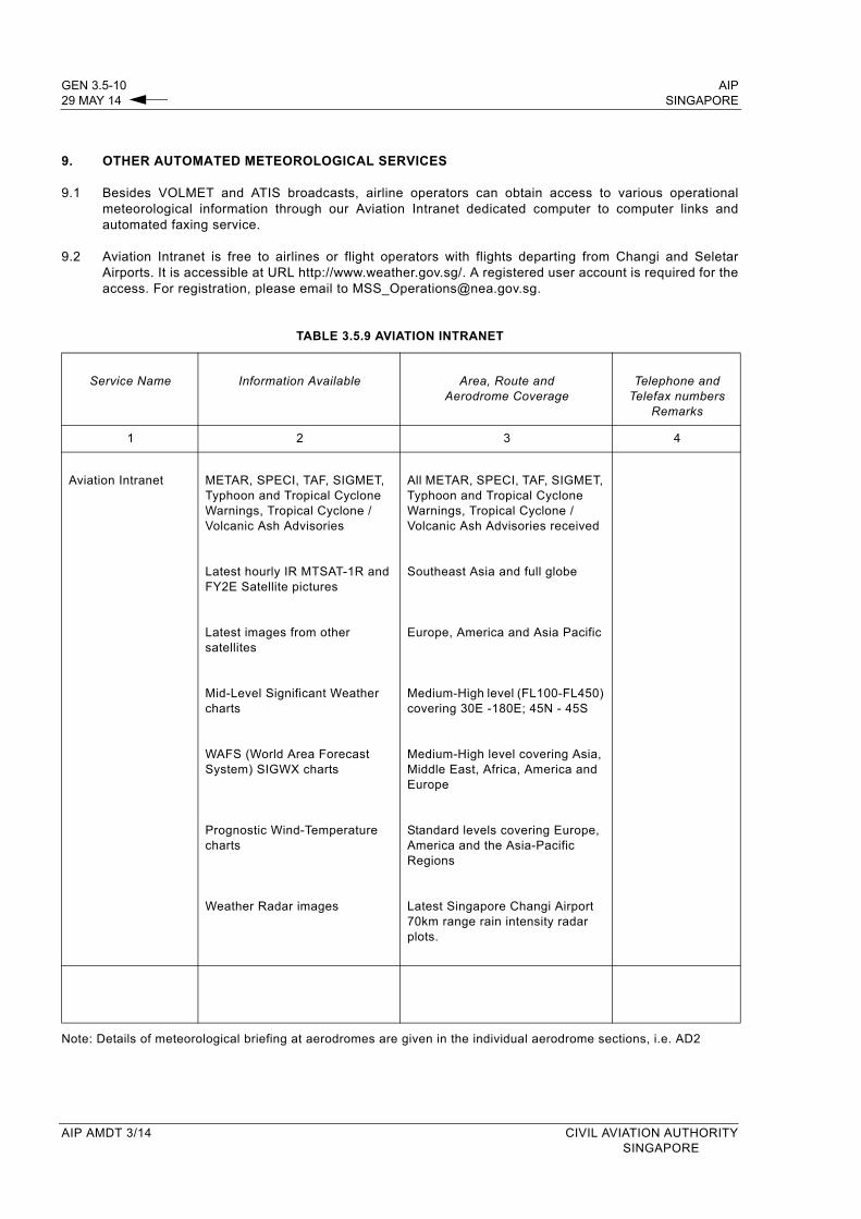
9. OTHER AUTOMATED METEOROLOGICAL SERVICES
9.1 Besides VOLMET and ATIS broadcasts, airline operators can obtain access to various operational meteorological information through our Aviation Intranet dedicated computer to computer links and automated faxing service.
9.2 Aviation Intranet is free to airlines or flight operators with flights departing from Changi and Seletar Airports. It is accessible at URL http://www.weather.gov.sg/. A registered user account is required for the access. For registration, please email to [email protected].
TABLE 3.5.9 AVIATION INTRANET
Service Name Information Available Area, Route andAerodrome Coverage
Telephone and Telefax numbers
Remarks
1 2 3 4
Aviation Intranet METAR, SPECI, TAF, SIGMET, Typhoon and Tropical Cyclone Warnings, Tropical Cyclone / Volcanic Ash Advisories
Latest hourly IR MTSAT-1R and FY2E Satellite pictures
Latest images from other satellites
Mid-Level Significant Weather charts
WAFS (World Area Forecast System) SIGWX charts
Prognostic Wind-Temperature charts
Weather Radar images
All METAR, SPECI, TAF, SIGMET, Typhoon and Tropical Cyclone Warnings, Tropical Cyclone / Volcanic Ash Advisories received
Southeast Asia and full globe
Europe, America and Asia Pacific
Medium-High level (FL100-FL450) covering 30E -180E; 45N - 45S
Medium-High level covering Asia, Middle East, Africa, America and Europe
Standard levels covering Europe, America and the Asia-Pacific Regions
Latest Singapore Changi Airport 70km range rain intensity radar plots.
Note: Details of meteorological briefing at aerodromes are given in the individual aerodrome sections, i.e. AD2
AIP AMDT 3/14 CIVIL AVIATION AUTHORITY SINGAPORE
AIP ENR 1.1-3SINGAPORE 29 MAY 14
2.3.15 In the event of an aircraft arriving at the clearance limit without having received a further clearance, the pilot-in-command shall immediately request a further clearance and hold in accordance with the specified holding pattern where one is established or otherwise the standard holding pattern, maintaining the last assigned cruising level until further clearance is received. Where no direct ATC co-ordination facilities between Regional Area Control Centres exist, pilots on such routes must endeavour, when airborne, to contact the Area Control Centre of the next FIR which the aircraft is entering and obtain clearance to enter its Control Area before reaching the transfer point of the two ACCs.
2.3.16 When a flight operates successively in a Control Area and subsequently along the advisory route or area, the clearance issued for the flight or any revisions thereto will only apply to those portions of the flight conducted within controlled airspaces.
2.4 ROUTE AND LEVEL ASSIGNMENT
2.4.1 The pilot-in-command shall fly in strict accordance to the route specified by ATC. Deviation from the specified route may be permitted by ATC if traffic conditions permit.
2.4.2 Traffic permitting ATC will assign the flight planned level if in accordance with the table of Semi-Circular System of Cruising Levels. Cruising levels below the minimum specified in subsection ENR 3.1 will not be assigned.
2.5 ESSENTIAL TRAFFIC INFORMATION
2.5.1 Essential traffic is that controlled traffic to which the provision of separation by ATC is applicable but, which in relation to a particular controlled traffic, does not have the required minimum separation.
2.5.2 Essential traffic information shall be issued to controlled flights concerned whenever they constitute essential traffic to each other.
Note: This information will inevitably relate to controlled flights which are cleared subject to maintaining own separation and remaining in visual meteorological conditions.
2.5.3 Essential traffic information shall include:
a) Direction of flight of aircraft concerned;b) Type of aircraft concerned;c) Level(s) of aircraft concerned and estimated time of passing or if this is not available, the estimated
time of arrival for the reporting point nearest to where the level will be crossed.
2.6 INSTRUCTIONS TO DEPARTING AIRCRAFT
2.6.1 ATC may specify any or all of the following items when issuing clearance to departing aircraft:
a) Turn after take-off;
b) Track to make good before turning on desired route;
c) Initial level to maintain;
d) Time, point and/or rate at which level change shall be made.
2.6.2 ATC may instruct a departing aircraft to leave a reporting point at a specified time or to be at a specified level at a specified point or time. The pilot-in-command shall notify ATC if these instructions cannot be complied with.
CIVIL AVIATION AUTHORITY AIP AMDT 3/14SINGAPORE

ENR 1.1-4 AIP29 MAY 14 SINGAPORE
2.7 ARRIVAL/APPROACH INSTRUCTIONS
2.7.1 ATC clearance or control instructions for approach to an aerodrome or holding point will be issued to an arriving aircraft on initial contact with the appropriate ATC unit.
2.7.2 The clearance will specify the clearance limit, route and level to be flown. An Expected Approach Time will be included if it is anticipated that the arriving aircraft will be required to hold.
2.7.3 Pilots are reminded to use the phraseology minimum fuel and MAYDAY MAYDAY MAYDAY fuel to notify ATC of their low fuel state or fuel emergency. For details, refer to CAAS Information Circular IC 5/2013 available at URL http://www.caas.gov.sg - Regulations - Safety - Documents and Notices - Information Circulars.
2.8 WEATHER INFORMATION
2.8.1 Weather information will be passed to inbound aircraft on request. However, pilots should tune on to ATIS frequency 128.6MHz for the weather.
2.8.2 The term CAVOK will be used in place of visibility, weather and cloud when the following conditions apply simultaneously:
a) Visibility 10km or more;b) No precipitations or thunderstorms;c) No cloud below 1 500m.
2.8.3 Deterioration and improvement weather reports and significant weather information, e.g. severe turbulence, thunderstorms, icing conditions etc. will be passed to all aircraft concerned.
2.9 AIRCRAFT JOINING OR CROSSING AIRWAYS
2.9.1 Pilots-in-command of aircraft joining or crossing an airway will:
a) When flying under VFR outside the Singapore/Johor Airspace Complex and CTRs notify the appropriate authority; or
b) When flying under IFR, or when joining or crossing the Singapore/Johor Airspace Complex and CTRs request clearance from the appropriate authority not later than 10 minutes on VHF RTF or 20 minutes on HF RTF before joining or crossing.
2.9.2 An in-flight request or notification or intention to join an Airway shall include the following information, as appropriate:
a) Aircraft identification;b) Aircraft type;c) Position;d) Level and flight conditions;e) Estimated time at point of joining;f) Desired level;g) Route and point of first intended landing;h) True airspeed;i) The words “Request joining clearance”.
2.9.3 An in-flight request or notification of intention to cross an Airway shall include the following information:
a) Aircraft identification;b) Aircraft type;c) True track;d) Place and estimated time of crossing;e) Desired crossing level;f) Ground Speed;g) The words “Request crossing clearance”
2.9.4 The selected crossing or joining point should, where possible, be associated with a radio facility to assist accurate navigation.
AIP AMDT 3/14 CIVIL AVIATION AUTHORITYSINGAPORE

! !
!!!!
!!!
!!!!
!
! !
!!!!
!!!
!!!!
!
! !
!!!!
!!!
!!!!
!
! !
!!!!
!!!
!!!!
!
RMSBAL
BOBAG
MATSU
PIBOSKIMAT
SAROX
LATUK
ADNUT
AROSO
SAPAT
GUPTA
MESOG
MASBO
TOPOR
BATAR
DUMOK
OGAKO
LELIB
IDSUDI
AKOMA
UKASA
30 DME VTK30 DME PU
35 DME SJ
PIMOKBED
REDUK
SABKA
PU
SJ
JB KK
VPK
VMR
VKN
TRS
ASA
HOSBA
REKOP
90 DME PULIP
TAXUL
VPT
JR
VTK
VJBARAMA
SHA8 SJ
TI
KIBOL
KILOTOTLON
NOP
DAM
SUS
UGPEK
URIGO VISAT
VEPLI
MAL
DUBSA
BUVAL
DOVOLIDSEL
EGOLOMANIM
KETOD
RAXIM
MASNIBONSU
LENDA
PADLI
NIVAM
ANBUS
GEMAS
SUKRI
Y331
G219
B338
L629
N892
G584A2
24
W534
L629
G580
G579
L635
G584
M761
G582
L642
A464
M771
M758
G334
M763
A457
N892
R469
G334
M761
G582
N891
W533
N891
R469
B469
B469
M763
G334
N891
R325
B469
A464
B466
M771A576
B470W5
33
N884
L635
R208 L642
B466
G579
W407
B338
P501
N502Y336
Y335
Y334
Y333
Y332
Y336
P501
W533
G579
P501
M635
M630
Y340
Y339
Y342
Y339
Y349
Y344
Y343
FIRSINGAPORE
SECT
OR 2
SECTOR 1
H
E
C
A
B
DF
KUANTAN TMA
JOHOR CTA
W401
W651
FIRSINGAPORE
FIRKUALA LUMPUR
W401
KUALA LUMPUR
TMA
AIRSPACE DIVISION KUALA LUMPUR/SINGAPORE AREAS CONTROL CENTRES
A I P SINGAPORE
ENR 2.1-929 MAY 14
CIVIL AVIATION AUTHORITYSINGAPORE
AIP AMDT 3/14
102°30' 103°00' E 103°30' 104°00' 104°30'
102°30' 103°00' E 103°30' 104°00' 104°30'
04°00'
03°30'
03°00'
02°30'
01°30'N
02°00'
04°00'
03°30'
03°00'
02°30'
01°30'N
02°00'
10 0 10 20 305 NM
CHANGES :
FL 360FL 145
FL 360FL 120
FL 3005 500ft
FL 2452 000ft
FL 2455 500ft FL 245
3 000ft
30 DME PU
61 DME PU
90 DME PU
35 D
ME SJ
45 D
ME SJ
50 D
ME SJ FL 245
3 000ft
FL 2452 000ft
012133N1035928E
FL 2459 500ft
New RNAV routes Y343, Y344 and Y349 added.ATS route A457 revised.Kuala Lumpur Terminal Area revised.

A1M300
L625
M646
N892
L642
N884
P762
M771
M767
M765
M626
B465
A583
L507
M770
P648
A202
M522
L628
A582
G463
M758
N891
G580L774
P574
G334
R468
M768
P901
M751
G86
G473
G474
R207
A599
N500
P756
R474
N875
B346
M761
G581
M753
R223
A457
A341
G458
L637
R208
R597
B329
W17R325
B202
R334
B218
A340
L635
G466
B338
G582
M759
L629
R469M5
22
R215
L515
B219
L643
/W9
B591
G468 M630
A334
G580
G584
M763
Y445
N633
A464/M751
R474
A464
R474
R325
B462
A576
A464
A585
N891
G460
R215
L759
N891
L642
M771
N892
M767
G578
A461
G578
B472B473
B462
G467
A590
N884
M646
A461
M646
A341
M758
M754
M635M774
G472
P646N895
P646
R207
L507P646
L301
L301
M626
B466
R588
B579
R461
Y347
M751/W540
M758
L625
M753R588
A202
A1
A1
L642
M771
N500
M771
M754
L625
L625
M646
M646
R596R596
B462
B462
G581
N892
B591
A461
A461A583
B463
A581
B465 B463
A581
M522
R590B472
P628
L645
P627N571
P628
N571N563
M300 N563 Y339G344
Y331
L642
N884
R325A464
P570
P570
N628
L644
P901
M772
M772
M772
G473
R474
B579
A224
N892
M751
A1
A581
L628
P627
SJ
M768
M767
A206
B468
R575
R575
M755
R575
R575
N891
R470
R470
M755
W1W1
L644
N502P501
M644
Y337
L896
L510 M770
M770P628
M766
M501
M501M501
R471
R588
OPG
R345
B204
Y338
R588
B205
R468
Y446
Y447
P627
M626
M502
B214
B329
B214
G221
Q15
B460
L510
P648
W2
L517
W2W2
M765
M904
M904
L504
M505
M646
L504
G460
R467
A464
W23
M510
M505W1
7
R334
R213
R335
R328
B466
Y346
R208
Y345
Y349
KUALALUMPUR
FIR
HO CHI MINH FIR
SINGAPORE FIR
HONG KONG FIR
GUANGZHOU FIR
HANOIFIR
BANGKOK FIR
YANGON FIRPHNOM PENH FIR
KOTAKINABALU
FIRUJUNG
PANDANG FIR
MANILA FIR
TAIPEI FIR
JAKARTA FIR
SANYA FIR
HO CHIH MINH ACC
SINGAPORE ACCFIR C
HENN
AI
VIENTAINEFIR
KUNMING FIR
PU
PR
Hong Kong
PK
CN
NE
VJB
VPK
PQ
KOH KONG
CABUBL
COTZAM
SAJ
LIPManila JOM
SAN
LAO
HCN
PCA
DAN
SAV
PTHTSN
Kota Kinabalu
Brunei
VSI
PAK
CMP
KRT
RYN
YangonPATHEIN
BGO
DWI
Kuching
PNK
GMA
MCT
LSO
Vientiane
GYA
CTR
MDY
Hanoi
Chiang Mai
MENEX
VMRVKLVPT
VBA
VIH
VPG
VKB
HTY
STN
Phnom Penh
PKU
PUT
RAN
Medan
VPL
LALIT
SKATE
ELMAS
SARSI
OMEGA
SELSU
BUNTO
BEDAX LEDAM
LIBDI
MEPEL
SAGOD
TEBOV
IBITA
LULDA
PEDNO
ANIMU
RABIV
KATAN
LAMOK
ALDIN
TOKON
LEGED
REKEL
IBOBI
BISIGMEVINKABAM POTIB
ELATO
KAPLI
AGVAR
AVMUP
AKOTA
MAVRA
MUMOT
NOMAN
SABNO
DULOPIKELA
DAGON
ASSAD
SAMASSIKOU
GUKUMDABGIMESOXDAMELVEPAM
MONBO
MIGUGEXOTO
DOSUTEGEMU
IGNISCAVOI
ITBAMBUNTA
GONLYANINA
BOMPA
PAPRA
DONGIVILAO
NOBEN
LULBU
TENON
MAPNO
ALDAS
PANDIMIMUXDAMVO
ELSAS
DAGAG
MOXON
NODIN
VINIK
LAXOR
TEGID
TODAM
LAGOT
AKMON
MELASDUDIS
SAPEN
OSANU
VIMAG
AGSON
MAMOK
DOGOGASISU
OLKIT
OKADA
VIBUNLEKOB
BUTRARAMEI
MENAM
BAKOK
BISOR
MAKAS
BETNO
TANEK
TERIX
ARUPA
AKTOD
TOMANNIMIX
ATETI
KAMIN
AGOBA
OBGETOBLOT
ESPITSABIPBOBOB
ANSOS LINSOSADEK
OSIKA
AVDAXAVLED
TAPIN
LUSMO
MABLI
TASEK
TOSOK
PARDIKETIVODIRU
ASUNAHOSBA
NISOK
GUNIP DOLOXENREP
IKUKOBOSTIPOVUS
SANOB
IGARIESPOBIPRIX
ANOKO BITODRUSET RELIP
XONAN
UPNEP
EKAVO REGOS
PUGER
SALAXKAGAS
IKULA
OBMOG
LAGOG
IGOGU
SAMAK SAPAM
TAVUN
MIPAK
BULVA
TOPIN
PADET
MEMAK
MABIX
NIXUL
ANSAXNOPEK
GIVAL
IGREX
LIMLA
VAS
AGSAM
VAMPI
Bangkok
ANIPU
ASOBA
BENSA
ATBUD
ARESIEMPUL
DODUGVAVUM
BIDAG
ANIRU
BOMPODARMU
BIDRU
NOBOKLAVOS
LAPON
NOHET NALAO
LAVAN
KISAN
AKNAT
SATON
BIDEG
RECNO
SMU
EMELA
ALUMO
MUBAN
TONIK
SUWANSUPIN
ROT
UDN
BALAB
MERIM
ISBIX
VBU
TIKAL
MC
VIN
HATIN
TUNPO
NAH
XONUS
HAMIN
BMT
AC
LOSON
TEBAK
RIZAN
ANBUSBOBAG
SUKRI
POLAK
KADAX
DUGON
ABTOK
PADLI
UPROB
EMRAN
GOLUD
MIKIN
ALDIS
BEDIP
NAKHA
BASIT
GOMES
BIDEM RULOK
SIHANOUK
MAPSO
DUKUNLEKIR
IDKUT
MEKARNILAM
ANOBO
ADIZ
LADON
APASI
SADUS
PPB
POPET
HUE
MEOVA
PONUK
TATELBOMAS
PADLO
OKENA
POXEM
DALER AKATO
LALAT
AKSAG
CRA
KADIM
BQDIB
DONDA
TPG
TACSADOK
OBDOS
KIKOR
LPB
OSUKA
NOBER
PASAT
SELKA
GULIB VMI
ALADO
MAREL
KONCO
CQ
KARAN
BATEM
VKR
TIDAR
UPRONODONO
BUT
DIPUN
SIRAT
ATPOM
MDMULAD
KADMO
LABUAN
ARAMA
NUMDI OSOTA
DADEM
ANHOA
IDOTAALPHA
VKP
120°E
120°E
115°E
115°E
110°E
110°E
105°E
105°E
100°E
100°E
95°E
95°E
20°N 20°N
15°N 15°N
10°N 10°N
5°N 5°N
AIPSINGAPORE
CIVIL AVIATION AUTHORITYSINGAPORE
AIP AMDT 3/14
ENR 2.1-1529 MAY 14
ATS ROUTE STRUCTURE WITHIN SINGAPORE & ADJACENT FIRs
CHANGES : New RNAV routes Y343 to Y349 added.

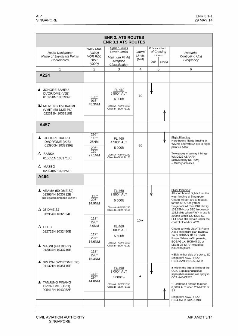
AIP ENR 3.1-1 SINGAPORE 29 MAY 14
CIVIL AVIATION AUTHORITY AIP AMDT 3/14 SINGAPORE
ENR 3. ATS ROUTES ENR 3.1 ATS ROUTES
Route Designator Name of Significant Points
Coordinates
Track MAG (GEO)
VOR RDL DIST
(COP)
Upper Limits Lower Limits
Minimum Flt Alt Airspace
Classification
Lateral Limits (NM)
D i r e c t i o n
of Cruising Levels
Remarks Controlling Unit
Frequency Odd E v e n
1 2 3 4 5 6
A224
JOHORE BAHRU DVOR/DME (VJB) 013950N 1033939E
MERSING DVOR/DME
(VMR) (58 DME PU) 022318N 1035218E
196° 016°
45.3NM
FL 460
5 500ft ALT
6 000ft
Class A –ABV FL150 Class B –BLW FL150
10
A457
JOHORE BAHRU DVOR/DME (VJB) 013950N 1033939E
∆ SABKA
015051N 1031713E
∆ MASBO
020248N 1025251E
296° 116°
25NM
FL 460
4 500ft ALT
5 000ft
Class A –ABV FL150 Class B –BLW FL150
20
Flight Planning: Northbound flights landing at WMKK and WMSA are to flight plan via A457. Tolerances of airway infringe WMD222 ASAHAN (activated by NOTAM) – Military activities
296° 116°
27.1NM
A464
ARAMA (50 DME SJ)
013654N 1030712E (Delegated airspace BDRY)
∆ 35 DME SJ
012954N 1032024E
∆ LELIB
012729N 1032450E
MASNI (FIR BDRY) 012037N 1033746E
SINJON DVOR/DME (SJ)
011321N 1035115E
TANJUNG PINANG
DVOR/DME (TPG) 005413N 1043052E
117° 297°
14.9NM
FL 460
3 500ft ALT
5 500ft
Class A –ABV FL150 Class B –BLW FL150
10
Flight Planning: All southbound flights from the west landing at Singapore Changi Airport are to request for the STAR only from Singapore ATC on PRI FREQ 133.25MHz or SEC frequency 135.8MHz when RWY in use is 20 and within 120 DME SJ. FLT shall still remain under the control of WMKK ATC. Changi arrivals via ATS Route A464 shall flight plan BOBAG 1A or BOBAG 1B as STAR Route. When traffic permits, BOBAG 1K, BOBAG 1L or LELIB 2B STAR would be issued to pilots.
5NM either side of track to SJ Singapore ACC FREQ: P133.25MHz S135.8MHz
within the lateral limits of the OCA. 15min longitudinal separation minima will apply in OCA A464/A576.
Eastbound aircraft to reach 6,000ft ALT when 25NM SE of SJ. Singapore ACC FREQ: P134.4MHz S128.1MHz
118° 298°
5.0NM
FL 460
3 000ft ALT
5 500ft
Class A –ABV FL150 Class B –BLW FL150
117° 297°
14.6NM
118° 298°
15.3NM
114° 294°
44.0NM
FL 460 2 000ft ALT
6 000ft
Class A –ABV FL150 Class B –BLW FL150
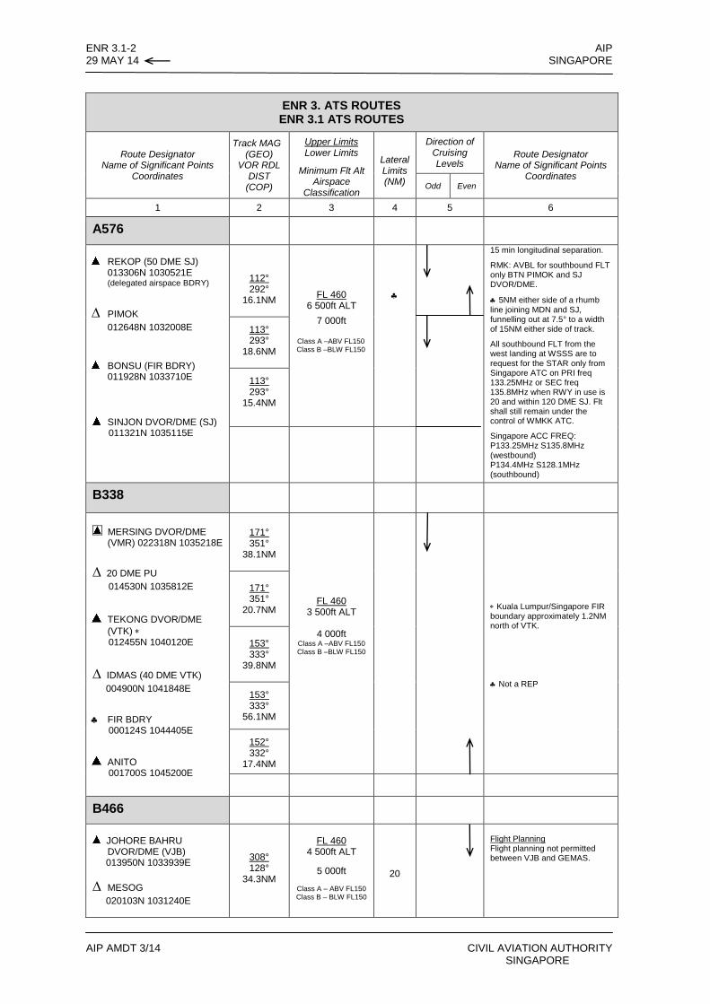
ENR 3.1-2 AIP 29 MAY 14 SINGAPORE
AIP AMDT 3/14 CIVIL AVIATION AUTHORITY SINGAPORE
ENR 3. ATS ROUTES ENR 3.1 ATS ROUTES
Route Designator Name of Significant Points
Coordinates
Track MAG (GEO)
VOR RDL DIST
(COP)
Upper Limits Lower Limits
Minimum Flt Alt Airspace
Classification
Lateral Limits (NM)
Direction of Cruising Levels
Route Designator Name of Significant Points
Coordinates Odd Even
1 2 3 4 5 6
A576
REKOP (50 DME SJ)
013306N 1030521E (delegated airspace BDRY)
∆ PIMOK
012648N 1032008E
BONSU (FIR BDRY) 011928N 1033710E
SINJON DVOR/DME (SJ)
011321N 1035115E
112° 292°
16.1NM
FL 460
6 500ft ALT
7 000ft
Class A –ABV FL150 Class B –BLW FL150
15 min longitudinal separation.
RMK: AVBL for southbound FLT only BTN PIMOK and SJ DVOR/DME.
5NM either side of a rhumb line joining MDN and SJ, funnelling out at 7.5° to a width of 15NM either side of track.
All southbound FLT from the west landing at WSSS are to request for the STAR only from Singapore ATC on PRI freq 133.25MHz or SEC freq 135.8MHz when RWY in use is 20 and within 120 DME SJ. Flt shall still remain under the control of WMKK ATC.
Singapore ACC FREQ: P133.25MHz S135.8MHz (westbound) P134.4MHz S128.1MHz (southbound)
113° 293°
18.6NM
113° 293°
15.4NM
B338
MERSING DVOR/DME (VMR) 022318N 1035218E
∆ 20 DME PU
014530N 1035812E
TEKONG DVOR/DME
(VTK) 012455N 1040120E
∆ IDMAS (40 DME VTK)
004900N 1041848E
FIR BDRY 000124S 1044405E
ANITO 001700S 1045200E
171° 351°
38.1NM
FL 460 3 500ft ALT
4 000ft
Class A –ABV FL150 Class B –BLW FL150
Kuala Lumpur/Singapore FIR boundary approximately 1.2NM north of VTK.
Not a REP
171° 351°
20.7NM
153° 333°
39.8NM
153° 333°
56.1NM
152° 332°
17.4NM
B466
JOHORE BAHRU
DVOR/DME (VJB) 013950N 1033939E
∆ MESOG
020103N 1031240E
308° 128°
34.3NM
FL 460
4 500ft ALT
5 000ft
Class A – ABV FL150 Class B – BLW FL150
20
Flight Planning Flight planning not permitted between VJB and GEMAS.
AA
A
A A
A
A
A
A A
A
A
A A
A
A
A
A
A
A
A
A
AA
A
A
B
A A A A
A
A
A
A
A A
A
A
A
A
A
A
A
AA
AA
A
A
A
A
A
A
A
A
A
A
A
A
A
A
A
AA
A A
A
A
A
A
B
A
SAKMA
IDAGADIRAX
APRIL
ALEMO
SARVO
UDERODAKUS
UKASA
KIMAT
REMESBAVAL
LELIB
TOPOR AKOMAOGAKO
GUPTABATARDUMOK
REDUKRUMID GEMASSAPAT SAROX
LATUKINTOT
PIBOSBILIK
GOBAS ADNUT
MATSUSUKATPULIP
ANSOMTEPUS
GUNBO D80/VJND50/BRU
RUPOS
TMA BDRY
UDONI
IDMAS
AGOSA
MASBO
ANOBO
SUPIN
DOSIK
VMK
DUGON
PADANG
BANDA ACEH
TOMUD
TONIKMUBAN
GUGITLOSLO
DIPUN
SIRAT
AROSO
AKMARBOSTI
RELIP
VIH
RNP 1
0RN
P 10
RNP 1
0RN
P 10
RNP 1
0
RNP 1
0
RNP 1
0
RNP 1
0
RNP 10RNP 10
RNP 1
0
RNP 1
0
RNP 1
0
RNP 10
RNP 10
RNP 10
RNP 10
RNP 10
RNP 10
RNP 1
0
RNP 10
RNP 10
RNP 10
RNP 10
RNP 1
0
RNP 10
RNP 10
RNP 1
0
RNAV 10
RNAV 5
RNP 10
RNP 10
RNP 10
RNP 10
RNP 10
RNP 10
RNP 10
RNP 10
L895
P574
N646
N633
A585
N752
N628
L511
M767
L764
L759
N571
A341
B329
L515
B219
G334
R223
B469
L625
B579
A340
B466W3
4
P628
L774
P762
M522
R334
M759
A334
Y331
G460
R455
G464
M646
N500
G580
M761
Y445
M753
R325
B338
W17
L511
M768
N633
M771
L643
/W9
L635R208
N875
W533
A457M751
G579
M768
G582
G458
M751
M766
G458
M766
W17
M758
M646
L645
G578
A457
P570
A464
M771
R588
L642
N892L642
N500
A464
R208
P756P570
L759
G580
B579
W1
N563
M522
A585
A583
N884
P574 N571
M761
L642
A576S
R588
L625
R223
M765
M300
M646
B466
B466
M767
M522
M770
L642
R325
R588
L625
P648
L629
W34
P648
N633
N891A464
R468
G578
P628
M753
M754
B469
M300
G460
R468
N884
M768
M767
N884
P648
M770
A576 M768
R325N891
M765
M635
L759
M626
P627
N891 W16
N571
N892
M522
R461
N892
M765R468
M766
M767
N884
A464
R325
M753
B469
R325
P648
B470
M768
N875
R467
N891
R588
L625
M767
M771
G580
R461
M751
G584
B470
M765
G579
N563
G468
R469
N628
A457
L774G462
M626
M758
N875
G458
G464
A583
B344N8
92
M774
N891
M626
L637
A341
M754
B466
G334
M774
A464
P628
P627
M771
G466
M646
M751/W540
P756
G580
A585
M758
L895
M763
G334 G334
A464
L515
L644
L644
L644
M772
M772
M772
G334G334
M755
R575
R575
R575
N633
G461
M755
M766
R575
N502
P501
R579
Y336
M644M644
Y336
W443
Y337
L897
L896
L896
L510M770
R588
B205
OPG
P628
W12
W12
Y446
Y447
P627
Q15
L510
W2
L517L517
W2
M904
M904
M904
M774L504M774
M635
M505
M635
L504
L504
L504
M635
G460
M630
M510
W23
R213
W17
M505
R334W7
R334
Y347
Y346
Y345
Y349
L644
PU
PR
CN
BMT
AC
SJ
NE
TPG
JB
VPK
PQ
KOH KONG
PKN
VBU
BKL
PTHTSN
VSN
VMI
VJN
BRU
VSI
PKP
RYN
VKG
PNK
CPN
PLB
VTK
VJB
VMRVKL
VPT
VKN
VKP
VPG VKR
VKBVAS
HTY
STN
PNH
PKU
PUT
RAN
MDN
VPL
PPB
LAWIB
YUANA
LALIT
OMEGA
BUNIK
MASRI
SAMSU
AKULA
AMBOY
BENSA
PIPOV
SALIL
RELAK
PAGAI
TOLIT
SELSU
BUNTO
BEDAXLEDAM
POSOD
KEVOK
BIKAL
TODAK
LULDALALAT
GURNI
TOKON
TOSOV
LEGED
ANOKIDOXAR
KARAN
MUGANNOBEN
LULBU
TENON
MAPNO
ALDAS
PANDIAGSAM
MIMUXDAMVO
ELSAS
DAGAG
MOXON
NODINSUMLA
VINIK
LAXOR
TEGID
TODAM
LAGOT
AKMON
MELASDUDIS
LATHA
SAPENPOPET
BITIS
OSANU
GABUSLADOP
VIMAG
ELANG
AGSON
MAMOKBUTAX
DARMU
UKIBA
VIDIPDOGOG
ASISU
OLKIT
KADMO
PILAX
OKADA
LAMUD
KIBON
IBALA
DOLTA
DOMIL BIDAK
BOSLOMIMIX
BAKOK
BISOR
POLAK
OSUKA
TERIX
ARUPA
KIKOR
RUSMA
TOMAN
NIMIX ATETI
KAMIN
AGOBA
OBGET
OBLOT
SABIPBOBOBVERIN
ABASA
ANITOTAPIN
LUSMOLEBIN
ELGOR
MABLI
VISAT
PAPSA
LOSON
TASEK
TOSOK
TAMOS
KIBOL
PARDI
OBMATJATAM
KETIV
ODIRU
BALABISBIX
TAROSASUNA SAMKO
HOSBAPIMOKREKOP
MERIM
D90PU LIPROKILOT
NISOK OTLONURIGO
MABALUGPEKMUMSO
DUBSATAXUL VEPLISUSAR
DAMOGGOTLA NOPATGUNIP
DOLOXENREP
IKUKOIKUMIPOVUS
PASVAKADAX GOLUD
DUBAXDALAN VENLISANOB
IGARI ESPOBIPRIXUTHAIANOKO BITOD
RUSETAPASISAMOGSUWAN
CONDA
ADBOP
XONAN
UPNEP
OSOTA
MENEX
EKAVO
REGOS
PUGER
SALAX
BIRAS
KAGAS
IKULA
OBMOG
LAGOG
IGOGU
SAMAK SAPAM
TAVUN
MIPAK
PEKDO
OKABU
BULVA
TOPIN
PADET
AMVIL
MEMAKVAMPI
NILAM
DOLEM
MABIX
ANSAXIGEBONOPEK
GIVAL
IGREX
KARMI
VBA
ARAMA KK
ESPIT
OPULA
OMLIV
ONAPO
OLSAM
OMBAP
RIZAN
AGUPOBOMPO
ANIRU
VAVUM
DODUG
BIDAG
TIKAL
SMU
RECNO
KISAN
PABIO
BORAS
ALUMO
TUNPO L644
SATON
AKNATBIDEG
EMELA
ANBUS
BOBAG
PADLI
BUVAL
KETOD
ABTOK
ISTAN
UPROB
PILEK
IDKUT
EMRAN
LEKIR
MINAT
MAPSO
DUKUN
MEKAR
BASIT
SIHANOUK
AGEDO
Y338
PADLO
NITOM
CRA
TI
AGEGA
GULIB
TIDAR
ODONO
UPRON
BUT
SURGA
KADAR
BAVUSATPOM OBDOS
MULAD
MD
WIDIA
RAFIS
TRIBO
ROTAN
NUGROAGUSI
SURIG
SUGIKTANUR
LABUAN
SUKRI
REPOV
NUMDI
DADEM
CAN THO
ANHOA
BIBAN
TPN
115°E
115°E
110°E
110°E
105°E
105°E
100°E
100°E
95°E
95°E
10°N 10°N
5°N 5°N
0° 0°
AIR TRAFFIC SYSTEM CHART
AIPSINGAPORE
CIVIL AVIATION AUTHORITYSINGAPORE
ENR 3.1-1729 MAY 14
AIP AMDT 3/14
JAKARTAFIR
YANGONFIR
BANGKOKFIR
KUALA LUMPURFIR
HO CHI MINHFIR
SINGAPOREFIR
MANILAFIR
KOTA KINABALUFIR
MELBOURNEFIR
PHNOM PENHFIR
CHENNAIFIR
SOUTHERN BDRY OFSOUTH CHINA SEACORRIDOR
NORTHERN BOUNDARY OF SOUTH CHINA SEA CORRIDOR
AREA OF RESPONSIBILITY OF KUALA LUMPUR ACC
FL 150GND/SEA
FL 200GND/SEA
RVSM SEPARATION AVAILABLESINGAPORE FIR
BTN FL 290 AND FL 410 (Inclusive)
To Mauritius
To MaleTo Mauritius
To Colombo
To Male
To Colombo
To Madurai
To Mauritius
To Bangalore
To Chennai
To Dubai
To ASOPO
To Bhubaneshwar
To Colombo
To Jamshedpur
To Yangon
To Ba
ngko
k
To Bangkok
To Pa
kse
To Phucat
From Ho
ng Ko
ng
To Hong
Kong
To Tai
pei/Ja
pan
From Ta
ipei
To ManilaTo Manila
From Manila/Japan
To Man
ila
To Zamboanga
To Darwin
To Darwin
OCEANIC CTA
To Denpasar
To Denpasar
To Surabaya
To Jak
arta
To Jakarta
FromJakarta
From Melbourne
To Jakarta
For complete informationsee Area Chart
CHANGES : New RNAV routes Y343 to Y349 added.Kuala Lumpur Terminal Area revised.
To Ja
karta
UJUNG PANDANGFIR
35 DME VKB Airway in which Mach Number Technique and RNAVare applied. (Refer to pages ENR 1.8-13 to 1.8-18)Inbound and Outbound flights exempted from reportingaircraft observations at these points. B
A
D35/VKBLEGEND

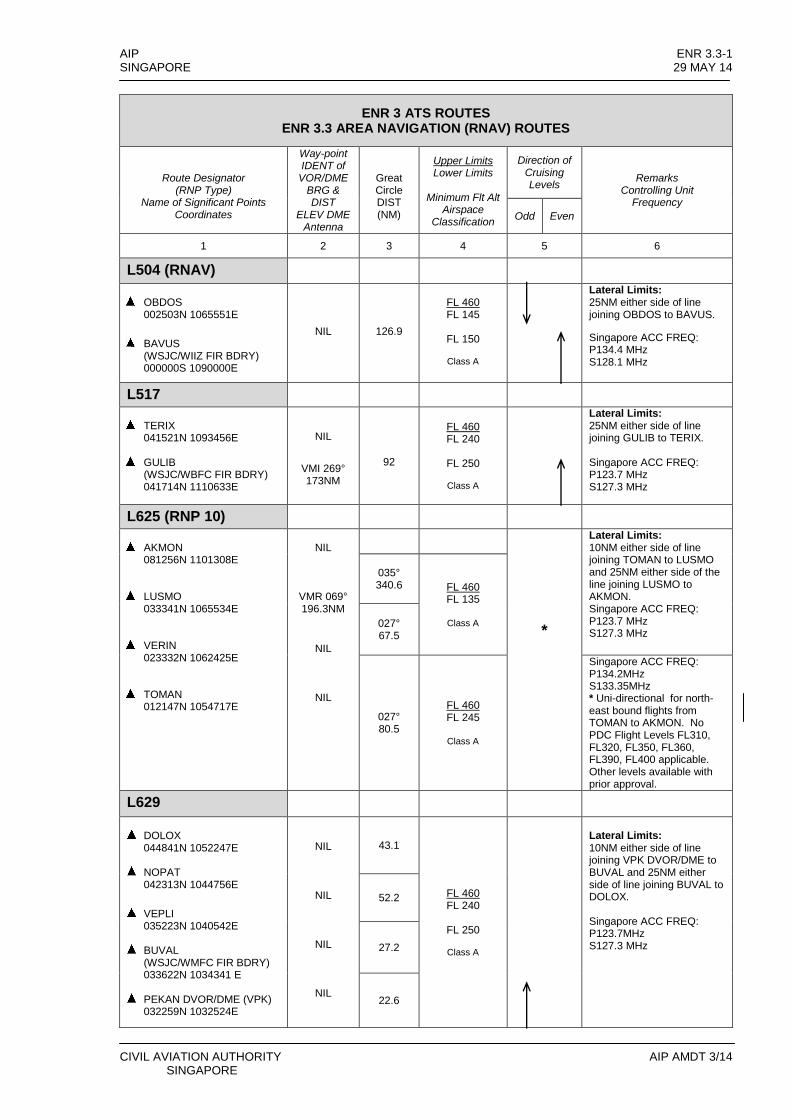
AIP ENR 3.3-1 SINGAPORE 29 MAY 14
CIVIL AVIATION AUTHORITY AIP AMDT 3/14 SINGAPORE
ENR 3 ATS ROUTES ENR 3.3 AREA NAVIGATION (RNAV) ROUTES
Route Designator
(RNP Type) Name of Significant Points
Coordinates
Way-point IDENT of
VOR/DME BRG & DIST
ELEV DME Antenna
Great Circle DIST (NM)
Upper Limits Lower Limits
Minimum Flt Alt
Airspace Classification
Direction of Cruising Levels
Remarks Controlling Unit
Frequency
Odd Even
1 2 3 4 5 6
L504 (RNAV)
OBDOS
002503N 1065551E
BAVUS
(WSJC/WIIZ FIR BDRY) 000000S 1090000E
NIL
126.9
FL 460 FL 145
FL 150
Class A
Lateral Limits: 25NM either side of line joining OBDOS to BAVUS.
Singapore ACC FREQ: P134.4 MHz S128.1 MHz
L517
TERIX
041521N 1093456E
GULIB (WSJC/WBFC FIR BDRY) 041714N 1110633E
NIL
VMI 269° 173NM
92
FL 460 FL 240
FL 250
Class A
Lateral Limits: 25NM either side of line joining GULIB to TERIX. Singapore ACC FREQ: P123.7 MHz S127.3 MHz
L625 (RNP 10)
AKMON
081256N 1101308E
LUSMO
033341N 1065534E
VERIN
023332N 1062425E
TOMAN
012147N 1054717E
NIL
VMR 069° 196.3NM
NIL
NIL
*
Lateral Limits: 10NM either side of line joining TOMAN to LUSMO and 25NM either side of the line joining LUSMO to AKMON. Singapore ACC FREQ: P123.7 MHz S127.3 MHz
035° 340.6
FL 460 FL 135
Class A 027°
67.5
027° 80.5
FL 460 FL 245
Class A
Singapore ACC FREQ: P134.2MHz S133.35MHz * Uni-directional for north-east bound flights from TOMAN to AKMON. No PDC Flight Levels FL310, FL320, FL350, FL360, FL390, FL400 applicable. Other levels available with prior approval.
L629
DOLOX
044841N 1052247E
NOPAT 042313N 1044756E
VEPLI
035223N 1040542E
BUVAL (WSJC/WMFC FIR BDRY) 033622N 1034341 E
PEKAN DVOR/DME (VPK)
032259N 1032524E
NIL
NIL
NIL
NIL
43.1
FL 460 FL 240
FL 250
Class A
Lateral Limits: 10NM either side of line joining VPK DVOR/DME to BUVAL and 25NM either side of line joining BUVAL to DOLOX. Singapore ACC FREQ: P123.7MHz S127.3 MHz
52.2
27.2
22.6

ENR 3.3-2 AIP 29 MAY 14 SINGAPORE
AIP AMDT 3/14 CIVIL AVIATION AUTHORITY SINGAPORE
ENR 3. ATS ROUTES ENR 3.3 AREA NAVIGATION (RNAV) ROUTES
Route Designator
(RNP Type) Name of Significant Points
Coordinates
Way-point IDENT of VOR/DME
BRG & DIST
ELEV DME Antenna
Great Circle DIST (NM)
Upper Limits Lower Limits
Minimum Flt Alt Airspace
Classification
Direction of Cruising Levels
Remarks Controlling Unit
Frequency
Odd Even
1 2 3 4 5 6
L635
MABLI 041717N 1061247E
SUSAR
035848N 1051547E
DUBSA
034901N 1044540E
UGPEK
033647N 1040752E
DOVOL
(WSJC/WMFC FIR BDRY) 033047N 1034923E
PEKAN DVOR/DME
(VPK) 032259N 1032524E
NIL
NIL
NIL
NIL
NIL
Lateral Limits: 10NM either side of line joining VPK DVOR/DME to DOVOL and 25NM either side of the line joining DOVOL to MABLI Singapore ACC FREQ: P123.7 MHz S127.3 MHz
59.9
FL 460 FL 240
FL 250
Class A
31.6
39.7
19.4
25.2
L642 (RNP 10)
ESPOB (VVTS/WSJC FIR BDRY) 070000N 1053317E
ENREP 045223N 1041442E
VEPLI
035223N 1040542E
EGOLO
(WSJC/WMFC FIR BDRY) 031934N 1040047E
ROBMO
025440N 1035700E
MERSING DVOR/DME
(VMR) 022318N 1035218E
NIL
VMR 008° 150.0NM
VMR 008° 89.7NM
VMR 008° 56.6NM
VMR 008° 31.6NM
149.2
*
* Uni-directional for
southbound flights from ESPOB to ENREP. No PDC Flight Levels FL310, FL320, FL350, FL360, FL390, FL400 applicable. Other levels available with prior approval. Lateral Limits: 10NM either side of line joining VMR DVOR/DME to EGOLO and 25NM either side of line joining EGOLO to ESPOB. Bi-directional between VMR and ENREP.
Singapore ACC FREQ: P123.7 MHz S127.3 MHz
60.4
FL 460 FL 135
FL 140
Class A
33.0
25.1
31.6
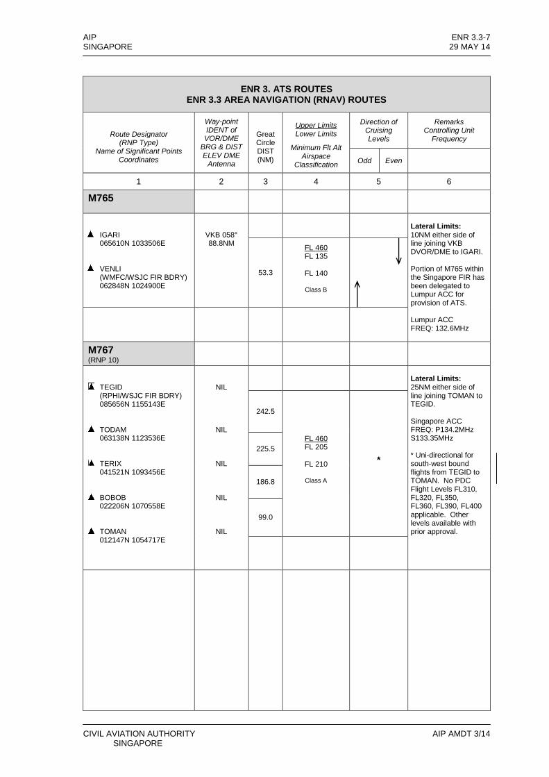
AIP ENR 3.3-7 SINGAPORE 29 MAY 14
CIVIL AVIATION AUTHORITY AIP AMDT 3/14 SINGAPORE
ENR 3. ATS ROUTES ENR 3.3 AREA NAVIGATION (RNAV) ROUTES
Route Designator
(RNP Type) Name of Significant Points
Coordinates
Way-point IDENT of VOR/DME
BRG & DIST ELEV DME
Antenna
Great Circle DIST (NM)
Upper Limits Lower Limits
Minimum Flt Alt Airspace
Classification
Direction of Cruising Levels
Remarks Controlling Unit
Frequency
Odd Even
1 2 3 4 5 6
M765
IGARI 065610N 1033506E
VENLI (WMFC/WSJC FIR BDRY) 062848N 1024900E
VKB 058° 88.8NM
Lateral Limits: 10NM either side of line joining VKB DVOR/DME to IGARI. Portion of M765 within the Singapore FIR has been delegated to Lumpur ACC for provision of ATS. Lumpur ACC FREQ: 132.6MHz
53.3
FL 460 FL 135
FL 140
Class B
M767 (RNP 10)
TEGID (RPHI/WSJC FIR BDRY) 085656N 1155143E
TODAM 063138N 1123536E
TERIX 041521N 1093456E
BOBOB 022206N 1070558E
TOMAN 012147N 1054717E
NIL
NIL
NIL
NIL
NIL
Lateral Limits: 25NM either side of line joining TOMAN to TEGID. Singapore ACC FREQ: P134.2MHz S133.35MHz * Uni-directional for south-west bound flights from TEGID to TOMAN. No PDC Flight Levels FL310, FL320, FL350, FL360, FL390, FL400 applicable. Other levels available with prior approval.
242.5
FL 460 FL 205
FL 210
Class A
*
225.5
186.8
99.0
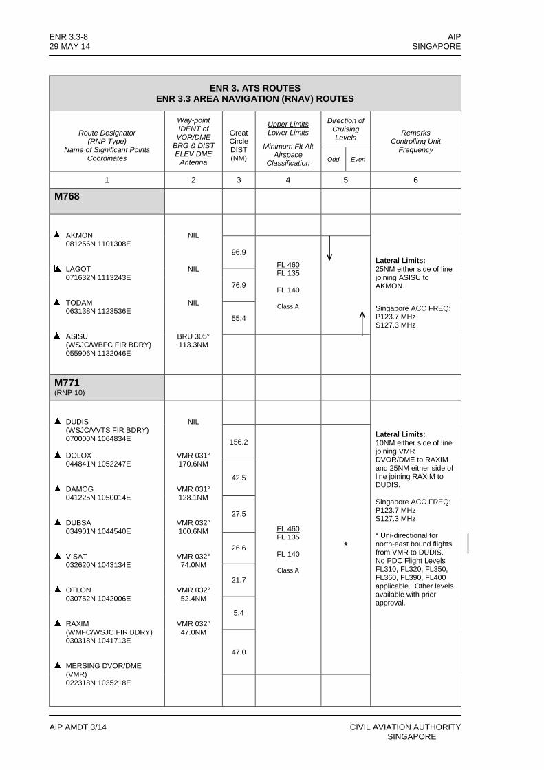
ENR 3.3-8 AIP 29 MAY 14 SINGAPORE
AIP AMDT 3/14 CIVIL AVIATION AUTHORITY SINGAPORE
ENR 3. ATS ROUTES ENR 3.3 AREA NAVIGATION (RNAV) ROUTES
Route Designator
(RNP Type) Name of Significant Points
Coordinates
Way-point IDENT of VOR/DME
BRG & DIST ELEV DME
Antenna
Great Circle DIST (NM)
Upper Limits Lower Limits
Minimum Flt Alt Airspace
Classification
Direction of Cruising Levels
Remarks Controlling Unit
Frequency
Odd Even
1 2 3 4 5 6
M768
AKMON 081256N 1101308E
LAGOT 071632N 1113243E
TODAM 063138N 1123536E
ASISU (WSJC/WBFC FIR BDRY) 055906N 1132046E
NIL
NIL
NIL
BRU 305° 113.3NM
Lateral Limits: 25NM either side of line joining ASISU to AKMON.
Singapore ACC FREQ: P123.7 MHz S127.3 MHz
96.9
FL 460 FL 135
FL 140
Class A
76.9
55.4
M771 (RNP 10)
DUDIS (WSJC/VVTS FIR BDRY) 070000N 1064834E
DOLOX 044841N 1052247E
DAMOG 041225N 1050014E
DUBSA 034901N 1044540E
VISAT 032620N 1043134E
OTLON 030752N 1042006E
RAXIM (WMFC/WSJC FIR BDRY) 030318N 1041713E
MERSING DVOR/DME (VMR) 022318N 1035218E
NIL
VMR 031° 170.6NM
VMR 031° 128.1NM
VMR 032° 100.6NM
VMR 032° 74.0NM
VMR 032° 52.4NM
VMR 032° 47.0NM
Lateral Limits: 10NM either side of line joining VMR DVOR/DME to RAXIM and 25NM either side of line joining RAXIM to DUDIS. Singapore ACC FREQ: P123.7 MHz S127.3 MHz * Uni-directional for north-east bound flights from VMR to DUDIS. No PDC Flight Levels FL310, FL320, FL350, FL360, FL390, FL400 applicable. Other levels available with prior approval.
156.2
FL 460 FL 135
FL 140
Class A
*
42.5
27.5
26.6
21.7
5.4
47.0
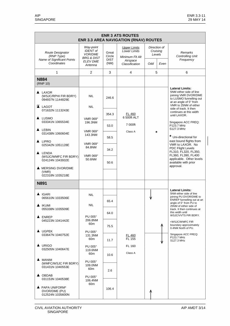
AIP ENR 3.3-11 SINGAPORE 29 MAY 14
CIVIL AVIATION AUTHORITY AIP AMDT 3/14 SINGAPORE
ENR 3 ATS ROUTES ENR 3.3 AREA NAVIGATION (RNAV) ROUTES
Route Designator
(RNP Type) Name of Significant Points
Coordinates
Way-point IDENT of
VOR/DME BRG & DIST ELEV DME
Antenna
Great Circle DIST (NM)
Upper Limits Lower Limits
Minimum Flt Alt Airspace
Classification
Direction of Cruising Levels
Remarks Controlling Unit
Frequency
Odd Even
1 2 3 4 5 6
N884 (RNP 10)
Lateral Limits: 5NM either side of line joining VMR DVOR/DME to LUSMO funnelling out at an angle of 5° from VMR to 25NM of either side of track. It then continues at this width until LAXOR.
Singapore ACC FREQ: P123.7 MHz S127.3 MHz
* Uni-directional for
east bound flights from VMR to LAXOR. No PDC Flight Levels FL310, FL320, FL350, FL360, FL390, FL400 applicable. Other levels available with prior approval.
LAXOR
(WSJC/RPHI FIR BDRY) 094937N 1144829E
LAGOT 071632N 1113243E
LUSMO
033341N 1065534E
LEBIN
031438N 1060604E
LIPRO
025342N 1051128E
LENDA
(WSJC/WMFC FIR BDRY) 024124N 1043932E
MERSING DVOR/DME (VMR) 022318N 1035218E
NIL
NIL
VMR 069° 196.3NM
VMR 069° 143.3NM
VMR 069° 84.8NM
VMR 069° 50.6NM
246.6
FL 460 6 500ft ALT
7 000ft
Class A
*
354.3
53.0
58.5
34.2
50.6
N891
Lateral Limits: 5NM either side of line joining PU DVOR/DME to ENREP funnelling out at an angle of 5° from PU to 25NM of either side of track. It then continues at this width until WSJC/VVTS FIR BDRY.
WSJC/WMFC FIR boundary approximately 0.4NM North of PU. Singapore ACC FREQ: P123.7 MHz S127.3 MHz
IGARI
065610N 1033506E
IKUMI
055338N 1035509E
ENREP
045223N 1041442E
UGPEK
033647N 1040752E
URIGO
032505N 1040647E
MANIM
(WMFC/WSJC FIR BDRY) 031431N 1040553E
OBDAB
031153N 1040538E
PAPA UNIFORM* DVOR/DME (PU) 012524N 1035600N
NIL
NIL
PU 005° 206.8NM
60m
PU 005° 131.3NM
60m
PU 005° 119.6NM
60m
PU 005° 109.0NM
60m
PU 005° 106.4NM
60m
FL 460 FL 155
FL 160
Class A
65.4
64.0
75.5
11.7
10.6
2.6
106.4
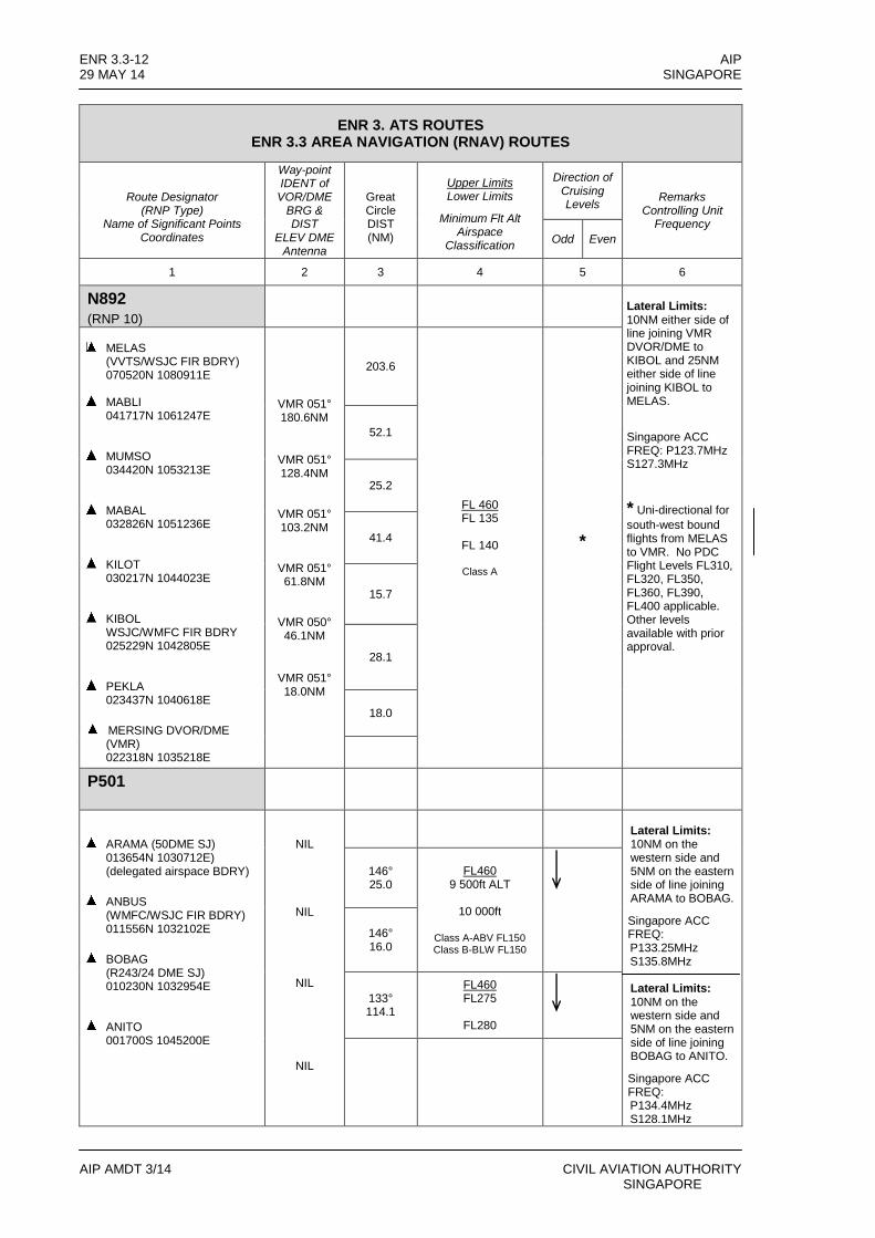
ENR 3.3-12 AIP 29 MAY 14 SINGAPORE
AIP AMDT 3/14 CIVIL AVIATION AUTHORITY SINGAPORE
ENR 3. ATS ROUTES ENR 3.3 AREA NAVIGATION (RNAV) ROUTES
Route Designator
(RNP Type) Name of Significant Points
Coordinates
Way-point IDENT of
VOR/DME BRG & DIST
ELEV DME Antenna
Great Circle DIST (NM)
Upper Limits Lower Limits
Minimum Flt Alt Airspace
Classification
Direction of Cruising Levels
Remarks Controlling Unit
Frequency
Odd Even
1 2 3 4 5 6
N892
(RNP 10)
Lateral Limits: 10NM either side of line joining VMR DVOR/DME to KIBOL and 25NM either side of line joining KIBOL to MELAS.
Singapore ACC FREQ: P123.7MHz S127.3MHz
* Uni-directional for
south-west bound flights from MELAS to VMR. No PDC Flight Levels FL310, FL320, FL350, FL360, FL390, FL400 applicable. Other levels available with prior approval.
MELAS
(VVTS/WSJC FIR BDRY) 070520N 1080911E
MABLI 041717N 1061247E
MUMSO
034420N 1053213E
MABAL
032826N 1051236E
KILOT
030217N 1044023E
KIBOL
WSJC/WMFC FIR BDRY 025229N 1042805E
PEKLA
023437N 1040618E
MERSING DVOR/DME (VMR) 022318N 1035218E
VMR 051° 180.6NM
VMR 051° 128.4NM
VMR 051° 103.2NM
VMR 051° 61.8NM
VMR 050° 46.1NM
VMR 051° 18.0NM
203.6
FL 460 FL 135
FL 140
Class A
*
52.1
25.2
41.4
15.7
28.1
18.0
P501
ARAMA (50DME SJ) 013654N 1030712E) (delegated airspace BDRY)
ANBUS
(WMFC/WSJC FIR BDRY) 011556N 1032102E
BOBAG
(R243/24 DME SJ) 010230N 1032954E
ANITO
001700S 1045200E
NIL
NIL
NIL
NIL
Lateral Limits: 10NM on the western side and 5NM on the eastern side of line joining ARAMA to BOBAG.
Singapore ACC FREQ: P133.25MHz S135.8MHz Lateral Limits: 10NM on the western side and 5NM on the eastern side of line joining BOBAG to ANITO.
Singapore ACC FREQ: P134.4MHz S128.1MHz
146° 25.0
FL460 9 500ft ALT
10 000ft
Class A-ABV FL150 Class B-BLW FL150
146° 16.0
133° 114.1
FL460 FL275
FL280

WSD 15WSD 14
WMD 8
WSD 45WSD 44WSD 13WMD 12WMD 227
WSR 31
WSD4
SINGAPORE FIR
KUALA LUMPUR FIR
TANJUNG PINANGSOUTH ZONE CTR
BATAM ATZ
TENGAHATZ
CHANGI CTR
PAYA LEBARCTR
SELETARCTR
SEMBAWANGATZ
TANJUNG PINANGNORTH ZONE CTR
RAJA HAJI FISABILILLAH ATZ
MNM ALT7 000FT
MNM ALT6 000FT
LAVAX Holding AreaHold Speed : Max IAS 220ktsDirection : LEFT HANDLeg time : 1 minute
REMES Holding AreaHold Speed : Max IAS 220ktsDirection : RIGHT HANDLeg time : 1 minute
269°
089°
168°
348°
CIVIL AVIATION AUTHORITYSINGAPORE
AIP AMDT 3/14
A I PSINGAPORE
ENR 3.6-529 MAY 14
REMES AND LAVAX LOW LEVEL HOLDING AREAS
CHANGES : 01° 09' 50"N104° 27' 14"ESJ R-095/D36
00° 43' 42"N103° 57' 35"ESJ R-168/D30
BED
ATS routes A457 revised.


331°
307°
126°
294°
298°
293°
335° 008°
032°
069°
005°
016°
196°
356°
176° 171°
351° 001°
262°
262°
251°
088°
145°
158°
146°
133°
326°
139°
296°
095°
356°
114°
231°
176°
351°
356°176°
294°
114°265°294°
085°
082°
262°
117°
343°297°
117°
297°
293°
113°
293°
113°
292°
124°
298°
118°
298°
118°
021°
201°
023°
203°
333°
152°
079°
259°
145° 157°
338°
347°
163°
336°082°
319°
082°
153°
343°
306°
295°
115°
333°
319°
275°
296°
308°
112°
0
18
927
0
18
927
0
18
927
0
18
927
0
18
927
0
18
927
0
18
927
AREA CHART - ICAO
B469
4 00020
B469
4 000135 500
7 000 G580
3 00034
259°
WMR229
WSP36 WSD34
WSR38WSP49
WSD35WSD5
WMP228
WSD11
WSD11B
TRANSITCHANNEL
LIGHTAIRCRAFTTRAININGAREA C
LIGHTAIRCRAFTTRAININGAREA B
FIR KU
ALA L
UMPU
RFIR
SING
APOR
E
D61/PU
D30/PU
FIR KUALA LUMPURFIR SINGAPORE
023°
203°
168°
Kluang
WSP3
WSP24
SeletarSembawang
TANJUNG PINANG/Raja Haji Fisabilillah
PARDI FIR BDRY ANITO ANITO
TARO
SSA
LAX
OGAK
OGU
PTA
VBA
LATUK D90/PU ROBMO RAXIM
ATPOMTOMAN
CIVIL AVIATION AUTHORITYSINGAPORE
AIPSINGAPORE
ENR 3.6-729 MAY 14
SINGAPORE/JOHOR AIRSPACE COMPLEXLOW LEVEL HOLDING AREAS
AIP AMDT 3/14
JOHOR BAHRU/Senai Intl
D50/SJ
D45/SJ
D35/SJ
LEGENDTerminal Control Area (TMA)
Control Zone (CTR)
ATS RoutesRoute designator
Distance in nautical milesMinimum flight altitude (ft)/flight level
Oceanic Control Area (OCA)Reporting Point Compulsory
On request
DME distance from SJ NavaidRadio Navigation Aid
NameIdentification and frequency
Geographical CoordinatesElevation of DME site
Collocated VOR and DMERadio Navigation Aids
Compass rose orientated onthe chart to Magnetic North
Restricted Airspace
NOTE :- See flip side for details of designated areas
Area Minimum Altitude (AMA)Each quadrilateral contains an area minimum altitude (AMA) whichrepresents the lowest altitude which may be used under instrumentmeteorological conditions (IMC). The AMA provides a minimum clearance of 1 000 feet (300m) above all terrains and obstacles in the quadrilateral. It is represented in thousands and hundreds of feet above mean sea level.
Example : 3 400 feet
NOTE :- In computing the area minimum altitude, a margin of 200 feet (60m) for vegetation has been added for spot elevations.
D35/SJ
2300-1100SUN/MON to FRI/SAT
EXCEPTPUBLIC HOLIDAYS
2300 - 1100SUN/MON-THU/FRI2300-0500 FRI/SATEXCLUDES WSD11
WMD22412 000ft AMSL
WATERNOTAM
60m
130.2
00°53'48"N103°55'30"E
00°43'42"N103°57'35"E
PEKLA LENDA
NYLONHolding Area
HOSBAHolding Area
MNM ALT7 500ft
MNM
ALT
3 000
ft
BATAM SOUTHHolding Area
MNM ALT5 5
00ft
MNM ALT2 5
00ft
BATAMHolding Area
MNM ALT4 000ft
SAMKOHolding Area
(P - Prohibited, R - Restricted, D - Danger)
3 000ft AMSLTENGAH
ATZ
122.0
DAerodrome Traffic Zone (ATZ)
Name of ATZAirspace Classification
Upper LimitRadio frequency(ies)
Name of CTRAirspace Classification
Upper LimitRadio frequency(ies)
Name of TMAAirspace Classification
Upper LimitLower Limit
Radio frequency(ies)
3 000ft AMSLCHANGI
CTR
118.6mC
124.7
TMAJOHOR
1 500ft AMSLFL 145B
C
34
WSR2D
118.05
46
R325FL 130
54
6 000
A464 26
6 000
A464
A4645 500
35 DME SJ 01°29'54"N103°20'24"E
A5767 000
16
5
W401
6 00018
A4645 500
A5767 000
01°02'30"N103°29'54" E
BOBAG
REMES
D20/SJ
B3384 000
130.2
G580
7 00083
24
BATAM/Hang Nadim
PAPAUNIFORM SINGAPORE
CHANGI
W4017 000
28
34
B469
4 00028
B338
4 00059
B46934
22
30 DME PU 01°55'20"N103°54'05"E
30 DME VTK 01°54'54"N104°01'53"E
HOSBA 01° 19' 48"N104° 24' 18"E
SJ R-079/34 DMEVTK R-103/24 DME
29
21
27
21
18 19
16
NYLON 01°36'57"N104°06'24"E
VTK R-023/13 DME
01°20'37"N103°37'46"E
MASNI
BONSU 01°19'28"N103°37'10"E
01°45'22"N103°54'43"E
AKOMA
POINT ALFA 01°30'33"N103°49'42"E
VTK R-296/13DME 01°27'29"N103°24'50"E
LELIB
PIMOK 01°26'48"N103°20'08"E
01°33'06"N103°05'21"E
REKOP
ARAMA 01°36'54"N103°07'12"E
01°44'12"N102°53'30"E
TOPOR
ANBUS 01°15'56"N103°21'02"E
ASUNA 00°59'48"N103°09'54" E
ANITO PARDI
TEKONG
01°25'24"N103°56'00"E
DVOR/DME 115.1PU. _ _.. _ .
01°24'55"N104°01'20"E
DVOR/DME 116.5VTK _ ._ __...
SAMKO
...01° 13' 21"N
103° 51' 15"E
SINJONSJ
DVOR/DME 113.5._ _ _
60m
B469
4 000/FL 16020
W401
6 00010W401
6 0007
N892
OBDA
BG2
1911
000
51
N891
FL 16
010
6G2
194 0
0030
079°
118.7
CTR
3 000ft AMSLTANJUNG PINANG
NORTH ZONE
6 000ft AMSLTANJUNG PINANG
SOUTH ZONECTR
118.63 000ft AMSL
CHANGICTR
CTR
3 000ft AMSLPAYA LEBAR
3 000ft AMSLSEMBAWANG
ATZ
129.7
122.03 000ft AMSLTENGAH
ATZ
118.45
3 000ft AMSLCTR
KLUANG
PayaLebar
Tengah
GND2 000ft AMSLWMR223
0000 - 1430MON - FRI
NOTAM
L642 32
00°55'11"N104°31'34"E
NDB 385TI _..
3246
19
47
DVOR/DME 116.8 02°23'18"N103°52'18"E
MERSINGVMR _ ..._ __ ..
TANJUNG PINANG
1 500ft AMSLBATAM
ATZC
01°05'30"N103°52'55"E
SJ R-168/8DMEVTK R-203/21 DME
KONG KONG
01°31'20"N103°59'28"E
NDB 286KK _ ._ _ ._ CTRSELETAR
3 000ft AMSL
D
C
B
B
D
WATERWMD12
NOTAM
FL 550WATER
WSD13
NOTAM
FL 550
WATER
WMD8
NOTAM WATER
WSD14
NOTAM
FL 550FL 550
3 500ft AMSLDAYS VMC
WSR3110 000ft AMSL
3 000ft AMSLFL 300
PERM
WMD230
NOTAM2 000ft AMSL9 500ft AMSL
GND2 000ft AMSL
10 000ft AMSLWMD227
WATERDAYS VMC
NOTAM
WATERFL 400
WSD13
NOTAM
SINGAPORE D-ATIS 128.6 APP 120.3
119.3 TWR 118.6 118.25
WSD11A
BATAM
01°08'13"N104°07'57"E
DVOR/DME 116.0BTM ...___ _
Identification of areaNationality letter
Vertical limitsActivation by NOTAM
103°00'E 103°30'E 104°00'E 104°30'E
1°00'N
1°30'N
2°00'N
1°00'N
1°30'N
2°00'N
103°00'E 103°30'E 104°00'E 104°30'E
N502
FL 280105
G579
5 000
M77147
N88451
18
C
W407
4 00021
348°041
°
221°
041°
221°
79
B4695 00063
B4705 00080 74
B3384 000
40
26
128.3C
18
CHANGES :
0
18
927
FOR DEPARTURE AND ARRIVAL ROUTESREFER TO WSSS AD 2-51 TO WSSS AD 2-100
Note :
P501FL 15025
00°48'18"N104°08'06"E
UDONI
00°49'00"N104°18'48"E
IDMAS
TANJUNG PINANG
00°54'13"N104°30'52"E
DVOR/DME 114.8TPG _ ._ _ ._ _.
LIGHTAIRCRAFTTRAININGAREA A
A4646 00044
VAR
27'E
(2010
)
B469
4 00030G579
4 00030
B4703 00030
148
M7746 000
M6356 000
59
M6356 00043
OBDOS
ATS route A457 revised.Kuala Lumpur Terminal Area revised.
B4694 000
10
A224
6 00045
GND2 000ft AMSL
WMR226
2330 - 1030SUN/MON - WED/THU2330 - 0500 THU/FRI
0600 -1030 FRI2330 - 0430 FRI/SAT
MASBO 02°02'48"N102°52'51"E
B4665 00034
REDUK 02°19'57"N103°04'59"E
01°23'06"N102°59'04"E
SUKRI
RNAV 5
Y3396 000
56
Y3396 00038
AROSO 02°08'46"N103°24'21"E
Y3425 00033
RNAV 5
RNAV 5RNAV 5
C3 000ft AMSL
CTRJOHOR122.5
PERM
WMD231
NOTAM2 000ft AMSL9 500ft AMSL
GND2 000ft AMSL
GND3 500ft AMSL
WMR225
2330 - 1030SUN/MON - WED/THU2330 - 0500 THU/FRI
0600 -1030 FRI2330 - 0430 FRI/SAT
M6306 000
57
MESOG 02°01'03"N103°12'40"E
R469
10 00057 P501FL 280114
P501FL 15016
R469
6 00020
118.41 500ft AMSL
RAJA HAJI FISABILILLAHATZ
C
M6306 000
61
G57919
RNAV 5
R3256 00053
W6513 000
21
MITO
SGE
MAS
M6306 00037
R469
6 00023
G5797 00010
.NDB 400 01°30'00"N103°42'42"E
JAYBEEJB _ _ _..._
JOHOR BAHRUDVOR/DME 112.5
01°39'50"N103°39'39"E
VJB ...__ _ _. ._ .
NDB 245JOHOR BAHRU
01°40'30"N103°39'36"E
JR _ _ __...
A5767 000
99
RNAV 5
WSD4GND/WATER
FL 160
00°45'18"N104°02'42"E
BAVAL
SJ ...._ _ _
60m 01° 13' 21"N103° 51' 15"E
DVOR/DME 113.5SINJON
W534
5 00047
19
15
B466FL 13051
31
16
15
5
15
15
5 000
A45725
5 000
A45727
5 000
A45716
SABKA 01°50'51"N103°17'13"E
Speed Control ProceduresSpeed control procedures are in force unless notified otherwise by ATC or ATIS. All arriving turbo-propeller and turbo-jet aircraft are to fly at not faster than indicated air speed 250 knots when within 40nm from Singapore Changi Airport or when at or below 10,000ft except all arriving aircraft into Singapore Changi Airport shall comply with the speed restrictions depicted on the transitions and RNAV STARS. Further speed reductions will be regulated by ATC as necessary. Pilots who may not be able to comply with the speed limits specified above for reasons of flight safety and/or weather should inform ATC and state the speed(s) acceptable.
Airspace Levels ClassificationControlled airspace FL150 to FL460
Surface to FL150AB
Controlled airspace more than 100 nmseaward from the shoreline Lower limit to FL460 A
Control Zone(CTRs) Changi CTR
Paya Lebar CTR
Seletar CTR
Surface to upper limit
Surface to upper limitATZs
Uncontrolled airspace
C
D
C
D
G*
* Aircraft operating in the Light Aircraft Training Areas A, B and C (please refer to page ENR 5.2-1) are required to have continuous two-way communicationswith the appropriate ATS authority.
AIRSPACE CLASSIFICATION IN THE SINGAPORE FIR
10 0 10 20 30 40Nautical Miles
10 0 10 20 30 40 50 60 70 80Kilometers
TMAKUALA LUMPURFL 245
2000 ALT
BC
124.7
TMAJOHOR
1 500ft AMSLFL 245
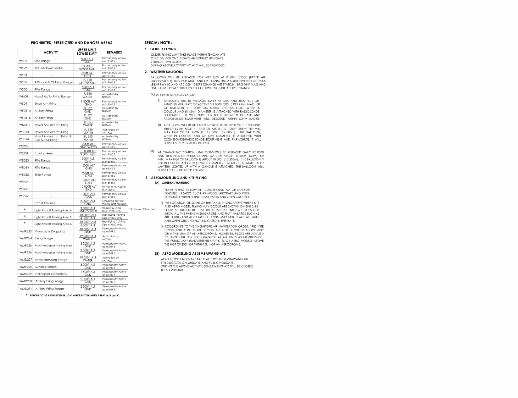
SPECIAL NOTE :-1. GLIDER FLYING
2. WEATHER BALLOONS
GLIDER FLYING MAY TAKE PLACE WITHIN TENGAH ATZBTN 0100/1000 ON SUNDAYS AND PUBLIC HOLIDAYS.VERTICAL LIMIT 3 000ft.DURING ABOVE ACTIVITY NO ATC WILL BE PROVIDED.
BALLOONS WILL BE RELEASED FOR MET OBS AT 0120N 10353E (UPPER AIROBSERVATORY), BRG 244° MAG AND DIST 1.5NM FROM SOUTHERN END OF PAYALEBAR RWY 02 AND AT 0122N 10359E (CHANGI MET STATION), BRG 014° MAG ANDDIST 1.1NM FROM SOUTHERN END OF RWY 02L (SINGAPORE CHANGI). (A)
AT CHANGI MET STATION, BALLOONS WILL BE RELEASED DAILY AT 0530AND 1800 PLUS OR MINUS 15 MIN. RATE OF ASCENT IS 500ft (150m) PERMIN. MAX HGT OF BALLOON IS ABOUT 40 000ft (12 200m). THE BALLOON ISRED IN COLOUR AND 2.1ft (0.7m) IN DIAMETER. AT NIGHT, A SMALL PAPERLANTERN LIGHTED UP WITH A CANDLE IS ATTACHED. THE BALLOON WILLBURST 1 TO 1.5 HR AFTER RELEASE.
(B)
3. AEROMODELLING AND KITE FLYING
i) PILOTS FLYING AT LOW ALTITUDES SHOULD WATCH OUT FORPOSSIBLE HAZARDS SUCH AS MODEL AIRCRAFT AND KITES,ESPECIALLY WHEN FLYING NEAR PARKS AND OPEN GROUND.
ii) THE LOCATION OF SOME OF THE PARKS IN SINGAPORE WHERE KITEAND AERO MODEL FLYING MAY OCCUR ARE SHOWN ON ENR 3.4-5.PILOTS SHOULD NOTE THAT THE CHART AT ENR 3.4-5 DOES NOTSHOW ALL THE PARKS IN SINGAPORE AND THAT HAZARDS SUCH ASKITE FLYING AND AERO MODEL FLYING MAY TAKE PLACE AT PARKSAND OPEN GROUND NOT INDICATED IN ENR 3.4-5.
iii) ACCORDING TO THE SINGAPORE AIR NAVIGATION ORDER, 1985, KITEFLYING AND AERO MODEL FLYING ARE NOT PERMITTED ABOVE 200ftOR WITHIN 5km OF AN AERODROME. HOWEVER, PILOTS ARE ADVISEDTO LOOK OUT FOR SUCH HAZARDS AT ALL TIMES AS MEMBERS OF THE PUBLIC MAY INADVERTENTLY FLY KITES OR AERO MODELS ABOVETHE HGT OF 200ft OR WITHIN 5km OF AN AERODROME.
(B) AERO MODELLING AT SEMBAWANG ATZAERO MODELLING MAY TAKE PLACE WITHIN SEMBAWANG ATZ BTN 0200/0700 ON SUNDAYS AND PUBLIC HOLIDAYS. DURING THE ABOVE ACTIVITY, SEMBAWANG ATZ WILL BE CLOSED TO ALL AIRCRAFT.
(A) GENERAL WARNING
ACTIVITY UPPER LIMITLOWER LIMIT REMARKS
WSD1
WSR2
WSD4
WSD5
WSP3
WMD8
WSD11
WSD11B
WMD12
WSD11A
WSD13
WSD14
WSR31
WSD33
WSP24
Rifle Range 500ft ALTGND
Permanently Activeas in ENR 5
Jet Let-down Sector FL 3003 000ft MSL
Permanently Activeas in ENR 5Permanently Activeas in ENR 5
A/G and G/G Firing Range
- 750ft ALTGNDFL 160
GND/WATERPermanently Activeas in ENR 5
Naval Air/Air Firing Range
Rifle Range 500ft ALTGND
Permanently Activeas in ENR 5
FL 550WATER
Activation by NOTAM
Small Arm Firing 1 300ft ALTGND
Permanently Activeas in ENR 5
Artillery Firing FL 125GND
Activation by NOTAM
Artillery Firing FL 125GND
Activation by NOTAM
Naval Anti-aircraft Firing FL 550WATER
Activation by NOTAM
Naval Anti-aircraft Firing FL 550WATER
Activation by NOTAM
Naval Anti-aircraft Firing &Live Air/Air Firing
FL 550WATER
Permanently Activeas in ENR 5- 800ft ALT
GND/WATER
Activation by NOTAM
Training Area 10 000ft ALT3 500ft MSL
Permanently Activeas in ENR 5
Rifle Range 500ft ALTGND
Permanently Activeas in ENR 5
WSD34 Rifle Range 500ft ALTGND
Permanently Activeas in ENR 5
WSD35 Rifle Range 900ft ALTGND
Permanently Activeas in ENR 5
WSP36 - 1 000ft ALTGND
Permanently Activeas in ENR 5
WSR38 - 10 000ft ALTGND
Permanently Activeas in ENR 5
WSP49 - 300ft ALTGND
Permanently Activeas in ENR 5
Transit Channel 2 000ft ALTGND
Activated only forMilitary acft crossing
Light Aircraft Training Area A 3 500ft ALTGND/*2 000ft
Training & LocalFlts in VMC only*
Light Aircraft Training Area B 10 000ft ALT4 000ft ALT
High Flying TrainingOps in VMC only*
* In Transit Channel
PROHIBITED, RESTRICTED AND DANGER AREAS
BALLOONS WILL BE RELEASED DAILY AT 2330 AND 1000 PLUS OR MINUS 30 MIN. RATE OF ASCENT IS 1 000ft (305m) PER MIN. MAX HGTOF BALLOON 110 000ft (33 500m). THE BALLOON, WHITE INCOLOUR AND 6ft (2m) DIAMETER, IS ATTACHED WITH RADIOSONDE EQUIPMENT. IT WILL BURST 1.5 TO 2 HR AFTER RELEASE ANDRADIOSONDE EQUIPMENT WILL DESCEND WITHIN 60NM RADIUS.
AT UPPER AIR OBSERVATORY,(i)
A BALLOON WILL BE RELEASED BETWEEN 0130 - 0230 ON THE SECOND THU OF EVERY MONTH. RATE OF ASCENT IS 1 000ft (305m) PER MIN.MAX HGT OF BALLOON IS 115 000ft (35 000m). THE BALLOON,WHITE IN COLOUR AND 6ft (2m) DIAMETER, IS ATTACHED WITHOZONESONDE/RADIOSONDE EQUIPMENT AND PARACHUTE. IT WILLBURST 1.5 TO 2 HR AFTER RELEASE.
(ii)
WMR223 Parachute Dropping 10 000ft ALTGND
Permanently Activeas in ENR 5
WMD224 Firing Range 12 000ft ALTWATER
Activation by NOTAM
WMR225 RMAF Helicopter Training Area 3 500ft ALTGND
Permanently Activeas in ENR 5
WMR226 2 000ft ALTGND
Permanently Activeas in ENR 5RMAF Helicopter Training Area
WMD227 Radar Bombing Range 10 000ft ALTWATER
Activation by NOTAM
WMP228 Sultan's Palace 5 000ft ALTGND
Permanently Activeas in ENR 5
WMR229 Helicopter Operations 1 500ft ALTGND
Permanently Activeas in ENR 5
WMD230 Artillery Firing Range 2 000ft ALTGNDPermanently Activeas in ENR 5
WMD231 Artillery Firing Range 2 000ft ALTGNDPermanently Activeas in ENR 5
Light Aircraft Training Area C 10 000ft ALT High Flying TrainingOps in VMC only* 4 000ft ALT
* AEROBATICS IS PROHIBITED IN LIGHT AIRCRAFT TRAINING AREAS A, B and C.
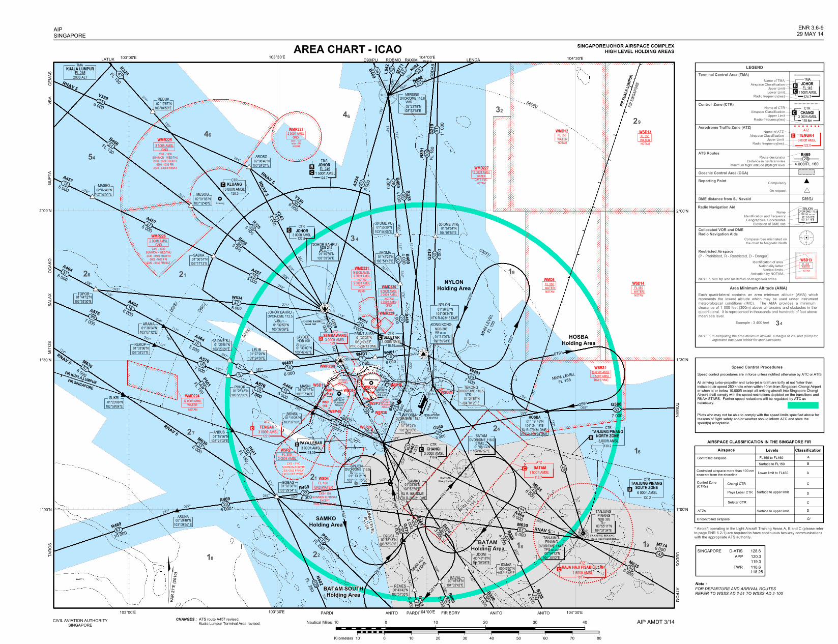
331°
307°
126°
294°
298°
293°
335° 008°
032°
069°
005°
016°
196°
356°
176° 171°
351° 001°
262°
262°
251°
088°
145°
158°
146°
133°
326°
139°
296°
095°
356°
114°
231°
176°
351°
356°176°
294°
114°265°294°
085°
082°
262°
117°
343°297°
117°
297°
293°
113°
293°
113°
292°
124°
298°
118°
298°
118°
021°
201°
023°
203°
333°
152°
079°
259°
145° 157°
338°
347°
163°
336°082°
319°
082°
153°
343°
306°
295°
115°
333°
319°
275°
296°
308°
112°
0
18
927
0
18
927
0
18
927
0
18
927
0
18
927
0
18
927
0
18
927
AREA CHART - ICAO
B469
4 00020
B469
4 00013
5 5007 000 G580
3 00034
259°
WMR229
WSP36WSD34
WSR38WSP49
WSD35WSD5
WMP228
WSD11
WSD11B
TRANSITCHANNEL
LIGHTAIRCRAFTTRAININGAREA A
LIGHTAIRCRAFTTRAININGAREA B
FIR KU
ALA L
UMPU
RFIR
SING
APOR
E
D61/PU
D30/PU
FIR KUALA LUMPURFIR SINGAPORE
203°
Kluang
WSP3
WSP24
SeletarSembawang
TANJUNG PINANG/Raja Haji Fisabilillah
PARDI FIR BDRY ANITO ANITO
TARO
SSA
LAX
OGAK
OGU
PTA
VBA
LATUK D90/PU ROBMO RAXIM
OBDOSTOMAN
CIVIL AVIATION AUTHORITYSINGAPORE
AIPSINGAPORE
ENR 3.6-929 MAY 14
SINGAPORE/JOHOR AIRSPACE COMPLEXHIGH LEVEL HOLDING AREAS
AIP AMDT 3/14
JOHOR BAHRU/Senai Intl
D50/SJ
D45/SJ
D35/SJ
LEGENDTerminal Control Area (TMA)
Control Zone (CTR)
ATS RoutesRoute designator
Distance in nautical milesMinimum flight altitude (ft)/flight level
Oceanic Control Area (OCA)Reporting Point Compulsory
On request
DME distance from SJ NavaidRadio Navigation Aid
NameIdentification and frequency
Geographical CoordinatesElevation of DME site
Collocated VOR and DMERadio Navigation Aids
Compass rose orientated onthe chart to Magnetic North
Restricted Airspace
NOTE :- See flip side for details of designated areas
Area Minimum Altitude (AMA)Each quadrilateral contains an area minimum altitude (AMA) whichrepresents the lowest altitude which may be used under instrumentmeteorological conditions (IMC). The AMA provides a minimum clearance of 1 000 feet (300m) above all terrains and obstacles in the quadrilateral. It is represented in thousands and hundreds of feet above mean sea level.
Example : 3 400 feet
NOTE :- In computing the area minimum altitude, a margin of 200 feet (60m) for vegetation has been added for spot elevations.
D35/SJ
2300-1100SUN/MON to FRI/SAT
EXCEPTPUBLIC HOLIDAYS
2300 - 1100SUN/MON-THU/FRI2300-0500 FRI/SATEXCLUDES WSD11
WMD22412 000ft AMSL
WATERNOTAM
60m
130.2
00°53'48"N103°55'30"E
00°45'18"N104°02'42"E
00°43'42"N103°57'35"E
00°49'00"N104°18'48"E
PEKLA LENDA
NYLONHolding Area
HOSBAHolding Area
MNM LEVELFL 155
MNM
LEVE
LFL
155
BATAM SOUTHHolding Area
MNM ALT5 5
00ft
MNM LEVEL
FL 155
BATAMHolding Area
MNM LEVELFL 155
SAMKOHolding Area
(P - Prohibited, R - Restricted, D - Danger)
3 000ft AMSLTENGAH
ATZ
122.0
DAerodrome Traffic Zone (ATZ)
Name of ATZAirspace Classification
Upper LimitRadio frequency(ies)
Name of CTRAirspace Classification
Upper LimitRadio frequency(ies)
Name of TMAAirspace Classification
Upper LimitLower Limit
Radio frequency(ies)
3 000ft AMSLCHANGI
CTR
118.6mC
124.7
TMAJOHOR
1 500ft AMSLFL 145B
C
34
WSR2D
118.05
46
6 000
A464 26
A5767 000
99
A4645 500
35 DME SJ 01°29'54"N103°20'24"E
A5767 000
16
5
W401
6 00018
A4645 500
A5767 000
01°02'30"N103°29'54" E
BOBAG
BAVALREMES
D20/SJ
IDMAS
B3384 000
130.2
G580
7 00083
24
BATAM/Hang Nadim
SINGAPORECHANGI
W4017 000
28
34
B469
4 00028
B338
4 00059
B46934
R469
10 00057
R469
6 00020
22
30 DME PU 01°55'20"N103°54'05"E
30 DME VTK 01°54'54"N104°01'53"E
HOSBA 01° 19' 48"N104° 24' 18"E
SJ R-079/34 DMEVTK R-103/24 DME
29
21
27
21
18 19
16
BC
NYLON 01°36'57"N104°06'24"E
VTK R-023/13 DME
01°20'37"N103°37'46"E
MASNI
BONSU 01°19'28"N103°37'10"E
POINT ALFA 01°30'33"N103°49'42"E
VTK R-296/13 DME 01°27'29"N103°24'50"E
LELIB
PIMOK 01°26'48"N103°20'08"E
01°33'06"N103°05'21"E
REKOP
ARAMA 01°36'54"N103°07'12"E
01°44'12"N102°53'30"E
TOPOR
ASUNA 00°59'48"N103°09'54" E
ANITO PARDI
NDB 400
TEKONG
01°25'24"N103°56'00"E
DVOR/DME 115.1PU. _ _.. _ .
01°24'55"N104°01'20"E
DVOR/DME 116.5VTK _ ._ __...
SAMKO
...01° 13' 21"N
103° 51' 15"E
SINJONSJ
DVOR/DME 113.5._ _ _
60m
B469
4 000/FL 16020
W401
6 00010W401
6 0007
N892
OBDA
BG2
1911
000
51
N891
FL 16
010
6G2
194 0
0030
079°
W6513 000
21
CTR
3 000ft AMSLTANJUNG PINANG
NORTH ZONE
6 000ft AMSLTANJUNG PINANG
SOUTH ZONECTR
118.4
118.63 000ft AMSL
CHANGICTR
CTR
3 000ft AMSLPAYA LEBAR
3 000ft AMSLSEMBAWANGATZ
129.7
122.03 000ft AMSLTENGAH
ATZ
118.45
3 000ft AMSLCTR
KLUANG124.7
PayaLebar
Tengah
WSD4
GND2 000ft AMSLWMR223
0000 - 1430MON - FRI
NOTAM
L642 32
P501FL 150
3246
19
18
DVOR/DME 116.8 02°23'18"N103°52'18"E
MERSINGVMR _ ..._ __ ..
01°05'30"N103°52'55"E
SJ R-168/8DMEVTK R-203/21 DME
KONG KONG
01°31'20"N103°59'28"E
NDB 286KK _ ._ _ ._ CTRSELETAR
3 000ft AMSL
1 500ft AMSLRAJA HAJI FISABILILLAH
ATZ
D
C
B
B
D
P501FL 280
WATER
WMD12
NOTAM
FL 550WATER
WSD13
NOTAM
FL 550
WATER
WMD8
NOTAM WATER
WSD14
NOTAM
FL 550FL 550
3 500ft AMSLDAYS VMC
WSR3110 000ft AMSL
GND/WATERFL 160
3 000ft AMSLFL 300
GND3 500ft AMSL
WMR225
2330 - 1030SUN/MON - WED/THU2330 - 0500 THU/FRI
0600 -1030 FRI2330 - 0430 FRI/SAT
PERM
WMD231
NOTAM2 000ft AMSL9 500ft AMSL
GND2 000ft AMSL
PERM
WMD230
NOTAM2 000ft AMSL9 500ft AMSL
GND2 000ft AMSL
10 000ft AMSLWMD227
WATERDAYS VMC
NOTAM
WATERFL 400
WSD13
NOTAM
023°
041°
168°
PAPAUNIFORM
C
G579
5 000
103°00'E 103°30'E 104°00'E 104°30'E
1°00'N
1°30'N
2°00'N
1°00'N
1°30'N
2°00'N
103°00'E 103°30'E 104°00'E 104°30'E
01°30'00"N103°42'42"E
JAYBEE.
WSD11A
Identification of areaNationality letter
Vertical limitsActivation by NOTAM
N502
FL 280105
114
N88451
18M77147
G579
4 00030
221°
B4705 0008079
041°
40
221°
74B3384 000
CHANGES :
0
18
927
60m
16
P501FL 15025
00°48'18"N104°08'06"E
UDONI
TANJUNG PINANG
00°54'13"N104°30'52"E
DVOR/DME 114.8TPG _ ._ _ ._ _.
10 0 10 20 30 40Nautical Miles
10 0 10 20 30 40 50 60 70 80Kilometers
LIGHTAIRCRAFTTRAININGAREA C
148
W407
4 00021
A4646 000
44
VAR
27'E
(2010
)
348°
C
118.71 500ft AMSL
BATAMATZ
C
B469
4 00030
B4695 00062
26
TANJUNG PINANG
00°55'11"N104°31'34"E
NDB 385TI _..
6 000
M63559
M7746 000
6 000
M63543
ATPOM
SINJON
01° 13' 21"N103° 51' 15"E
DVOR/DME 113.5SJ ...._ _ _
RNAV 5
RNAV 5RNAV 5
GND2 000ft AMSL
WMR226
2330 - 1030SUN/MON - WED/THU2330 - 0500 THU/FRI
0600 -1030 FRI2330 - 0430 FRI/SAT
RNAV 5
ANBUS 01°15'56"N103°21'02"E
R469
6 000
G57919
G5797 00010
JB _ _ __ ...
A224
6 00045
01°45'22"N103°54'43"E
AKOMA B4694 000
10
MASBO 02°02'48"N102°52'51"E MESOG
02°01'03"N103°12'40"E
REDUK 02°19'57"N103°04'59"E
AROSO 02°08'46"N103°24'21"E
128.3C
Y3396 000
56
R325FL 13047
Y3396 00038
R3256 00053
JOHOR BAHRUDVOR/DME 112.5
VJB...__ _ _. ._ . 01°39'50"N103°39'39"E
NDB 245JOHOR BAHRU 01°40'30"N103°39'36"E
JR _ _ __...
5 000
Y3425 00033
01°23'06"N102°59'04"E
SUKRI
57M630
6 000
37M6306 000
M6306 000
61
B4703 00030
RNAV 5
RNAV 5
BATAM
01°08'13"N104°07'57"E
DVOR/DME 116.0BTM ...___ _
GEMA
SMI
TOS
ATS route A457 revised.Kuala Lumpur Terminal Area revised.
W534
A5767 000
47
19
15
A457
TMAJOHOR
1 500ft AMSLFL 245
B4665 00034
31
6 000
A46416
15
5
15
15
B466FL 13051
5 00016
5 000
A45727
255 000
A457
SABKA 01°50'51"N103°17'13"E
3 000ft AMSLCTR
JOHOR122.5
C
23
Speed Control ProceduresSpeed control procedures are in force unless notified otherwise by ATC or ATIS. All arriving turbo-propeller and turbo-jet aircraft are to fly at not faster than indicated air speed 250 knots when within 40nm from Singapore Changi Airport or when at or below 10,000ft except all arriving aircraft into Singapore Changi Airport shall comply with the speed restrictions depicted on the transitions and RNAV STARS. Further speed reductions will be regulated by ATC as necessary. Pilots who may not be able to comply with the speed limits specified above for reasons of flight safety and/or weather should inform ATC and state the speed(s) acceptable.
Airspace Levels ClassificationControlled airspace FL150 to FL460
Surface to FL150AB
Controlled airspace more than 100 nmseaward from the shoreline Lower limit to FL460 A
Control Zone(CTRs) Changi CTR
Paya Lebar CTR
Seletar CTR
Surface to upper limit
Surface to upper limitATZs
Uncontrolled airspace
C
D
C
D
G*
* Aircraft operating in the Light Aircraft Training Areas A, B and C (please refer to page ENR 5.2-1) are required to have continuous two-way communicationswith the appropriate ATS authority.
AIRSPACE CLASSIFICATION IN THE SINGAPORE FIR
SINGAPORE D-ATIS 128.6 APP 120.3
119.3 TWR 118.6 118.25
FOR DEPARTURE AND ARRIVAL ROUTESREFER TO WSSS AD 2-51 TO WSSS AD 2-100
Note :
54
TMAKUALA LUMPURFL 2452000 ALT

SPECIAL NOTE :-1. GLIDER FLYING
2. WEATHER BALLOONS
GLIDER FLYING MAY TAKE PLACE WITHIN TENGAH ATZBTN 0100/1000 ON SUNDAYS AND PUBLIC HOLIDAYS.VERTICAL LIMIT 3 000ft.DURING ABOVE ACTIVITY NO ATC WILL BE PROVIDED.
BALLOONS WILL BE RELEASED FOR MET OBS AT 0120N 10353E (UPPER AIROBSERVATORY), BRG 244° MAG AND DIST 1.5NM FROM SOUTHERN END OF PAYALEBAR RWY 02 AND AT 0122N 10359E (CHANGI MET STATION), BRG 014° MAG ANDDIST 1.1NM FROM SOUTHERN END OF RWY 02L (SINGAPORE CHANGI). (A)
AT CHANGI MET STATION, BALLOONS WILL BE RELEASED DAILY AT 0530AND 1800 PLUS OR MINUS 15 MIN. RATE OF ASCENT IS 500ft (150m) PERMIN. MAX HGT OF BALLOON IS ABOUT 40 000ft (12 200m). THE BALLOON ISRED IN COLOUR AND 2.1ft (0.7m) IN DIAMETER. AT NIGHT, A SMALL PAPERLANTERN LIGHTED UP WITH A CANDLE IS ATTACHED. THE BALLOON WILLBURST 1 TO 1.5 HR AFTER RELEASE.
(B)
3. AEROMODELLING AND KITE FLYING
i) PILOTS FLYING AT LOW ALTITUDES SHOULD WATCH OUT FORPOSSIBLE HAZARDS SUCH AS MODEL AIRCRAFT AND KITES,ESPECIALLY WHEN FLYING NEAR PARKS AND OPEN GROUND.
ii) THE LOCATION OF SOME OF THE PARKS IN SINGAPORE WHERE KITEAND AERO MODEL FLYING MAY OCCUR ARE SHOWN ON ENR 3.4-5.PILOTS SHOULD NOTE THAT THE CHART AT ENR 3.4-5 DOES NOTSHOW ALL THE PARKS IN SINGAPORE AND THAT HAZARDS SUCH ASKITE FLYING AND AERO MODEL FLYING MAY TAKE PLACE AT PARKSAND OPEN GROUND NOT INDICATED IN ENR 3.4-5.
iii) ACCORDING TO THE SINGAPORE AIR NAVIGATION ORDER, 1985, KITEFLYING AND AERO MODEL FLYING ARE NOT PERMITTED ABOVE 200ftOR WITHIN 5km OF AN AERODROME. HOWEVER, PILOTS ARE ADVISEDTO LOOK OUT FOR SUCH HAZARDS AT ALL TIMES AS MEMBERS OF THE PUBLIC MAY INADVERTENTLY FLY KITES OR AERO MODELS ABOVETHE HGT OF 200ft OR WITHIN 5km OF AN AERODROME.
(B) AERO MODELLING AT SEMBAWANG ATZAERO MODELLING MAY TAKE PLACE WITHIN SEMBAWANG ATZ BTN 0200/0700 ON SUNDAYS AND PUBLIC HOLIDAYS. DURING THE ABOVE ACTIVITY, SEMBAWANG ATZ WILL BE CLOSED TO ALL AIRCRAFT.
(A) GENERAL WARNING
ACTIVITY UPPER LIMITLOWER LIMIT REMARKS
WSD1
WSR2
WSD4
WSD5
WSP3
WMD8
WSD11
WSD11B
WMD12
WSD11A
WSD13
WSD14
WSR31
WSD33
WSP24
Rifle Range 500ft ALTGND
Permanently Activeas in ENR 5
Jet Let-down Sector FL 3003 000ft MSL
Permanently Activeas in ENR 5Permanently Activeas in ENR 5
A/G and G/G Firing Range
- 750ft ALTGNDFL 160
GND/WATERPermanently Activeas in ENR 5
Naval Air/Air Firing Range
Rifle Range 500ft ALTGND
Permanently Activeas in ENR 5
FL 550WATER
Activation by NOTAM
Small Arm Firing 1 300ft ALTGND
Permanently Activeas in ENR 5
Artillery Firing FL 125GND
Activation by NOTAM
Artillery Firing FL 125GND
Activation by NOTAM
Naval Anti-aircraft Firing FL 550WATER
Activation by NOTAM
Naval Anti-aircraft Firing FL 550WATER
Activation by NOTAM
Naval Anti-aircraft Firing &Live Air/Air Firing
FL 550WATER
Permanently Activeas in ENR 5- 800ft ALT
GND/WATER
Activation by NOTAM
Training Area 10 000ft ALT3 500ft MSL
Permanently Activeas in ENR 5
Rifle Range 500ft ALTGND
Permanently Activeas in ENR 5
WSD34 Rifle Range 500ft ALTGND
Permanently Activeas in ENR 5
WSD35 Rifle Range 900ft ALTGND
Permanently Activeas in ENR 5
WSP36 - 1 000ft ALTGND
Permanently Activeas in ENR 5
WSR38 - 10 000ft ALTGND
Permanently Activeas in ENR 5
WSP49 - 300ft ALTGND
Permanently Activeas in ENR 5
Transit Channel 2 000ft ALTGND
Activated only forMilitary acft crossing
Light Aircraft Training Area A 3 500ft ALTGND/*2 000ft
Training & LocalFlts in VMC only*
Light Aircraft Training Area B 10 000ft ALT4 000ft ALT
High Flying TrainingOps in VMC only*
* In Transit Channel
PROHIBITED, RESTRICTED AND DANGER AREAS
BALLOONS WILL BE RELEASED DAILY AT 2330 AND 1000 PLUS OR MINUS 30 MIN. RATE OF ASCENT IS 1 000ft (305m) PER MIN. MAX HGTOF BALLOON 110 000ft (33 500m). THE BALLOON, WHITE INCOLOUR AND 6ft (2m) DIAMETER, IS ATTACHED WITH RADIOSONDE EQUIPMENT. IT WILL BURST 1.5 TO 2 HR AFTER RELEASE ANDRADIOSONDE EQUIPMENT WILL DESCEND WITHIN 60NM RADIUS.
AT UPPER AIR OBSERVATORY,(i)
A BALLOON WILL BE RELEASED BETWEEN 0130 - 0230 ON THE SECOND THU OF EVERY MONTH. RATE OF ASCENT IS 1 000ft (305m) PER MIN.MAX HGT OF BALLOON IS 115 000ft (35 000m). THE BALLOON,WHITE IN COLOUR AND 6ft (2m) DIAMETER, IS ATTACHED WITHOZONESONDE/RADIOSONDE EQUIPMENT AND PARACHUTE. IT WILLBURST 1.5 TO 2 HR AFTER RELEASE.
(ii)
WMR223 Parachute Dropping 10 000ft ALTGND
Permanently Activeas in ENR 5
WMD224 Firing Range 12 000ft ALTWATER
Activation by NOTAM
WMR225 RMAF Helicopter Training Area 3 500ft ALTGND
Permanently Activeas in ENR 5
WMR226 2 000ft ALTGND
Permanently Activeas in ENR 5RMAF Helicopter Training Area
WMD227 Radar Bombing Range 10 000ft ALTWATER
Activation by NOTAM
WMP228 Sultan's Palace 5 000ft ALTGND
Permanently Activeas in ENR 5
WMR229 Helicopter Operations 1 500ft ALTGND
Permanently Activeas in ENR 5
WMD230 Artillery Firing Range 2 000ft ALTGNDPermanently Activeas in ENR 5
WMD231 Artillery Firing Range 2 000ft ALTGNDPermanently Activeas in ENR 5
Light Aircraft Training Area C 10 000ft ALT High Flying TrainingOps in VMC only* 4 000ft ALT
* AEROBATICS IS PROHIBITED IN LIGHT AIRCRAFT TRAINING AREAS A, B and C.

G334G334
L642
M761
M771N8
91
N892
N884
B469
B469R325
Y339
A457
W534
M630
A576W401
W401W401
W651
G579
G579 B469
W407 G580
A464
R469
B338
G580
A224
B469B338
N891
G21 9
G579B469
B470
L625
G580
N884
G584
M761
P501
P501
Y336Y335Y334Y333
Y332
Y336
A464
M635
B466
Y342
Y339
Y343 VPT
VMR
VJBJR
JB
PU
SJ
KK
VTK
90 DME PUUKASA
BIKTA
ROBMO
NIVAM
OBDAB
MANIMKETOD
RAXIM
OTLON
KILOT
KIBOL
PEKLA
LIPRO
LENDA
BUNTO
HOSBATOMAN
AROSO
MASBOMESOG
TOPOR
ARAMA
SUKRI
30 DMESJ
PIMOK
LELIB
POINT ALFA
BOBAGSAMKO
30 DMEPU
AKOMA20 DME PU
30 DME VTK
BONSUMASNI
ANBUS
PADLI
BED
REDUK
REKOP
SABKA
2230 - 1030SUN/MON-FRI/SAT
2330 - 1030SUN/MON-WED/THU2330-0500 THU/FRI
0600-1030 FRI2330-0430 FRI/SAT
2330 - 1030SUN/MON-WED/THU2330-0500 THU/FRI
0600-1030 FRI2330-0430 FRI/SAT
0000 - 1430MON-FRINOTAM
DAYS VMCNOTAM
PERM
PERM
NOTAM
NOTAM
0100 - 0830MON-FRI
NOTAM
DAYS VMC
NOTAM
NOTAM
NOTAM NOTAM NOTAM NOTAM
NOTAM NOTAM NOTAM
10 000ft ALT3 000ft ALT
10 000ft ALTGND
3 500ft ALTGND
2 000ft ALTGND
12 000ft ALTWATER
9 500ft ALT2 000ft ALT
9 500ft ALT2 000ft ALT
2 000ft ALTGND
2 000ft ALTGND
1 500ft ALTGND
10 000ft ALTWATER
2 000ft ALTWATER
2 000ft ALTWATER
10 000ft ALT3 500ft ALT
FL 550WATER
FL 550WATER
FL 550WATER
FL 550WATER
FL 550WATER
FL 550WATER
FL 550WATER
WMR104
WMR225
WMR226
WMR223
WMD231
WMD230
WMR229
WMD224WSR31
WMD227
WMD21
WSD20
WMD12 WSD13 WSD44 WSD45
WMD8 WSD14 WSD15
(13 DME VTK)
SOUTH CHINA SEA
ANAMBASISLANDSGROUP
AREA OF RESPONSIBILITY OFKUALA LUMPUR ACC
SOUTHERN BOUNDARY OF SOUTH CHINA SEA CORRIDOR
103° 00'E 103° 30' 104° 00' 104° 30' 105° 00' 105° 30' 106° 00'
03°00'N
02°30'
02°00'
01°30'
103° 00'E 103° 30' 104° 00' 104° 30' 105° 00' 105° 30' 106° 00'
03°00'N
02°30'
02°00'
01°30'
PROHIBITED, RESTRICTED AND DANGER AREAS - CHART 1
ENR 5.1-729 MAY 14
AIP AMDT 3/14CIVIL AVIATION AUTHORITYSINGAPORE
AIPSINGAPORE
CHANGES : New RNAV route Y343 added.ATS route A457 revised.
For complete informationsee chart ENR 5.1-9.
LEGENDPERMANENTLY ACTIVE AS IN ENR 5ACTIVATION BY NOTAM
FL 150GND/WATER
FL 200GND/WATER
SINGAPOREFIR
KUALA LUMPURFIR

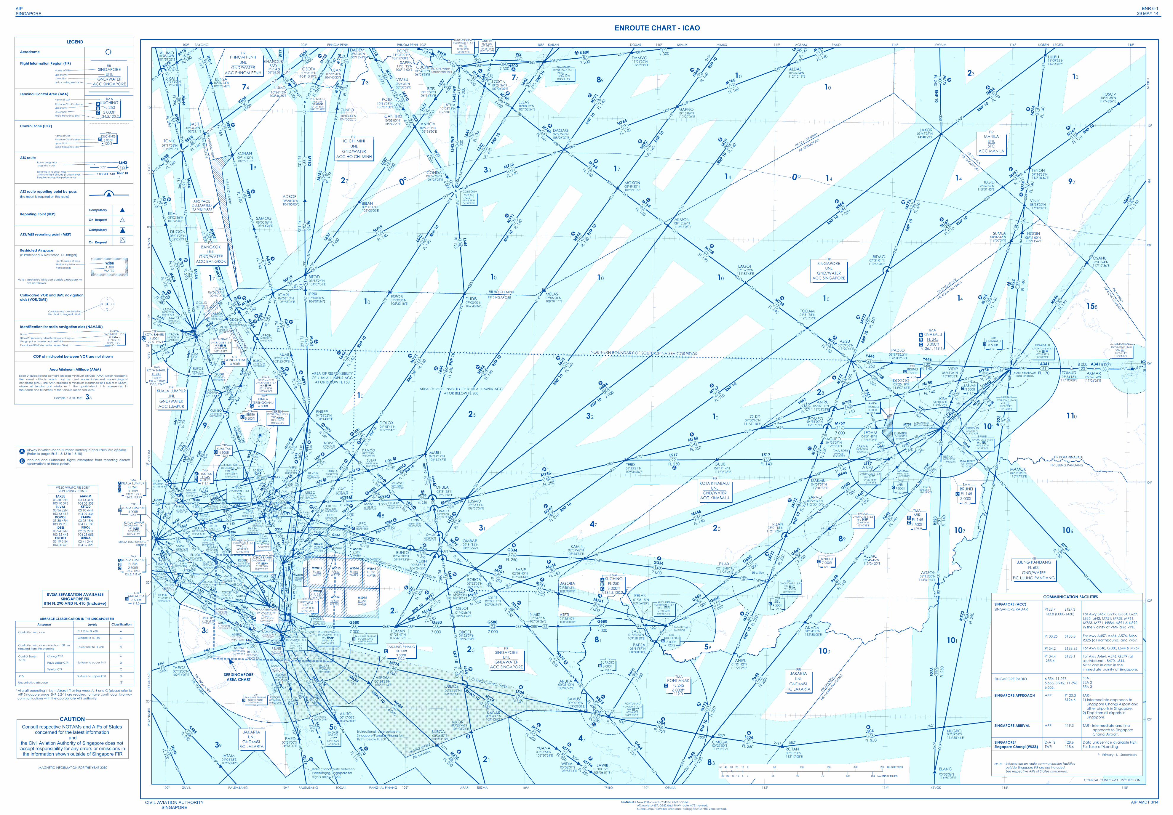
WMD21WSD20
WMD12 WSD13 WSD44 WSD45
WSD15WSD14WMD8
WMD227
0
18
27 9
0
18
27 9
0
18
27 9
0
18
27 9
0
18
27 9
0
18
27 9
0
18
27 9
0
18
27 9
0
18
27 9
0
18
27 9
0
18
27 9
0
18
27 9
0
18
27 9
0
18
27 9
0
18
27 9
0
18
27 9
0
18
27 9
0
18
27 9
0
18
27 9
0
18
27 9
0
18
27 9
0
18
27 9
0
18
27 9
0
18
27 9
2 000ftWATER 2 000ft
WATER
FL 550WATER
FL 550WATER
FL 550WATER
FL 550WATER
FL 550WATER
FL 550WATER
FL 550WATER
10 000ftWATER
IDSEL
MANIMEGOLO
LENDA
RAXIMKETOD
DOVOLBUVAL
OMBAP
BIDAG
ANIPU
RIZAN
AGUPO
BOMPO
ANIRU
OPULA
ONAPO
OMLIV
OLSAM
OBLOT
OBGET
WIDIA
YUANAOMEGA
BENSA
SALIL
RELAK
BUNTO
LEDAM
TOSOV
LULBU
TENON
MAPNO
ALDAS
PANDIAGSAMMIMUX
DAMVO
ELSAS
DAGAG
MOXON
NODINSUMLA
VINIK
LAXOR
TEGID
TODAM
LAGOT
AKMON
MELASDUDIS
LATHA
SAPEN
POPET
BITIS
OSANU
VIMAG
AGSON
MAMOK
BUTAX
DARMU
UKIBA
VIDIP
DOGOG
ASISU
OLKIT
KADMO
PILAX
OKADA
KIBON
OSUKA
TERIX
ARUPA
KIKORKADAR
OBDOS
TOMAN
NIMIX ATETI
KAMIN
AGOBA
ESPIT
SABIP
BOBOB
VERIN
ANITO
LUSMO
LEBIN
ELGOR
MABLI
VISAT
PAPSA
LOSON
KIBOL
PARDI
JATAM
TAROS
SUKRI
SAMKO
HOSBAREKOP
ARAMA
D90PU LIPRO
KILOT
OTLON
URIGO
MABAL
UGPEK
MUMSO
DUBSATAXUL
VEPLISUSAR
DAMOGNOPAT
DOLOX
ENREP
IKUKOIKUMI
PASVA
KADAX
VENLI
IGARI ESPOBIPRIX
BITOD
SAMOGTIKAL
SUWAN
BIBANADBOP
XONAN
OSOTASIHANOUKKOS
GOLUD
NIVAM
ELANG
ALUMO
KISAN
ANBUS
PADLI
ABTOK
DUGON
MATBA
BASIT
PADLO
GULIB
TIDAR
ODONO
UPRON
SURGA
BAVUS
ATPOM
ROTAN
NUGRO
LAWIB
REPOV
ASUNA
TUNPO
NUMDI
ANHOA
CONDA
DADEM
CAN THO
N646
M767
B219
M772
G334
R223
B469
L644
M635
M522
M761
M759
M765
G460
Y331
R455
G464
G580
P648
N500
Y445
N891
M753
G219
B338
L629
N884
G466
W1
M768
M646
L637
L643
/W9
N892
G584
R208
N875
W533
A224
W651
M771
R588
M768
M751
M768
M768
N892
M768
M753
M771
N891
M772
L629
M772
M768
N875
N500
N891
L625
B469
G580
G579
N500
M768
L644
L635
G584
M772
G580
M772
M522
M646
R469
P648
R223
A341
M761
G582 G460
M765
N875
M768
M758
L625
B470
M635
R208
A341
N884
L643
/W9
N892
N875
N891
N500
M774
L642
M753
L635
N884
G580
M774
M765
M646
M771
M758
G334
L637
M768
A464
P648
M761
M768
A464
L642
M522
M754
B592
L637
M751
G334
M763
A457
L625
N892
R469
L644
G334
M761
G582
L625
M772
M767
P648
N891
N884
B463
M771
B338
M767
N500
M646M771
M646
M758L629
W533
R325
R208
N891
L642
M646
G580
M761
N891
R469
B469
G334
B469
R588
M763
M767
A334
M754
G334
M765
N892
N891
R325
N891
M771
N892
R468
M646
M626
G466
B469
M768
G580
M767
M759
A464
M774
M635
M765
M774
M771
B466
M758
M765
M771
P648
G582
M765
G580M630
N875
B470
G460
N892
M758
M646
L642
W533
M768
A585
L644
L625
M761
P648
R208
M754
M772
M753G579
N884
M767
L635
M772
M758
N892
M646
M758
L625
G466
M754
A457
N892
R208
N875
L642
Y342
M765
M758
L644
N875
L642
M754
R468
N884
G580
B469
M772
R588
R575R575
M755
M755
M755
L644
L644
P501
P501
N502
R579
Y332
Y333
Y334
Y335
Y336
M644M644
M644
Y336
M770
A341
R588
R588
051°
231°
Y447
Y446Y446
L504
L517 L517L517
W2
W540/M751
M904
M904
M904
M904
M904
M774
L504
L504L504
L504
G460
G460
W534
B466
Y340
Y341 Y339
Y339A576
M630
R213
M510
W23
M510
W23
R334
L637
W17
Y346
Y346
Y345
Y349
Y344
Y343
W540/M751
SAKMA
ALEMO
SARVO
UDERO
DAKUS
UKASA
KIMAT
REMES
BAVAL
UDONI
IDMAS
BOBAG
TOPOR
OGAKOMASBOBATAR
DUMOK
MESOG
GEMASSAPATSAROX
LATUKISTAN
PIBOS ADNUT
MATSU
PULIP
ANSON
GUNBO
D80/VJND50/BRU
RUPOS
TMA BDRY
VMK
DOSIK
TOMUD
CUCHI
TMA BDRY
GUGIT
LOSLO
TONIK
ANOBO
SIRAT
GUPTA
MITOS
REDUK
AROSO
AKMAR
VIMBU
POTIX
LASOB
SABKA
ENKOL
A
A
A A
A
A
A
A
A
A
A
A
A
A
A
A
A
A
A
A
A
A
AA
A
A
A
A
A
A
A
A
A A
A A
A
A A
A
A
A
A
A
A
A
A
A
A
AA
A
AA
A
A
A
AA
A
A
A
AA
A
A A
AA
A
A
AAA
AA
A
A
A
A
AA
A
A
A
A
A
A
A
A
A
A
A
B
A
A
A
A
B
A
A
A
A
AA
A
A
A
A
A
A
A
A
A
A
AAA
RNP 1
0
RNP 1
0
RNP 1
0
RNP 1
0
RNP 1
0RN
P 10
RNP 1
0
RNP 1
0
RNP 1
0
RNP 1
0
RNP 1
0
RNP 1
0
RNP 1
0
RNP 1
0
RNP 1
0
RNP 10
RNP 10
RNP 1
0
RNP 10
RNP 10
RNP 10
RNP 10
RNP 10
RNP 10
RNP 10
RNP 10RNP 10
RNP 10
RNP 10
RNP 10
RNP 1
0
RNP 1
0
RNP 1
0
RNP 1
0
RNP 1
0
RNAV 5
RNAV 10
RNP 10
RNAV 10
10°35.4'N103°38.5E
10°26'24"N102°26'42"E
09°14'42"N102°50'18"E
10°33'07"N104°15'49"E
08°00'06"N103°14'24"E
08°30'00"N104°05'00"E 08°30'00"N
105°00'00"E
07°15'24"N104°07'06"E
07°00'00"N104°07'54"E
06°56'10"N103°35'06"E 07°00'00"N
105°33'18"E
06°28'48"N102°49'00"E
06°17'06"N102°16'36"E
06°16'02"N102°15'42"E
08°02'36"N101°45'00"E
08°03'12"N101°20'30"E
06°15'29"N102°04'31"E
05°32'14"N102°12'33"E
05°45'12"N103°13'24"E
05°53'38"N103°55'09"E
04°51'39"N102°50'02"E
03°40'24"N101°53'48"E
03°26'26"N102°06'04"E
03°20'32"N102°03'14"E
03°21'33"N102°37'38"E
03°09'44"N102°21'02"E
02°55'16"N102°33'46"E03°00'55"N
102°28'53"E
02°48'02"N102°40'19"E
02°32'00"N102°31'50"E
02°32'10"N102°02'30"E
02°18'10"N102°00'07"E
02°10'00"N102°05'13"E
01°58'30"N102°06'10"E
01°58'50"N102°26'08"E
02°02'48"N102°52'51"E
01°44'12"N102°53'30"E
01°36'54"N103°07'12"E
01°33'06"N103°05'21"E
02°19'57"N103°04'59"E
01°02'30"N103°29'54"E
01°23'06"N102°59'04"E
00°42'00"N102°16'07"E
01°05'30"N103°52'55"E
00°43'42"N103°57'35"E
00°45'18"N104°02'42"E 00°49'00"N
104°18'48"E
00°16'23"N104°03'00"E
01°19'48"N104°24'18"E
00°12'30"S104°24'24"E
00°34'00"S104°13'00"E
00°17'00"S104°52'00"E
00°06'47"S107°43'42"E
00°25'03"N106°55'51"E
00°22'44"S107°05'24"E
01°21'47"N105°47'17"E 01°23'07"N
106°45'31"E
02°52'45"N103°39'01"E
02°53'41"N103°38'36"E
03°52'23"N104°05'42"E
03°36'47"N104°07'52"E
03°25'05"N104°06'47"E
04°23'13"N104°47'56"E
04°12'25"N105°00'14"E
03°58'48"N105°15'47"E
03°49'01"N104°45'40"E
03°26'20"N104°31'34"E
04°52'23"N104°14'42"E
04°48'41"N105°22'47"E
03°44'20"N105°32'13"E
03°28'26"N105°12'36"E
03°30'14"N105°48'18"E03°07'52"N
104°20'06"E
03°02'17"N104°40'23"E
02°53'42"N105°11'28"E
02°40'08"N105°59'53"E
02°33'32"N106°24'25"E
02°31'16"N106°32'42"E
03°33'41"N106°55'34"E
03°31'55"N106°21'18"E
03°14'38"N106°06'04"E
02°55'12"N106°28'12"E
03°21'16"N106°23'18"E
02°22'06"N107°05'58"E
02°00'59"N106°38'24"E
01°42'56"N106°41'47"E
02°00'11"N107°26'24"E
01°24'52"N107°59'26"E 01°25'40"N
108°30'00"E
01°58'42"N108°30'00"E
02°34'42"N108°55'36"E
00°31'40"N108°48'46"E
00°37'54"S108°30'54"E
04°17'17"N106°12'47"E
07°00'00"N106°48'34"E
02°09'40"N107°50'44"E
07°05'20"N108°09'11"E
10°15'59"N106°14'54"E
10°08'18"N106°38'01"E
10°29'36"N107°04'32"E
10°08'12"N107°32'54"E
11°01'12"N106°11'00"E
09°27'48"N108°26'30"E
11°06'30"N109°32'42"E
10°13'06"N110°20'06"E
08°49'30"N109°21'18"E
08°12'56"N110°13'08"E
07°16'32"N111°32'43"E
06°31'38"N112°35'36"E
05°59'06"N113°20'46"E
05°09'11"N113°03'26"E
07°31'01"N113°55'44"E
05°25'18"N114°07'42"E
04°51'49"N113°47'06"E
04°51'00"N112°57'09"E
04°35'37"N112°52'00"E
04°01'39"N112°40'36"E
05°41'06"N115°10'03"E
05°18'49"N115°02'09"E
04°50'10"N111°51'18"E
04°34'37"N114°06'07"E
04°12'15"N114°08'08"E
04°51'05"N115°12'40"E
03°55'50"N114°29'40"E
03°26'30"N112°50'10"E
02°45'45"N113°34'20"E
01°34'00"N112°38'00"E
02°15'00"N114°51'24"E
03°01'15"N112°17'24"E
02°18'48"N111°23'24"E
01°35'18"N109°54'30"E
01°28'24"N109°58'30"E
01°11'57"N110°08'30"E
01°01'42"N111°27'25"E
00°23'00"S111°07'12"E
04°26'13"N114°52'32"E 04°19'23"N
115°30'48"E
04°05'06"N115°47'12"E
08°02'42"N116°00'54"E 08°11'00"N
116°11'42"E
07°41'24"N117°17'36"E
08°38'30"N116°13'48"E
08°56'56"N115°51'43"E
09°49'37"N114°48'29"E
09°16'36"N116°18'46"E
10°21'38"N117°48'07"E
11°09'52"N116°33'09"E
11°38'06"N114°00'00"E
10°56'54"N112°12'18"E
04°24'28"N113°39'55"E
04°15'21"N109°34'56"E
01°04'18"S102°53'42"E
00°52'31"S108°53'14"E
00°55'36"S114°50'03"E
180°
190°
001°
181°
137°
316°
234°
234°
008°
188°
053°
358°
036°
215°
11°06'00"N105°57'00"E10°45'54"N
101°51'23"E
09°17'36"N101°59'07"E
10°32'20"N104°40'30"E
11°03'23"N102°14'42"E
10°03'44"N104°35'22"E
01°15'56"N103°21'02"E
02°15'29"N102°14'45"E
01°45'52"N102°02'37"E
03°09'18"N103°31'33"E
06°18'18"N102°17'44"E
08°01'25"N102°05'49"E
06°14'56"N102°13'39"E
05°54'13"N117°03'08"E
09°34.8'N102°21.1'E
10°54'11"N106°26'56"E
05°57'52.3"N114°01'26.5"E
02°22'22"N102°18'16"E
04°19'38"N113°19'37"E
04°17'14"N111°06'33"E
05°32'33"N102°33'46"E
05°43'21"N101°17'13"E
06°36'14"N103°01'29"E
06°09'03"N103°20'40"E
06°52'30"N102°50'00"E
10°34'50"N101°36'40"E
00°36'57"S106°31'19"E
00°00'00"S109°00'00"E
00°24'25"N105°21'14"E
00°31'51"S112°17'08"E
00°09'51"S114°58'44"E
01°00'55"S109°06'01"E
02°09'48"N102°38'30"E
00°59'48"N103°09'54"E
00°48'18"N104°08'06"E
05°54'14"N117°26'21"E
10°26'43"N103°46'35"E
09°47'14"N105°54'30"E
08°57'26"N106°28'29"E
10°53'44"N105°13'41"E
10°24'33"N105°30'52"E
10°14'05"N105°37'00"E
10°05'00"N105°42'20"E
05°12'19"N102°41'53"E
FL 70
FL 210
6 000
FL 14
0
FL 110 FL 250
FL 170
9 000
10 50
0
FL 100
FL 270
7 300
7 000
FL 250
FL 165
FL 160
10 000
FL 130
4 000
7 500
5 500
FL 250
FL 14
0
FL 250
5 000
FL 250
5 000
FL 130
FL 140
5 000
FL 140
4 000
FL 140
FL 140
FL 250
FL 210
7 000
FL 250
FL 250
FL 140
6 000
7 000 7 000
FL 140
FL 25
0
FL 140
FL 250
FL 14
0
7 000
FL 135
7 000
6 000
FL 140
FL 140
FL 250
7 000
FL 140
FL 25
0
FL 250
FL 140
FL 250
FL 140
FL 25
0
7 000
FL 140
7 000
FL 140
FL 250
FL 250
FL 16
0
FL 210
FL 140
FL 250
FL 170
FL 100
FL 140
FL 135
FL 25
0
7 000
FL 250
FL 16
0
FL 140
FL 250
7 000
7 000
FL 250
4 000
6 000
FL 250
11 000
FL 140
FL 140
FL 250
FL 140
FL 250
FL 250
7 000
10 000
FL 25
0
FL 250
FL 140
7 000
FL 250
FL 14
0
FL 140
7 000
7 000
7 000
FL 170
FL 140
FL 250
FL 140
10 000
FL 140
4 000
5 000
6 000
FL 14
0
FL 140FL 140
FL 210
FL 250
FL 140
7 000
FL 140
FL 250
FL 270
7 000
FL 140
FL 250
6 000
FL 70
FL 250
6 000
7 000
FL 135
7 000
FL 140
FL 140
FL 140
FL 140
6 000
FL 25
0
FL 14
0
FL 250
FL 140
7 000
FL 25
0
FL 250
FL 250FL 250
7 000
4 000
6 000
FL 250
7 000
FL 250
4 000
6 000
FL 250
FL 250
FL 25
0
5 000
7 000
FL 25
0
5 000
FL 130
FL 140
FL 160
7 000
FL 140
5 000
FL 250
FL 250
6 000
7 000
FL 250
FL 160
FL 25
0
FL 250
FL 140
FL 250
7 000
FL 140
11 000
4 000
7 300
FL 100
5 000
FL 140
FL 140
FL 140
7 300
FL 140
4 000
FL 140
7 000
7 000
FL 140
FL 140
7 000
FL 250
7 000
7 000FL 250
7 000
FL 160
FL 70
FL 250
FL 14
0
9 0009 000
FL 150
FL 250
8 0008 000
FL 25
0
FL 250
5 000
FL 25
0
FL 240
8000
FL 14
0FL
250
8000
FL 160
FL 165
FL 14
0
FL 160
FL 160
FL 13
5FL
135
FL 13
5
FL 13
5
FL 13
5
FL 160
FL 280
FL 280
FL 150
7 000
FL 250
FL 290FL 290
FL 290
FL 140
FL 280
8 000
8000
FL 250
FL 250 FL 140
FL150
FL 250 FL 140 A 070
8 000/FL 240
FL 70
FL 150
FL 250
FL 250
FL 250
FL 250
FL 250
FL 250FL 250
FL 250
7 000
7 000
7 000
7 000
7 000
6 000
6 000
7 000
7 000
7 000
6 000
5 000
FL 135FL 135
FL 0605 000
4 000
4 000
4 000
4 000
4 000
4 000
10 000
11 00
0
10 000
10 000
8 000/FL 240
354
341
338
330
304
241
226
202
190
187
139
176
174
165
96
137
134
88
87
131
94
83
109
118
58
116
77
113
88
66
56
55
48
44
74
38
17
32
21
19
16
15
77
6
50
53
53
150
47
22
72
62
42
53
45
31
90
92
43
30
65
66
64
76
140
67
59
122
47
41
32
32
33
91
243
92
119
91
5037
107
28
57
28
38
53
45
48
80
27
53
99
22
22
99
41
75
26
96
65
45
67
79
102
70
36
33
16
26
108
111
46
89
38
28
148
25
156
57
125
79
14
48
121
91
119
6968
92
110
40
23
47
114
34
110
83
21
52
24
25
183
20
30
40100
20
56
66
72
27
70
56
58
37
127
48
70
112
61
93
63
27
99
68
48
43
28
84
28
74
36
41
58
141 32
136
25
149
33
32
12
66
24
33
177
68
130
131
59
52
36
17
88
121
113
148
20
110
78
150
20
81
84
84
26
61
58
38
89
60
204
80
247
595
41
97
72
23
31
62
25
39
28
82
80
2943
23
41
131
98
59
64
36
120
59
35
78
47
34
16
60
79
21
116
109
102
22
56
148
38
116
93
91
50
50
57
12634
11
11
57
11
20
104
166
27
19
4610
2624
3118
51
148
98
53
1916
36
65
49
81
151
100
37
54
29
6139
170
29
28
109
75
105
114
2516
31
42 3028
2938
15
10376
88
63
302
61
28FL 1
60
92
97
8000 13
18
17
147
12041
92 133 40
52
40
20
33
93
153
80
127
15
106
71163
23
60
33
33
50
51
57
37
33
38
23
3412
10
22
60
16
35
12
107
129
103
25
5016
31
16
27
24
19
24
10
30
21
052°
052°
344°164°
344°333°
292°
246°
190°
010°
190°
010°
059°
239°059°
239°
059°
342°162°
342°162°
162°342°
342°162°
342°162°
342°
030°
177°357°
176°357°
035°
215°
180°
360°
085° 265° 083°263° 083°
213°
213°
239°
212°
212°
174°
033°
192°
032°
128°
308°128°
308°125°
305°068°
248°068°
248°068°
248°069°215
°
215°
033°
126°
306°
305°
125°
125°
305°
125°
305°
306°
306°
126°
126°
159°
339°
077°
257° 077°
257° 077°257°
020°
200° 228°
038°
218°
038°
218°
269° 269°089°131°
311°
008°
188°
249°
069°239°
059°
227°
047°
048°
090° 270° 076°
020°
200°
004°
184°
035°
215°
035°
089°
020°
019°
019°
021°
021°
047°
227°
048°
228°
052°
232°052°
232°
052°
232°
066°
246°
016°
197°
6 000
207°
027°
207°
027°
158°
338°
196°
016°
073°
253°
235°
055°
268°088°268°
010°
190°
027°
207° 249°
069° 266°086°266°086°
318°
139°
208°
028°
029°
209°
319°
308°
308°
270°
296°298°
134°
154°
113°
293°
328°
336° 009°
189°
032°
069°
069°
231°
230°
032°
032°054°
252°
267° 087° 267°
032°
252°
087°
069°
285°
105°
008°
005°
005°01
6°
196°
356°176°
171°351°
001°
082°262°
251°
071°252°
316°
136°
334°
088°
153°
333°
145°159°
339°
157°
348°168°
123°
131°
169°
268° 088° 268°
027°
232°
169°
027°
088°
285°
097°
277°091°
311°
131°
131°
311°
131°
311°
188°
185°
053°
252°231° 169°
267°
069°
136°
316°136°
316°137°
317°138°
303°
317°
024°
030°
210°
268°
286°
271° 096°069°
214°
035°
051°075°
255°233°
075°
276°
249°069°
255°
024°
037°
217°
038°
218°
038°
218°
360°
009°
146°
233°
010°
233°
053°
010°
010°
190°
194°
014°
194°
146°
133°
346°
326°
030°
204°
156°
105°087°054°
192°
252°
220°
238°
024°
058°088° 268°
353°173°
355°355°
175°
262°082°
314°
232°
052°
232°
052°
062°
242°
020°
233°
092°272°
269°
341°
164°
161°
344°
100°
280° 097°276° 082°
262°
232°
306°
148°
302°118°
335°
146°
326°
330°
150°
030°317°
265°
248°
208°
012°
0
7525 50
250 KILOMETRES100 150
125 NAUTICAL MILES
20040 203050 50
100020
10
10 51525
AIPSINGAPORE
ENR 6-129 MAY 14
AIP AMDT 3/14
ENROUTE CHART - ICAO
CIVIL AVIATION AUTHORITYSINGAPORE
OCEANIC CONTROL AREA
116° 118°
10°
FIR SINGAPORE
FIR KOTA KINABALU
FIR HO CHI MINH
FIR SINGAPORE
08°
114°112°110°106°104°102°
116° 118°114°112°110°108°106°104°102°
06°
04°
02°
00°
10°
08°
06°
04°
02°
00°
FIR MANILAFIR SINGAPORE
FIR KOTA KINABALUFIR MANILA
FIR UJUNG PANDANG
KOTA KINABALU/Kota Kinabalu
BANDAR SERIBEGAWAN/Brunei
FIR JA
KARTA
FIR UJ
UNG PANDANG
SIBU/Sibu
NORTHERN BOUNDARY OF SOUTH CHINA SEA CORRIDOR
FIR SINGAPORE
FIR JAKARTA
Bidirectional route betweenSingapore/Pangkal Pinang forflights below FL 200
TODAK PANGKAL PINANGPALEMBANG
Bidirectional route betweenPalembang/Singapore forflights below FL 200
AREA OF RESPONSIBILITY OF KUALA LUMPUR ACCAT OR BELOW FL 200
FIR HO CHI MINHFIR SINGAPORE
AREA OF RESPONSIBILITYOF KUALA LUMPUR ACC
AT OR BELOW FL 150
APARI
FIR SINGAPORE
FIR KUALA LUMPUR
FIR HO CHI MINH
FIR BANGKOK
PHNOM PENH PANDIAGSAMMIMUXRAYONG
VPG
HTY
ANSO
MSU
WAN
REGO
S
SEE SINGAPOREAREA CHART
PEKA
NBAR
U
CONICAL CONFORMAL PROJECTION
SOUTHERN BDRY OF SOUTH CHINA SEA CORRIDOR
PHNOM PENH 108°
TRIBO OSUKA KEVOK
Consult respective NOTAMs and AIPs of States concerned for the latest information
andthe Civil Aviation Authority of Singapore does not accept responsibility for any errors or omissions inthe information shown outside of Singapore FIR
CAUTION
HO CHI MINHUNL
GND/WATERACC HO CHI MINH
FIR
FIR PHNOM PENH
FIR BA
NGKOK
KUALA LUMPURUNL
GND/WATERACC LUMPUR
FIR
KUANTAN4 500ft
CTR
122.6C
KUANTANFL 2454 500 ft
TMA
118.1CAB
DVOR/DME 116.8VMR 02°23'18"N
103°52'18"E
MERSING
KUALA LUMPUR4 000ft
CTR
122.6C
DVOR/DME 116.7TSN
10°48'59"N106°38'44"E
TANSONNHAT
DVOR/DME 116.1VKL 02°43'28"N
101°44'17"E
KUALA LUMPUR
MALACCA6 500ft
CTR
118.0C
DVOR/DME 116.5VTK
01°24'55"N104°01'20"E
TEKONG
60m
TANJUNG PINANGNORTH ZONE3 000ft AMSL
CTR
130.2B
50
25
25
21
PHNOM PENHUNL
GND/WATERACC PHNOM PENH
FIR
10
10
10
25
17
31
48
93
95
35 SINGAPORESingapore Changi
BANGKOKUNL
GND/WATERACC BANGKOK
FIR
JAKARTAUNL
GND/MSLFIC JAKARTA
FIR
TANJUNG PINANG10 000ft3 000ft
TMA
130.2
C SINGAPOREUNL
GND/WATERACC SINGAPORE
FIR
PONTIANAKFL 2456 000ft
TMA
119.0C
47
83
5981
KUCHINGFL 2503 000ft
TMA
134.5,120.2CAB
100
KUCHING/Kuching
KINABALUFL 2453 000ft
TMA
126.1, 119.1C
AB
BRUNEIFL 1453 000ft
TMA
121.3
C
110101
109
FIR KOTA KINABALU
89
JAKARTAUNL
GND/MSLFIC JAKARTA
FIR
10
SINGAPOREUNL
GND/WATERACC SINGAPORE
FIR
KOTA KINABALUUNL
GND/WATERACC KINABALU
FIR
10
20
28
15814
10
MIRIFL 1452 500ft
TMA
129.9CB
MANILAUNLSFC
ACC MANILA
FIR
1010
14 14 92
1023
14
10
32
47
73 77 89
33 17
MIMUXDOXAR LEGEDNOBEN
PEKA
NBAR
U
PALEMBANGGUVIL
TOKONPR
101
KARAN
106
RVSM SEPARATION AVAILABLESINGAPORE FIR
BTN FL 290 AND FL 410 (Inclusive)
74
19
27
KUALA LUMPURFL 2453 500ft
TMA
132.2, 125.1124.2, 119.45
CAB
BRUNEI3 500ft
CTR
121.3C
HO CHI MINH/Tansonnhat Int'l
KUALA LUMPUR INT'L/Sepang
39
FIR SINGAPORE
FIR JAKARTA
VPT 02°54'59"N104°06'39"E
PULAUTIOMAN
TANJUNG PINANGSOUTH ZONE6 000ft AMSL
CTR
130.2B KUCHING
3 000ftCTR
120.2C
SUPADIO6 000ft
CTR
118.3B
VOR/DME 113.2PNK 00°04'45"S
109°22'30"E
PONTIANAK
DVOR/DME 114.1PTH 10°55'40"N108°04'14"E
PHANTHIET
KINABALU3 500ft
CTR
119.1C
LABUAN3 500ft
CTR
119.7C
DVOR/DME 112.0BRU 04°52'30"N
114°52'54"E
BRUNEI
DVOR/DME 112.4VMI 04°20'16"N113°59'39"E
MIRI
MIRI7 000ft
CTR
123.3C
DVOR/DME 112.6VBU 03°09'14"N113°00'48"E
BINTULU
BINTULU7 000ft
CTR
122.3C
SIBU9 500ft
CTR
122.6C
AIRSPACEDELEGATEDTO VIETNAM
FIR SIN
GAPORE
CHANGES : New RNAV routes Y343 to Y349 added.ATS routes A457, G582 and RNAV route M751 revised.Kuala Lumpur Terminal Area and Terengganu Control Zone revised.
VAVUM
NDB 320NE
00°31'36"S104°33'24"E
SINGKEP
AMPATRIANGLE
3 000ft121.3
WSJC/WMFC FIR BDRYREPORTING POINTS
03 50 35N103 40 37E03 36 22N103 43 41E03 30 47N103 49 23E03 24 32N103 55 44E03 19 34N104 00 47E
TAXUL
BUVAL
DOVOL
IDSEL
EGOLO
03 14 31N104 05 53E03 10 44N104 09 43E03 03 18N104 17 13E02 52 29N104 28 05E02 41 24N104 39 32E
MANIM
KETOD
RAXIM
KIBOL
LENDA
KUALA LUMPURFL 2452 500ft
TMA
132.2, 125.1124.2, 119.45
CAB
* Aircraft operating in Light Aircraft Training Areas A, B and C (please refer to AIP Singapore page ENR 5.2-1) are required to have continuous two-way communications with the appropriate ATS authority.
UJUNG PANDANGFL 600
GND/WATERFIC UJUNG PANDANG
FIR
NDB 320AC
10° 56' 21"N107° 11' 18"E
ANLOC
0°0°
Airspace Levels Classification
Controlled airspace FL 150 to FL 460Surface to FL 150
Controlled airspace more than 100 nmseaward from the shoreline
Control Zones(CTRs)
ATZsUncontrolled airspace
Changi CTRPaya Lebar CTRSeletar CTR
Lower limit to FL 460
Surface to upper limit
Surface to upper limit
A
B
A
C
CD
DG*
AIRSPACE CLASSIFICATION IN THE SINGAPORE FIR
LEGENDAerodrome
Flight Information Region (FIR)
Terminal Control Area (TMA)
Control Zone (CTR)
ATS route
Reporting Point (REP)
ATS/MET reporting point (MRP)
Restricted Airspace(P-Prohibited, R-Restricted, D-Danger)
Note : Restricted airspace outside Singapore FIR are not shown
Collocated VOR and DME navigationaids (VOR/DME)
Identification for radio navigation aids (NAVAID)
On Request
On Request
Compulsory
Name of CTRAirspace ClassificationUpper LimitRadio frequency (ies)
Name of TMAAirspace ClassificationUpper LimitLower LimitRadio Frequency (ies)
Name of FIR
Unit providing service
Upper LimitLower Limit
Identification of area
Vertical limitsNationality letter
Route designator
Distance in nautical milesMinimum flight altitude (ft)/flight level
Magnetic track
Required navigation performance
0
18
27 9
Compass rose orientated onthe chart to Magnetic North
NameNAVAID, frequency, identification or call signGeographical coordinates in WGS-84Elevation of DME site (to the nearest 30m)
Compulsory
SINGAPOREUNL
GND/WATERACC SINGAPORE
FIR
KUCHINGFL 2503 000ft
TMA
134.5,120.2CAB
KUCHING3 000ft
CTR
120.2C
WSD8FL 400WATER
DVOR/DME 113.5SJ 01°13'21"N
103°51'15"E
SINJON
60m
ATS route reporting point by-pass(No report is required on this route)
AB
Airway in which Mach Number Technique and RNAV are applied(Refer to pages ENR 1.8-13 to 1.8-18)Inbound and Outbound flights exempted from reporting aircraftobservations at these points.
MAGNETIC INFORMATION FOR THE YEAR 2010
DVOR/DME 113.9VSI 02°14'49"N
112°00'12"E
SIBU
DVOR/DME 115.6 VPK
03°22'59"N103°25'24"E
PEKAN
GONG KEDAK4 500ft
CTR
C
KOTA BHARU4 500ft
CTR
122.5, 126.1C
KOTA BHARUFL 2453 500ft
TMA
132.6, 120.85130.3, 124.7
7 000/FL 140 RNP 10
DVOR/DME 113.1VJN 05°53'57"N
116°02'02"E
KINABALU
COMMUNICATION FACILITIESSINGAPORE (ACC)
SINGAPORE RADIO
SINGAPORE APPROACH
SINGAPORE ARRIVAL
SINGAPORE/Singapore Changi (WSSS)
P - Primary ; S - Secondary
NOTE : Information on radio communication facilitiesoutside Singapore FIR are not included.See respective AIPs of States concerned.
SINGAPORE RADAR
D-ATISTWR
128.6118.6
APP 119.3
APP P120.3S124.6
6 556, 11 2975 655, 8 942, 11 3966 556.
P134.4 255.4
S128.1
P133.25 S135.8
P134.2 S133.35
133.8 (0000-1430)
For Awy A457, A464, A576, B466R325 (all northbound) and R469For Awy B348, G580, L644 & M767.For Awy A464, A576, G579 (allsouthbound), B470, L644,N875 and in area in theimmediate vicinity of Singapore.SEA 1SEA 2SEA 3
TAR - 1) Intermediate approach to Singapore Changi Airport and other airports in Singapore.2) Dep from all airports in Singapore.TAR - Intermediate and final approach to Singapore Changi Airport.Data Link Service available H24.For Take-off/Landing
P123.7 S127.3For Awy B469, G219, G334, L629, L635, L642, M751, M758, M761, M763, M771, N884, N891 & N892 in the vicinity of VMR and VPK.
L642032° 122
DVOR/DME 114.8TPG 00°54'13"N
104°30'52"E
TANJUNG PINANG
RUSMA
DVOR/DME 114.5VKG 01°28'22"N
110°18'43"E
KUCHING
VOR/DME 116.3VLB 05°17'24"N
115°15'06"E
LABUAN
DVOR/DME 115.1PU 01°25'24"N
103°56'00"E
PAPA UNIFORM
60m
DVOR/DME 112.5VJB 01°39'50"N
103°39'39"E
JOHOR BAHRU
DVOR/DME 114.0VSN 05°54'14"N
118°04'30"E
SANDAKAN
DVOR/DME 113.5SJ 01°13'22"N
103°51'16"E
SINJON
60m
NDB 278PQ
10° 09' 55"N104° 02' 20"E
PHU QUOC
NDB 333CN 08°43'58"N
106°37'35"E
CONSON
KERTEH5 500ft
CTRC
DVOR/DME 112.3VKB 06°09'48"N102°18'51"E
KOTA BHARU
DVOR/DME 112.9VKR 05°21'38"N103°04'54"E
KUALATERENGGANU
DVOR/DME 113.3VKP 04°31'58"N103°25'48"E
!!
!
!!!
KERTEH
DVOR/DME 113.7VKN 03°46'23"N103°12'40"E
KUANTAN
COP at mid-point between VOR are not shown
Area Minimum Altitude (AMA)Each 2° quadrilateral contains an area minimum altitude (AMA) which representsthe lowest altitude which may be used under instrument meteorologicalconditions (IMC). The AMA provides a minimum clearance of 1 000 feet (300m)above all terrains and obstacles in the quadrilateral. It is represented inthousands and hundreds of feet above mean sea level.
Example : 3 500 feet 35 KUALATERENGGANU
6 500ft
CTR
C

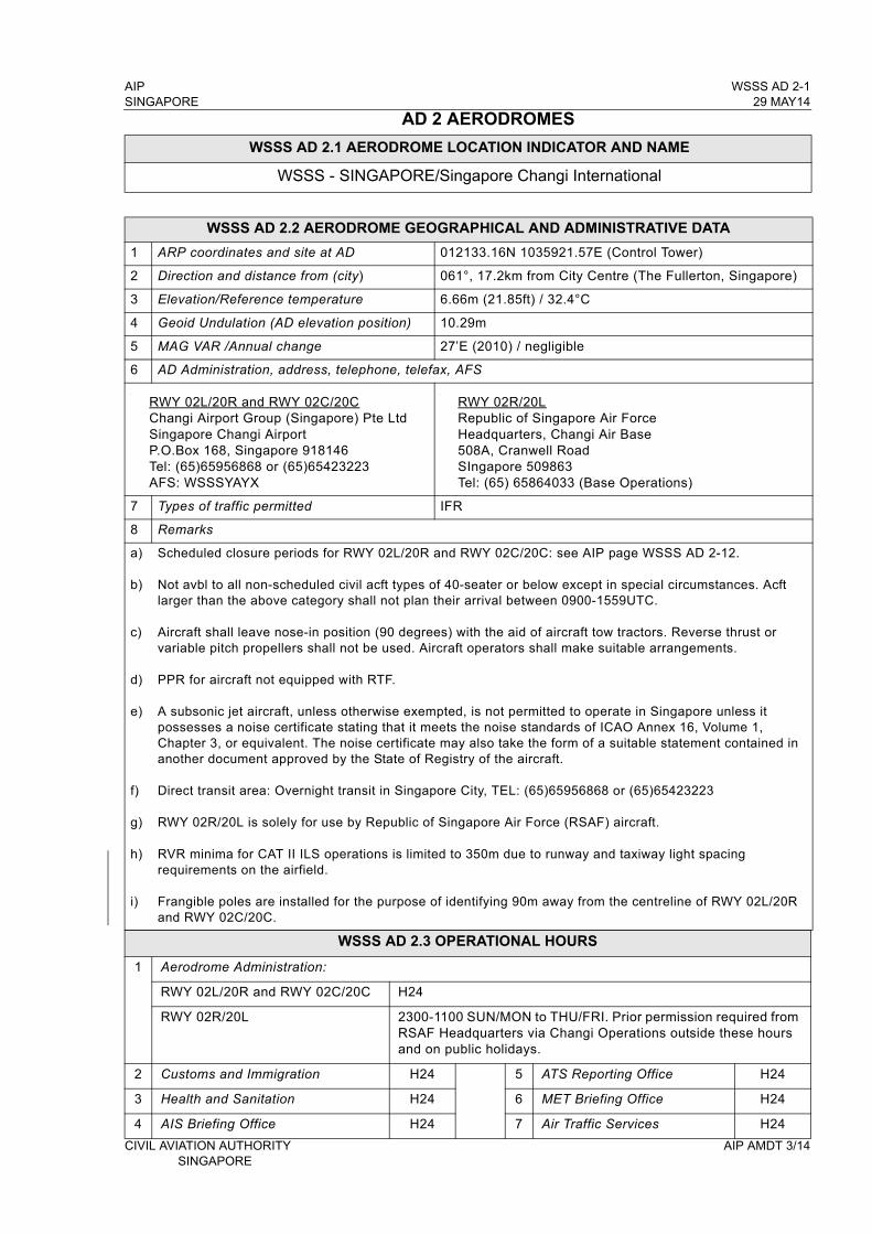
AIP WSSS AD 2-1SINGAPORE 29 MAY14
AD 2 AERODROMES
WSSS AD 2.1 AERODROME LOCATION INDICATOR AND NAME
WSSS - SINGAPORE/Singapore Changi International
WSSS AD 2.2 AERODROME GEOGRAPHICAL AND ADMINISTRATIVE DATA
1 ARP coordinates and site at AD 012133.16N 1035921.57E (Control Tower)
2 Direction and distance from (city) 061°, 17.2km from City Centre (The Fullerton, Singapore)
3 Elevation/Reference temperature 6.66m (21.85ft) / 32.4°C
4 Geoid Undulation (AD elevation position) 10.29m
5 MAG VAR /Annual change 27’E (2010) / negligible
6 AD Administration, address, telephone, telefax, AFS
RWY 02L/20R and RWY 02C/20CChangi Airport Group (Singapore) Pte LtdSingapore Changi AirportP.O.Box 168, Singapore 918146Tel: (65)65956868 or (65)65423223AFS: WSSSYAYX
RWY 02R/20LRepublic of Singapore Air ForceHeadquarters, Changi Air Base508A, Cranwell RoadSIngapore 509863Tel: (65) 65864033 (Base Operations)
7 Types of traffic permitted IFR
8 Remarks
a)
b)
c)
d)
e)
f)
g)
h)
i)
Scheduled closure periods for RWY 02L/20R and RWY 02C/20C: see AIP page WSSS AD 2-12.
Not avbl to all non-scheduled civil acft types of 40-seater or below except in special circumstances. Acft larger than the above category shall not plan their arrival between 0900-1559UTC.
Aircraft shall leave nose-in position (90 degrees) with the aid of aircraft tow tractors. Reverse thrust or variable pitch propellers shall not be used. Aircraft operators shall make suitable arrangements.
PPR for aircraft not equipped with RTF.
A subsonic jet aircraft, unless otherwise exempted, is not permitted to operate in Singapore unless it possesses a noise certificate stating that it meets the noise standards of ICAO Annex 16, Volume 1, Chapter 3, or equivalent. The noise certificate may also take the form of a suitable statement contained in another document approved by the State of Registry of the aircraft.
Direct transit area: Overnight transit in Singapore City, TEL: (65)65956868 or (65)65423223
RWY 02R/20L is solely for use by Republic of Singapore Air Force (RSAF) aircraft.
RVR minima for CAT II ILS operations is limited to 350m due to runway and taxiway light spacing requirements on the airfield.
Frangible poles are installed for the purpose of identifying 90m away from the centreline of RWY 02L/20R and RWY 02C/20C.
WSSS AD 2.3 OPERATIONAL HOURS
1 Aerodrome Administration:
RWY 02L/20R and RWY 02C/20C H24
RWY 02R/20L 2300-1100 SUN/MON to THU/FRI. Prior permission required from RSAF Headquarters via Changi Operations outside these hours and on public holidays.
2 Customs and Immigration H24 5 ATS Reporting Office H24
3 Health and Sanitation H24 6 MET Briefing Office H24
4 AIS Briefing Office H24 7 Air Traffic Services H24
CIVIL AVIATION AUTHORITY AIP AMDT 3/14 SINGAPORE
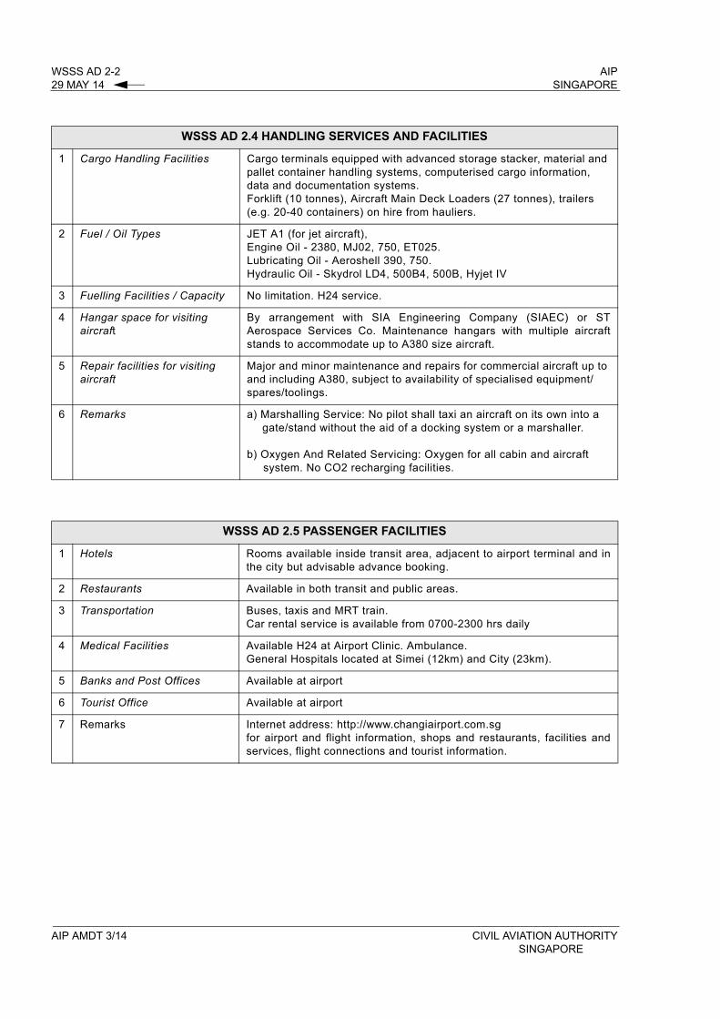
WSSS AD 2-2 AIP29 MAY 14 SINGAPORE
WSSS AD 2.4 HANDLING SERVICES AND FACILITIES
1 Cargo Handling Facilities Cargo terminals equipped with advanced storage stacker, material and pallet container handling systems, computerised cargo information, data and documentation systems. Forklift (10 tonnes), Aircraft Main Deck Loaders (27 tonnes), trailers (e.g. 20-40 containers) on hire from hauliers.
2 Fuel / Oil Types JET A1 (for jet aircraft), Engine Oil - 2380, MJ02, 750, ET025. Lubricating Oil - Aeroshell 390, 750. Hydraulic Oil - Skydrol LD4, 500B4, 500B, Hyjet IV
3 Fuelling Facilities / Capacity No limitation. H24 service.
4 Hangar space for visiting aircraft
By arrangement with SIA Engineering Company (SIAEC) or ST Aerospace Services Co. Maintenance hangars with multiple aircraft stands to accommodate up to A380 size aircraft.
5 Repair facilities for visiting aircraft
Major and minor maintenance and repairs for commercial aircraft up to and including A380, subject to availability of specialised equipment/spares/toolings.
6 Remarks a) Marshalling Service: No pilot shall taxi an aircraft on its own into a gate/stand without the aid of a docking system or a marshaller.
b) Oxygen And Related Servicing: Oxygen for all cabin and aircraft system. No CO2 recharging facilities.
WSSS AD 2.5 PASSENGER FACILITIES
1 Hotels Rooms available inside transit area, adjacent to airport terminal and in the city but advisable advance booking.
2 Restaurants Available in both transit and public areas.
3 Transportation Buses, taxis and MRT train.Car rental service is available from 0700-2300 hrs daily
4 Medical Facilities Available H24 at Airport Clinic. Ambulance. General Hospitals located at Simei (12km) and City (23km).
5 Banks and Post Offices Available at airport
6 Tourist Office Available at airport
7 Remarks Internet address: http://www.changiairport.com.sgfor airport and flight information, shops and restaurants, facilities and services, flight connections and tourist information.
AIP AMDT 3/14 CIVIL AVIATION AUTHORITYSINGAPORE

AIP WSSS AD 2-21SINGAPORE 29 MAY 14
2.3 AERODROME CHARACTERISTICS OF SINGAPORE CHANGI AND PAYA LEBAR AIRPORTS
2.3.1 Tabulated below are details of aerodrome characteristics of Singapore Changi Airport and Paya Lebar Airport which indicate the similarities and significant differences for ease of identification by pilots operating into these two airports.
Aeronautical Service
Paya LebarAirport
Singapore Changi Airport
Significant Differences and
Remarks
Magnetic heading of RWY 02/2002L/20R02C/20C02R/20L
Exercise caution due to similar RWY
alignment
Track/DIST from SAMKO Holding Area (8 DME/DVOR SJ 348°)
Nil 020°/14.3NM to “BED” NDB Differences in track and distances
Track/DIST from NYLON Holding Area (13 DME/DVOR VTK 203°)
Nil 206°/19.8NM to “BED” NDB
Approach Lights
RWY 02Modified Calvert High
INTST with centreline and 3 crossbars. High INTST white LGT with brilliancy control and sequenced
flashing lights.
RWY 02LPrecision APCH LGT CAT II. Extended centreline with red
side row barettes,2 crossbars,
2 APCH beacons and sequenced flashing lights.
RWY 20Modified Calvert High
INTST with centreline and 3 crossbars. High INTST white LGT with brilliancy control and sequenced
flashing lights.
RWY 20RPrecision APCH LGT CAT I.Centreline barettes flashing white, 2 APCH beacons and sequenced flashing lights.(ref chart WSSS AD 2-31)
ILS
RWY 20 - Nil
RWY 20RIDENT ICH
No back beamLLZ 108.9 MHzGP 329.3 MHz
RWY 02 - Nil
RWY 02LIDENT ICW
No back beamLLZ 110.9 MHzGP 330.8 MHz
IBN Flashing R ‘PL’HN and IMC
Flashing G ‘CH’HN and IMC
ABN Nil ALTN Flashing W G every 2.3 SEC
CIVIL AVIATION AUTHORITY AIP AMDT 3/14 SINGAPORE
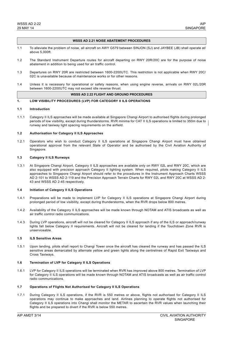
WSSS AD 2-22 AIP29 MAY 14 SINGAPORE
WSSS AD 2.21 NOISE ABATEMENT PROCEDURES
1.1 To alleviate the problem of noise, all aircraft on AWY G579 between SINJON (SJ) and JAYBEE (JB) shall operate at/above 5,000ft.
1.2 The Standard Instrument Departure routes for aircraft departing on RWY 20R/20C are for the purpose of noise abatement in addition to being used for air traffic control.
1.3 Departures on RWY 20R are restricted between 1600-2200UTC. This restriction is not applicable when RWY 20C/02C is unavailable because of maintenance works or for other reasons.
1.4 Unless it is necessary for operational or safety reasons, when using engine reverse, arrivals on RWY 02L/20R between 1600-2200UTC may not exceed idle reverse thrust.
WSSS AD 2.22 FLIGHT AND GROUND PROCEDURES
1. LOW VISIBILITY PROCEDURES (LVP) FOR CATEGORY II ILS OPERATIONS
1.1 Introduction
1.1.1 Category II ILS approaches will be made available at Singapore Changi Airport to authorised flights during prolonged periods of low visibility, except during thunderstorms. RVR minima for CAT II ILS operations is limited to 350m due to runway and taxiway light spacing requirements on the airfield.
1.2 Authorisation for Category II ILS Approaches
1.2.1 Operators who wish to conduct Category II ILS operations at Singapore Changi Airport must have obtained operational approval from the relevant State of Operator and be authorised by the Civil Aviation Authority of Singapore.
1.3 Category II ILS Runways
1.3.1 At Singapore Changi Airport, Category II ILS approaches are available only on RWY 02L and RWY 20C, which are also equipped with precision approach Category II lighting system. When required, pilots making Category II ILS approaches to Singapore Changi Airport should refer to the procedures in the Instrument Approach Charts WSSS AD 2-101 to WSSS AD 2-119 and the Precision Approach Terrain Charts for RWY 02L and RWY 20C at WSSS AD 2-43 and WSSS AD 2-45 respectively.
1.4 Initiation of Category II ILS Operations
1.4.1 Preparations will be made to implement LVP for Category II ILS operations at Singapore Changi Airport during prolonged period of low visibility, except during thunderstorms, when the RVR drops below 800 metres.
1.4.2 Availability of the Category II ILS approaches will be made known through NOTAM and ATIS broadcasts as well as air traffic control radio communications.
1.4.3 During LVP operations, aircraft will not be cleared for Category II ILS approach if any of the ILS or approach/runway lights fall below Category II requirements. Aircraft will not be cleared for landing if the Touchdown Zone RVR is unserviceable.
1.5 ILS Sensitive Areas
1.5.1 Upon landing, pilots shall report to Changi Tower once the aircraft has cleared the runway and has passed the ILS sensitive areas demarcated by alternate yellow and green lights along the centrelines of Rapid Exit Taxiways and Cross Taxiways.
1.6 Termination of LVP for Category II ILS Operations
1.6.1 LVP for Category II ILS operations will be terminated when RVR has improved above 800 metres. Termination of LVP for Category II ILS operations will be made known through NOTAM and ATIS broadcasts as well as air traffic control radio communications.
1.7 Operations of Flights Not Authorised for Category II ILS Operations
1.7.1 During Category II ILS operations, if the RVR is 550 metres or above, flights not authorised for Category II ILS operations may continue to make approaches and land. Airlines planning to operate flights not authorised for Category II ILS operations into Changi shall monitor the METAR to ascertain the RVR values when launching their flights and be prepared to divert if the RVR is below 550 metres.
AIP AMDT 3/14 CIVIL AVIATION AUTHORITY SINGAPORE
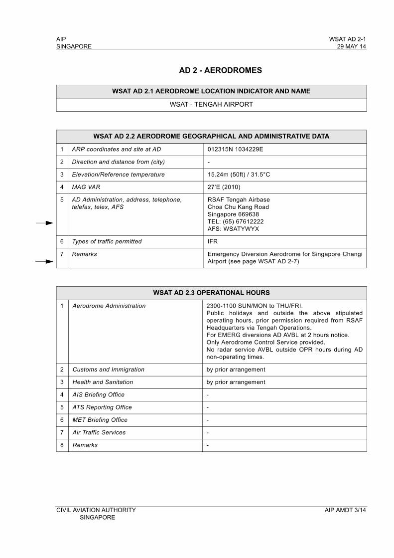
AIP WSAT AD 2-1SINGAPORE 29 MAY 14
AD 2 - AERODROMES
WSAT AD 2.1 AERODROME LOCATION INDICATOR AND NAME
WSAT - TENGAH AIRPORT
WSAT AD 2.2 AERODROME GEOGRAPHICAL AND ADMINISTRATIVE DATA
1 ARP coordinates and site at AD 012315N 1034229E
2 Direction and distance from (city) -
3 Elevation/Reference temperature 15.24m (50ft) / 31.5°C
4 MAG VAR 27’E (2010)
5 AD Administration, address, telephone,telefax, telex, AFS
RSAF Tengah AirbaseChoa Chu Kang RoadSingapore 669638TEL: (65) 67612222 AFS: WSATYWYX
6 Types of traffic permitted IFR
7 Remarks Emergency Diversion Aerodrome for Singapore Changi Airport (see page WSAT AD 2-7)
WSAT AD 2.3 OPERATIONAL HOURS
1 Aerodrome Administration 2300-1100 SUN/MON to THU/FRI.Public holidays and outside the above stipulated operating hours, prior permission required from RSAF Headquarters via Tengah Operations. For EMERG diversions AD AVBL at 2 hours notice. Only Aerodrome Control Service provided. No radar service AVBL outside OPR hours during AD non-operating times.
2 Customs and Immigration by prior arrangement
3 Health and Sanitation by prior arrangement
4 AIS Briefing Office -
5 ATS Reporting Office -
6 MET Briefing Office -
7 Air Traffic Services -
8 Remarks -
CIVIL AVIATION AUTHORITY AIP AMDT 3/14 SINGAPORE
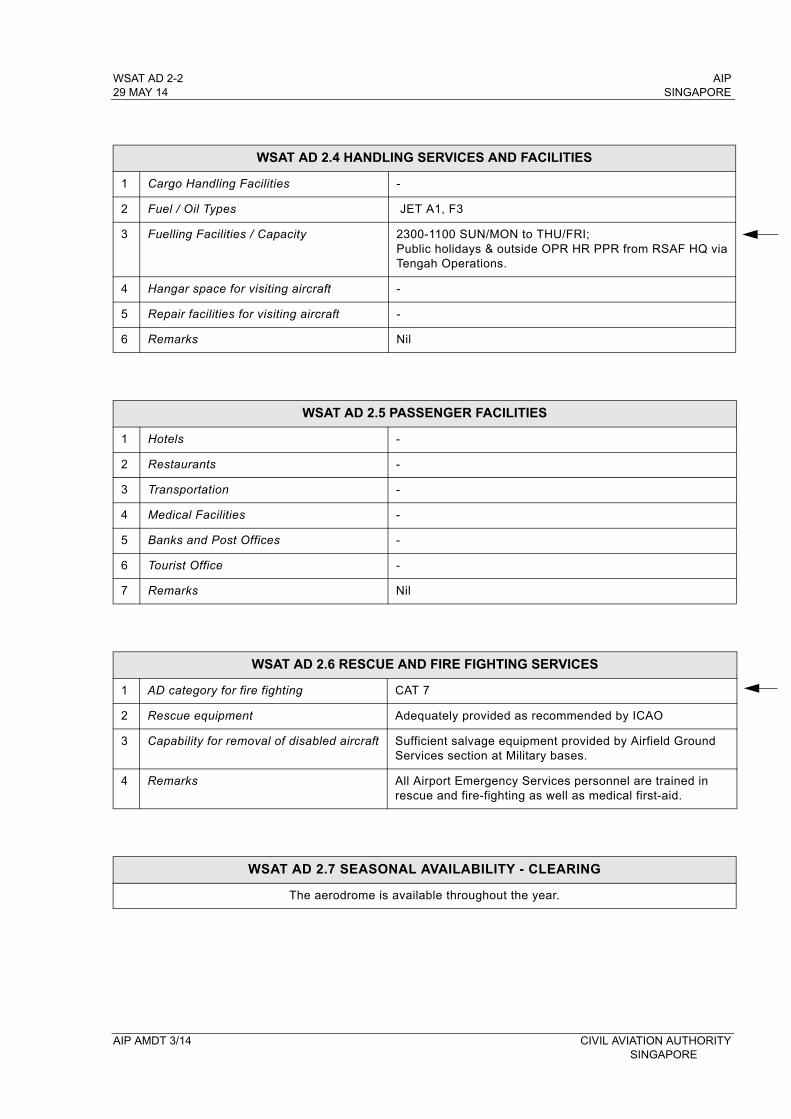
WSAT AD 2-2 AIP29 MAY 14 SINGAPORE
WSAT AD 2.4 HANDLING SERVICES AND FACILITIES
1 Cargo Handling Facilities -
2 Fuel / Oil Types JET A1, F3
3 Fuelling Facilities / Capacity 2300-1100 SUN/MON to THU/FRI; Public holidays & outside OPR HR PPR from RSAF HQ via Tengah Operations.
4 Hangar space for visiting aircraft -
5 Repair facilities for visiting aircraft -
6 Remarks Nil
WSAT AD 2.5 PASSENGER FACILITIES
1 Hotels -
2 Restaurants -
3 Transportation -
4 Medical Facilities -
5 Banks and Post Offices -
6 Tourist Office -
7 Remarks Nil
WSAT AD 2.6 RESCUE AND FIRE FIGHTING SERVICES
1 AD category for fire fighting CAT 7
2 Rescue equipment Adequately provided as recommended by ICAO
3 Capability for removal of disabled aircraft Sufficient salvage equipment provided by Airfield Ground Services section at Military bases.
4 Remarks All Airport Emergency Services personnel are trained in rescue and fire-fighting as well as medical first-aid.
WSAT AD 2.7 SEASONAL AVAILABILITY - CLEARING
The aerodrome is available throughout the year.
AIP AMDT 3/14 CIVIL AVIATION AUTHORITYSINGAPORE
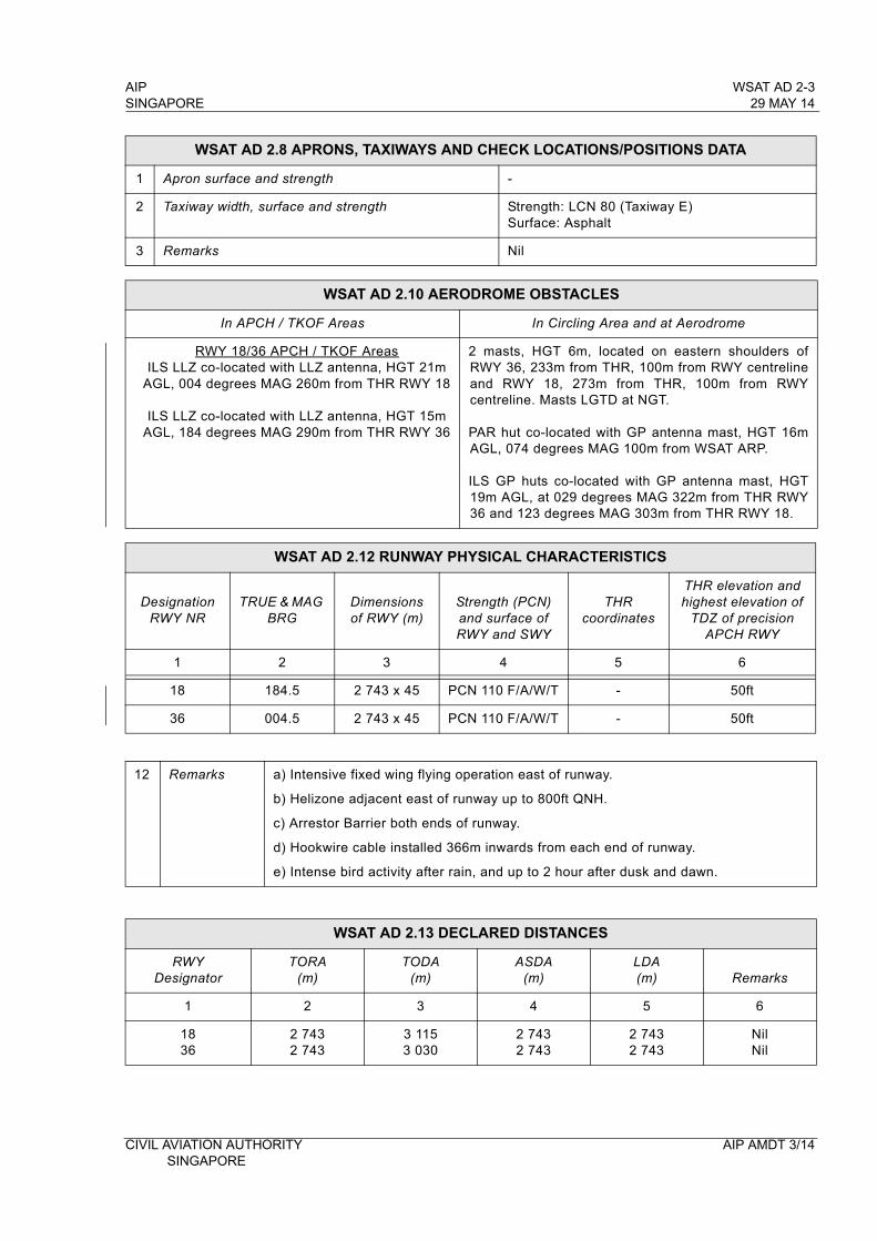
AIP WSAT AD 2-3SINGAPORE 29 MAY 14
WSAT AD 2.8 APRONS, TAXIWAYS AND CHECK LOCATIONS/POSITIONS DATA
1 Apron surface and strength -
2 Taxiway width, surface and strength Strength: LCN 80 (Taxiway E) Surface: Asphalt
3 Remarks Nil
WSAT AD 2.10 AERODROME OBSTACLES
In APCH / TKOF Areas In Circling Area and at Aerodrome
RWY 18/36 APCH / TKOF AreasILS LLZ co-located with LLZ antenna, HGT 21m
AGL, 004 degrees MAG 260m from THR RWY 18
ILS LLZ co-located with LLZ antenna, HGT 15m AGL, 184 degrees MAG 290m from THR RWY 36
2 masts, HGT 6m, located on eastern shoulders of RWY 36, 233m from THR, 100m from RWY centreline and RWY 18, 273m from THR, 100m from RWY centreline. Masts LGTD at NGT.
PAR hut co-located with GP antenna mast, HGT 16m AGL, 074 degrees MAG 100m from WSAT ARP.
ILS GP huts co-located with GP antenna mast, HGT 19m AGL, at 029 degrees MAG 322m from THR RWY 36 and 123 degrees MAG 303m from THR RWY 18.
WSAT AD 2.12 RUNWAY PHYSICAL CHARACTERISTICS
DesignationRWY NR
TRUE & MAG BRG
Dimensions of RWY (m)
Strength (PCN) and surface of RWY and SWY
THR coordinates
THR elevation and highest elevation of
TDZ of precision APCH RWY
1 2 3 4 5 6
18 184.5 2 743 x 45 PCN 110 F/A/W/T - 50ft
36 004.5 2 743 x 45 PCN 110 F/A/W/T - 50ft
12 Remarks a) Intensive fixed wing flying operation east of runway.
b) Helizone adjacent east of runway up to 800ft QNH.
c) Arrestor Barrier both ends of runway.
d) Hookwire cable installed 366m inwards from each end of runway.
e) Intense bird activity after rain, and up to 2 hour after dusk and dawn.
WSAT AD 2.13 DECLARED DISTANCES
RWY Designator
TORA(m)
TODA(m)
ASDA(m)
LDA(m) Remarks
1 2 3 4 5 6
1836
2 7432 743
3 1153 030
2 7432 743
2 7432 743
NilNil
CIVIL AVIATION AUTHORITY AIP AMDT 3/14SINGAPORE
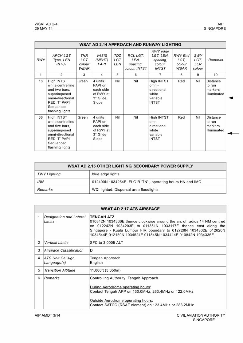
WSAT AD 2-4 AIP29 MAY 14 SINGAPORE
WSAT AD 2.14 APPROACH AND RUNWAY LIGHTING
RWYAPCH LGTType, LEN
INTST
THRLGT
colourWBAR
VASIS(MEHT)
PAPI
TDZLGTLEN
RCL LGT, LEN,
spacing,colour, INTST
RWY edge LGT, LEN,spacing,colour, INTST
RWY EndLGT,
colourWBAR
SWYLGT,LEN
colour
Remarks
1 2 3 4 5 6 7 8 9 10
18 High INTST white centre line and two bars, superimposed omni-directional RED ‘T’ PAPI Sequenced flashing lights
Green 4 units PAPI on each side of RWY at 3° Glide Slope
Nil Nil High INTST omni-directional white variable INTST
Red Nil Distance to run markers illuminated
36 High INTST white centre line and five bars, superimposed omni-directional RED ‘T’ PAPI Sequenced flashing lights
Green 4 units PAPI on each side of RWY at 3° Glide Slope
Nil Nil High INTST omni- directional white variable INTST
Red Nil Distance to run markers illuminated
WSAT AD 2.15 OTHER LIGHTING, SECONDARY POWER SUPPLY
TWY Lighting blue edge lights
IBN 012400N 1034254E, FLG R ‘TN’ , operating hours HN and IMC.
Remarks WDI lighted. Dispersal area floodlights
WSAT AD 2.17 ATS AIRSPACE
1 Designation and Lateral Limits
TENGAH ATZ010842N 1034336E thence clockwise around the arc of radius 14 NM centred on 012242N 1034203E to 011351N 1033117E thence east along the Singapore - Kuala Lumpur FIR boundary to 012728N 1034302E 012620N 1034544E 012150N 1034524E 011845N 1034414E 010842N 1034336E.
2 Vertical Limits SFC to 3,000ft ALT
3 Airspace Classification D
4 ATS Unit CallsignLanguage(s)
Tengah ApproachEnglish
5 Transition Altitude 11,000ft (3,350m)
6 Remarks Controlling Authority: Tengah Approach
During Aerodrome operating hours: Contact Tengah APP on 130.0MHz, 263.4MHz or 122.0MHz
Outside Aerodrome operating hours:Contact SATCC (RSAF element) on 123.4MHz or 288.2MHz
AIP AMDT 3/14 CIVIL AVIATION AUTHORITY SINGAPORE

AIP WSAT AD 2-5SINGAPORE 29 MAY 14
WSAT AD 2.18 ATS COMMUNICATION FACILITIES
Service Designation Call sign
FrequencyP - Primary
S - Secondary
Hours of operation Remarks
APP TengahApproach
P130.0 MHzP263.4 MHzS122.0 MHz BTN 2300-1100
SUN/MON to THU/FRI; and
On SUN, Public holidays and outside the above times, PPR from RSAF HQ via Tengah Ops.
TWR TengahTower
P122.0 MHzP282.5 MHzS263.4 MHz
TengahGround
122.0 MHz337.8MHz
TengahTalkdown
130.0 MHz290.8 MHz328.5 MHz
ACC Singapore Radar
P123.7 MHzS127.3 MHz
H24for AWY B469, G219, G334, R208, L625, L629, L635, L642, M751, M753, M758, M761, M763, M771, N884, N891 and N892.133.8 MHz 0000-1430
P133.25 MHzS135.8 MHz
H24
for AWY A457, A464, A576, B466, R325 (all northbound) and R469.
P134.4 MHzS128.1 MHz
255.4 MHz
for AWY A464, G579, A576 (all southbound), B470, G220, N875 and in area in the immediate vicinity of Singapore
Radar Maint Period: Monthly - EV third SAT 1601-2359
SingaporeRadio
6 556 KHz11 297 KHz
H24
SEA 1, SATCOM SER AVBLSSB suppressed carrier
5 655 KHz8 942 KHz
11 396 KHz
SEA 2, SATCOM SER AVBLSSB suppressed carrier
6 556 KHz SEA 3, SATCOM SER AVBLSSB suppressed carrier
APP SingaporeApproach
P120.3 MHzS124.6 MHz
TAR - Intermediate approach to Singapore Changi AP and other airports in Singapore
- DEP from all airports in Singapore
Maint Period: MonthlyEV first THU 0000-0900 (ASR I) andEV fourth SAT 1601-2359 (ASR II)
CIVIL AVIATION AUTHORITY AIP AMDT 3/14 SINGAPORE
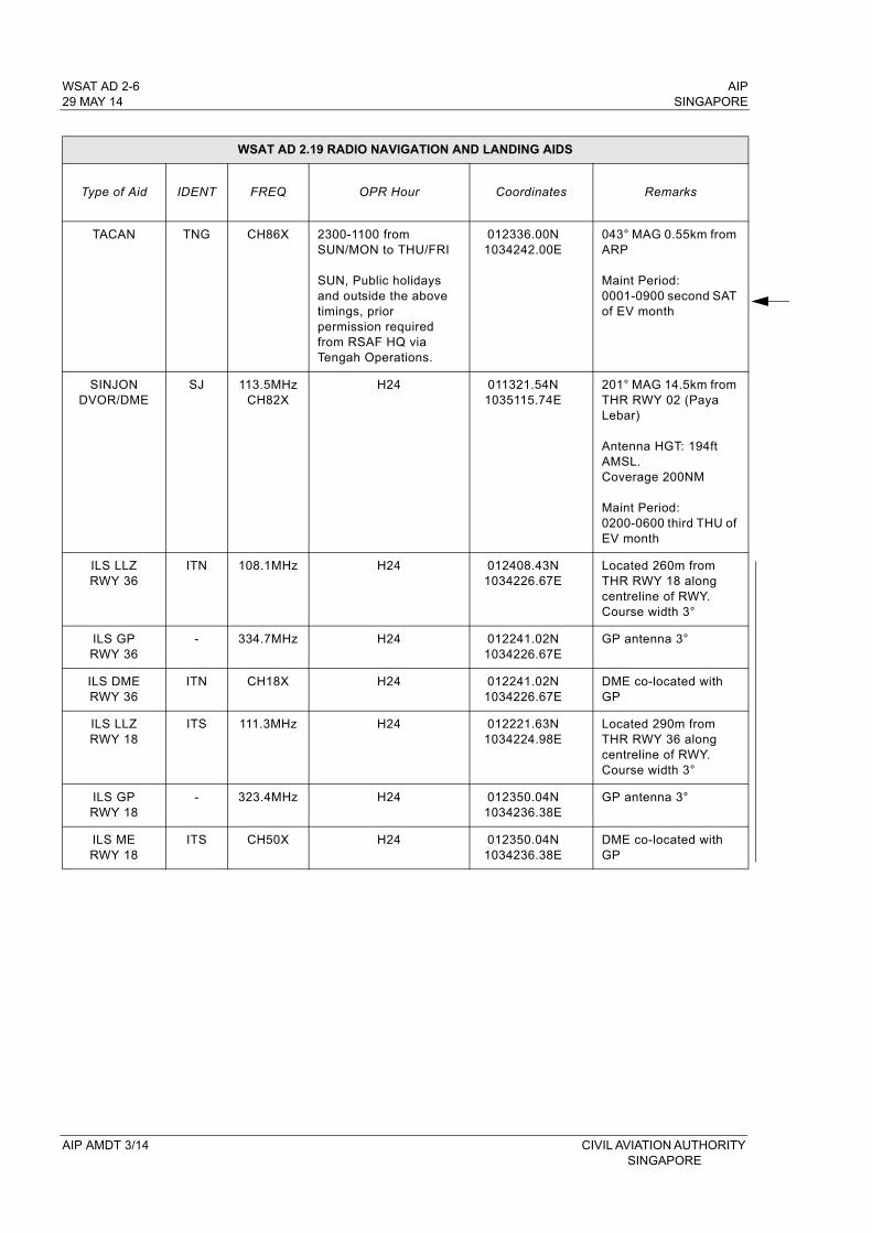
WSAT AD 2-6 AIP29 MAY 14 SINGAPORE
WSAT AD 2.19 RADIO NAVIGATION AND LANDING AIDS
Type of Aid IDENT FREQ OPR Hour Coordinates Remarks
TACAN TNG CH86X 2300-1100 fromSUN/MON to THU/FRI
SUN, Public holidays and outside the above timings, prior permission required from RSAF HQ via Tengah Operations.
012336.00N1034242.00E
043° MAG 0.55km from ARP
Maint Period:0001-0900 second SAT of EV month
SINJON DVOR/DME
SJ 113.5MHzCH82X
H24 011321.54N1035115.74E
201° MAG 14.5km from THR RWY 02 (Paya Lebar)
Antenna HGT: 194ft AMSL. Coverage 200NM
Maint Period: 0200-0600 third THU of EV month
ILS LLZRWY 36
ITN 108.1MHz H24 012408.43N1034226.67E
Located 260m from THR RWY 18 along centreline of RWY. Course width 3°
ILS GP RWY 36
- 334.7MHz H24 012241.02N 1034226.67E
GP antenna 3°
ILS DMERWY 36
ITN CH18X H24 012241.02N 1034226.67E
DME co-located with GP
ILS LLZRWY 18
ITS 111.3MHz H24 012221.63N 1034224.98E
Located 290m from THR RWY 36 along centreline of RWY. Course width 3°
ILS GPRWY 18
- 323.4MHz H24 012350.04N 1034236.38E
GP antenna 3°
ILS MERWY 18
ITS CH50X H24 012350.04N 1034236.38E
DME co-located with GP
AIP AMDT 3/14 CIVIL AVIATION AUTHORITY SINGAPORE
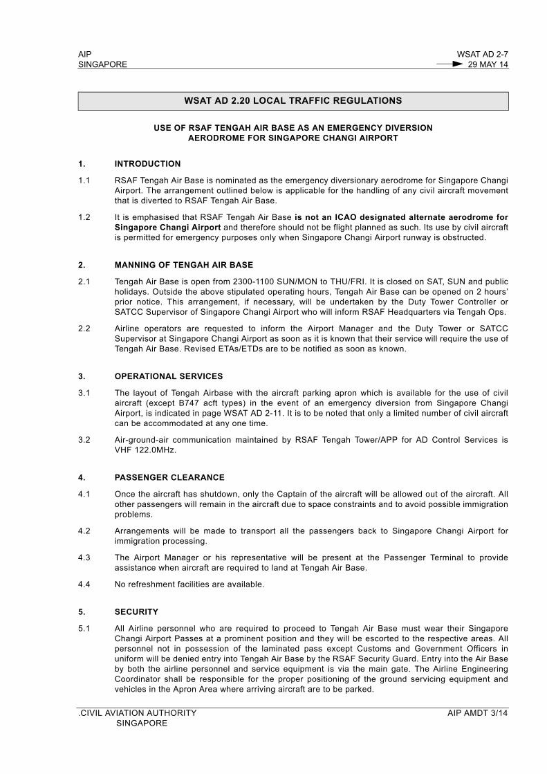
AIP WSAT AD 2-7SINGAPORE 29 MAY 14
WSAT AD 2.20 LOCAL TRAFFIC REGULATIONS
USE OF RSAF TENGAH AIR BASE AS AN EMERGENCY DIVERSIONAERODROME FOR SINGAPORE CHANGI AIRPORT
1. INTRODUCTION
1.1 RSAF Tengah Air Base is nominated as the emergency diversionary aerodrome for Singapore Changi Airport. The arrangement outlined below is applicable for the handling of any civil aircraft movement that is diverted to RSAF Tengah Air Base.
1.2 It is emphasised that RSAF Tengah Air Base is not an ICAO designated alternate aerodrome for Singapore Changi Airport and therefore should not be flight planned as such. Its use by civil aircraft is permitted for emergency purposes only when Singapore Changi Airport runway is obstructed.
2. MANNING OF TENGAH AIR BASE
2.1 Tengah Air Base is open from 2300-1100 SUN/MON to THU/FRI. It is closed on SAT, SUN and public holidays. Outside the above stipulated operating hours, Tengah Air Base can be opened on 2 hours’ prior notice. This arrangement, if necessary, will be undertaken by the Duty Tower Controller or SATCC Supervisor of Singapore Changi Airport who will inform RSAF Headquarters via Tengah Ops.
2.2 Airline operators are requested to inform the Airport Manager and the Duty Tower or SATCC Supervisor at Singapore Changi Airport as soon as it is known that their service will require the use of Tengah Air Base. Revised ETAs/ETDs are to be notified as soon as known.
3. OPERATIONAL SERVICES
3.1 The layout of Tengah Airbase with the aircraft parking apron which is available for the use of civil aircraft (except B747 acft types) in the event of an emergency diversion from Singapore Changi Airport, is indicated in page WSAT AD 2-11. It is to be noted that only a limited number of civil aircraft can be accommodated at any one time.
3.2 Air-ground-air communication maintained by RSAF Tengah Tower/APP for AD Control Services is VHF 122.0MHz.
4. PASSENGER CLEARANCE
4.1 Once the aircraft has shutdown, only the Captain of the aircraft will be allowed out of the aircraft. All other passengers will remain in the aircraft due to space constraints and to avoid possible immigration problems.
4.2 Arrangements will be made to transport all the passengers back to Singapore Changi Airport for immigration processing.
4.3 The Airport Manager or his representative will be present at the Passenger Terminal to provide assistance when aircraft are required to land at Tengah Air Base.
4.4 No refreshment facilities are available.
5. SECURITY
5.1 All Airline personnel who are required to proceed to Tengah Air Base must wear their Singapore Changi Airport Passes at a prominent position and they will be escorted to the respective areas. All personnel not in possession of the laminated pass except Customs and Government Officers in uniform will be denied entry into Tengah Air Base by the RSAF Security Guard. Entry into the Air Base by both the airline personnel and service equipment is via the main gate. The Airline Engineering Coordinator shall be responsible for the proper positioning of the ground servicing equipment and vehicles in the Apron Area where arriving aircraft are to be parked.
.CIVIL AVIATION AUTHORITY AIP AMDT 3/14SINGAPORE
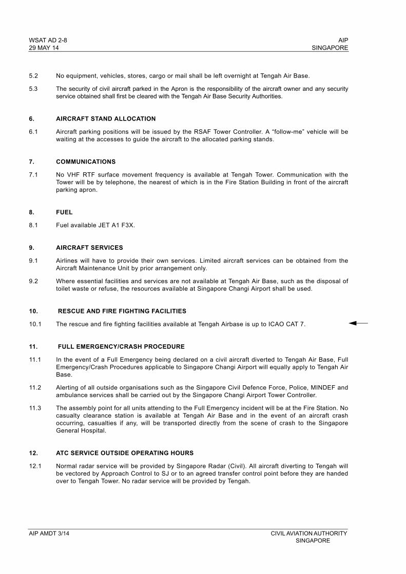
WSAT AD 2-8 AIP29 MAY 14 SINGAPORE
5.2 No equipment, vehicles, stores, cargo or mail shall be left overnight at Tengah Air Base.
5.3 The security of civil aircraft parked in the Apron is the responsibility of the aircraft owner and any security service obtained shall first be cleared with the Tengah Air Base Security Authorities.
6. AIRCRAFT STAND ALLOCATION
6.1 Aircraft parking positions will be issued by the RSAF Tower Controller. A “follow-me” vehicle will be waiting at the accesses to guide the aircraft to the allocated parking stands.
7. COMMUNICATIONS
7.1 No VHF RTF surface movement frequency is available at Tengah Tower. Communication with the Tower will be by telephone, the nearest of which is in the Fire Station Building in front of the aircraft parking apron.
8. FUEL
8.1 Fuel available JET A1 F3X.
9. AIRCRAFT SERVICES
9.1 Airlines will have to provide their own services. Limited aircraft services can be obtained from the Aircraft Maintenance Unit by prior arrangement only.
9.2 Where essential facilities and services are not available at Tengah Air Base, such as the disposal of toilet waste or refuse, the resources available at Singapore Changi Airport shall be used.
10. RESCUE AND FIRE FIGHTING FACILITIES
10.1 The rescue and fire fighting facilities available at Tengah Airbase is up to ICAO CAT 7.
11. FULL EMERGENCY/CRASH PROCEDURE
11.1 In the event of a Full Emergency being declared on a civil aircraft diverted to Tengah Air Base, Full Emergency/Crash Procedures applicable to Singapore Changi Airport will equally apply to Tengah Air Base.
11.2 Alerting of all outside organisations such as the Singapore Civil Defence Force, Police, MINDEF and ambulance services shall be carried out by the Singapore Changi Airport Tower Controller.
11.3 The assembly point for all units attending to the Full Emergency incident will be at the Fire Station. No casualty clearance station is available at Tengah Air Base and in the event of an aircraft crash occurring, casualties if any, will be transported directly from the scene of crash to the Singapore General Hospital.
12. ATC SERVICE OUTSIDE OPERATING HOURS
12.1 Normal radar service will be provided by Singapore Radar (Civil). All aircraft diverting to Tengah will be vectored by Approach Control to SJ or to an agreed transfer control point before they are handed over to Tengah Tower. No radar service will be provided by Tengah.
AIP AMDT 3/14 CIVIL AVIATION AUTHORITY SINGAPORE
AIP WSAT AD 2-9SINGAPORE 29 MAY 14
WSAT AD 2.24 CHARTS RELATED TO TENGAH AERODROME
Page
Aerodrome Plan WSAT AD 2-11
CIVIL AVIATION AUTHORITY AIP AMDT 3/14SINGAPORE

AIP SINGAPORE
INTENTIONALLY
LEFT
BLANK
CIVIL AVIATION AUTHORITY SINGAPORE
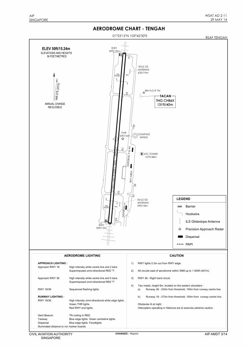
ELEV50ft/15m
36
18
ELEV50ft/15m
PAPI
IBN FLG R 'TN'
COMPASSSWING
ATC TOWER157ft/48m
PAR52ft/16m
DISPE
RSAL
6E1
2 743
m x 4
6m (9
000ft
x 15
0ft)
ASP
HALT
E4
E8E6
DISPE
RSAL
9 &
9A
ELEV 50ft/15.24mELEVATIONS AND HEIGHTS
IN FEET/METRESVA
R 27'E
(2010
)
TNG CH86XTNG CH86X131ft/40m131ft/40m
TACAN
AERODROME CHART - TENGAH01°23'15"N 103°42'30"E RSAF TENGAH
AIPSINGAPORE
WSAT AD 2-1129 MAY 14
CIVIL AVIATION AUTHORITYSINGAPORE
AIP AMDT 3/14CHANGES : Reprint.
E2
PAPI
ww BarrierHookwireILS Glideslope AntennaPrecision Approach RadarDispersalPAPI
LEGEND
ECE3
36 ILS GSANTENNA59ft/18m
18 ILS GSANTENNA62ft/19m
E9BA
Y ARE
A
ANNUAL CHANGENEGLIGIBLE
APPROACH LIGHTING : 1) RWY lights 0.3m out from RWY edge.Approach RWY 18 High intensity white centre line and 2 bars.
Superimposed omni-directional RED 'T'. 2) All circuits east of aerodrome within 3NM up to 1 500ft (457m).
Approach RWY 36 High intensity white centre line and 5 bars. 3) RWY 36 - Right hand circuit.Superimposed omni-directional RED 'T'.
4) Two masts, height 6m, located on the eastern shoulders :RWY 18/36 Sequenced flashing lights. a) Runway 36 - 233m from threshold, 100m from runway centre line.
RUNWAY LIGHTING : b) Runway 18 - 273m from threshold, 100m from runway centre line.RWY 18/36 High intensity omni-directional white edge lights.
Green THR lights. Obstacles lit at night.Red RWY end lights. Helicopters operating in Helizone are to exercise extreme caution.
Ident Beacon TN coding in RED.Taxiway Blue edge lights. Green centreline lights.Dispersal Blue edge lights. FloodlightsIlluminated distance to run marker boards.
AERODROME LIGHTING CAUTION

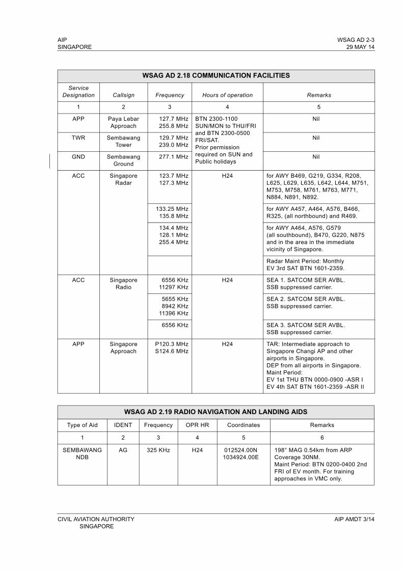
AIP WSAG AD 2-3SINGAPORE 29 MAY 14
WSAG AD 2.18 COMMUNICATION FACILITIES
Service Designation Callsign Frequency Hours of operation Remarks
1 2 3 4 5
APP Paya Lebar Approach
127.7 MHz255.8 MHz
BTN 2300-1100 SUN/MON to THU/FRI and BTN 2300-0500 FRI/SAT.Prior permission required on SUN and Public holidays
Nil
TWR Sembawang Tower
129.7 MHz239.0 MHz
Nil
GND Sembawang Ground
277.1 MHz Nil
ACC SingaporeRadar
123.7 MHz127.3 MHz
H24 for AWY B469, G219, G334, R208, L625, L629, L635, L642, L644, M751, M753, M758, M761, M763, M771, N884, N891, N892.
133.25 MHz135.8 MHz
for AWY A457, A464, A576, B466, R325, (all northbound) and R469.
134.4 MHz128.1 MHz255.4 MHz
for AWY A464, A576, G579 (all southbound), B470, G220, N875 and in the area in the immediate vicinity of Singapore.
Radar Maint Period: Monthly EV 3rd SAT BTN 1601-2359.
ACC Singapore Radio
6556 KHz11297 KHz
H24 SEA 1. SATCOM SER AVBL.SSB suppressed carrier.
5655 KHz8942 KHz
11396 KHz
SEA 2. SATCOM SER AVBL.SSB suppressed carrier.
6556 KHz SEA 3. SATCOM SER AVBL.SSB suppressed carrier.
APP Singapore Approach
P120.3 MHzS124.6 MHz
H24 TAR: Intermediate approach to Singapore Changi AP and other airports in Singapore. DEP from all airports in Singapore.Maint Period: EV 1st THU BTN 0000-0900 -ASR I EV 4th SAT BTN 1601-2359 -ASR II
WSAG AD 2.19 RADIO NAVIGATION AND LANDING AIDS
Type of Aid IDENT Frequency OPR HR Coordinates Remarks
1 2 3 4 5 6
SEMBAWANG NDB
AG 325 KHz H24 012524.00N1034924.00E
198° MAG 0.54km from ARP Coverage 30NM.Maint Period: BTN 0200-0400 2nd FRI of EV month. For training approaches in VMC only.
CIVIL AVIATION AUTHORITY AIP AMDT 3/14 SINGAPORE