BHUTAN CIVIL AVIATION REQUIREMENT - BCAA
150
BHUTAN CIVIL AVIATION REQUIREMENT BCAR-3 Meteorological Service for International and Domestic Air Navigation Second Edition, Dec 2017 Issued under the authority of the Director General Bhutan Civil Aviation Authority
-
Upload
khangminh22 -
Category
Documents
-
view
0 -
download
0
Transcript of BHUTAN CIVIL AVIATION REQUIREMENT - BCAA

BHUTAN CIVIL AVIATION REQUIREMENT
BCAR-3
Meteorological Service for International and Domestic Air Navigation
Second Edition, Dec 2017
Issued under the authority of the Director General Bhutan Civil Aviation Authority
Meteorological Service BCAR - 3
Record of Amendments Corrigenda Page: i
Second Edition Revision 00 Bhutan Civil Aviation Authority Dec 2017
RECORD OF AMENDMENTS AND CORRIGENDA
AMENDMENTS CORRIGENDA
Date Date Entered Date Date Entered
No. applicable entered By No. of issue entered By

Meteorological Service BCAR - 3
Table of Contents Page: ii
Second Edition Revision 00 Bhutan Civil Aviation Authority Dec 2017
TABLE OF CONTENTS
RECORD OF AMENDMENTS AND CORRIGENDA ................................................................... i
TABLE OF CONTENTS .................................................................................................................. ii
FOREWORD .................................................................................................................................. viii
CHAPTER 1. Definitions ............................................................................................................. 1-1
1.1 Definitions .............................................................................................................................. 1-1
1.2 Terms used with a limited meaning ....................................................................................... 1-7
CHAPTER 2. General provisions ............................................................................................... 2-1
2.1 Objective, determination and provision of meteorological service ........................................ 2-1
2.2. Supply, use, quality management and interpretation of meteorological information ........... 2-1
2.3 Notifications required from operators ................................................................................... 2-3
CHAPTER 3. World area forecast system and meteorological offices ................................... 3-1
3.1 (Reserved for WAFS) ............................................................................................................ 3-1
3.2 (Reserved for WAFC) ............................................................................................................ 3-1
3.3 Aerodrome meteorological offices ......................................................................................... 3-1
3.4 Meteorological watch offices ................................................................................................. 3-2
3.5 Volcanic ash advisory centres ................................................................................................ 3-2
3.6 State volcano observatories ................................................................................................... 3-2
3.7 Tropical cyclone advisory centres ......................................................................................... 3-2
CHAPTER 4. Meteorological observations and reports ........................................................... 4-1
4.1 Aeronautical meteorological stations and observations ......................................................... 4-1
4.2 Agreement between air traffic services authorities and meteorological authorities............... 4-1
4.3 Routine observations and reports ........................................................................................... 4-2
4.4 Special observations and reports ............................................................................................ 4-2
4.5 Contents of reports ................................................................................................................. 4-3
4.6 Observing and reporting meteorological elements................................................................. 4-3
4.7 Reporting meteorological information from automatic observing systems ........................... 4-5
4.8 Observations and reports of volcanic activity ........................................................................ 4-5
Meteorological Service BCAR - 3
Table of Contents Page: iii
Second Edition Revision 00 Bhutan Civil Aviation Authority Dec 2017
CHAPTER 5. Aircraft observations and reports ...................................................................... 5-1
5.1 Obligations of the state .......................................................................................................... 5-1
5.2 Types of aircraft observations ................................................................................................ 5-1
5.3 Routine aircraft observations-designation .............................................................................. 5-1
5.4 Routine aircraft observations-exemption ............................................................................... 5-1
5.5 Special aircraft observations .................................................................................................. 5-1
5.6 Other non-routine aircraft observations ................................................................................. 5-2
5.7 Reporting of aircraft observations during flight ..................................................................... 5-2
5.8 Relay of air-reports by ATS units .......................................................................................... 5-2
5.9 Recording and post flight reporting of aircraft observations of volcanic activity ................. 5-2
CHAPTER 6. Forecasts................................................................................................................ 6-1
6.1 Use of forecasts ...................................................................................................................... 6-1
6.2 Aerodrome forecasts .............................................................................................................. 6-1
6.3 Landing forecasts ................................................................................................................... 6-2
6.4 Forecasts for take-off ............................................................................................................. 6-2
6.5 Area forecasts for low-level flights ........................................................................................ 6-3
CHAPTER 7. SIGMET and AIRMET information, aerodrome warnings and wind shear
warnings and alerts ........................................................................................................................ 7-1
7.1 SIGMET information ............................................................................................................. 7-1
7.2 AIRMET information ............................................................................................................ 7-1
7.3 Aerodrome warnings .............................................................................................................. 7-1
7.4 Wind shear warnings and alerts ............................................................................................. 7-2
CHAPTER 8. Aeronautical climatological information .......................................................... 8-1
8.1 General provisions ................................................................................................................. 8-1
8.2 Aerodrome climatological tables ........................................................................................... 8-1
8.3 Aerodrome climatological summaries ................................................................................... 8-1
8.4 Copies of meteorological observational data ......................................................................... 8-2
CHAPTER 9. Service for operators and flight crew members ................................................ 9-1
9.1 General provisions ................................................................................................................. 9-1
9.2 Briefing, consultation and display.......................................................................................... 9-3

Meteorological Service BCAR - 3
Table of Contents Page: iv
Second Edition Revision 00 Bhutan Civil Aviation Authority Dec 2017
9.3 Flight documentation ............................................................................................................. 9-3
9.4 Automated pre-flight information systems for briefing, consultation, flight planning and flight
documentation ................................................................................................................................ 9-4
9.5 Information for aircraft in flight ............................................................................................. 9-4
CHAPTER 10. Information for air traffic services, search and rescue services and
aeronautical information services ............................................................................................... 10-1
10.1 Information for air traffic services units ........................................................................... 10-1
10.2 Information for search and rescue services units ............................................................... 10-1
10.3 Information for aeronautical information services units ................................................... 10-1
CHAPTER 11. Requirements for and use of communications.............................................. 11-1
11.1 Requirements for communications .................................................................................... 11-1
11.2 Use of aeronautical fixed service communications and the public Internet— meteorological
bulletins ........................................................................................................................................ 11-2
11.3 Use of aeronautical fixed service communications-world area forecast system products 11-2
11.4 Use of aeronautical mobile service communication ......................................................... 11-2
11.5 Use of aeronautical data link service-contents of D-VOLMET ......................................... 11-2
11.6 Use of aeronautical broadcasting service-contents of VOLMET broadcasts ..................... 11-3
APPENDIX 1. Flight documentation – model charts and forms..................................... APP 1-1
Opmet information model A ................................................................................................. APP 1-2
Upper wind and temperature chart for standard isobaric surface model IS Example 1 ........ APP 1-3
Upper wind and temperature chart for standard isobaric surface model IS Example 2 ........ APP 1-4
Significant weather chart (high level) model SWH ............................................................... APP 1-5
Significant weather chart (medium level) model SWM ........................................................ APP 1-6
Significant weather chart (low level) model SWL Example 1 ............................................... APP 1-7
Significant weather chart (low level) model SWL Example 2 ............................................... APP 1-8
SIGMET for phenomena other than tropical cyclone and volcanic ash in graphical format
model SGE ............................................................................................................................. APP 1-9
Sheet of notations used in flight documentation model SN ................................................ APP 1-10
APPENDIX 2. Technical specifications related to world area forecast system and
meteorological offices ............................................................................................................. APP 2-1
1. World area forecast system .............................................................................................. APP 2-1
Meteorological Service BCAR - 3
Table of Contents Page: v
Second Edition Revision 00 Bhutan Civil Aviation Authority Dec 2017
2. Aerodrome meteorological offices ................................................................................... APP 2-1
3. Volcanic ash advisory centre ........................................................................................... APP 2-2
4. State volcano observatories ............................................................................................. APP 2-2
5. Tropical cyclone advisory centres .................................................................................... APP 2-2
APPENDIX 3. Technical specifications related to meteorological observations and
reports ...................................................................................................................................... APP 3-1
1. General provision related to meteorological observations ............................................... APP 3-1
2. General criteria related to meteorological reports ............................................................ APP 3-1
3. Dissemination of meteorological reports ......................................................................... APP 3-5
4. Observing and reporting of meteorological elements ...................................................... APP 3-5
Table A3-1. Template for the local routine (MET REPORT) and local special (SPECIAL)
reports .................................................................................................................................. APP 3-17
Table A3-2: Template for METAR and SPECI .............................................................. APP 3-21
Table A3-3. Use of change indicators in trend forecasts ................................................ APP 3-24
Table A3-4. Ranges and resolutions for the numerical elements included in local
reports.……….……............................................................................................................. APP 3-25
Table A 3-5. Ranges and resolutions for the numerical elements included in METAR and SPECI
.............................................................................................................................................. APP 3-26
Example A3-1. Routine report ........................................................................................... APP 3-27
Example A3-2. Special report ............................................................................................ APP 3-28
APPENDIX 4. Technical specifications related to aircraft observations and reports..... APP 4-1
1. Contents of air-reports ..................................................................................................... APP 4-1
2. Criteria for reporting ........................................................................................................ APP 4-3
3. Exchange of air-reports ................................................................................................... APP 4-4
4. Specific provisions related to reporting wind shear and volcanic ash ............................. APP 4-5
APPENDIX 5. Technical specifications related to forecasts ............................................. APP 5-1
1. Criteria related to TAF ..................................................................................................... APP 5-1
2. Criteria related to trend forecasts ..................................................................................... APP 5-5
3. Criteria related to forecasts for take-off ........................................................................... APP 5-8
4. Criteria related to area forecasts for low-level flights ...................................................... APP 5-9
Table A5-1. Template for TAF .......................................................................................... APP 5-11
Table A5-2. Use of change and time indicators in TAF .................................................... APP 5-13
Meteorological Service BCAR - 3
Table of Contents Page: vi
Second Edition Revision 00 Bhutan Civil Aviation Authority Dec 2017
Table A5-3. Template for GAMET ................................................................................... APP 5-14
Table A5-4. Ranges and resolutions for the numerical elements included in TAF ........... APP 5-17
Example A5-1: TAF........................................................................................................... APP 5-17
Example A5-2. Cancellation of TAF ............................................................................... APP 5-18
Example A5-3. GAMET area forecast ............................................................................. APP 5-18
APPENDIX 6. Technical specifications related to sigmet and airmet information, aerodrome
warnings and wind shear warnings and alerts ..................................................................... APP 6-1
1. Specifications related to sigmet information .................................................................... APP 6-1
2. Specifications related to airmet information .................................................................... APP 6-2
3. Specifications related to special air-reports ..................................................................... APP 6-5
4. Detailed criteria related to SIGMET and AIRMET messages and special air reports
(uplink)……………………………………………………………………………………...APP 6-5
5. Specifications related to aerodrome warnings ................................................................. APP 6-6
6. Specifications related to wind shear warnings ................................................................. APP 6-7
Table A6-1A. Template for SIGMET and AIRMET messages .......................................... APP 6-9
Table A6-2. Template for aerodrome warnings ................................................................ APP 6-16
Table A6-3. Template for wind shear warnings ................................................................ APP 6-17
Example A6-5. SIGMET message for severe turbulence ................................................. APP 6-18
Example A6-6. AIRMET message for moderate mountain wave .................................... APP 6-18
APPENDIX 7. Technical specifications related to aeronautical climatological information
.................................................................................................................................................. APP 7-1
1. Processing of aeronautical climatological information .................................................... APP 7-1
2. Exchange of aeronautical climatological information ..................................................... APP 7-1
3. Content of aeronautical climatological information......................................................... APP 7-1
APPENDIX 8. Technical specifications related to service for operators and flight crew
members .................................................................................................................................. APP 8-1
1. Means of supply and format of meteorological information ............................................ APP 8-1
2. Specifications related to information for pre-flight planning and in-flight re-planning . APP 8-1
3. Specifications related to briefing and consultation ......................................................... APP 8-1
4. Specifications related to flight documentation ................................................................ APP 8-2
5. Specifications related to automated pre-flight information systems for briefing, consultation,
flight planning and flight documentation ............................................................................... APP 8-4
Meteorological Service BCAR - 3
Table of Contents Page: vii
Second Edition Revision 00 Bhutan Civil Aviation Authority Dec 2017
6. Specifications related to information for aircraft in flight ............................................... APP 8-4
Figure A8-1. Fixed areas of coverage of WAFS forecasts in chart form — Mercator projection
................................................................................................................................................ APP 8-6
Figure A8-2. Fixed areas of coverage of WAFS forecasts in chart form- Polar stereographic
projection (northern hemisphere) ........................................................................................... APP 8-7
Figure A8-3. Fixed areas of coverage of WAFS forecasts in chart form —Polar stereographic
projection (southern hemisphere) ........................................................................................... APP 8-8
APPENDIX 9. Technical specifications related to information for air traffic services, search
and rescue services and aeronautical information services ................................................ APP 9-1
1. Information to be provided for air traffic services units .................................................. APP 9-1
2. Information to be provided for search and rescue services units ..................................... APP 9-2
3. Information to be provided for aeronautical information services units .......................... APP 9-3
APPENDIX 10. Technical specifications related to requirements for and use of
communications .................................................................................................................... APP 10-1
1. Specific requirements for communications .................................................................... APP 10-1
2. Use of aeronautical fixed service communications and the public internet ................... APP 10-1
3. Use of aeronautical mobile service communications ..................................................... APP 10-2
4. Use of aeronautical data link service — D-VOLMET ................................................... APP 10-2
5. Use of aeronautical broadcasting service — VOLMET BROADCASTS ..................... APP 10-3
ATTACHMENT A. Operationally desirable accuracy measurement or observation ATT A-1
ATTACHMENT B. Operationally desirable accuracy of forecasts .............................. ATT B-1
ATTACHMENT C. Selected criteria applicable to aerodrome reports ....................... ATT C-1
ATTACHMENT D. Conversion of instrumented readings into runway visual range and
visibility.................................................................................................................................. ATT D-1
______________________
Meteorological Service BCAP - 3
Foreword Chapter: Page: viii
Second Edition Revision 00 Bhutan Civil Aviation Authority Dec 2017
FOREWORD
Section 59 of the Civil Aviation Act of Bhutan 2016 empowers the Head of Authority, in this case
the Director General of Civil Aviation Authority of Bhutan (BCAA), to make Rules and
Regulations concerning the use of the airspace, air navigation facilities and services. Accordingly,
BCAR-3 (Meteorological Service) containing provision incorporating the standard and
recommended practices of ICAO Annex 3 has been developed.
BCAR-3 or BCAR – Meteorological Service, which are to be used interchangeably and construed
to refer to this document, is hereby published in accordance with Section 56 of the Act.
During the transposing of the standard and recommended practices of ICAO Annex 3 to this
BCAR, some provisions that are not applicable or currently irrelevant have been left out and
marked as “Reserved”. These provisions will be incorporated as and when appropriate.
Any difference existing in this BCAR and the related ICAO Standards and Recommended Practices
and any amendments thereto will be notified to the ICAO and the same shall be published in the
Aeronautical Information Publication (AIP).
BCAR-3 hereby supersedes the BCAR – Meteorological Service that was published on October 1,
2010.
This BCAR is a controlled document and the provisions contained herein are subject to change
through amendments.
Wangdi Gyaltshen
Director General
Bhutan Civil Aviation Authority
Date: 07/12/2017

Meteorological Service BCAR - 3
Definitions Chapter: 1 Page: 1-1
Second Edition Revision 00 Bhutan Civil Aviation Authority Dec 2017
1. CHAPTER 1. DEFINITIONS
Note.— The designation (RR) in these definitions indicates a definition which has been extracted
from the Radio Regulations of the International Telecommunication Union (ITU) (see Handbook
on Radio Frequency Spectrum Requirements for Civil Aviation including Statement of Approved
ICAO Policies (ICAO Doc 9718).
1.1 Definitions
When the following terms are used in this document for Meteorological Service for International
and Domestic Air Navigation, they have the following meanings:
Aerodrome. A defined area on land or water (including any buildings, installations and equipment)
intended to be used either wholly or in part for the arrival, departure and surface movement of
aircraft.
Aerodrome climatological summary. Concise summary of specified meteorological elements at an
aerodrome, based on statistical data.
Aerodrome climatological table. Table providing statistical data on the observed occurrence of one
or more meteorological elements at an aerodrome.
Aerodrome control tower. A unit established to provide air traffic control service to aerodrome
traffic.
Aerodrome elevation. The elevation of the highest point of the landing area.
Aerodrome meteorological office. An office designated to provide meteorological service for
aerodromes serving international air navigation.
Aerodrome reference point. The designated geographical location of an aerodrome.
Aeronautical fixed service (AFS). A telecommunication service between specified fixed points
provided primarily for the safety of air navigation and for the regular, efficient and economical
operation of air services.
Aeronautical fixed telecommunication network (AFTN). A worldwide system of aeronautical
fixed circuits provided, as part of the aeronautical fixed service, for the exchange of messages
and/or digital data between aeronautical fixed stations having the same or compatible
communications characteristics.
Aeronautical meteorological station. A station designated to make observations and
meteorological reports for use in international and domestic air navigation.
Aeronautical mobile service (RR S1.32). A mobile service between aeronautical stations and
aircraft stations, or between aircraft stations, in which survival craft stations may participate;
emergency position-indicating radio beacon stations may also participate in this service on
designated distress and emergency frequencies.
Aeronautical telecommunication station. A station in the aeronautical telecommunication service.
Meteorological Service BCAR - 3
Definitions Chapter: 1 Page: 1-2
Second Edition Revision 00 Bhutan Civil Aviation Authority Dec 2017
Aircraft. Any machine that can derive support in the atmosphere from the reactions of the air other
than the reactions of the air against the earth’s surface.
Aircraft observation. The evaluation of one or more meteorological elements made from an aircraft
in flight.
AIRMET information. Information issued by a meteorological watch office concerning the
occurrence or expected occurrence of specified en-route weather phenomena which may affect the
safety of low-level aircraft operations and which was not already included in the forecast issued for
low-level flights in the flight information region concerned or sub-area thereof.
Air-report. A report from an aircraft in flight prepared in conformity with requirements for
position, and operational and/or meteorological reporting.
Air traffic services unit. A generic term meaning variously, air traffic control unit, flight
information centre or air traffic services reporting office.
Alternate aerodrome. An aerodrome to which an aircraft may proceed when it becomes either
impossible or inadvisable to proceed to or to land at the aerodrome of intended landing where the
necessary services and facilities are available, where aircraft performance requirements can be met
and which is operational at the expected time of use. Alternate aerodromes include the following:
Take-off alternate. An alternate aerodrome at which an aircraft would be able to land should this
become necessary shortly after take-off and it is not possible to use the aerodrome of departure.
En-route alternate. An alternate aerodrome at which an aircraft would be able to land in the event
that a diversion becomes necessary while en route.
Destination alternate. An alternate aerodrome at which an aircraft would be able to land should it
become either impossible or inadvisable to land at the aerodrome of intended landing.
Note- The aerodrome from which a flight departs may also be an en-route or a destination
alternate aerodrome for that flight.
Altitude. The vertical distance of a level, a point or an object considered as a point, measured from
mean sea level (MSL).
Approach control unit. A unit established to provide air traffic control service to controlled flights
arriving at, or departing from, one or more aerodromes.
Appropriate ATS authority. The relevant authority designated by the State responsible for
providing air traffic services in the airspace concerned.
Area control centre. A unit established to provide air traffic control service to controlled flights in
control areas under its jurisdiction.
Area navigation (RNAV). A method of navigation which permits aircraft operations on any desired
flight path within the coverage of ground- or space-based navigation aids or within the limits of the
capability of self-contained aids, or a combination of these.
Note -Area navigation includes performance-based navigation as well as other operations that do
not meet the definition of performance-based navigation.
Meteorological Service BCAR - 3
Definitions Chapter: 1 Page: 1-3
Second Edition Revision 00 Bhutan Civil Aviation Authority Dec 2017
Automatic dependent surveillance (ADS). A surveillance technique in which aircraft automatically
provide, via a data link, data derived from on-board navigation and position-fixing systems,
including aircraft identification, four-dimensional position and additional data as appropriate.
Automatic dependent surveillance — contract (ADS-C). A means by which the terms of an ADS-
C agreement will be exchanged between the ground system and the aircraft, via a data link,
specifying under what conditions ADS-C reports would be initiated, and what data would be
contained in the reports.
Note.— The abbreviated term “ADS contract” is commonly used to refer to ADS event contract,
ADS demand contract, ADS periodic contract or an emergency mode
Briefing. Oral commentary on existing and/or expected meteorological conditions.
Cloud of operational significance. A cloud with the height of cloud base below 1 500 m (5 000 ft)
or below the highest minimum sector altitude, whichever is greater, or a cumulonimbus cloud or a
towering cumulus cloud at any height.
Consultation. Discussion with a meteorologist or another qualified person of existing and/or
expected meteorological conditions relating to flight operations; a discussion includes answers to
questions.
Control area. A controlled airspace extending upwards from a specified limit above the earth.
Cruising level. A level maintained during a significant portion of a flight.
Elevation. The vertical distance of a point or a level, on or affixed to the surface of the earth,
measured from mean sea level.
Extended range operation. Any flight by an aeroplane with two turbine engines where the flight
time at the one engine inoperative cruise speed (in ISA and still air conditions), from a point on the
route to an adequate alternate aerodrome, is greater than the threshold time approved by the State of
the Operator.
Flight crew member. A licensed crew member charged with duties essential to the operation of an
aircraft during a flight duty period.
Flight documentation. Written or printed documents, including charts or forms, containing
meteorological information for a flight.
Flight information centre. A unit established to provide flight information service and alerting
service.
Flight information region. An airspace of defined dimensions within which flight information
service and alerting service are provided.
Flight level. A surface of constant atmospheric pressure which is related to a specific pressure
datum, 1 013.2 hectopascals (hPa), and is separated from other such surfaces by specific pressure
intervals.
Note 1.— A pressure type altimeter calibrated in accordance with the Standard Atmosphere:
a) when set to a QNH altimeter setting, will indicate altitude;
Meteorological Service BCAR - 3
Definitions Chapter: 1 Page: 1-4
Second Edition Revision 00 Bhutan Civil Aviation Authority Dec 2017
b) when set to a QFE altimeter setting, will indicate height above the QFE reference datum;
c) when set to a pressure of 1 013.2 hPa, may be used to indicate flight levels.
Note 2.— The terms “height” and “altitude”, used in Note 1, indicate altimetric rather than
geometric heights and altitudes.
Forecast. A statement of expected meteorological conditions for a specified time or period, and for
a specified area or portion of airspace.
GAMET area forecast. An area forecast in abbreviated plain language for low-level flights for a
flight information region or sub-area thereof, prepared by the meteorological office designated by
the meteorological authority concerned and exchanged with meteorological offices in adjacent
flight information regions, as agreed between the meteorological authorities concerned.
Grid point data in digital form. Computer processed meteorological data for a set of regularly
spaced points on a chart, for transmission from a meteorological computer to another computer in a
code form suitable for automated use.
Height. The vertical distance of a level, a point or an object considered as a point, measured from a
specified datum.
Human Factors principles. Principles which apply to aeronautical design, certification, training,
operations and maintenance and which seek safe interface between the human and other system
components by proper consideration to human performance.
Level. A generic term relating to the vertical position of an aircraft in flight and meaning variously
height, altitude or flight level.
Meteorological authority. The authority providing or arranging for the provision of meteorological
service for international and domestic air navigation on behalf of a Contracting State.
Meteorological bulletin. A text comprising meteorological information preceded by an appropriate
heading.
Meteorological information. Meteorological report, analysis, forecast, and any other statement
relating to existing or expected meteorological conditions.
Meteorological office. An office designated to provide meteorological service for international air
navigation.
Meteorological report. A statement of observed meteorological conditions related to a specified
time and location.
Meteorological satellite. An artificial Earth satellite making meteorological observations and
transmitting these observations to Earth.
Meteorological watch office (MWO). An office designated to provide information concerning the
occurrence or expected occurrence of specified en-route weather and other phenomena in the
atmosphere that may affect the safety of aircraft operations within its specified area of
responsibility.
Minimum sector altitude. The lowest altitude which may be used which will provide a minimum
Meteorological Service BCAR - 3
Definitions Chapter: 1 Page: 1-5
Second Edition Revision 00 Bhutan Civil Aviation Authority Dec 2017
clearance of 300 m (1 000 ft) above all objects located in an area contained within a sector of a
circle of 46 km (25 NM) radius centred on a radio aid to navigation.
Navigation specification. A set of aircraft and flight crew requirements needed to support
performance-based navigation operations within a defined airspace. There are two kinds of
navigation specifications:
Required navigation performance (RNP) specification. A navigation specification based on area
navigation that includes the requirement for performance monitoring and alerting, designated by
the prefix RNP, e.g. RNP 4, RNP APCH.
Area navigation (RNAV) specification. A navigation specification based on area navigation that
does not include the requirement for performance monitoring and alerting, designated by the prefix
RNAV, e.g. RNAV 5, RNAV 1.
Note.— The Performance-based Navigation (PBN) Manual (ICAO Doc 9613), Volume II, contains
detailed guidance on navigation specifications.
Observation (meteorological). The evaluation of one or more meteorological elements.
Operational control. The exercise of authority over the initiation, continuation, diversion or
termination of a flight in the interest of the safety of the aircraft and the regularity and efficiency of
the flight.
Operational flight plan. The operator’s plan for the safe conduct of the flight based on
considerations of aeroplane performance, other operating limitations and relevant expected
conditions on the route to be followed and at the aerodromes concerned.
Operational planning. The planning of flight operations by an operator.
Operator. A person, organization or enterprise engaged in or offering to engage in an aircraft
operation.
Performance-based navigation (PBN). Area navigation based on performance requirements for
aircraft operating along an ATS route, on an instrument approach procedure or in a designated
airspace.
Note.— Performance requirements are expressed in navigation specification (RNAV specification,
RNP specification) in terms of accuracy, integrity, continuity, availability and functionality needed
for the proposed operation in the context of a particular airspace concept.
Pilot-in-command. The pilot designated by the operator, or in the case of general aviation, the
owner, as being in command and charged with the safe conduct of a flight.
Prevailing visibility. The greatest visibility value, observed in accordance with the definition of
“visibility”, which is reached within at least half the horizon circle or within at least half of the
surface of the aerodrome. These areas could comprise contiguous or non-contiguous sectors.
Note.— This value may be assessed by human observation and/or instrumented systems. When
instruments are installed, they are used to obtain the best estimate of the prevailing visibility.
Prognostic chart. A forecast of a specified meteorological element(s) for a specified time or period
and a specified surface or portion of airspace, depicted graphically on a chart.
Meteorological Service BCAR - 3
Definitions Chapter: 1 Page: 1-6
Second Edition Revision 00 Bhutan Civil Aviation Authority Dec 2017
Quality assurance. Part of quality management focused on providing confidence that quality
requirements will be fulfilled (ISO 9000*).
Quality control. Part of quality management focused on fulfilling quality requirements (ISO
9000*)
Quality management. Coordinated activities to direct and control an organization with regard to
quality (ISO 9000*).
Regional air navigation agreement. Agreement approved by the Council of ICAO normally on the
advice of a regional air navigation meeting.
Reporting point. A specified geographical location in relation to which the position of an aircraft
can be reported.
Rescue coordination centre. A unit responsible for promoting efficient organization of search and
rescue services and for coordinating the conduct of search and rescue operations within a search
and rescue region.
Runway. A defined rectangular area on a land aerodrome prepared for the landing and take-off of
aircraft.
Runway visual range (RVR). The range over which the pilot of an aircraft on the centre line of a
runway can see the runway surface markings or the lights delineating the runway or identifying its
centre line.
Search and rescue services unit. A generic term meaning, as the case may be, rescue coordination
centre, rescue subcentre or alerting post.
SIGMET information. Information issued by a meteorological watch office concerning the
occurrence or expected occurrence of specified en-route weather and other phenomena in the
atmosphere that may affect the safety of aircraft operations.
Standard isobaric surface. An isobaric surface used on a worldwide basis for representing and
analyzing the conditions in the atmosphere.
State volcano observatory. A volcano observatory, designated by regional air navigation
agreement, to monitor active or potentially active volcanoes within a State and to provide
information on volcanic activity to its associated area control centre/flight information centre,
meteorological watch office and volcanic ash advisory centre
Threshold. The beginning of that portion of the runway usable for landing.
Touchdown zone. The portion of a runway, beyond the threshold, where it is intended landing
aeroplanes first contact the runway.
Tropical cyclone. Generic term for a non-frontal synoptic-scale cyclone originating over tropical or
sub-tropical waters with organized convection and definite cyclonic surface wind circulation.
Tropical cyclone advisory centre (TCAC). A meteorological centre designated by regional air
navigation agreement to provide advisory information to meteorological watch offices, world area
forecast centres and international OPMET databanks regarding the position, forecast direction and
speed of movement, central pressure and maximum surface wind of tropical cyclones.
Meteorological Service BCAR - 3
Definitions Chapter: 1 Page: 1-7
Second Edition Revision 00 Bhutan Civil Aviation Authority Dec 2017
Upper-air chart. A meteorological chart relating to a specified upper-air surface or layer of the
atmosphere.
Visibility. Visibility for aeronautical purposes is the greater of:
a) the greatest distance at which a black object of suitable dimensions, situated near the
ground, can be seen and recognized when observed against a bright background;
b) the greatest distance at which lights in the vicinity of 1 000 candelas can be seen and
identified against an unlit background.
Note.— The two distances have different values in air of a given extinction coefficient, and the
latter b) varies with the background illumination. The former a) is represented by the
meteorological optical range (MOR).
VOLMET. Meteorological information for aircraft in flight.
Data link-VOLMET (D-VOLMET). Provision of current aerodrome routine meteorological reports
(METAR) and aerodrome special meteorological reports (SPECI), aerodrome forecasts (TAF),
SIGMET, special air-reports not covered by a SIGMET and, where available, AIRMET via data
link.
VOLMET broadcast. Provision, as appropriate, of current METAR, SPECI, TAF and SIGMET by
means of continuous and repetitive voice broadcasts.
World area forecast centre (WAFC). A meteorological centre designated to prepare and issue
significant weather forecasts and upper-air forecasts in digital form on a global basis direct to
States using aeronautical fixed service internet-based services.
World area forecast system (WAFS). A worldwide system by which world area forecast centres
provide aeronautical meteorological en-route forecasts in uniform standardized formats.
1.2 Terms used with a limited meaning
For the purpose of this document, the following terms are used with a limited meaning as indicated
below:
a) to avoid confusion in respect of the term “service” between the meteorological service
considered as an administrative entity and the service which is provided, “meteorological
authority” is used for the former and “service” for the latter;
b) “provide” is used solely in connection with the provision of service;
c) “issue” is used solely in connection with cases where the obligation specifically extends to
sending out the information to a user;
d) “make available” is used solely in connection with cases where the obligation ends with
making the information accessible to a user; and
e) “supply” is used solely in connection with cases where either c) or d) applies. _____________________
* ISO Standard 9000 — Quality Management Systems — Fundamentals and Vocabulary.

BCAR – Meteorological Service BCAR - 3
General Provisions Chapter: 2 Page: 2-1
Second Edition Revision 00 Bhutan Civil Aviation Authority Dec 2017
2. CHAPTER 2. GENERAL PROVISIONS
2.1 Objective, determination and provision of meteorological service
2.1.1 The objective of meteorological service for international and domestic air navigation shall
be to contribute towards the safety, regularity and efficiency of international and domestic air
navigation.
2.1.2 This objective shall be achieved by supplying the following users: operators, flight crew
members, air traffic services units, search and rescue services units, airport managements and
others concerned with the conduct or development of international and domestic air navigation,
with the meteorological information necessary for the performance of their respective functions.
2.1.3 BCAA shall determine the meteorological service which will be provided within Bhutan to
meet the needs of international and domestic air navigation. This determination shall be made in
accordance with the provisions of this document and in accordance with regional air navigation
agreement.
2.1.4 The BCAA shall designate the authority, hereinafter referred to as the meteorological
authority to provide or arrange for the provision of meteorological services for national and
international air navigation on its behalf. Details of the meteorological authority so designated shall
be included in the State aeronautical information publication, in accordance with BCAR - 15,
Appendix 1, GEN 1.1.
2.1.5 The designated meteorological authority shall comply with the requirements of the World
Meteorological Organization in respect of qualifications and training of meteorological personnel
providing service for international air navigation.
Note.— Requirements concerning the qualifications and training of meteorological personnel in
aeronautical meteorology are given in the Technical Regulations (WMO-No. 49), Volume I —
General Meteorological Standards and Recommended Practices, Part VI — Education and
Training of Meteorological Personnel.
2.2. Supply, use, quality management and interpretation of meteorological information
2.2.1 Close liaison shall be maintained between those concerned with the supply and those
concerned with the use of meteorological information on matters which affect the provision of
meteorological service for national and international air navigation.
2.2.2 The designated meteorological authority shall establish and implement a properly organized
quality system comprising procedures, processes and resources necessary to provide for the quality
management of the meteorological information to be supplied to the users listed in 2.1.2.
2.2.3 The quality system established in accordance with 2.2.2 should be in conformity with the
International Organization for Standardization (ISO) 9000 series of quality assurance standards and
should be certified by an approved organization.
Note.— The ISO 9000 series of quality assurance standards provide a basic framework for the
development of a quality assurance programme. The details of a successful programme are unique
to the organization. Guidance on the establishment and implementation of a quality system is given
amrak
BCAR – Meteorological Service BCAR - 3
General Provisions Chapter: 2 Page: 2-2
Second Edition Revision 00 Bhutan Civil Aviation Authority Dec 2017
in the Manual on the Quality Management System for the Provision of Meteorological Service for
International Air Navigation (ICAO Doc 9873).
2.2.4 The quality system should provide the users with assurance that the meteorological
information supplied complies with the stated requirements in terms of the geographical and spatial
coverage, format and content, time and frequency of issuance and period of validity, as well as the
accuracy of measurements, observations and forecasts. When the quality system indicates that
meteorological information to be supplied to the users does not comply with the stated
requirements, and automatic error correction procedures are not appropriate, such information
should not be supplied to the users unless it is validated with the originator.
Note.— Requirements concerning the geographical and spatial coverage, format and content, time
and frequency of issuance and period of validity of meteorological information to be supplied to
aeronautical users are given in Chapters 3, 4, 6, 7, 8, 9 and 10 and Appendices 2, 3, 5, 6, 7, 8 and
9 of this document and the relevant regional air navigation plans. Guidance concerning the
accuracy of measurement and observation, and accuracy of forecasts is given in Attachments A and
B, respectively, to this document.
2.2.5 In regard to the exchange of meteorological information for operational purposes the quality
system should include verification and validation procedures and resources for monitoring
adherence to the prescribed transmission schedules for individual messages and/or bulletins
required to be exchanged, and the times of their filing for transmission. The quality system should
be capable of detecting excessive transit times of messages and bulletins received.
Note.— Requirements concerning the exchange of operational meteorological information are
given in Chapter 11 and Appendix 10 of this document.
2.2.6 Demonstration of compliance of the quality system applied shall be by audit. If non-
conformity of the system is identified, action shall be initiated to determine and correct the cause.
All audit observations shall be evidence-based and properly documented.
2.2.7 Owing to the variability of meteorological elements in space and time, to limitations of
observing techniques and to limitations caused by the definitions of some of the elements, the
specific value of any of the elements given in a report shall be understood by the recipient to be the
best approximation of the actual conditions at the time of observation.
Note.— Guidance on the operationally desirable accuracy of measurement or observation is given
in Attachment A.
2.2.8 Owing to the variability of meteorological elements in space and time, to limitations of
forecasting techniques and to limitations caused by the definitions of some of the elements, the
specific value of any of the elements given in a forecast shall be understood by the recipient to be
the most probable value which the element is likely to assume during the period of the forecast.
Similarly, when the time of occurrence or change of an element is given in a forecast, this time
shall be understood to be the most probable time.
Note.— Guidance on the operationally desirable accuracy of forecasts is given in Attachment B
2.2.9 The meteorological information supplied to the users listed in 2.1.2 shall be consistent with
Human Factors principles and shall be in forms which require a minimum of interpretation by these
users, as specified in the following chapters.
Note.— Guidance material on the application of Human Factors principles can be found in the

BCAR – Meteorological Service BCAR - 3
General Provisions Chapter: 2 Page: 2-3
Second Edition Revision 00 Bhutan Civil Aviation Authority Dec 2017
ICAO Human Factors Training Manual (ICAO Doc 9683).
2.3 Notifications required from operators
2.3.1 An operator requiring meteorological service or changes in existing meteorological service
shall notify, sufficiently in advance, the designated meteorological authority or the aerodrome
meteorological office concerned. The minimum amount of advance notice required shall be as
agreed between the designated meteorological authority or aerodrome meteorological office and the
operator concerned.
2.3.2 The designated meteorological authority be notified by the operator requiring service when:
a) new routes or new types of operations are planned;
b) changes of a lasting character are to be made in scheduled operations; and
c) other changes, affecting the provision of meteorological service, are planned.
Such information shall contain all details necessary for the planning of appropriate arrangements by
the designated meteorological authority.
2.3.3 The aerodrome meteorological office, or the meteorological office concerned, shall be
notified by the operator or a flight crew member:
a) of flight schedules;
b) when non-scheduled flights are to be operated; and
c) when flights are delayed, advanced or cancelled.
2.3.4 The notification to the aerodrome meteorological office of individual flights should contain
the following information except that, in the case of scheduled flights, the requirement for some or
all of this information may be waived as agreed between the meteorological office and the operator
concerned.
a) aerodrome of departure and estimated time of departure;
b) destination and estimated time of arrival;
c) route to be flown and estimated times of arrival at, and departure from, any intermediate
aerodrome(s);
d) alternate aerodromes needed to complete the operational flight plan and taken from the
relevant list contained in the regional air navigation plan;
e) cruising level;
f) type of flight, whether under visual or instrument flight rules;
g) type of meteorological information requested for a flight crew member, whether flight
documentation and/or briefing or consultation; and

BCAR – Meteorological Service BCAR - 3
General Provisions Chapter: 2 Page: 2-4
Second Edition Revision 00 Bhutan Civil Aviation Authority Dec 2017
h) time (s) at which briefing, consultation and/or flight documentation
______________________

Meteorological Service BCAR - 3
WAFS and Meteorological Offices Chapter: 3 Page: 3-1
Second Edition Revision 00 Bhutan Civil Aviation Authority Dec 2017
3. CHAPTER 3. WORLD AREA FORECAST SYSTEM AND
METEOROLOGICAL OFFICES
Note.— Technical specifications and detailed criteria related to this chapter are given in Appendix
2.
3.1 (Reserved for WAFS)
3.2 (Reserved for WAFC)
3.3 Aerodrome meteorological offices
3.3.1 The designated meteorological authority shall establish one or more aerodrome and/or other
meteorological offices which shall be adequate for the provision of the meteorological service
required to satisfy the needs of international and domestic air navigation.
3.3.2 An aerodrome meteorological office shall carry out all or some of the following functions as
necessary to meet the needs of flight operations at the aerodrome:
a) prepare and/or obtain forecasts and other relevant information for flights with which it is
concerned; the extent of its responsibilities to prepare forecasts shall be related to the local
availability and use of en-route and aerodrome forecast material received from other
offices;
b) prepare and/or obtain forecasts of local meteorological conditions;
c) maintain a continuous survey of meteorological conditions over the aerodromes for which
it is designated to prepare forecasts;
d) provide briefing, consultation and flight documentation to flight crew members and/or
other flight operations personnel;
e) supply other meteorological information to aeronautical users;
f) display the available meteorological information;
g) exchange meteorological information with other aerodrome meteorological offices; and
h) supply information received on pre-eruption volcanic activity, a volcanic eruption or
volcanic ash cloud, to its associated air traffic services unit, aeronautical information
service unit and meteorological watch office (MWO) as agreed between the
meteorological, aeronautical information service and ATS authorities concerned.
3.3.3 The aerodromes for which landing forecasts are required shall be determined by regional air
navigation agreement.
3.3.4 For an aerodrome without an aerodrome meteorological office located at the aerodrome:
a) The designated meteorological authority shall establish one or more aerodrome
Meteorological Service BCAR - 3
WAFS and Meteorological Offices Chapter: 3 Page: 3-2
Second Edition Revision 00 Bhutan Civil Aviation Authority Dec 2017
meteorological office(s) to supply meteorological information as required; and
b) The designated meteorological authority shall establish means by which such information
can be supplied to the aerodromes concerned.
3.4 Meteorological watch offices
3.4.1 The designated meteorological authority, having accepted the responsibility for providing air
traffic services for air navigation/ within a flight information region (FIR) or a control area (CTA),
shall establish, in accordance with regional air navigation agreement, one or more MWOs.
3.4.2 An MWO shall:
a) maintain continuous watch over meteorological conditions affecting flight operations
within its area of responsibility;
b) prepare SIGMET and other information relating to its area of responsibility;
c) supply SIGMET information and, as required, other meteorological information to
associated air traffic services units;
d) disseminate SIGMET information;
e) when required by regional air navigation agreement, in accordance with 7.2.1:
1) prepare AIRMET information related to its area of responsibility;
2) supply AIRMET information to associated air traffic services units; and
3) disseminate AIRMET information.
3.4.3 The boundaries of the area over which meteorological watch is to be maintained by an
MWO should be coincident with the boundaries of an FIR or a CTA or a combination of FIRs
and/or CTAs.
3.5 Volcanic ash advisory centres
(Not applicable)
3.6 State volcano observatories
(Not applicable)
3.7 Tropical cyclone advisory centres
(Not applicable)
______________________

Meteorological Service BCAR - 3
Meteorological Observations and Reports Chapter: 4 Page: 4-1
Second Edition Revision 00 Bhutan Civil Aviation Authority Dec 2017
4. CHAPTER 4. METEOROLOGICAL OBSERVATIONS AND REPORTS
Note.— Technical specifications and detailed criteria related to this chapter are given in Appendix
3.
4.1 Aeronautical meteorological stations and observations
4.1.1 The designated meteorological authority shall establish, at aerodromes in Bhutan, such
aeronautical meteorological stations as it determines to be necessary. An aeronautical
meteorological station may be a separate station or may be combined with a synoptic station.
Note.— Aeronautical meteorological stations may include sensors installed outside the aerodrome,
where considered justified, by the meteorological authority to ensure the compliance of
meteorological service for international and domestic air navigation with the provisions of this
document.
4.1.2 (Reserved)
4.1.3 Aeronautical meteorological stations shall make routine observations at fixed intervals. At
aerodromes, the routine observations shall be supplemented by special observations whenever
specified changes occur in respect of surface wind, visibility, runway visual range, present weather,
clouds and/or air temperature.
4.1.4 The designated meteorological authority shall arrange for its aeronautical meteorological
stations to be inspected at sufficiently frequent intervals to ensure that a high standard of
observation is maintained, that instruments and all their indicators are functioning correctly, and
that the exposure of the instruments has not changed significantly.
Note.— Guidance on the inspection of aeronautical meteorological stations including the
frequency of inspections is given in the Manual on Automatic Meteorological Observing Systems at
Aerodromes (ICAO Doc 9837)
4.1.5 (Reserved)
4.1.6 (Reserved)
4.1.7 Where an integrated semi-automatic system is used for the dissemination/display of
meteorological information, it should be capable of accepting the manual insertion of data covering
those meteorological elements which cannot be observed by automatic means.
4.1.8 The observations shall form the basis for the preparation of reports to be disseminated at the
aerodrome of origin and of reports to be disseminated beyond the aerodrome of origin.
4.2 Agreement between air traffic services authorities and meteorological authorities
An agreement between the designated meteorological authority and the appropriate ATS authority
should be established to cover, among other things:
a) the provision in air traffic services units of displays related to integrated automatic systems;

Meteorological Service BCAR - 3
Meteorological Observations and Reports Chapter: 4 Page: 4-2
Second Edition Revision 00 Bhutan Civil Aviation Authority Dec 2017
b) the calibration and maintenance of these displays/instruments;
c) the use to be made of these displays/instruments by air traffic services personnel;
d) as and where necessary, supplementary visual observations (for example, of meteorological
phenomena of operational significance in the climb-out and approach areas) if and when
made by air traffic services personnel to update or supplement the information supplied by
the meteorological station;
e) meteorological information obtained from aircraft taking off or landing (for example, on
wind shear); and
Note.— Guidance on the subject of coordination between ATS and aeronautical meteorological
services is contained in the Manual on Coordination between Air Traffic Services, Aeronautical
Information Services and Aeronautical Meteorological Services (ICAO Doc 9377).
4.3 Routine observations and reports
4.3.1 At aerodromes, routine observations shall be made throughout the 24 hours of each day.
Such observations shall be made at intervals of one hour or, if so determined by regional air
navigation agreement, at intervals of one half-hour. At other aeronautical meteorological stations,
such observations shall be made as determined by the BCAA and the designated meteorological
authority taking into account the requirements of air traffic services units and aircraft operations.
4.3.2 Reports of routine observations shall be issued as:
a) local routine reports, only for dissemination at the aerodrome of origin, (intended for
arriving and departing aircraft); and
b) METAR for dissemination beyond the aerodrome of origin (mainly intended for flight
planning, VOLMET broadcasts and D -VOLMET).
4.3.3 At aerodromes that are not operational throughout 24 hours in accordance with 4.3.1,
METAR shall be issued prior to the aerodrome resuming operations in accordance with regional air
navigation agreement.
4.4 Special observations and reports
4.4.1 A list of criteria for special observations shall be established by meteorological office in
consultation with the appropriate ATS authority, operators and others concerned.
4.4.2 Reports of special observations shall be issued as:
a) local special reports, only for dissemination at the aerodrome of origin (intended for
arriving and departing aircraft); and
b) SPECI for dissemination beyond the aerodrome of origin (mainly intended for flight
planning, VOLMET broadcasts and D-VOLMET) unless METAR are issued at half-
hourly intervals.
4.4.3 At aerodromes that are not operational throughout 24 hours in accordance with 4.3.1,
Meteorological Service BCAR - 3
Meteorological Observations and Reports Chapter: 4 Page: 4-3
Second Edition Revision 00 Bhutan Civil Aviation Authority Dec 2017
following the resumption of the issuance of METAR, SPECI shall be issued, as necessary.
4.5 Contents of reports
4.5.1 Local routine, local special reports, METAR and SPECI shall contain the following
elements in the order indicated:
a) identification of the type of report;
b) location indicator;
c) time of the observation;
d) identification of an automated or missing report, when applicable;
e) surface wind direction and speed;
f) visibility;
g) runway visual range, when applicable;
h) present weather;
i) cloud amount, cloud type (only for cumulonimbus and towering cumulus clouds) and
height of cloud base or, where measured, vertical visibility;
j) air temperature and dew-point temperature; and
k) QNH and, when applicable, QFE (QFE included only in local routine and special reports).
Note.— The location indicators referred to under b) and their significations are published in
Location Indicators (ICAO Doc 7910).
4.5.2 In addition to elements listed under 4.5.1 a) to k), local routine reports, special reports,
METAR and SPECI should contain supplementary information to be placed after element k).
4.5.3 Optional elements included under supplementary information shall be included in METAR
and SPECI in accordance with regional air navigation agreement.
4.6 Observing and reporting meteorological elements
4.6.1 Surface wind
4.6.1.1 The mean direction and the mean speed of the surface wind shall be measured, as well as
significant variations of the wind direction and speed, and reported in degrees true and metres per
second (or knots), respectively.
4.6.1.2 When local routine and special reports are used for departing aircraft, the surface wind
observations for these reports should be representative of conditions along the runway; when local
routine and special reports are used for arriving aircraft, the surface wind observations for these
reports should be representative of the touchdown zone.
Meteorological Service BCAR - 3
Meteorological Observations and Reports Chapter: 4 Page: 4-4
Second Edition Revision 00 Bhutan Civil Aviation Authority Dec 2017
4.6.1.3 For METAR and SPECI, the surface wind observations should be representative of
conditions above the whole runway where there is only one runway and the whole runway complex
where there is more than one runway.
4.6.2 Visibility
4.6.2.1 The visibility as defined in Chapter 1 shall be measured or observed, and reported in
metres or kilometres.
Note.— Guidance on the conversion of instrument readings into visibility is given in Attachment D.
4.6.2.2 When local routine, special reports are used for departing aircraft, the visibility
observations for these reports should be representative of conditions along the runway; when local
routine and special reports are used for arriving aircraft, the visibility observations for these reports
should be representative of the touchdown zone of the runway.
4.6.2.3 For METAR and SPECI, the visibility observations should be representative of the
aerodrome.
4.6.3 (Reserved)
4.6.4 Present weather
4.6.4.1 The present weather occurring at the aerodrome shall be observed and reported as
necessary. The following present weather phenomena shall be identified, as a minimum: rain,
drizzle, snow and freezing precipitation (including intensity thereof), haze, mist, fog, freezing fog
and thunderstorms (including thunderstorms in the vicinity).
4.6.4.2 For local routine and special reports, the present weather information should be
representative of conditions at the aerodrome.
4.6.4.3 For METAR and SPECI, the present weather information should be representative of
conditions at the aerodrome and, for certain specified present weather phenomena, in its vicinity.
4.6.5 Clouds
4.6.5.1 Cloud amount, cloud type and height of cloud base shall be observed and reported as
necessary to describe the clouds of operational significance. When the sky is obscured, vertical
visibility shall be observed and reported, where measured, in lieu of cloud amount, cloud type and
height of cloud base. The height of cloud base and vertical visibility shall be reported in metres (or
feet).
4.6.5.2 The cloud observations for local routine and special reports should be representative of the
runway threshold(s) in use.
4.6.5.3 The cloud observations for METAR and SPECI should be representative of the aerodrome
and its vicinity.
4.6.6 Air temperature and dew-point temperature
4.6.6.1 The air temperature and the dew-point temperature shall be measured and reported in
degrees Celsius.
Meteorological Service BCAR - 3
Meteorological Observations and Reports Chapter: 4 Page: 4-5
Second Edition Revision 00 Bhutan Civil Aviation Authority Dec 2017
4.6.6.2 The observations of air temperature and dew-point temperature for local routine reports,
local special reports, METAR and SPECI should be representative of the whole runway complex.
4.6.7 Atmospheric pressure
The atmospheric pressure shall be measured, and QNH and QFE values shall be computed and
reported in hectopascals.
4.6.8 Supplementary information
Observations made at aerodromes shall include the available supplementary information
concerning significant meteorological conditions, particularly those in the approach and climb-out
areas. Where practicable, the information should identify the location of the meteorological
condition.
4.7 Reporting meteorological information from automatic observing systems
4.7.1 METAR and SPECI from automatic observing systems should be used during non-
operational hours of the aerodrome, and during operational hours of the aerodrome as determined
by the meteorological authority in consultation with users based on the availability and efficient use
of personnel.
Note.— Guidance on the use of automatic meteorological observing systems is given in ICAO Doc
9837
4.7.2 Local routine and special reports from automatic observing systems shall be used during
operational hours of the aerodrome as determined by the meteorological authority in consultation
with users based on the availability and efficient use of personnel.
4.7.3 Local routine reports, local special reports, METAR and SPECI from automatic observing
systems shall be identified with the word “AUTO”.
4.8 Observations and reports of volcanic activity
(Not applicable)
______________________
Meteorological Service BCAR - 3
Aircraft Observations and Reports Chapter: 5 Page: 5-1
Second Edition Revision 00 Bhutan Civil Aviation Authority Dec 2017
5. CHAPTER 5. AIRCRAFT OBSERVATIONS AND REPORTS
Note.— Technical specifications and detailed criteria related to this chapter are given in Appendix
4.
5.1 Obligations of the state
The designated meteorological authority shall arrange, according to the provisions of this chapter,
for observations to be made by aircraft registered with BCAA operating on international and
domestic air routes and for the recording and reporting of these observations.
5.2 Types of aircraft observations
The following aircraft observations shall be made:
a) routine aircraft observations during en-route and climb-out phases of the flight; and
b) special and other non-routine aircraft observations during any phase of the flight.
5.3 Routine aircraft observations-designation
5.3.1 When air-ground data link is used and automatic dependent surveillance — contract (ADS-
C) or secondary surveillance radar (SSR) Mode S is being applied, automated routine observations
should be made every 15 minutes during the en-route phase and every 30 seconds during the climb-
out phase for the first 10 minutes of the flight.
5.3.2 For helicopter operations to and from aerodromes on offshore structures, routine
observations should be made from helicopters at points and times as agreed between the
meteorological authorities and the helicopter operators concerned.
5.3.3 In the case of air routes with high-density air traffic (e.g. organized tracks), an aircraft from
among the aircraft operating at each flight level shall be designated, at approximately hourly
intervals, to make routine observations in accordance with 5.3.1. The designation procedures shall
be in accordance with regional air navigation agreement.
5.3.4 In the case of the requirement to report during the climb-out phase, an aircraft shall be
designated, at approximately hourly intervals, at each aerodrome to make routine observations in
accordance with 5.3.1.
5.4 Routine aircraft observations-exemption
Aircraft not equipped with air-ground data link shall be exempted from making routine aircraft
observations.
5.5 Special aircraft observations
Special observations shall be made by all aircraft whenever the following conditions are
Meteorological Service BCAR - 3
Aircraft Observations and Reports Chapter: 5 Page: 5-2
Second Edition Revision 00 Bhutan Civil Aviation Authority Dec 2017
encountered or observed:
a) moderate or severe turbulence; or
b) moderate or severe icing; or
c) severe mountain wave; or
d) thunderstorms, without hail, that are obscured, embedded, widespread or in squall lines; or
e) thunderstorms, with hail, that are obscured, embedded, widespread or in squall lines.
5.6 Other non-routine aircraft observations
When other meteorological conditions not listed under 5.5, e.g. wind shear, are encountered and
which, in the opinion of the pilot-in-command, may affect the safety or markedly affect the
efficiency of other aircraft operations, the pilot-in-command shall advise the appropriate air traffic
services unit as soon as practicable.
Note.— Icing, turbulence and, to a large extent, wind shear are elements which, for the time being,
cannot be satisfactorily observed from the ground and for which in most cases aircraft
observations represent the only available evidence.
5.7 Reporting of aircraft observations during flight
5.7.1 Aircraft observations shall be reported by air-ground data link. Where air-ground data link is
not available or appropriate, aircraft observations during flight shall be reported by voice
communications.
5.7.2 Aircraft observations shall be reported during flight at the time the observation is made or as
soon thereafter as is practicable.
5.7.3 Aircraft observations shall be reported as air-reports.
5.8 Relay of air-reports by ATS units
The designated meteorological authority shall make arrangements with the appropriate ATS
authority to ensure that, on receipt by the air traffic services units of:
a) special air-reports by voice communications, the air traffic services units relay them
without delay to their associated meteorological watch office; and
b) routine and special air-reports by data link communications, the air traffic services units
relay them without delay to their associated meteorological watch office.
5.9 Recording and post flight reporting of aircraft observations of volcanic activity
(Not applicable)
______________________

Meteorological Service BCAR - 3
Forecasts Chapter: 6 Page: 6-1
Second Edition Revision 00 Bhutan Civil Aviation Authority Dec 2017
6. CHAPTER 6. FORECASTS
Note.— Technical specifications and detailed criteria related to this chapter are given in Appendix
5.
6.1 Use of forecasts
The issue of a new forecast by an aerodrome meteorological office, such as a routine aerodrome
forecast, shall be understood to cancel automatically any forecast of the same type previously
issued for the same place and for the same period of validity or part thereof.
6.2 Aerodrome forecasts
6.2.1 An aerodrome forecast shall be prepared by the aerodrome meteorological office designated
by the meteorology authority concerned.
Note.— The aerodromes for which aerodrome forecasts are to be prepared and the period of
validity of these forecasts are listed in the relevant facilities and services implementation document
(FASID).
6.2.2 An aerodrome forecast shall be issued at a specified time not earlier than one hour prior to
the beginning of its validity period and consist of a concise statement of the expected
meteorological conditions at an aerodrome for a specified period.
6.2.3 Aerodrome forecasts and amendments thereto shall be issued as TAF and include the
following information in the order indicated:
a) identification of the type of forecast;
b) location indicator;
c) time of issue of forecast;
d) identification of a missing forecast, when applicable;
e) date and period of validity of forecast;
f) identification of a cancelled forecast, when applicable;
g) surface wind;
h) visibility;
i) weather;
j) cloud; and
k) expected significant changes to one or more of these elements during the period of
Meteorological Service BCAR - 3
Forecasts Chapter: 6 Page: 6-2
Second Edition Revision 00 Bhutan Civil Aviation Authority Dec 2017
l) validity.
Optional elements shall be included in TAF in accordance with regional air navigation agreement.
Note.— The visibility included in TAF refers to the forecast prevailing visibility.
6.2.4 Aerodrome meteorological offices preparing TAF shall keep the forecasts under continuous
review and, when necessary, shall issue amendments promptly. The length of the forecast messages
and the number of changes indicated in the forecast shall be kept to a minimum.
Note.— Guidance on methods to keep TAF under continuous review is given in Chapter 3 of the
Manual of Aeronautical Meteorological Practice (ICAO Doc 8896).
6.2.5 TAF that cannot be kept under continuous review shall be cancelled.
6.2.6 The period of validity of a routine TAF should be not less than 6 hours or more than 30
hours; the period of validity should be as per regional air navigation agreement. Routine TAF valid
for less than 12 hours should be issued every 3 hours and those valid for 12 to 30 hours should be
issued every 6 hours.
6.2.7 When issuing TAF, meteorological offices shall ensure that not more than one TAF is valid
at an aerodrome at any given time.
6.3 Landing forecasts
6.3.1 A landing forecast shall be prepared by the aerodrome meteorological office concerned as
determined by local agreement and regional air navigation agreement; such forecasts are intended
to meet the requirements of local users and of aircraft within about one hour’s flying time from the
aerodrome.
6.3.2 Landing forecasts shall be prepared in the form of a trend forecast.
6.3.3 A trend forecast shall consist of a concise statement of the expected significant changes in
the meteorological conditions at that aerodrome to be appended to a local routine report, local
special report, METAR or SPECI. The period of validity of a trend forecast shall be 2 hours from
the time of the report which forms part of the landing forecast.
6.4 Forecasts for take-off
6.4.1 A forecast for take-off shall be prepared by the aerodrome meteorological office as agreed
between the designated meteorological authority and the operators concerned.
6.4.2 A forecast for take-off should refer to a specified period of time and should contain
information on expected conditions over the runway complex in regard to surface wind direction
and speed and any variations thereof, temperature, pressure (QNH), and any other elements as
agreed locally.
6.4.3 A forecast for take-off should be supplied to operators and flight crew members on request
within the 3 hours before the expected time of departure.
6.4.4 Aerodrome meteorological offices preparing forecasts for take-off should keep the forecasts
Meteorological Service BCAR - 3
Forecasts Chapter: 6 Page: 6-3
Second Edition Revision 00 Bhutan Civil Aviation Authority Dec 2017
under continuous review and, when necessary, should issue amendments promptly.
6.5 Area forecasts for low-level flights
6.5.1 When the density of traffic operating below flight level 100 (or up to flight level 150 in
mountainous areas, or higher, where necessary) warrants the routine issue and dissemination of
area forecasts for such operations, the frequency of issue, the form and the fixed time or period of
validity of those forecasts and the criteria for amendments thereto shall be determined by the
designated meteorological authority in consultation with the users.
6.5.2 When the density of traffic operating below flight level 100 warrants the issuance of
AIRMET information in accordance with 7.2.1, area forecasts for such operations shall be prepared
in a format as agreed between the meteorological authorities concerned. When abbreviated plain
language is used, the forecast shall be prepared as a GAMET area forecast, employing approved
ICAO abbreviations and numerical values; when chart form is used, the forecast shall be prepared
as a combination of forecasts of upper wind and upper-air temperature, and of SIGWX phenomena.
The area forecasts shall be issued to cover the layer between the ground and flight level100 (or up
to flight level 150 in mountainous areas, or higher, where necessary) and shall contain information
on en-route weather phenomena hazardous to low-level flights, in support of the issuance of
AIRMET information, and additional information required by low-level flights.
6.5.3 Area forecasts for low-level flights prepared in support of the issuance of AIRMET
information shall be issued every 6 hours for a period of validity of 6 hours and transmitted to
meteorological offices concerned not later than one hour prior to the beginning of their validity
period.
______________________
Meteorological Service BCAR - 3
SIGMET and AIRMET Information, Aerodrome Warnings and Wind Shear Warnings and Alerts
Chapter: 7 Page: 7-1
Second Edition Revision 00 Bhutan Civil Aviation Authority Dec 2017
7. CHAPTER 7. SIGMET AND AIRMET INFORMATION, AERODROME
WARNINGS AND WIND SHEAR WARNINGS AND ALERTS
Note.— Technical specifications and detailed criteria related to this chapter are given in Appendix
6.
7.1 SIGMET information
7.1.1 SIGMET information shall be issued by a meteorological watch office and shall give a
concise description in abbreviated plain language concerning the occurrence or expected
occurrence of specified en-route weather and other phenomena in the atmosphere that may affect
the safety of aircraft operations, and of the development of those phenomena in time and space.
7.1.2 SIGMET information shall be cancelled when the phenomena are no longer occurring or are
no longer expected to occur in the area.
7.1.3 The period of validity of a SIGMET message shall be not more than 4 hours.
7.1.4 (Not applicable)
7.1.5 (Not applicable)
7.1.6 SIGMET messages shall be issued not more than 4 hours before the commencement of the
period of validity.
7.2 AIRMET information
7.2.1 AIRMET information shall be issued by a meteorological watch office in accordance with
regional air navigation agreement, taking into account the density of air traffic operating below
flight level 100. AIRMET information shall give a concise description in abbreviated plain
language concerning the occurrence and/or expected occurrence of specified en-route weather
phenomena, which have not been included in Section I of the area forecast for low-level flights
issued in accordance with 6.5 and which may affect the safety of low-level flights, and of the
development of those phenomena in time and space.
7.2.2 AIRMET information shall be cancelled when the phenomena are no longer occurring or are
no longer expected to occur in the area.
7.2.3 The period of validity of an AIRMET message shall be not more than 4 hours.
7.3 Aerodrome warnings
7.3.1 Aerodrome warnings shall be issued by the aerodrome meteorological office and shall give
concise information of meteorological conditions which could adversely affect aircraft on the
ground, including parked aircraft, and the aerodrome facilities and services.
7.3.2 Aerodrome warnings should be cancelled when the conditions are no longer occurring
and/or no longer expected to occur at the aerodrome.
Meteorological Service BCAR - 3
SIGMET and AIRMET Information, Aerodrome Warnings and Wind Shear Warnings and Alerts
Chapter: 7 Page: 7-2
Second Edition Revision 00 Bhutan Civil Aviation Authority Dec 2017
7.4 Wind shear warnings and alerts
Note.— Guidance on the subject is contained in the Manual on Low-level Wind Shear (ICAO Doc
9817). Wind shear alerts are expected to complement wind shear warnings and together are
intended to enhance situational awareness of wind shear.
7.4.1 Wind shear warnings shall be prepared by the aerodrome meteorological office designated
by meteorological authority concerned for aerodromes where wind shear is considered a factor, in
accordance with local arrangements with the appropriate ATS unit and operators concerned. Wind
shear warnings shall give concise information on the observed or expected existence of wind shear
which could adversely affect aircraft on the approach path or take -off path or during circling
approach between runway level and 500 m (1 600 ft) above that level and aircraft on the runway
during the landing roll or take-off run. Where local topography has been shown to produce
significant wind shears at heights in excess of 500 m (1 600 ft) above runway level, then 500 m (1
600 ft) shall not be considered restrictive.
7.4.2 Wind shear warnings for arriving aircraft and/or departing aircraft should be cancelled when
aircraft reports indicate that wind shear no longer exists or, alternatively, after an agreed elapsed
time. The criteria for the cancellation of a wind shear warning should be defined locally for each
aerodrome, as agreed between the designated meteorological authority, the appropriate ATS
authority and the operators concerned.
7.4.3 At aerodromes where wind shear is detected by automated, ground-based, wind shear
remote-sensing or detection equipment, wind shear alerts generated by these systems shall be
issued. Wind shear alerts shall give concise, up-to-date information related to the observed
existence of wind shear involving a headwind/tailwind change of 7.5 m/s (15 kt) or more which
could adversely affect aircraft on the final approach path or initial take-off path and aircraft on the
runway during the landing roll or take-off run.
7.4.4 Wind shear alerts should be updated at least every minute. The wind shear alert should be
cancelled as soon as the headwind/tailwind change falls below 7.5 m/s (15 kt).
______________________
Meteorological Service BCAR - 3
Aeronautical Climatological Information Chapter: 8 Page: 8-1
Second Edition Revision 00 Bhutan Civil Aviation Authority Dec 2017
8. CHAPTER 8. AERONAUTICAL CLIMATOLOGICAL INFORMATION
Note.— Technical specifications and detailed criteria related to this chapter are given in Appendix
7.
8.1 General provisions
Note.— In cases where it is impracticable to meet the requirements for aeronautical climatological
information on a national basis, the collection, processing and storage of observational data may
be effected through computer facilities available for international use, and the responsibility for the
preparation of the required aeronautical climatological information may be delegated as agreed
between the meteorological authorities concerned.
8.1.1 Aeronautical climatological information required for the planning of flight operations shall
be prepared in the form of aerodrome climatological tables and aerodrome climatological
summaries. Such information shall be supplied to aeronautical users as agreed between the
designated meteorological authority and the user concerned.
Note.— Climatological data required for aerodrome planning purposes are set out in BCAR - 14,
Volume I, 3.1.4 and Attachment A.
8.1.2 Aeronautical climatological information should normally be based on observations made
over a period of at least five years and the period should be indicated in the information supplied.
8.1.3 Climatological data related to sites for new aerodromes and to additional runways at existing
aerodromes should be collected starting as early as possible before the commissioning of those
aerodromes or runways.
8.2 Aerodrome climatological tables
The designated meteorological authority should make arrangements for collecting and retaining
necessary observational data and have the capability:
a) to prepare aerodrome climatological tables for each regular and alternate international
aerodrome within its territory; and
b) to make available such climatological tables to an aeronautical user within a time period as
agreed between the designated the meteorological authority and the user concerned.
8.3 Aerodrome climatological summaries
Aerodrome climatological summaries should follow the procedures prescribed by the World
Meteorological Organization. Where computer facilities are available to store, process and retrieve
the information, the summaries should be published or otherwise made available to aeronautical
users on request. Where such computer facilities are not available, the summaries should be
prepared using the models specified by the World Meteorological Organization and should be
published and kept up to date as necessary.
Meteorological Service BCAR - 3
Aeronautical Climatological Information Chapter: 8 Page: 8-2
Second Edition Revision 00 Bhutan Civil Aviation Authority Dec 2017
8.4 Copies of meteorological observational data
The designated meteorological authority, on request and to the extent practicable, shall make
available to any other meteorological authority, to operators and to others concerned with the
application of meteorology to international air navigation, meteorological observational data
required for research, investigation or operational analysis.
______________________
Meteorological Service BCAR - 3
Service for Operators and Flight Crew Members Chapter: 9 Page: 9-1
Second Edition Revision 00 Bhutan Civil Aviation Authority Dec 2017
9. CHAPTER 9. SERVICE FOR OPERATORS AND FLIGHT CREW
MEMBERS
Note.— Technical specifications and detailed criteria related to this chapter are given in Appendix
8.
9.1 General provisions
9.1.1 Meteorological information shall be supplied to operators and flight crew members for:
a) pre-flight planning by operators;
b) in-flight re-planning by operators using centralized operational control of flight operations;
c) use by flight crew members before departure; and
d) aircraft in flight.
9.1.2 Meteorological information supplied to operators and flight crew members shall cover the
flight in respect of time, altitude and geographical extent. Accordingly, the information shall relate
to appropriate fixed times, or periods of time, and shall extend to the aerodrome of intended
landing, also covering the meteorological conditions expected between the aerodrome of intended
landing and alternate aerodromes designated by the operator.
9.1.3 Meteorological information supplied to operators and flight crew members shall be up to
date and include the following information, as agreed between the designated meteorological
authority and the operators concerned:
a) forecasts of
1) upper wind and upper-air temperature;
2) upper-air humidity;
3) geopotential altitude of flight levels;
4) flight level and temperature of tropopause;
5) direction, speed and flight level of maximum wind; and
6) SIGWX phenomena; and
7) cumulonimbus clouds, icing and turbulence.
Note 1.— Forecasts of upper-air humidity and geopotential altitude of flight levels are
used only in automatic flight planning and need not be displayed.
Note 2.— Forecasts of cumulonimbus cloud, icing and turbulence are intended to be
processed and, if necessary, visualized according to the specific thresholds relevant to user
operations.
Meteorological Service BCAR - 3
Service for Operators and Flight Crew Members Chapter: 9 Page: 9-2
Second Edition Revision 00 Bhutan Civil Aviation Authority Dec 2017
b) METAR or SPECI (including trend forecasts as issued in accordance with regional air
navigation agreement) for the aerodromes of departure and intended landing, and for take-
off, en-route and destination alternate aerodromes;
c) TAF or amended TAF for the aerodromes of departure and intended landing, and for take-
off, en-route and destination alternate aerodromes;
d) forecasts for take-off;
e) SIGMET information and appropriate special air-reports relevant to the whole route;
Note.— Appropriate special air-reports will be those not already used in the preparation of
SIGMET.
f) as determined by local agreement and regional air navigation agreement, GAMET area
forecast and/or area forecasts for low-level flights in chart form prepared in support of the
issuance of AIRMET information, and AIRMET information for low-level flights relevant
to the whole route;
g) aerodrome warnings for the local aerodrome;
h) meteorological satellite images; and
9.1.4 Forecasts listed under 9.1.3 a) shall be generated from the digital forecasts provided by the
WAFCs whenever these forecasts cover the intended flight path in respect of time, altitude and
geographical extent, unless otherwise agreed between the designated meteorological authority and
the operator concerned.
9.1.5 When forecasts are identified as being originated by the WAFCs, no modifications shall be
made to their meteorological content.
9.1.6 Charts generated from the digital forecasts provided by the WAFCs shall be made available,
as required by operators, for fixed areas of coverage as shown in Appendix 8, Figures A8 -1, A8-2
and A8 -3.
9.1.7 When forecasts of upper wind and upper-air temperature listed under 9.1.3 a) 1) are supplied
in chart form, they shall be fixed time prognostic charts for flight levels as specified in Annex 3,
Appendix 2, 1.2.2 a). When forecasts of SIGWX phenomena listed under 9.1.3 a) 6) are supplied in
chart form, they shall be fixed time prognostic charts for an atmospheric layer limited by flight
levels as specified in Annex 3, Appendix 2, 1.3.2 and Appendix 5, 4.3.2.
9.1.8 The forecasts of upper wind and upper-air temperature and of SIGWX phenomena above
flight level 100 requested for pre-flight planning and in-flight re-planning by the operator shall be
supplied as soon as they become available, but not later than 3 hours before departure. Other
meteorological information requested for pre-flight planning and in-flight re-planning by the
operator shall be supplied as soon as is practicable.
9.1.9 When necessary, the designated meteorological authority responsible for providing MET
services for operators and flight crew members, shall initiate coordinating action with the
meteorological authorities of other States with a view to obtaining from them the reports and/or
forecasts required.
9.1.10 Meteorological information shall be supplied to operators and flight crew members at the
Meteorological Service BCAR - 3
Service for Operators and Flight Crew Members Chapter: 9 Page: 9-3
Second Edition Revision 00 Bhutan Civil Aviation Authority Dec 2017
location to be determined by the meteorological authority, after consultation with the operators
concerned and at the time between the aerodrome meteorological office and the operator
concerned. The service for pre-flight planning shall be confined to flights originating within the
territory of Bhutan. At an aerodrome without an aerodrome meteorological office at the aerodrome,
arrangements for the supply of meteorological information shall be as agreed between the
meteorological authority and the operator concerned.
9.2 Briefing, consultation and display
Note.— The requirements for the use of automated pre-flight information systems in providing
briefing, consultation and display are given in 9.4.
9.2.1 Briefing and/or consultation shall be provided, on request, to flight crew members and/or
other flight operations personnel. Its purpose shall be to supply the latest available information on
existing and expected meteorological conditions along the route to be flown, at the aerodrome of
intended landing, alternate aerodromes and other aerodromes as relevant, either to explain and
amplify the information contained in the flight documentation, or as agreed between the designated
meteorological authority and the operator concerned, in lieu of flight documentation.
9.2.2 Meteorological information used for briefing, consultation and display shall include any or
all of the information listed in 9.1.3.
9.2.3 If the meteorological office expresses an opinion on the development of the meteorological
conditions at an aerodrome which differs appreciably from the aerodrome forecast included in the
flight documentation, the attention of flight crew members shall be drawn to the divergence. The
portion of the briefing dealing with the divergence shall be recorded at the time of briefing and this
record shall be made available to the operator.
9.2.4 The required briefing, consultation, display and/or flight documentation shall normally be
provided by the meteorological office associated with the aerodrome of departure. At an aerodrome
where these services are not available, arrangements to meet the requirements of flight crew
members shall be as agreed between the designated meteorological authority and the operator
concerned. In exceptional circumstances, such as an undue delay, the meteorological office
associated with the aerodrome shall provide or, if that is not practicable, arrange for the provision
of a new briefing, consultation and/or flight documentation as necessary.
9.2.5 The flight crew member or other flight operations personnel for whom briefing, consultation
and/or flight documentation has been requested should visit the meteorological office at the time
agreed between the meteorological office and the operator concerned. Where local circumstances at
an aerodrome make personal briefing or consultation impracticable, the meteorological office
should provide those services by telephone or other suitable telecommunications facilities.
9.3 Flight documentation
Note.— The requirements for the use of automated pre-flight information systems in providing
flight documentation are given in 9.4.
9.3.1 Flight documentation to be made available shall comprise information listed under 9.1.3 a)
1) and 6), b), c), e) f) and, if appropriate, g). However, flight documentation for flights of two
hours’ duration or less, after a short stop or turnaround, shall be limited to the information
operationally needed, as agreed between the meteorological authority and the operator concerned,

Meteorological Service BCAR - 3
Service for Operators and Flight Crew Members Chapter: 9 Page: 9-4
Second Edition Revision 00 Bhutan Civil Aviation Authority Dec 2017
but in all cases the flight documentation shall at least comprise information on 9.1.3 b), c), e) f)
and, if appropriate, g).
9.3.2 Whenever it becomes apparent that the meteorological information to be included in the
flight documentation will differ materially from that made available for pre-flight planning and in-
flight re-planning, the operator shall be advised immediately and, if practicable, be supplied with
the revised information as agreed between the operator and the aerodrome meteorological office
concerned.
9.3.3 In cases where a need for amendment arises after the flight documentation has been
supplied, and before take -off of the aircraft, the meteorological office should, as agreed locally,
issue the necessary amendment or updated information to the operator or to the local air traffic
services unit, for transmission to the aircraft.
9.3.4 The designated meteorological authority shall retain information supplied to flight crew
members, either as printed copies or in computer files, for a period of at least 30 days from the date
of issue. This information shall be made available, on request, for inquiries or investigations and,
for these purposes, shall be retained until the inquiry or investigation is completed.
9.4 Automated pre-flight information systems for briefing, consultation, flight planning and
flight documentation
9.4.1 Where the designated meteorological authority uses automated pre-flight information
systems to supply and display meteorological information to operators and flight crew members for
self-briefing, flight planning and flight documentation purposes, the information supplied and
displayed shall comply with the relevant provisions in 9.1 to 9.3 inclusive.
9.4.2 Automated pre-flight information systems providing for a harmonized, common point of
access to meteorological information and aeronautical information services information by
operators, flight crew members and other aeronautical personnel concerned should be as agreed
between the designated meteorological authority and the BCAA or the agency to which the
authority to provide service has been delegated in accordance with BCAR-15, 2.1.1 c)
Note.— The meteorological and aeronautical information services information concerned is
specified in 9.1 to 9.3 and Appendix 8 and BCAR - 15, 8.1 and 8.2, respectively.
9.4.3 Where automated pre-flight information systems are used to provide for a harmonized,
common point of access to meteorological information and aeronautical information services
information by operators, flight crew members and other aeronautical personnel concerned, the
designated meteorological authority shall remain responsible for the quality control and quality
management of meteorological information provided by means of such systems in accordance with
Chapter 2, 2.2.2.
Note.— The responsibilities relating to aeronautical information services information and the
quality assurance of the information are given in BCAR - 15, Chapters 1, 2 and 3.
9.5 Information for aircraft in flight
9.5.1 Meteorological information for use by aircraft in flight shall be supplied by an aerodrome
meteorological office to its associated air traffic services unit through appropriate arrangement and
procedures. Meteorological information for planning by the operator for aircraft in flight shall be
Meteorological Service BCAR - 3
Service for Operators and Flight Crew Members Chapter: 9 Page: 9-5
Second Edition Revision 00 Bhutan Civil Aviation Authority Dec 2017
supplied on request, as agreed between the designated meteorological authority and the operator
concerned.
9.5.2 Meteorological information for use by aircraft in flight shall be supplied to air traffic
services units in accordance with the specifications of Chapter 10.
9.5.3 Meteorological information shall be supplied in accordance with the specifications of
Chapter 11.
______________________
Meteorological Service BCAR - 3
Information for ATS, SAR & AIS Chapter: 10 Page: 10-1
Second Edition Revision 00 Bhutan Civil Aviation Authority Dec 2017
10. CHAPTER 10. INFORMATION FOR AIR TRAFFIC SERVICES, SEARCH
AND RESCUE SERVICES AND AERONAUTICAL INFORMATION
SERVICES
Note – Technical specifications and detailed criteria related to this chapter are given in Appendix
9.
10.1 Information for air traffic services units
10.1.1 The designated meteorological authority shall designate an aerodrome meteorological
office to be associated with each air traffic services unit. The associated aerodrome meteorological
office shall, after coordination with the air traffic services unit, supply, or arrange for the supply of,
up-to-date meteorological information to the unit as necessary for the conduct of its functions.
10.1.2 An aerodrome meteorological office should be associated with an aerodrome control tower
or approach control unit for the provision of meteorological information.
10.1.3 A meteorological watch office shall be associated with a flight information centre or an
area control centre for the provision of meteorological information.
10.1.4 Where, owing to local circumstances, it is convenient for the duties of an associated
aerodrome meteorological office or meteorological watch office to be shared between two or more
aerodrome meteorological offices or meteorological watch offices, the division of responsibility
should be determined by the meteorological authority in consultation with the appropriate ATS
authority.
10.1.5 Any meteorological information requested by an air traffic services unit in connection with
an aircraft emergency shall be supplied as rapidly as possible.
10.2 Information for search and rescue services units
Aerodrome meteorological offices or meteorological watch offices designated by the
meteorological authority in accordance with regional air navigation agreement shall supply search
and rescue services units with the meteorological information they require in a form established by
mutual agreement. For that purpose, the designated aerodrome meteorological office shall maintain
liaison with the search and rescue services unit throughout a search and rescue operation.
10.3 Information for aeronautical information services units
The meteorological authority office shall supply up-to-date meteorological information to relevant
aeronautical information services units, as necessary, for the conduct of their functions.
______________________
Meteorological Service BCAR - 3
Requirements for and Use of Communications Chapter: 11 Page: 11-1
Second Edition Revision 00 Bhutan Civil Aviation Authority Dec 2017
11. CHAPTER 11. REQUIREMENTS FOR AND USE OF COMMUNICATIONS
Note 1.— Technical specifications and detailed criteria related to this chapter are given in
Appendix 10.
11.1 Requirements for communications
11.1.1 Suitable telecommunications facilities shall be made available to permit aerodrome
meteorological offices and, as necessary, aeronautical meteorological stations to supply the
required meteorological information to air traffic services units on the aerodromes for which those
offices and stations are responsible, and in particular to aerodrome control towers, approach control
units and the aeronautical telecommunications stations serving these aerodromes.
11.1.2 Suitable telecommunications facilities shall be made available to permit meteorological
watch offices to supply the required meteorological information to air traffic services and search
and rescue services units in respect of the flight information regions, control areas and search and
rescue regions for which those offices are responsible, and in particular to flight information centre,
area control centres and rescue coordination centres and the associated aeronautical
telecommunications stations.
11.1.3 Suitable telecommunications facilities shall be made available to permit world area forecast
centres to supply the required world area forecast system products to meteorological offices,
meteorological authorities and other users.
11.1.4 Telecommunications facilities between aerodrome meteorological offices and, as necessary,
aeronautical meteorological stations and aerodrome control towers or approach control units shall
permit communications by direct speech, the speed with which the communications can be
established being such that the required points may normally be contacted within approximately 15
seconds.
11.1.5 Telecommunications facilities between aerodrome meteorological offices and flight
information centres, area control centres, rescue coordination centres and aeronautical
telecommunications stations should permit:
a) communications by direct speech, the speed with which the communications can be
established being such that the required points may normally be contacted within
approximately 15 seconds; and
b) printed communications, when a record is required by the recipients; the message transit
time should not exceed 5 minutes.
Note.— In 11.1.4 and 11.1.5, “approximately 15 seconds” refers to telephony communications
involving switchboard operation and “5 minutes” refers to printed communications involving
retransmission.
11.1.6 The telecommunications facilities required in accordance with 11.1.4 and 11.1.5 should be
supplemented, as and where necessary, by other forms of visual or audio communications, for
example, closed-circuit television or separate information processing systems.
11.1.7 As agreed between the designated meteorological authority and the operators concerned,
Meteorological Service BCAR - 3
Requirements for and Use of Communications Chapter: 11 Page: 11-2
Second Edition Revision 00 Bhutan Civil Aviation Authority Dec 2017
provision should be made to enable operators to establish suitable telecommunications facilities for
obtaining meteorological information from aerodrome meteorological offices or other appropriate
sources.
11.1.8 Suitable telecommunications facilities shall be made available to permit meteorological
offices to exchange operational meteorological information with other meteorological offices.
11.1.9 The telecommunications facilities used for the exchange of operational meteorological
information should be the aeronautical fixed service or, for the exchange of non-time critical
operational meteorological information, the public Internet, subject to availability, satisfactory
operation and bilateral/multilateral and/or regional air navigation agreements.
Note 1.— Aeronautical fixed service Internet-based services, operated by the World Area Forecast
Centres, providing for global coverage are used to support the global exchanges of operational
meteorological information.
Note 2.— Guidance material on non-time-critical operational meteorological information and
relevant aspects of the public Internet is provided in the Guidelines on the Use of the Public
Internet for Aeronautical Applications (ICAO Doc 9855).
11.2 Use of aeronautical fixed service communications and the public Internet—
meteorological bulletins
Meteorological bulletins containing operational meteorological information to be transmitted via
the aeronautical fixed service or the public internet shall be originated by the appropriate
meteorological office or aeronautical meteorological station.
Note.— Meteorological bulletins containing operational meteorological information authorized for
transmission via the aeronautical fixed service are listed in BCAR - 10, Volume II, Chapter 4,
together with the relevant priorities and priority indicators.
11.3 Use of aeronautical fixed service communications-world area forecast system products
(Reserved)
11.4 Use of aeronautical mobile service communication
The content and format of meteorological information transmitted to aircraft and by aircraft shall
be consistent with the provisions of this document.
11.5 Use of aeronautical data link service-contents of D-VOLMET
D-VOLMET shall contain current METAR and SPECI, together with trend forecasts where
available, TAF and SIGMET, special air-reports not covered by a SIGMET and, where available,
AIRMET.
Note.— The requirement to provide METAR and SPECI may be met by the data link-flight
information service (D-FIS) application entitled “Data link-aerodrome routine meteorological
report (D-METAR) service”; the requirement to provide TAF may be met by the D-FIS application
Meteorological Service BCAR - 3
Requirements for and Use of Communications Chapter: 11 Page: 11-3
Second Edition Revision 00 Bhutan Civil Aviation Authority Dec 2017
entitled “Data link-aerodrome forecast (D-TAF) service”; and the requirement to provide SIGMET
and AIRMET messages may be met by the D-FIS application entitled “Data link-SIGMET (D-
SIGMET) service”. The details of these data link services are specified in the Manual of Air Traffic
Services Data Link Applications (ICAO Doc 9694).
11.6 Use of aeronautical broadcasting service-contents of VOLMET broadcasts
11.6.1 Continuous VOLMET broadcasts, normally on very high frequencies (VHF), shall contain
current METAR and SPECI, together with trend forecasts where available.
11.6.2 Scheduled VOLMET broadcasts, normally on high frequencies (HF), shall contain current
METAR and SPECI, together with trend forecasts where available and, where so determined by
regional air navigation agreement, TAF and SIGMET.
______________________
Meteorological Service BCAR – 3
Flight Documentation-Model Charts and Forms APP 1 Page: APP 1-1
Second Edition Revision 00 Bhutan Civil Aviation Authority Dec 2017
APPENDIX 1. FLIGHT DOCUMENTATION – MODEL CHARTS AND FORMS
(See Chapter 9 of this Document.)
MODEL A OPMET information
MODEL IS Upper wind and upper-air temperature chart for standard isobaric surface
Example 1. Arrows, feathers and pennants (Mercator projection)
Example 2. Arrows, feathers and pennants (Polar stereographic
projection)
MODEL SWH Significant weather chart (high level) Example. Polar stereographic
projection (showing the jet stream vertical extent)
MODEL SWM Significant weather chart (medium level)
MODEL SWL Significant weather chart (low level) Example 1 Example 2
MODEL TCG Tropical cyclone advisory information in graphical format
MODEL VAG Volcanic ash advisory information in graphical format
MODEL STC SIGMET for tropical cyclone in graphical format
MODEL SVA SIGMET for volcanic ash in graphical format
MODEL SGE SIGMET for phenomena other than tropical cyclone and volcanic ash in
graphical format
MODEL SN Sheet of notations used in flight documentation
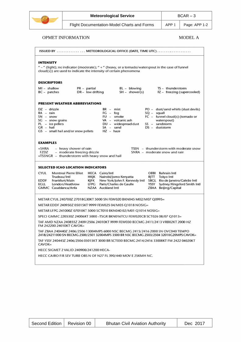
Meteorological Service BCAR – 3
Flight Documentation-Model Charts and Forms APP 1 Page: APP 1-2
Second Edition Revision 00 Bhutan Civil Aviation Authority Dec 2017
OPMET INFORMATION MODEL A
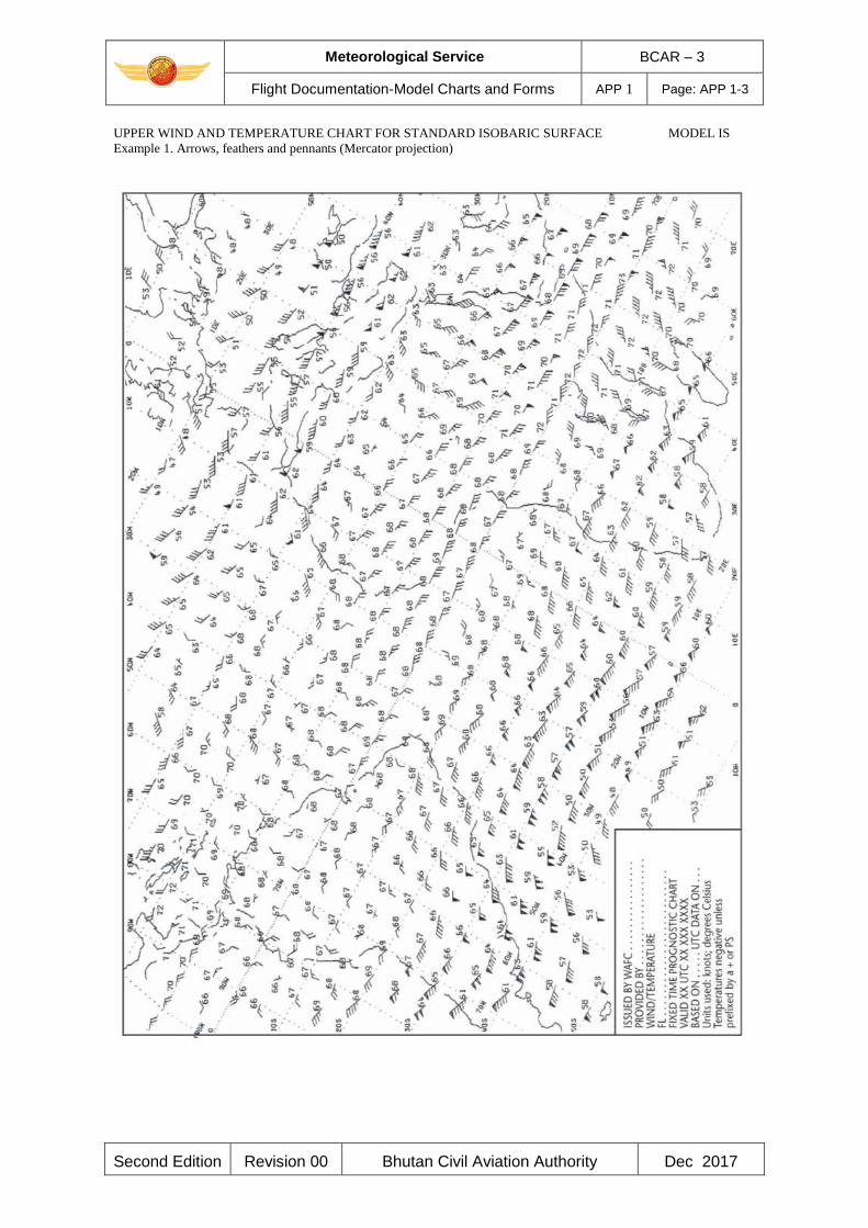
Meteorological Service BCAR – 3
Flight Documentation-Model Charts and Forms APP 1 Page: APP 1-3
Second Edition Revision 00 Bhutan Civil Aviation Authority Dec 2017
UPPER WIND AND TEMPERATURE CHART FOR STANDARD ISOBARIC SURFACE MODEL IS
Example 1. Arrows, feathers and pennants (Mercator projection)
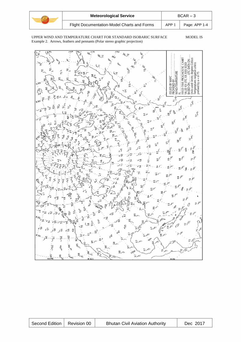
Meteorological Service BCAR – 3
Flight Documentation-Model Charts and Forms APP 1 Page: APP 1-4
Second Edition Revision 00 Bhutan Civil Aviation Authority Dec 2017
UPPER WIND AND TEMPERATURE CHART FOR STANDARD ISOBARIC SURFACE MODEL IS
Example 2. Arrows, feathers and pennants (Polar stereo graphic projection)
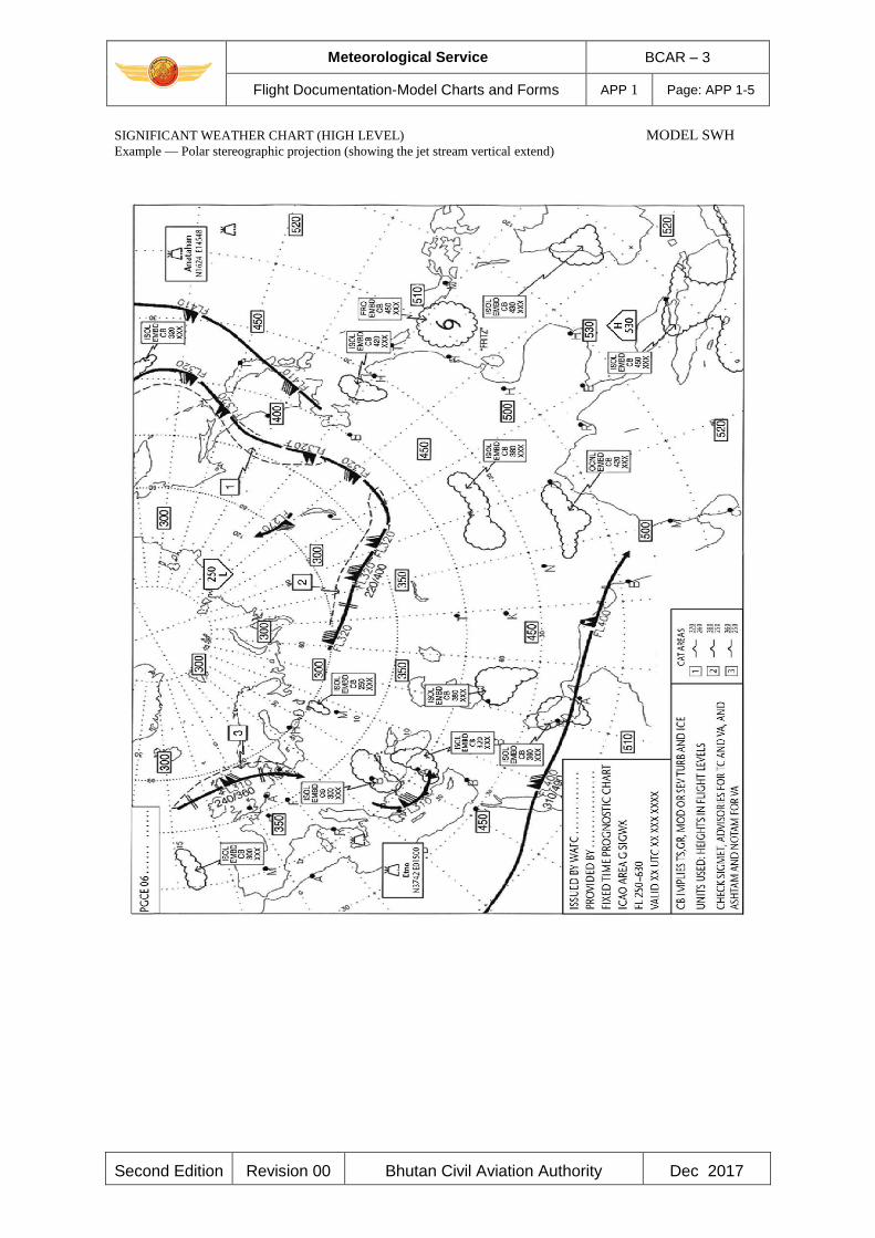
Meteorological Service BCAR – 3
Flight Documentation-Model Charts and Forms APP 1 Page: APP 1-5
Second Edition Revision 00 Bhutan Civil Aviation Authority Dec 2017
SIGNIFICANT WEATHER CHART (HIGH LEVEL) MODEL SWH
Example — Polar stereographic projection (showing the jet stream vertical extend)
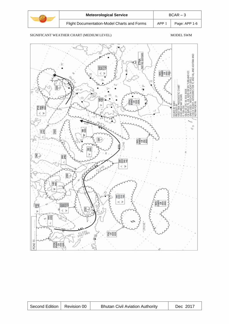
Meteorological Service BCAR – 3
Flight Documentation-Model Charts and Forms APP 1 Page: APP 1-6
Second Edition Revision 00 Bhutan Civil Aviation Authority Dec 2017
SIGNIFICANT WEATHER CHART (MEDIUM LEVEL) MODEL SWM
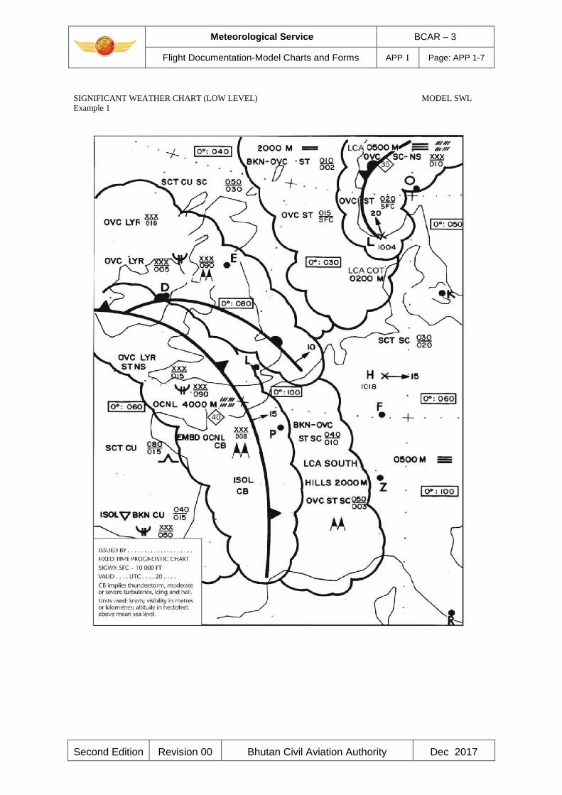
Meteorological Service BCAR – 3
Flight Documentation-Model Charts and Forms APP 1 Page: APP 1-7
Second Edition Revision 00 Bhutan Civil Aviation Authority Dec 2017
SIGNIFICANT WEATHER CHART (LOW LEVEL) MODEL SWL
Example 1
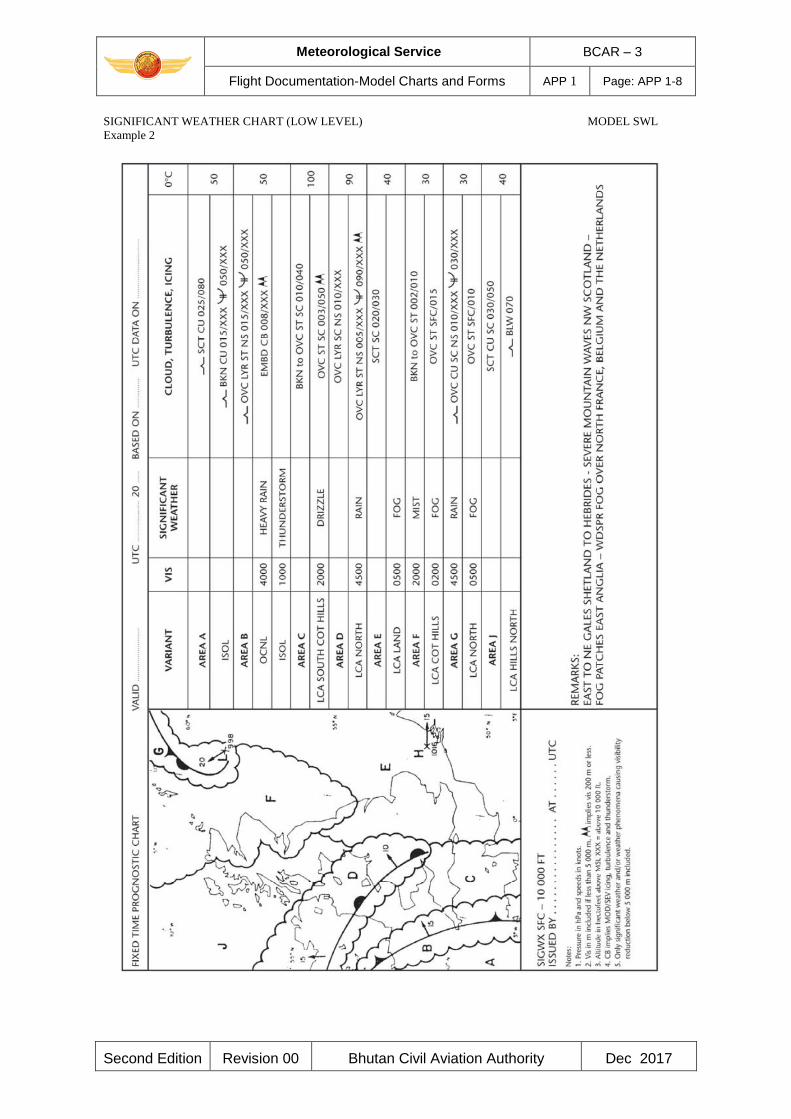
Meteorological Service BCAR – 3
Flight Documentation-Model Charts and Forms APP 1 Page: APP 1-8
Second Edition Revision 00 Bhutan Civil Aviation Authority Dec 2017
SIGNIFICANT WEATHER CHART (LOW LEVEL) MODEL SWL
Example 2
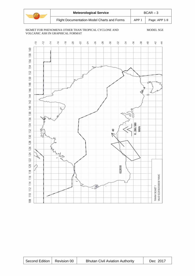
Meteorological Service BCAR – 3
Flight Documentation-Model Charts and Forms APP 1 Page: APP 1-9
Second Edition Revision 00 Bhutan Civil Aviation Authority Dec 2017
SIGMET FOR PHENOMENA OTHER THAN TROPICAL CYCLONE AND MODEL SGE
VOLCANIC ASH IN GRAPHICAL FORMAT
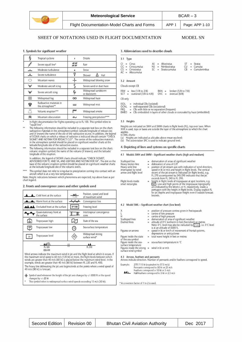
Meteorological Service BCAR – 3
Flight Documentation-Model Charts and Forms APP 1 Page: APP 1-10
Second Edition Revision 00 Bhutan Civil Aviation Authority Dec 2017
SHEET OF NOTATIONS USED IN FLIGHT DOCUMENTATION MODEL SN
Meteorological Service BCAR - 3
Technical Specifications related to WAFS & Meteorological Offices
APP 2 Page: APP 2- 1
Second Edition Revision 00 Bhutan Civil Aviation Authority Dec 2017
APPENDIX 2. TECHNICAL SPECIFICATIONS RELATED TO WORLD AREA
FORECAST SYSTEM AND METEOROLOGICAL OFFICES
(See Chapter 3 of this document.)
1. WORLD AREA FORECAST SYSTEM
1.2.1 ICAO stipulates in Appendix 2 of Annex 3 the technical specifications related to world area
forecast system required of the contracting states which have accepted responsibilities for
providing a WAFC within the framework of the world area forecast system.
1.2 Bhutan is not a WAFC. However, the MET Service provider shall have to be familiar with the
technical specifications so as to be able to interact with them and use its products/services
effectively.
2. AERODROME METEOROLOGICAL OFFICES
2.1 Use of world area forecast system (WAFS) products
2.1.1 The aerodrome meteorological office shall use forecasts issued by the WAFCs in the
preparation of flight documentation, whenever these forecasts cover the intended flight path in
respect of time, altitude and geographical extent for WAFS formats, codes and information
contained refer to ICAO Annex 3, Appendix 2.
2.1.2 In order to ensure uniformity and standardisation of flight documentation, the WAFS GRIB
and BUFR data received shall be decoded into standard WAFS charts in accordance with relevant
provisions in this MOS-MET (IAN), and the meteorological content and identification of the
originator of the WAFS forecasts shall not be amended.
2.2 Notification of WAFC concerning significant discrepancies
2.2.1 The aerodrome meteorological office using WAFS BUFR data shall notify the WAFC
concerned immediately if significant discrepancies are detected or reported in respect of WAFS
SIGWX forecasts concerning:
a) icing, turbulence, cumulonimbus clouds that are obscured, frequent, embedded or
occurring at a squall line, and sandstorms/dust storms; and
b) volcanic eruptions or a release of radioactive materials into the atmosphere, of significance
to aircraft operations.
The WAFC receiving the message shall acknowledge its receipt to the originator, together with a
brief comment on the report and any action taken, using the same means of communication
employed by the originator.
Note.— Guidance on reporting significant discrepancies is provided in the Manual of Aeronautical
Meteorological Practice (ICAO Doc 8896).

Meteorological Service BCAR - 3
Technical Specifications related to WAFS & Meteorological Offices
APP 2 Page: APP 2- 2
Second Edition Revision 00 Bhutan Civil Aviation Authority Dec 2017
3. Volcanic ash advisory centre
(Not applicable)
4. State volcano observatories
(Not applicable)
5. Tropical cyclone advisory centres
(Not applicable)
______________________
Meteorological Service BCAR - 3
Technical Specifications related to Meteorological Observations and Reports
APP 3 Page: APP 3- 1
Second Edition Revision 00 Bhutan Civil Aviation Authority Dec 2017
APPENDIX 3. TECHNICAL SPECIFICATIONS RELATED TO
METEOROLOGICAL OBSERVATIONS AND REPORTS
(See Chapter 4 of this document.)
1. GENERAL PROVISION RELATED TO METEOROLOGICAL OBSERVATIONS
1.1 The meteorological instruments used at an aerodrome should be situated in such a way as to
supply data which are representative of the area for which the measurements are required.
Note.— Specifications concerning the siting of equipment and installations on operational areas,
aimed at reducing the hazard to aircraft to a minimum, are contained in BCAR - 14, Volume I,
Chapter 9.
1.2 Meteorological instruments at aeronautical meteorological stations should be exposed,
operated and maintained in accordance with the practices, procedures and specifications
promulgated by the World Meteorological Organization (WMO).
1.3 The observers at an aerodrome should be located, in so far as is practicable, so as to supply
data which are representative of the area for which the observations are required.
1.4 Where automated equipment forms part of an integrated semi-automatic observing system,
displays of data which are made available to the local air traffic services units should be a subset
of and displayed parallel to those available in the local meteorological service unit. In those
displays, each meteorological element should be annotated to identify, as appropriate, the
locations for which the element is representative.
2. GENERAL CRITERIA RELATED TO METEOROLOGICAL REPORTS
2.1 Format of meteorological reports
2.1.1 Local routine and special reports shall be issued in abbreviated plain language, in
accordance with the template shown in Table A3-1.
2.1.2 METAR and SPECI shall be issued in accordance with the template shown in Table A3-2
and disseminated in the METAR and SPECI code forms prescribed by WMO.
Note.— The METAR and SPECI code forms are contained in the Manual on Codes (WMO-No.
306), Volume I.1, Part A — Alphanumeric Codes.
2.1.3 METAR and SPECI should be disseminated in digital form in addition to the dissemination
of the METAR and SPECI in accordance with 2.1.2.
2.1.4 METAR and SPECI if disseminated in digital form shall be formatted in accordance with a
globally interoperable information exchange model and shall use extensible mark up language
(XML)/geography mark up language (GML).
2.1.5 METAR and SPECI if disseminated in digital form shall be accompanied by the
appropriate metadata.

Meteorological Service BCAR - 3
Technical Specifications related to Meteorological Observations and Reports
APP 3 Page: APP 3- 2
Second Edition Revision 00 Bhutan Civil Aviation Authority Dec 2017
Note.— Guidance on the information exchange model, XML/GML and the metadata profile is
provided in the Manual on the Digital Exchange of Aeronautical Meteorological Information
(ICAO Doc 10003).
2.2 Use of CAVOK
When the following conditions occur simultaneously at the time of observation:
a) visibility, 10 km or more, and the lowest visibility is not reported;
Note 1.— In local routine and special reports, visibility refers to the value(s) to be
reported in accordance with 4.2.4.2 and 4.2.4.3; in METAR and SPECI, visibility refers to
the value(s) to be reported in accordance with 4.2.4.4.
Note 2.— The lowest visibility is reported in accordance with 4.2.4.4 a).
b) no cloud of operational significance;
c) no weather of significance to aviation as given in 4.4.2.3, 4.4.2.5 and 4.4.2.6; information
on visibility, runway visual range, present weather and cloud amount, cloud type and
height of cloud base shall be replaced in all meteorological reports by the term
“CAVOK”.
2.3 Criteria for issuance of local special reports and SPECI
2.3.1 The list of criteria for the issuance of local special reports shall include the following:
a) those values which most closely correspond with the operating minima of the operators
using the aerodrome;
b) those values which satisfy other local requirements of the air traffic services units and of
the operators;
c) an increase in air temperature of 2°C or more from that given in the latest report, or an
alternative threshold value as agreed between the meteorological authority, the appropriate
ATS authority and the operators concerned;
d) the available supplementary information concerning the occurrence of significant
meteorological conditions in the approach and climb-out areas as given in Table A3-1;
e) when noise abatement procedures are applied in accordance with the PANS-ATM (ICAO
Doc 4444) and the variation from the mean surface wind speed (gusts) has changed by 2.5
m/s (5 kt) or more from that at the time of the latest report, the mean speed before and/or
after the change being 7.5 m/s (15 kt) or more; and
f) those values which constitute criteria for SPECI.
2.3.2 Where required in accordance with Chapter 4, 4.4.2 b), SPECI shall be issued whenever
changes in accordance with the following criteria occur:
a) when the mean surface wind direction has changed by 60° or more from that given in the
Meteorological Service BCAR - 3
Technical Specifications related to Meteorological Observations and Reports
APP 3 Page: APP 3- 3
Second Edition Revision 00 Bhutan Civil Aviation Authority Dec 2017
latest report, the mean speed before and/or after the change being 5 m/s (10 kt) or more;
b) when the mean surface wind speed has changed by 5 m/s (10 kt) or more from that given
in the latest report;
c) when the variation from the mean surface wind speed (gusts) has changed by 5 m/s (10 kt)
or more from that at the time of the latest report, the mean speed before and/or after the
change being 7.5 m/s (15 kt) or more;
d) when the onset, cessation or change in intensity of any of the following weather
phenomena occurs:
— freezing precipitation
— moderate or heavy precipitation (including showers thereof)
— thunderstorm (with precipitation);
e) when the onset or cessation of any of the following weather phenomena occurs:
— freezing fog
— thunderstorm (without precipitation);
f) when the amount of a cloud layer below 450 m (1 500 ft) changes:
— from SCT or less to BKN or OVC; or
— from BKN or OVC to SCT or less.
2.3.3 Where required in accordance with Chapter 4, 4.4.2 b), SPECI should be issued whenever
changes in accordance with the following criteria occur:
a) when the wind changes through values of operational significance. The threshold values
should be established by the designated meteorological authority in consultation with the
appropriate ATS authority and the operators concerned, taking into account changes in the
wind which would:
1) require a change in runway(s) in use; and
2) indicate that the runway tailwind and crosswind components have changed through
values representing the main operating limits for typical aircraft operating at the
aerodrome;
b) when the visibility is improving and changes to or passes through one or more of the
following values, or when the visibility is deteriorating and passes through one or more of
the following values:
1) 800, 1 500 or 3 000 m; and
2) 5 000 m, in cases where significant numbers of flights are operated in accordance
with the visual flight rules;
Meteorological Service BCAR - 3
Technical Specifications related to Meteorological Observations and Reports
APP 3 Page: APP 3- 4
Second Edition Revision 00 Bhutan Civil Aviation Authority Dec 2017
Note 1.— In local special reports, visibility refers to the value(s) to be reported in
accordance with 4.2.4.2 and 4.2.4.3; in SPECI, visibility refers to the value(s) to be
reported in accordance with 4.2.4.4.
Note 2.— Visibility refers to “prevailing visibility” except in the case where only the
lowest visibility is reported in accordance with 4.2.4.4 b).
c) when the runway visual range is improving and changes to or passes through one or more
of the following values, or when the runway visual range is deteriorating and passes
through one or more of the following values: 50, 175, 300, 550 or 800 m;
d) when the onset, cessation or change in intensity of any of the following weather
phenomena occurs:
— duststorm
— sandstorm
— funnel cloud (tornado or waterspout);
e) when the onset or cessation of any of the following weather phenomena occurs:
— low drifting dust, sand or snow
— blowing dust, sand or snow
— squall;
f) when the height of base of the lowest cloud layer of BKN or OVC extent is lifting and
changes to or passes through one or more of the following values, or when the height of
base of the lowest cloud layer of BKN or OVC extent is lowering and passes through one
or more of the following values:
1) 30, 60, 150 or 300 m (100, 200, 500 or 1 000 ft); and
2) 450 m (1 500 ft), in cases where significant numbers of flights are operated in
accordance with the visual flight rules;
g) when the sky is obscured and the vertical visibility is improving and changes to or passes
through one or more of the following values, or when the vertical visibility is deteriorating
and passes through one or more of the following values: 30, 60, 150 or 300 m (100, 200,
500 or 1 000 ft); and
h) any other criteria based on local aerodrome operating minima, as agreed between the
designated meteorological authority and the operators concerned.
Note.— Other criteria based on local aerodrome operating minima are to be considered in
parallel with similar criteria for the inclusion of change groups and for the amendment of TAF
developed in response to Appendix 5, 1.3.2 j).
2.3.4 When a deterioration of one weather element is accompanied by an improvement in another
element, a single SPECI shall be issued; it shall then be treated as a deterioration report.

Meteorological Service BCAR - 3
Technical Specifications related to Meteorological Observations and Reports
APP 3 Page: APP 3- 5
Second Edition Revision 00 Bhutan Civil Aviation Authority Dec 2017
3. DISSEMINATION OF METEOROLOGICAL REPORTS
3.1 METAR and SPECI
3.1.1 METAR and SPECI shall be disseminated to international OPMET databanks and the
centres designated by regional air navigation agreement for the operation of aeronautical fixed
service Internet-based services, in accordance with regional air navigation agreement.
3.1.2 METAR and SPECI shall be disseminated to other aerodromes in accordance with regional
air navigation agreement.
3.1.3 SPECI representing a deterioration in conditions shall be disseminated immediately after
the observation. A SPECI representing a deterioration of one weather element and an
improvement in another element shall be disseminated immediately after the observation.
3.1.4 A SPECI representing an improvement in conditions should be disseminated only after the
improvement has been maintained for 10 minutes; it should be amended before dissemination, if
necessary, to indicate the conditions prevailing at the end of that 10-minute period.
3.2 Local routine and special reports
3.2.1 Local routine reports shall be transmitted to local air traffic services units and shall be made
available to the operators and to other users at the aerodrome.
3.2.2 Local special reports shall be transmitted to local air traffic services units as soon as the
specified conditions occur. However, as agreed between the meteorological authority and the
appropriate ATS authority, they need not be issued in respect of:
a) any element for which there is in the local air traffic services unit a display corresponding
to the one in the meteorological station, and where arrangements are in force for the use of
this display to update information included in local routine and special reports; and
b) runway visual range, when all changes of one or more steps on the reporting scale in use
are being reported to the local air traffic services unit by an observer on the aerodrome.
Local special reports shall also be made available to the operators and to other users at the
aerodrome.
4. OBSERVING AND REPORTING OF METEOROLOGICAL ELEMENTS
Introductory Note.— Selected criteria applicable to meteorological information referred to under
4.1 to 4.8 for inclusion in aerodrome reports are given in tabular form at Attachment C.
4.1 Surface wind
4.1.1 Siting
4.1.1.1 Surface wind should be observed at a height of 10 ± 1 m (30 ± 3 ft) above the ground.
4.1.1.2 Representative surface wind observations should be obtained by the use of sensors

Meteorological Service BCAR - 3
Technical Specifications related to Meteorological Observations and Reports
APP 3 Page: APP 3- 6
Second Edition Revision 00 Bhutan Civil Aviation Authority Dec 2017
appropriately sited. Sensors for surface wind observations for local routine and special reports
should be sited to give the best practicable indication of conditions along the runway and
touchdown zones. At aerodromes where topography or prevalent weather conditions cause
significant differences in surface wind at various sections of the runway, additional sensors should
be provided.
Note.— Since, in practice, the surface wind cannot be measured directly on the runway, surface
wind observations for take-off and landing are expected to be the best practicable indication of the
winds which an aircraft will encounter during take-off and landing.
4.1.2 Displays
4.1.2.1 Surface wind displays relating to each sensor shall be located in the meteorological station
with corresponding displays in the appropriate air traffic services units. The displays in the
meteorological station and in the air traffic services units shall relate to the same sensors, and
where separate sensors are required as specified in 4.1.1.2, the displays shall be clearly marked to
identify the runway and section of runway monitored by each sensor.
4.1.2.2 The mean values of, and significant variations in, the surface wind direction and speed for
each sensor should be derived and displayed by automated equipment.
4.1.3.1 The averaging period for surface wind observations shall be:
a) 2 minutes for local routine and special reports and for wind displays in air traffic services
units; and
b) 10 minutes for METAR and SPECI, except that when the 10-minute period includes a
marked discontinuity in the wind direction and/or speed, only data occurring after the
discontinuity shall be used for obtaining mean values; hence, the time interval in these
circumstances shall be correspondingly reduced.
Note.— A marked discontinuity occurs when there is an abrupt and sustained change in wind
direction of 30° or more, with a wind speed of 5 m/s (10 kt) before or after the change, or a
change in wind speed of 5 m/s (10 kt) or more, lasting at least 2 minutes.
4.1.3.2 The averaging period for measuring variations from the mean wind speed (gusts) reported
in accordance with 4.1.5.2 c) should be 3 seconds for local routine reports, local special reports,
METAR, SPECI and wind displays used for depicting variations from the mean wind speed
(gusts) in air traffic services units.
4.1.4 Accuracy of measurement
The reported direction and speed of the mean surface wind, as well as variations from the mean
surface wind, should meet the operationally desirable accuracy of measurement as given in
Attachment A.
4.1.5 Reporting
4.1.5.1 In local routine reports, local special reports, METAR and SPECI, the surface wind
direction and speed shall be reported in steps of 10 degrees true and 1 metre per second (or 1
knot), respectively. Any observed value which does not fit the reporting scale in use shall be
rounded to the nearest step in the scale.
Meteorological Service BCAR - 3
Technical Specifications related to Meteorological Observations and Reports
APP 3 Page: APP 3- 7
Second Edition Revision 00 Bhutan Civil Aviation Authority Dec 2017
4.1.5.2 In local routine reports, local special reports, METAR and SPECI:
a) the units of measurement used for the wind speed shall be indicated;
b) variations from the mean wind direction during the past 10 minutes shall be reported as
follows, if the total variation is 60° or more:
1) when the total variation is 60° or more and less than 180° and the wind speed is 1.5
m/s (3 kt) or more, such directional variations shall be reported as the two extreme
directions between which the surface wind has varied;
2) when the total variation is 60° or more and less than 180°and the wind speed is less
than 1.5 m/s (3 kt), the wind direction shall be reported as variable with no mean
wind direction; or
3) when the total variation is 180° or more, the wind direction shall be reported as
variable with no mean wind direction;
c) variations from the mean wind speed (gusts) during the past 10 minutes shall be reported
when the maximum wind speed exceeds the mean speed by:
1) 2.5 m/s (5 kt) or more in local routine and special reports when noise abatement
procedures are applied in accordance with the PANS-ATM (ICAO Doc 4444); or
2) m/s (10 kt) or more otherwise;
d) when a wind speed of less than 0.5 m/s (1 kt) is reported, it shall be indicated as calm;
e) when a wind speed of 50 m/s (100 kt) or more is reported, it shall be indicated to be more
than 49 m/s (99 kt); and
f) when the 10-minute period includes a marked discontinuity in the wind direction and/or
speed, only variations from the mean wind direction and mean wind speed occurring since
the discontinuity shall be reported.
Note.— See note under 4.1.3.1.
4.1.5.3 In local routine and special reports:
a) if the surface wind is observed from more than one location along the runway, the
locations for which these values are representative shall be indicated;
b) when there is more than one runway in use and the surface wind related to these runways
is observed, the available wind values for each runway shall be given, and the runways to
which the values refer shall be reported;
c) when variations from the mean wind direction are reported in accordance with 4.1.5.2 b)
2), the two extreme directions between which the surface wind has varied shall be
reported; and
d) when variations from the mean wind speed (gusts) are reported in accordance with 4.1.5.2
c), they shall be reported as the maximum and minimum values of the wind speed
attained.
Meteorological Service BCAR - 3
Technical Specifications related to Meteorological Observations and Reports
APP 3 Page: APP 3- 8
Second Edition Revision 00 Bhutan Civil Aviation Authority Dec 2017
4.1.5.4 In METAR and SPECI, when variations from the mean wind speed (gusts) are reported in
accordance with 4.1.5.2 c), the maximum value of the wind speed attained shall be reported.
4.2 Visibility
4.2.1 Siting
4.2.1.1 When instrumented systems are used for the measurement of visibility, the visibility
should be measured at a height of approximately 2.5 m (7.5 ft) above the runway.
4.2.1.2 When instrumented systems are used for the measurement of visibility, representative
visibility observations should be obtained by the use of sensors appropriately sited. Sensors for
visibility observations for local routine and special reports should be sited to give the best
practicable indications of visibility along the runway and touchdown zone.
4.2.2 Displays
When instrumented systems are used for the measurement of visibility, visibility displays relating
to each sensor should be located in the meteorological station with corresponding displays in the
appropriate air traffic services units. The displays in the meteorological station and in the air
traffic services units should relate to the same sensors, and where separate sensors are required as
specified in 4.2.1, the displays should be clearly marked to identify the area, e.g. runway and
section of runway, monitored by each sensor.
4.3 Runway visual range
(Reserved)
4.4 Present weather
4.4.1 Siting
When instrumented systems are used for observing present weather phenomena listed under
4.4.2.3 and 4.4.2.4, representative information should be obtained by the use of sensors
appropriately sited.
4.4.2 Reporting
4.4.2.1 In local routine and special reports, observed present weather phenomena shall be
reported in terms of type and characteristics and qualified with respect to intensity, as appropriate.
4.4.2.2 In METAR and SPECI, observed present weather phenomena shall be reported in terms
of type and characteristics and qualified with respect to intensity or proximity to the aerodrome, as
appropriate
4.4.2.3 In local routine reports, local special reports, METAR and SPECI, the following types of
present weather phenomena should be reported, using their respective abbreviations and relevant
criteria, as appropriate: a) Precipitation
Drizzle DZ
Meteorological Service BCAR - 3
Technical Specifications related to Meteorological Observations and Reports
APP 3 Page: APP 3- 9
Second Edition Revision 00 Bhutan Civil Aviation Authority Dec 2017
Rain RA Snow SN Snow grains SG Ice pellets PL
Hail GR — Reported when diameter of largest hailstones is 5 mm or more.
4.4.2.4 In automated local routine reports, local special reports, METAR and SPECI, in addition
to the precipitation types listed under 4.4.2.3 a), the abbreviation UP should be used for
unidentified precipitation when the type of precipitation cannot be identified by the automatic
observing system.
4.4.2.5 In local routine reports, local special reports, METAR and SPECI, the following
characteristics of present weather phenomena, as necessary, shall be reported, using their
respective abbreviations and relevant criteria, as appropriate:
Small hail and/or snow pellets GS
— Reported when diameter of largest hailstones is less than 5 mm.
b) Obscurations (hydrometeors)
Fog FG
— Reported when visibility is less than 1 000 m, except when qualified
by “MI”, “BC”, “PR” or “VC” (see 4.4.2.6 and 4.4.2.8).
Mist BR
— Reported when visibility is at least 1 000 m but not more than 5 000 m.
c) Obscurations (lithometeors)
— The following should be used only when the obscuration consists
predominantly of lithometeors and the visibility is 5 000 m or less except
“SA” when qualified by “DR” (see 4.4.2.6) and volcanic ash.
Sand SA
Dust (widespread) DU
Haze HZ
Smoke FU
Volcanic ash VA
d) Other phenomena
Dust/sand whirls (dust devils) PO
Squall SQ
Funnel cloud (tornado or waterspout) FC
Duststorm DS
Sandstorm SS
Meteorological Service BCAR - 3
Technical Specifications related to Meteorological Observations and Reports
APP 3 Page: APP 3- 10
Second Edition Revision 00 Bhutan Civil Aviation Authority Dec 2017
Thunderstorm TS — Used to report a thunderstorm with precipitation in accordance with the templates
shown in Tables A3-1 and A3-2. When thunder is heard or lightning is detected at the
aerodrome during the 10-minute period preceding the time of observation but no
precipitation is observed at the aerodrome, the abbreviation “TS” shall be used
without qualification.
Freezing FZ — Supercooled water droplets or precipitation, used with types of present weather
phenomena in accordance with the templates shown in Tables A3-1 and A3-2.
Note.— At aerodromes with human observers, lightning detection equipment may supplement
human observations. For aerodromes with automatic observing systems, guidance on the use of
lightning detection equipment intended for thunderstorm reporting is given in the Manual on
Automatic Meteorological Observing Systems at Aerodromes (ICAO Doc 9837).
4.4.2.6 In local routine reports, local special reports, METAR and SPECI, the following
characteristics of present weather phenomena, as necessary, should be reported, using their
respective abbreviations and relevant criteria, as appropriate:
Shower SH
— Used to report showers in accordance with the templates shown in Tables A3-1 and
A3-2. Showers observed in the vicinity of the aerodrome (see 4.4.2.8) should be
reported as “VCSH” without qualification regarding type or intensity of precipitation.
Blowing BL
— Used in accordance with the templates shown in Tables A3-1 and A3-2 with types of
present weather phenomena raised by the wind to a height of 2 m (6 ft) or more above
the ground.
Low drifting DR
— Used in accordance with the templates shown in Tables A3-1 and A3-2 with types of
present weather phenomena raised by the wind to less than 2 m (6 ft) above ground
level.
Shallow MI
— Less than 2 m (6 ft) above ground level.
Patches BC
— Fog patches randomly covering the aerodrome.
Partial PR
— A substantial part of the aerodrome covered by fog while the remainder is clear.
4.4.2.7 In automated local routine reports, local special reports, METAR and SPECI, when
showers (SH) referred to in 4.4.2.6 cannot be determined based upon a method that takes account
of the presence of convective cloud, the precipitation should not be characterized by SH.
4.4.2.8 In local routine reports, local special reports, METAR and SPECI, the relevant intensity
or, as appropriate, the proximity to the aerodrome of the reported present weather phenomena
should be indicated as follows:
Meteorological Service BCAR - 3
Technical Specifications related to Meteorological Observations and Reports
APP 3 Page: APP 3- 11
Second Edition Revision 00 Bhutan Civil Aviation Authority Dec 2017
(local routine and special reports) (METAR and SPECI)
Light FBL —
Moderate MOD (no indication)
Heavy HVY + Used with types of present weather phenomena in accordance with the templates shown in Tables
A3-1 and A3-2. Light intensity should be indicated only for precipitation.
Vicinity VC
— Between approximately 8 and 16 km of the aerodrome reference point and used only in
METAR and SPECI with present weather in accordance with the template shown in
Table A3-2 when not reported under 4.4.2.5 and 4.4.2.6. 4.4.2.9 In local routine reports, local special reports, METAR and SPECI:
a) one or more, up to a maximum of three, of the present weather abbreviations given in
4.4.2.3 and 4.4.2.4 shall be used, as necessary, together with an indication, where
appropriate, of the characteristics given in 4.4.2.5. and 4.4.2.6 and intensity or proximity
to the aerodrome given in 4.4.2.8, so as to convey a complete description of the present
weather of significance to flight operations;
b) the indication of intensity or proximity, as appropriate, shall be reported first followed
respectively by the characteristics and the type of weather phenomena; and
c) where two different types of weather are observed, they shall be reported in two separate
groups, where the intensity or proximity indicator refers to the weather phenomenon
which follows the indicator. However, different types of precipitation occurring at the
time of observation shall be reported as one single group with the dominant type of
precipitation reported first and preceded by only one intensity qualifier which refers to the
intensity of the total precipitation.
4.4.2.10 In automated local routine reports, local special reports, METAR and SPECI, the present
weather should be replaced by “//” when the present weather cannot be observed by the automatic
observing system due to a temporary failure of the system/sensor.
4.5 Clouds
4.5.1 Siting
When instrumented systems are used for the measurement of the cloud amount and the height of
cloud base, representative observations should be obtained by the use of sensors appropriately
sited. For local routine and special reports, in the case of aerodromes with precision approach
runways, sensors for cloud amount and height of cloud base should be sited to give the best
practicable indications of the cloud amount and height of cloud base at the threshold of the runway
in use. For that purpose, a sensor should be installed at a distance of less than 1 200 m (4 000 ft)
before the landing threshold.
4.5.2 Display
When automated equipment is used for the measurement of the height of cloud base, height of
Meteorological Service BCAR - 3
Technical Specifications related to Meteorological Observations and Reports
APP 3 Page: APP 3- 12
Second Edition Revision 00 Bhutan Civil Aviation Authority Dec 2017
cloud base display(s) should be located in the meteorological station with corresponding display(s)
in the appropriate air traffic services units. The displays in the meteorological station and in the air
traffic services units should relate to the same sensor, and where separate sensors are required as
specified in 4.5.1, the displays should clearly identify the area monitored by each sensor.
4.5.3 Reference level
The height of cloud base shall be reported above aerodrome elevation. When a precision approach
runway is in use which has a threshold elevation 15 m (50 ft) or more below the aerodrome
elevation, local arrangements shall be made in order that the height of cloud bases reported to
arriving aircraft shall refer to the threshold elevation. In the case of reports from offshore
structures, the height of cloud base shall be given above mean sea level.
4.5.4 Reporting
4.5.4.1 In local routine reports, local special reports, METAR and SPECI, the height of cloud
base shall be reported in steps of 30 m (100 ft) up to 3 000 m (10 000 ft).
4.5.4.2 At aerodromes where low-visibility procedures are established for approach and landing,
as agreed between the meteorological authority and the appropriate ATS authority, in local routine
and special reports the height of cloud base should be reported in steps of 15 m (50 ft) up to and
including 90 m (300 ft) and in steps of 30 m (100 ft) between 90 m (300 ft) and 3 000 m (10 000
ft), and the vertical visibility in steps of 15 m (50 ft) up to and including 90 m (300 ft) and in steps
of 30 m (100 ft) between 90 m (300 ft) and 600 m (2 000 ft).
4.5.4.3 In local routine reports, local special reports, METAR and SPECI:
a) cloud amount should be reported using the abbreviations “FEW” (1 to 2 oktas), “SCT” (3
to 4 oktas), “BKN” (5 to 7 oktas) or “OVC” (8 oktas);
b) cumulonimbus clouds and towering cumulus clouds should be indicated as “CB” and
“TCU”, respectively;
c) the vertical visibility should be reported in steps of 30 m (100 ft) up to 600 m (2 000 ft);
d) if there are no clouds of operational significance and no restriction on vertical visibility
and the abbreviation “CAVOK” is not appropriate, the abbreviation “NSC” should be
used;
e) when several layers or masses of cloud of operational significance are observed, their
amount and height of cloud base should be reported in increasing order of the height of
cloud base, and in accordance with the following criteria:
1) the lowest layer or mass, regardless of amount to be reported as FEW, SCT, BKN or
OVC as appropriate;
2) the next layer or mass, covering more than 2/8 to be reported as SCT, BKN or OVC
as appropriate;
3) the next higher layer or mass, covering more than 4/8 to be reported as BKN or OVC
as appropriate; and
Meteorological Service BCAR - 3
Technical Specifications related to Meteorological Observations and Reports
APP 3 Page: APP 3- 13
Second Edition Revision 00 Bhutan Civil Aviation Authority Dec 2017
4) cumulonimbus and/or towering cumulus clouds, whenever observed and not reported
in 1) to 3);
f) when the cloud base is diffuse or ragged or fluctuating rapidly, the minimum height of
cloud base, or cloud fragments, should be reported; and
g) when an individual layer (mass) of cloud is composed of cumulonimbus and towering
cumulus clouds with a common cloud base, the type of cloud should be reported as
cumulonimbus only.
Note.— Towering cumulus indicates cumulus congestus clouds of great vertical extent.
4.5.4.4 Any observed value in 4.5.4.1, 4.5.4.2 and 4.5.4.3 c) which does not fit the reporting
scale in use shall be rounded down to the nearest lower step in the scale.
4.5.4.5 In local routine and special reports:
a) the units of measurement used for the height of cloud base and vertical visibility shall be
indicated; and
b) when there is more than one runway in use and the heights of cloud bases are observed by
instruments for these runways, the available heights of cloud bases for each runway shall
be reported and the runways to which the values refer shall be indicated.
4.5.4.6 In automated local routine reports, local special reports, METAR and SPECI:
a) when the cloud type cannot be observed by the automatic observing system, the cloud
type in each cloud group should be replaced by “///”;
b) when no clouds are detected by the automatic observing system, it should be indicated by
using the abbreviation “NCD”;
c) when cumulonimbus clouds or towering cumulus clouds are detected by the automatic
observing system and the cloud amount and/or the height of cloud base cannot be
observed, the cloud amount and/or the height of cloud base should be replaced by “///”;
and
d) the vertical visibility should be replaced by “///” when the sky is obscured and the value of
the vertical visibility cannot be determined by the automatic observing system due to a
temporary failure of the system/sensor.
4.6 Air temperature and dew-point temperature
4.6.1 Display
When automated equipment is used for the measurement of air temperature and dew-point
temperature, air temperature and dew-point temperature displays should be located in the
meteorological station with corresponding displays in the appropriate air traffic services units. The
displays in the meteorological station and in the air traffic services units should relate to the same
sensors
Meteorological Service BCAR - 3
Technical Specifications related to Meteorological Observations and Reports
APP 3 Page: APP 3- 14
Second Edition Revision 00 Bhutan Civil Aviation Authority Dec 2017
4.6.2 Reporting
4.6.2.1 In local routine reports, local special reports, METAR and SPECI, the air temperature and
the dew-point temperature shall be reported in steps of whole degrees Celsius. Any observed value
which does not fit the reporting scale in use shall be rounded to the nearest whole degree Celsius,
with observed values involving 0.5° rounded up to the next higher whole degree Celsius.
4.6.2.2 In local routine reports, local special reports, METAR and SPECI, a temperature below
0°C shall be identified.
4.7 Atmospheric pressure
4.7.1 Display
When automated equipment is used for the measurement of atmospheric pressure, QNH and, if
required in accordance with 4.7.3.2 b), QFE displays relating to the barometer shall be located in
the meteorological station with corresponding displays in the appropriate air traffic services units.
When QFE values are displayed for more than one runway, as specified in 4.7.3.2 d), the displays
shall be clearly marked to identify the runway to which the QFE value displayed refers.
4.7.2 Reference level
The reference level for the computation of QFE should be the aerodrome elevation. For non-
precision approach runways, the thresholds of which are 2 m (7 ft) or more below the aerodrome
elevation, and for precision approach runways, the QFE, if required, should refer to the relevant
threshold elevation.
4.7.3 Reporting
4.7.3.1 For local routine reports, local special reports, METAR and SPECI, QNH and QFE shall
be computed in tenths of hectopascals and reported therein in steps of whole hectopascals, using
four digits. Any observed value which does not fit the reporting scale in use shall be rounded
down to the nearest lower whole hectopascal.
4.7.3.2 In local routine and special reports:
QNH shall be included;
a) QFE shall be included if required by users or as agreed between the meteorological
authority, the ATS authority and the operators concerned, on a regular basis;
b) the units of measurement used for QNH and QFE values shall be included; and
c) if QFE values are required for more than one runway, the required QFE values for each
runway shall be reported and the runways to which the values refer shall be indicated.
4.7.3.3 In METAR and SPECI, only QNH values shall be included.

Meteorological Service BCAR - 3
Technical Specifications related to Meteorological Observations and Reports
APP 3 Page: APP 3- 15
Second Edition Revision 00 Bhutan Civil Aviation Authority Dec 2017
4.8 Supplementary information
4.8.1 Reporting
4.8.1.1 In local routine reports, local special reports, METAR and SPECI, the following recent
weather phenomena, i.e. weather phenomena observed at the aerodrome during the period since
the last issued routine report or last hour, whichever is the shorter, but not at the time of
observation, should be reported, up to a maximum of three groups, in accordance with the
templates shown in Tables A3-1 and A3-2, in the supplementary information:
— freezing precipitation
— moderate or heavy precipitation (including showers thereof)
— blowing snow
— thunderstorm
Note.— The meteorological authority, in consultation with users, may agree not to provide recent
weather information where SPECI are issued.
4.8.1.2 In local routine and special reports, the following significant meteorological conditions or
combinations thereof, should be reported in supplementary information:
— cumulonimbus clouds CB
— Thunderstorm TS
— moderate or severe turbulence MOD TURB, SEV TURB
— wind shear WS
— Hail GR
— severe squall line SEV SQL
— moderate or severe icing MOD ICE, SEV ICE
— freezing precipitation FZDZ, FZRA
— severe mountain waves SEV MTW
— duststorm, sandstorm DS, SS
— blowing snow BLSN
— funnel cloud (tornado or waterspout) FC
The location of the condition should be indicated. Where necessary, additional information should
be included using abbreviated plain language.
4.8.1.3 In automated local routine reports, local special reports, METAR and SPECI, in addition
to the recent weather phenomena listed under 4.8.1.1, recent unknown precipitation should be
reported in accordance with the template shown in Table A3-2 when the type of precipitation
cannot be identified by the automatic observing system.
Note.— The meteorological authority, in consultation with users, may agree not to provide recent
weather information where SPECI are issued.
4.8.1.4 In METAR and SPECI, where local circumstances so warrant, information on wind shear
should be added.
Note.— The local circumstances referred to in 4.8.1.4 include, but are not necessarily limited to,
wind shear of a nontransitory nature such as might be associated with low-level temperature
Meteorological Service BCAR - 3
Technical Specifications related to Meteorological Observations and Reports
APP 3 Page: APP 3- 16
Second Edition Revision 00 Bhutan Civil Aviation Authority Dec 2017
inversions or local topography.
4.8.1.5 In METAR and SPECI, the following information should be included in the
supplementary information, in accordance with regional air navigation agreement:
a) (Reserved)
b) information on the state of the runway provided by the appropriate airport authority
Note.— The state of the runway is specified in the Manual on Codes (WMO-No. 306), Volume I.1,
Part A — Alphanumeric Codes, Code Tables 0366, 0519, 0919 and 1079.
(INTENTIONALLY LEFT BLANK)

Meteorological Service BCAR - 3
Technical Specifications related to Meteorological Observations and Reports
APP 3 Page: APP 3- 17
Second Edition Revision 00 Bhutan Civil Aviation Authority Dec 2017
Table A3-1. Template for the local routine (MET REPORT) and local special (SPECIAL)
reports
Key: M = inclusion mandatory, part of every message;
C = inclusion conditional, dependent on meteorological conditions;
O = inclusion optional.
Note 1.— The ranges and resolutions for the numerical elements included in the local routine and
special reports are shown in Table A3-4 of this appendix.
Note 2.— The explanations for the abbreviations can be found in the Procedures for Air
Navigation Services — ICAO Abbreviations and Codes (PANS-ABC, ICAO Doc 8400)

Meteorological Service BCAR - 3
Technical Specifications related to Meteorological Observations and Reports
APP 3 Page: APP 3- 18
Second Edition Revision 00 Bhutan Civil Aviation Authority Dec 2017
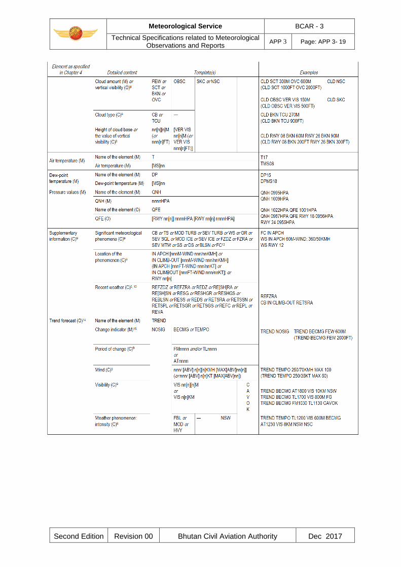
Meteorological Service BCAR - 3
Technical Specifications related to Meteorological Observations and Reports
APP 3 Page: APP 3- 19
Second Edition Revision 00 Bhutan Civil Aviation Authority Dec 2017
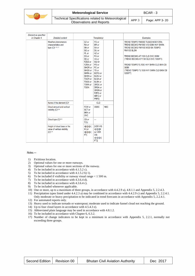
Meteorological Service BCAR - 3
Technical Specifications related to Meteorological Observations and Reports
APP 3 Page: APP 3- 20
Second Edition Revision 00 Bhutan Civil Aviation Authority Dec 2017
Notes.—
1) Fictitious location.
2) Optional values for one or more runways.
3) Optional values for one or more sections of the runway.
4) To be included in accordance with 4.1.5.2 c).
5) To be included in accordance with 4.1.5.2 b) 1).
6) To be included if visibility or runway visual range < 1 500 m.
7) To be included in accordance with 4.3.6.4 d).
8) To be included in accordance with 4.3.6.4 c).
9) To be included whenever applicable.
10) One or more, up to a maximum of three groups, in accordance with 4.4.2.9 a), 4.8.1.1 and Appendix 5, 2.2.4.3.
11) Precipitation types listed under 4.4.2.3 a) may be combined in accordance with 4.4.2.9 c) and Appendix 5, 2.2.4.1.
Only moderate or heavy precipitation to be indicated in trend forecasts in accordance with Appendix 5, 2.2.4.1.
12) For automated reports only.
13) Heavy used to indicate tornado or waterspout; moderate used to indicate funnel cloud not reaching the ground.
14) Up to four cloud layers in accordance with 4.5.4.3 e).
15) Abbreviated plain language may be used in accordance with 4.8.1.2.
16) To be included in accordance with Chapter 6, 6.3.2.
17) Number of change indicators to be kept to a minimum in accordance with Appendix 5, 2.2.1, normally not
exceeding three groups.

Meteorological Service BCAR - 3
Technical Specifications related to Meteorological Observations and Reports
APP 3 Page: APP 3- 21
Second Edition Revision 00 Bhutan Civil Aviation Authority Dec 2017
Table A3-2: Template for METAR and SPECI
Key : M = inclusion mandatory, part of every message;
C = inclusion conditional, dependent on meteorological conditions or method
of observation;
O = inclusion optional.
Note 1.— The ranges and resolutions for the numerical elements included in METAR and SPECI
are shown in Table A3-5 of this appendix.
Note 2.— The explanations for the abbreviations can be found in the PANS-ABC (ICAO Doc
8400)

Meteorological Service BCAR - 3
Technical Specifications related to Meteorological Observations and Reports
APP 3 Page: APP 3- 22
Second Edition Revision 00 Bhutan Civil Aviation Authority Dec 2017

Meteorological Service BCAR - 3
Technical Specifications related to Meteorological Observations and Reports
APP 3 Page: APP 3- 23
Second Edition Revision 00 Bhutan Civil Aviation Authority Dec 2017
Notes.— 1) Fictitious location.
2) To be included whenever applicable.
3) To be included in accordance with 4.1.5.2 c).
4) To be included in accordance with 4.1.5.2 b) 1).
5) To be included in accordance with 4.2.4.4 b).
6) To be included in accordance with 4.2.4.4 a).
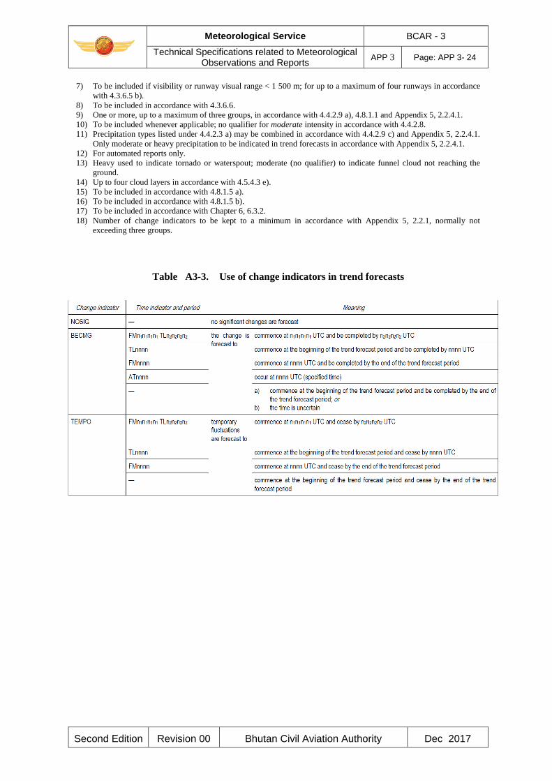
Meteorological Service BCAR - 3
Technical Specifications related to Meteorological Observations and Reports
APP 3 Page: APP 3- 24
Second Edition Revision 00 Bhutan Civil Aviation Authority Dec 2017
7) To be included if visibility or runway visual range < 1 500 m; for up to a maximum of four runways in accordance
with 4.3.6.5 b).
8) To be included in accordance with 4.3.6.6.
9) One or more, up to a maximum of three groups, in accordance with 4.4.2.9 a), 4.8.1.1 and Appendix 5, 2.2.4.1.
10) To be included whenever applicable; no qualifier for moderate intensity in accordance with 4.4.2.8.
11) Precipitation types listed under 4.4.2.3 a) may be combined in accordance with 4.4.2.9 c) and Appendix 5, 2.2.4.1.
Only moderate or heavy precipitation to be indicated in trend forecasts in accordance with Appendix 5, 2.2.4.1.
12) For automated reports only.
13) Heavy used to indicate tornado or waterspout; moderate (no qualifier) to indicate funnel cloud not reaching the
ground.
14) Up to four cloud layers in accordance with 4.5.4.3 e).
15) To be included in accordance with 4.8.1.5 a).
16) To be included in accordance with 4.8.1.5 b).
17) To be included in accordance with Chapter 6, 6.3.2.
18) Number of change indicators to be kept to a minimum in accordance with Appendix 5, 2.2.1, normally not
exceeding three groups.
Table A3-3. Use of change indicators in trend forecasts
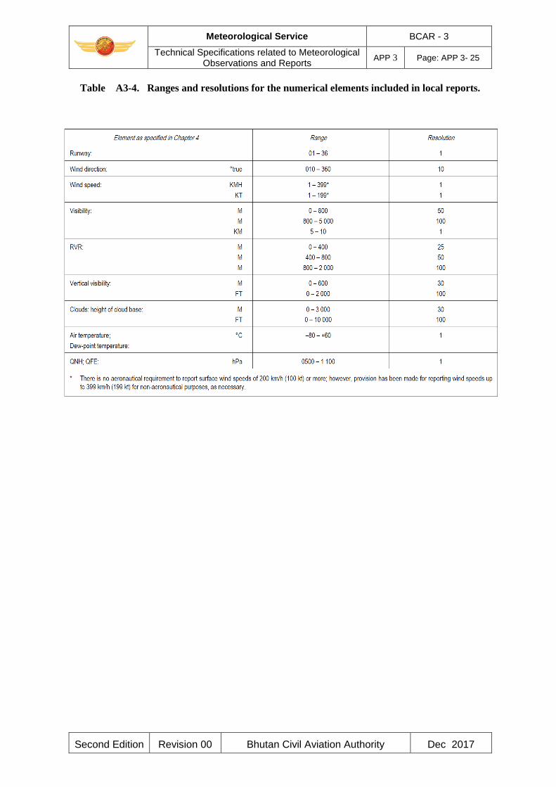
Meteorological Service BCAR - 3
Technical Specifications related to Meteorological Observations and Reports
APP 3 Page: APP 3- 25
Second Edition Revision 00 Bhutan Civil Aviation Authority Dec 2017
Table A3-4. Ranges and resolutions for the numerical elements included in local reports.
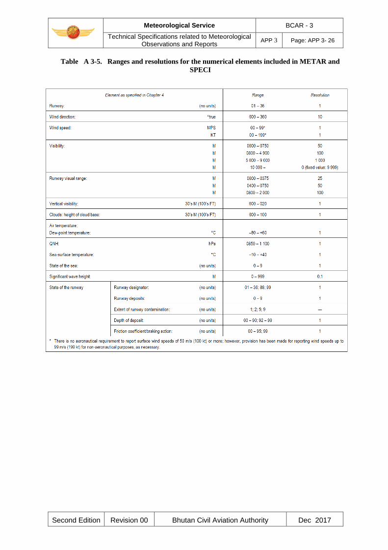
Meteorological Service BCAR - 3
Technical Specifications related to Meteorological Observations and Reports
APP 3 Page: APP 3- 26
Second Edition Revision 00 Bhutan Civil Aviation Authority Dec 2017
Table A 3-5. Ranges and resolutions for the numerical elements included in METAR and
SPECI
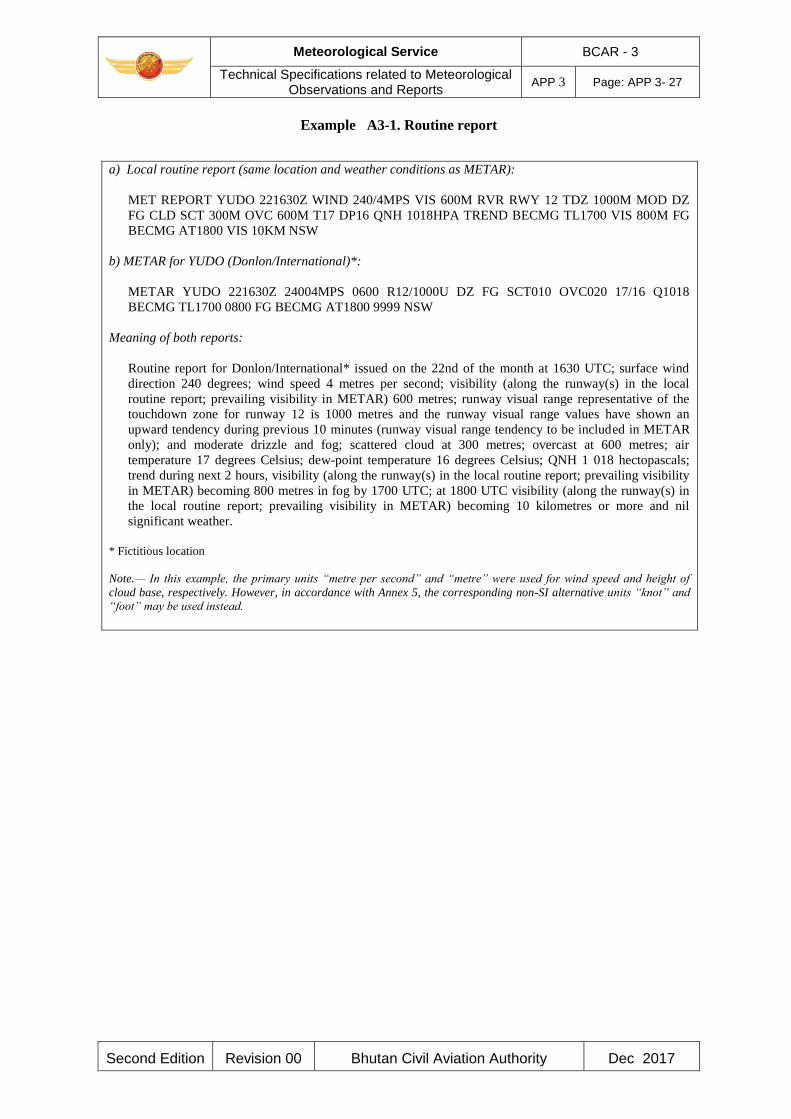
Meteorological Service BCAR - 3
Technical Specifications related to Meteorological Observations and Reports
APP 3 Page: APP 3- 27
Second Edition Revision 00 Bhutan Civil Aviation Authority Dec 2017
Example A3-1. Routine report
a) Local routine report (same location and weather conditions as METAR):
MET REPORT YUDO 221630Z WIND 240/4MPS VIS 600M RVR RWY 12 TDZ 1000M MOD DZ
FG CLD SCT 300M OVC 600M T17 DP16 QNH 1018HPA TREND BECMG TL1700 VIS 800M FG
BECMG AT1800 VIS 10KM NSW
b) METAR for YUDO (Donlon/International)*:
METAR YUDO 221630Z 24004MPS 0600 R12/1000U DZ FG SCT010 OVC020 17/16 Q1018
BECMG TL1700 0800 FG BECMG AT1800 9999 NSW
Meaning of both reports:
Routine report for Donlon/International* issued on the 22nd of the month at 1630 UTC; surface wind
direction 240 degrees; wind speed 4 metres per second; visibility (along the runway(s) in the local
routine report; prevailing visibility in METAR) 600 metres; runway visual range representative of the
touchdown zone for runway 12 is 1000 metres and the runway visual range values have shown an
upward tendency during previous 10 minutes (runway visual range tendency to be included in METAR
only); and moderate drizzle and fog; scattered cloud at 300 metres; overcast at 600 metres; air
temperature 17 degrees Celsius; dew-point temperature 16 degrees Celsius; QNH 1 018 hectopascals;
trend during next 2 hours, visibility (along the runway(s) in the local routine report; prevailing visibility
in METAR) becoming 800 metres in fog by 1700 UTC; at 1800 UTC visibility (along the runway(s) in
the local routine report; prevailing visibility in METAR) becoming 10 kilometres or more and nil
significant weather.
* Fictitious location
Note.— In this example, the primary units “metre per second” and “metre” were used for wind speed and height of
cloud base, respectively. However, in accordance with Annex 5, the corresponding non-SI alternative units “knot” and
“foot” may be used instead.
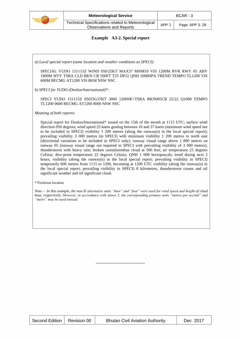
Meteorological Service BCAR - 3
Technical Specifications related to Meteorological Observations and Reports
APP 3 Page: APP 3- 28
Second Edition Revision 00 Bhutan Civil Aviation Authority Dec 2017
Example A3-2. Special report
a) Local special report (same location and weather conditions as SPECI):
SPECIAL YUDO 151115Z WIND 050/25KT MAX37 MNM10 VIS 1200M RVR RWY 05 ABV
1800M HVY TSRA CLD BKN CB 500FT T25 DP22 QNH 1008HPA TREND TEMPO TL1200 VIS
600M BECMG AT1200 VIS 8KM NSW NSC
b) SPECI for YUDO (Donlon/International)*:
SPECI YUDO 151115Z 05025G37KT 3000 1200NE+TSRA BKN005CB 25/22 Q1008 TEMPO
TL1200 0600 BECMG AT1200 8000 NSW NSC
Meaning of both reports:
Special report for Donlon/International* issued on the 15th of the month at 1115 UTC; surface wind
direction 050 degrees; wind speed 25 knots gusting between 10 and 37 knots (minimum wind speed not
to be included in SPECI) visibility 1 200 metres (along the runway(s) in the local special report);
prevailing visibility 3 000 metres (in SPECI) with minimum visibility 1 200 metres to north east
(directional variations to be included in SPECI only); runway visual range above 1 800 metres on
runway 05 (runway visual range not required in SPECI with prevailing visibility of 3 000 metres);
thunderstorm with heavy rain; broken cumulonimbus cloud at 500 feet; air temperature 25 degrees
Celsius; dew-point temperature 22 degrees Celsius; QNH 1 008 hectopascals; trend during next 2
hours, visibility (along the runway(s) in the local special report; prevailing visibility in SPECI)
temporarily 600 metres from 1115 to 1200, becoming at 1200 UTC visibility (along the runway(s) in
the local special report; prevailing visibility in SPECI) 8 kilometres, thunderstorm ceases and nil
significant weather and nil significant cloud.
* Fictitious location
Note.— In this example, the non-SI alternative units “knot” and “foot” were used for wind speed and height of cloud
base, respectively. However, in accordance with Annex 5, the corresponding primary units “metres per second” and
“metre” may be used instead.
______________________
Meteorological Service BCAR - 3
Technical Specifications related to Aircraft Observations and Reports
APP 4 Page: APP 4- 1
Second Edition Revision 00 Bhutan Civil Aviation Authority Dec 2017
APPENDIX 4. TECHNICAL SPECIFICATIONS RELATED TO AIRCRAFT
OBSERVATIONS AND REPORTS
(See Chapter 5 of this document.)
1. CONTENTS OF AIR-REPORTS
1.1 Routine air-reports by air-ground data link
1.1.1 When air-ground data link is used and automatic dependent surveillance — (ADS-C) or SSR
Mode S is being applied, the elements contained in routine air-reports shall be: Message type designator Aircraft identification Data block 1
Latitude Longitude Level Time
Data block 2
Wind direction Wind speed Wind quality flag Air temperature Turbulence (if available) Humidity (if available)
Note.— When ADS-C or SSR Mode S is being applied, the requirements of routine air-reports may
be met by the combination of the basic ADS-C/SSR Mode S data block (data block 1) and the
meteorological information data block (data block 2), available from ADS-C or SSR Mode S
reports. The ADS- C message format is specified in the PANS-ATM (ICAO Doc 4444), 4.11.4 and
Chapter 13 and the SSR Mode S message format is specified in BCAR - 10, Volume III, Part I,
Chapter 5.
1.1.2 When air-ground data link is used while ADS-C and SSR Mode S are not being applied, the
elements contained in routine reports shall be: Message type designator
Section 1 (Position information)
Aircraft identification Position or latitude and longitude Time Flight level or altitude Next position and time over Ensuing significant point
Section 2 (Operational information)
Meteorological Service BCAR - 3
Technical Specifications related to Aircraft Observations and Reports
APP 4 Page: APP 4- 2
Second Edition Revision 00 Bhutan Civil Aviation Authority Dec 2017
Estimated time of arrival Endurance
Section 3 (Meteorological information)
Air temperature Wind direction Wind speed Turbulence Aircraft icing Humidity (if available)
Note.— When air-ground data link is used while ADS-C and SSR Mode S are not being applied, the
requirements of routine air-reports may be met by the controller-pilot data link communication
(CPDLC) application entitled “Position report”. The details of this data link application are
specified in the Manual of Air Traffic Services Data Link Applications (ICAO Doc 9694) and in
BCAR - 10, Volume III, Part I.
1.2 Special air-reports by air-ground data link
When air-ground data link is used, the elements contained in special air-reports shall be:
Message type designator Aircraft identification
Data block 1
Latitude Longitude Level Time
Data block 2
Wind direction Wind speed Wind quality flag Air temperature Turbulence (if available) Humidity (if available)
Data block 3
Condition prompting the issuance of a special air-report (one condition to be selected from the list
presented in Table A4-1).
Note 1.— The requirements of special air -reports may be met by the data link flight information
service (D-FIS) application entitled “Special air-report service”. The details of this data link
application are specified in ICAO Doc 9694.
1.3 Special air-reports by voice communications
When voice communications are used, the elements contained in special air-reports shall be:
Meteorological Service BCAR - 3
Technical Specifications related to Aircraft Observations and Reports
APP 4 Page: APP 4- 3
Second Edition Revision 00 Bhutan Civil Aviation Authority Dec 2017
Message type designator
Section 1 (Position information)
Aircraft identification
Position or latitude and longitude
Time
Level or range of levels
Section 3 (Meteorological information)
Condition prompting the issuance of a special air-report, to be selected from the list presented in
Table A4-1
Note 1.— Air-reports are considered routine by default. The message type designator for special
air-reports is specified in the PANS-ATM (ICAO Doc 4444), Appendix 1.
2. CRITERIA FOR REPORTING
2.1 General
When air-ground data link is used, the wind direction, wind speed, wind quality flag, air
temperature, turbulence and humidity included in air-reports shall be reported in accordance with
the following criteria.
2.2 Wind direction
The wind direction shall be reported in terms of degrees true, rounded to the nearest whole degree.
2.3 Wind speed
The wind speed shall be reported in metres per second or knots, rounded to the nearest 1 m/s (1
knot). The units of measurement used for the wind speed shall be indicated.
2.4 Wind quality flag
The wind quality flag shall be reported as 0 when the roll angle is less than 5 degrees and as 1 when
the roll angle is 5 degrees or more.
2.5 Air temperature
The air temperature shall be reported to the nearest tenth of a degree Celsius.
2.6 Turbulence
The turbulence shall be reported in terms of the cube root of the eddy dissipation rate (EDR).
2.6.1 Routine air-reports
The turbulence shall be reported during the en-route phase of the flight and shall refer to the 15-
minute period immediately preceding the observation. Both the average and peak value of
Meteorological Service BCAR - 3
Technical Specifications related to Aircraft Observations and Reports
APP 4 Page: APP 4- 4
Second Edition Revision 00 Bhutan Civil Aviation Authority Dec 2017
turbulence, together with the time of occurrence of the peak value to the nearest minute, shall be
observed. The average and peak values shall be reported in terms of the cube root of EDR. The
time of occurrence of the peak value shall be reported as indicated in Table A4-2. The turbulence
shall be reported during the climb-out phase for the first 10 minutes of the flight and shall refer to
the 30-second period immediately preceding the observation. The peak value of turbulence shall be
observed.
2.6.2 Interpretation of the turbulence report
Turbulence shall be considered:
a) severe when the peak value of the cube root of EDR exceeds 0.7;
b) moderate when the peak value of the cube root of EDR is above 0.4 and below or equal to
0.7;
c) light when the peak value of the cube root of EDR is above 0.1 and below or equal to 0.4;
and
d) nil when the peak value of the cube root of EDR is below or equal to 0.1.
Note.— The EDR is an aircraft-independent measure of turbulence. However, the relationship
between the EDR value and the perception of turbulence is a function of aircraft type, and the
mass, altitude, configuration and airspeed of the aircraft. The EDR values given above describe the
severity levels for a medium-sized transport aircraft under typical en-route conditions (i.e. altitude,
airspeed and weight).
2.6.3 Special air-reports
Special air-reports on turbulence shall be made during any phase of the flight whenever the peak
value of the cube root of EDR exceeds 0.4. The special air-report on turbulence shall be made with
reference to the 1-minute period immediately preceding the observation. Both the average and peak
value of turbulence shall be observed. The average and peak values shall be reported in terms of the
cube root of EDR. Special air-reports shall be issued every minute until such time as the peak
values of the cube root of EDR fall below 0.4.
2.7 Humidity
The humidity shall be reported as the relative humidity, rounded to the nearest whole percent.
Note.— The ranges and resolutions for the meteorological elements included in air-reports are
shown in Table A4-3.
3. Exchange of air-reports
(Reserved)
Meteorological Service BCAR - 3
Technical Specifications related to Aircraft Observations and Reports
APP 4 Page: APP 4- 5
Second Edition Revision 00 Bhutan Civil Aviation Authority Dec 2017
4. SPECIFIC PROVISIONS RELATED TO REPORTING WIND SHEAR AND
VOLCANIC ASH
4.1 Reporting of wind shear
4.1.1 When reporting aircraft observations of wind shear encountered during the climb-out and
approach phases of flight, the aircraft type should be included.
4.1.2 Where wind shear conditions in the climb-out or approach phases of flight were reported or
forecast but not encountered, the pilot-in-command should advise the appropriate air traffic
services unit as soon as practicable unless the pilot-in-command is aware that the appropriate air
traffic services unit has already been so advised by a preceding aircraft.
4.2 Post-flight reporting of volcanic activity
(Not applicable)
______________________

Meteorological Service BCAR - 3
Technical Specification related to Forecast APP 5 Page: APP 5-1
Second Edition Revision 00 Bhutan Civil Aviation Authority Dec 2017
APPENDIX 5. TECHNICAL SPECIFICATIONS RELATED TO FORECASTS
(See Chapter 6 of this document.)
1. CRITERIA RELATED TO TAF
1.1 TAF format
1.1.1 TAF shall be issued in accordance with the template shown in Table A5 - 1 and disseminated
in the TAF code form prescribed by the World Meteorological Organization (WMO).
Note.— The TAF code form is contained in WMO Publication No. 306, Manual on Codes, Volume
I.1, Part A — Alphanumeric Codes.
1.1.2 TAF should be disseminated, in digital form, in addition to the dissemination of the TAF in
accordance with 1.1.1.
1.1.3 TAF if disseminated in digital form shall be formatted in accordance with a globally
interoperable information exchange model and shall use extensible mark-up language
(XML)/geography mark-up language (GML).
1.1.4 TAF if disseminated in digital form shall be accompanied by the appropriate metadata.
1.2 Inclusion of meteorological elements in TAF
Note.— Guidance on operationally desirable accuracy of forecasts is given in Attachment B.
1.2.1 Surface wind
In forecasting surface wind, the expected prevailing direction shall be given. When it is not
possible to forecast a prevailing surface wind direction due to its expected variability, for example,
during light wind conditions (less than 1.5 m/s (3 kt)) or thunderstorms, the forecast wind direction
shall be indicated as variable using “VRB”. When the wind is forecast to be less than 0.5 m/s (1 kt),
the forecast wind speed shall be indicated as calm. When the forecast maximum speed (gust)
exceeds the forecast mean wind speed by 5 m/s (10 kt) or more, the forecast maximum wind speed
shall be indicated. When a wind speed of 50 m/s (100 kt) or more is forecast, it shall be indicated to
be more than 49 m/s (99 kt).
1.2.2 Visibility
When the visibility is forecast to be less than 800 m, it should be expressed in steps of 50 m; when
it is forecast to be 800 m or more but less than 5 km, in steps of 100 m; 5 km or more but less than
10 km, in kilometre steps; and when it is forecast to be 10 km or more, it should be expressed as 10
km, except when conditions of CAVOK are forecast to apply. The prevailing visibility should be
forecast. When visibility is forecast to vary in different directions and the prevailing visibility
cannot be forecast, the lowest forecast visibility should be given.

Meteorological Service BCAR - 3
Technical Specification related to Forecast APP 5 Page: APP 5-2
Second Edition Revision 00 Bhutan Civil Aviation Authority Dec 2017
1.2.3 Weather phenomena
One or more, up to a maximum of three, of the following weather phenomena or combinations
thereof, together with their characteristics and, where appropriate, intensity, shall be forecast if they
are expected to occur at the aerodrome:
— freezing precipitation
— freezing fog
— Moderate or heavy precipitation (including showers thereof)
— Low drifting dust, sand or snow
— blowing dust, sand or snow
— dust storm
— Sandstorm
— Thunderstorm (with or without precipitation)
— squall
— funnel cloud (tornado or waterspout)
— other weather phenomena given in Appendix 3, 4.4.2.3, as agreed between the designated
meteorological authority, the appropriate ATS authority and the operators concerned.
The expected end of occurrence of those phenomena shall be indicated by the abbreviation “NSW”.
1.2.4 Cloud
Cloud amount should be forecast using the abbreviations “FEW”,“SCT”, “BKN” or “OVC” as
necessary. When it is expected that the sky will remain or become obscured and clouds cannot be
forecast and information on vertical visibility is available at the aerodrome, the vertical visibility
should be forecast in the form “VV” followed by the forecast value of the vertical visibility. When
several layers or masses of cloud are forecast, their amount and height of base should be included
in the following order:
a) the lowest layer or mass regardless of amount, to be forecast as FEW, SCT, BKN or OVC
as appropriate;
b) the next layer or mass covering more than 2/8, to be forecast as SCT, BKN or OVC as
appropriate;
c) the next higher layer or mass covering more than 4/8, to be forecast as BKNr OVC as
appropriate; and
d) Cumulonimbus clouds, whenever forecast and not already included under a) to c).
Cloud information should be limited to cloud of operational significance; when no cloud of
operational significance is forecast, and “CAVOK” is not appropriate, the abbreviation “NSC”
should be used.
1.2.5 Temperature
When forecast temperatures are included in accordance with regional air navigation agreement, the
maximum and minimum temperatures expected to occur during the period of validity of the TAF
should be given, together with their corresponding times of occurrence.
Meteorological Service BCAR - 3
Technical Specification related to Forecast APP 5 Page: APP 5-3
Second Edition Revision 00 Bhutan Civil Aviation Authority Dec 2017
1.3 Use of change groups
Note.― Guidance on the use of change and time indicators in TAF is given in Table A5-2.
1.3.1 The criteria used for the inclusion of change groups in TAF or for the amendment of TAF
shall be based on any of the following weather phenomena or combinations thereof being forecast
to begin or end or change in intensity:
— freezing fog
— freezing precipitation
— moderate or heavy precipitation (including showers)
— Thunderstorm
— dust storm
— Sandstorm.
1.3.2 The criteria used for the inclusion of change groups in TAF or for the amendment of TAF
should be based on the following:
a) when the mean surface wind direction is forecast to change by 60º or more, the mean speed
before and/or after the change being 5 m/s (10 kt) or more;
b) when the mean surface wind speed is forecast to change by 5 m/s (10 kt) or more;
c) when the variation from the mean surface wind speed (gusts) is forecast to change by 5 m/s
(10 kt) or more, the mean speed before and/or after the change being 7.5 m/s (15 kt) or
more;
d) when the surface wind is forecast to change through values of operational significance. The
threshold values should be established by the meteorological authority in consultation with
ATS authority and the operators concerned, taking into account changes in the wind which
would:
1) require a change in runway(s) in use; and
2) indicate that the runway tailwind and crosswind components will change through
values representing the main operating limits for typical aircraft operating at the
aerodrome;
e) when the visibility is forecast to improve and change to or pass through one or more of the
following values, or when the visibility is forecast to deteriorate and pass through one or
more of the following values:
— 150, 350, 600, 800, 1 500 or 3 000 m; or
— 5 000 m in cases where significant numbers of flights are operated in accordance with
the visual flight rules;
f) when any of the following weather phenomena or combinations thereof are forecast to
begin or end:
— low drifting dust, sand or snow
— blowing dust, sand or snow
— squall
Meteorological Service BCAR - 3
Technical Specification related to Forecast APP 5 Page: APP 5-4
Second Edition Revision 00 Bhutan Civil Aviation Authority Dec 2017
— funnel cloud (tornado or waterspout);
g) when the height of base of the lowest layer or mass of cloud of BKN or OVC extent is
forecast to lift and change to or pass through one or more of the following values, or when
the height of the lowest layer or mass of cloud of BKN or OVC extent is forecast to lower
and pass through one or more of the following values:
1) 30, 60, 150 or 300 m (100, 200, 500 or 1 000 ft); or
2) 450 m (1 500 ft) in cases where significant numbers of flights are operated in
accordance with the visual flight rules;
h) when the amount of a layer or mass of cloud below 450 m (1 500 ft) is forecast to change:
1) from NSC, FEW or SCT to BKN or OVC; or
2) from BKN or OVC to NSC, FEW or SCT;
i) when the vertical visibility is forecast to improve and change to or pass through one or
more of the following values, or when the vertical visibility is forecast to deteriorate and
pass through one or more of the following values: 30, 60, 150 or 300 m (100, 200, 500 or 1
000 ft); and
j) any other criteria based on local aerodrome operating minima, as agreed between the
designated meteorological authority and the operators concerned.
Note.— Other criteria based on local aerodrome operating minima are to be considered in parallel
with similar criteria for the issuance of SPECI developed in response to Appendix 3, 2.3.3 h).
1.3.3 When a change in any of the elements given in Chapter 6, 6.2.3 is required to be indicated
in accordance with the criteria given in 1.3.2, the change indicators “BECMG” or “TEMPO”
should be used followed by the time period during which the change is expected to occur. The time
period should be indicated as the beginning and end of the period in whole hours UTC. Only those
elements for which a significant change is expected should be included following a change
indicator. However, in the case of significant changes in respect of cloud, all cloud groups,
including layers or masses not expected to change should be indicated.
1.3.4 The change indicator “BECMG” and the associated time group should be used to describe
changes where the meteorological conditions are expected to reach or pass through specified
threshold values at a regular or irregular rate and at an unspecified time during the time period. The
time period should normally not exceed 2 hours but in any case should not exceed 4 hours.
1.3.5 The change indicator “TEMPO” and the associated time group should be used to describe
expected frequent or infrequent temporary fluctuations in the meteorological conditions which
reach or pass specified threshold values and last for a period of less than one hour in each instance
and, in the aggregate, cover less than one-half of the forecast period during which the fluctuations
are expected to occur. If the temporary fluctuation is expected to last one hour or longer, the change
group “BECMG” should be used in accordance with 1.3.4 or the validity period should be
subdivided in accordance with 1.3.6.
1.3.6 Where one set of prevailing weather conditions is expected to change significantly and more
or less completely to a different set of conditions, the period of validity should be subdivided into
self-contained periods using the abbreviation “FM” followed immediately by a six-figure time
Meteorological Service BCAR - 3
Technical Specification related to Forecast APP 5 Page: APP 5-5
Second Edition Revision 00 Bhutan Civil Aviation Authority Dec 2017
group in days, hours and minutes UTC indicating the time the change is expected to occur. The
subdivided period following the abbreviation “FM” should be self-contained and all forecast
conditions given before the abbreviation should be superseded by those following the abbreviation.
1.4 Use of probability groups
It is recommended that the probability of occurrence of an alternative value of a forecast element or
elements should be indicated, as necessary, by use of the abbreviation “PROB” followed by the
probability in tens of per cent and the time period during which the alternative value(s) is (are)
expected to apply. The probability information should be placed after the element or elements
forecast and be followed by the alternative value of the element or elements. The probability of a
forecast of temporary fluctuations in meteorological conditions should be indicated, as necessary,
by use of the abbreviation “PROB” followed by the probability in tens of per cent, placed before
the change indicator “TEMPO” and associated time group. A probability of an alternative value or
change of less than 30 per cent should not be considered sufficiently significant to be indicated. A
probability of an alternative value or change of50 per cent or more, for aviation purposes, should
not be considered a probability but instead should be indicated, as necessary, by use of the change
indicators “BECMG” or “TEMPO” or by subdivision of the validity period using the abbreviation
“FM”. The probability group should not be used to qualify the change indicator “BECMG” nor the
time indicator “FM”.
1.5 Numbers of change and probability groups
It is recommended that the number of change and probability groups should be kept to a minimum
and should not normally exceed five groups.
1.6 Dissemination of TAF
TAF and amendments thereto shall be disseminated to international OPMET databanks and the
centres designated by regional air navigation agreement for the operation of aeronautical fixed
service Internet-based services, in accordance with regional air navigation agreement.
2. CRITERIA RELATED TO TREND FORECASTS
2.1 Format of trend forecasts
Trend forecasts shall be issued in accordance with the templates shown in Appendix 3, Tables A3 -
1 and A3-2. The units and scales used in the trend forecast shall be the same as those used in the
report to which it is appended.
Note.— Examples of trend forecasts are given in Appendix 3.
2.2 Inclusion of meteorological elements in trend forecasts
2.2.1 General provisions
The trend forecast shall indicate significant changes in respect of one or more of the elements:
surface wind, visibility, weather and clouds. Only those elements shall be included for which a
Meteorological Service BCAR - 3
Technical Specification related to Forecast APP 5 Page: APP 5-6
Second Edition Revision 00 Bhutan Civil Aviation Authority Dec 2017
significant change is expected. However, in the case of significant changes in respect of cloud, all
cloud groups, including layers or masses not expected to change shall be indicated. In the case of a
significant change in visibility, the phenomenon causing the reduction of visibility shall also be
indicated. When no change is expected to occur, this shall be indicated by the term “NOSIG”.
2.2.2 Surface wind
The trend forecast shall indicate changes in the surface wind which involve:
a) a change in the mean wind direction of 60° or more, the mean speed before and/or after the
change being 5 m/s (10 kt) or more;
b) a change in mean wind speed of 5 m/s (10 kt) or more; and
c) changes in the wind through values of operational significance. The threshold values shall
be established by the meteorological authority in consultation with the ATS authority and
the operators concerned, taking into account changes in the wind which would:
1) require a change in runway(s) in use; and
2) indicate that the runway tailwind and crosswind components will change through
values representing the main operating limits of typical aircraft operating at the
aerodrome.
2.2.3 Visibility
When the visibility is expected to improve and change to or pass through one or more of the
following values, or when the visibility is expected to deteriorate and pass through one or more of
the following values: 150, 350, 600, 800, 1 500 or 3 000 m, the trend forecast shall indicate the
change. When significant numbers of flights are conducted in accordance with the visual flight
rules, the forecast shall additionally indicate changes to or passing through 5 000 m.
Note.— In trend forecasts appended to local routine and special reports, visibility refers to the
forecast visibility along the runway(s); in trend forecasts appended to METAR and SPECI,
visibility refers to the forecast prevailing visibility.
2.2.4 Weather phenomena
2.2.4.1 The trend forecast shall indicate the expected onset, cessation or change in intensity of one
or more of the following weather phenomena or combinations thereof:
— freezing precipitation
— moderate or heavy precipitation (including showers)
— thunderstorm (with precipitation)
— dust storm
— sandstorm
— other weather phenomena given in Appendix 3, 4.4.2.3, as agreed between the
meteorological authority, the appropriate ATS authority and the operators concerned.
2.2.4.2 The trend forecast shall indicate the expected onset or cessation of one or more of the
following weather phenomena or combinations thereof:

Meteorological Service BCAR - 3
Technical Specification related to Forecast APP 5 Page: APP 5-7
Second Edition Revision 00 Bhutan Civil Aviation Authority Dec 2017
— ice crystals
— freezing fog
— low drifting dust, sand or snow
— blowing dust, sand or snow
— thunderstorm (without precipitation)
— squall
— funnel cloud (tornado or waterspout).
2.2.4.3 The total number of phenomena reported in 2.2.4.1 and 2.2.4.2 shall not exceed three.
2.2.4.4 The expected end of occurrence of the weather phenomena shall be indicated by the
abbreviation “NSW”.
2.2.5 Clouds
When the height of the base of a cloud layer of BKN or OVC extent is expected to lift and change
to or pass through one or more of the following values, or when the height of the base of a cloud
layer of BKN or OVC extent is expected to lower and pass through one or more of the following
values: 30, 60, 150, 300 and 450 m (100, 200,500, 1 000 and 1 500 ft), the trend forecast shall
indicate the change. When the height of the base of a cloud layer is below or is expected to fall
below or rise above 450 m (1500 ft), the trend forecast shall also indicate changes in cloud amount
from SKC, FEW, or SCT increasing to BKN or OVC, or changes from BKN or OVC decreasing to
SKC, FEW or SCT. When no cumulonimbus and no cloud below 1 500 m (5 000 ft) or below the
highest minimum sector altitude, whichever is greater, are forecast and “CAVOK” and “SKC” are
not appropriate, the abbreviation “NSC” shall be used.
2.2.6 Vertical visibility
When the sky is expected to remain or become obscured and vertical visibility observations are
available at the aerodrome, and the vertical visibility is forecast to improve and change to or pass
through one or more of the following values, or when the vertical visibility is forecast to deteriorate
and pass through one or more of the following values: 30, 60, 150 or 300 m (100, 200, 500 or 1 000
ft), the trend forecast shall indicate the change.
2.2.7 Additional criteria
Criteria for the indication of changes based on local aerodrome operating minima, additional to
those specified in 2.2.2 to 2.2.6, shall be used as agreed between the designated meteorological
authority and the operator concerned.
2.3 Use of change groups
Note.— Guidance on the use of change indicators in trend forecasts is given in Table A 3-3.
2.3.1 When a change is expected to occur, the trend forecast shall begin with one of the change
indicators “BECMG” or “TEMPO”.
2.3.2 The change indicator “BECMG” shall be used to describe forecast changes where the
meteorological conditions are expected to reach or pass through specified, values at a regular or
irregular rate. The period during which, or the time at which, the change is forecast to occur shall
be indicated, using the abbreviations “FM”, “TL”, or “AT”, as appropriate, each followed by a time
group in hours and minutes. When the change is forecast to begin and end wholly within the trend
Meteorological Service BCAR - 3
Technical Specification related to Forecast APP 5 Page: APP 5-8
Second Edition Revision 00 Bhutan Civil Aviation Authority Dec 2017
forecast period, the beginning and end of the change shall be indicated by using the abbreviations
“FM” and “TL”, respectively, with their associated time groups. When the change is forecast to
commence at the beginning of the trend forecast period but be completed before the end of that
period, the abbreviation “FM” and its associated time group shall be omitted and only “TL” and its
associated time group shall be used. When the change is forecast to begin during the trend forecast
period and be completed at the end of that period, the abbreviation “TL” and its associated time
group shall be omitted and only “FM” and its associated time group shall be used. When the
change is forecast to occur at a specified time during the trend forecast period, the abbreviation
“AT” followed by its associated time group shall be used. When the change is forecast to
commence at the beginning of the trend forecast period and be completed by the end of that period
or when the change is forecast to occur within the trend forecast period but the time is uncertain,
the abbreviations “FM”, “TL” or “AT” and their associated time groups shall be omitted and the
change indicator “BECMG” shall be used alone.
2.3.3 The change indicator “TEMPO” shall be used to describe forecast temporary fluctuations in
the meteorological conditions which reach or pass specified values and last for a period of less than
one hour in each instance and, in the aggregate, cover less than one-half of the period during which
the fluctuations are forecast to occur. The period during which the temporary fluctuations are
forecast to occur shall be indicated, using the abbreviations “FM” and/or “TL”, as appropriate, each
followed by a time group in hours and minutes. When the period of temporary fluctuations in the
meteorological conditions is forecast to begin and end wholly within the trend forecast period, the
beginning and end of the period of temporary fluctuations shall be indicated by using the
abbreviations “FM” and “TL”, respectively, with their associated time groups. When the period of
temporary fluctuations is forecast to commence at the beginning of the trend forecast period but
cease before the end of that period, the abbreviation “FM” and its associated time group shall be
omitted and only “TL” and its associated time group shall be used. When the period of temporary
fluctuations is forecast to begin during the trend forecast period and cease by the end of that period,
the abbreviation “TL” and its associated time group shall be omitted and only “FM” and its
associated time group shall be used. When the period of temporary fluctuations is forecast to
commence at the beginning of the trend forecast period and cease by the end of that period, both
abbreviations “FM” and “TL” and their associated time groups shall be omitted and the change
indicator “TEMPO” shall be used alone.
2.4 Use of the probability indicator
The indicator “PROB” shall not be used in trend forecasts.
3. CRITERIA RELATED TO FORECASTS FOR TAKE-OFF
3.1 Format of forecasts for take-off
The format of the forecast should be as agreed between the designated meteorological authority and
the operator concerned. The order of the elements and the terminology, units and scales used in
forecasts for take-off should be the same as those used in reports for the same aerodrome.
3.2 Amendments to forecasts for take-off
The criteria for the issuance of amendments to forecasts for take-off for surface wind direction and
speed, temperature and pressure and any other elements agreed locally should be agreed between
the meteorological authority and the operators concerned. The criteria should be consistent with the
Meteorological Service BCAR - 3
Technical Specification related to Forecast APP 5 Page: APP 5-9
Second Edition Revision 00 Bhutan Civil Aviation Authority Dec 2017
corresponding criteria for special reports established for the aerodrome in accordance with
Appendix 3, 2.3.1.
4. CRITERIA RELATED TO AREA FORECASTS FOR LOW-LEVEL FLIGHTS
4.1 Format and content of GAMET area forecast
When prepared in GAMET format, area forecasts shall contain two sections: Section I related to
information on en-route weather phenomena hazardous to low-level flights, prepared in support of
the issuance of AIRMET information, and Section II related to additional information required by
low- level flights. The content and order of elements in a GAMET area forecast, when prepared,
shall be in accordance with the template shown in Table A5-3. Additional elements in Section II
shall be included in accordance with regional air navigation agreement. Elements which are already
covered by a SIGMET message shall be omitted from GAMET area forecasts.
4.2 Amendments to GAMET area forecasts
When a weather phenomenon hazardous to low-level flights has been included in the GAMET area
forecast and the phenomenon forecast does not occur, or is no longer forecast, a GAMET AMD
shall be issued, amending only the weather element concerned.
Note.— Specifications regarding the issuance of AIRMET information amending the area forecast
in respect of weather phenomena hazardous for low-level flights are given in Appendix 6.
4.3 Content of area forecasts for low-level flights in chart form
4.3.1 When chart form is used for area forecasts for low-level flights, the forecast of upper wind
and upper-air temperature shall be issued for points separated by no more than 500 km (300 NM)
and for at least the following altitudes: 600, 1 500 and 3 000 m (2 000, 5 000 and 10 000 ft), and 4
500 m (15 000 ft) in mountainous areas.
4. 3.2 When chart form is used for area forecasts for low-level flights, the forecast of SIGWX
phenomena shall be issued as low-level SIGWX forecast for flight levels up to 100 (or up to flight
level 150 in mountainous areas, or higher, where necessary). Low-level SIGWX forecasts shall
include the following items:
a) the phenomena warranting the issuance of a SIGMET as given in Appendix 6 and which
are expected to affect low-level flights; and
b) the elements in area forecasts for low-level flights as given in Table A5-3 except elements
concerning:
1) upper wind and upper-air temperature; and
2) forecast QNH.
Note.— Guidance on the use of terms “ISOL”, “OCNL” and “FRQ” referring to cumulonimbus
and towering cumulus clouds, and thunderstorms is given in Appendix 6.
Meteorological Service BCAR - 3
Technical Specification related to Forecast APP 5 Page: APP 5-10
Second Edition Revision 00 Bhutan Civil Aviation Authority Dec 2017
4.4 Exchange of area forecasts for low-level flights
Area forecasts for low-level flights prepared in support of the issuance of AIRMET information
shall be exchanged between aerodrome meteorological offices and/or meteorological watch offices
responsible for the issuance of flight documentation for low-level flights in the flight information
regions concerned.
(INTENTIONALLY LEFT BLANK)
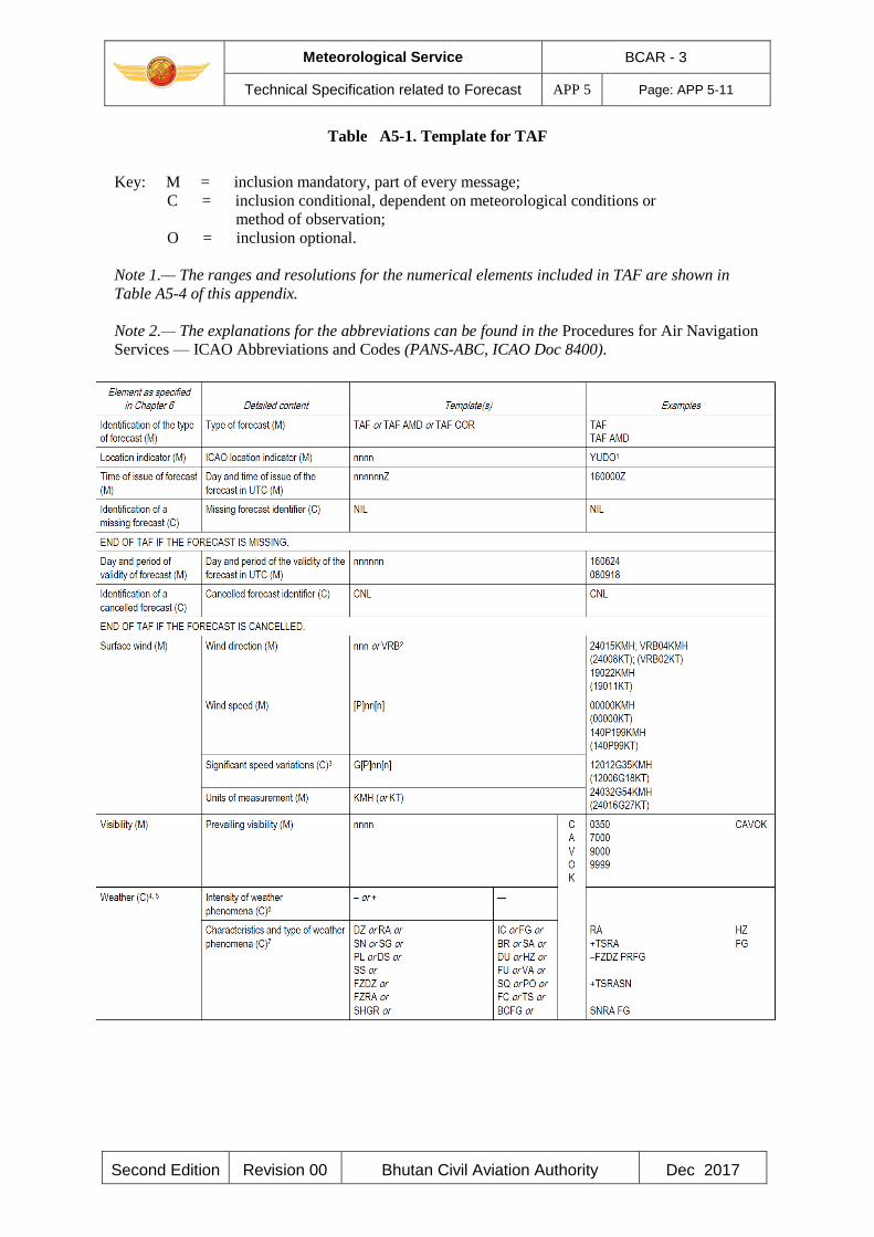
Meteorological Service BCAR - 3
Technical Specification related to Forecast APP 5 Page: APP 5-11
Second Edition Revision 00 Bhutan Civil Aviation Authority Dec 2017
Table A5-1. Template for TAF
Key: M = inclusion mandatory, part of every message;
C = inclusion conditional, dependent on meteorological conditions or
method of observation;
O = inclusion optional.
Note 1.— The ranges and resolutions for the numerical elements included in TAF are shown in
Table A5-4 of this appendix.
Note 2.— The explanations for the abbreviations can be found in the Procedures for Air Navigation
Services — ICAO Abbreviations and Codes (PANS-ABC, ICAO Doc 8400).
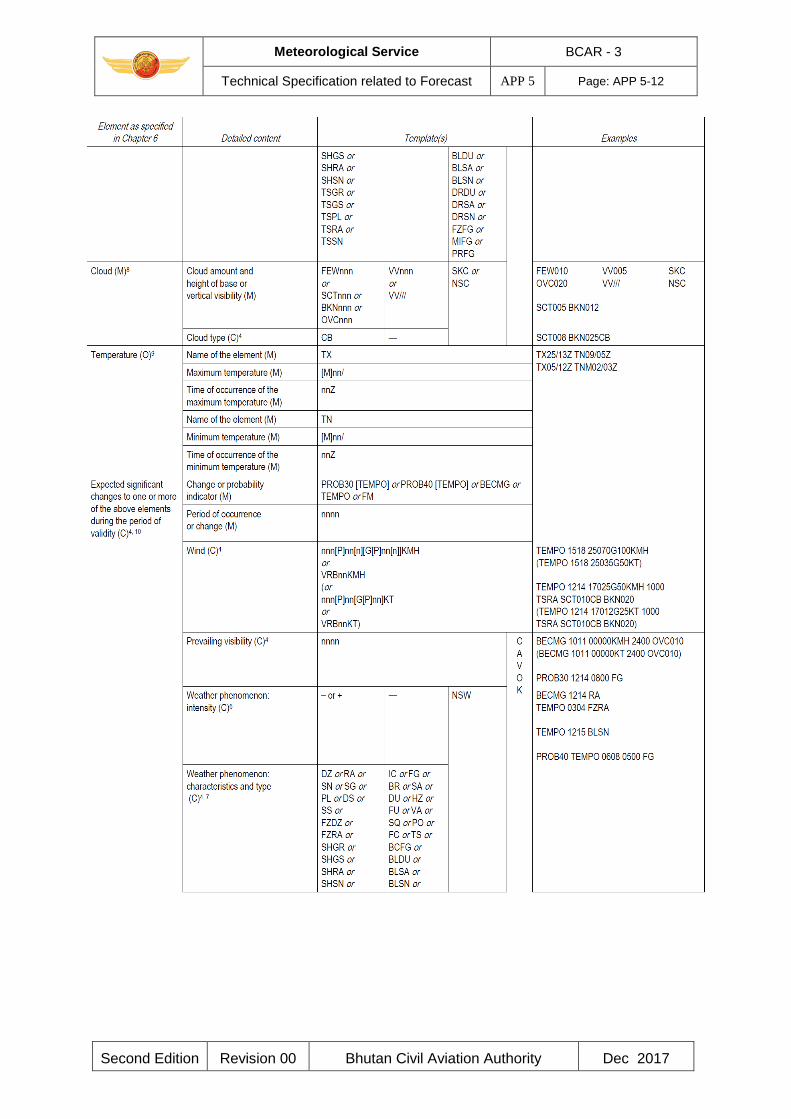
Meteorological Service BCAR - 3
Technical Specification related to Forecast APP 5 Page: APP 5-12
Second Edition Revision 00 Bhutan Civil Aviation Authority Dec 2017
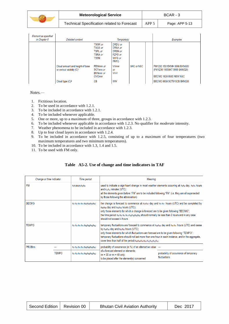
Meteorological Service BCAR - 3
Technical Specification related to Forecast APP 5 Page: APP 5-13
Second Edition Revision 00 Bhutan Civil Aviation Authority Dec 2017
Notes.—
1. Fictitious location.
2. To be used in accordance with 1.2.1.
3. To be included in accordance with 1.2.1.
4. To be included whenever applicable.
5. One or more, up to a maximum of three, groups in accordance with 1.2.3.
6. To be included whenever applicable in accordance with 1.2.3. No qualifier for moderate intensity.
7. Weather phenomena to be included in accordance with 1.2.3.
8. Up to four cloud layers in accordance with 1.2.4.
9. To be included in accordance with 1.2.5, consisting of up to a maximum of four temperatures (two
maximum temperatures and two minimum temperatures).
10. To be included in accordance with 1.3, 1.4 and 1.5.
11. To be used with FM only.
Table A5-2. Use of change and time indicators in TAF
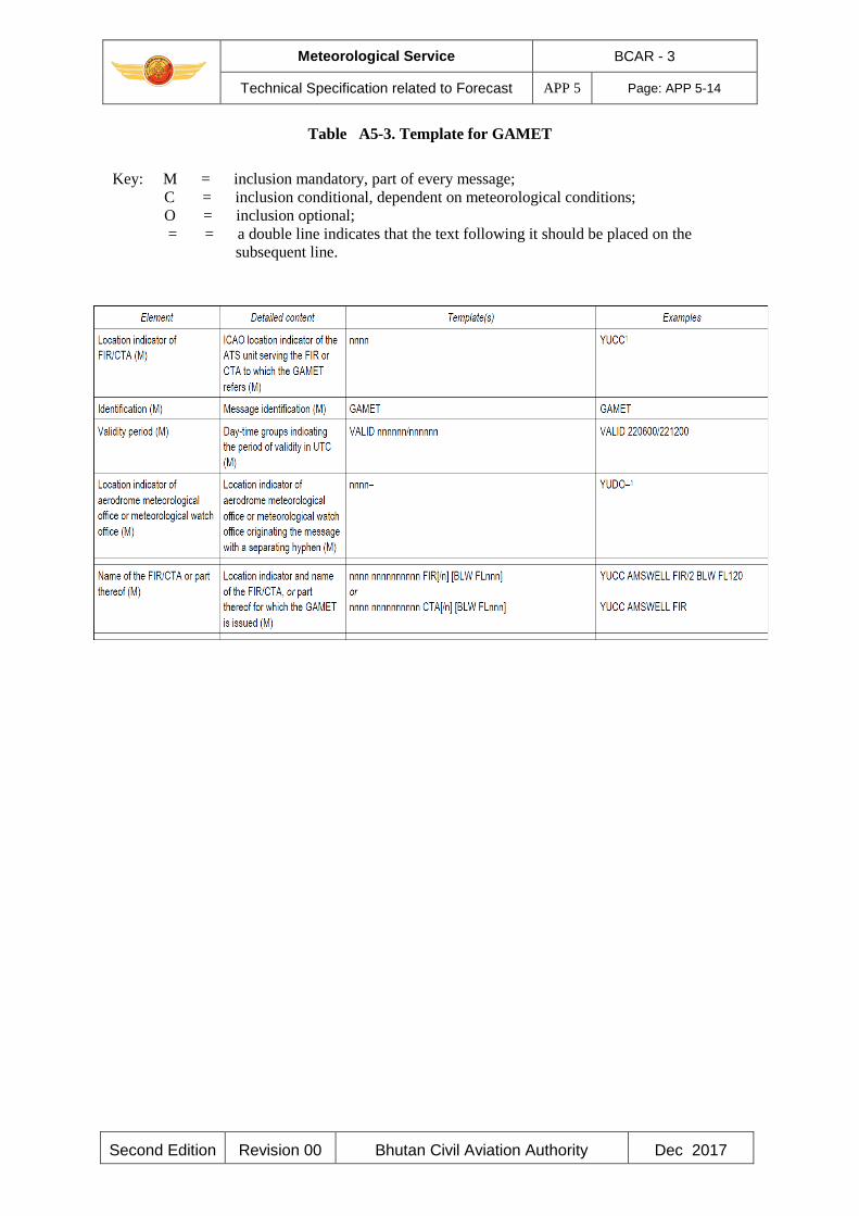
Meteorological Service BCAR - 3
Technical Specification related to Forecast APP 5 Page: APP 5-14
Second Edition Revision 00 Bhutan Civil Aviation Authority Dec 2017
Table A5-3. Template for GAMET
Key: M = inclusion mandatory, part of every message;
C = inclusion conditional, dependent on meteorological conditions;
O = inclusion optional;
= = a double line indicates that the text following it should be placed on the
subsequent line.

Meteorological Service BCAR - 3
Technical Specification related to Forecast APP 5 Page: APP 5-15
Second Edition Revision 00 Bhutan Civil Aviation Authority Dec 2017
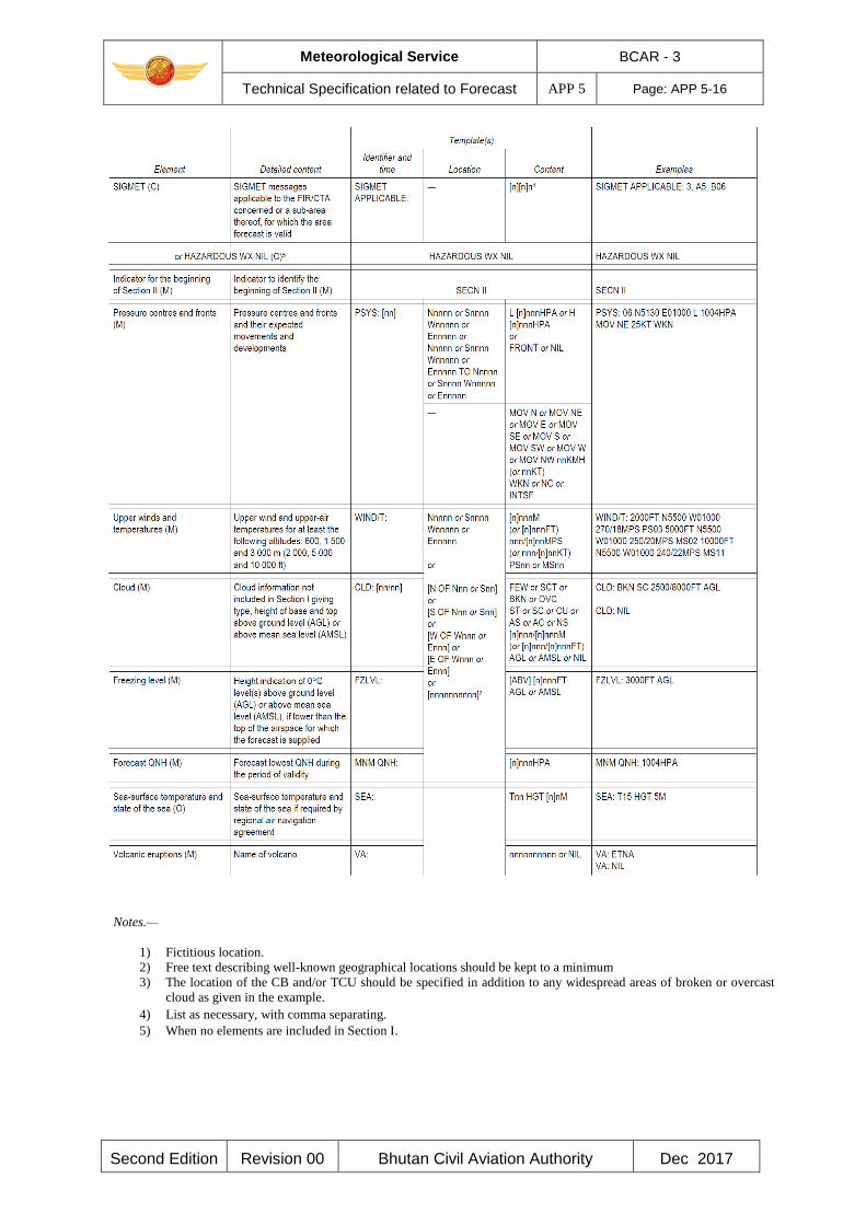
Meteorological Service BCAR - 3
Technical Specification related to Forecast APP 5 Page: APP 5-16
Second Edition Revision 00 Bhutan Civil Aviation Authority Dec 2017
Notes.—
1) Fictitious location.
2) Free text describing well-known geographical locations should be kept to a minimum
3) The location of the CB and/or TCU should be specified in addition to any widespread areas of broken or overcast
cloud as given in the example. 4) List as necessary, with comma separating. 5) When no elements are included in Section I.
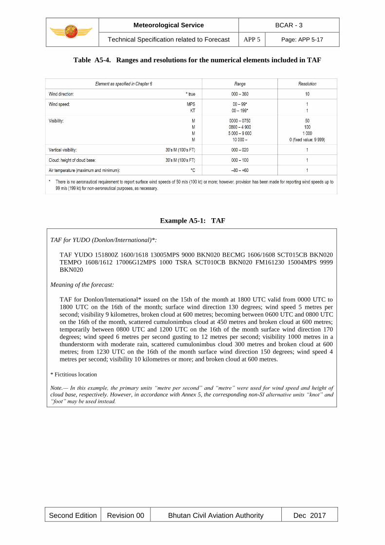
Meteorological Service BCAR - 3
Technical Specification related to Forecast APP 5 Page: APP 5-17
Second Edition Revision 00 Bhutan Civil Aviation Authority Dec 2017
Table A5-4. Ranges and resolutions for the numerical elements included in TAF
Example A5-1: TAF
TAF for YUDO (Donlon/International)*:
TAF YUDO 151800Z 1600/1618 13005MPS 9000 BKN020 BECMG 1606/1608 SCT015CB BKN020
TEMPO 1608/1612 17006G12MPS 1000 TSRA SCT010CB BKN020 FM161230 15004MPS 9999
BKN020
Meaning of the forecast:
TAF for Donlon/International* issued on the 15th of the month at 1800 UTC valid from 0000 UTC to
1800 UTC on the 16th of the month; surface wind direction 130 degrees; wind speed 5 metres per
second; visibility 9 kilometres, broken cloud at 600 metres; becoming between 0600 UTC and 0800 UTC
on the 16th of the month, scattered cumulonimbus cloud at 450 metres and broken cloud at 600 metres;
temporarily between 0800 UTC and 1200 UTC on the 16th of the month surface wind direction 170
degrees; wind speed 6 metres per second gusting to 12 metres per second; visibility 1000 metres in a
thunderstorm with moderate rain, scattered cumulonimbus cloud 300 metres and broken cloud at 600
metres; from 1230 UTC on the 16th of the month surface wind direction 150 degrees; wind speed 4
metres per second; visibility 10 kilometres or more; and broken cloud at 600 metres.
* Fictitious location
Note.— In this example, the primary units “metre per second” and “metre” were used for wind speed and height of
cloud base, respectively. However, in accordance with Annex 5, the corresponding non-SI alternative units “knot” and
“foot” may be used instead.
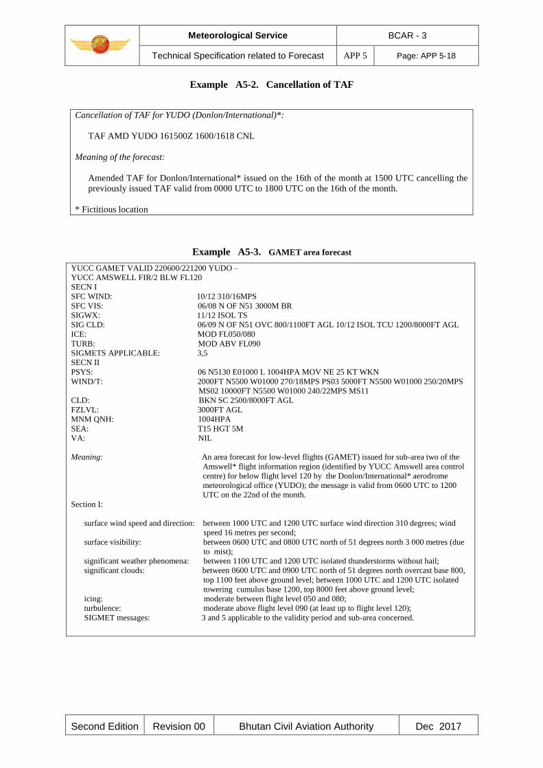
Meteorological Service BCAR - 3
Technical Specification related to Forecast APP 5 Page: APP 5-18
Second Edition Revision 00 Bhutan Civil Aviation Authority Dec 2017
Example A5-2. Cancellation of TAF
Cancellation of TAF for YUDO (Donlon/International)*:
TAF AMD YUDO 161500Z 1600/1618 CNL
Meaning of the forecast:
Amended TAF for Donlon/International* issued on the 16th of the month at 1500 UTC cancelling the
previously issued TAF valid from 0000 UTC to 1800 UTC on the 16th of the month.
* Fictitious location
Example A5-3. GAMET area forecast
YUCC GAMET VALID 220600/221200 YUDO –
YUCC AMSWELL FIR/2 BLW FL120
SECN I
SFC WIND: 10/12 310/16MPS
SFC VIS: 06/08 N OF N51 3000M BR
SIGWX: 11/12 ISOL TS
SIG CLD: 06/09 N OF N51 OVC 800/1100FT AGL 10/12 ISOL TCU 1200/8000FT AGL
ICE: MOD FL050/080
TURB: MOD ABV FL090
SIGMETS APPLICABLE: 3,5
SECN II
PSYS: 06 N5130 E01000 L 1004HPA MOV NE 25 KT WKN
WIND/T: 2000FT N5500 W01000 270/18MPS PS03 5000FT N5500 W01000 250/20MPS
MS02 10000FT N5500 W01000 240/22MPS MS11
CLD: BKN SC 2500/8000FT AGL
FZLVL: 3000FT AGL
MNM QNH: 1004HPA
SEA: T15 HGT 5M
VA: NIL
Meaning: An area forecast for low-level flights (GAMET) issued for sub-area two of the
Amswell* flight information region (identified by YUCC Amswell area control
centre) for below flight level 120 by the Donlon/International* aerodrome
meteorological office (YUDO); the message is valid from 0600 UTC to 1200
UTC on the 22nd of the month.
Section I:
surface wind speed and direction: between 1000 UTC and 1200 UTC surface wind direction 310 degrees; wind
speed 16 metres per second;
surface visibility: between 0600 UTC and 0800 UTC north of 51 degrees north 3 000 metres (due
to mist);
significant weather phenomena: between 1100 UTC and 1200 UTC isolated thunderstorms without hail;
significant clouds: between 0600 UTC and 0900 UTC north of 51 degrees north overcast base 800,
top 1100 feet above ground level; between 1000 UTC and 1200 UTC isolated
towering cumulus base 1200, top 8000 feet above ground level;
icing: moderate between flight level 050 and 080;
turbulence: moderate above flight level 090 (at least up to flight level 120);
SIGMET messages: 3 and 5 applicable to the validity period and sub-area concerned.

Meteorological Service BCAR - 3
Technical Specification related to Forecast APP 5 Page: APP 5-19
Second Edition Revision 00 Bhutan Civil Aviation Authority Dec 2017
Section II:
pressure systems:
at 0600 UTC low pressure of 1 004 hectopascals at 51.5 degrees north 10.0 degrees east, expected to move north-eastwards at 25 knots and to weaken;
winds and
temperatures: at 2 000 feet above ground level at 55 degrees north 10 degrees west wind direction 270
degrees, wind speed 18 metres per second, temperature plus 3 degrees Celsius; at 5 000
feet above ground level at 55 degrees north 10 degrees west wind direction 250 degrees,
wind speed 20 metres per second, temperature minus 2 degrees Celsius; at 10 000 feet
above ground level at 55 degrees north 10 degrees west wind direction 240 degrees, wind
speed 22 metres per second, temperature minus 11 degrees Celsius;
clouds: broken stratocumulus, base 2 500 feet, top 8 000 feet above ground level; freezing level: 3 000 feet above ground level; minimum QNH: 1 004 hectopascals; sea: surface temperature 15 degrees Celsius; and state of the sea 5 metres;
volcanic ash: nil.
* Fictitious location
______________________

Meteorological Service BCAR - 3
Specifications for SIGMET and AIRMET information,
aerodrome warnings and wind shear warnings and alerts APP 6
Page: APP 6-1
Second Edition Revision 00 Bhutan Civil Aviation Authority Dec 2017
APPENDIX 6. TECHNICAL SPECIFICATIONS RELATED TO SIGMET AND
AIRMET INFORMATION, AERODROME WARNINGS AND WIND SHEAR
WARNINGS AND ALERTS
(See Chapter 7 of this document)
Note.— Data type designators to be used in abbreviated headings for SIGMET, AIRMET, tropical
cyclone and volcanic ash advisory messages are given in the Manual on the Global
Telecommunication System (WMO-No. 386).
1. SPECIFICATIONS RELATED TO SIGMET INFORMATION
1.1 Format of SIGMET messages
1.1.1 The content and order of elements in a SIGMET message shall be in accordance with the
template shown in Table A6 -1.
1.1.2 Messages containing SIGMET information shall be identified as: “SIGMET”.
1.1.3 The sequence number referred to in the template in Table A6-1 shall correspond with the
number of SIGMET messages issued for the flight information region since 0001 UTC on the day
concerned. The meteorological watch offices whose area of responsibility encompasses more than
one CTA shall issue separate SIGMET messages for each CTA within its area of responsibility.
1.1.4 In accordance with the template in Table A6 -1, only one of the following phenomena shall
be included in a SIGMET message, using the abbreviations as indicated below:
At cruising level (irrespective of altitude):
Thunderstorm
— Obscured OBSC TS
— Embedded EMBD TS
— Frequent FRQ TS
— squall line SQL TS
— obscured with hail OBSC TSGR
— embedded with hail EMBD TSGR
— frequent, with hail FRQ TSGR
— squall line with hail SQL TSGR
Turbulence
— severe turbulence SEV TURB
Icing
— severe icing SEV ICE
— severe icing due to SEV ICE (FZRA)
freezing rain
mountain wave
— severe mountain wave SEV MTW
Meteorological Service BCAR - 3
Specifications for SIGMET and AIRMET information,
aerodrome warnings and wind shear warnings and alerts APP 6
Page: APP 6-2
Second Edition Revision 00 Bhutan Civil Aviation Authority Dec 2017
Duststorm
— heavy duststorm HVY DS
Sandstorm
— heavy sandstorm HVY SS
volcanic ash
— volcanic ash VA (+ volcano name, if known)
radioactive cloud RDOACT CLD
1.1.5 SIGMET information shall not contain unnecessary descriptive material. In describing the
weather phenomena for which the SIGMET is issued, no descriptive material additional to that
given in 1.1.4 shall be included. SIGMET information concerning thunderstorms or a tropical
cyclone shall not include references to associated turbulence and icing.
1.1.6 Meteorological watch offices should issue SIGMET information in digital form, in addition
to the issuance of this SIGMET information in abbreviated plain language in accordance with 1.1.1.
1.1.7 SIGMET if disseminated in digital form shall be formatted in accordance with a globally
interoperable information exchange model and shall use extensible markup language
(XML)/geography markup language (GML).
1.1.8 SIGMET if disseminated in digital form shall be accompanied by the appropriate metadata.
1.1.9 It is recommended that SIGMET, when issued in graphical format, should be as specified in
Appendix 1.
Note.— Guidance on the information exchange model, XML/GML and the metadata profile is
provided in the Manual on the Digital Exchange of Aeronautical Meteorological Information
(ICAO Doc 10003).
1.2 Dissemination of SIGMET messages
1.2.1 SIGMET messages shall be disseminated to meteorological watch offices, and to other
meteorological offices in accordance with regional air navigation agreement.
1.2.2 SIGMET messages shall be disseminated to international OPMET databanks and the centres
designated by regional air navigation agreement for the operation of aeronautical fixed service
Internet-based services, in accordance with regional air navigation agreement.
2. SPECIFICATIONS RELATED TO AIRMET INFORMATION
2.1 Format of AIRMET messages
2.1.1 The content and order of elements in an AIRMET message shall be in accordance with the
template shown in Table A6-1A.
2.1.2 The sequence number referred to in the template in Table A6-1A shall correspond with the
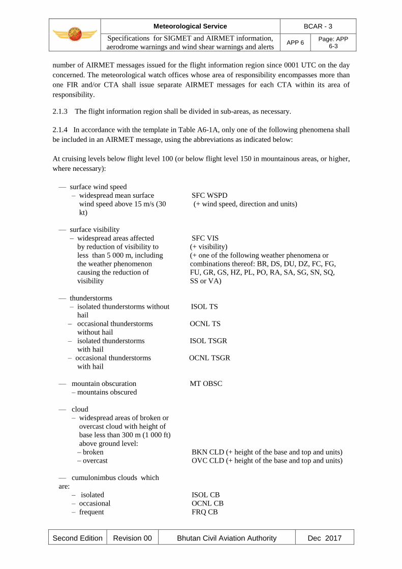
Meteorological Service BCAR - 3
Specifications for SIGMET and AIRMET information,
aerodrome warnings and wind shear warnings and alerts APP 6
Page: APP 6-3
Second Edition Revision 00 Bhutan Civil Aviation Authority Dec 2017
number of AIRMET messages issued for the flight information region since 0001 UTC on the day
concerned. The meteorological watch offices whose area of responsibility encompasses more than
one FIR and/or CTA shall issue separate AIRMET messages for each CTA within its area of
responsibility.
2.1.3 The flight information region shall be divided in sub-areas, as necessary.
2.1.4 In accordance with the template in Table A6-1A, only one of the following phenomena shall
be included in an AIRMET message, using the abbreviations as indicated below:
At cruising levels below flight level 100 (or below flight level 150 in mountainous areas, or higher,
where necessary):
— surface wind speed
– widespread mean surface
wind speed above 15 m/s (30
kt)
— surface visibility
– widespread areas affected
by reduction of visibility to
less than 5 000 m, including
the weather phenomenon
causing the reduction of
visibility
— thunderstorms
– isolated thunderstorms without
hail
– occasional thunderstorms
without hail
– isolated thunderstorms
with hail
– occasional thunderstorms
with hail
— mountain obscuration
– mountains obscured
— cloud
– widespread areas of broken or
overcast cloud with height of
base less than 300 m (1 000 ft)
above ground level:
– broken
– overcast
— cumulonimbus clouds which
are:
– isolated
– occasional
– frequent
SFC WSPD
(+ wind speed, direction and units)
SFC VIS
(+ visibility)
(+ one of the following weather phenomena or
combinations thereof: BR, DS, DU, DZ, FC, FG,
FU, GR, GS, HZ, PL, PO, RA, SA, SG, SN, SQ,
SS or VA)
ISOL TS
OCNL TS
ISOL TSGR
OCNL TSGR
MT OBSC
BKN CLD (+ height of the base and top and units)
OVC CLD (+ height of the base and top and units)
ISOL CB
OCNL CB
FRQ CB

Meteorological Service BCAR - 3
Specifications for SIGMET and AIRMET information,
aerodrome warnings and wind shear warnings and alerts APP 6
Page: APP 6-4
Second Edition Revision 00 Bhutan Civil Aviation Authority Dec 2017
— towering cumulus clouds which
are:
– isolated
– occasional
– frequent
— icing
– moderate icing (except for
icing in convective clouds)
— turbulence
– moderate turbulence (except for
turbulence in convective
clouds)
— mountain wave
– moderate mountain wave
ISOL TCU
OCNL TCU
FRQ TCU
MOD ICE
MOD TURB
MOD MTW
2.1.5 AIRMET information shall not contain unnecessary descriptive material. In describing the
weather phenomena for which the AIRMET is issued, no descriptive material additional to that
given in 2.1.4 shall be included. AIRMET information concerning thunderstorms or cumulonimbus
clouds shall not include references to associated turbulence and icing.
Note.— The specifications for SIGMET information which is also applicable to low-level flights are
given in 1.1.4.
2.1.6 Meteorological offices should issue AIRMET information in digital form, in addition to the
issuance of this AIRMET information in abbreviated plain language in accordance with 2.1.1.
2.1.7 AIRMET if disseminated in digital form shall be formatted in accordance with a globally
interoperable information exchange model and shall use XML/GML.
2.1.8 AIRMET if disseminated in digital form shall be accompanied by the appropriate metadata.
Note.— Guidance on the information exchange model, XML/GML and the metadata profile is
provided in ICAO Doc 10003.
2.2 Dissemination of AIRMET messages
2.2.1 AIRMET messages should be disseminated to meteorological watch offices in adjacent FIRs
and to other meteorological watch offices or aerodrome meteorological offices, as agreed between
the meteorological authorities concerned.
2.2.2 AIRMET messages should be transmitted to international operational meteorological
databanks and the centres designated by regional air navigation agreement for the operation of
aeronautical fixed service Internet-based services, in accordance with regional air navigation
agreement.

Meteorological Service BCAR - 3
Specifications for SIGMET and AIRMET information,
aerodrome warnings and wind shear warnings and alerts APP 6
Page: APP 6-5
Second Edition Revision 00 Bhutan Civil Aviation Authority Dec 2017
3. SPECIFICATIONS RELATED TO SPECIAL AIR-REPORTS
Note.— This appendix deals with the uplink of special air-reports. The general specifications
related to special air reports are in Appendix 4.
3.1 Special air-reports should be uplinked for 60 minutes after their issuance.
3.2 Information on wind and temperature included in automated special air-reports should not be
uplinked to other aircraft in flight
4. DETAILED CRITERIA RELATED TO SIGMET AND AIRMET MESSAGES AND
SPECIAL AIR REPORTS (UPLINK)
4.1 Identification of the flight information region
In cases where the airspace is divided into an FIR and an upper flight information region (UIR), the
SIGMET should be identified by the location indicator of the air traffic services unit serving the
FIR.
Note.— The SIGMET message applies to the whole airspace within the lateral limits of the FIR, i.e.
to the FIR and to the UIR. The particular areas and/or flight levels affected by the meteorological
phenomena causing the issuance of the SIGMET are given in the text of the message.
4.2 Criteria related to phenomena included in SIGMET and AIRMET messages and special
air-reports (uplink)
4.2.1 An area of thunderstorms and cumulonimbus clouds should be considered:
a) obscured (OBSC) if it is obscured by haze or smoke or cannot be readily seen due to
darkness;
b) embedded (EMBD) if it is embedded within cloud layers and cannot be readily recognized;
c) isolated (ISOL) if it consists of individual features which affect, or are forecast to affect, an
area with a maximum spatial coverage less than 50 per cent of the area concerned (at a
fixed time or during the period of validity); and
d) occasional (OCNL) if it consists of well-separated features which affect, or are forecast to
affect, an area with a maximum spatial coverage between 50 and 75 per cent of the area
concerned (at a fixed time or during the period of validity).
4.2.2 An area of thunderstorms should be considered frequent (FRQ) if within that area there is
little or no separation between adjacent thunderstorms with a maximum spatial coverage greater
than 75 per cent of the area affected, or forecast to be affected, by the phenomenon (at a fixed time
or during the period of validity).
4.2.3 Squall line (SQL) should indicate a thunderstorm along a line with little or no space between
individual clouds.
4.2.4 Hail (GR) should be used as a further description of the thunderstorm, as necessary.
Meteorological Service BCAR - 3
Specifications for SIGMET and AIRMET information,
aerodrome warnings and wind shear warnings and alerts APP 6
Page: APP 6-6
Second Edition Revision 00 Bhutan Civil Aviation Authority Dec 2017
4.2.5 Severe and moderate turbulence (TURB) should refer only to: low-level turbulence
associated with strong surface winds; rotor streaming; or turbulence whether in cloud or not in
cloud (CAT). Turbulence should not be used in connection with convective clouds.
4.2.6 Turbulence shall be considered:
a) severe whenever the peak value of the cube root of EDR exceeds 0.7; and
b) moderate whenever the peak value of the cube root of EDR is above 0.4 and below or equal
to 0.7.
4.2.7 Severe and moderate icing (ICE) should refer to icing in other than convective clouds.
Freezing rain (FZRA) should refer to severe icing conditions caused by freezing rain.
4.2.8 A mountain wave (MTW) should be considered:
a) severe whenever an accompanying downdraft of 3.0 m/s (600 ft/min) or more and/or
severe turbulence is observed or forecast; and
b) moderate whenever an accompanying downdraft of 1.75–3.0 m/s (350–600 ft/min) and/or
moderate turbulence is observed or forecast.
4.2.9 Sandstorm/duststorm should be considered:
a) heavy whenever the visibility is below 200 m and the sky is obscured; and
b) moderate whenever the visibility is:
1) below 200 m and the sky is not obscured; or
2) between 200 m and 600 m.
5. SPECIFICATIONS RELATED TO AERODROME WARNINGS
5.1 Format and dissemination of aerodrome warnings
5.1.1 The aerodrome warnings shall be issued in accordance with the template in Table A6-2
where required by operators or aerodrome services, and shall be disseminated in accordance with
local arrangements to those concerned.
5.1.2 The sequence number referred to in the template in Table A6-2 shall correspond with the
number of aerodrome warnings issued for the aerodrome since 0001 UTC on the day concerned.
5.1.3 In accordance with the template in Table A6-2, aerodrome warnings should relate to the
occurrence or expected occurrence of one or more of the following phenomena:
— thunderstorm
— hail
— snow (including the expected or observed snow accumulation)
— freezing precipitation
— hoar frost or rime
— duststorm

Meteorological Service BCAR - 3
Specifications for SIGMET and AIRMET information,
aerodrome warnings and wind shear warnings and alerts APP 6
Page: APP 6-7
Second Edition Revision 00 Bhutan Civil Aviation Authority Dec 2017
— strong surface wind and gusts
— squall
— frost
— toxic chemicals
— other phenomena as agreed locally.
5.1.4 The use of text additional to the abbreviations listed in the template in Table A6 -2 should be
kept to a minimum. The additional text should be prepared in abbreviated plain language using
approved ICAO abbreviations and numerical values. If no ICAO approved abbreviations are
available, English plain language text should be used.
5.2 Quantitative criteria for aerodrome warnings
When quantitative criteria are necessary for the issue of aerodrome warnings covering, for example,
the expected maximum wind speed, the criteria should be established by agreement between the
aerodrome meteorological office and the users concerned.
6. SPECIFICATIONS RELATED TO WIND SHEAR WARNINGS
6.1 Detection of wind shear
Evidence of the existence of wind shear should be derived from:
a) ground-based, wind shear remote-sensing equipment, for example, Doppler radar;
b) ground-based, wind shear detection equipment, for example, a system of surface wind
and/or pressure sensors located in an array monitoring a specific runway or runways and
associated approach and departure paths;
c) aircraft observations during the climb-out or approach phases of flight to be made in
accordance with Chapter 5; or
d) other meteorological information, for example, from appropriate sensors located on
existing masts or towers in the vicinity of the aerodrome or nearby areas of high ground.
Note.— Wind shear conditions are normally associated with the following phenomena:
— thunderstorms, microbursts, funnel cloud (tornado or waterspout), and gust fronts
— frontal surfaces
— strong surface winds coupled with local topography
— sea breeze fronts
— mountain waves (including low-level rotors in the terminal area)
— low-level temperature inversions.
Meteorological Service BCAR - 3
Specifications for SIGMET and AIRMET information,
aerodrome warnings and wind shear warnings and alerts APP 6
Page: APP 6-8
Second Edition Revision 00 Bhutan Civil Aviation Authority Dec 2017
6.2 Format and dissemination of wind shear warnings and alerts
Note.— Information on wind shear is also to be included as supplementary information in local
routine reports, local special reports, METAR and SPECI in accordance with the templates in
Appendix 3, Tables A3-1 and A3-2.
6.2.1 The wind shear warnings shall be issued in accordance with the template in Table A6-3 and
shall be disseminated in accordance with local arrangements to those concerned.
6.2.2 The sequence number referred to in the template in Table A6 - 3 shall correspond with the
number of wind shear warnings issued for the aerodrome since 0001 UTC on the day concerned.
6.2.3 The use of text additional to the abbreviations listed in the template in Table A6-3 should be
kept to a minimum. The additional text should be prepared in abbreviated plain language using
approved ICAO abbreviations and numerical values. If no ICAO approved abbreviations are
available, English plain language text should be used.
6.2.4 When an aircraft report is used to prepare a wind shear warning, or to confirm a warning
previously issued, the corresponding aircraft report, including the aircraft type, should be
disseminated unchanged in accordance with local arrangements to those concerned.
Note 1.— Following reported encounters by both arriving and departing aircraft, two different
wind shear warnings may exist: one for arriving aircraft and one for departing aircraft.
Note 2.— Specifications for reporting the intensity of wind shear are still undergoing development.
It is recognized, however, that pilots, when reporting wind shear, may use the qualifying terms
“moderate”, “strong” or “severe”, based to a large extent on their subjective assessment of the
intensity of the wind shear encountered.
6.2.5 The wind shear alerts shall be disseminated from automated, ground-based, wind shear
remote-sensing or detection equipment in accordance with local arrangements to those concerned.
6.2.6 Where microbursts are observed, reported by pilots or detected by ground-based, wind shear
detection or remote-sensing equipment, the wind shear warning and wind shear alert should include
a specific reference to microburst.
6.2.7 Where information from ground-based, wind shear detection or remote-sensing equipment is
used to prepare a wind shear alert, the alert shall, if practicable, relate to specific sections of the
runway and distances along the approach path or take-off path as agreed between the
meteorological authority, the appropriate ATS authority and the operators concerned.
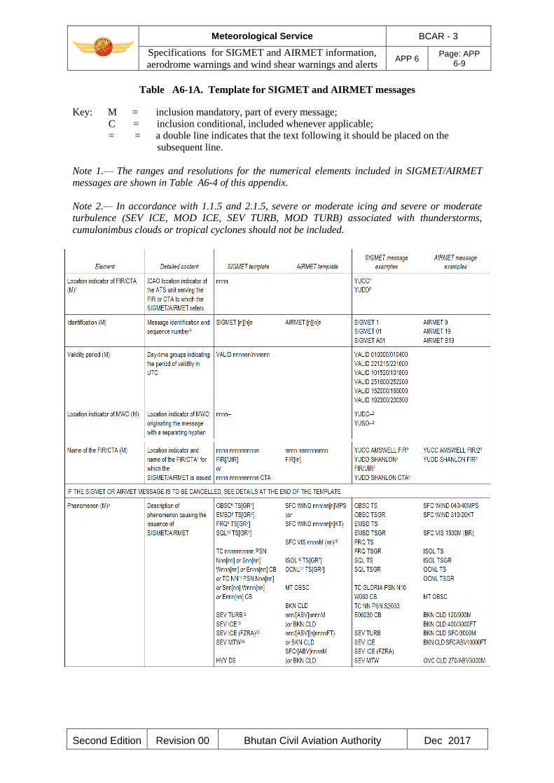
Meteorological Service BCAR - 3
Specifications for SIGMET and AIRMET information,
aerodrome warnings and wind shear warnings and alerts APP 6
Page: APP 6-9
Second Edition Revision 00 Bhutan Civil Aviation Authority Dec 2017
Table A6-1A. Template for SIGMET and AIRMET messages
Key: M = inclusion mandatory, part of every message;
C = inclusion conditional, included whenever applicable;
= = a double line indicates that the text following it should be placed on the
subsequent line.
Note 1.— The ranges and resolutions for the numerical elements included in SIGMET/AIRMET
messages are shown in Table A6-4 of this appendix.
Note 2.— In accordance with 1.1.5 and 2.1.5, severe or moderate icing and severe or moderate
turbulence (SEV ICE, MOD ICE, SEV TURB, MOD TURB) associated with thunderstorms,
cumulonimbus clouds or tropical cyclones should not be included.
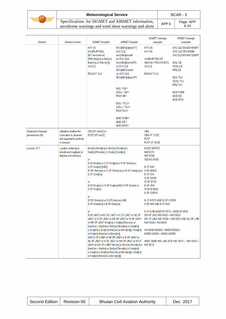
Meteorological Service BCAR - 3
Specifications for SIGMET and AIRMET information,
aerodrome warnings and wind shear warnings and alerts APP 6
Page: APP 6-10
Second Edition Revision 00 Bhutan Civil Aviation Authority Dec 2017
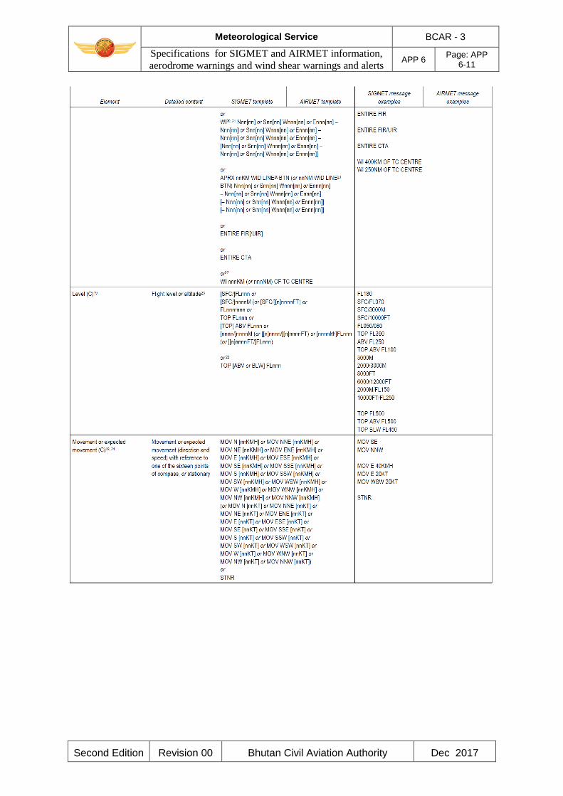
Meteorological Service BCAR - 3
Specifications for SIGMET and AIRMET information,
aerodrome warnings and wind shear warnings and alerts APP 6
Page: APP 6-11
Second Edition Revision 00 Bhutan Civil Aviation Authority Dec 2017
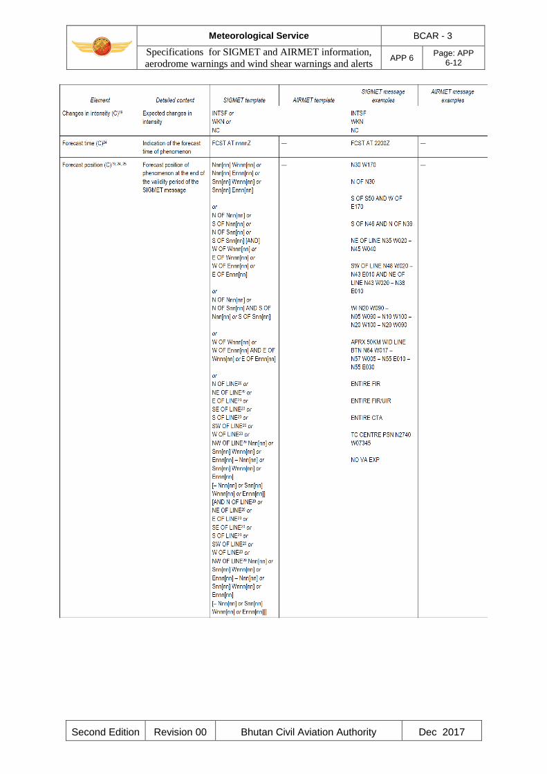
Meteorological Service BCAR - 3
Specifications for SIGMET and AIRMET information,
aerodrome warnings and wind shear warnings and alerts APP 6
Page: APP 6-12
Second Edition Revision 00 Bhutan Civil Aviation Authority Dec 2017

Meteorological Service BCAR - 3
Specifications for SIGMET and AIRMET information,
aerodrome warnings and wind shear warnings and alerts APP 6
Page: APP 6-13
Second Edition Revision 00 Bhutan Civil Aviation Authority Dec 2017
Notes.—
1. See 4.1.
2. Fictitious location.
3. In accordance with 1.1.3 and 2.1.2.
4. See 2.1.3.
5. In accordance with 1.1.4 and 2.1.4.
6. In accordance with 4.2.1 a).
7. In accordance with 4.2.4.
8. In accordance with 4.2.1 b).
9. In accordance with 4.2.2.
10. In accordance with 4.2.3.
11. Used for unnamed tropical cyclones.
Meteorological Service BCAR - 3
Specifications for SIGMET and AIRMET information,
aerodrome warnings and wind shear warnings and alerts APP 6
Page: APP 6-14
Second Edition Revision 00 Bhutan Civil Aviation Authority Dec 2017
12. In accordance with 4.2.5 and 4.2.6.
13. In accordance with 4.2.7.
14. In accordance with 4.2.8.
15. In accordance with 2.1.4.
16. In accordance with 4.2.1 c).
17. In accordance with 4.2.1 d).
18. The use of cumulonimbus (CB) and towering cumulus (TCU) is restricted to AIRMETs in accordance
with 2.1.4.
19. In the case of volcanic ash cloud or tropical cyclone covering more than one area within the FIR, these
elements can be repeated, as necessary.
20. A straight line is to be used between two points drawn on a map in the Mercator projection or between
two points which crosses lines of longitude at a constant angle.
21. The number of coordinates should be kept to a minimum and should not normally exceed seven.
22. Only for SIGMET messages for tropical cyclones.
23. Only for SIGMET messages for volcanic ash cloud and tropical cyclones.
24. The elements “forecast time” and “forecast position” are not to be used in conjunction with the element
“movement or expected movement”.
25. The levels of the phenomena remain fixed throughout the forecast period.
26. Only for SIGMET messages for volcanic ash.
27. To be used for two volcanic ash clouds or two centres of tropical cyclones simultaneously affecting the
FIR concerned.
28. End of the message (as the SIGMET/AIRMET message is being cancelled).
(INTENTIONALLY LEFT BLANK)
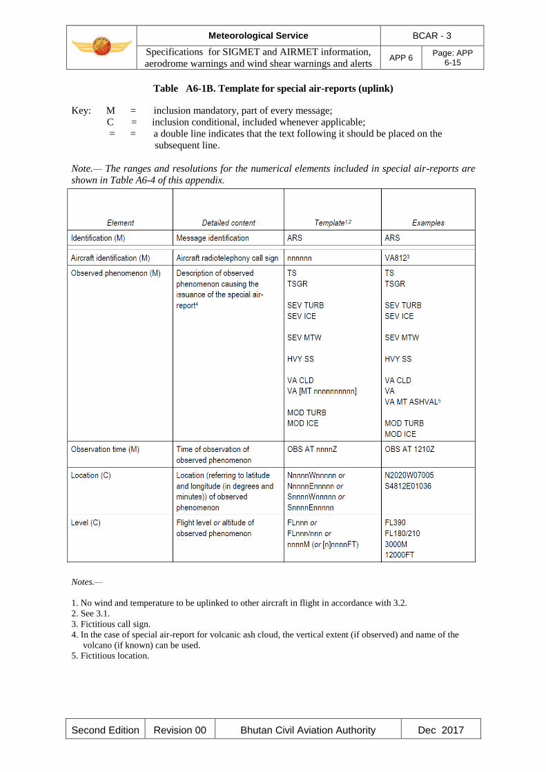
Meteorological Service BCAR - 3
Specifications for SIGMET and AIRMET information,
aerodrome warnings and wind shear warnings and alerts APP 6
Page: APP 6-15
Second Edition Revision 00 Bhutan Civil Aviation Authority Dec 2017
Table A6-1B. Template for special air-reports (uplink)
Key: M = inclusion mandatory, part of every message;
C = inclusion conditional, included whenever applicable;
= = a double line indicates that the text following it should be placed on the
subsequent line.
Note.— The ranges and resolutions for the numerical elements included in special air-reports are
shown in Table A6-4 of this appendix.
Notes.—
1. No wind and temperature to be uplinked to other aircraft in flight in accordance with 3.2.
2. See 3.1.
3. Fictitious call sign.
4. In the case of special air-report for volcanic ash cloud, the vertical extent (if observed) and name of the
volcano (if known) can be used.
5. Fictitious location.
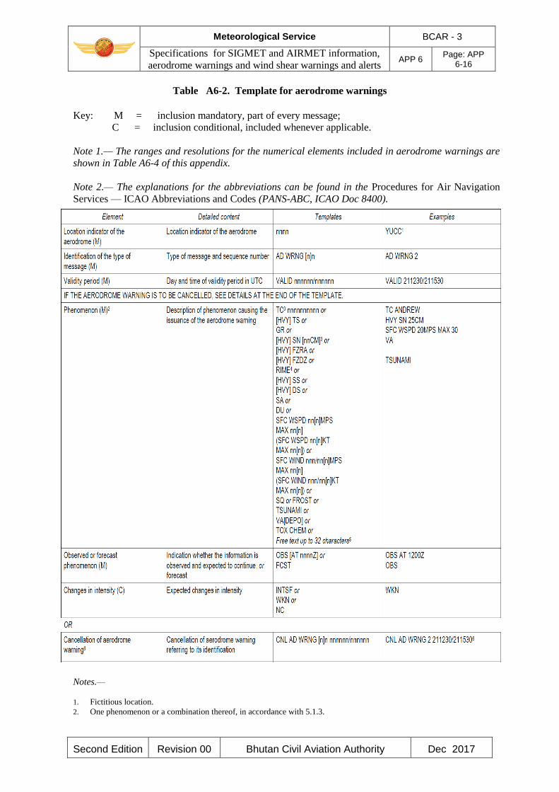
Meteorological Service BCAR - 3
Specifications for SIGMET and AIRMET information,
aerodrome warnings and wind shear warnings and alerts APP 6
Page: APP 6-16
Second Edition Revision 00 Bhutan Civil Aviation Authority Dec 2017
Table A6-2. Template for aerodrome warnings
Key: M = inclusion mandatory, part of every message;
C = inclusion conditional, included whenever applicable.
Note 1.— The ranges and resolutions for the numerical elements included in aerodrome warnings are
shown in Table A6-4 of this appendix.
Note 2.— The explanations for the abbreviations can be found in the Procedures for Air Navigation
Services — ICAO Abbreviations and Codes (PANS-ABC, ICAO Doc 8400).
Notes.—
1. Fictitious location.
2. One phenomenon or a combination thereof, in accordance with 5.1.3.

Meteorological Service BCAR - 3
Specifications for SIGMET and AIRMET information,
aerodrome warnings and wind shear warnings and alerts APP 6
Page: APP 6-17
Second Edition Revision 00 Bhutan Civil Aviation Authority Dec 2017
3. In accordance with 5.1.3.
4. Hoar frost or rime in accordance with 5.1.3.
5. In accordance with 5.1.4.
6. End of the message (as the aerodrome warning is being cancelled).
Table A6-3. Template for wind shear warnings
Key: M = inclusion mandatory, part of every message;
C = inclusion conditional, included whenever applicable.
Note 1.— The ranges and resolutions for the numerical elements included in wind shear warnings are
shown in Table A6-4 of this appendix.
Note 2.— The explanations for the abbreviations can be found in the PANS-ABC (ICAO Doc 8400).
Notes.—
1. Fictitious location.
2. Additional provisions in 6.2.3.
3. End of the message (as the wind shear warning is being cancelled).
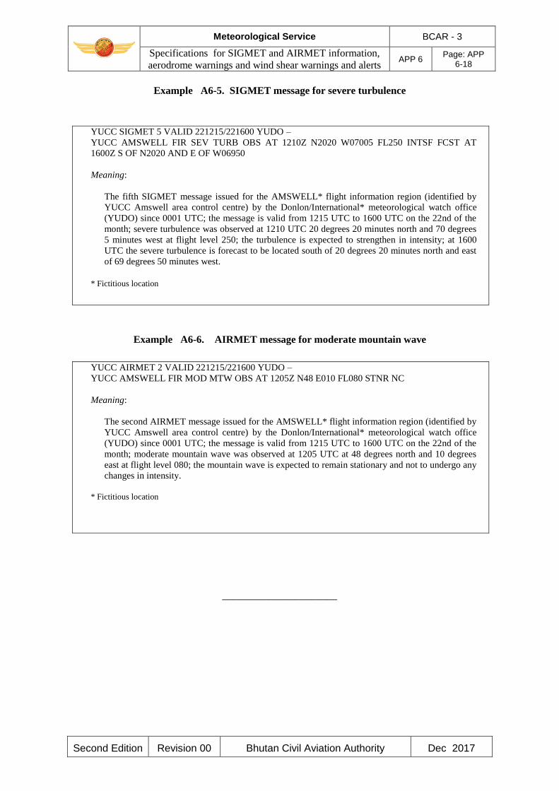
Meteorological Service BCAR - 3
Specifications for SIGMET and AIRMET information,
aerodrome warnings and wind shear warnings and alerts APP 6
Page: APP 6-18
Second Edition Revision 00 Bhutan Civil Aviation Authority Dec 2017
Example A6-5. SIGMET message for severe turbulence
YUCC SIGMET 5 VALID 221215/221600 YUDO –
YUCC AMSWELL FIR SEV TURB OBS AT 1210Z N2020 W07005 FL250 INTSF FCST AT
1600Z S OF N2020 AND E OF W06950
Meaning:
The fifth SIGMET message issued for the AMSWELL* flight information region (identified by
YUCC Amswell area control centre) by the Donlon/International* meteorological watch office
(YUDO) since 0001 UTC; the message is valid from 1215 UTC to 1600 UTC on the 22nd of the
month; severe turbulence was observed at 1210 UTC 20 degrees 20 minutes north and 70 degrees
5 minutes west at flight level 250; the turbulence is expected to strengthen in intensity; at 1600
UTC the severe turbulence is forecast to be located south of 20 degrees 20 minutes north and east
of 69 degrees 50 minutes west.
* Fictitious location
Example A6-6. AIRMET message for moderate mountain wave
YUCC AIRMET 2 VALID 221215/221600 YUDO –
YUCC AMSWELL FIR MOD MTW OBS AT 1205Z N48 E010 FL080 STNR NC
Meaning:
The second AIRMET message issued for the AMSWELL* flight information region (identified by
YUCC Amswell area control centre) by the Donlon/International* meteorological watch office
(YUDO) since 0001 UTC; the message is valid from 1215 UTC to 1600 UTC on the 22nd of the
month; moderate mountain wave was observed at 1205 UTC at 48 degrees north and 10 degrees
east at flight level 080; the mountain wave is expected to remain stationary and not to undergo any
changes in intensity.
* Fictitious location
______________________
Meteorological Service BCAR - 3
Technical Specifications related to Aeronautical Climatological Information APP 7 Page: APP 7-1
Second Edition Revision 00 Bhutan Civil Aviation Authority Dec 2017
APPENDIX 7. TECHNICAL SPECIFICATIONS RELATED TO
AERONAUTICAL CLIMATOLOGICAL INFORMATION
(See Chapter 8 of this document)
1. PROCESSING OF AERONAUTICAL CLIMATOLOGICAL INFORMATION
Meteorological observations for regular and alternate aerodromes should be collected, processed
and stored in a form suitable for the preparation of aerodrome climatological information.
2. EXCHANGE OF AERONAUTICAL CLIMATOLOGICAL INFORMATION
Aeronautical climatological information should be exchanged on request between meteorological
authorities. Operators and other aeronautical users desiring such information should normally apply
to the designated meteorological authority responsible for its preparation.
3. CONTENT OF AERONAUTICAL CLIMATOLOGICAL INFORMATION
3.1 Aerodrome climatological tables
3.1.1 An aerodrome climatological table should give as applicable:
a) mean values and variations there from, including maximum and minimum values, of
meteorological elements (for example, of air temperature); and/or
b) the frequency of occurrence of present weather phenomena affecting flight operations at
the aerodrome (for example, of sandstorms); and/or
c) the frequency of occurrence of specified values of one, or of a combination of two or more,
elements (for example, of a combination of low visibility and low cloud).
3.1.2 Aerodrome climatological tables should include information required for the preparation of
aerodrome climatological summaries in accordance with 3.2.
3.2 Aerodrome climatological summaries
Aerodrome climatological summaries should cover:
a) frequencies of the occurrence of runway visual range/visibility and/or height of the base of
the lowest cloud layer of BKN or OVC extent below specified values at specified times;
b) frequencies of visibility below specified values at specified times;
c) frequencies of the height of the base of the lowest cloud layer of BKN or OVC extent
below specified values at specified times;
d) frequencies of occurrence of concurrent wind direction and speed within specified ranges;
Meteorological Service BCAR - 3
Technical Specifications related to Aeronautical Climatological Information APP 7 Page: APP 7-2
Second Edition Revision 00 Bhutan Civil Aviation Authority Dec 2017
e) frequencies of surface temperature in specified ranges of 5°C at specified times; and
f) mean values and variations there from, including maximum and minimum values of
meteorological elements required for operational planning purposes, including take-off
performance calculations.
Note.— Models of climatological summaries related to a) to e) are given in the Technical
Regulations (WMO-No. 49), Volume II — Meteorological Service for International Air Navigation,
Part III.
______________________

Meteorological Service BCAR - 3
Technical Specifications related to Service for Operators and Flight Crew Members
APP 8 Page: APP 8-1
Second Edition Revision 00 Bhutan Civil Aviation Authority Dec 2017
APPENDIX 8. TECHNICAL SPECIFICATIONS RELATED TO SERVICE FOR
OPERATORS AND FLIGHT CREW MEMBERS
(See Chapter 9 of this document)
Note.— Specifications related to flight documentation (including the model charts and forms) are
given in Appendix 1.
1. MEANS OF SUPPLY AND FORMAT OF METEOROLOGICAL INFORMATION
1.1 Meteorological information shall be supplied to operators and flight crew members by one or
more of the following, as agreed between the designated meteorological authority and the operator
concerned, and with the order shown below not implying priorities:
a) written or printed material, including specified charts and forms;
b) data in digital form;
c) briefing;
d) consultation;
e) display; or
f) in lieu of a) to e), by means of an automated pre-flight information system providing self-
briefing and flight documentation facilities while retaining access by operators and aircrew
members to consultation, as necessary, with the meteorological office, in accordance with
5.1.
1.2 The designated meteorological authority, in consultation with the operator, shall determine:
a) the type and format of meteorological information to be supplied; and
b) methods and means of supplying that information.
1.3 On request by the operator, the meteorological information supplied for flight planning should
include data for the determination of the lowest usable flight level.
2. Specifications related to information for pre-flight planning and in-flight re-planning
(Reserved)
3. Specifications related to Briefing and Consultation
(Reserved)
Meteorological Service BCAR - 3
Technical Specifications related to Service for Operators and Flight Crew Members
APP 8 Page: APP 8-2
Second Edition Revision 00 Bhutan Civil Aviation Authority Dec 2017
4. SPECIFICATIONS RELATED TO FLIGHT DOCUMENTATION
4.1 Presentation of information
4.1.1 The flight documentation related to forecasts of upper wind and upper-air temperature and
SIGWX phenomena shall be presented in the form of charts. For low- level flights, alternatively,
GAMET area forecasts shall be used.
Note.— Models of charts and forms for use in the preparation of flight documentation are given in
Appendix 1. These models and methods for their completion are developed by the World
meteorological Organization on the basis of relevant operational requirements stated by the
International Civil Aviation Organization.
4.1.2 The flight documentation related to concatenated route-specific upper wind and upper-air
temperature forecasts should be provided as agreed between the designated meteorological
authority and the operator concerned.
Note.— Guidance on the design, formulation and use of concatenated charts is given in the Manual
of Aeronautical Meteorological Practice (ICAO Doc 8896).
4.1.3 METAR and SPECI (including trend forecasts as issued in accordance with regional air
navigation agreement), TAF, GAMET, SIGMET and AIRMET shall be presented in accordance
with the templates in Appendices 1, 2, 3, 5 and 6. Such meteorological information received from
other meteorological offices shall be included in flight documentation without change.
Note.— Examples of the form of presentation of METAR/SPECI and TAF are given in Appendix 1.
4.1.4 The location indicators and the abbreviations used should be explained in the flight
documentation.
4.1.5 The forms and the legend of charts included in flight documentation should be printed in
English. Where appropriate, approved abbreviations should be used. The units employed for each
element should be indicated; they should be in accordance with BCAR-5.
4.2 Charts in flight documentation
4.2.1 Characteristics of charts
4.2.1.1 Charts included in flight documentation should have a high standard of clarity and
legibility and should have the following physical characteristics:
a) for convenience, the largest size of charts should be about 42 × 30 cm (standard size A3)
and the smallest size should be about 21 × 30 cm (standard size A4). The choice between
these sizes should depend on the route lengths and the amount of detail that needs to be
given in the charts as agreed between the meteorological authorities and the users
concerned;
b) major geographical features, such as coastlines, major rivers and lakes should be depicted
in a way that makes them easily recognizable;
c) for charts prepared by computer, meteorological data should take preference over basic

Meteorological Service BCAR - 3
Technical Specifications related to Service for Operators and Flight Crew Members
APP 8 Page: APP 8-3
Second Edition Revision 00 Bhutan Civil Aviation Authority Dec 2017
chart information, the former cancelling the latter wherever they overlap;
d) major aerodromes should be shown as a dot and identified by the first letter of the name of
the city the aerodrome serves as given in Table AOP of the relevant regional air navigation
plan;
e) a geographical grid should be shown with meridians and parallels represented by dotted
lines at each 10° latitude and longitude; dots should be spaced one degree apart;
f) latitude and longitude values should be indicated at various points throughout the charts
(i.e. not only at the edges); and
g) labels on the charts for flight documentation should be clear and simple and should present
the name of the world area forecast centre or, for non-world area forecast system (WAFS)
products, the originating centre, the type of chart, date and valid time and, if necessary, the
types of units used in an unambiguous way.
4.2.1.2 Meteorological information included in flight documentation shall be represented as
follows:
a) winds on charts shall be depicted by arrows with feathers and shaded pennants on a
sufficiently dense grid;
b) temperatures shall be depicted by figures on a sufficiently dense grid;
c) wind and temperature data selected from the data sets received from a world area forecast
centre shall be depicted in a sufficiently dense latitude/longitude grid; and
d) wind arrows shall take precedence over temperatures and either shall take precedence over
chart background.
4.2.1.3 For short-haul flights, charts should be prepared covering limited areas at a scale of 1:15 ×
106 as required.
4.2.2 Set of charts to be provided
4.2.2.1 The minimum number of charts for flights between flight level 250 and flight level 630
shall include a high -level SIGWX chart (flight level 250 to flight level 630) and a forecast 250 hPa
winds and temperature chart. The actual charts provided for pre-flight and in-flight planning and
for flight documentation shall be as agreed between meteorological authorities and users
concerned.
4.2.2.2 Charts to be provided shall be generated from the digital forecasts provided by the WAFCs
whenever these forecasts cover the intended flight path in respect of time, altitude and geographical
extent, unless otherwise agreed between the designated meteorological authority and the operator
concerned.
4.2.3 Height indications
In flight documentation, height indications shall be given as follows:
a) all references to en-route meteorological conditions, such as height indications of upper

Meteorological Service BCAR - 3
Technical Specifications related to Service for Operators and Flight Crew Members
APP 8 Page: APP 8-4
Second Edition Revision 00 Bhutan Civil Aviation Authority Dec 2017
winds, turbulence or bases and tops of clouds, shall preferably be expressed in flight
levels; they may also be expressed in pressure, altitude or, for low-level flights, height
above ground level; and
b) all references to aerodrome meteorological conditions, such as height indications of the
bases of clouds, shall be expressed in height above the aerodrome elevation.
4.3 Specifications related to low-level flights
4.3.1 In chart form
Where the forecasts are supplied in chart form, flight documentation for low -level flights,
including those in accordance with the visual flight rules, operating up to flight level 100 (or up to
flight level 150 in mountainous areas or higher, where necessary), should contain the following as
appropriate to the flight:
a) information from relevant SIGMET and AIRMET messages;
b) upper wind and upper-air temperature charts as given in Appendix 5, 4.3.1;and
c) significant weather charts as given in Appendix 5, 4.3.2.
4.3.2 In abbreviated plain language
Where the forecasts are not supplied in chart form, flight documentation for low-level flights,
including those in accordance with the visual flight rules, operating up to flight level 100 (up to
flight level 150 in mountainous areas or higher, where necessary), should contain the following
information as appropriate to the flight:
a) SIGMET and AIRMET information; and
b) GAMET area forecasts.
Note.— An example of the GAMET area forecast is given in Appendix 5.
5. Specifications related to automated pre-flight information systems for briefing,
consultation, flight planning and flight documentation
(Reserved)
6. SPECIFICATIONS RELATED TO INFORMATION FOR AIRCRAFT IN FLIGHT
6.1 Supply of information requested by an aircraft in flight
If an aircraft in flight requests meteorological information, the aerodrome meteorological office
which receives the request should arrange to supply the information with the assistance, if
necessary, of another meteorological office.
Meteorological Service BCAR - 3
Technical Specifications related to Service for Operators and Flight Crew Members
APP 8 Page: APP 8-5
Second Edition Revision 00 Bhutan Civil Aviation Authority Dec 2017
6.2 Information for in-flight planning by the operator
Meteorological information for planning by the operator for aircraft in flight should be supplied
during the period of the flight and should normally consist of any or all of the following:
a) METAR and SPECI (including trend forecasts as issued in accordance with regional air
navigation agreement);
b) TAF and amended TAF;
c) SIGMET and AIRMET information and special air-reports relevant to the flight, unless the
latter have been the subject of a SIGMET message; and
d) upper wind and upper-air temperature information.
e) volcanic ash and tropical cyclone advisory information relevant to the flight; and
f) other meteorological information in alphanumeric or graphical form as agreed between the
designated meteorological authority and the operator concerned.
Note.— Guidance on the display of graphical information in the cockpit is provided in ICAO Doc
8896.
(INTENTIONALLY LEFT BLANK)
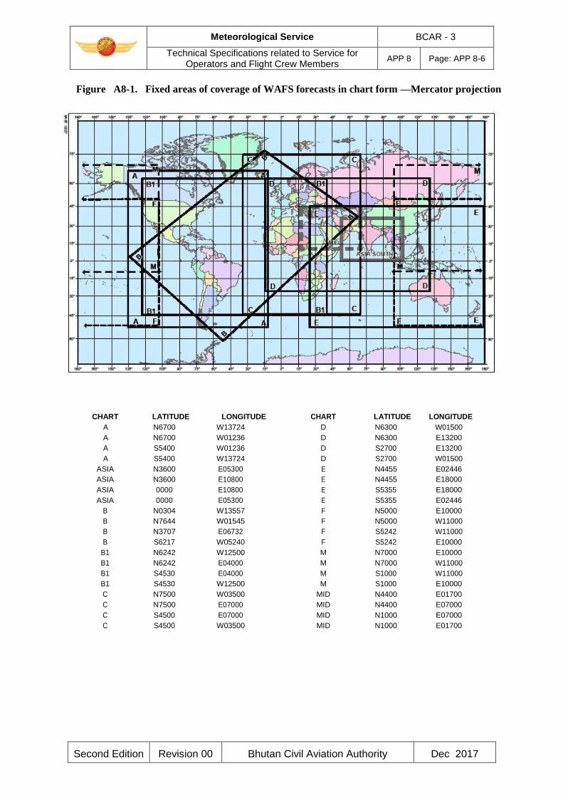
Meteorological Service BCAR - 3
Technical Specifications related to Service for Operators and Flight Crew Members
APP 8 Page: APP 8-6
Second Edition Revision 00 Bhutan Civil Aviation Authority Dec 2017
Figure A8-1. Fixed areas of coverage of WAFS forecasts in chart form —Mercator projection
CHART LATITUDE LONGITUDE CHART LATITUDE LONGITUDE A N6700 W13724 D N6300 W01500 A N6700 W01236 D N6300 E13200 A S5400 W01236 D S2700 E13200 A S5400 W13724 D S2700 W01500
ASIA N3600 E05300 E N4455 E02446 ASIA N3600 E10800 E N4455 E18000 ASIA 0000 E10800 E S5355 E18000 ASIA 0000 E05300 E S5355 E02446
B N0304 W13557 F N5000 E10000 B N7644 W01545 F N5000 W11000 B N3707 E06732 F S5242 W11000 B S6217 W05240 F S5242 E10000
B1 N6242 W12500 M N7000 E10000 B1 N6242 E04000 M N7000 W11000 B1 S4530 E04000 M S1000 W11000 B1 S4530 W12500 M S1000 E10000 C N7500 W03500 MID N4400 E01700 C N7500 E07000 MID N4400 E07000 C S4500 E07000 MID N1000 E07000 C S4500 W03500 MID N1000 E01700
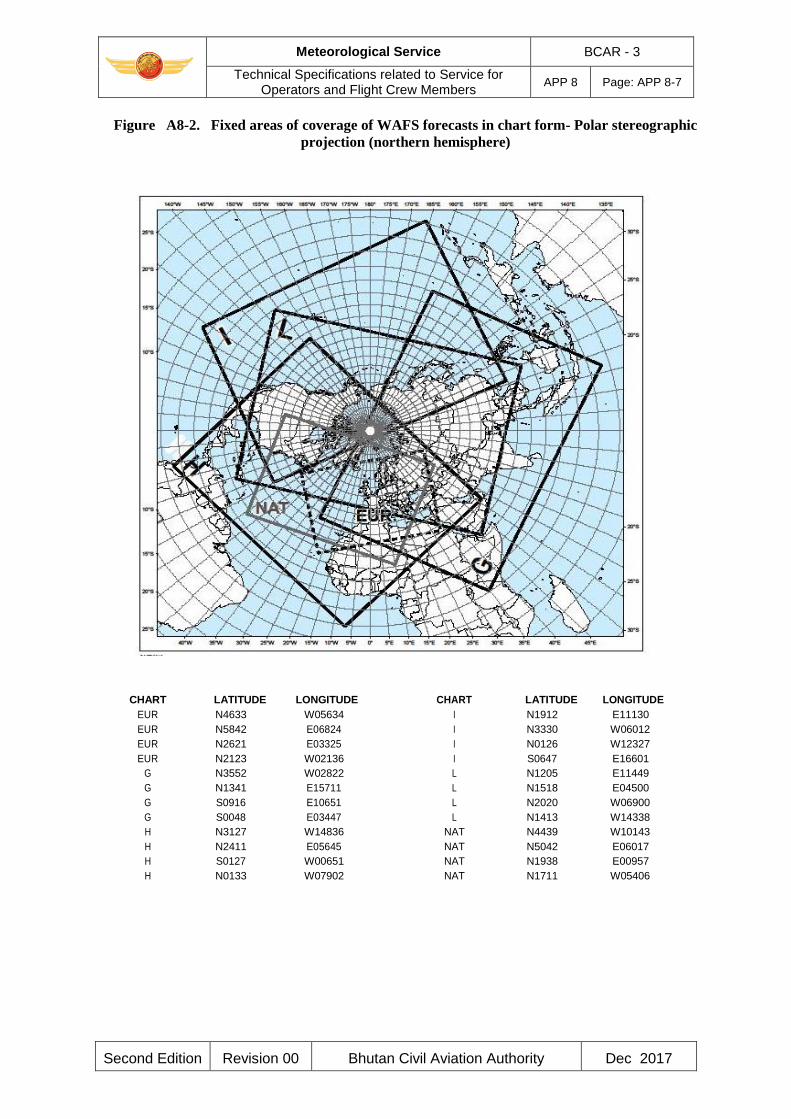
Meteorological Service BCAR - 3
Technical Specifications related to Service for Operators and Flight Crew Members
APP 8 Page: APP 8-7
Second Edition Revision 00 Bhutan Civil Aviation Authority Dec 2017
Figure A8-2. Fixed areas of coverage of WAFS forecasts in chart form- Polar stereographic
projection (northern hemisphere)
CHART LATITUDE LONGITUDE CHART LATITUDE LONGITUDE EUR N4633 W05634 I N1912 E11130 EUR N5842 E06824 I N3330 W06012 EUR N2621 E03325 I N0126 W12327 EUR N2123 W02136 I S0647 E16601
G N3552 W02822 L N1205 E11449 G N1341 E15711 L N1518 E04500 G S0916 E10651 L N2020 W06900 G S0048 E03447 L N1413 W14338 H N3127 W14836 NAT N4439 W10143 H N2411 E05645 NAT N5042 E06017 H S0127 W00651 NAT N1938 E00957 H N0133 W07902 NAT N1711 W05406
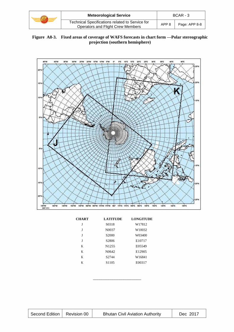
Meteorological Service BCAR - 3
Technical Specifications related to Service for Operators and Flight Crew Members
APP 8 Page: APP 8-8
Second Edition Revision 00 Bhutan Civil Aviation Authority Dec 2017
Figure A8-3. Fixed areas of coverage of WAFS forecasts in chart form —Polar stereographic
projection (southern hemisphere)
CHART LATITUDE LONGITUDE
J S0318 W17812
J N0037 W10032
J S2000 W03400
J S2806 E10717
K N1255 E05549
K N0642 E12905
K S2744 W16841
K S1105 E00317
______________________
Meteorological Service BCAR - 3
Technical Specifications related to Information for ATS, SAR and AIS
APP 9 Page: APP 9-1
Second Edition Revision 00 Bhutan Civil Aviation Authority Dec 2017
APPENDIX 9. TECHNICAL SPECIFICATIONS RELATED TO INFORMATION
FOR AIR TRAFFIC SERVICES, SEARCH AND RESCUE SERVICES AND
AERONAUTICAL INFORMATION SERVICES
(See Chapter 10 of this document)
1. INFORMATION TO BE PROVIDED FOR AIR TRAFFIC SERVICES UNITS
1.1 List of information for the aerodrome control tower
The following meteorological information shall be supplied, as necessary, to an aerodrome control
tower by its associated aerodrome meteorological office:
a) local routine and special reports, METAR and SPECI, TAF and trend forecasts and
amendments thereto, for the aerodrome concerned;
b) SIGMET and AIRMET information, wind shear warnings and alerts and aerodrome
warnings;
c) any additional meteorological information agreed upon locally, such as forecasts of surface
wind for the determination of possible runway changes;
1.2 List of information for the approach control unit
The following meteorological information shall be supplied, as necessary, to an approach control
unit by its associated aerodrome meteorological office:
a) local routine and special reports, METAR and SPECI, TAF and trend forecasts and
amendments thereto, for the aerodrome(s) with which the approach control unit is
concerned;
b) SIGMET and AIRMET information, wind shear warnings and alerts and appropriate special
air-reports for the airspace with which the approach control unit is concerned and
aerodrome warnings;
c) any additional meteorological information agreed upon locally;
1.3 List of information for the area control centre and flight information centre
The following meteorological information shall be supplied, as necessary, to an area control centre
or a flight information centre by its associated meteorological watch office:
a) METAR and SPECI, including current pressure data for aerodromes and other locations,
TAF and trend forecasts and amendments thereto, covering the flight information region
(FIR) or the control area (CTA) and, if required by the flight information centre (FIC) or
area control centre (ACC), covering aerodromes in neighbouring FIRs, as determined by
regional air navigation agreement;
Meteorological Service BCAR - 3
Technical Specifications related to Information for ATS, SAR and AIS
APP 9 Page: APP 9-2
Second Edition Revision 00 Bhutan Civil Aviation Authority Dec 2017
b) forecasts of upper winds, upper-air temperatures and significant en-route weather
phenomena and amendments thereto, particularly those which are likely to make operation
under visual flight rules impracticable, SIGMET and AIRMET information and appropriate
special air-reports for the FIR or CTA and, if determined by regional air navigation
agreement and required by the FIC or ACC, for neighbouring FIRs;
c) any other meteorological information required by the FIC or ACC to meet requests from
aircraft in flight; if the information requested is not available in the associated
meteorological watch office (MWO), that office shall request the assistance of another
meteorological office in supplying it;
d) information received on volcanic ash cloud, for which a SIGMET has not already been
issued, as agreed between the meteorological and ATS authorities concerned;
e) information received concerning the release of radioactive material into the atmosphere, as
agreed between the meteorological and ATS authorities concerned;
1.4 Supply of information to aeronautical telecommunications stations
Where necessary for flight information purposes, current meteorological reports and forecasts shall
be supplied to designated aeronautical telecommunication stations. A copy of such information
shall be forwarded, if required, to the FIC or ACC.
1.5 Format of information
1.5.1 Local routine and special reports, METAR and SPECI, TAF and trend forecasts, SIGMET
and AIRMET information, upper wind and upper-air temperature forecasts and amendments
thereto should be supplied to air traffic services units in the form in which they are prepared,
disseminated to other aerodrome meteorological offices or received from other aerodrome
meteorological offices or MWOs, unless otherwise agreed locally.
1.5.2 When computer-processed upper-air data for grid points are made available to air traffic
services units in digital form for use by air traffic services computers, the contents, format and
transmission arrangements should be as agreed between the meteorological authority and the
appropriate ATS authority. The data should normally be supplied as soon as is practicable after the
processing of the forecasts has been completed.
2. INFORMATION TO BE PROVIDED FOR SEARCH AND RESCUE SERVICES UNITS
2.1 List of information
Information to be supplied to rescue coordination centres shall include the meteorological
conditions that existed in the last known position of a missing aircraft and along the intended route
of that aircraft with particular reference to:
a) significant en-route weather phenomena;
b) cloud amount and type, particularly cumulonimbus; height indications of bases and tops;
c) visibility and phenomena reducing visibility;
Meteorological Service BCAR - 3
Technical Specifications related to Information for ATS, SAR and AIS
APP 9 Page: APP 9-3
Second Edition Revision 00 Bhutan Civil Aviation Authority Dec 2017
d) surface wind and upper wind;
e) state of ground, in particular, any snow cover or flooding;
f) sea-surface temperature, state of the sea, ice cover if any and ocean currents, if relevant to
the search area; and
g) sea-level pressure data.
2.2 Information to be provided on request
2.2.1 On request from the rescue coordination centre, the designated aerodrome meteorological
office or MWO should arrange to obtain details of the flight documentation which was supplied to
the missing aircraft, together with any amendments to the forecast which were transmitted to the
aircraft in flight.
2.2.2 To facilitate search and rescue operations the designated aerodrome meteorological office or
MWO should, on request, supply:
a) complete and detailed information on the current and forecast meteorological conditions in
the search area; and
b) current and forecast conditions en route, covering flights by search aircraft from and
returning to the aerodrome from which the search is being conducted.
2.2.3 On request from the rescue coordination centre, the designated aerodrome meteorological
office or WMO should supply or arrange for the supply of meteorological information required by
ships undertaking search and rescue operations.
3. INFORMATION TO BE PROVIDED FOR AERONAUTICAL INFORMATION
SERVICES UNITS
3.1 List of information
The following information shall be supplied, as necessary, to an aeronautical information services
unit:
a) information on meteorological service for international air navigation, intended for
inclusion in the aeronautical information publication(s) concerned;
Note.— Details of this information are given in BCAR - 15, Appendix 1, Part 1, GEN 3.5
and Part 3, AD 2.2, 2.11, 3.2 and 3.11
b) Information necessary for the preparation of NOTAM including, in particular, information
on:
1) the establishment, withdrawal and significant changes in operation of
aeronautical meteorological services. This information is required to be provided to
the aeronautical information services unit sufficiently in advance of the effective date
to permit issuance of NOTAM in compliance with BCAR-15, 5.1.1 and 5.1.1.1;

Meteorological Service BCAR - 3
Technical Specifications related to Information for ATS, SAR and AIS
APP 9 Page: APP 9-4
Second Edition Revision 00 Bhutan Civil Aviation Authority Dec 2017
2) (Not applicable)
3) (Not applicable)
c) information necessary for the preparation of aeronautical information circulars including, in
particular, information on:
1) expected important changes in aeronautical meteorological procedures, services and
facilities provided; and
2) effect of certain weather phenomena on aircraft operations.
______________________

Meteorological Service BCAR - 3
Technical Specifications related to Requirements for and Use of Communications
APP 10 Page: APP 10-1
Second Edition Revision 00 Bhutan Civil Aviation Authority Dec 2017
APPENDIX 10. TECHNICAL SPECIFICATIONS RELATED TO
REQUIREMENTS FOR AND USE OF COMMUNICATIONS
(See Chapter 11 of this document)
1. SPECIFIC REQUIREMENTS FOR COMMUNICATIONS
1.1 Required transit times of meteorological information
AFTN messages and bulletins containing operational meteorological information shall achieve
transit times of less than 5 minutes, unless otherwise determined to be lower by regional air
navigation agreement.
1.2 Grid point data for ATS and operators
1.2.1 When upper-air data for grid points in digital form are made available for use by air traffic
services computers, the transmission arrangements should be as agreed between the meteorological
authority and the appropriate ATS authority.
1.2.2 When upper-air data for grid points in digital form are made available to operators for flight
planning by computer, the transmission arrangements should be as agreed between the world area
forecast centre concerned, the meteorological authority and the operators concerned.
2. USE OF AERONAUTICAL FIXED SERVICE COMMUNICATIONS AND THE
PUBLIC INTERNET
2.1 Meteorological bulletins in alphanumeric format
2.1.1 Composition of bulletins
Whenever possible, exchanges of operational meteorological information should be made in
consolidated bulletins of the same types of meteorological information.
2.1.2 Filing times of bulletins
Meteorological bulletins required for scheduled transmissions should be filed regularly and at the
prescribed scheduled times. METAR should be filed for transmission not later than 5 minutes after
the actual time of observation. TAF should be filed for transmission not earlier than one hour prior
to the beginning of their validity period.
2.1.3 Heading of bulletins
Meteorological bulletins containing operational meteorological information to be transmitted via
the aeronautical fixed service or the public Internet shall contain a heading consisting of:
a) an identifier of four letters and two figures;
b) the ICAO four-letter location indicator corresponding to the geographical location of the
Meteorological Service BCAR - 3
Technical Specifications related to Requirements for and Use of Communications
APP 10 Page: APP 10-2
Second Edition Revision 00 Bhutan Civil Aviation Authority Dec 2017
meteorological office originating or compiling the meteorological bulletin;
c) a day-time group; and
d) if required, a three-letter indicator.
Note 1.— Detailed specifications on format and contents of the heading are given in the Manual on
the Global Telecommunication System (WMO-No. 386) and are reproduced in the Manual of
Aeronautical Meteorological Practice (ICAO Doc 8896).
Note 2.— ICAO location indicators are listed in Location Indicators (ICAO Doc 7910).
2.1.4 Structure of bulletins
Meteorological bulletins containing operational meteorological information to be transmitted via
the AFTN shall be encapsulated in the text part of the AFTN message format.
2.2 World area forecast system products
(Reserved)
3. USE OF AERONAUTICAL MOBILE SERVICE COMMUNICATIONS
3.1 Content and format of meteorological messages
3.1.1 The contents and format of reports, forecasts and SIGMET information transmitted to
aircraft shall be consistent with the provisions of Chapters 4, 6 and 7 of this document.
3.1.2 The contents and format of air-reports transmitted by aircraft shall be consistent with the
provisions of Chapter 5 of this document and the Procedures for Air Navigation Services — Air
Traffic Management (PANS-ATM, ICAO Doc 4444), Appendix 1.
3.2 Content and format of meteorological bulletins
The substance of a meteorological bulletin transmitted via the aeronautical mobile service shall
remain unchanged from that contained in the bulletin as originated.
4. USE OF AERONAUTICAL DATA LINK SERVICE — D-VOLMET
4.1 Detailed content of meteorological information available for D-VOLMET
4.1.1 The aerodromes for which METAR, SPECI and TAF are to be available for uplink to
aircraft in flight shall be determined by regional air navigation agreement.
4.1.2 The flight information regions (FIRs) for which SIGMET and AIRMET messages are to be
available for uplink to aircraft in flight shall be determined by regional air navigation agreement.
Meteorological Service BCAR - 3
Technical Specifications related to Requirements for and Use of Communications
APP 10 Page: APP 10-3
Second Edition Revision 00 Bhutan Civil Aviation Authority Dec 2017
4.2 Criteria related to information to be available for D-VOLMET
4.2.1 The latest available METAR, SPECI and TAF, and valid SIGMET and AIRMET should be
used for uplink to aircraft in flight.
4.2.2 TAF included in the D-VOLMET should be amended as necessary to ensure that a forecast,
when made available for uplink to aircraft in flight, reflects the latest opinion of the aerodrome
meteorological office concerned.
4.2.3 If no SIGMET message is valid for an FIR, an indication of “NIL SIGMET” should be
included in the D-VOLMET.
4.3 Format of information to be available for D-VOLMET
The content and format of reports, forecasts and SIGMET and AIRMET information included in D-
VOLMET shall be consistent with the provisions of Chapters 4, 6 and 7 of this document.
5. USE OF AERONAUTICAL BROADCASTING SERVICE — VOLMET BROADCASTS
5.1 Detailed content of meteorological information to be included in VOLMET broadcasts
5.1.1 The aerodromes for which METAR, SPECI and TAF are to be included in VOLMET
broadcasts, the sequence in which they are to be transmitted and the broadcast time shall be
determined by regional air navigation agreement.
5.1.2 The flight information regions for which SIGMET messages are to be included in scheduled
VOLMET broadcasts shall be determined by regional air navigation agreement. Where this is done,
the SIGMET message shall be transmitted at the beginning of the broadcast or of a five -minute
time block.
5.2 Criteria related to information to be included in VOLMET broadcasts
5.2.1 When a report has not arrived from an aerodrome in time for a broadcast, the latest available
report should be included in the broadcast, together with the time of observation.
5.2.2 TAF included in scheduled VOLMET broadcasts should be amended as necessary to ensure
that a forecast, when transmitted, reflects the latest opinion of the meteorological office concerned.
5.2.3 Where SIGMET messages are included in scheduled VOLMET broadcasts, an indication of
“NIL SIGMET” should be transmitted if no SIGMET message is valid for the flight information
regions concerned.
5.3 Format of information to be included in VOLMET broadcasts
5.3.1 The content and format of reports, forecasts and SIGMET information included in VOLMET
broadcasts shall be consistent with the provisions of Chapters 4, 6 and 7 of this document.
5.3.2 VOLMET broadcasts should use standard radiotelephony phraseologies.
Meteorological Service BCAR - 3
Technical Specifications related to Requirements for and Use of Communications
APP 10 Page: APP 10-4
Second Edition Revision 00 Bhutan Civil Aviation Authority Dec 2017
Note.— Guidance on the standard radiotelephony phraseologies to be used in VOLMET broadcasts
is given in the Manual on Coordination between Air Traffic Services, Aeronautical Information
Services and Aeronautic al Meteorological Services (ICAO Doc 9377), Appendix 1.
______________________

Meteorological Service BCAR - 3
Operationally Desirable Accuracy Measurement or Observations
ATT A Page: ATT A-1
Second Edition Revision 00 Bhutan Civil Aviation Authority Dec 2017
ATTACHMENT A. OPERATIONALLY DESIRABLE ACCURACY
MEASUREMENT OR OBSERVATION
Note.— The guidance contained in this table relates to Chapter 2, 2.2 — Supply, use, quality
management and interpretation of meteorological information, in particular to 2.2.7, and Chapter
4 — Meteorological observations and reports
Operationally desirable accuracy
Element to be observed of measurement or observation*
Mean surface wind Direction: ± 10°
Speed: ± 0.5 m/s (1 kt) up to 5 m/s (10 kt)
Variations from the mean surface wind
± 10% above 5 m/s (10 kt)
± 1 m/s (2 kt), in terms of longitudinal
and lateral components
Visibility ± 50 m up to 600 m
± 10% between 600 m and 1 500 m
± 20% above 1 500 m
Runway visual range ± 10 m up to 400 m
± 25 m between 400 m and 800 m
± 10% above 800 m
Cloud amount ± 1 okta
Cloud height ± 10 m (33 ft) up to 100 m (330 ft)
± 10% above 100 m (330 ft)
Air temperature and dew-point ± 1°C
Temperature
Pressure value (QNH, QFE) ± 0.5 hPa
*The operationally desirable accuracy is not intended as an operational requirement; it is to be understood as a goal that
has been expressed by the operators.
Note.— Guidance on the uncertainties of measurement or observation can be found in the Guide to
Meteorological Instruments and Methods of Observation (WMO-No. 8).
______________________
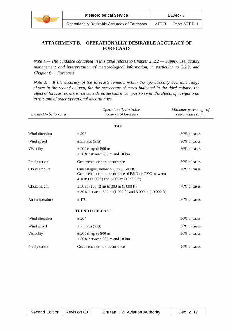
Meteorological Service BCAR - 3
Operationally Desirable Accuracy of Forecasts ATT B Page: ATT B- 1
Second Edition Revision 00 Bhutan Civil Aviation Authority Dec 2017
ATTACHMENT B. OPERATIONALLY DESIRABLE ACCURACY OF
FORECASTS
Note 1.— The guidance contained in this table relates to Chapter 2, 2.2 — Supply, use, quality
management and interpretation of meteorological information, in particular to 2.2.8, and
Chapter 6 — Forecasts. Note 2.— If the accuracy of the forecasts remains within the operationally desirable range
shown in the second column, for the percentage of cases indicated in the third column, the
effect of forecast errors is not considered serious in comparison with the effects of navigational
errors and of other operational uncertainties.
Operationally desirable Minimum percentage of
Element to be forecast accuracy of forecasts cases within range
TAF
Wind direction ± 20° 80% of cases
Wind speed ± 2.5 m/s (5 kt) 80% of cases
Visibility ± 200 m up to 800 m 80% of cases
± 30% between 800 m and 10 km
Precipitation Occurrence or non-occurrence 80% of cases
Cloud amount One category below 450 m (1 500 ft) 70% of cases
Occurrence or non-occurrence of BKN or OVC between
450 m (1 500 ft) and 3 000 m (10 000 ft)
Cloud height ± 30 m (100 ft) up to 300 m (1 000 ft) 70% of cases
± 30% between 300 m (1 000 ft) and 3 000 m (10 000 ft)
Air temperature ± 1°C 70% of cases
TREND FORECAST
Wind direction ± 20° 90% of cases
Wind speed ± 2.5 m/s (5 kt) 90% of cases
Visibility ± 200 m up to 800 m 90% of cases
± 30% between 800 m and 10 km
Precipitation Occurrence or non-occurrence 90% of cases
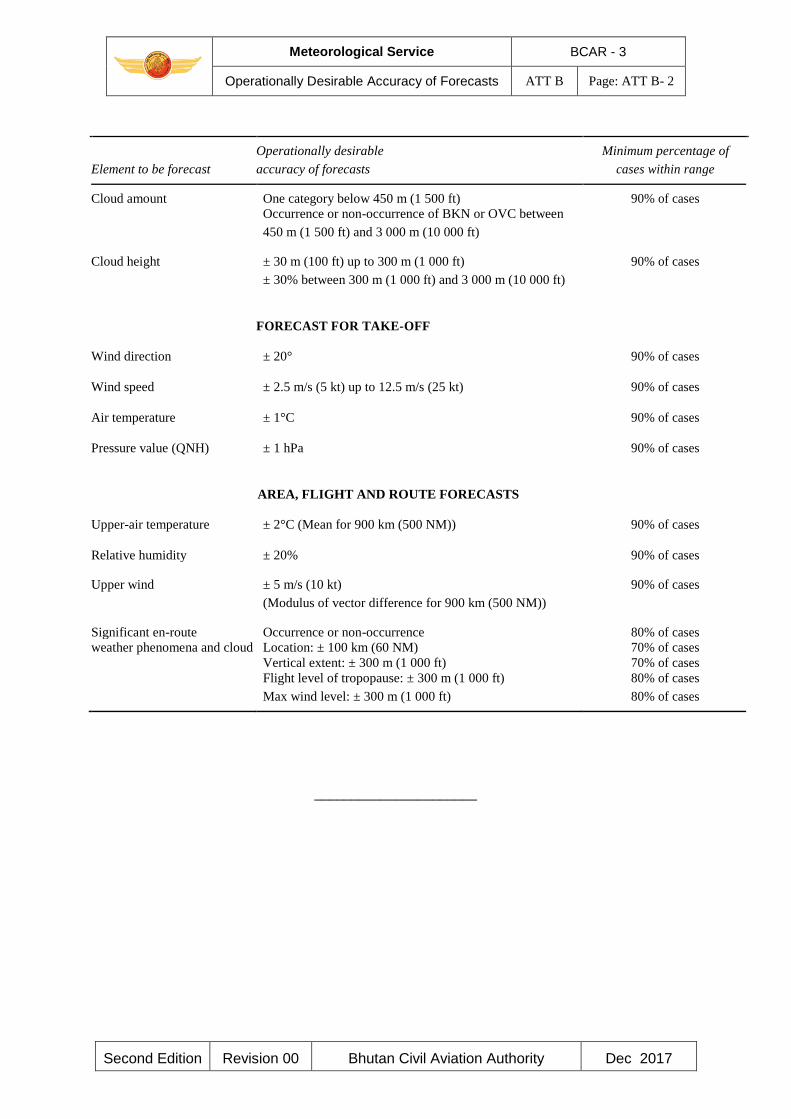
Meteorological Service BCAR - 3
Operationally Desirable Accuracy of Forecasts ATT B Page: ATT B- 2
Second Edition Revision 00 Bhutan Civil Aviation Authority Dec 2017
Operationally desirable Minimum percentage of
Element to be forecast accuracy of forecasts cases within range
Cloud amount One category below 450 m (1 500 ft) 90% of cases
Occurrence or non-occurrence of BKN or OVC between
450 m (1 500 ft) and 3 000 m (10 000 ft)
Cloud height ± 30 m (100 ft) up to 300 m (1 000 ft) 90% of cases
± 30% between 300 m (1 000 ft) and 3 000 m (10 000 ft)
FORECAST FOR TAKE-OFF
Wind direction ± 20° 90% of cases
Wind speed ± 2.5 m/s (5 kt) up to 12.5 m/s (25 kt) 90% of cases
Air temperature ± 1°C 90% of cases
Pressure value (QNH) ± 1 hPa 90% of cases
AREA, FLIGHT AND ROUTE FORECASTS
Upper-air temperature ± 2°C (Mean for 900 km (500 NM)) 90% of cases
Relative humidity ± 20% 90% of cases
Upper wind ± 5 m/s (10 kt) 90% of cases
(Modulus of vector difference for 900 km (500 NM))
Significant en-route Occurrence or non-occurrence 80% of cases
weather phenomena and cloud Location: ± 100 km (60 NM) 70% of cases
Vertical extent: ± 300 m (1 000 ft) 70% of cases
Flight level of tropopause: ± 300 m (1 000 ft) 80% of cases
Max wind level: ± 300 m (1 000 ft) 80% of cases
______________________

BCAR – Meteorological Service BCAR - 3
Selected criteria applicable to aerodrome reports ATT C Page: ATT C- 1
Second Edition Revision 00 Bhutan Civil Aviation Authority Dec 2017
ATTACHMENT C. SELECTED CRITERIA APPLICABLE TO AERODROME REPORTS
(The guidance in this table relates to Chapter 4 and Appendix 3.)
BCAR – Meteorological Service BCAR - 3
Conversion of Instrument Reading into Runway Visual Range and Visibility
ATT D Page: ATT D- 1
Second Edition Revision 00 Bhutan Civil Aviation Authority Sept 2017
ATTACHMENT D. CONVERSION OF INSTRUMENTED READINGS INTO
RUNWAY VISUAL RANGE AND VISIBILITY
(Reserved)
- END -