
AIS/MAP TF/5-REPORT INTERNATIONAL CIVIL AVIATION ...
220
AIS/MAP TF/5-REPORT INTERNATIONAL CIVIL AVIATION ORGANIZATION THE MIDDLE EAST AIR NAVIGATION PLANNING AND IMPLEMENTATION REGIONAL GROUP (MIDANPIRG) REPORT OF THE FIFTH MEETING OF AIS/MAP TASK FORCE (Tehran, Iran Islamic Republic of, 5 – 7 May 2009) The views expressed in this Report should be taken as those of the MIDANPIRG AIS/MAP Task Force and not of the Organization. This Report will, however, be submitted to the MIDANPIRG and any formal action taken will be published in due course as a Supplement to the Report. Approved by the Meeting and published by authority of the Secretary General
-
Upload
khangminh22 -
Category
Documents
-
view
3 -
download
0
Transcript of AIS/MAP TF/5-REPORT INTERNATIONAL CIVIL AVIATION ...
AIS/MAP TF/5-REPORT
INTERNATIONAL CIVIL AVIATION ORGANIZATION
THE MIDDLE EAST AIR NAVIGATION PLANNING AND IMPLEMENTATION REGIONAL GROUP
(MIDANPIRG)
REPORT OF THE FIFTH MEETING OF AIS/MAP TASK FORCE
(Tehran, Iran Islamic Republic of, 5 – 7 May 2009)
The views expressed in this Report should be taken as those of the MIDANPIRG AIS/MAP Task Force and not of the Organization. This Report will, however, be submitted to the MIDANPIRG and any formal action taken will be published in due course as a Supplement to the Report.
Approved by the Meeting
and published by authority of the Secretary General

The designations employed and the presentation of material in this publication do not imply the expression of any opinion whatsoever on the part of ICAO concerning the legal status of any country, territory, city or area or of its authorities, or concerning the delimitation of its frontier or boundaries.
TABLE OF CONTENTS Page
PART I - HISTORY OF THE MEETING 1. Place and Duration.........................................................................................................1
2. Opening.......................................................................................................................1-2
3. Attendance .....................................................................................................................2
4. Officers and Secretariat..................................................................................................2
5. Language........................................................................................................................2
6. Agenda ........................................................................................................................2-3
7. Conclusions and Decisions - Definition ........................................................................3
8. List of Draft Conclusions and Draft Decisions..............................................................3
PART II - REPORT ON AGENDA ITEMS
Report on Agenda Item 1............................................................................................1-1
Report on Agenda Item 2............................................................................................2-1 Appendix 2A
Report on Agenda Item 3 ..................................................................................... 3-1/3-8 Appendices 3A-3C
Report on Agenda Item 4 ................................................................................... .4-1/4-4 Appendices 4A-4C
Report on Agenda Item 5 .................................................................................... 5-1/5-4 Appendices 5A-5C
Report on Agenda Item 6 ..................................................................................... 6-1/6-4 Appendices 6A – 6F
Report on Agenda Item 7 ..................................................................................... 7-1/7-2 Appendix 7A
Report on Agenda Item 8 ............................................................................................8-1 Appendix 8A
Report on Agenda Item 9 ..................................................................................... 9-1/9-4 Appendices 9A & 9B
Report on Agenda Item 10 ........................................................................................10-1 Report on Agenda Item 11 ........................................................................................11-1 Appendices 11A & 11B
Report on Agenda Item 12 ........................................................................................12-1
List of Participants ................................................................................... Attachment A
--------------
AIS/MAP TF/5-REPORT -1-
AIS/MAP TF/5
History of the Meeting PART I – HISTORY OF THE MEETING 1. PLACE AND DURATION
1.1 The Fifth Meeting of the MIDANPIRG AIS/MAP Task Force was held at the Islamic Republic of Iran Broadcasting (IRIB) Int'l Conference Centre (IICC) from 5 to 7 May 2009. 2. OPENING 2.1 Mr. Faramarz Sarvi, Vice President Flight Standards/Civil Aviation Organization (CAO) of Iran welcomed the participants and indicated that such meetings are beneficial to the aviation community and would strengthen the cooperation between MID States. He underlined that the role of AIS has changed significantly with the introduction of RNP, RNAV, PBN and airborne computer based systems, where the quality of AIS data has a direct impact on the safety of air navigation. Mr. Sarvi pointed out that aviation activity in the MID Region is one of the fastest growing in the world and accordingly, the provision of services such as AIS/AIM, ATM and SAR must be compatible with the growth. He provided also an overview of the developments of aviation infrastructure in Iran. 2.2 H.E. Mr. Hashimi, The First Vice Minister of Road & Transportation, welcomed all the participants to Tehran wishing that the AIS/MAP TF/5 meeting would be very successful. He stated that aviation industry is a kind of gift to humanity and a symbol of development of any country in the world. Mr. Hashimi highlighted the importance of human resources in the field of aviation and recognized that investment in aviation, including training of aviation personnel, will improve the services available to the aviation community and overall improve safety. He further pointed out the importance of aeronautical information and the need for the availability of high quality aeronautical information in a timely manner and where needed (in the ground and onboard the aircraft). Mr. Hashimi mentioned that one of the objectives of the AIS/MAP Task Force is to develop procedures and guidance material related to the use of aeronautical information and associated applications and new technology. He mentioned that the participants represent the elite of aviation industry gathered to exchange views and find means to minimize human errors and maximize safety and standardization of AIS data. Mr. Hashimi re-iterated Iran’s support to the ICAO MID Regional Office and all regional and international civil aviation activities and cooperation aiming at improving the safety and efficiency of international air navigation. 2.3 Mr. Mo’menirokh, The Chairman of the Board and Chief Executive Officer of the Iranian Airport Company (IAC) welcomed the ICAO MID Regional Office Representatives and all participants to Tehran. He highlighted the important role AIS is playing within the framework of the ATM Operational Concept. He emphasized on the need to transit to the digital world and to use the technology for the provision and exchange of aeronautical information. In this regard, and as part of the Iranian CNS/ATM project, Mr. Mo’menirokh confirmed that Iran has started the process of transition from AIS to AIM, in accordance with the ICAO guidelines. He underlined the need to comply with the current ICAO SARPs as an essential pre-requisite for the transition from AIS to AIM. In particular, Mr. Mo’menirokh highlighted the importance of implementation of Quality Management System (QMS) for AIS and mentioned that Iran AIS has been certified ISO 9001 since January 2009. He further stated that Iran is working hard to conclude an agreement with a contractor for the implementation of an AIS Automation Project. In closing, he thanked the ICAO MID Regional Office and all participants wishing them a fruitful and successful meeting.

AIS/MAP TF/5-REPORT -2-
AIS/MAP TF/5
History of the Meeting
2.4 Mr. Jehad Faqir, ICAO MID Regional Office Deputy Regional Director, on behalf of Mr. Mohamed R. M. Khonji, the Regional Director, welcomed the participants and thanked the CAO of Iran and the Iranian Airport Company (IAC) for hosting the fifth meeting of the AIS/MAP Task Force and for their generous hospitality. He highlighted the major objectives of AIS and the need for transition from AIS to AIM to meet the pressing demand of the new navigation and ATM systems which are data-dependent, all requiring access to high quality and timeliness Aeronautical Information. He requested the meeting to include in its work programme the development of an Action Plan/Strategy for the transition from AIS to AIM in the MID Region and to develop associated planning material. In closing, he wished the participants a pleasant stay in Tehran and a fruitful meeting. 3. ATTENDANCE 3.1 The meeting was attended by a total of sixty four (64) participants, including experts from eight (8) States (Bahrain, Egypt, Iran, Jordan, Kuwait, Oman, Saudi Arabia and Syria.). The list of participants is at Attachment A to the Report. 4. OFFICERS AND SECRETARIAT 4.1 The meeting was chaired by Mr. Ramezanali Ziaeegravi, Deputy of General Director of ATM, Tehran Mehrabad International Airport, Iranian Airport Company. Mr. Mohamed Smaoui, Regional Officer Aeronautical Information & Charts/Meteorology was the Secretary of the meeting, supported by Mr. Jehad Faqir, Deputy Regional Director, ICAO MID Regional Office. 5. LANGUAGE 5.1 Discussions were conducted in English and documentation was issued in English. 6. AGENDA 6.1 The following Agenda was adopted:
Agenda Item 1: Adoption of provisional agenda Agenda Item 2: Follow-up on MIDANPIRG/11 Conclusions and Decisions relevant to
the AIS/MAP field Agenda Item 3: Status of implementation of AIS/MAP requirements in the MID
Region Agenda Item 4: Quality Management System (QMS) Agenda Item 5: AIS automation Agenda Item 6: Electronic Terrain and Obstacle Data (eTOD) Agenda Item 7: Review of air navigation deficiencies in the AIS/MAP field Agenda Item 8: MID Region AIS/MAP implementation Plan Agenda Item 9: Aeronautical Information Management (AIM)
AIS/MAP TF/5-REPORT -3-
AIS/MAP TF/5
History of the Meeting
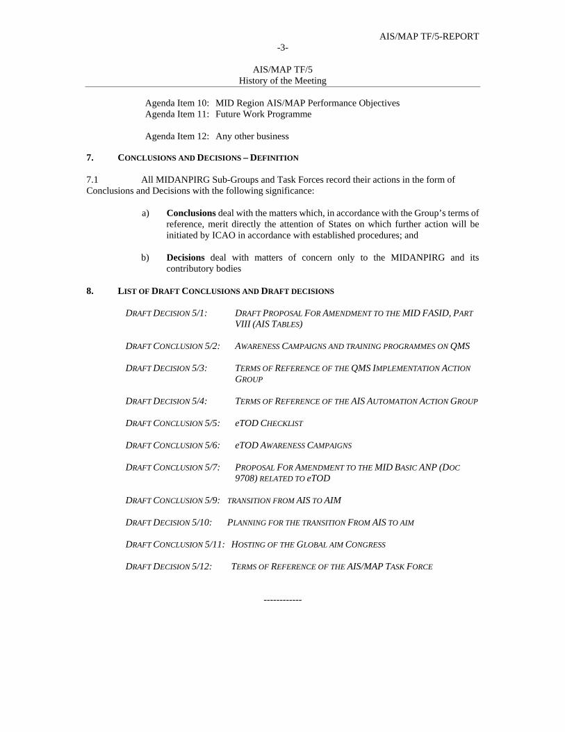
Agenda Item 10: MID Region AIS/MAP Performance Objectives Agenda Item 11: Future Work Programme Agenda Item 12: Any other business
7. CONCLUSIONS AND DECISIONS – DEFINITION 7.1 All MIDANPIRG Sub-Groups and Task Forces record their actions in the form of Conclusions and Decisions with the following significance:
a) Conclusions deal with the matters which, in accordance with the Group’s terms of reference, merit directly the attention of States on which further action will be initiated by ICAO in accordance with established procedures; and
b) Decisions deal with matters of concern only to the MIDANPIRG and its
contributory bodies 8. LIST OF DRAFT CONCLUSIONS AND DRAFT DECISIONS
DRAFT DECISION 5/1: DRAFT PROPOSAL FOR AMENDMENT TO THE MID FASID, PART
VIII (AIS TABLES) DRAFT CONCLUSION 5/2: AWARENESS CAMPAIGNS AND TRAINING PROGRAMMES ON QMS DRAFT DECISION 5/3: TERMS OF REFERENCE OF THE QMS IMPLEMENTATION ACTION
GROUP DRAFT DECISION 5/4: TERMS OF REFERENCE OF THE AIS AUTOMATION ACTION GROUP DRAFT CONCLUSION 5/5: eTOD CHECKLIST
DRAFT CONCLUSION 5/6: eTOD AWARENESS CAMPAIGNS
DRAFT CONCLUSION 5/7: PROPOSAL FOR AMENDMENT TO THE MID BASIC ANP (DOC
9708) RELATED TO eTOD
DRAFT CONCLUSION 5/9: TRANSITION FROM AIS TO AIM
DRAFT DECISION 5/10: PLANNING FOR THE TRANSITION FROM AIS TO AIM
DRAFT CONCLUSION 5/11: HOSTING OF THE GLOBAL AIM CONGRESS
DRAFT DECISION 5/12: TERMS OF REFERENCE OF THE AIS/MAP TASK FORCE
------------

AIS/MAP TF/5-REPORT 1-1
AIS/MAP TF/5
Report on Agenda Item 1
PART II: REPORT ON AGENDA ITEMS REPORT ON AGENDA ITEM 1: ADOPTION OF PROVISIONAL AGENDA 1.1 The meeting reviewed and adopted the Provisional Agenda as at Para. 6 of the History of the Meeting.
----------------------
AIS/MAP TF/5-REPORT
2-1
AIS/MAP TF/5 Report on Agenda Item 2
REPORT ON AGENDA ITEM 2: FOLLOW-UP ON MIDANPIRG/11 CONCLUSIONS AND DECISIONS
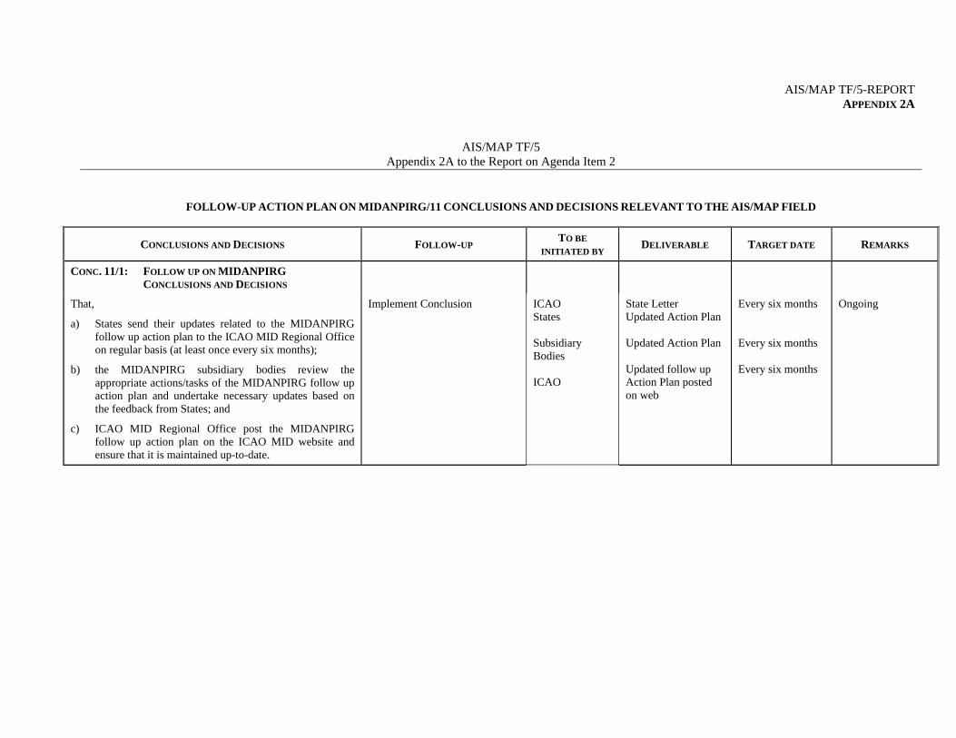
RELEVANT TO THE AIS/MAP FIELD 2.1 The meeting noted the status of relevant MIDANPIRG/11 Conclusions and Decisions related to the AIS/MAP field and the follow up actions taken by concerned parties as at Appendix 2A to the Report on Agenda Item 2.
------------------------
AIS/MAP TF/5-REPORT APPENDIX 2A
AIS/MAP TF/5 Appendix 2A to the Report on Agenda Item 2
FOLLOW-UP ACTION PLAN ON MIDANPIRG/11 CONCLUSIONS AND DECISIONS RELEVANT TO THE AIS/MAP FIELD
CONCLUSIONS AND DECISIONS FOLLOW-UP TO BE
INITIATED BY DELIVERABLE TARGET DATE REMARKS
CONC. 11/1: FOLLOW UP ON MIDANPIRG
CONCLUSIONS AND DECISIONS
That,
a) States send their updates related to the MIDANPIRG follow up action plan to the ICAO MID Regional Office on regular basis (at least once every six months);
b) the MIDANPIRG subsidiary bodies review the appropriate actions/tasks of the MIDANPIRG follow up action plan and undertake necessary updates based on the feedback from States; and
c) ICAO MID Regional Office post the MIDANPIRG follow up action plan on the ICAO MID website and ensure that it is maintained up-to-date.
Implement Conclusion
ICAO States Subsidiary Bodies ICAO
State Letter Updated Action Plan Updated Action Plan Updated follow up Action Plan posted on web
Every six months Every six months Every six months
Ongoing
AIS/MAP TF/5-REPORT APPENDIX 2A
2A-2
CONCLUSIONS AND DECISIONS FOLLOW-UP TO BE
INITIATED BY DELIVERABLE TARGET DATE REMARKS
CONC. 11/3: INCREASING THE EFFICIENCY OF
MIDANPIRG
That, with a view to increase the efficiency of MIDANPIRG:
a) States appoint an ICAO Focal Point Person(s) (ICAO-FPP) using the form at Appendix 4E to the Report on Agenda Item 4; who would:
i. ensure the internal distribution of all ICAO MID Office correspondences related to MIDANPIRG activities and the follow-up within civil aviation administration;
ii. follow up the ICAO MID Office postings of
tentative schedule of meetings, MIDANPIRG follow up action plan, State Letters, working/information papers, reports of meetings, etc, on both the ICAO MID website and the MID Forum; and
iii. ensure that required action and replies are communicated to ICAO MID Regional Office by the specified target dates.
b) ICAO MID Regional Office copy all correspondences related to MIDANPIRG activities to the designated ICAO-FPP as appropriate.
Implement the Conclusion
ICAO States
State Letter (Reminder) List of ICAO FPP
Apr. 2009 Jun. 2009
Ongoing
AIS/MAP TF/5 -REPORT APPENDIX 2A
2A-3
CONCLUSIONS AND DECISIONS FOLLOW-UP TO BE
INITIATED BY DELIVERABLE TARGET DATE REMARKS
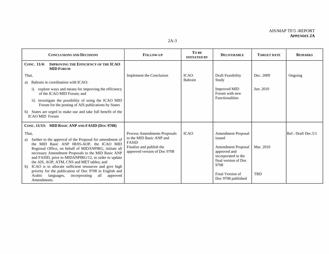
CONC. 11/4: IMPROVING THE EFFICIENCY OF THE ICAO
MID FORUM
That,
a) Bahrain in coordination with ICAO:
i) explore ways and means for improving the efficiency of the ICAO MID Forum; and
ii) investigate the possibility of using the ICAO MID Forum for the posting of AIS publications by States
b) States are urged to make use and take full benefit of the ICAO MID Forum
Implement the Conclusion ICAO Bahrain
Draft Feasibility Study Improved MID Forum with new Functionalities
Dec. 2009 Jun. 2010
Ongoing
CONC. 11/13: MID BASIC ANP AND FASID (DOC 9708)
That,
a) further to the approval of the Proposal for amendment of the MID Basic ANP 08/05-AOP, the ICAO MID Regional Office, on behalf of MIDANPIRG, initiate all necessary Amendment Proposals to the MID Basic ANP and FASID, prior to MIDANPIRG/12, in order to update the AIS, AOP, ATM, CNS and MET tables; and
b) ICAO is to allocate sufficient resources and give high priority for the publication of Doc 9708 in English and Arabic languages, incorporating all approved Amendments.
Process Amendments Proposals to the MID Basic ANP and FASID Finalize and publish the approved version of Doc 9708
ICAO Amendment Proposal issued Amendment Proposal approved and incorporated in the final version of Doc 9708 Final Version of Doc 9708 published
Mar. 2010 TBD
Ref.: Draft Dec.5/1
AIS/MAP TF/5-REPORT APPENDIX 2A
2A-4
CONCLUSIONS AND DECISIONS FOLLOW-UP TO BE
INITIATED BY DELIVERABLE TARGET DATE REMARKS
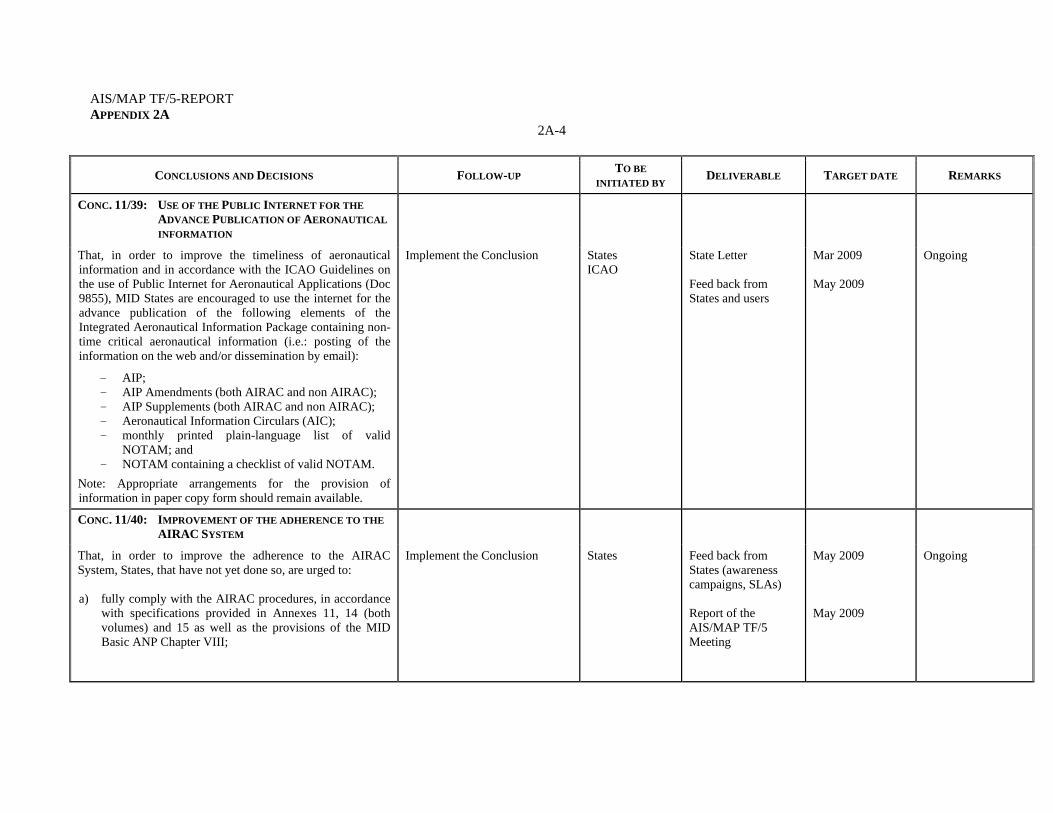
CONC. 11/39: USE OF THE PUBLIC INTERNET FOR THE
ADVANCE PUBLICATION OF AERONAUTICAL
INFORMATION
That, in order to improve the timeliness of aeronautical information and in accordance with the ICAO Guidelines on the use of Public Internet for Aeronautical Applications (Doc 9855), MID States are encouraged to use the internet for the advance publication of the following elements of the Integrated Aeronautical Information Package containing non-time critical aeronautical information (i.e.: posting of the information on the web and/or dissemination by email):
- AIP; - AIP Amendments (both AIRAC and non AIRAC); - AIP Supplements (both AIRAC and non AIRAC); - Aeronautical Information Circulars (AIC); - monthly printed plain-language list of valid
NOTAM; and - NOTAM containing a checklist of valid NOTAM.
Note: Appropriate arrangements for the provision of information in paper copy form should remain available.
Implement the Conclusion States ICAO
State Letter Feed back from States and users
Mar 2009 May 2009
Ongoing
CONC. 11/40: IMPROVEMENT OF THE ADHERENCE TO THE
AIRAC SYSTEM
That, in order to improve the adherence to the AIRAC System, States, that have not yet done so, are urged to: a) fully comply with the AIRAC procedures, in accordance
with specifications provided in Annexes 11, 14 (both volumes) and 15 as well as the provisions of the MID Basic ANP Chapter VIII;
Implement the Conclusion States
Feed back from States (awareness campaigns, SLAs) Report of the AIS/MAP TF/5 Meeting
May 2009 May 2009
Ongoing
AIS/MAP TF/5 -REPORT APPENDIX 2A
2A-5
CONCLUSIONS AND DECISIONS FOLLOW-UP TO BE
INITIATED BY DELIVERABLE TARGET DATE REMARKS
b) organize awareness campaigns involving AIS and all technical Departments providing the raw data to the AIS for promulgation; and
c) arrange for the signature of Service Level Agreements (SLA) between AIS and the data originators.
CONC. 11/41: ANNEX 15 PROVISIONS RELATED TO AIRAC
That, ICAO consider to review the current provisions of Annex 15 Chapter 6 and Appendix 4 related to AIRAC by replacing the words “significant” and “major” changes, which lead to different interpretations, by a comprehensive list of changes which necessitate the use of the AIRAC System.
Follow up with ICAO HQ ICAO Appropriate provisions in Annexes 15 (Amendment 36 to Annex 15)
Nov. 2010 Actioned (Draft Amendment 36 to Annex 15)
CONC. 11/42: IMPLEMENTATION OF WGS-84 IN THE MID
REGION
That, taking into consideration the status of implementation of WGS-84 in the MID Region as reflected in Appendix 5.3A to the Report on Agenda Item 5.3 and recognizing that WGS-84 is an important pre-requisite for the implementation of PBN and for the transition from AIS to AIM; States that have not yet done so are urged to:
a) develop effective and detailed WGS-84 implementation plans with clear timelines and send these plans to the ICAO MID Regional Office, prior to 30 June 2009;
b) adopt appropriate procedures to validate the WGS-84 data and ensure the quality (accuracy, integrity and resolution) of the published WGS-84 coordinates, in accordance with ICAO Annex 15 requirements;
c) achieve the total implementation of the WGS-84 System, in accordance with ICAO Annexes 4, 11, 14 and 15 provisions, prior to 31 December 2010 ; and
Follow up with concerned States ICAO States
State Letter WGS-84 implementation plans Report on the status of implementation of WGS-84
Apr 2009 Jun 2009 Ongoing
Actioned (State Letter Ref.: AN 8/1.1-09/128 dated 14 April 2009) Ongoing

AIS/MAP TF/5-REPORT APPENDIX 2A
2A-6
CONCLUSIONS AND DECISIONS FOLLOW-UP TO BE
INITIATED BY DELIVERABLE TARGET DATE REMARKS
d) report the status of implementation of WGS-84 on a regular basis to the ICAO MID Regional Office and appropriate MIDANPIRG subsidiary bodies, until the system is fully implemented.
CONC. 11/43: MID REGION eTOD IMPLEMENTATION
STRATEGY
That, the MID Region eTOD implementation Strategy is adopted as at Appendix 5.3B to the Report on Agenda Item 5.3.
Follow up the eTOD implementation status
States eTOD WG AIS/MAP TF
Feed back from States updated eTOD status of implementation
May 2009 To be replaced and superseded by Draft Conc. 5/5 & 5/7
CONC. 11/44: DRAFT FASID TABLE RELATED TO eTOD
That, ICAO consider to include the Draft FASID Table at Appendix 5.3D to the Report on Agenda Item 5.3, into the MID FASID, Part VIII (AIS), with necessary amendments, as appropriate.
Follow up with ICAO HQ ICAO eTOD FASID Table included in the MID FASID
TBD Ongoing
DEC. 11/45: TERMS OF REFERENCE OF THE eTOD
WORKING GROUP
That, the Terms of Reference of the eTOD Working Group be updated as at Appendix 5.3E to the Report on Agenda Item 5.3.
Implement the eTOD WG Work Programme
eTOD WG AIS/MAP TF
eTOD WG/2 Report May 2009 To be replaced and superseded by Draft Dec. 5/8
AIS/MAP TF/5 -REPORT APPENDIX 2A
2A-7
CONCLUSIONS AND DECISIONS FOLLOW-UP TO BE
INITIATED BY DELIVERABLE TARGET DATE REMARKS
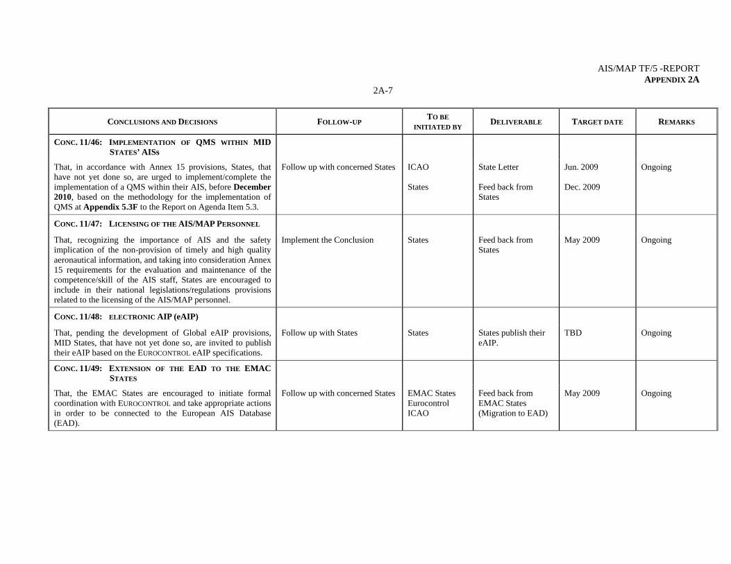
CONC. 11/46: IMPLEMENTATION OF QMS WITHIN MID
STATES’ AISs
That, in accordance with Annex 15 provisions, States, that have not yet done so, are urged to implement/complete the implementation of a QMS within their AIS, before December 2010, based on the methodology for the implementation of QMS at Appendix 5.3F to the Report on Agenda Item 5.3.
Follow up with concerned States ICAO States
State Letter Feed back from States
Jun. 2009 Dec. 2009
Ongoing
CONC. 11/47: LICENSING OF THE AIS/MAP PERSONNEL
That, recognizing the importance of AIS and the safety implication of the non-provision of timely and high quality aeronautical information, and taking into consideration Annex 15 requirements for the evaluation and maintenance of the competence/skill of the AIS staff, States are encouraged to include in their national legislations/regulations provisions related to the licensing of the AIS/MAP personnel.
Implement the Conclusion States
Feed back from States
May 2009 Ongoing
CONC. 11/48: ELECTRONIC AIP (eAIP)
That, pending the development of Global eAIP provisions, MID States, that have not yet done so, are invited to publish their eAIP based on the EUROCONTROL eAIP specifications.
Follow up with States States States publish their eAIP.
TBD Ongoing
CONC. 11/49: EXTENSION OF THE EAD TO THE EMAC
STATES
That, the EMAC States are encouraged to initiate formal coordination with EUROCONTROL and take appropriate actions in order to be connected to the European AIS Database (EAD).
Follow up with concerned States EMAC States Eurocontrol ICAO
Feed back from EMAC States (Migration to EAD)
May 2009 Ongoing
AIS/MAP TF/5-REPORT APPENDIX 2A
2A-8
CONCLUSIONS AND DECISIONS FOLLOW-UP TO BE
INITIATED BY DELIVERABLE TARGET DATE REMARKS
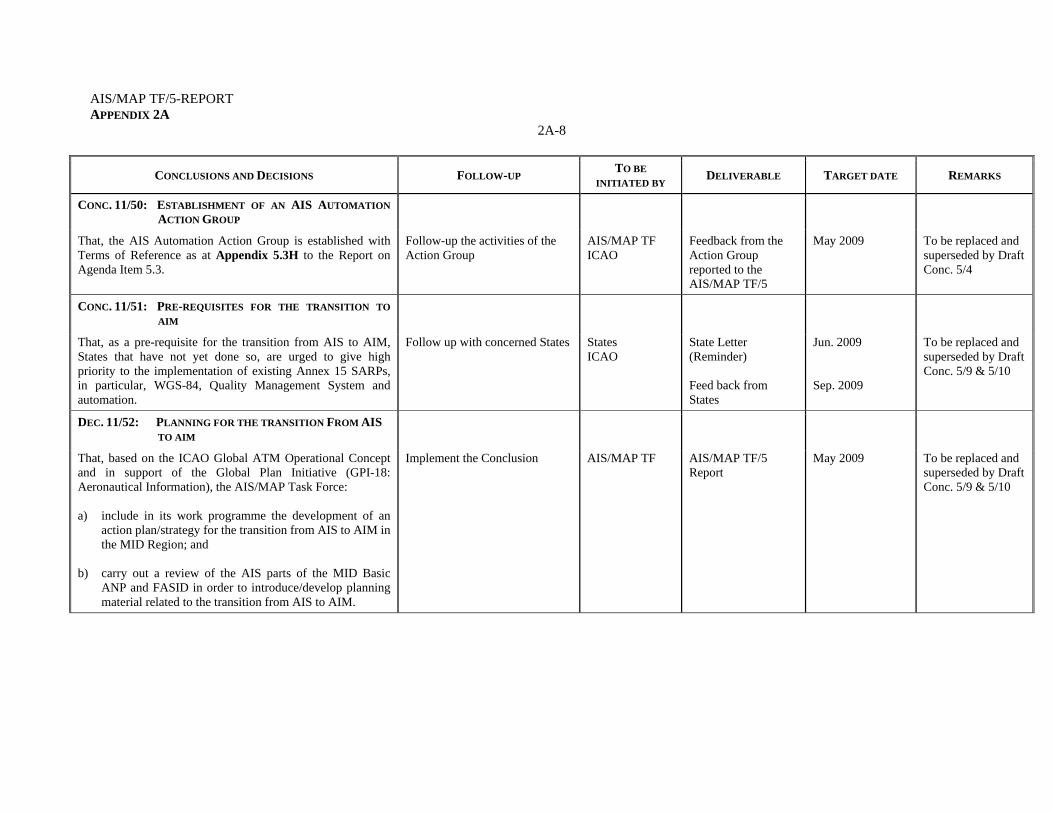
CONC. 11/50: ESTABLISHMENT OF AN AIS AUTOMATION
ACTION GROUP
That, the AIS Automation Action Group is established with Terms of Reference as at Appendix 5.3H to the Report on Agenda Item 5.3.
Follow-up the activities of the Action Group
AIS/MAP TF ICAO
Feedback from the Action Group reported to the AIS/MAP TF/5
May 2009 To be replaced and superseded by Draft Conc. 5/4
CONC. 11/51: PRE-REQUISITES FOR THE TRANSITION TO
AIM
That, as a pre-requisite for the transition from AIS to AIM, States that have not yet done so, are urged to give high priority to the implementation of existing Annex 15 SARPs, in particular, WGS-84, Quality Management System and automation.
Follow up with concerned States States ICAO
State Letter (Reminder) Feed back from States
Jun. 2009 Sep. 2009
To be replaced and superseded by Draft Conc. 5/9 & 5/10
DEC. 11/52: PLANNING FOR THE TRANSITION FROM AIS
TO AIM
That, based on the ICAO Global ATM Operational Concept and in support of the Global Plan Initiative (GPI-18: Aeronautical Information), the AIS/MAP Task Force: a) include in its work programme the development of an
action plan/strategy for the transition from AIS to AIM in the MID Region; and
b) carry out a review of the AIS parts of the MID Basic
ANP and FASID in order to introduce/develop planning material related to the transition from AIS to AIM.
Implement the Conclusion AIS/MAP TF AIS/MAP TF/5 Report
May 2009 To be replaced and superseded by Draft Conc. 5/9 & 5/10
AIS/MAP TF/5 -REPORT APPENDIX 2A
2A-9
CONCLUSIONS AND DECISIONS FOLLOW-UP TO BE
INITIATED BY DELIVERABLE TARGET DATE REMARKS
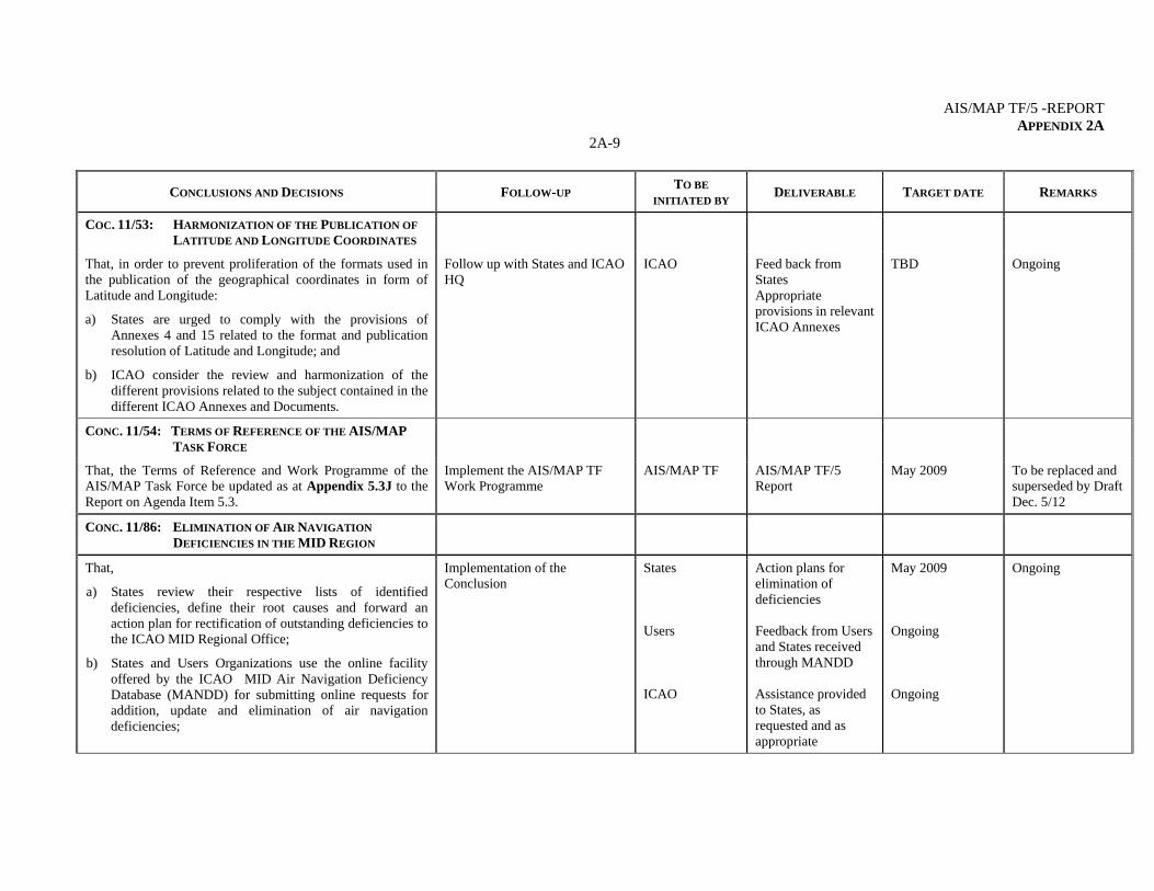
COC. 11/53: HARMONIZATION OF THE PUBLICATION OF
LATITUDE AND LONGITUDE COORDINATES
That, in order to prevent proliferation of the formats used in the publication of the geographical coordinates in form of Latitude and Longitude:
a) States are urged to comply with the provisions of Annexes 4 and 15 related to the format and publication resolution of Latitude and Longitude; and
b) ICAO consider the review and harmonization of the different provisions related to the subject contained in the different ICAO Annexes and Documents.
Follow up with States and ICAO HQ
ICAO Feed back from States Appropriate provisions in relevant ICAO Annexes
TBD Ongoing
CONC. 11/54: TERMS OF REFERENCE OF THE AIS/MAP
TASK FORCE
That, the Terms of Reference and Work Programme of the AIS/MAP Task Force be updated as at Appendix 5.3J to the Report on Agenda Item 5.3.
Implement the AIS/MAP TF Work Programme
AIS/MAP TF AIS/MAP TF/5 Report
May 2009 To be replaced and superseded by Draft Dec. 5/12
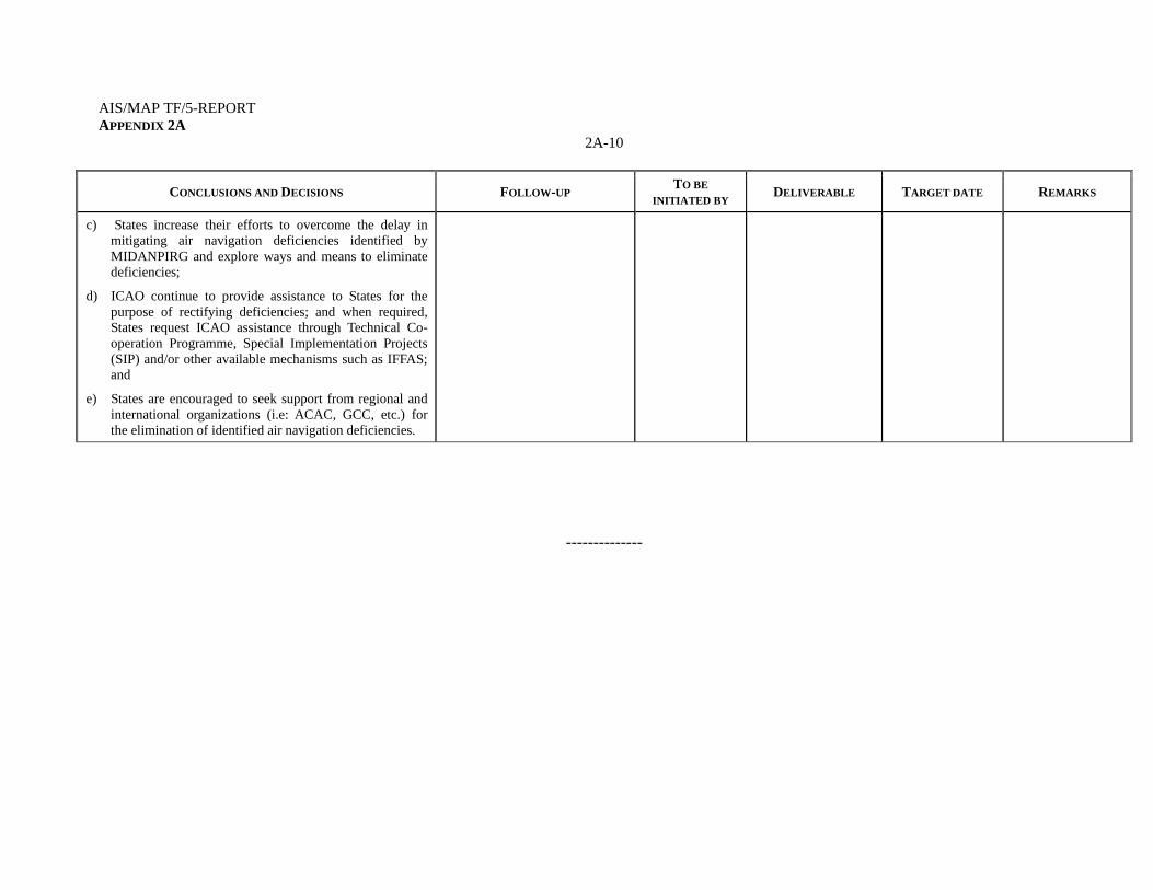
CONC. 11/86: ELIMINATION OF AIR NAVIGATION
DEFICIENCIES IN THE MID REGION
That,
a) States review their respective lists of identified deficiencies, define their root causes and forward an action plan for rectification of outstanding deficiencies to the ICAO MID Regional Office;
b) States and Users Organizations use the online facility offered by the ICAO MID Air Navigation Deficiency Database (MANDD) for submitting online requests for addition, update and elimination of air navigation deficiencies;
Implementation of the Conclusion
States Users ICAO
Action plans for elimination of deficiencies Feedback from Users and States received through MANDD Assistance provided to States, as requested and as appropriate
May 2009 Ongoing Ongoing
Ongoing
AIS/MAP TF/5-REPORT APPENDIX 2A
2A-10
CONCLUSIONS AND DECISIONS FOLLOW-UP TO BE
INITIATED BY DELIVERABLE TARGET DATE REMARKS
c) States increase their efforts to overcome the delay in mitigating air navigation deficiencies identified by MIDANPIRG and explore ways and means to eliminate deficiencies;
d) ICAO continue to provide assistance to States for the purpose of rectifying deficiencies; and when required, States request ICAO assistance through Technical Co-operation Programme, Special Implementation Projects (SIP) and/or other available mechanisms such as IFFAS; and
e) States are encouraged to seek support from regional and international organizations (i.e: ACAC, GCC, etc.) for the elimination of identified air navigation deficiencies.
--------------
AIS/MAP TF/5-REPORT 3-1
AIS/MAP TF/5
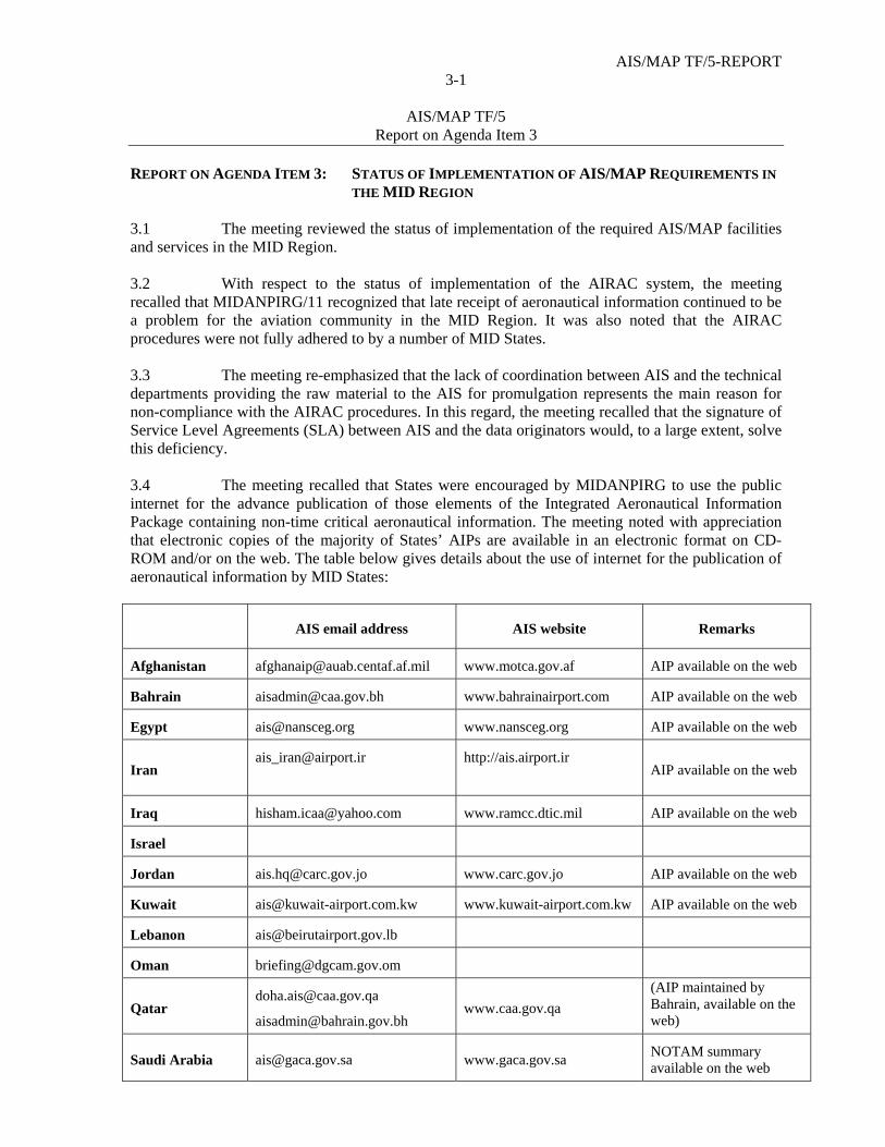
Report on Agenda Item 3 REPORT ON AGENDA ITEM 3: STATUS OF IMPLEMENTATION OF AIS/MAP REQUIREMENTS IN
THE MID REGION 3.1 The meeting reviewed the status of implementation of the required AIS/MAP facilities and services in the MID Region. 3.2 With respect to the status of implementation of the AIRAC system, the meeting recalled that MIDANPIRG/11 recognized that late receipt of aeronautical information continued to be a problem for the aviation community in the MID Region. It was also noted that the AIRAC procedures were not fully adhered to by a number of MID States. 3.3 The meeting re-emphasized that the lack of coordination between AIS and the technical departments providing the raw material to the AIS for promulgation represents the main reason for non-compliance with the AIRAC procedures. In this regard, the meeting recalled that the signature of Service Level Agreements (SLA) between AIS and the data originators would, to a large extent, solve this deficiency. 3.4 The meeting recalled that States were encouraged by MIDANPIRG to use the public internet for the advance publication of those elements of the Integrated Aeronautical Information Package containing non-time critical aeronautical information. The meeting noted with appreciation that electronic copies of the majority of States’ AIPs are available in an electronic format on CD-ROM and/or on the web. The table below gives details about the use of internet for the publication of aeronautical information by MID States:
AIS email address AIS website Remarks
Afghanistan [email protected] www.motca.gov.af AIP available on the web
Bahrain [email protected] www.bahrainairport.com AIP available on the web
Egypt [email protected] www.nansceg.org AIP available on the web
Iran [email protected]
http://ais.airport.ir
AIP available on the web
Iraq [email protected] www.ramcc.dtic.mil AIP available on the web
Israel
Jordan [email protected] www.carc.gov.jo AIP available on the web
Kuwait [email protected] www.kuwait-airport.com.kw AIP available on the web
Lebanon [email protected]
Oman [email protected]
Qatar [email protected]
[email protected] www.caa.gov.qa
(AIP maintained by Bahrain, available on the web)
Saudi Arabia [email protected] www.gaca.gov.sa NOTAM summary available on the web
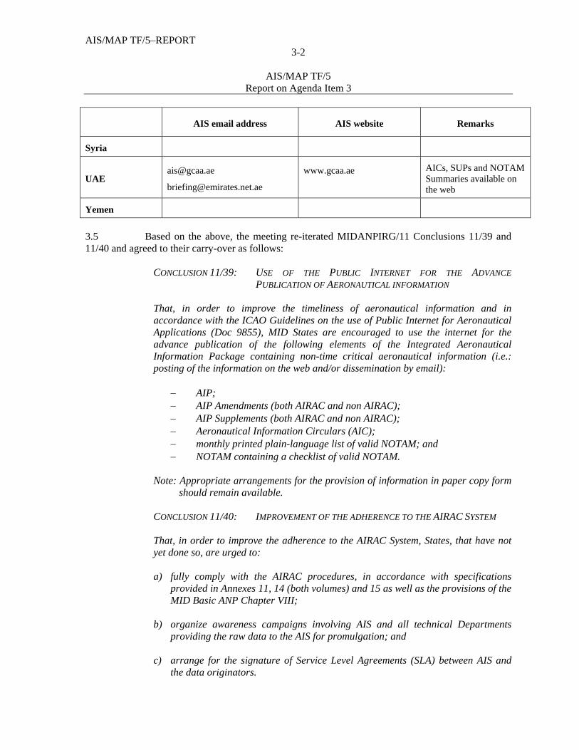
AIS/MAP TF/5–REPORT 3-2
AIS/MAP TF/5
Report on Agenda Item 3
AIS email address AIS website Remarks
Syria
www.gcaa.ae
AICs, SUPs and NOTAM Summaries available on the web
Yemen
3.5 Based on the above, the meeting re-iterated MIDANPIRG/11 Conclusions 11/39 and 11/40 and agreed to their carry-over as follows:
CONCLUSION 11/39: USE OF THE PUBLIC INTERNET FOR THE ADVANCE
PUBLICATION OF AERONAUTICAL INFORMATION
That, in order to improve the timeliness of aeronautical information and in accordance with the ICAO Guidelines on the use of Public Internet for Aeronautical Applications (Doc 9855), MID States are encouraged to use the internet for the advance publication of the following elements of the Integrated Aeronautical Information Package containing non-time critical aeronautical information (i.e.: posting of the information on the web and/or dissemination by email):
AIP; AIP Amendments (both AIRAC and non AIRAC); AIP Supplements (both AIRAC and non AIRAC); Aeronautical Information Circulars (AIC); monthly printed plain-language list of valid NOTAM; and NOTAM containing a checklist of valid NOTAM.
Note: Appropriate arrangements for the provision of information in paper copy form
should remain available.
CONCLUSION 11/40: IMPROVEMENT OF THE ADHERENCE TO THE AIRAC SYSTEM
That, in order to improve the adherence to the AIRAC System, States, that have not yet done so, are urged to:
a) fully comply with the AIRAC procedures, in accordance with specifications
provided in Annexes 11, 14 (both volumes) and 15 as well as the provisions of the MID Basic ANP Chapter VIII;
b) organize awareness campaigns involving AIS and all technical Departments
providing the raw data to the AIS for promulgation; and c) arrange for the signature of Service Level Agreements (SLA) between AIS and
the data originators.

AIS/MAP TF/5-REPORT 3-3
AIS/MAP TF/5
Report on Agenda Item 3 3.6 In connection with the above, the meeting recalled that MIDANPIRG/11, through Conclusion 11/4 requested Bahrain, in coordination with ICAO, to explore ways and means for improving the efficiency of the ICAO MID Forum and investigate the possibility of using the ICAO MID Forum for the posting of AIS publications by States. The meeting further noted that, as a follow-up action to MIDANPIRG/11 Conclusions 11/4 and 11/39, the ICAO MID Regional Office sent State Letter Ref.: AN 8/4 – 09/133 dated 16 April 2009, inviting States to keep the Office informed of their intentions/suggestions related to the use of the ICAO MID Forum for the posting of the AIS publications. However, no reply was received from States in this respect. 3.7 The meeting was of view that the posting of all AIS publications on the ICAO MID Forum is not feasible/practical, since this would raise a cost-recovery and copy right issue. However, as a first step, the meeting agreed that the following improvements could be implemented in the next version of the ICAO MID Forum:
the creation of special links to the MID States Civil Aviation Authorities’ websites; the creation of a special page for AIS/AIM services with a special link to the MID
States’ AIS websites;
provide the possibility to States to post on the ICAO MID Forum AIS page, the information/AIS publications that they consider important for the benefit of safety to be posted on this forum;
manage the restricted access to the Forum by providing a personal username and
password to each Member of the Forum, in addition to the usernames and passwords provided to each State and which allow the posting of some AIS publications on the AIS page of the Forum; and
dissemination of an automatic email to be sent to the different Members of the
Forum, whenever a new message, query, information, publication, etc, is posted on the Forum.
3.8 Based on the above, the meeting urged States to send officially to the MID Regional Office their suggestions related to the use of the ICAO MID Forum and to contribute to its improvement. States were also urged to make use and take full benefit of the ICAO MID Forum especially for the exchange of information and sharing of experience related to eTOD, QMS and AIS automation. In this regard, the meeting recognized that the improvement of the Forum would be efficient only if it’s based on feedback received from States/users. 3.9 With regard to the provision of pre-flight information services, the meeting recognized that a number of Aerodrome AIS Units have not yet been established in accordance with the MID FASID Table AIS 1 and that the quality of the services provided by the States’ AIS Briefing Offices is still far below user requirements. Accordingly, the meeting re-emphasized that the only way to improve the quality of the services provided by AIS would be the implementation of AIS automation, QMS and the provision of tailored products meeting the user requirements.
AIS/MAP TF/5–REPORT 3-4
AIS/MAP TF/5
Report on Agenda Item 3
3.10 The meeting recalled that, further to the approval of the proposal for amendment of the MID Basic ANP 08/05-AOP, MIDANPIRG/11, through Conclusion 11/13, agreed that the ICAO MID Regional Office, on behalf of MIDANPIRG, initiate all necessary Amendment Proposals to the MID Basic ANP and FASID, prior to MIDANPIRG/12, in order to update the AIS, AOP, ATM, CNS and MET Tables. Accordingly, the meeting reviewed and updated the MID FASID Tables, AIS 1, AIS 2, AIS 3, AIS 4, AIS 6, AIS 7 and AIS 8 at Appendix 3A to the Report on Agenda Item 3, and agreed that the Secretariat consolidate a draft proposal for amendment to the MID FASID, Part VIII, for review by the ATM/SAR/AIS SG/11 meeting before official circulation to States.
DRAFT DECISION 5/1: DRAFT PROPOSAL FOR AMENDMENT TO THE MID FASID, PART VIII (AIS TABLES)
That, based on the feedback from States, the Secretariat consolidate a draft proposal for amendment to the MID FASID, Part VIII (AIS), for review by the ATM/SAR/AIS SG/11 meeting before official circulation to States.
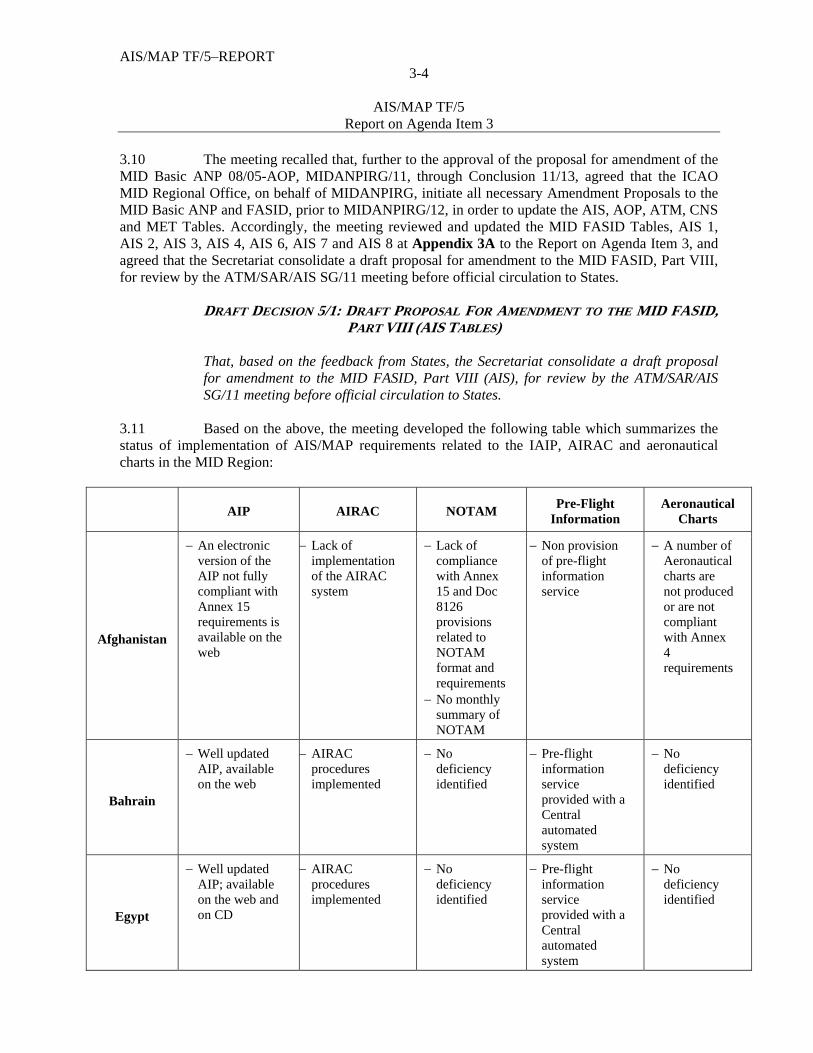
3.11 Based on the above, the meeting developed the following table which summarizes the status of implementation of AIS/MAP requirements related to the IAIP, AIRAC and aeronautical charts in the MID Region:
AIP AIRAC NOTAM Pre-Flight
Information Aeronautical
Charts
Afghanistan
An electronic version of the AIP not fully compliant with Annex 15 requirements is available on the web
Lack of implementation of the AIRAC system
Lack of compliance with Annex 15 and Doc 8126 provisions related to NOTAM format and requirements
No monthly summary of NOTAM
Non provision of pre-flight information service
A number of Aeronautical charts are not produced or are not compliant with Annex 4 requirements
Bahrain
Well updated AIP, available on the web
AIRAC procedures implemented
No deficiency identified
Pre-flight information service provided with a Central automated system
No deficiency identified
Egypt
Well updated AIP; available on the web and on CD
AIRAC procedures implemented
No deficiency identified
Pre-flight information service provided with a Central automated system
No deficiency identified
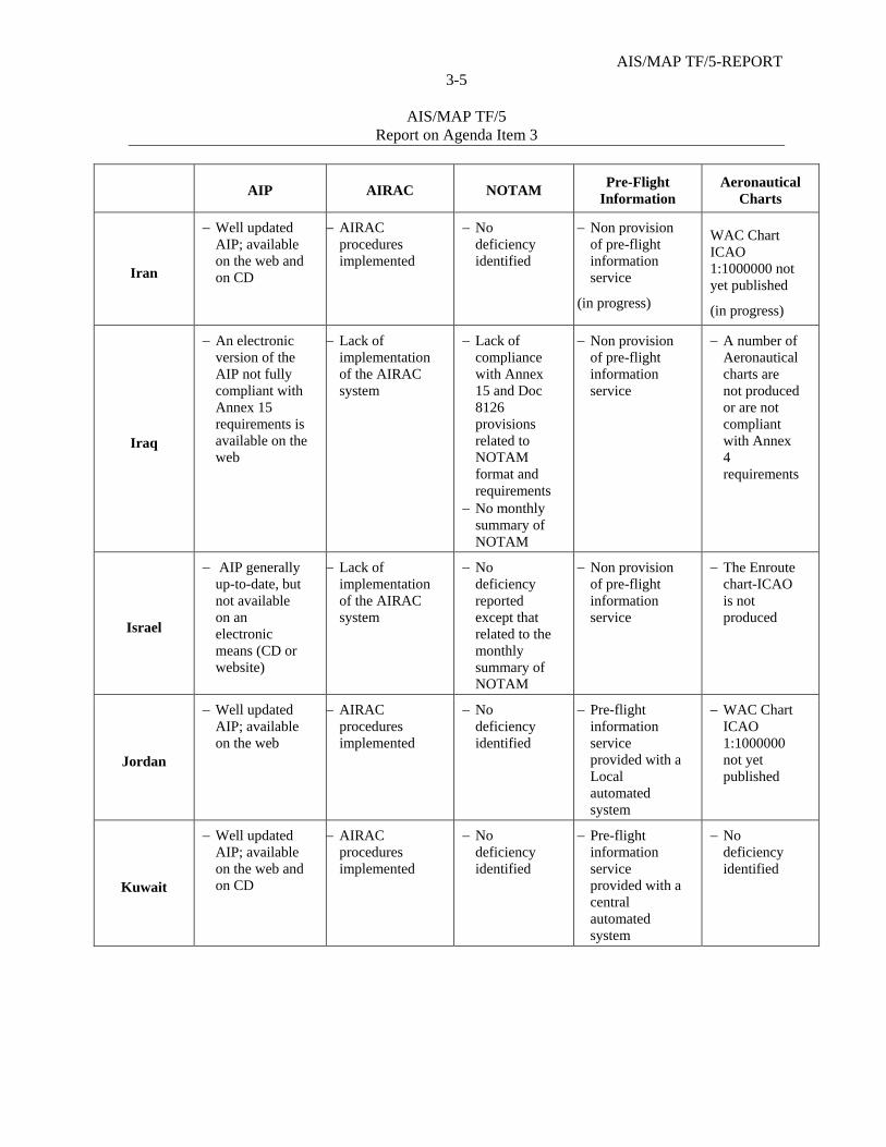
AIS/MAP TF/5-REPORT 3-5
AIS/MAP TF/5
Report on Agenda Item 3
AIP AIRAC NOTAM Pre-Flight
Information Aeronautical
Charts
Iran
Well updated AIP; available on the web and on CD
AIRAC procedures implemented
No deficiency identified
Non provision of pre-flight information service
(in progress)
WAC Chart ICAO 1:1000000 not yet published
(in progress)
Iraq
An electronic version of the AIP not fully compliant with Annex 15 requirements is available on the web
Lack of implementation of the AIRAC system
Lack of compliance with Annex 15 and Doc 8126 provisions related to NOTAM format and requirements
No monthly summary of NOTAM
Non provision of pre-flight information service
A number of Aeronautical charts are not produced or are not compliant with Annex 4 requirements
Israel
AIP generally up-to-date, but not available on an electronic means (CD or website)
Lack of implementation of the AIRAC system
No deficiency reported except that related to the monthly summary of NOTAM
Non provision of pre-flight information service
The Enroute chart-ICAO is not produced
Jordan
Well updated AIP; available on the web
AIRAC procedures implemented
No deficiency identified
Pre-flight information service provided with a Local automated system
WAC Chart ICAO 1:1000000 not yet published
Kuwait
Well updated AIP; available on the web and on CD
AIRAC procedures implemented
No deficiency identified
Pre-flight information service provided with a central automated system
No deficiency identified
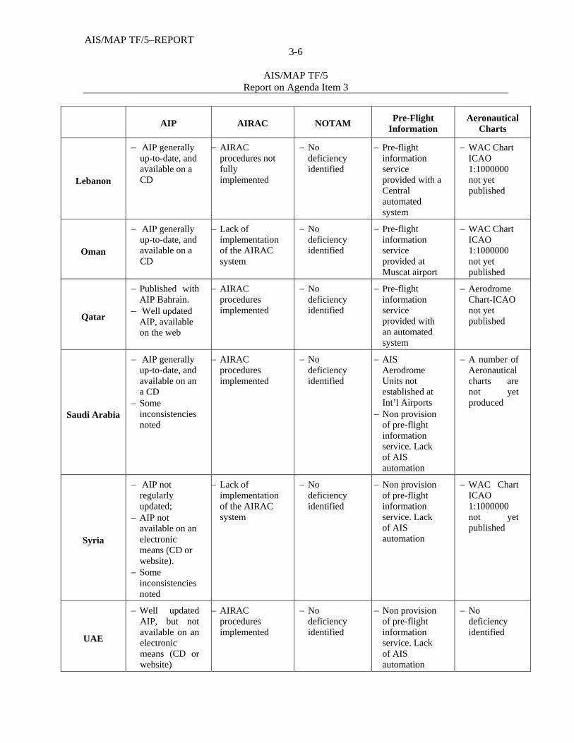
AIS/MAP TF/5–REPORT 3-6
AIS/MAP TF/5
Report on Agenda Item 3
AIP AIRAC NOTAM Pre-Flight
Information Aeronautical
Charts
Lebanon
AIP generally up-to-date, and available on a CD
AIRAC procedures not fully implemented
No deficiency identified
Pre-flight information service provided with a Central automated system
WAC Chart ICAO 1:1000000 not yet published
Oman
AIP generally up-to-date, and available on a CD
Lack of implementation of the AIRAC system
No deficiency identified
Pre-flight information service provided at Muscat airport
WAC Chart ICAO 1:1000000 not yet published
Qatar
Published with AIP Bahrain.
Well updated AIP, available on the web
AIRAC procedures implemented
No deficiency identified
Pre-flight information service provided with an automated system
Aerodrome Chart-ICAO not yet published
Saudi Arabia
AIP generally up-to-date, and available on an a CD
Some inconsistencies noted
AIRAC procedures implemented
No deficiency identified
AIS Aerodrome Units not established at Int’l Airports
Non provision of pre-flight information service. Lack of AIS automation
A number of Aeronautical charts are not yet produced
Syria
AIP not regularly updated;
AIP not available on an electronic means (CD or website).
Some inconsistencies noted
Lack of implementation of the AIRAC system
No deficiency identified
Non provision of pre-flight information service. Lack of AIS automation
WAC Chart ICAO 1:1000000 not yet published
UAE
Well updated AIP, but not available on an electronic means (CD or website)
AIRAC procedures implemented
No deficiency identified
Non provision of pre-flight information service. Lack of AIS automation
No deficiency identified

AIS/MAP TF/5-REPORT 3-7
AIS/MAP TF/5
Report on Agenda Item 3
AIP AIRAC NOTAM Pre-Flight
Information Aeronautical
Charts
Yemen
AIP generally up-to-date;
AIP not available on an electronic means (CD or website)
Some
inconsistencies noted
Lack of implementation of the AIRAC system
No deficiency identified
Non provision of pre-flight information service. Lack of AIS automation
A number of Aeronautical charts are not produced
3.12 The meeting recognized that although the progress achieved in the implementation of the required AIS/MAP facilities and services in the MID Region, concern is still expressed about a number of issues, mainly:
number of AIPs are not regularly updated;
the adherence to the AIRAC system is still below expectations; and
pre-flight briefings are even not available or provided in a way which is not meeting the user requirements.
WGS-84 implementation 3.13 The meeting highlighted the requirements for the implementation of WGS-84 and reviewed the status of its implementation in the MID Region. It was noted in this regard that although the implementation of WGS-84 should have been completed since 1998, some MID States have still not fully completed the implementation of the system. 3.14 The meeting reviewed and updated the FASID Table AIS-5 as at Appendix 3B to the Report on Agenda Item 3. A simplified Status report of WGS-84 implementation in the MID Region is also presented at Appendix 3C to the Report on Agenda Item 3. 3.15 The Status of implementation of WGS-84 in the MID Region can be summarized as follows:
a) six (6) States have fully implemented WGS-84 including the geoid undulation; b) seven (7) States have implemented the majority of WGS-84 requirements;
however, one or two elements (geoid undulation, quality system) are not yet implemented;
c) one (1) State has partially implemented WGS-84; and
d) one (1) State has not yet implemented WGS-84.
AIS/MAP TF/5–REPORT 3-8
AIS/MAP TF/5
Report on Agenda Item 3
3.16 The meeting recalled that, taking into consideration the status of implementation of WGS-84 in the MID Region, MIDANPIRG/11 underlined that the implementation of WGS-84 is an important pre-requisite for the implementation of Performance Based Navigation (PBN) and urged those States that have not yet completed the implementation of WGS-84 to accord high priority to this project and to expedite the process of full implementation of WGS-84. Accordingly, MIDANPIRG/11 agreed to the following Conclusion: CONCLUSION 11/42: IMPLEMENTATION OF WGS-84 IN THE MID REGION
That, taking into consideration the status of implementation of WGS-84 in the MID Region as reflected in Appendix 5.3A to the Report on Agenda Item 5.3; recognizing that WGS-84 is an important pre-requisite for the implementation of PBN and for the transition from AIS to AIM; States that have not yet done so are urged to:
a) develop effective and detailed WGS-84 implementation plans with clear timelines and send these plans to the ICAO MID Regional Office, prior to 30 June 2009;
b) adopt appropriate procedures to validate the WGS-84 data and ensure the quality (accuracy, integrity and resolution) of the published WGS-84 coordinates, in accordance with ICAO Annex 15 requirements;
c) achieve the total implementation of the WGS-84 System, in accordance with ICAO Annexes 4, 11, 14 and 15 provisions, prior to 31 December 2010 ; and
d) report the status of implementation of WGS-84 on a regular basis to the ICAO MID Regional Office and appropriate MIDANPIRG subsidiary bodies, until the system is fully implemented.
3.17 The meeting noted that, as a follow-up action to the above MIDANPIRG/11 Conclusion, the ICAO MID Regional Office sent State Letter Ref.: AN 8/1.1 – 09/128 dated 14 April 2009 to concerned States urging them to send their WGS-84 implementation plan and to take necessary measures to meet the deadline of 31 December 2010 agreed by MIDANPIRG/11 for the achievement of a full implementation of the WGS-84 system in the MID Region. 3.18 Based on the above, the meeting re-iterated the above MIDANPIRG/11 Conclusion 11/42 and agreed to its carry-over.
--------------------
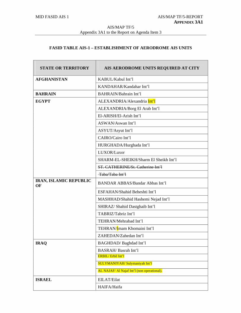
MID FASID AIS 1 AIS/MAP TF/5-REPORT APPENDIX 3A1
AIS/MAP TF/5 Appendix 3A1 to the Report on Agenda Item 3
FASID TABLE AIS-1 – ESTABLISHMENT OF AERODROME AIS UNITS
STATE OR TERRITORY
AIS AERODROME UNITS REQUIRED AT CITY
AFGHANISTAN KABUL/Kabul Int’l
KANDAHAR/Kandahar Int’l
BAHRAIN BAHRAIN/Bahrain Int’l
EGYPT ALEXANDRIA/Alexandria Int’l
ALEXANDRIA/Borg El Arab Int’l
El-ARISH/El-Arish Int’l
ASWAN/Aswan Int’l
ASYUT/Asyut Int’l
CAIRO/Cairo Int’l
HURGHADA/Hurghada Int’l
LUXOR/Luxor
SHARM-EL-SHEIKH/Sharm El Sheikh Int’l
ST. CATHERINE/St. Catherine Int’l
Taba/Taba Int’l
IRAN, ISLAMIC REPUBLIC OF
BANDAR ABBAS/Bandar Abbas Int’l
ESFAHAN/Shahid Beheshti Int’l
MASHHAD/Shahid Hashemi Nejad Int’l
SHIRAZ/ Shahid Dastghaib Int’l
TABRIZ/Tabriz Int’l
TEHRAN/Mehrabad Int’l
TEHRAN/Imam Khomaini Int’l
ZAHEDAN/Zahedan Int’l
IRAQ BAGHDAD/ Baghdad Int’l
BASRAH/ Basrah Int’l
ERBIL/ Erbil Int’l
SULYMANIYAH/ Sulymaniyah Int’l
AL NAJAF/ Al Najaf Int’l (non operational).
ISRAEL EILAT/Eilat
HAIFA/Haifa
AIS/MAP TF/5 –REPORT APPENDIX A1
3A1-2
STATE OR TERRITORY
AIS AERODROME UNITS REQUIRED AT CITY
OVDA/Ovda Int’l
TEL AVIV/Ben Gurion
TEL AVIV/ Sde-Dov
JORDAN AMMAN/Marka Int’l
AMMAN/Queen Alia Int’l
AQABA/ King Hussein Int’l
JERUSALEM/Jerusalem (non operational)
KUWAIT KUWAIT/Kuwait Int’l
LEBANON BEIRUT/R. B. H – Beirut Int’l
OMAN Muscat/Muscat Int’l
SALALAH/Salalah
QATAR DOHA/Doha Int’l
DOHA/New Doha Int’l (Future)
SAUDI ARABIA DAMMAM/King Fahd Int’l
JEDDAH/King Abdulaziz Int’l
MADINAH/Prince Mohammad Bin Abdulaziz
RIYADH/King Khalid Int’l
SYRIAN ARAB REPUBLIC ALEPPO/Aleppo Int’l
LATTAKIA/Bassel Al-Assad
DAMASCUS/Damascus Int’l
UNITED ARAB EMIRATES ABU DHABI/Abu Dhabi Int’l
AL AIN/Al Ain Int’l
DUBAI/Dubai Int’l
FUJAIRAH/Fujairah Int’l
RAS AL KHAIMAH/Ras Al Khaimah Int’l
SHARJAH/Sharjah Int’l
DUBAI/ Jabel Ali Int’l (Future)
YEMEN ADEN/Aden Int’l
HODEIDAH / Hodeidah Int’l
SANA’A / Sana’a Int’l
TAIZ /Taiz Int’l
---------------
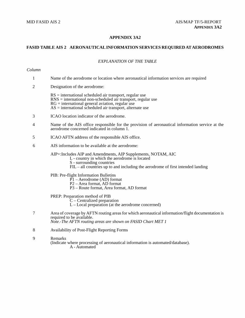
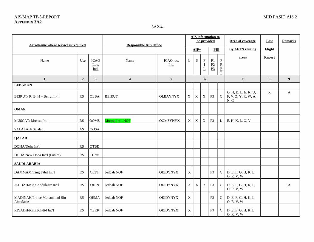
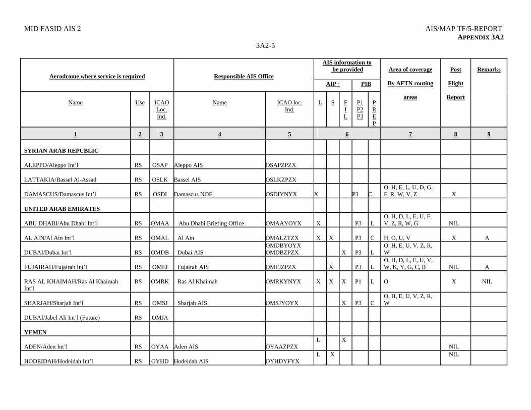
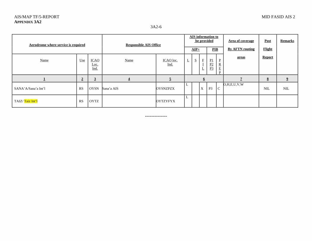
MID FASID AIS 2 AIS/MAP TF/5-REPORT APPENDIX 3A2
APPENDIX 3A2
FASID TABLE AIS 2 AERONAUTICAL INFORMATION SERVICES REQUIRED AT AERODROMES EXPLANATION OF THE TABLE Column 1 Name of the aerodrome or location where aeronautical information services are required 2 Designation of the aerodrome:
RS = international scheduled air transport, regular use RNS = international non-scheduled air transport, regular use RG = international general aviation, regular use AS = international scheduled air transport, alternate use
3 ICAO location indicator of the aerodrome. 4 Name of the AIS office responsible for the provision of aeronautical information service at the
aerodrome concerned indicated in column 1. 5 ICAO AFTN address of the responsible AIS office.
6 AIS information to be available at the aerodrome:
AIP+:Includes AIP and Amendments, AIP Supplements, NOTAM, AIC L - country in which the aerodrome is located S - surrounding countries FIL – all countries up to and including the aerodrome of first intended landing PIB: Pre-flight Information Bulletins P1 – Aerodrome (AD) format P2 – Area format, AD format P3 – Route format, Area format, AD format PREP: Preparation method of PIB C – Centralized preparation L – Local preparation (at the aerodrome concerned)
7 Area of coverage by AFTN routing areas for which aeronautical information/flight documentation is required to be available. Note.-The AFTN routing areas are shown on FASID Chart MET 1
8 Availability of Post-Flight Reporting Forms
9 Remarks
(Indicate where processing of aeronautical information is automated/database). A - Automated

MID FASID AIS 2 AIS/MAP TF/5-REPORT APPENDIX 3A2
3A2-1
AIS information to be provided
Aerodrome where service is required
Responsible AIS Office AIP+ PIB
Name
Use
ICAO Loc. Ind.
Name
ICAO loc.
Ind.
L
S
F I L
P1 P2 P3
PREP
Area of coverage
By AFTN routing
areas
Post
Flight
Report
Remarks
1
2
3
4
5
6
7
8
9
AFGHANISTAN
KABUL/Kabul Int’l
RS
OAKB
KANDAHAR/Kandahar Int’l
AS
OAKN
BAHRAIN
BAHRAIN/Bahrain Int’l
RS
OBBI
Bahrain AIS
OBBBYNYX
X
P3
L
O, H, D, L, E, K, U, F, V, Z, Y, R, W, A, N, G
NIL
A
EGYPT
ALEXANDRIA/Alexandria Int’l
RS
HEAX
Alexandria
HEAXZIZX
X
P3
C
X
A
ALEXANDRIA/Borg El Arab Int’l
RS
HEBA
EL-ARISH/El-Arish Int’l
RS
HEAR
ASWAN/Aswan Int’l
RS
HESN
Aswan
HESNZIZX
X
P3
C
H, L, U X
A
ASYUT/Asyut Int’l
RS
HEAT
Cairo
HECAZPZX
X
P3
H, L, U X
CAIRO/Cairo Int’l
RS
HECA
Cairo
HECAZPZX HECAZIZX
X
X
X
P3
C
D, E, G, H, L, O, U, V
X
A
HURGHADA/Hurghada
RS
HEGN
Hurghada
HEGNZIZX
X
P3
C
E, L, O, U X
A
LUXOR/Luxor
RS
HELX
Luxor
HELXZIZX
X
P3
C
E, F, H, L X
A
SHARM-EL-SHEIKH/Sharm El Sheikh
RS
HESH
Sharm El Sheikh
HESHZIZX
X
P3
C
E, L, O, U X
A

AIS/MAP TF/5-REPORT MID FASID AIS 2 APPENDIX 3A2
3A2-2
AIS information to be provided
Aerodrome where service is required
Responsible AIS Office AIP+ PIB
Name
Use
ICAO Loc. Ind.
Name
ICAO loc.
Ind.
L
S
F I L
P1 P2 P3
PREP
Area of coverage
By AFTN routing
areas
Post
Flight
Report
Remarks
1
2
3
4
5
6
7
8
9
ST. CATHERINE/St. Catherine Int’l
RS
HESC
Cairo
HECAZPZX
X
D, E, G, H, L, O, U, V
X
TABA/Taba Int’l
RS
HETB
Cairo
HECAZPZX
X
D, E, G, H, L, O, U, V
X
IRAN, ISLAMIC REPUBLIC OF
BANDAR ABBAS/Bandar Abbas Int’l
RS
OIKB
Tehran AIS/NOF
OIIIYNYX
X
ESFAHAN/ Shahid Beheshti Int’l
RS
OIFM
Tehran AIS/NOF
OIIIYNYX
X
MASHHAD/Shahid Hashemi Nejad Int’l
RS
OIMM
Tehran AIS/NOF
OIIIYNYX
X
SHIRAZ/ Shahid Dastghaib Int’l
RS
OISS
Tehran AIS/NOF
OIIIYNYX
X
TABRIZ/Tabriz Int’l
RNS
OITT
Tehran AIS/NOF
OIIIYNYX
X
TEHRAN/Mehrabad Int’l
RS
OIII
Tehran AIS/NOF
OIIIYNYX
X
X
X
B, C, D, E, F, G, H, L, M, O, P, S, T, U, V, Z
X
A
TEHRAN/Imam Khomaini Int’l
RS
OIIE
Tehran AIS/NOF
OIIIYNYX
X
X
ZAHEDAN/Zahedan Int’l
RS
OIZH
Tehran AIS/NOF
OIIIYNYX
X
IRAQ
BAGHDAD/Baghdad Int’l
RS
ORBI
BASRAH/Basrah Int’l
RS
ORMM
ERBIL/Erbil Int’l RS ORER
SULYMANIYAH/ RS ORSU
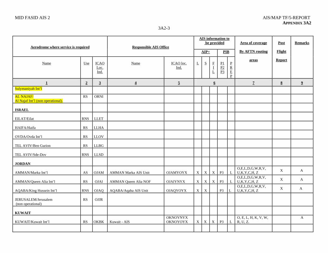
MID FASID AIS 2 AIS/MAP TF/5-REPORT APPENDIX 3A2
3A2-3
AIS information to be provided
Aerodrome where service is required
Responsible AIS Office AIP+ PIB
Name
Use
ICAO Loc. Ind.
Name
ICAO loc.
Ind.
L
S
F I L
P1 P2 P3
PREP
Area of coverage
By AFTN routing
areas
Post
Flight
Report
Remarks
1
2
3
4
5
6
7
8
9
Sulymaniyah Int’l
AL NAJAF/ Al Najaf Int’l (non operational).
RS ORNI
ISRAEL
EILAT/Eilat
RNS
LLET
HAIFA/Haifa
RS
LLHA
OVDA/Ovda Int’l
RS
LLOV
TEL AVIV/Ben Gurion
RS
LLBG
TEL AVIV/Sde-Dov
RNS
LLSD
JORDAN
AMMAN/Marka Int’l
AS
OJAM
AMMAN Marka AIS Unit
OJAMYOYX
X
X
X
P3
L
O,E,L,D,G,W,R,V, U,K,Y,C,H, Z
X A
AMMAN/Queen Alia Int’l
RS
OJAI
AMMAN Queen Alia NOF
OJAIYNYX
X
X
X
P3
L
O,E,L,D,G,W,R,V, U,K,Y,C,H, Z
X A
AQABA/King Hussein Int’l
RNS
OJAQ AQABA/Aqaba AIS Unit OJAQYOYX
X
X
P3
L
O,E,L,D,G,W,R,V, U,K,Y,C,H, Z
X A
JERUSALEM/Jerusalem (non operational)
RS
OJJR
KUWAIT
KUWAIT/Kuwait Int’l
RS
OKBK
Kuwait - AIS
OKNOYNYX OKNOYOYX
X
X
X
P3
L
O, E, L, H, K, V, W, R, U, Z.
A
AIS/MAP TF/5-REPORT MID FASID AIS 2 APPENDIX 3A2
3A2-4
AIS information to be provided
Aerodrome where service is required
Responsible AIS Office AIP+ PIB
Name
Use
ICAO Loc. Ind.
Name
ICAO loc.
Ind.
L
S
F I L
P1 P2 P3
PREP
Area of coverage
By AFTN routing
areas
Post
Flight
Report
Remarks
1
2
3
4
5
6
7
8
9
LEBANON
BEIRUT/ R. B. H – Beirut Int’l
RS
OLBA
BEIRUT
OLBAYNYX
X
X
X
P3
C
O, H, D, L, E, K, U, F, V, Z, Y, R, W, A, N, G
X A
OMAN
MUSCAT/ Muscat Int’l
RS
OOMS
Muscat Int’l NOF
OOMSYNYX
X
X
X
P3
L
E, H, K, L, O, V
SALALAH/ Salalah
AS
OOSA
QATAR
DOHA/Doha Int’l
RS
OTBD
DOHA/New Doha Int’l (Future)
RS
OTxx
SAUDI ARABIA
DAMMAM/King Fahd Int’l
RS
OEDF
Jeddah NOF
OEJDYNYX
X
P3
C
D, E, F, G, H, K, L, O, R, V, W
JEDDAH/King Abdulaziz Int’l
RS
OEJN
Jeddah NOF
OEJDYNYX
X
X
X
P3
C
D, E, F, G, H, K, L, O, R, V, W
A
MADINAH/Prince Mohammad Bin Abdulaziz
RS
OEMA
Jeddah NOF
OEJDYNYX
X
P3
C
D, E, F, G, H, K, L, O, R, V, W
RIYADH/King Khalid Int’l
RS
OERK
Jeddah NOF
OEJDYNYX
X
P3
C
D, E, F, G, H, K, L, O, R, V, W
MID FASID AIS 2 AIS/MAP TF/5-REPORT APPENDIX 3A2
3A2-5
AIS information to be provided
Aerodrome where service is required
Responsible AIS Office AIP+ PIB
Name
Use
ICAO Loc. Ind.
Name
ICAO loc.
Ind.
L
S
F I L
P1 P2 P3
PREP
Area of coverage
By AFTN routing
areas
Post
Flight
Report
Remarks
1
2
3
4
5
6
7
8
9
SYRIAN ARAB REPUBLIC
ALEPPO/Aleppo Int’l
RS
OSAP Aleppo AIS OSAPZPZX
LATTAKIA/Bassel Al-Assad
RS
OSLK Bassel AIS OSLKZPZX
DAMASCUS/Damascus Int’l
RS
OSDI Damascus NOF OSDIYNYX X P3 C
O, H, E, L, U, D, G, F, R, W, V, Z
X
UNITED ARAB EMIRATES
ABU DHABI/Abu Dhabi Int’l
RS
OMAA
Abu Dhabi Briefing Office
OMAAYOYX
X
P3
L
O, H, D, L, E, U, F, V, Z, R, W, G
NIL
AL AIN/Al Ain Int’l
RS
OMAL
Al Ain
OMALZTZX
X
X
P3
C
H, O, U, V
X
A
DUBAI/Dubai Int’l
RS
OMDB
Dubai AIS
OMDBYOYX OMDBZPZX
X
P3
L
O, H, E, U, V, Z, R, W
FUJAIRAH/Fujairah Int’l
RS
OMFJ
Fujairah AIS
OMFJZPZX
X
P3
L
O, H, D, L, E, U, V, W, K, Y, G, C, B
NIL
A
RAS AL KHAIMAH/Ras Al Khaimah Int’l
RS
OMRK
Ras Al Khaimah
OMRKYNYX
X
X
X
P1
L
O
X
NIL
SHARJAH/Sharjah Int’l
RS
OMSJ
Sharjah AIS
OMSJYOYX
X
P3
C
O, H, E, U, V, Z, R, W
DUBAI/Jabel Ali Int’l (Future)
RS
OMJA
YEMEN
ADEN/Aden Int’l
RS
OYAA Aden AIS OYAAZPZX
L
X
NIL
HODEIDAH/Hodeidah Int’l
RS
OYHD Hodeidah AIS OYHDYFYX
L
X
NIL
AIS/MAP TF/5-REPORT MID FASID AIS 2 APPENDIX 3A2
3A2-6
AIS information to be provided
Aerodrome where service is required
Responsible AIS Office AIP+ PIB
Name
Use
ICAO Loc. Ind.
Name
ICAO loc.
Ind.
L
S
F I L
P1 P2 P3
PREP
Area of coverage
By AFTN routing
areas
Post
Flight
Report
Remarks
1
2
3
4
5
6
7
8
9
SANA’A/Sana’a Int’l
RS
OYSN Sana’a AIS OYSNZPZX
L
X
P3
C
O,H,E,U,V,W NIL
NIL
TAIZ/ Taiz Int’l
RS
OYTZ OYTZYFYX
L
--------------
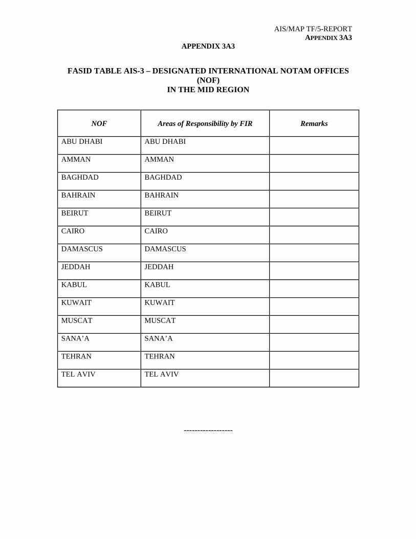
AIS/MAP TF/5-REPORT APPENDIX 3A3
APPENDIX 3A3
FASID TABLE AIS-3 – DESIGNATED INTERNATIONAL NOTAM OFFICES (NOF)
IN THE MID REGION
NOF
Areas of Responsibility by FIR
Remarks
ABU DHABI
ABU DHABI
AMMAN
AMMAN
BAGHDAD
BAGHDAD
BAHRAIN
BAHRAIN
BEIRUT
BEIRUT
CAIRO
CAIRO
DAMASCUS
DAMASCUS
JEDDAH
JEDDAH
KABUL
KABUL
KUWAIT
KUWAIT
MUSCAT
MUSCAT
SANA’A
SANA’A
TEHRAN
TEHRAN
TEL AVIV
TEL AVIV
------------------

AIS/MAP TF/5-REPORT APPENDIX 3A4
APPENDIX 3A4
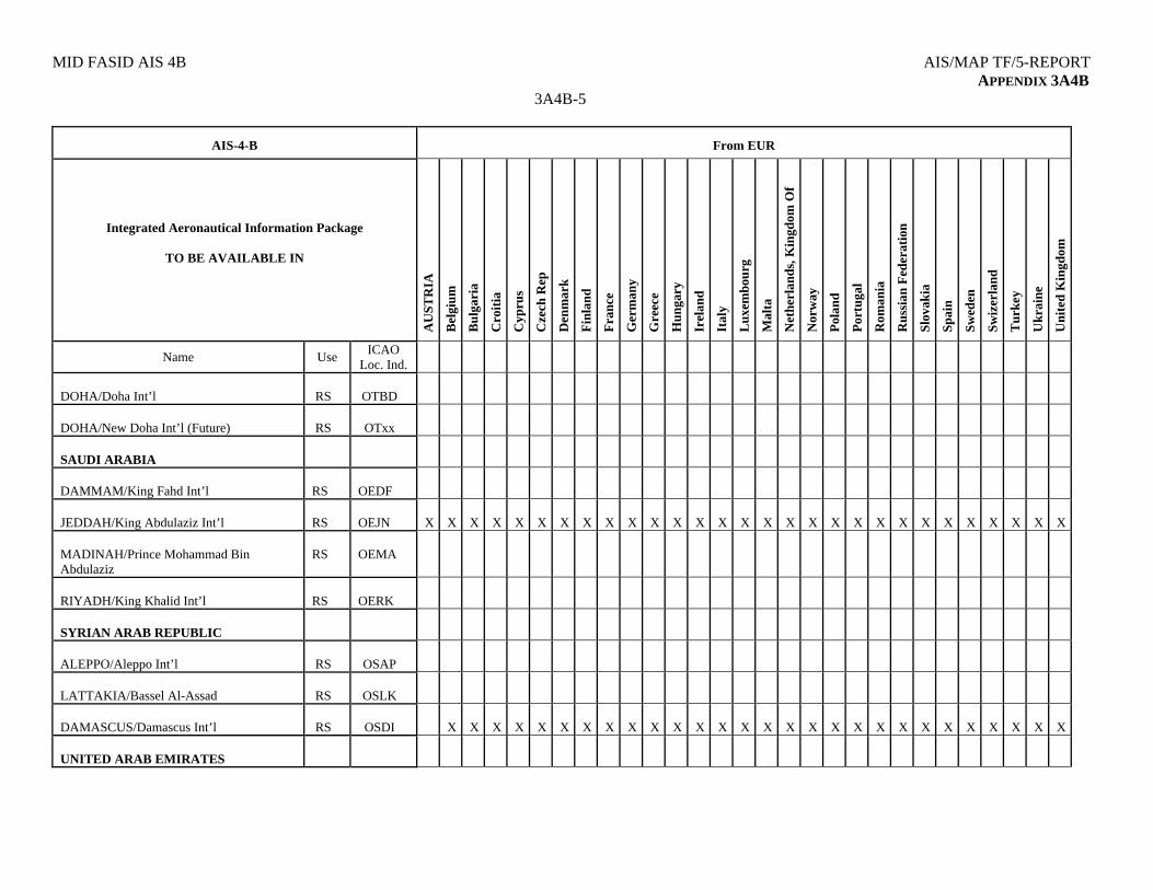
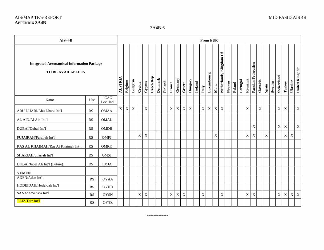
FASID TABLE AIS-4 AVAILABILITY OF AERONAUTICAL INFORMATION
EXPLANATION OF THE TABLE FASID Table AIS-4 sets out the requirement for the integrated aeronautical information package from foreign Aeronautical Information Services (AIS) to be available at aerodrome/heliport AIS Units in the MID region, for pre-flight briefing. The table consists of three parts. Table AIS-4A covers the requirements for the integrated aeronautical information package from States and Territories in the MID region, Table AIS-4B includes the requirements from the EUR region and Table AIS-4C includes the requirements from the ASIA, CAR, NAM, SAM and AFI regions. For each aerodrome/heliport in the MID region, the requirement is shown by an ‘’X’’ against the State or Territory from which the integrated aeronautical information package is required. For each aerodrome/heliport the location indicator and designator of aerodrome/heliport use are listed. Aerodrome/Heliport use Designation:
RS - international scheduled air transport, regular use; RNS - international non-scheduled air transport, regular use; RG - international general aviation, regular use; AS - international scheduled air transport, alternate use.
------------
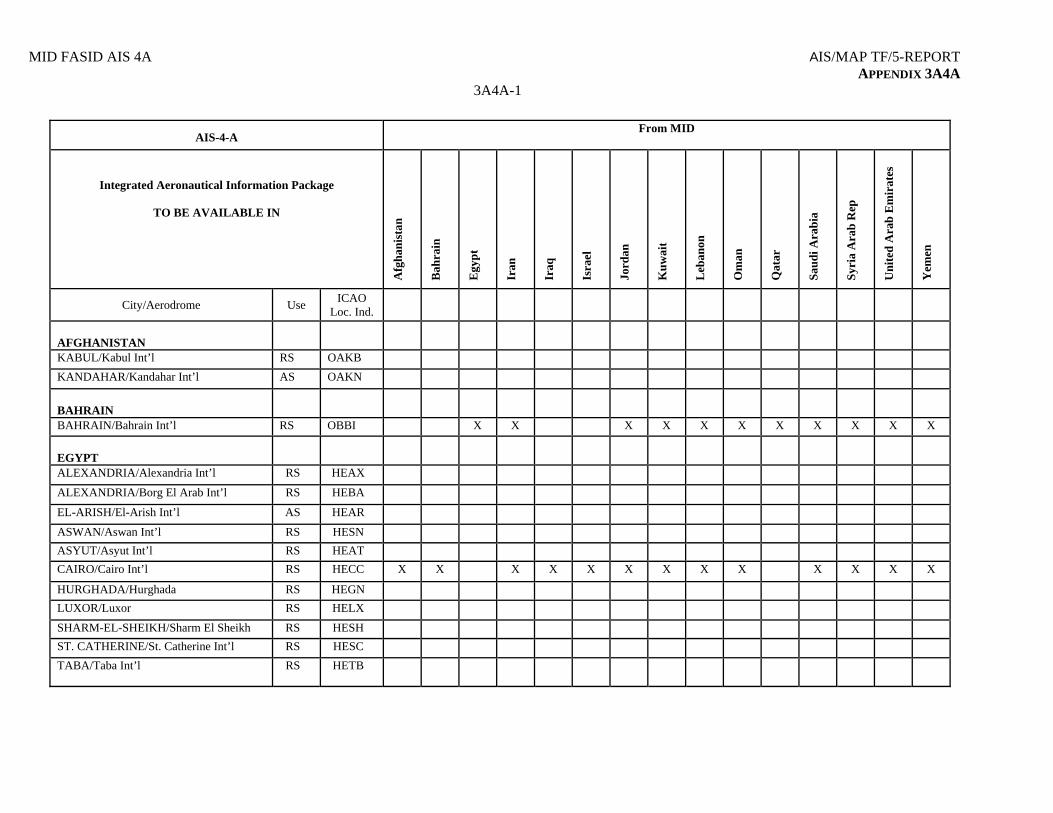
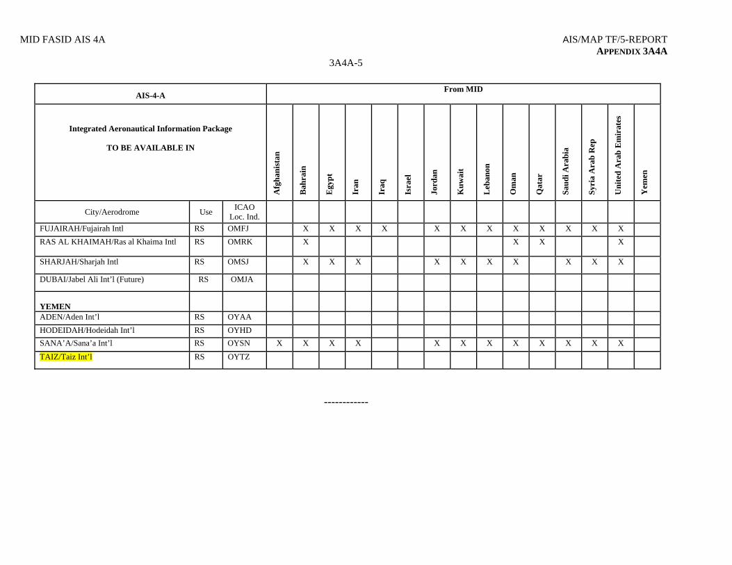
MID FASID AIS 4A AIS/MAP TF/5-REPORT APPENDIX 3A4A
3A4A-1
AIS-4-A From MID
Integrated Aeronautical Information Package
TO BE AVAILABLE IN
A
fgh
anis
tan
Bah
rain
Egy
pt
Iran
Iraq
Isra
el
Jord
an
Ku
wai
t
Leb
anon
Om
an
Qat
ar
Sau
di A
rab
ia
Syr
ia A
rab
Rep
Un
ited
Ara
b E
mir
ates
Yem
en
City/Aerodrome Use ICAO
Loc. Ind.
AFGHANISTAN
KABUL/Kabul Int’l RS OAKB
KANDAHAR/Kandahar Int’l AS OAKN
BAHRAIN
BAHRAIN/Bahrain Int’l RS OBBI X X X X X X X X X X X
EGYPT
ALEXANDRIA/Alexandria Int’l RS HEAX
ALEXANDRIA/Borg El Arab Int’l RS HEBA
EL-ARISH/El-Arish Int’l AS HEAR
ASWAN/Aswan Int’l RS HESN
ASYUT/Asyut Int’l RS HEAT
CAIRO/Cairo Int’l RS HECC X X X X X X X X X X X X X
HURGHADA/Hurghada RS HEGN
LUXOR/Luxor RS HELX
SHARM-EL-SHEIKH/Sharm El Sheikh RS HESH
ST. CATHERINE/St. Catherine Int’l RS HESC
TABA/Taba Int’l RS HETB
AIS/MAP TF/5–REPORT MID FASID AIS 4A APPENDIX 3A4A
3A4A-2
AIS-4-A From MID
Integrated Aeronautical Information Package
TO BE AVAILABLE IN
A
fgh
anis
tan
Bah
rain
Egy
pt
Iran
Iraq
Isra
el
Jord
an
Ku
wai
t
Leb
anon
Om
an
Qat
ar
Sau
di A
rab
ia
Syr
ia A
rab
Rep
Un
ited
Ara
b E
mir
ates
Yem
en
City/Aerodrome Use ICAO
Loc. Ind.
IRAN, ISLAMIC REPUBLIC OF
BANDAR ABBAS/Bandar Abbas Int’l RS OIKB X
ESFAHAN/ Shahid Beheshti Int’l RS OIFM X
MASHHAD/Shahid Hashemi Nejad Int’l RS OIMM X
SHIRAZ/ Shahid Dastghaib Int’l RS OISS X
TABRIZ/Tabriz Int’l RNS OITT X
TEHRAN/Mehrabad Int’l RS OIII X X X X X X X X X X X X X X
TEHRAN/Imam Khomaini Int’l RS OIIE X
ZAHEDAN/Zahedan Int’l RS OIZH X
IRAQ
BAGHDAD/Baghdad Intl RS ORBI
BASRAH/Basrah Intl RS ORMM
ERBIL/Erbil Int’l RS ORER
SULYMANIYAH/ Sulymaniyah Int’l
RS ORSU
AL NAJAF/ Al Najaf Int’l (non operational).
RS ORNI
ISRAEL
MID FASID AIS 4A AIS/MAP TF/5-REPORT APPENDIX 3A4A
3A4A-3
AIS-4-A From MID
Integrated Aeronautical Information Package
TO BE AVAILABLE IN
A
fgh
anis
tan
Bah
rain
Egy
pt
Iran
Iraq
Isra
el
Jord
an
Ku
wai
t
Leb
anon
Om
an
Qat
ar
Sau
di A
rab
ia
Syr
ia A
rab
Rep
Un
ited
Ara
b E
mir
ates
Yem
en
City/Aerodrome Use ICAO
Loc. Ind.
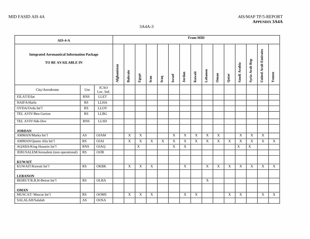
EILAT/Eilat RNS LLET
HAIFA/Haifa RS LLHA
OVDA/Ovda Int’l RS LLOV
TEL AVIV/Ben Gurion RS LLBG
TEL AVIV/Sde-Dov RNS LLSD
JORDAN
AMMAN/Marka Int’l AS OJAM X X X X X X X X X X
AMMAN/Queen Alia Int’l RS OJAI X X X X X X X X X X X X X X
AQABA/King Hussein Int’l RNS OJAQ X X X X X
JERUSALEM/Jerusalem (non operational) RS OJJR
KUWAIT
KUWAIT/Kuwait Int’l RS OKBK X X X X X X X X X X X
LEBANON
BEIRUT/R.B.H-Beirut Int’l RS OLBA X
OMAN
MUSCAT/ Muscat Int’l RS OOMS X X X X X X X X X
SALALAH/Salalah AS OOSA
AIS/MAP TF/5–REPORT MID FASID AIS 4A APPENDIX 3A4A
3A4A-4
AIS-4-A From MID
Integrated Aeronautical Information Package
TO BE AVAILABLE IN
A
fgh
anis
tan
Bah
rain
Egy
pt
Iran
Iraq
Isra
el
Jord
an
Ku
wai
t
Leb
anon
Om
an
Qat
ar
Sau
di A
rab
ia
Syr
ia A
rab
Rep
Un
ited
Ara
b E
mir
ates
Yem
en
City/Aerodrome Use ICAO
Loc. Ind.
QATAR
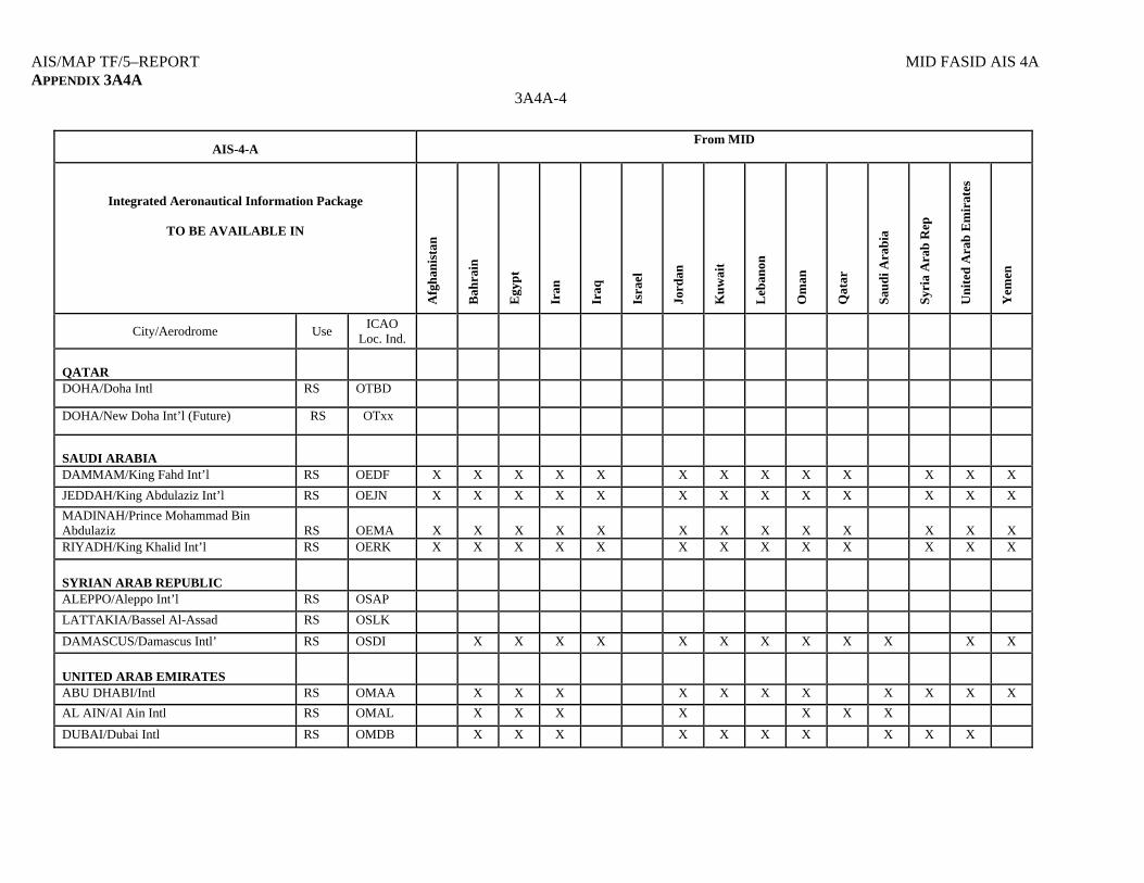
DOHA/Doha Intl RS OTBD
DOHA/New Doha Int’l (Future) RS OTxx
SAUDI ARABIA
DAMMAM/King Fahd Int’l RS OEDF X X X X X X X X X X X X X
JEDDAH/King Abdulaziz Int’l RS OEJN X X X X X X X X X X X X X
MADINAH/Prince Mohammad Bin Abdulaziz
RS
OEMA
X
X
X
X
X
X
X
X
X
X
X
X
X
RIYADH/King Khalid Int’l RS OERK X X X X X X X X X X X X X
SYRIAN ARAB REPUBLIC
ALEPPO/Aleppo Int’l RS OSAP
LATTAKIA/Bassel Al-Assad RS OSLK
DAMASCUS/Damascus Intl’ RS OSDI X X X X X X X X X X X X
UNITED ARAB EMIRATES
ABU DHABI/Intl RS OMAA X X X X X X X X X X X
AL AIN/Al Ain Intl RS OMAL X X X X X X X
DUBAI/Dubai Intl RS OMDB X X X X X X X X X X
MID FASID AIS 4A AIS/MAP TF/5-REPORT APPENDIX 3A4A
3A4A-5
AIS-4-A From MID
Integrated Aeronautical Information Package
TO BE AVAILABLE IN
A
fgh
anis
tan
Bah
rain
Egy
pt
Iran
Iraq
Isra
el
Jord
an
Ku
wai
t
Leb
anon
Om
an
Qat
ar
Sau
di A
rab
ia
Syr
ia A
rab
Rep
Un
ited
Ara
b E
mir
ates
Yem
en
City/Aerodrome Use ICAO
Loc. Ind.
FUJAIRAH/Fujairah Intl RS OMFJ X X X X X X X X X X X X
RAS AL KHAIMAH/Ras al Khaima Intl RS OMRK X X X X
SHARJAH/Sharjah Intl RS OMSJ X X X X X X X X X X
DUBAI/Jabel Ali Int’l (Future) RS OMJA
YEMEN
ADEN/Aden Int’l RS OYAA
HODEIDAH/Hodeidah Int’l RS OYHD
SANA’A/Sana’a Int’l RS OYSN X X X X X X X X X X X X
TAIZ/Taiz Int’l RS OYTZ
------------
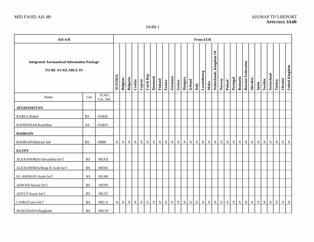
MID FASID AIS 4B AIS/MAP TF/5-REPORT APPENDIX 3A4B
3A4B-1
AIS-4-B
From EUR
Integrated Aeronautical Information Package
TO BE AVAILABLE IN
A
US
TR
IA
Bel
giu
m
Bu
lgar
ia
Cro
itia
Cyp
rus
Cze
ch R
ep
Den
mar
k
Fin
lan
d
Fra
nce
Ger
man
y
Gre
ece
Hu
nga
ry
Irel
and
Ital
y
Lu
xem
bou
rg
Mal
ta
Net
her
lan
ds,
Kin
gdom
Of
Nor
way
Pol
and
Por
tuga
l
Rom
ania
Ru
ssia
n F
eder
atio
n
Slo
vak
ia
Sp
ain
Swed
en
Swiz
erla
nd
Tur
key
Ukr
aine
Un
ited
Kin
gdom
Name Use ICAO
Loc. Ind.
AFGHANISTAN
KABUL/Kabul
RS
OAKB
KANDAHAR/Kandahar
AS
OAKN
BAHRAIN
BAHRAIN/Bahrain Intl
RS
OBBI
X
X
X
X
X
X
X
X
X
X
X
X
X
X
X
X
X
X
X
X
X
X
X
X
X
X
X
X
X
EGYPT
ALEXANDRIA/Alexandria Int’l
RS
HEAX
ALEXANDRIA/Borg El Arab Int’l
RS
HEBA
EL-ARISH/El-Arish Int’l
AS
HEAR
ASWAN/Aswan Int’l
RS
HESN
ASYUT/Asyut Int’l
RS
HEAT
CAIRO/Cairo Int’l
RS
HECA
X
X
X
X
X
X
X
X
X
X
X
X
X
X
X
X
X
X
X
X
X
X
X
X
X
X
X
X
X
HURGHADA/Hurghada
RS
HEGN
AIS/MAP TF/5-REPORT MID FASID AIS 4B APPENDIX 3A4B
3A4B-2
AIS-4-B
From EUR
Integrated Aeronautical Information Package
TO BE AVAILABLE IN
A
US
TR
IA
Bel
giu
m
Bu
lgar
ia
Cro
itia
Cyp
rus
Cze
ch R
ep
Den
mar
k
Fin
lan
d
Fra
nce
Ger
man
y
Gre
ece
Hu
nga
ry
Irel
and
Ital
y
Lu
xem
bou
rg
Mal
ta
Net
her
lan
ds,
Kin
gdom
Of
Nor
way
Pol
and
Por
tuga
l
Rom
ania
Ru
ssia
n F
eder
atio
n
Slo
vak
ia
Sp
ain
Swed
en
Swiz
erla
nd
Tur
key
Ukr
aine
Un
ited
Kin
gdom
Name Use ICAO
Loc. Ind.
LUXOR/Luxor
RS
HELX
SHARM-EL-SHEIKH/Sharm El Sheikh
RS
HESH
ST. CATHERINE/St. Catherine Int’l
RS
HESC
TABA/Taba Int’l
RS
HETB
IRAN, ISLAMIC REPUBLIC OF
BANDAR ABBAS/Bandar Abbas Int’l
RS
OIKB
ESFAHAN/ Shahid Beheshti Int’l
RS
OIFM
MASHHAD/Shahid Hashemi Nejad Int’l
RS
OIMM
SHIRAZ/ Shahid Dastghaib Int’l
RS
OISS
TABRIZ/Tabriz Int’l
RNS
OITT
TEHRAN/Mehrabad Int’l
RS
OIII
X
X
X
X
X
X
X
X
X
X
X
X
X
X
X
X
X
X
X
X
X
X
X
X
X
X
X
TEHRAN/Imam Khomaini Int’l
RS
OIIE
ZAHEDAN/Zahedan Int’l
RS
OIZH
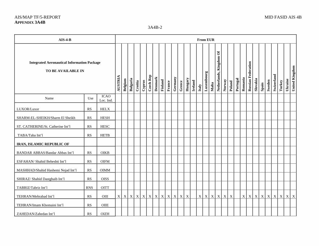
MID FASID AIS 4B AIS/MAP TF/5-REPORT APPENDIX 3A4B
3A4B-3
AIS-4-B
From EUR
Integrated Aeronautical Information Package
TO BE AVAILABLE IN
A
US
TR
IA
Bel
giu
m
Bu
lgar
ia
Cro
itia
Cyp
rus
Cze
ch R
ep
Den
mar
k
Fin
lan
d
Fra
nce
Ger
man
y
Gre
ece
Hu
nga
ry
Irel
and
Ital
y
Lu
xem
bou
rg
Mal
ta
Net
her
lan
ds,
Kin
gdom
Of
Nor
way
Pol
and
Por
tuga
l
Rom
ania
Ru
ssia
n F
eder
atio
n
Slo
vak
ia
Sp
ain
Swed
en
Swiz
erla
nd
Tur
key
Ukr
aine
Un
ited
Kin
gdom
Name Use ICAO
Loc. Ind.
IRAQ
BAGHDAD/Baghdad Int’l
RS
ORBI
BASRAH/Basrah Int’l
RS
ORMM
ERBIL/Erbil Int’l RS ORER
SULYMANIYAH/ Sulymaniyah Int’l
RS ORSU
AL NAJAF/ Al Najaf Int’l (non operational).
RS ORNI
ISRAEL
EILAT/Eilat
RNS
LLET
HAIFA/Haifa
RS
LLHA
OVDA/Ovda Int’l
RS
LLOV
TEL AVIV/Ben Gurion
RS
LLBG
TEL AVIV/Sde-Dov
RNS
LLSD
JORDAN

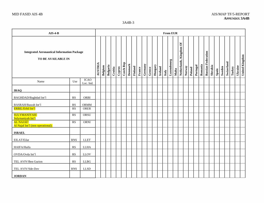
AIS/MAP TF/5-REPORT MID FASID AIS 4B APPENDIX 3A4B
3A4B-4
AIS-4-B
From EUR
Integrated Aeronautical Information Package
TO BE AVAILABLE IN
A
US
TR
IA
Bel
giu
m
Bu
lgar
ia
Cro
itia
Cyp
rus
Cze
ch R
ep
Den
mar
k
Fin
lan
d
Fra
nce
Ger
man
y
Gre
ece
Hu
nga
ry
Irel
and
Ital
y
Lu
xem
bou
rg
Mal
ta
Net
her
lan
ds,
Kin
gdom
Of
Nor
way
Pol
and
Por
tuga
l
Rom
ania
Ru
ssia
n F
eder
atio
n
Slo
vak
ia
Sp
ain
Swed
en
Swiz
erla
nd
Tur
key
Ukr
aine
Un
ited
Kin
gdom
Name Use ICAO
Loc. Ind.
AMMAN/Marka Int’l
AS
OJAM
X
X
X
X
X
X
X
X
X
X
X
X
X
X
AMMAN/Queen Alia Int’l
RS
OJAI
X
X
X
X
X
X
X
X
X
X
X
X
X
X
X
X
X
X
X
X
X
X
X
X
X
X
AQABA/King Hussein Int’l
RNS
OJAQ
X
X
X
X
X
X
X
JERUSALEM/Jerusalem (non operational)
RS
OJJR
KUWAIT
KUWAIT/Kuwait Int’l
RS
OKBK
X
X
X
X
X
X
X
X
X
X
X
X
X
X
X
X
X
X
X
X
X
X
X
X
X
X
X
X
X
LEBANON
BEIRUT/R.B.H-Beirut Int’l
RS
OLBA
X
X
X
X
X
X
X
X
X
X
X
X
X
X
X
X
X
X
X
X
X
X
X
X
X
X
X
X
X
OMAN
MUSCAT/Muscat Int’l
RS
OOMS
X
X
X
X
X
X
X
X
X
X
X
SALALAH/Salalah
AS
OOSA
QATAR
MID FASID AIS 4B AIS/MAP TF/5-REPORT APPENDIX 3A4B
3A4B-5
AIS-4-B
From EUR
Integrated Aeronautical Information Package
TO BE AVAILABLE IN
A
US
TR
IA
Bel
giu
m
Bu
lgar
ia
Cro
itia
Cyp
rus
Cze
ch R
ep
Den
mar
k
Fin
lan
d
Fra
nce
Ger
man
y
Gre
ece
Hu
nga
ry
Irel
and
Ital
y
Lu
xem
bou
rg
Mal
ta
Net
her
lan
ds,
Kin
gdom
Of
Nor
way
Pol
and
Por
tuga
l
Rom
ania
Ru
ssia
n F
eder
atio
n
Slo
vak
ia
Sp
ain
Swed
en
Swiz
erla
nd
Tur
key
Ukr
aine
Un
ited
Kin
gdom
Name Use ICAO
Loc. Ind.
DOHA/Doha Int’l
RS
OTBD
DOHA/New Doha Int’l (Future)
RS
OTxx
SAUDI ARABIA
DAMMAM/King Fahd Int’l
RS
OEDF
JEDDAH/King Abdulaziz Int’l
RS
OEJN
X
X
X
X
X
X
X
X
X
X
X
X
X
X
X
X
X
X
X
X
X
X
X
X
X
X
X
X
X
MADINAH/Prince Mohammad Bin Abdulaziz
RS
OEMA
RIYADH/King Khalid Int’l
RS
OERK
SYRIAN ARAB REPUBLIC
ALEPPO/Aleppo Int’l
RS
OSAP
LATTAKIA/Bassel Al-Assad
RS
OSLK
DAMASCUS/Damascus Int’l
RS
OSDI
X
X
X
X
X
X
X
X
X
X
X
X
X
X
X
X
X
X
X
X
X
X
X
X
X
X
X
X
UNITED ARAB EMIRATES
AIS/MAP TF/5-REPORT MID FASID AIS 4B APPENDIX 3A4B
3A4B-6
AIS-4-B
From EUR
Integrated Aeronautical Information Package
TO BE AVAILABLE IN
A
US
TR
IA
Bel
giu
m
Bu
lgar
ia
Cro
itia
Cyp
rus
Cze
ch R
ep
Den
mar
k
Fin
lan
d
Fra
nce
Ger
man
y
Gre
ece
Hu
nga
ry
Irel
and
Ital
y
Lu
xem
bou
rg
Mal
ta
Net
her
lan
ds,
Kin
gdom
Of
Nor
way
Pol
and
Por
tuga
l
Rom
ania
Ru
ssia
n F
eder
atio
n
Slo
vak
ia
Sp
ain
Swed
en
Swiz
erla
nd
Tur
key
Ukr
aine
Un
ited
Kin
gdom
Name Use ICAO
Loc. Ind.
ABU DHABI/Abu Dhabi Int’l
RS
OMAA
X X X X X X X X X X X X X X X X X
AL AIN/Al Ain Int’l
RS
OMAL
DUBAI/Dubai Int’l
RS
OMDB
X X X X
FUJAIRAH/Fujairah Int’l
RS
OMFJ
X X X X X X X X
RAS AL KHAIMAH/Ras Al Khaimah Int’l
RS
OMRK
SHARJAH/Sharjah Int’l
RS
OMSJ
DUBAI/Jabel Ali Int’l (Future)
RS
OMJA
YEMEN
ADEN/Aden Int’l RS OYAA
HODEIDAH/Hodeidah Int’l RS OYHD
SANA’A/Sana’a Int’l RS OYSN X X X X X X X X X X X X X
TAIZ/Taiz Int’l RS OYTZ
-------------
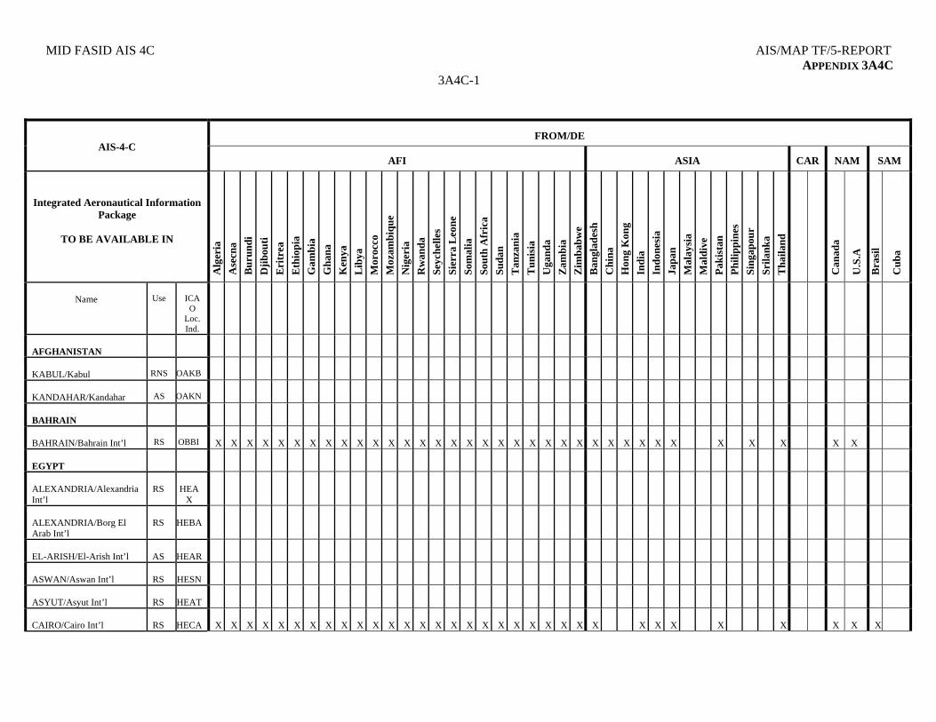
MID FASID AIS 4C AIS/MAP TF/5-REPORT APPENDIX 3A4C
3A4C-1
FROM/DE
AIS-4-C
AFI
ASIA
CAR
NAM
SAM
Integrated Aeronautical Information Package
TO BE AVAILABLE IN
Alg
eria
Ase
cna
Bu
run
di
Dji
bou
ti
Eri
trea
Eth
iop
ia
Gam
bia
Gh
ana
Ken
ya
Lib
ya
Mor
occo
Moz
ambi
que
Nig
eria
Rw
and
a
Sey
chel
les
Sier
ra L
eone
Som
alia
Sou
th A
fric
a
Suda
n
Tan
zan
ia
Tu
nis
ia
Uga
nd
a
Zam
bia
Zim
bab
we
Ban
glad
esh
Ch
ina
Hon
g K
ong
Ind
ia
Ind
ones
ia
Jap
an
Mal
aysi
a
Mal
div
e
Pak
ista
n
Phi
lip
pin
es
Sin
gap
our
Sri
lan
ka
Th
aila
nd
Can
ada
U.S
.A
Bra
sil
Cu
ba
Name
Use
ICA
O Loc. Ind.
AFGHANISTAN
KABUL/Kabul
RNS
OAKB
KANDAHAR/Kandahar
AS
OAKN
BAHRAIN
BAHRAIN/Bahrain Int’l
RS
OBBI
X
X
X
X
X
X
X
X
X
X
X
X
X
X
X
X
X
X
X
X
X
X
X
X
X
X
X
X
X
X
X
X
X
X
X
EGYPT
ALEXANDRIA/Alexandria Int’l
RS
HEA
X
ALEXANDRIA/Borg El Arab Int’l
RS
HEBA
EL-ARISH/El-Arish Int’l
AS
HEAR
ASWAN/Aswan Int’l
RS
HESN
ASYUT/Asyut Int’l
RS
HEAT
CAIRO/Cairo Int’l
RS
HECA
X
X
X
X
X
X
X
X
X
X
X
X
X
X
X
X
X
X
X
X
X
X
X
X
X
X
X
X
X
X
X
X
X
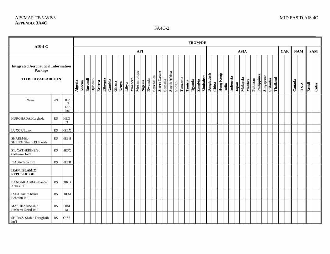
AIS/MAP TF/5-WP/3 MID FASID AIS 4C APPENDIX 3A4C
3A4C-2
FROM/DE
AIS-4-C
AFI
ASIA
CAR
NAM
SAM
Integrated Aeronautical Information Package
TO BE AVAILABLE IN
Alg
eria
Ase
cna
Bu
run
di
Dji
bou
ti
Eri
trea
Eth
iop
ia
Gam
bia
Gh
ana
Ken
ya
Lib
ya
Mor
occo
Moz
ambi
que
Nig
eria
Rw
and
a
Sey
chel
les
Sier
ra L
eone
Som
alia
Sou
th A
fric
a
Suda
n
Tan
zan
ia
Tu
nis
ia
Uga
nd
a
Zam
bia
Zim
bab
we
Ban
glad
esh
Ch
ina
Hon
g K
ong
Ind
ia
Ind
ones
ia
Jap
an
Mal
aysi
a
Mal
div
e
Pak
ista
n
Phi
lip
pin
es
Sin
gap
our
Sri
lan
ka
Th
aila
nd
Can
ada
U.S
.A
Bra
sil
Cu
ba
Name
Use
ICA
O Loc. Ind.
HURGHADA/Hurghada
RS
HEG
N
LUXOR/Luxor
RS
HELX
SHARM-EL-SHEIKH/Sharm El Sheikh
RS
HESH
ST. CATHERINE/St. Catherine Int’l
RS
HESC
TABA/Taba Int’l
RS
HETB
IRAN, ISLAMIC REPUBLIC OF
BANDAR ABBAS/Bandar Abbas Int’l
RS
OIKB
ESFAHAN/ Shahid Beheshti Int’l
RS
OIFM
MASHHAD/Shahid Hashemi Nejad Int’l
RS
OIM
M
SHIRAZ/ Shahid Dastghaib Int’l
RS
OISS
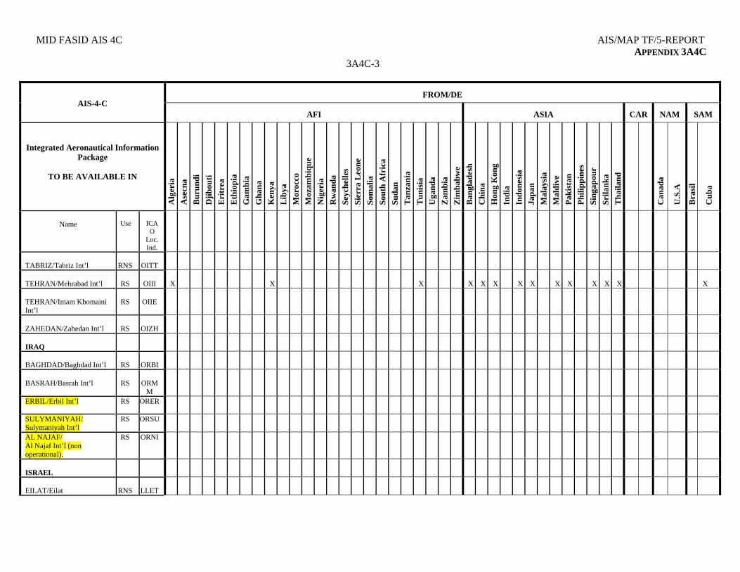
MID FASID AIS 4C AIS/MAP TF/5-REPORT APPENDIX 3A4C
3A4C-3
FROM/DE
AIS-4-C
AFI
ASIA
CAR
NAM
SAM
Integrated Aeronautical Information Package
TO BE AVAILABLE IN
Alg
eria
Ase
cna
Bu
run
di
Dji
bou
ti
Eri
trea
Eth
iop
ia
Gam
bia
Gh
ana
Ken
ya
Lib
ya
Mor
occo
Moz
ambi
que
Nig
eria
Rw
and
a
Sey
chel
les
Sier
ra L
eone
Som
alia
Sou
th A
fric
a
Suda
n
Tan
zan
ia
Tu
nis
ia
Uga
nd
a
Zam
bia
Zim
bab
we
Ban
glad
esh
Ch
ina
Hon
g K
ong
Ind
ia
Ind
ones
ia
Jap
an
Mal
aysi
a
Mal
div
e
Pak
ista
n
Phi
lip
pin
es
Sin
gap
our
Sri
lan
ka
Th
aila
nd
Can
ada
U.S
.A
Bra
sil
Cu
ba
Name
Use
ICA
O Loc. Ind.
TABRIZ/Tabriz Int’l
RNS
OITT
TEHRAN/Mehrabad Int’l
RS
OIII
X
X
X
X
X
X
X
X
X
X
X
X
X
X
TEHRAN/Imam Khomaini Int’l
RS
OIIE
ZAHEDAN/Zahedan Int’l
RS
OIZH
IRAQ
BAGHDAD/Baghdad Int’l
RS
ORBI
BASRAH/Basrah Int’l
RS
ORM
M
ERBIL/Erbil Int’l RS ORER
SULYMANIYAH/ Sulymaniyah Int’l
RS ORSU
AL NAJAF/ Al Najaf Int’l (non operational).
RS ORNI
ISRAEL
EILAT/Eilat
RNS
LLET

AIS/MAP TF/5-REPORT MID FASID AIS 4C APPENDIX 3A4C
3A4C-4
FROM/DE
AIS-4-C
AFI
ASIA
CAR
NAM
SAM
Integrated Aeronautical Information Package
TO BE AVAILABLE IN
Alg
eria
Ase
cna
Bu
run
di
Dji
bou
ti
Eri
trea
Eth
iop
ia
Gam
bia
Gh
ana
Ken
ya
Lib
ya
Mor
occo
Moz
ambi
que
Nig
eria
Rw
and
a
Sey
chel
les
Sier
ra L
eone
Som
alia
Sou
th A
fric
a
Suda
n
Tan
zan
ia
Tu
nis
ia
Uga
nd
a
Zam
bia
Zim
bab
we
Ban
glad
esh
Ch
ina
Hon
g K
ong
Ind
ia
Ind
ones
ia
Jap
an
Mal
aysi
a
Mal
div
e
Pak
ista
n
Phi
lip
pin
es
Sin
gap
our
Sri
lan
ka
Th
aila
nd
Can
ada
U.S
.A
Bra
sil
Cu
ba
Name
Use
ICA
O Loc. Ind.
HAIFA/Haifa
RS
LLHA
OVDA/Ovda Int’l
RS
LLOV
TEL AVIV/Ben Gurion
RS
LLBG
TEL AVIV/Sde-Dov
RNS
LLSD
JORDAN
AMMAN/Marka Int’l
AS
OJAM
X
X
X
X
X
X
AMMAN/Queen Alia Int’l
RS
OJAI
X
X
X
X
X
X
X
X
X
X
X
X
AQABA/King Hussein Int’l
RNS
OJAQ
X
JERUSALEM/Jerusalem (non operational)
RS
OJJR
KUWAIT
KUWAIT/Kuwait Int’l
RS OKBK
X
X
X
X
X
X
X
X
X
X
X
X
X
X
X
X
X
X
X
X
X
X
X
X
X
X
X
X
LEBANON
BEIRUT/R.B.H-Beirut Intl’
RS
OLBA
X
X
X
X
X
X
X
X
X
X
X
X
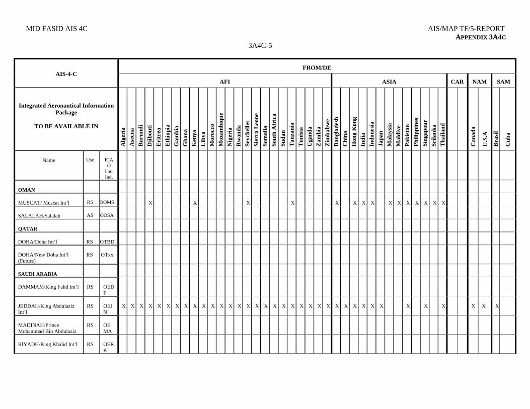
MID FASID AIS 4C AIS/MAP TF/5-REPORT APPENDIX 3A4C
3A4C-5
FROM/DE
AIS-4-C
AFI
ASIA
CAR
NAM
SAM
Integrated Aeronautical Information Package
TO BE AVAILABLE IN
Alg
eria
Ase
cna
Bu
run
di
Dji
bou
ti
Eri
trea
Eth
iop
ia
Gam
bia
Gh
ana
Ken
ya
Lib
ya
Mor
occo
Moz
ambi
que
Nig
eria
Rw
and
a
Sey
chel
les
Sier
ra L
eone
Som
alia
Sou
th A
fric
a
Suda
n
Tan
zan
ia
Tu
nis
ia
Uga
nd
a
Zam
bia
Zim
bab
we
Ban
glad
esh
Ch
ina
Hon
g K
ong
Ind
ia
Ind
ones
ia
Jap
an
Mal
aysi
a
Mal
div
e
Pak
ista
n
Phi
lip
pin
es
Sin
gap
our
Sri
lan
ka
Th
aila
nd
Can
ada
U.S
.A
Bra
sil
Cu
ba
Name
Use
ICA
O Loc. Ind.
OMAN
MUSCAT/ Muscat Int’l
RS
OOMS
X
X
X
X
X
X
X
X
X
X
X
X
X
X
X
SALALAH/Salalah
AS
OOSA
QATAR
DOHA/Doha Int’l
RS
OTBD
DOHA/New Doha Int’l (Future)
RS
OTxx
SAUDI ARABIA
DAMMAM/King Fahd Int’l
RS
OEDF
JEDDAH/King Abdulaziz Int’l
RS
OEJN
X
X
X
X
X
X
X
X
X
X
X
X
X
X
X
X
X
X
X
X
X
X
X
X
X
X
X
X
X
X
X
X
X
X
X
X
MADINAH/Prince Mohammad Bin Abdulaziz
RS
OEMA
RIYADH/King Khalid Int’l
RS
OERK
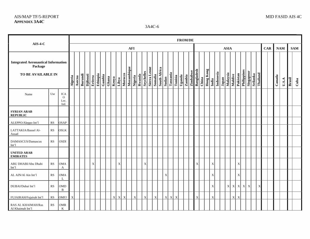
AIS/MAP TF/5-REPORT MID FASID AIS 4C APPENDIX 3A4C
3A4C-6
FROM/DE
AIS-4-C
AFI
ASIA
CAR
NAM
SAM
Integrated Aeronautical Information Package
TO BE AVAILABLE IN
Alg
eria
Ase
cna
Bu
run
di
Dji
bou
ti
Eri
trea
Eth
iop
ia
Gam
bia
Gh
ana
Ken
ya
Lib
ya
Mor
occo
Moz
ambi
que
Nig
eria
Rw
and
a
Sey
chel
les
Sier
ra L
eone
Som
alia
Sou
th A
fric
a
Suda
n
Tan
zan
ia
Tu
nis
ia
Uga
nd
a
Zam
bia
Zim
bab
we
Ban
glad
esh
Ch
ina
Hon
g K
ong
Ind
ia
Ind
ones
ia
Jap
an
Mal
aysi
a
Mal
div
e
Pak
ista
n
Phi
lip
pin
es
Sin
gap
our
Sri
lan
ka
Th
aila
nd
Can
ada
U.S
.A
Bra
sil
Cu
ba
Name
Use
ICA
O Loc. Ind.
SYRIAN ARAB REPUBLIC
ALEPPO/Aleppo Int’l
RS
OSAP
LATTAKIA/Bassel Al-Assad
RS
OSLK
DAMASCUS/Damascus Int’l
RS
OSDI
UNITED ARAB EMIRATES
ABU DHABI/Abu Dhabi Int’l
RS
OMA
A
X
X
X
X
X
X
AL AIN/Al Ain Int’l
RS
OMA
L
X
X
X
DUBAI/Dubai Int’l
RS
OMD
B
X
X
X
X
X
X
X
FUJAIRAH/Fujairah Int’l
RS
OMFJ
X
X
X
X
X
X
X
X
X
X
X
X
X
X
RAS AL KHAIMAH/Ras Al Khaimah Int’l
RS
OMR
K
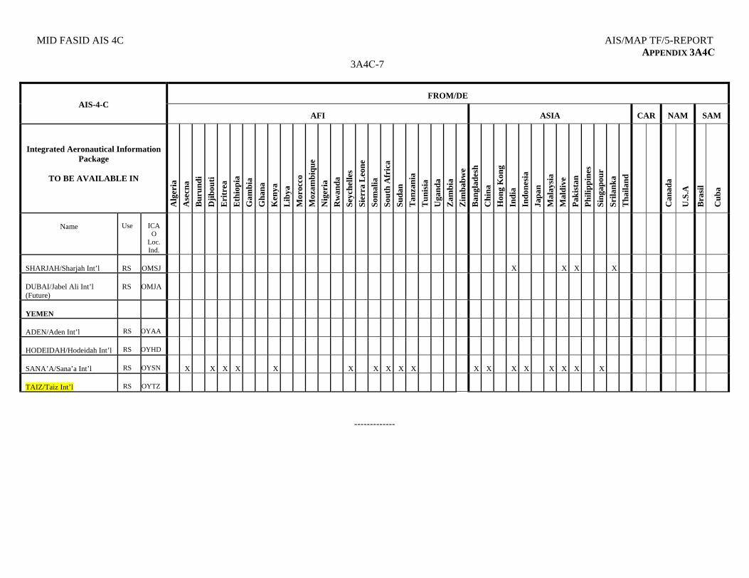
MID FASID AIS 4C AIS/MAP TF/5-REPORT APPENDIX 3A4C
3A4C-7
FROM/DE
AIS-4-C
AFI
ASIA
CAR
NAM
SAM
Integrated Aeronautical Information Package
TO BE AVAILABLE IN
Alg
eria
Ase
cna
Bu
run
di
Dji
bou
ti
Eri
trea
Eth
iop
ia
Gam
bia
Gh
ana
Ken
ya
Lib
ya
Mor
occo
Moz
ambi
que
Nig
eria
Rw
and
a
Sey
chel
les
Sier
ra L
eone
Som
alia
Sou
th A
fric
a
Suda
n
Tan
zan
ia
Tu
nis
ia
Uga
nd
a
Zam
bia
Zim
bab
we
Ban
glad
esh
Ch
ina
Hon
g K
ong
Ind
ia
Ind
ones
ia
Jap
an
Mal
aysi
a
Mal
div
e
Pak
ista
n
Phi
lip
pin
es
Sin
gap
our
Sri
lan
ka
Th
aila
nd
Can
ada
U.S
.A
Bra
sil
Cu
ba
Name
Use
ICA
O Loc. Ind.
SHARJAH/Sharjah Int’l
RS
OMSJ
X
X
X
X
DUBAI/Jabel Ali Int’l (Future)
RS
OMJA
YEMEN
ADEN/Aden Int’l
RS
OYAA
HODEIDAH/Hodeidah Int’l
RS
OYHD
SANA’A/Sana’a Int’l
RS
OYSN
X
X
X
X
X
X
X
X
X
X
X
X
X
X
X
X
X
X
TAIZ/Taiz Int’l
RS
OYTZ
-------------
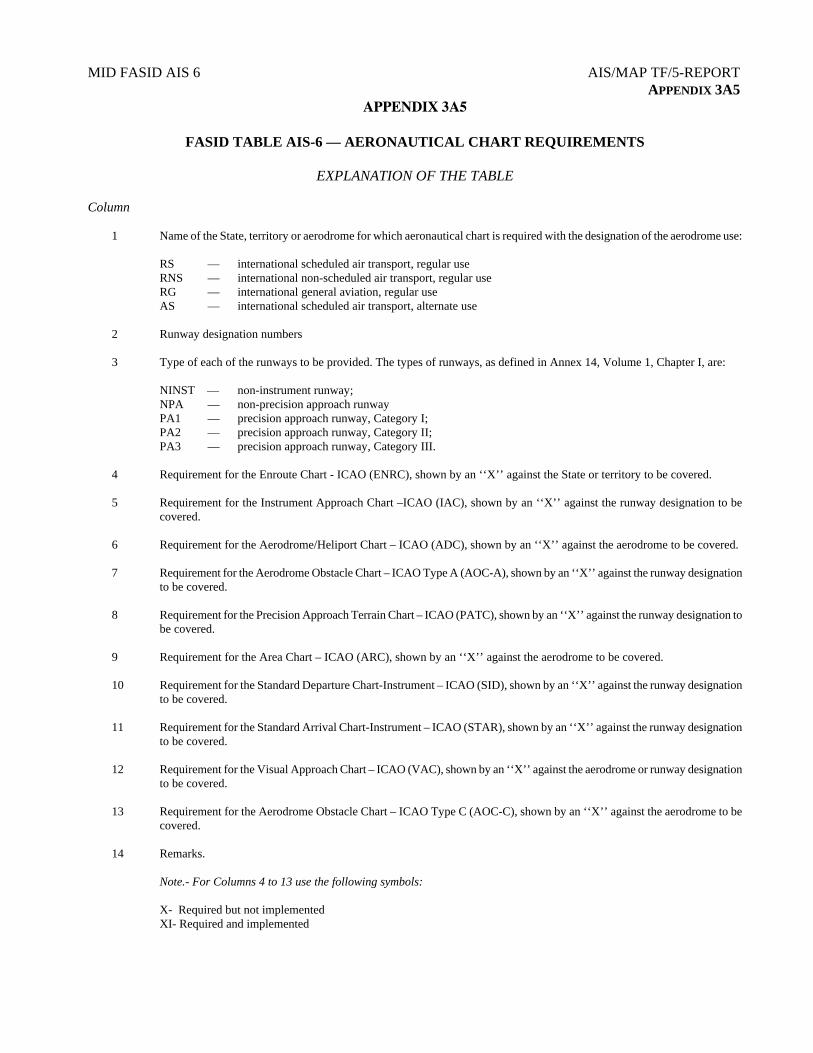
MID FASID AIS 6 AIS/MAP TF/5-REPORT APPENDIX 3A5
APPENDIX 3A5
FASID TABLE AIS-6 — AERONAUTICAL CHART REQUIREMENTS
EXPLANATION OF THE TABLE Column 1 Name of the State, territory or aerodrome for which aeronautical chart is required with the designation of the aerodrome use:
RS — international scheduled air transport, regular use RNS — international non-scheduled air transport, regular use RG — international general aviation, regular use AS — international scheduled air transport, alternate use
2 Runway designation numbers 3 Type of each of the runways to be provided. The types of runways, as defined in Annex 14, Volume 1, Chapter I, are: NINST — non-instrument runway; NPA — non-precision approach runway PA1 — precision approach runway, Category I; PA2 — precision approach runway, Category II; PA3 — precision approach runway, Category III. 4 Requirement for the Enroute Chart - ICAO (ENRC), shown by an ‘‘X’’ against the State or territory to be covered. 5 Requirement for the Instrument Approach Chart –ICAO (IAC), shown by an ‘‘X’’ against the runway designation to be
covered. 6 Requirement for the Aerodrome/Heliport Chart – ICAO (ADC), shown by an ‘‘X’’ against the aerodrome to be covered. 7 Requirement for the Aerodrome Obstacle Chart – ICAO Type A (AOC-A), shown by an ‘‘X’’ against the runway designation
to be covered. 8 Requirement for the Precision Approach Terrain Chart – ICAO (PATC), shown by an ‘‘X’’ against the runway designation to
be covered. 9 Requirement for the Area Chart – ICAO (ARC), shown by an ‘‘X’’ against the aerodrome to be covered. 10 Requirement for the Standard Departure Chart-Instrument – ICAO (SID), shown by an ‘‘X’’ against the runway designation
to be covered. 11 Requirement for the Standard Arrival Chart-Instrument – ICAO (STAR), shown by an ‘‘X’’ against the runway designation
to be covered.
12 Requirement for the Visual Approach Chart – ICAO (VAC), shown by an ‘‘X’’ against the aerodrome or runway designation to be covered.
13 Requirement for the Aerodrome Obstacle Chart – ICAO Type C (AOC-C), shown by an ‘‘X’’ against the aerodrome to be
covered. 14 Remarks.
Note.- For Columns 4 to 13 use the following symbols: X- Required but not implemented XI- Required and implemented
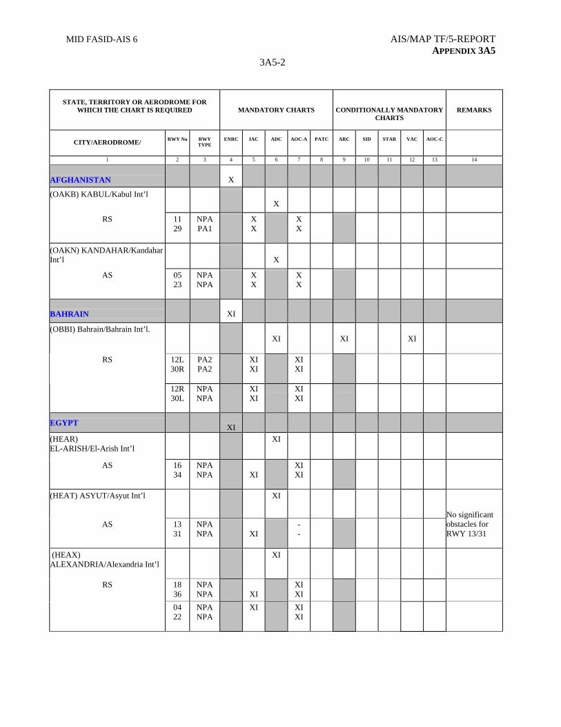
MID FASID-AIS 6 AIS/MAP TF/5-REPORT APPENDIX 3A5
3A5-2
STATE, TERRITORY OR AERODROME FOR WHICH THE CHART IS REQUIRED
MANDATORY CHARTS
CONDITIONALLY MANDATORY CHARTS
REMARKS
CITY/AERODROME/
RWY No
RWY TYPE
ENRC
IAC
ADC
AOC-A
PATC
ARC
SID
STAR
VAC
AOC-C
1 2 3 4 5 6 7 8 9 10 11 12 13 14
AFGHANISTAN
X
(OAKB) KABUL/Kabul Int’l
X
RS 11 29
NPA PA1
X X
X X
(OAKN) KANDAHAR/Kandahar Int’l
X
AS 05 23
NPA NPA
X X
X X
BAHRAIN
XI
(OBBI) Bahrain/Bahrain Int’l. XI
XI
XI
12L 30R
PA2 PA2
XI XI
XI XI
RS
12R 30L
NPA NPA
XI XI
XI XI
EGYPT
XI
(HEAR) EL-ARISH/El-Arish Int’l
XI
AS 16 34
NPA NPA
XI
XI XI
(HEAT) ASYUT/Asyut Int’l XI
AS 13 31
NPA NPA
XI
- -
No significant obstacles for RWY 13/31
(HEAX) ALEXANDRIA/Alexandria Int’l
XI
RS 18 36
NPA NPA
XI
XI XI
04 22
NPA NPA
XI XI XI
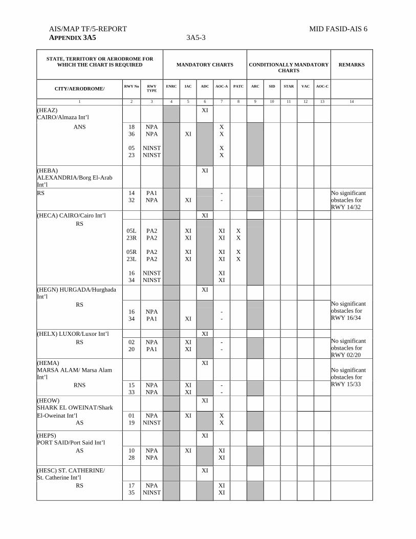
AIS/MAP TF/5-REPORT MID FASID-AIS 6 APPENDIX 3A5 3A5-3
STATE, TERRITORY OR AERODROME FOR
WHICH THE CHART IS REQUIRED
MANDATORY CHARTS
CONDITIONALLY MANDATORY CHARTS
REMARKS
CITY/AERODROME/
RWY No
RWY TYPE
ENRC
IAC
ADC
AOC-A
PATC
ARC
SID
STAR
VAC
AOC-C
1 2 3 4 5 6 7 8 9 10 11 12 13 14
(HEAZ) CAIRO/Almaza Int’l
XI
ANS 18 36
05 23
NPA NPA
NINST NINST
XI
X X
X X
(HEBA) ALEXANDRIA/Borg El-Arab Int’l
XI
RS 14 32
PA1 NPA
XI
- -
No significant obstacles for RWY 14/32
(HECA) CAIRO/Cairo Int’l XI RS
05L 23R
05R 23L
16 34
PA2 PA2
PA2 PA2
NINST NINST
XI XI
XI XI
XI XI
XI XI
XI XI
X X
X X
(HEGN) HURGADA/Hurghada Int’l
XI
RS
16 34
NPA PA1
XI
- -
No significant obstacles for RWY 16/34
(HELX) LUXOR/Luxor Int’l XI RS
02 20
NPA PA1
XI XI
- -
No significant obstacles for RWY 02/20
(HEMA) MARSA ALAM/ Marsa Alam Int’l
XI
RNS 15 33
NPA NPA
XI XI
- -
No significant obstacles for RWY 15/33
(HEOW) SHARK EL OWEINAT/Shark
XI
El-Oweinat Int’l AS
01 19
NPA NINST
XI X X
(HEPS) PORT SAID/Port Said Int’l
XI
AS 10 28
NPA NPA
XI XI XI
(HESC) ST. CATHERINE/ St. Catherine Int’l
XI
RS 17 35
NPA NINST
XI XI

MID FASID-AIS 6 AIS/MAP TF/5-REPORT APPENDIX 3A5
3A5-4
STATE, TERRITORY OR AERODROME FOR
WHICH THE CHART IS REQUIRED
MANDATORY CHARTS
CONDITIONALLY MANDATORY CHARTS
REMARKS
CITY/AERODROME/
RWY No
RWY TYPE
ENRC
IAC
ADC
AOC-A
PATC
ARC
SID
STAR
VAC
AOC-C
1 2 3 4 5 6 7 8 9 10 11 12 13 14
(HESH) SHARM-EL-SHEIKH/ Sharm-El-Sheikh Int’l
XI
RS 04L 22R
04R 22L
PA1 NPA
NPA NPA
XI
XI
X X
X X
(HESN) ASWAN/Aswan Int’l XI
RS 17 35
NPA PA1
XI XI
- -
No significant obstacles for RWY 17/35
(HETB) TABA/Taba Int’l XI
AS
04 22
NPA NINST
XI XI XI
IRAN
XI
(OIKB) BANDAR ABBASS/ XI X
Bandar Abbas Int’l RS
03R 21L
03L 21R
NPA PA1
NINST NINST
XI XI
X X
X X
XI XI
XI XI
(OIFM) Esfahan/ Shahid Beheshti Int’l
XI X
RS 08L 26R
NPA PA1
XI XI
X X
XI XI
XI
08R 26L
NPA NPA
XI XI
X X
XI XI
XI
(OIMM) Mashhad/ Shahid Hashemi Nejad Int’l
XI XI
RS 13L 31R
13R 31L
NPA PA1
NPA NPA
XI XI
XI XI
X X
X X
XI XI
XI XI
XI XI
XI XI
(OISS) Shiraz/Shahid Dastghaib Int’l
XI X
RS
11R 29L
11L 29R
NPA PA1
NPA NPA
X XI
X XI
X X
X X
XI XI
XI XI
XI
XI
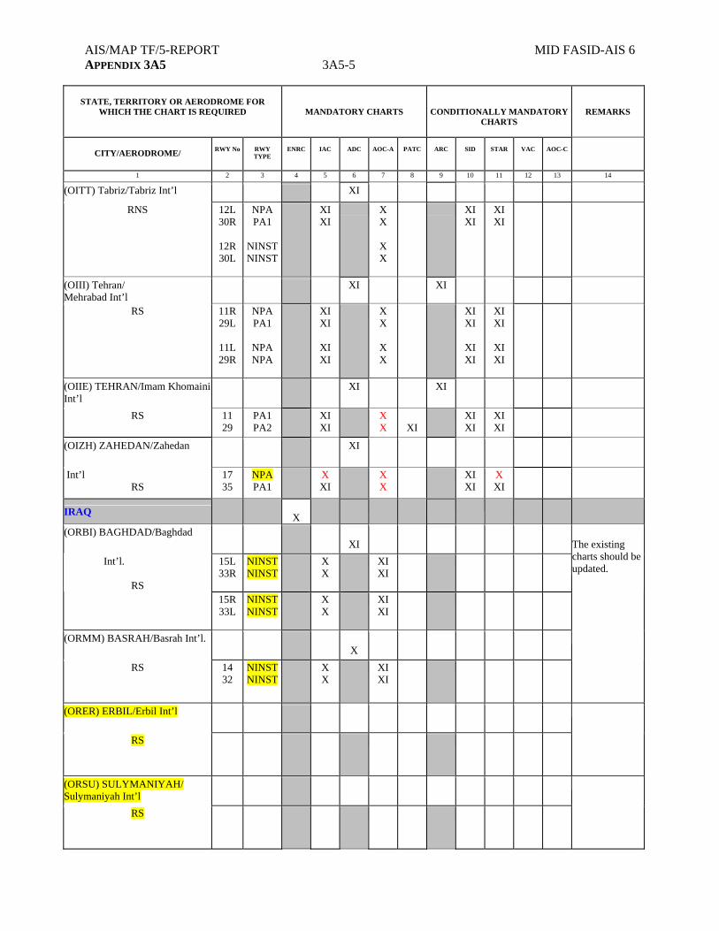
AIS/MAP TF/5-REPORT MID FASID-AIS 6 APPENDIX 3A5 3A5-5
STATE, TERRITORY OR AERODROME FOR
WHICH THE CHART IS REQUIRED
MANDATORY CHARTS
CONDITIONALLY MANDATORY CHARTS
REMARKS
CITY/AERODROME/
RWY No
RWY TYPE
ENRC
IAC
ADC
AOC-A
PATC
ARC
SID
STAR
VAC
AOC-C
1 2 3 4 5 6 7 8 9 10 11 12 13 14
(OITT) Tabriz/Tabriz Int’l XI
RNS
12L 30R
12R 30L
NPA PA1
NINST NINST
XI XI
X X
X X
XI XI
XI XI
(OIII) Tehran/ Mehrabad Int’l
XI XI
RS 11R 29L
11L 29R
NPA PA1
NPA NPA
XI XI
XI XI
X X
X X
XI XI
XI XI
XI XI
XI XI
(OIIE) TEHRAN/Imam Khomaini Int’l
XI XI
RS 11 29
PA1 PA2
XI XI
X X
XI
XI XI
XI XI
(OIZH) ZAHEDAN/Zahedan XI
Int’l RS
17 35
NPA PA1
X XI
X X
XI XI
X XI
IRAQ
X
(ORBI) BAGHDAD/Baghdad XI
15L 33R
NINST NINST
X X
XI XI
Int’l.
RS 15R
33L NINST NINST
X X
XI XI
The existing charts should be updated.
(ORMM) BASRAH/Basrah Int’l. X
RS 14 32
NINST NINST
X X
XI XI
(ORER) ERBIL/Erbil Int’l
RS
(ORSU) SULYMANIYAH/ Sulymaniyah Int’l
RS
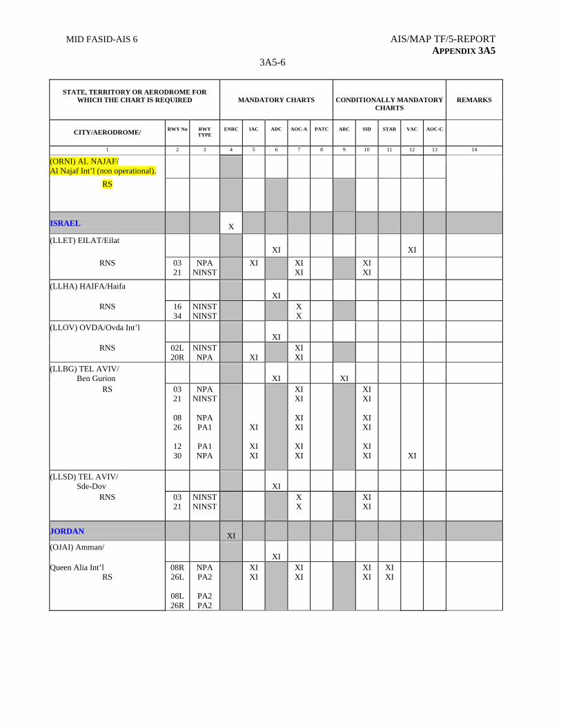
MID FASID-AIS 6 AIS/MAP TF/5-REPORT APPENDIX 3A5
3A5-6
STATE, TERRITORY OR AERODROME FOR
WHICH THE CHART IS REQUIRED
MANDATORY CHARTS
CONDITIONALLY MANDATORY CHARTS
REMARKS
CITY/AERODROME/
RWY No
RWY TYPE
ENRC
IAC
ADC
AOC-A
PATC
ARC
SID
STAR
VAC
AOC-C
1 2 3 4 5 6 7 8 9 10 11 12 13 14
(ORNI) AL NAJAF/ Al Najaf Int’l (non operational).
RS
ISRAEL
X
(LLET) EILAT/Eilat
XI
XI
RNS 03 21
NPA NINST
XI XI XI
XI XI
(LLHA) HAIFA/Haifa XI
RNS 16 34
NINST NINST
X X
(LLOV) OVDA/Ovda Int’l
XI
RNS 02L 20R
NINST NPA
XI
XI XI
(LLBG) TEL AVIV/ Ben Gurion
XI
XI
RS 03 21
08 26
12 30
NPA NINST
NPA PA1
PA1 NPA
XI
XI XI
XI XI
XI XI
XI XI
XI XI
XI XI
XI XI
XI
(LLSD) TEL AVIV/ Sde-Dov
XI
RNS 03 21
NINST NINST
X X
XI XI
JORDAN
XI
(OJAI) Amman/ XI
Queen Alia Int’l RS
08R 26L
08L 26R
NPA PA2
PA2 PA2
XI XI
XI XI
XI XI
XI XI

AIS/MAP TF/5-REPORT MID FASID-AIS 6 APPENDIX 3A5 3A5-7
STATE, TERRITORY OR AERODROME FOR
WHICH THE CHART IS REQUIRED
MANDATORY CHARTS
CONDITIONALLY MANDATORY CHARTS
REMARKS
CITY/AERODROME/
RWY No
RWY TYPE
ENRC
IAC
ADC
AOC-A
PATC
ARC
SID
STAR
VAC
AOC-C
1 2 3 4 5 6 7 8 9 10 11 12 13 14
(OJAM) Amman/Marka Int’l XI
AS 06 24
NPA PA1
XI XI
XI XI
XI XI
XI XI
X
X X
XI XI
XI XI
XI XI
XI XI
(OJAQ) AQABA/King XI
XI
Hussein Int’l RS
01 19
PA1 NPA
XI XI
XI XI
XI XI
(OJJR) JERUSALEM/ Jerusalem (Non operational)
RS
12 30
PA1 NPA
KUWAIT
XI
OKBK KUWAIT/Kuwait Int’l.
XI
RS 33L 15R
33R 15L
PA2 PA2
PA2 PA2
XI XI
XI XI
XI XI
XI XI
XI XI
XI XI
XI XI
XI XI
XI XI
XI XI
LEBANON
XI
(OLBA) BEIRUT/ R.B.H-Beirut Int’l
XI
RS 17 35
16 34
03 21
PA1 NINST
PA1
NINST
PA1 PA1
XI
XI
XI XI
XI XI
XI XI
XI
XI XI
XI
XI
XI
XI
OMAN
X
(OOMS) Muscat/ Muscat Int’l XI
RS
08 26
PA1 PA1
XI XI
XI XI
XI XI
XI XI
(OOSA) SALALAH/Salalah Int’l XI
XI
AS
07 25
NPA PA1
XI XI
- -
XI XI
XI XI
No significant obstacle for RWY 07/25
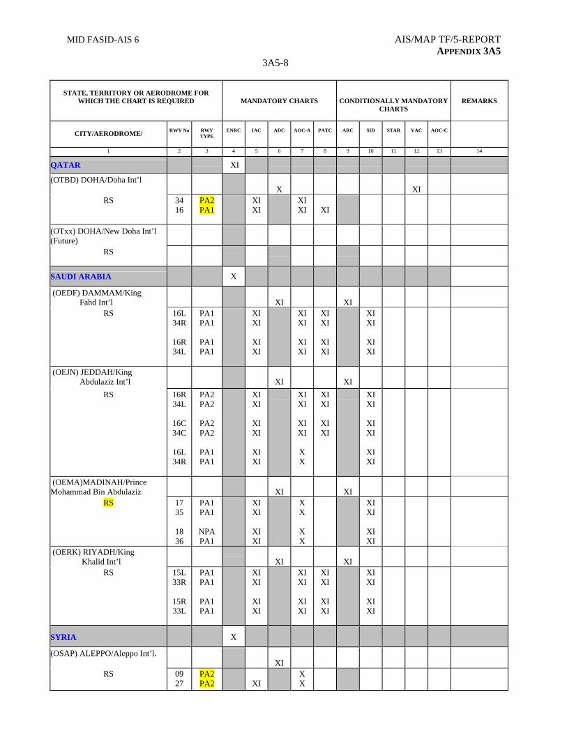
MID FASID-AIS 6 AIS/MAP TF/5-REPORT APPENDIX 3A5
3A5-8
STATE, TERRITORY OR AERODROME FOR
WHICH THE CHART IS REQUIRED
MANDATORY CHARTS
CONDITIONALLY MANDATORY CHARTS
REMARKS
CITY/AERODROME/
RWY No
RWY TYPE
ENRC
IAC
ADC
AOC-A
PATC
ARC
SID
STAR
VAC
AOC-C
1 2 3 4 5 6 7 8 9 10 11 12 13 14
QATAR XI
(OTBD) DOHA/Doha Int’l X
XI
RS
34 16
PA2 PA1
XI XI
XI XI
XI
(OTxx) DOHA/New Doha Int’l (Future)
RS
SAUDI ARABIA
X
(OEDF) DAMMAM/King Fahd Int’l
XI
XI
RS 16L 34R
16R 34L
PA1 PA1
PA1 PA1
XI XI
XI XI
XI XI
XI XI
XI XI
XI XI
XI XI
XI XI
(OEJN) JEDDAH/King Abdulaziz Int’l
XI
XI
RS 16R 34L
16C 34C
16L 34R
PA2 PA2
PA2 PA2
PA1 PA1
XI XI
XI XI
XI XI
XI XI
XI XI
X X
XI XI
XI XI
XI XI
XI XI
XI XI
(OEMA)MADINAH/Prince Mohammad Bin Abdulaziz
XI
XI
RS 17 35
18 36
PA1 PA1
NPA PA1
XI XI
XI XI
X X
X X
XI XI
XI XI
(OERK) RIYADH/King Khalid Int’l
XI
XI
RS 15L 33R
15R 33L
PA1 PA1
PA1 PA1
XI XI
XI XI
XI XI
XI XI
XI XI
XI XI
XI XI
XI XI
SYRIA X
(OSAP) ALEPPO/Aleppo Int’l. XI
RS 09 27
PA2 PA2
XI
X X
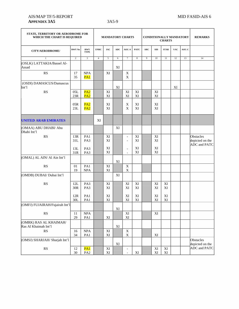
AIS/MAP TF/5-REPORT MID FASID-AIS 6 APPENDIX 3A5 3A5-9
STATE, TERRITORY OR AERODROME FOR
WHICH THE CHART IS REQUIRED
MANDATORY CHARTS
CONDITIONALLY MANDATORY CHARTS
REMARKS
CITY/AERODROME/
RWY No
RWY TYPE
ENRC
IAC
ADC
AOC-A
PATC
ARC
SID
STAR
VAC
AOC-C
1 2 3 4 5 6 7 8 9 10 11 12 13 14
(OSLK) LATTAKIA/Bassel Al-Assad
XI
RS 17 35
NPA PA1
XI X X
(OSDI) DAMASCUS/Damascus Int’l
XI
XI
05L 23R
PA2 PA2
XI XI
XI XI
XI XI
XI XI
RS
05R 23L
PA2 PA2
XI XI
X X
XI XI
XI XI
UNITED ARAB EMIRATES
XI
(OMAA) ABU DHABI/ Abu Dhabi Int’l
XI
RS
13R 31L
13L 31R
PA1 PA3
PA3 PA3
XI XI
XI XI
- - - -
XI XI
XI XI
XI XI
XI XI
Obstacles depicted on the ADC and PATC
(OMAL) AL AIN/ Al Ain Int’l
XI
RS
01 19
PA1 NPA
XI XI
X X
(OMDB) DUBAI/ Dubai Int’l XI
RS 12L 30R
12R 30L
PA3 PA3
PA1 PA1
XI XI
XI XI
XI XI
XI XI
XI XI
XI XI
XI XI
XI XI
XI XI
XI XI
(OMFJ) FUJAIRAH/Fujairah Int’l XI
RS 11 29
NPA PA1
XI
XI XI
XI
(OMRK) RAS AL KHAIMAH/ Ras Al Khaimah Int’l
XI
RS 16 34
NPA PA1
XI XI
X X
XI
(OMSJ) SHARJAH/ Sharjah Int’l XI
RS 12 30
PA1 PA2
XI XI
- -
XI
XI XI
XI XI
Obstacles depicted on the ADC and PATC
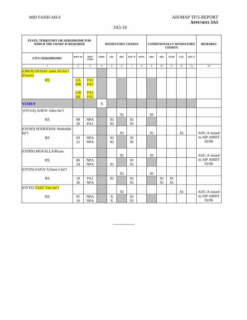
MID FASID-AIS 6 AIS/MAP TF/5-REPORT APPENDIX 3A5
3A5-10
STATE, TERRITORY OR AERODROME FOR
WHICH THE CHART IS REQUIRED
MANDATORY CHARTS
CONDITIONALLY MANDATORY CHARTS
REMARKS
CITY/AERODROME/
RWY No
RWY TYPE
ENRC
IAC
ADC
AOC-A
PATC
ARC
SID
STAR
VAC
AOC-C
1 2 3 4 5 6 7 8 9 10 11 12 13 14
(OMJA) DUBAI/ Jabel Ali Int’l (Future)
RS 12L 30R
12R 30L
PA3 PA3
PA3 PA3
YEMEN X
(OYAA) ADEN/ Aden Int’l XI
XI
RS 08 26
NPA PA1
XI XI
XI XI
(OYHD) HODEIDAH/ Hodeidah Int’l
XI
XI
XI
RS 03 21
NPA NPA
XI XI
XI XI
AOC-A issued in AIP AMDT
02/06
(OYRN) MUKALLA/Riyan XI
XI
RS 06 24
NPA NPA
XI
XI XI
AOC-A issued in AIP AMDT
02/06
(OYSN) SANA’A/Sana’a Int’l XI
XI
RS 18 36
PA1 NPA
XI XI XI
XI XI
XI XI
(OYTZ) TAIZ/ Taiz Int’l XI
XI
RS 01 19
NPA NPA
X X
XI XI
AOC-A issued in AIP AMDT
02/06
----------------

MID FASID AIS 7 AIS/MAP TF/5-REPORT APPENDIX 3A6
APPENDIX 3A6
FASID Table AIS-7
PRODUCTION RESPONSIBILITY FOR SHEETS OF
THE WORLD AERONAUTICAL CHART - ICAO 1:1 000 000
EXPLANATION OF THE TABLE
Column
1. Name of the State accepting production responsibility
2. World Aeronautical Chart — ICAO 1:1 000 000 sheet number(s) for which production responsibility is accepted.
3. Remarks.
State
Sheet number(s)
Remarks
Afghanistan 2336, 2337, 2430, 2431, 2442 Bahrain 2547 Egypt 2447, 2448, 2543, 2544 Iran, Islamic Republic of 2338, 2339, 2428, 2429, 2443,
2444, 2548
Iraq 2427, 2445 Israel Jordan 2426, 2446, 2447 Note: Jordan to cover its own
territory within Amman FIR Kuwait 2445
Note: Kuwait to cover its own territory within Kuwait FIR
Lebanon 2426
Note: Lebanon to cover its own territory within Beirut FIR
Oman 2563, 2670
Qatar
Saudi Arabia 2446, 2545, 2546, 2564, 2565, 2566, 2668, 2669
Syrian Arab Republic 2426 Note: Syria to cover its own territory within Damascus FIR
United Arab Emirates Yemen 2686, 2687 Notes. - In those instances where the production responsibility for certain sheets has been accepted by more than
one State, these States by mutual agreement should define limits of responsibility for those sheets. - The responsibility for the production of the WAC sheets: 2548, 2563, and 2670 is not yet assigned to any
States.
---------------
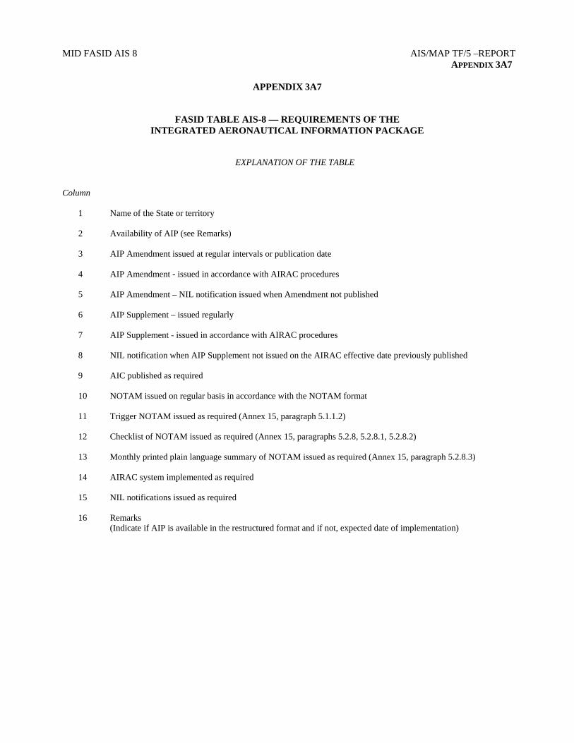
MID FASID AIS 8 AIS/MAP TF/5 –REPORT APPENDIX 3A7
APPENDIX 3A7
FASID TABLE AIS-8 — REQUIREMENTS OF THE INTEGRATED AERONAUTICAL INFORMATION PACKAGE
EXPLANATION OF THE TABLE Column 1 Name of the State or territory 2 Availability of AIP (see Remarks)
3 AIP Amendment issued at regular intervals or publication date
4 AIP Amendment - issued in accordance with AIRAC procedures
5 AIP Amendment – NIL notification issued when Amendment not published
6 AIP Supplement – issued regularly
7 AIP Supplement - issued in accordance with AIRAC procedures
8 NIL notification when AIP Supplement not issued on the AIRAC effective date previously published
9 AIC published as required
10 NOTAM issued on regular basis in accordance with the NOTAM format
11 Trigger NOTAM issued as required (Annex 15, paragraph 5.1.1.2)
12 Checklist of NOTAM issued as required (Annex 15, paragraphs 5.2.8, 5.2.8.1, 5.2.8.2)
13 Monthly printed plain language summary of NOTAM issued as required (Annex 15, paragraph 5.2.8.3)
14 AIRAC system implemented as required
15 NIL notifications issued as required
16 Remarks (Indicate if AIP is available in the restructured format and if not, expected date of implementation)
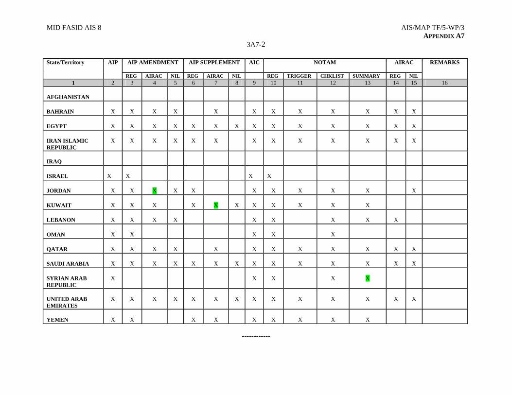
MID FASID AIS 8 AIS/MAP TF/5-WP/3 APPENDIX A7
3A7-2
AIP AMENDMENT
AIP SUPPLEMENT AIC NOTAM AIRAC State/Territory AIP
REG AIRAC NIL REG AIRAC NIL REG TRIGGER CHKLIST SUMMARY REG NIL
REMARKS
1 2 3 4 5 6 7 8 9 10 11 12 13 14 15 16 AFGHANISTAN
BAHRAIN
X
X
X
X
X
X
X
X
X
X
X
X
EGYPT
X
X
X
X
X
X
X
X
X
X
X
X
X
X
IRAN ISLAMIC REPUBLIC
X
X
X
X
X
X
X
X
X
X
X
X
X
IRAQ
ISRAEL
X
X
X
X
JORDAN
X
X
X
X
X
X
X
X
X
X
X
KUWAIT
X
X
X
X
X
X
X
X
X
X
X
LEBANON
X
X
X
X
X
X
X
X
X
OMAN
X
X
X
X
X
QATAR
X
X
X
X
X
X
X
X
X
X
X
X
SAUDI ARABIA
X
X
X
X
X
X
X
X
X
X
X
X
X
X
SYRIAN ARAB REPUBLIC
X
X
X
X
X
UNITED ARAB EMIRATES
X
X
X
X
X
X
X
X
X
X
X
X
X
X
YEMEN
X
X
X
X
X
X
X
X
X
------------
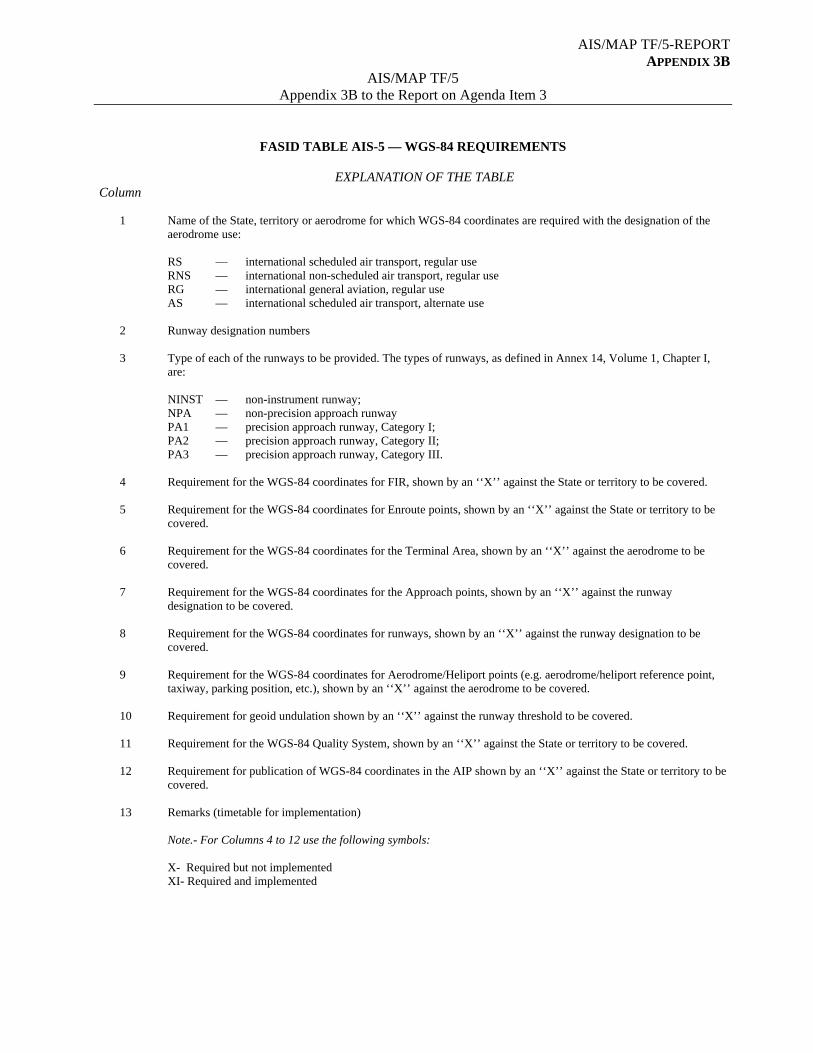
AIS/MAP TF/5-REPORT APPENDIX 3B
AIS/MAP TF/5 Appendix 3B to the Report on Agenda Item 3
FASID TABLE AIS-5 — WGS-84 REQUIREMENTS
EXPLANATION OF THE TABLE Column 1 Name of the State, territory or aerodrome for which WGS-84 coordinates are required with the designation of the
aerodrome use:
RS — international scheduled air transport, regular use RNS — international non-scheduled air transport, regular use RG — international general aviation, regular use AS — international scheduled air transport, alternate use
2 Runway designation numbers 3 Type of each of the runways to be provided. The types of runways, as defined in Annex 14, Volume 1, Chapter I,
are: NINST — non-instrument runway; NPA — non-precision approach runway PA1 — precision approach runway, Category I; PA2 — precision approach runway, Category II; PA3 — precision approach runway, Category III. 4 Requirement for the WGS-84 coordinates for FIR, shown by an ‘‘X’’ against the State or territory to be covered. 5 Requirement for the WGS-84 coordinates for Enroute points, shown by an ‘‘X’’ against the State or territory to be
covered. 6 Requirement for the WGS-84 coordinates for the Terminal Area, shown by an ‘‘X’’ against the aerodrome to be
covered. 7 Requirement for the WGS-84 coordinates for the Approach points, shown by an ‘‘X’’ against the runway
designation to be covered. 8 Requirement for the WGS-84 coordinates for runways, shown by an ‘‘X’’ against the runway designation to be
covered. 9 Requirement for the WGS-84 coordinates for Aerodrome/Heliport points (e.g. aerodrome/heliport reference point,
taxiway, parking position, etc.), shown by an ‘‘X’’ against the aerodrome to be covered. 10 Requirement for geoid undulation shown by an ‘‘X’’ against the runway threshold to be covered. 11 Requirement for the WGS-84 Quality System, shown by an ‘‘X’’ against the State or territory to be covered.
12 Requirement for publication of WGS-84 coordinates in the AIP shown by an ‘‘X’’ against the State or territory to be covered.
13 Remarks (timetable for implementation)
Note.- For Columns 4 to 12 use the following symbols: X- Required but not implemented XI- Required and implemented
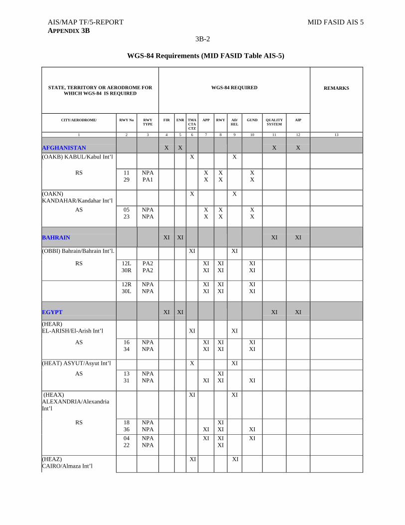
AIS/MAP TF/5-REPORT MID FASID AIS 5 APPENDIX 3B
3B-2
WGS-84 Requirements (MID FASID Table AIS-5)
STATE, TERRITORY OR AERODROME FOR WHICH WGS-84 IS REQUIRED
WGS-84 REQUIRED
CITY/AERODROME/
RWY No
RWY TYPE
FIR
ENR
TMA CTA CTZ
APP
RWY
AD/ HEL
GUND
QUALITY SYSTEM
AIP
REMARKS
1 2 3 4 5 6 7 8 9 10 11 12 13
AFGHANISTAN
X
X
X
X
(OAKB) KABUL/Kabul Int’l
X X
RS 11 29
NPA PA1
X X
X X
X X
(OAKN) KANDAHAR/Kandahar Int’l
X X
AS 05 23
NPA NPA
X X
X X
X X
BAHRAIN
XI
XI
XI
XI
(OBBI) Bahrain/Bahrain Int’l. XI XI
RS 12L 30R
PA2 PA2
XI XI
XI XI
XI XI
12R 30L
NPA NPA
XI XI
XI XI
XI XI
EGYPT
XI
XI
XI
XI
(HEAR) EL-ARISH/El-Arish Int’l
XI
XI
AS 16 34
NPA NPA
XI XI
XI XI
XI XI
(HEAT) ASYUT/Asyut Int’l X XI
AS 13 31
NPA NPA
XI
XI XI
XI
(HEAX) ALEXANDRIA/Alexandria Int’l
XI XI
RS 18 36
NPA NPA
XI
XI XI
XI
04 22
NPA NPA
XI XI XI
XI
(HEAZ) CAIRO/Almaza Int’l
XI XI
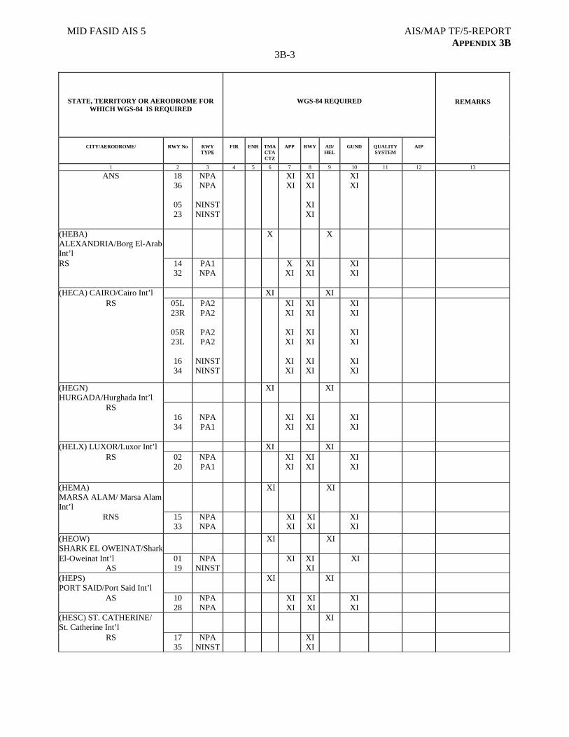
MID FASID AIS 5 AIS/MAP TF/5-REPORT APPENDIX 3B
3B-3
STATE, TERRITORY OR AERODROME FOR WHICH WGS-84 IS REQUIRED
WGS-84 REQUIRED
CITY/AERODROME/
RWY No
RWY TYPE
FIR
ENR
TMA CTA CTZ
APP
RWY
AD/ HEL
GUND
QUALITY SYSTEM
AIP
REMARKS
1 2 3 4 5 6 7 8 9 10 11 12 13
ANS 18 36
05 23
NPA NPA
NINST NINST
XI XI
XI XI
XI XI
XI XI
(HEBA) ALEXANDRIA/Borg El-Arab Int’l
X X
RS 14 32
PA1 NPA
X XI
XI XI
XI XI
(HECA) CAIRO/Cairo Int’l XI XI RS
05L 23R
05R 23L
16 34
PA2 PA2
PA2 PA2
NINST NINST
XI XI
XI XI
XI XI
XI XI
XI XI
XI XI
XI XI
XI XI
XI XI
(HEGN) HURGADA/Hurghada Int’l
XI XI
RS
16 34
NPA PA1
XI XI
XI XI
XI XI
(HELX) LUXOR/Luxor Int’l XI XI RS
02 20
NPA PA1
XI XI
XI XI
XI XI
(HEMA) MARSA ALAM/ Marsa Alam Int’l
XI XI
RNS 15 33
NPA NPA
XI XI
XI XI
XI XI
(HEOW) SHARK EL OWEINAT/Shark
XI XI
El-Oweinat Int’l AS
01 19
NPA NINST
XI
XI XI
XI
(HEPS) PORT SAID/Port Said Int’l
XI XI
AS 10 28
NPA NPA
XI XI
XI XI
XI XI
(HESC) ST. CATHERINE/ St. Catherine Int’l
XI
RS 17 35
NPA NINST
XI XI
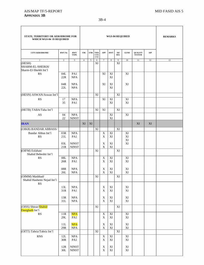
AIS/MAP TF/5-REPORT MID FASID AIS 5 APPENDIX 3B
3B-4
STATE, TERRITORY OR AERODROME FOR WHICH WGS-84 IS REQUIRED
WGS-84 REQUIRED
CITY/AERODROME/
RWY No
RWY TYPE
FIR
ENR
TMA CTA CTZ
APP
RWY
AD/ HEL
GUND
QUALITY SYSTEM
AIP
REMARKS
1 2 3 4 5 6 7 8 9 10 11 12 13
(HESH) SHARM-EL-SHEIKH/ Sharm-El-Sheikh Int’l
XI XI
RS 04L 22R
04R 22L
PA1 NPA
NPA NPA
XI
XI
XI XI
XI XI
XI
XI
(HESN) ASWAN/Aswan Int’l XI XI
RS 17 35
NPA PA1
XI
XI XI
XI XI
(HETB) TABA/Taba Int’l XI XI XI
AS
04 22
NPA NINST
XI XI
XI
IRAN
XI XI XI XI
(OIKB) BANDAR ABBASS/ XI XI Bandar Abbas Int’l
RS 03R 21L
03L 21R
NPA PA1
NINST NINST
X X
X X
XI XI
XI XI
XI XI XI XI
(OIFM) Esfahan/ Shahid Beheshti Int’l
XI XI
RS 08L 26R
NPA PA1
X X
XI XI
XI XI
08R 26L
NPA NPA
X X
XI XI
XI XI
(OIMM) Mashhad/ Shahid Hashemi Nejad Int’l
XI XI
RS 13L 31R
13R 31L
NPA PA1
NPA NPA
X X
X X
XI XI
XI XI
XI XI
XI XI
(OISS) Shiraz/Shahid Dastghaib Int’l
XI XI
RS
11R 29L
11L 29R
NPA PA1
NPA NPA
X X
X X
XI XI
XI XI
XI XI
XI XI
(OITT) Tabriz/Tabriz Int’l XI XI
RNS
12L 30R
12R 30L
NPA PA1
NINST NINST
X X
X X
XI XI
XI XI
XI XI
XI XI
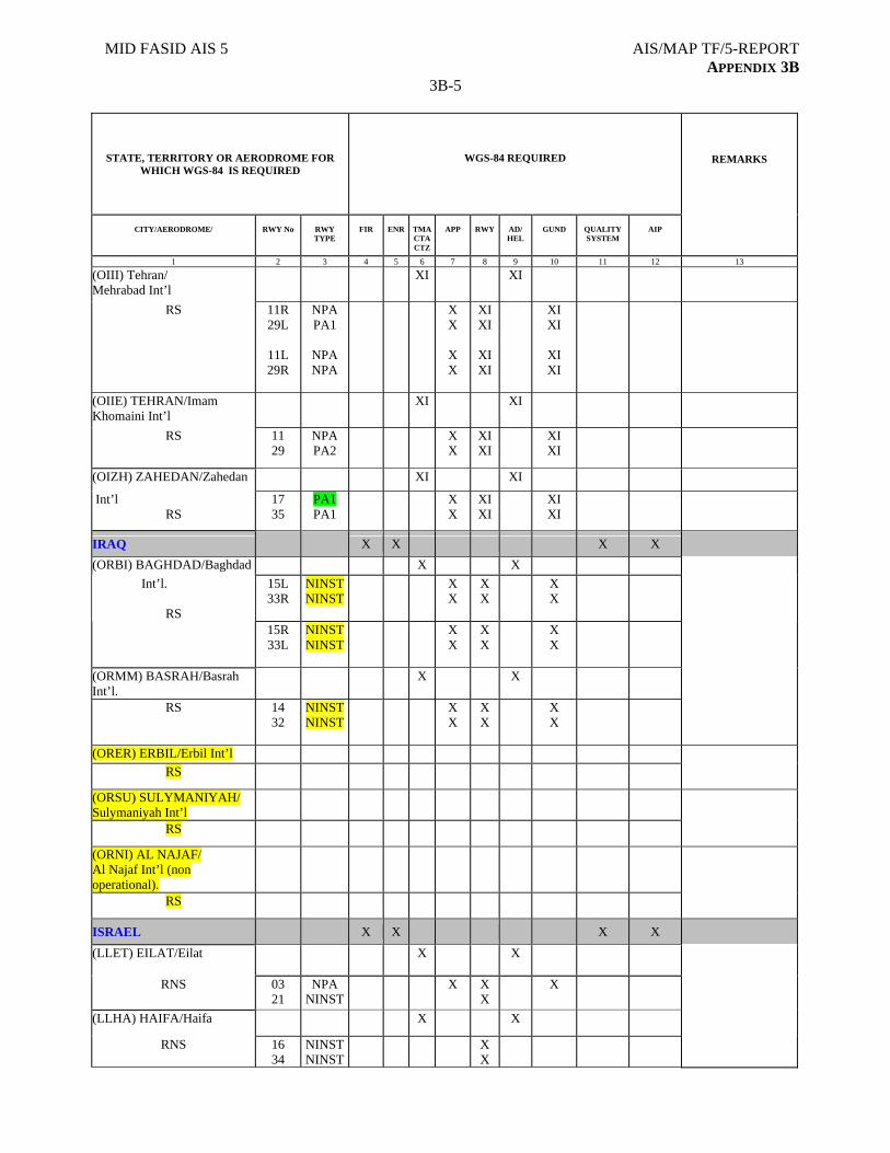
MID FASID AIS 5 AIS/MAP TF/5-REPORT APPENDIX 3B
3B-5
STATE, TERRITORY OR AERODROME FOR WHICH WGS-84 IS REQUIRED
WGS-84 REQUIRED
CITY/AERODROME/
RWY No
RWY TYPE
FIR
ENR
TMA CTA CTZ
APP
RWY
AD/ HEL
GUND
QUALITY SYSTEM
AIP
REMARKS
1 2 3 4 5 6 7 8 9 10 11 12 13
(OIII) Tehran/ Mehrabad Int’l
XI XI
RS 11R 29L
11L 29R
NPA PA1
NPA NPA
X X
X X
XI XI
XI XI
XI XI
XI XI
(OIIE) TEHRAN/Imam Khomaini Int’l
XI XI
RS 11 29
NPA PA2
X X
XI XI
XI XI
(OIZH) ZAHEDAN/Zahedan XI XI
Int’l RS
17 35
PA1 PA1
X X
XI XI
XI XI
IRAQ X X X X
(ORBI) BAGHDAD/Baghdad X X
15L 33R
NINST NINST
X X
X X
X X
Int’l.
RS 15R
33L NINST NINST
X X
X X
X X
(ORMM) BASRAH/Basrah Int’l.
X X
RS 14 32
NINST NINST
X X
X X
X X
(ORER) ERBIL/Erbil Int’l
RS
(ORSU) SULYMANIYAH/ Sulymaniyah Int’l
RS
(ORNI) AL NAJAF/ Al Najaf Int’l (non operational).
RS
ISRAEL X X X X
(LLET) EILAT/Eilat
X X
RNS 03 21
NPA NINST
X
X X
X
(LLHA) HAIFA/Haifa X X
RNS 16 34
NINST NINST
X X
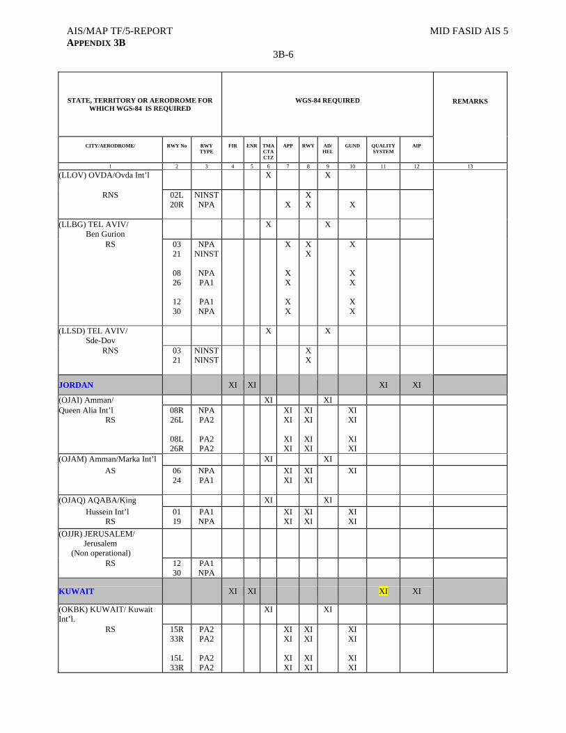
AIS/MAP TF/5-REPORT MID FASID AIS 5 APPENDIX 3B
3B-6
STATE, TERRITORY OR AERODROME FOR WHICH WGS-84 IS REQUIRED
WGS-84 REQUIRED
CITY/AERODROME/
RWY No
RWY TYPE
FIR
ENR
TMA CTA CTZ
APP
RWY
AD/ HEL
GUND
QUALITY SYSTEM
AIP
REMARKS
1 2 3 4 5 6 7 8 9 10 11 12 13
(LLOV) OVDA/Ovda Int’l
X X
RNS 02L 20R
NINST NPA
X
X X
X
(LLBG) TEL AVIV/ Ben Gurion
X X
RS 03 21
08 26
12 30
NPA NINST
NPA PA1
PA1 NPA
X
X X
X X
X X
X
X X
X X
(LLSD) TEL AVIV/ Sde-Dov
X X
RNS 03 21
NINST NINST
X X
JORDAN
XI XI XI XI
(OJAI) Amman/ XI XI Queen Alia Int’l
RS 08R 26L
08L 26R
NPA PA2
PA2 PA2
XI XI
XI XI
XI XI
XI XI
XI XI
XI XI
(OJAM) Amman/Marka Int’l XI XI
AS 06 24
NPA PA1
XI XI
XI XI
XI
(OJAQ) AQABA/King XI XI
Hussein Int’l RS
01 19
PA1 NPA
XI XI
XI XI
XI XI
(OJJR) JERUSALEM/ Jerusalem (Non operational)
RS
12 30
PA1 NPA
KUWAIT
XI XI XI XI
(OKBK) KUWAIT/ Kuwait Int’l.
XI XI
RS 15R 33R
15L 33R
PA2 PA2
PA2 PA2
XI XI
XI XI
XI XI
XI XI
XI XI
XI XI
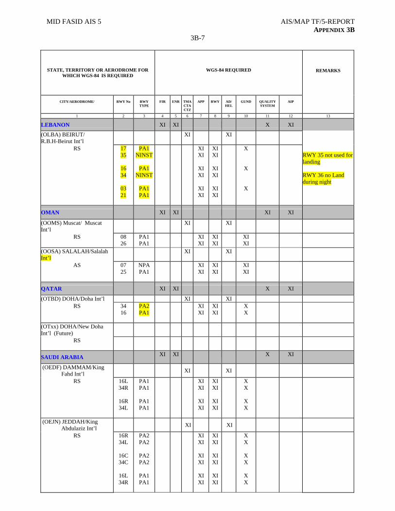
MID FASID AIS 5 AIS/MAP TF/5-REPORT APPENDIX 3B
3B-7
STATE, TERRITORY OR AERODROME FOR WHICH WGS-84 IS REQUIRED
WGS-84 REQUIRED
CITY/AERODROME/
RWY No
RWY TYPE
FIR
ENR
TMA CTA CTZ
APP
RWY
AD/ HEL
GUND
QUALITY SYSTEM
AIP
REMARKS
1 2 3 4 5 6 7 8 9 10 11 12 13
LEBANON XI XI X XI
(OLBA) BEIRUT/ R.B.H-Beirut Int’l
XI XI
RS 17 35
16 34
03 21
PA1 NINST
PA1
NINST
PA1 PA1
XI XI
XI XI
XI XI
XI XI
XI XI
XI XI
X
X
X
RWY 35 not used for landing RWY 36 no Land during night
OMAN
XI XI XI XI
(OOMS) Muscat/ Muscat Int’l
XI XI
RS
08 26
PA1 PA1
XI XI
XI XI
XI XI
(OOSA) SALALAH/Salalah Int’l
XI XI
AS
07 25
NPA PA1
XI XI
XI XI
XI XI
QATAR XI XI X XI
(OTBD) DOHA/Doha Int’l XI XI RS
34 16
PA2 PA1
XI XI
XI XI
X X
(OTxx) DOHA/New Doha Int’l (Future)
RS
SAUDI ARABIA XI XI X XI
(OEDF) DAMMAM/King Fahd Int’l
XI XI
RS 16L 34R
16R 34L
PA1 PA1
PA1 PA1
XI XI
XI XI
XI XI
XI XI
X X
X X
(OEJN) JEDDAH/King Abdulaziz Int’l
XI XI
RS 16R 34L
16C 34C
16L 34R
PA2 PA2
PA2 PA2
PA1 PA1
XI XI
XI XI
XI XI
XI XI
XI XI
XI XI
X X
X X
X X

AIS/MAP TF/5-REPORT MID FASID AIS 5 APPENDIX 3B
3B-8
STATE, TERRITORY OR AERODROME FOR WHICH WGS-84 IS REQUIRED
WGS-84 REQUIRED
CITY/AERODROME/
RWY No
RWY TYPE
FIR
ENR
TMA CTA CTZ
APP
RWY
AD/ HEL
GUND
QUALITY SYSTEM
AIP
REMARKS
1 2 3 4 5 6 7 8 9 10 11 12 13
(OEMA)MADINAH/Prince Mohammad Bin Abdulaziz
XI XI
RS 17 35
18 36
PA1 PA1
NPA PA1
XI XI
XI XI
XI XI
XI XI
X X
X X
(OERK) RIYADH/King Khalid Int’l
XI XI
RS 15L 33R
15R 33L
PA1 PA1
PA1 PA1
XI XI
XI XI
XI XI
XI XI
X X
X X
SYRIA
XI XI X XI
(OSAP) ALEPPO/Aleppo Int’l.
XI XI
RS 09 27
PA2 PA2
XI XI
XI XI
X X
(OSLK) LATTAKIA/Bassel Al-Assad
XI XI
RS 17 35
NPA PA1
XI XI XI
X
(OSDI) DAMASCUS/Damascus Int’l
XI XI
05L 23R
PA2 PA2
XI XI
XI XI
X X
RS
05R 23L
PA2 PA2
XI XI
XI XI
X X
UNITED ARAB EMIRATES
XI
XI
XI
XI
(OMAA) ABU DHABI/ Abu Dhabi Int’l
XI XI
RS
13R 31L
13L 31R
PA1 PA3
PA3 PA3
XI XI
XI XI
XI XI
XI XI
XI XI
XI XI
(OMAL) AL AIN/ Al Ain Int’l
XI XI
RS
01 19
PA1 NPA
XI XI
XI XI
XI XI
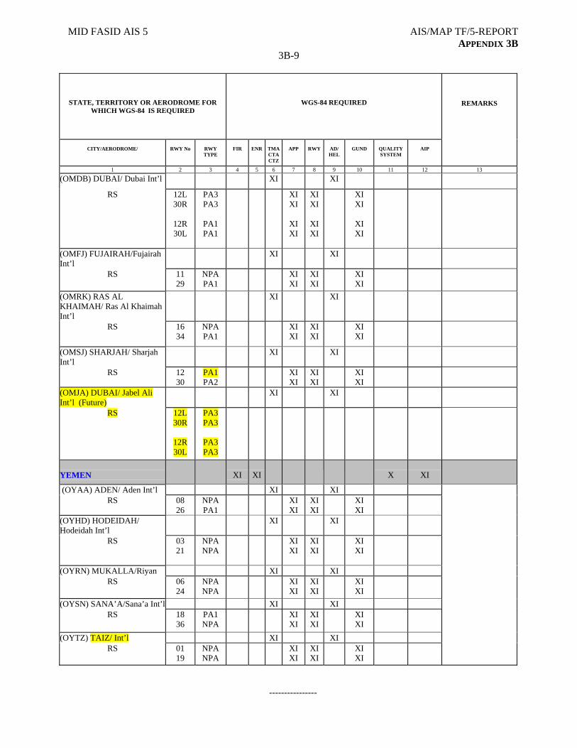
MID FASID AIS 5 AIS/MAP TF/5-REPORT APPENDIX 3B
3B-9
STATE, TERRITORY OR AERODROME FOR WHICH WGS-84 IS REQUIRED
WGS-84 REQUIRED
CITY/AERODROME/
RWY No
RWY TYPE
FIR
ENR
TMA CTA CTZ
APP
RWY
AD/ HEL
GUND
QUALITY SYSTEM
AIP
REMARKS
1 2 3 4 5 6 7 8 9 10 11 12 13
(OMDB) DUBAI/ Dubai Int’l XI XI
RS 12L 30R
12R 30L
PA3 PA3
PA1 PA1
XI XI
XI XI
XI XI
XI XI
XI XI
XI XI
(OMFJ) FUJAIRAH/Fujairah Int’l
XI XI
RS 11 29
NPA PA1
XI XI
XI XI
XI XI
(OMRK) RAS AL KHAIMAH/ Ras Al Khaimah Int’l
XI XI
RS 16 34
NPA PA1
XI XI
XI XI
XI XI
(OMSJ) SHARJAH/ Sharjah Int’l
XI XI
RS 12 30
PA1 PA2
XI XI
XI XI
XI XI
(OMJA) DUBAI/ Jabel Ali Int’l (Future)
XI XI
RS 12L 30R
12R 30L
PA3 PA3
PA3 PA3
YEMEN
XI
XI
X
XI
(OYAA) ADEN/ Aden Int’l XI XI RS 08
26 NPA PA1
XI XI
XI XI
XI XI
(OYHD) HODEIDAH/ Hodeidah Int’l
XI XI
RS 03 21
NPA NPA
XI XI
XI XI
XI XI
(OYRN) MUKALLA/Riyan XI XI RS 06
24 NPA NPA
XI XI
XI XI
XI XI
(OYSN) SANA’A/Sana’a Int’l XI XI RS 18
36 PA1 NPA
XI XI
XI XI
XI XI
(OYTZ) TAIZ/ Int’l XI XI RS 01
19 NPA NPA
XI XI
XI XI
XI XI
----------------

AIS/MAP TF/5-REPORT APPENDIX 3C
AIS/MAP TF/5
Appendix 3C to the Report on Agenda Item 3
STATUS OF IMPLEMENTATION OF WGS-84 IN THE MID REGION
FIR ENR TMA/CTA/CTZ APP RWY AD/HEL GUND
QUALITYSYSTEM
AIP REMARKS
AFGHANISTAN N N N N N N N N N
BAHRAIN F F F F F F F F F
EGYPT F F F F F F F F F
IRAN F F F N F F F F F
IRAQ P P P P P P N N P
ISRAEL F F F F P F F N F
JORDAN F F F F F F F F F
KUWAIT F F F F F F F F F
LEBANON F F F F F F N N F
OMAN F F F F F F F F F
QATAR F F F F F F N N F
SAUDI ARABIA F F F F F F N F F GUND implementation under process
SYRIA F F F F F F N N F
UNITED ARAB EMIRATES
F F F F F F F F F
YEMEN F F F F F F F N F
Legend: F: Fully implemented P: Partly implemented N: Not implemented
-------------------
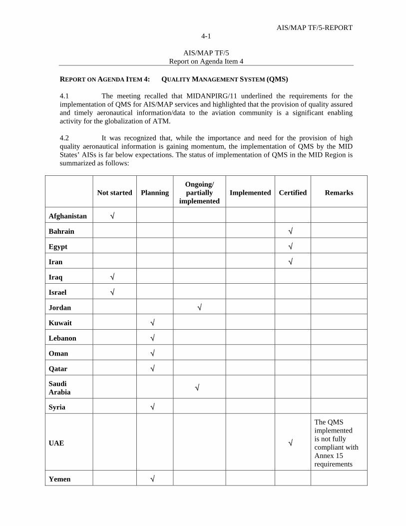
AIS/MAP TF/5-REPORT 4-1
AIS/MAP TF/5
Report on Agenda Item 4
REPORT ON AGENDA ITEM 4: QUALITY MANAGEMENT SYSTEM (QMS) 4.1 The meeting recalled that MIDANPIRG/11 underlined the requirements for the implementation of QMS for AIS/MAP services and highlighted that the provision of quality assured and timely aeronautical information/data to the aviation community is a significant enabling activity for the globalization of ATM. 4.2 It was recognized that, while the importance and need for the provision of high quality aeronautical information is gaining momentum, the implementation of QMS by the MID States’ AISs is far below expectations. The status of implementation of QMS in the MID Region is summarized as follows:
Not started Planning Ongoing/ partially
implemented Implemented Certified Remarks
Afghanistan
Bahrain
Egypt
Iran
Iraq
Israel
Jordan
Kuwait
Lebanon
Oman
Qatar
Saudi Arabia
Syria
UAE
The QMS implemented is not fully compliant with Annex 15 requirements
Yemen
AIS/MAP TF/5–REPORT 4-2
AIS/MAP TF/5
Report on Agenda Item 4
4.3 The meeting recalled that MIDANPIRG/11 noted that EUROCONTROL, through the Controlled and Harmonized Aeronautical Information Network project “CHAIN”, supported the European States in meeting ICAO requirements related to QMS (awareness campaigns, development of guidelines, development of Computer Based Training “CBT”, etc). 4.4 In connection with the above, the meeting noted that MIDANPIRG/11 urged those States that have not yet done so, to implement the required QMS in accordance with the guidance provided by both the Methodology for the implementation of QMS at Appendix 4A to the Report on Agenda Item 4 and the CHAIN deliverables. Accordingly, MIDANPIRG/11 agreed to the following Conclusion:
CONCLUSION 11/46: IMPLEMENTATION OF QMS WITHIN MID STATES’ AISs
That, in accordance with Annex 15 provisions, States, that have not yet done so, are urged to implement/complete the implementation of a QMS within their AIS, before December 2010, based on the methodology for the implementation of QMS at Appendix 5.3F to the Report on Agenda Item 5.3 and the EUROCONTROL CHAIN deliverables.
4.5 The meeting reviewed and updated the Terms of Reference (TOR) of the QMS Implementation Action Group (QMS AG) as at Appendix 4B to the Report on Agenda Item 4. In this regard, it was recalled that the QMS AG was established with a view to support the implementation of QMS in compliance with the ISO 9000 requirements within MID States’ AISs. However, the meeting noted that the activities of the Action Group were very limited and that the tasks assigned to it were not completed. Accordingly, the meeting urged States to provide more input and support to the Action Group and encouraged the Members of the Action Group to use the electronic means of communication, including the ICAO MID Forum, for the exchange of information related to QMS and the sharing of experiences. In this regard, the meeting noted with appreciation the experiences of Iran and Jordan for the implementation of QMS and encouraged the Members of the QMS AG to benefit from the experience of those States that have already implemented a QMS or are in an advance phase of implementation. The importance of the commitment of the high level Management including the development of a quality policy as well as the convening of awareness campaigns and training programmes related to QMS were particularly highlighted. 4.6 Based on the above, the meeting agreed to the following Draft Conclusion and Decision:
DRAFT CONCLUSION 5/2: AWARENESS CAMPAIGNS AND TRAINING PROGRAMMES ON QMS
That, MID States, with the support of ICAO and the QMS Implementation Action Group (QMS AG), organize, at the National level, awareness campaigns and training programmes to promote and expedite the process of implementation of QMS for AIS.

AIS/MAP TF/5-REPORT 4-3
AIS/MAP TF/5
Report on Agenda Item 4
DRAFT DECISION 5/3: TERMS OF REFERENCE OF THE QMS
IMPLEMENTATION ACTION GROUP That, the Terms of Reference of the QMS Implementation Action Group (QMS AG)
be updated as at Appendix 4B to the Report on Agenda Item 4. 4.7 The meeting was informed that Amendment 36 to Annex 15 would introduce new provisions related to QMS. It was highlighted in this regard that the proposal for amendment which was issued on 23 April 2009 through State Letter Ref.: AN 2/2.2-09/13 clarifies the scope of the QMS to encompass all organizations involved in the data processing chain, from the point of origin/survey, through to the AIS and distribution of the data to the intended user. The part of draft Amendment 36 to Annex 15 related to QMS attached as Appendix 4C to the Report on Agenda Item 4 was reviewed and supported by the meeting. However, it was highlighted that comments on the proposal for amendment to Annex 15 are expected to reach Montreal before 6 August 2009 and accordingly, the meeting urged States to further study the proposal for amendment and send their comments to ICAO Headquarters before the set deadline. Furthermore, the meeting was informed that during its preliminary review, the Air Navigation Commission (ANC) requested that States be consulted regarding the status of implementation of QMS. In this regard, States were requested to reply to the questionnaire at Attachment G of the State Letter giving information on their Action Plan for the implementation of QMS and the associated cost. 4.8 The meeting considered that an ICAO AIS Quality Manual was required to support the consistent implementation of QMS. In this regard, the meeting noted that the AIS-AIM SG/1 meeting held in Montreal 2-4 December 2008 addressed this issue and agreed to the establishment of an ad-hoc group to develop a draft AIS Quality Manual and present it to the AIS-AIM SG/2 meeting (November 2009) for review. It was also highlighted that in order to meet the Annex 15 requirements related to data integrity, States would require clear guidance on the means to measure integrity throughout the data supply chain. Accordingly, the ad-hoc group was tasked to develop guidance material on the means for measuring integrity to be included in the AIS Quality Manual. 4.9 Based on the above, the meeting reiterated MIDANPIRG/11 Conclusion 11/46 and urged States that have not yet done so, to implement/complete the implementation of a QMS within their AIS, before December 2010 as requested by MIDANPIRG, taking into consideration the new requirements which would be introduced by Amendment 36 to Annex 15. Licensing of the AIS/MAP Personnel 4.10 The meeting recalled that, recognizing the importance of AIS as an essential foundation block of the future ATM operational concept and the safety implication of the non-provision of timely and high quality aeronautical information, and taking into consideration Annex 15 requirements for the evaluation and maintenance of the competence/skills of the AIS staff, MIDANPIRG/10 was of view that AIS/MAP personnel should be licensed and through Conclusion 10/53, invited ICAO to consider the introduction of the licensing of the AIS/MAP personnel as a Recommended Practice in Annex 1. 4.11 The meeting noted that the ANC during its review of the MIDANPIRG/10 report and especially Conclusion 10/53 recognized that the competency of personnel involved in safety critical activities was paramount, but that such competencies could be achieved without licensing.
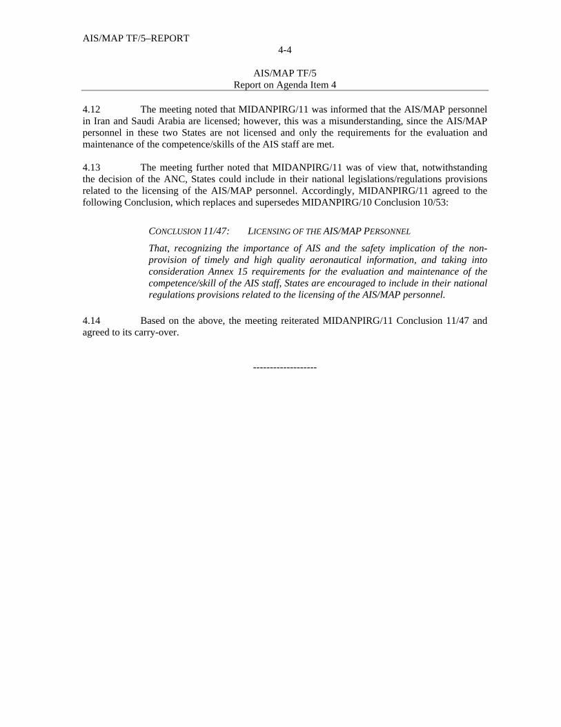
AIS/MAP TF/5–REPORT 4-4
AIS/MAP TF/5
Report on Agenda Item 4
4.12 The meeting noted that MIDANPIRG/11 was informed that the AIS/MAP personnel in Iran and Saudi Arabia are licensed; however, this was a misunderstanding, since the AIS/MAP personnel in these two States are not licensed and only the requirements for the evaluation and maintenance of the competence/skills of the AIS staff are met. 4.13 The meeting further noted that MIDANPIRG/11 was of view that, notwithstanding the decision of the ANC, States could include in their national legislations/regulations provisions related to the licensing of the AIS/MAP personnel. Accordingly, MIDANPIRG/11 agreed to the following Conclusion, which replaces and supersedes MIDANPIRG/10 Conclusion 10/53:
CONCLUSION 11/47: LICENSING OF THE AIS/MAP PERSONNEL
That, recognizing the importance of AIS and the safety implication of the non-provision of timely and high quality aeronautical information, and taking into consideration Annex 15 requirements for the evaluation and maintenance of the competence/skill of the AIS staff, States are encouraged to include in their national regulations provisions related to the licensing of the AIS/MAP personnel.
4.14 Based on the above, the meeting reiterated MIDANPIRG/11 Conclusion 11/47 and agreed to its carry-over.
-------------------
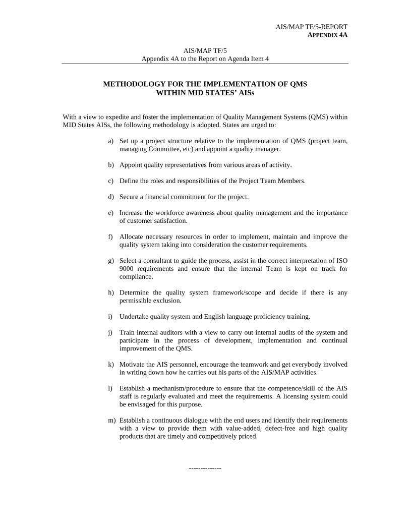
AIS/MAP TF/5-REPORT APPENDIX 4A
AIS/MAP TF/5
Appendix 4A to the Report on Agenda Item 4
METHODOLOGY FOR THE IMPLEMENTATION OF QMS WITHIN MID STATES’ AISs With a view to expedite and foster the implementation of Quality Management Systems (QMS) within MID States AISs, the following methodology is adopted. States are urged to:
a) Set up a project structure relative to the implementation of QMS (project team, managing Committee, etc) and appoint a quality manager.
b) Appoint quality representatives from various areas of activity.
c) Define the roles and responsibilities of the Project Team Members.
d) Secure a financial commitment for the project.
e) Increase the workforce awareness about quality management and the importance
of customer satisfaction.
f) Allocate necessary resources in order to implement, maintain and improve the quality system taking into consideration the customer requirements.
g) Select a consultant to guide the process, assist in the correct interpretation of ISO
9000 requirements and ensure that the internal Team is kept on track for compliance.
h) Determine the quality system framework/scope and decide if there is any
permissible exclusion.
i) Undertake quality system and English language proficiency training.
j) Train internal auditors with a view to carry out internal audits of the system and participate in the process of development, implementation and continual improvement of the QMS.
k) Motivate the AIS personnel, encourage the teamwork and get everybody involved
in writing down how he carries out his parts of the AIS/MAP activities.
l) Establish a mechanism/procedure to ensure that the competence/skill of the AIS staff is regularly evaluated and meet the requirements. A licensing system could be envisaged for this purpose.
m) Establish a continuous dialogue with the end users and identify their requirements
with a view to provide them with value-added, defect-free and high quality products that are timely and competitively priced.
--------------

AIS/MAP TF/5-REPORT APPENDIX 4B
AIS/MAP TF/5
Appendix 4B to the Report on Agenda Item 4
MID REGION QUALITY MANAGEMENT SYSTEM IMPLEMENTATION
ACTION GROUP (QMS AG)
A) TERMS OF REFERENCE
With a view to support the implementation of Quality Management System in compliance with the ISO 9000 requirements within MID States’ AISs, the MID Region QMS Action Group shall:
1) identify the difficulties that MID States could have to comply with Annex 15
requirements pertaining to quality system; 2) develop a common understanding of ISO 9000 requirements and develop associated
guidelines as required; 3) foster the implementation of the methodology adopted in the MID Region for the
implementation of QMS within Aeronautical Information Services; 4) guide the development and support the roll-out of an awareness campaign for QMS
implementation within MID States; and 5) monitor the implementation of QMS within MID States’ AISs.
B) COMPOSITION
The QMS AG will be composed of the following Experts:
State Member’s Name and Title Member’s Contact Details
Mr. Mohammed Al Hallaq
Fax: (973) 17 32 181 Tel: (973) 17322 182 Mobile: (973) 3968 4688 Email: [email protected]
Bahrain * (Rapporteur of the AG)
Mr. Ali Abdulla AlMutaie AIS data Supervisor
Fax: (973) 17323876 Tel: (973) 17321181 Mobile: (973) 39697374 Email: [email protected]
Egypt Mr. Mahfouz Mostafa Ahmed General Manager of AIS Publications
Fax: (20) 2 2267 8882/5 Tel: (20) 2 2267 9009 Mobile: (20) 10 8555079 Email: [email protected] [email protected]
Iran Mr. Amir Ghahremani AIS Expert
Fax: +9821 44649269 Tel: +9821 66025108 Mobile: +989124122230 Email: [email protected]
AIS/MAP TF/5-REPORT APPENDIX 4B
4B-2
State Member’s Name and Title Member’s Contact Details
Mrs. Narges Assari AIS Expert
Tel : +9821 66025108 Fax : +9821 44649269 Mobile: +98910102005738 Email: [email protected]
Jordan
Mrs. Hanan Qabartai Chief AIS HQ
Tel: (962) 6 4892282 ext. 3525 Fax: (962) 6 4891266 Mobile: (962)796768012 Email: [email protected]
Kuwait Mr. Salah Al Mushaiti AIS Officer
Tel: (965-2) 473 7583 Fax: (965-2) 476 5512 Mobile: (965) 6668 1897 Email: [email protected]
Oman Mr. Jaffar Abdulamir AIS Officer
Tel: +968 24518350 Fax: +968 24519850 Mobile: +968 99316040 Email: [email protected]
Saudi Arabia Mr. Gharman Abdel Aziz El Shahri Chief of Charting Office
Fax: (966) 6405000 Ext. 2302 Tel: (966) 640 5000 Ext 2300 Mobile: (966) 504 700 111 Email: [email protected]
Yemen Mr. Hussein Al –Sureihi Director of AIS-HQ
Fax: (967-1) 345 527 Tel: (967-1) 346652/3 Mobile: (967) 77777 6898 Email: [email protected]
C) WORKING ARRANGEMENTS
The QMS AG shall report to the AIS/MAP Task Force. The work of the QMS AG shall be carried out mainly through exchange of correspondence, between its Members using all means of communication (email, facsimile, Tel, Teleconferencing, ICAO MID Forum, etc).
---------------
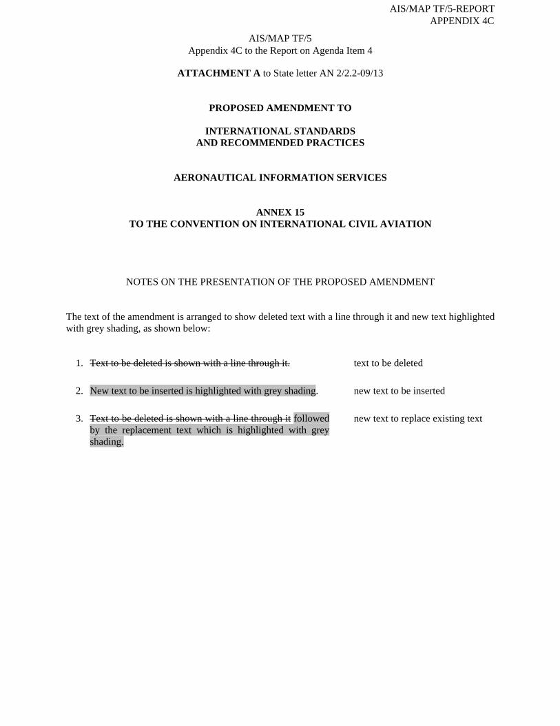
ATTACHMENT A to State letter AN 2/2.2-09/13
PROPOSED AMENDMENT TO
INTERNATIONAL STANDARDS AND RECOMMENDED PRACTICES
AERONAUTICAL INFORMATION SERVICES
ANNEX 15 TO THE CONVENTION ON INTERNATIONAL CIVIL AVIATION
NOTES ON THE PRESENTATION OF THE PROPOSED AMENDMENT The text of the amendment is arranged to show deleted text with a line through it and new text highlighted with grey shading, as shown below:
1. Text to be deleted is shown with a line through it. text to be deleted
2. New text to be inserted is highlighted with grey shading. new text to be inserted
3. Text to be deleted is shown with a line through it followed by the replacement text which is highlighted with grey shading.
new text to replace existing text
AIS/MAP TF/5 Appendix 4C to the Report on Agenda Item 4
AIS/MAP TF/5-REPORT APPENDIX 4C
Skodsi
Typewritten Text
__________________________________________________________________________________
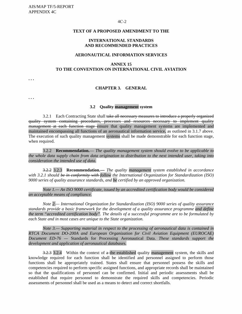
4C-2
TEXT OF A PROPOSED AMENDMENT TO THE
INTERNATIONAL STANDARDS AND RECOMMENDED PRACTICES
AERONAUTICAL INFORMATION SERVICES
ANNEX 15
TO THE CONVENTION ON INTERNATIONAL CIVIL AVIATION . . .
CHAPTER 3. GENERAL . . .
3.2 Quality management system
3.2.1 Each Contracting State shall take all necessary measures to introduce a properly organized quality system containing procedures, processes and resources necessary to implement quality management at each function stage ensure that quality management systems are implemented and maintained encompassing all functions of an aeronautical information service, as outlined in 3.1.7 above. The execution of such quality management systems shall be made demonstrable for each function stage, when required.
3.2.2 Recommendation.— The quality management system should evolve to be applicable to the whole data supply chain from data origination to distribution to the next intended user, taking into consideration the intended use of data.
3.2.2 3.2.3 Recommendation.— The quality management system established in accordance with 3.2.1 should be in conformity with follow the International Organization for Standardization (ISO) 9000 series of quality assurance standards, and be certified by an approved organization.
Note 1.— An ISO 9000 certificate, issued by an accredited certification body would be considered an acceptable means of compliance.
Note 2.— International Organization for Standardization (ISO) 9000 series of quality assurance standards provide a basic framework for the development of a quality assurance programme and define the term “accredited certification body”. The details of a successful programme are to be formulated by each State and in most cases are unique to the State organization.
Note 3.— Supporting material in respect to the processing of aeronautical data is contained in RTCA Document DO-200A and European Organization for Civil Aviation Equipment (EUROCAE) Document ED-76 — Standards for Processing Aeronautical Data. These standards support the development and application of aeronautical databases.
3.2.3 3.2.4 Within the context of a the established quality management system, the skills and knowledge required for each function shall be identified and personnel assigned to perform those functions shall be appropriately trained. States shall ensure that personnel possess the skills and competencies required to perform specific assigned functions, and appropriate records shall be maintained so that the qualifications of personnel can be confirmed. Initial and periodic assessments shall be established that require personnel to demonstrate the required skills and competencies. Periodic assessments of personnel shall be used as a means to detect and correct shortfalls.
AIS/MAP TF/5-REPORT APPENDIX 4C
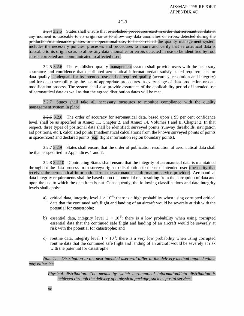
4C-3
3.2.4 3.2.5 States shall ensure that established procedures exist in order that aeronautical data at any moment is traceable to its origin so as to allow any data anomalies or errors, detected during the production/maintenance phases or in operational use, to be corrected the quality management system includes the necessary policies, processes and procedures to assure and verify that aeronautical data is traceable to its origin so as to allow any data anomalies or errors detected in use to be identified by root cause, corrected and communicated to affected users.
3.2.5 3.2.6 The established quality management system shall provide users with the necessary assurance and confidence that distributed aeronautical information/data satisfy stated requirements for data quality is adequate for its intended use and of required quality (accuracy, resolution and integrity) and for data traceability by the use of appropriate procedures in every stage of data production or data modification process. The system shall also provide assurance of the applicability period of intended use of aeronautical data as well as that the agreed distribution dates will be met.
3.2.7 States shall take all necessary measures to monitor compliance with the quality management system in place.
3.2.6 3.2.8 The order of accuracy for aeronautical data, based upon a 95 per cent confidence level, shall be as specified in Annex 11, Chapter 2, and Annex 14, Volumes I and II, Chapter 2. In that respect, three types of positional data shall be identified: surveyed points (runway thresholds, navigation aid positions, etc.), calculated points (mathematical calculations from the known surveyed points of points in space/fixes) and declared points (e.g. flight information region boundary points).
3.2.7 3.2.9 States shall ensure that the order of publication resolution of aeronautical data shall be that as specified in Appendices 1 and 7.
3.2.8 3.2.10 Contracting States shall ensure that the integrity of aeronautical data is maintained throughout the data process from survey/origin to distribution to the next intended user (the entity that receives the aeronautical information from the aeronautical information service provider). Aeronautical data integrity requirements shall be based upon the potential risk resulting from the corruption of data and upon the use to which the data item is put. Consequently, the following classifications and data integrity levels shall apply:
a) critical data, integrity level 1 × 10⁻⁸: there is a high probability when using corrupted critical data that the continued safe flight and landing of an aircraft would be severely at risk with the potential for catastrophe;
b) essential data, integrity level 1 × 10⁻⁵: there is a low probability when using corrupted
essential data that the continued safe flight and landing of an aircraft would be severely at risk with the potential for catastrophe; and
c) routine data, integrity level 1 × 10⁻³: there is a very low probability when using corrupted
routine data that the continued safe flight and landing of an aircraft would be severely at risk with the potential for catastrophe.
Note 1.— Distribution to the next intended user will differ in the delivery method applied which
may either be:
Physical distribution. The means by which aeronautical information/data distribution is achieved through the delivery of a physical package, such as postal services.
or
AIS/MAP TF/5-REPORT APPENDIX 4C
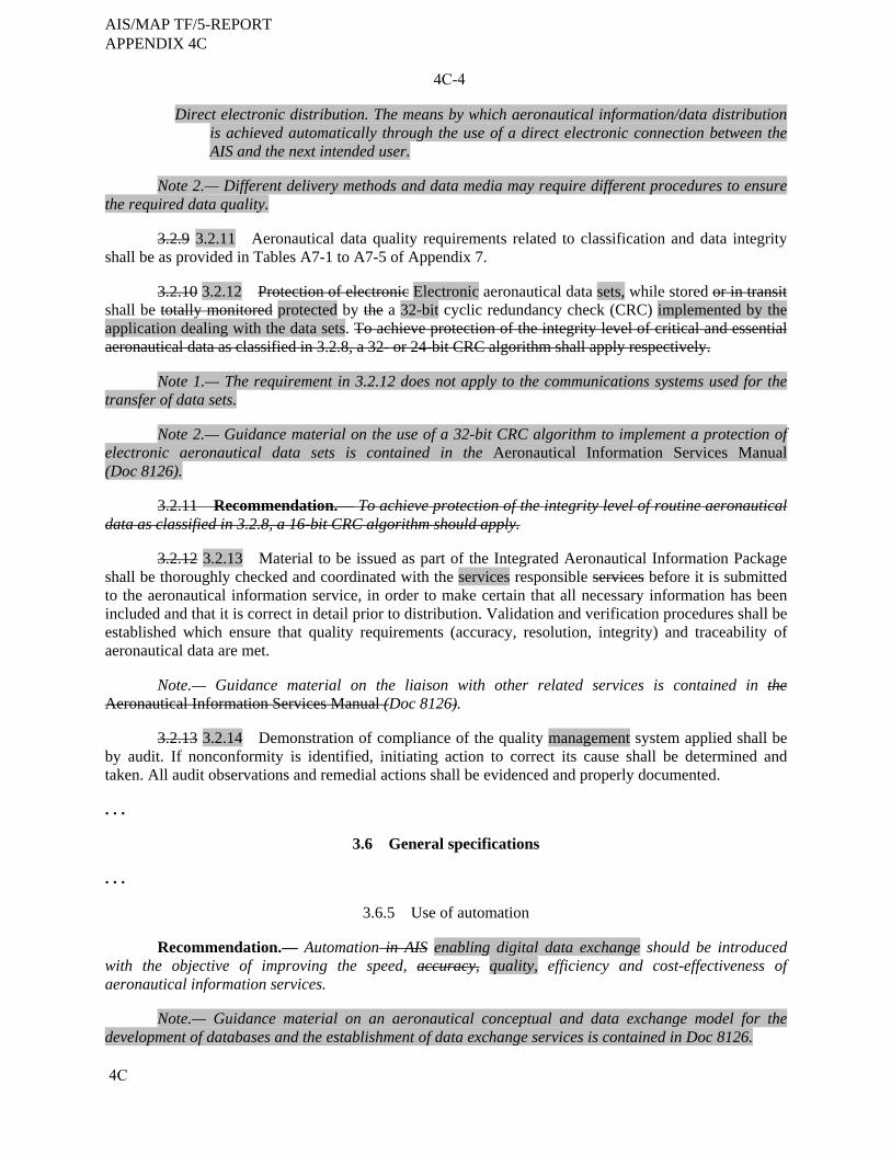
4C
4C-4
Direct electronic distribution. The means by which aeronautical information/data distribution is achieved automatically through the use of a direct electronic connection between the AIS and the next intended user.
Note 2.— Different delivery methods and data media may require different procedures to ensure
the required data quality.
3.2.9 3.2.11 Aeronautical data quality requirements related to classification and data integrity shall be as provided in Tables A7-1 to A7-5 of Appendix 7.
3.2.10 3.2.12 Protection of electronic Electronic aeronautical data sets, while stored or in transit shall be totally monitored protected by the a 32-bit cyclic redundancy check (CRC) implemented by the application dealing with the data sets. To achieve protection of the integrity level of critical and essential aeronautical data as classified in 3.2.8, a 32- or 24-bit CRC algorithm shall apply respectively.
Note 1.— The requirement in 3.2.12 does not apply to the communications systems used for the transfer of data sets.
Note 2.— Guidance material on the use of a 32-bit CRC algorithm to implement a protection of electronic aeronautical data sets is contained in the Aeronautical Information Services Manual (Doc 8126).
3.2.11 Recommendation.— To achieve protection of the integrity level of routine aeronautical data as classified in 3.2.8, a 16-bit CRC algorithm should apply.
3.2.12 3.2.13 Material to be issued as part of the Integrated Aeronautical Information Package shall be thoroughly checked and coordinated with the services responsible services before it is submitted to the aeronautical information service, in order to make certain that all necessary information has been included and that it is correct in detail prior to distribution. Validation and verification procedures shall be established which ensure that quality requirements (accuracy, resolution, integrity) and traceability of aeronautical data are met.
Note.— Guidance material on the liaison with other related services is contained in the Aeronautical Information Services Manual (Doc 8126).
3.2.13 3.2.14 Demonstration of compliance of the quality management system applied shall be by audit. If nonconformity is identified, initiating action to correct its cause shall be determined and taken. All audit observations and remedial actions shall be evidenced and properly documented. . . .
3.6 General specifications . . .
3.6.5 Use of automation
Recommendation.— Automation in AIS enabling digital data exchange should be introduced with the objective of improving the speed, accuracy, quality, efficiency and cost-effectiveness of aeronautical information services.
Note.— Guidance material on an aeronautical conceptual and data exchange model for the development of databases and the establishment of data exchange services is contained in Doc 8126.
AIS/MAP TF/5-REPORT APPENDIX 4C

4C-5
. . .
3.6.7 Human Factors considerations
3.6.7.1 The organization of the aeronautical information services as well as the design, contents, processing and distribution of aeronautical information/data shall take into consideration Human Factors principles which facilitate their optimum utilization.
3.6.7.2 Due consideration shall be given to the integrity of information where human interaction is required and mitigating steps taken where risks are identified.
Note.— This may be accomplished through the design of systems, through operating procedures or through improvements in the operating environment. . . .
3.8 Metadata
3.8.1 Each Contracting State shall collect metadata for aeronautical information/data processes and/or exchange points. This metadata collection shall be applied throughout the data supply chain, from survey/origin to distribution to the next intended user by the aeronautical information service.
Note.— ISO Standard 19115 specifies requirements for geographic information metadata.
3.8.2 The metadata to be collected shall include, as a minimum:
a) the name of the organization or entity performing the function;
b) the function performed; and
c) the date and time of operation. . . .
CHAPTER 4. AERONAUTICAL INFORMATION PUBLICATIONS (AIP) . . .
4.3 Specifications for AIP Amendments . . .
4.3.4 Each AIRAC AIP Amendment page, including the cover sheet, shall display an effective date. When an effective time other than 0000 UTC is used, the effective time shall also be displayed on the cover sheet. . . .
AIS/MAP TF/5-REPORT APPENDIX 4C
Skodsi
Typewritten Text
----------
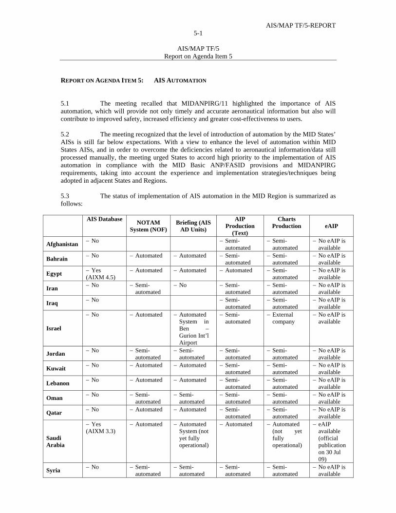
AIS/MAP TF/5-REPORT 5-1
AIS/MAP TF/5
Report on Agenda Item 5
REPORT ON AGENDA ITEM 5: AIS AUTOMATION 5.1 The meeting recalled that MIDANPIRG/11 highlighted the importance of AIS automation, which will provide not only timely and accurate aeronautical information but also will contribute to improved safety, increased efficiency and greater cost-effectiveness to users. 5.2 The meeting recognized that the level of introduction of automation by the MID States’ AISs is still far below expectations. With a view to enhance the level of automation within MID States AISs, and in order to overcome the deficiencies related to aeronautical information/data still processed manually, the meeting urged States to accord high priority to the implementation of AIS automation in compliance with the MID Basic ANP/FASID provisions and MIDANPIRG requirements, taking into account the experience and implementation strategies/techniques being adopted in adjacent States and Regions. 5.3 The status of implementation of AIS automation in the MID Region is summarized as follows:
AIS Database
NOTAM System (NOF)
Briefing (AIS AD Units)
AIP Production
(Text)
Charts Production
eAIP
Afghanistan No Semi-
automated Semi-
automated No eAIP is
available
Bahrain No Automated Automated Semi-
automated Semi-
automated No eAIP is
available
Egypt Yes (AIXM 4.5)
Automated Automated Automated
Semi-automated
No eAIP is available
Iran No Semi-automated
No
Semi-automated
Semi-automated
No eAIP is available
Iraq No Semi-automated
Semi-automated
No eAIP is available
Israel
No Automated
Automated System in Ben –Gurion Int’l Airport
Semi-automated
External company
No eAIP is available
Jordan No Semi-automated
Semi-automated
Semi-automated
Semi-automated
No eAIP is available
Kuwait No Automated
Automated
Semi-automated
Semi-automated
No eAIP is available
Lebanon No Automated
Automated
Semi-automated
Semi-automated
No eAIP is available
Oman No Semi-
automated Semi-
automated Semi-
automated Semi-
automated No eAIP is
available
Qatar No Automated Automated
Semi-
automated Semi-
automated No eAIP is
available
Saudi Arabia
Yes (AIXM 3.3)
Automated
Automated System (not yet fully operational)
Automated Automated (not yet fully operational)
eAIP available (official publication on 30 Jul 09)
Syria No Semi-
automated Semi-
automated Semi-
automated Semi-
automated No eAIP is
available
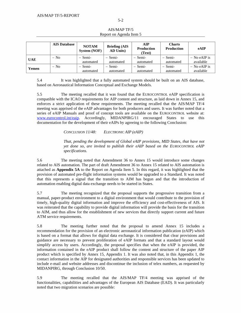
AIS/MAP TF/5-REPORT 5-2
AIS/MAP TF/5
Report on Agenda Item 5
AIS Database
NOTAM System (NOF)
Briefing (AIS AD Units)
AIP Production
(Text)
Charts Production
eAIP
UAE No Semi-
automated Semi-
automated Semi-
automated Semi-
automated No eAIP is
available
Yemen No Semi-
automated Semi-
automated Semi-
automated Semi-
automated No eAIP is
available 5.4 It was highlighted that a fully automated system should be built on an AIS database, based on Aeronautical Information Conceptual and Exchange Models. 5.5 The meeting recalled that it was found that the EUROCONTROL eAIP specification is compatible with the ICAO requirements for AIP content and structure, as laid down in Annex 15, and enforces a strict application of these requirements. The meeting recalled that the AIS/MAP TF/4 meeting was apprised of the eAIP advantages for both producers and users. It was further noted that a series of eAIP Manuals and proof of concept tools are available on the EUROCONTROL website at: www.eurocontrol.int/eaip. Accordingly, MIDANPIRG/11 encouraged States to use this documentation for the development of their eAIPs by agreeing to the following Conclusion: CONCLUSION 11/48: ELECTRONIC AIP (eAIP)
That, pending the development of Global eAIP provisions, MID States, that have not yet done so, are invited to publish their eAIP based on the EUROCONTROL eAIP specifications.
5.6 The meeting noted that Amendment 36 to Annex 15 would introduce some changes related to AIS automation. The part of draft Amendment 36 to Annex 15 related to AIS automation is attached as Appendix 5A to the Report on Agenda Item 5. In this regard, it was highlighted that the provision of automated pre-flight information systems would be upgraded to a Standard. It was noted that this represents a signal that the transition to AIM has begun and that the introduction of automation enabling digital data exchange needs to be started in States. 5.7 The meeting recognized that the proposal supports the progressive transition from a manual, paper-product environment to a digital environment that would contribute to the provision of timely, high-quality digital information and improve the efficiency and cost-effectiveness of AIS. It was reiterated that the capability to provide digital information will provide the basis for the transition to AIM, and thus allow for the establishment of new services that directly support current and future ATM service requirements. 5.8 The meeting further noted that the proposal to amend Annex 15 includes a recommendation for the provision of an electronic aeronautical information publication (eAIP) which is based on a format that allows for digital data exchange. It is considered that clear provisions and guidance are necessary to prevent proliferation of eAIP formats and that a standard layout would simplify access by users. Accordingly, the proposal specifies that when the eAIP is provided, the information contained in the eAIP product shall follow the content and structure of the paper AIP product which is specified by Annex 15, Appendix 1. It was also noted that, in this Appendix 1, the contact information in the AIP for designated authorities and responsible services has been updated to include e-mail and website addresses and discontinue the inclusion of telex numbers, as requested by MIDANPIRG, through Conclusion 10/50. 5.9 The meeting recalled that the AIS/MAP TF/4 meeting was apprised of the functionalities, capabilities and advantages of the European AIS Database (EAD). It was particularly noted that two migration scenarios are possible:
AIS/MAP TF/5-REPORT 5-3
AIS/MAP TF/5
Report on Agenda Item 5
direct connection to EAD system; and regional replica of the EAD.
5.10 The meeting noted that the AIS/MAP TF/4 meeting was informed about the Europe-Middle East ATM Coordination (EMAC) mechanism/activities. The meeting recalled that within the framework of EMAC the exchange of aeronautical information was considered as a potential area of cooperation. 5.11 The meeting was informed about the actions carried out by Jordan, in coordination with Eurocontrol, in order to be connected to the EAD. It was noted in this regard that through the EMAC and EUROMED Aviation projects, Jordan was invited, as well as other EUROMED Beneficiary States, to be connected to the EAD as a data provider and/or data user. 5.12 The meeting noted that Jordan decided to plan the migration to the EAD in three phases:
Phase 1: implementation of the EAD integrated AIS office solution by maintaining INO, SDO and PAMS information and disseminating relevant data via the EAD terminal (EADPRO);
Phase 2: implementation of the Briefing Facility at the different ATS reporting
offices; and Phase 3: evaluation of the feasibility to implement the eAIP and Chart production
according to the Jordanian Civil Aviation Regulatory Commission (CARC) requirements and EUROCONTROL specifications.
5.13 The meeting was apprised of the migration steps undertaken/planned by Jordan to migrate to the EAD. The meeting was also informed about the cost estimate of the project. 5.14 Based on the above, the meeting thanked Jordan for sharing this information and encouraged other States to do so. 5.15 The meeting further noted that Egypt is in the process of coordination with EUROCONTROL for the development of a migration and transition plan with a view to be connected to the EAD. 5.16 The meeting was informed also about Iran activities and plans related to AIS automation. 5.17 Based on the above, the meeting re-iterated MIDANPIRG/11 Conclusion 11/49 as follows: CONCLUSION 11/49: EXTENSION OF THE EAD TO THE EMAC STATES
That, the EMAC States (Egypt, Jordan, Lebanon and Syria) are encouraged to initiate formal coordination with EUROCONTROL and take appropriate actions in order to be connected to the European AIS Database (EAD).

AIS/MAP TF/5-REPORT 5-4
AIS/MAP TF/5
Report on Agenda Item 5
5.18 The meeting recalled that MIDANPIRG/11, through Decision 11/50, agreed to the establishment of an AIS Automation Action Group (AISA AG). However, the meeting noted with concern that the activities of the Action Group were very limited and that the tasks assigned to it were not completed. It was highlighted that the AISA AG was established with a view to foster and harmonize the implementation of AIS Automation in the MID Region. The AISA AG should represent a forum for discussion, brainstorming, exchange of experience and sharing of information related to AIS Automation. The final objective of the AISA AG is to develop a cohesive and comprehensive AIS Automation Plan for the MID Region. To reach the above-mentioned goals, the meeting agreed that the Members of the AISA AG should be committed to contribute to the activities of Action Group. Accordingly, the meeting urged States to provide more input and support to the Action Group and encouraged its Members to use all means of communications for the exchange of information and sharing of experiences related to AIS automation (E-mails, ICAO MID Forum, Teleconferencing, etc). 5.19 Based on the above, the meeting reviewed and updated the TOR of the AISA AG as at Appendix 5B to the Report on Agenda Item 5 and agreed accordingly to the following Draft Decision, which is proposed to replace and supersede MIDANPIRG/11 Decision 11/50:
DRAFT DECISION 5/4: TERMS OF REFERENCE OF THE AIS AUTOMATION
ACTION GROUP That, the Terms of Reference of the AIS Automation Action Group (AISA AG) be updated as at Appendix 5B to the Report on Agenda Item 5.
---------------------------
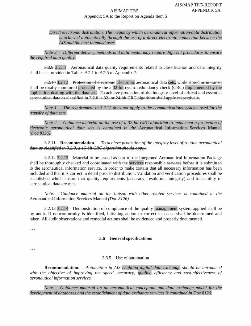
-
Direct electronic distribution. The means by which aeronautical information/data distribution is achieved automatically through the use of a direct electronic connection between the AIS and the next intended user.
Note 2.— Different delivery methods and data media may require different procedures to ensure
the required data quality.
3.2.9 3.2.11 Aeronautical data quality requirements related to classification and data integrity shall be as provided in Tables A7-1 to A7-5 of Appendix 7.
3.2.10 3.2.12 Protection of electronic Electronic aeronautical data sets, while stored or in transit shall be totally monitored protected by the a 32-bit cyclic redundancy check (CRC) implemented by the application dealing with the data sets. To achieve protection of the integrity level of critical and essential aeronautical data as classified in 3.2.8, a 32- or 24-bit CRC algorithm shall apply respectively.
Note 1.— The requirement in 3.2.12 does not apply to the communications systems used for the transfer of data sets.
Note 2.— Guidance material on the use of a 32-bit CRC algorithm to implement a protection of electronic aeronautical data sets is contained in the Aeronautical Information Services Manual (Doc 8126).
3.2.11 Recommendation.— To achieve protection of the integrity level of routine aeronautical data as classified in 3.2.8, a 16-bit CRC algorithm should apply.
3.2.12 3.2.13 Material to be issued as part of the Integrated Aeronautical Information Package shall be thoroughly checked and coordinated with the services responsible services before it is submitted to the aeronautical information service, in order to make certain that all necessary information has been included and that it is correct in detail prior to distribution. Validation and verification procedures shall be established which ensure that quality requirements (accuracy, resolution, integrity) and traceability of aeronautical data are met.
Note.— Guidance material on the liaison with other related services is contained in the Aeronautical Information Services Manual (Doc 8126).
3.2.13 3.2.14 Demonstration of compliance of the quality management system applied shall be by audit. If nonconformity is identified, initiating action to correct its cause shall be determined and taken. All audit observations and remedial actions shall be evidenced and properly documented. . . .
3.6 General specifications . . .
3.6.5 Use of automation
Recommendation.— Automation in AIS enabling digital data exchange should be introduced with the objective of improving the speed, accuracy, quality, efficiency and cost-effectiveness of aeronautical information services.
Note.— Guidance material on an aeronautical conceptual and data exchange model for the development of databases and the establishment of data exchange services is contained in Doc 8126.
AIS/MAP TF/5 Appendix 5A to the Report on Agenda Item 5
AIS/MAP TF/5-REPORT APPENDIX 5A
Skodsi
Typewritten Text
____________________________________________________________________________
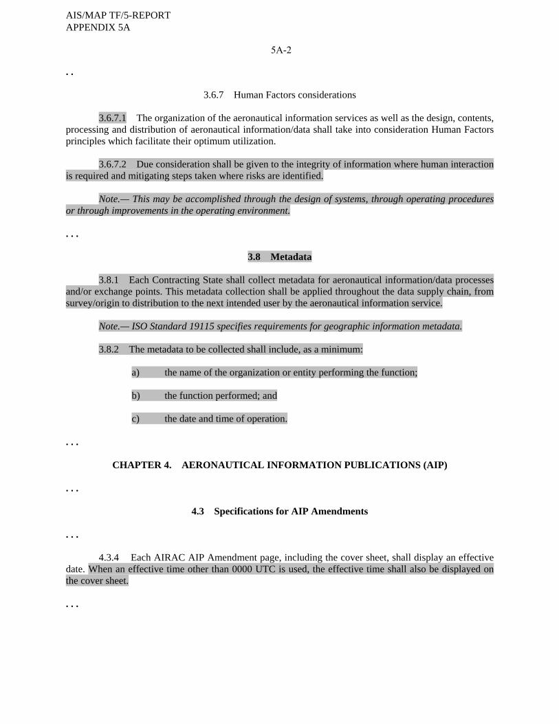
5A-2
. .
3.6.7 Human Factors considerations
3.6.7.1 The organization of the aeronautical information services as well as the design, contents, processing and distribution of aeronautical information/data shall take into consideration Human Factors principles which facilitate their optimum utilization.
3.6.7.2 Due consideration shall be given to the integrity of information where human interaction is required and mitigating steps taken where risks are identified.
Note.— This may be accomplished through the design of systems, through operating procedures or through improvements in the operating environment. . . .
3.8 Metadata
3.8.1 Each Contracting State shall collect metadata for aeronautical information/data processes and/or exchange points. This metadata collection shall be applied throughout the data supply chain, from survey/origin to distribution to the next intended user by the aeronautical information service.
Note.— ISO Standard 19115 specifies requirements for geographic information metadata.
3.8.2 The metadata to be collected shall include, as a minimum:
a) the name of the organization or entity performing the function;
b) the function performed; and
c) the date and time of operation. . . .
CHAPTER 4. AERONAUTICAL INFORMATION PUBLICATIONS (AIP) . . .
4.3 Specifications for AIP Amendments . . .
4.3.4 Each AIRAC AIP Amendment page, including the cover sheet, shall display an effective date. When an effective time other than 0000 UTC is used, the effective time shall also be displayed on the cover sheet. . . .
AIS/MAP TF/5-REPORT APPENDIX 5A
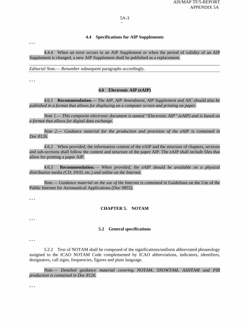
-
4.4 Specifications for AIP Supplements
. . .
4.4.4 When an error occurs in an AIP Supplement or when the period of validity of an AIP Supplement is changed, a new AIP Supplement shall be published as a replacement. Editorial Note.— Renumber subsequent paragraphs accordingly. . . .
4.6 Electronic AIP (eAIP)
4.6.1 Recommendation.— The AIP, AIP Amendment, AIP Supplement and AIC should also be published in a format that allows for displaying on a computer screen and printing on paper.
Note 1.— This composite electronic document is named “Electronic AIP” (eAIP) and is based on a format that allows for digital data exchange.
Note 2.— Guidance material for the production and provision of the eAIP is contained in Doc 8126.
4.6.2 When provided, the information content of the eAIP and the structure of chapters, sections and sub-sections shall follow the content and structure of the paper AIP. The eAIP shall include files that allow for printing a paper AIP.
4.6.3 Recommendation.— When provided, the eAIP should be available on a physical distribution media (CD, DVD, etc.) and online on the Internet.
Note.— Guidance material on the use of the Internet is contained in Guidelines on the Use of the Public Internet for Aeronautical Applications (Doc 9855). . . .
CHAPTER 5. NOTAM . . .
5.2 General specifications . . .
5.2.2 Text of NOTAM shall be composed of the significations/uniform abbreviated phraseology assigned to the ICAO NOTAM Code complemented by ICAO abbreviations, indicators, identifiers, designators, call signs, frequencies, figures and plain language.
Note.— Detailed guidance material covering NOTAM, SNOWTAM, ASHTAM and PIB production is contained in Doc 8126. . . .
5A-3
AIS/MAP TF/5-REPORT APPENDIX 5A
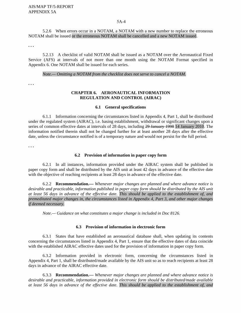
5A-4
5.2.6 When errors occur in a NOTAM, a NOTAM with a new number to replace the erroneous NOTAM shall be issued or the erroneous NOTAM shall be cancelled and a new NOTAM issued. . . .
5.2.13 A checklist of valid NOTAM shall be issued as a NOTAM over the Aeronautical Fixed Service (AFS) at intervals of not more than one month using the NOTAM Format specified in Appendix 6. One NOTAM shall be issued for each series.
Note.— Omitting a NOTAM from the checklist does not serve to cancel a NOTAM. . . .
CHAPTER 6. AERONAUTICAL INFORMATION REGULATION AND CONTROL (AIRAC)
6.1 General specifications
6.1.1 Information concerning the circumstances listed in Appendix 4, Part 1, shall be distributed
under the regulated system (AIRAC), i.e. basing establishment, withdrawal or significant changes upon a series of common effective dates at intervals of 28 days, including 29 January 1998 14 January 2010. The information notified therein shall not be changed further for at least another 28 days after the effective date, unless the circumstance notified is of a temporary nature and would not persist for the full period. . . .
6.2 Provision of information in paper copy form
6.2.1 In all instances, information provided under the AIRAC system shall be published in paper copy form and shall be distributed by the AIS unit at least 42 days in advance of the effective date with the objective of reaching recipients at least 28 days in advance of the effective date.
6.2.2 Recommendation.— Whenever major changes are planned and where advance notice is desirable and practicable, information published in paper copy form should be distributed by the AIS unit at least 56 days in advance of the effective date. This should be applied to the establishment of, and premeditated major changes in, the circumstances listed in Appendix 4, Part 3, and other major changes if deemed necessary.
Note.— Guidance on what constitutes a major change is included in Doc 8126.
6.3 Provision of information in electronic form
6.3.1 States that have established an aeronautical database shall, when updating its contents concerning the circumstances listed in Appendix 4, Part 1, ensure that the effective dates of data coincide with the established AIRAC effective dates used for the provision of information in paper copy form.
6.3.2 Information provided in electronic form, concerning the circumstances listed in Appendix 4, Part 1, shall be distributed/made available by the AIS unit so as to reach recipients at least 28 days in advance of the AIRAC effective date.
6.3.3 Recommendation.— Whenever major changes are planned and where advance notice is desirable and practicable, information provided in electronic form should be distributed/made available at least 56 days in advance of the effective date. This should be applied to the establishment of, and
AIS/MAP TF/5-REPORT APPENDIX 5A
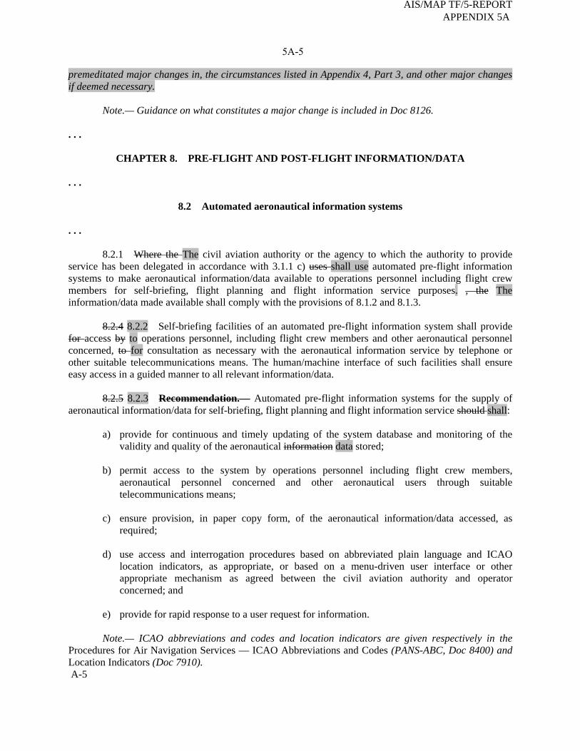
5A-5
premeditated major changes in, the circumstances listed in Appendix 4, Part 3, and other major changes if deemed necessary.
Note.— Guidance on what constitutes a major change is included in Doc 8126. . . .
CHAPTER 8. PRE-FLIGHT AND POST-FLIGHT INFORMATION/DATA . . .
8.2 Automated aeronautical information systems . . .
8.2.1 Where the The civil aviation authority or the agency to which the authority to provide service has been delegated in accordance with 3.1.1 c) uses shall use automated pre-flight information systems to make aeronautical information/data available to operations personnel including flight crew members for self-briefing, flight planning and flight information service purposes. , the The information/data made available shall comply with the provisions of 8.1.2 and 8.1.3.
8.2.4 8.2.2 Self-briefing facilities of an automated pre-flight information system shall provide for access by to operations personnel, including flight crew members and other aeronautical personnel concerned, to for consultation as necessary with the aeronautical information service by telephone or other suitable telecommunications means. The human/machine interface of such facilities shall ensure easy access in a guided manner to all relevant information/data.
8.2.5 8.2.3 Recommendation.— Automated pre-flight information systems for the supply of aeronautical information/data for self-briefing, flight planning and flight information service should shall:
a) provide for continuous and timely updating of the system database and monitoring of the validity and quality of the aeronautical information data stored;
b) permit access to the system by operations personnel including flight crew members,
aeronautical personnel concerned and other aeronautical users through suitable telecommunications means;
c) ensure provision, in paper copy form, of the aeronautical information/data accessed, as
required;
d) use access and interrogation procedures based on abbreviated plain language and ICAO location indicators, as appropriate, or based on a menu-driven user interface or other appropriate mechanism as agreed between the civil aviation authority and operator concerned; and
e) provide for rapid response to a user request for information.
Note.— ICAO abbreviations and codes and location indicators are given respectively in the
Procedures for Air Navigation Services — ICAO Abbreviations and Codes (PANS-ABC, Doc 8400) and Location Indicators (Doc 7910). A-5
AIS/MAP TF/5-REPORT APPENDIX 5A

5A-6
8.2.2 8.2.4 Recommendation.— Automated pre-flight information systems providing a harmonized, common point of access by operations personnel, including flight crew members and other aeronautical personnel concerned, to aeronautical information in accordance with 8.2.1 and meteorological information in accordance with 9.5.1 of Annex 3 — Meteorological Service for International Air Navigation, should be established by an agreement between the civil aviation authority or the agency to which the authority to provide service has been delegated in accordance with 3.1.1 c) and the relevant meteorological authority.
8.2.3 8.2.5 Where automated pre-flight information systems are used to provide the harmonized, common point of access by operations personnel, including flight crew members and other aeronautical personnel concerned, to aeronautical information/ data and meteorological information, the civil aviation authority or the agency to which the authority to provide service has been delegated in accordance with 3.1.1 c) shall remain responsible for the quality and timeliness of the aeronautical information/ data provided by means of such a system.
Note.— The meteorological authority concerned remains responsible for the quality of the meteorological information provided by means of such a system in accordance with 9.5.1 of Annex 3. . . .
CHAPTER 10. ELECTRONIC TERRAIN AND OBSTACLE DATA
10.1 Function Sets of electronic terrain and obstacle data used in combination with aeronautical data, as appropriate, shall satisfy user requirements necessary to support the following air navigation applications: . . .
10.2 Coverage and terrain and obstacle data numerical requirements
10.2.1 To satisfy requirements necessary to accommodate air navigation systems or functions specified in 10.1, sets of electronic Electronic terrain and obstacle data shall be collected and recorded in databases data sets in accordance with the following coverage areas:
— Area 1: entire territory of a State;
— Area 2: terminal control area;
— Area 3: aerodrome/heliport area; and
— Area 4: Category II or III operations area.
Note.— See Appendix 8 for graphical illustrations of the defined coverage areas. . . .
10.2.3 Area 2 data shall be provided for all aerodromes regularly used by international civil aviation.
10.2.4 Recommendation.— Area 3 data should be provided at those aerodromes/heliports where it is considered to be beneficial, e.g. where it is supported by the availability of aerodrome mapping data.
AIS/MAP TF/5-REPORT APPENDIX 5A
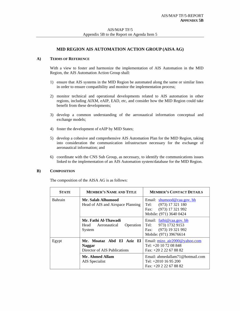
AIS/MAP TF/5-REPORT APPENDIX 5B
AIS/MAP TF/5
Appendix 5B to the Report on Agenda Item 5
MID REGION AIS AUTOMATION ACTION GROUP (AISA AG)
A) TERMS OF REFERENCE
With a view to foster and harmonize the implementation of AIS Automation in the MID Region, the AIS Automation Action Group shall:
1) ensure that AIS systems in the MID Region be automated along the same or similar lines
in order to ensure compatibility and monitor the implementation process; 2) monitor technical and operational developments related to AIS automation in other
regions, including AIXM, eAIP, EAD, etc, and consider how the MID Region could take benefit from these developments;
3) develop a common understanding of the aeronautical information conceptual and
exchange models; 4) foster the development of eAIP by MID States; 5) develop a cohesive and comprehensive AIS Automation Plan for the MID Region, taking
into consideration the communication infrastructure necessary for the exchange of aeronautical information; and
6) coordinate with the CNS Sub Group, as necessary, to identify the communications issues
linked to the implementation of an AIS Automation system/database for the MID Region. B) COMPOSITION
The composition of the AISA AG is as follows:
STATE MEMBER’S NAME AND TITLE MEMBER’S CONTACT DETAILS
Mr. Salah Alhumood Head of AIS and Airspace Planning
Email: [email protected]. bh Tel: (973) 17 321 180 Fax: (973) 17 321 992 Mobile: (971) 3640 0424
Bahrain
Mr. Fathi Al-Thawadi Head Aeronautical Operation System
Email: [email protected]. bh Tel: 973) 1732 9153 Fax: (973) 19 321 992 Mobile: (971) 39676614
Mr. Moataz Abd El Aziz El Naggar Director of AIS Publications
Email: [email protected] Tel: +20 10 72 08 848 Fax: +20 2 22 67 88 82
Egypt
Mr. Ahmed Allam AIS Specialist
Email: [email protected] Tel: +2010 16 95 200 Fax: +20 2 22 67 88 82
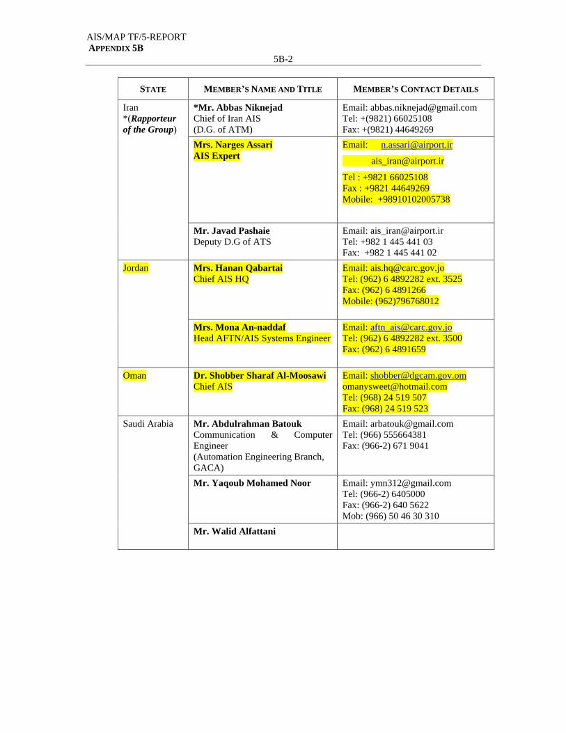
AIS/MAP TF/5-REPORT APPENDIX 5B
5B-2
STATE MEMBER’S NAME AND TITLE MEMBER’S CONTACT DETAILS
*Mr. Abbas Niknejad Chief of Iran AIS (D.G. of ATM)
Email: [email protected] Tel: +(9821) 66025108 Fax: +(9821) 44649269
Mrs. Narges Assari AIS Expert
Email: [email protected]
Tel : +9821 66025108 Fax : +9821 44649269 Mobile: +98910102005738
Iran *(Rapporteur of the Group)
Mr. Javad Pashaie Deputy D.G of ATS
Email: [email protected] Tel: +982 1 445 441 03 Fax: +982 1 445 441 02
Mrs. Hanan Qabartai Chief AIS HQ
Email: [email protected] Tel: (962) 6 4892282 ext. 3525 Fax: (962) 6 4891266 Mobile: (962)796768012
Jordan
Mrs. Mona An-naddaf Head AFTN/AIS Systems Engineer
Email: [email protected] Tel: (962) 6 4892282 ext. 3500 Fax: (962) 6 4891659
Oman Dr. Shobber Sharaf Al-Moosawi Chief AIS
Email: [email protected] [email protected] Tel: (968) 24 519 507 Fax: (968) 24 519 523
Mr. Abdulrahman Batouk Communication & Computer Engineer (Automation Engineering Branch, GACA)
Email: [email protected] Tel: (966) 555664381 Fax: (966-2) 671 9041
Mr. Yaqoub Mohamed Noor
Email: [email protected] Tel: (966-2) 6405000 Fax: (966-2) 640 5622 Mob: (966) 50 46 30 310
Saudi Arabia
Mr. Walid Alfattani

AIS/MAP TF/5-REPORT APPENDIX 5B
5B-3
C) WORKING ARRANGEMENTS
The AISA AG shall report to the AIS/MAP Task Force. The work of the AISA AG shall be carried out mainly through exchange of correspondence, between its Members using all means of communication (email, facsimile, Tel, Teleconferencing, ICAO MID Forum, etc).
---------------
AIS/MAP TF/5-REPORT 6-1
AIS/MAP TF/5
Report on Agenda Item 6
REPORT ON AGENDA ITEM 6: ELECTRONIC TERRAIN AND OBSTACLE DATA (eTOD) 6.1 The meeting was apprised of the outcome of the eTOD WG/2 meeting held in Tehran, Iran, Islamic Republic of, from 3 to 4 May 2009. 6.2 The meeting reviewed and analysed the numerical requirements for terrain and obstacle data for areas 1, 2, 3 and 4 as defined in Annex 15, Appendix 8, Tables A8-1 and A8-2. 6.3 The meeting noted that the eTOD WG/2 meeting was apprised of the outcome of the EUROCONTROL Terrain and Obstacle Data Working Group (TOD WG) and the European proposal for amendment to Annex 15 provisions contained in Chapter 10 related to eTOD. The meeting noted that an agreement was initially reached regarding the required changes/minor refinements for Area 1, Area 3 and Area 4, as well as some general changes affecting all areas. 6.4 The meeting further noted that the eTOD WG/2 was apprised of the outcome of the AIS-AIM SG/1 meeting held in Montreal, 2-4 December 2008 related to eTOD. 6.5 The meeting recalled that the ANC on 12 March 2009 carried out a preliminary review of draft Amendment 36 to Annex 15 and consequential amendments to Annexes 4, 11 and 14 and the PANS-ABC (Doc 8400) and that State Letter Ref.: AN 2/2.2-09/13 dated 23 April 2009 has been issued. It was highlighted that comments on the proposal for amendment to Annex 15 are expected to reach Montreal before 6 August 2009. Accordingly, the meeting urged States to study the proposal for amendment and send their comments to ICAO Headquarters before the set deadline. The part of draft Amendment 36 to Annex 15 related to eTOD is attached as Appendix 6A to the Report on Agenda Item 6. 6.6 The meeting was informed about the most important changes which would be introduced to Annex 15, Chapter 10 related to eTOD. The meeting particularly noted that in the proposed Draft Amendment 36 to Annex 15, Area 2 would be divided into four sub-areas as follows:
Area 2a is described as a rectangular area around the runway extending to 255m each side of the runway centre line with the length of the runway strip plus any clearway(s) that exist;
Area 2b is described as a surface with a 1.2% slope extending from the ends of
Area 2a with a length of 10km and a splay of 15% to each side; Area 2c is described as an Area with a 1.2% slope extending outside Area 2a and
Area 2b at a distance of not more than 10 km to the boundary of Area 2a; and Area 2d is described as the remainder of Area 2 outside the Areas 2a, 2b and 2c up
to a distance of 45km from the ARP, or the TMA boundary, whichever is smaller. 6.7 Accordingly, obstacles shall be collected if they:
are located within Area 2a and their height exceeds 3m above ground level; penetrate the surface in Area 2b and their height exceeds 3m above ground level;
AIS/MAP TF/5-REPORT 6-2
AIS/MAP TF/5
Report on Agenda Item 6
penetrate the surface in Area 2c and their height exceeds 15m above ground level; and
are located within Area 2d and their height exceeds 100m above ground level.
6.8 The meeting supported the proposal to postpone the applicability date related to eTOD provisions for Area 2 and Area 3, from 18 November 2010 to 15 November 2012. 6.9 The meeting highlighted that some of the legal and institutional issues pertaining to eTOD are still not addressed. Accordingly, States were urged to look into these issues when developing their national regulations related to eTOD. 6.10 The meeting reviewed and endorsed the eTOD checklist at Appendix 6B to the Report on Agenda Item 6, in order to assist States in the process of planning and implementation of eTOD provisions and agreed accordingly to the following Draft Conclusion:
DRAFT CONCLUSION 5/5: eTOD CHECKLIST
That, MID States be encouraged to use the eTOD checklist at Appendix 6B to the Report on Agenda Item 6 in order to assist them in the process of planning and implementation of the eTOD provisions.
6.11 The meeting highlighted that the implementation of eTOD provisions is a challenge for all concerned. It was also recognized that some of those who should be involved in the implementation process were not aware of the responsibilities that they might have and that only a small cross section of those affected were fully aware of the implications and the new responsibilities arising. Furthermore, as a result of the nature of the task and the new technologies and standards that are involved, it was underlined that many stakeholders require training to enable them to perform the tasks for which they are responsible. 6.12 Based on the above the meeting agreed that States should organize awareness campaigns and training events (workshops) involving all concerned personnel from within and outside the CAA in order to provide an overview of the technical, legal, institutional and financial issues related to eTOD as well as of the actions that need to be taken in implementing eTOD and to bring a high-level understanding of the associated topics. Accordingly, the meeting agreed to the following Draft Conclusion:
DRAFT CONCLUSION 5/6: eTOD AWARENESS CAMPAIGNS
That, for the sake of an efficient and harmonized implementation of eTOD, MID States at the National Level and, to the extent possible co-operatively, organize awareness campaigns and training programmes (seminars, workshops, etc) to promote and expedite the process of eTOD implementation.
6.13 In connection with the above, the meeting agreed that a State Letter is to be issued by the ICAO MID Regional Office with a view to encourage States to use the eTOD checklist in the process of planning and implementation of eTOD and invite them to organize eTOD awareness campaigns and training events in compliance with the above Draft Conclusion.
AIS/MAP TF/5-REPORT 6-3
AIS/MAP TF/5
Report on Agenda Item 6
6.14 The meeting reviewed and updated the MID Region AIS/MAP Timelines related to eTOD as at Appendix 6C to the Report on Agenda Item 6. It was noted in this regard that no State from the MID Region has notified ICAO of a difference to the provisions of Annex 15, Chapter 10. It was also noted that the majority of States will not be able to implement the eTOD provisions related to Area 2 and Area 3 before November 2012. 6.15 The meeting exchanged views and shared experience regarding the implementation of eTOD provisions. In this regard, the meeting encouraged States to register into the EUROCONTROL eTOD Forum and follow up all the discussions posted on this forum which proved to be very informative. The meeting urged States also to use the ICAO MID Forum to post any query or useful information related to eTOD on this Forum. 6.16 The meeting recalled that the MID Region eTOD Implementation Strategy at Appendix 6D to the Report on Agenda Item 6 was reviewed and endorsed by MIDANPIRG/11 through Conclusion 11/43. The meeting urged States to comply with the MID Region eTOD Implementation Strategy. It was further recalled that MIDANPIRG/11, based on a Recommendation from the First Meeting of the MIDANPIRG Steering Group (MSG/1) held in Dubai, 1-3 July 2008, agreed that the MIDANPIRG Conclusions and Decisions which are of general nature and their status of implementation would be “Ongoing” for many years are more suitable for inclusion in the Air Navigation Plan, Handbooks, Manuals, Guidelines, etc, as appropriate. 6.17 Based on the above, the meeting reviewed the draft proposal for amendment to the MID Basic ANP at Appendix 6E to the Report on Agenda Item 6, with a view to introduce a new part related to eTOD based on the MID Region eTOD Implementation Strategy and agreed accordingly to the following Draft Conclusion:
DRAFT CONCLUSION 5/7: PROPOSAL FOR AMENDMENT TO THE MID BASIC
ANP (DOC 9708) RELATED TO eTOD
That,
a) MID States review the draft proposal for amendment to the MID Basic ANP (Part VIII) at Appendix 6E to the Report on Agenda Item 6 and send their comments to the ICAO MID Regional Office before 15 August 2009; and
b) the ATM/SAR/AIS Sub-Group further review and refine, as necessary, the
proposal and propose to MIDANPIRG its inclusion in the MID Basic ANP, in accordance with standard procedure.
6.18 In connection with the above, the meeting agreed that a State Letter is to be issued by the ICAO MID Regional Office inviting States to comment on the draft proposal for amendment to the MID Basic ANP (Part VIII). 6.19 The meeting recalled that MIDANPIRG/11, through Conclusion 11/44, invited ICAO to consider the inclusion of a Draft FASID Table related to the implementation of eTOD into the MID FASID, Part VIII (AIS), with necessary amendments, as appropriate. 6.20 The meeting noted that, further to the approval of the proposal for amendment of the MID Basic ANP 08/05-AOP, MIDANPIRG/11, through Conclusion 11/13, agreed that the ICAO MID Regional Office, on behalf of MIDANPIRG, initiate all necessary Amendment Proposals to the MID Basic ANP and FASID, prior to MIDANPIRG/12, in order to update the AIS, AOP, ATM, CNS and MET Tables.
AIS/MAP TF/5-REPORT 6-4
AIS/MAP TF/5
Report on Agenda Item 6
6.21 Based on the above, the meeting reviewed and updated the Draft MID FASID Table AIS 9 as at Appendix 6F to the Report on Agenda Item 6 and agreed to its inclusion as part of the Proposal for Amendment of the MID FASID (AIS Tables) (Draft Decision 5/1 refers). 6.22 The meeting recalled that MIDANPIRG/10, under Decision 10/58 established the eTOD Working Group, with a view to, inter-alia, harmonize, coordinate and support the eTOD implementation activities on a regional basis. 6.23 Noting that the majority of the Tasks assigned to the eTOD Working Group have been completed, the meeting agreed to dissolve the eTOD Working Group and include the remaining eTOD tasks which have not yet been completed into the Work Programme of the AIS/MAP Task Force. Accordingly, the meeting agreed to the following Draft Decision:
DRAFT DECISION 5/8: DISSOLUTION OF THE eTOD WORKING GROUP
That, noting that the majority of the Tasks assigned to the eTOD Working Group have been completed:
a) the eTOD Working Group is dissolved; and b) the eTOD tasks which have not yet been completed be included into the Work
Programme of the AIS/MAP Task Force.
---------------------------

.
8.2.2 8.2.4 Recommendation.— Automated pre-flight information systems providing a harmonized, common point of access by operations personnel, including flight crew members and other aeronautical personnel concerned, to aeronautical information in accordance with 8.2.1 and meteorological information in accordance with 9.5.1 of Annex 3 — Meteorological Service for International Air Navigation, should be established by an agreement between the civil aviation authority or the agency to which the authority to provide service has been delegated in accordance with 3.1.1 c) and the relevant meteorological authority.
8.2.3 8.2.5 Where automated pre-flight information systems are used to provide the harmonized, common point of access by operations personnel, including flight crew members and other aeronautical personnel concerned, to aeronautical information/ data and meteorological information, the civil aviation authority or the agency to which the authority to provide service has been delegated in accordance with 3.1.1 c) shall remain responsible for the quality and timeliness of the aeronautical information/ data provided by means of such a system.
Note.— The meteorological authority concerned remains responsible for the quality of the meteorological information provided by means of such a system in accordance with 9.5.1 of Annex 3. . . .
CHAPTER 10. ELECTRONIC TERRAIN AND OBSTACLE DATA
10.1 Function Sets of electronic terrain and obstacle data used in combination with aeronautical data, as appropriate, shall satisfy user requirements necessary to support the following air navigation applications: . . .
10.2 Coverage and terrain and obstacle data numerical requirements
10.2.1 To satisfy requirements necessary to accommodate air navigation systems or functions specified in 10.1, sets of electronic Electronic terrain and obstacle data shall be collected and recorded in databases data sets in accordance with the following coverage areas:
— Area 1: entire territory of a State;
— Area 2: terminal control area;
— Area 3: aerodrome/heliport area; and
— Area 4: Category II or III operations area.
Note.— See Appendix 8 for graphical illustrations of the defined coverage areas. . . .
10.2.3 Area 2 data shall be provided for all aerodromes regularly used by international civil aviation.
10.2.4 Recommendation.— Area 3 data should be provided at those aerodromes/heliports where it is considered to be beneficial, e.g. where it is supported by the availability of aerodrome mapping data.
AIS/MAP TF/5 Appendix 6A to the Report on Agenda Item 6
AIS/MAP TF/5-REPORT APPENDIX 6A
Skodsi
Typewritten Text
_______________________________________________________________________
6A-2
10.2.3 10.2.5 At IFR aerodromes/heliports, When provided, Area 3 shall cover the area that
extends from the edge(s) of the runway(s) to 90 m from the runway centre line(s) and for all other parts of aerodrome/heliport movement area(s), 50 m from the edge(s) of the defined area(s).
10.2.4 10.2.6 Area 4 shall be restricted to those runways where precision approach Category II or III operations have been established and where detailed terrain and appropriate obstacle information is required by operators to enable them to assess, by use of radio altimeters, the effect of terrain and obstacles on decision height determination. The width of the area shall be 60 m on either side of the extended runway centre line while the length shall be 900 m from the runway threshold measured along the extended runway centre line.
Note.— Area 4 terrain data and Area 2 obstacle data are normally sufficient to support the production of the Precision Approach Terrain Chart — ICAO. When more detailed obstacle data is required for Area 4, this may be provided in accordance with the Area 4 obstacle data requirements specified in Appendix 8, Table A8-2. Guidance on appropriate obstacles for this chart is given in the Aeronautical Chart Manual (Doc 8697).
10.2.7 Recommendation.— Where the terrain at a distance greater than 900 m (3 000 ft) from the runway threshold is mountainous or otherwise significant, Area 4 should be extended to a distance not exceeding 2 000 m from the runway threshold.
10.2.5 10.2.8 According to the air navigation applications listed in 10.1 and areas of coverage, sets Sets of electronic terrain data shall satisfy the numerical requirements specified in Appendix 8, Table A8-1 while obstacle data shall satisfy the numerical requirements specified in Appendix 8, Table A8-2.
Note 1.— Numerical terrain and obstacle data requirements for Area 2 provided in Appendix 8, Table A8-1 and Table A8-2, respectively, are defined on the basis of the most stringent application requirement (application listed under 10.1 b)).
Note 2.— It is recognized that some applications listed in 10.1 could be adequately accommodated with terrain and obstacle data sets that are of lower requirements than those specified in Appendix 8, Table A8-1 and Table A8-2, respectively. Consequently, careful evaluation of available data sets by data users is necessary in order to determine if the products are fit for their intended use.
10.3 Terrain database data set — content and structure
10.3.1 A terrain database data set shall contain digital sets of data representing terrain surface in the form of continuous elevation values at all intersections (points) of a defined grid, referenced to common datum. A terrain grid shall be angular or linear and shall be of regular or irregular shape. . . .
10.3.3 Terrain data shall be collected according to the areas specified in 10.2, terrain data collection surfaces and criteria specified in Appendix 8, Figure Figures A8-1, A8-3 and A8-4, and in accordance with the terrain data numerical requirements provided in Table A8-1 of Appendix 8. In terrain databases data sets, only one feature type, i.e. terrain, shall be recorded. Feature attributes describing terrain shall be those listed in Appendix 8, Table A8-3. The terrain feature attributes listed in Table A8-3 represent the minimum set of terrain attributes, and those annotated as mandatory shall be recorded in the terrain database data set.
AIS/MAP TF/5-REPORT APPENDIX 6A
6A-3
10.4 Obstacle database data set — content and structure
10.4.1 One obstacle database Obstacle data sets shall contain a digital set of obstacle data and shall include all obstacles that penetrate the collection surfaces defined in Figure A8-2 those features having vertical significance in relation to adjacent and surrounding features that are considered hazardous to air navigation. Obstacle data shall comprise the digital representation of the vertical and horizontal extent of man-made objects. Obstacles shall not be included in terrain databases data sets. Obstacle data elements are features that shall be represented in the database data sets by points, lines or polygons.
10.4.2 Obstacles, which in accordance with the definition, can be fixed (permanent or temporary) or mobile shall be identified within the areas defined in 10.2, on the basis of the obstacle data collection surfaces and criteria specified in Appendix 8, Figure Figures A8-2, A8-3 and A8-4, and collected in accordance with obstacle data numerical requirements provided in Table A8-2 of Appendix 8. In an obstacle database data set, all defined obstacle feature types shall be recorded and each of them shall be described according to the list of mandatory attributes provided in Table A8-4 of Appendix 8.
Note.— Specific attributes associated with mobile (feature operations) and temporary types of obstacles are annotated in Appendix 8, Table A8-4, as optional attributes. If these types of obstacles are to be recorded in the database data set, appropriate attributes describing such obstacles are also required. . . .
10.6 Availability . . .
10.6.1.1 States shall ensure that as of 20 November 2008, electronic terrain and obstacle data are made available in accordance with Area 1 specifications and terrain data in accordance with Area 4 specifications.
10.6.1.2 States shall ensure that as of 18 November 2010 15 November 2012, electronic terrain and obstacle data are made available in accordance with Area 2 and Area 3 specifications.
10.6.1.3 Recommendation.— States should ensure that electronic terrain and obstacle data are made available in accordance with Area 1, Area 2, and Area 3 specifications and terrain data in accordance with Area 4 specifications. . . .
AIS/MAP TF/5-REPORT APPENDIX 6A
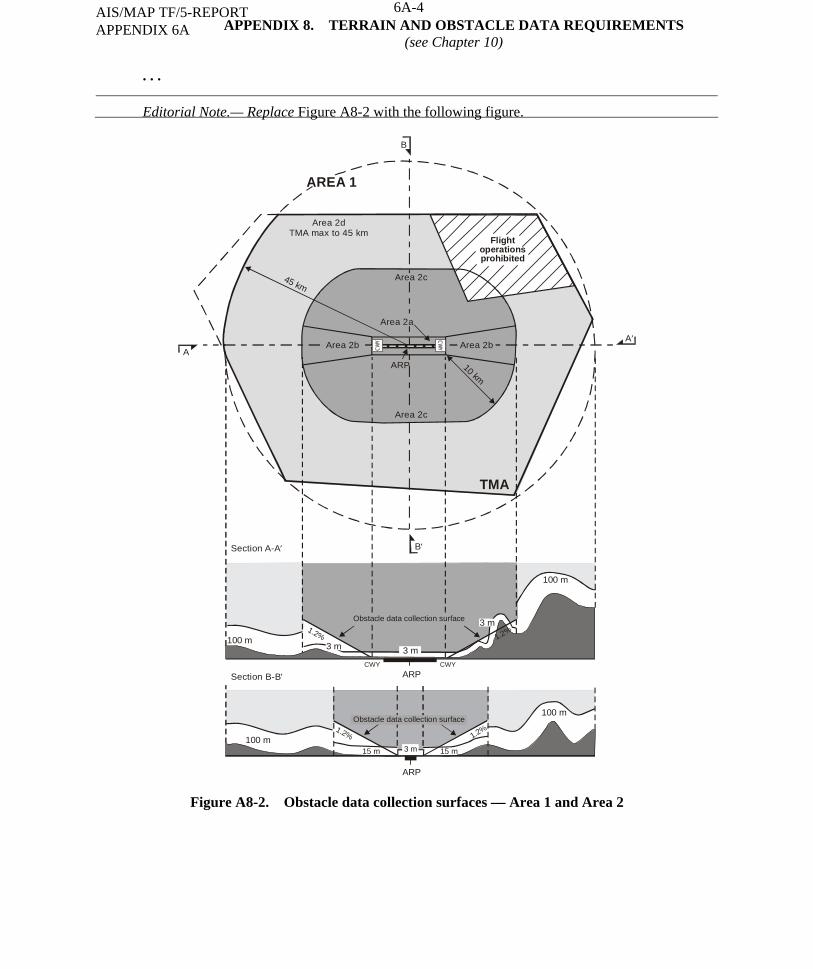
A-22
APPENDIX 8. TERRAIN AND OBSTACLE DATA REQUIREMENTS (see Chapter 10)
. . . Editorial Note.— Replace Figure A8-2 with the following figure.
Figure A8-2. Obstacle data collection surfaces — Area 1 and Area 2
45 km
10 km
Section A-A′
A′
B′
A
B
Section B-B′
ARP
Area 2dTMA max to 45 km
AREA 1
TMA
ARP
ARP
100 m
100 m15 m 15 m
CWY CWY
100 m
100 m
1.2%
1.2% 1.2%
Flightoperationsprohibited
CWY CW
Y
3 m3 m
3 m
3 m
Area 2b Area 2b
Area 2c
Area 2c
Area 2a
1.2%
Obstacle data collection surface
Obstacle data collection surface
6A-4AIS/MAP TF/5-REPORT APPENDIX 6A
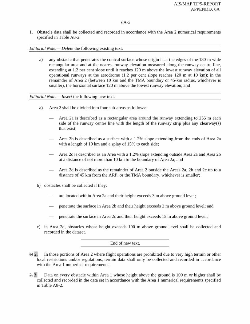
6A-5
1. Obstacle data shall be collected and recorded in accordance with the Area 2 numerical requirements specified in Table A8-2:
Editorial Note.— Delete the following existing text. a) any obstacle that penetrates the conical surface whose origin is at the edges of the 180-m wide
rectangular area and at the nearest runway elevation measured along the runway centre line, extending at 1.2 per cent slope until it reaches 120 m above the lowest runway elevation of all operational runways at the aerodrome (1.2 per cent slope reaches 120 m at 10 km); in the remainder of Area 2 (between 10 km and the TMA boundary or 45-km radius, whichever is smaller), the horizontal surface 120 m above the lowest runway elevation; and
Editorial Note.— Insert the following new text. a) Area 2 shall be divided into four sub-areas as follows:
— Area 2a is described as a rectangular area around the runway extending to 255 m each side of the runway centre line with the length of the runway strip plus any clearway(s) that exist;
— Area 2b is described as a surface with a 1.2% slope extending from the ends of Area 2a
with a length of 10 km and a splay of 15% to each side;
— Area 2c is described as an Area with a 1.2% slope extending outside Area 2a and Area 2b at a distance of not more than 10 km to the boundary of Area 2a; and
— Area 2d is described as the remainder of Area 2 outside the Areas 2a, 2b and 2c up to a
distance of 45 km from the ARP, or the TMA boundary, whichever is smaller; b) obstacles shall be collected if they:
— are located within Area 2a and their height exceeds 3 m above ground level;
— penetrate the surface in Area 2b and their height exceeds 3 m above ground level; and
— penetrate the surface in Area 2c and their height exceeds 15 m above ground level; c) in Area 2d, obstacles whose height exceeds 100 m above ground level shall be collected and
recorded in the dataset.
End of new text. b) 2. In those portions of Area 2 where flight operations are prohibited due to very high terrain or other
local restrictions and/or regulations, terrain data shall only be collected and recorded in accordance with the Area 1 numerical requirements.
2. 3. Data on every obstacle within Area 1 whose height above the ground is 100 m or higher shall be
collected and recorded in the data set in accordance with the Area 1 numerical requirements specified in Table A8-2.
AIS/MAP TF/5-REPORT APPENDIX 6A

6A-6
Figure A8-3. Terrain and obstacle data collection surface — Area 3 1. Data on terrain and obstacles, except frangible objects as defined by Annex 14, that extend more than
a half-metre (0.5 m) above the horizontal plane passing through the nearest point on the aerodrome/heliport movement area shall be collected and recorded.
2. Terrain and obstacle data in Area 3 shall be collected and recorded in accordance with numerical
requirements specified in Table A8-1 and Table A8-2, respectively.
AIS/MAP TF/5-REPORT APPENDIX 6A
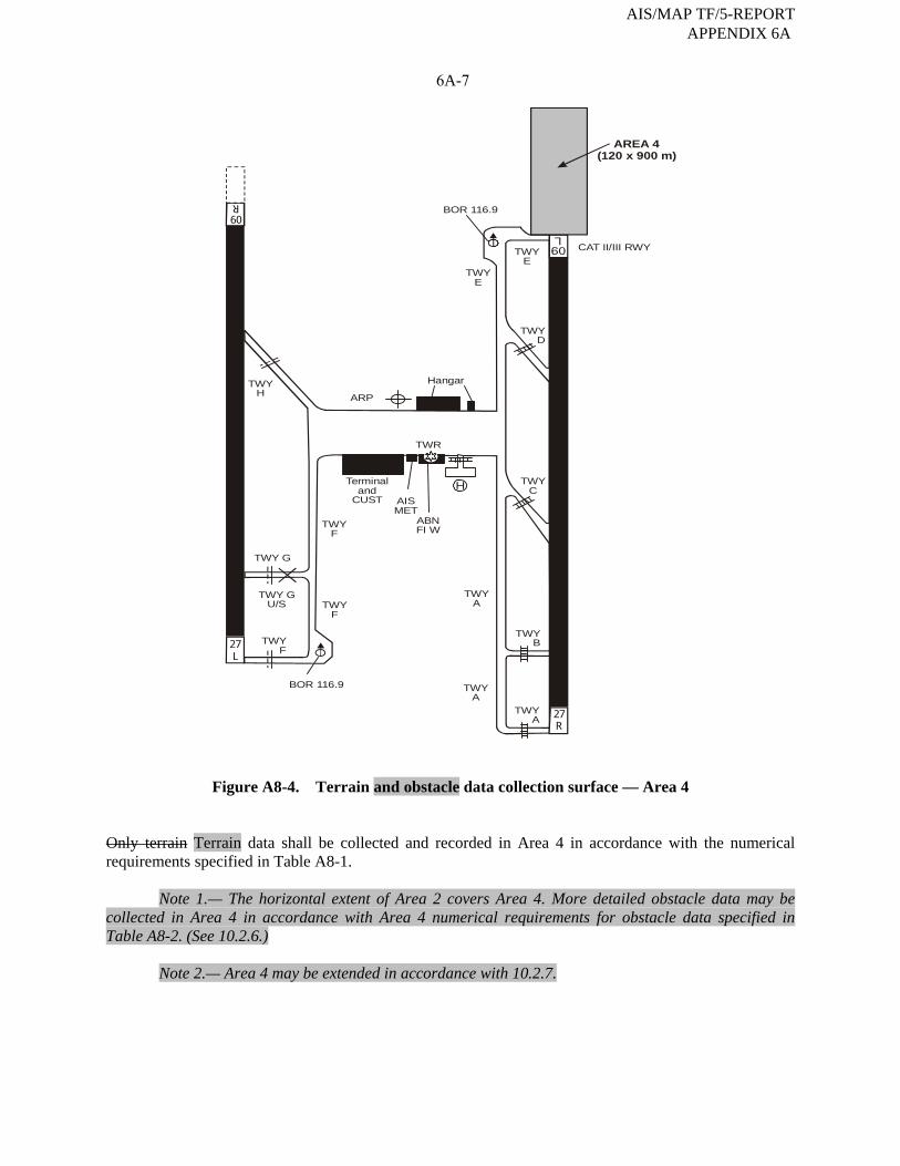
6A-7
Figure A8-4. Terrain and obstacle data collection surface — Area 4 Only terrain Terrain data shall be collected and recorded in Area 4 in accordance with the numerical requirements specified in Table A8-1.
Note 1.— The horizontal extent of Area 2 covers Area 4. More detailed obstacle data may be collected in Area 4 in accordance with Area 4 numerical requirements for obstacle data specified in Table A8-2. (See 10.2.6.)
Note 2.— Area 4 may be extended in accordance with 10.2.7.
BOR 116.9
BOR 116.9
TWYE
TWYE
TWYD
TWYH
TWYC
TWYB
TWYA
TWYA
TWYA 27
R
27L
60
R
ARP
Hangar
H
TWY G
TWY GU/S
TWYF
TWYF
TWYF
Terminaland
CUST AISMET
ABNFI W
TWR
CAT II/III RWY
AREA 4(120 x 900 m)
L
AIS/MAP TF/5-REPORT APPENDIX 6A

6A-8
Table A8-1. Terrain data numerical requirements
Area 1 Area 2 Area 3 Area 4
Post spacing 3 arc seconds
(approx. 90 m) 1 arc second
(approx. 30 m) 0.6 arc seconds (approx. 20 m)
0.3 arc seconds (approx. 9 m)
Vertical accuracy 30 m 3 m 0.5 m 1 m
Vertical resolution 1 m 0.1 m 0.01 m 0.1 m
Horizontal accuracy 50 m 5 m 0.5 m 2.5 m
Confidence level (1σ) 90% 90% 90% 90%
Data classification Integrity level
routine 1 × 10⁻³
essential 1 × 10⁻⁵
essential 1 × 10⁻⁵
essential 1 × 10⁻⁵
Maintenance period as required as required as required as required
Table A8-2. Obstacle data numerical requirements
Area 1 Area 2 Area 3 Area 4
Vertical accuracy 30 m 3 m 0.5 m 1 m
Vertical resolution 1 m 0.1 m 0.01m 0.1 m
Horizontal accuracy 50 m 5 m 0.5 m 2.5 m
Confidence level (1σ) 90% 90% 90% 90%
Data classification Integrity level
routine 1 × 10⁻³
essential 1 × 10⁻⁵
essential 1 × 10⁻⁵
essential 1 × 10⁻⁵
Maintenance period as required as required as required as required
Table A8-3. Terrain attributes
Terrain attribute Mandatory/Optional
. . .
Vertical confidence level Mandatory
Surface type Mandatory Optional
Recorded surface Mandatory
. . .
AIS/MAP TF/5-REPORT APPENDIX 6A

6A-9
Table A8-4. Obstacle attributes
Obstacle attribute Mandatory/Optional
. . .
Elevation Mandatory
Height Optional
Vertical accuracy Mandatory
. . .
— — — — — — — —
AIS/MAP TF/5-REPORT APPENDIX 6A
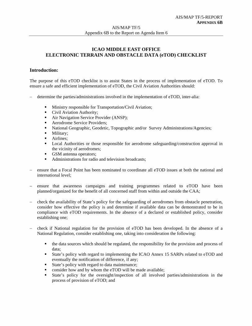
AIS/MAP TF/5-REPORT APPENDIX 6B
AIS/MAP TF/5 Appendix 6B to the Report on Agenda Item 6
ICAO MIDDLE EAST OFFICE ELECTRONIC TERRAIN AND OBSTACLE DATA (eTOD) CHECKLIST
Introduction: The purpose of this eTOD checklist is to assist States in the process of implementation of eTOD. To ensure a safe and efficient implementation of eTOD, the Civil Aviation Authorities should: determine the parties/administrations involved in the implementation of eTOD, inter-alia:
Ministry responsible for Transportation/Civil Aviation; Civil Aviation Authority; Air Navigation Service Provider (ANSP); Aerodrome Service Providers; National Geographic, Geodetic, Topographic and/or Survey Administrations/Agencies; Military; Airlines; Local Authorities or those responsible for aerodrome safeguarding/construction approval in
the vicinity of aerodromes; GSM antenna operators; Administrations for radio and television broadcasts;
ensure that a Focal Point has been nominated to coordinate all eTOD issues at both the national and
international level; ensure that awareness campaigns and training programmes related to eTOD have been
planned/organized for the benefit of all concerned staff from within and outside the CAA; check the availability of State’s policy for the safeguarding of aerodromes from obstacle penetration,
consider how effective the policy is and determine if available data can be demonstrated to be in compliance with eTOD requirements. In the absence of a declared or established policy, consider establishing one;
check if National regulation for the provision of eTOD has been developed. In the absence of a
National Regulation, consider establishing one, taking into consideration the following:
the data sources which should be regulated, the responsibility for the provision and process of data;
State’s policy with regard to implementing the ICAO Annex 15 SARPs related to eTOD and eventually the notification of difference, if any;
State’s policy with regard to data maintenance; consider how and by whom the eTOD will be made available; State’s policy for the oversight/inspection of all involved parties/administrations in the
process of provision of eTOD; and
AIS/MAP TF/5-REPORT APPENDIX 6B
6B-2
State’s policy for cost-recovery related to the provision of eTOD. Identify how the costs, both initial and ongoing, are to be recovered for each Area and in case charges are to be levied on the use of data, identify the appropriate means/mechanisms by which the revenue can be collected.
ensure that necessary resources for the implementation of eTOD have been secured; ensure that an Action Plan/Roadmap with clear timelines and assigned responsibilities for the
provision of eTOD has been developed; ensure that the possible sources of terrain and obstacle data have been identified; ensure that the candidate techniques that will be used for Terrain and Obstacle Data acquisition have
been identified and determined; ensure that the survey requirements for each of the four Areas, including resurvey intervals have been
determined; ensure that the responsibilities that may be placed upon surveyors to ensure that they use the correct
standards, have been identified; ensure that a mechanism is established to ensure that the quality of eTOD is maintained from the
survey up to the end user; ensure that cross-boarder issues have been addressed and consider the establishment of agreements
with neighboring States to exchange and harmonize common data, as necessary; ensure that the means/media by which each dataset shall be made available have been determined;
and ensure that means of carrying out oversight/inspections for monitoring progress have been
established.
----------------

AIS/MAP Implementation Plan for MID Region AIS/MAP TF/5-REPORT APPENDIX 6C
6C-1
Middle East — Aeronautical Information Services Implementation
2000 01 02 03 04 05 06 07 08 09 10 11 12 13 14 15 16
Global Provision of Terrain Data for Area 1
MID Region
States Afghanistan
Bahrain
Egypt
Iran, Islamic Rep. of
Iraq
Israel
Jordan
Kuwait
Lebanon Oman
Qatar
Saudi Arabia
Syrian Arab Republic
United Arab Emirates
Yemen
Global Provision of Obstacle Data for Area 1
MID Region
States Afghanistan
Bahrain
Egypt
Iran, Islamic Rep. of
Iraq
Israel
Jordan
Kuwait
Lebanon
Oman
Qatar
Saudi Arabia
Syrian Arab Republic
United Arab Emirates
Yemen
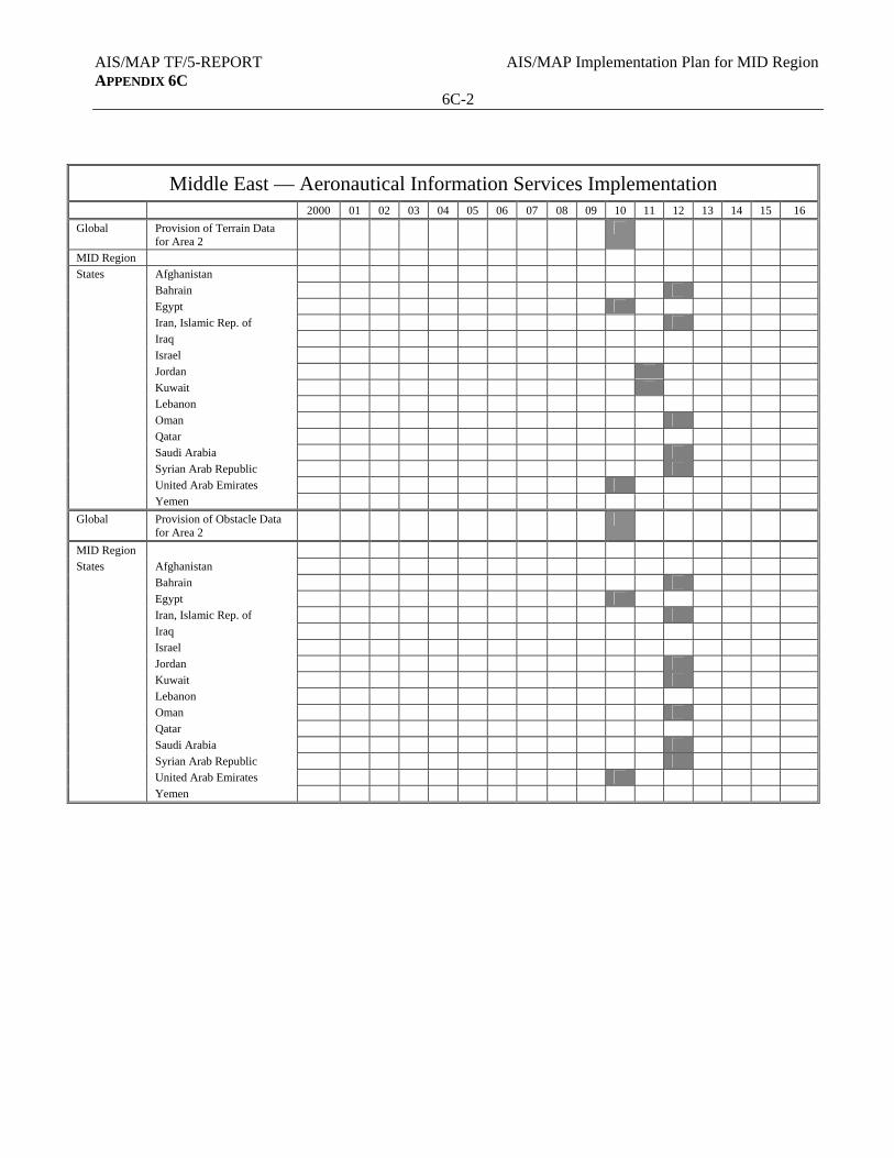
AIS/MAP TF/5-REPORT AIS/MAP Implementation Plan for MID Region APPENDIX 6C
6C-2
Middle East — Aeronautical Information Services Implementation
2000 01 02 03 04 05 06 07 08 09 10 11 12 13 14 15 16
Global Provision of Terrain Data for Area 2
MID Region
States Afghanistan
Bahrain
Egypt
Iran, Islamic Rep. of
Iraq
Israel
Jordan
Kuwait
Lebanon
Oman
Qatar
Saudi Arabia
Syrian Arab Republic
United Arab Emirates
Yemen
Global Provision of Obstacle Data for Area 2
MID Region States Afghanistan
Bahrain
Egypt
Iran, Islamic Rep. of
Iraq
Israel
Jordan
Kuwait
Lebanon
Oman
Qatar
Saudi Arabia
Syrian Arab Republic
United Arab Emirates
Yemen

AIS/MAP Implementation Plan for MID Region AIS/MAP TF/5-REPORT APPENDIX 6C
6C-3
Middle East — Aeronautical Information Services Implementation
2000 01 02 03 04 05 06 07 08 09 10 11 12 13 14 15 16
Global Provision of Terrain Data for Area 3
MID Region
States Afghanistan
Bahrain
Egypt
Iran, Islamic Rep. of
Iraq
Israel
Jordan
Kuwait
Lebanon
Oman
Qatar
Saudi Arabia
Syrian Arab Republic
United Arab Emirates
Yemen
Global Provision of Obstacle Data for Area 3
MID Region States Afghanistan
Bahrain
Egypt
Iran, Islamic Rep. of
Iraq
Israel
Jordan
Kuwait
Lebanon
Oman
Qatar
Saudi Arabia
Syrian Arab Republic
United Arab Emirates
Yemen
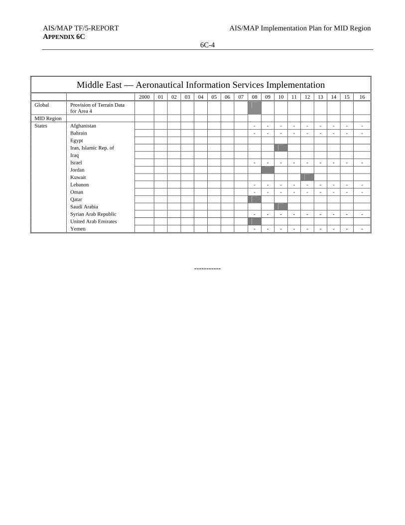
AIS/MAP TF/5-REPORT AIS/MAP Implementation Plan for MID Region APPENDIX 6C
6C-4
Middle East — Aeronautical Information Services Implementation
2000 01 02 03 04 05 06 07 08 09 10 11 12 13 14 15 16
Global Provision of Terrain Data for Area 4
MID Region
States Afghanistan - - - - - - - - -
Bahrain - - - - - - - - -
Egypt
Iran, Islamic Rep. of
Iraq
Israel - - - - - - - - -
Jordan
Kuwait
Lebanon - - - - - - - - -
Oman - - - - - - - - -
Qatar
Saudi Arabia
Syrian Arab Republic - - - - - - - - -
United Arab Emirates
Yemen - - - - - - - - -
-----------
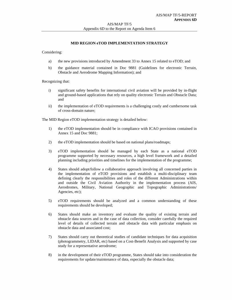
AIS/MAP TF/5-REPORT APPENDIX 6D
AIS/MAP TF/5 Appendix 6D to the Report on Agenda Item 6
MID REGION eTOD IMPLEMENTATION STRATEGY Considering:
a) the new provisions introduced by Amendment 33 to Annex 15 related to eTOD; and
b) the guidance material contained in Doc 9881 (Guidelines for electronic Terrain, Obstacle and Aerodrome Mapping Information); and
Recognizing that:
i) significant safety benefits for international civil aviation will be provided by in-flight and ground-based applications that rely on quality electronic Terrain and Obstacle Data; and
ii) the implementation of eTOD requirements is a challenging costly and cumbersome task of cross-domain nature;
The MID Region eTOD implementation strategy is detailed below:
1) the eTOD implementation should be in compliance with ICAO provisions contained in Annex 15 and Doc 9881;
2) the eTOD implementation should be based on national plans/roadmaps; 3) eTOD implementation should be managed by each State as a national eTOD
programme supported by necessary resources, a high level framework and a detailed planning including priorities and timelines for the implementation of the programme;
4) States should adopt/follow a collaborative approach involving all concerned parties in
the implementation of eTOD provisions and establish a multi-disciplinary team defining clearly the responsibilities and roles of the different Administrations within and outside the Civil Aviation Authority in the implementation process (AIS, Aerodromes, Military, National Geographic and Topographic Administrations/ Agencies, etc);
5) eTOD requirements should be analyzed and a common understanding of these
requirements should be developed; 6) States should make an inventory and evaluate the quality of existing terrain and
obstacle data sources and in the case of data collection, consider carefully the required level of details of collected terrain and obstacle data with particular emphasis on obstacle data and associated cost;
7) States should carry out theoretical studies of candidate techniques for data acquisition
(photogrammetry, LIDAR, etc) based on a Cost-Benefit Analysis and supported by case study for a representative aerodrome;
8) in the development of their eTOD programme, States should take into consideration the
requirements for update/maintenance of data, especially the obstacle data;
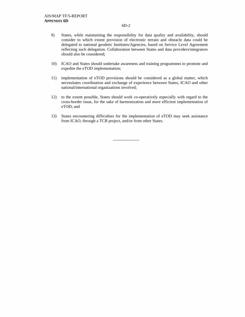
AIS/MAP TF/5-REPORT APPENDIX 6D
6D-2
9) States, while maintaining the responsibility for data quality and availability, should consider to which extent provision of electronic terrain and obstacle data could be delegated to national geodetic Institutes/Agencies, based on Service Level Agreement reflecting such delegation. Collaboration between States and data providers/integrators should also be considered;
10) ICAO and States should undertake awareness and training programmes to promote and
expedite the eTOD implementation; 11) implementation of eTOD provisions should be considered as a global matter, which
necessitates coordination and exchange of experience between States, ICAO and other national/international organizations involved;
12) to the extent possible, States should work co-operatively especially with regard to the
cross-border issue, for the sake of harmonization and more efficient implementation of eTOD; and
13) States encountering difficulties for the implementation of eTOD may seek assistance
from ICAO, through a TCB project, and/or from other States.
-------------------

AIS/MAP TF/5-REPORT APPENDIX 6E
AIS/MAP TF/5
Appendix 6E to the Report on Agenda Item 6
PROPOSAL FOR AMENDMENT TO THE MID BASIC ANP (DOC 9708)
FOR THE INTRODUCTION OF A NEW SECTION RELATED TO eTOD
World Geodetic System – 1984 (WGS-84)
…
5.9 In order to ensure that quality (accuracy, resolution and integrity) and traceability requirements for the WGS-84 related geographical coordinate data are met, States must take measures to develop and introduce a quality system programme. This programme containing procedures, processes and resources should be in conformity with the International Organization for Standardization (ISO) 9000 series of quality assurance standards.
(Insert the following new Text)
Electronic Terrain and Obstacle Data (eTOD) Requirements
(FASID Table AIS 9)
6.1 Recognizing that significant safety benefits for international civil aviation will be provided by in-flight and ground-based applications that rely on quality electronic Terrain and Obstacle Data (eTOD), States should make every effort to implement the eTOD provisions in accordance with Chapter 10 of Annex 15 and Doc 9881.
6.2 FASID Table AIS-X sets out the requirements for the provision of Electronic Terrain and Obstacle Data (eTOD) to be provided by States.
6.3 The implementation of eTOD should involve different Administrations within and outside the Civil Aviation Authority i.e.: AIS, Aerodromes, Military, National Geographic and Topographic Administrations/Agencies, procedure designers, etc.
6.4 States, while maintaining the responsibility for data quality and availability, should consider to which extent the provision of electronic terrain and obstacle data could be delegated to national geodetic Institutes/Agencies, based on Service Level Agreement reflecting such delegation.
6.5 States should consider carefully the required level of details of collected terrain and obstacle data with particular emphasis on obstacle data and associated cost.
6.6 States should take into consideration the requirements for update/maintenance of data, especially related to obstacles.
6.7 States should work co-operatively with regard to the cross-border issue, for the sake of harmonization and more efficient implementation of eTOD.
(Renumber the following paragraphs)
--------------
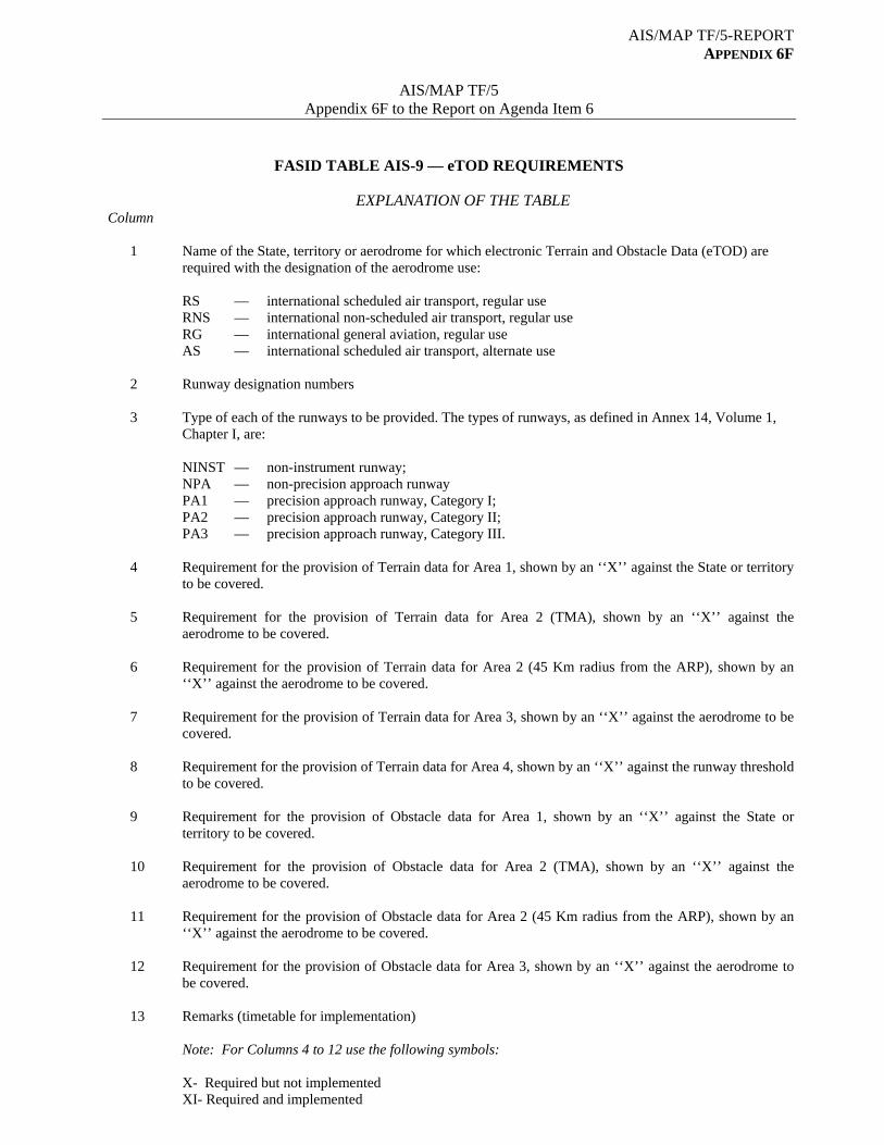
AIS/MAP TF/5-REPORT APPENDIX 6F
AIS/MAP TF/5
Appendix 6F to the Report on Agenda Item 6
FASID TABLE AIS-9 — eTOD REQUIREMENTS
EXPLANATION OF THE TABLE Column 1 Name of the State, territory or aerodrome for which electronic Terrain and Obstacle Data (eTOD) are
required with the designation of the aerodrome use:
RS — international scheduled air transport, regular use RNS — international non-scheduled air transport, regular use RG — international general aviation, regular use AS — international scheduled air transport, alternate use
2 Runway designation numbers 3 Type of each of the runways to be provided. The types of runways, as defined in Annex 14, Volume 1,
Chapter I, are: NINST — non-instrument runway; NPA — non-precision approach runway PA1 — precision approach runway, Category I; PA2 — precision approach runway, Category II; PA3 — precision approach runway, Category III. 4 Requirement for the provision of Terrain data for Area 1, shown by an ‘‘X’’ against the State or territory
to be covered. 5 Requirement for the provision of Terrain data for Area 2 (TMA), shown by an ‘‘X’’ against the
aerodrome to be covered. 6 Requirement for the provision of Terrain data for Area 2 (45 Km radius from the ARP), shown by an
‘‘X’’ against the aerodrome to be covered. 7 Requirement for the provision of Terrain data for Area 3, shown by an ‘‘X’’ against the aerodrome to be
covered. 8 Requirement for the provision of Terrain data for Area 4, shown by an ‘‘X’’ against the runway threshold
to be covered. 9 Requirement for the provision of Obstacle data for Area 1, shown by an ‘‘X’’ against the State or
territory to be covered. 10 Requirement for the provision of Obstacle data for Area 2 (TMA), shown by an ‘‘X’’ against the
aerodrome to be covered. 11 Requirement for the provision of Obstacle data for Area 2 (45 Km radius from the ARP), shown by an
‘‘X’’ against the aerodrome to be covered.
12 Requirement for the provision of Obstacle data for Area 3, shown by an ‘‘X’’ against the aerodrome to be covered.
13 Remarks (timetable for implementation)
Note: For Columns 4 to 12 use the following symbols: X- Required but not implemented XI- Required and implemented

AIS/MAP TF/5-REPORT APPENDIX 6F
6F-2
eTOD Requirements (MID FASID Table AIS-9)
STATE, TERRITORY OR AERODROME FOR WHICH eTOD IS REQUIRED
TERRAIN DATA REQUIRED OBSTACLE DATA
REQUIRED REMARKS
Area 2 Area 2 Area 3 CITY/AERODROME
RWY No
RWY TYPE
Area 1
TMA 45 Km
Area 3 Area 4 Area 1
TMA 45 Km
1 2 3 4 5 6 7 8 9 10 11 12 13
AFGHANISTAN
X
X
(OAKB) KABUL/Kabul Int’l
X
X
X
X
RS 11 29
NPA PA1
(OAKN) KANDAHAR/Kandahar Int’l
AS 05 23
NPA NPA
BAHRAIN
X
X
(OBBI) Bahrain/Bahrain Int’l. X X X X
12L 30R
PA2 PA2
RS
12R 30L
NPA NPA
EGYPT
X
X
(HEAR) EL-ARISH/El-Arish Int’l
X
X
X
X
AS 16 34
NPA NPA
(HEAT) ASYUT/Asyut Int’l X X X X
AS 13 31
NPA NPA
(HEAX) ALEXANDRIA/Alexandria Int’l
X
X
X
X
RS 18 36
NPA NPA
04 22
NPA NPA
(HEAZ) CAIRO/Almaza Int’l
X
X
X
X
ANS 18 36
05 23
NPA NPA
NINST NINST
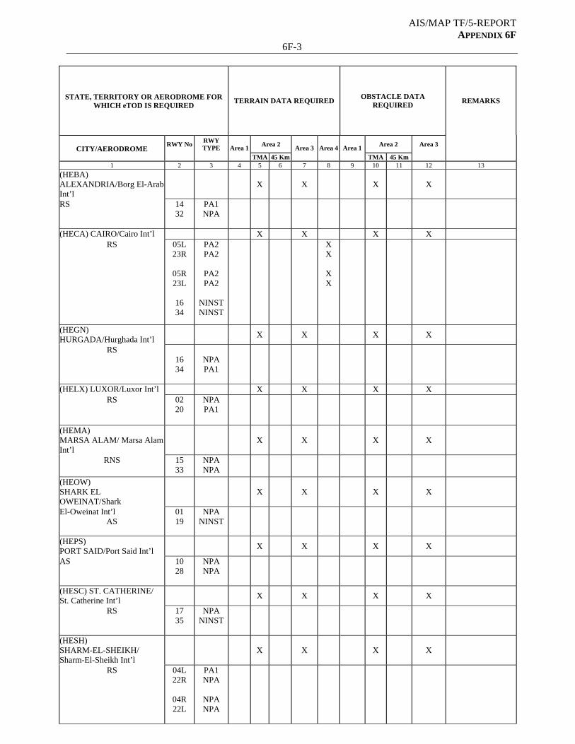
AIS/MAP TF/5-REPORT APPENDIX 6F
6F-3
STATE, TERRITORY OR AERODROME FOR WHICH eTOD IS REQUIRED
TERRAIN DATA REQUIRED OBSTACLE DATA
REQUIRED REMARKS
Area 2 Area 2 Area 3 CITY/AERODROME
RWY No
RWY TYPE
Area 1
TMA 45 Km
Area 3 Area 4 Area 1
TMA 45 Km
1 2 3 4 5 6 7 8 9 10 11 12 13
(HEBA) ALEXANDRIA/Borg El-Arab Int’l
X
X
X
X
RS 14 32
PA1 NPA
(HECA) CAIRO/Cairo Int’l X X X X RS
05L 23R
05R 23L
16 34
PA2 PA2
PA2 PA2
NINST NINST
X X
X X
(HEGN) HURGADA/Hurghada Int’l
X
X
X
X
RS
16 34
NPA PA1
(HELX) LUXOR/Luxor Int’l X X X X RS
02 20
NPA PA1
(HEMA) MARSA ALAM/ Marsa Alam Int’l
X
X
X
X
RNS 15 33
NPA NPA
(HEOW) SHARK EL OWEINAT/Shark
X
X
X
X
El-Oweinat Int’l AS
01 19
NPA NINST
(HEPS) PORT SAID/Port Said Int’l
X
X
X
X
AS 10 28
NPA NPA
(HESC) ST. CATHERINE/ St. Catherine Int’l
X
X
X
X
RS 17 35
NPA NINST
(HESH) SHARM-EL-SHEIKH/ Sharm-El-Sheikh Int’l
X
X
X
X
RS 04L 22R
04R 22L
PA1 NPA
NPA NPA
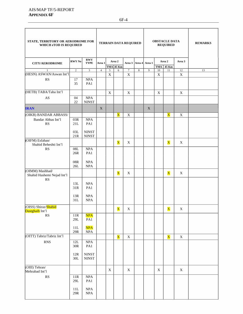
AIS/MAP TF/5-REPORT APPENDIX 6F
6F-4
STATE, TERRITORY OR AERODROME FOR WHICH eTOD IS REQUIRED
TERRAIN DATA REQUIRED OBSTACLE DATA
REQUIRED REMARKS
Area 2 Area 2 Area 3 CITY/AERODROME
RWY No
RWY TYPE
Area 1
TMA 45 Km
Area 3 Area 4 Area 1
TMA 45 Km
1 2 3 4 5 6 7 8 9 10 11 12 13
(HESN) ASWAN/Aswan Int’l X X X X
RS 17 35
NPA PA1
(HETB) TABA/Taba Int’l X X X X
AS
04 22
NPA NINST
IRAN
X X
(OIKB) BANDAR ABBASS/ X X X X Bandar Abbas Int’l
RS 03R 21L
03L 21R
NPA PA1
NINST NINST
(OIFM) Esfahan/ Shahid Beheshti Int’l
X X X X
RS 08L 26R
NPA PA1
08R 26L
NPA NPA
(OIMM) Mashhad/ Shahid Hashemi Nejad Int’l
X X X X
RS 13L 31R
13R 31L
NPA PA1
NPA NPA
(OISS) Shiraz/Shahid Dastghaib Int’l
X X X X
RS
11R 29L
11L 29R
NPA PA1
NPA NPA
(OITT) Tabriz/Tabriz Int’l X X X X
RNS
12L 30R
12R 30L
NPA PA1
NINST NINST
(OIII) Tehran/ Mehrabad Int’l
X
X
X
X
RS 11R 29L
11L 29R
NPA PA1
NPA NPA
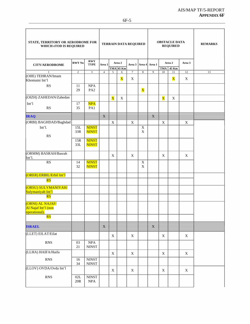
AIS/MAP TF/5-REPORT APPENDIX 6F
6F-5
STATE, TERRITORY OR AERODROME FOR WHICH eTOD IS REQUIRED
TERRAIN DATA REQUIRED OBSTACLE DATA
REQUIRED REMARKS
Area 2 Area 2 Area 3 CITY/AERODROME
RWY No
RWY TYPE
Area 1
TMA 45 Km
Area 3 Area 4 Area 1
TMA 45 Km
1 2 3 4 5 6 7 8 9 10 11 12 13
(OIIE) TEHRAN/Imam Khomaini Int’l
X X X X
RS 11 29
NPA PA2
X
(OIZH) ZAHEDAN/Zahedan X X X X
Int’l RS
17 35
NPA PA1
IRAQ X X
(ORBI) BAGHDAD/Baghdad X X X X
15L 33R
NINST NINST
X X
Int’l.
RS 15R
33L NINST NINST
(ORMM) BASRAH/Basrah Int’l.
X
X
X
X
RS 14 32
NINST NINST
X X
(ORER) ERBIL/Erbil Int’l
RS
(ORSU) SULYMANIYAH/ Sulymaniyah Int’l
RS
(ORNI) AL NAJAF/ Al Najaf Int’l (non operational).
RS
ISRAEL
X X
(LLET) EILAT/Eilat
X
X
X
X
RNS 03 21
NPA NINST
(LLHA) HAIFA/Haifa X X X X
RNS 16 34
NINST NINST
(LLOV) OVDA/Ovda Int’l
X
X
X
X
RNS 02L 20R
NINST NPA
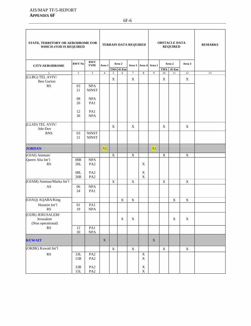
AIS/MAP TF/5-REPORT APPENDIX 6F
6F-6
STATE, TERRITORY OR AERODROME FOR WHICH eTOD IS REQUIRED
TERRAIN DATA REQUIRED OBSTACLE DATA
REQUIRED REMARKS
Area 2 Area 2 Area 3 CITY/AERODROME
RWY No
RWY TYPE
Area 1
TMA 45 Km
Area 3 Area 4 Area 1
TMA 45 Km
1 2 3 4 5 6 7 8 9 10 11 12 13
(LLBG) TEL AVIV/ Ben Gurion
X
X
X
X
RS 03 21
08 26
12 30
NPA NINST
NPA PA1
PA1 NPA
(LLSD) TEL AVIV/ Sde-Dov
X
X
X
X
RNS 03 21
NINST NINST
JORDAN
XI XI
(OJAI) Amman/ X X X X Queen Alia Int’l
RS 08R 26L
08L 26R
NPA PA2
PA2 PA2
X
X X
(OJAM) Amman/Marka Int’l X X X X
AS 06 24
NPA PA1
(OJAQ) AQABA/King X X X X
Hussein Int’l RS
01 19
PA1 NPA
(OJJR) JERUSALEM/ Jerusalem (Non operational)
X X
X X
RS
12 30
PA1 NPA
KUWAIT
X X
(OKBK) Kuwait Int’l X X X X
RS 33L 15R
33R 15L
PA2 PA2
PA2 PA2
X X
X X

AIS/MAP TF/5-REPORT APPENDIX 6F
6F-7
STATE, TERRITORY OR AERODROME FOR WHICH eTOD IS REQUIRED
TERRAIN DATA REQUIRED OBSTACLE DATA
REQUIRED REMARKS
Area 2 Area 2 Area 3 CITY/AERODROME
RWY No
RWY TYPE
Area 1
TMA 45 Km
Area 3 Area 4 Area 1
TMA 45 Km
1 2 3 4 5 6 7 8 9 10 11 12 13
LEBANON X X
(OLBA) BEIRUT/ R.B.H-Beirut Int’l
X
X
X
X
RS 17 35
16 34
03 21
PA1 NINST
PA1
NINST
PA1 PA1
OMAN
X X
(OOMS) Muscat/ Muscat Int’l
X
X
X
X
RS
08 26
PA1 PA1
(OOSA) SALALAH/Salalah Int’l
X
X
X
X
AS
07 25
NPA PA1
QATAR X X
(OTBD) DOHA/Doha Int’l X X X X RS
34 16
PA2 PA1
X
(OTxx) DOHA/New Doha Int’l (Future)
RS
SAUDI ARABIA
X X
(OEDF) DAMMAM/King Fahd Int’l
X
X
X
X
RS 16L 34R
16R 34L
PA1 PA1
PA1 PA1
(OEJN) JEDDAH/King Abdulaziz Int’l
X
X
X
X
RS 16R 34L
16C 34C
16L 34R
PA2 PA2
PA2 PA2
PA1 PA1
X X
X X

AIS/MAP TF/5-REPORT APPENDIX 6F
6F-8
STATE, TERRITORY OR AERODROME FOR WHICH eTOD IS REQUIRED
TERRAIN DATA REQUIRED OBSTACLE DATA
REQUIRED REMARKS
Area 2 Area 2 Area 3 CITY/AERODROME
RWY No
RWY TYPE
Area 1
TMA 45 Km
Area 3 Area 4 Area 1
TMA 45 Km
1 2 3 4 5 6 7 8 9 10 11 12 13
(OEMA)MADINAH/Prince Mohammad Bin Abdulaziz
X
X
X
X
RS 17 35
18 36
PA1 PA1
NPA PA1
(OERK) RIYADH/King Khalid Int’l
X
X
X
X
RS 15L 33R
15R 33L
PA1 PA1
PA1 PA1
SYRIA
X X
(OSAP) ALEPPO/Aleppo Int’l
X
X
X
X
RS 09 27
PA2 PA2
X X
(OSLK) LATTAKIA/Bassel Al-Assad
X
X
X
X
RS 17 35
NPA PA1
(OSDI) DAMASCUS/Damascus Int’l
X
X
X
X
05L 23R
PA2 PA2
X X
RS
05R 23L
PA2 PA2
X X
UNITED ARAB EMIRATES
X X
(OMAA) ABU DHABI/ Abu Dhabi Int’l
X
X
X
X
RS
13R 31L
13L 31R
PA1 PA3
PA3 PA3
X
X X
(OMAL) AL AIN/ Al Ain Int’l
X
X
X
X
RS
01 19
PA1 NPA
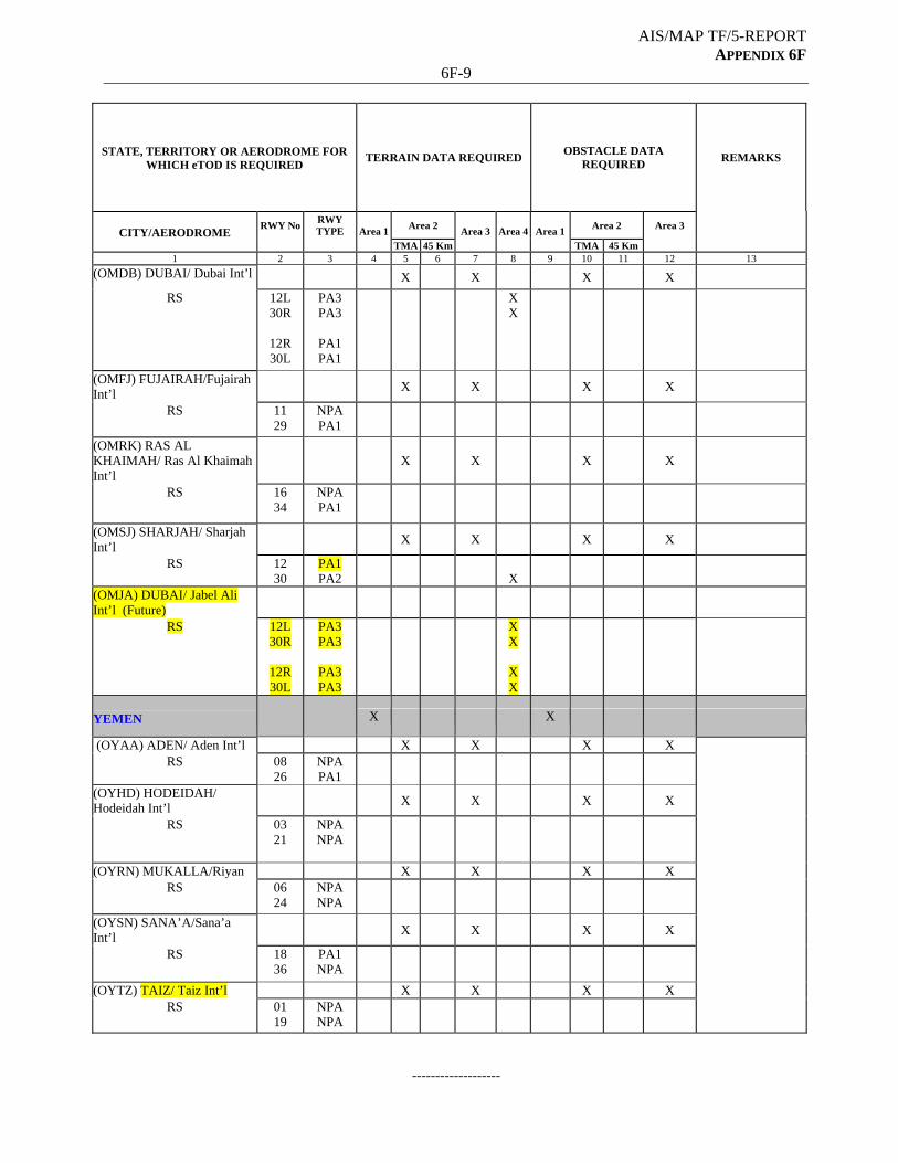
AIS/MAP TF/5-REPORT APPENDIX 6F
6F-9
STATE, TERRITORY OR AERODROME FOR WHICH eTOD IS REQUIRED
TERRAIN DATA REQUIRED OBSTACLE DATA
REQUIRED REMARKS
Area 2 Area 2 Area 3 CITY/AERODROME
RWY No
RWY TYPE
Area 1
TMA 45 Km
Area 3 Area 4 Area 1
TMA 45 Km
1 2 3 4 5 6 7 8 9 10 11 12 13
(OMDB) DUBAI/ Dubai Int’l X X X X
RS 12L 30R
12R 30L
PA3 PA3
PA1 PA1
X X
(OMFJ) FUJAIRAH/Fujairah Int’l
X
X
X
X
RS 11 29
NPA PA1
(OMRK) RAS AL KHAIMAH/ Ras Al Khaimah Int’l
X
X
X
X
RS 16 34
NPA PA1
(OMSJ) SHARJAH/ Sharjah Int’l
X
X
X
X
RS 12 30
PA1 PA2
X
(OMJA) DUBAI/ Jabel Ali Int’l (Future)
RS 12L 30R
12R 30L
PA3 PA3
PA3 PA3
X X
X X
YEMEN
X X
(OYAA) ADEN/ Aden Int’l X X X X RS 08
26 NPA PA1
(OYHD) HODEIDAH/ Hodeidah Int’l
X
X
X
X
RS 03 21
NPA NPA
(OYRN) MUKALLA/Riyan X X X X RS 06
24 NPA NPA
(OYSN) SANA’A/Sana’a Int’l
X
X
X
X
RS 18 36
PA1 NPA
(OYTZ) TAIZ/ Taiz Int’l X X X X RS 01
19 NPA NPA
-------------------
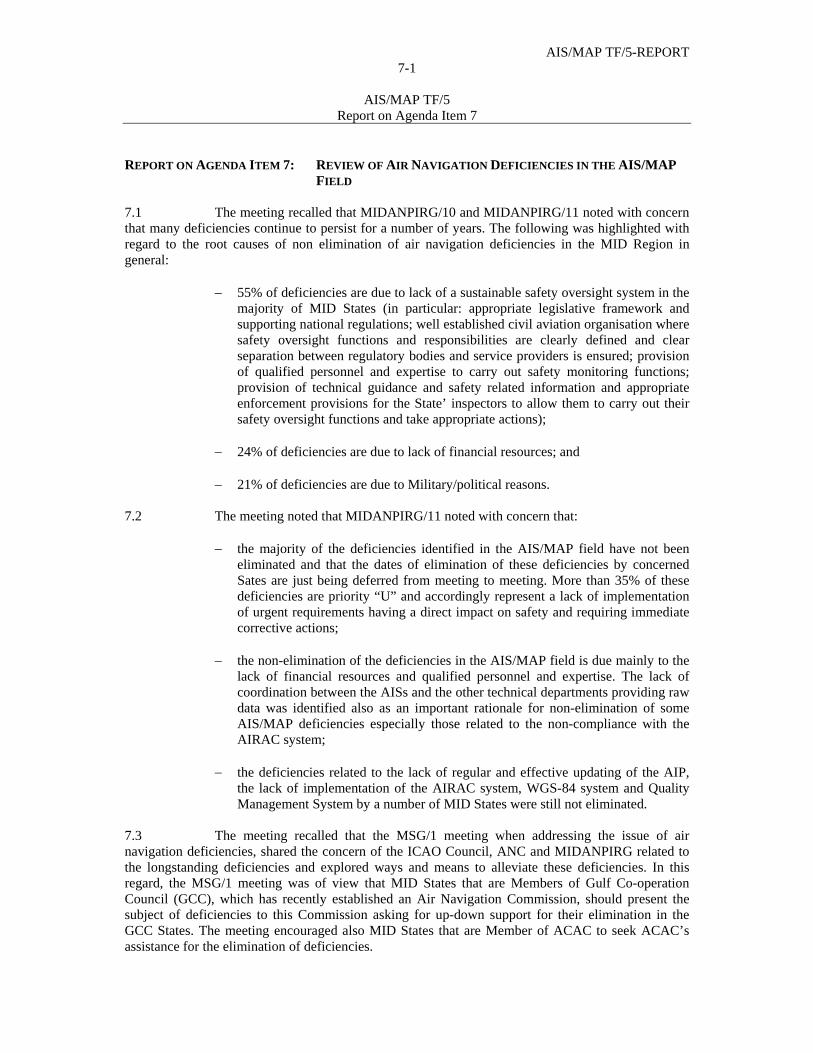
AIS/MAP TF/5-REPORT 7-1
AIS/MAP TF/5
Report on Agenda Item 7
REPORT ON AGENDA ITEM 7: REVIEW OF AIR NAVIGATION DEFICIENCIES IN THE AIS/MAP
FIELD 7.1 The meeting recalled that MIDANPIRG/10 and MIDANPIRG/11 noted with concern that many deficiencies continue to persist for a number of years. The following was highlighted with regard to the root causes of non elimination of air navigation deficiencies in the MID Region in general:
55% of deficiencies are due to lack of a sustainable safety oversight system in the majority of MID States (in particular: appropriate legislative framework and supporting national regulations; well established civil aviation organisation where safety oversight functions and responsibilities are clearly defined and clear separation between regulatory bodies and service providers is ensured; provision of qualified personnel and expertise to carry out safety monitoring functions; provision of technical guidance and safety related information and appropriate enforcement provisions for the State’ inspectors to allow them to carry out their safety oversight functions and take appropriate actions);
24% of deficiencies are due to lack of financial resources; and 21% of deficiencies are due to Military/political reasons.
7.2 The meeting noted that MIDANPIRG/11 noted with concern that:
the majority of the deficiencies identified in the AIS/MAP field have not been eliminated and that the dates of elimination of these deficiencies by concerned Sates are just being deferred from meeting to meeting. More than 35% of these deficiencies are priority “U” and accordingly represent a lack of implementation of urgent requirements having a direct impact on safety and requiring immediate corrective actions;
the non-elimination of the deficiencies in the AIS/MAP field is due mainly to the
lack of financial resources and qualified personnel and expertise. The lack of coordination between the AISs and the other technical departments providing raw data was identified also as an important rationale for non-elimination of some AIS/MAP deficiencies especially those related to the non-compliance with the AIRAC system;
the deficiencies related to the lack of regular and effective updating of the AIP,
the lack of implementation of the AIRAC system, WGS-84 system and Quality Management System by a number of MID States were still not eliminated.
7.3 The meeting recalled that the MSG/1 meeting when addressing the issue of air navigation deficiencies, shared the concern of the ICAO Council, ANC and MIDANPIRG related to the longstanding deficiencies and explored ways and means to alleviate these deficiencies. In this regard, the MSG/1 meeting was of view that MID States that are Members of Gulf Co-operation Council (GCC), which has recently established an Air Navigation Commission, should present the subject of deficiencies to this Commission asking for up-down support for their elimination in the GCC States. The meeting encouraged also MID States that are Member of ACAC to seek ACAC’s assistance for the elimination of deficiencies.
AIS/MAP TF/5-REPORT 7-2
AIS/MAP TF/5
Report on Agenda Item 7
7.4 The meeting noted that the ICAO MID Regional Office further improved the MID Air Navigation Deficiency Database (MANDD). It was highlighted in this regard, that the database management system including all searching features capabilities will be available on the web (restricted) soon. 7.5 In connection with the above, the meeting noted that MIDANPIRG/11 agreed to Conclusion 11/86 related to the elimination of air navigation deficiencies as follows:
CONCLUSION 11/86: ELIMINATION OF AIR NAVIGATION DEFICIENCIES IN THE MID REGION That, a) MID States review their respective lists of identified deficiencies, define their root
causes and forward an action plan for rectification of outstanding deficiencies to the ICAO MID Regional Office;
b) MID States and Users Organizations use the online facility offered by the ICAO MID Air Navigation Deficiency Database (MANDD) for submitting online requests for addition, update and elimination of air navigation deficiencies;
c) MID States increase their efforts to overcome the delay in mitigating air navigation deficiencies identified by MIDANPIRG and explore ways and means to eliminate deficiencies;
d) ICAO continue to provide assistance to States for the purpose of rectifying deficiencies; and when required, States request ICAO assistance through Technical Co-operation Programme, Special Implementation Projects (SIP) and/or other available mechanisms such as IFFAS;and
e) MID States are encouraged to seek support from regional and international organizations (i.e. ACAC, GCC, etc.) for the elimination of identified air navigation deficiencies.
7.6 The meeting reviewed and updated the list of deficiencies in the AIS/MAP field as at Appendix 7A to the Report on Agenda Item 4. It was noted with appreciation that Jordan has eliminated two deficiencies and Oman has eliminated one.
---------------------------
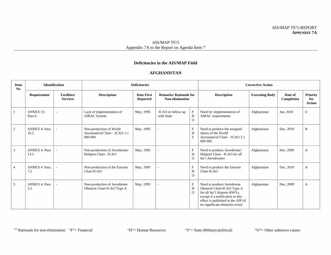
AIS/MAP TF/5-REPORT APPENDIX 7A
AIS/MAP TF/5
Appendix 7A to the Report on Agenda Item 7
(1) Rationale for non-elimination: “F”= Financial “H”= Human Resources “S”= State (Military/political) “O”= Other unknown causes
Deficiencies in the AIS/MAP Field
AFGHANISTAN
Identification Deficiencies Corrective Action Item No
Requirement Facilities/ Services
Description Date First Reported
Remarks/ Rationale for Non-elimination
Description Executing Body Date of Completion
Priority for
Action
1 ANNEX 15: Para 6.
- Lack of implementation of AIRAC System
May, 1995
ICAO to follow up with State
F H O
Need for implementation of AIRAC requirements
Afghanistan Jan, 2010
U
2 ANNEX 4: Para 16.2
- Non-production of World Aeronautical Chart – ICAO 1:1 000 000
May, 1995
- F H S
Need to produce the assigned sheets of the World Aeronautical Chart – ICAO 1:1 000 000
Afghanistan Dec, 2010
B
3 ANNEX 4: Para 13.2
- Non-production of Aerodrome/ Heliport Chart - ICAO
May, 1995
- F H O
Need to produce Aerodrome/ Heliport Chart - ICAO for all Int`l Aerodromes
Afghanistan Dec, 2009
A
4 ANNEX 4 Para. 7.2
- Non-production of the Enroute Chart-ICAO
May, 1995
- F H O
Need to produce the Enroute Chart-ICAO
Afghanistan Dec, 2010
A
5 ANNEX 4: Para 3.2
- Non-production of Aerodrome Obstacle Chart-ICAO Type A
May, 1995
- F H O
Need to produce Aerodrome Obstacle Chart-ICAO Type A for all Int`l Airports RWYs, except if a notification to this effect is published in the AIP (if no significant obstacles exist)
Afghanistan Dec, 2009
A
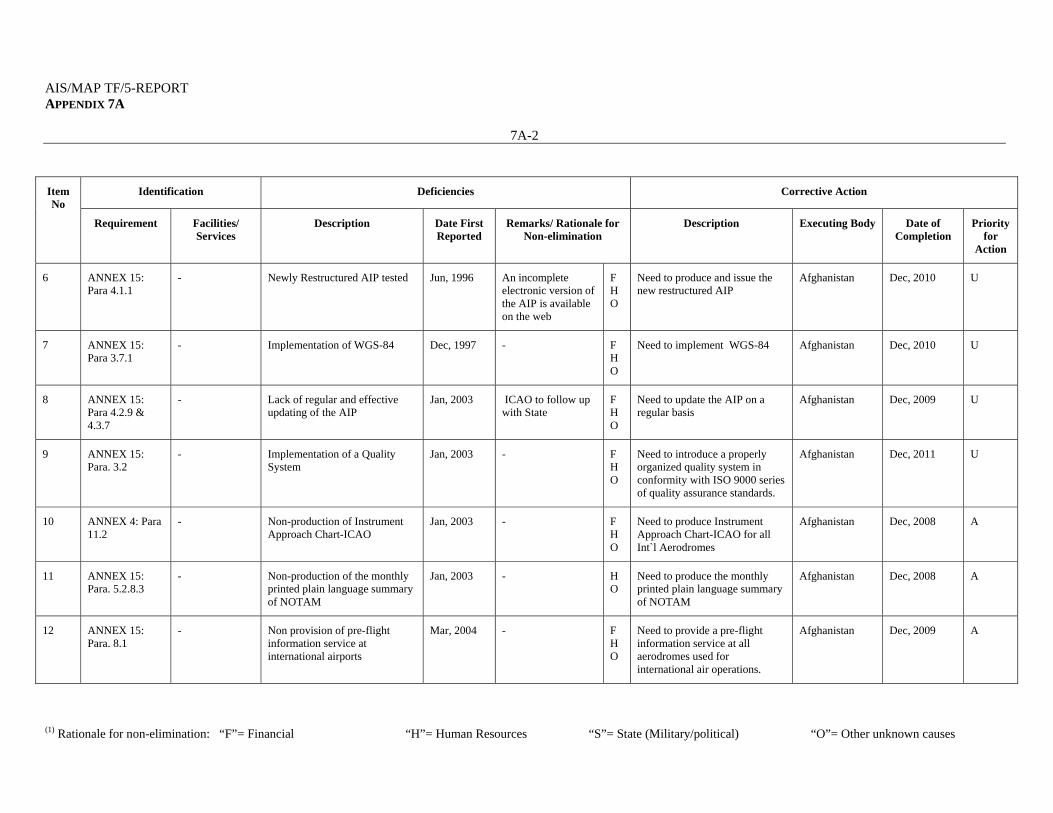
AIS/MAP TF/5-REPORT APPENDIX 7A
7A-2
(1) Rationale for non-elimination: “F”= Financial “H”= Human Resources “S”= State (Military/political) “O”= Other unknown causes
Identification Deficiencies Corrective Action Item No
Requirement Facilities/ Services
Description Date First Reported
Remarks/ Rationale for Non-elimination
Description Executing Body Date of Completion
Priority for
Action
6 ANNEX 15: Para 4.1.1
- Newly Restructured AIP tested Jun, 1996
An incomplete electronic version of the AIP is available on the web
F H O
Need to produce and issue the new restructured AIP
Afghanistan Dec, 2010
U
7 ANNEX 15: Para 3.7.1
- Implementation of WGS-84 Dec, 1997
- F H O
Need to implement WGS-84 Afghanistan Dec, 2010
U
8 ANNEX 15: Para 4.2.9 & 4.3.7
- Lack of regular and effective updating of the AIP
Jan, 2003
ICAO to follow up with State
F H O
Need to update the AIP on a regular basis
Afghanistan Dec, 2009
U
9 ANNEX 15: Para. 3.2
- Implementation of a Quality System
Jan, 2003
- F H O
Need to introduce a properly organized quality system in conformity with ISO 9000 series of quality assurance standards.
Afghanistan Dec, 2011
U
10 ANNEX 4: Para 11.2
- Non-production of Instrument Approach Chart-ICAO
Jan, 2003
- F H O
Need to produce Instrument Approach Chart-ICAO for all Int`l Aerodromes
Afghanistan Dec, 2008
A
11 ANNEX 15: Para. 5.2.8.3
- Non-production of the monthly printed plain language summary of NOTAM
Jan, 2003
- H O
Need to produce the monthly printed plain language summary of NOTAM
Afghanistan Dec, 2008
A
12 ANNEX 15: Para. 8.1
- Non provision of pre-flight information service at international airports
Mar, 2004
- F H O
Need to provide a pre-flight information service at all aerodromes used for international air operations.
Afghanistan Dec, 2009
A
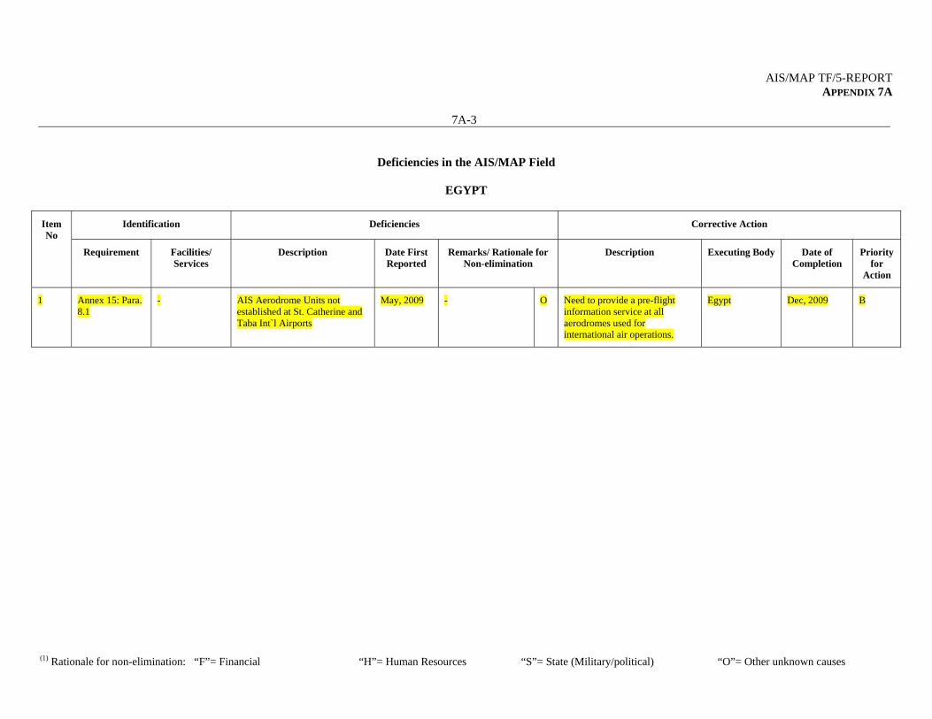
AIS/MAP TF/5-REPORT APPENDIX 7A
7A-3
(1) Rationale for non-elimination: “F”= Financial “H”= Human Resources “S”= State (Military/political) “O”= Other unknown causes
Deficiencies in the AIS/MAP Field
EGYPT
Identification Deficiencies Corrective Action Item No
Requirement Facilities/ Services
Description Date First Reported
Remarks/ Rationale for Non-elimination
Description Executing Body Date of Completion
Priority for
Action
1 Annex 15: Para. 8.1
- AIS Aerodrome Units not established at St. Catherine and Taba Int`l Airports
May, 2009
- O Need to provide a pre-flight information service at all aerodromes used for international air operations.
Egypt Dec, 2009
B
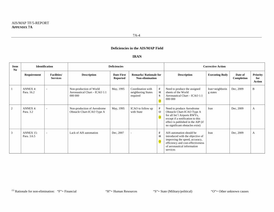
AIS/MAP TF/5-REPORT APPENDIX 7A
7A-4
(1) Rationale for non-elimination: “F”= Financial “H”= Human Resources “S”= State (Military/political) “O”= Other unknown causes
Deficiencies in the AIS/MAP Field
IRAN
Identification Deficiencies Corrective Action Item No
Requirement Facilities/ Services
Description Date First Reported
Remarks/ Rationale for Non-elimination
Description Executing Body Date of Completion
Priority for
Action
1 ANNEX 4: Para. 16.2
- Non-production of World Aeronautical Chart – ICAO 1:1 000 000
May, 1995
Coordination with neighboring States required
F H S
O
Need to produce the assigned sheets of the World Aeronautical Chart – ICAO 1:1 000 000
Iran+neighboring states
Dec, 2009
B
2 ANNEX 4: Para. 3.2
- Non-production of Aerodrome Obstacle Chart-ICAO Type A
May, 1995
ICAO to follow up with State
F O
O
Need to produce Aerodrome Obstacle Chart-ICAO Type A for all Int`l Airports RWYs, except if a notification to this effect is published in the AIP (if no significant obstacles exist)
Iran Dec, 2009
A
3 ANNEX 15: Para. 3.6.5
- Lack of AIS automation Dec, 2007
- F H
O
AIS automation should be introduced with the objective of improving the speed, accuracy, efficiency and cost-effectiveness of aeronautical information services
Iran Dec, 2009
A

AIS/MAP TF/5-REPORT APPENDIX 7A
7A-5
(1) Rationale for non-elimination: “F”= Financial “H”= Human Resources “S”= State (Military/political) “O”= Other unknown causes
Deficiencies in the AIS/MAP Field
IRAQ
Identification Deficiencies Corrective Action Item No
Requirement Facilities/ Services
Description Date First Reported
Remarks/ Rationale for Non-elimination
Description Executing Body Date of Completion
Priority for
Action
1 ANNEX 15: Para 6.
- Lack of implementation of AIRAC System
May, 1995
ICAO to follow up with State
F H O
Need to fully comply with the AIRAC procedure
Iraq Jan, 2010
U
2 ANNEX 4: Para. 16.2
- Non-production of World Aeronautical Chart – ICAO 1:1 000 000
May, 1995
- F H S
Need to produce the assigned sheets of the World Aeronautical Chart – ICAO 1:1 000 000
Iraq Dec, 2010
B
3 ANNEX 4: Para. 7.2
- Non-production of the Enroute Chart-ICAO
May, 1995
- F H O
Need to produce the Enroute Chart-ICAO
Iraq Dec, 2010
A
4 ANNEX 4: Para. 13.2
- Non-production of Aerodrome/ Heliport Chart - ICAO
May, 1995
- F H O
Need to produce Aerodrome/ Heliport Chart - ICAO for all Int`l Aerodromes
Iraq Dec, 2010
A
5 ANNEX 15: Para 4.1.1
- Newly Restructured AIP Jun, 1996
An incomplete electronic version of the AIP is available on the web
F H O
Need to produce and issue the new restructured AIP
Iraq Dec, 2010
U
6 ANNEX 15: Para 3.7.1
- Implementation of WGS-84 Dec, 1997
- F H O
Need to implement WGS-84 Iraq Dec, 2010
U

AIS/MAP TF/5-REPORT APPENDIX 7A
7A-6
(1) Rationale for non-elimination: “F”= Financial “H”= Human Resources “S”= State (Military/political) “O”= Other unknown causes
Identification Deficiencies Corrective Action Item No
Requirement Facilities/ Services
Description Date First Reported
Remarks/ Rationale for Non-elimination
Description Executing Body Date of Completion
Priority for
Action
7 ANNEX 15: Para. 3.2
- Implementation of a Quality System
Jan, 2003
- F H O
Need to introduce a properly organized quality system in conformity with ISO 9000 series of quality assurance standards.
Iraq Dec, 2011
U
8 ANNEX 15: Para 4.2.9 & 4.3.7
- Lack of regular and effective updating of the AIP
Jan, 2003
ICAO to follow up with State
F H O
Need to update the AIP on a regular basis
Iraq Dec, 2010
U
9 ANNEX 15: Para. 5.2.8.3
- Non-production of the monthly printed plain language summary of NOTAM
Jan, 2003
- H O
Need to produce the monthly printed plain language summary of NOTAM
Iraq Dec, 2008
A
10 ANNEX 4: Para. 11.2
- Non-production of Instrument Approach Chart-ICAO
Jan, 2003
- F H O
Need to produce Instrument Approach Chart-ICAO for all Int`l Aerodromes
Iraq Dec, 2008
A
11 ANNEX 15: Para. 8.1
- Non provision of pre-flight information service at international airports
Mar, 2004
- F H O
Need to provide a pre-flight information service at all aerodromes used for international air operations.
Iraq Dec, 2009
A
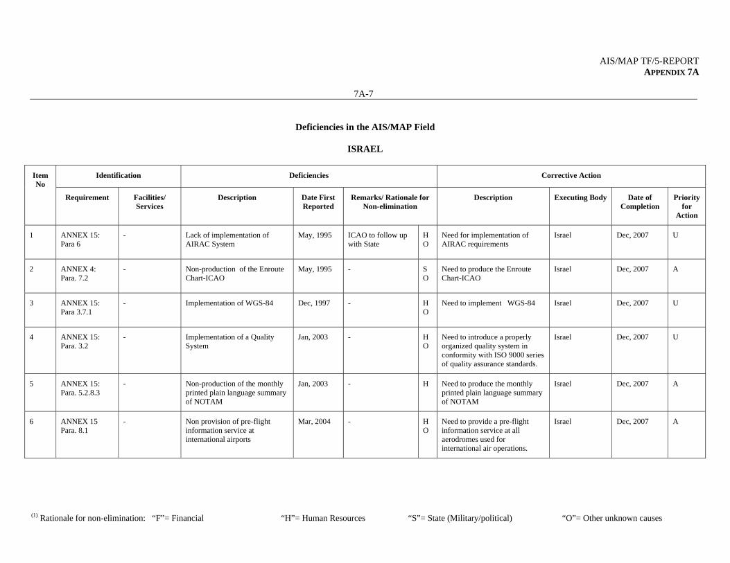
AIS/MAP TF/5-REPORT APPENDIX 7A
7A-7
(1) Rationale for non-elimination: “F”= Financial “H”= Human Resources “S”= State (Military/political) “O”= Other unknown causes
Deficiencies in the AIS/MAP Field
ISRAEL
Identification Deficiencies Corrective Action Item No
Requirement Facilities/ Services
Description Date First Reported
Remarks/ Rationale for Non-elimination
Description Executing Body Date of Completion
Priority for
Action
1 ANNEX 15: Para 6
- Lack of implementation of AIRAC System
May, 1995
ICAO to follow up with State
H O
Need for implementation of AIRAC requirements
Israel Dec, 2007
U
2 ANNEX 4: Para. 7.2
- Non-production of the Enroute Chart-ICAO
May, 1995
- S O
Need to produce the Enroute Chart-ICAO
Israel Dec, 2007
A
3 ANNEX 15: Para 3.7.1
- Implementation of WGS-84 Dec, 1997
- H O
Need to implement WGS-84 Israel Dec, 2007
U
4 ANNEX 15: Para. 3.2
- Implementation of a Quality System
Jan, 2003
- H O
Need to introduce a properly organized quality system in conformity with ISO 9000 series of quality assurance standards.
Israel Dec, 2007
U
5 ANNEX 15: Para. 5.2.8.3
- Non-production of the monthly printed plain language summary of NOTAM
Jan, 2003
- H Need to produce the monthly printed plain language summary of NOTAM
Israel Dec, 2007
A
6 ANNEX 15 Para. 8.1
- Non provision of pre-flight information service at international airports
Mar, 2004
- H O
Need to provide a pre-flight information service at all aerodromes used for international air operations.
Israel Dec, 2007
A
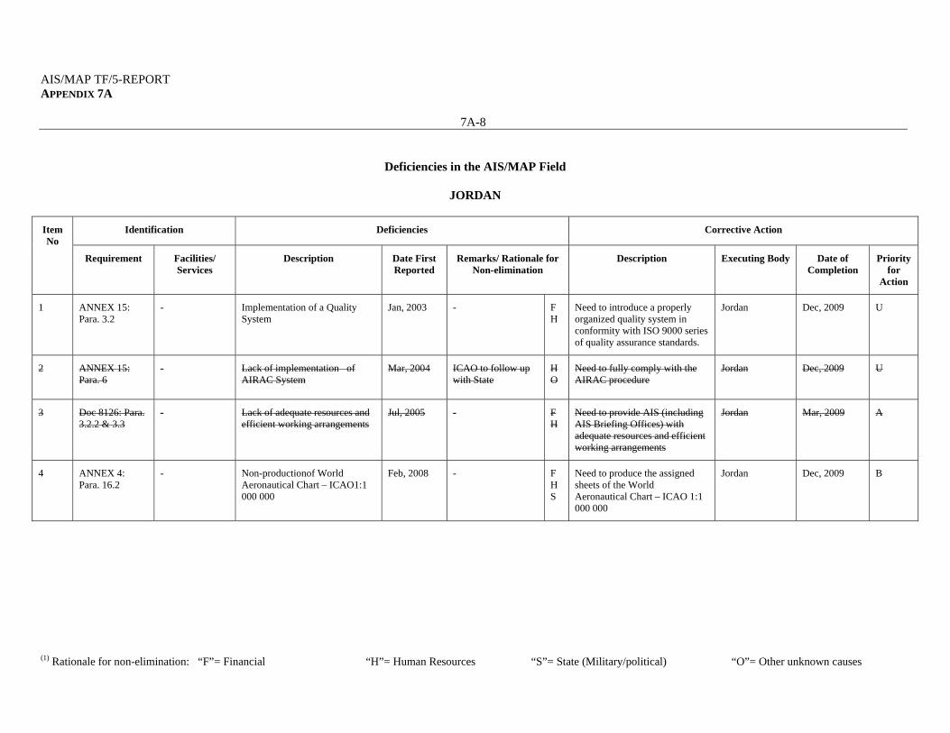
AIS/MAP TF/5-REPORT APPENDIX 7A
7A-8
(1) Rationale for non-elimination: “F”= Financial “H”= Human Resources “S”= State (Military/political) “O”= Other unknown causes
Deficiencies in the AIS/MAP Field
JORDAN
Identification Deficiencies Corrective Action Item No
Requirement Facilities/ Services
Description Date First Reported
Remarks/ Rationale for Non-elimination
Description Executing Body Date of Completion
Priority for
Action
1 ANNEX 15: Para. 3.2
- Implementation of a Quality System
Jan, 2003
- F H
Need to introduce a properly organized quality system in conformity with ISO 9000 series of quality assurance standards.
Jordan Dec, 2009
U
2 ANNEX 15: Para. 6
- Lack of implementation of AIRAC System
Mar, 2004
ICAO to follow up with State
H O
Need to fully comply with the AIRAC procedure
Jordan Dec, 2009
U
3 Doc 8126: Para. 3.2.2 & 3.3
- Lack of adequate resources and efficient working arrangements
Jul, 2005
- F H
Need to provide AIS (including AIS Briefing Offices) with adequate resources and efficient working arrangements
Jordan Mar, 2009
A
4 ANNEX 4: Para. 16.2
- Non-productionof World Aeronautical Chart – ICAO1:1 000 000
Feb, 2008
- F H S
Need to produce the assigned sheets of the World Aeronautical Chart – ICAO 1:1 000 000
Jordan Dec, 2009
B
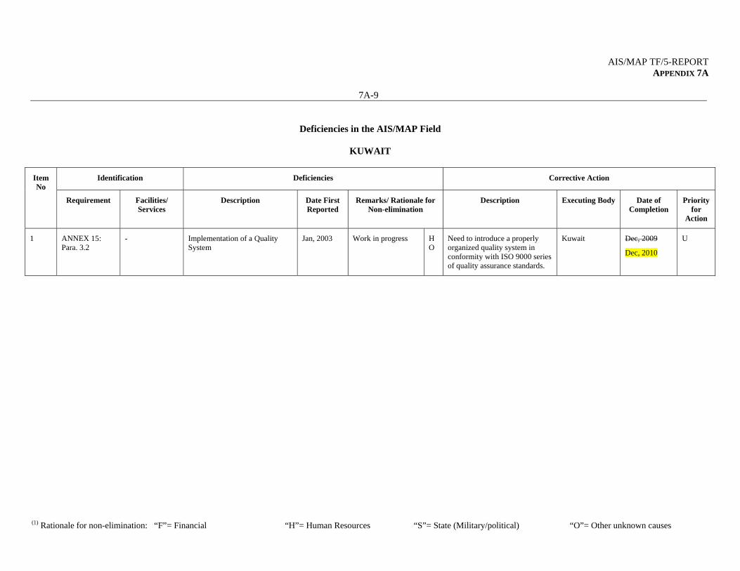
AIS/MAP TF/5-REPORT APPENDIX 7A
7A-9
(1) Rationale for non-elimination: “F”= Financial “H”= Human Resources “S”= State (Military/political) “O”= Other unknown causes
Deficiencies in the AIS/MAP Field
KUWAIT
Identification Deficiencies Corrective Action Item No
Requirement Facilities/ Services
Description Date First Reported
Remarks/ Rationale for Non-elimination
Description Executing Body Date of Completion
Priority for
Action
1 ANNEX 15: Para. 3.2
- Implementation of a Quality System
Jan, 2003
Work in progress H O
Need to introduce a properly organized quality system in conformity with ISO 9000 series of quality assurance standards.
Kuwait Dec, 2009
Dec, 2010
U
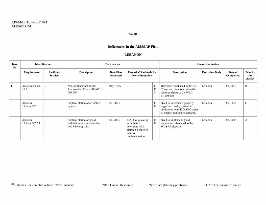
AIS/MAP TF/5-REPORT APPENDIX 7A
7A-10
(1) Rationale for non-elimination: “F”= Financial “H”= Human Resources “S”= State (Military/political) “O”= Other unknown causes
Deficiencies in the AIS/MAP Field
LEBANON
Identification Deficiencies Corrective Action Item No
Requirement Facilities/ Services
Description Date First Reported
Remarks/ Rationale for Non-elimination
Description Executing Body Date of Completion
Priority for
Action
1 ANNEX 4 Para. 16.2
- Non-productionof World Aeronautical Chart – ICAO1:1 000 000
May, 1995
- F H S
Difference published in the AIP. There`s no plan to produce the required sheets of the WAC 1:1000 000
Lebanon Dec, 2015
B
2 ANNEX 15:Para. 3.2
- Implementation of a Quality System
Jan, 2003
- F H
Need to introduce a properly organized quality system in conformity with ISO 9000 series of quality assurance standards.
Lebanon Dec, 2010
U
3 ANNEX 15:Para. 3.7.2.4
- Implementation of geoid undulation referenced to the WGS-84 ellipsoid.
Jan, 2003
ICAO to follow up with State to determine what action is needed to achieve implementation.
F H
Need to implement geoid undulation referenced to the WGS-84 ellipsoid.
Lebanon Dec, 2009
A
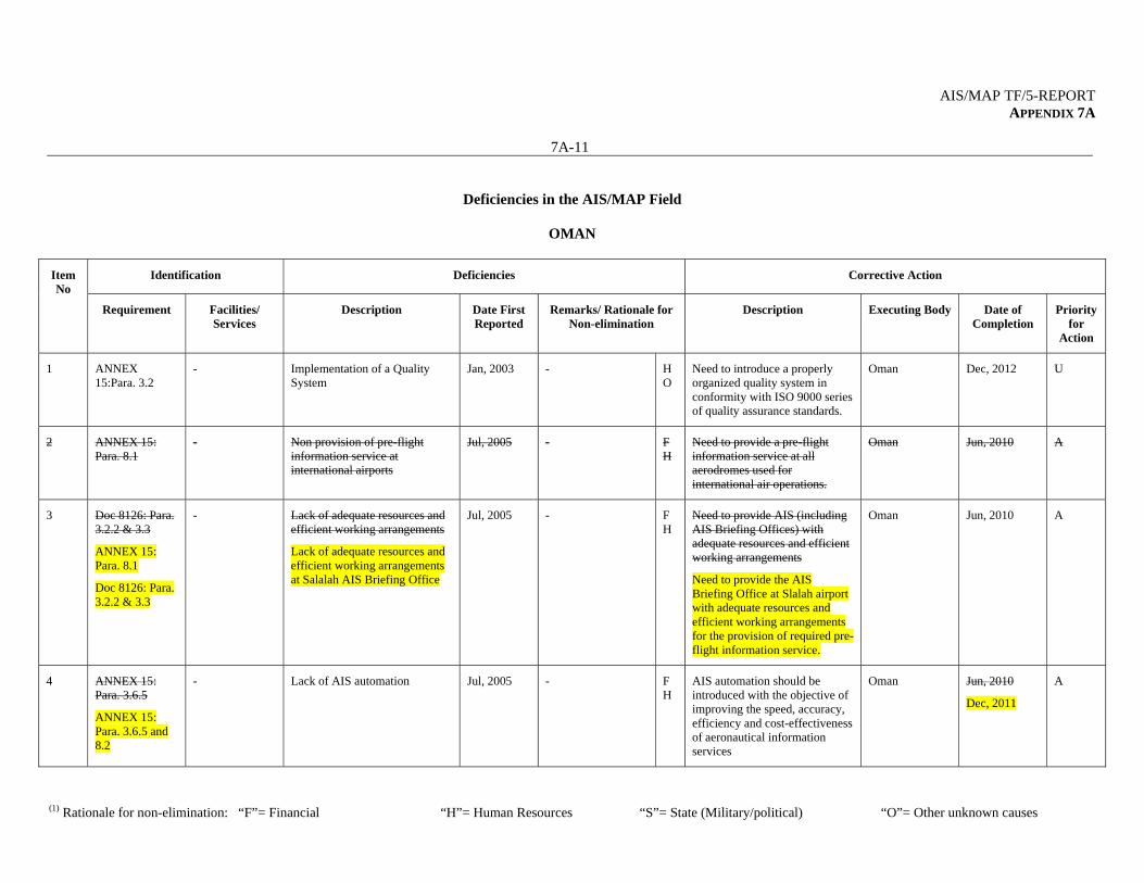
AIS/MAP TF/5-REPORT APPENDIX 7A
7A-11
(1) Rationale for non-elimination: “F”= Financial “H”= Human Resources “S”= State (Military/political) “O”= Other unknown causes
Deficiencies in the AIS/MAP Field
OMAN
Identification Deficiencies Corrective Action Item No
Requirement Facilities/ Services
Description Date First Reported
Remarks/ Rationale for Non-elimination
Description Executing Body Date of Completion
Priority for
Action
1 ANNEX 15:Para. 3.2
- Implementation of a Quality System
Jan, 2003
- H O
Need to introduce a properly organized quality system in conformity with ISO 9000 series of quality assurance standards.
Oman Dec, 2012
U
2 ANNEX 15: Para. 8.1
- Non provision of pre-flight information service at international airports
Jul, 2005
- F H
Need to provide a pre-flight information service at all aerodromes used for international air operations.
Oman Jun, 2010
A
3 Doc 8126: Para. 3.2.2 & 3.3
ANNEX 15: Para. 8.1
Doc 8126: Para. 3.2.2 & 3.3
- Lack of adequate resources and efficient working arrangements
Lack of adequate resources and efficient working arrangements at Salalah AIS Briefing Office
Jul, 2005
- F H
Need to provide AIS (including AIS Briefing Offices) with adequate resources and efficient working arrangements
Need to provide the AIS Briefing Office at Slalah airport with adequate resources and efficient working arrangements for the provision of required pre-flight information service.
Oman Jun, 2010
A
4 ANNEX 15: Para. 3.6.5
ANNEX 15: Para. 3.6.5 and 8.2
- Lack of AIS automation Jul, 2005
- F H
AIS automation should be introduced with the objective of improving the speed, accuracy, efficiency and cost-effectiveness of aeronautical information services
Oman Jun, 2010
Dec, 2011
A
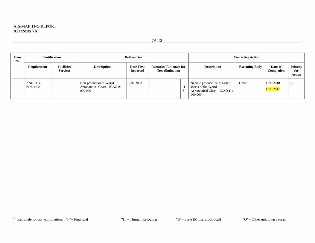
AIS/MAP TF/5-REPORT APPENDIX 7A
7A-12
(1) Rationale for non-elimination: “F”= Financial “H”= Human Resources “S”= State (Military/political) “O”= Other unknown causes
Identification Deficiencies Corrective Action Item No
Requirement Facilities/ Services
Description Date First Reported
Remarks/ Rationale for Non-elimination
Description Executing Body Date of Completion
Priority for
Action
5 ANNEX 4: Para. 16.2
- Non-productionof World Aeronautical Chart – ICAO1:1 000 000
Feb, 2008
- F H S
Need to produce the assigned sheets of the World Aeronautical Chart – ICAO 1:1 000 000
Oman Dec, 2010
Dec, 2011
B

AIS/MAP TF/5-REPORT APPENDIX 7A
7A-13
(1) Rationale for non-elimination: “F”= Financial “H”= Human Resources “S”= State (Military/political) “O”= Other unknown causes
Deficiencies in the AIS/MAP Field
QATAR
Identification Deficiencies Corrective Action Item No
Requirement Facilities/ Services
Description Date First Reported
Remarks/ Rationale for Non-elimination
Description Executing Body Date of Completion
Priority for
Action
1 ANNEX 4: Para. 13.2
- Non-production of Aerodrome/Heliport Chart - ICAO
May, 1995
- H O
Need to produce Aerodrome/Heliport Chart - ICAO for all Int`l Aerodromes
Qatar Dec, 2008
A
2 ANNEX 15:Para. 3.2
- Implementation of a Quality System
Jan, 2003
- H O
Need to introduce a properly organized quality system in conformity with ISO 9000 series of quality assurance standards.
Qatar Dec, 2009
U
3 ANNEX 15:Para. 3.7.2.4
- Implementation of geoid undulation referenced to the WGS-84 ellipsoid.
Jan, 2003
ICAO to follow up with State to determine what action is needed to achieve implementation.
H Need to implement geoid undulation referenced to the WGS-84 ellipsoid.
Qatar Dec, 2009
A
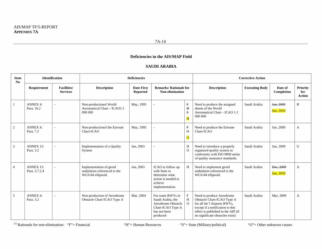
AIS/MAP TF/5-REPORT APPENDIX 7A
7A-14
(1) Rationale for non-elimination: “F”= Financial “H”= Human Resources “S”= State (Military/political) “O”= Other unknown causes
Deficiencies in the AIS/MAP Field
SAUDI ARABIA
Identification Deficiencies Corrective Action Item No
Requirement Facilities/ Services
Description Date First Reported
Remarks/ Rationale for Non-elimination
Description Executing Body Date of Completion
Priority for
Action
1 ANNEX 4: Para. 16.2
- Non-productionof World Aeronautical Chart – ICAO1:1 000 000
May, 1995
- F H S
H
Need to produce the assigned sheets of the World Aeronautical Chart – ICAO 1:1 000 000
Saudi Arabia Jun, 2009
Jun, 2010
B
2 ANNEX 4: Para. 7.2
- Non-productionof the Enroute Chart-ICAO
May, 1995
- F O
O
Need to produce the Enroute Chart-ICAO
Saudi Arabia Jun, 2009
A
3 ANNEX 15: Para. 3.2
- Implementation of a Quality System
Jan, 2003
- H O
Need to introduce a properly organized quality system in conformity with ISO 9000 series of quality assurance standards.
Saudi Arabia Jun, 2009
U
4 ANNEX 15: Para. 3.7.2.4
- Implementation of geoid undulation referenced to the WGS-84 ellipsoid.
Jan, 2003
ICAO to follow up with State to determine what action is needed to achieve implementation.
H Need to implement geoid undulation referenced to the WGS-84 ellipsoid.
Saudi Arabia Dec, 2009
Jun, 2010
A
5 ANNEX 4: Para. 3.2
- Non-production of Aerodrome Obstacle Chart-ICAO Type A
Mar, 2004
For some RWYs in Saudi Arabia, the Aerodrome Obstacle Chart-ICAO Type A has not been produced
F H O
Need to produce Aerodrome Obstacle Chart-ICAO Type A for all Int`l Airports RWYs, except if a notification to this effect is published in the AIP (if no significant obstacles exist)
Saudi Arabia Mar, 2009
A
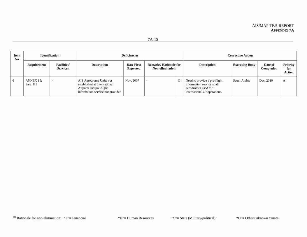
AIS/MAP TF/5-REPORT APPENDIX 7A
7A-15
(1) Rationale for non-elimination: “F”= Financial “H”= Human Resources “S”= State (Military/political) “O”= Other unknown causes
Identification Deficiencies Corrective Action Item No
Requirement Facilities/ Services
Description Date First Reported
Remarks/ Rationale for Non-elimination
Description Executing Body Date of Completion
Priority for
Action
6 ANNEX 15: Para. 8.1
- AIS Aerodrome Units not established at International Airports and pre-flight information service not provided
Nov, 2007
- O Need to provide a pre-flight information service at all aerodromes used for international air operations.
Saudi Arabia Dec, 2010
A

AIS/MAP TF/5-REPORT APPENDIX 7A
7A-16
(1) Rationale for non-elimination: “F”= Financial “H”= Human Resources “S”= State (Military/political) “O”= Other unknown causes
Deficiencies in the AIS/MAP Field
SYRIA
Identification Deficiencies Corrective Action Item No
Requirement Facilities/ Services
Description Date First Reported
Remarks/ Rationale for Non-elimination
Description Executing Body Date of Completion
Priority for
Action
1 ANNEX 15: Para 6.
- Lack of implementation of AIRAC System
May, 1995
ICAO to follow up with State
F H
Need to fully comply with the AIRAC procedure
Syria Dec, 2009
U
2 ANNEX 4: Para. 16.2
- Non-productionof World Aeronautical Chart – ICAO1:1 000 000
May, 1995
- F H S
Need to produce the assigned sheets of the World Aeronautical Chart – ICAO 1:1 000 000
Syria Dec, 2009
B
3 ANNEX 15: Para. 3.2
- Implementation of a Quality System
Jan, 2003
- F H
Need to introduce a properly organized quality system in conformity with ISO 9000 series of quality assurance standards.
Syria Sep, 2010
U
4 ANNEX 15: Para. 3.7.2.4
- Implementation of geoid undulation referenced to the WGS-84 ellipsoid.
Jan, 2003
ICAO to follow up with States to determine what action is needed to achieve implementation.
F H
Need to implement geoid undulation referenced to the WGS-84 ellipsoid.
Syria Aug, 2010
A
5 ANNEX 15: Para 4.2.9 & 4.3.7
- Lack of regular and effective updating of the AIP
Jul, 2005
ICAO to follow up with State
F H O
Need to update the AIP on a regular basis
Syria Aug, 2009
U
6 ANNEX 15 Para. 3.1.1.2, 3.1.5, 3.1.6 & 4.1
- Lack of consistency between the different Sections of the AIP containing the same information.
Jul, 2005
- H Need to review the AIP for consistency
Syria Aug, 2009
U
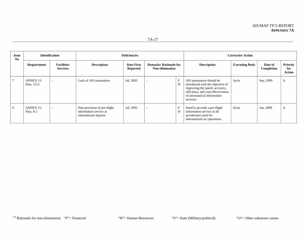
AIS/MAP TF/5-REPORT APPENDIX 7A
7A-17
(1) Rationale for non-elimination: “F”= Financial “H”= Human Resources “S”= State (Military/political) “O”= Other unknown causes
Identification Deficiencies Corrective Action Item No
Requirement Facilities/ Services
Description Date First Reported
Remarks/ Rationale for Non-elimination
Description Executing Body Date of Completion
Priority for
Action
7 ANNEX 15: Para. 3.6.5
- Lack of AIS automation Jul, 2005
- F H
AIS automation should be introduced with the objective of improving the speed, accuracy, efficiency and cost-effectiveness of aeronautical information services
Syria Sep, 2009
A
8 ANNEX 15: Para. 8.1
- Non provision of pre-flight information service at international airports
Jul, 2005
- F H
Need to provide a pre-flight information service at all aerodromes used for international air operations.
Syria Jun, 2009
A
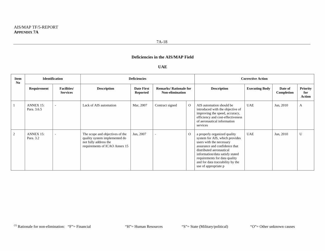
AIS/MAP TF/5-REPORT APPENDIX 7A
7A-18
(1) Rationale for non-elimination: “F”= Financial “H”= Human Resources “S”= State (Military/political) “O”= Other unknown causes
Deficiencies in the AIS/MAP Field
UAE
Identification Deficiencies Corrective Action Item No
Requirement Facilities/ Services
Description Date First Reported
Remarks/ Rationale for Non-elimination
Description Executing Body Date of Completion
Priority for
Action
1 ANNEX 15: Para. 3.6.5
- Lack of AIS automation Mar, 2007
Contract signed O AIS automation should be introduced with the objective of improving the speed, accuracy, efficiency and cost-effectiveness of aeronautical information services
UAE Jun, 2010
A
2 ANNEX 15: Para. 3.2
- The scope and objectives of the quality system implemented do not fully address the requirements of ICAO Annex 15
Jun, 2007
- O a properly organized quality system for AIS, which provides users with the necessary assurance and confidence that distributed aeronautical information/data satisfy stated requirements for data quality and for data traceability by the use of appropriate p
UAE Jun, 2010
U
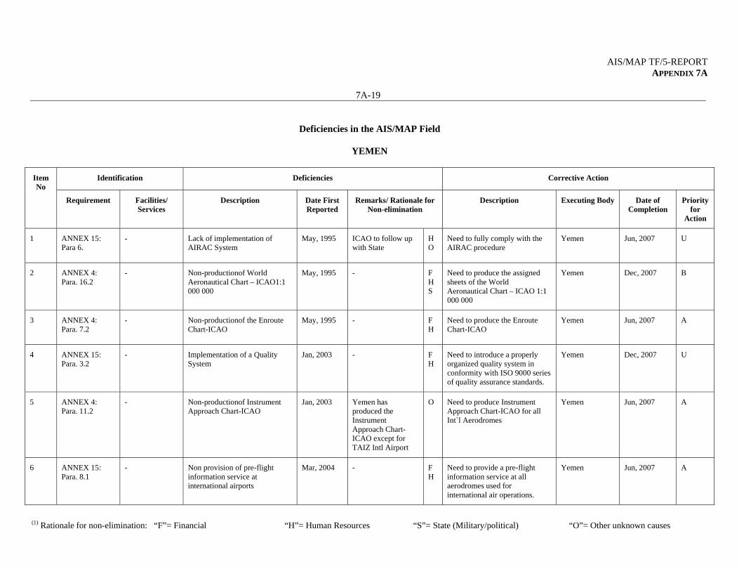
AIS/MAP TF/5-REPORT APPENDIX 7A
7A-19
(1) Rationale for non-elimination: “F”= Financial “H”= Human Resources “S”= State (Military/political) “O”= Other unknown causes
Deficiencies in the AIS/MAP Field
YEMEN
Identification Deficiencies Corrective Action Item No
Requirement Facilities/ Services
Description Date First Reported
Remarks/ Rationale for Non-elimination
Description Executing Body Date of Completion
Priority for
Action
1 ANNEX 15: Para 6.
- Lack of implementation of AIRAC System
May, 1995
ICAO to follow up with State
H O
Need to fully comply with the AIRAC procedure
Yemen Jun, 2007
U
2 ANNEX 4: Para. 16.2
- Non-productionof World Aeronautical Chart – ICAO1:1 000 000
May, 1995
- F H S
Need to produce the assigned sheets of the World Aeronautical Chart – ICAO 1:1 000 000
Yemen Dec, 2007
B
3 ANNEX 4: Para. 7.2
- Non-productionof the Enroute Chart-ICAO
May, 1995
- F H
Need to produce the Enroute Chart-ICAO
Yemen Jun, 2007
A
4 ANNEX 15: Para. 3.2
- Implementation of a Quality System
Jan, 2003
- F H
Need to introduce a properly organized quality system in conformity with ISO 9000 series of quality assurance standards.
Yemen Dec, 2007
U
5 ANNEX 4: Para. 11.2
- Non-productionof Instrument Approach Chart-ICAO
Jan, 2003
Yemen has produced the Instrument Approach Chart-ICAO except for TAIZ Intl Airport
O Need to produce Instrument Approach Chart-ICAO for all Int`l Aerodromes
Yemen Jun, 2007
A
6 ANNEX 15: Para. 8.1
- Non provision of pre-flight information service at international airports
Mar, 2004
- F H
Need to provide a pre-flight information service at all aerodromes used for international air operations.
Yemen Jun, 2007
A
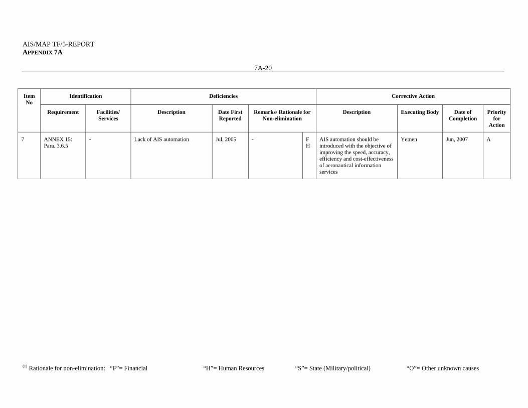
AIS/MAP TF/5-REPORT APPENDIX 7A
7A-20
(1) Rationale for non-elimination: “F”= Financial “H”= Human Resources “S”= State (Military/political) “O”= Other unknown causes
Identification Deficiencies Corrective Action Item No
Requirement Facilities/ Services
Description Date First Reported
Remarks/ Rationale for Non-elimination
Description Executing Body Date of Completion
Priority for
Action
7 ANNEX 15: Para. 3.6.5
- Lack of AIS automation Jul, 2005
- F H
AIS automation should be introduced with the objective of improving the speed, accuracy, efficiency and cost-effectiveness of aeronautical information services
Yemen Jun, 2007
A

AIS/MAP TF/5-REPORT APPENDIX 7A
7A-21
(1) Rationale for non-elimination: “F”= Financial “H”= Human Resources “S”= State (Military/political) “O”= Other unknown causes
Note:* Priority for action to remedy a deficiency is based on the following safety assessments: 'U' priority = Urgent requirements having a direct impact on safety and requiring immediate corrective actions. Urgent requirement consisting of any physical, configuration, material, performance, personnel or procedures specification, the application of which is urgently required for air navigation safety. 'A' priority = Top priority requirements necessary for air navigation safety. Top priority requirement consisting of any physical, configuration, material, performance, personnel or procedures specification, the application of which is considered necessary for air navigation safety. 'B' priority = Intermediate requirements necessary for air navigation regularity and efficiency. Intermediate priority requirement consisting of any physical, configuration, material, performance, personnel or procedures specification, the application of which is considered necessary for air navigation regularity and efficiency. Definition: A deficiency is a situation where a facility, service or procedure does not comply with a regional air navigation plan approved by the Council, or with related ICAO Standards and Recommended Practices, and which situation has a negative impact on the safety, regularity and/or efficiency of international civil aviation.
--------------------
AIS/MAP TF/5-REPORT 8-1
AIS/MAP TF/5
Report on Agenda Item 8
REPORT ON AGENDA ITEM 8: MID REGION AIS/MAP IMPLEMENTATION PLAN 8.1 The meeting recalled that the AIS/MAP Timelines are used by the AIS/MAP Task Force as an internal planning tool for the implementation of specific AIS/MAP related subjects. 8.2 The meeting reviewed and updated the MID Region AIS/MAP Timelines as at Appendix 8A to the Report on Agenda Item 8, taking into consideration the latest developments in the AIS/MAP field.
---------------------------
AIS/MAP TF/5-REPORT APPENDIX 8A
AIS/MAP TF/5 Appendix 8A to the Report on Agenda Item 5
Middle East Region
AIS/MAP IMPLEMENTATION PLAN
Updated Timelines
TIMELINES:
Global
Regional
National
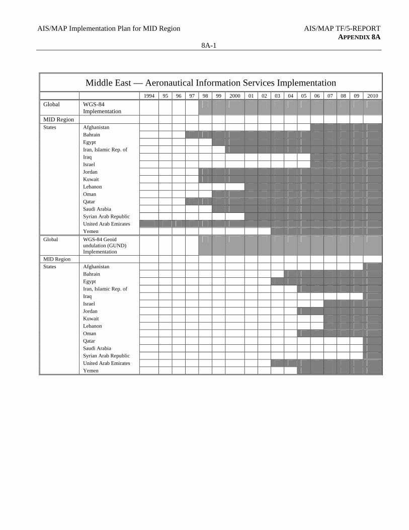
AIS/MAP Implementation Plan for MID Region AIS/MAP TF/5-REPORT APPENDIX 8A
8A-1
Middle East — Aeronautical Information Services Implementation
1994 95 96 97 98 99 2000 01 02 03 04 05 06 07 08 09 2010
Global WGS-84 Implementation
MID Region States Afghanistan
Bahrain
Egypt
Iran, Islamic Rep. of
Iraq
Israel
Jordan
Kuwait
Lebanon
Oman
Qatar
Saudi Arabia
Syrian Arab Republic
United Arab Emirates
Yemen
Global WGS-84 Geoid undulation (GUND) Implementation
MID Region
States Afghanistan
Bahrain
Egypt
Iran, Islamic Rep. of
Iraq
Israel
Jordan
Kuwait
Lebanon
Oman
Qatar
Saudi Arabia
Syrian Arab Republic
United Arab Emirates
Yemen
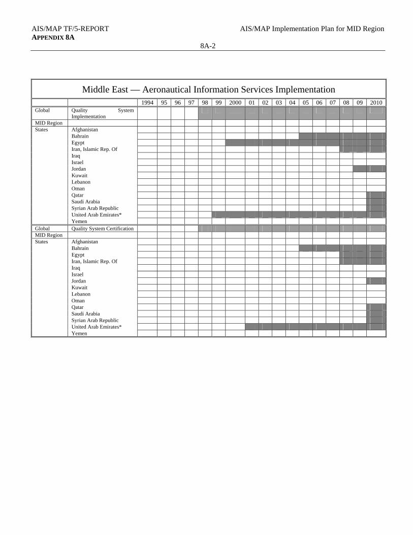
AIS/MAP TF/5-REPORT AIS/MAP Implementation Plan for MID Region APPENDIX 8A
8A-2
Middle East — Aeronautical Information Services Implementation
1994 95 96 97 98 99 2000 01 02 03 04 05 06 07 08 09 2010 Global Quality System
Implementation
MID Region States Afghanistan Bahrain Egypt Iran, Islamic Rep. Of Iraq Israel Jordan Kuwait Lebanon Oman Qatar Saudi Arabia Syrian Arab Republic United Arab Emirates* Yemen Global Quality System Certification MID Region States Afghanistan Bahrain Egypt Iran, Islamic Rep. Of Iraq Israel Jordan Kuwait Lebanon Oman Qatar Saudi Arabia Syrian Arab Republic United Arab Emirates* Yemen
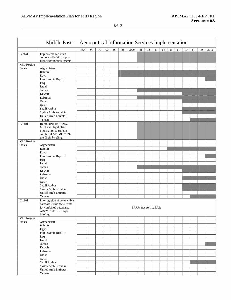
AIS/MAP Implementation Plan for MID Region AIS/MAP TF/5-REPORT APPENDIX 8A
8A-3
Middle East — Aeronautical Information Services Implementation
1994 95 96 97 98 99 2000 01 02 03 04 05 06 07 08 09 2010 Global Implementation of an
automated NOF and pre-flight Information System
MID Region States Afghanistan Bahrain Egypt Iran, Islamic Rep. Of Iraq Israel Jordan Kuwait Lebanon Oman Qatar Saudi Arabia Syrian Arab Republic United Arab Emirates Yemen Global Harmonization of AIS,
MET and flight plan information to support combined AIS/MET/FPL pre-flight briefing.
MID Region States Afghanistan Bahrain Egypt Iran, Islamic Rep. Of Iraq Israel Jordan Kuwait Lebanon Oman Qatar Saudi Arabia Syrian Arab Republic United Arab Emirates Yemen Global Interrogation of aeronautical
databases from the aircraft for combined automated AIS/MET/FPL in-flight briefing.
SARPs not yet available
MID Region States Afghanistan Bahrain Egypt Iran, Islamic Rep. Of Iraq Israel Jordan Kuwait Lebanon Oman Qatar Saudi Arabia Syrian Arab Republic United Arab Emirates Yemen

AIS/MAP TF/5-REPORT AIS/MAP Implementation Plan for MID Region APPENDIX 8A
8A-4
Middle East — Aeronautical Information Services Implementation
1994 95 96 97 98 99 2000 01 02 03 04 05 06 07 08 09 2010 Global Publication of the Integrated
Aeronautical Information Package on a CD-ROM and on the website.
MID Region States Afghanistan Bahrain Egypt Iran, Islamic Rep. of Iraq Israel Jordan Kuwait Lebanon Oman Qatar Saudi Arabia Syrian Arab Republic United Arab Emirates Yemen Global Implementation of a fully
automated AIS Database/System.
SARPs not available
MID Region States Afghanistan Bahrain Egypt Iran, Islamic Rep. of Iraq Israel Jordan Kuwait Lebanon Oman Qatar Saudi Arabia Syrian Arab Republic United Arab Emirates Yemen 1994 95 96 97 98 99 2000 01 02 03 04 05 06 07 08 09 2010 Global Vertical reference system
(EGM 96) Implementation
MID Region States Afghanistan Bahrain Egypt Iran, Islamic Rep. of Iraq Israel Jordan Kuwait Lebanon Oman Qatar Saudi Arabia Syrian Arab Republic United Arab Emirates Yemen
----------------
AIS/MAP TF/5-REPORT
9-1
AIS/MAP TF/5 Report on Agenda Item 9
REPORT ON AGENDA ITEM 9: AERONAUTICAL INFORMATION MANAGEMENT (AIM)
9.1 The meeting recalled that the Eleventh Air Navigation Conference (ANConf/11) held in Montreal in 2003 endorsed the ATM Operational Concept and recognized that in the global ATM system environment envisioned by the operational concept, Aeronautical Information Services (AIS) would become one of the most valuable and important enabling services. As the global ATM system foreseen in the operational concept was based on a collaborative decision-making (CDM) environment, the timely availability from authorized sources of high quality electronic aeronautical, meteorological, airspace and flow management information would be necessary. The ANConf/11 stressed out that AIS and MET services are subsets of the ATM information requirements and therefore, would need to be fully addressed when developing ATM requirements. 9.2 The meeting noted that the most important change to move from AIS to AIM is the transition from a product-centered service to the provision and management of data in an interoperable form sufficient for end use. The shift from standardizing products to standardizing data will enable more freedom in the definition of future products while maintaining a high degree of quality, integrity and coherence of the information contained in these new products. The biggest change in the transition to AIM will be the increase use of computer technologies in the management of information. This will be materialized by an increased emphasis on the digital form of data that will drive all processes for the management of information. 9.3 The meeting further noted that, by using this approach, the definition of the data products is decoupled from definition of the usage for the end products. The end-user applications which make use of the information transferred in the form of data sets do not rely exclusively on the structure and format of the messages, but are free to transform the data and combine it with other data to construct the final view appropriate for the end user. 9.4 It was highlighted that though the transition from a product-centric (current AIS) to a data centric (AIM) service is essential, it is foreseen that AIM will still have to cater for the provision of traditional AIS products during the transition phase. 9.5 The meeting noted that the AIM concept requires that all aeronautical information, including that currently held in aeronautical information publications (AIP) be stored as individual standardized data sets to be accessed by user applications. The distribution of these data sets will define the new services provided by the future AIM. This will constitute the future Integrated Aeronautical Information Package that will contain the minimum regulatory requirement to ensure the flow of information necessary for the safety, regularity and efficiency of international air navigation. It was also highlighted that the future capabilities of transferring digital data between the air and the ground will be used for providing new products such as In-flight information bulletins by uploading aeronautical and meteorological information directly aboard the aircrafts at all phases of flight. 9.6 The meeting recalled that on 20 March 2008, the ANC, agreed to the establishment of the AIS-AIM Study Group (AIS-AIMSG), which held its First meeting in Montreal, Canada, 2 to 4 December 2008. It was noted that the work of the AIS-AIMSG would be completed within four years. The meeting was informed that a first round of SARPs related mainly to the standard aeronautical data models, eAIP, electronic charts and quality system for AIM, is expected to be adopted in 2010 and that the second round of SARPs related to AIM with associated guidance material would be adopted in 2013.

AIS/MAP TF/5-REPORT 9-2
AIS/MAP TF/5
Report on Agenda Item 9
9.7 It was highlighted that the implementation of AIM SARPs is expected to be phased between 2015 and 2019. In this regard, recognizing that not all States or regions would be able to implement the AIM related SARPs with same rate, it was underlined that the implementation should be evolutionary, based on regional needs and taking into consideration national capabilities. 9.8 The meeting recalled that the ANC noted the Roadmap for the transition from AIS to AIM at Appendix 9A to the Report on Agenda Item 9, which is available also at: http://www.icao.int/anb/AIM/. It was highlighted that the Roadmap for the transition from AIS to AIM has been developed to address in greater detail the direction given for aeronautical information in the Global Air Navigation Plan (Doc 9750). It is intended as a high-level document to provide a framework for States in their evolution towards AIM, and to clarify the purpose and scope of the transition. The roadmap identifies the major milestones towards a uniform global evolution to AIM and indicates specific steps and timelines for implementation. The roadmap is intended to serve as a strategic positioning initiative to add impetus to the continuing improvement of aeronautical information services in terms of quality, integrity and definition of new services and products to better serve aeronautical users. The expectations are that the transition to AIM will not involve many changes in terms of the scope of information to be distributed. The major change will be the increased emphasis on data distribution. The roadmap is based on what we know today but has been developed to provide sufficient flexibility for the new concepts that will emerge from future research. 9.9 The meeting noted that three phases of action are envisaged for States and ICAO to complete the transition to AIM:
Phase 1 — Consolidation Phase 2 — Going digital Phase 3 — Information management
9.10 In the first phase, existing standards will need to be refined and strengthened and their implementation in all States ensured. This will concern mainly: quality requirements; AIRAC adherence; the implementation of the adopted standard reference system for coordinates (World Geodetic System-1984); and the provision of terrain and obstacle data. The projects in the first phase will be conducted to identify potential gaps in order to focus on near-term work programme activities. 9.11 In the second phase, the introduction of database-driven processes will improve the value of current products by improving their quality and availability for current users. This will concern mainly the creation of a national or regional databases used to produce the existing products and services, but with better quality and availability. The global deployment of new, already well specified products such as electronic AIP will also be initiated. The projects in the second phase will be conducted to enhance the quality and availability of existing products in the medium-term work programme activities. 9.12 In the third phase, new products and services will be developed. Quality control and staff training and planning will be applied to current and new products and services. This will support a new AIM function for air navigation service providers which will enable the provision of the new data that will be required by the future ATM components. The projects in the third phase will be conducted to serve new users and to promote continuous improvement by the research community.
AIS/MAP TF/5-REPORT
9-3
AIS/MAP TF/5 Report on Agenda Item 9
9.13 It was highlighted that during the complex transition to AIM, industry, regulators, manufacturers, service providers and other organizations will need to work together to achieve the best results. 9.14 The meeting recalled that a MID AIM Seminar was successfully held in Cairo from 21 to 23 October 2008. MIDANPIRG/11 noted that the Seminar addressed important subjects related to the transition from AIS to AIM and agreed that the AIS/MAP Task Force should review the Executive Summary of the MID AIM Seminar at Appendix 9B to the Report on Agenda Item 9 and take necessary follow up actions. 9.15 Based on the above the meeting agreed to the following Draft Conclusions and Decision which are proposed to replace and supersede MIDANPIRG/11 Conclusion 11/51 and Decision 11/52: DRAFT CONCLUSION 5/9: TRANSITION FROM AIS TO AIM
That, recognizing the limitations of the current AIS, which do not meet the new global ATM system requirements envisioned by the ATM Operational Concept, and taking into consideration the ICAO Roadmap for the transition from AIS to AIM:
a) MID States are urged to develop national plans to implement the transition from AIS to AIM and send them to the ICAO MID Regional Office before 15 September 2009; and
b) the AIS/MAP Task Force monitor the progress of transition from AIS to AIM in the MID Region and supports regional and national planning.
DRAFT DECISION 5/10: PLANNING FOR THE TRANSITION FROM AIS TO AIM
That, based on the ICAO Global ATM Operational Concept and the ICAO Roadmap for the transition from AIS to AIM, the AIS/MAP Task Force: a) develop performance goals for the transition from AIS to AIM in the MID Region
and identify achievable Milestones; and
b) carry out a review of the AIS parts of the MID Basic ANP and FASID in order to introduce/develop planning material related to the transition from AIS to AIM.
DRAFT CONCLUSION 5/11: HOSTING OF THE GLOBAL AIM CONGRESS
That, considering that the Global AIM Congress has been hosted since 2006 by States from the EUR, APAC and AFI Regions:
a) MID States are encouraged to host the Global AIM Congress in 2012; and
b) those MID States that are interested to host the Global AIM Congress in 2012, inform the ICAO MID Regional Office of their intention before 30 September 2009, in order to carry out necessary coordination with EUROCONTROL and the Congress Consortium.

AIS/MAP TF/5-REPORT 9-4
AIS/MAP TF/5
Report on Agenda Item 9
9.16 With a view to give effect to the above Draft Conclusion in a timely manner, the meeting agreed that a State Letter is to be issued by the ICAO MID Regional Office, requesting States to develop national plans to implement the transition from AIS to AIM and encouraging them to host the Global AIM Congress in 2012.
-----------------
��������������
��� ����������
�� �������
�
Noted by the Air Navigation Commission on 10 March 2009
AIS/MAP TF/5 Appendix 9A to the Report on Agenda Item 9
AIS/MAP TF/5-REPORT APPENDIX 9A
Skodsi
Typewritten Text
Skodsi
Typewritten Text
_________________________________________________________________________

(ii)
FOREWORD
The Global Air Navigation Plan (Doc 9750) was developed as a strategic document to guide the implementation of CNS/ATM systems with respect to the Global Air Traffic Management Operational Concept (Doc 9854) and the Strategic Objectives of ICAO.
The Global Air Navigation Plan (Doc 9750) contains near- and medium-term guidance on air navigation system improvements necessary to support a uniform transition to the air traffic management system envisioned in the Global Air Traffic Management Operational Concept (Doc 9854). More specifically, Doc 9750, Chapter 1, Table 1-1 sets out twenty-three global plan initiatives (GPI). Two are directly related to aeronautical information (GPI-18 Aeronautical Information and GPI-20 WGS-84) and many of the others have an indirect impact on the way aeronautical information will be exchanged in the future.
This roadmap has been developed to address more specifically, and in greater detail, the direction given in Doc 9750 for the future development of aeronautical information. The changes foreseen are such this development is being referred to as the transition from aeronautical information services (AIS) to aeronautical information management (AIM).
The roadmap offers practical guidance and advice to regional planning groups and States for development of the implementation and funding strategies which will be required for the global plan initiatives related to aeronautical information. It identifies the major milestones recommended for a uniform evolution across all regions of the world, specific steps that need to be achieved and timelines for implementation.
The roadmap is intended to serve as a strategic positioning initiative to drive the continuing improvement of aeronautical information services in terms of quality, timeliness and the identification of new services and products to better serve aeronautical users. The roadmap sets a baseline for establishing strategies and other initiatives to advance the AIM objectives globally. It should place the future AIM in a position to better serve airspace users and ATM in terms of their information management requirements.
The expectations are that the transition to AIM will not involve many changes in terms of the scope of aeronautical information to be distributed. The major change will be the introduction of new products and services and an increased emphasis on better data distribution in terms of quality and timeliness in order to meet user requirements and contribute to improved safety, increased efficiency and greater cost-effectiveness of the air navigation system.
__________________________
(iii)
TABLE OF CONTENTS
Page
Glossary ............................................................................................................................................ (iv)
Part I. Roadmap Overview............................................................................................................ I-1
Why aeronautical information matters ......................................................................................... I-1 How information is distributed today............................................................................................ I-2 The objective of the transition to AIM .......................................................................................... I-2 What will change.......................................................................................................................... I-3 Users ................................................................................................................................... I-3 Data..................................................................................................................................... I-4 Products .............................................................................................................................. I-4 Static versus dynamic information ...................................................................................... I-5 AIRAC cycle ........................................................................................................................ I-5 Eight guiding principles for the transition to AIM ......................................................................... I-5 The roadmap to AIM .................................................................................................................... I-6 Phase 1 — Consolidation.................................................................................................... I-7 Phase 2 — Going digital ..................................................................................................... I-8 Phase 3 — Information management ................................................................................. I-9 The regional dimension....................................................................................................... I-10
Part II. Roadmap Steps ................................................................................................................. II-1
P-01 — Data quality monitoring ………………………………………………………………… II.2 P-02 — Data integrity monitoring ………………………………………………………………. II.2 P-03 — AIRAC adherence monitoring ………………………………………………………... II.2 P-04 — Monitoring of States’ differences to Annex 4 and Annex 15 ………………………. II.2 P-05 — WGS-84 implementation ………………………………………………………………. II.2 P-06 — Integrated aeronautical information database ………………………………………. II.3 P-07 — Unique identifiers ………………………………………………………………………. II.3 P-08 — Aeronautical information conceptual model …………………………………………. II.3 P-09 — Aeronautical data exchange …………………………………………………………… II.3 P-10 — Communication networks ……………………………………………………………… II.4 P-11 — Electronic AIP ........................................................................................................ II.4 P-12 — Aeronautical information briefing ........................................................................... II.4 P-13 — Terrain.................................................................................................................... II.4 P-14 — Obstacles ............................................................................................................... II.4 P-15 — Aerodrome mapping .............................................................................................. II.4 P-16 —Training ................................................................................................................... II.4 P-17 — Quality.................................................................................................................... II.4 P-18 — Agreements with data originators .......................................................................... II.4 P-19 — Interoperability with meteorological products ........................................................ II.4 P-20 — Electronic aeronautical charts................................................................................ II.4 P-21 — Digital NOTAM....................................................................................................... II.5
Part III. Roadmap Timeline ............................................................................................................ 3-1

(iv)
GLOSSARY
TERMS
Aeronautical data. A representation of aeronautical facts, concepts or instructions in a formalized manner suitable for communication, interpretation or processing.
Aeronautical information. Information resulting from the assembly, analysis and formatting of aeronautical data.
1Aeronautical information management (AIM). The dynamic, integrated management of aeronautical information services — safely, economically and efficiently — through the provision and exchange of quality assured digital aeronautical data in collaboration with all parties.
1Data set. Identifiable collection of related digital data.
1Database. A usually large collection of data stored in structured digital format so that appropriate applications may quickly retrieve and update it.
Note. — This primarily refers to digital data (accessed by computers) rather than files of physical records.
1Digital. Involving or relating to the use of computer technology or digital communications.
1Information management (IM). The processes defined to ensure the collection, utilization and transmission of quality data which is tailored for the needs of each component of the air traffic management system.
1Interoperability. The capacity for diverse systems and organizations to exchange information by transferring data and requesting remote services in a manner that requires the client system to have little or no knowledge of the unique characteristics of the server system.
Note.— This is usually achieved by common understanding of the semantic, the syntax and the protocols for the exchange of data.
NOTAM. A notice distributed by means of telecommunication containing information concerning the establishment, condition or change in any aeronautical facility, service, procedure or hazard, the timely knowledge of which is essential to personnel concerned with flight operations.
1Metadata. A structured description of the content, quality, condition or other characteristics of data.
1 Not an official ICAO definition. (Used in the context of this document only).

(v)
ABBREVIATIONS/ACRONYMS
AICM Aeronautical information conceptual model AIM Aeronautical information management AIP Aeronautical information publication(s) AIRAC Aeronautical information regulation and control AIS Aeronautical information services AIXM Aeronautical information exchange model AN-Conf/11 Eleventh Air Navigation Conference (2003) ATM Air traffic management EUROCONTROL European Organisation for the Safety of Air Navigation IP Internet protocol PIB Pre-flight information bulletin RNAV Area navigation RNP Required navigation performance SARPs Standards and Recommended Practices WGS-84 World geodetic system-1984
__________________________

I-1
Part I
Roadmap Overview
WHY AERONAUTICAL INFORMATION MATTERS
1. The Eleventh Air Navigation Conference (AN-Conf/11) held in Montreal in September 2003 endorsed the operational concept and recognized that, in the global air traffic management (ATM) system environment envisioned by the operational concept, aeronautical information service (AIS) would become one of the most valuable and important enabling services. As the global ATM system foreseen in the operational concept was based on a collaborative decision-making environment, the timely availability of high-quality and reliable electronic aeronautical, meteorological, airspace and flow management information would be necessary. Some recommendations of AN-Conf/11 addressed the importance of aeronautical information in particular.
2. In June 2006, a Global AIS Congress was held in Madrid, Spain. The event was facilitated by the European Organization for Safety of Air Navigation (EUROCONTROL) in partnership with ICAO. The congress considered the essential role of AIS in the evolving world of ATM. It noted that computer-based navigation systems, and area navigation (RNAV), required navigation performance (RNP) and ATM requirements, introduced a need for new corresponding AIS requirements for quality and timeliness of information. The role of AIS would need to transform to an information management service, changing duties, responsibilities and scope to satisfy these new requirements and to cope with and manage the provision of information.
3. The congress supported the recommendations of AN-Conf/11 dealing with aeronautical information, and began to define a future high-level view as to the shape, nature and content of a strategy for the evolution from traditional product-centric AIS to the enlarged scope of data-centric aeronautical information management (AIM). Realizing the safety-critical nature of aeronautical information, the congress agreed that, in order to prevent diverging developments in the future, it was considered essential that ICAO take the lead at the global level with regard to the transition from AIS to AIM. Accordingly, the congress developed ten recommendations calling for ICAO action or support from States and international organizations.
4. In September 2007, the 36th Session of the Assembly recognized the need to support the recommendations of the congress and called for further coordination with States and international organizations.
5. Today, high-quality aeronautical information is often cited in research programmes as a pre-requisite for the development of the many new interoperable tools that future aircraft will carry to improve their effectiveness in navigating safely and efficiently. These new tools will also be used by ATM systems to improve the efficiency while maintaining safety. This will result in the provision of more services to more aircraft in the same airspace at the same time.
I-2 Roadmap for the Transition from AIS to AIM
HOW INFORMATION IS DISTRIBUTED TODAY
6. We are in the age of the Internet, satellite navigation and computer networks, yet our approach to aeronautical information distribution is still based on paper charts, paper documentation and telex-based text messages. Systems exist in isolation. Much of the data is entered more than twice in different computers using a keyboard rather than via file transfer or database transactions.
7. Better aeronautical information is essential if we are to have an integrated and interoperable ATM system which enables air navigation service providers to safely handle more traffic in the same amount of space during the same amount of time. Such a system would effectively link the full range of services from airspace design to flight planning, airport operations planning and flight separation assurance while continuing to maintain the safety and security of the travelling public and lessening the environmental impact on the planet and its population.
8. Better aeronautical information is essential if we are to have a flexible ATM System which reduces costs and environmental impacts while improving access to congested airspace and remote airports in developing countries. Such a system would allow planners and decision makers to make the right decisions for the development of new tools and techniques based on information of the right accuracy, available on time at the right place.
9. Better aeronautical information is essential if we are to have a system that empowers airspace users by giving them a greater role in shaping the ATM system, understanding their options and helping them making informed decisions while maintaining the public safety and minimizing the impact on the environment. Such a system would be focussed on users needs.
10. Corrupt or erroneous aeronautical information has the potential to adversely affect the safety of satellite navigation just as corrupt or malfunctioning navigation aids adversely affects the safety of ground-based navigation.
11. These improvements are central to the ICAO Global Air Traffic Management Operational Concept and justify by themselves the name change from AIS to AIM that identifies the new focus on all aspects related to proper information management as opposed to the traditional way of focusing on the provision of standard products to the pilot only.
THE OBJECTIVE OF THE TRANSITION TO AIM
12. Recommendation 1/8 of AN-Conf/11 clearly stated the objective for global aeronautical information as follows:
“That ICAO, when developing ATM requirements, define corresponding requirements for safe and efficient global aeronautical information management that would support a digital, real-time, accredited and secure aeronautical information environment”.
13. The Global Air Traffic Management Operational Concept, which had been developed to be visionary in scope and not constrained by the level of technology available at the time, was also endorsed by AN-Conf/11.
14. Much has been done in the community, and the technology has become more mature and more widely deployed. However, some regions are more advanced than others and the need for the adoption of global standards is becoming more evident now than it was in 2003. Present and future navigation systems, and other air traffic management systems, are data dependant. All require

Overview I-3
access to global, broad-based aeronautical information of a considerably higher quality and timeliness than is generally available today. The provision of aeronautical information is a core process that underpins all elements of ATM.
15. To satisfy new requirements arising from the Global Air Traffic Management Operational Concept, aeronautical information services must transition to a broader concept of aeronautical information management, with a different method of information provision and management given its data-centric nature as opposed to the product-centric nature of AIS.
WHAT WILL CHANGE
16. The Global Air Traffic Management Operational Concept defines seven interdependent concept components that will be integrated to form the future ATM system. They comprise airspace organization and management, aerodrome operations, demand and capacity balancing, traffic synchronization, conflict management, airspace user operations and ATM service delivery management. The order of these components implies no priority.
17. The management, utilization and transmission of data and information are vital to the proper functioning of these components. The exchange and management of information used by the different processes and services must ensure the cohesion and linkage between the seven concept components described above.
Users
18. The provision of aeronautical information today is mainly focused on the requirements of pre-flight briefing. The provision of aeronautical information tomorrow will address the requirements of all components of the ATM system for all phases of flight.
Figure 1. Information Management as a component of the future ATM Operational Concept
AOM
AO
DCB
TSCM
AUOIM / SDM
Airspace Organisationand Management
AerodromeOperations
Demand and CapacityBalancing
Traffic Synchronisation
Airspace UsersOperations
Conflict Management
IM / SDM = Information Management / ATM Service Delivery Management

I-4 Roadmap for the Transition from AIS to AIM
Data
19. The shift from standardizing products to standardizing data will enable more freedom in the definition of future products while maintaining a high degree of quality, integrity and coherency of the information contained in these new products.
20. The biggest change in the transition to AIM will be the increase use of computer technologies in the management of information. This will be materialised by an increased emphasis on the digital form of data that will drive all processes for the management of information.
21. Both graphical and text products will be based on the same underlying, standard definition of geo-referenced atomic data. The definition of a standard aeronautical data exchange model will ensure standardized interfaces between computers of providers and users of data. This will enable the definition of new products where both text and graphics will be presented in a more readable form. This will enable the definition of new services where the same information will be made available in the decision support tools for all ATM components.
22. The current standard in Annex 15 — Aeronautical Information Services is centred on products and does not provide specifications required for digital data exchange. A central element in the transition to AIM will be the precise standardization of atomic data elements in terms of field names, field types and field definitions. This will be provided in the form of a standard aeronautical data dictionary (also called metadata registry). Furthermore, the definition of standard structured groupings of fields by features, attributes and associations is necessary. This will be provided in the form of a standard conceptual model for aeronautical information. Finally, the mechanisms to maintain a data set, up to date across different components, would need to be agreed. This will be provided in the form of a standard exchange model for aeronautical data. The evolution of these models will be organised at the global level to ensure continuity in the services in a way that allows innovation and new requirements to be taken into account.
23. By using this approach, the definition of the data products is decoupled from definition of the usage for the end products. The end-user applications which make use of the information transferred in the form of data sets do not rely exclusively on the structure and format of the messages, but are free to transform the data and combine it with other data to construct the final view appropriate for the end user.
Products
24. Pre-flight information bulletins are often loaded with information not relevant to the flight because of the limited filtering capabilities that the current NOTAM format is offering. Pre-flight briefings are often also difficult to read and interpret because of the lack of graphical capabilities of the current NOTAM format. This will require that new standard products combining textual and graphical information be specified.
25. Electronic chart displays are becoming easier to install in the cockpit and at lower costs. Their functionality is increasing and it is likely that they will progressively complement some paper charts and replace others. This will require updated standards and symbols for electronic displays capabilities.
26. The future capabilities of transferring digital data between the air and the ground will be used for providing new products such as In-flight information bulletins by uploading aeronautical and meteorological information directly aboard the aircrafts at all phases of flight.

Overview I-5
27. The AIM concept requires that all aeronautical information, including that currently held in aeronautical information publications (AIP), be stored as individual standardized data sets to be accessed by user applications. The distribution of these data sets will define the new services provided by the future AIM. This will constitute the future Integrated Aeronautical Information package that will contain the minimum regulatory requirement to ensure the flow of information necessary for the safety, regularity and efficiency of international air navigation.
Static versus dynamic information
28. Stability is essential for proper planning of airspace operations. Examples of changes that must be announced well in advance are: the installation or decommissioning of ground-based air navigation aids; the opening of a new aerodrome for international flight operations; airspace danger and restricted areas; and the route structure for major traffic flows.
29. Events of short duration or known with little advance notice are inevitable occurrences. These events must be announced quickly in a manner that is comprehensible by the different components of the ATM system.
30. In an interoperable environment based on data standards, these two types of information will be transferred by common networks under the same data exchange mechanisms using the same data standard definitions.
AIRAC cycle
31. It is expected that the need for aeronautical data to become effective on internationally agreed common dates will remain. Coordination and planning constraints require major changes to be announced well in advance and introduced only at regular intervals.
32. The quality and integrity requirements of databases will define new roles for human intervention such as verification, monitoring and correction before releasing new data.
33. The current cycle is essentially based on the maximum expected time for postal delivery of the paper products. The distribution of data products through data networks will not suffer from the same delay in delivery. Shorter cycles will become possible to better match users needs. Transitioning to a modern distribution mechanism will mean that the specifications for new concepts of operation need not be constrained to a twenty-eight-day cycle. The future ATM system will be free to identify a better cycle that will adequately balance the need for improved reactivity with the need for advanced planning.
EIGHT GUIDING PRINCIPLES FOR THE TRANSITION TO AIM
34. The projects undertaken to achieve the steps identified in the roadmap must be specified and conducted in accordance with the following eight guiding principles. The transition from AIS to AIM will have to:
1. comply with the process for amendments to the Annexes to the Chicago Convention;
2. support or facilitate the generation and distribution of aeronautical information which serves to improve the safe and cost-effective accessibility of air traffic services in the world;
I-6 Roadmap for the Transition from AIS to AIM
3. provide a foundation for measuring performance and outcomes linked to the distribution of quality assured aeronautical information and a better understanding of the determinants of ATM, safety and effectiveness not related to the distribution of the information;
4. assist States to make informed choices about their aeronautical information services and the future of AIM;
5. build upon developments in States, international organizations and industry and acknowledge that the transition to AIM is a natural evolution rather than a revolution;
6. provide over-arching and mature standards, that apply to a wide range of aeronautical information products, services and technologies;
7. be guided by the Global Air Navigation Plan (Doc 9750) and ensure that all development is aimed at achieving the ATM system envisaged in the Global Air Traffic Management Operational Concept (Doc 9854);
8. ensure, to the greatest extent possible, that solutions are internationally harmonized and integrated and do not unnecessarily impose multiple equipment carriage requirements for aircraft or multiple systems on the ground.
THE ROADMAP TO AIM
35. The purpose of the roadmap is to develop the AIM concept and associated performance requirements by providing a basis upon which to manage and facilitate, on a worldwide basis, the transition from AIS to AIM. The roadmap is based on what we know today but has been developed to provide sufficient flexibility for the new concepts that will emerge from future research.
36. Three phases of action are envisaged for States and ICAO to complete the transition to AIM:
Phase 1 — Consolidation
Phase 2 — Going digital
Phase 3 — Information management
37. The roadmap must proceed with caution when advocating more sophisticated information management initiatives to ensure that they do not impede the obligations of States to correct infrastructure and other deficiencies already identified.
38. In the first phase, existing standards will need to be refined and strengthened and their implementation in all States ensured. This will concern mainly: quality requirements; AIRAC adherence; the implementation of the adopted standard reference system for coordinates (World Geodetic System-1984); and the provision of terrain and obstacle data. The projects in the first phase will be conducted to identify potential gaps in order to focus on near-term work programme activities.
39. In the second phase, the introduction of database-driven processes will improve the value of current products by improving their quality and availability for current users. This will concern mainly the creation of a national or regional databases used to produce the existing products and services, but with better quality and availability. The global deployment of new, already well specified products
Overview I-7
such as electronic AIP will also be initiated. The projects in the second phase will be conducted to enhance the quality and availability of existing products in the medium-term work programme activities.
40. In the third phase, new products and services will be developed. Quality control and staff training and planning will be applied to current and new products and services. This will support a new AIM function for air navigation service providers which will enable the provision of the new data that will be required by the future ATM components. The projects in the third phase will be conducted to serve new users and to promote continuous improvement by the research community.
41. The roadmap will identify the main steps to be achieved in the three phases. Each step will require projects of two types of activities: one will be the development of the standards required and the other will be the implementation in States of the standards.
a) Development of Standards. The development of new standards often lie on the critical path of the transition. Amendments to ICAO Standards and Recommended Practices (SARPs) are required for uniform implementation of the transition to AIM in all States. Actions related to the establishment of these standards in Annexes to the Chicago Convention and in guidance material will be led by the ICAO Secretariat with the support of States and International Organisations.
b) Implementation of Standards. Implementation of Standards allowing the transition to AIM will be the responsibility of States. Guidance material will be issued by ICAO to assist in the implementation.
42. Part II of the roadmap lists numerous steps of varying complexity. Some will result in the establishment of new databases or the expansion of existing ones. Others will seek to foster better data and technical standards for gathering information and data protection. Still others will focus on obtaining consensus on the indicators and determinants of quality aeronautical information. Almost all of the projects will involve collaborative efforts with key stakeholders at the national, regional and inter-regional levels. Securing stakeholder participation at the outset of the process and maintaining it throughout the project implementation phase are critical to ensuring that outcomes are relevant, practical and contribute to improving the efficiency and safety of air travel and of the ATM system.
43. Accordingly, consultations through various ICAO working arrangements have been and will remain an ongoing feature of the roadmap. The input and feedback of all players is key to ensuring that the roadmap contributes to better aeronautical information and a stronger ATM system for the air transport industry.
Phase 1 — Consolidation
44. During Phase 1 of the transition to AIM, steps will aim to strengthen a solid base by enhancing the quality of the existing products. Fine-tuning and improvement of SARPs for existing products will continue to be conducted in the usual manner in order to respond to near-term user requirements.
45. Since the electronic AIP will have the exact same structure as the paper it is important that States make every effort to issue their aeronautical information as specified in Annex 15.
46. The NOTAM system as it exists today requires on-going upgrades to cope with new types of information (e.g. GNSS navigation) and to respond to the difficulties being reported by the users. It is not clear at this time when and how the current NOTAM system will be changed. Research and trials are underway and their results will be addressed in Phase 3 of the transition to AIM or later. It
I-8 Roadmap for the Transition from AIS to AIM
is important to continue to improve the current SARPs related to NOTAM to better serve users needs with the current products. It is also important for States to continue to invest the time and effort necessary to comply with these SARPs.
47. Many ICAO charts types form an integral part of the AIP. Amendments to specifications are also envisaged for electronic chart display but most of the SARPs in Annex 4 — Aeronautical Charts will remain applicable after the transition to AIM. It is important that States comply with the existing Annex 4 SARPs.
48. The requirement to use a common horizontal, vertical and temporal reference system remains essential to facilitate the exchange of data between different systems. The expression of all coordinates in the AIP and charts using WGS-84 is important and should be pursued during the first phase of the transition to AIM.
49. Provision of terrain and obstacle data becomes applicable during Phase 1 of the transition to AIM. It will be an important project to be conducted by States. Feedback from States on the implementation experience may require adaptation of the relevant SARPs. Since these constitute also digital data sets products, the achievement of these steps will also contribute to phase 2 of the roadmap.
50. Quality requirements on information are covered by current SARPs in terms of accuracy and integrity. The steps in Phase 1 aim to meet these requirements. Should the requirements prove to be difficult to implement, the requirements would have to be reassessed to verify that the risk of harm to persons or damage to property for not achieving the requirements is reduced to, and maintained at or below, an acceptable level (definition of safety). In addition, States will implement and continuously improve their quality management system in view of its increasing importance for future products and services.
51. The requirement for States to adhere to the Aeronautical Information Regulation and Control (AIRAC) process must be emphasized. The quality of the future service to be provided under information management will rely on proper mechanism for distribution and synchronisation of information. Shorter response times will be required in the future. This can only be achieved if the current requirements can, at the very least, be met.
Phase 2 — Going digital
52. During Phase 2 of the transition to AIM, the main focus will be on the establishment of data-driven processes for the production of the current products in all States. States which have not yet done so will be encouraged “to go digital” by using computer technology or digital communications and introducing the use of structured digital data from databases in their production processes. The emphasis will not, therefore, be on the introduction of new products or services but more on the introduction of highly structured databases and tools like geographic information systems.
53. An aeronautical information conceptual model will provide guidance for States to implement such digital databases. Guidance material will include advice on a minimum data set to begin a phased development of the database.
54. Many States are already providing electronic forms of their AIPs, whether on CD or on the Internet. These electronic AIP may be accessible for printing and/or for navigation via a web browser tool. Guidance material that will be based on existing best practices will be provided to States to ensure that new types of media will be harmonized for users.

Overview I-9
Phase 3 — Information management
55. During Phase 3, the digital databases that will have been introduced in Phase 2, will be used for the transfer of information in the form of digital data. This will require the adoption of a standard aeronautical data exchange model to ensure interoperability between all systems for the exchange of full aeronautical data sets, but also for short term notification of changes.
56. As new products are introduced, organisational changes will need to be defined to implement better management of information in terms of: staff planning and staff training; formalization of agreements with data providers to ensure high degree of data quality; introduction of an extensive amount of explicit meta-information; impact on cost-recovery mechanisms; and explicit traceability of the changes to information and identification of liabilities.
57. The third phase will place the future AIM functions of the States in capacity of addressing the new requirements that will be needed to implement the future Global Air Traffic Management Operational Concept in a net-centric information environment.
58. ATM systems will require a common information reference model with quality procedures for the management of seamless information flow to ensure not only interoperability between States, but interoperability between different systems within the State. New digital data products and services will be specified to serve these interoperability requirements.
Figure 2. Performance driven approach.
59. The definition of new AIM data products and services will be based on requirements identified for each ATM Component. A structured approach to the development of these new requirements on AIM will be followed to ensure that any standards recommended for AIM is derived from agreed information exchange models that specify the minimum information required to support business services defined for ATM functions that are identified to fulfil desired outcomes specified in terms of performance requirements. This structured top-down approach of deriving specific data
������������� ��������
� �������� �����
� �������������� ���
� �������������
� ���� ������
������������������
� ������ � ����
� ���!��������������������
���������
� ����
� ����������"� ��#
����������$� ������������

I-10 Roadmap for the Transition from AIS to AIM
standards from high level objectives will ensure that the new requirements introduced in the transition to AIM on States will clearly relate to identified enablers for the future ATM system as illustrated in Figure 2.
The regional dimension
60. During the complex transition to AIM, industry, regulators, manufacturers, service providers and other organizations will need to work together to achieve the best results.
61. In Europe, the SESAR Master Plan and the Single European Sky initiatives have assembled a multitude of partners to define a modernization programme to significantly reduce costs and increase service capabilities.
62. In United States of America, the NextGen programme is also underway to modernize the national air transportation system to allow increased capacity and reliability, while improving safety and security and minimizing the environmental impact of aviation.
63. In many parts of the world States are grouping their resources to introduce new equipment and new structures for the provision of common services over their common airspace.
64. These are only three of the many examples of modernization programmes that are underway in different regions of the world. All initiatives are primarily directed towards improving safety and security and minimizing the environmental impact of aviation. They all seek a more efficient and reliable exchange of information between the various components of the future ATM system. They refer to new concepts such as system-wide information management, increased automation for collaborative decision making, better integration of systems and 4-D trajectory, to name just a few.
65. These initiatives are all using the Global Air Traffic Management Operational Concept as a guide to ensure a common reference. They are referring to the Global Air Navigation Plan as a common planning framework. All of these initiatives need some assurance of stability in the development of new techniques. This is the purpose of the Global Air Navigation Plan and this roadmap.
66. This roadmap provides a structured framework for States to plan and to monitor their progress with reference to other States in the same region and across regions of the world and supports regional and national plans to implement the transition to AIM.
67. It is not the intention that this roadmap could be used without addition to form a national or a regional plan. No milestones nor description of deliverables are provided in the roadmap, since these will be included via the usual planning process.
__________________________
II-1
Part II
Roadmap Steps
INTRODUCTION
68. The roadmap overview provides the strategic direction and major principles for the transition to AIM. Three phases have been introduced in Part I of this document, the three phases are not to be followed in a waterfall approach to each of the phases. For example, steps may be taken to introduce the digital elements while the consolidation steps are not all finalised yet. Similarly, it is not necessary that all steps for going digital be achieved to start introducing new measures related to information management. The phases are however giving an indication of the priorities on how to address the transition.
69. A minimum list of major steps to achieve in order to realise the transition to AIM is provided in Part II. A broad positioning of the steps in relation with the three phases is also provided. The transition to AIM will be effective at the global level when these steps will be achieved. Most steps in Phase 2 and 3 of the transition require new standards and recommended practices to be adopted at the global level, an indication of the time required for these new texts to be made available is provided in Part III.
STEPS
70. The steps listed in Part 2, constitute a minimum list of areas of activities for States to coordinate the transition to AIM between themselves and with ICAO. The steps are to be taken as a checklist of high level actions to be conducted for realising the transition. Failing to take action on any of those steps would necessarily increase the duration of the transition and negatively affect the enabling role of AIM in the future ATM Concept of operation.
71. The list may evolve during the transition especially when we get closer to Phase 3. This roadmap will be maintained up-to-date with the further evolution of the overall ATM concepts and system requirements.
P-01 — Data quality monitoring
P-02 — Data integrity monitoring
P-03 — AIRAC adherence monitoring
P-04 — Monitoring of States’ differences to Annex 4 and Annex 15
P-05 — WGS-84 implementation
II-2 Roadmap for the Transition from AIS to AIM
P-06 — Integrated aeronautical information database
P-07 — Unique identifiers
P-08 — Aeronautical information conceptual model
P-09 — Aeronautical data exchange
P-10 — Communication networks
P-11 — Electronic AIP
P-12 — Aeronautical information briefing
P-13 — Terrain
P-14 — Obstacles
P-15 — Aerodrome mapping
P-16 — Training
P-17 — Quality
P-18 — Agreements with data originators
P-19 — Interoperability with meteorological products
P-20 — Electronic aeronautical charts
P-21 — Digital NOTAM
P-01 — Data quality monitoring
An ongoing challenge for organizations producing information is to ensure that the quality of the information produced suits its intended uses, and that data users are provided the appropriate information about data quality.
P-02 — Data integrity monitoring
Data integrity requirements introduced by safety objectives must be measurable and adequate.
P-03 — AIRAC adherence monitoring
The standard regulation and control mechanisms for the distribution of aeronautical information is an essential element ensuring that each person involved makes decisions based on the same information.
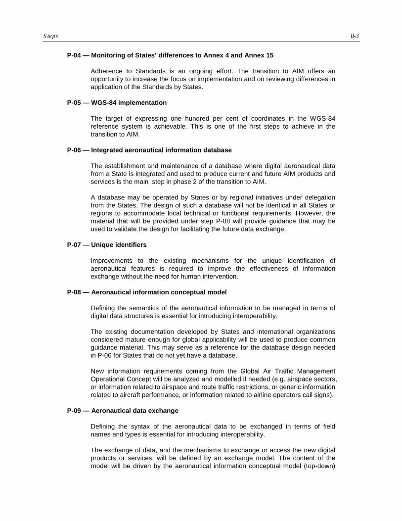
Steps II-3
P-04 — Monitoring of States’ differences to Annex 4 and Annex 15
Adherence to Standards is an ongoing effort. The transition to AIM offers an opportunity to increase the focus on implementation and on reviewing differences in application of the Standards by States.
P-05 — WGS-84 implementation
The target of expressing one hundred per cent of coordinates in the WGS-84 reference system is achievable. This is one of the first steps to achieve in the transition to AIM.
P-06 — Integrated aeronautical information database
The establishment and maintenance of a database where digital aeronautical data from a State is integrated and used to produce current and future AIM products and services is the main step in phase 2 of the transition to AIM.
A database may be operated by States or by regional initiatives under delegation from the States. The design of such a database will not be identical in all States or regions to accommodate local technical or functional requirements. However, the material that will be provided under step P-08 will provide guidance that may be used to validate the design for facilitating the future data exchange.
P-07 — Unique identifiers
Improvements to the existing mechanisms for the unique identification of aeronautical features is required to improve the effectiveness of information exchange without the need for human intervention.
P-08 — Aeronautical information conceptual model
Defining the semantics of the aeronautical information to be managed in terms of digital data structures is essential for introducing interoperability.
The existing documentation developed by States and international organizations considered mature enough for global applicability will be used to produce common guidance material. This may serve as a reference for the database design needed in P-06 for States that do not yet have a database.
New information requirements coming from the Global Air Traffic Management Operational Concept will be analyzed and modelled if needed (e.g. airspace sectors, or information related to airspace and route traffic restrictions, or generic information related to aircraft performance, or information related to airline operators call signs).
P-09 — Aeronautical data exchange
Defining the syntax of the aeronautical data to be exchanged in terms of field names and types is essential for introducing interoperability.
The exchange of data, and the mechanisms to exchange or access the new digital products or services, will be defined by an exchange model. The content of the model will be driven by the aeronautical information conceptual model (top-down)

II-4 Roadmap for the Transition from AIS to AIM
and by requirements coming from technological choices (bottom-up) and the evolution of the model will be coordinated in order to balance the need for innovation with the need for protecting investments.
The use of the Internet as a communication media is, for example, one important bottom-up driver in the definition of the model. The use of well established geographic information standards also applied in non aeronautical domains is another important technological choice.
P-10 — Communication networks
More data will be exchanged on ground networks and the current data will be exchanged in a form that will require more bandwidth. It is envisaged that a transition of the network to be based on Internet protocol (IP) will be required to cope with these future needs. for the transition to AIM to be effective, the needs of future AIM will have to be declared in terms usable for network specification. Which data network will be used to distribute the new data products and services;, what information can be exchanged via the public Internet; and what information requires a secured network reserved for aviation are open questions that will need to be answered for the transition to be effective.
P-11 — eAIP
The integrated aeronautical information package will not be phased out because new products will be introduced to serve the needs of future systems and new users. On the contrary, the integrated aeronautical information package will be adapted to include the new data products needed during the transition to AIM.
The electronic version of the AIP will be defined in two forms: one will be in the form of a printable document, and the other will be in a form that can be viewed by web browsers.
Guidance material will be required to help States implementing the web browser form of the electronic AIP in order to avoid the proliferation of many different presentations of AIP information over the Internet.
P-12 — Aeronautical information briefing
Fine tuning of the current NOTAM format by introduction of new selection criteria is needed to improve the selectivity of the information presented to pilots in the Pre-flight information bulletin (this can be done in Phase 1).
The combination of graphical and textual information in a digital net-centric environment will be exploited to better respond to the airspace users requirements of aeronautical information in all phases of flight when the new digital data products will be specified and made available (in Phase 3).
P-13 — Terrain
The compilation and provision of terrain data sets is an integral part of the transition to AIM.

Steps II-5
P-14 — Obstacle
The compilation and provision of obstacle data sets is an integral part of the transition to AIM.
P-15 — Aerodrome mapping
There is a new requirement emerging from industry that traditional aerodrome charts should be complemented by structured aerodrome mapping data which can be imported into electronic displays.
P-16 — Training
The training of personnel will be adapted to the new requirements on skill and competences introduced by the transition to AIM.
A new training manual will be developed to reflect the new competencies required by the transition to AIM.
P-17 — Quality
Quality management measures will be re-enforced to ensure the required level of quality of the aeronautical information.
In order to assist States in the implementation of an efficient quality management system, guidance material for the development of a quality manual will be developed.
P-18 — Agreements with data originators
Data of high quality can only be maintained if the source is of good quality. States will be required to better control relationships along the whole data chain from the producer to the distributor. This may take the form of template service level agreements with data originators, neighbouring States, information service providers or others.
P-19 — Interoperability with meteorological products
The meteorological data products of the future will be combined with the AIM data products to form the future flight briefings and the new services provided to all ATM components.
This will require that the meteorological data will be made available in a similar format to the other aeronautical data which are clearly focusing on the use of open standards (such as XML and GML) for the implementation of table-driven data validation built into the data exchange mechanism, whereas current meteorological data products for aviation are based on simple alphanumeric codes.
Now that the bandwidth of telecommunication links and space of digital storage devices are no longer a limiting factor, the move towards net-centric and system-wide information management is becoming feasible for wider distribution of meteorological forecast data from the world area forecast centres in a format that
II-6 Roadmap for the Transition from AIS to AIM
will not require considerable efforts for the learning and configuration of a decoding software thereby ensuring true interoperability.
Meteorological information is essential in the compilation of pilot briefings, the transition to AIM will include activities both at the standardization and implementation level to find solutions for the interoperability of meteorological data products with the new AIM data products.
P-20 — Electronic aeronautical charts
New electronic aeronautical charts, based on digital databases and the use of Geographic Information Systems will be defined to complement paper charts and replace others that have become obsolete and need to be improved to satisfy user needs. The possibility to deploy these new products over the Internet will be exploited.
P-21 — Digital NOTAM
One of the most innovative data product that will be based on the standard aeronautical data exchange model will be a digital NOTAM that will provide dynamic aeronautical information to all stakeholders with an accurate and up-to-date common representation of the aeronautical environment.in which flights are operated.
The digital NOTAM will be defined as a data set that contains information included in a NOTAM in a structured format which can be fully interpreted by an automated computer system for accurate and reliable update of the aeronautical environment representation both for automated information equipments and for human actors.
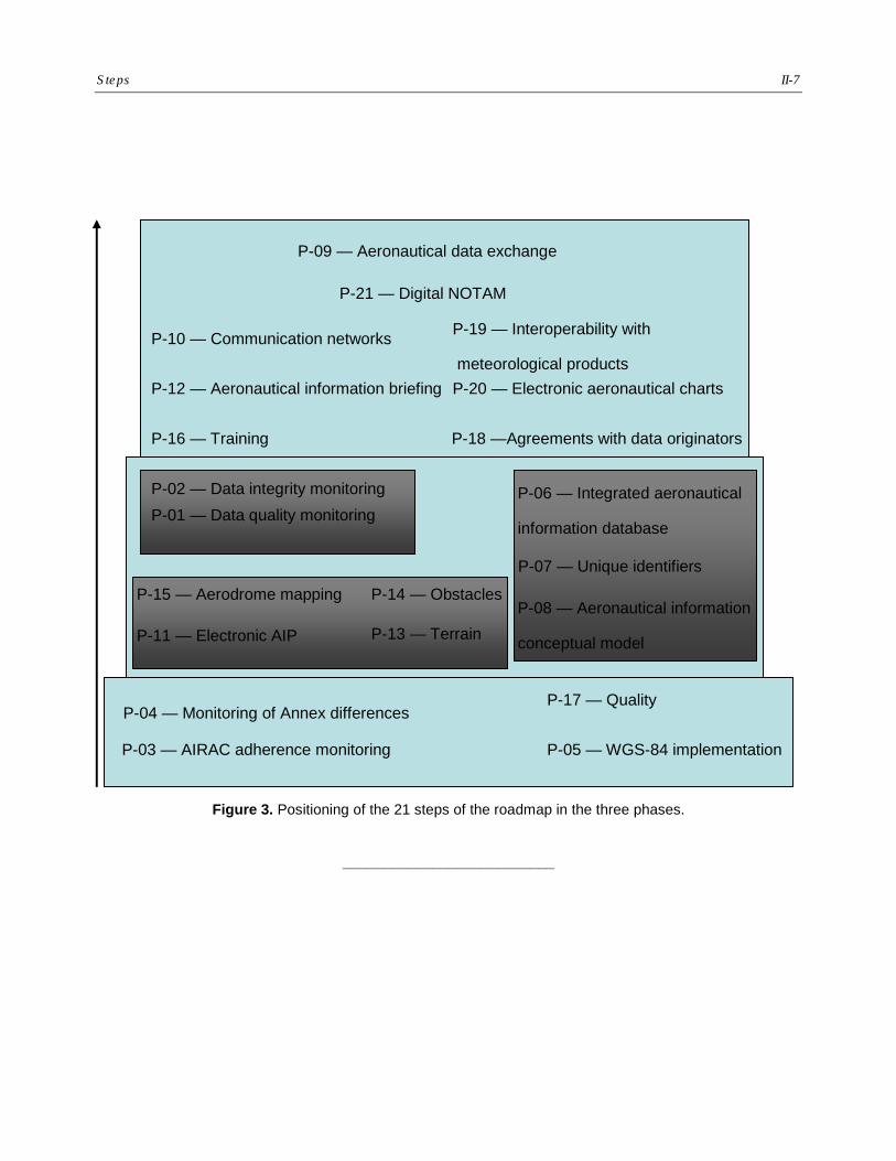
Steps II-7
Figure 3. Positioning of the 21 steps of the roadmap in the three phases.
__________________________
P-04 — Monitoring of Annex differences
P-05 — WGS-84 implementation
P-13 — Terrain
P-14 — Obstacles
P-01 — Data quality monitoring
P-02 — Data integrity monitoring
P-03 — AIRAC adherence monitoring
P-11 — Electronic AIP
P-15 — Aerodrome mapping
P-09 — Aeronautical data exchange
P-10 — Communication networks
P-12 — Aeronautical information briefing
P-16 — Training
P-17 — Quality
P-18 —Agreements with data originators
P-19 — Interoperability with
meteorological products P-20 — Electronic aeronautical charts
P-21 — Digital NOTAM
P-06 — Integrated aeronautical
information database
P-07 — Unique identifiers
P-08 — Aeronautical information
conceptual model


III-1
Part III
Roadmap Timeline
1. The roadmap serves as general indication of what the air transport industry may be expecting from States in their implementation of the transition to AIM. In this part III, the timeline indicates to States, the major milestones that are envisaged in ICAO to support the transition to AIM and the Global Air Traffic Management Operational Concept initiatives related to the management of aeronautical information.
December 2008 Phase 1 — Consolidation, has begun with the establishment of the AIS-AIM Study Group, more information on the work and planned actions of the group may be found on the ICAO website under the Air Navigation Bureau, MET/AIM link.
The consultation process for Amendment 36 to Annex 15 and Amendment 56 of Annex 4 are initiated in the first quarter of 2009.
The development of Amendment 2 to the AIS Manual (Doc 8126) and Amendment 30 to the PANS-ABC (Doc 8400) has begun to introduce guidance on best practices already available.
November 2009 Phase 2 – Going digital will begin by the development of new guidance material related (electronic AIP, aeronautical information conceptual model, training, quality) that will be developed with the support of the AIS-AIMSG which will hold its second meeting end of 2009.
November 2010 Amendment 36 of Annex 15 and Amendment 56 of Annex 4 would become applicable. The preparation of Amendment 37 to Annex 15 and Amendment 57 to Annex 4 plus any consequential amendments required in other annexes will have progresses with the help of the AIS-AIMSG.
October 2011 Phase 3 — Information management, will begin with the fourth meeting of the AIS-AIMSG which will finalise the proposals for amendment 37 to Annex 15 and amendment 57 of Annex 4. These amendments will be setting the scene for the future requirements on States to produce data sets. It is not envisaged that new data products will be required for mandatory provision by the future ATM systems at this date, but if States choose to provide the data identified in scope at that time, they will be able to base their development on recommendations ensuring a global harmonisation.
III-2 Roadmap for the Transition from AIS to AIM
The consultation process of Amendment 37 to Annex 15 and Amendment 57 to Annex 4 will be initiated in the first quarter of 2012.
November 2013 Amendment 37 to Annex 15 and Amendment 57 to Annex 4 would become applicable,
Possible divisional-type meeting should a substantial number of subjects of worldwide scope involving meteorological, aeronautical information and supporting communication network fields need to be agreed in order to finalize the transition to AIM. This could include a substantial enlargement of the scope of aeronautical information required by ATM and an obligation to provide the information in the form of digital data.
November 2016 Amendment 38 to Annex 15 and Amendment 58 to Annex 4 would become applicable including the recommendations of the divisional meeting.
__________________________
AIS/MAP TF/5-REPORT APPENDIX 9B
AIS/MAP TF/5
Appendix 9B to the Report on Agenda Item 9
MID AIM SEMINAR
(Cairo, 21-23 October 2008)
EXECUTIVE SUMMARY 1. INTRODUCTION: 1.1 The MID AIM Seminar has been successfully held in Cairo from 21 to 23 October 2008. 53 participants from 16 States, 3 international organizations and 1 Commercial data house have attended the seminar. The seminar was hosted by the Egyptian National Air Navigation Services Company (NANSC). It was moderated by Mr. Mohamed Smaoui, RO/AIS/MET, ICAO MID Office and Mr. Manfred Unterreiner, Chairman AIS Operations Subgroup, AIM, EUROCONTROL. 1.2 The seminar addressed different subjects related to the transition from AIS to AIM according to the following agenda:
1. Introduction
2. Setting the Scene/Drivers for change ANC/11 and ATM Operational Concept User Requirements, Single European Sky (SES)
3. Current Status of AIS
Global and Regional issues/developments MID Regional AIS/MAP planning and implementation Status
4. Transition towards Aeronautical Information Management (AIM)
From Strategy to Implementation
5. AIM Opportunities & Enablers for Change QMS and CHAIN Training and Competency Management eAIP Data Modelling/Exchange (AICM/AIXM) Digital NOTAM (xNOTAM) EAD eTOD and airport mapping Emerging Technologies (GIS, 4D, Digital Data Link, etc).
6. Conclusions and closing session
1.3 The main objectives of the MID AIM Seminar were to:
AIS/MAP TF/5-REPORT APPENDIX 9B
9B-2
a) increase the level of awareness of States regarding the current shortcomings of AIS and the necessity to transit from the provision of AIS products to the interchange and management of aeronautical information in digital form;
b) provide States with a better understanding of the planning and
implementation issues related to the transition from AIS to AIM; and
c) provide briefings related to international experiences, directions and advances being made in the field, in particular: QMS and CHAIN, AICM/AIXM, xNOTAM, EAD, eAIP, etc.
2. SUMMARY OF DISCUSSIONS 2.1 The seminar recognized the limitations of the current AIS, which do not meet the new global ATM system requirements envisioned by the ATM Operational Concept. 2.2 The need to support the global ATM system by establishing conditions for the provision, in real-time, of high quality aeronautical information to any airspace user, any time, anywhere, was re-iterated. 2.3 The seminar recalled and supported the Recommendations of the Global AIS Congress. 2.4 ICAO should take the lead in the development of the AIM Strategy/Roadmap and associated AIM SARPs and guidance material; and ensure that they are suitable for global use. Particularly, when defining the Roadmap for the transition from AIS to AIM, ICAO should establish clear milestones and related success criteria. 2.5 The Seminar noted with appreciation the establishment of the AIS-AIMSG and emphasized that States and international organizations should assist ICAO and contribute to the development of successful AIM SARPs, based on a partnership approach and sharing of experience and expertise. In particular, active contribution by the States is encouraged to support the work of the AIS-AIMSG considering that input would be coordinated through the Study Group Members or regional ‘contact points’. 2.6 The Seminar recognized the urgent need for ICAO to develop SARPs and guidance material to enable the global exchange of data in digital format, i.e.: provision of a standard Aeronautical Information Conceptual Model and standard Aeronautical Information Exchange Model (AICM/AIXM). 2.7 The need to define appropriate means to allow the further evolution of the standard models in a managed and supportable manner was highlighted. 2.8 Legal and institutional issues as well as cost-recovery and copyright issues should be addressed. 2.9 Policy, regulations and human factors are critical components of AIM. 2.10 Performance goals for the transition from AIS to AIM need to be identified.
AIS/MAP TF/5-REPORT APPENDIX 9B
9B-3 2.11 A common understanding of Global AIM in terms of vision, goals, functions and capabilities need to be developed. Milestones that are achievable and mechanisms for coordination and monitoring of progress need to be identified. 2.12 States can proceed at their own rate towards the common vision. 2.13 The achievement of current ICAO requirements is an essential foundation for the transition towards AIM and States need to take urgent action to achieve the requirements, in particular concerning the implementation of a QMS. 2.14 QMS is one of the most important pre-requisites for the transition from AIS to AIM and for a performance driven business. 2.15 Need for Quality and Implementation Monitoring “You can improve only what you measure”. 2.16 Urgent need for ICAO to develop the AIM QMS Manual. 2.17 The deliverables shared with and provided to the seminar e.g. the CHAIN solutions need to be exploited in order to enable increased supply of digital products/data. 2.18 Future AIM will have a series of implication on staff competency. A global training and competency management scheme shall be established and an ICAO AIM Training Manual has to be published, as a matter of urgency. 2.19 Projects like xNOTAM (Digital NOTAM) would be beneficial for the Civil Aviation Community only with a global effort. 2.20 Transition from AIS to AIM requires information management technologies that were not necessary for conventional AIS i.e.: UML, XML, GML, GIS, data link, etc. 2.21 Best use must be made of the Experience gained from the implementation of the EAD in the European Region. Participation of the MID States to the EAD would be very beneficial for the AIS Community to promote the availability, completeness and quality of aeronautical information, in a harmonized and cost-effective manner. 2.22 The ICAO Work Programme that supports the transition from AIS to AIM has been defined. However, much work has to be done and the timescales are very tight. 2.23 The importance of gathering AIM stakeholders and providing forums for discussion of planning and implementation issues related to the transition from AIS to AIM, was highlighted. In this regard, the Seminar recognized the importance for all stakeholders to attend the AIM Congresses (the upcoming AIM Congress will be held in Johannesburg, South Africa, 23-25 June 2009). 2.24 MID States were encouraged to host one of the AIM Congresses. 2.25 MID States were also encouraged to organize AIM Seminars, Workshops, awareness campaigns, etc.

AIS/MAP TF/5-REPORT APPENDIX 9B
9B-4 2.26 The Seminar noted with concern the non-attendance of the end users representative Organizations (IATA and IFALPA). 2.27 The participants expressed their gratitude to ICAO for organizing such an important Seminar, to EUROCONTROL for their support and to Egypt for hosting the Seminar.
--------------
AIS/MAP TF/5-REPORT
10-1
AIS/MAP TF/5 Report on Agenda Item 10
REPORT ON AGENDA ITEM 10: MID REGION AIS/MAP PERFORMANCE OBJECTIVES 10.1 The meeting recalled that performance-based approach to planning stems from requirements associated with the results based environment that ICAO, industry and States have been steadily moving toward. The ICAO Global ATM Operational Concept (Doc 9854) provides a clear statement of the expectations of the Air Traffic Management (ATM) Community. In this regard, it was noted that eleven Key Performance Areas (KPAs) have been identified in the operational concept. The meeting further noted that the Manual on Global Performance of the Air Navigation System (Doc 9883) was developed to support this approach. Doc 9883 provides a step by step approach to performance-based planning on the basis of the KPAs identified in the operational concept. 10.2 In addition to the above, the meeting recalled that ICAO is transitioning to a results based approach and it is therefore, important to trace all activities and work programmes to the Business Plan (and the outputs contained therein) to ensure consistency of strategy and traceability to previously agreed global results. In this regard, the work of the Planning and Implementation Regional Groups (PIRGs) has to be justified and based on clearly established performance objectives in support of the ICAO Strategic Objectives. The methods of monitoring progress are also being revised to ensure that progress can be measured against timelines and to ensure that performance objectives are being met. 10.3 Based on the above, the meeting reviewed and updated the AIS/MAP Performance Framework Forms (PFF) as at Appendix 10A to the Report on Agenda Item 10.
---------------
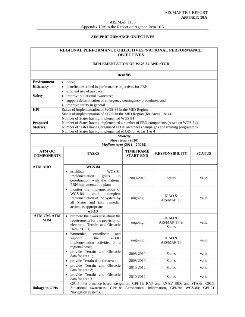
AIS/MAP TF/5-REPORT APPENDIX 10A
AIS/MAP TF/5 Appendix 10A to the Report on Agenda Item 10A
AIM PERFORMANCE OBJECTIVES
REGIONAL PERFORMANCE OBJECTIVES /NATIONAL PERFORMANCE OBJECTIVES
IMPLEMENTATION OF WGS-84 AND eTOD
Benefits
Environment none; Efficiency benefits described in performance objectives for PBN efficient use of airspace. Safety improve situational awareness;
support determination of emergency contingency procedures; and improve safety in general
KPI Status of implementation of WGS-84 in the MID Region Status of implementation of eTOD in the MID Region (for Areas 1 & 4)
Proposed Metrics:
Number of States having implemented WGS 84 Number of States having implemented a number of PBN components (based on WGS-84) Number of States having organised eTOD awareness campaigns and training programmes Number of States having implemented eTOD for Areas 1 & 4
Strategy Short term (2010)
Medium term (2011 - 20015)
ATM OC COMPONENTS
TASKS TIMEFRAME START-END
RESPONSIBILITY
STATUS
ATM AUO WGS-84 establish WGS-84
implementation goals in coordination with the national PBN implementation plan;
2009-2010 States valid
monitor the implementation of WGS-84 until complete implementation of the system by all States and take remedial action, as appropriate.
ongoing ICAO &
AIS/MAP TF valid
eTOD ATM CM, ATM
SDM promote the awareness about the
requirements for the provision of electronic Terrain and Obstacle Data (eTOD);
ongoing ICAO &
AIS/MAP TF & States
valid
harmonize, coordinate and support the eTOD implementation activities on a regional basis;
ongoing ICAO &
AIS/MAP TF valid
provide Terrain and Obstacle data for area 1;
2008-2010 States valid
provide Terrain data for area 4; 2008-2010 States valid provide Terrain and Obstacle
data for area 2; 2010-2012 States valid
provide Terrain and Obstacle data for area 3.
2010-2012 States valid
linkage to GPIs GPI-5: Performance-based navigation; GPI-11: RNP and RNAV SIDs and STARs; GPI/9: Situational awareness; GPI/18: Aeronautical Information, GPI/20: WGS-84; GPI-21: Navigation systems.
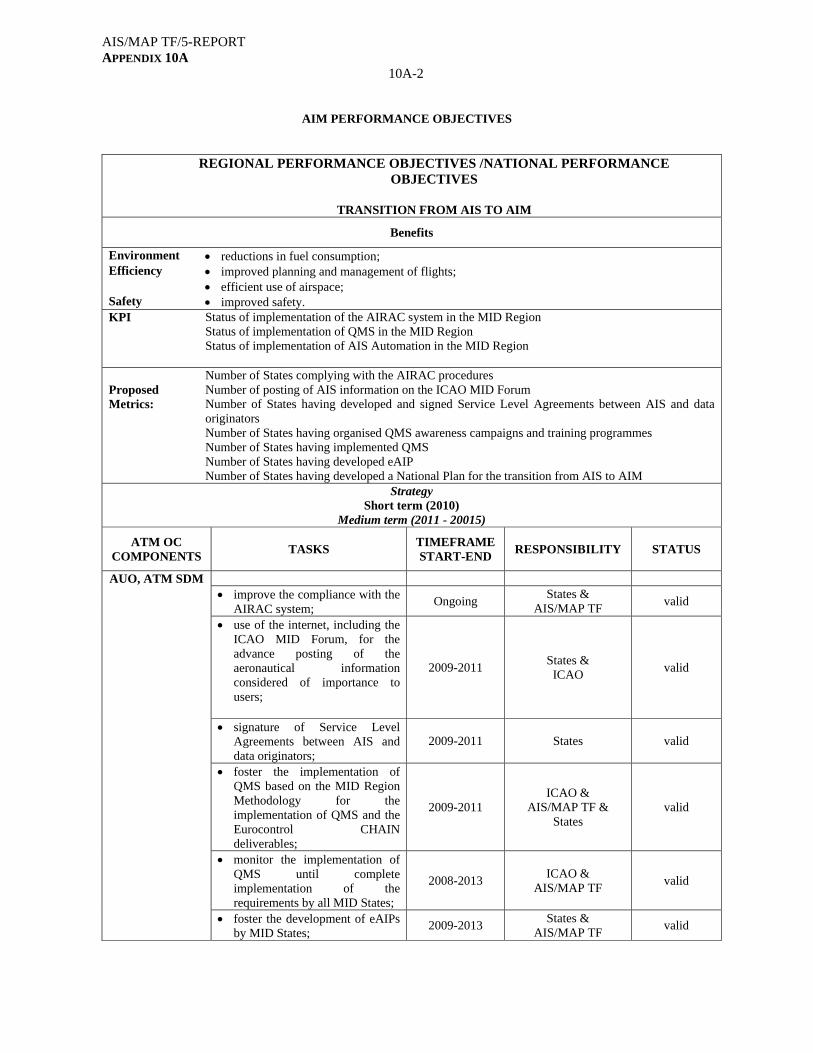
AIS/MAP TF/5-REPORT APPENDIX 10A
10A-2
AIM PERFORMANCE OBJECTIVES
REGIONAL PERFORMANCE OBJECTIVES /NATIONAL PERFORMANCE OBJECTIVES
TRANSITION FROM AIS TO AIM
Benefits
Environment reductions in fuel consumption; Efficiency improved planning and management of flights; efficient use of airspace; Safety improved safety. KPI Status of implementation of the AIRAC system in the MID Region
Status of implementation of QMS in the MID Region Status of implementation of AIS Automation in the MID Region
Proposed Metrics:
Number of States complying with the AIRAC procedures Number of posting of AIS information on the ICAO MID Forum Number of States having developed and signed Service Level Agreements between AIS and data originators Number of States having organised QMS awareness campaigns and training programmes Number of States having implemented QMS Number of States having developed eAIP Number of States having developed a National Plan for the transition from AIS to AIM
Strategy Short term (2010)
Medium term (2011 - 20015)
ATM OC COMPONENTS
TASKS TIMEFRAME START-END
RESPONSIBILITY
STATUS
AUO, ATM SDM improve the compliance with the
AIRAC system; Ongoing
States & AIS/MAP TF
valid
use of the internet, including the ICAO MID Forum, for the advance posting of the aeronautical information considered of importance to users;
2009-2011 States & ICAO
valid
signature of Service Level Agreements between AIS and data originators;
2009-2011 States valid
foster the implementation of QMS based on the MID Region Methodology for the implementation of QMS and the Eurocontrol CHAIN deliverables;
2009-2011 ICAO &
AIS/MAP TF & States
valid
monitor the implementation of QMS until complete implementation of the requirements by all MID States;
2008-2013 ICAO &
AIS/MAP TF valid
foster the development of eAIPs by MID States;
2009-2013 States &
AIS/MAP TF valid

AIS/MAP TF/5-REPORT APPENDIX 10A
10A-3
Strategy Short term (2010)
Medium term (2011 - 20015)
ATM OC COMPONENTS
TASKS TIMEFRAME START-END
RESPONSIBILITY
STATUS
AUO, ATM SDM monitor the implementation of
AIS automation in the MID Region in order to ensure availability, sharing and management of electronic aeronautical information;
2008-2013 ICAO &
AIS/MAP TF valid
foster the development of national/regional AIS databases. 2010-2015
ICAO & AIS/MAP TF &
States valid
linkage to GPIs GPI-5: Performance-based navigation; GPI-11: RNP and RNAV SIDs and STARs; GPI/18: Aeronautical Information
Abbreviations used in the Global ATM Operational Concept:
AO Aerodrome Operations AOM Airspace Organization and Management ATM SDM ATM Service Delivery Management AUO Airspace User Operations CM Conflict Management DCB Demand and Capacity Balancing TS Traffic Synchronization
--------------

AIS/MAP TF/5-REPORT
11-1
AIS/MAP TF/5 Report on Agenda Item 11
REPORT ON AGENDA ITEM 11: FUTURE WORK PROGRAMME 11.1 The meeting recalled that MIDANPIRG/11, under Decision 11/54, approved the revised Terms of Reference (TOR) and Work Programme of the AIS/MAP Task Force. 11.2 Taking into consideration the latest development of the AIS/MAP field, the meeting reviewed and updated the TOR and Work Programme of the AIS/MAP Task Force and agreed to the following Draft Decision, which is proposed to replace and supersede MIDANPIRG/11 Decision 11/54:
DRAFT DECISION 5/12: TERMS OF REFERENCE OF THE AIS/MAP TASK
FORCE
That, the Terms of Reference and Work Programme of the AIS/MAP Task Force be updated as at Appendix 11A to the Report on Agenda Item 11.
11.3 Taking into consideration the Work Programme of the Task Force, and noting that MIDANPIRG/12 is tentatively scheduled to be held in October 2010, the meeting agreed that the AIS/MAP TF/6 meeting be held in the first half of 2011. The venue will be Cairo, unless a State is willing to host the meeting. 11.4 In accordance with the ICAO Business plan and the requirements for performance monitoring, the meeting developed a follow-up action plan as at Appendix 11B to the Report on Agenda Item 11.
------------
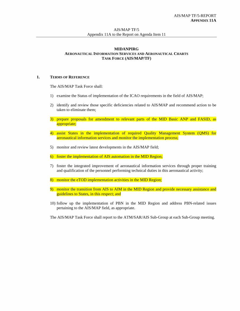
AIS/MAP TF/5-REPORT APPENDIX 11A
AIS/MAP TF/5
Appendix 11A to the Report on Agenda Item 11
MIDANPIRG AERONAUTICAL INFORMATION SERVICES AND AERONAUTICAL CHARTS
TASK FORCE (AIS/MAP/TF)
1. TERMS OF REFERENCE
The AIS/MAP Task Force shall:
1) examine the Status of implementation of the ICAO requirements in the field of AIS/MAP;
2) identify and review those specific deficiencies related to AIS/MAP and recommend action to be taken to eliminate them;
3) prepare proposals for amendment to relevant parts of the MID Basic ANP and FASID, as
appropriate;
4) assist States in the implementation of required Quality Management System (QMS) for aeronautical information services and monitor the implementation process;
5) monitor and review latest developments in the AIS/MAP field;
6) foster the implementation of AIS automation in the MID Region;
7) foster the integrated improvement of aeronautical information services through proper training
and qualification of the personnel performing technical duties in this aeronautical activity;
8) monitor the eTOD implementation activities in the MID Region;
9) monitor the transition from AIS to AIM in the MID Region and provide necessary assistance and guidelines to States, in this respect; and
10) follow up the implementation of PBN in the MID Region and address PBN-related issues
pertaining to the AIS/MAP field, as appropriate.
The AIS/MAP Task Force shall report to the ATM/SAR/AIS Sub-Group at each Sub-Group meeting.
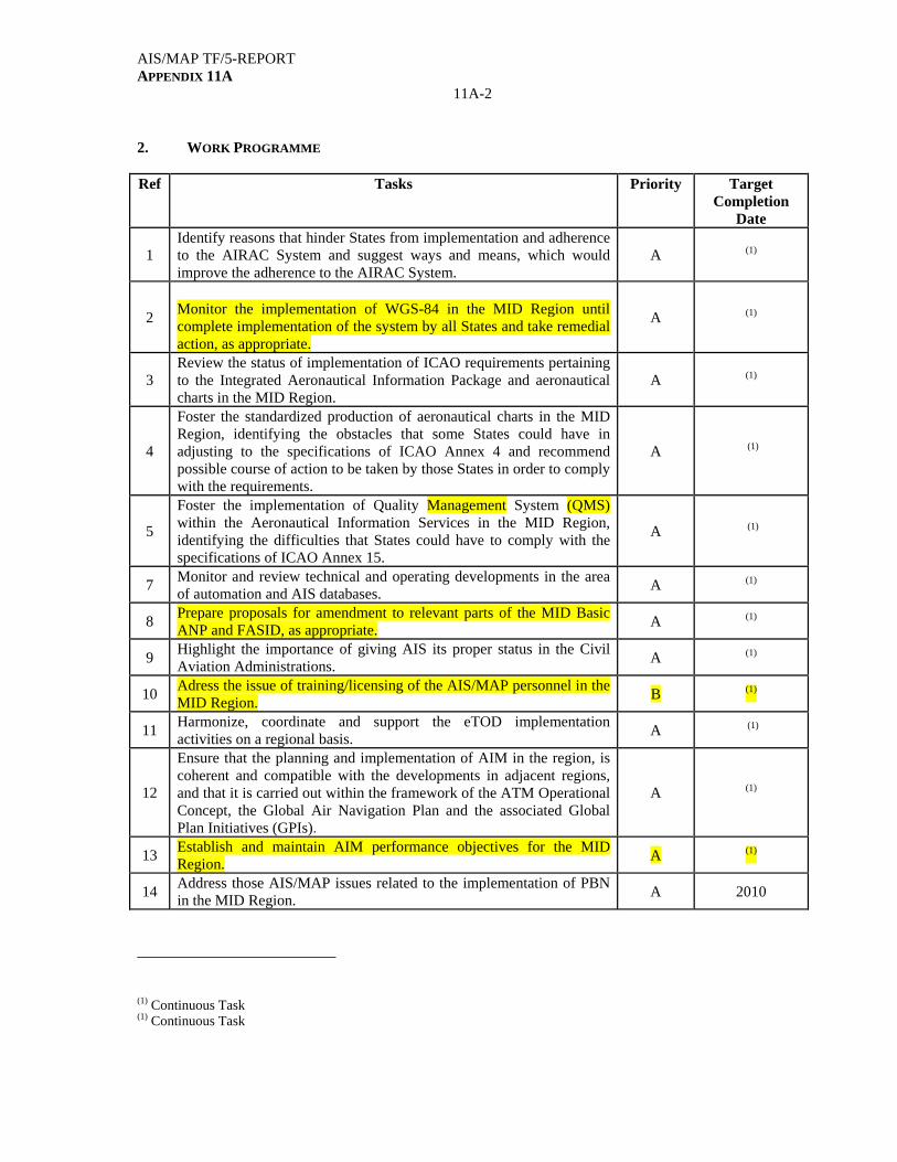
AIS/MAP TF/5-REPORT APPENDIX 11A
11A-2
2. WORK PROGRAMME Ref Tasks Priority Target
Completion Date
1 Identify reasons that hinder States from implementation and adherence to the AIRAC System and suggest ways and means, which would improve the adherence to the AIRAC System.
A (1)
2
Monitor the implementation of WGS-84 in the MID Region until complete implementation of the system by all States and take remedial action, as appropriate.
A (1)
3 Review the status of implementation of ICAO requirements pertaining to the Integrated Aeronautical Information Package and aeronautical charts in the MID Region.
A (1)
4
Foster the standardized production of aeronautical charts in the MID Region, identifying the obstacles that some States could have in adjusting to the specifications of ICAO Annex 4 and recommend possible course of action to be taken by those States in order to comply with the requirements.
A (1)
5
Foster the implementation of Quality Management System (QMS) within the Aeronautical Information Services in the MID Region, identifying the difficulties that States could have to comply with the specifications of ICAO Annex 15.
A (1)
7 Monitor and review technical and operating developments in the area of automation and AIS databases.
A (1)
8 Prepare proposals for amendment to relevant parts of the MID Basic ANP and FASID, as appropriate.
A (1)
9 Highlight the importance of giving AIS its proper status in the Civil Aviation Administrations.
A (1)
10 Adress the issue of training/licensing of the AIS/MAP personnel in the MID Region.
B (1)
11 Harmonize, coordinate and support the eTOD implementation activities on a regional basis.
A (1)
12
Ensure that the planning and implementation of AIM in the region, is coherent and compatible with the developments in adjacent regions, and that it is carried out within the framework of the ATM Operational Concept, the Global Air Navigation Plan and the associated Global Plan Initiatives (GPIs).
A (1)
13 Establish and maintain AIM performance objectives for the MID Region.
A (1)
14 Address those AIS/MAP issues related to the implementation of PBN in the MID Region.
A 2010
(1) Continuous Task (1) Continuous Task

AIS/MAP TF/5-REPORT APPENDIX 11A
11A-3 3. PRIORITIES
A High priority tasks, on which work should be speeded up. B Medium priority tasks, on which work should begin as soon as possible, but without
detriment to priority A tasks. C Tasks of lesser priority, on which work should begin as time and resources allow, but without
detriment to priority A and B tasks. 4. COMPOSITION
MIDANPIRG Provider States, IATA, IFALPA, and IFATCA Other representatives from industry and user Organizations having a vested interest in Aeronautical Information Services could participate as observers in the work of the Task Force, as appropriate.
--------------

AIS/MAP TF/5 – REPORT APPENDIX 11B
AIS/MAP TF/5
Appendix 11B to the Report on Agenda Item 11
DRAFT FOLLOW-UP ACTION PLAN
CONCLUSIONS AND DECISIONS FOLLOW-UP TO BE
INITIATED BY DELIVERABLE TARGET DATE REMARKS
DRAFT DEC. 5/1: DRAFT PROPOSAL FOR AMENDMENT
TO THE MID FASID, PART VIII (AIS
TABLES)
That, based on the feedback from States, the Secretariat consolidate a draft proposal for amendment to the MID FASID, Part VIII (AIS), for review by the ATM/SAR/AIS SG/11 meeting before official circulation to States.
Consolidate the proposal for amendment
ICAO
Draft Proposal for amendment to be presented to the ATM/SAR/AIS SG/11 meeting
Nov. 2009
DRAFT CONC. 5/2: AWARENESS CAMPAIGNS AND
TRAINING PROGRAMMES ON QMS
That, States, with the support of ICAO and the QMS Implementation Action Group (QMS AG), organize, at the National level, awareness campaigns and training programmes to promote and expedite the process of implementation of QMS for AIS.
Implement the Conclusion
States
Feedback from States on their plan for awareness campaigns and training programmes on QMS
Nov. 2009
DRAFT DEC. 5/3: TERMS OF REFERENCE OF THE QMS
IMPLEMENTATION ACTION GROUP
That, the Terms of Reference of the QMS Implementation Action Group (QMS AG) be updated as at Appendix 4B to the Report on Agenda Item 4.
Follow-up the activities of the QMS AG
AIS/MAP TF ICAO
Feedback from the Action Group
Nov. 2009
DRAFT DEC. 5/4: TERMS OF REFERENCE OF THE AIS
AUTOMATION ACTION GROUP
That, the Terms of Reference of the AIS Automation Action Group (AISA AG) be updated as at Appendix 5B to the Report on Agenda Item 5.
Follow-up the activities of the AISA AG
AIS/MAP TF ICAO
Feedback from the Action Group
Nov. 2009
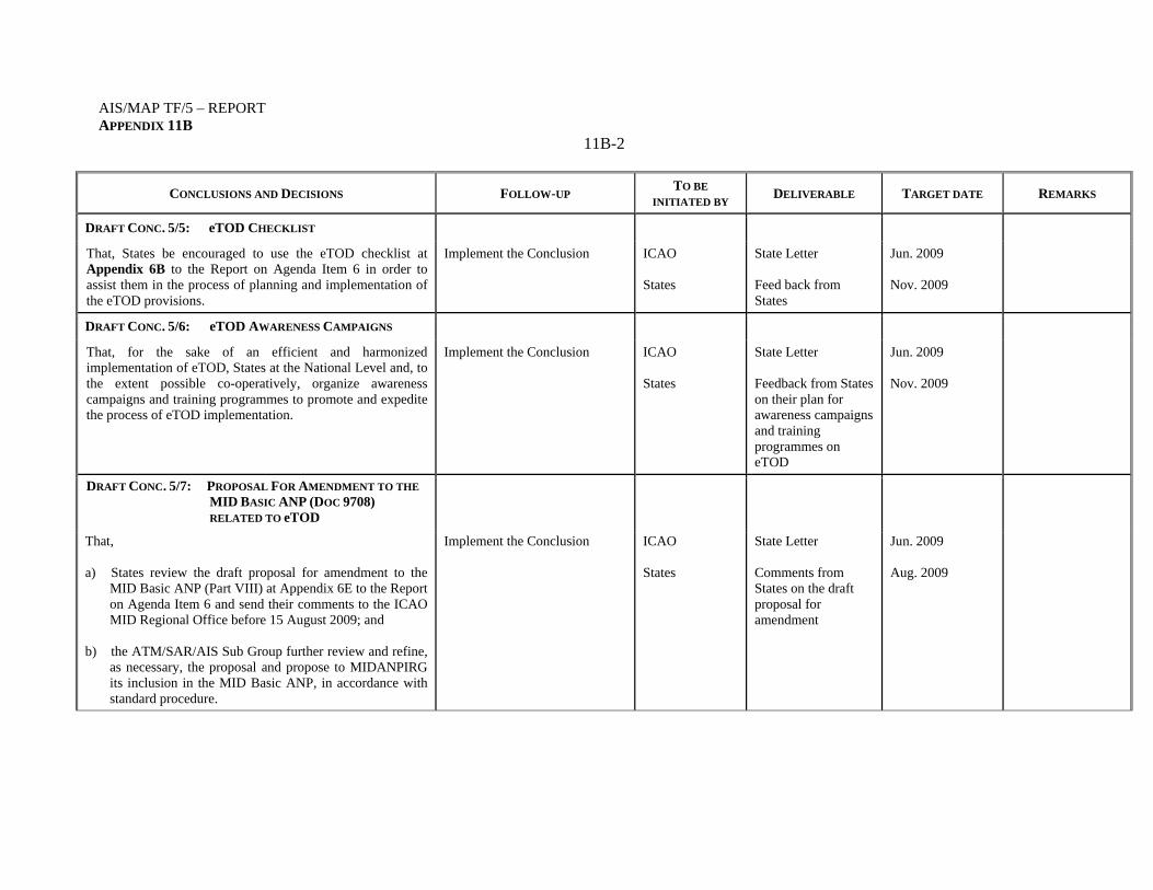
AIS/MAP TF/5 – REPORT APPENDIX 11B
11B-2
CONCLUSIONS AND DECISIONS FOLLOW-UP TO BE
INITIATED BY DELIVERABLE TARGET DATE REMARKS
DRAFT CONC. 5/5: eTOD CHECKLIST
That, States be encouraged to use the eTOD checklist at Appendix 6B to the Report on Agenda Item 6 in order to assist them in the process of planning and implementation of the eTOD provisions.
Implement the Conclusion ICAO States
State Letter Feed back from States
Jun. 2009 Nov. 2009
DRAFT CONC. 5/6: eTOD AWARENESS CAMPAIGNS
That, for the sake of an efficient and harmonized implementation of eTOD, States at the National Level and, to the extent possible co-operatively, organize awareness campaigns and training programmes to promote and expedite the process of eTOD implementation.
Implement the Conclusion ICAO States
State Letter Feedback from States on their plan for awareness campaigns and training programmes on eTOD
Jun. 2009 Nov. 2009
DRAFT CONC. 5/7: PROPOSAL FOR AMENDMENT TO THE
MID BASIC ANP (DOC 9708)
RELATED TO eTOD
That,
a) States review the draft proposal for amendment to the MID Basic ANP (Part VIII) at Appendix 6E to the Report on Agenda Item 6 and send their comments to the ICAO MID Regional Office before 15 August 2009; and
b) the ATM/SAR/AIS Sub Group further review and refine,
as necessary, the proposal and propose to MIDANPIRG its inclusion in the MID Basic ANP, in accordance with standard procedure.
Implement the Conclusion ICAO States
State Letter Comments from States on the draft proposal for amendment
Jun. 2009 Aug. 2009
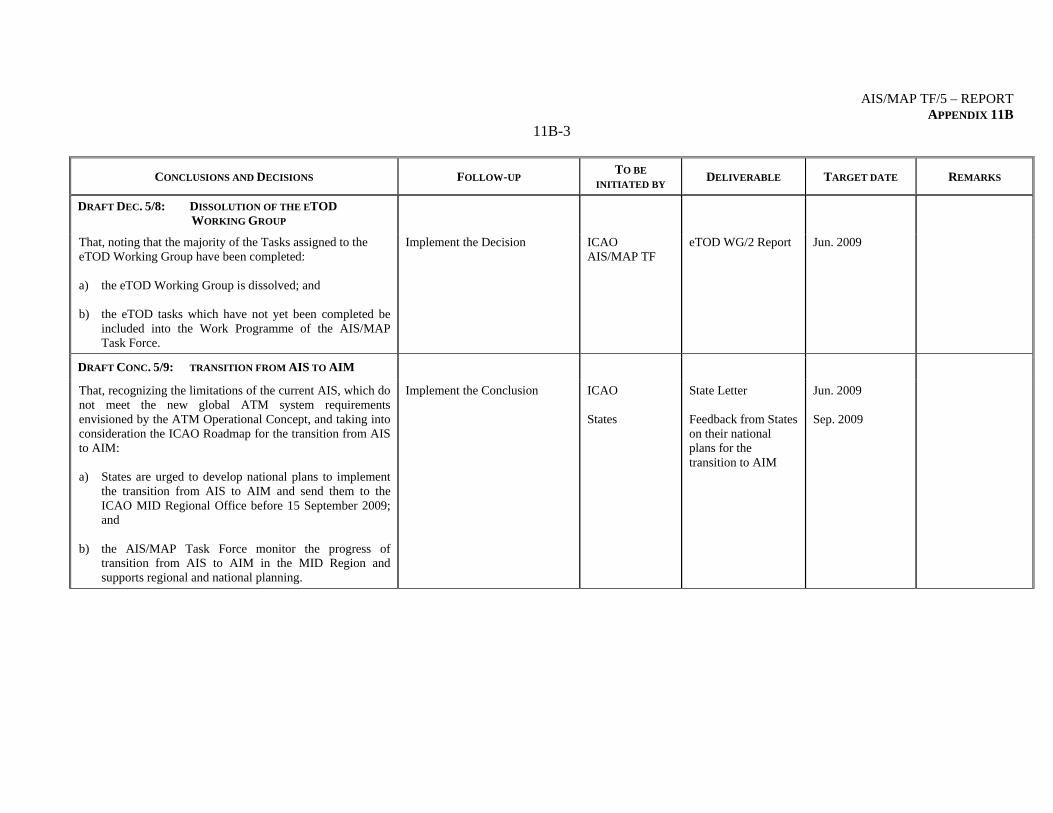
AIS/MAP TF/5 – REPORT APPENDIX 11B
11B-3
CONCLUSIONS AND DECISIONS FOLLOW-UP TO BE
INITIATED BY DELIVERABLE TARGET DATE REMARKS
DRAFT DEC. 5/8: DISSOLUTION OF THE ETOD
WORKING GROUP
That, noting that the majority of the Tasks assigned to the eTOD Working Group have been completed:
a) the eTOD Working Group is dissolved; and b) the eTOD tasks which have not yet been completed be
included into the Work Programme of the AIS/MAP Task Force.
Implement the Decision ICAO AIS/MAP TF
eTOD WG/2 Report Jun. 2009
DRAFT CONC. 5/9: TRANSITION FROM AIS TO AIM
That, recognizing the limitations of the current AIS, which do not meet the new global ATM system requirements envisioned by the ATM Operational Concept, and taking into consideration the ICAO Roadmap for the transition from AIS to AIM: a) States are urged to develop national plans to implement
the transition from AIS to AIM and send them to the ICAO MID Regional Office before 15 September 2009; and
b) the AIS/MAP Task Force monitor the progress of
transition from AIS to AIM in the MID Region and supports regional and national planning.
Implement the Conclusion ICAO States
State Letter Feedback from States on their national plans for the transition to AIM
Jun. 2009 Sep. 2009
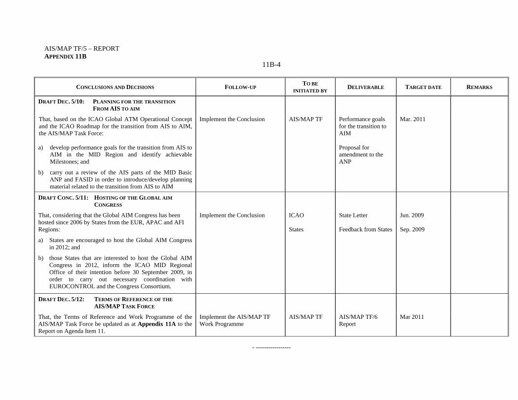
AIS/MAP TF/5 – REPORT APPENDIX 11B
11B-4
CONCLUSIONS AND DECISIONS FOLLOW-UP TO BE
INITIATED BY DELIVERABLE TARGET DATE REMARKS
DRAFT DEC. 5/10: PLANNING FOR THE TRANSITION
FROM AIS TO AIM
That, based on the ICAO Global ATM Operational Concept and the ICAO Roadmap for the transition from AIS to AIM, the AIS/MAP Task Force: a) develop performance goals for the transition from AIS to
AIM in the MID Region and identify achievable Milestones; and
b) carry out a review of the AIS parts of the MID Basic ANP and FASID in order to introduce/develop planning material related to the transition from AIS to AIM
Implement the Conclusion AIS/MAP TF Performance goals for the transition to AIM Proposal for amendment to the ANP
Mar. 2011
DRAFT CONC. 5/11: HOSTING OF THE GLOBAL AIM
CONGRESS
That, considering that the Global AIM Congress has been hosted since 2006 by States from the EUR, APAC and AFI Regions:
a) States are encouraged to host the Global AIM Congress in 2012; and
b) those States that are interested to host the Global AIM Congress in 2012, inform the ICAO MID Regional Office of their intention before 30 September 2009, in order to carry out necessary coordination with EUROCONTROL and the Congress Consortium.
Implement the Conclusion ICAO States
State Letter Feedback from States
Jun. 2009 Sep. 2009
DRAFT DEC. 5/12: TERMS OF REFERENCE OF THE
AIS/MAP TASK FORCE
That, the Terms of Reference and Work Programme of the AIS/MAP Task Force be updated as at Appendix 11A to the Report on Agenda Item 11.
Implement the AIS/MAP TF Work Programme
AIS/MAP TF AIS/MAP TF/6 Report
Mar 2011
- -----------------
AIS/MAP TF/5-REPORT
12-1
AIS/MAP TF/5 Report on Agenda Item 12
REPORT ON AGENDA ITEM 12: ANY OTHER BUSINESS 12.1 The meeting highlighted that the update of the hardcopies of the AIPs of the different States represents a big burden for the AIS/MAP Personnel and that States should promote the exchange of aeronautical information in electronic format. In this regard, reference was made to Annex 15 para. 3.3.5, which states that “One copy of each of the elements of the Integrated Aeronautical Information Package, in paper or electronic form or both, that have been requested by the aeronautical information service of an ICAO Contracting State shall be made available by the originating State in the mutually-agreed form(s), without charge, even where authority for publication/storage and distribution has been delegated to a commercial agency”. 12.2 The meeting recognized that AIS is in a transition phase and that the hardcopies are still needed by some users, especially the aeronautical charts printed on a format bigger than A4. In addition, the provisions of Annex 15 give enough flexibility for the exchange of aeronautical information in paper or electronic form or both. However, States were encouraged to clearly mention in the AIC related to the renewal of the subscription to their Aeronautical Information Publications (if available in an electronic format), the possibility of exchange of the paper and/or electronic copy of the publications. 12.3 The meeting recalled that Standards and Recommended Practices for Aeronautical Information Services were first adopted by the ICAO Council on 15 May 1953, and were designated as Annex 15 to the Convention. Accordingly, each 15 May, all AISs in the world are celebrating the AIS day. The meeting noted that within few days, the AIS community will celebrate the fifty sixth “anniversary” of Annex 15. 12.4 The meeting inquired if it was time to rename the AIS/MAP Task Force to AIM Task Force and agreed that this could be decided by the AIS/MAP TF/6 meeting.
------------
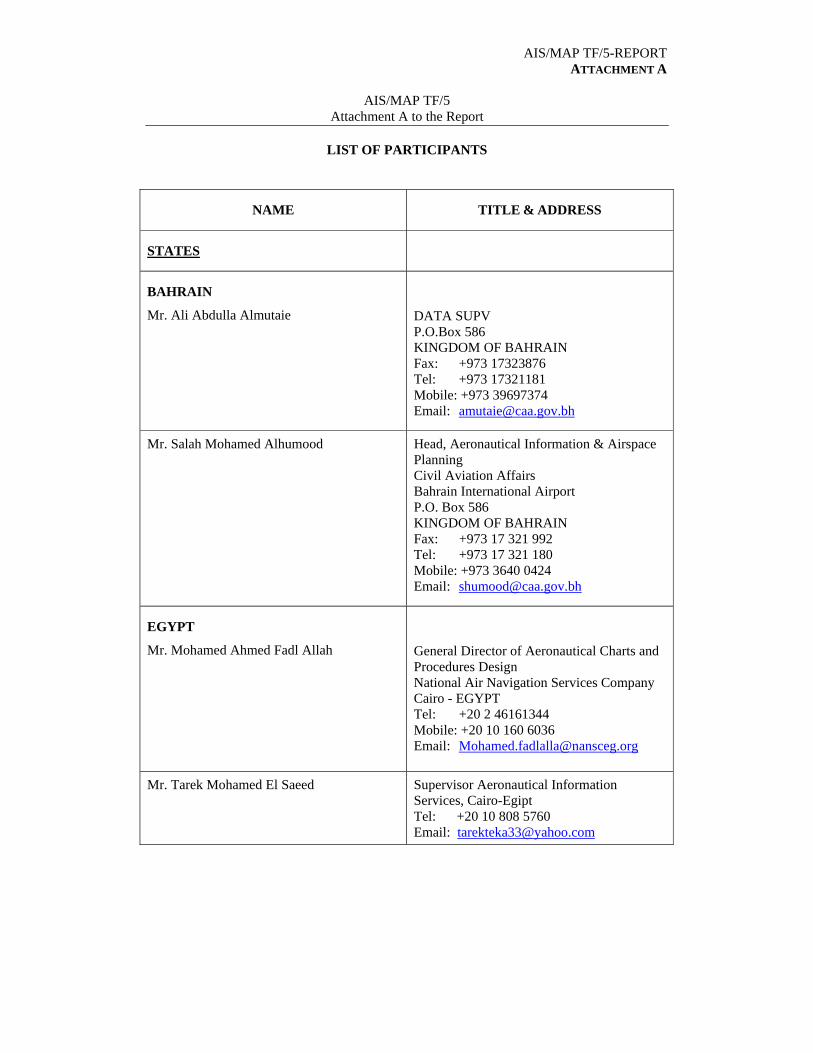
AIS/MAP TF/5-REPORT ATTACHMENT A
AIS/MAP TF/5
Attachment A to the Report
LIST OF PARTICIPANTS
NAME TITLE & ADDRESS
STATES
BAHRAIN
Mr. Ali Abdulla Almutaie
DATA SUPV P.O.Box 586 KINGDOM OF BAHRAIN Fax: +973 17323876 Tel: +973 17321181 Mobile: +973 39697374 Email: [email protected]
Mr. Salah Mohamed Alhumood Head, Aeronautical Information & Airspace Planning Civil Aviation Affairs Bahrain International Airport P.O. Box 586 KINGDOM OF BAHRAIN Fax: +973 17 321 992 Tel: +973 17 321 180 Mobile: +973 3640 0424 Email: [email protected]
EGYPT
Mr. Mohamed Ahmed Fadl Allah
General Director of Aeronautical Charts and Procedures Design National Air Navigation Services Company Cairo - EGYPT Tel: +20 2 46161344 Mobile: +20 10 160 6036 Email: [email protected]
Mr. Tarek Mohamed El Saeed Supervisor Aeronautical Information Services, Cairo-Egipt Tel: +20 10 808 5760 Email: [email protected]
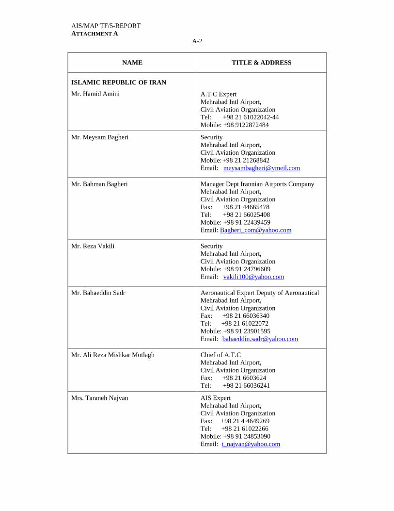
AIS/MAP TF/5-REPORT ATTACHMENT A
A-2
NAME TITLE & ADDRESS
ISLAMIC REPUBLIC OF IRAN
Mr. Hamid Amini
A.T.C Expert Mehrabad Intl Airport, Civil Aviation Organization Tel: +98 21 61022042-44 Mobile: +98 9122872484
Mr. Meysam Bagheri Security Mehrabad Intl Airport, Civil Aviation Organization Mobile: +98 21 21268842 Email: [email protected]
Mr. Bahman Bagheri Manager Dept Irannian Airports Company Mehrabad Intl Airport, Civil Aviation Organization Fax: +98 21 44665478 Tel: +98 21 66025408 Mobile: +98 91 22439459 Email: [email protected]
Mr. Reza Vakili Security Mehrabad Intl Airport, Civil Aviation Organization Mobile: +98 91 24796609 Email: [email protected]
Mr. Bahaeddin Sadr Aeronautical Expert Deputy of Aeronautical Mehrabad Intl Airport, Civil Aviation Organization Fax: +98 21 66036340 Tel: +98 21 61022072 Mobile: +98 91 23901595 Email: [email protected]
Mr. Ali Reza Mishkar Motlagh Chief of A.T.C Mehrabad Intl Airport, Civil Aviation Organization Fax: +98 21 6603624 Tel: +98 21 66036241
Mrs. Taraneh Najvan AIS Expert Mehrabad Intl Airport, Civil Aviation Organization Fax: +98 21 4 4649269 Tel: +98 21 61022266 Mobile: +98 91 24853090 Email: [email protected]
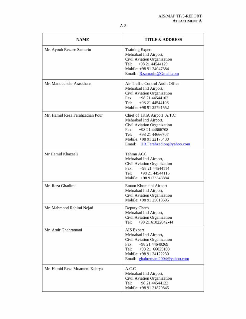
AIS/MAP TF/5-REPORT ATTACHMENT A
A-3
NAME TITLE & ADDRESS
Mr. Ayoub Rezaee Samarin Training Expert Mehrabad Intl Airport, Civil Aviation Organization Tel: +98 21 44544129 Mobile: +98 91 24047384 Email: [email protected]
Mr. Manouchehr Araskhans Air Traffic Control Audit Office Mehrabad Intl Airport, Civil Aviation Organization Fax: +98 21 44544102 Tel: +98 21 44544106 Mobile: +98 91 25791552
Mr. Hamid Reza Farahzadian Pour Chief of IKIA Airport A.T.C Mehrabad Intl Airport, Civil Aviation Organization Fax: +98 21 44666708 Tel: +98 21 44666707 Mobile: +98 91 22175430 Email: [email protected]
Mr Hamid Khazaeli Tehran ACC Mehrabad Intl Airport, Civil Aviation Organization Fax: +98 21 44544114 Tel: +98 21 44544115 Mobile: +98 9123343884
Mr. Reza Ghadimi Emam Khomeini Airport Mehrabad Intl Airport, Civil Aviation Organization Mobile: +98 91 25018595
Mr. Mahmood Rahimi Nejad Deputy Chero Mehrabad Intl Airport, Civil Aviation Organization Tel: +98 21 61022042-44
Mr. Amir Ghahramani AIS Expert Mehrabad Intl Airport, Civil Aviation Organization Fax: +98 21 44649269 Tel: +98 21 66025108 Mobile: +98 91 24122230 Email: [email protected]
Mr. Hamid Reza Moameni Kebrya A.C.C Mehrabad Intl Airport, Civil Aviation Organization Tel: +98 21 44544123 Mobile: +98 91 21870845
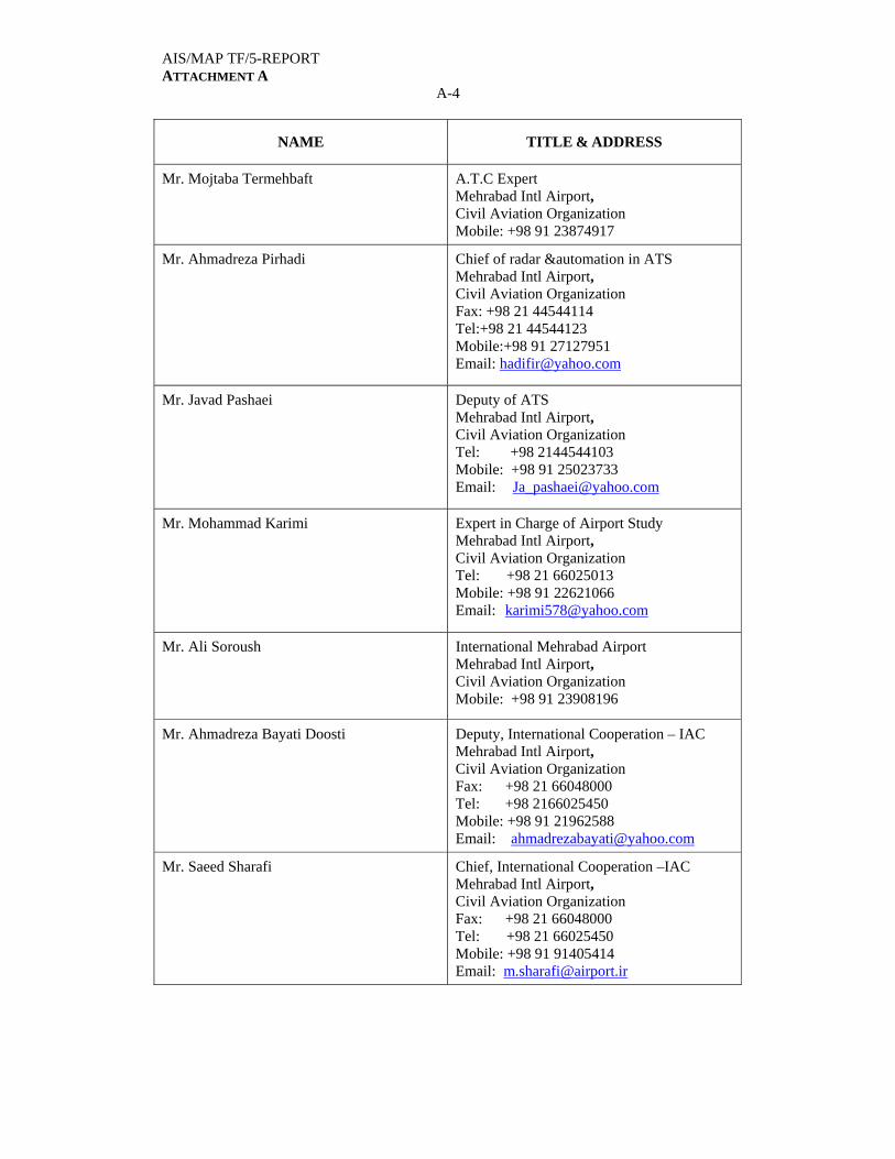
AIS/MAP TF/5-REPORT ATTACHMENT A
A-4
NAME TITLE & ADDRESS
Mr. Mojtaba Termehbaft A.T.C Expert Mehrabad Intl Airport, Civil Aviation Organization Mobile: +98 91 23874917
Mr. Ahmadreza Pirhadi Chief of radar &automation in ATS Mehrabad Intl Airport, Civil Aviation Organization Fax: +98 21 44544114 Tel:+98 21 44544123 Mobile:+98 91 27127951 Email: [email protected]
Mr. Javad Pashaei Deputy of ATS Mehrabad Intl Airport, Civil Aviation Organization Tel: +98 2144544103 Mobile: +98 91 25023733 Email: [email protected]
Mr. Mohammad Karimi Expert in Charge of Airport Study Mehrabad Intl Airport, Civil Aviation Organization Tel: +98 21 66025013 Mobile: +98 91 22621066 Email: [email protected]
Mr. Ali Soroush International Mehrabad Airport Mehrabad Intl Airport, Civil Aviation Organization Mobile: +98 91 23908196
Mr. Ahmadreza Bayati Doosti Deputy, International Cooperation – IAC Mehrabad Intl Airport, Civil Aviation Organization Fax: +98 21 66048000 Tel: +98 2166025450 Mobile: +98 91 21962588 Email: [email protected]
Mr. Saeed Sharafi Chief, International Cooperation –IAC Mehrabad Intl Airport, Civil Aviation Organization Fax: +98 21 66048000 Tel: +98 21 66025450 Mobile: +98 91 91405414 Email: [email protected]

AIS/MAP TF/5-REPORT ATTACHMENT A
A-5
NAME TITLE & ADDRESS
Ms. Hoda Harati Coordinator, International Co-Operation-IAC Mehrabad Intl Airport, Civil Aviation Organization Fax: +98 21 66048000 Tel: +98 21 66025450 Mobile: +98 91 25142758 Email: [email protected]
Mr. Saeed Taghipoor Iran Airports Co Mehrabad Intl Airport, Civil Aviation Organization Fax: +98 21 66048000 Tel: +98 21 66025450 Mobile: [email protected]
Mr. Ehsan Rezapour Iran Airports Co Mehrabad Intl Airport, Civil Aviation Organization Fax: +98 21 66048000 Tel: +98 21 66025450 Mobile: [email protected]
Mr. Ehsan Samiei Iran Airports Co Mehrabad Intl Airport, Civil Aviation Organization Fax: +98 21 66048000 Tel: +98 21 66025450 Mobile: [email protected]
Mr. Arya Ghadiri Afshar Iran Airports Co Mehrabad Intl Airport, Civil Aviation Organization Fax: +98 21 66048000 Tel: +98 21 66025450 Mobile: [email protected]
Mr. Reza Sayyari Iran Airports Co Mehrabad Intl Airport, Civil Aviation Organization Fax: +98 21 66048000 Tel: +98 21 66025450 Mobile: [email protected]
Mr. Mehdi Zand
Mehrabad int'l Aiort Mehrabad Intl Airport, Civil Aviation Organization Mobile: +98 91 24231598
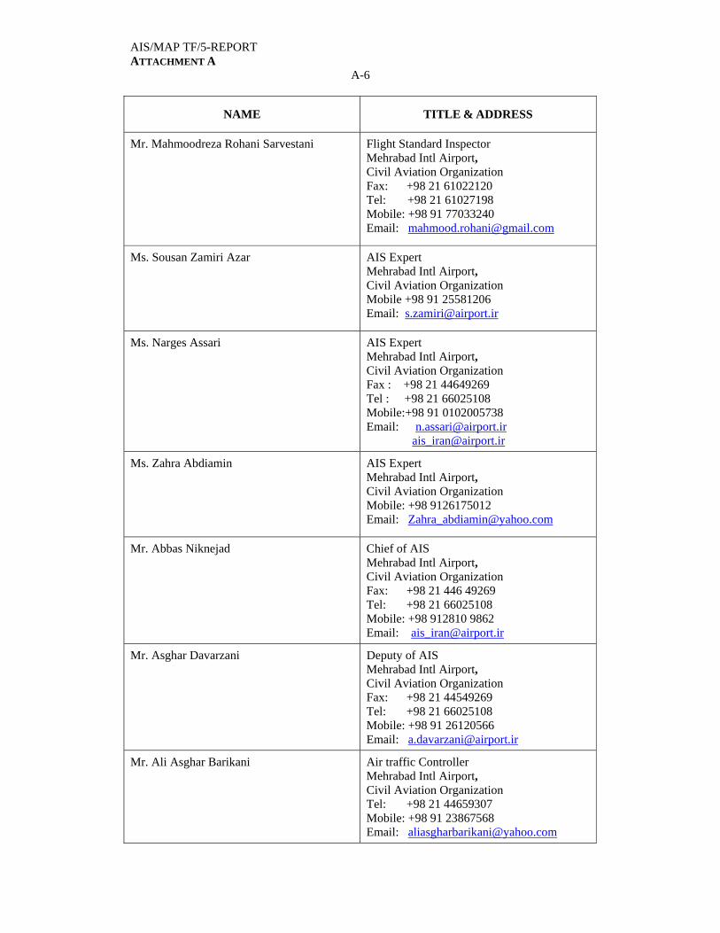
AIS/MAP TF/5-REPORT ATTACHMENT A
A-6
NAME TITLE & ADDRESS
Mr. Mahmoodreza Rohani Sarvestani Flight Standard Inspector Mehrabad Intl Airport, Civil Aviation Organization Fax: +98 21 61022120 Tel: +98 21 61027198 Mobile: +98 91 77033240 Email: [email protected]
Ms. Sousan Zamiri Azar AIS Expert Mehrabad Intl Airport, Civil Aviation Organization Mobile +98 91 25581206 Email: [email protected]
Ms. Narges Assari AIS Expert Mehrabad Intl Airport, Civil Aviation Organization Fax : +98 21 44649269 Tel : +98 21 66025108 Mobile:+98 91 0102005738 Email: [email protected] [email protected]
Ms. Zahra Abdiamin AIS Expert Mehrabad Intl Airport, Civil Aviation Organization Mobile: +98 9126175012 Email: [email protected]
Mr. Abbas Niknejad Chief of AIS Mehrabad Intl Airport, Civil Aviation Organization Fax: +98 21 446 49269 Tel: +98 21 66025108 Mobile: +98 912810 9862 Email: [email protected]
Mr. Asghar Davarzani Deputy of AIS Mehrabad Intl Airport, Civil Aviation Organization Fax: +98 21 44549269 Tel: +98 21 66025108 Mobile: +98 91 26120566 Email: [email protected]
Mr. Ali Asghar Barikani Air traffic Controller Mehrabad Intl Airport, Civil Aviation Organization Tel: +98 21 44659307 Mobile: +98 91 23867568 Email: [email protected]
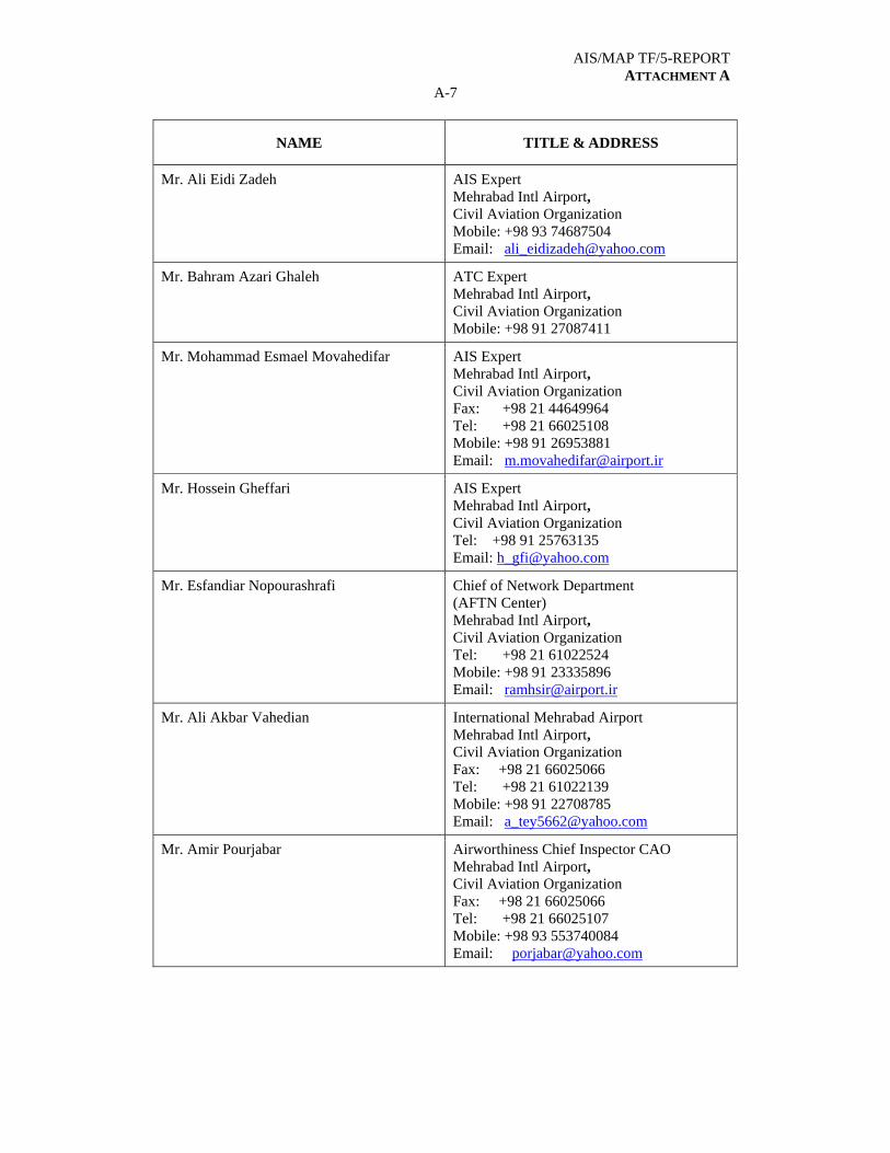
AIS/MAP TF/5-REPORT ATTACHMENT A
A-7
NAME TITLE & ADDRESS
Mr. Ali Eidi Zadeh AIS Expert Mehrabad Intl Airport, Civil Aviation Organization Mobile: +98 93 74687504 Email: [email protected]
Mr. Bahram Azari Ghaleh ATC Expert Mehrabad Intl Airport, Civil Aviation Organization Mobile: +98 91 27087411
Mr. Mohammad Esmael Movahedifar AIS Expert Mehrabad Intl Airport, Civil Aviation Organization Fax: +98 21 44649964 Tel: +98 21 66025108 Mobile: +98 91 26953881 Email: [email protected]
Mr. Hossein Gheffari AIS Expert Mehrabad Intl Airport, Civil Aviation Organization Tel: +98 91 25763135 Email: [email protected]
Mr. Esfandiar Nopourashrafi Chief of Network Department (AFTN Center) Mehrabad Intl Airport, Civil Aviation Organization Tel: +98 21 61022524 Mobile: +98 91 23335896 Email: [email protected]
Mr. Ali Akbar Vahedian International Mehrabad Airport Mehrabad Intl Airport, Civil Aviation Organization Fax: +98 21 66025066 Tel: +98 21 61022139 Mobile: +98 91 22708785 Email: [email protected]
Mr. Amir Pourjabar Airworthiness Chief Inspector CAO Mehrabad Intl Airport, Civil Aviation Organization Fax: +98 21 66025066 Tel: +98 21 66025107 Mobile: +98 93 553740084 Email: [email protected]

AIS/MAP TF/5-REPORT ATTACHMENT A
A-8
NAME TITLE & ADDRESS
Mr. Fahrhad Shahabi Flight Operation Expert Mehrabad Intl Airport, Civil Aviation Organization Fax: +98 21 66025066 Tel: +98 21 61022139 Mobile: +98 91 26302407 Email: [email protected]
JORDAN
Mrs. Hanan Akram Qabartai
Chief AIS HQ Directorate ATM Civil Aviation Regulatory Commission P.O. Box 7547-11110 Amman - JORDAN Fax: +962-6 489 1266 Tel: +962-6 489 2282 Ext 3525 Mobile: 962-79 6768012 Email: [email protected]
Mr. Ahmed Sabra AIS Supervisor /ANS Department/ Aqaba King Hossein Int’l Fax: +962 6 4891266 Tel: +962 3 2012111 Mobile: +962 79 6118077 Email: [email protected]
KUWAIT Mr. Esam Juma Ahmad Ali
AIS Officer Directorate General of Civil Aviation Kuwait International Airport P.O.Box 6837 - Hawalli State of KUWAIT Fax: +965 476 5512 Mobile: +965 66630735 Email: [email protected]
Mr. Abdullah M. Al-Adwani Superintendent of AIS Directorate General of Civil Aviation Kuwait International Airport P.O. Box 17 Safat 13001 13001 KUWAIT Fax: +965-2 476 5512 Tel: +965-2 476 2531 Mobile: +965-6605 1116 Email: [email protected]
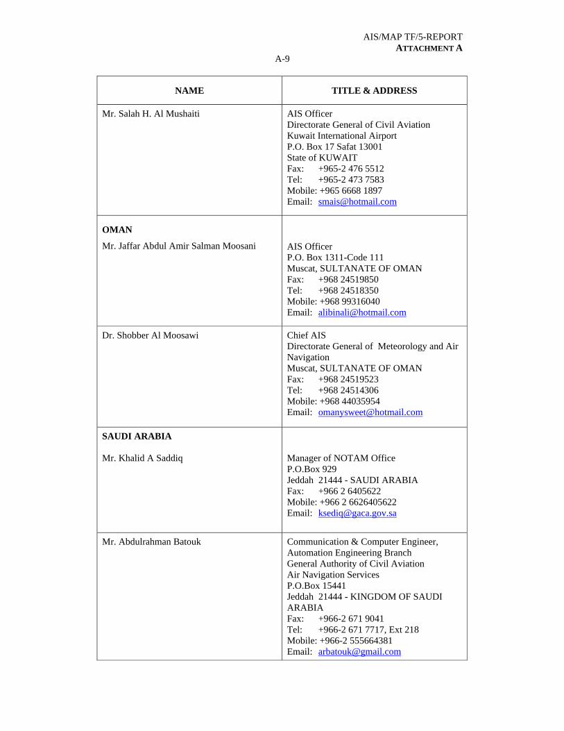
AIS/MAP TF/5-REPORT ATTACHMENT A
A-9
NAME TITLE & ADDRESS
Mr. Salah H. Al Mushaiti AIS Officer Directorate General of Civil Aviation Kuwait International Airport P.O. Box 17 Safat 13001 State of KUWAIT Fax: +965-2 476 5512 Tel: +965-2 473 7583 Mobile: +965 6668 1897 Email: [email protected]
OMAN
Mr. Jaffar Abdul Amir Salman Moosani
AIS Officer P.O. Box 1311-Code 111 Muscat, SULTANATE OF OMAN Fax: +968 24519850 Tel: +968 24518350 Mobile: +968 99316040 Email: [email protected]
Dr. Shobber Al Moosawi Chief AIS Directorate General of Meteorology and Air Navigation Muscat, SULTANATE OF OMAN Fax: +968 24519523 Tel: +968 24514306 Mobile: +968 44035954 Email: [email protected]
SAUDI ARABIA Mr. Khalid A Saddiq
Manager of NOTAM Office P.O.Box 929 Jeddah 21444 - SAUDI ARABIA Fax: +966 2 6405622 Mobile: +966 2 6626405622 Email: [email protected]
Mr. Abdulrahman Batouk Communication & Computer Engineer, Automation Engineering Branch General Authority of Civil Aviation Air Navigation Services P.O.Box 15441 Jeddah 21444 - KINGDOM OF SAUDI ARABIA Fax: +966-2 671 9041 Tel: +966-2 671 7717, Ext 218 Mobile: +966-2 555664381 Email: [email protected]
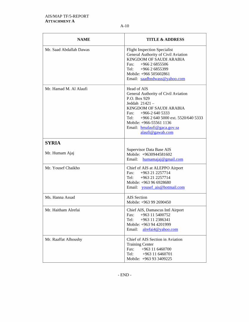
AIS/MAP TF/5-REPORT ATTACHMENT A
A-10
NAME TITLE & ADDRESS
Mr. Saad Abdallah Dawas Flight Inspection Specialist General Authority of Civil Aviation KINGDOM OF SAUDI ARABIA Fax: +966 2 6855506 Tel: +966 2 6855399 Mobile: +966 505602861 Email: [email protected]
Mr. Hamad M. Al Alaufi Head of AIS General Authority of Civil Aviation P.O. Box 929 Jeddah 21421 – KINGDOM OF SAUDI ARABIA Fax: +966-2 640 5333 Tel: +966 2 640 5000 ext. 5520/640 5333 Mobile: +966-55561 1136 Email: [email protected] [email protected]
SYRIA Mr. Humam Ajaj
Supervisor Data Base AIS Mobile: +9630944581602 Email: [email protected]
Mr. Yousef Chaikho Chief of AIS at ALEPPO Airport Fax: +963 21 2257714 Tel: +963 21 2257714 Mobile: +963 96 6928680 Email: [email protected]
Ms. Hanna Assad AIS Section Mobile: +963 99 2690450
Mr. Haitham Alrefai Chief AIS, Damascus Intl Airport Fax: +963 11 5400752 Tel: +963 11 2386341 Mobile: +963 94 4201999 Email: [email protected]
Mr. Raaffat Alhoushy Chief of AIS Section in Aviation Training Center Fax: +963 11 6460700 Tel: +963 11 6460701 Mobile: +963 93 3409225
- END -