Annex D. Environmental Protection Reports
112
Annex D. Environmental Protection Reports
-
Upload
khangminh22 -
Category
Documents
-
view
1 -
download
0
Transcript of Annex D. Environmental Protection Reports

Annex D. Environmental Protection Reports

OPI Project File #: R.112349.002 DND EIA Portal#: 2021-21-102750
NOT FOR DISTRIBUTION 1
Department of National Defence (DND)
Due Diligence Environmental Effects Determination (DDEED) Project: Remedial Excavation – Rocky Point (RP) 14 Property
of Canadian Forces Ammunition Depot (CFAD), Metchosin, BC
Prepared by: Janet Jeffery Date: March 24, 2021
Version: [V2]

NOT FOR DISTRIBUTION 2
OPI Project File #: R.112349.002 DND EIA Portal#: 2021-21-102750
Executive Summary
A review of the potential significant adverse environmental effects was conducted for Rocky Point RP-14 Remedial Excavation located at the Department of National Defence CFAD Rocky Point property, Metchosin, BC. The Project consists of the following components:
1. Site preparation,2. Excavation and3. Remediation activities.
Potential significant adverse effects of the Physical Activity were assessed and mitigation measures have been identified to minimize or eliminate these effects on the Valued Environmental Components (VECs). Mitigation measures for the protection of the following VECs are provided in this report: Atmosphere, Surface Water and Groundwater, Soils and Geology, Ambient Noise, Terrestrial Animals and Habitat, Aquatic Animals and Habitat, Vegetation, Species at Risk and Migratory Birds, Cultural Resources and Health and Safety. Mitigation measures identified in the interaction tables will be incorporated into the Project design and implementation. Potential environmental effects associated with the Project are expected to be minimal and short-term in duration. With appropriate mitigation, adequate Project planning, and compliance with applicable legislative and regulatory requirements, there is little likelihood that significant adverse environmental impacts will result from proposed Project activities. On the basis of this Due Diligence Environmental Effects Determination (DDEED) report, it has been determined that the Physical Activity is not likely to cause significant adverse environmental effects. Therefore, the Physical Activity can proceed with application of the mitigation measures specified in the interaction tables in this report.

NOT FOR DISTRIBUTION 3
OPI Project File #: R.112349.002 DND EIA Portal#: 2021-21-102750
Part 1. Project Information 1.1 Title of Proposed Project Rocky Point (RP) 14 – Remedial Excavation. 1.2 Originating Directorate, Base, or Unit Canadian Forces Base (CFB) Esquimalt 1.3 Location of Proposed Project Latitude: 48° 20’ 45.13”N, Longitude: -123° 34’ 7.64”W The Project is located at the Rocky Point 14 (RP-14) property located at Canadian Forces Ammunition Depot (CFAD) Rocky Point, Metchosin, BC. CFAD Rocky Point is the explosives and munitions storage area for Canadian Forces Base Esquimalt (CFB Esquimalt) and the Pacific Naval Fleet and is located approximately 25 km southwest of Victoria, BC. RP-14 (the “Site”) is located on the northern edge of the Rocky Point property, facing Pedder Bay and the Pedder Bay RV Resort & Marina to the north (Drawing 648721-001). 1.4 Project Summary Previous environmental investigations identified the Site as a former landfill, and large amounts of metal debris have been identified. Based on further site observations, the Site is considered to be a former “dumping area” as opposed to a landfill. Metal debris is present on a steep bank leading to the foreshore area of the Site. The debris is noted to extend below the high water mark and include various items including empty ordnance casings, munitions boxes and old fuel cans. The Site is accessed from the south (Rocky Point Road) by an existing gravel road that leads to the interior of the Site area. Previous investigations at the Site have concluded the following: • Concentrations of arsenic, chromium, copper, lead, nickel, tin and zinc in soil exceeding
applicable guidelines.• Sediment contamination (i.e., lead and zinc) was identified just off-shore to the north and east
of the dumping area in the marine environment. The extent of this contamination has beendelineated.
• Metals-contaminated soil was identified to 2.0 m below ground surface (m bgs) and insediment to 0.3 m. Hazardous waste (HW) concentrations of leachable metals in soil wereidentified at one location at the southeast area of the Site.
• The total area of contaminated soil and sediment is estimated to be 1,230 m2 and 1,000 m2,respectively.
• Groundwater contamination was not identified.Remediation of the Site will consist of limited excavation of contaminated soil (Contaminated Sites Regulation [CSR] Industrial Land Use [IL] [CSR IL] + and Hazardous Waste [HW] soil) and risk assessment of residual soil and sediment impacts. This approach will consist of the following components: • Excavation and disposal of approximately 210 tonnes of Waste quality soil (i.e., CSR IL+) soil
and approximately 470 tonnes of Hazardous Waste (HW) soil.

NOT FOR DISTRIBUTION 4
OPI Project File #: R.112349.002DND EIA Portal#: 2021-21-102750
• Transportation of contaminated soil to a licensed and approved facility.It is anticipated the access road into the Site will require some upgrades and possible extension into the excavation areas to allow for equipment access and turn around area. Some tree and vegetation removal is anticipated. Approximately 200 tonnes of surficial debris will also be removed from the Site. The debris is anticipated to be accessible without the removal of any additional trees (i.e., beyond the tree removal required for the excavation of contaminated soils).Surficial debris would be transported to a licensed and approved facility. Site restoration will consist of topsoil with planting of a number of trees similar to what is currently present. The limited excavation program is assumed to require two days. This time estimate doesn’t include set-up,backfill, site restoration, or other non-excavation activities.1.5 Applicability of DND EIA DirectiveThis activity does not meet the definition of a project under sections 81-91 of the Canadian Impact Assessment Act (IAA) as it does not involve a physical work. It is also not a designated project under paragraph 109(b) of the IAA or by order made by the Minister under subsection 9(1).In accordance with the ADM(IE) Environmental Impact Assessment Directive and MARPAC SEMS DE1, a Due Diligence Environmental Effects Determination is recommended for the proposed work as the activities have the potential for adverse environmental effects and have not been previously assessed.1.6 DDEED Start DateJune 25, 20201.7 EIA number2021-21-1027501.8 Provincial and Municipal Government InvolvementNone identified.1.9 Other Federal Departments or Third-Party GroupsNone identified.1.10 Contacts
1.10.1 DDEED Point of Contacta) Name: Becky MacInnis, MARPAC Environmental Staff Specialist (ESS)b) E-mail Address: [email protected]
1.10.2 Project OPIa) Name: Rachel Speller, Environment Officer, BSE Safety & Environment (BSE)b) E-mail Address: [email protected]
1.11 Other Reference Numbers (If Applicable)Not applicable.

NOT FOR DISTRIBUTION 5
OPI Project File #: R.112349.002 DND EIA Portal#: 2021-21-102750
Part 2. Environmental Effects Discussion
2.1 Description of Project Components, Project Schedule and Project Site The Site is comprised of a mixture of mature deciduous and coniferous tree species with an open understory of mixed trees and shrubs and a well-developed moss layer. The marine waters of Pedder Bay are located immediately north of the Site area. An existing gravel road, approximately 3 m wide and overgrown in areas, provide access into the Site from the south (Rocky Point Road). The Site area is located within federally designated Critical Habitat for the blue-grey taildropper slug (Prophysaon coeruleum) (Threatened, Schedule 1 of the federal Species at Risk Act [SARA]; provincially Blue-listed). Direct observations of the slug have been made nearby (~ 120 m across the road to the south of the Site) but not directly within the Site. The threaded vertigo (Nearctula sp. 1; Special Concern, Schedule 1 of the SARA; provincially Blue-listed), an arboreal snail species, has also been documented in close proximity to the Site. Other environmentally sensitive attributes in nearby areas include the presence of several rare lichens and a winter roost for Double-crested Cormorants (Phalacrocorax auritus). Further details of these attributes are discussed in the following sections. Remediation of the Site will consist of limited excavation of impacted soil (CSR IL + and HW soil) and risk assessment of residual soil and sediment impacts. Project activities will include the removal and disposal of approximately 210 tonnes of Waste quality soil (i.e. CSR IL +) soil and approximately 470 tonnes of HW soil from the Site. Excavations are not anticipated to exceed a maximum depth of 2.0 m below ground surface. The excavation will occur in an area that was formerly used to dump miscellaneous metal debris from CFAD Rocky Point. The total area of contaminated soil is estimated to be 310 m2. It is anticipated the soil will be loaded directly into trucks for transportation off-Site to an approved facility. Approximately 200 tonnes of surficial debris (metal, etc.) is also anticipated to be removed from Site as part of Project activities. Site restoration will consist of application of topsoil with planting of a number of trees similar to what is currently present. For the purposes of this Due Diligence Environmental Effects Determination, the Project will be comprised of the following three components:
1. Site preparation;2. Excavation; and3. Remediation activities.
The proposed Site layout is illustrated on Drawing 648721-002. Site Preparation
Site preparation includes activities carried out prior to the start of excavation work to ensure work will proceed smoothly. These activities include, but are not limited to, the following: • Utility location and establishment of any required protection, re-routing or removal of utilities
prior to ground disturbance, if required;• Identification and implementation of on- and off-Site traffic control requirements;

OPI Project File #: R.112349.002 DND EIA Portal#: 2021-21-102750
NOT FOR DISTRIBUTION 6
• Detailed survey of project area to document pre-remediation conditions, includingphotographs;
• Set up of temporary fencing around work site;• Preparation of spaces for site support, such as office trailers, portable washrooms, lay-down
areas, worker parking, and equipment refueling, where necessary;• Installation of erosion and sediment control measures; and• Limited tree and vegetation removal. Approval by MARPAC FSE of a Tree Replacement Plan
(see Table 9) is required prior to any removal of trees.Remedial Excavation and Backfilling It is anticipated that a total of 210 tonnes of Waste quality soil (i.e. CSR IL+) and approximately 470 tonnes of HW soil will be excavated to depths of up to 2.0 m below ground surface. The proposed excavation areas are illustrated on drawing 648721-002. It is anticipated that soil will be loaded directly onto trucks and transported to a facility authorized to accept contaminated soil or hazardous waste under the BC Environmental Management Act. Additionally, approximately 200 tonnes of surficial metal debris will be removed from the Site as part of project activities. Following completion of remedial excavation activities, the excavation areas will be backfilled with clean imported material and compacted. Backfill material will consist of granular aggregate placed to within 0.3 m of the surrounding Site grade followed by topsoil. Backfilling will be conducted as soon as practicable following excavation and receipt of confirmatory sample results to minimize the length of time the excavation is open. Site Restoration Restoration of the Site will be to pre-excavation conditions including re-establishment of vegetation of the Site area following the recommended mitigation measures provided in this document. Trees will be planted according to the Tree Replacement Plan approved by MARPAC FSE and in accordance with the MARPAC FSE Tree Replacement Policy. The decommissioning of the monitoring wells at the Site will likely be completed in the fiscal year following the completion of the remedial excavation, pending analytical results. Scheduling It is anticipated that the remedial excavation program will take approximately two to three business days (12 hours per day) This time estimate does not include set-up, backfill, site restoration, or other non-excavation activities).

NOT FOR DISTRIBUTION 7
OPI Project File #: R.112349.002 DND EIA Portal#: 2021-21-102750
2.2 Identification of Valued Ecosystem Components (VECs) The Environmental Effects Matrix is used to identify potential interactions between project components and identified VECs. Table 1. Environmental Effects Matrix
PROJECT COMPONENTS
Enter each component e.g., phases ofconstruction,aspects ofoperation.
VALUED ECOSYSTEM COMPONENTS (VEC) [modify as necessary]
PHYSICAL BIOLOGICAL SOCIAL AND CULTURAL
Atmos
phere
Surfa
ce W
ater
Grou
ndwa
ter
Soils
and G
eolog
y
Ambie
nt No
ise
Terre
strial
Anim
als
and H
abita
t Aq
uatic
Anim
als
and H
abita
t Ve
getat
ion
Spec
ies at
Risk
and
Migra
tory B
irds
Land
Use
Parks
and R
ecrea
tiona
l Ar
eas
Popu
lation
Cultu
ral R
esou
rces
Abori
ginal
/ Trad
itiona
l Ac
tivitie
s He
alth a
nd Sa
fety
Site preparation x x x x x x x x x x x Excavation x x x x x x x x x x x Remediation x x x x x x x x x x
Legend: [Blank] = No Effect | [X] = Potential Significant Adverse Effect
2.3 Description of Valued Ecosystem Components General Description
A Site visit was completed by SNC-Lavalin on October 26, 2020. Selected site photographs are included in Annex A. Relevant search results are included in Annex B. The Site is located within federally designated Critical Habitat for the blue-grey taildropper slug. Direct observations of the slug have been made ~ 120 m across the road to the south of the Site, but not directly within the Site area. Other environmentally sensitive attributes in nearby areas include the presence of the threaded vertigo (Special Concern, Schedule 1 of the SARA) and foothill sedge (Carex tumulicola) (Endangered, Schedule 1 of the SARA; provincially Yellow-listed), several species of rare lichens and a night roost for Double-crested Cormorants. Further details of these attributes are discussed in the following sections. Several groundwater wells are also present throughout the area of the Site as a result of previous investigations. The Site is located at the northern extent of Rocky Point, adjacent to the marine waters of Pedder Bay. Terrain in the vicinity of the Site is gently to moderately sloped towards the north. Areas adjacent the shoreline slope sharply towards Pedder Bay. Due to the steepness of the terrain, foreshore areas were not accessed at the time of the Site visit. Surrounding land use is rural in nature and includes a mixture of residential, recreational and institutional land uses. These include the Pedder Bay RV Resort & Marina to northwest of the Site, Pearson College (across Pedder Bay) north of the Site, and a small number of DND residences to the east of the Site. Rocky Point

NOT FOR DISTRIBUTION 8
OPI Project File #: R.112349.002 DND EIA Portal#: 2021-21-102750
Road, the main road leading to CFAD Rocky Point, is located ~ 75 m south of the Site. Further south beyond the road the lands are undeveloped and forested.
Valued Ecosystem Components (VECs): 2.3.1 Physical Components
i) AtmosphereThe Project area is located in the Coastal Douglas-fir Moist Maritime Biogeoclimatic subzone (CDFmm). The CDFmm represents the mildest climate in Canada with warm, dry summers and mild, moist winters (Green and Klinka, 1994). The closest climate station to the Site with comprehensive data is William Head, located approximately 2 km northeast of the Site. The average daily temperatures at William Head, from 1981-2010 ranged from 5.4 degrees Celsius (°C) in December to 16.5 °C in August. The mean annual precipitation for the period of 1981-2010 was 944.1 millimetres (mm), which includes 13.8 mm of snow (Environment and Climate Change Canada, 2020). CFAD Rocky Point is utilized on a regular basis by DND staff and visitors. The surrounding area is rural in nature and overall vehicle emissions are anticipated to be low. Vehicle emissions from those utilizing CFAD Rocky Point are current contributors to pre-existing sources of air contaminants in the local area. Receptors of poor air quality would be DND staff, visitors and local wildlife.
ii) Surface WaterThe marine waters of Pedder Bay are located immediately north of the Site. No streams or other watercourses have been identified in the vicinity of the Site. In addition, no direct pathways such as ditches exist on the Site to provide flow of surface water towards Pedder Bay. Rainfall is anticipated to infiltrate to ground, however if ground conditions become saturated or during periods of heavy precipitation excess surface water is anticipated to flow northward, towards Pedder Bay. A roadside ditch runs parallel to Rocky Point Road near the entrance to the Site. The ditch was dry at the time of the Site visit.
iii) GroundwaterThe Site is located within Regional Aquifer No. 606 – Sooke Metchosin, a 537.6 km2 partially confined bedrock aquifer with high vulnerability and low productivity. Groundwater from AQ 606 is used predominately for drinking water and irrigation. A search of iMapBC identified the nearest groundwater well (Well Tag 105800) to the Site to be located over 950 m west (cross-gradient) of the Site. Well Tag No. 105800 is a private domestic water supply well. Given its distance and topographic orientation to the Site, impacts to this well as result of Site activities are not anticipated. Five environmental monitoring wells are also located within the Site area. The monitoring wells were installed in 2017 to assess groundwater quality in the Site area. On October 30, 2017 depth to water in three of the five wells ranged from 3.2 m to 4.3 m. The remaining two wells were dry. Analysis of two groundwater samples collected at this time from monitoring wells present along the north edge of the Site in close proximity to the shore indicated that concentrations of all Potential Contaminants of Concern (PCOCs) were less than the referenced guidelines.
iv) Soils and Geology

NOT FOR DISTRIBUTION 9
OPI Project File #: R.112349.002 DND EIA Portal#: 2021-21-102750
Previous environmental investigations indicate soil stratigraphy at the Site to generally consist of a combination of sand and silt with some clay units to 4.7 m (the maximum depth investigated). Bedrock was encountered at depths ranging from 3.1 m to 4.7 m. Debris consisting of wood, glass, concrete or metal was also encountered at some locations. Based on the results of the most recent investigation at the Site (SNC-Lavalin, 2018), elevated concentrations of select metals (i.e. arsenic, chromium, copper, lead, nickel, tin and/or zinc) in soil exceeding applicable guidelines were identified in five separate locations across the Site. In addition, metals contaminated soil at one location was considered to be HW quality based on the toxicity characteristic leaching procedure (TCLP) from that location.
v) Ambient NoiseThe Site is located within an active Canadian Forces ammunition depot that is subject to high noise levels when explosives are detonated during testing or destruction. Outside these periods, ambient noise levels are considered low, due to the remote nature of the Site and lack of development in surrounding areas. A small number of military residences are located 500 m southeast of the Site.
2.3.2 Biological Components i) Terrestrial Animals and Habitat
The forested habitat at the Site is anticipated to provide suitable habitat to a wide variety of terrestrial wildlife. The mid-seral, mixed coniferous overstory with well-developed shrub and herb understory provides structural diversity and foraging opportunities for various mammals and birds including Columbian black-tailed deer (Odocoileus hemionus columbianus), black bear (Ursus americanus) and cougar (Puma concolor). Smaller mammals common to these areas include river otter (Lontra canadensis), red squirrel (Tamiasciurus hudsonicus) and North American deermouse (Peromyscus maniculatus). A raccoon (Procyon lotor) was observed in a tree at the time of the site visit. The Site provides a wide variety of suitable nesting habitat for many bird species (i.e., trees of varying height and species, shrubs and a variety of ground cover). In general, the nesting period for most migratory bird species in the area of the Site is from late March to mid-August (ECCC, 2020). The nesting period extends from February 1 to September 15 for some raptor species (BC MoE, 2014). A forested area located adjacent the Pedder Bay shoreline approximately 180 m east of the Site area has been identified as a night roost for Double-crested Cormorants. The Double-crested Cormorant is provincially Blue-listed (Special Concern). Habitat preferences vary for this species depending on activity. Nest colonies are often found on rocky marine islets, coastal cliff formations or steep bluffs as well as human structures over or adjacent to water. Courtship and breeding activities occur early to mid-April to mid-September. Young are usually fledged by the end of September (Zevit 2010). Double-crested Cormorants were observed utilizing the area as a night roost in the fall and winter of 2003 (Welstead and Vennesland, 2003 [in Welstead, 2020]). The 2003 survey concluded up to 680 birds may use the roost site at a time. Follow up surveys were completed three times between mid October, 2019 and mid November, 2019 (the peak time of activity observed during the 2003 surveys) (NRCan, 2020). The results of the surveys confirmed the on-going use of the area by Double-crested Cormorants, although the numbers of birds observed were substantially lower than in 2003. The results of the survey noted that it was unclear whether the area is a night roost site used throughout the winter or whether it is primarily a migratory stop-over point for migrant

NOT FOR DISTRIBUTION 10
OPI Project File #: R.112349.002 DND EIA Portal#: 2021-21-102750
Double-crested Cormorants and further surveys would be required to confirm the presence of Double-crested Cormorants throughout the season.
ii) Aquatic Animals and HabitatNo aquatic habitat is present on Site; however, the marine waters of Pedder Bay are located immediately north of the Site (Refer to Section 2.3.1.ii Surface Water for further details). A search of aquatic species at risk through the Fisheries and Oceans Canada (DFO) Aquatic Species at Risk mapping application (DFO, 2020) identified the waters of Pedder Bay as designated Critical Habitat for the killer whale (Orcinus orca) – northeast Pacific southern resident population (Endangered on Schedule 1 of the SARA). Based on the mapping, several other aquatic species at risk may also potentially be found in the Pedder Bay area, for foraging or if suitable habitat is present (Annex B). Pedder Bay is also located on the Strait of Juan de Fuca, a key migration route for all five species of Pacific Salmon. No formal recreational or commercial fisheries areas were identified in Pedder Bay (iMapBC, 2020), however the Pedder Bay Marina reports recreational fishing for salmon and bottom-fish, such as ling and rock cod, as well as Dungeness crab (Cancer magister) and other rock crabs in the area (Pedder Bay, 2020). Marine mammals such as seals may also occasionally frequent the bay area; however, no sensitive areas (i.e. haul-outs or other areas) were identified (iMapBC, 2020). Pedder Bay is located within DFO Fisheries Management Area 20 – Sooke, Bonilla Point Lighthouse. No other fish-bearing streams or aquatic habitat were identified.
iii) VegetationForest composition is a mixture of mature deciduous and coniferous species dominated by coastal Douglas-fir (Pseudotsuga menziesii var. menziesii) mixed with instances of grand fir (Abies grandis), red alder (Alnus rubra) and bigleaf maple (Acer macrophyllum). The forest understory is open with a well-developed moss layer. Understory species composition consists primarily of salal (Gaultheria shallon), oceanspray (Holodiscus discolor var. discolor), trailing blackberry (Rubus ursinus), red huckleberry (Vaccinium parvifolium) and sword fern (Polystichum munitum). Occurrences of several rare lichens and foothill sedge have been documented in areas surrounding the Site (Section 2.3.2. iv), but not directly at the Site itself.
iv) Species at Risk and Migratory BirdsA search through iMapBC (iMapBC, 2020) identified the area of the Site to be located within federally designated Critical Habitat for the blue-grey taildropper slug (Threatened, Schedule 1 of the SARA; provincially Blue-listed). Direct observations of the slug have been made nearby (~ 120 m across the road to the south of the Site) but not directly within the Site (Drawing 648721-002). The Recovery Strategy for the Blue-grey Taildropper in Canada was released in 2018 (ECCC, 2018). Two types of Critical Habitat are identified:
1. Occupied Zone. The Occupied Zone consists of areas of known occurrences surroundedby a 25 m radial distance to account for limited seasonal movement and error associatedwith GIS mapping (ECCC, 2016b).
2. Zone of Influence. The Zone of Influence includes an additional area within a 240 m radiusaround the Occupied Zone established to maintain a moist ‘interior forest’ microclimate(ECCC, 2016b).

NOT FOR DISTRIBUTION 11
OPI Project File #: R.112349.002 DND EIA Portal#: 2021-21-102750
Within these zones (i.e., Occupied Zone and Zone of Influence) critical habitat for this species is further identified according to detailed biophysical attributes specific for this species (ECCC, 2018). The Site is located within Zone of Influence Critical Habitat for blue-grey taildropper. In support of the Project, Biolinx Environmental Research Ltd. completed a survey and habitat assessment for blue-grey taildroppers at the Site in December, 2020. The survey results identified three species of slugs and two species of large snails present at the Site; however, no blue-grey taildroppers were detected (Table 2).
Table 2. Summary of slugs and large snails detected during Blue-grey Taildropper surveys at Rocky Point on 1-2 December 2020 Species # of individuals Slugs: Pacific Banana Slug, Ariolimax columbianus 13 Chocolate Arion, Arion rufus (introduced) 2 Reticulate Taildropper, Prophysaon andersonii 9 Snails: Robust Lancetooth, Haplotrema vancouverense 10 Pacific Sideband, Monadenia fidelis 1 Northwest Hesperian, Vespericola columbianus 10
The best time for surveying blue-grey taildroppers is in the late fall (COSEWIC, 2016 in Biolinx, 2020) and conditions were suitable for the survey. Although the blue-grey taildropper was not detected, in consideration of occurrences of the species in nearby areas (forested area to the south of the site across Rocky Point Road) it cannot be assumed that the species is absent from the Site. A habitat assessment was completed to guide the application of protection and mitigation measures. The results of the habitat assessment are summarized below. • The majority of the site consists of relatively poor habitat for blue-grey taildropper with
assigned suitability ratings of Very Low, Low and Low-medium.• The southern and western fringe of the Site area contained habitat rated primarily as low-
medium suitability.• A small patch of Medium suitability habitat is present at the western edge of the Site and along
the west and east sides of the access road into the Site area.• No habitat rated as High suitability was present in the Site area.Figure 1. Habitat suitability map for Blue-grey Taildropper at the Site (Biolinx, 20201)
1 Note the Remediation Area noted in Figure 1 above, represents the entire area of RP-14. The proposed excavation areas are illustrated on Drawing 648721-002, attached.

OPI Project File #: R.112349.002 DND EIA Portal#: 2021-21-102750
NOT FOR DISTRIBUTION 12
A permit under Section 73 of the SARA is required for activities that contravene the SARA’s general or critical habitat prohibitions for all species listed as Extirpated, Endangered, or Threatened under Schedule 1 of the SARA. It is noted that while available mapping (i.e., iMapBC) shows the area of the Site to be located within Critical Habitat for the blue-grey taildropper, the Critical Habitat for this species is not officially protected as the Ministerial Order to protect the habitat has yet to be filed (SARA Registry, 2020). SARA requires that the Critical Habitat of all listed species, when found on federal lands, be legally protected within six months after it is identified in a finalized SARA recovery or action plan. While the recovery strategy for this species was finalized in October, 2018, a Ministerial Order to protect the critical habitat has yet to be filed and as such, a SARA permit to authorize the proposed work is not needed at this time. However, once the Order is filed, a permit will become necessary. As no observations of taildroppers have been detected on Site, a permit to affect individual species or their residence is not considered necessary at this time. A search of the BC Conservation Data Centre’s (CDC) BC Species and Ecosystem Explorer database (BC MoE, 2020) was completed to determine the potential presence at or near the Project Site of provincially Red-listed and Blue-listed species and ecological communities or species listed on Schedule 1 of SARA. The search results indicate that 62 wildlife species at risk and 34 plant species at risk have the potential to occur in the area, based on the following search parameters: Capital Regional District; CDFmm biogeoclimatic zone; and forested habitat type. These species, including scientific name, federal and provincial status and preferred habitat are provided in Annex B.

NOT FOR DISTRIBUTION 13
OPI Project File #: R.112349.002 DND EIA Portal#: 2021-21-102750
A rare occurrence search of the CDC’s Mapped Known Locations of Species and Ecological Communities at Risk database (iMapBC, 2020) identified the following documented occurrences of Red-listed, Blue-listed and/or SARA-listed species to occur within a 300 m radius of the Site: • Occurrences of blue-grey taildropper (Threatened, Schedule 1 of the SARA; provincially
Blue-listed), approximately 120 m south of the Site• Occurrences of threaded vertigo (Special Concern, Schedule 1 of the SARA; provincially
Blue-listed) approximately 120 m south of the Site.• Occurrences of Douglas-fir Dull Oregon-grape (Pseudotsuga menziesii / Berberis nervosa)
(provincially Red-listed) Ecological Community approximately 100 m south of the Site.
In addition to the above, the following species occurrences were identified through a review of species at risk data provided by Natural Resources Canada and DND. None of these occurrences were identified within the area of the Site. The occurrence locations in proximity to the Site are illustrated on Drawing 648721-002. • Foothill sedge (Carex tumulicola) (Endangered, Schedule 1 of the SARA; provincially
Yellow-listed),• The following rare lichens and liverworts:
o Considerable gingerbread (Pannaria rubiginosa)(lichen) (provincially Red-listed)o Lesser copperwort (liverwort)2o Enterographa pallidella (lichen) (provincially Red-listed)o Lichina intermedia (lichen)3o Cephaloziella phyllacantha (liverwort) (provincially Blue-listed)o Octopus’ matchstick (Pilophorus robustus) (lichen) (provincially Blue-listed)o Seaside bone (Hypogymnia heterophylla) (lichen) (Threatened, Schedule 1 of the
SARA; provincially Red-listed)o Troubled pixie-cup (Cladonia dimorpha) (lichen) (provincially Blue-listed)
None of these occurrences are anticipated to be affected by activities at the Site.
2.3.3 Social and Cultural Components i) Cultural Resources
The Heritage Conservation Act (HCA) provides for the protection of British Columbia’s archaeological resources (RSBC 1996 Chapter 187). The HCA applies to archaeological sites predating 1846, whether they are located on public or private land. The HCA states that sites may not be destroyed, excavated or altered without a permit issued by the Minister or designate. The June, 2020 Sensitive Areas Map (SAMs) for Rocky Point shows the distribution of recorded sensitive areas (including archaeological sites and cultural features) within the vicinity of the Site (Annex C). Based on this map, no archaeological sites have been recorded within the Site boundaries. The nearest recorded Sites are located over 150 m southwest and southeast of the Site respectively and are not anticipated to be affected by project activities.
ii) Social ComponentsPedder Bay RV Resort and Marina, located ~ 235 m northwest of the Site, offers guided fishing charters. The marina is full service and offers 240 berths, power, fuel dock with gas, and can 2 No current provincial or federal species at risk status identified 3 No current provincial or federal species at risk status identified
NOT FOR DISTRIBUTION 14
OPI Project File #: R.112349.002 DND EIA Portal#: 2021-21-102750
accommodate vessels up to 50 ‘ long (Pedder Bay, 2020). The Pedder Bay marina docks extend into Pedder Bay ~ 30 m north of the Site. Pearson College, a two-year pre-university school for students from over 150 countries is located ~ 180 m to the north (across Pedder Bay). A small number of military residences are located 500 m southeast of the Site. These social resources are not expected to be affected by the proposed remediation works.
iii) Health and SafetyThe Site is located within a historical dumping area. Metal debris encountered during previous investigations consisted of various items including empty ordnance casings, munitions boxes and old fuel cans. As such, there is the potential for unexploded ordnance (UXO) to be encountered during debris removal and excavation activities. The Site is located in a vacant forested area with unrestricted access to the general public. A hiking trail is present through the northern area of the Site, adjacent to the shoreline. Although public access is unrestricted, Site access for Project activities will be arranged through PSPC representative and DND Range Control. In consideration of the unrestricted access to the Site, the potential for accident and injury at the Site as a result of Project activities exists for construction workers, visitors, nearby residents and the general public. Public transportation routes will also be utilized in association with the off-Site movement of materials

NOT FOR DISTRIBUTION 15
OPI Project File #: R.112349.002 DND EIA Portal#: 2021-21-102750
2.4 Project Effects and Associated Mitigation Measures The following table describes the potential effects of proposed activities on the VECs identified on the Site, as well as mitigation measures to minimize and eliminate residual significant adverse effects resulting from the proposed works. The likelihood of adverse effects, if all the outlined mitigation measures are implemented, is determined. Table 3. Project Interaction with Atmosphere
Project Component(s) Description of Effects on Atmosphere Mitigation Measures Are residual significant
adverse effects likely?
All Project Components Land alteration activities, such as clearing vegetation, moving soil, excavating, or placing fill, have the potential to generate dust and temporarily degrade local atmospheric conditions.
Employ good housekeeping and dust suppression techniques to reduce airborne dust and prevent off-site migration: - Monitor and manage track-out of vehicles and equipment from the Site inorder to reduce the potential for the dispersion of material and debris asfugitive dust- Remove excess soil from equipment, machinery and vehicles regularly andbefore movement of vehicles out of the Site- Sweep paved access roads and clean construction site daily- Cover stockpiled materials at all times access is not needed- Enforce speed control on Site- Employ proper truck loading- Cover all materials transported to and from the Site as appropriate. Coverdust-producing materials with 6 mm polyethylene sheeting (at a minimum)- Application of water spray as a dust suppressant is acceptable, providedrun-off is appropriately managed- Application of oil as a dust suppressant is prohibited- Application of other dust suppressants is not permitted without priorauthorization from DND OPI.Develop and implement a plan which details dust emission and control measures to be employed. Ensure the plan assigns implementation and monitoring roles. Ensure on-Site personnel have reviewed the plan, understand their roles and responsibilities, and are properly trained and equipped to implement the plan. Schedule work to avoid periods of extremely dry or windy conditions. Monitor airborne dust conditions daily and employ additional housekeeping and dust suppression techniques as required. DND OPI is responsible for coordinating notification of the affected community of the nature and likely duration of forthcoming project activities that may temporarily degrade local atmospheric conditions. Coordinate
No

OPI Project File #: R.112349.002 DND EIA Portal#: 2021-21-102750
NOT FOR DISTRIBUTION 16
Table 3. Project Interaction with Atmosphere
Project Component(s) Description of Effects on Atmosphere Mitigation Measures Are residual significant
adverse effects likely?
notification to individuals and/or organizations/municipalities outside the Department through Base Public Affairs.
All Project Components Emissions from construction equipment, machinery, generators and vehicles used during land alteration activities will generate Green House Gases (GHG) and temporarily reduce local air quality.
Ensure equipment, machinery and vehicles used on Site are in good working order and comply with applicable air quality standards. Operate equipment and machinery at optimum rated loads. Turn off equipment and machinery when not in use to minimize exhaust. Repair or replace equipment and machinery producing excessive exhaust. Minimize vehicle idling time. Use stationary emission sources (e.g., portable diesel generators, compressors, etc.) only as necessary and turn off when not in use. Install generator(s) in a location that will minimize disturbance from emissions and noise to adjacent communities.
No

OPI Project File #: R.112349.002 DND EIA Portal#: 2021-21-102750
NOT FOR DISTRIBUTION 17
Table 3. Project Interaction with Surface Water and Groundwater
Project Component(s) Description of Effects on Surface Water and Groundwater Mitigation Measures
Are residual significant
adverse effects likely?
All Project Components Land alteration and equipment traffic on roadways will increase the potential for transport of silt-laden water to the aquatic environment (directly or via storm water drainage system or surface water runoff). This could result in runoff with high levels of suspended solids entering surface water features. Increases in suspended solids will degrade surface water quality. An elevated load of suspended solids in surface water can coat fish gills and reduce oxygen concentrations in the water causing asphyxiation. There is potential for storm water and/or surface runoff from the site to contain contaminants in concentrations exceeding applicable discharge guidelines due to historical soil contamination. Elevated levels of contaminants in surface water can potentially cause a variety of adverse effects on aquatic wildlife including tumours, organ damage, physical deformities, reproductive disorders and population decline.
Isolate the work area and prevent the release of any potential sediment laden or polluted runoff from entering a surface water feature or encroaching onto adjacent properties or roadways. Implement erosion and sediment control measures along the north boundary of the Site between the work area and the shoreline of Pedder Bay to protect potential runoff from reaching the marine environment. Do not conduct work or move machinery within 30 m of drainage ditches or ditch segments in proximity to works. Employ erosion and sediment control measures if this is unavoidable. Develop and implement a plan which details erosion and sediment control measures and surface runoff pollution prevention measures. Ensure plan assigns implementation and monitoring roles. Ensure on-Site personnel have reviewed the plan, understand their roles and responsibilities, and are properly trained and equipped to implement the plan. Ensure plan addresses unforeseen storm events with associated potential overland erosion from rainfall impact and surface water run-off. Implement, at a minimum, the following erosion and sediment control measures: - Install effective erosion and sediment control measures prior to landdisturbance in areas where there is potential surface run-off to sensitivereceptors, such as drainage ditches, catch basins or water features (i.e.Pedder Bay)- Inspect and maintain erosion and sediment and control measures on aregular basis while in use- Repair erosion and sediment control measures if damage occurs- Ensure on-site personnel are prepared to quickly erect additionalerosion and sediment control measures to minimize sediment enteringreceiving waters if necessary- Minimize the area of soil exposed at any one time by: phasingactivities (site preparation, excavation and site remediation); retainingvegetation as much as possible; and, once construction works arecompleted, stabilizing any exposed soils as soon as possible usingtemporary measures such as mulch, erosion sediment control blankets,hydro-seeding, and/or plastic sheeting or replanting exposed soils withan approved seed mix or long-term vegetation
No

OPI Project File #: R.112349.002 DND EIA Portal#: 2021-21-102750
NOT FOR DISTRIBUTION 18
Table 3. Project Interaction with Surface Water and Groundwater
Project Component(s) Description of Effects on Surface Water and Groundwater Mitigation Measures
Are residual significant
adverse effects likely?
- Remove non-biodegradable erosion and sediment control measuresonce the area is stabilized (not before)- Implement measures to manage water flowing into the Site as well aswater being pumped/diverted from the Site such that sediment is filteredout prior to the water entering a waterbody- Schedule work to avoid periods of heavy precipitation and extreme dryconditions- Discontinue work during periods of heavy rain that may lead toexcessive erosion of soils and cause increased sedimentation intoadjacent waterbodies.- Limit the movement of vehicles/machinery to defined work areas- Avoid off-road access of vehicles/machinery. If off-road access isunavoidable, minimize disturbance to soils/vegetation by using the sameaccess route and avoiding wet areas. Implement measures outlined inVegetation and Terrestrial Wildlife Habitat below.Restore areas affected by off-road access to original condition.- Limit laydown and material storage areas to previouslypaved/developed areas (impermeable surfaces)- Refer to additional mitigation measures for Species at Risk provided inTables 7, 8 and 9, below.Implement, at a minimum, the following pollution prevention measures: - Do not permit water containing deleterious substances to be pumpedinto surface water features, sewer or drainage systems- Implement site isolation measures to minimize water flowing onto theSite and into excavation areas- Characterize all water, through sampling and analysis, prior topumping/discharging off Site. This includes water that is captured withinan excavation zone (from precipitation and groundwater/marineinfiltration)- Do not pump/discharge water off Site until sampling and analysis haveconfirmed that water meets the discharge criteria applicable to the pointof discharge. Water discharged to the aquatic environment must meetthe CCME Water Quality Guidelines for the Protection of Aquatic Life,the BC Approved Water Quality Guidelines (Aquatic Life) and BCWorking Water Quality Guidelines (Aquatic Life) – the most stringentstandard from these guidelines is to be appliedWater discharged to ground must meet CCME’s CanadianEnvironmental Quality Guidelines and Federal Groundwater Quality

OPI Project File #: R.112349.002 DND EIA Portal#: 2021-21-102750
NOT FOR DISTRIBUTION 19
Table 3. Project Interaction with Surface Water and Groundwater
Project Component(s) Description of Effects on Surface Water and Groundwater Mitigation Measures
Are residual significant
adverse effects likely?
Guidelines, adhering to CL and RL parameters. - Engage a Qualified Environmental Professional (QEP) to complete therequired sampling- Ensure samples are tested for all known or potential contaminants ofconcern- Ensure analysis is completed by an independent testing agencyaccredited according to the Standards Council of Canada, the CanadianAssociation of Laboratory Accreditation Inc. (ISO/IEC 17025) and BritishColumbia Ministry of Environment- Use flocculation tanks, settling basins or other treatment facilities toensure water meets discharge criteria applicable to the point ofdischarge- No vehicle washing is permitted on site. If a wheel wash is installed, allwash water must be contained and disposed of at an appropriatelylicensed facility- No construction wastes, including hazardous products or wastes, willbe discharged to surface water features, drainage features, or sanitarysewer
All Project Components Accidental fuel spills from equipment, machinery and vehicles used during land alteration activities have the potential to pollute soils, nearby surface water features and enter the underlying aquifer. Releases of petroleum based products can induce toxic effects in aquatic organisms including mortality and sub-lethal effects such as impaired growth or reproductive capacity.
Develop and implement a plan which details spill prevention and response measures to be employed. Ensure plan includes a list of spill response equipment that will be present on Site. Ensure plan assigns implementation and monitoring roles. Ensure on-Site personnel have reviewed the plan, understand their roles and responsibilities, and are properly trained and equipped to conduct spill response activities. Identify high-risk locations where spills are probable and maintain spill kits and vessels capable of containing 110% of the largest potential spill through the duration of the project, at these locations. Consider the location of the generator, if present, and the associated fuel tank to be a high-risk location. Include an inventory of required contents at the top of the kit. Locate Personal Protective Equipment (PPE) at the top of the spill kit to ensure easy access for the spill responder. Keep spill kits closed with a safety seal affixed to indicate if the kit has been used or tampered with. Respond immediately to all spills in accordance with the spill plan. Contact the following if a spill cannot be contained and cleaned up and second level response is required: - 911 for land-borne spills. Inform the 911 operator of the spill locationand state that the spill has occurred on CFB Esquimalt Property.
No

OPI Project File #: R.112349.002 DND EIA Portal#: 2021-21-102750
NOT FOR DISTRIBUTION 20
Table 3. Project Interaction with Surface Water and Groundwater
Project Component(s) Description of Effects on Surface Water and Groundwater Mitigation Measures
Are residual significant
adverse effects likely?
Verbally report all spills regardless of size to DND OPI immediately. If DND OPI is not available, contact the Joint Operations Centre (JOC) (363-2425, 363-5848). Submit the following information to DND OPI within one day of a spill incident: - Date and time of spill (indicate occurrence, discovery and cleanupcommencement and- Type of material spilled and Transport of Dangerous Goodsclassification- Spill surface (gravel, water, pavement, shop floor)- Quantity of material spilled and quantity recovered (kg/L)- Source/origin of spill- Cause of spill (description of incident)- Corrective action taken and action plan to prevent a subsequent spill- Human impacts- Environmental impacts (ground, water, vegetation, wildlife)- Weather conditions at the time of the incident- Agencies or authorities notified or involved- Media interest- Additional commentsDND OPI is responsible for ensuring that all spills are reported to MARPAC FSE in accordance with MARPAC SEMS DSE1: Safety and Environmental Emergency Incident Reporting. If MARPAC FSE personnel are not immediately available, contact the Joint Operations Centre (JOC) (363-2425, 363-5848). If required, MARPAC FSE or the JOC will contact Emergency Management BC directly to ensure that Environment and Climate Change Canada’s (ECCC) notification requirement is met. Ensure all equipment, machinery and vehicles brought on Site are clean and free of leaks, excess oil, and grease. Check all equipment, machinery and vehicles every morning for leaks and ensure they are maintained in good working order. Ensure hydraulic machinery operating in proximity to drainage or fish-bearing bodies of water uses environmentally-sensitive hydraulic fluids that are non-toxic to aquatic life and are readily or inherently

OPI Project File #: R.112349.002 DND EIA Portal#: 2021-21-102750
NOT FOR DISTRIBUTION 21
Table 3. Project Interaction with Surface Water and Groundwater
Project Component(s) Description of Effects on Surface Water and Groundwater Mitigation Measures
Are residual significant
adverse effects likely?
biodegradable. Limit refuelling, fuel stockpiling and maintenance of equipment to designated areas on level, impermeable surface areas at least 30m away from any drainage or surface water features. Ensure all refuelling occurs with funnels, pads and drip pans in place. Store fuels, lubricants and chemicals appropriately on Site, with proper controls to prevent the release of deleterious substances, in a designated area at least 30m away from surface water features or surface water drainage. Place properly sized oil drip pans under all equipment and vehicles left on site.
All Project Components Accidental fuel spills or leaks from fuel storage tanks associated with temporary power generators have the potential to contaminate soil, surface water and ground water.
Install, operate, maintain and test temporary power generator and associated fuel tank in accordance with the following, as applicable: - CCME Environmental Code of Practice for Aboveground andUnderground Storage Tank Systems Containing Petroleum and AlliedPetroleum Products- National Fire Code of Canada- CSA Standard B139, Installation Code for Oil-Burning Equipment- CSA B138: Standard for Generators and Portable PoweredEquipment.Ensure the generator fuel tank is completely empty of product when transiting to/from the Site. Inspect the generator and fuel tank for potential damage accrued during transit prior to the first transfer of any petroleum products or allied petroleum products into the storage tank system. Ensure safe fueling procedures are developed and adhered to Install the generator and fuel tank in a location that is protected from potential vehicle/machinery impacts, is on an impermeable surface and is at least 30 m away from sensitive receptors such as surface water or drainage features. Use secondary spill containment if generator and fuel tank cannot be located at least 30 m away from sensitive receptors. Keep a spill kit capable of containing 110% of the fuel tank volume
No

OPI Project File #: R.112349.002 DND EIA Portal#: 2021-21-102750
NOT FOR DISTRIBUTION 22
Table 3. Project Interaction with Surface Water and Groundwater
Project Component(s) Description of Effects on Surface Water and Groundwater Mitigation Measures
Are residual significant
adverse effects likely?
accessible and nearby at all times.
All Project Components Inappropriate storage of waste materials could result in soil and/or surface water pollution. Store waste materials in a protected, secure location at least 30 m from
sensitive receptors, such as surface water or drainage features. Refer to additional mitigation measures outlined above.
No

OPI Project File #: R.112349.002 DND EIA Portal#: 2021-21-102750
NOT FOR DISTRIBUTION 23
Table 4. Project Interaction with Soil and Geology
Project Component(s) Description of Effects on Soil and Geology Mitigation Measures Are residual significant
adverse effects likely?
All Project Components Land alteration activities have the potential to uncover metals and other Contaminants of Concern associated with historical activities. Relocation and export of these soils from the Site has the potential to contaminate adjacent soils in the export area. Residual soil on equipment and vehicles has the potential to migrate to and contaminate off-site soils and surface waters during track out of equipment and vehicles from the Site. The import of fill material from off-site sources that do not meet Site soil criteria has the potential to be a continued source of contamination if imported to the site
GENERAL On-site personnel will stop work if suspected contamination (e.g., hydrocarbon staining or odour, wood waste, old concrete/metal debris) is encountered during project implementation where it is not expected. On-site personnel will immediately notify the DND OPI. The DND OPI is responsible for informing MARPAC FSE. Do not disturb contaminated soils until a QEP has assessed the situation and developed a management plan that has been approved by DND OPI and MARPAC FSE. Develop and implement a Soil Management Plan to address how soils will be handled, stockpiled and disposed of. Ensure this plan assigns implementation and monitoring roles. Ensure on-Site personnel have reviewed the plan, understand their roles and responsibilities, and are properly trained and equipped to carry out the plan. Ensure the plan includes the following information: - work title- work number- Contract Authority contact information (if applicable)- On-site Supervisor contact information- location of the excavation and soil storage area- list of known or potential contaminants of concern- approximate volume of soil- plan for soil storage, reuse, relocation or disposal- management plan for stockpiled soils- signature of individual responsible for planStockpile and cover all excavated materials in an appropriate temporary soil storage area, with continuous impermeable surface and appropriate grading and berming. Temporary soil storage area must be approved by the DND OPI prior to its use. DND OPI is responsible for engaging and gaining approval from all appropriate stakeholders (including MARPAC FSE) prior to approving a temporary soil storage area. Ensure the temporary soil storage area is in a protected location, at least 30 m away from any sensitive receptors. Place all stockpiled materials on a minimum 6 mm PVC or plastic liner to prevent contamination of underlying surface materials. Cover all stockpiled materials with a minimum 6mm PVC or plastic liner
No

OPI Project File #: R.112349.002 DND EIA Portal#: 2021-21-102750
NOT FOR DISTRIBUTION 24
Table 4. Project Interaction with Soil and Geology
Project Component(s) Description of Effects on Soil and Geology Mitigation Measures Are residual significant
adverse effects likely?
to minimize interaction with wind and precipitation. Monitor and manage track-out of vehicles and equipment from the Site to reduce the potential for the dispersion of material and debris as fugitive dust. Remove excess soil from equipment, machinery, vehicles and roadways regularly. No vehicle washing is permitted on-site. If a wheel wash is installed, contain all wash water and dispose of at a facility in accordance with Federal, Provincial and Municipal criteria applicable to the method of disposal. RELOCATION OF SOIL Include the following in the Soil Management Plan if excess soil/fill will be relocated to another area within the DND, to another DND property, or relocated off of federal land: - Sampling plan- Analytical results- Plan for the reuse of excess soils on DND property- If relocated to provincial land, name and address of authorized facilityand copy of BC MOE permits- Manifests/weight tickets/disposal certificatesDo not relocate soils to another area within the DND property or to another DND property without prior authorization from DND OPI. DND OPI is responsible for engaging and gaining approval from all appropriate stakeholders (including MARPAC FSE) prior to relocating soils on DND properties. Conduct environmental characterization of stockpiled soils in accordance with the British Columbia Ministry of Environment Technical Guidance on Contaminated Sites – Site Characterization and Confirmation Testing (2009). Conduct sampling using a QEP. Complete sample analysis using a laboratory that has been accredited by an internationally recognized body (e.g. Standards Council of Canada

OPI Project File #: R.112349.002 DND EIA Portal#: 2021-21-102750
NOT FOR DISTRIBUTION 25
Table 4. Project Interaction with Soil and Geology
Project Component(s) Description of Effects on Soil and Geology Mitigation Measures Are residual significant
adverse effects likely?
(SCC) or Canadian Association for Laboratory Accreditation (CALA)) and in accordance with the International Standard ISO/IEC 17025. Manage soils in accordance with the BC Hazardous Waste Regulations or complete a Contaminated Soils Relocation Agreement (CSRA) as required under the BC CSR if excess soil/fill be relocated from federal to provincial land. Dispose of soil/fill at a facility authorized to accept contaminated soil or hazardous waste under the BC Environmental Management Act when not relocating soil/fill through a CSRA.
Expedite characterization and relocation of soil to minimize risk of contaminant migration from stockpiles. IMPORT OF SOIL DND OPI shall insure adherence with the Directorate of Contaminated Sites (DCS) Contaminated Sites Instruction (CSI.004.001): Imported Fill (15 June 2020). Specifically: Imported backfill material must be virgin material obtained from a quarry or a pit. If this is not possible, Base Safety and Environment (BSE) and/or DCS must be engaged during the selection process for imported fill. All imported fill (virgin or otherwise) must be tested for: metals, VOCs, PAHs, hydrocarbons, and PFAS. Sampling for PFAS shall include the following compounds:
PFAS Name PFAS Acronym Criteria (mg/kg) Perfluorooctane sulfonate
PFOS 0.01 Perfluorooctanoic acid
PFOA 0.01 Perfluorobutanoate PFBA 0.01 Perfluorobutane sulfonate
PFBS 0.01 Perfluoropentanoate PFPeA 0.01

OPI Project File #: R.112349.002 DND EIA Portal#: 2021-21-102750
NOT FOR DISTRIBUTION 26
Table 4. Project Interaction with Soil and Geology
Project Component(s) Description of Effects on Soil and Geology Mitigation Measures Are residual significant
adverse effects likely?
Perfluorohexane sulfonate
PFHxS 0.01 Perfluorohexanoate PFHxA 0.01 Perfluoroheptanoate PFHpA 0.01 Perfluorononanoate PFNA 0.01
- Complete sample analysis using a laboratory that has beenaccredited by an internationally recognized body (e.g. StandardsCouncil of Canada (SCC) or Canadian Association for Laboratory Accreditation (CALA)) and in accordance with the InternationalStandard ISO/IEC 17025;- Conduct environmental characterization of imported fill inaccordance with the British Columbia Ministry of EnvironmentTechnical Guidance on Contaminated Sites – SiteCharacterization and Confirmation Testing (2009);
All tested samples of imported fill must meet the CCME criteria for an Agricultural Land Use (or background concentrations). If this is not possible, MARPAC FSE must be engaged during the selection process for imported fill. A record of all sampling must be kept for verification, along with details of the source site (the location where the imported fill is coming from) and the receiving site (where the imported soil is being reused). Pits and quarries cannot be pre-qualified. sampling results shall be no more than three months old. - Stockpiling of material on DND property prior to sampling is notrecommended. A risk-based approach may be permitted, if necessary.However, sampling shall be completed prior to the use of the material. Ifthe material is found to exceed CCME Agricultural criteria, material shallbe removed from DND property;- Due to the low risk of some activities and material, sampling is notrequired for the following:a. topsoil;

OPI Project File #: R.112349.002 DND EIA Portal#: 2021-21-102750
NOT FOR DISTRIBUTION 27
Table 4. Project Interaction with Soil and Geology
Project Component(s) Description of Effects on Soil and Geology Mitigation Measures Are residual significant
adverse effects likely?
b. imported fill less than 10 m3;c. gravel/aggregates larger than 2 mm (i.e. do not pass a US #10 sieve);d. fines generated by the mechanical activity of crushing virgin rock (i.e.crusher dust); ore. gravel/aggregate material with less than 20% fines (US #10/2 mmsieve) by volume.These materials shall be from a virgin source and shall not be recycledmaterial. These materials shall be inspected to ensure that they containno visual or olfactory indications of contamination;Prior to the import of crushed rock, recent analytical results of theproposed imported crushed rock must be provided to MARPAC FSE. Ifno current data is available, leachate testing must be completed. Anyproject requiring the import of crushed rock shall consult with MARPACFSE for approval prior to import.Refer to additional mitigation measures outlined under Table 3, Project Interaction with Surface and Groundwater
All Project Components Land alteration activities have the potential to impact underground utilities which could result in worker injury, release of deleterious substances, and disruptions to operations.
Initiate a BC One Call and obtain an approved RP Ops U (P) Excavation Clearance Form prior to project commencement. No
All Project Components Accidental fuel spills or leaks from fuel storage tanks associated with temporary power generators have the potential to contaminate soil, surface water and ground water.
Refer to additional mitigation measures outlined under Table 3, Project Interaction with Surface and Groundwater No
All Project Components Accidental fuel spills from equipment, machinery and vehicles used during Project activities have the potential to pollute soils, nearby surface water features and enter the underlying aquifer.
Refer to additional mitigation measures outlined under Table 3, Project Interaction with Surface and Groundwater No
All Project Components Inappropriate storage of waste materials could result in soil and/or surface water pollution.
Develop and implement a work plan to appropriately manage and dispose of project waste materials. Ensure this plan assigns implementation and monitoring roles. Ensure all waste materials are segregated, salvaged and recycled where practical.
No

OPI Project File #: R.112349.002 DND EIA Portal#: 2021-21-102750
NOT FOR DISTRIBUTION 28
Table 4. Project Interaction with Soil and Geology
Project Component(s) Description of Effects on Soil and Geology Mitigation Measures Are residual significant
adverse effects likely?
Store waste materials in a protected, secure location at least 30 m from sensitive receptors, such as surface water or drainage features. Visually inspect waste material storage area regularly to identify potential problems or leaks. Provide on-site containers for collection, handling, and storage of anticipated quantities of waste materials. Do not use the local waste collection system. Ensure on-site containers are enclosed to limit contact with rain and runoff and prevent light materials from blowing out. Do not allow on-site containers to overflow. Do not allow waste materials to accumulate on the ground. Do not bury waste materials on Site.
Site Preparation The potential for soil erosion increases if the soil has no or very little vegetative cover of plants. Plant cover protects the soil from raindrop impact and splash, tends to slow down the movement of runoff water and allows excess surface water to infiltrate.
Remove vegetation using mechanical or hand clearing methods. Minimize the removal of vegetation wherever possible. Restrict movement of vehicles, machinery and foot traffic along dedicated pathways that minimize landscape and vegetation disturbance Erect visible temporary fencing to protect existing vegetation and trees from accidental damage by heavy machinery. Ensure protection includes tree roots within the dripline. Do not permit equipment, machinery and vehicles in these areas. Ensure on-site personnel are aware of these areas and associated restrictions.
No
All Project Components Off-road operation or storage of equipment, machinery and vehicles may crush vegetation and damage tree root systems. Heavy construction equipment can compact soil and dramatically reduce pore space. Compaction inhibits root growth, limits water penetration, and decreases oxygen needed for root survival.
Off-road activities will be limited to routes authorized by MARPAC FSE that avoid impacts to SAR and minimize impacts to vegetation. Restrict the storage of machinery and equipment to pre-disturbed areas (e.g. parking lots, roads) whenever possible. Refer to Tables 7, 8 and 9, Species at Risk and Migratory Birds, Aquatic Animals and Habitat & Project Interaction with Vegetation for further mitigations for species at risk in the project area. Conduct off-road operation of equipment, machinery and vehicles when ground is dry. Avoid unnecessary machinery and vehicle operation during
No

OPI Project File #: R.112349.002 DND EIA Portal#: 2021-21-102750
NOT FOR DISTRIBUTION 29
Table 4. Project Interaction with Soil and Geology
Project Component(s) Description of Effects on Soil and Geology Mitigation Measures Are residual significant
adverse effects likely?
wet periods. Restrict Movement of vehicles, machinery and foot traffic along dedicated pathways that minimize landscape disturbance Erect visible temporary fencing to protect existing vegetation and trees from accidental damage by heavy machinery. Ensure protection includes tree roots within the dripline. Do not permit equipment, machinery and vehicles in these areas. Ensure on-site personnel are aware of these areas and associated restrictions.

OPI Project File #: R.112349.002 DND EIA Portal#: 2021-21-102750
NOT FOR DISTRIBUTION 30
Table 5. Project Interaction with Ambient Noise
Project Component(s) Description of Effects on Ambient Noise Mitigation Measures Are residual significant
adverse effects likely?
All Project components Noise levels will increase above ambient conditions during project activities. Increased levels of noise may be disruptive to residents/personnel adjacent to the Site. High levels of noise from equipment and remediation activities at the project site have the potential to harm hearing of on-site workers. Increased levels of noise in the natural environment may be disruptive to terrestrial animals, including raptors and migratory/SAR birds, in the immediate area, potentially resulting in their relocation from the area.
Comply with Canada Occupational Health and Safety Regulations (DND/CAF personnel) and the BC Occupational Health and Safety Regulations (Contractor personnel) regarding noise regulations and PPE requirements. Properly maintain equipment and machinery to minimize unnecessary noise pollution. Fit all machinery and equipment with functioning exhaust and muffler systems. Ensure machinery covers and equipment panels are well fitted and remain in place to muffle noise. Ensure bolts and fasteners are tight to avoid rattling. Place power-generating equipment to reduce exposure and minimize disruption to adjacent occupants. Shield loud power equipment and turn off equipment when not in use. Prevent occurrence of multiple noise activities during a single event (cumulative effects) or for prolonged periods. DND OPI is responsible for completing a noise generation evaluation if noise complaints are reported. Project activities that have the potential to increase ambient noise levels will comply with time periods identified in applicable municipal noise bylaws. If work is required outside these hours, the DND OPI is responsible for gaining approval as required. DND OPI is responsible for coordinating notification of the affected community of the nature and likely duration of any particularly noisy operations that may be forthcoming as a part of project activities. Coordinate notification to individuals and/or organizations/municipalities outside the Department through Base Public Affairs. .
Schedule noise generating activities to avoid sensitive bird periods such as breeding, nesting, roosting, rearing young and staging (migration). The general nesting period for southern BC is February – September.
A QEP will conduct a bird nest survey within 7 days prior to commencement of noise generating activities if activities will be conducted during the nesting period and/or if there is the potential that nests of species at risk, migratory birds, eagles, peregrine falcons, gyrfalcons, ospreys, herons and/or burrowing owls may be present. If nests are present, a QEP will develop a management plan identifying
No

OPI Project File #: R.112349.002 DND EIA Portal#: 2021-21-102750
NOT FOR DISTRIBUTION 31
Table 5. Project Interaction with Ambient Noise
Project Component(s) Description of Effects on Ambient Noise Mitigation Measures Are residual significant
adverse effects likely?
protective measures specific to the species present.
Management plan should be developed in accordance with the most recent version of the following documents, as applicable:
- Guidelines for Raptor Conservation during Urban and Rural LandDevelopment in British Columbia, BC Ministry of Environment- Guide for developing Beneficial Management Practices for MigratoryBird Conservation, Environment and Climate Change Canada.Project implementation will not commence until the management plan is approved by DND OPI and MARPAC FSE. DND OPI is responsible for developing contingency plans to modify project activities in accordance with the management plan. A QEP, who is provided with authority to modify or halt project activities if it is deemed necessary to do so for the protection of bird species or habitat, will monitor the plan through implementation.
All Project Components Generator use will temporarily increase local ambient noise levels. DND OPI is responsible for coordinating notification of the affected
community prior to generator use. No

OPI Project File #: R.112349.002 DND EIA Portal#: 2021-21-102750
NOT FOR DISTRIBUTION 32
Table 6. Project Interaction with Terrestrial Animals and Habitat
Project Component(s) Description of Effects on Terrestrial Animals and Habitat Mitigation Measures
Are residual significant
adverse effects likely?
All Project Components Machinery and equipment used in land alteration activities have the potential to harm terrestrial wildlife, including SAR and migratory birds that enter the project site and damage previously unknown wildlife habitat features that are encountered during project implementation.
Wildlife may become trapped in open excavation areas
Develop and implement a plan which details wildlife protection measures to be employed. Ensure plan assigns implementation and monitoring roles. Ensure on-Site personnel have reviewed the plan, understand their roles and responsibilities, and are properly trained and equipped to implement the plan. Implement, at a minimum, the following wildlife protection measures: - Employ temporary fencing and barricades when possible to preventwildlife from entering the Site- Ensure all food wastes are secured in wildlife-proof containers andare removed promptly from the Site- Ensure all potential sources of water are minimized by limitingstanding pools of water on the SiteEnsure that all open excavations are covered when left overnight to prevent trapping wildlife. - Limit potential sources of shelter by covering or containing piles ofsoil, fill, brush, rocks and other loose materials, capping ends of pipes;and ensuring that trailers, bins, boxes, and vacant buildings aresecured at the end of each work day- Check the Site for wildlife prior to beginning work each day- Regularly inspect protective fencing, barricades or other installedmeasures to ensure their integrity and continued functionOn-site personnel will stop work if wildlife enter the Site. Work will not commence until wildlife have vacated the vicinity of the Site. Wildlife will be allowed to exit the site on their own, via safe routes. On-site personnel are prohibited from capturing, handling or harassing wildlife. In the event that wildlife on Site appear to be injured, abandoned, or in distress, on-site personnel will immediately notify the DND OPI. The DND OPI is responsible for engaging MARPAC FSE who will advise on the appropriate management strategy. On-site personnel will stop work if wildlife habitat features (nest, den, burrow, hibernaculum, etc.) are discovered during project implementation. On-site personnel will immediately notify the DND OPI. The DND OPI is responsible for informing MARPAC FSE.
No

OPI Project File #: R.112349.002 DND EIA Portal#: 2021-21-102750
NOT FOR DISTRIBUTION 33
Table 6. Project Interaction with Terrestrial Animals and Habitat
Project Component(s) Description of Effects on Terrestrial Animals and Habitat Mitigation Measures
Are residual significant
adverse effects likely?
Do not disturb wildlife habitat features within the Site until a QEP has assessed the situation and developed a management plan that has been approved by DND OPI and MARPAC FSE Restrict Movement of vehicles, machinery and foot traffic to a small number of defined dedicated pathways to minimize habitat and landscape disturbance If SAR are encountered on-site, the QEP responsible for environmental monitoring must be notified immediately
All Project Components Food wastes and other garbage may attract wildlife to the Site. Off-site disposal of waste materials in landfills results in displacement of terrestrial animals and destruction of habitat.
Develop and implement a work plan to appropriately manage and dispose of project waste materials. Ensure this plan assigns implementation and monitoring roles. Ensure all waste materials are segregated, salvaged and recycled where practical. Visually inspect waste material storage area regularly to identify potential problems or leaks. Provide on-site containers for collection, handling, and storage of anticipated quantities of waste materials. Do not use the local waste collection system. Ensure on-site containers are enclosed to limit contact with rain and runoff and prevent light materials from blowing out. Ensure on-site containers are not easily accessible by wildlife (e.g. gulls, bears, racoons) Do not allow on-site containers to overflow. Do not allow waste materials to accumulate on the ground. Do not bury waste materials on Site. Do not dispose of waste materials in surface water or drainage features. Segregate potentially hazardous waste from nonhazardous site debris. Remove waste material and debris from site and deposit in waste
No

OPI Project File #: R.112349.002 DND EIA Portal#: 2021-21-102750
NOT FOR DISTRIBUTION 34
Table 6. Project Interaction with Terrestrial Animals and Habitat
Project Component(s) Description of Effects on Terrestrial Animals and Habitat Mitigation Measures
Are residual significant
adverse effects likely?
containers at end of each working day
Site Preparation Removal/disturbance of vegetation may result in the loss of nesting habitat, loss of nests (direct mortality) and the disruption to bird breeding and nesting activities.
Schedule vegetation disturbance/clearing activities to avoid sensitive bird periods such as breeding, nesting, rearing young and staging (migration). The general nesting period for southern BC is February 1 to September 15. Nest of some species are protected year round by the BC Wildlife Act. . Trees or other structures containing the nests of eagles, peregrine falcons, gyrfalcons, ospreys, herons will not be felled or disturbed, even outside of the breeding season. Nests of eagle, peregrine falcon, gyrfalcon, osprey, heron or burrowing owl are protected all year, whether occupied or not. It is prohibited to damage, destroy or remove a non-active nest without a permit or an authorization. Stop work if nests containing eggs or young are encountered at any time and inform the DND OPI. Do not commence work in the vicinity of the nest until a QEP has been to the Site, assessed the feature and developed a management plan which has been approved by MARPAC FSE. A QEP will conduct a bird nest survey within 7 days prior to commencement of vegetation removal activities and report on results prior to project implementation if activities will be conducted during the nesting period and/or if there is the suitable nest habitat for eagles, peregrine falcons, gyrfalcons, ospreys, herons and burrowing owls. For any nests identified as active (and for inactive nests of raptors, herons, SAR bird species or migratory birds), a QEP will develop a management plan identifying protective measures specific to the species present. The management plan should be developed in accordance with the most recent version of the following documents, as applicable: - Guidelines for Raptor Conservation during Urban and Rural Land
No

OPI Project File #: R.112349.002 DND EIA Portal#: 2021-21-102750
NOT FOR DISTRIBUTION 35
Table 6. Project Interaction with Terrestrial Animals and Habitat
Project Component(s) Description of Effects on Terrestrial Animals and Habitat Mitigation Measures
Are residual significant
adverse effects likely?
Development in British Columbia, BC Ministry of Environment - Guide for Developing Beneficial Management Practices for MigratoryBird Conservation, Environment and Climate Change CanadaProject implementation will not commence until the management plan is approved by DND OPI and MARPAC FSE. DND OPI is responsible for developing contingency plans to modify project activities in accordance with the management plan. A QEP will monitor the plan through implementation. The QEP has with the authority to modify or halt project activities if it is deemed necessary to do so for the protection of bird species or habitat A monitoring report will be produced by the QEP after each day of monitoring on-site.
All Project Components Increased levels of noise in the natural environment may be disruptive to terrestrial animals, including raptors and migratory/SAR birds, in the immediate area, potentially resulting in their relocation from the area.
Refer to mitigation measures outlined in Table 5, Project Interaction with Ambient Noise. No

OPI Project File #: R.112349.002 DND EIA Portal#: 2021-21-102750
NOT FOR DISTRIBUTION 36
Table 7. Project Interaction with Aquatic Animals and Habitat
Project Component(s) Description of Effects on Aquatic Animals and Habitat Mitigation Measures
Are residual significant
adverse effects likely?
All Project Components Sensitive aquatic habitat may be damaged or destroyed by machinery, equipment, vehicles and on-site activities when works are occurring in the vicinity. The nearest aquatic habitat to the subject site is the marine waters of Pedder Bay, located immediately north of the Site. Accidental fuel spills from equipment, machinery and vehicles used during vegetation removal activities have the potential to pollute soils, nearby surface water features and enter the underlying aquifer. Accidental fuel spills or leaks from fuel storage tanks associated with temporary power generators have the potential to contaminate soil, surface water and ground water. Accidental fuel spills from machinery, equipment and vehicles have the potential to pollute the nearby aquatic environment (i.e. Pedder Bay). Releases of petroleum-based products can induce toxic effects in aquatic organisms including mortality and sub-lethal effects such as impaired growth or reproductive capacity.
QEP to conduct the following when works are occurring near sensitive features: - Flag off/barricade any sensitive areas- Monitor on-site activities to verify compliance with the EED and toensure that mitigation measures are sufficient for avoiding adverseenvironmental effects.- Alter work methodology and/or issue stop work orders, in order toprevent environmental impacts and/or adverse environmental effects, whether probable, imminent, or occurring. Once corrective actions have been implemented and deemed appropriate by the QEP, the suspended project activities will resume under the guidance of the QEP. - Report all environmental non-compliances and incidents to DND OPIimmediately. DND OPI to inform MARPAC FSE of all environmental non-compliances and incidents.- Complete and submit an environmental monitoring report that includesthe following:- Names of on-site personnel- Dates and brief description of the activities that were monitored- Description of sensitive features and corresponding mitigationmeasures implemented to protect these features- Description of environmental non-conformances and incidents andactions taken to mitigate impactsDo not conduct unnecessary removal or disturbance of logs, stumps or decaying large woody debris. Tree and vegetation removal in nearshore areas will be limited as much as possible. Avoid removal of mature trees wherever possible. Any tree greater than 25 cm at breast height that will likely be removed during the project will be documented within a Tree Replacement Plan. The Tree Replacement Plan shall comply with MARPAC FSE Tree Replacement Policy by documenting the trees proposed for removal including number, species, photo, diameter at breast height, observation of any nests, and general conditions and location. Once approved by MARPAC FSE, trees removed during the project will be replaced by two trees of the same species, or a species approved by MARPAC FSE, and planted in the same general location. Planting shall occur within six months of removal and/or during early spring or fall to improve chances of survival. Replacement trees should have basal diameters of not less
No

OPI Project File #: R.112349.002 DND EIA Portal#: 2021-21-102750
NOT FOR DISTRIBUTION 37
Table 7. Project Interaction with Aquatic Animals and Habitat
Project Component(s) Description of Effects on Aquatic Animals and Habitat Mitigation Measures
Are residual significant
adverse effects likely?
than 4 cm and not less than approximately 1.5 m in height. Replanted trees that die off are to be replanted and the newly planted trees are to be watered on three separate occasions.
Refer to mitigation measures outlined under Table 3, Project Interaction with Surface and Groundwater and Table 6, Project Interaction with Terrestrial Animals and Habitat
Table 8. Project Interaction with Species at Risk and Migratory Birds
Project Component(s) Description of Effects on Species at Risk and Migratory Birds Mitigation Measures
Are residual significant
adverse effects likely?
All Project Components Sensitive features, including but not limited to SAR occurrences, critical habitat, sensitive aquatic habitat, nesting sites and significant trees, may be damaged or destroyed by machinery, equipment, vehicles and on-site activities when works are occurring in the near vicinity.
DND OPI will consult with MARPAC FSE during project design phase to determine whether works are occurring near sensitive features. QEP to conduct the following when works are occurring near sensitive features: - Flag off/barricade any sensitive areas that are near project footprint- Monitor on-site activities to verify compliance with the EED and toensure that mitigation measures are sufficient for avoiding adverseenvironmental effects.- Alter work methodology and/or issue stop work orders, in order toprevent environmental impacts and/or adverse environmental effects,whether probable, imminent, or occurring. Once corrective actions havebeen implemented and deemed appropriate by the QEP, thesuspended project activities will resume under the guidance of theQEP.- Report all environmental non-compliances and incidents to DND OPIimmediately. DND OPI to inform MARPAC FSE of all environmentalnon-compliances and incidents.- Complete and submit an environmental monitoring report that includesthe following:
No

OPI Project File #: R.112349.002 DND EIA Portal#: 2021-21-102750
NOT FOR DISTRIBUTION 38
Table 8. Project Interaction with Species at Risk and Migratory Birds
Project Component(s) Description of Effects on Species at Risk and Migratory Birds Mitigation Measures
Are residual significant
adverse effects likely?
- Names of on-site personnel- Dates and brief description of the activities that were monitored- Description of sensitive features and corresponding mitigationmeasures implemented to protect these features- Description of environmental non-conformances and incidents andactions taken to mitigate impacts- Photographs documenting sensitive features, activities, mitigationmeasures, environmental non-compliances and incidents, andcorrective actionsConduct a pre-construction meeting that includes the QEP and on-site personnel to ensure a common understanding of the sensitive features and the required mitigation measures for the Project.
All Project Components Machinery and equipment used in land alteration activities have the potential to harm terrestrial wildlife, including SAR and migratory birds that enter the project site and damage previously unknown wildlife habitat features that are encountered during project implementation. Wildlife may become trapped in open excavation areas, areas of standing water (e.g., stormwater ponds, sumps), and open pipes on the Site.
Refer to mitigation measures outlined in Table 6, Project Interaction with Terrestrial Animals and Habitat
No
All Project Components Removal/disturbance of vegetation may result in direct loss of Species at Risk (SAR), harm or harassment of SAR, and destruction of SAR critical habitat. The federal Species at Risk Act (SARA) contains general prohibitions that make it an offence to: - kill, harm or harass a listed species- destroy or damage the residence of a listed
speciesdestroy any part of critical habitat of a
listed species
The Site and surrounding area is located within designated Critical Habitat for blue-grey taildropper. Known occurrences of this species occur ~ 120 m south of the Site. The likelihood of blue-grey taildroppers occurring in the Project area is low, however the following measures are recommended to minimize potential impacts and improve habitat for this species in the future. - Avoid soil disturbance, equipment access and vegetation removal
in areas rated as Medium suitability for the species (see Figure1,Section 2.3.2 iv). These areas should be noted by the QEP andflagging/barriers installed where necessary and in particular nearthe small excavation area on the west side of the access roadleading into the Site (Drawing 648721-002). This may also includere-routing the haul road and turn-around area in the soilremediation area, if required; avoid widening the access road intothe site.
OPI Project File #: R.112349.002 DND EIA Portal#: 2021-21-102750
NOT FOR DISTRIBUTION 39
Table 8. Project Interaction with Species at Risk and Migratory Birds
Project Component(s) Description of Effects on Species at Risk and Migratory Birds Mitigation Measures
Are residual significant
adverse effects likely?
- All new roads should be restored after completion of remediationactivities. The hard pack of the existing access road should bebroken up to allow vegetation to naturally reclaim.
- In areas of lower suitability for blue-grey taildropper, minimizedisturbance of native vegetation, wherever possible.
- Restore the area after soil remediation activities are complete by:- applying a top layer of loose forest soil, leaf litter and mulchover the area; do not compact this layer- laying down coarse woody debris including logs, bark andlarge branches- planting native trees (refer to Table 9) and shrubs- restoring the original mesic (moist, but well-drained)hydrology of the site (i.e., creation of artificial wet areasshould be avoided)- Remove any invasive plants (e.g., holly) on the site.- Avoid bringing new soil or mulch from other areas, whichmay contain seeds of invasive plant or introduced invasiveslugs or other invertebrates.- Monitor the site over time to ensure that native vegetationand soil conditions have been restored; remove any invasiveplants as required.
- A permit under Section 73 of the SARA is required for activitiesthat contravene the SARA’s general or critical habitat prohibitionsfor all species listed as Extirpated, Endangered, or Threated underSchedule 1 of the SARA. It is noted that while available mapping(i.e. iMapBC) shows the area of the Site to be located withinCritical Habitat for the blue-grey taildropper, the Critical Habitat forthis species is not officially protected as the Ministerial Order toprotect the habitat has yet to be filed (SARA Registry, 2020).SARA requires that the Critical Habitat of all listed species, whenfound on federal lands, be legally protected within six months afterit is identified in a finalized SARA recovery or action plan. Whilethe recovery strategy for this species was finalized in October,2018, a Ministerial Order to protect the critical habitat has yet to befiled and as such, a SARA permit to authorize the proposed workcannot be applied for at this time. However, once the Order is filed,a permit will become necessary. As no observations of taildroppershave been detected on Site, a permit to affect individual species or
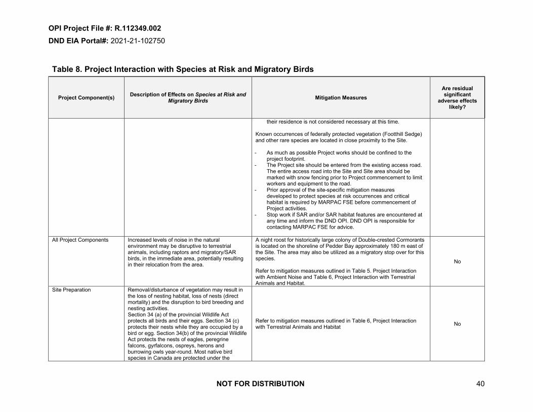
OPI Project File #: R.112349.002 DND EIA Portal#: 2021-21-102750
NOT FOR DISTRIBUTION 40
Table 8. Project Interaction with Species at Risk and Migratory Birds
Project Component(s) Description of Effects on Species at Risk and Migratory Birds Mitigation Measures
Are residual significant
adverse effects likely?
their residence is not considered necessary at this time. Known occurrences of federally protected vegetation (Footthill Sedge) and other rare species are located in close proximity to the Site. - As much as possible Project works should be confined to the
project footprint.- The Project site should be entered from the existing access road.
The entire access road into the Site and Site area should bemarked with snow fencing prior to Project commencement to limitworkers and equipment to the road.
- Prior approval of the site-specific mitigation measuresdeveloped to protect species at risk occurrences and criticalhabitat is required by MARPAC FSE before commencement ofProject activities.
- Stop work if SAR and/or SAR habitat features are encountered atany time and inform the DND OPI. DND OPI is responsible forcontacting MARPAC FSE for advice.
All Project Components Increased levels of noise in the natural environment may be disruptive to terrestrial animals, including raptors and migratory/SAR birds, in the immediate area, potentially resulting in their relocation from the area.
A night roost for historically large colony of Double-crested Cormorants is located on the shoreline of Pedder Bay approximately 180 m east of the Site. The area may also be utilized as a migratory stop over for this species. Refer to mitigation measures outlined in Table 5. Project Interaction with Ambient Noise and Table 6, Project Interaction with Terrestrial Animals and Habitat.
No
Site Preparation Removal/disturbance of vegetation may result in the loss of nesting habitat, loss of nests (direct mortality) and the disruption to bird breeding and nesting activities. Section 34 (a) of the provincial Wildlife Act protects all birds and their eggs. Section 34 (c) protects their nests while they are occupied by a bird or egg. Section 34(b) of the provincial Wildlife Act protects the nests of eagles, peregrine falcons, gyrfalcons, ospreys, herons and burrowing owls year-round. Most native bird species in Canada are protected under the
Refer to mitigation measures outlined in Table 6, Project Interaction with Terrestrial Animals and Habitat No

OPI Project File #: R.112349.002 DND EIA Portal#: 2021-21-102750
NOT FOR DISTRIBUTION 41
Table 8. Project Interaction with Species at Risk and Migratory Birds
Project Component(s) Description of Effects on Species at Risk and Migratory Birds Mitigation Measures
Are residual significant
adverse effects likely?
Migratory Birds Convention Act, 1994 (MBCA), and are collectively referred to as “migratory birds”. General prohibitions under the Act and its regulations protect migratory birds, their nests and eggs anywhere they are found in Canada
All Project Components Heavy machinery and equipment used in land alteration activities may increase the risk of transporting noxious weeds and invasive species to the site. Noxious weeds and invasive species may negatively impact biodiversity by out-competing and replacing native plants and plant SAR in the area, potentially causing species extirpation and even extinction.
Ensure machinery and materials arrive on site in a clean condition and are maintained free of invasive species and noxious weeds. Restore disturbed areas to function as they did in their pre-disturbance condition. Avoid transferring soil or plant material to other work sites; bag or securely contain invasive plants for transport and dispose off site in accordance with local municipal procedures; inspect all equipment, machinery, and vehicles for soil or plant materials and if necessary wash down before leaving the site, minimize unnecessary soil disturbance; and re-vegetate disturbed areas as soon as possible with a native seed mix. Replant exposed soils with an approved seed mix during site restoration activities to prevent the establishment of invasive species Refer to mitigation measures outlined in Table 6, Project Interaction with Terrestrial Animals and Habitat
No
Off-road operation or storage of equipment, machinery and vehicles may crush vegetation and damage tree root systems. Heavy construction equipment can compact soil and dramatically reduce pore space. Compaction inhibits root growth, limits water penetration, and decreases oxygen needed for root survival.
Off-road activities have the potential to affect SAR and/or critical habitat. Off-road activities will be limited to routes authorized by MARPAC FSE that avoid impacts to SAR and minimize impacts to vegetation. Restrict the storage of machinery and equipment to pre-disturbed areas (e.g. parking lots, roads) whenever possible. Conduct off-road operation of equipment, machinery and vehicles when ground is dry. Erect visible temporary fencing to protect existing vegetation and trees from accidental damage by heavy machinery. Ensure protection includes tree roots within the dripline. Do not permit equipment, machinery and vehicles in these areas. Ensure on-site personnel are aware of these areas and associated restrictions.

OPI Project File #: R.112349.002 DND EIA Portal#: 2021-21-102750
NOT FOR DISTRIBUTION 42
Table 9. Project Interaction with Vegetation
Project Component(s) Description of Effects on Vegetation Mitigation Measures Are residual significant
adverse effects likely?
Site Preparation/Excavation Activities
Project activities will involve the removal/disturbance of vegetation within the project footprint. This includes the disturbance of cultivated grasslands associated with land alteration activities occurring outside of pre-developed areas (e.g., gravel, asphalt, concrete). Removal/disturbance of vegetation may result in direct loss of Species At Risk (SAR), harm or harassment of SAR, and destruction of SAR critical habitat. The federal Species at Risk Act (SARA) contains general prohibitions that make it an offence to: - kill, harm or harass a listed species- destroy or damage the residence of a listedspecies- destroy any part of critical habitat of a listedspeciesRemoval/disturbance of native plants and/or trees may result in a loss of regional biodiversity. The potential for soil erosion increases if the soil has no or very little vegetative cover of plants. Plant cover protects the soil from raindrop impact and splash, tends to slow down the movement of runoff water and allows excess surface water to infiltrate.
Stop work if SAR and/or SAR habitat features are encountered at any time and inform the DND OPI. DND OPI is responsible for contacting MARPAC FSE for advice. NATIVE PLANTS/TREES If project activities have the potential to impact native plants and/or trees, DND OPI will consult with MARPAC FSE during project design phase to determine salvage/replacement/restoration requirements. DND OPI is responsible for implementing salvage/replacement/restoration requirements, including aftercare to ensure survival. Schedule site restoration activities to occur as soon as work is complete to prevent erosion. If there is insufficient time remaining in the growing season for the seeds to germinate, stabilize the site (e.g., cover exposed areas with erosion control blankets to keep the soil in place and prevent erosion) and implement site restoration activities as soon as the growing season permits. Avoid impacts to the following trees on CFB Esquimalt properties: - Arbutus (Arbutus menziesii)- Garry oak, (Quercus garryana)- Pacific Dogwood (Cornus nuttalli)- Pacific Yew (Taxus brevifolia),- Big Leaf Maple (Acer marophyllum)- Conifers greater than 80 cm diameterAvoid removal of mature trees wherever possible. Any tree greater than 25cm at breast height that will likely be removed during the project will be documented within a Tree Replacement Plan. The Tree Replacement Plan shall comply with MARPAC FSE Tree Replacement Policy by documenting the trees proposed for removal including number, species, photo, diameter at breast height, observation of any nests, and general conditions and location. Once approved by MARPAC FSE, trees removed during the project will be replaced by two trees of the same species, or a species approved by MARPAC FSE, and planted in the same general location. Planting shall occur within six months of removal and/or during early spring or fall to improve chances of survival. Replacement trees should have basal diameters of not less than 4 cm and not less than approximately 1.5 m
No

OPI Project File #: R.112349.002 DND EIA Portal#: 2021-21-102750
NOT FOR DISTRIBUTION 43
Table 9. Project Interaction with Vegetation
Project Component(s) Description of Effects on Vegetation Mitigation Measures Are residual significant
adverse effects likely?
in height. Replanted trees that die off are to be replanted and the newly planted trees are to be watered on three separate occasions. Remove vegetation using mechanical or hand clearing methods. Do not use biocides. Do not tear moss from rocks when moving materials/supplies in rocky areas. Where vegetation/tree removal is necessary outside the excavation footprint, avoid grubbing and use vegetative maintenance and removal techniques such as pruning, mowing, girdling, topping and select tree removals that allow the root system to remain intact, to help bind the soil and encourage rapid colonization of low-growing plant species.
Site Preparation/Remedial Excavation and Backfilling
Project activities will involve the removal/disturbance of vegetation (including invasive species) within the project footprint. The potential for soil erosion increases if the soil has no or very little vegetative cover of plants. Plant cover protects the soil from raindrop impact and splash, tends to slow down the movement of runoff water and allows excess surface water to infiltrate.
Remove vegetation using mechanical or hand clearing methods. Do not use biocides. Invasive plant species excavated during the vegetation removal activities shall be properly controlled following excavation and during off-Site transportation (i.e., placed on impermeable surfaces and covered securely with impermeable polyethylene sheeting) to reduce the potential for spreading and/or seed dispersal. The project shall follow all relevant federal, provincial and local bylaws, guidelines and notifications for treatment, transport and disposal of invasive species, including but not limited to the BC Integrated Pest Management Act and Regulations, the BC Weed Control Act and Regulations. Avoid transferring soil or plant material to other work sites; bag or securely contain invasive plants for transport and dispose off site in accordance with local municipal procedures; inspect all equipment, machinery, and vehicles for soil or plant materials and if necessary wash down before leaving the site, minimize unnecessary soil disturbance; and re-vegetate disturbed areas as soon as possible with a native seed mix. If project activities have the potential to affect native plants and/or trees, DND OPI will consult with MARPAC FSE during project design phase to determine salvage/replacement/restoration requirements.
No

OPI Project File #: R.112349.002 DND EIA Portal#: 2021-21-102750
NOT FOR DISTRIBUTION 44
Table 9. Project Interaction with Vegetation
Project Component(s) Description of Effects on Vegetation Mitigation Measures Are residual significant
adverse effects likely?
DND OPI is responsible for implementing salvage/replacement/restoration requirements, including aftercare to ensure survival. Schedule site restoration activities to occur as soon as work is complete to prevent erosion. If there is insufficient time remaining in the growing season for the seeds to germinate, stabilize the site (e.g., cover exposed areas with erosion control blankets to keep the soil in place and prevent erosion) and implement site restoration activities as soon as the growing season permits. Restrict Movement of vehicles, machinery and foot traffic to a small number of defined dedicated pathways to minimize vegetation, grass and landscape disturbance. Refer to mitigation measures outlined in Table 6, Project Interaction with Terrestrial Animals and Habitat
All Project Components Heavy machinery and equipment used in land alteration activities may increase the risk of transporting noxious weeds and invasive species to the site. Noxious weeds and invasive species may negatively impact biodiversity by out-competing and replacing native plants and plant SAR in the area, potentially causing species extirpation and even extinction.
Ensure machinery and materials arrive and depart the site in a clean condition and are maintained free of invasive species and noxious weeds. Avoid transferring soil or plant material to other work sites; bag or securely contain invasive plants for transport and dispose off site in accordance with local municipal procedures; inspect all equipment, machinery, and vehicles for soil or plant materials and if necessary wash down before leaving the site, minimize unnecessary soil disturbance; and re-vegetate disturbed areas as soon as possible with a native seed mix. Restore disturbed areas to function as they did in their pre-disturbance condition. Replant exposed soils with an approved seed mix during site restoration activities to prevent the establishment of invasive species.
No
All Project Components Off-road operation or storage of equipment, machinery and vehicles may crush vegetation and damage tree root systems. Heavy construction equipment can compact soil and dramatically reduce pore space. Compaction inhibits root growth, limits water penetration, and decreases oxygen needed for root survival.
Off-road operation of equipment is prohibited. All equipment will be operated and stored on pre-disturbed, non-vegetated areas such as within the Site itself and on area roads.
No

OPI Project File #: R.112349.002 DND EIA Portal#: 2021-21-102750
NOT FOR DISTRIBUTION 45
Table 10. Project Interaction with Cultural Resources
Project Component(s) Description of Effects on Cultural Resources Mitigation Measures Are residual significant
adverse effects likely?
Site Preparation/Remedial Excavation and Backfilling
Land alteration activities have the potential to uncover and disturb previously unidentified cultural features. Archaeological sites are protected by the HCA. They are non-renewable, very susceptible to disturbance and are finite in number. Archaeological sites are an important resource that is protected for their historical, cultural, scientific and educational value to the general public, local communities and First Nations. Impacts to archaeological sites must be avoided or managed.
Prior to excavation activities, site supervisors and excavation operators will attend an on-site archaeological briefing. Develop and implement a chance finds procedure that will address the possibility of encountering archaeological materials during land alteration activities and to provide protocols to follow in the event of a chance archaeological find to ensure that archaeological sites are documented and protected, and that appropriate reporting and notification requirements are being followed, as required. Chance finds procedure to include the following: - Stop work immediately if potential archaeological materials arediscovered during project activities and immediately notify the DNDOPI. The DND OPI is responsible for immediately reportingarchaeological chance finds to MARPAC FSE. MARPAC FSE willadvise if any internal and/or external notifications are required and ifthere are any specific restrictions/considerations required prior tomoving forward with further archaeologicalassessment/investigation.- Do not disturb potential archaeological materials until aprofessional archaeological has been to the site,assessed/investigated the materials and developed amanagement plan that has been approved by DND OPI andMARPAC FSE.DND OPI is responsible for providing MARPAC FSE with a final copy of any archaeological reports and all associated GIS datasets. GIS datasets to be provided as ArcGIS file geodatabases and/or shapefiles.
No

OPI Project File #: R.112349.002 DND EIA Portal#: 2021-21-102750
NOT FOR DISTRIBUTION 46
Table 11. Project Interaction with Health and Safety
Project Component(s) Description of Effects on Health and Safety Mitigation Measures Are residual significant
adverse effects likely?
All Project Components Potential hazards associated with project activities may impact the health and safety of workers, visitors and residents/personnel adjacent to the Site.
Develop and implement a Health and Safety Plan to minimize the potential for accidental injury or property damage during all stages of the project. Ensure the plan outlines measures for protecting site workers, visitors, and DND/CAF personnel working adjacent to the Site. Ensure the plan is monitored through project implementation. Ensure all project activities comply with the direction detailed in the Canada Occupational Health and Safety Regulations (DND/CAF personnel) and the BC Occupational Health and Safety Regulations (Contractor personnel) regarding Occupational Health and Safety (OHS) Immediately take measures to rectify unforeseen or peculiar safety related hazards that become evident during project implementation. Verbally advise the DND OPI immediately and provide a written report of the hazard or condition as soon as practical Conduct regular safety briefings and meetings with on-site workers to encourage safe working procedures are followed. Investigate and report all incidents and accidents as required by: - DND General Safety Program (DND/CAF personnel)- Occupational Health and Safety Regulation, B.C. Reg. 195/2015,Workers Compensation Act (Contractor personnel)DND OPI is responsible for ensuring compliance with BSO 2-539: Occupational Health and Safety Liaison with Private Contractors. This includes: - ensuring that all hazards associated with the project are identified andassessed and mitigation strategies are developed prior to workcommencing- ensuring that a communication plan is developed with the appropriateDND/CAF supervisors for hazards that have the potential to impactadjacent DND/CAF personnel
Refer to additional mitigation measures Table 3, Project interaction with Surface Water and Groundwater
No

OPI Project File #: R.112349.002 DND EIA Portal#: 2021-21-102750
NOT FOR DISTRIBUTION 47
Table 11. Project Interaction with Health and Safety
Project Component(s) Description of Effects on Health and Safety Mitigation Measures Are residual significant
adverse effects likely?
Site Preparation/Remedial Excavation and Backfilling
Land alteration activities have the potential to impact overhead and underground utilities which could result in worker injury, release of deleterious substances, and disruptions to operations. Land alteration activities have the potential to uncover metals, hydrocarbons, PAHs, and other Contaminants of Concern. Exposure to these contaminants during sub-surface work may impact worker health. Use of heavy machinery and equipment and increased vehicle traffic associated with land alteration activities carries the potential for accident and injury to workers, visitors and local residents.
Initiate a BC One Call and obtain an approved RP Ops U (P) Excavation Clearance Form prior to project commencement. Ensure all overhead lines to be removed from the Site are de-energized prior to removal. A Project-specific Health and Safety Plan shall be developed and implemented to minimize the potential for accidental injury during remediation activities in accordance with existing and legislated safety requirements. The Health and Safety plan will be prepared and submitted for approval by DND Implement mitigation measures identified in Table 3, Project Interaction with Surface Water and Groundwater
No
Site Preparation/Excavation Debris in the former dumping area was noted to included empty ordnance casings, munition boxes and old fuel cans. Land alteration activities have the potential to uncover Unexploded Explosive Ordnance (UXO). Disturbance to UXO may result in the item exploding and causing damage, injury and / or fatalities.
DND OPI is responsible for engaging the appropriate Departmental authority for determining the level of UXO risk associated with the proposed project activities. DND OPI is responsible for communicating and providing documentation of UXO activities conducted as part of their project to the appropriate Departmental authority. Develop and implement a chance finds procedure that will address the possibility of encountering UXO and provide protocols to follow in the event of a chance UXO find. On-site personnel will stop work immediately if potential UXO are encountered. Potential UXO will not be touched or disturbed. On-site personnel will note the location of the potential UXO and will immediately leave the area, call 911 and notify the DND OPI. Depending on the level of risk identified, the following additional mitigation measures may be required: - Engage a Qualified UXO Expert as defined within the Directorate ofAmmunition and Explosive Regulation (DAER)- Conduct UXO surveys using visual and/or detector aided scans priorto commencing on-site work- Develop and Implement UXO avoidance procedures- Develop and Implement UXO clearance procedures
No

OPI Project File #: R.112349.002 DND EIA Portal#: 2021-21-102750
NOT FOR DISTRIBUTION 48
Table 11. Project Interaction with Health and Safety
Project Component(s) Description of Effects on Health and Safety Mitigation Measures Are residual significant
adverse effects likely?
- Establish and implement UXO safety procedures- Establish and implement a UXO hazard-reporting procedure that allon-site personnel must follow- Ensure all on-site personnel are aware of the UXO hazards and havereceived a UXO safety briefing
All Project Components Dust generated may present a risk to workers or other people in the area if contaminated soil is encountered. Inhaled dust particles could cause irritation of respiratory tracts or create an exposure pathway for potentially adsorbed contaminants.
Refer to mitigation measures outlined in Table 1, Project Interaction with Atmosphere No
All Project Components High levels of noise from equipment and demolition activities at the project site have the potential to harm hearing of on-site workers. Refer to mitigation measures outlined in Table 5, Project Interaction
with Ambient Noise. No

NOT FOR DISTRIBUTION 49
OPI Project File #: R.112349.002DND EIA Portal#: 2021-21-102750
2.5 Indigenous Community EngagementThe RP-14 remediation site is under the custodianship of Department of National Defence but located on traditional territory of the Sc'ianew First Nation (Beecher Bay). An assessment conducted by DND following Aboriginal Consultation and Accommodation – Updated Guidelines for Federal Officials to Fulfill the Legal Duty to Consult (March 2011; Annex B), indicated that the proposed project will not have adverse impacts on potential or established Aboriginal or treaty rights within the project area. As such, consultation with the Sc'ianew First Nation (Beecher Bay) is not required. The Legal Duty to Consult Worksheet can be found in Annex D.
2.6 Public ParticipationDue to the scope, scale and location of the project public participation was not required.
2.7 References and Expertise from Other Federal Government Bodies or ThirdParty Groups
BC Ministry of Environment and Climate Change Strategy (ENV). 2020. B.C. Conservation Data Centre - BC Species and Ecosystems Explorer. Available at: http://www.env.gov.bc.ca/cdc/.Accessed December, 2020.BC ENV, 2014. BC Ministry of Environment and Climate Change Strategy. Develop with Care 2014. Environmental Guidelines for Urban and Rural Land Development in British Columbia.Biolinx, 2020. Biolinx Environmental Research Ltd. Surveys and Mitigation Recommendations for Blue-grey Taildropper on DND Lands Subjected to Soil Remediation at CFAD RockyPoint,Vancouver Island. Lennart Sopuck, MSc., RPBio and Kristiina Ovaska, PhD., December, 2020.Environment and Climate Change Canada. 2020. Canadian Climate Normals 1981-2010.Available online at URL: www.climate.weatheroffice.gc.ca/climate_normals/index_e.html.[Accessed December, 2020].Green and Klinka, 1994. A Field Guide to Site Identification and Interpretation for the Vancouver Forest Region. R.N. Green and K. Klinka. Ministry of Forests Research Program, 1994.iMapBC, 2020. BC Ministry of Forests, Lands and Natural Resource Operations (MFLNRO).iMapBC Public Mapping Application (iMap BC, 2020). Available:http://ilmbwww.gov.bc.ca/content/e-services/geobc/imapbc [Accessed December, 2020].NRCan, 2020. Double-crested Cormorant Roost Survey Results at Rocky Point. Natural Resources Canada. January 6, 2020.SNC-Lavalin, 2018. Phase III Environmental Site Assessment and Remedial Options Analysis RP-14, CFAD Rocky Point, Metchosin, BC.Zevit, Pamela (2010). Pamela Zevit of Adamah Consultants for the South Coast Conservation Program (SCCP) in partnership with: International Forest Products (Interfor), Capacity Forestry (CapFor) and the BC Ministry of Environment (BC MoE), E-Flora and E-Fauna the Electronic Atlas of the Flora and Fauna of BC, Species at Risk & Local Government: A Primer for BC.August, 2010.
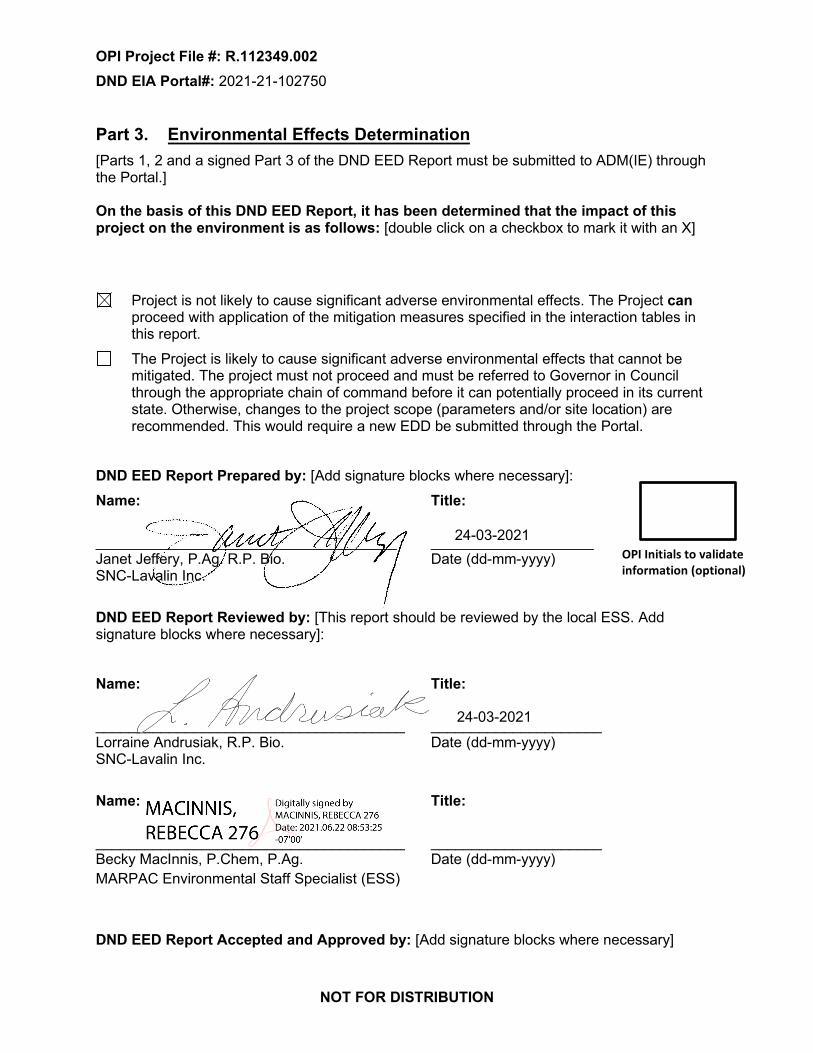
NOT FOR DISTRIBUTION
OPI Project File #: R.112349.002 DND EIA Portal#: 2021-21-102750
Part 3. Environmental Effects Determination [Parts 1, 2 and a signed Part 3 of the DND EED Report must be submitted to ADM(IE) through the Portal.] On the basis of this DND EED Report, it has been determined that the impact of this project on the environment is as follows: [double click on a checkbox to mark it with an X]
Project is not likely to cause significant adverse environmental effects. The Project can proceed with application of the mitigation measures specified in the interaction tables in this report. The Project is likely to cause significant adverse environmental effects that cannot be mitigated. The project must not proceed and must be referred to Governor in Council through the appropriate chain of command before it can potentially proceed in its current state. Otherwise, changes to the project scope (parameters and/or site location) are recommended. This would require a new EDD be submitted through the Portal.
DND EED Report Prepared by: [Add signature blocks where necessary]: Name: Title:
_____________________________________ ____________________ Janet Jeffery, P.Ag. R.P. Bio. Date (dd-mm-yyyy) SNC-Lavalin Inc.
DND EED Report Reviewed by: [This report should be reviewed by the local ESS. Add signature blocks where necessary]:
Name: Title:
______________________________________ _____________________ Lorraine Andrusiak, R.P. Bio. Date (dd-mm-yyyy) SNC-Lavalin Inc.
Name: Title:
______________________________________ _____________________ Becky MacInnis, P.Chem, P.Ag. Date (dd-mm-yyyy) MARPAC Environmental Staff Specialist (ESS)
DND EED Report Accepted and Approved by: [Add signature blocks where necessary]
OPI Initials to validate information (optional)
24-03-2021
24-03-2021

NOT FOR DISTRIBUTION
OPI Project File #: R.112349.002
DND EIA Portal#: 2021-21-102750
The undersigned accepts the determination and recommendations of this environmental effects determination report. The undersigned also accepts the responsibility to incorporate the recommendations of the report into the Project design and implementation.
Name: Title:
______________________________________ Rachel Speller, Environment Officer, Base Safety and Environment Date (dd-mm-yyyy)
15-June-2021_

NOT FOR DISTRIBUTION
OPI Project File #: R.112349.002DND EIA Portal#: 2021-21-102750
Drawings 648721-001 – Location Plan 648721-002 – Site Plan

_Site Location
0 2.5 5 7.5 101.25Kilometers
Ü
Project Path:
MXD
Path:
\\Sli2
606\p
rojec
ts\Cu
rrent
Proje
cts\PW
GSC\
6487
21-R
P 14\4
.0 Ex
ecuti
on\4.
5 GIS
and D
rawing
s\GIS\
Mxds
\6487
21-00
1.mxd
Legend_ RP-14 Site Location
CFAD Rocky Point Boundary
REFERENCES:1.2. BCGOV ILMB Crown Registry and Geographic Base Branch (CRGB)(data accessed through www.GeoBC.gov.bc.ca)3. GPS Data Collected using an eTrex. Accuracy expected to be approximately +/- 3.5m.
NOTES:1. Original in colour.2. Numerical scale reflects full-size print. Print scaling will distort this scale, however scale bar willremain accurate.3. Intended for illustration purposes, accuracy has not been verified for construction or navigation
REVISIONS:0 - AM - 2020-12-04 - DRAFT - JJ
CLIENT:Public Services and Procurement Canada
PROJECT LOCATION:RP-14, CFADRocky Point
REF No:
648721-001DATE: 2020-12-09SCALE: 1:125,000BY: AM
Proj Coord Sys: NAD 1983 UTM Zone 10NCHK'D: JJ
Location PlanREV: 0
!
!
!
!
_
Site Location
Fort St. John
Kelowna
Terrace
Vancouver

!(!(
!(
!(!(!(!(!( !(!(
!(!(
!(
!(
!(
!(
!(
!(
!(!(!(!(!(!(!(!(
PedderBay
PearsonCollege
Pedder Bay RVResort and Marine
Rocky Point Road
MilitaryResidences
Sharp-tailedSnake
Threaded Vertigo
Douglas-fir/ dull
Oregon-grape
Blue-greyTaildropper
Blue-greyTaildropper
ThreadedVertigo
0 100 200 300 40050Meters
Ü
Project Path:
MXD
Path:
\\Sli2
606\p
rojec
ts\Cu
rrent
Proje
cts\PW
GSC\
6487
21-R
P 14\4
.0 Ex
ecuti
on\4.
5 GIS
and D
rawing
s\GIS\
Mxds
\6487
21-00
2.mxd
Legend&< MONITORING WELL
APPROXIMATE ACCESS ROAD - CLEARING AND POSSIBLEEXTENSION INTO EXCAVATION AREAS MAY BE REQUIRED FOREQUIPMENT ACCESSESTIMATED EXCAVATION EXTENTSITE AREADOUBLE-CRESTED CORMORANTSPECIES AND ECOSYSTEMS AT RISK (DATA BC)
CRITICAL HABITAT FOR FEDERALLY-LISTED SPECIES AT RISK(POSTED)
BLUE-GREY TAILDROPPER CRITICAL HABITAT - OCCUPIEDZONEBLUE-GREY TAILDROPPER CRITICAL HABITAT - ZONE OFINFLUENCESARA CRITICAL HABITAT (DFO)
SPECIES AT RISK (NRCan, 2020)!( BLUE-GREY TAILDROPPER!( CONSIDERABLE GINGERBREAD (LICHEN)!( FOOTHILL SEDGE!( LESSER COPPERWORT (LIVERWORT)!( LICHEN - ENTEROGRAPHA PALLIDELLA!( LICHEN - LICHINA INTERMEDIA!( LIVERWORT - CEPHALOZIELLA PHYLLACANTHA!( OCTOPUS' MATCHSTICK (LICHEN)!( SEASIDE BONE!( TROUBLED PIXIE-CUP (LICHEN)
REFERENCES:RP_14_SAR_data_2020nov
NOTES:1. Original in colour.2. Numerical scale reflects full-size print. Print scaling will distort this scale, however scale barwill remain accurate.3. Intended for illustration purposes, accuracy has not been verified for construction or
REVISIONS:0 - AM - 2020-12-04 - DRAFT - JJ
CLIENT:Public Works and Procurement Canada
PROJECT LOCATION:RP-14, CFADRocky Point
REF No:
648721-002DATE: 2021-05-25SCALE: 1:5,000BY: AM
Proj Coord Sys: NAD 1983 UTM Zone 10NCHK'D: JJ
SITE PLANREV: 0
&<
&<
&<
&<

NOT FOR DISTRIBUTION
OPI Project File #: R.112349.002
DND EIA Portal#: 2021-21-102750
Annex A. Site Photographs

Project 648721
Photograph 1: Rocky Point Road adjacent to access road entrance, looking southeast.
Photograph 2: Entrance to Site access road off Rocky Point Road, looking northeast.

Project 648721
Photograph 3: Access road, looking northeast from entrance.
Photograph 4: South excavation area, looking south (excavation extent to be confirmed prior to start of work).

Project 648721
Photograph 5: South excavation area, looking south (excavation extent to be confirmed prior to start of work).
Photograph 6: Metal debris adjacent Pedder Bay at edge of south excavation area.

Project 648721
Photograph 7: Northern portion of south excavation, looking north (excavation extent to be confirmed prior to start of work).
Photograph 8: South excavation area, looking south (excavation extent to be confirmed prior to start of work).

Project 648721
Photograph 9: North excavation area, looking southeast showing existing access road (excavation extent to be confirmed prior to start of work).
Photograph 10: North excavation area, looking north (excavation extent to be confirmed prior to start of work).

NOT FOR DISTRIBUTION
OPI Project File #: R.112349.002
DND EIA Portal#: 2021-21-102750
Annex B. Search Results

JEFFJ2
Typewritten Text
Groundwater wells

11/30/2020 Groundwater Wells and Aquifers - Province of British Columbia
https://apps.nrs.gov.bc.ca/gwells/well/105800 1/3
Groundwater Wells and Aquifers
Well Summary
Licensing Information
Location Information
Well Activity
Legacy record 2010-07-12 2010-07-16 D. A. Smithson & Sons March 7th 2012 at 12:52 AM
Well Work Dates
2010-07-12 2010-07-16
Well Tag Number: 105800 Well Status: New Observation Well Number:Well Identi�cation Plate Number: 32164 Well Class: Water Supply Observation Well Status:Owner Name: JOHN HOMER Well Subclass: Domestic Environmental Monitoring System (EMS) ID:Intended Water Use: Private Domestic Aquifer Number: Alternative specs submitted: No
Licensed Status: Unlicensed Licence Number:
Street Address: 5598 ROCKY POINT ROADTown/City: SOOKE
Legal Description:
Lot
Plan RW648
District Lot
Block
Section 42
Township
Range
Land District
Property Identi�cation Description(PID)
Description of Well Location: NOT PROVIDED
Geographic Coordinates - North American Datum of 1983 (NAD 83)Latitude: 48.349178 Longitude: -123.582382UTM Easting: 456851 UTM Northing: 5355275Zone: 10 Coordinate Acquisition Code: (10 m
accuracy) Handheld GPS withaccuracy of +/- 10 metres
Activity ↕ Work Start Date ↕ Work End Date ↕ Drilling Company ↕ Date Entered ↕
Start Date ofConstruction
End Date ofConstruction
Start Date ofAlteration
End Date ofAlteration
Start Date ofDecommission
End Date ofDecommission
1 km
3000 ftMapBox | Government of British Columbia, DataBC, GeoBC

11/30/2020 Groundwater Wells and Aquifers - Province of British Columbia
https://apps.nrs.gov.bc.ca/gwells/well/105800 2/3
Well Completion Data
Lithology
26.00 400.00 vari-coloured
MEDIUM-HARD, BLACK GREEN GREY, SEEPAGE
400.00 500.00 vari-coloured
VeryHard
BLACK, GREEN, LAYER OF TAN ROCK AT 405'-408'WITH SEEPAGE
500.00 640.00 vari-coloured
Hard BLACK, GREEN
Casing Details
0.00 31.00 Steel 6.630 0.188 Not Installed
Surface Seal and Back�ll Details
Liner Details
Screen Details
Well Development
Well Yield
Well Decommission Information
CommentsNo comments submitted
Alternative Specs Submitted: No
Total Depth Drilled: 640.00 feet Static Water Level (BTOC): Well Cap: SECUREDFinished Well Depth: 640.00 feet Estimated Well Yield: 0.125 USGPM Well Disinfected Status: Not DisinfectedFinal Casing Stick Up: 32.000 inches Artesian Flow: Drilling Method: Air RotaryDepth to Bedrock: 26.00 feet Artesian Pressure: Orientation of Well: VERTICALGround elevation: 138.00 Method of determining elevation: GPS
From (ftbgl)
To (ftbgl)
RawData Description Moisture Colour Hardness Observations
Water Bearing Flow Estimate(USGPM)
From (ft) To (ft) Casing Type Casing Material Diameter Wall Thickness Drive Shoe
Surface Seal Material: Bentonite clay Back�ll Material Above Surface Seal:Surface Seal Installation Method: Poured Back�ll Depth:Surface Seal Thickness: 2.00Surface Seal Depth:
Liner Material:Liner Diameter: Liner Thickness:Liner from: Liner to:
Liner perforations
There are no records to show
From To
Intake Method:Type:Material:Opening:Bottom:
Installed Screens
There are no records to show
From To Diameter Assembly Type Slot Size
Developed by: Air lifting Development Total Duration: 4.00 hours
Estimation Method: Air Lifting Estimation Rate: Estimation Duration: 3.00Static Water Level Before Test: Drawdown:Hydrofracturing Performed: No Increase in Yield Due to Hydrofracturing:
Reason for Decommission: Method of Decommission:Sealant Material: Back�ll Material:Decommission Details:

11/30/2020 Groundwater Wells and Aquifers - Province of British Columbia
https://apps.nrs.gov.bc.ca/gwells/well/105800 3/3
Documents
WTN 105800_Well Construction.pdf
DisclaimerThe information provided should not be used as a basis for making �nancial or any other commitments. The Government of British Columbia accepts no liability forthe accuracy, availability, suitability, reliability, usability, completeness or timeliness of the data or graphical depictions rendered from the data.

����������� ����������� ����� �������� ��� ������ ���������� ���� � ���������� �� �������� ��� ���������������� ���� ���� ����� ����������������������������� ����������������������� ������������������������������� ������������������������������������������� ������ ������������� �������������������� ��������������������� � ������ ��������� �������������� �������������������� ��������������������� ����� �������������������������� ���� ������������������������� ������ �����
��� �� ��� ������� �� ��� ������������������ �� ������� �� ���
��������� �� ��� �������������������������� ��� ���������
�������������������������������� ����� ������ ���� ���������������� �� ��� ���������������������������������������������������������������������������������������� ��������������������������������������� �������������������������� �������������������������������������������������������������������������������������������������������������������������������������������������������������������� ��������� ��� �������� ��� �� ������� ��� ����� ��� �������������� ��������������������������������������������������������������������������������������������������������� �������� ������� �� �� ��� ���������� ������������� ����� ��������������� ������������������������������������������������ � � ���������������� ���������������������������������������� � �� ����������������������������� � ��������������������������
���������������������������������������� ��
� ���� �������� ���� ���� ������������������������������������������������������������������������
� ���������������� ����������������������������� ������� �� ������ ��� ������ �� �������������������� �������������������������������������������� ����� ��� ���������������������������� ��
�������������������������� ������� ������ ��� ����� ������������������������������ ����� �������� ���������������������� � �� �������������������
��������������������������������������� �� ������������������������������������� ��������������������������������������������������������������� ��� �
�������������������������������� � ������������������������� � �������� � ����� ��������������������� ������
� ���� ��� �����������������������
�������� ���� ������������������������������������� ��������� ������������������������ ��������� ����� ���� ��
��������������������������� ���� �� �� ������ ������������� ������������������� ���������������� ����� �� �� � ������������������ ���� ���� � ��� ��� �� �
� ���� ����������� � ���������������������� �� ����������������������������� �������������������������������������������������� � ��� �����
�������������� ������ ��� ��� ���� �� ��� �����
������������� ��������������� ������ �� ������ ������������������������ ������ ����������� �� ������������� �������� ��� �� ��� ����������������������������� ������������������ ��������������������������������������������������������������������������������������������������������� ��� ������������������������ ������������� ������� ���� ����� ��� ������� ����� �� ���������������������� �������������������������������������������� ������������ ������� ������������������������ ����� ��� �� ������������������������ �������� � ����������
�� �� ��� �� �� � ��� ����������������������� � ������������������������ � �������� ������ ���� ����������������������������������������������������������������������������������������������������������� � ���� ������� �� ���� ���� ������������ � ����������� ���������������������������������������������� ��������������������������� �������������������������������������������������������������������� ������� � �������������������������������������������������������������������������������������������������������������������
����� ��
������ �����������
������
���� ����� ����
��� ��������������� !��"�#��$%��$
&''' ('')''*'' +''
,-./012./.3.�456 78990:-;.<=3>;0:�2?.0:�=3 @??A;=3
BCDEFGHIJKLMCDNOIPEQFLRDSFMTFFN
UCDVWFJNXFFYI
ZRVQMCDNL[\�)]&[\�+&[\�])
[\�+*_[\�++aabcdebc
fghh ijceklajmenogpcj qehbcjrjccb scejrjccb
ftgjrjccb aabcogpcj uv wxy zA<
UIVIDN� =;{80:;-;3�>.:;-�>;99�1�|-:;08./� =;{80:;-;3�>.:;-�>;99� |}:8~;���0;-~.:8?/�>;99� �/.}:8~;���0;-~.:8?/�>;99|��8�;-��?�/3.-6���������������������������������������������������������������������������� ���¡ ��¢£��¤ ���¡���� ������¤ ���¡��������¤���¡���������¥�¦��§�������¢�©ª�«������������¬�®°±² ³®µ¶±·µ³·µ®¹°µ°ºµ »°ºµ±°·¼½¾°¿®¼®· ÀÁÂÃÄÅÆÇȱó®Éɶ±®É·µ®Êµ±¼½¾°¿® ÄÁË»¾É²®·Ì°É°µÍµ±¶±²µ·Æ°²·µ°±² ΰÏбʾºµ°Ñ°µÍ Ò±Ó¼½¾°¿®¶É· °Ôº·µ°±² ÕÕÕ¼ÎÍÊ·¾É°º¶±²²®ºµ°Ñ°µÍÖ È±µÒ°Å®Éͼ½¾°¿®×µ® Õ²Ê®Ø Ò®´µ® ®Êȱó·µ®Ò°º®²º® Õ¾®Êµ±³®ÉÉ Ù²Å²±Ó²Ú̮ѷµ°±²³®ÉÉÛ����Ü�ÝÕ²·ºµ°Ñ®Þ ��ßÝÁàáÖâ������ ������������������ �������¬��ã��äåæçèéêëéèìíîïêèëéìèíðñòêéçìéîóïæôççïæõîóóçææçö÷øùúûèüçìëíçëïýç÷æêïçþêææò÷�çóïïè�êíêïîïêèëèé�êî÷ê�êïø�ìèüêæêèëæõéòìïôçìöçæóìê÷çöèëïôîïýç÷æêïçþ��ôîïêëéèìíîïêèëêæ�ìèüêöçö÷øïôçùúûèüçìëíçëïîæî�ò÷�êóæçìüêóçèëîë�îæêæ�÷îæêæ�ýêïôèòïýîììîëïøèéîëøêëö�ýôçïôçìç�ìçææèìêí��êçö�îëöêïæòæçêæîïøèòìèýëìêæ�åëöçìëèóêìóòíæïîëóçæýê��ïôçùúûèüçìëíçëï�èìêïææïî��îûçëïæîëöóèëïìîóïèìæ�÷çìçæ�èëæê÷�çèì�êî÷�çïèîëø�çìæèëèì÷òæêëçææçëïêïø�éèìîëøöêìçóï�êëöêìçóï�æ�çóêî��êëóêöçëïî��óèëæçñòçëïêî�èìîëøèïôçì�èææèìöîíîûçæïèîëø�çìæèëèì÷òæêëçææçëïêïø÷îæçöèëïôêæéîóïæôççïèìîëøòæçèéêëéèìíîïêèëéìèíêï��çïîê�çöíçïôèöæéèìî�� ûòìçæîìçöçæóìê÷çöêëïôçóèí�îëêèëöèóòíçëïõðñòêéçì�îóïæôççï�úèí�îëêèë�èóòíçëï��öéþ��îóïæôççïûçëçìîïçö�Ç�Ç��������ðñòêéçìæèë�êëç�ôïï�æ���î��æ�ëìæ�ûèü�÷ó�óî�ûýç��æ�îñòêéçìæ�

Aquifer Classification Worksheet – Aquifer 606 Page 1
Aquifer Classification Worksheet for Sooke-Metchosin Aquifer (606)
Aquifer number: 606
Proposed name of aquifer: Sooke-Metchosin Aquifer (606)
Aquifer Classification: IIIA(12).
Descriptive location of aquifer:
This bedrock aquifer is found on southwest Vancouver Island, encompassing much of the land
area in the municipalities of Metchosin, Colwood, Langford and Sooke, including the East Sooke
Peninsula. Jordan River defines the western boundary of the aquifer, and the southern aquifer
boundary is formed by the marine coastline from Jordan River to Esquimalt Lagoon. The
northern and eastern aquifer boundary is defined by the Leech River Fault, in the Sooke Hills,
which separates bedrock of the Metchosin Igneous Complex and the Leech River Complex
(Massey, 1994; Yorath and Nasmith, 1995).
Date: July 2004.
NTS mapsheet: 092B/05, 092B/06, 092B/12, 092C/08
TRIM mapsheets: 092B.031, .032, .033, .041, .042, .043, .051, .052, 092C.050
What geological formation does the aquifer belong to?
The aquifer is made up of rocks from the Metchosin Igneous Complex, a gabbroic and basaltic
igneous and volcanic bedrock of Paleocene to Eocene origin, 50-56 Ma in age (Massey, 1994).
The Metchosin Igneous Complex is a layered gabbro and leucogabbro (light-coloured feldspar–
and quartz–rich gabbro) including sheeted gabbroic and dioritic dykes that extend upward into
fine-grained pillow and flow basalts. The unit also contains minor tuff, breccia, and rare
limestone (Massey, 1994; Yorath and Nasmith, 1995).
Well records indicate alternating layers of light and dark green igneous bedrock intercepted by
quartz and feldspar veins, and water bearing fractures at depth. Other well logs describe the
lithology as blue, red, brown or black volcanic bedrock, or layered hard grey and soft green
bedrock. A few records indicate the occurrence of limestone, while some describe the presence
of “conglomerate,” which may correspond with brecciated rock in shear and fracture zones.
Described occurrences of layered “sandstone and shale” are thought mainly to correspond with
weathered, feldspar–rich igneous bedrock, or grus, and fine-grained black basalt. Some wells
may be drilled through true sandstone and conglomerate of the Sooke Formation, which

Aquifer Classification Worksheet – Aquifer 606 Page 2
comprises Muir Creek aquifer 449, a sedimentary bedrock formation that unconformably
overlies the Metchosin Complex in parts of Sooke, including at Orveas Bay, Loss Creek and
Jordan River.
Overlying portions of the bedrock aquifer are Vashon and Capilano sediments deposited
during the Fraser glaciation (13-29 ka)(Blyth and Rutter, 1993; Monahan and Levson,
2000), including water bearing strata of aquifers 599, 604, and 605, and water bearing
surficial deposits associated with shallow wells along the coastal margin of Orveas Bay,
and on the East Sooke Peninsula that were not delineated separately due to the small
number of wells and their lack of spatial connectivity. Aquifer 682, formed from
glaciofluvial sediments of the Colwood delta, overlies the Sooke-Metchosin aquifer in a
sandur (glaciofluvial flood deposit) that extends from Langford Lake area south-east
toward Esquimalt Lagoon. Aquifer 683 similarly overlies much of the lowland (<60 m
elevation), inland approximately 2.5 km from the coast at Parry Bay (Witty’s Lagoon),
and extending north along the historical Metchosin Creek floodplain, east of Metchosin
Mountain.
What type of aquifer is it (unconsolidated/bedrock? Confined/unconfined)?
The aquifer is a partially confined bedrock aquifer. The aquifer is confined by sediments
deposited at the end of the Fraser glaciation including Victoria clay and Vashon till. A
blanket (> 1 km thick) of till is present over parts of the aquifer within the lowlands
adjacent to the maritime coast; while colluvium forms the surficial layer at elevations
>80-100 m, as indicated on the surficial geology and quaternary geology maps of the area
(Blyth and Rutter, 1993; Monahan and Levson, 2000).
How was the aquifer boundary delineated?
The aquifer boundary was delineated to encompass bedrock of the Metchosin Igneous
Complex in areas of present groundwater development. The aquifer covers the largest
land area of all aquifers in the Capital Regional District. The spatial extent could be
amended in future to include land west of Jordan River, as far west as Sombrio Point, an
area for which there are presently no records of bedrock wells. The Leech River Fault is
thought to be a natural barrier to groundwater movement, and forms the north and north-
eastern aquifer boundary.
What is the size of the aquifer? 537.6 km2
What is the aquifer’s productivity?
The productivity of the aquifer is considered low. The aquifer is made up of consolidated
igneous and volcanic bedrock. Estimated well yields range from a minimum of 0.005 L/s
up to a maximum of 6.3 L/s, with an arithmetic mean well yield of 0.25 L/s and a median

Aquifer Classification Worksheet – Aquifer 606 Page 3
yield of 0.05 L/s. Higher water yields are likely attributable, for the most part, to the
influence of surface water sources, as higher well yields are observed in wells found in
close proximity to permanent or ephemeral streams. For example, the highest yields were
observed wells found adjacent to Doer Creek or Veitch Creek. There is insufficient
information to determine transmissivity and specific capacity of the aquifer at this time.
What is the groundwater pumped from the aquifer used for?
The groundwater is used predominantly for drinking water and irrigation, including
bedrock wells in the Langford area that are used for irrigation of local parks (Dave
Newman, Municipality of Langford, pers. comm. July 12, 2004).
What is the level of groundwater demand?
The level of groundwater demand is interpreted to be low. There are records of 632 wells
completed into this aquifer, resulting in a calculated well density of 1 well/km2. Most
wells are found along the southern area of the aquifer, within ≤ 6 km of the coast, where
suburban and rural development is greatest. Parkland and Department of National
Defence property covers much of the East Sooke Peninsula, and a significant part of the
northern area of the aquifer is undeveloped Crown land or forestry tenures.
Describe the reliance on the aquifer for supply.
There is an overall low reliance upon the aquifer for supply. However, the greatest
reliance upon groundwater is in parts of Sooke and Metchosin where there are limited
opportunities to connect to a municipal water supply. Municipal water sources are
available over the majority of the Langford and Colwood area. Water for domestic
drinking and irrigation purposes may also be obtained from surface water bodies
including Ayum Creek, Barnes Creek, Bilston Creek, Charters Creek, Doerr Creek,
Metchosin Creek, Pedder Creek, Pike Creek, Veitch Creek, Waugh Creek, Vera Brook,
Jordan River, Leech River, Sooke River, Glenairly Spring, Glen Lake, Langford Lake,
and Quarantine Lake. A total of 66 water licences exist for the above water bodies for the
licenced purposes of domestic use, enterprise, waterworks, irrigation, storage, and land
improvement.
Are there any known water use conflicts?
There are no water use conflicts reported for the aquifer.
Describe the groundwater flow direction(s).
The information available at present is insufficient to determine the direction of
groundwater flow. Groundwater flow is assumed to be from upland areas to adjacent
lowland areas. Topography of the area would suggest that the dominant regional
groundwater flow direction is southeast toward the coast.

Aquifer Classification Worksheet – Aquifer 606 Page 4
Describe the source(s) of recharge to the aquifer.
The source of aquifer recharge is expected to be infiltration of precipitation in the surface
watershed area overlying the aquifer. Streams and rivers may also be a source of aquifer
recharge or discharge.
How deep is the water table or the aquifer?
Water depth ranges from a minimum of 0.61 m (2.0 m) to a maximum of 213 m (700 ft).
The arithmetic mean depth to water is 21 m (68 ft), the geometric mean water depth is 7.9
m (26 ft) and the median water depth is 6.9 m (23 ft). These values may not be
representative of conditions over the entire aquifer as they were calculated using
information available from 56 of 632 well records (9% of wells). The arithmetic mean
and median well depth are 98 m (322 ft) and 91 m (299 ft) respectively. While the
minimum well depth is 7.3 m (24 ft), and the maximum well depth is 262 m (860 ft). The
depth to bedrock ranges from 0 to 47 m (154 ft), with an average depth of 5.4 m and a
median depth of 3.0 m (18 ft and 10 ft). Within the aquifer water is thought to flow
through discreet fractures rather than through primary porosity. The majority of water
bearing fractures occur within the depth range of 30 to 100 m (100 to 300 ft) from the
land surface.
Is the aquifer vulnerable to human activities at the land surface? If so, why?
The aquifer is considered highly vulnerable to contamination from human activities at the
surface. The aquifer is partially confined with a Victoria clay or Vashon till present in
260 wells (41% of the wells); for an additional 22% of the wells there is insufficient
information to confirm the presence or absence of a confining layer, and within 37% of
the wells there is no confining layer noted. Where present clay or till range in thickness
from 0.46 to 85 m (1.5 to 138 ft) with geometric mean and median thickness of 4.3 m (14
ft). The surficial and quaternary geology maps indicate that much of the aquifer area is
covered by a thin (< 1 m) veneer of unconsolidated colluvium or weathered broken rock
with little or no confining properties; a blanket (> 1 m thick) of silty till is found over the
aquifer at elevations < 80 m to 100 m, where most of the groundwater development has
occurred (Blyth and Rutter, 1993). The great depth of the wells and thickness of the
bedrock layer above the water level are expected to provide a measure of protection of
the water source from surface pollutants. In contrast, the vulnerability of the aquifer may
be increased by the fact that water can travel rapidly through bedrock fractures, compared
to the speed of water travel through the pore spaces of unconsolidated sediments. Much
of the upslope (recharge) area of the aquifer is presently undeveloped forest.
Vulnerability indices such as the Aquifer Vulnerability Index (Van Stempvoort, et al.,
1993) or DRASTIC (Aller, et al., 1987) were not used to evaluate individual well or
aquifer vulnerability at this time.

Aquifer Classification Worksheet – Aquifer 606 Page 5
Are there any documented water quantity concerns?
Very low to trace yields have been identified for some wells. There are no additional
concerns regarding water quantity documented in Water Protection Section files.
Are there any documented water quality concerns that are health-related?
There are no health-related water quality concerns documented in Water Protection
Section files.
Observation Wells
There is one active WLAP Observation Well in the aquifer, in the Metchosin area.
References
Aller, L. Bennet, T., Lehr, J., Petty, R., and Hackett, G. 1987. DRASTIC: A Standardized
system for evaluating ground water pollution potential using hydrogeologic settings
(EPA-600/2-87-035). Dublin, Ohio, Ada, Oklahoma: National Water Well
Association, U.S. Environmental Protection Agency.
Byth, H.E. and Rutter, N.W. 1993. Surficial geology of the Sooke area, NTS 92B/5 (1:50
000). Victoria, BC: B.C. Ministry of Energy, Mines and Petroleum Resources.
Land and Water B.C. Inc. 2004. Water licences report.
http://www.elp.gov.bc.ca:8000/pls/wtrwhse/water_licences. (Accessed July 5, 2004).
Massey, N.W.D. 1994. Geological Compilation, Vancouver Island, British Columbia
(NTS 92 B, C, E, F, G, K, L, 102 I) (1:250,000). Map. Victoria, BC: B.C. Ministry of
Energy, Mines and Petroleum Resources, Open File 1994-6, digital files and legend.
Monahan, P.A. and Levson, V.M. Geoscience Map 2000-2, Quaternary geological map
of Greater Victoria (TRIM sheets 92B.043, 044, 053 and 054). Victoria, BC: B.C.
Ministry of Energy and Mines, Geological Survey Branch.
Van Stempvoort, D., Ewert, L. and Wassenaar, L. 1993. “Aquifer Vulnerability Index: A
GIS-compatible method for groundwater vulnerability mapping.” Canadian Water
Resources Journal, V.18,1,25-37.
Yorath, C.J. and Nasmith, H.W. 1995. The geology of Southern Vancouver Island.
Victoria, BC: Orca Book Publishers.

Aquifer Classification Worksheet – Aquifer 606 Page 6
Aquifer Classification Summary for Sooke-Metchosin Aquifer (606)
Classification
Level of development (use): III – Low
Degree of vulnerability: A - High
Classification IIIA
Ranking Value
Productivity: 1 – Low
Vulnerability: 3 – High
Size: 3 – >25 km2
Demand: 1 – Low
Type of Groundwater Use: 3 – Multiple use
Documented Quantity Concerns: 1 – Isolated
Documented Quality Concerns Related to Human Health: 0 – None reported
Rank 12
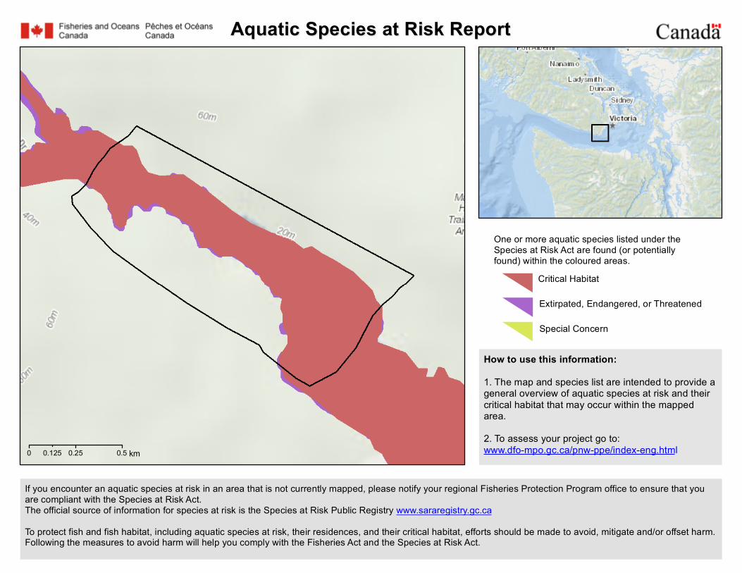
Aquatic Species at Risk ReportAquatic Species at Risk Report
0 0.25 0.50.125 km
How to use this information:1. The map and species list are intended to provide ageneral overview of aquatic species at risk and theircritical habitat that may occur within the mappedarea.2. To assess your project go to:www.dfo-mpo.gc.ca/pnw-ppe/index-eng.html
If you encounter an aquatic species at risk in an area that is not currently mapped, please notify your regional Fisheries Protection Program office to ensure that youare compliant with the Species at Risk Act.The official source of information for species at risk is the Species at Risk Public Registry www.sararegistry.gc.caTo protect fish and fish habitat, including aquatic species at risk, their residences, and their critical habitat, efforts should be made to avoid, mitigate and/or offset harm.Following the measures to avoid harm will help you comply with the Fisheries Act and the Species at Risk Act.
One or more aquatic species listed under theSpecies at Risk Act are found (or potentiallyfound) within the coloured areas.
Extirpated, Endangered, or Threatened
Critical Habitat
Special Concern

2020-12-09
Critical habitat for these species is found within the outlined areaCritical habitat is identified in recovery strategies or action plans for species listed under Schedule 1 of the Species at Risk Act as extirpated,endangered or threatened.
Name Where Found Species Status
Killer Whale - Northeast Pacific SouthernResident Pacific Ocean/Océan Pacifique Endangered
Species found (or potentially found) within the outlined area
Name Where Found Species Status
Basking Shark - Pacific Pacific Ocean/Océan Pacifique Endangered
Bluntnose Sixgill Shark Pacific Ocean/Océan Pacifique Special Concern
Grey Whale - Eastern North Pacific Pacific Ocean/Océan Pacifique Special Concern
Harbour Porpoise - Pacific Ocean Pacific Ocean/Océan Pacifique Special Concern
Humpback Whale - North Pacific Pacific Ocean/Océan Pacifique Special Concern
Killer Whale - Northeast Pacific Offshore Pacific Ocean/Océan Pacifique Threatened
Killer Whale - Northeast Pacific SouthernResident Pacific Ocean/Océan Pacifique Endangered
Killer Whale - Northeast Pacific Transient Pacific Ocean/Océan Pacifique Threatened
Leatherback Sea Turtle - Pacific Pacific Ocean/Océan Pacifique Endangered
Longspine Thornyhead Pacific Ocean/Océan Pacifique Special Concern
Page 2 of 3

2020-12-09
Northern Abalone Pacific Ocean/Océan Pacifique Endangered
Rougheye Rockfish type I Pacific Ocean/Océan Pacifique Special Concern
Rougheye Rockfish type II Pacific Ocean/Océan Pacifique Special Concern
Steller Sea Lion Pacific Ocean/Océan Pacifique Special Concern
Tope Pacific Ocean/Océan Pacifique Special Concern
Yelloweye Rockfish - Pacific Ocean InsideWaters Pacific Ocean/Océan Pacifique Special Concern
Yelloweye Rockfish - Pacific Ocean OutsideWaters Pacific Ocean/Océan Pacifique Special Concern
Page 3 of 3

"
"
"
"
"
20-4
20-5
20-1
20-3
20-2
20-7
20-6
Sombrio Point
Sheringham Point
Bonilla Point Light
WilliamHead
SookeSooke
DuncanDuncan
CroftonCrofton
Mill BayMill Bay
Port RenfrewPort Renfrew
AREA 20
0 4 8 12 16 20Nautical Miles ± Key Map
±BCKey Points
" Communities
Canada/United States Border
Rockfish Conservation Areas
PFMA Subareas
V a n c o u v e rV a n c o u v e rI s l a n dI s l a n d
W a s h i n g t o nW a s h i n g t o nS t a t eS t a t e
Juan de Fuca Stra i t
S a l i s h
S e a
*Not for Navigation*Not for Navigation
CanadaPêches et OcéansCanada
Fisheries and OceansCanada


Scientific Name Scientific Name Synonyms English Name English Name Synonyms Name Category Species Code Class (English) BC List Provincial FRPA Prov COSEWIC SARA Schedule SARA StatusAccipiter gentilis laingi Northern Goshawk, laingi subspecies Vertebrate Animal B‐NOGO‐LA birds Red Y (May 2004) Threatened 1 ThreatenedAllogona townsendiana Oregon Forestsnail Invertebrate Animal MO‐ALLTOW gastropods Red Endangered 1 Endangered
Anaxyrus boreas Bufo boreas Western Toad Vertebrate Animal A‐ANBO amphibians Yellow Special Concern 1 Special Concern
Aneides vagrans Wandering Salamander Vertebrate Animal A‐ANVA amphibians Blue Special Concern 1 Special ConcernAplodontia rufa Mountain Beaver Vertebrate Animal M‐APRU mammals Yellow Special Concern 1 Special Concern
Ardea herodias fannini Great Blue Heron, fannini subspecies Vertebrate Animal B‐GBHE‐FA birds Blue Y (May 2004) Special Concern 1 Special ConcernBrachyramphus marmoratus Marbled Murrelet Vertebrate Animal B‐MAMU birds Blue Y (May 2004) Threatened 1 Threatened
Buteo swainsoni Swainson's Hawk Vertebrate Animal B‐SWHA birds RedCallophrys johnsoni Loranthomitoura johnsoni Johnson's Hairstreak Invertebrate Animal LE‐CALJOH insects Red Y (Jun 2006)
Callophrys mossii mossii Incisalia mossii mossii Moss' Elfin, mossii subspecies Invertebrate Animal LE‐CALMOS‐MO insects Blue
Cardellina canadensis Wilsonia canadensis Canada Warbler Vertebrate Animal B‐CAWA birds Blue Threatened 1 Threatened
Carychium occidentale Western Thorn Invertebrate Animal MO‐CAROCC gastropods BlueCercyonis pegala incana Common Wood‐nymph, incana subspecies Invertebrate Animal LE‐CERPEG‐IN insects Red
Cervus elaphus roosevelti Cervus canadensis roosevelti Cervus elaphus roosevelti
Roosevelt Elk Vertebrate Animal M‐CEEL‐RO mammals Blue
Charina bottae Northern Rubber Boa Vertebrate Animal R‐CHBO reptiles Yellow Special Concern 1 Special ConcernChlosyne hoffmanni Charidryas hoffmanni Hoffman's Checkerspot Invertebrate Animal LE‐CHLHOF insects Red
Chordeiles minor Common Nighthawk Vertebrate Animal B‐CONI birds Yellow Special Concern 1 ThreatenedCoccothraustes vespertinus Evening Grosbeak Vertebrate Animal B‐EVGR birds Yellow Special Concern 1 Special Concern
Coccyzus americanus Yellow‐billed Cuckoo Vertebrate Animal B‐YBCU birds RedCoenonympha tullia insulana Coenonympha california
insulana Common Ringlet, insulana subspecies Invertebrate Animal LE‐COETUL‐IN insects Red
Contia tenuis Sharp‐tailed Snake Vertebrate Animal R‐COTE reptiles Red Endangered 1 EndangeredContopus cooperi Olive‐sided Flycatcher Vertebrate Animal B‐OSFL birds Blue Special Concern 1 Threatened
Corynorhinus townsendii Townsend's Big‐eared Bat Vertebrate Animal M‐COTO mammals BlueCryptomastix devia Puget Oregonian Invertebrate Animal MO‐CRYDEV gastropods Red Extirpated 1 ExtinctDeroceras hesperium Evening Fieldslug Invertebrate Animal MO‐DERHES gastropods Red Data Deficient
Dicamptodon tenebrosus Coastal Giant Salamander Pacific Giant Salamander Vertebrate Animal A‐DITE amphibians Blue Y (May 2004) Threatened 1 Threatened
Epargyreus clarus Silver‐spotted Skipper Invertebrate Animal LE‐EPACLA insects BlueErynnis propertius Propertius Duskywing Invertebrate Animal LE‐ERYPRO insects Red
Euchloe ausonides insulanus Large Marble, insulanus subspecies Island Large Marble Invertebrate Animal LE‐EUCAUS‐IN insects Red Extirpated 1 Extinct
Euphagus carolinus Rusty Blackbird Vertebrate Animal B‐RUBL birds Blue Special Concern 1 Special ConcernGlaucidium gnoma swarthi Northern Pygmy‐owl, swarthi subspecies Vertebrate Animal B‐NPOW‐SW birds Blue Y (Jun 2006)
Gulo gulo luscus Wolverine, luscus subspecies Vertebrate Animal M‐GUGU‐LU mammals Blue Y (May 2004) Special Concern 1 Special ConcernGulo gulo vancouverensis Wolverine, vancouverensis subspecies Vertebrate Animal M‐GUGU‐VA mammals Red Y (May 2004) Special Concern 1 Special ConcernHemphillia dromedarius Hemphillia malonei Dromedary Jumping‐slug Invertebrate Animal MO‐HEMDRO gastropods Red Threatened 1 Threatened
Hemphillia glandulosa Warty Jumping‐slug Invertebrate Animal MO‐HEMGLA gastropods Red Special Concern 1 Special ConcernHesperia colorado oregonia Western Branded Skipper, oregonia
subspeciesOregon Branded Skipper Invertebrate Animal LE‐HESCOL‐OR insects Red Endangered
Hirundo rustica Barn Swallow Vertebrate Animal B‐BASW birds Blue Threatened 1 ThreatenedIcaricia saepiolus insulanus Plebejus saepiolus insulanus Greenish Blue, insulanus subspecies Vancouver Island Blue Invertebrate Animal LE‐PLESAE‐IN insects Red Endangered 1 Endangered
Icteria virens Yellow‐breasted Chat Vertebrate Animal B‐YBCH birds Red Y (May 2004) Endangered 1 EndangeredLagopus leucura saxatilis Lagopus leucurus saxatilis White‐tailed Ptarmigan, saxatilis subspecies Vertebrate Animal B‐WTPT‐SA birds Blue Y (Jun 2006)
Lasionycteris noctivagans Silver‐haired Bat Vertebrate Animal M‐LANO mammals YellowLasiurus cinereus Hoary Bat Vertebrate Animal M‐LACI mammals Yellow

Lepus americanus washingtonii Snowshoe Hare, washingtonii subspecies Vertebrate Animal M‐LEAM‐WA mammals Red
Megascops kennicottii kennicottii Otus kennicottii kennicottii Western Screech‐Owl, kennicottii subspecies
Vertebrate Animal B‐WSOW‐KE birds Blue Threatened 1 Threatened
Melanerpes lewis Lewis's Woodpecker Vertebrate Animal B‐LEWO birds Blue Y (May 2004) Threatened 1 ThreatenedMustela erminea anguinae Ermine, anguinae subspecies Vertebrate Animal M‐MUER‐AN mammals BlueMustela frenata altifrontalis Long‐tailed weasel, altifrontalis subspecies Vertebrate Animal M‐MUFR‐AL mammals Red
Myodes gapperi occidentalis Clethrionomys gapperi occidentalis
Southern Red‐backed Vole, occidentalis subspecies
Vertebrate Animal M‐MYGA‐OC mammals Red
Myotis californicus Californian Myotis Vertebrate Animal M‐MYCA mammals YellowMyotis evotis Myotis keenii Long‐eared Myotis Keen's Myotis
Western Long‐eared Myotis
Vertebrate Animal M‐MYEV mammals Yellow
Myotis lucifugus Little Brown Myotis Vertebrate Animal M‐MYLU mammals Yellow Endangered 1 EndangeredNearctula sp. 1 Nearctula rowellii Threaded Vertigo Invertebrate Animal MO‐NEASP1 gastropods Blue Special Concern 1 Special Concern
Oporornis agilis Connecticut Warbler Vertebrate Animal B‐COWA birds Blue Y (Jun 2006)Oreamnos americanus Mountain Goat Vertebrate Animal M‐ORAM mammals BluePatagioenas fasciata Columba fasciata Band‐tailed Pigeon Vertebrate Animal B‐BTPI birds Blue Special Concern 1 Special Concern
Pekania pennanti Martes pennanti Fisher Vertebrate Animal M‐PEPE mammals No Status Y (Jun 2006)
Phalacrocorax auritus Double‐crested Cormorant Vertebrate Animal B‐DCCO birds Blue Not at RiskPinicola enucleator carlottae Pine Grosbeak, carlottae subspecies Vertebrate Animal B‐PIGR‐CA birds Blue
Pristiloma johnsoni Broadwhorl Tightcoil Invertebrate Animal MO‐PRIJOH gastropods BlueProgne subis Purple Martin Vertebrate Animal B‐PUMA birds Blue
Prophysaon coeruleum Blue‐grey Taildropper Invertebrate Animal MO‐PROCOE gastropods Blue Threatened 1 EndangeredRana aurora Northern Red‐legged Frog Red‐legged Frog Vertebrate Animal A‐RAAU amphibians Blue Y (May 2004) Special Concern 1 Special Concern
Rangifer tarandus pop. 15 Caribou (Northern Mountain Population) Vertebrate Animal M‐RATA‐15 mammals Blue Y (May 2004) Special Concern 1 Special Concern
Scapanus townsendii Townsend's Mole Vertebrate Animal M‐SCTO mammals Red Endangered 1 EndangeredSetophaga castanea Dendroica castanea Bay‐breasted Warbler Vertebrate Animal B‐BAYW birds Red Y (Jun 2006)
Setophaga virens Dendroica virens Black‐throated Green Warbler Vertebrate Animal B‐BTNW birds Blue Y (Jun 2006)
Sorex bendirii Pacific Water Shrew Vertebrate Animal M‐SOBE mammals Red Y (May 2004) Endangered 1 EndangeredSorex rohweri Olympic Shrew Vertebrate Animal M‐SORO mammals Red
Sorex trowbridgii Trowbridge's Shrew Vertebrate Animal M‐SOTR mammals BlueSpeyeria zerene bremnerii Zerene Fritillary, bremnerii subspecies Invertebrate Animal LE‐SPEZER‐BR insects Red
Staala gwaii Haida Gwaii Slug Invertebrate Animal MO‐STAGWA gastropods Red Special Concern 1 Special ConcernStrix occidentalis Spotted Owl Vertebrate Animal B‐SPOW birds Red Y (May 2004) Endangered 1 Endangered
Sympetrum vicinum Autumn Meadowhawk Invertebrate Animal OD‐SYMVIC insects BlueSynthliboramphus antiquus Ancient Murrelet Vertebrate Animal B‐ANMU birds Blue Y (May 2004) Special Concern 1 Special Concern
Tyto alba Barn Owl Vertebrate Animal B‐BNOW birds Red Threatened 1 ThreatenedUrsus arctos Grizzly Bear Vertebrate Animal M‐URAR mammals Blue Y (May 2004) Special Concern 1 Special Concern
Search CriteriaAnimalsAND 'Regional Districts':Capital Regional DistrictAND Habitat Types: ForestSort Order:Scientific Name AscendingOpen Government License– BC

Scientific Name English Name Name Category Species Code BC List Provincial FRPA Prov Wildlife Act COSEWIC SARA Schedule SARA Status PresenceHabitats
(Type / Subtype / Dependence)BGC
Allium amplectens slimleaf onion Vascular Plant ALLIAMP Blue Regularly occurring Forest / Garry Oak Woodland / Facultative ‐ frequent use
Grassland/Shrub / Meadow / Facultative ‐ frequent use
Other Unique Habitats / Vernal Pools/Seasonal Seeps / Facultative ‐
frequent use Rock/Sparsely Vegetated Rock / Garry Oak Coastal Bluffs / Facultative ‐ frequent use
Rock/Sparsely Vegetated Rock / Rock/Sparsely Vegetated Rock / Facultative ‐
frequent use
CDFmmCWHxm
Aphyllon pinorum pine broomrape Vascular Plant OROBPIN Red Regularly occurring Forest / Conifer Forest ‐ Mesic (average) / Facultative ‐ frequent use
Forest / Conifer Forest ‐ Moist/wet / Facultative ‐ occasional use
CDFmmCWHmmCWHxm
Balsamorhiza deltoidea deltoid balsamroot Vascular Plant BALSDEL Red Endangered 1 Endangered Regularly occurring Forest / Garry Oak Woodland / Facultative ‐ frequent use
Forest / Mixed Forest (deciduous/coniferous mix) / Facultative ‐ frequent use
Grassland/Shrub / Grassland / Facultative ‐ frequent use
Other Unique Habitats / Beach / Facultative ‐occasional use
Other Unique Habitats / Sand Dune / Facultative ‐ occasional use
Rock/Sparsely Vegetated Rock / Rock/Sparsely Vegetated Rock / Facultative ‐
frequent use
CDFmmCWHxm
Bulbostylis capillaris densetuft hairsedge Vascular Plant BULBCAP Unknown Regularly occurring Forest / Garry Oak Woodland / Facultative ‐ frequent use
Grassland/Shrub / Meadow / Facultative ‐ frequent use
CDFmm
Cardamine angulata angled bittercress Vascular Plant CARDANG Blue Regularly occurring Forest / Conifer Forest ‐ Moist/wet / Facultative ‐ frequent use
Riparian / Riparian Forest / Facultative ‐ frequent use
Stream/River / Stream/River / Facultative ‐ frequent use
CWHdmCWHvhCWHwh

Scientific Name English Name Name Category Species Code BC List Provincial FRPA Prov Wildlife Act COSEWIC SARA Schedule SARA Status PresenceHabitats
(Type / Subtype / Dependence)BGC
Carex tumulicola foothill sedge Vascular Plant CARETUM Yellow Endangered 1 Endangered Regularly occurring Forest / Garry Oak Woodland / Facultative ‐ frequent use
Grassland/Shrub / Grassland / Facultative ‐ frequent use
Grassland/Shrub / Meadow / Facultative ‐ occasional use
Wetland / Bog / Facultative ‐ occasional use Wetland / Fen / Facultative ‐ occasional use Wetland / Marsh / Facultative ‐ occasional
use Wetland / Swamp / Facultative ‐ occasional
use
CDFmm
Cephalanthera austiniae phantom orchid Vascular Plant CEPHAUS Red Endangered 1 Threatened Regularly occurring Forest / Conifer Forest ‐ Mesic (average) / Facultative ‐ frequent use
Forest / Mixed Forest (deciduous/coniferous mix) / Facultative ‐ frequent use
Forest / Old Forest / Facultative ‐ frequent use
CDFmmCWHdmCWHxm
Claytonia washingtoniana Washington springbeauty Vascular Plant CLAYWAS Red Regularly occurring Forest / Conifer Forest ‐ Dry / Unknown Forest / Mixed Forest (deciduous/coniferous
mix) / Unknown Rock/Sparsely Vegetated Rock / Cliff /
Unknown Rock/Sparsely Vegetated Rock / Talus /
Unknown
CDFmmCWHdmCWHxmIDFww
Dryopteris arguta coastal wood fern Vascular Plant DRYOARG Blue Special Concern 1 Special Concern Regularly occurring Forest / Conifer Forest ‐ Dry / Facultative ‐ frequent use
Forest / Deciduous/Broadleaf Forest / Facultative ‐ occasional use
Forest / Garry Oak Woodland / Facultative ‐ frequent use
Forest / Mixed Forest (deciduous/coniferous mix) / Facultative ‐ frequent use
Grassland/Shrub / Grassland / Facultative ‐ occasional use
Rock/Sparsely Vegetated Rock / Cliff / Facultative ‐ frequent use
Rock/Sparsely Vegetated Rock / Garry Oak Coastal Bluffs / Facultative ‐ frequent use
Rock/Sparsely Vegetated Rock / Rock/Sparsely Vegetated Rock / Facultative ‐
frequent use Stream/River / Stream/River / Facultative ‐
frequent use
CDFmm
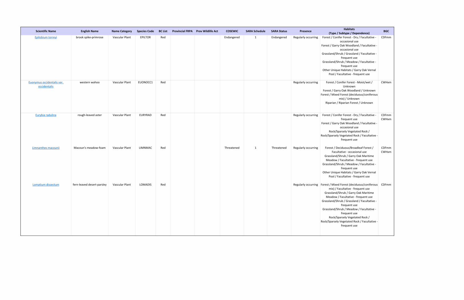
Scientific Name English Name Name Category Species Code BC List Provincial FRPA Prov Wildlife Act COSEWIC SARA Schedule SARA Status PresenceHabitats
(Type / Subtype / Dependence)BGC
Epilobium torreyi brook spike‐primrose Vascular Plant EPILTOR Red Endangered 1 Endangered Regularly occurring Forest / Conifer Forest ‐ Dry / Facultative ‐ occasional use
Forest / Garry Oak Woodland / Facultative ‐ occasional use
Grassland/Shrub / Grassland / Facultative ‐ frequent use
Grassland/Shrub / Meadow / Facultative ‐ frequent use
Other Unique Habitats / Garry Oak Vernal Pool / Facultative ‐ frequent use
CDFmm
Euonymus occidentalis var. occidentalis
western wahoo Vascular Plant EUONOCC1 Red Regularly occurring Forest / Conifer Forest ‐ Moist/wet / Unknown
Forest / Garry Oak Woodland / Unknown Forest / Mixed Forest (deciduous/coniferous
mix) / Unknown Riparian / Riparian Forest / Unknown
CWHxm
Eurybia radulina rough‐leaved aster Vascular Plant EURYRAD Red Regularly occurring Forest / Conifer Forest ‐ Dry / Facultative ‐ frequent use
Forest / Garry Oak Woodland / Facultative ‐ occasional use
Rock/Sparsely Vegetated Rock / Rock/Sparsely Vegetated Rock / Facultative ‐
frequent use
CDFmmCWHxm
Limnanthes macounii Macoun's meadow‐foam Vascular Plant LIMNMAC Red Threatened 1 Threatened Regularly occurring Forest / Deciduous/Broadleaf Forest / Facultative ‐ occasional use
Grassland/Shrub / Garry Oak Maritime Meadow / Facultative ‐ frequent use
Grassland/Shrub / Meadow / Facultative ‐ frequent use
Other Unique Habitats / Garry Oak Vernal Pool / Facultative ‐ frequent use
CDFmmCWHxm
Lomatium dissectum fern‐leaved desert‐parsley Vascular Plant LOMADIS Red Regularly occurring Forest / Mixed Forest (deciduous/coniferous mix) / Facultative ‐ frequent use
Grassland/Shrub / Garry Oak Maritime Meadow / Facultative ‐ frequent use
Grassland/Shrub / Grassland / Facultative ‐ frequent use
Grassland/Shrub / Meadow / Facultative ‐ frequent use
Rock/Sparsely Vegetated Rock / Rock/Sparsely Vegetated Rock / Facultative ‐
frequent use
CDFmm

Scientific Name English Name Name Category Species Code BC List Provincial FRPA Prov Wildlife Act COSEWIC SARA Schedule SARA Status PresenceHabitats
(Type / Subtype / Dependence)BGC
Lomatium papilioniferum butterfly bearing lomatium Vascular Plant Red Threatened 1 Threatened Regularly occurring Forest / Conifer Forest ‐ Dry / Facultative ‐ occasional use
Forest / Garry Oak Woodland / Facultative ‐ frequent use
Rock/Sparsely Vegetated Rock / Cliff / Facultative ‐ frequent use
Rock/Sparsely Vegetated Rock / Rock/Sparsely Vegetated Rock / Facultative ‐
frequent use Rock/Sparsely Vegetated Rock / Talus /
Facultative ‐ frequent use
CDFmmCWHxm
Lupinus oreganus var. kincaidii Kincaid's lupine Vascular Plant LUPIORE1 Unknown Extirpated 1 Extinct Regularly occurring Forest / Garry Oak Woodland / Facultative ‐ frequent use
Grassland/Shrub / Grassland / Facultative ‐ frequent use
Rock/Sparsely Vegetated Rock / Rock/Sparsely Vegetated Rock / Facultative ‐
occasional use
CDFmm
Marah oregana coast manroot Vascular Plant MARAORE Red Endangered Regularly occurring Agriculture / Hedgerow / Facultative ‐ occasional use
Agriculture / Pasture/Old Field / Facultative ‐frequent use
Forest / Garry Oak Woodland / Facultative ‐ frequent use
Grassland/Shrub / Meadow / Facultative ‐ frequent use
Rock/Sparsely Vegetated Rock / Rock/Sparsely Vegetated Rock / Facultative ‐
frequent use
CDFmm
Meconella oregana white meconella Vascular Plant MECOORE Red Endangered 1 Endangered Regularly occurring Forest / Deciduous/Broadleaf Forest / Facultative ‐ frequent use
Rock/Sparsely Vegetated Rock / Garry Oak Coastal Bluffs / Facultative ‐ frequent use
Rock/Sparsely Vegetated Rock / Rock/Sparsely Vegetated Rock / Facultative ‐
frequent use
CDFmmCWHxm
Mitellastra caulescens leafy mitrewort Vascular Plant MITECAU Blue Regularly occurring Forest / Conifer Forest ‐ Mesic (average) / Unknown
Forest / Conifer Forest ‐ Moist/wet / Unknown
Forest / Mixed Forest (deciduous/coniferous mix) / Unknown
Riparian / Riparian Forest / Unknown Rock/Sparsely Vegetated Rock / Cliff /
Unknown Rock/Sparsely Vegetated Rock /
Rock/Sparsely Vegetated Rock / Unknown Rock/Sparsely Vegetated Rock / Talus /
Unknown
CMACWHdsCWHmsCWHxmMHmm

Scientific Name English Name Name Category Species Code BC List Provincial FRPA Prov Wildlife Act COSEWIC SARA Schedule SARA Status PresenceHabitats
(Type / Subtype / Dependence)BGC
Plagiobothrys tenellus slender popcornflower Vascular Plant PLAGTEN Red Threatened 1 Threatened Regularly occurring Forest / Conifer Forest ‐ Dry / Facultative ‐ occasional use
Forest / Garry Oak Woodland / Facultative ‐ frequent use
Grassland/Shrub / Grassland / Facultative ‐ frequent use
Grassland/Shrub / Meadow / Facultative ‐ frequent use
Rock/Sparsely Vegetated Rock / Garry Oak Coastal Bluffs / Facultative ‐ frequent use
CDFmm
Platanthera ephemerantha white‐lip rein orchid Vascular Plant PIPECAN Blue Regularly occurring Forest / Conifer Forest ‐ Dry / Facultative ‐ frequent use
Forest / Garry Oak Woodland / Facultative ‐ frequent use
CDFmmCWHvh
Rubus lasiococcus dwarf bramble Vascular Plant RUBULAS Blue Regularly occurring Forest / Conifer Forest ‐ Mesic (average) / Obligate
Forest / Conifer Forest ‐ Moist/wet / Facultative ‐ occasional use
CDFmmCWHdsCWHmmCWHxmESSFmwMHmm
Sabulina pusilla dwarf sandwort Vascular Plant MINUPUS Red Endangered 1 Endangered Regularly occurring Forest / Conifer Forest ‐ Dry / Facultative ‐ frequent use
Grassland/Shrub / Grassland / Facultative ‐ occasional use
Grassland/Shrub / Meadow / Facultative ‐ frequent use
Other Unique Habitats / Garry Oak Vernal Pool / Facultative ‐ frequent use Other Unique Habitats / Vernal
Pools/Seasonal Seeps / Facultative ‐ frequent use
CDFmm
Sanicula bipinnatifida purple sanicle Vascular Plant SANIBIP Red Threatened 1 Threatened Regularly occurring Forest / Deciduous/Broadleaf Forest / Facultative ‐ occasional use
Forest / Garry Oak Woodland / Facultative ‐ occasional use
Grassland/Shrub / Garry Oak Maritime Meadow / Facultative ‐ frequent use Rock/Sparsely Vegetated Rock /
Rock/Sparsely Vegetated Rock / Facultative ‐ occasional use
CDFmmCWHxm
Sericocarpus rigidus white‐top aster Vascular Plant SERIRIG Blue Special Concern 1 Special Concern Regularly occurring Forest / Garry Oak Woodland / Facultative ‐ frequent use
Forest / Mixed Forest (deciduous/coniferous mix) / Facultative ‐ frequent use
Grassland/Shrub / Meadow / Facultative ‐ frequent use
Rock/Sparsely Vegetated Rock / Rock/Sparsely Vegetated Rock / Facultative ‐
frequent use
CDFmmCWHxm

Scientific Name English Name Name Category Species Code BC List Provincial FRPA Prov Wildlife Act COSEWIC SARA Schedule SARA Status PresenceHabitats
(Type / Subtype / Dependence)BGC
Silene scouleri ssp. scouleri coastal Scouler's catchfly Vascular Plant SILESCO2 Red Endangered 1 Endangered Regularly occurring Forest / Garry Oak Woodland / Unknown Grassland/Shrub / Garry Oak Maritime
Meadow / Unknown Rock/Sparsely Vegetated Rock / Garry Oak
Coastal Bluffs / Unknown
CDFmm
Syntrichia laevipila twisted oak moss Nonvascular Plant TORTLAE2 Blue Special Concern 1 Special Concern Regularly occurring Forest / Garry Oak Woodland / Facultative ‐ frequent use
CDFmm
Thelypteris nevadensis Nevada marsh fern Vascular Plant THELNEV Red Regularly occurring Forest / Mixed Forest (deciduous/coniferous mix) / Facultative ‐ frequent use
Riparian / Riparian Forest / Facultative ‐ frequent use
Rock/Sparsely Vegetated Rock / Rock/Sparsely Vegetated Rock / Facultative ‐
frequent use Stream/River / Stream/River / Facultative ‐
occasional use
CWHxm
Tonella tenella small‐flowered tonella Vascular Plant TONETEN Blue Endangered 1 Endangered Regularly occurring Forest / Conifer Forest ‐ Dry / Facultative ‐ frequent use
Forest / Garry Oak Woodland / Facultative ‐ frequent use
Other Unique Habitats / Vernal Pools/Seasonal Seeps / Obligate Rock/Sparsely Vegetated Rock /
Rock/Sparsely Vegetated Rock / Facultative ‐ frequent use
Rock/Sparsely Vegetated Rock / Talus / Facultative ‐ frequent use
CDFmm
Triteleia howellii Howell's triteleia Vascular Plant TRITHOW Red Endangered 1 Endangered Regularly occurring Forest / Conifer Forest ‐ Dry / Facultative ‐ occasional use
Forest / Deciduous/Broadleaf Forest / Facultative ‐ frequent use
Forest / Garry Oak Woodland / Facultative ‐ frequent use
Grassland/Shrub / Meadow / Facultative ‐ frequent use
Rock/Sparsely Vegetated Rock / Garry Oak Coastal Bluffs / Facultative ‐ occasional use
CDFmm
Uropappus lindleyi Lindley's microseris Vascular Plant UROPLIN Red Endangered 1 Endangered Regularly occurring Forest / Conifer Forest ‐ Dry / Unknown Forest / Deciduous/Broadleaf Forest /
Unknown Grassland/Shrub / Meadow / Unknown Rock/Sparsely Vegetated Rock / Cliff /
Unknown Rock/Sparsely Vegetated Rock / Garry Oak
Coastal Bluffs / Unknown
CDFmm

Scientific Name English Name Name Category Species Code BC List Provincial FRPA Prov Wildlife Act COSEWIC SARA Schedule SARA Status PresenceHabitats
(Type / Subtype / Dependence)BGC
Viola howellii Howell's violet Vascular Plant VIOLHOW Red Regularly occurring Forest / Conifer Forest ‐ Moist/wet / Facultative ‐ frequent use
Forest / Garry Oak Woodland / Facultative ‐ frequent use
Grassland/Shrub / Meadow / Facultative ‐ frequent use
Rock/Sparsely Vegetated Rock / Rock/Sparsely Vegetated Rock / Facultative ‐
occasional use
CDFmmCWHmmCWHxmMHmm
Viola praemorsa var. praemorsa yellow montane violet Vascular Plant VIOLPRA1 Red Endangered 1 Endangered Regularly occurring Agriculture / Pasture/Old Field / Facultative ‐occasional use
Forest / Garry Oak Woodland / Facultative ‐ frequent use
Grassland/Shrub / Meadow / Obligate
CDFmmCWHxm
Zeltnera muehlenbergii Muhlenberg's centaury Vascular Plant ZELTMUE Red Endangered 1 Endangered Regularly occurring Forest / Garry Oak Woodland / Facultative ‐ frequent use
Grassland/Shrub / Garry Oak Maritime Meadow / Facultative ‐ frequent use
Grassland/Shrub / Meadow / Facultative ‐ frequent use
Other Unique Habitats / Vernal Pools/Seasonal Seeps / Facultative ‐
frequent use
CDFmm
Search Criteria
PlantsAND 'Regional Districts':Capital
Regional DistrictAND Habitat Types: Forest
Sort Order:Scientific Name AscendingOpen Government License– BC


NOT FOR DISTRIBUTION
OPI Project File #: R.112349.002
DND EIA Portal#: 2021-21-102750
Annex C. DND Sensitive Areas Map

(#
(#
(#
(#
(#
(#
455000 .000000 456000 .000000 457000 .000000 458000 .000000 459000 .000000 460000 .000000
5351
000.00
0000
5351
900.00
0000
5352
800.00
0000
5353
700.00
0000
5354
600.00
0000
RO C K Y P O I N TS en s i t i ve A r ea s M ap S er i e s
F EB RU A RY 20 1 8
P ro d u ce d b y F O R M AT I O N E N V IR O N M E N TMA R I T IM E F O R C E S PA C I F IC
D E PA RT M E N T O F N AT I O N A L D E F E N C E , C A N A D A
20 1 7 C o lo u r O r th o p h o to s10 c m re s o lu t io n
This map was created for use by Maritime Forces Pacific.Any unauthorized use of this map is strictly prohibited.
Note that this version may not be the most current andthere may be information missing and/or incorrectlyrepresented. This map depicts the best information
available at the time of printing.
RO C K Y P O I N TBR I TI S H C O L U MB I A
D at e : Fe b 2 0 1 8 Sc a l e :F i l e N a m e : r p _ s a m s _ f e b 1 8 . m x d
Archaeological and Cultural Features
First Nations Burial Site. Do not disturb area. Do not move or disturbrocks.
These layers denote identified areas of cultural significance. All projects,exercises and/or development activities occurring near these areas, or in otherareas likely to be of cultural significance, should include an assessment for thepotential for disturbance. MARPAC policy opts to avoid known archaeologicalareas completely where possible. If avoidance is not an option, an archaeologistis required to complete an Archaeological Impact Assessment.
Culturally Modified Tree. Do not cut, nail, or damage any part of the tree.Varied Cultural Material (including, but not limited to, lithics, middens,and/or depressions). Do not disturb individual sites.
This layer includes identified locations of both provincially listed andfederally protected species. Formation Environment shall be contactedduring the planning phase of any projects, exercises and/or developmentactivities proposed to occur within or near these areas. Under the Species atRisk Act it is an offence to kill, harm or harass a listed species; destroy ordamage the residence of a listed species; and/or destroy any part of criticalhabitat of a listed species.
Wetland FeaturesThis layer includes wetlands, water bodies, streams, and adjacent riparianareas, including those that are intermittent (with wetted area for part of theyear) and ephemeral (only wetted during and immediately afterprecipitation). Projects, exercises and/or development activities occurring inand around water shall comply with the Fisheries Act and the BC WaterSustainability Act.
Contaminated Site Features
Sensitive Species Occurrences and Habitat
Contaminated/Risk Managed Sites. This layer includes areas of known orsuspected contamination, as well as areas which have been remediatedand/or are under risk management. These areas should not be disturbed.Formation Environment shall be contacted during the planning phase ofany projects, exercises and/or development activities proposed to occurwithin or near these areas.
Soil excavation activities on all CFB Esquimalt adminstered lands have apotential to uncover historical contamination or archaeologicallysignificant materials (including areas that are not marked on this map).Disturbance of any contaminated and/or archaeologically significantmaterials on CFB Esquimalt properties is the responsibility of the projectOPI. Excavation activities occurring within all areas of CFB Esquimaltproperties shall comply with MARPAC SEMS DE2.
This layer includes critical habitat for federally protected species. Under theSpecies at Risk Act it is an offence to destroy any part of critical habitat of alisted species. Formation Environment shall be contacted during theplanning phase of any project and/or development activities proposed tooccur within or near these areas.This layer identifies sensitive ecosystems. Land-use planning shouldconsider the continued integrity of these ecosystems.
1:8,500
Active Risk Managed Site Monitoring Wells. Formation Environment shallbe contacted prior to any projects and/or development activities in theseareas.Note that additional monitoring wells, not captured in this layer, may existon the property. Should any projects and/or development activitiesnecessitate their destruction, appropriate decommissioning is required.Formation Environment shall be contacted prior to any groundwater welldecommissioning.
&*
Other FeaturesMascot Geodetic Control Monuments. This layer includes survey controlmonuments. These features are protected by law under Sections 442 and443 of the Criminal Code of Canada. Do not damage, move or destroy.
(#

NOT FOR DISTRIBUTION
OPI Project File #: R.112349.002
DND EIA Portal#: 2021-21-102750
Annex C. Legal Duty to Consult Worksheet

Updated May 2017 Page 1
ASSISTANT DEPUTY MINISTER (INFRASTRUCTURE AND ENVIRONMENT)
Determining if there is a legal duty to consult1
The legal duty to consult arises when the Crown has knowledge of potential or established Aboriginal or treaty rights and contemplates conduct that may adversely affect those rights. Three elements are therefore required before the duty to consult is triggered:
1) Contemplated Crown conduct; 2) Potential or established Aboriginal or treaty rights; and 3) Potential adverse impact.
Federal departments/agencies must gather sufficient information to make a preliminary assessment of what potential or established section 35 rights are in question (i.e. hunting, fishing, self-government rights, cultural rights etc.) and whether there are potential adverse impacts that the project/activity may have on such rights.
This chart has been developed to help you gather the information needed to establish whether your project triggers the duty to consult. Completing this chart will guide you through an initial assessment and analysis of the established or potential section 35 rights2 and the potential adverse impacts of your proposed project or activity. It will also help in determining the scope and content of that duty and how to design the consultation process. The completed chart should be retained in your project file.
Any questions regarding your assessment of the duty to consult can be directed to ADM(IE) at [email protected] or DND/CF LA, Aboriginal Law Advisory Services.
If you determine that the legal duty to consult does not arise in your project, there may still be good governance reasons for engaging with local Indigenous groups. CAF bases are encouraged to be proactive in developing positive relationships with local Indigenous groups just as they do with local municipalities.
The best first step in this information gathering process is to consult the Aboriginal and Treaty Rights Information System (ATRIS). This Indigenous and Northern Affairs Canada (INAC) database is publically available; however, government representatives can access more complete information by requesting an ATRIS user account. Contact [email protected] for an account. ATRIS is an online mapping tool that provides an intuitive and comprehensive information system relating to Aboriginal and treaty rights. ATRIS also provides users with available information on Indigenous communities, including: contact information, information on community level leadership, membership to other organizations such as tribal councils, information on treaties and agreements, of which a community is a beneficiary, and links to community websites and other public resources. ATRIS can be accessed through the following link: http://sidait-atris.aadnc-aandc.gc.ca/atris_online/
1 This document is based on: Aboriginal Consultation and Accommodation – Updated Guidelines for Federal Officials to Fulfill the
Legal Duty to Consult (March 2011) which can be accessed at: http://www.aadnc-aandc.gc.ca/DAM/DAM-INTER-HQ/STAGING/texte-text/intgui_1100100014665_eng.pdf .
2 Section 35 rights refers to section 35 of the Constitution Act, 1982 which recognized and affirmed the existing Aboriginal and treaty rights of the Aboriginal peoples of Canada.

Updated May 2017 Page 2
Element 1: Is there contemplated Crown conduct? Describe intended project/activity to determine if there is contemplated Crown conduct?
1.
What is the nature of the proposed project/activity?
Remedial excavation of metals impacted soil and removal of metal debris at the Rocky Point 14 (RP-14) property located at Canadian Forces Ammunition Depot (CFAD) Rocky Point.
2.
What is the purpose of the project/activity?
The remediation will consist of limited excavation of impacted soil and risk assessment of residual soil and sediment impacts, to reduce human health and environmental risks.
3.
What is entailed in developing the project/activity?
Tree and vegetation removal, excavation and disposal of metals impacted soil and surficial metal debris, transportation of impacted soil and debris to a licensed and approved facility, and site restoration including topsoil placement and planting of trees.
4.
Describe the area affected by the project/activity.
The site is a mixture of coniferous and deciduous trees, with a gravel access road. Pedder Bay is located immediately north of the site. This area was formerly used to dump miscellaneous metal debris from CFAD Rocky Point.
5.
Who owns the land?
Department of National Defence
6.
If the land is owned by DND, when was the property acquired? Mid-1950s (approximate)
7.
Is there more than one federal body involved?
No
8.
Which department, agency, Crown Corporation, Authority, Board, Review Panel or other federal body is responsible for carrying out the particular project/activity or its authorization?
CFB Esquimalt Base Safety and Environment

Updated May 2017 Page 3
9.
Are there corporations, provincial/territorial governments, or third parties that might also be involved? No other corporations or governments. Only other third parties are contractors and consultants hired by DND to undertake the work.
10.
Are there any statutes, regulations, agreements or protocols relating to the project/activity that refer to the matter of Aboriginal consultation? A Due Diligence Environmental Effects Determination (DDEED) is being completed for the project.
11.
What is the mandate or scope of authority of those involved in the project/activity, or its authorization, and are there others that ought to be involved? Department of National Defence: Land Owner and Project OPI Public Services and Procurement Canada: Contracting Authority SNC-Lavalin: DND/PSPC’s external environmental consultant Excavation contractor: TBD
12.
What type of decision(s) must be made in relation to the project/activity?
N/A – the scope and workplan has been determined, DDEED has been completed.
13.
Have any options/alternatives within the proposed project/activity been identified?
No, the project is required to mitigate potential impacts to human health and the environment as a result of the historic metals contamination.
Element 2: Are there potential or established Aboriginal or treaty rights in the project area? Conduct background research on Indigenous groups in the area and assess what established or potential section 35 rights may exist and identify potential adverse impacts.
1.
What Indigenous communities could be affected by the proposed project/activity? Sc'ianew First Nation (Beecher Bay)
2. What real or ’constructive’ knowledge is there of potential or established rights and which communities assert or hold such rights?
Is there contemplated Crown conduct? Yes No

Updated May 2017 Page 4
Same as above
3.
What is the basis for those established or potential rights? Are the rights premised on historic or modern treaty rights or Aboriginal rights and/or title? History significance, historic treaties.
4.
Is there more than one Indigenous group claiming rights (i.e. overlapping claims)? If so, what rights are claimed for which areas?
[Note that there may be alternate spellings or different names for each Aboriginal group. For example, the Sliammon First Nation of BC is also referred to as the Tla’amin First Nation.] No
5.
Are there any other consultation processes, involving Indigenous groups, already in place to deal with the proposed project/activity (i.e. environmental, regulatory, public fora, etc.)? No
6.
Have Indigenous groups in the area raised concerns about this proposed project/activity or similar activities (past or present)? No
7.
Are there any burial grounds, traditional territories or reserves in the area where rights are claimed? No
Element 3: Could the contemplated Crown conduct have an adverse impact on the potential or established Aboriginal or treaty rights within the project area?
1.
Could the contemplated Crown conduct have adverse effects on air, land or water?
No
Are there potential or established Aboriginal or treaty rights in the project area? Yes No

Updated May 2017 Page 5
2.
Could the contemplated Crown conduct have adverse effects on hunting?
No
3.
Could the contemplated Crown conduct have adverse effects on fishing?
No
4.
Could the contemplated Crown conduct have adverse effects on trapping?
No
5.
Could the contemplated Crown conduct have adverse effects on harvesting plants?
No
6.
Could the contemplated Crown conduct have adverse effects on Aboriginal title or a claim to land?
No
7.
Could the contemplated Crown conduct have adverse effects on other Aboriginal or treaty rights?
No
Could the contemplated Crown Conduct have an adverse impact on the potential or established Aboriginal or treaty rights in the project area?
Yes No

Updated May 2017 Page 6
Annex A
Potential sources of information:
Internal government sources.
Note that the Crown may be deemed to have constructive knowledge of a treaty right or potential Aboriginal right, even if only one department/agency is aware of the assertion.
Suggested sources are:
Aboriginal Treaty Rights and Information System (ATRIS) is a research tool that can be used to view, gather and query baseline information regarding Aboriginal treaties, rights, claims, litigation, geographic and other related subject matter. ATRIS allows users to relate many types of Indigenous and Northern Affairs Canada (INAC) corporate data within geographical and consultation contexts: http://sidait-atris.aadnc-aandc.gc.ca/atris_online/
Historic treaties INAC Historic Treaties (Text and Guides): http://www.ainc-AANDC.gc.ca/al/hts/tgu/index-eng.asp
Specific claims
INAC Specific Claims: http://www.ainc-AANDC.gc.ca/al/ldc/spc/index-eng.asp
Status Report on Specific Claims: http://services.aadnc-aandc.gc.ca/SCBRI_E/Main/ReportingCentre/External/externalreporting.aspx
Comprehensive land claims
INAC Comprehensive Claims: http://www.ainc-AANDC.gc.ca/al/ldc/ccl/index-eng.asp British Columbia Treaty Commission: http://www.bctreaty.net/ Métis and Non-Status Indian interests – Office of the Federal Interlocutor;
http://www.ainc-AANDC.gc.ca/ai/ofi/index-eng.asp Correspondence to government officials Knowledge held by officials in other departments/agencies involved in the enforcement of
regulation of land and resource uses – Fisheries and Oceans Canada, Parks Canada, Environment Canada, Natural Resources Canada, National Defence, etc.
Public information It is well worth doing a general internet search of the Aboriginal group(s) in your project area. Most groups have informative websites and you may locate relevant news that impacts your project/activity.

1
Biolinx Environmental Research Ltd. 1759 Colburne Place, North Saanich, BC V8L 5A2 Tel: (250) 655-4602 Cell: 250 634-8909 Email: [email protected]
Surveys and Mitigation Recommendations for Blue-grey Taildropper on DND Lands Subjected to Soil Remediation at CFAD Rocky Point, Vancouver Island
Prepared by Lennart Sopuck, MSc., RPBio and Kristiina Ovaska, PhD
December 2020
1.0 INTRODUCTION
SNC Lavalin, on behalf of the Department of National Defence, is planning to conduct a soil remediation project at CFAD Rocky Point. The project involves the removal of contaminated soil and engaging in other remediation activities at a former dump site (Figure 1). These activities may potentially impact Blue-grey Taildropper (Prophysaon coeruleum), which is listed as Endangered under the federal Species at Risk Act. There are Blue-grey Taildropper occurrences immediately south of the paved Rocky Point entrance road, but not from the site itself. The designated Critical Habitat extends across the road (Environment and Climate Change Canada 2018) and covers the entirety of the remediation site. Here we report on gastropod surveys and habitat assessment, targeting Blue-grey Taildropper, conducted at the remediation site in December 2020.
2.0 STUDY AREA
The soil remediation area is demarcated by the dotted yellow line in Figure 1. The gastropod surveys included the remediation area and a buffer zone extending approximately 20 m beyond the yellow line (i.e., the study area). The site is within a second-growth stand of mainly coniferous forest, dominated by Douglas-fir and with Grand Fir and scattered Bigleaf Maples as secondary components. A few large remnant Douglas-fir trees are present. Red Alders occur in moist and disturbed sites. The understorey includes Ocean Spray, dense patches of Salal, Trailing Blackberry, and Sword Ferns.
3.0 METHODS
The survey methods were modified from protocols developed for detecting rare species of terrestrial gastropods in the United States under the Northwest Forest Plan (Duncan et al. 2003). These methods produce “presence/not detected” type of data, but together with search effort, they can provide an indication of relative abundance. This method has been used previously with success for Blue-grey Taildroppers on Vancouver Island (e.g., Sopuck and Ovaska 2006a-c). To carry out a survey, two observers walked through the study area along parallel meandering transects and conducted Point searches where concentrations of microhabitat features suitable for Blue-grey Taildroppers were present; these features included decaying logs, piles of bark, stumps, rocks, or other cover-objects or moist refuges, and accumulations of moist leaf litter. At each point, the observer searched an area of ca. 5 m radius for Blue-grey Taildroppers for 10 minutes. In addition to point searches, the observers opportunistically examined additional microsites along the transects, such as decaying logs and mushrooms favoured by many gastropods. We recorded all slugs and large snails (shell diameter >10 mm) detected. Identification was done based on external features, and the animals were released immediately after examination. Nomenclature follows Forsyth (2004).
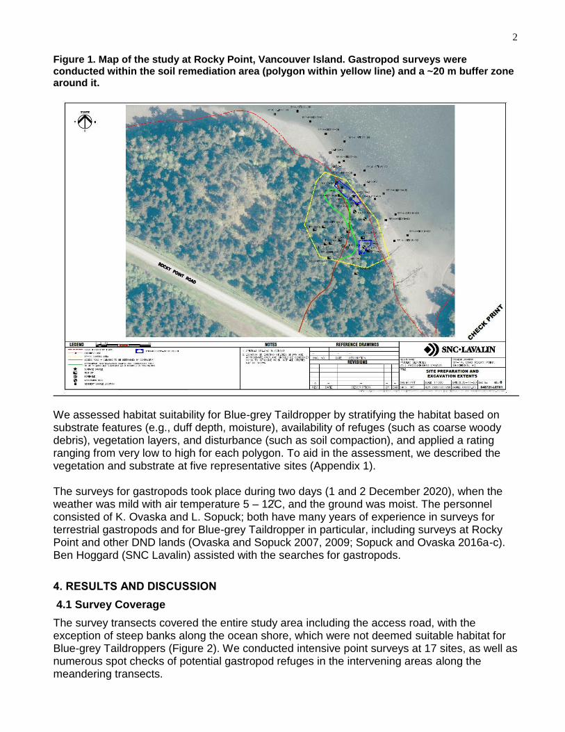
2
Figure 1. Map of the study at Rocky Point, Vancouver Island. Gastropod surveys were conducted within the soil remediation area (polygon within yellow line) and a ~20 m buffer zone around it.
We assessed habitat suitability for Blue-grey Taildropper by stratifying the habitat based on substrate features (e.g., duff depth, moisture), availability of refuges (such as coarse woody debris), vegetation layers, and disturbance (such as soil compaction), and applied a rating ranging from very low to high for each polygon. To aid in the assessment, we described the vegetation and substrate at five representative sites (Appendix 1). The surveys for gastropods took place during two days (1 and 2 December 2020), when the weather was mild with air temperature 5 – 12 C, and the ground was moist. The personnel consisted of K. Ovaska and L. Sopuck; both have many years of experience in surveys for terrestrial gastropods and for Blue-grey Taildropper in particular, including surveys at Rocky Point and other DND lands (Ovaska and Sopuck 2007, 2009; Sopuck and Ovaska 2016a-c). Ben Hoggard (SNC Lavalin) assisted with the searches for gastropods.
4. RESULTS AND DISCUSSION
4.1 Survey Coverage
The survey transects covered the entire study area including the access road, with the exception of steep banks along the ocean shore, which were not deemed suitable habitat for Blue-grey Taildroppers (Figure 2). We conducted intensive point surveys at 17 sites, as well as numerous spot checks of potential gastropod refuges in the intervening areas along the meandering transects.

3
Figure 2. Gastropod survey coverage within the Rocky Point study area. Gastropod sampling sites refer to location of intensive point surveys.
4.2 Gastropod Surveys
The surveys resulted in the detection of three species of slugs and two species of large snails but no Blue-grey Taildroppers (Table 1; see Appendix 2 for raw data with coordinates). Table 1. Summary of slugs and large snails detected during Blue-grey Taildropper surveys at Rocky Point on 1-2 December 2020.
Species # of individuals
Slugs:
Pacific Banana Slug, Ariolimax columbianus 13
Chocolate Arion, Arion rufus (introduced) 2
Reticulate Taildropper, Prophysaon andersonii 9
Snails:
Robust Lancetooth, Haplotrema vancouverense 10
Pacific Sideband, Monadenia fidelis 1
Northwest Hesperian, Vespericola columbianus 10

4
The detection of other gastropods, particularly congeneric Reticulate Taildroppers, indicated that conditions were suitable for surveys, regardless of lateness in the season. Blue-grey Taildroppers are often detected most readily in late fall (COSEWIC 2016). Although the species was not detected, it cannot be assumed that it is absent from the site; several previous records exist from the immediate vicinity (forest on the south side of paved entrance road to Rocky Point). As with other rare and difficult-to-detect species, habitat suitability assessment can be used to guide the application of protection and mitigation measures.
4.3 Habitat Assessment
Most of the study area consists of relatively poor habitat for Blue-grey Taildroppers with assigned suitability ratings of Very Low, Low, and Low-medium (Figure 3). The site contains several highly disturbed areas with compacted soils and include an old dump site and a roadbed (Appendix 3; Photo 1). These and very wet areas were rated as Low or Very Low suitability. The southern and western fringes of the remediation area contained habitat rated mainly as low-medium quality. A small patch of higher quality habitat, rated as Medium, is present at the western edge of the remediation area (Hab3 in Figure 3); a large Bigleaf Maple, deep moss layer, and abundant coarse woody debris contributed to this rating (Appendix 3, Photo 2). Habitat rated as Medium-quality was also present along the sides of the access road south of the remediation area (Appendix 3, Photo 3). No habitat rated as high quality is present in the study area. Figure 3. Habitat suitability map for Blue-grey Taildropper at the Rocky Point study area.

5
5.0 RECOMMENDED MITIGATION MEASURES
The likelihood of Blue-grey Taildroppers occurring in the remediation area is low, but as a precautionary measure, we recommend a habitat-based approach within the designated Critical Habitat. The following measures are intended to minimize potential impacts and improve habitat for the species in the future:
Avoid soil disturbance and vegetation removal in areas rated as Medium suitability for the species (see Figure 3). This may include re-routing the haul road and turn-around area in the soil remediation area, if required; avoid widening the access road into the site; all roads should be restored after completion of remediation activities.
In areas of lower suitability for Blue-grey Taildropper, minimize disturbance of native vegetation, wherever possible.
Restore the area after soil remediation activities are complete by:
o applying a top layer of loose forest soil, leaf litter and mulch over the area; do not compact this layer
o laying down coarse woody debris including logs, bark and large branches
o planting native trees and shrubs
o restoring the original mesic (moist, but well-drained) hydrology of the site (i.e., creation of artificial wet areas should be avoided)
Remove any invasive plants (e.g., holly) on the site.
Avoid bringing new soil or mulch from other areas, which may contain seeds of invasive plant or introduced invasive slugs or other invertebrates.
Monitor the site over time to ensure that native vegetation and soil conditions have been restored; remove any invasive plants as required.
6.0 LITERATURE CITED
COSEWIC. 2016. COSEWIC assessment and status report on the Blue-grey Taildropper Prophysaon coeruleum in Canada. Committee on the Status of Endangered Wildlife in Canada. Ottawa. xii + 50 pp. http://www.registrelep-sararegistry.gc.ca/default_e.cfm (accessed December 2020)
Duncan, N., Burke, T., Dawlan, S., and Hohenlobe, P. 2003. Survey protocol for survey and manage terrestrial mollusk species from the Northwest Forest Plan. Version 3.0 http://www.blm.gov/or/plans/surveyandmanage/files/11-mollusks_v3_enclosed2.pdf (accessed November 2020).
Environment and Climate Change Canada. 2018. Recovery Strategy for the Blue-grey Taildropper (Prophysaon coeruleum) in Canada. Species at Risk Act Recovery Strategy Series. Environment and Climate Change Canada, Ottawa. 2 parts, 20 pp. + 36 pp.
Forsyth, R. 2004. Land snails of British Columbia. Royal BC Museum Handbook. Royal BC Museum, Victoria, British Columbia. 188 pp.
Ovaska, K. and Sopuck, L. 2007. Surveys for the Blue-grey Taildropper slug (Prophysaon coeruleum) on federal lands on southern Vancouver Island, BC, fall 2007. Report

6
prepared by Biolinx Environmental Research Ltd. for CFS/CFB Esquimalt Natural Resources Program, Victoria, BC. 49 pp.
Ovaska, K. and Sopuck, L. 2009. Surveys for the Blue-grey Taildropper slug (Prophysaon coeruleum) on federal lands on southern Vancouver Island in 2008. Report prepared by Biolinx Environmental Research Ltd. for CFS/CFB Esquimalt Natural Resources Program, Victoria, BC. 124 pp.
Sopuck, L. and Ovaska, K. 2016a. Surveys and habitat assessment for rare gastropods at a proposed development site, Royal Roads University Campus, November 2016. Report prepared by Biolinx Environmental Research Ltd. for Royal Roads University, Victoria, BC. 12 pp.
Sopuck, L. and Ovaska, K. 2016b. Habitat assessment and survey for gastropods at risk at the COL-30 remediation area, DND Colwood property. Report prepared by Biolinx Environmental Research Ltd. for SNS Lavalin and Public Works and Government Services Canada. 12 pp.
Sopuck, L. and Ovaska, K. 2016c. Surveys and habitat assessment for gastropods at risk at the DND Colwood property, fall 2015. Report prepared by Biolinx Environmental Research Ltd. for SNS Lavalin and Defence Construction Canada. 50 pp.

7
Appendix 1. Habitat description at representative sites within the Rocky Point study area.
UTM coordinates for plot centres: Zone 10 NAD 83
Veg plot ID
UTM East
UTM North
Canopy closure
(%)
Dominant trees (20 m
radius)
Dominant shrubs (10 m radius)
Dominant ferns (10 m radius)
Dominant herbs/grass
(10 m radius)º
Shrub (%)
Grass/ herbs (%)
Ferns (%)
Moss (%)
CWD* (%)
Duff depth**
Disturbance rating^
Habitat rating
(BGT)^
HAB1 457880 5354898 40 Douglas-fir, alder, grand
fir
sword fern
grass, herb Robert
trace 20 1 40 5 sh H VL
HAB2 457863 5354900 70 Douglas-fir, grand fir,
alder, shore pine
sword fern
grass 0 1 trace 30 8 sh H L
HAB3 457848 5354898 60 Douglas-fir, bigleaf
maple, alder, grand fir
salal, holly sword fern
grass 5 1 20 40 20 mod M M
HAB4 457881 5354853 30 alder, Douglas-fir,
grand fir
salal, red huckleberry,
holly
sword fern
grass 30 trace 10 40 25 sh H L-M
HAB5 457843 5354842 30 Douglas-fir, grand fir,
alder, bigleaf maple
salal, ocean spray, rose, holly, broom
sword fern
grass 60 trace 8 20 5 mod M M
tree "island"
457874 5354875
Douglas-fir 30 L-M
ºherb species could not be assessed adequately due to time of year; *Coarse Woody Debris: diameter >10 cm; ** Shallow (< 5cm), moderate (5-10 cm); deep (>10 cm); ^ BGT-Blue-grey Taildropper; Very low, Low, Medium, High

8
Appendix 2. Raw data for gastropod surveys targeting slugs and large snails at the Rocky Point Study area, 1-2 December 2020.
UTM coordinates for Point surveys (10 min within 5-m radius area): Zone 10 NAD 83
Date Time
(session start)
Time (session
end)
Temp session
start
Temp session
end
Substrate moisture
Obs. type
(Spot/ Point)
UTM Easting
UTM Northing
Pacific Banana
Slug
Chocolate Arion
Reticulate Taidropper
Robust Lancetooth
Pacific Sideband
Northwest Hesperian
1-Dec-20 14:00 17:00 8 5 moist S 1 1
1-Dec-20 14:00 17:00 8 5 moist P 457842 5354828
1-Dec-20 14:00 17:00 8 5 moist S 1
1-Dec-20 14:00 17:00 8 5 moist S 1
1-Dec-20 14:00 17:00 8 5 moist P 457826 5354866 2 1
1-Dec-20 14:00 17:00 8 5 moist P 457832 5354907 1
1-Dec-20 14:00 17:00 8 5 moist P 457875 5354855 1
1-Dec-20 14:00 17:00 8 5 moist P 457852 5354896 5
1-Dec-20 14:00 17:00 8 5 moist P 457855 5354897 1
1-Dec-20 14:00 17:00 8 5 moist P 457872 5354925 2
2-Dec-20 14:00 16:30 9 8 moist S 457874 5354875 1
2-Dec-20 14:00 16:30 9 8 moist S 1
2-Dec-20 14:00 16:30 9 8 moist S 1
2-Dec-20 14:00 16:30 9 8 moist P 457847 5354918 1
2-Dec-20 14:00 16:30 9 8 moist P 457847 5354945
1-Dec-20 14:00 17:00 8 5 moist S 1 2
1-Dec-20 14:00 17:00 8 5 moist P 457844 5354838 2
1-Dec-20 14:00 17:00 8 5 moist S 1 2 1
1-Dec-20 14:00 17:00 8 5 moist P 457837 5354867 2 1
1-Dec-20 14:00 17:00 8 5 moist S 1
1-Dec-20 14:00 17:00 8 5 moist P 457833 5354910
1-Dec-20 14:00 17:00 8 5 moist S 3
1-Dec-20 14:00 17:00 8 5 moist P 457888 5354861
1-Dec-20 14:00 17:00 8 5 moist P 457854 5354920
1-Dec-20 14:00 17:00 8 5 moist P 457861 5354907 1 2
1-Dec-20 14:00 17:00 8 5 moist P 457880 5354916 1
2-Dec-20 14:00 16:30 9 8 moist P 457865 5354926 1 1
2-Dec-20 14:00 16:30 9 8 moist P 457871 5354928 2

9
Appendix 3. Photos of the study area.
Photo 1: Low suitability habitat for Blue-grey Taildropper at HAB1 point near the centre of the remediation area. Note compacted soils and lack of shrub understorey. A dump site with rusted metal garbage was noted inside the remediation area on the slope in the background of this photo (to the right). The majority of the remediation area was rated as low or very low suitability.

10
Photo 2: A small area of medium suitability habitat for Blue-grey Taildropper in the western corner of the remediation area. Note Bigleaf Maple leaf litter and coarse woody debris.

11
Photo 3: View of access road just outside of the remediation area looking south-west towards the main paved road. The access road surface is of low quality due to soil compaction but habitat on both sides was rated as medium suitability.