ANNE ARUNDEL COUNTY ILLICIT DISCHARGE ...
257
ANNE ARUNDEL COUNTY ILLICIT DISCHARGE DETECTION AND ELIMINATION 2017 ANNUAL REPORT PERMIT NUMBER MD0068306 Submitted to Anne Arundel County Department of Public Works 2662 Riva Road Annapolis, MD 21401 Submitted by Versar, Inc. 9200 Rumsey Road Columbia, MD 21045 FINAL: January 2018
-
Upload
khangminh22 -
Category
Documents
-
view
3 -
download
0
Transcript of ANNE ARUNDEL COUNTY ILLICIT DISCHARGE ...

ANNE ARUNDEL COUNTY ILLICIT DISCHARGE DETECTION
AND ELIMINATION
2017 ANNUAL REPORT
PERMIT NUMBER MD0068306
Submitted to
Anne Arundel County Department of Public Works
2662 Riva Road Annapolis, MD 21401
Submitted by
Versar, Inc. 9200 Rumsey Road
Columbia, MD 21045
FINAL: January 2018


List of Tables
iii
TABLE OF CONTENTS
Page
1 INTRODUCTION .............................................................................................................. 1-1 2 METHODOLOGY ............................................................................................................. 2-1
2.1 FIELD INVESTIGATION – OUTFALL INSPECTIONS ........................................ 2-1 2.2 FIELD INVESTIGATION – ROUTINE SURVEY OF COMMERCIAL AND
INDUSTRIAL WATERSHEDS ................................................................................ 2-4
2.3 DATA ENTRY .......................................................................................................... 2-5 3 RESULTS ............................................................................................................................ 3-1
3.1 PHYSICAL FINDINGS ............................................................................................ 3-1 3.2 CHEMICAL FINDINGS ........................................................................................... 3-1 3.3 UPLAND POLLUTANT SOURCE FINDINGS ...................................................... 3-2
4 SUMMARY AND CONCLUSIONS ................................................................................. 4-1 5 CORRECTIONS AND ENFORCEMENT ACTIONS ................................................... 5-1 6 RECOMMENDATIONS ................................................................................................... 6-1 7 REFERENCES ................................................................................................................... 7-1 APPENDICES A EROSION AND STRUCTURAL ISSUES SITE-SPECIFIC REPORTS .......................... A-1 B ILLICIT CONNECTIONS SITE-SPECIFIC REPORTS.....................................................B-1 C UPLAND POLLUTANT SOURCES SITE-SPECIFIC REPORTS ....................................C-1 D MAPS .................................................................................................................................. D-1 E ESRI GEODATABASE FOR ILLICIT DISCHARGE DETECTION PROGRAM INSPECTIONS ..................................................................................................................... E-1 F COUNTY INSPECTION COMPLIANCE DATABASE REPORTS ................................. F-1
I:\WPShared\DEPT.74\Anne Arundel\IDDE\2016 Rpt\15782-R IDDE.doc

List of Tables
iv

List of Tables
v
LIST OF TABLES Table Page 2-1. Analytes, testing ranges, and action criteria for dry-weather discharge screening
in Anne Arundel County .................................................................................................. 2-4
3-1. Structural issues identified in field inspections and reported to Anne Arundel County during the 2017 reporting period......................................................................... 3-1
3-2. Potential illicit discharges identified in field inspections during the 2017 reporting period, based on results from re-tests .............................................................................. 3-2
3-3. Summary of upland pollutant source findings identified during the 2017 reporting period ............................................................................................................................... 3-3
4-1. Summary of conditions evaluated during initial outfall inspections performed during the 2017 reporting period ..................................................................................... 4-1
5-1. FY2017 Illicit Discharge Detection and Elimination Program: Investigative activities and follow-up actions ....................................................................................... 5-2
5-2. Follow-up and Resolution of Past Unresolved IDDE Cases ......................................... 5-21

List of Tables
vi

Introduction
1-1
1 INTRODUCTION Under its National Pollutant Discharge Elimination System (NPDES) Municipal Separate
Storm Sewer System (MS4) permit #MD0068306, Part III.E.3., Anne Arundel County is required to implement an inspection and enforcement program to ensure that all discharges to and from the municipal separate storm sewer system that are not composed entirely of storm-water are either permitted by the Maryland Department of the Environment (MDE) or eliminated. The requirements for the permit encompass five main components: field screening of a minimum of 150 storm drain outfalls annually, conducting routine surveys of commercial and industrial drainage catchments to find and eliminate pollutant sources, maintaining a program to address illegal dumping and spills, maintaining appropriate enforcement procedures for investigating and eliminating non-permitted discharges, and reporting of all discharge detection and elimination activities.
The County’s program uses outfall field screening to locate illegal storm drain connec-
tions or other non-permitted dry-weather discharges through the municipal storm sewer systems. Versar, Inc. (Versar; with LimnoTech as subcontractor) has a contract with the County to perform the field screening. Where dry-weather effluent from municipal storm sewers is found, it is tested for contaminants. If contamination is found, the program requires that it be eliminated or permitted.
Within each area where field crews conduct dry-weather screening of outfalls, Versar and
LimnoTech teams also perform routine visual surveys of commercial and industrial drainage areas. Inspectors drive through each commercial and industrial area, looking for signs of pollution. If pollutant sources are present, the field team notifies the County of the possible infraction at the site; the County then reviews the conditions and considers possible enforcement actions.
The Anne Arundel County Department of Inspections and Permits (I&P) maintains an
inspection and enforcement program for identifying, reporting, and eliminating non-stormwater discharges into the County storm drain system, which includes illicit dumping and spills. This program is complaint-based with complaints filed by the public, other County inspectors or departments, and the Versar/LimnoTech team. The County agencies requested inspections of one outfall and one small pipe related to possible illicit discharge activities; these requests had been initiated by complaints during the 2017 reporting period. The County also requested that a field crew return to one site to conduct a test as a follow-up of a potential illicit discharge identified in the 2016 reporting period.
In the event of dumping, a spill, or an illegal connection, I&P corrects the situation
or refers the matter to MDE for correction. If inspections identify food-waste-related concerns (e.g., overflowing or leaking dumpsters or grease collection facilities), the Anne Arundel County Department of Health corrects the situation. Both County agencies and MDE maintain appro-priate enforcement procedures to ensure correction of these activities.
This report summarizes the outfall and commercial and industrial drainage catchment
screening activities conducted by Versar and LimnoTech field teams during the 2017 reporting

Introduction
1-2
period. The 2017 reporting period extended from July 2016 through June 2017. The report also includes compliance or enforcement updates from illicit discharges, upland pollutant sources, or structural issues reported during the 2017 reporting period. Additionally, a summary of the final resolution of complaints reported on as unresolved during the previous reporting period is presented in this year’s report.

Methodology
2-1
2 METHODOLOGY
2.1 FIELD INVESTIGATION – OUTFALL INSPECTIONS Dry-weather discharges from illegal sources have a higher likelihood of originating from
commercial and industrial land uses (MDE, 1997). Each year, the Anne Arundel County NPDES MS4 Permit Coordinator, or a delegated staff member, coordinates with Versar to identify priority assessment areas in the County that should be investigated for possible illicit discharges to the stormwater system. The target areas frequently encompass towns (e.g., Hanover, Odenton, Ferndale) and are bounded by major roadways or geographical features. Versar uses available digital data provided by the County and other sources, and Geographic Information System (GIS) tools to examine the area of concern and identify at least 150 specific outfalls to screen in the applicable survey period. The County targets approximately 75 percent of the outfalls in commercial or industrial land use areas and the remainder in residential land use areas. The County may also request that field efforts include revisits to outfalls that had exhibited illicit discharge during previous year's assessments to confirm illicit discharge elimination. By assessing a different area of the county each year, and returning to sites that exhibited possible illicit discharge conditions in previous survey periods, the County achieves an area-wide review of likely sources of dry-weather discharge throughout the permit period.
The areas targeted for the 2017 field effort included the north part of Route 2, north of
Arnold, up to Route 100/Mountain Road (including Glen Burnie and part of Severna Park); Veterans Highway in the Millersville area; the County portion of Parole and Annapolis Town Center; and Bestgate Road. During the 2017 screening effort, Versar staff used GIS desktop analysis to identify target outfalls draining portions of commercial and industrial land uses. In addition, the County requested that residential outfalls with pipe diameters of at least 36 inches be included in the criteria for selecting sites. To prepare for the field inspections, technicians used the Anne Arundel County’s GIS coverage of storm drains and closed storm drain utility grids to create base maps for the target areas. Field crews used these maps in a differential Global Positioning System (GPS) unit to identify the extents of the local networks; the locations of outfalls; and the businesses, facilities, or neighborhoods within the drainage areas.
Field crews successfully inspected 150 outfalls during the reporting period, including
two special requests from the County. County staff also requested a field visit to investigate a small pipe at a vehicle service facility. The crews recorded water chemistry for flowing outfall discharges, and physical conditions of every screened outfall and its surrounding area, in electronic field sheets. Crews documented additional details pertaining to each outfall in the “notes” section of the field sheets. Physical parameters recorded at each outfall included structural condition, deposits, vegetative condition, and erosion; conditions at flowing outfalls also included floatables, odor, color, and clarity associated with the discharge. Crews took photographs of each outfall to document conditions. The inspection methodologies for these physical parameters are presented below. Typically, the size criteria for outfall screening required at least an 18-inch pipe opening for systems draining commercial areas and a 36-inch opening for residential areas.

Methodology
2-2
The field teams' assessments of the structural condition of each outfall involved inspecting the outfall pipe and outfall structure for cracking, spalling, stability issues, and pipe separations. Often, outfall pipes or structures can be damaged or impaired by large scour holes at the outfall or severe downstream channel erosion that undermines the storm drain outfall. Other conditions such as excessive debris or pipe corrosion can affect the structural integrity of an outfall. When field teams identified damaged outfalls or situations that could threaten the stability of the storm drain system, they documented the significant factors at the outfall that were affecting the structural integrity of the storm drain pipe or outfall structure on the field data sheets. Staff also reported structural issues to the Anne Arundel County Program Manager; the manager then notified the Infrastructure Management Division (IMD).
Deposits and stains present in an outfall may indicate the past discharge of a contaminant.
If field crews observed significant deposits or staining at an outfall, they then investigated areas upstream in the network to determine the source.
Vegetative condition is a physical parameter that may indicate the possibility of
excessive nutrients, or chemicals and compounds in a discharge that harm or inhibit growth. If field crews found unusual vegetative conditions at a site, they attempted to determine the cause.
At each outfall, field crews inspected the banks of the channel leading away from
the outfall for signs of erosion. Crews documented any significant erosion within 25 feet of an outfall.
If the field crews observed flowing water during a dry-weather screening, they inspected
the discharge to determine the presence of floatables. The presence of floatables such as trash, sewage, or oil sheen may be evidence of an ongoing illicit connection, poor housekeeping, or a recent spill. If the crews found significant floatables in the discharge, they attempted to identify the source.
The field crews also recorded whether they detected any odor at each site where they
found dry-weather flow. If the crews perceived a rancid-sour, sewage, gas, or other strong odor at a site, they recorded its qualities on the field sheets. These odors may indicate an illegal connection or spill. If the crews detected these odors, they attempted to locate the source.
Field crews documented whether algal growth was present at each outfall. The presence
of algal growth may indicate the presence of nutrients or sewage within the discharge. If the crews found significant algal growth within the storm drain pipe or in the receiving channel, they attempted to identify the source or the contributing factors.
Similarly, the color and clarity of the discharge may indicate contaminants in the
discharge. A cloudy or opaque discharge typically means that solids are suspended in the effluent. The color of a discharge can be a clue to help assess the composition of the discharge, including the presence of chemicals or sewage. If the field team found abnormal color or clarity, team members attempted to identify the source of a potential contaminant.

Methodology
2-3
In some cases, outfalls were either completely or partially submerged as a result of changing deposition patterns at the outfall or in the downstream channel, or its position in a tidal area. In these cases, field crews attempted to collect flowing discharge samples from the upstream storm drain structures. Submerged conditions do not necessarily indicate a storm drain structural problem.
Field crews chemically tested dry-weather discharge from outfalls using Chemetrics color
comparator test kits (for detergents, phenols, copper, chlorine, and ammonia), an Extech single analyte tester (for fluoride), and a YSI or In-situ multi-parameter sonde (for water temperature and pH). All field screening took place following a minimum of 72 hours of dry-weather (i.e., less than 0.10 inches of rainfall). Crews compared the results of the screening tests to "action" criteria, presented in Table 2-1, to determine which results should be considered abnormal and warrant further investigation (action) for possible illicit connections.
If the field teams determined that chemical conditions at an outfall resulted in any tested
concentrations above the action criteria, they revisited the site within 24 hours, but at least four hours after the first test. This protocol was followed to account for any discharge anomalies, and to confirm the results of the chemical test conducted on the first visit.
Field crews indicated a possible illicit connection for any outfall with dry-weather flow
that was found to have a concentration above any of the action criteria (Table 2-1) during both inspections; test results that only indicated a low pH reading, with all other parameters testing within acceptable limits, represented a unique, non-illicit condition. Possible illicit connections also included situations where an observable pollutant had been discharged through a storm drain system, but at the time of inspection the system did not exhibit flowing effluent or the discharge did not contain the pollutant. To identify the source of any illicit discharge, the field crews followed the storm drain systems upstream, testing flows through manholes and inlets as necessary and practical, until the source was identified or the discharge could not reasonably be tracked further. Field teams documented evidence of illicit discharges, including the probable cause(s), with photographs.

Methodology
2-4
Table 2-1. Analytes, testing ranges, and action criteria for dry-weather discharge screening in
Anne Arundel County
Analyte Effluent Type
Indicated Action Criterion
Minimum Detection
Limit Instrument
Range Kit or Probe
Chlorine (Cl) industrial, tap water, sewage ≥ 0.40 mg/l(a) 0.05 mg/l 0 to 5 mg/l Chemetrics color
comparator
Copper (Cu) industrial ≥ 0.21 mg/l(a) 0.05 mg/l 0 to 10 mg/l Chemetrics color comparator
Phenols dry cleaning ≥ 0.17 mg/l(a) 0.05 mg/l 0 to 12 mg/l Chemetrics color comparator
Detergents* sewage, washwater ≥ 0.5 mg/l (residential)(a) 0.15 mg/l 0.15 to 3 mg/l Chemetrics color
comparator
Ammonia sewage ≥ 1.0 mg/l(b) N/A 0 to 300 mg/l Chemetrics color comparator
Fluoride sewage, tap water ≥ 0.75 mg/l(c) N/A 0 to 10 mg/l Extech fluoride meter pH industrial washwater ≤ 6.5 or ≥ 8.5 N/A 0 to 14 YSI sonde Water Temperature sewage N/A N/A N/A YSI sonde (a) MDE 1997 (b) CWP 2004a, CWP 2004b, and Pitt 2004 (c) Anne Arundel County (2011) * Field test results may fall below instrument range when using color comparators
Versar staff prepared site-specific reports for each identified major storm drain structural
issue found in the field and submitted them to the Anne Arundel County MS4 Program Manager. The Program Manager typically then shared the reports with the IMD to facilitate corrections for the infractions. On occasion, structural issues were identified for non-County owned infrastructure (e.g., State-owned). In those instances, the information was shared with the appropriate agency for follow-up. Appendix A includes copies of the site-specific reports detailing the major structural issues identified in the field during the 2017 reporting period.
Versar staff prepared and submitted reports of field-identified possible illicit connections
to the Anne Arundel County MS4 Program Manager. The Program Manager then sent copies of the reports to I&P to initiate plans for follow-up site visits and inspections for these reported problems, and enforcement action as appropriate. Appendix B includes reports of possible illicit connections, with details of the findings by Versar and LimnoTech field teams.
During the illicit discharge outfall investigations, some storm drain outfalls were found
that were not on the County’s digital version of its infrastructure network. In such cases, field teams recorded each new outfall's location with the GPS unit. The MS4 geodatabase developed for the 2017 reporting period includes the locations of previously unmapped outfalls found during the field investigations to the County to augment the County’s knowledge of the system.
2.2 FIELD INVESTIGATION – ROUTINE SURVEY OF COMMERCIAL AND INDUSTRIAL DRAINAGE CATCHMENTS
During the 2017 survey period, field teams conducted routine visual surveys of the
drainage areas of commercial and industrial facilities in the general areas noted above to search

Methodology
2-5
for signs of polluting activities. These efforts were intended to help the County discover and eliminate any upland pollutant sources. Versar staff used GIS tools (e.g., digital land cover data sets and aerial photography) to identify areas depicting commercial and industrial land uses to facilitate the surveys of these properties. Field crews visited each commercial or industrial property in the designated areas to confirm storm drain system components and to document upland pollutant sources if the teams found evidence of polluting activities during the surveys. Upland pollutant source identification would include evidence of spills or dumping, poor housekeeping, poor maintenance of drainage systems, or other polluting activity not approved by a valid MDE permit. If field teams identified any upland pollutant source, they recorded the evidence on electronic field data sheets and documented the conditions with photographs. During the 2017 reporting period, County staff also requested that field crews include a particular geographic area in response to a citizen complaint, to investigate possible polluting activity.
Versar and LimnoTech teams reported evidence of upland pollutant sources to the Anne
Arundel County MS4 Program Manager. The Program Manager then typically sent copies of the reports to I&P or the Health Department, as appropriate, to initiate plans for correction. Versar prepared and submitted site-specific reports for any site that the field teams determined required further investigation or correction. Appendix C includes copies of these reports
As part of the County’s program to address spills and illegal dumping, the County pro-
vides a means to receive complaints from residents to assist in identifying possible problems during regular field activities. The Department of Inspections & Permits maintains a 24-Hour Environmental Hotline for citizens to report environmentally related complaints including spills and illegal dumping into the County storm drain system. The Hotline has been in existence since 1988 and has been advertised in numerous ways including on the County webpage: www.aacounty.org/departments/inspections-and-permits/environmental-programs. The recently updated County webpage also provides a link for citizens to submit an on-line request for investigation: www.aacounty.org/services-and-programs/building-and-grading-violations. In addition, the County webpage provides a link for citizens to submit on-line requests for investigation of environmental concerns or any other observation or issue of concern: www.aacounty.org/services-and-programs/report-a-concern . This on-line reporting interface is in addition to the options for reporting concerns and issues through the mobile app SeeClickFix.com© (SeeClickFix,Inc., 2008-2017) and/or by dialing 311.
2.3 DATA ENTRY Versar staff performed a quality review and transferred appropriate information from the
outfall inspection field sheets to an ESRI-format personal geodatabase (a proprietary GIS format that is also compatible with Microsoft Access). The field geodatabase has one feature class that provides data collected during the field assessments, and a table that has records, fields, and values that conform to the format required by MDE; these records are also in the IDDE table feature that is included in the MS4 geodatabase. The feature class (for field data) contains a record for each visit to an outfall site. The table (for MDE applications) contains data from only those field visits that involved successful outfall screening of features included in the County's

Methodology
2-6
digital data sets of stormwater infrastructure, for initial and second visits (including two requested site visits), as appropriate. If field inspections indicated that an outfall had dry-weather flow containing a high concentration of a contaminant, project protocol required that field crews screen the outfall again to verify the results of the initial test. The geodatabase includes the data gathered during the second visits as a separate entry from data recorded on the first site visits.
Appendix D contains two maps that show the locations of assessed sites in the 2017
reporting period. One of the maps shows potential upland pollutant sources identified during the period. The other map shows all outfalls screened in the period, structural or erosion issues identified by field team during the period, and outfalls screened in the three previous years. In 2014, the first year of the County’s current permit, the County screened outfalls in the Hanover, Linthicum Heights, and Glen Burnie areas. In 2015, screening continued in these same geographic areas. In 2016, the County conducted outfall screening in the Maryland City, Odenton, Hanover, and Severn areas. During 2017, the County screened outfalls in the north part of Route 2, north of Arnold, up to Route 100/Mountain Road (including Glen Burnie and part of Severna Park); Veterans Highway in the Millersville area; the County portion of Parole and Annapolis Town Center; and Bestgate Road.

Results
3-1
3 RESULTS
3.1 PHYSICAL FINDINGS Versar and LimnoTech field teams identified locations where physical issues signifi-
cantly affected stormwater infrastructure within the targeted areas of Anne Arundel County during the 2017 reporting period; Versar reported the five most critical of these conditions to the County (Table 3-1). Appendix A contains site-specific reports on these five findings.
Table 3-1. Structural issues identified in field inspections and reported to Anne Arundel County during the 2017 reporting period
Location Town Outfall ID Inspection
Date Issue Saunders Way Glen Burnie M08H2O011 03/06/2017 collapsed infrastructure 1207 and 1209 Hutton Drive Glen Burnie M08D5O001 03/07/2017 blocked infrastructure Cloverleaf Drive Millersville N/A 04/11/2017 damaged infrastructure 2631 Annapolis Road Hanover F09G5O001 04/14/2017 blocked infrastructure 756 North Mesa Road Millersville N/A 06/09/2017 erosion
3.2 CHEMICAL FINDINGS Of the 150 outfalls successfully screened by Versar and LimnoTech, 53 had dry-
weather flow during the initial site visit (one site visited as a result of a County request did not have flow, but field crews conducted chemicals tests on the pooled water). Where possible at each of these outfalls, field crews collected a sample of the effluent and conducted tests on portions of the sample for phenols, chlorine, copper, detergents, ammonia, and fluoride. Field crews also documented air and water temperature and pH during the site visit. Of the screened outfalls exhibiting dry-weather flow (and the one site tested without flow) during the initial screening, 12 yielded a result above the action criteria limit for one or more of the tested contaminants. Field crews re-screened each of these outfalls, and of those, 10 had concentrations that were above at least one action level when re-tested (Table 3-2). Appendix B contains site-specific reports for five of the 10 re-tested outfalls that staff identified as potential illicit discharges, as confirmed by two successive elevated chemical test results. Discharges from five of the 10 retested outfalls were outside of the acceptable range for pH only; the County determined that the results were due to natural causes and no source could be identified. In light of this, the Appendix does not include site specific reports for the five low-pH sites.
Appendix E contains an ESRI-format geodatabase that includes a field data set with all field screening attempts, and an MDE-compliant data table which includes records from successful outfall screenings of facilities included in the County's digital infrastructure data set during the 2017 reporting period. The data set structure includes a separate record for each visit to each outfall.

Results
3-2
Table 3-2. Potential illicit discharges identified in field inspections during the 2017 reporting
period, based on results from re-tests
Outfall Date of Test Test
Order Chlorine
(mg/l) Copper (mg/l)
Phenols (mg/l)
Detergents (mg/l)
Ammonia (mg/l)
Fluoride (mg/l) pH
M06C4O008 03/23/2017 Initial 0 0 0 3.0 0 4.3 7.37 03/24/2017 Re-test 0 0 0 3.0 0 10 7.22
M09E7O014 04/12/2017 Initial 0 0 0 0.1 1.5 0.2 6.45 04/13/2017 Re-test 0 0 0 0.1 2 0.2 6.30
R20B5O001 04/13/2017 Initial 0 0.4 0 0.25 7.5 0.1 5.92 04/13/2017 Re-test 0 0.4 0 0.25 5 0.1 5.89
R20B5O005 04/13/2017 Initial 0 0 0 0.25 2.5 0 5.93 04/13/2017 Re-test 0 0 0 0.25 5 0 5.88
M08E8O006 05/01/2017 Initial 0 0 0.25 0.75 30 0.3 7.51 05/01/2017 Re-test 0 0 0.25 0.75 30 0.4 7.48
Q20G6O002 05/10/2017 Initial 0 0 0 0.1 0 0 6.29* 05/11/2017 Re-test NR NR NR NR NR NR 6.34*
N11E7O001 05/17/2017 Initial 0 0 0.05 0 0 0.2 6.35* 05/19/2017 Re-test 0 0 0 0.15 0 0.2 6.35*
N12G2O007 05/17/2017 Initial 0 0 0.1 0 0 0.1 5.81* 05/19/2017 Re-test 0 0 0 0 0 0.1 6.30*
M10H6O001 05/19/2017 Initial 0 0 0 0.2 0 0.1 6.24* 06/09/2017 Re-test 0 0 0 0.1 0 0.2 5.07*
N12A7O0011 06/09/2017 Initial 0 0 0 0.1 0 0.2 6.41* 06/09/2017 Re-test 0 0 0 0.15 0 0.1 6.21*
Bold = Exceeds action criterion threshold NR = not recorded * = Natural source (reports for these sites are not included in Appendix B)
3.3 UPLAND POLLUTANT SOURCE FINDINGS
Versar and LimnoTech field crews identified 19 upland pollutant sources during the
routine survey of the commercial and industrial sites within the targeted areas of Anne Arundel County. Table 3-3 provides a summary of the results of the upland pollutant source investi-gations. Appendix C contains site-specific reports on these sites.

Results
3-3
Table 3-3. Summary of upland pollutant source findings identified during the 2017
reporting period
Address Town Business Name Inspection
Date
Wash-down
Activity
Poor House-keeping
(solid waste)
Poor House-keeping (liquid waste)
3071 Solomons Island Road
Edgewater Edgewater Service Center 02/22/2017 X X
Energy Parkway, near Fort Smallwood Road crossing
Curtis Bay N/A 02/22/2017 X
Cork Road, near Monaghan Road crossing
Glen Burnie N/A 02/23/2017 X
337 Hospital Drive (Southgate Marketplace)
Glen Burnie Unspecified 03/07/2017 X
337 Hospital Drive (Southgate Marketplace)
Glen Burnie Unspecified 03/07/2017 X
East Park Drive, just west of Crain Highway South intersection
Glen Burnie N/A 03/13/2017 X
7550 and 7556 Governor Ritchie Highway (Glen Burnie Village)
Glen Burnie Unspecified 03/13/2017 X X
Green Branch Lane, across from Winding Wood Road
Glen Burnie N/A 03/13/2017 X
514 Crain Highway North
Glen Burnie Unspecified 03/24/2017 X
8221 Cloverleaf Drive Millersville A. C. Schultes 04/11/2017 X X 8201 Cloverleaf Drive Millersville Aireco Supply Inc. 04/11/2017 X 8116 Veterans Highway Millersville Bear Landscaping 04/11/2017 X 674 Old Mill Road Millersville Goodwill Industries 04/11/2017 X 8217 Cloverleaf Drive Millersville ROK Brothers 04/11/2017 X X 670 Old Mill Road Millersville Shoppers Food Warehouse 04/11/2017 X 8328 Veterans Highway (Chesapeake Plaza)
Millersville Unspecified 04/14/2017 X
285 Old Mill Road (Old Mill Plaza)
Millersville Unspecified 04/14/2017 X
413 Headquarters Drive Millersville Unspecified 05/09/2017 X (two concerns)

Results
3-4

Summary and Conclusions
4-1
4 SUMMARY AND CONCLUSIONS In support of Anne Arundel County's NPDES permit requirements (Condition III.E.3.a,
Illicit Discharge Detection and Elimination, NPDES municipal stormwater permit #MD0068306), Versar and LimnoTech field crews successfully screened 150 outfalls for the 2017 reporting period. Appendix E contains an ESRI-format geodatabase that presents the results of these visits. Table 4-1 contains a summary of the physical and chemical parameters evaluated in the initial outfall screenings during the period (flowing and not flowing conditions). Note that the table includes the presence of constituents where noted, not just those samples in which the concentrations exceeded criteria.
Table 4-1. Summary of conditions evaluated during initial outfall inspections performed during the 2017 reporting period
Condition Number of Outfalls Observable Flow 53 Chlorine present 3 Detergents present 48 Ammonia present 4 Fluoride present 44 Excessive vegetation 6 Algae growth 22 Cloudy water 8 Opaque water 12 Outfall damaged or buried 10 Concrete cracking 1 Concrete spalling 5 Sediment deposits 46 Submerged outfall (incl. partially) 7 Moderate erosion 13 Severe erosion 2 Oil sheen 10 Trash present 42 Oil/Gas/Sulfur/Sewage odor 3 Rancid/sour odor 1 Other than clear color 20 Note: Some sites had multiple findings, resulting in an
overall total greater than 150. Versar and LimnoTech field crews reported five stormwater structures exhibiting major
structural or erosion problems within the targeted areas of Anne Arundel County during the 2017 reporting period. Appendix A contains details of these findings.

Summary and Conclusions
4-2
Of the outfalls containing dry-weather flow which were screened by Versar and LimnoTech within the targeted areas of Anne Arundel County, 10 yielded results above the action criteria for tested contaminants for two successive screenings during the 2017 reporting period. Appendix B contains details of five of these findings. Samples which only exhibited pH levels below the action criterion, and no other contaminants at action levels, are not included, as this condition is thought to reflect a naturally occurring state.
As required in Condition III.E.3.b, the field program included investigations of
commercial and industrial sites in the target areas to determine if any upland pollutant sources were present. Field teams identified 19 upland pollutant sources during these surveys for the 2017 reporting period. Appendix C contains details of these findings.
As required by Conditions III.E.3.c and d, Anne Arundel County used appropriate
enforcement procedures to correct any illicit discharge, upland pollutant source, spill, or illegal dumping activities identified within the County. The Corrections and Enforcement Actions section of this report below describes follow-up actions in further detail for the problems identified during the illicit discharge inspections and routine survey of commercial and industrial drainage catchments (see Tables 5-1 and 5-2, and Appendix F).
Corrections and Enforcement Actions
5-1
5 CORRECTIONS AND ENFORCEMENT ACTIONS As is presented in Table 5-1, significant findings from field investigations were sent to
the responsible authorities for action. Reports of potential illicit connections and upland pollutant sources (e.g., leaking or overflowing dumpsters) identified during the investigations for the fiscal year (FY) 2017 reporting period went to either I&P or to the County Health Department. Structural issues were forwarded to IMD to determine ownership of the infrastructure; then, either IMD or I&P would respond, depending on their areas of responsibility. The IMD or I&P Departments then addressed the problems based on whether the infrastructure was publicly or privately owned, respectively. Occasionally, complex cases are not resolved in time for a particular year’s report; such cases are typically reported as unresolved. Table 5-2 provides details regarding the resolution of several cases described in the previous reporting year.
The Anne Arundel County Department of Inspections and Permits applies a phased
approach to eliminating and enforcing illicit storm drain discharges. Phase 1 Enforcement consists of a Violation Notice sent by first class and certified mail to the property owner. The Phase 1 Violation Notice includes an explanation of the violation and requests a written commit-ment to immediately cease the illicit discharge. Upon written receipt of the commitment to comply, the Department monitors the site for up to 60 days. If compliance is maintained, the violation is considered abated. Should the Department fail to receive written commitment to comply, or if further violations are observed, the Department proceeds to Phase 2 Enforcement. At the Phase 2 Enforcement level, the Department posts a Stop Work Order on the property and issues a $1000 civil citation to the property owners. The civil citation must be paid and the violation abated or the civil citations are litigated in court. During the 2017 reporting period, the County opened 42 cases related to IDDE concerns. Of these, 35 had been resolved by the end of the period; seven cases are still unresolved. One case that was opened during the 2016 reporting period remained unresolved at the end of FY17. One case resulted in the issuance of a NPDES 12-SW industrial stormwater permit.
County staff referred most of the cases to I&P; about a quarter of the cases were referred
to the Department of Health, and several involved MDE. Cases came to the County from agencies such as MDE, Maryland State Highway Administration, and the U.S. Environmental Protection Agency. Details of these cases are provided in Tables 5-1 and 5-2. During the period, the County also handled 53 environment section complaints and two zoning section complaints. Details of the complaints and County staff actions are provided in Appendix F.
Appendix F contains inspection compliance database reports from the I&P Complaint
Tracking System for illicit connections, upland pollutant sources, or environmental hotline complaints relevant to this report. These reports detail County efforts in determining if remediation is necessary and what action was taken.

5-2
Table 5-1. FY2017 Illicit Discharge Detection and Elimination Program: Investigative activities and follow-up actions
Survey Date I&P
Compliance Database ID
Outfall/Site Address Issue Response Status
July 11, 2016 E-2016-368
1684 Wickham Way
Crofton, MD
A complaint received from US EPA NPDES Enforcement Branch. A citizen observed an adult male cleaning and rinsing oil and water-based paint from brushes and buckets in the street. Observed water and paint running down the street into the storm water drain.
July 11, 2016: Received from US EPA July 12, 2016: Sent to I&P for follow up. July 13, 2016: Investigated by I&P. No violations observed. Will continue to monitor. November 10, 2016: After continued monitoring, no violations found. CASE CLOSED
RESOLVED
August 4, 2016 1427 Harvey Ave.
Severn, MD
AA County Dept. of Housing received a compliant regarding a broken/leaking water line at a residential property. The leak has been ongoing for multiple days and is creating a soil erosion issue. Mud and sediment is flowing into the storm drain system. Department of Public Works has responded four times and homeowner has expressed no interest in fixing the leak.
August 4, 2016: Received by WPRP from Housing and Food Protection Services. August 4, 2016: Sent to I&P for follow-up. August 5, 2016: WPRP informed that complaint is not an IDDE, sediment erosion control, or grading issue. August 5, 2016: Public Works states that they cannot legally turn off water utility at the property. January 2017: Property was sold after bank foreclosure. Potable water line was shut off and repaired prior to sale. CASE CLOSED
RESOLVED
August 4, 2016 E-2016-418 1619 Wall Drive
Pasadena, MD
A compliant received by Planning and Zoning from a citizen regarding an illegal discharge into Rock Creek directly above the culvert running under Ford Drive. The culvert is adjacent to the complainant’s address and allows a tributary of Rock Creek to flow through the complainant’s property, under Wall Dr., and ultimately to Wall Cove. Citizen claims heavy discharge of soapy water, debris, and mud emanating from 7718 Ford Dr.
August 4, 2016: WPRP notified of issue. MDE leading IDDE investigation. August 4, 2016: Public Works and MDE met with complainant at his home. Complainant shared photos of discharges. Culvert pipe observed to be completely covered by detritus and muck. NO water observed running through pipe and pool of standing water observed directly upstream of pipe opening. County Engineer informed MDE that non-tidal wetland designation has impeded culvert upgrade by county due to wetland draining concerns. Complainant claims wetland conditions were caused by pipe blockage/lack of drainage through culvert. Other neighbors claim torn pool liner caused washouts along culvert. No obvious path of flow from 7718 Ford Dr. to culvert observed. Owner of 7718 not available on day of investigation. August 4, 2016: MDE sent copy of investigation report to all parties to serve as notice that all dumping/discharge into stream is a non-tidal wetland violation. Complaint closed by MDE. August 5, 2016: WPRP received investigation and illicit discharge report from MDE. CASE CLOSED
RESOLVED

5-3
Table 5-1. FY2017 Illicit Discharge Detection and Elimination Program: Investigative activities and follow-up actions
Survey Date I&P
Compliance Database ID
Outfall/Site Address Issue Response Status
August 10, 2016 E-2016-430 102 Ferndale Rd.
Glen Burnie, MD
A complaint received from US EPA NPDES Enforcement Branch via MDE. Citizen concerned that neighbor’s car leaking oil into storm drain system
August 10, 2016: Received from US EPA via MDE. August 10, 2016: Sent to I&P for follow up. August 12, 2016: Investigated by I&P. Homeowner informed inspector that there is a car leaking oil on site. Homeowner already cleaned up existing oil. Car in process of being repaired. Inspector advised homeowner to place catch pan under car while parked. No evidence of oil entering storm drain system observed. CASE CLOSED
RESOLVED
August 12, 2016 E-2016-452
3495 Fort Meade Road
Laurel MD
Citizen complaint received via email from SHA regarding an illegal car washing operation. SHA investigated and found a car washing operation, including a power washer and 275-gallon container of water, operating at an abandoned commercial property. Wash water appears to be running off and exiting to the rear of the property, but not entering storm drain system.
August 12, 2016: Received by WPRP from SHA. August 15, 2017: Inspector stopped by carwash and spoke to the operators; informed the owners that they may not continue to operate the carwash until they acquire a NPDES permit for discharging water into the storm drain system. August 17, 2016: Follow up visit by I&P to deliver to application for NPDES permit. Operators had packed up all the carwash materials and nobody was there; all carwashing operations ceased. Inspector will continue to monitor the site to ensure that the carwash does not become operational again. CASE CLOSED
RESOLVED
August 30, 2016 E-2016-556 1477 Gordon Dr.
Glen Burnie, MD
A complaint received from US EPA NPDES Enforcement Branch via MDE. Citizen concerned about neighbor’s car leaking oil onto street.
August 30, 2016: Received from US EPA via MDE. August 30, 2016: Sent to I&P for follow up. October 12, 2016: Investigated by I&P. No violations found. CASE CLOSED
RESOLVED

5-4
Table 5-1. FY2017 Illicit Discharge Detection and Elimination Program: Investigative activities and follow-up actions
Survey Date I&P
Compliance Database ID
Outfall/Site Address Issue Response Status
September 26, 2016
Cedar Point Development
Kenjamin Court Lot Nos. 11 & 12 Glen Burnie, MD
Case opened by MDE Oil Control Program (OCP) following discovery of debris and buried drums containing petroleum products during redevelopment activities at a residential construction site. Drums were removed from ground by grading contractor without MDE OCP staff present. Approximately 40 drums were uncovered, crushed during excavation, and removed from ground. Approximately 1,175 gallons of liquid and 325 tons of petroleum impacted soils were removed from site. MDE OCP performed subsurface investigation of excavation site. Petroleum contaminated soils and high PID readings detected in test pits. Three soil removal events occurred between February and April 2017. Approx. 3,044 tons of soil removed in total. Soil removal conducted to depths of 8 to 17.5 ft. below grade. No groundwater encountered. After third removal event, soil sampling results indicated all parameters below MDE soil cleanup standards.
September 26, 2016: Case opened by MDE Oil Control Program (OCP). September 26, 2016: WPRP notified of case by MDE OPC. November 9, 2016: WPRP requests that Versar investigate associated storm drain outfall for any odor, water color, clarity, and sheen indicating presence of petroleum. February 22, 2017: Versar staff investigated associated outfall. Could not confirm dry weather flow due to backwater conditions. No non-chemical indicators of petroleum observed. Will return to site following day. Sample taken for TPH analysis. February 23, 2017: Follow up investigation by Versar. Fluoride levels below action level. March 15, 2017: TPH results received by WPRP from Versar. Results indicate TPH (6 mg/l) just above lab’s detection limit (5 mg/l). May 31, 2017: Case closed by MDE. CASE CLOSED
RESOLVED
November 23, 2016 E-2016-607
Pine Tree Club 1801 Hawkins Rd. Crownsville, MD
A complaint received from US EPA NPDES Enforcement Branch. A citizen was concerned about sewage disposal at a private campground. Multiple cabins and/or trailers discharging untreated sewage on to ground and into stream feeding South River.
November 23, 2016: Received by WPRP from US EPA November 28, 2016: Sent to I&P and Health Department for follow up. Dec 7, 2016: Investigated by I&P. Inspector spoke with individual in charge of maintenance at camp site and was informed that every cabin and trailer was outfitted with grey water and black water tanks and that they were being properly disposed of. Inspector was not allowed to be shown around the exact cabin or location so was not able to determine any illegal dumping had taken place. December 7, 2016: Case referred Health Department for further investigation. December 12, 2016: Inspection by Health Department. No signs of sewage overflow, illicit discharge, or upland pollutant source observed. CASE CLOSED
RESOLVED

5-5
Table 5-1. FY2017 Illicit Discharge Detection and Elimination Program: Investigative activities and follow-up actions
Survey Date I&P
Compliance Database ID
Outfall/Site Address Issue Response Status
January 23, 2017
E-2017-36 Z-2017-78
Horizon Business Park
8028 Ritchie Hwy. Pasadena, MD
A citizen complaint to MDE. Citizen concerned about large amount of trash and debris in and around a waterway (possibly a stormwater facility) running between the K-Mart and Horizon buildings. During investigation, I&P inspector found tires, construction materials, shopping carts, and store display units among the debris. Excessive trash poses health and safety concerns. Inspector also observed damaged fence, curb failure, cracked cement, and undercutting of concrete inflow channel.
January 23, 2017: Received by WPRP from MDE February 1, 2017: Sent to I&P for follow-up. February 1, 2017: Investigated by I&P. Inspector found that adjoining property containing stormwater pond pre-dates the stormwater maintenance and inspection agreement. Without agreement, I&P is unable to enforce action. February 1, 2017: Case referred to Health Department and Planning and Zoning. February 6, 2017: Investigated by Planning and Zoning. February 24, 2017: Junk Debris Code Notice of Violation letter sent to property owner by Planning and Zoning. March 30, 2017: Property owner indicated to Health Department that site would be cleaned up within 30 days. April 2, 2017: Follow up inspection by Planning and Zoning. Inspector observed all junk/debris and trash had been removed from the site. CASE CLOSED
RESOLVED
February 7, 2017
E-2017-49
1341 Chapel View Dr.
Odenton, MD
WPRP staff observed black discharge coming from Outfall I13O001 while monitoring rain event. No oily sheen or apparent odor noted. The discharge was not observed during the earlier morning with light rain, only after the intensity increased, and for a short time after (within 30 minutes).
February 7, 2017: Investigated by I&P. Opened manhole H13M145 located on Chapel View Dr. There No flow observed; structure completely dry. Investigated outfall I13O001 - slight flow observed along with orange colored discharge. Traced storm drain to manhole H13M145 and observed another manhole I13M011. Could not access manhole at time of inspection. Will return to pop manhole and check for flow/sample discharge. February 10, 2017: Follow up inspection by I&P. Flow observed in manhole I13M011 looked like ground water penetration from bricked manhole structure. Could not access water to obtain a sample. Tested flow from outfall and found the iron count to be 3 PPM. Observed black string-like algae was present. Traced storm pipe back to next manhole and no flow observed. Flow from outfall is likely ground water penetration from bricked manhole structure. Will continue to monitor and return during heavy rain event. April 7, 2017: Follow up inspection by I&P. Inspected after heavy rain event. No discolored discharge observed. Discharge from outfall was clean water with slight brown color. CASE CLOSED
RESOLVED

5-6
Table 5-1. FY2017 Illicit Discharge Detection and Elimination Program: Investigative activities and follow-up actions
Survey Date I&P
Compliance Database ID
Outfall/Site Address Issue Response Status
February 22, 2017 Z-2017-80
Edgewater Service Center
3071 Solomon's Island Road,
Edgewater, MD
A Versar field team discovered waste management issues at the automotive service shop, Edgewater Service Center, at the above address. The field team documented that the business was storing numerous disabled vehicles on the lot. The team documented vehicle parts, such as engines, stored outdoors, without cover. Some of the vehicles had flat tires and other overt signs of neglect. As documented in the photographs, many of the stored vehicles did not have current registration tags; this implies that they were not part of an active service cycle. The lot exhibited an open dumpster and debris scattered around it. Other signs of inadequate handling of materials included rusting fluid tanks (including one for used motor oil) and open drums.
February 13, 2017: Received from Versar and forwarded to Planning and Zoning, Zoning Enforcement April 3, 2017: Investigated by zoning. Inspector’s observations similar to Versar teams. April 4, 2017: Notice of Violation sent to property owner. April 28, 2017: Property owner submitted application for Variance and Special Exception. July 3, 2017: Follow up inspection by Zoning Enforcement. 17 unregistered vehicles removed, 10 awaiting titles before towing. Owner submitted Certificate of Use application. Will revisit in 30 days. August 16, 2017: Follow up inspection. All vehicles displaying current registration with the exception of two vehicles which are involved in a court law suit and will be permitted. Approved certificate of use number 71389. CASE CLOSED
RESOLVED
February 22, 2017
Energy Parkway and Fort
Smallwood Rd. Curtis Bay, MD
Versar field team discovered an area exhibiting significant debris at the above address. The field team surmised that this area of Energy Parkway may be used by people using the bus service and truck drivers transporting goods, and that some of these people may be disposing of their trash along the roadside. The team observed that the debris generally included beverage and food containers, and loose wrappers. The larger units of debris (e.g., bags full of trash or boxes) in some locations implied that some dumping activity had also occurred.
March 6, 2017: WPRP inquiry regarding county ownership of stretch of road in question. March 7, 2017: WPRP informed that AA County owns stretch of road in question. March 30, 2017: WPRP inquired with Public Works about a targeted litter pick-up at the location. March 30, 2017: Work Order created by Public Works for investigation and clean-up. May 2, 2017: Public Works completed clean-up of the site. 14 bags of trash collected. CASE CLOSED
RESOLVED
February 23, 2017
Cork Rd. and Monoghan Rd.
Glen Burnie, MD
A Versar field team member discovered debris that included used hypodermic syringes and needles in an area near the stormwater pond, O08E3O00001. The team member found several used drug delivery devices in the vicinity of the pond and the nearby sidewalk. There is a concern that this area may be frequented by users of illegal drugs.
March 7, 2017: Received from Versar. March 30, 2017: Sent to Health Department for follow up. March 31, 2017: Investigated by Health Department medical waste specialist. Inspector found two syringes marked for insulin delivery. Inspector removed and disposed of syringes. CASE CLOSED
RESOLVED

5-7
Table 5-1. FY2017 Illicit Discharge Detection and Elimination Program: Investigative activities and follow-up actions
Survey Date I&P
Compliance Database ID
Outfall/Site Address Issue Response Status
March 2, 2017 E-2017-103 394 Dublin Dr.
Glen Burnie, MD
A Versar field crew observed a garden hose that was attached to a pool and left to (perhaps) discharge pool filter backwash or some other type of pool water into a storm water pond. There is a second hose section around the corner of the fence that is not currently attached to anything, but may get tied into the other hose.
March 2, 2017: Received from Versar. March 7, 2017: Sent to I&P for follow up. March 7, 2017: Investigated by I&P. Inspector found pool covered with tarp and hose not connected to pump or filter, nor in pool. Hose suspected to be used to gravity drain standing water from on top of tarp. CASE CLOSED
RESOLVED
March 6, 2017
M08H2O011 Saunders Way
Glen Burnie, MD
While investigating outfall M08H2O011 a Versar field team member found an area of collapsed infrastructure in the receiving channel of the outfall. The damaged area is co-located with the discharge path of outfall M08H2O008 which is at the end of a pipe perpendicular to the main channel. The field team member noted that the damage to the concrete included a large opening in the lower part of the channel. Due to this location, discharge from either outfall may be able to flow into the hole and undercut the surrounding concrete. The team member's photographs indicated that the damage extended from the upper edge of the channel to the base. The extent of the damage and the presence of a significant hole may also pose a danger to pedestrians using the channel as a path from the adjacent neighborhoods.
March 30, 2017: Received from Versar. March 30, 2017: Sent to Public Works Bureau of Highways for follow-up. March 31, 2017: Work Order created for further investigation and repairs. April 18, 2017: Repairs made to outfall. CASE CLOSED
RESOLVED
March 7, 2017
1207 and 1209 Hutton Drive
Glen Burnie, MD
A Versar field team found an outfall (M08D5O001) behind two residential properties almost completely buried with sediment and vegetation overgrowth. The field team noted that the outfall exhibited a small depression in the area that would have been the plunge pool. The team surmised that the outfall would allow flow in high-water conditions. To explore possible flows into the outfall's pipe, the team investigated conditions in the nearest curb inlet, on Hutton Drive. In the inlet box, the team documented flowing conditions and pooled water. Tests of the flowing water did not indicate any parameter levels above program criteria.
March 31, 2017: Received by WPRP March 31, 2017: Sent to Public Works Bureau of Highways for follow up. March 31, 2017: Work Order for further investigation (WO# WO17266702). July 17, 2017: Outfall cleaned. CASE CLOSED
RESOLVED
March 7, 2017
Southgate Marketplace
337 Hospital Drive Glen Burnie, MD
While investigating outfalls in the area, a Versar field team found signs of inadequate waste management associated with several businesses at the Southgate Marketplace shopping center. The team found a bag of trash near an open dumpster behind the door for Suite M, thought to be a Jackson Hewitt office. Adjacent to that, the team found another open dumpster with scattered loose trash behind the door for Suite N; the team assessed this to be a rear door for Angel Nails. Further down the line, the team documented a collection of bagged and loose trash near the door for Suite R, thought to be used by the Illumination business.
March 31, 2017: Sent to Health Department for follow-up. June 20, 2017: Tickler e-mail sent by WPRP. June 22, 2017: Health Department reports that all debris and trash has been removed. CASE CLOSED
RESOLVED

5-8
Table 5-1. FY2017 Illicit Discharge Detection and Elimination Program: Investigative activities and follow-up actions
Survey Date I&P
Compliance Database ID
Outfall/Site Address Issue Response Status
March 7, 2017
Southgate Marketplace
337 Hospital Drive Glen Burnie, MD
A Versar field team found signs of inadequate waste cooking oil and grease management associated with businesses at the Southgate Marketplace shopping center. The team found a small bin, which appeared to be a collection device for used cooking oil, with two dump buckets on the ground next to it. The dump buckets, with labels describing the original contents as soy sauce, contained some residual materials. The team members could not verify which restaurant was using the bin, but they presumed that the business was China House Restaurant (Suite U). The team found a larger bin for waste kitchen grease nearby. The team noted that the bin had a significant amount of waste residue on the top and trash on the ground near it. The team surmised that this bin may have been used by the Capri Pizza and Sub Express restaurant (Suite V). The rear doors for businesses in this section of the shopping center did not have labels to confirm the establishments, so the team used other information to inform the suggestions. The team also documented a 55-gallon drum and some pails stored behind what was either China House Restaurant or a nearby dry cleaners business. Although the team members did not confirm the labels on the containers, they felt that since the buckets' lids were intact, the contents were safely contained at the time of the site visit.
March 31, 2017: Received from Versar March 31, 2017: Sent to Health Department for follow-up. June 20, 2017: Tickler e-mail sent by WPRP. June 21, 2017: Health Department reported the grease buckets belonged to Suite V and that the business now keeps them indoors. CASE CLOSED
RESOLVED
March 13, 2017 E-2017-173
Green Branch Lane, Glen Burnie,
MD
A Versar field team found a well-worn path and a widespread dump site in a wooded area downhill of the road. The team found trash strewn throughout the wooded area near the road. Further downhill, the team found debris near the edge of the stream; this material will likely enter the stream during a storm or wind event, due to its close proximity to the flowing water.
March 31, 2017: Received by WPRP March 31, 2017: Sent to I&P for follow-up. April 4, 2017: Investigated by I&P. Inspector observed similar conditions as Versar staff. Noted debris already in floodplain and stream bed. April 4, 2017: Complaint referred to Health Department and Zoning for follow up. June 20, 2017: Tickler e-mail sent by WPRP. September 11, 2017: Health Department reported that they have been working with the property owner (Chesapeake Glen) to get the property cleaned up. Due to dense vegetation, inspectors have had difficulty ensuring that the valley area has been properly cleaned up; however, property edges are now cleaned up and Health Department staff continues interaction with the property owner to ensure the situation does not reoccur. Inspectors will re-visit site after leaf-off to ensure all trash and debris has been removed. CASE OPEN
UNRESOLVED

5-9
Table 5-1. FY2017 Illicit Discharge Detection and Elimination Program: Investigative activities and follow-up actions
Survey Date I&P
Compliance Database ID
Outfall/Site Address Issue Response Status
March 13, 2017
E-2017-163 Z-2017-403
East Park Drive Glen Burnie, MD
A Versar field team found a dump site which had amassed an extensive collection of discarded tires in a wooded area downhill of the road. Upon closer inspection, the team noted an adjacent area with a significant amount of debris, including beer cans, bottles, and other trash. The arrangement of a neatly stacked wall of tires and accumulated debris associated with food consumption suggested that this area may be frequently used as a hidden place to congregate or as a semi-permanent living arrangement by one or more people. The trash and tires were located near a stream; as such, the debris or liquid releases from the site may pose a pollution hazard to the stream.
March 31, 2017: Received from Versar. March 31, 2017: Sent to I&P for follow up. April 3, 2017: Investigated by I&P. Inspector found discarded tires and significant amount of debris. Unclear if issue should be handled as illicit discharge or referred to another department. Inspector will continue to investigate. April 4, 2017: Case forwarded to Health Department and Zoning Enforcement. May 4, 2017: Investigated by Health Department and Zoning Enforcement. Property owner notified of violation. June 7, 2017: Follow up inspection Reveals all tires and debris removed. CASE CLOSED
RESOLVED
March 13, 2017
7550 and 7556 Governor Ritchie Highway, Glen
Burnie, MD
A Versar field team found poor waste management conditions near some of the businesses associated with the Glen Burnie Village Shopping Center. On the sidewalk near two restaurants, Ka Ming and Mi Pueblo (at 7550 and 7556, respectively), the team found dumpsters overloaded with trash. The team could not ascertain that the dumpsters were exclusively receiving waste material from the two restaurants, however, the types of waste that the team observed at the site and the proximity to the restaurants did suggest predominant use by these two establishments. The team documented that excessive debris was strewn around the dumpsters and in the street; the material included full bags of trash, loose cardboard, and food-related materials. The team noted that trash in and around the bins emitted a foul odor. During the site visit, birds congregated around one bin and pecked at some of the bags. This birds' disturbance had the potential to release and disperse debris from the initial deposition site. The dumpsters were located near and upgrade of a curb inlet. The team also documented two waste grease containers in the same area that displayed dark stains on the ground around them. There is a concern that the combination of factors (excessive and uncovered debris and waste, spoiling food, and dispersal by animals) demonstrated a cumulative potential for debris and contaminated liquids from the dumpster area to travel to and possibly enter the storm drain system.
March 31, 2017: Sent to Health Department for follow up. June 20, 2017: Tickler e-mail sent by WPRP. June 21, 2017: Site inspected by Health Department. Inspector observed all violations have been corrected. CASE CLOSED
RESOLVED
March 24, 2017
E-2017-141
M06C4O008 512-514
Crain Highway Glen Burnie, MD
A Versar field team inspected outfall M06C4O008 behind the business park identified as 512-514 Crain Highway North, in Glen Burnie, MD. On the first field visit, Versar staff found the 60-inch reinforced concrete pipe outfall with a large plunge pool that was partially backed up into the pipe. The opaque discharge had a faint oily smell. Test results of the discharge indicate a fluoride reading above the acceptable range (4.3) and elevated
March 27, 2017: Received from Versar. April 3, 2017: Investigated by I&P. Investigator did not observe any vehicle washing taking place in the parking lot or runoff from the tile cutting business in the business park. Inspector observed possible effluent-laden runoff from garages of CC Auto Service (CCAS). Inspector will follow-up with

5-10
Table 5-1. FY2017 Illicit Discharge Detection and Elimination Program: Investigative activities and follow-up actions
Survey Date I&P
Compliance Database ID
Outfall/Site Address Issue Response Status
March 24, 2017
(Continued)
E-2017-141
M06C4O008 512-514
Crain Highway Glen Burnie, MD
detergent levels (3.0). The field crew had observed elevated readings for detergents for all tests conducted on 3/23 and attributed the high levels, in part, to runoff carrying road salt, as a consequence of road treatments associated with a recent winter storm. The team conducted a brief, preliminary site reconnaissance and trackdown of the infrastructure leading to the outfall and found that access to the pipes was limited (junctions were buried and grates were welded to their frames). The crew was able to access the system at a yard grate at the far end of the main line. A sample obtained from this access point had fluoride readings of 0.2 (below action levels) and detergent readings of 1.5 (above action levels). The team returned the next day and assessed conditions at the outfall. The discharge was again faintly brown and opaque. The crew observed an oily sheen on the surface of the water. Test results of a sample at the pipe opening indicated a fluoride level of greater than 10.0 (out of range) and a detergent level of greater than 3.0 (above the range of the test's capabilities). The crew conducted a more thorough trackdown on the second day and attempted to gain access to the pipe network to inspect the lines for flowing water and to look for opportunities to obtain water for more samples. The crew cleared and opened the grate in the west corner of the parking lot and obtained a sample of the standing water in the system. Test results for the sample collected at this location indicated a fluoride concentration of 0.5 (below action level) and a detergent level of 0.75 (above action level). The team did not observe flowing water in the access points along the first incoming pipeline from the north (left, up-network of the outfall). As the crew members were following the route for the second pipeline entering from the north, they witnessed active vehicle washing in the parking lot at Bays 1 and 2 of the 514 building arrangement (the crew did not ascertain the business using these facilities at the time). The team observed the sudsy waste water from the washing activity entering the nearby storm drain inlet. The team obtained a sample of the waste water and test results indicated fluoride levels of 0.5 (below action levels) and detergent levels of 3.0. The team found dry conditions in all other access points along the network, except for the standing water observed in the last inlet on the line, which the team had observed during the previous visit. The team concluded that contaminants enter the drains from on-site washing activity. Based on information acquired during the site visits, the team surmised that detergent and fluoride input comes, in part, from washing activities at automotive repair shops in the business park, and possibly also from washdown activity occasionally conducted at the marble and granite tile business (Maryland Bullnose, LLC, at 514 Crain Highway).
owner/manager of the business park and supervisor of CCAS, to determine source of the runoff and if there is a violation. April 6, 2017: Re-inspection by I&P. No illicit discharge observed from businesses in business park. Inspector and Property Manager (PM) assessed area bordering adjacent property owned by Mr. Safak, observed trash and debris on Mr. Safak’s property. Observed significant runoff from Mr. Safak’s property onto PM’s property, as well as possible illicit connections. Inspector informed PM of damage to storm drain pipe which may be related to illegal wooden structure on Mr. Safak’s property. Further investigation into potential connections between PM’s and other properties to follow. April 8, 2017: I&P inspector attempted to locate and identify all branches of the storm drain system in question, including storm drains along Crain Highway and at Empire Towers that could be connected to the storm drain system in question. April 11, 2017: During re-inspection, I&P inspector observes pipe on Mr. Safak’s property to be buried. Inspector told Mr. Safak’s employees to have Mr. Safak contact him. April 26, 2017: I&P inspector met onsite with Mr. Safak. Inspector observes buried pipes connected to slotted drain which Mr. Safak had installed to manage runoff from his property and from Crain Hwy. No evidence of illicit hand sinks observed. Inspector does not suspect illicit connections or discharge from Mr. Safak’s property. Further investigations planned to determine source of discharge. May 2, 2017: Inspection of parking lot repairs at Empire Towers. Inspector observed clean-up from parking lot repairs has occurred. Further investigations planned. May 31, 2017: I&P Inspector unable to locate source of discharge. Inspector to coordinate meeting with Versar to collect and test new sample at outfall. June 7, 2017: I&P Inspector unable to locate source of discharge. Meeting coordinated for following week to take new sample at outfall. June 13, 2017: I&P inspector met with Versar and property owner. Versar staff obtained samples at outfall, and at inlet between property and Enterprise Rent-a-Car, and at manhole at property entrance from Crain Highway. All samples tested above action level for detergents, below action level for fluoride. Inspector will continue to track down source. July 6, 2017: I&P Inspector visited site, began mapping connected storm drains. Inspector and Versar will investigate further after mapping completed. July 31, 2017: I&P continues to trace all branches of storms drain system. August 11, 2017: I&P continues to trace all branches of storms drain system. August 15, 2017: I&P continues to trace all branches of storms drain system. August 29, 2017: I&P continues to trace all branches of storms drain system. CASE OPEN
UNRESOLVED

5-11
Table 5-1. FY2017 Illicit Discharge Detection and Elimination Program: Investigative activities and follow-up actions
Survey Date I&P
Compliance Database ID
Outfall/Site Address Issue Response Status
March 24, 2017 E-2017-141
514 Crain Hwy North. Glen Burnie, MD
While investigating outfalls in the area, a Versar field team discovered washdown activity occurring in the parking lot outside the doors to Bay 2 of an automotive service business at 514 Crain Highway North on March 24. The team did not ascertain which business was using the service bays at the time. The team observed and documented a person washing a small truck with soap and water. The washing activity created enough water for the runoff flow to extend into the middle of the parking lot. The team members tracked the flow and documented runoff entering a grate inlet in the parking lot. In the adjacent parking area to the west, associated with businesses in the buildings at the 512 address, the team observed more evidence of possible washdown activity. On the center-west side of the parking lot, the team members discovered fresh runoff tracks apparently emanating from a service bay door, although they did not observe the washing activity presumed to have created the water. The team noted that the runoff had sufficient volume to reach a grate inlet in the parking lot; the stains at the inlet provided signs that tainted runoff had entered the inlet from the southwest in the past, also. On the parking lot near the southwest end of the same building, the team also documented a substantial trail of sediment associated with runoff. This residue suggested drainage from a separate washing activity that had involved dirt which was then transported via runoff toward an inlet in the corner of the lot. Evidence of accumulated light sediment on the southwest edge of the lot suggested that this type of runoff may have occurred more than once. In an area of the complex near the southeast end of the stormwater infrastructure network, the team found another stain. The white residue appeared to be associated with runoff from a commercial bay used by the Maryland Bullnose LLC business (514 address) that processes stone and tile. Although only the residue was evident, the flow line from the bay door toward a nearby grate inlet suggested that excessive flows from washdown activities may have the potential to transport mineral particulates and other substances to the storm drain system. The team documented evidence from activities at the 512-514 business center that suggested that washdown activities may have occurred repeatedly in several locations in the building complex. Several of the storm drain inlets appeared to be receiving runoff from these activities when the volumes of water used were large enough to transport the material from the source to the drain. In any case, the residues may be carried into the system via storm runoff. According to the County's digital data sets, the network for this business center is correlated with outfall M06C4O008.
March 27, 2017: Received from Versar. April 3, 2017: Investigated by I&P. Investigator did not observe any vehicle washing taking place in the parking lot or runoff from the tile cutting business in the business park. Inspector observed possible effluent-laden runoff from garages of CC Auto Service (CCAS). Inspector will follow-up with owner/manager of the business park and supervisor of CCAS, to determine source of the runoff and if there is a violation. April 6, 2017: Re-inspection by I&P. No illicit discharge observed from businesses in business park. Inspector and Property Manager (PM) assessed area bordering adjacent property owned by Mr. Safak, observed trash and debris on Mr. Safak’s property. Observed significant runoff from Mr. Safak’s property onto PM’s property, as well as possible illicit connections. Inspector informed PM of damage to storm drain pipe which may be related to illegal wooden structure on Mr. Safak’s property. Further investigation into potential connections between PM’s and other properties’ to follow. April 8, 2017: I&P inspector attempted to locate and identify all branches of the storm drain system in question, including storm drains along Crain Highway and at Empire Towers that could be connected to the storm drain system in question. April 11, 2017: During re-inspection, I&P inspector observes pipe on Mr. Safak’s property to be buried. Inspector told Mr. Safak’s employees to have Mr. Safak contact him. April 26, 2017: I&P inspector met onsite with Mr. Safak. Inspector observes buried pipes connected to slotted drain which Mr. Safak had installed to manage runoff from his property and from Crain Hwy. No evidence of illicit hand sinks observed. Inspector does not suspect illicit connections or discharge from Mr. Safak’s property. Further investigations planned to determine source of discharge. May 2, 2017: Inspection of parking lot repairs at Empire Towers. Inspector observed clean-up from parking lot repairs has occurred. Further investigations planned. May 31, 2017: I&P Inspector unable to locate source of discharge. Inspector to coordinate meeting with Versar to collect and test new sample at outfall. June 7, 2017: I&P Inspector unable to locate source of discharge. Meeting coordinated for following week to take new sample at outfall. June 13, 2017: I&P inspector met with Versar and property owner. Versar staff obtained samples at outfall, and at inlet between property and Enterprise Rent-a-Car, and at manhole at property entrance from Crain Highway. All samples tested above action level for detergents, below action level for fluoride. Inspector will continue to track down source. July 6, 2017: I&P Inspector visited site, began mapping connected storm drains. Inspector and Versar will investigate further after mapping completed. July 31, 2017: I&P continues to trace all branches of storms drain system. August 11, 2017: I&P continues to trace all branches of storms drain system.
UNRESOLVED

5-12
Table 5-1. FY2017 Illicit Discharge Detection and Elimination Program: Investigative activities and follow-up actions
Survey Date I&P
Compliance Database ID
Outfall/Site Address Issue Response Status
March 24, 2017
(Continued) E-2017-141
514 Crain Hwy North. Glen Burnie, MD
August 15, 2017: I&P continues to trace all branches of storms drain system. August 29, 2017: I&P continues to trace all branches of storms drain system. CASE OPEN
April 11, 2017 E-2017-199
ROK Brothers Auto Parts
Recycling 8217 Cloverleaf Dr.
Millersville, MD
A Versar-LimnoTech field team discovered bulk solid storage and waste management issues at the ROK Brothers automotive parts recycling center, located at the above address. The business buys and recycles automotive parts and scrap metal. The field team documented that the business used bins and boxes to segregate and store used auto parts outdoors, on pavement and without cover. The team documented that some of the receptacles contained rusting parts. The crew found many of the bins overfilled. A cluster of bins and the end of a long line of bins were both near a stormwater inlet. The conditions on the lot also demonstrated inadequate waste management practices. The team found several open rollaway dumpsters that showed signs of damage and deterioration. One dumpster had a rusting shell with signs of damage. Another dumpster had a large gash on one end that would allow liquids to escape the enclosure. The team documented that one dumpster had what appeared to be an oil stain on the underlying pavement near one corner. Generally, the team observed oil odors, discarded kitty litter (commonly used to soak up automotive fluids), and material associated with automobiles (glass, metal, and plastic) in these debris bins. The team also identified a pallet of used batteries and bins of radiators and engine belts placed on the impervious surface. Site conditions also included a coating of oil-grit over a wide area of the parking lot and a clean-up procedure that appeared to include dumping of deposited material adjacent to the parking area and upslope of the adjacent stream. The team assessed the site as a severe hotspot during the investigation, due to the number of concerns, the proximity of open bins to stormwater inlets, and the perceptions indicating motor oil discharge associated with open bins and apparent leaks on the pavement.
April 12, 2017: Received from Versar April 12, 2017: Sent to I&P for investigation. April 13, 2017: Investigated by I&P. Investigator observed employees cleaning debris from the lot, as well as applying cat litter (absorbent) to the lot. Inspector noted significant curb damage along the perimeter of the property that requires repairs. Warehouse Manager gave inspector overview of protocols including drainage of oil from engines and spill cleanup. Inspector learned that EPA had investigated the property in the past for similar issues. Warehouse Manager will provide inspector with previous MDE inspection report. April 21, 2017: Inspector met with Warehouse Manager regarding copy of previous MDE inspection report. Warehouse Manager stated that he will request again from the Office Manager. April 24, 2017: Inspector spoke with Office Manager to request copy of MDE report. Office Manager stated she will provide by the end of the day. April 25, 2017: Inspector received MDE report from 2/8/2012, Clean Harbors remediation quote, and signed agreement dated 6/4/2015. Inspector requested copy of letter from Clean Harbors that requested property owners to outline maintenance actions for compliance. April 27, 2017: Inspector reviewed MDE and Clean Harbors documents. Requested information from MDE Oil Compliance Division. Requested follow-up investigation by MDE. May 5, 2017: Joint inspection performed by I&P Inspector and MDE Oil Program Environmental Compliance Specialist. Investigation yielded little evidence of oil leaving property and indicated daily oil cleanup procedures are taking place. MDE contacted property owners to advise of second oil complain against tenant. I&P Inspector requested that a separate stormwater investigation is conducted by MDE Water Compliance Division. May 9, 2017: I&P Inspector received proof of purchase from ROK Brothers’ Office Manager for tarps, absorbent brooms, and other remedial items. Re-inspection will be scheduled. May 17, 2017: Joint re-inspection conducted by I&P and MDE. MDE Inspector advised Office Manager that they must apply for NPDES 12-SW Permit immediately, and reviewed on-going actions required for permit compliance. Inspectors observed evidence of trace oil and automotive fluids in holding bins, and oil spills in warehouse. Damaged curb had been repaired and painted safety yellow. MDE to provide complete report by 5/22/2017.
UNRESOLVED

5-13
Table 5-1. FY2017 Illicit Discharge Detection and Elimination Program: Investigative activities and follow-up actions
Survey Date I&P
Compliance Database ID
Outfall/Site Address Issue Response Status
April 11, 2017
(Continued) E-2017-199
ROK Brothers Auto Parts
Recycling 8217 Cloverleaf Dr.
Millersville, MD
June 7, 2017: I&P Inspector performed inspection. Observed secured tarp covers on exterior storage containers. Punctures in storage containers not yet welded/repaired. July 14, 2017: Facility is in process of obtaining coverage under the State's Industrial Stormwater Permit (12-SW), which includes development of a SWPPP for the site. July 21, 2017: Industrial Stormwater Permit issued (permit # MDR003273). Permit is valid through 12/31/18 and is extendable under the terms of the 12-SW permit. A follow-up site visit will be conducted by MDE and I&P inspectors in late September 2017. CASE OPEN
April 11, 2017 E-2017-231
8221 Cloverleaf Drive, Millersville,
MD
A Versar-LimnoTech field team discovered improper bulk solid storage associated with business operations at the A.C. Schultes facility, located at the above address. According to the company's Web site, the business provides water and wastewater services, including well construction and pump and motor repair. At the Millersville site, the field team documented that there were rusted tanks and pipes on the edge of the storage lot adjacent to a stormwater pond. The edge of the lot appeared to have a gravel surface and no curb. A view of the lot looking across the pond showed a steep hill immediately adjacent to the edge of the lot; thus any debris, erosion or leach runoff, or leaked fluids have the potential to escape the fenced lot and enter the stormwater system directly.
April 26, 2017: Received from Versar. April 26, 2017: Sent to I&P for follow up. May 2, 2017: I&P Inspector met onsite with A.C. Schultes’ Project Administrator to conduct inspection of property and storage yard. No evidence of fluid or chemicals in storage tanks. Only surface rust observed on storage tanks. Project Administrator informed inspector that tanks are stored empty and are only used to store potable water during drilling operations. CASE CLOSED
RESOLVED
April 11, 2017
Goodwill Thrift Store
674 Old Mill Road, Millersville,
MD
A Versar-LimnoTech field team discovered several issues related to waste management associated with business operations at the Goodwill thrift store. The field team documented that one dumpster was overfilled with bags, cardboard, and bedding material. A mattress leaned against the fence near the second dumpster. The team noted that the dumpster area displayed stains leading toward the nearby storm system inlet. Behind the pen, someone had tied a trash bag to the fence; the team noted that the bag did not adequately retain the debris it contained. The team also found a discarded floor fan on the hill behind the dumpsters.
April 26, 2017: Received from Versar. April 26, 2017: Sent to Health Department for follow up. May 4, 2017: Health Department investigated. Violation addressed. CASE CLOSED
RESOLVED
April 11, 2017 E-2017-234
8116 Veterans Highway,
Millersville, MD
A Versar field team discovered improper bulk solid storage associated with business operations at the Bear Landscaping facility, located at the above address. The field team documented the presence of a large mulch pile stored on pavement outside of the existing enclosures. The team found the pile uncovered at the time of the field visit. The area around the pile showed signs that equipment had tracked some of the mulch across sections of the lot. Excess nutrients from the concentrated and exposed mulch may enter the storm system along paved routes during rain events.
April 26, 2017: Received from Versar. April 26, 2017: Sent to I&P for follow up. April 26, 2017: Investigated by I&P. Several uncovered mulch piles were observed. Inspector contacted the county’s environmental code administrator to advise him of the nature of the complaint and he noted that there were no violations of Federal, State or county codes. CASE CLOSED
RESOLVED

5-14
Table 5-1. FY2017 Illicit Discharge Detection and Elimination Program: Investigative activities and follow-up actions
Survey Date I&P
Compliance Database ID
Outfall/Site Address Issue Response Status
April 11, 2017 E-2017-229
Cloverleaf Business Park
Cloverleaf Drive, Millersville, MD
A Versar-LimnoTech field team discovered evidence and consequences of damaged infrastructure along a stream channel in the Cloverleaf Business Park in Millersville. In a short section of stream, between the emergence of the stream from the culvert under Cloverleaf Drive and a downstream piped section, the team found a combination of obstructing conditions including collapsed infrastructure and large pieces of debris in the streambed. The team noted that the open channel appeared to be partially fortified by a rudimentary structure that included plywood decking within the side frames. On the downstream end of the short channel, the team found a constructed frame, apparently intended to support panels above the surface of the water. The team presumed that the apparatus had been installed to trap debris. Photo-documentation from the site shows that some of the panels were made of expanded metal; some other panels appeared to be plywood boards. During the site visit, the team members discovered that a portion of the makeshift screen cover had collapsed. At least two of the sheets of expanded metal had fallen into the stream. The team also distinguished parts of a broken shopping cart partially covered by sticks and leaves in the streambed. The team observed trapped leaves, sticks, and small pieces of rubbish with these large pieces of debris. The stream flow appeared to be at least partially blocked by the accumulated material. The team did not ascertain the extent of the blockage that was in the downstream piped section. The team inspected the stream conditions on the opposite end of the piped section and found it to be a dry channel. This set of conditions suggested that the blockage would need to be cleared to allow the stream to flow effectively. Note that the piped section and its openings are not included as features in the available versions of the County's digital data representing the stormwater infrastructure network.
April 26, 2017: Received from Versar. April 26, 2017: Sent to I&P for follow up. April 27, 2017: Investigated by I&P. Investigator contacted WPRP Senior Project Manager (PM) and Constituent Services, and WPRP PM, for status of any scheduled retrofit projects. Advised by Senior PM that structure in question was a private facility; advised by PM that it was an SHA structure. May 9, 2017: I&P Investigator contacted SHA to inquire about structure in question being located on SHA property or within SHA easement. SHA advised that structure is not on SHA property or within SHA easement and will send plans to confirm. June 5, 2017: I&P Investigator contacted WPRP Senior PM to determine if retro-fit grant funding would be issued for failed conveyance structure in question. Informed that structure was reviewed for grant funding in 2016, but nothing has been allocated for 2017-18. June 13, 2017: I&P Investigator determined structure is on private property, property owner is required to stabilize structure. WPRP retrofit funding not allocated for this structure until 2020. Corrective action notice sent to property owner. June 29, 2017: Property Owner’s contractor contacted WPRP Inspector. Plans submitted for temporary stabilization of the structure with a chain link fence preventing access to the failed device until retrofit. Proposed plan under review. August 4, 2017: Conveyance device has been temporarily stabilized with a perimeter 6 ft chain link fence to prevent access to the failed device that could pose harm to person or animal. Temporary perimeter fence inspected by I&P. CASE OPEN
UNRESOLVED
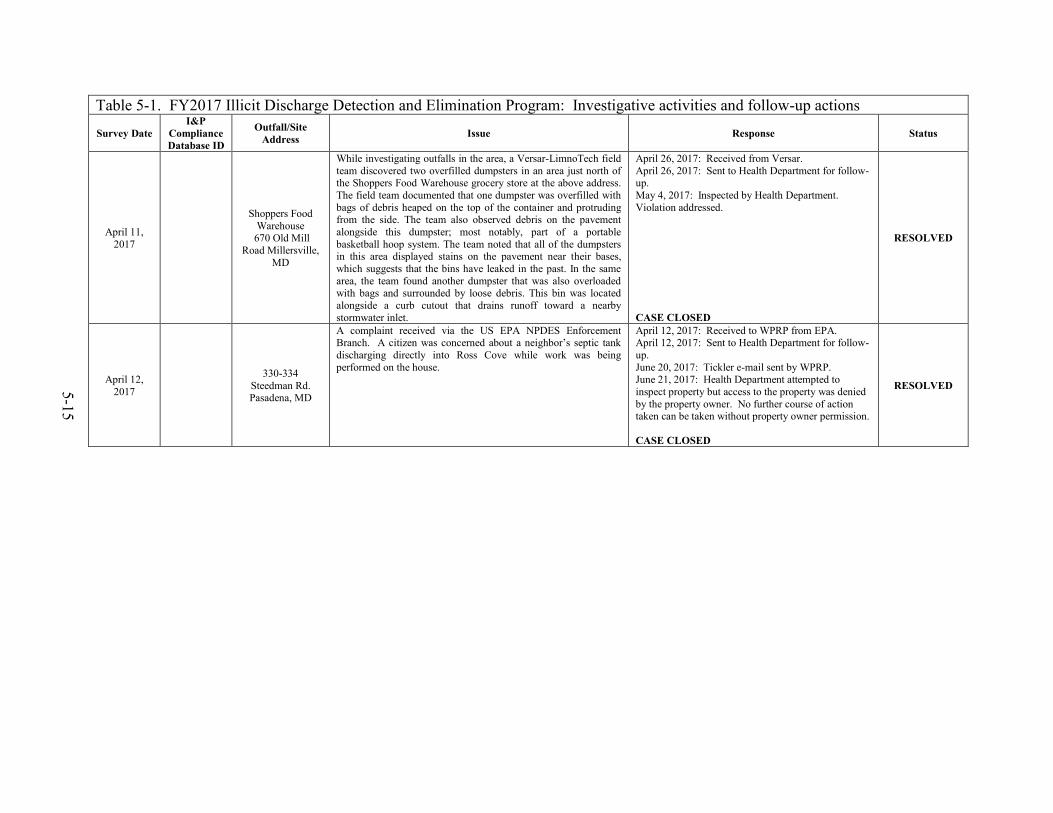
5-15
Table 5-1. FY2017 Illicit Discharge Detection and Elimination Program: Investigative activities and follow-up actions
Survey Date I&P
Compliance Database ID
Outfall/Site Address Issue Response Status
April 11, 2017
Shoppers Food Warehouse
670 Old Mill Road Millersville,
MD
While investigating outfalls in the area, a Versar-LimnoTech field team discovered two overfilled dumpsters in an area just north of the Shoppers Food Warehouse grocery store at the above address. The field team documented that one dumpster was overfilled with bags of debris heaped on the top of the container and protruding from the side. The team also observed debris on the pavement alongside this dumpster; most notably, part of a portable basketball hoop system. The team noted that all of the dumpsters in this area displayed stains on the pavement near their bases, which suggests that the bins have leaked in the past. In the same area, the team found another dumpster that was also overloaded with bags and surrounded by loose debris. This bin was located alongside a curb cutout that drains runoff toward a nearby stormwater inlet.
April 26, 2017: Received from Versar. April 26, 2017: Sent to Health Department for follow-up. May 4, 2017: Inspected by Health Department. Violation addressed. CASE CLOSED
RESOLVED
April 12, 2017
330-334 Steedman Rd. Pasadena, MD
A complaint received via the US EPA NPDES Enforcement Branch. A citizen was concerned about a neighbor’s septic tank discharging directly into Ross Cove while work was being performed on the house.
April 12, 2017: Received to WPRP from EPA. April 12, 2017: Sent to Health Department for follow-up. June 20, 2017: Tickler e-mail sent by WPRP. June 21, 2017: Health Department attempted to inspect property but access to the property was denied by the property owner. No further course of action taken can be taken without property owner permission. CASE CLOSED
RESOLVED

5-16
Table 5-1. FY2017 Illicit Discharge Detection and Elimination Program: Investigative activities and follow-up actions
Survey Date I&P
Compliance Database ID
Outfall/Site Address Issue Response Status
April 12, 2017 E-2017-230
M09E7O014 Oakwood and
Elvaton Roads, Millersville, MD
A Versar field team inspected outfall M009E7O014 near the intersection of Oakwood and Elvaton Roads in Millersville, MD. On the first field visit, Versar staff found cloudy, brown water flowing at the 27-inch reinforced concrete pipe outfall. The crew obtained a sample of the discharge at the mouth of the outfall, to test for illicit discharge indicators. The result for pH indicated a reading slightly below the acceptable range (6.4). The test for ammonia indicated an elevated level of 1.5 mg/l. The field team returned the next day and assessed conditions at the outfall. The team observed that the discharge was clear and flowing. The crew collected a sample of the discharge at the pipe opening. The test results again indicated a low pH level (6.3) and an elevated ammonia level (2). As a consequence of the second set of results indicating potential illicit discharge, the crew conducted a track down of the pipe network. The first manhole up-network from the outfall was located in a busy street (Oakwood Road). The crew decided that the conditions at this location were too dangerous to attempt a screening. The team did not verify the presence of the next manhole in the network, as depicted in the features in the County's digital infrastructure files. Instead, the team gained access to the third manhole, which was adjacent to the cul-de-sac of Argus Lane. Here, the team found and tested water in the system. The results indicated pH levels within acceptable limits (6.76). The test results did not indicate the presence of ammonia. At the fourth manhole in the system the results were similar to those found in the third manhole – acceptable levels for pH and no ammonia. The team concluded that input to the system which changed the water's parameter levels to suggest an illicit condition arose between the inlets at Argus Lane and the outfall. The digital infrastructure files do not illustrate any inlets between the third manhole and the outfall. The team suggested that runoff from the road areas may be influencing the water quality at the outfall.
April 26, 2017: Sent to I&P for investigation. May 1, 2017: I&P inspector tested water at the outfall; found pH level within acceptable range (6.5). May 2, 2017: I&P inspector re-tested water at the outfall; found pH level within acceptable range (7.0). County testing does not include ammonia, so unable to substantiate report of elevated ammonia. CASE CLOSED
RESOLVED

5-17
Table 5-1. FY2017 Illicit Discharge Detection and Elimination Program: Investigative activities and follow-up actions
Survey Date I&P
Compliance Database ID
Outfall/Site Address Issue Response Status
April 13, 2016 E-2017-213
R20B5O001 Forest Drive and Solomon's Island
Road Parole, MD
A LimnoTech field team inspected outfall R20B5O001, near the intersection of Forest Drive and Solomon's Island Road in Parole, MD. The configuration of this outfall consisted of one headwall with three pipe openings. On the first field visit staff found flowing water at the 48-inch reinforced concrete pipe outfall at the rightmost pipe opening. The team assessed the discharge as cloudy water with an orange silty deposit (possibly iron floc) and an oily sheen. The crew obtained a sample of the discharge at the mouth of the outfall, to test for illicit discharge indicators. The result for pH indicated a reading below the acceptable range (5.9). The tests for ammonia and copper indicated elevated levels (7.5 and 0.4, respectively). The field team returned the same day, after a four-hour interval, and assessed conditions at the outfall again. The team observed that discharge was clear, with some sediment, but was otherwise relatively unchanged from the initial visit. The crew collected a sample of the discharge at the pipe opening. The test results again indicated a low pH level (5.8) and elevated ammonia and copper levels (5 and 0.4, respectively). As a consequence of the second set of results indicating potential illicit discharge, the crew conducted a trackdown of the pipe network. The crew members found the system dry at the one up-network inlet that they could find.
April 18, 2016: Received from Versar. April 19, 2017: Investigated by I&P. Inspector canvassed Parole Town Center complex and surrounding area, including manhole inlets, bio-retention and SWM ponds, dumpsters, and surrounding grounds. Trash/leaves clogging drain inlet, as well as grease spill, were observed behind Whole Foods business. April 21, 2017: Correction notice sent to property owner and Whole Foods manager. Health Department notified, who in turn notified MDE. MDE closed complaint since no grease observed entering storm drain. May 4, 2017: Joint investigation by I&P and Versar staff. Field test results indicated pH was 7.09 and ammonia was 0 ppm (both within acceptable limits). CASE CLOSED
RESOLVED
April 13, 2016 E-2017-213
R20B5O005 Forest Drive and Solomon's Island
Road Parole, MD
A LimnoTech field team inspected outfall R20B5O005, near the intersection of Forest Drive and Solomon's Island Road in Parole, MD. On the first field visit, at 11:06 a.m., staff found flowing water at the 42-inch reinforced concrete pipe outfall. The team assessed the discharge as cloudy water with algae growth. The crew obtained a sample of the discharge at the mouth of the outfall, to test for illicit discharge indicators. The result for pH indicated a reading below the acceptable range (5.9). The test for ammonia indicated an elevated level of 2.5 mg/l. The field team returned the same day, after a four-hour interval, and assessed conditions at the outfall again. The team observed that discharge was clear, but was otherwise relatively unchanged from the initial visit. The crew collected a sample of the discharge at the pipe opening. The test results again indicated a low pH level (5.8) and an elevated ammonia level (5.0). As a consequence of the second set of results indicating potential illicit discharge, the crew conducted a trackdown of the pipe network. At the first inlet up the network, the crew found the system wet but not flowing. At the nearby second inlet, the crew found dry conditions.
April 18, 2016: Received from Versar. April 19, 2017: Investigated by I&P. Inspector canvassed Parole Town Center complex and surrounding area, including manhole inlets, bio-retention and SWM ponds, dumpsters, and surrounding grounds. Trash/leaves clogging drain inlet, as well as grease spill, were observed behind Whole Foods business. April 21, 2017: Correction notice sent to property owner and Whole Foods manager. Health Department notified, who in turn notified MDE. MDE closed complaint since no grease observed entering storm drain. May 4, 2017: Joint investigation by I&P and Versar staff. Field test results indicated pH was 7.09 and ammonia was 0 ppm (both within acceptable limits). CASE CLOSED
RESOLVED

5-18
Table 5-1. FY2017 Illicit Discharge Detection and Elimination Program: Investigative activities and follow-up actions
Survey Date I&P
Compliance Database ID
Outfall/Site Address Issue Response Status
April 14, 2017
8328 Veterans Highway,
Millersville, MD
A Versar field team discovered inadequate waste management conditions in the parking lot of the Chesapeake Plaza. The field team documented that one dumpster was overfilled with debris piled around it. The dumpster had a painted sign on it that suggested that it was used by staff with the X-Press Floors business (X-Press Floors Plus). The debris on and around the dumpster included sheets of plywood, rolls of waste carpet and padding, and long tubes.
April 26, 2017: Received from Versar. April 26, 2017: Sent to Health Department for follow up. May 8, 2017: Investigated by Health Department. No violations cited. CASE CLOSED
RESOLVED
April 14, 2017
Old Mill Plaza 285 Old Mill
Road, Millersville, MD
A Versar field team discovered inadequate cooking grease storage conditions in the parking lot behind the Old Mill Plaza, located at the above address. The storage container displayed a label identifying the contents as waste kitchen grease. The field team documented that waste grease distributed on the pavement appeared to be associated with the grease bin, which may indicate a leak or a spill.
April 26, 2017: Sent to Health Department for follow-up. May 10, 2017: Investigated by Health Department. Inspectors found spilled grease was cleaned up and no further violations cited. CASE CLOSED
RESOLVED
April 14, 2017 E-2016-311
F09G5O01 2631 Annapolis
Rd. Hanover, MD
While investigating outfalls in the area, a Versar field team discovered blocked infrastructure near the Shell gas station and car wash, located at 2631 Annapolis Rd. The team identified the headwall for the outfall (F09G5O001) and noted that the pipe opening was clogged with plant debris. The photo-documentation shows evidence that someone had intentionally placed sticks at the outfall opening, perpendicular to the direction of the pipe. The photograph also illustrates that someone had cut through a tree trunk near the outfall, but had let the tree fall without cutting the trunk into smaller sections. The team surmised that the extent of the blockage observed would effectively impede flow from the stormwater network, which was intended to drain the Shell station parking lot. The crew assessed that the pipe structure would require maintenance to clear the accumulated material and restore adequate flow to the system. Note that Versar staff reported this condition to the County in 2016, also, as an element of an illicit discharge report.
April 26, 2017: Received from Versar. April 26, 2017: Sent to Public Works for follow-up. Informed Public Works that the outfall is owned by County and that Versar team found blocked outfall while performing a site visit to confirm that a previous illicit discharge had been eliminated. April 27, 2017: Work Order requested for Northern District to clear outfall inlet. April 27, 2017: Public Works learned that outfall is located on either SHA or private property. May 5, 2017: Public Works corrected outfall ownership in CSDS system. May 5, 2017: Sent to I&P for further investigation. May 9, 2017: Investigated by I&P who reopened old case file. Property manager was advised to make the necessary repairs. June 9, 2017: Follow up inspection by I&P. No action has been taken by property owner. July 10, 2017: Follow up inspection by I&P. No action has been taken by property owner. August 29, 2017: Inspector contacted the property owner and advised them to do the necessary repairs. The property owner has agreed to make the necessary repairs. Awaiting property owner to hire a contractor to execute. CASE OPEN
UNRESOLVED

5-19
Table 5-1. FY2017 Illicit Discharge Detection and Elimination Program: Investigative activities and follow-up actions
Survey Date I&P
Compliance Database ID
Outfall/Site Address Issue Response Status
May 1, 2017 E-2017-251
M08E8O006 200 Hospital Drive, Glen Burnie, MD
Versar staff found outfall M08E8O006 backed up but slightly flowing. The team noted that the discharge was opaque and brown and had a foul odor; team members initially detected a chemical smell and later noted the odor of sewage. Sample results of the discharge indicated an above-action level of detergent (0.75 mg/l) and excessive ammonia (>30 mg/l) levels. The field team returned four hours later to assess conditions at the outfall and observed that the discharge conditions were similar to those documented in the morning, and the sewage odor was even stronger. Sample results again indicated elevated detergent (0.75) and excessive ammonia (> 30) levels. As a consequence of the second set of results indicating potential illicit discharge, the crew conducted a trackdown of the pipe network. According to the features in the County's digital infrastructure files, the outfall receives flow directly from the channel on the north side of Hospital Drive, in front of the building at the 200 address. The team documented that the channel received flow input from outfall M08E8O003 (which was dry) and a small 12-inch, reinforced concrete pipe that emerged from the side of the channel downstream of the outfall. The small pipe feature is not shown in the County's digital data; as such, its purpose and connections are yet unknown. The team presumed that the small pipe transported flows from the direction of the building at 200 Hospital Drive, based on the orientation of the visible portion of the pipe. Test results of the discharge at the small pipe indicated the same concentrations of fluoride, detergents, and ammonia as documented in the outfall sample (0.4, 0.75, and >30, respectively). The crew noted that the effluent emitted a strong sewage odor and displayed suds in the sample. Effluent from the small pipe entered the culvert under Hospital Drive soon after emerging in the channel. The crew searched for but did not find signs of a sewer line in the area near the pipe.
May 4, 2017: Received from Versar. May 10, 2017: Investigated by I&P. Investigator made same observations as Versar team. Investigator obtained property manager and will set up meeting to further investigate illicit connection. May 25, 2017. Investigator reviewed site plans/construction drawings with JLL’s chief engineer to determine origins of unknown 12” pipe. Plans pre-dated pipe. Further investigation to take place after 3 days dry weather. June 2, 2017: I&P Investigator observed flow from 12” pipe. Did not take sample due to less than 72 hours since last rainfall. Inspector will meet with JLL engineer at later date to determine illicit connection. June 12, 2017: Follow up inspection by I&P. Inspector had JLL engineer turn on all taps in building and flush multiple toilets. No increased flow observed at pipe in question. Engineer shut off cooling tower overflow drain. After approximately 10 minutes, flow at pipe ceased. Directed property management to have cooling tower overflow drain redirected to gray water/sanitary sewer. June 27, 2017: Follow up inspection by I&P. No update on situation. No active or recently completed plumbing permit found. Violation has not yet been resolved. July 31, 2017: Follow up Inspection by I&P. Unable to determine if violation still exists due to wet conditions. Will re-inspect after 72-hr dry period. August 11, 2017: Follow up Inspection by I&P. Minimal flow observed. Further investigation required. CASE OPEN
UNRESOLVED
May 9, 2017 E-2017-274 413 Headquarters
Drive, Millersville, MD
A Versar field team discovered inadequate waste management conditions at the edge of the parking lot east of 413 Headquarters Drive, in Millersville. The field team documented an uncovered pile of road salt on the pavement near a stormwater inlet. The team noted that a tarp and concrete blocks were on the pavement immediately adjacent to the pile. The placement of salt on an impervious surface introduces the risk of distribution of salt particles and associated nutrients — by wind, rain, or physical disturbance —to the adjacent storm drain inlet.
May 15, 2017: Hotspot report received from Versar. May 16, 2017: Hotspot report forwarded to I&P. May 17, 2017. Investigated by I&P. Investigator contacted property owners, who told inspector that landscaping contractors would re-cover the salt pile by the end of the day. May 19, 2017. I&P performed re-inspection and found salt pile was securely covered with tarp and concrete blocks. May 22, 2017. I&P conducted final inspection and found the salt pile to be properly stabilized. CASE CLOSED
RESOLVED

5-20
Table 5-1. FY2017 Illicit Discharge Detection and Elimination Program: Investigative activities and follow-up actions
Survey Date I&P
Compliance Database ID
Outfall/Site Address Issue Response Status
May 9, 2017 413 Headquarters
Drive, Millersville, MD
A Versar field team discovered inadequate waste management conditions at the edge of the parking lot east of 413 Headquarters Drive, in Millersville. The field team documented two open and overfilled dumpsters on a gravel pad on the ground adjacent to the parking lot. The dumpsters had various types of debris scattered around them, including wood pallets, cardboard, and a small mattress. The particles were placed in an area up-gradient from a stormwater wet pond and thus had the potential for direct transport into County waterways.
May 15, 2017: Hotspot report received from Versar. May 16, 2017: Hotspot report forwarded to Health Department. May 19, 2017: Health Department conducted inspection, found dumpster full but not overflowing. Pallets had been removed. The contractor assured the inspector that the dumpsters were emptied twice per week. No violations cited. CASE CLOSED
RESOLVED
April 11, 2017
8201 Cloverleaf Drive
Millersville, MD
A Versar field team discovered bulk solid storage issues associated with the business, Aireco Supply, Inc., located at the above address. According to the company's Web site, the business sells (wholesale) supplies related to heating, ventilation, air conditioning, and refrigeration (HVACR). The field team investigated a storage area adjacent to the parking lot near the main business entrance. The storage area was segregated from the parking lot by a fence but the pavement spanned the entire area. The team documented that the storage area contained numerous discarded pressure tanks. From a vantage point outside of the fenced lot, the team observed that some of the pressure tanks had rusting holes where they had been punctured. The team also noted an open bin of discarded materials stored in the open.
April 26, 2017: Received from Versar. April 26, 2017: WPRP staff consulted with Planning and Zoning, Zoning Enforcement, regarding case. Zoning Enforcement stated that the site’s zoning classification (C-4) allows for outside storage, and that the accumulation of materials does not warrant a citation. CASE CLOSED
RESOLVED
June 9, 2017 N. Mesa Road Millersville, MD
While investigating outfalls in the area, a Versar field team discovered evidence of severe erosion downstream of outfall M12E4O001, which is located behind the residence at 756 North Mesa Road. The team documented conditions near the outfall with photographs. Patterns of bank gouging in the area just downstream of the pipe opening suggested that this area had received significant runoff flows over time. There is significant down-cutting to the right of the outfall pipe, where a sheet of plastic is now exposed. As the channel became established over time, the force and volume of water eroded the soil under the vegetation, exposing some roots. At the time of the field visit, the team documented that the channel had widened beyond the original path of riprap installed to slow the force of the discharge. The team observed other areas of erosion downstream, which suggests that the force of the discharge continues to be significant enough to cause damage further down the course.
June 20, 2017: Received from Versar. June 20, 2017: Sent to IMD for follow up. July 25, 2017: Infrastructure Management (IM) has added the outfall to the correction/maintenance project list for FY 18. IMD will repair the structure to include the limits of the perceived outfall and provide a transition back to the existing channel. CASE CLOSED
RESOLVED

5-21
Table 5-2. Follow-up and Resolution of Past Unresolved IDDE Cases Survey Date
I&P Compliance Database ID
Outfall/Site Address Issue Response Status
December 10, 2015 8854 Woodland
Manor Drive
While investigating outfall B11F5O001 for the County dry weather screening effort, a Versar field team discovered collapsed infrastructure at the outfall, located to the east of Woodland Manor Drive behind the above address. Three evident sections of the large reinforced concrete pipe were found separated from each other; the end section and second section were completely disconnected from the third section which was still embedded in the ground. The wingwall-style end section was lying in the lower receiving bed, misaligned with the second section. The field team documented erosion around the third section; significant erosion at the site likely created the pit that now holds the disconnected sections. The field crew also documented an eroded bank opposite the end section.
December 18, 2015: Sent to Infrastructure for their follow up. March 22, 2016: Follow up sent to IMD. April 8, 2016: Investigated by IMD. Will confirm that pipe is within County easement. May 19, 2016: Email received from IMD. Site determined to be County infrastructure. Staff instructed to develop estimate for repairs. July 13, 2016: IMD update states that they are seeking a bid to repair this problem. Repair likely to occur in winter of 2016 or spring of 2017. IMD will notify WPRP when repairs are completed. June 22, 2017: Tickler e-mail sent to IMD. June 28, 2017: IMD reported that repairs to the outfall were completed in March 2017. CASE CLOSED
RESOLVED
December 10, 2015 E-2016-396
1742 Disney Road (Provinces Park)
Severn, MD
While investigating outfalls in the area, a Versar field team discovered an uncovered pile of sand and sediment that had been deposited on a corner of a parking lot in Provinces Park, an Anne Arundel County Parks and Recreation facility. The field team documented that the pile of sand and sediment was located immediately adjacent to a storm drain inlet. The location of the pile partially blocks intended flows to the inlet; flows are also partially blocked by storage trailers in the same section of the parking area. Material from the pile may be dislodged by disturbances from humans, animals, or rain; this material may then enter the storm drain system and transport associated metals and nutrients to the system and contribute occluding bulk material to the pipes and downstream areas.
December 18, 2015: Sent to I&P for follow up. December 21, 2015: I&P sent complaint to North County Grading Supervisor for follow up. March 22, 2016: Follow up sent to I&P, NCGS. June 1, 2016: Follow up sent to I&P. July 18, 2016: Follow up sent to I&P. July 21, 2016: I&P requests information again. July 25, 2016: I&P sent Versar report. July 26, 2016: Case has been opened. November 10, 2016: Awaiting response from Recreation and Parks Maintenance Contractor. January 6, 2017: Pile has been moved and is no longer obstructing path of water to catch basin. CASE CLOSED
RESOLVED
March 2, 2016 Z-2017-966 Rear of 2739
Annapolis Road
While investigating a potential hotspot at another property, a Versar field team noted several pieces of discarded bulk items/trash along an access road located between 2739 and 2747 Annapolis Road. At the time of the visit, the field team documented dirty conditions in the gutter pans and much staining, indicating that the road is frequently used for parking trucks. On a vacant lot on the east side of the road, the field team found many pieces of general trash, including large cardboard boxes. A storage area on the property located toward the end of the access road possibly belongs to Nationwide Tire Recyclers. On the west side of the road, the team found and documented a discarded sofa. Though the material is not placed on impervious surfaces, it constitutes a general pollution problem with the potential for blowing into the
March 7, 2016: Received from Versar. March 8, 2016: Sent to IMD for their review. March 9. 2016: IMD suggests Road Ops for this issue. March 22, 2016: Sent to Road Ops for their review. March 22, 2016: Road Ops says this is a private road, so they would not provide cleanup. June 26, 2017: Investigated by WPRP staff. Personnel on site stated to WPRP staff that tire cleanup has been in progress for the last week. West side of private road was free from debris; Many large debris items remained on the east side of the road, including furniture, pop-up canopies, a rusted 55-gallon drum, 5 gallon buckets, and general trash. June 26, 2017: Sent to Zoning for follow-up; zoning compliance case opened.
UNRESOLVED

5-22
Table 5-2. Follow-up and Resolution of Past Unresolved IDDE Cases Survey Date
I&P Compliance Database ID
Outfall/Site Address Issue Response Status
March 2, 2016
(Continued)
roadway with eventual travel to the storm drain system and surface water. The source of the material and the ownership of the vacant lot could not be determined at the time of the field visit.
September 12, 2017: Zoning inspected site, observed trash/debris. Notice being sent to property owner. CASE OPEN
January 5, 2016 E-2016-0306 2633 Rockenbach
Road
While investigating outfall F09F5O001, on the east side of the Ridgeview Plaza Shopping Center, a Versar field team observed signs of destructive runoff forces at the outfall. On the southeast side of the outfall, the rocks and plastic of the rip rap, intended to stabilize the bank, had been dislodged and pushed downstream. The flared end section of the outfall on the same side showed signs of crumbling during the field visit. Also, the erosion had started to undercut the outfall, so that the opening was found to be no longer fully supported underneath. The force of the runoff coming out of the pipe had eroded the opposite bank, exposing tree roots. The hydrology of the outfall's flow may have been altered over time, in part by the collected rocks in the plunge pool, so that it now follows a path toward the trees on the left before returning to the intended alignment.
February 1, 2016: Received from Versar. February 9, 2016: Sent to IMD. March 1, 2016: Follow up sent to IMD. March 21, 2016: IMD reports this is not their issue as they think it’s in an SHA ROW. March 22, 2016: Sent to SHA for their review. March 28, 2016: SHA reports that this is not in their ROW. May 31, 2016: Sent to I&P for possible follow up. June 3, 2016: I&P reports case not open yet. Research about site underway. July 18, 2016: Follow up sent to I&P. July 21, 2016: Case has been opened. Extensive erosion reported by I&P during inspection. Waiting for property owner response. August 30, 2016: Inspector met with property manager on-site to discuss remediation. March 10, 2017: Remediation work has begun. March 22, 2017: Outfall has been repaired. Riprap has been added downstream of the outfall to prevent future erosion. Site has been stabilized with seed and straw mulch. CASE CLOSED
RESOLVED
March 3, 2016 E-2016-0093 1710 Midway
Road
A Versar field team investigated the site of a paving operation along the front of the long warehouse on the right side of Midway Road (1710) and found two piles of material deposited on impervious surfaces near the paving area. The team found a pile of sand in the southeast corner of the parking lot. There was evidence that vehicles had dispersed some of the sand throughout the parking lot. The team also found a pile of crushed concrete along the edge of the cul-de-sac of Midway Road. The location of this material presents more of a concern than the sand because there is a grated storm drain inlet downgrade of the cement. The team noted that tire tracks on the ground above the inlet imply that trucks may be using this area for turning or backing into the warehouse docks, and thus routinely disturbing the soil immediately adjacent to the storm inlet. Team members photo-documented the relative location of the concrete to the inlet. The Versar team surmised that if paving crews were still active in the area these materials may yet be removed, in due course of company business on the site; however, the proximity of
March 7, 2016: Received from Versar. March 8, 2016: Sent to I&P. March 10, 2016: Inspection by I&P finds active work and improvements on-going. Work will be monitored until completed. June 1, 2016: Follow up sent to I&P. June 8, 2016: I&P inspector met with owner. Owner is in process of finding new contractor to complete work. I&P will continue monitoring site. June 30, 2016: Repairs underway. I&P monitoring continues. Review due on July 29. July 21, 2016: Follow up by I&P reports that repairs are under way and that I&P continues to monitor site. July 25, 2016: I&P reports that a site visit on July 20 revealed that all asphalt repairs have been made.
RESOLVED

5-23
Table 5-2. Follow-up and Resolution of Past Unresolved IDDE Cases Survey Date
I&P Compliance Database ID
Outfall/Site Address Issue Response Status
March 3, 2016
(Continued)
The concrete to the storm inlet, and the potential of uninhibited concrete particles entering the storm drain after disturbance from routine heavy truck maneuvers at the site, denote a significant concern. Lighter particles of concrete, and the component materials (including the possibility of lead), may also enter the storm drain with rain and wind events.
CASE CLOSED
April 21-22, 2016 E-2016-0208 601 Hammonds
Ferry Road
A Versar field team inspected outfall K02B8O002, which is located in a stormwater retention pond east of the parking lots for 601 and 611 Hammonds Ferry Road. At the outfall's 27-inch round concrete pipe, the team observed a small amount of shallow flowing water. The flow from the outfall was slightly impeded by leaves and debris in the outfall channel. The team also noted persistent iron flocculent along the water line. The team extracted a sample of the discharge with a syringe and tested the water for contaminant; test results showed an above-action-level concentration of detergents (0.5 mg/L). The field crew investigated the associated parking lots for active washing or dumping activity; the team did not observe any such evidence on the day of the first visit. Versar staff visited the site the following day and again found conditions at the target outfall similar to those observed during the previous visit. The team acquired a water sample of the flowing effluent and tested it for contaminants; test results indicated an above-action-level concentration of detergents (0.75 mg/L). Due to the elevated results, the team initiated a trackdown to search for a source within the network. The team followed the outfall's drainage line to a yard grate, in the parking lot between the buildings at 601 and 611 Hammonds Ferry Road, where two drainage lines converged. Both pipes exhibited very low discharges. The team collected samples from both of the pipes and tested the water specifically for concentrations of detergents. The discharge from the southwestern pipe opening, which is the output from the drainage line running between the buildings at 601 and 611 Hammonds Ferry Road, had a detergent concentration of 0.35 mg/L. The discharge from the northwestern pipe, which drains the north parking lot, behind the building at 611 Hammonds Ferry Road, had a layer of algae and a detergent concentration of 0.50 mg/L. In the parking lot near the yard grate, the team noticed a personal vehicle surrounded by damp pavement, and a visible line of water draining to the curb inlet just above the target outfall in the network. An employee of Valley Lighting (one of the businesses occupying the building at 601 Hammonds Ferry Road) stated that he had given the
April 27, 2016: Received from Versar. April 29, 2016: Sent to I&P June 1, 2016: Follow up sent to I&P. June 3, 2016: I&P reports that inspection performed on April 29. Flow was observed, but a source could not be determined. Each tenant in the building was briefed that vehicle washing with soap was not permitted and that a fleet washing service that collected all water before it reached the stormdrain was required. All were informed that this applied to personal vehicles, too. Follow inspection scheduled for May 11. June 7, 2016: I&P asked about status of follow up inspection. June 27, 2016: Follow up inspection found high levels of detergent, but unclear about source. Will continue to visit site to determine source. Retest scheduled for July 28. July 21, 2016: Re-inspection planned for August 18. November 4, 2016: Inspector reports that no water/flow was observed at the inflow/outfall pipe in question during inspection on November 4. Washing activities at site believed to have ceased.
RESOLVED

5-24
Table 5-2. Follow-up and Resolution of Past Unresolved IDDE Cases Survey Date
I&P Compliance Database ID
Outfall/Site Address Issue Response Status
April 21-22, 2016
(Continued)
car "a quick rinse." The team did not detect signs of soap in the residual dampness in the parking lot. From the drainage intersection, the team followed the northwest and southwest drainage lines up to the next inlets and found both of these inlets to be dry; this suggests that water may be infiltrating the drainage system underground between these inlets and the intersection where the team observed flowing water. The field team surmised that it is more likely that, due to the very small amount of discharge in the system, the observed discharge was the last remnants of past washing activity in the parking lots of 601 and 611 Hammonds Ferry Road.
CASE CLOSED
April 26-27, 2016 E-2016-0206
1741 West Nursery Road
(Aloft BWI Hotel)
A Versar field team inspected target outfall J04A7O026new2 at the Aloft BWI Baltimore Washington International Airport Hotel. Versar staff selected this site for a revisit in 2015; site assessments in June 2014 documented pH levels above the action-level criterion and the presence of exposed trash at the site. In 2016, the field crew observed flowing water at the outfall on the first visit. The crew collected a sample of the effluent to test for illicit discharge indicators. The result for pH indicated a reading above the acceptable range (9.55). The Versar team returned the next day and collected a sample of the flowing effluent. The result for pH on the revisit indicated a reading above the acceptable range (10.99). Due to the pH result out of the acceptable range, the team initiated a trackdown of the network to attempt to locate a possible source. Note that the storm water infrastructure network on this lot was not available as a digital file to guide the field team; the descriptions of the trackdown include details that informed a draft sketch of the possible network, which is included in this report. At the first manhole up-network from the outfall (MH1; the manhole provided access to a junction of three pipes), the team observed flowing water from the pipe entering from the north; the pipe exhibited a white mineral build-up. The team obtained a sample from the north pipe; test results indicated a pH of 11.23 (and chlorine levels unchanged from the levels at the outfall, at 0.1). The team proceeded to track the drainage line to the next probable access point – a curb inlet at the south end of the parking lot (CI1. The team extracted and tested the water from this location and found a pH level of 8.53 and a chlorine level of 0.1. From the marked difference in pH readings and flow volume, the team determined that this curb inlet was not in line with the main (north) pipeline, and likely connects to the main line north of the first manhole. The team tracked the more likely main drainage line to a manhole in the northwest corner of the parking lot; there, the team found flowing water with a slurry of mineral deposits. The team also noted that the walls in this manhole were seeping. The team tested the flowing water and found a pH reading of 11.84; the similarity of this pH reading and flow condition confirmed an in-line connection with the pipe in the manhole at the south end of the parking lot, so the team continued to search this line and collect samples for pH levels. At the next upstream manhole in the system, the team observed a similar slurry of
May 3, 2016: Received from Versar. May 5, 2016: Sent to I&P. June 1, 2016: Follow up sent to I&P. June 3, 2016: I&P reports that inspection occurred on April 29. Property owner informed about issues. Re-inspection planned for May 6 to follow up on illicit discharge. Other items to be corrected by June 1. June 7, 2016: Inquiry sent to I&P to see if follow up inspections made. June 27, 2016: I&P re-inspected site today. Evidence of sanitary sewer connection to storm drain observed. Investigation continues. July 18, 2016: Follow up sent to I&P. July 21, 2016: I&P reports that they are still working with property owner to resolve issue. November 4, 2016: During inspection on November 4, inspector notes that all corrective items have been made.
RESOLVED

5-25
Table 5-2. Follow-up and Resolution of Past Unresolved IDDE Cases Survey Date
I&P Compliance Database ID
Outfall/Site Address Issue Response Status
April 26-27, 2016
(Continued)
mineral deposits in the shallow water, and continued to the next access point – a yard grate near the northeast corner of the parking lot. There, the team discovered excessive seepage in the walls of the catch basin and more evidence of accumulating mineral deposits in the draining water; the crew noted that the concrete frame supporting the grate was soft and crumbling. Within the catch basin, the team observed a 4-inch black PVC pipe leading from the eastern edge of the parking lot that delivered flowing water to the network. As team members attempted to determine the origin of the small pipe, they entered the woods and discovered a pipe end in a wet, muddy, grass area. The team surmised that this area may constitute a French drain installed to remove excess water from the ground. The pH of a water sample collected at the entrance to this pipe was 11.95 in the field test. The team returned to the first manhole and proceeded to track the drainage lines around the southern boundary of the parking lot. The water sample taken from the manhole to the east of the first manhole had a pH reading of 10.2; a water sample collected from a curb inlet on the southern edge of the parking lot revealed a pH of 11.44. The team also documented that ground water seeps into the parking lot on the east side of the hotel; trench drains along the edge of the parking lot probably help to move this water off the lot (Figure 6). The team found correlated evidence from several sources and four field visits that the hotel stands on a very porous, possibly high pH, soil, and that the lot receives ground water flow from a spring of very high pH water at the eastern (rear) side of the property. On both main storm drain lines, the team members traced pH values increasing as they approached the back side of the hotel property.
CASE CLOSED
April 26-27, 2016 E-2016-0234 7621 Energy
Parkway
A Versar field team inspected outfall Q06H3F002new2, located east of the warehouse at 7621 Energy Parkway, on April 26. A field crew had previously visited this outfall in 2013. The 33-inch, reinforced concrete pipe outfall discharged to a large wet pond. The team found flowing water in the outfall; the effluent showed evidence of iron flocculent, bacterial growth, and a surface sheen. The effluent also emitted a sulfur odor. The field staff carefully collected a sample of clear discharge at the outfall to test for possible illicit discharge constituents. Phenol levels tested above the acceptable range for the sample taken on the first site visit (4 mg/l). Staff members returned to the site the following day and found conditions at the outfall similar to the observations made the previous day. They again observed and tested flowing water at the outfall. Phenol levels were again above the acceptable range. Due to the presence of elevated contaminant levels combined with characteristics of concern (odor and excessive iron), the field crew initiated a trackdown on the site to attempt to isolate the source of the phenols. The team tested flowing water in the parking
May 10, 2016: Received from Versar. May 12, 2016: Sent to I&P. May 16, 2016: I&P inspector contacted MDE WMA technical staff for guidance on possible sources of phenols. MDE states that fly ash likely not source of phenols observed at site. June 1, 2016: Follow up sent to I&P. June 2, 2016: Versar plan s retest at end of June. Details about site obtained from I&P the next day. June 3, 2016: I&P reports that inspection performed on May 13. Could not discern if illicit discharge occurring due to active precipitation. Inspection evaluated stormdrain system on site. Has requested that Versar retest the area using the construction drawing provided by property owners. Will revisit site following retest. June 14, 2016: Versar retuned to retest site. Illicit discharge observed that caused an atypical reaction in the phenols test. Narrowed down possible locations for the discharge and provided that information to I&P via an email report.

5-26
Table 5-2. Follow-up and Resolution of Past Unresolved IDDE Cases Survey Date
I&P Compliance Database ID
Outfall/Site Address Issue Response Status
April 26-27, 2016
(Continued) E-2016-0234 7621 Energy
Parkway
lot grate closest to the outfall, in the southeast corner of the parking lot; the test results did not detect phenols. The team searched the lot for evidence of additional pipes entering the system that may be contributing to the flows, but did not discover any such infrastructure. As the flow at the nearest grate was significantly lower than the flows observed at the outfall, the team considered that there may be infiltration of groundwater into the pipe as it passes under the adjacent field, before discharging to the pond. The team searched for an indication of the pipe's route between the parking lot grate and the outfall; without such evidence, the assumption is that the pipe directly connects the two access points in a straight line without a deviation in the path. As part of the site evaluation, the team documented the presence of a sign announcing a potential future use of the property as a fuel storage site. The team noted that the field contained PVC pipe markers for wells. Research conducted for this report revealed that the lot at 7621 Energy Parkway had been used as a fly ash disposal site by Baltimore Gas and Electric Company between 1982 and 1992. In 1997, property modifications added an impervious cap for the majority of the disposal area, in the form of a large warehouse and associated parking area. The extent to which the presence of a capped fly ash disposal site may influence the phenol levels recorded in the outfall screening tests is unknown.
June 16, 2014: I&P having difficulty determining actual source of discharge. Asked if Versar has ability to do video inspection of system to find discharge. June 20, 2016: Asked Versar about their video pipeline inspection capabilities. Awaiting answer. June 22, 2016: Coordinated with I&P and IMD to use IMD’s open end agreement for video inspection. July 7, 2016: Re-inspection by I&P confirmed high phenols. Video pipe inspection had not occurred as of this date. July 11, 2016: Email from MS4 Project Manager at Versar confirms that they do not have video inspection capabilities. July 18, 2016: Follow up sent to I&P. July 21, 2016: I&P reports work continues. Next inspection planned for August 8. November 2, 2016: Inspection performed. Next inspection planned for December 5. December 12, 2016: Video scope inspection of pipe revealed no illicit connections or severely disconnected joints. Phenols believed to be entering system via groundwater at pipe joints. Inspector awaiting results of sample analysis from outlet structure of DPW-OMD pond. February 23, 2016: Analysis results of samples taken at outlet structure and initially-tested inflow pipe show Phenols below action level. WPRP-NPDES MS4 Senior Planner recommends closing case. CASE CLOSED
RESOLVED

5-27
Table 5-2. Follow-up and Resolution of Past Unresolved IDDE Cases Survey Date
I&P Compliance Database ID
Outfall/Site Address Issue Response Status
May 10 and 27, 2016 E-2016-0279 881 Elkridge
Landing Road
A Versar field team inspected outfall, I04F3O014, located west of the National Security Agency offices at 881 Elkridge Landing Road. Field crews had visited this site in May 2015; the discharge at the outfall on the previous year's visit exhibited above-action-level concentrations of detergents. On May 10, 2016 field staff observed flowing water at the outfall. Field staff collected and tested a sample of the discharge at the outfall; results indicated above-action-level detergent concentrations (0.75 mg/l). Staff members returned to the site at the next opportunity (that is, a sampling period with a preceding 72 hours of dry weather) – May 27, 2016. They again observed flowing water at the outfall. The tests on the discharge showed above-action-level concentrations of detergents (0.6 mg/l). The team initiated a trackdown of the system to identify the source of the flow. The digital infrastructure data provided by County staff includes one manhole and two curb inlets in the stormwater conveyance system leading to the outfall. Field staff found evidence that there are more elements to the network than the digital data indicate. The field crew inspected the manhole and found two inlet pipes; one was a large concrete trunk line pipe which was dry, and one was a smaller black pipe which had flowing effluent from the direction of the first curb inlet. The crew proceeded to the next access point, the first curb inlet. This inlet also displayed two input pipes; one pipe leading from the second curb inlet (northeast) had flowing effluent, and one pipe conveying flow from the southeast was damp. The field crew inspected the second curb inlet, which is the easternmost extent of the stormwater infrastructure network according to the County's data set. The crew found a small PVC pipe contributing flowing effluent to this inlet from a source to the east. The crew tested this effluent for detergents; results showed concentrations above action levels (0.8 mg/l). Due to security constraints at the guarded National Security Agency facility, the field crew did not attempt to track the source of this small PVC pipe; consequently, the team did not identify the source of the flowing discharge.
June 1, 2016: Received from Versar. June 2, 2016: Sent to I&P for follow up. June 2, 2016: Inspection by I&P found flow from parking lot drains. Inspector notes that he plans to meet with property owner to determine source of flow. July 18, 2016: Follow up sent to I&P. July 21, 2016: Work continues by I&P. November 4, 2016: I&P performs site visit. Inspector suggests another visit in which all taps in building are opened to observe if flow increases at inlet in question. November 18, 2016: I&P performs site visit. Inspector observes no flow at inlet in question after all taps in building opened. Inspector believes that the flow (and presence of detergents) is a coincidence with summertime washing of the mechanical systems on the roof, and/or the result of the conditions of infiltrating groundwater. CASE CLOSED
RESOLVED
June 8, 2016 E-2016-0311 2631 Annapolis Road (MD 175)
A Versar field team inspected outfall F09G5O001, south of the Shell gas station and car wash facility at the corner of Annapolis Road (Maryland Route 175) and Rockenbach Road in Hanover. Versar staff had inspected a larger, associated outfall nearby (F09F5O001) in 2015, and found high detergent levels in the system. On the first field visit the crew discovered that the outfall was blocked
June 15, 2016: Received from Versar June 15, 2016: Forwarded to I&P for further investigation. July 18, 2016: Follow up sent to I&P. July 19, 2016: Meeting between property owner and I&P inspector. Work is being contracted out by property owner. I&P will continue monitoring work until complete.

5-28
Table 5-2. Follow-up and Resolution of Past Unresolved IDDE Cases Survey Date
I&P Compliance Database ID
Outfall/Site Address Issue Response Status
June 8, 2016 (Continued) E-2016-0311 2631 Annapolis
Road (MD 175)
by layers of cut tree limbs that had been stacked in front of the outfall opening; this makeshift dam also accumulated forest debris (dirt, leaves, and sticks) such that the opening for the pipe appeared to be barely functioning as an outfall. The crew observed water beneath the debris partially blocking the outfall and water seeping out of the ground on the hillside above the outfall headwall. This discharge and seepage collected in a small stream that subsequently entered a storm water inlet which was not identified in the County's GIS data sets; the crew also noted a white deposition on the bottom of the small stream channel. After a variety of upstream tracking and sampling activities, the Versar team concluded that possible cross connection to the storm drain from the car wash exists. Although there were trench drains in place near the entrance and exit for the car wash, the field crew did not find sufficient water in either of these devices to account for the amount of flowing water observed in the storm water network. The team, thus, surmised that the discharge from the car wash entered the storm water system through an access route that was not readily apparent - perhaps through an illicit connection. The field crew also extended the inspection course away from the car wash, toward the large outfall, (F09F5O001) and included examinations and testing at two curb inlets downstream of the presumed source. At the first curb inlet, the crew observed flowing water and detergent levels above 3.0 mg/l. This inlet also exhibited a tie-in for a second pipe, leading to the southwest, not shown in the County's GIS coverage. At the second curb inlet, the team observed that the water appeared to be pooled and the catch basin contained some garbage and debris; the water sample from the second curb inlet also had detergent levels above 3.0 mg/l. The field team considered that the tie-in from the first curb inlet may connect to the stormwater infrastructure for outfall F09F5O001, so team members inspected two of the access points in that network, also. The curb inlet immediately west of the Car Doc facility leads directly to outfall F09F5O001, according to the GIS data. The field team inspected this inlet and found it to be dry. The team investigated conditions at outfall F09F5O001 and found flowing effluent from the pipe and suds in the plunge pool. A test for detergents in this discharge showed levels above 3.0 mg/l. This complaint was forwarded to I&P for additional tracking and follow up.
November 10, 2016: Owner waiting on contractor to perform remediation work. March 12, 2017: Follow up inspection by I&P. Car wash closed. SMO in process of tracking down illicit connection. June 6, 2016: Settlement tanks have been cleaned and piping issues have been corrected by a licensed plumber. Illicit discharge no longer occurring. CASE CLOSED
RESOLVED

5-29
Table 5-2. Follow-up and Resolution of Past Unresolved IDDE Cases Survey Date
I&P Compliance Database ID
Outfall/Site Address Issue Response Status
June 9, 2016 E-2016-0354
Ashley Apartments
Red Clay Rd. Laurel, MD
A Versar field team inspected outfall B12G2O001 located east of the apartments along Andrew Court (behind building 3440) at the Ashley Apartments complex. On the first field visit, Versar staff found the 42-inch reinforced concrete pipe contained impeded but flowing water. The crew obtained a sample from the flowing water to test for illicit discharge indicators. The result for pH indicated a reading below the acceptable range (6.21). The Versar team returned the next day and collected a sample of the flowing effluent. The result for pH on the revisit indicated a reading below the acceptable range (6.2). In response to the pH results out of the acceptable range, the team initiated a trackdown of the network to attempt to locate a possible source. The team used a map of the County's GIS data sets illustrating the storm water infrastructure in the area, but found that some of the features in the data sets did not correlate with network components and connections observed in the field. The field team sought but did not find the first three manholes up-network from the outfall, as indicated in the GIS data; the team succeeded in locating the fourth manhole in the system (note that there is also an input to this manhole from the west that is not indicated in the County's GIS-based network). This fourth manhole had standing water near the opening for the input pipe from the west. The team obtained a sample of this water; the pH reading was within the acceptable range (6.9). The team noted a weak flow from the main pipe coming from the south, but the water level was too low to provide an adequate sample. An inspection of the curb inlet to the south also revealed a faint flow of water but without sufficient volume to obtain a sample. The team attempted to track a source of flow from a portion of the network to the west, which may have contributed to the water in the fourth manhole. The fifth manhole (to the west of the fourth), located in a parking lot between the apartment clusters for Andrew Court and Red Clay Road, displayed four tie-ins upon inspection (the County's GIS layer for storm water pipes shows three). The team observed flowing water in the pipe entering the manhole from the west; a sample of this water had a pH of 7.6. A pipe entering from the south (the one pipe missing in the data set) also contained flowing water. Due to its close proximity, the team considered that this pipe may have been associated with a yard grate in the grassy area adjacent to the parking lot. In the yard inlet, the team documented that a small white drain pipe had flowing effluent. A sample of the flowing water from the white pipe had a pH of 7.03.
June 17, 2016: Received from Versar. June 20, 2016: Sent to I&P for follow up. July 18, 2016: Follow up sent to I&P. July 21, 2016: I&P reports that inspection has been performed. Unclear about status. July 25, 2016: Direct follow up sent to inspector. August 30, 2016: During inspection, inspector reports no illicit discharge. Low pH detected by Versar team appears to be result of groundwater. CASE CLOSED
RESOLVED

5-30
Table 5-2. Follow-up and Resolution of Past Unresolved IDDE Cases Survey Date
I&P Compliance Database ID
Outfall/Site Address Issue Response Status
June 10, 2016 E-2016-0353
Laurel Race Track 3600 Ft Meade Rd
Laurel, MD
While investigating outfalls in the area on June 10, 2016, a Versar field team observed a trail of pooled and flowing cloudy water originating from a source at the south corner of the Laurel Race Track property. The team noticed a pool of cloudy water on the hill adjacent to outfall A11C7O001. The team observed that the water in the outfall was stagnant and orange, with an oily sheen. The team members headed northeast to investigate the trail of water leading to the outfall. They found an area along the fence line where water coursed through some rocks and pooled along a footpath behind a maintenance area for the race track. Further to the northeast, along the fence, the team observed a larger volume of water exiting the fenced area at a gate. Alongside the opening, the team noted that a post hydrant was leaking, spraying water into the air. The team surmised that this and related pumps are available and used to fill water tanker trucks employed to wet down the race track as part of routine maintenance; wash down activities may also be routine in the maintenance area.
June 17, 2016: Received from Versar. June 20, 2016: Sent to I&P for follow up. July 18, 2016: Follow up sent to I&P. July 21, 2016: I&P reports that case opened on July 6. August 29, 2016: I&P reports that initial inspection was accomplished on July 5. Inspector unable to observe pooling runoff, leaking hydrant, or illicit discharge. After continued weekly monitoring, no evidence of illicit discharge was observed. CASE CLOSED
RESOLVED

Recommendations
6-1
6 RECOMMENDATIONS The County’s illicit discharge detection and elimination program has been successful in
the identification and removal of a wide variety of sources of pollutants, including illicit connections, upland pollutant sources, dumping, and spills. At this time, no recommendations are being made for improvements to the program.

Recommendations
6-2

References
7-1
7 REFERENCES Anne Arundel County, Maryland Department of Public Works Bureau of Utility Operations.
2011. 2011 Drinking Water Quality Report. Center for Watershed Protection (CWP). 2004. Illicit Discharge Detection and Elimination, A
Guidance Manual for Program Development and Technical Assessments. Maryland Department of the Environment. 1997. Dry Weather Flow and Illicit Discharges in
Maryland Storm Drain Systems. Pitt, R. 2004. Methods for Detection of Inappropriate Discharge to Storm Drain Systems. IDDE
Project Support Material used in preparation of CWP 2004.

References
7-2

Appendix A
A-1
APPENDIX A
EROSION AND STRUCTURAL ISSUES SITE-SPECIFIC REPORTS

Appendix A
A-2

Appendix A
A-3
Anne Arundel County Infrastructure Site Visit Report Location: Saunders Way, Glen Burnie Date: March 6, 2017 Investigators: C. Tonkin Concern: Collapsed infrastructure While investigating outfall M08H2O011, which is located to the east of Saunders Way, between Ingalls Road and Lorimer Road, a Versar field team member found an area of collapsed infrastructure in the receiving channel of the outfall (Figure 1). The damaged area is co-located with the discharge path of outfall M08H2O008 which is at the end of a pipe perpendicular to the main channel. The field team member noted that the damage to the concrete included a large opening in the lower part of the channel. Due to this location, discharge from either outfall may be able to flow into the hole and undercut the surrounding concrete. The team member's photographs indicated that the damage extended from the upper edge of the channel to the base (Figure 2). The extent of the damage and the presence of a significant hole may also pose a danger to pedestrians using the channel as a path from the adjacent neighborhoods. An area map, indicating the location of the infrastructure damage, is provided in Figure 3.
Figure 1. Collapsed infrastructure (foreground right) found in the receiving channel for target outfall M08H2O011

Appendix A
A-4
Figure 2. View looking across the channel, showing the extent of damage immediately downstream of outfall M08H2O008 (top center); note that discharge from either outfall may enter the large opening due to its location near the base of the main channel

Appendix A
A-5
Figure 3. Area map

Appendix A
A-6

Appendix A
A-7
Anne Arundel County Infrastructure Site Visit Report Location: 1207 and 1209 Hutton Drive, Glen Burnie Date: March 7, 2017 Investigators: C. Tonkin and K. Dillow Concern: Blocked infrastructure While investigating outfall M08D5O001, which is located behind the lots at the addresses listed above, a Versar field team found the outfall almost completely buried with sediment and vegetation overgrowth (Figure 1). The field team noted that the outfall exhibited a small depression in the area that would have been the plunge pool. The team surmised that the outfall would allow flow in high-water conditions. To explore possible flows into the outfall's pipe, the team investigated conditions in the nearest curb inlet, on Hutton Drive. In the inlet box, the team documented flowing conditions and pooled water (Figure 2). Tests of the flowing water did not indicate any parameter levels above program criteria. An area map, indicating the location of the buried outfall, is provided in Figure 3.
Figure 1. Outfall M08D5O001 found buried with sediment and vegetation
Headwall

Appendix A
A-8
Figure 2. Evidence of pooled water in the nearest curb inlet; note flow from the two lines entering the inlet box (below and left)

Appendix A
A-9
Figure 3. Area map

Appendix A
A-10

Appendix A
A-11
Anne Arundel County Infrastructure Site Visit Report Location: Cloverleaf Business Park, Cloverleaf Drive, Millersville, MD Date: April 11, 2017 Investigators: T. Jones, K. Dillow, J. Hinder, and P. Donovan (Versar, Inc); L. Vander Linden and
S. Dagli (LimnoTech) Concern: Damaged Infrastructure While investigating outfalls in the area, a Versar-LimnoTech field team discovered evidence and consequences of damaged infrastructure along a stream channel in the Cloverleaf Business Park in Millersville. In a short section of stream, between the emergence of the stream from the culvert under Cloverleaf Drive and a downstream piped section, the team found a combination of obstructing conditions including collapsed infrastructure and large pieces of debris in the streambed. The team noted that the open channel appeared to be partially fortified by a rudimentary structure that included plywood decking within the side frames (Figure 1). On the downstream end of the short channel, the team found a constructed frame, apparently intended to support panels above the surface of the water (Figure 2). The team presumed that the apparatus had been installed to trap debris. Photo-documentation from the site shows that some of the panels were made of expanded metal; some other panels appeared to be plywood boards (Figure 3). During the site visit, the team members discovered that a portion of the makeshift screen cover had collapsed. At least two of the sheets of expanded metal had fallen into the stream (Figure 3). The team also distinguished parts of a broken shopping cart partially covered by sticks and leaves in the streambed (Figures 2 and 3). The team observed trapped leaves, sticks, and small pieces of rubbish with these large pieces of debris (Figure 4). The stream flow appeared to be at least partially blocked by the accumulated material (Figure 4). The team did not ascertain the extent of the blockage that was in the downstream piped section. The team inspected the stream conditions on the opposite end of the piped section and found it to be a dry channel. This set of conditions suggested that the blockage would need to be cleared to allow the stream to flow effectively. An area map is provided in Figure 5. Note that the piped section and its openings are not included as features in the available versions of the County's digital data representing the stormwater infrastructure network.

Appendix A
A-12
Figure 1. An apparently fortified channel with plywood decking forming part of the sides (left)
Figure 2. View of part of a super-structure constructed over the stream that supported expanded metal panels (left) and large sheets of plywood (center, under and in front of the pipe in the foreground); the grey plastic seen in the stream (upper left) is an exposed portion of a broken shopping cart

Appendix A
A-13
Figure 3. View of a supported expanded metal panel and at least two panels that had fallen into the stream; a portion of one is seen just above the head of the lacrosse stick in the photograph, portions of another can be seen under and around the grey plastic (top center) which was part of a broken shopping cart
Figure 4. View of some of the impeded water that extends back into the culvert under Cloverleaf Drive

Appendix A
A-14
Figure 5. Area map with an illustration of the piped section of stream, which was not a feature of the County's digital data

Appendix A
A-15
Anne Arundel County Infrastructure Site Visit Report Location: Shell gas station and car wash, 2631 Annapolis Road, Hanover, MD Date: April 14, 2017 Investigators: K. Dillow and J. Hinder Concern: Blocked Infrastructure While investigating outfalls in the area, a Versar field team discovered blocked infrastructure near the Shell gas station and car wash, located at the above address. The team identified the headwall for the outfall (F09G5O001) and noted that the pipe opening was clogged with plant debris (Figure 1). The photo-documentation shows evidence that someone had intentionally placed sticks at the outfall opening, perpendicular to the direction of the pipe. The photograph also illustrates that someone had cut through a tree trunk near the outfall, but had let the tree fall without cutting the trunk into smaller sections. The team surmised that the extent of the blockage observed would effectively impede flow from the stormwater network, which was intended to drain the Shell station parking lot. The crew assessed that the pipe structure would require maintenance to clear the accumulated material and restore adequate flow to the system. Note that Versar staff reported this condition to the County in 2016, also, as an element of an illicit discharge report. An area map is provided in Figure 2.
Figure 1. View of the visible headwall of outfall F09G5O001 (center) and the arranged sticks placed at the pipe opening, which is effectively blocked by plant material; note that the tree trunk in the foreground had been sliced once with a saw, but not further divided into sections

Appendix A
A-16
Figure 2. Area map, showing the location of the impeded pipe; the pipe appears to have been established to drain the parking lot of the gas station

Appendix A
A-17
Anne Arundel County Infrastructure Site Visit Report
Location: 756 North Mesa Road, Millersville, MD Date: June 9, 2017 Investigators: C. Tonkin and D. Spradlin Concern: Erosion
While investigating outfalls in the area, a Versar field team discovered evidence of severe
erosion downstream of outfall M12E4O001, which is located behind the residence at 756 North Mesa Road. The team documented conditions near the outfall with photographs. Patterns of bank gouging in the area just downstream of the pipe opening suggested that this area had received significant runoff flows over time (Figure 1). There is significant down-cutting seen in Figure 1, to the right of the outfall pipe, where a sheet of plastic is now exposed. As the channel became established over time, the force and volume of water eroded the soil under the vegetation, exposing some roots (Figures 1 and 2). At the time of the field visit, the team documented that the channel had widened beyond the original path of riprap installed to slow the force of the discharge (Figure 3). The team observed other areas of erosion downstream, which suggests that the force of the discharge continues to be significant enough to cause damage further down the course (Figure 4). An area map is provided in Figure 5.
Figure 1. View of outfall M12E4O001 (left) showing an eroded channel (right) that has developed, probably from strong discharge flows; note the drop in elevation covered in a plastic sheet to the right of the pipe opening in the photograph

Appendix A
A-18
Figure 2. View of the eroded bank, showing exposed roots, that has developed to the right of the pipe (as seen looking at the pipe opening); note the plastic sheeting that covers the ground near the pipe which has developed into a channel guide for flows
Figure 3. View of the eroded channel, looking toward the outfall pipe (the black pipe seen to the left of the person), which shows damage from soil removal on both sides of the widening channel

Appendix A
A-19
Figure 4. Further evidence of erosion observed downstream of the plunge pool of the outfall

Appendix A
A-20
Figure 5. Area map

Appendix B
B-1
APPENDIX B
ILLICIT DISCHARGE SITE-SPECIFIC REPORTS

Appendix B
B-2

Appendix B
B-3
Anne Arundel County Illicit Discharge Site Visit Report Outfall ID: M06C4O008 Location: 512 and 514 Crain Highway North, Glen Burnie, MD Date: March 23 and 24, 2017 Investigators: C. Tonkin and K. Dillow Concern: Elevated detergent and fluoride On March 23, 2017, a Versar field team inspected outfall M06C4O008 behind the business park identified as 512-514 Crain Highway North, in Glen Burnie, MD. On this first field visit, Versar staff found the 60-inch reinforced concrete pipe outfall with a large plunge pool that was partially backed up into the pipe (Figure 1). The crew noted that the opaque discharge had a faint oily smell. The crew obtained a sample of the discharge at the mouth of the outfall, to test for illicit discharge indicators. The results of the tests are provided in Table 1, as Test 1. The result for fluoride indicated a reading above the acceptable range (4.3). The test for detergents also indicated an elevated level (3.0). The field crew had observed elevated readings for detergents for all tests conducted on March 23 and attributed the high levels, in part, to runoff carrying road salt, as a consequence of road treatments associated with a recent winter storm. The Versar team conducted a brief, preliminary site reconnaissance and trackdown of the infrastructure leading to the outfall and found that access to the pipes was limited (junctions were buried and grates were welded to their frames). The crew was able to access the system at a yard grate at the far end of the main line. A sample obtained from this access point had fluoride readings of 0.2 (below action levels) and detergent readings of 1.5 (above action levels). The field team returned the next day and assessed conditions at the outfall. The discharge was again faintly brown and opaque. The crew observed a distinct oil sheen on the surface of the water (Figure 2). The crew collected a sample of the discharge at the pipe opening. The results of the tests of this sample are provided in Table 1, as Test 2. The test results indicated a fluoride level of greater than 10.0 (out of range) and a detergent level of greater than 3.0 (above the range of the test's capabilities). The crew conducted a more thorough trackdown on the second day and attempted to gain access to the pipe network to inspect the lines for flowing water and to look for opportunities to obtain water for more samples. The crew cleared and opened the grate in the west corner of the parking lot and obtained a sample of the standing water in the system. Test results for the sample collected at this location indicated a fluoride concentration of 0.5 (below action level) and a detergent level of 0.75 (above action level). The team did not observe flowing water in the access points along the first incoming pipeline from the north (left, up-network of the outfall). As the crew members were following the route for the second pipeline entering from the north, they witnessed active vehicle washing in the

Appendix B
B-4
parking lot at Bays 1 and 2 of the 514 building arrangement (Figure 3; the crew did not ascertain the business using these facilities at the time). The team observed the sudsy waste water from the washing activity entering the nearby storm drain inlet (Figure 4). The team obtained a sample of the waste water. The test results indicated fluoride levels of 0.5 (below action levels) and detergent levels of 3.0. The team found dry conditions in all other access points along the network, except for the standing water observed in the last inlet on the line, which the team had observed during the previous visit. The team concluded that contaminants enter the drains from on-site washing activity. Based on information acquired during the site visits, the team surmised that detergent and fluoride input comes, in part, from washing activities at automotive repair shops in the business park, and possibly also from washdown activity occasionally conducted at the marble and granite tile business (Maryland Bullnose, LLC, at 514 Crain Highway). An area map is provided in Figure 5.
Table 1. Chemical test results (red values indicate concentrations above action levels) of samples taken at outfall M06C4O008
Action Level Test 1 Result Test 2 Result pH ≤ 6.5 or ≥ 8.5 7.37 7.22 Temperature (°F) 44 45.7 Ammonia (mg/l) ≥ 1 0.0 0.0 Total Chlorine (mg/l) ≥ 0.4 0.0 0.0 Detergents (mg/l) ≥ 0.5 3.0 >3.0 Fluoride (mg/l) ≥ 0.75 4.3 >10.0 Phenols (mg/l) ≥ 0.17 0.0 0.0 Copper (mg/l) ≥ 0.21 0.0 0.0

Appendix B
B-5
Figure 1. Conditions at outfall M06C4O008, showing pooled opaque water on March 23
Figure 2. Evidence of oil on the surface of the discharge from the outfall on March 24

Appendix B
B-6
Figure 3. Active vehicle washing observed and documented at a business facility on March 24
Figure 4. Evidence of the excess wash water from the vehicle washing entering the storm drain

Appendix B
B-7
Figure 5. Area map

Appendix B
B-8

Appendix B
B-9
Anne Arundel County Illicit Discharge Site Visit Report Outfall ID: M09E7O014 Location: Oakwood and Elvaton Roads, Millersville, MD Date: April 12 and 13, 2017 Investigators: K. Dillow and J. Hinder Concern: pH and ammonia beyond criteria thresholds On April 12, 2017, a Versar field team inspected outfall M009E7O014 near the intersection of Oakwood and Elvaton Roads in Millersville, MD. On the first field visit, Versar staff found cloudy, brown water flowing at the 27-inch reinforced concrete pipe outfall (Figure 1). The crew obtained a sample of the discharge at the mouth of the outfall, to test for illicit discharge indicators. The results of the tests are provided in Table 1, as Test 1. The result for pH indicated a reading slightly below the acceptable range (6.4). The test for ammonia indicated an elevated level of 1.5 mg/l.
The field team returned the next day and assessed conditions at the outfall. The team observed that the discharge was clear and flowing. The crew collected a sample of the discharge at the pipe opening. The results of the tests of this sample are provided in Table 1, as Test 2. The test results again indicated a low pH level (6.3) and an elevated ammonia level (2).
Table 1. Chemical test results (red values indicate concentrations above action levels) of samples taken at outfall M09E7O014
Action Level Test 1 Result Test 2 Result pH ≤ 6.5 or ≥ 8.5 6.4 6.3 Temperature (°F) 59.9 54.8 Ammonia (mg/l) ≥ 1 1.5 2 Total Chlorine (mg/l) ≥ 0.4 0.0 0.0 Detergents (mg/l) ≥ 0.5 0.1 0.1 Fluoride (mg/l) ≥ 0.75 0.2 0.2 Phenols (mg/l) ≥ 0.17 0.0 0.0 Copper (mg/l) ≥ 0.21 0.0 0.0
As a consequence of the second set of results indicating potential illicit discharge, the crew conducted a trackdown of the pipe network. The first manhole up-network from the outfall was located in a busy street (Oakwood Road). The crew decided that the conditions at this location were too dangerous to attempt a screening. The team did not verify the presence of the next manhole in the network, as depicted in the features in the County's digital infrastructure files. Instead, the team gained access to the third manhole, which was adjacent to the cul-de-sac of Argus Lane (Figure 2). Here, the team found and tested water in the system. The results indicated pH levels within acceptable limits (6.76). The test results did not indicate the presence of ammonia. At the fourth manhole in the system (Figure 3), the results were similar to those found in the third manhole – acceptable levels for pH and no ammonia.

Appendix B
B-10
The team concluded that input to the system which changed the water's parameter levels to suggest an illicit condition arose between the inlets at Argus Lane and the outfall. The digital infrastructure files do not illustrate any inlets between the third manhole and the outfall. The team suggested that runoff from the road areas may be influencing the water quality at the outfall. An area map is provided in Figure 4.
Figure 1. Conditions at outfall M09E7O014, showing cloudy, brown water on April 12
Figure 2. View inside the third manhole

Appendix B
B-11
Figure 3. View inside the fourth manhole
Figure 4. Area map

Appendix B
B-12

Appendix B
B-13
Anne Arundel County Illicit Discharge Site Visit Report Outfall ID: R20B5O001 Location: Forest Drive and Solomon's Island Road, Parole, MD Date: April 13, 2017 Investigators: S. Dagli and A. Ritzenthaler Concern: Parameter levels beyond thresholds On April 13, 2017, a LimnoTech field team inspected outfall R20B5O001, near the intersection of Forest Drive and Solomon's Island Road in Parole, MD. The configuration of this outfall consisted of one headwall with three pipe openings (Figure 1). On the first field visit, at 10:44 a.m., staff found flowing water at the 48-inch reinforced concrete pipe outfall at the rightmost pipe opening (Figures 1 and 2). The team assessed the discharge as cloudy water with an orange silty deposit (possibly iron floc) and an oil sheen. The crew obtained a sample of the discharge at the mouth of the outfall, to test for illicit discharge indicators. The results of the tests are provided in Table 1, as Test 1. The result for pH indicated a reading below the acceptable range (5.9). The tests for ammonia and copper indicated elevated levels (7.5 and 0.4, respectively).
The field team returned the same day, after a four-hour interval, and assessed conditions at the outfall again. The team observed that discharge was clear, with some sediment, but was other-wise relatively unchanged from the initial visit. The crew collected a sample of the discharge at the pipe opening. The results of the tests of this sample are provided in Table 1, as Test 2. The test results again indicated a low pH level (5.8) and elevated ammonia and copper levels (5 and 0.4, respectively).
As a consequence of the second set of results indicating potential illicit discharge, the crew conducted a trackdown of the pipe network. The crew members found the system dry at the one up-network inlet that they could find. An area map is provided in Figure 3.
Table 1. Chemical test results (red values indicate concentrations above action levels) of samples taken at outfall R20B5O001
Action Level Test 1 Result Test 2 Result pH ≤ 6.5 or ≥ 8.5 5.9 5.8 Temperature (°F) 60.6 60.1 Ammonia (mg/l) ≥ 1 7.5 5 Total Chlorine (mg/l) ≥ 0.4 0.0 0.0 Detergents (mg/l) ≥ 0.5 0.25 0.25 Fluoride (mg/l) ≥ 0.75 0.1 0.1 Phenols (mg/l) ≥ 0.17 0.0 0.0 Copper (mg/l) ≥ 0.21 0.4 0.4

Appendix B
B-14
Figure 1. Conditions at outfall R20B5O001 where the team documented and collected samples of the flowing effluent seen in the rightmost pipe opening; the other two pipes discharging at the headwall (left and center) did not have flowing conditions at the time of the site visit
Figure 2. View of the orange silty effluent flowing in the rightmost pipe of outfall R20B5O001

Appendix B
B-15
Figure 3. Area map

Appendix B
B-16

Appendix B
B-17
Anne Arundel County Illicit Discharge Site Visit Report Outfall ID: R20B5O005 Location: Forest Drive and Solomon's Island Road, Parole, MD Date: April 13, 2017 Investigators: S. Dagli and A. Ritzenthaler Concern: Parameter levels beyond thresholds On April 13, 2017, a LimnoTech field team inspected outfall R20B5O005, near the intersection of Forest Drive and Solomon's Island Road in Parole, MD. On the first field visit, at 11:06 a.m., staff found flowing water at the 42-inch reinforced concrete pipe outfall (Figure 1). The team assessed the discharge as cloudy water with algae growth (Figure 2). The crew obtained a sample of the discharge at the mouth of the outfall, to test for illicit discharge indicators. The results of the tests are provided in Table 1, as Test 1. The result for pH indicated a reading below the acceptable range (5.9). The test for ammonia indicated an elevated level of 2.5 mg/l.
The field team returned the same day, after a four-hour interval, and assessed conditions at the outfall again. The team observed that discharge was clear, but was otherwise relatively unchanged from the initial visit. The crew collected a sample of the discharge at the pipe opening. The results of the tests of this sample are provided in Table 1, as Test 2. The test results again indicated a low pH level (5.8) and an elevated ammonia level (5).
As a consequence of the second set of results indicating potential illicit discharge, the crew conducted a trackdown of the pipe network. At the first inlet up the network, the crew found the system wet but not flowing (Figure 3). At the nearby second inlet, the crew found dry conditions. An area map is provided in Figure 4.
Table 1. Chemical test results (red values indicate concentrations above action levels) of samples taken at outfall R20B5O001
Action Level Test 1 Result Test 2 Result pH ≤ 6.5 or ≥ 8.5 5.9 5.8 Temperature (°F) 64.2 71.7 Ammonia (mg/l) ≥ 1 2.5 5 Total Chlorine (mg/l) ≥ 0.4 0.0 0.0 Detergents (mg/l) ≥ 0.5 0.25 0.25 Fluoride (mg/l) ≥ 0.75 0.0 0.0 Phenols (mg/l) ≥ 0.17 0.0 0.0 Copper (mg/l) ≥ 0.21 0.0 0.0

Appendix B
B-18
Figure 1. Conditions at outfall R20B5O005 (the secured wire was part of the apparatus in place for a different study); note the signs of green algae growth in the pipe and on the rocks in the plunge pool
Figure 2. View of the flowing effluent at outfall R20B5O005 (the secured wire and sensor were part of the apparatus in place for a different study); note the signs of green algae in the pipe and the plunge pool
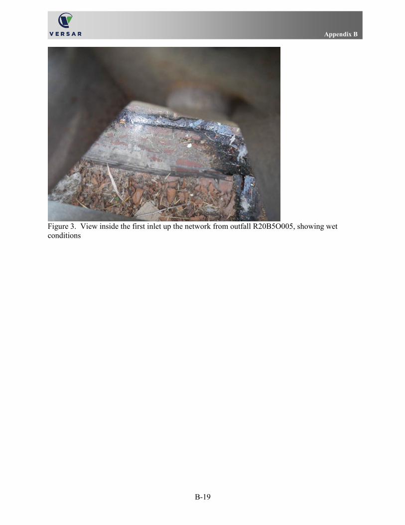
Appendix B
B-19
Figure 3. View inside the first inlet up the network from outfall R20B5O005, showing wet conditions

Appendix B
B-20
Figure 4. Area map

Appendix B
B-21
Anne Arundel County Illicit Discharge Site Visit Report Outfall ID: M08E8O006 Location: 200 Hospital Drive, Glen Burnie, MD Date: May 1, 2017 Investigators: C. Tonkin and K. Dillow Concern: possible sewage On May 1, 2017, a Versar field team inspected outfall M08E8O006, across the street from 200 Hospital Drive, near the intersection of Hospital Drive and Oakwood Road in Glen Burnie, MD. On the first field visit, conducted approximately 11:30 in the morning, Versar staff found the outfall backed up but slightly flowing (Figure 1). The team noted that the discharge was opaque and brown and had a foul odor; team members initially detected a chemical smell and later noted the odor of sewage. The crew obtained a sample of the discharge to test for illicit discharge indicators. The results of the tests are provided in Table 1, as Test 1. The results indicated an above-action level of detergent (0.75 mg/l) and excessive ammonia (> 30 mg/l) levels.
The field team returned four hours later and assessed conditions at the outfall. The team observed that the discharge conditions were similar to those documented in the morning, and the sewage odor was even stronger. The crew collected a sample of the discharge at the pipe opening. The results of the tests of this sample are provided in Table 1, as Test 2. The test results again indicated elevated detergent (0.75) and excessive ammonia (> 30) levels.
As a consequence of the second set of results indicating potential illicit discharge, the crew conducted a trackdown of the pipe network. According to the features in the County's digital infrastructure files, the outfall receives flow directly from the channel on the north side of Hospital Drive, in front of the building at the 200 address. The team documented that the channel received flow input from outfall M08E8O003 (which was dry) and a small 12-inch, reinforced concrete pipe that emerged from the side of the channel downstream of the outfall (Figure 2). The small pipe feature is not shown in the County's digital data; as such, its purpose and connections are yet unknown. The team presumed that the small pipe transported flows from the direction of the building at 200 Hospital Drive, based on the orientation of the visible portion of the pipe. The team tested the discharge at the small pipe; the test results indicated the same concentrations of fluoride, detergents, and ammonia as documented in the outfall sample shown as Test 2 in Table 1 (0.4, 0.75, and > 30, respectively). The crew noted that the effluent emitted a strong sewage odor and displayed suds in the sample. Effluent from the small pipe entered the culvert under Hospital Drive soon after emerging in the channel (Figure 3). The crew searched for but did not find signs of a sewer line in the area near the pipe. An area map is provided in Figure 4.

Appendix B
B-22
Table 1. Chemical test results (red values indicate concentrations above action levels) of samples taken at outfall M08E8O006
Action Level Test 1 Result Test 2 Result pH ≤ 6.5 or ≥ 8.5 7.51 7.48 Temperature (°F) 63.9 63.9 Ammonia (mg/l) ≥ 1 > 30 > 30 Total Chlorine (mg/l) ≥ 0.4 0.0 0.0 Detergents (mg/l) ≥ 0.5 0.75 0.75 Fluoride (mg/l) ≥ 0.75 0.3 0.4 Phenols (mg/l) ≥ 0.17 Inconclusive Inconclusive Copper (mg/l) ≥ 0.21 0.0 0.0
Figure 1. Conditions at outfall M08E8O006, showing opaque and brown water on May 1

Appendix B
B-23
Figure 2. View of the channel in front of the building at 200 Hospital Drive; note the small pipe entering the channel at an angle from the direction of the building (outfall M08E8O003 is seen to the left)
Figure 3. View of the channel relative to the culvert under Hospital Drive, note the small pipe jutting out of the side of the channel (lower left, facing away from the viewer) and releasing effluent that flows toward the culvert opening

Appendix B
B-24
Figure 4. Area map

Appendix C
C-1
APPENDIX C
UPLAND POLLUTANT SOURCES SITE-SPECIFIC REPORTS

Appendix C
C-2

Appendix C
C-3
Anne Arundel County Hotspot Site Visit Report Location: Edgewater Service Center, 3071 Solomon's Island Road, Edgewater, MD Date: February 22, 2017 Investigators: C. Tonkin and M. Glaudemans Concern: Waste management While investigating outfalls in the area, a Versar field team discovered waste management issues at the automotive service shop, Edgewater Service Center, at the above address. The field team documented that the business was storing numerous disabled vehicles on the lot (Figure 1). The team documented vehicle parts, such as engines, stored outdoors, without cover (Figure 1). Some of the vehicles had flat tires and other overt signs of neglect (Figures 1 and 2). As documented in the photographs, many of the stored vehicles did not have current registration tags; this implies that they were not part of an active service cycle (Figures 1, 2, and 3). The lot exhibited an open dumpster and debris scattered around it (Figure 4). Other signs of inadequate handling of materials included rusting fluid tanks (including one for used motor oil) and open drums (Figure 5). An area map is provided as Figure 6.
Figure 1. Vehicles in various stages of disrepair stored on the lot at the service center; note the partially covered engine on the ground seen on the right

Appendix C
C-4
Figure 2. Some of the damaged, rusted, and unregistered vehicles found on the lot
Figure 3. Many of the stored vehicles did not display current registration tags

Appendix C
C-5
Figure 4. An open dumpster observed during the site visit, and scattered debris
Figure 5. Debris scattered on the lot (old tires and rusting metal), rusting tanks for used oil and other fluids, and open drums

Appendix C
C-6
Figure 6. Area map

Appendix C
C-7
Anne Arundel County Hotspot Site Visit Report Location: Energy Parkway near the intersection with Fort Smallwood Road,
Curtis Bay, MD Date: February 22, 2017 Investigators: C. Tonkin and M. Glaudemans Concern: Debris and dumping While investigating outfalls in the area, a Versar field team discovered an area exhibiting significant debris at the above address. The field team surmised that this area of Energy Parkway may be used by people using the bus service and truck drivers transporting goods, and that some of these people may be disposing of their trash along the roadside. The team observed that the debris generally included beverage and food containers, and loose wrappers (Figures 1 and 2). The larger units of debris (e.g., bags full of trash or boxes) in some locations implied that some dumping activity had also occurred (Figures 1 and 3). An area map is provided as Figure 4.
Figure 1. Debris found scattered along the roadway; the pole displaying the bus stop sign is seen on the far left

Appendix C
C-8
Figure 2. Another section of the long stretch of trash found along the roadway
Figure 3. Some of the debris was found in larger units, such as full bags and cardboard boxes; this implies more specific, intentional dumping activity

Appendix C
C-9
Figure 4. Area map

Appendix C
C-10

Appendix C
C-11
Anne Arundel County Hotspot Site Visit Report Location: Near the corner of Cork Road and Monaghan Road, Glen Burnie, MD Date: February 23, 2017 Investigators: C. Tonkin Concern: Debris, specifically used hypodermic syringes and needles While investigating outfalls in the area, a Versar field team member discovered debris that included used hypodermic syringes and needles in an area near the stormwater pond, O08E3O00001, behind 391 Cork Road in Glen Burnie. The team member found several used drug delivery devices in the vicinity of the pond and the nearby sidewalk (Figures 1, 2, and 3). There is a concern that this area may be frequented by users of illegal drugs. An area map is provided as Figure 4.
Figure 1. One of the used hypodermic syringes and needles found during the site visit

Appendix C
C-12
Figure 2. Another syringe-needle assembly found near a paved area
Figure 3. Another empty drug delivery device found at the site
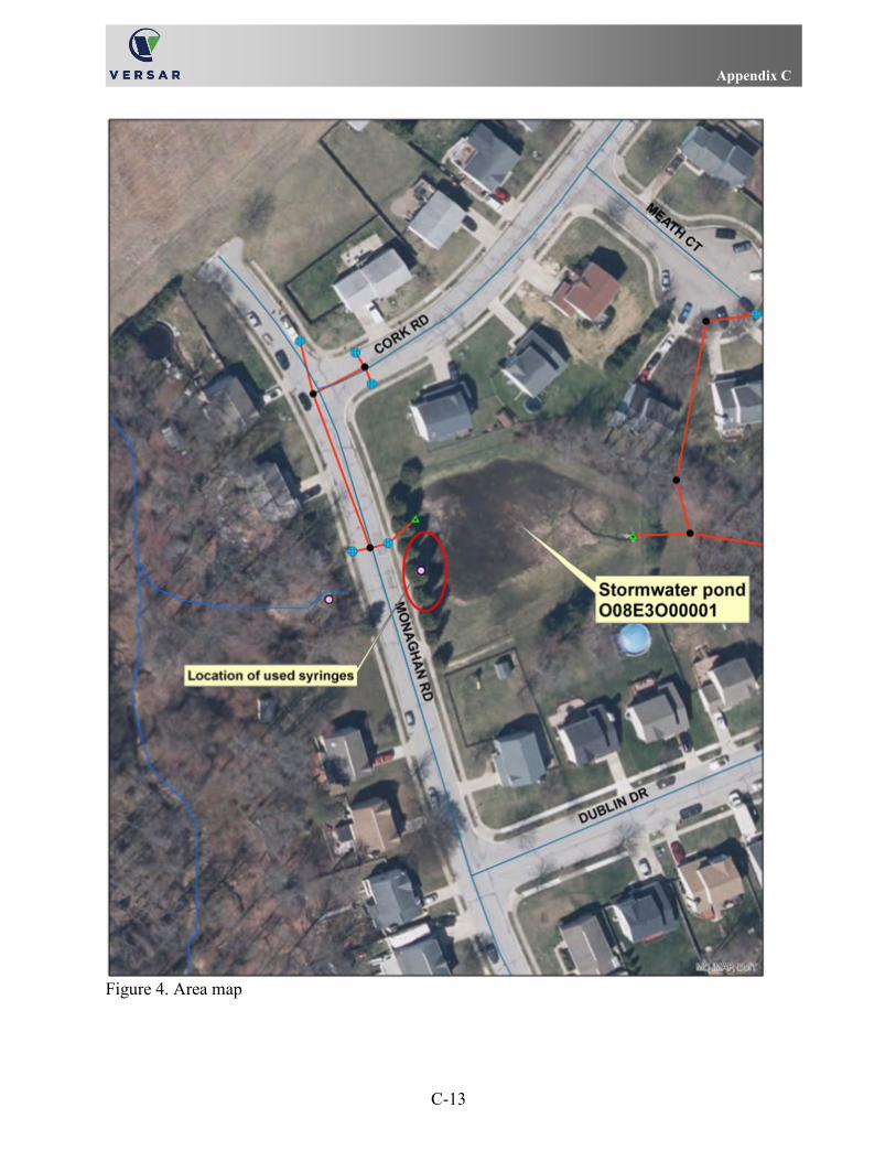
Appendix C
C-13
Figure 4. Area map

Appendix C
C-14

Appendix C
C-15
Anne Arundel County Hotspot Site Visit Report Location: 337 Hospital Drive, Glen Burnie (Southgate Marketplace) Date: March 7, 2017 Investigators: C. Tonkin and K. Dillow Concern: Waste management While investigating outfalls in the area, a Versar field team found signs of inadequate waste management associated with several businesses at the Southgate Marketplace shopping center. The team found a bag of trash near an open dumpster behind the door for Suite M, thought to be a Jackson Hewitt office (Figure 1). Adjacent to that, the team found another open dumpster with scattered loose trash behind the door for Suite N; the team assessed this to be a rear door for Angel Nails (Figure 2). Further down the line, the team documented a collection of bagged and loose trash near the door for Suite R, thought to be used by the Illumination business (Figure 3). An area map, indicating the general location of the businesses, is provided in Figure 4.
Figure 1. An open dumpster and a loose bag of trash behind the door for Suite M

Appendix C
C-16
Figure 2. An open dumpster and loose trash behind the rear door for Suite N
Figure 3. Bags of trash and loose debris behind and beneath the rear door for Suite R

Appendix C
C-17
Figure 4. Area map

Appendix C
C-18

Appendix C
C-19
Anne Arundel County Hotspot Site Visit Report Location: 337 Hospital Drive, Glen Burnie (Southgate Marketplace) Date: March 7, 2017 Investigators: C. Tonkin and K. Dillow Concern: Improper cooking oil storage While investigating outfalls in the area, a Versar field team found signs of inadequate waste cooking oil and grease management associated with businesses at the Southgate Marketplace shopping center. The team found a small bin, which appeared to be a collection device for used cooking oil, with two dump buckets on the ground next to it (Figure 1). The dump buckets, with labels describing the original contents as soy sauce, contained some residual materials (Figure 2). The team members could not verify which restaurant was using the bin, but they presumed that the business was China House Restaurant (Suite U). The team found a larger bin for waste kitchen grease nearby (Figure 3). The team noted that the bin had a significant amount of waste residue on the top and trash on the ground near it. The team surmised that this bin may have been used by the Capri Pizza and Sub Express restaurant (Suite V). The rear doors for businesses in this section of the shopping center did not have labels to confirm the establish-ments, so the team used other information to inform the suggestions.
The team also documented a 55-gallon drum and some pails stored behind what was either China House Restaurant or a nearby dry cleaners business (Figure 4). Although the team members did not confirm the labels on the containers, they felt that since the buckets' lids were intact, the contents were safely contained at the time of the site visit. An area map, indicating the general location of the businesses, is provided in Figure 5.
Figure 1. A small bin for used cooking oil and two dump buckets found behind the China House restaurant (not confirmed)

Appendix C
C-20
Figure 2. A view into the small buckets in Figure 1 showing residual contents
Figure 3. A waste grease bin found behind the Capri Pizza and Sub Express restaurant (not confirmed); note the dark stains on the ground around the bin, and the loose debris

Appendix C
C-21
Figure 4. A 55-gallon drum and two apparently sealed buckets which may have been associated with functions at the Capri Pizza restaurant or the nearby dry cleaners business

Appendix C
C-22
Figure 5. Area map
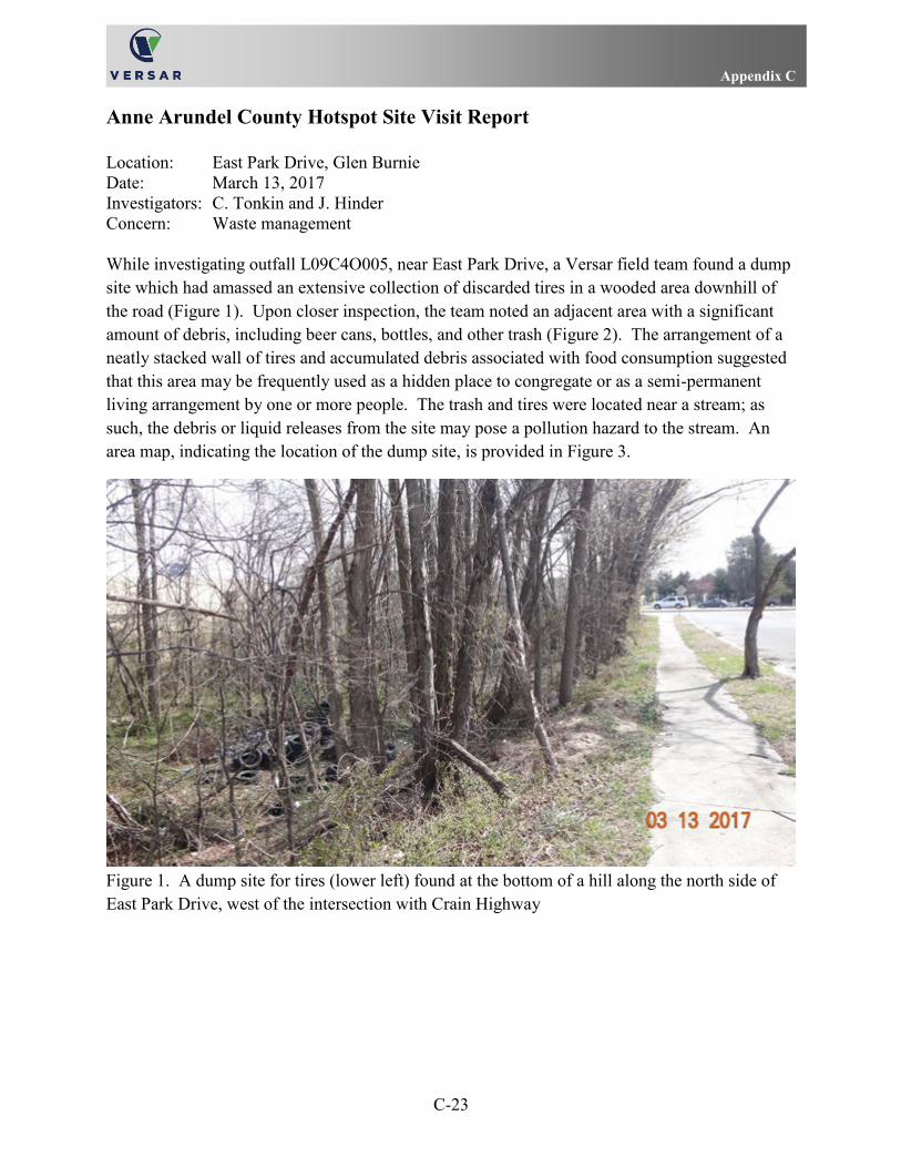
Appendix C
C-23
Anne Arundel County Hotspot Site Visit Report Location: East Park Drive, Glen Burnie Date: March 13, 2017 Investigators: C. Tonkin and J. Hinder Concern: Waste management While investigating outfall L09C4O005, near East Park Drive, a Versar field team found a dump site which had amassed an extensive collection of discarded tires in a wooded area downhill of the road (Figure 1). Upon closer inspection, the team noted an adjacent area with a significant amount of debris, including beer cans, bottles, and other trash (Figure 2). The arrangement of a neatly stacked wall of tires and accumulated debris associated with food consumption suggested that this area may be frequently used as a hidden place to congregate or as a semi-permanent living arrangement by one or more people. The trash and tires were located near a stream; as such, the debris or liquid releases from the site may pose a pollution hazard to the stream. An area map, indicating the location of the dump site, is provided in Figure 3.
Figure 1. A dump site for tires (lower left) found at the bottom of a hill along the north side of East Park Drive, west of the intersection with Crain Highway

Appendix C
C-24
Figure 2. View showing an accumulation of beverage and food packaging waste behind a wall of stacked tires downhill from East Park Drive

Appendix C
C-25
Figure 3. Area map

Appendix C
C-26

Appendix C
C-27
Anne Arundel County Hotspot Site Visit Report Location: 7550 and 7556 Governor Ritchie Highway, Glen Burnie Date: March 13, 2017 Investigators: C. Tonkin and J. Hinder Concern: Waste management While investigating outfalls in the vicinity, a Versar field team found poor waste management conditions near some of the businesses associated with the Glen Burnie Village Shopping Center. On the sidewalk near two restaurants, Ka Ming and Mi Pueblo (at 7550 and 7556, respectively), the team found dumpsters overloaded with trash (Figure 1). The team could not ascertain that the dumpsters were exclusively receiving waste material from the two restaurants, however, the types of waste that the team observed at the site and the proximity to the restaurants did suggest predominant use by these two establishments. The team documented that excessive debris was strewn around the dumpsters and in the street; the material included full bags of trash, loose cardboard, and food-related materials (Figures 2 and 3). The team noted that trash in and around the bins emitted a foul odor. During the site visit, birds congregated around one bin and pecked at some of the bags (Figure 3). This birds' disturbance had the potential to release and disperse debris from the initial deposition site. The dumpsters were located near and upgrade of a curb inlet. The team also documented two waste grease containers in the same area that displayed dark stains on the ground around them (Figures 2 and 3). There is a concern that the combination of factors (excessive and uncovered debris and waste, spoiling food, and dispersal by animals) demonstrated a cumulative potential for debris and contaminated liquids from the dumpster area to travel to and possibly enter the storm drain system. An area map, indicating the location of the dumpsters and nearby storm drain inlet, is provided in Figure 4.

Appendix C
C-28
Figure 1. Two dumpsters near the restaurants Ka Ming (foreground) and Mi Pueblo (background) exhibiting overloaded conditions and excessive debris
Figure 2. The dumpster and waste grease bin on the north corner of the sidewalk, near the Ka Ming entrance; note the dark stains around the grease bin on the right, also

Appendix C
C-29
Figure 3. The second dumpster and waste grease bin at the site; note the birds congregating on and near the bags of debris

Appendix C
C-30
Figure 4. Area map

Appendix C
C-31
Anne Arundel County Hotspot Site Visit Report Location: Green Branch Lane, Glen Burnie Date: March 13, 2017 Investigators: C. Tonkin and J. Hinder Concern: Waste management While investigating outfall L09E6O011, on the east side of Green Branch Lane, a Versar field team found a well-worn path and a widespread dump site in a wooded area downhill of the road (Figure 1). The team found trash strewn throughout the wooded area near the road (Figures 2 and 3). Further downhill, the team found debris near the edge of the stream; this material will likely enter the stream during a storm or wind event, due to its close proximity to the flowing water (Figure 4). An area map, indicating the location of the dump site, is provided in Figure 5.
Figure 1. Scattered debris found in the wooded area along the east side of Green Branch Lane; this photograph looks south

Appendix C
C-32
Figure 2. A widespread accumulation of debris in the woods near Green Branch Lane; this photograph looks northeast
Figure 3. Another view of some of the debris scattered throughout the wooded area; this photograph looks southeast

Appendix C
C-33
Figure 4. A view of debris found near the edge of the stream; debris close to a stream may enter the stream during a storm event

Appendix C
C-34
Figure 5. Area map

Appendix C
C-35
Anne Arundel County Hotspot Site Visit Report Location: 512 and 514 Crain Highway North, Glen Burnie, MD Date: March 24, 2017 Investigators: C. Tonkin and K. Dillow Concern: Washdown activity While investigating outfalls in the area, a Versar field team discovered washdown activity occurring in the parking lot outside the doors to Bay 2 of an automotive service business at 514 Crain Highway North on March 24. The team did not ascertain which business was using the service bays at the time. The team observed and documented a person washing a small truck with soap and water (Figure 1). The washing activity created enough water for the runoff flow to extend into the middle of the parking lot (Figure 2). The team members tracked the flow and documented runoff entering a grate inlet in the parking lot (Figure 3).
In the adjacent parking area to the west, associated with businesses in the buildings at the 512 address, the team observed more evidence of possible washdown activity. On the center-west side of the parking lot, the team members discovered fresh runoff tracks apparently emanating from a service bay door (Figure 4), although they did not observe the washing activity presumed to have created the water. The team noted that the runoff had sufficient volume to reach a grate inlet in the parking lot; the stains at the inlet provided signs that tainted runoff had entered the inlet from the southwest in the past, also (Figure 5). On the parking lot near the southwest end of the same building, the team also documented a substantial trail of sediment associated with runoff. This residue suggested drainage from a separate washing activity that had involved dirt which was then transported via runoff toward an inlet in the corner of the lot (Figure 6). Evidence of accumulated light sediment on the southwest edge of the lot suggested that this type of runoff may have occurred more than once (Figure 7).
In an area of the complex near the southeast end of the stormwater infrastructure network, the team found another stain (Figure 8). The white residue appeared to be associated with runoff from a commercial bay used by the Maryland Bullnose LLC business (514 address) that processes stone and tile. Although only the residue was evident, the flow line from the bay door toward a nearby grate inlet suggested that excessive flows from washdown activities may have the potential to transport mineral particulates and other substances to the storm drain system.
The team documented evidence from activities at the 512-514 business center that suggested that washdown activities may have occurred repeatedly in several locations in the building complex. Several of the storm drain inlets appeared to be receiving runoff from these activities when the volumes of water used were large enough to transport the material from the source to the drain. In any case, the residues may be carried into the system via storm runoff. According to the County's digital data sets, the network for this business center is correlated with outfall M06C4O008. An area map is provided as Figure 9.

Appendix C
C-36
Figure 1. Evidence of washdown activity at Bay 2 of an unidentified business
Figure 2. Excessive runoff from the Bay 2 washdown activity flowing across the pavement

Appendix C
C-37
Figure 3. Excessive runoff from Bay 2 washdown activity entering a grate inlet
Figure 4. Fresh wet stains suggesting recent washdown activity (not observed) on the center-west side of the 512 building

Appendix C
C-38
Figure 5. Evidence of fresh (wet) and previous (dried) stains indicating tainted runoff entering the grate inlet from the south (foreground); the fresh stain was associated with the runoff shown in Figure 4
Figure 6. Evidence of runoff from a previous washdown activity that carried sediment; the grate inlet receiving this runoff is at the southwest corner of the lot (off the left side of the photograph)

Appendix C
C-39
Figure 7. Evidence of accumulating sediment at the southwest edge of the parking lot; the flows associated with the stain reported in Figure 6 passed under the blue tractor-cab (right)
Figure 8. Evidence of possible previous washdown activity, associated with a tile fabrication business, which carried and deposited white particulates (leading away from the closed bay door; right center)

Appendix C
C-40
Figure 9. Area map

Appendix C
C-41
Anne Arundel County Hotspot Site Visit Report Location: A.C. Schultes of Maryland, 8221 Cloverleaf Drive, Millersville, MD Date: April 11, 2017 Investigators: T. Jones, K. Dillow, J. Hinder, and P. Donovan (Versar, Inc); L. Vander Linden
and S. Dagli (LimnoTech) Concern: Improper Bulk Solid Storage
While investigating outfalls in the area, a Versar-LimnoTech field team discovered improper bulk solid storage associated with business operations at the A. C. Schultes facility, located at the above address. According to the company's Web site, http://www.acschultes.com/, the business provides water and wastewater services, including well construction and pump and motor repair. At the Millersville site, the field team documented that there were rusted tanks and pipes on the edge of the storage lot adjacent to a stormwater pond (Figure 1). The edge of the lot appeared to have a gravel surface and no curb. A view of the lot looking across the pond showed a steep hill immediately adjacent to the edge of the lot (Figure 2); thus, any debris, erosion or leach runoff, or leaked fluids have the potential to escape the fenced lot and enter the stormwater system directly. An area map is provided in Figure 3.
Figure 1. A view of some of the equipment stored on the lot; note the equipment stored along the perimeter, right and background (the stormwater pond is off the photograph to the right)

Appendix C
C-42
Figure 2. A view looking across the stormwater pond at the edge of the business lot; note the steep hill between the lot and the pond

Appendix C
C-43
Figure 3. Area map

Appendix C
C-44

Appendix C
C-45
Anne Arundel County Hotspot Site Visit Report Location: Aireco Supply, 8201 Cloverleaf Drive, Millersville, MD Date: April 11, 2017 Investigators: K. Dillow, J. Hinder, and P. Donovan (Versar, Inc); L. Vander Linden and
S. Dagli (LimnoTech) Concern: Improper Bulk Solid Storage While investigating outfalls in the area, a Versar field team discovered bulk solid storage issues associated with the business, Aireco Supply, Inc., located at the above address. According to the company's Web site, https://www.aireco.com/, the business sells (wholesale) supplies related to heating, ventilation, air conditioning, and refrigeration (HVACR). The field team investigated a storage area adjacent to the parking lot near the main business entrance. The storage area was segregated from the parking lot by a fence (Figure 1), but the pavement spanned the entire area. The team documented that the storage area contained numerous discarded pressure tanks. From a vantage point outside of the fenced lot, the team observed that some of the pressure tanks had rusting holes where they had been punctured (Figure 2). The team also noted an open bin of discarded materials stored in the open (Figure 3). An area map is provided in Figure 4.
Figure 1. A fence segregating the storage area (background) from the parking lot (foreground)

Appendix C
C-46
Figure 2. A detail view of one of the pressure tanks seen with rusting holes from previous punctures
Figure 3. View inside the storage area showing an open bin for discarded materials (center), pressure tanks, bulk rolls of tubing, and stacks of pipes

Appendix C
C-47
Figure 4. Area map

Appendix C
C-48

Appendix C
C-49
Anne Arundel County Hotspot Site Visit Report Location: Bear Landscaping, 8116 Veterans Highway, Millersville, MD Date: April 11, 2017 Investigators: K. Dillow, J. Hinder, and P. Donovan Concern: Improper Bulk Solid Storage While investigating outfalls in the area, a Versar field team discovered improper bulk solid storage associated with business operations at the Bear Landscaping facility, located at the above address. The field team documented the presence of a large mulch pile stored on pavement outside of the existing enclosures (Figure 1). The team found the pile uncovered at the time of the field visit. The area around the pile showed signs that equipment had tracked some of the mulch across sections of the lot. Excess nutrients from the concentrated and exposed mulch may enter the storm system along paved routes during rain events. An area map is provided in Figure 2.
Figure 1. An uncovered pile of mulch found outside the enclosures in the front of the lot near the main road
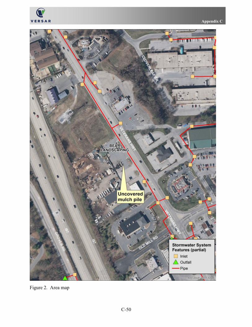
Appendix C
C-50
Figure 2. Area map

Appendix C
C-51
Anne Arundel County Hotspot Site Visit Report Location: Goodwill thrift store, 674 Old Mill Road, Millersville, MD Date: April 11, 2017 Investigators: T. Jones, K. Dillow, J. Hinder, and P. Donovan (Versar, Inc); L. Vander Linden
and S. Dagli (LimnoTech) Concern: Waste Management While investigating outfalls in the area, a Versar-LimnoTech field team discovered several issues related to waste management associated with business operations at the Goodwill thrift store, located at the above address. The field team documented that one dumpster was overfilled with bags, cardboard, and bedding material (Figure 1). A mattress leaned against the fence near the second dumpster (Figure 2). The team noted that the dumpster area displayed stains leading toward the nearby storm system inlet (Figure 2). Behind the pen, someone had tied a trash bag to the fence; the team noted that the bag did not adequately retain the debris it contained (Figure 3). The team also found a discarded floor fan on the hill behind the dumpsters (Figure 4). An area map is provided in Figure 5.
Figure 1. An overfilled dumpster found in a pen behind the Goodwill thrift store

Appendix C
C-52
Figure 2. A mattress found leaning against the pen fence; note the orange stains evident on the pavement near both dumpsters
Figure 3. A trash bag tied to the rear of the pen contained loose and unsecured debris

Appendix C
C-53
Figure 4. A discarded floor fan found on the hill behind the dumpsters

Appendix C
C-54
Figure 5. Area map

Appendix C
C-55
Anne Arundel County Hotspot Site Visit Report Location: ROK Brothers Auto Parts Recycling, 8217 Cloverleaf Drive, Millersville, MD Date: April 11, 2017 Investigators: T. Jones, K. Dillow, J. Hinder, and P. Donovan (Versar, Inc); L. Vander Linden
and S. Dagli (LimnoTech) Concerns: Improper Bulk Solid Storage and Waste Management While investigating outfalls in the area, a Versar-LimnoTech field team discovered bulk solid storage and waste management issues at the ROK Brothers automotive parts recycling center, located at the above address. According to the company's Web site, http://rokbrothersllc.com/, the business buys and recycles automotive parts and scrap metal. The field team documented that the business used bins and boxes to segregate and store used auto parts outdoors, on pavement and without cover (Figure 1). The team documented that some of the receptacles contained rusting parts (Figure 2). The crew found many of the bins overfilled (Figure 3). A cluster of bins and the end of a long line of bins were both near a stormwater inlet (Figures 4 and 5).
The conditions on the lot also demonstrated inadequate waste management practices. The team found several open rollaway dumpsters that showed signs of damage and deterioration. One dumpster had a rusting shell with signs of damage (Figure 6). Another dumpster had a large gash on one end that would allow liquids to escape the enclosure (Figure 7). The team documented that one dumpster had what appeared to be an oil stain on the underlying pavement near one corner (Figure 8). Generally, the team observed oil odors, discarded kitty litter (commonly used to soak up automotive fluids), and material associated with automobiles (glass, metal, and plastic) in these debris bins. The team also identified a pallet of used batteries and bins of radiators and engine belts placed on the impervious surface. Site conditions also included a coating of oil-grit over a wide area of the parking lot and a clean-up procedure that appeared to include dumping of deposited material adjacent to the parking area and upslope of the adjacent stream. The team assessed the site as a severe hotspot during the investigation, due to the number of concerns, the proximity of open bins to stormwater inlets, and the perceptions indicating motor oil discharge associated with open bins and apparent leaks on the pavement. Figure 9 provides an area map showing the relative locations of bins to the stormwater system.

Appendix C
C-56
Figure 1. Open boxes and bins used to segregate and store used auto parts
Figure 2. Boxes of rusted rotors stored in boxes (foreground) and bins with large automotive components (background) on the lot; see Figure 3 for more detail

Appendix C
C-57
Figure 3. Overfilled bins with large automotive components stored on the pavement
Figure 4. View showing the relative location of the bins used to store automotive parts to a stormwater inlet (center right)

Appendix C
C-58
Figure 5. A long line of open storage bins and boxes that ends at a stormwater inlet (left)
Figure 6. A rusting rollaway dumpster exhibiting a puncture hole on the side and a tear at the bottom; note stains on the pavement (left)

Appendix C
C-59
Figure 7. A rollaway dumpster partially filled with water, with a gash (lower left) on one end; note what appears to be an oil slick inside the bin, near the opening
Figure 8. A dark oily discharge appeared to emanate from under a rollaway dumpster

Appendix C
C-60
Figure 9. Area map

Appendix C
C-61
Anne Arundel County Hotspot Site Visit Report Location: Shoppers Food Warehouse, 670 Old Mill Road, Millersville, MD Date: April 11, 2017 Investigators: T. Jones, K. Dillow, J. Hinder, and P. Donovan (Versar, Inc); L. Vander Linden
and S. Dagli (LimnoTech) Concern: Waste Management While investigating outfalls in the area, a Versar-LimnoTech field team discovered two overfilled dumpsters in an area just north of the Shoppers Food Warehouse grocery store at the above address. The field team documented that one dumpster was overfilled with bags of debris heaped on the top of the container and protruding from the side (Figure 1). The team also observed debris on the pavement alongside this dumpster; most notably, part of a portable basketball hoop system (Figure 1). The team noted that all of the dumpsters in this area displayed stains on the pavement near their bases, which suggests that the bins have leaked in the past (Figure 2). In the same area, the team found another dumpster that was also overloaded with bags and surrounded by loose debris (Figure 3). This bin was located alongside a curb cut-out that drains runoff toward a nearby stormwater inlet. An area map is provided in Figure 4.
Figure 1. An overfilled dumpster found in a paved area near the Shoppers Food Warehouse grocery store; note the debris on the left that was part of a basketball hoop system

Appendix C
C-62
Figure 2. Orange stains evident on the pavement near three of the dumpsters that suggest prior leakage
Figure 3. A second overfilled dumpster found near a curb cut-out; note the curb inlet across the side street

Appendix C
C-63
Figure 4. Area map

Appendix C
C-64

Appendix C
C-65
Anne Arundel County Hotspot Site Visit Report Location: Chesapeake Plaza, 8328 Veterans Highway, Millersville, MD Date: April 14, 2017 Investigators: K. Dillow and J. Hinder Concern: Waste Management While investigating outfalls in the area, a Versar field team discovered inadequate waste management conditions in the parking lot of the Chesapeake Plaza, located at the above address. The field team documented that one dumpster was overfilled with debris piled around it. The dumpster had a painted sign on it that suggested that it was used by staff with the X-Press Floors business (X-Press Floors Plus). The debris on and around the dumpster included sheets of plywood, rolls of waste carpet and padding, and long tubes (Figure 1). An area map is provided in Figure 2.
Figure 1. An overfilled dumpster with debris on and around it found on the parking lot of the Chesapeake Plaza; note the hand-written sign that reads "X-Press Floors"

Appendix C
C-66
Figure 2. Area map

Appendix C
C-67
Anne Arundel County Hotspot Site Visit Report Location: Old Mill Plaza, 285 Old Mill Road, Millersville, MD Date: April 14, 2017 Investigators: K. Dillow and J. Hinder Concern: Cooking Grease Storage While investigating outfalls in the area, a Versar field team discovered inadequate cooking grease storage conditions in the parking lot behind the Old Mill Plaza, located at the above address. The storage container displayed a label identifying the contents as waste kitchen grease (Figure 1). The field team documented that waste grease distributed on the pavement appeared to be associated with the grease bin, which may indicate a leak or a spill (Figure 2). An area map is provided in Figure 3.
Figure 1. A waste grease container stored in a corner of the parking lot behind the Old Mill Plaza businesses

Appendix C
C-68
Figure 2. Evidence of a leak or a spill distributing waste grease to the pavement adjacent to the container

Appendix C
C-69
Figure 3. Area map

Appendix C
C-70

Appendix C
C-71
Anne Arundel County Hotspot Site Visit Report Location: 413 Headquarters Drive, Millersville, MD Date: May 9, 2017 Investigators: K. Dillow and B. Smith Concern: Waste Management While investigating outfalls in the area, a Versar field team discovered inadequate waste management conditions at the edge of the parking lot east of 413 Headquarters Drive, in Millersville. The field team documented two open and overfilled dumpsters on a gravel pad on the ground adjacent to the parking lot (Figure 1). The dumpsters had various types of debris scattered around them, including wood pallets, cardboard, and a small mattress (Figure 2). The articles were placed in an area up-gradient from a stormwater wet pond and thus had the potential for direct transport into County waterways. An area map is provided in Figure 3.
Figure 1. Two open and overfilled dumpsters found on a gravel pad adjacent to the parking lot near 413 Headquarters Drive

Appendix C
C-72
Figure 2. Debris found adjacent to the dumpsters

Appendix C
C-73
Figure 3. Area map

Appendix C
C-74
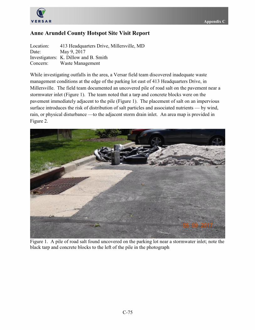
Appendix C
C-75
Anne Arundel County Hotspot Site Visit Report Location: 413 Headquarters Drive, Millersville, MD Date: May 9, 2017 Investigators: K. Dillow and B. Smith Concern: Waste Management While investigating outfalls in the area, a Versar field team discovered inadequate waste management conditions at the edge of the parking lot east of 413 Headquarters Drive, in Millersville. The field team documented an uncovered pile of road salt on the pavement near a stormwater inlet (Figure 1). The team noted that a tarp and concrete blocks were on the pavement immediately adjacent to the pile (Figure 1). The placement of salt on an impervious surface introduces the risk of distribution of salt particles and associated nutrients — by wind, rain, or physical disturbance —to the adjacent storm drain inlet. An area map is provided in Figure 2.
Figure 1. A pile of road salt found uncovered on the parking lot near a stormwater inlet; note the black tarp and concrete blocks to the left of the pile in the photograph

Appendix C
C-76
Figure 2. Area map

Appendix D
D-1
APPENDIX D
MAPS

Appendix D
D-2

Appendix D
D-3

Appendix D
D-4

Appendix E
E-1
APPENDIX E
ESRI-FORMAT GEODATABASE FOR ILLICIT DISCHARGE DETECTION PROGRAM INSPECTIONS

Appendix E
E-2
Appendix F
F-1
APPENDIX F
COUNTY INSPECTION COMPLIANCE DATABASE REPORTS

Appendix F
F-2

Environment Section Complaint
Case ID: E - 2016 - 311 Location:
Tax ID: 400005799800
Received: 6/15/2016 Details:
Tickler: 9/15/2017 Completed:
ILLEGAL DISCHARGES COMPLAINT
Receiver: Inspector:
Date Assigned: Permit Number: Original ID:
ADC Map: Related Cases:
Water Front: Critical Area: N Violation:
Cty. Council Ind: Case Org:
Complainant:
Owner Information Violator Information
Owner 1: Violator 1:
Owner 2: Violator 2:
Address: Address:
Phone:
State Map: 14 13 0473 County Map:
Map No: Suffix Block Parcel Plat Sect Block Lot No
Date Event Due Date Request for Trial Date
6/15/2016 OPENED COMPLAINT CASE 6/20/2016
ON APRIL 8, 2016, A VERSAR FIELD TEAM INSPECTED OUTFALL F09G5O001, WHICH IS SOUTH OF THE SHELL GAS STATION AND CAR WASH FACILITY AT THE CORNER OF ANNAPOLIS ROAD (MARYLAND ROUTE 175) AND ROCKENBACH ROAD IN HANOVER. VERSAR STAFF HAD INSPECTED A LARGER, ASSOCIATED OUTFALL NEARBY, F09F5O001, IN 2015, AND FOUND HIGH DETERGENT LEVELS IN THE SYSTEM. ON THE FIRST FIELD VISIT DURING THE CURRENT ROUND OF INSPECTIONS, THE CREW DISCOVERED THAT THE OUTFALL F09G5O001 WAS BLOCKED BY LAYERS OF CUT TREE LIMBS THAT HAD BEEN STACKED IN FRONT OF THE OUTFALL OPENING; THIS MAKESHIFT DAM ALSO ACCUMULATED FOREST DEBRIS (DIRT, LEAVES, AND STICKS) SUCH THAT THE OPENING FOR THE PIPE APPEARED TO BE BARELY FUNCTIONING AS AN OUTFALL. THE CREW OBSERVED WATER BENEATH THE DEBRIS PARTIALLY BLOCKING THE OUTFALL AND WATER SEEPING OUT OF THE GROUND ON THE HILLSIDE ABOVE THE OUTFALL HEADWALL. THIS DISCHARGE AND SEEPAGE COLLECTED IN A SMALL STREAM THAT SUBSEQUENTLY ENTERED A STORM WATER INLET WHICH WAS NOT IDENTIFIED IN THE COUNTY'S GIS DATA SETS. THE CREW ALSO NOTED A WHITE DEPOSITION ON THE BOTTOM OF THE SMALL STREAM CHANNEL. THE FIELD TEAM COLLECTED A SAMPLE OF WATER FLOWING INTO THIS STREAM TO TEST FOR ILLICIT DISCHARGE INDICATORS. THE RESULT FOR DETERGENTS WAS ABOVE 3.0 MG/L, THE HIGHEST FUNCTIONAL LEVEL THAT THE FIELD TEST IS DESIGNED TO DETECT .THE VERSAR TEAM RETURNED THE NEXT DAY AND OBSERVED SIMILAR CONDITIONS AT THE OUTFALL SITE, AND NOTED THE ADDITION OF A GREYISH-WHITE RESIDUE AND FAINT SUDS IN THE STREAM BELOW THE OUTFALL. THE CREW COLLECTED A SAMPLE OF THE FLOWING WATER ENTERING THE STREAM; THE RESULT FOR DETERGENTS ON THE REVISIT WAS ABOVE 3.0 MG/L. THE EXCESSIVE LEVELS OF DETERGENTS AND THE PRESENCE OF SUDS PROMPTED A THOROUGH TRACKDOWN OF THE SOURCE OF THE EFFLUENT AND AN INVESTIGATION OF THE STORM WATER NETWORK ASSOCIATED WITH OUTFALLS F09G5O001 AND F09F5O001.
6/15/2016 CASE NOTE 6/15/2016 6/15/2016
Page 1 of 3Anne Arundel County Department of Inspections and Permits
9/18/2017http://aacoprod-intra.aacounty.org/ComplaintIntranet/printCase.do

THE CREW MEMBERS INSPECTED THE NETWORK DIRECTLY CONNECTED TO OUTFALL F09G5O001 BY FOLLOWING THE INTERCONNECTED PIPES AND ACCESS POINTS; THEY DOCUMENTED THE LOCATIONS OF STRUCTURES THAT WERE NOT INCLUDED IN THE COUNTY'S GIS (GEOGRAPHIC INFORMATION SYSTEM) DATA SETS, AND TESTED WATER AT SEVERAL LOCATIONS TO ISOLATE THE SOURCE OF THE DETERGENTS. THE CREW INSPECTED THE FIRST MANHOLE IN THE NETWORK, JUST UPHILL FROM THE OUTFALL. THE POOLED WATER AT THE BOTTOM OF THE MANHOLE WAS GREYISH-PURPLE AND EMITTED A FOUL ODOR. THE DETERGENT TEST OF THE WATER IN THE FIRST MANHOLE SHOWED A RESULT OF AT LEAST 3.0 MG/L. THE COUNTY'S GIS DATA SET INDICATED A MANHOLE IN THE NETWORK ON THE HILLSIDE NEAR THE ENTRANCE TO THE CARWASH, BUT THE FIELD CREW DID NOT FIND THIS STRUCTURE ON THE DAY OF THE TRACKDOWN. AS THE CREW MEMBERS PROCEEDED ALONG THE NETWORK INDICATED BY THE GIS DATA LAYER, THEY FOUND AND OPENED THE NEXT AVAILABLE MANHOLE (WHICH SHOULD BE THE THIRD IN THE SERIES). AT THIS ACCESS POINT, WHICH WAS ADJACENT TO THE EXIT FOR THE CAR WASH, THE CREW OBSERVED GREYISH-PURPLE WATER AND EXCESSIVE SUDS .THE TEST FOR DETERGENTS IN A SAMPLE OF THE WATER FROM THE THIRD MANHOLE SHOWED LEVELS ABOVE 3.0 MG/L. ALTHOUGH THERE WERE TRENCH DRAINS IN PLACE NEAR THE ENTRANCE AND EXIT FOR THE CAR WASH, THE FIELD CREW DID NOT FIND SUFFICIENT WATER IN EITHER OF THESE DEVICES TO ACCOUNT FOR THE AMOUNT OF FLOWING WATER OBSERVED IN THE STORM WATER NETWORK. THE TEAM, THUS, SURMISED THAT THE DISCHARGE FROM THE CAR WASH ENTERED THE STORM WATER SYSTEM THROUGH AN ACCESS ROUTE THAT WAS NOT READILY APPARENT - PERHAPS THROUGH AN ILLICIT CONNECTION. THE FIELD CREW ALSO EXTENDED THE INSPECTION COURSE AWAY FROM THE CAR WASH, TOWARD THE LARGE OUTFALL, F09F5O001, AND INCLUDED EXAMINATIONS AND TESTING AT TWO CURB INLETS DOWNSTREAM OF THE PRESUMED SOURCE. AT THE FIRST CURB INLET, THE CREW OBSERVED FLOWING WATER AND DETERGENT LEVELS ABOVE 3.0 MG/L. THIS INLET ALSO EXHIBITED A TIE-IN FOR A SECOND PIPE, LEADING TO THE SOUTHWEST, NOT SHOWN IN THE COUNTY'S GIS COVERAGE. AT THE SECOND CURB INLET, THE TEAM OBSERVED THAT THE WATER APPEARED TO BE POOLED AND THE CATCH BASIN CONTAINED SOME GARBAGE AND DEBRIS; THE WATER SAMPLE FROM THE SECOND CURB INLET ALSO HAD DETERGENT LEVELS ABOVE 3.0 MG/L. THE FIELD TEAM CONSIDERED THAT THE TIE-IN FROM THE FIRST CURB INLET MAY CONNECT TO THE STORMWATER INFRASTRUCTURE FOR OUTFALL F09F5O001, SO TEAM MEMBERS INSPECTED TWO OF THE ACCESS POINTS IN THAT NETWORK, ALSO. THE CURB INLET IMMEDIATELY WEST OF THE CAR DOC FACILITY LEADS DIRECTLY TO OUTFALL F09F5O001, ACCORDING TO THE GIS DATA. THE FIELD TEAM INSPECTED THIS INLET AND FOUND IT TO BE DRY. THE TEAM INVESTIGATED CONDITIONS AT OUTFALL F09F5O001 AND FOUND FLOWING EFFLUENT FROM THE PIPE AND SUDS IN THE PLUNGE POOL . A TEST FOR DETERGENTS IN THIS DISCHARGE SHOWED LEVELS ABOVE 3.0 MG/L.
7/6/2016 CASE NOTE 7/29/2016 7/6/2016
SOAP SUDS WERE FOUND IN A NEARBY STORM DRAIN. AN CLOSE BY OUTFALL IS BLOCKED WITH TREES AND DEBRIS. A REPORT HAS BEEN SENT OUT TO THE PROPERTY OWNER. WE ARE WAITING ON A RESPONSE TO PROCEED WITH A PLAN OF ACTION.
8/30/2016 CASE NOTE 9/30/2016 8/30/2016
THE INSPECTOR HAS MET WITH THE PROPERTY OWNER AND OPERATIONS MANAGER ON SITE TO ADDRESS THE ILLICT DISCHARGE INTO THE STORMWATER SYSTEM. THE CAUSE OF THE ISSUE CAN BE ATTRIBUTED TO AN ILLEGAL HOOKUP FROM THE CARWASH INTO THE STORM DRAIN SYSTEM INSTEAD OF THE SANITARY SYSTEM. THE OWNER IS WORKING ON HIRING A CONTRACTOR TO REMEDIATE THE ISSUE. THE INSPECTOR HAS ADVISED THE OWNER TO CONTACT HIM ONCE THE CONTRACTOR IS GOING TO START WORK. DATE OF MEETING WAS 7/7/2016.
11/10/2016 CASE NOTE 2/3/2017 11/10/2016
OWNER IS WAITING ON CONTRACTOR TO PERFORM REMEDIATION WORK.
3/10/2017 CASE NOTE 4/10/2017 3/10/2017
CAR WASH WAS CLOSED TODAY. SMO IS IN THE PROCESS OF TRACKING DOWN THE ILLICIT CONNECTION. THEY ARE IN THE PROCESS OF HIRING A CONTRACTOR TO LOCATE THE ILLICIT CONNECTION.
6/6/2017 CLOSE COMPLAINT
THE SETTLEMENT TANKS HAVE BEEN CLEANED. THE PIPING HAS BEEN CORRECTED BY A LICENSED PLUMBER. THE ILLICIT DISCHARGE IS NO LONGER OCCURRING. CLOSE THIS
Page 2 of 3Anne Arundel County Department of Inspections and Permits
9/18/2017http://aacoprod-intra.aacounty.org/ComplaintIntranet/printCase.do

COMPLAINT.
9/7/2017 OPENED COMPLAINT CASE 9/15/2017 9/7/2017
9/7/2017 CASE NOTE 9/7/2017 9/7/2017
THE BLOCKED INFRASTRUCTURE AT 2631 ANNAPOLIS RD. HAS BEEN INVESTIGATED BY JOE MAXWELL ORIGINALLY ON 5/9/2017. THE PROPERTY MANAGER WAS ADVISED TO MAKE THE NECESSARY REPAIRS AND UPON A FOLLOW-UP INSPECTIONS ON 6/9/2017 AND 7/10/2017 NO ACTION HAS BEEN TAKEN. THE INSPECTOR HAS BEEN ABLE TO CONTACT THE PROPERTY OWNER ON 8/29/2017 AND ADVISED THEM TO DO THE NECESSARY REPAIRS. THE PROPERTY OWNER HAS AGREED TO MAKE THE NECESSARY REPAIRS AND WE ARE NOW WAITING ON THE PROPERTY OWNER TO HIRE A CONTRACTOR TO EXECUTE.
Page 3 of 3Anne Arundel County Department of Inspections and Permits
9/18/2017http://aacoprod-intra.aacounty.org/ComplaintIntranet/printCase.do

Environment Section Complaint
Case ID: E - 2016 - 351 Location:
Tax ID: 377190095117
Received: 7/6/2016 Details:
Tickler: Completed: 3/7/2017
STORMWATER MANAGEMENT ISSUES
Receiver: Inspector:
Date Assigned: 7/6/2016 Permit Number: Original ID:
ADC Map: Related Cases:
Water Front: N Critical Area: N Violation:
N Cty. Council Ind: Case Org:
Complainant:
Owner Information Violator Information
Owner 1: Violator 1:
Owner 2: Violator 2:
Address: Address:
Phone:
State Map: 11 10 0181 County Map:
Map No: Suffix Block Parcel Plat Sect Block Lot No
Date Event Due Date Request for Trial Date
7/6/2016 OPENED COMPLAINT CASE 8/9/2016
THIS MAINTENANCE INSPECTION WAS CONDUCTED TO ENSURE THAT THE STORM WATER MANAGEMENT (SWM) POND AND/OR FACILITY IS BEING MAINTAINED IN ACCORDANCE WITH ARTICLE 16, TITLE 4, 4-303/4-401 (SWM ORDINANCE) AND THE TERMS OF SWM AGREEMENT #657 TAX ACCOUNT #N/A THIS IS THE THIRD CORRECTION NOTICE ISSUED SINCE THE INITIAL SWM MAINTENANCE INSPECTION CONDUCTED ON 3/7/2016. THIS MOST RECENT INSPECTION REVEALED THAT THE SWM DRYWELLS ARE NOT IN COMPLIANCE AT THIS TIME. PLEASE COMPLETE THE FOLLOWING CORRECTION ITEMS BY 8/7/2016: DRYWELL 10 (IN FRONT OF 7826 AND 7828 CREEK SHORE WAY): 1. REPAIR OR REPLACE THE GABION BASKETS AT THE OUTFALL/OUTLET PIPE ON THE SHORELINE BETWEEN 7820 CREEK SHORE WAY AND 1309 SEA SHELL COURT 2. DIG OUT ANY SEDIMENT/DEBRIS LYING BETWEEN THE OUTLET PIPE AND THE GABION BASKETS. DRYWELL 11D (BETWEEN 7848 CREEK SHORE WAY AND 1309 WATERWAY COURT): 1. OBSERVATION WELL WAS HOLDING APPROXIMATELY 2 FIGHT AT TIME OF INSPECTION. DRYWELL NEEDS TO BE REVISITED A MINIMUM OF 72 HOURS AFTER THE NEXT SIGNIFICANT RAIN EVENT TO REASSESS ITS PERFORMANCE. NO CORRECTIONS NEEDED AT THIS TIME. THE FOLLOW-UP INSPECTION IS CURRENTLY SCHEDULED FOR 8/8/2016.
11/2/2016 CASE NOTE 12/31/2016 11/2/2016
THIS MAINTENANCE INSPECTION WAS CONDUCTED TO ENSURE THAT THE STORM WATER MANAGEMENT (SWM) POND AND/OR FACILITY IS BEING MAINTAINED IN ACCORDANCE WITH ARTICLE 16, TITLE 4, 4-303/4-401 (SWM ORDINANCE) AND THE TERMS OF SWM AGREEMENT #657 TAX ACCOUNT #N/A THIS IS THE FOURTH CORRECTION NOTICE ISSUED SINCE THE INITIAL INSPECTION CONDUCTED ON 3/7/2016. THIS MOST RECENT INSPECTION REVEALED THAT THE SWM DRYWELLS ARE NOT IN COMPLIANCE. PLEASE COMPLETE THE FOLLOWING CORRECTION ITEMS BY 12/4/2016: DRYWELL 10 (IN FRONT OF 7826 AND 7828 CREEK SHORE WAY): 1. RESTORE THE OUTFALL AT THE SHORELINE BETWEEN 7820 CREEK SHORE WAY AND 1309 SEA SHELL COURT BY: REMOVING ALL SEDIMENT/DEBRIS/VEGETATION FROM THE GABION BASKETS; REMOVING ALL SEDIMENT/DEBRIS FROM BETWEEN THE OUTLET PIPE AND THE GABION
Page 1 of 2Anne Arundel County Department of Inspections and Permits
6/8/2017http://aacoprod-intra.aacounty.org/ComplaintIntranet/printCase.do

BASKETS. DRYWELL 11D (BETWEEN 7848 CREEK SHORE WAY AND 1309 WATERWAY COURT): 1. IN COMPLIANCE AT THIS TIME. OTHER NOTES/COMMENTS: 1. FAILURE TO COMPLY WITH AND/OR REPLY TO THIS NOTICE WILL RESULT IN THE ISSUANCE OF A NON-COMPLIANCE NOTICE AND VIOLATION LETTER. THE FOLLOW-UP INSPECTION IS CURRENTLY SCHEDULED FOR 12/5/2016.
1/5/2017 CASE NOTE 2/28/2017 1/5/2017
THIS MAINTENANCE INSPECTION WAS CONDUCTED TO ENSURE THAT THE STORM WATER MANAGEMENT (SWM) POND AND/OR FACILITY IS BEING MAINTAINED IN ACCORDANCE WITH ARTICLE 16, TITLE 4, 4-303/4-401 (SWM ORDINANCE) AND THE TERMS OF SWM AGREEMENT #657 TAX ACCOUNT #N/A THIS IS THE FIFTH CORRECTION NOTICE ISSUED SINCE THE INITIAL INSPECTION CONDUCTED ON 3/7/2016. THIS MOST RECENT INSPECTION REVEALED THAT THE SWM DRYWELLS ARE NOT IN COMPLIANCE. PLEASE COMPLETE THE FOLLOWING CORRECTION ITEMS BY 2/1/2017: DRYWELL 10 (IN FRONT OF 7826 AND 7828 CREEK SHORE WAY): 1. RESTORE THE OUTFALL AT THE SHORELINE BETWEEN 7820 CREEK SHORE WAY AND 1309 SEA SHELL COURT BY: REMOVING ALL SEDIMENT/DEBRIS/VEGETATION FROM THE GABION BASKETS; REMOVING ALL SEDIMENT/DEBRIS FROM BETWEEN THE OUTLET PIPE AND THE GABION BASKETS. OTHER NOTES/COMMENTS: 1. FAILURE TO COMPLY WITH AND/OR REPLY TO THIS NOTICE WILL RESULT IN THE ISSUANCE OF A NON-COMPLIANCE NOTICE AND VIOLATION LETTER. 2. INSPECTOR WILL CONSULT WITH SUPERVISOR TO DETERMINE IF WORK IS NECESSARY AND/OR RESTRICTED DUE TO OUTFALL BEING ON THE SHORELINE. THE FOLLOW-UP INSPECTION IS CURRENTLY SCHEDULED FOR 2/2/2017.
3/7/2017 CLOSE COMPLAINT
AS OF 1/23/2017, THE OUTFALL BY 7822 CREEK SHORE WAY WAS FOUND TO BE IN COMPLIANCE AT THIS TIME AS IT IS PART OF A PUBLIC STORM DRAIN SYSTEM. THIS COMPLAINT CASE MAY BE CLOSED AT THIS TIME.
Page 2 of 2Anne Arundel County Department of Inspections and Permits
6/8/2017http://aacoprod-intra.aacounty.org/ComplaintIntranet/printCase.do

Environment Section Complaint
Case ID: E - 2016 - 368 Location:
Tax ID: 220490063522
Received: 7/12/2016 Details:
Tickler: Completed: 11/10/2016
ILLEGAL DISCHARGES COMPLAINT
Receiver:
Date Assigned: 7/12/2016 Permit Number: Original ID:
ADC Map: Related Cases:
Water Front: Critical Area: N Violation:
Cty. Council Ind: Case Org:
Complainant:
Owner Information Violator Information
Owner 1: Violator 1:
Owner 2: Violator 2:
Address: Address:
Phone:
State Map: 42 17 0155 County Map: 1 39
Map No: Suffix Block Parcel Plat Sect Block Lot No
Date Event Due Date Request for Trial Date
7/12/2016 OPENED COMPLAINT CASE 7/17/2016
ADULT MAN KEEPS CLEANING, RINSING, AND DUMPING OIL AND WATER BASE PAINT BRUSHES AND BUCKETS IN STREET. THE RINSE AND PAINT RUN DOWN THE STREET AGAINST CAR TIRES AND ROAD INTO THE STORM WATER DRAIN. HAS DONE THIS MULTIPLE TIMES.
7/14/2016 CASE NOTE 11/30/2016 7/14/2016
INSPECTOR ARRIVED ON SITE OF VIOLATION ON 7/13/16. NO VIOLATION WAS OBSERVED AT THAT TIME. INSPECTOR WILL CONTINUE TO FOLLOW-UP ON INSPECTION TO TRACK DOWN OR CONFIRM A SOURCE OF ILLICIT DISCHARGE.
11/10/2016 CLOSE COMPLAINT
NO VIOLATION
Page 1 of 1Anne Arundel County Department of Inspections and Permits
6/8/2017http://aacoprod-intra.aacounty.org/ComplaintIntranet/printCase.do

Environment Section Complaint
Case ID: E - 2016 - 397 Location:
Tax ID: 200001831850
Received: 7/27/2016 Details:
Tickler: Completed: 7/28/2016
ILLEGAL DISCHARGES COMPLAINT
Receiver: Inspector:
Date Assigned: 7/27/2016 Permit Number: Original ID:
ADC Map: Related Cases:
Water Front: Critical Area: N Violation:
Cty. Council Ind: Case Org:
Complainant:
Owner Information Violator Information
Owner 1: Violator 1:
Owner 2: Violator 2:
Address: Address:
Phone:
State Map: 51 A 22 0290 County Map:
Map No: Suffix Block Parcel Plat Sect Block Lot No
Date Event Due Date Request for Trial Date
7/27/2016 OPENED COMPLAINT CASE 8/1/2016
ASSISTANT DIRECTOR BILL BRYANT SMELLED WHAT MAY HAVE BEEN A COAL TAR PRODUCT BRING USED IN THE PARKING LOT
7/28/2016 NO VIOLATION FOUND 8/2/2016 7/28/2016
JPP INSPECTS SITE. STANDARD STRIPING & ASPHALT WAS SETTING UP TO SEAL THE PARKING LOT. JOB SUPERINTENDENT INDICATED NEYRA FORCE WAS BEING APPLIED. NEYRA PAVESHIELD IS ON THE COUNTY APPROVED PRODUCT LIST BUT NOT NERYA FORCE. SPECIFICATION SHEET SHOWS NEYRA FORCE IS A WATER BASED ASPHALT RESIN PRODUCT WITH NO COAL TAR IN THE FORMULATION.
7/28/2016 CLOSE COMPLAINT
NO VIOLATION, CLOSE COMPLAINT
Page 1 of 1Anne Arundel County Department of Inspections and Permits
6/8/2017http://aacoprod-intra.aacounty.org/ComplaintIntranet/printCase.do

Environment Section Complaint
Case ID: E - 2016 - 418 Location:
Tax ID: 369425896650
Received: 8/4/2016 Details:
Tickler: Completed: 8/18/2016
ILLEGAL DISCHARGES COMPLAINT
Receiver: Inspector:
Date Assigned: 8/4/2016 Permit Number: Original ID:
ADC Map: Related Cases:
Water Front: Critical Area: N Violation:
Cty. Council Ind: Case Org:
Complainant:
Owner Information Violator Information
Owner 1: Violator 1:
Owner 2: Violator 2:
Address: Address:
Phone:
State Map: 17 06 0512 County Map: 1 124
Map No: Suffix Block Parcel Plat Sect Block Lot No
Date Event Due Date Request for Trial Date
8/4/2016 OPENED COMPLAINT CASE 8/31/2016
THE CONTINUED DISCHARGE OF DECAY, DEBRIS, PURE SLOP, AN ILLICIT DISCHARGE SOMETIMES SOAPY. THIS IS A SECONDARY COMPLAINT IN CONJUNCTION WITH A ACTIVE DPW/IMD CULVERT REPAIR COMPLAINT FOR WALL DRIVE AND FORD DRIVE.
8/18/2016 CLOSE COMPLAINT
MDE LEAD INVESTIGATION. CLOSE COMPLAINT.
Page 1 of 1Anne Arundel County Department of Inspections and Permits
6/8/2017http://aacoprod-intra.aacounty.org/ComplaintIntranet/printCase.do

Environment Section Complaint
Case ID: E - 2016 - 430 Location:
Tax ID: 526702839200
Received: 8/11/2016 Details:
Tickler: Completed: 8/18/2016
ILLEGAL DISCHARGES COMPLAINT
Receiver: Inspector:
Date Assigned: 8/11/2016 Permit Number: Original ID:
ADC Map: Related Cases:
Water Front: Critical Area: N Violation:
Cty. Council Ind: N Case Org:
Complainant:
Owner Information Violator Information
Owner 1: Violator 1:
Owner 2: Violator 2:
Address: Address:
Phone:
State Map: 04 22 0673 County Map: B 4
Map No: Suffix Block Parcel Plat Sect Block Lot No
Date Event Due Date Request for Trial Date
8/11/2016 OPENED COMPLAINT CASE 8/16/2016
8/12/2016 CASE NOTE 8/12/2016 8/12/2016
MET WITH HOMEOWNER AT 102 FERNDALE RD. IN GLENBURNIE. HOMEOWNER INFORMED INSPECTOR THAT HE DOES HAVE A CAR LEAKING OIL. ADVISED HOMEOWNER TO PARK CAR IN SAME LOCATION AND PLACE A CATCH PAN UNDER CAR. HOMEOWNER HAS ALREADY CLEANED UP PRESENT OIL WITH STA-DRY MATERIAL. IN THE PROCESS OF GETTING CAR FIXED.
8/18/2016 CLOSE COMPLAINT
CASE CLOSED
Page 1 of 1Anne Arundel County Department of Inspections and Permits
6/8/2017http://aacoprod-intra.aacounty.org/ComplaintIntranet/printCase.do

Environment Section Complaint
Case ID: E - 2016 - 432 Location:
Tax ID: 316502504900
Received: 8/11/2016 Details:
Tickler: Completed: 8/15/2016
DRAINAGE COMPLAINT
Receiver: Inspector:
Date Assigned: 8/11/2016 Permit Number: Original ID:
ADC Map: Related Cases:
Water Front: Critical Area: N Violation:
Cty. Council Ind: Case Org:
Complainant:
Owner Information Violator Information
Owner 1: Violator 1:
Owner 2: Violator 2:
Address: Address:
Phone:
State Map: 40 04 0022 County Map: 1 H 18
Map No: Suffix Block Parcel Plat Sect Block Lot No
Date Event Due Date Request for Trial Date
8/11/2016 OPENED COMPLAINT CASE 8/16/2016
SOME KIND OF WORK THERE. I FOUND NO PERMITS FOR THIS PROPERTY. RUNOFF IS COMING FROM THIS PROPERTY TO 763 WINDGATE CROSSING ROAD INTO THE STORMDRAIN.
8/15/2016 CLOSE COMPLAINT
A DRAINAGE COMPLAINT INCLUDING RUNOFF FROM SITE WAS RECEIVED ON 8/11/2016 FOR THE REFERENCED ADDRESS. THE PROPERTY IS NOT WITHIN THE CRITICAL AREA. AT THE TIME OF ARRIVAL, I MET WITH THE NEXT DOOR NEIGHBOR WHO WAS THE COMPLAINANT REGARDING THE SUBJECT PROPERTY. THEY INDICATED TO ME, AND IT WAS OBSERVED THAT THE HOMEOWNER OF THE SUBJECT PROPERTY PULLS THEIR VEHICLES DIRECTLY ONTO THE FRONT YARD CAUSING RUTS AND EROSIVE CONDITIONS WHICH IN TURN, DURING RAIN EVENTS DISCHARGES SEDIMENT LADEN WATER DIRECTLY INTO THE STORM DRAIN SYSTEM. ANNE ARUNDEL COUNTY DOES NOT ENFORCE THE PARKING OF VEHICLES ON YARDS AND THERE IS NO CONSTRUCTION ACTIVITY THAT IS ENFORCEABLE UNDER ANNE ARUNDEL COUNTY CODE. ALTHOUGH THERE IS A DEFINITIVE POINT SOURCE FOR THE SEDIMENT POLLUTION, THERE IS NO ACTION THAT CAN BE TAKEN BY THIS DEPARTMENT. PHOTO DOCUMENTATION TAKEN, AS WELL AS PHOTOS RECEIVED FROM THE COMPLAINANT VIA EMAIL. THIS CASE IS CLOSED. -JJH
Page 1 of 1Anne Arundel County Department of Inspections and Permits
6/8/2017http://aacoprod-intra.aacounty.org/ComplaintIntranet/printCase.do

Environment Section Complaint
Case ID: E - 2016 - 434 Location:
Tax ID: 400001008500
Received: 8/11/2016 Details:
Tickler: Completed: 8/14/2017
SEDIMENT CONTROLS DOWN/MISSING
Receiver: Inspector:
Date Assigned: 8/11/2016 Permit Number: Original ID:
ADC Map: Related Cases:
Water Front: Critical Area: N Violation:
Cty. Council Ind: Case Org:
Complainant:
Owner Information Violator Information
Owner 1: Violator 1:
Owner 2: Violator 2:
Address: Address:
Phone:
State Map: 30 01 0576 County Map: 1
Map No: Suffix Block Parcel Plat Sect Block Lot No
Date Event Due Date Request for Trial Date
8/11/2016 OPENED COMPLAINT CASE 8/16/2016
CONTROLS DOWN MISSING. NO PERMITS ON PROPERTY. SEE ATTACHMENT FOR DETAILS
8/12/2016 CASE NOTE 8/22/2016 8/12/2016
PARCEL IN QUESTION IS PART OF A 16.26 ACRE APARTMENT COMPLEX. PARTICULARLY ADDRESSED AS 537 TRANQUIL CT WHERE THE RENTAL OFFICE/COMMUNITY CENTER/SWIMMING POOL IS LOCATED. COMPLAINT CITES STOCKPILED SOILS AND NO SEDIMENT & EROSION CONTROLS. CALL TO COMPLAINANT CONFIRMS THE STOCKPILED SOILS HAVE BEEN REMOVED AS WELL AS THE ASPHALT FROM THE TENNIS COURTS. NO EROSION CONTROLS WERE PUT IN PLACE AS OF THE INITIAL EMAIL 8/1/2016. AT THIS TIME THERE IS STILL STAINING IN THE AREAS WERE DIRT WAS STOCK PILED, AND SEDIMENT IN THE STORM DRAINS AND THE BLUE LINE STREAM (PICTURE SPRING BRANCH). THERE ARE NO PERMITS CURRENTLY LISTED IN THE SYSTEM FOR ANY GRADING WORK ANYWHERE ON THIS PARCEL. THERE IS HOWEVER AA COUNTY PROJECTS INVOLVING THE REPLACEMENT OF SIDEWALKS IN THE AREA. SITE VISIT REVEALS - TENNIS COURT REMOVED AND ACCESS TO REMOVE MATERIALS WAS ACHIEVED ALONG A ROUGHLY 10-11 FT WIDE PATH BETWEEN THE WOODED PORTION OF THE PROPERTY (ALONG THE MAPPED BLUE LINE STREAM - PICTURE SPRING BRANCH). THE AREA DISTURBED WAS COVERED VEGETATIVELY WITH STRAW MULCH. SOME SEED WAS ALSO IN EVIDENCE. HOWEVER THE AREA DISTURBED EXCEEDS 5000 SQ FT, NO PERMIT WAS SUBMITTED FOR THE WORK, AND NO SEDIMENT AND EROSION CONTROLS WERE INSTALLED TO PREVENT RUNOFF. COLLAPSED SOILS WERE OBSERVED ALONG THE STREAM AND EXTENSIVE STAINING WAS IN EVIDENCE ALONG THE ROAD AND IN THE STORM DRAIN DEVICE. SWO POSTED. SPOKE VIA PHONE WITH MARK MONTGOMERY - 202-340-9450 -CONTRACTOR LEAD FOR THE DONALDSON GROUP WHO PERFORMED THE WORK. INDICATED THE REQUIREMENT FOR A REINFORCED SILT FENCE INSTALLATION AND PROTECTION OF THE STORMWATER INLET. TO FOLLOW UP WITH LETTER.
8/24/2016 CASE NOTE 9/23/2016
Page 1 of 3Anne Arundel County Department of Inspections and Permits
9/14/2017http://aacoprod-intra.aacounty.org/ComplaintIntranet/printCase.do

SWO & VIOLATION LETTER DRAFTED ALONG WITH CITATIONS. LETTERS TO BE SENT TO EACH ENTITY AS PER CODE REQUIREMENTS: GOLDSTAR SHELTER COVE LLC RESIDENT AGENT: MICHEAL HILLMAN CERTIFIED MAIL: 7010-3090-0003-3960-0322 CITATION #: 3Z35140647 THE CORPORATION TRUST, INC RESIDENT AGENT FOR THE DONALDSON GROUP, LLC CERTIFIED MAIL: 7010-3090-0003-3960-0346 CITATION #: 2Z35140646 THE DONALDSON GROUP, LLC (CONTRACTOR OF RECORD) CERTIFIED MAIL: 7010-3090-0003-3960-0339 CITATION PHOTO COPY OF 2Z35140646 FINE IS $500 EACH (2 TOTAL). RSF TO BE REINSTALLED CORRECTLY, SITE IS CURRENTLY VEGETATIVELY STABILIZED WITH STRAW MULCH AND SEED. AN SGP WILL ALSO NEED TO BE SUBMITTED WITH A COMPLIANCE DATE OF 9/28/2016. CITATION PAYMENT DATE 9/30/2016, TRIAL NOTIFICATION DATE 9/24/2016. EMAILED SYNOPSIS OF SITE MEETING FROM 8/23/2016 WITH THE DONALDSON GROUP REPRESENTATIVE MARK MONTGOMERY AND HE REPLIED WITH AFFIRMATION OF CONTACT UPON FULL CORRECTION OF RSF.
8/31/2016 CASE NOTE
FOLLOW UP INSPECTION AFTER FINDING THE RSF WAS INSTALLED INCORRECTLY. SITE VISIT REVEALED RSF AT LEAST FACING THE CORRECT DIRECTION AT THIS TIME AND THE FABRIC WAS BURIED, HOWEVER THE WIRE MESH BACKING WAS NOT BURIED AT ALL. POC FOR THE DONALDSON GROUP - MARK MONTGOMERY WILL BE SENT VIA EMAIL A COPY OF THE SILT FENCE DETAIL TO ALLOW FOR PROPER CORRECTION TO THE FENCE INSTALLATION.
9/9/2016 CASE NOTE
RECEIVED A FOLLOW UP REQUEST FROM CONTRACTOR REP. MARK MONTGOMERY INDICATING THE RSF INSTALLATION HAS FINALLY BEEN CORRECTED AND THE WHOLE FENCE IS NOW PROPERLY BURIED. 9/8/2016 - SITE VISIT - CONFIRMED BOTH THE FABRIC AND WIRE MESH ARE INSTALLED CORRECTLY AND THE SITE REMAINS STABILIZED VEGETATIVELY WITH STRAW. SPOKE WITH MR. MONTGOMERY AND CONFIRMED NEXT STEPS WILL BE TO SUBMIT A SGP TO CORRECT THE REMAINING VIOLATION.
9/27/2016 CIVIL CITATION (NO PERMIT) 10/2/2016 10/12/2016
CITATION #: 2Z35140646 THE DONALDSON GROUP, LLC (CONTRACTOR OF RECORD)
9/27/2016 CIVIL CITATION (NO PERMIT) 10/2/2016 10/12/2016
CITATION #: 3Z35140647 THE CORPORATION TRUST, INC RESIDENT AGENT FOR THE DONALDSON GROUP, LLC
9/30/2016 CASE NOTE
IN RECEIPT OF CITATION PAYMENTS. RECEIPT AND CHECK COPY ADDED TO PAPER AND ELECTRONIC FILES.
10/27/2016 CASE NOTE 10/31/2016
FOLLOW UP CALL TO MR. MONTGOMERY FOR THE STATUS OF THE STANDARD GRADING PLAN. SGP TO BE SUBMITTED BY THE END OF THIS MONTH. SITE VISIT - 10-26-2016 - VEG COVER CHECK - SITE ABOUT 60% COVERED. EMAIL FOLLOW UP TO MR. MONTGOMERY INDICATING REQUIREMENT FOR SUBMITTAL OF SGP AND TO OVERSEED REMAINING EXPOSED AREAS.
10/31/2016 CASE NOTE 11/18/2016
EMAIL COMMUNICATION WITH MR. MONTGOMERY. OVERSEEDING TO BE COMPLETED THIS WEEK. FURTHER SGP TO BE SUBMITTED BY FRIDAY 11/4/2016. SENT A BLANK APPLICATION AND INSTRUCTION SHEET SINCE HE WAS HAVING DIFFICULTY FINDING SAID APPLICATION. TICKLER FOR MID NOVEMBER VEG COVER STATUS CHECK.
11/29/2016 CASE NOTE 4/3/2017
SITE VISIT FOR FFOLLOW UP VEGETATIVE COVER CHECK. ENTIRE SITE HAS BEEN RESEEDED AND RESTRAWED. MINIMAL GERMINATION, COVER LESS THAN 60% AT THIS TIME WITH THE REWORKING. SET TICKLER FOR EARLY SPRING FOLLOW UP. PHOTOGRAPHED SITE.
4/27/2017 CASE NOTE 5/26/2017
FOLLOW UP INSPECTION AFTER TOUCHING BASE WITH MR. MONTGOMERY. SITE STILL AROUND 60%. RECOMMENDED TOP DRESSING/TOP SOIL AMMENDMENT AND RESEED AND TO CALL FOR INSPECTION UPON GERMINATION. SET 30 DAY TICKLER.
5/30/2017 CASE NOTE 6/22/2017
RECEIVED FOLLOW UP NOTIFICATION, THE SITE HAS BEEN HYDRO SEEDED AND TOP
Page 2 of 3Anne Arundel County Department of Inspections and Permits
9/14/2017http://aacoprod-intra.aacounty.org/ComplaintIntranet/printCase.do

DRESSED AND HAS GERMINATED. 5/26/2017 - SITE VISIT TO CONFIRM COVERAGE. THE PORTION BETWEEN THE ROAD AND THE POOL IS ADEQUATE IN COVERAGE AND STABILIZATION. BETWEEN THE POOL AND THE STREAM THE AREA IS PREDOMINATELY UNDER WATER AND IS SPARSELY VEGETATED. THE OPEN AREA HAS SPOTS WHERE THERE WAS AND EFFORT TO TOP DRESS AND HYDRO SEED. THESE AREAS ARE CLOSE TO 95% COVERAGE, THE TOTAL AREA HAS NOT RECEIVED THE SAME TREATMENT AND REMAINS AROUND 60% COVERAGE. NOTIFIED REP - MARK MONTGOMERY OF THIS AND INDICATED A WILLINGNESS TO MEET ON SITE TO GO OVER AND MAKE SURE EVERYONE IS ON THE SAME PAGE.
6/2/2017 CASE NOTE
ONSITE MEETING WITH MR. MONTGOMERY AND A REP FROM THE LANDSCAPING COMPANY SELECTED TO PERFORM THE WORK. ADDITIONALLY G PATTERSON MET ON SITE TO GAUGE BEST COURSE OF ACTION. RESOLUTION: RSF CAN BE REMOVED. ONE MORE ROUND OF HYDRO SEEDING INSTALLATION OF A DRAINAGE WAY FROM POOL CONCRETE SURROUND TO ESTABLISHED WOODED EDGE OF THE STREAM BUFFER TO ALLOW FOR POSITIVE DRAINAGE OF TRAPPED SURFACE WATER. AFTER INSTALL AND GERMINATION FROM SEEDING, PHOTODOCUMENT AND CLOSE CASE.
8/14/2017 CLOSE COMPLAINT
MEET ON SITE WITH MR. MONTGOMERY AND A FEW OTHER REPRESENTATIVES @ 11:00AM. ON SITE - 8/11/2017 - MET ON SITE AND CONFIRMED REMOVAL OF RSF. FURTHER THE ADDITIONAL SEEDING APPLICATION HAS HAD SUFFICIENT GERMINATION TO CONSIDER THE SITE VEGETATIVELY STABILIZED. VIOLATION HAS BEEN ABATED. SWO LIFTED. CLOSE CASE.
Page 3 of 3Anne Arundel County Department of Inspections and Permits
9/14/2017http://aacoprod-intra.aacounty.org/ComplaintIntranet/printCase.do

Environment Section Complaint
Case ID: E - 2016 - 436 Location:
Tax ID: 314490035445
Received: 8/11/2016 Details:
Tickler: Completed: 8/24/2016
ILLEGAL DISCHARGES COMPLAINT
Receiver: Inspector:
Date Assigned: 8/11/2016 Permit Number: Original ID:
ADC Map: Related Cases:
Water Front: Critical Area: N Violation:
Cty. Council Ind: Case Org:
Complainant:
Owner Information Violator Information
Owner 1: Violator 1:
Owner 2: Violator 2:
Address: 8312 SUNNYVIEW DR Address:
MILLERSVILLE 21108
Phone:
State Map: 23 01 0557 County Map: 23
Map No: Suffix Block Parcel Plat Sect Block Lot No
Date Event Due Date Request for Trial Date
8/11/2016 OPENED COMPLAINT CASE 8/16/2016
PROPERTY UNDER SWO. HOSE RUNNING TO COUNTY CURB INLETS.
8/15/2016 NOT IN COMPLIANCE 8/20/2016 8/15/2016
A COMPLAINT OF ILLEGAL DISCHARGES WAS RECEIVED ON 8/11/2016 FOR THE REFERENCED ADDRESS. THE PROPERTY IS NOT WITHIN THE CRITICAL AREA. THE PROPERTY CURRENTLY HAS A BUILDING PERMIT #B02329286 FOR AN INGROUND POOL UNDER STOP WORK ORDER POSTED BY INSPECTOR 603. A FIELD INSPECTION WAS PERFORMED THE SAME DAY. AT THE TIME OF ARRIVAL IT WAS OBSERVED THAT THE CONSTRUCTION OF THE INGROUND POOL WAS NOT COMPLIANT WITH STANDARD EROSION & SEDIMENT CONTROL PRACTICES. THE SILT FENCE WAS NOT REINFORCED BY ANNE ARUNDEL COUNTY STANDARDS & SPECIFICATIONS. NONE OF THE EXPOSED SOIL HAS BEEN TEMPORARILY STABILIZED. A CALL TO ANGIE WITH NORTHERN ROADS OPS. WAS MADE TO FOLLOW UP. A BUSINESS CARD WAS LEFT WITH THE HOMEOWNERS DAUGHTER WITH A REQUEST THAT HE CALL. A PHONE CONVERSATION WAS HAD WITH MR. CARTER THAT AFERNOON AND REQUESTED THAT THE POOL CONTRACTOR CONTACT ME TO EXPLAIN THE COMPLAINT. SUSAN WITH CATALINA POOLS WAS CONTACTED TO ADVISE HER OF THE NON-COMPLIANCE. SHE STATED THAT SHE WILL HAVE THE CREW CORRECT THE SITUATION. I HAVE SENT HER A DETAIL AND SPECIFICATION OF REINFORCED SILT FENCE VIA EMAIL. THE CASE WILL BE CLOSED WHEN SEDIMENT CONTROLS ARE INSTALLED ADEQUATELY.
8/24/2016 CLOSE COMPLAINT
A FOLLOW-UP INSPECTION WAS PERFORMED ON 8/23/2016. THE EROSION & SEDIMENT CONTROLS HAVE BEEN INSTALLED BY WAY OF REINFORCED SILT FENCE AT THE PERIMETER OF THE POOL INSTALLATION. PHOTO DOCUMENTATION TAKEN. THIS CASE IS CLOSED.
Page 1 of 1Anne Arundel County Department of Inspections and Permits
6/8/2017http://aacoprod-intra.aacounty.org/ComplaintIntranet/printCase.do

Environment Section Complaint
Case ID: E - 2016 - 441 Location:
Tax ID: 410505452540
Received: 8/16/2016 Details:
Tickler: Completed: 8/31/2016
ILLEGAL DISCHARGES COMPLAINT
Receiver: Inspector:
Date Assigned: 8/16/2016 Permit Number: Original ID:
ADC Map: Related Cases:
Water Front: Critical Area: N Violation: Y
Cty. Council Ind: Case Org:
Complainant:
Owner Information Violator Information
Owner 1: Violator 1:
Owner 2: Violator 2:
Address: Address:
Phone:
State Map: 37 04 0110 County Map: 2 A 4
Map No: Suffix Block Parcel Plat Sect Block Lot No
Date Event Due Date Request for Trial Date
8/16/2016 OPENED COMPLAINT CASE 8/21/2016
8/31/2016 CLOSE COMPLAINT
SEDIMENT CONTROLS INSTALLED
Page 1 of 1Anne Arundel County Department of Inspections and Permits
6/8/2017http://aacoprod-intra.aacounty.org/ComplaintIntranet/printCase.do

Environment Section Complaint
Case ID: E - 2016 - 452 Location:
Tax ID: 400001733704
Received: 8/19/2016 Details:
Tickler: Completed: 8/19/2016
ILLEGAL DISCHARGES COMPLAINT
Receiver: Inspector:
Date Assigned: 8/19/2016 Permit Number: Original ID:
ADC Map: Related Cases:
Water Front: Critical Area: N Violation:
Cty. Council Ind: Case Org:
Complainant:
Owner Information Violator Information
Owner 1: Violator 1:
Owner 2: Violator 2:
Address: Address:
Phone:
State Map: 19 18 0073 County Map:
Map No: Suffix Block Parcel Plat Sect Block Lot No
Date Event Due Date Request for Trial Date
8/19/2016 CLOSE COMPLAINT 8/31/2016
INSPECTOR STOPPED BY THE CARWASH AND SPOKE TO THE OPERATORS ON MONDAY 8/15/2016. I INFORMED THE OWNERS THAT THEY MAY NOT CONTINUE TO OPERATE THE CARWASH UNTIL THEY ACQUIRE A NPDES PERMIT FOR DISCHARGING WATER INTO THE STORM DRAIN SYSTEM. WHEN INSPECTOR WENT BACK TO BRING THEM THE APPLICATION FOR THE NPDES PERMIT ON WEDNESDAY 8/17/2016, THEY HAD PACKED UP ALL THE CARWASH MATERIALS AND NOBODY WAS THERE. THIS COMPLAINT CAN BE CLOSED BECAUSE THE CARWASH OPERATION HAS BEEN SHUT DOWN. INSPECTOR WILL CONTINUE TO MONITOR THE SITE TO ENSURE THAT THE CARWASH DOES NOT BECOME OPERATIONAL AGAIN.
8/19/2016 OPENED COMPLAINT CASE 8/24/2016
THE PROPERTY SEEMS ABANDONED. IT’S A CLOSED RESTAURANT CALLED CLUB U CHICKEN. THERE ARE A COUPLE OF VANS, A POWER WASHER AND 275 GALLON TOTE OF LIQUID ON THE PROPERTY. A SIGN ON THE ROAD SAYS, “CAR WASH AND DETAILING “. THE FLOW OF THE WASTEWATER APPEARS TO EXIT THE REAR OF THE PROPERTY.
Page 1 of 1Anne Arundel County Department of Inspections and Permits
6/8/2017http://aacoprod-intra.aacounty.org/ComplaintIntranet/printCase.do

Environment Section Complaint
Case ID: E - 2016 - 479 Location:
Tax ID: 265411728508
Received: 9/6/2016 Details:
Tickler: Completed: 9/13/2016
STOCK PILE (GENERAL)
Receiver: Inspector:
Date Assigned: 9/6/2016 Permit Number: Original ID:
ADC Map: Related Cases:
Water Front: Critical Area: N Violation:
Cty. Council Ind: Case Org:
Complainant:
Owner Information Violator Information
Owner 1: Violator 1:
Owner 2: Violator 2:
Address: Address:
Phone:
State Map: 55 04 0015 County Map: 17
Map No: Suffix Block Parcel Plat Sect Block Lot No
Date Event Due Date Request for Trial Date
9/6/2016 OPENED COMPLAINT CASE 9/11/2016
9/13/2016 CASE NOTE
PARCEL IN QUESTION IS A 13,200 SQ FT LOT IN THE RIVA FARMS SUBDIVISION. IT IS OUTSIDE OF THE CRITICAL AREA AND IS NOT SUBJECT TO ANY OTHER EASEMENTS, OR BUFFERS. THE 1052 SQ FT PRIMARY STRUCTURE WAS BUILT IN 1972. COMPLAINT CITES STOCK PILE (GENERAL) AND DETAILS DIRT DUMPED IN THE FRONT YARD TWO MONTHS AGO AND IS WASHING INTO THE STREET AND DOWN TO A STORM DRAIN. 9/6/2016 - SITE VISIT - SOIL ALONG WITH CONSTRUCTION DEBRIS (BROKEN UP BLOCK AND ASPHALT) STOCKPILED IN THE FRONT YARD. OWNER WAS HOME AT THE TIME AND CAME OUT TO DISCUSS. A RETAINING WALL (19" HIGH) IS UNDER CONSTRUCTION AROUND THE BORDER OF THE DRIVEWAY. THE STOCKPILE IS THE SOIL AND MATERIAL REMOVED AS A RESULT OF THIS CONSTRUCTION. THE WALL IS TO REMAIN UNDER TWO FEET AND THE AREA OF THE STOCKPILE IS UNDER 1,000 SQ FT (40'X20'). INFORMED OWNER OF NECESSITY TO INSTALL A REINFORCED SILT FENCE (PROVIDED A COPY OF THE RSF DETAIL) IMMEDIATELY AND THEN TO BROOM SWEEP THE ROAD, RAKE OUT THE STOCKPILE, STRAW, AND SEED. POSTED SWO, PHOTOGRAPHED SITE AND WILL FOLLOW UP VIOLATION LETTER. OWNER TO INSTALL RSF BY END OF THIS WEEK/BEGINNING OF NEXT WEEK.
9/13/2016 CLOSE COMPLAINT
OWNER EMAILED TO INDICATE THEY HAD INSTALLED SOD OVER THE AFFECTED AREA. RUBBLE HAD BEEN REMOVED AND REQUESTED AN INSPECTION TO CONFIRM IF THE CASE CAN BE CLOSED. SITE VISIT REVEALED CONFIRMATION OF EMAIL. SITE ADEQUATELY SODDED AND STABILIZATION IS COMPLETE. VIOLATION ABATED, CLOSE CASE.
Page 1 of 1Anne Arundel County Department of Inspections and Permits
6/8/2017http://aacoprod-intra.aacounty.org/ComplaintIntranet/printCase.do

Environment Section Complaint
Case ID: E - 2016 - 480 Location:
Tax ID: 432304607901
Received: 9/6/2016 Details:
Tickler: Completed: 1/5/2017
STORMWATER MANAGEMENT ISSUES
Receiver: Inspector:
Date Assigned: 9/6/2016 Permit Number: Original ID:
ADC Map: Related Cases:
Water Front: Critical Area: N Violation:
Cty. Council Ind: Case Org:
Complainant:
Owner Information Violator Information
Owner 1: Violator 1:
Owner 2: Violator 2:
Address: Address:
Phone:
State Map: 15 05 0248 County Map:
Map No: Suffix Block Parcel Plat Sect Block Lot No
Date Event Due Date Request for Trial Date
9/6/2016 OPENED COMPLAINT CASE 9/11/2016
DRAINAGE PROBLEM ON CAROLYN ROAD SUSPECTED TO BE RESULT OF AN UNMAINTAINED STORM DRAIN IN QUARTERFIELD CROSSING APARTMENTS.
9/9/2016 CASE NOTE 10/14/2016 9/9/2016
INSPECTOR ARRIVED ON-SITE ON FRIDAY, 9/9/2016, AT APPROXIMATELY 1:30 PM. UPON ARRIVAL, INSPECTOR FOUND THAT: 1. THE GRADING OF CAROLYN ROAD AND THE LOCATION OF THE STORM DRAINS ALONG IT ARE NOT CONDUCIVE TO PROVIDING GOOD DRAINAGE ALONG THE ROAD, PARTICULARLY BETWEEN THE END OF CAROLYN ROAD (BY QUARTERFIELD APARTMENTS) AND WHERE IT INTERSECTS WITH MARTIN ROAD. 2. THE STORM DRAINS FOR QUARTERFIELD CROSSING APARTMENTS HAVE TRASH AND DEBRIS IN THEM, BUT DO NOT APPEAR TO BE CLOGGED AS THERE IS NO STANDING WATER. THE STORM DRAIN BY THE DEAD END OF CAROLYN ROAD IS DAMAGED AND HAS A LARGE SINKHOLE FORMING ADJACENT TO IT. AT THIS TIME, IT IS UNCLEAR IF COUNTY HAS AUTHORITY TO ENFORCE CLEANING OF STORM DRAINS IN QUARTERFIELD CROSSING APARTMENTS. INSPECTOR MAY REFER DRAINAGE PROBLEMS OF CAROLYN ROAD OVER TO EITHER INFRASTRUCTURE MANAGEMENT DIVISION OR NORTHER DISTRICT ROAD OPERATIONS. INSPECTOR WILL FOLLOW-UP BY 10/12/2016.
11/16/2016 CASE NOTE 12/30/2016 11/16/2016
INSPECTOR ARRIVED ON-SITE ON THURSDAY, 11/10/2016, AT APPROXIMATELY 1:15 PM. UPON ARRIVAL, INSPECTOR FOUND THAT: 1. THE STORM DRAINS FOR QUARTERFIELD CROSSING APARTMENTS HAVE TRASH AND DEBRIS IN THEM. 2. THE INLET BY THE DEAD END OF CAROLYN ROAD IS DAMAGED AND HAS A LARGE SINKHOLE FORMING ADJACENT TO IT. DUE TO THE ABOVE OBSERVATIONS, PLEASE COMPLETE THE FOLLOWING CORRECTION ITEMS: 1. CLEAN ALL STORM DRAINS. 2. REPAIR INLET BY THE END OF CAROLYN ROAD. 3. REPAIR SINKHOLE AT INLET BY THE END OF CAROLYN ROAD. THE FOLLOW-UP INSPECTION IS CURRENTLY SCHEDULED FOR 12/14/2016. I
1/5/2017 CLOSE COMPLAINT
INSPECTOR ARRIVED ON-SITE ON TUESDAY, 12/27/2016, AT APPROXIMATELY 2:30 PM. UPON ARRIVAL, INSPECTOR FOUND THAT ALL CORRECTION ITEMS HAD BEEN COMPLETED. THIS COMPLAINT MAY BE CLOSED AT THIS TIME.
Page 1 of 1Anne Arundel County Department of Inspections and Permits
6/8/2017http://aacoprod-intra.aacounty.org/ComplaintIntranet/printCase.do
Environment Section Complaint
Case ID: E - 2016 - 488 Location:
Tax ID: 200090046594
Received: 9/9/2016 Details:
Tickler: Completed: 9/9/2016
ILLEGAL DISCHARGES COMPLAINT
Receiver: Inspector:
Date Assigned: 9/9/2016 Permit Number: Original ID:
ADC Map: Related Cases:
Water Front: Critical Area: N Violation: Y
Cty. Council Ind: Case Org:
Complainant:
Owner Information Violator Information
Owner 1: Violator 1:
Owner 2: Violator 2:
Address: Address:
Phone:
State Map: 51 A 16 0210 County Map:
Map No: Suffix Block Parcel Plat Sect Block Lot No
Date Event Due Date Request for Trial Date
9/9/2016 CLOSE COMPLAINT
RE-CHECKED ACTUAL SEALING OPERATION ON 9-15-16 AND CONFIRMED GEMSEAL BLACK DIAMOND IS BEING USED TO SEAL PORTIONS OF PARKING AREAS NOT REPAVED NO EVIDENCE OF ANY VIOLATIONS, CASE MAY BE CLOSED
9/9/2016 OPENED COMPLAINT CASE 9/14/2016
BASED ON MANY YEARS IN THE BUSINESS, COMPLAINANT DETECTED THE SMELL OF COAL TAR BEING USED IN THE PARKING LOT OF RIVE FESTIVAL
9/9/2016 NO VIOLATION FOUND 9/14/2016 9/9/2016
INSPECTION BY JPP ON 9-9-16 FOUND NO COAL TAR BASED SEALANTS WERE BEING USED ON THE PROPERTY. PAVING CONTRACTOR NVM PAVING & CONCRETE, INC WAS WORKING ON SITE USING AN ASPHALT BASED PRIMER. CONFIRMED BY READING THE INGREDIENT LIST ON THE OPEN CANS. SEALANT SUB-CONTRACTOR WAS ALSO ON SITE, BUT NOT WORKING AT THE TIME. THEY PROVIDED EVIDENCE GEM-STAR BLACK DIAMOND WAS USED TO SEAL THE AREAS OF THE PARKING LOT WHERE THE ASPHALT WASN'T BEING REPLACED. THIS PRODUCT IS ON THE COUNTY'S APPROVED PRODUCTS LIST. CONTINUED SEALING OPERATIONS ARE TO TAKE PLACE AS THE WEATHER ALLOWS.
Page 1 of 1Anne Arundel County Department of Inspections and Permits
6/8/2017http://aacoprod-intra.aacounty.org/ComplaintIntranet/printCase.do

Environment Section Complaint
Case ID: E - 2016 - 496 Location:
Tax ID: 316502504900
Received: 9/12/2016 Details:
Tickler: Completed: 9/26/2016
GRADING W/O PERMIT
Receiver: Inspector:
Date Assigned: 9/12/2016 Permit Number: Original ID:
ADC Map: Related Cases:
Water Front: Critical Area: N Violation:
Cty. Council Ind: Case Org:
Complainant:
Owner Information Violator Information
Owner 1: Violator 1:
Owner 2: Violator 2:
Address: Address:
Phone:
State Map: 40 04 0022 County Map: 1 H 18
Map No: Suffix Block Parcel Plat Sect Block Lot No
Date Event Due Date Request for Trial Date
9/12/2016 OPENED COMPLAINT CASE 9/17/2016
9/26/2016 NOT IN COMPLIANCE 10/1/2016 9/26/2016
A COMPLAINT OF ALLEGED GRADING WITHOUT A PERMIT WAS RECEIVED ON 9/12/2016 FOR THE REFERENCED ADDRESS. THE COMPLAINANT IS LISTED AS TROY CHAGNON. A PHONE CALL WAS MADE TO THE COMPLAINANT FOR DETAILS ON THE SUSPECTED VIOLATION. HE INDICATED THAT THE SUBJECT PROPERTY OWNER WAS CUTTING OUT A PORTION OF THE EXISITING DRIVEWAY, STOCKPILING THE MATERIAL WITH NO EROSION AND SEDIMENT CONTROLS IN-PLACE. DISCHARGE WAS OBSERVED OFF-SITE. A PRIOR COMPLAINT FOR THIS ADDRESS WAS ADDRESSED IN E-2016-432. A FIELD INSPECTION WAS PERFORMED THE SAME DAY. AT THE TIME OF ARRIVAL, IT WAS OBSERVED AND VERIFIED AS THE COMPLAINANT HAD ASSERTED IN THE PHONE CALL. THE DRIVEWAY HAD BEEN CUT AND THE MATERIAL STOCKPILED WITH NO EROSION AND SEDIMENT CONTROLS INSTALLED. MEASUREMENTS WERE TAKEN TOTALING 560+/- SQUARE FEET OF DISTURBANCE ON STEEP SLOPES. AN OFF-SITE DEPOSITION OF SEDIMENT WAS OBSERVED LEADING TO THE STORM DRAIN SYSTEM. THE POINT SOURCE OF THE DISCHARGE WAS THE SUBJECT PROPERTY. A STOP WORK ORDER WAS POSTED FOR THE VIOLATIONS. PHOTO DOCUMENTATION TAKEN. A STANDARD GRADING PLAN IS REQUIRED FOR ABATEMENT WITH INSTALLATION OF EROSION AND SEDIMENT CONTROLS.
9/26/2016 CLOSE COMPLAINT
THE SGP-2016-182 WAS APPROVED FOR THE DRIVEWAY ON 9/23/2016. THIS CASE IS CLOSED.
Page 1 of 1Anne Arundel County Department of Inspections and Permits
6/8/2017http://aacoprod-intra.aacounty.org/ComplaintIntranet/printCase.do

Environment Section Complaint
Case ID: E - 2016 - 523 Location:
Tax ID: 389190070195
Received: 9/26/2016 Details:
Tickler: Completed: 10/21/2016
ILLEGAL DISCHARGES COMPLAINT
Receiver: Inspector:
Date Assigned: 9/26/2016 Permit Number: Original ID:
ADC Map: Related Cases:
Water Front: Critical Area: N Violation: Y
Cty. Council Ind: Case Org:
Complainant:
Owner Information Violator Information
Owner 1: Violator 1:
Owner 2: Violator 2:
Address: Address:
Phone: 443-743-5165
State Map: 17 15 0076 County Map:
Map No: Suffix Block Parcel Plat Sect Block Lot No
Date Event Due Date Request for Trial Date
9/26/2016 OPENED COMPLAINT CASE 10/1/2016
REFERRAL FROM DPW-WPRP ON 9-16-16. PANAMA SOLUTION DISCHARGING COAL TAR PRODUCT TO STORMDRAIN
9/26/2016 NOT IN COMPLIANCE 10/1/2016 9/26/2016
WPRP INSPECTOR MARY FORD INSPECTED SITE 9-23-16 AND OBSERVED PAVEMENT SEALANT STAINS ON THE RIP RAY INLET PROTECTION FOR THE SWM POND. NO EVIDENCE OF STAINING OUTSIDE RIP RAP. CONTRACTOR WAS USING SEAL MASTER, MASTER SEAL, WHICH IS ON THE COUNTY'S APPROVED PRODUCT LIST. CONTRACTOR REPORTED THEY SPILLED PRODUCT ON PARKING LOT AND IT FLOWED TO A STORMDRAIN INLET BEFORE THEY COULD RESPOND. THE STORMDRAIN DISCHARGS DIRECTLY INTO THE SWM POND. CONTRACTOR USED A HOSE TO FLUSH STORMDRAIN INTO SWM POND. CONTRACTOR WAS DIRECTED TO REMOVE AND REPLACE THE STAINED RIP RAP INLET PROTECTION FOR SWM POND.
9/26/2016 CASE NOTE 9/26/2016 9/26/2016
CONTRACTOR E-MAILED PHOTOS OF REPAIR THAT WILL BE VERIFIED IN THE FIELD
10/3/2016 CASE NOTE 10/3/2016 10/3/2016
RIP RAP INLET PROTECTION TO SWM POND WAS NOT REPAIRED WITH CLASS 1 RIP RAP AND NEEDS TO BE RE-DONE WITH CLASS 1 RIP RAP
10/21/2016 CLOSE COMPLAINT
RESTORATIVE REPAIRS COMPLETED TO IMD CHECKLIST.
Page 1 of 1Anne Arundel County Department of Inspections and Permits
6/8/2017http://aacoprod-intra.aacounty.org/ComplaintIntranet/printCase.do

Environment Section Complaint
Case ID: E - 2016 - 534 Location:
Tax ID: 468090068723
Received: 9/30/2016 Details:
Tickler: 10/10/2016 Completed:
DISCOLORED WATER COMPLAINT
Receiver: Inspector:
Date Assigned: 9/30/2016 Permit Number: Original ID:
ADC Map: Related Cases:
Water Front: Critical Area: N Violation:
Cty. Council Ind: Case Org:
Complainant:
Owner Information Violator Information
Owner 1: Violator 1:
Owner 2: Violator 2:
Address: Address:
Phone:
State Map: 21 10 0612 County Map:
Map No: Suffix Block Parcel Plat Sect Block Lot No
Date Event Due Date Request for Trial Date
9/30/2016 CASE NOTE 9/30/2016 9/30/2016
AT 5:30 JPP ARRIVES AT SITE AND CHECKS AREA, BUT THERE IS NO ACTIVE CONSTRUCTION UNDERWAY IN THE AREA. THE GEO CORTEX STORM LAYER SHOWS ALL THE STORMDRAINS IN THE DRAINAGE AREA ARE IN DEVELOPED AREAS. CLOSEST CONSTRUCTION IS TOWN CENTER BOULEVARD, BUT IT OUTFALLS TO A DIFFERENT STREAM. WPRP STAFF WILL CHECK ALL STORMWATER BMP'S IN THE DRAINAGE AREA AND EVALUATE POSSIBLE SOURCES OF THE DISCOLORED DISCHARGE(S)
9/30/2016 OPENED COMPLAINT CASE 10/5/2016
HOTLINE CALL AT 5:00 PM FROM CHRIS VICTORIA. JPP RESPONDED AND WAS ADVISED AN UN-NAMED STREAM BEING EVALUATED BY DPW IS RUNNING VERY DISCOLORED. THE CLOSEST INTERSECTION TO THE OUTFALL SOURCE WAS THE INTERSECTION OF ROYAL OAK COURT AND MILITIA LANE IN SEVEN OAKS.
10/3/2016 CASE NOTE 10/3/2016 10/3/2016
FOLLOW UP INSPECTION BY WPRP SUPERVISOR ST AND INSPECTION MS LOCATED SHA STORMDRAIN SEGMENT NOT SHOWN ON THE GEO-CORTEX STORM LAYER. SHA SEGMENT CONNECTS SEDIMENT TRAPS SERVING THE SEVEN OAKS TOWN CENTER PROJECT TO A PRE EXISTING STORMDRAIN OUTFALLING TO THE STREAM. SEDIMENT TRAPS WERE OVERFLOWING DURING LONG DURATION RAINFALL EVENT. EROSION CONTROL INSPECTOR RR WAS NOTIFIED AND PERFORMED FOLLOW UP INSPECTION ON CONSTRUCTION PROJECT. TRAPS ARE TO BE CHEMICALLY TREATED AND DE-WATERED.
Page 1 of 1Anne Arundel County Department of Inspections and Permits
6/8/2017http://aacoprod-intra.aacounty.org/ComplaintIntranet/printCase.do

Environment Section Complaint
Case ID: E - 2016 - 556 Location:
Tax ID: 585508485100
Received: 10/12/2016 Details:
Tickler: Completed: 10/12/2016
ILLEGAL DISCHARGES COMPLAINT
Receiver: Inspector:
Date Assigned: 10/12/2016 Permit Number: Original ID:
ADC Map: Related Cases:
Water Front: Critical Area: N Violation:
Cty. Council Ind: Case Org:
Complainant:
Owner Information Violator Information
Owner 1: Violator 1:
Owner 2: Violator 2:
Address: Address:
Phone:
State Map: 04 24 0139 County Map: 2 31
Map No: Suffix Block Parcel Plat Sect Block Lot No
Date Event Due Date Request for Trial Date
10/12/2016 OPENED COMPLAINT CASE 10/17/2016
10/12/2016 CLOSE COMPLAINT
NO VIOLATION WAS FOUND.
Page 1 of 1Anne Arundel County Department of Inspections and Permits
6/9/2017http://aacoprod-intra.aacounty.org/ComplaintIntranet/printCase.do

Environment Section Complaint
Case ID: E - 2016 - 607 Location:
Tax ID: 200009358400
Received: 12/7/2016 Details:
Tickler: Completed:
ILLEGAL DISCHARGES COMPLAINT
Receiver: Inspector:
Date Assigned: Permit Number: Original ID:
ADC Map: Related Cases:
Water Front: Critical Area: N Violation:
Cty. Council Ind: Case Org:
Complainant:
Owner Information Violator Information
Owner 1: Violator 1:
Owner 2: Violator 2:
Address: 1801 HAWKINS RD Address:
CROWNSVILLE 21032
Phone:
State Map: 44 08 0062 County Map:
Map No: Suffix Block Parcel Plat Sect Block Lot No
Date Event Due Date Request for Trial Date
12/7/2016 OPENED COMPLAINT CASE 12/12/2016
A CONCERN WAS REPORTED TO AGENCY'S "REPORT OF A VIOLATION" ABOUT SEWAGE DISPOSAL AT A PRIVATE CAMPGROUND IN CROWNSVILLE, MARYLAND. THE CAMPGROUND IS CALLED THE PINE TREE CLUB AND IS OWNED BY THE PINE TREE ASSOCIATES. COMPLAINT THAT MULTIPLE CABINS AND/OR TRAILERS DUMPING UNTREATED SEWAGE IN AND/ON THE GROUND WAS RUNNING OFF INTO A STREAM, WHICH FLOWS INTO THE SOUTH RIVER AND EVENTUALLY THE BAY.
12/7/2016 CLOSE COMPLAINT
INSPECTOR SMITH ARRIVED ON SITE. INSPECTOR SPOKE TO KARL HOZEHL, PERSON IN CHARGE OF MAINTENANCE. MR. HOZEHL INFORMED INSPECTOR THAT EVERY CABIN AND TRAILER WAS OUTFITTED WITH GREY WATER AND BLACK WATER TANKS AND THAT THEY WERE BEING PROPERLY DISPOSED OF. HE INSURED THAT EVERYTHING WAS IN COMPLIANCE. INSPECTOR WAS NOT ALLOWED TO BE SHOWN AROUND THE EXACT CABIN OR LOCATION SO WAS NOT ABLE TO DETERMINE ANY ILLEGAL DUMPING HAD TAKEN PLACE. REFERRED TO TOM GRUVER - HEALTH DEPARTMENT FOR FURTHER INVESTIGATION.
Page 1 of 1Anne Arundel County Department of Inspections and Permits
9/18/2017http://aacoprod-intra.aacounty.org/ComplaintIntranet/printCase.do

Environment Section Complaint
Case ID: E - 2017 - 7 Location:
Tax ID: 715500588980
Received: 1/5/2017 Details:
Tickler: Completed: 1/10/2017
ILLEGAL DISCHARGES COMPLAINT
Receiver: Inspector:
Date Assigned: 1/5/2017 Permit Number: Original ID:
ADC Map: Related Cases:
Water Front: Critical Area: Y Violation: Y
Cty. Council Ind: Case Org:
Complainant:
Owner Information Violator Information
Owner 1: Violator 1:
Owner 2: Violator 2:
Address: Address:
Phone:
State Map: 69 18 0879 County Map: 12
Map No: Suffix Block Parcel Plat Sect Block Lot No
Date Event Due Date Request for Trial Date
1/5/2017 OPENED COMPLAINT CASE 1/10/2017
1/10/2017 NO VIOLATION FOUND 1/15/2017 1/10/2017
INSPECTION REVEALED NO DISCHARGE AT TIME OF INSPECTION, HOWEVER COMPLAINANT ADVISED CONTRACTOR USING SUMP PUMP TO PUMP WATER FROM FOOTERS INTO COUNTY STORMDRAIN. ADVISED CONTRACTOR HE MUST USE FILTER BAG ON HOSE END BEFORE ANY OTHER PUMPING TO BE DONE. HE ADVISED HE WOULD GET DIRT BAG IF ANY OTHER PUMPING TO BE DONE
1/10/2017 CLOSE COMPLAINT
Page 1 of 1Anne Arundel County Department of Inspections and Permits
6/9/2017http://aacoprod-intra.aacounty.org/ComplaintIntranet/printCase.do

Environment Section Complaint
Case ID: E - 2017 - 9 Location:
Tax ID: 457790229385
Received: 1/5/2017 Details:
Tickler: Completed: 1/18/2017
ILLEGAL DISCHARGES COMPLAINT
Receiver: Inspector:
Date Assigned: 1/5/2017 Permit Number: Original ID:
ADC Map: Related Cases:
Water Front: Critical Area: N Violation:
Cty. Council Ind: Case Org:
Complainant:
Owner Information Violator Information
Owner 1: Violator 1:
Owner 2: Violator 2:
Address: Address:
Phone:
State Map: 15 04 0560 County Map: 14
Map No: Suffix Block Parcel Plat Sect Block Lot No
Date Event Due Date Request for Trial Date
1/5/2017 OPENED COMPLAINT CASE 1/31/2017
UNCOVERED SALT PILE
1/18/2017 CLOSE COMPLAINT
SALT PILE HAS BEEN COVERED.
Page 1 of 1Anne Arundel County Department of Inspections and Permits
6/9/2017http://aacoprod-intra.aacounty.org/ComplaintIntranet/printCase.do

Environment Section Complaint
Case ID: E - 2017 - 15 Location:
Tax ID: 354990002739
Received: 1/18/2017 Details:
Tickler: Completed: 3/7/2017
ILLEGAL DISCHARGES COMPLAINT
Receiver: Inspector:
Date Assigned: Permit Number: Original ID:
ADC Map: Related Cases:
Water Front: Critical Area: N Violation:
Cty. Council Ind: Case Org:
Complainant:
Owner Information Violator Information
Owner 1: Violator 1:
Owner 2: Violator 2:
Address: 618 WHITTIER PKY Address: 618 WHITTIER PKY
SEVERNA PARK 21146 SEVERNA PARK 21146
Phone:
State Map: 32 02 0910 County Map: 1 25B
Map No: Suffix Block Parcel Plat Sect Block Lot No
Date Event Due Date Request for Trial Date
1/18/2017 OPENED COMPLAINT CASE 1/30/2017
AN ILLICIT DISCHARGE COMPLAINT INVESTIGATION WAS CONDUCTED ON 01/17/2017, IN ACCORDANCE WITH FEDERAL ENVIRONMENTAL PROTECTION AGENCY CLEAN WATER ACT OF 1972 (33 U.S.C. §1251 ET SEQ. 1972) AND ANNE ARUNDEL COUNTY STORM WATER MANAGEMENT ORDINANCE (ARTICLE 16, TITLE 4, 4-303/4-401). FOLLOWING THE ON-SITE INSPECTION ON 01/17/2017, IT WAS DETERMINED THAT THERE IS A VIOLATION AT THE RESIDENCE LOCATED AT 618 WHITTIER PARKWAY, SEVERNA PARK, MD 21146, THAT REQUIRES THE FOLLOWING CORRECTIVE ACTION(S). PHOTO DOCUMENTATION REFLECTS THE PATH OF AUTOMOTIVE FLUIDS ILLICIT DISCHARGE FROM THE VEHICLE AT 618 WHITTIER PARKWAY INTO THE ADJACENT COUNTY STORMWATER INLET. IMMEDIATELY PREVENT FURTHER AUTOMOBILE OIL AND OR FLUIDS DISCHARGE FROM THE VEHICLE PARKED IN THE DRIVEWAY AT 618 WHITTIER PARKWAY BY: 1. PROVIDING A CATCHMENT TO CONTAIN ALL AUTOMOBILE OIL AND OR FLUIDS WITH PROPER ROUTINE DISPOSAL AT APPROVED AUTOMOBILE FLUIDS DISPOSAL DROP OFF LOCATIONS; OR 2. REPAIRING VEHICLE TO PREVENT FURTHER ILLICIT DISCHARGE INTO COUNTY STORMWATER DRAINAGE SYSTEM. PROVIDE SERVICE REPAIR RECEIPT AND DOCUMENTATION. ADDITIONALLY HOMEOWNER IS RESPONSIBLE FOR APPLYING AN OIL ABSORBENT PRODUCT ON SPILL AREA ON CONCRETE TO EXTRACT AS MUCH SURFACE OIL AS POSSIBLE. INSPECTOR MARY FORD SPOKE WITH HOMEOWNER PHIL BARLIE ON 1/23/2017 AND 01/24/2017 TO DISCUSS CLEAN-UP WORK AND CONFIRM REQUIRED COMPLIANCE ACTIONS WILL BE COMPLETED. MR. BARLIE WILL HAVE REQUIRED CLEAN-UP AND RESTORATIVE WORK COMPLETED NO LATER THAN 02/06/2017.
3/7/2017 CLOSE COMPLAINT 3/15/2017
RE-INSPECTION CONDUCTED ON 03/03/2017, REVEALED THAT THE REQUESTED REMEDIATION ACTIONS HAVE BEEN COMPLETED. ENTRAPMENT PAN IS PRESENT UNDER THE AUTOMOTIVE WITH CONTINUAL OIL LEAK AND OIL ABSORBANT GRANULES HAVE BEEN APPLIED TO PAVEMENT AND IN THE ENTRAPMENT PAN.
Page 1 of 2Anne Arundel County Department of Inspections and Permits
9/18/2017http://aacoprod-intra.aacounty.org/ComplaintIntranet/printCase.do

3/7/2017 CASE NOTE 2/7/2017 2/7/2017
RE-INSPECTION ON 02/07/017, SHOWS THAT NO ACTIONS HAVE BEEN TAKEN BY THE PROPERTY OWNER TO REMEDIATE THE CONTINUOUS AUTOMOTIVE OIL LEAK. REQUIRED ENTRAPMENT PAN WAS NOT PRESENT AND THE PROPERTY OWNER HAS NOT APPLIED THE REQUESTED OIL ABSORBANT GRANULES TO ABSORB THE EXCESS OIL ON PAVEMENT. PHASE II CERTIFIED LETTER SENT TO MR. BARLIE ON 02/10/2017.
Page 2 of 2Anne Arundel County Department of Inspections and Permits
9/18/2017http://aacoprod-intra.aacounty.org/ComplaintIntranet/printCase.do

Environment Section Complaint
Case ID: E - 2017 - 20 Location:
Tax ID: 353501797300
Received: 1/23/2017 Details:
Tickler: Completed: 7/7/2017
ILLEGAL DISCHARGES COMPLAINT
Receiver: Inspector:
Date Assigned: 1/23/2017 Permit Number: Original ID:
ADC Map: Related Cases:
Water Front: Critical Area: N Violation:
Cty. Council Ind: Case Org:
Complainant:
Owner Information Violator Information
Owner 1: Violator 1:
Owner 2: Violator 2:
Address: Address:
Phone:
State Map: 10 21 0014 County Map: A 6
Map No: Suffix Block Parcel Plat Sect Block Lot No
Date Event Due Date Request for Trial Date
1/23/2017 OPENED COMPLAINT CASE 1/28/2017
1/23/2017 CASE NOTE 1/23/2017 1/23/2017
INSPECTOR ARRIVED ON-SITE AT APPROXIMATELY 11:20 AM ON THURSDAY, 1/19/2017. THIS VISIT WAS IN RESPONSE TO A COMPLAINT ABOUT THE ABOVE PROPERTY DISCHARGING WATER ONTO 1ST AVENUE. THE WATER HAS CAUSED DAMAGE ALONG 1ST AVENUE. IN ADDITION, DUE TO THE CLAIM THAT THE WATER HAS ALSO BEEN "SOAPY," THERE COULD BE A POTENTIAL ILLICIT DISCHARGE. INSPECTOR WAS ABLE TO TRACE THE DISCHARGE TO AN APPROXIMATELY 1-2 INCH WIDE WHITE PVC PIPE. AT THE END OF THE PIPE, INSPECTOR OBSERVED WHAT APPEARED TO BE WET LAUNDRY LINT. INSPECTOR KNOCKED ON THE FRONT DOOR OF 8 MARLEY NECK ROAD TO SPEAK WITH THE HOMEOWNER. THERE WAS NO ANSWER, AND IT'S UNCLEAR IF ANYONE WAS HOME AT THE TIME OF THE VISIT. INSPECTOR REQUESTS THAT THE HOMEOWNER CONTACT THEM IMMEDIATELY TO SETUP A MEETING TO DISCUSS THE ISSUE, DETERMINE THE SOURCE OF THE DISCHARGE INSIDE THE HOME, AND WORK OUT A SOLUTION.
2/23/2017 CASE NOTE 2/23/2017 2/23/2017
INSPECTOR ARRIVED ON-SITE AT APPROXIMATELY 3:00 PM ON WEDNESDAY, 2/22/2017. THE SAME OBSERVATIONS WERE NOTED AS THE VISIT CONDUCTED ON 1/19/2017. INSPECTOR WAS UNABLE TO MAKE CONTACT WITH THE OWNER AND/OR RESIDENT(S). 2ND CORRECTION WAS ISSUED ON 2/23/2017 REQUESTING A RESPONSE BY 3/27/2017 TO DISCUSS AND IDENTIFY THE SOURCE AND TYPE OF DISCHARGE FROM INSIDE THE HOME.
3/28/2017 CASE NOTE 4/28/2017
INSPECTOR ARRIVED ON-SITE AT APPROXIMATELY 11:55 AM ON TUESDAY, 3/28/2017. OBSERVATIONS WERE THE SAME AS THE VISIT CONDUCTED ON 1/19/2017. INSPECTOR SPOKE WITH OWNER. OWNER INFORMED INSPECTOR THAT THE DRAIN PIPE IN QUESTION IS NO LONGER IN USE. INSPECTOR AND OWNER AGREED TO SETUP AN APPOINTMENT FOR A
Page 1 of 2Anne Arundel County Department of Inspections and Permits
9/14/2017http://aacoprod-intra.aacounty.org/ComplaintIntranet/printCase.do

FOLLOW-UP VISIT FOR THE INSPECTOR TO CONFIRM THAT THE DRAIN PIPE IS NO LONGER IN USE.
5/1/2017 CASE NOTE 6/2/2017
INSPECTOR ARRIVED ON-SITE AT APPROXIMATELY 2:10 PM ON MONDAY, 5/1/2017. INSPECTOR KNOCKED ON THE FRONT DOOR AND RECEIVED NO ANSWER. THERE WAS NO VISIBLE EVIDENCE THAT THE DRAIN PIPE HAS BEEN RECENTLY USED. THERE WAS NO PRESENCE OF SOAPY WATER OR WET LAUNDRY LINT. AS PER THE PREVIOUS VISIT, OWNER HAS NOT CONTACTED INSPECTOR TO SETUP AN APPOINTMENT DATE AND TIME. THE APPOINTMENT IS SO THE INSPECTOR MAY GO INSIDE THE RESIDENCE AND CONFIRM THAT THERE IS INDEED NO ILLICIT CONNECTION AND/OR THAT THE DRAIN PIPE IS NO LONGER IN USE. INSPECTOR REQUESTS THE OWNER CONTACT THEM BY PHONE OR EMAIL TO SETUP AN APPOINTMENT, OR TO SET A TIME ON THE SCHEDULED FOLLOW-UP DATE. FAILURE TO REPLY TO THIS CORRECTION NOTICE WILL RESULT IN THE ISSUANCE OF A NON-COMPLIANCE NOTICE AND VIOLATION LETTER. FURTHER NON-COMPLIANCE WILL RESULT IN A REFERRAL THE COUNTY OFFICE OF LAW AND POTENTIAL CIVIL CITATIONS.
6/2/2017 CASE NOTE 7/5/2017
INSPECTOR ARRIVED ON-SITE AT APPROXIMATELY 11:50 AM ON FRIDAY, 6/2/2017. THERE WAS NO VISIBLE EVIDENCE THAT THE DRAIN PIPE HAS BEEN RECENTLY USED. THERE WAS NO PRESENCE OF SOAPY WATER OR WET LAUNDRY LINT. INSPECTOR REQUESTS THE OWNER CONTACT THEM BY PHONE OR EMAIL TO SETUP AN APPOINTMENT, OR TO SET A TIME ON THE SCHEDULED FOLLOW-UP DATE. THIS APPOINTMENT IS FOR THE INSPECTOR TO CONFIRM THAT THE DRAIN PIPE IN QUESTION IS NO LONGER IN USE. OR, IN LIEU OF AN APPOINTMENT, OWNER MAY TAKE PHOTOGRAPHS OF THE CURRENT SETUP OF THE SUMP PUMP LINE/DRAIN PIPES IN THE BASEMENT, AND IF POSSIBLE, SHOW WHERE THE ILLICIT CONNECTION USED TO BE AND THAT IT IS IN FACT DISCONNECTED. OWNER MAY EMAIL OR MAIL THESE PHOTOS TO THE INSPECTOR. FURTHER NON-COMPLIANCE WILL RESULT IN A NON-COMPLIANCE NOTICE AND VIOLATION LETTER.
7/6/2017 CASE NOTE 8/7/2017
INSPECTOR ARRIVED ON-SITE AT APPROXIMATELY 10:55 AM ON THURSDAY, 7/6/2017. THERE WAS NO VISIBLE EVIDENCE THAT THE DRAIN PIPE HAS BEEN RECENTLY USED. THERE WAS NO PRESENCE OF SOAPY WATER OR WET LAUNDRY LINT. INSPECTOR REQUESTS THE OWNER CONTACT THEM BY PHONE OR EMAIL TO SETUP AN APPOINTMENT, OR TO SET A TIME ON THE SCHEDULED FOLLOW-UP DATE. THIS APPOINTMENT IS FOR THE INSPECTOR TO CONFIRM THAT THE DRAIN PIPE IN QUESTION IS NO LONGER IN USE. OR IN LIEU OF AN APPOINTMENT, OWNER MAY TAKE PHOTOGRAPHS OF THE CURRENT SETUP OF THE SUMP PUMP LINE/DRAIN PIPES IN THE BASEMENT, AND IF POSSIBLE, SHOW WHERE THE ILLICIT CONNECTION USED TO BE AND THAT IT IS IN FACT DISCONNECTED. OWNER MAY EMAIL OR MAIL THESE PHOTOS TO THE INSPECTOR.
7/7/2017 CLOSE COMPLAINT
INSPECTOR ARRIVED ON-SITE AT APPROXIMATELY 1:25 PM ON FRIDAY, 7/7/2017. THERE WAS NO VISIBLE EVIDENCE THAT THE DRAIN PIPE HAS BEEN RECENTLY USED. THERE WAS NO PRESENCE OF SOAPY WATER OR WET LAUNDRY LINT. IN SPITE OF RECENT PRECIPITATION, NO WATER PRESENT BY THE DRAIN PIPE OR ON 1ST AVE. IT IS BELIEVED AT THIS TIME THAT THE ISSUE HAS BEEN RESOLVED. COMPLAINT MAY BE CLOSED AT THIS TIME. NOTE: THIS COMPLAINT MAY BE REOPENED IF NEW COMPLAINTS/EVIDENCE OF ILLICIT DISCHARGE ARISE.
Page 2 of 2Anne Arundel County Department of Inspections and Permits
9/14/2017http://aacoprod-intra.aacounty.org/ComplaintIntranet/printCase.do

Environment Section Complaint
Case ID: E - 2017 - 36 Location:
Tax ID: 344515902501
Received: 2/1/2017 Details:
Tickler: Completed: 2/2/2017
STORMWATER MANAGEMENT ISSUES
Receiver: Inspector:
Date Assigned: Permit Number: Original ID:
ADC Map: Related Cases:
Water Front: Critical Area: N Violation:
Cty. Council Ind: Case Org:
Complainant:
Owner Information Violator Information
Owner 1: Violator 1:
Owner 2: Violator 2:
Address: Address: 8036 RITCHIE HWY
PASADENA 21122 PASADENA 21122
Phone:
State Map: 16 21 0889 County Map:
Map No: Suffix Block Parcel Plat Sect Block Lot No
Date Event Due Date Request for Trial Date
2/1/2017 OPENED COMPLAINT CASE 2/6/2017
COMPLAINTANT FADY HADDAD OF 8003 MERRYCHASE COURT, GLEN BURNIE, MD 21061 AT [email protected] FILED AN ON-LINE COMPLAINT ON MDE SITE REGARDING SIGNIFICANT TRASH AND DEBRIS IN POND IN BETWEEN HORIZON BUSINESS PARK AT 8028 RITCHIE HWY AND KMART STORE IN THE CROSSROADS SHOPPING CENTER LOCATED AT 8036 RITCHIE HWY, PASADENA, MD 21122. MDE SENT COMPLAINT TO JANIS MARKUSIC, WPRP THEN FORWARD TO STEVE TRUMPLER. MARY FORD, PASADENA TERRITORY INSPECTOR WAS ON-SITE ON 2/1/2017 TO DOCUMENT CONDITIONS. POND REQUIRES EXTENSIVE TRASH AND DEBRIS REMOVAL. EXCESSIVE TRASH CONDITIONS EXIST AND POSE POSSIBLE HEALTH AND SAFETY CONCERNS. EVIDENCE OF DUMPING INCLUDING CONSTRUCTION MATERIALS, SHOPPING CARTS, STORE DISPLAY UNITS AND TIRES. PROTECTIVE FENCING IS DAMAGED IN MANY AREAS AND FAILING TO PROVIDE ADEQUATE SAFETY CONTROLS. AREAS OF CURB FAILURE AND CRACKED CEMENT. STORMWATER CEMENT INFLOW CHANNEL.UNDERCUTTING. NO STORMWATER AGREEMENT ON RECORD WITH THE COUNTY AS SHOPPING CENTER PRE-DATES REQUIRED INSPECTION AND MAINTENANCE AGREEMENT. INP IS UNABLE TO ENFORCE CLEAN-UP BY PROPERTY OWNER SVAP II PASADENA CROSSROADS LLC. CASE REFERRED TO STEVE HAMMOND (SUPERVISOR) [email protected] AND THOMAS MOULTON (AREA INSPECTOR) [email protected] (410) 222-7227 AT AA COUNTY HEALTH DEPARTMENT ENVIRONMENTAL DIVISION ON 2/2/2017. ALSO REFERRED ON 2/2/2017 TO RITA SCHINDLER (410) 222-6678 OF AA COUNTY ZONING FOR VIOLATION OF COUNTY JUNK DEBRIS CODE.
2/2/2017 CLOSE COMPLAINT
Page 1 of 1Anne Arundel County Department of Inspections and Permits
9/18/2017http://aacoprod-intra.aacounty.org/ComplaintIntranet/printCase.do

Zoning Section Complaint
Case ID: Z - 2017 - 78 Location:
Tax ID: 344515902501
Received: 2/2/2017 Details:
Tickler: Completed: 4/18/2017
JUNK AND DEBRIS COMPLAINT
Receiver: Inspector:
Date Assigned: Permit Number: Original ID:
ADC Map: Related Cases:
Water Front: Critical Area: N Violation:
Cty. Council Ind: Case Org:
Complainant:
Owner Information Violator Information
Owner 1: Violator 1:
Owner 2: Violator 2:
Address: 0 RITCHIE HWY Address:
PASADENA 21122
Phone:
State Map: 16 21 0889 County Map:
Map No: Suffix Block Parcel Plat Sect Block Lot No
Date Event Due Date Request for Trial Date
2/2/2017 OPENED COMPLAINT CASE 2/16/2017
2/22/2017 VIOLATION LETTER 3/24/2017 2/22/2017
ON FEBRUARY 6, 2017, I INSPECTED YOUR PROPERTY AND OBSERVED A POSSIBLE VIOLATION OF ARTICLE 18-17-101 OF THE ANNE ARUNDEL COUNTY CODE, WHICH PROHIBITS THE USE OF LAND FOR THE DISPOSAL OF JUNK INCLUDING TIRES, PALLETS, DISCARDED WINDOW, CARDBOARD DISPLAYS, SHOPPING CARTS.
4/17/2017 CASE NOTE 4/17/2017 4/17/2017
4/02/17 INSPECT. ALL J/D REMVD. ENTIRE AREA CLEAN. PHOTOS IN FILE & TO MARY FORD. ABATED. CLOSE.
4/18/2017 CLOSE COMPLAINT
Page 1 of 1Anne Arundel County Department of Inspections and Permits
9/18/2017http://aacoprod-intra.aacounty.org/ComplaintIntranet/printCase.do

Environment Section Complaint
Case ID: E - 2017 - 37 Location:
Tax ID: 329690091940
Received: 2/2/2017 Details:
Tickler: 1/24/2017 Completed: 1/24/2017
ILLEGAL DISCHARGES COMPLAINT
ILLEGAL DISCHARGES COMPLAINT
Receiver: Inspector:
Date Assigned: 2/2/2017 Permit Number: none Original ID:
ADC Map: Related Cases:
Water Front: Critical Area: N Violation:
Cty. Council Ind: Case Org:
Complainant:
Owner Information Violator Information
Owner 1: Violator 1:
Owner 2: Violator 2:
Address: Address:
Phone:
State Map: 16 07 0018 County Map: 4
Map No: Suffix Block Parcel Plat Sect Block Lot No
Date Event Due Date Request for Trial Date
2/2/2017 OPENED COMPLAINT CASE 2/7/2017
2/2/2017 CASE NOTE 1/24/2017 1/24/2017
INSPECTOR ARRIVED ON-SITE ON TUESDAY, 1/24/2017, AT APPROXIMATELY 11:45 AM. VISIT IS IN RELATION TO COMPLAINT OF TURBID WATER IN THE COUNTY FLOODPLAIN, SUGGESTING POTENTIAL ILLICIT DISCHARGE. INSPECTOR WALKED UPSTREAM FROM THE ORIGINAL OBSERVATION POINT. INSPECTOR UNABLE TO FIND A POINT SOURCE OF ILLICIT DISCHARGE/TURBID RUNOFF. NO VIOLATION EVER FOUND. COMPLAINT MAY BE CLOSED. --
Page 1 of 1Anne Arundel County Department of Inspections and Permits
6/9/2017http://aacoprod-intra.aacounty.org/ComplaintIntranet/printCase.do

Environment Section Complaint
Case ID: E - 2017 - 40 Location:
Tax ID: 201090226603
Received: 2/3/2017 Details:
Tickler: 4/10/2017 Completed: 3/24/2017
ILLEGAL DISCHARGES COMPLAINT LEAVES COMING THROUGH 54 INCH STORM DRAIN OUTFALL
Receiver: Inspector:
Date Assigned: 2/3/2017 Permit Number: Original ID:
ADC Map: Related Cases:
Water Front: Critical Area: N Violation:
Cty. Council Ind: Case Org:
Complainant:
Owner Information Violator Information
Owner 1: Violator 1:
Owner 2: Violator 2:
Address: Address:
Phone:
State Map: 51 A 02 0269 County Map:
Map No: Suffix Block Parcel Plat Sect Block Lot No
Date Event Due Date Request for Trial Date
2/3/2017 OPENED COMPLAINT CASE 2/3/2017
.
2/3/2017 CASE NOTE 2/28/2017 2/3/2017
.THE MS4 STORMWATER OUTFALL MONITORING STATION AT FOREST DRIVE (RUNOFF FROM ANNAPOLIS TOWNE CENTER) HAS HAD A LOT OF LEAVES COMING THROUGH THE 54" RCP DURING RAIN EVENTS. SO MANY LEAVES THAT IT DAMS THE FLOW OF WATER THROUGH THE PIPE AND WE HAVE TO CLEAN THE PIPE BEFORE EACH MONITORED RAIN EVENT.
2/3/2017 CASE NOTE 2/28/2017 2/3/2017
THE CURB INLET LOCATED IN BETWEEN THE BANK OF AMERICA AND PARKING GARAGE CONTAIN SUBSTANTIAL AMOUNT OF LEAVES. A CORRECTION NOTICE WAS ISSUED TO THE PROPERTY OWNER REQUIRING THEM TO REMOVE THE LEAVES FROM ALL INLETS.
3/7/2017 CASE NOTE 4/10/2017 3/7/2017
EXTEND COMPLIANCE DATE TO 10 APRIL 17
5/1/2017 CASE NOTE
INSPECTION WAS COMPLETED AFTER BEING NOTIFIED THAT THE INLETS HAD BEEN CLEANED OUT. THERE WERE NO SIGNS OF LEAVES OR DEBRIS INSIDE THE INLETS.
Page 1 of 1Anne Arundel County Department of Inspections and Permits
6/9/2017http://aacoprod-intra.aacounty.org/ComplaintIntranet/printCase.do

Environment Section Complaint
Case ID: E - 2017 - 49 Location:
Tax ID: 446502953148
Received: 2/9/2017 Details:
Tickler: Completed:
ILLEGAL DISCHARGES COMPLAINT
Receiver: Inspector:
Date Assigned: Permit Number: Original ID:
ADC Map: Related Cases:
Water Front: Critical Area: N Violation:
Cty. Council Ind: Case Org:
Complainant:
Owner Information Violator Information
Owner 1: Violator 1:
Owner 2: Violator 2:
Address: Address:
ODENTON 21113
Phone:
State Map: 29 11 0266 County Map: 4
Map No: Suffix Block Parcel Plat Sect Block Lot No
Date Event Due Date Request for Trial Date
2/9/2017 OPENED COMPLAINT CASE 2/28/2017
NASRIN M. DAHLGREN, PROJECT MANAGER FROM AA COUNTY WATERSHED PROTECTION AND RESTORATION PROGRAM, 2662 RIVA ROAD - MS 7217, ANNAPOLIS, MD 21401 REPORTED ILLICIT DISCHARGE FROM AN OUTFALL I13O001 OFF OF 1341 CHAPELVIEW DRIVE IN ODENTON. WPRP CONSULTANT WAS MONITORING A 1" RAIN EVENT AND NOTICED BLACK DISCHARGE COMING FROM THIS OUTFALL. NO NOTED OILY SHEEN. NO APPARENT ODOR. THE DISCHARGE WAS NOT OBSERVED DURING THE EARLIER MORNING WITH LIGHT RAIN, ONLY AFTER THE INTENSITY PICKED UP AND WAS A SHORT TIME AFTER (WITHIN 30 MINUTES). I HAVEN'T BEEN THERE DURING A RAIN EVENT, BUT WHEN I WAS THERE RECENTLY, I DID NOTICE A SUBSTANCE ON THE SURFACE OF THE WATER. THERE WAS FLOW COMING FROM THE OUTFALL, BUT NO RAIN FOR MORE THAN 48 HOURS PRIOR. SEE ATTACHED PHOTO FROM MY VISIT.
2/10/2017 CASE NOTE 2/7/2017 2/7/2017
INSPECTION ON 2/7/2017 REVEALED THE FOLLOWING: OPENED MANHOLE H13M145 LOCATED ON CHAPEL VIEW DR. THERE WAS NO FLOW OBSERVED, STRUCTURE COMPLETELY DRY. THEN CONTINUED TO OUTFALL I13O001 WHERE A SLIGHT FLOW WAS OBSERVED ALONG WITH ORANGE COLORED DISCHARGE. PROCEEDED TO WALK STORM DRAIN BACK TO MANHOLE H13M145 AND OBSERVED ANOTHER MANHOLE I13M011. COULD NOT ACCESS MANHOLE AT TIME OF INSPECTION. WILL RETURN TO POP MANHOLE AND CHECK FOR FLOW AND TEST WHAT EVER IS DISCHARGING FROM OUTFALLI13O001
2/13/2017 CASE NOTE 2/10/2017 2/10/2017
SITE INSPECTION TODAY 2/10/2017 REVEALED THERE IS FLOW OBSERVED IN MANHOLE I13M011. THE FLOW LOOKED LIKE GROUND WATER PENETRATION FROM BRICKED MANHOLE STRUCTURE. COULD NOT ACCESS WATER TO OBTAIN A SAMPLE. TESTED FLOW FROM OUTFALL AND FOUND THE IRON COUNT TO BE 3 PPM. WHEN TESTING OUTFALL WATER A WHITE AND BLACK STRING LIKE ALGAE WAS PRESENT. TRACED STORM PIPE BACK TO NEXT MANHOLE AND THERE WAS NO FLOW OBSERVED. THE FLOW FROM OUTFALL IS LIKELY GROUND WATER
Page 1 of 2Anne Arundel County Department of Inspections and Permits
9/18/2017http://aacoprod-intra.aacounty.org/ComplaintIntranet/printCase.do

PENETRATION FROM BRICKED MANHOLE STRUCTURE.
3/7/2017 CASE NOTE 3/7/2017 3/7/2017
EXTEND TICKLER DATE TO 3/28/2017. WILL CONTINUE TO MONITOR AND RETURN DURING HEAVY RAIN EVENT.
4/7/2017 CLOSE COMPLAINT
INSPECTION ON 4/6/2017 AFTER HEAVY RAIN EVENT REVEALED THAT THERE IS NO DISCOLORED DISCHARGE. ALL DISCHARGE FROM OUTFALL WAS CLEAN WATER WITH A SLIGHT BROWN COLOR. THIS COMPLAINT CAN NOW BE CLOSED
Page 2 of 2Anne Arundel County Department of Inspections and Permits
9/18/2017http://aacoprod-intra.aacounty.org/ComplaintIntranet/printCase.do

Environment Section Complaint
Case ID: E - 2017 - 80 Location:
Tax ID: 200008847100
Received: 2/23/2017 Details:
Tickler: Completed: 2/27/2017
GRADING W/O PERMIT
Receiver: Inspector:
Date Assigned: Permit Number: Original ID:
ADC Map: Related Cases:
Water Front: Critical Area: N Violation:
Cty. Council Ind: Case Org:
Complainant:
Owner Information Violator Information
Owner 1: Violator 1:
Owner 2: Violator 2:
Address: 1419 DEFENSE HWY Address: 1419 DEFENSE HWY
GAMBRILLS 21054 GAMBRILLS 21054
Phone:
State Map: 43 19 0033 County Map:
Map No: Suffix Block Parcel Plat Sect Block Lot No
Date Event Due Date Request for Trial Date
2/23/2017 OPENED COMPLAINT CASE 2/28/2017
2/27/2017 CLOSE COMPLAINT
PARCEL IN QUESTION IS A 2.66 ACRE LOT IN THE MINOR SO RIVER FARMS SUBDIVISION. THE PROPERTY IS NOT IN THE CRITICAL AREA AND HAS NO OTHER KNOWN BUFFERS OR SPECIAL AREAS. A SGP WAS ISSUED IN 2014 FOR CLEARING AREA TO SPREAD MILLINGS THE 2,330 SQ FT PRIMARY STRUCTURE WAS BUILT IN 1950. COMPLAINT CITES GRADING WITHOUT A PERMIT -SPREADING ASPHALT TO MAKE A PARKING LOT. INITIAL SITE VISIT -2-24-2017 - . NO ONE IN RESIDENCE AT THE TIME OF INSPECTION. POSTED NO TRESPASSING. VISIBLE FOR RIGHT OF WAY CONFIRMED MILLINGS SPREAD IN AN AREA OF THE FRONT YARD. TOTAL AREA UNDER 5,000 SQ FT. NO CLEARING/TREE REMOVAL JUST THE SPREADING OF MILLINGS. PHOTOGRAPHED SITE. NO VIOLATION CLOSE CASE.
Page 1 of 1Anne Arundel County Department of Inspections and Permits
9/18/2017http://aacoprod-intra.aacounty.org/ComplaintIntranet/printCase.do

Environment Section Complaint
Case ID: E - 2017 - 84 Location:
Tax ID: 500002639000
Received: 2/23/2017 Details:
Tickler: Completed: 4/11/2017
STOCK PILE (GENERAL)
Receiver: Inspector:
Date Assigned: 2/23/2017 Permit Number: Original ID:
ADC Map: Related Cases:
Water Front: Critical Area: N Violation:
Cty. Council Ind: Case Org:
Complainant:
Owner Information Violator Information
Owner 1: Violator 1:
Owner 2: Violator 2:
Address: Address:
Phone:
State Map: 05 01 0093 County Map:
Map No: Suffix Block Parcel Plat Sect Block Lot No
Date Event Due Date Request for Trial Date
2/23/2017 OPENED COMPLAINT CASE 2/28/2017
2/27/2017 CASE NOTE 3/7/2017
PARCEL IN QUESTION IS A 29.83 ACRE CEMETERY. THE PROPERTY IS NOT IN THE CRITICAL AREA. A BLUE LINE STREAM MARKS MUCH OF THE SOUTHERN PROPERTY BOUNDARY. THERE ARE NO OTHER KNOWN SPECIAL AREAS, BUFFERS OR EASEMENTS. COMPLAINT CITES -STOCKPILE GENERAL EXISTING CASE HISTORY SHOWS A VIOLATION IN 2008. SITE REQUIREMENTS AT THAT TIME WERE WITH A SGP AND STABILIZE THE SITE. INITIAL SITE VISIT -2/24/2017 - MET WITH SITE REPRESENTATIVE AND OBSERVED STOCKPILE LOCATION. ACCORDING TO THE DIRECTOR OF THE FACILITY - STEVEN BRENNAN - CEDAR HILL – 410-789-0150 DRUID RIDGE – 410-486-5300 AN AGREEMENT WAS REACHED WITH THE COUNTY TO ALLOW THE STOCKPILE IN A DESIGNATED AREA. A PREVIOUS AREA HAS SINCE BEEN SEEDED AND HAS REACHED THE REQUIRED VEGETATIVE COVER. THE CURRENT AREA HAS A SUPER SILT FENCE IN POOR REPAIR, ISSUES WITH SWM AND SILTING INTO THE EXISTING DRAINAGE WAY. TO CONFER WITH G PATTERSON MONDAY ON DETAILS WITH THIS SITE AND STEPS MOVING FORWARD. 2/27/2017 - CONFIRMED SITE REQUIREMENTS WITH G PATTERSON - SITE PERMITTED A <5,000 SQ FT AREA FOR TEMPORARY STOCKPILE. SEDIMENT AND EROSION CONTROLS REQUIRED TO BE MAINTAINED FOR THE DURATION OF THE NEED TO STOCKPILE SOILS ON SITE. FURTHER GIVEN THE STATE OF SEDIMENT RUN OFF, CORRECTIONS, REPAIR, AND CLEANUP NEED TO BE PERFORMED. EMAILED INFORMATION AND REQUIREMENTS TO MR. BRENNAN. SET TICKLER FOR NEXT WEEK FOR STATUS UPDATE.
3/10/2017 CASE NOTE 3/24/2017
FOLLOW UP VISIT FOR PROGRESS FOLLOWING COMMUNICATION WITH STEVEN BRENNAN. 3/9/2017 - SITE VISIT CONFIRMED MOST OF THE HEAVILY DAMAGED SSF HAS BEEN REPAIRED. THE SSF HAS BEEN EXTENDED TOWARD THE PAVEMENT, THE SILT AND SILTED IN STONE HAS BEEN REMOVED FROM THE DRAINAGE SWALE, AND NEARLY ALL THE STOCKPILED MATERIAL
Page 1 of 2Anne Arundel County Department of Inspections and Permits
6/9/2017http://aacoprod-intra.aacounty.org/ComplaintIntranet/printCase.do

HAS BEEN REMOVED. WORK IS TO CONTINUE THROUGH THE WEEKEND TO FINISH THE SSF, FINISH AND RESTORE THE DRAINAGE SWALE, ANDD FINISH GRADE THE SLOPED ENTRANCE TO THE STOCKPILE AREA.
3/20/2017 CASE NOTE 3/20/2017 3/20/2017
RECEIVED FOLLOW UP COMMUNICATION FROM STEVE BRENNAN VIA EMAIL INDICATING A LETTER SENT TO CORPORATE HQ IN HOUSTON. HE FORWARDED THE LETTER WHICH WAS SENT 3/3/2017 AFTER A VISIT 3/2/2017 FROM INSPECTOR RON ROULHAC. IN IT THE LETTER REFLECTED ISSUES CURRENTLY BEING ABATED THROUGH THIS VIOLATION. THIS INSPECTOR NOTIFIED MR. BRENNAN OF THE FOLLOW UP INTERDEPARTEMENTALLY TO CLARIFY AND CONSOLIDATE THE CASES IN ORDER TO SIMPLIFY. CALLED AND LEFT VM'S ON MR. ROULHAC'S CELL AND OFFICE NUMBERS PROVIDING THE CASE #, CURRENT STATUS AND TO GO AHEAD AND CLOSE HIS CASE OUT AS THE VIOLATIONS WERE ALREADY IN THE PROCESS OF ABATEMENT AND TO OUTLINE SOME FACTUAL ERRORS IN HIS ASSESMENT (EXPIRED GRADING PERMIT RENEWAL, AND AGREEMENT THROUGH SGP AUTHORIZED IN 2008). FOLLOW UP INSPECTION FOR STATUS - 3/17/2017 - FURTHER WORK PERFORMED ON SSF, THE INLET PORTION OF THE STORM MANAGEEMENT DEVICE HAS BEEN RESTORED, AND THE DISTURBED AREA WHERE THE ROCK WAS ERRONEOUSLY STOCKPILED HAS BEEN REMOVED AND VEGETATIVELY STABILIZED WITH WOOD MULCH AND SEED. ADDITIONALLY FURTHER WORK HAS BEEN DONE TO LESSEN THE STEEPNESS OF THE ENTRANCE TO THE STOCKPILE AREA. REMAINING WORK AT THIS POINT IS: FINISH REPAIRS TO SSF CLEAN SWEEP PAVED SURFACES TO REMOVE SILTED SOILS.
4/5/2017 CASE NOTE 4/13/2017
RECEIVED A COMMUNICATION FROM INSPECTOR ROULHAC INCLUDING THE CLOSING OUT STEPS FOR THE OLD GRADING PERMIT AND THE SUBSEQUENT CLOSURE OF HIS CASE. FOLLOW UP INSPECTION PLANNED FOR WEEKS END TO VERIFY COMPLETION OF REPAIRS TO THE SUPER SILT FENCE AND CLEAN UP OF THE SILTING THAT HAS OCCURRED IN THE CUL-DE-SAC AS A RESULT OF THE REPAIR AND REPLACEMENT ACTIVITIES.
4/11/2017 CLOSE COMPLAINT
FOLLOW UP INSPECTION FOR REMAINING REPAIRS ON SSF AND CONDITIONS TO CLOSE EXISTING GRADING PERMIT: G02013430 - IS SLATED TO BE CLOSED OUT. A COUPLE OF REMAINING CONDITIONS NECESSARY TO BE MET TO CLOSE AND COMMUNICATED FROM GRADING INSPECTOR TO OWNER REP. THERE IS A PORTION OF THE SSF WITH HOLES IN IT AT THE REAR, HOWEVER THEY ARE ABOVE GRADE LEVEL AND DO NOT AFFECT THE FILTERING CAPABILITIES OF THE MATERIAL AT THIS TIME. ADDITIONALLY THERE ARE FALLEN TREES AND VEGETATIVE MATERIAL PRESENTING POTENTIAL FAILURE OPPORTUNITIES IN THE FUTURE BUT ARE NOT IMPACTING THE FENCING AT THIS TIME. THE REMAINING ITEM REQUIRING ATTENTION IS A ROUTINE MAINTENANCE CHALLENGE - ROUTINE SWEEPING PROGRAM ON THE CUL DE SAC TO MINIZE SILTING RUN OFF. THE VIOLATION ON THIS PROPERTY HAS BEEN ABATED. SWO LIFTED, CLOSE CASE.
Page 2 of 2Anne Arundel County Department of Inspections and Permits
6/9/2017http://aacoprod-intra.aacounty.org/ComplaintIntranet/printCase.do

Environment Section Complaint
Case ID: E - 2017 - 103 Location:
Tax ID: 374490068397
Received: 3/8/2017 Details:
Tickler: Completed: 3/8/2017
ILLEGAL DISCHARGES COMPLAINT
Receiver: Inspector:
Date Assigned: 3/8/2017 Permit Number: Original ID:
ADC Map: Related Cases:
Water Front: Critical Area: N Violation:
Cty. Council Ind: Case Org:
Complainant:
Owner Information Violator Information
Owner 1: Violator 1:
Owner 2: Violator 2:
Address: Address:
Phone:
State Map: 16 04 0036 County Map: 1 4 59
Map No: Suffix Block Parcel Plat Sect Block Lot No
Date Event Due Date Request for Trial Date
3/8/2017 OPENED COMPLAINT CASE 3/13/2017
VERSAR FIELD CREWS CAME ACROSS A GARDEN HOSE THAT WAS ATTACHED TO A POOL AND LEFT TO (PERHAPS) DISCHARGE POOL FILTER BACKWASH OR SOME OTHER TYPE OF POOL WATER INTO A STORM WATER POND. THERE IS A SECOND HOSE SECTION AROUND THE CORNER OF THE FENCE THAT IS NOT CURRENTLY ATTACHED TO ANYTHING, BUT MAY GET TIED INTO THE OTHER HOSE.
3/8/2017 CLOSE COMPLAINT
THE HOSE IS NOT HOOKED UP TO ANY KIND OF FILTER OR PUMP. OWNERS CURRENTLY HAVE A TARP ON THE POOL, AND THEY USE THE HOSE TO KEEP THE STANDING WATER ON TOP OF THE TARP BELOW A CERTAIN LEVEL. ALL PRESSURE/GRAVITY DRIVEN. THE OTHER HOSE WAS NOT PRESENT. COMPLAINT MAY BE CLOSED AT THIS TIME.
Page 1 of 1Anne Arundel County Department of Inspections and Permits
6/9/2017http://aacoprod-intra.aacounty.org/ComplaintIntranet/printCase.do

Environment Section Complaint
Case ID: E - 2017 - 104 Location:
Tax ID: 300032684600
Received: 3/8/2017 Details:
Tickler: Completed: 3/10/2017
ILLEGAL DISCHARGES COMPLAINT
Receiver: Inspector:
Date Assigned: 3/8/2017 Permit Number: Original ID:
ADC Map: Related Cases:
Water Front: Critical Area: N Violation:
Cty. Council Ind: Case Org:
Complainant:
Owner Information Violator Information
Owner 1: Violator 1:
Owner 2: Violator 2:
Address: Address:
Phone:
State Map: 16 03 0436 County Map: 1
Map No: Suffix Block Parcel Plat Sect Block Lot No
Date Event Due Date Request for Trial Date
3/8/2017 OPENED COMPLAINT CASE 4/7/2017
WHILE CONDUCTING A SWM MAINTENANCE INSPECTION OF THE SWM FACILITIES, INSPECTOR OBSERVED A WHITE AND TAN RESIDUE ON THE PROPERTY. THIS RESIDUE COVERS AN AREA BETWEEN BUILDING 206 AND A CONCRETE YARD INLET. RESIDUE CAN RUNOFF DURING A RAIN EVENT INTO THE STORM DRAIN SYSTEM, PRESENTING A POTENTIAL ILLICIT DISCHARGE.
3/10/2017 CLOSE COMPLAINT
INSPECTOR ARRIVED ON-SITE ON FRIDAY, 3/10/2017, AT APPROXIMATELY 1:45 PM. INSPECTOR HAD SPOKEN WITH PROPERTY MANAGER BY PHONE EARLIER IN THE MORNING. PROPERTY MANAGER INFORMED INSPECTOR THAT THE RESIDUE WAS FROM LIME PUT DOWN BY A SANITARY SEWER CLEANING SERVICE. AFTER CONSULTING WITH SUPERVISOR, IT WAS DECIDED THAT THERE IS NO VIOLATION. INSPECTOR IS CLOSING THE COMPLAINT AT THIS TIME.
Page 1 of 1Anne Arundel County Department of Inspections and Permits
6/9/2017http://aacoprod-intra.aacounty.org/ComplaintIntranet/printCase.do

Environment Section Complaint
Case ID: E - 2017 - 111 Location:
Tax ID: 324690237454
Received: 3/10/2017 Details:
Tickler: 3/20/2017 Completed:
ILLEGAL DISCHARGES COMPLAINT
Receiver: Inspector:
Date Assigned: 3/10/2017 Permit Number: Original ID:
ADC Map: Related Cases:
Water Front: Critical Area: N Violation:
Cty. Council Ind: Case Org:
Complainant:
Owner Information Violator Information
Owner 1: Violator 1:
Owner 2: Violator 2:
Address: 0 Address:
Phone:
State Map: County Map:
Map No: Suffix Block Parcel Plat Sect Block Lot No
Date Event Due Date Request for Trial Date
3/10/2017 OPENED COMPLAINT CASE 3/15/2017
3/16/2017 CASE NOTE 3/16/2017 3/16/2017
UPON THE INSPECTORS SITE VISIT THERE WAS NY ANY SIGNS OF ILLEGAL DISCHARGES. NO EVIDENCE OF ILLEGAL DUMPING IN AN OPEN SPACE WAS OBSERVED. THIS COMPLAINT CAN BE CLOSED.
Page 1 of 1Anne Arundel County Department of Inspections and Permits
6/9/2017http://aacoprod-intra.aacounty.org/ComplaintIntranet/printCase.do

Environment Section Complaint
Case ID: E - 2017 - 118 Location:
Tax ID: 500010741700
Received: 3/14/2017 Details:
Tickler: Completed: 3/31/2017
ILLEGAL DISCHARGES COMPLAINT
Receiver: Inspector:
Date Assigned: Permit Number: Original ID:
ADC Map: Related Cases:
Water Front: Critical Area: N Violation:
Cty. Council Ind: Case Org:
Complainant:
Owner Information Violator Information
Owner 1: Violator 1:
Owner 2: Violator 2:
Address: 1344 W NURSERY RD Address:
Phone:
State Map: 01 19 0039 County Map:
Map No: Suffix Block Parcel Plat Sect Block Lot No
Date Event Due Date Request for Trial Date
3/14/2017 OPENED COMPLAINT CASE 4/13/2017
INSPECTOR ARRIVED ON-SITE ON MONDAY, 3/13/2017, AT APPROXIMATELY 2:30 PM TO CONDUCT A MAINTENANCE INSPECTION OF THE SWM POND. DURING INSPECTION, INSPECTOR CAME UPON A YARD INLET LOCATED IN THE PARKING LOT OF THE BUS SERVICE BUILDING. YARD INLET IS PART OF THE OVERALL PROPERTY'S SWM SYSTEM. INSPECTOR OBSERVED A SOAPY LOOKING/SMELLING DISCHARGE COMING FROM A SMALL PIPE INTO THE YARD INLET. INSPECTOR WILL INVESTIGATE FURTHER TO DETERMINE SOURCE OF EFFLUENT.
3/17/2017 CASE LOF ENTRY 3/24/2017
INSPECTOR ARRIVED ON-SITE ON FRIDAY, 3/17/2017, AT APPROXIMATELY 11:00 AM, TO CONDUCT A MEETING WITH OWNER AND TENANT SUPERVISOR. INSPECTOR HAD TENANT SUPERVISOR TURN ON RUNNING WATER (TURNED ON SINK FAUCETS, FLUSHED TOILETS, ETC.). INSPECTOR OBSERVED NO INCREASED FLOW COMING INTO THE INLET. INSPECTOR THEN WENT INSIDE THE TENANT'S SHOP. INSPECTOR SAW NO PORTABLE PARTS CLEANERS OR DEGREASERS. INSPECTOR THEN HAD A TENANT EMPLOYEE RUN WATER INTO A FLOOR DRAIN. INSPECTOR WENT OUTSIDE TO THE INLET AND AGAIN OBSERVED NO INCREASED FLOW COMING INTO THE INLET. INSPECTOR HAS CONCLUDED THAT THE PIPES COMING INTO THE INLET ARE DRAINING THE BUILDING'S ROOF LEADERS. HOWEVER, INSPECTOR MAY NEED TO TAKE A WATER SAMPLE FROM THE INLET AND ANALYZE IT. THIS IS TO FURTHER DETERMINE WHETHER THERE IS AN ILLICIT CONNECTION INTO THE ROOF LEADERS OR NOT. INSPECTOR WILL FOLLOW-UP BY FRIDAY, 3/24/2017.
3/24/2017 NOT IN COMPLIANCE 3/27/2017
INSPECTOR HELD ON-SITE MEETING WITH OWNER, TENANT AND FIELD SAMPLING CREW. FIELD SAMPLING CREW TOOK A SAMPLE FROM PIPE/YARD INLET THAT TESTED HIGH FOR DETERGENTS AND FLOURIDE. INSPECTOR, OWNER AND TENANT WERE ABLE TO DETERMINE THAT THE SOURCE IS THE FLOOR DRAINS IN THE WASH BAYS. THE FLOOR DRAINS CONNECT TO AN OIL-WATER SEPARATOR, WHICH IS CONNECTED TO THE INLET. AFTER FURTHER
Page 1 of 2Anne Arundel County Department of Inspections and Permits
9/18/2017http://aacoprod-intra.aacounty.org/ComplaintIntranet/printCase.do
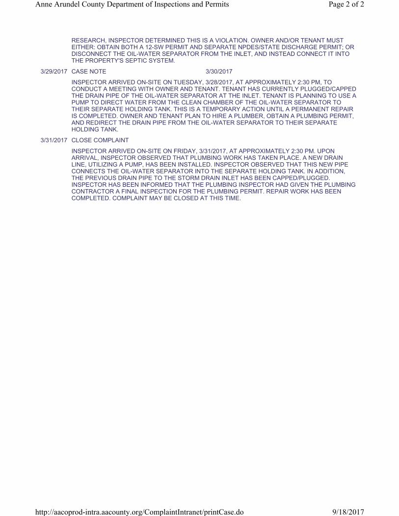
RESEARCH, INSPECTOR DETERMINED THIS IS A VIOLATION. OWNER AND/OR TENANT MUST
EITHER: OBTAIN BOTH A 12-SW PERMIT AND SEPARATE NPDES/STATE DISCHARGE PERMIT; OR
DISCONNECT THE OIL-WATER SEPARATOR FROM THE INLET, AND INSTEAD CONNECT IT INTO
THE PROPERTY'S SEPTIC SYSTEM.
3/29/2017 CASE NOTE 3/30/2017
INSPECTOR ARRIVED ON-SITE ON TUESDAY, 3/28/2017, AT APPROXIMATELY 2:30 PM, TO
CONDUCT A MEETING WITH OWNER AND TENANT. TENANT HAS CURRENTLY PLUGGED/CAPPED
THE DRAIN PIPE OF THE OIL-WATER SEPARATOR AT THE INLET. TENANT IS PLANNING TO USE A
PUMP TO DIRECT WATER FROM THE CLEAN CHAMBER OF THE OIL-WATER SEPARATOR TO
THEIR SEPARATE HOLDING TANK. THIS IS A TEMPORARY ACTION UNTIL A PERMANENT REPAIR
IS COMPLETED. OWNER AND TENANT PLAN TO HIRE A PLUMBER, OBTAIN A PLUMBING PERMIT,
AND REDIRECT THE DRAIN PIPE FROM THE OIL-WATER SEPARATOR TO THEIR SEPARATE
HOLDING TANK.
3/31/2017 CLOSE COMPLAINT
INSPECTOR ARRIVED ON-SITE ON FRIDAY, 3/31/2017, AT APPROXIMATELY 2:30 PM. UPON
ARRIVAL, INSPECTOR OBSERVED THAT PLUMBING WORK HAS TAKEN PLACE. A NEW DRAIN
LINE, UTILIZING A PUMP, HAS BEEN INSTALLED. INSPECTOR OBSERVED THAT THIS NEW PIPE
CONNECTS THE OIL-WATER SEPARATOR INTO THE SEPARATE HOLDING TANK. IN ADDITION,
THE PREVIOUS DRAIN PIPE TO THE STORM DRAIN INLET HAS BEEN CAPPED/PLUGGED.
INSPECTOR HAS BEEN INFORMED THAT THE PLUMBING INSPECTOR HAD GIVEN THE PLUMBING
CONTRACTOR A FINAL INSPECTION FOR THE PLUMBING PERMIT. REPAIR WORK HAS BEEN
COMPLETED. COMPLAINT MAY BE CLOSED AT THIS TIME.
Page 2 of 2Anne Arundel County Department of Inspections and Permits
9/18/2017http://aacoprod-intra.aacounty.org/ComplaintIntranet/printCase.do

Environment Section Complaint
Case ID: E - 2017 - 141 Location:
Tax ID: 500090085824
Received: 3/27/2017 Details:
Tickler: 9/22/2017 Completed:
ILLEGAL DISCHARGES COMPLAINT
Receiver: Inspector:
Date Assigned: Permit Number: Original ID:
ADC Map: Related Cases:
Water Front: Critical Area: N Violation:
Cty. Council Ind: Case Org:
Complainant:
Owner Information Violator Information
Owner 1: Violator 1:
Owner 2: Violator 2:
Address: Address:
Phone:
State Map: 09 12 0682 County Map: 2
Map No: Suffix Block Parcel Plat Sect Block Lot No
Date Event Due Date Request for Trial Date
3/27/2017 OPENED COMPLAINT CASE 4/27/2017
DPW MS4 CONTRACTOR DISCOVERED AN OUTFALL WITH FLOWING WATER BEHIND BUILDING 512. WATER TESTED HIGH FOR FLUORIDE AND DETERGENTS. AFTER FURTHER TESTS AND INVESTIGATION/RESEARCH, SUSPECTED THAT THE PRESENCE OF FLUORIDE AND DETERGENTS IS DUE TO ON-SITE VEHICLE WASHING, AND POSSIBLY MARBLE/GRANITE TILE CUTTING. REFERRED TO I&P FOR FURTHER INVESTIGATION AND ENFORCEMENT. INSPECTOR UNABLE TO PINPOINT A DEFINITIVE SOURCE. INSPECTOR WILL CONTINUE TO INVESTIGATE.
4/3/2017 CASE NOTE 5/4/2017
INSPECTOR ARRIVED ON-SITE ON MONDAY, 4/3/2017, AT APPROXIMATELY 3:00 PM. UPON ARRIVAL, INSPECTOR DIDN'T OBSERVE ANY VEHICLE WASHING TAKING PLACE IN THE PARKING LOT. IN ADDITION, INSPECTOR DIDN'T OBSERVE ANY RUNOFF FROM THE TILE CUTTING BUSINESS IN THE BUSINESS PARK. HOWEVER, INSPECTOR DID OBSERVE WHAT MAY BE EFFLUENT LADEN RUNOFF FROM THE GARAGES OF C C AUTO SERVICE (CCAS). INSPECTOR WILL FOLLOW-UP WITH OWNER/MANAGER OF THE BUSINESS PARK, AS WELL AS THE SUPERVISOR OF CCAS, TO DETERMINE THE SOURCE OF THE RUNOFF AND IF THERE IS A VIOLATION. INSPECTOR WILL CONTINUE TO MONITOR/INVESTIGATE.
4/6/2017 CASE NOTE 5/8/2017 4/6/2017
INSPECTOR ARRIVED ON-SITE ON THURSDAY, 4/6/2017, AT APPROXIMATELY 10:00 AM. UPON ARRIVAL, INSPECTOR MET WITH PROPERTY MANAGER (PM) INSPECTOR DID NOT OBSERVE ANY ILLICIT RUNOFF COMING FROM THE BUSINESSES ON THE PROPERTY. INSPECTOR AND PM ACCESSED AN AREA OF THE PROPERTY THAT RUNS ADJACENT TO PROPERTY BELONGING TO MR. SAFAK. PM INFORMED INSPECTOR THAT MR. SAFAK MAY BE ILLEGALLY DUMPING DIRTY HANDSINK WATER/PLUMBING. INSPECTOR OBSERVED TRASH AND OTHER DEBRIS ON MR. SAFAK'S PROPERTY, AS WELL AS A LARGE AMOUNT OF RUNOFF FROM HIS ONTO PM'S PROPERTY. IN ADDITION, INSPECTOR OBSERVED A WHITE PVC PIPE ON MR. SAFAK'S PROPERTY. IF PIPE DOES DISCHARGE, IT WOULD FLOW ONTO PM'S PROPERTY AND INTO THEIR
Page 1 of 3Anne Arundel County Department of Inspections and Permits
9/18/2017http://aacoprod-intra.aacounty.org/ComplaintIntranet/printCase.do

STORM DRAIN. UNCLEAR IF PIPE IS AN ILLICIT CONNECTION AT THIS TIME. INSPECTOR SHOWED PM THE LOCATION OF A BRANCH OF THEIR STORM DRAINS IN THIS AREA. THERE IS AN INLET THAT MAY NEED MAINTENANCE. IN ADDITION, THERE WAS DAMAGE TO PM'S STORM DRAIN PIPE, WHICH MAY BE RELATED TO AN ILLEGALLY BUILT WOODEN STRUCTURE ON MR. SAFAK'S PROPERTY. THEY ALSO OBSERVED A DRAIN ON MR. SAFAK'S PROPERTY CONNECTED INTO A WHITE PVC CLEANOUT NEAR THE CORNER OF THEIR 2 PROPERTIES AND BG'S CAR WASH. INSPECTOR PLANS TO INVESTIGATE FURTHER INTO MR. SAFAK'S PROPERTY. IN ADDITION, INSPECTOR WILL INVESTIGATE FURTHER INTO POTENTIAL OTHER PROPERTIES' STORM DRAINS CONNECTING WITH PM'S STORM DRAINS. AT END OF MEETING, INSPECTOR AND PM SPOKE WITH SUPERVISOR OF CCAS. INSPECTOR INFORMED SUPERVISOR THAT IF THEY CREATE RUNOFF IN THEIR GARAGE, THEY MUST CONTAIN IT. NO ILLICIT RUNOFF OBSERVED AT THE TIME. INSPECTOR WILL CONTINUE TO MONITOR/INVESTIGATE.
4/19/2017 CASE NOTE 4/19/2017
INSPECTOR ARRIVED ON-SITE TO TRACKDOWN ALL BRANCHES OF THE STORM DRAIN SYSTEM IN QUESTION. TRACKDOWN INCLUDED LOCATING STORM DRAINS ALONG CRAIN HIGHWAY AND AT EMPIRE TOWERS THAT COULD BE CONNECTED TO THE STORM DRAIN SYSTEM IN QUESTION.
4/27/2017 CASE NOTE
INSPECTOR ARRIVED ON-SITE ON 4/11/2017. PIPE IN QUESTION ON MR. SAFAK'S PROPERTY APPEARS TO HAVE BEEN BURIED. INSPECTOR MADE CONTACT WITH MR. SAFAK'S EMPLOYEES AND ASKED TO HAVE MR. SAFAK CONTACT HIM REGARDING POTENTIAL ILLICIT CONNECTION. INSPECTOR WILL CONTINUE TO INVESTIGATE.
4/27/2017 CASE NOTE 5/3/2017
INSPECTOR ARRIVE ON-SITE ON WEDNESDAY, 4/26/2017, AT APPROXIMATELY 2:30 PM. INSPECTOR MET WITH MR. SAFAK, THE OWNER OF 516 & 518 N CRAIN HWY. INSPECTOR AND MR. SAFAK WALKED AROUND THE PROPERTY TO DETERMINE WHAT THE RECENTLY BURIED PIPES ON MR. SAFAK'S PROPERTY WERE CONNECTED TO. PIPES ARE CONNECTED TO A SLOTTED DRAIN THAT MR. SAFAK HAD INSTALLED TO HELP MANAGE RUNOFF FROM HIS PROPERTY, AS WELL AS RUNOFF HIS PROPERTY RECEIVES FROM CRAIN HWY. INSPECTOR SAW NO EVIDENCE OF ANY ILLICIT HAND SINK(S). BASED ON THIS AND UNDERSTANDING WHAT THE PIPES ARE CONNECTED TO, INSPECTOR DOES NOT CURRENTLY SUSPECT ANY ILLICIT CONNECTION OR DISCHARGE FROM MR. SAFAK'S PROPERTY TO THE FEDER PROPERTY'S STORM DRAINS. INSPECTOR WILL CONTINUE TO INVESTIGATE TO DETERMINE A SOURCE. INSPECTOR WILL ASK FEDER'S PM AND VERSAR FIELD CREW FOR ASSISTANCE AS NECESSARY.
5/2/2017 CASE NOTE 5/9/2017
INSPECTOR ARRIVE ON-SITE ON TUESDAY, 5/2/2017, AT APPROXIMATELY 2:45 PM. INSPECTOR FOLLOWED-UP ON PARKING LOT REPAIRS AT EMPIRE TOWERS. CLEAN UP FROM REPAIRS APPEARS TO HAVE TAKEN PLACE. INSPECTOR WILL CONTINUE TO INVESTIGATE TO DETERMINE A SOURCE. INSPECTOR WILL ASK FEDER'S PM AND VERSAR FIELD CREW FOR ASSISTANCE AS NECESSARY.
5/31/2017 CASE NOTE 6/7/2017
UNABLE TO DETERMINE/LOCATE A SOURCE. INSPECTOR PLANS TO COORDINATE A MEETING WITH VERSAR AND FEDER TO RETEST THE OUTFALL AT 512 CRAIN HWY. WILL CONTINUE TO MONITOR/INVESTIGATE.
6/7/2017 CASE NOTE 6/12/2017
UNABLE TO LOCATE SOURCE. INSPECTOR COORDINATING A MEETING FOR THE FOLLOWING WEEK TO COLLECT A NEW SAMPLE TO TEST AT THE OUTFALL.
6/13/2017 CASE NOTE 6/27/2017
INSPECTOR ARRIVED ON-SITE ON TUESDAY, 6/13/2017, AT APPROXIMATELY 12:00 PM TO MEET WITH FEDDER AND VERSAR. VERSAR TOOK SAMPLES AT THE OUTFALL-IN-QUESTION, AT AN INLET BETWEEN THE FEDDER PROPERTY AND ENTERPRISE RENT-A-CAR, AND AT A MANHOLE AT THE PROPERTY ENTRANCE FROM CRAIN HWY. ALL SAMPLES TESTED BELOW ACTION LEVELS FOR FLUORIDE. HOWEVER, ALL SAMPLES TESTED ABOVE ACTION LEVELS FOR DETERGENTS. INSPECTOR WILL CONTINUE TO TRACK DOWN A SOURCE. AT THIS TIME, THE INSPECTOR IS UNABLE TO FIND A VIOLATION ON THE FEDDER PROPERTY.
6/28/2017 CASE NOTE 6/29/2017
Page 2 of 3Anne Arundel County Department of Inspections and Permits
9/18/2017http://aacoprod-intra.aacounty.org/ComplaintIntranet/printCase.do

7/6/2017 CASE NOTE 7/13/2017
INSPECTOR VISITED PROPERTY. INSPECTOR IS BEGINNING TO MAP OUT THE CONNECTED STORM DRAINS ON GEOCORTEX. ONCE INSPECTOR HAS COMPLETED THE MAP OUT AS ACCURATELY AS POSSIBLE, INSPECTOR AND VERSAR WILL COMMENCE FURTHER TRACKDOWN TO DETERMINE THE POTENTIAL SOURCE(S).
7/7/2017 CASE NOTE 7/13/2017
INSPECTOR VISITED PROPERTY. INSPECTOR CONTINUED TO MAP OUT THE CONNECTED STORM DRAINS ON GEOCORTEX. ONCE INSPECTOR HAS COMPLETED THE MAP OUT AS ACCURATELY AS POSSIBLE, INSPECTOR AND VERSAR WILL COMMENCE FURTHER TRACKDOWN TO DETERMINE THE POTENTIAL SOURCE(S).
7/10/2017 CASE NOTE 7/13/2017
INSPECTOR VISITED PROPERTY. INSPECTOR CONTINUED TO MAP OUT THE CONNECTED STORM DRAINS ON GEOCORTEX. ONCE INSPECTOR HAS COMPLETED THE MAP OUT AS ACCURATELY AS POSSIBLE, INSPECTOR AND VERSAR WILL COMMENCE FURTHER TRACKDOWN TO DETERMINE THE POTENTIAL SOURCE(S).
7/11/2017 CASE NOTE 7/13/2017
VISIT. MAP OUT STORM DRAINS.
7/18/2017 CASE NOTE 7/21/2017
7/19/2017 CASE NOTE 7/21/2017
7/31/2017 CASE NOTE 8/4/2017
INSPECTOR CONTINUES TO TRACE ALL BRANCHES OF THE STORM DRAIN IN QUESTION. ONGOING.
8/11/2017 CASE NOTE 8/25/2017
TRACING OF ALL STORM DRAINS. ONGOING.
8/15/2017 CASE NOTE 8/25/2017
TRACING OF ALL STORM DRAINS. ONGOING.
8/29/2017 CASE NOTE 9/5/2017
TRACING OF STORM DRAINS. ONGOING.
Page 3 of 3Anne Arundel County Department of Inspections and Permits
9/18/2017http://aacoprod-intra.aacounty.org/ComplaintIntranet/printCase.do

Environment Section Complaint
Case ID: E - 2017 - 148 Location:
Tax ID: 300019868500
Received: 3/29/2017 Details:
Tickler: Completed: 5/1/2017
ILLEGAL DISCHARGES COMPLAINT
Receiver: Inspector:
Date Assigned: 3/29/2017 Permit Number: Original ID:
ADC Map: Related Cases:
Water Front: Critical Area: N Violation:
Cty. Council Ind: Case Org:
Complainant:
Owner Information Violator Information
Owner 1: Violator 1:
Owner 2: Violator 2:
Address: Address:
Phone:
State Map: 16 21 0264 County Map: 1
Map No: Suffix Block Parcel Plat Sect Block Lot No
Date Event Due Date Request for Trial Date
3/29/2017 OPENED COMPLAINT CASE 4/21/2017
MESSAGE TRANSFERRED TO STEVE TRUMPLER FROM ENVIRONMENTAL COMPLAINTS LINE. MR. CHUCK CAVEY, RESIDENT AT 8427 ELVATON ROAD OBSERVED DETERGENTS DISCHARGING FROM SUMP PIPE AT 8425 ELVATON ROAD. COMPLAINT ASSIGNED TO WPRP INSPECTOR, MARY FORD AND ON-SITE INVESTIGATION WILL BE CONDUCTED ON 03/29/2017.
3/30/2017 CASE NOTE 4/28/2017
SITE INVESTIGATION CONDUCTED ON 3/29/2017, AT 1430 BY INSPECTOR MARY FORD. A PARTIALLY BURIED 1' PVC PIPE WAS LOCATED EXTENDING FROM HOME TO ELVATON ROAD. NO VISIBLE EVIDENCE OF ACTIVE DETERGENT WATER DISCHARGE LEAVING PIPE AT TIME OF INSPECTION. RESIDENT AT 8427 ELVATON ROAD IS LOCATED DOWN SLOPE AND RECEIVES DISCHARGE WILL CONTACT THE INSPECTOR WHEN ACTIVE DISCHARGE IS OCCURRING FOR RE-INSPECTION. CURRENT RESIDENT TENANTS AT 8425 ELVATON ROAD PROVIDED A COPY OF THEIR LEASE AGREEMENT THAT SHOWED MR. LARRY GOLDEN AS THE CURRENT PROPERTY OWNER OF 8425 ELVATON ROAD AND PROVIDED HIS TELEPHONE NUMBER. MR GOLDEN WAS CONTACTED BY TELEPHONE AND A VOICE MESSAGE WAS LEFT REQUESTING THAT HE CONTACT THE COUNTY TO DISCUSS THE DISCHARGE ONTO ELVATON ROAD. RE-INSPECTION TO BE CONDUCTED WHEN ACTIVE DISCHARGE IS OCCURRING. CORRECTION NOTICE ISSUED TO LAWRENCE GOLDEN PROPERTY OWNER REQUIRING IMMEDIATE REMEDIATION ACTIONS. INSPECTOR FORD CALLED MR. GOLDEN AND WAS ADVISED THAT HE WOULD BE IN MARYLAND AS OF 04/18/2017, TO COMPLETE THE REPAIR BY 04/21/2017.
4/24/2017 CASE NOTE 4/28/2017
INSPECTOR FORD CONTACTED MR. LAWRENCE GOLDEN ON 04/24/2017, AT 9:40 AM TO DISCUSS THE CURRENT STATUS OF REPAIR TO PROPERLY ROUTE THE WASHING MACHINE DISCHARGE TO THE SEPTIC SYSTEM FROM THE SUMP PUMP. MR LAWRENCE INDICATED THE REPAIR WOULD BE COMPLETED WITHIN 48 HOURS. MR. GOLDEN IS TO CONTACT INSPECTOR FORD UPON COMPLETING THE REPAIR SO THAT AN INSPECTION CAN BE PERFORMED TO CONFIRM
Page 1 of 2Anne Arundel County Department of Inspections and Permits
6/9/2017http://aacoprod-intra.aacounty.org/ComplaintIntranet/printCase.do

PROPER DRAINAGE BY INSPECTING THE THE SUMP PUMP LINE AND WASHING MACHINE DRAINAGE PIPE.
5/1/2017 CLOSE COMPLAINT
MR. GOLDEN HAS MADE THE NECESSARY REPAIRS TO RESOLVE THE DETERGENT DISCHARGE ON ELVATON ROAD. THE WASHING MACHINE WAS RE-ROUTED FROM THE SUMP PUMP AND CORRECTLY DISCHARGES INTO SEPTIC TANK.
Page 2 of 2Anne Arundel County Department of Inspections and Permits
6/9/2017http://aacoprod-intra.aacounty.org/ComplaintIntranet/printCase.do

Environment Section Complaint
Case ID: E - 2017 - 155 Location:
Tax ID: 306516244100
Received: 3/30/2017 Details:
Tickler: Completed: 5/1/2017
ILLEGAL DISCHARGES COMPLAINT
Receiver: Inspector:
Date Assigned: 3/30/2017 Permit Number: Original ID:
ADC Map: Related Cases:
Water Front: Critical Area: N Violation:
Cty. Council Ind: Case Org:
Complainant:
Owner Information Violator Information
Owner 1: Violator 1:
Owner 2: Violator 2:
Address: Address:
Phone:
State Map: 11 22 0300 County Map: 4
Map No: Suffix Block Parcel Plat Sect Block Lot No
Date Event Due Date Request for Trial Date
3/30/2017 OPENED COMPLAINT CASE 4/21/2017
COMMERCIAL RETAIL TENANTS LOCATED AT 8515 FT. SMALLWOOD ROAD CONTACTED ZONING ENFORCEMENT TO ISSUE COMPLAINT CONCERNING JUNK DEBRIS AND STORAGE OF VEHICLES AT 8513 FT. SMALLWOOD ROAD. COUNTY ZONING INSPECTOR RITA SCHINDLER CONDUCTED AN ON-SITE INSPECTION ON 3/24/2017, AND IN ADDITION TO JUNK DEBRIS AND VEHICLE STORAGE VIOLATIONS, DISCOVERED AN OVERFLOWING BARREL DRUM FULL WITH USED AUTOMOTIVE OIL AND LARGE OIL STAINING ON THE LOT ASPHALT. INSPECTOR SCHINDLER SHARED THE ILLICIT DISCHARGE FINDINGS WITH WPRP INSPECTOR MARY FORD ON 3/30/2017 AT 0945. INSPECTOR FORD WILL CONDUCT ADDITIONAL ON-SITE INVESTIGATION ACTIONS ON 3/30/2017.
3/31/2017 CASE NOTE 4/21/2017 3/31/2017
INSPECTION CONDUCTED ON 3/30/2017, BY INSPECTOR FORD CONFIRMED THE PRESENCE OF (1) 50 GALLON STEEL DRUM WITH USED AUTOMOTIVE OIL SPILLING OVER THE RIM WITH A USED OIL PAN ON TOP. AT THE BASED OF THE DRUM ARE DEBRIS PILES COVERED IN USED AUTOMOTIVE OIL. ALSO PRESENT IS A 3X2 OIL SPILL ON THE ASPHALT. THE BUILDING ON THE PROPERTY WAS LOCKED AND NO ONE WAS PRESENT TO RESPOND TO INSPECTOR FORD INQUIRY. A COUNTY INSPECTION DOOR HANGER WAS LEFT CITING THE ILLICIT DISCHARGE ON THE PROPERTY AND TO CONTACT INSPECTOR FORD. CORRECTION NOTICE WAS ISSUED TO DWIGHT W KELLEY PROPERTY OWNER REQUIRING IMMEDIATE REMEDIATION ACTIONS BY OR BEFORE 04/21/2017.
4/24/2017 CASE NOTE
PROPERTY OWNER DWIGHT KELLEY CONTACTED INSPECTOR FORD TO ADVISE THAT THE LOCATION IS OCCUPIED BY TENANTS AND HE WOULD REQUIRE THE REMOVAL AND CLEAN-UP OFF THE OIL DRUM AND SPILLS BY 04/21/2017. RE-INSPECTION WILL BE PERFORMED ON 04/24/2017.
5/1/2017 CLOSE COMPLAINT
Page 1 of 2Anne Arundel County Department of Inspections and Permits
6/9/2017http://aacoprod-intra.aacounty.org/ComplaintIntranet/printCase.do

MR. KELLEY HAS TAKEN THE NECESSARY ACTIONS REQUESTED BY THE COUNTY TO
REMEDIATE THE LOT. THE CURRENT TENANTS ON HIS PROPERTY K&K CONSTRUCTION AND
TOWER, HAVE REMOVED THE OIL DRUM FROM THE PROPERTY AND ANY RESIDUAL OIL AROUND
THE DRUM HAS BEEN TREATED AND REMOVED WITH AN OIL ABSORBENT. CURRENT TENANTS
HAVE PLACED EQUIPMENT AND WORK VEHICLES IN THE AREA WHERE THE DRUM WAS
ORIGINALLY LOCATED.
Page 2 of 2Anne Arundel County Department of Inspections and Permits
6/9/2017http://aacoprod-intra.aacounty.org/ComplaintIntranet/printCase.do

Environment Section Complaint
Case ID: E - 2017 - 163 Location:
Tax ID: 422990093024
Received: 4/3/2017 Details:
Tickler: Completed: 4/4/2017
ILLEGAL DISCHARGES COMPLAINT
Receiver: Inspector:
Date Assigned: Permit Number: Original ID:
ADC Map: Related Cases:
Water Front: Critical Area: N Violation:
Cty. Council Ind: Case Org:
Complainant:
Owner Information Violator Information
Owner 1: Violator 1:
Owner 2: Violator 2:
Address: 0 CRAIN HWY Address: 0 CRAIN HWY
GLEN BURNIE 21061 GLEN BURNIE 21061
Phone:
State Map: 15 17 1025 County Map: 2
Map No: Suffix Block Parcel Plat Sect Block Lot No
Date Event Due Date Request for Trial Date
4/3/2017 OPENED COMPLAINT CASE 4/4/2017
DPW MS4 CONTRACTOR DISCOVERED STOCKPILES OF DISCARDED TIRES. ADJACENT TO THE TIRES WAS A SIGNIFICANT AMOUNT OF TRASH AND DEBRIS. REFERRED TO I&P FOR FURTHER INVESTIGATION/ENFORCMENT. INSPECTOR WILL INVESTIGATE AND DETERMINE PROPER ACTION.
4/3/2017 CASE NOTE 4/3/2017
INSPECTOR ARRIVED ON-SITE ON MONDAY, 4/3/2017, AT APPROXIMATELY 2:40 PM. UPON ARRIVAL, INSPECTOR OBSERVED STACKED, DISCARDED TIRES. IN ADDITION, INSPECTOR OBSERVED A SIGNIFICANT AMOUNT OF TRASH/DEBRIS. IT IS UNCLEAR IF THIS SHOULD BE HANDLED AS AN ILLICIT DISCHARGE, OR GIVEN TO A DIFFERENT DIVISION/DEPARTMENT FOR FURTHER INVESTIGATION/ENFORCEMENT. INSPECTOR WILL CONTINUE TO FOLLOW-UP/INVESTIGATE.
4/4/2017 CLOSE COMPLAINT
PER DISCUSSION WITH SUPERVISOR, IT WAS DECIDED THAT THE COMPLAINT NEEDS TO BE REFERRED TO ANOTHER OFFICE. INSPECTOR WILL FORWARD COMPLAINT TO THE HEALTH DEPARTMENT AND TO ZONING. I&P COMPLAINT MAY BE CLOSED AT THIS TIME.
Page 1 of 1Anne Arundel County Department of Inspections and Permits
9/18/2017http://aacoprod-intra.aacounty.org/ComplaintIntranet/printCase.do

Zoning Section Complaint
Case ID: Z - 2017 - 403 Location:
Tax ID: 422990093024
Received: 4/17/2017 Details:
Tickler: Completed: 6/7/2017
JUNK AND DEBRIS COMPLAINT
Receiver: Inspector:
Date Assigned: Permit Number: Original ID:
ADC Map: Related Cases:
Water Front: Critical Area: N Violation:
Cty. Council Ind: Case Org:
Complainant:
Owner Information Violator Information
Owner 1: Violator 1:
Owner 2: Violator 2:
Address: 0 CRAIN HWY Address:
GLEN BURNIE 21061
Phone:
State Map: 15 17 1025 County Map: 2
Map No: Suffix Block Parcel Plat Sect Block Lot No
Date Event Due Date Request for Trial Date
4/17/2017 OPENED COMPLAINT CASE 5/1/2017
5/9/2017 VIOLATION LETTER 5/29/2017 5/9/2017
ON MAY 4, 2017, I INSPECTED YOUR PROPERTY AND OBSERVED A POSSIBLE VIOLATION OF ARTICLES 18-17-101 OF THE ANNE ARUNDEL COUNTY CODE, WHICH PROHIBITS THE USE OF LAND FOR THE DISPOSAL OF JUNK INCLUDING DISCARDED TIRES.
6/7/2017 CASE NOTE 6/7/2017 6/7/2017
INSPECTION ON 6-7-2017 REVEALED THAT ALL TIRES HAVE BEEN REMOVED.
6/7/2017 CLOSE COMPLAINT
Page 1 of 1Anne Arundel County Department of Inspections and Permits
9/18/2017http://aacoprod-intra.aacounty.org/ComplaintIntranet/printCase.do

Environment Section Complaint
Case ID: E - 2017 - 170 Location:
Tax ID: 200007987002
Received: 4/3/2017 Details:
Tickler: Completed: 7/14/2017
CRITICAL AREA CLEARING/GRADING
Receiver: Inspector:
Date Assigned: 4/3/2017 Permit Number: Original ID:
ADC Map: Related Cases:
Water Front: Critical Area: Y Violation:
Cty. Council Ind: Case Org:
Complainant:
Owner Information Violator Information
Owner 1: Violator 1:
Owner 2: Violator 2:
Address: Address:
Phone:
State Map: 51 H 08 0288 County Map:
Map No: Suffix Block Parcel Plat Sect Block Lot No
Date Event Due Date Request for Trial Date
4/3/2017 OPENED COMPLAINT CASE 4/8/2017
CLEARING/GRADING IN THE CRITICAL AREA
4/10/2017 NOT IN COMPLIANCE 4/15/2017 4/10/2017
A COMPLAINT OF CRITICAL AREA CLEARING/GRADING WAS RECEIVED FROM MS. LISA DAVIS ON 4/3/2017, WHO RESIDES AT 2639 GREENBRIAR LN. ANNAPOLIS, MD 21401. THE COMPLAINANT ALLEDGES THAT MR. SNYDER IS CONSTRUCTING WITHIN A PROPERTY THAT DOES NOT BELONG TO HIM. FURTHER DEED RESEARCH RESULTED IN THE CONFIRMATION THAT IN FACT MR. & MRS. SNYDER OWN A PARCEL OF LAND THAT IS 20-FEET WIDE AND 539-FEET LONG WITH WHICH IS WATERFRONT AND LIES WITHIN THE 100-FOOT BUFFER AND RCA. THEY HAVE OWNED SAID PROPERTY SINCE DECEMBER 1, 2000. THE PARCEL HAS BEEN CONTINUOUSLY CONVEYED SINCE SEPTEMBER 25, 1951. NO ACTIVE PERMITS EXIST FOR THE PROPERTY. A FIELD INSPECTION WAS PERFORMED ON THE SAME DAY. AT THE TIME OF ARRIVAL, I MET WITH MS. DAVIS WHO WALKED ME TO THE WATERFRONT TO ILLUSTRATE HER CONCERNS ON THE NEIGHBORING PROPERTY. IT WAS OBSERVED THAT A ROCK RETAINING WALL AT THE SHORELINE, APPROXIMATELY 2-FEET IN HEIGHT AND 20-FEET LONG HAS BEEN CONSTRUCTED WITHIN AND OUTSIDE THE WATERS OF THE STATE ON CRAB CREEK. (2) 6X6 WOODEN JETTYS WERE OBSERVED ON BOTH SIDES OF THE ROCK WALL, AND SAND FILL WAS USED BEHIND THE WALL TO THE EXISTING SYCAMORE. A STONE DRAINAGE SWALE OF IRREGULAR DIRECTION HAS BEEN CONSTRUCTED APPROXIMATELY 70-FEET LONG TO THE WATERFRONT. (2) CORRUGATED BLACK PVC PIPES WERE OBSERVED OUFALLING FROM THE PROPERTY TO CRAB CREEK. A STONE PATH WAS OBSERVED HEADING AWAY FROM THE EXISTING TREE TOWARDS THE ROADWAY APPROXIMATELY 50-FEET LONG AND 7-FEET WIDE. THE REMAINDER OF THE PATHWAY BECOMES MULCH THEREAFTER UNTIL THE ROADWAY EDGE WHERE MORE STONE HAS BEEN APPLIED AT THE FRONTAGE. A FENCE EXISTS ON THE PARCEL RIGHT SIDE WITH A GATE AT THE ROADWAY. PHOTO DOCUMENTATION TAKEN FROM MS. DAVIS PROPERTY. NO ACCESS WAS ATTEMPTED ONTO THE SUBJECT PROPERTY. CONTACT WILL BE SOUGHT OF THE HOMEOWNER OF THE SUBJECT PROPERTY.
Page 1 of 2Anne Arundel County Department of Inspections and Permits
9/14/2017http://aacoprod-intra.aacounty.org/ComplaintIntranet/printCase.do

4/10/2017 STOP WORK ORDER 4/10/2017 4/10/2017
THE STOP WORK ORDER WAS POSTED ON THE PROPERTY ON 4/4/2017 FOR GRADING/FILLING/CONSTRUCTION WITHIN THE 100-FOOT CRITICAL AREA BUFFER WITHOUT A PERMIT. CONSTRUCTION WITHIN TIDAL WATERS, NO PERMIT, HAS BEEN REFERRED TO MDE. MR. SNYDER ESCORTED ME TO THE WATERFRONT WHERE ADDITIONAL PHOTO DOCUMENTATION WAS TAKEN AND A DISCUSSION WAS HAD CONCERNING THE VIOLATION.
4/10/2017 CASE NOTE 5/12/2017 4/10/2017
A MEETING WAS HAD ON-SITE WITH ANDREA BUIE OF MDE AND MR. & MRS. SNYDER IN ATTENDANCE. THE CASE IS BEING REFERRED TO THE TIDAL DIVISION WITHIN MDE FOR ASSESSMENT. THE TOTAL DISTURBANCE IS UNDER 5,000-SQUARE FEET, THEREFORE A STANDARD GRADING PLAN APPLICATION WAS RECOMMENDED TO BE SUBMITTED TO ANNE ARUNDEL COUNTY FOR REVIEW AND ABATEMENT OF THE VIOLATION. PHOTO DOCUMENTATION TAKEN. A VIOLATION LETTER WILL BE MAILED FIRST CLASS AND ALSO TRANSMITTED VIA EMAIL TO THE HOMEOWNERS.
4/13/2017 GENERAL LETTER 5/13/2017 4/28/2017
APRIL 13, 2017 FIRST CLASS MAIL RONALD W. SNYDER MARILYN L. SNYDER 2644 GREENBRIAR LN. ANNAPOLIS, MD 21401 RE: 2644 GREENBRIAR LN. ANNAPOLIS, MD 21401 (TAX MAP 51, BLOCK 8, PARCEL 288) STOP WORK ORDER AND VIOLATION NOTICE (FN# E-2017-170) (TAX ID: 200007987002) DEAR MR. & MRS. SNYDER: ON APRIL 3, 2017, THE REFERENCED PROPERTY WAS INSPECTED BY REPRESENTATIVES OF THIS DEPARTMENT AND FOUND TO BE IN VIOLATION OF THE ANNE ARUNDEL COUNTY CRITICAL AREA, GRADING, AND STORMWATER MANAGEMENT ORDINANCES (ALL CODE CITATIONS ARE FROM THE ANNE ARUNDEL COUNTY CODE). SPECIFICALLY, UNAUTHORIZED GRADING AND FILLING RESULTING IN DISTURBANCE LESS THAN 5,000 SQUARE FEET IN THE CHESAPEAKE BAY CRITICAL AREA BUFFER HAS OCCURRED WITHOUT PRIOR APPROVAL IN VIOLATION OF ARTICLE 16, SECTION 3-201, 4-201 AND ARTICLE 17, RESPECTIVELY. CONSEQUENTLY, A STOP WORK ORDER HAS BEEN POSTED ON THE SUBJECT PROPERTY. PLEASE NOTE, TO PERFORM FURTHER WORK IN VIOLATION OF THIS ARTICLE OR A STOP WORK ORDER IS A VIOLATION OF ARTICLE 16, SECTION 5-101(A)(4). ACCORDINGLY, YOU MUST SUBMIT THE REQUIRED STANDARD GRADING PLAN APPLICATION, BY NO LATER THAN MAY 13, 2017 AND DILIGENTLY PURSUE ISSUANCE OF SAME, INCLUSIVE OF APPLICABLE ZONING AND ENVIRONMENTAL AUTHORIZATIONS. IN ACCORDANCE WITH ARTICLE 16, SECTION 1-109, THE DEPARTMENT SHALL DENY THE ISSUANCE OF ADDITIONAL PERMITS UNTIL THIS VIOLATION IS CORRECTED. FAILURE TO COMPLY WITH THIS NOTICE MAY RESULT IN THE ISSUANCE OF ADDITIONAL FINES AND IMMEDIATE REFERRAL TO THE COUNTY OFFICE OF LAW FOR CIVIL ENFORCEMENT OR PENALTIES AS OUTLINED IN ARTICLE 16, TITLE 5. IN ADDITION, THE COUNTY MAY INSTITUTE ANY OTHER APPROPRIATE LEGAL PROCEEDINGS AS ALLOWED BY LAW IN RESPONSE TO THE VIOLATIONS AT THE ABOVE PROPERTY. SHOULD YOU HAVE ANY QUESTIONS RELATIVE TO PERMITTING REQUIREMENTS, YOU MAY ACCESS THE COUNTY’S WEBSITE AT WWW.AACOUNTY.ORG OR YOU MAY CONTACT MR. JAY LESHINSKIE, PERMIT COORDINATOR OF THE PERMIT CENTER AT (410) 222-7730. IF YOU HAVE ANY OTHER QUESTIONS REGARDING THIS CORRESPONDENCE, PLEASE CONTACT ME AT [email protected] OR (410) 222-4602. (A COPY OF THIS NOTICE MUST BE INCLUDED WITH ALL REQUIRED APPLICATIONS.)
6/9/2017 CASE NOTE 6/23/2017 6/9/2017
THE STANDARD GRADING PLAN APPLICATION WAS RECEIVED BY THIS INSPECTOR ON 4/25/2017 FOR THE SUBJECT PROPERTY VIOLATION. IT WAS REQUIRED BY MDE FOR THE OFFENDING STRUCTURES TO BE REMOVED FROM TIDAL WATERS. THIS IS NOT ILLUSTRATED ON THE PLAN. AT THIS TIME, THE SUBMITTED SGP-112-2017 CAN NOT BE APPROVED DUE TO THE CONSTRUCTION WITHIN THE 100-FOOT CRITICAL AREA BUFFER AND TIDAL WATERS WITHOUT PRIOR AUTHORIZATION.
7/14/2017 CLOSE COMPLAINT
A FOLLOW-UP INSPECTION WAS PERFORMED ON JUNE 16, 2017 BY MDE FOR THE TIDAL VIOLATIONS. THE FIRST ROW OF CHANNELWARD STONE HAS BEEN REMOVED FROM THE WALL. ADDITIONAL STONE HAS BEEN REMOVED NEAR THE WOOD FENCE. THE 8-FOOT LONG WOOD STRUCTURE, BELOW MEAN HIGH WATER (MHW) HAS BEEN REMOVED. THE WOOD STEP, BELOW MHW HAS BEEN REMOVED. MDE STILL REQUIRES THE STONE SWALE TO BE PERMITTED THROUGH TIDAL SECTION DUE TO DISCHARGE INTO CRAB CREEK. PHOTO DOCUMENTATION WITHIN THE REPORT WAS FORWARDED TO THIS DEPARTMENT. ANNE ARUNDEL COUNTY IS CLOSING THIS CASE FOR COMPLIANCE WITH STATED REQUIREMENTS.
Page 2 of 2Anne Arundel County Department of Inspections and Permits
9/14/2017http://aacoprod-intra.aacounty.org/ComplaintIntranet/printCase.do

Environment Section Complaint
Case ID: E - 2017 - 173 Location:
Tax ID: 339690041141
Received: 4/4/2017 Details:
Tickler: Completed: 4/4/2017
ILLEGAL DISCHARGES COMPLAINT
Receiver: Inspector:
Date Assigned: Permit Number: Original ID:
ADC Map: Related Cases:
Water Front: Critical Area: N Violation:
Cty. Council Ind: Case Org:
Complainant:
Owner Information Violator Information
Owner 1: Violator 1:
Owner 2: Violator 2:
Address: 0 GREEN BRANCH LN Address: 0 GREEN BRANCH LN
GLEN BURNIE 21061 GLEN BURNIE 21061
Phone:
State Map: 15 17 0184 County Map: 2
Map No: Suffix Block Parcel Plat Sect Block Lot No
Date Event Due Date Request for Trial Date
4/4/2017 OPENED COMPLAINT CASE 4/5/2017
DPW MS4 CONTRACTOR FOUND EVIDENCE OF DUMPING JUST UPHILL OF COUNTY FLOODPLAIN IN THE APARTMENT COMPLEX. TRASH/DEBRIS MAY ENTER NATURAL WATERS DURING STORM OR WIND EVENT(S). INSPECTOR WILL INVESTIGATE FURTHER. IN ADDITION, INSPECTOR WILL DETERMINE IF I&P SHOULD BE THE ENFORCEMENT AUTHORITY, OR IF COMPLAINT NEEDS TO BE TRANSFERRED.
4/4/2017 CLOSE COMPLAINT
INSPECTOR ARRIVED ON-SITE ON TUESDAY, 4/4/2017, AT APPROXIMATELY 12:30 PM. UPON ARRIVAL, INSPECTOR OBSERVED TRASH/DEBRIS IN THE WOODS ALONGSIDE GREEN BRANCH LN, BETWEEN GREEN BUD LN AND GREEN ORCHARD RD. SOME OF THE TRASH/DEBRIS IS ALREADY IN THE COUNTY FLOODPLAIN AND/OR DOWN NEAR THE STREAMBED. IT IS SUSPECTED THAT THIS IS NOT AN I&P RELATED ISSUE. INSPECTOR WILL REFER COMPLAINT OVER TO HEALTH DEPARTMENT, AND ZONING. I&P COMPLAINT MAY BE CLOSED AT THIS TIME.
Page 1 of 1Anne Arundel County Department of Inspections and Permits
9/18/2017http://aacoprod-intra.aacounty.org/ComplaintIntranet/printCase.do

Environment Section Complaint
Case ID: E - 2017 - 183 Location:
Tax ID: 190405418300
Received: 4/10/2017 Details:
Tickler: Completed: 4/19/2017
SEDIMENT CONTROLS DOWN/MISSING
Receiver: Inspector:
Date Assigned: 4/10/2017 Permit Number: Original ID:
ADC Map: Related Cases:
Water Front: Critical Area: Y Violation:
Cty. Council Ind: Case Org:
Complainant:
Owner Information Violator Information
Owner 1: Violator 1:
Owner 2: Violator 2:
Address: Address:
Phone:
State Map: 56 07 0126 County Map: 4660
Map No: Suffix Block Parcel Plat Sect Block Lot No
Date Event Due Date Request for Trial Date
4/10/2017 OPENED COMPLAINT CASE 4/15/2017
NEW HOUSE BEING CONSTRUCTED AFTER DEMO OF AN EXISTING HOME. WHILE THERE WAS SILT FENCE AROUND THE FOUNDATION, AFTER THE RAINS THURSDAY THEY PUMPED OUT THE AREA LEAVING MUD IN THE ROAD AND GOING TOWARDS STORM DRAIN.
4/19/2017 CLOSE COMPLAINT
INSPECTION REVEALED ALL RSF IS INSTALLED, NO EVIDENCE OF ANY SEDIMENT LEAVING SITE. ADVISED HOMEOWNER TO INSTALL A SCE, AND STABILIZE SMALL AREA OUTSIDE OF RSF. CLOSE THIS COMPLAINT
Page 1 of 1Anne Arundel County Department of Inspections and Permits
6/9/2017http://aacoprod-intra.aacounty.org/ComplaintIntranet/printCase.do

Environment Section Complaint
Case ID: E - 2017 - 199 Location:
Tax ID: 320790040500
Received: 4/17/2017 Details:
Tickler: 7/28/2017 Completed:
ILLEGAL DISCHARGES COMPLAINT
Receiver: Inspector:
Date Assigned: Permit Number: Original ID:
ADC Map: Related Cases:
Water Front: Critical Area: N Violation:
Cty. Council Ind: Case Org:
Complainant:
Owner Information Violator Information
Owner 1: Violator 1:
Owner 2: Violator 2:
Address: Address:
Phone:
State Map: 15 23 0958 County Map: 4
Map No: Suffix Block Parcel Plat Sect Block Lot No
Date Event Due Date Request for Trial Date
4/17/2017 OPENED COMPLAINT CASE 4/29/2017
VERSAR-LIMNOTECH FIELD OBSERVATION REPORT DATED 4/11/2017 CITED IMPROPER BULK SOLID STORAGE AND WASTE MANAGEMENT WITH AUTOMOTIVE OIL ILLICIT DISCHARGE. REPORT WAS SENT TO JANIS MARKUSIC OF DPW WPRP ON 4/11/2017 AND FORWARD TO STEVE TRUMPLER ON 4/12/2017. COMPLAINT SENT TO WPRP INSPECTOR MARY FORD ON 4/13/2017 AND AN ON-SITE INVESTIGATION WAS CONDUCTED ON 4/13/2017, BY INSPECTOR FORD.
4/18/2017 CASE NOTE
UPON ARRIVAL TO CONDUCT ON-SITE INSPECTION, INSPECTOR FORD WITNESSED SEVERAL EMPLOYEES SWEEPING THE LOT, APPLYING CAT LITTER AS AN ABSORBENT AND CLEANING THE LOT OF ANY TRASH AND DEBRIS. RAFAEL TORRES, WAREHOUSE MANAGER ACCOMPANIED INSPECTOR FORD DURING THE SITE INSPECTION AND PROVIDED AN OVERVIEW OF THE BULK STORAGE PICK UP SCHEDULE AND PROTOCOL, REQUIRED DRAINAGE OF OIL FROM ALL AUTOMOTIVE ENGINES, AND DAILY LOT OIL CLEAN-UP. THERE WAS SIGNIFICANT CURB DAMAGE ALONG THE PERIMETER THAT NEEDS REPAIR. THE PROPERTY DOES ABUT TO A STREAM VALLEY AREA FOR MARLEY CREEK 4. RAFAEL NOTED THAT AN EPA INSPECTION WAS CONDUCTED THE PREVIOUS YEAR AND HE WOULD FORWARD A COPY UPON LOCATING. EXTENSIVE PHOTO DOCUMENTATION WAS PERFORMED FOR COUNTY RECORDS.
4/24/2017 CASE NOTE
INSPECTOR FORD MET WITH RAFAEL TORRES ON 04/21/2017, WAREHOUSE MANAGER TO FOLLOW UP ON RECEIVING A COPY OF THE EPA REPORT THAT WAS TO HAVE BEEN FORWARD. RAFAEL INDICATED HE WOULD REQUEST AGAIN FROM RANDA ALLISON, OFFICE MANAGER TO FORWARD ON MONDAY 04/24/2017.
4/24/2017 CASE NOTE 4/24/2017 4/24/2017
INSPECTOR FORD CONTACTED AND SPOKE WITH RANDA ALLISON, OFFICE MANAGER ON 04/24/2017 AT 9:03 AM TO REQUEST A COPY OF THE EPA REPORT. MS. ALLISON INDICATED SHE
Page 1 of 3Anne Arundel County Department of Inspections and Permits
9/18/2017http://aacoprod-intra.aacounty.org/ComplaintIntranet/printCase.do

WOULD SCAN AND SEND BY COB ON 04/24/2017.
4/25/2017 CASE NOTE
INSPECTOR FORD RECEIVED FROM MS. ALLISON COPIES OF THE MDE INSPECTION REPORT DATED 02/08/2012 AND CLEAN HARBORS REMEDIATION QUOTE #2190936 AND SIGNED AGREEMENT DATED 06/24/2015. INSPECTOR FORD REQUESTED A COPY OF THE LETTER FROM CLEAN HARBORS THAT WAS REQUESTED FROM PROPERTY OWNERS CLOVERLEAF WAREHOUSE AND BUSINESS PARK, LLLP THAT OUTLINES REQUIRED MAINTENANCE ACTIONS TO STAY IN COMPLIANCE. MS. ALLISON ACKNOWLEDGED THE REQUEST AND WILL FORWARD ONCE LOCATED.
5/1/2017 CASE NOTE
FOLLOWING REVIEW OF THE MDE AND CLEAN HARBORS DOCUMENTS, ADDITIONAL INFORMATION WAS REQUESTED ON 04/27/2017, VIA EMAIL AND VOICEMAIL FROM MR. MIKE FRANK, OF THE MDE OIL COMPLIANCE DIVISION. INSPECTOR FORD ALSO REQUESTED THAT A FOLLOW-UP INVESTIGATION BE PERFORMED BY MDE SINCE THE PRIOR MAINTENANCE COMPLIANCE ACTIONS REQUESTED BY MDE HAVE NOT BEEN ADHERE TO.
5/5/2017 CASE NOTE
INSPECTOR FORD PLACED A SECOND CALL TO MDE OIL PROGRAM DIRECTOR, MIKE FRANK TO FOLLOW UP ON THE REQUEST FOR A MDE FOLLOW UP INSPECTION TO ORIGINAL 2012 OIL COMPLAINT. AS A RESULT, INSPECTOR FORD RECEIVED A CALL FROM MDE OIL PROGRAM ENVIRONMENTAL COMPLIANCE SPECIALIST, MR. MICHAEL JESTER ON 05/05/2017, TO ACCOMPANY HIM FOR A JOINT INSPECTION AT ROK BROTHERS AUTO PARTS RECYCLING FACILITY. THE JOINT INSPECTION WAS CONDUCTED ON 05/05/2017, FOLLOWING A SIGNIFICANT RAIN EVENT ALLOWING THE INSPECTORS TO HAVE A BETTER VISUAL INSPECTION OF THE EXTENT OF THE OIL RUN-OFF FROM THE PROPERTY AND IMPACTS TO THE ADJOINING MARLEY CREEK SINCE ANY OIL WOULD APPEAR AS A SHEEN ON THE SURFACE OF STANDING OR FLOWING WATER. THE INSPECTION YIELDED MINIMAL EVIDENCE OF OIL LEAVING THE PROPERTY AND INDICATED THAT DAILY OIL CLEAN UP ACTIONS USING AN OIL ABSORBENT ARE IN EFFECT. BASED ON THESE FINDINGS, MR. JESTER PREPARED A OBSERVATION OF FINDINGS REPORT AND CONTACTED THE PROPERTY OWNERS TO ADVISE OF THE SECOND OIL COMPLIANT ISSUED AGAINST THEIR TENANT, ROK BROTHERS. MR. JESTER PROVIDED A COPY OF THE REPORT TO INSPECTOR FORD AND PROVIDED THE MDE WATER COMPLIANCE DIVISION CONTACT FOR MILLERSVILLE, MR. DAVID HAFFNER (410) 537-4058. INSPECTOR FORD HAS REQUESTED THAT A SEPARATE STORMWATER INVESTIGATION IS CONDUCTED BY MR. HAFFNER AND IS AWAITING CONFIRMATION OF THE DATE AND TIME.
5/9/2017 CASE NOTE
INSPECTOR FORD RECEIVED DOCUMENTATION FROM ROK BROTHERS OFFICE MANAGER MS. RANDA ALLISON THAT FOLLOWING THE MDE OIL COMPLIANCE INSPECTION CONDUCTED ON 05/05/2017, THEY HAVE ORDERED WATERPROOF ROLL OFF TARPS FOR ALL OUTDOOR STORAGE CONTAINERS AND ABSORBENT BOOMS TO BE PLACED INSIDE OF ANY CONTAINERS WITH PUNCTURES AND AROUND ADJACENT STORMDRAINS AS A TEMPORARY REMEDIATION UNTIL PERMANENT WELDING REPAIRS CAN BE PERFORMED WHICH IS EXPECTED TO BE COMPLETED PRIOR TO THE END OF MAY 2017. INSPECTOR FORD WILL REINSPECT TO ENSURE CONTAINER REPAIRS ARE MADE AND ROLL OFF TARPS INSTALLED. PROOF OF PURCHASE RECEIPTS WERE SUBMITTED TO THE COUNTY FOR THE ROLL OFF TARPS AND ABSORBENT BOOMS. ROK BROTHERS HAS INDICATED IN WRITING THEIR INTENT TO COMPLY FULLY WITH ALL COMPLIANCE REQUIREMENTS AND CORRECTIVE REMEDIATION ACTIONS.
5/19/2017 CASE NOTE
ON 05/17/2017, INSPECTOR FORD AND MDE INDUSTRIAL PERMIT COMPLIANCE SPECIALIST, MR. BEN WELLS CONDUCTED A JOINT SITE INSPECTION AT ROK BROTHERS AUTO RECYCLING. SPECIALIST WELLS ADVISED OFFICE MANAGER MS. RANDA WELLS THEY MUST IMMEDIATELY APPLY FOR A NPDES 12-SW PERMIT WITH MDE. HE ALSO REVIEWED WITH MS. ALLISON THE REQUIRED ON-GOING MAINTENANCE ACTIONS REQUIRED WITH THE NPDES PERMIT INCLUDING QUARTERLY OUTFALL TESTING AND PREPARING AND UPDATING A STORMWATER PREVENTION AND PROTECTION PLAN (SWPPP). FOLLOWING THE PERMITTING DISCUSSION THE ON-SITE INSPECTION WAS CONDUCTED AND YIELDED EVIDENCE OF TRACE OIL AND AUTOMOTIVE FLUIDS IN HOLDING BINS, PUNCTURES IN OUTDOOR ROLL-OFF CONTAINERS, UNCOVERED ROLL-OFF CONTAINERS AND OIL SPILLS IN INTERIOR WAREHOUSE SURROUNDING THE 250 GALLON OIL RECYCLING TANK. DURING INSPECTION, IT WAS CONFIRMED THAT ROK BROTHERS HAS REPLACED THE ENTIRE PERIMETER CURB WITH A NEW CEMENT POURED CURB. HE CURB
Page 2 of 3Anne Arundel County Department of Inspections and Permits
9/18/2017http://aacoprod-intra.aacounty.org/ComplaintIntranet/printCase.do

HAS BEEN PAINTED SAFETY YELLOW TO PREVENT REPEATED DAMAGED CAUSED BY
FORKLIFTS AND LOADERS. SPECIALIST WELLS PROVIDED VERBAL GUIDANCE TO ADDRESS THE
REMEDIATION AND COMPLIANCE REQUIREMENTS FOR THE SITE. SPECIALIST WELLS WILL BE
PROVIDING A COMPLETE MDE REPORT BY 05/22/2017.
6/7/2017 CASE NOTE 6/7/2017 6/7/2017
INSPECTOR FORD CONDUCTED AN INSPECTION ON 6/6/2017, AND OBSERVED TARP COVERS ON
ALL EXTERIOR LARGE STORAGE CONTAINERS. TARPS ARE CONSTRUCTED OF THICK GRADE
MATERIAL COATED WITH A RUBBERIZED WATERPROOF MEMBRANE. TARPS TAUGHT AND ARE
SECURED WITH HOOK STRAPS. PUNCTURES IN THE HULL OF THE EXTERIOR LARGE STORAGE
CONTAINERS HAVE NOT YET BEEN WELDED OR REPAIRED.
9/12/2017 CASE NOTE
INSPECTOR FORD REQUESTED AN UPDATE FROM MDE ON 09/06/2017 PERTAINING TO THE
ISSUANCE OF THE 12-SW INDUSTRIAL PERMIT FOR ROK. TAMMY ROBERSON, MDE ACTING
DISTRICT MANAGER, PROVIDED A COPY OF THE 12-SW PERMIT NPDES NUMBER # MDR003273
AND PROOF OF REGISTRATION OF APPLICATION #12SW3273 APPROVED BY MDE ON 07/21/2017.
NPDES PERMIT IS VALID THROUGH DECEMBER 31, 2018 AND IS EXTENDABLE UNDER THE
TERMS OF THE 12-SW PERMIT. A FOLLOW-UP SITE VISIT WILL BE CONDUCTED BY APRIL
RHODES, MDE ENVIRONMENTAL COMPLIANCE SPECIALIST AND INSPECTOR FORD IN LATE
SEPTEMBER 2017.
Page 3 of 3Anne Arundel County Department of Inspections and Permits
9/18/2017http://aacoprod-intra.aacounty.org/ComplaintIntranet/printCase.do

Environment Section Complaint
Case ID: E - 2017 - 111 Location:
Tax ID: 324690237454
Received: 3/10/2017 Details:
Tickler: Completed: 9/11/2017
ILLEGAL DISCHARGES COMPLAINT
Receiver: Inspector:
Date Assigned: 3/10/2017 Permit Number: Original ID:
ADC Map: Related Cases:
Water Front: Critical Area: N Violation:
Cty. Council Ind: Case Org:
Complainant:
Owner Information Violator Information
Owner 1: Violator 1:
Owner 2: Violator 2:
Address: Address:
Phone:
State Map: 10 11 0044 County Map:
Map No: Suffix Block Parcel Plat Sect Block Lot No
Date Event Due Date Request for Trial Date
3/10/2017 OPENED COMPLAINT CASE 3/15/2017
3/16/2017 CASE NOTE 3/16/2017 3/16/2017
UPON THE INSPECTORS SITE VISIT THERE WAS NY ANY SIGNS OF ILLEGAL DISCHARGES. NO EVIDENCE OF ILLEGAL DUMPING IN AN OPEN SPACE WAS OBSERVED. THIS COMPLAINT CAN BE CLOSED.
9/11/2017 CLOSE COMPLAINT
NO VIOLATIONS PRESENT, THIS COMPLAINT CAN BE CLOSED.
Page 1 of 1Anne Arundel County Department of Inspections and Permits
9/14/2017http://aacoprod-intra.aacounty.org/ComplaintIntranet/printCase.do

Environment Section Complaint
Case ID: E - 2017 - 229 Location:
Tax ID: 320790067408
Received: 4/27/2017 Details:
Tickler: Completed: 6/13/2017
STORMWATER MANAGEMENT ISSUES
Receiver: Inspector:
Date Assigned: Permit Number: Original ID:
ADC Map: Related Cases:
Water Front: Critical Area: N Violation:
Cty. Council Ind: Case Org:
Complainant:
Owner Information Violator Information
Owner 1: Violator 1:
Owner 2: Violator 2:
Address: Address:
Phone:
State Map: 15 23 0959 County Map:
Map No: Suffix Block Parcel Plat Sect Block Lot No
Date Event Due Date Request for Trial Date
4/27/2017 OPENED COMPLAINT CASE 5/2/2017
INSPECTOR FORD CONDUCTED ON-SITE INSPECTION AND DISCOVERED SEVERELY DAMAGED STREAM CONVEYANCE STRUCTURE AS REPORTED BY VERSAR REPORT DATED 4/11/2017. INSPECTOR FORD CONTACTED MS. ERIKA JACKSON, WPRP SR PROJECT MANAGER & CONSTITUENT SERVICES AND MR. DIRON BAKER, WPRP PROJECT MANAGER TO REQUEST STATUS OF ANY RETRO-FIT PROJECTS SCHEDULED. MS. JACKSON ADVISED ITS WAS PRIVATE FACILITY WHILE MR. BAKER ADVISED IT WAS AN SHA STRUCTURE.
5/9/2017 CASE NOTE
INSPECTOR FORD CONTACTED MS. DANA HAVLIK, DIVISION CHIEF OF SHA INFRASTRUCTURE DEVELOPMENT (410) 545-8418 TO INQUIRE IF THE STRUCTURE IS SHA PROPERTY OR WITHIN AN SHA EASEMENT. MS. HAVLIK ADVISED THAT THE STRUCTURE IS NOT ON SHA PROPERTY OR WITHIN AN SHA EASEMENT AND WILL SEND PLAN SHEETS TO SUBSTANTIATE.
6/5/2017 CASE NOTE 6/5/2017 6/5/2017
INSPECTOR FORD CONTACTED WPRP SR PROJECT MANAGER ERIKA JACKSON TO DETERMINE IF WPRP RETRO-FIT GRANT FUNDING WOULD BE ISSUED FOR THE FAILED SWM CONVEYANCE STRUCTURE. MS. JACKSON HAD ADVISED THAT THE FAILED STRUCTURE WAS REVIEWED FOR GRANT FUNDING IN 2016 BUT NOTHING HAS BEEN ALLOCATED FOR THE 2017-2018 YEAR.
6/13/2017 CLOSE COMPLAINT
DEVICE WAS DETERMINED TO BE LOCATED ON PRIVATELY OWNED PROPERTY AND STABILIZATION OF THE DEVICE IS REQUIRED BY PRIVATE OWNER. WPRP RETRO-FIT FUNDING IS NOT CURRENTLY ALLOCATED FOR THE DEVICE THROUGH 2020. INSPECTOR FORD SENT CORRECTIVE ACTION NOTICE TO THE PRIVATE OWNER ON 6/13/2017, TO REPAIR OR STABILIZE STRUCTURE TO PREVENT ANY DANGER OR HARM BY THE DEVICE TO PERSON OR ANIMAL.
6/30/2017 CASE NOTE
Page 1 of 2Anne Arundel County Department of Inspections and Permits
9/18/2017http://aacoprod-intra.aacounty.org/ComplaintIntranet/printCase.do

INSPECTOR FORD WAS CONTACTED ON 6/29/2017, BY GEOFF JONES OF HATFIELD'S EQUIPMENT
INC. TO DISCUSS THE STABILIZATION OF THE SWM OUTFALL STRUCTURE. IT WAS DETERMINED
THAT SINCE FUTURE WPRP RETROFIT GRANT FUNDING MAY BE AVAILABLE TO REPLACE THE
FAILING STRUCTURE, THE PROPERTY OWNERS WILL STABILIZE IN THE INTERIM WITH A 6 FT
GALVANIZED STEEL FENCE PREVENTING ACCESS TO THE FAILED DEVICE. MR, JONES
SUBMITTED A PLAN SKETCH TO THE COUNTY FOR REVIEW AND APPROVAL PRIOR TO
COMMENCEMENT OF WORK. THE PROPOSED PLAN IS UNDER REVIEW AS OF 6/30/2017.
9/12/2017 CASE NOTE
GEOFF JONES OF HATFIELD'S EQUIPMENT CONTACTED INSPECTOR FORD TO ADVISE THE SWM
CONVEYANCE DEVICE HAS BEEN TEMPORARILY STABILIZED WITH A PERIMETER 6 FT CHAIN
LINK FENCE TO PREVENT ACCESS TO THE FAILED DEVICE THAT COULD POSE HARM TO
PERSON OR ANIMAL. TEMPORARY PERIMETER FENCE WAS COMPLETED AND INSPECTED BY
INSPECTOR FORD ON 08/04/2017.
Page 2 of 2Anne Arundel County Department of Inspections and Permits
9/18/2017http://aacoprod-intra.aacounty.org/ComplaintIntranet/printCase.do

Environment Section Complaint
Case ID: E - 2017 - 230 Location:
Tax ID: 305090027157
Received: 4/27/2017 Details:
Tickler: Completed: 5/5/2017
ILLEGAL DISCHARGES COMPLAINT
Receiver: Inspector:
Date Assigned: Permit Number: Original ID:
ADC Map: Related Cases:
Water Front: Critical Area: N Violation:
Cty. Council Ind: Case Org:
Complainant:
Owner Information Violator Information
Owner 1: Violator 1:
Owner 2: Violator 2:
Address: Address:
Phone:
State Map: 16 13 1025 County Map: 1
Map No: Suffix Block Parcel Plat Sect Block Lot No
Date Event Due Date Request for Trial Date
4/27/2017 OPENED COMPLAINT CASE 5/5/2017
COMPLAINT REPORT WAS GENERATED BY VERSAR WHILE CONDUCTING COUNTY OUTFALL INSPECTION AND TESTING. ON 4/12/2017 AND 4/13/2017, VERSAR TEAM FOUND ELEVATED AMMONIA LEVELS (1.5 MG/L, 2.0 MG/L) AND LOW PH LEVELS (6.4/6.3). VERSAR ELEVATED COMPLAINT TO THE WPRP INP INSPECTION TEAM FOR FURTHER INVESTIGATION.
5/5/2017 CLOSE COMPLAINT
INSPECTOR FORD CONDUCTED WATER SAMPLING TESTING AT COUNTY OUTFALL #M009E7O014 ON 05/01/2017 AND 05/02/2017. PH LEVELS WERE TESTED ON BOTH DAYS AND YIELDED ACCEPTABLE RANGES OF PH (6.5 / 7.0). COUNTY TESTING DOES NOT INCLUDE AMMONIA SO THE ELEVATED OF AMMONIA WERE UNABLE TO BE SUBSTANTIATED. COMPLAINT CLOSED DUE TO ACCEPTABLE PH LEVELS.
Page 1 of 1Anne Arundel County Department of Inspections and Permits
9/18/2017http://aacoprod-intra.aacounty.org/ComplaintIntranet/printCase.do

Environment Section Complaint
Case ID: E - 2017 - 231 Location:
Tax ID: 320790084670
Received: 4/27/2017 Details:
Tickler: Completed: 5/5/2017
STORMWATER MANAGEMENT ISSUES
Receiver: Inspector:
Date Assigned: Permit Number: Original ID:
ADC Map: Related Cases:
Water Front: Critical Area: N Violation:
Cty. Council Ind: Case Org:
Complainant:
Owner Information Violator Information
Owner 1: Violator 1:
Owner 2: Violator 2:
Address: Address:
Phone:
State Map: 15 23 0643 County Map: 2CR
Map No: Suffix Block Parcel Plat Sect Block Lot No
Date Event Due Date Request for Trial Date
4/27/2017 OPENED COMPLAINT CASE 5/5/2017
THE COMPLAINT REPORT WAS GENERATED BY VERSAR WHILE CONDUCTING ROUTINE COUNTY OUTFALL INSPECTION AND TESTING. ON 4/11/2017, THE VERSAR FIELD TEAM OBSERVED FROM A DISTANCE STORAGE TANKS ADJACENT TO THE STORMWATER POND WITH VISIBLE EXTERIOR RUST. THE VERSAR FIELD TEAM DID NOT GAIN ACCESS TO THE EQUIPMENT STORAGE YARD AND ELEVATED THE COMPLAINT ON 4/27/2017, TO THE INP INSPECTION TEAM.
5/5/2017 CLOSE COMPLAINT
INSPECTOR FORD MET WITH MR. BRANDON CHAMBER, PROJECT ADMINISTRATOR OF A.C. SCHULTES ON 05/02/2017, AND WAS ABLE TO CONDUCTED AN INSPECTION OF THE A.C. SCHULTES PROPERTY AND EQUIPMENT STORAGE YARD. INSPECTION OF THE STORAGE TANKS ADJACENT TO THE STORMWATER POND YIELDED NO EVIDENCE OF THE STORAGE OF ANY FLUIDS OR CHEMICALS. MR. CHAMBERS EXPLAINED THAT TANKS ARE STORED EMPTY AND ARE USED DURING WELL DRILLING OPERATIONS BUT CONTAIN ONLY PORTABLE WATER. INSPECTION OF THE TANKS SHOWED ONLY SURFACE RUST OF EXTERIOR PAINT AND NO AREAS OF COMPLETE RUST THROUGH OR BREACHES DUE CORROSION. VERSAR INSPECTION TEAM DID NOT GAIN ACCESS TO THE EQUIPMENT STORAGE YARD AND THUS WAS UNABLE TO DETERMINE THE EXTENT OF RUST THROUGH. COMPLAINT CLOSED DUE TO INSIGNIFICANT FINDINGS FOLLOWING ON-SITE INSPECTION.
Page 1 of 1Anne Arundel County Department of Inspections and Permits
9/18/2017http://aacoprod-intra.aacounty.org/ComplaintIntranet/printCase.do

Environment Section Complaint
Case ID: E - 2017 - 233 Location:
Tax ID: 400090060772
Received: 4/28/2017 Details:
Tickler: Completed: 6/21/2017
GRADING W/O PERMIT
Receiver: Inspector:
Date Assigned: 4/28/2017 Permit Number: Original ID:
ADC Map: Related Cases:
Water Front: Critical Area: N Violation:
Cty. Council Ind: Case Org:
Complainant:
Owner Information Violator Information
Owner 1: Violator 1:
Owner 2: Violator 2:
Address: Address:
Phone:
State Map: 14 15 0167 County Map: 5B
Map No: Suffix Block Parcel Plat Sect Block Lot No
Date Event Due Date Request for Trial Date
4/28/2017 OPENED COMPLAINT CASE 5/3/2017
STREAM HAS BEEN BACKFILLED BY DIRT USING A BOBCAT. CAUSING NEIGHBOR'S YARD TO FLOOD WHEN IT RAINS.
5/2/2017 CASE NOTE
PARCEL IN QUESTION IS A .9 ACRE LOT IN THE MINOR GUSH PROPERTY SUBDIVISION. THE PROPERTY IS NOT IN THE CRITICAL AREA. IT DOES HAVE A MAPPED BLUE LINE STREAM BISECTING THE NORTHEASTERN PORTION OF THE PROPERTY IDENTIFIED AS "UNNAMED SEVERN RUN TRIBUTARY". PLAT INFORMATION FURTHER REFERS TO THIS AS A PORTION OF THE STORMWATER MANAGEMENT FOR THIS AREA AND ORIGINATES ON THE ADJACENT SUBDIVISION "TURNBURY RUN AT ZEBRON FARM". THE 2,373 SQ FT PRIMARY STRUCTURE WAS BUILT IN 1989. COMPLAINT CITES GRADING WITHOUT A PERMIT - STREAM BACKFILLED WITH DIRT AND NOW CAUSING FLOODING ON NEIGHBORING PROPERTY. INITIAL VISIT - 4/28/2017 -ONE ASPECT OF THE CASE TO BE ANSWERED WAS THE INSTALLATION OF A PRIVACY FENCE. CONFIRMED THE FENCE IS A 6' FENCE AND THUS NOT REQUIRING A PERMIT. NO ONE IN RESIDENCE, HOWEVER, ABLE TO PHOTOGRAPH MUCH OF THE AFFECTED PROPERTY FROM THE NEIGHBORING DRIVEWAY. CONFIRMED THE AREA WHERE THE SWM DITCH/STREAM CROSSED THE SUBJECT PROPERTY, HAS BEEN BACKFILLED AND SODDED. POSTED SWO AND PHOTOGRAPHED SITE. TO FOLLOW UP FOR CLARIFICATION ON WHETHER TO PURSUE A VIOLATION FOR STREAM BUFFER OR SWM DISCHARGE, OR BOTH. 5/1/2017 - PHONE CALL WITH OWNER - SPOKE WITH MRS. AVRAMIDIS. SHE INDICATED THEY WERE OUT OF TOWN AT THE MOMENT PLANNING ON RETURNING 5/2/2017. INFORMED HER OF THE VIOLATION AND NEXT STEPS WOULD BE LAID OUT IN A VIOLATION LETTER. 5/1/2017 - CONFERRED WITH G PATTERSON. HE WILL RESEARCH FURTHER AND FOLLOW UP ON APPROPRIATE NEXT STEPS.
5/8/2017 STOP WORK ORDER 5/13/2017
5/5/2017 - AFTER ADDITIONAL RESEARCH. CONFIRMED THE CUT THROUGH THE PROPERTY IS CLASSIFIED AS A STREAM. THUS THE VIOLATION WOULD BE ILLEGAL FILLING AND GRADING
Page 1 of 2Anne Arundel County Department of Inspections and Permits
9/14/2017http://aacoprod-intra.aacounty.org/ComplaintIntranet/printCase.do

WITHIN A STREAM AND STREAM BUFFER. FURTHER, GIVEN THE WORK COMPLETED, OWNER WILL BE AFFORDED THE OPPORTUNITY TO SUBMIT A STANDARD GRADING PLAN AND REMOVE THE FILL MATERIAL AND RESTORE THE STREAM BANKS TO ITS ORIGINAL CONFIGURATION. ADDITIONALLY, GIVEN PENDING WEATHER EVENTS, TO FOLLOW UP WITH A SITE VISIT, MEET WITH OWNER AND WALK PROPERTY AND RELOCATE SWO. SITE VISIT - 5/5/2017 - RELOCATED SWO TO INSIDE BACK FENCE LINE. OVERNIGHT RAIN EVENT RESULTED IN ROUGHLY 3" OF RAIN FALL. STREAM WAS FLOWING WHILE ON SITE. WALKED EXTENT WITH OWNER AND WENT OVER DETAILS OF ABATEMENT. OWNERS TO SUBMIT STANDARD GRADING PLAN TO ABATE VIOLATION AND TO SEND VIOLATION LETTER NO CITATIONS MONDAY.
5/18/2017 CASE NOTE 6/19/2017
5/16/2017 - IN RECEIPT OF SGP TO ABATE VIOLATION. 5/18/2017 - SGP REVIEWED AND APPROVED AS SUBMITTED. VEG STABIL REQUIRED FOR ANY REMAINING AREAS DISTURBED TO COMPLETE WORK. EMAILED COMMENT LETTER/APPROVAL TO OWNERS. COMPLIANCE DATE TO COMPLETE THE WORK SET FOR 30 DAYS FROM THE DATE OF SAID LETTER (SET FOR MONDAY THE 19TH. 6/19/2017.
6/6/2017 CASE NOTE
OWNER EMAILED TO REQUEST INSPECTION ON INSTALLATION OF ROCK AND FABRIC. 6/5/2017 SITE VISIT - OUTLET PORTION AND ABOUT 20' INSIDE OF FENCE INCOMPLETE, INLET PORTION UNDER THE FENCE REQUIRES FURTHER STABILIZATION AND REMOVAL OF STOCKPILED FILL. NOTIFIED OWNER VIA EMAIL AND COORDINATED A SITE VISIT FOR 6/6/2017 TO GO OVER NEXT STEPS.
6/21/2017 CLOSE COMPLAINT
FINAL INSPECTION FOLLOWING EARLY NOTIFICATION OF COMPLETION BY OWNER. SITE VISIT -6/20/2017 - ROCK AND FABRIC ADDED TO REMAINING AREAS INCLUDING INLET SIDE OF DRAINAGE WAY STREAM ONTO THE PROPERTY AND THE OUTLET PORTION ALL THE WAY TO THE CULVERT CROSSING UNDER THE NEIGHBORS ACCESS ROAD. VIOLATION ABATED, STOP WORK ORDER LIFTED, CLOSE CASE.
Page 2 of 2Anne Arundel County Department of Inspections and Permits
9/14/2017http://aacoprod-intra.aacounty.org/ComplaintIntranet/printCase.do

Environment Section Complaint
Case ID: E - 2017 - 234 Location:
Tax ID: 400004372200
Received: 5/1/2017 Details:
Tickler: 5/1/2017 Completed: 5/1/2017
ILLEGAL DISCHARGES COMPLAINT
Receiver: Inspector:
Date Assigned: Permit Number: Original ID:
ADC Map: Related Cases:
Water Front: Critical Area: N Violation:
Cty. Council Ind: Case Org:
Complainant:
Owner Information Violator Information
Owner 1: Violator 1:
Owner 2: Violator 2:
Address: Address:
Phone:
State Map: 22 05 0001 County Map:
Map No: Suffix Block Parcel Plat Sect Block Lot No
Date Event Due Date Request for Trial Date
5/1/2017 OPENED COMPLAINT CASE 5/6/2017
5/1/2017 CASE NOTE 5/1/2017 5/1/2017
A VERSAR FIELD TEAM DISCOVERED IMPROPER BULK SOLID STORAGE ASSOCIATED WITH BUSINESS OPERATIONS AT THE BEAR LANDSCAPING FACILITY, LOCATED AT THE ABOVE ADDRESS. THE FIELD TEAM DOCUMENTED THE PRESENCE OF A LARGE MULCH PILE STORED ON PAVEMENT OUTSIDE OF THE EXISTING ENCLOSURES. THE TEAM FOUND THE PILE UNCOVERED AT THE TIME OF THE FIELD VISIT. THE AREA AROUND THE PILE SHOWED SIGNS THAT EQUIPMENT HAD TRACKED SOME OF THE MULCH ACROSS SECTIONS OF THE LOT. EXCESS NUTRIENTS FROM THE CONCENTRATED AND EXPOSED MULCH MAY ENTER THE STORM SYSTEM ALONG PAVED ROUTES DURING RAIN EVENTS.
5/1/2017 CASE NOTE 5/1/2017 5/1/2017
SITE INSPECTION REVEALED SEVERAL UNCOVERED MULCH PILES. CONTACTED THE COUNTY ENVIRONMENTAL CODE ADMINISTRATOR TO ADVISED HIM OF THE NATURE OF THE COMPLAINT AND HE NOTED THAT THERE WAS NO VIOLATIONS OF FEDERAL, STATE AND COUNTY CODES. CLOSE THIS COMPLAINT.
Page 1 of 1Anne Arundel County Department of Inspections and Permits
9/18/2017http://aacoprod-intra.aacounty.org/ComplaintIntranet/printCase.do

Environment Section Complaint
Case ID: E - 2017 - 251 Location:
Tax ID: 300090007559
Received: 5/4/2017 Details:
Tickler: 9/22/2017 Completed:
ILLEGAL DISCHARGES COMPLAINT
Receiver: Inspector:
Date Assigned: Permit Number: Original ID:
ADC Map: Related Cases:
Water Front: Critical Area: N Violation:
Cty. Council Ind: Case Org:
Complainant:
Owner Information Violator Information
Owner 1: Violator 1:
Owner 2: Violator 2:
Address: Address:
Phone:
State Map: 15 12 0920 County Map:
Map No: Suffix Block Parcel Plat Sect Block Lot No
Date Event Due Date Request for Trial Date
5/4/2017 OPENED COMPLAINT CASE 5/11/2017
POTENTIAL ILLICIT DISCHARGE COMPLAINT REFERRED BY DPW MS4 CONTRACTOR (VERSAR). UNABLE TO LOCATE SOURCE AT THIS TIME. WILL CONTINUE TO MONITOR AND INVESTIGATE.
5/10/2017 CASE NOTE 5/17/2017
INSPECTOR REVISITED SITE. OBSERVATIONS STILL THE SAME AS BEFORE. INSPECTOR OBTAINED CONTACT INFORMATION FOR PROPERTY MANAGER. INSPECTOR PLANS TO SETUP A MEETING TO FURTHER INVESTIGATE POTENTIAL ILLICIT CONNECTION.
5/25/2017 CASE NOTE 6/1/2017
INSPECTOR MET WITH JLL'S ASSISTANT CHIEF ENGINEER. INSPECTOR AND ENGINEER REVIEWED SITE PLANS/CONSTRUCTION DRAWINGS TO SEE IF THEY COULD LOCATE THE ORIGIN/CONNECTIONS OF THE UNKNOWN 12-INCH CMP. PLANS AVAILABLE PRE-DATE THE CMP. INSPECTOR AND ENGINEER WILL RECONVENE NEXT WEEK AFTER A MINIMUM OF 3 DRY WEATHER DAYS. AT THAT TIME, ENGINEER WILL TURN ON ALL RUNNING WATER (TOILETS, SINKS, ETC.) TO SEE IF THE ILLICIT CONNECTION IS INDEED COMING FROM 200 HOSPITAL DR.
6/2/2017 CASE NOTE 6/12/2017
INSPECTOR OBSERVED FLOWING FROM 12-INCH CONCRETE OUTFALL. OTHER 2 OUTFALLS WERE NOT FLOWING. DUE TO LESS THAN 72 HOURS SINCE LAST RAINFALL, SAMPLE WAS NOT TAKEN. INSPECTOR IS TENTATIVELY COORDINATING A MEETING WITH JLL ENGINEER FOR MONDAY, 6/12/2017. AT FUTURE MEETING, ENGINEER WILL TURN ON ALL RUNNING WATER LINES SO AS TO CONFIRM IF AN ILLICIT CONNECTION EXISTS AT THE BUILDING.
6/12/2017 CASE NOTE 6/26/2017 6/26/2017
INSPECTOR ARRIVED ON-SITE ON MONDAY 6/12/2017 AT APPROXIMATELY 10:00 AM. ASSISTANT CHIEF ENGINEER AND THEIR COWORKER TURNED ON SINKS/FAUCETS IN THE BUILDING AND
Page 1 of 2Anne Arundel County Department of Inspections and Permits
9/18/2017http://aacoprod-intra.aacounty.org/ComplaintIntranet/printCase.do

FLUSHED MULTIPLE TOILETS. HOWEVER, INSPECTOR NEVER OBSERVED INCREASED FLOW AT
THE CONCRETE PIPE-IN-QUESTION. ENGINEER AND INSPECTOR BEGAN TO SUSPECT THAT THE
CONCRETE PIPE MAY BE CONNECTED TO THE OVERFLOW DRAIN FOR THE COOLING TOWER.
ENGINEER WENT TO THE COOLING TOWER AND SHUT OFF THE OVERFLOW DRAIN. AFTER
APPROXIMATELY 10 MINUTES, THE FLOW IN THE CONCRETE PIPE CEASED. THIS CONFIRMED
THE SUSPICION ABOUT THE SOURCE OF THE ILLICIT DISCHARGE. PROPERTY
MANAGEMENT/OWNER NEEDS TO HIRE A PLUMBER AND REDIRECT THE COOLING TOWER
OVERFLOW DRAIN INTO THE GRAYWATER/SANITARY SEWER. IN ADDTION, THEM OR THEIR
PLUMBER WILL HAVE TO OBTAIN A PLUMBING PERMIT FROM THE COUNTY.
6/28/2017 CASE NOTE 7/28/2017
INSPECTOR ARRIVED ON-SITE ON TUESDAY 6/27/2017 AT APPROXIMATELY 2:10 PM. THERE HAS
BEEN NO UPDATE ON THE SITUATION. IN ADDITION, INSPECTOR COULDN'T FIND RECORDS FOR
AN ACTIVE OR RECENTLY COMPLETED PLUMBING PERMIT FOR THE PROPERTY. THUS, THE
VIOLATION HAS NOT YET BEEN RESOLVED. PROPERTY MANAGEMENT/OWNER NEEDS TO HIRE A
PLUMBER AND REDIRECT THE COOLING TOWER OVERFLOW DRAIN INTO THE
GRAYWATER/SANITARY SEWER. IN ADDTION, THEM OR THEIR PLUMBER WILL HAVE TO OBTAIN
A PLUMBING PERMIT FROM THE COUNTY.
7/19/2017 CASE NOTE 7/28/2017
7/31/2017 CASE NOTE 8/11/2017
UNCLEAR IF VIOLATION STILL EXISTS DUE TO WET CONDITIONS. INSPECTOR WILL REASSESS
POST SAMPLE TESTING TRAINING DURING A 72-HOUR DRY PERIOD
8/11/2017 CASE NOTE 8/25/2017
VERY MINIMAL FLOW. NEEDS FURTHER INVESTIGATION BEFORE BEING CLOSED.
Page 2 of 2Anne Arundel County Department of Inspections and Permits
9/18/2017http://aacoprod-intra.aacounty.org/ComplaintIntranet/printCase.do

Environment Section Complaint
Case ID: E - 2017 - 272 Location:
Tax ID: 352009929400
Received: 5/16/2017 Details:
Tickler: Completed: 5/17/2017
SEDIMENT CONTROLS DOWN/MISSING
Receiver: Inspector:
Date Assigned: 5/16/2017 Permit Number: Original ID:
ADC Map: Related Cases:
Water Front: Critical Area: Y Violation:
Cty. Council Ind: Case Org:
Complainant:
Owner Information Violator Information
Owner 1: Violator 1:
Owner 2: Violator 2:
Address: Address:
Phone:
State Map: 24 21 0346 County Map: 49
Map No: Suffix Block Parcel Plat Sect Block Lot No
Date Event Due Date Request for Trial Date
5/16/2017 OPENED COMPLAINT CASE 5/21/2017
SILT FENCE FAILED ON TO YARD NEXT DOOR. SEDIMENT FLOWED TO (2) STORM DRAINS EMPTYING DIRECTLY INTO THE MAOTHY RIVER.
5/17/2017 CLOSE COMPLAINT
VISITED SITE AND CONTROLS AND SEDIMENT HAS ALREADY BEEN CORRECTED. SPOKE WITH CONTRACTOR REGARDING THE CONTROLS AND SEDIMENT TO AVOID ADDITIONAL COMPLAINTS. RECOMMENDATION IS TO CLOSE THE COMPLAINT.
Page 1 of 1Anne Arundel County Department of Inspections and Permits
6/9/2017http://aacoprod-intra.aacounty.org/ComplaintIntranet/printCase.do

Environment Section Complaint
Case ID: E - 2017 - 274 Location:
Tax ID: 300090039210
Received: 5/17/2017 Details:
Tickler: Completed: 5/22/2017
ILLEGAL DISCHARGES COMPLAINT
Receiver: Inspector:
Date Assigned: Permit Number: Original ID:
ADC Map: Related Cases:
Water Front: Critical Area: N Violation:
Cty. Council Ind: Case Org:
Complainant:
Owner Information Violator Information
Owner 1: Violator 1:
Owner 2: Violator 2:
Address: Address:
Phone:
State Map: 22 18 0301 County Map:
Map No: Suffix Block Parcel Plat Sect Block Lot No
Date Event Due Date Request for Trial Date
5/17/2017 OPENED COMPLAINT CASE 5/22/2017
WHILE PERFORMING OUTFALL FIELD INSPECTIONS IN THE MILLERSVILLE AREA, AA COUNTY THIRD PARTY SUB-CONTRACTOR VERSAR IDENTIFIED AN UNCOVERED SALT PILE IMMEDIATELY ADJACENT TO A STORMDRAIN THAT FEEDS DIRECTLY INTO A SWM POND. PHOTOGRAPHS TAKEN AT THE LOCATION INDICATE A TARP AND CONCRETE BLOCKS NEAR BY BUT NOT COVERING THE PILE. VERSAR TEAM PREPARED A HOT SPOT REPORT ON 05/09/2017 AND SENT TO JANIS MARKUSIC, WPRP WHICH WAS FORWARD TO STEVE TRUMPLER, INP AND INSPECTOR MARY FORD, INP ON 05/16/2017. INSPECTOR FORD PERFORMED AN INSPECTION ON 05/17/2017, AND FOUND THE SALT PILE UNCOVERED AND EXPOSED. THE TARP WAS PULLED BACK WITH STANDING WATER COLLECTING IN THE FOLDS AND THE CONCRETE BLOCKS ONCE USED TO SECURE THE TARP COVER WERE ON PERIMETER. INSPECTOR FORD CONTACTED THE PROPERTY OWNERS, ASSOCIATED PROPERTIES AT (410) 421-5010 AND SPOKE WITH TORI WHO WAS ABLE TO CALL THE LANDSCAPE CONTRACTORS TO COVER THE SALT PILE ON 05/17/2017. THE LANDSCAPE CONTRACTORS SAID THE PILE WOULD BE COVERED BY THE END OF THE DAY ON 05/17/2017, AND TOTALLY REMOVED FROM THE PROPERTY BY 05/19/2017.
5/19/2017 CASE NOTE 5/19/2017 5/19/2017
RE-INSPECTION WAS PERFORMED BY INSPECTOR FORD ON 05/19/2017, AND THE SALT PILE WAS SECURELY COVERED WITH TARP AND CONCRETE BLOCKS. A THIRD INSPECTION WILL BE CONDUCTED ON 05/22/2017, TO CONFIRM REMOVAL FROM THE SITE.
5/22/2017 CLOSE COMPLAINT
SALT PILE HAS BEEN PROPERLY STABILIZED COMPLAINT CLOSED.
Page 1 of 1Anne Arundel County Department of Inspections and Permits
9/18/2017http://aacoprod-intra.aacounty.org/ComplaintIntranet/printCase.do

Environment Section Complaint
Case ID: E - 2017 - 277 Location:
Tax ID: 361533510150
Received: 5/18/2017 Details:
Tickler: Completed: 7/31/2017
DRAINAGE COMPLAINT
Receiver: Inspector:
Date Assigned: 5/18/2017 Permit Number: Original ID:
ADC Map: Related Cases:
Water Front: Critical Area: Y Violation:
Cty. Council Ind: Case Org:
Complainant:
Owner Information Violator Information
Owner 1: Violator 1:
Owner 2: Violator 2:
Address: Address:
Phone:
State Map: 11 09 0024 County Map: B 28
Map No: Suffix Block Parcel Plat Sect Block Lot No
Date Event Due Date Request for Trial Date
5/18/2017 OPENED COMPLAINT CASE 5/23/2017
7816 DID NEW RENOVATIONS AND WATER HAS CONTINUED TO PUMP OUT OF A PIPE THEY BURIED IN THE GRASS. THE WATER IS CONSTANT AND HAS CREATED PONDING AND STANDING WATER ON THE STREET. WHICH DRAINS INTO THE BAY. ITS SO MUCH WATER GRASS AND WEEDS ARE GROWING OUT OF THE STREET. ALSO GREEN SLIME ALGEE HAS BUILT UP ON THE STREET, THIS IS NOT ACCEPTABLE TO THE RESIDENTS DOWN FLOW OF THIS DISCHARGE.
7/31/2017 CLOSE COMPLAINT
INSPECTOR HAS BEEN MONITORING THE SITUATION SINCE THE COMPLAINT WAS FILED. THERE IS NOTHING UNDER THE COUNTY CODE THAT CAN BE ENFORCED TO PROVIDE RELIEF IN THIS SITUATION. THIS COMPLAINT CAN BE CLOSED.
Page 1 of 1Anne Arundel County Department of Inspections and Permits
9/14/2017http://aacoprod-intra.aacounty.org/ComplaintIntranet/printCase.do

Environment Section Complaint
Case ID: E - 2017 - 291 Location:
Tax ID: 316523011800
Received: 5/23/2017 Details:
Tickler: Completed: 9/6/2017
TRACKING OF MUD ONTO R-O-W COMPLAINT
Receiver: Inspector:
Date Assigned: 5/23/2017 Permit Number: Original ID:
ADC Map: Related Cases:
Water Front: Critical Area: N Violation:
Cty. Council Ind: Case Org:
Complainant:
Owner Information Violator Information
Owner 1: Violator 1:
Owner 2: Violator 2:
Address: Address:
Phone:
State Map: 40 10 0023 County Map: 2 L 6
Map No: Suffix Block Parcel Plat Sect Block Lot No
Date Event Due Date Request for Trial Date
5/23/2017 OPENED COMPLAINT CASE 5/28/2017
DIRT FROM CONSTRUCTION GOING DOWN STORM DRAIN.
6/6/2017 NO VIOLATION FOUND 6/11/2017 6/6/2017
WAGNER HOMES CLEAN UP THE INLET, SWEPT THE STREET AND ADDED STRAW TO THE HOUSE SITE, PERMIT G02016651 AND ADDED STONE TO THE SCE
6/6/2017 CLOSE COMPLAINT
8/22/2017 RE-OPEN CASE 8/22/2017 8/22/2017
RE-OPEN CASE, SECOND COMPLAINT FILTER FENCE BROKEN IN SEVERAL SPOTS AND MUDDY WATER RUNNING DOWN ROAD TO SEWER DRAIN.
9/6/2017 CLOSE COMPLAINT
PERMITTEE REPAIED ALL SEDIMENT CONTROLS ONSITE. LOT HAS BEEN GRADED AND SEEDED AND STRQWED AND TACKED. STREET HAS BEEN SWEPT AND INLET CLEANED. CLOSE COMPLAINT FOR I & P
Page 1 of 1Anne Arundel County Department of Inspections and Permits
9/14/2017http://aacoprod-intra.aacounty.org/ComplaintIntranet/printCase.do

Environment Section Complaint
Case ID: E - 2017 - 328 Location:
Tax ID: 316531522501
Received: 6/12/2017 Details:
Tickler: Completed: 7/24/2017
ILLEGAL DISCHARGES COMPLAINT
Receiver: Inspector:
Date Assigned: 6/12/2017 Permit Number: Original ID:
ADC Map: Related Cases:
Water Front: Critical Area: Y Violation:
Cty. Council Ind: Case Org:
Complainant:
Owner Information Violator Information
Owner 1: Violator 1:
Owner 2: Violator 2:
Address: Address:
Phone:
State Map: 40 12 0037 County Map: 3
Map No: Suffix Block Parcel Plat Sect Block Lot No
Date Event Due Date Request for Trial Date
6/12/2017 OPENED COMPLAINT CASE 6/17/2017
ANONYMOUS MESSAGE RECEIVED BY JPP THE CAPE ST CLAIRE SHOPPING CENTER IS POSSIBLY USING COAL TAR TO SEAL PARKING LOT.
6/13/2017 CASE NOTE 6/13/2017 6/13/2017
INSPECTION OF 6-12-17 CONFIRMED THE PARKING LOT IN FRONT OF GRAULS MARKET WAS SEALED AND RE-STRIPPED. NO CONTRACTOR WAS ON-SITE AT THE TIME AND THE MANAGER ON DUTY AT GRAULS WAS NOT ABLE TO PROVIDE ANY HELPFUL INFORMATION. IN THE REAR OF GRAULS MARKET WAS A WASTE 5 GALLON BUCKET OF SEAL MASTER BRAND, MASTER SHIELD, WHICH IS ON THE COUNTY APPROVED PRODUCT LIST.
7/24/2017 CLOSE COMPLAINT
CONTINUED MONITORING FOUND NO EVIDENCE OF A COAL TAR VIOLATION
Page 1 of 1Anne Arundel County Department of Inspections and Permits
9/14/2017http://aacoprod-intra.aacounty.org/ComplaintIntranet/printCase.do