COASTAL HABITATS IN PUGET SOUND: A Research Plan in Support of the Puget Sound Nearshore Partnership
Upload
khangminh22Category
view
5download
0
AUGUST2007
AANCHORAGENCHORAGE CCOASTALOASTAL MMANAGEMENTANAGEMENT PPLANLAN

This publication was released by the Municipality of Anchorage’s Planning Department for the purpose of public information. It was produced in Anchorage, Alaska, by Service Business Printing at a cost of $8.00.

ANCHORAGE COASTAL MANAGEMENT PLAN
July 2007
Adopted August 28, 2007 Assembly Ordinance No. 2007-107
Municipality of Anchorage Mark Begich, Mayor
Prepared by Bristol Environmental & Engineering Services Corporation (BEESC)
&LaRoche & Associates
for the Planning Department
Physical Planning Division
This publication was funded by the Alaska Coastal Management Program, Department of Natural Resources (DNR), through grant funding administered by the Department of Commerce, Community & Economic Development (DCCED), pursuant to National Oceanic and Atmospheric Administration (NOAA) Award No. NA06NO54190191. The views expressed herein are those of the authors and do not necessarily reflect the views of NOAA, DNR, or DCCED.


Anchorage Coastal Management Plan i July 2007
TABLE OF CONTENTS
1.0 CHAPTER ONE INTRODUCTION ..............................................................................1
1.1 Plan Organization........................................................................................................1
2.0 CHAPTER TWO BOUNDARY AND DESIGNATION...............................................3
2.1 Anchorage Coastal Zone Boundary ............................................................................3
2.1.1 Boundary Clarification............................................................................................3
2.1.2 Designation .............................................................................................................3
2.2 Federal Lands Boundary Definition............................................................................3
2.3 Seaward Coastal Zone Boundary Definition...............................................................4
2.4 Areas Meriting Special Attention................................................................................4
3.0 CHAPTER THREE ISSUES, GOALS, AND OBJECTIVES........................................5
3.1 Introduction.................................................................................................................5
3.1.1 Issues of Local Concern..........................................................................................5
3.1.2 Goals and Objectives ..............................................................................................8
4.0 CHAPTER FOUR RESOURCE INVENTORY AND ANALYSIS ..............................9
4.1 Resource Inventory .....................................................................................................9
4.1.1 Introduction.............................................................................................................9
4.1.2 Physical Setting.....................................................................................................10
4.1.3 Socioeconomic Setting..........................................................................................11
Population .....................................................................................................................11
Economy .......................................................................................................................11
4.1.4 Land Use ...............................................................................................................13
Vacant Lands.................................................................................................................14
Historic and Cultural Features ......................................................................................14
4.1.5 Transportation Routes and Facilities.....................................................................15
4.1.6 Utility Routes and Facilities..................................................................................18
4.1.7 Land Ownership and Management Responsibilities.............................................18
4.1.8 Subject Uses, Activities, and Designations...........................................................19
4.1.9 Recreation Resources ............................................................................................19
Parks, Trails, and Natural Resource Use Areas ............................................................21
ACWR and Potter Marsh ..............................................................................................24

Anchorage Coastal Management Plan ii July 2007
Palmer Hay Flats State Game Refuge...........................................................................24
4.1.10 Important Habitats.............................................................................................24
Aquatic Habitats............................................................................................................24
Important Fish and Wildlife Habitats............................................................................25
Bird Resources and Habitats .........................................................................................27
Terrestrial Resources and Habitats................................................................................30
4.1.11 Areas Meriting Special Attention......................................................................30
4.2 Coastal Resource Analysis........................................................................................32
4.2.1 Analysis Methodology ..........................................................................................33
Original Resource Inventory and Mapping...................................................................33
Updated Coastal Resource Data Maps..........................................................................33
Sensitivity Index Model ................................................................................................34
4.2.2 Uses and Activities of Concern.............................................................................35
Shoreline Modifications ................................................................................................35
Stream Channel Alterations ..........................................................................................36
Removal of Shoreline Vegetation .................................................................................37
Clearing and Excavation Activities & Loss of Vegetative Habitat...............................37
Improper Placement of Drainage Structures .................................................................38
Construction Activity & Disturbance to Fish and Wildlife ..........................................38
Construction Activity & Changes in Water Quality .....................................................39
Changes in Surface Hydrology & Loss of Aquatic Habitats ........................................39
5.0 CHAPTER FIVE ENFORCEABLE POLICIES ..........................................................41
5.1 Authorization for Enforceable Policies.....................................................................41
5.2 Designation ...............................................................................................................41
5.3 Applicability of Enforceable Policies .......................................................................41
5.4 Proper and Improper Uses.........................................................................................41
5.5 Enforceable Policies..................................................................................................42
5.5.1 Policies Applicable Throughout the Coastal Zone/Designated RecreationUse Area...............................................................................................................42
EP-1 Uses, Activities, and Setbacks .............................................................................42
EP-2 Buffering and Screening ......................................................................................42
EP-3 Waterfront Development......................................................................................43
EP-4 Coastal Access .....................................................................................................43

Anchorage Coastal Management Plan iii July 2007
EP-5 Capital Improvements ..........................................................................................43
6.0 CHAPTER SIX IMPLEMENTATION ........................................................................44
6.1 Introduction...............................................................................................................44
6.2 Coastal Management Program Participant Duties and Responsibilities ...................44
6.3 General Coastal Consistency Information ................................................................44
6.3.1 Consistency Review Definition ............................................................................44
6.3.2 Subject Uses ..........................................................................................................44
6.3.3 Proper and Improper Uses.....................................................................................45
6.3.4 Uses of State Concern ...........................................................................................45
6.4 Coastal Consistency Review Process........................................................................45
6.4.1 How to Use the CZM Plan Maps and Model........................................................45
6.4.2 Two Types of Consistency Reviews.....................................................................46
6.4.3 Determination of Consistency in Connection with Other Permitsand Approvals ......................................................................................................46
6.4.4 ADEC Jurisdiction ................................................................................................46
6.4.5 “ABC” List............................................................................................................46
6.5 Federal Authority and Consistency Determination...................................................47
6.6 MOA Participation in State-Coordinated Consistency Review................................48
6.6.1 Procedures .............................................................................................................48
6.6.2 Permit Pre-Application Meeting ...........................................................................48
6.6.3 Consistency Comments.........................................................................................48
6.6.4 Public Hearing During a State-Coordinated Consistency Review........................49
6.6.5 Changes in the Nature of a Permitted or Approved Activity ................................49
6.6.6 Due Deference.......................................................................................................49
6.6.7 Uses Subject to Local Consistency Review..........................................................49
6.6.8 Application Procedure and Time Line ..................................................................50
6.6.9 Local Consistency Determinations Inside the MOA ............................................50
6.7 Elevation Process and Appeals .................................................................................50
6.7.1 Elevation of State Consistency Determination .....................................................50
6.8 Amendments .............................................................................................................50
6.9 Monitoring and Enforcement ....................................................................................51

Anchorage Coastal Management Plan iv July 2007
TABLES
Table 4-1 General Population Characteristics of Anchorage ............................................... 11
Table 4-2 Wage and Salary Employment by Sector Anchorage and Alaska 2003 .............. 12
Table 4-3 Land Use Inventory Results, Anchorage Bowl 1998........................................... 14
Table 4-4 Trail System Resource Features........................................................................... 23
APPENDICES Appendix A. Enforceable Policies
Appendix B. Enforceable Policy Cross Reference Table
Appendix C. Abbreviations and Acronyms
Appendix D. Definitions
Appendix E. References
Appendix F. Description of ASIDESS Model
Appendix G. Table 2 of the Anchorage Wetlands Management Plan
Maps[Depicting the Anchorage coastal zone boundary and Recreation Use Designation]
Map A: Anchorage Bowl
Map B: Chugiak-Eagle River
Map C: Turnagain Arm
Anchorage Coastal Management Plan 1 July 2007
1.0 CHAPTER ONE INTRODUCTION
The original Municipality of Anchorage (MOA) Coastal Management Plan (CMP) was approved locally in 1979. It was forwarded to and then adopted by the State in the spring of 1980, followed by Assembly adoption in January 1981. The CMP was subsequently amended in June 1987. The CMP is a policy document that defines issues of local concern and guides the development needs of residents, businesses, and landowners within the Anchorage coastal zone boundary.
Changes in Alaska state law, enacted in 2004, required that the MOA amend its CMP. This 2007 Plan Amendment has been prepared to comply with the Alaska Coastal Management Act (ACMA), as amended by the Alaska State Legislature in 2003, and the Alaska Coastal Management Program (ACMP) regulations adopted in 2004. The CMP includes one designation based on historic coastal access and recreation patterns, plans, and scientific evidence that link natural features and geography with important habitat and coastal waters.
1.1 PLAN ORGANIZATION
This CMP revision includes the following chapters. Descriptions for abbreviations and acronyms used in this document are described in Appendix C-Abbreviations and Acronyms. The terms used in the CMP are defined in Appendix D-Definitions.
Chapter One. Introduction and Organization of the CMP. This chapter introduces the plan and describes how it is organized.
Chapter Two. MOA Coastal Zone Boundary and Designation. This includes a description of the MOA coastal zone boundary and the Recreation Use Area Designation.
Chapter Three. Issues of Local Concern, Goals, and Objectives. This is a description of the issues of local concern, goals for balanced management of coastal resources, and objectives for how the management is to occur. This chapter is to be used to support enforceable policies applicable to the land and water uses subject to the MOA CMP.
Chapter Four. Resource Inventory and Analysis. This is a description of Anchorage’s coastal resources and an analysis of the impacts from uses and activities. Results from the Anchorage Sensitivity Index Decision Support System (ASIDESS) model of the Anchorage Coastal Atlasform the basis for the resource analysis and the Recreation Use Area Designation.
Chapter Five. Enforceable Policies Applicable within the Designated Areas. This chapter describes the enforceable policies that are to be used to implement the goals and objectives, and provides standards for uses and activities within the designated area.
Chapter Six. Implementation. This is a description of the land and water uses and activities subject to the MOA CMP and how the plan is implemented by local, state, and federal agencies.

Anchorage Coastal Management Plan 2 July 2007
Appendices. The following appendices are provided:
Appendix A Enforceable Policies Appendix B Enforceable Policy Cross-Reference Table Appendix C Abbreviations and Acronyms Appendix D Definitions Appendix E References Appendix F Description of ASIDESS Model Appendix G Table 2 of the Anchorage Wetlands Management Plan
Maps depicting the coastal zone boundary and the Recreation Use Designation:
Map A: Anchorage Bowl
Map B: Chugiak-Eagle River
Map C: Turnagain Arm

Anchorage Coastal Management Plan 3 July 2007
2.0 CHAPTER TWO BOUNDARY AND DESIGNATION
2.1 ANCHORAGE COASTAL ZONE BOUNDARY
No official changes to the Anchorage coastal zone boundary, as of December 22, 2003, as described by the Alaska Department of Natural Resources (ADNR), are proposed.
The coastal zone boundary is described by ADNR as follows:
The inland coastal boundary of the Municipality of Anchorage along with the coast between the Matanuska-Susitna Borough and Potter Creek, includes all lands and waters within: (1) a zone extending 1,320 feet inland, measured horizontally, from the extent of the 100-year coastal flood; (2) the 100-year floodplain or 200 feet from the center (whichever is greater) of each river and stream intersected by the 1,320-foot zone up to the 1,000-foot elevation contour; and (3) other areas as delineated on the Coastal Zone Boundaries of Alaska, ACMP, June 1988 (Map #94). The inland boundary in watersheds of the upper Knik River and south of Potter Creek includes all lands and waters within the 1,000-foot elevation contour. Reference to 1:25,000 or 1:63,360 USGS topographic maps, Federal Emergency Management Agency (FEMA) Flood Insurance Rate maps (FIRM), or the Anchorage Coastal management Program, may be necessary to determine if the above criteria apply and whether the use or activity lie within the coastal zone (Coastal Zone Boundaries of Alaska, Alaska Coastal Zone Management Program, 1988).
2.1.1 Boundary Clarification
The original coastal zone boundary followed the 100-year floodplain of known and mapped streams in a parallel line to the 1,320-foot contour. The original coastal zone boundary creek delineations were made following U.S. Geological Survey (USGS) maps, and other sources, that depicted official stream channels. Since the original boundary was mapped, there have been a number of improvements in delineation of MOA streams mapping, augmented by field verifications and Global Positioning System (GPS) instrumentation. Several new stream sections, tributaries, and channels have been subsequently delineated and the Plan revision boundary reflects these technical adjustments.
Extensive development along, and channelization of, numerous creek corridors has occurred since the original mapping. As development has occurred, the MOA has also updated its mapping, parcel, and environmental features databases, which has resulted in a number of minor technical adjustments to the coastal zone boundary. The new CMP maps reflect these minor technical adjustments. The adjustments are linear and represent additions or extensions to the stream channels as mapped in the original plan.
2.1.2 Designation
The MOA has designated Kincaid Park, the Tony Knowles Coastal Trail, and the Chester Creek Trailas Recreation Use Areas. According to the Alaska Administrative Code (AAC), 11 AAC 114.250, the following subject areas can be established as “designated areas”: important habitat, recreational use, tourism use, natural hazards, major energy facilities, commercial fishing and seafood processing facilities, and history and archaeology.

Anchorage Coastal Management Plan 4 July 2007
There are resources within the designation that have important physical, biological, and cultural attributes upon which existing recreation uses and potential recreation uses depend.
Maps A, B, and C delineate the coastal zone boundary and the designated areas.
2.2 FEDERAL LANDS BOUNDARY DEFINITION
Excluded from Alaska’s coastal zone boundaries are “those lands owned, leased, held in trust or whose use is otherwise by law subject solely to the discretion of the federal government, its officers or agents….” (15 Code of Federal Regulations [CFR] 923.33)
In accordance with federal law, the MOA coastal zone excludes all federal lands and waters within its boundaries. However, the federal government is not exempt from the ACMP or the MOA CMP. Federal law requires “federal agencies, whenever legally permissible, to consider state management programs as supplemental requirements to be adhered to in addition to existing agency mandates” per 15 CFR 930.32(a).
All uses and activities on excluded federal lands that directly affect the coastal area must be consistent to the maximum extent practical with the ACMP and are subject to the consistency provisions of Section 307 of the Coastal Zone Management Act of 1972, as amended.
2.3 SEAWARD COASTAL ZONE BOUNDARY DEFINITION
The statewide seaward coastal zone boundary is the “outer limit of the United States territorial sea” (15 CFR 923.32), which is the “three geographic mile line” (43 CFR 3301.1). The depicted statewide seaward coastal zone boundary was extracted from the Outer Continental Shelf Protraction Diagram map series (Bureau of Land Management).
2.4 AREAS MERITING SPECIAL ATTENTION
The original MOA CMP included ten Areas Meriting Special Attention (AMSAs). The resource data and values for each AMSA are incorporated into the Resource Inventory and Analysis, Chapter Five. The locations of the AMSAs are depicted on the MOA’s coastal resource maps.
(1) Andesitic Dike at Potter Marsh on the Old Seward Highway (2) Bird Creek Regional Park (3) Eagle River Valley Lowlands (4) Fish Creek Estuary (5) Old Girdwood Townsite, south of the Seward Highway (6) Point Campbell Dunes and Delta (7) Point Campbell-Point Woronzof Coastal Wetlands (8) Point Woronzof Bluffs (9) Port of Anchorage (10) Seward Highway and Turnagain Arm scenic corridor

Anchorage Coastal Management Plan 5 July 2007
3.0 CHAPTER THREE ISSUES, GOALS, AND OBJECTIVES
3.1 INTRODUCTION
Uses and activities that may have the potential to affect the physical, biological, or cultural use of coastal resources upon which recreational uses depend, and that have the potential to have a direct and significant impact on habitats, are described below as issues of local concern. The issues are followed by a set of goals and objectives. The goals describe long-range purpose and intent and the objectives are more specific and shorter-term, measurable statements of intent.
Anchorage is Alaska’s largest city and is a major gateway to recreational opportunities in the southcentral region as well as statewide. Public access to coastal resources, for both seasonal and year-round use, is critical to the Anchorage quality of life, local recreation, and the tourism economy. It has been an essential goal and element of the MOA CMP since the 1970s. The local recreation and tourism economy relies heavily on the natural features found in Anchorage’s coastal zone, including the diverse fish and wildlife resources, scenic views, open spaces, natural resource areas, and clean air and water.
Acres of greenbelts and more than 120 miles of trails, provide access to the coast through the many parks and natural areas. The fish and wildlife resources of the Anchorage coastal zone draw upon the diverse habitat of the region, and these resources are important to local residents and visitors. There are areas of particular importance or sensitivity, such as fish spawning and rearing habitat, and bird habitat, where fish and wildlife use should be protected in a reasonable manner.
There is community-wide commitment to making Anchorage a safe and healthy place to live, with a high quality of life, a thriving, sustainable, broad-based economy that is built in harmony with the natural resources of the region and supported by efficient infrastructure.
This commitment is documented as a matter of local concern in a number of locally adopted plans, including: Anchorage 2020, the 2006 Anchorage Bowl Park, Natural Resource, and Recreation Facility Plan, the 1997 Anchorage Areawide Trails Plan, the 2005 Draft Long Range Transportation Plan, the 1990 Utility Corridor Plan, the Girdwood Area Plan, and the Chugiak-Eagle River Comprehensive Plan.
For example, according to the APNRF:
“Since the 1920s Anchorage residents have planned, protected and treasured parks, natural areas, and places of recreation and conservation.”
In addition, the Design and Environment section of Anchorage 2020 is directly implemented through the MOA CMP.
3.1.1 Issues of Local Concern
(1) The natural features of the coastal zone are an important asset for attracting and retaining businesses like the growing information technology sectors. This business sector is very mobile and has a great degree of flexibility when locating new businesses. Quality of life in the community in which they locate is very important.

Anchorage Coastal Management Plan 6 July 2007
(2) Natural resource areas and open spaces are valued by Anchorage residents for fish and wildlife, and plant habitats. The corresponding ecological functions and values of these habitats contribute significantly to create a livable, dynamic, and economically viable city.
(3) The connection between the urban setting and the natural environment are important to residents, businesses, and visitors. This has been documented in a number of local plans.
(4) There is a natural link between development activities in upland habitats and the effect these uses and activities can potentially have on riparian habitat and important wetlands located downstream.
(5) Important habitat may be negatively and cumulatively impacted by poor-quality development and construction practices.
(6) Encroachment into sensitive wetlands, into the upper reaches of the watersheds, improper development within floodplains, and inadequate construction setbacks from shorelines and stream banks can pose direct and significant cumulative and secondary impacts to the water quality of the marine waters, streams and lakes thereby negatively impacting habitats and recreation areas.
(7) There are a number of creeks and streams of local concern that are valued for their recreation potential and important biological productivity. These include: Campbell Creek, Little Campbell Creek, Chester Creek, Fish Creek, Furrow Creek, Potter Creek/Potter Marsh, Rabbit Creek, Little Rabbit Creek, Ship Creek, Eagle River, and Glacier, California, Virgin, Peters, Fire, Carol, and Meadow Creeks.
(8) All of the freshwater creeks and streams within the MOA coastal zone flow into the coastal waters of Cook Inlet.
(9) Anchorage has experienced local water quality problems due, in part, to historical connections between non-point source runoff from construction sites and septic systems and the stream systems.
(10) Natural colonization and importation of non-native and invasive species are beginning to appear and proliferate in the MOA. There are species with the potential to out-compete native species.
(11) There are uses and activities that are economically or physically dependent on a waterfront location. These uses and activities must be given priority. These uses and activities are located primarily in the lower Ship Creek Valley and within the Port of Anchorage.
(12) Of mid-sized cities, Anchorage is uniquely endowed with a spectacular and dramatic coastline to which public access to its recreation resources, including the scenic resources, is still possible.
(13) Adequate, safe, and maintained access to the coastal land and water resources, upon which a number of activities and uses depend, is essential to sustaining and enhancing future economic growth and development.
(14) Adequate, safe, and maintained access to coastal land and water resources is an important component of the quality of life valued by residents, businesses, and visitors.

Anchorage Coastal Management Plan 7 July 2007
(15) There have been a number of public-initiated efforts to acquire and improve access to coastal resources such as the Fish Creek Estuary, Lake Otis, the Eagle River and Rabbit Creek Greenbelt trails that demonstrate local concern and commitment to both the recreational values and habitat values of resources in the MOA coastal zone.
(16) Public access to streams, lakes, and the coast must be retained as land is subdivided or developed.
(17) There is a need to address random and/or informal or unorganized public access via easements or undeveloped trails through, or adjacent to, coastal resources.
(18) There is competition for the few, and quickly declining, remaining undeveloped or underdeveloped lands, which results in an increased pressure on marginally suitable and unsuitable lands.
(19) Marginally suitable and unsuitable lands often include those areas with wetlands, intertidal and mudflat conditions, and seismic and avalanche hazard areas.
(20) The Anchorage Coastal Wildlife Refuge (ACWR) is an important natural resource area and local natural feature of the Anchorage coastal zone. A large representation of wildlife species can be found in the ACWR and adjacent coastal sections, and in similar environments for both Chugiak-Eagle River, and Turnagain Arm, providing both opportunities for scientific study and education, as well as tourism.
(21) Potter Marsh is a well-known section of the ACWR and is popular for bird viewing. Thousands of visitors stop to view wildlife at Potter Marsh and other accessible coastal sites, including Ship Creek, adjacent sections off the Tony Knowles Coastal Trail, and sections of Turnagain Arm.
(22) Sport and resident fish species, essential to residents and visitors, rely upon continued stewardship of Anchorage’s urban streams and lakes.
(23) The half million-acre Chugach State Park, bordering the Anchorage Bowl, Eagle River, and Girdwood valley, provides hiking, climbing, mountain biking, skiing, snowmobiling, horseback riding, and wildlife viewing opportunities, but access opportunities need to be expanded and improved and wildlife corridors need to be maintained as hillside-to-coast connections.
(24) Salmon rearing and spawning habitats are very susceptible to the addition of sediments to stream bottoms. The salmon streams within Anchorage’s coastal zone may be vulnerable to cumulative impacts that can result from individually minor but collectively significant actions taking place over time. Many uses by themselves do not represent an intolerable change in the biologically productive streams and lakes, but when considered cumulatively could have an adverse effect to the local fisheries. Similar cumulative impact concerns exist due to the long-term filling of freshwater wetlands.
(25) Alaska has experienced a rapid warming since the 1960s. Annual average temperatures have warmed up to 1.8°F (1°C) per decade over the last three decades, and winter warming has been as high as 3°F (2°C) per decade. This warming trend may adversely affect fish and wildlife habitats and biological productivity. The condition of waterways, watersheds, and coastal ecosystems affect the availability of clean water for not only habitats but for human consumption.

Anchorage Coastal Management Plan 8 July 2007
3.1.2 Goals and Objectives
Goal 1 To encourage the protection of important fish and wildlife habitats, high value wetlands, and riparian zones.
Objective A Identify and designate important habitat areas in the MOA coastal zone.
Goal 2 To encourage development and construction practices that minimize adverse impacts to the recreation areas and habitats within the MOA coastal zone.
Objective A Develop enforceable policies for those activities that have the potential to alter the hydrologic conditions, resulting in adverse impacts to the recreation areas.
Objective B Develop enforceable policies that address the cumulative impacts to fish and wildlife habitat that can result from the creation of additional impervious surfaces.
Goal 3 To give high priority to, and preserve space for, water-dependent uses and activities requiring direct access to water.
Objective A Develop enforceable policies where priority of use is given to water-dependent and water-related uses over other uses.
Objective B Develop enforceable policies for the siting and design of uses and activities located on or adjacent to streams, lakes, and marine waters.
Goal 4 To promote and maintain access opportunities to coastal areas for purposes of recreation, tourism, coastal development, and transportation and utilities.
Objective A Establish siting and design criteria for the location of uses or activities immediately adjacent to marine areas, streams, and lakes, so as not to preclude future public access to the resource.
Objective B Promote pedestrian-oriented waterfront activities, consistent with public safety and security.
Objective C Work with the State of Alaska, MOA, and landowners to develop access improvements at the Port and Ship Creek.
Goal 5 To enhance and maintain public access to the coastal resources for recreation purposes and enjoyment of habitat resources.
Objective A To plan for and retain access routes and points, including natural open spaces, that link neighborhoods, existing and planned greenbelts and parks, existing and planned trails, and open spaces to and within coastal waters, streams, and lakes.
Goal 6 To encourage full participation by the citizenry, landowners, MOA departments, and state and federal agencies, in coastal land and water resource use and development decisions within the MOA coastal zone.
Objective A Develop a coastal management program that addresses issues of local concern.
Objective B Coordinate the goals and objectives of the coastal management program with other land use, facility, and development plans of the MOA.
Objective C Merge policies in this plan amendment with MOA permit actions and/or Title 21 to ensure consistent plan implementation.
Anchorage Coastal Management Plan 9 July 2007
4.0 CHAPTER FOUR RESOURCE INVENTORY AND ANALYSIS
This chapter includes a description of the coastal resources within the MOA coastal zone boundary and includes subject uses and activities. An analysis of impacts from uses and activities under 11 AAC 114.230 and 11 AAC 114.250 follows the inventory.
4.1 RESOURCE INVENTORY
4.1.1 Introduction
The MOA has prepared and adopted a number of local plans, based on extensive research and public involvement, that document historic use of the natural setting for recreation and document the link between the natural environment – streams, lakes, soils, water quality, air quality, fish and wildlife – and the quality of life important to residents, businesses, and visitors. Information from these plans and documents has been incorporated into the CMP resource inventory and analysis. The plans referenced include:
Anchorage 2020/Anchorage Bowl Comprehensive Plan (Anchorage 2020)
Anchorage Bowl Park, Natural Resource, and Recreation Facility Plan (APNRF)Anchorage Areawide Trails Plan Anchorage Long Range Transportation Plan (LRTP)Utility Corridor Plan (1990)Port of Anchorage Master Plan Anchorage Wetlands Management Plan Patterns of the Past Girdwood Area Plan Chugiak-Eagle River Comprehensive Plan Original Anchorage Coastal Management Plan
There are a number of guiding principles in these plans that apply directly to the MOA CMP. These principles are:
The community vision for Anchorage is “a safe and healthy place to live where daily life is enriched by a wealth of year-round recreational and educational opportunities”. Among the most important attributes of Anchorage are: the natural beauty and setting, trails/parks/greenbelts/open space, the outdoor and recreational opportunities, and the accessibility to the wilderness (Anchorage 2020, Community Survey). Parks and natural resource areas define neighborhoods, provide connections to the environment, and create a sense of place for residents. Recreation is an essential element to a balanced community. There is a network of natural resource areas throughout Anchorage that preserve and enhance scenic vistas, fish, wildlife, and plant habitats and their ecological functions and values. Anchorage residents value and care for public spaces and natural resources.

Anchorage Coastal Management Plan 10 July 2007
4.1.2 Physical Setting
Anchorage is located in southcentral Alaska at the head of Cook Inlet. The terrain is varied and includes rugged mountainous areas, many streams and small lakes, numerous open spaces, wetlands, and wooded foothills. Anchorage has the most miles of coastline of any city in North America. Fourteen of the 46 permanent streams found in the city flow through the Anchorage Bowl to the coastal waters of Cook Inlet. Native vegetation consists of black spruce, white spruce, mountain hemlock, paper birch, balsam poplar, black cottonwood, willow, and alder.
The Anchorage Bowl occupies approximately 100 square miles, and is bounded by Chugach State Park, Turnagain and Knik Arm, and by Elmendorf Air Force Base and Fort Richardson Military Reservation (Anchorage 2020).
The Chugiak-Eagle River area is located along the upper portion of Knik Arm, midway between the Anchorage Bowl and the Palmer-Wasilla area. Most of this community is situated on narrow lowlands, approximately 65 square miles in area. The lowlands consist of forested uneven terrain bisected by four stream systems – Eklutna River, Peters Creek, Fire Creek, and Eagle River – which drain from the mountains to the inlet. The Fort Richardson Military Reservation separates the Anchorage Bowl from Chugiak-Eagle River. The community is bounded by Knik Arm and Cook Inlet to the north and west. To the east lie the Chugach Mountains.
There are five smaller communities along Turnagain Arm including Girdwood. Girdwood lies near the head of Turnagain Arm, about 42 miles southeast of Anchorage. Girdwood valley formed from glaciation and is broad, flat, and relatively short in length. The valley rises sharply to mountains peaks close to 6,000 feet. The area’s landforms have played a primary role in shaping the land use patterns of today.
The average July temperature ranges from 58 degrees Fahrenheit (°F) to 65°F, with record high temperatures of 85°F. The average January temperature ranges from 6° to 13°F, with record low temperature of –45°F. Average rainfall is 15 inches and average snowfall is 69 inches (Anchorage2020).
Alaska has experienced a rapid warming since the 1960s. Annual average temperatures have warmed up to 1.8?F (1°C) per decade over the last three decades, and winter warming has been as high as 3°F (2°C) per decade. According to a study of 67 glaciers, between the mid-1950s and mid-1990s the glaciers thinned by an average of about 1.6 feet (0.5 m) per year. Repeat measurements on 28 of those glaciers show that from the mid-1990s to 2000-2001 the rate of thinning had increased to nearly 6 feet (1.8 m) per year (Arendt, A.A., K.A. Echelmeyer, W.D. Harrison, C.S. Lingle, V.B. Valentine, 2002).
Within the MOA there are over 400 kilometers of hiking, walking, biking, and skiing trails; five species of salmon and fifty-two species of mammals, including wolf, lynx, moose, and bear; some 215 bird species, including nesting loons; and mountain views in all directions, including Mt. McKinley.
The unique natural features of Anchorage include its parks, natural open spaces, greenbelts, trails, viewsheds, and year-round access to thousand of acres of wilderness. These features, in turn, increase property values, provide a balance between urban development and nature, and contribute to the overall health of the community, both socially and economically.

Anchorage Coastal Management Plan 11 July 2007
4.1.3 Socioeconomic Setting
PopulationAccording to the United States (U.S.) Census, American Community Survey for 2003, the population of Anchorage was 264,134. Table 4.2.1 below describes some general population characteristics of Anchorage, as compared to the U.S. as a whole.
Table 4-1 General Population Characteristics of Anchorage
2003 Estimate for Anchorage Percent of Population U.S.
Total Population 264,134 100.0 100.0%
Male 132,039 50.0 48.9%
Female 132,095 50.0 51.1%
Median Age (years) 33.2 (X) 36.0
Average Household Size 2.64 (X) 2.6
Source: U.S. Census, 2003 American Community Survey Data Profile U.S. = United States
According to Anchorage 2020, Anchorage’s population has tripled since statehood. The population is estimated to reach between 278,919 and 305,519 by 2020. Anchorage residents are young in comparison to the national average. Trends indicate that the number of school-age children will continue to increase and the senior adult population is expected to grow rapidly (Anchorage 2020).
The parks, greenbelts, and trail systems already existing will be challenged to keep up with projected population growth and community expansion.
EconomyAnchorage is Alaska’s primary transportation, communications, trade, service, and finance center and accounts for 47 percent of the State’s employment. According to Anchorage 2020, the city’s prosperity is tied to national and international markets for oil, gas, minerals, timber, and seafood. More than 70 percent of the State’s legal, business, engineering, and management service employment is based in Anchorage. Government plays an important role with 8,300 state employees, compared to 5,300 in Juneau, the State’s capital (Anchorage 2020). Anchorage jobs generally pay more than jobs elsewhere in Alaska. In 2003, 56.7 percent of the total wages earned from private enterprises in the State that year were from jobs in Anchorage (Alaska Department of Labor, 2004). See Table 4.2 for non-farm wage and salary by employment sector for Anchorage and the State.

Anchorage Coastal Management Plan 12 July 2007
Table 4-2 Wage and Salary Employment by Sector Anchorage and Alaska 2003
Sector State of Alaska Municipality of Anchorage
Total Non-farm Wage & Salary 299,517 144,642
Goods-producing 37,417 12,692
Natural Resources & Mining 10,058 2,500
Construction 16,242 8,283
Manufacturing 11,142 1,900
Service-providing 262,100 131,967
Trade, Transportation, Utilities 61,050 32,708
Financial Activities 13,875 8,450
Professional & Business Services 23,758 17,242
Educational & Health Services 31,975 17,242
Leisure & Hospitality 29,650 15,017
Government 82,150 30,525
Other Services 12,575 6,142
Source: 2005 Port of Anchorage Marine Terminal Redevelopment Environmental Assessment
Anchorage’s economic assets include: a well-educated and skilled work force; an efficient air and marine transportation system; and a modern communications, and low-cost utility system in place with capacity for growth. Employers, residents, and visitors value Anchorage for its high quality of life. Attributes such as modern infrastructure, excellent health and educational services, competitive wages, low taxes, excellent environmental quality, natural setting, and access to the outdoors make Anchorage a good place to reside and do business.
Recreation, the Economy, and Quality of Life According to the 2006 Anchorage Bowl Park, Natural Resource, and Recreation Facility Plan(APNRF), residents and visitors place a high premium on quality of the environment in Anchorage. Resources such as wetlands, streams, lakes, and forests, including the greenbelts in which these resources can be found, are considered some of the most important resources in Anchorage.
While recreation and tourism are not considered “industries” in the classical sense, they play an important part in a variety of economic sectors. According to the APNRF, of the estimated 1.5 million visitors traveling to Alaska in the summer 2003, and about 60 percent traveled to Anchorage. This is an annual increase of about 5 percent annually since 1990. There are a number of economic impacts of the tourism industry on Anchorage. These include the direct expenditures on the purchase of goods and services, such as hotel rooms and ground transportation, taxes and fees, and payroll.
There are direct positive impacts from direct employment by recreation- and tourism-related businesses, such as cruise companies and support businesses. There are direct out-of-pocket expenditures from tourists that are not part of tour packages. There are also indirect positive impacts from air transportation to and from Anchorage to other places within Alaska, and indirect impacts of earnings and employment related to this travel. According to the Alaska Travel Industry Association,

Anchorage Coastal Management Plan 13 July 2007
the tourism industry has a 78 percent hire rate. This is the highest of all key Alaska industries. Tourism is also Alaska’s second largest private-sector employer, accounting for one in eight private-sector jobs.
Chugiak-Eagle River, located north of the Anchorage Bowl, is surrounded by natural areas and open space, including Chugach State Park. There are many opportunities for recreation and tourism development to complement the growing visitor industry in Chugiak-Eagle River and in the State of Alaska. The area has experienced very rapid growth over the past twenty years with the population almost doubling between 1980 and 1990, from 12,858 to 25,324 (Chugiak-Eagle River Chamber of Commerce, 2005). The 2000 population was 29,915, which was an 18 percent growth rate in the past decade. According to the Chugiak-Eagle River Chamber of Commerce website, the community supports economic development and economic diversity that complements the community oriented nature of this area. The business sector is largely service/retail businesses.
Girdwood, located south of the Anchorage Bowl, is considered a developing resort community, dominated by the recreation and tourism industry (Girdwood Area Plan, 1995). However, one-third of the work force is employed outside of the community. The current population is estimated at 1,500 (Girdwood Commercial Areas and Transportation Master Plan, 2001). Girdwood is a prime visitor spot with several million visitors traveling by bus and rail to and from the Anchorage International Airport, the cruise ship docks in Whittier and Seward to the south, and Denali National Park to the north. The community strives to promote continued growth, year-round recreational opportunities for residents and visitors, preserve the natural open spaces, and ensure that physical development blends with the natural environment.
4.1.4 Land Use
According to Anchorage 2020, most of the suitable land in the Anchorage Bowl is already developed, and the remaining vacant land faces some level of development constraints. The Planning Department (PD) conducted a municipal-wide land use inventory, with field surveys and mapping, in 2003. Inventory results indicated that three-quarters or 50,050 acres, of the 64,400 acres, in the Bowl were already in use. A land use map has been developed that presents a recent ground-truthed mapping of existing land uses throughout the MOA. Table 4.3 depicts the inventory results for occupied lands.

Anchorage Coastal Management Plan 14 July 2007
Table 4-3 Land Use Inventory Results, Anchorage Bowl 1998
Land Use (occupied lands) Acreage Percent of Total Developed Land
Residential 17,595 35%
Commercial 2,631 5%
Industrial 2,559 5%
Parks and Open Space 10,823 22%
Rights-of-way 9,454 19%
Transportation 3,224 6%
Institutional 3,773 8%
Total 50,059 100%
Source: Anchorage 2020 Comprehensive Plan, 1998
Land use in Girdwood consists primarily of recreation, natural areas/open space, residences, commercial uses, light industrial uses, and public lands. Recreation uses include alpine and cross-country skiing, golfing, camping, and trails. There is an extensive natural areas/reserve and open space system. Residential use is primarily single-family and multi-family. Commercial uses include highway-oriented commercial development and commercial development at the Girdwood Townsite and commercial recreation uses along the Alyeska Highway, at the townsite, and at the resort area. Industrial uses are primarily mining and storage and repair businesses. Chugiak-Eagle River has grown up as a primarily residential community, with a growing commercial center, and some light industrial uses.
Vacant Lands According to the inventory conducted for Anchorage 2020, only 22 percent of the total land base, or about 14,300 acres, is vacant or undeveloped. This acreage was assessed to determine if site conditions, such as steep slopes, wetlands, poor soils, or seismic or other natural hazards, limited development potential. According to the inventory, about 6,200 acres were found to be fully suitable, while 5,000 acres were limited by one constraint and were considered marginally suitable for development. About 3,100 acres were limited by two or more constraints and were considered unsuitable for development. This means about 11,200 acres, or one-sixth of the total land area in the Bowl, is vacant and suitable, or marginally suitable, for future community expansion (Anchorage 2020). In addition, some parcels in use are developed well below their allowable intensity and are considered “under-developed.”
More intense development and infill, along with redevelopment and reuse of parcels, may result in a net increase in the available acreage for development. However, these processes of infill and redevelopment of parcels may not entirely remove the pressure for development on marginally suitable lands.
Historic and Cultural Features An extensive inventory of historic and cultural features of Anchorage was completed in 1986. The report is called Patterns of the Past: An Inventory of Anchorage’s Historic Resources. The inventory was compiled as a basic source of information about Native and prehistory resources, buildings, transportation facilities, mining, aviation, the military, and other resources that are visible reminders of

Anchorage Coastal Management Plan 15 July 2007
Anchorage’s past. This detailed report provides significant documentation of historic and cultural features within the MOA coastal zone. These documented cultural resources comprise the cultural attributes upon which existing recreation and future recreation use depend.
4.1.5 Transportation Routes and Facilities
The need for a balanced, multi-modal transportation system is identified in a number of Anchorage plans, including the Anchorage Long-Range Transportation Plan (LRTP 2025) and Anchorage 2020.The vision statement in Anchorage 2020 states: “balances growth with the retention of the city’s natural features and quality of life.” One of the goals in the LRTP is to “design and maintain a transportation system that respects the integrity of Anchorage’s natural and built environment, and protects Anchorage’s scenic vistas.” These goals are complementary to the MOA CMP, and supported by the enforceable policies in Chapter Five. The following section describes the Anchorage transportation system as it relates to the MOA CMP.
RoadsAccording to Anchorage 2020, roads are a major land use. About 9,300 acres or almost 20 percent of developed land in the Anchorage Bowl is devoted to road rights-of-way. Traffic congestion and the need to coordinate transportation improvements with land use have been identified as key planning issues in Anchorage. Nineteen of 30 intersections evaluated in November 1999, operated at poor levels of service during that time, versus 12 during the morning peak and eight during the midday off-peak periods. Travel times are taking longer and average travel speeds are slower during these times of day. The most congested corridors are: C Street, northbound and southbound; DeBarr Road and 15th Avenue, eastbound and westbound; Lake Otis Parkway northbound; Muldoon Road, northbound and southbound; Tudor Road, eastbound and westbound; New Seward Highway, northbound and southbound; and Northern Lights Boulevard eastbound.
The Girdwood Commercial Areas and Transportation Master Plan describes Girdwood’s vision for a low-impact, environmentally based tourism industry with adequate roads, streets, trails, and pedestrian systems. The Chugiak-Eagle River Comprehensive Plan describes the local transportation system as facing a number of challenges because of the population growth and community expansion occurring in the community.
TrailsAnchorage has a well-developed trail system, both in the Bowl and region wide. Because of the local geography and natural features, there are both land-based trail systems and water-based trail systems, linear greenbelts, and interpretive natural trails systems. In many places, these trail systems overlap and serve multi-purposes.
There are a number of water-based trail systems that have the potential to impact coastal waters. They include: Ship Creek, Chester Creek, Fish Creek, Campbell Creek, Little Campbell Creek, Furrow Creek, Rabbit Creek, Little Rabbit Creek, Potter Creek, Eagle River, Knik River, Placer River, Portage Creek, Eagle River, Eklutna River, and Twenty-Mile River.
These waterways are very important because they offer excellent recreational opportunities to residents and visitors alike and they provide important habitat for fish and wildlife. Water levels, water quality, riparian support, and access are key resource issues.
The 1997 Anchorage Areawide Trails Plan provides for trail linkages and trailheads, and addresses a diverse group of trail users and activities and does not duplicate efforts of state and federal

Anchorage Coastal Management Plan 16 July 2007
management agencies for the planning of state and federal lands within the MOA. The trail networks in Girdwood and Chugiak-Eagle River also support the recreational activity base critical to the local economy. Commercial recreation and major parks and greenway corridors can be found in Eagle River, Chugiak, and nearby Eklutna.
Trail systems relevant to the MOA CMP include sections of:
Anchorage Coastal Wildlife Refuge Cheney Lake Park
Far North Bicentennial Park Johns Park
Goose Lake Park Russian Jack Springs Park
University Lake Park Section 36 Park Lands
Winner Creek Portage
Bird Ridge/Bird Creek Girdwood Beaver Pond
Girdwood Coastal Wetlands Eagle River Valley Watershed
A number of important trail issues that are directly relevant to the MOA CMP were identified in the 1997Anchorage Areawide Trails Plan. Relevant issues include:
Protection of existing trail systems and linkages
Access to trails and between trail systems
Compatibility of trail use with adjacent uses and activities
RailThere are major railroad facilities, including offices, maintenance yards, and a passenger depot, located in the Ship Creek area. The Alaska Railroad Corporation owns most of the lower Ship Creek Valley. They lease land for fuel storage and other industrial uses. The railroad runs from the Kenai Peninsula, with terminals in Seward and Whittier, north to Anchorage, and then to Nenana and Fairbanks, in the interior. The railroad is a state-owned corporation and its operations are self-supporting. The railroad was established in 1914, by the U.S. Congress, to boost economic development by providing a way to get gold and other minerals from the Interior to port for shipment south (ISER, Research Summary No. 63, 2005).
According to ISER, the Alaska Railroad supports nearly 1,900 jobs and $83 million in payroll. Of the jobs, 42 percent are railroad jobs and 58 percent are in other Alaska businesses. Of the payroll, 53 percent goes to railroad employees and 47 percent to employees of the Alaska businesses. The jobs and payroll result from $108 million the railroad spends annually to operate and build facilities. Railroad employees spend their dollars on goods and services in Anchorage and the railroad invests its money in supplies and services from Alaska businesses. The railroad creates certain economic opportunities for Anchorage, including providing a cheaper, more efficient way to transport heavy, bulk commodities such as sand and gravel, and coal; transporting jet fuel from the refinery near Fairbanks to Anchorage; and, offering the tourism industry an alternative transportation mode.

Anchorage Coastal Management Plan 17 July 2007
Port of Anchorage The Port is the northernmost ice-free port in North America and has a tidal range of 38.9 feet, which is the second greatest tidal range in North America. The Port occupies 129 acres of uplands and 1,400 acres of tidelands. It is surrounded by military properties to the north, south, east, and by the Knik Arm of Upper Cook Inlet to the west. The Port site is also an AMSA under the 1987 MOA CMP. The AMSA gave priority to water-dependent uses where development of facilities is dependent upon the use of, or access to, coastal waters.
The Port serves 80 percent of Alaska’s populated areas and is the gateway for 90 percent of all merchandise cargo consumed in Alaska. Cruise vessels and container, trailer, break-bulk, dry-bulk, and liquid-bulk cargos are accommodated. The Port stages 100 percent of the exports of refined petroleum products from the State’s largest refinery in Fairbanks, in addition to staging petroleum deliveries from refiners on the Kenai Peninsula and in Valdez. The Port is the largest of the State’s 95 ports and harbors and links railroad, road, and air cargo throughout the State (2005 Port of Anchorage Marine Terminal Redevelopment Environmental Assessment).
There are three major functional areas in the Port: the dock structure and berthing areas; storage areas; and the internal transportation network (roads, rail, and pipelines). The Port is self-supporting, receives no tax support from the MOA, and funds facility improvements through its revenues and grants. It is the largest of the State’s 95 public ports and harbors, and accommodates cruise vessels and a full range of maritime commodities, including container, trailer, break-bulk, dry-bulk, and liquid-bulk cargos (2005 Port of Anchorage Marine Terminal Redevelopment Environmental Assessment).
The 1999 Port of Anchorage Master Plan (VZM, 1999) identified two key findings about growth of port operations through 2025. First, the plan states that containerized cargo throughputs at the port are expected to grow at a compound annual rate of 2.5 percent, according to moderate forecasts. Second, market opportunities include growth in domestic and international container traffic, automobile and bulk cargos, and cruise activities.
The master plan identified a number of key needs:
(1) Replace obsolete infrastructure;
(2) Expand current and near-future cargo-handling capacity at maintainable, safe, and efficient levels;
(3) Create additional berths for new customers;
(4) Expand and upgrade facilities for offloading and more streamlined intermodal transportation;
(5) Construct and implement security requirements under the new Maritime Security mandates of 2002; and,
(6) Add space and improve berthing to support military rapid deployments.
The master plan makes implementation recommendations regarding facility improvements, access improvements, and strategic marketing. The facilities implementation recommendations include the development of a phased process that allows the Port to plan and construct new terminals and related infrastructure. Phases include existing facilities improvement, northern tidelands expansion, natural resources facility (land fill for dredged materials), and north access improvements program.

Anchorage Coastal Management Plan 18 July 2007
Implementation recommendations for improved access include the following: improve internal circulation and coordinate with other transportation planning efforts, including the AnchorageMetropolitan Area Transportation Study Model, Ship Creek Transportation Study, and other local and state road improvements efforts, such as Gambell Street and North Access. The strategic marketing implementation recommendations include continuing to be a major distribution center for the State of Alaska, and seeking new opportunities and approaches for increasing passenger travel.
Additional information from the 2003 Comprehensive Economic Development Strategy (CEDS) for Anchorage indicates that Port expansion is considered to be the city’s top priority. The Port contributed $15.6 million in personal income annually through employment, and an estimated total of $725 million to Alaska’s Gross State Product.
AviationThere are three major aviation facilities: Merrill Field, the Ted Stevens Anchorage International Airport, and Lake Hood Airstrip and Seaplane Base. Merrill Field is municipal owned and occupies 436 acres in north Anchorage. The international airport is a state-owned facility located in west Anchorage and occupies 4,680 acres. Lake Hood Airstrip and Seaplane Base are located in west Anchorage near the international airport and is also a state-owned facility. Secondary airports include facilities in Birchwood and Girdwood with smaller airstrips scattered throughout the MOA.
4.1.6 Utility Routes and Facilities
Utilities include electricity, gas, water, wastewater, and communication services. Anchorage Municipal Light and Power (ML&P) provides electricity to that portion of the Anchorage Bowl that coincides generally with the old city limit. Chugach Electric Association (CEA) serves the remainder of the area not served by ML&P. CEA also serves Girdwood. Matanuska Electric Association (MEA) serves the Eagle River area. The Alaska Power Administration, a federal agency, operates the Eklutna power plant and wholesales electricity to ML&P, CEA, and MEA. ENSTAR provides natural gas directly to customers and to electric companies for power generation. Service is provided to the Anchorage Bowl via transmission facilities from the Kenai Peninsula across Turnagain Arm to the Potter Valley, and serves Anchorage via Hillside Drive, Abbott Loop/Bragaw, and a line that follows the Alaska Railroad right-of-way. Eagle River natural gas service is via a smaller distribution-size gas line. Water and wastewater service is generally provided within the paved portion of the MOA street right-of-way. The majority of planned water and wastewater improvements do not coincide with other existing/proposed utility extensions. Telephone and cable television transmission occurs through facilities (cables) that are typically installed in conjunction with the placement of other utility systems, especially underground electric. The MOA 1990 Utility Corridor Plan delineates and regulates major utility corridors and the process for additions and amendments.
4.1.7 Land Ownership and Management Responsibilities
The lands and waters included in the coastal zone/designation are primarily in public ownership. The Designation boundary has been drawn to coincide with those lands and waters modeled as having highest sensitivity. The land within the designation is primarily public and is constrained by several environmental features. The area is comprised of streams, lakes; drainage ways and ravines; wetlands and lowlands; shorelines along waterways, lakes, and ponds; trail rights-of-way and easements; and, parks and greenbelts.
Management of the lands and waters inside the designation is the responsibility of the MOA, and state and federal resource agencies.

Anchorage Coastal Management Plan 19 July 2007
4.1.8 Subject Uses, Activities, and Designations
In accordance with 11 AAC 114.250, Subject Uses, Activities, and Designations, the MOA CMP describes those land and water uses and activities that are subject to the plan. The uses and activities subject to the plan are limited to those included in 11 AAC 112.200–11 AAC 112.240, 11 AAC 112.260–11 AAC 112.280, and 11 AAC 114.250 (b)–(i) and include:
Habitats – Important Habitat, 11 AAC 112.300(9)
Coastal Development, 11 AAC 112.200
Coastal Access, 11 AAC 112.220
The MOA has designated a subset of lands and waters within its coastal zone boundary as a Recreation Use Area. There are resources within the designation that have important physical, biological, and cultural attributes upon which existing recreation uses and potential recreation uses depend.
Within the Anchorage Coastal Boundary and the Designated Recreation Use Area, the District has identified important habitats, demonstrated to have a high sensitivity to development by the ASIDESS Model.
4.1.9 Recreation Resources
Recreation resources features and values in the Anchorage coastal zone have been described in local and regional planning documents. See Section 4.1.1 Introduction for details on these plans. Similar resource values are promoted by other entities, such as the Anchorage Convention and Visitors Bureau, and the State Alaska Division of Tourism, and are described as key assets that contribute to the economic and social well being of the community and the State as a whole. Resources include the streams and lakes; intertidal areas, wetlands and marshes; parks and trails; and natural resource use areas of Anchorage.
The significance of Anchorage’s coastal boundary and the recreation functions provided therein are described and documented in the Conceptual Open Space Map in Anchorage 2020, the Anchorage Bowl Parks Plan (Map 6), the Anchorage Wetlands Management Plan, the Areawide Trails Plan, and in similar maps in the Chugiak-Eagle River Comprehensive Plan, the Turnagain Arm Comprehensive Plan, and the Girdwood Area Plan. Additional details of these recreation functions and uses are reflected in the public survey summary of the Technical Report on Significant Natural Open Space in the Anchorage Bowl, from the 2004 Parks Plan survey, and a 2005 municipal-wide recreation survey. These maps, documents, and survey findings represent considerable community need for parks, open space, and recreation facilities, and contribute to defining the existing and potential recreation uses.
The MOA has a history of established recreation and tourism uses within its coastal zone boundary, focused for years on the extensive trails network and park system. With over 200 miles of trails in the Anchorage Bowl alone, the MOA trail system networks throughout the coastal boundary. The MOA has a formal goal, with associated design standards, of providing pedestrian connectivity and, where appropriate, habitat connectivity between and among various land uses, subdivisions, schools, employment centers, and parks and open spaces. This connectivity standard is a driver in the Parks Plan implementation. MOA policy and design standards aim to achieve trail and park locations within walking distances (ideally ¼ mile) of residents. Since the MOA coastal boundary consists of numerous east-west-trending corridors, which parallel the riparian zones, the coastal boundary is the essential element of this goal. The MOA coastal zone provides most of the only remaining lands

Anchorage Coastal Management Plan 20 July 2007
where existing and potential future recreation uses and connections between homes and schools can occur. The Recreation Use Designation directly coincides with the MOA’s long-term goal of providing coastal and public access to coastal resources and the public recreation functions that these provide.
While trails are the essential public access means into Anchorage’s coastal boundary, recreation uses and potential uses associated with the adjacent lands continue to grow. Unlike other sections of Alaska, Anchorage supports higher residential and commercial development densities, which naturally generate higher parks and recreation needs. Along with our efficient access and well-developed trail system, residents and tourists have direct exposure to most MOA parks and these are used by large numbers and in all seasons. Recent trail counts from the Coastal and nearby Chester Creek Greenbelt Trails show summer season uses in excess of 1200 people per day. The existing use and potential for use of these parks has also been established thru demand analyses for organized sports fields, thru Alaska Tourism and Marketing surveys and trends analyses, by land use analyses, and by new levels-of-service standards in the Parks Plan.
Aside from the established and documented public use of recreation facilities (parks, picnic sites, ballfields, etc.) outlined in various District plans, passive recreation uses continue to expand in the MOA. Fishing, birding, and other tourism-related activities have been on the rise since the 1980s and exceed what the MOA had originally envisioned in its original coastal plan. For instance, at least 2-dozen commercial bird tour companies and hundreds of individual birders regularly visit parks and open space sites with native habitats in the Bowl, in the Eagle River Greenbelt, and in the Girdwood Valley each spring and summer. And the MOA has initiated a Pacific Salmon Restoration Program intended to enhance and/or restore salmon populations within the coastal boundary. This effort is in part aimed at drawing the community into the coastal zone for fishing and other passive recreation where such resources are concentrated.
Remaining undeveloped and public lands within the coastal boundary are recognized as a refuge for existing and potential future recreation resources and uses. This is particularly evident in the Anchorage Bowl, where little vacant land remains, and in both Turnagain Arm and Chugiak-Eagle River, where geography and federal and state conservation land units surround residential communities. Because the District’s coastal boundary is a relatively small percentage of the MOA land mass, essentially all remaining undeveloped acreage provides an existing recreation function that is not, and can not be provided otherwise. At least in the Anchorage Bowl and the Turnagain Arm subareas, existing trails and riparian corridors lead to and concentrate public use at the immediate coastal fringe. Loss of existing or potential recreation areas to development in other sections of the Recreation Use Designation will have an immediate and significant negative impact on coastal access and coastal resources.
The following summarizes recreation use and potential for each of the MOA subareas:
Anchorage Bowl – Although open space and parks comprise 22% of the land use in the Bowl, most of this acreage is provided by only 4 large parks. In addition, state parkland dominates the land use to the east. Public access to open space is limited and/or informal in many sections of the Bowl. Through the policies of Anchorage 2020 and the Parks Plan, the MOA has established levels-of-service for community recreation needs based on population and housing densities. Based on these levels-of-service numbers, additional parks in four categories are needed in varying numbers in all sections of the Bowl. This needs assessment reflects the significance of existing and projected recreation sites and community uses. Geography, land ownership, and land use focuses recreation activities into the narrow riparian corridors and larger remaining open spaces in the Bowl. Nearly all of these existing or potential open space sites lie within the MOA coastal boundary in the Bowl.

Anchorage Coastal Management Plan 21 July 2007
[NOTE—A new map could be added to the final plan that shows the park system with an overlay of the coastal boundary.]
Chugiak-Eagle River – This section of the MOA is surrounded by military lands, Chugach State Park, and the Eagle River Greenbelt. It includes scattered large tracts of privately owned land, and numerous larger vacant areas. Access is limited as is public land and established park facilities. Because funding sources for park and facility developments are limited, public parcels, which conform strongly to the coastal boundary, are the most commonly used recreation sites. Existing recreation use and especially future potential will by necessity rely on the coastal areas, as these again provide continuity and connectivity between and among the residential developments and other public facilities. Most public use is concentrated in the Eagle River Greenbelt and adjacent public lands, where boating, fishing, and hiking are most common.
Turnagain Arm – All five communities in Turnagain Arm are surrounded by state and/or federal lands, and all border the Seward Highway National Scenic Highway. All communities depend on, and connect to, the Seward Highway recreation corridor, which includes formal and informal recreation areas, as well as public fishing access. Given the steep-sided geography and land ownership patterns in these communities, the coastal boundary is vital to public access and use of each area’s coastal resources. Formal recreation facilities are lacking in this part of the Municipality and residents and tourists generally pursue nature-oriented activities (hiking, birding, fishing, hunting, climbing). Girdwood Valley, which is evolving as a resort community, and Portage Valley in the Chugach National Forest provide most recreation facilities and programs and attract thousands of visitors and residents in all seasons. All sections of the coastal boundary, but especially the public lands, correspond exactly with existing recreation uses, access and new recreation potential. These land uses and future recreation and open space needs of each community are documented in the Turnagain Arm Comprehensive Plan and the Girdwood Area Plan.
In addition, Anchorage is the primary jumping-off point for major recreation and tourism opportunities in the Matanuska-Susitna Valley, Denali National Park, Katmai National Park, Kenai Fjords, and Kodiak. Anchorage is also connected by road to the Kenai Peninsula via the Seward Highway, a National Scenic Highway, and the interior and rest of south central Alaska, via the Glenn and Parks Highways.
The recreation and tourism economy represents one of the fastest growing economic sectors in the Anchorage area. Anchorage has a steady, year-round employment base, with significant spikes in employment from recreation, tourism, and construction activities in the summer months.
Parks, Trails, and Natural Resource Use Areas Parks
Anchorage has a large park system with 53 acres of parkland per 1,000 population. Of those acres, 55 percent are found in three major parks, including 4,000 acres at Far North Bicentennial Park, 1,000 acres at Kincaid Park, and 600 acres at Ruth Arcand Park. Over 79 percent of parks, natural resource use areas, and recreation facilities in the Bowl are mostly used as natural resource areas with limited development. The remaining 21 percent of land is devoted to traditional neighborhood and community parks with a mix of facilities and natural features such as picnic areas, trails, and some parking lots (APNRF).
Local use of the Anchorage park system is significant. The system includes neighborhood use areas, community use areas, special use areas, natural resource use areas, and trails and connections. Neighborhood use areas include close-to-home recreation areas typically 5-10 acres in size.

Anchorage Coastal Management Plan 22 July 2007
Community use areas are parks larger in size at 10-50 acres, and serving a broader purpose than neighborhood parks, while also preserving the unique landscape or natural use areas. Special use areas are represented by single, specialized recreation use, and can include such things as equestrian centers, sports parks, and indoor facilities.
Parks provide economic enhancement by improving real property values, attracting workers to live and work in the community, and enticing retirees to stay. Parks and trails not only are enjoyed by residents, but also attract visitors to extend their stay and contribute to the local tourism market. As Anchorage’s population and economy continues to grow, there will be challenges to provide for the future recreational needs of residents.
In addition to the parks systems described above, Anchorage is framed by the Chugach State Park. This park is the third largest state park in the nation with 485,000 acres, abuts the foothills of east Anchorage, and is readily accessible by a number of trailheads and trail links. The half-million acre park is full of recreation opportunities, with some of Alaska’s most accessible hiking, camping, wildlife viewing, climbing, and skiing/snowshoeing. The mountains frame the Anchorage landscape with vistas, sunrises, and in the winter months, alpenglow.
A variety of wildlife resides in the park including eagles, moose, bears, wolf packs, and lynx. The terrain includes meadows and open areas with high alpine wildflowers, rugged mountain peaks, glacier-fed rivers, clear water streams, mature spruce forests, and more than 50 glaciers. Access to this park (and trail) system is linked to the trail and greenbelt network in the Anchorage Bowl, Chugiak-Eagle River, and Turnagain Arm areas.
Trails
According to the 1997 Anchorage Areawide Trails Plan, there are more miles of trails in the State than roadways. Anchorage’s extensive trail system has been described by Bicycling Magazine “as one of the best systems in the United States.” The American Hiking Society named Anchorage second on a recent list of Top Trail Towns. The 120 miles (193 km) of paved trails and 300 miles (482 km) of unpaved and wilderness trails offer numerous opportunities for visitors to get out and enjoy Anchorage’s natural areas.
The Anchorage Bowl trail system consists of dedicated trails within the area south of Fort Richardson and north of Muldoon Road to Cook Inlet, Chugach State Park, and Potter Section House. The Chugiak-Eagle River trail system covers the area from Muldoon Road, north to the Matanuska-Susitna Borough boundary, and from Knik Arm to Chugach State Park. The Girdwood-Turnagain Arm trail system includes those trails from the Potter Section House south to Girdwood, trails within the Girdwood community, and trails along Turnagain Arm (1997 Anchorage Areawide Trails Plan).
Trails include greenways and linear parks and provide the physical connection between residents, businesses, and the natural setting within which they area located. The 1997 Anchorage Areawide Trails Plan documents trail use and defines trail types to include: multi-use paved trails, multi-use unpaved trails, cross-country ski trails, snowmachine trails, skijoring trails, sled dog mushing trails, water trails, and natural trails.

Anchorage Coastal Management Plan 23 July 2007
The Anchorage District has delineated the Tony Knowles Coastal Trail, the Chester Creek Trail, and Kincaid Park as a Recreation Use Designation. Some of the top trail systems are listed below:
Table 4-4 Designated Recreation Use Area - Trail System Resource Features
Trail System Length Access and Route Resource Features Tony Knowles Coastal Trail
11 miles From downtown and Westchester Lagoon or from Kincaid Park
Fish and wildlife habitat
Wildlife viewing Scenic vistas Kincaid Park Trails and Park
43-mile network through 1,400 acres of parkland
From the coastal trail at either end
Scenic vistas – Mt. Susitna, Alaska Range
Kincaid Park is certified for international 5K, 10K, 15K, and 30K competition
Multiple length trails
From the coastal trail at Westchester Lagoon.
Forested natural areas
Chester Creek Trail 6 miles Connects with Coastal Trail Fish and wildlife habitat
OTHER SIGNIFICANT TRAILS
Flattop 3 miles round trip Trailhead in Chugach State Park
Wildlife viewing
Scenic vistas – Alaska Range, Cook Inlet
Williwaw Valley 14 miles round trip Glen Alps or Prospect Heights
Wildlife habitat
Wildlife viewing Scenic vistas Turnagain Arm Trails 9.4 miles one way Varying routes accessible via
Potter Creek, McHugh Creek, Rainbow, or Windy Corner
Fish and wildlife habitat
Wildlife viewing Scenic vistas Source: Anchorage Park, Natural Resource, and Recreation Facility Plan, April 2006
Natural Resource Use Areas
The term “natural resource use area” is used to describe those areas within the Anchorage Bowl Parks and Recreation System that are reserved primarily for their natural functions. Natural functions may include air and water quality, flood control, and the protection of wildlife values. These areas provide critical habitat for fish, and wildlife important to the quality of life in Anchorage. These lands can consist of individual sites exhibiting natural resources; lands that are unsuitable for development but offer natural resource potential such as steep slopes, drainage ways, and ravines, surface water management areas and utility easements; and protected lands, such as wetlands and lowlands, shorelines along waterways, lakes, and ponds. These natural landscapes and stream corridors also link neighborhoods, parks, and schools, and act as buffers between different land uses.

Anchorage Coastal Management Plan 24 July 2007
The term “natural resource use area” is used synonymously with natural open space, or open space, greenbelt, and habitat area, according to the APNRF. According to the plan, the natural resource use areas “help define the physical form of the city by contributing to its natural character and creating unique neighborhoods.” Table 4.4.describes trail system resource features.
ACWR and Potter Marsh The ACWR extends from Point Woronzof southeast to Potter Creek. Potter Marsh, at the southern end of the ACWR, is one of the most accessible and scenic wildlife viewing areas in Alaska. Much of the rest of the refuge has only limited public access. Spruce, cottonwoods, and alders frame the north and east borders of the marsh. To the south, Turnagain Arm connects with Cook Inlet, and bald eagles, water birds, and spawning salmon can be found. A 1,550-foot boardwalk with interpretive signs provides access to the northern part of the marsh. A small highway pullout at the southern end of the marsh allows for viewing and photography from a vehicle.
The marsh hosts the greatest number of birds between late April and the end of May. Bald eagles, northern harriers, yellowlegs, Arctic terns, pintails, Canada geese, red-necked grebes, and Pacific loons stay through the summer. Muskrats and moose also frequent the marsh year-round; in May and June, they forage on the new green growth. From June through September, three species of salmon return to spawn in Rabbit Creek, which flows under the boardwalk. Fishing is prohibited. In winter, there are resident snowshoe hares, coyotes, beavers, weasels, mink, voles, and shrews. There are also piles of sedges pushed up on the marsh, and used by muskrats for winter food storage.
Palmer Hay Flats State Game Refuge Palmer Hay Flats is designated as a State Game Refuge, and is managed by ADFG. It is a popular wildlife viewing and waterfowl hunting area. The refuge lies north of Anchorage, at the head of Knik Arm. Although outside the MOA coastal zone, the refuge is an important recreation and tourism destination directly abutting the MOA coastal zone boundary. Tens of thousands of dabbling ducks, primarily pintails, mallards, green-winged teal, and wigeon, and thousands of diving ducks, including canvasbacks, greater scaup, and common goldeneye, arrive on the flats each spring and fall during their annual migration. Tundra and trumpeter swans, sandhill cranes, and three species of geese: lesser Canada geese, white-fronted geese, and snow geese, also can be viewed on the refuge. The wet meadows and marshes of the refuge are interspersed with islands of spruce trees and serve as major calving and wintering grounds for the Matanuska Valley moose population. Muskrats, snowshoe hares, red-tailed hawks, and coyotes on the refuge, can also be found in the refuge. The best time to view migrating waterfowl is between late April and mid-May.
4.1.10 Important Habitats
The coastal habitats occurring in the MOA coastal zone boundary/designated area, per 11 AAC 112.300(a) (2), (3), (4), (8), and (9), have been inventoried, analyzed, and described spatially in the maps (Map A, B, and C). This information has been used for the ASIDESS model and the designations. A brief narrative about each resource is included below.
Aquatic Habitats
MarineThe marine environment is presented as a biophysical zone that includes marine, near-shore waters and intertidal wetlands, estuaries, and inland to the local mean high water line. These are mainly waters classified as Section 10 waters under the Clean Water Act.

Anchorage Coastal Management Plan 25 July 2007
WetlandsWetland resources include the adopted and updated municipal freshwater wetland boundaries, as delineated and designated (A, B, C) in the Anchorage Wetlands Management Plan (1996). Wetlands serve as critical points for the transport and transformation of essential nutrients from the terrestrial to the aquatic realm. Wetlands provide dissolved organic matter to surface waters and ultimately to marine coastal waters.
The extent of wetlands in the watershed directly affects the amount of nutrient concentrations available to surface waters. Levels of nutrients may be altered by development or loss of wetland hydrologic connections. Based on nutrient loading, wetlands are significantly and biologically productive habitats, and the uses and activities affecting wetlands can ultimately have a direct, and significant impact on marine coastal waters. There are a number of wetland types including coniferous woodland, deciduous woodland, mixed coniferous-deciduous woodland, mixed woodland, treeless bog, spruce bog, brackish marsh, tidal marsh, and wet deciduous woodlands.
Streams and Lakes Stream resources include field-delineated stream channels, some historic, USGS-mapped channels not yet field-verified, current (2004) official Alaska Department of Fish and Game (ADFG) anadromous stream coverage, and additional stream reaches identified by recent fish surveys. Stream locations are based on GIS mapping by the Municipal Watershed Management Services (MWMS) and theMunicipal Hydrologic Classification System (MOA Document #WMP APg97002). Lake resources include those delineated by the MWMS formal lake and waterbody coverage. Floodplain resources include mapped floodways and the 100-year floodplain boundaries, as delineated on the National Flood Insurance Rate Maps (FIRM).
Important Fish and Wildlife Habitats Most of these data were compiled through interviews with local experts and management professionals and taken from existing publications and literature or taken from existing municipal planning documents. Collectively, these data represent scientific evidence of the value of these significant resources to Anchorage.
Anadromous Fish
The information on fish streams and anadromous fish distribution is based on current ADFG information including:
(1) The Atlas to the Catalog of Waters Important for Spawning, Rearing or Migration of Anadromous Fishes (referred to as the "Atlas");
(2) The Catalog of Waters Important for Spawning, Rearing or Migration of Anadromous Fishes(referred to as the "Catalog");
(3) Recent ADFG stream surveys; and
(4) Information from ADFG on other known spawning, rearing, and overwinter habitats, and waterbodies stocked by ADFG.
Fish habitats and distribution information presented in the atlas includes delineation of known distribution of any of the five salmonids, spawning, rearing, and overwinter habitats, and ADFG fish-stocked waterbodies for the past 10 years. Minor tributaries are locally important for rearing and winter habitats. There is concern with cumulative riparian habitat losses and degradation, water

Anchorage Coastal Management Plan 26 July 2007
quality, and to some degree water quantity, loss of anadromous fish altogether in certain streams, fish passage obstruction issues, human use of stream banks and attendant erosion, and several very important anadromous fish concentration sites.
All of Cook Inlet is designated Essential Fish Habitat (EFH) for both juvenile and adult lifestages of Pacific cod, walleye pollock, and sculpins (NOAA Fisheries, 2003). Congress defines EFH as “those waters and substrate necessary to fish for spawning, breeding, feeding, or growth to maturity” (16 USC 1802(10)). EFH guidelines under 50 CFR 600.10 further interpret the EFH definition as follows:
Waters include aquatic areas and their associated physical, chemical, and biological properties that are used by fish and may include aquatic areas historically used by fish where appropriate; substrate includes sediment, hard bottom, structures underlying the waters, associated biological communities; necessary means the habitat required to support a sustainable fishery and the managed species’ contribution to a healthy ecosystem; and 'spawning, breeding, feeding, or growth' to maturity covers a species’ full life cycle.
In addition, all streams, lakes, ponds, wetlands, and other water bodies that currently support or historically supported anadromous fish species (e.g., salmon) are considered freshwater EFH.
Key Scientific Interviews
Stewart Seaberg, OHMP/ADNR
Barry Stratton, ADFG
Marine Fisheries and Marine Mammals
Upper Cook Inlet marine fisheries include forage and groundfish species. Forage fish are important food for finfish, salmonids, marine mammals, and seabirds. Forage fish species include hooligan or candlefish, Bering Cisco, Pacific sandlance, capelin, saffron cod, longfin smelt, stickleback, and eulachon. Groundfish include Pacific halibut, walleye pollock, greenling, Pacific staghorn sculpin, clingfish, stickleback, skates, and the occasional shark (Port of Anchorage Marine Terminal Redevelopment Environmental Assessment, 2005). In addition, Upper Cook Inlet, as a fish migratory corridor, provides marine habitat to all five species of Alaska salmon.
Beluga whales occur seasonally throughout much of Alaska. Depending on the season, beluga whales can occur in both offshore and coastal waters. During the winter, belugas remain in Cook Inlet but they are more dispersed throughout Upper Cook Inlet. During the spring and summer, Upper Cook Inlet belugas are generally concentrated near the warmer waters of river mouths where prey is present. Belugas are often seen at the mouth of Ship Creek and offshore of the tidelands July to early October (Port of Anchorage Marine Terminal Redevelopment Environmental Assessment, 2005). Harbor seal are also commonly observed in Upper Cook Inlet (NOAA Fisheries, 2003). The closest identified harbor seal haulout site is approximately 25 miles at Chickaloon Bay in the southern portion of Turnagain Arm. In Upper Cook Inlet, harbor seal presence is seasonal along the Susitna River and other tributaries during eulachon and salmon migrations.
Threatened and Endangered Species
The NOAA lists seven species of whales found in Alaska waters as endangered. These include sperm, bowhead, humpback, fin, northern right, sei, and blue whales. The fin, sei, and humpback whales occur in the lower portion of Cook Inlet but are considered uncommon to rare in Upper Cook Inlet.
Anchorage Coastal Management Plan 27 July 2007
The remaining four species of whales are generally found in deeper offshore waters of the Gulf of Alaska, Bering Sea, and Beaufort Sea, and are not found in Upper Cook Inlet (NOAA Fisheries, 2003).
No stocks of Pacific salmon or steelhead originating from the freshwater habitats in Alaska are listed under the Endangered Species Act.
The endangered western populations of Steller sea lion, and the proposed threatened distinct population segment of northern sea otter, occur only in Lower Cook Inlet and are not known to occur in Upper Cook Inlet (NOAA Fisheries, 2003 and USFWS 2004).
Bird Resources and Habitats Bird resources and habitat per 11 AAC 112.300(a) (2), (3), (4), (8), and (9), have been inventoried, analyzed, and mapped in the new coastal resource atlas. Data highlights and the results of interviews with experts are included below.
Birds of Prey (Raptors)
Raptor habitat resources include the nesting and roosting sites, and important migratory habitat for birds of prey. Raptors include bald eagles and diurnal hawks.
Raptor species groups were defined by habitat use in the MOA, including nesting communities, migration habitats and eagle roosts, perch sites, and winter use concentrations. Several species are rare and irregular in winter, at or near the edge of their known Alaska winter range, including merlins and sharp-shinned hawks. Variable numbers of both gyrfalcon and peregrine falcons move through the area and occasionally winter. Local raptor nesting numbers are declining in part due to cumulative habitat losses, disturbance, and prey declines.
Key Scientific Interviews
Bob Dittrick, ADNR
Brad Andres, U.S. Fish and Wildlife Service (USFWS)
Rick Sinnott, Alaska Department of Fish and Game (ADFG).
Songbird Habitats
Songbird resource habitats include nesting and migratory habitat assemblages, and important plant communities for groupings of important species of songbird habitats. The highlights of known Species of Concern, as identified by the USGS/USFWS Neotropical Bird Working Group, Alaska, are described. With ensuing research and field surveys since the 1970s, the value and productivity of Anchorage’s intertidal habitats has increased in importance. The area between the mouth of Ship Creek and Potter Marsh has been nominated as an Important Bird Area by the National Audubon Society. The nomination represents a formal recognition that significant percentages of certain species depend on this coastal fringe for staging habitat.
Typical Anchorage area important songbird assemblages were delineated in the following plant community types: white spruce/birch forests, black cottonwood forest, mixed forest with freshwater seeps and pools, wetlands, and shrub zones.

Anchorage Coastal Management Plan 28 July 2007
The following Species of Special Concern, as listed by the Alaska Region, Neotropical Migratory Bird Working Group, are described as significant components in Anchorage’s songbird groups. Several of these forms are on National Watch Lists as species of concern also:
Varied Thrush Townsend’s Warbler
Blackpoll Warbler Brown Creeper
Northern Waterthrush Olive-sided Flycatcher
Western Wood-Pewee Golden-crowned Kinglet
Boreal Chickadee Rusty Blackbird
In general, key informants noted that parcel and plant community sizes, as well as plant community cumulative losses, are limiting factors in shaping songbird populations and habitat use. Buffer corridors next to new developments and maintenance of large remaining wooded parcels are important to songbird viability in the Municipality. Changes in songbird populations and species combinations, and losses to forest residents can occur as a result of future land clearing, and road and linear developments.
Key Scientific Interview
Colleen Handel, U.S. Geological Service (USGS), Biological Resources Division, Alaska Biological Science Center.
Waterfowl Habitats
Waterfowl resource habitats are described in the inventory as those areas that provide regular and consistent waterfowl migration, molting, and nesting habitats, as well as areas that regularly support high waterfowl species diversity and consistent winter habitat or concentration sites.
Significant waterfowl use sites were delineated in intertidal pockets, larger waterbodies and know lakes, patterned ground wetlands, and within some greenbelt wetlands and slough areas. Critical winter habitats were identified in lower Ship Creek.
Key Scientific Interviews
Karen Laing, USFWS
Maureen deZeeuw, USFWS
Brad Andres, USFWS
Loon Habitats
Loon resource habitats include Pacific loon nesting, potential nesting waterbodies, and surrounding sensitive zones. A summary coverage of the following areas is provided:
Pacific loon nesting areas including waterbodies where these loons nest and a 100-foot buffer around each;
Potential Pacific loon nesting areas of both historic nest sites and where potential future sites still exists, given the expressed knowledge of nest site requirements; and
Sensitive areas where loon nesting and nursery activities occur that are especially sensitive to disturbances.

Anchorage Coastal Management Plan 29 July 2007
Loons are considered a significant species for Anchorage. Anchorage loons are found to be generally sensitive to local disturbances, especially during early stages of nest and pair bonding, and when the young first hatch. Anchorage’s loon nesting population is small, dwindling, and threatened by increasing development and recreation activities on lakes. Most Anchorage lakes provided historic nest use for loons, and Anchorage is now one of the few cities in the country to support nesting loons.
Key Scientific Interview
Nancy Tankersly-Fair, ADFG
Shorebird Habitats
Shorebird habitats were mapped in the following categories:
Nesting and brood rearing areas Migration and staging areas
High species diversity sites Estuarine concentration areas
Brood movement corridors
Upper Cook Inlet is a major migration corridor for shorebirds in their spring (early April to mid-May) and fall (early July to mid-September) migrations. Most of the region’s major shorebird concentration areas are along the western shores of Upper Cook Inlet, the Susitna and Little Susitna River flats, and Matanuska and Knik River flats. During the spring, summer, and fall, shorebirds, gulls, and waterfowl use the intertidal mudflats of Ship Creek and the tidelands to the north of Cairn Point. The area of coastal wetlands and intertidal mudflats south of the Port, from Ship Creek to Potter Marsh, including Westchester Lagoon, has been nominated by the Audubon Society as an “Important Bird Area,” because of its high concentrations of migrating waterfowl and shorebirds. Significant numbers of several species of Cook Inlet waterfowl and shorebirds stage in these intertidal areas.
Coastal/intertidal pools and ponds, and freshwater deltas in the Anchorage Coastal Wildlife Refuge, and north around to Ship Creek, provide high migrant numbers, and diversities. Estuaries provide the most consistent concentrations sites, including areas with seeps and springs, as well as major stream channels. The majority of Cook Inlet populations of Hudsonian Godwit, Short-billed Dowitcher, and Semi-palmated Plovers stage in the Earthquake Park-Ship Creek zone each fall.
Shorebird brood movements have been impacted with new developments and linear construction projects (roads) between bog breeding areas and coast. Shorebirds are very site tenacious to breeding and even migratory habitats year-to-year. Most local breeders need a fairly large territory, which have and continue to be land development and subdivision. Hudsonian Godwit may no longer nest in the area, except for maybe 1-2 pairs in Turnagain Bog.
Key Scientific Interviews
L. Tibbets and R.E. Gill, USGS, Biological Resources Division, Alaska Biological Science Center
Municipality of Anchorage Planning Department Staff

Anchorage Coastal Management Plan 30 July 2007
Terrestrial Resources and Habitats Terrestrial resources and habitats, per 11 AAC 112.300 (a) (2), (3), (4), (8), and (9), have been inventoried, analyzed, and are described spatially in the new atlas. Data highlights and the results of interviews with experts are included below.
Moose Habitat The ADFG considers the entire Anchorage Bowl important moose habitat.
Bear Habitat Bear resource habitat includes those areas identified on the ADFG black and brown bear habitat use maps, and also includes tracked bear sighting data from the past 10+ years.
There are typically 5-10 resident brown bears in the Anchorage Bowl, and another 10-20+ across the rest of the MOA. Habitat use is concentrated along the Chugach Front Range foothills, and down along the upper riparian corridors of the major salmon streams. Most habitats where brown bears roam are considered either critical or important to local populations. There are approximately 40-50 black bears in the Bowl and at least that many elsewhere. Important habitats focus across the sub-alpine and upper wooded fringes of the Chugach Front Range, and down into the larger wooded sections of the coastal plains, mainly along greenbelts and in the larger parks. Denning occurs in the upper stretches of this bear use zone.
Key Scientific Interviews
Rick Sinnott, ADFG
4.1.11 Areas Meriting Special Attention
The following areas were classified as AMSAs under the original CMP. The areas described formerly in the 1984 CZM Plan as AMSAs are included in Chapter Four, Resource Inventory and Analysis, because of the important physical, biological, and cultural attributes of each area and because of the biological productivity of resources in specific AMSAs.
A description of each AMSA, its purpose and its value is described below.
Fish Creek Estuary Fish Creek Estuary is a coastal wetland valued for its unique physical features and natural productivity in an urban environment, wetlands, scenic views, and recreation. The area is described as: (1) an area of unique, scarce, fragile, or vulnerable natural habitat, physical features, and scenic importance; (2) an area of natural productivity or essential habitat for living resources, including fish, wildlife, and the various trophic levels in the food web critical to their well-being; and (3) an area needed to protect, maintain, or replenish coastal land or resources, including coastal flooding.
Point Campbell Dunes and Delta The Point Campbell Dunes and Delta are valued for their scientific and educational importance and recreational and scenic qualities. The area offers the highest topographical vantage point in the Anchorage lowlands with a 360-degree view of the Alaska Range, Talkeetna Mountains, and Chugach-Kenai Range. Four types of glaciation can be seen: (1) the glacial profile of Mt. Susitna, (2) Caribou Hills and the truncated spurs of the Chugach Mountains, (3) Eklutna glaciation as high-level moraines on the Chugach Mountains, and (4) the Knik glaciation forming the lateral moraines upon

Anchorage Coastal Management Plan 31 July 2007
which Anchorage is built. The dunes are vulnerable to erosion from trampling and there is a lack of state and federal management of the resource. Dunes provide a natural buffer against the erosive forces of wind, water and waves. Sometimes it is necessary to stabilize or strengthen existing sand dunes or build new ones to protect oceanfront structures.
Point Campbell-Point Woronzof Coastal Wetlands The Point Campbell-Point Woronzof coastal wetlands are valued for their biologically productive habitat, scenic importance, and recreational qualities. The coastal marsh supports numerous species of migratory waterbirds. The site offers scenic views across Cook Inlet and views of Fire Island. The site is located close to the urbanized portions of Anchorage, yet provides opportunities for recreation and wildlife viewing. The area can be described as: (1) an area of unique, scarce, fragile, or vulnerable natural habitat, physical features, and scenic importance; (2) an area of natural productivity or essential habitat for living resources, including fish, wildlife, and the various trophic levels in the food web critical to their well-being; (3) an area of significant hazard, if developed, because of storms, slides, floods, erosion, and settlement; and (4) an area needed to protect, maintain, or replenish coastal land or resources, including coastal floodplains, beaches, and offshore sand deposits.
Point Woronzof Bluffs The bluffs at Point Woronzof are valued for their scenic and open space qualities and their scientific and educational importance. The bluffs are important because they contain the only known fossil beds in the Anchorage area. The site also offers views of Mt. McKinley and the skyline of Anchorage. The area can be described as: (1) an area of unique, scarce, fragile, or vulnerable natural habitat, physical features, and scenic importance; (2) an area of unique geologic or topographic significance, that is susceptible to industrial or commercial development; and (3) an area with special scientific values or opportunities, including those where ongoing research projects could be jeopardized by development or conflicting uses and activities.
Port of Anchorage The area can be described as tidal flats within the coastal floodplain of Ship Creek. The Port of Anchorage is an important part of both the Anchorage and state economy. Most facilities located here are water-dependent, and require direct access to coastal waters. There are also supporting infrastructure and activities that are water-related. The Port has an adopted Master Plan that guides development. The port area is also home to a unique urban salmon fishery in Ship Creek. The area was classified as an AMSA in the original coastal management plan in order to preserve an area where development of facilities depends upon the use of, or access to, coastal waters.
Andesitic Dike at Potter Marsh The Andesitic Dike at Potter Marsh is the only known igneous exposure in the Anchorage area. The dike is located just east of Potter Marsh, along the Old Seward Highway. The area can be described as: (1) an area of unique, scarce, fragile, or vulnerable natural habitat, physical features, and scenic importance; (2) an area of unique geologic or topographic significance, that is susceptible to industrial or commercial development; and, (3) an area with special scientific values or opportunities, including those where ongoing research projects could be jeopardized by development or conflicting uses and activities.
Seward Highway/Turnagain Arm Scenic Corridor The Seward Highway serves those portions of population concentrated south of the Anchorage Bowl, generally along the Seward Highway, and extending to Portage at the southern corporate boundary.

Anchorage Coastal Management Plan 32 July 2007
The corridor offers numerous scenic vistas, includes glacial valleys, glaciers, a variety of vegetation types, a change in ecosystems, and a variety of wildlife species. Several streams cross the highway and offer fishing opportunities.
The recreation, scenic, heritage, or wilderness significance of the area was first formally recognized by the U.S. Secretary of the Interior in 1958. In addition, many historical and archaeological sites are found adjacent to the Seward Highway. The area can be described as an area of unique, scarce, fragile, or vulnerable natural habitat, physical features, and scenic importance.
Bird Creek Regional Park The Bird Creek Regional Park is managed by the ANDR, Division of Parks. The park lies mostly on the valley floor of Bird and Penguin Creeks. It is valued for the conservation and protection of habitat, recreation opportunities, and scenic qualities. The area is described as an: (1) area of unique, scarce, fragile, or vulnerable natural habitat, physical features, historical significance, cultural value, and scenic importance; (2) an area of natural productivity of essential habitat for living resources, including fish, wildlife, and the various components of the food web critical to their well-being; and (3) an area of substantial recreational value and/or opportunity.
Eagle River Valley Lowlands Eagle River is Anchorage’s largest river, running approximately 41 miles from its source at Eagle Glacier to the coastal waters of Knik Arm. It is valued for recreation, flood control, open space, fish and wildlife habitat, and view sheds. The area is described as: (1) an area of unique, scarce, fragile, or vulnerable natural habitat, physical features, and scenic qualities; (2) an area of substantial recreational value or opportunity; (3) an area of unique geologic or topographic significance, that is susceptible to industrial or commercial development; and (4) an area of significant hazard, due to storms, slides, floods, erosion, or settlement.
Old Girdwood Townsite The Old Girdwood Townsite was built on the shores of Turnagain Arm. Subsidence following the Good Friday Earthquake of March 1964, inundated the original townsite with saltwater. The vegetation of the area has changed to a more saltwater-tolerant plant community. It is a flat and boggy area with grasses and sedges, and has been identified by the ADFG as a resting and habitat area for migratory waterfowl and other birds. The area can be described as: (1) an area of unique, scarce, fragile, or vulnerable natural habitat, physical features, and scenic importance; (2) an area of unique geologic or topographic significance, that is susceptible to industrial or commercial development; and (3) an area of significant hazard, if developed, because of storms, slides, floods, and erosion.
4.2 COASTAL RESOURCE ANALYSIS
Impacts to coastal resources do not necessarily result from any single factor, but rather from the interaction of various effects. Some individual resources may have greater value, as part of a system or complex of habitats, than as an isolated consideration.
The productivity of the important habitat in the Anchorage coastal zone and the physical, biological, and cultural attributes of the coastal resources upon which recreation use depends can be directly and significantly affected by a number of uses and activities.
This chapter presents the resource analysis methodology used to develop the maps and enforceable policies and discusses the uses and activities of concern in the coastal zone.

Anchorage Coastal Management Plan 33 July 2007
4.2.1 Analysis Methodology
Original Resource Inventory and Mapping The original MOA CMP resource inventory focused on a mapping regime summarized in the four-volume Anchorage Coastal Resource Atlas. There were four sub-areas described: (1) Chugiak-Eagle River, (2) Turnagain Arm, (3) Anchorage Bowl, and (4) Fire Island. Each sub-area also had a set of coastal resource maps. The resource analysis grouped areas with similar environmental characteristics into Resource Policy Units (RPUs). The RPUs became the fundamental planning elements of the original MOA CMP. Each RPU was evaluated for suitability for development and/or preservation. The RPUs were further aggregated into broad classification categories, based on development suitability and general environmental sensitivity. These broad classification categories were termed the Preservation, Conservation, and Utilization Environments (1987 MOA CMP, Chapter 3).
The original resource inventory was based on field investigations and mapping, aerial photography review and analysis, and assimilation of other biophysical data that existed at the time. These data were integrated using an overlay process and characteristics were compared and weighted based on levels of sensitivity, significance, constraints, and impacts potential. Impacts analysis was performed with a series of data matrices that matched potential development activities and associated impacts weighted against sensitivities of each resource unit. The matrix became a type of suitability index for estimating impacts to coastal resources in the Preservation, Conservation, and Utilization Environments.
Goals and enforceable policies were crafted for each of the RPUs and were used historically as conditions of approval when issuing permits. The goals and policies were also integrated into other regulatory tools, such as the Anchorage Land Use Code and other MOA planning documents. Special area plans were developed, and in some cases, adopted as elements of the CMP, to provide further detail and site-specific enforceable policies for certain RPUs. The two most well known plans are the Anchorage Wetlands Management Plan (1982 and 1996), and the three-volume Anchorage Parks, Greenbelt, and Recreation Facility Plan (1985).
Updated Coastal Resource Data Maps For this CMP Amendment, the MOA undertook a full revision of the original three-volume Anchorage Coastal Resource Atlas. [The Fire Island Atlas has not been revised. Fire Island remains inside the Anchorage coastal boundary.] This information was used to create a sensitivity analysis model from which the designations were developed.
While attempting to remain true to the original content and format, revisions were based on, and included, an expanded and more diverse set of coastal resource data made up of a series of maps, some of which were combined and presented as conglomerate maps. A summary of terrain and vegetation mapping from a software analysis of aerial photography, which displays as a plant community map, has been created as a land cover layer.
The following resource data has been mapped for the entire MOA coastal zone, which includes the Anchorage Bowl, Chugiak-Eagle River, and Turnagain Arm:
Coastal Resource Sensitivity (refer to ASIDESS model) Land use Bear habitats Anadromous fish streams Watersheds, floodplains, and freshwater wetlands Soils, slope, and avalanche Municipal parks and trails Landcover and plant communities

Anchorage Coastal Management Plan 34 July 2007
Additionally, bird habitats, surficial geology, and geotechnical data has been mapped for that portion of the coastal zone within the Anchorage Bowl, however, the data sets for these resources are currently missing or incomplete for Chugiak-Eagle River and Turnagain Arm. These data sets will be added to the MOA CMP coverage and Coastal Resource Atlas as they are completed.
Fish and wildlife elements are combined into the Wildlife Habitat Map for the Bowl. Most of these data were accumulated during a yearlong species and habitat inventory project, in which the MOA teamed with The Great Land Trust biology staff.
Scientific interviews with key informants and professionals in each technical field, and reviews of recent publications for each subject area were made during this process to update existing information and delineate new data on maps and aerial photography. These data resulted from a combination of professional knowledge and field experience of each key-informant in each subject area, as well as from existing or “in-press” scientific studies and reported results. These data were transferred to maps using a mylar overlay on 1” to 2400’ scale aerial orthophoto maps, and then later digitized into a Geographic Information System (GIS) database.
Sensitivity Index Model A sensitivity index model was designed using the updated resource information to provide a data analytical tool for use in revising the Anchorage Coastal Resource Atlas. The model generates map products that represent the result of GIS layer assimilations of all the new coastal resources data. This analysis is based on an ESRI ArcGIS, Version 9.0, software-modeling program, also known as the Anchorage Sensitivity Index Decision Support System (ASIDESS).
The original Anchorage Coastal Resource Atlas was completely updated by the ASIDESS Model, and for the purposes of the MOA CMP Amendment, was replaced. The original atlas provided the important historical and scientific documentation for the model.
The ASIDESS Model enables the user to explore the sensitivity of areas to development. Sensitivity data sets are based on five topics: (1) aquatic resources, (2) coastal and public access, (3) geotechnical hazards, (4) habitat, and (5) human impacts.
Geographic Information SystemIn order to delineate specific sensitive areas within Anchorage’s coastal boundary, each GIS layer was assigned a series of weights based on the intrinsic habitat values, known sensitivities to disturbance, and importance to each species’ life cycle needs in the Anchorage area. Additional GIS layers were added to the model as important data modifiers and as refinements to the individual significance of sensitive areas. These layers include road rights-of-way and land use. The GIS coverage was assigned negative weights in order to correlate these “human” factors as impacts and modifiers of natural areas. For example, the land use categories were given various negative values, based on their “typical” development patterns, as these would impact sensitive environments. Negative land use values were used because they further modify the relative significance, rarity, and sensitivity of the habitat coverage.
In the designed default settings mode, the sensitivity model produces a discrete new GIS layer, which is called the sensitivity model layer. This layer represents the intersections of all the GIS layers. Along with the modeling technician’s and software manufacturer recommendations, MOA staff then created logical breaks within the progression of intersection points generated by running the model, based on the number of overlap locations of each layer. The range of overlap points varied from 1.0 to 12.5, and the breakdown represented the logic of best professional judgment on points for

Anchorage Coastal Management Plan 35 July 2007
distinguishing high overlap = high sensitivity, mid-overlap = moderate sensitivity, and lower overlap = lowest sensitivity. These data breaks also followed natural or logical data separations identified in the model program.
Every one of these GIS layers is based on data that represent important coastal resources. The locations and frequency of resource-overlap contributes progressively to an area’s increasing level of significance and sensitivity. The results of the model are portrayed to represent the scientific basis for calling out the most important habitats and coastal resources, as required by 11 AAC 114.250 (h).
Specific areas of sensitivity form the rational basis for the developing the Designated Recreation Use Area and the Designated Important Habitat Area. Those areas within the coastal zone having a low to medium sensitivity to development correspond to the Designated Recreation Use Area. Those areas having a high sensitivity to development correspond to the Designated Important Habitat Area.
MetadataMetadata for this GIS model program are included as the scientific documentation for the weighting scheme that generated the sensitivity locations and the two designations. The sensitivity locations are produced with the software, and are intended to be scientific and objective delineations of sensitive and important coastal resources for the MOA. The model details are described in Appendix F. The detailed maps for the coastal resources will be included in Volume II Resource Maps in final plan amendment.
For Chugiak-Eagle River and Turnagain Arm, the MOA GIS database was used as the analytical tool to delineate sensitivity. The Designated Important Habitat Area coincides where two or more data layers overlapped and where layers overlapped anadromous fish streams out to a point 200-feet from each stream’s centerline. Data layers include: anadromous fish, bears, wetlands, parks, trails, flood zone, lakes, streams, and avalanche. A weighting method for those data that were available was applied and is similar to the weighting method used in the Sensitivity Model. For instance, only "A" and "B" wetland coverage, only anadromous streams, and only the essential bear habitats were included in the basic set of data coverages, which mirrors the protocols set up in the Sensitivity Model.
4.2.2 Uses and Activities of Concern
There are a number of uses and activities of concern that are related to community expansion that have the potential to create impacts on or adjacent to the streams, lakes, and wetlands within Anchorage’s coastal zone. Uses and activities include (1) shoreline modifications, (2) stream channel alterations, (3) removal of shoreline vegetation and increases in impervious surfaces, (4) improper placement of drainage structures, (5) construction disturbances, (6) changes in surface hydrology, and (8) degradation of water quality.
These uses and activities have been documented in local studies and plans to have the potential to adversely impact the physical, biological, and cultural attributes upon which the recreation use of these resources depends. Certain uses and activities also have the potential to have a direct and significant impact on coastal waters and have been documented in the ASIDESS model to be biologically and significantly productive.
Shoreline Modifications Shoreline modifications in Anchorage have historically been focused along Knik Arm, in an area between the west edge of downtown and the north end of the Port. Most modifications have included fill and bulkhead efforts that occur as part of port and harbor facilities, road, and utility expansion and

Anchorage Coastal Management Plan 36 July 2007
improvement projects. Most of these shoreline projects have been essential to Anchorage’s, and the State’s transportation, utility, and shipping links, and the bulk of these have occurred prior to the 1990s. Typical shoreline structures include: bulkheads, riprap, breakwaters, causeways, piers, docks, and bridges.
Poorly designed, or improperly placed, shoreline structures may destroy important aquatic or marine habitats, significantly disrupt sediment transport, induce erosion or accretion, or adversely alter tidal circulation patterns. Appropriate re-vegetation of disturbed areas, using native species, will be important to minimizing erosion.
Shoreline stabilization and the increasing modification of natural shorelines to prevent, or reduce the landward migration of the shoreline, which is a natural process, can often result in the loss of shallow water habitats, wetlands, reduced fish diversity and abundance, and changes in runoff patterns.
Although the individual impact to fish and wildlife habitats from a single shoreline modification project may not be significant, the cumulative effects of multiple projects need to be considered when evaluating the extent of impact to important marine habitats, fish and wildlife use areas, and recreation activities. These impacts are particularly significant to the Port of Anchorage and Ship Creek area, where land uses are regulated to assure water-dependent/water-related activities, because there are few such marine access sites within the MOA.
Stream Channel Alterations Stream channel alterations include uses and activities such as channelization, diversions, channel widening or narrowing, changing gradients, and removing streamside vegetation. Meandering stream courses are often "straightened" to accommodate road and/or utility alignments, commercial or industrial fill areas, or residential developments.
Much of Anchorage’s historic stream channelization activities occurred in the period between 1940 and the 1980s. Straightening has the effect of shortening the stream, which may intensify water velocity due to an increased stream gradient. The meanders in an undisturbed stream system absorb the stream's energy, and allow for the creation of pools and riffles. When a stream is channelized, a trough is created, and there are few opportunities for necessary aquatic habitats to form within the "trough" to replace those that have been lost. Some of the oldest known channelized reaches of Anchorage’s streams are only now showing signs of a natural recreation of meanders.
Channelization not only affects the hydraulic equilibrium of a flowing water system, but also can have an adverse effect on stream biota, the distribution of streambed materials, stream temperature, and the upstream migration of spawning salmon. Narrowing a stream channel by making it deeper may increase stream bank erosion and decrease food organism productivity within the channel. Stream diversions involve moving stream flow to another channel, or precluding a stream from utilizing its entire floodplain.
Diversions of streams often are proposed where development activities, such as roadways, mining, cleared areas, or fill for pads, attempt to re-route a natural stream course around or away from the development area. Diversions may be temporary or permanent, but in either case, stream depth, gradient, and velocity are subject to change with attendant alterations to the characteristics of the fish habitat. Small, clear-water meandering streams are sensitive to channel modifications, although all streams are susceptible to adverse impacts from alteration of stream hydraulic characteristics. Although the individual impact to fish and wildlife habitats from a single stream channel modification may not be significant, the cumulative effects of multiple modifications need to be considered when

Anchorage Coastal Management Plan 37 July 2007
evaluating the extent of impact to important marine habitats, fish and wildlife use areas, and recreation activities.
Removal of Shoreline VegetationRemoval of shoreline vegetation can result in excessive turbidity. Long-term excessive turbidity can adversely affect overall stream or marine environment productivity, primarily by reducing light penetration important to photosynthesis and by increasing stream temperature (Hall and McKay, 1983). Even where fish resources are not directly impacted by siltation, associated impacts of reduced photosynthesis, increased water temperature, and reduced dissolved oxygen may decrease the value of aquatic systems to fish (Bjornn et al., 1977). Eroded soil may also pose a water quality issue directly as a result of sedimentation and siltation, and indirectly from contaminants carried with or attached to soil particles that are carried into the water.
Sediment is commonly introduced into Anchorage streams as surface runoff from roadways and cleared areas, or runoff from construction sites. Sedimentation can cover the existing streambed and fill spaces between bottom materials. Sediment can smother fish food organisms, such as algae and invertebrates. Emergent vegetation in wetlands is adversely affected by increased sediment. Fine sediment (fines) that infiltrate into stream substrates can smother incubating salmonid eggs and young fry. Proper stormwater management is particularly important where high levels of precipitation are a common occurrence, and in parts of Anchorage where runoff volumes are artificially high, due to high percentages of impervious surface. Water quality impacts, mainly from occasional point sources, and from chronic non-point source runoff, have been documented in most of Anchorage’s streams, in particular those within the central sections of the Anchorage Bowl.
Fish resources and habitats, and to some degree, public recreation activities can be negatively impacted when development results in the change in drainage patterns, negative water quality impacts, loss of habitat, and loss of wetlands. Although the individual impact to fish and wildlife habitats from a incidental removal of shoreline vegetation may not be significant, the cumulative effects of projects that remove shoreline vegetation need to be considered when evaluating the extent of impact to important marine habitats, fish and wildlife use areas, and recreation activities.
Clearing and Excavation Activities & Loss of Vegetative HabitatDevelopment activities that can create the loss of vegetative habitat include clearing and excavation; placement of fill for residential, commercial, industrial, and community facilities; road construction; utility placement; and harbor facility development. Changes that result in the loss of plant species and communities can, in turn, result in decreased habitat productivity and decreased water quality.
Considerable fish and wildlife habitat losses have accrued over the past three decades in Anchorage; and these losses are attributable to residential development, expansion of community infrastructure and public use facilities, and more recently because of industrial and large-scale commercial development. Most of this wildlife habitat and plant community change has occurred in the Anchorage Bowl, concentrated in the periods between 1950 and the mid-1990s. Within that time frame, nearly 10,000 acres of various wetland types were cleared, drained, and/or filled. This concentration of fill and subsequent habitat losses of various plant communities has led to diminished local breeding populations of several obligate and facultative wetland bird species.
Notable declines in nesting shorebirds and waterfowl have been documented and/or been accounted for with anecdotal information produced beginning in the 1980s. The greatest impacts, or those areas with the largest overall percentages of wetland acres lost, include the Chester Creek, Fish Creek, and Little Campbell Creek watersheds. Subsequent physical impacts associated with these cumulative

Anchorage Coastal Management Plan 38 July 2007
wetland losses include known or documented plant community changes, and plant diversity losses, introduction of exotics and less valuable plant species, increased long-term erosion runoff, and nutrient enrichment/contamination of lakes.
Improper Placement of Drainage StructuresCulverts are the most commonly used drainage structure and must be correctly installed to allow both adult and juvenile fish to move upstream and downstream, unimpeded. If the culvert is not properly set in the streambed, its outlet may be perched above the stream surface, creating a waterfall that impedes passage for many species and age classes of fish. Undersized culverts concentrate stream flow such that velocities through the pipe exceed the swimming capability of fish, especially younger age classes of coho and sockeye salmon. This situation constitutes a "velocity barrier" to fish passage. Where feasible, bridges are preferable to culverts, because they allow unobstructed flow of water and passage of fish. However, if bridge supports are placed within a narrow channel, they may also constrict flows, increase flow velocities, or accumulate debris, which creates a barrier to fish movements.
Construction Activity & Disturbance to Fish and Wildlife During construction and operation of development sites and facilities, the physical presence of equipment, machinery, ships, motor vehicles, and human beings can discourage or preclude the use of specific sites or areas important to wildlife populations.
Although some acclimation to development activity can be expected, some marine mammal and shorebird species are generally more sensitive to activity disturbance because their use areas are discrete and substitute habitats are not readily available. Some marine mammals have been shown to be vulnerable to disruptions caused by development activities. Helicopters, low-flying aircraft, boat traffic, and human presence have been associated with pup mortality and declining use of some habitats by marine mammals. Development activities in flat terrain, or areas devoid of visual barriers, may be more disturbing to wildlife species than similar activities conducted where the topography or vegetative buffers obscures visibility.
Wildlife species most susceptible to activity disturbance are ducks, geese, shorebirds, songbirds and bears. Waterfowl and shorebirds are present in largest numbers during spring and fall migration. There are small numbers of wintering waterfowl, mostly along lower Ship Creek and in a few other creeks where open water persists. Moderate numbers of bald eagles winter in the immediate coastal sections, which is at the northern limits of their Alaska winter range in the State. The critically important resting and feeding activities that occur at these times could be adversely affected by development activity, if the disturbance is such that the birds are prevented from using feeding and resting areas. Migrant species are most vulnerable to disturbance during stopovers, because these times are critical to survival. Some waterfowl and shorebirds that nest and/or summer in the MOA coastal zone may acclimate to the sights and sounds around them, while others may remain sensitive to disturbance. This is important because much of the remaining native habitats in the area are fringed with development.
Wildlife may be also adversely affected by loud and unpredictable noise (startling sounds). Nesting waterfowl and seabirds are particularly vulnerable to startling noises that can result in direct mortality to eggs and young through destruction, abandonment, or increased susceptibility to predation during the absence of the parent bird. Egg mortality also can occur, when exposed eggs become overheated or chilled, after parents have been driven from the nest. Molting birds may be vulnerable to noise disturbance because they are already under considerable physiological stress during their flightless period. Birds on staging areas are actively feeding to replenish fat reserves lost during spring

Anchorage Coastal Management Plan 39 July 2007
migration (and prior to nesting) or preparing for extended migrations south in the fall. Loss of access to these important seasonal feeding and resting areas, due to noise disturbance, may seriously affect productivity and survival of adult birds.
Wildlife may be precluded from using undisturbed habitats adjacent to directly disturbed habitats, due to noise or activity that discourages wildlife presence. The alteration or loss or terrestrial habitats are most critical to wildlife populations if important feeding areas or seasonal use areas of limited availability are disturbed. Wildlife habitat may also be impacted, both from direct and indirect activities associated with development. Alteration, fragmentation, or destruction of wildlife habitat can result in the direct loss or displacement of species, and the ability of the ecosystem to support other biological resources, such as the plant communities upon which the wildlife relied for survival.
Construction Activity & Changes in Water Quality
As a result of historical and ongoing construction and development activities, certain portions of waterbodies and streams in Anchorage’s coastal zone show varying degrees of water quality degradation. Although some sections and reaches of streams have been documented with heavy metal and other toxic contaminations, the predominant water quality problems are from turbidity and above-acceptable fecal coliform levels. At least 12 Anchorage waterbodies are included in the ADEC Category 5/Section 303(d) Listed Waterbodies, nearly all with fecal coliform issues.
In a broader sense, most of the MOA streams have periods of elevated turbidity levels and chronic low-levels of sediments, mainly associated with non-point source additions from construction sites and untreated, or under-maintained storm water runoff pipes. Runoff treatment and related storm drain systems in the MOA are now regulated by conditions of an EPA NPDES permit. These permit requirements specifically target management and treatment of construction activities and land use policies in ways that are intended to reduce chronic and storm-event levels of sediment loads.
Policies in this plan provide methods that address local concerns with water quality that are not within ADEC’s jurisdiction. ADEC does not regulate water quality or quantity issues relative to residential development in Anchorage. The MOA, through its local land use code, building permit regulations, and watershed management program, continues to manage water-related issues associated with residential land uses. Several enforceable policies provide assistance with this discrete management of local water quality and quantity.
Changes in Surface Hydrology & Loss of Aquatic Habitats Changes in surface hydrology and water quality can have adverse impacts on aquatic species, such as fish, plants, and microbes. Direct alteration of stream channels, and secondary and ephemeral drainage ways, including ditching of streams, culverts at numerous crossings, indiscriminate changes to the riparian corridor soils and vegetation, channelization of stream reaches, and continued creation of impervious surfaces adjacent to waterbodies, was a common development theme in the 1970s and 1980s. Along with a lack of control of runoff volumes, resulting from lack of stormwater runoff management, and the fact that essentially all storm drains “day-lighted” into Anchorage’s creeks, a common impact was faster storm event volume increases, and reduced creek base flows. That meant that the main creek channels had lessened base flows, and increased stormwater runoff peak flows. Fish resources suffered from these creek flow volume alterations, and also from numerous fish passage blockages, resulting from new culverts, fills, and channelization activities. Fish passage has been all but blocked into the Chester Creek watershed, and into parts of the Little Campbell Creek tributaries.
Anchorage Coastal Management Plan 40 July 2007
Resident and anadromous fish populations have been variously reduced, and or nearly eliminated in several Anchorage Bowl streams, due to habitat alteration, water quality, and in-stream passage impacts. Except in those stream systems that continued to be enhanced with stocked fish, native salmonids are nearly extirpated from Chester and Fish Creeks, because of passage blockages near their mouths, while Little Campbell and Campbell Creek watersheds include numerous minor blockages from culverts and channelization actions. The Campbell Creek watershed anadromous fish populations are continuously impacted and threatened, mainly from chronic sediment loading, generated by construction and development activities, vegetation removal, and street maintenance operations. Most of the other anadromous streams remain in good health.
Studies from the 1980s led the State to identify several Anchorage streams as impaired waterbodies. The MOA has initiated several programs since the early 1980s to attempt to address and assert long-term controls on water quality problems, culminating with the issuance of a federal National Pollutant Discharge Elimination System Permit (NPDES) from the U.S. Environmental Protection Agency in 1992. Conditions of this federal permit added water quality, land use regulation, and management practices for stormwater management. Several of these items relate directly to, and serve as implementation measures to, enforceable policies from the original 1987 MOA CMP, notably for the River Floodplains and Class I, II, and III Waters Resource Policy Units, and to enforceable policies in this plan amendment. Today, the MOA Project Management and Engineering Department’s Watershed Management Division (referred to as Watershed Management Services also - WMS) maintains a creek-by-creek analysis of impervious surface calculations. According to the WMS analysis, Anchorage creeks and streams are at or over the threshold where base flows are lowered and storm events are faster with higher volumes. This results in adverse impacts to fish habitat, water quality. Increased flow volumes affect fish overwintering and summer rearing habitats.
Increased pressures to develop the remaining vacant lands will continue to put pressure on shoreline alterations along the creek systems. Since the MOA consolidated public ownership of lands along many greenbelts, these areas are now the focus of considerable public recreation activity. These linear habitats along the creeks also provide increasingly important wildlife corridors, and they serve as connections for wildlife movements between the hillside forests and the coastal fringe.

Anchorage Coastal Management Plan 41 July 2007
5.0 CHAPTER FIVE ENFORCEABLE POLICIES
5.1 AUTHORIZATION FOR ENFORCEABLE POLICIES
The designation of a specific portion of the MOA coastal zone boundary (Kincaid Park, the Tony Knowles Coastal Trail, Chester Creek Trail) as Recreation Use Areas provides the MOA with the legal authority to address the prioritization of uses and activities within these areas.
5.2 DESIGNATION
The Recreation Use Designation has been developed in accord with the state requirements described in 11 AAC 114.250 (c) below. A designation for the purposes of coastal management does not imply that all areas within the Designation are in public ownership, or used for public recreational purposes. Rather, the Designation relates to, and encompasses actively used areas, those areas that have the potential to be used, and those areas that are setbacks or buffers needed to protect the adjacent recreational resource. A Designation is not a zoning district.
The designation is also described in Chapters One and Four and on Maps A, B, and C.
5.3 APPLICABILITY OF ENFORCEABLE POLICIES
Pursuant to the regulations for designating for recreation, the trail systems identified in Chapter 4 and in Table 4.4 lands defined as the Designated Recreation Use area, are currently used, and have the potential to be used, for recreational purposes. There are physical, biological, and cultural
features upon which recreational use depends. Recreation uses in the area designated includes existing and planned features for trails, organized sports, and for passive activities such as tourism and wildlife viewing.
5.4 PROPER AND IMPROPER USES
All land and water uses and activities are considered proper as long as they comply with the enforceable policies of the MOA CMP, ACMP standards, and applicable federal and state regulations, and municipal regulations.
11 AAC 114.250. Subject uses, activities, and designations. (c) A district shall consider and may designate areas of recreational use. Criteria for designation of areas of recreational use are(1) the area receives significant use by persons engaging in recreational pursuits; or (2) the area has potential for recreational use because of physical, biological, or cultural features.(Eff. 7/1/2004, Register 170; am 10/29/2004, Register 172)

Anchorage Coastal Management Plan 42 July 2007
A land or water use or activity will be considered improper if it is inconsistent with ACMP standards or the policies of the MOA CMP, or it does not comply with or cannot be made to comply with the applicable federal and state regulations. See Chapter Six, Implementation, for details.
5.5 ENFORCEABLE POLICIES
This section includes the enforceable policies (EP) that apply throughout the Designated Recreation Use area.
5.5.1 Policies Applicable Throughout the Designated Recreation Use Area
EP-1 Uses, Activities, and Setbacks The following uses area allowed and considered appropriate in the Recreation Use Area: primary and secondary structures, utilities and transportation features, direct access to streams or waterbodies or to accommodate water-dependent and/or water-related uses, habitat enhancement or restoration projects, land clearing for approved developments, impervious surfaces, clearing of native or other vegetation, removal of dead or decaying trees that threaten public or private property or health and safety. These uses are permitted provided they meet the following required conditions [and relevant Municipal regulations]:
(a) A 50-foot setback from the Ordinary High Water (OH) of streams and/or waterbodies, as depicted on Maps 1, 2, & 3 unless there is no practicable alternative location for the use or activity.
(b) For streams or waterbodies with contiguous wetlands, setback distances shall follow those defined in Table 2 of the Anchorage Wetlands Management Plan (see Appendix), which vary from 25’ to 200’.
Note: This policy flows from the State Habitat Standard 11 AAC 112.300 (a) (2, 3, 8, and 9) and the Recreation Use Designation. Specific streams and waterbodies and the Recreation Designation are depicted on Maps 1, 2, &3, referenced in the Anchorage Wetlands Management Plan Table 2., which is included as an Appendix, or available on supplemental maps or GIS coverages from the District’s Watershed Management Section or Planning Department.
EP-2 Buffering and Screening (a) For commercial, industrial, or institutional projects and associated activities within 200-feet
of streams or waterbodies within the Recreation Use Area Designation, as shown on Maps 1, 2, & 3 or in Table 2. of the Anchorage Wetlands Management Plan (see Appendix), natural or landscaped vegetative buffers (with non-invasive species) or other screening measures shall be required specifically where the project site parallels or abuts, but lies outside, the stream or waterbody setbacks cited in EP-1.
(b) Requirements for the size and extent of buffers or screening measures: At a minimum, these site-specific buffers or screens shall be 10’ wide if composed of vegetation.
Note: This Recreation Use Designation policy flows from the State Utility Routes and Facilities Standard 11 AAC 112.240 and the Transportation Routes and Facilities Standard 11 AAC 112.280, and applies to the Municipality’s Recreation Use Area Designation. It is intended to protect the unique, location-specific biological and recreation features of the Designation within the Anchorage Coastal Boundary. Screening and buffering are effective standards that can be added to development reviews and project designs to further minimize a project’s primary and cumulative impacts to wildlife, native vegetation, public uses and access. Because each site includes a unique variety of existing features and/or sire constraints, the width and type of

Anchorage Coastal Management Plan 43 July 2007
buffer and screening measures necessarily requires a case-by-case determination, which should occur during a consistency review, or in pre-application consultations.
EP-3 Waterfront Development In accordance with 11 AAC 112.200:
(a) Water-dependent Uses and Activities within the Municipality of Anchorage include: docks; boat ramps and launches; marinas, including wet-boat storage and boathouses, haul-out facilities, permanent or transient docking spaces and dry-storage; boat fueling facilities, piers, wharfs, and mooring pilings; fish processing facilities and hatcheries; water-based tourism facilities and accessory attached housing; and transportation-related structures dependent on water access.
(b) Water-related Uses and Activities within the Municipality of Anchorage include: retails stores and commercial activities such as hotels, restaurants, pedestrian-oriented access, and other similar uses that provide access to and/or views of the shoreline.
Note: This policy flows from the Coastal Development Standard 11 AAC 112.200 and the Coastal Access Standard 11 AAC 112.220. Coastal access is a longstanding goal and element of the Municipality’s Coastal Management Plan and Comprehensive Plan.
EP-4 Coastal Access (a) Development shall not interfere with existing legal public access to, or use of, the waterfront
where such access or use has been established through acquisition, donation, dedication, or prescriptive easement.
(b) New subdivisions shall be designed to maintain or enhance public access to, from, and along coastal waters within the coastal zone where practicable.
Note: This policy flows from the Coastal Development Standard 11 AAC 112.200 and the Coastal Access Standard 11 AAC 112.220. Coastal access is a longstanding goal and element of the Municipality’s Coastal Management Plan and Comprehensive Plan.
EP-5 Capital Improvements (a) Capital improvements on non-federal, publicly owned property shall incorporate walkways,
shelters, viewing platforms, and landscaping whenever practicable to enhance public access to coastal waters.
Note: This policy flows from the Coastal Access Standard 11 AAC 112.220. Coastal access is a longstanding goal and element of the Municipality’s Coastal Management Plan and Comprehensive Plan.

Anchorage Coastal Management Plan 44 July 2007
6.0 CHAPTER SIX IMPLEMENTATION
6.1 INTRODUCTION
6.2 COASTAL MANAGEMENT PROGRAM PARTICIPANT DUTIES AND RESPONSIBILITIES
The MOA is a Unified Home Rule Municipality and is eligible to be a coastal district in accordance with state law at Alaska Statute (AS) 46.40.210(2)(B). As a home rule municipality, the MOA may exercise all legislative powers not otherwise prohibited by its Municipal Charter. According to MOA Title 21, Section 21.05.030, Comprehensive Plan, the coastal management plan is considered an element of the comprehensive plan, referenced in Title 21 at Section 21.05.030.
The Planning Department, through the CMP Coordinator implements the MOA CMP. The Planning Department has traditionally worked to integrate elements of its CMP into various sections of its Land Use Code, local permit reviews, and policies of other local planning documents. Integration of the CMP implementation measures into other local planning documents requires coordination and approval of the Planning and Zoning Commission and the Municipal Assembly. Consistency reviews are handled internally, and do not go to the Planning and Zoning Commission.
The point of contact for local consistency reviews, involving the MOA coastal zone is the Planning Director, who can be reached at:
Municipality of Anchorage Planning Department P.O. Box 196650 Anchorage, AK 99519 (907) 343-7921 (907) 343-7927
6.3 GENERAL COASTAL CONSISTENCY INFORMATION
6.3.1 Consistency Review Definition
According to AS 46.40.210 (5), definitions:
consistency review” means the evaluation of a proposed project, the scope of which is determined under AS 46.40.094 and 46.40.096, against the state standards adopted under AS 46.40.040 for those evaluations and the enforceable policies in an applicable district coastal management plan approved under AS 46.40.060.
6.3.2 Subject Uses
In accordance with 11 AAC 100.010, land and water uses and activities in the coastal zone, that are subject to consistency review and enforceable policies, include the following:
Federal activities affecting coastal uses or resources;

Anchorage Coastal Management Plan 45 July 2007
Land and water uses and activities requiring federal permits or authorizations (see 11 AAC 110.400); and
Land and water uses and activities requiring state permits or authorizations.
In addition, outside of the state consistency review process, there may be a local consistency review for land and water uses in the MOA coastal zone for land and water uses and activities requiring local permits or authorizations.
6.3.3 Proper and Improper Uses
In accordance with 11 AAC 114.260, the MOA CMP is required to identify uses and activities, including uses of state concern, that are considered proper and improper within the coastal zone.
The MOA has not identified any uses that are categorically prohibited within its coastal zone. Proper and improper uses are determined by their compliance with enforceable policy requirements.
All land or water uses or activities within the MOA are considered to be proper as long as they comply with the policies of MOA CMP, the ACMP standards under 11 AAC 112, and applicable municipal, state, and federal regulations. All other land or water uses or activities are considered to be improper if they are inconsistent with ACMP standards, or the policies of this CMP, or if they do not comply, or cannot be made to comply, with applicable federal and state regulations. Designated areas included in this CMP identify specific land or water uses and activities that will be allowed or not allowed.
6.3.4 Uses of State Concern
Uses of state concern are uses and activities that are considered to be of state or national interest. The MOA cannot restrict or exclude uses of state concern unless they provide ample justification for the exclusion or restriction within the MOA CMP.
Uses of State Concern are defined in AS 46.40.210(12). In addition, the former Coastal Policy Council issued Resolution Number 13 that specifies more categories and criteria for uses of state concern. This resolution remains in effect until statutes or regulations replace it, or until it is formally rescinded by ADNR.
6.4 COASTAL CONSISTENCY REVIEW PROCESS
Because the State of Alaska has adopted the MOA CMP as an amendment to the ACMP, the MOA is one of several reviewers that concurs or objects to an applicant’s consistency certification, or a federal agency’s consistency determination to the coordinating agency during consistency review. Based on these comments, and on the policies and procedures of the ACMP, the coordinating agency issues a consistency finding.
6.4.1 How to Use the CZM Plan Maps and Model
The MOA has designated Kincaid Park, the Tony Knowles Coastal Trail, and the Chester Creek Trail as Recreation Use Areas. There are resources within the designation that have important physical, biological, and cultural attributes upon which existing recreation uses and potential recreation uses depend.
Maps A, B, and C describe the coastal zone boundary and the designated area.

Anchorage Coastal Management Plan 46 July 2007
The MOA will upload the sensitivity map information to its interactive map applications website so that individuals can determine if their project falls within, or touches, the plan designation. Hard copies of the maps will be available at the Planning Department Public Counter. Ideally, the public will have the capability to use the MOA map application website to highlight a project site boundary on a parcel-level basis and compare that parcel on any scale to the coastal zone boundary and designation boundary. If a project site is within or touches the designation, then the project is subject to the plans enforceable policies.
6.4.2 Two Types of Consistency Reviews
The enforceable components of this CMP form the basis for a determination of consistency with the MOA CMP. There are two types of reviews: (1) state-coordinated consistency reviews, and (2) locally coordinated consistency reviews. When a project is proposed, State ACMP project reviewers determine which authorizations are needed. If the project is a federal activity, or needs state or federal authorization, the State of Alaska reviews the project for consistency with the ACMP. The MOA also participates in the state-coordinated review. If only local authorization is required (but not state or federal authorization), then the MOA itself reviews the project for consistency with the ACMP.
6.4.3 Determination of Consistency in Connection with Other Permits and Approvals
In addition to consistency, an applicant is required to obtain all other necessary permits and approvals required in connection with a proposed project. A determination of consistency does not guarantee, or presume, approval of any other federal, state, or local permit.
6.4.4 ADEC Jurisdiction
In accordance with AS 46.40.040(b), a district may not address a matter regulated by the Alaska Department of Environmental Conservation (ADEC) under AS 46.03, AS 46.04, and AS 46.14 and the regulations adopted under those statutes. ADEC air, land, and water quality standards are the exclusive standards of the ACMP for those purposes. Issuance of ADEC permits, certification, approvals, and authorizations establishes consistency with the ACMP program for those activities of a proposed project subject to those permits, certifications, approvals, or authorizations. A project that includes an activity subject to an ADEC authorization on the C List (see ABC List next) may require a coordinated review if the project includes a different activity that is not subject to an ADEC authorization, but is the subject of an enforceable policy or another C-listed authorization. However, the specific activities subject to ADEC authorization are not within the scope of those project activities to be reviewed.
In the case of an ADEC single agency review, the scope of review is limited to an activity that is the subject of an enforceable policy. ADEC Policy Guidance No. 2003-001, January 7, 2004, contains the actual procedure by which ADEC will participate and coordinate in ACMP consistency reviews. This document is titled, “DEC Single Agency Coastal Management Consistency Review Procedures,” and sets forth the Uniform Procedures for Conducting a Coastal Management Consistency Review for Projects that Only Require a [ADEC] Permit or Contingency Plan Approval to Operate.
6.4.5 “ABC” List
The ABC List is a classification system of state and federal approvals that can streamline the consistency review portion of the state permitting process for a proposed project. The intent of the ABC List (specifically the "A" and "B" portions of the list) is to reduce the amount of time reviewers

Anchorage Coastal Management Plan 47 July 2007
must spend on reviewing routine individual projects. The ABC List allows them to concentrate on those projects requiring a more involved consistency review.
The ABC List actually breaks down into three lists:
The "A" List represents categorically consistent determinations – approvals of activities requiring a resource agency authorization, when such activities have been determined to have minimal impact on coastal uses or resources;
The "B" List has been broken into two sections: Section I of the "B" List represents generally consistent determinations – approvals for routine activities that require resource agency authorization(s), when such activities can be made consistent with the ACMP through the application of standard measures; and Section II of the "B" List includes nationwide permits and general permits that have been found to be consistent with the ACMP.
The "C" List represents a comprehensive listing of those state permits that may trigger consistency review.
Projects do not always fit neatly into just one of the three lists ("A," "B," or "C"). Some projects need authorizations that fall under more than one list or include activities that are not found in the “B” List. For these projects, OPMP will determine how much review the project requires.
6.5 FEDERAL AUTHORITY AND CONSISTENCY DETERMINATION
In accordance with federal law, the MOA coastal zone excludes all federal lands and waters within its boundaries. Federal lands and waters are those lands and waters managed, owned, or held in trust by the federal government.
Federal law requires "federal agencies, whenever legally permissible, to consider State management programs as supplemental requirements to be adhered to in addition to existing agency mandates" per Code of Federal Regulations (CFR), 15 CFR 930.32(a). Federally licensed or permitted activities proposed within the coastal area and affecting coastal uses or resources must be consistent with the ACMP, including the MOA CMP (15 CFR 930.50). Federal license and permit activities described in detail in Outer Continental Shelf plans and affecting coastal uses or resources must be consistent with the ACMP, including the MOA CMP (15 CFR 930.70).
All federally conducted or supported activities, including development projects directly affecting the coastal zone, must be consistent to the maximum extent practicable with the ACMP, including the MOA CMP. Federal activities are "any functions performed by, or on behalf of, a federal agency in the exercise of its statutory responsibilities." This does not include the issuance of a federal license or permit. Federal development projects are those federal activities "involving the construction, modification, or removal of public works, facilities, or other structures, and the acquisition, utilization, or disposal of land or water resources" per 15 CFR 931.31. The phrase "consistent to the maximum extent practicable" means that such activities and projects must be "fully consistent with such programs unless compliance is prohibited based upon the requirements of existing law applicable to the federal agency's operations" per 15 CFR 930.32(a).

Anchorage Coastal Management Plan 48 July 2007
6.6 MOA PARTICIPATION IN STATE-COORDINATED CONSISTENCY REVIEW
6.6.1 Procedures
The point of contact for state and federal consistency reviews involving the MOA CMP is OPMP. OPMP addresses are:
Southcentral Regional Office Central Office 550 West 7th Avenue, Suite 705 P. O. Box 111030 Anchorage, Alaska 99501-3559 Juneau, Alaska 99811-1030 Phone: (907) 269-7470 Phone: (907) 465-3562 Fax: (907) 269-3981 Fax: (907) 465-3075
The state-coordinated consistency review process is contained in state regulations at 11 AAC 110. The MOA seeks to work with applicants to initiate early communication and facilitate an expedient and informed consistency review.
6.6.2 Permit Pre-Application Meeting
During a consistency review, the CMP Coordinator may contact the coordinating agency to request a meeting to resolve issues. The purpose of the meeting is to discuss the coastal management and permitting issues of the proposed activity, and to work toward resolution of issues of local concern and potential conflicts. Scheduling a permit pre-application meeting does not change the final consistency review deadline of 90 days as directed in 11 AAC 100.265.
6.6.3 Consistency Comments
During the period allowed to review and consider the proposed use, the MOA will prepare written comments on the applicant’s consistency certification. In preparing a consistency review comment, the MOA will comment on consistency with state standards. In order to be considered by the coordinating agency, MOA comments must be in writing and must:
(1) State that the MOA concurs with the applicant's consistency certification and explain why, or
(2) Identify that the MOA objects to the applicant's consistency certification.
If the MOA objects, then it must:
(1) Identify and explain why the proposed project is inconsistent with specific state standards or the MOA CMP enforceable policies; and
(2) Identify any alternative measure that, if adopted by the applicant, would achieve consistency with the specific state standard or MOA CMP enforceable policy.
Alternative measures are project conditions proposed by a state resource agency or the MOA that, if adopted by the applicant, would make the project consistent with either state standards or MOA CMP enforceable policies. If alternative measures are proposed, the MOA must explain how the alternative measure would achieve consistency with the specific enforceable policies in question.
When the consistency review is routine in nature and the Planning and Zoning Commission does not need to take action, the CMP Coordinator will issue the consistency comments on behalf of the MOA.

Anchorage Coastal Management Plan 49 July 2007
6.6.4 Public Hearing During a State-Coordinated Consistency Review
Any person or affected party may request that the coordinating agency hold a public hearing on a project or activity undergoing a consistency determination, by providing adequate justification for the request as specified in 11 AAC 110. During the initial consistency review, the CMP Coordinator, in consultation with the Planning Director and affected parties, may decide if the scope of a project will require a public hearing. If a public hearing is needed, the CMP Coordinator will submit a written request to the coordinating agency that a public hearing be held and outline the need for such a hearing. The coordinating agency will review the request to determine if it is based on concerns not already adequately addressed in the review. If a public hearing is held, the 90-day deadline in 11 AAC 110.265 for the completing the consistency review is unchanged. The coordinating agency should be consulted for the exact schedule.
6.6.5 Changes in the Nature of a Permitted or Approved Activity
Per 11 AAC 110.280, an applicant that proposes a modification to an activity, for which a final consistency has been issued, must submit a new coastal project questionnaire to the agency that coordinated the consistency review. The modification is subject to another consistency review if the modification will have significantly different effects than the existing use on the resources of the MOA coastal zone, and if a new authorization or change in authorization is required.
6.6.6 Due Deference
Due deference is a concept and practice within the consistency review process that affords the commenting review participants the opportunity to include, review, or refine the alternative measures or consistency concurrence if they have expertise in the resource, or the responsibility for managing the resource. The MOA and resource agencies are provided deference in interpretation of policies and standards in their area of expertise or area of responsibility. First, in order to be afforded due deference, the MOA must have an approved coastal management plan and have commented during the consistency review. Then, the MOA may be afforded due deference if no resource agency has specific authority or expertise, and if the MOA can demonstrate expertise in the field.
A district does not have to have a specific policy that applies to the proposed project under review. The MOA may comment on the consistency of the proposed project within the state standards.
If the coordinating agency rejects the MOA comments, or any alternative measures that the MOA might seek to have imposed on the application in connection with a consistency determination, the coordinating agency must provide a brief, written explanation stating the reasons for rejecting or modifying the alternative measure. Note: this requirement only applies when the coordinating agency disagrees with the MOA on issues involving the interpretation and application of the MOA CMP.
AS 46.40.090(b) requires coastal districts that have and exercise zoning or other land use controls to implement their plans. While there is no specific guidance in statute or regulations on how to implement the district plan, the preferred method is through the performance of local consistency review.
6.6.7 Uses Subject to Local Consistency Review
All uses that are proposed in the MOA coastal zone that do not require federal or state authorization, or that are not a federal activity, will require a determination of consistency from the MOA if they are land and water uses requiring a permit or approval in accordance with MOA Code, Title 21. When a

Anchorage Coastal Management Plan 50 July 2007
project does not require a state or federal permit or authorization, and only requires local approval, the MOA will determine how the policies will be applied to the proposed project.
6.6.8 Application Procedure and Time Line
There is no separate application for a local consistency determination under the MOA CMP. Rather, the applicant desiring to undertake a subject use applies to the MOA (depending on where the use is to be located) for the required land-use permit or approval. Platting and zoning actions also undergo internal consistency reviews during their respective public process.
6.6.9 Local Consistency Determinations Inside the MOA
The point of contact for local consistency reviews is the MOA CMP Coordinator, a staff position in the MOA Department of Planning. The address of the CMP Coordinator is:
Municipality of Anchorage Planning Department P.O. Box 196650 Anchorage, AK 99519 (907) 343-7921 (phone) (907) 343-7927 (fax)
The MOA Title 21 Regulations and land development ordinances detail the review process and schedule for each specific local permit or approval required. The MOA will conduct its consistency review concurrently with its permit or approval review process. Final permits will include conditions or changes as necessary for consistency with the MOA CMP.
Subject uses within the MOA that do not require a state or federal authorization, or that are not a federal activity, will have a local consistency determination made by the MOA. Rezoning, conditional uses, variances, and new subdivisions, are actions that require local consistency determinations by the MOA.
MOA zoning and subdivision ordinances are not part of the MOA CMP and are not subject to state review and approval. Therefore, amendments to the local zoning and subdivision ordinances will not require an amendment to the approved CMP. However, the local zoning and subdivision ordinances may not conflict with the MOA CMP. The Planning Department typically reviews changes to Title 21 and related zoning and platting ordinances for consistency with its CMP.
6.7 ELEVATION PROCESS AND APPEALS
6.7.1 Elevation of State Consistency Determination
Elevations of a consistency determination issued by a coordinating agency follow the procedures established under regulations at 11 AAC 110.600.
6.8 AMENDMENTS
AS 11 AAC 365(b) requires that the MOA review and submit their plan to ADNR every 10 years for re-approval. The MOA may specify a shorter time frame to review its plan.

Anchorage Coastal Management Plan 51 July 2007
Every five years, the CMP Coordinator should initiate a local review of the approved coastal program. This formal review gives residents, developers, affected communities, and local landowners an opportunity to become familiar with the plan and its policies and to propose amendments. Changes can keep the CMP up-to-date and relevant. Some adjustments may be made to the MOA coastal zone boundaries or land-use districts based on new information. Policies may be further refined and standards adopted to facilitate the consistency review process. More detailed plans developed for special areas, such as AMSA plans, may be incorporated into the MOA CMP after state and federal approval.
In addition, after completing any regional planning efforts, the Planning and Zoning Commission may evaluate amending the MOA CMP to include pertinent policies, classifications, and resource data developed through the specific planning process. The MOA Assembly must approve all amendments to the MOA CMP. The Commissioner of ADNR and the federal Office of Ocean and Coastal Resource Management must also approve any amendment to the MOA CMP. The process for amending the MOA CMP is provided in regulations at 11 AAC 114.
Two processes are available to the MOA for amending its CMP. The minor amendment process quickly incorporates minor changes. The significant amendment process provides a more thorough review for important changes. Examples of changes that are a significant amendment to the MOA CMP are:
New policies or changes to existing policies,
Alteration to the coastal zone boundaries,
AMSA or ACMP special management areas, and
Restrictions or exclusions of a use of state concern not previously restricted or excluded.
6.9 MONITORING AND ENFORCEMENT
State resource agencies and municipalities attain their enforcement responsibility from AS 46.40.100. If an applicant fails to implement an adopted alternative measure, or if the applicant undertakes a project modification not incorporated into the final determination, and not reviewed under 11 AAC 110.800-820, it is a violation of the ACMP. The responsibility for enforcing alternative measures carried on state and federal permits rests with the permitting agency. The MOA strongly encourages the State to enforce alternative measures and bring violators into compliance.
Enforceable policies and ACMP standards are implemented at the state level through alternative measures incorporated into the project description. The ACMP does not issue a separate coastal permit, but relies on existing state authorities. Thus, state monitoring and enforcement of the ACMP occurs primarily through agency monitoring and enforcement of alternative measures on their permits. A district can assist in this process by monitoring projects and providing information to appropriate state agencies.
The CMP Coordinator and the Planning Department have first-hand knowledge of local concerns and issues related to development activities in the MOA coastal zone. The CMP Coordinator and the Planning Department may, within legal and logistical constraints, assist agencies and municipalities in their monitoring and compliance efforts. The intent is to ensure that alternative measures associated with the MOA CMP are carried out in the development process.

Anchorage Coastal Management Plan 52 July 2007
The CMP Coordinator will work with state and federal agencies in monitoring and enforcement, and provide responsible agencies with copies of local reports on noncompliance. This will include adherence to permit conditions, cooperative plans, and the policies of the CMP.
When a MOA permit or approval is required, the permit will include all conditions placed on the subject use during the consistency determination. The MOA shall do the same for subject uses, requiring a permit or approval from the MOA. In such instances, the permitting state and/or federal agency will share concurrent jurisdiction with the MOA, and either or both may seek to enforce the conditions placed on the subject use.

APPENDIX A
Enforceable Policies
INTRODUCTION
This section includes the enforceable policies (EP) that apply throughout the Designated Recreation Use area.
EP-1 Uses and Activities and Setbacks The following uses area allowed and considered appropriate in the Recreation Use Area: primary and secondary structures, utilities and transportation features, direct access to streams or waterbodies or to accommodate water-dependent and/or water-related uses, habitat enhancement or restoration projects, land clearing for approved developments, impervious surfaces, clearing of native or other vegetation, removal of dead or decaying trees that threaten public or private property or health and safety. These uses are permitted provided they meet the following required conditions [and relevant Municipal regulations]:
(a) A 50-foot setback from the Ordinary High Water (OH) of streams and/or waterbodies, as depicted on Maps 1, 2, & 3 unless there is no practicable alternative location for the use or activity.
(b) For streams or waterbodies with contiguous wetlands, setback distances shall follow those defined in Table 2 of the Anchorage Wetlands Management Plan (see Appendix), which vary from 25’ to 200’.
EP-2 Buffering and Screening (A) For commercial, industrial, or institutional projects and associated activities within 200-
feet of streams or waterbodies within the Recreation Use Area Designation, as shown on Maps 1, 2, & 3 or in Table 2. of the Anchorage Wetlands Management Plan (see Appendix), natural or landscaped vegetative buffers (with non-invasive species) or other screening measures shall be required specifically where the project site parallels or abuts, but lies outside, the stream or waterbody setbacks cited in EP-1.
(B) Requirements for the size and extent of buffers or screening measures: At a minimum, these site-specific buffers or screens shall be 10’ wide if composed of vegetation.
Appendix A Enforceable Policies 1 July 2007 Anchorage Coastal Management Plan

EP-3 Waterfront Development In accordance with 11 AAC 112.200:
(A) Water-dependent Uses and Activities within the Municipality of Anchorage include: docks; boat ramps and launches; marinas, including wet-boat storage and boathouses, haul-out facilities, permanent or transient docking spaces and dry-storage; boat fueling facilities, piers, wharfs, and mooring pilings; fish processing facilities and hatcheries; water-based tourism facilities and accessory attached housing; and transportation-related structures dependent on water access.
(B) Water-related Uses and Activities within the Municipality of Anchorage include: retails stores and commercial activities such as hotels, restaurants, pedestrian-oriented access, and other similar uses that provide access to and/or views of the shoreline.
EP-4 Coastal Access (A) Development shall not interfere with existing legal public access to, or use of, the
waterfront where such access or use has been established through acquisition, donation, dedication, or prescriptive easement.
(B) New subdivisions shall be designed to maintain or enhance public access to, from, and along coastal waters within the coastal zone where practicable.
EP-5 Capital Improvements (A) Capital improvements on non-federal, publicly owned property shall incorporate
walkways, shelters, viewing platforms, and landscaping whenever practicable to enhance public access to coastal waters.
Appendix A Enforceable Policies 2 July 2007 Anchorage Coastal Management Plan

APP
END
IX B
Enfo
rcea
ble
Polic
ies
Cro
ss R
efer
ence
Tab
le
Enfo
rcea
ble
Polic
y N
ame
& N
umbe
r R
esou
rce
Inve
ntor
y &
Ana
lysi
s Is
sues
, Goa
ls, a
nd
Obj
ectiv
es
Enfo
rcea
ble
Polic
ies
App
licab
le T
hrou
ghou
t the
Coa
stal
Zon
e/D
esig
nate
d R
ecre
atio
n U
se A
rea
EP-1
Use
s &
Act
iviti
es &
Set
back
s pp
. 16-
19, 2
4, 2
6-31
, 35-
39
pp. 5
-7
EP-2
Buf
ferin
g an
d Sc
reen
ing
pp. 1
6-19
, 24,
26-
31, 3
5-39
pp
. 5-7
EP-3
Wat
erfr
ont D
evel
opm
ent
pp. 1
6-19
, 24,
26-
31, 3
5-39
pp
. 5-7
EP-4
Coa
stal
Acc
ess
pp
. 13-
15, 2
6-29
, 35-
39
pp. 5
-7
EP-5
Cap
ital I
mpr
ovem
ents
pp
. 11,
13-
15, 2
0-22
, 24,
29-
31, 3
5-39
pp
. 5, 6
Map
sA
, B, a
nd C
dep
ict
the
desi
gnat
ions
for
Anc
hora
ge B
owl,
Chu
giak
-Eag
leR
iver
, and
Tur
naga
in
Arm
Appe
ndix
B, E
nfor
ceab
le P
olic
y C
ross
-Ref
eren
ce T
able
1
July
200
7 An
chor
age
Coa
stal
Man
agem
ent P
lan


APPENDIX C
List of Abbreviations and Acronyms Used
AAC Alaska Administrative Code
ACMA Alaska Coastal Management Act
ACMP Alaska Coastal Management Program
ACWR Anchorage Coastal Wildlife Refuge
ADFG Alaska Department of Fish & Game
ADNR Alaska Department of Natural Resources
AHRS Alaska Historic Resources Survey
AMSA Areas Meriting Special Attention
APNRF Anchorage Bowl Park, Natural Resource, and Recreation Facility Plan
ASIDESS Anchorage Sensitivity Index Decision Support System
BLM Bureau of Land Management
CEA Chugach Electric Association
CEDS Comprehensive Economic Development Strategy
CFR Code of Federal Regulations
CFR Code of Federal Regulations
CMP Coastal Management Plan
EFH Essential Fish Habitat
FEMA Federal Emergency Management Agency
FIRM Flood Insurance Rate Maps
GIS Geographic Information System
gpm Gallons per minute
GPS Global Positioning System
HPA Historic, Prehistoric, and Archaeologic Area
IHA Important Habitat Area
ISER Institute of Social and Economic Research
LRTP Long-Range Transportation Plan
Appendix C Abbreviations & Acronyms 1 July 2007 Anchorage Coastal Management Plan

MEA Matanuska Electric Association
ML&P Municipal Light and Power
MOA Municipality of Anchorage
MWMS Municipal Watershed Management Services
NOAA National Oceanographic and Atmospheric Administration
NPDES National Pollutant Discharge Elimination System
P.L. Public Law
PD Municipality of Anchorage Planning Department
PME Municipality of Anchorage Project Management and Engineering Department
Port Port of Anchorage
RCA Recreation and Coastal Access
RPU Resource Policy Unit
TRF Transportation Routes and Facilities
U.S. United States
USDA U.S. Department of Agriculture
USFWS U.S. Fish and Wildlife Service
USGS U.S. Geological Service
Appendix C Abbreviations & Acronyms 2 July 2007 Anchorage Coastal Management Plan

APPENDIX D
DefinitionsA number of the terms used in coastal management have specific regulatory or procedural meaning. To clarify the intent of the coastal management polices, the following definitions apply to language used in the plan policies.
ACMP is the Alaska Coastal Management Program.
Active floodplain of watercourses is the portion of a floodplain that is periodically inundated or encompassed by a mean annual flood (Q = 2.33 flood frequency) and is characterized by active flowing channels, high water channels and adjacent unvegetated or sparsely vegetated bars.
Adjacent has the same meaning as in state law.
11 AAC 112.990 (a) (2) "adjacent" means near but not necessarily touching; (Eff. 7/1/2004, Register 170; am 10/29/2004, Register 172)
AMSA has the same meaning as in state law.
AS 46.40.210 (1) "area which merits special attention" means a delineated geographic area within the coastal area which is sensitive to change or alteration and which, because of plans or commitments or because a claim on the resources within the area delineated would preclude subsequent use of the resources to a conflicting or incompatible use, warrants special management attention, or which, because of its value to the general public, should be identified for current or future planning, protection, or acquisition; these areas, subject to council definition of criteria for their identification, include: (A) areas of unique, scarce, fragile or vulnerable natural habitat, cultural value, historical
significance, or scenic importance; (B) areas of high natural productivity or essential habitat for living resources; (C) areas of substantial recreational value or opportunity; (D) areas where development of facilities is dependent upon the utilization of, or access to,
coastal water; (E) areas of unique geologic or topographic significance which are susceptible to industrial
or commercial development; (F) areas of significant hazard due to storms, slides, floods, erosion, or settlement; and (G) areas needed to protect, maintain, or replenish coastal land or resources, including
coastal flood plains, aquifer recharge areas, beaches, and offshore sand deposits;
Appendix D Definitions 1 July 2007 Anchorage Coastal Management Plan

Avoid has the same meaning as in state law.
11 AAC 112.900. Sequencing process to avoid, minimize, or mitigate. (a) As used in this chapter and for purposes of district enforceable policies developed under 11 AAC 114, "avoid, minimize, or mitigate" means a sequencing process of (1) avoiding adverse impacts to the maximum extent practicable; (2) where avoidance is not
practicable, minimizing adverse impacts to the maximum extent practicable; or (3) if neither avoidance nor minimization is practicable, conducting mitigation to the extent appropriate and practicable; for purposes of this paragraph, "mitigation" means
(A) on-site rehabilitation of project impacts to affected coastal resources during or at the end of the life of the project; or
(B) to the extent on-site rehabilitation of project impacts is not practicable, substituting, if practicable, rehabilitation of or an improvement to affected coastal resources within the district, either on-site or off-site, for a coastal resource that is unavoidably impacted.
(b) For a project that requires a federal authorization identified under 11 AAC 110.400, the coordinating agency shall consult with the authorizing federal agency during that federal agency’s authorization review process to determine whether the mitigation requirements proposed by the federal agency for that federal authorization would satisfy the mitigation requirements of (a)(3) of this section. If the coordinating agency determines that the mitigation requirements proposed by the federal agency would not satisfy the mitigation requirements of (a)(3) of this section, the coordinating agency shall require appropriate mitigation in accordance with (a)(3) of this section.
(c) For purposes of (a)(3) of this section, a determination of practicability includes the consideration of the following factors, as applicable: (1) the magnitude of the functional values lost by the impacted coastal resources;
(2) the likelihood that the mitigation measure or improvement will succeed in actually rehabilitating the impacted coastal resources; and
(3) the correlation between the functional values lost by the coastal resources impacted and the proposed mitigation measure or improvement.
(d) To the extent feasible and not otherwise addressed by state or federal law, any requirements imposed under (a)(3) of this section for mitigation through on-site or off-site rehabilitation of project impacts shall be established by the coordinating agency at the time of the project’s consistency review under 11 AAC 110.
(e) In applying the mitigation process described in (a)(3) of this section, unless required by a federal agency issuing an authorization identified under 11 AAC 110.400 for the project, the coordinating agency may not require
(1) that no net loss of impacted coastal resources occur; or (2) monetary compensation. (Eff. 7/1/2004, Register 170; am 10/29/2004, Register 172)
Base Flood means the flood having one percent chance of being equaled or exceeded in any given year. Also referred to as the 100-year flood.
Coastal Processes are the collective results of physical, oceanographic, and meteorologic influences on the geographic landforms and nearshore waters of the Lake and Peninsula Borough. Coastal processes are also influenced by freshwater discharges from major river drainage systems and suspended sediments transported by rivers to coastal waters. Key features of coastal processes are shoreline erosion and accretion.
Appendix D Definitions 2 July 2007 Anchorage Coastal Management Plan
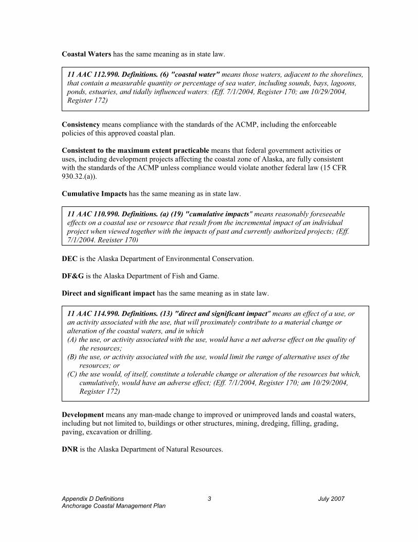
Coastal Waters has the same meaning as in state law.
11 AAC 112.990. Definitions. (6) "coastal water" means those waters, adjacent to the shorelines, that contain a measurable quantity or percentage of sea water, including sounds, bays, lagoons, ponds, estuaries, and tidally influenced waters; (Eff. 7/1/2004, Register 170; am 10/29/2004, Register 172)
Consistency means compliance with the standards of the ACMP, including the enforceable policies of this approved coastal plan.
Consistent to the maximum extent practicable means that federal government activities or uses, including development projects affecting the coastal zone of Alaska, are fully consistent with the standards of the ACMP unless compliance would violate another federal law (15 CFR 930.32.(a)).
Cumulative Impacts has the same meaning as in state law.
11 AAC 110.990. Definitions. (a) (19) "cumulative impacts" means reasonably foreseeable effects on a coastal use or resource that result from the incremental impact of an individual project when viewed together with the impacts of past and currently authorized projects; (Eff. 7/1/2004, Register 170)
DEC is the Alaska Department of Environmental Conservation.
DF&G is the Alaska Department of Fish and Game.
Direct and significant impact has the same meaning as in state law.
11 AAC 114.990. Definitions. (13) "direct and significant impact" means an effect of a use, or an activity associated with the use, that will proximately contribute to a material change or alteration of the coastal waters, and in which (A) the use, or activity associated with the use, would have a net adverse effect on the quality of
the resources; (B) the use, or activity associated with the use, would limit the range of alternative uses of the
resources; or (C) the use would, of itself, constitute a tolerable change or alteration of the resources but which,
cumulatively, would have an adverse effect; (Eff. 7/1/2004, Register 170; am 10/29/2004, Register 172)
Development means any man-made change to improved or unimproved lands and coastal waters, including but not limited to, buildings or other structures, mining, dredging, filling, grading, paving, excavation or drilling.
DNR is the Alaska Department of Natural Resources.
Appendix D Definitions 3 July 2007 Anchorage Coastal Management Plan

Due deference has the same meaning as in state law.
11 AAC 110.990. Definitions. (a) (25) "due deference" means that deference that is appropriate in the context of (A) the commentor's expertise or area of responsibility; and (B) all the evidence available to support any factual assertions of the commentor; (Eff. 7/1/2004, Register 170)
Environmentally Responsible means consistent with coastal resource protection and performance standards of this plan, and incorporating current best management practices with protection measures commensurate with the values of habitats affected.
Eolian mean applied to deposits arranged by the wind, as the sands and other loose materials along shores, etc.
Estuary has the same meaning as in state law.
11 AAC 11.990 Definitions. (11) "estuary" means a semiclosed coastal body of water that has a free connection with the sea and within which seawater is measurably diluted with freshwater derived from land drainage; (Eff. 7/1/2004, Register 170; am 10/29/2004, Register 172)
Facilities related to commercial fishing and seafood processing has the same meaning as in state law.
11 AAC 114.990. Definitions. (17) "facilities related to commercial fishing and seafood processing" includes hatcheries and related facilities, seafood processing plants and support facilities, marine industrial and commercial facilities, and aquaculture facilities; (Eff. 7/1/2004, Register 170; am 10/29/2004, Register 172)
Feasible and prudent means consistent with sound engineering practice and not causing environmental, social, or economic problems that outweigh the public benefit to be derived from compliance with the standard which is modified by the term "feasible and prudent".
Floodway means the channel of a river or other watercourse and the adjacent land areas that must be reserved in order to discharge the base flood without cumulatively increasing the water surface elevation more than a designated height, usually one foot, at any point.
Fluted ridge means smooth, gutter-like channels, or deep smooth furrows worn in the face of ridges by glacial action.
Fluvial means of, found in, or produced by a river.
Geomorphology means the study of the formation of 'the earth's topographic features.
Glaciolacustrine means produced by or belonging to glacially formed lakes.
Appendix D Definitions 4 July 2007 Anchorage Coastal Management Plan

Important fishing areas are areas used consistently over time for commercial, sport, or subsistence fishing. Fishing includes harvesting marine invertebrates and plants.
Important habitats has the same meaning as in state law.
11 AAC 112.300. Habitats. (c) For purposes of this section, (1) "important habitat" means habitats listed in (a)(1) – (8) of this section and other habitats
in the coastal area that are (A) designated under 11 AAC 114.250(h); (B) identified by the department as a habitat (i) the use of which has a direct and significant impact on coastal water; and (ii) that is shown by written scientific evidence to be significantly more productive than
adjacent habitat; or (C) identified as state game refuges, state game sanctuaries, state range areas, or fish and
game critical habitat areas under AS 16.20; (Eff. 7/1/2004, Register 170; am 10/29/2004, Register 172)
Lacustrine means produced by or belonging to lakes.
Local knowledge has the same meaning given in state law except that “generally accepted by the local community” is that body of knowledge that is reflected in local plans, studies, policies and standards.
11 AAC 114.990. Definitions. (22) "local knowledge" means a body of knowledge or information about the coastal environment or the human use of that environment, including information passed down through generations, if that information is (A) derived from experience and observations; and (B) generally accepted by the local community; (Eff. 7/1/2004, Register 170; am 10/29/2004, Register 172)
Maintain means to provide for continuation of current conditions and functions.
Mariculture is the captive cultivation of plants and animals in marine and estuarine waters for human consumption.
Mean High Water has the same meaning as in state law.
11 AAC 53.900 (14) “mean high water” means the tidal datum plane of the average of all the high tides, as would be established by the National Geodetic Survey, at any place subject to tidal influence; (Eff. 3/27/80, Register 73; am 7/5/2001, Register 159)
Mean Higher High Water is the average of all the daily higher high water recorded over a 19-year period or a computed equivalent period. It is usually associated with a tide exhibiting mixed characteristics.
Appendix D Definitions 5 July 2007 Anchorage Coastal Management Plan

Mean Lower Low Water has the same meaning as in state law.
11 AAC 53.900 (17) “mean lower low water” means the tidal datum plane of the average of the lower of the two low waters of each day , as would be established by the National Geodetic Survey, at any place subject to tidal influence; (Eff. 3/27/80, Register 73; am 7/5/2001, Register 159)
Minimize has the same meaning as in state law (see Avoid, Minimize and Mitigate).
Mitigate has the same meaning as in state law (see Avoid, minimize and Mitigate).
Natural Hazard is a condition created by a geological process, topography, water drainage, or unique weather condition that presents a significant hazard to life and property. See State Standard.
11 AAC 112.990. Definitions. (15) "natural hazards" (A) means the following natural processes or adverse conditions that present a threat to life
or property in the coastal area: flooding, earthquakes, active faults, tsunamis, landslides, volcanoes, storm surges, ice formations, snow avalanches, erosion, and beach processes;
(B) includes other natural processes or adverse conditions designated by the department or by a district in a district plan; (Eff. 7/1/2004, Register 170; am 10/29/2004, Register 172)
One Hundred Year Flood is a flood of a magnitude, which can be expected to occur on an average of once every 100 years. It is possible for this size flood to occur during any year, and possible in successive years. It would have a one percent chance of being equaled or exceeded in any year. Statistical analysis of available stream flow or storm records, or analysis of rainfall or runoff characteristics of the watershed, or topography and storm characteristics are used to determine the extent and depth of the 100-year flood.
OPMP is the Office of Project Management and Permitting with the Department of Natural Resources.
Ordinary high water has the same meaning as in state law.
11 AAC 53.900 (23) “Ordinary high water” means the mark along the bank or shore up to which the presence and action of non-tidal water are so common and usual, and so long continued in all ordinary years, as to leave a natural line impressed on the bank or shore and indicated by erosion, shelving, changes in soil characteristics, destruction of terrestrial vegetation, or other distinctive physical characteristics.; (Eff. 3/27/80, Register 73; am 7/5/2001, Register 159)
Paludal means pertaining to swamps or marshes, and to deposits deposited in a swamp environment.
Appendix D Definitions 6 July 2007 Anchorage Coastal Management Plan

Practicable has the same meaning as in state law.
11 AAC 112.990. Definitions. (18) "practicable" means feasible in light of overall project purposes after considering cost, existing technology, and logistics of compliance with the standard; (Eff. 7/1/2004, Register 170; am 10/29/2004, Register 172)
Proper and improper uses are the can-do and can't-do uses for the area.
Public need has the same meaning as in state law except that “documented” includes those needs expressed in locally adopted plans, studies, policies and standards.
11 AAC 114.990 (35) "public need" means a documented need of the general public and not that of a private person; (Eff. 7/1/2004, Register 170; am 10/29/2004, Register 172)
Resource agency has the same meaning as in state law.
Sec. 46.39.010. (2) "resource agency" means (A) the Department of Environmental Conservation; (B) the Department of Fish and Game; or (C) the Department of Natural Resources.
Saltwater wetlands has the same meaning as in state law. (see also “wetlands”)
11 AAC 112.990. Definitions. (25) "saltwater wetlands" means those coastal areas along sheltered shorelines characterized by halophilic hydrophytes and macroalgae extending from extreme low tide to an area above extreme high tide that is influenced by sea spray or tidally induced water table changes; (Eff. 7/1/2004, Register 170; am 10/29/2004, Register 172)
Shall means mandatory; it requires a course of action or set of conditions to be achieved.
Should states intent for a course of action or set of conditions to be achieved. This implies that case-specific discretion may be applied for achieving the intent of the action.
Significant adverse impact means an impact as indicated in state law by “direct and significant impact”.
Subject uses is a description of the land and water uses and activities which are subject to the district plan.
Subsidence is a lowering in elevation of ground surface due to underground geologic or hydrologic change. It can be a common occurrence in areas susceptible to seismic activity and where excessive water table depletion occurs.
Subsistence Use Areas are coastal habitat areas, used traditionally or occasionally in response to seasonal or cyclic resource abundance, where subsistence harvests of fish, wildlife, and other biological resources are conducted.
Appendix D Definitions 7 July 2007 Anchorage Coastal Management Plan

Subsistence uses has the same meaning as in state law.
AS 16.05.940 (33) "subsistence uses" means the noncommercial, customary and traditional uses of wild, renewable resources by a resident domiciled in a rural area of the state for direct personal or family consumption as food, shelter, fuel, clothing, tools, or transportation, for the making and selling of handicraft articles out of nonedible by-products of fish and wildlife resources taken for personal or family consumption, and for the customary trade, barter, or sharing for personal or family consumption; in this paragraph, "family" means persons related by blood, marriage, or adoption, and a person living in the household on a permanent basis; (Eff. ///; Register )
Surface Waters include streams, rivers, ponds, lakes, and contiguous open water wetlands.
Tsunami is a great sea wave produced by submarine earth movements or volcanic eruption.
Uses of state concern has the meaning as in state law.
AS 46.40.210 (12) "uses of state concern" means those land and water uses that would significantly affect the long-term public interest; "uses of state concern" include (A) uses of national interest, including the use of resources for the siting of ports and major
facilities that contribute to meeting national energy needs, construction and maintenance of navigational facilities and systems, resource development of federal land, and national defense and related security facilities that are dependent upon coastal locations;
(B) uses of more than local concern, including those land and water uses that confer significant environmental, social, cultural, or economic benefits or burdens beyond a single coastal resource district;
(C) the siting of major energy facilities, activities pursuant to a state or federal oil and gas lease, or large-scale industrial or commercial development activities that are dependent on a coastal location and that, because of their magnitude or the magnitude of their effect on the economy of the state or the surrounding area, are reasonably likely to present issues of more than local significance;
(D) facilities serving statewide or interregional transportation and communication needs; and(E) uses in areas established as state parks or recreational areas under AS 41.21 or as state
game refuges, game sanctuaries, or critical habitat areas under AS 16.20.
Waterbody means any area of surface water with a permanent minimum surface area of 2,500 square feet (see Anchorage Wetlands Management Plan).
Appendix D Definitions 8 July 2007 Anchorage Coastal Management Plan

Water-Dependent has the same meaning as in state law.
11 AAC 112.990. Definitions. (31) "water-dependent" means a use or activity that can be carried out only on, in, or adjacent to a water body because the use requires access to the water body;(32) "water-related" means a use or activity that is not directly dependent upon access to a water body, but which provides goods or services that are directly associated with water-dependence and which, if not located adjacent to a water body, would result in a public loss of quality in the goods or services offered; (Eff. 7/1/2004, Register 170; am 10/29/2004, Register 172)
Waterfront means the area along the coastline between mean higher high water and mean high sea level.
Water-Related has the same meaning in state law.
Wetlands has the same meaning as in state law.
11 AAC 112.990. Definitions. (33) "wetlands" means saltwater wetlands and those freshwater wetlands that have a direct drainage to coastal waters; (Eff. 7/1/2004, Register 170; am 10/29/2004, Register 172)
Appendix D Definitions 9 July 2007 Anchorage Coastal Management Plan


APPENDIX E References
Alaska Climate Research Center. Available at http://climate.gi.alaska.edu.Alaska Department of Natural Resources (ADNR), Division of Forestry. Available at
http://www.dnr.state.ak.us/forestry/.
ADNR, June, 2005. Division of Geologic and Geophysical Surveys. Comments on draft plan.
ADNR, Division of Mining, Land and Water – Land Use Planning, Fish and Wildlife. Available at http://www.dnr.state.ak.us.mlw/planning/mgtplans/fish_ck/pdf/Ch2_Fish.pdf.
ADFG, Division of Wildlife Conservation. Available at http://www.wildlife.alaska.gov
ADFG, 1992. Catalog of Waters Important to Anadromous Fish – Southcentral Region.Anchorage, Alaska.
ADFG, Region 2 information available at sf.adfg.state.ak.us/region2/areas/ncihome.cfm
ADFG, Undated. The Evaluation of Wetland and Riparian Restoration Projects.
Alaska Department of Labor, 2003 (July 1). Research & Analysis Projected Population by Census Area.
Bisson, P.A. and R.E. Bilby, 1982. Avoidance of Suspended Sediment by Juvenile Coho Salmon. N. Amer. J. Fish. Manage. 2: pp. 371-374.
Bjornn, T.C. and D.W. Reiser, 1991. Meehan, W.R., ed. “Habitat Requirements of Salmonids in Streams,” pp. 83-138. In: Influences of Forest and Rangeland Management on Salmonid Fishes and Their Habitats. Amer. Fish. Soc. Spec. Pub. 19, 751 pp.
Bryant, M.D., 1995. Pulsed Monitoring for Watershed and Stream Restoration. Fisheries 20: pp. 6-13.
Chapman, D.W., 1988. Critical Review of Variables Used to Define Effects of Fines in Redds of Large Salmonids. Trans. Amer. Fish. Soc. 117: pp. 1-21.
Carberry, Michael and Donna Lane. 1986. Patterns of the Past – An Inventory of Anchorage’s Historic Resources.
Colt, Steve, 2001 (January 2). The Economic Importance of Healthy Alaska Ecosystems. Institute of Social and Economic Research.
Colt, Steve, 2001. “The Economic Importance of Healthy Alaska Ecosystems.” Institute of Social and Economic Research (ISER).
Cordone, A.J. and D.W. Kelley, 1961. The Influences of Inorganic Sediment on the Aquatic Life of Streams. Calif. Fish Game 47: pp. 189-228.
Appendix E References 1 July 2007 Anchorage Coastal Management Plan

Federal Transit Administration and Matanuska-Susitna Borough, 2003. Knik Arm Ferry, NEPA Environmental Assessment.
Joyce, M.R. 1980. Effects of Gravel Removal on Terrestrial Biota. In: Woodward-Clyde Consultants, ed. Gravel Removal Studies in Arctic and Subarctic Floodplain in Alaska - technical report; pp. 215-272. U.S. Fish and Wildlife Service, Biological Services Program, FWS/OBS-80/08. 403 pp.
McDowell Group and DCCED, 1999 (May). Alaska Visitor Industry Economic Impact Study.
Municipality of Anchorage, 2006. Anchorage Bowl Park, Natural Resource, and Recreation Facility Plan. MOA Planning Department and MOA Parks and Recreation Department.
Municipality of Anchorage, 2003. Anchorage 2020- Anchorage Bowl Comprehensive Plan. MOA Planning Department, 2003
Municipality of Anchorage, 1987. Anchorage Coastal Management Plan Program Document. MOA Planning Department, 1987.
Municipality of Anchorage, 1997. Areawide Trails Plan. MOA Department of Community Planning and Development.
Municipality of Anchorage, 1999. Commercial and Industrial Land Use Study. Municipality of Anchorage, 1993. Chugiak-Eagle River Comprehensive Plan. MOA
Department of Community Planning and Development.
Municipality of Anchorage and State of Alaska, 1995. Girdwood Area Plan. MOA Department of Community Planning and Development.
Municipality of Anchorage, December 1980. Anchorage Coastal Resource Atlas – Anchorage Bowl, Chugiak-Eagle River, and Turnagain Arm.
Parsons Brinkerhoff & HDR Alaska, in affiliation with Lounsbury, Inc., 2003. Knik Arm Crossing Engineering Feasibility and Cost Estimate Update, Volume 1.
Port of Anchorage, 2005. Marine Terminal Redevelopment Environmental Impact Statement, Port Intermodal Expansion Project.
USDA, Natural Resources Conservation Services, Alaska. Available at http://www.ak/nrcs/usda.gov/technical/soils/soilsurveys.html.
United States Department of Homeland Security Disaster Communities Federal Emergency Management Agency. Available at http://www.fema.gov/hazards/landslides/.
United States Geological Survey Volcano Observatories. Volcano Hazard Program. Available at http://volcanoes.usgs.gov/.
University of Washington. Earth and Space Sciences. Available at http://www.ess.washington.edu/tsunami/index.html.
VZM/TranSystem,1999. Port of Anchorage Master Plan.
Appendix E References 2 July 2007 Anchorage Coastal Management Plan

Weigand, D.C., 1991. Effects of Gravel Scalping on Juvenile Salmonid Habitat. M.S. Thesis, University of Washington, Seattle, Washington.
Appendix E References 3 July 2007 Anchorage Coastal Management Plan


Anchorage Coastal Management Plan 1 July 2007Appendix F Description of ASIDESS Model
APPENDIX F
Description of ASIDESS Model
Anchorage Sensitivity Index Decision Support System ASIDESS User Guide
July 21, 2005, AeroMap U.S.


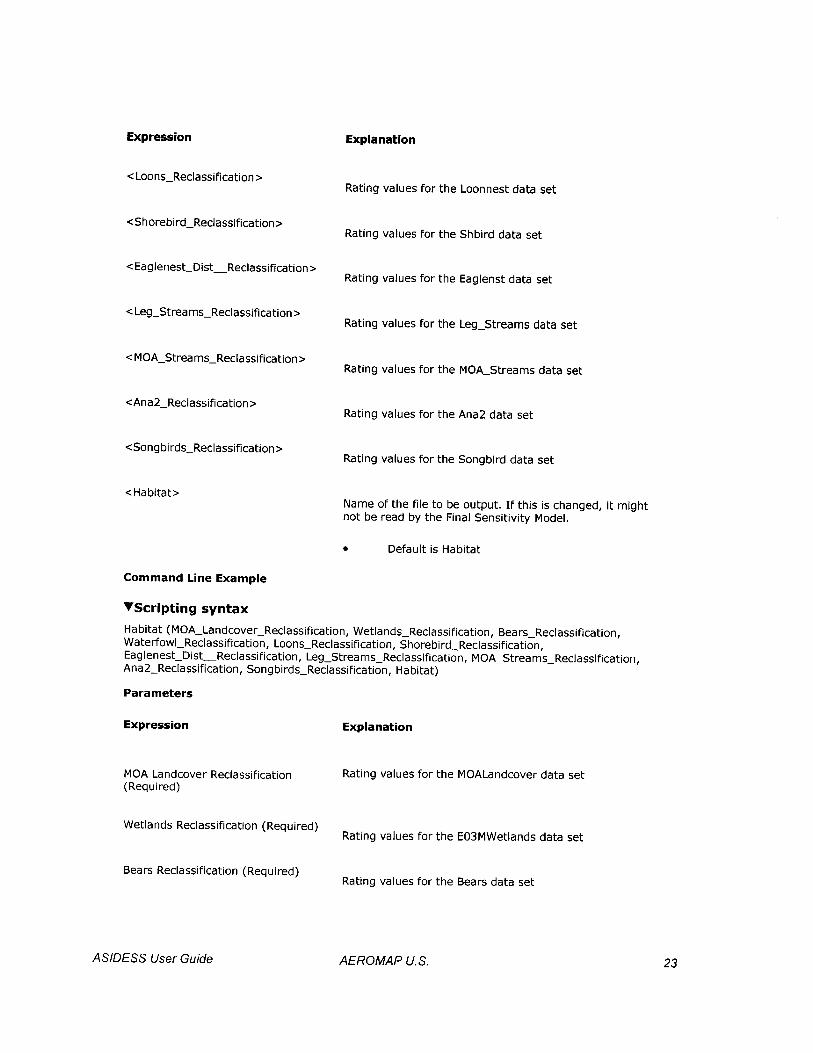


Appe
ndix
G T
able
2 o
f the
Anc
hora
ge W
etla
nds
Man
agem
ent P
lan
1Ju
ly 2
007
Anch
orag
e C
oast
al M
anag
emen
t Pla
n
APP
END
IX G
Tabl
e 2
of th
e A
ncho
rage
Wet
land
s M
anag
emen
t Pla
n
Wet
land
Des
igna
tions
, Enf
orce
able
and
Adm
inis
trat
ive
Pol
icie
s and
Man
agem
ent S
trat
egie
s
NO
TE:
1.W
etla
nd n
umbe
rs li
sted
for t
he o
rigin
al 1
982
Anc
hora
ge W
etla
nds M
anag
emen
t Pla
n ar
e fo
r ref
eren
ce o
nly.
In
man
y ca
ses,
1982
wet
land
site
num
bers
refe
r to
site
s whi
ch
have
bee
n sp
lit o
r mer
ged
in th
e cu
rren
t rev
isio
n.
2.A
ll se
ctio
ns in
ital
ics
repr
esen
t Enf
orce
able
Pol
icie
s of t
his p
lan.
AN
CH
OR
AG
E B
OW
L
Site
No.
1982
Site
No.
Map
No.
Site
Des
crip
tion,
Enf
orce
able
and
Adm
inis
trat
ive
Polic
ies a
nd
Man
agem
ent S
trat
egie
s 19
82D
esig
natio
nN
ewD
esig
natio
n 1
N
one
1
#1
CA
TTA
IL P
ON
D A
T PO
RT
(2.6
3 ac
res;
Pub
lic &
Priv
ate
Ow
ners
hip)
(Sco
res:
Hyd
rolo
gy
= 10
0; H
abita
t = 7
3; S
peci
es O
ccur
renc
e =
49; S
ocia
l Fun
ctio
n =
24)
Beca
use
the
site
pro
vide
s mig
rato
ry a
nd li
mite
d ne
stin
g ha
bita
t for
seve
ral s
peci
es a
nd
perf
orm
s wat
er q
ualit
y fu
nctio
ns fo
r an
are
a w
ith c
onta
min
ated
gro
undw
ater
, the
site
shal
l be
mai
ntai
ned
to th
e m
axim
um e
xten
t.
Und
esig
nate
dB
1
Non
e
1 #2
CA
TTA
IL P
ON
D A
T PO
RT
(1 a
cre;
Pub
lic &
Priv
ate
Ow
ners
hip)
(Sco
res:
Hyd
rolo
gy =
60
; Hab
itat =
44;
Spe
cies
Occ
urre
nce
= 45
; Soc
ial F
unct
ion
= 11
) Si
te ju
st so
uth
of T
erm
inal
Roa
d cl
asse
d as
“C
” w
etla
nds.
A h
ydro
logi
c an
alys
is sh
all b
e do
ne
and
shal
l mee
t the
acc
epta
ble
stan
dard
s of t
he M
unic
ipal
Dep
artm
ent o
f Pub
lic W
orks
in o
rder
to
pre
vent
floo
ding
of a
djac
ent p
rope
rtie
s. A
toxi
cs e
valu
atio
n sh
all b
e do
ne if
exc
avat
ion
is
prop
osed
, and
it sh
all m
eet t
he a
ccep
tabl
e st
anda
rds o
f the
Ala
ska
Dep
artm
ent o
f En
viro
nmen
tal C
onse
rvat
ion
and
the
Mun
icip
al D
epar
tmen
t of H
ealth
and
Hum
an S
ervi
ces i
n or
der t
o pr
even
t deg
rada
tion
of w
ater
qua
lity
in a
djac
ent w
ater
bod
ies a
nd w
etla
nds.
Und
esig
nate
dB
/C
1
Non
e
1 TR
AC
TS A
AN
D E
E (1
8 ac
res;
Pub
lic O
wne
rshi
p) (S
core
s: H
ydro
logy
= 8
8; H
abita
t = 1
25;
Spec
ies O
ccur
renc
e =
51; S
ocia
l Fun
ctio
n =
17)
Fede
ral U
.S. A
ir Fo
rce
land
s beh
ind
the
Port
whi
ch a
re c
urre
ntly
mos
tly p
erm
itted
. An
y ne
w m
anag
emen
t stra
tegi
es sh
all b
e co
nsist
ent w
ith a
pplic
able
Cor
ps p
erm
its.
Und
esig
nate
dB

Appe
ndix
G T
able
2 o
f the
Anc
hora
ge W
etla
nds
Man
agem
ent P
lan
2Ju
ly 2
007
Anch
orag
e C
oast
al M
anag
emen
t Pla
n
Site
No.
1982
Site
No.
Map
No.
Site
Des
crip
tion,
Enf
orce
able
and
Adm
inis
trat
ive
Polic
ies a
nd
Man
agem
ent S
trat
egie
s 19
82D
esig
natio
nN
ewD
esig
natio
n 2
58A
1,
2
and
9
SHIP
CR
EEK
FLO
OD
PLA
IN (a
bove
CEA
dam
) (1
.8 a
cres
; Pub
lic &
Priv
ate
Ow
ners
hip)
(S
core
s: N
ot A
sses
sed)
W
etla
nds i
mpo
rtant
for w
ater
qua
lity,
floo
d st
orag
e. D
evel
opm
ent i
n w
etla
nds s
hall
be su
bjec
t to
Ala
ska
Dep
artm
ent o
f Fis
h an
d G
ame
timin
g sti
pula
tions
to li
mit
dist
urba
nce
to a
nadr
omou
s fis
h m
ovem
ents
. D
evel
opm
ent d
esig
ns sh
ould
mirr
or in
form
atio
n ou
tline
d in
the
Ship
Cre
ek-
Port
Land
Use
Pla
n. E
xecu
tive
Ord
er (
EO) 1
1990
will
be
used
to p
rote
ct th
e C
reek
on
mili
tary
la
nd
Und
esig
nate
d Pr
eser
vatio
nA
2
58A
1,
2
and
9
SHIP
CR
EEK
BEA
VER
PO
ND
(0.
75 a
cres
; Pub
lic &
Priv
ate
Ow
ners
hip)
(Sco
res:
Hyd
rolo
gy
= 11
8; H
abita
t = 6
8; S
peci
es O
ccur
renc
e =
68; S
ocia
l Fun
ctio
n =
24)
Floo
d co
ntro
l and
hab
itat f
unct
ions
shal
l be
pres
erve
d by
fill
avoi
danc
e.
Und
esig
nate
dA
3
58A
3 SH
IP C
REE
K:
NW
REE
VE/
VIK
ING
(3.
2 ac
res;
Pub
lic O
wne
rshi
p) (S
core
s: H
ydro
logy
= 7
4;
Hab
itat =
80;
Spe
cies
Occ
urre
nce
= 63
; Soc
ial F
unct
ion
= 76
) V
alue
s for
floo
d co
ntro
l, w
ater
qua
lity
and
habi
tat.
Site
is a
n ol
d sl
ough
of S
hip
Cre
ek.
Fill
with
in sl
ough
shal
l be
avoi
ded.
Und
esig
nate
dPr
eser
vatio
nA
4
Non
e
3 N
OR
TH O
F R
AIL
RO
AD
TR
AC
KS,
INTE
RSE
CTI
ON
OF
REE
VE/
POST
RO
AD
(4
acre
s;
Publ
ic O
wne
rshi
p) (S
core
s: H
ydro
logy
= 1
11; H
abita
t = 7
3; S
peci
es O
ccur
renc
e =
35; S
ocia
l Fu
nctio
n =
25)
Beca
use
the
pond
and
adj
acen
t wet
land
s pro
vide
hab
itat f
or se
vera
l spe
cies
and
an
impo
rtan
t fil
ter a
rea
for l
ocal
snow
dum
p, th
e dr
aina
ge a
nd p
ond
area
s sha
ll be
mai
ntai
ned
and
avoi
ded
to th
e m
axim
um e
xten
t. Th
e si
te’s
filte
ring
val
ues s
hall
be p
rote
cted
, sin
ce th
e p
ond
drai
ns
dire
ctly
into
Shi
p C
reek
. Sn
owm
elt s
houl
d be
trea
ted
alth
ough
it is
reco
gniz
ed th
at th
is m
ay b
e im
prac
tical
.
Und
esig
nate
dB
5
Non
e 1
1 M
OU
NTA
IN V
IEW
DR
IVE/
GLE
NN
HIG
HW
AY
INTE
RSE
CTI
ON
(8
acre
s; P
ublic
& P
rivat
e O
wne
rshi
p) (S
core
s: H
ydro
logy
= 8
6; H
abita
t = 4
7; S
peci
es O
ccur
renc
e =
18; S
ocia
l Fun
ctio
n =
59)
Mos
t of a
rea
is M
OA
-HLB
land
. A h
ydro
logi
c an
alys
is sh
all b
e do
ne a
nd sh
all m
eet t
he
acce
ptab
le st
anda
rds o
f the
Mun
icip
al D
epar
tmen
t of P
ublic
Wor
ks a
nd A
lask
a D
epar
tmen
t of
Tran
spor
tatio
n/ P
ublic
Fac
ilitie
s to
assu
re th
at th
e G
lenn
Hig
hway
and
site
s to
the
east
shal
l no
t be
mor
e th
an m
inim
ally
adv
erse
ly im
pact
ed.
Und
esig
nate
dC
6
Non
e 1
4 TU
RPI
N P
AR
K (
1.8
acre
s; P
ublic
Ow
ners
hip)
(Sco
res:
Hyd
rolo
gy =
70;
Hab
itat =
34;
Spe
cies
O
ccur
renc
e =
18; S
ocia
l Fun
ctio
n =
60)
Mun
icip
al p
ark
land
. A h
ydro
logi
c an
alys
is sh
all b
e do
ne a
nd sh
all m
eet t
he a
ccep
tabl
e st
anda
rds o
f the
Mun
icip
al D
epar
tmen
t of P
ublic
Wor
ks in
ord
er to
pre
vent
floo
ding
, mai
ntai
n bo
th su
rfac
e an
d su
bsur
face
cro
ss d
rain
age,
and
pre
vent
dra
inag
e of
adj
acen
t wet
land
s.
Und
esig
nate
dC

Appe
ndix
G T
able
2 o
f the
Anc
hora
ge W
etla
nds
Man
agem
ent P
lan
3Ju
ly 2
007
Anch
orag
e C
oast
al M
anag
emen
t Pla
n
Site
No.
1982
Site
No.
Map
No.
Site
Des
crip
tion,
Enf
orce
able
and
Adm
inis
trat
ive
Polic
ies a
nd
Man
agem
ent S
trat
egie
s 19
82D
esig
natio
nN
ewD
esig
natio
n 6
5
6 1
3 SO
UTH
WES
T A
ND
SO
UTH
EAST
INTE
RSE
CTI
ON
OF
TUR
PIN
/GLE
NN
HIG
HW
AY
(47
ac
res;
Pub
lic O
wne
rshi
p) (S
core
s: H
ydro
logy
= 8
7; H
abita
t = 5
7; S
peci
es O
ccur
renc
e =
18;
Soci
al F
unct
ion
= 50
) Is
olat
ed si
te; m
inim
al h
ydro
logy
val
ues;
no
obvi
ous d
rain
agew
ays.
(Not
e: s
ize
of si
te a
nd
drai
nage
bas
in in
flate
d sc
ore)
.
Dev
elop
able
C
6
57
13
SOU
THEA
ST IN
TER
SEC
TIO
N O
F 4TH
AV
ENU
E/B
ON
IFA
CE
PAR
KW
AY
(2.
8 ac
res;
Pr
ivat
e O
wne
rshi
p) (S
core
s: H
ydro
logy
= 7
8; H
abita
t = 2
7; S
peci
es O
ccur
renc
e =
16; S
ocia
l Fu
nctio
n =
27)
A hy
drol
ogic
ana
lysi
s sha
ll be
don
e an
d sh
all m
eet t
he a
ccep
tabl
e st
anda
rds o
f the
Mun
icip
al
Dep
artm
ent o
f Pub
lic W
orks
in o
rder
to p
reve
nt fl
oodi
ng, m
aint
ain
both
surf
ace
and
subs
urfa
ce
cros
s dra
inag
e an
d pr
even
t dra
inag
e of
adj
acen
t wet
land
s. D
rain
agew
ays s
hall
be a
void
ed. A
w
ritte
n pl
an sh
all b
e pr
esen
ted
to th
e M
unic
ipal
Dep
artm
ent o
f Com
mun
ity P
lann
ing
and
Dev
elop
men
t to
dete
rmin
e if
alte
rnat
ives
exi
st th
at w
ould
allo
w av
oida
nce
of a
ltera
tion
of
drai
nage
of t
he si
te.
Dev
elop
able
C
7
57
12
NO
RTH
RU
SSIA
N JA
CK
PA
RK
(53
.4 a
cres
; Pub
lic O
wne
rshi
p) (S
core
s: H
ydro
logy
= 1
02;
Hab
itat =
60;
Spe
cies
Occ
urre
nce
= 18
; Soc
ial F
unct
ion
= 75
) A
hydr
olog
ic a
naly
sis s
hall
be d
one
and
mee
t the
acc
epta
ble
stan
dard
s of t
he M
unic
ipal
D
epar
tmen
t of P
ublic
Wor
ks in
ord
er to
pre
vent
floo
ding
, mai
ntai
n bo
th su
rfac
e an
d su
bsur
face
cr
oss d
rain
age
and
prev
ent d
rain
age
of a
djac
ent w
etla
nds.
Par
k am
eniti
es sh
all b
e pe
rmitt
ed
beyo
nd 2
5 fe
et o
f dra
inag
eway
s and
/or o
pen
wat
er.
Rela
tivel
y lo
w v
alue
site
; inf
orm
atio
n on
hy
drol
ogy
shal
l pre
cede
per
mitt
ing
for i
dent
ifica
tion
of d
rain
age
prob
lem
s or r
eten
tion
area
s.Th
is si
te d
oes n
ot h
ave
any
stre
ams o
r pon
ds; t
he in
tent
is to
pro
tect
the
sprin
gs a
nd to
mai
ntai
n on
site
dra
inag
e.
Pres
erva
tion
C
8
51
36
BR
OO
KR
IDG
E SU
BD
IVIS
ION
(10
.5 a
cres
; Priv
ate
Ow
ners
hip)
(Sco
res:
Hyd
rolo
gy =
124
; H
abita
t = 9
5; S
peci
es O
ccur
renc
e =
75; S
ocia
l Fun
ctio
n =
38)
Rem
aini
ng u
ndev
elop
ed w
etla
nds a
t Che
ster
Cre
ek c
lass
ed a
s “A
”. S
etba
ck fr
om c
reek
shal
l be
mai
ntai
ned
as p
latte
d (s
ee P
erm
it #B
-517
). N
o ru
noff
shal
l ent
er in
to se
tbac
k ar
ea u
nles
s tr
eate
d.
Dev
elop
able
A
9 5
1 2
5 M
ULD
OO
N: C
hest
er C
K/ F
OO
THIL
LS S
UB
DIV
ISIO
N N
EAR
TU
RF
CT.
(2.
25+
acre
s;
Publ
ic/P
rivat
e O
wne
rshi
p) (S
core
s: H
ydro
logy
= 1
04; H
abita
t = 8
9; S
peci
es O
ccur
renc
e =
71;
Soci
al F
unct
ion
= 71
) A
rea
curr
ently
per
mitt
ed fo
r sto
rm d
rain
det
entio
n sy
stem
. Pr
ovid
es fl
ood
rete
ntio
n, w
ater
qu
ality
, hab
itat.
Unf
illed
are
as sh
all b
e re
tain
ed.
Dev
elop
able
A

Appe
ndix
G T
able
2 o
f the
Anc
hora
ge W
etla
nds
Man
agem
ent P
lan
4Ju
ly 2
007
Anch
orag
e C
oast
al M
anag
emen
t Pla
n
Site
No.
1982
Site
No.
Map
No.
Site
Des
crip
tion,
Enf
orce
able
and
Adm
inis
trat
ive
Polic
ies a
nd
Man
agem
ent S
trat
egie
s 19
82D
esig
natio
nN
ewD
esig
natio
n10
51
25
and
3
6
HID
EAW
AY
HIL
LS, T
RA
CT
A (
33.9
acr
es; P
rivat
e O
wne
rshi
p) (S
core
s: H
ydro
logy
= 1
04;
Hab
itat =
71;
Spe
cies
Occ
urre
nce
= 60
; Soc
ial F
unct
ion
= 50
) En
hanc
emen
t pot
entia
l pos
sibl
e in
nor
ther
ly si
te.
Dev
elop
men
t cou
ld o
ccur
in w
este
rnm
ost
one-
third
; hyd
rolo
gy/fl
ood
stor
age
conn
ectio
n to
Che
ster
Cre
ek a
nd a
djac
ent w
etla
nds s
hall
be
reta
ined
at t
he e
ast e
nd b
y se
tbac
ks, a
void
ance
and
min
imiz
atio
n of
fills
. D
itche
s sho
uld
be
fille
d an
d ar
ea c
an se
rve
for s
torm
wat
er re
tent
ion.
Rem
nant
, hig
hly
dist
urbe
d w
etla
nd e
xten
ding
so
uth
of th
e m
ain
site
pro
vide
s pos
sibl
e w
ater
qua
lity
and
flood
con
trol,
but i
s gen
eral
ly lo
w
valu
e an
d re
mai
ns “
C”.
Nor
ther
n po
rtio
n of
this
site
, at t
he d
itch,
shal
l be
reta
ined
or r
epla
ced
with
a st
orm
dra
in sy
stem
for w
ater
qua
lity
purp
oses
.
Dev
elop
able
B
/C
10A
5
3 3
6 N
OR
TH A
ND
SO
UTH
OF
36TH
: W
ILLI
WA
/PU
SSY
WIL
LOW
STR
EET
(3.6
6 ac
res;
Priv
ate
Ow
ners
hip)
(Sco
res:
Hyd
rolo
gy =
74;
Hab
itat =
48;
Spe
cies
Occ
urre
nce
= 18
; Soc
ial F
unct
ion
= 40
) M
inim
al v
alue
s.
Und
esig
nate
dC
11
Non
e 2
5 SU
SITN
A S
CH
OO
L PO
ND
(0.
5 ac
res;
Pub
lic O
wne
rshi
p) (S
core
s: N
ot A
sses
sed)
Th
e po
nd a
nd w
etla
nd sh
all b
e re
tain
ed a
s a st
orm
wate
r det
entio
n/tr
eatm
ent s
ite u
nles
s the
site
is
nee
ded
for s
choo
l exp
ansi
on, i
n w
hich
cas
e, a
new
stor
mw
ater
det
entio
n/tre
atm
ent s
ite m
ust
be id
entif
ied
in th
e ar
ea to
repl
ace
thes
e hy
drol
ogic
/wat
er q
ualit
y fu
nctio
ns a
nd v
alue
s. C
lean
out a
nd m
aint
enan
ce o
f the
pon
d sh
all b
e al
low
ed o
nly
from
Aug
ust 1
5 to
May
1.
Such
ac
tiviti
es sh
all n
ot b
e pe
rmitt
ed d
urin
g th
e sp
ring
and
sum
mer
(i.e
., M
ay 1
to A
ugus
t 15)
due
to
the
need
to p
rote
ct n
estin
g w
ater
fow
l.
Und
esig
nate
dC
11
Non
e 2
5
20TH
/CH
AN
DA
LAR
(0.
5 ac
res;
Priv
ate
Ow
ners
hip)
(Sco
res:
Not
Ass
esse
d)
Dev
elop
er sh
all s
ubm
it a
drai
nage
impa
ct a
naly
sis to
add
ress
dra
inag
e in
rela
tion
to
neig
hbor
ing
hom
es.
Und
esig
nate
dC
11
50
25
NO
RTH
WES
T IN
TER
SEC
TIO
N O
F N
OR
THER
N L
IGH
TS/M
ULD
OO
N (
two
site
s) (6
acr
es;
Priv
ate
Ow
ners
hip)
(Sco
res:
Hyd
rolo
gy =
69;
Hab
itat =
50;
Spe
cies
Occ
urre
nce
= 17
; Soc
ial
Func
tion
= 55
) So
uthe
rn, c
ente
r sec
tion
of e
aste
rly si
te a
bove
Pos
t Off
ice
prov
ides
hig
her h
abita
t val
ues;
cou
ld
be u
sed
for e
nhan
cem
ent.
A w
ritte
n pl
an sh
all b
e su
bmitt
ed to
the
Mun
icip
al D
epar
tmen
t of
Com
mun
ity P
lann
ing
and
Dev
elop
men
t for
revi
ew a
nd a
ppro
val d
escr
ibin
g ef
fort
s to
avoi
d im
pact
s to
the
habi
tat v
alue
s of t
he so
uthe
rn a
nd c
entr
al se
ctio
ns o
f the
eas
terl
y tra
ct, s
uch
as
timin
g w
indo
ws,
addi
tiona
l set
back
s, ve
qeta
tive
scre
enin
g, re
duct
ion
of fi
ll an
d on
site
en
hanc
emen
t.
Dev
elop
able
C
12
44
36
MU
LDO
ON
PA
RK
: N
OR
THER
N L
IGH
TS B
OU
LEV
AR
D A
ND
MU
LDO
ON
RO
AD
(10
.6
acre
s; P
ublic
Ow
ners
hip)
(Sco
res:
Hyd
rolo
gy =
69;
Hab
itat =
53;
Spe
cies
Occ
urre
nce
= 22
; So
cial
Fun
ctio
n =
50)
Isol
ated
site
has
rela
tivel
y lo
w v
alue
s. D
rain
ages
shal
l be
mai
ntai
ned
to p
reve
nt fl
oodi
ng,
mai
ntai
n bo
th su
rfac
e an
d su
bsur
face
cro
ss d
rain
age
and
prev
ent d
rain
age
of a
djac
ent
wet
land
s. P
ark
amen
ities
shal
l onl
y be
per
mitt
ed b
eyon
d 85
feet
of d
rain
agew
ays a
nd o
pen
wat
er.
Pres
erva
tion
C

Appe
ndix
G T
able
2 o
f the
Anc
hora
ge W
etla
nds
Man
agem
ent P
lan
5Ju
ly 2
007
Anch
orag
e C
oast
al M
anag
emen
t Pla
n
Site
No.
1982
Site
No.
Map
No.
Site
Des
crip
tion,
Enf
orce
able
and
Adm
inis
trat
ive
Polic
ies a
nd
Man
agem
ent S
trat
egie
s 19
82D
esig
natio
nN
ewD
esig
natio
n13
44
35
SOU
THW
EST
INTE
RSE
CTI
ON
OF
NO
RTH
ERN
LIG
HTS
/PA
TTER
SON
(4.
75 a
cres
; Pr
ivat
e O
wne
rshi
p) (S
core
s: H
ydro
logy
= 1
05; H
abita
t = 6
1; S
peci
es O
ccur
renc
e =
18; S
ocia
l Fu
nctio
n =
47)
A hy
drol
ogic
ana
lysi
s sha
ll be
don
e an
d m
eet t
he a
ccep
tabl
e st
anda
rds o
f the
Mun
icip
al
Dep
artm
ent o
f Pub
lic W
orks
and
the
Mun
icip
al D
epar
tmen
t of C
omm
unity
Pla
nnin
g an
d D
evel
opm
ent i
n or
der t
o as
cert
ain
poss
ible
con
nect
ions
to C
hest
er C
reek
and
Bax
ter B
og a
nd to
en
sure
the
mai
nten
ance
of f
low
s to
Che
ster
Cre
ek a
nd B
axte
r Bog
.
Dev
elop
able
C
14
Non
e 2
4 C
HEN
EY L
AK
E (2
6 ac
res;
Pub
lic O
wne
rshi
p) (S
core
s: H
ydro
logy
= 1
17; H
abita
t = 1
08;
Spec
ies O
ccur
renc
e =
97; S
ocia
l Fun
ctio
n =
95)
Prim
ary
impo
rtanc
e fo
r hab
itat v
alue
s; so
me
wat
er q
ualit
y va
lues
. Pr
ovid
es w
ater
bird
nes
ting
and
stag
ing
habi
tat a
nd a
ctiv
e re
crea
tion.
A
65-
foot
min
imum
setb
ack
shal
l be
mai
ntai
ned
for
park
impr
ovem
ents
.
Und
esig
nate
dA
/Ope
n W
ater
14A
4
4 2
4 V
UET
ER S
UB
DIV
ISIO
N (
7 ac
res;
Priv
ate
Ow
ners
hip)
(Sco
res:
Hyd
rolo
gy =
71;
Hab
itat =
41
; Spe
cies
Occ
urre
nce
= 18
; Soc
ial F
unct
ion
= 74
) A
hydr
olog
ic a
naly
sis s
hall
be d
one
and
mee
t the
acc
epta
ble
stan
dard
s of t
he M
unic
ipal
D
epar
tmen
t of P
ublic
Wor
ks in
ord
er to
asc
erta
in p
ossi
ble
conn
ectio
ns to
Che
ster
Cre
ek a
nd to
en
sure
the
mai
nten
ance
of f
low
s to
Che
ster
Cre
ek.
A 65
-foot
setb
ack
shal
l app
ly a
long
all
drai
nage
way
s to
Che
ster
Cre
ek.
A 10
0-fo
ot se
tbac
k sh
all b
e m
aint
aine
d ad
jace
nt to
Che
ster
C
reek
due
to it
s ana
drom
ous f
ish
reso
urce
s.
Dev
elop
able
C
15
44
35
BA
XTE
R L
AK
E (4
2 ac
res;
Pub
lic &
Priv
ate
Ow
ners
hip)
(Sco
res:
Hyd
rolo
gy =
131
; Hab
itat =
12
2; S
peci
es O
ccur
renc
e =
81; S
ocia
l Fun
ctio
n =
75)
Any
deve
lopm
ent s
hall
requ
ire
a hy
drol
ogy/
drai
nage
surv
ey.
Impe
rvio
us st
ruct
ures
shal
l be
requ
ired
at b
orde
rs to
min
imiz
e an
y de
wat
erin
g of
“A”
and
“B”
wet
land
are
as.
Cri
tical
hy
drol
ogic
al c
onne
ctio
ns e
xist
in “
B” w
etla
nd a
reas
whi
ch sh
all b
e av
oide
d an
d pr
otec
ted.
.
Dev
elop
able
C
onse
rvat
ion
Pres
erva
tion
A/B
16 4
5 3
5 N
OR
TH O
F R
EFLE
CTI
ON
LA
KE
(2.5
acr
es; P
rivat
e O
wne
rshi
p) (S
core
s: N
ot A
sses
sed)
M
ost o
f site
alre
ady
perm
itted
/dev
elop
ed.
Min
imal
val
ues,
mar
gina
l wet
land
. D
evel
opab
le
C
17
46
23
NO
RTH
ERN
LIG
HTS
/WES
LEY
AN
& R
USS
IAN
JAC
K P
AR
K (
45 a
cres
app
rox.
; Pu
blic
&
Priv
ate
Ow
ners
hip)
(“A
” w
etla
nd sc
ores
: H
ydro
logy
= 9
4; H
abita
t = 8
4; S
peci
es O
ccur
renc
e =
85; S
ocia
l Fun
ctio
n =
72.
“B”
wet
land
scor
es:
Hyd
rolo
gy =
95;
Hab
itat =
70;
Spe
cies
O
ccur
renc
e =
53, S
ocia
l Fun
ctio
n =
58)
Bla
ck sp
ruce
fore
sted
edg
es/s
outh
ern
rim is
cla
ssed
as “
C”
wet
land
s. A
15-
foot
tran
sitio
nal
buffe
r sha
ll be
mai
ntai
ned
betw
een
fill p
erm
itted
und
er G
ener
al P
erm
its a
nd “
B” w
etla
nd..
Rem
aind
er c
lass
ed a
s “B
” w
etla
nds d
ue to
hig
her h
abita
t, flo
od c
ontro
l and
wat
er q
ualit
y va
lues
. C
onne
ctio
n to
fork
of C
hest
er C
reek
at t
he n
orth
. R
ussi
an Ja
ck P
ark
is “
A”
wet
land
are
a; m
ost
of th
e pa
rk a
rea
is im
porta
nt to
Che
ster
Cre
ek.
Dev
elop
able
C
onse
rvat
ion
Pres
erva
tion
A/B
/C
17A
4
6 2
3 N
OR
TH O
F N
OR
THER
N L
IGH
TS B
OU
LEV
AR
D A
ND
WES
LEY
AN
(3
acre
s; P
rivat
e O
wne
rshi
p) (S
core
s: H
ydro
logy
= 9
1; H
abita
t = 5
5; S
peci
es O
ccur
renc
e =
54; S
ocia
l Fun
ctio
n =
60)
Parti
ally
dis
turb
ed a
rea
and
old
grav
el p
it; m
inim
um v
alue
s.
Dev
elop
able
C

Appe
ndix
G T
able
2 o
f the
Anc
hora
ge W
etla
nds
Man
agem
ent P
lan
6Ju
ly 2
007
Anch
orag
e C
oast
al M
anag
emen
t Pla
n
Site
No.
1982
Site
No.
Map
No.
Site
Des
crip
tion,
Enf
orce
able
and
Adm
inis
trat
ive
Polic
ies a
nd
Man
agem
ent S
trat
egie
s 19
82D
esig
natio
nN
ewD
esig
natio
n 1
8 4
8 22
,23 an
d 33
GO
OSE
LA
KE
(36
acre
s; P
ublic
Ow
ners
hip)
(Sco
res:
Hyd
rolo
gy =
88;
Hab
itat =
120
; Spe
cies
O
ccur
renc
e =
122;
Soc
ial F
unct
ion
= 97
) D
ocum
ente
d hi
gh v
alue
s for
hab
itat,
wat
er q
ualit
y an
d re
crea
tion.
Min
or p
ark
amen
ities
cou
ld
be p
erm
itted
but
shal
l be
conc
entr
ated
at n
orth
end
onl
y.
Spec
ial S
tudy
A
18
48
23,
33 and
34
GO
OSE
LA
KE
(22.
5 ac
res;
Pub
lic O
wne
rshi
p) (S
core
s: H
ydro
logy
= 6
8; H
abita
t = 8
3;
Spec
ies O
ccur
renc
e =
15; S
ocia
l Fun
ctio
n =
74)
Incl
udes
upp
er M
osqu
ito L
ake
drai
nage
. Im
porta
nt a
s fee
der a
rea
for M
osqu
ito L
ake.
Fri
nges
coul
d be
dev
elop
ed b
ut k
ey d
rain
age
sect
ions
shal
l be
avo
ided
.
Spec
ial S
tudy
B
18
48
22,
23 and
33
SOU
TH S
IDE
OF
NO
RTH
ERN
LIG
HTS
/BR
AG
AW
, EA
ST O
F G
OO
SE L
AK
E (3
5 ac
res;
Pu
blic
Ow
ners
hip)
(Sco
res:
Hyd
rolo
gy =
76;
Hab
itat =
75;
Spe
cies
Occ
urre
nce
= 17
; Soc
ial
Func
tion
= 74
) A
ll “C
” w
etla
nd si
tes s
urro
undi
ng “
B”
wet
land
s. R
evis
ed w
etla
nd b
ound
ary.
Dra
inag
e in
to B
ar
eas s
hall
be a
void
ed, i
.e.,
mai
ntai
ned
in p
rese
nt c
ondi
tion.
A 1
5-fo
ot tr
ansi
tiona
l buf
fer s
hall
be m
aint
aine
d be
twee
n fil
l aut
hori
zed
unde
r the
se G
Ps a
nd a
djac
ent “
B” w
etla
nds.
A 25
-foot
tran
sitio
nal b
uffe
r sha
ll be
mai
ntai
ned
betw
een
fill a
utho
rize
d un
der t
hese
GPs
and
ad
jace
nt “
A” w
etla
nds t
o th
e w
est.
A 6
5-fo
ot se
tbac
k sh
all b
e m
aint
aine
d as
a m
inim
um a
long
al
l dra
inag
eway
s. N
o de
velo
pmen
t sha
ll be
aut
hori
zed
by th
e G
Ps e
ast o
f the
trai
l whe
re th
e in
terf
ace
betw
een
area
s des
igna
ted
B an
d C
is c
lose
st to
the
trai
l. N
o fil
l sha
ll be
allo
wed
to b
e pl
aced
und
er th
e G
Ps fr
om A
pril
thro
ugh
June
with
in 2
00 fe
et o
f the
A-d
esig
nate
d w
etla
nds a
nd
with
in 5
0 fe
et o
f B-d
esig
nate
d w
etla
nds d
ue to
con
cern
for n
estin
g.
If no
dam
age
wou
ld re
sult
to p
riva
te p
rope
rty,
trea
ted,
loca
l sto
rm w
ater
shal
l be
dire
cted
into
the
wet
land
.
Spec
ial S
tudy
C
18A
4
8 3
3 M
OSQ
UIT
O L
AK
E (1
4 ac
res;
Pub
lic O
wne
rshi
p) (S
core
s: H
ydro
logy
= 8
5; H
abita
t = 8
8;
Spec
ies O
ccur
renc
e =
67; S
ocia
l Fun
ctio
n =
76)
Lake
pro
per a
nd n
orth
erly
“A”
wet
land
s sha
ll b
e pr
eser
ved
with
out d
istu
rban
ce.
Isol
ated
lo
bes s
outh
of l
ake
and
bike
trai
l les
s val
uabl
e an
d co
uld
be fi
lled
for r
ecre
atio
n or
road
ex
pans
ions
.A
25-fo
ot tr
ansi
tiona
l buf
fer s
hall
be m
aint
aine
d be
twee
n fil
l aut
horiz
ed u
nder
th
ese
GPs
and
adj
acen
t “A”
wet
land
s. A
65-
foot
wat
erbo
dy se
tbac
k sh
all b
e m
aint
aine
d as
a
min
imum
aro
und
Mos
quito
Lak
e. N
o fil
l sha
ll be
allo
wed
from
Apr
il th
roug
h Ju
ly in
this
uni
t un
der t
he G
Ps to
pro
tect
nes
ting
nea
r Mos
quito
Lak
e.
Spec
ial S
tudy
A
/C
18B
48
33
and
3
4
NO
RTH
SID
E PR
OV
IDEN
CE,
ALO
NG
BR
AG
AW
RIG
HT-
OF-
WA
Y (
21 a
cres
; Pub
lic
Ow
ners
hip)
(Sco
res:
Hyd
rolo
gy =
58;
Hab
itat =
73;
Spe
cies
Occ
urre
nce
= 12
; Soc
ial F
unct
ion
= 64
) Al
thou
gh id
entif
ied
and
just
ified
as d
evel
opab
le in
Goo
se L
ake
Plan
; thi
s site
pro
vide
s w
ater
bird
hab
itat i
n flo
oded
wes
terl
y ar
eas w
hich
shal
l be
mai
ntai
ned.
Site
filte
rs ru
noff
from
ea
ster
ly se
ctio
ns to
Mos
quito
Lak
e co
mpl
ex.
Key
wet
land
are
as li
e in
wes
terly
por
tions
and
ea
ster
ly t
rans
ition
al a
reas
cou
ld b
e de
velo
ped.
Run
off d
rain
agew
ays i
nto
flood
ed M
osqu
ito
Lake
com
plex
shal
l be
mai
ntai
ned.
Spec
ial S
tudy
B

Appe
ndix
G T
able
2 o
f the
Anc
hora
ge W
etla
nds
Man
agem
ent P
lan
7Ju
ly 2
007
Anch
orag
e C
oast
al M
anag
emen
t Pla
n
Site
No.
1982
Site
No.
Map
No.
Site
Des
crip
tion,
Enf
orce
able
and
Adm
inis
trat
ive
Polic
ies a
nd
Man
agem
ent S
trat
egie
s 19
82D
esig
natio
nN
ewD
esig
natio
n 1
8C
47
33
CH
ESTE
R C
REE
K C
OR
RID
OR
: N
OR
THER
N L
IGH
TS T
O S
OU
TH O
F PR
OV
IDEN
CE
HO
SPIT
AL
(19.
2 ac
res;
Pub
lic &
Priv
ate
Ow
ners
hip)
(Sco
res:
Hyd
rolo
gy =
95;
Hab
itat =
86;
Sp
ecie
s Occ
urre
nce
= 79
; Soc
ial F
unct
ion
= 82
) D
irect
con
nect
ion
to C
hest
er C
reek
: pr
ovid
es fl
ood
stor
age,
wat
er q
ualit
y fu
nctio
ns a
nd w
ildlif
e ha
bita
t.Pr
ovid
ence
Hos
pita
l im
prov
emen
ts sh
all b
e lo
cate
d ou
tsid
e th
e we
tland
cor
rido
r.
Oth
er d
evel
opm
ent s
hall
be a
void
ed e
xcep
t for
min
or re
crea
tion
amen
ities
.
Pres
erva
tion
Sp
ecia
l Stu
dy
A
18D
4
9 3
3 W
EST
SID
E PR
OV
IDEN
CE,
NO
RTH
OF
36TH
, BET
WEE
N C
HES
TER
CR
EEK
&
PRO
VID
ENC
E D
RIV
E, S
OU
TH O
F M
ALL
AR
D (
1.6
acre
s; P
ublic
Ow
ners
hip)
(Sco
res:
H
ydro
logy
= 7
6; H
abita
t = 5
0; S
peci
es O
ccur
renc
e =
48; S
ocia
l Fun
ctio
n =
41)
A hy
drol
ogic
ana
lysi
s sha
ll be
don
e an
d sh
all m
eet t
he a
ccep
tabl
e st
anda
rds o
f the
Mun
icip
al
Dep
artm
ent o
f Pub
lic W
orks
in o
rder
to p
reve
nt fl
oodi
ng, m
aint
ain
both
surf
ace
and
subs
urfa
ce
cros
s dra
inag
e, a
nd p
reve
nt d
rain
age
of a
djac
ent w
etla
nds.
It sh
all b
e us
ed in
det
erm
inin
g th
e pl
acem
ent o
f fill
that
wou
ld m
inim
ize
inte
rfer
ence
with
the
loca
l hyd
rolo
gy. A
25-
foot
tr
ansi
tiona
l buf
fer s
hall
be m
aint
aine
d be
twee
n fil
l aut
hori
zed
unde
r the
GPs
and
adj
acen
t “A”
w
etla
nds t
o th
e w
est.
Spec
ial S
tudy
C
18E
4
7 3
3 SO
UTH
OF
CH
ESTE
R C
REE
K C
OR
RID
OR
NEA
R P
RO
VID
ENC
E H
OSP
ITA
L, N
OR
TH O
F EA
ST 4
0TH A
VEN
UE
(1.5
acr
es; P
ublic
Ow
ners
hip)
(Sco
res:
Hyd
rolo
gy =
95;
Hab
itat =
79;
Sp
ecie
s Occ
urre
nce
= 48
; Soc
ial F
unct
ion
= 41
) M
inim
um 2
5-fo
ot b
uffe
r sha
ll be
requ
ired
from
gre
enbe
lt/”A
” we
tland
s. D
rain
age
conn
ectio
ns,
or lo
w a
reas
adj
acen
t to
Che
ster
Cre
ek c
orri
dor a
nd “
A” w
etla
nd sh
all b
e m
aint
aine
d.
Spec
ial S
tudy
B
19
48
22
NO
RTH
WES
T C
OR
NER
OF
NO
RTH
ERN
LIG
HTS
/BR
AG
AW
(6.
6 ac
res;
Pub
lic
Ow
ners
hip)
(Sco
res:
Hyd
rolo
gy =
87;
Hab
itat =
49;
Spe
cies
Occ
urre
nce
= 24
; Soc
ial F
unct
ion
= 67
) Fr
agm
ente
d; p
artia
lly d
evel
oped
. A
100’
setb
ack
shal
l be
mai
ntai
ned
adja
cent
to C
hest
er C
reek
du
e to
its a
nadr
omou
s fis
h re
sour
ces.
Spec
ial S
tudy
C
20
49
22
CH
ESTE
R C
REE
K P
AR
K:
NO
RTH
OF
NO
RTH
ERN
LIG
HTS
BO
ULE
VA
RD
(76
.2 a
cres
; Pu
blic
Ow
ners
hip)
(Sco
res:
Hyd
rolo
gy =
134
; Hab
itat =
97;
Spe
cies
Occ
urre
nce
= 61
; Soc
ial
Func
tion
= 80
) Po
rtion
s are
with
in C
hest
er C
reek
gre
enbe
lt. I
mpo
rtanc
e fo
r wat
er q
ualit
y, re
char
ge, f
lood
st
orag
e, o
pen
spac
e an
d ha
bita
t. D
rain
age
conn
ectio
ns to
the
cree
k sh
all b
e m
aint
aine
d vi
a av
oida
nce
or fi
ll se
tbac
ks.
Wet
land
s eas
t of G
oose
Lak
e D
rive
and
Tiki
shla
Par
k ar
e “B
” ou
tsid
e of
gre
enbe
lt. “
B”
wet
land
are
a ru
ns fr
om E
ast 2
0th A
venu
e so
uthw
ard
for
appr
oxim
atel
y 22
5 fe
et.
Dev
elop
men
t sho
uld
be li
mite
d to
nor
ther
n an
d ea
ster
n po
rtion
s of s
ite.
Dra
inag
e ch
anne
l whi
ch c
ross
es N
orth
ern
Ligh
ts a
nd ru
ns a
cros
s the
sout
hern
por
tion
of
Her
itage
Lan
d Ba
nk p
arce
l #3-
019
shal
l be
reta
ined
with
a 2
5-fo
ot b
uffe
r. T
his a
rea,
eas
t of
Goo
se L
ake
Driv
e, w
as d
esig
nate
d “C
onse
rvat
ion”
in th
e G
oose
Lak
e Pl
an (1
983.
) Th
e si
te’s
hi
ghes
t val
ues a
re w
ithin
the
Che
ster
Cre
ek fl
oodp
lain
. N
orth
-sou
th c
hann
el in
ditc
h sh
all
incl
ude
a 65
-foot
setb
ack.
Pres
erva
tion
A/B

Appe
ndix
G T
able
2 o
f the
Anc
hora
ge W
etla
nds
Man
agem
ent P
lan
8Ju
ly 2
007
Anch
orag
e C
oast
al M
anag
emen
t Pla
n
Site
No.
1982
Site
No.
Map
No.
Site
Des
crip
tion,
Enf
orce
able
and
Adm
inis
trat
ive
Polic
ies a
nd
Man
agem
ent S
trat
egie
s 19
82D
esig
natio
nN
ewD
esig
natio
n 2
1 1
5 2
1 C
HES
TER
CR
EEK
GR
EEN
BEL
T/SI
TKA
STR
EET
(85
acre
s; P
ublic
Ow
ners
hip)
(Sco
res:
H
ydro
logy
= 1
42; H
abita
t = 1
20; S
peci
es O
ccur
renc
e =
106;
Soc
ial F
unct
ion
= 89
) Im
porta
nce
for w
ater
qua
lity
and
rech
arge
of C
hest
er C
reek
. Pa
rk d
evel
opm
ent s
hall
be p
lace
d on
wet
land
s fri
nges
. Ru
n-of
f fro
m sn
ow d
ump
site
eas
t of S
itka
Stre
et sh
all b
e tr
eate
d b
efor
e en
teri
ng c
reek
/wet
land
s. T
he M
unic
ipal
ity sh
ould
ulti
mat
ely
mov
e th
e N
orth
For
k of
Che
ster
C
reek
out
of t
he ro
adsi
de d
itch
into
the
wet
land
s pro
per.
The
Dep
artm
ent o
f Pub
lic W
orks
sh
ould
pro
vide
eng
inee
ring
feas
ibili
ty a
naly
ses a
nd c
ost e
stim
ates
and
inco
rpor
ate
them
into
fu
ture
Cap
ital
Impr
ovem
ent P
rogr
ams.
Pres
erva
tion
A
21A
1
5 2
1
OR
CA
STR
EET
(3 a
cres
; Pub
lic O
wne
rshi
p) (S
core
s: H
ydro
logy
= 8
7; H
abita
t = 5
3; S
peci
es
Occ
urre
nce
= 18
; Soc
ial F
unct
ion
= 54
) Im
porta
nce
for w
ater
qua
lity
filte
ring
of M
erril
l Fie
ld a
rea
and
flood
con
trol a
s par
t of l
arge
r “A
” w
etla
nd.
Mun
icip
al o
wne
rshi
p. S
ite sh
all b
e un
dist
urbe
d to
the
max
imum
ext
ent.
Dev
elop
able
B
21B
1
5 2
1 SO
UTH
WES
T C
OR
NER
OF
DEB
AR
R &
LA
KE
OTI
S IN
TER
SEC
TIO
N (
4 ac
res;
Priv
ate
Ow
ners
hip)
(Sco
res:
Not
Ass
esse
d)
Cla
ssed
as “
C”
wet
land
. N
ew c
hann
el o
f the
Nor
th F
ork
of C
hest
er C
reek
has
bee
n da
ylig
hted
on
-site
.A
65-fo
ot se
tbac
k sh
all b
e m
aint
aine
d al
ong
the
Nor
th F
ork
of C
hest
er C
reek
.
Dev
elop
able
C
22
14
20
D S
TREE
T TO
A S
TREE
T, 1
7TH T
O 1
8TH &
ALO
NG
CH
ESTE
R C
REE
K G
REE
NB
ELT
(16
acre
s; P
ublic
& P
rivat
e O
wne
rshi
p) (S
core
s: H
ydro
logy
= 7
0; H
abita
t = 5
0; S
peci
es O
ccur
renc
e =
18; S
ocia
l Fun
ctio
n =
48) (
Sout
h si
de “
A”
area
= N
ot A
sses
sed)
M
inim
al v
alue
s. A
25-
foot
tran
sitio
nal b
uffe
r sha
ll be
mai
ntai
ned
on o
utsi
de m
argi
n of
gr
eenb
elt.
Dra
inag
e sh
all b
e tr
eate
d by
dev
elop
men
t (in
fille
d ar
eas)
pri
or to
its r
elea
se in
to
adja
cent
wat
er b
odie
s and
wet
land
s. A
100-
foot
setb
ack
shal
l be
mai
ntai
ned
adja
cent
to C
hest
er
Cre
ek d
ue to
its a
nadr
omou
s fis
h re
sour
ces.
“A”
wet
land
alo
ng b
ike
trai
l bel
ow M
ulca
hy,
sout
h of
cre
ek, s
hall
be p
rese
rved
.
Pres
erva
tion
Dev
elop
able
A
/C
23
14
19
WES
TCH
ESTE
R L
AG
OO
N (
27 a
cres
; Pub
lic O
wne
rshi
p) (S
core
s: H
ydro
logy
= 1
18; H
abita
t =
112;
Spe
cies
Occ
urre
nce
= 14
7; S
ocia
l Fun
ctio
n =
103)
In
clud
es w
este
rn C
hest
er C
reek
gre
enbe
lt. D
ocum
ente
d hi
gh h
abita
t, re
crea
tion
and
wat
er
qual
ity v
alue
s. M
inor
recr
eatio
n am
eniti
es sh
all b
e pe
rmitt
ed o
nly
if no
oth
er p
ract
icab
le
alte
rnat
ives
exi
st o
n-si
te.
Pres
erva
tion
A
24
5A
1
8+
FISH
CR
EEK
CO
RR
IDO
R (2
.6 a
cres
—Pu
blic
Ow
ners
hip;
10.
10 a
cres
—Pr
ivat
e O
wne
rshi
p)
(Sco
res:
Hyd
rolo
gy =
89;
Hab
itat =
79;
Spe
cies
Occ
urre
nce
= 61
; Soc
ial F
unct
ion
= 48
) Pr
evio
us fi
ll pe
rmit
area
s with
pro
tect
ed se
tbac
ks sh
all b
e tr
eate
d as
“A”
wet
land
s. R
oad
cros
sing
s, tra
ils a
nd c
hann
el im
prov
emen
ts sh
ould
be
perm
itted
if n
o up
land
alte
rnat
ives
are
av
aila
ble.
Im
porta
nt to
Fis
h C
reek
floo
d co
ntro
l and
wat
er q
ualit
y.
Dev
elop
able
A
24A
5
A
41
NO
RTH
WO
OD
PA
RK
(10
acr
es; P
ublic
Ow
ners
hip)
(Sco
res:
Hyd
rolo
gy =
113
; Hab
itat =
11
1; S
peci
es O
ccur
renc
e =
97; S
ocia
l Fun
ctio
n =
86)
“A”
wet
land
s with
in p
ark
land
s; si
gnifi
cant
wat
er q
ualit
y re
char
ge a
nd fl
ood
stor
age
valu
es.
All
park
dev
elop
men
ts sh
all b
e co
nsis
tent
with
the
loca
lly a
dopt
ed p
ark
plan
.
Con
serv
atio
nA

Appe
ndix
G T
able
2 o
f the
Anc
hora
ge W
etla
nds
Man
agem
ent P
lan
9Ju
ly 2
007
Anch
orag
e C
oast
al M
anag
emen
t Pla
n
Site
No.
1982
Site
No.
Map
No.
Site
Des
crip
tion,
Enf
orce
able
and
Adm
inis
trat
ive
Polic
ies a
nd
Man
agem
ent S
trat
egie
s 19
82D
esig
natio
nN
ewD
esig
natio
n 2
5 5
2
9 M
ILK
Y W
AY
/BR
OA
DM
OO
R E
STA
TES
CO
MPL
EX (
Priv
ate
Ow
ners
hip)
a)
Mai
n se
ctio
n =
75 a
cres
(Sco
res:
Hyd
rolo
gy =
96;
Hab
itat =
57,
Spe
cies
Occ
urre
nce
= 47
; So
cial
Fun
ctio
n =
51)
, nor
th sp
ur =
17
acre
s (no
t ass
esse
d).
Hig
her v
alue
hab
itat a
nd w
ette
r are
as lo
cate
d at
the
wes
t sid
e at
“A
” w
etla
nd e
dge
and
at th
e so
uth
porti
on o
f sou
ther
n tra
ct.
The
wes
terly
300
’ aro
und
Aer
o D
rive
exte
nded
(~1
1 ac
res)
and
th
e so
uthe
rly 1
.9 a
cres
in a
10
acre
par
cel s
outh
of W
. 40th
are
cla
ssed
as “
B”
wet
land
s. Id
entif
ied
scho
ol si
te lo
cate
d at
eas
t end
. Is
olat
ed si
te n
orth
of p
ark
has b
een
dist
urbe
d an
d dr
aine
d an
d is
of l
ow v
alue
. C
ross
dra
inag
e sh
all b
e m
aint
aine
d to
“A”
wet
land
s tow
ards
the
wes
t. A
25-
foot
tran
sitio
nal b
uffe
r sha
ll be
mai
ntai
ned
bet
wee
n fil
l aut
hori
zed
unde
r the
GPs
an
d ad
jace
nt “
B” w
etla
nds.
No
wor
k sh
all b
e do
ne w
ithin
100
-foot
of t
he a
djac
ent “
B”
wet
land
s und
er th
e G
Ps b
etw
een
Apri
l and
Jul
y.
If no
dam
age
wou
ld re
sult
to p
riva
te
prop
erty
, tre
ated
, loc
al st
orm
wat
er sh
all b
e di
rect
ed i
nto
the
unfil
led
wetla
nd.
Aero
Dri
ve
shal
l be
perm
itted
but
cro
ss-d
rain
age
to “
A” w
etla
nds s
hall
be re
tain
ed a
nd in
sure
d in
des
ign.
Sout
hern
end
of 1
0 ac
re p
arce
l sou
th o
f W. 4
0th (“
B”
area
) cou
ld b
e en
hanc
ed a
nd li
nked
to
isol
ated
“B
” si
te to
sout
h fo
r hab
itat.
b)
Sou
ther
n sp
ur =
2.8
acr
es (S
core
s: H
ydro
logy
= 7
5; H
abita
t = 5
2; S
peci
es O
ccur
renc
e =
42;
Soci
al F
unct
ion
= 4
4)
Des
igna
ted
“B
” an
d ow
ned
by c
hurc
h to
eas
t. If
to b
e pe
rmitt
ed, s
hall
reta
in n
orth
ern
undi
stur
bed
port
ion
to m
axim
um e
xten
t, as
hyd
rolo
gic
and
habi
tat l
ink
to m
ain
wetla
nds.
Dev
elop
able
U
ndes
igna
ted
B/C
26
5
16
and
2
7
SOU
THW
EST
CO
RN
ER O
F N
OR
THER
N L
IGH
TS/P
OST
MA
RK
DR
IVE
(8.5
acr
es; P
ublic
O
wne
rshi
p) (S
core
s: H
ydro
logy
= 7
5; H
abita
t = 6
8; S
peci
es O
ccur
renc
e =
62; S
ocia
l Fun
ctio
n =
55)
Dra
inag
e sh
all b
e m
aint
aine
d th
roug
hout
site
. M
ost o
f site
is b
eing
dev
elop
ed a
t tim
e of
Pla
n re
visi
on.
Dev
elop
able
C
26A
5
1
7 SO
UTH
SID
E N
OR
THER
N L
IGH
TS:
POST
MA
RK
DR
IVE
TO E
AR
THQ
UA
KE
PAR
K (
0.7
acre
s; P
ublic
Ow
ners
hip)
(Sco
res:
Hyd
rolo
gy =
57;
Hab
itat =
80;
Spe
cies
Occ
urre
nce
= 18
; So
cial
Fun
ctio
n =
39)
Dra
inag
eway
are
a se
rves
as o
utflo
w fr
om m
ain
bog.
Dra
inag
eway
from
bog
shal
l be
reta
ined
or
repl
aced
. L
imite
d ha
bita
t val
ues.
Und
esig
nate
dC

Appe
ndix
G T
able
2 o
f the
Anc
hora
ge W
etla
nds
Man
agem
ent P
lan
10
July
200
7 An
chor
age
Coa
stal
Man
agem
ent P
lan
Site
No.
1982
Site
No.
Map
No.
Site
Des
crip
tion,
Enf
orce
able
and
Adm
inis
trat
ive
Polic
ies a
nd
Man
agem
ent S
trat
egie
s 19
82D
esig
natio
nN
ewD
esig
natio
n 2
6A
and
2
6B
5
16
17
27
and
2
8
TUR
NA
GA
IN B
OG
PR
OPE
R (
435
acre
s; P
ublic
Ow
ners
hip)
(Sco
res:
Hyd
rolo
gy =
149
; H
abita
t = 1
90; S
peci
es O
ccur
renc
e =
113;
Soc
ial F
unct
ion
= 65
) Fi
ll pe
rmit
appl
icat
ions
shou
ld b
e co
nsis
tent
with
the
land
use
des
igna
tions
and
the
alte
rnat
ives
an
alys
is c
onta
ined
in th
e A
ncho
rage
Inte
rnat
iona
l Airp
ort (
AIA
) Mas
ter P
lan.
Prio
rity
shou
ld
be g
iven
to a
irpor
t loc
atio
n-de
pend
ent e
nter
pris
es. F
ill p
erm
it re
quire
men
ts sh
ould
fully
co
nsid
er o
ther
Mun
icip
al p
lans
such
as t
rails
, roa
ds, a
nd d
rain
age
plan
ning
for t
he a
irpor
t are
a.
The
follo
win
g ap
ply
to “
C”
site
s:
A w
ritte
n pl
an sh
all b
e su
bmitt
ed to
the
Mun
icip
al D
epar
tmen
t of C
omm
unity
Pla
nnin
g an
d D
evel
opm
ent f
or re
view
and
app
rova
l des
crib
ing
effo
rts t
o m
inim
ize
and
avoi
d im
pact
s to
the
habi
tat v
alue
s to
the
high
er v
alue
wet
land
s at t
he n
orth
ern
end
of th
e “C
” ar
ea, s
uch
as ti
min
g w
indo
ws,
addi
tiona
l set
back
s, ve
geta
tive
scre
enin
g, re
duct
ion
of fi
ll, a
nd o
nsite
enh
ance
men
ts.
In #
26A,
a 6
5-fo
ot tr
ansi
tiona
l buf
fer s
hall
be m
aint
aine
d be
twee
n fil
l aut
hori
zed
in th
e G
Ps
and
adja
cent
“A”
site
s. T
his i
s to
prov
ide
an a
dequ
ate
buffe
r for
nes
ting
arou
nd th
e w
ater
bod
y in
the
adja
cent
“A”
wet
land
. An
impe
rvio
us b
arri
er sh
all b
e pl
aced
at t
he m
argi
ns o
f any
fill
auth
oriz
ed b
y th
ese
GPs
, to
the
botto
m o
f the
pea
t lay
er, o
r to
a m
inim
um o
f one
foot
bel
ow th
e bo
ttom
of g
rave
l fill
, to
prec
lude
gro
undw
ater
out
mig
ratio
n fr
om a
s adj
acen
t wet
land
. O
nly
land
use
s des
igna
ted
in th
e A
IA M
aste
r Pla
n sh
ould
be
cons
ider
ed fo
r cov
erag
e un
der t
he G
Ps.
A
miti
gatio
n pl
an sh
all b
e de
velo
ped
in c
onsu
ltatio
n w
ith a
Spe
cial
Miti
gatio
n C
omm
ittee
(c
ompo
sed
of S
tate
and
Fed
eral
reso
urce
age
ncie
s and
the
Mun
icip
ality
) dur
ing
the
envi
ronm
enta
l ana
lysi
s, en
gine
erin
g, d
esig
n, a
nd c
onst
ruct
ion
of th
e pr
ojec
t. A
repo
rt
refle
ctin
g th
is co
nsul
tatio
n an
d fin
al a
ppro
val b
y th
e C
orps
shal
l be
subm
itted
with
the
requ
est
for a
GP.
A
65-fo
ot se
tbac
k sh
all b
e m
aint
aine
d fr
om a
ll w
ater
bodi
es.
Th
e fo
llow
ing
appl
y to
“A
” an
d “B
” si
tes:
A
IA st
rate
gic
deve
lopm
ent p
lan
will
est
ablis
h ap
prop
riate
type
s and
leve
ls o
f com
pens
ator
y m
itiga
tion
for a
irpor
t wet
land
fills
in
“A
” an
d “B
” si
tes,
and
will
be
deve
lope
d in
con
junc
tion
with
the
reso
urce
age
ncie
s. P
roje
cts t
hat a
ddre
ss a
irpor
t saf
ety
issu
es a
nd n
eigh
borh
ood-
airp
ort
conf
licts
(e.g
. noi
se im
pact
s, cl
ear-
zone
requ
irem
ents
), in
clud
ing
min
or ro
ad, t
rail,
util
ity li
nes,
taxi
way
and
runw
ay p
roje
cts,
shou
ld b
e pe
rmitt
ed w
ith n
o or
redu
ced
miti
gatio
n re
quire
men
ts.
The
othe
r are
as o
f the
mai
n Tu
rnag
ain
Bog
cor
e, p
artic
ular
ly a
t the
nor
thw
est,
cent
ral w
est,
and
sout
heas
t frin
ges a
re tr
ansi
tion
zone
s whe
re w
etla
nds g
rade
out
into
adj
acen
t upl
and
woo
ds, a
nd
are
of lo
wer
val
ue th
an th
e m
ain
patte
rned
gro
und
core
.
Spec
ial S
tudy
; D
evel
opab
le;
Pres
erva
tion
A/B
/C

Appe
ndix
G T
able
2 o
f the
Anc
hora
ge W
etla
nds
Man
agem
ent P
lan
11
July
200
7 An
chor
age
Coa
stal
Man
agem
ent P
lan
Site
No.
1982
Site
No.
Map
No.
Site
Des
crip
tion,
Enf
orce
able
and
Adm
inis
trat
ive
Polic
ies a
nd
Man
agem
ent S
trat
egie
s 19
82D
esig
natio
nN
ewD
esig
natio
n 2
6C
5
17
EAR
THQ
UA
KE
PAR
K (
84 a
cres
; Pub
lic O
wne
rshi
p—“A
” W
etla
nds;
Priv
ate
Ow
ners
hip—
“C”
Wet
land
s) (S
core
s: H
ydro
logy
= 1
06; H
abita
t = 1
05; S
peci
es O
ccur
renc
e =
64; S
ocia
l Fu
nctio
n =
69)
Plat
ted
porti
on a
t eas
t end
con
tain
s low
er v
alue
wet
land
s—cl
asse
d as
“C
” w
etla
nds.
Rem
aind
er
of w
etla
nds c
onta
ins p
ools
and
pon
ds, m
ixed
hab
itat;
high
er v
alue
s of s
ite.
Con
veys
stor
m d
rain
sy
stem
from
Nor
ther
n Li
ghts
Bou
leva
rd.
Publ
ic p
arkl
and
area
s rem
ain
prot
ecte
d as
“A
” w
etla
nds.
Min
or re
crea
tion
amen
ities
and
trai
ls c
ould
be
plac
ed in
“A”
wet
land
s, bu
t sha
ll be
at
leas
t 50
feet
awa
y fr
om w
ater
bodi
es.
Jone
s Cre
ek c
orrid
or e
ast o
f the
mai
n 26
C si
te is
“A
” w
etla
nd; r
equi
res w
etla
nd d
elin
eatio
n p
rior
to p
erm
ittin
g.
Pres
erva
tion
A/C
26C
N
one
16
CO
AST
AL
TRA
IL N
OR
THEA
ST O
F PO
STM
AR
K D
RIV
E/N
OR
THER
N L
IGH
TS
INTE
RSE
CTI
ON
(1.
6 ac
res;
Pub
lic O
wne
rshi
p) (S
core
s: H
ydro
logy
= 4
7; H
abita
t = 4
1;
Spec
ies O
ccur
renc
e =
15; S
ocia
l Fun
ctio
n =
64)
No
know
n w
etla
nd fu
nctio
n; so
me
drai
nage
val
ues.
Any
fill
proj
ects
shal
l mai
ntai
n dr
aina
ge
thro
ugh
site
.
Und
esig
nate
dC
26D
5
2
7 PO
STM
AR
K D
RIV
E W
EST
(78
acre
s; P
ublic
Ow
ners
hip)
(Sco
res:
Hyd
rolo
gy =
128
; Hab
itat
= 87
; Spe
cies
Occ
urre
nce
= 67
; Soc
ial F
unct
ion
= 73
) C
orps
requ
ires m
itiga
tion
plan
app
rova
l prio
r to
perm
it is
suan
ce .
Sig
nific
ant s
ite d
ue to
bot
h m
igra
tory
and
nes
ting
habi
tat v
alue
s. P
roxi
mity
to ru
nway
s req
uire
s off
-site
miti
gatio
n. A
ll fil
l an
d ex
cava
tion
wor
k in
this
wet
land
shal
l be
cond
ucte
d an
d sc
hedu
led
in a
man
ner t
o m
inim
ize
dist
urba
nce
to m
igra
tory
bir
ds to
the
max
imum
ext
ent.
Dev
elop
able
A
26E
N
one
41
LAK
E SP
ENA
RD
(A
ppro
xim
atel
y 4
acre
s; P
ublic
Ow
ners
hip)
(Sco
res:
Not
Ass
esse
d)
Wet
land
s fri
nge
shal
l be
mai
ntai
ned
with
ade
quat
e se
tbac
ks fr
om th
e la
ke.
Prov
ides
impo
rtant
fil
terin
g fu
nctio
n fo
r the
lake
’s w
ater
qua
lity
cont
rol.
Und
esig
nate
dA
/Ope
n W
ater
27
Non
e 2
6 A
LON
G B
LUFF
/CO
AST
AL
TRA
IL, S
OU
TH O
F PO
INT
WO
RO
NZO
F (1
1.7
acre
s; P
ublic
O
wne
rshi
p) (S
core
s: H
ydro
logy
= 7
1; H
abita
t = 6
0; S
peci
es O
ccur
renc
e =
23; S
ocia
l Fun
ctio
n =
33)
Lim
ited
habi
tat v
alue
s. T
wo
prim
ary
drai
nage
ways
shal
l be
mai
ntai
ned.
Ful
l wet
land
de
linea
tion
requ
ired
pri
or to
per
mitt
ing.
Spec
ial S
tudy
C
28
1
50
LITT
LE C
AM
PBEL
L LA
KE
(16.
1 ac
res;
Pub
lic O
wne
rshi
p) (S
core
s: H
ydro
logy
= 8
3;
Hab
itat =
95;
Spe
cies
Occ
urre
nce
= 89
; Soc
ial F
unct
ion
= 74
) W
etla
nds i
mpo
rtant
for h
abita
t and
ope
n sp
ace.
Par
k am
enity
dev
elop
men
t sh
all
occu
r out
side
w
etla
nds t
o th
e m
axim
um e
xten
t.
Pres
erva
tion
A
29
4A
5
2 SO
UTH
AIR
PAR
K L
AK
E (2
acr
es a
ppro
x.; P
ublic
Ow
ners
hip)
(Sco
res:
Not
Ass
esse
d)
La
ke a
nd fr
inge
wet
land
s sha
ll be
pre
serv
ed.
Prov
ides
wat
erbi
rd h
abita
t and
wat
er q
ualit
y fu
nctio
ns.
Pres
erva
tion
A

Appe
ndix
G T
able
2 o
f the
Anc
hora
ge W
etla
nds
Man
agem
ent P
lan
12
July
200
7 An
chor
age
Coa
stal
Man
agem
ent P
lan
Site
No.
1982
Site
No.
Map
No.
Site
Des
crip
tion,
Enf
orce
able
and
Adm
inis
trat
ive
Polic
ies a
nd
Man
agem
ent S
trat
egie
s 19
82D
esig
natio
nN
ewD
esig
natio
n 2
9A
Non
e 5
2 N
OR
THEA
ST A
IR G
UA
RD
/RA
SPB
ERR
Y R
OA
D (
0.62
acr
es; P
rivat
e O
wne
rshi
p) (S
core
s:
Hyd
rolo
gy =
65;
Hab
itat =
55;
Spe
cies
Occ
urre
nce
= 18
; Soc
ial F
unct
ion
= 18
) Se
ason
al p
ond
with
pos
sibl
e co
nnec
tion
to D
eLon
g La
ke; s
torm
dra
inag
e an
d la
ke c
onne
ctio
n sh
all b
e m
aint
aine
d or
ade
quat
ely
hand
led
in d
evel
opm
ent d
esig
n. C
onve
ys d
rain
age
acro
ss
Ras
pber
ry R
oad.
Und
esig
nate
dC
29A
N
one
52
NO
RTH
WES
T A
IR G
UA
RD
/RA
SPB
ERR
Y R
OA
D (
0.67
acr
es; P
ublic
Ow
ners
hip)
(Sco
res:
H
ydro
logy
= 5
2; H
abita
t = 4
7; S
peci
es O
ccur
renc
e =
18; S
ocia
l Fun
ctio
n =
18)
Isol
ated
; sea
sona
l flo
odin
g w
hich
dra
ins e
ast a
nd a
cros
s Air
Gua
rd R
oad
to D
eLon
g La
ke
drai
nage
. N
o kn
own
spec
ies u
se.
Dra
inag
e fu
nctio
ns to
lake
shal
l be
mai
ntai
ned
or re
plac
ed.
Und
esig
nate
dC
30
4
40, 4
1 an
d52
DEL
ON
G L
AK
E/M
EAD
OW
LA
KE
(46
acre
s; P
ublic
& P
rivat
e O
wne
rshi
p) (S
core
s:
Hyd
rolo
gy =
119
; Hab
itat =
122
; Spe
cies
Occ
urre
nce
= 13
3; S
ocia
l Fun
ctio
n =
73)
This
lake
syst
em h
as im
porta
nt w
ater
bird
and
fish
hab
itat a
s rec
ogni
zed
by th
e A
lask
a D
epar
tmen
t of F
ish
and
Gam
e. P
rese
rvat
ion
of th
e no
rth
side
wet
land
s on
Mea
dow
Lak
e sh
all
be id
entif
ied
in th
e An
chor
age
Inte
rnat
iona
l Airp
ort M
aste
r Pla
n. A
irpor
t exp
ansi
ons s
hall
rem
ain
buffe
red
from
Mea
dow
Lak
e an
d ad
jace
nt w
etla
nds.
An
85-fo
ot se
tbac
k in
“C
” ar
eas
shal
l be
mai
ntai
ned
arou
nd th
e la
ke to
mai
ntai
n th
e ha
bita
t and
hyd
rolo
gic
valu
es o
f the
so
uthe
ast c
orne
r of D
elon
g La
ke.
The
east
erly
35-
foot
of
Lot 1
Blo
ck 2
, Ald
erw
ood
Subd
ivis
ion
shal
l rem
ain
undi
stur
bed.
Eith
er tr
ees s
hall
be p
lant
ed o
r a fe
nce
shal
l be
cons
truc
ted
at th
e ea
st e
dge
of fi
ll au
thor
ized
und
er th
e G
Ps (o
n Lo
t 1) t
o vi
sual
ly sc
reen
dev
elop
men
t fro
m
adja
cent
wet
land
s. Th
e ac
tive
drai
nage
way
in th
e no
rth
side
of L
ot 1
, Bl
ock
2 Al
derw
ood
Subd
ivis
ion
shal
l rem
ain
undi
stur
bed.
Hom
eow
ner r
ecre
atio
nal a
men
ities
in “
A” a
reas
shal
l be
lim
ited
to p
ile-s
uppo
rted
stru
ctur
es.
Mos
t of t
he so
uth
side
wet
land
s are
com
mon
are
as o
r pa
rk re
serv
e tra
cts.
Idea
lly, L
ots 3
5A a
nd B
at t
he la
ke’s
eas
t sho
re sh
ould
be
mer
ged
with
“A
” w
etla
nd (c
urre
ntly
des
igna
ted
as “
C”)
und
er fe
e si
mpl
e ac
quis
ition
.
Pres
erva
tion
Dev
elop
able
A
/C
31
6
41
BEN
TZEN
LA
KE
(6.1
acr
es; P
ublic
Ow
ners
hip)
(Sco
res:
Hyd
rolo
gy =
91;
Hab
itat =
91;
Sp
ecie
s Occ
urre
nce
= 73
; Soc
ial F
unct
ion
= 64
) W
etla
nds w
ithin
par
k la
nd sh
all
be p
rese
rved
; im
porta
nce
for h
abita
t, flo
od c
ontro
l.
Pres
erva
tion
A
31A
6
4
1 a
nd
42
NO
RTH
WES
T O
F M
INN
ESO
TA/IN
TER
NA
TIO
NA
L: N
OR
THW
OO
D/V
AN
BU
REN
(th
ree
site
s) (
6 ac
res;
Pub
lic a
nd P
rivat
e O
wne
rshi
p) (S
core
s: H
ydro
logy
= 6
9; H
abita
t = 4
3; S
peci
es
Occ
urre
nce
= 22
; Soc
ial F
unct
ion
= 48
) Si
tes m
ostly
dis
turb
ed; n
orth
ern
half
has a
hig
her p
oten
tial f
or e
nhan
cem
ent.
Site
sout
h of
In
tern
atio
nal A
irpor
t Roa
d is
isol
ated
from
rest
of C
onno
rs B
og a
nd h
as lo
w v
alue
s.
Dev
elop
able
/ Pr
eser
vatio
nC
32
6
42
DEL
AN
EY L
AK
E (3
.5 a
cres
; Pub
lic O
wne
rshi
p) (S
core
s: H
ydro
logy
= 1
16; H
abita
t = 8
9;
Spec
ies O
ccur
renc
e =
46; S
ocia
l Fun
ctio
n =
47)
Mod
erat
e m
igra
tory
bird
hab
itat/s
ome
nest
ing.
May
pro
vide
floo
d at
tenu
atio
n/w
ater
qua
lity
cont
rol f
or F
ish
Cre
ek.
The
lake
and
, to
the
max
imum
ext
ent,
mos
t of f
ring
e on
the
nort
h si
de o
f th
e ra
ilroa
d tr
acks
, sha
ll be
pre
serv
ed.
Dev
elop
able
B

Appe
ndix
G T
able
2 o
f the
Anc
hora
ge W
etla
nds
Man
agem
ent P
lan
13
July
200
7 An
chor
age
Coa
stal
Man
agem
ent P
lan
Site
No.
1982
Site
No.
Map
No.
Site
Des
crip
tion,
Enf
orce
able
and
Adm
inis
trat
ive
Polic
ies a
nd
Man
agem
ent S
trat
egie
s 19
82D
esig
natio
nN
ewD
esig
natio
n 3
3 6
4
2 SO
UTH
EAST
INTE
RSE
CTI
ON
OF
MIN
NES
OTA
/INTE
RN
ATI
ON
AL
(9.7
acr
es; P
ublic
O
wne
rshi
p) (S
core
s: H
ydro
logy
= 1
14; H
abita
t = 8
1; S
peci
es O
ccur
renc
e =
24; S
ocia
l Fun
ctio
n =
48)
Prov
ides
mod
erat
e op
en w
ater
hab
itat;
actu
al n
estin
g us
e lim
ited;
cur
rent
ly p
erm
itted
for
road
way
impr
ovem
ents
; rem
aind
er o
f site
cou
ld b
e us
ed fo
r sto
rm d
rain
age
rete
ntio
n/tre
atm
ent.
Su
ffici
ent a
rea
shal
l be
reta
ined
at w
est e
dge
for s
torm
dra
in st
orag
e an
d fil
trat
ion.
Dev
elop
able
B
34
and
3
4B
6
41,
42 and
53
CO
NN
OR
S-ST
RA
WB
ERR
Y B
OG
(31
0 ac
res;
Pub
lic &
Priv
ate
Ow
ners
hip)
(Sco
res:
A
sses
sed
in tw
o pa
rts:
Hyd
rolo
gy =
114
, 98;
Hab
itat =
138
, 131
; Spe
cies
Occ
urre
nce
= 98
, 113
; So
cial
Fun
ctio
n =
80, 4
9)
“A”
wet
land
s des
igna
tion
for a
ll pu
blic
wet
land
s and
por
tions
of p
rivat
ely-
owne
d pa
rcel
s #01
2-05
1-75
and
012
-053
-01.
A si
gnifi
cant
wat
erbi
rd m
igra
tory
and
nes
ting
habi
tat c
ompl
ex. T
he
DR
AFT
Con
nors
-Stra
wbe
rry
Bog
Mas
ter P
lan
shou
ld se
rve
as th
e ba
sis f
or th
e m
anag
emen
t an
d re
stor
atio
n of
the
Con
nors
-Stra
wbe
rry
Bog
Sys
tem
. M
unic
ipal
ly-le
ased
air
port
land
s in
the
nort
hwes
t cor
ner o
f the
bog
shal
l be
man
aged
to re
tain
wet
land
func
tions
and
oth
er v
alue
s co
vere
d in
leas
e te
rms r
estr
ictio
ns.
Mun
icip
al la
nds w
ithin
Con
nors
-Str
awbe
rry
bog
shal
l be
man
aged
for o
pen
spac
e, w
ildlif
e ha
bita
t, an
d w
etla
nds f
unct
ions
. A
DR
AFT
Con
nors
-St
raw
berr
y B
og M
aste
r Pla
n ou
tline
s rec
reat
ion
deve
lopm
ent l
imite
d to
pas
sive
and
inte
rpre
tive
uses
.Tr
ails
in w
etla
nds s
hall
be b
uilt
on p
iles t
o th
e m
axim
um e
xten
t. R
equi
red
Ras
pber
ry a
nd
Min
neso
ta ro
ad a
nd in
terc
hang
e ex
pans
ions
are
reco
gniz
ed a
s in
the
best
pub
lic in
tere
st, a
nd
shou
ld b
e pe
rmitt
ed w
ith m
inim
al e
ncro
achm
ent.
Mea
sure
s sha
ll be
take
n to
mai
ntai
n na
tura
l dr
aina
ge p
atte
rns a
nd e
nhan
ce o
r res
tore
dis
turb
ed a
reas
. R
oad
desi
gn sh
ould
be
cons
iste
nt
with
Mas
ter P
lan
reco
mm
enda
tions
for i
nten
ded
disc
harg
e of
trea
ted
road
dra
inag
e in
to p
ublic
la
nds i
n C
onno
rs L
ake
rech
arge
are
as.
Port
ions
of p
arce
ls #
012-
071-
14 a
nd 0
12-0
51-7
5 w
ithin
th
e C
onno
rs L
ake
rech
arge
zone
hav
e si
gnifi
cant
hab
itat f
unct
ions
whi
ch sh
all b
e pr
eser
ved;
reco
mm
end
fee
sim
ple
acqu
isiti
on o
f the
se si
tes.
Pres
erva
tion
A/O
pen
Wat
er
34A
6
5
4 EA
ST O
F IN
TER
STA
TE C
IRC
LE (1
.92
acre
s; P
rivat
e O
wne
rshi
p) (S
core
s: H
ydro
logy
= 4
8;
Hab
itat =
35;
Spe
cies
Occ
urre
nce
= 24
; Soc
ial F
unct
ion
= 33
) A
form
al w
etla
nd d
elin
eatio
n sh
all b
e re
quire
d w
ith d
evel
opm
ent p
lans
. Si
te is
a lo
w v
alue
tra
nsiti
onal
wet
land
.
Und
esig
nate
dC

Appe
ndix
G T
able
2 o
f the
Anc
hora
ge W
etla
nds
Man
agem
ent P
lan
14
July
200
7 An
chor
age
Coa
stal
Man
agem
ent P
lan
Site
No.
1982
Site
No.
Map
No.
Site
Des
crip
tion,
Enf
orce
able
and
Adm
inis
trat
ive
Polic
ies a
nd
Man
agem
ent S
trat
egie
s 19
82D
esig
natio
nN
ewD
esig
natio
n 3
4A
6
42
and
5
4
BLU
EBER
RY
LA
KE,
INC
LUD
ING
AR
EAS
TO T
HE
NO
RTH
AN
D S
OU
TH (
thre
e si
tes)
(B
lueb
erry
Lak
e: a
ppro
x. 9
.5 a
cres
; Priv
ate
Ow
ners
hip;
Sco
res:
Hyd
rolo
gy =
99;
Hab
itat =
98;
Sp
ecie
s Occ
urre
nce
= 41
; Soc
ial F
unct
ion
= 32
). (A
reas
Nor
th a
nd S
outh
of L
ake:
33.
18 a
cres
; Pu
blic
and
Priv
ate
Ow
ners
hip;
Sco
res:
Hyd
rolo
gy =
83;
Hab
itat =
53;
Spe
cies
Occ
urre
nce
= 17
; So
cial
Fun
ctio
n =
53)
Blu
eber
ry L
ake
prop
er a
nd a
djac
ent 1
00-f
oot f
ringe
setb
ack
is d
esig
nate
d “A
”. T
his a
rea
was
pl
atte
d w
ith a
65-
foot
setb
ack
whi
ch w
as e
xpan
ded
in th
e 19
82 p
lan
to 1
00 fe
et fo
r add
ition
al
prot
ectio
n.Th
is a
rea
is c
urre
ntly
und
er a
U.S
. Dep
artm
ent o
f Jus
tice/
EPA
cour
t-im
pose
d ju
dgm
ent a
nd fu
ture
fills
shal
l req
uire
com
plia
nce
with
this
fede
ral a
ctio
n. T
he n
arro
w w
etla
nd
to th
e no
rth o
f Dow
ling
Roa
d ex
tend
ed is
mos
tly fi
lled
and
rem
ains
“C
”.
Wet
land
s sou
th o
f D
owlin
g R
oad
right
-of-
way
, and
out
side
the
lake
“A
” zo
ne ,
are
“B”.
A h
ydro
logi
c an
alys
is
shal
l be
requ
ired
in fu
ture
act
ions
to d
eter
min
e th
e ex
tent
of r
echa
rge
zone
s to
the
lake
. A
15-
foot
buf
fer s
hall
be re
quir
ed a
t the
bor
der o
f “C
” ar
eas w
ith th
e “B
” zo
ne.
Pres
erva
tion
Dev
elop
able
A
/B/C
34C
6
5
4 SO
UTH
EAST
INTE
RSE
CTI
ON
OF
MIN
NES
OTA
/RA
SPB
ERR
Y (
20.2
0 ac
res;
Pub
lic
Ow
ners
hip)
(Sco
res:
Hyd
rolo
gy =
79;
Hab
itat =
47;
Spe
cies
Occ
urre
nce
= 18
; Soc
ial F
unct
ion
= 63
) Si
te d
evel
opab
le b
ut h
as g
reat
pot
entia
l for
hab
itat e
nhan
cem
ent/f
lood
stor
age/
miti
gatio
n si
te.
Ahy
drol
ogic
ana
lysi
s sha
ll be
don
e fo
r any
fill
prop
osed
on
the
west
side
, and
this
shal
l mee
t the
ac
cept
able
stan
dard
s of t
he M
unic
ipal
Dep
artm
ent o
f Pub
lic W
orks
in o
rder
to e
nsur
e th
at
adja
cent
hom
es w
ill n
ot b
e ad
vers
ely
affe
cted
by
the
prop
osed
fill.
Any
road
exp
ansi
on o
n th
e w
est s
ide
shal
l add
ress
dra
inag
e im
pact
s on
adja
cent
hom
es p
rior
to p
erm
it.
Dev
elop
able
C
34D
6
5
3 IR
IS S
UB
DIV
ISIO
N (R
aspb
erry
Roa
d/C
onno
rs B
og)
(3.5
acr
es; P
rivat
e O
wne
rshi
p) (S
core
s:
Ass
esse
d w
ith S
ite #
34)
Clu
ster
dev
elop
men
t and
min
imal
fill
shal
l be
used
in d
evel
opm
ent d
esig
ns; f
ill sh
all b
e lim
ited
to th
e ro
adsi
de a
nd w
este
rly
port
ions
of t
he lo
t or t
o hi
gher
por
tions
of t
he si
te.
If pe
rmitt
ed:
runo
ff sh
all b
e tr
eate
d be
fore
ent
erin
g bo
g, la
ndsc
ape
scre
enin
g sh
all b
e re
quire
d be
twee
n de
velo
pmen
t and
bog
; any
dev
elop
men
t sha
ll in
clud
e ha
bita
t enh
ance
men
t in
bog.
Int
ent:
m
ajor
ity o
f site
shou
ld b
e re
tain
ed; d
evel
opm
ent t
o oc
cur i
n C
orps
pro
cess
.
Pres
erva
tion
A

Appe
ndix
G T
able
2 o
f the
Anc
hora
ge W
etla
nds
Man
agem
ent P
lan
15
July
200
7 An
chor
age
Coa
stal
Man
agem
ent P
lan
Site
No.
1982
Site
No.
Map
No.
Site
Des
crip
tion,
Enf
orce
able
and
Adm
inis
trat
ive
Polic
ies a
nd
Man
agem
ent S
trat
egie
s 19
82D
esig
natio
nN
ewD
esig
natio
n 3
4E
6
53
NO
RTH
WO
OD
/RA
SPB
ERR
Y (
2.75
acr
es; P
ublic
Ow
ners
hip)
(Sco
res:
Hyd
rolo
gy =
83;
H
abita
t = 5
9; S
peci
es O
ccur
renc
e =
57; S
ocia
l Fun
ctio
n =
59)
Hig
h en
hanc
emen
t/miti
gatio
n po
tent
ial.
A h
ydro
logi
c an
alys
is sh
all b
e do
ne a
nd sh
all m
eet t
he
acce
ptab
le st
anda
rds o
f the
Mun
icip
al D
epar
tmen
t of P
ublic
Wor
ks in
ord
er to
pre
vent
flo
odin
g, m
aint
ain
both
surf
ace
and
subs
urfa
ce c
ross
dra
inag
e, a
nd p
reve
nt d
rain
age
of
adja
cent
wet
land
s. It
shal
l be
used
in d
eter
min
ing
the
plac
emen
t of f
ill th
at w
ould
min
imiz
e in
terf
eren
ce w
ith th
e lo
cal h
ydro
logy
and
pre
vent
floo
ding
of t
he ro
ad a
nd a
djac
ent s
ubdi
visi
on.
The
sem
i-per
man
ent p
onds
at t
he c
entr
al/s
outh
end
shal
l be
avoi
ded
with
a 6
5-fo
ot se
tbac
k.
An
impe
rvio
us b
arri
er sh
all b
e pl
aced
at t
he m
argi
ns o
f any
fill
auth
orize
d by
the
GPs
to th
e bo
ttom
of t
he p
eat o
r a m
inim
um o
f one
foot
bel
ow th
e bo
ttom
of g
rave
l fill
to p
recl
ude
grou
ndw
ater
out
mig
ratio
n fr
om a
n ad
jace
nt w
etla
nd.
New
fill
shal
l be
visu
ally
buf
fere
d fr
om
the
pond
s. I
f no
dam
age
wou
ld re
sult
to p
riva
te p
rope
rty,
trea
ted
loca
l sto
rm w
ater
shal
l be
dire
cted
into
the
wet
land
. N
o fil
l sha
ll be
allo
wed
unde
r the
GPs
from
Apr
il to
Jul
y to
pro
tect
ne
stin
g ha
bita
t. R
ecom
men
d si
te re
mai
n un
deve
lope
d in
Her
itage
Lan
d B
ank
inve
ntor
y
Dev
elop
able
C
34F
6
6
6 a
nd
67
SOU
TH C
ON
NO
RS
BO
G:
BO
TH S
IDES
OF
STR
AW
BER
RY
RO
AD
(48
+ ac
res;
Priv
ate
Ow
ners
hip)
(Sco
res:
Hyd
rolo
gy =
106
; Hab
itat =
95;
Spe
cies
Occ
urre
nce
= 50
; Soc
ial F
unct
ion
= 49
) Fi
rst 1
00 fe
et fr
om S
traw
berr
y La
ke to
be
clas
sed
as “
A”
wet
land
. H
igh
wat
erbi
rd a
nd re
char
ge
valu
es.
Add
ition
al 2
00 fe
et so
uth
of “
A”
wet
land
and
irre
gula
r are
a fu
rther
wes
t to
be c
lass
ed a
s “B
” w
etla
nds.
Rem
aind
er o
utw
ard
area
cla
ssed
as “
C”
wet
land
s . A
25-
foot
tran
sitio
nal b
uffe
r sh
all b
e m
aint
aine
d fr
om “
B” w
etla
nds.
Sto
rm w
ater
shal
l be
trea
ted
befo
re e
nter
ing
adj
acen
t w
etla
nds f
rom
fill
perm
itted
und
er G
P.
A hy
drol
ogic
ana
lysi
s sha
ll be
don
e an
d sh
all m
eet t
he
acce
ptab
le st
anda
rds o
f the
Mun
icip
al D
epar
tmen
t of P
ublic
Wor
ks in
ord
er to
pre
vent
flo
odin
g, m
aint
ain
surf
ace
and
subs
urfa
ce c
ross
dra
inag
e, a
nd p
reve
nt d
rain
age
of a
djac
ent
wet
land
s. It
shal
l be
used
in d
eter
min
ing
the
plac
emen
t of f
ill th
at w
ould
min
imiz
e in
terf
eren
ce
with
the
loca
l hyd
rolo
gy a
nd h
elp
esta
blis
h ap
prop
riat
e se
tbac
ks fr
om d
rain
ages
and
wat
er
bodi
es.
If fil
l is a
utho
rize
d by
GPs
, the
n th
e tw
o di
tche
s sha
ll be
fille
d in
the
adja
cent
un
deve
lope
d ar
eas.
An
impe
rvio
us b
arri
er sh
all b
e pl
aced
at t
he m
argi
ns o
f any
fill
auth
orize
d in
the
GPs
to th
e bo
ttom
of t
he p
eat l
ayer
or a
min
imum
of o
ne fo
ot b
elow
the
botto
m o
f gra
vel
fill t
o pr
eclu
de g
roun
dwat
er o
utm
igra
tion
from
an
adja
cent
wet
land
s. If
no
dam
age
wou
ld
resu
lt to
pri
vate
pro
pert
y, tr
eate
d lo
cal s
torm
wat
er sh
all b
e di
rect
ed to
the
bog
from
fill
auth
oriz
ed in
the
GPs
. H
ydro
logi
c an
alys
is o
f “B”
wet
land
s sha
ll in
dica
te im
port
ance
and
role
of
200
-foot
setb
ack
to h
ydro
logy
/hab
itat o
f Str
awbe
rry
Lake
and
impo
rtan
t are
as to
be
avoi
ded
to th
e w
est.
Sou
ther
ly a
rea
may
serv
e as
spill
over
/dra
inag
e si
te b
etw
een
Con
nors
/Stra
wbe
rry
Bog
and
Cam
pbel
l Cre
ek.
Dra
inag
e zo
nes s
hall
be
iden
tifie
d an
d pr
otec
ted.
Pres
erva
tion
Dev
elop
able
A
/B/C

Appe
ndix
G T
able
2 o
f the
Anc
hora
ge W
etla
nds
Man
agem
ent P
lan
16
July
200
7 An
chor
age
Coa
stal
Man
agem
ent P
lan
Site
No.
1982
Site
No.
Map
No.
Site
Des
crip
tion,
Enf
orce
able
and
Adm
inis
trat
ive
Polic
ies a
nd
Man
agem
ent S
trat
egie
s 19
82D
esig
natio
nN
ewD
esig
natio
n 3
4G
6
53
CO
NN
OR
S B
OG
/64TH
AV
ENU
E, T
RA
CT
A (
9.7
acre
s; P
rivat
e O
wne
rshi
p) (S
core
s:
Hyd
rolo
gy =
88;
Hab
itat =
75;
Spe
cies
Occ
urre
nce
= 55
; Soc
ial F
unct
ion
= 47
) So
uthe
rn p
ortio
n of
low
er v
alue
whe
re to
pogr
aphy
gra
des u
p an
d pl
ant c
omm
uniti
es c
hang
e.
Nor
ther
ly p
ortio
n si
mila
r to
flood
ed a
reas
in m
ain
Con
nors
Bog
imm
edia
tely
to n
orth
of s
ite.
Avi
sual
buf
fer s
hall
be e
stab
lishe
d at
the
edge
of a
ny fu
ture
fill
and
rem
aini
ng u
nfill
ed se
ctio
ns to
no
rth
and
east
. If
no d
amag
e to
pri
vate
pro
pert
y, o
n-si
te tr
eate
d sto
rm w
ater
shal
l be
dire
cted
in
to th
e C
onno
rs B
og w
etla
nds.
Dev
elop
able
B
35
6
53
RA
SPB
ERR
Y T
O S
TRA
WB
ERR
Y/N
OR
THW
OO
D T
O JE
WEL
LA
KE
(Fou
r site
s) (1
5 ac
res;
Pr
ivat
e O
wne
rshi
p) (S
core
s: H
ydro
logy
= 8
7; H
abita
t = 6
2; S
peci
es O
ccur
renc
e =
41; S
ocia
l Fu
nctio
n =
35)
Sha
dy B
irch
Ter
race
Sub
divi
sion
, a la
rge
unpl
atte
d ar
ea so
uth
of 7
1st A
venu
e, c
onta
ins a
pon
d
and
frin
ge h
abita
t whi
ch sh
all b
e re
tain
ed v
ia a
65-
foot
setb
ack.
Th
is a
rea
of S
hady
Birc
h is
de
sign
ated
“B
”. I
sola
ted
smal
l par
cels
are
“C
” w
etla
nds.
Dev
elop
able
B
/C
35A
6
5
3 73
RD A
ND
JEW
EL L
AK
E (2
.4 a
cres
; Priv
ate
Ow
ners
hip)
(Sco
res:
Hyd
rolo
gy =
87;
Hab
itat =
72
; Spe
cies
Occ
urre
nce
= 53
; Soc
ial F
unct
ion
= 40
) Po
rtion
s pre
viou
sly
perm
itted
by
Cor
ps In
divi
dual
Per
mit;
setb
acks
from
pon
d pr
evio
usly
re
quire
d un
der I
ndiv
idua
l Per
mits
. H
igh
bird
use
and
hab
itat d
iver
sity
. Si
gnifi
cant
run-
off a
nd
wat
er q
ualit
y co
ntro
l for
San
d La
ke.
Pond
hab
itat,
wat
er q
ualit
y an
d dr
aina
ge v
alue
s sha
ll be
m
aint
aine
d vi
a av
oida
nce.
Dev
elop
able
B
36
6
66
HA
THO
R S
UB
DIV
ISIO
N (
27.1
2 ac
res;
Pub
lic &
Priv
ate
Ow
ners
hip)
(Sco
res:
Hyd
rolo
gy =
10
3; H
abita
t = 1
04; S
peci
es O
ccur
renc
e =
29; S
ocia
l Fun
ctio
n =
42)
Mai
n se
ctio
ns n
early
dev
elop
ed:
sout
h of
Kro
nos D
rive
to b
e cl
asse
d as
“C
” w
etla
nds.
N
orth
ernm
ost h
alf o
f Blo
ck 2
and
Wes
t 80th
righ
t-of-
way
to th
e po
nds t
o be
cla
ssed
as “
A”
wet
land
s (H
atho
r Par
k); s
hall
be re
tain
ed d
ue to
hab
itat,
wat
er q
ualit
y, fl
ood
cont
rol a
nd
recr
eatio
n va
lues
. A
25-
foot
buf
fer s
hall
be m
aint
aine
d be
twee
n an
y fil
l per
mitt
ed u
nder
the
GPs
and
adj
acen
t “A”
wet
land
s.
Dev
elop
able
A
/C
36A
N
one
66
BLA
CK
BER
RY
/DIM
ON
D (
2.5
acre
s; P
rivat
e O
wne
rshi
p) (S
core
s: H
ydro
logy
= 5
5; H
abita
t =
75; S
peci
es O
ccur
renc
e =
18; S
ocia
l Fun
ctio
n =
39)
Prov
ides
floo
d st
orag
e an
d w
ater
qua
lity
func
tions
: co
nnec
tion
betw
een
Sand
Lak
e w
etla
nds
and
Cam
pbel
l Lak
e. T
he d
rain
agew
ay sh
all b
e m
aint
aine
d be
twee
n Sa
nd L
ake
wetla
nds a
nd
Cam
pbel
l Lak
e; n
o fil
l sha
ll be
allo
wed
with
in 2
5-fo
ot o
f the
mai
n ch
anne
l in
orde
r to
prot
ect
the
area
’s fl
ood
stor
age
and
wat
er q
ualit
y fu
nctio
ns.
Silt
fenc
es sh
all b
e us
ed in
ass
ocia
tion
with
pla
cem
ent o
f any
fill.
Fill
slop
es sh
all b
e ve
geta
ted
to m
inim
ize
eros
ion
and
redu
ce
turb
idity
.
Und
esig
nate
dC
36B
6
6
6 B
IRC
H L
AK
E (5
.7 a
cres
; Pub
lic &
Priv
ate
Ow
ners
hip)
(Sco
res:
Hyd
rolo
gy =
80;
Hab
itat =
93
; Spe
cies
Occ
urre
nce
= 56
; Soc
ial F
unct
ion
= 74
) H
igh
hydr
olog
y an
d ha
bita
t val
ues.
Min
or re
crea
tion
amen
ities
may
be
cons
ider
ed b
ut sh
all b
e bu
ilt o
n pi
les o
r at t
he fr
inge
s onl
y.
Dev
elop
able
A

Appe
ndix
G T
able
2 o
f the
Anc
hora
ge W
etla
nds
Man
agem
ent P
lan
17
July
200
7 An
chor
age
Coa
stal
Man
agem
ent P
lan
Site
No.
1982
Site
No.
Map
No.
Site
Des
crip
tion,
Enf
orce
able
and
Adm
inis
trat
ive
Polic
ies a
nd
Man
agem
ent S
trat
egie
s 19
82D
esig
natio
nN
ewD
esig
natio
n 3
7 2
5
2 SA
ND
LA
KE
FRIN
GE
WET
LAN
DS
(20.
25 a
cres
app
rox.
= P
ublic
Ow
ners
hip;
2.7
5 ac
res =
Pr
ivat
e O
wne
rshi
p) (S
core
s: H
ydro
logy
= 1
38; H
abita
t = 1
70; S
peci
es O
ccur
renc
e =
143,
So
cial
Fun
ctio
n =
89)
Incl
udes
frin
ge w
etla
nds o
n no
rth si
de o
f San
d La
ke, p
ark
land
at e
ast e
nd o
f lak
e, a
nd is
olat
ed
pond
and
dra
inag
e ar
ea so
uth
of W
est 7
2nd A
venu
e. L
akes
ide
wetla
nds s
hall
be
avoi
ded
via
appr
opri
ate
setb
acks
thro
ugho
ut.
Isol
ated
pon
d an
d dr
aina
gew
ay b
elow
Wes
t 72nd
Ave
nue
shal
l be
pre
serv
ed.
(Ass
essm
ent i
nclu
ded
lake
acr
eage
).
Pres
erva
tion
A
37A
2
6
5 SA
ND
, SU
ND
I, JE
WEL
LA
KES
(62
acr
es; P
ublic
& P
rivat
e O
wne
rshi
p) (S
core
s: H
ydro
logy
=
86; H
abita
t = 9
2; S
peci
es O
ccur
renc
e =
110;
Soc
ial F
unct
ion
= 45
) “A
” w
etla
nds d
esig
natio
n fo
r tho
se la
kesi
de w
etla
nds a
roun
d Sa
nd, S
undi
and
the
unna
med
lake
im
med
iate
ly e
ast o
f Sun
di L
ake,
and
the
wet
land
com
plex
that
con
nect
s the
se w
ater
bodi
es.
Mun
icip
ally
-ow
ned
park
land
s are
als
o cl
assi
fied
as “
A”
wet
land
s and
are
con
nect
ed to
the
lake
se
tbac
k pr
eser
vatio
n zo
ne a
t a c
omm
on b
ound
ary
near
Sun
di L
ake.
Frin
ge w
etla
nds e
xist
ar
ound
Jew
el L
ake.
Pri
or to
any
dev
elop
men
t of t
he J
ewel
Lak
e ed
ge, a
wet
land
del
inea
tion
and
Cor
ps a
ppro
val s
hall
be re
quir
ed.
Thes
e w
etla
nds a
re v
ital t
o w
ater
qua
lity,
wat
er le
vel m
aint
enan
ce a
nd fl
ood
stor
age,
as w
ell a
s th
e ha
bita
t and
ope
n sp
ace
func
tions
of t
he la
kes a
nd c
anal
s. T
he fu
nctio
ns sh
all b
e m
aint
aine
d an
d pr
eser
ved
by a
dher
ence
to th
e po
licie
s bel
ow.
“A
” w
etla
nd d
esig
nate
d w
ithin
the
lake
se
tbac
ks c
ould
be
used
in su
bdiv
isio
n de
sign
as a
pla
tted
open
spac
e ar
ea, w
ith d
evel
opm
ent
rest
rictio
ns c
onsi
sten
t with
a “
Pres
erva
tion”
cla
ssifi
catio
n. A
t the
tim
e of
app
licat
ion,
hy
drol
ogic
al a
naly
sis o
f the
ent
ire
site
by
the
appl
ican
t/dev
elop
er s
hall
prov
ide
the
rela
tions
hip
of th
e w
etla
nds t
o w
ater
qua
lity,
rech
arge
and
floo
d st
orag
e to
the
four
are
a la
kes.
Fie
ld
reco
rds a
nd su
rvey
s sho
w v
ery
high
hab
itat a
nd h
ydro
logi
cal v
alue
s. T
hus,
prio
r to
futu
re
perm
ittin
g, a
dditi
onal
info
rmat
ion
on h
abita
t val
ues s
hall
be p
rovi
ded
by a
n ap
plic
ant.
An
alys
is o
f pot
entia
l fill
impa
cts o
n ha
bita
t and
hyd
rolo
gy fu
nctio
ns sh
all b
e re
quir
ed b
y th
e ap
plic
ant.
Fill
pro
ject
s sha
ll n
ot th
reat
en v
iabi
lity
of th
e la
kes a
nd a
djac
ent h
abita
t.
Dev
elop
men
t pot
entia
l exi
sts b
ut th
e C
orps
sta
ndar
ds sh
all b
e m
et.
Pres
erva
tion
A
37B
2
6
5 SO
UTH
SID
E SA
ND
LA
KE:
CH
AR
LOTT
E C
IRC
LE, V
ICTO
RIA
SU
BD
IVIS
ION
(3.8
3 ac
res;
Priv
ate
Ow
ners
hip)
(Sco
res:
Hyd
rolo
gy =
48;
Hab
itat =
52;
Spe
cies
Occ
urre
nce
= 11
; So
cial
Fun
ctio
n =
48)
Rea
lign
wet
land
bou
ndar
y to
the
vege
tatio
n br
eak
(eas
twar
d) o
f the
orig
inal
. A
25-
foot
tr
ansi
tiona
l buf
fer s
hall
be m
aint
aine
d fr
om a
djac
ent “
A” w
etla
nds.
An im
perv
ious
bar
rier
sh
all b
e pl
aced
at t
he m
argi
ns o
f new
fill
auth
orize
d by
the
GPs
adj
acen
t to
the
“A”
wet
land
s to
the
botto
m o
f the
pea
t lay
er o
r a m
inim
um o
f one
foot
bel
ow th
e bo
ttom
of t
he g
rave
l fill
to
prec
lude
gro
undw
ater
out
mig
ratio
n fr
om th
e ad
jace
nt w
etla
nd.
If no
dam
age
wou
ld re
sult
to
priv
ate
prop
erty
, tre
ated
loca
l sto
rm w
ater
shal
l be
dire
cted
into
the
bog
from
wet
land
s to
the
east
.
Dev
elop
able
C

Appe
ndix
G T
able
2 o
f the
Anc
hora
ge W
etla
nds
Man
agem
ent P
lan
18
July
200
7 An
chor
age
Coa
stal
Man
agem
ent P
lan
Site
No.
1982
Site
No.
Map
No.
Site
Des
crip
tion,
Enf
orce
able
and
Adm
inis
trat
ive
Polic
ies a
nd
Man
agem
ent S
trat
egie
s 19
82D
esig
natio
nN
ewD
esig
natio
n 3
7C
2
65
ST. B
ENED
ICT’
S (5
.4 a
cres
; Priv
ate
Ow
ners
hip)
(Sco
res:
Hyd
rolo
gy =
75;
Hab
itat =
59;
Sp
ecie
s Occ
urre
nce
= 68
; Soc
ial F
unct
ion
= 44
) W
este
rnm
ost 1
50 fe
et in
clud
es k
ey h
abita
t and
hyd
rolo
gy a
reas
, with
con
nect
ion
to “
A”
wet
land
. Po
nded
in sp
ring;
nes
ting
use,
sign
ifica
nt sp
ecie
s pre
sent
. A
200-
foot
tran
sitio
nal
buffe
r sha
ll be
mai
ntai
ned
from
the
“A”
wet
land
s to
prot
ect h
abita
t val
ues o
f the
“A”
wet
land
s an
d at
the
wes
t end
of t
his s
ite.
New
fill
shal
l be
visu
ally
scre
ened
fro
m th
e se
tbac
k al
ong
the
“A”
wet
land
s. If
no
dam
age
wou
ld re
sult
to p
riva
te p
rope
rty,
trea
ted.
loca
l sto
rmw
ater
shal
l be
dir
ecte
d in
to th
e bo
g.
No
wor
k sh
all b
e do
ne o
n th
is si
te u
nder
the
GPs
bet
ween
Apr
il an
d Ju
ly.
An im
perv
ious
bar
rier
shal
l be
plac
ed a
t the
mar
gins
of f
ill a
utho
rize
d in
the
GPs
ad
jace
nt to
the
“A”
wet
land
s to
the
botto
m o
f the
pea
t lay
er o
r a m
inim
um o
f one
foot
bel
ow th
e bo
ttom
of g
rave
l fill
to p
recl
ude
grou
ndw
ater
out
mig
ratio
n fr
om a
djac
ent w
etla
nds.
Dev
elop
able
C
37D
2
6
5 W
EST
OF
JEW
EL L
AK
E R
OA
D:
84TH
TO
86TH
(8.
2 ac
res;
Priv
ate
Ow
ners
hip)
(Sco
res:
H
ydro
logy
= 8
7; H
abita
t = 6
7; S
peci
es O
ccur
renc
e =
35; S
ocia
l Fun
ctio
n =
45)
Sign
ifica
nt d
istu
rban
ce a
lread
y. A
200
-foot
tran
sitio
nal b
uffe
r sha
ll be
mai
ntai
ned
from
“A”
w
etla
nds t
o pr
otec
t the
nes
ting
habi
tat i
n “A
” we
tland
s. A
n im
perv
ious
bar
rier
shal
l be
plac
ed
at th
e m
argi
ns o
f any
fill
auth
oriz
ed in
the
GPs
adj
acen
t to
“A”
wet
land
s to
the
botto
m o
f pea
t la
yer o
r a m
inim
um o
f one
foot
bel
ow th
e bo
ttom
of g
rave
l fill
to p
recl
ude
grou
ndw
ater
ou
tmig
ratio
n fr
om a
djac
ent w
etla
nds.
Dev
elop
able
C
37E
N
one
52
WES
T 72
ND A
VEN
UE
(1.7
5 ac
res;
Pub
lic O
wne
rshi
p) (T
hree
site
s) (S
core
s: H
ydro
logy
= 4
9;
Hab
itat =
40;
Spe
cies
Occ
urre
nce
= 18
; Soc
ial F
unct
ion
= 47
) Th
ree
prev
ious
ly U
ndes
igna
ted
site
s. N
orth
erly
and
eas
tern
are
as a
re is
olat
ed si
nkho
les =
“C
” w
etla
nd.
Sout
herl
y si
te’s
dra
inag
e fu
nctio
n sh
all b
e re
tain
ed o
r rep
lace
d. M
ay h
ave
hydr
olog
ic
conn
ectio
n to
lake
to th
e so
uth.
A h
ydro
logi
cal a
naly
sis s
hall
be d
one
and
shal
l mee
t the
ac
cept
able
stan
dard
s of t
he M
unic
ipal
Pub
lic W
orks
Dep
artm
ent i
n or
der t
o pr
even
t flo
odin
g,
mai
ntai
n bo
th su
rfac
e an
d su
bsur
face
cro
ss d
rain
age,
and
pre
vent
dra
inag
e fr
om a
djac
ent
wet
land
s. It
shal
l be
used
in d
eter
min
ing
the
plac
emen
t of f
ill th
at w
ould
min
imiz
e in
terf
eren
ce
with
the
loca
l hyd
rolo
gy a
nd re
plac
e dr
aina
ge fu
nctio
ns..
Add
ition
al sm
all w
etla
nd p
ools
and
de
pres
sion
s are
scat
tere
d in
this
par
cel a
nd th
ey sh
all b
e de
linea
ted
prio
r to
deve
lopm
ent.
Any
ad
ditio
nal w
et a
reas
are
ver
y sm
all a
nd c
an b
e co
vere
d un
der t
he G
ener
al P
erm
it.
Und
esig
nate
dC
38
12
43+
C
AM
PBEL
L C
REE
K G
REE
NB
ELT
(165
+ ac
res =
Gre
enbe
lt ar
eas;
Pub
lic O
wne
rshi
p)
(Sco
res:
Hyd
rolo
gy =
140
; Hab
itat =
112
; Spe
cies
Occ
urre
nce
= 10
2; S
ocia
l Fun
ctio
n =
54)
“A”
wet
land
s des
igna
tion
appl
ies t
o th
ose
area
s with
in th
e gr
eenb
elt w
hich
are
pro
tect
ed u
nder
M
unic
ipal
par
k ow
ners
hip
and
stre
am p
rote
ctio
n or
dina
nce.
Im
porta
nt to
fish
hab
itat,
flood
co
ntro
l and
recr
eatio
n. P
erm
its fo
r pub
lic u
se tr
ails
, add
ition
s and
cha
nges
shal
l be
plac
ed a
s fa
r fro
m c
reek
as p
ossi
ble
and
shal
l avo
id w
etla
nds t
o th
e m
axim
um e
xten
t.
Pres
erva
tion
A
38
Non
e 6
8 TA
KU
LA
KE
(14.
5 ac
res;
Pub
lic O
wne
rshi
p) (S
core
s: N
ot A
sses
sed)
Pa
rk a
men
ities
allo
wed
but
mus
t mai
ntai
n dr
aina
gew
ay a
t sou
th e
nd o
f lak
e; m
inim
um se
tbac
ks
of 6
5 fe
et sh
all b
e re
quir
ed fr
om la
ke sh
ore.
Pro
vide
s flo
od st
orag
e, h
abita
t.
Und
esig
nate
dA
/Ope
n W
ater

Appe
ndix
G T
able
2 o
f the
Anc
hora
ge W
etla
nds
Man
agem
ent P
lan
19
July
200
7 An
chor
age
Coa
stal
Man
agem
ent P
lan
Site
No.
1982
Site
No.
Map
No.
Site
Des
crip
tion,
Enf
orce
able
and
Adm
inis
trat
ive
Polic
ies a
nd
Man
agem
ent S
trat
egie
s 19
82D
esig
natio
nN
ewD
esig
natio
n 3
8A
12
44
INTE
RN
ATI
ON
AL:
CA
MPB
ELL
CR
EEK
, EA
ST A
ND
WES
T O
F H
IGH
WA
Y (
11.3
acr
es;
Priv
ate
Ow
ners
hip)
(Sco
res a
sses
sed
in tw
o pa
rts:
Hyd
rolo
gy =
86,
63;
Hab
itat =
50,
34;
Sp
ecie
s Occ
urre
nce
= 18
, 18;
Soc
ial F
unct
ion
= 45
, 46)
A
25-
foot
non
-dis
turb
ance
buf
fer s
hall
be m
aint
aine
d fr
om “
A” w
etla
nds.
Run
-off
from
any
ne
w d
evel
opm
ent s
hall
be tr
eate
d be
fore
ent
erin
g th
e cr
eek.
Dev
elop
able
C
38B
1
2 5
5 O
LD S
EWA
RD
HIG
HW
AY
/64TH
AV
ENU
E (1
2.4
acre
s; P
rivat
e O
wne
rshi
p) (S
core
s:
Hyd
rolo
gy =
80;
Hab
itat =
63;
Spe
cies
Occ
urre
nce
= 26
; Soc
ial F
unct
ion
= 35
) A
lthou
gh d
istu
rbed
, con
side
rabl
e ha
bita
t val
ues e
xist
whe
re p
onde
d. P
oten
tial f
or h
abita
t en
hanc
emen
t.Ea
ster
n on
e-th
ird
of si
te a
nd p
onds
shal
l be
reta
ined
and
enh
ance
d w
ith 6
5-fo
ot
setb
acks
. C
lust
er d
evel
opm
ent c
ould
occ
ur o
n w
este
rn a
nd so
uthe
rn fr
inge
s with
buf
ferin
g fr
om
pond
s. P
onde
d si
tes e
ast o
f foo
t tra
il re
quire
Indi
vidu
al P
erm
it.
Dev
elop
able
C
38B
1
2 5
5 N
EAR
TA
KU
ELE
MEN
TAR
Y (
7.5
acre
s; P
rivat
e O
wne
rshi
p) (S
core
s: H
ydro
logy
= 8
1;
Hab
itat =
66;
Spe
cies
Occ
urre
nce
= 24
; Soc
ial F
unct
ion
= 59
) M
argi
nal w
etla
nds o
n ea
st si
de o
f cre
ek.
A 25
-foot
buf
fer s
hall
be m
aint
aine
d fr
om “
A”
wet
land
/gre
enbe
lt. O
n-si
te d
rain
age
shal
l be
treat
ed b
efor
e en
teri
ng c
reek
.
Dev
elop
able
C
38C
1
2 5
5 A
LON
G C
STR
EET:
DO
WLI
NG
TO
76TH
AV
ENU
E (1
4.01
acr
es; P
ublic
& P
rivat
e O
wne
rshi
p) (S
core
s: H
ydro
logy
= 8
5; H
abita
t = 8
8; S
peci
es O
ccur
renc
e =
28; S
ocia
l Fun
ctio
n =
49)
Arti
ficia
lly c
reat
ed p
onds
: ro
ad d
ecre
ases
hab
itat v
alue
s; n
estin
g du
cks p
rese
nt.
Are
a ha
s dr
aina
ge p
robl
ems.
A w
ritte
n pl
an sh
all b
e su
bmitt
ed to
the
Mun
icip
al D
epar
tmen
t of
Com
mun
ity P
lann
ing
and
Dev
elop
men
t des
crib
ing
how
pro
pose
d fil
l wou
ld m
inim
ize
impa
cts t
o ne
stin
g ha
bita
t, su
ch a
s tim
ing
wind
ows,
addi
tiona
l set
back
s, ve
geta
tive
scre
enin
g, re
duct
ion
of
fill,
and
onsi
te e
nhan
cem
ent.
A h
ydro
logi
c an
alys
is sh
all b
e do
ne a
nd sh
all m
eet t
he
acce
ptab
le st
anda
rds o
f the
Mun
icip
al D
epar
tmen
t of P
ublic
Wor
ks in
ord
er to
pre
vent
flo
odin
g, m
aint
ain
both
surf
ace
and
subs
urfa
ce c
ross
dra
inag
e, a
nd p
reve
nt d
rain
age
of
adja
cent
wet
land
s. It
shal
l be
used
in d
eter
min
ing
the
plac
emen
t of f
ill th
at w
ould
min
imiz
e in
terf
eren
ce w
ith th
e lo
cal h
ydro
logy
. In
Tra
ct 3
B, th
e se
ason
al d
rain
age
patte
rn (w
est t
o ea
st
tow
ard
Cam
pbel
l Cre
ek) s
hall
be m
aint
aine
d vi
a fil
l avo
idan
ce o
f sea
sona
l sur
face
flow
low
po
ints
.Th
e w
ater
bod
y at
the
sout
h en
d of
trac
t with
in th
e C
Stre
et ri
ght-o
f-way
, sou
th o
f Ra
spbe
rry
Road
, and
a 2
5-fo
ot se
tbac
k ar
ound
the
wat
er b
ody
shal
l be
trea
ted
as a
n “’
A”
wet
land
. N
o w
ork
shal
l be
done
in th
is se
tbac
k un
der t
he G
Ps fr
om A
pril
thro
ugh
July
. Are
aha
s per
man
ent a
nd se
ason
al p
onds
. “B
” ar
ea in
clud
es p
arce
l at S
E H
art/7
2d in
ters
ectio
n.
Dev
elop
able
B
/C
38D
N
one
75
EAST
SID
E O
F C
AM
PBEL
L LA
KE,
AT
VIC
TOR
RO
AD
(1.
6 ac
res;
Pub
lic &
Priv
ate
Ow
ners
hip)
(Sco
res:
Hyd
rolo
gy =
98;
Hab
itat =
77;
Spe
cies
Occ
urre
nce
= 78
; Soc
ial F
unct
ion
= 41
) In
clud
es la
kesh
ore
wet
land
s. G
ood
spec
ies u
se, i
.e. s
alm
on, a
nd st
orm
wat
er fi
lterin
g va
lues
; ar
ea sh
all b
e pr
eser
ved.
Und
esig
nate
dA

Appe
ndix
G T
able
2 o
f the
Anc
hora
ge W
etla
nds
Man
agem
ent P
lan
20
July
200
7 An
chor
age
Coa
stal
Man
agem
ent P
lan
Site
No.
1982
Site
No.
Map
No.
Site
Des
crip
tion,
Enf
orce
able
and
Adm
inis
trat
ive
Polic
ies a
nd
Man
agem
ent S
trat
egie
s 19
82D
esig
natio
nN
ewD
esig
natio
n 3
9 1
2A
43
and
5
5
TIN
A L
AK
E (1
0 ac
res;
Pub
lic &
Priv
ate
Ow
ners
hip)
(Sco
res:
Hyd
rolo
gy =
135
; Hab
itat =
93;
Sp
ecie
s Occ
urre
nce
= 73
; Soc
ial F
unct
ion
= 36
) V
alue
s for
wat
er re
tent
ion/
filte
ring
and
sign
ifica
nt sp
ecie
s use
. R
emai
ning
wet
land
s hav
e di
rect
co
nnec
tion
to la
ke’s
hyd
rolo
gy v
alue
s. A
ssum
ed th
at o
uter
frin
ges o
f wet
land
cou
ld b
e fil
led.
Ad
ditio
nal p
roje
cts s
hall
not o
ccur
dur
ing
wat
erfo
wl b
reed
ing
seas
on (A
pril-
July
).Fi
ll ed
ges
shal
l inc
lude
vis
ual l
ands
cape
d bu
ffer.
If D
owlin
g Ro
ad is
to b
e de
velo
ped,
any
miti
gatio
n th
at
may
be
requ
ired
shal
l be
off-s
ite.
Dev
elop
able
A
40
40A
13
13
43
BU
SIN
ESS
PAR
K (
Publ
ic O
wne
rshi
p—“A
” w
etla
nd si
te; &
Priv
ate
Ow
ners
hip)
a)
Wes
t Sid
e of
Bus
ines
s Par
k B
oule
vard
. (8
.38
acre
s) (S
core
s: H
ydro
logy
= 1
12; H
abita
t =
67; S
peci
es O
ccur
renc
e =
94; S
ocia
l Fun
ctio
n =
65)
M
unic
ipal
and
Bus
ines
s Par
k C
oalit
ion-
owne
d la
nd c
lass
ed a
s “A
” w
etla
nds d
ue to
hig
h hy
drol
ogy,
hab
itat v
alue
s, en
hanc
emen
t/miti
gatio
n po
tent
ials
iden
tifie
d; lo
cal s
now
dum
p ne
arby
. Sm
all p
rivat
ely
owne
d pa
rcel
wes
t of r
oad
rem
ains
as a
“C
” w
etla
nd .
A 2
5-fo
ot
tran
sitio
nal b
uffe
r sha
ll be
mai
ntai
ned
betw
een
fill a
utho
rize
d un
der t
he G
Ps a
nd th
e “A
” w
etla
nd.
No
wor
k sh
all b
e do
ne o
n th
is si
te u
nder
the
GPs
from
Apr
il th
roug
h Ju
ly. A
n im
perv
ious
bar
rier
shal
l be
plac
ed a
t the
mar
gins
of a
ny fi
ll au
thor
ized
by
thes
e G
Ps a
djac
ent
to th
e “A
” we
tland
s to
the
botto
m o
f the
pea
t lay
er o
r a m
inim
um o
f one
foot
bel
ow th
e bo
ttom
of
the
grav
el fi
ll to
pre
clud
e gr
ound
wat
er o
utm
igra
tion
from
an
adja
cent
wet
land
..b)
East
Sid
e of
Bus
ines
s Par
k B
oule
vard
(app
roxi
mat
ely
8 ac
res)
(Sco
res:
Hyd
rolo
gy =
94;
H
abita
t = 5
9; S
peci
es O
ccur
renc
e =
71; S
ocia
l Fun
ctio
n =
49) (
Are
a ha
s a se
mi-p
erm
anen
t po
nd)
Low
er v
alue
s due
to d
istu
rban
ce; r
ecom
men
d M
unic
ipal
supp
ort t
o th
e C
oalit
ion
to a
cqui
re
Trac
ts 2
, 3, a
nd 4
. En
hanc
emen
t pot
entia
l, sp
ecie
s use
. A
wri
tten
plan
shal
l be
subm
itted
in th
e pe
rmit
proc
ess d
escr
ibin
g ho
w fil
l will
min
imiz
e im
pact
s on
nest
ing
habi
tats.
Thi
s sha
ll in
clud
e av
oida
nce
and/
or c
lust
er d
esig
n.
Dev
elop
able
Dev
elop
able
A/C B

Appe
ndix
G T
able
2 o
f the
Anc
hora
ge W
etla
nds
Man
agem
ent P
lan
21
July
200
7 An
chor
age
Coa
stal
Man
agem
ent P
lan
Site
No.
1982
Site
No.
Map
No.
Site
Des
crip
tion,
Enf
orce
able
and
Adm
inis
trat
ive
Polic
ies a
nd
Man
agem
ent S
trat
egie
s 19
82D
esig
natio
nN
ewD
esig
natio
n 4
0B
13
43
SOU
THEA
ST IN
TER
SEC
TIO
N O
F TU
DO
R/C
STR
EET
(Sou
th o
f EX
XO
N g
rave
l pit
pond
) (3
4 ac
res;
Priv
ate
Ow
ners
hip)
(Sco
res:
Hyd
rolo
gy =
86;
Hab
itat =
50;
Spe
cies
Occ
urre
nce
= 18
; Soc
ial F
unct
ion
= 40
) M
ixed
woo
ds.
A hy
drol
ogic
ana
lysi
s sha
ll be
don
e an
d sh
all m
eet t
he a
ccep
tabl
e st
anda
rds o
f th
e M
unic
ipal
Dep
artm
ent o
f Pub
lic W
orks
in o
rder
to p
reve
nt fl
oodi
ng, m
aint
ain
both
surf
ace
and
subs
urfa
ce c
ross
dra
inag
e, a
nd p
reve
nt d
rain
age
of a
djac
ent w
etla
nds.
It sh
all b
e us
ed in
de
term
inin
g th
e pl
acem
ent o
f fill
that
wou
ld m
inim
ize
inte
rfer
ence
with
the
loca
l hyd
rolo
gy,
part
icul
arly
with
mov
emen
t of r
unof
f fro
m sn
ow d
umps
. A
100-
foot
setb
ack
shal
l be
requ
ired
fr
om th
e EX
XON
gra
vel p
it po
nd.
A w
ritte
n pl
an sh
all b
e su
bmitt
ed to
the
Mun
icip
al
Dep
artm
ent o
f Com
mun
ity P
lann
ing
and
Dev
elop
men
t for
revi
ew a
nd a
ppro
val d
escr
ibin
g ef
fort
s to
avoi
d an
d m
inim
ize
impa
cts t
o th
e tr
act’s
hab
itat v
alue
s, pa
rtic
ular
ly a
void
ance
of
cons
truc
tion
in S
ite 4
0B d
urin
g wa
terf
owl n
estin
g an
d m
igra
tion
peak
s. Ad
ditio
nal e
xam
ples
of
poss
ible
mea
sure
s to
avoi
d an
d m
inim
ize
impa
cts t
o ha
bita
t inc
lude
add
ition
al se
tbac
ks,
vege
tativ
e sc
reen
ing,
redu
ctio
n of
fill,
and
ons
ite e
nhan
cem
ent.
No
wor
k sh
all b
e do
ne o
n th
is
site
und
er th
e G
Ps fr
om A
pril
thro
ugh
July
.
Dev
elop
able
C
40B
1
3 4
3 SO
UTH
WES
T IN
TER
SEC
TIO
N O
F IN
TER
NA
TIO
NA
L/C
STR
EET
(4 a
cres
; Priv
ate
Ow
ners
hip)
(Sco
res:
Hyd
rolo
gy =
71;
Hab
itat =
43;
Spe
cies
Occ
urre
nce
= 18
; Soc
ial F
unct
ion
= 33
) M
inim
al v
alue
s; c
ould
be
used
for s
torm
dra
in tr
eatm
ent.
Dev
elop
able
C
40B
1
3 4
3 SO
UTH
EAST
INTE
RSE
CTI
ON
OF
INTE
RN
ATI
ON
AL/
C S
TREE
T (1
.1 a
cres
; Priv
ate
Ow
ners
hip)
(Sco
res:
Hyd
rolo
gy =
72;
Hab
itat =
42;
Spe
cies
Occ
urre
nce
= 18
; Soc
ial F
unct
ion
= 50
) M
inim
al v
alue
s; c
ould
be
used
for s
torm
dra
in tr
eatm
ent.
Dev
elop
able
C
41
13
31
A S
TREE
T TO
C S
TREE
T/36
TH T
O 4
0TH (
3.4
acre
s; P
ublic
Ow
ners
hip)
(Sco
res:
Hyd
rolo
gy =
68
; Hab
itat =
36;
Spe
cies
Occ
urre
nce
= 18
; Soc
ial F
unct
ion
= 46
) Fr
agm
ente
d an
d al
read
y pa
rtial
ly d
evel
oped
. D
evel
opm
ent
asso
ciat
ed w
ith fi
ll au
thor
ized
un
der t
he G
Ps sh
all i
nclu
de a
mea
ns o
f wat
er q
ualit
y tr
eatm
ent o
f sto
rmw
ater
to p
reve
nt
furt
her d
egra
datio
n of
the
wat
er q
ualit
y of
Fis
h Cr
eek;
any
met
hod
prop
osed
shal
l be
appr
oved
by
the
Mun
icip
al P
ublic
Wor
ks D
epar
tmen
t. L
ocal
stor
m d
rain
s lea
d di
rect
ly to
Fis
h C
reek
.
Dev
elop
able
C
41
13
31
WET
LAN
DS
SOU
TH O
F LO
USS
AC
LIB
RA
RY
(4
acre
s; P
ublic
Ow
ners
hip)
(Sco
res:
H
ydro
logy
= 7
9; H
abita
t = 6
3; S
peci
es O
ccur
renc
e =
54; S
ocia
l Fun
ctio
n =
60)
Sign
ifica
nt d
istu
rban
ce b
ut h
as m
oder
ate
wat
erfo
wl u
se/n
estin
g. P
onde
d ar
eas a
rtific
ially
cr
eate
d an
d w
ater
leve
ls m
ay b
e su
pple
men
ted.
Dev
elop
men
t sha
ll av
oid
all p
onde
d ar
eas i
n th
is T
ract
. A
65’ s
etba
ck sh
all a
pply
aro
und
the
perm
anen
t pon
d.
Dev
elop
men
t ass
ocia
ted
with
fill
auth
orize
d un
der t
he G
Ps sh
all i
nclu
de a
mea
ns o
f wat
er q
ualit
y tr
eatm
ent o
f st
orm
wat
er to
pre
vent
furt
her d
egra
datio
n of
the
wat
er q
ualit
y of
Fis
h C
reek
; any
met
hod
prop
osed
shal
l be
appr
oved
by
the
Mun
icip
al P
ublic
Wor
ks D
epar
tmen
t. N
o w
ork
shal
l be
done
in
this
site
und
er th
e G
Ps fr
om A
pril
thro
ugh
July
.
Dev
elop
able
C

Appe
ndix
G T
able
2 o
f the
Anc
hora
ge W
etla
nds
Man
agem
ent P
lan
22
July
200
7 An
chor
age
Coa
stal
Man
agem
ent P
lan
Site
No.
1982
Site
No.
Map
No.
Site
Des
crip
tion,
Enf
orce
able
and
Adm
inis
trat
ive
Polic
ies a
nd
Man
agem
ent S
trat
egie
s 19
82D
esig
natio
nN
ewD
esig
natio
n 4
1 1
3 3
1 A
STR
EET
TO F
AIR
BA
NK
S: 4
0TH T
O T
UD
OR
RO
AD
(47
.5 a
cres
; Priv
ate
Ow
ners
hip)
(S
core
s: H
ydro
logy
= 9
9; H
abita
t = 7
0; S
peci
es O
ccur
renc
e =
60; S
ocia
l Fun
ctio
n =
40)
Porti
ons d
evel
oped
. C
ould
serv
e as
stor
m d
rain
trea
tmen
t/col
lect
ion
site
. D
evel
opm
ent
shal
l di
rect
stor
m w
ater
thro
ugh
appr
opri
ate
trea
tmen
t pri
or to
ent
ranc
e in
to st
orm
dra
in a
s it l
eads
di
rect
ly in
to F
ish C
reek
.
Dev
elop
able
C
42
13A
3
2 N
E N
EW S
EWA
RD
HIG
HW
AY
/TU
DO
R R
OA
D (
13 a
cres
; Priv
ate
Ow
ners
hip)
(Sco
res:
H
ydro
logy
= 1
05; H
abita
t = 8
5; S
peci
es O
ccur
renc
e =
28; S
ocia
l Fun
ctio
n =
54)
Pond
s pro
vide
hig
h sp
ecie
s use
and
hab
itat d
iver
sity
. Po
nds o
r spe
cies
use
and
hab
itat
dive
rsity
shal
l be
mai
ntai
ned
with
a m
inim
um 6
5-fo
ot se
tbac
k. O
utle
t ditc
h co
uld
be fi
lled
to
reta
in w
etla
nd c
hara
cter
istic
s. P
ond
area
cou
ld b
e tra
cted
out
. Pe
rfor
ms s
torm
dra
in fi
lter
func
tion.
Clu
ster
hou
sing
reco
mm
ende
d fo
r eas
tern
edg
e of
site
. (U
npla
tted
area
s zon
ed
Res
iden
tial.)
Dev
elop
able
B
43
16
32
LAK
E O
TIS
(9 a
cres
; Pub
lic &
Priv
ate
Ow
ners
hip)
(Sco
res:
Hyd
rolo
gy =
109
; Hab
itat =
96;
Sp
ecie
s Occ
urre
nce
= 96
; Soc
ial F
unct
ion
= 80
) W
etla
nd fr
inge
impo
rtant
for l
ake
wat
er q
ualit
y, w
ildlif
e ha
bita
t and
ope
n sp
ace
valu
es.
Park
impr
ovem
ents
shal
l be
deve
lope
d at
wet
land
frin
ges a
nd o
n pi
lings
whe
neve
r pra
ctic
able
. Fu
ture
mod
ifica
tions
to th
e la
ke w
ater
leve
l con
trol s
truc
ture
shal
l be
revi
ewed
und
er th
e In
divi
dual
Per
mit
revi
ew p
roce
ss to
pre
clud
e an
y de
wat
erin
g im
pact
s on
wetla
nds.
A m
inim
um
65-fo
ot se
tbac
k sh
all b
e m
aint
aine
d fr
om la
ke fo
r all
new
stru
ctur
es.
Min
or a
cces
sory
st
ruct
ures
may
be
built
on
pile
s.
Pres
erva
tion
A
44
17
32
MA
CIN
NES
STR
EET/
TUD
OR
RO
AD
, ALO
NG
FIS
H C
REE
K (
3 ac
res;
Priv
ate
Ow
ners
hip)
(S
core
s: H
ydro
logy
= 9
3; H
abita
t = 9
8; S
peci
es O
ccur
renc
e =
52; S
ocia
l Fun
ctio
n =
78)
Impo
rtanc
e fo
r hab
itat,
wat
er q
ualit
y va
lues
. W
etla
nd w
as re
tain
ed a
s on-
site
miti
gatio
n fo
r a
prev
ious
ly p
erm
itted
pro
ject
. A
rea
exte
nds a
s nar
row
, wet
dra
inag
eway
nor
th a
nd e
ast t
o Ea
st
40th
Ave
nue
right
-of-
way
.
Con
serv
atio
nA
45
17
44
WA
LDR
ON
DR
IVE
WET
LAN
DS
(13.
8 ac
res;
Priv
ate
Ow
ners
hip)
(Sco
res:
Hyd
rolo
gy =
110
; H
abita
t = 8
5; S
peci
es O
ccur
renc
e =
61; S
ocia
l Fun
ctio
n =
53)
A m
inim
um 8
5-fo
ot se
tbac
k sh
all b
e m
aint
aine
d fro
m c
reek
(hea
dwat
ers o
f Fis
h Cr
eek)
in a
ny
futu
re p
erm
ittin
g. S
outh
ern
frin
ge c
ould
be
deve
lope
d w
ithou
t miti
gatio
n an
d ap
prop
riate
bu
ffer
ing.
On-
site
dra
inag
e tre
atm
ent s
hall
be in
clud
ed in
any
new
dev
elop
men
t.
Con
serv
atio
nB
46
18
43
WES
T SI
DE
OLD
SEW
AR
D H
IGH
WA
Y:
EAST
57TH
/DO
WLI
NG
(2.
5 ac
res;
Priv
ate
Ow
ners
hip)
(Sco
res:
Hyd
rolo
gy =
63;
Hab
itat =
34;
Spe
cies
Occ
urre
nce
= 18
; Soc
ial F
unct
ion
= 46
) M
inim
al v
alue
s; c
ould
be
used
in st
orm
dra
in tr
eatm
ent.
Dev
elop
able
C

Appe
ndix
G T
able
2 o
f the
Anc
hora
ge W
etla
nds
Man
agem
ent P
lan
23
July
200
7 An
chor
age
Coa
stal
Man
agem
ent P
lan
Site
No.
1982
Site
No.
Map
No.
Site
Des
crip
tion,
Enf
orce
able
and
Adm
inis
trat
ive
Polic
ies a
nd
Man
agem
ent S
trat
egie
s 19
82D
esig
natio
nN
ewD
esig
natio
n 4
6 1
8 4
4 55
TH T
O D
OW
LIN
G:
SEW
AR
D H
IGH
WA
Y T
O L
AK
E O
TIS
(24
acre
s; P
rivat
e O
wne
rshi
p)
(Sco
res:
Hyd
rolo
gy =
87;
Hab
itat =
52;
Spe
cies
Occ
urre
nce
= 42
; Soc
ial F
unct
ion
= 12
) M
inim
al v
alue
s; c
ould
be
used
for s
torm
dra
in tr
eatm
ent.
All
but w
est e
nd d
istu
rbed
and
that
is
isol
ated
by
fills
and
road
s and
is to
o sm
all t
o pr
ovid
e ha
bita
t. A
hyd
rolo
gic
anal
ysis
shal
l be
done
and
shal
l mee
t the
acc
epta
ble
stan
dard
s of t
he M
unic
ipal
Pub
lic W
orks
Dep
artm
ent i
n or
der t
o de
term
ine
if a
pond
is p
rese
nt a
nd a
setb
ack
is re
quir
ed.
Dev
elop
able
C
46
18
44
NO
RTH
WES
T IN
TER
SEC
TIO
N O
F D
OW
LIN
G/S
EWA
RD
HIG
HW
AY
(17
acr
es; P
rivat
e O
wne
rshi
p) (S
core
s: H
ydro
logy
= 1
06; H
abita
t = 5
0; S
peci
es O
ccur
renc
e =
18; S
ocia
l Fun
ctio
n =
39)
Min
imal
val
ues;
cou
ld b
e us
ed fo
r sto
rm d
rain
trea
tmen
t/hab
itat e
nhan
cem
ent.
Dev
elop
able
C
46
18
56
SOU
THW
EST
INTE
RSE
CTI
ON
: D
OW
LIN
G/S
EWA
RD
HIG
HW
AY
(1.
45 a
cres
; Priv
ate
Ow
ners
hip)
(Sco
res:
Hyd
rolo
gy =
85;
Hab
itat =
33;
Spe
cies
Occ
urre
nce
= 18
; Soc
ial F
unct
ion
= 46
) M
inim
al v
alue
s.
Dev
elop
able
C
47
19
45
TUD
OR
DO
G T
RA
CK
AN
D S
ITE
BEH
IND
DEP
T. O
F PU
BLI
C W
OR
KS
(4.8
acr
es; P
ublic
O
wne
rshi
p) (S
core
s: N
ot A
sses
sed)
A
25-fo
ot tr
ansi
tiona
l buf
fer s
hall
be m
aint
aine
d be
twee
n an
y fil
l per
mitt
ed u
nder
the
GPs
and
ad
jace
nt “
A” w
etla
nds.
Dev
elop
able
C
47
19
45
EAST
SID
E O
F LA
KE
OTI
S A
T 52
ND A
VEN
UE
AN
D N
OR
TH O
F D
OW
LIN
G (
21 a
cres
; Pr
ivat
e O
wne
rshi
p) (S
core
s ass
esse
d in
two
parts
: H
ydro
logy
= 8
0, 4
7; H
abita
t = 6
4, 3
0;
Spec
ies O
ccur
renc
e =
18, 1
8; S
ocia
l Fun
ctio
n =
53, 5
4)
Nor
ther
n se
ctio
n cu
rren
tly d
rain
s sou
th to
nor
th a
t Fol
ker S
treet
righ
t-of-
way
. A h
ydro
logi
c an
alys
is sh
all b
e do
ne a
nd sh
all m
eet t
he a
ccep
tabl
e st
anda
rds o
f the
Mun
icip
al D
epar
tmen
t of
Publ
ic W
orks
in o
rder
to p
reve
nt fl
oodi
ng o
f adj
acen
t pro
pert
y, p
artic
ular
ly o
f the
dev
elop
ed
infr
astr
uctu
re a
nd h
omes
in S
imon
ian
Subd
ivis
ion;
to m
aint
ain
both
surf
ace
and
subs
urfa
ce
cros
s dra
inag
e; a
nd to
pre
vent
dra
inag
e of
adj
acen
t wet
land
s. It
shal
l be
used
in d
eter
min
ing
the
plac
emen
t of f
ill th
at w
ould
min
imiz
e in
terf
eren
ce w
ith th
e lo
cal h
ydro
logy
, par
ticul
arly
w
ith m
ovem
ent o
f wat
er to
Cam
pbel
l Cre
ek.
A 50
-foot
tran
sitio
nal b
uffe
r sha
ll be
mai
ntai
ned
betw
een
any
fill p
erm
itted
und
er th
ese
GPs
alo
ng th
e ea
ster
n an
d so
uthe
rn b
ound
arie
s of L
ot 7
2 an
d ad
jace
nt “
A” w
etla
nds.
A 2
5-fo
ot tr
ansi
tiona
l buf
fer s
hall
be m
aint
aine
d be
twee
n an
y fil
l pe
rmitt
ed u
nder
thes
e G
Ps a
nd a
djac
ent “
A” w
etla
nds.
Dev
elop
able
C
48
41
45+
C
AM
PBEL
L TR
AC
T (1
400
acre
s; P
ublic
Ow
ners
hip)
(Sco
res:
Hyd
rolo
gy =
126
; Hab
itat =
15
6; S
peci
es O
ccur
renc
e =
137;
Soc
ial F
unct
ion
= 52
) Po
rtion
s hav
e a
dire
ct li
nk to
Cam
pbel
l Cre
ek h
ydro
logi
c re
gim
e. B
ashe
r Lak
e w
etla
nds s
hall
be
pre
serv
ed b
ecau
se o
f hig
h hy
drol
ogy
and
habi
tat v
alue
s. P
ark
deve
lopm
ent a
llow
ed if
co
nsis
tent
with
Bic
ente
nnia
l Par
k M
aste
r Pla
n. A
ny a
ctiv
ity sh
all a
void
/min
imiz
e di
stur
banc
e to
su
rfac
e w
ater
con
nect
ions
to C
ampb
ell C
reek
, its
trib
utar
ies a
nd B
ashe
r Lak
e. T
rails
in
wet
land
s sha
ll be
set b
ack
at le
ast 1
00 fe
et fr
om C
ampb
ell C
reek
/trib
utar
ies.
Util
ities
and
ro
ads s
hall
be
plac
ed in
the
leas
t sen
sitiv
e ar
eas.
Pres
erva
tion
A

Appe
ndix
G T
able
2 o
f the
Anc
hora
ge W
etla
nds
Man
agem
ent P
lan
24
July
200
7 An
chor
age
Coa
stal
Man
agem
ent P
lan
Site
No.
1982
Site
No.
Map
No.
Site
Des
crip
tion,
Enf
orce
able
and
Adm
inis
trat
ive
Polic
ies a
nd
Man
agem
ent S
trat
egie
s 19
82D
esig
natio
nN
ewD
esig
natio
n 4
8 3
7 7
1 t
o 7
3
NO
RTH
OF
SER
VIC
E H
IGH
SC
HO
OL:
SO
UTH
ERN
MO
ST C
AM
PBEL
L C
REE
K (
269.
4 ac
res;
Pub
lic O
wne
rshi
p) (S
core
s: H
ydro
logy
= 1
17; H
abita
t = 1
50; S
peci
es O
ccur
renc
e =
48;
Soci
al F
unct
ion
= 69
) W
etla
nds w
ithin
Bic
ente
nnia
l Par
k sh
all b
e pr
eser
ved
with
min
or p
ark/
recr
eatio
nal
impr
ovem
ents
allo
wed
, but
lim
ited
to n
on-fi
ll ac
tiviti
es if
pra
ctic
able
. Be
st M
anag
emen
t Pr
actic
es sh
all b
e us
ed d
urin
g co
nstr
uctio
n, b
ut d
rain
age
and
surfa
ce ru
n-of
f con
nect
ions
shal
l be
pre
serv
ed.
Pres
erva
tion
A
48
43
48
SOU
TH S
IDE
OF
TUD
OR
/MU
LDO
ON
CU
RV
E (6
8 ac
res;
Pub
lic O
wne
rshi
p) (S
core
s:
Hyd
rolo
gy =
113
; Hab
itat =
99;
Spe
cies
Occ
urre
nce
= 24
; Soc
ial F
unct
ion
= 59
) H
igh
habi
tat/h
ydro
logy
(dra
inag
e/re
char
ge) f
unct
ions
shal
l be
pres
erve
d: h
eadw
ater
s of b
ranc
h of
Cam
pbel
l Cre
ek.
Impe
rvio
us d
ikes
shal
l be
plac
ed a
t the
mar
gins
of a
ny fi
ll to
the
botto
m o
f th
e pe
at la
yer o
r a m
inim
um o
f one
foot
bel
ow th
e ne
w fil
l to
sepa
rate
and
isol
ate
fills
from
“A”
w
etla
nd.
Util
ities
, m
inor
par
k am
eniti
es, a
nd F
ooth
ills P
ark,
as p
revi
ousl
y ou
tline
d in
Util
ity
Cor
ridor
and
Anc
hora
ge B
owl p
ark
plan
s, co
uld
be d
evel
oped
with
out c
ompe
nsat
ory
miti
gatio
n in
the
north
erly
dis
turb
ed a
reas
.
Spec
ial S
tudy
A
48
19
58
ALO
NG
AB
BO
TT L
OO
P R
OA
D:
NO
RTH
WES
T EN
D O
F B
LM T
RA
CT
(80
acre
s; P
ublic
O
wne
rshi
p) (S
core
s: H
ydro
logy
= 8
4; H
abita
t = 1
24; S
peci
es O
ccur
renc
e =
29; S
ocia
l Fun
ctio
n =
59)
Hea
dwat
ers f
or fo
rks o
f Litt
le C
ampb
ell C
reek
. V
alue
s for
wat
er q
ualit
y, st
orag
e, re
char
ge a
nd
habi
tat.
Min
or u
tility
, par
k de
velo
pmen
t pos
sibl
e on
eas
tern
frin
ges;
a 1
00-fo
ot se
tbac
k sh
all b
e m
aint
aine
d fr
om w
ater
bodi
es a
nd a
ll cr
oss-
drai
nage
sha
ll be
pro
tect
ed.
Spec
ial S
tudy
A
48
Non
e 7
2 EA
ST O
F SE
RV
ICE
HIG
H S
CH
OO
L TO
HIL
LSID
E PA
RK
(2
acre
s; P
ublic
Ow
ners
hip)
(S
core
s: H
ydro
logy
= 7
8; H
abita
t = 6
5; S
peci
es O
ccur
renc
e =
28; S
ocia
l Fun
ctio
n =
56)
Dra
inag
e to
the
“A”
wet
land
s sha
ll be
mai
ntai
ned.
Und
esig
nate
dB
48A
3
7 7
1 ZO
DIA
K M
AN
OR
SU
BD
IVIS
ION
(3.
2 ac
res;
Pub
lic O
wne
rshi
p) (S
core
s: H
ydro
logy
= 7
3;
Hab
itat =
54;
Spe
cies
Occ
urre
nce
= 17
; Soc
ial F
unct
ion
= 55
) N
orth
ern
edge
s at “
A”
wet
land
are
wet
ter.
A 2
5-fo
ot se
tbac
k sh
all b
e m
aint
aine
d al
ong
the
drai
nage
con
veya
nce
(sou
thea
st to
nor
thw
est)
from
Ser
vice
Hig
h Sc
hool
. A
50-
foot
tran
sitio
nal
buffe
r sha
ll be
mai
ntai
ned
betw
een
fill p
erm
itted
und
er th
e G
Ps a
nd th
e “A
” w
etla
nds.
Dev
elop
able
C
48B
N
one
48
SOU
THEA
ST M
ULD
OO
N-T
UD
OR
-KLU
TIN
A D
RIV
E (3
acr
es; P
rivat
e O
wne
rshi
p) (S
core
s:
Hyd
rolo
gy =
61;
Hab
itat =
47;
Spe
cies
Occ
urre
nce
= 18
; Soc
ial F
unct
ion
= 44
) Is
olat
ed si
te.
Min
imum
val
ues.
Und
esig
nate
dC
49
East
42
46
SOU
TH S
IDE
OF
TUD
OR
RO
AD
: A
RM
OR
Y T
O A
DO
T/PF
(7.
5 ac
res;
Pub
lic O
wne
rshi
p)
(Sco
res:
Hyd
rolo
gy =
66;
Hab
itat =
57;
Spe
cies
Occ
urre
nce
= 24
; Soc
ial F
unct
ion
= 42
) M
ay se
rve
to fi
lter r
un-o
ff b
efor
e en
terin
g C
ampb
ell C
reek
; lo
cal d
rain
age
shal
l be
m
aint
aine
d. R
efer
ence
Tud
or R
oad
PLI P
lan
for r
ecom
men
ded
use.
A 2
5-fo
ot b
uffe
r sha
ll be
m
aint
aine
d fr
om “
A” w
etla
nd to
the
sout
h. S
mal
l iso
late
d ar
ea so
uth
of A
DO
T/PF
bui
ldin
g is
of
min
imal
val
ue a
nd is
cla
ssed
as “
C”.
Spec
ial S
tudy
B
/C

Appe
ndix
G T
able
2 o
f the
Anc
hora
ge W
etla
nds
Man
agem
ent P
lan
25
July
200
7 An
chor
age
Coa
stal
Man
agem
ent P
lan
Site
No.
1982
Site
No.
Map
No.
Site
Des
crip
tion,
Enf
orce
able
and
Adm
inis
trat
ive
Polic
ies a
nd
Man
agem
ent S
trat
egie
s 19
82D
esig
natio
nN
ewD
esig
natio
n 4
9 W
est
42
46
SOU
TH S
IDE
OF
TUD
OR
RO
AD
: EA
ST O
F PO
LIC
E D
EPA
RTM
ENT
(81
acre
s; P
ublic
O
wne
rshi
p) (S
core
s: H
ydro
logy
= 9
0; H
abita
t = 7
0; S
peci
es O
ccur
renc
e =
24; S
ocia
l Fun
ctio
n =
56)
Muc
h of
thes
e w
etla
nds d
esig
nate
d as
goo
d/ex
celle
nt su
itabi
lity
zone
s in
Tudo
r Roa
d PL
I Pla
n.
Dev
elop
er sh
all p
rovi
de h
ydro
logy
/hab
itat e
valu
atio
ns n
eces
sary
to d
elin
eate
fill
area
s/se
tbac
ks
in “
B” a
rea.
All
fills
shal
l inc
lude
a 1
00-fo
ot se
tbac
k fr
om th
e no
rth
bank
of C
ampb
ell C
reek
.“C
” w
etla
nd w
est o
f upl
and
fore
st, w
hich
bis
ects
this
are
a, is
isol
ated
, of l
ower
val
ue, a
nd c
ould
be
fille
d un
der a
Gen
eral
Per
mit.
Sou
ther
n po
rtion
s of t
his w
etla
nd re
quire
add
ition
al
delin
eatio
n, e
spec
ially
sout
h of
Eas
t 45th
Ave
nue
and
the
Ani
mal
Con
trol
faci
lity.
Spec
ial S
tudy
B
/C
49A
N
one
36
TUD
OR
/MU
LDO
ON
CU
RV
E (1
0 ac
res;
Pub
lic &
Priv
ate
Ow
ners
hip)
(Sco
res:
Hyd
rolo
gy =
10
0; H
abita
t = 9
4; S
peci
es O
ccur
renc
e =
49; S
ocia
l Fun
ctio
n =
38)
Hig
h ha
bita
t/hyd
rolo
gy fu
nctio
ns sh
all b
e m
aint
aine
d. A
djac
ent s
urro
undi
ng tr
ansi
tion
area
co
uld
be u
sed
for a
dditi
onal
stor
mw
ater
det
entio
n. I
mpo
rtant
for l
ocal
road
way
dra
inag
e/w
ater
qu
ality
.
Und
esig
nate
dB
50
62
61
STU
CK
AG
AIN
: EN
D O
F M
IDD
EN W
AY
(2.
9 ac
res;
Priv
ate
Ow
ners
hip)
(Sco
res:
H
ydro
logy
= 7
3; H
abita
t = 7
7; S
peci
es O
ccur
renc
e =
22; S
ocia
l Fun
ctio
n =
21)
Pond
is st
ream
hea
dwat
ers;
goo
d po
tent
ial f
ish
habi
tat.
Ret
ain
pond
as o
pen
spac
e;
drai
nage
way
shal
l be
trac
ted
out i
n pl
attin
g. A
min
imum
85-
foot
setb
ack
shal
l be
mai
ntai
ned
from
pon
d an
d cr
eek
(whe
re w
etla
nds a
djac
ent.)
.
Dev
elop
able
B
50
Non
e 6
1 ST
UC
KA
GA
IN:
MID
DEN
WA
Y (
0.4
acre
s; P
rivat
e O
wne
rshi
p) (S
core
s: H
ydro
logy
= 6
4;
Hab
itat =
45;
Spe
cies
Occ
urre
nce
= 18
; Soc
ial F
unct
ion
= 29
) U
niqu
e lo
cal s
ite.
No
know
n sp
ecie
s use
. Lo
t dev
elop
men
t sha
ll be
con
sist
ent w
ith la
rge
lot
zoni
ng to
pre
clud
e ex
tens
ive
fill c
over
age.
Loc
al d
rain
age
patte
rns s
hall
be m
aint
aine
d ar
ound
th
e si
nkho
le.
Und
esig
nate
dC
51
19
57
and
7
0
STR
EAM
SID
E SI
TES,
68TH
AV
ENU
E TO
80TH
/LA
KE
OTI
S TO
AB
BO
TT L
OO
P (8
1.4
acre
s; P
rivat
e O
wne
rshi
p) (S
core
s: H
ydro
logy
= 1
27; H
abita
t = 1
07; S
peci
es O
ccur
renc
e =
69;
Soci
al F
unct
ion
= 50
) A
100-
foot
setb
ack
shal
l be
mai
ntai
ned
alon
g Li
ttle
Cam
pbel
l Cre
ek to
mai
ntai
n its
ana
drom
ous
fish
reso
urce
s and
its f
lood
stor
age/
hydr
olog
y fu
nctio
ns.
Set
back
are
as sh
all b
e tre
ated
as “
A”
wet
land
s. M
ost a
reas
scor
ed h
igh
in th
e as
sess
men
ts, b
ut th
e hi
gh v
alue
site
s are
con
cent
rate
d at
th
e st
ream
cor
ridor
s and
thes
e ar
e to
be
prot
ecte
d vi
a th
e se
tbac
ks.
Dev
elop
able
C
51A
N
one
70
CA
ND
YW
INE
CIR
CLE
(4.
7 ac
res;
Priv
ate
Ow
ners
hip)
(Sco
res:
Hyd
rolo
gy =
102
; Hab
itat =
88
; Spe
cies
Occ
urre
nce
= 49
; Soc
ial F
unct
ion
= 40
) In
clud
es n
orth
bra
nch,
sout
h fo
rk o
f Litt
le C
ampb
ell C
reek
. Im
porta
nt fo
r flo
od st
orag
e, w
ater
qu
ality
mai
nten
ance
; pos
sibl
e fis
h us
e. E
ntir
e flo
odpl
ain
area
shal
l be
incl
uded
in se
tbac
k;
addi
tiona
l set
back
s/re
quir
emen
ts to
be
dete
rmin
ed in
per
mit
proc
ess,
with
min
imum
of 1
00 fe
et
of se
tbac
k re
quire
d.
Und
esig
nate
dB

Appe
ndix
G T
able
2 o
f the
Anc
hora
ge W
etla
nds
Man
agem
ent P
lan
26
July
200
7 An
chor
age
Coa
stal
Man
agem
ent P
lan
Site
No.
1982
Site
No.
Map
No.
Site
Des
crip
tion,
Enf
orce
able
and
Adm
inis
trat
ive
Polic
ies a
nd
Man
agem
ent S
trat
egie
s 19
82D
esig
natio
nN
ewD
esig
natio
n 5
2 1
9 5
7 a
nd
70
#19A
ISO
LATE
D S
ITES
: LA
KE
OTI
S TO
AB
BO
TT L
OO
P/68
TH T
O A
BB
OTT
(45
acr
es;
Priv
ate
Ow
ners
hip)
(Sco
res:
Hyd
rolo
gy =
118
; Hab
itat =
63;
Spe
cies
Occ
urre
nce
= 44
; Soc
ial
Func
tion
= 40
) M
ostly
isol
ated
, par
tially
dis
turb
ed, l
ow v
alue
are
as.
Min
imal
impa
cts f
ores
een
if fil
led.
A 1
00-
foot
setb
ack
shal
l be
mai
ntai
ned
alon
g al
l for
ks o
f Litt
le C
ampb
ell C
reek
due
to a
nadr
omou
s fis
h re
sour
ces.
A h
ydro
logi
c an
alys
is sh
all b
e do
ne fo
r wor
k pr
opos
ed in
the
nort
hern
por
tion
of 7
2nd a
nd A
bbot
t Loo
p to
pre
vent
floo
ding
of e
xist
ing
and
futu
re h
omes
and
road
way
s at t
he
nort
hern
end
of T
ravi
s Str
eet.
A fi
eld
delin
eatio
n sh
all b
e do
ne to
det
erm
ine
the
nort
herl
y ex
tent
of t
he w
etla
nd n
orth
east
of i
nter
sect
ion
of 8
0th a
nd S
now
View
Dri
ve.
If a
hydr
olog
ic
conn
ectio
n to
Litt
le C
ampb
ell C
reek
is o
bser
ved,
a 6
5-fo
ot w
ater
body
setb
ack
shal
l be
requ
ired
al
ong
it.
Setb
ack
area
s sha
ll be
trea
ted
as “
A” w
etla
nds.
Dev
elop
able
C
53
19
57
TIFF
AN
Y T
ERR
AC
E TO
BA
BY
BEA
R D
RIV
E/64
TH T
O 6
8TH (
16.2
acr
es; P
rivat
e O
wne
rshi
p) (
Scor
es:
Hyd
rolo
gy =
87;
Hab
itat =
80;
Spe
cies
Occ
urre
nce
= 48
; Soc
ial F
unct
ion
= 43
) Pe
bble
broo
k Su
bdiv
isio
n si
te w
as is
sued
Gen
eral
Per
mit;
“A
” de
sign
atio
n ap
plie
s to
rem
aini
ng
wet
land
setb
ack
afte
r dev
elop
men
t and
the
narr
ow re
mai
ning
strip
alo
ng th
e cr
eek
to th
e w
est
para
llel w
ith 6
6th A
venu
e. A
100
-foot
setb
ack
shal
l be
mai
ntai
ned
alon
g ch
anne
ls o
f Litt
le
Cam
pbel
l Cre
ek.
A 2
5-fo
ot tr
ansi
tiona
l buf
fer s
hall
be m
aint
aine
d be
twee
n fil
l aut
hori
zed
unde
r the
GPs
and
adj
acen
t “A”
wet
land
s. (S
ee p
erm
it #C
-521
.) R
emai
ning
wet
land
s to
the
north
are
“C
” w
etla
nds w
ith a
setb
ack
as p
er p
lats
.
Dev
elop
able
A
/C
54
19
56
and
5
7
64TH
AN
D D
OW
LIN
G/L
AK
E O
TIS
TO N
EWT
DR
IVE
(18.
7 ac
res;
Priv
ate
Ow
ners
hip)
(S
core
s: H
ydro
logy
= 6
6; H
abita
t = 5
8; S
peci
es O
ccur
renc
e =
18; S
ocia
l Fun
ctio
n =
49)
Isol
ated
site
; pos
sibl
e us
e fo
r sto
rm d
rain
trea
tmen
t.
Dev
elop
able
C
55,
5
6 an
d 5
7
19
56
DO
WLI
NG
TO
LO
RE
RO
AD
/SEW
AR
D H
IGH
WA
Y T
O L
AK
E O
TIS
(71.
41 a
cres
; Priv
ate
Ow
ners
hip)
(Sco
res:
Hyd
rolo
gy =
117
; Hab
itat =
86;
Spe
cies
Occ
urre
nce
= 24
; Soc
ial F
unct
ion
= 54
) Si
tes l
ocat
ed so
uth
of 6
8th A
venu
e cl
asse
d as
“C
” w
etla
nds.
Cre
eksi
de si
tes a
t O’B
rian
Stre
et
and
on lo
ts to
the
east
cla
ssed
as “
B”
wet
land
s due
to d
irect
hyd
rolo
gic
conn
ectio
n to
cre
ek w
ith
wat
er q
ualit
y, fl
ood
stor
age
valu
es; d
evel
opm
ent c
ould
occ
ur o
n ou
ter f
ringe
s. G
alat
ea E
stat
es
Subd
ivis
ion
clas
sed
as a
“C
”. A
100
-foot
setb
ack
shal
l be
mai
ntai
ned
alo
ng c
hann
els o
f Litt
le
Cam
pbel
l Cre
ek in
ord
er to
mai
ntai
n an
adro
mou
s fish
reso
urce
s as w
ell a
s wat
er q
ualit
y a
nd
flood
stor
age
func
tions
.
Dev
elop
able
B
/C

Appe
ndix
G T
able
2 o
f the
Anc
hora
ge W
etla
nds
Man
agem
ent P
lan
27
July
200
7 An
chor
age
Coa
stal
Man
agem
ent P
lan
Site
No.
1982
Site
No.
Map
No.
Site
Des
crip
tion,
Enf
orce
able
and
Adm
inis
trat
ive
Polic
ies a
nd
Man
agem
ent S
trat
egie
s 19
82D
esig
natio
nN
ewD
esig
natio
n 5
8 1
9 6
9 LO
RE
RO
AD
TO
82N
D A
VEN
UE:
SEW
AR
D H
IGH
WA
Y T
O L
AK
E O
TIS
(18.
88 a
cres
; Pr
ivat
e O
wne
rshi
p) (S
core
s: H
ydro
logy
= 7
6; H
abita
t = 6
5; S
peci
es O
ccur
renc
e =
37; S
ocia
l Fu
nctio
n =
21)
All
site
s iso
late
d ex
cept
for a
13.
2 ac
re si
te a
djac
ent t
o th
e cr
eek.
Pos
sibl
e fo
r a se
dim
enta
tion
basi
n si
te. A
100
-foot
setb
ack
shal
l be
mai
ntai
ned
alon
g Li
ttle
Cam
pbel
l Cre
ek d
ue to
its
anad
rom
ous f
ish
reso
urce
s. A
ll dr
aina
ge c
orri
dors
shal
l be
mai
ntai
ned
to th
e cr
eek.
Th
e so
uthe
rly
pond
ed p
arce
l sou
thea
st o
f the
socc
er fi
eld
is d
esig
nate
d “B
” an
d sh
all b
e m
aint
aine
d w
ith a
65-
foot
setb
ack.
Dev
elop
able
B
/C
58A
N
one
69
HA
RTZ
ELL/
DIM
ON
D IN
TER
SEC
TIO
N (
1.06
acr
es; P
rivat
e O
wne
rshi
p) (S
core
s: H
ydro
logy
=
97; H
abita
t = 8
0; S
peci
es O
ccur
renc
e =
38; S
ocia
l Fun
ctio
n =
36)
Dire
ct c
onne
ctio
n to
sout
h fo
rk o
f Litt
le C
ampb
ell C
reek
. Fl
ow fr
om sp
rings
/pon
d w
ithin
flo
odpl
ain;
floo
d st
orag
e/re
char
ge fu
nctio
ns; f
ish
rear
ing
habi
tat.
Por
tions
of s
ite w
hich
may
be
fille
d sh
all b
e de
term
ined
dur
ing
proj
ect r
evie
w.In
tegr
ity o
f spr
ings
/trib
utar
y sh
all b
e re
tain
ed
with
min
imum
85-
foot
setb
ack.
Und
esig
nate
dB
58B
N
one
69
SOU
THEA
ST IN
TER
SEC
TIO
N:
DIM
ON
D/S
EWA
RD
HIG
HW
AY
(0.
88 a
cres
; Priv
ate
Ow
ners
hip)
(Sco
res:
Hyd
rolo
gy =
70;
Hab
itat =
56;
Spe
cies
Occ
urre
nce
= 28
; Soc
ial F
unct
ion
= 44
) Si
te c
ould
be
used
for s
torm
wat
er d
eten
tion/
treat
men
t—co
nnec
ts v
ia p
ipe
dire
ctly
to L
ittle
C
ampb
ell C
reek
. A
65-
foot
setb
ack
shal
l be
mai
ntai
ned
alon
g th
e no
rthw
est c
orne
r. A
rea
whe
re fi
ll sh
all b
e av
oide
d in
clud
es 4
00 fe
et ru
nnin
g so
uth
alon
g D
imon
d ex
it ra
mp
and
for a
t le
ast 1
25 fe
et to
the
east
, e.g
. the
low
cor
ner.
Impo
rtant
for f
lood
con
trol a
nd w
ater
qua
lity.
Und
esig
nate
dC
58C
N
one
69
LITT
LE C
AM
PBEL
L C
REE
K F
LOO
DPL
AIN
AT
OLD
SEW
AR
D H
IGH
WA
Y (
0.1
acre
s ap
prox
.; Pr
ivat
e O
wne
rshi
p) (S
core
s: N
ot A
sses
sed)
Th
is si
te in
clud
es a
n ol
d ch
anne
l, as
soci
ated
floo
dpla
in a
nd se
vera
l rem
nant
poo
ls o
f Litt
le
Cam
pbel
l Cre
ek.
Any
new
dev
elop
men
t sha
ll ha
ve a
min
imum
100
-foot
(in
wet
land
s) se
tbac
k fr
om th
e ne
w c
hann
el a
t the
eas
t end
of t
he p
arce
l;. T
he se
tbac
k co
uld
be
redu
ced
in th
e pe
rmit
proc
ess a
long
the
north
bor
der s
ince
the
cree
k w
as m
oved
to a
ditc
h.
Und
esig
nate
dB
59
9
68
SOU
TH O
F D
IMO
ND
CEN
TER
MA
LL/W
EST
OF
OLD
SEW
AR
D H
IGH
WA
Y (
8.5
acre
s;
Priv
ate
Ow
ners
hip)
(Sco
res:
Hyd
rolo
gy =
79;
Hab
itat =
79;
Spe
cies
Occ
urre
nce
= 45
; Soc
ial
Func
tion
= 5)
N
o co
nnec
tion
to p
onds
to th
e w
est;
min
imal
val
ues.
Lar
ge p
erm
anen
t pon
d pr
ovid
es b
ird
nest
ing
and
mig
rato
ry h
abita
t fu
nctio
ns .
A 1
00-fo
ot se
tbac
k sh
all b
e m
aint
aine
d ar
ound
the
pond
. Th
e co
nvey
ance
of i
ndus
tria
l are
a ru
noff
to C
ampb
ell C
reek
shal
l be
mai
ntai
ned.
Rem
aind
er o
f “C
” ar
ea lo
w v
alue
and
hig
hly
dist
urbe
d.
Dev
elop
able
U
ndes
igna
ted
C/O
pen
Wat
er

Appe
ndix
G T
able
2 o
f the
Anc
hora
ge W
etla
nds
Man
agem
ent P
lan
28
July
200
7 An
chor
age
Coa
stal
Man
agem
ent P
lan
Site
No.
1982
Site
No.
Map
No.
Site
Des
crip
tion,
Enf
orce
able
and
Adm
inis
trat
ive
Polic
ies a
nd
Man
agem
ent S
trat
egie
s 19
82D
esig
natio
nN
ewD
esig
natio
n 5
9 9
6
8 K
ING
STR
EET:
SO
UTH
OF
DIM
ON
D (
52 a
cres
; Priv
ate
Ow
ners
hip)
(Sco
res:
Hyd
rolo
gy =
88
; Hab
itat =
75;
Spe
cies
Occ
urre
nce
= 30
; Soc
ial F
unct
ion
= 32
) Se
rves
as l
ocal
indu
stria
l are
a dr
aina
ge; l
ikel
y fe
eds i
nto
Cam
pbel
l Cre
ek, c
onve
ying
indu
stria
l ru
n-of
f; at
tenu
ates
flow
s to
Cam
pbel
l Cre
ek.
A h
ydro
logi
c an
alys
is sh
all b
e do
ne a
nd sh
all
mee
t the
acc
epta
ble
stan
dard
s of t
he M
unic
ipal
Pub
lic W
orks
Dep
artm
ent t
o as
sure
rete
ntio
n of
a su
ffici
ent c
orri
dor t
hrou
gh lo
w p
oint
of w
etla
nds t
o co
nvey
stor
m fl
ows t
o C
ampb
ell C
reek
, at
tenu
ate
flow
s, an
d co
nvey
indu
stri
al ru
noff.
It s
hall
be u
sed
in d
eter
min
ing
the
plac
emen
t of
fill t
hat w
ould
min
imiz
e in
terf
eren
ce w
ith th
e lo
cal h
ydro
logy
, par
ticul
arly
with
mov
emen
t of
wat
er to
Cam
pbel
l Cre
ek.
Clu
ster
dev
elop
men
t tec
hniq
ues s
hall
be u
tiliz
ed to
the
max
imum
ex
tent
if d
evel
oped
.
Dev
elop
able
C
59
9
77
WES
T O
F O
LD S
EWA
RD
HIG
HW
AY
, EA
ST O
F R
AIL
RO
AD
, NO
RTH
OF
100TH
AV
ENU
E(1
1.9
acre
s; P
rivat
e O
wne
rshi
p) (S
core
s: H
ydro
logy
= 8
1; H
abita
t = 5
9; S
peci
es O
ccur
renc
e =
17; S
ocia
l Fun
ctio
n =
27)
A hy
drol
ogic
ana
lysi
s sha
ll be
don
e an
d sh
all m
eet t
he a
ccep
tabl
e st
anda
rds o
f the
Mun
icip
al
Publ
ic W
orks
Dep
artm
ent i
n or
der t
o pr
even
t flo
odin
g of
adj
acen
t pro
pert
y, m
aint
ain
both
su
rfac
e an
d su
bsur
face
cro
ss d
rain
age,
and
pre
vent
dra
inag
e of
adj
acen
t wet
land
s. It
shal
l be
used
in d
eter
min
ing
the
plac
emen
t of f
ill th
at w
ould
min
imiz
e in
terf
eren
ce w
ith th
e lo
cal
hydr
olog
y, p
artic
ular
ly w
ith m
ovem
ent o
f wat
er to
Cam
pbel
l Cre
ek.
Dev
elop
able
U
ndes
igna
ted
C
60
9
76
NO
RTH
OF
100TH
/WES
T O
F M
INN
ESO
TA (
33 a
cres
) (Pr
ivat
e O
wne
rshi
p) (
Scor
es:
Ass
esse
d w
ith S
ite N
o. 6
0 N
orth
) Si
te is
mar
gina
l, di
stur
bed
and
dryi
ng w
etla
nds.
Add
ition
al w
etla
nd d
elin
eatio
n sh
all b
e re
quir
ed b
efor
e pe
rmit
is is
sued
. N
o kn
own
surf
ace
wat
er si
tes o
r dra
inag
e pa
ttern
s.
Dev
elop
able
C
60
9
77
OLD
SEW
AR
D H
IGH
WA
Y T
O C
STR
EET
TO N
OR
TH S
IDE
OF
O’M
ALL
EY:
SOU
TH O
F 10
4TH A
VEN
UE
(16.
9 ac
res;
Priv
ate
Ow
ners
hip)
(Sco
res:
Hyd
rolo
gy =
88;
Hab
itat =
55;
Sp
ecie
s Occ
urre
nce
= 42
; Soc
ial F
unct
ion
= 31
) A
hydr
olog
ic a
naly
sis s
hall
be d
one
and
shal
l mee
t the
acc
epta
ble
stan
dard
s of t
he M
unic
ipal
D
epar
tmen
t of P
ublic
Wor
ks in
ord
er to
pre
vent
floo
ding
of a
djac
ent r
oad
and
prop
erty
, m
aint
ain
both
surf
ace
and
subs
urfa
ce c
ross
dra
inag
e, a
nd p
reve
nt d
rain
age
of a
djac
ent
wet
land
s. It
shal
l be
used
in d
eter
min
ing
the
plac
emen
t of f
ill th
at w
ould
min
imiz
e in
terf
eren
ce
with
loca
l hyd
rolo
gy, p
artic
ular
ly w
ith m
ovem
ent o
f wat
er to
Cam
pbel
l Cre
ek.
Dev
elop
able
C
60
Nor
th 9
7
6 a
nd
77
EAST
OF
MIN
NES
OTA
DR
IVE/
NO
RTH
OF
WES
T 10
0TH A
VEN
UE
TO C
STR
EET
RIG
HT-
OF-
WA
Y (
167.
1 ac
res;
Pub
lic &
Priv
ate
Ow
ners
hip)
(Sc
ores
: H
ydro
logy
= 1
31;
Hab
itat =
101
; Spe
cies
Occ
urre
nce
= 46
; Soc
ial F
unct
ion
= 39
) Th
is a
rea
has k
now
n dr
aina
ge p
robl
ems a
nd m
oder
ate
to h
igh
mig
rato
ry h
abita
t. T
he si
te h
as
enha
ncem
ent p
ossi
bilit
ies,
i.e. d
iver
sify
pla
nt c
omm
unity
, cre
ate
open
wat
er fo
r mor
e ha
bita
t.
Hyd
rolo
gy ,
habi
tat,
and
drai
nage
info
rmat
ion
shal
l be
requ
ired
in th
e pe
rmit
and
plat
ting
proc
ess.
Fill
avo
idan
ce z
ones
may
be
requ
ired.
Sco
res s
kew
ed sl
ight
ly b
y th
e si
ze o
f the
site
. Si
te is
ext
rem
ely
dist
urbe
d, d
rain
ed a
nd d
itche
d an
d is
typi
cally
dry
afte
r May
.
Dev
elop
able
B

Appe
ndix
G T
able
2 o
f the
Anc
hora
ge W
etla
nds
Man
agem
ent P
lan
29
July
200
7 An
chor
age
Coa
stal
Man
agem
ent P
lan
Site
No.
1982
Site
No.
Map
No.
Site
Des
crip
tion,
Enf
orce
able
and
Adm
inis
trat
ive
Polic
ies a
nd
Man
agem
ent S
trat
egie
s 19
82D
esig
natio
nN
ewD
esig
natio
n 6
0 So
uth
9
76
and
7
7
INSI
DE
MIN
NES
OTA
/O’M
ALL
EY C
UR
VE
(162
acr
es; P
ublic
& P
rivat
e O
wne
rshi
p)
(Sco
res:
Hyd
rolo
gy =
106
; Hab
itat =
98;
Spe
cies
Occ
urre
nce
= 68
; Soc
ial F
unct
ion
= 47
) G
roun
dwat
er, r
echa
rge/
flood
stor
age,
and
hab
itat
info
rmat
ion
(rel
atin
g to
the
Kla
tt Bo
g co
re)
shal
l be
requ
ired
thro
ugh
the
perm
it pr
oces
s. F
ill is
bet
ter s
uite
d fo
r the
nor
thw
est c
orne
r (i.e
. pa
rk a
men
ities
.) A
rea
treat
s sno
wm
elt a
nd ru
n-of
f fro
m in
dust
rial a
reas
. M
ost h
abita
t occ
urs a
t th
e fr
inge
s. F
utur
e si
te d
evel
opm
ents
shou
ld re
quire
det
erm
inat
ion
of h
ow st
orm
dra
in sy
stem
s ei
ther
fit t
he S
outh
Anc
hora
ge D
rain
age
Mas
ter P
lan
or h
ow th
e Pl
an w
ill b
e m
odifi
ed.
Dev
elop
able
B
60
Non
e 7
7 N
OR
TH O
F 10
4TH/C
STR
EET
(10.
6 ac
res;
Priv
ate
Ow
ners
hip)
(Sco
res:
Hyd
rolo
gy =
95;
H
abita
t = 7
8; S
peci
es O
ccur
renc
e =
65; S
ocia
l Fun
ctio
n =
13)
This
are
a ha
s kno
wn
drai
nage
pro
blem
s. V
alue
s for
filte
ring,
wat
er su
pply
into
Kla
tt B
og
syst
em.
Mod
erat
e bi
rd u
se c
once
ntra
ted
arou
nd p
onds
. A
hydr
olog
ic a
naly
sis s
hall
be d
one
and
shal
l mee
t the
acc
epta
ble
stan
dard
s of t
he M
unic
ipal
Dep
artm
ent o
f Pub
lic W
orks
in o
rder
to
prev
ent f
lood
ing
of a
djac
ent p
rope
rty,
mai
ntai
n gr
ound
wat
er re
char
ge, a
s wel
l as b
oth
surf
ace
and
subs
urfa
ce c
ross
dra
inag
e, a
nd p
reve
nt d
rain
age
of w
etla
nds,
in p
artic
ular
with
rega
rd to
K
latt
Bog.
It s
hall
be u
sed
in d
eter
min
ing
the
plac
emen
t of f
ill th
at w
ould
min
imiz
e in
terf
eren
ce
with
the
loca
l hyd
rolo
gy.
A w
ritte
n pl
an sh
all b
e su
bmitt
ed to
the
Mun
icip
al D
epar
tmen
t of
Com
mun
ity D
evel
opm
ent d
escr
ibin
g ho
w p
ropo
sed
fill
wou
ld m
inim
ize
impa
cts t
o ne
stin
g ha
bita
t. Ex
ampl
es o
f pos
sibl
e m
easu
res i
nclu
de ti
min
g w
indo
ws,
addi
tiona
l set
back
s, ve
geta
tive
scre
enin
g, re
duct
ion
of fi
ll an
d on
site
enh
ance
men
t. A
100
-foot
setb
ack
shal
l be
mai
ntai
ned
arou
nd th
e tw
o ex
istin
g po
nds o
r new
pon
ds w
ould
be
cons
truc
ted
near
the
outfl
ow to
mai
ntai
n th
e w
ater
filte
ring
and
stor
m d
rain
age
colle
ctio
n fu
nctio
ns o
f the
exi
stin
g po
nds.
If n
o da
mag
e w
ould
resu
lt to
pri
vate
pro
pert
y, tr
eate
d lo
cal,
stor
m w
ater
shal
l be
dire
cted
to K
latt
Bog.
No
wor
k sh
all b
e do
ne o
n th
is si
te u
nder
the
GPs
from
Apr
il th
roug
h Ju
ly.
The
pon
d ed
ge sh
all b
e de
linea
ted
by P
lann
ing
staf
f or t
he C
orps
of E
ngin
eers
prio
r to
perm
ittin
g.
Dev
elop
able
C
60A
9
7
6 PA
TRIC
IA S
UB
DIV
ISIO
N (
61 a
cres
; Priv
ate
Ow
ners
hip)
(Sco
res:
Hyd
rolo
gy =
96;
Hab
itat =
10
7; S
peci
es O
ccur
renc
e =
79; S
ocia
l Fun
ctio
n =
47)
Porti
ons o
f the
cor
e ar
ea a
re re
cogn
ized
by
the
U.S
. Fis
h an
d W
ildlif
e Se
rvic
e an
d th
e A
ncho
rage
Coa
stal
Man
agem
ent P
rogr
am a
s crit
ical
wild
life
habi
tat.
Indi
vidu
al o
wne
rshi
p of
lo
ts c
ompo
unds
the
diff
icul
ty o
f fut
ure
perm
ittin
g: M
unic
ipal
and
indi
vidu
al lo
t ow
ners
shou
ld
coor
dina
te a
solu
tion
befo
re p
erm
ittin
g. O
lym
pic
Dri
ve sh
all b
e pe
rmitt
ed a
s a se
cond
ary
acce
ss (p
revi
ously
a p
lat r
equi
rem
ent).
Met
hods
shal
l be
utili
zed
to m
aint
ain
habi
tat a
nd
hydr
olog
y co
nnec
tions
and
to li
mit
the
dew
ater
ing
of c
ore
area
s.
Con
serv
atio
nB

Appe
ndix
G T
able
2 o
f the
Anc
hora
ge W
etla
nds
Man
agem
ent P
lan
30
July
200
7 An
chor
age
Coa
stal
Man
agem
ent P
lan
Site
No.
1982
Site
No.
Map
No.
Site
Des
crip
tion,
Enf
orce
able
and
Adm
inis
trat
ive
Polic
ies a
nd
Man
agem
ent S
trat
egie
s 19
82D
esig
natio
nN
ewD
esig
natio
n 6
0B
Non
e 7
7 C
STR
EET/
O’M
ALL
EY:
TEM
POR
AR
Y S
EDIM
ENTA
TIO
N P
ON
DS
(5.5
acr
es; P
ublic
O
wne
rshi
p) (S
core
s: H
ydro
logy
= 9
7; H
abita
t = 8
3; S
peci
es O
ccur
renc
e =
66; S
ocia
l Fun
ctio
n =
52)
No
fill s
hall
be p
erm
itted
in th
e po
nds u
nder
the
GPs
unl
ess t
he w
ater
qua
lity
and
flow
regu
latio
n fu
nctio
ns in
to K
latt
Bog
ditc
h ar
e re
plac
ed.
A w
ritte
n pl
an sh
all b
e su
bmitt
ed to
the
Mun
icip
al D
epar
tmen
t of C
omm
unity
Pla
nnin
g an
d D
evel
opm
ent f
or re
view
and
app
rova
l de
scri
bing
effo
rts t
o av
oid
and
min
imiz
e im
pact
s to
the
trac
t’s h
abita
t val
ues,
such
as t
imin
g w
indo
ws,
addi
tiona
l set
back
s, ve
geta
tive
scre
enin
g, re
duct
ion
of fi
ll, a
nd o
nsite
enh
ance
men
t. Im
porta
nt fo
r wat
er q
ualit
y/re
gula
tion
of fl
ow in
Kla
tt B
og d
itch;
goo
d sp
ecie
s use
.
Und
esig
nate
dC
60C
Non
e 7
8 O
’MA
LLEY
/SEW
AR
D H
IGH
WA
Y S
NO
W D
UM
P A
REA
(2.
0 ac
res a
ppro
x.; P
ublic
O
wne
rshi
p) (S
core
s: N
ot A
sses
sed)
Si
te h
as b
een
crea
ted
from
snow
dum
p an
d tra
il an
d ro
ad fi
lls.
Mod
erat
e ha
bita
t and
run-
off
stor
age.
A hy
drol
ogic
ana
lysi
s sha
ll be
don
e an
d sh
all m
eet t
he a
ccep
tabl
e st
anda
rds o
f the
M
unic
ipal
Dep
artm
ent o
f Pub
lic W
orks
. The
stud
y sh
all b
e us
ed in
det
erm
inin
g th
e pl
acem
ent o
f fil
l tha
t wou
ld m
inim
ize
inte
rfer
ence
with
the
loca
l hyd
rolo
gy.
Pon
ds sh
all b
e av
oide
d to
the
max
imum
ext
ent.
No
wor
k sh
all b
e do
ne o
n th
is si
te u
nder
the
GPs
from
Apr
il th
roug
h Ju
ly.
Und
esig
nate
dC
61
7
74
RES
OLU
TIO
N P
OIN
T SU
BD
IVIS
ION
(10
.1 a
cres
; Priv
ate
Ow
ners
hip)
(Sco
res:
Hyd
rolo
gy =
74
; Hab
itat =
41;
Spe
cies
Occ
urre
nce
= 26
; Soc
ial F
unct
ion
= 35
) A
hydr
olog
ic a
naly
sis s
hall
be d
one
and
shal
l mee
t the
acc
epta
ble
stan
dard
s of t
he M
unic
ipal
Pu
blic
Wor
ks D
epar
tmen
t to
enab
le d
elin
eatio
n an
d pr
otec
tion
of d
rain
age
corr
idor
s to
the
bluf
f. T
he st
udy
shal
l be
used
in d
eter
min
ing
the
plac
emen
t of f
ill th
at w
ould
min
imiz
e in
terf
eren
ce w
ith lo
cal h
ydro
logy
.
Dev
elop
able
C
62
8
75
and
8
3
BA
YSH
OR
E D
RIV
E (2
6.3
acre
s; P
rivat
e O
wne
rshi
p) (S
core
s: H
ydro
logy
= 8
3, H
abita
t = 8
7;
Spec
ies O
ccur
renc
e =
61; S
ocia
l Fun
ctio
n =
59)
Elon
gate
d se
ctio
n to
the
east
is “
A”
wet
land
and
con
veys
subs
urfa
ce w
ater
from
Kla
tt B
og to
B
aysh
ore
Lake
; wes
terly
sect
ion
is “
A”
wet
land
whi
ch is
impo
rtant
to th
e B
aysh
ore
Lake
flo
odpl
ain.
Sou
ther
ly “
C”
area
is m
argi
nal b
lack
spru
ce fo
rest
wet
land
s and
app
ears
un
conn
ecte
d to
Bay
shor
e C
reek
. A
25-fo
ot tr
ansit
iona
l buf
fer s
hall
be m
aint
aine
d be
twee
n fil
l au
thor
ized
und
er th
e G
Ps a
nd “
A” w
etla
nds.
A 2
5-fo
ot se
tbac
k fr
om th
e to
p of
the
bluf
f alo
ng
Bays
hore
Cre
ek sh
all b
e m
aint
aine
d.
Pres
erva
tion
Con
serv
atio
nD
evel
opab
le
A/C
62
8
75
and
8
3
BA
YSH
OR
E LA
KE
(9 a
cres
; Pub
lic &
Priv
ate
Ow
ners
hip)
(Sco
res:
Hyd
rolo
gy =
91;
Hab
itat
= 96
; Spe
cies
Occ
urre
nce
= 85
; Soc
ial F
unct
ion
= 75
) D
ocum
ente
d hi
gh h
abita
t, re
crea
tion
and
wat
er q
ualit
y va
lues
. Sh
all
be p
rese
rved
.
Pres
erva
tion
A

Appe
ndix
G T
able
2 o
f the
Anc
hora
ge W
etla
nds
Man
agem
ent P
lan
31
July
200
7 An
chor
age
Coa
stal
Man
agem
ent P
lan
Site
No.
1982
Site
No.
Map
No.
Site
Des
crip
tion,
Enf
orce
able
and
Adm
inis
trat
ive
Polic
ies a
nd
Man
agem
ent S
trat
egie
s 19
82D
esig
natio
nN
ewD
esig
natio
n 6
3 9
7
5 7
6 8
3 a
nd
84
MA
IN K
LATT
BO
G C
OR
E (5
20 a
cres
; Pub
lic &
Priv
ate
Ow
ners
hip)
(Sco
res:
Hyd
rolo
gy =
86
; Hab
itat =
123
; Spe
cies
Occ
urre
nce
= 88
; Soc
ial F
unct
ion
= 53
) a)
“A
” w
etla
nds :
Set
asi
de m
itiga
tion
area
of C
onco
rd H
ills s
ubdi
visi
on, a
nd e
ast e
dge
of
Sout
hpor
t PU
D b
ehin
d di
ke.
b) “
B”
wet
land
s : S
outh
wes
t por
tions
, mos
tly so
uth
and
wes
t of O
’Mal
ley
Roa
d. C
entra
l se
ctio
ns o
f the
sout
hwes
t wet
land
s (Si
mps
on T
ract
s B a
nd p
arts
of C
, esp
ecia
lly B
urea
u of
Lan
d M
anag
emen
t lan
ds so
uth
of O
’Mal
ley)
are
reco
gniz
ed b
y th
e U
.S. F
ish
and
Wild
life
Serv
ice
as
criti
cal w
ildlif
e ha
bita
ts.
Cum
ulat
ive
impa
cts f
rom
dev
elop
men
t and
infr
astru
ctur
e ha
ve a
ltere
d th
e bo
g’s f
ringe
s and
hyd
rolo
gic
regi
me.
The
per
mit
revi
ew p
roce
ss sh
all r
equi
re in
form
atio
n ne
cess
ary
to id
entif
y or
subs
tant
iate
the
loca
l dra
inag
e re
gim
e, w
ater
tabl
e de
pths
and
cri
tical
w
ildlif
e zo
nes.
Dev
elop
men
t may
occ
ur se
lect
ivel
y on
por
tions
of t
his a
rea
follo
win
g th
e pe
rmit
revi
ew p
roce
ss.
Met
hods
shal
l be
utili
zed
to m
aint
ain
the
criti
cal h
abita
t and
hyd
rolo
gica
l co
nnec
tions
impo
rtan
t to
the
criti
cal h
abita
t zon
es a
nd a
reaw
ide
drai
nage
.Su
bdiv
isio
n de
sign
an
d Be
st M
anag
emen
t Pra
ctic
es, i
nclu
ding
clu
ster
hou
sing
, sha
ll be
use
d to
avo
id d
ewat
erin
g of
cr
itica
l are
as a
nd d
rain
agew
ays.
Sco
res f
or H
abita
t and
Spe
cies
Occ
urre
nce
are
high
and
co
rres
pond
with
the
U.S
. Fis
h an
d W
ildlif
e Se
rvic
e’s c
ritic
al h
abita
t ide
ntifi
catio
n, a
lthou
gh
hydr
olog
ic c
hang
es m
ay h
ave
redu
ced
bird
usa
ge.
The
bog
may
serv
e as
impo
rtant
stor
m d
rain
co
llect
ion
treat
men
t site
as i
t now
con
veys
stor
m d
rain
out
put f
rom
indu
stria
l site
s to
the
east
.A
rea
coul
d al
so b
e us
ed fo
r hab
itat e
nhan
cem
ent/m
itiga
tion
site
for o
ther
pro
ject
s in
Anc
hora
ge.
Idea
l sce
nario
wou
ld c
all f
or p
ublic
ow
ners
hip
of re
mai
ning
crit
ical
and
und
evel
opab
le se
ctio
ns
of th
e bo
g’s c
ore.
c)
“C
” w
etla
nds:
Fou
r iso
late
d an
d di
stur
bed
site
s sou
th o
f Kla
tt R
oad
(see
Map
s 83
and
84)
and
addi
tiona
l site
s in
the
Sout
hpor
t PU
D, w
est o
f Sou
thpo
rt B
oule
vard
. It
is re
cogn
ized
that
por
tions
of t
he S
outh
port
PUD
, spe
cific
ally
the
dens
e bl
ack
spru
ce w
oods
no
rth o
f Ens
ign
Driv
e an
d w
est o
f Sou
thpo
rt B
oule
vard
, and
oth
er w
oode
d w
etla
nds b
etw
een
Sout
hpor
t Bou
leva
rd a
nd B
aysh
ore
Driv
e so
uth
of E
nsig
n D
rive,
are
low
er v
alue
site
s com
pare
d to
the
Kla
tt B
og c
ore.
The
se a
reas
are
des
igna
ted
“C.”
Sin
ce th
e So
uthp
ort P
UD
are
a is
und
er
Cor
ps ju
risdi
ctio
n co
vere
d by
a lo
ng-te
rm In
divi
dual
404
Per
mit,
the
Cor
ps w
ill c
ontin
ue to
ad
min
iste
r all
wet
land
fill
aspe
cts o
f the
Sou
thpo
rt PU
D.
Con
serv
atio
n/D
evel
opab
le
A/B
/C
64
11
91
and
9
2
JOH
N’S
PA
RK
NO
RTH
/BO
TAN
ICA
L G
AR
DEN
SU
BD
IVIS
ION
(15
acr
es; P
ublic
& P
rivat
e O
wne
rshi
p) (S
core
s: H
ydro
logy
= 8
4; H
abita
t = 7
7; S
peci
es O
ccur
renc
e =
39; S
ocia
l Fun
ctio
n =
42)
A st
ream
cor
rido
r set
back
of 2
5 fe
et sh
all b
e re
tain
ed fr
om “
A” w
etla
nd.
Larg
e po
rtion
s (Tr
acts
B
and
C) a
lread
y pe
rmitt
ed b
y C
orps
.
Und
esig
nate
dB

Appe
ndix
G T
able
2 o
f the
Anc
hora
ge W
etla
nds
Man
agem
ent P
lan
32
July
200
7 An
chor
age
Coa
stal
Man
agem
ent P
lan
Site
No.
1982
Site
No.
Map
No.
Site
Des
crip
tion,
Enf
orce
able
and
Adm
inis
trat
ive
Polic
ies a
nd
Man
agem
ent S
trat
egie
s 19
82D
esig
natio
nN
ewD
esig
natio
n 6
4 1
0 8
4 a
nd
85
SOU
TH O
F K
LATT
RO
AD
: W
EST
OF
MA
RY
STR
EET
TO T
IMB
ERLA
NE
DR
IVE
(8.3
ac
res;
Pub
lic &
Priv
ate
Ow
ners
hip)
(Sco
res:
Hyd
rolo
gy =
91;
Hab
itat =
41;
Spe
cies
Occ
urre
nce
= 18
; Soc
ial F
unct
ion
= 75
) A
hydr
olog
ic a
naly
sis s
hall
be d
one
and
shal
l mee
t the
acc
epta
ble
stan
dard
s of t
he M
unic
ipal
D
epar
tmen
t of P
ublic
Wor
ks to
ena
ble
delin
eatio
n an
d pr
otec
tion
of d
rain
age
conv
eyan
ce
corr
idor
s, es
peci
ally
on
the
west
side
. The
stud
y sh
all b
e us
ed in
det
erm
inin
g th
e pl
acem
ent o
f fil
l tha
t wou
ld m
inim
ize
inte
rfer
ence
with
the
loca
l hyd
rolo
gy.
Site
cou
ld b
e us
ed fo
r dra
inag
e tre
atm
ent (
Trac
t A).
Fill
shal
l min
imiz
e an
y lo
cal d
rain
age.
The
dra
inag
e di
tch
and
catc
h ba
sin
shou
ld b
e cl
eane
d re
gula
rly to
avo
id lo
cal f
lood
ing
prob
lem
s with
adj
acen
t hom
es.
Dev
elop
able
C
64
11
92
SOU
THEA
ST IN
TER
SEC
TIO
N O
F JO
HN
S R
OA
D A
ND
HU
FFM
AN
RO
AD
(2.
7 ac
res;
Pr
ivat
e O
wne
rshi
p) (S
core
s: H
ydro
logy
= 6
6; H
abita
t = 3
5; S
peci
es O
ccur
renc
e =
18; S
ocia
l Fu
nctio
n =
59)
Min
imal
val
ues.
Dev
elop
able
C
65
11
92
JOH
N’S
PA
RK
/FU
RR
OW
CR
EEK
CO
RR
IDO
R (8
acr
es; P
ublic
Ow
ners
hip)
(Sco
res:
Not
A
sses
sed)
Shal
l be
com
plet
ely
pre
serv
ed.
Trai
l cro
ssin
gs o
f cre
ek a
re p
erm
issi
ble
but m
ust f
ollo
w 4
04
proc
ess.
Pres
erva
tion
A
66
26
86
MO
OSE
MEA
DO
WS
(Huf
fman
/Sew
ard
Hig
hway
) (7
0 ac
res;
Pub
lic &
Priv
ate
Ow
ners
hip)
(S
core
s: H
ydro
logy
= 1
12; H
abita
t = 1
10; S
peci
es O
ccur
renc
e =
65; S
ocia
l Fun
ctio
n =
57)
Scor
es e
quiv
alen
t to
thos
e of
“A
” w
etla
nd v
alue
s but
func
tions
focu
sed
in c
entra
l sec
tions
.
Dev
elop
men
t pos
sibl
e on
frin
ges w
ith c
entra
l por
tion
reta
ined
for w
ater
qua
lity/
flood
con
trol.
W
ater
leve
ls a
nd h
eadw
ater
s of t
he n
orth
fork
of F
urro
w C
reek
func
tions
shal
l be
mai
ntai
ned.
Clu
ster
dev
elop
men
t sui
tabl
e at
sout
h en
d. L
ands
cape
d sc
reen
ing
shal
l be
requ
ired
bet
wee
n de
velo
pmen
t and
cen
tral
are
a. C
entra
l por
tions
may
be
enha
nced
. Cou
ld b
e us
ed a
s col
lect
ion
basi
n fo
r Lak
e O
tis st
orm
dra
in sy
stem
.
Con
serv
atio
nB
67
22
78
NO
RTH
OF
O’M
ALL
EY A
LON
G IN
DEP
END
ENC
E D
RIV
E (1
0.7
acre
s; P
rivat
e O
wne
rshi
p)
(Sco
res:
Hyd
rolo
gy =
90;
Hab
itat =
70;
Spe
cies
Occ
urre
nce
= 50
; Soc
ial F
unct
ion
= 37
) C
onve
ys m
inor
form
er tr
ibut
ary
of F
urro
w C
reek
; dra
inag
e an
d hi
gh g
roun
dwat
er ta
ble
prob
lem
s. W
est s
ide
of In
depe
nden
ce D
rive
may
rem
ain
as “
C”
wet
land
; cre
eksi
de si
tes a
nd
drai
nage
func
tions
shal
l be
reta
ined
via
a 6
5-fo
ot se
tbac
k fr
om th
e tr
ibut
ary
of F
urro
w C
reek
. A
hydr
olog
ic a
naly
sis s
hall
be d
one
and
shal
l mee
t the
acc
epta
ble
stan
dard
s of t
he M
unic
ipal
D
epar
tmen
t of P
ublic
Wor
ks in
ord
er to
pre
vent
floo
ding
of a
djac
ent p
rope
rty,
mai
ntai
n bo
th
surf
ace
and
subs
urfa
ce c
ross
dra
inag
e, a
nd p
reve
nt d
rain
age
of a
djac
ent w
etla
nds.
It sh
all b
e us
ed in
det
erm
inin
g th
e pl
acem
ent o
f fill
that
wou
ld m
inim
ize
inte
rfer
ence
with
the
loca
l hy
drol
ogy,
par
ticul
arly
with
mov
emen
t of w
ater
to F
urro
w C
reek
. A
lthou
gh sc
ores
wer
e m
oder
atel
y hi
gh, t
he si
te is
hig
hly
dist
urbe
d .
Key
stre
am a
rea
is lo
cate
d an
d pr
otec
ted
in si
te
#67A
.
Dev
elop
able
C

Appe
ndix
G T
able
2 o
f the
Anc
hora
ge W
etla
nds
Man
agem
ent P
lan
33
July
200
7 An
chor
age
Coa
stal
Man
agem
ent P
lan
Site
No.
1982
Site
No.
Map
No.
Site
Des
crip
tion,
Enf
orce
able
and
Adm
inis
trat
ive
Polic
ies a
nd
Man
agem
ent S
trat
egie
s 19
82D
esig
natio
nN
ewD
esig
natio
n 6
7 2
2 7
8 IN
DEP
END
ENC
E PA
RK
: V
AN
GU
AR
D D
RIV
E A
ND
SEN
TRY
DR
IVE
(11.
5 ac
res;
Priv
ate
Ow
ners
hip)
(Sco
res:
Hyd
rolo
gy =
73;
Hab
itat =
58;
Spe
cies
Occ
urre
nce
= 36
; Soc
ial F
unct
ion
= 55
) V
angu
ard
Driv
e co
nvey
s gen
eral
dra
inag
e w
hich
eve
ntua
lly re
ache
s Litt
le C
ampb
ell C
reek
. D
rain
age
func
tions
shal
l be
reta
ined
.
Dev
elop
able
C
67A
N
one
78
CR
EEK
: LA
KE
OTI
S TO
O’M
ALL
EY (
1.9
acre
s; P
rivat
e O
wne
rshi
p) (S
core
s: H
ydro
logy
=
68; H
abita
t = 6
8; S
peci
es O
ccur
renc
e =
18; S
ocia
l Fun
ctio
n =
42)
65-f
oot m
inim
um se
tbac
k pr
eclu
des l
ower
des
igna
tion.
Sha
ll be
pla
tted
as u
ndis
turb
ed st
ream
co
rrid
or.
Impo
rtanc
e fo
r con
veya
nce
of o
rigin
al fo
rk o
f Fur
row
Cre
ek, f
lood
con
trol a
nd w
ater
qu
ality
. Si
nce
flow
s are
onl
y oc
casi
onal
ly c
onfin
ed in
a d
efin
ed c
hann
el, t
he e
ntire
site
shal
l be
reta
ined
to th
e m
axim
um e
xten
t .
Und
esig
nate
dA
68
21
70
84TH
TO
AB
BO
TT/S
PRU
CE
STR
EET
RIG
HT-
OF-
WA
Y (
42.1
acr
es; P
rivat
e O
wne
rshi
p)
(Sco
res:
Mer
ged
with
Site
s #51
and
#52
) A
100-
foot
setb
ack
shal
l be
mai
ntai
ned
alon
g th
e ch
anne
ls o
f Litt
le C
ampb
ell C
reek
to m
aint
ain
its a
nadr
omou
s fis
h re
sour
ces a
s wel
l as f
lood
stor
age
and
hydr
olog
ic fu
nctio
ns. A
65-
foot
se
tbac
k sh
all b
e m
aint
aine
d fr
om th
e sm
all t
ribu
tary
in th
e w
etla
nd a
t Lak
e O
tis a
nd A
bbot
t. A
w
ritte
n pl
an sh
all b
e su
bmitt
ed to
the
Mun
icip
al D
epar
tmen
t of C
omm
unity
Pla
nnin
g an
d D
evel
opm
ent f
or re
view
and
app
rova
l des
crib
ing
effo
rts t
o av
oid
and
min
imiz
e im
pact
s to
the
trac
t’s h
abita
t val
ues,
such
as t
imin
g w
indo
ws,
addi
tiona
l set
back
s, ve
geta
tive
scre
enin
g,
redu
ctio
n of
fill
and
ons
ite e
nhan
cem
ent
No
chan
ge sh
all b
e al
low
ed in
the
botto
m o
r inv
ert
elev
atio
n of
the
culv
ert u
nder
Abb
ott R
oad
in th
e w
este
rly
parc
el o
r oth
er m
odifi
catio
n of
this
dr
aina
ge w
hich
wou
ld in
crea
se d
rain
age
flow
rate
or v
olum
e: th
is is
to p
reve
nt lo
wer
ing
of th
e w
ater
tabl
e in
wet
land
# 6
9. S
etba
cks s
hall
trea
t as a
n “A
” we
tland
s are
a. A
cqui
sitio
n an
d en
hanc
emen
t pos
sibl
e. S
core
s m
erge
d w
ith S
ites #
51 a
nd #
52.
Dev
elop
able
C
69
21
79
RU
TH A
RC
AN
D P
AR
K, S
OU
THEA
ST O
F LA
KE
OTI
S/A
BB
OTT
(18
4.1
acre
s; P
ublic
O
wne
rshi
p) (S
core
s: H
ydro
logy
= 1
46; H
abita
t = 1
45; S
peci
es O
ccur
renc
e =
54; S
ocia
l Fu
nctio
n =
80)
Mun
icip
al p
ark
land
s: m
anag
e un
der a
dopt
ed p
ark
plan
s. C
onve
ys fo
rks o
f Litt
le C
ampb
ell
Cre
ek a
nd F
urro
w C
reek
. Li
mite
d ac
tive
recr
eatio
n fil
l con
stru
ctio
n pe
rmitt
ed in
per
iphe
ral
wet
land
s as o
utlin
ed in
the
park
pla
n. S
edim
enta
tion
basi
ns a
re a
llow
ed a
s par
t of w
ater
qua
lity
cont
rol.
Pres
erva
tion
A

Appe
ndix
G T
able
2 o
f the
Anc
hora
ge W
etla
nds
Man
agem
ent P
lan
34
July
200
7 An
chor
age
Coa
stal
Man
agem
ent P
lan
Site
No.
1982
Site
No.
Map
No.
Site
Des
crip
tion,
Enf
orce
able
and
Adm
inis
trat
ive
Polic
ies a
nd
Man
agem
ent S
trat
egie
s 19
82D
esig
natio
nN
ewD
esig
natio
n 7
0 2
1 8
0 B
IRC
H/1
04TH
(51
acr
es; P
rivat
e O
wne
rshi
p) (S
core
s: H
ydro
logy
= 1
02; H
abita
t = 9
9; S
peci
es
Occ
urre
nce
= 65
; Soc
ial F
unct
ion
= 44
) a)
East
of S
prin
ghill
Driv
e . N
orth
of E
90th
;Cla
ssed
as “
B”
wet
land
s due
to u
npla
tted
area
and
he
adw
ater
s fun
ctio
ns.
Hea
dwat
ers o
f for
k of
Litt
le C
ampb
ell C
reek
; if p
erm
itted
, sha
ll re
tain
m
inim
um 8
5 fo
ot se
tbac
k. S
outh
of E
90th
; Als
o cl
asse
d as
“B
” w
etla
nds.
Hyd
rolo
gy c
onne
ctio
n to
“B”
wet
land
are
as to
nor
th sh
all b
e re
tain
ed.
b)
Wes
t of S
prin
ghill
Driv
e . C
lass
ed a
s “C
” w
etla
nd; A
100
-foot
setb
ack
shal
l be
mai
ntai
ned
alon
g Li
ttle
Cam
pbel
l Cre
ek to
mai
ntai
n its
and
rom
ous f
ish re
sour
ces a
s wel
l as i
ts fl
ood
stor
age
func
tions
Fi
ll sh
all b
e lim
ited
to th
e m
inim
um n
eces
sary
for a
sing
le-la
ne a
cces
s dr
ivew
ay, u
tiliti
es, a
cces
sory
stru
ctur
e, a
nd h
ouse
pad
. Fill
for y
ards
is n
ot a
utho
rize
d in
this
un
it un
der t
he G
Ps.
c)H
LB P
arce
ls (L
ots 8
9, 9
0, 9
1 an
d 97
) adj
acen
t to
cree
k, ju
st e
ast o
f Abb
ott L
oop
are
“A”,
as
requ
ired
in F
urro
w C
reek
2 m
itiga
tion
term
s. T
rails
are
per
mitt
ed h
ere.
Dev
elop
able
A
/B/C
70
21
80
SOU
TH F
OR
K, L
ITTL
E C
AM
PBEL
L C
REE
K (
3.3
acre
s; P
rivat
e O
wne
rshi
p) (S
core
s:
Hyd
rolo
gy =
84;
Hab
itat =
68;
Spe
cies
Occ
urre
nce
= 44
; Soc
ial F
unct
ion
= 34
) 10
0-fo
ot m
inim
um se
tbac
k pr
eclu
des l
ower
des
igna
tion.
Im
porta
nce
for c
onve
yanc
e, w
ater
qu
ality
, flo
od c
ontro
l, fis
h ha
bita
t. S
trea
m c
orri
dor h
as p
ocke
ts o
f wet
land
s whi
ch sh
all r
emai
n un
dist
urbe
d (u
sing
100
-foot
set
back
s or a
void
ance
). A
ssum
ed w
ould
not
be
fille
d fo
r re
side
ntia
l dev
elop
men
t. U
tility
cor
ridor
s, dr
ivew
ays s
houl
d be
per
mitt
ed if
no
prac
tical
al
tern
ativ
es e
xist
.
Und
esig
nate
dA
71
Non
e 8
1 C
RA
IG C
REE
K C
T/B
IRC
H (
9.1
acre
s; P
rivat
e O
wne
rshi
p) (S
core
s: H
ydro
logy
= 9
1; H
abita
t =
83; S
peci
es O
ccur
renc
e =
50; S
ocia
l Fun
ctio
n =
47)
Impo
rtanc
e fo
r flo
od st
orag
e, w
ater
qua
lity,
rech
arge
. U
niqu
e lo
cal h
abita
t. D
evel
opm
ent
poss
ible
on
frin
ges b
ut s
hall
pre
serv
e in
tegr
ity a
nd fu
nctio
ns o
f the
site
.H
ydro
logy
and
st
ream
info
rmat
ion
shal
l be
requ
ired
in p
erm
it pr
oces
s. S
tream
may
be
seas
onal
.
Und
esig
nate
dB
71A
N
one
82
EAST
OF
HIL
LSID
E D
RIV
E: N
OR
TH E
ND
OF
HA
MPT
ON
DR
IVE
AN
D E
AST
OF
SCH
USS
DR
IVE
(1.5
acr
es; P
rivat
e O
wne
rshi
p) (S
core
s: N
ot A
sses
sed)
Tw
o si
tes.
Addi
tiona
l inf
orm
atio
n re
quir
ed o
n hy
drol
ogy
and
drai
nage
func
tions
bef
ore
perm
ittin
g. F
ill sh
all a
void
per
man
ent p
onds
and
em
erge
nt v
eget
atio
n lo
w po
ints
whe
re
seas
onal
poo
ls d
evel
op.
Und
esig
nate
dB
/Ope
n W
ater
72
Non
e 8
9 LA
KE-
O-T
HE-
HIL
LS (
7.5
acre
s; P
rivat
e O
wne
rshi
p) (S
core
s: H
ydro
logy
= 9
9; H
abita
t = 9
8;
Spec
ies O
ccur
renc
e =
44; S
ocia
l Fun
ctio
n =
51)
Ass
ocia
ted
wet
land
s alo
ng th
e la
ke fr
inge
. Si
te sh
all b
e re
tain
ed v
ia 6
5-fo
ot n
on-d
istu
rban
ce
setb
ack
for w
etla
nd fr
inge
s.
Und
esig
nate
dA
/Ope
n W
ater

Appe
ndix
G T
able
2 o
f the
Anc
hora
ge W
etla
nds
Man
agem
ent P
lan
35
July
200
7 An
chor
age
Coa
stal
Man
agem
ent P
lan
Site
No.
1982
Site
No.
Map
No.
Site
Des
crip
tion,
Enf
orce
able
and
Adm
inis
trat
ive
Polic
ies a
nd
Man
agem
ent S
trat
egie
s 19
82D
esig
natio
nN
ewD
esig
natio
n 7
2A
Non
e 8
9 11
5TH A
VEN
UE/
HIL
LSID
E D
RIV
E (6
.4 a
cres
; Priv
ate
Ow
ners
hip)
(Sco
res:
Hyd
rolo
gy =
93;
H
abita
t = 8
7; S
peci
es O
ccur
renc
e =
24; S
ocia
l Fun
ctio
n =
32)
Site
has
kno
wn
drai
nage
pro
blem
s. S
erve
s for
rech
arge
, flo
od st
orag
e of
Litt
le C
ampb
ell C
reek
. A
hydr
olog
ic a
naly
sis s
hall
be d
one
and
shal
l mee
t the
acc
epta
ble
stan
dard
s of t
he M
unic
ipal
D
epar
tmen
t of P
ublic
Wor
ks in
ord
er to
pre
vent
floo
ding
of a
djac
ent p
rope
rty,
mai
ntai
n gr
ound
wat
er re
char
ge a
nd fl
ood
stor
age
of L
ittle
Cam
pbel
l Cre
ek, a
s wel
l as b
oth
surf
ace
and
subs
urfa
ce c
ross
dra
inag
e, a
nd p
reve
nt d
rain
age
of w
etla
nds.
It sh
all b
e us
ed in
det
erm
inin
g th
e pl
acem
ent o
f fil
l tha
t wou
ld m
inim
ize
inte
rfer
ence
with
loca
l hyd
rolo
gy.
A 10
0-fo
ot se
tbac
k sh
all b
e m
aint
aine
d al
ong
Littl
e C
ampb
ell C
reek
to m
aint
ain
its a
nadr
omou
s fis
h re
sour
ces.
A
65-fo
ot se
tbac
k sh
all b
e m
aint
aine
d fr
om d
rain
agew
ays a
nd se
eps.
Und
esig
nate
dC
72A
N
one
89
WES
T O
F H
ILLS
IDE
DR
IVE,
ALO
NG
CR
EEK
(14
.13
acre
s; P
rivat
e O
wne
rshi
p) (S
core
s:
Hyd
rolo
gy =
106
; Hab
itat =
95;
Spe
cies
Occ
urre
nce
= 28
; Soc
ial F
unct
ion
= 50
) V
alue
s for
floo
d st
orag
e, re
char
ge, w
ater
qua
lity
and
fish
habi
tat.
A 10
0-fo
ot se
tbac
k fr
om L
ittle
C
ampb
ell C
reek
and
an
85-fo
ot se
tbac
k fr
om lo
cal s
prin
gs sh
all b
e m
aint
aine
d to
pre
serv
e fis
h ha
bita
t, flo
od st
orag
e, re
char
ge, a
nd w
ater
qua
lity
func
tions
.Ad
ditio
nal d
elin
eatio
n re
quir
ed
befo
re p
erm
ittin
g.
Und
esig
nate
dC
72B
N
one
90
115TH
AV
ENU
E/C
OB
RA
AV
ENU
E (1
1 ac
res;
Priv
ate
Ow
ners
hip)
(Sco
res:
Hyd
rolo
gy =
81;
H
abita
t = 6
3; S
peci
es O
ccur
renc
e =
14; S
ocia
l Fun
ctio
n =
27)
Hea
dwat
ers f
or C
raig
Cre
ek—
poor
ly d
efin
ed c
hann
el.
An 8
5-fo
ot se
tbac
k sh
all b
e m
aint
aine
d fr
om C
raig
Cre
ek u
nles
s a h
ydro
logi
c an
alys
is in
dica
tes t
hat a
redu
ced
setb
ack
in S
ly F
ox
Subd
ivis
ion,
Lot
2, w
ould
not
adv
erse
ly a
ffect
Cra
ig C
reek
. Fi
ll sh
all b
e lim
ited
to th
e m
inim
um
nece
ssar
y fo
r a si
ngle
-lane
acc
ess d
rive
way
, util
ities
, hou
se p
ad, a
nd a
cces
sory
stru
ctur
e. F
ill
for y
ards
is n
ot a
utho
rize
d in
this
uni
t in
the
GPs
. A
dditi
onal
wet
land
del
inea
tion
shal
l be
requ
ired
bef
ore
perm
ittin
g in
Bou
lder
Spr
ings
Sub
divi
sion
bet
ween
Vos
ikof
Pla
ce a
nd B
ould
er
Cir
cle.
Sep
tic sy
stem
s sha
ll be
loca
ted
as fa
r fro
m c
reek
as p
ossi
ble.
Und
esig
nate
dC
72B
N
one
90
SOU
TH F
OR
K, L
ITTL
E C
AM
PBEL
L C
REE
K (
18.3
acr
es; P
rivat
e O
wne
rshi
p) (S
core
s:
Hyd
rolo
gy =
85;
Hab
itat =
81;
Spe
cies
Occ
urre
nce
= 34
; Soc
ial F
unct
ion
= 25
) A
100-
foot
setb
ack
shal
l be
mai
ntai
ned
alo
ng L
ittle
Cam
pbel
l C
reek
to m
aint
ain
its
anad
rom
ous f
ish
reso
urce
s. F
ill sh
all b
e lim
ited
to th
e m
inim
um n
eces
sary
for a
sing
le-la
ne
acce
ss d
rive
way
, util
ities
, hou
se p
ad, a
nd a
cces
sory
stru
ctur
e. F
ill fo
r yar
ds is
not
aut
hori
zed
in th
is un
it in
the
GPs
.
Und
esig
nate
dC
72C
3
4 8
9 N
OR
THEA
ST O
F LA
KE-
O-T
HE
HIL
LS (C
raig
Cre
ek)
(3 a
cres
; Priv
ate
Ow
ners
hip)
(Sco
res:
Si
te sc
ored
with
Site
#72
F)
A 10
0-fo
ot se
tbac
k sh
all b
e m
aint
aine
d fr
om C
raig
Cre
ek to
mai
ntai
n flo
od st
orag
e/w
ater
qu
ality
func
tions
and
val
ues.
Fill
shal
l be
limite
d to
the
min
imum
nec
essa
ry fo
r a si
ngle
-lane
ac
cess
dri
vew
ay, u
tiliti
es, h
ouse
pad
, and
acc
esso
ry st
ruct
ure.
Fill
for y
ards
is n
ot a
utho
rize
d in
this
unit
in th
e G
Ps.
Dev
elop
able
C

Appe
ndix
G T
able
2 o
f the
Anc
hora
ge W
etla
nds
Man
agem
ent P
lan
36
July
200
7 An
chor
age
Coa
stal
Man
agem
ent P
lan
Site
No.
1982
Site
No.
Map
No.
Site
Des
crip
tion,
Enf
orce
able
and
Adm
inis
trat
ive
Polic
ies a
nd
Man
agem
ent S
trat
egie
s 19
82D
esig
natio
nN
ewD
esig
natio
n 7
2D
34
90
SOU
TH O
F H
IDEA
WA
Y L
AK
E (7
.2 a
cres
; Priv
ate
Ow
ners
hip)
(Sco
res:
Hyd
rolo
gy =
88;
H
abita
t = 9
8; S
peci
es O
ccur
renc
e =
44; S
ocia
l Fun
ctio
n =
40)
Con
tain
s spr
ings
/cha
nnel
s to
Hid
eaw
ay L
ake;
Cra
ig C
reek
hea
dwat
ers a
rea;
pon
ds h
ave
flood
st
orag
e ca
paci
ty v
alue
s. S
ite se
rves
as a
dra
inag
e ba
sin
and
flood
stor
age
area
. D
etai
led
drai
nage
ana
lyse
s sha
ll be
requ
ired
bef
ore
perm
ittin
g. C
omm
on d
rain
age
conn
ectio
ns to
lake
an
d sp
ring
s sha
ll be
reta
ined
via
avo
idan
ce.
Dev
elop
able
B
72E
3
4 8
2 a
nd
90
HID
EAW
AY
LA
KE
(7.8
acr
es; P
rivat
e O
wne
rshi
p) (S
core
s: H
ydro
logy
= 8
3; H
abita
t = 8
6;
Spec
ies O
ccur
renc
e =
43; S
ocia
l Fun
ctio
n =
40)
Wet
land
s adj
acen
t to
lake
and
feed
er c
reek
shal
l be
pres
erve
d.
Dev
elop
able
A/O
pen
Wat
er
72F
3
2 8
8 a
nd
89
FOR
SYTH
E PA
RK
AR
EA (
25 a
cres
; Pub
lic &
Priv
ate
Ow
ners
hip)
(Sco
res:
Hyd
rolo
gy =
94;
H
abita
t = 9
2; S
peci
es O
ccur
renc
e =
33; S
ocia
l Fun
ctio
n =
37)
A 10
0-fo
ot se
tbac
k sh
all b
e m
aint
aine
d al
ong
Littl
e C
ampb
ell C
reek
to m
aint
ain
its
anad
rom
ous
fish
reso
urce
s. F
ill sh
all b
e lim
ited
to th
e m
inim
um n
eces
sary
for a
sing
le-la
ne
acce
ss d
rive
way
, util
ities
, and
pad
s for
a h
ouse
and
acc
esso
ry st
ruct
ure.
Fill
for y
ards
is n
ot
auth
oriz
ed in
this
uni
t und
er th
e G
Ps.
The
nar
row
strip
alo
ng L
ittle
Cam
pbel
l Cre
ek u
pstre
am
of th
e pa
rk is
des
igna
ted
“A”
. H
omes
shal
l be
plac
ed a
s far
from
setb
ack
as p
ract
icab
le.
Mix
ed D
evel
opab
le
A/C
73
31
89
and
9
6
DO
WN
EY F
INC
H T
O D
EAR
MO
UN
RO
AD
(49
.4 a
cres
; Priv
ate
Ow
ners
hip)
(Sco
res:
H
ydro
logy
= 9
8; H
abita
t = 1
11;
Spec
ies O
ccur
renc
e =
18; S
ocia
l Fun
ctio
n =
47)
No
wet
land
s nor
th o
f Dow
ney
Finc
h; sm
all s
ites n
orth
of H
uffm
an ri
ght-o
f-w
ay c
lass
ed “
C”
wet
land
s. L
arge
r site
to th
e so
uth
to b
e cl
asse
d as
“B
” w
etla
nds,
due
to h
igh
grou
ndw
ater
, po
nds a
nd p
oor d
rain
age.
Dev
elop
men
t pos
sibl
e on
sout
hern
frin
ges.
Fill
shal
l be
limite
d to
the
min
imum
nec
essa
ry fo
r a si
ngle
-lane
acc
ess d
rive
way
, util
ities
, acc
esso
ry st
ruct
ure,
and
hou
se
pad.
Fill
for y
ards
is n
ot a
utho
rize
d in
this
uni
t in
the
GPs
. A
65-fo
ot m
inim
um se
tbac
k sh
all
be m
aint
aine
d ar
ound
the
pond
. S
mal
l cre
ek a
nd w
etla
nd a
t Tra
pper
s Tra
il Ro
ad a
nd B
irch
sh
all b
e re
tain
ed a
s “A”
—re
quir
es b
ette
r del
inea
tion
and
may
ext
end
sout
h of
Tra
pper
s Tra
il Ro
ad.
Dev
elop
able
/ U
ndes
igna
ted
A/B
/C

Appe
ndix
G T
able
2 o
f the
Anc
hora
ge W
etla
nds
Man
agem
ent P
lan
37
July
200
7 An
chor
age
Coa
stal
Man
agem
ent P
lan
Site
No.
1982
Site
No.
Map
No.
Site
Des
crip
tion,
Enf
orce
able
and
Adm
inis
trat
ive
Polic
ies a
nd
Man
agem
ent S
trat
egie
s 19
82D
esig
natio
nN
ewD
esig
natio
n 7
4 2
4 8
7 C
AN
GE
STR
EET
ALO
NG
CLE
O R
IGH
T-O
F-W
AY
(10
.6 a
cres
; Priv
ate
Ow
ners
hip)
(Sco
res:
H
ydro
logy
= 7
0; H
abita
t = 6
8; S
peci
es O
ccur
renc
e =
18; S
ocia
l Fun
ctio
n =
42)
A hy
drol
ogic
ana
lysi
s sha
ll be
don
e an
d sh
all m
eet t
he a
ccep
tabl
e st
anda
rds o
f the
Mun
icip
al
Dep
artm
ent o
f Pub
lic W
orks
in o
rder
to p
reve
nt fl
oodi
ng o
f adj
acen
t pro
pert
y, m
aint
ain
grou
ndw
ater
rech
arge
and
floo
d st
orag
e of
the
nort
h fo
rk o
f Fur
row
Cre
ek, a
s wel
l as b
oth
surf
ace
and
subs
urfa
ce c
ross
dra
inag
e, a
nd p
reve
nt d
rain
age
of w
etla
nds.
It sh
all b
e us
ed in
de
term
inin
g th
e pl
acem
ent o
f fill
that
wou
ld m
inim
ize
inte
rfer
ence
with
the
loca
l hyd
rolo
gy a
nd
mai
ntai
n an
ade
quat
e dr
aina
ge c
orri
dor.
The
topo
grap
hic
drai
nage
(i.e
., th
e lo
w po
int)
shal
l be
reta
ined
in it
s und
istu
rbed
stat
e w
ithou
t a se
tbac
k.
A 6
5-fo
ot se
tbac
k sh
all b
e re
tain
ed a
long
th
e cr
eek.
Th
e cr
eek
shal
l be
reta
ined
in a
n op
en c
hann
el.
A li
mite
d pr
e-di
scha
rge
notif
icat
ion
proc
edur
e sh
all b
e in
stitu
ted
by th
e Co
rps.
The
Cor
ps w
ill F
AX c
opie
s of t
he
appl
icat
ion
and
of th
e hy
drol
ogic
ana
lysi
s to
EPA,
USF
WS,
NM
FS, A
DFG
, AD
GC
, and
AD
EC
afte
r bei
ng p
rovi
ded
thes
e by
the
Mun
icip
ality
. Any
con
cern
s spe
cific
ally
rela
ted
to th
e hy
drol
ogic
ana
lysi
s sha
ll be
rais
ed w
ithin
five
wor
king
day
s of t
he F
AX a
nd c
ondi
tions
pr
opos
ed to
reso
lve
conc
erns
with
in 1
5 ca
lend
ar d
ays o
f the
FAX
. The
Cor
ps w
ill d
eter
min
e if
thes
e co
nditi
ons a
re a
ppro
pria
te fo
r inc
lusi
on o
n th
e G
P au
thor
izatio
n.
Dev
elop
able
C
75
23
87
BO
TH S
IDES
OF
LAK
E O
TIS,
NO
RTH
OF
ALD
ERW
OO
D L
OO
P (1
8.23
acr
es; P
rivat
e O
wne
rshi
p) (S
core
s: H
ydro
logy
= 7
3; H
abita
t = 6
2; S
peci
es O
ccur
renc
e =
18; S
ocia
l Fun
ctio
n =
43)
The
drai
nage
way
func
tion
at n
orth
end
of s
ite a
cros
s Lak
e O
tis sh
all b
e m
aint
aine
d .
Dev
elop
able
C
75
25
86
NO
RTH
SID
E O
F H
UFF
MA
N R
OA
D:
GR
EGO
RY
RO
AD
TO
ALD
ERW
OO
D L
OO
P (1
7.52
ac
res;
Priv
ate
Ow
ners
hip)
(Sco
res:
Hyd
rolo
gy =
82;
Hab
itat =
80;
Spe
cies
Occ
urre
nce
= 28
; So
cial
Fun
ctio
n =
38)
A 65
-foot
setb
ack
from
the
cree
k sh
all b
e m
aint
aine
d in
the
nort
hwes
t cor
ner o
f the
trac
t. A
65-
foot
setb
ack
shal
l be
mai
ntai
ned
arou
nd th
e sp
ring
. A
hyd
rolo
gic
anal
ysis
shal
l be
done
and
sh
all m
eet t
he a
ccep
tabl
e st
anda
rds o
f the
Mun
icip
al D
epar
tmen
t of P
ublic
Wor
ks in
ord
er to
pr
even
t flo
odin
g of
adj
acen
t pro
pert
y, m
aint
ain
grou
ndw
ater
rech
arge
and
floo
d st
orag
e of
the
nort
h fo
rk o
f Fur
row
Cre
ek, a
s wel
l as b
oth
surf
ace
and
subs
urfa
ce c
ross
dra
inag
e, a
nd p
reve
nt
drai
nage
of w
etla
nds.
It sh
all b
e us
ed in
det
erm
inin
g th
e pl
acem
ent o
f fill
that
wou
ld m
inim
ize
inte
rfer
ence
with
the
loca
l hyd
rolo
gy a
nd m
aint
ain
an a
dequ
ate
drai
nage
cor
rido
r.
Dev
elop
able
C
76
26
93
TAN
AG
A T
ERR
AC
E A
ND
HU
FFM
AN
HIL
LS S
UB
DIV
ISIO
NS
(16.
8 ac
res;
Priv
ate
Ow
ners
hip)
(Sco
res:
Hyd
rolo
gy =
110
; Hab
itat =
86;
Spe
cies
Occ
urre
nce
= 64
; Soc
ial F
unct
ion
= 43
) C
urre
ntly
Cor
ps p
erm
itted
. Si
te c
onta
ins m
ain
fork
and
nor
th fo
rk o
f Fur
row
Cre
ek; h
igh
hydr
olog
y va
lues
. Ea
ster
n on
e-th
ird
of T
anag
a Te
rrac
e ha
s key
hab
itat a
nd fl
ood
stor
age
zone
an
d sh
all
be re
tain
ed a
s per
cur
rent
per
mit
and
plat
. Se
tbac
k sh
all b
e de
sign
ated
“A”
as p
er
perm
it. T
ract
1 o
f Huf
fman
Hill
s Nor
th A
dditi
on #
2 is
pre
serv
ed a
s per
con
ditio
ns o
f 404
pe
rmit.
Con
serv
atio
nD
evel
opab
le
A/B

Appe
ndix
G T
able
2 o
f the
Anc
hora
ge W
etla
nds
Man
agem
ent P
lan
38
July
200
7 An
chor
age
Coa
stal
Man
agem
ent P
lan
Site
No.
1982
Site
No.
Map
No.
Site
Des
crip
tion,
Enf
orce
able
and
Adm
inis
trat
ive
Polic
ies a
nd
Man
agem
ent S
trat
egie
s 19
82D
esig
natio
nN
ewD
esig
natio
n 7
7 2
5 9
4 SO
UTH
EAST
MER
GA
NSE
R T
O L
AK
E O
TIS
(4.2
acr
es; P
rivat
e O
wne
rshi
p) (S
core
s:
Hyd
rolo
gy =
58;
Hab
itat =
39;
Spe
cies
Occ
urre
nce
= 18
; Soc
ial F
unct
ion
= 41
) M
inim
al v
alue
s.
Dev
elop
able
C
78
Non
e 1
00
ELM
OR
E C
REE
K, W
EST
OF
ELM
OR
E D
RIV
E (2
.2 a
cres
; Priv
ate
Ow
ners
hip)
(Sco
res:
H
ydro
logy
= 9
3; H
abita
t = 6
5; S
peci
es O
ccur
renc
e =
48; S
ocia
l Fun
ctio
n =
28)
Sout
hern
por
tion
alon
g cr
eek
clas
sed
as “
A”
wet
land
s. N
orth
ern
spur
with
out c
reek
cla
ssed
as
“C”
wet
land
s. A
25-
foot
tra
nsiti
onal
buf
fer s
hall
be m
aint
aine
d be
twee
n fil
l per
mitt
ed u
nder
th
e G
Ps a
nd th
e ad
jace
nt “
A” w
etla
nd.
Fill
shal
l be
limite
d to
the
min
imum
nec
essa
ry fo
r ut
ilitie
s, an
acc
esso
ry st
ruct
ure,
a si
ngle
-lane
acc
ess d
rive
way
and
hou
se p
ad.
Fill
for y
ards
is
not a
utho
rize
d in
this
uni
t in
the
GPs
.
Und
esig
nate
dA
/C
78
27
101
EL
MO
RE
STR
EET
TO M
AN
YTE
LL A
VEN
UE
(Tim
berlu
x Su
bdiv
isio
n) (
10.8
acr
es; P
rivat
e O
wne
rshi
p) (S
core
s: H
ydro
logy
= 1
07; H
abita
t = 1
06; S
peci
es O
ccur
renc
e =
48; S
ocia
l Fu
nctio
n =
35)
Elm
ore
Cre
ek fl
ows t
hrou
gh si
te p
rovi
ding
ope
n w
ater
hab
itat,
hydr
olog
y va
lues
. An
y dr
aina
ge
area
s con
nect
ed b
y cu
lver
ts to
the
“B”
wet
land
s loc
ated
nor
th o
f Man
ytel
l Ave
nue
shal
l rem
ain
undi
stur
bed.
Fi
ll sh
all b
e lim
ited
to th
e m
inim
um n
eces
sary
for u
tiliti
es, a
n ac
cess
ory
stru
ctur
e, a
sing
le-la
ne a
cces
s dri
vew
ay a
nd h
ouse
pad
. Fill
for y
ards
is n
ot a
utho
rized
in th
is un
it un
der t
he G
Ps.
Fill
shal
l avo
id to
pogr
aphi
c lo
w po
ints.
A 6
5-fo
ot se
tbac
k sh
all b
e m
aint
aine
d ar
ound
the
pond
.
Dev
elop
able
B
/C
79
29
101
PA
RK
HIL
LS T
O E
VER
GR
EEN
STR
EET
(6.8
acr
es; P
rivat
e O
wne
rshi
p) (S
core
s: H
ydro
logy
=
62; H
abita
t = 4
3; S
peci
es O
ccur
renc
e =
18; S
ocia
l Fun
ctio
n =
39)
Prov
ides
loca
l are
a st
orm
wat
er re
tent
ion
and
serv
es a
s hea
dwat
ers o
f Gol
d C
reek
. Fu
ture
de
velo
pmen
t sha
ll in
clud
e fil
l av
oida
nce
to re
tain
stor
m w
ater
func
tions
. C
reek
cor
rido
r and
dr
aina
ge a
reas
shal
l be
delin
eate
d an
d av
oide
d v
ia 6
5-fo
ot se
tbac
ks.
Dev
elop
able
B
79A
N
one
101
EA
ST O
F B
UFF
ALO
STR
EET,
SO
UTH
OF
104TH
AV
ENU
E (4
.75
acre
s; P
rivat
e O
wne
rshi
p)
(Sco
res:
Hyd
rolo
gy =
57;
Hab
itat =
34;
Spe
cies
Occ
urre
nce
= 18
; Soc
ial F
unct
ion
= 29
) Is
olat
ed si
te w
ith m
inim
um v
alue
s. A
hydr
olog
ic a
naly
sis s
hall
be d
one
and
shal
l mee
t the
ac
cept
able
stan
dard
s of t
he M
unic
ipal
Dep
artm
ent o
f Pub
lic W
orks
in o
rder
to p
reve
nt fl
oodi
ng
of a
djac
ent p
rope
rty,
mai
ntai
n gr
ound
wat
er re
char
ge a
nd fl
ood
stor
age
of th
e Li
ttle
Rabb
it C
reek
, as w
ell a
s bot
h su
rfac
e an
d su
bsur
face
cro
ss d
rain
age,
and
pre
vent
dra
inag
e of
w
etla
nds.
It sh
all b
e us
ed in
det
erm
inin
g th
e pl
acem
ent o
f fill
that
wou
ld m
inim
ize
inte
rfer
ence
w
ith th
e lo
cal h
ydro
logy
.
Und
esig
nate
dC

Appe
ndix
G T
able
2 o
f the
Anc
hora
ge W
etla
nds
Man
agem
ent P
lan
39
July
200
7 An
chor
age
Coa
stal
Man
agem
ent P
lan
Site
No.
1982
Site
No.
Map
No.
Site
Des
crip
tion,
Enf
orce
able
and
Adm
inis
trat
ive
Polic
ies a
nd
Man
agem
ent S
trat
egie
s 19
82D
esig
natio
nN
ewD
esig
natio
n 8
0 3
0 1
02
NO
RTH
OF
RA
BB
IT C
REE
K R
OA
D/A
ND
OV
ER (
10 a
cres
; Priv
ate
Ow
ners
hip)
(Sco
res:
H
ydro
logy
= 8
7; H
abita
t = 7
9; S
peci
es O
ccur
renc
e =
18; S
ocia
l Fun
ctio
n =
40)
Parti
al h
eadw
ater
s for
Elm
ore
Cre
ek; m
oder
ate
habi
tat d
iver
sity
, flo
od c
ontro
l, w
ater
qua
lity
valu
es.
Lots
, as p
latte
d, c
ould
avo
id fi
ll in
wet
land
s by
plac
ing
stru
ctur
es n
ext t
o ro
ad.
A 65
-fo
ot se
tbac
k sh
all b
e m
aint
aine
d al
ong
the
cree
k ch
anne
l and
pon
ds.
Fill
shal
l not
be
plac
ed in
th
e po
nd a
nd d
rain
age
outle
t at t
he n
orth
wes
t cor
ner o
f the
uns
ubdi
vide
d ar
ea n
orth
of
Fern
woo
d Av
enue
ext
ende
d. F
ill sh
all b
e lim
ited
to th
e m
inim
um n
eces
sary
for a
sing
le-la
ne
acce
ss d
rive
way
, util
ities
, and
pad
s for
a h
ouse
and
an
acce
ssor
y st
ruct
ure.
Fill
for y
ards
is n
ot
auth
oriz
ed in
this
uni
t und
er th
e G
Ps .
Thi
s are
a is
use
d by
moo
se a
s a c
alvi
ng a
rea
and
is a
lso
a hi
gh u
se c
orrid
or fo
r lar
ge a
nim
al m
ovem
ents
.
Dev
elop
able
C
80
30
102
PI
CK
ETT
STR
EET/
142N
D A
VEN
UE
(9.6
acr
es; P
rivat
e O
wne
rshi
p) (S
core
s: H
ydro
logy
= 6
6;
Hab
itat =
79;
Spe
cies
Occ
urre
nce
= 18
; Soc
ial F
unct
ion
= 35
) Po
nd a
nd a
djac
ent w
etla
nds s
hall
be re
tain
ed a
s ope
n sp
ace
in fu
ture
subd
ivis
ion
pla
ns. (
Not
e he
adw
ater
s of G
old
Cre
ek).
“A
” w
etla
nd d
esig
natio
n co
nfor
ms w
ith o
pen
spac
e re
serv
e an
d dr
aina
ge e
asem
ents
in E
ques
trian
Hei
ghts
Sub
divi
sion
. Fu
ture
fill
in K
ijik
Subd
ivis
ion
shal
l av
oid
wetla
nds t
o th
e m
axim
um e
xten
t and
, if r
equi
red,
shal
l be
limite
d to
sing
le la
ne a
cces
s an
d pr
imar
y st
ruct
ures
.
Dev
elop
able
A/O
pen
Wat
er
81
60
102
a
nd
103
SEC
TIO
N 3
6 (1
18.3
0 ac
res;
Pub
lic O
wne
rshi
p) (S
core
s: H
ydro
logy
= 1
34; H
abita
t = 1
32;
Spec
ies O
ccur
renc
e =
31; S
ocia
l Fun
ctio
n =
62)
Dev
elop
men
t sha
ll be
con
cent
rate
d at
upl
and
edge
s whe
reve
r pra
ctic
able
and
as p
er S
ectio
n 36
La
nd U
se P
lan.
Wet
land
s sha
ll be
pre
serv
ed fo
r flo
od c
ontr
ol a
nd w
ater
qua
lity.
Hea
dwat
ers
of R
abbi
t Cre
ek.
Pres
erva
tion
A
81
60
102
a
nd
103
CLA
RK
’S R
OA
D T
O B
EAR
VA
LLEY
, LIT
TLE
RA
BB
IT C
REE
K (
5.07
acr
es; P
ublic
O
wne
rshi
p) (S
core
s: H
ydro
logy
= 7
9; H
abita
t = 6
7; S
peci
es O
ccur
renc
e =
48; S
ocia
l Fun
ctio
n =
52)
With
in th
e flo
odpl
ain;
pro
vide
s for
floo
d st
orag
e, w
ater
qua
lity,
som
e ha
bita
t val
ues.
Site
is
with
in S
ectio
n 36
and
shal
l be
pres
erve
d.
Und
esig
nate
dA
82
60
102
B
EAR
VA
LLEY
SC
HO
OL—
NO
RTH
(27
.5 a
cres
; Pub
lic O
wne
rshi
p) (S
core
s: H
ydro
logy
=
80; H
abita
t =
89; S
peci
es O
ccur
renc
e =
18; S
ocia
l Fun
ctio
n =
55)
On
Mun
icip
al la
nd; w
ater
pre
sent
due
to b
ack-
up fr
om fi
ll. N
orth
of 1
49th
Ave
nue
to b
e cl
asse
d as
“B
” w
etla
nd to
pro
tect
pon
d ha
bita
t and
flow
s to
the
north
wes
t. S
outh
of 1
49th
Ave
nue
to b
e cl
asse
d as
“C
” w
etla
nd.
A 2
5-fo
ot tr
ansi
tiona
l buf
fer s
hall
be m
aint
aine
d be
twee
n fil
l au
thor
ized
by
the
GPs
and
bot
h “A
” an
d “B
” w
etla
nds.
In a
dditi
on, a
vis
ual b
uffe
r of t
rees
or
a fe
nce
shal
l be
plac
ed a
t the
edg
e of
the
fill a
utho
rize
d un
der t
he G
Ps to
redu
ce th
e im
pact
s to
wild
life
use
in a
djac
ent w
etla
nds.
A 2
5-fo
ot w
ater
bod
y se
tbac
k sh
all b
e m
aint
aine
d al
ong
any
drai
nage
cor
rido
r and
cha
nnel
s. F
ill sh
all b
e lim
ited
to th
e m
inim
um n
eces
sary
for u
tiliti
es, a
si
ngle
-lane
acc
ess d
rive
way
, an
acce
ssor
y st
ruct
ure,
and
hou
se p
ad.
Fill
for y
ards
is n
ot
auth
oriz
ed in
this
uni
t und
er th
e G
Ps.
Dra
inag
e flo
ws i
n ch
anne
l acr
oss C
lark
s Roa
d to
Rab
bit
Cre
ek.
Dev
elop
able
B
/C

Appe
ndix
G T
able
2 o
f the
Anc
hora
ge W
etla
nds
Man
agem
ent P
lan
40
July
200
7 An
chor
age
Coa
stal
Man
agem
ent P
lan
Site
No.
1982
Site
No.
Map
No.
Site
Des
crip
tion,
Enf
orce
able
and
Adm
inis
trat
ive
Polic
ies a
nd
Man
agem
ent S
trat
egie
s 19
82D
esig
natio
nN
ewD
esig
natio
n 8
3 6
0 1
08
BEA
R V
ALL
EY:
CA
RL/
JAM
IE S
TREE
TS (7
0.12
acr
es; P
rivat
e O
wne
rshi
p) (S
core
s:
Hyd
rolo
gy =
109
; Hab
itat =
105
; Spe
cies
Occ
urre
nce
= 28
; Soc
ial F
unct
ion
= 50
) A
hydr
olog
ic a
naly
sis s
hall
be d
one
and
shal
l mee
t the
acc
epta
ble
stan
dard
s of t
he M
unic
ipal
D
epar
tmen
t of P
ublic
Wor
ks in
ord
er to
pre
vent
floo
ding
of a
djac
ent p
rope
rty,
mai
ntai
n gr
ound
wat
er re
char
ge a
nd fl
ood
stor
age
of th
e Li
ttle
Rabb
it C
reek
, as w
ell a
s bot
h su
rfac
e an
d su
bsur
face
cro
ss d
rain
age,
and
pre
vent
dra
inag
e of
wet
land
s. It
shal
l be
used
in d
eter
min
ing
the
plac
emen
t of f
ill a
nd re
quir
emen
t for
100
-foot
setb
acks
alo
ng d
rain
agew
ays t
hat w
ould
m
inim
ize
inte
rfer
ence
with
the
loca
l hyd
rolo
gy.
A 1
00-fo
ot se
tbac
k sh
all b
e m
aint
aine
d al
ong
all i
dent
ified
cre
eks t
o pr
otec
t ana
drom
ous f
ish
reso
urce
s. F
ill sh
all b
e lim
ited
to th
e m
inim
um
nece
ssar
y fo
r util
ities
, a si
ngle
-lane
acc
ess d
rive
way
and
hous
e an
d ac
cess
ory
stru
ctur
e pa
ds.
Fill
for y
ards
is n
ot a
utho
rize
d in
this
uni
t und
er th
e G
Ps.
A w
ritte
n pl
an sh
all b
e su
bmitt
ed to
th
e M
unic
ipal
Dep
artm
ent o
f Com
mun
ity P
lann
ing
and
Dev
elop
men
t for
revi
ew a
nd a
ppro
val
desc
ribi
ng e
ffort
s to
avoi
d an
d m
inim
ize
impa
cts t
o th
e tr
act’s
hab
itat v
alue
s for
larg
e m
amm
als,
espe
cial
ly b
ear.
Lin
ear f
ills c
ross
ing
this
are
a sh
all b
e m
inim
ized
or c
onfin
ed to
av
oid
disr
uptin
g m
igra
tory
mov
emen
t. E
xam
ples
incl
ude
timin
g w
indo
ws, a
dditi
onal
setb
acks
, ve
geta
tive
scre
enin
g, re
duct
ion
of fi
ll, a
nd o
nsite
enh
ance
men
t.B
ecau
se o
f pas
t dev
elop
men
t inc
ludi
ng d
itche
s, ro
ad, d
rivew
ay a
nd h
ouse
fills
, util
ity li
nes,
etc.
, th
e lo
cal h
ydro
logy
in B
ear V
alle
y, e
spec
ially
bet
wee
n Ja
mie
Stre
et, D
iane
Driv
e, a
nd N
ickl
een
Stre
et, m
ay h
ave
chan
ged
to th
e po
int t
hat s
ites p
revi
ousl
y id
entif
ied
as w
etla
nds m
ay n
o lo
nger
be
wet
. In
add
ition
, it s
houl
d be
und
erst
ood
that
the
wet
land
s map
ping
for t
he B
ear V
alle
y ar
ea
may
be
gene
raliz
ed a
nd a
dditi
onal
del
inea
tions
may
be
nece
ssar
y to
cla
rify
actu
al w
etla
nd
boun
darie
s.
Dev
elop
able
C
84
61
102
th
roug
h 1
08
VA
NTA
GE
POIN
TE S
UB
DIV
ISIO
N (
36.0
6 ac
res;
Priv
ate
Ow
ners
hip)
(Sco
res:
Hyd
rolo
gy =
80
; Hab
itat =
112
; Spe
cies
Occ
urre
nce
= 54
; Soc
ial F
unct
ion
= 40
) Fu
ture
fill
proj
ects
shal
l ad
here
to E
PA a
ctio
n on
pre
viou
s vio
latio
n. A
100
-foot
set
back
shal
l be
mai
ntai
ned
from
stre
am c
hann
els a
nd w
ater
bodi
es to
reta
in w
ater
qua
lity,
floo
d co
ntro
l va
lues
of p
ond
and
cree
ks d
urin
g pe
rmit
proc
ess.
Are
a is
sour
ce fo
r dri
nkin
g w
ater
do
wns
trea
m.
A hy
drol
ogic
and
dra
inag
e im
pact
s stu
dy s
hall
be su
bmitt
ed p
rior
to p
erm
ittin
g.Pa
rtial
hea
dwat
ers o
f Litt
le R
abbi
t Cre
ek a
nd c
onta
ins t
wo
smal
l trib
utar
ies.
Dev
elop
able
B

Appe
ndix
G T
able
2 o
f the
Anc
hora
ge W
etla
nds
Man
agem
ent P
lan
41
July
200
7 An
chor
age
Coa
stal
Man
agem
ent P
lan
Site
No.
1982
Site
No.
Map
No.
Site
Des
crip
tion,
Enf
orce
able
and
Adm
inis
trat
ive
Polic
ies a
nd
Man
agem
ent S
trat
egie
s 19
82D
esig
natio
nN
ewD
esig
natio
n 8
4 6
0 1
08
BEA
R V
ALL
EY (
2 si
tes)
(28.
7 ac
res;
Priv
ate
Ow
ners
hip)
(Sco
res:
Hyd
rolo
gy =
96;
Hab
itat =
77
; Spe
cies
Occ
urre
nce
= 28
; Soc
ial F
unct
ion
= 50
) A
com
preh
ensi
ve h
ydro
logi
c an
alys
is o
f sur
face
flow
s sha
ll be
don
e an
d sh
all m
eet t
he
acce
ptab
le st
anda
rds o
f the
Mun
icip
al D
epar
tmen
t of P
ublic
Wor
ks in
ord
er to
pre
vent
floo
ding
of
adj
acen
t pro
pert
y, m
aint
ain
grou
ndw
ater
rech
arge
and
floo
d st
orag
e of
the
Littl
e Ra
bbit
Cre
ek, a
s wel
l as b
oth
surf
ace
and
subs
urfa
ce c
ross
dra
inag
e, a
nd p
reve
nt d
rain
age
of
wet
land
s. It
shal
l be
used
in d
eter
min
ing
the
plac
emen
t of f
ill a
nd re
quir
emen
ts fo
r set
back
s al
ong
drai
nage
ways
that
wou
ld m
inim
ize
inte
rfer
ence
with
the
loca
l hyd
rolo
gy.
Fill
shal
l be
limite
d to
the
min
imum
nec
essa
ry fo
r util
ities
, a si
ngle
-lane
acc
ess d
rive
way
and
a h
ouse
and
ac
cess
ory
stru
ctur
e pa
ds.
Fill
for y
ards
is n
ot a
utho
rize
d in
this
uni
t und
er th
e G
Ps.
A
min
imum
setb
ack
of 1
00 fe
et sh
all b
e m
aint
aine
d fr
om a
ny c
reek
or d
rain
agew
ays i
dent
ified
in
the
hydr
olog
ic a
naly
sis.
Sou
ther
ly si
te a
ppea
rs is
olat
ed, w
ithou
t inf
low
s or o
utflo
ws.
Dev
elop
able
C
85
28
106
16
4TH/S
TON
ERID
GE
(12.
5 ac
res;
Priv
ate
Ow
ners
hip)
(Sco
res:
Hyd
rolo
gy =
113
; Hab
itat =
86
; Spe
cies
Occ
urre
nce
= 70
; Soc
ial F
unct
ion
= 45
) An
85-
foot
setb
ack
shal
l be
mai
ntai
ned
from
cre
ek fo
r flo
od c
ontr
ol, w
ater
qua
lity.
Thi
s site
re
quire
s an
accu
rate
wet
land
bou
ndar
y de
term
inat
ion.
Lar
ge lo
t zon
ing
allo
ws f
or a
dequ
ate
setb
acks
and
avo
idan
ce o
f flo
od c
ontro
l are
as.
A fu
ll w
ater
shed
ana
lysi
s of L
ittle
Sur
viva
l C
reek
shou
ld b
e de
velo
ped
and
shou
ld in
clud
e id
entif
icat
ion
of a
ll fe
eder
sprin
gs a
nd
drai
nage
way
s, an
d th
e m
ain
chan
nel t
o its
sour
ce.
Min
imum
setb
acks
from
any
per
man
ent
chan
nel s
hall
be 8
5 fe
et a
nd 2
5 fe
et fr
om e
phem
eral
dra
inag
eway
s.
Dev
elop
able
B

Appe
ndix
G T
able
2 o
f the
Anc
hora
ge W
etla
nds
Man
agem
ent P
lan
42
July
200
7 An
chor
age
Coa
stal
Man
agem
ent P
lan
Site
No.
1982
Site
No.
Map
No.
Site
Des
crip
tion,
Enf
orce
able
and
Adm
inis
trat
ive
Polic
ies a
nd
Man
agem
ent S
trat
egie
s 19
82D
esig
natio
nN
ewD
esig
natio
n 8
5 2
8 1
06
RIC
KY
RO
AD
TO
164
TH A
VEN
UE—
OFF
GO
LDEN
VIE
W D
RIV
E (5
8.7
acre
s; P
rivat
e O
wne
rshi
p) (S
core
s: H
ydro
logy
= 1
14; H
abita
t = 9
5; S
peci
es O
ccur
renc
e =
30; S
ocia
l Fun
ctio
n =
46)
Site
with
cre
ek in
nor
ther
n ha
lf to
war
ds R
icky
Roa
d (tr
ibut
ary
of L
ittle
Rab
bit C
reek
) con
veys
su
rfac
e ru
n-of
f fro
m e
ast a
nd so
uth;
shal
l be
cla
ssed
as “
B” w
etla
nds.
Sou
ther
n si
te sh
all b
e cl
asse
d as
“C
” w
etla
nds (
162nd
to 1
64th
Ave
nues
). A
hyd
rolo
gic
anal
ysis
of s
urfa
ce fl
ows s
hall
be d
one
for a
ny p
roje
cts i
n ei
ther
wet
land
are
a, a
nd sh
all
mee
t the
acc
epta
ble
stan
dard
s of t
he
Mun
icip
al D
epar
tmen
t of P
ublic
Wor
ks in
ord
er to
pre
vent
floo
ding
of a
djac
ent p
rope
rty,
m
aint
ain
grou
ndw
ater
rech
arge
and
floo
d st
orag
e of
the
Littl
e Ra
bbit
and
Littl
e Su
rviv
al
Cre
eks,
as w
ell a
s bot
h su
rfac
e an
d su
bsur
face
cro
ss d
rain
age,
and
pre
vent
dra
inag
e of
w
etla
nds.
It sh
all b
e us
ed in
det
erm
inin
g th
e pl
acem
ent o
f fill
and
requ
irem
ents
for s
etba
cks
alon
g dr
aina
gewa
ys th
at w
ould
allo
w m
aint
enan
ce o
f exi
stin
g su
rfac
e dr
aina
ge fo
r sou
ther
n si
te (1
62nd
to 1
64th
Ave
nues
) and
whe
ther
ther
e is
a co
nnec
tion
to L
ittle
Rab
bit C
reek
in th
e ar
ea w
est o
f St.
Jam
es S
tree
t rig
ht-o
f-way
. A
65-fo
ot se
tbac
k sh
all b
e re
quir
ed fr
om a
ll dr
aina
ges i
dent
ified
in th
e hy
drol
ogic
ana
lysi
s. A
lim
ited
pre-
disc
harg
e no
tific
atio
n pr
oced
ure
shal
l be
inst
itute
d by
the
Cor
ps. T
he C
orps
will
FAX
cop
ies o
f the
app
licat
ion
and
of th
e hy
drol
ogic
ana
lysi
s to
EPA,
USF
WS,
NM
FS, A
DFG
, AD
GC
, and
AD
EC a
fter b
eing
pro
vide
d th
ese
by th
e M
unic
ipal
ity. A
ny c
once
rns s
peci
fical
ly re
late
d to
the
hydr
olog
ic a
naly
sis s
hall
be
rais
ed w
ithin
five
wor
king
day
s of t
he F
AX a
nd c
ondi
tions
pro
pose
d to
reso
lve
conc
erns
with
in
15 c
alen
dar d
ays o
f the
FAX
. The
Cor
ps w
ill d
eter
min
e if
thes
e co
nditi
ons a
re a
ppro
pria
te fo
r in
clus
ion
on th
e G
P au
thor
izat
ion.
Fill
shal
l be
limite
d to
the
min
imum
nec
essa
ry fo
r util
ities
, a
sing
le-la
ne a
cces
s dri
vew
ay a
nd h
ouse
and
acc
esso
ry st
ruct
ure
pads
. Fill
for y
ards
is n
ot
auth
oriz
ed in
this
uni
t und
er th
e G
Ps.
Dev
elop
able
B
/C
85A
N
one
106
V
IRG
O A
VEN
UE
(6.0
7 ac
res;
Priv
ate
Ow
ners
hip)
(Sco
res:
Hyd
rolo
gy =
77;
Hab
itat =
48;
Sp
ecie
s Occ
urre
nce
= 18
; Soc
ial F
unct
ion
= 33
) A
hydr
olog
ic a
naly
sis o
f sur
face
flow
s sha
ll be
don
e an
d sh
all m
eet t
he a
ccep
tabl
e st
anda
rds o
f th
e M
unic
ipal
Dep
artm
ent o
f Pub
lic W
orks
in o
rder
to p
reve
nt fl
oodi
ng o
f adj
acen
t pro
pert
y,
mai
ntai
n gr
ound
wat
er re
char
ge a
nd fl
ood
stor
age,
as w
ell a
s bot
h su
rfac
e an
d su
bsur
face
cro
ss
drai
nage
, and
pre
vent
dra
inag
e of
wet
land
s. It
shal
l be
used
in d
eter
min
ing
the
plac
emen
t of f
ill
and
requ
irem
ents
for s
etba
cks a
long
dra
inag
eway
s and
the
ephe
mer
al p
ond
at th
e so
uthe
rn e
nd
of th
e tr
act t
hat w
ould
allo
w m
aint
enan
ce o
f exi
stin
g su
rfac
e dr
aina
ge.
Add
ition
al w
etla
nds
and
ephe
mer
al d
rain
agew
ays m
ay b
e lo
cate
d in
low
lyin
g ar
eas o
f par
cels
sout
h of
Virg
o A
venu
e an
d ab
ove
the
bluf
f eas
t of t
he O
ld S
ewar
d H
ighw
ay.
Addi
tiona
l fie
ld d
elin
eatio
n an
d hy
drol
ogic
info
rmat
ion
shal
l be
requ
ired
pri
or to
any
futu
re p
lat o
r dev
elop
men
t act
iviti
es,
part
icul
arly
in H
LB p
arce
ls 2
-127
thro
ugh
2-13
6.
Und
esig
nate
dC
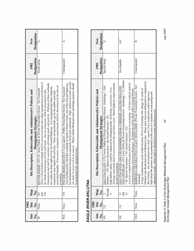
Appe
ndix
G T
able
2 o
f the
Anc
hora
ge W
etla
nds
Man
agem
ent P
lan
43
July
200
7 An
chor
age
Coa
stal
Man
agem
ent P
lan
Site
No.
1982
Site
No.
Map
No.
Site
Des
crip
tion,
Enf
orce
able
and
Adm
inis
trat
ive
Polic
ies a
nd
Man
agem
ent S
trat
egie
s 19
82D
esig
natio
nN
ewD
esig
natio
n 8
6 N
one
105
a
nd
110
POTT
ER M
AR
SH (
425.
56+
acre
s; P
ublic
& P
rivat
e O
wne
rshi
p) (S
core
s: N
ot A
sses
sed)
Th
ese
criti
cal h
abita
t wet
land
s sha
ll be
pre
serv
ed u
nder
the
refu
ge m
anag
emen
t jur
isdi
ctio
n of
th
e Al
aska
Dep
artm
ent o
f Fis
h an
d G
ame.
Any
use
pro
posa
ls s
hall
be p
rese
nted
to th
at
Dep
artm
ent a
nd sh
all b
e co
nsis
tent
with
refu
ge g
oals
and
pol
icie
s. P
ortio
ns o
f the
se w
etla
nds
are
with
in th
e St
ate
right
-of-
way
for S
ewar
d H
ighw
ay.
It is
reco
gniz
ed th
at fu
ture
hig
hway
ex
pans
ions
may
requ
ire fi
ll ac
tiviti
es.
Thes
e ar
e pe
rmis
sibl
e, g
iven
the
publ
ic n
eed
and
asso
ciat
ed b
enef
its.
If ne
cess
ary,
miti
gatio
n re
quir
emen
ts sh
all b
e de
term
ined
at t
he ti
me
of
perm
ittin
g.
Pres
erva
tion
A
86A
N
one
110
PO
TTER
CR
EEK
MO
UTH
(3.5
acr
es a
ppro
x.; P
ublic
Ow
ners
hip)
(Sco
res:
Not
Ass
esse
d)
Are
a in
clud
es p
artly
inte
rtida
l wet
land
s at m
outh
of P
otte
r Cre
ek, e
ast o
f the
Sew
ard
Hig
hway
, bu
t inc
lude
d he
re b
ecau
se it
is p
rimar
ily fr
eshw
ater
influ
ence
d. H
igh
hab
itat a
nd w
ater
qua
lity
site
shal
l be
pre
serv
ed in
its e
ntire
ty.
Min
or A
lask
a R
ailro
ad tr
ack
and
brid
ge p
roje
cts s
houl
d be
per
mitt
ed w
ith m
inim
al re
view
.
Und
esig
nate
dA
EAG
LE R
IVER
-EK
LUTN
A
Site
No.
1982
Site
No.
Map
No.
Site
Des
crip
tion,
Enf
orce
able
and
Adm
inis
trat
ive
Polic
ies a
nd
Man
agem
ent S
trat
egie
s 19
82D
esig
natio
nN
ewD
esig
natio
n10
113
1
2 th
roug
h
6
EKLU
TNA
FLA
TS (
176.
5 ac
res;
Pub
lic &
Priv
ate
Ow
ners
hip)
(Sco
res:
Hyd
rolo
gy =
104
; H
abita
t =
143;
Spe
cies
Occ
urre
nce
= 60
; Soc
ial F
unct
ion
= 26
) H
igh
habi
tat v
alue
s; c
ould
be
enha
nced
by
enla
rgin
g po
nds.
Hyd
rolo
gy c
onne
ctio
ns, c
ross
-dr
aina
ge a
nd p
onds
shal
l be
pres
erve
d to
the
max
imum
ext
ent.
Min
or h
ighw
ay im
prov
emen
ts
shou
ld b
e pe
rmitt
ed.
Spec
ial S
tudy
A
102
131
12
and
1
3
EKLU
TNA
RIV
ER A
ND
TH
UN
DER
BIR
D C
REE
K C
OR
RID
OR
AN
D O
NE
ISO
LATE
D
SITE
UPS
TREA
M (
10.5
acr
es; P
ublic
& P
rivat
e O
wne
rshi
p) (S
core
s: H
ydro
logy
= 7
2; H
abita
t =
88; S
peci
es O
ccur
renc
e =
43; S
ocia
l Fun
ctio
n =
25)
A pr
ecis
e we
tland
del
inea
tion
shal
l be
requ
ired
prio
r to
perm
ittin
g. A
65-
foot
setb
ack
shal
l be
m
aint
aine
d al
ong
wat
erw
ays/
drai
nage
s. Is
olat
ed si
te c
an b
e fil
led
with
a G
ener
al P
erm
it.
Dev
elop
able
A
/C
102A
Non
eN
one
BA
RB
AR
A L
AK
E/EK
LUTN
A V
ALL
EY W
ETLA
ND
S (P
rivat
e O
wne
rshi
p) (S
core
s: N
ot
Ass
esse
d)A
larg
e w
etla
nd b
asin
exi
sts w
ithin
Sec
tions
34/
35 o
f Tow
nshi
p 16
N, R
ange
1E,
sout
h of
Ek
lutn
a La
ke R
oad
and
wes
t of B
arba
ra L
ake.
The
se a
reas
wer
e no
t del
inea
ted
or e
valu
ated
for
this
revi
sion
. An
y de
velo
pmen
t her
e sh
all
requ
ire C
orps
not
ifica
tion
and/
or a
ppro
val.
Indi
vidu
al 4
04 p
erm
its a
re re
com
men
ded
in th
is a
rea
as it
incl
udes
seve
ral s
prin
gs a
nd
ephe
mer
al c
reek
s, w
hich
shal
l be
iden
tifie
d in
per
mit
and
plat
pro
cess
.
Und
esig
nate
dB

Appe
ndix
G T
able
2 o
f the
Anc
hora
ge W
etla
nds
Man
agem
ent P
lan
44
July
200
7 An
chor
age
Coa
stal
Man
agem
ent P
lan
Site
No.
1982
Site
No.
Map
No.
Site
Des
crip
tion,
Enf
orce
able
and
Adm
inis
trat
ive
Polic
ies a
nd
Man
agem
ent S
trat
egie
s 19
82D
esig
natio
nN
ewD
esig
natio
n10
312
2 1
2 TH
UN
DER
BIR
D H
EIG
HTS
SU
BD
IVIS
ION
(11
.2 a
cres
; Priv
ate
Ow
ners
hip)
(Sco
res:
H
ydro
logy
= 8
1; H
abita
t = 7
4; S
peci
es O
ccur
renc
e =
15; S
ocia
l Fun
ctio
n =
21)
A 6
5-fo
ot se
tbac
k sh
all b
e m
aint
aine
d al
ong
the
drai
nage
way
in so
uthe
rn si
te.
Trac
t C n
ear
Sand
pipe
r cla
ssed
as “
C”
wet
land
due
to m
inim
um v
alue
s. H
ighe
st v
alue
s con
cent
rate
d at
dr
aina
gew
ay.
Dev
elop
able
C
103A
Pond
121
12
THU
ND
ERB
IRD
HEI
GH
TS (
1 ac
re; P
rivat
e O
wne
rshi
p) (S
core
s: H
ydro
logy
= 7
9; H
abita
t =
64; S
peci
es O
ccur
renc
e =
23; S
ocia
l Fun
ctio
n =
21)
Pond
at O
ld G
lenn
Hig
hway
cla
ssed
as “
B” w
etla
nd; f
lood
stor
age,
dra
inag
e fu
nctio
ns sh
all b
e m
aint
aine
d. A
dditi
onal
info
rmat
ion
on in
flow/
stor
age
shal
l be
requ
ired
dur
ing
perm
it pr
oces
s.
Inflo
w id
entif
ied
as c
reek
shal
l be
mai
ntai
ned
with
65-
foot
setb
ack.
Und
esig
nate
dB
104
Non
e 1
6 TH
UN
DER
BIR
D F
ALL
S SU
BD
IVIS
ION
: A
T C
REE
K (
11.6
acr
es; P
rivat
e O
wne
rshi
p)
(Sco
res:
Hyd
rolo
gy =
75;
Hab
itat =
53;
Spe
cies
Occ
urre
nce
= 23
; Soc
ial F
unct
ion
= 28
) Su
bsta
ntia
l stre
amflo
w; h
as fl
ood
stor
age
valu
es.
Hab
itat v
alue
s not
fully
kno
wn.
A 6
5-fo
ot
setb
ack
shal
l be
mai
ntai
ned
alon
g th
e cr
eek
to m
aint
ain
flood
stor
age
valu
es.
Fill
shal
l be
limite
d to
the
min
imum
nec
essa
ry fo
r util
ities
, a si
ngle
-lane
acc
ess d
rive
way
and
hou
se a
nd
acce
ssor
y st
ruct
ure
pads
. Fi
ll fo
r yar
ds is
not
aut
hori
zed
in th
is u
nit u
nder
the
GPs
. Lar
ge lo
t zo
ning
shou
ld a
llow
for m
inim
um fi
ll to
reta
in d
rain
ages
.
Und
esig
nate
dC
104
121
16
and
1
7
BET
WEE
N G
LEN
N H
IGH
WA
Y A
ND
PA
RA
DIS
LA
NE,
NO
RTH
OF
EDM
ON
DS
LAK
E(9
.5 a
cres
; Pub
lic &
Priv
ate
Ow
ners
hip)
(Sco
res:
Hyd
rolo
gy =
86;
Hab
itat =
82;
Spe
cies
O
ccur
renc
e =
30; S
ocia
l Fun
ctio
n =
26)
Wet
land
s adj
acen
t to
the
trib
utar
y ch
anne
l sha
ll b
e re
tain
ed b
y a
65-fo
ot se
tbac
k.
Pres
erva
tion
Und
esig
nate
dC
104
121
17
NO
RTH
OF
EDM
ON
DS
LAK
E/EA
ST O
F G
LEN
N H
IGH
WA
Y (
7.8
acre
s; P
rivat
e O
wne
rshi
p) (S
core
s: H
ydro
logy
= 7
6; H
abita
t = 5
0; S
peci
es O
ccur
renc
e =
17; S
ocia
l Fun
ctio
n =
22)
A 2
5-fo
ot tr
ansi
tiona
l buf
fer s
hall
be m
aint
aine
d b
etw
een
area
s cov
ered
und
er th
e G
Ps a
nd
“A”
wet
land
s.
Dev
elop
able
C
104
131
11
EKLU
TNA
FLA
TS (
18.5
acr
es; P
rivat
e O
wne
rshi
p) (S
core
s: N
ot A
sses
sed)
D
rain
agew
ay/o
utle
t str
eam
wes
t of G
lenn
Hig
hway
shal
l be
pres
erve
d w
ith 6
5-fo
ot se
tbac
k.
Shal
l inc
lude
dra
inag
e an
alys
is a
nd lo
catio
n of
cha
nnel
on
perm
its.
Spec
ial S
tudy
B
105
119
17
WES
T O
F G
LEN
N H
IGH
WA
Y -
WES
T O
F ED
MO
ND
S LA
KE
(46.
3 ac
res;
Priv
ate
Ow
ners
hip)
(Sco
res:
Hyd
rolo
gy =
96;
Hab
itat =
96;
Spe
cies
Occ
urre
nce
= 56
; Soc
ial F
unct
ion
= 50
) C
reek
cha
nnel
shal
l be
mai
ntai
ned
undi
stur
bed.
A m
aste
r dev
elop
men
t pla
n sh
all b
e re
quir
ed,
incl
udin
g a
hydr
olog
y an
alys
is a
nd sh
all i
nclu
de a
65-
foot
setb
acks
from
cre
eks.
Dra
inag
eway
an
d ep
hem
eral
flow
s sha
ll be
mai
ntai
ned.
Oth
er se
tbac
ks a
nd fi
ll re
stric
tions
may
be
requ
ired
durin
g th
e pl
attin
g pr
oces
s.
Spec
ial S
tudy
B

Appe
ndix
G T
able
2 o
f the
Anc
hora
ge W
etla
nds
Man
agem
ent P
lan
45
July
200
7 An
chor
age
Coa
stal
Man
agem
ent P
lan
Site
No.
1982
Site
No.
Map
No.
Site
Des
crip
tion,
Enf
orce
able
and
Adm
inis
trat
ive
Polic
ies a
nd
Man
agem
ent S
trat
egie
s 19
82D
esig
natio
nN
ewD
esig
natio
n10
611
8 1
7 a
nd
18
MIR
RO
R L
AK
E O
UTL
ET (
8.6
acre
s; P
rivat
e O
wne
rshi
p) (S
core
s: H
ydro
logy
= 7
0; H
abita
t =
76; S
peci
es O
ccur
renc
e =
48; S
ocia
l Fun
ctio
n =
35)
Fish
pre
sent
in st
ream
whi
ch sh
all b
e m
aint
aine
d w
ith a
min
imum
65-
foot
setb
ack.
Cre
ek
cros
sing
s sha
ll re
quir
e br
idge
s or a
rche
d cu
lver
ts to
pro
tect
hab
itat.
A m
aste
r dev
elop
men
t pl
an sh
all b
e re
quir
ed, i
nclu
ding
a h
ydro
logy
ana
lysi
s whi
ch sh
all i
nclu
de d
esig
n to
ret
ain
drai
nage
way
and
eph
emer
al fl
ows.
Oth
er se
tbac
ks a
nd fi
ll re
stric
tions
may
be
requ
ired
in
perm
it an
d p
lat p
roce
ss.
Und
esig
nate
d/S
peci
al S
tudy
B
106
125
19
NO
RTH
OF
RA
NK
IN R
OA
D (
55 a
cres
; Priv
ate
Ow
ners
hip)
(Sco
res:
Hyd
rolo
gy =
80;
Hab
itat
= 53
; Spe
cies
Occ
urre
nce
= 21
; Soc
ial F
unct
ion
= 28
) A
hydr
olog
ic a
naly
sis s
hall
be d
one
and
shal
l mee
t the
acc
epta
ble
stan
dard
s of t
he M
unic
ipal
D
epar
tmen
t of P
ublic
Wor
ks in
ord
er to
pre
vent
floo
ding
of a
djac
ent p
rope
rty,
mai
ntai
n gr
ound
wat
er re
char
ge a
nd fl
ood
stor
age,
as w
ell a
s bot
h su
rfac
e an
d su
bsur
face
cro
ss
drai
nage
, and
pre
vent
dra
inag
e of
wet
land
s. It
shal
l be
used
in d
eter
min
ing
the
plac
emen
t of f
ill
and
requ
irem
ents
for s
etba
cks a
long
dra
inag
eway
s tha
t wou
ld a
llow
mai
nten
ance
of e
xist
ing
surf
ace
drai
nage
. Lar
ge si
te si
ze p
ushe
d sc
ores
hig
her t
han
expe
cted
. Si
te is
isol
ated
bas
in w
ith
min
imal
val
ues.
Und
esig
nate
d/S
peci
al S
tudy
C
107
118
17
WES
T O
F G
LEN
N H
IGH
WA
Y -
SOU
TH O
F ED
MO
ND
S LA
KE
(11.
9 ac
res;
Priv
ate
Ow
ners
hip)
(Sco
res:
Hyd
rolo
gy =
59;
Hab
itat =
41;
Spe
cies
Occ
urre
nce
= 23
; Soc
ial F
unct
ion
= 47
) A
hydr
olog
ic a
naly
sis s
hall
be d
one
and
shal
l mee
t the
acc
epta
ble
stan
dard
s of t
he M
unic
ipal
D
epar
tmen
t of P
ublic
Wor
ks in
ord
er to
pre
vent
floo
ding
of a
djac
ent p
rope
rty,
mai
ntai
n gr
ound
wat
er re
char
ge a
nd fl
ood
stor
age,
as w
ell a
s bot
h su
rfac
e an
d su
bsur
face
cro
ss
drai
nage
, and
pre
vent
dra
inag
e of
wet
land
s. It
shal
l be
used
in d
eter
min
ing
the
plac
emen
t of f
ill
and
requ
irem
ents
for s
etba
cks a
long
dra
inag
eway
s and
eph
emer
al fl
ows t
hat w
ould
allo
w m
aint
enan
ce o
f exi
stin
g su
rfac
e dr
aina
ge.
A 6
5-fo
ot se
tbac
k sh
all b
e m
aint
aine
d al
ong
cree
ks.
A m
aste
r dev
elop
men
t pla
n is
reco
mm
ende
d. O
ther
setb
acks
and
fill
rest
rictio
ns m
ay b
e re
quire
d. I
sola
ted
site
s are
“C
” w
etla
nds.
Spec
ial S
tudy
B
/C
108
117
17
OU
TLET
OF
EDM
ON
DS
LAK
E (1
8.1
acre
s; P
ublic
& P
rivat
e O
wne
rshi
p) (S
core
s:
Hyd
rolo
gy =
86;
Hab
itat =
88;
Spe
cies
Occ
urre
nce
= 48
; Soc
ial F
unct
ion
= 57
) Po
ssib
le fi
sh h
abita
t; im
porta
nt h
ydro
logi
cal c
onve
yanc
e. A
ll di
stur
banc
e sh
all b
e av
oide
d to
th
e m
axim
um e
xten
t.
Pres
erva
tion
A
108A
116
16
EAST
SID
E O
F ED
MO
ND
S LA
KE
(2.8
acr
es; P
rivat
e O
wne
rshi
p) (S
core
s: H
ydro
logy
= 8
7;
Hab
itat =
73;
Spe
cies
Occ
urre
nce
= 29
; Soc
ial F
unct
ion
= 49
) M
inim
al fr
inge
wet
land
s pre
sent
on
lake
shor
e. M
inor
road
mai
nten
ance
/exp
ansi
on fi
lls c
ould
be
per
mitt
ed v
ia N
atio
nwid
e Pe
rmit.
Fri
nge
area
s sha
ll ot
herw
ise
be p
rese
rved
.
Dev
elop
able
O
pen
Wat
er/
A

Appe
ndix
G T
able
2 o
f the
Anc
hora
ge W
etla
nds
Man
agem
ent P
lan
46
July
200
7 An
chor
age
Coa
stal
Man
agem
ent P
lan
Site
No.
1982
Site
No.
Map
No.
Site
Des
crip
tion,
Enf
orce
able
and
Adm
inis
trat
ive
Polic
ies a
nd
Man
agem
ent S
trat
egie
s 19
82D
esig
natio
nN
ewD
esig
natio
n10
911
3 1
7 a
nd
26
MIR
RO
R L
AK
E A
ND
FR
ING
E W
ETLA
ND
S (9
2.9
acre
s; P
ublic
& P
rivat
e O
wne
rshi
p)
(Sco
res:
Hyd
rolo
gy =
116
; Hab
itat =
150
; Spe
cies
Occ
urre
nce
= 12
3; S
ocia
l Fun
ctio
n =
82)
Frin
ge w
etla
nds a
nd o
pen
wat
er o
f Mirr
or L
ake
asse
ssed
toge
ther
. M
inim
um se
tbac
k of
75
feet
sh
all b
e re
quir
ed w
here
wet
land
s are
con
tiguo
us w
ith th
e la
ke o
r, if
less
than
75
feet
of
wet
land
s, th
e se
tbac
k sh
all b
e th
e w
idth
of t
hose
wet
are
as.
Min
or fi
lls fo
r lak
e ac
cess
are
pe
rmitt
ed b
ut sh
all b
e lim
ited
to la
ke a
cces
s doc
k st
ruct
ures
whe
neve
r pra
ctic
able
.
Und
esig
nate
dA
109
113
26
MIR
RO
R L
AK
E, S
OU
TH S
IDE
(63.
15 a
cres
; Priv
ate
Ow
ners
hip)
(Sco
res:
Hyd
rolo
gy =
113
; H
abita
t = 1
01; S
peci
es O
ccur
renc
e =
18; S
ocia
l Fun
ctio
n =
34)
Fill
shal
l be
the
min
imum
nec
essa
ry fo
r util
ities
, pad
s for
a h
ouse
and
an
acce
ssor
y st
ruct
ure
and
sing
le la
ne a
cces
s dri
vew
ay. F
ill fo
r roa
ds is
not
aut
hori
zed
in th
is u
nit u
nder
the
GPs
. A
hydr
olog
ic a
naly
sis s
hall
be d
one
and
shal
l m
eet t
he a
ccep
tabl
e st
anda
rds o
f the
Mun
icip
al
Dep
artm
ent o
f Pub
lic W
orks
in o
rder
to p
reve
nt fl
oodi
ng o
f adj
acen
t pro
pert
y, m
aint
ain
grou
ndw
ater
rech
arge
and
floo
d st
orag
e, a
s wel
l as b
oth
surf
ace
and
subs
urfa
ce c
ross
dr
aina
ge, a
nd p
reve
nt d
rain
age
of w
etla
nds.
It sh
all b
e us
ed in
det
erm
inin
g th
e pl
acem
ent o
f fil
l and
requ
irem
ents
for s
etba
cks a
long
dra
inag
eway
s tha
t wou
ld a
llow
mai
nten
ance
of e
xist
ing
surf
ace
drai
nage
. A
min
imum
of a
65-
foot
setb
ack
shal
l be
mai
ntai
ned
alon
g th
e cr
eek
and
pond
sout
h of
Lak
esho
re D
rive.
A
75-fo
ot se
tbac
k fr
om o
rdin
ary
high
wat
er sh
all b
e m
aint
aine
d al
ong
Mir
ror L
ake;
lake
fron
t str
uctu
res o
n pi
les m
ay b
e pe
rmitt
ed u
nder
the
GPs
in
the
75-fo
ot se
tbac
k. N
o w
ork
shal
l be
done
with
in 2
00 fe
et o
f Mir
ror L
ake
from
Apr
il th
roug
h Ju
ly.
Dev
elop
able
C
109A
113
26
SOU
THEA
ST O
F A
NTH
EM A
ND
LA
KES
HO
RE
DR
IVE
(2 a
cres
; Priv
ate
Ow
ners
hip)
(S
core
s: H
ydro
logy
= 8
6; H
abita
t = 6
7; S
peci
es O
ccur
renc
e =
18; S
ocia
l Fun
ctio
n =
34)
A 65
-foot
setb
ack
shal
l be
mai
ntai
ned
arou
nd th
e se
ason
al p
ond
and
drai
nage
are
a in
to si
te.
Dev
elop
able
C
110
115A
17
MIR
RO
R L
AK
E TO
ED
MO
ND
S LA
KE
(40.
2 ac
res;
Pub
lic O
wne
rshi
p) (S
core
s: H
ydro
logy
=
99; H
abita
t = 8
9; S
peci
es O
ccur
renc
e =
91; S
ocia
l Fun
ctio
n =
80)
A m
aste
r par
k pl
an fo
r the
are
a sh
ould
be
deve
lope
d w
hich
iden
tifie
s allo
wed
use
s and
ap
prop
riate
act
iviti
es.
Any
maj
or p
ark
amen
ity d
evel
opm
ent s
hall
avoi
d dr
aina
ge p
atte
rns a
nd
open
wat
er a
reas
. Th
e m
aste
r par
k pl
an sh
ould
als
o id
entif
y th
ose
wet
land
are
as to
be
prot
ecte
d fo
r wat
er q
ualit
y m
aint
enan
ce.
Pres
erva
tion
A
111
113A
27
MEA
DO
W L
AK
E (2
7.27
acr
es; P
rivat
e O
wne
rshi
p) (S
core
s: H
ydro
logy
= 1
13; H
abita
t = 1
03;
Spec
ies O
ccur
renc
e =
44; S
ocia
l Fun
ctio
n =
62)
Wet
land
s frin
ge a
roun
d th
e la
ke is
not
wid
e en
ough
for d
evel
opm
ent a
s a “
C”
site
with
a
setb
ack.
The
refo
re, t
he e
ntire
site
is d
esig
nate
d as
“A
” w
etla
nd.
Min
or la
ke a
cces
s stru
ctur
es
are
perm
itted
.
Dev
elop
able
A

Appe
ndix
G T
able
2 o
f the
Anc
hora
ge W
etla
nds
Man
agem
ent P
lan
47
July
200
7 An
chor
age
Coa
stal
Man
agem
ent P
lan
Site
No.
1982
Site
No.
Map
No.
Site
Des
crip
tion,
Enf
orce
able
and
Adm
inis
trat
ive
Polic
ies a
nd
Man
agem
ent S
trat
egie
s 19
82D
esig
natio
nN
ewD
esig
natio
n11
2N
one
27
PETE
RS
GA
TE S
UB
DIV
ISIO
N:
THR
EE S
ITES
(46
.84
acre
s; P
rivat
e O
wne
rshi
p) (S
core
s:
Hyd
rolo
gy =
93;
Hab
itat =
93;
Spe
cies
Occ
urre
nce
= 18
; Soc
ial F
unct
ion
= 36
) Pr
ovid
es w
ater
qua
lity,
det
entio
n fo
r Pet
ers C
reek
. A
65-fo
ot se
tbac
k sh
all b
e m
aint
aine
d al
ong
seco
ndar
y dr
aina
gew
ays a
nd c
reek
. A
wri
tten
plan
shal
l be
subm
itted
to th
e M
unic
ipal
D
epar
tmen
t of C
omm
unity
Pla
nnin
g an
d D
evel
opm
ent f
or re
view
and
app
rova
l des
crib
ing
effo
rts t
o av
oid
and
min
imiz
e im
pact
s to
the
trac
t’s h
abita
t, w
ater
qua
lity,
and
hyd
rolo
gic
valu
es. E
xam
ples
of p
ossi
ble
mea
sure
s to
cons
ider
incl
ude
timin
g w
indo
ws, a
dditi
onal
setb
acks
, ve
geta
tive
scre
enin
g, re
duct
ion
of fi
ll, a
nd o
nsite
enh
ance
men
t. C
ross
-dra
inag
e sh
all b
e m
aint
aine
d.
Fill
shal
l be
the
min
imum
nec
essa
ry fo
r util
ities
, pad
s for
a h
ouse
and
an
acce
ssor
y st
ruct
ure
and
a si
ngle
-lane
acc
ess d
rive
way.
Fill
for y
ards
is n
ot a
utho
rized
und
er th
e G
Ps .
Und
esig
nate
dC
113
115
25
MIR
RO
R D
RIV
E (7
.6 a
cres
; Priv
ate
Ow
ners
hip)
(Sco
res:
Hyd
rolo
gy =
78;
Hab
itat =
47;
Sp
ecie
s Occ
urre
nce
= 27
; Soc
ial F
unct
ion
= 39
) U
se o
f clu
ster
dev
elop
men
t sho
uld
be in
corp
orat
ed in
pla
ts to
pro
tect
seas
onal
pon
d an
d to
id
entif
y dr
aina
ges.
A hy
drol
ogic
ana
lysi
s sha
ll be
don
e an
d sh
all m
eet t
he a
ccep
tabl
e st
anda
rds
of th
e M
unic
ipal
Dep
artm
ent o
f Pub
lic W
orks
in o
rder
to p
reve
nt fl
oodi
ng o
f adj
acen
t pro
pert
y,
mai
ntai
n gr
ound
wat
er re
char
ge a
nd fl
ood
stor
age,
as w
ell a
s bot
h su
rfac
e an
d su
bsur
face
cro
ss
drai
nage
, and
pre
vent
dra
inag
e of
wet
land
s. It
shal
l be
used
in d
eter
min
ing
the
plac
emen
t of f
ill
and
requ
irem
ents
for s
etba
cks a
long
dra
inag
eway
s and
the
seas
onal
pon
d th
at w
ould
allo
w m
aint
enan
ce o
f exi
stin
g su
rfac
e dr
aina
ge.
Pres
erva
tion
C
114
126
24
TWO
ISO
LATE
D S
ITES
: N
OR
TH O
F O
BER
G R
OA
D (
8.5
acre
s; P
rivat
e O
wne
rshi
p)
(Sco
res:
Hyd
rolo
gy =
61;
Hab
itat =
35;
Spe
cies
Occ
urre
nce
= 18
; Soc
ial F
unct
ion
= 20
) D
rain
age
shal
l be
mai
ntai
ned
thro
ugh
site
s.
Spec
ial S
tudy
C
114
115
18
and
2
5
NO
RTH
OF
DEE
R P
AR
K, W
EST
OF
WA
TER
LIN
E (1
4.7
acre
s; P
rivat
e O
wne
rshi
p) (S
core
s:
Hyd
rolo
gy =
66;
Hab
itat =
67;
Spe
cies
Occ
urre
nce
= 22
; Soc
ial F
unct
ion
= 20
) To
pogr
aphi
c lo
w p
oint
con
veys
stor
m d
rain
flow
s thr
ough
site
. St
orm
dra
inag
e th
roug
h si
te
shal
l be
mai
ntai
ned.
A 1
00-fo
ot se
tbac
k sh
all b
e m
aint
aine
d al
ong
trib
utar
y ch
anne
l.
Pres
erva
tion
C
115
115
23
28
and
2
9
PETE
RS
CR
EEK
CO
RR
IDO
R A
ND
AD
JAC
ENT
DR
AIN
AG
E (5
acr
es a
ppro
x.; P
ublic
&
Priv
ate
Ow
ners
hip)
(Sco
res:
Not
Ass
esse
d)
Incl
udes
wet
land
s alo
ng c
reek
. W
ork
adja
cent
to c
reek
or o
ther
con
nect
ing
drai
nage
s sha
ll re
quir
e w
etla
nd d
elin
eatio
n an
d C
orps
app
rova
l. R
ipar
ian
wet
land
s sha
ll be
pre
serv
ed.
Pres
erva
tion
A
116
130
31
32
and
3
5
LOW
ER F
IRE
CR
EEK
AN
D B
EAC
H L
AK
E C
OM
PLEX
(30
0 ac
res a
ppro
x.; P
ublic
& P
rivat
e O
wne
rshi
p) (S
core
s: N
ot A
sses
sed)
M
unic
ipal
par
klan
d sh
all
be p
rese
rved
. M
inor
par
k an
d tra
il am
eniti
es a
nd ro
ad a
cces
s are
pe
rmis
sibl
e. P
rivat
e la
nds a
t cre
ek m
outh
con
trolle
d by
the 1
979
Agr
eem
ent o
f Com
prom
ise
and
Settl
emen
t bet
wee
n th
e M
unic
ipal
ity a
nd E
klut
na, I
nc.
Und
er th
is a
gree
men
t, th
e 10
0-ye
ar
flood
plai
n is
to b
e pr
eser
ved
exce
pt fo
r tra
ils.
Area
s out
side
the
flood
plai
n sh
all r
equi
re a
n In
divi
dual
Per
mit
and
an a
dditi
onal
25-
foot
setb
ack
from
“A”
wet
land
are
as.
Pres
erva
tion
A/B

Appe
ndix
G T
able
2 o
f the
Anc
hora
ge W
etla
nds
Man
agem
ent P
lan
48
July
200
7 An
chor
age
Coa
stal
Man
agem
ent P
lan
Site
No.
1982
Site
No.
Map
No.
Site
Des
crip
tion,
Enf
orce
able
and
Adm
inis
trat
ive
Polic
ies a
nd
Man
agem
ent S
trat
egie
s 19
82D
esig
natio
nN
ewD
esig
natio
n11
710
8 3
5 a
nd
36
MIN
K C
REE
K:
WER
E/JE
RR
Y (
85+
acre
s; P
ublic
& P
rivat
e O
wne
rshi
p) (S
core
s: H
ydro
logy
=
118;
Hab
itat =
93;
Spe
cies
Occ
urre
nce
= 36
; Soc
ial F
unct
ion
= 42
) “A
” w
etla
nd d
esig
natio
n fo
r Cre
ek c
orrid
or (1
50-f
eet w
ide
at c
reek
fork
s, an
d in
clud
es th
e la
ke
feed
ing
Min
k C
reek
.) A
25-
foot
buf
fer s
hall
be m
aint
aine
d be
twee
n an
y fil
ls a
nd th
e “A
” w
etla
nd si
tes.
“C
” w
etla
nd d
esig
natio
n fo
r are
a no
rth o
f the
lake
. “B
” w
etla
nd d
esig
natio
n fo
r rem
aind
er o
f site
. A
rea
is g
ener
ally
val
uabl
e to
Min
k C
reek
floo
d co
ntro
l, w
ater
qua
lity
and
wild
life
habi
tat.
D
rain
age
and
flood
con
trol
func
tions
shal
l be
mai
ntai
ned.
An
y fil
l aut
hori
zed
unde
r the
GPs
sh
all b
e a
min
imum
of 2
00 fe
et fr
om th
e ed
ge o
f Min
k La
ke.
Fill
shal
l be
the
min
imum
ne
cess
ary
for u
tiliti
es, p
ads f
or a
hou
se a
nd a
n ac
cess
ory
stru
ctur
e an
d a
sing
le-la
ne a
cces
s dr
ivew
ay.
Fill
for y
ards
is n
ot a
utho
rize
d in
this
uni
t und
er th
e G
Ps.
An
impe
rvio
us b
arri
er
shal
l be
plac
ed a
t the
mar
gins
of a
ny fi
ll au
thor
ized
by th
ese
GPs
to th
e bo
ttom
of t
he p
eat l
ayer
or
a m
inim
um o
f one
foot
bel
ow th
e bo
ttom
of t
he g
rave
l fill
to p
recl
ude
grou
ndw
ater
ou
tmig
ratio
n fr
om a
n ad
jace
nt w
etla
nd.
Dev
elop
able
A
/B/C
117
110
30
SOU
TH B
IRC
HW
OO
D/T
OFS
ON
STR
EET
(86
acre
s; P
rivat
e O
wne
rshi
p) (S
core
s:
Hyd
rolo
gy =
110
; Hab
itat =
151
; Spe
cies
Occ
urre
nce
= 54
; Soc
ial F
unct
ion
= 40
) Po
nded
are
as a
nd d
rain
age
corr
idor
out
of T
ofso
n St
reet
lobe
, whi
ch d
rain
s int
o M
ink
Cre
ek
shal
l be
reta
ined
; con
trib
utes
as h
eadw
ater
s. F
ring
es c
ould
be
deve
lope
d w
ith a
ppro
pria
te
setb
acks
to d
rain
age
zone
s, w
hich
shal
l be
dete
rmin
ed in
the
pla
tting
and
per
mitt
ing
proc
esse
s. N
orth
erly
lobe
(app
roxi
mat
ely
12 a
cres
) is “
C”
wet
land
and
shal
l inc
lude
a 2
5-fo
ot
buffe
r to
“A”
wet
land
are
as.
Pres
erva
tion
B
117A
110A
30
and
3
1
OFF
BIR
CH
WO
OD
—JA
YH
AW
K R
IGH
T-O
F-W
AY
(10
.11
acre
s; P
rivat
e O
wne
rshi
p)
(Sco
res:
Hyd
rolo
gy =
90;
Hab
itat =
66;
Spe
cies
Occ
urre
nce
= 18
; Soc
ial F
unct
ion
= 37
) Po
orly
def
ined
stre
am c
hann
el. A
hyd
rolo
gic
anal
ysis
shal
l be
done
and
shal
l mee
t the
ac
cept
able
stan
dard
s of t
he M
unic
ipal
Dep
artm
ent o
f Pub
lic W
orks
in o
rder
to p
reve
nt fl
oodi
ng
of a
djac
ent p
rope
rty,
mai
ntai
n gr
ound
wat
er re
char
ge a
nd fl
ood
stor
age,
as w
ell a
s bot
h su
rfac
e an
d su
bsur
face
cro
ss d
rain
age,
and
pre
vent
dra
inag
e of
wet
land
s. It
shal
l be
used
in
dete
rmin
ing
the
plac
emen
t of f
ill a
nd re
quir
emen
ts fo
r set
back
s (m
inim
um o
f 65
feet
) alo
ng
drai
nage
way
s tha
t wou
ld a
llow
mai
nten
ance
of e
xist
ing
surf
ace
drai
nage
.
Und
esig
nate
dC
117A
107
35
BEV
ERLY
/SO
UTH
BIR
CH
WO
OD
(4
acre
s; P
rivat
e O
wne
rshi
p) (S
core
s: H
ydro
logy
= 7
4;
Hab
itat =
48;
Spe
cies
Occ
urre
nce
= 18
; Soc
ial F
unct
ion
= 36
) M
inim
al v
alue
s.
Dev
elop
able
C

Appe
ndix
G T
able
2 o
f the
Anc
hora
ge W
etla
nds
Man
agem
ent P
lan
49
July
200
7 An
chor
age
Coa
stal
Man
agem
ent P
lan
Site
No.
1982
Site
No.
Map
No.
Site
Des
crip
tion,
Enf
orce
able
and
Adm
inis
trat
ive
Polic
ies a
nd
Man
agem
ent S
trat
egie
s 19
82D
esig
natio
nN
ewD
esig
natio
n11
810
7 3
9 O
LD G
LEN
N H
IGH
WA
Y:
NO
RTH
SID
E O
F PA
RK
S C
REE
K (
12.7
acr
es; P
rivat
e O
wne
rshi
p) (S
core
s: H
ydro
logy
= 6
6; H
abita
t = 4
5; S
peci
es O
ccur
renc
e =
18; S
ocia
l Fun
ctio
n =
30)
Isol
ated
site
. A h
ydro
logi
c an
alys
is sh
all b
e do
ne a
nd sh
all m
eet t
he a
ccep
tabl
e st
anda
rds o
f the
M
unic
ipal
Dep
artm
ent o
f Pub
lic W
orks
in o
rder
to p
reve
nt fl
oodi
ng o
f adj
acen
t pro
pert
y,
mai
ntai
n gr
ound
wat
er re
char
ge a
nd fl
ood
stor
age,
as w
ell a
s bot
h su
rfac
e an
d su
bsur
face
cro
ss
drai
nage
, and
pre
vent
dra
inag
e of
wet
land
s. It
shal
l be
used
in d
eter
min
ing
the
plac
emen
t of f
ill
and
requ
irem
ents
for s
etba
cks a
long
dra
inag
eway
s tha
t wou
ld a
llow
mai
nten
ance
of t
he so
uth
end
conn
ectio
n to
Par
ks C
reek
such
that
exi
sting
surf
ace
drai
nage
will
be
mai
ntai
ned.
Dev
elop
able
C
119
128
37
and
3
8
OLD
GLE
NN
HIG
HW
AY
: C
AN
YO
N (
13.6
2 ac
res;
Pub
lic &
Priv
ate
Ow
ners
hip)
(Sco
res:
H
ydro
logy
= 8
9; H
abita
t = 8
9; S
peci
es O
ccur
renc
e =
24; S
ocia
l Fun
ctio
n =
51)
Can
yon
labe
led
Ope
n W
ater
and
cre
ek c
hann
el. A
hyd
rolo
gic
anal
ysis
shal
l be
done
if th
e dr
aina
ges o
r Par
ks C
reek
wou
ld b
e af
fect
ed, a
nd th
is a
naly
sis s
hall
mee
t the
acc
epta
ble
stan
dard
s of t
he M
unic
ipal
Dep
artm
ent o
f Pub
lic W
orks
in o
rder
to p
reve
nt fl
oodi
ng o
f adj
acen
t pr
oper
ty, m
aint
ain
grou
ndw
ater
rech
arge
and
floo
d st
orag
e, a
s wel
l as b
oth
surf
ace
and
subs
urfa
ce c
ross
dra
inag
e, a
nd p
reve
nt d
rain
age
of w
etla
nds.
It sh
all b
e us
ed in
det
erm
inin
g th
e pl
acem
ent o
f fill
and
requ
irem
ents
for s
etba
cks a
long
dra
inag
eway
s tha
t wou
ld a
llow
mai
nten
ance
of t
he d
rain
age
conv
eyan
ce to
Par
ks C
reek
such
that
exi
stin
g su
rfac
e dr
aina
ge
will
be
mai
ntai
ned.
Iso
late
d si
te o
n no
rth si
de o
f Old
Gle
nn H
ighw
ay re
mai
ns a
s “C
” w
etla
nd.
Con
serv
atio
nA
/C/O
pen
Wat
er
120
128
39
and
4
0
PAR
KS
CR
EEK
- EA
ST S
IDE
OF
HIG
HW
AY
(45
.5 a
cres
; Priv
ate
Ow
ners
hip)
(Sco
res:
H
ydro
logy
= 9
5; H
abita
t = 8
9; S
peci
es O
ccur
renc
e =
18; S
ocia
l Fun
ctio
n =
34)
Setb
acks
enc
ompa
ss m
ost o
f wet
land
. Ri
pari
an si
tes a
re c
lass
ed “
A” a
nd sh
all r
emai
n un
dist
urbe
d to
the
max
imum
ext
ent
for f
lood
val
ues/
wat
er q
ualit
y an
d pr
obab
le fi
sh h
abita
t.N
on-c
onne
cted
spur
wet
land
s aw
ay fr
om c
reek
floo
dpla
in i
s “C
” w
etla
nds.
Dev
elop
able
A
/C
121
111
40
BEA
VER
PO
ND
: PA
RK
S C
REE
K (N
orth
of C
hugi
ak H
igh
Scho
ol)
(38.
56 a
cres
; Pub
lic &
Pr
ivat
e O
wne
rshi
p) (S
core
s: H
ydro
logy
= 1
04; H
abita
t = 1
23; S
peci
es O
ccur
renc
e =
42; S
ocia
l Fu
nctio
n =
50)
Sout
hern
are
as to
rem
ain
as “
C”
wet
land
s; re
mai
nder
of s
ite, i
nclu
ding
pon
d/cr
eek
to b
e cl
asse
d as
“A
” w
etla
nds d
ue to
hyd
rolo
gy/h
abita
t val
ues.
Floo
d co
ntro
l and
hig
h ha
bita
t val
ue si
te.
Ahy
drol
ogic
ana
lysi
s sha
ll be
don
e, a
nd th
is a
naly
sis sh
all m
eet t
he a
ccep
tabl
e st
anda
rds o
f the
M
unic
ipal
Dep
artm
ent o
f Pub
lic W
orks
in o
rder
to p
reve
nt fl
oodi
ng o
f adj
acen
t pro
pert
y,
mai
ntai
n gr
ound
wat
er re
char
ge a
nd fl
ood
stor
age,
as w
ell a
s bot
h su
rfac
e an
d su
bsur
face
cro
ss
drai
nage
, and
pre
vent
dra
inag
e of
wet
land
s. It
shal
l be
used
in d
eter
min
ing
the
plac
emen
t of
fill a
nd re
quir
emen
ts fo
r set
back
s alo
ng d
rain
agew
ays t
hat s
uch
that
exi
stin
g su
rfac
e dr
aina
ge
will
be
mai
ntai
ned.
A
100-
foot
setb
ack
shal
l be
mai
ntai
ned
alon
g Pa
rks C
reek
to p
rote
ct
anad
rom
ous f
ish
reso
urce
s. A
65-
foot
setb
ack
shal
l be
mai
ntai
ned
alon
g th
e tr
ibut
ary
of P
arks
C
reek
in th
e so
uthe
rn lo
be.
Dev
elop
able
A
/C

Appe
ndix
G T
able
2 o
f the
Anc
hora
ge W
etla
nds
Man
agem
ent P
lan
50
July
200
7 An
chor
age
Coa
stal
Man
agem
ent P
lan
Site
No.
1982
Site
No.
Map
No.
Site
Des
crip
tion,
Enf
orce
able
and
Adm
inis
trat
ive
Polic
ies a
nd
Man
agem
ent S
trat
egie
s 19
82D
esig
natio
nN
ewD
esig
natio
n12
210
0 3
4 4
1 a
nd
46
FIR
E C
REE
K C
OM
PLEX
DO
WN
STR
EAM
OF
THE
ALA
SKA
RA
ILR
OA
D (
230
acre
s ap
prox
.; Pu
blic
Ow
ners
hip)
(Par
tial A
rea
Ass
essm
ent S
core
s: H
ydro
logy
= 1
07; H
abita
t = 1
09;
Spec
ies O
ccur
renc
e =
78; S
ocia
l Fun
ctio
n =
41)
Publ
ic la
nd, i
nclu
ding
par
t of B
each
Lak
e pa
rk.
Site
shal
l be
pres
erve
d as
indi
cate
d. M
inor
tra
ils, p
ark
amen
ities
, roa
d ac
cess
and
util
ity p
lace
men
t to
be p
erm
itted
whe
re n
o pr
actic
able
up
land
alte
rnat
ives
exi
st.
Any
fills
shal
l be
set b
ack
a m
inim
um o
f 85
feet
from
the
cree
k.
Pres
erva
tion
A
123
112
34
and
4
1
PSA
LM L
AK
E C
OM
PLEX
(24
acr
es; P
ublic
Ow
ners
hip)
(Sco
res:
Not
Ass
esse
d)
Incl
udes
the
open
wat
er a
nd w
etla
nd fr
inge
of P
salm
Lak
e. S
ite sh
all b
e p
rese
rved
.Pr
eser
vatio
nA
124
97
and
98
33
42
and
4
3
MIL
ITA
RY
LA
ND
S (5
.8 a
cres
; Pub
lic O
wne
rshi
p) (S
core
s: N
ot A
sses
sed)
Sh
all b
e pr
eser
ved
and
man
aged
via
EO
#11
990
for m
ilita
ry la
nds.
Pres
erva
tion
A
125
Non
e 4
6 PI
ON
EER
DR
IVE:
TW
O S
ITES
(7.
5 ac
res;
Priv
ate
Ow
ners
hip)
(Sco
res:
Hyd
rolo
gy =
61;
H
abita
t = 3
6; S
peci
es O
ccur
renc
e =
18; S
ocia
l Fun
ctio
n =
48)
Min
imal
val
ues.
A h
ydro
logi
c an
alys
is sh
all b
e do
ne, a
nd th
is a
naly
sis s
hall
mee
t the
ac
cept
able
stan
dard
s of t
he M
unic
ipal
Dep
artm
ent o
f Pub
lic W
orks
in o
rder
to p
reve
nt fl
oodi
ng
of a
djac
ent p
rope
rty,
mai
ntai
n gr
ound
wat
er re
char
ge a
nd fl
ood
stor
age,
as w
ell a
s bot
h su
rfac
e an
d su
bsur
face
cro
ss d
rain
age,
and
pre
vent
dra
inag
e of
wet
land
s. It
shal
l be
used
in
dete
rmin
ing
the
plac
emen
t of f
ill a
nd re
quir
emen
ts fo
r set
back
s alo
ng d
rain
agew
ays t
hat s
uch
exis
ting
surf
ace
drai
nage
will
be
mai
ntai
ned.
Und
esig
nate
dC
125
102
46
HIL
LCR
EST/
WA
TER
LIN
E (3
5.5
acre
s; P
rivat
e O
wne
rshi
p) (S
core
s: H
ydro
logy
= 8
8; H
abita
t =
69; S
peci
es O
ccur
renc
e =
18; S
ocia
l Fun
ctio
n =
41)
A 10
0-fo
ot se
tbac
k sh
all b
e m
aint
aine
d ar
ound
the
ephe
mer
al p
ond
at th
e no
rthe
rn e
nd o
f the
si
te a
nd th
e dr
aina
ge in
to a
nd o
ut o
f the
pon
d, a
s w
ell a
s alo
ng th
e st
ream
in w
etla
nds t
hat
exis
ts w
etla
nd t
owar
d th
e no
rthe
ast a
t See
-Saw
righ
t-of-w
ay.
Cou
ld b
e us
ed a
s ope
n sp
ace
in
clus
ter z
one/
PUD
.
Dev
elop
able
C
126
106
47
NO
RTH
EAST
INTE
RSE
CTI
ON
OF
SOU
TH B
IRC
HW
OO
D/G
LEN
N H
IGH
WA
Y (
21.2
7 ac
res;
Pub
lic &
Priv
ate
Ow
ners
hip)
(Sco
res:
Hyd
rolo
gy =
96;
Hab
itat =
79;
Spe
cies
Occ
urre
nce
= 32
; Soc
ial F
unct
ion
= 39
) “C
” w
etla
nds d
esig
natio
n fo
r iso
late
d so
uthe
rn si
te.
“B”
wet
land
s des
igna
tion
for r
emai
nder
of s
ite; r
equi
rem
ent f
or p
erm
itsh
all i
nclu
de h
ydro
logy
an
alys
is to
iden
tify
stre
am c
hann
els a
nd fu
nctio
ns.
Pres
erva
tion
B/C
127
103
47
DR
AIN
AG
E IN
TO L
OW
ER F
IRE
LAK
E (8
.76
acre
s; P
rivat
e O
wne
rshi
p) (S
core
s: H
ydro
logy
=
93; H
abita
t = 8
8; S
peci
es O
ccur
renc
e =
24; S
ocia
l Fun
ctio
n =
61)
Pond
to b
e de
sign
ated
as “
Ope
n W
ater
; rev
ise
wet
land
bou
ndar
y. D
rain
age
thro
ugh
nort
hern
un
conn
ecte
d si
te sh
all b
e id
entif
ied
and
mai
ntai
ned.
Dev
elop
able
A/O
pen
Wat
er

Appe
ndix
G T
able
2 o
f the
Anc
hora
ge W
etla
nds
Man
agem
ent P
lan
51
July
200
7 An
chor
age
Coa
stal
Man
agem
ent P
lan
Site
No.
1982
Site
No.
Map
No.
Site
Des
crip
tion,
Enf
orce
able
and
Adm
inis
trat
ive
Polic
ies a
nd
Man
agem
ent S
trat
egie
s 19
82D
esig
natio
nN
ewD
esig
natio
n12
710
3 4
7 D
AR
BY
RO
AD
(9.
65 a
cres
; Priv
ate
Ow
ners
hip)
(Sco
res:
Hyd
rolo
gy =
76;
Hab
itat =
64;
Sp
ecie
s Occ
urre
nce
= 18
; Soc
ial F
unct
ion
= 59
) A
hydr
olog
ic a
naly
sis s
hall
be d
one,
and
this
ana
lysi
s sha
ll m
eet t
he a
ccep
tabl
e st
anda
rds o
f the
M
unic
ipal
Dep
artm
ent o
f Pub
lic W
orks
in o
rder
to p
reve
nt fl
oodi
ng o
f adj
acen
t pro
pert
y,
mai
ntai
n gr
ound
wat
er re
char
ge a
nd fl
ood
stor
age,
as w
ell a
s bot
h su
rfac
e an
d su
bsur
face
cro
ss
drai
nage
, and
pre
vent
dra
inag
e of
wet
land
s. It
shal
l be
used
in d
eter
min
ing
the
plac
emen
t of f
ill
and
requ
irem
ents
for s
etba
cks a
long
dra
inag
eway
s and
cre
ek su
ch th
at e
xist
ing
surf
ace
drai
nage
will
be
mai
ntai
ned.
Pla
tting
pro
cess
shal
l pro
vide
hyd
rolo
gy in
form
atio
n.
Dev
elop
able
C
128
105
46
and
4
9
LOW
ER F
IRE
LAK
E (in
clud
ing
Fire
Cre
ek)
(68
acre
s; P
ublic
& P
rivat
e O
wne
rshi
p) (S
core
s:
Hyd
rolo
gy =
130
; Hab
itat =
145
; Spe
cies
Occ
urre
nce
= 11
7; S
ocia
l Fun
ctio
n =
64)
Hig
h va
lue
habi
tat,
flood
con
trol a
nd w
ater
qua
lity
valu
es.
Whe
re w
etla
nds f
ring
e is
on
the
lake
ed
ge, s
etba
cks s
hall
be a
min
imum
of 6
5 fe
et.
Fills
into
the
lake
and
cre
ek sh
all b
e av
oide
d.
Sept
ic se
tbac
k re
quire
men
ts fo
r new
lots
shou
ld b
e ha
ndle
d by
var
ianc
e ra
ther
than
by
allo
win
g fil
l int
o th
e la
ke.
The
Dep
artm
ent o
f Hea
lth a
nd H
uman
Ser
vice
s sho
uld
revi
ew v
aria
nce
requ
ests
for t
his u
nusu
al a
rea.
Pres
erva
tion
A
129
104
47
and
4
8
UPP
ER F
IRE
LAK
E/C
REE
K (
29.3
5 ac
res a
ppro
x.; P
ublic
& P
rivat
e O
wne
rshi
p) (S
core
s:
Hyd
rolo
gy =
112
; Hab
itat =
84;
Spe
cies
Occ
urre
nce
= 29
; Soc
ial F
unct
ion
= 37
) In
clud
es la
ke fr
inge
and
inle
t cre
ek w
etla
nd c
orrid
ors.
Impo
rtant
to fi
sh h
abita
t, w
ater
qua
lity,
flo
od c
ontro
l of F
ire C
reek
and
lake
com
plex
. Fi
lls sh
all b
e se
para
ted
from
wat
erbo
dies
via
10
0-fo
ot m
inim
um se
tbac
ks.
Mix
ed D
evel
opab
le
A
130
103
45
49
and
5
0
MID
DLE
FIR
E C
REE
K C
OM
PLEX
(Sew
ard
Hig
hway
to A
lask
a R
ailro
ad)
(175
acr
es a
ppro
x.;
Priv
ate
Ow
ners
hip)
(Sco
res:
Hyd
rolo
gy =
87;
Hab
itat =
112
; Spe
cies
Occ
urre
nce
= 90
; Soc
ial
Func
tion
= 40
) “A
” w
etla
nds t
o in
clud
e m
ajor
por
tions
of 1
00-y
ear f
lood
plai
n vi
a a
100-
foot
setb
ack
on e
ach
side
of c
reek
. R
emai
ning
par
alle
l wet
land
s des
igna
ted
“C”.
Bea
ver p
onds
at t
he A
lask
a Ra
ilroa
d sh
all
be p
rese
rved
. Ar
ea w
here
Site
#13
6 co
nnec
ts to
Fir
e C
reek
cor
rido
r (M
ap 5
0)
is “
B”;
the
hydr
olog
ic c
onne
ctio
n sh
all b
e de
linea
ted
and
reta
ined
. A
setb
ack
of a
t lea
st 1
00
feet
shal
l be
mai
ntai
ned
alon
g th
e cr
eek
due
to it
s ana
drom
ous f
ish
reso
urce
s. A
25-
foot
tr
ansi
tiona
l buf
fer s
hall
be m
aint
aine
d be
twee
n fil
l aut
hori
zed
unde
r the
GPs
and
”A”
w
etla
nds:
a 1
5-fo
ot tr
ansi
tiona
l buf
fer s
hall
be m
aint
aine
d be
twee
n fil
l aut
hori
zed
unde
r the
G
Ps a
nd “
B” w
etla
nds
Pres
erva
tion/
D
evel
opab
le
A/B
/C
131
77
thro
ugh
83
44
and
5
1
CLU
NIE
LA
KE
CO
MPL
EX (
372
acre
s; P
ublic
and
Priv
ate
Ow
ners
hip)
(Sco
res:
Hyd
rolo
gy =
12
7; H
abita
t = 1
77; S
peci
es O
ccur
renc
e =
127;
Soc
ial F
unct
ion
= 48
) M
ilita
ry la
nds s
hall
be p
rese
rved
and
man
aged
via
EO
#11
990.
Priv
ate
land
s at e
ast e
nd c
ould
be
dev
elop
ed u
nder
clu
ster
hou
sing
or P
C z
onin
g. A
ny d
esig
n sh
all
incl
ude
build
ing
and
fill
setb
acks
of 1
00 fe
et o
r mor
e fro
m w
ater
bodi
es a
nd lo
cal d
rain
ages
.
Pres
erva
tion
A

Appe
ndix
G T
able
2 o
f the
Anc
hora
ge W
etla
nds
Man
agem
ent P
lan
52
July
200
7 An
chor
age
Coa
stal
Man
agem
ent P
lan
Site
No.
1982
Site
No.
Map
No.
Site
Des
crip
tion,
Enf
orce
able
and
Adm
inis
trat
ive
Polic
ies a
nd
Man
agem
ent S
trat
egie
s 19
82D
esig
natio
nN
ewD
esig
natio
n13
2an
d13
3
76
50
WES
T FI
RE
CR
EEK
CO
MPL
EX (
24 a
cres
app
rox.
; Pub
lic &
Priv
ate
Ow
ners
hip)
(Sco
res:
N
ot A
sses
sed)
O
uter
wet
land
of F
ire C
reek
com
plex
, wes
t of c
reek
cor
ridor
. A
hydr
olog
ic a
naly
sis sh
all b
e do
ne, a
nd th
is a
naly
sis s
hall
mee
t the
acc
epta
ble
stan
dard
s of t
he M
unic
ipal
Dep
artm
ent o
f Pu
blic
Wor
ks in
ord
er to
pre
vent
floo
ding
of a
djac
ent p
rope
rty,
mai
ntai
n gr
ound
wate
r rec
harg
e an
d flo
od st
orag
e, a
s wel
l as b
oth
surf
ace
and
subs
urfa
ce c
ross
dra
inag
e, a
nd p
reve
nt d
rain
age
of w
etla
nds.
It sh
all b
e us
ed in
det
erm
inin
g th
e pl
acem
ent o
f fill
such
that
exi
stin
g su
rfac
e dr
aina
ge w
ill b
e m
aint
aine
d.
A 1
00-fo
ot se
tbac
k sh
all b
e m
aint
aine
d ar
ound
the
pond
and
any
ch
anne
l with
abo
ve-g
roun
d flo
w.
A 65
-foot
setb
ack
shal
l be
mai
ntai
ned
alon
g su
bsur
face
dr
aina
ge c
orri
dors
.
Dev
elop
able
C
134
100
49
FIR
E C
REE
K:
PRIO
R T
O H
IGH
WA
Y C
RO
SSIN
G (
18.2
acr
es; P
rivat
e O
wne
rshi
p) (S
core
s:
Hyd
rolo
gy =
85;
Hab
itat =
90;
Spe
cies
Occ
urre
nce
= 48
; Soc
ial F
unct
ion
= 47
) A
25-fo
ot tr
ansi
tiona
l buf
fer s
hall
be m
aint
aine
d be
twee
n “
A” a
nd “
C”
site
s. an
d a
100-
foot
se
tbac
k sh
all b
e m
aint
aine
d al
ong
Fire
Cre
ek d
ue to
its a
nadr
omou
s fis
h re
sour
ces.
Pres
erva
tion
A/C
135
Non
e 4
9 U
PPER
CA
RO
L C
REE
K (
29.6
acr
es a
ppro
x.; P
ublic
Ow
ners
hip)
(Sco
res:
Hyd
rolo
gy =
97;
H
abita
t = 9
0; S
peci
es O
ccur
renc
e =
33; S
ocia
l Fun
ctio
n =
68)
Con
tain
s mai
n ch
anne
l and
num
erou
s fee
der s
prin
gs a
nd tr
ibut
arie
s. P
rovi
des f
lood
con
trol a
nd
wat
er q
ualit
y va
lues
. D
evel
oper
shal
l pr
ovid
e we
tland
det
erm
inat
ion
for t
he si
te a
bove
the
Old
G
lenn
Hig
hway
. Fo
ur fe
eder
spri
ngs a
re p
rese
nt a
nd sh
all b
e av
oide
d.
Dev
elop
able
B
135
Part
76
49
LOW
ER C
AR
OL
CR
EEK
(8.
35 a
cres
; Priv
ate
Ow
ners
hip)
(Sco
res:
Hyd
rolo
gy =
102
; Hab
itat
= 82
; Spe
cies
Occ
urre
nce
= 48
; Soc
ial F
unct
ion
= 51
) Pr
ovid
es fi
sh h
abita
t. A
rea
with
in fl
oodp
lain
and
trib
utar
y of
cre
ek sh
all b
e pr
eser
ved.
Pres
erva
tion
A
136
76
53
SOU
THEA
ST E
ND
OF
POW
DER
RES
ERV
E C
OM
PLEX
(75
acr
es a
ppro
x.; P
ublic
& P
rivat
e O
wne
rshi
p) (S
core
s: N
ot A
sses
sed)
In
clud
es m
ain
corr
idor
of w
etla
nds t
o Fi
re C
reek
. A h
ydro
logi
c an
alys
is sh
all b
e do
ne, a
nd th
is
anal
ysis
shal
l mee
t the
acc
epta
ble
stan
dard
s of t
he M
unic
ipal
Dep
artm
ent o
f Pub
lic W
orks
in
orde
r to
prev
ent f
lood
ing
of a
djac
ent p
rope
rty,
mai
ntai
n gr
ound
wate
r rec
harg
e an
d flo
od
stor
age,
as w
ell a
s bot
h su
rfac
e an
d su
bsur
face
cro
ss d
rain
age,
and
pre
vent
dra
inag
e of
w
etla
nds.
It sh
all b
e us
ed in
det
erm
inin
g th
e pl
acem
ent o
f fill
such
that
exi
stin
g su
rfac
e dr
aina
ge w
ill b
e m
aint
aine
d. A
wri
tten
plan
shal
l be
subm
itted
to th
e M
unic
ipal
Dep
artm
ent o
f C
omm
unity
Pla
nnin
g an
d D
evel
opm
ent d
escr
ibin
g ho
w th
e pr
opos
ed fi
ll w
ould
min
imiz
e im
pact
s to
habi
tat.
Exam
ples
of p
ossi
ble
mea
sure
s to
cons
ider
incl
ude
timin
g w
indo
ws,
addi
tiona
l set
back
s, ve
geta
tive
scre
enin
g, re
duct
ion
of fi
ll, a
nd o
nsite
enh
ance
men
t. D
evel
oper
sh
all s
ubm
it hy
drol
ogic
and
hab
itat i
nfor
mat
ion
for p
roje
cts i
n th
e “B
” si
te d
urin
g a
n In
divi
dual
Sec
tion
404
perm
it re
view
and
pla
t pr
oces
sing
for d
eter
min
atio
n of
futu
re a
dditi
onal
se
tbac
ks a
nd a
void
ance
zone
s.
Pres
erva
tion
Dev
elop
able
B
/C

Appe
ndix
G T
able
2 o
f the
Anc
hora
ge W
etla
nds
Man
agem
ent P
lan
53
July
200
7 An
chor
age
Coa
stal
Man
agem
ent P
lan
Site
No.
1982
Site
No.
Map
No.
Site
Des
crip
tion,
Enf
orce
able
and
Adm
inis
trat
ive
Polic
ies a
nd
Man
agem
ent S
trat
egie
s 19
82D
esig
natio
nN
ewD
esig
natio
n13
7N
one
54
SC
HR
OED
ER S
UB
DIV
ISIO
N P
ON
DS
(3.7
acr
es; P
rivat
e O
wne
rshi
p) (S
core
s: H
ydro
logy
=
72; H
abita
t = 5
7; S
peci
es O
ccur
renc
e =
18; S
ocia
l Fun
ctio
n =
52)
A hy
drol
ogic
ana
lysi
s sha
ll be
don
e, a
nd th
is a
naly
sis s
hall
mee
t the
acc
epta
ble
stan
dard
s of t
he
Mun
icip
al D
epar
tmen
t of P
ublic
Wor
ks in
ord
er to
pre
vent
floo
ding
of a
djac
ent p
rope
rty,
m
aint
ain
grou
ndw
ater
rech
arge
and
floo
d st
orag
e, a
s wel
l as b
oth
surf
ace
and
subs
urfa
ce c
ross
dr
aina
ge, a
nd p
reve
nt d
rain
age
of w
etla
nds.
It sh
all b
e us
ed in
det
erm
inin
g th
e pl
acem
ent o
f fil
l and
requ
irem
ents
for s
etba
cks a
roun
d th
e po
nd a
nd a
long
dra
inag
eway
s suc
h th
at d
rain
age
into
the
site
is m
aint
aine
d. “
B” w
etla
nds d
esig
natio
n fo
r pon
d an
d fr
inge
on
nort
h si
de o
f Sc
hroe
der R
oad.
Pon
d sh
all b
e pr
eser
ved.
Pres
erva
tion
B/C
137A
7553
SOU
TH R
EGEN
CY
DR
IVE
(1.4
acr
es; P
rivat
e O
wne
rshi
p) (N
ot A
sses
sed)
Si
te is
hig
hly
dist
urbe
d, re
mna
nt w
etla
nd.
A hy
drol
ogic
ana
lysi
s sha
ll be
don
e an
d th
is a
naly
sis
shal
l mee
t the
acc
epta
ble
stan
dard
s of t
he M
unic
ipal
Dep
artm
ent o
f Pub
lic W
orks
in o
rder
to
prev
ent f
lood
ing
of a
djac
ent p
rope
rty
and
to m
aint
ain
surf
ace
and
subs
urfa
ce c
ross
dra
inag
e.
Dev
elop
able
C
138
Non
e 5
4 SP
RIN
GB
RO
OK
LO
OP
(3.6
6 ac
res;
Priv
ate
Ow
ners
hip)
(Sco
res:
Hyd
rolo
gy =
82;
Hab
itat =
79
; Spe
cies
Occ
urre
nce
= 18
; Soc
ial F
unct
ion
= 49
) Si
te h
as c
onsi
dera
ble
run-
off,
drai
nage
pro
blem
s. A
hyd
rolo
gic
anal
ysis
shal
l be
done
, and
this
an
alys
is sh
all m
eet t
he a
ccep
tabl
e st
anda
rds o
f the
Mun
icip
al D
epar
tmen
t of P
ublic
Wor
ks in
or
der t
o pr
even
t flo
odin
g of
adj
acen
t pro
pert
y, m
aint
ain
grou
ndwa
ter r
echa
rge
and
flood
st
orag
e, a
s wel
l as b
oth
surf
ace
and
subs
urfa
ce c
ross
dra
inag
e, a
nd p
reve
nt d
rain
age
of
wet
land
s. It
shal
l be
used
in d
eter
min
ing
the
plac
emen
t of f
ill a
nd re
quir
emen
ts fo
r set
back
s su
ch th
at su
rfac
e dr
aina
ge p
atte
rns a
re m
aint
aine
d.
Und
esig
nate
dC
138
Non
e 5
4 LU
GEN
E A
ND
SPR
ING
BR
OO
K (
1.03
acr
es; P
rivat
e O
wne
rshi
p) (S
core
s: H
ydro
logy
= 5
8;
Hab
itat =
36;
Spe
cies
Occ
urre
nce
= 18
; Soc
ial F
unct
ion
= 33
) M
inim
al v
alue
s; d
rain
agew
ays s
hall
be m
aint
aine
d th
roug
h th
e si
te.
Dev
elop
able
C
139
63
thro
ugh
75
53
and
5
8
MIL
ITA
RY
LA
ND
S (6
0 ac
res;
Pub
lic O
wne
rshi
p) (S
core
s: N
ot A
sses
sed)
Sh
all
be p
rese
rved
and
man
aged
via
EO
#11
990.
Pres
erva
tion
A
140
63
thro
ugh
75
58
MIL
ITA
RY
LA
ND
S (A
crea
ge u
nkno
wn;
Pub
lic O
wne
rshi
p) (S
core
s: N
ot A
sses
sed)
Sh
all
be p
rese
rved
and
man
aged
via
EO
#11
990.
Pres
erva
tion
A
141
85
58
MO
UTH
OF
MEA
DO
W C
REE
K (
1.67
acr
es; P
ublic
& P
rivat
e O
wne
rshi
p) (S
core
s:
Hyd
rolo
gy =
94;
Hab
itat =
77;
Spe
cies
Occ
urre
nce
= 48
; Soc
ial F
unct
ion
= 61
) Pr
ovid
es fo
r fis
h ha
bita
t. W
etla
nds s
hall
be m
aint
aine
d in
an
undi
stur
bed
stat
e.
Pres
erva
tion
A
142
70
58
and
6
1
MIL
ITA
RY
LA
ND
(Pu
blic
Ow
ners
hip)
(Sco
res:
Not
Ass
esse
d)
Shal
l be
pre
serv
ed a
nd m
anag
ed v
ia E
O #
1199
0.Pr
eser
vatio
nA

Appe
ndix
G T
able
2 o
f the
Anc
hora
ge W
etla
nds
Man
agem
ent P
lan
54
July
200
7 An
chor
age
Coa
stal
Man
agem
ent P
lan
Site
No.
1982
Site
No.
Map
No.
Site
Des
crip
tion,
Enf
orce
able
and
Adm
inis
trat
ive
Polic
ies a
nd
Man
agem
ent S
trat
egie
s 19
82D
esig
natio
nN
ewD
esig
natio
n14
3 9
0 6
2 th
roug
h 8
6
EAG
LE R
IVER
GR
EEN
BEL
T (P
ublic
Ow
ners
hip)
(Sco
res:
Not
Ass
esse
d)
Entir
e w
etla
nd c
ompl
ex sh
all b
e pr
eser
ved
to th
e m
axim
um e
xten
t. M
inor
trai
l and
par
k am
eniti
es, a
nd a
cces
s roa
ds p
erm
issi
ble
if no
oth
er p
ract
icab
le lo
catio
n po
ssib
le.
Ver
y hi
gh
habi
tat,
flood
con
trol a
nd re
crea
tion
valu
es.
Furt
her
field
del
inea
tion
of w
etla
nds s
hall
be
requ
ired
pri
or to
per
mitt
ing
in th
e gr
eenb
elt.
Pres
erva
tion
Con
serv
atio
nD
evel
opab
le
A
143A
91
69
70
78
and
8
4
LOW
ER E
AG
LE R
IVER
VA
LLEY
, LA
ND
S O
UTS
IDE
THE
EAG
LE R
IVER
GR
EEN
BEL
T(2
5 ac
res a
ppro
x.; P
ublic
& P
rivat
e O
wne
rshi
p) (S
core
s: N
ot A
sses
sed)
Th
e up
stre
am a
reas
on
map
s 69/
70 a
re tr
ansi
tiona
l bet
wee
n th
e riv
er fl
oodp
lain
and
the
old
river
te
rrac
es a
nd a
re “
B”
wet
land
s; d
rain
agew
ays,
chan
nels
, and
pon
ds sh
all b
e id
entif
ied
and
pres
erve
d.Th
e do
wns
trea
m si
tes a
re g
ener
ally
with
in th
e flo
odpl
ain
and
are
“A”
wet
land
s and
sh
all
be a
void
ed to
the
max
imum
ext
ent.
Pres
erva
tion
Con
serv
atio
nA
/B
144
144A
90
and
91
62
SOU
TH S
IDE
OF
EAG
LE R
IVER
(G
reen
belt
= Pu
blic
Ow
ners
hip;
8 a
cres
= P
rivat
e O
wne
rshi
p) (S
core
s: N
ot A
sses
sed)
“B
” w
etla
nds :
loca
ted
wes
t of t
he N
orth
Eag
le R
iver
brid
ge (o
utsi
de th
e gr
eenb
elt).
“C
” w
etla
nds :
Den
a’In
a Es
tate
s Sub
divi
sion
. If
pla
tted,
wet
land
s abo
ve g
reen
belt
on u
pper
sh
elf a
re d
evel
opab
le.
Thes
e ar
e is
olat
ed a
nd lo
w v
alue
. A
25-fo
ot tr
ansi
tiona
l buf
fer s
hall
be
mai
ntai
ned
betw
een
“A”
wetla
nds a
nd a
ny fi
ll au
thor
ized
und
er th
e G
Ps.
Con
serv
atio
nB
/C
145
90
72
HIL
AN
D R
OA
D/S
TON
EHIL
L (3
9 ac
res;
Priv
ate
Ow
ners
hip)
(Sco
res:
Hyd
rolo
gy =
90;
H
abita
t = 9
2; S
peci
es O
ccur
renc
e =
18; S
ocia
l Fun
ctio
n =
43)
A ju
risd
ictio
nal d
eter
min
atio
n sh
all b
e do
ne fo
r the
pre
viou
sly
unde
sign
ated
are
as.
A hy
drol
ogic
ana
lysi
s sha
ll be
don
e, a
nd th
is a
naly
sis sh
all m
eet t
he a
ccep
tabl
e st
anda
rds o
f the
M
unic
ipal
Dep
artm
ent o
f Pub
lic W
orks
in o
rder
to p
reve
nt fl
oodi
ng o
f adj
acen
t pro
pert
y,
mai
ntai
n gr
ound
wat
er re
char
ge a
nd fl
ood
stor
age,
as w
ell a
s bot
h su
rfac
e an
d su
bsur
face
cro
ss
drai
nage
, and
pre
vent
dra
inag
e of
wet
land
s. It
shal
l be
used
in d
eter
min
ing
the
plac
emen
t of f
ill
and
requ
irem
ents
for s
etba
cks (
min
imum
65
feet
) suc
h th
at su
rfac
e dr
aina
ge p
atte
rns a
re
mai
ntai
ned.
Fi
ll sh
all b
e th
e m
inim
um n
eces
sary
for u
tiliti
es, p
ads f
or a
hou
se a
nd a
n ac
cess
ory
stru
ctur
e an
d a
sing
le-la
ne a
cces
s dri
vewa
y. F
ill fo
r yar
ds is
not
aut
horiz
ed in
this
unit
unde
r the
GPs
. C
lust
er d
evel
opm
ent s
houl
d be
use
d to
pre
serv
e st
ream
s and
surf
ace
drai
nage
cor
ridor
s in
“B”
area
s. S
mal
l iso
late
d si
tes a
re “
C”
.
Dev
elop
able
B
/C
146
87+
6
3 EA
ST O
F PA
RK
VIE
W T
ERR
AC
E (1
4 ac
res a
ppro
x.; P
rivat
e O
wne
rshi
p) (S
core
s: H
ydro
logy
=
83; H
abita
t = 5
6; S
peci
es O
ccur
renc
e =
18; S
ocia
l Fun
ctio
n =
42)
Min
imal
val
ues.
Ass
essm
ent m
ostly
app
lied
to “
C”
wet
land
are
as.
East
erly
site
adj
acen
t to
river
and
floo
dpla
in is
“B
” w
etla
nd.
Clu
ster
des
ign
shal
l be
appl
ied
to a
void
floo
dpla
in a
nd
high
er v
alue
site
s nea
r riv
er.
Rec
ent d
elin
eatio
n id
entif
ied
less
wet
land
are
a on
blu
ff; t
hree
is
olat
ed p
ocke
ts a
re lo
w v
alue
. La
rge
area
on
east
side
dra
ins i
nto
high
er v
alue
sedg
e po
nds.
A25
-foot
tran
sitio
nal b
uffe
r sha
ll be
mai
ntai
ned
betw
een
“A”
wet
land
s and
any
fill
auth
oriz
ed
unde
r the
GPs
.
Con
serv
atio
nD
evel
opab
le
B/C

Appe
ndix
G T
able
2 o
f the
Anc
hora
ge W
etla
nds
Man
agem
ent P
lan
55
July
200
7 An
chor
age
Coa
stal
Man
agem
ent P
lan
Site
No.
1982
Site
No.
Map
No.
Site
Des
crip
tion,
Enf
orce
able
and
Adm
inis
trat
ive
Polic
ies a
nd
Man
agem
ent S
trat
egie
s 19
82D
esig
natio
nN
ewD
esig
natio
n14
7 8
9 6
3 a
nd
64
DR
AIN
AG
EWA
Y B
ELO
W R
AV
ENW
OO
D S
CH
OO
L (1
3.9
acre
s; P
rivat
e O
wne
rshi
p)
(Sco
res:
Hyd
rolo
gy =
105
; Hab
itat =
84;
Spe
cies
Occ
urre
nce
= 48
; Soc
ial F
unct
ion
= 45
) C
onve
ys d
rain
age
from
subd
ivis
ions
abo
ve a
nd n
atur
al se
eps i
nto
Eagl
e R
iver
via
smal
l ch
anne
ls in
gul
lies.
Sha
ll be
pre
serv
ed.
Pres
erva
tion
A
148
84
71
SOU
TH S
IDE
OF
EAG
LE R
IVER
/HIL
AN
D R
OA
D (
5.7
acre
s; P
rivat
e O
wne
rshi
p) (S
core
s:
Hyd
rolo
gy =
73;
Hab
itat =
78;
Spe
cies
Occ
urre
nce
= 48
; Soc
ial F
unct
ion
= 34
) In
clud
es sp
urs n
ot lo
cate
d w
ithin
the
gree
nbel
t. H
abita
t are
as a
nd h
ydro
logi
c co
nnec
tions
to
the
gree
nbel
t and
Eag
le R
iver
shal
l be
pres
erve
d an
d bu
ffere
d.
Con
serv
atio
nB
149
92
64
thro
ugh
69
LAR
GE
“MIX
ED D
EVEL
OPM
ENT”
SIT
E SO
UTH
OF
EAG
LE R
IVER
RO
AD
(42
0.2
acre
s;
Priv
ate
Ow
ners
hip)
(Sco
res:
Hyd
rolo
gy =
131
; Hab
itat =
114
; Spe
cies
Occ
urre
nce
= 80
; Soc
ial
Func
tion
= 35
) Pr
ovid
es d
irect
hyd
rolo
gica
l con
nect
ion
to E
agle
Riv
er.
Stre
am c
hann
els,
pond
s and
surf
ace
flow
s sha
ll be
mai
ntai
ned
with
setb
acks
as o
pen
spac
e, i.
e. P
C or
clu
ster
dev
elop
men
t te
chni
ques
. Id
entif
icat
ion
of p
erm
anen
t cha
nnel
s and
gen
eral
hyd
rolo
gy sh
all p
rece
de th
e pl
at
and
perm
it pr
oces
ses.
Nor
ther
n sp
ur in
to S
unny
Val
ley
Subd
ivis
ion
need
s a w
etla
nd
dete
rmin
atio
n. R
oad
cros
sing
s sha
ll be
min
imiz
ed a
nd n
on-d
ewat
erin
g te
chni
ques
shal
l be
inco
rpor
ated
into
des
ign
in th
e ar
ea.
Inte
nt o
f the
des
igna
tion
is to
mai
ntai
n si
gnifi
cant
hy
drol
ogy
valu
es a
nd c
onne
ctio
ns to
Eag
le R
iver
. In
clud
es “
B”
site
s bet
wee
n gr
eenb
elt/f
lood
plai
n an
d up
per r
iver
terr
aces
nor
th o
f the
rive
r.
Con
serv
atio
nD
evel
opab
le
B
150
94
79
and
8
0
STR
EAM
CO
RR
IDO
R/W
ETLA
ND
S A
DJA
CEN
T TO
TH
E G
REE
NB
ELT
OU
T EA
GLE
R
IVER
RO
AD
, NO
RTH
OF
THE
RIV
ER(1
8 ac
res a
ppro
x.; P
ublic
& P
rivat
e O
wne
rshi
p)
(Sco
res:
Not
Ass
esse
d) In
clud
es o
ld sl
ough
, pon
ds a
nd tr
ibut
ary
of E
agle
Riv
er.
Hig
h ha
bita
t an
d flo
od c
ontr
ol fu
nctio
ns sh
all b
e pr
eser
ved.
Con
serv
atio
nA

Appe
ndix
G T
able
2 o
f the
Anc
hora
ge W
etla
nds
Man
agem
ent P
lan
56
July
200
7 An
chor
age
Coa
stal
Man
agem
ent P
lan
TUR
NA
GA
IN A
RM
Site
No.
1982
Site
No.
Map
No.
Site
Des
crip
tion,
Enf
orce
able
and
Adm
inis
trat
ive
Polic
ies a
nd
Man
agem
ent S
trat
egie
s 19
82D
esig
natio
nN
ewD
esig
natio
n16
1N
one
5
SOU
TH IN
DIA
N (
16.4
acr
es; P
rivat
e O
wne
rshi
p) (S
core
s: H
ydro
logy
= 7
8; H
abita
t = 7
6;
Spec
ies O
ccur
renc
e =
50; S
ocia
l Fun
ctio
n =
64)
Cre
eks s
hall
be
mai
ntai
ned
with
65-
foot
setb
acks
. R
emai
nder
of s
ite c
ould
be
deve
lope
d;
cent
er o
f wet
land
is a
pos
sibl
e en
hanc
emen
t are
a.
Und
esig
nate
dB
170
Non
e
6 B
IRD
CR
EEK
FLO
OD
PLA
IN (
24.9
acr
es; P
ublic
Ow
ners
hip)
(Sco
res:
Hyd
rolo
gy =
85;
H
abita
t = 9
5; S
peci
es O
ccur
renc
e =
96; S
ocia
l Fun
ctio
n =
57)
Sign
ifica
nt h
ydro
logy
, fis
heri
es v
alue
s whi
ch sh
all b
e p
rese
rved
in it
s ent
iret
y.
Und
esig
nate
dA
171
Non
e
7 B
IRD
CR
EEK
VA
LLEY
(5.
1 ac
res;
Pub
lic &
Priv
ate
Ow
ners
hip)
(Sco
res:
Hyd
rolo
gy =
71;
H
abita
t = 6
8; S
peci
es O
ccur
renc
e =
28; S
ocia
l Fun
ctio
n =
45)
Smal
l iso
late
d si
tes w
ith c
reek
con
nect
ions
; mai
ntai
n fu
nctio
n as
hea
dwat
ers f
or lo
cal c
reek
s. A
hydr
olog
ic a
naly
sis s
hall
be d
one,
and
this
ana
lysis
shal
l mee
t the
acc
epta
ble
stan
dard
s of t
he
Mun
icip
al D
epar
tmen
t of P
ublic
Wor
ks in
ord
er to
pre
vent
floo
ding
of a
djac
ent p
rope
rty,
m
aint
ain
grou
ndw
ater
rech
arge
and
floo
d st
orag
e, a
s wel
l as b
oth
surf
ace
and
subs
urfa
ce c
ross
dr
aina
ge, a
nd p
reve
nt d
rain
age
of w
etla
nds.
It sh
all b
e us
ed in
det
erm
inin
g th
e pl
acem
ent o
f fill
an
d re
quir
emen
ts fo
r set
back
s suc
h th
at su
rfac
e dr
aina
ge p
atte
rns a
re m
aint
aine
d an
d he
adw
ater
s are
pro
tect
ed.
The
par
cel n
orth
of a
nd a
djac
ent t
o th
e hi
ghw
ays i
s des
igna
ted
B”;
stre
ams s
hall
be id
entif
ied
and
avoi
ded
via
65-fo
ot se
tbac
ks.
Und
esig
nate
dB
/C
172
Non
e
8 a
nd
9
SOU
TH O
F B
IRD
—R
OA
DSI
DE
(16.
3 ac
res;
Pub
lic O
wne
rshi
p) (S
core
s: H
ydro
logy
= 7
7;
Hab
itat =
77;
Spe
cies
Occ
urre
nce
= 37
; Soc
ial F
unct
ion
= 44
) Po
ssib
le fi
sh-r
earin
g ha
bita
t in
pond
s; a
fish
surv
ey sh
all b
e do
ne b
efor
e pe
rmitt
ing
to e
valu
ate
the
pres
ence
and
use
of f
ish
in th
e ar
ea.
A hy
drol
ogic
ana
lysi
s sha
ll be
don
e, a
nd th
is a
naly
sis
shal
l mee
t the
acc
epta
ble
stan
dard
s of t
he M
unic
ipal
Dep
artm
ent o
f Pub
lic W
orks
in o
rder
to
prev
ent f
lood
ing
of a
djac
ent p
rope
rty,
mai
ntai
n gr
ound
wat
er re
char
ge a
nd fl
ood
stor
age,
as
wel
l as b
oth
surf
ace
and
subs
urfa
ce c
ross
dra
inag
e, a
nd p
reve
nt d
rain
age
of w
etla
nds.
It sh
all
be u
sed
in d
eter
min
ing
the
plac
emen
t of f
ill a
nd re
quir
emen
ts fo
r set
back
s suc
h th
at su
rfac
e dr
aina
ge p
atte
rns a
re m
aint
aine
d. C
ross
-dra
inag
e sh
all b
e m
aint
aine
d.
Map
8 si
tes c
lass
ed a
s “C
” w
etla
nds;
map
9 si
tes c
lass
ed a
s “B
” w
etla
nds a
nd fi
ll co
uld
be
plac
ed a
t frin
ges,
away
from
key
hyd
rolo
gic
zone
s.
Und
esig
nate
dB
/C
173
Non
e 1
0 a
nd
12
SMA
LL S
ITES
—R
OA
DSI
DE
(5.5
acr
es; P
ublic
Ow
ners
hip)
(Sco
res:
Hyd
rolo
gy =
67;
H
abita
t = 5
3; S
peci
es O
ccur
renc
e =
33; S
ocia
l Fun
ctio
n =
40)
Isol
ated
site
s; d
rain
agew
ays s
hall
be m
aint
aine
d th
roug
h th
e si
tes v
ia a
void
ance
.
Und
esig
nate
dC

Appe
ndix
G T
able
2 o
f the
Anc
hora
ge W
etla
nds
Man
agem
ent P
lan
57
July
200
7 An
chor
age
Coa
stal
Man
agem
ent P
lan
Site
No.
1982
Site
No.
Map
No.
Site
Des
crip
tion,
Enf
orce
able
and
Adm
inis
trat
ive
Polic
ies a
nd
Man
agem
ent S
trat
egie
s 19
82D
esig
natio
nN
ewD
esig
natio
n17
4N
one
12
LAR
GE
PON
D—
BIR
D P
OIN
T (9
acr
es; P
ublic
Ow
ners
hip)
(Sco
res:
Hyd
rolo
gy =
83;
Hab
itat
= 82
; Spe
cies
Occ
urre
nce
= 65
; Soc
ial F
unct
ion
= 32
) H
igh
bird
use
, wat
er q
ualit
y, re
tent
ion
valu
es.
Uni
que
site
; one
of f
ew o
pen
fres
hwat
er si
tes
betw
een
Anc
hora
ge a
nd G
irdw
ood.
Min
or tr
ansp
orta
tion/
utili
ty-r
elat
ed fi
lls c
ould
occ
ur b
ut
shal
l avo
id o
pen
wat
er a
nd d
rain
ages
.
Und
esig
nate
dB
180
Non
e 4
2 PO
RTA
GE
CA
FE (
5.6
acre
s; P
rivat
e O
wne
rshi
p) (S
core
s: H
ydro
logy
= 5
8; H
abita
t = 6
5;
Spec
ies O
ccur
renc
e =
61; S
ocia
l Fun
ctio
n =
27)
Hab
itat v
alue
s sha
ll b
e re
tain
ed b
y m
inim
izin
g fil
ls. A
wri
tten
plan
shal
l be
prov
ided
to th
e M
unic
ipal
Dep
artm
ent o
f Com
mun
ity P
lann
ing
and
Dev
elop
men
t for
revi
ew; i
t sha
ll de
scri
be
the
effo
rts t
o av
oid
and
min
imiz
e im
pact
s to
habi
tat b
y re
duct
ion
in fi
ll an
d de
sign
. Exa
mpl
es o
f po
ssib
le m
easu
res t
o co
nsid
er in
clud
e tim
ing
win
dow
s, ad
ditio
nal s
etba
cks,
vege
tativ
e sc
reen
ing,
redu
ctio
n of
fill,
and
ons
ite e
nhan
cem
ent.
A 2
5-fo
ot tr
ansi
tiona
l buf
fer s
hall
be
mai
ntai
ned
betw
een
this
trac
t and
adj
acen
t coa
stal
wet
land
s. A
ll dr
aina
ge m
ust b
e tr
eate
d on
-si
te b
efor
e be
ing
rele
ased
to a
djac
ent w
etla
nds.
Und
esig
nate
dC
201
160
24
and
2
5
TID
EWA
TER
SLO
UG
H (
25.4
acr
es; P
ublic
Ow
ners
hip)
(Sco
res:
Hyd
rolo
gy =
97;
Hab
itat =
10
6; S
peci
es O
ccur
renc
e =
85; S
ocia
l Fun
ctio
n =
50)
Dow
nstre
am p
ortio
n, b
elow
Rai
lroad
trac
ks, i
s with
in in
terti
dal w
etla
nds.
Ups
tream
por
tion
prov
ides
hig
h fis
h/w
ildlif
e ha
bita
t; co
uld
be u
sed
for a
hab
itat e
nhan
cem
ent s
ite.
Lim
ited
trai
ls,
utili
ty d
evel
opm
ent m
ay b
e po
ssib
le b
ut sh
all b
e lim
ited
to e
xist
ing
ease
men
ts or
at f
ring
es.
Pres
erva
tion
A
202
Non
e 2
5
NO
RTH
EAST
CO
RN
ER H
IGH
WA
Y/G
IRD
WO
OD
AC
CES
S R
OA
D (
29.2
acr
es; P
ublic
O
wne
rshi
p) (S
core
s: H
ydro
logy
= 9
4; H
abita
t = 1
08; S
peci
es O
ccur
renc
e =
42; S
ocia
l Fun
ctio
n =
57)
Site
mos
tly n
on-ti
dal,
has f
resh
wat
er in
fluen
ce; l
imite
d ha
bita
t, w
ater
qua
lity,
ope
n sp
ace
valu
es.
Hab
itat e
nhan
cem
ent p
ossi
ble
by d
evel
opin
g in
terc
onne
cted
pon
ds. E
phem
eral
dr
aina
gew
ay in
Nor
thw
est c
orne
r sh
all b
e re
tain
ed fo
r rec
harg
e, ru
n-of
f. N
orth
east
cor
ner
(app
roxi
mat
ely
3-5
acre
s) is
a lo
wer
val
ue tr
ansi
tiona
l wet
land
and
cla
ssed
“C
”. A
pre
-di
scha
rge
notif
icat
ion
proc
edur
e sh
all b
e us
ed th
e C
orps
shal
l FAX
the
appl
icat
ion
to E
PA,
USF
WS,
NM
FS, A
DG
C, A
DEC
, and
AD
FG; t
he a
genc
ies s
hall
resp
ond
with
in fi
ve w
orki
ng
days
if th
ey h
ave
a pr
oble
m w
ith th
e pr
opos
al: w
ithin
fifte
en c
alen
dar d
ays o
f the
FAX
the
agen
cies
shal
l pro
vide
subs
tant
ive
com
men
ts if
they
hav
e no
ted
a pr
oble
m e
arlie
r. If
no
reso
lutio
n ca
n be
reac
hed
at th
at ti
me,
the
Cor
ps sh
all p
roce
ed w
ith th
e ap
plic
atio
n as
an
indi
vidu
al p
erm
it ap
plic
atio
n. A
25-
foot
tran
sitio
nal b
uffe
r sha
ll be
mai
ntai
ned
betw
een
“A”
wet
land
s and
any
fill
auth
oriz
ed u
nder
the
GPs
. Th
is si
te is
one
of v
ery
few
pot
entia
l tra
nspo
rtatio
n fa
cilit
y zo
nes w
ithin
the
Gird
woo
d ar
ea a
nd th
e D
raft
GIR
DW
OO
D A
REA
PL
AN
(Spr
ing
1994
) fu
rther
iden
tifie
s thi
s wet
land
for C
omm
erci
al L
and
Use
. En
croa
chm
ent
of fi
ll in
to “
A” w
etla
nd zo
ne is
per
mitt
able
for c
omm
erci
al u
ses a
nd/o
r pub
lic fa
cilit
ies
but
drai
nage
and
hab
itat f
unct
ions
sha
ll be
avo
ided
and
reta
ined
or r
epla
ced
in th
e sa
me
gene
ral
area
—sh
all b
e as
sess
ed a
nd d
eter
min
ed in
the
Indi
vidu
al 4
04 p
roce
ss.
Und
esig
nate
dA
/C

Appe
ndix
G T
able
2 o
f the
Anc
hora
ge W
etla
nds
Man
agem
ent P
lan
58
July
200
7 An
chor
age
Coa
stal
Man
agem
ent P
lan
Site
No.
1982
Site
No.
Map
No.
Site
Des
crip
tion,
Enf
orce
able
and
Adm
inis
trat
ive
Polic
ies a
nd
Man
agem
ent S
trat
egie
s 19
82D
esig
natio
nN
ewD
esig
natio
n20
3N
one
25
OLD
GIR
DW
OO
D T
OW
NSI
TE (
3.8
acre
s; P
rivat
e O
wne
rshi
p) (S
core
s: N
ot A
sses
sed)
A
rea
is h
ighl
y di
stur
bed.
A h
ydro
logi
c an
alys
is sh
all b
e do
ne, a
nd th
is a
naly
sis s
hall
mee
t the
ac
cept
able
stan
dard
s of t
he M
unic
ipal
Dep
artm
ent o
f Pub
lic W
orks
in o
rder
to p
reve
nt fl
oodi
ng
of a
djac
ent p
rope
rty,
mai
ntai
n gr
ound
wat
er re
char
ge a
nd fl
ood
stor
age,
as w
ell a
s bot
h su
rfac
e an
d su
bsur
face
cro
ss d
rain
age,
and
pre
vent
dra
inag
e of
wet
land
s. It
shal
l be
used
in
dete
rmin
ing
the
plac
emen
t of f
ill a
nd re
quir
emen
ts fo
r set
back
s suc
h th
at su
rfac
e dr
aina
ge
patte
rns a
re m
aint
aine
d. .
Und
esig
nate
dC
204
Non
e 2
5 SO
UTH
OF
GO
LD A
VEN
UE,
WES
T O
F G
LAC
IER
CR
EEK
(3.
8 ac
res;
Priv
ate
Ow
ners
hip)
(S
core
s: H
ydro
logy
= 6
9; H
abita
t = 7
3; S
peci
es O
ccur
renc
e =
28; S
ocia
l Fun
ctio
n =
56)
Con
veys
flow
s out
of o
ld to
wns
ite; m
ay p
rovi
de fi
sh h
abita
t; hi
gher
frin
ges c
ould
be
deve
lope
d;
the
larg
e m
eado
w a
djac
ent t
o th
e hi
ghw
aysh
all b
e pr
eser
ved.
Und
esig
nate
dB
205
Non
e 2
5 a
nd
27
EAST
OF
GLA
CIE
R C
REE
K/N
OR
TH T
O V
IRG
IN C
REE
K (
93.8
acr
es; P
ublic
Ow
ners
hip)
(S
core
s: H
ydro
logy
= 7
7; H
abita
t = 1
26; S
peci
es O
ccur
renc
e =
82; S
ocia
l Fun
ctio
n =
58)
Hig
h va
lues
for b
ird a
nd fi
sh h
abita
t; co
nvey
s mid
dle
and
low
er V
irgin
Cre
ek sy
stem
. C
ould
be
used
for h
abita
t enh
ance
men
t. T
his s
ide
of th
e va
lley
is th
e on
ly lo
catio
n fo
r an
alte
rnat
e ro
ad
and
utili
ty a
cces
s fo
r upp
er G
irdw
ood
Val
ley
whi
ch m
ay in
the
futu
re re
quire
pla
cem
ent
thro
ugh
wet
land
s. M
inor
fills
for r
ailr
oad/
high
way
impr
ovem
ents
and
util
ities
shou
ld b
e pe
rmitt
ed b
ut th
ese
shal
l avo
id c
hann
els a
nd fl
oodp
lain
to th
e m
axim
um e
xten
t. A
sses
smen
t re
fers
onl
y to
are
a be
twee
n th
e A
lask
a R
ailro
ad a
nd th
e Se
war
d H
ighw
ay.
Und
esig
nate
dA
206
152
25
and
2
6
ISO
LATE
D S
ITES
NO
RTH
EAST
OF
SITE
#20
5 (1
5 ac
res a
ppro
x.; P
ublic
Ow
ners
hip)
(S
core
s: N
ot A
sses
sed)
In
floo
dpla
in o
f Virg
in a
nd G
laci
er C
reek
s. P
rovi
des f
lood
stor
age
and
fish
habi
tat f
unct
ions
w
hich
shal
l be
pres
erve
d.
Pres
erva
tion
A
207
148
and
157
25
NEW
IND
UST
RIA
L SU
BD
IVIS
ION
AN
D A
REA
S B
ETW
EEN
CA
LIFO
RN
IA A
ND
G
LAC
IER
CR
EEK
S (3
0 ac
res;
Pub
lic O
wne
rshi
p) (S
core
s: N
ot A
sses
sed)
So
uthe
rn w
etla
nd c
onta
ins c
onflu
ence
zon
e of
Cal
iforn
ia a
nd G
laci
er C
reek
s; im
porta
nt fi
sh
habi
tat =
“A
” w
etla
nd.
Nor
ther
n si
te is
mos
tly d
evel
oped
. R
emai
ning
wet
land
s res
trict
ed in
pr
evio
us C
orps
per
mit.
Pres
erva
tion
Und
esig
nate
dA
208
159
23
and
2
5
AB
OV
E G
IRD
WO
OD
AC
CES
S R
OA
D, I
N L
OW
ER V
ALL
EY (
5.5
acre
s; P
rivat
e O
wne
rshi
p) (S
core
s: H
ydro
logy
= 7
3; H
abita
t = 4
2; S
peci
es O
ccur
renc
e =
17; S
ocia
l Fun
ctio
n =
43)
Min
imal
val
ues.
A hy
drol
ogic
ana
lysi
s sha
ll be
don
e, a
nd th
is a
naly
sis s
hall
mee
t the
acc
epta
ble
stan
dard
s of t
he M
unic
ipal
Dep
artm
ent o
f Pub
lic W
orks
in o
rder
to p
reve
nt fl
oodi
ng o
f adj
acen
t pr
oper
ty, m
aint
ain
grou
ndw
ater
rech
arge
and
floo
d st
orag
e, a
s wel
l as b
oth
surf
ace
and
subs
urfa
ce c
ross
dra
inag
e, a
nd p
reve
nt d
rain
age
of w
etla
nds.
It sh
all b
e us
ed in
det
erm
inin
g th
e pl
acem
ent o
f fill
and
requ
irem
ents
for s
etba
cks s
uch
that
surf
ace
drai
nage
pat
tern
s are
m
aint
aine
d.
Dev
elop
able
C

Appe
ndix
G T
able
2 o
f the
Anc
hora
ge W
etla
nds
Man
agem
ent P
lan
59
July
200
7 An
chor
age
Coa
stal
Man
agem
ent P
lan
Site
No.
1982
Site
No.
Map
No.
Site
Des
crip
tion,
Enf
orce
able
and
Adm
inis
trat
ive
Polic
ies a
nd
Man
agem
ent S
trat
egie
s 19
82D
esig
natio
nN
ewD
esig
natio
n20
914
8 2
2 a
nd
23
”SQ
UIR
REL
CA
GE ”
(88
.2 a
cres
; Pub
lic &
Priv
ate
Ow
ners
hip)
(Sco
res:
Hyd
rolo
gy =
110
; H
abita
t = 1
30; S
peci
es O
ccur
renc
e =
85; S
ocia
l Fun
ctio
n =
56)
Loca
ted
with
in th
e flo
odpl
ain
of C
alifo
rnia
Cre
ek.
Prov
ides
div
erse
, hig
h va
lue
fish/
wild
life
habi
tat f
unct
ions
; bre
edin
g ar
ea fo
r sev
eral
sign
ifica
nt sp
ecie
s. R
ecre
atio
n am
eniti
es c
ould
be
perm
itted
but
shal
l be
loca
ted
at th
e fr
inge
s whe
re w
etla
nd tr
ansi
tions
to u
plan
d, to
the
max
imum
ext
ent.
Pres
erva
tion
A
210
155
23
ISO
LATE
D S
ITE
AB
OV
E A
LYES
KA
HIG
HW
AY
/CR
OW
CR
EEK
RO
AD
(5
acre
s; P
ublic
O
wne
rshi
p) (S
core
s: N
ot A
sses
sed)
A
hydr
olog
ic a
naly
sis s
hall
be d
one,
and
this
ana
lysi
s sha
ll m
eet t
he a
ccep
tabl
e st
anda
rds o
f the
M
unic
ipal
Dep
artm
ent o
f Pub
lic W
orks
in o
rder
to p
reve
nt fl
oodi
ng o
f adj
acen
t pro
pert
y,
mai
ntai
n gr
ound
wat
er re
char
ge a
nd fl
ood
stor
age,
as w
ell a
s bot
h su
rfac
e an
d su
bsur
face
cro
ss
drai
nage
, and
pre
vent
dra
inag
e of
wet
land
s. It
shal
l be
used
in d
eter
min
ing
the
plac
emen
t of f
ill
and
requ
irem
ents
for s
etba
cks s
uch
that
surf
ace
drai
nage
pat
tern
s are
mai
ntai
ned.
A 1
00-fo
ot
setb
ack
shal
l be
mai
ntai
ned
alon
g cr
eeks
and
dra
inag
eway
s.
Pres
erva
tion
C
211
145
22
SOU
THW
EST
OF
ALY
ESK
A S
UB
DIV
ISIO
N (
14 a
cres
app
rox.
; Pub
lic O
wne
rshi
p) (S
core
s:
Not
Ass
esse
d)Lo
wer
are
as o
f Mun
icip
al H
erita
ge L
and
Ban
k la
nd a
djac
ent t
o G
laci
er C
reek
. Th
e O
ffici
al
Stre
ets a
nd H
ighw
ays P
lan
iden
tifie
s a fu
ture
righ
t-of-w
ay w
hich
cou
ld b
e pe
rmitt
ed b
ut sh
all
be lo
cate
d in
less
val
uabl
e we
tland
frin
ges,
alon
g w
ith m
inor
par
k an
d tr
ail a
men
ities
. Lo
cate
d in
onl
y su
itabl
e ar
ea fo
r suc
h tra
nspo
rtatio
n an
d re
crea
tion
corr
idor
s.
Pres
erva
tion
A

Appe
ndix
G T
able
2 o
f the
Anc
hora
ge W
etla
nds
Man
agem
ent P
lan
60
July
200
7 An
chor
age
Coa
stal
Man
agem
ent P
lan
Site
No.
1982
Site
No.
Map
No.
Site
Des
crip
tion,
Enf
orce
able
and
Adm
inis
trat
ive
Polic
ies a
nd
Man
agem
ent S
trat
egie
s 19
82D
esig
natio
nN
ewD
esig
natio
n21
2,21
314
4th
roug
h14
7
21
and
2
2
ALY
ESK
A S
UB
DIV
ISIO
N (
56.1
8 ac
res;
Pub
lic O
wne
rshi
p—“A
” w
etla
nds;
Priv
ate
Ow
ners
hip—
“C”
wet
land
s) (S
core
s: H
ydro
logy
= 1
12; H
abita
t = 9
6; S
peci
es O
ccur
renc
e =
60;
Soci
al F
unct
ion
= 4
7)
Perm
it an
d p
latti
ng p
roce
ss sh
all r
equi
re id
entif
icat
ion
of re
char
ge, f
lood
stor
age
and
habi
tat
area
sth
roug
hout
Site
s 212
and
213
. M
unic
ipal
land
s in
Site
212
mos
tly c
lass
ed a
s “A
” w
etla
nds..
Par
k pl
an id
entif
ies a
ctiv
e de
velo
pmen
t; O
S&H
P id
entif
ies c
olle
ctor
road
in p
ortio
ns
of S
ite 2
12. T
hese
dev
elop
men
ts sh
all b
e pe
rmitt
ed in
less
val
uabl
e po
rtio
ns .
Site
213
is th
e la
rges
t and
onl
y ar
ea o
f priv
ate
land
suita
ble
for r
esid
entia
l exp
ansi
on in
the
Gird
woo
d V
alle
y..
A hy
drol
ogic
ana
lysi
s sha
ll be
don
e, a
nd th
is a
naly
sis s
hall
mee
t the
acc
epta
ble
stan
dard
s of t
he
Mun
icip
al D
epar
tmen
t of P
ublic
Wor
ks in
ord
er to
pre
vent
floo
ding
of a
djac
ent p
rope
rty,
m
aint
ain
grou
ndw
ater
rech
arge
and
floo
d st
orag
e, a
s wel
l as b
oth
surf
ace
and
subs
urfa
ce c
ross
dr
aina
ge, a
nd p
reve
nt d
rain
age
of w
etla
nds.
It sh
all b
e us
ed in
det
erm
inin
g th
e pl
acem
ent o
f fil
l and
requ
irem
ents
for s
etba
cks s
uch
that
surf
ace
drai
nage
pat
tern
s are
mai
ntai
ned.
Fill
shal
l be
lim
ited
to th
e m
inim
um n
eces
sary
for u
tiliti
es, p
ads f
or a
hou
se a
nd a
cces
sory
stru
ctur
e, a
nd
sing
le-la
ne a
cces
s dri
vew
ay.
Fill
for y
ards
is n
ot a
utho
rize
d in
this
uni
t und
er th
e G
Ps.
Cro
ss-
drai
nage
shal
l be
mai
ntai
ned.
A 1
00-fo
ot se
tbac
k fr
om c
reek
s sha
ll be
mai
ntai
ned
to p
rote
ct
anad
rom
ous f
ish
reso
urce
s. A
wri
tten
plan
shal
l be
subm
itted
to th
e M
unic
ipal
Dep
artm
ent o
f C
omm
unity
Pla
nnin
g an
d D
evel
opm
ent d
escr
ibin
g ho
w th
e pr
opos
ed fi
ll w
ould
min
imiz
e im
pact
s to
fish
and
wild
life
habi
tat.
Exa
mpl
es o
f pos
sibl
e m
easu
res t
o co
nsid
er in
clud
e tim
ing
win
dow
s, ad
ditio
nal s
etba
cks,
vege
tativ
e sc
reen
ing,
redu
ctio
n of
fill,
and
ons
ite e
nhan
cem
ent.
A
limite
d pr
e-di
scha
rge
notif
icat
ion
proc
edur
e sh
all b
e in
stitu
ted
by th
e C
orps
. The
Cor
ps w
ill
FAX
copi
es o
f the
app
licat
ion
and
of th
e hy
drol
ogic
ana
lysi
s and
hab
itat r
evie
w to
EPA
, U
SFW
S, N
MFS
, AD
FG, A
DG
C, a
nd A
DEC
afte
r bei
ng p
rovi
ded
thes
e by
the
Mun
icip
ality
. Any
co
ncer
ns sp
ecifi
cally
rela
ted
to th
e hy
drol
ogic
ana
lysi
s sha
ll be
rais
ed w
ithin
five
wor
king
day
s of
the
FAX
and
cond
ition
s pro
pose
d to
reso
lve
conc
erns
with
in 1
5 ca
lend
ar d
ays o
f the
FAX
. Th
e C
orps
will
det
erm
ine
if th
ese
cond
ition
s are
app
ropr
iate
for i
nclu
sion
on th
e G
P au
thor
izat
ion.
For
the
wetla
nds a
rea
wes
t of T
imbe
rlin
e an
d N
orth
of A
lpin
a, a
full
pre-
disc
harg
e no
tific
atio
n pr
oced
ure
shal
l be
inst
itute
d by
the
Cor
ps if
wor
k is
pro
pose
d un
der t
he
GPs
. The
Cor
ps w
ill F
AX c
opie
s of t
he a
pplic
atio
n an
d of
the
hydr
olog
ic a
naly
sis a
nd h
abita
t re
view
to E
PA, U
SFW
S, N
MFS
, AD
FG, A
DG
C, a
nd A
DEC
afte
r bei
ng p
rovi
ded
thes
e by
the
Mun
icip
ality
. Any
con
cern
s sha
ll be
rais
ed w
ithin
five
wor
king
day
s of t
he F
AX a
nd c
ondi
tions
pr
opos
ed to
reso
lve
conc
erns
with
in 1
5 ca
lend
ar d
ays o
f the
FAX
. If r
esol
utio
n of
con
cern
s ca
nnot
be
reac
hed
at th
at ti
me,
revi
ew o
f the
app
licat
ion
shal
l be
com
plet
ed u
nder
the
Indi
vidu
al P
erm
it pr
oces
s.
Pres
erva
tion/
Dev
elo
pabl
eA
/C

Appe
ndix
G T
able
2 o
f the
Anc
hora
ge W
etla
nds
Man
agem
ent P
lan
61
July
200
7 An
chor
age
Coa
stal
Man
agem
ent P
lan
Site
No.
1982
Site
No.
Map
No.
Site
Des
crip
tion,
Enf
orce
able
and
Adm
inis
trat
ive
Polic
ies a
nd
Man
agem
ent S
trat
egie
s 19
82D
esig
natio
nN
ewD
esig
natio
n21
414
3 2
1 C
OR
TIN
A D
RIV
E (2
.8 a
cres
; Priv
ate
Ow
ners
hip)
(Sco
res:
Hyd
rolo
gy =
84;
Hab
itat =
61;
Sp
ecie
s Occ
urre
nce
= 26
; Soc
ial F
unct
ion
= 42
) A
hydr
olog
ic a
naly
sis s
hall
be d
one,
and
this
ana
lysi
s sha
ll m
eet t
he a
ccep
tabl
e st
anda
rds o
f the
M
unic
ipal
Dep
artm
ent o
f Pub
lic W
orks
in o
rder
to p
reve
nt fl
oodi
ng o
f adj
acen
t pro
pert
y,
mai
ntai
n gr
ound
wat
er re
char
ge a
nd fl
ood
stor
age,
as w
ell a
s bot
h su
rfac
e an
d su
bsur
face
cro
ss
drai
nage
, and
pre
vent
dra
inag
e of
wet
land
s. It
shal
l be
used
in d
eter
min
ing
the
plac
emen
t of f
ill
and
requ
irem
ents
for s
etba
cks s
uch
that
surf
ace
drai
nage
pat
tern
s are
mai
ntai
ned.
Dev
elop
able
C
215
and
216
149
thro
ugh
151
22
AB
OV
E C
RO
W C
REE
K R
OA
D (
43 a
cres
; Pub
lic &
Priv
ate
Ow
ners
hip)
(Sco
res:
Hyd
rolo
gy
= 98
; Hab
itat =
73;
Spe
cies
Occ
urre
nce
= 32
; Soc
ial F
unct
ion
= 59
) Li
es p
artly
with
in M
unic
ipal
par
k la
nd.
Prov
ides
hyd
rolo
gy v
alue
s of f
lood
stor
age
and
rech
arge
to C
alifo
rnia
Cre
ek a
nd o
pen
spac
e fu
nctio
ns.
Thes
e m
ain
func
tions
shal
l be
reta
ined
.
Con
serv
atio
nB
217
137
17
CR
OW
CR
EEK
RO
AD
(27
.6 a
cres
; Pub
lic O
wne
rshi
p) (S
core
s: H
ydro
logy
= 8
1; H
abita
t =
85; S
peci
es O
ccur
renc
e =
61; S
ocia
l Fun
ctio
n =
42)
Dra
inag
eway
s and
smal
l cre
eks s
hall
be m
aint
aine
d w
ith a
min
imum
65-
foot
setb
ack
for f
lood
co
ntro
l, w
ater
qua
lity
and
mod
erat
e ha
bita
t val
ues.
Pres
erva
tion
Und
esig
nate
dB
217
138
and
139
18
CR
OW
CR
EEK
RO
AD
—C
REE
K (
2.6
acre
s; P
ublic
Ow
ners
hip)
(Sco
res:
Hyd
rolo
gy =
68;
H
abita
t = 7
6; S
peci
es O
ccur
renc
e =
50; S
ocia
l Fun
ctio
n =
44)
Cre
ek a
ssoc
iate
d dr
aina
gew
ay sh
all
be m
aint
aine
d. (
Lies
with
in fl
oodp
lain
and
rete
ntio
n ar
ea).
Add
ition
al w
etla
nd d
elin
eatio
n m
ay b
e re
quire
d.
Pres
erva
tion
Und
esig
nate
dA
218
141
21
MO
OSE
MEA
DO
WS
(121
.5 a
cres
; Pub
lic O
wne
rshi
p) (S
core
s: H
ydro
logy
= 1
11; H
abita
t =
105;
Spe
cies
Occ
urre
nce
= 67
; Soc
ial F
unct
ion
= 64
) U
niqu
e ha
bita
t typ
e w
ithin
Mun
icip
ality
. Pr
ovid
es re
char
ge a
nd fl
ood
cont
rol f
or se
vera
l tri
buta
ries o
f Gla
cier
Cre
ek.
Recr
eatio
n po
tent
ial h
igh:
fill
s for
min
or e
nhan
cem
ents
cou
ld b
e pe
rmitt
ed, i
.e. t
rails
, par
king
pul
l-out
s, bu
t the
se sh
all b
e pl
aced
at f
ring
es.
Sepa
rate
wet
land
al
ong
Asp
en R
oad
desi
gnat
ed “
C”;
pro
vide
s buf
fer t
o A
lyes
ka C
reek
; sha
ll be
mai
ntai
ned
with
a
75-fo
ot se
tbac
k fr
om c
reek
.
Pres
erva
tion
Dev
elop
able
A
/C
219
Non
e 1
9
and
22
WIN
NER
CR
EEK
WET
LAN
DS
(60
acre
s app
rox.
; Pub
lic O
wne
rshi
p) (S
core
s: N
ot A
sses
sed)
In
clud
es w
etla
nds i
n va
lley
floor
and
on
plat
eau
up th
e W
inne
r Cre
ek V
alle
y. C
onta
ins
num
erou
s pon
ds a
nd tr
ibut
arie
s. Im
porta
nt fo
r flo
od c
ontro
l in
low
er v
alle
y an
d fo
r lim
ited
fish
and
wild
life
habi
tat.
Som
e de
sign
atio
ns m
ay c
hang
e as
a re
sult
of th
e on
goin
g M
unic
ipal
-Sta
te
Gla
cier
-Win
ner C
reek
pla
nnin
g ef
forts
cur
rent
ly u
nder
way
. Hab
itat v
alue
s lim
ited
to th
ose
area
s ad
jace
nt to
wat
erbo
dies
sinc
e m
ost s
ites a
re d
imin
ishe
d by
shor
ter,
cool
er g
row
ing
seas
ons
beca
use
of h
ighe
r ele
vatio
ns a
nd d
ista
nce
from
the
coas
t. Fi
ll ac
tions
shal
l be
avoi
ded
or
loca
ted
at fr
inge
s to
the
max
imum
ext
ent.
An
85-fo
ot se
tbac
k sh
all b
e m
aint
aine
d fr
om a
ny
cree
ks, d
rain
agew
ays,
and
wat
erbo
dies
.U
pper
Win
ner C
reek
Val
ley
site
s are
mos
tly ri
pari
an
and
in th
e flo
odpl
ain
and
shal
l be
pres
erve
d to
the
max
imum
ext
ent.
Und
esig
nate
dB


Maps July 2007 Anchorage Coastal Management Plan
MAPS
Depicting the Anchorage coastal zone boundary and Recreation Use Designation
MAP A: Anchorage Bowl
MAP B: Chugiak-Eagle River
MAP C: Turnagain Arm


������
������
���������
�� �
���������
�����
� ��
������� ��������
���� �
�����������
�������� ��
�
������
���
�� �������
����� ���
������
���� �����
�������
������ ���
�����
��
������
���������
������
��� ���������������
��������
��� �����������
���������
��� ��
����������
���
����������
�� ��
�� ������
����������
����� ��
�� ��
���������
����
���
���������
������
����������
��� �
��������
���������
����������
�����
��
����������
�������
���
���������
���������������
���������
�������������
������ ��
��� ����
���� �
�������������
��� ������
����!��
�
�����������
�
��������
��� ���������������
��������
����������
��� �
��
������������������
���������
��������
���������� ������� ��
����������
�����
�����
�
����������
�������
�
���������
���
��������������
��� �����
��
�����������
���������
���
����������
��� �����
��������
�
���������
��� ������
��� ��
� ���
��� ����� �" ��
��� ������������
���#�����
��� ���
���
��������
����������
������
����������
���� �����
������
�������������������
������
��������
���������
���������
�������
���
��������
��
��� ��������
����������
������
����������
�������
����
���������
��$�����
��%������
�����
����
���
����
��
��������
��������
�����
������������
�����
��� ����
���������
���� ����
���� ��
���$������
��$������
����������
���������
������
����
�
��� ����
���������
����������
������ �������
��$������
��� ���� ��
����������
��������
������
�� �������
��� ������
�������
��������
��� ��
��#�����
���� ����
�� �� �����
���������
���������
���$�������
������
����
���#�����
����� ���������
���������
��%�������
��������
�������������
���$������
������
��
�� ��
����
���������
���� ��� �����
�� ���������
���� �����
������
������ �����
������������
����������
������ �����
���������
�����
�����
������
���
�
��������
��� ����������������
��
����$������
���������
������� ��
��������
����������
�����
������
����� ������
���������
������������
���������
��� ����������
��������
���������
�� �����
�����������
���������
��� ������
������
����
��� ��������
����������� ���
�����
���� ���
�������
�
�����������
��� !�
�� ������
���%������
�������
���
����������
�������������
�������� �����
���� ����
����� ��
����������
��%#������
��������
��
����������
������
���
��#������
��� ���� �
���� �����
�������
��� ������
��� ��
���� ��
��� ������
�����
������
������
����
�����
�����
����������
��#�������
������� ��
������
�
�� ����� ���
�����������
���� ������
�����
���
���#������
�����
����
���������
��������
�
��������������
��������
������������
��������
�����
���
������������
������
�������
������
�� ������
����������
�����������
��������
��� ��
��
������������
��� ������
��$�������
��� ��� ���
�
�������
����� ����
��������
������
�����������
��������
��� ����
�����������
���������������������
�����
������
����������
����������
������
�����������
����� ����
����� ���������
�
�� ��������
����������
��� �
����
�������
����
�������
���
������������
������� �����
��� ������������
����� ��
�����"
���
�
�������������
��� �����
����
����
�� �
����������
��$�������
�����
������
�������������
����������
��������
��"��������
�
����� ����
�����������
�� ���������� ��
���� ����
�� ���
� �����
����������
�������
��
�������������
����
������
���������
��%�������
��������
�
���������
���
����������
����� ���
���������
����
�����
������
��
���$$������
�����������
������ ��
���������
��"��������
����
�
���������
�����
���
��
���$������
������
�������
����
��� ��
���������
���
��#%������
�� �����������
������ ��
�����
����
���
�������
�
����������
������ �
��������
��������������
��%$������
���%������
�����
�����
���������
������
��
��
������� �
�����������
�������
����
����������
��%������
������� ���
����������
�
�� ������
���#������
��������
����������
���������
�����������
��
����� ��
�������������
����������
���������������
��������
�� ����� ����
����������
����������
���������
������
����
��������
��������������
��������
�����
��� ��
����������
��� ��
���
�
��� �����
�
��������
��#�������
������� ���
���$������
������ �����
���������
�������
���������
���������
��� �����
���
�
����!� ��
�����������
��� ������
��
��� ��
�
�����
���
���������
����������������
���������
��� �����
��� ���
����������
��%������
��� ������
�������������������
��������
���$�����
�����������
���$������
�����������
��� ������
���������
���������� �����
���������
����������
���#������
���$#������
���������
��������
��������
��$$������
���%������
��� ���������
��������
��� ���
�� ��
��$������
�����������
���������
�������
����
���������
��������
�����������
�����������
��� $������
�������
������
����� ��
����
����
��% ������
����� ����
��� ����������
������
��
�����
��
����
��������
���������������
��� �������
������
������
����������
������
���
��� ������
��$�����
�������"���
�������
�����
���������
���� �����
������
�����
�� �� ��
��� �����
���������
���������
�������������
������
����
�������������
������ �����
��������
�
���������
������ �
���������
������
����� ����
��$�������
������������
�����������
���������
���$������
���"�������
����������
������������
��������������������
�����
���
��
������
���
��� ���
���
��� ������
����
�������� ������
��������
���� ����
��������
���
��$������
������ ���
���#������
��� ��������
����������
��� �������
��������
��
����� ��
����
����
����
�������� ���
��������
�����������
���
������
���������
������������
���������
�
�������������
��� ��
�������
�������
�������
��������������
�����
�������
���������
���������
�����������
��$%�����
�� �����
���������
�����
��� ������������
����������
���������
���������
���$������
�������� ������
���������
��� ��
���
����������
���� ������
������������
����������
����
������
������������
���������
��� ��������
�� �����
���������
������
������ ��
������
��� ������
���������
��� �����
���������
�����������
���
���$������
���������
�����
��
����������
����������
��� ������
���������
����������
����������
���%������
�����������
��$�������
����������
��������
��$������
��$�������
������
���������
����������
��� ���
���
�� ��������
������
��� ���
��%#������
����������
������
�
���$������
��#������
������
������
���$ ������
�����
�������
��� ������
��#������
���������
���$������
��� ������
���%������
��%������
�����
���
���������
���������
��$�����
���������
���������
���
�������
���
��$������
��� $������
�����
��� ����
��$������
�����
��� ����
�������������
�����������
���������
����������
���������
�� ������
� �����
� ��������
����������� ������ ����� ����� ���� ������������������� ��
� � &��'()*
�+)*)�,-.*�/)0()12�2+)�3)*2�/)./)*)42-2'54�50�*.-2'-(�(51-2'54*�05/�)-1+�6-2-27.)&���)1-8*)�50�����-46��41+5/-9):*�����*)4*'2';'27�,56)(�./52515(*<�0')(6�;)/'0'1-2'54�-46=5/�'42)/./)2-2'54�50�-�*.)1'0'1�./5>)12:*�/)(-2'54�25�2+)�(51-2'54�50�6-2-�-46�6)*'94-2'54*�,-7�3)�/)?8'/)6&�
�+'*�,-.�'*�0846)6�37�2+)��(-*@-��5-*2-(��-4-9),)42��/59/-,<�).-/2,)42�50��-28/-(�)*58/1)*<� 00'1)�50��/5>)12��-4-9),)42�-46��)/,'22'49<��8/*8-42�25��-2'54-(� 1)-4'1�-46��2,5*.+)/'1��6,'4'*2/-2'54�A� ��B��C-/6��5&��� �� �$�#��$%&���+)�./).-/-2'54�50�2+'*�,-.�'*�0846)6�37�-�9/-42�0/5,�2+)�� ��<�-46�-6,'4'*2)/)6�37�2+)��(-*@-�).-/2,)42�50��-28/-(�)*58/1)*<� 00'1)�50��/5>)12��-4-9),)42�-46��)/,'22'49<�-46�2+)�).-/2,)42�50��5,,)/1)<��5,,84'27�-46��1545,'1�);)(5.,)42<�';'*'54�50��5,,84'27��6;51-17&��+)�;')C*�)D./)**)6�+)/)'4�-/)�2+5*)�50�2+)��84'1'.-('27�50��41+5/-9)�-46�65�452�4)1)**-/'(7�/)0()12�2+)�;')C*�50�2+)�� ���5/�-47�50�'2*�*83E-9)41')*&�
���� ������ �
� ��F��-46��*)�-2-�-/)�3-*)6�54��##��*8/;)7*<�*5�*5,)�-/)-*�C'2+'4�2+))*'94-2'54*�,-7�+-;)�3))4�0'(()6<�6'*28/3)6<�5/�6);)(5.)6�*'41)��##�&
�5/�,5/)�6)2-'(*�50�2+)�15-*2-(�-/)-�6)*'94-2'5435846-/')*<�/)0)/�25�2+)��(-4G*�C)3*'2)�-2F+22.F==CCC&,84'&5/9=�(-44'49<�5/�1542-12�2+)�(-44'49�).-/2,)42�A��$�E%#��B�05/�+-/6�15.')*5/��*�50�2+)�,-.*&
������
������������
� ����� ���� ��������
�����������������
)1/)-2'54��*)��/)-�)*'94-2'54
�������!!"
�+'*�,-.�/)0()12*�2+)�3)*2�/)./)*)42-2'54�50�*.-2'-(�(51-2'54*�05/�)-1+�6-2-27.)&���)1-8*)50�����-46��41+5/-9)G*������)4*'2';'27�./52515(*<�0')(6�;)/'0'1-2'54�-46=5/�'42)/./)2-2'54�50-�*.)1'0'1�./5>)12G*�/)(-2'54�25�2+)�(51-2'54�50�6-2-�-46�6)*'94-2'54*�,-7�3)�/)?8'/)6&
�+'*�,-.�C-*�0846)6�37�2+)��(-*@-��5-*2-(��-4-9),)42��/59/-,<�).-/2,)42�50��-28/-()*58/1)*�A�B<�2+/589+�9/-42�0846'49�-6,'4'*2)/)6�37�2+)�).-/2,)42�50��5,,)/1)<�5,,84'27�H��1545,'1�);)(5.,)42�A���B<�.8/*8-42�25��-2'54-(� 1)-4'1�-46�2,5*.+)/'1��6,'4'*2/-2'54�A� ��B��C-/6��5&��� �� �$�# �#�&���+)�;')C*�)D./)**)6+)/)'4�-/)�2+5*)�50�2+)�-82+5/*�-46�65�452�4)1)**-/'(7�/)0()12�2+)�;')C*�50�� ��<�<�5/����&
�84'1'.-('27�50��41+5/-9)�5-*2-(��5846-/7

��������������
���
����
���
��
����������
�� ��������
����������
���� ����
�������
��������
�������
������������
�������������
�������������
���
��
�
��������
�
��
��
��
��
���������
�������
������������
!�������������
���
���
"���
��
��
�����������
���
����
��
����������
���������
��
���
��
�
��
���
��
�
�������������
���"������
��
��
�"�
�
���#���
"������
�����������
���
��
��
��
��
��
�
���"���
�����������
��������
���
��
��
!��
���
���
�
���������
��
���
���
��
���������
��������
��������������
���
��
��
��
�
��
��
��
��
�
�����������
���������
������������
���������
����"�!����
"�������
�"��������"��
���
����
��
���
��!
���
����
����
��
���������
������
��
�����
��
�������������
�������!����
����!��������
�������������
��������
������
���������
$������
��
�"
���
��
���
��
�
�������������������
���
���
��
���������
�������
��
��
��
��
��
���
��
����
��
�������������
��
��
��
�
��
���
��
�
����������
���
��
��
�
���
���
��
�"
��
���
����
��
���
��
��
�
��������������
������������
��"������������ ��"������������
���������
��������
��"���!���
��
��
�������
��
���"��������
���
���
�
���������
��������
���
���
���
��
�"
���
�
��
���
���
"��"���
��
���
��
������
�������
���
��
��
���������
��������
��������!��
"������"���
����!���������
���
���
��
������"���
�����������
��������
���������
��
!!��
��
�
��
���
���
�"
��
"��
��
'��
���
��
��������
�!�����"���
���"�������
������
�����������
������������
���
���
����
�
��������
����"�������"���
��
���
��
��
��
��
��
�
�������"���
��
��
���
���
���
��
!������
�������
��
��
��
��
�
���
��
��
��������������
���
��
��
��
�
����
��
��
��
���
���
"����������
���������
��
���
���
��
��
"���
��
��
���������������
������
���
�
�������
��
"�
�"�
����
��
��������
����������
������
��
���
���
��
��
��������
$�����"��
���������
�
�����������
�������
���������
������������
��������
��������
���������
���������
��
�"�
���
��
��
���������
������"��
����
����
��
��
���
�
���������
��"����"���
�����������������
���������
���������
�����������
��
���
��
���
��
��
���
���
"�
�
$��
���
��
�
���������
��
��
��
�
�������
���!����������
���
���
������
��
�
��������
������
����"����
���������
*����"���
��������"��
������������
�����!�����
����������
"�����"���
���������
���
��
���
��
�
���
��
��
���
���
�
��
���
��
��
��
��
��
�
����������
��������
"�����"���
���
��
��
��
��
��
���
��
��
�����������
�$����������
���������
���
��������
���
���
��
��
��
���
��
�
���
"��
�
��
��
��
���
��
�
����������
��������
���������
���������
��
!!��
��
�����������
�������������
�������
���������
����"��
!����������
�������������
��������
��
��
���
��
�
��
���
�
�"������
���"����
��������
�����
����������
!�������������"���
����������
��"
��
��
��
���
������
����
�������
���
�"��
����
���
����������
�������������
$+"��
��
��
���
�
���
���
���
��
������
��
������������
��
��
��
���
��
����������������
���"����"��
��
��"
���
��
��
"��������
�����������
"�
����
��
��
������
��
��
��
��
��
��
��
���
��
��������
�������������
$���"���
��
��
���
��������
���������
�����������
���������
����������
����
��������
����
��
��
�������������
���
��
��
���
���
����
�
���
������
��
�
��������
���������
����"����
���
���
��
��
�
���������
��������
�����������
����!"�����#
�����
����
#
��$��%�����#
��''��(�����#
%!�
$)��!
�#
���
���
����
��
�#��$'�������
��'#��
���#
����!������#
���#%�����#
���!������#
����������
����������"
!�������"
�"����������
��������"
����������"
"��"�����
�����������"
����������"
����������� ������ ����� ����� ���� ������������������� ��
/ ; < >/?@��QYZ
�[\����]Q� ^�_�\����]`Y�] ]\[Zj]�[Z� \]����[`�
�Q]Zj]�]�Q��]
��������#�$����'�*��
����q�]\�ZY�] ]]�Yx]ZY�\<//>Z[�{Y^Z|Z�Z�}Y]�Y]Z�� ��\ �Y�YZ�`\] ��\Z}]^�]{YxYY\_�QQY|�Z [�xY|��Y{YQ��YZ�\�Y<//>?
!��}��YY ]�QZ�_ �Y��]Z ]Q]�Y]YZ�`\] ��\x�[\]��YZ|�Y_Y� � �Y�Q]\~Z�YxZ� Y] q� �q�����?}[\�?��`��Q]\\�\`|����\ ]� �Y�Q]\\�\`�Y�]� }Y\ �>�>+��<;�_���]�����YZ����Z�_ �Y}]�Z?
������
�[\����]Q� ^�_�\����]`Y��]Z ]Q��[\]�^ ���Z}]��Y_QY� Z �YxYZ �Y��YZY\ ] ��\�_Z�] �]QQ��] ��\Z_��Y]��] ] ^�Y?�Y�][ZY�_���]\�\����]`Y~Z����Y\Z� �{� ^��� ���QZ|_�YQ{Y��_��] ��\]\����\ Y���Y ] ��\�_]Z�Y��_������Y� ~Z�YQ] ��\ � �YQ��] ��\�_] ]]\YZ�`\] ��\Z}]^xY�Y�[��Y?
���Z}]��]Z_[\Yx^ �Y�Q]Zj]��]Z ]Q�]\]`Y}Y\ ���`�]}|�Y�]� }Y\ �_�] [�]Q�YZ�[��YZ�����| ���[`�`�]\ _[\�\`]}�\�Z Y�Yx^ �Y�Y�]� }Y\ �_��}}Y��Y|��}}[\� ^����\�}���Y{YQ��}Y\ �������|�[�Z[]\ ��] ��\]Q��Y]\��]\� }�Z��Y����}�\�Z �] ��\��������]���?��/���@�;�/;�;?��Y{�Y�ZY���YZZY�Y�Y�\]�Y ��ZY�_ �Y][ ���Z]\�\� \Y�YZZ]��Q^�Y_QY� �Y{�Y�Z�_����|���|�������?
�������!!"

���
��
��
�"
���
���
���
��
���
�
���
���
��
��
�"
��
���
��
��
��
"
���
��
��
���
�
���
���
��
��
"
"�
��
��
��
"
��
��
���
��
�"
"�
�"�
���
�
��
��
��
��
��
"
��
���
��
��
��
"
��
���
��
��
��
�"
!���
��
��
�"
��
���
��
��
�"
��
��
��
���
��
�"
��
���
��
�"
��
���
��
�"
���
����
���
� ���
���
����
� �
��
�� �
���
���
����
����
���
����
� ��
/<
�;
��QY
Z
"Y
\]
�
�
Y\
�\Z
[Q]
�
��
�[
`�
�[\
����]
Q� ^�
_�\�
���]
`Y"Y
\]��
Y\�\
Z[Q]
���
�[`�
���*�
+��
+���
��
����
�����
��
'��
�; �
<���
�
�
� �
���
��)
�+��
���
����
����
���*�
+���
�
���+
�����
�
���
��
������
����
��.
���
���
����/��
������
�
���:����
/;
</?
@�
�QYZ
�Y�]
��
�^
�Q]Z
j]�
]�Q��
]
�Q^YZj]��^
���+
����
�
����/��������
��������
�
���:���
�Q]Zj]�]�Q��]
�Y�]�
��^
�Y�
]�
��
^
����
����
���
�=
��QxY�`�{Y
��
��q�
]\
�ZY
�]
]]�
Yx]
ZY
�\;
��>
Z[�{
Y^Z|
Z�
Z�}
Y]�
Y]Z
�� �
�\ �
Y�
YZ�`
\] ��
\Z}
]^�
]{Y
xYY\
_�QQY
|
�Z [
�xY
|��
Y{YQ
��Y
Z�\
�Y;
��>?
���
���
!��}
��Y
Y ]
�QZ�
_ �Y
��]
Z ]Q
]�Y
]Y
Z�`\
] ��
\x�
[\]
��YZ|
�Y_Y
� �
�Y
�Q]
\~Z
�Yx
Z� Y
] q
� �
q���
��
?}[\
�?��`
��Q]
\\�\
`|�
���\
]�
�Y
�Q]
\\�\
`�
Y�]�
}Y\
�>
�>+�
�<;�
_���
]�
����
YZ�
���
Z�_
�Y
}]�
Z?
��
����
���
���
��
��
�"
���
��
��
�"
"��
��
��
�"
���Z
}]�
�Y_QY
� Z
�Y
xYZ
�Y��
YZY\
] ��
\�_
Z�]
��]
��\Z
_��Y
]��
] ]
^�Y
?�
Y�][
ZY�
_���
]\
�\�
���]
`Y~Z
���
�Y\
Z� �{
� ^��
� ��
�QZ|
_�YQ
{Y
��_��
] ��
\]\
���
�\ Y
���Y
] ��
\�_
]Z
�Y��
_���
���Y
� ~Z
�YQ]
��\
� �
YQ�
�] ��
\�_
]
]]\
Y
Z�`\
] ��
\Z}
]^x
Y�Y
�[��Y
?
���Z
}]�
�]Z
_[\
Yx
^ �
Y�
Q]Zj
]�
�]Z
]Q�
]\]`
Y}Y\
���
`�]}
|�Y�
]� }
Y\ �
_�]
[�]Q
�YZ
�[��
YZ��
��
�| �
��[`
�`�
]\ _
[\�
\`]
}�\
�Z Y
�Y
x^ �
Y�
Y�]�
}Y\
�_�
�}}
Y��Y
|��}
}[\
� ^�
���
\�}
���
Y{YQ
��}
Y\ �
��
��
��|
�[�Z
[]\
��
] ��
\]Q�
�Y]\
��]
\�
}�Z
��Y�
���
}�\
�Z �]
��\
���
��
���
]�
��?
��
/��
�@�
;�/;
�;?
��Y
{�Y�
ZY�
��YZ
ZY
�Y�Y
�\]
�Y �
�ZY
�_ �
Y][
���
Z]\
�
\�
\Y�Y
ZZ]�
�Q^�Y
_QY�
�Y
{�Y�
Z�_
��
��
|��
�|�
���
��
�?
�[`[
Z <
//�
�[\
����
]Q� ^
�_�
\���
�]`Y
��]
Z ]Q
��[
\]�
^

Copyright © 2022 FDOKUMEN