COASTAL ZONE MANAGEMENT PLAN - USAID
85
" 2- i oj.. . ., COAST CONSERVATION DEPARTMENT SRI LANKA COASTAL ZONE MANAGEMENT PLAN 1990 Colombo, Sri Lanka
-
Upload
khangminh22 -
Category
Documents
-
view
3 -
download
0
Transcript of COASTAL ZONE MANAGEMENT PLAN - USAID

"
2-
i oj... ~"w'
.,
COAST CONSERVATION DEPARTMENT
SRI LANKA
COASTAL ZONE MANAGEMENT PLAN
1990
Colombo, Sri Lanka

Funding for the preparation and printing of this document was provided in part by the Government of Sri Lanka; and inpart by the Office of Forestry, Environment and Natural Resources, Bureau for Science and Technology, U.S. Agencyfor International Development.
rr
Preface
The Sri Lanka Coastal Zone Management Plan has been prepared in accordance withsection 12 of the Coast Conservation Act No. 57 of 1981. It was submitted to the Coast Conservation Advisory Council and was also made available. for public comments before submission toCabinet. The Plan has now been approved by the Cabinet of Ministers.
The Coastal Zone is !he interface between land and sea and includes that part of the landaffected by its proximity to the sea and that part of the sea affected by its proximity to the land.This is a dynamic area, intensely used, where impacts of unplanned development activities canhave significant deleterious effects. The prime objective of the Plan is to provide for the sustained use of coastal resources for the economic and social benefit of the nation.
The Sri Lanka Coastal Zone Management Plan addresses only certain critical coastalproblems. Initial emphasis has been given to problems which have resulted in significant economic and social loss and which are at the same time, most amenable to management. The Plandefines these problems and describes a management strategy to control coastal erosion; reducethe loss and degradation of coastal habitats such as coral reefs, estuaries and lagoons, mangroves,seagrass beds, salt marshes and barrier beaches, spits and dunes; and addresses issues relating toloss and degradation of archaeological, historical and cultural monuments and sites, and areas ofrecreational and scenic value.
The Plan should be considered a first generation plan and the policies and managementstrategies contained therein will have to be tested and their success evaluated over time. Coastalzone management planning is a continuing effort and modifications and refinements will be introduced in subsequent plans.
It is my pleasure to acknowledge the valuable contributions made by Dr. 1.1. Samarakoon(University of Kelaniya), Professor P.L. Prematileke, (University of Peradeniya), Dr. KemLowry (University of Hawaii), Mr. H.J. M. Wickremaratne (Lanka Hydraulic Institute), and Mr.B.W. Perera (CRM In-Country Project Administrator). Considerable assistance was provided byMr. Stephen Olsen and Ms. Lynne Hale, Coastal Resources Center, The University of RhodeIsland, who assisted in the drafting of the Plan.
The Workshop on Management of Coastal Habitats in Sri Lanka held in Colombo in May1986 provided a forum at which the major issues concerning coastal habitats in Sri Lanka werediscussed. Recommendations made by the group of professionals who attended the workshophave been incorporated in the Plan.
Very special thanks are due to members of the Advisory Council, agencies concernedwith environmental management and the public who commented on the Plan at the review stage.
The guidance and support provided by the Honorable Minister of Fisheries and the Secretary, Ministry of Fisheries, particu!arly during critical stages of plan formulation, proved invaluable. The considerable time and effort devoted to the preparation of this plan by the Staff of theCoast Conservation Department is gratefully acknowledged.
DirectorCoast Conservation DepartmentSri Lanka
n
Foreword
Recognizing the Coastal Zone as a distinct region with valuable resources that requirespecial attention, the Government of Sri Lanka enacted legislation in 1981 which enables coastalresources to be conserved and development to be managed.
Until recently, much of the Coastal Zone was considered a wasteland having only marginal value unless reclaimed or converted to other uses. It is now well established that theCoastal Zone contains some of the most productive ecosystems, which, if managed for sustainable development, can support progress and help meet food, health, housing, and other criticalnational needs. The coastal fisheries which provide the bulk of the protein needs of Sri Lanka'spopulation is largely dependent on the environmental quality of coastal habitats such as lagoons,estuaries, mangroves, sea grass beds, and coral reefs. Loss or degradation of these habitats leadsto decrease in fisheries productivity.
Clean and stable beaches are a prime natural resource on which important economic activities such as tourism depend. Furthermore, they are the best natural defense against the ravagesof coast erosion. However, unplanned development which is taking place today, threatens thestability of the beaches in several coastal areas. With rapid population growth and rapidly diminishing national resources, we need to plan our development strategy in concert with resourceconservation and environmental management. If we fail to do so, we shall not be able to reachour objectives of increasing employment, incomes and improving the quality of life of ourpeople.
We therefore need to pay very special attention to resolving coastal issues through institutional arrangements designed to allocate scarce resources among competing users. It is alsonecessary to maintain the programme's priority and ensure that public support and assistance formanagement measures, which are sometimes rather irksome, are forthcoming. Without suchSUPPDrt the programme will fail.
I would like to thank those persons in the public and private sectors who have devotedtime and thought to this document and made significant contributions to its form and content. Inparticular, I thank the several agencies, groups and individuals who commented on the documentduring the review period and made suggestions, many of which have been incorporated.
I commend this document. I trust it will be used by developers and management agenciesand hope that the people of this country will provide Coastal Zone Management all support andassistance.
R. KarunatilekaMinister of Ports and Shipping
I
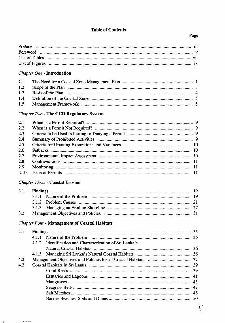
Table of ContentsPage
Preface iiiForeword vList of Tables viiList of Figures IX
Chapter One· Introduction
1.1 The Need for a Coastal Zone Management Plan 11.2 Scope of the Plan 31.3 Basis of the Plan 41.4 Definition of the Coastal Zone 51.5 Management Framework 5
Chapter Two· The CCD Regulatory System
2.1 When is a Permit Required? 92.2 When is a Permit Not Required? 92.3 Criteria to be Used in Issuing or Denying a Permit 92.4 Summary of Prohibited Activities 92.5 Criteria for Granting Exemptions and Variances 102.6 Setbacks 102.7 Environmental Impact Assessment 102.8 Contraventions 112.9 Monitoring 112.10 Issue of Permits 11
Chapter Three· Coastal Erosion
3.1 Findings 193.1.1 Nature of the Problem 193.1.2 Problem Causes 213.1.3 Managing an Eroding Shoreline 27
3.2 Management Objectives and Policies 31
Chapter Four· Management of Coastal Habitats
4.1 Findings 354.1.1 Nature of the Problem 354.1.2 Identification and Characterization of Sri Lanka's
Natural Coastal Habitats 364.1.3 Managing Sri Lanka's Natural Coastal Habitats 36
4.2 Management Objectives and Policies for all Coastal Habitats 374.3 Coastal Habitats in Sri Lanka 39
Coral Reefs........................................................................................................... 39Estuaries and Lagoons.......................................................................................... 41Mangroves 45Seagrass Beds 47Salt Marshes 48Barrier Beaches, Spits and Dunes 50
/ \
"
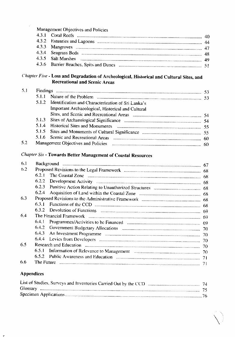
Management Objectives and Policies4.3.1 Coral Reefs 404.3.2 Estuaries and Lagoons 444.3.3 Mangroves 474.3.4 Seagrass Beds 484.3.5 Salt Marshes 494.3.6 Barrier Beaches, Spits and Dunes 51
Chapter Five - Loss and Degradation of Archeological, Historical and Cultural Sites, andRecreational and Scenic Areas
5.1 Findings 535.1.1 Nature of the Problem 535.1.2 Identification and Characterization of Sri Lanka's
Important Archaeological, Historical and CulturalSites, and Scenic and Recreational Areas 54
5.1.3 Sites of Archaeological Significance 545.1.4 Historical Sites and Monuments 555.1.5 Sites and Monuments of Cultural Significance 555.1.6 Scenic and Recreational Areas 60
5.2 Management Objectives and Policies 60
Chapter Six - Towards Better Management of Coastal Resources
6. 1 Background....................................... 676.2 Proposed Revisions to the Legal Framework 68
6.2.1 The Coastal Zone 686.2.2 Development Activity.. 686.2.3 Punitive Action Relating to Unauthorized Structures 686.2.4 Acquisition of Land within the Coastal Zone 68
6.3 Proposed Revisions to the Administrative Framework 686.3.1 Functions of the CCD 686.3.2 Devolution of Functions .. 69
6.4 The Financial Framework 696.4.1 Programmes/Activities to be Financed 696.4.2 Government Budgetary Allocations 706.4.3 An Investment Programme .. 706.4.4 Levies from Developers 70
6.5 Research and Education 706.5.1 Information of Relevance to Management 706.5.2 Public Awareness and Education 71
6.6 The Future 71
Appendices
List of Studies, Surveys and Inventories Carried Out by the CCD 74Glossary 75Specimen Applications 76
\"
n
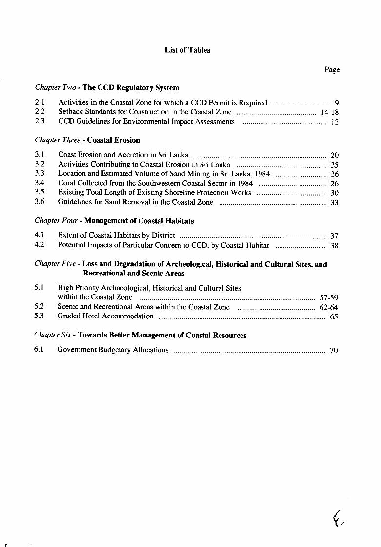
List of Tables
Page
Chapter Two - The CCD Regulatory System
2.1 Activities in the Coastal Zone for which a CCD Permit is Required 92.2 Setback Standards for Construction in the Coastal Zone .. 14-182.3 CCD Guidelines for Environmental Impact Assessments 12
Chapter Three - Coastal Erosion
3.1 Coast Erosion and Accretion in Sri Lanka 203.2 Activities Contributing to Coastal Erosion in Sri Lanka 253.3 Location and Estimated Volume of Sand Mining in Sri Lanka, 1984 263.4 Coral Collected from the Southwestern Coastal Sector in 1984 263.5 Existing Total Length of Existing Shoreline Protection Works 303.6 Guidelines for Sand Removal in the Coastal Zone 33
Chapter Four - Management of Coastal Habitats
4.1 Extent of Coastal Habitats by District 374.2 Potential Impacts of Particular Concern to CCD, by Coastal Habitat 38
Chapter Five - Loss and Degradation of Archeological, Historical and Cultural Sites, andRecreational and Scenic Areas
5.1 High Priority Archaeological, Historical and Cultural Siteswithin the Coastal Zone 57-59
5.2 Scenic and Recreational Areas within the Coastal Zone 62-645.3 Graded Hotel Accommodation 65
Chapter Six - Towards Better Management of Coastal Resources
6.1 Government Budgetary Allocations 70
n
List of Figures
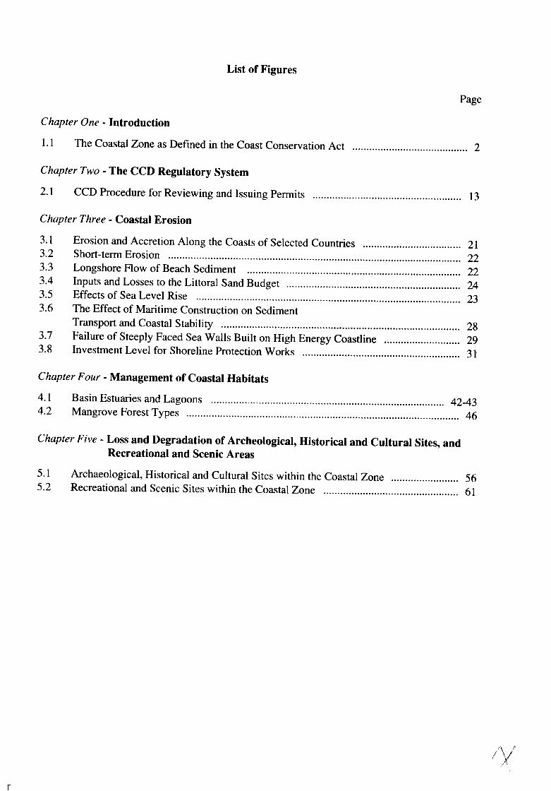
Page
Chapter One· Introduction
1.1 The Coastal Zone as Defined in the Coast Conservation Act 2
Chapter Two - The CCD Regulatory System
2.1 CCD Procedure for Reviewing and Issuing Permits 13
Chapter Three· Coastal Erosion
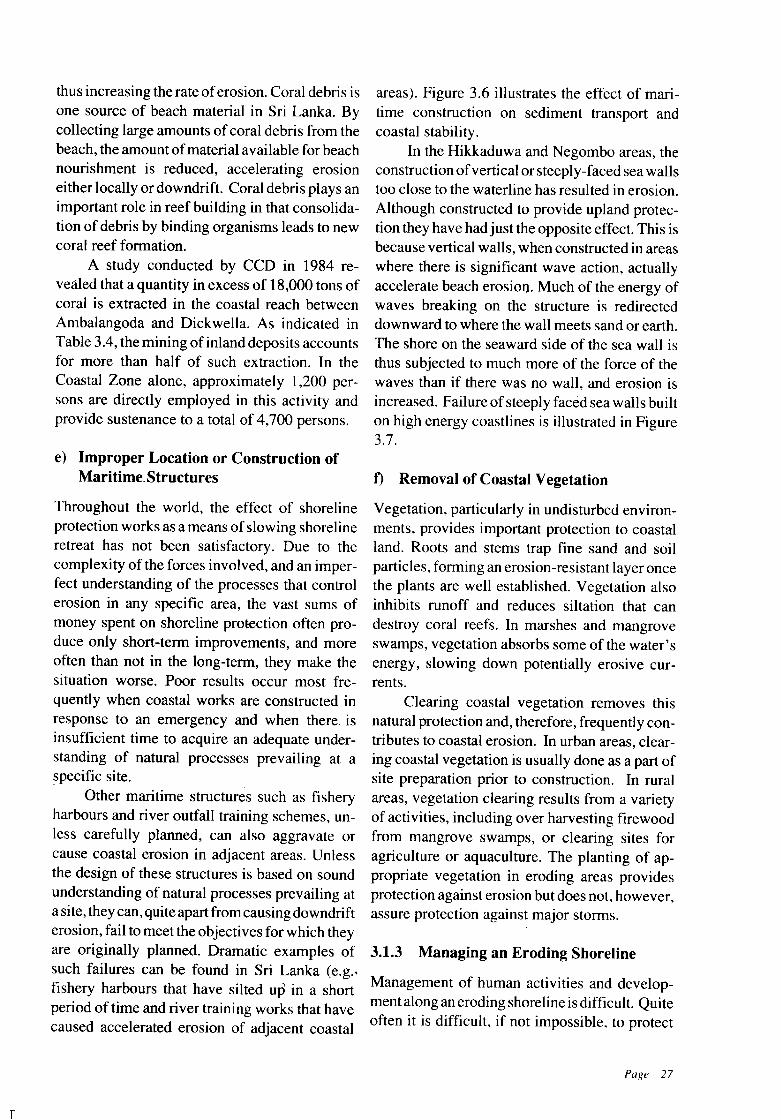
3.1 Erosion and Accretion Along the Coasts of Selected Countries 213.2 Short-term Erosion 223.3 Longshore Flow of Beach Sediment 223.4 Inputs and Losses to the Littoral Sand Budget 243.5 Effects of Sea Level Rise 233.6 The Effect of Maritime Construction on Sediment
Transport and Coastal Stability 283.7 Failure of Steeply Faced Sea Walls Built on High Energy Coastline 293.8 Investment Level for Shoreline Protection Works 31
Chapter Four· Management of Coastal Habitats
4.1 Basin Estuaries and Lagoons 42-434.2 Mangrove Forest Types 46
Chapter Five - Loss and Degradation of Archeological, Historical and Cultural Sites, andRecreational and Scenic Areas
5.1 Archaeological, Historical and Cultural Sites within the Coastal Zone 565.2 Recreational and Scenic Sites within the Coastal Zone 61
'\ iIy

CHAPTER ONE
Introduction
n
1.1. THE NEED FOR A COASTALZONE MANAGEMENT PLAN
Sri Lanka is an island situated between 5 55' and95 I' N, and 79°41' and 81 54' E, between the
Tropic of Cancer and the Equator. It has a landarea of 64,000 square kilometers and a 1,585kilometer long coastline. In the last five centuries, following foreign occupation, the country'sdevelopment has been closely related to maritime activities. Priorto this period, its civilizationwas concentrated in the interior. Today, morethan half of its population of sixteen millionpeople lives in villages, towns and citie+; in thecoastal districts. The trade and commerce thatprovided the original impetus for settlement ofcoastal communities have been supplemented byfishing. tourism and a host of other important
economic activities. A substantial proportion ofthe national economy and social welfare of alarge number of its people is inextricably interwoven with the sustainability of resources provided by the natural habitats of the Coastal Zone.
During the four decades following independence (1948), the economic importance ofcoastal areas has increased further with thegrowth of human settlements and the development of commercial harbours, fishery harbours,landing facilities, river training and outfallschemes. transport. communications. recreationalfacilities and tourism. Development has beenparticularly intense in the southern, southwesternand western coastal areas of the country.
The benefits ofeconomic development havebrought problems in their wake-increasing conflicts over coastal uses. and the depletion and
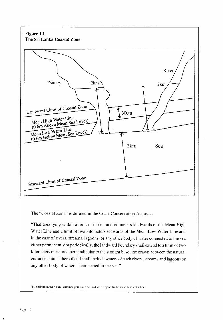
Figure 1.1The Sri Lanka Coastal Zone
Estuary
. . f Coastal ZoneLandward Llfnlt 0
. h Water LineMean Rig Mean Sea Level)(o.6m Above .
Water Line l)Mean LoW Mean Sea Leve(O.6m Below
2km Sea
dLimit of Coastal Zone
Seawar
The "Coastal Zone" is defined in the Coast Conservation Act as...
"That area lying within a limit of three hundred meters landwards of the Mean High
Water Line and a limit of two kilometers seawards of the Mean Low Water Line and
in the case of rivers, streams, lagoons, or any other body of water connected to the sea
either permanently or periodically, the landward boundary shall extend to a limit of two
kilometers measured perpendicular to the straight base line drawn between the natural
entrance points I thereof and shall include waters of such rivers, streams and lagoons or
any other body of water so connected to the sea."
'By definition. the natural entrance points are defined with respect to the mean low water line.
Page 2
I'
degradation of coastal resources. There are examples offishery harbours that have silted up andstructures designed to keep the outfalls of riversopen that have had the opposite effect. There areinstances of shore protection methods that havefailed or merely transferred erosion problems toadjacent coastal areas. Although coastal erosionis one of the most visible problems it is by nomeans the only one. Loss of public access to theshoreline, coastal pollution, depletion of fisheryresources, due in part to the depletion of coastalhabitats, and poorly sited tourist facilities havecontributed to the need for a comprehensiveapproach to coastal management.
Although interest in coastal problems in SriLanka dates as far back as the 1920' s, such effortswere mainly focussed on seeking engineeringsolutions to curb immediate coastal erosion problems by construction of protective structures.During this period, there were many agenciessuch as the Departments of Public Works, Railways, Highways, and Irrigation that were carrying out coastal protection schemes designed tomeet their individual requirements. However,the lack of understanding of the dynamic natureand complex interrelationships among ecosystems and human activities in the Coastal Zoneresulted in an escalation of coastal problems andconsiderable degradation of the coastal environment.
The realization that a comprehensive approach to coastal resource management wasrequired led to the establishment of a CoastProtection Unit in the Colombo Port Commission in 1963. In 1978, a Coast ConservationDivision was established in the Ministry ofFisheries. This division was upgraded to a department, the Coast Conservation Department(CCD) in 1984.
In 1981 Parliament enacted the CoastConservation Act - Act No. 57 of 1981. ThisAct decreed the appointment of a Director ofCoast Conservation with responsibilities -
(a) for the administration and implementationof the provisions of this Act;
(b) for the formulation and execution ofschemesof work for the coast conservation within theCoastal Zone; and
(c) for the conduct of research, in collaborationwith other departments, agencies and institutions for the purpose of coast conservation.
The definition of the Coastal Zone in thisAct is reproduced and illustrated on page 2 ofthis document. The Act required the Director ofCoast Conservation to have a survey made ofthe Coastal Zone and on the basis of the resultsof the survey to prepare a comprehensive CoastalZone Management (CZM) Plan.
This document is Sri Lanka's first Plan forcoastal resources management. It is the productof hours of work, several meetings, workshopsand considerable research and planning. It represents the best available analysis of Sri Lanka'scoastal problems and indicates how best to dealwith them. It is, with all that, a first step, albeit animportant one. The strategies for managing thecoastal problems outlined in this Plan will betested and revised as necessary over time. Newproblems may arise and will be dealt with insubsequent Plans.
1.2 SCOPE OF THE PLAN
The legal framework for this Plan is provided bythe Coast Conservation Act, No. 57 of 1981, theCoast Conservation Regulation, No. I of 1983and the Coast Conservation Act (Amendment)No. I of 1988. The Plan has received the assentof the Cabinet of Ministers on April II, 1990.
The objectives of this Plan are to:
• Identify coastal problems that need to be addressed:
• Indicate why these problems are important;
• Present the ceo' s management programme toaddress these problems;
• Identify what should be done by governmentaland non-governmental organizations and thepublic to reduce the scope and magnitude ofcoastal problems;
• Identify research activities of immediate im~
portance to the management of coastal resources.
Page 3
The Plan deals with the following coastalproblems: erosion; loss and degradation ofnatural coastal habitats; and loss and degradation ofarchaeological, historical and cultural monumentsand sites, and recreational and scenic areas.
The Plan is divided into six Chapters. Chapter 1 introduces the Plan and Chapter 2 describesthe CCO's regulatory system. There is a chapterfor each of the problems stated above (Chapters3 to 5). Chapter 6 outlines the measures requiredfor the formulation and implementation of aprogramme for comprehensive resources management.
This version of the Coastal Resources Management Plan does not cover every coastal problem. It has been designed to address the criticalcoastal problems first, specifically those problems which have resulted in significant economicand social losses and which are most amenable tomanagement within anticipated budgetary andpersonnel constraints. These management activities will be tested and refined as necessary. Subsequent Plans will deal with additional problems.
1.3 BASIS OF THE PLAN
It does not indicate how the Plan is to be preparedor what the emphasis in the Plan should be.Hence, one ofthe first planning tasks undertakenby CCO staffwas to develop a set ofplanning andmanagement principles which provided purposeand direction to those participating in the planning process. It was also seen as a means of communicating to other agencies with managementresponsibilities in coastal areas that complementthose of CCO, the central purposes of the Planand to indicate how the planning process wouldproceed.
This set of principles was initially developed in 1984. They were submitted to the CoastConservation Advisory Council established bythe Coast Conservation Act comprising representatives from Ministries with legal and/oradministrative responsibilities for coastal resources or areas. This Council reviewed theseprinciples and formally approved them in 1985.
Because these principles help provide theconceptual framework for the Plan that follows,a brief synthesis is presented below:
a) The Coastal Zone is a fragile and vulnerablearea that requires integrated management ofhuman activities that affect natural resources.
c) The control, custody and management of theCoastal Zone is vested in the State.
b) The Coastal Zone is the common heritage ofthe nation to which every citizen has right ofaccess.
d) The State accepts responsibility to maintain,and where possible to improve the quality ofits Coastal Zone by means of regulation, acquisition, investment or other strategies asmay be consistent with the needs and inter-ests of this and future generations.
In accepting responsibility for the management of the Coastal Zone, the State and itsagents recognize that there are limits to thatmanagement responsibility. The Coastal Zoneof Sri Lanka has ecologically vulnerable andinherently unstable areas, subject to naturalprocesses as well as human intervention. Notall impacts of natural processes can be controlled and such attempts may result in social,economic and environmental costs that areprohibitive.
Ouring the time this Plan was being developed, itbecame clear that there exist in Sri Lanka manydifferent ideas about what coast conservationmeans and what a Coastal Zone ManagementPlan should encompass. To many, coast conservation means coastal erosion control. This isperhaps not surprising in a country in whichcoastal erosion during the monsoon causes seri-ous concern. To others, coast conservation meansthe preservation of natural coastal habitats, suchas coral reefs, mangroves, estuaries and lagoons.Moreover, there continues to be confusion about e)what management means, about how coastalmanagement fits in with all the other laws andagency programmes that affect life in coastalareas, and whether anotherregulatory programmewill stifle those economic development activitiesthat are essential to Sri Lanka's well-being.
The Coast Conservation Act provides thelegal basis for this Plan and the managementactivities that are described in the Plan. However,the Act does not provide a rationale for the Plan.
Page 4
n
n
f) The Coastal Zone Management Plan shouldbe an instrument to promote the socioeconomic well-being of coastal communities inparticular and the Sri Lankan community ingeneral.
g) Any individual, private company or government agency, contemplating setting up a development activity within the Coastal Zonemust accept the responsibility for carryingout such activity in a manner that will notsignificantly affect the stability, quality orproductivity of the Coastal Zone.
h) The management ofcoastal resources and activities affecting these resources is the responsibility of many agencies. The management role of the CCD is to ensure that insofaras possible, all development activities in theCoastal Zone are consistent with the principles of sustainable resource yields. Thiswill be achieved primarily throughinteragency coordination and cooperation, andalso by means of investment, research anddirect regulation.
i) Direct regulation by the CCD will occur onlyin the Coastal Zone as defined by the CoastConservation Act.
j) Community understanding and support ofthe management programme is essential foreffective implementation. Hence, the meansfor effective community participation in thedesign of management strategies and in implementation activities will continue to bedeveloped and refined. The means of community participation are likely to take different forms depending on the resource management issues and the degree of communityinterest.
The Coastal Zone Management Plan restson a solid foundation of information about thenation's coasts. The CCD has carried out a largenumber of surveys, and technical studies on thecoasta1.resources and issues this Plan addresses.A list of these CCD-sponsored studies and publications is found at the end of the Plan. Theresults of these inventories and studies are incorporated in the Findings of each chapter.
1.4 DEFINITION OF THE SRI LANKA~COASTAL ZONE
The Coastal Zone is defined in the Coast Conservation Act as follows:
"Thatarea lyingwithina limitofthree hundredmeters landwards of the Mean High WaterLine and a limit of two kilometers seawards ofthe Mean Low Water Line and in the case ofrivers, streams, lagoons, or any other body ofwater connected to the sea either permanentlyor periodically, the landward boundary shallextend to a limit of two kilometers measuredperpendicular to the straight baseline drawnbetween the natural entrance points thereofand shall include the waters of such rivers,streams and lagoons or any other body ofwater so connected to the sea."
A diagram illustrating the Coastal Zone isgiven in Figure 1.1 on page 2.
1.5 MANAGEMENT FRAMEWORK
Before developing a management framework aproblem must be defined. The Findings presented at the beginning of Chapters 3, 4 and 5describe a coastal problem, then analyse why it isof concern. Findings also discuss causes of theproblem and government activities, if any, currently being undertaken to deal with the problem.A management framework is then set forth toaddress the problem.
The management framework refers to a setofrelated statements about specific coastal problems that indicate what the objectives are indealing with the problem, and how the objectivesare to be accomplished. The Objectives stated foreach coastal problem are specific statements ofconditions to be achieved or created; Policies arespecific management measures based on theFindings, which show how the objectives are tobe achieved. These policies or implementingactions are the primary focus ofattention for mostreaders of the Plan.
Implementing actions in this Plan are ofseveral types: regulations, direct development, research, coordination, education, and plan and
Page 5
policy development. All these constitute a management plan. For example, the chapter on erosion identifies several management actions forreducing or preventing erosion. The first step isto establish a setback line to ensure that structuresare not sited soclose to the shoreline that they willcontribute to or be affected by erosional processes. Other regulatory measures establish review procedures for constructing coastal protection schemes in some coastal areas, prohibit coralmining and require permits for sand mining. Inaddition, a public investment programme fordeveloping coastal protection schemes in selected areas has been formulated. Taken together, these actions constitute a ManagementPlan for erosion control; a set of coordinatedactivities by which the CCD seeks to halt orreduce problems related to coastal erosion.
Regulation
The regulation of various types ofcoastal activities constitutes the primary type of implementingaction in this Plan. The principal means of regulation is the appraisal of proposed developmentactivities in the designated Coastal Zone by thestaff of the CCD prior to issuance of a permit.Such regulation applies to both State and privatesector development activities. This regulatoryappraisal process involves an assessment of theprobable impacts of a proposed developmentactivity, a determination of whether the magnitude and severity of potential impacts outweighthe public good associated with the proposeddevelopment activity, and if so, whether the activity can be made consistent with coastal resource management objectives. Based on thisappraisal, the Director of the CCD (Director)issues or denies a permit for the proposed development activity. The details ofthis permit systemare described in Chapter 2.
Direct Development
A second major type of implementing action isdirect development activities undertaken by government agencies. With regard to coastal erosionmanagement, the major type of direct development is the construction of shoreline protectionworks. The CCD is responsible for the design,
Page 6
construction and maintenance ofcoast protectionworks including groynes, revetments, and offshore breakwaters, and the implementation andmaintenance ofbeach nourishment schemes. TheMaster Plan for Coast Erosion Managementcompleted by the CCD in 1986 is briefly described in Chapter 3.
Research
A third type of implementing action is to identifyareas of research and conduct research. Researchis necessary because often good management isprecluded due to some coastal problems and/orphenomena being inadequately understood. Although some important research has already beendone on coastal processes, more research will berequired. Because research is expensive andtime-consuming, the challenge is to identify andfocus on research that is critical to effective planning and management. This Plan includes severalresearch activities that have been identified during the planning process. The CCD will conductsome ofthis research and sponsorand direct otherresearch projects. Other agencies or individualswill also be invited to undertake necessary research activities.
Coordination
Many agencies have responsibility for the management of coastal resources or activities affecting those resources. In certain cases, responsibilities overlap resulting in actual or potentialconflicts among agencies. In other cases, it is notclear which agency or agencies are responsiblefor the management of some activities that resultin adverse impacts on coastal resources.
Because of these jurisdictional gaps andoverlaps there is a continuing need for coordination among agencies. To date, most of the coordination in the implementation of the CCD permit system has been informal. The CCD routinely consults with the Urban DevelopmentAuthority, the Greater Colombo EconomicCommission, the Ceylon Tourist Board and otheragencies which are directly involved in the approval of development projects. When particularly large or complex development projects arebeing considered, meetings involving represen-
tatives from relevant agencies such as the Central Environmental Authority (CEA), the National Aquatic Resources Agency (NARA), orthe Ministry of Fisheries (MOF) are convened.
Certain strategies in the management framework require more formal inter-agency coordination mechanisms than those currently in use.Memoranda of Understanding among agenciesand other formal coordinative devices will be'developed as needed in consultation with theseagencies.
Education
The management ofcoastal resources and activities will have its impact on the lives of manypeople. While management of activities have animmediate impact, the effect of management ofresources is not that easily perceived.
In the short-term, management of activitieswould appear to restrict development and curtailemployment of some people. The benefits ofsuch management, however, are widespread andaccrue over a longer period. There is, therefore,the need for a continuing education programmeto mobilize public support for such managementinitiatives. An education programme shouldexplain what is being done in Coastal Zone
3-
management and why certain management measures are being undertaken. The successful implementation of the Plan will depend on theunderstanding and support of the people of SriLanka. Those whose activities will be regulatedneed to understand why regulatory activities arebeing undertaken. At the same time, not all educational activities can be conducted by plannersand managers. They will often require drawing inpersons with detailed knowledge and understanding of local conditions.
Education programmes should, therefore,be multi-directional, involving traditional users,politicians, researchers and entrepreneurs as wellas planners and managers. Such programmesmay be conducted through seminars, workshops,curricula, publications, press reports, films, etc.
Plan and Policy Development
This Plan represents the first stage in developinga managementprogramme for Sri Lanka's coastalareas. Subsequent planning efforts will involvedeveloping objectives and implementing actionsfor other coastal problems, area-specific management plans, refinement of existing management guidelines and suggested amendments tothe Coast Conservation Act.
PaRe 7
CHAPTER TWO
The CCD Regulatory System
n
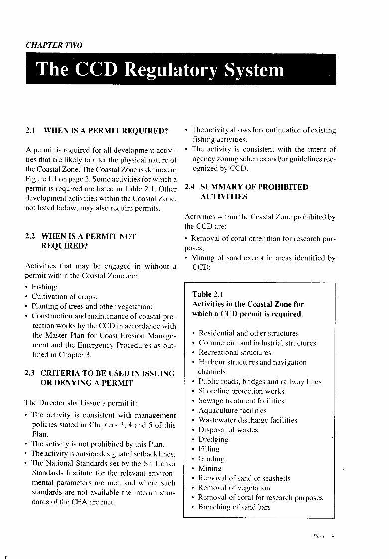
2.1 WHEN IS A PERMIT REQUIRED?
A pennit is required for all development activities that are likely to alter the physical nature ofthe Coastal Zone. The Coastal Zone is defined inFigure 1.1 on page 2. Some activities for which apennit is required are listed in Table 2.1. Otherdevelopment activities within the Coastal Zone,not listed below, may also require pennits.
2.2 WHEN IS A PERMIT NOTREQUIRED?
Activities that may be engaged in without apennit within the Coastal Zone are:
• Fishing;• Cultivation of crops;• Planting of trees and other vegetation;• Construction and maintenance of coastal pro
tection works by the CCD in accordance withthe Master Plan for Coast Erosion Management and the Emergency Procedures as outlined in Chapter 3.
2.3 CRITERIA TO BE USED IN ISSUINGOR DENYING A PERMIT
The Director shall issue a pennit if:
• The activity is consistent with managementpolicies stated in Chapters 3, 4 and 5 of thisPlan.
• The activity is not prohibited by this Plan.• The activity is outside designated setback lines.• The National Standards set by the Sri Lanka
Standards Institute for the relevant environmental parameters are met, and where suchstandards are not available the interim standards of the CEA are met.
• The activity allows for continuation ofexistingfishing activities.
• The activity is consistent with the intent ofagency zoning schemes and/or guidelines recognized by CCD.
2.4 SUMMARY OF PROHIBITEDACTIVITIES
Activities within the Coastal Zone prohibited bythe CCD are:
• Removal of coral other than for research purposes;• Mining of sand except in areas identified by
CCD:
Table 2.1Activities in the Coastal Zone forwhich a CCD permit is required.
• Residential and other structures• Commercial and industrial structures• Recreational structures• Harbour structures and navigation
channels• Public roads, bridges and railway lines• Shoreline protection works• Sewage treatment facilities• Aquaculture facilities• Wastewater discharge facilities• Disposal of wastes• Dredging• Filling• Grading• Mining• Removal of sand or seashells• Removal of vegetation• Removal of coral for research purposes• Breaching of sand bars
Page 9
"
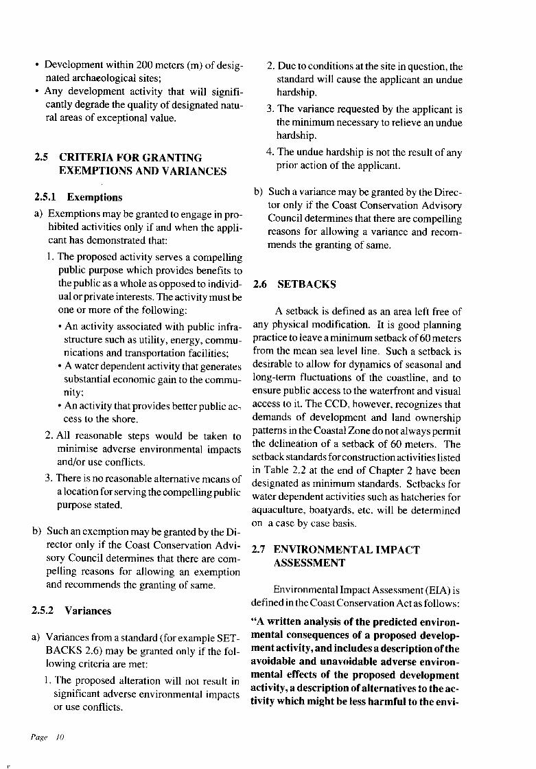
• Development within 200 meters (m) of designated archaeological sites;
• Any development activity that will significantly degrade the quality of designated natural areas of exceptional value.
2.5 CRITERIA FOR GRANTINGEXEMPTIONS AND VARIANCES
2.5.1 Exemptions
a) Exemptions may be granted to engage in prohibited activities only if and when the applicant has demonstrated that:
1. The proposed activity serves a compellingpublic purpose which provides benefits tothe public as a whole as opposed to individual or private interests. The activity must beone or more of the following:
• An activity associated with public infrastructure such as utility, energy, communications and transportation facilities;
• A water dependent activity that generatessubstantial economic gain to the community;
• An activity that provides better public ac~
cess to the shore.
2. All reasonable steps would be taken tominimise adverse environmental impactsand/or use conflicts.
3. There is no reasonable alternative means ofa location for serving the compelling publicpurpose stated.
b) Such an exemption may be granted by the Director only if the Coast Conservation Advisory Council determines that there are compelling reasons for allowing an exemptionand recommends the granting of same.
2.5.2 Variances
a) Variances from a standard (for example SETBACKS 2.6) may be granted only if the following criteria are met:
1. The proposed alteration will not result insignificant adverse environmental impactsor use conflicts.
Page 10
2. Due to conditions at the site in question, thestandard will cause the applicant an unduehardship.
3. The variance requested by the applicant isthe minimum necessary to relieve an unduehardship.
4. The undue hardship is not the result of anyprior action of the applicant.
b) Such a variance may be granted by the Director only if the Coast Conservation AdvisoryCouncil determines that there are compellingreasons for allowing a variance and recommends the granting of same.
2.6 SETBACKS
A setback is defined as an area left free ofany physical modification. It is good planningpractice to leave a minimum setback of60 metersfrom the mean sea level line. Such a setback isdesirable to allow for dynamics of seasonal and,long-term fluctuations of the coastline, and toensure public access to the waterfront and visualaccess to it. The CCD, however, recognizes thatdemands of development and land ownershippatterns in the Coastal Zone do not always permitthe delineation of a setback of 60 meters. Thesetback standards for construction activities listedin Table 2.2 at the end of Chapter 2 have beendesignated as minimum standards. Setbacks forwater dependent activities such as hatcheries foraquaculture, boatyards, etc. will be determinedon a case by case basis.
2.7 ENVIRONMENTAL IMPACTASSESSMENT
Environmental Impact Assessment (EIA) isdefined in the Coast Conservation Act as follows:
"A written analysis of the predicted environmental consequences of a proposed development activity, and includes a description oftheavoidable and unavoidable adverse environmental effects of the proposed developmentactivity, a description ofalternatives to the activity which might be less harmful to the envi-

n
ronment of the Coastal Zone, together withreasons why such alternatives were rejected,and a description of any irreversible or irretrievable commitments of resources requiredby the proposed development activity."
An EIA will be required in case of development activities that are considered to have significant impacts on the coastal environment. It isthe responsibility of the applicant to prepare theEIA. The guidelines for the preparation ofan EIAare given in Table 2.3. These guidelines aregeneral. The CCD advises developers to consultwith CCD during the design and preparation ofthe EIA. This will enable the CCD to assist thedeveloper to prepare a concise, cost effectiveEIA that focusses on the most relevant issues.
On receipt ofan EIA from the developer, theDirector shall submit a copy of the EIA to theCoast Conservation Advisory Council for itscomments. The Director shall also publish anotice in the Gazette indicating the place and timeat which the EIA can be inspected by the publicand invite the public to comment on the EIA.
The Coast Conservation Advisory Councilwill submit its comments to the Director within60 days of submission of an EIA to the CoastConservation Advisory Council. The public is requiretl to submit comments to the Director within30 days of the Gazette notification. The Directorshall consider all comments received and within60 days of receipt of comments from the CoastConservation Advisory Council make a decisionwhether a permit can be issued and the conditionsthereof.
2.8 CONTRAVENTIONS
The Coast Conservation Act specifies penaltiesfor contravention of the provisions of the Act.Engaging in any development activity prior toobtaining a permit issued by the Director, and/ornon-compliance with conditions stipulated in thepermit are contraventions. Penalties may includeany or all of the following:
Fines and Imprisonment: Offenders will, onconviction after summary trial before a magistrate, be liable to a fine of up to Rupees twenty-
five thousand or to imprisonment for a term up toone year. In the case of the second or subsequentoffence, the offender is liable to a fine of up toRupees fifty thousand or to imprisonment for aterm.up to two years. In both cases, the offendercan be fined as well as imprisoned.
Confiscation of Equipment and Machinery:Upon conviction for contravening the provisionsof the Coast Conservation Act, the magistrate canorder the confiscation of any vessel, craft, boat,vehicle, equipment or machinery used in committing the offense.
Demolition of Unauthorized Structures: TheDirector is empowered to order the demolition ofany unauthorized structures.
2.9 MONITORING
The CCD will ensure compliance with permitconditions through a monitoring system that willinclude one or more of the following:a) Monitoring key stages in a project in which
the developer shall obtain clearance from theCCD prior to proceeding to the subsequentstages;
b) Requiring the developer to furnish a certificate of conformity from a nominated authority that the permit conditions have been adhered to;
c) Direct supervision by CCD personnel or by anominated authority;
d) Periodic site visits by CCD personnel;e) Requiring the developerto conform to a stipu
lated time schedule for the development activity or the stipulated quotas;
f) Requiring the developer to submit reports,carry out surveys, tests, etc.
2.10 ISSUE OF PERMITS
. Any person desiring to engage in a DevelopmentActivity (see Section 2.1) within the CoastalZone (see Figure 1.1, on page 2) will be requiredto obtain a permit issued by the Director prior tocommencing the activity.
Page 11
Table 2.3CCD Guidelines for Environmental Impact Assessments
1. DESCRIPTION OF PROPOSED ACTIVITYa) Description of the nature, aims and scope of proposed activity.b) Description of the methodology to be adopted during construction, operation and
maintenance.c) Description of proposed project's socio-economic and ecological benefits/costs.(,1) Description of the long-term maintenance programme for the proposed activity.
2. SITE DESCRIPTIONa) Description of the area within which the activity, development or operation
is proposed to be sited and its environs. The description should include:
• Delineation of coastal habitats as defined in Chapter 4 and their ecological state• Water bodies;• Existing land uses;• Existing human activities;• Existing archaeological, historic, cultural, recreational or scenic sites as listed in
Tables 5.1 and 5.2;• Other relevant information.
b) Location of proposed activity marked on a I inch to 1 mile map.c) A site map at a scale suitable to show the proposed activity.
3. DESCRIPTION OF POTENTIAL IMPACTSThe description of potential impacts should include the foreseeable direct and indirect,long-term and short-term effects of the activity on the coastal zone. In this context,short-term and long-term do not necessarily refer to any fixed time periods, but shouldbe viewed in terms of the environmentally significant consequences of the proposedaction. Any irreversible or irretrievable commitments of resources should be identified. The description should include the potential impacts on the following:
a) Coastal habitats listed in Table 4.2;b) Quality and quantity of coastal waters;c) Land and current land use patterns;d) The abundance and diversity of plant and animal life;e) Erosion and depositional processes along the shore;f) Water circulation, flushing, turbidity and sedimentation;g) Freshwater runoff patterns and/or saltwater intrusion;h) Areas of archaeological, historic, cultural, and scenic significance;i) Public access to the shore and coastal waters;
4. PROPOSED MITIGATION MEASURESA statement setting out proposed measures to minimise impacts identified in 3 above,and a statement on the effectiveness of the proposed measures should be provided. Ifalternative measures were considered, these should be stated and reasons for selectionof the proposed mitigation measures given.
5. ADDITIONAL REQUIREMENTSThe Director may, on a case by case basis, specify other particulars to be includedin the EIA.
Page 12
The procedures for obtaining a CCD permitare summarized in.Figure 2.1. Application formsare available free ofcharge at the CCD, as well asfrom Assistant Government Agents and UrbanDevelopment Authority authorized officers.Specimen application forms are included in theAppendix. Each application must be accompanied by a fee of Rupees fifty.
For permit applications that do not requirean EIA, a decision on the application will usuallybe made within 3 weeks of receiving all therequired information. Consultation with CCDearly in the project planning stage is advised tofacilitate the permit process.
Figure 2.1CCD Procedure forReviewing and Issuing Permits
Filing of Permit Applicationwith CCD
Initial permit reviewand site visit by CCD staff
Determination of whetherEIA is required
~-
EIA Required
Call for EIA from Developer
Review of EIA by CCDAdvisory Council and Public
I Permit Granted
1-------
EIA Not Required
Request Observationsof Relevant Agencies
Permit Conditionally Grantedor Not Granted
Appeal to SecretaryMinistry of Defense
n
Permit Granted or Conditionally Granted Permit Denied •_____I
Page 13

Table 2.2Setback Standards for Construction in Sri Lanka's Coastal Zone
Area Map Latitude Longitude Dwelling Comm/. Non Water Tourism Special FeaturesUnits Irxlust Dependent Dev.
Buildings Activities..~ ------ "--------
Galle face- Colombo 6° 55' IO"N 79° 50' 34"E E. of rail E.of rail E. of rail E. of rail Entire coastal reach is pro-Mt. Lavinia 6° 50' 06"N 79° 51' 35"E track track track track tected by revetment. Satura-
tion of development betweenDehiwela & Mt. Lavinia E ofrailway track. Moratoriumon building activityW ofrailtrack.
Mt. Lavinia- Colombo 6° 50' 06"N 79° 51' 35"E 10m E of rail E. of rail E. of rail Heavily eroding coastlinePanadura Panadura- 6° 42' 48"N 79° 53' 58"E track track track Coast Erosion ManaegmentRiver Mouth Horana Plan envisages stabilizing
entire coastal reach withhard structures.
Panadura Panadura 6° 42' 48"N 79° 53' 58"E 10m 30 m 30m 60m Most of the coastal area isRiver Mouth- Horana 6° 35' 14"N 79° 57' IO"E fairly stable though long-Kalutara term erosion trends have been(Kalido) observed in certain sectors.
Kalido Hotel Panadura 6° 35' 14"N 79° 57' IO"E Not allowed* Not allowed* Migrating sand spit. dynamicMeriviere Horana 6° 33' 54"N 79° 57' 32"E and unstable area.
Meriviere - Panadura- 6° 33' 54"N 79° 57' 32"E 10m E of main E of main E of main Eroding coastline. NarrowMaggona Horana & 6° 30' 30"N 79° 58' 40"E Highway Highway Highway strip of land between high-Headland Aluthgama way & coastline only
suitable for constructionof dwelling unit.
Maggona Aluthgama 6° 30' 30"N 79° 58' 40"E 15 m Not allowed* Not allowed* Very high erosion hazardHeadland - 6° 26' 20"N 79° 59' 16"E intensity. Heavy tourism dev.Bentota River has reached saturation.Mouth
Bentota Riwr Aluthgama 6° 26' 20"N 79° 59' 16"E Not allowed* Not allowed* National Holiday ResortMouth- 6° 25' OO"N 79° 59' 38"E declared under Tourist BoardGodagala Act. Coastline subject toHeadland seasonal fluctuation.
Godagala Aluthgama 6° 25' OO"N 79° 59' 38"E 10m E of E of rail track Narrow strip of land betweenHeadland- 6° 24' 33"N 79° 59' 44"E railtrack railtrack and coastline.Bandarawatta
Bandarawatta Aluthgama 6° 24' 33"N 79° 59' 44"E 10m E of main E of main E of main Visual access to ocean to be- Kosgoda 6° 20' 25"N 80° 01' 24"E highway highway highway preserved.
Kosgoda - Aluthgama 6° 20' 25"E 80° 01' 24"E 10m 50m 50 m 50m Fairly stable coastline.Ahungalle- Ambalangoda 6° 17' 28"E 80° 02' 02"EMiddaramulla IAhungalle- Ambalangoda 6° 17' 28"E 80° 02' 02"E 10m 50m 50m 50 m Fairly stable coastline.Middaramulla- Balapitiya 6° 16' 08"N 80° 01' 40"EWellawatta
BalapitiyaWellawatta Akurala
Akurala HikkaduwaBridge
6° 16' 08"NAmbalangodaI 6° II' 36"N
Ambalangoda 6° 11' 36"N6° 08' 48"N
80° 01' 40"E
80° 03' 34"E
80° 03' 34"E80° 05' 46"E
15m
15m
E of mainhighway
E of mainhighway
E. of main highway
I
Coastline subject to erosion.
Coastline subject to severeerosion.
l' =1 mile map (Survey Department) and co-ordinates; * No Build Zone; ** No construction on the Sand Bar
Reference point for measurement of setback is the landward edge of the beach.
Beach is defined as a gently sloping area of unconsolidated material, typically sand, that extends landward from the mean high water markto the area where there is a marked change in material or natural physiographic form. In cases where there is no marked change inmaterial or natural physiographic form, the beach will be deemed to extend to a distance of 20 meters landward from mean high waterlevel, or to a level of 2.5 meters above mean high water level, whichever is less.
Page 14
n
Continued...Table 2.2...Setback Standards for Construction in the Coastal Zone.Area Map Latitude Longitude Dwelling Comm/. Non Water Tourism Special Features
Units Indust Dependent Dev.Buildings Activities
Hikkaduwa 6° 08' 48"N 80° OS' 46"E 15m E of main Not allowed* Coral reefs & marineBridge - Ambalangoda 6° 06' 14"N 80° 07' 25"E highway sanctuaryRatgamaOutfall
Ratgama Ambalangoda 6° 06' 14"N 80° 07' 25"E 15 m E.ofmain E. of main highway Heavy erosion hazard andOutfall - 6° 04' 15"N SO° 09' 30"E highway
Ilimited land between
Boosa highway and coastline.
Boosa- Ambalangoda 6° 04' 15"N 80° 09' 30"E Not allowed* Not allowed* Unstable spit.Gintota Outfall 6° 03' 25"N 80° 10' 32"E
IIGintota Outfall- Galle 6° 03' 25"N 80° 10' 32"E IS m E of main E of main highway Heavy erosion hazard.Galle Fort 6° 01' 25"N SO° 12' 55"E highway
IGalle Fort- Galle 6° 01' 25"N SO° 12' 55"E 10m E of main E of main highway Galle Harbuor area.Waggal 6° 01' 40"N SO° 14' 25"E highway
IModera
Waggal Galle 6° 01' 40"N 80° 14' 25"E No 20 m from 20 m from top of cliff Rocky cliffs.Modera - 6° 00' 20"N 80° 14' 26"E setback top of cliff
IYakdehimulla required
IYakdehimulla Galle 6° 00' 20"N 80° 14' 26"E 15 m 100 m or E of 100 morE Proposed Marine Sanctuary/- Welladda- 50 5S' 30"N SO° 21' 15"E main highway of highway Place of religious worshipragoda IWelladda- Galle 5° 5S' 30"N 800 21' 15"E 10m E of main E of main highway Heavy erosion hazard.ragoda - 5° 57'15"N 80° 24' 55"E highwayRassamunaiPoint
Rassamunai Galle 5° 57' 15"N 800 24' 55"E 15 m E of main E. of main highway Weligama Bay.Point - 50 56' 45"N SO° 26' 32"E highwayMirissa Point
IMirissa Point Galle 50 56' 45"N 80° 26' 32"E 10m 50m 50 m 50m- Godakanda 5° 56' 12"N 800 30' 20"E
IGodakanda - Galle & 5° 56' 12"N 80° 30' 20"E 10m 30m 30 m 30mPolhena Matara 5° 56' 18"N SO° 31' 4S"E
Polhena - Matara 50 56' IS"N SO° 31' 4S"E 15m 50m 50m 50m Coral reef subject toPallimulla 50 56' 30"N SO° 33' 26"E pressures of human activities.
Pallimulla - Matara 50 56' 30"N SO° 33' 26"E IS m 50m 50m 50mDondra Head 5° 55' 16"N 800 34' 5S"E
IDondra Head- Matara 5° 55' 16"N 80° 34' 58"E 25 m 50m 50m 50m Stable coastal land formed.Tangalle Headland 6° 01' 20"N 800 47' 50"E
Tangalle I Matara & 60 01' 20"N SO° 47' 50"E 50m Not Not Not Preserved habitats, BirdHeadland- Ambalantota 60 06' 15"N 81 0 00' 44"E allowed* allowed* allowed* santcuaries ArchaeologicalWalawe River Mouth sites, etc.South Bank
Walawe So. Ambalantota 6° 06' 15"N 81° 00' 44"E 15 m landward from 50 m landward from Sand dunes and salterns.Bank- Hambantota 6° II' OO"N Si o 14' 45"E toe of dune toe of duneBundala
I II' = I mile map (Survey Department) and co-ordinates; * No Build Zone; ** No construction on the Sand Bar
Reference point for measurement of setback is the landward edge of the beach.
Beach is defined as a gently sloping area of unconsolidated material, typically sand, that extends landward from the mean high water mark tothe area where there is a marked change in material or natural physiographic form. In cases where there is no marked change in material ornatural physiographic form, the beach will be deemed to extend to a distance of 20 meters landward from mean high water level, or to a levelof 2.5 meters above mean high water level, whichever is less.
Page 15
Continued...Table 2.2...Setback Standards for Construction in the Coastal Zone
Area Map Latitude Longitude Dwelling Comm/. Non Water Tourism Special FeaturesUnits Indust Dependent Dev.
Buildings Activities
Bundala - Hambantota 6° II' OO"N 81° 14' 45"E Not allowed* Not allowed* Yala and BundalaAmaduwa I 6° 16' 40"N 81 ° 25' 28"E
I ISanctuaries
Amaduwa- Hambantota 6° 16' 40"N 81°25'28"E Not allowed* Not allowed* Areas of importance for wild-Itikala Kalapuwa & Yala 6° 33' 12"N 81° 43' 38"E life of unique scenic value.
IItikala Kalapuwa- Yala 6° 33' 12"N 81° 43' 38"E 50m 100m 100m 100m Ero~ion hazard high. Sparse-Kandarajah Panama, 7° 04' 20"N 81° 51' 46"E ly populated land available
Potuvil & for adequate set back.Tirukkovil
Kandarajah- Tirukkovil 7° 04' 20"N 81° 51' 46"E 50m 75 m 75 m 75 mThanayamadu 7° IT 54"N 81°51'58"E
Thanayamadu Tirukkovil 7° 17' 54"N 81°51'58"E 50m 75 m 75 m 75 m Sparsely populated. LandKalkudah Kalmunai 7° 55' 08"N 81° 34' 48"E available for adequate set
Batticaloa back.Kalkudah
Kalkudah- Kalkudah 7° 55' 08"N 81° 34' 48"E 60m Not allowed* Not allowed* Area of unique scenic valuePulavi Point 7° 59' 36"N 81° 32' 36"E
I Iand to be preserved.
Pulavi Point- Kalkudah 7° 59' 36"N 81 0 32' 36"E 50 m Not allowed* Not allowed* -doPeriya MunaiPoint 7° 59' 46"N 81 0 31' 06"E
I IPeriya Munai Kalkudah 7° 59' 46"N 81°31'06"E 50m Not allowed* Not allowed* -doPoint- Mud- Kathiravel 8° 16' 18"N 81° 24' OO"E
I Iduchhchenai
Mudduch Kathiravel' 8°16'18"N 81 0 24' OO"E 50m Not allowed* Not allowed* Villus, barrier beacheschenai- Trincomalee 80 31' 30"N !W 19'00"E
I IKevuliya (Foul Point)
IKevuliya Trincomalee 8° 31' 3O:'N 81° 19' OO"E 50m Determined on a case by case basis Koddiyar Bay(Foul Point)- I 80 35' OO"N 81 0 14' 36"E
IFort Frederick
Fort Frederick Trincomalee 8° 35' OO"N 81° 14' 36"E 50m 75m 75m 75m-Thavikallu Nilaveli go 46' 12"N 81°08'40"E
Thavikallu- Nilaveli 8° 46' 12"N 81 ° 08' 40"E 50m 75m 75m 75mKokkulai Kemi Kokkilai 8° 59' OO"N 81° 58' 06"E
Kokkulai Kokkilai go 59' OO"N 81 0 58' 06"EKemi- MullaitivuTumpalai Iranamadu 9° 49' 20"N 80° 15' 10"E 75m Not allowed* Not allowed* Barrier Beaches and villus.
Point Pedro
ITumpalai- Point Pedro 9° 49' 20"N 80° 15' lO"E 10m 30m 30m 30mThiruvadinilaya Jaffna 9° 46' 42"N 79° 55' 34"E
IThiruvadinilaya- Jaffna 9° 46' 42"N 79° 55' 34"E 50m Not allowed* Not allowed* Fragile areaKovilan Point 9° 45' 40"N 79° 51' 38"E
I IDelft Islands- Jaffna 15m Determined on a case by case basisNayinativu PunerynKaraitivu &other Islands
I' = I mile map (Survey Department) and co-ordinates; * No Build Zone; ** No construction on the Sand Bar
Reference point for measurement of setback is the landward edge of the beach.
Beach is defined as a gently sloping area of unconsolidated material, typically sand, that extends landward from the mean high water mark tothe area where there is a marked change in material or natural physiographic form. In cases where there is no marked change in material ornatural physiographic form, the beach will be deemed to extend to a distance of 20 meters landward from mean high water level, or to a levelof 2.5 meters above mean high water level, whichever is less.
Page 16
Continued•..Table 2.2...Setback Standards for Construction in the Coastal Zone
9° 35' 54"N9° 23' 40"N
PunerynKalmunaiDevil Point(Kirimunai)
_A_r_ea +-M_a_p__-+-L_a~t~it_u_de +_L~o~n-g~it~u~d~e-+ ~:.::I;"'-}:,:~H_~~~~ b:~= ,:_i_a_I__F_e_a_tu~re~s _
80° 02' 58"£ 50m Not allowed* Not allowed* Low sandy coastline.80° 03' 12"£ Sparsely populated.
Adequate set backs can bedelineated.
Devil Point(Kirimunai)Weerawan-
dianmunai
Weerawandianmunai
Sinnativu
SinnativuPeriya Aru
PunerynTunukkai
Tunukkai
Tunukkai
9° 23' 40"N9° 21' IO"N
9° 21' IO"N9° 19' 45"N
9° 19' 45"N9° 09' 04"N
80° 03' 12"E800 03' 30"E
80° 03' 30"E80° OS' 04"E
80° 05' 04"E80° 05' 20"£
50m
1
50m
Not allowed"
Not allowed*
Not allowed*
N'lt a lowed"
INot allowed"
INot allowed"
Salt marshes.
Low sandy coastline, opencountry and jungle landavailable for adequate setback.
Periya AruPadavithurai
TunukkaiMantai
9° 09' 04"N9° OS' 30"N
80° 05' 20"E800 04' 12"E
20m 75m 75m 75m
Padavithurai- MantaiNayathumunai
9° OS' 30"N9°00' 55"N
80° 04' 12"E80° 01' 40"E
30 m Not allowed(on mainland)
Not allowed No construction onbarri~r beach.
Nayathumunai Mantai- Mantai
9° 00' 55"N8° 51' 04"N
80° 01' 40"E79° 51' 12"E
IS m 50m SOm 50 m
Mannar Island Talaimannar 30m 50m 50m 50m
Mantai KudremalaiPoint
Murunkan/ 8° 51' 04"NKudiramalai 8° 32' 25"N
79° 51' 12"E79° 52' 20"E
50m Not allowed
I
Not allowed Mangrove Swamps/Sanddunes.
KudiramalaiPoint Kandakuliya
Kudiramalai 8° 32' 25"NKalpitiya 8° 12' 35"N
79° 52' 20"E79° 41' 54"E
50m Not allowed Not allowed Mangrove Swamps/Sanddunes.
Kandakuliya Perichcha
villu
Perichchavillu
Udappu South
KalpitiyaPuttalam
Battulu OyaIBattulu Oya
8° 12' 35"N7° 49' 40"N
7° 49' 40"N7° 44' 30"N
79° 41' 54"E79° 46' 08"E
79° 46' 08"E79° 41' 16"E
50m
30m
75 m
75 m
75 m
75 m
75 m
75 m
Low sand dunes.
Deduru Oya Estuary
Mutupanthiya Lagoon.
Low dunes and sparselypopulated
IS m
75 m
Not allowed*
INot allowed"
15 m IS m
Not allowed"
75 m 75 m
75 m
15 m
30m
1
15m
I
20m
79° 49' 56"E790 50' 15"E
79° 41' 08"E79° 49' 56"E
79° 41' 16"E79° 41' 50"E
79° 41' 50"E79° 41' 08"E
r 44' 30"Nr 31' 30"N
Negombo r 19' 15"N7° IT 40"N
BattuluOya
Udappu SouthSinnakarukkuponne
Sinnakaruk- Battulu Oya 7° 37' 30"Nkupone -Chilaw Chilaw r 34' 40"N
I Chilaw 7° 34' 40"NNegombo 7° 19' 15"N
Chilaw Dummaladeniya
IDummaladeniya- Kammala
I' =I mile map (Survey Department) and co-ordinates; * No Build Zone; ** No construction on the Sand Bar
Reference point for measurement of setback is the landward edge of the beach.
Beach is defined as a gently sloping area of unconsolidated material, typically sand, that extends landward from the mean high water markto the area where there is a marked change in material or natural physiographic form. In cases where there is no marked change in materialor natural physiographic form, the beach will be deemed to extend to a distance of 20 meters landward from mean high water level, or to alevel of 2.5 meters above mean high water level, whichever is less.
Page 17
Continued...Table 2.2...Setback Standards for Construction in the Coastal Zone
Area Map Latitude Longitude Dwelling Comm/. Non Water Tourism Special FeaturesUnits Indust Dependent Dev.
Buildings Activities
Maha Oya Spit Negombo 7° IT 40"N 79° 50' 15"E Not allowed* Not allowed* Spit(Kammala - 7° 15' 36"N 79° 50' 22"EKammaltera)
Kammaltera - Negombo 7° 15' 36"N 79° 50' 22"E 10m 30m 30m 30mNegombo Rest r 12' 38"N 79° 49' 42"EHouse
INegombo Rest Negombo 7° 12' 38"N 79° 49' 42"E 10m 50m 50m 50mHouse - Duwa 7° 12' 28"N 79° 49' 06"E
Duwa Negombo 7° 12' 28"N 79° 49' 06"E 10 m from Not allowed* Not allowed* Barrier beach protected byLansiyawatta Colombo 6° 58' 52"N 79° 52' OO"E toe of dune sandstone reef which is now
showing signs of disintegra-tion.
Lansiyawatta- Negombo 6° 58' 52"N 79° 52' OO"E 15 m 30m 30m 30mKelaniya Colombo 6° 58' 40"N 79°51'52"EEstuary
Kelaniya River Colombo 6° 58' 40"N 79° 51' 52"E 100 m** Not allowed Not allowed* Migrating sand bar subjectMouth - I 6° 51' 54"N 79° 51' 42"E
Ito erosion
WelladevalayaI
Welladevalaya Colombo 6° 51' 54"N 79°51'42"E U.D.A. U.D.A.- Galle Face I 6° 55' IO"N 79° 50' 34"E Regulations Regulations
I
I' = I mile map (Survey Department) and co-ordinates; * No Build Zone; ** No construction on the Sand Bar
Reference point for measurement of setback is the landward edge of the beach.
Beach is defined as a gently sloping area of unconsolidated material, typically sand, that extends landward from the mean high water markto the area where there is a marked change in material or natural physiographic form. In cases where there is no marked change in materialor natural physiographic form, the beach will be deemed to extend to a distance of 20 meters landward from mean high water level, or to alevel of 2.5 meters above mean high water level, whichever is less.
CHAPTER THREE
Coastal Erosion
n
3.1 FINDINGS
3.1.1 The Nature of the Problem
Coastal erosion is a severe problem in Sri Lanka
that results in damage to or loss of houses, hotelsand other coastal structures, undermines roads,contributes to the loss or degradation of valuableland and disrupts fishing, navigation, recreationand other activities. In economic terms, thepublic and private costs of coastal erosion areenormous. Millions of rupees are spent annuallyto cope with the losses imposed by coastal erosion, and millions more are spent on measures toreduce coastal erosion. These costs, however, donot reflect the personal losses, disruption andinconveniences imposed by coastal erosion.
The impact of coastal erosion is most
severe along Sri Lanka's western and southwestern coasts. It has been estimated that along thecoastal segment extending about 685 km fromthe Kalpitiya to the Yala National Park Bay about175,000-285,000 square meters (sq m) of coastalland are lost each year. Of this amount. about95,000-160,000 sq m are lost annually from the137 km coastal segment that extends from themouth of the Kelani RiverUust north ofColombo)to Talawila (Kalpitiya Peninsula).
Coastal erosion in Sri Lanka is not a newphenomenon. Legends and narratives of coastalretreat go back over 2,000 years, including references to this topic in the Mahavamsa. However,the retreating coastline was first viewed as aproblem when large numbers of people began tosettle and build in the coastal areas during theearly part of this century. In the 1920's. there was
concern about protecting Sri Lanka's coastlinefrom erosion ~nd construction ofcoast protectionworks began. Since then, the primary means ofcombating coastal erosion has been to constructrevetments and groynes. However, by the 1970'sit became clear that erosion control has to beregarded as constituting part of a broader programme of coastal resources management. Thisis because coastal erosion is the result of powerful natural forces that man can rarely control.Most shoreline protection structures can onlybuy time, and sometimes make the problem worse.Approaches to managing coastal erosion that arebased upon understanding the physical processesthat cause erosion and working with rather thanagainst nature are emerging around the world.
The susceptibility ofany length ofshorelineto erosion is determined by its lithology and geomorphology, its exposure to the natural processesof waves and wind, and the availability of sediment to replenish it. Shoreline erosion is severealong most ofSri Lanka's shoreline but the country is fortunate in having important natural de-
Table 3.1Coastal Erosion and Accretion in Sri Lanka
fenses against erosion. Although annual monsoons regularly cause severe erosion in somelocations, small waves and weak variable windsprevail most of the time. The more devastatingcyclones are infrequent events that occur onceevery ten to fifteen years. Fortunately, thesemajor stonns usually affect only the relativelysparsely populated coastal areas of the easternand northwestern coastal sectors.
Coral and sandstone reefs that parallel mostof Sri Lanka's more developed reaches of shoreline act as natural breakwaters, sheltering theadjacent shore from large waves. Finally, most ofthe coast consists of gently sloping shores composed of beaches that, when left undisturbed,form an effective first line of defense against thesea, dissipating the energy of breaking waves.
Despite these favourable circumstances,most of Sri Lanka's shoreline is retreating. Inseveral locations, the rate of retreat has increaseddue to human activities. The proportion of eachcoastal sector that is retreating and in some casesaccreting, is presented in Table 3.1.
Sector District Coastline Erosion Erosion Accretion Accretion Net Erosion Net Lossin Ian % of coast rate % of coast rate m/yr l000m2/yr
m/yr m/yr
West Puttalam 300 30-40 0.3-0.4 30-60 0.0-0.1 0.2-0.4 60-120Gampaha 40 60-70 N.A-1.0 10-20 0.0-0.1 0.9-1.0 35-40
South- Colombo 40 40-50 0.0-0.1 N.A.* N.A. 0.0-0.1 0-5West Kalutara 40 70-80 0.1-0.5 20-30 0.0-0.1 0.0-0.4 10-20
Galle 75 70-80 N.A-0.3 0-10 0.0-0.1 0.2-0.3 10-20
South Matara 55 N.A-90 0.9-1.0 N.A. N.A. 0.9-1.0 40-50Hamban- 135 40-50 N.A-0.2 10-20 0.0-0.1 0.1-0.2 20-30tota
East Amparai 110 40-50 N.A-0.2 10-20 (l.O-O.1 0.1-0.2 20-25Batticaloa 100 N.A-60 0.1-0.2 N.A-20 0.0-0.1 0.0-0.2 10-20
North- Trinco- 210 N.A-40 N.A-0.2 10-20 0.2-0.3 N.A-O 10-0East malee
Mullaitivu 50 20-30 N.A-0.2 10-20 0.2-0.3 0.0-0.1 0-10
North Jaffna 275 60-70 N.A-0.3 0-20 0-0.1 0.2-0.3 30-90Mannar 155 60-70 N.A-0.5 0-20 0-0.2 0.3-0.5 70-80
ALL COUNTRY 1,585 45-55 0.30-0.35 10-25 0-0.15 0.20-0.35 300-500
(Above erosion/accretion data are based on interviews with long-tenn residents of respective coastal reaches. Wherever pOSSIble theaccuracy of these personal experiences have been cross-checked by comparing available maps. These figures should be treated asindicative.)
* N.A. not available
Source: Master Plan for Coast Erosion Management (1986)
Page 20
It is important to recognize that erosion ishighly localized and within each sector there iswide variation in erosion and accretion rates.Whether erosion of the shoreline is a problemdepends primarily on the adjacent land uses.However, the rate ofcoast erosion in Sri Lanka isnot unusual in terms of world trends as indicatedin Figure 3.1.
3.1.2 Problem Causes
a) Natural Processes
All shoreline sys~ems are dynamic. Movingwater and air carry material from place to place,eroding and depositing, constantly changing theshoreline. In the short-term, these changes are inresponse to storms, waves, currents and human
Figure 3.1 .Erosion and Accretion Along the Coasts of Selected Countnes
Sri Lanka 1
West Coast, Denmark
World's Coastlines
South Shore, New Jersey, USA
• Accretion ~ Erosion I?{:I Neutral....
n
1The percentages show the extremes of the estimated ranges for Sri Lanka Coasts.
Source: Sri Lanka Master Plan/or Coast Erosion Management (1986)
Figure 3.2Short-term Erosion
House (Before Storm)
Ocean
Normal High Tide
Figure 3.3Longshore Flow of Beach Sediment Produced by Wave and CurrentAction When Waves Approach the Shoreline at an Angle.
Page 22
----.------------ -~- --~~~-----------
activities. If in any location erosion is not balanced by accretion, the shoreline retreats. In thelong-term, shoreline retreat is a response tochanges in sea level.
Waves are the most important agent in building or eroding the shoreline. During calm weather,low energy waves deposit sediment and build upa beach. During storms, large high energy wavesdissipate their force on the shore causing erosionof the shoreline. Storms can result in suddendramatic changes to a beach. Frequently, however, such changes are only seasonal and a beachwill recover after a period of calm weather.These processes are illustrated in Figure 3.2.
Most waves arrive at the beach at an angle tothe shore, setting up a longshore current. Longshore currents move sediment downstream in a
. series of zigzags as successive wave fronts advance and retreat. The process of longshore driftis illustrated in Figure 3.3. Longshore drift playsa major role in moving sediment along the shoreline, and is one process that links together geographically separated reaches of shoreline.
Growing beaches and shorelines are fed ornourished by material that has been transportedfrom somewhere else. Sources of beach sand inSri Lanka include river-borne sediment frominland areas, sediment from eroding coastal fea-
. tures, offshore sand brought onshore by waves
and currents, and broken seashells and corals.Attempts to reduce erosion in one area oftenresult in reduced deposition and possibly increased erosion in adjacent areas. The littoralsand budget is illustrated in Figure 3.4.
Over the long-term, shoreline retreat occursin response to rising sea level. During the lastmajor worldwide glaciation about 18,000 yearsago, the sea level fell by an average of about100m worldwide. As the glaciers melted, the sealevel rose, and despite short-term and local reverses, it is continuing to rise today. While scientists are not in complete agreement as to thecurrent rate of the sea level rise, it is known thatthe sea level is currently rising faster than in thepast. Recent estimates of global mean sea levelrise vary from 0.5 meters to 2 meters over a 100year period. This would no doubt have disastrouseffects on low lying coastal areas resulting inshoreline retreat, erosion, flooding, and saltwaterintrusion (Figure 3.5). Designers of maritimestructures would need to take note of this for thefuture.
b) Human Activities
While coastal erosion is caused by natural processes, a variety ofhuman activities may add to theproblem. Human activities that are contributing
Figure 3.5Effects of Sea Level Rise
.-----------_._-- ..._-- .. . -- ._------------------.
Movement of Dune (Erosion)
Present Mean Sea Level~
~---:----------------------~----------------'
n
4- Page 23

n
Figure 3.4Sources of Inputs and Losses to the Littoral Sand Budget(Arrows Indicate Mean Net Transport of Sand)
Littoral Zone
Page 24
Submarine Canyon
Dredging
•Calcium Carbonate
(Production and Loss)
Hydrogenous ~position
Beach Replenishment
significantly to erosion ofsegments ofSri Lanka'scoast are discussed in this chapter, and summarised in Table 3.2.
c) Sand Mining
Sand and seashells are mined from Sri Lanka'scoastal areas and rivers and are used by theconstruction industry. Excessive mining and inappropriate siting of sand mining operations cancontribute to shoreline erosion and beach retreatby cutting the sand supply to downdrift beaches.Determining the sand budget for any particularreach of shoreline and the role of different sandsources in maintaining beach stability requiressite-specific hydrographic and geophysical measurements. Such il)formation is critical for determining the amount of sand that can be harvestedfrom an area without causing erosion problemseither at the site or at downdrift locations.
A survey of the location, extent, and socioeconomics of coastal sand and seashell miningfrom Puttalam to Dondra Head has been conducted by the CCD. This area includes most ofthe'major sand mining locations in Sri Lanka.This study revealed that approximately 500,000cubes (1,415,000 cu m) of sand were mined fromthis coastal region in 1984. About 1,900 individuals were directly employed as sand miners.These individuals provide sustenance to almost6,000 individuals. Wages earned by sand minersvary by location and type of mining, but ingeneral, sand miners make good wages. Theamount of sand extracted by site in 1.984 fromrivers and the Coastal Zone is shown in Table 3.3.
River sand is preferred for constructionactivities and approximately 97 percent of thesand mined in the above project comes fromrivers. The Kelani Ganga and Maha Oya are thelargest sources of river sand and together ac-
n
Table 3.2Activities Contributing to Coastal Erosion in Sri Lanka
Causal Agent Process Effect Examples
Beach Sand Mining reduction of sand in beach increased erosion Panadura, Lunawa, Angulanamaintenance system posing Palliyawattapossible threats to renewal
River Sand Mining reduction of sand in beach increased erosion of adjacent Kalu Ganga, Kelani Ganga,maintenance system posing beaches. erosion of river banks Maha Oyapossible threats to renewal
Inland Coral Mining conversion of productive development of inland waste Akurala, Kahawa, Ahangama,land into waterlogged area dumps & abandoned pits, Midigama
reduction of coastal stabilityby creation of low-lying areas
Collect,ion of Coral reduction of beach nourish- increased erosion Ambalangoda to Hikkaduwa.from beaches ment material Midigama, Ahangama and Polhena
Reef breaking reduction of reef size. increased wave energy on Ambalangoda to Hikkaduwa, Koggala,creation of gaps in reef beaches resulting in erosion Midigama. Polhena. Rekawa,
Pasikudah. Kuchchaveli, Nilaveli
Reef dynamiting and reduction of reef size. increased wave energy on Ambalangoda to Hikkaduwa. Koggala,breaking for fishery activity creation of gaps in reef beaches resulting in erosion Midigama, Polhena. Rekawa.
Pasikudah, Kuchchaveli, Nilaveli
Improperly sited groynes, interference with natural erosion in some places. Beruwala Fishery Harbor. Kirindeharbours, revetments, jetties sand transport processes accretion in others Fishery Harbour
Improperly sited interference with dynamics loss of structures, other Hikkaduwa. B~ntota, Beruwelacoastal buildings of coastal porcesses property due to retreat Negombo
Improper removal of coastal exposed area subject to more erosion, retreat Palliyawatte. Koggala, Polhena,vegetation rapid rates of wind erosion Negombo
Page 25
d) Coral Mining
Coral is the principal source of lime for SriLanka's construction industry, supplying app-
Table 3.3Location and Estimated Volume of SandMining (Puttalam to Dondra Head), 1984
count for 66 percent of the river sand harvestedin 1984 in the study area. The above study l'urtherrevealed that shoreline mining provided 16,000cubes of sand in 1984, with most activity concentrated between Thalpitiya and Panadura.
4216
30
100
Percentage
of TotalHarvest
7,5322,868
5,377
18.059
Amount(in tons)
From reef
BEACH
Location
Inland of Coastal Zone I
Within Coastal Zone l
LAND
TOTAL
SEA
Table 3.4Coral Collected from Sri Lanka'sSouthwestern Coastal Sector in 1984
roximately 90 percent of the total lime used,Coral is also used as an inexpensive source of soilameliorant which reduces acidity in agriculturallands. In certain parts ofthe southwestern coastalsector, coral has been mined for almost 400 years,Traditionally, only relic reefs behind beacheswere mined, But as the construction industryrapidly expanded in the late 1960's and 1970's,so did the coral mining industry, and this has ledto the destruction of living reefs that served asnatural barriers against wave attack in thesereaches of coastline.
Types of coral extraction in Sri Lanka include reef breaking, collection of coral debrisfrom the beach, and back beach mining. Reefs ar~
also sometimes blasted to provide navigationaccess to fishing boats. Both coral collectionfrom the beach and reef breaking aggravateserosion. Besides destroying the ecologicallyvaluable reef habitat (see also Section on CoralReefs), reef breaking reduces the size of thefringing reef and its natural ability to absorb theenergy of breaking waves. Without the protecting reef, the full force of waves strikes the shore,
100
3,7562,9882,5921,7161,4221,080
768672576392240104
222,771 43111,720 2179,445 1546,667 922,896 421,563 4
2,005 1
507,866 97
524,172
Numberof cubes*
removedin 1984 C/n Total
Number
of landingsites
Name of River
RIVER SAND
Kelani Ganga 181Maha Oya 61Gin Oya 2Kalu Ganga 67Deduru Oya 2Gin Ganga 41Nilwala Ganga 1
SUBTOTAL 363
SEA SAND
Narne of Landing Center
Nalluruwa 15Thalpitiya 6Ratmalana-WeJiwatte 3Angulana-Moderawatte 8Malanwatuna 3Panadura Estuary 2Ratmalana-Walauwatte 5Egoda Uyana 3Lunawa 3Wellawatte (Hikkaduwa) 2Lunawa (Beach Road) IMadampegama 1
SUBTOTAL 52
GRAND TOTAL 415
SOUl (,' (CD Internal Report No 3 SOt /(i-e, onom" .Iune,' of Itho'" ,'n~aged in the (oral milling industry (from Amhalangoda I
tof)"/..,,ellaii9R4 J' I A~ defln,'" bv the Coast ComenatlOn Act oj 19RI
L _I
~
*Note: a cube = iOO cubic feet or al'proximatdy 3 cubic meters.
Source: CCD internal Report No.7: A C,'nsus of the exploitationof sand and seashell resources in the Coastal Zone of Sri Lanka(/9R4 )
Page 26
r
thus increasing the rate oferosion. Coral debris isone source of beach material in Sri Lanka. Bycollecting large amounts of coral debris from thebeach, the amount ofmaterial available for beachnourishment is reduced, accelerating erosioneither locally or downdrift. Coral debris plays animportant role in reef building in that consolidation of debris by binding organisms leads to newcoral reef fonnation.
A study conducted by CCD in 1984 revealed that a quantity in excess of 18,000 tons ofcoral is extracted in the coastal reach betweenAmbalangoda and Dickwella. As indicated inTable 3.4, the mining of inland deposits accountsfor more than half of such extraction. In theCoastal Zone alone, approximately 1,200 persons are directly employed in this activity andprovide sustenance to a total of 4,700 persons.
e) Improper Location or Construction ofMaritime.Structures
Throughout the world, the effect of shorelineprotection works as a means of slowing shorelineretreat has not been satisfactory. Due to thecomplexity of the forces involved, and an imperfect understanding of the processes that controlerosion in any specific area, the vast sums ofmoney spent on shoreline prorection often produce only short-tenn improvements, and moreoften than not in the long-tenn, they make thesituation worse. Poor results occur most frequently when coastal works are constructed inresponse to an emergency and when there isinsufficient time to acquire an adequate understanding of natural processes prevailing at aspecific site.
Other maritime structures such as fisheryharbours and river outfall training schemes, unless carefully planned, can also aggravate orcause coastal erosion in adjacent areas. Unlessthe design of these structures is based on soundunderstanding of natural processes prevailing ata site, they can, quite apart from causing downdrifterosion, fail to meet the objectives for which theyare originally planned. Dramatic examples ofsuch failures can be found in Sri Lanka (e.g.•fishery harbours that have silted up in a shortperiod of time and river training works that havecaused accelerated erosion of adjacent coastal
areas). Figure 3.6 illustrates the effect of maritime construction on sediment transport andcoastal stability.
In the Hikkaduwa and Negombo areas, theconstruction ofvertical or steeply-faced sea wallstoo close to the waterline has resulted in erosion.Although constructed to provide upland protection they have had just the opposite effect. This isbecause vertical walls, when constructed in areaswhere there is significant wave action, actuallyaccelerate beach erosion. Much of the energy ofwaves breaking on the structure is redirecteddownward to where the wall meets sand or earth.The shore on the seaward side of the sea wall isthus subjected to much more of the force of thewaves than if there was no wall, and erosion isincreased. Failure of steeply faced sea walls builton high energy coastlines is illustrated in Figure3.7.
o Removal of Coastal Vegetation
Vegetation, particularly in undisturbed environments, provides important protection to coastalland. Roots and stems trap fine sand and soilparticles, fonning an erosion-resistant layer oncethe plants are well established. Vegetation alsoinhibits runoff and reduces siltation that candestroy coral reefs. In marshes and mangroveswamps, vegetation absorbs some of the water'senergy, slowing down potentially erosive currents.
Clearing coastal vegetation removes thisnatural protection and, therefore, frequently contributes to coastal erosion. In urban areas, clearing coastal vegetation is usually done as a part ofsite preparation prior to construction. In ruralareas, vegetation clearing results from a varietyof activities, including over harvesting firewoodfrom mangrove swamps, or clearing sites foragriculture or aquaculture. The planting of appropriate vegetation in eroding areas providesprotection against erosion but does not, however,assure protection against major stonns.
3.1.3 Managing an Eroding Shoreline
Management of human activities and development along an eroding shoreline is difficult. Quiteoften it is difficult, if not impossible, to protect
Page 27
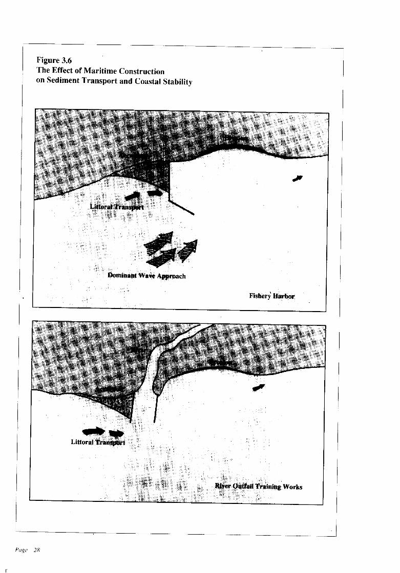
Figure 3.6The Effect of Maritime Constructionon Sediment Transport and Coastal Stability
Fishery Harbor
n
Page 28
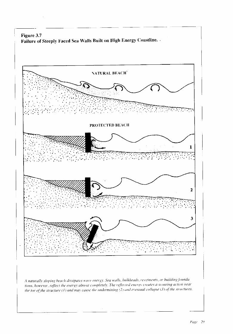
Figure 3.7Failure of Steeply Faced Sea Walls Built on High Energy Coastline.
NATURAL BEACH'..... ..'.:. :'.,.....
• ..... '. 0. ' .: ::':; ~~:> i.~ .... .. . . : ';
. . . ' .. '.:"~.: :....,'.:- .. ::.;.....
.. .. .. .. " ... ' ,.
.. : ' : "' -: .. " :.......... .." .. ...... .. "" . ...' ..'. "
," .. .. ' ' ',' ... ....
PROTECTED BEACH
:... ........ .' . ....... ..
. ... .... .. .. . ",
".. " .
." : .... .. 0,,'
: .. :.:.. ...... " .. " '.", ..:.
A naturally sloping heach dissipates \\'a\'c cnergy. Sca \\'alls, hlllkhcads, re\,ctmel1fs, or hllildingf{ilInda-
tlOl1.\. howCl'er. reflect the energy almo,lt completely The reflectcd energy (reates a Icounng actIOn /lear I
Ih, lac o(the ",.,,,1"'" (,)""" m"y u'".«' {I", ood,,.,.,,0"'," (2 IalId m'0""" ",1101'" (3) of Ih, """~""~_'
Page 29
n
life and property from erosion-caused destruction. Coastal dwellers.. however, demand thattheir property be safeguarded from the ravagesofcoast erosion. To meet these difficult demandsthe best option is to adopt a multifaceted management strategy that goes beyond the traditionalapproach of building shoreline protection structures to inhibit erosion. Elements of such a strategy should include:
• Use of appropriate erosion control techniquesthat are cost effective and socially and environmentally acceptable;
• Directing new development away from eroding shorelines;
• Requiring that neW construction in erosionprone areas be setback from the shore a sufficientdistance so that it will not be threatened byerosion for sometime;
• Regulation of human activities which contribute to accelerated erosion, such as coral andsand mining (Such regulations must, however,recognize the socio-economic dimensions ofthe activities, as well as their impacts on theshoreline);
• Protection, and where possible, restoration ofnatural features that inhibit erosion.
a) On-going Management Activities
Current CCD management of erosion consistsprimarily of shoreline protection structures, useof setback lines and directing development awayfrom eroding areas through the implementationof a regulatory system. A discussion of shorelineprotection structures follows. Setbacks and theCCD regulatory system were discussed in Chapter 2.
b) Shoreline Protection Structures
Sri Lanka has made a significant financial investment in protecting its shoreline. Figure 3.8 showsthe investment for shoreline protection worksduring the period 1955 to 1987 for the western,southwestern and southern coastal sectors.Commonly used shoreline protection structuresare revetments and groynes. In addition, sandnourishment has been utilized in restricted areas.Existing lengths of shoreline protection works
Page 30
are summarized by coastal sector in Table 3.5.It is usually considered that a revetment
provides protection only to the length of thecoastline it covers, and a groyne, if completelyeffective, to abput three times its length. Hence,all the protective structures so far built in thesesectors provide protection only to approximately70 km of coastline; whereas approximately 270to 380 km ofcoastline in these sectors are considered erosion prone areas. Thus the Rupees' 311
million investment has protected only between18 and 25 percent of the shoreline that requiresprotection. Clearly, protecting the coast withstructures is expensive.
In 1986, the CCD prepared a Master Plan forCoast Erosion Management with the assistanceof the Danish Government (DANIDA). TheMaster Plan identifies erosion prone sites alongthe coast where structural solutions to the erosionproblem are appropriate.
In the decade commencing 1986, the Government of Sri Lanka plans to invest, with bilateral assistance, a sum in excess of Rupees 1,200million to implement the recommendations ofthe Master Plan for Coast Erosion Management.This expenditure will provide protection to a
Table 3.5Length of Existing ShorelineProtectionWorks
Value in tennsTotal Length of 1985 prices
Sector (meters) (RS million)
REVETMENTS
West Coast 9,100mSouth West Coast 37,900 mSouth Coast 8,320m
55,320 m 250m
GROYNES
West Coast 2,200mSouth West Coast 3,400 mSouth Coast 1,020 m
6,620 m 61 m
311 m

total of 155 Ian of Sri Lanka's entire coastline,leaving 160 to 225 Ian of erosion prone coastlinein western, southwestern and southern areaswhere coast erosion will have to be accepted asa fact of life and development activities andhuman settlements planned accordingly.
3.2 MANAGEMENT OBJECTIVESAND POLICIES
Zone does not contribute to or aggravate erosionand that development does not occur in hazardous areas.
Policy 3.2.1.1 New construction may be permitted only in accordance with the setback standards set forth in Chapter 2; Table 2.2.
OBJECTIVE 3.2.2
OBJECTIVE 3.2.1
It is the objective of the CCD to ensure that thelocation ofdevelopment activities in the Coastal
It is the objective of the CCD to ensure thaterosion control techniques are cost effective andsocially and environmentally acceptable.
1955 -1964TOTAL FACTUAL 5.0INVESTMENT(in Million Rs)
Figure 3.8Investment Level for Shoreline Protection WorksDuring the Period 1955-1987 for West,South-West and South Coastal Sectors
1978·198429.0 8..2 8..2 :un
I I 180 I 1 I175 I170 I I
1965 - 197713.0
165 I I 1
FACTUAL PRICES
PRICE LEVEL '87 ~Expenditure Calculatedat '87 Price Level Assuming an AverageInflation Rate of 12% Per Year
I 160 I
5
o
33
30
10
Source: Sri Lanka Master Plan!or Coastal Erosion Management (updated)
Page 31
- 11

Policy 3.2.2.1 Schemes for coast protectionimplementedbyCCD shall be consistent with theMaster Plan for Coast Erosion Management.
Policy 3.2.2.2 Shoreline protection schemesimplemented by public or private entities otherthan the CCD may be permitted ifconsistent withthe following guidelines:
a) The proposed scheme is not in a zone designated "no build" by the CCD. "No build zones"are listed in Table 2.2.b) On the basis of sound professional information, applicants shall consider and evaluate nonstructural measures and if they are deemed unsuitable, shall state engineering justifications forstructural measures.c) Applications for structural measures to control erosion shall (i) demonstrate that the proposed structure has a reasonable probability ofcontrolling the erosion problem; (ii) indicatewhat measures will be taken to minimise erosionin adjacent areas; (iii) demonstrate that the proposed structure is an appropriate solution to theerosion problem considering the long-term rateof erosion in the area, the likely effects of majorstorms and the stability of the shoreline on eitherside of the proposed project.d) Describe a long-termmaintenanceprogrammefor the proposed facility including financial ar·rangements to pay for such maintenance.
Policy 3.2.2.3 Shoreline protection schemesmay be implemented in response to a short-termemergency where life or buildings are immediately threatened if such protective schemes areconsistent with the following guidelines:
a) Such schemes will not cause increased erosion in adjacent areas.b) Permanent structures (e.g. boulders, revetments, groynes, sea walls) are not incorporatedinto such schemes.c) Materials and elements used for constructionare of a nature that would not cause permanentalteration ofthe shoreline (e.g. gravel, sand, sandbags, gabions) and are easily removable.d) The developer monitors the effects of theschemes and implements corrective action, including removal, if CCD determines there areadverse impacts.
Page 32
e) Such schemes are implemented in the fullknowledge that they are temporary emergencymeasures designed to meet a particular situationand do not constitute long-term solutions.f) Such schemes are consistent with the aims ofensuring public access and do not disrupt orsignificantly impede otherexisting activities (e.g.fishing, tourism, etc.).
Policy 3.2.2.4 CCD will conduct and supportresearch on coastal processes relating to erosionand its control, including investigation into thefeasibility ofusing vegetation to control erosion.
OBJECTIVE 3.2.3
It is the objective of the CCD to preserve andwhere possible restore coral reefs.
Policy_ 3.2.3.1 Breaking of reefs, collectingof debris and mining of coral is prohibited inthe Coastal Zone.
Policy 3.2.3.2 The socio-economic impacts ofthe coral mining prohibition will be mitigatedthrough CCD coordination of inter-agency efforts to provide alternative employment to displaced coral miners.
Policy 3.2.3.3 Alternative sources of lime willbe sought to meet the requirements of the construction and agriculture industries.
Policy 3.2.3.4 Areas where reefrestoration willimpede erosion and provide additional habitatwill be identified.
OBJECTIVE 3.2.4
It is the objective of the CCD to allow sandmining in the Coastal Zone within sustainablelimits.
Policy 3.2.4.1 Sandmining may be permitted ifit is consistent with the guidelines given in Table3.6. The guidelines are designed to prevent increased erosion, destabilization ofsand dunes, orincreased turbidity in the vicinity of coral reefs.
Policy 3.2.4.2 When sand mining is permitted,it will be regulated through quotas, time schedule
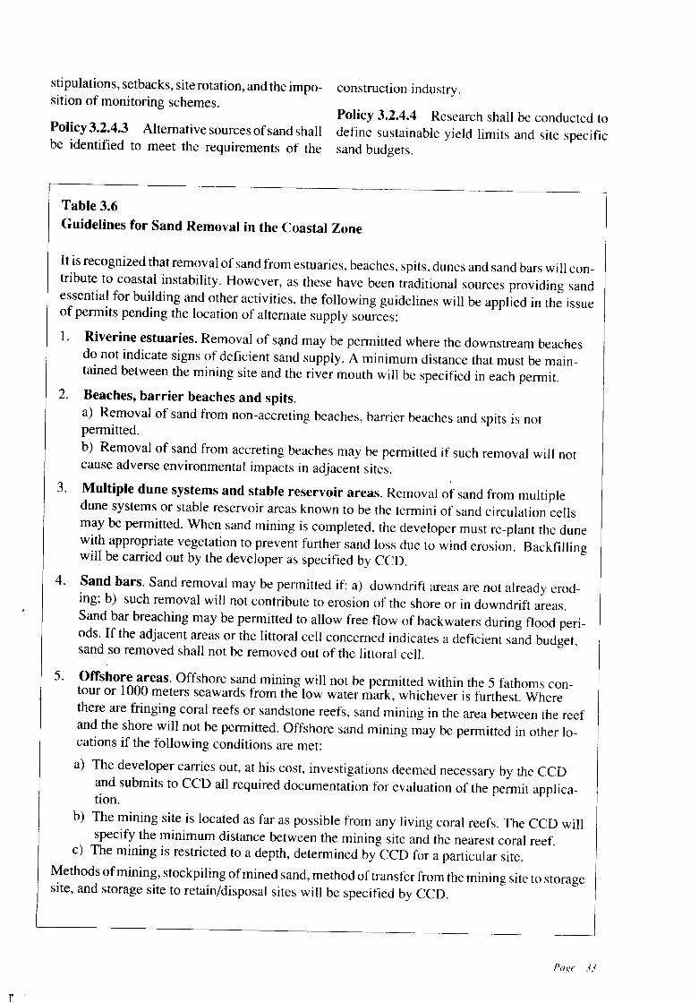
stipulations, setbacks, site rotation, and the imposition of monitoring schemes.
Policy 3.2.4.3 Alternative sources ofsand shallbe identified to meet the requirements of the
construction industry.
Policy 3.2.4.4 Research shall be conducted todefine sustainable yield limits and site specificsand budgets.
n
Table 3.6Guidelines for Sand Removal in the Coastal Zone
It is recognized that removal of sand from estuaries, beaches, spits, dunes and sand bars will contribute to coastal instability. However, as these have been traditional sources providing sandessential for building and other activities, the following guidelines will be applied in the issueof permits pending the location of alternate supply sources:
1. Riverine estuaries. Removal of sC;lnd may be permitted where the downstream beachesdo not indicate signs of deficient sand supply. A minimum distance that must be maintained between the mining site and the river mouth will be specified in each permit.
2. Beaches, barrier beaches and spits.a) Removal of sand from non-accreting beaches, barrier beaches and spits is notpermitted.b) Removal of sand from accreting beaches may be permitted if such removal will notcause adverse environmental impacts in adjacent sites.
3. Multiple dune systems and stable reservoir areas. Removal of sand from multipledune systems or stable reservoir areas known to be the termini of sand circulation cellsmay be permitted. When sand mining is completed, the developer must re-plant the dunewith appropriate vegetation to prevent further sand loss due to wind erosion. Backfillingwill be carried out by the developer as specified by CCO.
4. Sand bars. Sand removal may be permitted if: a) downdrift areas are not already eroding; b) such removal will not contribute to erosion of the shore or in downdrift areas.Sand bar breaching may be permitted to allow free flow of backwaters during flood periods. If the adjacent areas or the littoral cell concerned indicates a deficient sand budget,sand so removed shall not be removed out of the littoral cell.
5. Offshore areas. Offshore sand mining will not be permitted within the 5 fathoms contour or 1000 meters seawards from the low water mark, whichever is furthest. Wherethere are fringing coral reefs or sandstone reefs, sand mining in the area between the reefand the shore will not be permitted. Offshore sand mining may be permitted in other locations if the following conditions are met:
a) The developer carries out, at his cost, investigations deemed necessary by the CCOand submits to CCD all required documentation for evaluation of the permit application.
b) The mining site is located as far as possible from any living coral reefs. The CCD willspecify the minimum distance between the mining site and the nearest coral reef.
c) The mining is restricted to a depth, determined by CCO for a particular site.
Methods ofmining, stockpiling ofmined sand, method of transfer from the mining site to storagesite, and storage site to retain/disposal sites will be specified by CCD.
Page 33
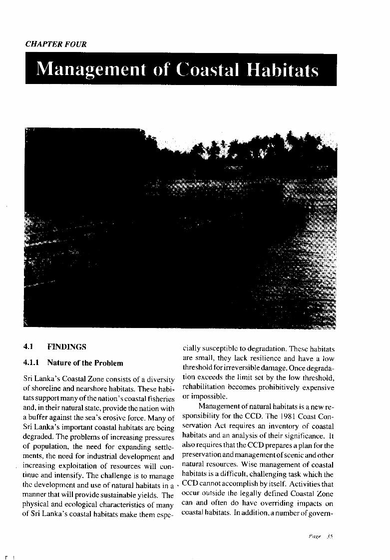
CHAPTER FOUR
Managelnent ()f (~oastal Habitclts
Nature of the Problem
FINDINGS cially susceptible to degradation. These habitatsare small, they lack resilience and have a lowthreshold for irreversible damage. Once degrada-
Sri Lanka's Coastal Zone consists of a diversity tion exceeds the limit set by the low threshold,of shoreline and nearshore habitats. These habi- rehabilitation becomes prohibitively expensivetats support many of the nation's coastal fisheries or impossible.and, in their natural state, provide the nation with Management of natural habitats is a new rea buffer against the sea's erosive force. Many of sponsibility for the CCD. The 1981 Coast ConSri Lanka's important coastal habitats are being servation Act requires an inventory of coastaldegraded. The problems of increasing pressures habitats and an analysis of their significance. Itof population, the need for expanding settle- also requires that the CCD prepares a plan for thements, the need for industrial development and preservation and managementofscenic and otherincreasing exploitation of resources will con- natural resources. Wise management of coastaltinue and intensify. The challenge is to manage habitats is a difficult, challenging task which thethe development and use of natural habitats in a . CCD cannot accomplish by itself. Activities thatmanner that will provide sustainable yields. The occur outside the legally defined Coastal Zonephysical and ecological characteristics of many can and often do have overriding impacts onof Sri Lanka's coastal habitats make them espe- coastal habitats. In addition, a number ofgovem-
4.1.1
4.1
- n !
mental agencies share responsibility for aspectsof coastal habitat management.
The CCD has embarked on a process to develop coordinated management strategies for SriLanka's coastal habitats. The process includedmapping of the coastal habitats on a scale of I to63,360 using available aerial photography anddetailed maps (CCD Internal Report No. 13:Report on the Preparation of Maps IndicatingCoastal Habitats, 1986). The CCD also commissioned a summary ofavailable information on SriLanka's coastal habitats and a preliminary identification ofmanagement issues and priorities formanagement and research (CCD Internal ReportNo. 14: Synthesis Report-Information on Critical Habitats in the Coastal Zwle, 1986). In Mayof 1986 the CCD condueted an inter-agencyworkshop on the management of Sri Lanka'scoastal habitats. The workshop's objectives were:
a) To review management objectives for eachtype of coastal habitat;
b) To review and rank the major managementissues for each habitat;
c) To identify the research that will be most helpful in understanding how to better manageeach habitat;
d) To identify on-going management efforts andresearch;
e) To identify the management initiatives thatcan be implemented immediately or in thenear future.
Forty-nine participants representing governmental agencies concerned with the management of coastal habitats and non-governmentalorganizations concerned with environmental conservation attended the workshop. The workshopproceedings are available from the CCD (CCDInternal Report No. 15: Report on Workshop onManagement of Coastal Habitats in Sri Lanka,1986).
The findings, policies and managementstrategies which follow are an outcome of thepreviously described process. The process ofdeveloping integrated strategies for managementofSri Lanka's coastal habitats will continue into thefuture. Its success will require the continuedcooperation and involvement of governmentaland non-governmental agencies concerned about
Page 36
coastal habitats and their uses, and of the peoplewho rely on these habitats for their livelihood andway of life.
4.1.2 Identification and Characterization ofSri Lanka's Natural Coastal Habitats
Coastal habitats considered in this Plan are coralreefs, estuaries and lagoons, mangroves, seagrassbeds, salt marshes, barrier beaches, spits, anddunes. Estimates of the aerial extent of eachhabitat type are shown in Table 4.1. Other coastalhabitats such as sandstone reefs are not specifically addressed in this Plan because of a lack ofinformation. Also, the relationship betweencoastal habitats and fish populations and theirdynamics are not discussed. A separate governmental agency exists specifically for fisheriesmanagement. It should be noted, however, thatfishery productivity depends largely upon theproper management of the coastal habitats discussed in this chapter.
While the six coastal natural habitats arediscussed separately, this does not imply they areindependent units. Coastal natural habitats arelinked together by a complex web of direct andindirect interactions. Disruption of anyone ofthese interactions has effects on the others.
Land use practices in river basins whichempty into coastal waters also have a majorimpact upon coastal habitats. These are not specifically addressed, as the CCD currently has nojurisdiction over such'activities. However, successful management of coastal habitats will require coordination with authorities responsiblefor upland activities.
4.1.3 Managing Sri Lanka's NaturalCoastal Habitats
Management of human activities within coastalhabitats is a challenging task. Management ismost meaningful when it is geographically specific and based on well understood links betweenhuman activities and changes within a naturalsystem. Unfortunately, these links are oftenpoorlyunderstood.
The known uses of the six coastal habitatsare classified under each habitat type as non-ex-
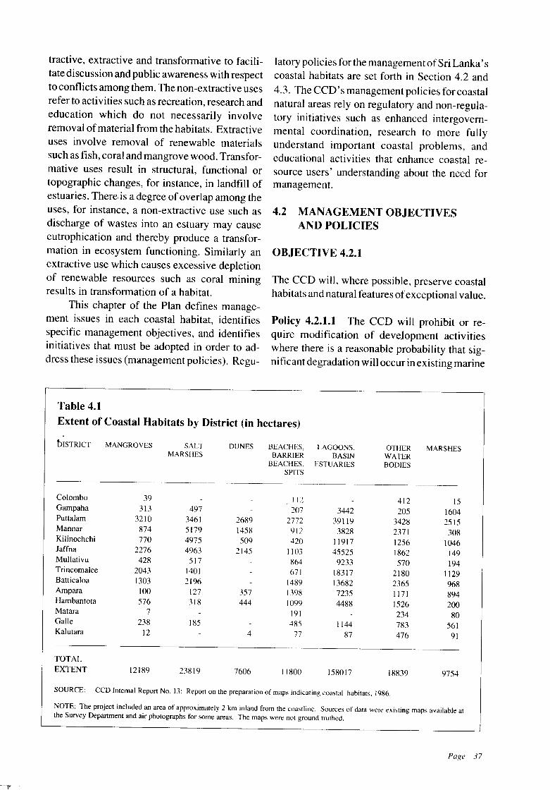
tractive, extractive and transformative to facilitate discussion and public awareness with respectto conflicts among them. The non-extractive usesrefer to activities such as recreation, research andeducation which do not necessarily involveremoval ofmaterial from the habitats. Extractiveuses involve removal of renewable materialssuch as fish, coral and mangrove wood. Transformative uses result in structural, functional ortopographic changes, for instance, in landfill ofestuaries. There, is a degree ofoverlap among theuses, for instance, a non-extractive use such asdischarge of wastes into an estuary may causeeutrophication and thereby produce a transformation in ecosystem functioning. Similarly anextractive use which causes excessive depletionof renewable resources such as coral miningresults in transformation of a habitat.
This chapter of the Plan defines management issues in each coastal habitat, identifiesspecific management objectives, and identifiesinitiatives that must be adopted in order to address these issues (management policies). Regu-
latory policies for the management ofSri Lanka'scoastal habitats are set forth in Section 4.2 and4.3. The CCD's management policies for coastalnatural areas rely on regulatory and non-regulatory initiatives such as enhanced intergovernmental coordination, research to more fullyunderstand important coastal problems, andeducational activities that enhance coastal resource users' understanding about the need formanagement.
4.2 MANAGEMENT OBJECTIVESAND POLICIES
OBJECTIVE 4.2.1
The CCO will, where possible, preserve coastalhabitats and natural features ofexceptional value.
Policy 4.2.1.1 The CCO will prohibit or require modification of development activitieswhere there is a reasonable probability that significant degradation will occur in existing marine
Table 4.1
Extent of Coastal Habitats by District (in hectares)
bISTRICT MANGROVES SALT DUNES BEACHES. LAGOONS, OTHER MARSHESMARSHES BARRIER BASIN WATER
BEACHES, ESTUARIES BODIESSPITS
Colombo 39 112 412 ISGampaha 313 497 207 3442 205 1604Puttalam 3210 3461 2689 2772 39119 3428 2515Mannar 874 5179 1458 912 3828 2371 308Kilinochchi 770 4975 509 420 11917 1256 1046Jaffna 2276 4963 2145 1103 45525 1862 149Mullativu 428 517 864 9233 570 194Trincomalee 2043 1401 671 18317 2180 1129Battica10a 1303 2196 1489 13682 2365 968Ampara 100 127 357 1398 7235 1171 894Hambantota 576 318 444 1099 4488 1526 200Matara 7 191 234 80Galle 238 185 485 1144 783 561Kalutara 12 4 77 87 476 91
TOTALEXTENT 12189 23819 7606 11800 158017 18839 9754
SOURCE: CCD Internal Report No. 13: Report on the preparation of maps indicating coastal habitats, 1986.
NOTE: The project included an area of approximately 2 km inland from the coastline. Sources of data were existing maps available atthe Survey Department and air photographs for some areas. The maps were not ground truthed.
Page 37
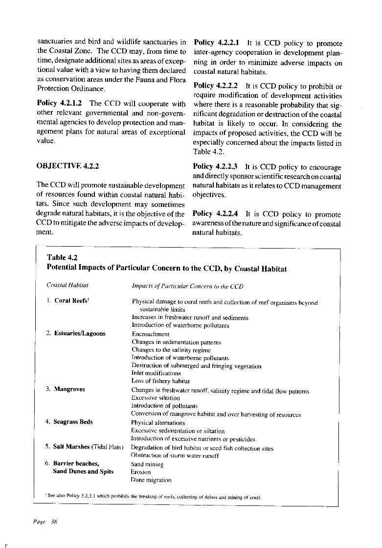
sanctuaries and bird and wildlife sanctuaries inthe Coastal Zone. The CCD may, from time totime, designate additional sites as areas ofexceptional value with a view to having them declaredas conservation areas under the Fauna and FloraProtection Ordinance.
Policy 4.2.1.2 The CCO will cooperate withother relevant governmental and non-governmental agencies to develop protection and management plans for natural areas of exceptionalvalue.
OBJECTIVE 4.2.2
The CCD will promote sustainable developmentof resources found within coastal natural habitats. Since such development may sometimesdegrade natural habitats, it is the objective of theCCD to mitigate the adverse impacts ofdevelopment.
Policy 4.2.2.1 It is CCD policy to promoteinter-agency cooperation in development planning in order to minimize adverse impacts oncoastal natural habitats.
Policy 4.2.2.2 It is CCD policy to prohibit orrequire modification of development activitieswhere there is a reasonable probability that significant degradation or destruction of the coastalhabitat is likely to occur. In considering theimpacts of proposed activities, the CCD will beespecially concerned about the impacts listed inTable 4.2.
Policy 4.2.2.3 It is CCD policy to encourageand directly sponsor scientific research on coastalnatural habitats as it relates to CCD managementobjectives.
Policy 4.2.2.4 It is CCD policy to promoteawareness of the nature and significance ofcoastalnatural habitats.
Table 4.2Potential Impacts of Particular Concern to the CCD, by Coastal Habitat
Coastal Habitat
1. Coral Reefs I
2. EstuarieslLagoons
3. Mangroves
4. Seagrass Beds
5. Salt Marshes (Tidal Flats)
6. Barrier beaches,Sand Dunes and Spits
Impacts ofParticular Concern to the CCD
Physical damage to coral reefs and collection of reef organisms beyondsustainable limits
Increases in freshwater runoff and sedimentsIntroduction of waterborne pollutants
EncroachmentChanges in sedimentation patternsChanges to the salinity regimeIntroduction of waterborne pollutantsDestruction of submerged and fringing vegetationInlet modificationsLoss of fishery habitat
Changes in freshwater runoff, salinity regime and tidal flow patternsExcessive siltationIntroduction of pollutantsConversion of mangrove habitat and over harvesting of resources
Physical alternationsExcessive sedimentation or siltationIntroduction of excessive nutrients or pesticides
Degradation of bird habitat or seed fish collection sitesObstruction of storm water runoff
Sand miningErosionDune migration
n
I See also Policy 3.2.3.1 which prohibits the breaking of reefs. collecting of debris and mining of coral.
Page 38
n
4.3 COASTAL HABITATS IN SRI LANKA
CORAL REEFS
a) DEFINITION
Coral reefs consist of a large rigid structuralmass of calcium carbonate formed by thecemented skeletal remains resulting from thesuccessive growth and development of hermatypic corals. Coralline algae also contribute to thestructural foundation of the reef. The coralsconstitute the more important component sincethey give vivid colour and impressive threedimensional form to the reef.
b) NATURE AND SIGNIFICANCE
Coral reefs in Sri Lanka front 2 to 3 percent ofthenation's total shoreline. They are mostly of thefringing type, meaning they occur adjacent toshore and grow from the sea floor usually on anucleus of rock, e.g. Hikkaduwa. Barrier reefs,which are ridges of corals lying some distancefrom shore and running parallel with it, are rare inSri Lanka. Examples of barrier reefs are theformations at Vankalai and Silavathurai. Bothfringing and barrier reefs dissipate wave energyand are important for coastal stability and as asource of beach material (see also Chapter 3).This was geographically demonstrated whencoral mining was stopped in the Vanderloos Bayarea, and beach building became evident withintwo years.
Coral reefs occur in shallow coastal watersthat are clear and free from excessive freshwaterand nutrients. Growth of corals is tied to thepresence ofmicroscopic symbiotic plants in theirbody walls. These plants require sunlight thatpasses through the clear, shallow water. According to NARA surveys, 166 species ofhermatypic(reef building) corals of varied shape and sizehave been recorded from Sri Lanka waters. Thestaghom coral (Acropora spp.) is the dominantspecies.
Spatial heterogeneity is a key reef characteristic providing diverse living opportunities fora multitude of plants and animals. This spatialheterogeneity is lost when corals are broken or
removed at a rate exceeding their regenerativecapacity. Loss ofspatial heterogeneity inevitablyresults in a general decrease in the diversity ofcoral reef organisms. The growth rate ofcorals isslow and varies between 2 cm per year for theboulder-like brain coral and 20 cm ~r year forbranching corals.
When physical damage occurs, its consequences can be rapid and obvious. Coral reefs canbecome masses of rubble encrusted by algae nolonger having the vibrant colour, beauty and productivity that once characterized them. TheHikkaduwa reef dramatically shows physicaldamage to reefs.
Reef degradation by pollution, however, isinsidious and the manifestation ofdamage occursover a prolonged period. This process is seen insome of the reefs at Vanderloos Bay where whitepatches on boulder corals, on close examination,correspond to areas where corals have died. InPolhena, retting ofcoconut husks in the intertidalregion has led to the destruction of coral reefs.Once the living component is removed and thecapacity for selfrepair lost, the structural foundation of a coral reef is rapidly eroded by waveaction.
c) ACTIVITIES SUPPORTED
Coral reefs in Sri Lanka support a variety ofuses,which are briefly summarized in the followingparagraphs.
Non-extractive uses
Tourism: Coastal tourism is a major economicactivity in Sri Lanka and one that is likely to grow(see also Chapter 5). Living coral reefs providean attraction for recreation and are important formaintaining the white beaches that tourists cherish. Local employment and income directly related to coral reef viewing include operation ofglass bottomed boats, trade in reef products andrental of underwater gear.
Science and Education: Since coral reefs arelocated nearshore they are easily accessible forstudy and research. Research on coral reefs isbeing conducted by NARA, the University ofColombo, and the University of Kelaniya.
Page 39
Extractive uses
Coral Mining: The extent and economic significance ofcoral mining in Sri Lanka is described inChapter 3. This is the human activity causinggreatest damage to Sri Lanka coral reefs.
Ornamental Fish and Reef Products: Collection and export of coral reef fish and shells earnsa substantial quantity of foreign exchange.Quantitative data on this industry is lacking butthis trade is thought to have seriously depletedmany reefs.
Fisheries: Angling and fishing with spear gunsare relatively small-scaleactivities on Sri Lanka'scoral reefs. Destructive commercial fishing withset nets and explosives are also carried out atreefs along the eastern and southern coasts.
Transformative uses
Anchorages: Fishermen living in the vicinity ofcoral reefs recognize the convenience of anchoring their mechanized boats in the sheltered waters located behind coral reefs. Reefs are sometimes breached with explosives in order to gainaccess to these sites.
d) MANAGEMENT ISSUES
The management of coral reefs for sustainableyields requires that their spatial heterogeneity bepreserved and that the reef organisms be protected. The following have been identified asimportant for the management of coral reefs forsustainable yields.
• Better enforcement of existing legislation forthe prohibition of coral mining;
• Provision of alternative sources of employment to those engaged in coral mining;
• Location andexploitationofalternative sourcesof lime for industrial use;
• Better control of reef blasting for provision ofnavigational access to fishing boatswith a viewto minimizing reef damage;
• Control of collection of ornamental fish andother reeforganisms to ensure that collection iskept within sustainable limits;
• Regulation of activities that contribute to in-
Page 40
creased sedimentation and freshwater inflowand pollution in the vicinity of coral reefs;
• Better enforcement of existing legislation anddrafting new legislation for the prohibition ofdestructive methods of fishing.
e) MANAGEMENT OBJECTIVES
The basic management objective for coral reefsis, where pu:;::ihle, to preserve them. More specifically the objectives for the management ofcoral reefs are:
• To preserve reefs as unique living resourceswhich are part of Sri Lanka's natural heritage,as well as for their importance in maintenanceof fisheries and as a natural buffer againstcoastal erosion.
• To maintain reefs as a scientific, educationaland tourist resource.
• To ensure that removal of reef organisms, suchas aquarium fish, does not exceed sustainablelevels.
4.3.1 MANAGEMENT POLICIES FORCORAL REEFS
Policy 4.3.1.1 Breaking of reefs, collecting ofdebris and mining of coral is prohibited in theCoastal Zone.
Policy 4.3.1.2 Limited collection of coral maybe permitted by the CCD if the collection is forvalid scientific research purposes.
Policy 4.3.1.3 In considering proposed development in the vicinity ofcoral reefs, the CCD willensure that adverse impacts of increases in freshwater runoff and sediments and the introductionof waterborne pollutants will be minimised.
Policy 4.3.1.4 CCD will cooperate with othergovernmental agencies to map and develop azoning system for coral reefs that identifies areasfor preservation and establishes categories ofallowable uses for other reefareas. Priority attention will be given to reefs currently utilized forrecreation and tourism. (A multiple use zoningplan for the Hi}(kaduwa Marine Sanctuary hasbeen formulated by NARA).
ESTUARIES AND LAGOONS
a) DEFINITIONS
An Estuary is a semi-enclosed coastal body ofwater, which has a free connection with the sea,and within which sea water is measurably dilutedby freshwater derived from land drainage. Froma management point of view, the estuaries in SriLanka need to be subdivided as basin estuariesand riverine estuaries, since the main management issues for the two types are fundamentallydifferent.
Basin Estuaries form where rivers dischargeinto relatively shallow expanded basins which intum connect with the sea, e.g. Negombo Lagoon,Puttalam Lagoon. Numerous coastal bodies ofwater that are named as lagoons (Puttalam Lagoon, Negombo Lagoon, Chilaw Lagoon, JaffnaLagoon, Batticaloa Lagoon) are basin estuaries.
Riverine Estuaries are formed by rivers discharging directly into the sea by way ofrelativelynarrow channels, e.g. Kelani Ganga estuary,Nilwala Ganga estuary.
Lagoons are coastal bodies of water containingbrackish water which are either permanentlyseparated from the sea or are connected with thesea only during part of the year.
b) NATURE AND SIGNIFICANCE
Sri Lanka's estuaries and lagoons are shown inFigure 4.1. Many of these estuaries are closelylinked with the major urban centers along thecoast. As populations increase and urban expansion continues, the estuaries, in addition to theirnatural functions, are required to support a widening range of human activities.
Sri Lanka's estuaries support a wide rangeof commercially important organisms that contribute both to estuarine and nearshore fisheries.It is important to note that some 90 percent of organisms of commercial importance captured inestuaries and lagoons arrive as migrants from thesea. This productivity depends largely Qn theestuary's ·mix of fresh and marine waters inproviding and renewing nutrients, organic materials and oxygen, and water circulation patterns
that provide high mixing rates. Sand transportedby rivers into the sea by way of riverine estuariesis important to beach maintenance.
The eventual fate of basin estuaries and lagoons is extinction by sedimentation, stabilization ofshoals by vegetation, barrier formation bylongshore drift or opening up ofan estuary mouthby erosion to form a bay.The pace of extinctiondepends primarily upon geomorphology but canalso be affected by human activities.
c) ACTIVITIES SUPPORTED
Sri Lanka's estuaries and lagoons acquire economic significance because of the many humanuses they support. Their fisheries provide em:ployment to a significantproportion ofthe coastalcommunity.
Non-extractive uses
Estuaries and lagoons are used as harbours, disposal sites for sewage and industrial effluents,recreation, science and education, some forms ofaquaculture and for transport. Estuaries haveprovided anchorage for both trading and fishingvessels since historical times and continue to doso today. Both sewage and industrial effluentsare discharged into estuaries in the vicinity ofurban areas (e.g. Kelani Ganga, Negombo Lagoon) and industrial centers (e.g. NegomboLagoon, Valaichchenai Estuary). Some estuaries (e.g. Negombo Lagoon, Bentota Ganga,Bolgoda Lake) are important for tourist recreation. Sri Lanka's estuaries and lagoons are themajor focus of research and education in marinescience since access is possible with minimalexpenditure. Raft culture of mussels and oystersis being conducted on an experimental scale inTrincomalee Bay, Puttalam Lagoon, RatgamaLake and Mirissa harbour. Timber is transportedalong the Kelani Ganga estuary. There have beenrecent efforts also to link Puttalam and Colomboby way of the Dutch Canal and the HamiltonCanal.
Extractive uses
Fishing is undoubtedly the most important extractive use of estuaries and lagoons, as it provides employment to thousands of coastal resi-
Page 41
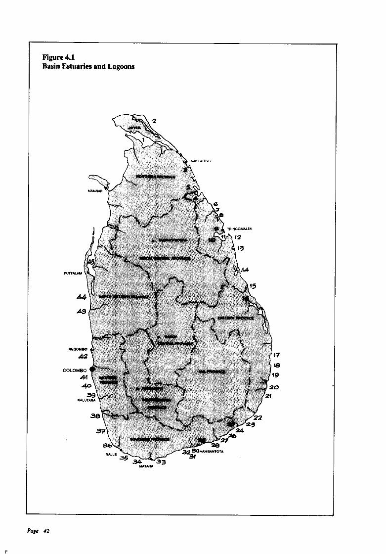
11
Figure 4.1Basin Estuaries and Lagoons
I'UTTAlAM
COLOMBO
4140
ag~UTARA
Page 42
222~
24-
7J3Z13:2 9OHAMBANTOTA
31
17
f8
19
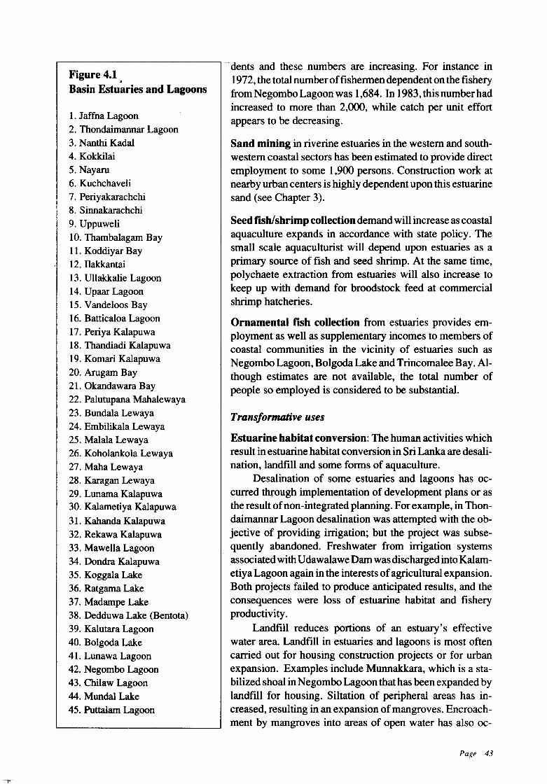
Figure 4.1 .Basin Estuaries and Lagoons
1. Jaffna Lagoon2. Thondaimannar Lagoon3. Nanthi Kadal4. Kokkilai5. Nayaru6. Kuchchaveli7. Periyakarachchi8. Sinnakarachchi9. Uppuweli10. Thambalagam Bay11. Koddiyar Bay12. Ilakkantai13. Ullakkalie Lagoon14. Upaar Lagoon15. Vandeloos Bay16. Batticaloa Lagoon17. Periya Kalapuwa18. Thandiadi Kalapuwa19. Koman Kalapuwa20. Arugam Bay21. Okandawara Bay22. Palutupana Mahalewaya23. Bundala Lewaya24. Embilikala Lewaya25. Malala Lewaya26. Koholankola Lewaya27. Maha Lewaya28. Karagan Lewaya29. Lunama Kalapuwa30. Kalametiya Kalapuwa31. Kahanda Kalapuwa32. Rekawa Kalapuwa33. Mawella Lagoon34. Dondra Kalapuwa35. Koggala Lake36. Ratgama Lake37. Madampe Lake38. Dedduwa Lake (Bentota)39. Kalutara Lagoon40. Bolgoda Lake41. Lonawa Lagoon42. Negombo Lagoon43. Chilaw Lagoon44. Mondal Lake45. Puttalam Lagoon
- dents and these numbers are increasing. For instance in1972, the total numberoffishermen dependent on the fisheryfrom Negombo Lagoon was 1,684. In 1983, this number hadincreased to more than 2,000, while catch per unit effortappears to be decreasing.
Sand mining in riverine estuaries in the western and southwestern coastal sectors has been estimated to provide directemployment to some 1,900 persons. Construction work atnearby urban centers is highly dependent upon this estuarinesand (see Chapter 3).
Seed fish/shrimp collection demand will increase as coastalaquaculture expands in accordance with state policy. Thesmall scale aquaculturist will depend upon estuaries as aprimary source of fish and seed shrimp. At the same time,polychaete extraction from estuaries will also increase tokeep up with demand for broodstock feed at commercialshrimp hatcheries.
Ornamental fish collection from estuaries provides employment as well as supplementary incomes to members ofcoastal communities in the vicinity of estuaries such asNegombo Lagoon, Bolgoda Lake and Trincomalee Bay. Although estimates are not available, the total number ofpeople so employed is considered to be substantial.
Transjonnative uses
Estuarine habitat conversion: The human activities whichresult in estuarine habitat conversion in Sri Lanka are desalination, landfill and some forms of aquaculture.
Desalination of some estuaries and lagoons has occurred through implementation of development plans or asthe result ofnon-integrated planning. For example, in Thondaimannar Lagoon desalination was attempted with the objective of providing irrigation; but the project was subsequently abandoned. Freshwater from irrigation systemsassociated with Udawalawe Dam was discharged into Kalametiya Lagoon again in the interests ofagricultural expansion.Both projects failed to produce anticipated results, and theconsequences were loss of estuarine habitat and fisheryproductivity.
Landflll reduces portions of an estuary's effectivewater area. Landfill in estuaries and lagoons is most oftencarried out for housing construction projects or for urbanexpansion. Examples include Munnakkara, which is a stabilized shoal in Negombo Lagoon that has been expanded bylandfill for housing. Siltation of peripheral areas has increased, resulting in an expansion of mangroves. Encroachment by mangroves into areas of open water has also oc-
Page 43
curred at Koggala Lagoon where a sand barrierblocks the lagoon mouth. SectionsofTrincomaleeBay have been filled for construction of industrial projects. Individuals residing on the shoreline sometimes encroach into the estuaries toincrease their land holdings.
Pond aquaculture and pen culture also transform segments of estuaries and lagoons. Some7.2 hectares in Batticaloa Lagoon have been converted into a pond by dykes constructed in ashallow area. Pens constructed in Puttalam Lagoon, Bolgoda Lake and in Negombo Lagoonhave restricted the availability of the lagoons forcommunity use.
d) MANAGEMENT ISSUES
The factors that result in estuarine habitat degradation are not discrete. Usually they interact andoften their adverse impacts are synergistic. Shoalformation, for instance, not only decreases thewater area, but it also decreases the substratumavailable for growth of seagrasses and in tumdecreases available feeding and breeding groundsfor several species of fish. Major managementissues in Sri Lanka's estuaries and lagoons include:
• Maintenance of water area: Natural processes as well as human activity cause reduCtionin effective water area ofestuaries and lagoons.Natural processes include sedimentation andencroachment by shoreline vegetation. Humanactivities such as encroachment, poor soil management in upland agriculture, deforestation,and damming ofrivers can and often do changethe quantity and patterns of sedimentation andcause accelerated filling of estuaries and lagoons.
• Maintenance of water qualiy: Availableinformation on water quality in estuaries andlagoons in Sri Lanka is limited. Recognizedcauses ofdegradation in estuarinellagoonal water quality are changes in the quantity andtiming of freshwater inflow, discharge of industrial effluents, discharge of domestic sewage and garbage, dumping of waste oil frommechanized boats and agricultural runoff.
• Maintenance offishery and sand resources:Regulatiop and control of exploitation of fish-
Page 44
ery and sand resources and use of destructivefishing techniques are priority managementIssues.
Maintaining a free connection with the sea:The main functions of estuaries and lagoonsand other coastal habitats are delivery of sediments and nutrients to downstream habitats,and provision of nursery and feeding groundsfor fishery organisms. Continuation of thesefunctions depends upon a free connectionbetween the sea and estuary.
However, a distinction has to be made between basin estuaries and riverine estuaries asthe major human uses ofthese two types are different. The primary activity in the former isfishing while in the latter is sand mining. Management measures must take this into account.
e) MANAGEMENT OBJECTIVES
The objectives for the management of estuariesand lagoons include maintenance of fisheryhabitat, maintenance and where possible restora-.tion of water quality, protection of recreationalvalues, and regulation of sand mining to levelsthat do not have an adverse impact on beachreplenishment.
4.3.2 MANAGEMENT POLICIES FORESTUARIES AND LAGOONS
Policy 4.3.2.1 In considering proposed development within or adjacent to estuaries or lagoons, the CCD will ensure that impacts due toencroachment, sedimentation, desalination andpollution are minimised.
Policy 4.3.2.2 The CCD will cooperate withothergovernmental and non-governmental agencies to develop special area management plansfor selected estuaries and lagoons.
MANGROVES
a) DEFINITION
Mangroves are salt-tolerant,woody, seed-bearing plants ranging in size from small shrubs to talltrees. They occuralong sheltered intertidal coast-
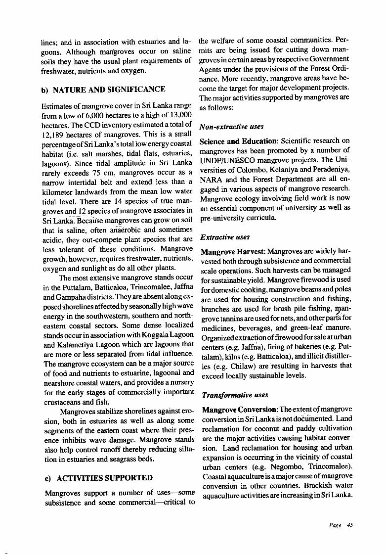
lines; and in association with estuaries and lagoons. Although mangroves occur on salinesoils they have the usual plant requirements offreshwater, nutrients and oxygen.
b) NATURE AND SIGNIFICANCE
Estimates of mangrove cover in Sri Lanka rangefrom a low of 6,000 hectares to a high of 13,000hectares. The CCD inventory estimated a total of12,189 hectares of mangroves. This is a smallpercentageofSri Lanka's total low energy coastalhabitat (i.e. salt marshes, tidal flats, estuaries,lagoons). Since tidal amplitude in Sri Lankararely exceeds 75 cm, mangroves occur as anarrow intertidal belt and extend less than akilometer landwards from the mean low watertidal level. There are 14 species of true mangroves and 12 species of mangrove associates inSri Lanka. Beca.usemangroves can grow on soilthat is saline, often ~aerobic and sometimesacidic, they out-compete plant species that areless tolerant of these conditions. Mangrovegrowth, however, requires freshwater, nutrients,oxygen and sunlight as do all other plants.
The most extensive mangrove stands occurin the Puttalam, Batticaloa, Trincomalee, Jaffnaand Gampaha districts. They are absent along exposedshorelines affectedby seasonally high waveenergy in the southwestern, southern and northeastern coastal sectors. Some dense localizedstands occur in association with Koggala Lagoonand Kalametiya Lagoon which are lagoons thatare more or less separated from tidal influence.The mangrove ecosystem can be a major sourceof food and nutrients. to estuarine, lagoonal andnearshore coastal waters, and provides a nurseryfor the early stages of commercially importantcrustaceans and fish.
Mangroves stabilize shorelines against erosion, both in estuaries as well as along somesegments of the eastern coast where their presence inhibits wave damage. Mangrove standsalso help control runoff thereby reducing siltation in estuaries and seagrass beds.
c) ACTIVITIES SUPPORTED
Mangroves support a number of uses-somesubsistence and some commercial--critical to
the welfare of some coastal communities. Permits are being issued for cutting down mangroves in certain areas by respective GovernmentAgents under the provisions of the Forest Ordinance. More recently, mangrove areas have become the target for major development projects.The major activities supported by mangroves areas follows:
Non-extractive uses
Science and Education: Scientific research onmangroves has been promoted by a number ofUNDP/UNESCO mangrove projects. The Universities of Colombo, Kelaniya and Peradeniya,NARA and the Forest Department are all engaged in various aspects of mangrove research.Mangrove ecology involving field work is nowan essential component of university as well aspre-university curricula.
Extractive uses
Mangrove Harvest: Mangroves are widely harvested both through subsistence and commercialscale operations. Such harvests can be managedfor sustainable yield. Mangrove firewood is usedfor domestic cooking, mangrovebeams andpolesare used for housing construction and fishing,branches are used for brush pile fishing, man-
,,grove tannins are used for nets, and otherparts formedicines, beverages, and green-leaf manure.Organizedextractionoffirewood for sale aturbancenters (e.g. Jaffna), firing of bakeries (e.g. Puttalam), kilns (e.g. Batticaloa), and illicit distilleries (e.g. Chilaw) are resulting in harvests thatexceed locally sustainable levels.
Transformative uses
Mangrove Conversion: The extentofmangroveconversion in SriLankais not dOCumented. Landreclamation for coconut and paddy cultivationare the major activities causing habitat conversion. Land reclamation for housing and urbanexpansion is occurring in the vicinity of coastalurban centers (e.g. Negombo, Trincomalee).Coastal aquaculture is a majorcause ofmangroveconversion in other countries. Brackish wateraquaculture activities are increasing in Sri Lanka.
Page 45
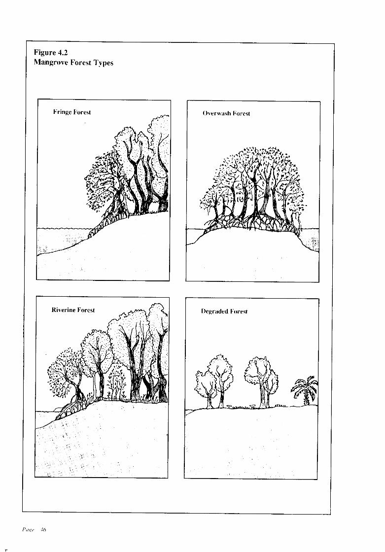
1'1
Figure 4.2Mangrove Forest Types
Fringe Forest
Riverine Forest
Poge 46
Overwash Forest
Degraded Forest
n
d) NATIONAL MANGROVECOMMITTEE
A National Mangrove Committee has been established in the Natural Resources, Energy andScience Authority (NARESA) of Sri Lanka asthe focal point to coordinate research and management of the island's mangrove ecosystems.The National Mangrove Committee is composedof represeptatives from the CCD and other governmental agencies and universities.
e) MANAGEMENT ISSUES
• Ensuring that exploitation of mangroves arecontained within the acceptable limits, commercial extraction should bediscouraged whileextraction for traditional use within acceptablelimits could be permitted. In this regard, grantofpermits by the Government Agents under theForest Ordinance needs to be reviewed. Sincefringing mangroves are indispensable becauseof their fisheries' nursery function as well asproviding a supply of detritus and nutrients, atotal prohibition ofmangrove extraction withina belt of specified dimension has to be implemented.
• Meeting demands for development in mangrove areas might involve confining development activity only to degraded mangrove forests. Such mangrove areas will have to bedefined taking into consideration functionaland social criteria in addition to biologicalcriteria.
• Regulation of activities that contribute to increased siltation, pollution, changes in salinityregime, and tidal patterns in the vicinity ofmangroves.
f) MANAGEMENT OBJECTIVES
The objectives for the managementofmangrovesare to preserve the mangroves as an importanthabitat for wildlife, a nursery for fish, a nutrienttrap, and to enable extraction at a sustainablelevel.
4.3.3 MANAGEMENT POLICIES FORMANGROVES
Policy 4.3.3.1 In considering proposed developments within or in the vicinity of mangroveswithin the Coastal Zone, the CCD will ensure thatimpacts of freshwater runoff, excessive siltation,oil pollution, and conversion of mangrove habitats are minimised.
Policy 4.3.3.2 The CCD will participate in theSri Lanka National Mangrove Committee.
Policy 4.3.3.3 In carrying out its managementresponsibilities for development activities within or adjacent to mangrove habitats within theCoastal Zone, the CCD will pay due regard to theguidelines developed by relevant national agenCIes.
SEAGRASS BEDS
a) DEFINITION
Seagrass beds are composed of rooted, seedbearing, marine plants (halophytes). They occurin shallow, nearshore coastal waters that aresheltered from high wave energy, and in estuariesand lagoons. The seagrasses, epiphytes and theabundant detritus found in seagrass beds togethercomprise a highly productive habitat that supports a large quantity ofcommercially importantorganisms.
b) NATURE AND SIGNIFICANCE
Seagrass beds are abundant along Sri Lanka'scoast, although their locations and extents havenot been precisely mapped and estimated. Theyform dense underwater meadows, the edges ofwhich may be glimpsed during low tide. Seagrassmeadows perform a number ofnatural functions.First, they provide reliefon an otherwise featureless substratum, allowing epiphytic organisms toobtain sites for attachment and providing nestinghabitat for numerous species of fish. They alsoprovide habitats for the endangered dugong andth,e protected green sea turtle. Seagrass bedssupply food to a wide variety of animals. Someherbivorous fish (e.g. parrot fishes) directlyconsume the leaves, while others, particularly
Page 47
juvenile fish, feed upon epiphytes, and still othersincluding some penaeid shrimp species feed upongrass detritus. l..-astly, seagrass binds sedimentand stabilizes it against erosion.
The major portion of marine fisheries production in SriLankais obtained from the nearshorecoastal waters along the northwestern and northeastern coasts. These are also the areas whereseagrass beds are most extensive. The linkagebetween seagrass beds and fisheries productionis direct and critical, but not quantified nor always recognized.
c) ACTIVITIES SUPPORTED
Non-extractive uses
Sediment stabilization: Dense seagrass foliagesharply decreases current speed at the watersediment inter-phase and prevents sediment displacement.
Science and education: Because of the accessibility of estuarine seagrass beds, both researchand university student projects are focussed onseagrass ecology.
Fishing: Seagrass beds along Sri Lanka's northwestern and northeastern coasts play an important role in supporting Sri Lanka's valuablenearshore coastal fisheries in this region. Some13,000 fishing craft use this region as a fishingground, using mostly bottom trawls and gillnets.The highest catch rate for demersal fishing recorded in Sri Lanka, 100 kilograms per hour, wasobtained in the sector north of the Mannar Peninsula where seagrass beds are most dense.
Extractive uses
Polychaete harvests: Polychaete worms whichare used as broodstock feed in commercial shrimphatcheries are harvested from selected seagrassbeds. The extent of such harvests are not known.
Direct harvests: A small scale direct use ofseagrass is for fodder at some locations in theMannar district.
d) MANAGEMENT ISSUES
tion. The following have been identified as important for ensuring sustainable yields.
• Regulation of trawling to ensure that the typesof gear used do not damage seagrass beds.
• Control of activities that affect estuarineseagrass beds, such as polychaete extractionand small mesh dragnet operations, to ensurethat their breeding and nursery habitat functions are not disrupted.
• Regulation ofdevelopment activities thatcouldresult in the release of sediment that couldsmother and destroy the vegetation.
e) MANAGEMENT OBJECTIVES
The objectives for the management of seagrassbeds are to preserve seagrass beds as fisherieshabitat and habitat for dugong and sea turtles.
4.3.4 MANAGEMENT POLICIES FORSEAGRASS BEDS
Policy 4.3.4.1 In considering proposed deyelopment in the vicinity of seagrass beds, the CCDwill ensure that physical alterations are prohibited, and excessive sedimentation or siltation,and introduction of nutrients or pesticides areminimised.
Policy 4.3.4.2 The CCD will identify a zoningscheme for utilization of seagrass beds that willenable fishing to co-exist with movements of thedugong and the green sea turtle.
SALT MARSHES
a) DEFINITION
Salt marshes consist ofherbaceous, salt resistantplants growing in sandy or muddy tidal flats inarid areas which are periodically inundated bysea water. Salt marshes are common characteristics of coastal areas in the temperate region andthey are generally replaced in the tropics bymangroves. Nevertheless, in some areas, tropicalversions of salt marshes occur.
b) NATURE AND SIGNIFICANCE
n
The major management issues related to seagrass Salt marshes in Sri Lanka mainly occur in regionsbeds stem from activities that destroythe vegeta- where the dry season is prolonged as in the north,
Page 48
T!
northwest, northeast and southeast. Whereas thesalt marshes in the northern regions occur mainlyon exposed tidal flats, in the south they occurlargely in the shelter of sand dunes.
Salt marsh vegetation in Sri Lanka typicallyoccurs as sparse, short growths interspersed withscrub mangroves. In the Mannar district wheretidal flats are more extensive, marsh vegetationcontains up to 56 species. In the vicinity ofM1JIldel Lake, there are salt marsh-mangroveassociations. One theory for this type of saltmarsh-mangrove association is suggested bychanges that have occurred in mangrove stands inthe Jaffna district. When the canopy is removedby fIrewood extractors, the soil becomes dehydrated and hypersaline, allowing salt marshvegetation to develop at the site.
The major natural functions of salt marshesare nutrient supply to nearshore coastal waters,provision of bird habitat, supply of seed fIsh forcoastal aquaculture and as a discharge area thatabsorb storm water runoff.
c) ACTIVITIES SUPPORTED
Salt marshes are not heavily utilized in Sri Lankaat the present time. However, in the future theyare likely to be the focus for activities whichrequire habitat conversion.
Non-extractive uses
Salt marshes support some tourism, bird watching, science and education activities. Birdwatching by Sri Lankans and by tourists usually occurson tidal flats that are associated with water bodieswhich serve as a habitat for migratory waterfowl.
Extractive uses
Grazing, waterfowl hunting and fIsh seed(milkfIsh) collection are also carried out in saltmarshes. Grazing on salt marsh pasture is arelatively small-scale traditional activity. Hunting of waterfowl, which is illegal in Sri Lanka,has intensifIed in recent years to meet the demand, reportedly from tourist hotels. Collectionof seed of milkfIsh from tidal pools situated insalt marshes in the Mannar District has beencontinuing since the 1960s.
Transformative uses
Since historical times, salt pans have been constructed on tidal flats with salt marsh vegetation.Such salt pans are situated in Hambantota, Trincomalee and Puttalam Districts. Shrimp aquaculture is a transformative use which is beingactively promoted at the present time and it islikely to expand. The majority of sites selectedfor aquaculture projects have been salt marshvegetation/scrub mangroves. Currently, this activity is limited to the Puttalam district. Dykeconstruction which impedes flow of storm waterrunoff is likely to increase the probability offlooding inhabited areas.
d) MANAGEMENT ISSUES
The salt marshes in Sri Lanka are a coastal habitatwhich can support development, and are currently viewed as preferred locations for salt pansand coastal aquaculture. However, the impact ofsuch habitat conversion must be carefully evaluated and the amount of habitat to be devoted to
such uses determined according to an integrateddevelopment plan. The adoption of proper siteselection criteria and the development and implementation of required mitigation measures isessential.
e) MANAGEMENT OBJECTIVES
• To ensure the maintainence of salt marshes asimportant waterfowl habitat, as a buffer whichprotects coastal settlements from flooding (bystorm water runoff and tidal surges) and wherethey help to protect an estuary or lagoon fromchemical pollution in runoff from land.
• To ensure sustainable multiple use of saltmarshes.
4.3.5 MANAGEMENT POLICIES FORSALT MARSHES
Policy 4.3.5.1 In considering developments inor adjacent to salt marshes, CCD will ensure thatthe development will not signifIcantly degradeimportant bird habitats or seed fIsh collectionsites or signifIcantly obstruct storm water runoff.
Policy 4.3.5.2 The CCD will support activities
Page 49
r
to map distribution and extents, clarify ownership, and identify types and scales of development that can be accommodated on particular saltmarsh areas in a manner harmonious with ecological and social needs.
Policy 4.3.5.3 The CCD will support researchthat will assist in identification and rehabilitationof particular sites by mangrove reforestation.
BARRIER BEACHES, SPITS AND DUNES
a) DEFINITION
Barrier beaches and spits: Barrier beaches areaccumulations ofunconsolidated sediment transported to shore by waves and moulded into a formthat lies across a body of water and isolates itfrom the sea (e.g. Koggala Lagoon). Spits areessentially incipient barrier beaches that projectfrom shore in the direction of dominant drift andare free at one end (e.g. the shoal that buildsseasonally at the mouth of Negombo Lagoon).
Dunes: Dunes are wind blown accumulations ofsand which are distinctive from adjacent landforms such as beaches and tidal flats. Althoughthey resemble beaches they differ mainly withrespect to absence of tidal effect. Dunes areunstable unless covered by vegetation.
b) NATURE AND SIGNIFICANCE
Barrier beaches and spits: Certain reaches ofSri Lanka's coastline consist of barrier beachesthat isolate lagoons and swamps from the sea, andspits that partially enclose estuaries. Some ofthese formations have extensive dunes associated with them as at Kalpitiya. Other barrierbeaches are free at both ends and form islands(e.g. Karaitivu). Barrier beaches predominatealong the southern and southwestern coasts whilespits are more common along the western andeastern coasts.
Sri Lanka's most prominent spits occuralongthe western and eastern coasts, forming in the direction of longshore drift. Most spits are unstable, regularly shifting position, and changingthe location of estuarine inlets. For instance, theinlet of Batticaloa has moved to its present posi-
Page 50
tion from a previous location 5 km south. Spitsthat obtrude into estuaries are especially unstable(e.g., the spit at the Kalu Ganga estuary). Someextensive spits (e.g. Kalpitiya) have been stabilized and are inhabited by relatively large populations.
Coast protection and sand supply are themajor natural functions of barrier beaches andspits (see Chapter 3). In addition, some segmentsof beaches serve as nesting areas for sea turtles(e.g. Kosgoda). The dynamic spits that form seasonally at estuarine inlets obstruct natural waterflow patterns, often resulting in the flooding oflow-lying lands (e.g. Kalu Ganga and Maha Oyaestuaries), and in decreased fishery productivity.For example, fishery yields at Koggala Lagoondeclined sharply after a spit expanded into abarrier beach and sealed off the inlet.
Dunes: Prominent sand dunes in Sri Lanka arefound along portions ofthe southern northeasternand northwestern coasts. Extensive dune systemsstretch between Mullaitivu and Point Pedro, andAmbakandawila, Kalpitiya, Kirinda and Sangamakande Points.
The formation and persistence of dunes depends on the delivery ofsand to the dune by windand retention of sand by moisture and vegetationcover. Removal of vegetation results in dunemigration as experienced in Manalkadu, PointPedro in 1950.
Dunes servt:( as protective barriers particularly during storm conditions. Lowering of thedune by mining or~ creating access to the beachdecreases their effectiveness as barriers (e.g.Uswetekeiyawa).
c) ACTIVITIES SUPPORTED
Barrier beaches and spits
Non-Extractive uses
Fishing communities traditionally use barrierbeaches and spits for beach landing of fishingcraft, drying of fish and gear, defecation andhousing. More recently, coastal tourism and recreation have emerged as prominent uses. In someinstances conflicts between the new and traditional uses of beaches have occurred.
Extractive/Transformative uses
Mining of beach sand, a major extractive use, isdiscussed in Chapter 3. Spits that form seasonallyat estuaries are breached (e.g. Maha Oya, KaluGanga) to prevent flooding. Such transformations need to be repeated annually. Other spitsare removed to facilitate recruitment of juvenileshrimp and fish to the estuary after a barrier forms(e.g. Kokkilai Lagoon).
Dunes
Transformative uses
Housing construction is expanding into dunes atseveral locations (e.g. Hambantota, Ambakandawila). Bothhouses and temples are constructedat the dune system at Point Pedro. Agricultureand grazing are traditional activities of someimportance in the dune habitat. Both activitiesresult in the removal of natural dune vegetationand thereby indirectly contribute to removal ofsand by wind.
Extractive uses
Sand mining for construction is the major extractive use of dunes, particularly at Point Pedro.Industrial mining ofdune sand is gaining importance in Hambantota.
d) MANAGEMENT ISSUES
Barrier beaches and spits
Erosion is the major issue for beach habitatmanagement (Chapter 3). In addition, barrierbeaches and spits are threatened by faecal pollution in areas where there are temporary or permanent human settlements or where hotel operators,are illegally discharging raw sewage/wastewater. Increased coastal development has also resulted in greatly reduced public access to beachesin several areas.
Dunes
Control of activities that contribute to destabilization of dunes is a major management issue.Destabilization of dunes occur because of unplanned construction activities and removal ofsand and vegetation.
e) MANAGEMENT OBJECTIVES
Barrier beaches, spits and dunes:
The major objectives for the management ofbarrier beaches, spits and dunes are:
• Tominimise human-caused erosion ofbeaches,spits and destabilization of dunes;
• To protect open space and aesthetic values forresidents and tourists (see Chapter 5);
• To minimise use conflicts between traditionaland new uses of beaches and dunes.
4.3.6 MANAGEMENT POLICIES FORBARRIER BEACHES, SPITS ANDDUNES
Policy 4.3.6.1 The CCD will support, promoteand implement activities related to managementof barrier beaches and spits in a manner that willbe harmonious with social needs and ecologicalfunctioning of brackish water bodies.
Policy 4.3.6.2 The CCD will support, promoteand implement activities that will be harmoniouswith dune stability.
Page 51
CHAPTER FIVE
Loss and Degradation ofArcheological, Historical andCultural Sites and Recreationaland Scenic Areas
5.1 FINDINGS
5.1.1 Nature of the Problem
Sri Lanka's Coastal Zone contains many anddiverse sites of archaeological, historical, andcultural significance. These sites provide valuable evidence of the pattern and progress of SriLankan culture and represent part of Sri Lanka'scommon heritage. Sri Lanka's Coastal Zone isalso a place of great scenic beauty. Coastal landscapes and seascapes form variegated vistas ofaesthetic beauty. Among these are picturesquebays, lagoons and coral reefs, wide sandy beaches,
sometimes with palm groves in the fringes, rockyterrain tumbling down to the beach. a few foci ofwater-trapped rock fissures functioning as seasonal blowholes, and wide salterns and lagoonsabounding in birdlife.
The cultural and scenic resources of SriLanka's Coastal Zone make it a focus for itscitizens' cultural and recreational activities. Thesesame resources support the nation's importanttourism industry. In 1985, which was a poor yearfor tourism, this industry generated earnings ofRupees 2,239 million and directly employed over23,000 individuals.
Pag(' 53
Archaeological, historical and cultural sites werecategorised as follows:
• Review of survey maps and other early mapsand illustrations;
• Field investigations. Site visits were not, however, made in the northern and eastern sectionsof the Coastal Zone from Puttalam to Kirinda.(clockwise), hence sites in this area still requirefield investigation.
5.1.3
Today, many of Sri Lanka's important archaeological, historical and cultural sites arethreatened with inappropriate development. Insome locations, important scenic areas are beingdegraded and public access to the shore obstructed. When archaeological or historical sitesare destroyed, they are lost forever. Problems ofloss and degradation result from both natural andhuman causes. Over time, structures exposed toweather deteriorate unless they are carefullyprotected. Unplanned and poorly planned development have degraded scenic areas, limited ac- A.cess to public places, and interfered with localfishing activities.
The Coast Conservation Act requires thatthe CCD Coastal Zone Management Plan should B.address .itself to the preservation of importantarchaeological, historical and cultural sites, aswell as the Coastal Zone's scenic beauty and C.important recreational areas. This will require theCCD to work in close cooperation with othergovernmental and non-governmental agenciesconcerned with the preservation of these re-
Monuments and sites of notable antiquity,historical associations, aesthetic value and/orthose which are the focal point of religiousactivities; (high priority)Monuments and sites older than 50 yearswhich are also of some added historical,aesthetic and/or popularity value;Religious monuments of recent origin, without any special aesthetic or popularity value.
SITES OF ARCHAEOLOGICALSIGNIFICANCE
n
sources.
5.1.2 Identification and Characterization ofSri Lanka's Important Archaeological, Historical and Cultural Sites, andScenic and Recreational Areas
The first requirement for the preservation ofimportant sites is their identification. In 1985,the CCD commissioned an inventory (CCDInternal Report No. 9, 1986: Inventory of PlacesofReligious and Cultural Significance and Areasof Scenic and Recreational Value I {KalpitiyaKirinda} and CCDlnternal Report No. 10, 1986:Inventory of Places of Religious and CulturalSignificance and Areas of Scenic and Recreational Value II {north and east coasts}), of thefollowing types of sites within the Coastal Zone:
• Places of archaeological, historical and cultural significance;
• Areas of scenic and recreational value.
Information for the inventory was collected using the following sources:
• A library survey;• Interviews with knowledgeable individuals;
Page 54
a) Definition
Sites of archaeological significance are all ancient sites, buildings and other structures, artifacts and other cultural sites datable to the year1850 or earlier, which are already declared asarchaeological sites and monuments, or are eligible for inclusion in the above.
b) Nature and Significance
The inventory identifies 26 sites ofpure archaeological value and 65 sites which also have historical and/or cultural significance as high priorityarchaeological sites. Of these sites, those considered more important from the point ofview ofageor current public focus and aesthetic and popularity value are listed in Table 5.1 and their locationsshown on Figure 5.1. Of these 91 sites, only 14are declared sites of the Archaeology Department.
The sites and monuments of pure archaeological value include pre-historic sites (Ussangoda, Bundala), and protohistoric sites(Pomparippu). In the second category, broadlyclassified as historic sites, are such entities asforts (e.g. Kalpitiya, Negombo, Mannar, etc.),
ports (e.g. Kalpitiya, Negombo, Mannar), mostof the Buddhist monastic sites (e.g. Kirinda,Hudumahavihara) and some churches (e.g. GalleFort Dutch Church).
Pre-historic sites such as that of Ussangodaare undisturbed sites with much potential. Testexcavations at the Bundala site have revealedvery valuable data on pre-historic man in SriLanka, dating back to about 27,000 years. Theprotohistoric (Megalithic) sites which haveyielded black and redware pottery and burials(urn and cist) can be dated between the 3rdcentury B.C. and 3rdcentury A.D. Ofthese sites,several excavations have been conducted atPomparippu, while some others have been subjected to surface examination only. The datayielded so far, and any future findings, will bemost significant for the study of this formativephase in Sri Lankan history. Among the historicsites, the ancient ports and forts reveal information on secular activities such as trade and commerce, and internal and external political relations in the past. The religious monuments suchas ancient Buddhist monasteries, Portuguese andDutch churches and Hindu shrines located withinthe coastal belt provide details of their respectivereligious, architectural and artistic traditions asmanifested in Sri Lanka through the ages.
5.1.4 HISTORICAL SITES ANDMONUMENTS
a) Definition
Historical sites and monuments are all ancientsites, buildings and other structures, artifacts andother cultural property which are more than 50years old. These include all archaeological reserves and sites which are eligible to be declaredas reserves but still are functional.
b) Nature and Significance
The inventory identifies 253 historical sites andmonuments in the Coastal Zone. Of these, 171are of type A, 72 are of type B and 10 are of typeC. (Types A, B, and C are described in 5.1.2).
. The sites considered more important from thepoint of view of age, current public focus andaesthetic and popularity value are indicated in
6-
Table 5.1 and Figure 5.1. These include suchedifices as buddhist monasteries, hindu kovils,(Muthumariamman kovil, Vishnu kovil, Udappuwa), devales (Seenigama), christian and catholic churches (Dutchchurch atKalpitiya, St. Anne'sTalawila), forts (Kalpitiya, Galle), secular buildings (Whist Bungalow, Mutwal, Closenberg,Galle), harbours (Colombo, Galle, Batticaloa),shipwrecks (Akurala, Galle and Trincomalee),esplanades and parks (Gordon Gardens, GalleFace), lakes (Beira Lake), air bases (Kogga1a)and resthouses (Tangalle).
Each site or edifice possesses its own intrinsic qualities and values, and requires recognitionin planning development activities in its vicinity.The importance ofarchaeological sites and somehistorical sites and monuments has been discussed. In addition, many buildings included inthis category are of national importance for theirarchitectural and artistic qualities. For instance,buddhist shrines at Telwatta, Batigama,Samudragiri Vihara, Rekawa, etc., depict significant maritime artistic traditions of the Kandyanstyle in their murals. The architectural design ofthe cluster of stupas at Veheranamaya is unique.Some of the churches, such as, St. Anne's atTalawila, dates from about the 17th century. Thelocation of the catholic church and hindu shrinesin close proximity at Udappuwa, testifies to theclose association and togetherness that existedbetween followers ofdifferent faiths in SriLanka.
The Fort at Galle is a living town which displays old Dutch character and architectural styleto this day.Some of the secular buildings inColombo (and other cities), such as, President'sHouse and Parliament building are significantvestiges of Colonial architecture. The Dutchhospital in Colombo Fort is a unique piece ofarchitecture and is the finest and only example ofits kind the world over. Shipwrecks, though notvery old, are of significant historical value. SriLanka's esplanades and parks are of recreationalas well as of historical value.
5.1.5 SITES AND MONUMENTS OFCULTURAL SIGNIFICANCE
a) Definition
All archaeological and historical sites and monu-
Page 55
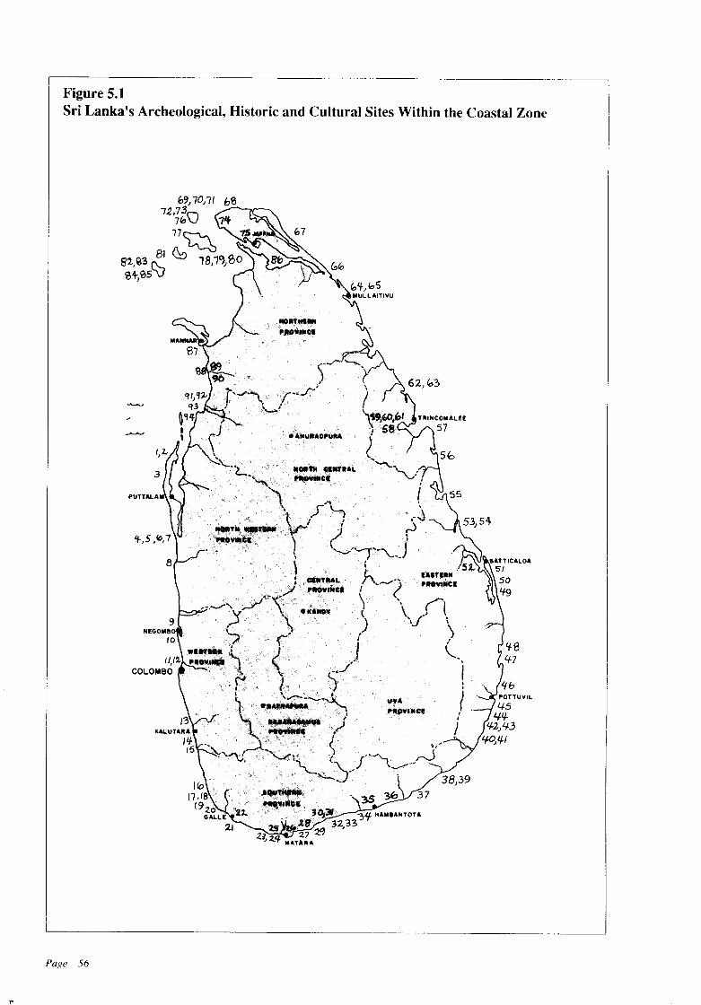
Figure 5.1Sri Lanka's Archeological, Historic and Cultural Sites Within the Coastal Zone
3
!f84-7
37
"
Page 56
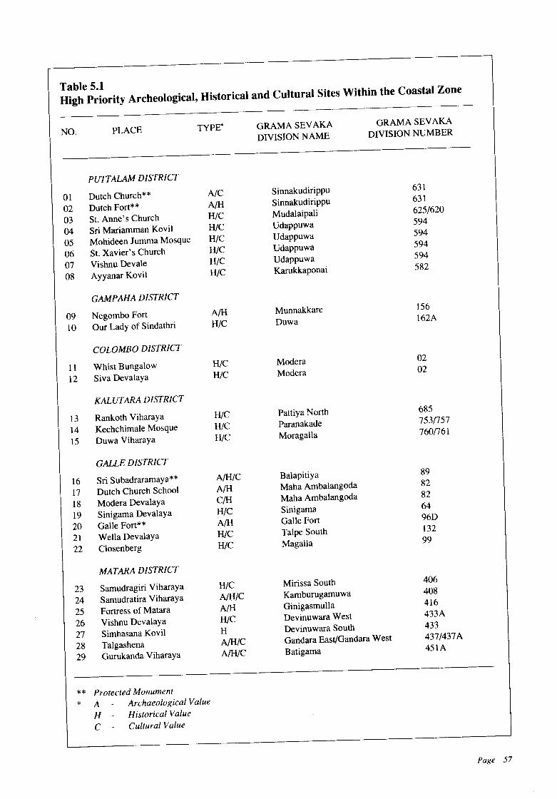
Table 5.1High Priority Archeological, Historical and Cultural Sites Within the Coastal Zone
NO. PLACE TYPE" GRAMA SEVAKA
DIVISION NAME
GRAMA SEVAKA
DIVISION NUMBER
PUTTALAM DISTRICT
01 Dutch Church** AIC Sinnakudirippu 631
02 Dutch Fort** A/H Sinnakudirippu 631
03 St. Anne's Church HIC Mudalaipali 625/620
04 Sri Mariamman Kovil HIC Udappuwa 594
05 Mohideen Jumma Mosque HIC Udappuwa 594
06 St. Xavier's Church HIC Udappuwa 594
07 Vishnu Devale HIC Udappuwa 594
08 Ayyanar Kovil HIC Karukkaponai 582
GAMPAHA DISTRICT
09 Negombo Fort A/H Munnakkare 156
10 Our Lady of Sindathri HIC Duwa 162A
COLOMBO DISTRICT
11 Whist Bungalow HIC Modera 02
12 Siva Devalaya HIC Modera 02
KALUTARA DISTRICT
13 Rankoth Viharaya HIC Pattiya North 685
14 Kechchimale Mosque HIC Paranakade 753/757
15 Duwa Viharaya HIC Moragalla 760/761
GALLE DISTRICT
16 Sri Subadraramaya** A/H/C Balapitiya 89
17 Dutch Church School A!H Maha Ambalangoda 82
18 Modera Devalaya C/H Maha Ambalangoda 82
19 Sinigama Devalaya HIC Sinigama 64
20 Galle Fort** A/H Galle Fort 96D
21 Wella Devalaya HIC Talpe South 132
22 Closenberg HIC Magalla 99
MATARA DISTRICT
23 Sarnudragiri Viharaya HIC Mirissa South 406
24 Samudratira Viharaya A!HIC Kamburugarnuwa 408
25 Fortress of Matara A/H Ginigasmulla 416
26 Vishnu Devalaya HlC Devinuwara West 433A
27 Simhasana Kovil H Devinuwara South 433
28 Talgashena A/H/C Gandara East/Gandara West 437/437A
29 Gurukanda Viharaya A/H/C Batigama 451A
** Protected Monument
* A Archaeological Value
H - Historical Value
C Cultural Value
Page 57
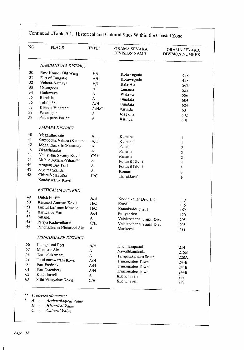
n
Continued...Table 5.L.Historical and Cultural Sites Within the Coastal Zone
-------NO. PLACE TYPE' GRAMASEVAKA GRAMA SEVAKA
DIVISION NAME DIVISION NUMBER
HAMBANTOTA DISTRICT
30 Rest House (Old Wing) H/C Kotuwegoda 45831 Fort of Tangalle A/H Kotuwegoda 45832 Vehera-Namaya HlC Bata-Ate 56233 Ussangoda A Lunama 55534 Godawaya A Walawa 58635 Bundala A Bundala 60436 Telulla** A/H Bundala 60437 Kirinda Vihare** A/H/C Kirinda 60138 Patanagala A Magama 60239 Palatupana Fort** A Kirinda 601
AMPARA DISTRICT
40 Megalithic site A Kumana I41 Samuddha Vihara (Kumana NC Kumana 142 Megalithic site (Panama) A Panama 243 Okandamalai A Panama 244 Velayutha Swamy Kovil e/H Panama 245 Muhudu-Maha-Vihara** A Pottuvil Div. I 346 Arugam Bay Port A Pottuvil Div. 1 347 Sagamankanda A Komari <)48 Chitra Velayutha HlC Thirukkovil 10
Kandaswamy Kovil
BAITICALOA DISTRICT
49 Dutch Fort** NH Koddaikallar Div. 1,2 11350 Kannaki Amman Kovil HIe Eruvil 11551 Jamiul Lafireen Mosque HlC Katankuddi Div. 1 16752 Batticaloa Fort NH Puliyantivu 17953 Sittandi A Valaichchenai Tamil Div. 20554 Periya Kaduveikarai C/H Valaichchenai Tamil Div. 20555 Panchankemi Historical Site A Mankemi 211
TRINCOMALEE DISTRICT
56 IIlangaturai Port NH Ichchilampattai 21457 Monastic Site A Nawathkanikadu 215B58 Tampalakamam A Tampalakamam South 228A59 Tirukoneswaram Kovil NH Trincomalee Town 244B60 Fort Fredrick NH Trincomalee Town 244B61 Fort Ostenberg A/H Trincomalee Town 244B62 Kuchchaveli A Kuchchaveli 23963 Sithi Vinayakar Kovil C/H Kuchchaveli 239
** Protected Monument* A Archaeological Value
H - Historical ValueC Cultural Value
Page 58
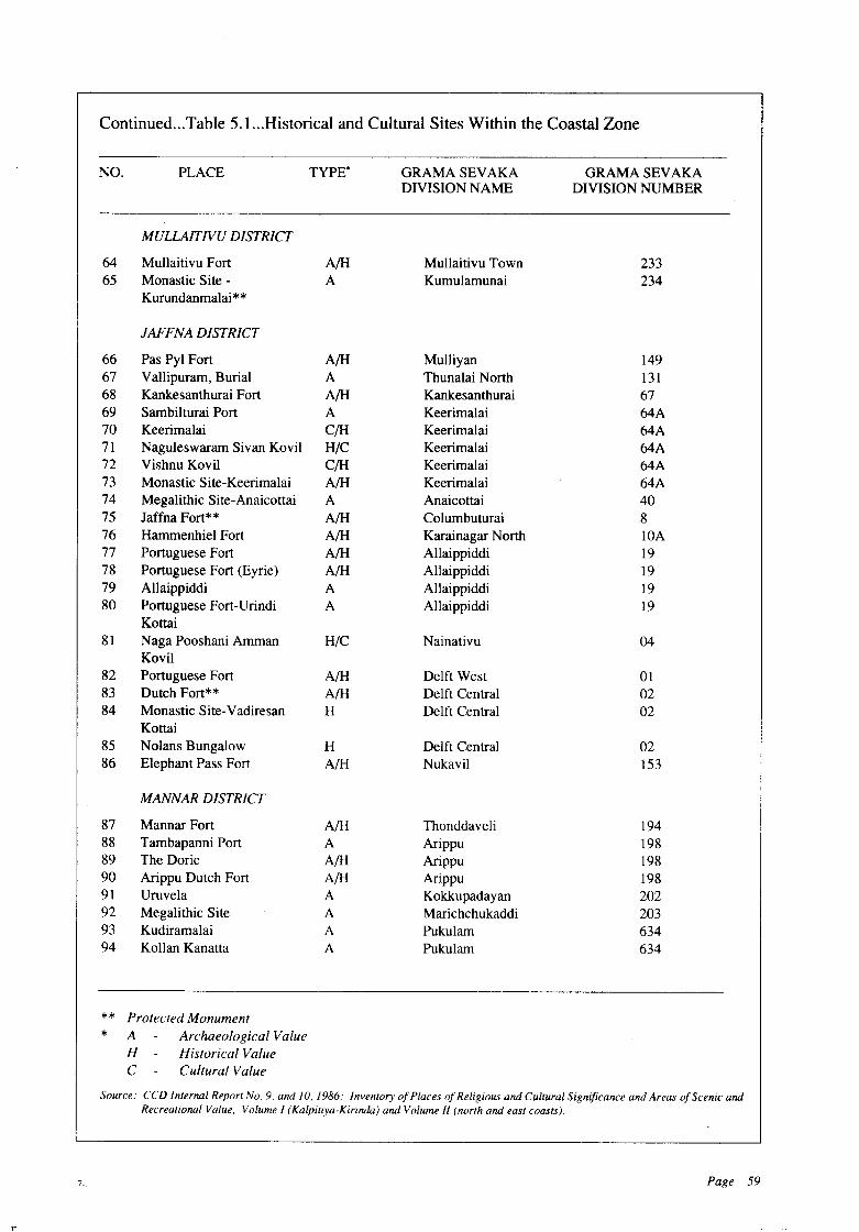
*
7_
Continued...Table 5.1 ...Historical and Cultural Sites Within the Coastal Zone
NO. PLACE TYPE" GRAMA SEVAKA GRAMA SEVAKADIVISION NAME DIVISION NUMBER
MULLAITNU DISTRICT
64 Mullaitivu Fort A/H Mullaitivu Town 23365 Monastic Site - A Kumulamunai 234
Kurundanmalai**
JAFFNA DISTRICT
66 Pas Pyl Fort A/H Mulliyan 14967 Vallipuram, Burial A Thunalai North 13168 Kankesanthurai Fort A/H Kankesanthurai 6769 Sambilturai Port A Keerimalai 64A70 Keerimalai C/H Keerimalai 64A71 Naguleswaram Sivan Kovil H/C Keerimalai 64A72 Vishnu Kovil C/H Keerimalai 64A73 Monastic Site-Keerimalai A/H Keerimalai 64A74 Megalithic Site-Anaicottai A Anaicottai 4075 Jaffna Fort** A/H Columbuturai 876 Hammenhiel Fort A/H Karainagar North lOA77 Portuguese Fort A/H Allaippiddi 1978 Portuguese Fort (Eyrie) A/H Allaippiddi 1979 Allaippiddi A Allaippiddi 1980 Portuguese Fort-Urindi A Allaippiddi 19
Kottai81 Naga Pooshani Amman H/C Nainativu 04
Kovil82 Portuguese Fort A/H Delft West 0183 Dutch Fort** A/H Delft Central 0284 Monastic Site-Vadiresan H Delft Central 02
Kottai85 Nolans Bungalow H Delft Central 0286 Elephant Pass Fort A/H Nukavil 153
MANNAR DISTRICT
87 Mannar Fort A/H Thonddaveli 19488 Tambapanni Port A Arippu 19889 The Doric A/H Arippu 19890 Arippu Dutch Fort A/H Arippu 19891 Uruvela A Kokkupadayan 20292 Megalithic Site A Marichchukaddi 20393 Kudiramalai A Pukulam 63494 Kollan Kanatta A Pukulam 634
** Protected MonumentA Archaeological ValueH Historical ValueC Cultural Value
Source: CCD Internal Report NO.9. and 10, 1986: Inventory ofPlaces ofReligious and Cultural Significance and Areas of Scenic andRecreational Value, Volume I (Kalpitiya-Kirinda) and Volume /I (north and east coasts).
Page 59
ments are by definition deemed to be culturalsites as well. Places where rituals or otherculturalevents are enacted, are also considered as sites ofcultural significance.
b) Nature and Significance
The inventory (see 5.1.2) identifies 253 sites andmonuments of cultural significance, 34 of whichare categorised as high priority sites. Of thesesites, those considered more important from thepoint of view of age, current public focus andaesthetic and popularity value are indicated inTable 5.1 and Figure 5.1. All of these sites aretied to Sri Lanka's various religious communities.
The numerous statues (Suruwam) of christian saints and buddhist devales dedicated to folkdeities like 'Devol Deviyo' are designated cultural sites. These edifices have been installed byfisherfolk for their rituals and vow-making, entreating the deities for safe return from the highseas. All catholic churches, ancient and modem,hold annual feasts which draw large crowds. St.Anne's Talawila, Our Lady of Sindrattri, Ouwa(Passion Play), St. Sebastian's Negombo, arefamous centers of worship, all situated by thebeach. The festivals such as, the Passion Play, areclosely associated with the sea. The hindu festivals connected with water-cutting rituals are alsoassociated with the sea and at locations such as,Udappuwa (Muthumariamman kovil, Vishnukovil).
5.1.6 SCENIC AND RECREATIONALAREAS
a) Definition
Scenic areas: Scenic areas in the coastal beltconstitute places that provide aesthetically appealing views of the beach, with uninterruptedvistas of seascape and landscape.
Recreational areas: Natural coastal areas aretraditionally used both by Sri Lankans and foreign visitors for activities such as swimming,diving, surfing, boating, sports fishing, leisurewalks, bird watching and relaxation.
Page 60
b) Nature and Significance
The inventory (see 5.1.2) records 89 recreationaland scenic areas situated within the Co~tal Zone.Most of these are located along the western,southwestern, southern and the eastern coast(Table 5.2 and Figure 5.2). Sri Lanka has manyfine beaches, most of them are eminently suitablefor recreation. In addition, the wide sandy beacheswith waves gushing and rolling in, provide uninterrupted picturesque vistas. These scenic vistasstill remain in good stead except for a few places,such as, Hikkaduwa, Negombo, Arugam Bay andKalkudah, where overdevelopment has occurred.Sri Lanka's tourism industry is centered aroundits scenic recreational beaches with 75.2 percentof Sri Lanka's graded hotels and 80.8 percent ofhotel rooms located along the coast (Table 5.3).
Whilst many of Sri Lanka's important scenic and recreational areas remain pristine, othershave been degraded. For example, beaches in theMount Lavinia to Dehiwela area and atHikkaduwa are littered with garbage, and sewerpipes carrying human wastes empty directly ontothe beach. In Mawella Lagoon and along the Tangalle coasts, coconut husk-retting pits pollute thewater. In some instances, the very quality of theresources, which made them significant, havebeen degraded due to incompatible uses and overexploitation. For example, coral mining for thelime industry constitutes a major threat to the seabeach and coral reefs along the southwestern andsouthern coasts. This together with unplannedtourism development are major factors in the deterioration of the beauty of the beach inHikkaduwa.
5.2 MANAGEMENT OBJECTIVES ANDPOLICIES
OBJECTIVE 5.2.1
It is the objective of the CCO to, within theCoastal Zone, preserve and protect Sri Lanka'ssignificant archaeological, historical and culturalsites and areas of scenic beauty.
Policy 5.2.1.1 Preservation of Sri Lanka's significant archaeological, historical and cultural
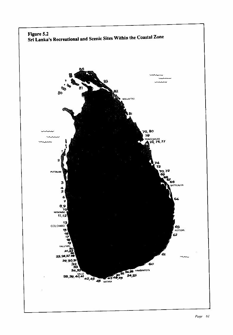
Figure S.2Sri Lanka's Recreational and Scenic Sites Within the Coastal Zone
2
PUTTAI.AM
13COLOMBO
15161718'f9
KALUTARA20
.2f.2~
25.'».21
29.~o.~
a2S
a.4.5GAlLE
98.39.4C.M....::1.+.3~
'14-73
70.7269
686766
BATTlCALOA
Page 61
Table 5.2Scenic and Recreational Sites Within the Coastal Zone
PLACE TYPE· GRAMA SEVAKADIVISION NAME
GRAMA SEVAKADIVISION NUMBER
ZONE 1(Kalpitiya-Chilaw»
I. Kandakuliya SIR Kuringipitti 6292. Talawila Beach SIR Mudalaipali 625/6203. Udappuwa Sand Spit S Udappuwa 5944. Karukkuponae Beach SIR Karukkuponae 582
ZONE 2(Chilaw-Negombo)
5. Chilaw Beach R Sea Beach (Chilaw) 5776. Teppanpola Beach R/S Marawila 5127. Wennappuwa Beach R Ulhitiyawa 4928. Waikkal Beach R/S Sindrathriya 4819. Lewis Place Beach R Ettukala/Wellaweediya 73/15810. Negombo Beach R Munnakkara 156
ZONE 3(Negombo-Colombo)
II. Talahena Beach R Talahena 16312. Kepungoda Beach SIR Kepungoda 163A13. Uswetakeiyawa Beach R Uswetakeiyawa 167
ZONE 4(Colombo-Panadura)
14. Galle Face Green R/S Slave Island 2115. Wellawatta-Mt. Lavinia R Wellawatta (S) 47/540/541
DehiwelaMt. Lavinia
ZONE 5(Pandura Bentota)
16. Panadura Beach R Pattiya (N/S) 685/68617. Wadduwa-Talpitiya Beach R/S Talpitiya 697/699
Wadduwa(W)18. Abrew Road Beach- R Kalutara (N) 717
Nagas-Handiya19. Kalutara Sandspit S Kalutara (N) 71720. MaggonaBay S Maggona(W) 7422I. Polkotuwa Beach S Polkotuwa 74822. Kechchimalai Mosque Area SIR Paranakade 753n5723. Moragalla Beach R Moragalla 760n61
ZONE 6(Bentota-Galle)
24. Bentota Spit & Estuary SIR Pahurumulla Div.l25 Godagala-Induruwa Beach SIR Angagoda 2/8
Yalegama
* S - Scenic Value R - Recreational Value
Page 62
Continued...Table,5.2...Scenic and Recreational Sites Within the Coastal Zone
PLACE TYPE' GRAMASEVAKA GRAMA SEVAKADIVISION NAME DIVISION NUMBER
26. Aturuwella Beach SIR Yalegama 827. Kaikawala/Naya-Handu- SIR Kaikawala 9
Gala Beach28. Babungala-Arangala Beach SIR Induruwa 1029. Kosgoda Sand Spit SIR Nape 1630. Amba1angoda Beach SIR Maha Ambalangoda 8231. Akurala Beach R Akurala 7632. Hikkaduwa Beach & R/S Wewala/Waulagoda 57/58
Coral Gardens33. Patuwatha-Narigama Beach R Narigama, Thiranagama 56/54/53
PatuwathaZONE 7(Galle-Dondra)
34. Galle Fort SIR Galle Fort 96D35. C10senberg S Magana 9936. Rumassala Headland S Unawatuna West 13737. Unawatuna Bay SIR Unawatuna (E-W), Talpe (S) 138/132/13738. Koggala Beach R Koggala 144A39. Deva1e Kanda S Ahangama East 15640. Yakkinnige Duwa (Island) S Ahangama East 15641. Kapparatota Bay S Kapparatota 38642. Weligama Bay SIR Galbokka, Mahaweediya 385/382/38243. Polwatumodera Beach SIR Polwatumodera 30844. Mirissa Bay SIR Mirissa South 40645. Polhena Beach R Polhena 41246. Ginigasmulla Beach SIR Ginigasmulla 416
ZONE 8(Dondra-Kirinda)
47. Dondra Light House Area S Devinuwara South 43348. Talalla Beach R Talalla South 43849. Naigalkanda-Dickwella R Batigama 451/452
Beach50. Kudawella Blow Hole S Kudawella West 466A51. Sinimodera (Mawella Bay) SIR Sinimodera 46852. Pallikudawa Beach SIR Unakuruwa 46953. Paraiwella Beach R Kotuwegoda 45854. Sitaraka1a Blow Hole R Kotuwegoda 45855. Rekawa Lagoon & Bay S Rekawa 46356. Kalametiya Lagoon & Bay SIR Hatagala 56357. Ussangoda S Lunama 55558. Karagam Lewaya S Walawa 58659. Hambantota Beach SIR Hambantota 584
ZONE 9(Kirinda-Banicaloa)
60. Kirinda Headland S Kirinda 60161. Yala National Park SIR Kirinda, Kumana 601/1
* S - Scenic Value R - Recreational Value
Page 63
Continued...Table 5.2...Scenic and Recreational Sites Within the Coastal Zone
PLACE TYPE' GRAMA SEVAKA GRAMA SEVAKADIVISION NAME DIVISION NUMBER
62. Panama Beach R Panama 263. Arugam Bay Beach SIR Potuvil 364. Kalmunai Beach R Kalmunai T.e. 6165. Punnaikudah Bay R Eravur 192 Div. 366. Palaiyadithona Beach R Chanthiveli 200
ZONE 10(Batticaloa-Foul Point)
67. Kiran Beach R Kiran 20368. Kalkudah Bay SIR Kalkudah 20469. Passikudah Bay SIR Kalkudah 20470. Valachchenai Estuary S Valachchenai (T) 20571. Thenadi Bay-Elephant Point S Valachchenai (T) 20572. Irrichchal Island S Mankemi 21173. Sallativu Island S Mankemi 21174. Vakarai Sand Spit & SIR Vakarai 212
Lagoon
ZONE 11(Foul Point-Chempionpattu)
75. Clappenberg Hill S Vellaimanal 22976. Trincomalee Harbour Area SIR Trincomalee Town 244/244A/244B77. Trincomalee Beach Road R Trincomalee Town 244B78. Nilaveli Beach R Kumpurupiddi 240/241/242
NilaveliSampaltivu
79. Red Rock Beach SIR Kumpurupiddi 24080. Pirates Cove R Kuchchaveli 239/23781. Kokkilai Lagoon S Kokkilai 225
ZONE 12(Chemionpattu-Mannar)
82. Chundikulam Sanctuary S Chundikulam Mulliyan 141/14983. Manalkadu Sand Dunes S Kudattanai-Karaiyur 14284. Senthankulam Beach SIR Myliddy Coast 72A85. Casuarina Beach SIR Karainagar North lOA86. Castle Beach SIR Delft Central 287. Kalmunai Point SIR Kavutharimunai 17288. Toddakkadu (Mannar Beach) SIR Thoddakkadu 189A89. Wilpattu National Park SIR Marichchukaddi 203
Pukulam 634Pomparippu 635
* S - Scenic Value R - Recreational Value
n
Source: CCD Internal Report No.9. and 10. 1986: Inventory of Places ofReligious and Cultural Significance and Areas oj'Scenicand Reerational, Value I (Kalpitiya-Kirinda) and Value If (north and east coasts).
sites and areas of scenic beauty in the Coastal
Zone is a high priority of the CCD.
Policy 5.2.1.2 The CCD will only permit de
velopment in the vicinity of designated high
priority archaeological sites when it follows
Archaeology Department guidelines forthe pres
ervation of archaeological sites. These guide
lines prohibit development within 200 m of the
designated sites. High priority archaeological
sites are listed in Table 5.1. Additional sites may
be included by the CCD from time to time.
Policy 5.2.1.3 The CCD shall require modifi
cation of, or shall prohibit, proposed develop
ments within the Coastal Zone where it finds a
reasonable probability of adverse impacts on
important archaeological, historical, cultural sites
and scenic areas. Adverse impacts are those which
can reasonably be expected to diminish or de
stroy those qualities of the site that make it
significant.
Policy 5.2.1.4 The CCD will cooperate with
the Archaeology Department and other relevant
governmental andnon-governmental agencies to
develop protection and preservation plans for
archaeological, historical and cultural sites, and
significant scenic areas.
Table 5.3 IGraded Hotel Accommodations-
1986 Second Quarter
Policy 5.2.1.5 It is the policy of the CCD to
promote awareness ofthe nature and significance
of coastal archaeological, historical and cultural
sites, and their scenic beauty.
OBJECTIVE 5.2.2
It is the objective of the CCD to maintain the
physical and cultural resources upon which high
quality recreation and the country's tourism in
dustry are based.
Policy 5.2.2.1 The CCD will permit develop
ment of tourist hotels within the Coastal Zone in
the locations and in accordance with the guide
lines cooperatively developed by the CCD, the
Ceylon Tourist Board, and the Urban Develop
ment Authority.
Policy 5.2.2.2 The CCD will require that pub
lic access is not impeded by recreational/tourist
developments.
Policy 5.2.2.3 The CCD will cooperate with
other governmental and non-governmental agen
cies in designating, planning for, and managing
coastal and recreational areas, and coastal and
marine parks.
Region No. of Hotels No. of Rooms
Colombo City 22 2,611
Greater Colombo 24 1,547
South Coast 46 3.439
East Coast 2 21
TOTAL INCOASTAL ZONE 94 7,688
Other Regions II \,821
GRAND TOTAL 125 9,509
Percent in Coastal Areas 75.2 80.8
ISource:Ceylon Tourist Board Monthly Bulletin on the PO:f{mll-
Ialief of the Tourism Sector, June 1986..-J
Page 65
CHAPTER SIX
Towards Better Managementof Coastal Resources
6.1 BACKGROUND
The Coastal Zone Management Plan presented inthis document is a major step forward in themanagement of Sri Lanka's Coastal Zone. Itprovides a framework for the formulation andimplementation of a comprehensive CoastalResources Management Programme. Much hasbeen learned in the five year process of developing this Plan and regulating development activities in the Coastal Zone through the interimpermit procedure as specified in the Coast Conservation Act.
At the time the Coast Conservation Act wasdrafted, the primary concern was coast erosion
8-
and the management of human activities contributing to same. The need for management ofcoastal resources was of less concern. This isreflected in the present provisions of the CoastConservation Act. The CCD, therefore, decidedto formulate a comprehensive and integratedplan for coastal resources management adoptingan incremental approach to plan development.This chapter identifies major constraints whichmake planning and implementation of an integrated management programme for coastal resources difficult. It also proposes correctivemeasures to be taken for rational management ofcoastal resources. They include legislative andadministrative changes, and investment in research and education.
6.2 PROPOSED REVISIONS TO THELEGAL FRAMEWORK
6.2.1 The Coastal Zone
The Coastal Zone as currently defined does notinclude most coastal habitats in their entirety,(i.e. only portions of lagoons and estuaries fallwithin the Coastal Zone). This means that insome parts of an estuary or stand of mangroves,development activities are regulated whereas inother parts they are not. Consequently, the CCDis restricted to management of activities withinthe portions of coastal features falling into thedefined Coastal Zone and not to the managementof a system as a whole. The definition of theCoastal Zone should be amended to read asfollows:
The Coastal Zone means that area lyingwithin a limit of three hundred meters landwardsof the Mean High Water Line and a limit of twokilometers seawards of the Mean Low Water lineand in the case of rivers, streams, lagoons, or anyother body of water connected to the sea eitherpermanently orperiodically, the landward boundary shall extend to a limit of two kilometersmeasured perpendicular to the straight baselinedrawn between the natural entrance point thereofand shall include riparian land lying within athree hundred meter parallel to the maximumflood water level of such rivers, streams andlagoons or any other body of water so connectedto the sea. It shall also include any contiguousareas of land or water as may be specified by theMinister in charge of the subject of coast conservation.
6.2.2 Development Activity
The present definition of development activityfocuses primarily on activities likely to alter thephysical nature of the Coastal Zone. Many activities that do not directly alter the physicalnature of the Coastal Zone could have severeadverse impacts on the environmental quality ofthe Coastal Zone. Hence, the definition of development activity needs to be amended to alsocover activities that change or adversely effectthe environmental quality of the Coastal Zone.
Page 68
6.2.3 Punitive Action Relating toUnauthorized Structures
The Act provides authority for the Director of theCCD to demolish unauthorized structures. Itdoes not provide the Director with authority totake any steps other than demolition of the entirestructure. In cases where the demolition of theentire structure is not necessary, provision shouldbe made to enable the Director to specify modifications including the demolition of portions ofthe structure in order to regularize such unauthorized constructions.
Provisions should also be made to enablethe Director to order the suspension or termination of utility services such as electricity andwater supply to unauthorized structures. Suchdeterrent action would force the developer tocomply expeditiously with an order made by theDirector.
6.2.4 Acquisition of Land within theCoastal Zone
The Act does not contain provision whereby theDirector could acquire land within the CoastalZone. The effects of implementing setbacks andother regulatory measures may reduce the valueof privately owned blocks of land or render themvalueless for development purposes. There arealso State-owned lands in the coastal front, whichare not effectively used by the State agencies thatpresently own them. The inclusion of provisionsin the Act enabling the Director to acquire landand/or for vesting of State-owned land in theDirector would facilitate better management ofsuch land.
6.3 PROPOSED REVISIONS TO THEADMINISTRATIVE FRAMEWORK
6.3.1 Functions of the CCD
The CCD as presently constituted is chargedwith the responsibility for coast protection andcoastal zone management. The magnitude of thecoast erosion problem more often than not tendsto obscure the CCD's responsibility for coastalzone management. There is a lack of awareness
n
amongst governmental agencies and coastaldwellers that coast erosion is primarily a naturalphenomenon and it is not possible either in practical or economic terms to 'hold the line' againstthe sea along the entire coastline of Sri Lanka.The fact that the financial investments for coastprotection are far greater than those on coastalmanagement tends to reduce the attention paid tothe latter programme in terms of allocation ofresources. In terms of returns from these investments, the benefits from coastal zone management though not immediately visible, far outweigh those from coast protection.
In the present context, it is not possible todivest the CCD of its responsibility for coastprotection. There is, however, the need for a shiftof emphasis from coast protection to erosionmanagement. The CCD Master Plan for CoastErosion Management is one step in that direction.The need to plan future development with arealistic appreciation of the erosion potential ofrespective coastal reaches must gain acceptanceif the present level of investment on coastal protection is to be reduced. There is also the need tostrengthen the capability of the CCD in coastalzone management, and over a phased period oftime, to divest it of the responsibility for construction of protective structures. The CCD'sprimary role should be in planning and management.
6.3.2 Devolution of Functions
The two major programmes implemented by theCCD are the Coastal Erosion Management Programme and the Coastal Resources ManagementProgramme. Funds for these two programmes areallocated in the government budgets to the CCDand the Director of CCD is held accountable fordisbursement of these funds. The formulationand the implementation of the programmes aredone currently by the CCD. There is some consultation with the district political and administrative authorities and the concerned non-governmental agencies. In the main, however, decision making is done by the CCD.
Inadequacy of involvement and participation by the beneficiaries of the programmes andthe district political and administrative authorities leads to a lack of understanding of the pur-
poses ofthe programmes and to resentment whencertain restrictions are imposed on developmentactivity.
There is provision in the Coast Conservation Act for delegation of the powers of theDirector to the Government Agents of the districts. However, such delegation without ensuring that adequate expertise is available at thelocal level will be a futile exercise. It is, therefore,necessary that the engineeringand planningcadresof the CCD are strengthened to make it possiblefor the CCD to post specialist officers to thedistricts to upgrade their capacity in management.
It is further proposed that these two programmes be de-centralized to enable greaterparticipation by the districts in planning andimplementation of the programmes. Financialprovision could be made in the district budgetsfor expenditures connected with planning andimplementation of the programmes. AllocationofCentral Government funds, preferably, shouldbe supported by contributions from district revenues. With the implementation of the ProvincialCouncil system it will be possible to raise localfunds to meet part of the costs of management.
6.4 THE FINANCIAL FRAMEWORK
6.4.1 Programmes/Activities to beFinanced
The implementation of the Coastal Zone Management Plan would require expenditure ofmoneys for the following programmes/activities:
a) Revision of CZMP. The Coast ConservationAct provides for periodic revisions of thePlan;
b) The administration of the permit and appealsprocedure. This is a sizeable component ofthe activities to be carried out under the Plan;
c) Acquisition of coastal lands for managementpurposes;
d) Rehabilitation of coastal lands and naturalhabitats to improve environmental quality;
e) Management of coastal erosion using appropriate erosion control techniques;
f) Conducting research and studies for a better
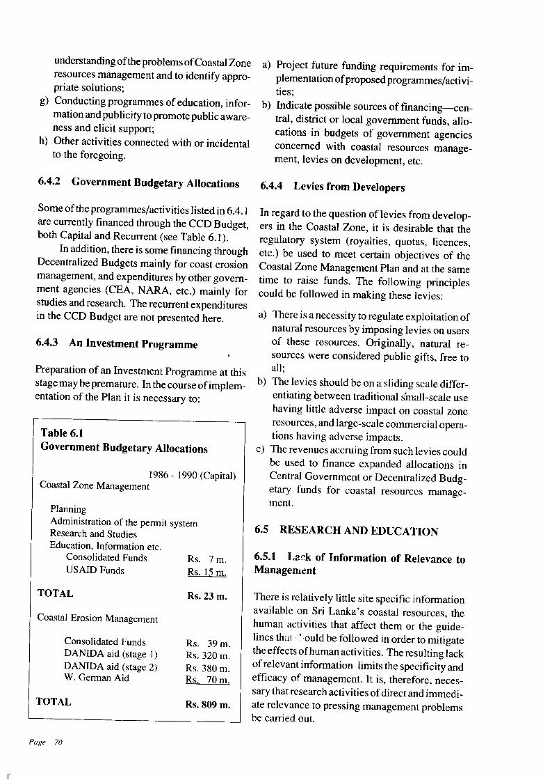
Rs. 7m.Rs. 15 m.
understanding ofthe problems ofCoastal Zoneresources management and to identify appropriate solutions;
g) Conducting programmes of education, information and publicity to promote public awareness and elicit support;
h) Other activities connected with or incidentalto the foregoing.
6.4.2 Government Budgetary Allocations
Some of the programmes/activities listed in 6.4.1are currently financed through the CCD Budget,both Capital and Recurrent (see Table 6.1).
In addition, there is some financing throughDecentralized Budgets mainly for coast erosionmanagement, and expenditures by other government agencies (CEA, NARA, etc.) mainly forstudies and research. The recurrent expendituresin the CCD Budget are not presented here.
6.4.3 An Investment Programme
Preparation of an Investment Programme at thisstage may be premature. In the course ofimplementation of the Plan it is necessary to:
Table 6.1Government Budgetary Allocations
1986 - 1990 (Capital)Coastal Zone Management
PlanningAdministration of the permit systemResearch and StudiesEducation, Information etc.
Consolidated FundsUSAID Funds
a) Project future funding requirements for implementation ofproposed programmes/activities;
b) Indicate possible sources of financing-central, district or local government funds, allocations in budgets of government agenciesconcerned with coastal resources management, levies on development, etc.
6.4.4 Levies from Developers
In regard to the question of levies from developers in the Coastal Zone, it is desirable that theregulatory system (royalties, quotas, licences,etc.) be used to meet certain objectives of theCoastal Zone Management Plan and at the sametime to raise funds. The following principlescould be followed in making these levies:
a) There is a necessity to regulate exploitation ofnatural resources by imposing levies on usersof these resources. Originally, natural resources were considered public gifts, free toall;
b) The levies should be on a sliding scale differentiating between traditional small-scale usehaving little adverse impact on coastal zoneresources, and large-scale commercial operations having adverse impacts.
c) The revenues accruing from such levies couldbe used to finance expanded allocations inCentral Government or Decentralized Budgetary funds for coastal resources management.
6.5 RESEARCH AND EDUCATION
6.5.1 Lack of Information of Relevance toManagement
n
TOTAL
Coastal Erosion Management
Consolidated FundsDANIDA aid (stage 1)DANIDA aid (stage 2)W. German Aid
TOTAL
Page 70
Rs. 23 m.
Rs. 39 m.Rs. 320 m.Rs. 380 m.Rs. 70 m.
Rs. 809 m.
There is relatively little site specific informationavailable on Sri Lanka's coastal resources, thehuman activities that affect them or the guidelines thai " ,auld be followed in order to mitigatethe effects ofhuman activities. The resulting lackof relevant information limits the specificity andefficacy of management. It is, therefore, necessary that research activities ofdirect and immediate relevance to pressing management problemsbe carried out.
A considerable volume of information re
lating to human activities (i.e. sand mining, coral
mining) has been gathered by the CCD as a part
ofthe coastal planning effort. The CCD will have
to undertake and/or support additional research
programmes that target specific items of direct
relevance to its management programme. Such
research will focus, in the immediate future,
mainly on geographically defined coastal habi
tats, so that special areamanagement plans can be
drawn up for areas with the most pressing man
agement problems.
6.5.2 Public Awareness and Education
Whilst there is a greater level ofpublic awareness
today on the need for the management of coastal
resources, much more needs to be done. Public
awareness and support is a pre-requisite for any
naturalresources managementprogramme. There
is also a need to educate regional and local level
administrators on the inter-relationship and link
ages between coastal habitats. The CCD will,
therefore, sponsor public awareness and educa
tion programmes that will focus on the general
need for management of coastal resources with
particular reference to geographically specific
habitats. Such programmes will involve partici
pation of provincial and district administrators,
school children, citizen groups and non-govern
mental groups concerned with environmental
management.
6.6 The Future
These are the perspectives for the future. The
current Plan is designed to address a few well
defined management issues. The management
strategies will have to be tried out and their
success tested over time. It has already been
stated that the Plan is an incremental one. As
experience is gained in the course of implemen
tation, the Plan will be modified and developed.
A Coastal Resources Management Programme
is primarily for the people. It will succeed only
with their support.
Page 71
Appendices
List of Studies, Surveys and Inventories Carried Out by the CCD
Glossary
Specimen Application Form
Pilge 73
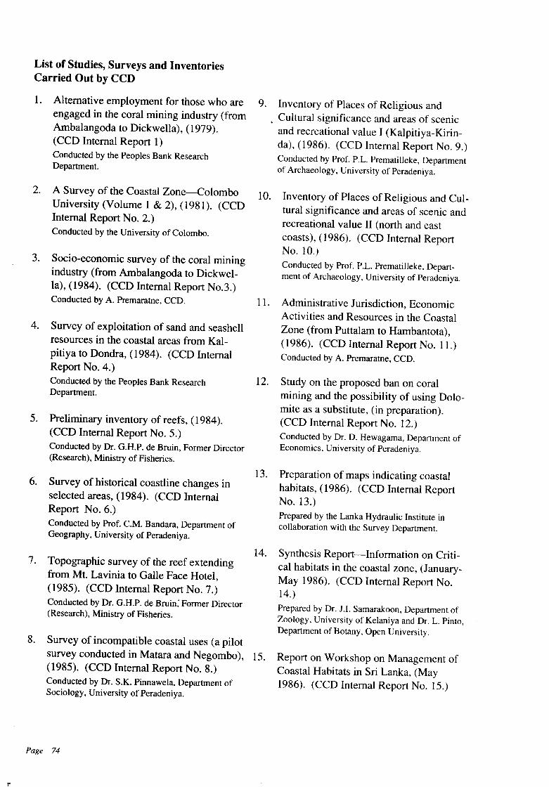
List of Studies, Surveys and InventoriesCarried Out by CCD
1. Alternative employment for those who areengaged in the coral mining industry (fromAmbalangoda to Dickwella), (1979).(CCD Internal Report 1)Conducted by the Peoples Bank ResearchDepartment.
9. Inventory of Places of Religious and. Cultural significance and areas of scenic
and recreational value I (Kalpitiya-Kirinda), (1986). (CCD Internal Report No.9.)Conducted by Prof. P.L. Prematilleke, Departmentof Archaeology, University of Peradeniya.
n
2. A Survey of the Coastal Zone-Colombo 10. Inventory of Places of Religious and Cul-University (Volume 1 & 2), (1981). (CCD tural significance and areas of scenic andInternal Report No.2.) recreational value II (north and eastConducted by the University of Colombo. coasts), (1986). (CCD Internal Report
No. 10.)3. Socio-economic survey of the coral mining Conducted by Prof. P.L. Prematilleke, Depart-
industry (from Ambalangoda to Dickwel- ment of Archaeology, University of Peradeniya.
la), (1984). (CCD Internal Report No.3.)Conducted by A. Premaratne, CCD. 11. Administrative Jurisdiction, Economic
Activities and Resources in the Coastal4. Survey of exploitation of sand and seashell Zone (from Puttalam to Hambantota),
resources in the coastal areas from Kal- (1986). (CCD Internal Report No. II.)pitiya to Dondra, (1984). (CCD Internal Conducted by A. Premaratne, CCD.
Report No.4.)Conducted by the Peoples Bank Research 12. Study on the proposed ban on coralDepartment. mining and the possibility of using Dolo-
mite as a substitute, (in preparation).5. Preliminary inventory of reefs, (1984). (CCD Internal Report No. 12.)
(CCD Internal Report No.5.) Conducted by Dr. D. Hewagama, Department of
Conducted by Dr. G.H.P. de Bruin, Former Director Economics, University of Peradeniya.
(Research), Ministry of Fisheries.
13. Preparation of maps indicating coastal6. Survey of historical coastline changes in habitats, (1986). (CCD Internal Report
selected areas, (1984). (CCD Internal No. 13.)Report No.6.) Prepared by the Lanka Hydraulic Institute inConducted by Prof. CM. Bandara, Department of collaboration with the Survey Department.Geography, University of Peradeniya.
14. Synthesis Report-Information on Criti-7. Topographic survey of the reef extending cal habitats in the coastal zone, (January-
from Mt. Lavinia to Galle Face Hotel, May 1986). (CCD Internal Report No.(1985). (CCD Internal Report No.7.) 14.)Conducted by Dr. G.H.P. de Bruin; Former Director Prepared by Dr. J.I. Samarakoon, Department of(Research), Ministry of Fisheries. Zoology, University of Kelaniya and Dr. L. Pinto,
Department of Botany, Open University.
8. Survey of incompatible coastal uses (a pilotsurvey conducted in Matara and Negombo), 15. Report on Workshop on Management of(1985). (CCD Internal Report No.8.) Coastal Habitats in Sri Lanka, (MayConducted by Dr. S.K. Pinnawela, Department of 1986). (CCD Internal Report No. 15.)Sociology, University of Peradeniya.
Page 74
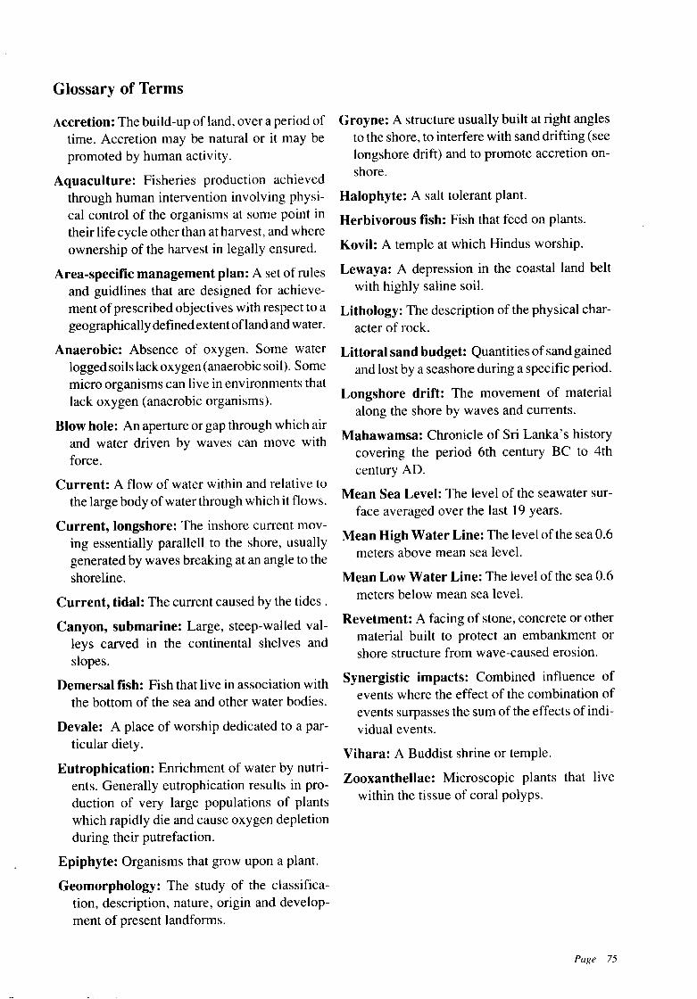
Glossary of Terms
Accretion: The build-up ofland, over a period oftime. Accretion may be natural or it may bepromoted by human activity.
Aquaculture: Fisheries production achievedthrough human intervention involving physical control of the organisms at some point intheir life cycle other than at harvest, and whereownership of the harvest in legally ensured.
Area-specific management plan: A set of rulesand guidlines that are designed for achievement of prescribed objectives with respect to ageographically definedextent ofland and water.
Anaerobic: Absence of oxygen. Some waterlogged soils lack oxygen (anaerobic soil). Somemicro organisms can live in environments thatlack oxygen (anaerobic organisms).
Blow hole: An aperture or gap through which airand water driven by waves can move withforce.
Current: A flow of water within and relative tothe large body of water through which it flows.
Current, longshore: The inshore current moving essentially parallell to the shore, usuallygenerated by waves breaking at an angle to theshoreline.
Current, tidal: The current caused by the tides.
Canyon, submarine: Large, steep-walled valleys carved in the continental shelves andslopes.
Demersal fish: Fish that live in association withthe bottom of the sea and other water bodies.
Devale: A place of worship dedicated to a particular diety.
Eutrophication: Enrichment of water by nutrients. Generally eutrophication results in production of very large populations of plantswhich rapidly die and cause oxygen depletionduring their putrefaction.
Epiphyte: Organisms that grow upon a plant.
Geomorphology: The study of the classification, description, nature, origin and development of present landforms.
Groyne: A structure usually built at right anglesto the shore, to interfere with sand drifting (seelongshore drift) and to promote accretion onshore.
Halophyte: A salt tolerant plant.
Herbivorous fish: Fish that feed on plants.
Kovil: A temple at which Hindus worship.
Lewaya: A depression in the coastal land beltwith highly saline soil.
Lithology: The description of the physical character of rock.
Littoral sand budget: Quantities of sand gainedand lost by a seashore during a specific period.
Longshore drift: The movement of materialalong the shore by waves and currents.
Mahawamsa: Chronicle of Sri Lanka's historycovering the period 6th century BC to 4thcentury AD.
Mean Sea Level: The level of the seawater surface averaged over the last 19 years.
Mean High Water Line: The level of the sea 0.6meters above mean sea level.
Mean Low Water Line: The level of the sea 0.6meters below mean sea level.
Revetment: A facing of stone, concrete or othermaterial built to protect an embankment orshore structure from wave-caused erosion.
Synergistic impacts: Combined influence ofevents where the effect of the combination ofevents surpasses the sum of the effects of individual events.
Vihara: A Buddist shrine or temple.
Zooxanthellae: Microscopic plants that livewithin the tissue of coral polyps.
Page 75
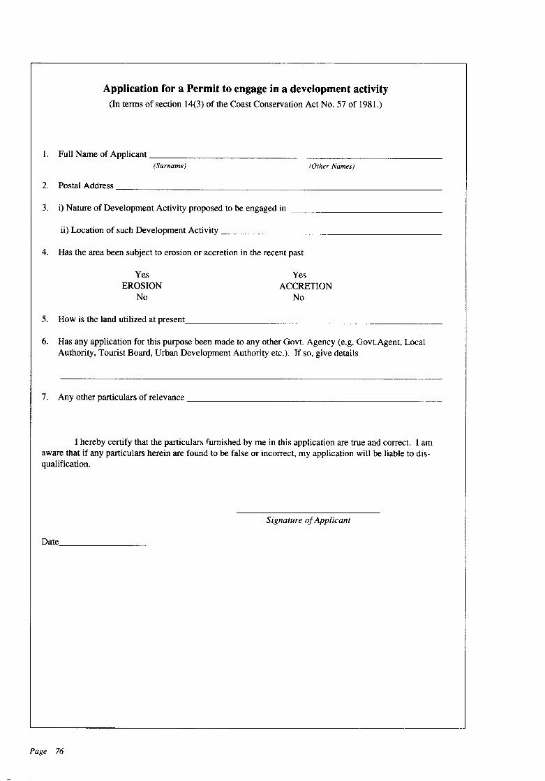
Application for a Permit to engage in a development activity(In terms of section 14(3) of the Coast Conservation Act No. 57 of 1981.)
1. Full Name of Applicant _(Surname) (Other Names)
2. Postal Address _
3. i) Nature of Development Activity proposed to be engaged in _
ii) Location of such Development Activity _
4. Has the area been subject to erosion or accretion in the recent past
YesEROSION
No
YesACCRETION
No
5. How is the land utilized at present. _
6. Has any application for this purpose been made to any other Govt. Agency (e.g. Govt.Agent, LocalAuthority, Tourist Board, Urban Development Authority etc.). If so, give details
7. Any other particulars of relevance _
I hereby certify that the particulars furnished by me in this application are true and correct. I amaware that if any particulars herein are found to be false or incorrect, my application will be liable to disqualification.
Signature ofApplicant
Date _
Page 76
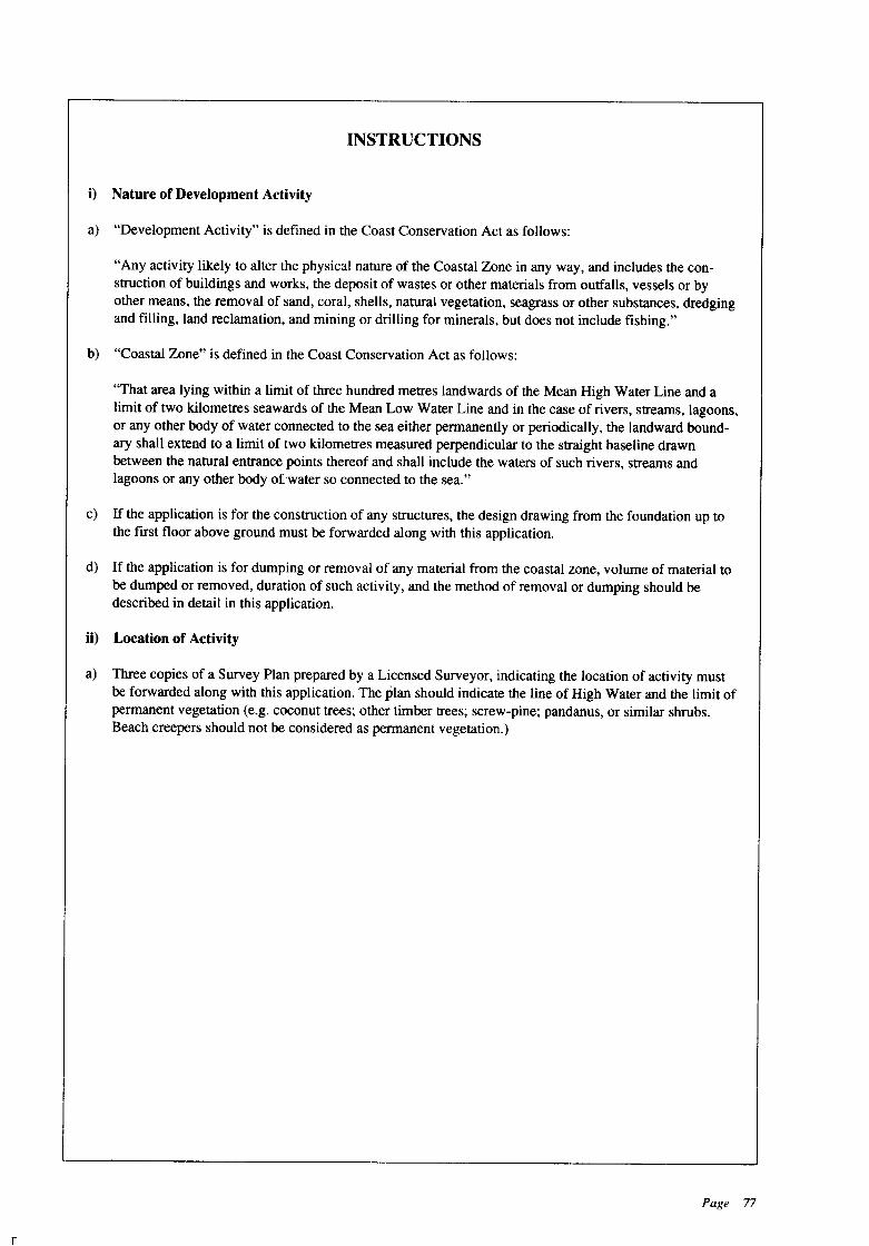
r
INSTRUCTIONS
i) Nature of Development Activity
a) "Development Activity" is defined in the Coast Conservation Act as follows:
"Any activity likely to alter the physical nature of the Coastal Zone in any way, and includes the construction of buildings and works, the deposit of wastes or other materials from outfalls, vessels or byother means, the removal of sand, coral, shells, natural vegetation, seagrass or other substances, dredgingand filling, land reclamation, and mining or drilling for minerals, but does not include fishing."
b) "Coastal Zone" is defined in the Coast Conservation Act as follows:
"That area lying within a limit of three hundred metres landwards of the Mean High Water Line and alimit of two kilometres seawards of the Mean Low Water Line and in the case of rivers, streams, lagoons,or any other body of water connected to the sea either permanently or periodically, the landward boundary shall extend to a limit of two kilometres measured perpendicular to the straight baseline drawnbetween the natural entrance points thereof and shall include the waters of such rivers, streams andlagoons or any other body ofwater so connected to the sea."
c) If the application is for the construction of any structures, the design drawing from the foundation up tothe first floor above ground must be forwarded along with this application.
d) If the application is for dumping or removal of any material from the coastal zone, volume of material tobe dumped or removed, duration of such activity, and the method of removal or dumping should bedescribed in detail in this application.
ii) Location of Activity
a) Three copies of a Survey Plan prepared by a Licensed Surveyor, indicating the location of activity mustbe forwarded along with this application. The plan should indicate the line of High Water and the limit ofpermanent vegetation (e.g. coconut trees; other timber trees; screw-pine; pandanus, or similar shrubs.Beach creepers should not be considered as permanent vegetation.)
Page 77
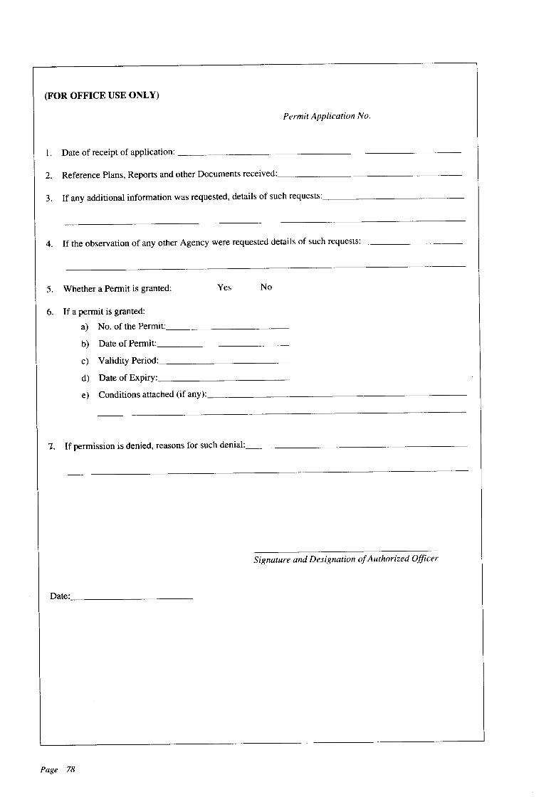
(FOR OFFICE USE ONLY)
Permit Application No.
1. Date of receipt of application: _
2. Reference Plans, Reports and other Documents received: _
3. If any additional information was requested, details of such requests: _
4. If the observation of any other Agency were requested details of such requests: _
5. Whether a Permit is granted: Yes No
6. If a permit is granted:
a) No. of the Permit _
b) Date of Permit _
c) Validity Period: _
d) Date of Expiry: _
e) Conditions attached (if any): _
1. If permission is denied, reasons for such denial: _
Signature and Designation ofAuthorized Officer
Date: ~
Page 78

Application for a renewal of Permit to engage in a development activity(In tenns of section 18(2) of the Coast Conservation Act No. 57 of 1981).
1. Number of the Pennit for which this renewal application is made: _
2. Expiry date of such Pennit _
3. Name of Applicant _
4. Postal Address: _
5. Reasons for renewal: _
6. Period for which renewal is required: _
7. What percentage of the development activity for which the original pennit was issued has been completed:
I certify that the particulars furnished by me in this application are true and correct. I confinn that the conditions stated in the original pennit have been strictly adhered to by me. I am aware that if any particularscontained herein are found to be false or incorrect, my application will be liable to disqualification.
Signature ofApplicantDate _
(Note: Renewal application must be made one month prior to expiry of the pennit issued for the purpose.)
(For Office Use Only) Permit Application No.
1. Date of application: _
2. If any additional details were requested, details of such request _
3. Whether a Renewal of Pennit was allowed: _
4. If a renewal is granted:
a) No. of the Renewal Pennit
b) Date of Pennit:
c) Validity period:
d) Date of expiry:
e) Conditions attached (if any):
5. If pennission is denied, reasons for such denial:
Yes No
Signature and Designation ofAuthorized Officer.
Date _
A 71658 (83/07) DEPT. OF GOVT. PRINTING, SRI LANKA
Page 79
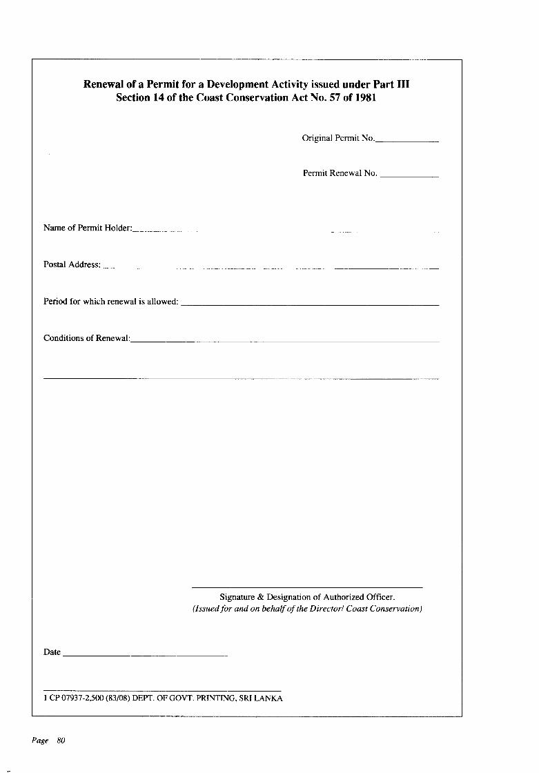
Renewal of a Permit for a Development Activity issued under Part IIISection 14 of the Coast Conservation Act No. 57 of 1981
Original Pennit No. _
Pennit Renewal No. _
Name of Pennit Holder: _
Postal Address: _
Period for which renewal is allowed: _
Conditions of Renewal: _
Signature & Designation of Authorized Officer.(Issuedfor and on behalfof the Directorl Coast Conservation)
Date _
1 CP 07937-2,500 (83/08) DEPT. OF GOVT. PRINTING, SRI LANKA
Page 80
PERMI'J FOR A DEVELOPMENT ACTIVITY ISSUED UNDERPART III-8ECTION 14 OF THE COAST CONSERVATION
ACT No. 57 OF 1981
Permit No. _
Name of Permit Holder: _(Surname) (Other Names)
•Postal Address: _
Nature of Development Activity: _
Location of Development Activity: _
Province _
District _
Local Authority _
Particulars of Survey Plan submitted by applicant:
Duration of Permit: _
Conditions Attached: _
Signature & Designation of Authorized Officer(Issued for and on behalfof the Director/Coast Conservation)
Date _
1 CP 07933 (83/08) DEPT. OF GOVT. PRINTING, SRI LANKA
Page 81

Government Press - Sri Lanka