
Coastal Defence - C-SCOPE
10
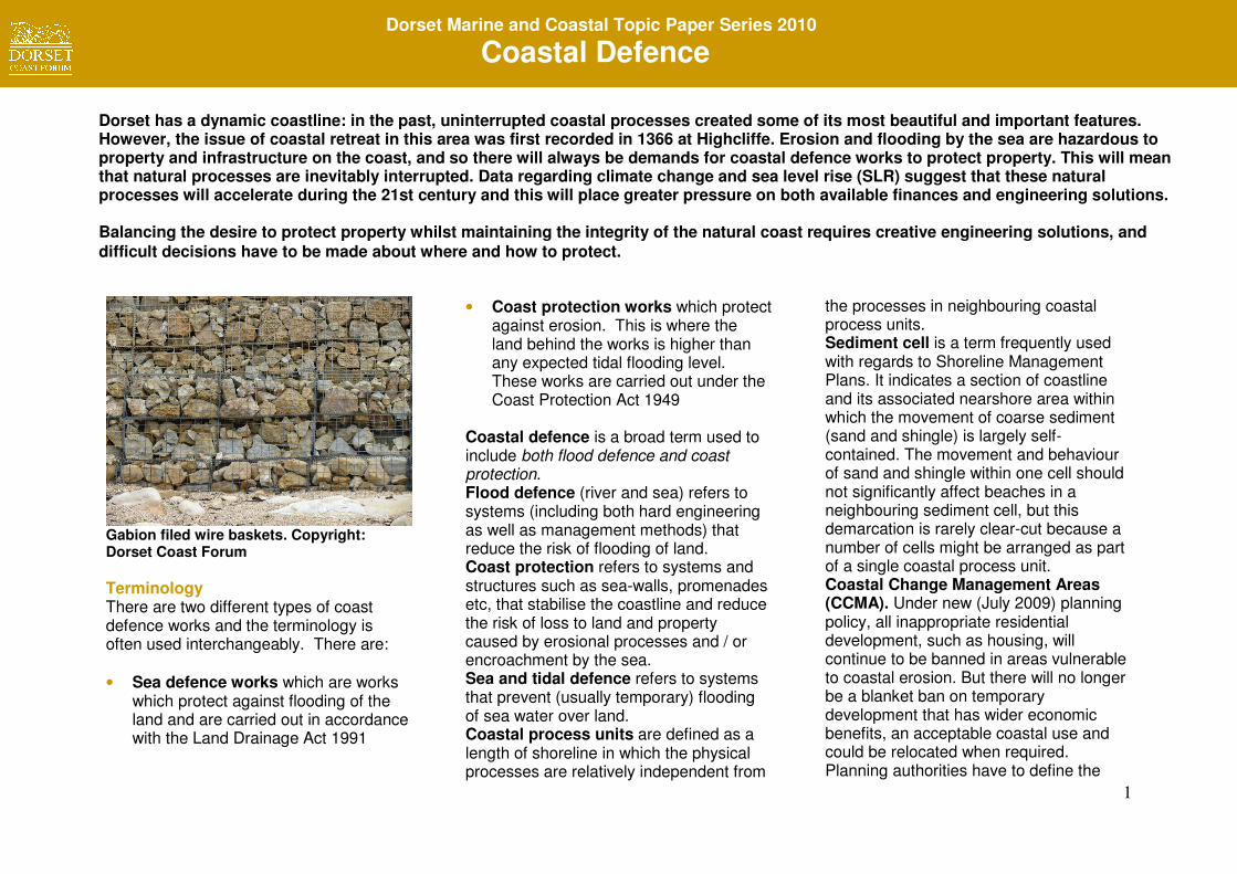
1 Dorset Marine and Coastal Topic Paper Series 2010 Coastal Defence Gabion filed wire baskets. Copyright: Dorset Coast Forum Terminology There are two different types of coast defence works and the terminology is often used interchangeably. There are: • Sea defence works which are works which protect against flooding of the land and are carried out in accordance with the Land Drainage Act 1991 • Coast protection works which protect against erosion. This is where the land behind the works is higher than any expected tidal flooding level. These works are carried out under the Coast Protection Act 1949 Coastal defence is a broad term used to include both flood defence and coast protection. Flood defence (river and sea) refers to systems (including both hard engineering as well as management methods) that reduce the risk of flooding of land. Coast protection refers to systems and structures such as sea-walls, promenades etc, that stabilise the coastline and reduce the risk of loss to land and property caused by erosional processes and / or encroachment by the sea. Sea and tidal defence refers to systems that prevent (usually temporary) flooding of sea water over land. Coastal process units are defined as a length of shoreline in which the physical processes are relatively independent from the processes in neighbouring coastal process units. Sediment cell is a term frequently used with regards to Shoreline Management Plans. It indicates a section of coastline and its associated nearshore area within which the movement of coarse sediment (sand and shingle) is largely self- contained. The movement and behaviour of sand and shingle within one cell should not significantly affect beaches in a neighbouring sediment cell, but this demarcation is rarely clear-cut because a number of cells might be arranged as part of a single coastal process unit. Coastal Change Management Areas (CCMA). Under new (July 2009) planning policy, all inappropriate residential development, such as housing, will continue to be banned in areas vulnerable to coastal erosion. But there will no longer be a blanket ban on temporary development that has wider economic benefits, an acceptable coastal use and could be relocated when required. Planning authorities have to define the Dorset has a dynamic coastline: in the past, uninterrupted coastal processes created some of its most beautiful and important features. However, the issue of coastal retreat in this area was first recorded in 1366 at Highcliffe. Erosion and flooding by the sea are hazardous to property and infrastructure on the coast, and so there will always be demands for coastal defence works to protect property. This will mean that natural processes are inevitably interrupted. Data regarding climate change and sea level rise (SLR) suggest that these natural processes will accelerate during the 21st century and this will place greater pressure on both available finances and engineering solutions. Balancing the desire to protect property whilst maintaining the integrity of the natural coast requires creative engineering solutions, and difficult decisions have to be made about where and how to protect. Dorset Marine and Coastal Topic Paper Series 2010 Coastal Defence
-
Upload
khangminh22 -
Category
Documents
-
view
6 -
download
0
Transcript of Coastal Defence - C-SCOPE
1
Dorset Marine and Coastal Topic Paper Series 2010
Coastal Defence
Gabion filed wire baskets. Copyright: Dorset Coast Forum
Terminology There are two different types of coast defence works and the terminology is often used interchangeably. There are: • Sea defence works which are works
which protect against flooding of the land and are carried out in accordance with the Land Drainage Act 1991
• Coast protection works which protect against erosion. This is where the land behind the works is higher than any expected tidal flooding level. These works are carried out under the Coast Protection Act 1949
Coastal defence is a broad term used to include both flood defence and coast protection. Flood defence (river and sea) refers to systems (including both hard engineering as well as management methods) that reduce the risk of flooding of land. Coast protection refers to systems and structures such as sea-walls, promenades etc, that stabilise the coastline and reduce the risk of loss to land and property caused by erosional processes and / or encroachment by the sea. Sea and tidal defence refers to systems that prevent (usually temporary) flooding of sea water over land. Coastal process units are defined as a length of shoreline in which the physical processes are relatively independent from
the processes in neighbouring coastal process units. Sediment cell is a term frequently used with regards to Shoreline Management Plans. It indicates a section of coastline and its associated nearshore area within which the movement of coarse sediment (sand and shingle) is largely self-contained. The movement and behaviour of sand and shingle within one cell should not significantly affect beaches in a neighbouring sediment cell, but this demarcation is rarely clear-cut because a number of cells might be arranged as part of a single coastal process unit. Coastal Change Management Areas (CCMA). Under new (July 2009) planning policy, all inappropriate residential development, such as housing, will continue to be banned in areas vulnerable to coastal erosion. But there will no longer be a blanket ban on temporary development that has wider economic benefits, an acceptable coastal use and could be relocated when required. Planning authorities have to define the
Dorset has a dynamic coastline: in the past, uninterrupted coastal processes created some of its most beautiful and important features. However, the issue of coastal retreat in this area was first recorded in 1366 at Highcliffe. Erosion and flooding by the sea are hazardous to property and infrastructure on the coast, and so there will always be demands for coastal defence works to protect property. This will mean that natural processes are inevitably interrupted. Data regarding climate change and sea level rise (SLR) suggest that these natural processes will accelerate during the 21st century and this will place greater pressure on both available finances and engineering solutions. Balancing the desire to protect property whilst maintaining the integrity of the natural coast requires creative engineering solutions, and
difficult decisions have to be made about where and how to protect.
Dorset Marine and Coastal Topic Paper Series 2010
Coastal Defence
2
Dorset Marine and Coastal Topic Paper Series 2010
Coastal Defence
'Coastal Change Management Area' in which the policy applies. Natural processes and natural hazards Natural forces (wind, wave, tide and current) shape Dorset’s coastline and give rise to two groups of hazards which can affect coastal property: • Coastal erosion is the process that
cuts, shapes and retreats our cliff coastlines. On much of the Dorset coast, erosion is accompanied by landslips, including some of the largest and most active in Europe.
The lead responsibility for assessing and (where appropriate) controlling erosion (commonly referred to as coast protection) lies with the District and Unitary Councils.
• Flooding - property can be affected by seawater inundation brought about by high tides or swamping with large waves - or often a combination of the two. The times of greatest risk are during spring high tides when accompanied by low-pressure storm surges and high winds from the south west, south or south east.
The Environment Agency has ultimate responsibility for managing coastal flood and erosion risk, although District/Unitary Councils do have some permissive
powers. The Environment Agency (EA) has the responsibility of approving all Shoreline Management Plans (SMP’s), allocate funding for new or ongoing coastal defence works and assisting local authorities in completing defence works.
Costs and Benefits Defra / EA policy is that publicly funded coastal defence schemes must typically achieve a cost / benefits ratio of approximately 1:5. This means that a £10M scheme must be able to demonstrate that £50M of infrastructure will be fully protected. National guidelines are set for the cost calculations. However
there are still a number of areas, such as social benefit and public access, where it is less straightforward to reach a satisfactory assessment of costs vs benefits. The Dorset coastline is regarded as probably the most valuable tangible asset that the County has in generating tourism income. Therefore, the socio-economic benefits /disbenefits must be considered when new engineering schemes are proposed, especially if ‘hard’ schemes are being considered. The legislative and grants application process for obtaining funds for coastal defence works is becoming more stringent
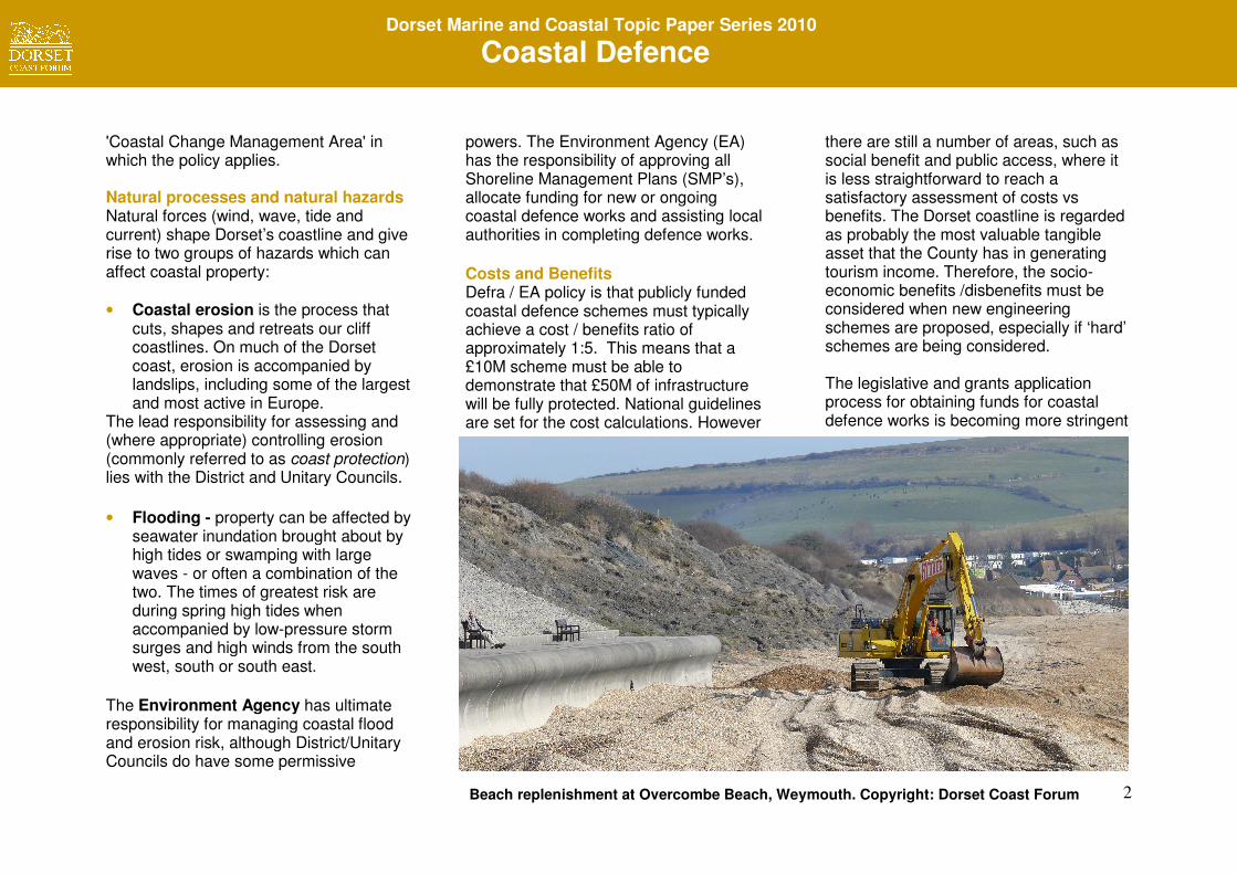
Beach replenishment at Overcombe Beach, Weymouth. Copyright: Dorset Coast Forum
3
Dorset Marine and Coastal Topic Paper Series 2010
Coastal Defence
and a points system is employed based upon:
o The type of scheme: flood defence is the highest priority, and urban coast defence is a higher priority than rural
o The SMP2 policies for the coastal cells involved, especially in the first epoch (today until 2030)
o Urgency of work o Shortfall in standard of protection
(as defined by the Environment Agency)
o The cost / benefits ratio
Dorset’s coastal defences The locations (where significant coastal defences exist) reflect the geographical extent of property along Dorset’s coast. The coastlines of urban Christchurch, Bournemouth, Poole, Swanage, Weymouth and Lyme Regis are almost entirely defended against erosion and flooding. There are sea-walls, artificial shingle banks and beaches retained by groynes. Solid walls can provide important extra amenities such as level promenades. Such defences are usually well established, but their use is more questionable now than in the past. The cost / benefit of hard defences have to be carefully calculated and the long-term sustainability of such structures is suspect because there is usually a continual
maintenance requirement. The design life requirement for a new sea-wall is usually 60-70 years and this figure assumes full and ongoing maintenance throughout the working life of that structure. However, it is unlikely that those protecting the large town will be abandoned.
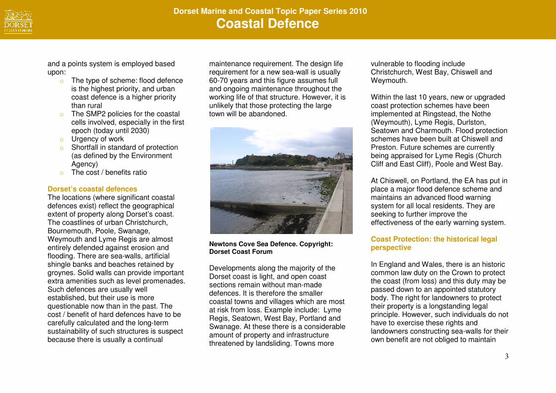
Newtons Cove Sea Defence. Copyright: Dorset Coast Forum
Developments along the majority of the Dorset coast is light, and open coast sections remain without man-made defences. It is therefore the smaller coastal towns and villages which are most at risk from loss. Example include: Lyme Regis, Seatown, West Bay, Portland and Swanage. At these there is a considerable amount of property and infrastructure threatened by landsliding. Towns more
vulnerable to flooding include Christchurch, West Bay, Chiswell and Weymouth. Within the last 10 years, new or upgraded coast protection schemes have been implemented at Ringstead, the Nothe (Weymouth), Lyme Regis, Durlston, Seatown and Charmouth. Flood protection schemes have been built at Chiswell and Preston. Future schemes are currently being appraised for Lyme Regis (Church Cliff and East Cliff), Poole and West Bay. At Chiswell, on Portland, the EA has put in place a major flood defence scheme and maintains an advanced flood warning system for all local residents. They are seeking to further improve the effectiveness of the early warning system. Coast Protection: the historical legal perspective In England and Wales, there is an historic common law duty on the Crown to protect the coast (from loss) and this duty may be passed down to an appointed statutory body. The right for landowners to protect their property is a longstanding legal principle. However, such individuals do not have to exercise these rights and landowners constructing sea-walls for their own benefit are not obliged to maintain
4
Dorset Marine and Coastal Topic Paper Series 2010
Coastal Defence
these to protect others. Recent case law has further established that an occupier of coastal land owes a measured duty of care at common law in this respect. Other permissions such as planning permission and consent in relation to any environmental designations would normally be required before individuals can commence with private defence works. Sources of Coastal and Environmental Law
o International treaties (e.g. Law of the Sea)
o EU Legislation o UK Primary legislation (Acts and
Statutes) o UK Secondary legislation
(Statutory Instruments) o Case law o Departmental notes (Planning
Policy Statements etc o Government Circulars, Codes of
Practice o Bye-Laws
The Regulations & Regulators Europe
• The European Water Framework Directive (2000/60/EC) (WFD) became part of UK law in December
2003. The aim is to ensure a better quality of water within lakes, streams and rivers but also includes estuaries and coastal waters (out to 1 mile from low water). Plans for coastal defences are assessed against their likely impact upon water quality.
• River Basin Management Plans (under the WFD) have to drawn up for every river basin district in England and Wales. Coastal defences are deemed to be those that reach the tidal limit of a river or estuary and so are subject to the controls set out in the WFD. Coincidentally, the same criteria are now used for defining the boundaries for Shoreline Management Plan (SMP) coastal cells.
• The Habitats (92/43/EEC) and Birds (79/409/EEC) Directives have implications for coastal defence management where protection of the coast may be restricted because designations under these directives may preclude the building of protection structures.
National The Environment Agency (since 2008) has been the national lead agency on coast defence policy, and provides the majority of funding through grant aid for schemes. It is also responsible for
managing flood defences both inland as well as on the coast. This approach gives the EA a ‘gatekeeper’ role as compared to the previous arrangements whereby grants were made by Defra directly to the Local Authority.
• The Coast Protection Act, 1949 provides an integrated approach to coast protection works. This embodies any construction, alteration, demolition, modifications and repairs for the purpose for protecting land from erosion or encroachment by the sea. The power to undertake coastal defence projects is vested in the relevant Coast Protection Authority. Their functions are confined to the open coast. The Act provides only enabling legislation and does not set down a duty upon the authority to protect. The Act does however, provide for the compulsory purchasing of land where works or repairs are proposed. Section 34 of the Act was modified to extend its scope to include provisions for an assessment of the environmental impacts of any proposed works. The Act also indicates that County Authorities do have some obligation to contribute to coastal defence capital works but they rarely do.
5
Dorset Marine and Coastal Topic Paper Series 2010
Coastal Defence
Planning permission will always be required for any new coast protection works and to modify existing structures. The Local Authority will need to determine whether an Environmental Impact Assessment (sic) is also necessary.
• FEPA Licences (Food and Environmental Protection Act (1985) A licence will be required if any part of a proposed construction will be submerged at Mean High Water Spring (MHWS) tides. Construction includes not only materials used during construction of, for example, new harbour walls, offshore structures, pontoons, jetties, land reclamation or private sea-walls but also their use in 'soft-engineered' sea defences, such as beach nourishment, and associated groynes and revetments. Such licences are currently issued by the Marine and Fisheries Agency (the MFA) but this power transfered to the Marine Management Organisation (the MMO) in the summer of 2010.
• PPG 20 (Coastal Planning) planning
guidance document has been superceded. It covered the character of the coast, designated areas and heritage coasts. It discusses types of coasts, policies for their conservation and development and policies covering
risks of flooding, erosion and land instability, as well as coastal protection and defence. It outlines policies for developments which may specifically require a coastal location, including tourism, recreation, mineral extraction, energy generation and wastewater and sewage treatment plants. In mid-2009, the Department for Communities and Local Government indicated that there was a need to update existing policy in the light of better data regarding climate change and sea level rise. Revisions are likely to suggest that: o Modest developments (of a time-
limited nature) should be allowed in vulnerable coastal locations (e.g. facilities for tourism such as cafés etc) and that the original presumption not to allow developments in such areas (as laid down in PPG20) should be rescinded
o Specific coastal change management areas (CCMA’s) be identified for those locations that are particularly likely to be affected by a rise in sea level or an accelerated rate of coastal erosion
o The new policy statement will form an Annexe to PPS25
• PPS25 (Development and Flood Risk) explains the Government’s
policies regarding developments where flooding is a measurable risk. It requires that flood risk is fully considered at all stages in the planning process and to generally direct developments away from areas at highest risk. PPS 25 makes clear that the EA has the lead role in giving advice on flooding matters at the strategic level and for all planning applications.
• The Water Resources Act (1991) and the Land Drainage Act (1991, amended 1994) provide the primary enabling legislation for sea defence works aimed at the prevention of flooding. It also provides for the construction of drainage works for “the defence against sea water and tidal water.” The Water Resources Act (2003) adds important details regarding the funding for new flood defence works.
• Land Drainage Act, 1991. Local
Authorities have the power to carry out works to improve safety and flood control improvements along waterways and on the coast, but are also required to ensure that the works do not hinder navigation, obstruct channels or significantly damage habitats or other
6
Dorset Marine and Coastal Topic Paper Series 2010
Coastal Defence
aspects of the environment (such as historical settings etc).
• Coastal Habitat Management Plans
(ChaMP’s). These plans consider the long-term cumulative impacts of flood and coastal defence schemes in relation to habitats and the impacts of climate change. ChaMPs can also recommend modifications to a defence scheme to help minimise habitat loss and to identify where habitat restoration is feasible. Information derived from these sources can all be fed into the SMP review process.
County
• The County Structure Plan has a statutory role in setting over-arching planning policies for Dorset, including those influencing the pattern of development and environmental protection. There is also a responsibility to support and uphold such items as the EU Water Framework Directive, Shoreline Management Plans and AONB Management Plans.
• Coast Protection Authorities
(Coastal District/Unitary Councils) have a statutory lead responsibility for coast protection including having a
lead role in developing Shoreline Management Plans and other Strategy Plans. They are also responsible for producing and implementing planning policies through the local plans.
• Beach Management Plans (non-
statutory) are often commissioned by District Authorities to manage coastal areas and produced by local authorities and the Environment agency
• The Regional Strategic Monitoring
Programmes (conducted by the Channel Coast Observatory in the South and West) provide the data for SMPs and other coastal defence work. Digital ground modelling is used to determine beach volume changes and the resulting data can be used to identify and quantify areas of erosion and accretion.
• Water Level Management Plans. Especially important in estuarine floodplain locations such as Radipole on the River Wey at Weymouth
• The Parish Council would normally
be consulted on coast defence plans/schemes relating to their parish.
The Policy Base The Environment Agency has overall responsibility for policy development and flood defence and coast protection in England and Wales. They can dispense grant aid for new defence schemes and would oversee the implementation. The EA can provide grants for defence structures, but not for associated land instability works which are frequently required to complete a successful coastal defence project. The Department for Communities and Local Government (DCLG) have this power though it is rarely exercised. The basis for national (England and Wales) policy for coast defence was originally embodied in the EA Strategy for Flood and Coastal Defence, published in 1993. The core aims (for coast defences) are outlined as: • Environmentally acceptable: natural
processes should not be disrupted except where life or important man-made or natural assets are at risk.
• Technically sound: a range of options should be considered, and schemes should be sustainable and work with natural processes as far as possible.
• Economically viable: the benefits of
defending must be equal to or exceed
7
Dorset Marine and Coastal Topic Paper Series 2010
Coastal Defence
the costs. The Environment Agency will undertake a series of financial tests during the planning phase of a new project and a cost / benefit ratio of 1:5 is considered reasonable before approval can be granted.
Environmental Impact Assessments (EIA) and ‘Appropriate Assessments’ Coast Protection works (other than maintenance or refurbishments) fall within Schedule 2 of the Town and Country Planning Regulations (1999) and may (in advance of any works) require an EIA to be carried out. This is most probable if the site of any proposed works is environmentally sensitive. If the location is a ‘Natura 2000’ site designated under the European Habitats Directive (1994), then an ‘Appropriate Assessment’ must also be carried out. Flood risk may also be a material consideration for certain developments for which an EIA will be required especially if the impact of development on flood risk is likely to affect a designated conservation site or compromise the SMP-preferred option for a given cell. Shoreline Management Plans (SMPs) SMPs are high level strategic documents that set the framework for the way that coast defence matters are managed for
the next 100 years. The first iteration of Shoreline Management Plans for England and Wales was carried out in the late 1990’s (SMP1). The second iteration began in 2008 and completion of all SMP reviews is scheduled for 2010 (SMP2). In a number of cases coastal cell boundaries have been altered since round one. The other distinct difference of note is that the plans have to extend up to all tidal limits within rivers and estuaries; this was not the case with SMP 1. The four main options available for any given coastal cell are:
• Advance the existing defence line
• Managed realignment (either of existing defence measures or by managing and manipulating natural processes
• No active intervention (meaning that no financial obligations are intended)
• Hold the line (where existing measures to defend the coast and property are to be continued and maintained)
The review process recognises that coastal defence works need to be conceived in a way that takes due regard for the natural processes operating at sea and on the coast. These processes can operate over large stretches of coastline, for example eroding cliffs on one part of
the coast can provide the sediment which forms beaches elsewhere. On Dorset’s rural coast the issue of coastal defence is also set within long-term conservation objectives. In particular there is a need to protect the natural processes that both underpin the coast’s internationally important geomorphology and to maintain the exposures of Triassic, Jurassic and Cretaceous geology which form the basis of the UNESCO World Heritage designation awarded in December 2001, and also the post-Cretacaeous strata which form the cliffs east from Studland to Chewton Bunny. Two SMP2 documents cover the Dorset coast:
• Hurst Spit to Durlston. The Two Bays SMP
• Durlston-Rame Head. Plymouth. (South Devon and Dorset SMP)
The lead authority for the Two Bays SMP is Bournemouth Unitary Authority and for the South Devon and Dorset SMP, it is Teignbridge District Council. The EA have indicated that a further level of more detailed ‘Strategy Plans’ may be required for some sections of the coast in the future. These aim to ensure more detailed strategic consideration of the
8
Dorset Marine and Coastal Topic Paper Series 2010
Coastal Defence
long-term and knock-on effects of proposed schemes, and to ensure related schemes are tackled in an integrated way. Planning Issues The justification to defend a section of coast is generally determined by the presence or absence of valued structures and infrastructure. Thus the planning system has an important long-term role to play. Land-use plans need to ensure that inappropriate development does not take place where it would increase the risk to other properties or cause erosional problems further along the coast. This position is supported by Government planning guidance and Environment Agency policies for protecting flood plains, and by the Dorset Structure Plan. Construction of coastal defences normally requires planning permission and may also require a Food and Environmental Protection Act (FEPA) licence. Constructions may also require permission under the Coast Protection Act (1949). The statutory Local Plans need to provide and implement policies to restrict inappropriate defence schemes, ensure quality of schemes when implemented and provide for access to maintain defences. The Information Base
Effective coastal defence relies on the coastal authorities having access to good quality information about the development and use of the coast, and a good scientific understanding of the coastal processes which are operating. Achieving this is a considerable and continuing task. The Shoreline Management Plans assist by collating available information and informing communities and planners of specific issues at specific locations along the coast. There is a growing need for the coast protection authorities to hold and manage the data being produced and to co-ordinate their efforts to avoid duplicating effort. Much of the information being gathered is potentially relevant to wider interests than coastal defence authorities, such as coastal planning, emergency planning, tourism development, leisure pursuits, pollution control, nature conservation and geological interpretation. The role of computer-based geographical information systems (GIS) is of increasing value, sophistication and importance. The research work carried out by the Channel Coast Observatory (CCO) and the Plymouth Coastal Observatory (PCO) is of great value in this context. The CCO is the data management centre for the Regional Coastal Monitoring Programmes
and is hosted by New Forest District Council, in partnership with the University of Southampton and the National Oceanography Centre, Southampton. The Data Catalogue is a searchable database of coastal data (bathymetric, beach profiles, aerial photographs, LIDAR, etc) collected by the Strategic Regional Coastal Monitoring Programmes. Data are freely available for download. Coastal Partnerships Coastal Partnerships, including the Dorset Coast Forum, involve people with diverse skills and interests but all with a keen interest and concern for the coast. Members of local communities, clubs and user groups to local authorities, statutory agencies, industries, businesses, water companies, port & harbour authorities and NGOs are all likely to be in membership. The general working principles that a coastal partnership would adopt include:
• Impartiality and a proven role in conflict resolution and consensus building
• The ability to work across sectors and between all levels of decision-making
• Raising awareness of issues and a mechanism for community engagement
9
Dorset Marine and Coastal Topic Paper Series 2010
Coastal Defence
• Horizon scanning to inform organisations of coastal issues
• Attracting project funding and initiating collaborative ventures
• Providing a gateway service and ‘one-stop-shop’ for information, contacts and project report production
• Filling gaps where there are no sectoral responsibilities and mobilising voluntary support and involvement
• Providing a (bottom-up) conduit to regional and national government
Partnership approaches have been tried and tested in many fields and are becoming increasingly popular. Coastal partnerships specialise in providing services to help organisations deliver Integrated Coastal Zone Management (ICZM). There are other organisations and some partnership initiatives that deliver ICZM (e.g. AONB’s with sections of coast, the European Marine Sites and Shoreline Management Groups) but they don’t offer the same core services which the existing voluntary arrangements provide. Coastal Partnerships are thus at the forefront of providing mechanisms to help deliver ICZM. Groups/Projects associated with coastal defence
SCOPAC (Standing Conference on Problems Associated with the Coast) SCOPAC was inaugurated in 1986 to facilitate co-ordination and joint research between coastal operating authorities from West Dorset to West Sussex. The core aim of the group is to provide a strong political forum for these authorities and other organisations that have a responsibility and interest in coastal risk management. The group also assists coastal stakeholders by disseminating advice and good practice through the publication of advice and guidance, the holding of conferences, field meetings and events. The full conference meets regularly, and is supported by an officers’ working group, and a research sub-group. SCOPAC has commissioned or supported a range of valuable research projects on behalf of its members since its formation. The value in working jointly with other professionals has been recognised by Dorset’s coastal engineers for many years. Defra ‘Coastal Pathfinder’ Projects This is a series of highly focussed projects (to be completed by Spring 2011) that looks at the issues surrounding coastal loss, coastal ‘squeeze’ and the development of tools necessary to help local coastal communities to adapt to the
threats posed by sea level rise and /or erosion. The Dorset and East Devon Pathfinder examined the issues at Swanage, Ringstead, Preston, Seatown, Charmouth, and Sidmouth in detail. High Quality Defence Schemes This stage is reached when it is judged that a replacement or extension to existing defences is essential. Dorset’s coast can demonstrate several schemes, which exemplify good practice in design and implementation, including the Lyme Regis Phase 1-3 coast protection works constructed between 1995 and 2004, which has attracted national awards. Since 1997, other significant and successful projects have been carried out at Charmouth, Portland Harbour and Preston Beach. The 2001 award by UNESCO of World Heritage Status for the Dorset and East Devon coast has added a new constraint to the planning and construction of new defence schemes. WH status is now a material consideration when new schemes are being evaluated. There are also some schemes, which have damaged the quality of the coast. Well-designed coastal defences have the potential to create and protect wildlife resources, as well as providing access,

10
Dorset Marine and Coastal Topic Paper Series 2010
Coastal Defence
securing coastal paths and providing other amenity benefits. Schemes need to be increasingly sensitive to the ecological and landscape aspects of the coast, and should seek to enhance these features. Finally schemes need to be properly maintained and monitored after they have been built. Generally, new schemes have a design life of some 60-70 years and funds need to be allocated towards ongoing maintenance. Increasingly, considerations have to be given to preparing ‘exit strategies’ that can be implemented at the end of the design life period. ‘Soft’ Coastal Defences Natural features already provide coastal defence capacity over large parts of the Dorset Coast. Chesil Beach and Studland Dunes are two examples of large features which protect the land behind them from erosion and flooding and elsewhere smaller beaches provide some measure of natural protection. There is a growing recognition of the value of natural coastal defences and of the need to work with and protect natural processes. Soft engineering techniques typically involve the use of sand, shingle or larger aggregates to replenish beach sediments. The materials used are typically imported
from offshore dredging areas although quarried material can also be used. Material sourced from dredged navigation channels (e.g. from Poole Harbour) has been used to recharge beaches at Bournemouth, Sandbanks and Swanage. Soft coast defence techniques have the benefit of conserving sediments for defence use rather than erecting solid linear barriers along the shoreline. However, groynes are often required to Beach repl stabilise the recharge material and to prevent drift. In recent years, the sustainability of soft engineering schemes has been brought into question. Typically, beach recharge schemes have to be repeated (or at least replenished) every 4-10 years. Sea-Level Rise: current research Coastal sea levels in the western counties of Britain have been rising at approximately 2.5mm per year during the 20th century but this rate is now accelerating rapidly. Predictions for the next 100 years suggest a rate of up to 1cm per annum (averaged over the whole period). It is also likely that the frequency of extreme storm events will also increase. In the long-term, an increasing amount of
property will become subject to flood and erosional risk. Whilst most urban coastline will continue to be defended, there are likely to be some places where property could not be defended without unjustifiable costs or environmental damage. Such situations must be handled with great sensitivity. Acceptable solutions for the owners affected will be difficult. The review of the Shoreline Management Plans (SMP2) provides a suitable opportunity to consider these issues in detail and to communicate directly with those communities likely to be affected. The DEFRA ‘Coastal Pathfinder’ and C-SCOPE research projects offer similar opportunities. The current direction for coastal defence policies is to move away from the use of ‘hard defences’ (concrete, metal, stone etc), but to use natural processes wherever possible to reduce flood risk. Throughout England and Wales there are some 24,000 miles of flood defences. In 2010/11, the EA plan to spend £161 million maintaining existing flood defences and £270 million building new and improved ones. Contribution to Paper: Tony Flux