September 5-7, 1985 Anchorage, Alaska SPONSORED BY
454
UNITED STATES DEPARTMENT OF THE INTERIOR GEOLOGICAL SURVEY PROCEEDINGS OF CONFERENCE XXXI A WORKSHOP ON "EVALUATION OF REGIONAL AND URBAN EARTHQUAKE HAZARDS AND RISK IN ALASKA" September 5-7, 1985 Anchorage, Alaska SPONSORED BY: U.S. Geological Survey Federal Emergency Management Agency Alaska Division of Geological and Geophysical Surveys and Alaska Office of Emergency Services EDITORS Walter W. Hays and Paula L. Gori U.S. Geological Survey Reston, Virginia 22092 Open-File Report 86-79 Compiled by Carla Kitzmiller and Wanda Fuller This report is preliminary and has not been edited or reviewed for conformity with U.S. Geological Survey publication standards and stratigraphic nomenclature. The views and conclusions contained in this document are those of the authors and should not be interpreted as necessarily representing the official policies, either expressed or implied, of the United States Government. Any use of trade names and trademarks in this publication is for descriptive purposes only and does not constitute endorsement by the U.S. Geological Survey. Reston, Virginia .- ^.i/s 1986 IS I 30130
-
Upload
khangminh22 -
Category
Documents
-
view
3 -
download
0
Transcript of September 5-7, 1985 Anchorage, Alaska SPONSORED BY

UNITED STATES
DEPARTMENT OF THE INTERIOR GEOLOGICAL SURVEY
PROCEEDINGS OF CONFERENCE XXXI
A WORKSHOP ON "EVALUATION OF REGIONAL AND URBAN EARTHQUAKE HAZARDS AND RISK IN ALASKA"
September 5-7, 1985
Anchorage, Alaska
SPONSORED BY:U.S. Geological Survey
Federal Emergency Management AgencyAlaska Division of Geological and Geophysical Surveys
and Alaska Office of Emergency Services
EDITORSWalter W. Hays and Paula L. Gori
U.S. Geological Survey Reston, Virginia 22092
Open-File Report 86-79
Compiled by
Carla Kitzmiller and Wanda Fuller
This report is preliminary and has not been edited or reviewed for conformity with U.S. Geological Survey publication standards and stratigraphic nomenclature. The views and conclusions contained in this document are those of the authors and should not be interpreted as necessarily representing the official policies, either expressed or implied, of the United States Government. Any use of trade names and trademarks in this publication is for descriptive purposes only and does not constitute endorsement by the U.S. Geological Survey.
Reston, Virginia .- ^.i/s 1986 IS I 30130

TABLE OF CONTENTS
ALASKA PROCEEDINGSHAZARD AWARENESS
Earthquakes and Public PolicyJoe Hayes........................................................ 1
BACKGROUND INFORMATION AND SUMMARY OF THE WORKSHOP
Background and SummaryWalter Hays and Paula Gori
Introduction.......................................................... 4Seismicity in Alaska.................................................. 5The Ground Shaking Hazard in Alaska................................... 10The 1985 Chile Earthquake............................................. 10The 1985 Mexico Earthquake............................................ 14The Regional Earthquake Hazards Assessments Program Element of
the NEHRP........................................................... 17Evaluation of Earthquake Hazards and Assessment of Potential Risk
in Alaska........................................................... 19Workshop Procedures................................................... 24Plenary Sessions...................................................... 24Discussion Groups..................................................... 30Reports of the Discussion Groups...................................... 31
EVALUATION OF THE WORKSHOP
Evaluation of the Workshop on "Evaluation of Regional and Urban Earthquake Hazards and Risk in Alaska"
Sallie Mars ton................................................... 38
EVALUATION OF EARTHQUAKE HAZARDS AND ASSESSMENT OF RISK; CURRENT STATE-OF-KNOWLEDGE AND STATE-OF-PRACTICE
SEISMICITY AND EARTHQUAKE POTENTIAL
Seismicity, Seismic Gaps and Earthquake Potential in AlaskaJohn Davies...................................................... 43
Regional Seismic Monitoring in Southern Alaska: Application to Earthquake Hazards Assessment
John Lahr, Christopher Stephens, and Robert Page................. 64
Seismic Sources in AlaskaGeorge Plafker and Klaus Jacob................................... 76
Hazards Evaluation for Large and Great Earthquakes Along the Queen Charlotte - Alaska - Aleutian Seismic Zone: 1985-2005
Stuart Nishenko and Klaus Jacob.................................. 83
Implementation Framework to Reduce Potential Losses from Tsunami Hazards in Alaska
Jane Preuss...................................................... 93

GEOLOGIC EFFECTS: FAULTING, GROUND FAILURE, AND TECTONIC DEFORMATION
Status of Earthquake Hazard Research in the Anchorage Area and Upper Cook Inlet, Alaska
Randall Updike................................................... 108
Sensitive Clays in the Bootlegger Cove FormationHarold Olsen..................................................... 119
USGS Engineering Geology Projects in the Anchorage Area, Alaska: A Review
Henry Schmoll.................................................... 134
GROUND SHAKING
Formulating Earthquake-Resistant Design CriteriaPaul Jennings.................................................... 148
Seismic Hazard Studies, Anchorage, AlaskaAlvaro Espinosa, Henry Schmoll, Stan Brockman, Lynn Yehle,Jack Odum, John Michael, and Ken Rukstales....................... 161
EARTHQUAKE DAMAGE
Earthquake Damage 1964 Lessons Learned and RelearnedKarl Steinbrugge................................................. 178
CURRENT ALASKAN URBAN AND RESOURCE DEVELOPMENT REQUIRING CONSIDERATION OF EARTHQUAKE HAZARDS
Anchorage Area
Recent and Anticipated Changes in Utilization of Earthquake Hazard Information for Siting Considerations; Anchorage, Alaska
Barbara Sheinberg................................................ 190
Alaska Coastal Communities
Improving Tsunami Preparedness in AlaskaGeorge Carte'.................................................... 193
Offshore Alaska
An Assessment of Earthquake Hazards Offshore Southern AlaskaYogesh Vyas...................................................... 200
IMPLEMENTATION OF SPECIFIC ACTIONS TO REDUCE POTENTIAL LOSSES FROM EARTHQUAKE HAZARDS IN ALASKA
Preparedness, Mitigation, Response and Recovery
Federal Response Planning in AlaskaRichard Buck..................................................... 215
11

Emergency Preparedness Planning in AlaskaLloyd Turner and Jim Sey......................................... 220
Present Planning for and Management of Seismic Risk MitigationLidia Selkregg................................................... 229
A Planning and Administrative Model for Risk MitigationLidia Selkregg................................................... 238
Social Effects and Disaster ResponseRichard Buck..................................................... 249
Legal Liability
Legal Liability Problems in Earthquake PreparednessJohn Wiggins..................................................... 256
Mitigation Options
Geologic-Hazards Mitigation in AlaskaRodney Combellick................................................ 262
Personal Preparedness
Reducing Losses From Earthquakes Through Personal PreparednessWilliam Kockelman................................................ 374
APPENDIX A; PARTICIPANTS
List of Participants in the Workshop.................................. A-l
APPENDIX B; TECHNICAL TERMS
Glossary of Technical Terms Used in the Assessment of EarthquakeHazards and Risk...................................................... B-l
APPENDIX C: DIRECTORY OF RESEARCHERS
Directory of Researchers Working on Alaska Earthquake Problems........ C-l
APPENDIX D: STRONG-MOTION ACCELEROGRAPH STATIONS
Strong-Motion Accelerograph Stations Located in Alaska and Maintained by the U.S. Geological Survey
Richard Maley.................................................... D-l
ISt 3.0130iii j

EARTHQUAKES AND PUBLIC POLICY
by
Joe L. Hayes
Anchorage, Alaska
Because of Alaska's vast natural resources which lie beneath the ground, its
climate, and unique tectonic activity, this State should place a priority on
earthquake research and seismic monitoring.
Many Alaskans remember the great 1964 earthquake, but a majority of residents
have come to this State since 1964. Some may be aware of the destruction that
quake caused and many may be concerned about the potential of a similar
incident.
It has always seemed a little ironic that the 1964 disaster fell on Good
Friday because all of us who were here at that time certainly felt nothing
good could come from that great quake. But there is good which is coming from
that disaster. First, we remember the effect it had on this community.
Second, we have conducted research about the effects of the quake and possible
consequences of another such disaster. Third, we are evaluating how well
Alaskans are prepared to handle such a disaster. And fourth, we have the
potential to assume a role for the Nation as a leader in earthquake research
and preparedness.
Because of the potential for another major quake and because of the building
boom that continues to take place in the southcentral area, it is essential
that we understand the geological makeup of areas in which we build, the
potential for quake damage, and how to respond in the event of a quake. The
simple fact is that Alaska, the most quake-active State in the Nation, does
not yet have an adequate program in earthquake research nor does it have an
adequate program to mitigate the effects of quakes. Why the public or
government has not made this issue a priority until just recently is difficult
to understand.
I3.OI3O

In health care, the least costly and most effective way of dealing with
sickness is to prevent it through good health practices. The same philosophy
should be useful for disaster prevention. It would certainly be wiser to
understand how, when, and where a quake might occur and to develop an area
with such information in mind rather than to treat the human and physical
damage that would occur afterward and that might be indirectly a result of
improper engineering or planning caused by a lack of knowledge.
In 1983, I cosponsored legislation which at least began to address the problem
as a part of State responsibility. Alaska law now reads, "collection,
recording, evaluation, and distribution of data on seismic events and
engineering geology and identification of potential seismic hazards throughout
the State are in the public interest." The law added duties in the State
Geologist's office to include the collection of seismic information, the
identification of potential hazards, and the duty to inform public officials
and industry about potential seismic hazards that might affect State
development. Furthermore, I was able to insert language in the State budget
to ensure adequate funding to meet these goals.
The directive is laudable as far as it goes, but it must be better defined and
it must be supported by the necessary funds and personnel. While we as a
State are dealing with limited revenues for dozens of priorities, we must
remember that a lack of commitment to such research today only invites danger
or preventable disaster tomorrow. With the massive construction taking place
now and in the future, seismic information is critical.
We must continue, and enhance, our seismic monitoring efforts and consolidate
the data into a central location for public access. We must establish a
funding method to assure that the collection and distribution of seismic
information is given the priority ranking it deserves. We must centralize our
seismic data collection efforts and provide support for seismic data
transmission. Among State, Federal, and university efforts we are conducting
an increased amount of research, but at times there appears to be a lack of
coordination in consolidating that information.
£0130

The Workshop on Alaskan Seismology, held in February 1982 in Wasilla, also
encouraged the formation of a working group on quakes, volcanoes, and
tsunamis, in part to address the consolidation problem just mentioned. Such a
group would also be charged with educating the public about mitigation the
hazards of potential disasters. This is a critical element to our overall
public policy. Communities should be involved in preparedness activities and
be given specific information on what to do in the event of a major quake.
Finally, Alaska should be recognized as a leader in quake research and
preparedness. This recognition will come only from an aggressive commitment
to quake research and efforts to make the research a priority. The best way
to achieve these goals is through the gathering and distribution of seismic
information such as that given in this series of Arctic Science Conferences.
I hope that these symposia, particularly in the area of earthquake research,
will continue as regularly scheduled events.
I SI*
BACKGROUND AND SUMMARY OF THE WORKSHOP ON
"EVALUATION OF REGIONAL AND URBAN EARTHQUAKE HAZARDS AND RISK IN ALASKA"
by
Walter W. Hays and Paula L. Gori
U.S. Geological Survey
Res ton, Virginia 22092
INTRODUCTION
Seventy-five earth scientists, social scientists, engineers, planners, and
emergency management specialists participated in a 3-day workshop on "Evaluation
of Regional and Urban Earthquake Hazards and Risk in Alaska." The workshop, held
in Anchorage, Alaska, on September 5-7, 1985, was sponsored by the U.S.
Geological Survey (USGS), Federal Emergency Management Agency (FEMA), Alaska
Division of Geological and Geophysical Surveys (ADGGS), and Alaska Office of
Emergency Services (AGES).
The workshop was the thirty-first in a series of workshops and conferences that
USGS has sponsored under the auspices of the National Earthquake Hazards
Reduction Program (NEHRP) since 1977, usually in cooperation with FEMA, the lead
agency in the NEHRP, and one or more other Federal and State agencies and
institutions. Each workshop and conference has a general goal of bringing
together producers and users of knowledge on the earthquake hazards of ground
shaking, surface faulting, earthquake-induced ground failure, regional tectonic
deformation, and, where applicable, tsunamis and seiches. In addition, each
workshop has a specific goal of strengthening new and ongoing activities in the
State or region to mitigate losses from earthquake hazards. In this workshop,
the specific goal was to evaluate the advances made in the state-of-knowledge and
the state-of-practice since the 1964 Prince William Sound earthquake and to
identify the range of achievable actions that can be undertaken in the next 3-5
years to accelerate progress, both in terms of research and implementation goals.
The workshop was scheduled to precede a meeting of the National Earthquake
Prediction Evaluation Council (NEPEC) which was continuing its technical
evaluation of recent predictions of earthquakes in two areas: the Shumagin gap
and the Yakataga gap. The record of seismicity in these two areas has gaps in
the occurrence of major earthquakes.
163-

SEISMICITY IN ALASKA
Alaska is a classic example of the problem of earthquake hazards mitigation in
the Western United States. The earthquake threat, which in terms of relative
seismicity of magnitude 4 earthquakes, is roughly 75 times worse than in the
Pacific West. The threat is well known to the populace mainly because of the
occurrence of the 1964 Prince William Sound earthquake. Nevertheless, very
little has been done to formulate and implement loss-reduction measures mainly
because of the low population density and the building wealth which make the risk
per capita small. California, in contrast, has a much higher population density
and greater building wealth.
The Gulf of Alaska is one of the most active tectonic regions in the World.
Approximately 11 percent of the World's earthquakes occur there. The Pacific
tectonic plate moves NNW at a rate of 6 to 7 cm/year relative to the North
American Plate and is being subducted beneath the North American plate along what
is called the Alaska-Aleutian subduction zone (Figure la and Ib). Many
earthquakes are generated in the process. The 1964 Prince William Sound, Alaska,
earthquake is an example of a "giant" earthquake generated in the Alaska
subduction zone (Figure 2). This earthquake, now rated as the second largest
earthquake to occur in the World in the period 1904-1984, was assigned a moment
magnitude (MW ) of 9.2 (Kanamori, 1977). The largest earthquake, the 1960 Chile
earthquake, was assigned a moment magnitude (M ) of 9.5. (See Table 1). The 1964
Prince William Sound earthquake caused every types of earthquake hazards (Figure
3) and generated significant primary and secondary losses. Examples of the
impacts included:
1. One hundred fifty deaths and economic losses of $500 million (1964
dollars) (Office of Emergency Services, 1972).
2. Widespread architectural damage, structural damage, and collapse in
buildings as far away as 60 miles from the epicenter due to the severe
ground shaking which had an estimated duration of shaking of more than 3
minutes. (Note: no strong motion records of the earthquake were
recorded so the exact level of ground acceleration at various locations
is unknown.)

Epicenters of Earthquakes Spreading Plate Boundary Consuming Plate Boundary
Figure la. Map showing major tectonic plates of the World. The Pacifictectonic plate moves NNW at a rate of 6 to 7 cm/year relative to the North American Plate. The Alaska-Aleutian subduct ion zone is one of the most active tectonic areas in the World where the Pacific Plate is being thrust under Alaska.
Volcano
Oceanic 0" lithosphere j
_!_»- I
Trench,
plate1<XM
I30N
£500]
Oceanic
Zone of easy shearing in rock near melting temperature
AAANTLE
MANTLE.
MANTLE
sinks be- .<se it is
relatively cool and
dense
Deeper behavior unknown
Continental} lithosphere
plate
Figure Ib. Schematic illustration of a subduct ion zone
757 £0130

0 WO 200 300 400 500i i i i i KILOMETERS
Figure 2. Map showing isoseismal contours in terms of Modified Mercalli intensity for the 1964 Prince William Sound earthquake (from National Academy of Sciences Report on the Alaska earthquake). No strong ground motion records were obtained in this earthquake.

EARTHQUAKE
DAMAGE/LOSS
tFAULT
RUPTURE
DAMAGE/LOSS
tVIBRATION
TSUNAMI DAMAGE/LOSS
FOUNDATION SETTLEMENT DAMAGE/LOSS
DAMAGE/LOSS
LURCHING h h
DAMAGE/LOSS
LIQUEFACTION I »-DAM AGE/LOSS
SEICHE
DAMAGE/LOSS
DAMAGE/LOSS
DAMAGE/LOSS
Figure 3. Schematic illustration of the types of physical effects (hazards) that can occur in an earthquake. Each hazard can cause damage, loss of life, injuries, loss of function, and loss of confidence.

3. Extensive ground failures in downtown Anchorage that caused the ground
surface to drop as much as 25 feet.
4. Regional tectonic deformation over an area of at least 77,000 square
miles which resulted in shorelines rising or subsiding by as much as 30
feet, destroying ports and harbors in the process.
5. Surface fault rupture causing 30 foot changes in elevation.
6. Damaging tsunami waves having a local run up of 50 feet or more affecting
both local and very distant locations.
7. Seiches causing spills of the contents of storage tasks.
8. Fires in Valdez and other areas.
The 1964 earthquake was the subject of a number of comprehensive reports
sponsored by the USGS and the National Academy of Sciences.
Table 1. The World's
Number
1
2
3
4
5
6
7
8
9
10
ten largest
Location
Chile
Alaska
Alaska
Kamchatka
Ecuador
Alaska
Assam
Banda Sea
Chile
Kuriles
earthquakes, 1904-1985
Year
1960
1964
1957
1962
1906
1965
1950
1938
1922
1963
(from Davies, 1984
Mw
9.5
9.2
9.1
9.1
8.6
8.7
8.6
8.5
8.5
8.5
Note: The moment magnitude scale (M^) is used to define the magnitude of giant
earthquakes (Kanamori, 1977). It is correct to call the M value a Richter
magnitude because the moment magnitude scale is consistent with the original
definition of magnitude proposed by Professor Charles F. Richter.
3.O13O
THE GROUND-SHAKING HAZARD IN ALASKA
Maps of the ground-shaking hazard have been prepared for Alaska (Thenhaus and
others, 1985). These maps (Figures 4 and 5) require the best available data on:
1) seismicity, 2) seismogenic zones, and 3) seismic wave attenuation functions.
Each step of the process requires fieldwork and careful research. The products
(maps) are controversial if a large number of technical issues need resolution
(Hays, 1984). A high level of controversy tends to impede their implementation
in terms of zoning maps of the Uniform Building Code, earthquake-resistant
design, and land use practices.
The ground-shaking hazard for the Anchorage area is compared in Figure 6 with the
hazard in other urban areas of the United States. The values for the curve are
obtained from maps such as those in Figures 4 and 5.
THE 1985 CHILE EARTHQUAKE
Information on the large earthquake (MQ = 7.8) that occurred near Valparaiso,o
Chile, on March 3, 1985, is included in this report because the experience and
information provided by the 1985 Chile earthquake are very relevant to three
regions of the United States: Southern Alaska, the Puget Sound area, Washington,
and Puerto Rico. Similar effects as those in the Chile earthquake could happen
in each of these three regions. All four regions have a similar tectonic
setting, namely a subduction zone where one tectonic plate is sliding at the rate
of several inches per year beneath another tectonic plate (see Figures la and
Ib). The world's greatest earthquakes (e.g., 1960 Chile earthquake (Mw = 9.5)
and 1964 Prince William Sound, Alaska, earthquake (Mw = 9.2)) have occurred in
subduction zones. The 1960 and 1985 Chile earthquakes were caused by subduction
of the Nazca tectonic plate beneath the South American plate. The 1985
earthquake caused 176 deaths, 2500 injuries, and economic losses from
architectural and structural damage to buildings and lifelines adding to about $2
billion. Unreinforced masonry and adobe buildings sustained the greatest damage
from ground shaking. Although, well-engineered buildings generally performed
well, a hospital suffered extensive damage, indicating the need for stringent
earthquake-resistant design criteria for critical facilities and tough inspection
standards and enforcement procedures.
10

100-YEAR RETURN PERIOD ACCELERATION
Contours are in terms of percent g.
/
Figure 4. Map showing the maximum level of peak horizontal bedrockacceleration expected in Alaska with an average return period of 100 years (Thenhaus and others, 1985). The corresponding exposure time is approximately 10 years. The values of acceleration have a 90 percent probability that they will not be exceeded during the exposure time. Soil effects must be considered separately.
11

500-YEAR RETURN PERIOD ROCK ACCELERATIONS
Contours are in terms of percent g
' ' ' 1
Figure 5. Map showing the maximum level of peak horizontal bedrockacceleration expected in Alaska with an average return period of 500 years (Thenhaus and others, 1985). The corresponding exposure time is approximately 50 years. The values of acceleration have a 90 percent probability that they will not be exceeded during the exposure time. Soil effects must be considered separately.
12

100 p
90
80
,£ 700s
SAN FRANCISCO, CA
^.'+
+X«>
XX
X
^^.*xx0 60*I- p< 50CCLULu 40O
ANCHORAGE,AK
S*.-''
O Oft SEATTLE, WA
*'"'*"
ss
Xxx
X
_-
CHARLESTON, SC
10 50 250 EXPOSURE TIME (YEARS)
Figure 6. Example of probabilistic bedrock ground-shaking hazard curves for various urban areas in the United States. These curves are based on data from Algermissen and others (1982) and Thenhaus and others (1985). Although controversy exists about the actual values of peak bedrock acceleration at a specific location, the relative values between locations are stable.
13

An unprecedented set of 30 strong motion accelerograms (each having 3 components)
documented the ground shaking in the 1985 Chile earthquake. The significant
facts were: 1) ground shaking reached levels of 0.85 g. (horizontal) and 0.65 g
(vertical), 2) both high and low ground-shaking frequencies were recorded, and 3)
the duration of shaking was long (60-80 seconds). Other than in Japan, these
ground motion data are the first comprehensive sample from a subduction zone
earthquake; they are essential for probabilistic ground shaking hazard
assessments and other applications that require a seismic wave attenuation
function with specification of the dispersion in the median value.
The 1985 Chile earthquake also caused physical effects such as the following:
1. Numerous landslides occurred in the coastal mountains, locally blocking
roads.
2. Liquefaction occurred in saturated beach sands.
3. Ground cracks were common in the epicentral area.
4. Part of the coastline subsided.
5. A small local tsunami having wave heights of 3.6 feet at Valparaiso,
Chile, was generated. This tsunami caused wave runups of 1.7 feet in
Hilo, Hawaii, and 0.2 feet in Seward, Alaska.
6. The extensive aftershock sequence that followed the mainshock included a
M 6.6 earthquake on March 17, and a M_ 6.3 earthquake on March 19.S o
THE 1985 MEXICO EARTHQUAKE
Just before this report went to press, a great earthquake occurred in Mexico on
September 19, 1985. This earthquake was the most devastating earthquake of the
past decade in North America. It severely damaged Mexico City, the world's most
populated metropolitan area. Because it was also a subduction zone earthquake
having relevance for Alaska, Puget Sound, and Puerto Rico, its effects are
summarized below for completeness.
The great 1985 Mexico earthquake, initially rated as M = 7.8 but later upgradedS
to M =8.1, occurred at a depth of 18 km in the Mexico trench subduction zoneo
where the Cocos tectonic plate is being subducted beneath the North American
plate. The existence of a possible seismic gap in this portion of the Cocos
plate and a general forecast of a large earthquake having an average recurrence
interval of about 35 years had been made in 1981 by McNally. The specific time
£013®14

of the earthquake had not been specified, however. This earthquake was
noteworthy because about 300 5-20 story buildings located in Mexico City, about
250 miles from the epicenter, collapsed partially or totally, causing an
estimated 10,000 deaths, numerous injuries, and economic losses of possibly $5-10
billion. A quarter million people lost their homes. The extraordinarily high
degree of damage at this large epicentral distance according to Rosenbleuth,
(1986) was mainly due to a double resonance phenomenon (that is; earthquake-
ground ground-building). The long period (2 second) ground motion was amplified
by the 50-meter thick, water-saturated, ancient lake bed underlying part of
Mexico City and had a duration of more than 3 minutes (see Figure 7). The lake
beds were recognized in 1964 by Zeevaert as having a characteristic site period
of about 2 seconds, the natural period of vibration of a typical 20-story
building. Past distant earthquakes (e.g., 1957 and 1962 Mexico earthquakes) had
also caused damage in Mexico City that was attributed to site amplification. In
the 1985 earthquake, six buildings collapsed at the Mexico General Hospital;
about 400 doctors, nurses, and patients were trapped in the ruins of the Juarez
hospital, just 8 blocks from the Presidential Palace. Government buildings, as a
group, sustained considerable damage. Long distance telecommunications with the
rest of the world were interrupted for several days after the earthquake due to
the destruction of the main microwave transmitter and the lack of a redundant,
backup system. Because of prior planning by US and Mexican scientists and
engineers, a number of strong motion accelerographs were in place in the
epicentral area at the time of the earthquake and recorded ground motions in the
order of 0.18g, a low value for a great earthquake. Both the epicentral region
and Mexico City were assigned an intensity of IX on the Modified Mercalli
Intensity scale. A building code including a factor of soil conditions has been
adopted and implemented in Mexico City since 1976, but it was not appropriate for
the most severe affects of this earthquake.
These strong motion data, together with the data acquired in the March 3, 1985
Chile earthquake provided an unprecedented strong-ground motion data sample for
subduction zone earthquakes. A building code as strict as any adopted in the
United States had been adopted and implemented in Mexico City since 1976. It
included a factor for soil conditions.

200 EW COMPONENT ACCELERATION
O
O
40
DISPLACEMENT
8 16 24 32 40 48 56 64 72 80
TIME, SECONDS
Figure 7. Accelerogram (top) recorded at a free field location on the surface of the 50-meter thick lake beds forming the foundation in parts of Mexico City. The epicenter of the September 19, 1985 Mexico earthquake was located some 400 km to the west. The strong 2 second period energy in the accelerogram and the velocity (middle) and displacement (bottom) time histories derived from it are a consequence of the filtering effect of the lake beds which amplified the ground motion, (relative to adjacent sites underlain by firmer rock-like materials) about a factor of 5. The coincidence of the dominant period of ground shaking (2 seconds) with the fundamental period of vibration of tall buildings contributed to their collapse. These records were provided by the Universidad Nacional Autonoma de Mexico.
16
THE REGIONAL EARTHQUAKE HAZARDS ASSESSMENTS PROGRAM ELEMENT OF THE NEHRP
Beginning October 1, 1983, U.S. Geological Survey initiated the new program
element, "Regional Earthquake Hazards Assessments". This element, a part of
NEHRP, was created to develop the basic information and the partnerships needed
for evaluating earthquake hazards and assessing the risk in broad geographic
regions containing important urban areas and to provide a basis for loss-
reduction measures that can be implemented by local governments. The goal is to
provide an integrated program having comprehensive research goals and producing
generic information that can be used to reduce earthquake losses in urban
areas. The scientific emphasis is on developing a fundamental physical
understanding of the cause, frequency of occurrence, and the physical effects of
earthquake ground shaking, surface faulting, ground failure, and tectonic
deformation in various geographic regions. This element requires a high degree
of team work, utilizing a multidisclipinary Task Force to accomplish the goals of
each task. Users of the information produced by this program (for example:
agencies of Federal, State, and local government involved in emergency response,
building safety, and planning) cannot find such an integrated synthesis and
evaluation of earthquake hazards in the scientific literature. Also, loss ,,r>,
estimates have not been updated in most urban areas for many years and the
may be seriously underestimated due to the sharp increase in building wealth
construction.
The interrelated tasks of the program element are described below:
Task 1: Information Systems - Because each research project produces basic
data and information, the goal is to produce a comprehensive information
system, available to both internal and external users, designed to give a
data base that is as uniform in quality and as complete on a regional and
urban scale as possible. Several categories of data can be identifed,
including: seismicity, gravity and magnetics, well logs, seismotectonic
data, fault trenching data, stress measurements, seismic reflection profiles,
ground failure data, soils data, ground motion data, inventory of structures,
damage assessments, bibliographic references, publications, and maps.
Because of the potentially large scope of the task, care must be exercised to
create a system that is both practical and economical.

Task 2: Hazards Evaluations and Synthesis - The goal is to use new and
existing data to produce synthesis reports describing the state-of-knowledge
about earthquake hazards (ground shaking, surface faulting, earthquake-
induced ground failures, and tectonic deformation) in the region and
recommending future research to increase the state-of-knowledge required for
the development and implementation of loss-reduction measures. The research
will provide a fundamental understanding of the nature and extent of the
earthquake hazards. Development of models (hypotheses) and analysis of data
are important aspects of this task.
Task 3: Ground Motion Modeling - The goal is to develop deterministic and
probabilistic ground motion models and maps. Commentaries will be provided
so that others can use the models for generating ground-shaking hazard maps
and for evaluating the sensitivity of uncertainty in median values of
important physical parameters.
Task 4: Loss Estimation Models - The goal is to develop economical methods
of acquiring inventories of structures and developing a standard model for
loss estimation. Commentaries on the use of such a model and its limitations
will be provided so that others can use it. Loss estimates will be produced.
Task 5; Implementation - The goal is to foster implementation of loss-
reduction measures in the urban area. In an urban area, the severity of an
earthquake disaster depends upon three general factors. They are: a) the
magnitude of the earthquake the larger the magnitude the greater the
potential for severe levels of ground shaking and other earthquake effects,
b) the location of the earthquake source relative to an urban area the
closer the source of energy release to an urban area the greater the
potential for damage, except in cases such as Mexico City where resonance
effects must be considered, and c) the degree of earthquake preparedness
within the urban area the smaller the number of loss reduction measures
adopted by the local community and the lower the level of preparedness, the
greater the potential for consequences in an earthquake.
To increase the state-of-preparedness in an urban area, conferences and
workshops are needed to bring together producers and users of earthquake
18

hazards information. Participants representing business and industry, the
private sector, and Federal, State, and local government will be involved in
the conferences and workshops. Proceedings of the conferences and workshops
will be disseminated to a wide audience, promulgating the research results
and recommending actions, based on these results, that will increase the
state-of-preparedness.
The scientific and engineering community are participating in this program
element through the USGS's program of external grants and contracts. In 1984 and
1985, Alaska was assigned 4th priority in terms of allocation of USGS resources,
following the Wasatch Front, Utah area (first), Southern California (second), and
Northern California (third).
EVALUATION OF EARTHQUAKE HAZARDS AND ASSESSMENT OF POTENTIAL RISK IN ALASKA
The assessment of the potential risk (chance of loss) from earthquake hazards in
an urban area is a complex task requiring: 1) an earthquake hazards model,
2) an exposure model (inventory), and 3) a vulnerability model.
A schematic illustration of the total range of consideration is shown in
Figure 8. Each model is described briefly below with additional detail being
provided by the papers contained in this report.
Earthquake Hazards Model (See papers by Davies, Lahr, and others, Plafker,
Nishenko, and Jacob, Preuss, Updike, Olsen, Schmoll, Jennings, Espinosa and
others). Assessment of risk in Alaska is closely related to the capability to
model the earthquake hazards of ground shaking, surface fault rupture, earthquake
induced ground failure, tectonic deformation, and tsunamis. Most of the
spectacular damage and losses in an earthquake are caused by partial or total
collapse of buildings as a consequence of the severity of the horizontal ground
shaking. However, ground failures triggered by earthquake ground shaking can
also cause substantial damage and losses. For example, during the 1964 Prince
William Sound, Alaska, earthquake, ground failures accounted for about 60% of the
estimated $500 million total loss with landslides, lateral spread failures, flow
failures, and liquefaction causing damage to highways, railway grades, bridges,
docks, ports, warehouses, and single family dwellings. Surface faulting, which
generally affects a long narrow area, has not occurred in the Eastern United
19 _ AO/3-0

EARTHQUAKE HAZARDS MODEL
EXPOSURE MODEL
VULNERABILITY MODEL
ASSESSMENT OF RISK
(SOCIAL AND ECONOMIC IMPACTS, LOSS OF FUNC TION, LOSS OF CONFIDENCE, LIFE LOSS, AND INJURIES)
Figure 8. Schematic illustration of the interaction between the three principal models needed for assessing the risk in an urban area.
20

States except possibly in the 1811-1812 New Madrid earthquakes. Surface
faulting, which generally occurs in earthquakes of magnitude 5.5 or greater in
the Western United States, has damaged lifeline systems and single family
dwellings, but has not directly caused deaths and injuries. Tsunamis, long
period water waves caused by the sudden vertical movement of a large area of the
seafloor during an earthquake, have occurred in Alaska and have produced loss of
life. Destructive tsunamis have also affected Hawaii, Puerto Rico, the Virgin
Islands, and the west coast of the United States. Historically, tsunamis have
been absent on the east coast.
The earthquake hazards model must answer the following questions:
1. Where have past earthquakes occurred? Where are they occurring now?
2. Why are they occurring?
3* How often do earthquakes of a certain size (magnitude) occur?
4. How bad (severe) have the physical effects (hazards) been in the past?
How bad can they be in the future?
5. How do the physical effects (hazards) vary spatially and temporally?
The answers to these questions are used to define the amplitude, frequency,
composition, and duration of horizontal ground shaking the three parameters that
correlate best with damage.
Exposure Model (See papers by Steinbrugge, Sheinberg, and Vyas). The spatial
distribution of things and people exposed to earthquake hazards is called
inventory. The inventory is one of the most difficult models to characterize.
For risk assessment, the term structure is used to refer to any object of value
that can be damaged by the earthquake hazards of ground shaking, surface
faulting, ground failure, tectonic deformation, and tsunami wave run up. The
various categories of structures include:
1. Buildings (residential, agricultural, commercial, institutional,
industrial, and special use).
2. Utility and transportation structures (electrical power structures,
communications, roads, railroads, bridges, tunnels, air navigational
facilities, airfields, and waterfront structures).
&C13O21

3. Hydraulic structures (earth, rock, or concrete dams, reservoirs, lakes,
ponds, surge tanks, elevated and surface storage tanks, distribution
systems, offshore platforms, and petroleum systems).
4. Earth structures (earth and rock slopes, major existing landslides, snow,
ice, or avalanche areas, subsidence areas, and natural or altered sites
having scientific, historical, or cultural significance).
5. Special structures (conveyor systems, sky lifts, ventilation systems,
stacks, mobile equipment, tower, poles, signs, frames, antennas, tailing
piles, gravel plants, agricultural equipment, furnishings, and shelf
items in the home).
A structure consists of many elements. To predict losses, the contribution of
each individual element to the total response of a structure in response to the
dynamic forces induced by ground motion (or another hazard) must be modeled.
Vulnerability Model (See papers by Jennings and Steinbrugge). Vulnerability is
a term describing the susceptibility of a structure or a class of structures to
damage. The prediction of the actual damage that a structure will experience
when subjected to a particular hazard (such as ground shaking) is very difficult
as a consequence of:
1. Irregularities in the quality of the design and construction (e.g., some
are designed and built according to a building code; some are not).
2. Variability in material properties.
3. Uncertainty in the level of ground shaking induced in the structure as a
function of magnitude, epicentral distance, and local site geology.
4. Uncertainty in structural response to earthquake ground shaking,
especially in the range where failure occurs.
A fragility curve can be used to represent failure of a specific type of
structure (or a structural system) when it is exposed to the dynamic forces
induced by ground shaking. For most structures, damage occurs as a function of
the amplitude, frequency composition, and duration of ground shaking and
manifests itself in various states ranging from "no damage" to "collapse."
Specification of the damage states of a structure is very difficult because each
state is a function of the lateral-force-resisting system of the structure and
the severity of the hazard.
22

Options for Research and Mitigation (See papers by Jennings, Preuss, Selkregg,
Buck, Sheinberg, Carte 1 , Turner and Sey, Wiggins, Combellick, Selkregg, and
Kockelman). In conjunction with an assessment of the potential risk from
earthquake hazards, answers are needed for the following questions:
1. What are the viable options for mitigating potential losses from
earthquake hazards?
2. What research is needed to provide sound technical and societal bases for
devising loss-reduction measures.
The answers to these questions encompass a wide range of possibilities and
provide options such as the following:
1. Personal preparedness (See paper by Kockelman) prepare on an individual
basis for the consequences that are expected to occur, taking advantage
of efficiencies provided by preparation for other natural hazards such as
floods.
2. Avoidance (See papers by Preuss, Selkregg and Carte 1 ) when the
characteristics of the hazard are known, select the least hazardous areas
for construction sites.
3. Land-use regulation (See papers by Selkregg, Preuss, and Carte 1 )-^^jjj^fe
the density of certain types of buildings and facilities or prohiljjjj|^||
their construction within parts of the area characterized by a relatively
high frequency of occurrence or severity of effects.
4. Engineering design and building codes (see papers by Jennings and
Johnson) require buildings to have a lateral force-resisting system that
is appropriate in terms of the frequency of occurrence and the severity
of the hazard expected in a given exposure time (e.g. , an exposure time
of 50 years corresponds with the useful life of ordinary buildings).
5. Distribution of losses use insurance and other financial methods to
distribute the potential losses expected in a given exposure time.
6. Response and recovery (See papers by Johnson, Turner and Sey, and Buck)
plan response and recovery measures that will address all of the needs
identified in realistic disaster scenarios.
7. A seismic safety organization devise policy and plans to achieve seismic
safety. (Note: such organizations now exist in California, Kentucky,
South Carolina, and New York).
23
WORKSHOP PROCEDURES
The procedures used in the workshop were designed to enhance the interaction
between all participants and to facilitate achievement of the general and
specific objectives. The following procedures were used:
PROCEDURE 1: Scientists, social scientists, engineers, planners, and
emergency management specialists, gave oral presentations in six
plenary sessions.
PROCEDURE 2: Research reports and preliminary technical papers prepared in
advance by the speakers were distributed at the workshop and
used as basic references. The technical papers of the speakers
were finalized after the workshop and are contained in this
publication.
PROCEDURE 3: To stimulate interaction, to reinforce basic facts, and to
provide a basis for defining priorities in the USGS's research
and implementation programs, a questionnaire was utilized in
conjunction with the first four plenary sessions. It is
included below in the description of the plenary sessions.
PROCEDURE 4: The participants were encouraged to participate in three
simultaneous discussion groups following the first five plenary
sessions. The objective was to identify the scientific-legal
political-social issues that must be resolved in current Alaskan
urban and resource development and to devise creative strategies
for dealing with these issues.
PROCEDURE 5: An ad hoc open house was held the first evening which provided
an opportunity for participants to become acquainted and to
interact informally.
PLENARY SESSIONS
Following introductory remarks by the Honorable Joe L. Hayes, former Speaker
of the Alaska House of Representatives, the workshop process was developed in
24
three plenary sessions involving all the participants. The themes,
objectives, and speakers for each plenary session are described below.
SESSION I: EVALUATION OF EARTHQUAKE HAZARDS AND ASSESSMENTS OF RISK IN
ALASKA: Knowledge and State-of-Practice
The objectives were to: 1) integrate scientific research and
implementation activities, 2) define the problem indicated by
the session theme, 3) clarify what is known about earthquake
hazards in Alaska and, 4) identify knowledge that is still
critically needed. These presentations served as a summary of
the state-of-knowledge and state-of-practice and gave a
multidisciplinary perspective.
OBJECTIVE;
SPEAKERS:
A series of overview type presentations identifying the advances
in the state-of-knowledge and state-of-practice made since the
1964 Prince William Sound, Alaska earthquake. The emphasis was
on answering the basic questions: WHERE?, WHY?, HOW BIG?, HOW
OFTEN? WHAT ARE THE PHYSICAL EFFECTS (HAZARDS) AND POTENTIAL
LOSSES (RISK)? and WHAT ARE THE OPTIONS FOR REDUCING POTENTIAL
LOSSES?
John Davies, University of Alaska
Lloyd Cluff, Pacific Gas and Electric Co.
Paul Jennings, California Institute of Technology
Karl Steinbrugge, Structural Engineer
Ted Algermissen, U.S. Geological Survey
Richard Buck, Federal Emergency Management Agency
SESSION II: REVIEW OF CURRENT RESEARCH AND IMPLEMENTATION ACTIVITIES IN
ALASKA: Earthquake and Tsunami Potential
OBJECTIVE: Presentations and interactive discussion to provide a measure of
the range of views and consensus on the status of current
research and implementation products related to the earthquake
and tsunami potential.
25

SPEAKERS: Klause Jacob (Moderator), Lamont-Doherty Geological Observatory
Lidia Selkregg, University of Alaska
George Plafker, U.S. Geological Survey
Stuart Nishenko, U.S. Geological Survey
A questionnaire was used in sessions II-IV. It called for each research and
implementation products to be ranked on a scale of 1 (lowest) to 5 (highest)
and the assignment of priorities ranging from 1 (highest) to 3 (lowest) for
the next 3-5 years work. The following instructions were given to each
participant:
On the basis of your experience, give your opinion or perception by
circling the appropriate answer. For the status, circle a number ranging
from 1 to 5, where the meaning is defined below.
Number 1 means that we know very little and lack empirical and
theoretical knowledge. Implementation is not yet feasible.
Number 2 means that we have limited empirical and theoretical
knowledge. Implementation is not yet credible.
Number 3 means that we have adequate empirical and theoretical knowledge
to solve the problem in a general way. Implementation is feasible and
has an acceptable technical basis, but controversy exists.
Number 4 means that we have sufficient empirical and theoretical
knowledge to solve the first order problem reasonably accurately.
Implementation is credible and can be fostered with minimal controversy.
Number 5 means that we have the required empirical and theoretical
knowledge to solve the first order problem completely. Implementation of
loss reduction measures can be achieved and the appropriate partnerships
exist to produce the required legislation and to enforce it.
26

QUESTIONNAIRE I;
Research topic
STATUS OF RESEARCH ON EARTHQUAKE AND TSUNAMI POTENTIAL IN ALASKA
StatusPoor Good 12345
Recommended Priority High low
1 2 3
A. RESEARCH
1. Historic seismicity2. Current seismicity3. Activity of specific faults4. Tectonic setting5. Seismic gaps6. Seismic sources7. Earthquake recurrence8. Tsunamigenic sources
B. PRODUCTS
1. Seismicity maps2. Map of seismic source zones3. Map of tsunami source zones4. Fault activity map5. Seismotectonic maps
0 2 3 0 0 1 7 0
52 12 2 7 9
16 16
14 15 9
17 14 16 9
10
10 12 7
12 10 6 2 5
4 2 1 2 2 0 0 1
1 6 10 13 21 5 18 8 03 10 14 4 13 10 15 5 00 9 15 7 0
6 1822 9
2 14 1250
3 10 133 21 6
10 14 620 8 25 13 11
4 15 128 18 35 12 13
23 8 06 12 12
SESSION III: REVIEW OF CURRENT RESEARCH AND IMPLEMENTATION ACTIVITIES IN
ALASKA: Ground Shaking Hazard.
OBJECTIVE: Presentation and Interactive discussion to provide a measure of
the range of views and consensus on the status of current
research and implementation products related to the earthquake
ground shaking hazard.
SPEAKER: John Wiggins (Moderator), NTS/J.H. Wiggins Company
Alvaro Espinosa, U.S Geological Survey
Izzat Idriss, Woodward Clyde Consultants
John Lahr (Recorder), U.S. Geological Survey
Note: Each number in the body of the questionnaire represents the numberof respondents.
27

QUESTIONNAIRE II: Research topic
STATUS OF RESEARCH ON THE GROUND SHAKING HAZARD IN ALASKAStatus Recommended Priority
Poor Good High Low 12345 123
A.
1.23.4.
5.6.
7.
B.
1.2.
3.
4.3r *
**'
RESEARCH
Seismic source zonesAttenuation laws for accelerationAttenuation laws for velocityAttenuation laws for spectral
velocity ordinantsDurationEngineering properties of soil
and rockLocal ground response
PRODUCTS
Maps of seismic source zonesProbabilistic maps ofground shaking hazard
Maps of ground shaking hazardfor specific scenarios
Maps of seismic risk zonesEngineering properties
of surficial deposits
053
34
24
1
2
32
2
71516
1812
611
6
13
814
7
20912
911
159
13
11
137
13
410
05
78
10
5
78
6
000
00
10
0
0
00
3
9139
814
514
6
12
715
7
101114
1215
1515
16
15
1610
15
1045
71
81
7
2
64
7
SESSION IV: REVIEW OF CURRENT RESEARCH AND IMPLEMENTATION ACTIVITIES IN ALASKA:
Ground Failure Hazard
OBJECTIVE: Presentation and interactive discussion to provide a measure of the
range of views and consensus on the status of current research and
implementation products related to the ground failure.
SPEAKERS: Randy Updike (Moderator), Department of Natural Resources
David Cole, Dowl Engineers
Hal Olsen, U.S Geological Survey
William Kockelman (Recorder), U.S. Geological Survey
Note: Each number in the body of the questioonaire represents the number of respondents.
28

QUESTIONNAIRE III: STATUS OF RESEARCH ON THE GROUND-FAILURE HAZARD IN THE PUGET SOUND, WASHINGTON, AREA
Research topic Status Recommended PriorityPoor Good High Low 12345 123
A.
1.2.3.4.
5.
RESEARCH
Liquefaction potentialLandslide susceptibilityReactivation of old landslidesCharacterization of sensitive
clay behaviorCharacterization of the foundation
121
41
3713
115
17168
1116
968
48
010
11
5149
177
181420
129
853
415
B. PRODUCTS
1.2.
3.4.
Regional liquefaction mapsRegional landslide
susceptibility mapsMaps of sensitive clay formationsDam inundation maps
1
140
7
784
13
161614
10
657
0
100
9
18143
16
1012
10
6
45
13
SESSION V: CURRENT ALASKAN URBAN AND RESOURCE DEVELOPMENT WHICH REQUIRE
CONSIDERATION OF EARTHQUAKE HAZARDS
OBJECTIVE: Short presentations describing some of the problems and
solutions for current Alaskan urban and resource development
which requires consideration of the hazards of ground shaking,
surface faulting, earthquake-induced ground failure, regional
tectonic deformation, and tsunamis.
SPEAKERS: Robert Page (Moderator), U.S. Geological Survey
Jogeshwar Singh, Harding-Lawson Associates
Henry Schmoll, U.S. Geological Survey
Barbara Sheinberg, Municipality of Anchorage
Ted Trueblood (Moderator 2), Alaska Railroad
Yogesh Vyas, Exxon Production Research Company
George Carte', Alaskan Tsunami Warning Center
David Cole, Dowl Engineers
Note: Each number in the body of the questionnaire represents the number of respondents. __
29

SESSION VI: IMPLEMENTATION OF SPECIFIC ACTIONS TO REDUCE POTENTIAL LOSSES
FROM EARTHQUAKE HAZARDS IN ALASKA
OBJECTIVE: A series of presentation describing the current status of
specific activities and suggesting actions that can be taken to
increase knowledge and accelerate implementation of loss
reduction measures in Alaska.
SPEAKERS: Gary Johnson, Federal Emergency Management Agency
Richard Buck, Federal Emergency Management Agency
Jim Sey, Alaska Division of Emergency Services
Jane Preuss, Urban Regional Research
George Carte 1 , Alaskan Tsunami Warning Center
Lidia Selkregg, University of Alaska
John Wiggins, NTS/J. H. Wiggins Company
William Kockelman, U.S. Geological Survey
Joe Hayes, Consulting Engineer
DISCUSSION GROUPS
Three simultaneous discussion groups were formed on the second day to give the
participants a chance to discuss some of the scientific-legal-political-social
issues that may present obstacles to implementation of loss reduction measures
in Alaska. The objective were: 1) to identify the obstacles and 2) to
suggest creative strategies for dealing with them. The discussion leaders
were: Group 1 Susan Tubbesing, Group 2 Jane Preuss, and Group 3 Paula Gori
The discussions were enriched by the wide variety of backgrounds of the
participants (see Appendix A for a list of participants). Because some
nonscientists and engineers were not familiar with the technical terms, a
glossary of technical terms was provided (Appendix B) to facilitate
communications. A directory of researchers is contained in Appendix C.
30

REPORTS OF THE DISCUSSION GROUPS
Discussion Group 1
Susan Tubbesing, (Moderator) Natural Hazards Research and Applications
Information Center
George Carte 1 Alaskan Tsunami Warning Center
Rodney Combellick Alaska Division of Geological and
Geophysical Survey
C. B. Grouse Earthquake Technology Corp.
Stephen Foo Mobile Oil Company
William Kockelman U.S. Geological Survey
Stuart Nishenko U.S. Geological Survey
Henry R. Schmoll U.S. Geological Survey
Jim Sey Alaska Division of Emergency Services
Randy Updike Alaska Department of Natural Resources
Discussion group 1 reviewed the history of hazard mitigation in Alaska,
especially loss reduction before events. The group also looked at public
attitudes towards adopting ordinances, plans, and legislation.
The group identified 10 concerns about seismic safety policy in Alaska:
1. Inadequate State policy and financial support for predisaster
mitigation.
2. Needed technical information is not available or usable.
3. Many Federally funded programs on geological hazards have been
terminated or reduced. State support is needed.
4. Alaska planning law offers no incentives or guidelines for
consideration of geological hazards in local plans, etc. except under
the Alaska Coastal Management Program (ACMP).
5. With the exception of some hazards-safety regulations for dams and
health facilities, Alaska does not require consideration of geologic
hazards in siting of critical facilities.
6. The State does not require explicit consideration of geological
hazards in siting State facilities.
7. Existing disaster-preparedness programs and relief funds do not
promote hazard mitigation.
31

8. Agency review for ACMP, Federal projects, etc. are hampered by
inadequate technical information in hazards and lack compliance
standards.
9. The State has not established minimum standards for professional
registration of geologists who prepare geotechnical reports.
10. The State has no mechanism to issue formal notices of serious
geological hazards.
The group discussed SB310, an Act establishing the "Alaska National Hazards
Safety Commission," which was introduced in the State Legislature. The chance
of its passage and strategies to get it passed were also discussed. Advocacy
groups such as "League of Women Voters" might be enlisted to support the
legislation since the act would improve safety for State citizens.
Alaska does not have legislation like the 1933 Field Act, which requires safe
school design and construction in California. The Uniform Building Code (UBC)
has not been adopted in its entirety by the State. Public education on
hazards and SB310 is needed.
Recommendations Group 1 endorsed "Geologic-Hazards Mitigation" in Alaska by
Alaska Division of Geology. (See Combellick's paper) All of the
recommendations contained in it were discussed and adopted. There were no
objections to any areas except requiring "minimum qualifications" for those
performing geotechnical review.
Recommendations for improvements in State policy:
1. Establish an Alaska Natural Hazards Safety Commission.
2. Develop State policies to support hazard mitigation at the State and
local levels.
3. Establish a State-hazard monitoring program.
4. Amend the Alaska Municipal Code to promote local government action in
hazard mitigation.
5. Regulate construction and major renovations of critical facilities.
6. Develop hazard-reduction requirements for State-funded construction
pr oj e ct s.
7. Establish requirements for hazard mitigation at the local level as a
condition for receiving disaster relief funds.
32

8. Provide better technical assistance to local governments and develop
public education programs.
9. Develop a State hazards notification program.
Discussion Group 2
Jane Preuss (Moderator) Urban Regional Research
Katherine West U.S. Geological Survey
Jack Cervantes Municipality of Anchorage
Klaus H. Jacob Lamont-Doherty Geological Observatory
Richard A. Buck Federal Emergency Management Agency
Paul C. Jennings California Institute of Technology
J. P. Singh Harding Lawson Associates
A. F. Espinosa U.S. Geological Survey
Allan Divis Terratech Ltd.
George Plafker U.S. Geological Survey
Anne Pasch Anchorage Community College
Bud Alto Alyeska Pipeline Service Co.
Hal Olsen U.S. Geological Survey
Robert J. Peters URS Corporation
The consensus of group 2 was that there is a need for additional education
pertaining to earthquake hazards. Education is considered vital to the
solution of the problem. There is a need to sensitize people at all levels to
the nature of earthquake hazards. The necessary education programs were
organized into two categories: 1) earth sciences in the schools and general
public and 2) education of decisionmakers.
People need to be convinced that it is in their self interest to be protected
from earthquakes and other natural hazards. More earth science courses need
to be taught in the schools. There is also a need to localize emergency
preparedness instructions in small communities, as well as in metropolitan
areas. People need to know what to do in emergency situations; they do not
necessarily need to understand the scientific mechanisms.
The discussion group felt that Alaskans need to be site specific when they
talk about hazards. For example, land spreading is a general problem in
33

Alaska. Landslides rather than faults need to be addressed in Anchorage.
Communities should have earthquake response and mitigation policies, prior to
obtaining Federal financial assistance.
Recommendations Group 2 made the following recommendations:
1. The scientific community needs to become involved in planning and
decisionmaking. The public needs an awareness and education program
about geologic hazards.
2. Local funding is needed for education on earthquake hazards
3. The scientific community needs to inform the emergency preparedness
community when an event is going to happen so they can prepare.
4. There is a need to simplify issues and to convert geotechnical
information into a usable form for decisionmakers.
5. Long- and short-term cost-benefit evaluations of mitigation related
construction costs are needed. Short-term economic interests are the
real constraints to building safety and implementing good regulations,
Discussion Group 3:
Paula Gori (Moderator) U.S. Geological Survey
Bob Page U.S. Geological Survey
Barbara Steinberg Municipality of Anchorage
Lloyd Cluff Pacific Gas and Electric
John Taber Lamont-Doherty Geological Observatory
John Lahr U.S. Geological Survey
Yogesh Vyas Exxon Production Research Company
David Cole Dowl Engineers
Niren Biswas Geophysical Institute
Lidia Selkregg University of Alaska
Laura Beck Municipality of Anchorage
John Wiggins NTS/J. H. Wiggins Company
Opportunities and constraints for implementing land-use and other mitigation
strategies to reduce earthquake losses Group 3 identified the following
opportunities to implementing hazard mitigation:
1. It is a State requirement that municipalities have a comprehensive
34

plan and a zoning ordinance. Municipalities are not required to have
an "earthquake" element or regulation, but they may.
2. In order for municipalities to get funds from the State they must have
a comprehensive plan.
3. Anchorage and other coastal cities are part of the Coastal Zone
Management program. The guide or plan has a risk mitigation section
which includes maps. These maps (one for faults areas one for areas
prone to liquefaction, etc.) have been accepted in concept by the city
of Anchorge. They, therefore, could be reflected in zoning and
subdivision ordinances.
Group 3 identified the following constraints to implementing hazard mitigation
measures:
4. Some individuals in Anchorage believe that laws and guidelines are
necessary-that it is not enough only for the Coastal Zone Management
maps to have been accepted in concept only.
5. Alaska does not require professional registration for geologists.
6. The architectural registration requires that architects pass an
earthquake section.
7. Engineers do not have the above requirement for registration.
8. The planning and building permit staff of the city do not have enough
staff to specialize, especially in geotechnical and earthquake issues.
9. The State and localities do not take advantage of their opportunities
to site and build facilities and infrastructure to withstand
earthquake ground shaking and ground failure.
10. Schools do not require special siting or building specifications.
Recommendations Group 3 made the following recommendations to implementing
hazard mitigation.
1. Enforce the Coastal Zone Management Act which includes a risk
mitigation requirements.
2. Establish a Seismic Safety Commission.
3. Assist municipalities to complete earthquake safety studies.
4. Adopt a code of conduct for engineers and geotechnical professionals.
5. Hire city geologists to assist in planning and siting public
facilities and reviewing site plans.
35

6. Increase the understanding of the State's, and professionals' legal
liability.
7. Strengthen the earth sciences curriculum.
8. Work towards a major 25th anniversary conference in 1989 to recall the
important lessons of the 1964 Prince William Sound earthquake.
REFERENCES
Algermissen, S. T., Perkins, D. M., Thenhaus, P. C., Hanson, S. L., and
Bender, B. L., (1982), Probabilistic estimates of maximum acceleration and
velocity in rock in the contiguous United States, U.S. Geological Survey
Open-File Report 82-1033, 99 p. (with 6 maps at 1:7,500,000).
Davies, John N., (1984), Alaska's Earthquake, in The Northern Engineering,
Geophysical Institute, University of Alaska, v. 16, no. 4, pp. 8-13.
Hays, W. W., (1984), Technical problems in the construction of a map to zone
the earthquake ground-shaking hazard in the United States, Engineering
Geology, v. 20, pp. 13-23.
Kanamori, Hiroo, (1977), The energy release in great earthquakes, Journal of
Geophysical Research, v. 82, no. 20, pp. 2981-2988.
McNally, Karen, 1981, Plate Subduction and Prediction of Earthquakes along the
Middle America trench in Simpson, D. W., and Richards, P. G., (Editors)
Earthquake Prediction - An International Review, American Geophysical
Union, Maurice Ewing Series, v. 4, pp. 63-72
National Academy of Sciences, (1964), The March 13, 1964, Prince William Sound
Earthquake, Government Printing Office, Washington, B.C.
Office of Emergency Preparedness, Report to the Congress Disaster
Preparedness, January 1972, v. 3, p. 80-81.
Rosenblueth, E., 1986, The Mexican Earthquake: a firsthand report, Civil
Engineering, January 1986, pp. 38-40.
36

Thenhaus, P. C., Ziony, J. I, Diment, W. H., Hopper, M. G., Perkins, D. M.,
Hanson, S. L., and Algermissen, S. T. (1985), Probabilistic estimates of
maximum seismic horizontal ground acceleration on rock in Alaska and the
adjacent continental shelf, Earthquake Spectra, v. 1 no. 2, pp. 285-306.
Zeevaert, L., 1964, Strong Ground Motions Recorded During Earthquakes of May
the llth and 19th, 1962 in Mexico City, Bulletin of the Seismological
Society of America, v 54, p. 209-229.
37

EVALUATION OF THE WORKSHOP ON "EVALUATION OF REGIONAL
AND URBAN EARTHQUAKE HAZARDS AND RISK IN ALASKA"
by
Sallie A. Marston
University of Colorado
Boulder, Colorado 80309
On September 5-7, 1985 a workshop dealing with the earthquake hazards and
risk in Alaska was conducted in Anchorage. At the conclusion of the two-and-
one-half-day meeting participants were asked to evaluate the effectiveness of
the workshop.
Responses were elicited on a five point scale: 1 and 2 representing the
lowest level of agreement or a "no" response, 3 moderate agreement, and 4 and
5 highest agreement or a "yes" response (see Figure 1). Not all respondents
answered all questions. Therefore percentages reflect the number of questions
completed (compare Figures 1 and 2). Additionally, the percentages that are
discussed in the text are a combined total of a positive rating of 3, 4 and 5.
The questionnaire asked workshop participants to vote according to various
criteria: 1) the usefulness of the information and activities provided; 2) given
the same opportunity would the participant attend the workshop and should
future workshops should be planned; 3) the level of earthquake awareness and
concern before and after the workshop. Finally, participants were asked to
list one or two "positive" and "less than positive" aspects of the workshop and
identify one or two possible future actions to carry out some of the specific
recommendations of the workshop.
Evaluations were returned by twenty-four participants. Overall, the
responses indicate that the workshop was successful in meeting its stated goals.
Ninety-two percent of the participants found the workshop useful for increasing
their knowledge of earthquake hazards in Alaska. Eighty-three percent felt that
38

the workshop was useful for increasing their knowledge of the potential risks
from earthquake hazards in Alaska. Ninety-six percent reported that the work
shop was instrumental in increasing knowledge of some of the unresolved technical
problems requiring further research. Eighty-three percent felt that the
workshop increased their knowledge of the need for considering the earthquake
hazard in Alaskan urban and/or resource development. In terms of improving
the participants' awareness of some of the unresolved legal, political and
social issues stemming from the Alaskan earthquake hazard, eighty-three percent
found the workshop to be useful. Finally, ninety-one percent felt that the
workshop added to their understanding of what actions could be taken to reduce
potential losses form earthquake hazards in Alaska.
In a second aspect of the questionnaire, 91% of the respondents indicated
that the workshop was helpful in providing new information and expertise and
establishing a better understanding of the problems faced by researchers and
decision makers.
In evaluating the various session formats, the formal presentations appear
to have been considered the most useful (92% favored them) with the discussions
following the presentations identified by only 74% of the respondents as useful.
Note that 26% gave this format a low rating and 31% gave this session a moderate
rating. Respondents favored small discussion groups (83%), the availability
of papers and abstracts (83%) and informal discussions (86%). Again, it is
important to note that the low and moderate ratings for small discussion groups,
and the availability of papers and abstracts also are significant (see Figure 2).
Nearly all of the respondents answered affirmatively (96%) to a repeat of
the workshop*with unanimous support for future workshops that would continue
the work initiated at the September 5-7 meeting.
Pre and post workshop awareness of the earthquake threat in Alaska was
equivalent* with 100% of the respondents indicating high awareness for both time
39

periods. Concern about the state of earthquake preparedness in Alaska, while
high (91%) prior to the workshop, increased following the workshop (100%).
A major goal of the workshop is to evaluate both concern and awareness as
it may be reflected in future behaviors. In order to identify whether the
workshop might inspire possible future mitigative action, the questionnaire
elicited open ended responses regarding plans to carry out some of the specific
recommendations made in the workshop. Actions suggested by respondents include
increasing local awareness, improving building codes, developing seismic maps
and seismic plans and, lobbying for a state commisson for earthquake hazard
research.
The questionnaire also elicited open ended participant response on positive
and less than positive aspects of the workshop. These comments were numerous
and varied. Less than positive comments included the need for more state and
local officials and politicians to attend the workshop; more time needed for
discussion; indications that some talks were too technical, with advice that
written handouts might alleviate the problem; and finally, the complaint that
the workshop was essentially "preaching to the converted".
Many positive comments included an appreciation for the wide range of
experts in attendance. Participants also complimented the graphics, speakers
and the use of discussion groups.
40

FIGURE 1 EVALUATION
WORKSHOP ON "EVALUATION OF REGIONAL AND URBAN EARTHQUAKEHAZARDS AND RISK IN ALASKA"
Anchorage, Alaska, September 5-7, 1985
Low_________High1 & 2 3 4 & 5
1. Did you find the workshop to be useful to you or your organization by increasing your knowledge of: a. earthquake hazards in Alaska?......................... 2 8 14b. the potential risk from earthquake hazards in Alaska? 4 14 6 c. some of the unresolved technical problems requiring
additional or more focused research?.................. 1 8 15d. Alaskan urban and/or resource development which
requires consideration of earthquake hazards?......... 4 10 10e. some of the unresolved legal, political, and social
issues that need to be resolved in Alaska?............ 4 6 14f. achieveable actions that can be taken to reduce
potential losses from earthquake hazards in Alaska?... 2 11 10
2. Did the workshop benefit you or your organization by:a. providing new sources of information and expertise you
might want to utilize in the future?.................. 2 12 9b. establishing better understanding of the problems
faced by researchers and decisionmakers?.............. 2 6 14
3. Did you find the following activities useful:a. formal presentations?................................. 2 8 14b. discussions following the formal presentations?....... 6 7 10c. small discussion group sessions?...................... 4 5 15d. preprints of paper, expanded abstracts?............... 4 10 10e. informal discussions during breaks and after hours?... 3 1 18
4. If the clock were truned back and the decision to attend the workshop were given to you again, would you want to attend?................................................... 1 -0- 22
5. Should future workshops be planned to continue the workinitiated at this meeting?................................ -0- 3 20
6. Prior to attending this workshop, I would rate my awarenessof the earthquake threat in Alaska as..................... -0- 5 19
7. Prior to attending this workshop, I would rate my concernabout the state-of-earthquake preparedness in Alaska as... 2 7 15
8. I now rate my awareness as................................ -0- -0- 24
9. I now rate my conce rn as.................................. -0- -0- 22
10. Please list two or three aspects of the meeting that you found to be positive and two or three aspects which you believe need improvement. In addition, list one or two specific actions you plan to undertake in the next 3-4 years to carry out specific recommendations made in the workshop.
41

FIGURE 2 EVALUATION
WORKSHOP ON "EVALUATION OF REGIONAL AND URBAN EARTHQUAKEHAZARDS AND RISK IN ALASKA"
Anchorage, Alaska, September 5-7, 1985
Low_________High 1 & 2 3 4 & 5
1. Did you find the workshop to be useful to you or your organization by increasing your knowledge of: a. earthquake hazards in Alaska?......................... 8 33 59b. the potential risk from earthquake hazards in Alaska? 17 58 25 c. some of the unresolved technical problems requiring
additional or more focused research?.................. 4 33 63d. Alaskan urban and/or resource development which
requires consideration of earthquake hazards?......... 16 42 42e. some of the unresolved legal, political, and social
issues that need to be resolved in Alaska?............ 17 25 58f. achieveable actions that can be taken to reduce
potential losses from earthquake hazards in Alaska?... 9 48 43
2. Did the workshop benefit you or your organization by:a. providing new sources of information and expertise you
might want to utilize in the future?.................. 9 52 39b. establishing better understanding of the problems
faced by researchers and decisionmakers?.............. 9 27 64
3. Did you find the following activities useful:a. formal presentations?................................. 8 33 59b. discussions following the formal presentations?....... 26 31 43c. small discussion group sessions?...................... 16 21 63d. preprints of paper, expanded abstracts?............... 16 42 42e. informal discussions during breaks and after hours?... 14 4 82
4. If the clock were truned back and the decision to attend the workshop were given to you again, would you want to attend?................................................... 4 -0- 96
5. Should future workshops be planned to continue the workinitiated at this meeting?................................ -0- 13 87
6. Prior to attending this workshop, I would rate my awarenessof the earthquake threat in Alaska as..................... -0- 21 79
7. Prior to attending this workshop, I would rate my concernabout the state-of-earthquake preparedness in Alaska as... 8 29 63
8. I now rate my awareness as................................ -0- 33 67
9. I now rate my concern as.................................. -0- 8 92
10. Please list two or three aspects of the meeting that you found to be positive and two or three aspects which you believe need improvement. In addition, list one or two specific actions you plan to undertake in the next 3-4 years to carry out specific recommendations made in the workshop.
42 3S2L 30130

SEISMICITY, SEISMIC GAPS AND EARTHQUAKE POTENTIAL IN ALASKA
By
John N. Davies
Alaska Division of Geological and Geophysical Surveys
Anchorage, Alaska
EARTHQUAKE OCCURRENCE IN ALASKA
Approximately 11 percent of the world's earthquakes occur in Alaska. Even
considering that the land area of Alaska is only about three-tenths of one
percent of the surface area of the world, this figure still understates the
level of earthquake activity in Alaska during the past 80 years. It is only
when the energy released by Alaskan earthquakes in this period is taken into
account that a proper perspective is gained.
The ten largest earthquakes in the world since 1904 are listed in Table 1. Of
these, three occurred in Alaska: the Good Friday earthquake of 1964 (M =
9.2, rank no. 2), the Andreanof-Fox Islands earthquake of 1957 (^ =9.1, rank
no. 3), and the Rat Islands earthquake of 1965 (MW = 8.7, rank no. 6). Three
out of ten gives the right impression of the ratio of energy released in
Alaska compared to the whole world for the period 1904-1984.
Table 1 is based on one compiled by Hiroo Kanamori which gives the energy
released by each earthquake larger than M =8.0 since 1904 for the world. In
this list Alaskan earthquakes contribute 30 percent of the total energy. It
appears during the past 80 years that Alaska has had a few really large
earthquakes and that the rate of occurrence of medium-sized shocks is more
normal. If one assumes that Alaska has 30 percent of the energy released by
quakes larger than M = 8.0, but only 11 percent of that released by smaller
quakes, then the energy released by earthquakes in Alaska since 1904 would be
about 25 percent of the total for the world.
A Comparison with California
California is regarded by many as the archetype of "earthquake country"
(lacopi, 1971). California is indeed earthquake country, cut by the San

Table 1. The World's Ten Largest Earthquakes 1904-1984
No. Location Year Mw Energy*
1. CHILE 1960 9.5 2000
2. ALASKA 1964 9.2 820
3. ALASKA 1957 9.1 585
4. KAMCHATKA 1952 9.0 350
5. ECUADOR 1906 8.8 204
6. ALASKA 1965 8.7 125
7. ASSAM 1950 8.6 100
8. BANDA SEA 1938 8.5 70
9. CHILE 1922 8.5 69
10. KURILES 1963 8.5 67
* Energy in dyne-cm x 10 27 Source: Based on data from Kanamori 1
44

Andreas fault system and many other faults; it has been the site of several
historical great earthquakes. Most famous among these was the 1906 M^ = 7.8
earthquake which devastated San Francisco. All of the recent damaging
earthquakes in California such as the San Fernando, Coalinga, and Morgan Hill
events, were rated about 6.5 on the Richter scale.
One can compare this activity in California to that in Alaska by considering
the histogram shown in Figure 1. This histogram shows the number of
earthquakes larger than magnitude 5.5 in each of the years from 1976 through
1980 for both Alaska and California. It is easy to see from this comparison
that Alaska also deserves to be called earthquake country. In Alaska,
however, most of these large earthquakes occur in remote, sparsely populated
regions so that many events with magnitudes in the 5 to 7 range cause little
if any damage and go almost unnoticed.
MAJOR EARTHQUAKE ZONES IN ALASKA
The Alaska-Aleutian Subduction Zone
The vast majority of the large earthquakes in Alaska occur along the Aleutian
Islands, the Alaska Peninsula, and the Kenai Peninsula. Almost three-quarters
of the events shown on the map in Figure 2 fall in this region. Plotted on
this map are the epicenters of all of the earthquakes larger than MW = 7.2 for
the period from 1897 through 1980, a total of 35 events (in fact, no events of
M > 7.2 have occurred in Alaska since 1980). All three of the great Alaskan
earthquakes listed in Table 1 occurred in this region.
The belt of earthquakes and volcanoes stretching from the western Aleutians to
the Kenai Peninsula is known as the Alaska-Aleutian subduct ion zone. The
great earthquakes here result from episodic slipping along the shallow contact
zone between the Pacific and North American plates or the Pacific plate is
thrust beneath the Alaskan portion of the North American plate. These
earthquakes typically cause very strong shaking which lasts several minutes;
significant, permanent uplift or subsidence over very large area; very large
seismic sea waves or tsunamis which cause damage at great distances across the
Pacific; extremely high wave run-up of a few to more than 30 m locally; and
45
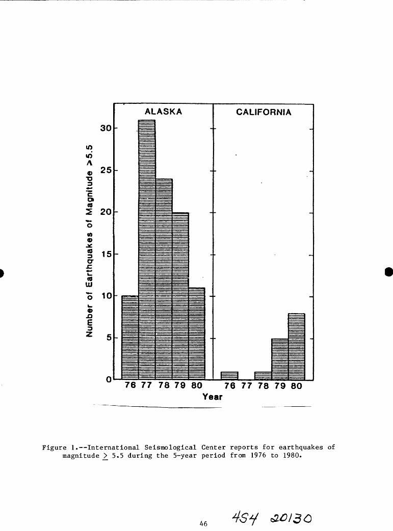
Number of Earthquakes of Magnitude >5.5
.-> -* ro ro co O en o en O 01 o
-
AL
*m ^
ASKA
^MM
CALIFORNIA
-
-
P=I ^===76 77 78 79 80 76 77 78 79 80
Year
Figure 1. International Seismological Center reports for earthquakes of magnitude > 5.5 during the 5-year period from 1976 to 1980.
46 46y

160° 170' 180' 170° 160° 150° 140° 130" 120°
ARCTIC OCEAN
/ IPoint Barrow Beaufort
Chukchi Sea
Barter Island
Delta Junction
PrinceWm. , I4
Sound Lltuya BayKodiak
Island
Shumagin Island Is.
PACIFIC OCEAN
50
180° 170< 160 150° 140"
Figure 2. The dots show the epicenter locations of all shallow (depth less than 70 km) earthquakes in Alaska of magnitude 7.2 or more from 1897 through 1980. The map shows 31 events, but two dots in the Yakutat - Yakataga area actually represent two events each, and two in the westernmost Aleutians are off the map. The 83-year record thus indicates that Alaska has 35 earthquakes of at least magnitude 7.2, or one every 2.3 years.
47

many landslides, snow avalanches, and submarine slumps at distances out to
100 km from the epicenter.
The 1946 Scotch Cap earthquake generated an extremely large tsunami which
completely destroyed the reinforced concrete lighthouse at Scotch Cap on
Unimak Island in the Aleutians and caused significant damage in the Hawaiian
Islands. The 1964 great Alaska earthquake caused permanent uplift or
subsidence of tens of thousands of square kilometers from Prince William Sound
to Kodiak Island. The tsunami did terrible damage at Kodiak, Seward, Chenega,
and other coastal villages of Alaska and at places as distant as Newport,
Oregon, and Crescent City, California. A secondary submarine slump near Shoup
Bay in Valdez Arm created a seiche wave which broke off trees more than 35 m
above Shoup Bay and which sloshed a wall of water about 7 m high through the
town of Valdez. The long duration of the strong shaking in Anchorage, more
than 60 km from the nearest point on the rupture surface, caused a dozen
damaging landslides along the bluffs of Knik Arm and Ship Creek.
Queen Charlotte-Fairweather Transform Fault Zone
Five epicenters are shown in Figure 2 along the panhandle region in
southeastern Alaska. These events occurred along the Fairweather fault which
is part of a transform fault system along which the Pacific plate is sliding
to the northwest (horizontally) by southeast Alaska. This region is known as
the Queen Charlotte-Fairweather transform fault zone. Great earthquakes with
Richter magnitudes up to the mid-8s can occur here, but the extremely large
events in the high 8s and low 9s typical of the subduction zone to the west
are not expected. Earthquakes in the transform zone occur on strike-slip
faults which cut the surface of the earth in long straight lines. Offsets
along these surface breaks can be on the order of meters, causing very intense
shaking near the fault.
The 1958 Lituya Bay earthquake (M = 7.9) had a horizontal displacement across
the Fairweather fault of about 15 m. The violent shaking from this quake
dislodged a giant rockslide in Lituya Bay, causing a seiche wave which washed
trees and soil from the bedrock of the opposite shore to an elevation more
than 500 m(!) above sea level.
48

Interior, Northern, and Western Alaska
In the interior of Alaska there are five epicenters shown on the map of
Figure 2. The largest of these quakes, the 1904 Rampart earthquake, is
sometimes listed as having a magnitude of 8, though 7.3 is probably more
correct. A sixth event south of the Alaska Range and about 50 km north of
Anchorage occurred in 1943, had a Richter magnitude of 7.4 (M ) and probablyo
should be classed with these other mainland Alaskan events. All of these
earthquakes occurred on faults which did not break the surface of the earth in
a clear escarpment. Typically, these events have durations of strong shaking
which last somewhat less than a minute. Rock fall and liquefaction of the
soil can occur 30 to 50 km away from the epicenter. The 1937 Salcha
earthquake left a number of fissures in the soil and caused a rockfall which
closed the Richardson Highway. The 1958 Huslia earthquake caused widespread
cracking and fissuring of the soil. A significant amount of liquefaction was
indicated by the numerous sand flows and sinkholes seen after the quake.
There have been no events larger than M = 7.0 in western and northern Alaska
including the offshore regions of the Bering, Chukchi, and Beaufort seas
(excluding the Aleutian zone, of course). If one lowers the magnitude
threshold a little and considers all events larger than M = 6.0, we begin to
see a trend of epicenters defining a broad belt from the Fairbanks-Delta
Junction area in interior Alaska through the Kotzebue-Nome area in western
Alaska, and on across the Chukchi Sea into Siberia. If one lowers the
threshold still further and considers all events larger than M = 4.5, then a
second trend emerges. This is a broad belt of epicenters trending north-
northeast, which again originates in the Fairbanks-Delta Junction area and
goes through the Barter Island area of north-eastern Alaska. The two regions
of lowest historical seismic activity in Alaska are the Kuskokwim and Yukon
deltas region around St. Marys and Bethel and the western half of the north
slope region centered around Point Barrow, with the latter being somewhat less
active than the former.
49

Alaskan Earthquake Statistics
We can get a reasonably quantitative sense of the relative hazards between
these broad zones of Alaska by examining the historical record for earthquakes
of magnitude greater than or equal to seven as compiled in Table 2. The
events listed in that table have been assigned to three zones: (1) the
subduct ion zone; (2) the transform zone; and (3) the mainland Alaska zone.
Recall that no large earthquakes (M ^ 7.0) have occurred in Alaska outside of
these three zones. That is not to say that it is impossible for a magnitude
seven event to occur near Bethel or Barrow, e.g., just that the probability is
considerably lower there relative to the three zones which have been active
over the past 90 years.
For each of these active zones the number of independent events larger than or
equal to magnitude seven and the time intervals between them are summarized
statistically in Table 3. In the subduction zone, e.g., there have been 37
events of M_>. 7.0 during the past 90 years. Excluded from this tabulation are
events that appear to be foreshocks or aftershocks of some other event. The
mean repeat time, or average interval time for independent earthquakes of M _>_
7.0 in the subduction zone was 2.3 years, and it has been 5.0 years since the
last such earthquake. The "time for 95% of cases" is the mean repeat time
plus 1.645 times one standard deviation of the individual repeat times about
their mean. This statistic assumes a Gaussian distribution of the repeat
times which is clearly not true for the M _> 7.0 case, but which may be true
for the M 7.8 case. It is simply meant to be a measure of how "overdue" a
particular zone may be. If the time interval since the last event in a
particular zone is longer than "95%" of all previously observed time intervals
between events, then one might say that zone is overdue for an earthquake of
the class in question. In the example of the subduction zone the time for 95%
of previous intervals is 6.1 years, so the fact that it has been 5.0 years
since the last event means that we are approaching being overdue for an
earthquake of M_> 7.0 there. However, for earthquakes of M 7.8 it has been
20.9 years since the last event and the 95% time is 19.3 years, so in this
case we are now overdue.
50

Table 2
MAJOR SHALLOW ALASKAN EARTHQUAKES: 1897 -1980
(After Abe and Noguchi, 1981 and 1983)*
YEAR MO DY TIME LAT. LONG. M, LOCATION ZONE*
123456789101112131 415161718192021222324.25262728293031323334353637383940
189818981899189918991899.39918991899189918991900190119011902190319031903190419051905190519051 9^61906190719081909191019101911191119121912191519. i1*17192319251926
610479999999101121126823912812954911911677155810
2911161444-10101723239183111752271422151017232151096171310731303141913
1836163713421332002204401704214112501104125012280439090205201605182613172156084603380602123600101722160108311936011320290326161316060757013102450847162612071908
52.50.58.
(60.)*60.60.60.60.59.60.60.
(60.)*60.52.55.50.52.57.64.53.50.55.50.51.53.52.59.52.51.553.51.52.59.64.54.56.554.555.5
55.2552.
+172.180.
-138.(-150.)*
-142.-142.-140.-140.-136.-143.-143.
(-142.)*-135.-177.-165.-170,+175.-156.-151.-176.180.
+165.180.
+179.-165.+173.-141. .+175.-176.-135-.180.
+173.-153.-147.+ 162.+163.-160.-156.5+168.-176.
7.66.96.97.27.96.97.48.06.96.97.07.7'
7.17.17.07.06.86.97.37.37.07.46.97.87.37.47.07.07.06.87.16.96.97.27.67.87.97.17.07.0
Near Is.Rat/Andreanof Is.S.E. Alaska(Kenai Penin.)*Gulf of AlaskaGulf of AlaskaS.E. AlaskaS.E. AlaskaS.E. AlaskaGulf of AlaskaGulf of Alaska(Kodiak)*S.E. AlaskaAndreanof Is.Unimak Is.(Fox Is.)Near/Rat Is.Alaska Penin.Central AlaskaAndreanof Is.Rat/Andreanof Is.KomandorskyRat/Andreanof Is.Rat Is.(Unimak Is.)Near Is.S.E. AlaskaNear /Rat Is.Andreanof Is.Queen Charlotte Is.Rat/Andreanof Is.Near Is.Kodiak Is.Central AlaskaKamchatkaKamchatkaAlaska Penin.Alaska Penin.Unimak Is.Andreanof Is.
S+S-T-S+T+T-T+T+T-T
T+S+*T+S+S+S+S-s-M+S+S+0+s-S+S+S+T+S+S+0-S+s-s-M+0+0+S+S+S+S+

#. YEAR MO DY TIME LAT. LONG. M, LOCATION ZONE*
41424344454647484950515253545556575859606162636465666768697071727374-
7576777879808182838485868788
192719281929192919291929193319351936193719381938194019401940194319441945194619461946194719481949194919511953195719571957195719571957195719571957195719581958196019641964196519651965196519651965
TO63771242117111144811124141110589213333333344471123223779
242175717272213221017161622312151211161422271359911111214162210197101362844302294
155916270134141921231058023617051231170920180354060706430327143204170235202512281114020922310401153022120748142220390958145511441447023414211129221915300615092013070336050108400227205808291432
57.560.51.51.52.
52.561 .2552.2555.5
64.7555.555.552.52.53.
61.7551.557.
59.2552.7551.564.554.5
53.7559.7556.54.51.352.2552.2551.551.551.51.553.7556.
52.2565.558.351.455.761 .151.351 .4
. 50.353.051.158.3
-137..-146.5
-170.-178.-178.+171.5
-150.75+175.+163.
-146.75-158.-158.5+173.5+173.5-165.5-151.+179.5+164.
-147.25-163.5-174.5-147.5-161.
-133.25-149.-156.+170.5-175.8-169.5-169.25-178.5-177.-177.
-178.75-165.75
-154.-166.
-155.5-136.5-168.9-155.9-147.5+178.6+179.6+177.9-167.6-171.3-152.5
7.16.87.57.07.37.86.97.17.17.38.37.36.87.17.07.46.97.26.77.37.07.27.58.16.77.17.1(8.1)7.17.06.97.07.17.07.06.96.57.37.96.77.0(8.4)*(8.2)*7.07.46.56.76.8
S.E. AlaskaGulf of AlaskaFox Is.Andreanof Is.Andreanof Is.Near Is.S. Central AlaskaNear/Rat Is.KamchatkaCentral AlaskaAlaska Penin.Alaska Penin.Near Is.Near Is.Unimak Is.S. Central AlaskaRat Is.KomandorskyGulf of AlaskaUnimak Is.Andreanof Is.Central AlaskaAlaska Penin.Queen Charlotte Is.Kenai Penin.Alaska Penin.Near Is.Andreanof Is.Fox Is.Fox Is.Andreanof Is.Andreanof Is.Andreanof Is.Andreanof Is.Unimak Is.Kodiak Is.Unimak Is.Central AlaskaS.E. AlaskaFox Is.Alaska Penin.Gulf of AlaskaRat Is.Rat Is.Rat Is.Fox/Unimak Is.Fox Is.Kodiak Is.
T+o_
S+S+s+s+M-s+0+M+S+S+S-s+s+M+s-0+s-s+s+M+S+0+s-s+s+s+s+s+s-s+s+s+s+s-s-M+T+S-S+S+s+s+s+o_
s-s-
52

#. YEAR MO DY TIME LAT. LONG. M. LOCATION ZONE*
89909192939495
1966196619691971197219751979
781112722
47221530228
1833021323090829214508432127
52.50.57.56.56.53.60.
0670816
+179-171+163+ 163-135+173-141
.9
.2
.6
.2
.9
.6
.6
6.86.47.17.57.47.47.0
Rat Is.Fox Is.KamchatkaKamchatkaS.E. AlaskaNear Is.S.E. Alaska
S-S-0+0T+S+T+
Explanation:
(1) Data for 1897-1912 from Abe, K. and S. Noguchi, 1983(a).
(2) Data for 1913-1917 from Abe, K. and S. Noguchi, 1983(b).
(3) Data for 1918-1980 from Abe, K., 1981.
(4) The following notes apply to the respective earthquake number:4 - location very uncertain, felt reports suggest a more westerly epicenter,
perhaps near the Shumagin Islands 12 - location very uncertain, felt reports suggest a more westerly epicenter,
perhaps near Kodiak Island 68 - moment magnitude 8.782 - moment magnitude 9.283 - moment magnitude 8.7
(5) Earthquake zones were defined as follows:
S = Alaska-Aleutian subduction zoneT » S.E. Alaska transform zoneM - Mainland Alaska0 - Outside of Alaska (Kamchatka, Komandorsky, Queen Charlotte)+ - Mg greater than or equal to 7.0- = M_ less than 7.0
S
53

Table 3Alaskan Earthquake Statistics
Independent Events, M >, 7.0, January 1897 - January 1986
Region Major (Ms > 7.0)
Great (Ms > 7.8)
Alaska-Aleutian Subduction ZoneNumber in 90 years 37 7 Mean repeat time (years) 2.3 9.7 Time since last event (years) 5.0 20.9 Time for 9556 of cases (years) 6.1 19.3 Date of the last event 1-30-81 2-M-65
S.E. Alaska Transform ZoneNumber in 90 years & 3 Mean repeat time (years) 11. M 29. M Time since last event (years) 6.9 27.5 Time for 9556 of oases (years) 29.3 97.8 Date of the last event 2-28-79 7-10-58
Mainland Alaska Seismic ZoneNumber in 90 years 6 0 Mean repeat time (years) 10.7 ? Time since last event (years) 27.8 ? Time for 9556 of cases (years) 24.5 ? Date of last event M-7-58 ?
All of AlaskaNumber in 90 years 51 10 Mean repeat time (years) 1.7 7.3 Time since last event (years) 5.0 21.0 Time for 9556 of cases (years) 4.5 17.3 Date of last event 1-30-81 2-M-65
NOTES
1) The data base for these calculations is the catalog of large, shallow earthquakes in Alaska based on the papers of Abe and Noguchi given in Table 2 augmented by data for the period Jan. 1981 - Jan. 1986 from the National Earthquake Information Service (NEIS).
2) The mean repeat time for the MS > 7.0 and MS > 7.8 events is the average of the observed interevent times.
3) The "time for 9556 of cases" is the mean interevent time plus 1.6M5 times one standard deviation of the individual interevent times about their mean.
£013-0

In the transform zone neither class of earthquake is close to being overdue,
so while an event of M >_ 7.0 could occur tomorrow, we would not be surprised
if it did not occur for another 30 years.
In the mainland Alaska seismic zone there have been no events of M >_ 7.8
during the past 90 years. This does not mean that such events are impossible,
simply that they are less frequent than in the subduct ion zone. The mean
repeat time for great earthquakes in this zone is probably on the order of a
few hundred years, so it's not surprising that we have not recorded one given
our short history here.
For major (7.0 _>. M _> 7.8) earthquakes in the mainland zone the time since the
last event is 27.8 years, and the time for 95% of the cases is 24.5 years,
thus we are overdue here too.
It should be noted that these statistics apply to very large zones and that
the mean recurrence times for a specific locality within one of these zones is
much longer than the mean repeat time for the whole zone.
CAUSE OF EARTHQUAKES IN ALASKA AND LIKELIHOOD OF FUTURE SHOCKS
The direct cause of the very large earthquakes in southeastern Alaska and the
Alaska Peninsula-Aleutian zone is the relative motion of the Pacific and North
American (Alaska) plates (Fig. 3). The Pacific plate is continuously created
by the upwelling of molten rock at the Juan de Fuca and East Pacific spreading
centers. The Juan de Fuca spreading center lies offshore of British Columbia,
Washington, and Oregon and forms the Juan de Fuca plate on one limb and the
northernmost part of the Pacific plate on the other. The East Pacific
spreading center begins in the Gulf of California and extends south and then
southwesterly from Central America. This spreading center forms the Cocos and
Nazca plates on one limb and the central part of the Pacific plate on the
other. From the Juan de Fuca and East Pacific spreading centers the Pacific
plate moves northwesterly relative to North America along the San Andreas and
Queen Charlotte-Fairweather transform fault systems. Along these transform
faults the plates slide past one another edge-to-edge. When the Pacific plate
arrives at the Gulf of Alaska it can no longer move sideways by the North
55

EURASIAN PLATE
Fairweather- Queen Charlotte Fault System,.,,::,:.,,,..,.
NORTH AMERICAN PLATE
Juan de Fuca.
Spreading Center
DIRECTION OF PLATE MOTION
Figure 3. Some of the plate tectonics features which give rise to the Pacific Ring of Fire. Most earthquakes and volcanoes occur around the margins of the pacific Basin, particularly in the subduction zones and along faults exhibiting strike-slip (lateral) displacement.
56

American plate; here it begins subducting beneath Alaska. The Pacific plate
is consumed beneath the North American and Eurasian plates along the Aleutian,
Kurile, and Japanese islands.
The conveyor-belt-like motion of the Pacific plate from spreading center to
subduction zone is thought to be driven by buoyancy forces. There may be a
small amount of push as it "falls off" the topographic high at the spreading
center and there is probably a much stronger pull as the cooler portion of the
plate, far away from its origin at the spreading center, sinks under
gravitational forces into the less-dense mantle. It is this relentless motion
of the Pacific plate as it slides by southeastern Alaska and is thrust beneath
the Gulf of Alaska and the Aleutian Islands that causes most of the
earthquakes in Alaska.
Over the past 5 million years, about 290 km of Pacific plate has been thrust
to the northwest underneath southern Alaska in the vicinity of Anchorage - an
average rate of about 5.8 cm year. Since the slip during the 1964 Good Friday
earthquake is calculated to have been about 10 m, it would take about 172
years to build up enough strain for a repeat of that devastating event. Note
that this is an average number and that it is assumed that no ##?aseismic slip
takes place; that is, that all of the 5.8 cm per year of relative motion
between the Pacific and North American plates is taken up in strain that is
entirely released in the form of great earthquakes. Extreme estimates of the
repeat times for great earthquakes in southern Alaska range from 30 years to
1800 years.
Seismic Gaps
The deterministic notion of repeat times of large earthquakes described above
leads to the idea of a seismic gap. If it takes a certain amount of time for
strain to build up in a region following a large earthquake, then it follows
that immediately after such an event the probability for another of similar
magnitude is quite low. Conversely, if much time has elapsed since the last
large event in an area where large earthquakes are known to occur, then the
probability for a large shock in the near future is relatively high. Such an
area is called a seismic gap (with a high seismic potential).
57

In southern Alaska there are two regions that have been identified as seismic
gaps: one near Yakataga and the other near the Shumagin Islands and Cold Bay
on the Alaska Peninsula. In each of these areas it has been at least 80 years
since the last great earthquake (MW _>. 7.8) occurred. In both areas, 80 years
is approximately the estimated repeat time for an earthquake of about M =
8.0. Hence, both areas are "due" for a large earthquake (i.e., have a high
seismic potential), so we wouldn't be surprised if one were to occur there
tomorrow. On the other hand, we wouldn't be surprised if one did not occur
there during the next 10 years. The quality of the data presently available
to us restricts us to the following statement: There is a 30 to 90 percent
chance of an earthquake of M > 8.0 occurring in the Yakataga and Shumagin
gaps in the next two decades (Nishenko and Jacob, 1985). The range in
probabilities arises out of different assumptions about how to do the
statistics.
Faults Away from Plate Boundaries
We understand the probabilities for large shocks in the seismic gaps quite
well by comparison to how well we understand that likelihood for large
earthquakes on most faults that do not lie near plate boundaries. In most
cases we have no direct information about the repeat time for large events on
a given fault: all we know, for example, is that a certain fault may have
been offset in the last 10,000 years - we may not even know if this offset was
sudden, in one or more large events, or gradual, in some form of continuous
creep.
One particularly important example of this situation is the Border Ranges
fault which follows an arcuate path along the northern front of the Chugach
and Kenai mountains from north of Cordova to the southwestern tip of Kodiak
Island, a distance of over 1000 km. This great fault is thought to be the
suture zone (or zone of collision) between parts of southern most Alaska which
were rafted together about 40 million years ago. It is possible that portions
of this suture zone are active today. There is some evidence, for example,
that the portion near Eagle River has moved in the last 4,000 years. There is
no large earthquake known to be associated with the Border Ranges fault. This
58

leaves us with the uncomfortable and unsatisfactory conclusion that there is a
possibility that there is a high probability for a large earthquake on this
major fault system which runs right through Anchorage. Clearly more work is
urgently needed to resolve this situation. In the meantime most, but not all,
assessments of seismic hazard in the Anchorage area assume the fault to be
active.
Again, this is only one example. There are many other major faults in
southcentral, western, and northern Alaska which may or may not generate
future large earthquakes: The Castle Mountain, Denali, Iditarod, Kal,tag, and
Tintina faults, to name just a few. Further, there are seismically active
zones such as the Badger Road area near Fairbanks that has had thousands of
earthquakes, including four events of magnitude 5.5 to 6.0 on one day - June
21, 1967. In this area we have earthquakes but no known fault. This makes it
difficult to assess the likelihood of future, possibly larger events. We know
these larger events can occur in the Interior: there were events of M = 7.3O
in 1904 south of Rampart, near Salcha in 1937, and near Huslia in 1958. None
of these earthquakes clearly occurred on a mapped fault. So, for the time
being, we must lump all of these events into one large seismogenic zone and
treat their occurrence statistically. This has the result that we "smear out"
the probability of occurrence of future larger events over a very big area,
with the consequence that some areas are underrated as to their seismic hazard
and others are overrated. For the present, this is the best that can be done.
RISK REDUCTION
What can we do to improve this situation in the future, and what can we do to
mitigate the effects of the inevitable future large earthquakes? The
essential new information will come only from a long-term commitment to a
program of seismic monitoring and geological mapping designed to identify and
evaluate potential seismic sources in Alaska. As this new information becomes
available, it must be incorporated into building codes and zoning requirements
so that it is used to assure the cost-effective and safe development of the
state.
59

That a long-term commitment to seismic risk reduction is cost effective was
clearly demonstrated by a three-year study carried out by the California
Division of Mines and Geology (CDMG). The results of this study are
summarized in Figure 4. The histogram shown in this figure indicates three
dollar values associated with each of a number of geologic hazards. The first
value given is the expected cost to society if we proceed with the status
quo. In case of seismic shaking, for example, this would be the expected loss
in California due to collapse or major damage to structures if no new hazard
mitigation programs were carried out between now and the year 2000. The
second value given in each case is the expected reduction possible if state-
of-the-art loss-reduction measures were in place from 1970 to 2000. The last
value is the expected cost of implementing the best possible programs to
reduce losses from the hazard. Again in the case of seismic shaking, this
program would include measures such as identifying areas most likely to
experience strong seismic shaking or ground failure as a result of large
earthquakes in the next 20 years, so that efforts may be concentrated in these
areas. Further measures would include the strengthening of some buildings and
the removal of other (unreinforced masonry, for example), changes in
occupancy, new building code requirements, and new zoning.
Summarizing the earthquake shaking case, we see that for the period from 1970
to 2000 the expected loss in California under current practices would be $21
billion, the possible reduction in these losses given state-of-the-art loss-
reduction measures would be about $10.5 billion, and the cost to implement
these measures would be about $2 billion. This gives a benefit/cost ratio
which is better than 5:1, a pretty good return on investment by any
standards! Some of the other major geologic problems yield even higher
benefit/cost ratios. Loss of mineral resources to urbanization and
landsliding, are both $10 billion-plus problems which have benefit/cost ratios
in excess of 9:1. Clearly a little foresight would make good economic sense.
These numbers, of course, apply only to California, where there is a very
large population exposed to these hazards. A similar study is needed in
Alaska to identify the problem areas where similar benefit/cost ratios might
apply to our geologic problem. It is very likely that given properly scaled
loss-reduction programs, similar benefit/cost ratios could be achieved for
60
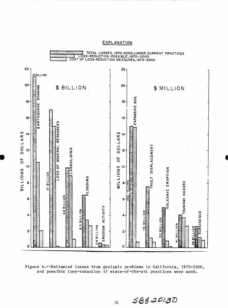
EXPLANATION
22-
20-
18-
16-
*" 14-g^_j-JO 12-Q
u_0
10-
2O
-J g.
_
m
6-
4-
2
0
m$^tifX:mx: *?sm TOTAL LOSSP: ! ::U:::|=::!;;:!: ; :::!i!::::i : -iii::::i=J L OS S - RF Dl 1^ T 1 O W
S, I970-2000.UNDER CURRENT PRACTICES POSSIBLE, 1970-2000
:::::->.::.l UVJi I Ur LUbi-KtUUi: 1 IQN MtASIIBFS IQTn-^nOO
1 22 1 1
21
1
1 '
:
:*:S't
' K
pi'ii
lli:
If:'ift
1i;
If?i
!/
i
l|
I:
IP
1
1
11
1 & '**:
1
i-i<;':S*1
1
1
3ILLION
OZ
enUJ*
oo£
o:
UJ
*~i
T
S B LLION
-
zO_J-J
00
»>4
|$
II
S"j.
l:
|;':??
1£?«:*
1'
*.' :
i
I':|5
11
P.Ky
1
N1:-: : ;: :_
|-?
:'-l
i
i;5:'j?s|;:P
-
enUJ
??! Ocr.
OenUJcr_j< «OB ^y
UJ z 9^ enu. oO Tlz
en en0^
z0-J-J<D
<ncS
m
ii?'
$&
1fss
Ri1ss^
11l-i:^!-:
S:
1
&'
iftS:fe
jWfl o
zQO0
p-U.
1
i > Op >3| -d If o03 || vX; <t
5:^ vX:
«o p xl ° o11 : ^ en "11 : - 0p vX; ' 00 Q;
vi I? vx- ; ^ ijj' ! ] || :5£ Q- pp^; ; ! |- ixo : ^jv...l-.-!
20-
18-
16
W 14 -<r^_j_jO | 2 .^
U.0
cn 10-2 O
3d 8-2
6-
4-
2-
0
$ M LLION
dSUJ
enzQ.XUJ
z gj_i
o m
Sv.;::S
feP
|
feii111;!?;
1
19
1
i?1i^.;->A:>
11
1
1
i ii3* *
WH
^
1v!v!
:?S
Sj:
H-Z iUJ
UJo
Q. en Z
5 2»- o.
0 K Q < UJ *
1 o 5; ?'? Z Z
i <l| O 2
I o zz p || *" u2 I | P.- *"" oj 1 2 i ||~ ^5 si !§ |$ p Q
£ | ^ 1 - 11^" §imi f 1 ^ |1 : J |OT "
L 5 iS :S:: . -J p^*r :S:: ~ ^ TT"!
i| vS ! ! ^ ;:-5::fr-%V ^ >:>': *° ® :^ :}"'j
^ S:: ! ! w | K.£.' j
Figure 4. Estimated losses from geologic problems in California, 1970-2000, and possible loss-reduction if state-of-the-art practices were used.
61

earthquake losses, loss of mineral resources, and frozen ground losses, to
name just a few.
CONCLUSIONS
We have a rapidly developing urban and transportation infrastructure in Alaska
which is vulnerable to an extremely high level of earthquake hazard. This
hazard, while qualitatively well understood, cannot be adequately quantified
for risk assessment purposes at the present level of knowledge. What is
required is a two-fold commitment to improving our knowledge of the hazard and
to carrying out appropriate loss-reduction measures. There is every reason to
believe that substantial benefit/cost ratios can be achieved in Alaska with a
well-planned program to reduce losses from earthquakes. Further, there are
many other geologic problems in Alaska that likely will admit to similar loss-
reduction efforts.
REFERENCES
Abe, K., 1981. Magnitudes of large shallow earthquakes from 1904 to 1980.
Physics of the Earth and Planetary Interiors 27:72-92.
Abe, K., and Noguchi, S., 1983 (a). Determination of magnitude for large
shallow earthquakes, 1898-1917. Physics of the Earth and Planetary
Interiors 32:45-49.
Abe, K., and Noguchi, S., 1983(b). Revision of magnitudes of large shallow
earthquakes, 1897-1912. Physics of the Earth and Planetary Interiors
33:1-11.
Alfors, John T. , Burnett, John L., and Gay, Thomas E., Jr., 1973. The Nature,
Magnitude, and Costs of Geologic Hazards in California and
Recommendations for Their Mitigation. Urban Geology: Master Plan for
California, Bulletin 198, California Division of Mines and Geology,
Sacramento, California.
62

lacopi, Robert, 1971. Earthquake Country. Lane Books, Menlo Park,
California, 160 p.
Kanamori, Hiroo, 1977. The energy release in great earthquakes. Journal of
Geophysical Research 82(20):2981-2988.
Nishenko, S. and Jacob, K., 1985. Hazards evaluation for large and great
earthquakes along the Queen Charlotte-Alaska-Aleutian seismic zone:
1985:2005, unpublished ms, 12 p.
63

REGIONAL SEISMIC MONITORING IN SOUTHERN ALASKA:
APPLICATION TO EARTHQUAKE HAZARDS ASSESSMENT
by
John C. Lahr, Christopher D. Stephens, and Robert A. Page
U. S. Geological Survey
Menlo Park, California 94025
INTRODUCTION
The seismic activity of southern Alaska is a consequence of the NNW-SSE
convergence of the Pacific and North American plates at a rate of about 6
cm/a. This convergent motion is accommodated by right-lateral strike-slip
motion on the Queen Charlotte Islands fault and subduction of the Pacific
plate along the Aleutian megathrust (Figure 1). The transition between these
two fault zones is complex, and the Pacific-North American plate boundary is
not identified with certainty along the eastern Gulf of Alaska. The plate
motion in this region is not confined to a single, well-defined fault zone;
rather it is distributed among faults bounding three tectonic blocks lying
between the continental margin and the Denali fault (Lahr and Plafker,
1980). Most of the motion occurs between the Yakutat block and the Wrangell
and St. Elias blocks. The Yakutat block, which is moving at nearly the
velocity of the Pacific plate, is currently in the process of being accreted
to Alaska.
The U.S. Geological Survey (USGS) began continuous high-gain seismic
monitoring in southern Alaska in 1971 with a network of 10 stations in the
Cook Inlet and Valdez regions. By 1974, the number of stations had increased
to 54 and the monitored region had expanded eastward along the Gulf of Alaska
as far as Yakutat Bay and northward to southern edge of the Wrangell
Mountains. During subsequent years additional changes have been made in the
network, including the temporary operation of additional stations for special
studies, but the area covered by the network has remained relatively
constant. Approximately 35,000 earthquakes have been located with data from
64
60'
Red
ou
bt
Illam
na
Au
gu
stin
e
'55
150°
145
140'
Figure 1
. Ma
p of
sou
ther
n Al
aska a
nd w
este
rn C
anada
emphasizing
principal
regional te
cton
ic f
eatures
(Lahr
and
Plafker, 1980;
Stephens a
nd o
thers, 19
84).
Lo
cati
on o
f cross
sect
ion A-A
1 of
Fig
ure
2 is
sho
wn.
KO,
Kodi
ak I
sland; M
, Middleton
Isla
nd;
K, K
ayak I
slan
d; C
I, C
ook
Inlet; A
N, A
nchorage;
PWS, Prince W
illi
am S
ound
(Valdez
is n
ear
S of
PWS
); I,
Icy
Bay;
Y,
Yakutat B
ay;
CS,
Cros
s So
und;
WV,
Wrangell
volcanoes; 1964,
rupt
ure
zone o
f 1964 P
rince
William
Sound
eart
hqua
ke;
1979
, ru
ptur
e zone o
f 1979 S
t. Eli as
earthquake; A
M, A
leutian
megathrust
; TZ
, Transistion
zone
; Q, Q
ueen C
harlotte I
slands f
ault;
C, C
hath
am S
trai
t fault; D
A, D
alto
n fault; DR
, Du
ke R
iver f
ault;
TF,
Totschunda-Fairweather f
ault
; T,
To
tsch
unda f
ault;
D, Denali fault; T
T,
unna
med
faults;
CM,
Cast
le M
ount
ain
fault; F
, Fairweather
faul
t; PZ,
Pamplona z
one;
do
uble
lin
e, 50
km
isob
ath
of B
ern* off
zon
e; Y
B, Ya
kuta
t block; SE
, St
. Eli as
block;
WB,
Wrangell block; sh
aded
zone
from
TT
through
CI to A
M is
speculative
northwestern
boun
dary
of
WB;
RM1,
Pa
cifi
c-No
rth
Amer
ican
plate r
elative
moti
on d
irec
tion
.

the USGS southern Alaska network; an additional 3,000 to 4,000 events are
currently being located each year. This data set constitutes an invaluable
source of information for delineating seismic source zones and elucidating the
regional seismotectonic framework, activities that are prerequisites for
evaluating earthquake potential in hazard assessment studies. In addition,
continued monitoring of the Yakataga seismic gap may provide valuable data for
testing current and future hypotheses about earthquake precursors.
To show the relationship of earthquakes to major tectonic features,
hypocenters within 50 km of the line A - A 1 (Figure 1), which extends from
Mt. Spurr volcano to the Aleutian trench, are shown in cross section in
Figure 2. The location of the Pacific plate has been inferred from the
distribution of subcrustal (focal depths greater than about 40 km)
earthquakes, the Benioff zone of seismicity. The Pacific plate is being
subducted below the North American plate (Alaska) along the Aleutian
megathrust, which crops out on the seafloor at the Aleutian trench. The
seismicity can be divided into four tectonic source zones (Figure 2) as
follows: 1) within the Aleutian megathrust zone; 2) within the subducting
Pacific plate; 3) within the overriding North American plate away from the
active volcanoes; and 4) within the North American plate along the axis of
active volcanoes. Each of these source zones will be described briefly and
some of the applications and limitations of the seismic network data will be
discussed.
ALEUTIAN MEGATHRUST
The largest earthquakes in Alaska, such as the moment magnitude (M ) 9.2
Prince William Sound earthquake of 1964, result from slip on the Aleutian
megathrust, the northward dipping interface between the Pacific and North
American plates. The most recent large thrust earthquake in the region was
the 1979 St. Elias earthquake of magnitude (M_) 7.1, which occurred north ando
east of Icy Bay (Figure 1). Data from the USGS network were critical in
delineating the lateral extent of the rupture zone and in monitoring the
magnitude and temporal distributions of the aftershocks (Stephens and others,
1980). To better resolve the depths of aftershocks and thereby the geometry
of the inferred buried rupture, Page and others (1984) supplemented the
66

MT
SP
UR
RC
OO
K
INL
ET
K
BN
AI
MO
UN
TA
INS
AN
CH
OR
AG
BP
RIN
CE
WIL
LIA
M?!
*;
GU
LF
OF
AL
ASK
A
SOU
ND
MA
GN
ITU
DE
x
>
0
O
>
3
25
50
75
100
KM
100
-
125 -
150 -
175
200
SC
HE
MA
TIC
C
RO
SS
S
EC
TIO
N
OF
T
HE
A
LE
UT
IAN
A
RC
S
HO
WIN
G
SE
LE
CT
ED
E
AR
TH
QU
AK
ES
F
RO
M
OC
TO
BE
R
19
71
T
HR
OU
GH
M
AY
1
98
5
JCs
Figu
re 2
. Cross
section
show
ing
hypocenters
of e
arth
quak
es w
ith
4 or
more
P-phase
readings,
1 or
mor
e S-phase
readings a
nd r
oot-
mean
-squ
are
residual less t
han
or e
qual to
0.6 s
. Vi
ew i
s northeast.
2604 e
vent
s within 5
0 km o
f line A
-A1,
sh
own
in F
igur
e 1,
ar
e included.
Stru
ctur
es m
odified
from P
lafk
er a
nd o
thers,
1982.
The
offs
ets
within t
he B
ern*off
zone b
elow C
ook
Inle
t and
the
tendency f
or c
rust
al events t
o co
ncen
trat
e near c
erta
in d
epths
are
thou
ght
to b
e ar
tifa
cts
of t
he l
ocation
proc
eedu
re.

regional network with a temporary array of 4 seismographs near the center of
the rupture zone. They found that the distribution of accurately located
hypocenters locally defined a thin (3 km thick), sub-horizontal planar fault
zone at a depth of 11 to 14 km. Thus the combination of regional monitoring
and a short-term special study was able to resolve the principal features of
the sequence.
Within the rupture zone of the great 1964 earthquake (Figure 1), relatively
few events believed to be on the Aleutian megathrust have occurred since the
regional network was installed. Nonetheless, the position of the subducted
Pacific plate and hence the location of the megathrust beneath the Anchorage
region (Figure 2) has been inferred from the distribution of Benioff zone
events.
An important unresolved question for the Anchorage region is the depth beneath
which slip on the megathrust occurs aseismically, that is without
earthquakes. Based on the distribution of aftershocks and elastic models of
the coseismic crustal deformation, the megathrust slipped to a depth of about
20 km in 1964. If the transition to asesimic slip occurs at 40 km depth, as
has been suggested for the Aleutian arc in general (Davies and House, 1979),
then seismic rupture could occur on a section of the megathrust downdip from
the 1964 rupture, directly below Anchorage at 30 to 35 km depth (Lahr and
others, 1984). It is possible that careful study of the focal mechanisms of
earthquakes recorded by the regional network within or near the megathrust
could assist in determining the location of this transition.
Knowledge of the average rate of occurrence and temporal distribution of
shocks on the megathrust, from the smallest that pose a potential hazard to
the largest that could occur, such as the 1964 earthquake, is important for
the assessment of seismic hazard in southern Alaska. Only the accumulation of
a record of earthquakes that is at least comparable in duration to the return
times of the events, which for the largest shocks is probably well over 100
years, will make it possible to determine those rates with confidence.
Regional monitoring over a few decades can provide important information for
the smaller shocks, but not for the largest earthquakes. More timely
approaches for the largest shocks are to extend the record back in time
68

through geologic studies, such as the study of Plafker and Rubin (1978) of
uplifted marine terraces on Middleton Island, or to draw analogies with other
arcs that have a longer seismic history.
Another important function of the USGS network is to monitor an area in which
a major earthquake is expected in the future, possibly within a decade or
two. The plate boundary between Icy Bay and Kayak Island has not broken in a
major earthquake since the Yakutat Bay earthquakes of 1899 and is one of only
three zones along the entire Alaska-Aleutian arc that has not ruptured within
the past 50 years. McCann and others (1980) concluded that this region - the
Yakataga seismic gap - is the likely site for a great (M>7.7) earthquake prior
to 2000. Seismicity patterns in and around this region are reviewed
continuously for changes that might alter our assessment of the imminence of a
major earthquake. Thus far, the data obtained from the regional seismic
network show a pattern of seismicity that has remained remarkably stable both
in time and space. Even if the gap filling event is not predicted in advance,
valuable data will have been gathered that can be used to test current and
future hypotheses about earthquake precursors.
ACTIVITY WITHIN THE PACIFIC PLATE
Seismicity within a subducted plate is attributed to some combination of
bending stresses, stresses due to phase transformations and temperature
gradients, and stresses resulting from the pull of the deeper portions of the
slab, which is sinking due to gravitational forces. The largest Benioff zone
events recorded worldwide have been near magnitude 8 (Abe and Kanamori,
1979). In the southern Alaska region, the Benioff zone has been the most
active source of earthquakes since regional monitoring began in 1971. Even
though the criteria for selecting shocks to be located emphasize shallow
events, most of the events processed occurred within the subducted Pacific
plate (Figure 2).
Focal mechanisms of Benioff zone events recorded by the regional network are
quite varied, but many are compatible with the least compressive stress axis
oriented downdip within the plane of the subducted plate (Lahr, 1975; Lahr and
Stephens, 1982). For example, two magnitude 6 earthquakes occurred in July
£6369

and September 1983 near Columbia Bay on the northern edge of Prince William
Sound. These are the largest events in the Prince William Sound region since
the M 9.2 earthquake of 1964. Using portable stations to augment the
regional network, Page and others (1985) showed that well-located aftershocks
define a northwest-dipping fault zone that was activated between 22 and 35 km
depth. The focal mechanisms indicated predominantly normal faulting
consistent with downdip-oriented tension. Based on the distribution of
Benioff zone events in adjacent areas, these two events are inferred to have
occurred within the upper part of the subducted plate.
The July 1983 shock produced an acceleration of 0.32 g at Valdez, 50 km away,
the largest acceleration yet recorded for an Alaskan earthquake. Strong-
motion seismographs were not deployed in Alaska until after the 1964
earthquake. Clearly the hazard associated with events originating within the
subducted Pacific plate must be factored into the overall seismic hazard
assessment.
ACTIVITY WITHIN THE NORTH AMERICAN PLATE
Although shallow-focus crustal earthquakes are much less frequent than those
within the Benioff zone, their potential close proximity to structures and the
possibility for surface faulting requires that they be given careful
consideration in hazard assessments. Generally the distribution of shallow
earthquakes in southern coastal Alaska is diffuse, and the events cannot be
clearly associated with mapped fault traces. One feature that is recognized
near Anchorage is a zone of persistent shallow activity that parallels the
strike of the Benioff zone, with epicenters located between the 35- and 50-km
depth contours drawn on the top of the Benioff zone (below Cook Inlet in
Figure 2). This zone does not appear to be associated with surface faulting
and the potential for large events has yet to be established.
In a few cases earthquakes have been associated with mapped faults. Activity
along the Castle Mountain fault system was so sparse prior to 1984 that no
events had been unequivocally associated with it. However, the Talkeetna
segment of the fault near Sutton was the source of a 5.7 m* (5.2 M )
earthquake on August 14, 1984 (Lahr and others, 1985). This event involved
70

right-lateral slip on a steeply north-dipping, buried segment of the fault.
Slip did not extend to the surface. In fact, geologic evidence for Holocene
displacements is lacking for this segment of the fault (Detterman and others,
1976). On the contiguous Susitna segment, however, Holocene displacements are
clearly evident (Detterman and others 1974). This illustrates the need for
both geologic and seismic studies in assessing the activity of faults. The
seismic potential of the Castle Mountain fault is clearly important because of
its proximity to Alaska's principal population center (40 km from Anchorage,
15 km from Palmer, 10 km from Wasilla). Although a rough estimate of the
maximum size of an event on the Castle Mountain fault can be made based upon
the length of the fault, it is more difficult to assess the frequency with
which such events might occur because the average slip rate is not known.
In evaluating the seismic potential of other mapped faults, the experience
with the Castle Mountain fault must be borne in mind: regional seismic
monitoring for 13 years could not clearly associate earthquakes with the
Castle Mountain fault, and when the fault did rupture, a segment without
identifiable Holocene displacements broke. Clearly other faults may likewise
constitute a hazard despite the current lack of definitive seismic or geologic
evidence.
VOLCANIC EARTHQUAKES
Shallow earthquakes are commonly associated with active volcanoes and often
increase in number and size prior to an eruption. The southern Alaska seismic
network was used to investigate the 1976 eruptions of Augustine volcano. The
eruptions were preceeded by an increase in minor seismic activity that began
as late as October 1975 (Kienle and Forbes, 1976). This activity was detected
by University of Alaska stations on Augustine Island. Activity increased
until at least January 2, by which time all of the stations on the island had
failed, possibly due to mudslides. Monitoring continued at a distance,
however, using stations from the regional network. On January 22, 1976 a very
energetic swarm of events began at the same time as the first of a series of
eruptions. In addition to documenting the sequence of earthquakes that
accompanied the 1976 eruptions, the regional stations recorded gradually
increasing and then gradually decreasing signals with a dominant frequency of
2 to 7 Hz that are believed to be a direct result of tremor generated by the
eruptions. Seven of the eruptions also generated atmospheric pressure
disturbances that traveled at about 0.3 km/s and were recorded at regional
seismographs up to 318 km away.
The current USGS network includes two stations on or near Mt. Spurr volcano
and one station each near Mt. Redoubt and Mt. Iliamna volcanoes. The
University of Alaska operates one station near Mt. Redoubt and a number of
stations on Mt. Augustine. A zone of shallow, predominantly low-magnitude
« 2) seismicity has been observed along the volcanic axis, and near Mt. Spurr
pronounced spatial and temporal clustering of events has occurred (Page and
others, 1982). In addition to shallow earthquakes, the Crater Peak
seismograph, which is on the volcanic pile, records a large number of low-
frequency (2-4 Hz) signals with durations of up to several tens of seconds.
Most of the events appear to originate from the volcanic pile, but precise
locations are not possible because phases cannot be identified and correlated
between stations. A shallow volcanic origin for the events is suspected, but
their exact cause is not yet resolved. Daily counts of volcanic events are
made by the USGS Branch of Alaskan Geology in Anchorage in order to detect
increases in activity that could presage an eruption of one of these
volcanoes.
CONCLUSION
Earthquake studies have played a key role in developing the current working
model of plate interactions in southern Alaska and will continue to provide a
vital source of information for refining this model as we monitor the dynamic
processes acting in Alaska. This information is essential for improving our
evaluation of earthquake potential. Continuous seismic monitoring is also a
prime strategy for documenting possible precursors to major earthquakes within
the identified seismic gaps along the Pacific margin in Alaska and precursors
to eruptions of the active volcanoes along Cook Inlet.
72 7
REFERENCES
Abe, Katsuyuki and Kanamori, Hiroo, 1979, Temporal variation of the activity
of intermediate and deep focus earthquakes, Journal of Geophysical
Research, v. 84, p. 3589-3595.
Davies, J. N. and House, Leigh, 1979, Aleutian subduction zone seismicity,
volcano-trench separation, and their relation to great thrust-type
earthquakes, Journal of Geophysical Research, v. 84, p. 4583-4591.
Detterman, R. L., Plafker, George, Hudson, Travis, Tysdal, R. G. and Pavoni,
N., 1974, Surface geology and Holocene breaks along the Susitna segment
of the Castle Mountain fault, Alaska, U.S. Geological Survey MF Map 618,
1 sheet.
Detterman, R. L., Plafker, George, Russell, G. T. and Hudson, Travis, 1976,
Features along part of the Talkeetna segment of the Castle Mountain-
Caribou fault system, Alaska, U.S. Geolological Survey MF Map 738, 1
sheet.
Keinle, Juergen and Forbes, R. B., 1976, Augustine - evolution of a volcano,
in Annual Report of the Geophysical Institute, 1975/76, University of
Alaska, Fairbanks, Alaska, p. 26-48.
Lahr, J. C., 1975, Detailed seismic investigation of Pacific-North American
plate interaction in southern Alaska, Ph.D. dissertation, Columbia
University, 141 p.
Lahr, J. C. and Plafker, George, 1980, Holocene Pacific-North American plate
interaction in southern Alaska: Implications for the Yakataga seismic
gap, Geology, v. 8, p. 483-486.
73

Lahr, J. C. and Stephens, C. D., 1982, Seismic activity in the vicinity of
Anchorage, Alaska, 1972-1982, Proceedings of the 33rd Alaska Science
Conference, 16-18 September, 1982, Fairbanks, Alaska, Arctic Division,
American Association for the Advancement of Science, p. 113. Also in
EOS, v. 64, p. 89-90.
Lahr, J. C., Stephens, C. D. and Page, R. A., 1984, Resolution of seismic
source zones in the Anchorage area, Alaska [abs.], Earthquake Notes,
Eastern Section, Seismological Society of America, v. 55, p. 16.
McCann, W. R. , Perez, 0. J. and Sykes, L. R. , 1980, Yakataga gap, Alaska:
Seismic history and earthquake potential, Science, v. 207, p. 1309-1314.
Page, R. A., Hassler, M. H., Stephens, C. D. and Criley, E. E., 1984, Fault
zone geometry of the 1979 St. Elias, Alaska, earthquake, in The United
States Geological Survey in Alaska: Accomplishments during 1982, U.S.
Geological Survey Circular 939, p. 65-67.
Page, R. A. Waller, J. A. and Stephens, C. D., 1982, Recent seismicity around
Spurr, Redoubt, and Iliamna volcanoes, southern Alaska, Proceedings of
the 33rd Alaska Science Conference, 16-18 September, 1982, Fairbanks,
Alaska, Arctic Division, American Association for the Advancement of
Science, p. 142.
Plafker, George, Bruns, T. R. , Winkler, G. R. and Tysdal, R. G., 1982, Cross
section of the eastern Aleutian arc, from Mount Spurr to the Aleutian
trench near Middleton Island, Alaska, The Geological Society of America,
Map and Chart Series MC-28P.
Plafker, George and Rubin, Meyer, 1978, Uplift history and earthquake
recurrence as deduced from marine terraces on Middleton Island, Alaska,
in Proceedings of conference VI, Methodology for identifying seismic gaps
and soon-to-break gaps: U. S. Geological Survey Open-File Report 78-943,
p. 687-721.
74

Reeder, J. W., Lahr, J. C., Thomas, J. A., Conens, Sue and Blackford, M. E.,
1977, Seismological aspects of the recent eruption of Augustine volcano,
EOS, v. 58, p. 1188.
Stephens, C. D., Fogleman, K. A., Lahr, J. C. and Page, R. A., 1984, Wrangell
Benioff zone, southern Alaska, Geology, v. 12, p. 373-376.
Stephens, C. D., Lahr, J. C., Fogleman, K. A. and Horner, R. B., 1980, The St,
Elias, Alaska, earthquake of February 28, 1979: Regional recording of
aftershocks and short-terra pre-earthquake seisraicity, Bulletin of the
Seismological Society of America, v. 70, p. 1607-1633.
75

SEISMIC SOURCES IN ALASKA
by
George Plafker
U.S. Geological Survey
Menlo Park, California 94025
and
Klaus H. Jacob
Lamont-Doherty Geological Observatory
Palisades, New York 10964
Shallow seismic sources in Alaska are primarily associated with the major
faults on the boundary between the Pacific plate (PAC) and North American
plate (NAM) in southeastern Alaska and the Aleutian Arc, faults along the
margins of three tectonic blocks in south-central Alaska, and a small number
of intraplate faults throughout Alaska and the Bering and Beaufort Sea shelves
(Fig. 1). Subcrustal earthquakes coincide with slabs of subducted Pacific
lithosphere beneath the Aleutian arc to maximum depths of 300 km, and beneath
the Wrangell volcanic arc to 100 km. The relative motion of PAC to NAM is
northwestward, increasing progressively from 5.8 cm/yr in the eastern Gulf of
Alaska to >8 cm/yr in the western Aleutians. PAC-NAN motion in the complex
region between the northern Gulf of Alaska, the Denali fault system, and the
western Alaska Range is concentrated mainly along the boundaries of the
Yakutat block (YB), Saint Elias block (SEB)l, and Wrangell block (WB). YB is
strongly coupled to PAC, and SEB and WB are strongly coupled to NAM, although
relative motions occur between all of these tectonic units.
PAC-NAM plate boundary faults capable of generating large or great earthquakes
are the submarine Queen Charlotte dextral transform in the eastern Gulf of
Alaska (1949 Queen Charlotte Mw=8.1 and Sitka Ms=7.6); the Aleutian megathrust
system of thrust to dextral-oblique thrust faults extending from the western
Gulf of Alaska at about 155° W longitude to about Amchitka at 180° longitude
(1938 Mw=8.2, 1946 Ms=7.4, 1957 Adak Mw=9.1); and the western Aleutian
oblique-dextral transform boundary from west of Amchitka to almost Kamchatka
I o
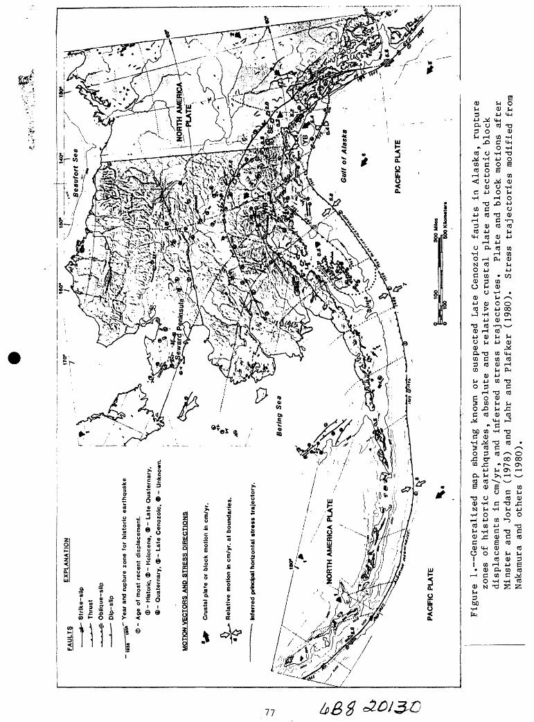
FAU
LTS
E
XP
LAN
ATI
ON
5
*- S
trik
e-sl
ip
__ _
_ »
- Th
rust
.
n jb
Ob
liqu
e-sl
ip D
ip-s
lip
^
ss'
Yea
r an
d ru
ptur
e zo
ne f
or h
isto
ric
eart
hq
uak
e
CD -
Age
of
mos
t re
cen
t di
spla
cem
ent.
<3> - H
isto
ric. ®
- H
oloc
ene,
9 - L
ate
Qu
ater
nar
y,
®-
Qu
ater
nar
y, ®
- L
ate
Cen
ozo
ic,
® -
Unk
now
n.
MO
TIO
N V
EC
TOR
S A
ND
STR
ES
S D
IRE
CTI
ON
SN
OR
TH A
ME
RIC
A
Cru
stai
pla
te o
r bl
ock
mot
ion
in c
m/y
r.
Rel
ativ
e m
otio
n in
cm
/yr.
at
boun
dari
es.
~~ I
nfer
red
prin
cipa
l hor
izon
tal
stre
ss t
raje
cto
ry
PA
CF
IC P
LATE
300 M
ttea
y
600 K
Hom
eter
s
PA
CF
IC P
LATE
Figure 1. Generalized ma
p showing
known or
suspected Late Cenozoic faults in
Alaska, rupture
zone
s of
historic earthquakes, absolute and
relative crustal pl
ate
and
tectonic block
displacements in
cm/y
r, an
d inferred stress trajectories.
Plate an
d block motions after
Minster and
Jordan (1
978) and
Lahr
and Plafker (1980).
Stress trajectories modified from
Nakamura an
d others (1980).

near 164° E longitude. In this western segment decoupling takes place between
oblique thrusting in the force-arc (1965 Rat Islands Mw=8.7) and lesser,
dextral strike slip in the back-arc (1975 Near Islands Ms=7.6). Seismic gaps
capable of generating major earthquakes (Ms=8.5) are located in the Shumagin
and Unalaska Islands segments, and in the westernmost Aleutian arc in the
Komandorski Islands segment, which is in USSR territory. Probabilities for
major events (Mw>7.8) to occur in these three gaps are estimated to be about
35-95 percent, 35-70 percent, and 35-78 percent, respectively (for time period
1985-2005).
The YB-SEB boundary is the Fairweather dextral fault (an onshore extension of
the Queen Charlotte transform) along which the 1958 Lituya earthquake (Mw=8.2)
occurred. The YB-PAC boundary is the submarine lower slope Transition fault
system along which the 1973 Cross Sound thrust earthquake (Ms=6.7) occurred.
The YB-WB boundary is the Pamplona submarine thrust zone and its eastern
onshore extension north and east of Icy Bay. This continuous thrust belt has
had a number of large historic events with magnitudes Msj(8.5. Parts of this
thrust system and the associated Chugach-St. Elias thrust faults may have
slipped during the 1899 earthquake sequence (Ms=8.5, 7.8, 8.4, and several
associated Ms=7-7.5 shocks); the 1979 St. Elias earthquake (Ms=7.1) occurred
on a down-dip extension of this system beneath the northern margin of the
Yakutat block.
The YB is essentially moving with the PAC plate, but with a slightly lower
velocity ( 5.4 cm/yr relative to NAM, and 0.4 cm/yr relative to PAC). As a
consequence, a large relative motion occurs along the dextral Fairweather
transform fault (at the eastern boundary), and at the Pamplona thrust zone (at
the northern boundary of YB), against SEB and WB, respectively. In contrast
the 0.4 cm/yr of YB vs. NAM represents a relatively slow oblique thrust motion
along the Transition fault system and its inferred down-dip detachment that
may separate YB by a subhorizontal plane from the underlying PAC plate.
Recurrence periods and maximum magnitudes on this Transition fault and
inferred detachment system could be quite long ( 1,000 yrs, Mw>8), but neither
of these two quantities are as yet constrained by seismic, historic or
geologic data. The Pamplona zone on the YB-WB boundary contains the Yakataga
Seismic Gap along which a major earthquake (up to Mw=8.3) has been forecast to
'8

occur with a probability of 35 to 55 percent during the next two decades on
the bases of seismologic data. Terrace studies near Icy Bay near the eastern
end of this gap, and at Middleton Island near the western end, suggest
recurrence intervals on the order of 500 to 1,500 years. The last event
comparable to the 1899 earthquake sequence in Yakutat Bay at the eastern end
of this zone occurred 380 years ago based on paleoseismic data. The geologic
data clearly suggest much longer recurrence intervals for great earthquakes
involving significant tectonic deformation than do probability estimates made
from the historic and instrumental record.
The PAC-WB margin is the eastern segment of the Aleutian megathrust, located
between 144° and 155° W longitude. Along it the great 1964 Alaska earthquake
(Mw=9.2), probably the 1900 (Ms=8.1) event, and several earlier large
earthquakes occurred. The YB-WB margin is the megathrust's northeastern
continuation, along the Pamplona zone.
In the northeast and north of WB the WB-NAM margin is associated with the
system of dextral transform to oblique thrusting of the Denali and Totschunda
faults; the WB-SEB boundary is a poorly defind, inferred fault zone connecting
the Fairweather with the Totschunda fault. The northwestern boundary of the
WB with NAM is also poorly defined and may correspond to a zone of diffuse
shallow seismicity that diverges southward from the Denali fault west of
McKinley Park, straddles Cook Inlet and Shelikof Strait, and joins the
Aleutian megathrust southwest of Kodiak Island. Motion of the WB relative to
NAM is taken to be a counterclockwise rotation about an axis near Kodiak
Island so that its northeastern edge moves dextrally, relative to NAM and the
SEB, at a maximum rate close to 1 cm/yr; its northern edge moves obliquely
convergent relative to NAM in the Alaska Range; and the block's western margin
causes shortening vs. NAM ranging from about 1 cm/yr at the northern western
margin to a negligibly small rate at the southern margin. In contrast, the
PAC-WB convergence rate along the block's southeastern thrust margin is much
higher at about 5.8 cm/yr. Paleoseismic data suggest that the dextral and
oblique slip segments of the boundaries of the WB block particularly the
Totschunda fault are potential sources for major earthquakes. The McKinley
region has had a few moderate-sized crustal earthquakes of which at least one
is confirmed to be a thrust mechanism with NW-SE directed shortening.
79

The YB-SEB boundary is the Fairweather fault, the WB-SEB boundary is the fault
zone inferred to connect from the Fairweather fault to the Totschunda fault,
and the SEB-NAM boundary is the Duke River, Dalton, and Chatham Strait system
of faults. YB is moving northwestward relative to the SEE at a velocity of
5.2 cm/yr, and SEE relative to NAM at no more than 0.2 cm/yr. The low
relative SEB-NAM block motion and lack of evidence for late Holocene
displacements suggests that the northeastern block boundary of SEE has a low
seismic potential.
Large onshore Holocene faults that cannot be related to the plate and block
boundaries described above are scarce in Alaska, and there are no known large
Alaskan intraplate earthquake that can be related to surface faults in the
interior of the blocks or plates. The Castle Mountain fault is an east-
northeast trending fault entirely within the WB. Field data suggest that it is
a north-dipping reverse fault with a dextral component, and earthquake data
suggest predominantly dextral slip at depth. Paleoseismic data suggest that the
last surface displacement of this fault was between 225 and 1,700 years ago.
The fault is of special importance because it is capable of generating a large
earthquake in close proximity to the Anchorage urban area. The November 3, 1943
(Ms=7.3) event may have been associated with this fault. A mostly offshore
fault zone, the Pat ton Bay fault zone, extends southwestward from Montague
Island past Kodiak to Chirikof Island on the fore-arc shelf. Although this
fault zone lies within UB, it is a splay off the Aleutian megathrust, and may be
considered as the approximate landward margin of the zone of deformation along
the PAC-WB boundary. This thrust zone slipped during the great 1964 earthquake
in which it displayed up to 7.9 m slip on a northwest-dipping reverse fault.
Within the NAM plate there is clear evidence of Holocene displacements on the
east-west trending Kigluaik and Bendeleben normal faults on the Seward
Peninsula and their offshore extensions onto the Bering Sea shelf. Holocene
faults with minor seismicity are mapped offshore near Prudhoe and Camden Bay
on the Beaufort Sea shelf. Several faults of undated but suspected Quaternary
age are located on the Bering Sea shelf and appear to be related to normal
faulting along the edges of Neogene basins on the shelf. Most of these
offshore faults do not appear to have Holocene displacements. A few severe

earthquakes are known from historic felt reports from the Pribilof Islands,
but the causative faults are not known.
Large faults with known or suspected Quaternary displacements occur within
continental Alaska; none of these faults have had unequivocal Holocene
displacements. On the other hand, earthquakes sometimes with magnitudes as
large as Ms=7-7.8 have occurred during historic times in interior Alaska.
Because all occurred prior to establishment of adequate seismic networks,
their epicenters are so poorly constrained that often it is not clear whether
they are associated with any of the known nearby surface faults. A large
earthquake (Ms=7.7-8.3?) occurred in 1904, reportedly near 64°N and 151°W, in
the lowlands northwest of McKinley National park with reported damage at
Rampart; on July 7, 1912, a Ms=7.5 event occurred in central Alaska; the
Fairbanks earthquake of October 16, 1947 measured Ms=7.0-7.2. Moderate-sized
earthquakes have occurred near the Yukon River in central Alaska, near the
Kobuk River trench south of the western Brooks Range, and low-level seismicity
is known in the northeastern Brooks Range where it approaches Camden Bay and
the Beaufort Sea.
It is not known whether the swarm-like seismicity in zones such as those near
Fairbanks or the Yukon River crossing of the Trans-Alaska Pipeline is related
to crustal faulting driven by large-scale tectonic stress systems, or is
related to some other process such as emplacement of magma at shallow
depths. No potentially active surface faults have been found in these
areas. Sporadic alkali-basalt magma occurrences of Quaternary age are
widespread in central Alaska and particularly in west-central Alaska, the
Seward Peninsula and the Bering Sea shelf. This suggests a mildly extensional
stress regime in contrast to the dominantly compressional stress regime in
much of the remainder of Alaska.
Earthquakes and tsunamis related to volcanic activity are a potential hazard
to military installations and to several important ports and fishing
communities in the Aleutian arc (including its shores facing the Bering Sea),
on the Alaska Peninsula, and in lower Cook Inlet. Volcanic earthquake hazards
may also exist in the Wrangell Mountains and at Edgecumbe Volcano or Kruzof
Island near Sitka. However, the most tsunamigenic earthquakes can be expected
81
along the convergent segments of the Aleutian megathrust and its eastward
extension into the Paraplona thrust zone. Major destruction in Alaska resulted
from the tsunami waves (and landslide-generated local waves) triggered by the
1964 Alaska earthquake, the 1958 Lituya earthquake and, to a lesser extent,
the 1948 Adak earthquake.
Subcrustual Aleutian earthquakes with depths between 50 and at most 300 km are
thought to be rarely larger than Mw=7.5, but there is a possibility that an
earthquake on June 2, 1903, near 57°N and 156°W (southwest of Katmai), with
magnitude 8.3(?) may have been 100 km deep.
Normal-faulting events associated with flexure of the Pacific plate in and
seaward of the Aleutian trench are rare; their maximum credible magnitudes
could be as large as Mw=8, and they may also induce tsunamis. The March 3,
1929, earthquake near 50.9°N and 169.7°W in the central Aleutians with a
magnitude Mw=8.0+0.5 may have been such a normal-faulting event that caused a
perceptible tsunami in Hawaii.
824,55
HAZARDS EVALUATION FOR LARGE AND GREAT EARTHQUAKES ALONG THE QUEEN CHARLOTTE - ALASKA - ALEUTIAN SEISMIC ZONE: 1985-2005
by
Stuart P. Nlshenko
National Earthquake Information Center
U.S. Geological Survey, Denver, CO 80225
Klaus Jacob
Lament-Doherty Geological Observatory
of Columbia University
Palisades, NY 10964
INTRODUCTION
Conditional probabilities for the ocurrence of large, great (and giant)
earthquakes along specific segments of the Queen Charlotte-Alaska-Aleutian
(QC-A-A) seismic zone are presented for the time interval 1985-2005. Time-
dependent recurrence models are combined with simple Gauss and Weibull
distribution functions to forecast the likelihood of future events in this
region. At present, areas of high seismic hazard include the Yakataga gap as
well as a large portion of the Alaska Peninsula (including the 1938, Shumagin
gap and 1946 segments as well as possibly the Unalaska gap). Areas of low
seismic hazard include the entire Queen Charlotte seismic zone (1949
[excluding the possible Cape St. James gap], 1972 and 1958 rupture zones), the
1964 Gulf of Alaska, portions of the 1957 Central Aleutian and the 1965 Rat
Islands zones.
83

The QC-A-A seismic zone is divided into 17 segments based on (1) the rupture
zones of the most recent large or great earthquakes, as defined by aftershock
distributions, and (2) variations in the amount of coseismic displacement
within individual rupture zones.
For each individual segment or gap along the QC-A-A seismic zone, input for
the time-dependent Gaussian model consists of the date of the last large
earthquake, the estimated repeat time and the standard deviation of time
intervals between events (the coefficent of variation). For the majority of
the QC-A-A seismic zone, the date and size of the last event is known.
Estimates of repeat time are calculated by dividing the coseismic displacement
in the previous event by the rate of fault motion. Note that these estimates
do not account for the effects of aseismic slip on recurrence intervals, and
hence, represent minimum repeat time and maximum probability estimates. Where
available, repeat time estimates are supplimented by historic and geologic
data as well. The coefficent of variation along any segment of the margin is
poorly known, and we uniformly assign a standard deviation equal to 33% of the
estimated repeat time in our estimates. A standard deviation of 33% is
similar to that found in studies along other simple transform and convergent
plate boundaries (Sykes and Nishenko, 1984; Nishenko, 1985).
For comparison to the above evaluation, we have also modeled the catalog of
historic repeats (and possible repeats) from Jacob (1984) along sections of
the A-A seismic zone using a Weibull distribution function.
84
Both of these time-dependent descriptions of earthquake hazard (or conditional
probability) are compared and contrasted to estimates of seismic hazard baed
on a Poisson model of recurrence. The Poisson based estimates of conditional
probability are termed time-independent or static, as they do not include the
amount of time elapsed since the previous shock. In general, conditional
probabilities based on the Poisson model cluster around 10-40% for a 20-year
time window throughout the entire QC-A-A seismic zone. Estimates of seismic
hazard based on all 3 models are presented in Table 1 and Figures 1 and 2.
Overall, as seen in Table 1 and Figures 1 and 2, recurrence time estimates
based on both the last shock and historic/geologic data vary by a factor of
two, while the range of probability estimates for each model, are within 10-
20% of each other. This reflects the fact that 2/3 of the margin has ruptured
within the last 20-30 years, and is now within the first 1/3 or less of a new
seismic cycle. The segments with the largest uncertainties (and possibly the
highest probabilities) are along the Alaskan Peninsula (the 1938 and Shumagin
gaps). The poor resolution reflects a fundimental lack of data concerning the
sizes and locations of previous earthquakes in this area.
Time-dependent estimates of conditional probability that are lower than the
Poisson estimates for any particular segment are suggested to indicate a low
level of seismic hazard. Areas of low hazard (i.e. less than 10-20% for the
next 20 years) presently include the entire Queen Charlotte seismic zone (1949
[excluding the possible Cape St. James gap], 1972 and 1958 rupture zones), the
1964 Gulf of Alaska, portions of the 1957 Central Aleutians and the 1965 Rat
Islands zones. Note that while the hazard for Mw>9 earthquakes along the 1964
Gulf of Alaska zone is presently low, we cannot rule out the possibility for
85

TABLE
i:
CONDITIONAL PROBABILITY ESTIMATES FOR THE QUEEN CHARLOTTE -
ALASKA - ALEUTIAN SEISMIC ZONE
: 1983 -
2003
oo
(A
LOCATION
1. Cape
St.
James
2. Queen
Charlotte Is
.
3. Sitka
4. Lituya
Bay
3. Yakutat
Bay
6. Yakataga
7. Prince
William Sound
CONDITIONAL PROBABILITY
LAST
SLIP
ESTIMATED
OTHER
SHOCK
DT
Mo
LENGTH
WIDTH
SLIP
RATE
REPEAT
DATA
POISSON
GAUSS
WEIBULL
(yrg
) (x
lO27
d-c) <
l"n>
<k
m)
(cm)
(cm/yr)
TIME
??
1949
36
12
490
(13)
350
5.5
100
18. IX
6. 6X
Mu 8. 1
1972
13
4 175
(15)
500
5.2
90
19. 9X
2. 3X
Ms 7. 4
1927,
45 y
33. 3%
18. 4X
1880
, 47 y
1958
27
7 330
(15)
430
3.2
86
20. 7X
6. 7X
Mw 7. 7
Max. Dis
p.
6. 5 m. 118 y
15. 6X
2. 4X
1848
, 110 y
16. 6X
3. OX
1899
86
2O
100-125
75
600
4. 8
125
14. 8X
18. IX
30. 6-39. IX
Mw 8. 2
Geodetic
380 y
3. I
X 0. 5X
1899
86
20
123-200
73
230
4.2
52
31.9%
96. 3X
30. 6-59.
IX
Mw 8. 1
1964
21
820
73O
ISO
1215
6.3
187
10. OX
0.5%
18. 1-
19. 6X
Mw 9. 2
Geodetic
3000
461 y
4. 2%
0. IX
Geologic
897 y
2. 2
7.
0. 03X
8. Gulf of
Alatka
1964
21
Mw 9. 2
187
10. OX
0. 5X
18. 1-
19. 6X
9. Kodiak
Is.
1964
21
Mw 9. 2
9A.
Kodiak
Is.
187
10.0%
0. 5X
IB. 1-19. 6X
Historic
Ms 7. 4-B
40-6O y
28. 3-39. 3X
14. 8-49. 2X
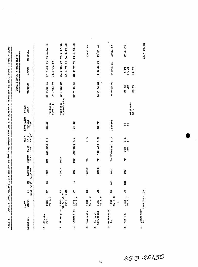
TABLE 1:
CONDITIONAL PROBABILITY ESTIMATES FOR THE QUEEN CHARLOTTE - ALASKA - ALEUTIAN SEISMIC ZONE
: 1983 - 2003
CONDITIONAL PROBABILITY
LAST
SLIP
ESTIMATED
OTHER
LOCATION
SHOCK
DT
Mo
LENGTH
WIDTH
SLIP
RATE
REPEAT
DATA
POISSON
OAUSS
WEIBULL
(yro)
(xlO
27 d-c)
(km)
<km)
(c
m) <<
=m/y
r)
TIME
10.
Alaska
P»n.
1938
47
30
300
120
200-300 7.1
28-42
37.9-31.0%
90.0-99.9% 33.6-36.1%
Mui
8. 2
Historic
30-91 y
19.7-32.9%
13.1-73.3%
11.
Shumagina
1903
82
(230
) (1
00)
Historic
18.1-28.3%
33. 0-87. 3% 49. 1-
37. 0%
MS.
3, Ms6. 9
60-100 y(
?)1847
138
68. 4-99. 1% 66. 9-79. 6X
12.
Unimak
Is.
1946
39
13
100
100
200-300 7.7
24-42
37.9-36.3%
81.2-99.9% 29.6-30.6%
Ms 7. 4
13.
Unalaska
1937
28
(1200)
70
8.3
23-23.6%
Mm 8.
8
14.
Central
Aleutians
1937
28
(120
0)
70
400-600 8.3
48-72
24.2-34.8%
12.8-44.2%
23-23.6%
5 Mw 8. 8
15.
Andreanof
Is.
1937
28
200
600
70 930-1580 8.3
115-191
9.9-13.9%
0.6-2.8%
23-23.6%
Mw 8. 8
fN.
16.
Rat Is.
1963
20
123
300
70
700
8.6
81
21.8%
3.2%
17.4-19%
>*
Mw 8. 7
280
3 36
30%
17. 2%
(J\
Historic
39 y
28. 7%
14. 5%
Oj17.
Commander
K
Is.
1849/38? 136
66.4-78.9%

References for Table 1
Entire QC-A-A seismic zone:
Sykes, L. R. , J. Geophys. Res., 76, 8O21-3O41, 1971.
Sykes, L. R. , J. B. Kisslinger, L. House, J. N. Davies and K. H. Jacob, Science, 210, 1343-1345, 198O.
Specific segments along the QC-A-A seismic zone:
1 and 23 Bostwick, T. D. , Ph.D. thesis, Univ. British Columbia, 1984.
Rodgers, G. C. , Earthquake Pred. Res., in press, 1985.
33 Page, R. , Earthquake Info. Bull., 5, 4-9, 1973.
43 Plafker, G. , T. Hudson and T. Bruns, Can. J. Earth Sci., 15, 8O5-816, 1978.
5 and 63 McCann, W. R. , 0. J. Perez and L. R. Sykes, Science, 207,13O9-1314, 198O.
Plafker, G. , T. Hudson and M. Rubin, EOS, Trans. AGU, 61, 111O, 1980.
Thatcher, W. and G. Plafker, Geol. Soc. America abs. with Programs, 9, 515, 1977.
7, 8, 93 Plafker, G. , U.S. Geol Survey Prof. Paper 543-1, 1967.
Plafker, G. and M. Rubin, U.S. Geol. Survey Open File Rpt. 78-943, 687-722, 1978.
Ruff, L. and H. Kanamori, Phys. Earth Planet. Int. , 31, 202-230, 1983.
10,11,123 Davies, J. , L. Sykes, L. House and K. Jacob, J. Geophys.Res. , 86, 3821-3855, 1981.
13, 14, 153 Wahr, J. and M. Wyss, J. Geophys. Res. , 85, 6471-6477,198O.
Ruff, L. , H. Kanamori and L. Sykes, EOS, Trans. AGU, 66, 298, 1985.
163 Ruff, L. and H. Kanamori, Phys. Earth Planet. Int. , 31, 202-23O, 1983.

60«N
55'
50'
USSR
-**Go^^ik
I70'E 180* I70*W 160* I5O« 140" 130*
S 1849/ J 1858(7)
1965 1957 |S| oS I 1938 I 1964 [l899J 1958^1 S I ? I
100% i-
GAUSS
14ISTORIC LAST
:::::SHOCK POISSON
&:£?£8WEIBULL
Figure 1. Conditional probability estimates for large and great interplate earthquakes along the Queen Charlotte-Alaska-Aleutian seismic zone: 1985-2005. Encircled numbers refer to fault zones or segments listed in Table 1. For each segment, the percentages and the height of box represent the range of calculated probabilities based on Gaussian, Poisson, and Weibull models (see bottom of figure for appropriate symbol). Dates and vertical bars at the top of the histogram refer to the time and lateral extent of the last large or great earthquake in each segment. For zone 9 (Kodiak Island), probabilities are presented for rerupture as a part of the 1964 zone and as an independent unit. Notethat the zones wi largest uncertain
hig obabilities also have theui iwv s*

CONDITIONAL PROBABILITYQUEEN CHARLOTTE-ALASKA-ALEUTIAN SEISMIC ZONE
1985-2005
50-59%
50-59%
49-80%
0-20% 20-50% M 60- 100% W& ::%:&5"3
Figure 2. Comparison of conditional probability estimates for large and great interplate earthquakes along the Queen Charlotte-Alaska-Aleutian seismic zone: 1985-2005. Encircled numbers refer to the fault zones or segments listed in Table 1. The percentages besides each zone represent the range of calculated probabilities from Gaussian (top), Poisson (middle), and Weibull (bottom) models. The shading of each fault segment corresponds to the mean probability estimate (see bottom of figure for key). Blank areas denote segments with lack of sufficient data for a particular recurrence model. ?"-
90

the ocurrence of smaller (Mw7.5-8) events in this area, as is seen
historically for the Kodiak Island region. Time-dependent estimates that are
greater than the Poisson estimates are judged to indicate a high level of
seismic hazard. Areas of high seismic hazard (i.e. greater than 50% for the
next 20 years) presently include the Yakataga gap as well as a large portion
of the Alaska Peninsula (including the 1938, Shumagin gap and 1946 segments as
well as possibly the Unalaska gap). While the degree of resolutuion is poor
for some of these gaps, the spatial proximity of a number of high hazard areas
along the Alaskan Peninsula raises the scenario whereby rupture in one segment
may trigger activity in adjacent segments and produce a larger event than any
one single segment. Historically, this section of the margin, Kodiak Island
to the Shumagins, was ruptured by a great (M>8) earthquake in 1788 with an
estimated rupture length of at least 600 km. The Commander Islands gap, in
the westernmost Aleutians, presently has a high probability for recurrence
based on the extrapolation of the Weibull data. Few other data, however,
exist to independently constrain the hazard level in the Commander Islands
area.
REFERENCES
Jacob, K., Estimates of long-term probabilities for future great earthquakes
in the Aleutians, Geophys. Res. Lett., 11, 295-298, 1984.
Nishenko, S. P., Seismic potential for large and great interplate earthquakes
along the Chilean and southern Peruvian margins of South America, Jour.
Geophys. Res., 90, 3589-3615, 1985.
76191

Sykes, L. R. and S. P. Nishenko, Probabilities of occurrence of large plate
rupturing earthquakes for the San Andreas, San Jacinto and Imperial
faults, California: 1983-2003, Jour. Geophys. Res., 89, 5905-5928, 1984.
92

IMPLEMENTATION FRAMEWORK TO REDUCE POTENTIAL LOSSES FROM TSUNAMI HAZARDS IN ALASKA
byJane Preuss, Urban Regional Research
Seattle, Washington 98104
INTENT
A high percentage of the damage and 119 of the 132 killed in the 1964 Alaska
earthquake was attributable to tsunamis. The purpose of the project
described in this paper is to develop a planning approach which responds to
the tsunami hazard.
The project technique was first to gain a more precise understanding of the
causes of damage by using a hydrodynamical model to simulate the character
istics of the 1964 event at decreasing scales of geographic size and
increasing levels of specificity. A series of measures designed to mitigate
potential losses from tsunamis and to maximize safety requirements during
the emergency response period are then proposed for the case study community
of Kodiak.
BACKGROUND ASSUMPTIONS: REGIONAL SCALE
The regional analysis verified wave heights, travel patterns and arrival
times of the incident wave. The methodology was to apply a far field/deep
water numerical model to 3 subregions (Region A - I,600x900km; Region B -
800x400km; and Region C - 100x10Okm).
10 15 20 25 30 65
Bathymetric Contours In Meters
35 -
Region A
Figure 1: Computational SchemeGRID SIZE 24300m
0 100 200 300 400 kn

The largest region was primarily concerned with defining source characteris
tics. This information was used to project generation and propagation of
the tsunami to the off-shore regions in the vicinity of Kodiak.
5 10 15 20 25 30 35 40 45 50
im
Region C
j GRID SIZE 2700m
0 20 40 km
Figure 2: Assumed Vertical Displacement (after Pflaker, 1969)
BACKGROUND ASSUMPTIONS: PROJECT SCALE
The underlying purpose of the project scale analysis is to develop an
approach to managing land development which both encourages continued
economic viability of waterfront activities and maximizes protection.
It was first necessary to gain a more precise understanding of the dynamics
of the tsunami near and at the shoreline. The focus of the project scale
was therefore to project the run-up height of the design tsunami (1964
magnitude) and to assess the effects, of this run-up on structures and other
objects located near the shoreline. Information from the regional analysis
was used as the basis for defining the characteristics of the incident wave
as it entered Chiniak Bay at Kodiak. Near field calculations using non
linear shallow water wave theory project maximum wave amplitude, velocity,
and maximum inundation area for four sub regions.
Area D Area: 50 x 30km Grid Size 900 metersArea E Area: 15 x 10km Grid Size 300 metersArea F Area: 6 x 4km Grid Size 100 metersArea G Area: 1.5 x 1km Grid Size 33 meters
94

In order to maximize the urban planning utility of the research findings
care was taken to correlate the boundaries of Area G with land use patterns,
Area G therefore includes all of the downtown business district and the majority of the canneries*
Computational Scheme for Region G
Bathymetric Contours in Meters
Actual Coastline
Modelled Coastline
Verification of Model
,o.om Modelled Wave_. , , . Run-up Heights
Modelled TsunamiInundation Based
on 1964 Conditions
Present Conditions
Figure 3: Definition of Region G
63m Modelled Wave / Run-up Heights
-: Modelled Tsunami""I.... Inundation Based on
Present Conditions
95

Data for Region G was mapped in a series of transparent overlays. This
format provides a vehicle for planning practioners to visually correlate
conditions today with conditions in 1964. It is also used as the basis for
calculating and evaluating the effects of a future repeat event. Information
collected for Region G includes such variables as are listed below. The
next step in the process was to define the dimensions of the planning area
subject to tsunami inundation. Figure 4 correlates the computer projected
run-up height with the inundation level observed in 1964.
o Land Use 1964: building use, type of construction, road locationso Pre-tsunami Ground Elevationso Ground Elevations immediately after the Tsunamio Ground Elevations after Reconstructiono Vegetation: 1964o Land Use: 1985o Building Location and Construction Type: 1985o Vegetation: 1985o Breakwater Dimensions: 1964o Breakwater Dimensions: 1985o Location of Critical Facilities (Power Plants, etc.): 1985
COMPUTED ._, INUNDATION
OBSERVED1964 INUNDATION
Figure 4: Comparison of Computed Run-up with Observed Inundation. Note close correlation between computed and observed boundaries.
96

PLANNING FRAMEWORK
The underlying planning problem for tsunami susceptible areas is that the
tsunami phenomenon is not only extremely complex but also that the event is
virtually unpredictable. Responsive plans must therefore address both a
high level of uncertainity with regard to time and characteristics of the
tsunami event and a relatively high level of precision with regard to causes
of damage. This prototype planning strategy first refines the description
of damage into categories addressed by the traditional planning/mitigation
and preparedness processes. Subsequently, a range of approaches are
suggested to address these relatively well defined characteristics of
vulnerability.
The effects of a tsunami event can result from direct forces and from
indirect or secondary effects caused by interaction of the tsunami forces
with land uses, flammable material, moored boats, etc. As shown in Table 1
tsunami effects have therefore been classified into three categories based
on their end results. Direct causes of damage are attributable to submer
gence (whole or partial) with the resulting water pressure, and to the
velocity of the moving water.
Secondary impacts are essentially caused by the direct impacts in conjunc
tion with other forces. For example bouyant forces may have lifted a
structure from its foundations or a boat from its moorage, or surge forces
may have created momentum which when added to other forces will move a
structure in the direction of the current. Damage is subsequently caused by
the floating debris (boats, cars, logs, etc.) impacting buildings.
Table 1 Components of Tsunami Losses
Type of Effect Cause
Direct Tsunami Water forces (surge, buoyant, drag, hydrostatic) Impacts Loss of ground support (erosion)
Secondary Impacts Impact forces/Floating debris (boats, cars, logs) ___________________Fire and contamination spread by water_________
Loss of Life Inadequate time for warningInadequate evacuation routes Inadequate education and preparation in how to
___________________respond to a warning________________________
97

The first two effects described above result in property damage. The third
type of effect is loss of life. Minimizing lives lost is to a large extent
dependent on proper warning and on the subsequent appropriate behavior of
people in the hazard area and tends to be addressed administratively through
education programs.
Implementation of mitigation and preparedness activities currently occurs
through a multi-faceted framework involving many agencies and jurisdictions.
To date, however, analysis of planning practices in Kodiak reveals that the
tsunami hazard is rarely an explicit consideration. In order to correlate
the activities needed to minimize tsunami effects listed in Table 1 the
elements of comprehensive planning have been correlated with mitigation and
preparedness activities in Table 2.
Table 2 Comprehensive Planning Framework
Comprehensive FunctionsPlan Elements______________Mitigation___________Emergency Preparedness
Land Use and Economic Minimize Flooding Development Building Collapse
Recreation and Open Space Buffer Gathering Places
TransportationVehicular EvacuationPedestrian__________________________________Search and Rescue____
A two part framework can then be proposed to integrate mitigation and
preparedness considerations into the comprehensive planning process. Part I
is The Damage Control District, Part II is The Life Safety District.
PART I: DAMAGE CONTROL DISTRICT
Objectives of the Damage Control District are to protect property from both
the direct and secondary causes of damage. This district encompasses the
harbor and all of the land area potentially inundated.
Within the District four special zones create a range of administrative
options addressing various aspects of the tsunami hazard. Although, all of
the sub-zones are within the Damage Control District, their dimensions are
defined in relation to characteristics of the hazard. The inland boundary
of the Damage Control District is the computed tsunami reoccurance elevation
which has been projected at the 30 foot elevation. The seaward boundary
encompasses the breakwater and all of the water borne uses in the near shore
98

area which potentially could be swept inland including boats, and piers,
The geographic boundaries of the Damage Control District for Kodiak are
based on the numerical calculations summarized in Figure 5a-5c.
Verification With 1964 Conditions
Maximum Water Level Above Ground
y//f 0 to I meter
E| I to 2 meters
^ 2 to 3 meters
# 3 to 4 meters
$|[ Greater than 4 meters
Projections With Present Conditions
Maximum Water Level Above Ground
y//_ 0 to I meter
HE I to 2 meters
H 2 to 3 meters
# 3 to 4 meters
$f Greater than 4 meters
D
Figure 5: Definition of"FlilhtMg District JJoundari
Final District Boundaries
es
99 AD 13D

Building Safety Zone
Flood level, water velocity and impact from debris result in building
collapse, structural and non-structural damage, and/or foundation failure.
Standards must therefore address:
o Resistance of Structures to Water Pressures o Protection of Structures from Debris
;e caused by direct effects have been organized into categories based on
projected water level above ground. It is expected that structures subject
to more than 3m of water will also be most vulnerable to water borne debris.
Table 3
Projected Damage Categories
Maximum Water Level above Ground
1m 2m 3m 4m 4m*
*Also susceptible to debris impacts.
Damage
Slight DamageSlight or Moderate DamageModerate DamagePossibly SalvagableUnsalvagable*
Building Types
Wood Frame
Wood Frame. Some Steel Framing
Masonry, Steel Framing
Reinforced Concrete Framing
Figure 6: Existing Building Construction Types
100

Based on the projected inundation/flooding levels a series of sub-areas have
been defined to guide administrative decisions relating to building
standards and siting criteria for new construction. Within the damage
susceptibility sub-area new construction standards would then be correlated
with water volume, wave velocity, and vulnerability to floating debris.
These standards would address foundation design, type of framing; building
orientation (siting); water proofing; and/or ground level use/first story
elevation.
Use Review for Critical Facilities and High Occupancy Uses
In order to minimize the number of lives at risk, a Building Use Review
District would establish stringent standards for specified critical and high
occupancy uses. Within this review district new critical facilities (hos
pitals, schools, fire and police stations) could not be built. Specified
high occupancy structures such as auditoriums and theaters could also not be
built. Other high occupancy structures such as hotels, and apartment
buildings would be subject to standards pertaining to construction type.
Fire Protection District
Inventory of cannery and related uses in Kodiak reveals a heavy concentra
tion of potentially flammable materials stored on site. For example, fuel
tanks are loosely anchored and electrical vaults are located adjacent to
highly combustable materials. These uses are subject to two types of
hazards: 1) being impacted by boats borne inland and 2) breaking lose and
hitting nearby buildings. Both types of hazards can result in fire.
Boundaries of the fire safety would be co-terminous with the entire Damage
Control District. All uses such as oil storage tanks, gas stations and
storage of hazardous materials would be reviewed in terms of siting and
construction of protective measures. Special attention would be given to
fuel storage and other combustable materials.
Measures to minimize fire damage could include:
o Limitation on uses which result in high damage potential such as gasstations
o Enclosed protection of dangerous uses such as fuel tanks o Creation of open space buffer zones around hazardous uses o Automatic shut-off values for fuel storage tanks
101

Water Safety District
A major cause of damage in 1964 was from boats which struck buildings as
they were carried inland. The primary objective of the Water Safety
District would therefore be to prevent uses in this district from becoming a
hazard to uses on the shore. The components of the district includes:
o The Breakwatero Boat Moorages, Docks, and Pierso Boats
Special attention should be given to securing the moorages of boats which
will remain bearthed in the harbor. Tsunami resistant bearths could be
constructed for selected high intensive loading docks.
Protective Buffer District
It is inevitable that certain uses such as cars in the mall parking lot will
become an additional hazard to structures further inland. Another aspect of
building safety is therefore to protect potentially hazardous uses and
designated structures such as existing high occupancy buildings from impact.
A special parking district would be created to facilitate removal of parking
from the most hazardous areas susceptible to greater than 3 or 4 M of
inundation.
Trees have been found to retard the velocity in areas where water depth is
less than 2 meters. A planting program would be implemented for inland
areas subject to less than 2-3 meters of inundation.
Barriers retarding the wave run-up must be designed to stop the movement of
the water body and/or of debris. In order to overcome the motion of the
tsunami several forces must be overcome including water pressure, inertia,
and friction between the earth and water. Buffers could be any of the
following types.
o Fill selected areas and protect the fill with reinforced retainingstructure above the height of the projected "worst case" wave
o Protective Dikes or Wallso Protective pilings surrounding uses to be protected from impact o Protective plantings in appropriate areas
102

PART II; LIFE SAFETY DISTRICT
The objectives of the Life Safety District are to protect lives by facili
tating evacuation out of the hazard area, and to maximize search and rescue
efforts after an event. Geographically the Life Safety District consists of
two components. One is the evacuation zone. The second is the receiving
zone. Administratively the Life Safety District consists of the geographic
zones and the operational preparedness plan.
The inland boundary of the Evacuation Zone is based on numerical projections
illustrated in Figure 6 as modified for safety to the 40 foot contour (modi
fied from 30 foot for the Damage Control District). The Receiving Area
begins above the 100' elevation.
Evacuation Zone
Evacuation considerations consist of three principal elements: a Warning
System; a Vehicular Evacuation Plan and a Pedestrian Evacuation Plan.
Warning System
The physical component of the warning system at the local level (within
Kodiak) pertains to delineation of an area within which a warning signal
can be clearly received. The geographic limits of the evacuation area
must therefore be clearly defined.
o An integral component of the warning system is public preparedness. The
population at risk, including seasonal populations, must be educated to
understand what to do in the event of a warning. They must know where
to go and the routes to take.
o Educational programs and rescue procedures must be established for
"special" target populations such as elderly and transient workers who
may not be aware of the tsunami hazard. Many of this latter population
do not speak english..
Vehicular Evacuation/Transportation Plan
Implementation of the vehicular element of the evacuation plan will in
clude identification of vechicular routes and traffic routing priorities
for vehicles which are parked in the area. It must also accommodate
vehciles assisting special designated populations, such as those
103 7,53

residing in the retirement home, and large groups, such as in the
theater. These routes will later be used for search and rescue and for
cleanup operations. This routing plan would define alternative routes
linking the Life Safety District with the Receiving Zone.
A supplementary operational plan would develop standards for maintenance
and for winter clearing of designated streets and sidewalks which link
the evacuation zone and the receiving areas.
Pedestrian Evacuation
Cannery workers, employees and patrons of the many businesses,
especially along Shelikoff Street are within accessible pedestrian
evacuation routes. Pedestrian evacuation can be facilitated in terms of:
o Construction of Stairs and/or sidwalkso Sidewalks designated for clearing during the winter
LIFE SAFETY DISTRICT
0 800'
Scale North
- Receiving Zone
- Evacuation Zone
Primary\ Evacuation
Routes
Figure 7: Life Safety District
104

Receiving Zone
People within the evacuation zone would be directed to designated areas such
as the school complex in the receiving area. The receiving zone consists of
two primary elements:
o Refuge Sites
Safe refuge sites to which people can go until their homes are again
safe. Places of refuge (schools, hospitals, etc.) must be clearly
identified outside the hazard zone.
o Congregation Places for the Response Team.
Places are identified which will be available for the rescue and
response workers to gather in order to receive instructions after
the event. Large spaces such as the Borough parking lot will be
required.
INTEGRATED IMPLEMENTATION FRAMEWORK
The traditional comprehensive planning process consists of three primary
elements (land use, transportation, and open space). Typically, however,
communities implement special purpose plans such as those listed in Table 4,
Column 1 through a range of ordinances and programs. Implementation of the
Damage Control District and the Life Safety District would therefore occur
through the special districts which are described above in conjunction with
the on-going planning process. Once the functional distribution of respon
sibilities has been defined the specific implementation responsibility,
including financial implications of damage prevention, and emergency
preparedness measures can be identified. Through this integrated approach
to planning and implementation it is also possible to maximize multi-purpose
utility of major facilities, e.g. parks, and circulation routes.
105
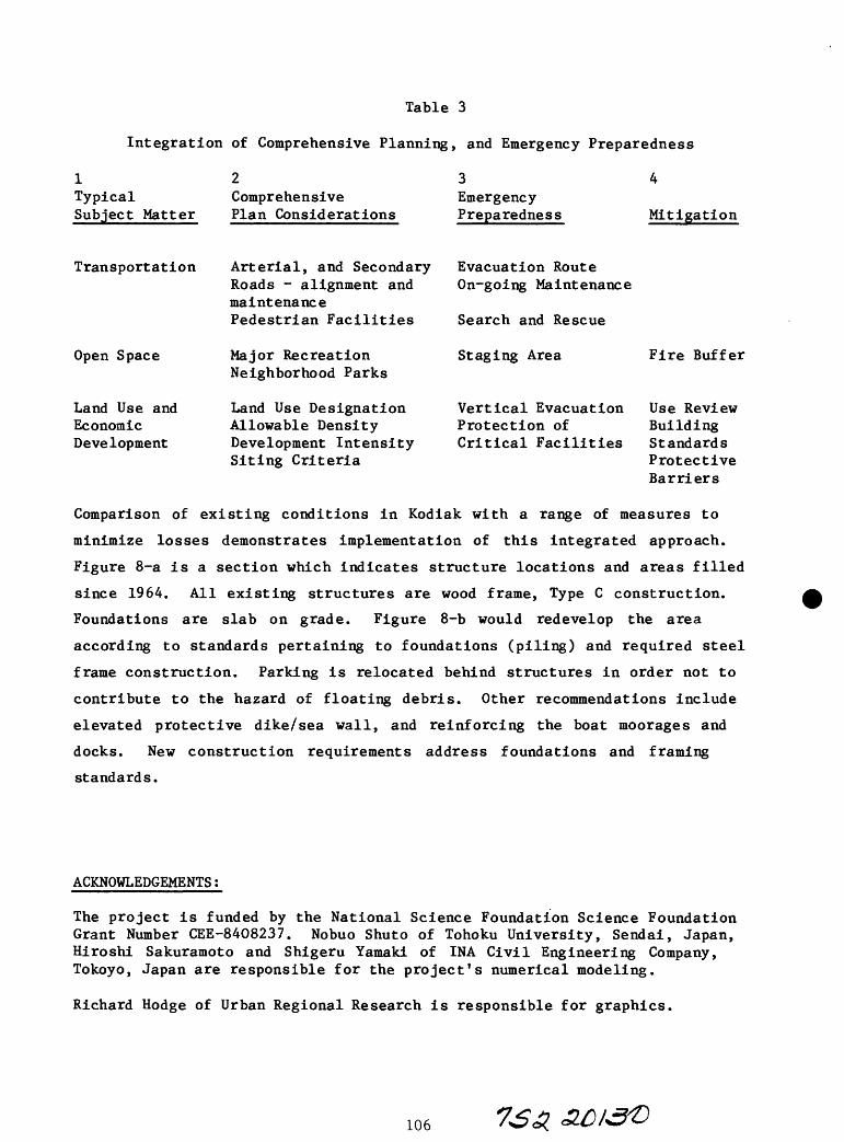
Table 3
Integration of Comprehensive Planning, and Emergency Preparedness
1TypicalSubject Matter
ComprehensivePlan Considerations
Emergency Preparedness Mitigation
Transportation
Open Space
Land Use andEconomicDevelopment
Arterial, and Secondary Roads - alignment and maintenance Pedestrian Facilities
Major Recreation Neighborhood Parks
Land Use Designation Allowable Density Development Intensity Siting Criteria
Evacuation Route On-going Maintenance
Search and Rescue
Staging Area
Vertical Evacuation Protection of Critical Facilities
Fire Buffer
Use ReviewBuildingStandardsProtectiveBarriers
Comparison of existing conditions in Kodiak with a range of measures to
minimize losses demonstrates implementation of this integrated approach.
Figure 8-a is a section which indicates structure locations and areas filled
since 1964. All existing structures are wood frame, Type C construction.
Foundations are slab on grade. Figure 8-b would redevelop the area
according to standards pertaining to foundations (piling) and required steel
frame construction. Parking is relocated behind structures in order not to
contribute to the hazard of floating debris. Other recommendations include
elevated protective dike/sea wall, and reinforcing the boat moorages and
docks. New construction requirements address foundations and framing
standards.
ACKNOWLEDGEMENTS;
The project is funded by the National Science Foundation Science Foundation Grant Number GEE-8408237. Nobuo Shuto of Tohoku University, Sendai, Japan, Hiroshi Sakuramoto and Shigeru Yamaki of INA Civil Engineering Company, Tokoyo, Japan are responsible for the project's numerical modeling.
Richard Hodge of Urban Regional Research is responsible for graphics.
106
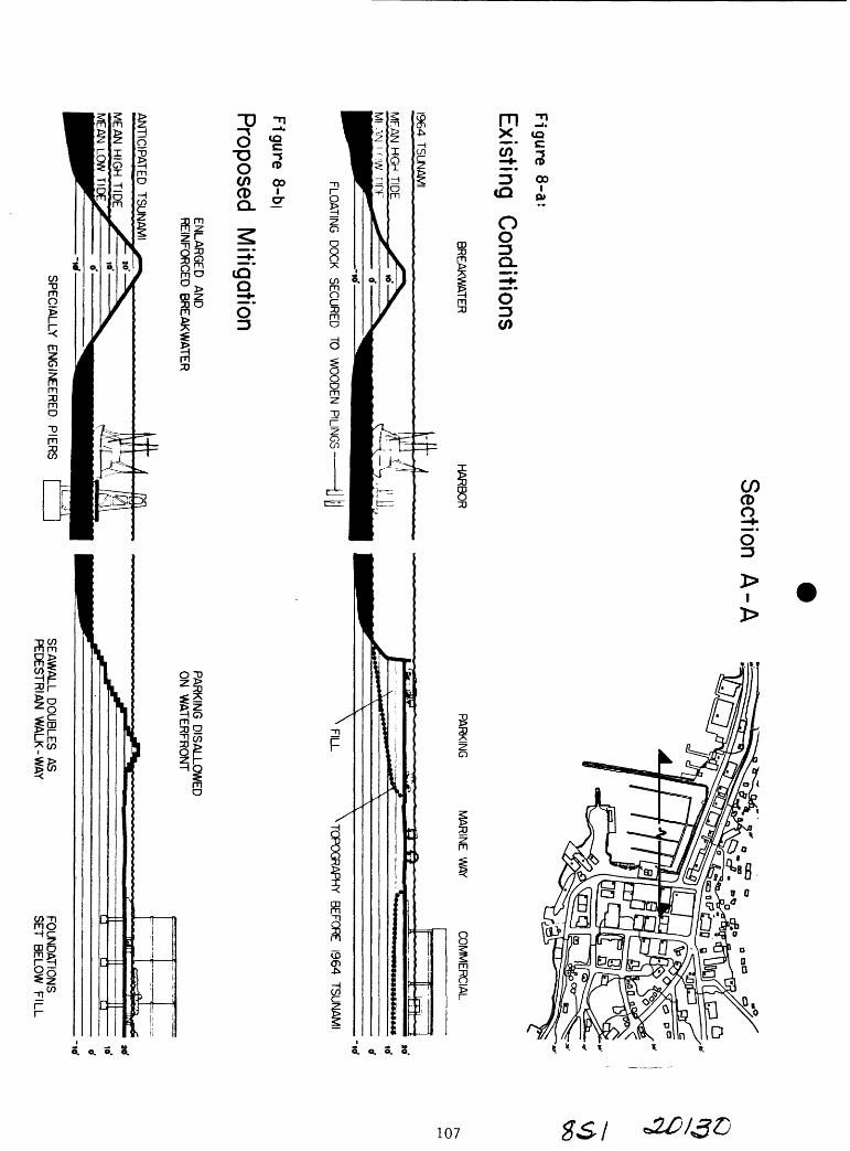
Figure 8-a:
Existing
Conditions
BREAKWATER
1964 TSUN
AMI
Section
A-A
HA
RB
OR
FLOATIN
G
DO
CK
SECU
RED
TO
W
OO
DEN
PILING
S
PARKIN
GM
AR
INE
W
AYC
OM
MER
CIAL
-icf
FILL
^TOPO
GR
APHY
BEFOR
E 1964
TSU
NA
MI
Fig
ure
8-bj
Proposed
Mitigation
EN
LAR
GE
D
AN
D
RE
INFO
RC
ED
B
RE
AK
WA
TER
AN
TICIP
ATE
D
TSU
NA
MI
SP
EC
IALLY
E
NG
INE
ER
ED
. PIE
RS
PA
RK
ING
D
ISA
LLOW
ED
O
N
WA
TER
FRO
NT
SE
AW
ALL D
OU
BLE
S
AS
P
ED
ES
TRIA
N
WA
LK-W
AY
FOU
ND
ATIO
NS
S
ET
BE
LOW
F
ILL

STATUS OF EARTHQUAKE HAZARD RESEARCH. IN THE ANCHORAGE AREA
AND UPPER COOK INLET, ALASKA
by
Randall G. Updike Engineering Geology Section
ot NaturaT ResourcesDivision of Geological and Geophysical Surveys
INTRODUCTION
The vigorous social and economic growth of Anchorage and vicinity in the past
two decades is a notable commentary on the capabilities of science and
technology to meet the demands of a cosmopolitan center in a rigorous geologic
environment. Among the many major engineering and construction tasks that
confront development of the municipality, the consideration of earthquake
hazards continues to be a pervasive issue. The catastrophic results from the
1964 Prince William Sound earthquake clearly indicated the devastation that
can result from major earthquakes.
Anchorage in 1984 is a substantially different and more complex city than that
of twenty years ago. New buildings, life-line networks, transportation
systems, and demography have significantly enhanced the potential risk to life
and property during future earthquakes.
Within the past five years, primarily through the efforts of the U.S.
Geological Survey (USGS) and the Alaska Division of Geological and Geophysical
Surveys (ADGGS), significant advances have been made toward a better
understanding of the geological parameters associated with earthquake hazards
for Anchorage. Two primary areas of concern are being addressed by this
research: (1) seismic sources that would directly impact Anchorage, and (2)
the response of Anchorage geological materials to these seismic events.
Though the two are intimately related, the research approaches and objectives
are fundamentally quite different.
EARTHQUAKE SOURCES
Southcentral Alaska is situated astride a zone wherein the Pacific Ocean plate
is being subducted beneath the North American plate along a zone from
108

southeastern Alaska to the Aleutian Islands, called the Aleutian megathrust.
This thrust zone is about 30 km (20 mi) beneath Anchorage. The result of this
very slow (6 cm/yr), continuous interaction is the sudden and variable release
of energy as deep-foci earthquakes from within or above the megathrust zone.
This has been the source of most of the major Alaskan earthquakes in the 20th
century. Other abstracts in this volume address this phenomenon in more
detail.
Associated with the plate boundary stress buildup in the crust, rock near the
earth's surface will occasionally rupture along faults that may be several
kilometers in length. These fault movements release large quantities of
energy as shallow-focus earthquakes. For several years, two major faults have
been recognized near to Anchorage.
The Castle Mountain Fault extends southwest from the Matanuska Valley, through
the town of Houston, and continues for many miles as a linear trace across the
lowlands on the west side of Cook Inlet (Detterman and others, 1974).
Reconnaissance efforts through trench excavations and geologic mapping have
determined late Holocene (less than 3,000 years) movement but no recurrence
determinations yet exist (Bruhn, 1979). Lahr and others (1985) recently
concluded that at least a 95-km length of this fault near Palmer should be
considered active based upon recent seismicity.
The Border Ranges Fault system occurs lies at the base of the Chugach
Mountains directly east of the city. It has been mapped at various scales
from southeastern Alaska, through the Kenai Peninsula and southwest through
Kodiak Island. Segments of this great fault system from the Matanuska Valley
to Turnagain Arm are currently being mapped in careful detail (1:25,000) by
Updike and others under a cooperative USGS-ADGGS project to determine precise
location, sense of movement, magnitude of displacement, and degree of
activity. Investigations to date (e.g., Updike and Ulery, 1983) have
identified local scarps offestting Holocene geologic deposits which directly
correlate with adjacent fault exposures in bedrock. Continuing studies are
addressing the critical question of whether such scarps are of tectonic origin
which would reflect the occurrence of large earthquakes within the past ten
thousand years.
109

Assuredly, other faults in the Chugach Mountains and beneath Cook Inlet may be
capable of generating infrequent earthquakes of moderate to large magnitudes,
but their identity is unknown. On-going geologic mapping in conjunction with
various geophysical methods may shed light on these questions. The important
point to recognize is that the megathrust mechanism is currently operating
beneath Anchorage, promising a future of seismicity along the subduction zone
as well as near-surface fault zones. Dependent upon which of these sources is
responsible for future seismic events, the ground response and possible damage
patterns for Anchorage may be quite different than previous earthquakes.
Multiple-scenario emergency response plans require an accurate definition of
both surface faults and subduction zone seismicity.
RESPONSE OF GEOLOGIC MATERIALS
The effect of subjecting Anchorage soils to the severe vibrations of a seismic
event will vary throughout the city. The near-surface soils tend to amplify
the incoming energy waves, and this amplification varies according to physical
properties, thicknesses, and location of the soil. Currently, the
Municipality of Anchorage, U.S. Geological Survey, and Alaska DGGS are
cooperatively monitoring various localities in the city to better assess the
variability of these ground acceleration properties, and are correlating these
records to the subsurface geology of the region. This work is summarized in
other abstracts in this volume.
A major cause of loss of life and property in Anchorage in 1964 was due to
ground failure (landslides). Two mechanisms that have been identified as
causes are liquefaction and sensitive silt and clay collapse. Liquefaction
involves the buildup of positive pore pressures in non-cohesive soils (silt
and sand) with attendant decrease in effective stresses, resulting in mobility
of the soil while the earthquake is occurring. Lateral spreading of the soils
results, disrupting structures constructed on or in these soils. Liquefaction
caused 1964 damage, for example, along the Seward and Glenn Highways, at the
Anchorage Port, and in Knik and Turnagain Arms (Hansen, 1965; Kachadoorian,
1968; McCulloch and Bonilla, 1970).
110

Sensitive silty clays are fine-textured cohesive soils which were deposited to
form a flocculated fabric resembling a "house-of-cards". The voids of this
fragile framework may be saturated. Due to the intense shearing stresses
induced by large earthquakes, the "card houses" collapse, the water is
liberated, hydrostatic pressures build up, and lateral movement results. This
phenomenon is discussed by Olsen in another abstract of this volume. The
large 1964 translatory landslides at "L" Street, 4th Avenue, Turnagain
Heights, and elsewhere are currently believed by Olsen, myself, and other
current investigators to be the result of sensitive clay failure within the
Bootlegger Cove Formation which underlies much of the western half of the city
(Updike, 1983a, 1984a; Updike and others, 1985; Updike and Carpenter, 1985).
CURRENT RESEARCH
Until recently, the understanding of the distribution and dynamic behavior of
the soils in Anchorage had not advanced beyond the few detailed studies done
immediately after the earthquake (Shannon and Wilson, 1964; Seed and Wilson,
1967; Seed, 1968; Kerr and Drew, 1965, 1968). Cooperative efforts of ADGGS
and the USGS, and with the assistance of consultant engineers, have provided
several new insights.
Laboratory testing
In conjunction with several geotechnical drilling programs in the past five
years, numerous undisturbed core samples of Anchorage soils have been
acquired. The stratigraphy of each borehole has been carefully logged and the
cores subjected to a suite of static engineering tests to calibrate the
geologic strata with their in situ physical properties (e.g., Updike and
others. 1985). Certain samples were retained for state-of-the-art testing
programs including cyclic triaxial and resonant column tests to correlate
dynamic behavior with stratigraphy (Updike and others, 1982; Lade and others,
1985).
In conjunction with the engineering laboratory tests, geologic studies have
specifically focused on the depositional history, sedimentary structures, and
post-depositional alteration of the soils. A first phase of a systematic
micropaleontologic study of the Bootlegger Cove Formation has recently been
111

completed by Ruth Schmidt under contract with ADGGS. An examination of pore
water chemistry by Yousef Kharaka (USGS-Menlo Park) has shown a significant
relationship between cations, anions, and clay sensitivity ratios (Updike and
others, 1985). An analysis of in situ soil particle fabrics using a scanning
electron microscope has documented the "card-house" fabric within the
sensitive soils, as well as a honey-comb fabric that has rarely been observed
anywhere in the world (Updike and Oscarson, 1984). These geologic studies are
re-affirming that the potential for future failures is just as great as in
1964.
In situ testing
Geotechnical engineers have long recognized that sampling and laboratory
testing have inherent shortcomings related to sample disturbance and
laboratory representation of ambient field conditions. This is particularly
true for non-cohesive soils. The standard penetration test, which involves
driving a specified split-spoon sampler into the soil utilizing a specific
amount of hammer energy, has for many years been the widely adopted test for
in situ soil conditions in Anchorage. Liquefaction susceptibility studies
still use SPT values as a baseline even though it clearly has shortcomings of
standardization and calibration.
The electric cone penetration test (CPT) was first used in the Anchorage area
by ADGGS about three years ago (Updike, 1984a, 1984b). This test involves
forcing a strain-gauge-instrumented probe into the ground at a constant
penetration rate using a hydraulic ram with a 20-ton reaction force.
Continuously recorded soundings of end-bearing and friction resistance are
digitally stored, later to be computer analyzed for soil property
characterization. Calibration between SPT and CPT techniques now exists for
major Anchorage soils and liquefaction susceptibility of area soils has been
assessed. The CPT is gaining wider usage on major engineering projects in the
region by consultants and by Alaska Department of Transportation and Public
Facilities.
Geophysical methods of in situ testing are primarily limited to the
geophysical logging techniques used by hydrologists to define density,
saturation, and porosity, and to shear wave velocity measurements. The latter
112

method has recently been used on both research and applied projects in
Anchorage (see Updike and others, 1985) where the shear modulus and damping
ratio of soils are desired for seismic modeling of soil response spectra. At
least two local engineering firms currently offer this capability. Other
methods of in situ properties measurement are being tested including the
pressuremeter and field shear vane but research data are still insufficient.
Immediately following the 1964 earthquake the Corps of Engineers installed
and monitored several slope indicator casings in and adjacent to the major
landslides (Shannon and Wilson, 1964). In recent years, some additional slope
indicator casings have been installed by the Municipality and USGS. These
casings have served as passive in situ monitoring systems which have been
recently surveyed and summarized by Updike (1983b). With two exceptions in
the 4th Avenue slide are, all other casings showed no record of movement
through 1980.
Field mapping
Two distinct mapping programs are being conducted by ADGGS in cooperation with
the USGS. The first is focused on the Border Ranges fault zone and includes
detailed mapping of both bedrock and surficial deposits of the 1:25,000 scale
metric quadrangles along the west front of the Chugach Mountains (e.g., Updike
and Ulery, 1983). The objective of this program is to produce a complete
series of geologic quadrangle maps from the Knik River valley on the north,
through Eklutna, Peters Creek, Eagle River, and east Anchorage, to Turnagain
Arm on the south. In addition to identifying the location of all faults and
their activity along the mountain front, other geologic hazards and
constraints such as landslides, avalanches, and flooding, will be identified
and assessed. I, as the principal investigator, have been greatly benefited
by the long-term experience in the region by Hank Schmoll (USGS-Denver) and
Richard Reger (ADGGS-Fairbanks).
Detailed mapping of both bedrock and surficial deposits is providing added
insight into the tectonic history of the Chugach Mountains, as well as the
glacial history of the mountains and adjacent populated lowlands. Additional
information on the location of economic minerals and construction materials
(sand, gravel, quarry stone) results from the mapping.
113

The second mapping program is committed to describing and graphically
portraying the engineering geology underlying Anchorage in three dimensions.
This Anchorage mapping is proceeding with two different objectives. One
mapping program, led by Hank Schmoll and others, under the direction of Al
Espinosa (USGS-Denver), is focused on mapping the entire unconsolidated
sedimentary stratigraphic column of up to several hundred meters and the
underlying bedrock configuration, with the goal of modelling expected seismic
accelerations across the city. Other abstracts in this volume detail this
effort. The second mapping project, under the direction of myself, is focused
on detailed engineering geologic characterization of the upper 50 m of
unconsolidated sediments beneath Anchorage, with the objective of more
accurately defining the ground failure potential beneath the city. This
objective requires the accumulation of hundreds of geotechnical borehole and
water well logs which are inventoried on a data retrieval system. Once
stratigraphic units are identified and mapped in the subsurface from logs or
at the surface from exposures, the known suite of engineering test data for
that unit can be applied so that the mapping not only elucidates the geology
of the region but also the variability of geotechnical properties.
These mapping data are becoming fundamental documents for planning and
zonation, seismic risk assessment, emergency response planning, and hazard
mitigation, supplementing the widely used earlier mapping of Miller and
Dobrovolny (1959), and Schmoll and Dobrovolny (1972). A first east-west
cross-section to bedrock in central Anchorage has been published by Schmoll
and Barnwell (1984). Detailed engineering geology maps and cross-sections of
the area north of Ship Creek, which includes the Anchorage Port and Government
Hill is completed (Updike, 1985; Updike and Carpenter, 1985). Two reports
have been produced to cover the detailed geology of south Anchorage (including
International Airport, Turnagain Heights and Campbell Lake) (Ulery and Updike,
1983; Updike and Ulery, 1985). The detailed engineering geology of the
downtown to midtown segment, which will connect the segments already completed
is currently underway by ADGGS and will mesh with on-going USGS-funded
ground-failure potential mapping by Moriwaki (Woodward-Clyde Consultants).
Colored maps and cross-sections are the basic products of the ADGGS work. The
aerial distribution, thickness, and current physical properties of the
sensitive and liquefiable soils are primary objectives of this mapping effort.
114
The mapping has found that both types of soils are widespread and are
responsible for numerous landslides throughout history.
FUTURE RESEARCH NEEDS
Our current understanding of seismic sources, particularly the Castle Mountain
and Border Ranges faults, is at best simplistic. The detailed mapping of both
faults with an emphasis toward determining Holocene movements is a first and
basic step. These efforts will need to be augmented with subsurface
exploration which will eventually include excavations across the fault traces,
seismic refraction and reflection profiles, and other geophysical methods
including gravity and magnetic surveys. These investigations must keep open
the distinct possibility of finding additional active faults within the
Chugach Mountains and beneath the Cook Inlet lowlands.
Our full appreciation for the diverse behavior of Anchorage area soils has not
been realized. Advanced methods of in situ geotechnical testing currently in
use in the contiguous U.S. must be brought to Alaska. The current pressures
to make greater use of tidal flats and stream flood plains raises the issue of
liquefaction susceptibility of soils that a few years ago were considered
unsuitable for construction. In situ testing of these soils as well as the
Bootlegger Cove Formation must be emphasized in future geotechnical research.
The first steps toward a municipality-wide rapid-access geotechnical data bank
have been made by ADGGS. In cooperation with private industry, the USGS, and
the Municipality of Anchorage, this data bank should be computerized and made
easily accessible for industry and government agencies, as well as for future
research.
Beyond the issues of seismically-induced ground failure, ground acceleration
as a function of the varied geology of the Municipality is not well
understood. This far-reaching concern can only be addressed through the
direct interface of three-dimensional geologic mapping and a carefully
deployed network of strong motion accelerometer stations in Anchorage.
Long-term data-collection and analyses will be necessary to establish viable
criteria for strong motion behavior of various areas in the region, and this
can only be realized through the cooperative commitment and efforts of the
Municipality, the USGS, and ADGGS.
REFERENCES
Bruhn, R.L., 1979, Holocene displacements measured by trenching the CastleMountain fault near Houston, Alaska: Alaska Division of Geological and Geophysical Surveys Geologic Report 61, p. 1-4.
Detterman, R.L., Plafker, G., Hudson, T., Tysdal, R.G., and Pavoni, N. , 1974, Subsurface geology and Holocene breaks along the Susitna segment of the Castle Mountain fault, Alaska: U.S. Geological Survey Miscellaneous Field Studies Map MF-618.
Hansen, W.R., 1965, Effects of the earthquake of March 27, 1964, at Anchorage, Alaska: U.S. Geological Survey Professional Paper 542-A, p. A1-A68.
Kachadoorian, Reuben, 1968, Effects of the earthquake of March 27, 1964, on the Alaska highway system: U.S. Geological Survey Professional Paper 545-C, p. C1-C66.
Kerr, P.R., and Drew, I.M., 1965, Quick clay movements, Anchorage, Alaska:Springfield, Virginia Technical Information Service, Document AD630-111. 133 p.
Lade, P.V., Updike, R.G., and Cole, D.A., 1985, Cyclic triaxial tests of the Bootlegger Cove Formation, Anchorage, Alaska: Alaska Division of Geological and Geophysical Surveys Report of Investigation 85- , in press.
Lahr, J.C., Page, R.A., and Fogleman, K.A., 1985, The 1984 Suttonearthquake new evidence for activity of the Castle Mountain fault (Abst.): Seismological Society of America Annual Meetings Program with Abstracts.
McCulloch, D.S., and Bonilla, M.G., 1970, Effects of the earthquake of March 27, 1964, on the Alaska Railroad: U.S. Geological Survey Professional Paper 545-D, p. D1-D161.
Miller, R.D., and Dobrovolny, Ernest, 1959, Surficial geology of Anchorage and vicinity, Alaska: U.S. Geological Survey Bulletin 1093, 128 p.
Schmoll, H.R., and Dobrovolny, Ernest, 1959, Generalized geologic map ofAnchorage and vicinity, Alaska: U.S. Geological Survey Map I-787-A, scale 1:24,000.
Schmoll, H.R., and Barnwell W.W., 1984, East-west geologic cross-section along the Debarr line, Anchorage, Alaska: U.S. Geological Survey Open-File Report 84-791, 10 p.
Seed, H.B., 1968, Landslides during earthquakes due to soil liquefaction:Journal of the Soil Mechanics and Foundations Division, v. 94, no. SM5, p. 1053-1122.
116

Seed, H.B., and Wilson, S.D., 1967, The Turnagain Heights landslide,Anchorage, Alaska: Journal of the Soil Mechanics and Foundations Division, American Society of Civil Engineers, v. 93, p. 325-353.
Shannon and Wilson, Inc., 1964, Report on Anchorage area soil studies, Alaska, to the U.S. Army Engineer District, Anchorage, Alaska: Seattle, Shannon and Wilson, Inc., 109 p.
Ulery, C.A., and Updike, R.G., 1983, Subsurface structure of the cohesivefacies of the Bootlegger Cove Formation in southwest Anchorage, Alaska: Alaska Division of Geological and Geophysical Surveys Professional Report 84, 5 p., scale 1:15,840, 3 sheets.
Updike, R.G., 1983a, Seismic liquefaction potential in the Anchorage area,south-central Alaska (abst.): Symposium on liquefiable deposits in the western United States, Geological Society of America, Rocky Mountain/ Cordilleran Sections Annual Meetings, Salt Lake City, Abstracts with Programs, p. 374.
________, 1983b, Inclinometer strain analyses of Anchorage landslides,1965-80: Alaska Division of Geological and Geophysical Surveys Professional Report 80, 141 p.
________, 1984a, The Turnagain Heights landslide an assessment using the electric cone penetration test: Alaska Division of Geological and Geophysical Surveys Report of Investigation-F, 84-13, 55 p.
________, 1984b, Liquefaction susceptibility analysis for foundation soils, Knik River Bridge, Glenn Highway, Alaska: Alaska Division of Geological and Geophysical Surveys Report of Investigation 84-26, 33 p.
________, 1985, Engineering geologic maps, Government Hill area, Anchorage, Alaska: U.S. Geological Survey I-series map, 1-1610.
Updike, R.G., and Carpenter, B.A., 1985, Engineering geology of the Government Hill area, Anchorage, Alaska: U.S. Geological Survey Bulletin 1588, in press.
Updike, R.G., Cole, D.A. , and Ulery, C.A., 1982, Shear moduli and dampingratios for the Bootlegger Cove Formation as determined by resonant-column testing, in Short Notes on Alaskan Geology - 1981: Alaska Division of Geological and Geophysical Surveys Professional Report 73, p. 7-12.
Updike, R.G., Olsen, H.W. , Schmoll, H.R., Stokoe, K.H., II, and Kharaka, Y.F., 1985, Geologic and geotechnical conditions adjacent to the Turnagain Heights landslide, Anchorage, Alaska: U.S. Geological Survey Bulletin, in press.
Updike, R.G., and Oscarson, R.C., 1984, The dynamic behavior of sensitiveclays as indicated by microfabric studies (abst.): Geological Society of America Cordilleran Section Meetings, Anchorage, Abstracts with Programs, v. 16, no. 5, p. 338.

Updike, R.G., and Ulery, C.A., 1983, Preliminary geologic map of the Anchorage B-6NW (Eklutna Lake) Quadrangle, Alaska: Alaska Division of Geological and Geophysical Surveys Report of Investigations 83-8, scale 1:10,000, 2 sheets.
Updike, R.G., and Ulery, C.A., 1985, Engineering geologic map and crosssections, southwest Anchorage, Alaska: Alaska Division of Geological and Geophysical Surveys Professional Report 89.

SENSITIVE CLAYS IN THE BOOTLEGGER COVE FORMATION
by
Harold W. Olsen
U.S. Geological Survey
Denver, Colorado 80225
INTRODUCTION
The Prince William Sound Earthquake of March 27, 1964 triggered five
major landslides in the Bootlegger Cove Formation beneath downtown and
residential areas of Anchorage. Geologic evidence indicates that similar
landslides occurred at various times in the past, probably in response to
historic earthquakes. The conclusion appears to be inescapable that the
Anchorage area is threatened by major landslides during future earthquakes.
Possible approaches for mitigating the potential hazards from such
landslides, short of relocating parts or all of the City of Anchorage, have
yet to be developed. In large measure, this appears to be due to the lack of
an adequate understanding of the distribution and properties of the materials
in the Bootlegger Cove Formation whose failure can be triggered by
earthquakes.
IMPORTANCE OF SENSITIVE CLAYS
In their final report on the 1964 Anchorage area soil studies, Shannon
and Wilson (1964) concluded that the earthquake-induced landslides could have
been triggered in the middle zone of the Bootlegger Cove Formation, either by
liquefaction of sand or by strength loss in sensitive clay. Subsequent
analyses of the Turnagain Heights landslide suggested that the sands should
have liquefied before significant strength loss could have developed in the
sensitive clays (Seed and Wilson, 1967). Thereafter, Seed (1968) included the
1964 earthquake-induced landslides in the Anchorage area in his compilation of
case histories for Landslides During Earthquakes Due To Soil Liquefaction on
the grounds that "there is good evidence to show that the major cause of the
Anchorage slides was probably liquefaction of sand layers, and sand and silt
seams and lenses within the clay deposit."
Thus the 1964 earthquake-induced landslides in Anchorage came to be
identified as an important example of the need for research concerning
liquefaction of sands as a cause of earthquake-induced ground failures. In
comparison, the significance of the 1964 Anchorage slides concerning strength
loss of sensitive clays as a cause of earthquake-induced ground failures
received little attention.
Since 1964, substantial advances have been made in the development of
methodology for evaluating the liquefaction susceptibility of sands. Of
particular interest is the approach based on in situ cone penetrometer data
that was not available in 1964, and which has been employed in several recent
subsurface investigations in Anchorage (Idriss and Moriwaki, 1982; Updike,
1984; Updike and Carpenter, in press). Where these investigations have
encountered sand strata in the soft and sensitive middle zone of the
formation, the results show that the sands are generally too dense to liquefy
during large-magnitude earthquakes. In addition, recent geologic studies
indicate that the thin seams and lenses of silt and sand in the formation are
abundant in the relatively stiff upper zone, but rare in the underlying soft
and sensitive middle zone where the failure planes of the 1964 Anchorage
slides developed (Updike and others, in press). In consequence, it now
120
appears probable that the 1964 Anchorage slides were triggered by strength
loss in sensitive clays, and that these materials govern the potential for
earthquake-induced ground failures in the Bootlegger Formation during future
earthquakes.
SENSITIVE CLAY BEHAVIOR
The strength of most clays deteriorates with disturbance. When the
potential strength loss is large, the clays are classed as sensitive. Clays
that are extremely sensitive are often called "quick" clays because their
strength can be reduced by disturbance to such a low value that they behave
like a viscous fluid.
The characteristics of sensitive clay behavior are twofold, namely, the
potential strength loss, and the rate at which strength deteriorates with
disturbance. These characteristics are not, in general, related. For
example, some quick clays loose strength rapidly in response to minor
disturbance, whereas other quick clays lose strength only after extensive
disturbance (Soderblom, 1974).
Sensitive clay behavior arises from the transformation of the clay fabric
from a flocculated to a dispersed state. This transformation is often
referred to as a collapse of the clay structure. The flocculated fabric
develops during sedimentation, and post-depositional changes in the pore fluid
chemistry tend to disperse the clay fabric. However, bonds between the clay
particles resist dispersion until broken by disturbance. The strength of
these bonds governs the effort required to break down the initial flocculated
fabric. Thereafter, the pore fluid chemistry governs the degree to which the
clay fabric becomes dispersed (Mitchell, 1975; Quigley, 1980; Torrance, 1983).
$&b jo/30

SENSITIVITY OF THE BOOTLEGGER COVE CLAYS
Figure 1 summarizes the scope of existing information concerning the
sensitivity of the Bootlegger Cove clays. The dashed curves differentiate
materials of low, medium, high, and extremely high sensitivity, where the
degrees of sensitivity are distinguished in terms of the sensitivity scale
used by Shannon and Wilson (1964). This scale is shown below, together with
the relative abundance of the material groups, based on data from about 2100
samples tested in 1964 (Hansen, 1965).
Degree of Sensitivity Sensitivity Ratio Relative Abundance
Low < 486%
Medium 4-10
High 10 - 40 13%
Extremely High > 40 <1%
The sensitivity ratio is the ratio of the undisturbed strength to the remolded
strength of the same material. Note that this scale relates to the potential
strength loss of a material, but not to the rate at which its strength
deteriorates with disturbance.
In figure 1, the most sensitive materials are shown with the lowest
undisturbed strengths, consistent with the findings of the 1964 Anchorage area
soil studies (Shannon and Wilson, 1964). The end points of each curve are
defined by strength measurements on core samples in undisturbed and remolded
states. The dashed curves between the end points indicate the strength
deteriorates with disturbance at a rate that has not yet been defined, except
for the hachured zone on the lowest curve. The hachured zone represents the
information obtained from laboratory cyclic loading tests in 1964, which
$ S3. 3.0130

100
80
60o>c0)u. * (/> 40COa>
20
Earthquake - Induced Deformations
Laboratory Cyclic Loading Tests
Sampling Disturbance
C0o vo1_o**-
o- z
Disturbance
Figure 1. Scope of existing information on the sensitivity of the Bootlegger
Cove clays.
123

describe the rate of strength degredation from disturbance caused by simulated
earthquake-induced deformations (Shannon and Wilson, 1964).
The distribution and properties of the sensitive clays in the Bootlegger
Cove Formation are best known near the eastern end of the Turnagain Heights
Landslide. At this location the existing data base includes the information
obtained by Shannon and Wilson in 1964, and additional data obtained in recent
years by the Alaska Department of Natural Resources and the U.S. Geological
Survey (Updike and others, in press). The recent data are emphasized herein
because they include information from a variety of tests at one site,
including, in situ cone penetration tests, downhole and crosshole seismic
velocity measurements, and laboratory geotechnical and geochemical
measurements on nearly-continuous undisturbed samples from the formation.
Figure 2 shows one of the cone penetration records together with a log of
the facies identified in the undisturbed cores from the adjacent boreholes.
The soft, middle zone of the formation lies between an elevation of about 8 m
above, to about 4 m below, mean sea level. This zone is overlain and
subdivided by massive sand layers. Note that the material between the sand
layers is weaker than that below. The same strata in the middle zone of the
formation are also evident in the shear wave velocity data in figure 3.
Intervals of relatively high shear wave velocity reflect the sand layers, and
the lowest shear wave velocity occurs in the upper part of the middle zone
between the sand layers.
The variation of sensitivity (strength loss potential only) in the
profile is indicated by the remolded laboratory vane strength data in figures
4 and 5 that were obtained from the nearby undisturbed cores. Low remolded
strength values indicate high sensitivity values, as shown by the correlation
in figure 6. This correlation is based on the data from the samples used in
124 1&5

Penetration Resistance kg/cm 2 )
Friction Facies Ratio
Sleeve Cone3 2 1 0 25 50 75 100125 150 02468j__i i i i i i i
IV
ZVH: HI
:vn:
in
Figure 2. Cone penetration resistance profile near the eastern end of the
Turnagain Heights landslide.
125

20
15-
10
.1 0+ *(0
1UJ
-5
-10
-15
-20-
n
o(0
LL
IV
W in
VII
in
150 200 250 300 350 Shear Wave Velocity (m/sec)
Figure 3. Shear wave velocity profile near the eastern end of the Turnagain
Heights landslide.
126

12
10
8
6
? 4
§ 2
! 0UJ
-2
-4
6
-8
-10
.19
Facies
. IV
. VII
. Ill
. VII
-
. Ill
"
V
Laboratory Vane
Remolded 10 20 30 40 50 60 70i i i i i i i
*
*
Jr
:
*
Strength (kN/m2)
Undisturbed 25 50 75 100 125 150 175
A
A
A A
A A
^
A A
A A
A A
A A
Figure 4. Remolded and undisturbed laboratory vane strength profiles on the
nearly-continuous cores from near the eastern end of the Turnagain
Heights landslide.
ui 6
VII
Ill
VII
Remolded
Undisturbed
1.0 10.0 100.0
Laboratory Vane Strength (kN/m2)
Figure 5. Remolded and undisturbed laboratory vane strength data on the core
between elevations 5.3 and 6.8 m.
127

Data from 1964 Cyclic Triaxial Test Program
BU
o 60"<5QC
| 40'wc0)
20
n
\
- N\
V
19 ^v^
^*/\
. >. ]
\
i
Extremely Sensitive
Highly Sensitive
_______ I10 100
Remolded Laboratory Vane Strength (kN/m 2 )
Figure 6. Correlation of sensitivity ratio with remolded laboratory vane
strength, based on data from the 1964 cyclic triaxial test program.
128

the 1964 cyclic test program (Shannon and Wilson, 1964). The correlation is
defined by the upper bound of the data points in recognition of the fact that
even though extreme care was used to minimize sampling disturbance when these
samples were taken, sampling disturbance cannot be completely avoided and
hence the sensitivity ratio values obtained on undisturbed samples are less
than in situ values.
Figure 4 shows that highly sensitive materials occur in strata of varying
thickness at several depths in the profile. Highly sensitive strata are
present not only in the soft middle zone of the formation, but also in the
lower zone. Between these highly sensitive strata, the materials are of low
to medium sensitivity.
The thickest and most sensitive stratum in figure 4 is in the upper part
of the middle zone between the sand layers, consistent with the location of
the minimum values of cone penetration resistance and shear wave velocity in
figures 2 and 3. This sensitive stratum is also evident in the 1964 data from
both the eastern and western ends of the Turnagain Heights Landslide, and its
elevation is consistent with the elevation of the failure plane of the
Turnagain Heights Landslide (Shannon and Wilson, 1964). Also, comparison of
figures 4 and 6 indicates the sensitivity of this stratum is generally
consistent with the sensitivity of the samples that were used in the
laboratory cyclic triaxial test program in 1964.
Within this highly sensitive stratum, at an elevation of about 6 meters,
an interval of very-low-strength material, having the visual appearance of a
fluid, was found between appreciably stronger materials above and below in a
single 4 and 1/2 in-diameter by 5 ft-long shelby tube sample. The strength
data obtained on this core are shown in figure 5. The remolded strength data
indicate the very-low-strength interval consists of extremely sensitive
material.
129

In the same interval, the very low undisturbed strength is also of
interest because the presence of such low strength material in situ is neither
plausible nor evident in the in situ cone penetration and shear wave velocity
data (figures 2 and 3). It therefore appears that the undisturbed strength
values obtained on this core are low, compared with in situ values, due to
sampling disturbance. Moreover, the closely associated variations of
undisturbed and remolded strength values with depth indicate that sampling
disturbance decreases the undisturbed strength by an amount that increases
with the sensitivity of the material. This relation is further indicated, in
figure 4, by the closely associated variations of undisturbed and remolded
strengths with depth for the entire profile.
Figure 7 shows the pore fluid chemistry data plotted to facilitate
comparisons with the remolded strength data in figures 4 and 5. The data show
chemical conditions in the middle and lower zones of the formation consistent
with those associated with sensitive clays in both Canada and Scandinavia,
namely, a low total concentration of dissolved solids (TDS), and a
predominance of monovalent cations compared with divalent cations (Mitchell,
1976; Quigley, 1980; Torrance, 1975, 1983). It is well known that these
conditions are required for the dispersion of clay particles.
The data in figure 7 further show marked anomalies (reversal of trends
with depth) in the concentrations of organic carbon and anions in the most
sensitive stratum in the profile. Previous studies have shown that organic
matter is often associated with extremely sensitive clays, particularly in
Scandanavia (Soderblom, 1974). Regarding anions, very little is known about
their importance as controls on the sensitivity of clays in other locations.
In the Bootlegger Cove clays, the geochemical reactions involved and the
regional controls on their occurrance remain to be determined.
130
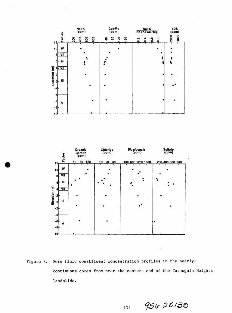
12
10
8
6
?4
I 2a o 0
UJ-2
-4
-6
-8
-in
Na+K Ca+Mg M (ppm) (ppm)9o o o o o o o o oCO O O O O «} CO CM CO
U» CM ^ CO CO T* T
- IV
VII
- Ill VII
.
. Ill
V-
1 1 1 1
,
,
,
I I i r^
9
m
Na+KNa+K+Ca+Mg
CM TT CO COo d o d 1 1 1 1
\
.
.
IDS (ppm)0 0o o o oCM ^ 1 1
«
1
.
,
.
.
Organic Chloride Bicarbonate Sulfate M Carbon (ppm) (ppm) (ppm) g (ppm)
^ «* 40 80 120 10 20 30 40080012001600 200400600800
10
8
6* .& 4
o 2"5
£ 0Ul
-2
-4
-6
-8
-10
. IV
. VII
. Ill
VII
. HI
-
V
*
9
9
9
^
*
.
t :
.*
^
Figure 7. Pore fluid constituent concentration profiles in the nearly-
continuous cores from near the eastern end of the Turnagain Heights
landslide.
131

RESEARCH NEEDS
The issues that need to be clarified, concerning the distribution and
severity of earthquake-induced ground failure hazards from sensitive clays in
the Bootlegger Cove Formation, include the geologic origin, regional
distribution, and in situ properties of the highly and extremely sensitive
strata in the formation.
It needs to be recognized that these issues cannot be addressed
effectively either with existing data or with conventional soil property
testing methods. The existing data are based primarily on samples obtained
with conventional sampling methods that are incapable of retrieving good
quality samples of highly sensitive materials. Existing dynamic laboratory
testing methods have rarely been used because they are expensive, and also
because the significance of the results that can be obtained is clouded by
disturbance effects of unknown magnitude. Finally, appropriate in situ
methods for identifying highly sensitive strata and for measuring their
dynamic properties have yet to be developed.
Significant research concerning these issues will require innovative
experimental approaches: (1) that enable sensitive clays to be differentiated
and classified not only in terms of their strength loss potential but also
with regard to the rate at which their strength deteriorates with disturbance,
(2) that allow disturbance effects either to be avoided, or measured and taken
into account, in both in situ and laboratory measurements; and (3) that are
designed to obtain not only geotechnical data but also the geochemical and
geologic data needed for understanding the regional controls on the
distribution and in situ properties of the most sensitive clay strata in the
Bootlegger Cove Formation.
132

REFERENCES CITED
Hansen, W.R., 1965, Effects of the earthquake of March 27, 1964, at Anchorage,
Alaska: U.S. Geological Survey Professional Paper 542A, p. A1-A68.
Idriss, I.M., and Moriwaki, Yoshihaiu, 1982, Anchorage Office Complex
geotechnical investigation, Anchorage, Alaska, V. 1, Seismic hazards
evaluation: San Francisco, Woodward-Clyde Consultants, p. 6-1 to 6-3.
Mitchell, J.K., 1976, Fundamentals of Soil Behavior: John Wiley and Sons, New
York, 422p.
Cuigley, R.M., 1980, Geology, minerology, and geochemistry of Canadian soft
soils: a geotechnical perspective: Canadian Geotechnical Journal, V. 17,
p. 261-285.
Seed, H.B., 1968, Landslides during earthquakes due to soil liquefaction: Journal
of the Soil Mechanics and Foundations Division, ASCE, V. 94, no. SM 5,
p. 1055-1122.
Seed, H.B., and Wilson, S.D., 1967, The Turnagain Heights landslide, Anchorage,
Alaska: Journal of the Soil Mechanics and Foundations Division, ASCE, V. 93,
p. 325-353.
Shannon and Wilson, Inc., 1964, Report on Anchorage area soil studies, Alaska:
Shannon and Wilson, Inc., Seattle, Washington, Inc., 109 p.
Soderblom, Rolf, 1974, New lines in quick clay research: Reprints and Preliminary
Reports No. 55, Swedish Geotechnical Institute, Stockholm, 468p.
Soderblom, Rolf, 1974, Organic matter in Swedish clays and its importance for
quick clay formation: Swedish Geotechnical Institute Proceedings No. 26,
89p.
Torrance, J.K., 1975, On the role of chemistry in the development and behavior of
sensitive marine clays of Canada and Scandanavia: Canadian Geotechnical
Journal, v. 12, p. 326-335.
Torrance, J.K., 1983, Towards a general model of quick clay development:
Sedimentology, V. 30, p. 547-555.
Updike, R.G., 1984, The Turnagain Heights landslide an assessment using the
electric cone penetration test: Alaska Division of Geological and
Geophysical Surveys, Report of Investigations 84-13, 48p.
Updike, R.G., and Carpenter, B.A., in press, Engineering geology of the
Government Hill area, Anchorage, Alaska: U.S. Geological Survey Bulletin.
Updike, R.G., Olsen, H.W., Schmoll, H.R., Kharaka, Y.F., Stokoe, K.G., in press,
Geologic and geotechnical conditions adjacent to the Turnagain Heights
landslide, Anchorage, Alaska; U.S. Geological Survey Bulletin.
133

USGS ENGINEERING GEOLOGY PROJECTS IN THE ANCHORAGE AREA, ALASKA: A REVIEW
by
Henry R. Schmoll
U. S. Geological Survey
Denver, CO 80225
INTRODUCTION
Anchorage began in 1915 as a tent city near the mouth of Ship Creek. It was
built to support construction of the Alaska Railroad, itself one of the major
engineering works of the state. Little thought was likely to have been given
to siting conditions for new construction in the city, at least for anything
as light and temporary as a group of tents. Soon, however, permanent
structures were built, and the center of town moved up from Ship Creek valley
to its present site, the smooth-surfaced gravel plain on which our workshop is
taking place (Capps, 1940, p. 12). It seemed like a good place for a town:
there were good, well-drained natural foundation conditions, plenty of gravel
and sand for construction purposes, and, as time went on, a good place for an
airfield. Eventually an artesian water supply was discovered that bubbled up
from beneath a thick bed of clay. The inhabitants thought they had it quite
good.
The catastrophic events of March 27, 1964, proved somewhat otherwise, and ever
since then there has been some awareness that earthquakes and earthquake-
induced landslides would have to be contended with. Eventually there were
even maps that indicated in a general way where such landsliding might take
place, as well as the many other places where it almost certainly would not.
Any new construction in the metropolitan area, should, one would think, take
earthquake shaking and slope instability into account; some siting and design
of construction seem to, more and more these days, whereas others most clearly
seem not to have done this. Questions that legitimately arise include: (1)
How seriously should carefully devised guidelines intended to warn of such

hazards be taken? (2) How thoroughly are the guidelines based on scientific
knowledge? (3) How sound is that scientific knowledge? (4) How did it reach
its present level? and (5) Is that level adequate for the purpose intended,
and if not, what further level must be attained? This paper will attempt to
review some aspects of these questions, and in so doing will touch upon the
developing relationship between various parts of the geologic and engineerng
communities and the community at large that occupies the burgeoning
metropolitan Anchorage area.
Geological research related to local earthquake-hazards investigations in the
metropolitan Anchorge area can be considered to have begun about 36 years
ago. Its early stages were dominated by workers of the Engineering Geology
Branch of the U. S. Geological Survey (USGS). Work by these individuals and
successive investigators has continued intermittently to the present, and this
review is devoted principally to summarizing that work. From the beginning,
concurrent studies by the Water Resources Division of the USGS (WRD) have
contributed on a steady basis, and work by other organizations, in particular
the Alaska Division of Geological and Geophysical Surveys (ADGGS), has become
increasingly important in recent years. In this paper, however, these other
efforts are discussed only as they relate to the USGS engineering and
environmental geology investigations.
The main purpose of this review is to establish a context within which ongoing
and newly proposed geological and seismological research may be placed. It
may refresh the memories of those who have been on the scene through a
substantial part of this time, and serve as a guide and perhaps note of
caution for more recent workers who may have only a more casual view of the
history of previous investigations. The goals of past projects will be
presented briefly, including consideration of the varying extent to which they
were concerned with earthquake-hazard evaluation. Some assessment will be
made as to how well the goals appear, at least from one vantage point, to have
been met. This review then might also serve as a point of departure for a
discussion by others at this workshop who have used information from these
investigations, regarding how they perceive the success or failure of the
investigations in reaching their goals, and how they regard the strengths and
135

weaknesses of the projects. Future investigations might then avoid past
pitfalls and proceed instead in directions that may be more fruitful.
Much of the content of this review has been gleaned from material in the files
of the projects under consideration, and from discussions over a period of
many years with the personnel involved, especially pioneers Ernest Dobrovolny
and Robert D. Miller, who until recently shared an office in their mutual
period of retirement, and to whom acknowledgment is warmly given.
PREVIOUS PROJECTS
The project of Dobrovolny and Miller, 1949-1959
In 1948, within a few years of the formal establishment of an organizational
base within the USGS for undertaking regional and urban area engineering
geological studies, Ernest Dobrovolny made a brief trip to Alaska to determine
the desirability, if any, of undertaking such work in what was then still a
remote outpost of urban America Alaska was still 11 years away from
statehood. From Denver, Colorado, where the Engineering Geology Branch was
newly ensconced after a departure from traditional USGS headquarters at
Washington, D. C., three or four urban centers in Alaska appeared to be
perhaps equally qualified candidates for such studies. Dobrovolny recommended
selection of Anchorage, correctly predicting that it was the area most likely
to expand and thus where the greatest benefit would accrue from the proposed
investigations.
Consequently the first Anchorage project was begun in 1949 by Dobrovolny and
R. D. Miller, with field work in that and the next few years. The principal
effort of that project was to produce the first, and still the most basic,
geologic map of the metropolitan area, published originally in a preliminary
version (Dobrovolny and Miller, 1950), and later in final form (Miller and
Dobrovolny, 1959), at about the same time that Alaska achieved statehood.
Another principal thrust of the project was to decipher the geologic history
of the area, mainly concerned with Pleistocene glaciation, on the basis of the
detailed local work. The conclusions were at variance somewhat with
concurrent but more regionally based interpretations of Karlstrom (1964), and
136

to a lesser degree with those of WRD workers (Cederstrom and others, 1964).
Efforts were made during the 1950s to reconcile opposing views, but without
much success [Miller allegedly had thoughts of pushing Karlstrom off the cliff
during one discussion], and the ground was laid for variant interpretations
and unresolved problems of reconstructing geological events that persist to
the present. These controversies are regarded mostly as an indication of (1)
the complexities of the local geology, (2) the incompleteness of the preserved
geologic record, and, especially, (3) the remaining need for the enhanced
dating of deposits that may lead to a more satifactory resolution of
geological uncertainties than has been attained heretofore.
A major achievement of the project was the identification and naming of the
single most significant geologic unit within the metropolitan area, the
Bootlegger Cove Formation (nee Bootlegger Cove Clay). The project also
sampled and analyzed physical properties of this and other principal geologic
units that underlie the metropolitan area. These early determinations were to
become important as the first guide to behavior of geologic materials in
response to construction processes that accompany urbanization, as well as to
naturally occurring seismically induced disturbance. The Dobrovolny-Miller
project was not directed at delineation of earthquake hazards per se, which at
that time were considered as but one aspect of a broader regional engineering
geologic investigation. Nevertheless, there was an awareness of the potential
for strong ground motion resulting from large magnitude earthquakes. The role
that the very soft Bootlegger Cove Formation could play in developing large-
scale ground failure during such seismic events was duly noted in a prophetic
paragraph (Miller and Dobrovolny, 1959, p. 103-104). The implications of
those statements were to be realized more quickly and with greater impact than
the authors probably could foresee.
Work immediately following the 1964 earthquake
A vast investigative effort was undertaken by a veritable army of workers from
all possible geological and related organizations following the devastating
earthquake of March 27, 1964. This effort took place throughout southern
Alaska, was reported voluminously, and is summarized, for example, by Eckel
(1970). Although investigations relevant to the Anchorage area are reported
137

in a number of publications, the principal summary of geologic effects in the
Anchorage area is that of Hansen (1965). In particular, he included concise
descriptions of the major areas of ground failure that were the principal
causes of property damage and financial loss. The investigations summarized
therein, based on large amounts of new data, greatly enhanced establishment of
the nature of the geologic problems that remain fundamental to wise and safe
land use. Nevertheless, basic questions, particularly as to precise
mechanisms of ground failure within the Bootlegger Cove Formation, were not
resolved by these intense but relatively short-lived studies. Consequently
the determination of suitable measures to solve the geological problems in a
way satisfactory for optimum land use development and minimization of risk was
not attained at that time, nor has it been since.
The project of Dobrovolny and Schmoll, 1965-1974
In the years following statehood, and prior to the 1964 Alaska earthquake,
another event pertinent to this summary of geological studies occurred: the
establishment of the Greater Anchorage Area Borough (GAAB). This new
governmental entity lay outside of the preexisting City of Anchorage
(restricted mainly to what is now the downtown area) but occupied a large part
of the metropolitan area, as well as including a much larger area within the
Chugach Mountains to the east. The events of 1964 did make clear, at least to
some, the desirability of a basic land use oriented geologic investigation as
a prerequisite for logical guidance to the development of this relatively vast
and geologically not well known area ["how many other surprises do the rocks
have in store for us?"]. Consequently, when special longer-term funding for
post-earthquake geologic investigations was under consideration by the U.S.
Congress, the GAAB requested that the USGS undertake studies comparable to
those begun in 1949 but that would extend such work into the new GAAB area.
The time and mood was right for such a request, and it was indeed granted; it
is unlikely, however, that the request would have been made at all without the
firm guidance of Lidia Selkregg, then member of the GAAB Planning Commission,
and, ever since, the outspoken conscience of geology at various
administrative, political, and educational levels within the Anchorage area.
138

In 1965 the proposed project was begun by Dobrovolny and the present writer,
and indeed in its early years was devoted mainly to work within the "back
country" of the GAAB, although at least some of the new area, especially that
northeast of the city along Knik Arm, was and still is the site of continued
urbanization. In addition to relatively conventional geologic studies,
another thrust of the project was an effort to make geology and its
application to land use planning a larger part of the awareness of those
responsible for the orderly development of the area (Dobrovolny and Schmoll,
1968). In this connection, and in company with personnel of the WRD, whose
cooperative studies with both the City and the GAAB were well established,
numerous meetings and field trips were held with GAAB administrative and
political leaders, and it is hoped that at least some groundwork was laid for
the continued interest in and further acceptance of geological input to the
land-development process. Paradoxically, it was apparent from the start that
in the area of the City, where most of the principal landslide destruction
occurred, and where many of the geotechnical puzzles still lay, the
politicoeconomic environment was not amenable to such geoproselytization.
Efforts of the project, both geoscientific and geopolitical, were not aimed in
that direction to the extent that it now may seem that they might have been.
Nevertheless, as time passed, it became apparent that by far the greater
interest and need was for increased work within the metropolitan area,
including the area of the City and of the previous project, in part because of
the increase in data becoming available as development proceeded, compared to
what was available in 1949. Furthermore, the creation of Chugach State Park
in the mountains directly east of the metropolitan area precluded imminent
exurbanization of that area and thus reduced the immediate need for much of
the work undertaken there. The resulting change in project direction
culminated in the publication of a so-called folio series of geological
derivitive maps (Schmoll and Dobrovolny, 1972a, 1972b, 1973, 1974; Dobrovolny
and Schmoll, 1974; Freethey, 1976). These maps utilized a more modern and
larger-scale base map than the earlier work, albeit one made just before the
1964 earthquake and consequently somewhat outmoded. Each folio map was
restricted in subject matter and designed to be more readily understandable to
nongeological users than a conventional geologic map. This procedure was
fashionable at the time and widely employed elsewhere in the nation. Whether
the procedure, and the philosophy underlying it, was appropriate, a point
about which the writer has subsequently entertained some doubt, is perhaps a
suitable topic for discussion at this workshop. Concurrently, under the
auspices of the University of Alaska, further efforts at making both
geological and other envioronraent-related studies more readily available were
undertaken (Selkregg and others, 1972). Meanwhile the nearly completed work
in the larger part of the GAAB was somewhat neglected, and remains largely
unpublished to this day.
One of the shortcomings of the folio series, philosophical considerations
aside, was the lack of any presentation of subsurface data. The importance of
this element was recognized, not only to meet the varied needs of the
engineering profession, and of geologists reconstructing past events, but to
provide data for seismologists as well, for at that stage it was also intended
to begin work on earthquake-hazard evaluation. Plans were made in the latter
stages of the project to continue the investigations in that direction, in
cooperation with A. F. Espinosa and others, as well as with the WRD personnel
in whose domain the subsurface lay. The time was not right, however; national
priorities lay in more populous parts in the country, and the project under
discussion came to a rather lame end.
Other work, 1974-1983
During this interval some efforts were made to continue the Anchorage project
described above on informal basis, but publications were limited largely to a
few temporary addenda to the folio series. These were developed to meet the
needs of WRD reports or because of other local interest (for example, Zenone
and others, 1974; Schmoll and others, 1980, 1981; Schmoll and Emanuel, 1981,
1983). In addition, however, some further stratigraphic work also continued
(Schmoll and Gardner, 1982).
Related work by the present writer and others on the west side of Cook Inlet
did, however, provided a needed broader regional understanding of the Cenozoic
geology of upper Cook Inlet basin. Such efforts have begun to yield a basin-
wide synthesis (Schmoll and Yehle, 1983; Schmoll and others, 1984) that will
aid further work in the Anchorage area as well.
JQ&5

During this period the first serious work on the sediments in Turnagain Arm,
most of which are exposed at low tide and are under water at high tide, was
undertaken by A. T. Ovenshine, Reuben Kachadoorian, and Susan Bartsch-Winkler
(Ovenshine and others, 1976; Bartsch-Winkler and Ovenshine, 1984). Later some
work of this type was extended to Knik Arm as well (Bartsch-Winkler, 1982;
Bartsch-Winkler and Schmoll, 1984a, 1984b). While much of that effort was
sedimentological in character, it has provided a framework and basic
understanding of these extensive deposits not previously available. The
importance of these studies will no doubt increase in future years as proposed
arm crossings and other offshore structures inevitably become realized.
A single USGS/Engineering Geology initiative consisted of a new investigation
in the vicinity of the Turnagain Heights landside of 1964, undertaken by H. W.
Olsen, a project that involved drilling, coring, and testing of material from
the Bootlegger Cove Formation (Olsen, this volume). This work, done
cooperatively with R. G. Updike of the ADGGS, among others, has attempted to
delve into the question of mechanisms of earthquake-induced landslides, and
while not providing all the answers, it at least points the way to finding
such answers. The first principal report of this work is now finalized
(Updike and others, in press).
The dominant engineering geologic effort during this period, however, was the
ADGGS program of further investigations into the nature of the Bootlegger Cove
Formation led by R. G. Updike, and funded cooperatively with the USGS (Updike,
this volume). Large amounts of accruing data on distribution of the formation
and on its physical properties and engineering geologic characteristics were
synthesized, and, in addition, imaginative new approaches were used in
gathering further data. This work, combined with that of Olsen, neatly
complements the earlier work described above, and furthermore bears more
directly than any of the earlier investigations on the problem of earthquake-
induced ground failure.
On the politcal scene the major event of this period was the union of the
former City of Anchorage and GAAB to form a new, all-encompassing entity, the
Municipality of Anchorage. Among other effects, this has given the
141

engineering geological and seismological community a single political point of
contact, a particularly logical development inasmuch as the former boundary
between the two political units was not well recognized in the geology.
Geopolitical strides that followed the union include, among others, (1)
establishment of the Anchorage Geotechnical Commission, an advisory group that
is made up largely of representatives of a greatly expanded private sector in
the engineering and geological fields, and that has substantially aided
communication between the scientific-engineering and political communities,
and (2) the inclusion of a geologist-planner, Barbara Sheinberg, on the staff
of the Community Planning Department, developments that long were goals of the
Dobrovolny-led projects.
CURRENT PROJECT
Beginning in about 1983, and coincidentally concurrent with the organizational
consolidation within the USGS of the engineering geology and seismology
elements that earlier had been proposed to meld into a continuation of the
Anchorage project, a phoenicular new Anchorage project did arise. This
project, led by A. F. Espinosa, is designed in effect to take on the remaining
tasks that were originally intended to carry the previous project to its
logical conclusion (Espinosa and others, this volume).
Among the early efforts of this new project has been resumption of subsurface
studies, of which the first preliminary report has appeared recently (Schmoll
and Barnwell, 1984). These subsurface studies are intended to lead to
completion, in effect, of the old folio series, with production of one or more
subsurface maps (as implied in Schmoll and others, 1985).
In addition, the uncompleted geologic maps of the entire municipality are in
active preparation for publication once again, both at the scales of the
existing mapping for much of the mountainous part of the area, and at the
larger 1:25,000 scale of the post-1964 topographic base maps. This work will
be accomplished in cooperation with R. G. Updike and others of the ADGGS, who
have meanwhile begun more detailed mapping in parts of the area (for example,
Updike and Ulery, 1983).
142
CONCLUDING REMARKS
At various times it began to appear from this vantage point that, after some
years of effort to establish ties necessary for significant utilization of the
geological work, not very much had actually been accomplished along these
lines, and there was uncertainty as to whether the earlier geologic efforts
would have very much of the intended impact. Today, however, in light of the
developments cited above, there seem to be grounds for guarded optimism, and
the wideranging nature of the participants at this workshop, and even the very
existence of the workshop itself, are added evidence to support this view.
As the current and newly proposed projects progress, the results of the mainly
geologic investigations discussed here will be combined with seismological
data compiled from existing and newly acquired records to yield the long-
sought areal evaluation of response to strong ground motion caused by major
earthquakes. Such information, together with the advanced analyses of the
behavior of the Bootlegger Cove Formation as proposed by Olsen (this volume),
will complete the package of seismogeotechnical data, the first elements of
which were initiated about 36 years ago. The community will then have, for
the first time, an adequate database on the basis of which scientifically
supportable recommendations on appropriate land use can reasonably be made.
It may seem naive, in retropsect, to have thought that such a necessarily
broad foundation could be achieved by a single two or three year project
staffed by two young and enthusiastic geologists, or even by subsequent more
extended projects staffed by a small number of more experienced but thus older
personnel. Yet a beginning had to be made, and it was. And, as inevitably
needed, further work continued slowly, while the community itself continued to
grow and mature. We now have in sight the completion of the first round in
the acculumation and interpetation of the necessary data. And it appears that
we also have a community that has taken at least the initial steps toward the
wise utilizaton of these data and interpretations.
143

REFERENCES
Bartsch-Winkler, Susan, 1982, Physiography, texture, and bedforms in Knik Arm,
upper Cook Inlet, Alaska, during June and July, 1980: U.S. Geological
Survey Open-File Report 82-464, 6 p, 1 sheet, scale 1:63,360.
Bartsch-Winkler, Susan, and Ovenshine, A. T., 1984, Macrotidal subarctic
environment of Turnagain and Knik Arms, upper Cook Inlet, Alaska:
Sedimentology of the intertidal zone: Journal of Sedimentary Petrology,
v. 54, no. 4, p. 1221-1238.
Bartsch-Winkler, Susan, and Schmoll, H. R., 1984a, Convoluted beds in late
Holocene intertidal sediment at the mouth of Knik Arm, upper Cook Inlet,
Alaska: U.S. Geological Survey Circular 868, p. 105-108.
_____1984b, Bedding types in upper Holocene distributary tidal channel
sequences, Knik Arm, upper Cook Inlet, Alaska: Journal of Sedimentary
Petrology, v. 54, no. 4, p. 1237-1248.
Capps, S. R. , 1940, Geology of the Alaska Railroad region: U.S. Geological
Survey Bulletin 907, 201 p.
Cederstrom, D. J., Trainer, F. W., and Waller, R. M., 1964, Geology and
ground-water resources of the Anchorage area, Alaska: U.S. Geological
Survey Water Supply Paper 1173, 108 p.
Dobrovolny, Ernest, and Miller, R. D., 1950, Descriptive geology of Anchorage
and vicinity, Alaska: U.S. Geological Survey Open-File Report, 11 p., 2
maps.
Dobrovolny, Ernest, and Schmoll, H. R., 1968, Geology as applied to urban
planning: an example from the Greater Anchorage Area Borough, Alaska:
International Geological Congress, 23d, Prague, 1968, Proceedings,
Section 12, Engineering geology in country planning, p. 39-56.
Reprinted, 1975, _in_Betz, Frederick, Jr., ed., Environmental geology:
Benchmark Papers in Geology, v. 25, p. 49-66. Reprinted, 1976, in Tank,
144

R. W., ed., Focus on environmental geology: New York, Oxford University
Press, p. 11-26.
1974, Slope stability map of Anchorage and vicinity, Alaska: U.S.
Geological Survey Miscellaneous Geologic Investigations Map I-787-E,
scale 1:24,000.
Eckel, E. B., 1970, The Alaska earthquake, March 27, 1964: Lessons and
conclusions: U.S. Geological Survey Professional Paper 546, 57 p.
Freethey, G. W., 1976, Relative permeability of surficial geologic materials,
Anchorage and vicinity, Alaska: U.S. Geological Survey Miscellaneous
Investigations Map I-787-F, scale 1:24,000.
Hansen, W. R., 1965, Effects of the earthquake of March 27, 1964, at
Anchorage, Alaska: U.S. Geological Survey Professional Paper 542-A, 68 p,
Karlstrom, T. N. V., 1964, Quaternary geology of the Kenai lowland and glacial
history of the Cook Inlet region, Alaska: U.S. Geological Survey
Professional Paper 443, 69 p.
Miller, R. D., and Dobrovolny, Ernest, 1959, Surficial geology of Anchorage
and vicinity, Alaska: U.S. Geological Survey Bulletin 1093, 128 p.
Ovenshine, A. T., Bartsch-Winkler, Susan, O'Brien, N. R., and Lawson, D. E.,
1976, Sedimentation in the high tidal range environment of Turnagain Arm,
Alaska, in. Miller, T. P., ed., Recent and ancient sedimentary
environments in Alaska: Anchorage, Alaska Geological Society Symposium
Proceedings, p. M1-M26.
Schmoll, H. R., and Barnwell, W. W., 1984, East-west geologic cross section
along the DeBarr line, Anchorage, Alaska: U.S. Geological Survey Open-
File Report 84-791, 11 p., 1 pi.
145

Schmoll, H. R., and Dobrovolny, Ernest, 1972a, Generalized geologic map of
Anchorage and vicinity, Alaska: U.S. Geological Survey Miscellaneous
Geologic Investigations Map I-787-A, scale 1:24,000.
_____1972b, Slope map of Anchorage and vicinity, Alaska: U.S. Geological
Survey Miscellaneous Geologic Investigations Map I-787-B, scale 1:24,000.
_1973, Construction materials map of Anchorage and vicinity, Alaska:
U.S. Geological Survey Miscellaneous Geologic Investigations Map I-787-C,
scale 1:24,000.
1974, Foundation and excavation conditions map of Anchorage and
vicinity, Alaska: U.S. Geological Survey Miscellaneous Geologic
Investigations Map I-787-D, scale 1:24,000.
Schmoll, H. R., Dobrovolny, Ernest, and Gardner, C. A., 1980, Preliminary
geologic map of the middle part of the Eagle River valley, Municipality
of Anchorage, Alaska: U.S. Geological Survey Open-File Report 80-890, 11
p., 1 pi., scale 1:25,000.
_____1981, Preliminary geologic map of Fire Island, Municipality of
Anchorage, Alaska: U.S. Geological Survey Open-File Report 81-552, 4 p.
Schmoll, H. R. , and Emanuel, R. P., 1981, Generalized geologic map and
hydrologic properties of the Potter Creek area, Municipality of
Anchorage, Alaska: U.S. Geological Survey Open-File Report 81-1168, 1
pi., scale 1:25,000.
_____1983, Geologic materials and hydrogeologic characteristics in the Fire
Lakes-Eklutna area, Anchorage, Alaska: U.S. Geological Survey Open-File
Report 83-479, 1 pi., scale 1:25,000.
Schraoll, H. R., and Gardner, C. A., 1982, Diamicton of subglacial or
subaqueous origin, Fire Island, Anchorage, Alaska: International Union
for Quaternary Research (INQUA), XI Congress, Moscow, U.S.S.R.,
Abstracts, v. 1, p. 282.
146

Schmoll, H. R., Odum, J. K., and Espinosa, A. F., 1985, Seismotechnistrati-
graphic cells: an approach to the analysis of subsurface geology at
Anchorage, Alaska, for seismic zonation stuidies: Geological Society of
America Abstracts with Programs, v. 17, no. 7, p. 710.
Schmoll, H. R., and Yehle, L. A., 1983, Glaciation in the upper Cook Inlet
basin: a preliminary reexamination based on geologic mapping in progress,
ir± Thorson, R. M., and Hamilton, T. D., eds., Glaciation in Alaska
Extended abstracts from a workshop: Alaska Quaternary Center, University
of Alaska Museum Occasional Paper no. 2, p. 75-81.
Schmoll, H. R., Yehle, L. A., Gardner, C. A., and Odum, J. K., 1984, Guide to
surficial geology and stratigraphy within the upper Cook Inlet basin
[prepared for the 80th annual meeting of the Cordilleran Section,
Geological Society of America]: Anchorage, Alaska Geological Society, 89 p.
Selkregg, L. L., and others, 1972, Environmental atlas of the Greater
Anchorage Area Borough, Alaska: Anchorage, University of Alaska, Arctic
Environmental Information and Data Center, 105 p.
Updike, R. G., Olsen, H. W. , Schmoll, H. R., Kharaka, Y. K., and Stokoe, K.
H., in press, Recent subsurface geologic and geotechnical srtudies
adjacent to the Turnagain Heights landslide in Lynn Ary Park, Anchorage,
Alaska: U.S. Geological Survey Bulletin.
Updike, R. G., and Ulery, C. A., 1983, Preliminary geologic map of the
Anchorage B-6 NW (Eklutna Lake) quadrangle, Alaska: Alaska Division of
Geological and Geophysical Surveys Report of Investigations 83-8, 2 pi.,
scale 1:10,000.
Zenone, Chester, Schmoll, H. R., and Dobrovolny, Ernest, 1974, Geology and
ground water for land-use planning in the Eagle River-Chugiak area,
Alaska: U.S. Geological Survey Open-File Report 74-57, 25 p., 1 pi.
147

FORMULATING EARTHQUAKE RESISTANT DESIGN CRITERIA*
by
Paul C. Jennings
California Institute of Technology
Pasadena, California 91125
INTRODUCTION
The primary function of design criteria in general, and earthquake-resistant
design criteria in particular, is to restate a complex problem that has
unknowns and uncertainties into an unambiguous, simplified form having no
uncertainties. The design criteria should provide clearly stated guidelines
for the designers. For example, when actually designing a structure, an
engineer needs to know the forces and deformations that the structure should
be able to resist. Some of these forces, such as dead loads imposed by
gravity, are well known, but other that result from transient actions of
nature or man, such as earthquake, wind or live loads, are not known. This
lack of knowledge must somehow be circumvented and a precise, unambiguous
statement of the design conditions must be given to the design engineer. This
is accomplished by means of the design criteria. The designer also needs to
know the properties of the materials and structural elements that will be
used, but as these are not precisely known, mainly because of imperfections in
materials and workmanship, the design criteria must also take this into
account. In the preparation of the design criteria, allowance must be made
for the uncertainties, and it is necessary to be cognizant of all the unknowns
for which allowances must be made.
The traditional engineering design criteria, for example those in the Uniform
Building Code, specify live loads that are greater than the actual loads
typically encountered, and specify allowable design stresses that are
appreciably less than the expected ultimate strength of the material. The
purpose of this procedure is to ensure extra strength that is sufficient for
unforeseen variations in loads, in material properties, and in workmanship.
* This paper is abstracted, with modifications, from the EERI Monograph "Earthquake Design Criteria" by G. W. Housner and P. C. Jennings.
148

These criteria, in effect, tell the design engineer: "if you design according
to these requirements, the structure will be considered adequate." A similar
approach could be taken for earthquake-resistant design if the conditions were
more or less the same for all projects. However, because the seismic hazard
varies markedly from place to place and because structures and facilities vary
in importance, cost, length of life, ease of repair, materials of construction
and consequences of failure, the formulation of seismic design criteria for
other than ordinary buildings cannot, in general, be codified simply; special
knowledge and judgment are required for formulating the criteria.
THE USE OF SEISMOLOGICAL AND GEOLOGICAL DATA
When designing structures for a seismic region, what the engineer would really
like to know is the strongest ground shaking that the site under consideration
will experience during the life-time of the planned facility. This pre-
knowledge, however, is not available, so recourse must be had to estimating
what might happen in the future by studying what has happened in the past.
Seismological and geological data form the basis for estimating future ground
motions, including shaking and possible fault rupture, and studies for
important facilities sited where the possibility of major earthquakes must be
considered nearly always involve geologists and seismologists.
The seismic history of a region in the U.S. shows what has happened in the
recent past, for example the last two hundred years, and thereby gives an
indication of what might be expected in the next two hundred years. In a
similar way, geological studies can give information on the occurrence of
faulting and earthquakes over a longer time span, typically thousands or
hundreds of thousands of years, and can thereby provide longer term estimates
of the activity of faults than is available from the historical record
alone. In this sense the past is used by the geologists and seismologists to
predict the future. The correct use of the recommendations of geoscientists
by earthquake engineers requires an understanding of the terminology and
concepts used by scientists.
/DBS149

EARTHQUAKE MAGNITUDE
Any measurement that characterizes the size of the area of strong shaking, or
the extent of the "felt area," or the total energy released in shaking, could
serve as an indication of the size of the earthquake. As originally developed
by C. F. Richter at the California Institute of Technology, the earthquake
magnitude scale uses as the pertinent measurement the peak amplitude recorded
by a standard Wood-Anderson seismograph, which has a natural period of 0.8
seconds, approximately 80% of critical damping and a magnification of 2800.
The peak amplitude, A, of Wood-Anderson seismograms varies over the surface of
ground in a manner similar to the variation of intensity of ground shaking,
being very small at large distances from the fault and thousands of times
larger close to the fault; so for a measure, the log^A is used. The plot of
logj|QA forms a hill-shaped surface and the volume of the hill would be a good
measure of the size of an earthquake, but it would not be practical to
evaluate. A less precise, but more practical, measure is that defined by
Richter:
M.L = log 10A-lotg 10A0(A)
In this expression, M, is the local magnitude, A is the epicentral distance in
kilometers, and AQ(A) is the Wood-Anderson amplitude corresponding to an
earthquake with magnitude zero. The variation of AQ(A) with distance was_0
determined from data and the level was fixed by setting its value at 10
millimeters for a distance of 100 km. Two different seismographic stations
will not, in general, compute the same value of M^, and the "official" value
is usually the weighted average from several records. Also, the magnification
of the standard Wood-Anderson instrument and of almost all other seismographs
is such that the instruments are driven off-scale by motion strong enough to
be felt, so the use of seismographs to determine the magnitudes of larger
earthquakes necessarily requires the readings to be made at large distances
where the character of the ground motion is much different from that near the
fault. At such distances, the motion does not contain direct information
about the nature of the close-in, potentially destructive shaking.
150

Seismic waves change their character as they travel away from the causative
fault. In particular, at larger distances the compression waves, shear waves
and surface waves separate out and the nature of the waves also change. This
has led to certain refinements in determining earthquake magnitudes, and other
magnitude scales have come into use. The most common of these are the
surface-wave magnitude M , the body-wave magnitude M,, and the moment
magnitude M . In general, the different magnitude scales do not give the same
numerical values, although they agree at some levels and there are empirical
techniques for converting from one to another. At distances of a thousand
kilometers and more, surface waves of 20-second period predominate in observed
seismograms and the amplitude of this motion is used to determine Ma , which issthe value most commonly reported in the press for major earthquakes.
Earthquakes smaller than about M, = 6 typically do not generate enough surface
waves for a determination, so the M scale is designed to agree with MT fors LImagnitudes in the range of 6 to 6-1/2. For larger earthquakes the value of M
S
consistently exceeds that of M,. For example, the 1906 San Francisco
earthquake had the approximate magnitudes M ~ 8.3 and MT ~ 6.9. The largestfc> -Lj
observed local magnitudes are in the 7 to 7-1/4 range, whereas surface wave
magnitudes as high as 8.6 have been assigned.
For the very largest earthquakes in history, such as the Chilean earthquake of
1960 and the Alaskan earthquake of 1964, the surface-wave magnitude
"saturates" in the sense that it cannot well distinguish two very large events
of different fault lengths on the basis of the maximum amplitude of the 20-sec
surface waves. For this reason H. Kanamori developed the moment magnitude,
My This magnitude scale is based on the total elastic strain energy released
by the fault rupture, and this is related to the seismic moment MQ defined by
MQ = PAD
in which y is the modulus of rigidity of the rock, A is the area of the
rupture surface of the fault and D is the average fault displacement. MQ can
be estimated from geological evidence which defines the area and extent of
rupture, or from records of long period seismographs at large distances, for
which even the largest earthquake appears to be a relatively short event.
Because MW and MQ do not saturate and do measure all the energy released, even
151

that at periods of tens and hundreds of seconds, they are of more fundamental
scientific interest to seismologists than the local magnitude, M, . The
largest earthquake on the moment magnitude scale is the Chilean event of 1960
which had a fault length of approximately 600 miles and an assigned value of
My = 9.9, compared to Mg = 8.6.
Having these different magnitudes introduces an element of confusion into
earthquake engineering. The most commonly used magnitudes, as given in
Gutenberg's and Richter's Seismicity of the Earth (Ref. 4) or in the U.S.G.S.
publication United States Earthquakes (Ref. 15), are M^ for moderately large
earthquakes (M = 6.4 for 1971 San Fernando) and Mg for large earthquakes
(M = 8.4 for 1964 Alaska).
The consistent use of M in this way means that its value will convey an idea
of the size of the event. Because practices vary, it is advisable to
ascertain what magnitude scales are used in any presentation concerning
magnitudes.
SEISMOLOGICAL DATA
Depending on the region, seismological data are available in various amounts
and degrees of quality. There are countries with some form of seismic record
going back as much as two or three thousand years, while the historical record
in the western United States is seldom as long as two hundred years.
Instrumental seismology has, of course, a much shorter history with a maximum
of about one hundred years. Similarly, there are some regions having networks
of seismic instruments sufficiently good to record all perceptible shocks and
to determine their locations to within a few kilometers; however, most seismic
regions have much less extensive coverage. Seismological data of high quality
imply instrument ally determined magnitudes and epicenters of all significant
events, with locations accurate enough to correlate earthquakes with geologic
features of the region. Earthquake data must include a sufficiently large
number of events so that enough earthquakes of larger magnitudes are present
to characterize events that must be considered in the design.
1087 £0130152

For engineering purposes the magnitudes are approximate indices of the size of
the earthquake; the local magnitude gives a measure of the strength of shaking
and M0 indicates the area that might be affected by strong ground motion. In searthquake engineering practice, it is customarily assumed that two
earthquakes having the same magnitude will have similar characteristics,
including ground shaking, other things being equal; but it should be kept in
mind that other things (tectonic setting, depth of rupture, rock type, fault
mechanism, rate of activity, etc.) are seldom entirely equal.
The adequacy of seismological data for purposes of design depends upon having
sufficient earthquakes in the historical record, with magnitudes and locations
determined, so that large magnitude events are also included. For example, if
the data include only earthquakes having M^ < 5 the probability distribution
for large earthquakes would not be defined and it would be of questionable
reliability to extrapolate to the probability of earthquakes M > 8. Lackingo
sufficient data to define a probability distribution, it is customary in U.S.
practice to assume a distribution for magnitudes that is consistent with the
seismic history of California, even though this introduces a degree of
uncertainty.
In the less seismic regions of the U.S., the seismological data are relatively
few and are typically of poor quality. For example, in the eastern part of
the country the available historical information on damaging earthquakes
seldom includes the instrumentally determined local magnitude of the event but
instead gives Modified Mercalli Intensity (MMI) numerals. The MMI index
provides information of a lower quality than the magnitude, not only because
it is based on personal observations of earthquake effects instead of
instrumental records, but also because the actual interpretation is often
unreliable.
GEOLOGICAL DATA
The seismic history of the United States, about one to three hundred years
depending on location, is a relatively short time for assessing the frequency
of earthquake occurrence. For reliable statistical studies to be made, the
duration of the seismic history should be long compared to the average time
153

between large earthquakes, a time which appears to range from as short as
about one hundred years to several thousand years, depending on the degree of
activity of the region. For example, major earthquakes away from continental
margins, such as have occurred in central China and the central United States,
appear to have the longest recurrence intervals.
The relatively short-time information provided by seismological history can be
supplemented by geological information about long-time tectonic processes that
are measured in thousands or hundreds of thousands of years. For example,
faults that can be identified as having experienced slip during the past
hundreds, thousands, or tens of thousands of years provide information about
the seismic hazard of a region, but it is a difficult scientific problem to
quantify this information.
In the best cases, the geological evidence will be sufficient to establish the
length over which a fault has ruptured, the amount of cumulative fault
displacement, and information about the period of time over which the
movements have taken place. In addition, it is sometimes possible to make
inferences concerning whether the fault has moved once, a few times, or many
times during its active history. For faults that are active up to the
present, geological data such as this can be used to help estimate the
magnitudes and frequency of occurrence of earthquakes that may reasonably be
expected in the future. It is equally useful if the geological data can be
used to rule out the expectation of a specific fault generating an earthquake,
which is an extremely important point for faults that may traverse or pass
near the site of a critical facility and could pose a hazard both from shaking
and fault displacement. If it can be demonstrated that the near surface
geological materials are undisturbed, this is conclusive evidence that the
fault has not ruptured (and thereby generated an earthquake) since the
formation of the oldest undisturbed material. Depending on the age of
material and the critical nature of the facility under design, the lack of
movement over an established number of years may eliminate the fault from
further consideration in formulating the design criteria. For most ordinary
construction, a fault that has not moved in Holocene times (the last 11,000
years) can be considered inactive, whereas for the design of nuclear plants,
it has been ruled that a fault that has moved once in the last 35,000 years or
154

more than once in the last 500,000 years must be considered as a possible
source of future earthquakes.
Depending on the geological data and the judgment of the geologist, various
procedures have been employed to interpret the seismic hazard posed by a given
fault. The crudest approach is that which simply assigns a maximum size to
the earthquake that the fault can generate. This earthquake is variously
known as the Maximum Capable Earthquake, Maximum Credible Earthquake, Safe
Shutdown Earthquake, Contingency Level Earthquake, etc. For example, a fault
whose discernible length is approximately 40 miles might be assigned a Maximum
Capable Earthquake (MCE) of M0 = 7, or one with a discernible length of 15smiles might be assigned a MCE of M = 6.5. The MCE represents a "worst case"
S
situation and by itself is not a very informative number, for it does not
distinguish between a fault that will have events of the approximate size of
the MCE once per 200 years and one for which the return period is once in
500,000 years, even though this information would be very important to
engineers preparing seismic design criteria.
SEISMOLOGICAL AND GEOLOGICAL INFORMATION REQUIRED FOR DESIGN
Geological and seismological consultant should address the question of
probability of occurrence. A report that merely states "the recommended
design earthquake is a Magnitude M = 7.5 at a distance of 20 km," isS
incomplete because it gives no indication of the frequency of occurrence of
the earthquake. In addition, the geoscientist has made a decision about
engineering design which is outside his area of competence. The expertise of
geological and seismological consultants is related to geologic and seismic
hazards, and their reports should describe the possible earthquakes together
with estimates of probability of occurrence, or the possible intensity of
ground shaking together with its estimated probability of occurrence. The
incorportion of the information into the design criteria should be the
responsibility of persons who understand engineering design and the
performance of structures, and who can balance the hazard posed by earthquakes
with that posed by other problems such as flooding and extreme winds.
155 1161

A seismological report on a site will usually contain an estimate of the
frequency of occurrence of earthquakes within a specified region. For a
large, relatively seismic, region, such as the state of California, a rather
good estimate can be made because of the large number of historical
earthquakes.
For smaller regions within California, or less seismic regions, the historical
record of earthquakes may contain so few events that estimates will be
unreliable. Usually it is assumed that the distribution of earthquakes of
various magnitudes within a region is similar to the distribution for
California, and the California distribution is scaled to fit the historical
record of the region. This might be described in the report by saying that N
earthquakes of magnitude M, or greater, are expected in a 100 year period, and
this would be sufficient for constructing the frequency distribution. For
some region of low seismicity it can be assumed that the probability of
occurrence of very large earthquakes is negligibly small, but for other
regions it may not be easy to decide whether or not the probability is
negligible.
Strong motion accelerograms recorded in the past illustrate the kind of ground
motions to be expected in the future, and the ground motion to be considered
in the design can be described by three components of ground acceleration
which are consistent with recorded accelerograms. The recommendations of an
earthquake consultant should, preferably, present ground accelerations in the
form of appropriate recorded accelerograms from particular earthquakes, or
synthesized accelerograms that have appropriate intensity, duration, and
frequency characteristics.
The frequency of occurrence of strong shaking can be specified using the
return period which is the average time between earthquake motions of a
specified strength or greater. The probability of an occurrence in any one
year for an event with a return period R is 1/R, and this can be used to
calculate the probability of the occurrence in a longer period of time. For
example, the probability of experiencing the shaking with a return period of
100 years in a given 100 year period is found by considering the probability
of having at least one such shaking, and the probability of going through the
156

entire 100 years without experiencing the event. These two probabilities
cover all possibilities and must therefore add to unity, and since the
probability of escaping the 100 year earthquake in one year is 0.99, and for
two years is (0.99) (0.99), etc., we have the equation
P100 = 1-C0.99) 100 = 0.63
where PIQQ is the probability of occurrence of one or more ground motions with
an average return period of 100 years, in a given 100-year period. With a 37%
probability (that is, 0.99 = .37) of not having an earthquake, P = 0.63,
i.e., there is a 63% chance of experiencing the 100-year event in a given 100-
year period (some 100 year periods may experience 2 or 3 such events).
Often the intensity of ground shaking is described by giving a value of peak
acceleration, but by itself this is an ambiguous and oversimplified
description, for two ground motions having the same peak acceleration can have
appreciably different intensities so far as structural response is
concerned. (See the accompanying figures). A related problem occurs when the
seismologist or geotechnical consultant describes the ground motion by
recommending a smooth "design spectrum," often tied to an estimate of the peak
ground acceleration or an "effective acceleration." To take these concepts
literally is a mistake. A "design spectrum" is not the same as a response
spectrum of actual ground motion or a smoothed "average spectrum," and it is
preceisely this difference that involves engineering judgment. In addition,
there is not yet a clear, accepted definition of "effective acceleration."
The concept arises because of the poor correlation between peak acceleration
and the actual response of structures.
The key step in setting the earthquake design criteria is fixing the level of
a smooth design spectrum. The relation of the design spectrum to the response
spectra of the expected motions of the design earthquake, or earthquakes,
depends on the probability of occurrence of the events under consideration and
the degree of conservatism needed for the project. If the structure to be
designed is highly ductile and ductile response is acceptable, the design
criteria can be set at a significantly lower level than the response spectra
of the expected motions. On the other hand, where essentially linear response
157

(SECONDS)
0 10
20
30
40
EL CE
NTRO
, SO
OE
OLYM
PIA,
S86W
oo .t. a
TAFT
, S6
9E (1
952)
'^jW^A^^
L»
HACHINOHE
HARBOR,
NS (1968)
HACH
INOH
E HARBOR,
EW (1
968)
('/^
WVv^
Hp'^
-
PACOIMA DA
M, S1
6E (1970
HOLIDAY
INN,
NOOW (1971)
(a)
(StCOHDS)
5 10
V1
I '
' '
' I "
HOSH
INA,
EW (1966)
CHOLAME
SHANDON NO.
2, N65E (1
966)
ROCC
A, NS (1972)
0 10
20
MELENDY RA
NCH,
N29W (1972)
(b)
(SECONDS)
30
*<0
50
60
70
80
A-2
\tjvM<
v**
(c)
Acc
ele
rog
ram
s fr
om
diff
ere
nt
ea
rth
qu
ake
s.
Gro
up
(a)
sho
ws
ac
cele
rogr
ams
fro
m M
j =
6'/i
to
7'/i
eart
hquake
s. G
roup (
b)
incl
udes
reco
rds
ob
tain
ed
clo
se t
o I
hc
fau
lt in
sm
alle
r e
art
hq
ua
kes,
plo
tte
d t
o a
diff
ere
nt
lime
sc
ale.
The m
uch
lo
ng
er
reco
rds
in g
rou
p (
c) a
re a
rtific
ially
gen
erat
ed a
ccel
ero
gr
ams
mo
de
ling
th
e ex
pect
ed
gro
und
mo
tion
cl
ose
to
the
fault
in
a gr
eat
(Ms- 8
+ )
eart
hquake
.
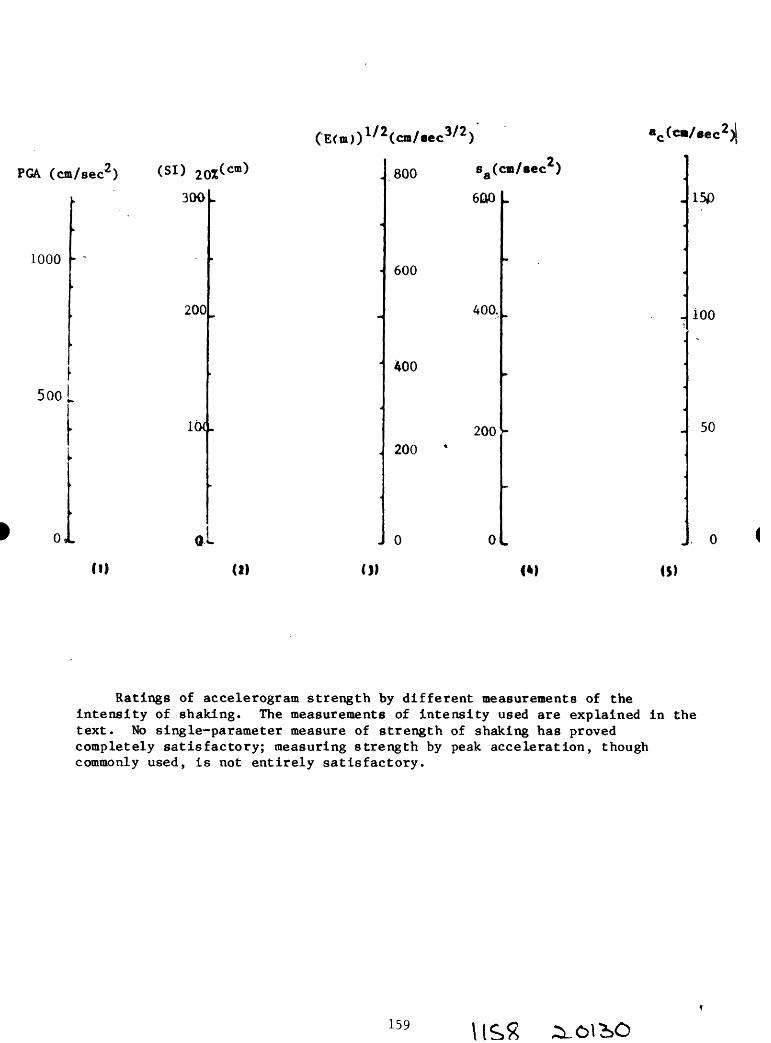
«c (c»/eec2)j
PGA (cm/sec2 ) ( SI > 20%(cm)
300
1000
200
500 L
,1
800 sa(cm/sec )
600
600
400.
400
200200
J 0 ol
150
ioo
50
(2) (I) <M <$)
Ratings of accelerogram strength by different measurements of the intensity of shaking. The measurements of intensity used are explained in the text. No single-parameter measure of strength of shaking has proved completely satisfactory; measuring strength by peak acceleration, though commonly used, is not entirely satisfactory.
159

and a high degree of conservatism are required, the design spectrum may be set
well above the response spectra of the expected motions. In most major
projects, the appropriate level of conservation is determined in a pluralistic
manner with inputs from the owner, concerned regulatory agencies, earthquake
engineers and geoscientists.
160 Ilp 2iOl?»0

Seismic Hazard Studies, Anchorage, Alaska
by
A. F. Esplnosa, H. R. Schmoll, S. R. Brockman, L. A. Yehle, J. K. Odum, J. A. Michael, and K. S. Rukstales
U. S. Geological SurveyOffice of Earthquakes, Volcanoes, and Engineering
Denver, Colorado 80225
SUMMARY
The project "Seismic Hazard Studies, Anchorage, Alaska," encompasses the
entire Municipality of Anchorage as well as some surrounding areas. In order
to quantify the seismic hazards of this area a series of ground-shaking maps
and surficial geologic maps of Anchorage and vicinity are being drawn. One of
the specific objectives in this project is to determine the nature and
variability of ground shaking in the region and to learn how the changes of
the geological environment affect the seismic signatures in this region. At
present there are only a few limited studies on attenuation relations
available for strong- and for weak-levels of ground motion in Alaska.
Attenuation curves are being developed for intensity from an edited version of
the existing data base. The problem of seismic amplification effects of
short-period waves is being investigated for this region. A shallow
reflection survey will be carried out in order to ascertain the location of
the major discontinuities and to identify the possible existence of two
Quaternary faults in the Anchorage area. Several other tasks are part of the
overall objectives of this program, (a) A damage evaluation in the city of
Anchorage, sustained from the 1964 Good Friday earthquake, is in progress.
This information and local surficial geological data are planned to be used in
order to ascertain any existing correlation between damage and geologic
conditions in the area, (b) In order to obtain strong ground-motion
161 l\P>\

recordings, eight portable accelerograph systems have been deployed in the
region. All available strong ground-motion recordings which have been
obtained in the area have been digitized, (c) Geological mapping at 1:63,360
and at 1:25,000 scales, begun under previous projects, is in process of
completion. In addition, a subsurface mapping program is under way, beginning
with the construction of several geological cross sections through
metropolitan Anchorage.
A deep geotechnical borehole, thus far extending to 232 meters in depth, is
devoted to obtaining lithological and geotechnical information for vertical
control. This control will be used to calibrate the subsurface geological
cross sections. The data obtained from this phase of the project are also
being used to construct a distribution model for physical parameters in order
to evaluate theoretically the expected levels of ground motion in the near
field. It is also contemplated to deploy a downhole triaxial short-period
seismometer system extending from the surface to a depth sufficient that
crystalline rock may be found. Several other efforts consist of cooperative
endeavors with the Trans Alaska Crustal Transect program, the Alaska Seismic
Studies project, the Alaska Division of Geological and Geophysical Surveys,
and the Geophysical Institute of the University of Alaska in Fairbanks,
Alaska.
162 U95 ^0130

SEISMICITY STUDIES
A set of maps showing seismlcity of the Arctic and adjoining regions was
released as part of an effort to gain an understanding, from the global-
framework point of view, of the distribution of earthquake epicenters with
magnitudes equal to or greater than 4.5 that have been located instrumentally
in the 1960-1983 period of time. The set includes 12 Lambert equal area
projections depicting earthquake hypocenters as functions of magnitude and of
depth categories. Figure 1 portrays an example of such a map. In this map
one can see very clearly areas of seismic quiescence.
40° E 40" W
140° E 160°E 180°
1960-1983 m
Figure 1. Seismicity of the Arctic and Adjoining Regions for earthquake epicenters located instrument ally from 1960 through 1983, with magnitudes (mb or M.) equal to and greater than 4.5. [After "Seismicity of the Arctic and Adjoining Regions, 1960-1983", by A. F. Espinosa and J. A. Michael, USGS-OFR-MAP-84-376, 1984].
163 0130

A similar set of maps, showing seismicity of Alaska and the Aleutian Islands,
was released as part of an effort to gain an understanding, from the regional-
framework point of view, of the distribution of earthquake epicenters with
magnitudes equal to or greater than 4.5 that have been located instrumentally
from 1960 through 1983. An edited seismic data-base magnetic tape has been
assembled for Alaska. This set consists of 11 Modified-Stereographic
Conformal Projection maps at a 1:12,500,000 scale, each depicting earthquake
hypocenters for a given magnitude range and for a given depth-of-focus
range. Figure 2 portrays an example of such a map. In this map one can see
very clearly areas of seismic quiescence.
70°
140°
170°W 160° 150"
Figure 2. Seismicity of Alaska and the Aleutian Islands for earthquake epicenters located instrumentally from 1960 through 1983, with magnitudes (mb or M.) equal to and greater than 4.5. [After "Seismicity of Alaska and the Aleutian Islands, 1960-1983", by A. F. Espinosa, USGS-OFR-MAP-84-855, 1984].
164 USX 30130

Other seismicity studies of the region which could affect Anchorage and
vicinity are In progress. In figure 3, the left map shows all earthquakes
which have been located from 1900 through 1984 and the right map shows only
earthquakes for which a magnitude has been computed In the same period of
time. On each map box 1 outlines the general area, and boxes 2, 3, and 4 are
used In an effort to gain an understanding, from the local seismicity
framework point of view, of the distribution of earthquake epicenters In the
region. Some of the epicenters, located from the high-gain short-period
seismic network data collected by the Alaska Seismic Studies Project, are
being used In a comparative seismicity study of the regions shown as boxes 3
and 4. Figure 4 Illustrates selected time and magnitude studies categorized
according to the 4 boxed areas outlined In figure 3.
I70"W 140°
Events with Assigned ' Magnitudes
Figure 3. Regional and local seismicity of Alaska for earthquake epicenters located from 1900 through 1984; left all earthquakes located, and on the right: earthquakes for which there is an assigned magnitude. Boxes 1, 2, 3, and 4 are used to study the spatial distribution of seismicity and for comparative studies.
165 UPS

1964
Aftershocks
Removed
February 28,1979mb=6.4 BOX 1
M«=7.1
October 29,1968 mb=6.0 Mt=6.5
March 28,1964 mb=6.2 Ms=8.5
1900 1910 1920 1930 1940 1950 1960 1970 1980Time, years
1000
I | 100
UJ 5
I
I 10c
January 1967- September1984
5.0 Magnitude, mb
6.0
Figure 4. Examples of some of the time and magnitude seismicity studies being done for the region. Box identifications refer to spatial seismicity distribution shown in the previous figure.
166

GEOMETRY OF A SUBDUCTION ZONE
A technique has been developed to map in three dimensions the geometry and
attitude of the lithospheric Pacific plate as it collides with the North
American plate and subducts. Such a 3-D visual display of how the mean-
surface of the lithospheric Pacific plate behaves is achieved by using the
instrumentally determined hypocenters for the region. The data bank used
contains teleseismic instrument-determined hypocenters for earthquakes with
magnitudes (m^ or M ) equal to and greater than A.5, from the years 1960
through 1984, from the map "Seismicity of Alaska and the Aleutian Islands,"
discussed in the preceding section. The resultng image yields a visual
display of what could be considered a three-dimensional representation of a
subducting plate based on seismological data for a given geographic region.
In composite figure 5 the upper part portrays a map of Alaska and adjoining
regions as viewed at an angle of inclination of 20° from the higher latitudes
(about 75° N.). Within this map a rectangular box is connected by vertical
dashed lines to the lower part of the figure which contains 3-D displays of
the mean-surface of the lithospheric Pacific plate. The intervening section,
second from the top, shows the location of volcanoes in the region that have
been active in Holocene time. The two most recently active volcanoes are
identified by their names and the dates of the last activity.
The 3-D display portrays the direction of the Pacific plate motion by arrows
and that of the North American plate by a large arrow labeled N. A. P. The
Pacific plate subducts under the North American plate in Canada, Alaska, and
in the Aleutian Islands region. This 3-D figure shows the contortion that the
167

Pacific plate (average thickness 50 km) is undergoing as it collides with the
North American plate* It also shows an elbow or bend of the subducting plate
with a north, slightly eastward, direction (under Canada) penetrating to a
depth of about 50 km.50oN 130°W
70°N
Figure 5. A technique has been developed to map a plate subduction zone using the data base from the "Seismicity of Alaska and the Aleutian Islands" map. A representation in three dimensions of the shape of the Lithospheric Pacific Plate as it subducts underneath the North American Plate is shown in this figure.
168 \1PT7

INTENSITY ATTENUATION STUDIES
The intensity data file in magnetic tape format has undergone an extensive
editing process which has taken nearly one and a half years. From this data
base we have been able to construct the Modified Mercalli Intensity
distribution for 14 earthquakes which have occurred in Alaska. An example is
shown in figure 7, following page. Some of the isoseismal maps published
earlier have been reviewed and revised.
The isoseismals for all the earthquakes occurring in Alaska have been
digitized and are being used to determine some of the source parameters. This
data-base is also being used to determine empirically the intensity
attenuation for each of the earthquakes under study (fig. 6).
f.
500 1000
Distance, km
1500 2000
VIII
VII
5 vi
I "
'i iv in
H i
February 28,1979
500 1000
Distance, km
1500
Figure 6. Modified Mercalli intensity ratings as a function of epicentral distance for two earthquakes in Alaska. The dashed-line represents a univariate regression least squares fit to the observed data. The middle curve, from the three curves shown, represents the best fit to the observed data by a process being developed and tested.
169 \\ftU

155° W 150e 147e
62°
N
60'
August 18,1962do=V)
150° W 130°
February 28,1979 do=VII)
Figure 7. Modified Mercalli intensity distribution for the earthquakes of August 18, 1962, and February 28, 1979. Numbers indicate the ratings assigned to each of the questionnaires and the solid star represents the epicenter of the event.
170

DAMAGE EVALUATION
A damage evaluation for the city of Anchorage is in preparation from a damage
data survey performed after the 1964 earthquake. A total of 680
questionnaires were obtained in an east-west traverse along 15th Avenue and
DeBarr Avenue in Anchorage. This information and local surficial geological
data are planned to be used in order to evaluate transfer-function
amplification curves in the area and to ascertain any existing correlation
between damage and geologic conditions.
A preliminary result shows that 44 percent of the houses built on outwash
gravel, 47 percent of the houses built on alluvial fans, and 50 percent of the
houses built on ice contact deposits sustained damage. The area covered by
the damage survey is shown in the upper part of figure 8. The geological
cross section portrays subsurface conditions beneath the area of the damage
survey. Strong-motion instruments have been deployed along this strip since
July, 1984; their locations are shown as solid triangles on figure 8, A
portable digital seismograph system will be deployed along this same strip for
a period of two months; the planned locations for these instruments are shown
on figure 8 as solid squares.
171 /as/

DE
PAR
TM
EN
T O
F T
HE
IN
TER
IOR
U
NIT
ED
STA
TES
GEO
LOG
ICA
L SU
RV
EYis
ow
EA
ST-W
EST
GE
OL
OG
IC C
RO
SS S
EC
TIO
N A
LO
NG
TH
E D
EB
AR
R L
INE
, AN
CH
OR
AG
E, A
LASK
A

GEOLOGIC MAPPING
Mapping aspects of the project may be divided into four phases: (1) surficial
geology mapping at 1:63,360 scale; (2) geologic mapping at 1:25,000 scale; (3)
subsurface mapping at 1:25,000 and (or) smaller scales, and (4) other efforts.
In the discussions that follow, reference is made to map areas identified on
figure 9 by circled number.
1. The surficial geology mapping of what is now the entire Municipality of
Anchorage was begun under a previous project; it then comprised the area
of the Greater Anchorage Area Borough (Schmoll, workshop volume). This
mapping was originally conceived as being published in three sheets,
each comprising about four standard 15* topographic quadrangles, and
covering respectively the northeastern (fig. 9, area 1), southeastern
(fig. 9, area 2) , and western (fig. 9, areas 3-6) parts of the roughly
triangular shaped Borough area. Because the western sheet has now been
superseded by more modern, larger scale quadrangle maps, surficial
geology mapping of most of this sheet will be converted to the larger
scale and be incorporated into phase two. Consequently, the original
mapping will now be issued as the northeastern and southeastern sheets,
with the part of the western sheet not covered by larger scale maps
(fig. 9, area 3), mainly the Anchorage A-7 quadrangle, issued
separately. As an adjunct to this mapping, and to extend the concepts
of the folio series of environmental geology maps, previously published
for most of the metropolitan area, to the rest of the Municipality, a
single geologic materials map of the entire Municipality is being
prepared on the original three sheet basis at 1:63,360 scale.
173 /o G? 30*30

152°W 150e
60
Figure 9. Map showing locations where geologic mapping is in progress. Numbered areas are referred to in the text. The grid outlines the standard l:63,360-scale (15') topographic base maps.
174

2. The newer l:25,000-scale topographic quadrangle maps cover most of the
metropolitan area of the Municipality, including the part that extends
northeast along Knik Arm to about Eklutna. Bedrock mapping in this area
is presently in progress (fig. 9, area 4) or planned (fig. 9, area 5) by
R. G. Updike and C. A. Ulery of the Alaska Division of Geological and
Geophysical Surveys. This new mapping will be combined with the
surficial geologic mapping noted above, to be upgraded to standards of
the larger scale, to produce a series of about 8 geologic quadrangle
maps. In addition, the long promised geologic maps for the rest of the
metropolitan area, covered by the generalized map in the folio series
(discussed in Schmoll, workshop volume), will be converted to about 6
additional quadrangle maps (fig. 9, area 6).
3. In a later phase of the project, after development of a number of sub
surface geologic cross sections through the lowland parts of the metro
politan area, it is planned to produce a map portraying subsurface
conditions. If possible this map will portray conditions extending from
the surface down to the "basement" complex of metamorphic and igneous rocks
that occur at the surface in the foothills bordering the east side of the
metropolitan area, but that is buried as deep as 3,500 m at the west end of
the area. The map will encompass parts of areas 5 and 6 shown in figure
9. Although a scheme for developing this map has been proposed, the
feasibility of this scheme has yet to be established, and many of the
details, including the level of interpolation that can be achieved from
existing and newly acquired data, remain to be placed in a realistic
format.
4. Other efforts, presently non-funded, may be devoted to completion of geologic
mappng west of Anchorage (fig. 9, area 7), an area likely to be the site of
175

considerably expanded development in the near future.
GEOTECHNICAL DRILLING
This phase of the project is devoted to the acquisition of new data to supplement
what is already available from existing drilling, mainly in the form of water-
well logs. Because much of that data is of limited quality and shallow in depth,
it is desirable to obtain additional high-quality data at carefully chosen sites
to fill in critical gaps in existing subsurface knowledge. In 1984, the first
hole was drilled and selectively sampled, in part as an experiment to ascertain
the feasibility of undertaking such drilling at reasonable cost, and to expand
existing experience in this activity acquired in drilling through similar rocks
in the area west of Anchorage. The initial hole reached 232 m at a cost of
$15,000, with limited but critical coring of the relatively soft Tertiary rock
that underlies the unconsolidated Quaternary deposits beginning at a depth of
about 155 m at the drill site. While this experiment was regarded as generally
successful, further techniques need to be developed for obtaining better samples
of the coarse-grained, nonhomogeneous Quaternary deposits which do not yield
readily to conventional sampling or coring methods.
176

COOPERATION WITH THE TACT PROGRAM
As an adjunct to the main thrust of the project, selected activities have been
undertaken in cooperation with the Trans Alaska Crustal Transect program. This
work may be divided into two phases: (1) observation and sampling of cuttings
obtained from the drilling of seismic shot holes; and (2) contributions to
geologic mapping.
1. Mainly because of previous knowledge and the continued interest in the
Quaternary glacial and volcanic deposits of the Copper River Basin,
opportunity was taken to observe the drilling through these materials done
in conjunction with TACT seismic lines. In 1984 operations at 16 drill
sites were monitored, and a technical report was released on the observed
results. A similar but more limited activity was conducted in 1985.
2. Also because of familiarity with the region, and the existence of unpublished
geologic mapping in the files of project personnel, contributions have been
made to the mapping of the Gulkana B-l quadrangle, part of the swath of
detailed geologic mapping across the Copper River basin and adjacent
Wrangell Mountains undertaken in conjunction with the TACT program.
Existing mapping, mainly in glacial and volcaniclastic deposits, was
revised photogrammetrically, and brief field investigations to visit sites
of uncertain identity on the basis of the photointepretation, were
undertaken in 1984. The revised mapping has been prepared for publication.
177

EARTHQUAKE DAMAGE ~ 1964 LESSONS LEARNED AND RELEARNED
by
Karl V. Steinbrugge
Structural Engineer
El Cerrito, California 94530
INTRODUCTION
The great Alaskan Earthquake of 1964 taught new lessons as well as repeated
those learned from previous earthquakes and reobserved in subsequent ones.
Perhaps "lessons learned" is too strong for all members of the design
professions. It appears that a few of the concepts have not been well
understood and/or applied in view of damage to some more recently constructed
buildings.
In a setting such as this workshop it seems important to review several of the
more important of these Alaskan lessons. The selected topics are based on
personal knowledge from the field inspections and studies made by the author
after the 1964 event. The intent is to raise questions for thought and
discussion, and not necessarily solutions to specific problems.
INTENSITY USE AND MISUSE
Modified Mercalli intensities usually provide major inputs for studies of
aggregate damage and potential life loss such as those developed for
governmental vulnerability studies. Also, there are engineers and scientists
who relate intensities taken from isoseismal maps to damage and to acceleration,
sometime interpolating intensities to obtain building design values to 2 or 3
significant figures. In some instances, undue faith may be placed on isoseismal maps.
S5178

Figure 1 shows a snowman in the Turnagain section of Anchorage and quite close
to a major landslide. The snowman survived the earthquake as did all wood frame
dwellings beyond the landslide area. What is the intensity? Figure 2 shows the
interior of a one story store across the street from the 4th Avenue landslide.
A globe turned over, several items fell on the floor, and some shifted the
author entered the store along with the owner upon his first return after the
earthquake. What is the intensity? Compare this with Figures 3, 4, and 5.
(For locations of these structures with respect to landslides and to each other,
see map in pocket in Steinbrugge, et al, 1967.) These comparisons are not
isolated instances.
The explanation for these field observations relates to the type of ground
motion generally experienced in Anchorage. The predominant motion was about 0.5
seconds, thereby accentuating damage to taller structures which have longer
natural periods.
No intensity map was drawn for Anchorage (Cloud, et al, 1967). Cloud states
"The results of bringing together long- and short- period effects are not
serious when attempting to rate moderate earthquakes. However, results are
striking when attempting to rate major events, such as the Prince William Sound
Earthquake, due to the greatly increased proportion of long-period effects to
short-period effects. Effects in Anchorage, Alaska, offer a classic example....
The U.S. Coast and Geodetic Survey's solution to this problem was to assign a
range of intensities rather than a single intensity.
This is not unique to Anchorage. For different soil conditions, earthquake
magnitudes, distances from seismic energy release regions, and other parameters,
isoseismal maps are not given in detail for the heaviest shaken areas see
similarly prepared maps for 1952 Kern County (California), 1959 Hebgen Lake
(Montana), and 1971 San Fernando (California).
This is not to say that isoseismal maps are useless far from it. Analysis
applied in the context of the source data, that is, to the reports of effects on
specific structures at specific sites are very useful when extrapolation for
179
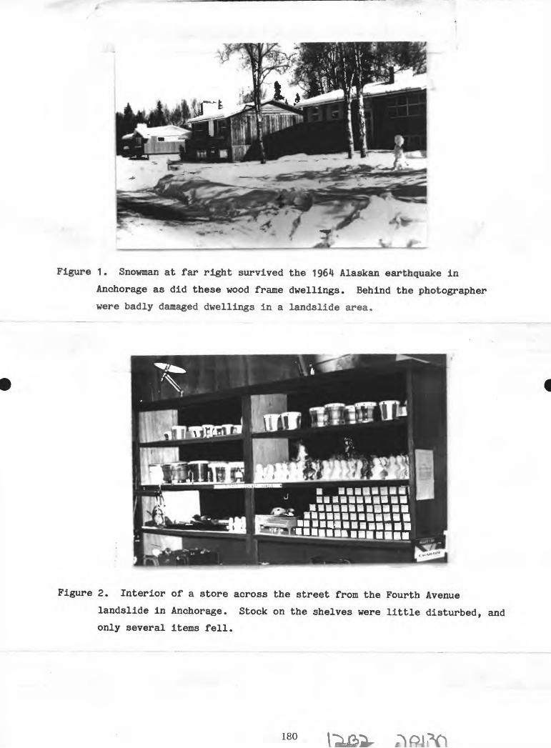
Figure 1. Snowman at far right survived the 1964 Alaskan earthquake in
Anchorage as did these wood frame dwellings. Behind the photographer
were badly damaged dwellings in a landslide area.
Figure 2. Interior of a store across the street from the Fourth Avenue
landslide in Anchorage. Stock on the shelves were little disturbed, and
only several items fell.
180

Figure 3. Mt. McKinley building in Anchorage. The very large crack in the
reinforced concrete bearing and shear wall was so wide that a hand could
be placed through it from window to window.
Figure 4. The 1200 "L" apartment building in Anchorage. Almost an identical
building to Figure 3> with almost identical damage in the second story,
181

Figure 5. One of 2 collapsed shear wall towers of the 6 story Four Seasons
apartment house in Anchorage. Floors were stacked upon each other like
pancakes. Prestressing wires which were not grouted shot out like
missiles, with the arrow indicating where one struck a house.
Figure 6. Four Seasons apartment house in the course of construction. Steel
columns with prestressed lift-slab floors. Minimal lateral force
resistance to bending moments at column to floor connections, and thus no
secondary or redundant resistance was present.
182

vulnerability purposes to other regions. However, numerical quantities assigned
to isoseismal lines rather than to back-up data have very large uncertanties.
One misuse of intensity involves circular reasoning. A design professional may
write to a building owner that the designed building will withstand an Intensity
VIII earthquake. Modified Mercalli Intensity VIII states "Damage slight in
specially designed structures.... 11 After the event and if the structure were
to be damaged similar to that shown in Figures 3, 4, and 5, then the designer
could assert that the damage was "due to an Intensity IX" as defined by him, the
most knowledgeable person on the structure. Yet all around the damaged
structure may be differently designed undamaged structures, meeting the same
building code. More will be said of this in later paragraphs on "Redundancy".
DAMAGE CONTROL AND LIFE SAFETY
The intent of earthquake resistive design as required by building codes is to
protect life, and is only partially directed towards damage control. (There are
certain exceptions, notably the code provisions for hospitals in California
constructed since 1972.)
The basic philosophy behind the seismic provisions of most American building
codes appears in the commentary on the fourth edition of the "Recommended
Lateral Force Requirements" by the Seismology Committee of the Structural
Engineers Association of California (1975). This publication states that the
code intends buildings to "Resist major earthquakes of the intensity of severity
of the strongest experienced in California, without collapse, with some
structural as well as nonstructural damage." It goes on to state "In most
structures it is expected that structural damage, even in a major earthquake,
could be limited to repairable damage." By using certain types of flexible, but
safe framing systems in certain occupancies, such as hotels, it is quite
possible for a structure to suffer 50% property loss without serious structural
damage.
183

Life was not lost in the buildings shown in Figures 3 and 4 and one can state
that the intent of the code was met. Certainly, none of us can quarrel with the
need for life safety, and this goal seems to be increasingly achievable.
The cost to repair the Mt. McKinley Building (Figure 3) was 40$ of its
replacement value and 30% for the 1200 "L" Building (Figure 4). Neither of
these structures were functional (occupied) for a long period of time. Does the
average design professional understand the code philosophy and is he willing to
be named on the drawings for a building which may not be functional for many
months? Does the owner understand this risk? Do disaster response planners
rely on all modern earthquake resistive buildings to remaining functional?
REDUNDANCY
All buildings meeting the lateral force requirements may be code-equal but not
necessarily truly equal. Certain structural types have redundancies inherent to
them. As time goes on, some of these redundancies are eliminated by research
which indicates that the redundancy is an extra cost which can be saved using
new methods or material assemblies. Cost saving is normally true, but
equivalent safety may not be true. Often the framers of building code
provisions had in mind the kinds of construction then current, and could not
have fully anticipate the future. Design forces, allowable stresses, minimums,
and other judgment-determined factors are often in these unstated contexts and
not understood by the researchers.
It is not the point to continue a long standing debate on equivalence vs.
adequacy for code purposes, but rather to show the lessons learned in 1964 and
repeated elsewhere.
Figures 3 and 4 are of poured-in-place reinforced concrete structures which were
well designed and constructed for their era, not unlike many hundreds of other
buildings in western United States. Both were structurally very similar. Each
had one wall completely sheared in a lower story; each wall was both a shear
wall and a bearing wall. The fracture was complete and an air gap separated the
upper portion from the lower portion. Certainly, there was redundancy in the
184
load carrying systems. Compare these with Figures 5 and 6.
Perhaps classic for redundancy were the multistory steel frame buildings in San
Francisco at the time of the 1906 shock. None were designed to be earthquake
resistive. All steel framing was encased in concrete for fire protection
reasons, thereby giving significant uncounted lateral force resistance through
composite action. All these steel frames survived excellently without the
benefit of our modern design and construction concepts. A number of these
buildings are still in use.
Inherent redundancy is often much less in precast concrete buildings due to
connection difficulties. The designer may compensate for this, unless he
believes that redundancy is unnecessary or he fully believes that the code is
adequate in all cases. Quite evidently this can be a decision by the designer
and yet meet the code.
Only a partial comparison can be made between poured-in-place and precast
concrete in Anchorage. A total of 20 buildings with precast concrete tee-beam
floors and roofs were examined by the author after 1964, although perhaps as
many as 26 may have existed. A review of known performance shows that the
largest completely undamaged building had a roof diaphragm area of 6500 square
feet, which certainly is not large. Four collapsed or partially collapsed.
While in some cases the damage can be attributed to the supporting hollow
concrete block or other reasons, these same factors were involved with lighter
material roofs and floors which were not damaged. It must be remembered that
the low rigid one and two story buildings outside of the landslide area were
almost always unaffected by the 0.5 second predominant ground motion, and
precast stand out by contrast.
I have no quarrel with precast concrete; I do believe that the construction
industry and design professionals continue to need a better understanding of
this product.
Redundancy may also be viewed by type of failure. Shear walls failing in shear
or by shifting along a cold joint usually does not cause collapse. Figures 7>
8, and 9 show movements along cold joints or x-crack failures, whereas shear
185
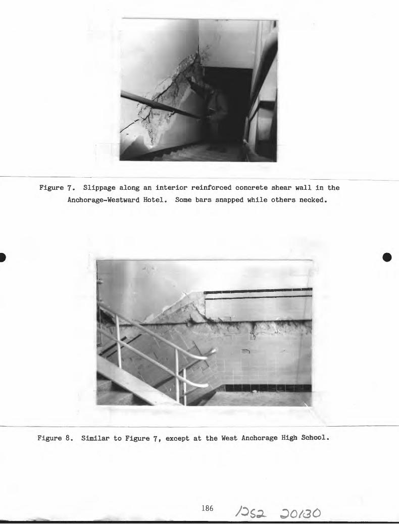
Figure 7. Slippage along an interior reinforced concrete shear wall in the
Anchorage-Westward Hotel. Some bars snapped while others necked.
Figure 8. Similar to Figure 7, except at the West Anchorage High School
186

Figure 9. Failure of shear walls (X-cracking) at the West Anchorage High
School.
Figure 10. Note unfilled cell containing reinforcing bar. In Anchorage,
187 f3S/

wall failures due to concrete splitting and turning over can be catastrophic as
shown in Figure 5. While no design professional wishes to contemplate the
failure of his design, many experienced designers consider the value of
redundancy or its equivalent should the unthinkable occur.
WORKMANSHIP
Workmanship is a perennial problem throughout the world. It has been observed
that shop workmanship is often better than field workmanship for a variety of
reasons| including the better opportunity for inspection as well as working
conditions.
Certain materials which are handled by individual workmen or very few persons
and which may be quickly covered have been troublesome in the field. Falling
into this category are unit masonry types such as hollow concrete block. Figure
10 is one such example found in Anchorage.
Figure 11 shows a problem at a cold joint in an otherwise monolithic reinforced
concrete wall in Anchorage. The aggregate along the cold joint acted as ball
bearings. Figures 7 and 8 also exhibit poor workmanship.
CITED REFERENCES
Cloud, Wm. K., et al (1969). "Distribution of Intensity, Prince William Sound
Earthquake of 1964" in The Prince William Sound f Alaska r Earthquake of
1964 and Aftershocks, vol. II, parts B and C, pp.5-48.
Steinbrugge, Karl V., et al (1967). "Building Damage in Anchorage" in The
Prince William Sound. Alaska. Earthquake of 1Q64 and Aftershocks f vol. I,
part A, pp.7-217.
188

Figure 11. Concrete was not monolithic in this cold joint, and aggregate acted
as ball bearings in this Anchorage building.
189

RECENT AND ANTICIPATED CHANGES IN UTILIZATION
OF EARTHQUAKE HAZARD INFORMATION FOR SITING
CONSIDERATIONS; ANCHORAGE, ALASKA
by
Barbara J. Sheinberg
Geologist;
Associate Planner,
Anchorage, Alaska
BACKGROUND
The title of this plenary session is "Current Alaskan Urban Development Which
Requires Consideration of Earthquake Hazards - Siting Considerations for New
Construction". This paper and discussion will focus on the historic absence
in the use of siting considerations relative to earthquake hazards in the
Municipality of Anchorage, Alaska and recent program changes attempting to
address and remedy this situation. The reasons for recent program changes
will be emphasized with recommendations and responsibilities assigned
regarding how these changes have been accomplished. Technical information
about earthquake hazards in Anchorage has existed for years. The data is
continually being refined, but has been available for years in a complete
enough form to meaningfully address siting considerations. In addition,
articulate public policy towards utilizing earthquake hazard information in
siting conditions has not recently changed. Key factors that have recently
changed have been:
1. Recent rapid area population growth that has fueled pressure for land
development in all city areas including on seismically hazardous
lands (Figure One),
2. Increased awareness and understanding on the part of key decision
makers about environmental processes and hazards, and
3. More effective communication on this matter between both
scientists/technicians and government bureaucrats and within the
bureaucratic structure itself.
190

T6T

These factors have resulted in recent Anchorage program changes including
proposals for and actions toward:
1. Adoption of geotechnical site investigation requirements as local
amendments to the Uniform Building Code (Municipal Title 23),
2. Initiation by the Municipality's Community Planning Department of an
earthquake safety study (with anticipated end results of municipal
plan and code changes).
The four study phases are:
a. Synthesis of seismicity and geotechnical hazard data to result in
a contour map showing annual probability of exceeding (for
example) 0.1, 1.0, 10 feet of ground displacement.
b. A damage and risk evaluation including an inventory of
Anchorage's existing to earthquake hazards in terms of dollars
and lives at risk.
c. Review of alternative hazard mitigation and reduction scenarious,
to include evaluation of the costs and benefits of each to both
the community and individuals. Resultant determination of
community's acceptable level of risk.
d. Translating results of Phase C above into recommended land use,
building code and siting changes and implementation of these
changes.
3. Adoption of an interim municipal review procedure (until earthquake
safety study is completed and implemented) for all development
proposals on land in Anchorage's most vulnerable earthquake hazard
areas. Review and comment will be by Municipality's Geotechnical
Advisory Commission.
4. Increased reliance by decision making bodies in Municipality on
comments and advise of Geotechnical Advisory Commission.
192 IW-J OO/3O

IMPROVING TSUNAMI PREPAREDNESS IN ALASKA
by
George W. Carte 1
Alaska Tsunami Warning Center
Palmer, Alaska 99645
INTRODUCTION
Before I can discuss improving tsunami preparedness in Alaska I will first
address the degree of preparedness as I have observed it. Most communities
under 600 population are not well prepared (Carte) 1984). Many of these same
communities have the highest percentage of land in the potential tsunami hazard
zone below 100 foot elevation. This evaluation is based on six factors:
communications, written plan, public warning devices, local response agencies,
evacuation sites, and availability of emergency equipment and services.
Although improvements are suggested in every factor, I believe communications
and written plans are most important and most lacking.
Some communities have planned development based on past experience or potential
tsunami flooding. Entire towns were relocated after extensive damage in the
1964 tsunami. Yet some were rebuilt in the same location where heavy damage
occurred. Unfortunately the tsunami hazard zone is not well defined for most
areas of Alaska. Rough estimates have been made for evacuation purposes but
detailed and reliable computations are needed for planning and zoning decisions.
A local, seismically-triggered, tsunami warning device is used in Hawaii. A
recent evaluation points out many possible problems (Cox and Morgan, 1984). If
the reliability of these triggers could be improved, they could help decrease
the warning time for a local tsunami.
Ultimately, how well the system works depends on personal response, both from
the local officials and the general public. Since most have little or no first
hand experience with tsunamis, education efforts are very important. The recent
regional "Shaker" exercises conducted by the State and FEMA were very
educational, but required extensive planning and logistics. Local drills are
conducted by the State and visits are also made occasionally by ATWC.
193

RISK AND PREPAREDNESS IN ALASKA
About three-fourths of Alaska's population lives on or near the Pacific coast.
All four of Alaska's largest industries depend on the sea. Fishing is the
principal activity for most of the Pacific coastal communities. Floating
logging camps and mills are mostly found in Southeastern Alaska. Oil platforms
and terminals are found in Cook Inlet and Prince William Sound. A major part of
the tourist industry involves sportfishing, sightseeing, and cruise ships to
coastal Southeastern and Southcentral Alaska plus sport-hunting activities.
An assessment of tsunami preparedness in Alaska was done for 46 communities
(CarteJ 1984). All towns over 1,000 population appeared adequately prepared and
85% of those below 600 population had low or marginal preparedness. This
assessment was based on the six factors that will be discussed next in this
paper. It was also found that eight of the nine towns with the largest area
subject to tsunami flooding were rated low or marginal. It appears that most of
the smaller communities will need outside help to achieve some minimal level of
preparedness.
The help needed by the smaller communities can and has come from many sources
besides the State and Federal governments. Boroughs, neighboring larger
communities, native corporations and private industry should all be included in
planning. The Alaska Division of Emergency Services (ADES) is the lead agency
responsible for this planning and coordination with help from the Federal
Emergency Management Agency (FEMA). The Plan for Public Safety Services
prepared for the Aleutian/Pribilof Islands Native Association includes a
discussion of the tsunami hazard in that region (Messick, 1978). Such reports
will have a positive effect of the level of preparedness.
COMMUNICATIONS AND WRITTEN ACTION PLANS
The universally acknowledged worst method of communication in a disaster is the
telephone. The system immediately becomes overloaded besides everyone's best
effort advising the public not to use their phone unless absolutely necessary.
Even if not overloaded, earthquake damage in the epicentral region will likely

cause equipment damage or satellite miss-alignment. Some small villages still
have their common phone in a community center which is locked at night.
Thirty of forty-six communities studied receive their initial warning via
telephone from a regional warning point. This is the only direct means for many
smaller villages. Some towns also receive the message via teletype through
local FAA/NWS offices. The only backup for most smaller communities is indirect
or non-specific means such as radio or television. The National Weather Service
via the NOAA Weather Radio, the Coast Guard via marine radio, and
commercial/public broadcasters via the BBS system are all trained and ready to
immediately broadcast warning messages.
The Alaska State-wide Satellite Television System is not yet utilized, although
widely watched, especially in small communities. Its main shortcoming is
dependence on the local satellite antenna and electric power. Electricity is
not always available 24 hours a day in some smaller villages and often
unreliable. The new Aspen State-wide computer network reaches most medium size
communities not on the State warning phone system. The Aspen network
potentially could be tied directly into the warning system.
What is most needed is non-satellite dependent and non-landline dependent
communications. The State's proposed meteor burst system and high frequency
radio network will begin to meet this need. Especially in small villages,
receiving devices should be solar recharged and battery operated for minimum
maintenance and maximum reliability.
Because of the infrequency of tsunamis a written plan is necessary to insure
proper, timely action is taken. Most smaller communities do not have any
written plans. Turnover of Village Public Safety Officers is frequent. Other
key local officials may be fishing, logging or just out of town when the
disaster strikes. The written plan needs local input. Although there will be
some "broiler plate" in each plan it should be site specific and practical.
Some local pride of authorship will help insure it is read and used.
195

OTHER PREPAREDNESS FACTORS
The most common public warning devices are sirens, bells, or whistles. To be
effective the signal for evacuation must be known, heard over the entire hazard
area, and regularly tested. Evacuation maps and placards describing the signals
and safe areas have been distributed in most of the highest risk communities by
the ADES. Remotely activated sirens, such as used by the Kenai Peninsula
Borough, would benefit several small communities on Kodiak Island, the Alaska
Peninsula and Southeastern Alaska.
The local response agencies in the typical coastal community are a volunteer
fire department, a health aid, and a Village Public Safety Officer (VPSO) or
small police department. These are the ones who will direct evacuation, rescue,
first aid, and initial recovery efforts. Public works departments, National
Guard units, EMT's, and others become more common as the population increases.
Yet in some very small villages there is no volunteer fire department. Since a
small community cannot affort these services, individuals will have to be more
self-reliant. Fortunately most residents of small villages are very
resourceful. They could be aided by training in hazard awareness and emergency
skills such as firefighting and first aid.
Most homes and stores in the very smallest villages are in the 100 foot hazard
zone. As community size increases buildings begin to extend inland. An
adequate evacuation site should be out of the hazard zone, easily accessible,
and provide protection from the elements. Perryville has no nearby high ground
and some communities have no buildings above the potential flooding level. Any
site selection for future community centers, schools, health clinics, fire
stations, etc. should be above the hazard zone or of tsunami resistant
construction.
As would be expected, small communities will not have a significant common
reserve of food, medicine, and emergency equipment. It would not be practical
to stockpile these perishable supplies and expensive equipment. In the more
remote villages, individuals have larger than normal food stocks and other
supplies, if they are not lost to the earthquake or tsunami. ADES or Borough
headquarters should list places with the highest risk and least resourcs to
prioritize relief efforts.
LOCAL PLANNING AND RELIABLE RUNUP DATA
Some larger communities routinely consider earthquake hazards and tsunami
hazards in planning and zoning. Old town sites at Afognak, Kaguyak, Chenega,
Valdez and Portage were abandoned after extensive earthquake and/or tsunami
damage in 1964. Yet Old Harbor was rebuilt in exactly the same place where
nearly every building was destroyed in 1964. Kodiak rebuilt the water-front
business district in the same location for economic reasons, and rejected the
suggestions for only reinforced concrete or masonary, tsunami-resistant
construction (Urban Regional Research, 1982).
There has been only 6 damaging local tsunamis in the last 87 years and no damage
from tsunamis generated outside Alaska (Cox and Pararas-Carayannis, 1976).
Because of the strong directional nature of tsunamis, Aleutian generated events
have caused no damage in the Gulf of Alaska and vice versa. Even the well
studied 1964 tsunami doesn't report positive and negative effects in parts of
Southeastern Alaska.
With such meager historical data, it is even more important that we have
emperical runup calculations done for Alaska as was done for the rest of the
Pacific Coast States. In the early 1970's three of nearly 100 Alaska coastal
towns were calculated by the Corps of Engineers (Houston and Garcia, 1974).
This would allow for more reliable hazard zone predictions for evacuation and
data to base zoning and planning decisions.
LOCAL TSUNAMIS WARNING SYSTEM
In November 1976 the Hawaiian Civil Defense Division and the Hawaii Institute of
Geophysics installed a number of seismic triggers and designed to sound an alarm
for an earthquake 6.5 or over (Adams et_ aL_y 1977). Specifically it will trigger
for an acceleration of 0.06g which is estimated to be a Richter magnitude 6.5 at
about 100 km. Therefore smaller events closer than 100 km would also trigger,
plus the relationship between acceleration and magnitude is variable. Local
197

instructions by Hawaiian Civil Defense say a public warning should only be
issued if the trigger is activated and the earthquake has been felt by
monitoring personnel (Cox and Morgan, 1984). To date no event has been large
enough to activate the triggers.
Cox and Morgan (1984) feel the potential for false alarms is so great with the
local triggers as to lower the confidence and effectiveness of the total tsunami
warning system in Hawaii. They therefore recommend the triggers be abandoned or
their threshold raised significantly to lessen the false alarms.
The main advantage to the local triggers is a more rapid warning for locally
generated waves. In Alaska we instruct those feeling a very strong earthquake
to evacuate the coastal areas immediately. How well that will be heeded is not
known. If a tsunami is near a town with a siren system, the dispatcher on duty
usually must receive permission from a superior or a warning over the State
warning system befor activating the siren system even if the quake were strongly
felt by the dispatcher. If there were a reliable trigger device this could
significantly speed the local warning. Since Alaska is much more seismically
active than Hawaii, possibly some triggers should be located in Alaska for
testing purposes to better determine their actual response before they are
considered for use in Alaska.
PREPAREDNESS EDUCATION AND EXERCISES
The ADES does a good job training local civil defense personnel in the moderate
and large communities. Visits to coastal communities are made by ADES and ATWC
personnel for education purposes. Bad weather, infrequent schedules, and high
costs make visits to the smaller communities less common.
Local exercises are conducted by the State, but are usually only "desk top"
type. The two regional "Shaker" exercises conducted by the State and FEMA were
very educational, but required extensive planning and logistics. The Coast
Guard at Kodiak conduct frequent local drills, including evacuation drills, and
could be a model for the rest of the State. The city of Kodiak and the Kodiak
Island Borough School District each have excellent written plans for the public
and staff. Possibly VPSO training at the State Trooper Academy could include
198 OO/3O

earthquake and tsunami preparedness.
Most exercises do not involve the private sector, yet a study of hurricane
warnings suggests adequate preparedness depends on coordination between Federal,
State, local, and private business (Carter, e_t_ al_, 1979). Canneries are an
example. Canneries can have a high concentration of often non-local workers
right on the waterfront. The State could require a tsunami evacuation plan for
major canneries and even yearly evacuation drills.
BIBLIOGRAPHY
CarteJ G., 1984, "A Tsunami Preparedness Assessment for Alaska," Science of
Tsunami Hazards, v. 2, n. 2, pp. 119-126.
Carter, T. M., J. P. Clark, R. K. Leik, 1979, "Organizational and Household
Response to Hurricane Warnings in the Local Community," presented at the
AAAS Annual Meeting, Houston, 1979, NHWS Report Series No. 79-01, 39 pp.
Cox, D. C., G. Pararas-Carayannis, 1976, "Catalog of Tsunamis in Alaska"
(Revised 1976), NOAA, World Data Center A: Solid Earth Geophysics, Rpt.
SE-1, 43 pp.
Cox, D. C., J. Morgan, 1984, "Local Tsunamis in Hawaii - Implications for
Warnings," Hawaii Institute of Geophysics Rpt. HIG-84-4, 104 pp.
Houston, J. R., A. W. Garcia, 1974 "Type 16 Flood Insurance Study: Tsunami
Predictions for Pacific Coastal Communities," U.S. Army Engineer Waterways
Experiment Station, Tech. Rpt. H-74-3, 88 pp.
Messick, M. J., 1978, "Plan for Public Safety Services, Aleutian-Pribilof
Islands," Aleutian/Pribilof Islands Association, Anchorage, AK, 198 pp.
Urban Regional Research, 1982, "Land Management Guidelines in Tsunami Hazard
Zones," prepared for the National Science Foundation, Washington, B.C., 258
pp.
199

AN ASSESSMENT OF EARTHQUAKE HAZARDS OFFSHORE SOUTHERN ALASKA
By
Yogesh K. Vyas
Exxon Production Research Co.
Houston, Texas
ABSTRACT
A careful assessment of earthquake hazards offshore S. Alaska is essential due to
high seismicity along the Aleutian arc and its potential impact on the design of
structures in the S. Bering Sea for oil and gas development. API RP 2A provides
guidelines on earthquake hazards in the region suitable for the development of
seismic input to the pre-lease sale planning. Significant progress has been made
recently in the areas related to simulation of ground motion for giant
earthquakes for which no strong motion records exist; input parameters for
probabilistic hazard analysis of the region; site-response analysis procedures to
account for effects of local soils, and processed strong-motion records for S.
Alaska. Future improvements could be achieved through refinement of the
simulation technology; updating seismic hazard maps for the region through
systematic hazard analyses; calibrating the site-response analysis procedures
accounting for the broad range of offshore soils; and upgrading the seismic
instrument networks in S. Alaska to record large magnitude earthquakes. The
recent progress together with the future improvements outlined in this paper
would lead to specification of more accurate seismic input for site-specific and
final design of offshore structures in the region.
I. INTRODUCTION
Over the past several years, industry and academia have been devoting a
significant effort to establish an improved understanding of earthquake hazards
offshore S. Alaska. The primary motivation for this effort is to develop more
reliable input for future design of safe yet cost-effective, earthquake-resistant
structures in the S. Bering Sea. This paper discusses some of the improvements
made recently regarding the assessment of earthquake hazards in the region, and
the areas of future improvements which would lead to specification of more
200

accurate input for final design of structures in the region. The paper also
discusses the general considerations involved with earthquake-resistant design of
offshore structures as well as the overall procedure used for the development of
design ground motions.
The Aleutian arc region is one of the most seismically active regions in the
world. The primary cause of the seismicity is the intermittent relieving of
stress which accumulates due to relative movements between the Pacific and the
North American plates. Between 1938 and 1979, several earthquakes (Fig. 1)
having moment magnitudes M 7-1/2 and larger have ruptured much of the interface
between the N. American and Pacific plates. Most of the significant earthquakes
have occurred in the shallow Benioff-zone situated between the Aleutian trench
and the Aleutian islands. The largest of these earthquakes (Fig. 2) had a moment
magnitude of M 9.2 (e.g., 1964 Prince William Sound earthquake), rupture lengths
of several hundred kilometers with strong shaking lasting up to 4 to 6 minutes.
The segments along the arc that have not ruptured in recent times are referred to
as "seismic gaps". One such gap called the Shumagin Gap [1] is situated between
two previous ruptures (Fig. 2) along the arc, M 9.1 of 1957 to the west and a M
8.4 of 1938 to the east. There is a high likelihood for a major earthquake to
occur in this gap [2] during next few decades.
The deep portion of the Benioff-zone has also generated some significant
earthquakes. Earthquakes are also associated with the volcanoes on the Aleutian
islands. Furthermore, local faults in the back-arc of the Aleutian islands also
have the potential to generate large earthquakes.
II. GENERAL EARTHQUAKE DESIGN CONSIDERATIONS [3]
Offshore structures are typically designed to meet both strength and ductility
requirements. The strength requirements are intended to prevent significant
interruption of normal platform operations and no damage to the platform. The
strength level earthquake (SLE) design ground motions are generally associated
with a return period of 200 years. The ductility requirements are to ensure that
the structure will not collapse under a rare, intense ductility level earthquake
(DLE) which is normally associated with a return period on the order of 1000's of
years. The design ground motions should always be specified with the knowledge
201

8.0+ D 7.0-7.9 0 6.0-6.9 5.0-5.9
Fig. 1. Seismicity Map of Southern Alaska
North Amtricon Plot*
Fig. 2. Seismic Gaps and Rupture Zone of Major Earthquakes Since 1938 [1].
202

of the analysis procedures to be used for computing earthquake loads on the
structure as well as the performance criteria (practice) used to ensure adequate
resistance to the imposed loads.
Offshore structures are sensitive to long-period (>1 sec) ground motions. It is
in this range that the soft offshore soils tend to amplify the ground motion.
Thus, it is important not to rely solely on the peak ground acceleration (PGA)
parameter for the design of an offshore structure. It is preferable to develop
design ground motions using long-period ground-motion parameters such as response
spectral velocity at long-period.
III. OVERVIEW OF SEISMIC EXPOSURE ANALYSIS PROCEDURE [3]
The procedures can be described (Fig. 3) in terms of the following four steps:
(1) seismotectonic characterization, (2) seismic exposure assessment, (3) ground
motion characterization, and (4) design ground motion specification. This
approach for seismic exposure analysis is also endorsed by APIb RP 2A [7].
A. Seismotectonic Characterization
This step involves developing an understanding of the seismotectonic setting
of the study region to explain where, why, and how often earthquakes occur in
the region and characterizing the generation and propagation of ground
motion. This step is divided into three parts: source evaluation, site
evaluation, and source-to-site motion attenuation. Source evaluation results
in a description of the potential earthquake sources in terms of their
location, type of faulting, activity, and maximum magnitude. Site evaluation
provides description of the local geology and soil conditions that might
influence ground motion at the site. Source-to-site motion attenuation
involves finding an appropriate relationship which characterizes the decay of
ground motion as a function of the earthquake magnitude and source-to-site
distance and possibly other parameters such as the focal depth, fault type
and local soil conditions.
203

SEISMOTECTONIC CHARACTERIZATION
SOURCE EVALUATION SOURCE TO SITE ATTENUATION DOT
SITE EVALUATION
RANKED SOURCE SIGNIFICANCE
NEAR FIELD
MO FIELD
FA* FIELD
SEISMIC RISK ASSESSMENT
TARGETING DESIGN EVENTS
FRO*.OF
EXEED.
MAGNITUDE AND DISTANCE
StE EVENTS
OLE EVENT*
DISTANCE
iSiUSCALING
SET OF ACCELEROGRAMS
GROUND MOTION CHARACTERIZATION
FSVSITE
FSV
COMPOSITE SPECTRA OF SCALED RECORDS COMPOSITE SPECTRA OF SITE CORRECTED DATA
DESIGN CRITERIA SPECIFICATION
PSV
--jilSNp* ACCSLEROORAMS MSIONSPfCTRA
STRUCTURAL PERFORMANCE
ALLOWABLE STRESSES
SAFETY FACTORS
ANALYSIS PROCEDURES
. j... * ». >.= , ,. . .. i
Figure 3. Schematic Exposure Analysis Procedure
1000.0
100.0-
u
uQ
10.0
1.00.1
5/.
SinULATEDRECONSTITUTED
1.0 10.0 PERIOD-SEC
100.0
Figure 4. Comparison Between Simulated and Reconstituted Motions for the 1964 Prince William Sound Earthquake. (At Anchorage Site).
204

B. Seismic Exposure Assessment
This step uses the information developed in the previous step to determine
those earthquakes which are the most important sources of strong ground
shaking in terms of magnitude and distance to the site. The strength level
earthquakes (SLE) design events are selected using probabilistic seismic
hazard analyses. The determination of the ductility level earthquake (DLE)
design events involves a more deterministic assessment of the major
earthquake likely to contribute most to ground motion at the site from
various sources.
C. Ground Motion Characterization
This step involves developing estimates of ground motion for the events
identified in the previous step. The process involves selecting and scaling
accelerograms recorded during earthquakes similar to the design events. The
effects of the local soil conditions are also explicitly accounted for. The
result of this step is a set of ground motion records and a suite of response
spectra which represent the design events associated with the SLE and DLE.
D. Design Ground Motion Specification
The final step involves synthesizing the results of the previous three steps
and specifying the level of ground motoin for the SLE and DLE design
events. Design ground motions are specified as smooth design spectra and
associated sets of representative accelerograms. Development of the final
specifications also takes into account the analytical procedures and
performance criteria for structural design.
IV. EARTHQUAKE HAZARDS ASSESSMENT OFFSHORE A. ALASKA - RECENT DEVELOPMENTS
AND FUTURE IMPROVEMENTS
The recent developments including the areas for future improvements in earthquake
hazards assessment offshore S. Alaska are discussed below under the following
sub-headings: (1) Giant Earthquakes, (2) Seismic Hazard Mapping, (3) Effects of
Offshore Soils, and (4) Strong-Motion Records.
205

A. Giant Earthquakes
The DLE design motions for future sites in the S. Bering Sea would most
likely to be dominated by the potential for giant earthquakes along the
Aleutian arc. A giant earthquake can be classified as having a moment
magnitude M of 8.5 or greater. The DLE design motions are normally
developed by scaling accelerograms representative of the magnitude and
source-to-site distance of the design earthquake and region's tectonic and
geologic conditions. The lack of recorded strong motion data for such large
earthquakes precludes such a direct approach. Exxon in collaboration with
Caltech [4] has developed an analytical procedure to simulate motions for
giant earthquakes. The simulated motions are obtained by mathematically
summing up recorded motions a smaller-size earthquake several hundred times
and constraining those motions by using seismological parameters of the giant
earthquakes inferred from teleseismic records.
The soundness of simulation technology has been verified by testing it for
two large earthquakes - the 1968 Tokachi-Oki earthquake (Japan) having MW 8.2
[4] and 1964 Prince William Sound earthquake (Alaska) having M 9.2 [5]. In
the former case, the overall shape and average response spectrum level of the
simulations match those for the recorded motions. For the latter case, no
actual strong motion records exist. However, a comparison between the
response spectra for the simulated motions and the reconstituted motions
(Fig. 4) for the event based upon the damage assessments and a tape recording
of the sounds of the earthquake [6], shows similar gross characteristics.
For future site-specific design, it would be desirable to refine the
simulation technology using any available strong-motion data for a truly
giant earthquake. A suite of actual strong-motion records for such an event
would allow a more accurate assessment of attenuation of ground motion
especially for sites close to the source. To achieve this, it is important
to maintain and if possible, upgrade the seismic instrument stations along
the Aleutian islands to record data for such events.
206

Due to lack of long-term historic selsmlcity data, there is also a
considerable uncertainty in the return intervals for giant earthquakes. One
possible approach to decrease the uncertainty would be to conduct geologic
dating studies of the sites along the Aleutian arc that have experienced
giant earthquakes and have preserved evidence of the paleo-seismic records.
Both historic and paleoseismic data base would allow more accurate
specification of recurrence relationships for such earthquakes.
B. Seismic Hazard Mapping
API RP 2A [7] has published a seismic hazard map (Fig. 5) for Offshore
Alaska. The S. Bering Sea region in this map has been classified as Zone 3
with an effective ground acceleration of 0.2 g. The Pacific segments south
of the Aleutian Islands and along the Alaska Peninsula have been classified
as Zones 4 and 5 with effective ground accelerations of 0.25 g and 0.4 g
respectively. A design spectrum corresponding to a given effective ground
acceleration can be obtained by scaling the normalized spectrum given in the
SPI RP 2A.
The Woodward-Clyde Consultants have performed two very comprehensive studies
- the 1978 [8] Offshore Alaska Seismic Exposure Study (OASES) and the 1982
[9] Outer Continental Shelf Environmental Assessment Program (OCSEAP). The
former study was performed using a limited data base to provide input for the
pre-lease sale planning for this region. Since then, the earthquake data
base for the region has been updated significantly, perhaps making the OASES
results obsolete though the overall methodology is still quite valid. Their
more recent study used improved recurrence relationships for large magnitude
earthquakes by explicitly accounting for their spatial and temporal
variations. The focus of the study was more on the earthquake hazard in the
Gulf of Alaska and thus a direct applicability to the S. Bering Sea is
somewhat limi t ed.
A more recent study [10] has also mapped the earthquake hazards in the Gulf
of Alaska. No explicit account of the spatial and temporal variations was
made of the recurrence for large magnitude earthquakes. Furthermore, the
study employed ground motion attenuation equations derived from the
207

API RP 2A SEISMIC ZONES
BERING SEA
ZONE ACCELERATION (g's)
1 0.05
2 0.10
3 0.204 0.255 0.40
Fig. 5. Seismic Hazard Map for Offshore Alaska [7].
tnv» SE
to0_
IB-
AlASKA
18
M - 8.0 H - 50 KM T - 1.5 SEC S% DAMPING
x 1985 t Exxon/E.rtec 1978 OASES
CALIFORNIA
18' 16'
DISTMKE (KM)
Fig. 6. Comparison Between Alaskan Subduction-Zone and California Attenua
tion Equations.
208

California earthquakes and therefore not directly applicable to the
subduct ion-zone ea rthquakes.
Some progress has been made toward establishing more relevant input for the
seismic hazard analysis of the region. Through a joint effort of Exxon and
The Earth Technology Corporation, improved ground-motion attenuation
equations [11, 12] for the Alaskan subduction-zone earthquakes have been
developed. The study used an extensive strong-motion data base largely made
up of corrected accelerograms for the Japanese subduction-zone earthquakes
but also for other subduction-zones around the Pacific rim such as Peru,
Chile, N. Guinea, Mexico and Alaska. The near-source saturation effects in
the attenuation equations for large magnitude earthquakes (M > 8.0) were
defined using simulated accelerograms for such earthquakes. These newly
derived attenuation equations predict lower rates of attenuation with
distance (Fig. 6) than those for California [13]. The new Alaskan equations
predict similar rates of attenuation as used in the OASES study except the
actual levels of ground motions are higher for the former case.
Most of the recording sites onshore Japan are underlain by thin alluvium
which may not be as favorable for the generation of long period surface wave
energy as the deep, long sedimentary basins in the back-arc of the
Aleutians. The effects of the back-arc geology may need to be accounted for
in the attenuation equations. Future seismic hazard analysis for the region
should use the improved attenuation equations as well as updated source and
recurrence models. The possible effects due to local faults in the back-arc
basin should also be investigated. Besides using input parameters more
relevant to the Alaskan environment, seismic hazard studies should perform
systematic parametric sensitivity anlaysis to identify uncertainties in the
various input parameters as well as the design motions.
C. Effects of Offshore Soils
Soft offshore soils generally tend to amplify the long-period «0.5 sec)
ground motion and attenuate the short-period motions (<0.5 sec). Since the
deepwater structures respond more to the long-period motions, the amplified
motions would result in greater earthquake loads to be induced on the
209 MB I

structures. There is a complete lack of significant ground motion records
from the seafloor precluding an empirical approach generally adopted for
onshore sites. Past efforts [14, 15] have attempted to acquire seafloor
accelerograms offshore Alaska and elsewhere but due to lack of funding, such
programs were not carried out for durations long enough to record motions for
large earthquakes. API RP 2A provides guidance (Fig. 7) on effects of local
soils, in form of normalized design spectra for rock, shallow and deep
alluvium. For a more detailed assessment of effects of local soils one-
dimensional site-response analysis procedures [16, 17] (Fig. 7) which have
been applied for various site-specific studies [3] are preferred. The
analysis involves both amplitude and frequency content modification of an
onshore accelerogram by mathematically propagating it upwards through a soil
model of the site under consideration. The soil model consists of a
description of the site's layering, strength and stiffness parameters all of
which are selected on the basis of offshore site investigation studies
followed by laboratory tests on soil samples recovered offshore.
A systematic and comprehensive site-response analysis of various possible
offshore scenarios would provide a very meaningful data base on effects of
offshore soils. Such information could be verified using onshore data with
appropriate adjustments for offshore application. Such a study should also
examine cases where the basic assumption involved with one-dimensional
analysis such as a vertically-propagating shear wave, is violated. Effects
of other wave-types arriving at arbitrary angles of incidence need to be
investigated. Effects of water overburden on vertical motions essentially
comprised of compressional waves which would get transmitted through water
also need to be accounted for. Finally, special cases where the lateral
heterogeneities in the site geometry which may result in wave reflection and
refraction causing amplification or deamplification of motions at the site
need to be examined too.
Strong-Motion Records
The cornerstone of the earthquake criteria development and various empirical
studies is the strong-motion instrument records. The Lamont-Doherty
Geological Observatory (LDGO) has been operating the Shumagin Island network
210

fcO
LU
iLUO. CO
API DESIGN SPECTRA FOR VARIOUS SOIL TYPES
DEEP ALLUVIUM SHALLOW
ALLUVIUM\
ROCK
PERIOD
1-D SITE-RESPONSE ANALYSIS
SEAFLOORSURFACE MOTION
BASE MOTION
ONSHORERECORDED
MOTION
SEISMICWAVES
Fig. 7. Effects of Local Soils on Ground Motions.
160*
A SMA WITH TRIGGER TRANSMISSION
INDEPENDENT SMA
Fig. 8. Location of LOGO Operated Strong Motion Stations [IB].
211
(Fig. 8) and has processed many strong-motion accelerograms recorded [18]
during Alaskan Benioff-zone earthquakes. Such programs need to be continued
and desirably the local networks should be expanded and upgraded to be able
to record some of the large earthquakes likely to occur in the region. A
special effort needs to be made in determining the site conditions at the
recording stations in terms of its soil types, layering and the soil
strengths as well as stiffnesses. Such information is very essential for
site response analysis performed to account for effects of local soils that
may be different from those at the recording site.
V. CONCLUSIONS
While significant progress has been made in the evaluation of earthquake hazards
offshore S. Alaska, there is room for further improvements. The improvements in
the areas related to calibration of simulation techniques for giant earthquakes,
updating of seismic hazard maps, evaluation of the effects of offshore soils and
upgrading of strong-motion instrument stations would allow specification of more
accurate input for the design of safe and more cost-effective earthquake-
resistant offshore structures.
REFERENCES
1. Davis, J., et al., "Shumagin Seismic Gap, Alaska Peninsula: History of Great
Earthquakes, Tectonic Setting and Evidence for High Seismic Potential,"
Journal of Geophysical Research, Vol. 86, No. 85, p. 3821, May 1981.
2. Jacob, K. H., Hauksson, E., "A Seismotectonic Analysis of the Seismic and
Volcanic Hazards in the Pribilof Islands-Eastern Aleutian Islands Region of
the Bering Sea," NOAA Report No. 03-5-022-70, 1983.
3. Vyas, Y. K., "Development of Site-Specific Earthquake Design Criteria for the
Santa Barbara Channel (SBC) Region, Offshore California," presented at the
Specialty Seminars on Earthquake Engineering, Design of Offshore Structures,
Stanford University, July 1984.
212

4. D. A. Coats and H. Kanamori, "Semi-Empirically Derived Long-Period Ground
Motions Generated by Giant Earthquakes," Proceedings of the 8th World
Conference on Earthquake Engineering, July 1984.
5. D. A. Coats, H. Kanamori, and H. Houston, "Simulation of Strong Motion from
the 1964 Alaskan Earthquake," Earthquake Notes of the Eastern Section of the
Seismological Society of America, Vol. 55, No. 1, March 1983.
6. Housner, G. W. and Jennings, P. C. (1972). Reconstituted Earthquake Ground
Motion at Anchorage, The Great Alaskan Earthquake of 1964, Engineering,
Printing and Publishing Office, National Academy of Sciences, Washington,
B.C., pp. 43-48.
7. "API Recommended Practice for Planning, Designing, and Constructing Fixed
Offshore Platforms," American Petroleum Institute, API RP 2A, Fifteenth
Edition, 1984.
8. Woodward-Clyde Consultants, 1978. Offshore Alaska Seismic Exposure Study,
prepared for Alaska Subartic Operators Committee (ASOC), March, 6 volumes.
9. Woodward-Clyde, 1982. Development and initial application of software for
seismic exposure evaluation, vol. II, Seismic Exposure.
10. Thenhaus, P. C., and others, "Probalistic Estimates of Maximum Seismic
Horizontal Ground Acceleration on Rock in Alaska and the Adjacent Connected
Shelf." Vol. 1, No. 2, Earthquake Spectra, February 1985.
11. Vyas, Y. K., Grouse, C. B., and Schell, B. A., "Ground-Motion Attenuation
Equations for Benioff-Zone Earthquakes Offshore Alaska," Earthquake Notes of
the Eastern Section of the Seismological Society of America, Vol. 55, No. 1,
March 1984.
12. Grouse, C. B., Vyas, Y. K. and Schell, B. A., "Ground Motion from Subduction-
Zone Earthquakes," submitted to Bulletin of the Seismological Society of
America, 1985.
213

13. Joyner, W. B., and D. M. Boore (1982). Prediction of earthquake response
spectra, U.S. Geological Survey Open-File Report 82-977.
14. Steinmetz, R. L., et al, "Seismic Instrumentation of the Kodiak Shelf,"
Marine Geotechnology, Volume 4, No. 3, 1981.
15. "Seafloor Earthquake Measurement System," Ocean Industry, September, 1982,
p. 221, a program conducted by Sandia National Laboratories for the
Department of Energy/U.S. Geological Survey with supplemental funding from
ARCO, Chevron, Gulf, Mobil and Shell.
16. Streeter, V. L., Wylie, E. B., and Richart, F. E., June., "Soil Motion
Computations by Characteristics Method," Jou. Geot. Div., A.S.C.E. proc.,
V. 100, No. GT3, March 1974, pp. 247-263.
17. Lee, M. K. W., and Finn, W. D. L., "DESRA-2, Dynamic Effective Stress
Response Analysis of Soil Deposits with Energy Transmitting Boundary
Including Assessment of Liquefaction Potential," Soil Mechanics Series No.
38, June, 1978, Dept. of Civil Engineering, University of British Columbia,
Vancouver, B.C.
18. Bevan, J. and Jacob, K. H., "Processed Strong-Motion Data from Subduction-
Zones: Alaska," Lament-Doherty Geological Observatory, Columbia University,
Palisades, New York.
214

FEDERAL RESPONSE PLANNING IN ALASKA
ByRichard A. Buck
Federal Emergency Management Agency, Region X
Bothell, Washington
The 1980 vulnerability study was the beginning of the Federal Emergency
Management Agency (FEMA) involvement in recent years in Alaska earthquake
preparedness. In the first years the concern was with upgrading State and
local preparedness and FEMA grants went in that direction. For the past two
years we have been engaged in an effort to upgrade the Federal earthquake
response prepapredness. Since FEMA does not have an office in Alaska and
because of high travel costs, we contracted with Alaska Division of Emergency
Services to work with the Federal agencies in Alaska and to come up with a
plan.
It is highly unusual for a State agency to be cast in the role of assisting
with Federal preparedness. This approach was taken for two reasons: (1) we
had few practical alternatives; (2) Federal and State agencies have a unique
relationship in Alaska. They are less inclined to be at odds with one another
than Federal and State agencies in the lower 48. The "we" and "they" are
distinguished by residence in Alaska or the lower 48.
We are happy with the progress of the plan. It is ready to be published.
Essentially it follows the format used in the Puget Sound Federal Earthquake
Plan, which was first published in 1977. The plan is based on three sets of
premises. The first set deals with the nature of the problem. The second set
is a belief about how effective organizations work, both in normal times and
during disasters. The third is an assumption about the planning process.
First, what is the problem in Alaska from earthquakes? As a Federal disaster
response agency we like to define the problem in terms of what types of
assistance would be requested by State and local authorities after the maximum
credible earthquake. The number of injured and homeless is a good indicator
of the level of need. Table I compares the number of seriously injured and
homeless from the four study areas on the west coast.
215 Ays 3

Table I
Seriously Injured and Homeless After a Great Earthquake
Los Angeles San Francisco Puget Sound Alaska
Injured 82,900 40,400 8,000 176
Homeless 182,000 57,500 23,500 2,000
From Table I it is clear that the overall magnitude of the problem from a
national perspective is not overwhelming. The Federal government should have
no trouble providing the assistance needed. That is not to minimize the
effects on the people in Alaska. It is a great loss for a small population.
Our perception of the problem tempers the amount of time and money we are
willing to spend on response preparedness at the Federal level in Alaska. The
problem is small enough that we should be able to handle it as we do the 25 to
50 major disasters that are declared in the U.S. each year. There will be
some unique problems because of climate and remoteness. Those will be the
subject of some special planning activities.
The second set of premises are described in a paper I wrote in 1983 for the
National Earthquake Hazards Reduction Conference in Seattle. The concept is
called "laissez faire disaster response." The term "laissez faire" was
borrowed from economics to describe a system that operates without much
central direction and where there is a good deal of competition between
elements in the organization and among outside organizations. These
conditions exist in government as well as the private sector. The
organization chart may make it look like a centrally directed system, but if
you look at how it really operates you normally will find an interlocking set
of informal networks within the organization and between elements of other
organizations which make it work day to day. If that is how it works day to
day, the organization will function best in a disaster working the same way.
Any attempt to reorder the organization to work along formal organizational
lines will only reduce its ability to deal with the disaster problems. In a
216 N6J

disaster the competition between elements will become fierce. The networks
may also breakdown due to communications equipment degradation. However, as
much as possible the disaster organization should follow the day to day
organizational methods of operation. People work best in a system they are
comfortable with and which seems familiar to them. Any special disaster
procedures should build on the day to day ways; and not replace them. This is
especially true when communications have broken down and centralized direction
is even less possible. Our Federal response plan follows this philosophy. It
expects agencies to use their normal formal and informal networks to get the
job done. It institutes some special procedures to re-establish contact among
the Alaska Federal agencies, State agencies and Federal agencies in the
lower 48.
For instance, the plan sets up a coordinating center in the Federal building
with an alternate at BLM's Campbell Lake District Office where agencies can
gather to coordinate operations and to which the State can direct requests for
Federal assistance. It also establishes a communications plan to replace the
normal telephone contact so vital in day to day business; but which will be
denied us after the earthquake.
We have also looked at the kinds of problems the Federal government will be
requested to assist with. The givens in this analysis were: (1) the State
and local governments will continue to be in control of response; the Federal
government will not be taking over the State and local functions; (2) the
State and local governments and the private sector in Alaska are capable of
handling most of the problems with which they will be confronted. An analysis
was done to identify those special problems which might be beyond State and
local capability. Table II lists those State/local deficiencies.
The Federal effort in dealing with the identified deficiencies to date has been
minimal. It consists of identifying the agency with the best capability in
dealing with each problem. This brings us to the third set of premises:
incremental planning. Through administering a number of planning projects, I
have come to the realization that the most grandiose planning schemes are doomed
to failure. Most organizations change incrementally at a fairly constant
rate. They are not capable of absorbing simultaneous systemwide changes.
217 HBio 50/30

Table II.
State/Local Response
Air Search & Rescue/Air Reconnaissance Field Kitchens
Trained Medical Triage Teams Damage & Hazard Assessment
Air Evacuation Outsize Airlift
Fire Fighting Support Resupply of Petroleum
Highway Clearance Air Transportable Generators
Temporary Bridge Repair
Demolition of Unsafe Structures
So it is with disaster plans. Planners can dream up comprehensive systems
which will optimize disaster response effectiveness in the abstract. But the
real world operators of organizations will not buy the systems. We have found
experience that it is not possible to address all the potential earthquake
problems in a preparedness program. Therefore, we have selected out the key
ones. Today, we do not have the resources devoted to planning to insure that
every one of these needs can be handled by the Federal government in an
effective way. By identifying the need and the agency with the capability, we
at least have alerted certain Federal agencies of what might be expected of
them in a major earthquake. This will allow them to take some preparedness
steps to be better able to perform the function. At this time,
we do not have the resources to assist them, or to prod them into taking
action. One step at a time, however. This is the essence of incremental
planning.
For the immediate future, the emphasis will be on maintaining the soon-to-be
published plan. Beyond that, we will begin to study the best means of
addressing the identified deficiencies in State and local response.
It should be noted that earthquake response planning also improves our ability
to deal with other catastrophic events. I, in fact, prefer to call our
efforts catastrophic disaster planning. At this time there is an earthquake
response planning effort nationally, which endeavors to put the entire Federal
government in a position to deal with large catastrophies. We have 25-50
218

major disasters declared in our country every year. But we have never seen
the capacity of the Federal government really strained by any of these. We
know the time will come particularly in California when a major earthquake
will do just that. The progress on this national earthquake planning has not
been impressive. So far, it has been along the lines of designing on the
proper organization chart and assigning some functions much like our Alaska
program. Some day, I hope, it will move into real problem-solving, addressing
just how resources from around the country will be brought to bear on a
catastrophic disaster. This national plan is needed more for a problem in
California than in Alaska. But Alaska will gain from the effort.
219 /55/ 3 0)2,0

EMERGENCY PREPAREDNESS PLANNING IN ALASKA
by
Lloyd I. Turner
and
Jim SeyAlaska Division of Emergency Services
Palmer, Alaska 99645
INTRODUCTION
Ninety-five percent of the population and industrial base of the State of
Alaska lies in one of the world's most active seismic zones. During this
century, the Pacific coastal and central regions of Alaska experienced 11
earthquakes of magnitude 8 or greater on the Richter Scale including the
catastrophic Good Friday Earthquake of March 27, 1964. Although no one can
predict precisely the location and timing of the next earthquake, scientists
agree that sooner or later another major event will occur within the borders
of the State. Due to the rapid growth in population that Alaska has
experienced in recent years, an earthquake, similar to what occurred in 1964,
could be far more destructive in terms of casualties and property loss.
As the agency charged with the overall responsibility for disaster planning
and management at the State level, the Alaska Division of Emergency Services
(ADES) is concerned about the earthquake threat within Alaska and has been
actively involved in preparing the communities and residents of the State for
such an eventuality.
The purpose of this paper is to acquaint the reader with the responsibilities
and services that are provided by this Division and to provide a summary of
the more important earthquake and tsunami preparedness programs that it has
undertaken in recent years. The paper also discusses the Division's plans and
programs for the immediate future and contains recommendations regarding areas
or subjects where additional effort is required.
220

THE ALASKA DIVISION OF EMERGENCY SERVICES
ADES is a Division of State government within the Department of Military and
Veterans Affairs. The authority for the establishment of ADES is contained in
Alaska Statute 26.23.030. The mission of the organization is to develop and
maintain a Statewide integrated emergency management system designed to
protect life and property and to assist individuals and local governments to
repair and recover from injury and damage caused by any type of disaster. In
order to accomplish its mission, ADES has three primary responsibilities. The
first is to work with and assist local governments and community organizations
in planning and preparing for both natural and civil defense disasters. In
accomplishing this goal, the Division conducts frequent training sessions and
exercises in various communities throughout the State and also provides direct
staff assistance to local governments in their planning and preparation
efforts. The Division's second responsibility is to coordinate the immediate
State response to save lives and preclude further damage to property when
disaster strikes. In this role, ADES can call upon any other State agency for
assistance. Finally, after the immediate threat is over, ADES is also
responsible for coordinating the recovery efforts and providing assistance to
communities and individuals in their rebuilding efforts through the use of
various State and Federal programs.
THE DISASTER RESPONSE PROCESS
During any disaster situation, the initial response efforts is the
responsibility of the individuals and communities directly affected by the
event. Assistance will be made available as soon as possible from both the
State and Federal sector if necessary; however, there is a time factor
involved while forces are mustered, problems identified and priorities
established.
If the community determines that the assistance required is beyond their local
capability, the governing body of the community can request additional aid
from the State. Under a typical disaster situation, ADES dispatches a
response team to the scene to determine the extent of the emergency and to
provide whatever immediate assistance may be required. A recommendation is
221 3-013>O

also forwarded to the Governor regarding what, if any, additional assistance
is required from the State government. Once the Governor has approved a
disaster declaration, the full force of State resources can be brought to bear
on the problem.
Depending upon the overall extent and impact of the disaster, the Governor can
also request Federal assistance. Such requests are channeled through the
Federal Emergency Management Agency (FEMA) to the President. If the President
approves the Governor's request, a Federal Coordinating Officer is appointed
from within FEMA and that officer is responsible for coordinating all Federal
assistance to the disaster area.
Although the above process may appear cumbersome and time consuming, in actual
practice it is not. Most State and Federal agencies have the statutory
authority and responsibility to assist communities in preventing further loss
of life or damage to property. Such assistance can be rendered without a
formal declaration at either the State or Federal level. Additionally, in the
event of a major disaster, it would be apparent from the outset that a
catastrophe had occurred and the required declaration would be forthcoming
immediately.
DISASTER ASSISTANCE PROGRAMS
There are a number of disaster assistance programs that are available through
the State and Federal governments. The following is a summary of some of the
Federal programs that could be applied within Alaska after the President has
approved a disaster declaration:
Temporary Housing - Provides funding to individuals for temporary housing
in the event their home has been destroyed or is unusable as a result of
the disaster. Up to one year's temporary housing can be granted under
this program.
Mini-Repair - Provides up to $10,000 for the repair of damaged homes to
permit early occupancy of the residence.
222

Small Business Administration Loans - Provides low interest loans to
individuals and businesses who have suffered personal or real property
losses as a result of the disaster.
Individual and Family Grant Program - FEMA can provide financial
assistance to individuals for the loss of personal property. The total
amount of the grant cannot exceed $5,000. FEMA provides 75% of the
funding for these grants and the State contributes the remainder.
Public Assistance Program - FEMA can also provide financial assistance to
the State and its communities for the repair of damaged public
facilities. This is also a 75%-25% matching program.
In addition to the Federal programs cited above, Alaska has. several similar
programs that are administered by ADES using State funds. These include the
State Individual and Family Grant Program, the State Public Assistance Program
and the State Disaster Loan Program. Funds for these programs are derived
from the Disaster Fund which is a revolving $5,000,000 account. The Governor
has the authority to appropriate up to $1,000,000 for any one disaster during
the State fiscal year. Legislative approval is required in the event that the
cost of any single disaster exceeds $1,000,000 or the total for all disasters
during the fiscal year exceeds $5,000,000. At the present time there are 19
State declared disasters in various stages of completion. They range from the
windstorm disaster that occurred in Southeast Alaska last winter to the recent
flooding on the Yukon and Kuskokwim Rivers.
RECENT EARTHQUAKE AND TSUNAMI RELATED PROJECTS
Beginning in the last 1970's, ADES has undertaken a number of earthquake and
tsunami related projects through funding provided by FEMA. The following is a
summary of the more important activities that have been completed:
Greater Anchorage Area Earthquake Response Study - This study, which was
completed in 1980, provides a comprehensive analysis of the effect that
an earthquake, similar to the 1964 event, would have on the Greater
Anchorage area. The report addresses casualty and damage estimates for
223 /6 5^ !> O13O

various facilities and utilities. Although the study is primarily
directed at Anchorage, it also includes a section on the effects that the
follow-on tsunamis would have on coastal communities. In addition to
ADES staff personnel, several engineering firms and recognized national
consultants contributed to the information contained in the report. The
document has been used extensively by ADES in its earthquake response
planning efforts.
Tsunami Run-Up Maps and Warning Stick-ons - Although Anchorage suffered
extensive damage and some loss of life the real "killer" in 1964 was not
the earthquake, but the tsunamis that followed and devastated many of the
coastal communities. To help communities prepare for a future tsunami
event, ADES has recently completed potential run-up maps for 24 coastal
towns ranging from Ketchikan in the Southeastern Region to Dutch
Harbor/Unalaska in the Aleutian Islands. Samples of the maps that have
been developed are available through ADES and will be displayed at the
workshop. Technical experts for this project was provided by the Alaska
Tsunami Warning Center. In addition to the maps which have received
widespread distribution, ADES has also distributed warning signal stick-
ons and informational brochures to the residents of the coastal
communities.
Public Awareness - Public awareness is a vital and continuing requirement
of any disaster preparedness program. During the past few years ADES has
maintained an active earthquake and tsunami education program throughout
the State. This includes frequent seminars and training sessions for
emergency management personnel at the local level as well as awareness
presentations for the general public including the school systems. Plans
are under way to expand the Division's capability in this regards by
using trained volunteers as guest speakers and instructors.
Disaster Volunteer Program - In 1983, ADES initiated a Disaster Volunteer
Program within the Division. Since that time, approximately 40
individuals have been trained and are qualified to assist when an
emergency strikes. These volunteers have proven themselves to be a
highly motivated and capable adjunct to the full time, professional staff
224

and were used extensively in the Southeast Windstorm Disaster of November
1984 and during the recent "Shaker II" Earthquake Exercise.
Training Exercises - During the past two years, ADES has become actively
involved as a participant in Statewide training exercises. These
exercises are designed to test the Division's response capability and
procedures for both wartime and natural disaster emergencies. The most
recent exercise, which was conducted in early April of this year, was
"Shaker II." This was a three day earthquake and tsunami exercise based
upon a scenario similar to 1964. Over 400 people participated and it
involved all levels of government and every major community in
Southcentral Alaska. The primary objective was to test current concepts,
plans and procedures with the end goal being improved disaster response
capability. Shortcomings in the State's ability to respond were
identified and efforts are now under way to make the necessary changes
and improvements.
One of the noteworthy findings of this exercise was that the overall
disaster response capability within the State has improved significantly
since 1964, and that ADES was much better prepared to manage a major
disaster today than they were 21 years ago.
Federal Agency Earthquake Response Plan - Over the years, the Federal
government has played an important role within Alaska. The assistance
rendered by the Federal agencies in 1964 was vitally important to the
overall recovery effort. Although there have been significant
improvements in the response capability at the State and local level in
recent years, Alaska would still count heavily upon the Federal sector
for assistance if another major earthquake should strike the State.
Recognizing the need for an effective Federal reponse, FEMA requested
that ADES undertaike the task of developing a detailed plan for the
Federal agencies to follow in the event that such a disaster again
occurs. Although it is rather unusual for a State agency to develop a
Federal plan, the cooperation received from all Federal agencies was
outstanding. The plan was completed and distributed earlier this summer
225

and it will be an effective tool in ensuring a coordinated response from
all levels of government.
FUTURE ACTIVITIES
During the forthcoming Federal fiscal year, ADES has requested funding from
FEMA to undertake a comprehensive review of the design and construction
standards for State owned or leased buildings and facilities in the Greater
Anchorage area. Buildings and facilities to be included in the review fall
into two categories:
1. Those that are not required for emergency or recovery operations. The
focus will be on buildings rather than facilities and will emphasize the
need for designing and constructing buildings to minimize potential loss
of life. Nonstructural hazards will be included in the review.
2. Those State owned or leased buildings and facilities that are critical
for emergency and recovery operations. Such facilities require a higher
standard of design than facilities indicated in 1. above. The continued
functioning of critical equipment will also be addressed.
The overall purpose of this proposal is to:
1. Review current standards and perform a preliminary analysis of State
owned or leased buildings and facilities in the Greater Anchorage area
using these standards.
2. Determine what, if any, changes should be made in present standards.
3. Develop a plan of action to implement proposed changes in the current
standards and to correct deficiencies in State owned or leased buildings
and facilities.
The Division plans to work quite closely with representative from the
scientific and engineering community in this vitally important undertaking and
226

is hopeful that the end result will be an improvement in building seismic
safety throughout the State.
In addition to the above, there are three other earthquake related projects
that ADES will be involved with during FY 86. The first will be the
development of an earthquake/tsunami disaster specific annex to the current
State Emergency Plan that will detail the specific response actions required
at the State level following such a catastrophic event. The annex will be
patterned after the recently completed Federal Agency Earthquake Response Plan
and it will address all seisinically prone areas in Alaska.
The second project entails the development of an alternate location for the
State's Emergency Operations Center (EOC) within the Greater Anchorage area.
The present location of the primary EOC in Was ilia meets the needs quite
adequately for most natural disaster situations and it is ideal for a civil
defense emergency since it is out of the primary impact area. However, if a
major earthquake strikes Anchorage, there is a need to have an alternate
location closer to the damage scene. Efforts are presently under way to
locate a suitable facility in closer proximity to the Municipality.
Although not directed specifically at the earthquake threat, ADES has
developed a comprehensive communications package that would enhance the
State's overall capability to respond to any major disaster. The system
consists of additional high frequency, single side band radios and the Meteor
Burst System, neither of which are affected by earthquakes. The Meteor Burst
System operates by bouncing radio signals off reflecting trails left by
burning meteors as they enter the atmosphere and the system provides hard copy
messages in a matter of seconds. Although ADES was unsuccessful in obtaining
funding for this project during the last Legislative session, every effort
will be made to include it in the next budget cycle.
RECOMMENDATIONS
During the course of the workshop we anticipate that many worthwhile
recommendations will be forthcoming from the participants, particularly in
regards to scientific and engineering work that needs to be accomplished.
227

From an emergency management standpoint, there are two specific areas where we
believe additional effort is required.
The first concerns the need for more research regarding tsunami run-up data.
Extensive efforts have been made in the past to define the potential run-up
that could be expected in our coastal communities from a distant source
tsunami. Although additional refinements are possible and certainly
desirable, the information presently available to ADES on distant source
tsunamis serves our emergency management requirements relatively well.
Our primary concern at this time is the need for more information on the
locally generated tsunami hazard since little or no warning can be given for
such an event. Because of the lack of data on this phenomenon, we, along with
the Tsunami Warning Center, have somewhat arbitrarily assumed that all coastal
communities in the seismic zone have such a hazard and we have established the
100 foot elevation level as the minimum safe area. With the data currently
available, it is the only prudent course to follow. However, any effort to
more precisely define this threat would be welcomed not only by emergency
managers but also by the communities since it would provide them with more
accurate and realistic run-up information.
The second area where we believe additional effort must be expended is in
regards to the private sector's involvement in our earthquake programs. Too
often our audiences are limited to fellow professionals from the emergency
management and scientific community. One of the key factors in California's
success has been their ability to get the private sector interested and
involved in their earthquake programs. The leaders in their statewide effort
are not only emergency management specialists, engineers and scientists, but
also include bankers, business leaders, media personnel, doctors, politicians,
etc. We believe that one of our primary goals in the next few years should be
to actively seek out and involve the private sector in our efforts within
Alaska.
228
^RESENT PLANNING FOR AND MANAGEMENT OF SEISMIC RISK MITIGATION
Lidia L. Selkreggl
University of Alaska Anchorage, Alaska
Introduction
In 1964 there was little knowledge of disaster planning. Concern over earth
quake risk was not reflected in U.S. public policy and, as stated, the exten
sive work conducted by the National Academy of Sciences to document the 1964
earthquake set the stage for the development of comprehensive analytical seismo
logy and risk mitigation studies. In the last 15 years several actions taken by
Congress have led to the current commitment to risk prevention and mitigation.
Qn^f^er 31, 1970, President Nixon signed Public Law 91-606, the Disaster tet
' - 'f'-if^'^f't'.'.., >' t<V 4? . 'iv,
^^P^JM Section 203 (h) of the act requested that a full investigation be c$«$i
to prevent or minimize loss of life and property due to major disasters.
President Nixon stated in his 1972 State of the Union message to Congress on
January 20, that the administration would consider new and accelerated activi
ties aimed at reducing the loss of life and property from earthquakes, hurri
canes, and other natural disasters. Prompted in part by the property losses
resulting from the 1971 San Fernando earthquake, Congress enacted the Disaster
Relief Act of 1974 (Public Law 93-288) to assist local and state governments in
1 The research presented here was conducted under the National Science
Foundation Grant GEE 8112632 (Earthquake Hazard Mitigation: Planning and Policy
Implementation, The Alaska Case).
229 IS&3 ^ 0/30
carrying out their responsibility of disaster mitigation and prevention. The
act required that every state designate a lead agency and prepare a state
emergency plan outlining the process for delivering federal aid and the frame
work necessary to coordinate state and local government action.
Seismic risk reduction was also the focus of the Earthquake Hazards Reduction
Act of 1977 (U.S. Public Law 95-124). The purpose of this act was to reduce the
risks to life and property resulting from future earthquakes through the
establishment of an effective earthquake hazards reduction program. For the
first time national concern for risk mitigation as a method to minimize death
and loss of property was addressed. The act brought national attention to the
development of earthquake-resistant design and construction and earthquake pre
diction, model codes, research, planning, and educational programs.
As a result of the Hazards Reduction Act of 1977, on July 20, 1979, President
Carter signed an executive order that created the Federal Emergency Management
Agency (FEMA) with the responsibility of coordinating disaster assistance
programs. The intent of the act was to streamline emergency management programs
and increase management efficiency in disaster preparedness, mitigation, relief,
and recovery. The act also s'tressed the need for increased research in the area
of disaster mitigation and prevention along with technical assistance to local
and state governments. FEMA was established to consolidate the planning, miti
gation, and assistance functions and responsibilities that were previously under
several separate federal agencies, including the Federal Disaster Assistance
Administration (FDAA) and the Federal Insurance and Hazard Mitigation Agency
(FIHMA). The objectives were to centralize and institutionalize federal
230

decision-making related to risk mitigation, prevention, and recovery and to
assist state and local government in reviewing the local state of preparedness.
Under the authority of the act the principal agencies entrusted with the respon
sibility for performing research on prediction, mitigation, and prevention of
seismic disasters are the National Science Foundation (NSF), the U.S. Geological
Survey (USGS), and the National Oceanic and Atmospheric Administration (NOAA).
Since the Alaska earthquake of 1964 substantive research programs on earthquake
hazards mitigation have been developed in seismology and geology by the USGS, in
building standards by the National Bureau of Standards, in seismic analysis of
nuclear power plants by the Nuclear Regulatory Commission, and in disaster
relief by FEMA.
In the last five years the NSF, USGS and FEMA's interest has increased the
number of professionals and scientists involved in earthquake-related sciences
and technology in this country and abroad. This has led to sponsoring of
workshops and conferences directed toward evaluating the process involved in
risk assessment, hazard mitigation, disaster prevention, and disaster recovery
both short and long range. A new dimension in risk mitigation awareness has
emerged with the involvement of planners, public administrators, sociologists,
who along with engineers, seismologists and architects look for solutions to
major public safety issues. However, research related to preearthquake planning
and postearthquake recovery is still in its infancy. Research efforts seem to
have focused mostly on the application of geological information in the alloca
tion and development of special zones (microzonation) rather then looking at the
total impact in a broader regional and urban context. Also limited is research
231
related to the organization and institution entrusted with implementation of
risk mitigation policies.
Measures and policies related to land use planning, site selection, design of
foundations and structures, abatement of hazardous structures, and location and
construction of critical facilities are not applied or implemented.
Organizational fragmentation seems to dispense the effectiveness of even the
best designed programs. Priorities and mandates of agencies and departments
differ, communication of bureaucrats with their counterparts in other agencies
often does not occur even when their responsibilities clearly overlap or inter
face.
Alaska Today
No doubt that the overall technical competence needed to insure safe development
in earthquake-prone regions has been refined since 1964. In 1978 the state
legislature passed the Alaska Disaster Act, which requires that the Division of
Emergency Services study areas subject to shifting, subsidence, flood, or other
catastrophic occurrences and recommends appropriate changes in zoning regula
tions, other land use regulations, or building requirements for areas suscep
tible to a disaster. The legislature passed the Alaska Coastal Management Act,
which contains a section on geophysical hazards (GAAC 80.050) that directs
districts (local governments) and state agencies to identify known geophysical
hazard areas and areas of high development potential where geophysical hazards
may occur. Development in these areas cannot be approved until siting, design,
and construction measures for minimizing property damage and protecting against
232

loss of life have been provided. A number of public and private organizations
directly or indirectly address problems of natural disaster. In addition, most
of the communities have designated an emergency preparedness director and have
developed civil defense-type plans.
Why then do many believe that another major earthquake in southcentral Alaska
would have a drastic effect on people and property? Why have lands designated
high risk in Anchorage been developed for industrial, commercial, and residen
tial use? Earthquake hazard mitigation presents implementation problems that
differ from those inherent in government programs to attack social and environ
mental ills. The threat from earthquakes is largely invisible and of low proba
bility, though of great potential consequence.
Many people interviewed as part of this study conducted in 1983 were pessimistic
about the prospects of improved risk mitigation efforts, and they often cited
specific impediments, including technical issues of geology, land use alloca
tion, government organization, and specific planning and management problems.
Broader concerns were related to the obvious lack of implementation of well-
known public safety measures. The issues most often referred to by the public,
scientists, policy makers, and staff of various agencies related to political
and organizational obstacles. The organizational obstacles often referred to
include imperfect scientific information and defective theoretical approaches,
ambiguous policy directives, and the difficulty of sustaining public interest in
;p
the issue. Political obstacles are even broader and more difficult to specify.
They include leaders who lack knowledge, sympathy, or commitment to implemen
tation, no firmly committed constituencies, and the problem of identification of
the level of government responsible for mitigation.
233

Some of the most often mentioned obstacles are:
1. Accuracy, reliability, and availability of scientific geotechnical
information. Geology and other relevant sciences in most cases, can
not tell with certainty when, where, or with what degree or severity an
earthquake will occur. Thus, uncertainty is injected into the
assessment of the actual risks. This ambiguity is the result of com
munication difficulties between the technical expert, the planner, and
the layman citizen or public official.
2. Earthquake hazard mitigation in Alaska has been hampered by lack of
understanding of how it relates to local, state, and national public
policy decision making. Risk evaluation prevention and mitigation stu
dies are isolated from the planning process.
3. Organization of the earthquake mitigation process lacks clarity.
Much of this results from the absence of an overall understanding of
how risks and geotechnical hazards should be placed in the policy pro
cess. Successful policy implementation is unlikely in a situation
where precise policy directives are not present. The Alaska case is a
hodge-podge of local planning and zoning, state land use, and federal
policy statements, and planners and public officials report lack of com
munication among departments as the stumbling block to hazard mitigation
Responsibility for geophysical hazard mitigation is spread among agen
cies and governmental organizations. Planning is done by another
234

department, and the issuing of building permits and codes and zoning
enforcement is the responsibility of yet another.
4. Shortage of funds. Geophysical hazard mitigation and implementation
programs are particularly vulnerable to budget cuts. Since hazard
mitigation has little institutional presence and no constituency, it
has difficulty making claims on resources.
5. Successful implementation is hampered by operational rules of admi
nistrative agencies which skirt or neglect geophysical risk mitigation.
Except in the more complex projects, neither a licensed engineer nor a
building official is required to consider siting in relation to
geophysical risk. Nor does geophysical risk mitigation appear promi
nently in land use regulations. For example, the 1982 Anchorage
Comprehensive Plan makes few references to seismic risk, and the ones
which do appear are incidental and indirect. In short, the existing
rules of responsible agencies usually don't support seismic risk miti
gation. Formal and informal standard operating procedures generally do
not include any regular incorporation of geophysical risk.
6. Planning and technical staff hired by federal, state and local agencies
are rarely trained to deal with seismic risk as part of the
environmental assessment process. Many consider mapping, storing, and
displaying of physical data to be the end product rather than the pro
cess leading to assessment and implementation of mitigation measures.
235

When communities seek outside assistance and have studies performed and
maps prepared by consultants or turn to state and federal data bases,
often they do not have staff with expertise to use the data and
translate it into planning recommendations and administrative regula
tions policies.
7. The lack of statuatory support for geotechnical hazard mitigation
measures reduces the probability that leaders in government and the
bureaucracy will take these dangers into account. Leaders may lack
skill or commitment to geophysical hazard mitigation. Agency heads and
local government leaders often lack the managerial and political skills
necessary to maximize what can be done within existing law.
8. Elected officials blame deficiencies of technical information and the
absence of directions and assistance that they receive from staff and
other levels of government. These excuses often make political
resistance to mitigation measures. Officials often fail to pursue
rational policy options for reasons which have to be judged as expe
dient rather than logical.
9. There is no constituency which supports seismic risk mitigation.
Although property owners, bankers, environmentalists, land developers,
neighborhood community councils, and other organized groups are all
heavily represented on legislative, planning, zoning, and platting
bodies, rarely seismic risk mitigation has received public attention.
236

Earthquake hazard mitigation lacks a constituency or support of
recognizable interest groups.
10. Lack of coordination among local, state, and federal government
involved in pre-paredness, mitigation, and recovery . Local and state
governments have some capacity to deal with the consequences of
disaster of all types. The federal role and responsibility in this
area, however, is most significant and is recognized and established in
legislation. This fact is based on the conception that coping with
large-scale disasters is beyond the capacity of local government. The
federal and state governments have thus assumed a critical role in
disaster mitigation and response. In earthquake hazard mitigation,
however, federal and state governments' roles have been minimal.
This is true despite the fact that Alaska has a unique institution
alized history of coordination among federal, state, and local agencies
on issues related to land use and economic development.
237
A PLANNING AND ADMINISTRATIVE MODEL FOR RISK AND MITIGATION
by
Lidia L. Selkreggl
University of Alaska
Anchorage, Alaska
Introduction
A review of present preparedness in the state conducted in 1982-83 reveals that
if a major earthquake were to occur today, the state and its major communities
would be no better prepared than on March 27, 1964. Little planning for risk
mitigation has been done. In fact, as a result of increased population and
development that occurred in upper Cook Inlet, many scientists, planners, and
administrators believe that another earthquake would have even greater impact on
commerce and people than in 1964. Destruction of transportation systems and
commerce in Anchorage, the major city and distribution center in the state,
would affect the entire state economy.
The Alaska experience exemplifies the need for improving methodologies in the
preparation of regional and municipal plans for seismic risk areas. Also
apparent is the need to educate planners and policy makers on the importance of
this issue and of developing effective interdisciplinary/interagency management
systems to insure the application of recommendations made in the immediate
relief and long-range recovery process.
The research presented here was conducted under the National Science
Foundation grant GEE 9112632 (Earthquake Hazard Mitigation: Planning and Policy
Implementation, The Alaska Case).
238

A planning model, that includes a "risk" component as an integral part of the
comprehensive planning process, is presented as an answer to some of the basic
problems encountered in assuring that risk mitigation becomes a part of future
urban and regional development in Alaska.
A Planning Model
The Alaska experience points out that efforts toward minimization of natural
risks not only depend on the ability to delineate hazardous areas and evaluate
the level of risk pertaining to potential use in those areas, but also on the
ability to develop new planning methodologies that include a "risk component" as
an integral part of the comprehensive planning process (Fig. 1). Areas of high
risk were identified and mapped in all affected communitied immediately
following the 1964 earthquake. Local governments, assisted by the U.S.
Geological Survey, have prepared detailed environmental studies for various com
munities. Since then, the Municipality of Anchorage has conducted a special
geotechnical hazard assessment study that, in addition to mapping seismic risk
areas, has identified other hazards wind, coastal erosion, snow-and rockslide
areas, permafrost zones, and areas subject to glaciation. Many communities, in
compliance with the Alaska Coastal Management Act, have prepared documents
reflecting geophysical hazard zones; however, this information is not being used
to develop comprehensive plans, and construction is taking place indiscrimina
tely on steep slopes, wetlands, and on man-made fill.
This leads to the conclusion that present planning methodology does not insure
successful application of disaster prevention and mitigation technology and
239

FIGURE 1
Risk Mitigation and Implementation Process
Risk Identificationand
Assessment
Safety Coals:PhysicalSocial
Economic
Risk Mitigation Planning
Component ¥ Comprehensive
Plan
Application of Risk Mitigation Technology to Urban/Regional Development
240

perhaps a new definition of comprehensive planning is in order. The present
concept of planning as a process for setting goals statements without develop
ment of specific guidelines for implementation has resulted in sporadic and
inconsistent application of technology directed to risk mitigation on the one
hand and other technologies (also often misguided) directed to land use alloca
tion, transportation, and utilities development on the other. A successful
planning process must integrate comprehensive goals and objectives based on the
understanding of the physical, social, and economic makeup of the urban system
into a master plan for implementation through team building that relates all
components of urban structure; utilities, transportation, public facilities,
land use and human services.
Knowledge of risks must be applied to all components of an ongoing compre
hensive planning process (Fig. 2). Implementation of goals and objectives
must be adjusted in response to increased technical knowledge and to
changes in the socioeconomic makeup of the area. Plans must be reliable
and predictable guides for public and private development decisions. At
present the general setting of goals without a defined implementation
mechanism does not provide the guidelines needed to express the true intent
of the goals. Risk consideration must be applied to all the components of
a comprehensive development plan. To accomplish this, coordination and
cooperation are indispensable. Inter- and intraagency coordination and use
of common baseline data are critical when implementing plans through
programs and projects.
A comprehensive regional/city development plan, tying together more specific
components which focus on specifics, is needed to assess the impact of seismic
241

FIGURE 2
Comprehensive Planning Model
STEPS Actions Products Actors
* O^sTnTenffvet IMPLEMENTATION fublic Sector Private Sector
Designed to Meet ^ ^ Coals and Objectives / \
- Allocation ol 1 Budeetsand Laws and 1 ' LJ'^ton Legal and ouageis ana .Adm/n/strafors
Cap/fa/ Resources | Capital Improvements Regulat.ons | . pub,,c
*
Preparedness M/f/gaf/bn
Recovery
Risk Techno/ogy Applied to
All Components
Addressing Risk Assessment with
Application of New Technology
Risk Management Physical/Social/
Economic J
\ /Administrative
Mandate
^ k
Master Plan
Utilities Transportation Public Facilities Land Use Human Services
*
Goals and Objectives
TAnalysis and Synthesis
71 T _5
P
.Legislators Administrators . Planners ' Public
' Inter-, IntragOvernment Participation and Coordination
' Engineers. Planners, Sociologists. Economists, Architects, etc
Public Lesiglators . Planners and Policy-makers
Planners Policy Analysts Scientists
L
-Data Collection Physical/Biological ^ R|SK . Socioeconomic . Scientists Data r Data
^\ /Social Commitment:
A Safe and Functional Environment
I
242

risk. A region or city exists as a function of its socioeconomic base and
environmental assets and limitations (Fig. 3). The relationships of people and
their environments change after a major earthquake. Preplanning for postearth-
quake reconstruction is needed to insure that an effective and rapid recovery
occurs within the framework of the reestablishment of a strong socioeconomic
system. Evaluation of the social and economic impact of a future seismic event
could help identify potential infrastructure losses which could significantly
disrupt the region. This would allow for preparation of long-range plans that
would consider the potential effects of seismic risk. After a risk analysis is
made, all facets of man-made environment should reflect awareness and applica
tion of risk mitigation components and should include an economic evaluation of
cost when changes on established patterns are recommended. Effective risk miti
gation, therefore, must take place before disaster strikes when community par
ticipation and education of policy makers can take place. This would ensure
that both the public and the legislators understand the multitude of topics
involved in the planning process and the responsibilities that each has in pro
moting public safety.
To date, much of the planning and preparedness effort has been directed towards
avoiding structual failure of individual buildings. Disruption that may result
from failure of the urban infrastructure has been almost totally ignored. Fire
could destroy a great part of a city because of failure of water systems.
Rescue and long-range recovery would be affected by failure of transportation,
communication, and utility systems. Because the city functions as an integrated
network, the failure of one element logically would affect the function of the
whole system. Moreover, disruption in a major component of a region/city
243

FIGURE 3
The City/Regional Infrastructure
Transportation Utilities
CITY/REGION C/i
Zo
Communications Human Services
Land Use (residential/commercial/industrial)
244

infrastructure would affect the whole economy. Weakening of the economic base
would in turn affect total recovery. The planners, public and policy makers in
Alaska have not so far included consideration of these facts in planning the
location of roads, ports, airports, major economic centers, schools, hospitals,
utilities, and other basic services.
To accomplish this, coordination and cooperation are indispensable. Use of com
puters makes the storage, retrieval, and distribution of data easier and more
accessible. Baseline data, however, must be updated on a continuing basis to
insure that new information, methodologies, and concepts are used in preparation
of comprehensive plans that include regulations directed to mitigation of
seismic risk and set guidelines for postearthquake recovery. Public and private
agencies must share the same reliable date to identify risks and establish
programs responsive to specific development needs.
Evaluation of the recovery process that took place after the March 1964 earth
quake emphasizes the importance of interrelating three planning phases
prevention, immediate relief, and long-range recovery and use of the same
physical and socioeconomic baseline data. Preventive measures were not con
sidered or followed in the reconstruction in Alaska except where federal dollars
were used for urban development in federally approved projects. To prevent this
in the future, risk mitigation guidelines and methodologies must be in place
before the disaster occurs.
Recommendations
Overspecialization and administrative division of specialized fields strongly
influenced effectiveness of long-range recovery programs following the earth-
245 J663

quake. Evident were conflicts on agency guidelines, timetables for implemen
tation of programs, and funding of specific projects, which interfered with the
continuity of the implementation process and diluted recommendations made after
the disaster. Institutional changes will be necessary if interdisciplinary
coordination is to be effective. Now is the time to evaluate the present con
ditions and chart a course of action to guide future seismic planning efforts.
Public and legislative commitment and funding efforts should be directed to:
1. Research of seismic risk causes and effects
2. Effective emergency preparedness and public education
3. Application of risk mitigation technology to urban and regional growth
and development
Implementation of these recommendations requires changes in the present methods
of planning and management of risk mitigation programs at local, state, and
federal levels. As stated, risk mitigation measures must be applied to the
development of all capital improvements and selection of land use. Development
of coordination among various departments at the municipal level would require a
strong legislative and administrative commitment. An advisory body similar to
the Anchorage Geotechnical Advisory Commission could assist the planning and
zoning commissions, department heads, municipal assemblies and councils, and the
mayor in establishing new guidelines for the application of risk prevention and
mitigation methodologies.
At the state level, an Alaska commission on seismic safety should be established
to provide a focal point for development of risk mitigation planning and imple-
246

mentation policies. Sufficient funds and personnel should be made available for
its functions. The commission would also represent the state interests at the
national level in advocating for risk mitigation and recovery programs. In addi
tion it is recommended that a state joint legislative committee on seismic
safety be established to deal with legislation needed to minimize the
catastrophic effects of earthquakes.
Scientists, researchers, architects, engineers, planners, and public administra
tors need to build communication skills to inform the public and the policy
makers of their findings. They must assume the social responsibility to educate
the public as well as policy makers. Only with their assistance will society
move toward achievements of the following critical goals:
1. Obtain a social commitment to risk mitigation
2. Support continued research of socioeconomic and physical/biological
data.
3. Develop of institutional processes and strategies necessary
for the synthesis and analysis of data and translation into
achievable goals.
4. Develop guidelines for state and local seismic risk zoning and
other land use controls.
5. Establish federal, state, and local incentive to assist with
implementation of risk mitigation measures.
247

6. Prepare a socioeconomic impact statement regarding the effect of
natural hazards on the community infrastructure.
7. Evaluate the legal implications and municipal liability of allowing
construction in high-risk areas without proper mitigation measures.
2481187 Mb

SOCIAL EFFECTS & DISASTER RESPONSE
By
Richard A. Buck
Federal Emergency Management Agency
Bothell, Washington
After having worked with Karl Steinbrugge on the 1975 earthquake vulnerability
study for the Puget Sound Area (which was similar in approach to the two
preceding studies: L.A. and S.F.), I proposed some new approaches to the
damage analysis. I first presented these ideas at a 1978 USGS research
applications conference in Denver. The new approaches came from my
observation of difficulties in using the 1975 Puget Sound Study for disaster
response planning.
It is important at this point to express what we had intended to get out of
the vulnerability analysis. The disaster agency at that time was the Federal
Disaster Assistance Administration whose sole responsibility was disaster
response at the Federal level and assistance to State governments in
preparedness for disaster response. We were not particularly interested at
that time in earthquake hazard mitigation, beyond what could be done to save
lives and protect property by effective immediate response to the
earthquake. Therefore, we were looking for information that could be used
directly by the local, State and Federal response agencies: emergency
services, police, fire, public works.
In the 1975 study the damage projections were normally stated in terms of the
number of destroyed structures or degree of damage to components in percent.
This is excellent information, but to be directly useful to emergency
responders it must be subjected to another level of analysis. That analysis
would show the degree of degradation of systems in terms of loss of function
and the amount of time required to restore the system. In other words, how
many users would be out of service and for how long. With this information,
the emergency responders have some idea of the requirements for emergency
provision of services.
249

In the 1980 vulnerability analysis for Anchorage we attempted to implement
some of the recommendations I made at that Denver meeting. Part of my
proposal at the Denver meeting involved the process as well as the outcome of
the analysis. I proposed that the process be more iterative in terms of the
relationship of the scientists and engineers and the users of the data. In
fact, it was proposed that the planning process move along simultaneously with
the vulnerability analysis rather than following it. The planners would use
preliminary data from the study in their planning process; the preliminary
data would stimulate various questions which the researchers could feed back
into the final results. It was a frustrating experience, I think, for the
researchers because they had to come face to face with the everyday
difficulties involved in intergovernmental response planning. Response
planning is inherently a messy process. It certainly slowed progress on the
vulnerability analysis; but I think the tradeoff was worthwhile.
For electric power, natural gas and housing units, we applied the approach
cited above; the second level of analysis. The engineers produced a damage
profile number of homes destroyed and damaged; number of breaks in lines and
pipes; numbers and percentages of componenets of utility systems damaged or
destroyed. The planners then worked with the utilities to get an analysis of
the effects on function and restoral times. They worked with engineers and
contractors to get home repair times and tied that in with utility
restoration. Table 1 (attached) of the study shows the electric power and
natural gas losses in terms of housing units without service, with restoral
times in hours.
Between the instant of the earthquake and 24 hours the study projects the
maximum loss of service. This will be a period of chaos and regrouping. Many
employees of the utilities will be tied up immediately with their own family
problems. There will be problems getting to their duty stations because of
slides and blocked roads. As the employees report in, crews will be
dispatched to begin restoration. Because of the extensiveness of damage,
there will be little restoration of service during the first 24 hours. After
that, the systems will be brought up to normalcy rapidly.
250

TABLE 1
ESTIMATED HOUSING UNIT DAMAGE AND LOSS OF UTILITIES
SHAKING/SLIDE
UNITS
690
114
172
56,487
PERCENT DAMAGED
60-100 (considered destroyed)
40- 60
20- 40
0- 20
UNITS
ELECTRIC POWER LOSSES
TIME
14,500
7,250
1,813
700
virtually all restored
24 hours after event
48 hours
72 hours
96 hours
120 hours
NATURAL GAS LOSSES
UNITS
281
187
93
15
virtually all restored
TIME
24 hours after event
48 hours
72 hours
96 hours
120 hours
251 1751

My immediate conclusion on seeing this data was that it did not look like
power and natural gas would be much of a problem. By 96 hours after the event
the table shows only 700 households without power; these are the homes too
damaged to live in anyway, so at 96 hours after the diaster electric power is
not a problem in general for emergency responders. I have no problem with
this data. My experience in the Coalinga earthquake leads me to believe that
power restoration will be rapid.
The natural gas service losses, I believe, are more questionable. First, very
little loss is projected. Second, the repairs would be rapidly made. The
Coalinga experience causes me to question this. Restoration of the natural
gas system was the most expensive problem in Coalinga; and it took about a
month. The problem was not so much breaks in the gas mains. The problem was
breaks in service connections to damaged homes and businesses and the problems
inherent in re-energizing the system once the gas had been turned off.
Service connections had to be repaired or capped off. The system was re
energized section by section after purging; which was expensive and time
consuming. In Anchorage, gas services have seismic shut off valves. There is
a good chance that every pilot light in the city will have to be relighted. I
believe based on what I saw in Coalinga that the utility was over-optimistic
in gas outage numbers and restoral times. In Coalinga, the gas problem did
not impact on people in a critical way. It was the dead of summer in the San
Joaquin Valley. Heat was the last thing anyone needed. Lack of heat would
even have been tolerable in winter there. But what about Anchorage in January
or February?
The next step in analysis was to look at the need for temporary shelters based
on physical damage and loss of utility services. The top of Table 1 gives the
damage profile for housing units. Not a lot of major damage, except in slide
areas. Table 2 (attached) gives the housing losses over time based on the
combined causes stated in terms of the number of people needing temporary
shelter or longer term temporary housing. The small numbers seeking shelter
during the first 24 hours is function of the priod of chaos and the inability
of responders to either provide shelters or let people know where to go for
shelter. During this period, people will make do themselves or with the help
of their neighbors. Two days after the event people now are able to seek
252

TABLE 2
ESTIMATED
DAYS AFTER EVENT
1st 24-hour s
2
3
4
5
6
7
8*
9
10
11
12
13
14
15
16
17
18
19
20
21
22
23
24
25
26
FAMILIES/ PERSONS NEEDING PUBLIC SHELTER OR HOUSING
SHAKING/ SLIDE UTILITIES UNIT TOTAL S W S W S W
69
100
100
100
100
100
100
200
300
350
400
450
475
500
525
550
575
600
620
630
640
650
660
677
677
677
69
122
122
122
122
122
122
225
325
375
425
460
490
500
525
550
575
600
620
630
640
650
660
677
677
677
173
260
130
65-0-
-0-
-0-
-0-
-0-
-0-
-0-
-0-
-0-
-0-
-0-
-0-
-0-
-0-
-0-
-0-
-0-
-0-
-0-
-0-
-0-
-0-
173
744
190
72
-0-
-0-
-0-
-0-
-0-
-0-
-0-
-0-
-0-
-0-
-0-
-0-
-0-
-0-
-0-
-0-
-0-
-0-
-0-
-0-
-0-
-0-
242
360
230
165
100
100
100
200
300
350
400
450
475
500
525
550
575
600
620
630
640
650
660
677
677
677
242
866
290
194
122
122
122
225
325
375
425
460
490
500
525
550
575
600
620
630
640
650
660
677
677
677
ASSISTANCE
PERSONS S W
774
1152
736
528
320
320
320
640
960
1120
1280
1440
1520
1600
1680
1760
1840
1920
1984
2016
2048
2080
2112
2166
2166
2166
774
2771
928
621
390
390
390
720
1040
1200
1360
1472
1568
1600
1680
1760
1840
1920
1984
2016
2048
2080
2112
2166
2166
2166
*Disaster Assistance Center Opens
S - Summer W - Winter
2531761*0)30

shelter, and some have been set up by the Red Cross and others. You can see
that at day 2 there is a great difference between the summer and winter
figures. Why? Heating needs. The house may have no damage, but the loss of
utilities essentially makes it unlivable. For a four day period we see a
tremendous need for immediate shelter. After day four, the need drops off
because of the restoration of utilities, but raises again on day 8. This rise
does not have a physical cause, so much as governmental and psychological
cause. The government's apparatus for providing is in place by day eight.
The people who have been making do with damaged homes living in them even in
fairly undesirable circumstances, now are seeking temporary housing. Living
in a damaged and perhaps minimally-heated house becomes intolerable,
especially now that government assistance is available and the prospect of
better quarters appears.
We see in the housing area a combination of disciplines coming together to
project the housing needs over time. This is information really useful to
emergency services. To arrive at these projections you must have an estimate
of damage to structure and utilities, a knowledge of what minimally acceptable
housing would be for people, and information about probable government aid
programs. When we began this project we knew how to get at the first two.
The second (the level of toleration of minimal housing conditions) required
research. One research project to help us get the answer was a random sample
telephone survey of the Anchorage area. The survey endeavored to judge the
self-sufficiency of people in Anchorage. The survey did not get at the
survival skills base. But it did ask questions about material survival
equipment and supplies: e.g., alternate heating sources, sleeping bags, camp
stoves, food supplies. We found that only about 1/4 of the households in
Anchorage had adequate survival gear. The average is brought down
considerably by apartment dwellers. As a whole apartment dwellers in
Anchorage are not any better prepared with survival gear than their
counterparts in Seattle.
I believe that in the Anchorage Study we were resonably successful in bringing
the psychological, organizational and governmental factors to bear on the
damage analysis melding the physical science and behavioral aspects. I have
questioned the natural gas analysis as being too optimistic. The housing
254

estimate used a survival survey which only looked at equipment and supplies.
The mental state of preparedness is probably more important. We hoped that
the survival gear inventory would be an indicator of mental preparedness. We
had neither the time nor money to examine survival skills and attitudes
directly.
The survival skills and attitudes is an area most in need of research
particularly as it applies to surviving in extremely cold and unforgiving
weather. Organized governmental response in an earthquake cannot be expected
to be effective the first 24 hours after an earthquake. The earthquake
damages or destroys the very resources needed for governmental response.
Communications are down, road access is blocked, command centers are damaged,
hospitals are damaged and medical supplies destroyed. For the first 24 hours
the response will mainly be people in neighborhoods helping each other. Their
effectiveness will be the primary variable leading to a high or low count in
the number of deaths and the intensity of suffering.

LEGAL LIABILITY PROBLEMS IN EARTHQUAKE PREPAREDNESS
by
John H. Wiggins
John H. Wiggins Company
Redondo Beach, California 90277
Liability for inappropriate or no action on the subject of earthquake
preparedness can take several forms: (a) professional, (b) corporate,
(c) public, and (d) personal.
Losses due to liability actions in the courts have recently caused many
insurers to vacate the marketplace. Those companies who have decided to
remain have raised rates to, in some cases, over 1000%, lowered limits of
liability and raised deductibles. This action has been taken because of large
and unpredicted court awards throughout the nation.
In 1960, 20% of every dollar that was reserved for paying losses went to pay
legal defense costs. In 1983 the percentage had risen to 50%. This change
has indicated quite clearly that Americans are willing to expend great sums on
legal battles blaming others for their problems. When the next major
earthquake occurs, it is my guess that we shall see similar liability problems
that have happened in other areas.
Persons and corporations are virtually naked with respect to the law and the
literature at length. Essentially, the question boils down to the questions
of whether or not the hazard was "known." If so, were appropriate "actions
taken." If not, why not and if so, were they taken prudently.
Personal and corporations are virtually naked with respect to the law and the
brief questions posed above. Public bodies are, to a certain extent,
insulated because of their discretionary authority to make policy decisions,
even though those decisions may be "unwise".
256

The Alaska Supreme Court has consistently applied the policy/operational
distinction in analyzing whether a decision is discretionary. The
discretionary function exception applies to governmental decisions entailing
planning or policy information. Decisions regarding execution or
implementation of policy are not entitled to immunity. Thus, a problem arises
where earthquake risk is concerned. The decision not to have a policy in the
face of uncontroverted evidence may take a municipal body out of the
discretionary realm. The decision on an operational level to "do nothing" in
the face of knowledge that shows the risk to be higher than any other action
may cause legal problems down the road.
Professional liability appears to me to be of great concern. I have therefore
chosen to outline the situation as I see it.
I. Current Condition
A. Increased dependence of society on sophisticated technology.
B. Increased awareness of the need for recognition of uncertainty
involved with technology and technological abilities.
C. Increased recognition by the citizenry and government of the need for
technological, risk balancing input in society-level decision-making.
D. Increased awareness of design professionals/scientists of the role
their work plays in shaping quality of life today and prospects for
life tomorrow.
E. Recognition that projects or programs depend on interaction of large
numbers of professional, lay and government personnel.
F. Recognition that technology placed at the disposal of nontechnical
sectors without further input or constraints or monitoring by
technological sector can, and already has, caused unforeseen, unwanted
effects of global proportions before non-technological sector
recognizes problem.
G. Increasing proclivity of legislatures and judiciary to affix legal
responsibility for injury to anyone upon someone.
H. Proclivity of professionals to avoid talking and speaking out in
public regardless of responsibility.
I. Need for consequences of actions to be identified by all sectors of
society.

II. General Legal Principles
A. Requirement to perform at not less than the norm of competance and
performance of the particular professional group.
B. Requirement that norm of group not stand at less than some
"reasonable" level.
C. Determination by non-members of professional group of what norm of
group must be in order to be "reasonable."
1. Legislative definition of "reasonable" norm.
a. Paucity of technologically qualified legislators.
b. Historical ineffectiveness of technological sector to unite
with one voice,
c. Lack of high-level, continuous lobbying by technological
sector.
2. Judicial definition of "reasonable" norm.
a. Jury's historical role in determining what shall be
reasonable (really law-making rather than fact-finding) when
no other definitions are available,
b. General lack of technical expertise of juries, judges, and
lawyers.
c. Anti-technology attitudes of lay public.
d. Limitations on time and scope of inquiry in educating a jury,
e. After-the-fact effect of jury's determination that norm of
technological group was "unreasonable."
D» Non-uniformity of definitions of group's responsibility
1. Fifty state legislatures.
2. Multitude of Federal agencies.
3. Developing international agencies.
4. Multitude of identifiable technical disciplines.
5. Multiple professional groups purporting to represent given
disciplines
6. Poor communication and lack of reciprocal recognition of judicial
decisions as to groups' responsibility.
E. Application of strict liability doctrine of responsibility.
1. Reasonableness and conformity to norm not relevant.
2. Issue restricted to question of whether work was "defective."
258

a. On question of "defectiveness of work," same unknowns as
questions of "unreasonableness" of standard of conduct.
III. Areas of Protection
A. Expensing liability as a cost to customer.
1. Malpractice and errors or omissions insurance,
a. Cost
b. Availability
c. Competitive disadvantage incurred vis-a-vis non-insuring
members of group.
d. Time lost in cooperating with carrier in defense of actions,
e. Judgments in excess of policy limits,
f. Large deductibles and cancellation policies.
B. Statutes limiting length of exposure to suit after completion of work.
1. Non-uniformity of legislation.
2. Possible constitutional infirmity as "special" legislation.
3. Some exposure for at least some period of time.
4. Risk of legislative repeal or judicial overturning.
C. Performng to code rainimums.
1. Inadequacy and antiquation of existing codes - no rationale, no
norms for uncertainty, no norms for criteria or specification
acceptance, etc.
2. Knowledge of technological sector of code inadequacies.
3. "Minimum" required performance not necessarily "reasonable"
performance.
4. No statute or flat judicial decision that adherence to code
requirements will prevent liability.
5. Lack of any code requirements in many areas.
6. Time lag between development/application of new technology and
recognition of it in code legislation.
D. Shifting risk/responsibility to owner.
1. Owner normally hires design professional as "expert" to advise and
recommend to him, and he is generally unwilling and unqualified to
make decisions out of his own area of expertise.
259

2. No settled doctrine that agent is protected vis-a-vis third party
tort claimants by mere fact that he faithfully carried out owner's
instructions, right of indemnification back over against owner is
probably best that design professional could salvage.
3. Severe proof problems in proving that owner was fully informed by
design professional of all the risks and was capable of
intelligent decision.
4. No assurance that owner will be financially responsible, or even,
still in area when injured plaintiff sues.
Shifting responsibility to legislative bodies of government.
1. Government officials historically immune from suit for alleged
errors as to matters involving the exercise of discretion.
2. Courts historically defer to legislature's action under police
power, inquiry confined to whether power to act existed and not as
to whether power was exercised in wisest manner.
3. Legislature has prospective power to create right of action (new
tort) and to restrict or eliminate tort law; legislature can
define what shall be "reasonable" standard of conduct or "Balanced
Risk" standard of conduct.
4. By making codes directive and by providing that no right of action
shall exist against professionals whose design, etc., conforms to
code directions, legislature can insulate design professionals
from liability when the improbable* but possible, catastrophe or
problem does in fact occur.
a. Legislature must be fully informed of, and comprehend the
risks so that in setting the requirements its action truly
involves exercise of judgment and discretion in balancing the
risks between laymen, professionals and governmental
administrators.
b. Straight, sweet-heart legislation aired purely at protecting
design professionals, without reference to realistic
requirements of performance, may be constitutionally suspect
as forbidden "special" legislation.
Accepted Level of Risk
260

c. Codes must do more than merely lay down a lower bound of
performance; they must deal with joint roles of design
professional and owner in a unified manner and must define
and require "reasonable" performance,
d. Legislation should directly reveal bases and purposes of
legislation, so that courts are not permitted to speculate as
to legislative intent,
e. Cost of risk can then be spread over entire tax base through
mediums of government disaster relief and/or catastrophe
insurance programs.
IV. Conclusions and Recommendations
A. Formation of group to push concept of utilizing technological input on
legislation which can apply Balanced Risk Concept.
1. Identify highest priority areas.
2. Formulate plan of action.
a. Changes at local levels, percolating upward or,
b. National legislation, percolating downward.
B. Professional insulation through Balanced Risk Contracts.
C. Development of pool of information, expert witnesses, etc., to be
tapped in interim by counsel for design professionals being sued; too
many decided cases in favor of unlimited liability of design
professionals will make remedial legislation much more difficult.
261 1763

GEOLOGIC-HAZARDS MITIGATION IN ALASKA: A REVIEW OF FEDERAL, STATE, AND LOCAL POLICIES
byR.A. Combellick
Alaska Division of Geological & Geophysical Surveys Fairbanks, Alaska
INTRODUCTION
Many processes that are responsible for Alaska's scenic beauty and abundant resources are also responsible for the wide variety of physical conditions and natural hazards that challenge the human presence. Earthquakes and volcanoes are as active in Alaska as anywhere else in the world, the climate is severe, topographic variation is extreme, and thousands of miles of coastline are exposed to the open ocean. Thus, Alaska is subject to major earthquakes, volcanic eruptions, landslides, snow avalanches, floods, tsunamis, and many local or chronic hazards, such as permafrost, that can be costly for property owners over a long period of time. Effective mitigation efforts have greatly reduced these costs in other states.
Although the number of major natural events in the recent past is high, few events have significantly affected the general public because of Alaska's relatively sparse population and vast, thinly inhabited areas. Major events will continue to occur intermittently as in the recent geologic past, and with increasing development, the probability will increase that people, busi nesses, property, and critical facilities will be affected.
Experience in other states demonstrates that local ordinances are among the most effective means of mitigating natural hazards. State governments generally provide guidelines, technical information, and the requirement or incentives for local adoption of risk-reduction measures. All municipalities in Alaska have zoning authority that can incorporate hazard-mitigation mea sures. Flood-plain-management ordinances have been adopted in at least 20 cities and boroughs. Other hazards have been only generally addressed. A few local governments have recently begun to independently act on specific issues of local concern. Most major municipalities have adopted the Uniform Building Code published in 1982 by the International Conference of Building Officials (ICBO). Although this code provides detailed requirements for earthquake- resistant design and construction, it does not provide comprehensive con struction and siting requirements for other hazards.
The purposes of this report are fourfold: 1) review geologic-hazard issues in Alaska from an historical perspective; 2) discuss various approaches to hazard mitigation; 3) evaluate hazard-mitigation programs in other states (their strengths, weaknesses, and applicability in Alaska); and 4) review existing state, federal, and local programs dealing with hazards in Alaska. This report also includes a summary of policy recommendations developed in September 1985 during an interagency workshop on earthquake hazards in Alaska. Because major programs of disaster preparedness and
Alaska Division of Geological & Geophysical Surveys Special Report 35, 1985 (71 p.). Copies available from DGGS, 794 University Ave. (Basement), Fairbanks, AK 99709. Cost $3.
V* 7

response already exist and operate under the Division of Emergency Services and local agencies, these activities are not discussed in detail. This report focuses primarily on activities that reduce the likelihood of injury or damage from natural hazards. Greater emphasis on knowledge of the hazards, public awareness, and effective mitigation measures will reduce vulnerability to hazards and consequently reduce dependence on postdisaster response and relief.
NATURAL DISASTERS IN ALASKA
From 1964 to 1981, there were seven presidential declarations of dis aster in Alaska, an average of one every 2.5 yr. These natural disasters included one major earthquake, three floods, one heavy rain and landslide, one severe freeze, and a major fire during a severe freeze. Although a total of about $76 million in federal aid was provided, it was far short of the total estimated damages. For example, of the $350 million estimated damages that resulted from the 1964 Great Alaska Earthquake in 1964, about $56 million in federal aid was provided. Except for restoration work performed directly by the U.S. Army Corps of Engineers, the remaining burden fell on state and local governments, private businesses, and individuals. Following the Chena River flood in Fairbanks in August 1967 (fig. 1), which resulted in damages that totalled about $84 million (Pewe, 1982), the federal government provided $7.3 million in direct financial aid (Federal Emergency Management Agency, 1982).
In addition to disaster declarations by the President, for which federal relief funds are available, the Governor of Alaska is authorized to make disaster declarations for which state relief funds are provided, generally through the Alaska Division of Emergency Services (ADES). State funds may supplement federal-relief funds for presidentially declared disasters, but more often are used to provide relief after events that are not declared disasters at the federal level. From January 1978 to February 1982, no dis asters were declared in Alaska by the federal government, but the Governor made 14 disaster declarations, an average of 2.5 every year. Relief funds authorized by the Governor ranged from $14,000 to $505,000 per disaster and totalled slightly more than $2 million for the 4-yr period. These figures are not necessarily all the funds expended; they do not reflect all expenditures through agencies outside ADES, but provide an estimate of the magnitude of state expenditures used to respond to natural disasters.
State expenditures for disaster relief are likely to increase as development extends into areas once considered remote and marginally suitable for development. Because many major natural events have occurred in remote areas where property damage was small, they are not commonly recognized as manifestations of continuing processes that will eventually affect developed areas. In 1912, a major volcanic eruption near Mt. Katmai was about 24 times larger than the 1980 eruptions of Mount St. Helens in terms of volume of magma ejected (Decker and Decker, 1981). A giant landslide-induced seiche occurred in Lituya Bay during an earthquake in 1958. The seiche stripped all vegetation to an elevation of 1,740 ft on the mountain opposite the slide and resulted in two deaths, even though Lituya Bay is only seasonally inhabited by a few people (figs. 2a,b). In 1946, a 100-ft-high tsunami hit Unimak Island, destroyed the lighthouse at Scotch Cap, and killed five people; in addition, it killed dozens of people and inflicted extensive property damage
263H$330130

Figure
1 Aerial vie
w of
downtown IO
J.luallKB
. A1
asKa
, du
ring
th
e Chena
Rive
r fl
ood.
Ph
otograph b
y U.S. Bu
reau
of
Lan
d Ma
nage
ment
! Au
gust
16
? t9
67

Figure 2. (a) View of Lituya Bay, Alaska, September 16, 1954. (b) The same area after the July 9, 1958, earthquake (Richter magnitude 7.9) that triggered a massive rock slide at the head of the bay (arrow). The resultant wave stripped vegetation to an elevation of 1740 ft on the hillside opposite the slide (August 9, 1958 photo). Photographs by D.J. Miller, U.S. Geological Survey.
264

elsewhere on the Pacific coast. In 1899, an earthquake of Richter magnitude 8.4 occurred near Yakutat Bay that elevated the coastline as much as 49 ft (Tarr and Martin, 1912).
Although many of these events are unusually devastating, they are not unique; they are the episodic results of ongoing natural processes that will continue to produce similar destruction in Alaska. For example, at least 40 of the more than 80 volcanoes in the Aleutian Islands and Wrangell Mountains have erupted at least once during the past 200 yr (Miller, 1976). Four giant waves have occurred in Lituya Bay since the mid-1800s (Miller, 1960); at least six tsunamis over 30 ft high have struck the Alaska coast during the last 100 yr (Cox and Pararas-Carayannis, 1976), and 15 great earthquakes (MJ7.8) have occurred in Alaska since 1899 (Meyers, 1976), an average of one every 5.5 yr.
The population of Alaska increased dramatically in the late 1960s and early 1970s and continues to grow at a steady rate (fig. 3). Undoubtedly, human exposure to natural hazards will increase substantially as the popula tion grows and occupies larger areas. More events will be declared disasters at the state and federal levels because they affect more people. A corres ponding increase in casualties and expenditure of public funds for disaster relief can be expected unless continued precautions are taken to reduce vulnerability to hazards.
Recent changes in federal policy add to the burden of disaster recovery on state and local governments and individuals, as the people in Fort Wayne, Indiana, discovered after their spring 1982 flood. Because of recent policy changes, federal grants to local governments for repair of public facilities are limited to 75 percent of the total cost of damages; state and local governments are responsible for the remainder. Also, federal disaster-relief loans to individuals and businesses are no longer available at low-interest rates (Federal Emergency Management Agency, oral commun., 1983). Loans issued at less than the conventional interest rate are only available to applicants who cannot qualify at the conventional rate. Thus, many people in Fort Wayne faced interest rates of about 16 percent on their disaster loans, as opposed to the 3 percent charged Alaskans in 1964 after the Great Alaska Earthquake.
Lessons from the 1964 Great Alaska Earthquake
The Great Alaska Earthquake of March 27, 1964 (Good Friday), provided an unprecedented opportunity to assess several conditions and effects: 1) the soundness of construction methods; 2) the effects of state and local land-use practices under conditions of severe ground shaking; 3) the effectiveness of disaster response; 4) the approaches to postearthquake recovery; and 5) the subsequent impact on land-use regulation and construction practices. Unfor tunately, many lessons from this event have not been taken seriously. Because of the increased population and accelerated construction in high-risk areas, Alaskans are more vulnerable now than they were in 1964. Selkregg and others (1970; 1984) reviewed planning and regulatory factors that relate to the 1964 earthquake and its aftermath. Their reviews, summarized below, underscore the desirability to assess hazard-mitigation measures in Alaska.
When the 1964 Great Alaska earthquake occurred, there was no state- development plan and there were very few controls on land use and construction in Alaska. Very little state assistance was available to local communities to prepare their own comprehensive development plans and implement zoning
265

ST
AT
E P
OP
UL
AT
ION
ro
cr»
CT>

controls. In addition, few state or local efforts had been made to collect basic data on geologic hazards in developing areas. Consequently, very little had been done to mitigate the effects of earthquakes or other geologic hazards. This situation not only accounted for much of the damage that occurred, but made it nearly impossible to make intelligent, defensible decisions for improvements during reconstruction. Reconstruction practices varied widely throughout the affected region, and many hard-hit areas were allowed to redevelop to preearthquake standards and conditions.
Anchorage was the only city in the affected region that adopted the ICBO Uniform Building Code before 1964, and many large buildings constructed according to that code withstood the severe shaking. A few buildings moved more than 11 ft without substantial damage except to utilities. However, local development plans and zoning ordinances did not consider potential hazards, and some heavily developed residential and business areas were affected by major destructive ground displacements. One of the few reports that contained geologic-hazards information on the Anchorage area before 1964 identified areas of poor foundation materials and slope instability (Miller and Dobrovolny, 1959). Although the report was available 4 yr before the earthquake, it was apparently not used in local planning. Many unstable areas identified in the report failed during the earthquake, which resulted in millions of dollars in damage to homes, businesses, and utilities.
Soon after the earthquake, several groups began to technically evaluate the affected area. The groups included an Engineering Geology Evaluation Group established by the Alaska State Housing Authority (ASHA); a federal Scientific and Engineering Task Force appointed by a special presidential commission; a panel of architects and engineers also appointed by the commission; and the U.S. Army Corps of Engineers. High-risk areas were identified, based on unstable soils and proximity to steep slopes. Recommendations were made to prohibit or severely restrict construction in high-risk areas or to limit high-risk areas to offstreet parking, parks, and other low-density purposes. A strong plea was made to improve planning and zoning and adopt and enforce building codes. Many local people objected to the recommendations because they thought the recommendations would further disrupt an economy already seriously impacted by the earthquake, despite arguments that the project would provide much-needed renovation in parts of the Anchorage business district and the chance to implement sound redevelopment plans.
Pressures were great to rebuild Anchorage to its preearthquake status as quickly as possible. Ultimately, the recommended urban-renewal projects, which originally included all areas identified as high risk, were reduced to only those areas that were directly damaged by the earthquake; adjacent unstable zones were excluded. The Corps of Engineers extensively studied the Turnagain Heights landslide area where many homes and utilities were destroyed (fig. 4). They reported that the slide material would continue to be subject to 'substantial differential movements' and 'locally large distortions during future earthquakes.' Accordingly, they concluded that construction of any type should be prohibited on the slide material. Although ASHA originally recognized a high-risk area that extended far inland from the slide scarp, its final redevelopment plan for Turnagain Heights reflected the strong public resistance to urban renewal and limited the proposed project to the area on the seaward side of the scarp that had failed during the earth-
267

Figure 4. During the Great Alaska Earthquake of March 27, 1964, homes were destroyed by a massive landslide in Turnagain Heights subdivision, Anchorage. U.S. Army photograph, courtesy of Alaska Earthquake Photograph Archives (archive no. TRN-35).
268

2 quake . The ASHA adopted the Corps of Engineers' recommendations andrecommended that the high-risk area be redeveloped for park and recreation purposes only. However, the Anchorage City Council decided not to adopt the plan and began to accept applications for building permits in the slide area.
Similarly, the L Street slide area in downtown Anchorage was designated as high risk and recommended for limited single-family residential construction and recreational open space. The council again decided not to adopt the recommendations. Permits were issued to rebuild existing buildings and erect new structures on the slide and in the adjacent high-risk area. Large, high- occupancy buildings continue to be constructed on and near the slide (fig. 5).
The approach to postearthquake reconstruction in Valdez contrasted markedly with Anchorage. Valdez and its marine facilities were seriously damaged by a tsunami and submarine slide caused by the earthquake (fig. 6). Because of earthquake hazards posed by rebuilding Valdez in the same location, the residents voted to move the entire town to a new location near Mineral Creek (fig. 7). The new site is naturally protected against tsunamis, and the soil is stable. The move, endorsed by the federal task force, paved the way for major assistance by the U.S. Office of Emergency Preparedness and Corps of Engineers. A new mayor and city council were elected to carry out the move, and an aggressive new planning and zoning commission was appointed. The Uniform Building Code was adopted, a comprehensive redevelopment plan was developed by a private contractor, and the entire town was relocated by the fall of 1967.
A major improvement in state disaster preparedness was made when a com prehensive disaster act was passed in 1977. Under this act, the newly created Division of Emergency Services (DES) initiated major disaster-preparedness plans and programs to improve the ability of state and local agencies to respond to disasters. This improvement in response capability is not matched by a complementary program of predisaster measures for proper land-use and construction practices to reduce the likelihood of injury or property damage.
In completing its eight-volume analysis of the 1964 earthquake and its aftermath, the National Research Council (1973) observed that if the earth quake had occurred in a more densely populated area during work and school hours (the event was at 5:36 p.m.), it could have resulted in 50 times as many deaths and 60 times as much property damage. The council concluded that improved hazard mitigation is possible only through research and meaningful regulation, which serve as a basis for improved design, construction, and land-use decisions, and better containment of disasters. Both require improved knowledge of the hazards, adequate warnings, and dependable response and recovery plans.
HAZARD MITIGATION
Advance planning and preparation are essential to prevent or minimize adverse effects from natural hazards and respond to disasters when they occur. The first step in this effort is to learn as much as possible about
2 Subsequent engineering analyses in unaffected areas inland from the TurnagainHeights landslide demonstrated that the sediments responsible for failure (Bootlegger Cove Formation) have a safety factor of only 0.85 (Seed and Wilson, 1966), which indicates an unsafe condition because the material is not strong enough to withstand anticipated loads.
269
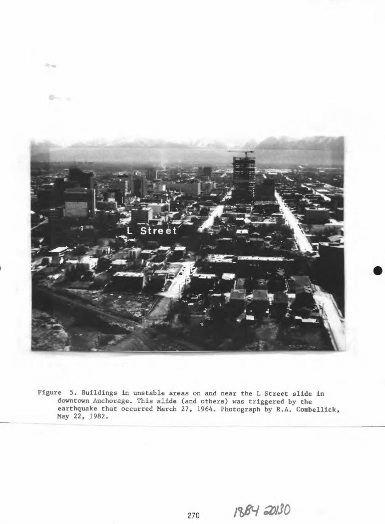
Figure 5. Buildings in unstable areas on and near the L Street slide in downtown Anchorage. This slide (and others) was triggered by the earthquake that occurred March 27, 1964. Photograph by R.A. Combellick, May 22, 1982.
270

Figure
6. Old
Vald
ez townsite after
a tsunami
destroyed
port
facilities an
d most of the
downtown area on
March 27
, 1964.
Photograph by J.
B.
Town
shen
d, Ap
ril
1964,
courtesy of Al
aska
Earthquake Ph
otog
raph
Arc
hive
, To
wnsh
end
coll
ecti
on n
o. 74
B.
- -

ro
-J
ro 00
Figu
re
7. Ne
w Va
ldez
townsite ne
ar Mi
nera
l Creek, 3.5
mi northwest
of old
townsite.
Photograph b
y Steve
and
Delores
McCu
tche
on,
summ
er 19
70.

natural processes and their potential effects. The second step is to use that information to develop measures that reduce the likelihood of injury and damage to persons and property at risk from the hazard. The third step is to develop the means to quickly respond to a disaster, restore public order, and remove the threat of further injury or damage. Hazard mitigation encompasses activities that reduce the likelihood of property damage or personal injury from a natural event. Disaster preparedness acknowledges that, particularly with major events, there will be property damage and personal injury that cannot be prevented through hazard mitigation. Therefore, disaster pre paredness creates mechanisms to respond to the disaster, enables an orderly recovery, and distributes financial losses. Response preparation normally in cludes plans, facilities, and programs for evacuation, search and rescue, communication, shelter, food, police protection, debris removal, rapidly deployable protection works (such as sand-bag levees), and restoration of lifelines and critical facilities. Hazard insurance and disaster-relief funds (the latter supported by taxes) are the most common means of distributing financial losses. In this report, relief funds and insurance are considered functions of disaster preparedness rather than mitigation because they do not reduce the overall cost of a disaster; they simply distribute those costs among taxpayers and insurance buyers. Although hazard insurance and disaster relief cannot substitute for adequate safety measures, they can be effective tools for mitigation if they include the proper incentives, such as reduced insurance rates for taking specified loss-reduction measures or requirements for taking such measures as a condition of eligibility. Disaster response puts disaster-preparedness plans and other postdisaster activities into effect to restore order and facilitate recovery. This report emphasizes hazard mitigation and does not discuss disaster preparedness and response in detail except where improvements can be made to promote mitigation.
The first two steps in the hazard-mitigation process, hazard evaluation and risk assessment, are prerequisites to the third step, risk reduction. Reliable information on natural processes and their associated risks is essential to determine appropriate risk-reduction measures. Inadequate information can result not only in inadequate or misguided measures, but can contribute to overdesign and overregulation.
Hazard Evaluation
The objective of hazard evaluation is to produce five kinds of information:
1. Descriptions of natural processes and controlling factors that relate to the hazard.
2. Location and extent of potentially affected areas.3. Probability and frequency of occurrence.4. Probable severity (for example, magnitude, intensity, and
duration).5. Expected physical effects.
Understanding the natural processes and controlling factors that relate to a hazard is essential for determining the location and extent of potenti ally affected areas, probability and frequency of occurrence, probable severity, and expected physical effects (fig. 8). Earthquakes are a good L
273

NATURAL PROCESSES
AND
CONTROLLING FACTORS
LOCATION AND
AREAL EXTENT
(Space element)
PROBABILITY AND
FREQUENCY OF OCCURRENCE
CTime element)
PROBABLE
SEVERITY
(Intensity element)
PHYSICAL EFFECTS
(Hazard)
Figure 8. Flow diagram of study objectives in hazard mitigation.
274

example of a hazard for which persistent data collection has led to success ful hazard mitigation in many parts of the country. As a result of continuous global and regional seismic monitoring and geological and geophysical studies over the past few decades, geoscientists are gradually developing a better understanding of the processes that control the distribution, occurrence, intensity, and effects of earthquakes. In California, commitments by federal and state agencies to long-term, continuous monitoring of earthquakes have contributed to an increased level of confidence in identifying areas of high earthquake hazard and improved knowledge of earthquake effects (for example, strong ground motion). Both factors have been used extensively and successfully in regulating land-use and improving earthquake safety in new and existing buildings.
The scale and complexity of processes determine the difficulty of evaluating associated hazards. Generally, the larger the area over which the processes operate and the greater their complexity, the less 'mappable' the hazards are because of the difficulties in delineating areas likely to be affected. Often, high cost and limited technology preclude accurate delineation of areas of high exposure and definitive predictions or forecasts of events. This condition poses legal problems in hazard mitigation, particularly in land-use regulation, because of limited technical defensibility of the boundaries of designated 'hazard areas. 1
Significant geologic hazards in Alaska are listed in table 1. The 'mappability' of these hazards is based on the presence of physical features that provide a basis for areal delineation of the hazard at scales appropriate for land-use planning. For secondary hazards, mappability is based on the relative ease of delineating areas susceptible to secondary effects. For example, areas in which the intensity of ground shaking is likely to exceed given levels are very difficult to accurately delineate; hence, this primary hazard of earthquakes has low mappability. Areas that are likely to experience ground failure as a result of the given intensity of ground motion are easier to delineate; hence, ground failure, as a secondary effect of earthquakes, has higher mappability. 'Prediction capability 1 for catastrophic events (table 1) is based on the presence of recognizable conditions that warn of an impending event within a definite time period so that people can be evacuated and other preparations can be made.
To a large degree, legal defensibility of hazard-related land-use regulations is related to mappability. A map adopted for regulatory use is subject to legal scrutiny; thus, the boundaries or contours depicted on it and data used to derive them must be defensible in court. Historically, two additional factors have heavily influenced court decisions and often override problems of scientific defensibility: 1) the potential loss associated with the hazard (for both life and property); and 2) the degree of restriction posed by the regulation. On the one hand, land-use regulations related to highly destructive hazards, such as floods or earthquakes, have fared better in courts than those that relate to less destructive hazards, such as soil creep or lightning. On the other hand, regulations do not fare well if they are so restrictive that they infringe on fundamental liberties or do not clearly relate to the promotion of public health and safety. Generally, if a rational relationship exists between a regulation and the promotion of public health and safety, the regulation will be upheld in court. On this basis, many regulations have survived court tests, even when there were disagreements within the scientific community about the validity of the data used as criteria for the regulation (Baker and McPhee, 1975).
275

ro *sj CT) I
Table
1. Significant
geol
ogic
hazards in A
laska.
Potentially
cata
stro
phic
geo
logi
c hazards
Even
t
Eart
hqua
ke
Causative
proc
esse
s
Crustal
displacement
Volc
anic
er
upti
on
Rapi
d mass
movement:
Snow
ava
lanc
heSnow a
ccumulation
on steep
slopes an
d su
bseq
uent
mod
ifi
ca
tion
by
drif
ting
, melting,
and
precipitation
(also
a secondary
effect of
ea
rthq
uake
s)
Natu
ral
or a
rtif
icia
l sl
ope
over
stee
peni
ng,
overloading
and/
or r
educ
tion
of
mate
rial
st
reng
th,
usua
lly
by wat
er saturation (also
a secondary
effect of
earth
quak
es,
volc
anic
eru
ptions,
coas
tal
eros
ion,
and
river
eros
ion)
Flow (m
udfl
ow,
Excessive
rain
fall
or
rapid
Slid
e (l
ands
lide
, ro
cksl
ide,
rock
fall,
slum
p)
debris flow,
debris av
alan
che,
sl
ushf
low
aval
anch
e)
snowmelt in a
reas of
steep
slopes an
d lo
ose
surficial
materials
(soil,
vegetation,
rock
; al
so a
secondary
effe
ct of
volc
anic
eruptions)
Prim
ary
hazards
Strong g
round
shak
ing
Faul
t di
spla
ceme
nt
Subs
iden
ce or
upl
ift
High
dyn
amic
pre
s
sure
Buri
al
Grou
nd d
ispl
ace
ment (both
vert
ical
an
d hori
zont
al)
High
dynamic pres
sure
Burial
Grou
nd displace
ment
High dynamic
pres
sure
Buri
al
Secondary
haza
rds
Ground failure
Aval
anch
eTs
unam
i (c
an a
lso
becaused by e
arthquakes
outs
ide
Alas
ka)
Seiche
Air
blas
t
Mapp
abil
ity
Zone of
Zone of
primary
seco
ndar
y hazards
haza
rds
Pred
icti
on,
capa
bili
ty
L-M
M-H
Floo
ding
fo
llow
ing
temporary
damm
ing
of stream b
y sl
ide
deposit
Tsun
ami
or seiche
Floo
ding
fol
lowi
ng
temporary
damm
ing
of s
tream
by flow
deposit
aMappability
H - Probable location o
f future e
vents
can be
shown
on la
rge-
scal
e ma
ps (l
:63,
360-
scal
e or
larger).
M - Variations in r
elat
ive
intensity
or severity of
haz
ard
can
be sh
own
on la
rge-
scal
e ma
ps,
but
not
the
location of future ev
ents
. .
L - Va
riat
ions
in r
elat
ive
inte
nsit
y or
se
veri
ty c
annot
be shown
on large-scale
maps
. Pr
edic
tion
capability
H -
Indi
vidu
al events ca
n be
predicted
with
su
ffic
ient
accuracy
and
warn
ing
time
to evacuate a
rea.
M - Al
thou
gh individual e
vent
s ca
nnot
be
re
liab
ly p
redicted,
cond
itio
ns favorable
for
thei
r occurrence c
an b
e fo
reca
st in
time to is
sue
warn
ings
and
evac
uate
ar
ea if n
ecessary.
L - Ne
ithe
r individual events n
or the
cond
itio
ns favorable
for
thei
r occurrence c
an b
e predicted
reliably e
nough
to al
low
for
adequate
resp
onse
.

Tabl
e 1. (c
on.)
Even
t
Volcanic e
rupt
ion
Floo
d
ro So
fc O
Soil
in
stab
ilit
y:
Cree
p
Heav
e
Subs
iden
ce
Caus
ativ
e processes
Buildup
of magma a
nd gas
under
pressure wit
hin
or
beneath
the
earth's
crus
t,
followed b
y upward m
igra
tion v
ia conduits a
nd fi
s
sures
to the
Eart
h's
sur
fa
ce
Clou
dbur
stProlonged
rainfall
Rapi
d sn
owme
ltRiver
ice
jam
Glac
ial
outb
urst
(release of
Primary ha
zard
s
Lava
flow
Pyroclastic
flow
Nuee
ardent (glow
ing
aval
anch
e)
Dire
cted
bla
st
Ash
fall
Volcanic b
omb
Earthquake
Noxi
ous
gas
High dynamic
pres
su
re in a
rea
of
high-flow
velocity
Submerence of
large
areas
Secondary ha
zard
s
Mudflow
(lah
ar)
Debris avalanche
Tsun
ami
Acid
rain
Ligh
tnin
gFo
rest
fire
Landslide
Erosion
and
de
posi
tion
Wate
r-su
pply
co
ntam
inat
ion
Mappability
Zone o
f Zone of
primary
secondary
hazards
haza
rds
Prediction^
capa
bili
ty
MM-
H
M-H
subg
laci
al or
englacial w
ater)
Exce
ssiv
e si
ltat
ion
Coas
tal
stor
m surge
Also
a
secondary
effect of
eart
hqua
kes,
vo
lcan
icer
upti
ons
(tsunami), and
mass
mov
emen
ts
Chro
nic
or localized
geol
ogic
hazards
Soli
fluc
tion
or
ge
lifl
ucti
onFrost
creep
Slow d
owns
lope
mov
emen
t of
nons
atur
ated
soils
on st
eep
slop
es
Fros
t he
ave
Swel
ling
of
clay-rich so
il
by a
bsorption
of w
ater
Soil
co
mpac
tion
Settling a
s a
result of
mel
ting
of ice-rich p
erma
fros
t or
seasonal gr
ound
ice
Shrinking
of cl
ayri
ch soils
duri
ngdrying
Diff
eren
tial
down-
slop
e mo
veme
nt
of g
round
surface
Diff
eren
tial
vertical
move
ment
of
ground
surface
Diff
eren
tial
vertical
movement of
ground
surf
ace

Tabl
e 1. (c
on.)
Event
Coas
tal
eros
ion
Causative
processes
Wave
s of su
ffic
ient
en
ergy t
o re
move
se
dime
nt or
rock faster
than it
is re
plen
ishe
dTsunami
Tidal
current
Arti
fici
al disruption of
longshore
sediment tr
ansp
ort
(jetty,
breakwater,
sand m
inin
g)Storm
surg
e
Prim
ary hazards
Land re
mova
l
Secondary hazards
Landslide
caused by
sl
ope
over
stee
peni
ng
Mapp
abil
ity3
Zone
of
Zone of
prim
ary
secondary
Prediction*
hazards
hazards
capa
bili
ty
HH
ro
^j
oo
River
eros
ion
Flow o
f su
ffic
ient
ve
locity
Land re
mova
land
capa
city
to
remove m
ater
ial
from r
iver
bank
Migr
atin
g or sh
ifti
ng c
hann
el
Arti
fici
ally
in
duce
d (for ex
ampl
e,
sand-and-gravel
mini
ng fr
om r
iver-
bank
)Also a
secondary
effect of floods
(see above)
Landslide
caused b
y sl
ope
over
stee
peni
ng

Risk Assessment
Ultimately, the impact of a disaster on individuals and public resources depends on the success of hazard mitigation. The number of casualties, amount of public-relief funds disbursed, and time required for recovery are reduced if mitigation efforts are successful. The effects of a disaster cannot be predicted accurately and are generally anticipated in terms of risk, that is the probable level of damage or loss given the probability of an event (hazard) occurring and its predicted effects. Disaster preparedness must be capable of responding to the 'calculated risk 1 (the estimated total risk for any given level of mitigation; fig. 9). 'Residual risk' is the difference between calculated risk and 'acceptable risk' (risk that can be accommodated without undue hardship). Residual risk represents the range of unacceptable risk that can be reduced by proper management.
If the potential physical effects of a hazard are known, the risk can be estimated based on the types of facilities present or planned, cost of re placement or repair, whether or not people are likely to be present, and the socioeconomic impact of damage. Obviously, there is no direct risk from a hazard, such as a landslide, if there are no facilities or people in the affected area. Similarly, the risk of locating agricultural land or parks in the path of a potential landslide is lower than for locating a hospital or power plant in the same location. The task of economists, planners, developers, designers, and regulators is to use the hazards information provided by scientists and engineers to derive associated 'calculated risks' and then select appropriate risk-reduction and disaster-preparedness measures. A comprehensive treatment of risk assessment for natural hazards is given by Burton and others (1978) and White and Haas (1975).
Risk Reduction
Given adequate information about geologic hazards and the risks they pose, different risk-reduction approaches are possible: 1) land use, 2) construction technology, 3) protection works, and 4) warning systems.
Land use
Land-use approaches to risk reduction involve decisions about where certain types of facilities can be built. The greatest power for effective land-use planning and regulation for most facilities is concentrated at the local-government level, where most construction is regulated under authority delegated by the state. Generally, the planning body of the local government prepares a comprehensive land-use plan that serves as a base for specific zoning ordinances. Natural hazards are just one of many considerations that may affect land-use-planning and zoning decisions. If the hazard is severe, separate hazard zones may be identified to limit land use to low-density or recreational purposes. If the hazard is localized and manageable on a site- specific basis, certain siting and design practices may be prescribed. Some local governments, primarily outside Alaska, use hazard-overlay maps to add qualifiers to existing zoning categories without changing their primary designations. In all cases, local governments have provisions that allow flexibility in cases where the ordinance imposes an undue hardship or where a specific use that is not normally allowed can be permitted because it meets
279

CO *1_
O)c"co030
OC
Calculated risk
Acceptable risk
MIncreasing mitigation
Figure 9. Relationship between risk and hazard mitigation. The residualrisk (R ) is the difference between calculated risk and acceptable risk for a given level of hazard mitigation (M). Modified from Woodward-Clyde Consultants, 1980b, fig. 1-1.
280

the standards intended by the ordinance. Where land is already in use, zoning changes generally apply only to new construction.
Hazards information can be used by individual builders to select safe sites for construction, for example, based on location of unstable slopes or ice-rich permafrost. At the state level, hazards information can be used in statewide and regional land-use plans to develop zoning regulations for state land and in site selection for state buildings and major public or critical facilities.
Construction Technology
Proper design and construction of facilities are effective in reducing vulnerability to many hazards. The most stringent regulatory measures are used in the design and construction of critical facilities. For most noncritical facilities, the power for implementing regulatory measures is at the local level. Typically a local government adopts the ICBO Uniform Building Code by ordinance and deletes or adds provisions as it deems appropriate for its jurisdiction. Sometimes, design and construction standards are incorporated into the zoning ordinances, such as minimum floor elevations in flood areas, but these are in addition to a building code that applies to the entire jurisdiction. Most states require local governments to adopt a building code and usually specify the Uniform Building Code (UBC). The State of Alaska currently does not require local governments to adopt a building code, although it gives them the authority to do so. Most major municipalities in Alaska have adopted modified versions of the Uniform Building Code. At least one municipality, the Fairbanks North Star Borough, has not yet adopted a building code.
Hazard-related design and construction requirements are not comprehensive in the Uniform Building Code. The latest version (International Congress of Building Officials, 1982) contains design requirements for wind and earthquake loads (sec. 2312) and guidelines for excavations, construction on expansive soils, grading, drainage, and erosion control to be implemented largely at the discretion of local building officials. A major limitation of the earthquake regulations in the code is that they provide design requirements only for the structural integrity of buildings under the forces of earthquake shaking and will not necessarily alleviate major foundation failures, building displace ments, or misalignments that result from earthquake-induced ground failure. This omission could mislead local authorities or building designers who follow the code rigorously to expect the resultant structure to be safe from earth quakes; in fact, the structure may be built on sensitive or liquefiable soils that could cause failure from major ground displacements even before shaking reaches the level for which the structure was designed. A building so designed would probably maintain its structural integrity; however, risk of injury from falling and sliding objects is still very high if major ground failures are involved and, unless the building can be realigned, it could be a total loss.
For earthquake design, the Uniform Building Code incorporates an 'importance factor 1 that depends on the type of facility proposed and specifies design criteria based on the seismic zone in which the facility is located (fig. 10). Buildings with assembly rooms for 300 or more persons re quire earthquake-design forces 1.25 times the normal value. For 'essential facilities' (hospitals, fire and police stations, and disaster centers), the factor is 1.5. Some state governments have legislated special design and con-
281 tfSI

176° 172° 168° 164° 160° 156° 152° 148° 144° 140° 136° 132° 128° 124° 70°
ARCTIC OCEAN
Barrow
Potential for earthquakes
Very high
H«gh
Moderate
0 100 200 300 400 500 kilometersi /
54°
164° 160° 156° 152° 148° 144° 140° 136°
Figure 10. Seismic-zone map from the Uniform Building Code (InternationalCongress of Building Officials, 1982). Seismic hazard is lowest in zone 1 and highest in zone 4.
282

struction requirements for such facilities beyond the provisions of the Uni form Building Code. State agencies (or federal agencies for federally supported projects) have authority to establish standards and review proposed designs and construction practices on a project-specific basis for some major public facilities, such as hydroelectric dams. Some specific approaches used in other states are discussed later in this report.
A problem in hazard-related design is that the magnitude of an event a structure should be capable of withstanding (the 'design event 1 ) is difficult to assess. The conservative approach is to design for the 'maximum credible event,' or the largest event possible considering the known natural processes or conditions in an area. For example, in a seismically active region, the maximum credible event could be a Richter magnitude 9.0 earthquake. The design cost for a Richter magnitude 9.0 earthquake may be unreasonably high for many facilities, especially if the probability is low that the event will occur during the design life of the facility. These costs may approach or even exceed the total financial loss that could result from the maximum credible event if no measures are taken. A more common approach is to design for the 100-yr event, which is often termed the 'maximum probable event.' Flood-hazard maps typically show elevations of the '100-yr flood,' a flood that can be expected to occur once every 100 yr. The type of facility will also help determine the design event. In California, the Division of Safety of Dams (DSD) requires that dams be designed so that no major amount of water is released if the maximum credible earthquake occurs.
Intensity of ground shaking at the site is the most important factor in earthquake-resistant design and depends on factors such as the distance of the site from the expected earthquake, the magnitude of the earthquake, the degree of attenuation of shaking with distance from the epicenter, and whether the site is on bedrock or sediment. Intensity of ground shaking can be expressed in terms of peak ground acceleration, duration, ground displacement, spectral velocity, or numerous other parameters. Thus, for design purposes, the maximum probable or maximum credible event must be one or more of these parameters, rather than just magnitude.
Protection works
A limited number of hazards can be mitigated by protection works and other structural and corrective solutions. The most common protection struc tures are flood-control dams and diversion works, which can substantially reduce the need to relocate existing facilities and impose new zoning restric tions to prevent disaster (fig. 11).
Although flood-protection works have successfully controlled flood hazards in many areas, two potentially serious deficiencies must be consider ed. First, if the protection works fail, the hazard can be much more severe than before the works were built because large volumes of water are suddenly released and the diversion works can inhibit flood water draining from the protected area. Second, protection works can promote increased development in the 'protected' area and, if the protection fails, damage and injury will be much more extensive.
Protection works have also been used successfully to control slope instability and coastal erosion. Techniques for stabilizing landslides are developing rapidly and proving to be increasingly successful. As a result, many areas in southern California that were formerly avoided because of
283 Ml

Figure 11
. Floodgate
in th
e Chena
Lake
s Fl
ood
Cont
rol
proj
ect,
about
20 m
i east of Fairbanks. The
structure
limits w
ater
flow to
12,000 ft
3 pe
r sec, wh
ich
is le
ss than on
e-fi
fth
the
amou
nt th
at flooded
Fairbanks
in
1967
. Ph
otogra
ph b
y U.
S. Army Co
rps
of Engineers.
landslide hazards are no longer considered unfit for development (Leighton, 1982). Because many landslides are triggered when they become water saturated, internal-drainage systems are frequently successful, as in the Pacific Palisades area. However, not all landslides can be controlled in this manner, and other protection or stabilization methods are often prohibitively expen sive. For coastal-erosion problems, jetties and breakwaters often reduce erosion in one area, but promote erosion or deposition in adjacent areas be cause the longshore transport of sediment is disrupted. Other protective or corrective approaches to risk reduction include firebreaks, riprap, use of vegetation for slope stabilization, and anchoring of loose structures.
Protection works and corrective measures are often necessary because land was improperly developed. Sound land-use planning and regulation and proper selection and preparation of construction sites are the best ways to avoid expensive postdevelopment measures that may have limited success.
Warning systems
Warning systems are both risk-reduction and disaster-preparedness mea sures. They help reduce the hazard to people by providing time to evacuate an area of impending disaster and simultaneously initiate disaster-response activities. Although short-term warning of an impending event can reduce risk of personal injury during a disaster, it generally does not reduce the hazard to fixed structures and property. Warnings are possible only if reliable hazard predictions can be issued and communication is dependable, or if adequate time lapses between an event and its effects (table 1). For example, if a major tsunami is generated by an earthquake beneath the south Pacific Ocean, there is ample time to issue warnings to Alaskan coastal communities.
Warning potential for river floods is high because predictive techniques for weather conditions that produce heavy rainfall are relatively effective, and often there is time to warn people downstream once a flood begins. Pre diction of volcanic eruptions is improving rapidly, but requires constant localized seismological monitoring and measurements of ground deformation. Warnings are less effective for snow avalanches and landslides. Typically, areas susceptible to these hazards are identified and studied to determine when conditions exist that could trigger mass movements; however, it is not possible to reliably predict individual events. Although advances are being made in earthquake prediction, it will probably be a long time before they are reliable.
Combinations of approaches
No single approach to risk reduction is universally effective. In most situations, a combination of approaches is most effective, and the circum stances will dictate which methods should be emphasized. For example, in developed areas, substantial changes to zoning ordinances are unreasonable; therefore, protection works or more stringent building codes should be emphasized. Old buildings may need to be refurbished to meet new standards. The best combination of risk-reduction measures depends on the level of jurisdiction (local, state, or federal), the types of facilities involved, the extent and type of development, and the expected hazards. A balance between land-use and building-technology approaches has proven most effective. Many local jurisdictions outside Alaska use both a strong hazards-related zoning
285

ordinance and a building code. If adequately enforced, this approach can alleviate many problems. Zoning ordinances can be used to prohibit or restrict construction of certain types of facilities in unstable areas. Facilities that are allowed in these areas must be built according to the building code.
The following examples illustrate how combined risk-reduction approaches are commonly used in specific applications.
Subdivisions
Most local jurisdictions, including those in Alaska, establish sub division regulations by ordinance to provide guidelines and requirements for dividing large parcels of land into smaller lots for resale. In addition to the standard requirement that developers submit plans and plats that describe proposed layouts of lots, utilities, and transportation routes for review and approval by the local planning commission, subdivision regulations sometimes deal with localized geologic hazards. Rather than impose ji priori restrictions on land use and construction within subdivisions, local jurisdictions may re quire, through subdivision regulations, that the developer identify hazards such as unstable soils, steep slopes, snow-avalanche zones, and areas prone to flooding. The developer must describe how these hazards can be avoided through appropriate land use or construction alternatives approved by the planning commission.
Excavations and grading
Many local governments establish site-development ordinances to prevent hazards caused by improper grading that could promote slope instability or inhibit drainage. A permit may be required for specific types of grading and excavations. Some provisions of this type are included in chapter 70 of the Uniform Building Code (International Conference of Building Officials, 1982).
Commercial facilities
Major new commercial facilities tend to attract residential development and, if improperly located, can inadvertently promote growth in hazardous areas. Therefore, if major shopping and business centers are located away from hazardous areas, community risks will be reduced.
Places of assembly
Special measures are often necessary for facilities, such as schools, auditoriums, churches, and other large buildings that are intended for large groups of people. The objectives of hazard mitigation for these structures are to allow safe exit and protect occupants from injury. One highly successful measure is the Field Act in California, which regulates construction and remodeling of schools. Other successful measures are the earthquake regulations in the Uniform Building Code that require design loads to be increased by 25 percent for buildings that will be used by at least 300 people.
286

Lifelines and critical facilities
Some facilities are essential to public health and safety and require special consideration in hazard mitigation. These critical facilities would pose a major danger to the public if damaged or must remain functional during and after a disaster for public safety or essential economic activities. Included in this category are hospitals, police and fire stations, detention facilities, disaster centers, dams, nuclear and other power plants, chemical plants that handle toxic materials, water supplies, sewer systems, power lines, highways, railroads, airports, and communications systems. Schools and other places of assembly are often considered critical facilities because of the large number of people that would be affected in a disaster. Key considerations are that critical facilities must provide for safety of occupants and, in most cases, must continue to perform some or all functions. Thus, more stringent hazard-mitigation measures are required. Special building standards and site-selection procedures are needed for these facilities. Effective hazard mitigation for these structures requires periodic review during site selection, design, construction, and operational phases of the projects. This process generally must be established through federal and state legislation and regulations that specify permitting and regulatory authorities, responsibilities and rights of the contractor(s), and review functions of various agencies.
The Hazard-mitigation Process
Hazard mitigation consists of four major steps: 1) collection of geologic data, 2) hazard evaluation, 3) risk assessment, and 4) risk reduction (fig. 12). The success of this process depends on effective public education. Government policy in hazard mitigation cannot be developed and implemented without support by an informed public. The most effective hazard mitigation occurs when informed individuals make wise decisions about where and how they build.
Roles of Different Levels of Government
Because most development is regulated by local governments, local risk-reduction practices have the greatest potential for success. Large public-works projects and construction of critical facilities are often regu lated at the state level, where hazard-management policies are most appropri ate. Because many hazards transcend the boundaries of local governments, adjoining local jurisdictions need to coordinate with each other to prevent conflicting plans and regulations. For example, flood-plain management or diversion practices in one community could affect other communities down stream, or zoning for major commercial facilities in one jurisdiction might promote development in hazardous areas of an adjacent jurisdiction. All regulatory activities of local governments are performed under authority granted by state government. Therefore, states need to provide legislation, clear policy guidelines, and adequate information for local governments to develop hazard-related ordinances.
In Alaska, local land-use policies are the responsibility of borough governments. Because boroughs occupy sizable land areas (larger than most counties in the contiguous states), the scale of borough land-use plans is
287

COLLECTION OF GEOLOGIC DATA
HAZARD EVALUATION
Statewide County (borough) City Subdivision or zone Specific site ^L ^L ^L ^L ^L
RISK ASSESSMENT
RISK REDUCTION
Land-use plans, general policies
Warning systems
Protection works
Regulation of critical facilities
Zoning ordinances
Subdivision ordinances
Site-development ordinances
Building codes
Use of information by private developers and builders
Figure 12. The hazard-mitigation process.
288 IKS'30130

ideal for incorporating geologic-hazards considerations. However, only 25 per cent of Alaska is subdivided into boroughs; therefore, when problems arise in areas outside the organized boroughs, coordination between borough and state or federal governments is necessary.
Because federal, state, and local governments have different levels of financial and personnel resources and different management responsibilities, their roles in hazard mitigation are also quite different (table 2). Local governments generally do not have the financial resources or personnel to conduct major geologic-hazards studies, particularly for large-scale and potentially catastrophic hazards like earthquakes and volcanic eruptions. State geological surveys are equipped to conduct these types of studies, publish information on hazards that affect the state, and provide technical assistance to local governments. Other state agencies can assist with land-use plans, ordinance development, building-code enforcement, and other risk-reduction measures. The federal government assists states by providing topical information on geologic-hazards processes, performing research, and mapping on a regional scale. State and federal governments have disaster- relief funds to assist communities if a disaster occurs. Availability of federal disaster-relief funds is becoming increasingly contingent on effective state and local risk-reduction measures that follow a disaster.
GEOLOGIC-HAZARD-MITIGATION PROGRAMS IN OTHER STATES
Twenty-seven states, including Alaska, have adopted some form of legisla tion that authorizes or requires measures for geologic-hazard mitigation. The comprehensiveness and effectiveness of hazards legislation vary widely among these states and depend on how strongly the statutes are worded and how actively they are implemented. In some states, hazards legislation is in effective because it authorizes measures that are never implemented. Of the 27 states with hazard-mitigation legislation in effect in 1982, 13 (including Alaska) adopted the Example State Disaster Act published by the Council of State Governments (1972). The disaster-prevention section of the act calls on the Governor and the state Division of Disaster Emergency Services to study disaster-prevention matters, land uses, and construction in the state and to recommend measures to reduce or prevent harmful consequences of a disaster. The Council of State Governments Disaster Act does little to mitigate hazards because it is primarily disaster-preparedness legislation. The act relies on follow-up legislation, policies, and development of agency programs to be ef fective for hazard mitigation. Only a few states have enacted programs in which hazards considerations are integral to land-use, development, and con struction policies. The most common approach at the state level is enactment of legislation that initiates development of local mitigation programs and broad state policies and sets up state regulation of certain facilities.
Hazard-mitigation programs in California and Colorado were reviewed to determine whether they could serve as models for similar programs in Alaska. Both states have significant geologic hazards that are similar to those in Alaska and have tested their programs over longer periods than most other states. Information used in this review includes state statutes and regula tions, published reports, and numerous discussions with individuals involved with the programs at state and local levels.
289

Table
2. Suggested
role
s of
federal, st
ate,
and
loca
l go
vern
ment
s in
hazard mitigation
and
disa
ster
prep
ared
ness
. Modified fr
om Council
of St
ate
Governments, 19
79;
Hays and
Shea
rer,
1981;
and
Nichols
and
Camp
bell
, 1971.
Poli
cy
PO <>D O
Research
Tech
nica
l services
Fede
ral
gove
rnme
nts
Long-term na
tion
al goals
and
policies
Financial
assi
stan
ce for
stat
e and
loca
l go
vern
ment
s to develop
poli
cies
and
prog
rams
Supp
ort
topical
rese
arch
on
geol
ogic
pr
oces
ses
and
regional
mapp
ing
of ha
zard
s Su
ppor
t en
gine
erin
g and
socioeconomic
stud
ies
Supp
ort
permanent
monitoring (f
orex
ampl
e, ea
rthq
uake
s) at
regi
onal
sc
ale
Cond
uct
post
disa
ster
studies
Supp
ly ge
olog
ic da
ta,
smal
l-sc
ale
regional ma
ps,
and
information
Provide
assistance to state
and
loca
l go
vern
ment
s
Stat
e government
Enabling legislation
for
local
governments
Statewide
goals
and
policies
Statewide
land
-use
pl
ans
Esta
blis
h interdisciplinary
councils to re
comm
end
publ
ic policy
Fina
ncia
l assistance to
local
governments
Supp
ort
research on
geol
ogic
ha
zard
s in th
e st
ate
and mapping
of
hazards
at lo
cal
to
statewide
scal
esSu
ppor
t long-term
moni
tori
ng at st
atew
ide
scal
eConduct
short-term
post
disa
ster
studies
in
coop
erat
ion with federal
government
Supp
ly ge
olog
ic da
ta,
larg
e-sc
ale
maps,
and
information
to lo
cal
gove
rnme
nts
and
publ
icProvide
tech
nica
l assistance to
lo
cal
governments
Local
government
County (borough)
land
-use
pl
ans
Perf
orm
or re
quir
e local
studies
of specific
haza
rds
Assemble an
d ev
alua
te
data
relevant to local
haza
rds
issues

Tabl
e 2.
(con.)
Risk
re
duct
ion
Disaster
preparedness
Deve
lop
model building co
des
and
land
-use
pl
ans
Prov
ide
fina
ncia
l su
ppor
t for
loca
l la
nd-u
se pl
ans
Support
deve
lopm
ent
ofri
sk-r
educ
tion
bui
ldin
gte
chno
logy
Protection works (f
or ex
ampl
e,U.S. Army Co
rps
of En
gine
ers)
Is
sue
predictions
and warnings
O
Fede
ral
disa
ster
-rel
ief
funds
and
loan
pr
ogra
ms
Prov
ide
advice an
d fi
nanc
ial
ince
ntiv
es fo
r state
and
loca
l pr
epar
edne
ss pl
ans
Maintain major re
spon
secapability (for example,
U.S.
Army Na
tion
al Gu
ard,
Corp
s of
En
gine
ers)
Of
fer
or su
bsid
ize
hazard
insu
ranc
e
Develop
guid
elin
es for
local
risk
-red
ucti
on
meas
ures
De
velo
p model
zoni
ng or
dina
nces
Establish
laws
an
dregulations
for
siti
ng an
d design of li
feli
nes
and
critical facilities
Set
hazard-mitigation
requ
irem
ents
for
cons
truc
tion
pr
ojec
ts using
stat
e ca
pita
l fu
nds
or
loans
Protection works
Eval
uate
predictions,
issue
warn
ings
, an
d advise as to
appropriate
response
Stat
e disaster-relief
funds
Disa
ster
-pre
pare
dnes
s pl
ans
and
prog
rams
Pu
blic
education
Assi
stan
ce to local
governments
in de
velo
ping
preparedness plans
Adopt
and
enforce
zoning
and
site
-dev
elop
ment
ordinances,
building
codes, an
d su
bdiv
isio
n regulations
Local
prep
ared
ness
pl
ans
Publ
ic education with
emphasis on in
divi
dual
preparedness

California
Hazard-mitigation programs in California are largely an outgrowth of public reaction to natural disasters, beginning with legislation that was developed after the St. Francis Dam failed in 1928 (Campbell, 1976). This approach has been responsible for a wide variety of seemingly unconnected special-purpose programs. For example, school construction has been strictly regulated for earthquake safety under the Field Act since 1933, when an earthquake extensively damaged schools in Long Beach. Similar standards for hospitals (Hospital Seismic Safety Act) did not appear until after the 1971 San Fernando earthquake when extensive damage occurred and dozens of people were killed at four major hospitals and many other medical facilities. In recent years, California has begun to develop more farsighted, coordinated programs in anticipation of future events.
Surges in public emotion that follow disasters have been responsible for the episodic development of hazards-related legislation in California. Two consequences are the need for extensive corrective action by the legislature on hastily prepared bills and, until the early 1970s, the lack of com prehensive, well-prepared legislation. A high percentage of hastily prepared bills were passed by the Legislature during the emotional aftermath of dis asters. Lulls between disasters allowed sufficient time to prepare good legislation, but were also periods of apathy during which few good bills were passed (Slosson, 1975).
Despite this erratic process, many successful programs that address specific problems were developed. In recent years, Californians and their legislators have begun to support more advanced planning and well-prepared, long-range legislation like the Alquist-Priolo Special Studies Zones Act and establishment of the Seismic Safety Commission.
Many lessons can be learned from the history of hazard-mitigation programs in California. The lessons are particularly applicable to Alaska, which is in a position similar to that of early 20th-century California. Economic development is still in its youth, one major damaging earthquake has occurred, and the likelihood is high that additional events will occur (as they did in California) that will take a progressively greater toll of lives and property unless the disaster potential is reduced. Ironically, the 1964 Great Alaska Earthquake inspired the establishment of California's Joint Committee on Seismic Safety, which in 1974 became the Seismic Safety Commission (Campbell, 1976).
The major state legislative programs that relate to geologic-hazard mitigation in California, their development, and some of their strengths and weaknesses are reviewed below.
State Planning and Zoning Law: General plan
In 1927, California passed legislation that allows local governments to prepare a general plan to document their land-use and development policies. In 1955, the general plan became a state requirement for all counties and cities, and two 'elements' (land use and circulation) were addressed (California Government Code, sees. 65300-65302). By 1971, seven more elements were added, including a 'seismic-safety element' and a 'safety element' required by amendments that were passed soon after the San Fernando earthquake. Also in 1971, the most significant feature relating to implementation was added: the
292
requirement that all zoning ordinances and subdivision approvals be consistent with a jurisdiction's general plan.
State law requires the Governor's Office of Planning and Research to pre pare, adopt, and periodically revise state guidelines to assist local govern ments in preparing their general plans. These guidelines constitute California's official interpretation of the planning law and give detailed instructions and suggestions on content, format, and procedures (California Office of Planning and Research, 1980).
As new elements were added to requirements in the general plan, local governments were given deadlines for their preparation and adoption. All seismic-safety and safety elements were to be completed by 1976. As of January 1977, 81 of the 412 cities and 19 of the 58 counties had not adopted a seismic-safety element (California Seismic Safety Commission, 1977a). Only the housing element requires an update every 5 yr. However, the guidelines strongly encourage thorough review and revision of all elements at least every 5 yr to reflect new conditions and public attitudes.
Various portions of each general plan must be submitted to appropriate state agencies for review. For example, a copy of the adopted seismic-safety element and associated technical data must be submitted to the state Division of Mines and Geology (DMG). With one exception (unrelated to hazards), state agencies do not have approval authority over general-plan elements. The pur pose of submitting review copies is to inform state agencies that have responsibilities related to certain aspects of the general plan and to provide those agencies with an opportunity to suggest revisions or improvements.
The seismic-safety element of the general plan must consist of an "identification and appraisal of seismic and geologic hazards, such as sus ceptibility to surface ruptures from faulting, to ground shaking, to ground failures, or to effects of seismically induced waves such as tsunamis and seiches." The safety element must describe proposed features for community protection from those hazards. Flooding must be addressed in other elements of the general plan, including the land-use element (which identifies areas subject to flooding) and the conservation element (for conservation aspects of flood control). State guidelines note that the division of the general plan into separate elements "is more a product of the incremental nature of the legislative process than a conscious design." Thus, local planning commissions are encouraged to combine the seismic-safety and safety elements into one section devoted to the hazard issues. Plans for implementing the Alquist- Priolo Special Studies Zones Act, described below, must also be included in the general plan if all or a portion of the local jurisdiction lies within one zone.
Only 1 yr after all seismic-safety elements were due to be completed, the California Seismic Safety Commission (SSC) (1977a) reviewed the seismic-safety requirement and found that it had already begun to produce positive effects. However, SSC recognized that it could be a long time before a major earthquake tested the requirement's effectiveness. The seismic-safety requirement forced local identification of earthquake problems, formulation of related policy, and significantly impacted land-use decisions. When a questionnaire was sent to four cities and four counties, most jurisdictions responded that information generated by the seismic-safety requirement provided important seismic and geologic data for decisionmakers at all levels of government and increased the awareness of planners, public-works officials, building departments, and elected representatives of seismic and geologic problems
293 MS

related to land-use planning. The review committee concluded that, despite some weaknesses, the seismic-safety requirement produced very significant benefits in the interest of public safety.
One weakness of the planning law is that the state is unable to ensure that general plans or their individual elements are adopted and periodically updated. No penalties are prescribed for failure to complete a general plan, nor are financial incentives given. However, any property owner, resident, state agency, state attorney general, or any aggrieved party may sue to en force the requirement for adoption of a general plan and consistency of subdivision approvals and zoning. The courts may issue a writ of mandate for compliance with the requirement or set aside city or county approval of an action that is inconsistent with the plan. Apparently, court action is the only means of ensuring compliance (J.L. Mintier, oral commun., 1982).
Another weakness is that no single agency is responsible for reviewing the adequacy of general plans. Seismic-safety elements are submitted to the Division of Mines and Geology (DMG) for possible review, but approval is not required. Also, DMG comments concentrate on the technical adequacy of geological and geophysical information and do not address application of the information to planning (J.L. Mintier, oral commun., 1982). The California Seismic Safety Commission (1977a) found a wide variation in content and quality of plans. Although SSC conceded that variation in content and organization is inevitable, and to a certain extent desirable, it concluded that lack of checks on quality allowed the adoption of many seismic-safety elements that contain misleading or erroneous information. Consequently, questions are raised about the validity and effectiveness of seismic-safety elements in a planning document.
After a general plan is adopted, implementing it through such means as revising existing zoning laws, updating building codes, and conducting safety inventories of existing buildings is difficult. Although the law requires that actions such as subdivision approvals and zoning changes be consistent with the general plan, it cannot ensure that new actions stipulated by the plan are implemented. Mintier and Stromberg (1982) surveyed seven jurisdictions and found that the safety element has not functioned successfully as a planning document. For example, all seven jurisdictions had adopted policies in their general plans that called for an inspection and rehabilitation program for hazardous buildings, but none have implemented their programs. Instead, the seismic-safety element has been most effective as an educational tool for planners and elected officials and as a broad mandate for local governments to learn about the geology of their areas and to mitigate hazards through project reviews.
Alquist-Priolo Special Studies Zones Act
The Alquist-Priolo Special Studies Zones Act was passed in December 1972 and became effective as part of the California Public Resources Code (sees. 2621 to 2630) in March 1973. As of 1980, the act had been amended four times. The law requires the State Geologist to delineate special-studies zones (normally 1/4 mi wide or less) that encompass all 'potentially and recently active' faults that constitute a possible hazard to structures from surface faulting or fault creep. Before any 'project' (defined by the law) within a special-studies zone is approved, cities and counties must require a geologic report that defines and delineates any hazard of surface fault rupture.
294

Project approvals and geologic reports must comply with policies and criteria set by the State Mining and Geology Board (SMGB). The act also requires that sellers of real property located within a special-studies zone disclose that fact to prospective buyers. Table 3 summarizes responsibilities and functions under the act.
According to the law, a 'project' is any new real-estate development or structure intended for human occupancy, with the exception of single-family wood-frame dwellings that do not exceed two stories and alterations that do not exceed 50 percent of the structure's value. The SMGB defines an active fault as one that shows evidence of surface displacement within the last 11,000 yr (Holocene time). To delineate special-studies zones, the State Geologist defined a 'potentially active' fault as one that shows evidence of surface displacement during the last 2 m.y. (Quaternary time), and included 'recently active' faults in the 'potentially active' category.' Since January 1, 1977, special-studies zones have been delineated based only on faults that show evidence of activity during Holocene time.
The DMG produces maps that show special-studies zones on U.S. Geological Survey l:24,000-scale topographic base maps (fig. 13). An ongoing fault- evaluation program selects faults that can be located in the field with suf ficient precision and confidence to indicate that site-specific investigations required by law will be successful. Positions of the special-studies zones are controlled by the positions of mapped fault traces. Zone boundaries are straight-line segments that join locatable features on the ground. The zones have a total width of about 1/4 mi except where there are closely spaced, parallel fault strands in which case the zone may be wider. As of January 1, 1980, 288 special-studies-zone maps had been issued; 24 of these had been revised. Approximately 24 counties and 69 cities are affected (Hart, 1980). The DMG is required to review new geologic and seismic data to revise existing zones or delineate new ones.
Local governments are responsible for determining, through requirements placed on the developer or builder of projects within a special-studies zone, whether a potential fault hazard exists for proposed structures and their occupants. Fault information shown on DMG special-studies-zone maps is not intended to be sufficient for this purpose. Along with the permit application, the developer or builder must submit a report prepared by a geologist registered in the State of California that addresses potential surface fault displacement through the project site. As required by SMGB policies, the city or county must then retain a registered geologist to review the report for adequacy. The city or county must approve the report before a permit is granted. The policies of SMGB prohibit construction of structures for human occupancy within 50 ft of an active fault. Therefore, to be eligible for a permit, a builder or developer must prove there are no active faults within 50 ft of the proposed project. The board has set 50 ft as the minimum standard, and encourages cities and counties to impose more restrictive criteria for large or critical structures.
The DMG has found that the investigative methods, documentation, report quality, and validity of conclusions are inadequate in many fault-evaluation reports (Hart and Wagner, 1975; Stewart and others, 1977). Although not re quired to do so by law, DMG published guidelines for the evaluations and a suggested outline for the reports (Hart, 1975).
Implementing the Special Studies Zones Act at the local level has additional problems, some of which remain unresolved. Most difficulties result
295

1 kilometer
EXPLANATION
Potentially active faults1952
Faults considered to have been active during Quaternary* time; solid line where accurately located, long dash where approximately located, short dash where inferred, dotted where concealed; query (?) indicates additional uncertainty. Evidence of historic offset indicated by year of earthquake-as sociated event
Special-studies-zone boundaries
These are delineated as straight-line segments that connect encircled turning points that define special-studies-zone segments
*Beginning with maps issued January 1, 1977, special-studies zones have been delineated only for those faults con sidered to have been active during Holocene time.
Figure 13. Example of a Special Studies Zones map. These maps are published by the California Division of Mines and Geology in accordance with the Alquist-Priolo Special Studies Zones Act of 1972. Modified from Hart, 1980, p. 7.
296

Tabl
e 3.
Summary
of responsibilities an
d functions
under
the
Alquist-Priolo
Special
Studies
Zone
s Act
(Hart, 1980).
1. 2. 3.
PO
1. 2.
Stat
e Geologist
Deli
neat
es sp
ecia
l-st
udie
s zo
nes;
co
mpil
es and
issu
es maps to
ci
ties
, counties,
and
state
agencies.
a. Pr
elim
inar
y maps for
revi
ew.
b. Official ma
ps.
Review
s new
data
.a. Re
vise
s ex
isti
ng ma
ps.
b. Co
mpil
es new
maps
.Ap
prov
es re
ques
ts for
waiv
ers
initiated
byci
ties
an
d counties.
Stat
e Mining and
Geology
Board
Formulates policies and
criteria to guide
citi
esan
d co
unti
es.
Serves
as
Appeals
Boar
d.
JU o
Citi
es and
Coun
ties
.
Must
ad
opt
zoning la
ws,
ordi
nanc
es,
rules,
and
regu
lati
ons;
primary
responsibility for
implementing ac
t.Re
gula
te specified
'projects' within
special-studies
zone
s.a.
De
term
ine
need
for
geol
ogic
reports
before
proj
ect
deve
lopm
ent,
b. Approve
geol
ogic
reports
before issuing
deve
lopm
ent
permits.
c. May
init
iate
wa
iver
pr
oced
ures
. May
char
ge reasonable fe
es fo
r ad
mini
stra
tive
co
sts.
Other
Seis
mic
Safe
ty Commission -
advi
ses
Stat
e Ge
olog
ist
and
State
Mining and
Geol
ogy
Boar
d.
Stat
e Ag
enci
es -
prohibited from si
ting
structure
across ac
tive
fa
ult
traces.
Disclosure -
pros
pect
ive
buyers of
any
real
property located within a
spec
ial-
st
udie
s zone mu
st be no
tifi
ed of th
at fa
ct.

from lack of clear definitions and requirements and from inconsistencies between SMGB policies and the Special Studies Zones Act. For example, the law is not clear about what basis is used to establish property values of buildings proposed for alteration to determine if a geologic report is required (based on 50 percent of the value). Whether 'structures for human occupancy 1 include warehouses, studios, and buildings added to an existing facility, or if the requirements apply to expansion of existing uses and changes in occupancy is not clear. Policies of SMGB prohibit building any structures for human occupancy within 50 ft of an active fault, whereas the Special Studies Zones Act exempts certain structures (for example, single- family dwellings) from that requirement. Many problems could be resolved by amending the act and revising SMGB policies (California Seismic Safety Commission, 1977b).
More serious implementation problems arise because the Special Studies Zones Act imposes uniform, statewide requirements that do not allow flexibility for local differences in government, level of development, and conditions that preclude accurate delineation of surface fault traces. For example, how can the trace of a suspected active fault be located in an urbanized area that has no predevelopment aerial photography and is largely covered by fill? Where faults must be located by remote-sensing methods, such as seismic and magnetometer surveys, it is generally not possible to date the displacement or accurately extrapolate the surface trace. Many local governments alleviate uncertainties in clarity, definition, and application of the law by imposing their own more restrictive ordinances. For example, if the setback is increased to 100 ft, the surface trace of a fault that has no surface expression can be approximately mapped because it incorporates a 50-ft margin of error beyond the setback required by SMGB. To alleviate uncertainties in how the law is applied to individual properties that lie partially within a special-studies zone, one city adjusted zone boundaries to follow property lines and street centerlines so that lots originally crossed by a zone boundary are now entirely within the zone (California Seismic Safety Commission, 1977b).
Requirements imposed by the Special Studies Zones Act and by board policies created a considerable demand for registered geologists. Two registered geologists are required for all new projects in every special-stud ies zone in every city and county affected by the act. One registered geologist prepares the report for the developer or builder, and the other re views it for the permitting body. Many local governments regard this require ment as excessive and have recommended that they be allowed to hire one geologist to prepare a report for the entire portion of a special-studies zone that transects their respective jurisdictions and that DMG provide the review. Because of the scarcity of registered geologists, some people believe that it is impractical and not in the public interest to require that the reports be reviewed by registered geologists. One city geologist found that "many geologists preparing reports are unaware of recent trends in fault analysis, rely on inappropriate methods of investigation, and restrict themselves too tightly to a site, referring only to published regional data rather than using field-checked air-photo interpretation" (California Seismic Safety Commission, 1977b).
The disclosure requirement presents implementation problems and is not clear about responsibility for its enforcement. Most local governments assume the state is responsible for enforcement, but a few have clarified their own
298

policies and procedures for disclosure. Most cities and counties do not know whether a seller discloses to prospective buyers that the subject property lies within a special-studies zone. Many sellers and real estate agents are unaware of the requirement, even though they may be aware of the act. One county requires the owner to sign a statement, recorded with the deed, that acknowledges the potential hazard, but only for new projects that require a geologic report under the Special Studies Zones Act. Enforcement of the disclosure provision for property that does not require a report is much more difficult because a permit is generally not involved, and the county is there fore unaware of a sale until after it is recorded. Apparently the only real compliance incentive is the threat of possible court action against the seller if an unnotified buyer suffers losses from fault damage (California Seismic Safety Commission, 1977b).
A major concern among property owners has been the potential impact of the Special Studies Zones Act on property values and development interests. Some cities and counties have in turn expressed concern about possible liability for lots declared 'unbuildable.' Although there apparently are no documented cases of financial loss due to the act, one would expect such losses to occur when property intended for construction is purchased, later included in a special-studies zone, and found to be located on an active fault. After the initial loss, however, subsequent investments in the property should not be affected because restrictions on property use would not change (California Seismic Safety Commission, 1977b).
The Special Studies Zones Act has successfully restricted development along mapped active faults in California. Its effectiveness in reducing the hazard from surface fault rupture has not been tested because no damaging surface ruptures have occurred in a special-studies zone since the law went into effect. Whether particular faults are active or inactive is often dis puted, because the age of most recent displacement is based on interpretations on which competent geologists may disagree, especially when there is insufficient conclusive evidence. When a geologic report is accepted, a jurisdiction reduces its liability if it takes the conservative position and regards faults of questionable age as active and imposes the setback require ment for an active fault.
Locating boundaries of special-studies zones has often been a problem for local agencies. Some landmarks that were used to identify turning points no longer exist because they were based on old topographic maps or were not field checked (California Seismic Safety Commission, 1977b). Once turning points are located, boundaries are rarely challenged, even though they represent no identifiable geologic boundary between areas of greater and lesser hazard. This approach to mapping hazard areas has generally been upheld by court decisions in many states, as long as there is a rational relationship between delineation of the hazard area and the promotion of public safety (Baker and McPhee, 1975). Boundaries that can be easily located by the enforcing agency are preferable to boundaries that follow natural discontinuities in hazard severity. Special-studies zones only delineate areas where fault-evaluation reports are required and do not themselves impose a. priori restrictions on land use. Therefore, precise geologic data to defend boundaries is not needed.
Field, Garrison, and Green Acts; School buildings
California's Field Act (Education Code, sees. 39140 to 39156 and 81130 to
266%

81146) is one of the best known and documented success stories in geologic-hazard mitigation. The Field Act resulted directly from public reaction to the extensive damage inflicted on schools in Los Angeles County during the Long Beach earthquake of March 10, 1933 (Richter magnitude 6.3). Although accurate figures are not available, about 70 schools were demolished and many more severely damaged (fig. 14). Assemblyman Don Field introduced the bill, which quickly passed both houses of the state legislature and was signed into law on April 10, 1933, exactly one month after the earthquake.
The Field Act regulates new construction of primary and secondary schools and community colleges to ensure conformance with minimum design standards for protection of life and property during an earthquake. Alterations or additions that exceed $20,000 are similarly affected. The Garrison Act was enacted in 1939 and amended by the Greene Acts in 1967, 1968, and 1974, to require that schools built before 1933 be inspected and, if judged unsafe, rehabilitated to Field Act standards or abandoned.
The Field Act has several requirements:
1. Plans for construction or alteration of school buildings must be prepared by registered architects or structural engineers.
2. Plans must be reviewed and approved by the Office of the State Architect, Department of General Services, before a construction contract is awarded to ensure that the plans meet standards of the state building code (ICBO Uniform Building Code by reference).
3. Construction must be continuously inspected by registered inspectors to ensure compliance with approved plans.
4. The design architect or structural engineer must observe the construction and prepare any necessary design changes.
5. All parties (designers, contractors, and inspectors) must filereports (under penalty of perjury) that verify compliance with the approved plans.
Because the act references the state building code (part 2, title 24, California Administrative Code), it does not impose its own standards for school-building design, and therefore remains flexible to accommodate changes in the code as earthquake-engineering technology advances. In effect, the Field Act simply strengthens uniform implementation of the code for school construction by placing strict design-review and approval responsibility and inspection enforcement in the hands of the State Architect. The law requires a filing fee of 0.6 to 0.7 percent of the estimated construction cost ($250 minimum) to defray the state's costs of implementing the law.
Other provisions of the Education Code (sees. 39002 to 39002.5 and 81033 to 81033.5) require geologic and soils-engineering studies of prospective school sites located within a special-studies zone (Alquist-Priolo Act) or an area designated geologically hazardous in the local general plan. A copy of the report must be submitted to the Department of Education. The site selec tion is not approved if the construction effort required to make the school building safe for occupancy is economically unfeasible.
The Field Act has proven its effectiveness through several damaging earthquakes since 1933. During the Kern County earthquake of 1952 (Richter magnitude 7.7) and the San Fernando earthquake of 1971 (Richter magnitude 6.4), many buildings not built to Field Act standards completely collapsed, but nearby school structures built in compliance with the law survived nearly undamaged (Campbell, 1976; Mann, 1979).
300 20 SV 3013b

CO o 10 o
Figu
re 14
. John M
uir
Scho
ol,
Long Beach, Ca
lifo
rnia
, da
mage
d by th
e March
10,
1933,
earthquake (R
icht
er ma
gnit
ude
6.3)
. Ph
otog
raph
by W.L. Huber

When Mann (1979) reviewed the Field Act and related laws for the Seismic Safety Commission, he concluded that the only major problem is that early (pre-1950) schools built to comply with the Field Act may no longer conform to modern standards because of frequent upgrading of building codes. The Field and Garrison Acts contain no provisions for periodic inspections and possible rehabilitation of schools that once complied with the law. Although many early structures are probably safe, Mann (1979) recommended that selected schools built from 1933 to 1950 be inspected by the Office of the State Architect and professional societies.
School boards faced with building a new school are concerned that Field Act requirements will make construction prohibitively expensive. In response to their concern, Mann (1979) compiled information from design professionals and estimators and showed that the total added cost of materials, labor, inspections, fees, and paperwork related to Field Act requirements historically has been a maximum of 5 percent of the total construction cost. This increase is partially offset by lower insurance rates available for schools that comply with the Field Act. In addition, because of the high probability of exposure to a significant earthquake during the 50-yr design life of any school in California, the relatively minor additional investment during construction is likely to prevent major earthquake-related repairs. With one exception, no school built to Field Act requirements has been damaged by an earthquake to the extent that major repair was necessary. However, the damage rate for schools built before 1933 is 25 to 75 percent.
Perhaps the only other major drawback of the Field and Garrison Acts is that they do not apply,to all educational facilities or other important public facilities (J.F. Meehan, oral commun., 1982). Universities, for example, are not subject to the acts. Hospitals were not placed under similar requirements until after the San Fernando earthquake in 1971. The Riley Act, which was also enacted in 1933, requires most other buildings to be constructed to comply with the state building code, but does not impose strict enforcement and review procedures as prescribed for schools by the Field Act. The review provision is probably primarily responsible for the Field Act's success. A study by Woodward-Clyde Consultants (1980a) concluded that "the superior performance demonstrated by public schools constructed under Field Act standards appears to be a product of both the formalized review process and the appropriateness of policy standards. The superior performance is also a product of the sound judgment exhibited by reviewers; this is related to sufficient scope of review, a high level of expertise of reviewers, and a high degree of independence of reviewers."
Hospital Seismic Safety Act
After many medical facilities were severely damaged during the San Fernando earthquake in 1972 (fig. 15), the Hospital Seismic Safety Act (California Health and Safety Code, beginning with section 15000) was enacted. This act requires enforcement and inspection procedures similar to those of the Field Act for construction and alteration of hospitals. New construction of hospitals must conform to provisions of the latest edition of the ICBO Uniform Building Code. An important difference from the Field Act is that the Hospital Seismic Safety Act requires, beyond protection of life and property from the immediate dangers posed by an earthquake, that hospitals be capable of continuing services to the public after a disaster. Additional requirements
302 208H

Figure 15
. Ol
ive
View H
ospi
tal,
Sylmar,
California,
dama
ged
by Sa
n Fernando
earthquake on February 9,
19
71 (Richter m
agni
tude
6.
4).
Phot
ogra
ph
courtesy of
National Oceanic
and
Atmo
sphe
ric
Administ
ration.
for fire safety and equipment anchorages are imposed. According to Woodward- Clyde Consultants (1980a), practical standards used to fulfill these require ments are that the design should permit safe exit after the maximum credible earthquake and continued function after the maximum probable earthquake (see app. B).
Implementation of the Hospital Seismic Safety Act is different than for the Field Act because of the additional safety requirements and because hospital construction is regulated by the Office of Statewide Health Planning and Development (SHPD). The Office of the State Architect, Department of General Services, reviews designs and inspects structures as under the Field Act, but under contract to SHPD, which coordinates all reviews and enforces the act. A Building Safety Board within SHPD serves as an advisory body and acts on appeals and waivers. To cover the cost of administering the act, SHPD is authorized to collect a filing fee not to exceed 0.7 percent of the estimated construction cost.
Construction plans for work that affects hospital structural elements must be accompanied by a geologic- and engineering-investigation report that evaluates the potential for earthquake damage. This site assessment can be waived by SHPD if judged unnecessary and not beneficial to public safety. The Department of General Services (generally the State Architect) provides independent review of the geologic data by a registered engineering geologist or DMG as part of its basis for approving or rejecting the plans.
The Hospital Seismic Safety Act authorizes SHPD to review hospital opera tions to ensure that the hospital is adequately prepared to resist earthquake damage. The act does not specifically provide for inspection of structural elements, nor does it require upgrading of older hospitals that are seismical- ly hazardous. Amendments to the act (chapter 303, 1982) authorize SHPD to inspect any hospital for hazardous conditions and order it vacated if it violates applicable building standards. Although upgrade policies that affect hospitals may also be contained in general plans and implemented at the local level, very little local action has been taken (Woodward-Clyde Consultants, 1980a).
Besides lacking policy for upgrading existing hospitals, the Hospital Seismic Safety Act has a potentially serious limitation regarding the require ment for continuing hospital services after an earthquake. The ability to provide uninterrupted medical services strongly depends on lifelines and other external critical facilities, such as roads, electric power, natural-gas lines, water, and sewer. Seismic-safety requirements for these facilities do not exist to the degree imposed on hospital buildings under the act. It is questionable whether a hospital could continue to function for a long period after a major earthquake that would probably disrupt some or all of these services, even though the building conforms to the strictest earthquake-safety standards. Although the Veteran's Administration requires its hospitals to be capable of operating independently of external facilities for at least 4 days, no similar requirement is included in California's Hospital Seismic Safety Act (Woodward-Clyde Consultants, 1980a).
Riley Act
The Riley Act (Health and Safety Code, sees. 19100 to 19183) regulates construction of most other buildings in California that are designed for human occupancy and do not have their own specific legislation. The only exclusions

are buildings located outside city limits and not intended for human occupancy, one- and two-family dwellings outside city limits, farm buildings, and certain labor-camp buildings in unincorporated areas.
The Riley Act was signed into law in 1933 and originally required that all buildings, other than those listed above, be constructed to withstand lateral design-wind and earthquake forces of 2 to 3 percent of the total vertical design load. Amendments in 1965 and 1974 changed the lateral-force requirements to comply with the state building code (part 1, title 24, California Administrative Code), which is based on the latest edition of the ICBO Uniform Building Code. A 1979 amendment allows local governments to assess the earthquake safety of existing buildings and identify permissible corrective actions. Structures governed by the Field, Garrison, or Hospital Seismic Safety Acts and all state-owned buildings are specifically excluded from the 1979 provisions. The latest amendment in 1980 authorizes local governments to require installation of earthquake-sensitive gas-shutoff valves in public buildings as a fire deterrent.
Although design and construction standards for buildings under the Riley Act are similar to standards of the Field and Hospital Acts (all use the ICBO Uniform Building Code), review and enforcement requirements are not nearly as stringent. City and county governments are responsible for enforcing new construction under the Riley Act through their own ordinances and procedures, some of which are prescribed by the Uniform Building Code. The 1979 amendments for reconstruction of hazardous buildings authorize local governments to assess earthquake safety and establish reconstruction standards. This provision applies only to unreinforced masonry buildings constructed before building codes were adopted that require earthquake-resistant design; in effect, the Riley Act assumes that all newer buildings are safe.
Two important provisions alleviate major concerns of local governments that want to initiate programs for building rehabilitation. One provision grants local governments immunity from liability for earthquake damage based on any action taken or not taken to assess or upgrade old buildings. The other provision recognizes the high cost of rehabilitating old buildings to meet codes that must be met for new buildings and allows local governments to enact their own building standards to improve seismic safety and still be economically feasible.
Because the Riley Act does not require centralized review and therefore has not produced centralized records, its effect in reducing earthquake hazards to buildings in California is difficult to assess. The present concern over the earthquake safety of many buildings constructed in California before and after 1933 suggests that the Riley Act has not been entirely successful. Although the act is enforced by local agencies, the quality of review and inspection varies (Woodward-Clyde Consultants, 1980b). Contributing factors include qualifications of building officials, competence of inspectors, personnel and funding limitations, interpretation of the building code, and familiarity of the building official with the type of project involved. Building officials in California are not required to meet any standard minimum qualifications. According to the Woodward-Clyde study, many building officials assume that building designs, soil reports, and geologic-hazard reports are adequate because they are prepared by registered professionals who are familiar with the code's requirements. Funding limitations often prevent local agencies from hiring competent professionals to perform reviews and from contracting to have reviews performed externally.
305 2056

Elected local officials play a large role in determining the degree of building-code enforcement by establishing budgets and setting work priorities. One survey of local building departments showed that 40 percent of the respondents believed that their elected local officials are sympathetic to weaker enforcement of building regulations, and 70 percent felt that local- government management has little or no concern about earthquake risk (Olson and Scott, 1980; International Conference of Building Officials, 1980). The survey concludes that roughly half of the local building departments in California operate with little support from elected officials and management. Judging from these surveys, the attitudes of many local elected officials in California apparently do not reflect public concerns for seismic safety. Two recent surveys in California showed strong public support for stringent seismic-safety measures. In one survey (Turner and others, 1979), 65 percent of the respondents strongly favored public expenditures to enforce building codes for seismic safety. The second survey (Turner and others, 1980) showed that 75 to 80 percent of the respondents favored laws to strengthen or vacate hazardous buildings.
Dam Safety Act
Design, construction, alteration, operation, and removal of nearly all nonfederal dams in California (concrete and earth-fill) are under the authority of the Dam Safety Act (California Water Code, sees. 6000 to 6501). The only exemptions are dams smaller than the jurisdictional size specified by the act, based on height and storage capacity. The Dam Safety Act is another example of response to public reaction that followed a major disaster. In 1928, the St. Francis Dam in southern California failed and caused extensive property damage and about 420 deaths. The new law put all nonfederal dams under state supervision if they were built or proposed to be built across a natural watercourse. State involvement includes extensive reviews of design and construction elements to ensure safety. After the 1963 failure of the Baldwin Hills Dam in Los Angeles, which was not built across a natural watercourse and therefore was exempt from state supervision, the act was amended to include offstream dams.
The Division of Safety of Dams (DSD) in California's Department of Water Resources (DWR) administers the Dam Safety Act and is required to authorize and supervise all aspects of dam construction, alteration, operation, and removal. Not only does DSD perform these functions for state-jurisdictional dams; it also reviews federal hydroelectric and flood-control dams under the Memoranda of Understanding with the Federal Energy Regulatory Commission and the U.S. Army Corps of Engineers.
For state-jurisdictional dams, the Dam Safety Act and associated regula tions require state-of-the-art design and construction standards. Before con struction can begin, an application must be filed with DWR, accompanied by detailed design plans, specifications, and the results and supporting data from regional and site-specific geologic and engineering studies. The DSD conducts extensive geologic and engineering reviews, and sometimes retains outside consultants to assist with the review of major critical projects. As part of the review process, DSD may conduct site inspections and observe field studies.
Dam construction or alteration may begin after DSD formally approves the design plans and supporting data. To ensure that approved plans are followed
306

and unforeseen problems are recognized and resolved, BSD frequently inspects sites during construction and reviews the required owner-performed inspections and tests. After the dam is built, a use permit is required before the re servoir can be filled. After filling, the dam and reservoir are inspected and evaluated at least annually during operation. The use permit can be revoked at any time if BSD finds a condition that indicates the dam or reservoir is unsafe and constitutes a danger to life and property. Fees that are collected with the initial application (before the design review begins) and annually during the operational phase provide $200,000 to $300,000 to the state general fund each year to partially offset costs of the dam-safety program.
The BWR is also responsible for site selection, design, construction, operation, and maintenance of State Water Project facilities. A Consulting Board for Earthquake Analysis was established to assist BWR in seismic design and participate with BSB in design reviews. The BSB annually inspects and evaluates state dams and nonstate-owned jurisdictional dams; the consulting board conducts an extensive review every 3 to 5 yr. As part of the safety program for state-owned dams, BWR also installs and operates strong-motion instruments to monitor earthquake effects. One or more instruments is installed on or near each dam at sites recommended by the design engineers for maximizing structural response. These data are combined with data from instru ments not owned by the state to determine possible damage to existing dams and provide seismic-design information for future dams. The instrumentation program is conducted by the Earthquake Engineering Section of BSB and is funded entirely through state water-use fees. Seismic instrumentation of dam sites has provided some of the best strong-motion data available anywhere for recent earthquakes.
The BWR requires high performance standards for dams, although design standards are not fixed. This approach promotes improvements in design techniques as technical knowledge improves. Each selected design must meet established minimum performance standards that are more conservative than for most other types of structures. For example, the design must ensure that no major amount of water is released from a reservoir as a result of the maximum credible earthquake or the 1,000-yr flood. The Bam Safety Act makes the owner and operator of a dam or reservoir legally responsible for the dam's safety and specifically protects the state from liability for damages that result from failure after approval, enforcement of orders, regulation, or measures taken to prevent failure (W.W. Peak, oral commun., 1982).
As with the Field and Hospital Acts, success of the amended Bam Safety Act in reducing geologic and seismic hazards to dams and reservoirs is largely attributed to its strict, centralized review procedure. The approach to dam reviews, however, is much different because of the size and uniqueness of dam projects. In contrast to schools and hospitals, for which definite design codes must be followed and standard, proven designs are typically used, each dam presents totally new problems for which great flexibility in design must be allowed. For this reason, dam-safety reviews require expertise in several disciplines and a high level of independent thinking (Scott, 1981). Thus, BWR uses experienced staff as well as private firms contracted for external reviews. Geologists and engineers in BWR must meet minimum qualifications and participate in continuous technical training, including extensive educational programs in earthquake engineering. Many review tasks of the department are performed by reputable private consulting firms with the best expertise in their fields. The review processes of BWR are considered to be objective, independent, and thorough (Woodward-Clyde Consultants, 1980b).
307

Although dams and reservoirs are subject to strict hazards-safety regula tions under the Dam Safety Act, other elements of the water-supply system are almost totally unregulated with regard to geologic hazards. Most water- distribution facilities, including aqueducts, pumping stations, treatment facilities, and local distribution networks, are built and operated by municipalities and are generally self regulating. The remainder, serving 20 to 25 percent of California's population, are owned by private companies regulated by the Public Utilities Commission. However, there are no general policies regarding protection of these facilities from natural hazards (Woodward-Clyde Consultants, 1980a). Because aqueducts and water-distribution lines frequently must be placed across active faults or within sediments sub ject to failure during earthquakes, they are highly susceptible to damage. Possible serious effects of damage, as demonstrated during past earthquakes, include loss of adequate water supply for fighting fires, contamination from damaged sewage facilities, and disruption of water supply to medical facilities for treating disaster victims. Except for the Dam Safety Act, there are no state policies regarding protection of water-supply facilities from natural hazards (W.W. Peak, oral commun., 1982).
The dam-safety program in California has not only been a model for other states, but has also had a major impact on federal dam-safety programs. Because of its major recent influence in the federal Auburn Dam and Warm Springs Dam projects, California helped demonstrate the inadequacy of the review process for many federal dam projects and was instrumental in causing improvements at the federal level (W.W. Peak, oral commun., 1982).
Just as the hazards-mitigation policies of the Field and Hospital Acts could be expanded to improve the safety of other buildings for public occupancy for which similar policies do not exist, the Dam Safety Act could be applied to other critical facilities in California and elsewhere. Presently, California does not have a formal review process for other critical facilities, although the Seismic Safety Commission has strongly encouraged such review. The SSC defines a critical facility as "any structure housing or serving large numbers of people, or otherwise posing unusually high hazards to public health and safety in the event of damage or malfunction" (Scott, 1981). In addition to dams, schools, and hospitals, the definition includes nuclear reactors, liquified-natural-gas terminals, petroleum-storage facilities, fire and police stations, disaster centers, communication and transportation facilities, utility lifelines, electric generating plants, prisons, coliseums, and large office buildings.
Strong-motion Instrumentation Program
Technology for design of earthquake-resistant buildings is derived largely from information about the forces and deformation induced in structures by ground motion during earthquakes. Reliable information of this type can be obtained only by measuring motion in buildings and on nearby ground during earthquakes. Lack of such data continues to hamper advancement of earthquake-design technology, despite major nationwide expansions in strong-motion instrumentation. The 1964 Great Alaska Earthquake produced limited information useful for seismic design because there were no strong-motion instruments in the area to record ground motion and building response.
308
In addition to providing data essential for improving earthquake- resistant design, quantitative measurements of ground motion are important to develop a better understanding of earthquake processes, improve prediction capabilities, aid regional planning, and assess applicability of data to other areas.
Because strong-motion data are important for improving earthquake- resistant design, a requirement was added to the Uniform Building Code in the mid-1960s that all buildings with more than six floors be instrumented with strong-motion-recording devices. Many California cities immediately adopted the provision. However, problems and inadequacies soon became apparent. There generally were no provisions for continued instrument maintenance, many areas were neglected because instruments were concentrated in areas of high-rise buildings, and instrument locations prescribed by the code frequently proved inadequate. For example, during the 1971 San Fernando earthquake, all deaths occurred in buildings with fewer than six stories, and instruments located at sites in buildings as prescribed by the code (one at ground level, one on a middle floor, and one at the top) often produced unusable data because the effects of structural details and resonant properties of the buildings were not considered. The ground-level instrument produced no building-response data, and the instrument on the middle floor often was located at a nodal point where response was minimal. The highest instrument often produced the only usable data, but recorded only the horizontal components of motion (California Division of Mines and Geology, 1976).
The California Legislature recognized the need for statewide planning, coordination, and standardization to obtain quantitative ground-motion information from earthquakes. The Strong-motion Instrumentation Program (SMIP) (Public Resources Code, sees. 2700 to 2708) was signed into law in October1971. with the objective of "acquiring strong-motion instruments and installing and maintaining such instruments as needed in representative geologic environments and structures throughout the state." The Division of Mines and Geology is responsible for organizing and monitoring the SMIP with advice from the Seismic Safety Commission. Under the program, DMG purchases, installs, and maintains instruments throughout the state and processes the resulting data. Funds to operate SMIP come from an application fee levied on all building permits in the state. The fee, collected by cities and counties, is 0.007 percent (7c per $1,000) of the proposed facility's total value as determined by the local building official. Local governments deposit the collected fees in the Strong-Motion Instrumentation Special Fund of the State Treasury to be used exclusively for the program. A city or county may be exempted from collecting the fees if it has adopted an ordinance that requires accelerograph installation and has at least one building under its jurisdic tion that was instrumented in accordance with the ordinance before January 20,1972. Fees are not collected from projects that do not require a city or county permit. Thus, state and federal construction projects and those requiring only state or federal permits are exempt from the fee requirement.
The SMIP is funded entirely by fees collected by cities and counties, including instrument purchases, field logistics for installation and maintenance, salaries, and data processing. Because the budget is affected directly by the construction industry, it varies from year to year. The program is adjusted to respond to revenue fluctuations; for example, the number of instruments purchased and installed each year is increased or decreased. The overall financial health of the program has been excellent
309 -^-^ 30130

despite downturns in the construction industry because fees have generated more revenue than originally anticipated. Although annual revenue was initially projected at $250,000, it grew rapidly to well over $400,000 in the first few years and is now about $1 million per yr (California Division of Mines and Geology, 1976; T.M. Wootton, oral commun., 1982). Although additional funds were needed for unanticipated data processing and instrument maintenance, the purchase and installation of instruments were accelerated. The program's goal is to install 1864 accelerographs by the year 2035, at which time the building-permit fee will be reduced to a level sufficient to maintain a monitoring program. Instruments will be distributed equally among free-field sites (away from man-made structures), buildings, structures other than buildings, and utility systems (T.M. Wootton, oral commun., 1982).
The SMIP uses structural information available for a building and its location relative to faults when it installs accelerographs and recording systems rather than using the standard minimum installation prescribed by the Uniform Building Code. This procedure maximizes the results by anticipating the building response. Most installations have a 13-channel capability that can record up to four strategically placed instruments that measure three directional components.
Data generated in the SMIP are being used to improve building designs and update codes. For example, one instrumented building that was constructed in compliance with existing codes failed during the 1979 Imperial Valley earthquake. Because the accelerographs recorded the earthquake motion and failure of the building, they provided invaluable data to analyze the building's structural response and determine design flaws responsible for failure (T.M. Wootton, oral commun., 1982).
Many local programs do not comply with the standards of the state program because of the exemption granted to cities and countries that had adopted pre-1972 ordinances that required installation of accelerographs. Those that had adopted a program were using unreliable building locations prescribed by the Uniform Building Code. Unfortunately, the exemption applies to most major cities. To partially alleviate this problem, the legislature enacted an amendment in 1975 that allowed, but did not require, an exempted city or county to apply to rescind its exemption.
Another possible weakness with the SMIP is that many major or critical facilities that require state or federal rather than local permits are exempt from the program. This situation does not necessarily mean that state- and federal-regulated critical facilities are not being adequately instrumented, but it may mean that some are not financially supporting a program from which they benefit greatly. A few of these facilities, such as dams in the State Water Project, are instrumented under separate programs with their own sources of funds and are contributing to the strong-motion data base in California. The earlier Advisory Board to the SMIP (now replaced by the Seismic Safety Commission as advisory body to the program) solicited the input of the California Water and Power Earthquake Engineering Forum and the Public Utilities Commission to determine appropriate accelerograph installations for many critical facilities and lifelines systems. The SMIP has since included many of these structures in its installation program (T.M. Wootton., oral commun., 1982).
A third potential weakness is the possible lack of sufficient funds to process and interpret strong-motion records from a major earthquake, a contingency not addressed in the legislation. In the absence of a legislative
310
solution, the Office of Strong-motion Studies has proposed two ways to deal with this problem. First, the program has a continuous reserve of controllable funds to purchase and install new instruments; these funds could be diverted, if needed, after a major earthquake. Second, after planned installations are completed and the program enters its operational phase, revenues will exceed expenses and thus allow a contingency reserve to accumulate. Once an adequate reserve is attained, fees could be reduced to a level necessary for program maintenance (California Division of Mines and Geology, 1976).
Other programs in California
In 1975, a Surface Mining and Reclamation Act (SMARA) was enacted in California to prevent adverse environmental impacts of surface mining, restore mined areas to a condition compatible with other uses, balance mining interests against other land uses, and eliminate residual hazards to public safety. The SMARA requires the State Mining and Geology Board to develop policies and guidelines for reclamation of mined land, which then must be implemented by lead agencies (generally local governments). The State Geologist is required by SMARA to classify areas based on their mineral potential (areas that contain little or no mineral deposits, areas that contain significant mineral deposits, and areas that contain mineral deposits of unknown significance). This information is used by SMGB to establish policies and land-use priorities for mineral-resource areas. Local governments are required to balance land use between development and resource extraction and to issue surface-mining permits consistent with SMGB policies.
A reclamation plan must be submitted to the local agency before a permit can be issued. Potential geologic hazards that result from surface-mining and reclamation practices represent one of several issues that must be addressed by the plan. Proposed approaches to soil-erosion control, flood control, disposal of mine waste, slope gradients, backfilling, erosion, and drainage must be described in the plan and must be consistent with SMGB policies before a permit is issued. The plan is reviewed only by the local agency. A copy of the plan must be submitted to the California Division of Mines and Geology, but DMG does not have approval authority. The SMGB encourages local agencies to integrate the requirements of SMARA with other required planning and review procedures, such as the general plan (California Division of Mines and Geology, 1979).
Another statute that requires local-government action in land use and development is the California Environmental Quality Act of 1970 (CEQA). This law requires local agencies to review, for environmental effects, all public and private projects over which they have discretionary authority. State guidelines for implementation specifically include geologic and seismic hazards as environmental effects and direct local agencies to examine such hazards in their assessments. Any issue in the assessment that may have a significant effect, including exposing people or structures to major geologic hazards, must be addressed in an environmental-impact report. For many new critical facilities that do not carry their own review requirements (as for dams and hospitals), CEQA is the chief means to ensure that geologic and seismic hazards are considered in siting and design (Mintier and Stromberg, 1982).
The Subdivision Map Act (1907) is the oldest land-use law in California. Among other provisions that establish procedures for filing and approval of
311

parcel maps, this law requires studies to evaluate possible expansive soils and flood hazards in tract developments of five or more lots, unless waived by the local building official. These studies can provide the developer and local building official with information necessary to take proper precautions against soil and flood hazards. The California Division of Real Estate may refuse approval if a subdivision is threatened by floods. As with implementation of the general plan and Riley Act, the Subdivision Map Act relies on diligence, adequate funding, and competence of local officials to be successful. Expansive soil is one of the most costly geologic problems nationwide but, ironically, one of the easiest and cheapest to correct. The benefit-cost ratio of measures to reduce losses from expansive soils can be as high as 20:1 (Alfors and others, 1973). This hazard can be dealt with adequately at the local level, such as through the Subdivision Map Act.
In 1981, an Earthquake Education Act signed into law in California provided $250,000 to develop public-education programs about earthquake preparedness and response. The Seismic Safety Commission was required to develop these programs within 2 yr, then test the programs in communities and schools in several counties. In 1984, a law was passed that authorizes the statewide implementation of the new curriculum. Another 1984 law requires all California schools that have an enrollment of 50 or more students to develop earthquake disaster plans and conduct regular drills.
In 1981, a Mobile Home Safety Act was passed that requires state certifi cation of anchoring devices for mobile homes. Manufacturers of the devices must submit results of physical tests of their products for review by the Department of Housing and Community Development and demonstrate that they meet minimum engineering standards for earthquake safety.
Statutory authority for California agencies engaged in geologic-hazard mitigation
All hazards programs in California are administered by a state agency, although for many programs the enforcement power is largely delegated to local governments. Agencies that have wide-ranging responsibilities for geologic-hazards mitigation are the Division of Mines and Geology (DMG), the State Mining and Geology Board (SMGB), and the Seismic Safety Commission (SSC). In broad terms, SSC is an advisory body and SMGB a policy-setting body. The DMG collects, analyzes, and disseminates information on the state's geology according to SMGB policies and (for earthquake issues) the advice of the SSC. Many other agencies are involved in hazard-mitigation programs but have narrower responsibilities. The roles of these agencies, such as the Office of Planning and Research, Office of the State Architect, and Division of Safety of Dams, are described in preceding sections on statutory programs.
Division of Mines and Geology
Sections 607 and 2201 to 2205 of the Public Resources Code established the Division of Mines and Geology under the direction of the State Geologist and outlined its authority. With regard to hazards, "the State Geologist may...conduct, with city and county governments or federal agencies, large- scale geological investigations to identify and provide timely delineation of geological hazards in and adjacent to metropolitan areas..."(sec. 2205h). Within this authority, DMG routinely studies geologic hazards throughout the state and publishes the results in bulletins, special reports, county re ports, and maps for use by local governments and the general public.
312

Other statutes require DMG to perform specific additional functions. For example, the Strong-motion Instrumentation Program was established by separate legislation that requires DMG to organize and monitor the program. The Alquist-Priolo Special Studies Zones Act requires DMG to delineate special-studies zones that encompass potentially active faults. Mineral- resource zones must be delineated by DMG (under the Surface Mining and Reclamation Act) to set priorities and policies for balancing local land use and developing reclamation plans. State planning law requires local agencies to submit copies of their approved general plans to DMG for review.
Most funding for DMG activities comes from yearly appropriations by the legislature through the general fund. The funds designated for the Strong- motion Instrumentation Program are directly offset by local-government de posits to the SMIP Special Fund from permit fees. Otherwise, appropriations to DMG are not itemized by project except for occasional special projects (T.E. Gay, oral commun., 1982). The State Geologist manages the budget to conduct programs under authority granted to DMG and according to policies and priorities set by SMGB. The Urban Geology Master Plan for California (Alfors and others, 1973) was prepared using funds from the Department of Housing and Urban Development.
State Mining and Geology Board
The State Mining and Geology Board has existed in some form as an advisory body for state geologic issues since the 1880s. It evolved into an informal policy board for the Division of Mines and Geology until 1975, when the legislature gave the board specific policy-setting duties in the Surface Mining and Reclamation Act. Complementary legislation in 1975 (sees. 660 to 678 of the Public Resources Code) formally established SMGB as a policy- making body for DMG and set its overall statutory authority.
The SMGB consists of nine members who represent the public interest; they are appointed by the Governor and are not employed by the state. Minimum qualifications of members are set by statute and are intended to represent a broad range of technical and planning fields that include geology, mining engineering, soils engineering, seismology, mineral resources, ecology, land scape architecture, and local government. A chairman is appointed by the Governor from among the members, and a paid executive officer and staff are appointed by the board. Board members hold staggered 4-yr terms and receive $100 compensation for each day the member is engaged in official board duties (up to $4,000 per yr).
In addition to developing surface-mining and reclamation policy, SMGB "shall also represent the state's interest in the development of geological information necessary to the understanding and utilization of the state's terrain and seismological and geological information pertaining to earthquake and other geological hazards. General policies for the Division shall be determined by the Board." The SMGB nominates a candidate for State Geolo gist, who is appointed by the director of the Department of Conservation and administers the board's policies as chief of the Division of Mines and Geology.
In effect, SMGB assumes much of the load usually borne by state legisla tures and administration in setting policies and priorities for the activities of a state geological survey (D.W. Sprague, oral commun., 1982). The advantage is direct public influence on survey activities by independent
313 SI SI 301 $b
public representatives. The possible disadvantages are the additional 'layer of bureaucracy, 1 a working relationship that may hamstring the survey, and difficulties identifying which policy issues are appropriate for board action as opposed to those that can be effectively resolved within the survey. There is also a potential problem regarding division of responsibilities in earthquake-hazard issues between SMGB and the Seismic Safety Commission. Although SSC has an advisory role and SMGB has a policy-setting role, the difference is often not distinct; whether two separate bodies are justified where subject areas overlap is questionable. On issues related to seismic hazards, however, SMGB and SSC appear to cooperate on an informal basis to minimize duplication. In at least one instance, legislation has formally established SSC as a policy-setting body for a DMG function. In 1975, the legislature abolished a separate board formerly established for the Strong- motion Instrumentation Program and transferred advisory and policy authority to SSC. The SMGB no longer issues policy for DMG management of the strong- motion program.
Seismic Safety Commission
The Seismic Safety Commission (SSC), established by the California Legislature in 1974, was an outgrowth of two advisory groups that were active in earthquake-related issues. The legislature's Joint Committee on Seismic Safety (1969-74) and the Governor's Earthquake Council (1971-74) recommended formation of a permanent organization with broad powers in earthquake-hazard reduction. The SSC was established by sections 8890 to 8899.5 of the Government Code as an advisory body to coordinate the various earthquake- related programs of state, federal, and local agencies. Amendments to the Seismic Safety Commission Act in 1976 abolished the Strong-motion Instrumentation Board and Geological Hazards Technical Advisory Committee and transferred their functions to SSC. In 1984, the legislature removed the sunset clause on SSC's enabling legislation, effectively making SSC a permanent commission.
All but two of the 17 members of SSC are appointed from the public by the Governor to represent the fields of seismology, geology, soils engineering, structural engineering, architecture, fire protection, public utilities, mechanical engineering, city and county government, insurance, social service, and emergency service. One member is appointed from the State Senate and one from the State Assembly. Members have staggered 4-yr terms and receive only travel expenses and per diem for their work. The SSC appoints a paid executive director who hires technical and clerical staff. Total funds expended by SSC in FY 1980-81 were $396,569, of which $31,000 was for direct support of SSC and the remainder for contracts and staff support to conduct special projects and prepare reports (California Seismic Safety Commission, 1981).
Responsibilities and powers of SSC are diverse, but are basically restricted to earthquake-hazard-reduction issues. Its statutory mandates are to set goals and priorities in the public and private sectors; recommend program changes to state and local agencies and the private sector to reduce earthquake hazards; review postearthquake reconstruction practices; gather, analyze, and disseminate information; encourage research; sponsor training for enforcement and technical personnel; help coordinate seismic-safety activities of all levels of government; advise the State Mining and Geology Board on seismic-safety aspects of the Special Studies Zones Act; and advise
314

the State Geologist on the Strong-motion Instrumentation Program. To carry out its functions, SSC reviews proposals, drafts legislation, conducts public hearings, and enters into contracts for special studies as a basis for issu ing its recommendations. Much of SSC's work is performed by or under super vision of specially appointed task committees. Figure 16 summarizes the functions of SSC and illustrates its relationships to the Division of Mines and Geology, the State Mining and Geology Board, and other agencies.
In practice, SSC helps coordinate about 30 seismic-safety programs that involve 52 state agencies. Total program expenditures during the past few years range from about $13.7 million in FY 1980-81 to $18.1 million in FY 1978-79. In addition to its ongoing advisory and coordinating functions, SSC reviewed numerous programs, such as the Hospital Seismic Safety Act, Field and Garrison Acts, and seismic-safety-element requirement (General Plan) and, as a result, recommended changes and drafted legislative amendments to increase their effectiveness. The SSC was instrumental in initiating state review of the federal Auburn Dam and Warm Springs Dam projects and establishing memoranda of understanding with federal agencies for future dam reviews (California Seismic Safety Commission, 1981).
After damaging earthquakes in California, members of SSC or its staff generally visit the site to observe the damage, evaluate disaster response, and issue recommendations for policy or program changes for particular problems made apparent by the events. Because of high public concern over the Livermore Valley earthquake of January 1980 and its possible implications for seismic safety of plutonium facilities at the Lawrence Livermore Laboratories, SSC conducted public hearings and initiated an independent review of the facility.
Recently, SSC created a Hazardous Buildings Committee to develop a model local ordinance for hazards mitigation of older buildings and recommended that seismic safety of state-owned buildings be evaluated. The Southern California Earthquake Preparedness Program (SCEPP) is a significant cooperative program with local government. The program is funded by the state and federal governments and involves five southern California counties. The objectives of SCEPP are to produce an operational prediction and warning system, establish earthquake-hazard-reduction plans, develop public-awareness programs, assess earthquake vulnerability, and conduct tests to improve plans and systems. The SSC has overall management responsibility for SCEPP and has appointed a policy advisory board to provide project direction. In 1984, the legislature authorized funding to extend SCEPP and initiate a similar program in the San Francisco Bay area (R.A. Andrews, oral commun., 1984).
A formal coordinating and advisory body for nonearthquake-related hazards does not exist in California. The SSC has reviewed some statutory programs and their implementation problems, but has focused primarily on earth quake-related issues. Legislation that established SCEPP in 1980 also broadened the authority of SSC to all natural hazards, but the demands of earthquake-hazards work have prevented the commission from devoting signifi cant effort to other hazards. The State Mining and Geology Board provides policy and advice to the Division of Mines and Geology on other hazards, but not to other state agencies and only in a limited fashion to local govern ments (D.W. Sprague, oral commun., 1982).
315

00
1 »
CT> JU 5 S ex o
Pub
lic
hear
ings
Pub
lic
info
rma
tion
Pos
t-ea
rthq
uake
re
cons
truc
tion
Res
earc
h
Tra
inin
g
Legi
slat
ure
Gov
erno
r
\
X /
\
' \
/ \
appro
priatio
n
\ /
\
\
advi
sory
, advi
sory
advi
sory
\
pro
po
se le
gis
latio
n
/
\
X
\
/
X
Bu
ildin
a S
afe
ty
annual
X
\
_ _ _
/
\R
oarH
/h
n^n
ita
l1!^
rfi
~><-
.v<-
_
___ \
^'
Saf
ety
, .
Min
ing
& G
eolo
gy^
Com
mis
sion
a
viso
ry
"^
Boa
rd
^
-7
conduct
^^
/
\
set /
advi
sory
he
lP
ad
viso
ry
P/ 1
Cy
/
coo
rdin
ate
\
/t
\
t
^ana
lyze
____
Oth
er s
tate
^.^
^"7\"
^^^
Div
isio
n of
Min
es
diss
emin
ate
agen
cies
/
\ &
Geo
logy
/ \
revi
ew
/
\
Fede
ral
Loca
l go
vern
men
t go
vern
men
t
enco
urag
esp
on
sor
Priva
tese
ctor
sponso
r j
Figu
re 16.
Functional re
lati
onsh
ips
betw
een
the
Seis
mic
Safety C
ommission
and
othe
r organizations
and
activities in Ca
lifo
rnia
.

State Board of Registration for Geologists and Geophysicists
A State Board of Registration for Geologists and Geophysicists is responsible for examining and registering applicants who perform professional geological or geophysical work in California. Originally established for registration of geologists only, the board was created through legislation in 1968 (sees. 7800 to 7807, California Business and Professions Code) because of considerable problems that developed when unqualified persons performed geologic work required by various local agencies. In the early 1960s, city and county governments began adopting ordinances that required geologic reports in proposed subdivision areas where a geologic hazard was known or presumed to exist. The proliferation of such ordinances occurred after Los Angeles County lost a $6 million lawsuit that resulted from movement of the Portuguese Bend landslide. The movement was initiated by construction of a county road (Campbell, 1976). The new ordinances created an immediate and considerable demand for geologists. Unfortunately, many unqualified people took advantage of the demand, which resulted in serious inadequacies and wide variation in report quality.
To protect homeowners and subdividers who were responsible for meeting report requirements, cities and counties established qualifying boards to determine who were qualified geologists and stipulated that only reports pre pared by approved professionals would be acceptable. With separate boards in each jurisdiction, each with its own qualifying criteria, geologists were forced to take numerous examinations and pay fees to several boards to practice in different areas of the state. Eventually, geologists demanded action from the state.
In 1968, legislation created the Board of Registration for Geologists and set minimum qualification requirements. The board developed its own regulations to establish procedures and fees. In 1972, the law was amended to include geophysicists, with similar requirements regarding background and experience. All geological or geophysical reports required under state and local laws must now be prepared by or under the supervision of a state- registered geologist or geophysicist. Optional certification in a specialty (such as engineering geology) is also provided under the statute.
Basic requirements for registration as a geologist are graduation with a major in geology or completion of at least 30 semester units in geologic science, of which at least 24 units are upper division or graduate courses; a minimum of 7 yr of professional geologic work that includes at least 3 yr under the supervision of a registered geologist or 5 yr "in responsible charge of professional geological work"; and successful performance on a written examination. Credit is given for experience through undergraduate training (^-yr credit for each year of training up to 2 yr), graduate training (year for year), and teaching (year for year if teaching load is at least six units per semester). Credit for training and teaching may not ex ceed 4 yr toward the 7-yr requirement. Minimum qualifications for registra tion as a geophysicist are equivalent to those for a geologist.
The primary objectives of state-level professional registration of geologists and geophysicists are to protect the public from unqualified persons and provide comparable professional standards throughout the state (a benefit for the public and professionals). Some professionals also believe it has helped to establish comparable pay scales for engineering geologists and registered engineers.
317 5/5S
The registration program in California has been subject to two major criticisms. First, registration does not necessarily protect the public from unqualified persons. Someone who once meets the qualifications for registra tion may not have the opportunity to keep up with rapid advances in knowledge and techniques in certain areas or maintain his or her original proficiency in that area. As an example, a city geologist in California found that "many [registered] geologists preparing reports are unaware of recent trends in fault analysis, rely on inappropriate methods of investigation, and restrict themselves too tightly to a site, referring only to published regional data rather than using field-checked air-photo interpretation" (California Seismic Safety Commission, 1977b). Inadequate report preparation by registered geologists and geophysicists is a significant problem, and only an adequate peer-review process is capable of detecting poor reports and producing improvements. When the Division of Mines and Geology reviewed geologic and seismic reports of a hospital site, only 31 of the initial 71 reports were accepted (Amimoto, 1974). The percentage of unacceptable reports has decreased markedly since the Division published study guidelines and the professional community became familiar with the requirements. However, many reports must still be revised. Apparently, the key to ensure acceptable geologic reports is a clear statement of the report requirements combined with an adequate review process. The requirement that the reports be prepared by registered geologists may not be necessary.
The second major criticism is that the law discriminates against academic personnel, who in many cases may be better qualified to perform certain types of work than many private consultants because they are more apt to keep up with new developments (Troxel, 1982). The law does not count research as qualifying experience, and many professors are not allowed by their employers to perform services that might be considered consulting. Because no more than 4-yr credit can be granted for teaching and a professor can rarely accumulate more than 3-mo consulting experience each year, at least 16 yr are needed to acquire the necessary experience.
Colorado
Although there is less natural-hazards legislation in Colorado than in California, the Colorado state government and many local jurisdications are very active in hazard mitigation. Most activity is attributable to state land-use-planning laws, a subdivision law, and a state geological survey that is very active in hazard issues. Hazards are a major focus of state planning and subdivision laws that were developed in the early 1970s. During the 1960s, population growth in Colorado was tremendous, and new subdivisions were virtually unregulated. Development expanded from relatively safe, flat areas into narrow, flood-prone valleys and onto steep mountain slopes. Serious property damage from geologic processes in mountain subdivisions con tributed to the overall problems of rapid development and short-lived land- sale schemes. These practices produced many unhappy customers and generated demands for stricter regulation of land use and development. Destructive floods on the South Platte River in 1965 and 1969 reinforced the demand to consider geologic processes in land-use decisions.
Legislative action on land-use problems and geologic hazards began in 1969 when the Colorado Geological Survey (CGS) was established. In 1971, a Land Use Commission was established and given broad advisory, coordination,
318

and review responsibilities. A stringent subdivision law [Senate bill (S.B.) 35] that requires evaluation of geologic factors was enacted in 1972. Finally, two important statutes regulating local land use were passed in 1974: House bill (H.B.) 1034, a Local Government Land Use Control Enabling Act that authorizes cities and counties to consider geologic hazards in any land-use decisions; and H.B. 1041, an act that concerns "areas and activities of state interest" and empowers local governments to designate geologic-hazard areas and requires that these areas be administered in accordance with state guidelines. Except for dam review and inspection, Colorado does not have statutory programs for state review and permitting of other special facilities as California has for schools and hospitals. Instead, the Colorado Land Use Commission has authority to review almost all development activities and issue cease-and-desist orders on behalf of the Governor for any development believed to pose a serious public hazard. The commission coordinates technical reviews among other state agencies, including the CGS, as part of its review function.
Unlike California, there is no state building code in Colorado, nor is there a state requirement for local adoption of building codes. Local governments have the authority to establish codes, and many have adopted the ICBO Uniform Building Code. The extent to which these jurisdictions adopt and implement provisions of the Uniform Building Code that relate to seismic and geologic hazards in Colorado was not studied.
Colorado Land-use-planning Laws
Colorado cities and counties did not acquire broad authority to plan and regulate land use until 1974, when the General Assembly passed the Local Government Land Use Control Enabling Act [H.B. 1034, Colorado Revised Statutes (Rev. Stat.) 29-20]. The act also mentioned certain considerations, including geologic hazards, that could be used as a basis for land-use decisions. However, the act did not prescribe conditions, requirements, procedures, or schedules for adopting local land-use plans; its only intent was to grant land-use regulatory authority to local governments.
In a companion bill passed the same year (H.B. 1041, Colorado Rev. Stat, 24-65.1-101, and those that follow), local governments were given the authority to identify and designate 'matters of state interest* (activities or areas having state significance). A major category of 'areas of state interest 1 is natural-hazard areas, which could include geologic hazards, flood hazards, and wildfire hazards. Legal definitions were given for most of the nine specific geologic hazards: avalanches, landslides, rock falls, mudflows, unstable or potentially unstable slopes, seismic effects, radioactivity, ground subsidence, and expansive soil and rock. However, local designations are not restricted to these nine hazards.
House bill 1041 required the state Department of Local Affairs to conduct a statewide program to designate natural-hazard areas or other matters of state interest by June 1976. The General Assembly appropriated enough money for the department to grant $25,000 to each participating county. To qualify for the grant, the county had to designate flood-, wildfire-, and geologic- hazard areas, as well as other matters of state interest. In addition, the Colorado Land Use Commission is authorized to formally request local govern ments to designate matters considered by the commission to be of state interest. If the local government fails to act, the commission may seek court
319

action. Although local designation of matters of state interest is optional under the law, the state has considerable power to see that it is done. However, this power is limited because the courts make the final decision, presumably based on their judgment of whether an activity or area is important enough to the public welfare to warrant state involvement (P. Schmuck, oral commun., 1982).
Before a matter of state interest is designated, a local government must hold public hearings and submit the proposed designation to the Land Use Commission for review. Geologic-hazard designations are reviewed by the Colorado Geological Survey. Neither the CGS nor the commission have approval authority over local designations, but both may issue recommendations for revision, which the local government can either accept or reject. Once the designation is adopted, the local government must develop guidelines and regulations for its administration consistent with state criteria. Generally, guidelines for geologic-hazard areas are contained in local zoning ordinances. In H.B. 1041, state criteria for geologic-hazard areas specify that "all developments shall be engineered and administered in a manner that will minimize significant hazards to public health and safety or to property due to a geologic hazard." Additionally, H.B. 1041 requires CGS to develop model geologic-hazard-control regulations to serve as compulsory guidelines for local governments. The resulting publication (Rogers and others, 1974) provides definitions, descriptions, criteria for recognition, consequences of improper use, and mitigation procedures for each hazard, plus identification procedures, recommended professional qualifications for geologists and engineers who prepare reports, and suggestions to local governments for administering geologic-hazard areas. The appendix of the report contains a model geologic-hazard-control regulation that demonstrates application of suggested procedures. The CGS is also required by H.B. 1041 to provide technical assistance to local governments concerned with designation and development of guidelines for geologic-hazard areas (W.P. Rogers, oral commun., 1982).
After a matter of state interest, such as a geologic-hazard area, has been designated by a local government or after the Land Use Commission has formally requested that a local government issue a designation, no de velopment is allowed in the area until local guidelines and regulations for its administration have been developed and approved. The law specifies that, as part of its administration, a local government must require a permit for any development in a designated hazard area. A permit can be approved only if the proposed activity complies with local-government guidelines for administration of the area.
A model local geologic-hazard-area regulation developed by the Colorado Land Use Commission and the CGS (Colorado Land Use Commission, 1976) specifies acceptable hazard-mitigation techniques for issuing a permit in a designated geologic-hazard area. For example, in designated avalanche areas, structures that support snow in the starting zone, avalanche deflection, or protection in the runout zone are considered acceptable mitigation techni ques, but artificial release of avalanches with explosives or artillery is not. Similarly, the model regulation lists earthquake-resistant design according to the ICBO Uniform Building Code as an acceptable mitigation technique in designated seismic areas. Mitigation measures are not required to issue a permit for certain 'allowable uses' in geologic-hazard areas, such as agricultural uses, certain industrial-commercial uses (loading and parking
320

areas), and public and private recreational uses such as parks, golf courses, and nature preserves.
Results from detailed technical studies of the hazard and documentation of proposed mitigation techniques are required by the model regulation as a basis for review of the permit application. These studies must be performed by a qualified professional geologist or registered professional engineer. Although geologists are not registered in Colorado, a separate bill, H.B. 1574 (1973), sets the minimum qualifications for geologists who prepare reports or maps required by law. According to the model regulations, the local government must solicit and consider recommendations from CGS on the permit application; however, compliance with the recommendations is not mandatory.
Table 4 summarizes functions of local and state agencies in implementing H.B. 1041 with regard to geologic-hazard areas. House bills 1034 and 1041 constitute the Colorado equivalent of the General Plan Law in California. Designation of geologic-hazard areas and development of guidelines for their administration are analogous to the 'seismic safety 1 and 'safety 1 elements in the General Plan, respectively. The major difference is that local master plans (as they are called in Colorado) are not required in California, nor are designations of geologic-hazard areas. As of September 1981, 26 of 63 counties had adopted a master plan (Colorado Land Use Commission, 1981). Information on how many of these counties had designated geologic-hazard areas was not available.
Colorado planning law has some of the same weaknesses as the General Plan and Special Studies Zones laws in California. House bill 1041 does not pro vide state government with a direct means to enforce the requirement that local governments administer matters of state interest in accordance with state and local guidelines, such as standardized review procedures (P. Schmuck, oral commun., 1982). Although the Colorado Geological Survey reviews designations of geologic-hazard areas and geologic reports prepared for per mit applications, its recommendations are not compulsory and approval is not required. Other than the 'courtesy review' of designations and guidelines that local governments are required to solicit from the state, there is no other review requirement such as the California requirement in the Special Studies Zones Act that the local permitting authority must obtain an independent review of geologic reports by a registered geologist. The CGS often identifies and resolves potential problems in their reviews, but only to the extent that a local government or developer is willing to accept the recommendations (W.P. Rogers, oral commun., 1982).
Colorado H.B. 1041 and other similar bills that introduce special permit requirements can be an unnecessary burden to developers and builders because of additional applications, required supporting materials, and delays. Often different permits duplicate requirements for supporting materials. The Colorado Land Use Commission has issued a permit-application form that local governments are required to use for development in areas of state interest (Colorado Land Use Commission, 1976). Even though a local government may have taken measures to incorporate the requirements of H.B. 1041 into its existing master plan and zoning procedures, at least two permit applications must be filed: one for the local zoning permit and one for the designated area under H.B. 1041. This problem could be eliminated by allowing local governments to incorporate the requirements of state laws into their own permitting procedures (P. Schmuck, oral commun., 1982).
321

Table 4. Functions of local and state agencies regarding geologic-hazard areasunder Colorado House bill 1041 (1974).
LOCAL GOVERNMENT
1. Designates geologic-hazard areas, among other f matters of stateinterest, 1 in accordance with guidelines from the Colorado Geological Survey and Land Use Commission.
2. Holds hearings and solicits state recommendations on permit applications for development in geologic-hazard areas.
3. Grants or denies permits for development in geologic-hazard areas in accordance with established guidelines.
4. Receives recommendations and technical assistance from the ColoradoGeological Survey and Land Use Commission to designate and administer geologic-hazard areas.
5. Sends recommendations on geologic-hazard areas to other local governments and the Land Use Commission.
6. On request of the Land Use Commission, acts on designations of specific geologic-hazard areas.
COLORADO DEPARTMENT OF LOCAL AFFAIRS
1. Conducts statewide program to identify geologic-hazard areas and other matters of state interest (before June 30, 1976).
2. Oversees and coordinates state technical assistance to local governments.
3. Provides financial assistance as authorized by law.
COLORADO LAND USE COMMISSION
1. Issues formal requests for local governments to take action in specific geologic-hazard areas.
2. Provides assistance, guidelines, model land-use regulations, and forms to be used for local designations of geologic-hazard areas, permit applica tions, and permits.
3. Reviews or delegates review of designations of geologic-hazard areas proposed by local governments.
4. Submits recommendations to local governments for modifying proposed designations of geologic-hazard areas.
5. Issues written notices to county boards of commissioners on any activity believed to constitute a serious hazard to the public safety, followed by written cease-and-desist orders on behalf of the Governor if the county fails to take action.
322

Table 4. (con.)
COLORADO GEOLOGICAL SURVEY
1. Develops guidelines and model local regulations to designate and administer geologic-hazard areas.
2. Sends recommendations to local governments and the Land Use Commission to designate geologic-hazard areas based on current information.
3. Provides technical assistance to local governments concerning designation of geologic-hazard areas.
One difficulty of administering geologic-hazard areas at the local level is reconciling hazard-area designations with other zoning ordinances. Hazards represent only one of many zoning considerations. Jefferson County, one of the most populated counties in Colorado, solved the problem by creating a separate Geologic Hazard Overlay District (G-H) zoning designation (J. McCalpin, oral commun., 1982). As its title implies, the G-H district is superimposed on other zone districts and its regulations supplement those of the underlying district. The G-H zoning resolution states that "when the regulations of this district conflict with any provision of the underlying zone district, the provisions of the Geologic Hazard Overlay District shall control; otherwise, the provisions of any underlying district shall remain in full force and effect." A G-H district may be designated for any of six different types of hazards. Guidelines for district administration basically follow the model geologic-hazard-area regulation issued by the state Land Use Commission that specifies the types of geologic and hazard-mitigation information required with permit applications. The guidelines also reference CGS criteria (Rogers and others, 1974) as the primary source for geologic-hazard identification and mitigation procedures.
Colorado land-use laws, particularly H.B. 1041, have been effective in encouraging consideration of geologic hazards in local planning and incorpor ation of positive hazard-reducing land-use requirements in zoning ordinances. Virtually all heavily populated counties have designated and are admin istering geologic-hazard areas. One exception, surprisingly, is the City and County of Denver, which has elected not to participate in the program. Many smaller communities are actively participating. The town of Vail has incorporated avalanche-hazard areas into its zoning ordinances, which has had a substantial impact on development. The initial hazard-assessment studies used as a basis for the zoning in Vail helped improve public awareness of the issue and produced positive responses from many developers. Builders who avoid hazardous areas, or use such areas for recreation, or use avalanche-resistant designs, have generally received support from the public; but those who are indifferent to avalanche hazards often elicit critical and antagonistic public response that can jeopardize their ability to obtain financing (Ives and Krebs, 1978).
Effectiveness of the hazard-area-designation program (H.B. 1041) in preventing damage or injury from natural hazards is difficult to assess because of the lack of centralized records on individual cases. Open-space and low-density uses have been effective in reducing damage from floods and avalanches in many areas of Colorado. Colorado lacks other major catastrophic
323
geologic hazards that affect large areas, such as frequent large earthquakes, which would provide more visible evidence on the effectiveness of hazard- mitigation measures.
Subdivision law
One of the strongest responses by the Colorado legislature to public pressure that resulted from uncontrolled development in the late 1960s was passage of a stringent subdivision law (S.B. 35, 1972). Because many problems of rapid growth in mountainous areas are related to geologic hazards, S.B. 35 requires that geologic conditions of an area be evaluated before a subdivision is approved by a county. The law applies to all division of land into single parcels of less than 35 acres within a county jurisdiction. Apparently the reason for having a maximum applicable parcel size of 35 acres was that larger parcels allow enough flexibility in land use that owners can avoid geologic hazards (W.R. Junge, oral commun., 1982). A county may elect to apply the same requirements to subdivisions that contain parcels of 35 acres or larger. Also, two or more counties may form a regional planning commission to implement the requirements of S.B. 35.
Major provisions of the Colorado subdivision law that relate to geologic hazards are listed below.
1. Every county must require that subdividers submit data, surveys, analyses, and studies of relevant site characteristics, including topography, lakes, streams, geology, potential radiation hazards, and soil suitability.
2. The Board of County Commissioners must distribute copies of preliminary subdivision plans and accompanying information on site characteristics to appropriate state agencies, including the Colorado Geological Survey, for evaluation of geologic factors that have a significant impact on the proposed use. State comments and recommendations are normally due in 24 days.
3. No subdivision may be approved until the required studies and plans have been submitted, reviewed, and found to meet 'sound planning and engineering requirements.'
4. No county may approve a preliminary or final plat unless hazardous conditions that require special precautions have been identified and proposed uses are compatible with these conditions.
The Colorado Geological Survey reviews all submitted information for geologic hazards and has had a major impact on subdivision plans and approvals. One weakness noted by CGS personnel is that they often do not know whether their recommendations have been implemented. Enforcement of S.B. 35 requirements is entirely at the county level, and some of the same problems exist as noted earlier for local implementation of the Riley and Subdivision Map Acts in California, including variability in the quality of documents approved for subdivisions and the degree to which subdividers are required to modify their plans to make them more compatible with known geologic conditions. However, the requirement in Colorado S.B. 35 that subdivision plans and supporting information be submitted to state agencies for review allows for much more state input to the subdivision process than in California, thereby upgrading the overall quality of the review process and providing some standardization.

The most serious weakness of the Colorado subdivision law is that it ap plies only to counties. Incorporated municipalities are not required to adopt subdivision regulations or follow the procedures set forth in S.B. 35. The City and County of Denver, for example, is immune from the subdivision law. The decision to exempt municipalities from the law apparently resulted from inadequate legislative support for state involvement in municipal-level regulatory processes to the degree called for in S.B. 35. Although the law has been successful in regulating development in mountain areas where there are many serious problems associated with steep slopes, it exempts a major percentage of subdivisions in the state that could be subject to equally serious problems (for example, mine-related subsidence, flooding, and ground-water depletion in the urban environment). Some proposed subdivision areas have been annexed into an adjacent municipality to avoid the require ments of S.B. 35 (W.R. Junge, oral commun., 1982).
A disclosure law was enacted recently (S.B. 13, 1983) that applies to all residential development. The developer must analyze the hazard potential and disclose any potential problems to prospective homebuyers. Because there is no requirement for state review or for submitting copies of disclosure statements to the state, there apparently is little means of review or enforcement other than the threat of litigation for not disclosing known hazards. It is too early to determine the effectiveness of this new law.
State-level project reviews
Major construction projects in Colorado that include many critical facilities are reviewed by the Colorado Geological Survey and other agencies to determine the adequacy of siting, design, construction, and, in some cases, operation to reduce potential dangers to the public from geologic hazards. With the exception of dams and certain state capital-construction projects, state-level review is not mandatory. However, basic information (for example, project type, location, size, or cost) for all proposed projects that receive state or federal financial assistance through grants or loans is routinely provided to the CGS through the Colorado Clearinghouse. The Clearinghouse was established to implement the provisions of the federal Office of Management and Budget (0MB) Circular A-95, which provided all states with the opportunity to review and comment on federally supported projects. The CGS may request a geologic report for any project that it believes is potentially dangerous to the public because of geologic hazards. Most applicants comply with the request and respond favorably to survey recommendations. If a significant problem is revealed and is not resolved by the builder, state or federal funds may be suspended. During 1981, CGS performed about 700 reviews through the Colorado Clearinghouse (W.R. Junge, oral commun., 1982).
The CGS reviews proposed capital-construction projects of other state agencies through memoranda of understanding or policy letters. Most state construction projects are supervised by the Colorado Division of Capital Construction, which is required to submit reports on soils and geology for review by CGS under a formal memorandum of understanding. Other agencies that
3 0MB Circular A-95 was rescinded and replaced by Presidential Executive order12372 in July 1982. Although Executive order 12372 changed some procedural elements, the state review process remains intact.
325

do not have formal agreements with CGS may request review of construction projects and are strongly encouraged to do so by the Governor. Compliance with CGS recommendations is not mandatory, but most agencies respond favorably to the reviews (W.R. Junge, oral commun., 1982).
A program for review and inspection of dam construction and operation in Colorado exists under the State Engineer's Office and is similar to the dam- safety program in California. For proposed dams over 10 ft high or with a greater than specified capacity, plans and specifications supported by a geotechnical report must be submitted for review. The State Engineer's Office employs geotechnical engineers to review these reports and may contract with private consulting firms for all or part of a review. During construction, an independent third party may be required to inspect the dam and report to the State Engineer's Office to ensure that construction complies with approved plans and specifications. The State Engineer's Office is required to inspect every operational dam under its jurisdiction annually. Because of staff and funding limitations, this requirement has been impossible to meet. Colorado has over 2,200 dams; of these, the State Engineers Office can only inspect about 400 each year. Consequently, most dams are inspected once every 4 to 5 yr, unless a potential problem is brought to the attention of the State Engineer's Office. This weakness in the inspection program may be partially responsible for recent dam failures in Colorado. Many dams built before review procedures and construction standards were established are nearing the end of their safe, useful life. In July 1982, an earthfill dam at the head waters of the Big Thompson River failed and caused several deaths and sub stantial damage to the Estes Park area. State inspection of the dam was over due and was scheduled for later in 1982.
Other major projects and critical facilities in Colorado are not subject to rigorous formal review and strict approval procedures as are some facilities in California. However, through the Clearinghouse, CGS can review and comment on many projects. A major weakness of this procedure is that only state- and federal-funded projects are recorded by the Clearinghouse. Unless controlled by local laws or unless a local government requests a review by CGS, privately funded power facilities and buildings for public occupancy, for example, may not be reviewed for geologic hazards (W.R. Junge, oral commun., 1982).
Minimum qualifications for professional geologists
Under H.B. 1574 (1973), any geologic report that is required by law for a state or local agency or commission in Colorado must be prepared by a 'pro fessional geologist.' There is no formal registration procedure for geologists in the state, but the law defines a professional geologist as "a person who is a graduate of any institution of higher education which is accredited by a regional or national accrediting agency, with a minimum of 30 semester (45 quarter) hours of undergraduate or graduate work in a field of geology and whose postbaccalaureate training has been in the field of geology with a specific record of an additional 5 yr of geologic experience to include no more than 2 yr of graduate work." Beyond these basic qualifica tions, selection of an appropriate professional to prepare geologic reports is left to the discretion of the person or agency who contracts the work and to the personal judgment of professionals who accept the work. Guidelines issued by the Colorado Geological Survey (Junge and Shelton, 1978) recommend
326

that professional geologists who prepare reports for review by a state or local agency have education and experience in civil engineering, ground-water geology, Quaternary geology, geomorphology, and interpretation of aerial photographs.
Lack of formal registration for professional geologists in Colorado avoids the so-called club atmosphere to which many people in California object, but raises some question about consistency in judgment and evalua tion when persons are selected to perform geologic work. Financial incentives may affect a geologist's judgment in accepting work for which he or she may be only marginally qualified. However, H.B. 1574 also eliminates the tendency to select a person for geologic work solely based on registration, and forces the contracting party and the consultant to evaluate professional quali fications based on the specific project. Because the requirement for educational and professional experience is more general, and a shorter experience period is required than in California (5 yr instead of 7 yr), built-in biases against some types of professionals (educators, for example) are reduced.
Statutory authority for the Colorado Geological Survey
In the mid-1960s, Colorado was one of only three states that did not have a state geological survey, and the incidence of serious geologic problems associated with development of its mountain regions was rapidly increasing. Recognizing the need for state action on geologic issues, many professional geologists worked through the American Institute of Professional Geologists and the Association of Engineering Geologists to develop a meaningful charter for the Colorado Geological Survey (CGS). Legislation was enacted to put the charter into effect and establish the Survey as a division in the Department of Natural Resources in February 1969.
Similar to the California Division of Mines and Geology, the legislation establishing CGS (Colorado Rev. Stat. 34-1-101 and those that follow) out lines its general statutory authority and responsibilities. Other statutes, such as H.B. 1041 (land-use-planning law) and S.B. 35 (subdivision law), prescribe specific functions consistent with the charter. The provisions of Colorado Revised Statutes 34-1-103 stipulate that "the Colorado Geological Survey shall function to provide assistance to and cooperate with the general public, industries, and agencies of state government, including institutions of higher education, in pursuit of the following objectives, the priorities of which shall be determined by mutual consent of the state geologist (chief of the division) and the executive director of the Department of Natural Resources." Some stated objectives relate to geologic hazards: "(a) to assist, consult with, and advise existing state and local governmental agencies on geologic problems..., (c) to conduct studies to develop geologi cal information..., (g) to evaluate the physical features of Colorado with reference to present and potential human and animal use..., and (i) to determine areas of natural geologic hazards that could affect the safety of or economic loss to the citizens of Colorado." The statute requires the State Geologist to fulfill these objectives and to "work for the maximum beneficial and most efficient use of the geologic processes for the protection of and economic benefit to the citizens of Colorado."
With this charge, and because Colorado lacked any requirements to consider geologic information in land-use planning and development, a major
327

task of CGS has been public education. Many people in Colorado objected to the use of geologic information as an infringement on their personal and property rights. Landowners and developers feared that geologic-hazard information would decrease property values and that the cost of geologic studies would outweigh the benefits. Public talks, testimony to legislative committees, newspaper articles, publications, conferences, and workshops were used to show how geologic information can save money, shorten development time, promote more efficient development, and provide a better product for the consumer (J.W. Rold, 1978). The CGS became involved in several important and controversial issues, such as proposed development in an area of known mudflows and avalanche hazards near Marble and a hazard assessment in mountain canyons after the Big Thompson River flood in 1976. These issues heightened public awareness of geologic problems, demonstrated the importance of using geologic information in development decisions, strengthened the credibility of CGS, and were major factors in the enactment of S.B. 35 and H.B. 1041 (W.P. Rogers, oral commun., 1982).
As in California, the annual legislative appropriation for the CGS is not itemized by project except for occasional short-term special projects. The State Geologist and the Executive Director of the Department of Natural Re sources mutually determine the task priorities of the survey, and the State Geologist manages the budget accordingly. A basic philosophy of CGS is to place a relatively low priority on research and general geologic mapping and a high priority on problem-oriented tasks that benefit the public directly. Thus, the emphasis is to technically assist local governments, inform the public, prepare maps and reports for the 'prudent layman,' and address specific issues and problems of public concern (W.R. Junge, oral commun., 1982).
In 1983, the General Assembly reduced funding for CGS to the salary of one full-time professional. Without funding from other sources, CGS would no longer be able to perform most of its statutory functions. However, new legislation allows CGS to perform work on a reimbursible basis; this mechanism has allowed CGS to continue many of its functions. Although CGS no longer performs some routine reviews in conjunction with Colorado planning and subdivision laws, it continues to review projects for other state agencies on request and addresses specific problems in local areas. The work is paid for by federal or state agencies, local governments or, in some cases, private companies. The work performed by CGS is restricted by its statutory authority, which remains unchanged, and the survey may not perform consulting work that competes with the private sector (W.R. Junge, oral commun., 1982).
Other States
Most approaches to hazard mitigation in other states are similar to measures adopted by California and Colorado. Variations exist primarily in emphasis, comprehensiveness, and the degree to which authority and responsibility are delegated to local governments. Many successful state programs use hazard-specific measures and emphasize problems that most concern the state. Massachusetts, for example, requires state review of proposed projects in coastal areas that could alter land that is subject to tidal action, coastal erosion, and flooding. Minnesota has adopted a
328
statewide building code that emphasizes flood-proofing requirements (Baker and McPhee, 1975).
State-level approaches to reduce loss potential from geologic hazards fall into two categories: 1) legislation and regulations that impose strict state controls on land use and building methods; and 2) planning legislation that transfers authority and responsibility for zoning and regulation of most construction to local governments. In both cases, programs generally rely heavily on a state geological survey or a similar agency that evaluates hazards on a regional basis, provides public information and technical assistance, and technically reviews planning documents and proposed facilities. Planning legislation has been emphasized over strict controls in recent years, particularly with increasing public desire for local autonomy. Strict state-level controls are reserved for very severe or regional problems that are beyond the capabilities of a local government if a disaster occurs and for critical facilities that affect large numbers of people or the continued operation of which is essential. Dams and hospitals are examples of facilities for which construction is strictly regulated at the state level in many states.
Hawaii and Maine are among the few states that have adopted statewide zoning regulations that specify the types of activities and construction permitted within each zone and incorporate hazards considerations into the zoning process. In Maine, one type of state zone is a 'protection zone' that regulates development on flood plains and steep slopes. Planning legislation has been enacted in lieu of strict statewide controls in Oregon and Wisconsin. Seven separate laws in Oregon's 'land-use package' establish requirements for local land-use planning, which must incorporate hazards considerations. The Wisconsin law encourages local flood-plain zoning but allows the state to impose its own zoning laws if the local government fails to do so. In Mississippi, a statewide building code has been enacted that local governments may modify to suit local conditions and preferences (Baker and McPhee, 1975).
Many states have established temporary or permanent commissions to advise the Governor, state agencies, the legislature, and local governments on land-use matters or hazards-related issues. In 1977, a temporary Seismic Advisory Council was established in Utah to recommend a program of seismic-hazard evaluation and mitigation to the Governor and legislature. The council disbanded when its mission was completed in 1980 (Carter, 1983).
Most states have a geological survey that collects geologic data and provides public information and technical assistance on hazards to local governments, developers, and individuals. Local governments use this informa tion and sometimes perform their own studies to support hazards-related land- use plans and zoning ordinances that they develop on their own initiative. The Utah Geological and Mineral Survey has a Hazards Section that identifies and maps geologic hazards throughout the state as required by state code. Similarly, the Illinois Geological Survey identifies hazards and brings them to the attention of local property owners, city governments, or regional planning bodies and advises other agencies on hazards issues that affect their various functions.
FEDERAL HAZARD-MITIGATION PROGRAMS IN ALASKA
Many hazard-mitigation and disaster-preparedness programs that affect Alaska exist at the federal level. Federal programs emphasize disaster
329

relief, regional studies, basic research on causal factors and processes, development of prediction capabilities and warning systems, and improvement of design standards and construction technology. Some major programs that benefit, or could benefit, Alaska are discussed in this section.
Disaster Relief
The federal Disaster Relief Act of 1974 (Public Law 93-288) provides financial assistance to state and local governments when the President declares an area a disaster or emergency. Under the program, the Federal Emergency Management Agency (FEMA) administers grants from the President's Disaster Relief Fund. Other agencies, such as the Small Business Administra tion and Farmer's Home Administration, provide disaster-relief loans.
Alaska has been a major recipient of financial assistance from the Presi dent's Disaster Relief Fund. From 1961 through 1979 (the President's fund existed before the Disaster Relief Act was passed in 1974), Alaska received about $76 million from the federal government to assist in recovery from major disasters. The 1964 earthquake and 1967 Fairbanks flood accounted for 83 percent of Alaska's total FEMA receipts as of 1979. From 1961 to 1970, Alaska's per-capita share ($221.81) was the largest of any state (Office of Emergency Preparedness, 1972). However, contributions from the President's Disaster Relief Fund generally cover only a small portion of the total damages. Assistance from the Disaster Relief Fund for recovery from the 1964 earthquake, for example, only amounted to about 16 percent of the total estimated damages. Although the U.S. Army Corps of Engineers performed much of the reconstruction at federal expense, a major share of the burden for disaster response and recovery was and remains at the state and local levels.
Although some improvements have been made in recent years, a major defi ciency with disaster-relief and insurance programs in general is that eligibility for benefits is often not contingent on implementation of risk-reduction measures. For this reason, many programs have discouraged hazard mitigation by failing to offer the proper incentives and rewarding lack of foresight. Unconditional availability of disaster assistance probably grew out of the notion that disasters are 'acts of God' and cannot be prevented or mitigated; therefore, everyone should be equally eligible for assistance.
The Disaster Relief Act of 1974 established some conditions of eligibility for federal disaster loans and grants to encourage hazard mitigation at the state and local levels. As prerequisites for financial assistance, the law requires that postdisaster reconstruction or repair financed with federal relief funds must conform with applicable codes and standards, and that hazards from similar future events in the affected area must be evaluated and appropriate mitigation measures must be adopted. These requirements apply only to postdisaster actions and still do not affect eligibility based on predisaster mitigation.
Some of the most significant advances in promoting hazard mitigation in conjunction with federal disaster relief have been in the area of flood haz ards. The National Flood Insurance Program not only offers a means to distri bute financial losses, but also provides positive incentives for flood-hazard reduction. Communities must meet certain requirements to participate in the program, and state governments assist by coordinating programs within their borders. To qualify for federally subsidized insurance, the community must
330

adopt prescribed land-use controls and construction standards for areas potentially affected by the 100-yr flood. For example, the lowest floor of a structure must not be below the level of the 100-yr flood or storm-surge height unless adequate flood proofing is provided.
A Flood Disaster Act was passed in 1973 to improve incentives for commu nity participation in the National Flood Insurance Program. This act increased available insurance coverages and prohibited federal financing of projects in flood areas unless the community participated in the program. The latter prohibition includes projects financed by federally insured banks and savings-and-loan associations. Community participation has increased dramatically since the Flood Disaster Act was passed. In Alaska, state-backed mortgage-loan financers also require flood insurance in the 100-yr-flood area as a prerequisite for loan approval.
Regional Studies
Several federal agencies perform research and map areas that provide useful information for describing geologic hazards on a regional scale. Most notable are programs of the U.S. Geological Survey (USGS) that produce topo graphic and geologic maps and evaluate regional seismic activity. These programs assess regional problems and identify areas that require more detailed study. They are not generally adequate for site-specific decisions or local land-use planning because map scales are small and subject treatment is general. Although regional geologic quadrangle maps (1:250,000 scale) are available for most of the continental United States, large areas of Alaska have not been mapped at this scale. In addition, geologic hazards are not generally identified on geologic quadrangle maps. The maps provide approximate ages and brief descriptions of bedrock units and surficial deposits, but must be interpreted to infer potential geologic hazards. Map information must be supplemented by additional studies and more detailed data to produce hazards maps that are useful for planning.
The USGS has primary responsibility for regional earthquake-hazard stud ies under the Earthquake Hazards Reduction Program (EHRP) established by Public Law 95-124 in 1977. This is the largest long-term federal program devoted to earthquake-hazards mitigation in the United States. The National Oceanic and Atmospheric Administration (NOAA) manages the Alaska Tsunami Warning Center in Palmer where 15 seismographs are monitored in Alaska and around the northern Pacific Ocean. Other short-term projects are funded by various federal agencies to evaluate the seismicity and seismic hazards of specific areas in relation to activities for which they have management re sponsibility. In recent years, the Department of Energy has funded regional seismograph networks to determine geothermal-energy potential and earthquake hazards on the Alaska Peninsula. The Bureau of Land Management (BLM), through NOAA, has provided major funding for seismograph networks to determine earth quake hazards to oil development on the Alaska continental shelf. The BLM-NOAA program provided about $1 million annually to operate seismic networks in Alaska and analyze the data. However, this and most other haz ards-related funds were phased out by the end of fiscal year 1982. The Department of Energy has reduced its funding for seismic studies in Alaska.
4 The fiscal year for the federal government is October 1 through September30.
331V <

As a result, many seismograph stations have been dismantled, and more will be removed if adequate support is not maintained (Davies, 1983).
Although EHRP is a large national program with broad scope, it sets no goals or policy to establish long-term, minimum seismograph networks nation wide or map earthquake hazards at minimum scales in all areas of high seismic risk. The USGS share of funding under the national program has been about $30 million annually since 1978. Distribution of funds among the four major ele ments of the USGS program (fundamental studies, earthquake prediction, induced seismicity, and hazards assessment) has remained relatively constant, with about 50 percent going to fundamental studies and hazards assessment. Under these two programs, the USGS operates limited seismograph networks and studies earthquake hazards in selected regions. Limited funding for these program elements on a national scale has forced the USGS to concentrate on heavily populated areas that have sufficiently high seismic activity to generate useful data in a reasonably short period, and that are relatively accessible so that the cost of obtaining data is not excessive (R.A. Page, oral commun., 1982). Alaska has received about 4 percent of the annual USGS budget for the earthquake-hazards-assessment portion of the national program, compared to 31 percent for California, 17 percent for the southeastern United States, 16 percent for the northeastern United States, and 13 percent for the central Mississippi valley (Hamilton, 1978). The only seismic instrumentation in Alaska supported by the EHRP is a small network on Adak Island that pro vides data to develop earthquake-prediction capabilities and a network operated by the USGS in southern and southeastern Alaska. The balance of Alaska funding goes to studies of earthquake-related ground instability in the Anchorage area, measurement of crustal deformation in two areas that are thought to have potential for major earthquakes in the near future, and interpretation of seismotectonic processes in southern Alaska from geologic and seismolbgic data (Hays, 1979; Reed, 1981).
From FY 1980 through FY 1984, USGS objectives and anticipated funding for its portion of the EHRP remained unchanged from previous years (Hays, 1979). Although it has been argued that EHRP has given only minor support to Alaska because "other agencies (mainly DOE and BLM-NOAA) have substantially funded seismograph networks in Alaska, there are apparently no plans to shift more support to Alaska to compensate for the loss of funding from other agencies.
Basic Research
A major activity of the USGS is basic research into processes and factors that affect the distribution, frequency, and severity of geologic hazards. Although much of this work is performed by USGS personnel, some funding is provided to universities, state governments, and private consultants. The National Science Foundation (NSF) also supports basic research related to geologic hazards. Information from these studies is used by federal, state, and local agencies, engineering firms, architects, and planning consultants to improve hazards-mapping and prediction capabilities, assess risks, and develop better approaches to hazard mitigation.
About 40 percent of the Earthquake Hazards Reduction Program is basic research. As part of its share of the program, The USGS evaluates the earthquake potential of seismically active areas, assesses earthquake hazards, develops earthquake-prediction capabilities, and provides data on
332MS*

earthquake occurrences and strong ground motion. The NSF supports research on fundamental earthquake causes and processes and engineering approaches to mitigate earthquake effects (Hamilton, 1978, Schnell and Herd, 1983).
The USGS will probably expand its research on landslides under a proposed National Landslide Hazard-reduction Program. The program's major goals are to determine the geologic, topographic, and hydrologic conditions that contribute to slope failures; determine factors that lead to changes in stability; analyze past failures to develop prediction capabilities; and recommend methods to mitigate landslide damage (U.S. Geological Survey, 1981). How much of this program will be performed in Alaska is unknown, but the research results should apply to mapping landslide hazards and improving risk-reduction methods in the state.
Two other hazards-related programs of the USGS in Alaska are the Arctic Environmental Studies Program and the Volcanic Hazards Program. The principal goal of both programs is to develop a better understanding of geologic processes in Alaska so that their potential effects in developing areas can be determined. The Arctic Environmental Studies Program obtains base-line geotechnical data for land-use planning in transportation corridors and other developing areas. The program also studies problems that arise during operation of the Trans-Alaska Pipeline System to provide a basis for avoiding or minimizing similar problems to other proposed facilities. The Volcanic Hazards Program studies volcanic deposits to determine the history and style of volcanic eruptions. A small part of this program monitors seismic and geochemical changes that may provide clues to future activity (Reed, 1981).
Prediction and Warning
The federal government supports numerous programs to advance technology for predicting major events. The weather-prediction program of the National Weather Service of NOAA is the oldest and most familiar. A major objective of this program is to improve capabilities of predicting weather-related catastrophies, such as floods and hurricanes.
About half of the USGS share of the Earthquake Hazards Reduction Program (25 to 30 percent of the total national program) is devoted to development of prediction capabilities. The largest effort is in California, although the results will apply in many other parts of the country (Hamilton, 1978). Prediction techniques developed in California may have limited application in Alaska because of differences in the seismotectonic processes responsible for major earthquakes in the two states.
Techniques for predicting volcanic eruptions are improving, especially with the large quantity of data provided by the eruptions of Mount St. Helens. Much of this progress has been made under the USGS Volcanic Hazards Program, which continues to study volcanoes in the United States and other parts of the world. This program includes studies of four volcanoes in the Cook Inlet region (Mt. Iliamna, Mt. Redoubt, Mt. Spurr, and Hayes Volcano), Mt. Edgecumbe in southeastern Alaska, and several volcanoes along the Alaska Peninsula and Aleutian Islands (T.P. Miller, oral commun., 1985). Internationally, there has been some success in predicting volcanic eruptions, and warnings are being issued based on these predictions. The ability to predict an eruption currently depends on historic information about a volcano's eruptive style, internal structure, and seismic activity, and on the geophysical and geochemical signals that normally precede an

eruption. The principle is the same for predicting other types of events: success depends on the delay between onset of the event at depth (as indicated by renewed seismic activity, for example) and the surface eruption. Volcano research by the USGS in the Cook Inlet area is not necessarily aimed at predicting eruptions of Cook Inlet volcanoes, but provides data to develop predictive models.
Prediction capability will be a principal objective of the proposed National Landslide Hazard-reduction Program, which will expand existing USGS landslide-research activities. Timing, geologic setting, mechanisms, rates, and extent of past slope failures will be studied to determine how these factors can be used to predict future failures.
The success of warning systems depends on timely and accurate predic tions of events or recognition of conditions that indicate a high probability that a hazardous event will occur. Because predicting an event's onset and location is not yet possible for many hazards, warning systems often depend on prediction of the time and place of impact after an event begins. For example, flooding can often be predicted only after a cloudburst has begun, and warnings must be issued and acted on during the limited time available as the flood develops. Similarly, the federal government has developed warning systems for hurricanes and tornados that are based not on predictions of occurrence, but on estimates of the time and place of impact once the storm has started.
Tsunami-warning systems are highly successful and effective, at least for tsunamis that originate at a distance, because many hours may pass after the tsunami is generated and before the waves reach a distant shoreline. In Alaska, the major difficulty in issuing tsunami warnings is inadequate communications with many small, remote communities in vulnerable coastal areas. The Alaska Tsunami Warning Center, operated by the National Weather Service in Palmer, issues warnings for the entire northern Pacific Ocean. The Alaska Division of Emergency Services assists by improving communications capabilities and supplementing public-education programs to instruct coastal residents on how to respond to warnings and how to recognize the signs of a local tsunami.
Snow-avalanche warning systems use weather forecasts and observations of snowpack conditions to determine the danger of avalanche activity rather than to predict or warn of individual events. The Alaska Avalanche and Fire Weather Forecast System (AAFWFS) was established by the federal government and the State of Alaska and began operation in 1980. The U.S. Forest Service (USFS) is lead agency for the program, and the Alaska Department of Public Safety was designated to represent the state and coordinate program partici pation by other state agencies. Objectives of the AAFWFS are to aid fire- suppression agencies in their management of resources and fire-related activities; provide mountain-weather and snow-stability forecasts to evaluate hazard levels; maintain an atlas of avalanche occurrences and paths; identify hazard zones to develop zoning regulations; and conduct a public-awareness program about avalanche dangers and accident prevention.
The fire-weather-service function of AAFWFS helps the National Weather Service prepare daily and spot fire-weather forecasts from April 15 to September 15 of each year. From September 15 to April 15, the AAFWFS provides mountain-weather and snow-stability forecasts that allow users to evaluate hazards and make scheduling decisions. Responsibilities for other avalanche- related activities are delegated by state legislation (Alaska Stat.

18.76.010) to the Department of Public Safety, which in turn has delegated some of the tasks to other state agencies. Federal participation in the program consists of monetary contributions from the BLM and USFS and support through the services of federal personnel.
The USGS has developed a system for notifying state and local govern ments, other federal agencies, and the public of potential or imminent dangers from geologic hazards. A notice is formalized as a Geologic Hazard Warning when a situation poses a risk greater than normal and warrants considerations of a timely response to ensure public safety (U.S. Geological Survey, 1984). A Geologic Hazard Warning is accompanied by copies of scientific papers or reports that provide the basis of the notification, descriptions of the known geologic and hydrologic conditions, and an offer to provide appropriate technical assistance to affected state and local governments. Whenever possible, warnings are accompanied by estimates of the time, place, and magnitude of the expected event and descriptions of possible geologic or hydrologic events.
The original Federal Register announcement of the hazard-notification system (U.S. Geological Survey, 1977) points out that the system does not have a nationwide capability to issue notifications of hazardous conditions wherever and whenever they may exist. It also does not relieve state governments of the responsibility to keep apprised of potential hazards. States may request an evaluation of a potential hazard by the USGS for possible issuance of a notice, watch, or warning. The notice also clearly divides the responsibility among federal, state, and local governments:
"The U.S. Geological Survey recognizes that providing earth-science information, in accordance with its expertise, is only the first of the inputs needed by state and local governments and the public, in mitigating the effects of geologic hazards. The actual adop the most effective mitigation measures by local authorities result from a cooperative effort by agencies at all governm levels and by non-governmental organizations and the public. Deci sions for adoption of such mitigation measures should be based upon a broad range of earth-science, engineering, and socio-economic information; 11 and
"...recommendations or orders to take defensive actions are issued by officials of state and local governments, where the police and public safety authority rests in our governmental system."
Construction Technology
Most major advances in construction technology and design standards continue to come from private industry. In a few areas, such as seismic design, the federal government conducts programs to develop standards for its own facilities and promote improvements in state and local building codes. The U.S. Army Corps of Engineers, Bureau of Reclamation, and the National Bureau of Standards are responsible for most of this work within the federal government. In addition, NSF supports research in seismic engineering as part of EHRP. Most research addresses methods to determine design events, analyze the response of soil and structures, determine the potential for failure of slopes, embankments, and foundations, and develop technology for earthquake-resistant construction (Schnell and Herd, 1983).
336

STATE AND LOCAL GEOLOGIC-HAZARD PROGRAMS IN ALASKA
The most significant progress in dealing with geologic hazards in Alaska has been in disaster preparedness. Enactment of a comprehensive disaster act in 1978 established the Alaska Division of Emergency Services and began a program that has significantly improved disaster preparedness at state and local levels. Although the Alaska Disaster Act addresses hazard mitigation, progress in this area has been limited. Local planning for flood hazards is improving, primarily in response to federal eligibility requirements for flood insurance and through assistance provided by the Alaska Department of Community and Regional Affairs.
Limited progress has been made to develop land-use-planning and con struction standards at state and local levels as a means of reducing losses from other geologic hazards in Alaska, particularly for hazards that are potentially catastrophic. However, state funding for engineering-geology and seismic-monitoring programs beginning in FY 1984 indicates some interest in such programs.
Disaster Preparedness, Warning Systems, and Protection Works
In 1977, the Alaska Legislature and Governor adopted the Alaska Disaster Act (Alaska Stat. 26.23), based on the Example State Disaster Act by the Council of State Governments (1972). This law expanded the former State Disaster Office into a new Division of Emergency Services (DES) in the Department of Military Affairs and gave it broad responsibilities in disaster preparedness. These responsibilities include (from Alaska Stat. 26.23.040) such actions as preparing a comprehensive state emergency plan, assisting local governments in designing their emergency plans, distributing emergency food and supplies, establishing public-information programs, and arranging for public and private facilities during emergencies. In preparing the state emergency plan, DES is responsible for recommending land-use and building regulations to reduce the impact of disasters.
The Alaska Disaster Act also provides for community disaster loans, grants to disaster victims, temporary housing, and removal of debris. The Governor is required to consider steps for disaster prevention, and appropriate state departments are required to identify areas vulnerable to disasters and study ways to reduce the dangers. However, disaster preparedness is emphasized, and functions that relate to hazard mitigation are primarily advisory.
A state emergency plan prepared by DES in accordance with the Alaska Disaster Act was adopted in 1978 and spells out disaster-response and plan ning functions of local, state, and federal government agencies that concern floods, forest fires, earthquakes, tsunamis, volcanic eruptions, and 'utilities emergencies. 1 Although most assigned responsibilities address dis aster preparedness and response, some relate to predisaster mitigation. For example, one responsibility assigned to local governments that concerns earthquakes is "land-use planning and seismic building codes to minimize the adverse effects of earthquakes on the community." However, because the emergency plan is not incorporated in state regulations, it lacks the force of law to require local governments to carry out this responsibility. The plan goes into effect when the Governor declares a disaster, which is too late to implement predisaster mitigation. In effect, the emergency plan is an
337

advisory document and, although valuable as an action plan during a state emergency, does not mandate predisaster hazard mitigation by other state agencies or local governments.
Warning systems and related communications facilities are hazard-mitiga tion functions for which DES has major responsibility and has made sub stantial contributions in recent years. The DES coordinates with the federal Tsunami Warning Center in Palmer to issue timely warnings by providing and maintaining communications facilities throughout the state. The capability to communicate tsunami warnings to remote coastal areas is improving as the com munications system is upgraded and expanded. In conjunction with its involve ment in the Tsunami Warning System, DES conducts public-education programs in coastal villages to instruct residents on how to respond to warnings and how to recognize and respond to indications of local tsunamis for which warnings are not possible (D. Thomason, oral commun., 1982).
The ability of DES to fulfill its statutory responsibilities is limited by its funding. Funding for day-to-day operations has been barely sufficient to maintain a small staff at its headquarters office in Palmer and at a few field locations around the state. Only when a disaster is declared by the Governor does DES acquire and administer substantial funds for disaster- response operations. One responsibility that has suffered because of limited funding is assistance to local governments for preparing emergency plans (D. Thomason, oral commun., 1982).
The State of Alaska has major statutory responsibility for the Alaska Avalanche Warning System, which is part of the Alaska Avalanche and Fire Weather Forecast System (AAFWFS). Various state agencies participate in the avalanche-warning system or contribute information according* to personnel and budgetary capabilities. Because of funding limitations, the proposed organization has never been fully staffed (Johnson, 1982). The program director and an avalanche specialist must contribute their time subject to the priorities of other duties. Two meteorologist positions are provided by the Alaska Railroad (a prime user of the warning system), and weather and snowpack information along the Seward Highway is generally provided by the Seward Highway Avalanche Project (SHAP), which is operated by the Alaska Department of Transportation and Public Facilities. The University of Alaska Arctic Environmental Information and Data Center operates the Alaska Avalanche Forecast Center, which maintains a statewide data base of weather, snow-stability, and avalanche occurrence data, including a special data base for SHAP (Fredston and Sweet, 1985). The Alaska Division of Geological and Geophysical Surveys has prepared avalanche atlases more or less independently of the joint program. Funding limitations eliminated the position to provide information and avalanche forecasts for the Juneau area (Johnson, 1982).
For these reasons, the Alaska Avalanche Warning System is only partially meeting its statutory responsibilities. Users and participants cite inadequate funding, absence of structure or direction, inexperienced staff members, lack of guidance from knowledgable avalanche specialists, and poor integration with user needs as reasons for the program's poor performance (Johnson, 1982). The USFS recommended that the entire program be taken over by the State of Alaska under the management of a single state agency.
Alaska statutes have some provisions for protection works through state participation in flood-control projects (Alaska Stat. 35.07.010). Under this law, state government assumes 90 percent of the nonfederal costs of federally approved flood-control projects that include planning, land acquisition,

construction, and maintenance. If the project is to protect facilities under state responsibility (for example, highways, roads, parks, or fish and game facilities), the state assumes all nonfederal costs.
In 1977, H.B. 425 was introduced in the Alaska Legislature to establish an erosion-control fund in the Department of Community and Regional Affairs, but was not passed. The fund would have been used to support grants to municipalities of up to $25,000 to cover 80 percent of the total cost of an erosion-control project to protect public property. In the absence of an ongoing erosion-control fund as proposed in 1977, some communities have obtained state financial assistance for erosion control by special appropria tion. Application for the funds is made to the Legislature in the same manner as for other capital-improvement projects.
Alaska Planning Law and Local Land-use Regulation
The Alaska Constitution establishes two levels of local government, cities and boroughs, that are classified according to such factors as popula tion, geography, economy, and transportation. Organized boroughs are designated as first, second, or third class, and cities are designated as first or second class. First-class boroughs and cities have the most powers of self government. An organized borough and all cities within it may unite to form a unified municipality with all powers of first-class cities and boroughs. Currently, there are 11 organized boroughs in Alaska that comprise 25 percent of the state's total area and contain 95 percent of its population. The remaining 75 percent of the state's area is designated the unorganized borough. Of the 11 organized boroughs, three are unified municipalities (Anchorage, Juneau, and Sitka), one is first class (Fairbanks North Star Borough), six are second class, and one is third class (Haines).
Requirements and powers for planning and zoning are delegated by the legislature (Alaska Stat. 29.33) to cities and boroughs based on their class. First- and second-class boroughs must provide planning and zoning on an an areawide basis, but may delegate planning and zoning powers to cities in their jurisdictions. Planning and zoning are optional for third-class boroughs. In the unorganized borough, first-class cities must, and second-class cities may, provide planning and zoning. The Alaska Land Act (Alaska Stat. 38.05) requires the state Department of Natural Resources to provide planning and zoning in the unorganized borough outside cities that provide their own and in third-class boroughs if planning and zoning are not provided by the borough. The state owns and classifies some land within organized boroughs, but is required by state law (Alaska Stat. 35.30.020) to comply with local planning and zoning ordinances to the same extent as other landowners.
To fulfill the planning and zoning requirement, first- and second-class boroughs must have a planning commission of at least five members. The commission must prepare a comprehensive plan for systematic development in the borough, zoning ordinances to implement the plan, and a subdivision ordinance (Alaska Stat. 29.33.080). State law provides very generalized guidelines for these plans:
"The comprehensive plan is a compilation of policy statements, goals, standards, and maps for guiding the physical, social, and economic development, both private and public, of the borough, and

may include, but is not limited to, the following: statement of policies, goals, standards, a land use plan, a community facilities plan, a transportation plan, and recommendations for plan implemen tation" (Alaska Stat. 29.33.085).
The planning commission must review the plan at least once every 2 yr and make recommendations to the borough assembly, which must "regulate and restrict the use of land and improvements by districts" in accordance with the plan.
The Alaska Division of Municipal and Regional Assistance (DMRA) in the Department of Community and Regional Affairs provides financial and technical assistance to local governments on request to partially offset budgetary and personnel limitations they face in preparing the required comprehensive plans. The DMRA coordinates the National Flood Insurance Program in Alaska and has been instrumental in having many communities comply with the program by helping them prepare flood-plain regulations. Other hazards are not systematically addressed by DMRA in its planning-assistance program (C.L. Miller, oral commun., 1982).
State financial assistance for planning is available to first- and second-class boroughs and first-class cities in the unorganized borough through grants and revenue sharing. The DMRA provides special-purpose grants on a funds-available basis and administers annual revenue-sharing funds to help pay for general municipal services. Boroughs that provide land-use planning receive $2 per capita annually from this fund.
Alaska's present land-use laws and the federal Alaska National Interest Lands Conservation Act of 1980 were influenced by recommendations of a Joint Federal-State Land Use Planning Commission that was established by the legislature in 1972 and was replaced by the Alaska Land Use Council in 1980. Most recommendations were related to resource development, preservation of lands in state and federal management systems, and land exchanges and disposals to satisfy terms of the Statehood Act and Alaska Native Claims Settlement Act. Few specific recommendations regarding geologic hazards resulted from the Commission's work. However, one recommendation for state-land policy outlined "primary public interests in retaining state lands in public ownership," which included "to restrict development in hazardous areas" (Joint Federal-State Land Use Planning Commission, 1979).
Geologic hazards in local planning and zoning
Alaska law neither requires nor encourages consideration of geologic hazards or any other specific issue in local comprehensive plans or ordi nances, except through the Alaska Coastal Management Program. Because federal law requires adoption of land-use controls by communities in flood-hazard areas as a prerequisite to participate in the National Flood Insurance Program, most affected cities and boroughs in Alaska address flood hazards in their planning and zoning. Although local governments have authority to address other hazards, few do. Most local governments that have addressed geologic hazards have taken a broad approach and group hazards with other considerations, such as habitat preservation for creating generalized open- space districts. Some comprehensive plans identify specific local hazards and provide guidelines to develop or preserve affected areas.

The Municipality of Anchorage has adopted a comprehensive Flood-plain Regulation (ch. 21.60, Anchorage Municipal Code), as have 17 other cities and boroughs, to comply with the eligibility requirements of the National Flood Insurance Program. In addition, the municipality has adopted a Residential Alpine/Slope District in its Zoning District Regulation (sec. 21.40.115, Anchorage Municipal Code) to collectively consider a number of environmental factors, one of which is geologic hazards. Permitted uses are restricted to single-family dwellings, accessory structures, and certain conditional uses subject to approval by the planning department. Minimum lot sizes and dimen sions are determined according to the slope of the lot. Although the state ment of intent of the Residential Alpine/Slope district declares that "creative site design and site engineering are essential" to ensure proper development, the district regulations do not establish design and engineering standards or procedures to implement this requirement. In early 1985, the municipality initiated a natural-hazard risk assessment of the Anchorage area to provide a possible basis for strengthening hazard-mitigation policy in the zoning-district regulation.
Zoning regulations in the Fairbanks North Star Borough (FNSB) (sec. 18.44.010, FNSB Code of Ordinances) include two zones that make minor references to hazards. The General Agriculture zone, intended primarily to preserve and develop agricultural uses, "may also be applied to lands con taining soils which are not able to support intensive structural develop ment..." In this application, the zone is generally used in areas of ice-rich permafrost or steep slopes. Uses are restricted primarily to one- and two- family residences, parks, schools, churches, facilities with few employees, livestock, and agriculture (not all-inclusive). An Outdoor Recreation zone was created to encourage open-space uses and specifically mentions providing floodways along the Chena River. Most development is prohibited in the Outdoor Recreation zone, unless directly related to recreation. The FNSB has also adopted comprehensive Flood Plain Building Regulations (ch. 15.04, FNSB Code of Ordinances) to comply with eligibility requirements of the National Flood Insurance Program. In 1984, the FNSB began a comprehensive revision of its zoning ordinance. The new ordinance will contain a flood-plain 'overlay zone'; no other substantial changes concerning geologic hazards are planned.
Land-use controls that are recommended in a comprehensive plan are not effective unless zoning ordinances are adopted to implement them. Further, a zoning ordinance for mitigating hazards is not effective unless hazardous areas are identified, maintained with a conservative approach to variances and conditional uses, and enforced. Although some local governments in Alaska have addressed geologic hazards in their comprehensive plans and, to a lesser extent, in zoning ordinances, implementation has been limited. Some factors that hamper implementing local hazard ordinances in Alaska are general public resistance to land-use controls; lack of technical background and concern about geologic hazards on borough planning commissions, assemblies, and staffs; lack of public information on potential hazards and associated risks; low awareness of potential legal liabilities of local governments with regard to injuries or property damage caused by natural hazards; and lack of suffi cient enforcement personnel.
The Anchorage Coastal Management Plan and Comprehensive Development Plan, both of which are referenced by title 21 (Land Use Regulation), describe extensive areas of known or suspected hazardous lands and recommend policies and controls for their proper management. Adoption of the proposed
341

measures and their application to the identified hazardous areas have been limited, particularly in areas of high development. Technical reports and planning documents available before the 1964 earthquake identified many hazardous areas that were affected by major earthquake-induced ground failures in 1964; yet most hazardous areas are still zoned for residences or businesses. With the exception of Earthquake Park, all other areas along the shoreline in the Turnagain Heights area west of Fish Creek that failed during the 1964 earthquake and areas next to the headwall scarp are still zoned R-l (single-family residential). In 1977, a memorandum and proposed ordinance were submitted on request to the Municipal Assembly by the municipal Department of Law. The memorandum and ordinance recognized the potential hazards to public safety and welfare in the Turnagain Heights slide area and the potential liabilities to the municipality if another earthquake occurred. The proposed ordinance placed a 1-yr moratorium on further development in the slide area to allow analysis of data and preparation of plans for future development; the ordinance was not approved by the Assembly (L.L. Selkregg, oral commun., 1982).
In 1982, the Anchorage Assembly passed an ordinance that formally recognizes the Anchorage Geotechnical Advisory Commission as an advisory body to the municipality. This group of professional geotechnical engineers and geologists existed for several years as an ad hoc organization that provided informal recommendations and information to the municipality. Now the Com mission is occasionally requested to provide formal input to the Assembly on matters related to zoning ordinances and building codes. Formal recognition of the Commission indicates the Assembly's increased awareness of the need to consider geologic-hazard issues.
In the Fairbanks North Star Borough, land-use controls receive strong public opposition, particularly in areas outside the City of Fairbanks. Another basic problem is the limited awareness among planning personnel and elected officials of potential geologic problems and associated legal liabilities (S.B. Hardy, oral commun., 1983). To improve geologic-hazards mitigation in local planning requires improved public information on hazards in a form appropriate for land-use planning and the availability of technical expertise to the borough planning staff. An additional problem is the limited capability of the borough to enforce zoning laws. One borough employee is responsible for all zoning inspections outside the cities of Fairbanks and North Pole where development is scattered over an area roughly the size of New Jersey. With about 1,000 homes constructed in 1982, adequate zoning enforcement has become nearly impossible.
State Land-use Planning and Classification
The Alaska Division of Land and Water Management in the Department of Natural Resources is responsible for land-use planning and classification in the unorganized borough outside first-class cities. State-owned land within organized boroughs is also classified by the state, but is subject to addi tional restrictions under borough ordinances. State land may be conveyed to private parties, native corporations, cities, or boroughs after it has been classified. After state disposal, land-use restrictions generally conform to the original classification, but may be modified by the covenant of sale and may expire after a specified period.
State land-planning and classification regulations [Title 11, Alaska
342

Administrative Code, ch. 55, sees. 10 to 80 (11AAC 55.010-55.280)] do not address land-use management of hazardous areas. Several existing classifica tions could be applied because they restrict or prohibit high-density or residential uses, but only one land class (Greenbelt Land) specifically applies to hazardous areas (flood plains).
Alaska Coastal Management Program
A separate planning process that affects development in coastal areas was established by the Alaska Coastal Management Act of 1977 (Alaska Stat. 46.40). This law initiated statewide and district coastal planning to address development and conservation of coastal resources and coordinated planning in coastal areas, policies for resolving use conflicts, and public participation with local, state, and federal agencies in coastal-zone management. Funding assistance is provided by the federal Coastal Zone Management program. When the state Coastal Zone Management plan was completed in 1979, Alaska became eligible to receive increased federal funding to administer the program and provide assistance to local governments in preparing district plans. Many local districts have completed their coastal-management plans and more are being prepared. The Department of Community and Regional Affairs oversees and assists in preparing district coastal plans; the Office of Coastal Management administers the overall state program.
After state and district coastal-management programs were adopted, the Alaska Coastal Management Act requires affected municipalities and state agencies to administer land and water uses in conformance with their plans. At the local level, zoning regulations must be adopted, and permits and variances that are consistent with the plan must be approved. At the state level, uses or activities under state jurisdiction that are consistent with state and local management plans and with other state laws and regulations that govern the activity must be approved. Under the federal Coastal Zone Management Program, state and local governments may review federal activities for compliance with approved coastal plans.
State regulations developed under the Alaska Coastal Management Act establish minimum standards that must be met by state and district programs (6 AAC 80) and guidelines to prepare plans (6 AAC 85). Among issues that must be addressed are 'geophysical-hazard areas' in the coastal zone:
6 AAC 80.050. GEOPHYSICAL HAZARD AREAS, (a) Districts and state agencies shall identify known geophysical hazard areas and areas of high development potential in which there is a substantial possibility that geophysical hazards may occur, (b) Development in areas identified under (a) of this section may not be approved by the appropriate state or local authority until siting, design, and construction measures for minimizing property damage and protecting against loss of life have been provided.
The state coastal-management plan does not delineate geophysical-hazard areas. This is recognized as an ongoing task of state agencies, primarily the Division of Geological and Geophysical Surveys, that requires continual data evaluation and mapping to identify geophysical hazards in 'areas of high development potential.' District coastal-management plans delineate geo-
343 3351

physical-hazard areas and recommend measures for their management, but as the state plan recognizes, "it will be impossible for districts to thoroughly assess each hazard area and devise detailed standards for any conceivable use." The state plan obligates developers to conduct studies needed to determine appropriate siting, design, and construction standards. Districts and state agencies are expected to have enough general data to know when to require such studies from developers. In practice, however, data are often insufficient in an area. Although geophysical-hazard areas are continually being identified for the state and district programs, no requirements exist to periodically update coastal-management plans.
Subdivision Law
In Alaska, subdivision platting responsibilities and powers are delegated to cities and boroughs in the same manner as planning and zoning. The borough planning commission, or a separate borough platting board, has jurisdiction over the form and size of subdivisions, dimensions of lots, and arrangement of utilities, transportation, and other public facilities. The platting board must publish a subdivision ordinance with rules and regula tions to implement this power. State statutes require that the platting board approve a plat before work can begin on a subdivision, unless a waiver is granted under special circumstances. The plat must show survey points, boundaries, calculations and angles used in the survey, and other information that may be required by ordinance (Alaska Stat. 29.33.160 to 29.33.180). If the subdivision will have a central well, water samples must be submitted to the state Department of Environmental Conservation for analysis, but there are no state requirements to collect geologic or soils data for review. Except for state residential-land disposals and other areas under state jurisdiction, all reviews, permits, and additional platting standards are the responsibility of local government.
The Municipality of Anchorage and the Fairbanks North Star Borough have incorporated limited hazards considerations in their subdivision regulations. Anchorage subdivision regulations contain provisions for subdivision design that implement the requirements of the R-10 (Residential Alpine/Slope) District in the zoning regulations: "Subdivision design in the R-10 District shall take into consideration known areas susceptible to landslide, mud and earth flow, talus development, soil creep, solifluction or rock glaciation, avalanche chutes, runouts or wind blast. Each lot or tract zoned R-10 shall include a building site which is not within such a known susceptible area" (sec. 21.80.120, Anchorage Municipal Code). Properly implemented, this regulation requires developers to provide suitable building sites on each lot in a hazardous area. However, because the requirement applies only to the R-10 district, known hazards in subdivisions that are not zoned R-10 are not addressed, such as the Turnagain Heights slide area, which is zoned R-l.
Title 17 subdivision regulations in the Fairbanks North Star Borough code take a more generalized approach to hazards: "In those areas where the planning commission has been presented with evidence to the effect that the preliminary layout, if approved and developed, would tend to result in a hazard to persons or property, or if evidence has been presented which tends to indicate that damage to properties lying beyond the boundaries of the proposed subdivision may occur, the planning commission may impose more restrictive standards than those already established in other sections of

these regulations" (sec. 17.20.020). Property impairment caused by disturbance of unstable soils is cited as one type of damage to which this regulation applies. In practice, this section of the borough subdivision regulations is seldom, if ever, used to apply more restrictive development standards. A more common practice is to change the zoning designation to one with a larger minimum lot size so that each lot contains a variety of siting alternatives (S.B. Hardy, oral commun., 1983).
Siting, Design, and Construction
The State of Alaska and some borough governments make limited use of building codes and other standards for site selection, design, and construc tion of public and private facilities. Some standards require consideration of geologic factors and use of appropriate construction technologies to minimize the danger from any hazardous condition. Specific requirements of building standards and the way they are implemented depend largely on the type of facility and whether its construction is under local or state jurisdiction. Standards are less strict for small private structures than for large public facilities, and the review and permitting process is different if the code is enforced by the state rather than the borough government. Review procedures for siting and design plans and for inspecting the project during construction are critical to successfully implement building codes and standards.
State and local building codes
The State of Alaska does not require local governments to adopt a building code, although it does give them the authority (Alaska Stat. 29.10.213). As part of the fire-prevention regulations in the state public-safety code, the state has adopted many sections of the ICBO Uniform Building Code (UBC) "to regulate all occupancies and buildings" (13 AAC 50.020). This regulation applies to all commercial, industrial, business, institutional, and public facilities in the state, and to residential buildings of four or more units. A municipality may be exempted from code requirements if the municipal govern ment has enacted satisfactory ordinances for review and approval of building plans and specifications. Sections of the UBC adopted by the state public- safety code include earthquake regulations (sec. 2312), but do not include sections that deal with soils, foundations, and slopes (UBC, chs. 29 and 70).
Building plans and specifications must be submitted to the state fire marshal for review, unless review responsibility has been transferred to the local government. The fire marshal's review concentrates on design aspects that affect fire safety. Consequently, plans and specifications are not re viewed for earthquake safety. Other than this chapter in the public-safety code, there is no statewide building code.
Some boroughs and cities in Alaska have adopted the UBC by ordinance, usually with amendments, to regulate construction in their jurisdictions. In most cases, UBC sections that deal with potential geologic problems are adopted in their entireties with minor changes, including section 2312 (Earth quake Regulations), chapter 29 (Excavations, Foundations, and Retaining Walls), and associated appendixes.
In the Municipality of Anchorage, the UBC applies to all construction in the area formerly known as the City of Anchorage (Borough Service Area 30);

the remainder of the borough is exempt from the UBC. Section 2312(1) of the UBC was reinstated in 1983, with amendments; it requires installation of accelerographs in certain large buildings to record ground motion during strong earthquakes. The municipal building department reviews building designs and soils-investigation reports for compliance with minimum requirements of the UBC. As long as the proposed design meets minimum requirements of the UBC, the building department has no local authority to decline a permit, even if it believes there is a potential hazard that is not adequately addressed by the UBC (R. Watts, oral commun., 1982). For example, although the UBC requires that a building be designed to resist stresses produced by lateral forces during an earthquake, it does not require that the building site be analyzed to determine the potential for earthquake-induced ground failure. Con sequently, a building could be designed to withstand earthquake shaking, but fail as a result of permanent differential movements of the ground on which it is built.
The City and Borough of Juneau has adopted the hazard-related sections of the UBC and, in some areas, has strengthened the requirements. For example, an additional factor that increases the design load according to building height must be included in the equation for determining design lateral-shear forces during earthquakes (sec. 19.06.010, City and Borough of Juneau Code of Regulations). For tall buildings, the resulting design load could be as much as 2.2 times that determined from the original equation in the UBC. Another change is an addition to chapter 29 of the UBC (Excavations, Foundations, and Retaining Walls) that partially compensates for the lack of adequate site- investigation requirements and gives the building official more power to en sure site safety. The addition requires that a qualified engineer submit an engineering report and recommendations for any proposed construction on soils that may have inadequate bearing capacity. The building official may incorporate the recommendations into the permit approval and any other requirements deemed necessary to ensure the stability and safety of the pro posed structure.
Construction in the Fairbanks North Star Borough is not regulated by a building code. The City of Fairbanks, however, has adopted the UBC with no substantial amendments relating to potential geologic problems.
Local goverments differ in their approaches to adopting and implementing hazard-related building codes in Alaska. Their approaches reflect various backgrounds and attitudes of local elected officials and building departments rather than variations in severity of geologic problems in different areas of the state. For example, a UBC requirement to install earthquake accelerometers in large buildings in Anchorage was temporarily deleted when builders objected to the cost, but was later readopted (L.L. Selkregg, oral commun., 1983).
Adoption of a statewide building code or a state requirement for local adoption of codes is probably not the best solution to improve the role of building codes in reducing losses from geologic hazards in Alaska. The great est need is to improve awareness by elected officials and the public of potential hazards and reasonable ways to reduce risks. The Anchorage Geo- technical Advisory Commission occasionally presents recommendations to the Municipal Assembly and meets with members of the planning department to dis cuss its recommendations and help resolve specific problems. If similar advisory services were available to local governments on a statewide basis, local implementation of hazard-related building codes would probably improve.
346

Another need is to improve the capability of local building departments to implement codes through adequate review of building plans and specifications for compliance with the geologic- and seismic-engineering requirements. In addition to sufficient funding to maintain adequate staffs, local governments would need to hire or contract reviewers and building inspectors who have had training or experience in earthquake and geologic engineering.
Critical facilities
The only critical facilities whose construction is regulated by the State of Alaska with specific regard to geologic hazards are dams and health facili ties. Until 1981, construction of school buildings was subject to state review and approval of engineering reports, plans, and specifications under the Health and Social Services code (7 AAC 22.100). However, this regulation was not enforced, at least during the last several years of its existence (R. Goldberg, oral commun., 1982). In January 1981, the Governor transferred many inspection and enforcement functions, including regulation of school facilities, to the Department of Environmental Conservation (Executive order 51). The new regulations developed by DEC eliminated all state review and approval of engineering reports and construction plans for schools.
Construction of health facilities remains under the jurisdiction of the Department of Health and Social Services. Plans and specifications must be submitted for review, approval, and licensing by the department and must conform to codes and standards prescribed in the Health and Social Services code (7 AAC 09.050). In addition to the Uniform Building Code, the regulations require compliance with local building codes and special earthquake provisions and require submission of site surveys and soil investigations when notified by the department (7 AAC 09.060 and 7 AAC 09.090 - 09.110). The earthquake provisions require a seismic-investigation report to accompany the site survey and soil-investigation reports on new health-facility con struction projects in UBC seismic zone III (which includes zones III and IV in later editions of the UBC). Plans and specifications for structural renovations of health facilities are also required to conform with the lateral-force provisions of the UBC. Nonstructural items such as book stacks and equipment must be properly secured to prevent or minimize undesired movement.
Plans and specifications for health facilities, along with supporting information, are reviewed by architects in the Division of State Health Planning and Development. Requirements and procedures are similar to those in California under the Hospital Seismic Safety Act. However, one requirement of California law that is not included in the Alaska regulations is that geologic and structural-design data be reviewed by professionals who are qualified in those fields. Although the difference may appear to be minor, the credibility of the review process is determined to a large degree by the technical expertise of the reviewers and has the greatest impact on the effectiveness of hazard-mitigation programs. In California, this is most apparent with regard to schools (Field Act) and health facilities (Hospital Seismic Safety Act; Woodward-Clyde Consultants, 1980a). Whether lack of this requirement in Alaska affects the adequacy of health-facility reviews for potential geologic hazards was not determined. Although the Division of State Health Planning and Development does not employ geologists or geotechnical engineers, this aspect of the review can be contracted to private firms (R. Goldberg, oral commun., 1982).
347

Dam construction is regulated under the Natural Resources code (11 AAC 93) that contains requirements to consider geologic and hydrologic factors in dam safety. Requirements for information that must be submitted to the Department of Natural Resources (DNR) for review depend on the size of the proposed dam. For dams that are higher than 20 ft or have a storage capacity of 100 acre-ft or more (classified as large dams), an evaluation of earthquake effects (if it is in UBC zone III or IV), a seepage analysis, hydrologic data, geologic and foundation information, and procedures used to develop design criteria and construction specifications (11 AAC 93.170) are required. The same procedures and supporting information are recommended, but not required, for medium-size dams. Dams under 10 ft high or that have a storage capacity less than 50 acre-ft (classified as small dams) do not need DNR review or approval beyond granting the state water-appropriation permit.
Permit applications for dam construction are reviewed by engineers in the Division of Land and Water Management (DLWM) for compliance with applicable dam-safety and construction regulations. The DLWM does not employ engineering geologists or seismologists to review geologic or earthquake information but can contract private consulting firms (S.F. Mack, oral commun., 1982).
The present dam-safety and construction regulation is only 6 yr old and has had little opportunity to be tested. No reviews for large dams have been conducted since the regulation went into effect in December 1979. Most large dams, which are generally hydroelectric, are regulated by the Federal Energy Regulatory Commission (FERC), which has its own requirements and review procedures for siting, design, construction, and operation.
The major difference between the dam-safety program in Alaska and its counterpart in California is that Alaska regulations do not specify minimum performance or design standards to mitigate geologic hazards to dams. The absence of these standards may contribute to uncertainty about what criteria will be used for granting or denying permits, especially when complex geologic, seismologic, and engineering problems are involved. Because of the complexity and uniqueness of each dam installation, design standards must remain flexible to accommodate and promote improvements in design technology. However, dams could be required to meet certain minimum performance standards without compromising design flexibility. An approach that has been successful in California is to require minimum performance under certain adverse circumstances. For example, California law allows no major release of water from a dam as a result of a maximum-credible earthquake or 1,000-yr flood. Performance standards for other natural events could also be included.
Public facilities and state-funded capital-improvement projects
Design and construction of most state facilities are the responsibility of the Department of Transportation and Public Facilities (DOT/PF). Although DOT/PF usually obtains engineering-geology data during a project, there are no specified building codes or design standards set by state law to minimize potential effects from geologic hazards and no requirement to identify hazards before a project begins. State law does require state agencies to comply with local ordinances to the same extent as other landowners (Alaska Stat. 35.10.025 and 35.30.020); thus many state facilities are subject to local building codes.
The only state capital projects that are routinely reviewed by the Division of Geological and Geophysical Surveys (DGGS) are those that receive
348

federal funding and are thus circulated through the state Clearinghouse (see following section). In other states, interagency agreements often establish review procedures among several agencies for proposed state capital-construction projects. The state geological survey is generally one party to the agreement and is given responsibility to review potential geologic hazards. Such a procedure has not yet been established in Alaska between DGGS and other agencies like DOT/PF and the Alaska Power Authority that are responsible for capital-construction projects. The DGGS is occasionally asked to participate in reviews on a project-specific basis where major concerns develop regarding the geology of proposed construction sites, but does not budget specifically for this service.
Local construction projects financed with state capital funds are also not subject to state siting and design standards, except under the Alaska Coastal Management Program. When a local government receives state funds for capital- improvement projects, state regulations do not stipulate that geologic hazards be evaluated or that siting and design meet minimum requirements for hazards safety.
Project reviews by state agencies
State agencies may review and comment on many proposed actions by state and federal agencies and projects that are regulated, licensed, or funded under state and federal laws. A brief description and location map of the proposed project or action is distributed to appropriate agencies, and reviewers can usually request additional pertinent information. The DGGS reviews many of these proposals to identify potential geologic hazards and conflicts with known mineral or construction-material resources.
Project reviews by DGGS fall into five categories: 1) federally funded or licensed projects for which descriptions are circulated by the state Clearing house under Presidential Executive order 12372 (see footnote 3); 2) projects in the coastal zone that require a federal permit (usually from the Corps of Engineers) and must comply with the Alaska Coastal Management Program;3) disposals and exchanges of state-land parcels under the Alaska Land Act;4) state selections of federal land under the Alaska Statehood Act; and5) projects under the jurisdiction of other state agencies that request reviews by DNR on a largely informal basis. Of these five categories, only projects regulated by the Alaska Coastal Management Program must be reviewed against a state hazard-related development standard. Because hazard-related development standards do not exist for other projects, the use of geologic- hazards information is left to the discretion of the approving authority.
Two additional problems faced by DGGS in reviewing for geologic hazards are the limited geologic information for many areas of the state and limited number of personnel. Reliable large-scale geologic maps exist for most areas of other states, but are available for only about 7 percent of Alaska (fig. 17).
Professional registration
The few state and local laws in Alaska that require consideration of geologic hazards in siting and design generally require submission of geologic or soils-engineering reports, but are not specific about the professional qualifications of those who prepare them. Other state laws
349

establish a state board of registration to set minimum qualifications and require engineers to register in Alaska. The state does not require professional registration of geologists, but provides optional certification for those who desire it. State certification is automatic if the applicant is certified as a professional geologist by the American Institute of Professional Geologists (Alaska Stat. 08.02.011). Certification requirements include a baccalaureate degree in geology or major subdivision, 5-yr experience (partial credit given for graduate degrees), and sustained record of high professional and ethical standards, as attested to by five professional geoscientists, at least three of whom are members of the Institute.
Geologic reports currently have a minor role in siting and design regula tions, so lack of a registration requirement probably has little impact on building safety in Alaska. If hazard-mitigation programs are expanded at state and local levels to include requirements for geologic reports, registration or certification of geologists may become important because more unqualified persons will be tempted to take advantage of the increased demand for professional services. However, judging from the problems and controversy that have developed over the registration program for geologists in California, a similar elaborate registration program in Alaska may not be feasible. A stipulation that geologists who prepare reports required by state and local laws be certified according to the existing procedure (Alaska Stat. 08.02.011) and that they provide evidence of training or experience in the type of work required for the report, should be adequate to protect the public from unqualified persons and yet be flexible enough to avoid undue restrictions. For instance, this procedure would allow many qualified out-of-state geologists who currently practice in Alaska to continue making their services available without having to pass a separate state qualifying examination.
Research and Technical Services
State-supported research on geologic hazards in Alaska takes place by two mechanisms. The DGGS is the primary state agency responsible for preparing maps and reports for the public on geologic resources and hazards and for pro viding technical assistance to local governments and other state agencies on geology-related matters. Most funding for DGGS comes from the annual state operating budget, although a limited amount also comes from federal agencies, such as the USGS. The second mechanism is through the University of Alaska. Until FY 1983, most of the university's funding for research, including geologic hazards, came from the federal government. In FY 1983, when the federal share of research receipts at the university dropped to 36 percent, the State of Alaska became the university's dominant funding source (Univer sity of Alaska, 1983). Another funding mechanism, discontinued by the Legisla ture in 1984, was the Alaska Council on Science and Technology (ACST). The ACST was one means by which researchers at the University of Alaska could obtain state funding and was also a funding source for some nonuniversity scientists and research organizations.
Division of Geological and Geophysical Surveys
The Alaska Division of Geological and Geophysical Surveys, as it now exists, was established by the Legislature in 1972 as a division of the
350

Department of Natural Resources. State statutes require DGGS to "conduct geological and geophysical surveys to determine the potential of Alaskan lands for production of metals, minerals and fuels; the locations and supplies of ground waters and construction materials; the potential geologic hazards to buildings, roads, bridges and other installations and structures; and...other surveys and investigations as will advance knowledge of the geology of Alaska" (Alaska Stat. 41.08.020a). Specifically, the law requires DGGS to "....collect, record, evaluate, archive, and distribute data on seismic events and engineering geology of the state; identify potential seismic hazards that might affect development in the state; and inform public officials and industry about potential seismic hazards that might affect development in the state" (Alaska Stat. 41.08.020b). The Engineering Geology Section of DGGS has primary responsibility for collecting data and publishing reports on engineering geology and seismic and geologic hazards. The Water Resources Investigations Section publishes surface-water maps and reports that include streamflow hydrographs, runoff, and flood-plain maps to evaluate flood hazards. The Minerals Investigations and Geologic Mapping Sections produce mineral-potential maps and general-purpose geologic maps that are also useful for identifying geologic hazards and locating sources of construction materials.
An ongoing task of DGGS is to prepare large-scale maps of surficial geology. These maps are currently available for only about 7 percent of the state (fig. 17). Because most construction not only takes place on recently deposited sediments, but also makes extensive use of these sediments (primarily sand and gravel), DGGS prepares surficial-geologic maps with three objectives: 1) to locate sources of construction materials; 2) to provide engineering-geologic information for construction and land use; and 3) to advance knowledge of the geologic history of Alaska. Such maps have been prepared for portions of the lower Matanuska Valley and Susitna valley, the Kenai lowlands, and the Anchorage bowl; maps are being prepared for the Haines-Skagway area, the Chugach Mountains, and parts of the North Slope at scales of 1:63,360 and 1:24,000. Additional maps are planned for other developing areas and transportation corridors.
The DGGS has begun to prepare special-purpose reports and maps on engi neering-geologic problems of selected areas that are of particular concern. Recently published examples include a comprehensive report on geologic hazards in the Fairbanks area (Pewe, 1982); an atlas of snow-avalanche paths along the Seward Highway (March and Robertson, 1983); subsurface-structure maps of the Bootlegger Cove Formation beneath Anchorage (Ulery and Updike, 1983); a report on the potential for earthquake-induced liquefaction in the Fairbanks-Nenana area (Combellick, 1984); and a report on liquefaction-susceptibility analyses of sediments in Knik Arm and upper Turnagain Arm (Updike, 1984). Reports in preparation include an engineering assessment of the Turnagain Heights land slide area in Anchorage, an engineering-geology map of southwest Anchorage, and an atlas of_snow-avalanche paths along the Richardson Highway.
In FY 1984 , the Legislature established a statewide seismic-hazard program within DGGS. This program was primarily initiated because of a major decline in federal support for earthquake monitoring in Alaska and because long-term, continuous monitoring of earthquakes is essential for seismic- hazard evaluation. The program supports seismograph networks and building
The fiscal year for the State of Alaska is July 1 through June 30.
351

Figu
re 17
. Areas
of Alaska fo
r which
surf
icia
l-ge
olog
ic maps were
available
in 1983 at
scales us
eful
fo
r detailed la
nd-u
se pl
anni
ng (l
:63,
360-
scal
e ma
ps or la
rger
).

instrumentation to directly monitor earthquakes, compile and analyze old and new data, and publish quarterly and annual earthquake bulletins. State funding of these seismograph networks, which are operated mainly by the University of Alaska in some of the most seismically active regions of Alaska, partially compensates for a recent dramatic decrease in federally supported networks. Only one network, which is operated by the USGS in south-central and southeastern Alaska, is supported by the federal government. Seismologic studies of some areas, particularly in interior regions away from major seismic regions, must still be based on limited existing data. For many areas of the state, reliable earthquake data either do not exist, or are available over such a short or discontinuous time period that they are inadequate for evaluating earthquake hazards (J.N. Davies, oral commun., 1982).
Occasionally DGGS is asked to participate on review panels or in special studies that involve other state agencies or local governments to address geologic problems associated with a major facility or hazard. One recent example is DGGS's participation on a geotechnical committee to make recom mendations on the Pillar Mountain landslide near Kodiak that was identified by the USGS and Alaska Department of Transportation and Public Facilities (DOT/PF) in 1977. The geotechnical committee was formally established by a resolution passed by the Kodiak Island Borough and City of Kodiak in 1978. Another example is DGGS's involvement in site evaluation for the new state office building in Anchorage in response to a request from the Office of the Governor. Public institutions, private companies, and the general public also request information and assistance from DGGS.
University of Alaska
In FY 1983, the University of Alaska received about 53 percent of its total research funding from the State of Alaska. Approximately 43 percent of the total was from the state general appropriation to the university and the remaining 10 percent was from state research contracts on specific topics (University of Alaska, 1983). During FY 1982 and the first half of FY 1983, the Geophysical Institute, which performs most of the university's research on geologic and geophysical hazards, received approximately 36 percent of its total operating funds from the state. However, state research contracts for specific topics, including geologic hazards, constituted only about 7 percent of the institute's budget (University of Alaska Geophysical Institute, 1982), and less than 2 percent was for research on geologic hazards.
The federal government provided over 60 percent of the university's research funding until FY 1982. A major part of the federal funding was for studies of geological and geophysical hazards associated with oil development on the outer continental shelf. Many of these projects, particularly those dealing with earthquake hazards, also provided useful data for coastal and interior areas of the state. Federal funding for geologic-hazards projects has been largely terminated, with the exception of limited support to study sea ice and permafrost.
When federal reductions severely impacted university-operated seismo graph networks in Alaska, the state appropriated about $140,000 for the Geo physical Institute to operate one regional network in FY 1983. The support came from a $20 million 'impact fund 1 created by President Reagan to provide relief to programs affected when federal responsibilities were transferred to the states. This was a one-time appropriation that maintained the seismic
353

network through June 1983. In July 1983, the Geophysical Institute began to receive partial support for its seismic networks through the DGGS seismic- hazard program, funded by special appropriation in FY 1984. In FY 1985, the seismic-hazard program was incorporated into the state operating budget at a reduced level.
Alaska Council on Science and Technology
By September 1982, the Alaska Council on Science and Technology (ACST) had provided $632,935 for geologic-hazard studies out of a total of $3,035,641 spent on research activities since the council was formed by the Legislature in 1979. Snow avalanches, earthquakes, volcanoes, permafrost, and coastal- flooding hazards were studied. The ACST also convened two workshops to assess the status of research on hazards in Alaska and make recommendations for improved federal and state policy on supporting hazards studies (Alaska Council on Science and Technology, 1980a,b). The Legislature terminated funding for ACST at the end of FY 1984.
Two major problems prompted ACST workshops on hazards: the reductions in federal funding for hazards studies and the lack of state policy on hazard mitigation. State research funding for ACST was distributed among many scientific disciplines, and the amount available for hazards studies was inadequate to compensate for the major cutbacks in federal funds. The ACST supported short-term projects to address specific topics but, without state support, was reluctant to fund projects like seismograph networks that require long-term commitments to be cost effective. The Working Group on Alaskan Seismology recognized the advantage of state participation in federally funded earthquake-hazard-evaluation programs and recommended immediate state action to fund earthquake studies and develop a comprehensive state policy for seismic safety (Alaska Council on Science and Technology, 1980b). Some sub sequent funding decisions made by ACST and the FY 1983 special appropriation made by the Legislature from the 'impact fund' were based on these recommenda tions, but no long-term state policy for hazard mitigation has been adopted.
CONCLUSIONS
Major geologic events will continue to occur in Alaska and, with increased development, affect more people and property. Earthquakes, volcanic eruptions, landslides, snow avalanches, floods, and related occurrences, such as tsunamis, seiches, mudflows, and secondary ground failures, are inevitable. The extent of property damage and injury associated with an event will depend not only on its location and severity, but also on how well the potential effects have been anticipated during planning and development. Although more continuous or localized processes like thaw settlement, soil creep, frost heave, and erosion may not be as disastrous, they may be just as costly over the long term unless susceptible areas are identified and potential problems are considered in selecting construction sites and designing facilities.
Although the State of Alaska has significantly improved its disaster- response and disaster-relief capabilities since the 1964 earthquake, there is a need to consider possible improvements in hazard mitigation (measures to reduce the potential for property damage and injury from natural events and, consequently, to reduce dependence on disaster relief). Technology is avail able to delineate natural hazards, determine their severity, and reduce their
354
potential effects on people and property. On the basis of this review of national and state policies, 10 issues are proposed for considering possible improvements in hazard-mitigation policy in Alaska:
1. Policy guidance and coordination of state and local hazard-mitiga tion programs.
2. Availability of basic technical information on hazards for land-use planning and construction.
3. Continuation of federally funded hazards studies that are being terminated or substantially reduced.
4. Incentives and guidelines to consider geologic hazards in local plans and ordinances.
5. Hazard mitigation in siting, design, and construction of critical facilities.
6. Hazard mitigation in siting, design, and construction of many state- funded public facilities.
7. The relationship between hazard-mitigation and eligibility for dis aster-relief funds.
8. Capability of state agencies to provide adequate technical services, assistance, and project reviews on geologic hazards for other agencies and local governments.
9. Standards of experience and education for geologists who prepare reports required by state or local laws for siting or designing facilities.
10. State capability to issue formal notices of serious geologic hazards and to coordinate the response by state and local agencies.
Successful hazard-mitigation programs in other states can serve as models for new or improved programs in Alaska. Certain attributes of federal programs that have suceeded in promoting hazard mitigation could also be in corporated in state programs. However, new programs in Alaska must be tailored to the state's unique political structure, demography, social atti tudes, and existing laws. For example, a statewide building code may not be a reasonable approach to hazard mitigation in Alaska because many local govern ments are not equipped to establish rigorous review procedures or inspection programs for their jurisdictions. Regulation of all construction in the vast remote areas of the unorganized borough would be logistically impossible. On the other hand, regulation of the construction of critical facilities and certain state-financed projects in hazardous areas is feasible.
Hazard-mitigation programs in California and Colorado were reviewed to determine their possible applicability in Alaska. These two states were chosen because of their extensive, successful programs and because their geologic environments and problems are similar to those in Alaska. Many factors contribute to the success of hazard-mitigation programs in California and Colorado and of some federal programs:
1. Strong policy guidance and coordination by a single state agency or commission.
2. Availability of adequate technical information to identify and evaluate hazards and determine design standards.
3. Encouragement of better awareness and appreciation of hazards among local officials through incentives or requirements to consider hazards in local comprehensive plans and ordinances.
355

4. Protection of local governments from damage liability for actions taken in good faith to mitigate geologic hazards.
5. Availability of guidelines and criteria to recognize and mitigate hazards at the local level.
6. Centralized and standardized review of design and construction plans and supporting information for certain critical facilities and most public facilities.
7. Appropriate, clearly defined design and performance standards for facilities subject to review for hazards safety.
8. Adequate training and experience of reviewers in geology, hydrology, seismology, or engineering, depending on the review task.
9. Inclusion of incentives or requirements for hazard mitigation aspart of disaster-relief programs.
10. Ability of programs to be self supporting through special permit or license fees (as with the California Strong-motion Instrumentation Program).
RECOMMENDATIONS FROM THE WORKSHOP ON EVALUATION OF REGIONAL AND URBAN EARTHQUAKE HAZARDS
AND RISK IN ALASKA
The U.S. Geological Survey conducted a workshop in Anchorage, September 5-7, 1985, to assess the current state of knowledge of earthquake hazards in Alaska and advances in mitigation and preparedness since the 1964 Great Alaska Earthquake. Participants included seismologists, geologists, planners, emergency coordinators, policymakers, and educators that represent all levels of government, the private sector, and academia.
Workshop participants discussed the 10 issues that were proposed in the conclusions of this report for possible improvements in hazard-mitigation policy. Nine recommendations were unanimously adopted to address these issues.
Recommendation 1 - Alaska Natural Hazards Safety Commission
That a commission be established by the Legislature to provide policy guidance for the Governor and Legislature and help coordinate agency programs in natural hazards. Specific duties of the proposed commission (to be administered by the Office of the Governor) include recommending goals, priorities, and policies for hazard mitigation in the public and private sec tors; developing legislation; disseminating public information; assisting in coordinating hazard-mitigation activities at all levels of government; and evaluating and issuing hazard warnings. Members should represent state, federal, and local governments and the private sector in the fields of geolo gy, seismology, hydrology, geotechnical engineering, structural engineering, planning, and emergency services. A bill to establish the Alaska Natural Hazards Safety Commission was introduced in the Alaska Senate on May 6, 1985 (app. A).
Recommendation 2 - State Policy for Hazard Mitigation
That the Governor and Legislature develop policies for hazard mitigation in Alaska that establish long-term commitments and goals:
356

A. Recognition of state responsibility for the safety of its citizens from major natural hazards and for taking reasonable measures to reduce the loss of life, injury, and property damage.
B. A commitment to ensure long-term financial support for hazard monitoring, mapping, and mitigation, including funding for local governments to develop and maintain risk-reduction programs.
C. A statement of the roles and responsibilities of state and local governments in hazard mitigation that outlines the hazard issues to be relegated to cities and boroughs vs. those of statewide significance (for example, critical facilities and regional hazards) for which state government will retain responsibility.
D. A declaration of state-agency responsibilities and duties for col lecting and disseminating technical information on hazards; providing techni cal, planning, and legal assistance to local governments; regulating con struction of critical facilities; reviewing design plans for state-regulated facilities; administering local planning-assistance funds; helping prepare local disaster-preparedness plans; evaluating hazards to state facilities; and managing state hazard-monitoring programs and hazard-warning systems.
Recommendation 3 - Hazard-monitoring Program
That the state establish and support a program that ensures availability of basic data needed to evaluate geologic hazards. Included in the proposed program is a minimal network of seismic-monitoring devices to complement those of the federal government. Support for periodic instrument maintenance, transmission of seismic records to processing facilities, and processing and cataloging of data is necessary. Support for scientists to respond quickly to a significant event, collect data, and evaluate immediate dangers is also necessary.
Although operation of the overall hazard-monitoring program will require a long-term financial commitment, hazard-evaluation studies can be conducted on a project-specific basis. State commitment to a hazard-monitoring program will ensure that data are available for hazard evaluation when needed.
Recommendation 4 - Amendments to the Municipal Code (Alaska Stat. 29) and Other Statutes to Promote Local-government Action in Hazard Mitigation
That amendments authorize or require consideration of geologic hazards in local comprehensive plans, building codes, and ordinances; provide for state financial and planning assistance to help local governments exercise this authority; reduce liability of local governments from hazard-related damages based on lawful actions taken to mitigate hazards; and require that state agencies provide guidelines and technical assistance.
Recommendation 5 - State Regulation of Construction and Major Alteration ofCritical Facilities
That critical facilities be reasonably protected from threat by natural processes. Because public health and safety are state responsibilities, state regulation of construction and major alteration of critical facilities is necessary. Existing regulations for safety of dams and health facilities from

geologic hazards should be reviewed to be consistent with this recommendation, and new legislation or regulations should be considered to address other important facilities.
Programs to reduce the vulnerability of critical facilities to geologic hazards have four essential components:
A. Requirements for geologic and engineering investigations of the proposed site to evaluate potential geologic hazards and determine maximum probable and, in some cases, maximum credible events.
B. A requirement that siting and design plans for construction or major alteration consider the identified hazards in accordance with design or performance standards established by law for the type of facility in question and that plans be prepared by registered architects or structural engineers.
C. A requirement for central review and approval of the plans and re ports by a designated state agency according to facility type (for example, regulation of hospital construction by the Division of State Health Planning and Development, dams by the Division of Land and Water Management, critical utilities by the Alaska Public Utilities Commission, or airports by the Department of Transportation and Public Facilities). The review and permitting agency should have the authority to establish interagency or external boards of consultants to assist in the review process or require independent review by a registered structural engineer and a certified professional geologist.
D. A requirement for verification by site inspection that construction complies with the approved plans.
Recommendation 6 - Hazard-mitigation Requirements for Certain Capital-con struction Projects
That capital-construction projects financed by the state be subject to minimum standards to protect life and property from geologic hazards. These requirements should apply to construction projects that are performed directly by or under the supervision of state agencies and local construction projects that are financed with state capital-improvement funds. State policymakers, on the advice of the proposed Natural Hazards Safety Commission (Recommendation 1), should determine which projects are subject to these requirements. Re gulated projects should include state-funded facilities that pose a signifi cant risk to public safety if damaged. Examples include state-office build ings, state-financed municipal-office buildings, state-financed indoor- recreation facilities, and state-financed housing complexes. Examples of state-funded facilities that may not be subject to these regulations include warehouses, grain-storage facilities, roads, and parks. Critical facilities constructed with capital-improvement funds should be subject to the more stringent requirements and state-level review proposed in Recommendation 5.
Before a regulated facility is constructed or has major structural alterations, a geologic and engineering site analysis is necessary to identify potential geologic hazards and determine how safe the site is for the proposed use. In addition, a review of design and construction plans is necessary to verify that they conform with applicable codes and ordinances and that identified hazards have been adequately considered. The state agency or local government that administers the project should be responsible for implementing the requirements and reviewing and certifying the reports and plans before construction.
358

Recommendation 7 - Conditional Availability of Disaster-relief Funds toPromote Hazard Mitigation
That state statutes that provide community disaster relief in the form of grants or loans include positive incentives or requirements for hazard mitigation. Unconditional availability of relief funds for declared disasters may act as an incentive against mitigation measures. There are two general ways in which these incentives or requirements can be applied.
A. Increase state disaster-relief benefits available to local govern ments that adopt comprehensive hazard ordinances.
B. Require that local governments incorporate hazard-mitigation mea sures in postdisaster reconstruction to minimize damage from similar future events as a condition for receiving disaster-relief funds.
Recommendation 8 - Improved Capabilities for State Agencies to ProvideTechnical Assistance to Other Agencies and Local Governments in Hazard
Mitigation and Disaster Preparedness
That appropriate state agencies be provided with sufficient funding and flexibility to respond to requests from other agencies and local governments for technical or planning assistance, including performance of routine reviews and participation in special review boards. Flexibility of project budgets (including the establishment of contingency funds) is necessary to provide for unanticipated needs. State agencies that request the assistance or participation of other agencies on review boards may compensate for services through reimbursible services agreements.
Recommendation 9 - State Hazard-notification System
That the state adopt a hazard-notification system to supplement that of the U.S. Geological Survey. Appropriate state agencies should recommend issuance of notices and supply supporting information to the proposed Natural Hazards Safety Commission (Recommendation 1). The Commission should review the recommendations, evaluate possible socioeconomic consequences, and advise the Governor, Legislature, state agencies, and local governments about appropriate responses, defensive actions, and funding alternatives. The state should be prepared to compensate for adverse socioeconomic impacts of hazard notifica tions through existing disaster-relief programs.
ACKNOWLEDGMENTS
Much of the information used to prepare this report came from personal discussions with the individuals listed below , most of whom are closely involved with hazard-mitigation programs at the local, state, and federal levels. I thank them for sharing their personal knowledge, opinions, and suggestions.
J.L. Aho CH2M Hill, Inc. (Anchorage, Alaska)R.A. Andrews Seismic Safety Commission, State of California
Affiliations in 1982.
359

G.W. Carte
J.N. Davies
C.L. Davis
J.F. Davis T.E. Gay, Jr. Ron Goldberg
S.B. Hardy
Paul Jenke
W.R. Junge S.F. Mack
G.D. March
Jim McCalpin J.F. Meehan Shirley Meudt C.L. Miller
J.L. Mintier
Tim Mittendorf Paul Morrison R.A. Page W.W. Peak Vern Persson R.D. Reger
J.R. Riehle W.P. Rogers Phil Schmuck L.L. Selkregg
J.M. Soule D.W. Sprague P.A. Stromberg Dennis Thomason R.G. Updike
Ron Watts Leila Wise T.M. Wootton
Alaska Tsunami Warning Center (National Oceanicand Atmospheric Administration) and Mayor of PalmerDivision of Geological and Geophysical Surveys,State of AlaskaState Fire Marshal's Office (Fairbanks), State ofAlaskaDivision of Mines and Geology, State of CaliforniaDivision of Mines and Geology, State of CaliforniaDivision of State Health Planning and Development,State of AlaskaDivision of Geological and Geophysical Surveys,State of Alaska, and Planning Commission, FairbanksNorth Star BoroughDivision of Land and Water Management, State ofAlaskaColorado Geological Survey
Division of Land and Water Management, State of AlaskaDivision of Geological and Geophysical Surveys, State of Alaska Jefferson County, ColoradoOffice of the State Architect, State of California Division of Emergency Services, State of Alaska Division of Municipal and Regional Assistance, State of AlaskaOffice of Planning and Research, State of California
Fairbanks North Star Borough Department of Water Resources, State of California
U.S. Geological SurveyDivision of Safety of Dams, State of California
Division of Safety of Dams, State of California Division of Geological and Geophysical Surveys, State of Alaska U.S. Geological Survey Colorado Geological SurveyDepartment of Local Affairs, State of Colorado University of Alaska, Anchorage, and Anchorage Municipal Assembly Colorado Geological Survey State Mining and Geology Board, State of California
Seismic Safety Commission, State of California Division of Emergency Services, State of Alaska Division of Geological and Geophysical Surveys, State of Alaska, and Anchorage Geotechnical Advisory Commission
Building Department, Municipality of Anchorage Department of Natural Resources, State of Alaska Office of Strong Motion Studies, California Division of Mines and Geology
360
I especially thank Gay and Junge for arranging and coordinating meetings and interviews in their respective states and Reger for initiating this project and providing many valuable references and suggestions. The report was reviewed by Reger, Updike, Selkregg, and Miller. Selected sections of the document were reviewed by Hardy, March, and Davies.
REFERENCES CITED
Alaska Council on Science and Technology, 1980a, Alaska natural hazards:Research priorities and recommendations: Juneau, 7 p.
________ 1980b, Alaskan seismology: Research priorities and recommendations:Juneau, 6 p.
Alaska Department of Labor, 1983, Alaska population overview, 1982: Juneau,116 p.
Alfors, J.T., Burnett, J.L., and Gay, T.E., Jr., 1973, Urban geology masterplan for California: Sacramento, California Division of Mines andGeology Bulletin 198, 112 p.
Amimoto, P.Y., 1974, Review of new hospital sites for seismic safety:Sacramento, California Geology, v. 27, no. 5, p. 110-113.
Baker, E.J., and McPhee, J.G., 1975, Land use management and regulation inhazardous areas: A research assessment: Boulder, University of ColoradoInstitute of Behavioral Science, Program on Technology, Environment andMan Monograph NSF-RA-E-75-008, 124 p.
Burton, lan, Kates, R.W., and White, G.F., 1978, The environment as hazard:New York, Oxford University Press, 240 p.
California Division of Mines and Geology, 1976, Second report on the Strong- Motion Instrumentation Program: Sacramento, Special Publication 48,39 p.
________ 1979, California surface mining and reclamation policies andprocedures: Sacramento, Special Publication 51, 40 p.
California Office of Planning and Research, 1980, General plan guidelines:Sacramento, 327 p.
California Seismic Safety Commission, 1977a, A review of the seismic safetyelement requirement in California: Sacramento, Report SSC 77-01, 31 p.
___________ 1977b, Report on local government implementation of the SpecialStudies Zones Act: Sacramento, 50 p.
___________ 1981, Annual report to the Governor and the legislature forJanuary 1980 - June 1981: Sacramento, 25 p.
Campbell, lan, 1976, The influence of geologic hazards on legislation inCalifornia: Sacramento, California Geology, v. 30, no. 10, p. 219-223.
Carter, Winn, 1983, The Utah Seismic Safety Advisory Council, in Hays, W.W.,ed., A workshop on the 1886 Charleston, South Carolina earthquake and its implications for today: U.S. Geological Survey Open-file Report 83-043, p. 356-359.
Colorado Land Use Commission, 1976, House bill 1041 - Model land use regula tions: Denver, 345 p.
________ 1981, Land use planning in Colorado: Denver, unpublished report, 10 p.
Combellick, R.A., 1984, Potential for earthquake-induced liquefaction in the Fairbanks-Nenana area, Alaska: Alaska Division of Geological and Geophysical Surveys Report of Investigations 84-5, 10 p., scale 1:250,000, 1 sheet.
361
Council of State Governments, 1972, Example state disaster act of 1972;suggested state legislation: Lexington, Kentucky, v. 32, p. 104-128.
________ 1979, The states and natural hazards: Lexington, Kentucky, 99 p. Cox, D.C., and Pararas-Carayannis, George, 1976, Catalog of tsunamis in
Alaska, revised by_ J.P. Calebaugh: Boulder, Colorado, World Data Centerfor Solid Earth Geophysics, National Oceanic and AtmosphericAdministration Report SE-1, 43 p.
Davies, J.N., 1983, Seismic, volcanic, and tsunami mitigation in Alaska - Anunmet need: Alaska Division of Geological and Geophysical Surveys Reportof Investigations 83-11, 13 p.
Decker, Robert, and Decker, Barbara, 1981, The eruptions of Mount St. Helens:Scientific American, v. 244, no. 3, p. 68-80.
EERI Committee on Seismic Risk, 1984, Glossary of terms for probabilisticseismic-risk and hazard analysis: Earthquake Spectra, v. 1, no. 1,p. 33-40.
Federal Emergency Management Agency, 1982, Federal disaster-relief funding forAlaska, January 1960 to January 1982: Seattle, Washington, unpublisheddata, 23 p.
Fredston, J.A., and Sweet, L.R., 1985, Seward Highway avalanche data base:Alaska Department of Transportation and Public Facilities Research Notes,v. 5, no. 3, 2 p.
Hamilton, R.M., 1978, Earthquake hazards reduction program - Fiscal year 1978,Studies supported by the U.S. Geological Survey: U.S. Geological SurveyCircular 780, 36 p.
Hart, E.W., 1975, Guidelines for evaluating the hazard of surface faultrupture and suggested outline for geologic reports on faults:Sacramento, California Division of Mines and Geology Note 49, 2 p.
________ 1980, Fault-rupture hazard zones in California: Alquist-PrioloSpecial Studies Zones Act of 1972 with index to special studies zonesmaps: Sacramento, California Division of Mines and Geology SpecialPublication 42, 25 p.
Hart, E.W., and Wagner, D.L., 1975, Investigations of surface faulting - Acritique: Association of Engineering Geologists Abstracts, 18th AnnualMeeting, p. 24.
Hays, W.W., 1979, Program and plans of the U.S. Geological Survey for produc ing information needed in national seismic hazards and risk assessment,fiscal years 1980-84: U.S. Geological Survey Circular 816, 40 p.
Hays, W.W., and Shearer, C.F., 1981, Suggestions for improving decisionmakingto face geologic and hydrologic hazards, in Hays, W.W., ed., 1981, Facinggeologic and hydrologic hazards - Earth-science considerations: U.S.Geological Survey Professional Paper 1240-B, 108 p.
International Conference of Building Officials, 1980, Issues which affect therole of building departments in earthquake hazard mitigation: Whittier,California, p. 12-13.
________ 1982, Uniform building code (revised ed.): Whittier, California,780 p.
Ives, J.D., and Krebs, P.V., 1978, Natural hazards research and land-useplanning responses in mountainous terrain: The town of Vail, Colorado,Rocky Mountains, U.S.A.: Arctic and Alpine Research, v. 10, no. 2,p. 213-222.
362

Johnson, J.B., 1982, An evaluation of the Alaska Avalanche and Fire WeatherForecast System: Fairbanks, University of Alaska Geophysical Instituteunpublished report to the Alaska Division of Geological and GeophysicalSurveys, 57 p..
Joint Federal-State Land-Use Commission, 1979, Summary of major land issues inAlaska: Anchorage, Published Report 39, 128 p.
Junge, W.R., and Shelton, D.C., 1978, The geological review process: Denver,Colorado Geological Survey, 4 p.
Leighton, F.B., 1982, Overcoming landslide hazards: Professional Surveyor,v. 2, no. 3, p. 16-26.
Mann, A.E., 1979, The Field Act and California schools: Sacramento, CaliforniaSeismic Safety Commission Report SSC 79-02, 77 p.
March, G.D., and Robertson, L.G., 1982, Snow avalanche atlas, Seward Highway,south-central Alaska: Alaska Division of Geological and GeophysicalSurveys Professional Report 81, 168 p., scale 1:63,360, 3 sheets.
Meyers, Herbert, 1976, A historical summary of earthquake epicenters in andnear Alaska: National Oceanic and Atmospheric Administration TechnicalMemorandum EDS NGSDC-1, 57 p.
Miller, D.J., 1960, Giant waves in Lituya Bay, Alaska: U.S. Geological SurveyProfessional Paper 354-C, 86 p.
Miller, R.D., and Dobrovolny, Ernest, 1959, Surficial geology of Anchorage andvicinity, Alaska: U.S. Geological Survey Bulletin 1093, 128 p., scale1:63,360, 6 sheets.
Miller, T.P., 1976, Augustine Volcano: Alaska Geographic, v. 4, no. 1,p. 17-28.
Mintier, J.L., and Stromberg, P.A., 1982, Seismic safety at the local level:Does planning make a difference?: Sacramento, California Seismic SafetyCommission, 26 p.
National Research Council, 1973, The great Alaska earthquake of 1964 - Summaryand recommendations: Washington, National Academy of Sciences, 291 p.
Nichols, D.R., and Campbell, C.C., eds., 1971, Environmental planning andurban geology: Washington, U.S. Department of the Interior and U.S.Department of Housing and Urban Development, 204 p.
Office of Emergency Preparedness, 1972, Disaster preparedness: Report toCongress: Washington, D.C., v. 1, 184 p.
Olson, R.A., and Scott, Stanley, 1980, Preparing for earthquakes: Where doesCalifornia stand?: Berkeley, University of California Institute ofGovernmental Studies California Data Brief, v. 4, no. 3, 6 p.
Pewe, T.L., 1982, Geologic hazards of the Fairbanks area, Alaska: AlaskaDivision of Geological and Geophysical Surveys Special Report 15, 109 p.
Reed, K.M., ed., 1981, The U.S. Geological Survey in Alaska, 1981 programs:U.S. Geological Survey Circular 843, 111 p.
Rogers, W.P., Ladwig, L.R., Hornbaker, A.L., Schwochow, S.D., Hart, S.S.,Shelton, D.C., Scroggs, D.L., and Soule, J.M., 1974, Guidelines andcriteria for identification and land-use controls of geologic hazard andmineral resource areas: Denver, Colorado Geological Survey SpecialPublication 6, 146 p.
Rold, J.W., 1978, The communication of information for geologic-hazardmitigation - The Colorado example: Public meeting, Denver, Colorado,unpublished report prepared for public meeting on May 15, 1978, 14 p.
Rollins, A.M., 1978, Census-Alaska: Number of inhabitants, 1792-1970:Anchorage, University of Alaska, 117 p.
363

Schnell, M.L., and Herd, D.G., 1983, National Earthquake Hazards ReductionProgram: Report to the U.S. Congress - Overview: U.S. Geological SurveyCircular 918, 65 p.
Scott, Stanley, 1981, Independent review of critical facilities, with specialemphasis on state-federal relationships and dam safety: Sacramento,California Seismic Safety Commission Report SSC-81-01, 55 p.
Seed, H.B., and Wilson, S.D., 1966, The Turnagain Heights landslide inAnchorage, Alaska: Berkeley, University of California Soil Mechanics andBituminous Materials Research Laboratory, 37 p.
Selkregg, L.L., Crittenden, E.D., and Williams, Norman Jr., 1970, Urbanplanning in the reconstruction, in The Great Alaska Earthquake of 1964,Human Ecology Volume: Washington, National Research Council, NationalAcademy of Sciences, p. 186-242.
Selkregg, L.L., Ender, R.L., Johnson, S.F., Kirn, J.C.K., Gorski, S.E., Preuss,Jane, and Kelso, Duncan, 1984, Seismic hazard mitigation: Planning andpolicy implementation - The Alaska case: Anchorage, University of Alaska,332 p.
Slosson, J.E., 1975, Legislation related to earthquakes: Sacramento,California Geology, v. 28, no. 2, p. 37.
Stewart, R.M., Hart, E.W., and Amimoto, P.Y., 1977, The review process and theadequacy of geologic reports: Sacramento, California Geology, v. 30,no. 10, p. 224-229.
Tarr, R.S., and Martin, Lawrence, 1912, The earthquakes at Yakutat Bay,Alaska, in September, 1899: U.S. Geological Survey Professional Paper69, 234 p.
Troxel, B.W., 1982, Limit of the law (letter to the editor): Geotimes, v. 27,no. 3, p. 9-10.
Turner, R.H., Nigg, J.M., Heller Paz, Denise, and Shaw Young, Barbara, 1979,Earthquake threat: The human response in southern California: LosAngeles, University of California Institute for Social Science Research,p. 92.
_______ 1980, Community response to earthquake threat in southern Calif ornia: Los Angeles, University of California Institute for Social ScienceResearch, Part 5, p. 64-70.
Ulery, C.A., and Updike, R.G., 1983, Subsurface structure of the cohesivefacies of the Bootlegger Cove Formation, southwest Anchorage, Alaska:Alaska Division of Geological and Geophysical Surveys Professional Report84 (in cooperation with the U.S. Geological Survey Office of Earthquakestudies), 5 p., scale 1:15,840, 3 sheets.
Updike, R.G., 1984, Liquefaction-susceptibility analysis for foundation soils,Knik River bridge, Glenn Highway, Alaska: Alaska Division of Geologicaland Geophysical Surveys Report of Investigations 84-26 (in cooperationwith the U.S. Geological Survey Office of Earthquake Studies), 33 p.
University of Alaska, 1983, Research annual report, 1981-82: Fairbanks, 121 p. University of Alaska Geophysical Institute, 1982, Annual report, 1981-82:
Fairbanks, 254 p. U.S. Geological Survey, 1977, Warning and preparedness for geologic-related
hazards: Federal Register, v. 42, no. 70, p. 19292-19296. _______ 1981, Goals, strategies, priorities and tasks of a national
landslide hazard-reduction program: U.S. Geological Survey Open-fileReport 81-987, 91 p.
________ 1984, Revision of terminology for Geologic Hazard Warnings: FederalRegister, v. 49, no. 21, p. 3938-3939.
364

White, G.F., and Haas, J.E., 1975, Assessment of research on natural hazards:Cambridge, Massachusetts, The MIT Press, 487 p.
Woodward-Clyde Consultants, 1980a, Assessment of review processes for seismicsafety in California: San Francisco, unpublished report prepared for theCalifornia Seismic Safety Commission, 44 p.
________ 1980b, Assessment of public policy regarding lifelines and criticalfacilities in California: San Francisco, unpublished report prepared forthe California Seismic Safety Commission, 2 v., 115 p.
SH/SI

APPENDIX A
Introduced: 5/6/85 Referred: State Affairs
and FinanceBY STURGULEWSKI, V. FISCHER, IN
THE SENATE RODEY AND ZHAROFF
SENATE BILL NO. 310IN THE LEGISLATURE OF THE STATE OF ALASKA FOURTEENTH LEGISLATURE - FIRST SESSION
A BILL
For an Act entitled: "An Act establishing the Alaska Natural Hazards SafetyCommission."
BE IT ENACTED BY THE LEGISLATURE OF THE STATE OF ALASKA:
Section 1. FINDINGS. The legislature finds that
(1) although the state has made significant improvements in disaster preparedness since the great earthquake of 1964, there has been little corresponding improvement in measures to reduce the disaster potential of natural hazards and, consequently, to reduce dependence on disaster relief;
(2) there is a pressing need to provide a consistent policy framework and a means for continuing coordination of hazard-related programs and public safety practices at all governmental levels and in the private sector; this need is not being addressed by any continuing state government organization;
(3) through concerted efforts coordinated by a Natural Hazards Safety Commission, the state can make long-term progress toward mitigating the effects of natural hazards on persons and property, thereby reducing the costs of responding to and recovering from natural hazards.
Sec. 2. AS 44.19 is amended by adding new sections to read:
ARTICLE 15. ALASKA NATURAL HAZARDS SAFETY COMMISSION.
Sec. 44.19.241. COMMISSION ESTABLISHED. The Alaska Natural Hazards Safety Commission is established in the Office of the Governor.
Sec. 44.19.242. MEMBERSHIP, (a) The commission is composed of 11 members appointed by the governor for terms of three years. A member holds office until a successor is appointed and confirmed. A vacancy is filled for the unexpired term. The governor shall appoint to the commission a representative from the University of Alaska, a representative from local government, a representative from the Department of Natural Resources, a representative from the Department of Military and Veterans' Affairs, a representative from an appropriate federal agency and shall appoint the remaining six members from members of the public who are knowledgeable in the
366

fields of geology, seismology, hydrology, geotechnical engineering, structural engineering, emergency services, or planning.
(b) The commission shall elect annually from its members a chairman and vice-chairman. A majority of the commission may vote to replace an officer of the commission.
(c) Eight members constitutes a quorum.(d) Commission members receive no compensation but are entitled to
travel and per diem authorized for boards and commissions under AS 39.20.180.
Sec. 44.19.243. POWERS AND DUTIES, (a) The commission shall
(1) recommend goals and priorities for hazard mitigation to the public and private sectors;
(2) recommend policies to the governor and the legislature, including needed research, mapping, and monitoring programs;
(3) offer advice on coordinating disaster preparedness andhazard-mitigation activities of government at all levels, review the practices for recovery and reconstruction after a natural disaster, and recommend improvements to mitigate losses from similar future events;
(4) gather, analyze, and disseminate information of general interest on hazard mitigation;
(5) establish and maintain necessary working relationships with other public and private agencies;
(6) review predictions and warnings issued by the federalgovernment, research institutions, and other organizations and persons and suggest appropriate responses at the state and local level; and
(7) review proposed hazard notifications and supportinginformation from state agencies, evaluate possible socioeconomic consequences, recommend that the governor issue formal hazard notifications when appropriate, and advise state and local agencies of appropriate responses.
(b) The commission may
(1) advise the governor and the legislature on disasterpreparedness and hazard mitigation and on budgets for those activities, and recommend legislation or policies to improve disaster preparedness or hazard mitigation;
(2) conduct public hearings;(3) appoint committees from its membership and appoint external
advisory committees of ex-officio members; and(4) accept grants, contributions, and appropriations from
public agencies, private foundations, and individuals.
Sec. 44.19.244 DEFINITIONS. In AS 44.19.241 - 44.19.244
(1) "commission" means the Alaska Natural Hazards Safety Commission;
(2) "disaster preparedness" means establishing plans andprograms for responding to and distributing funds to alleviate losses from a disaster as defined in AS 26.23.230;
367

(3) "hazard mitigation" or "mitigation" mean activities that prevent or alleviate the harmful effects of natural hazards to persons and property, including identification and evaluation of the hazards, assessment of the risks, and implementation of measures to reduce potential losses before a damaging event occurs.
Sec. 3. AS 44.66.010(a) is amended by adding a new paragraph to read:
(13) Alaska Natural Hazards Safety Commission (AS 44.19.241) June 30, 1989.
Sec. 4. Notwithstanding AS 44.19.242 enacted by sec. 2 of this Act, four of the initial members of the Alaska Natural Hazards Safety Commission shall serve terms of two years and three initial members shall serve terms of four years.
Sec. 5. Nothing in this Act is intended to transfer to the commission the authorities and responsibilities of other state agencies, boards, councils, or commissions or of local governments.
368

APPENDIX B Glossary
acceptable risk - A level of risk that can be accommodated without undue hardship and represents a realistic goal for design requirements for engineered structures.
active fault - a fault that, based on historical, seismological, or geological evidence, has a high probability of producing an earthquake.
avalanche - see debris avalanche, slushflow avalanche, and snow avalanche.
building code - a document that specifies minimum design and construction requirements for structures.
calculated risk - the estimated total risk to a facility or the public that corresponds to a specific level of mitigation.
chronic hazard - a hazard that produces small, persistent or episodic changes in the earth's surface that may be minor over short periods of time, but may cause major damage to structures over long periods of time.
creep - slow, more or less continuous downslope movement of soil or rock under gravitational stresses.
critical facility - a structure that houses or serves many people or otherwise poses unusually high hazards to public health and safety if the structure is damaged or malfunctions.
debris avalanche - a very rapid sliding or flowage of initially coherent soil and rock; a very rapid debris flow.
debris flow - a moderately rapid downslope flowage of soil, rock, and water that is triggered almost invariably by unusually heavy rain.
design criteria, design standards - minimum standards for layout, materials, structural properties, and construction of a facility (for example, building codes, design requirements in flood plains, or contract specifications).
design event - intensity of a natural event that is used as the basis for a structure's design.
design forces, design loads, design motions - static forces or motions at a site (for example, loads, displacements, velocities, or accelerations) that are used as the basis for a structure's design.
disaster - an event that causes great harm to people or property over a short period of time.
Most definitions modified from Bates and Jackson, 1980; EERI Committee on Seismic Risk, 1984; and Woodward-Clyde Consultants, 1980b.
369

disaster preparedness - plans, procedures, funds, facilities, and supplies established to respond to a natural disaster, distribute financial losses, and allow for an orderly recovery.
disaster recovery - the process of restoring services; relocating or rebuilding homes, businesses, and public facilities; and reestablishing normal social and economic activities.
disaster relief - provision of grants and loans to assist individuals, businesses, and state and local governments in recovering from a disaster.
disaster response - implementation of disaster-preparedness plans and other postdisaster activities (for example, search and rescue, debris removal, security, and provision of food, water, shelter, and medical aid) to restore public safety and facilitate recovery.
earthquake - a sudden motion or vibration in the earth caused by an abrupt release of energy.
fault - a fracture or fracture zone in the earth's crust along which there has been displacement of the sides relative to one another and parallel to the fracture.
frost heaving - the uneven lifting and deformation of the ground surface that results from freezing of ground water and growth of ground-ice masses.
gelifluction - solifluction in an area underlain by frozen ground.
geologic hazard - a natural or man-made geologic condition that potentially endangers life and property (for example, landslide, earthquake, flood, volcanic eruption, ground subsidence, erosion, or snow avalanche).
geotechnical - pertaining to the application of information about the earth's crust and surface materials to solve civil-engineering problems.
hazard - see natural hazard.
hazard evaluation - data collection and analysis to identify and describe a natural hazard and determine its potential severity, the area affected, and probability of occurrence.
hazard mitigation - policies and activities undertaken to prevent or minimize the likelihood of property damage and injuries from natural hazards (includes hazard evaluation, risk assessment, and hazard reduction).
hazard reduction - the application of technical information about hazards to develop policies and procedures for land use, facility design and construction, protection works, and warning systems to reduce the likelihood of property damage or injury.
heave - uneven uplift of the ground surface caused by expansion or displacement, such as from swelling clay, seepage pressure, or frost action.
370

intensity - a qualitative or quantitative measure of an event's severity at a specific site.
landslide - the perceptible, downward and outward sliding of soil, rock, and vegetation under gravitational influence.
magnitude (of an earthquake) - a measure of the strength or total energy released by an earthquake.
mappability - the relative ease of accurately locating or delineating a geologic hazard on a map at a scale appropriate for land-use planning (usually 1 in. = 1 mi or greater).
mass movement - the downslope displacement of a portion of the land surface as a unit, as in creep, landslide, flow, or avalanche.
maximum credible event - the most severe event of a given type (for example, flood, earthquake, or landslide) that can be expected at a site, considering the known natural processes or conditions in the area.
maximum probable event - the most severe event of a given type (for example, flood, earthquake, or landslide) that can reasonably be expected to occur within the design life of a facility; often defined as the event that occurs once every 100 yr.
mitigation - see hazard mitigation.
mudflow - a rapid downslope flow of predominantly fine-grained material generally combined with a large amount of water; usually flows along an active or abandoned stream course.
natural hazard - a natural condition that may endanger life and property (includes all geologic hazards plus nongeologic conditions like drought, tornados, hail, forest fires, and lightning).
nodal point - a location in a structure that vibrates very little relative to other locations at a given oscillation period during an earthquake.
nuee ardente - a rapidly flowing, turbulent, gaseous cloud (sometimes incandescent) that is erupted from a volcano; contains ash and other explosively ejected volcanic debris in its lower part.
performance criteria - minimum standards for the operational capabilities of a facility during and after an event of given intensity (for example, the services that a hospital must be capable of continuing after a major earthquake, or the volume of water that a dam must be capable of retaining during a 100-yr flood).
protection works - structural improvements made in hazardous areas to limit the adverse effects of natural events (examples include flood-control dams and levees, retaining walls, slope-drainage systems, refurbishing of old buildings against earthquake damage, and mobile-home anchoring systems).
371

pyroclastic flow - a rapidly moving, turbulent mixture of mostly fine-grained material and gas ejected explosively from a volcano.
residual risk - the difference between calculated risk and acceptable risk; represents the risk that can be reasonably reduced through mitigation.
risk - the probability of a given level of social or economic damage or loss resulting from one or more natural hazards based on the probability of the event occurring, its severity, location, and the probability that people or property will be adversely affected.
safety factor (engineering) - the ratio of a material's maximum strength (for example, soil, rock, concrete, or steel) to the probable maximum load to be applied to it.
seiche - oscillatory motion of a body of water in which the period of oscillation is determined by the dimensions of the containing basin. Onshore runup of the resulting waves has been known to exceed elevations of 1,000 ft.
seismic - pertaining to earthquakes or other natural or man-made vibrations in the earth.
siltation - accumulation of predominantly fine-grained sediment in a basin or behind a natural or man-made structure that obstructs the flow of sediment-laden water.
slushflow avalanche - a powerful flow of wet snow, soil, rock, and debris that occurs primarily in arctic and subarctic mountainous regions during rapid spring melting of the seasonal snow cover.
snow avalanche - the rapid falling or sliding of a large mass of snow that often incorporates considerable soil, rock, and debris.
solifluction - the slow, viscous, downslope flow of water-saturated soil.
subsidence - uneven sinking of the ground surface caused by regional tectonic lowering of the crust or, locally, by collapse of underground solution cavities, melting of massive ground ice, soil compaction, or shrinking of clay-rich soils on drying.
tsunami - a large gravitational sea wave produced by a volcanic eruption or submarine earthquake.
volcanic bomb - a mass of expelled lava that is rounded like a bombshell as it falls.
warning system - a means of notifying the public of an impending catastrophic event so that preparations can be made, the area can be evacuated, and disaster-response plans can be implemented.
Mb

APPENDIX C Acronyms
AAFWFS - Alaska Avalanche and Fire Weather Forecast SystemACST - Alaska Council on Science and TechnologyADES - Alaska Division of Emergency ServicesASHA - Alaska State Housing AuthorityBLM - Bureau of Land Management (U.S.)CEQA - California Environmental Quality ActCGS - Colorado Geological SurveyDEC - Department of Environmental Conservation (Alaska)DES - Division of Emergency Services (Alaska)DGGS - Division of Geological and Geophysical Surveys (Alaska)DLWM - Division of Land and Water Management (Alaska)DMG - Division of Mines and Geology (California)DMRA - Division of Municipal and Regional Assistance (Alaska)DNR - Department of Natural Resources (Alaska)DOT/PF - Department of Transportation and Public Facilities (Alaska)DSD - Division of Safety of Dams (California)DWR - Department of Water Resources (California)EHRP - Earthquake Hazards Reduction Program (U.S.)FEMA - Federal Emergency Management AgencyFERC - Federal Energy Regulatory CommissionFNSB - Fairbanks North Star BoroughICBO - International Conference of Building OfficialsNOAA - National Oceanic and Atmospheric Administration (U.S.)NSF - National Science Foundation0MB - Office of Management and Budget (U.S.)SCEPP - Southern California Earthquake Preparedness ProgramSHAP - Seward Highway Avalanche Project (Alaska)SHPD - Office of Statewide Health Planning and Development (California)SMARA - Surface Mining and Reclamation Act (California)SMGB - State Mining and Geology Board (California)SMIP - Strong-motion Instrumentation Program (California)SSC - Seismic Safety Commission (California)UBC - Uniform Building CodeUSFS - U.S. Forest ServiceUSGS - U.S. Geological Survey
373

REDUCING LOSSES FROM EARTHQUAKES
THROUGH PERSONAL PREPAREDNESS
by
William J. Kockelman
U.S. Geological Survey
Menlo Park, California 94025
PREFACE
After estimating long-term probabilities for future great earthquakes in the
Aleutians, Jacob (1984) concludes that "average recurrence periods for great
Aleutian earthquakes measure approximately 80 years. In seismic gaps with no
great earthquakes for the past 80 years or more, the conditional probabilities
for great events in the next 20 years are significantly higher than in
recently ruptured zones (99 to 30% versus 17 to 9%). The Shumagin, Yakataga,
and perhaps the Unalaska seismic gaps appear to have the highest presently
known probability rates for a great earthquake anywhere in the U.S."
INTRODUCTION
Actions to reduce earthquake hazards can be divided into five phases: two
before the event, one during the event, and two after the event. These five
phases are: (1) pre-event mitigation techniques which may take 1 to 20 years,
(2) preparedness measures which may take 1 to 20 weeks, (3) response during
the event, (4) recovery operations following the event which may take 1 to 20
weeks, and (5) post-event reconstruction activities which may take 1 to 20
years. These times vary depending upon the magnitude of the earthquake and
the resources available to the community and metropolitan area.
Preparedness is one phase of hazard reduction; personal preparedness is just
one aspect of that phase. For example, the Council of State Governments
(1976) suggests an outline for a comprehensive state emergency preparedness
374

plan and the Western States Seismic Policy Council (1984, Appendix A) reports
on the status of the States' earthquake preparedness projects. The Southern
California Earthquake Preparedness Project (1983), through "planning partner"
arrangements with selected public jurisdictions and private entities, has
developed planning guidelines for responding to, and recovering from, an
earthquake. The Federal Emergency Management Agency recently funded the
Central United States Earthquake Consortium the nation's first effort to
develop and coordinate earthquake preparedness activities in a region composed
of several states. Corporate, utility, and governmental preparedness (as well
as mitigation, response, recovery, and reconstruction) can be very complex;
discussion of these is beyond the scope of this paper.
A prerequisite to personal preparedness is familiarity with and concern about
all five of the hazard-reduction phases. For example, strengthening the
structure of the home, storing water, and showing family members how to shut
off the electric-, gas-, and water-supply lines are only a part of one phase -
- personal preparedness. Equally important are other phases which might
include picking up children from an evacuated school, securing heavy objects
at the work place as well as in the home, and retrofitting the commuter-
highway overpasses needed to reunite a family. For purposes of this paper, we
will introduce all five hazard-reduction phases.
MITIGATION TECHNIQUES
Many long-range techniques for reducing earthquake hazards before the event
are available to planners, engineers, and decisionmakers. Some of these are
well known to the planning profession, such as public acquisition of hazardous
areas; or to the engineering profession, such as designing and constructing
earthquake-resistant structures. Others are obvious, such as warning signs
and regulations. Still others have been successfully used in solving
landslide, flood, and soil problems, but have not heretofore been applied to
earthquake hazards.
These and other techniques are in List 1 under the general headings of
discouraging new development, removing or converting existing unsafe

development, providing financial incentives or disincentives, regulating new
development, protecting existing development, and ensuring the construction of
earthquake-resistant structures.
These techniques may be used in a variety of combinations to help reduce both
existing and potential earthquake hazards. Most of them are long range,
taking from 1 to 20 years or more to prepare, adopt, and execute. Many of the
techniques have been discussed and illustrated by William Spangle and
Associates, and others (1980), Brown and Kockelman (1983), Kockelman (1983),
Blair and Spangle (1979), Nichols and Buchanan-Banks (1974), and Jaffee and
others (1981).
PREPAREDNESS MEASURES
Preparedness measures are necessary because long-range mitigation techniques
can not completely reduce all damage and all threats to life safety. In
addition, preparedness is applicable to home, school, and place of work and
enhances disaster response. Important personal preparedness measures include:
o Storing emergency supplies for survival, sanitation, safety, and cooking,
o Knowing first-aid and water-purification procedures,
o Developing or being familiar with evacuation routes and
deciding on a place for the reunion of the family,
o Learning how to shut off gas-, electric-, and water-supply
service lines,
o Securing valuable and nonstructural objects to prevent damage
or personal injury,
o Keeping portable extinguishers and garden hoses ready for
fighting fires.
Preparedness measures can be taken anywhere from 1 to 20 weeks or more before
an event. An excellent booklet by Lafferty (undated) on earthquake
preparedness includes: suggested topics for family discussions, family-member
assignment check list, community-awareness check list, list of food items for
a 2-week emergency supply, suggested replacement periods for stored food, and
376

List 1. Some mitigation techniques for reducing earthquake hazards
Discouraging new development in hazardous areas by;
Adopting seismic-safety or alternate-land-use plansDeveloping public-facility and utility service-area policiesDisclosing the hazards to potential buyersEnacting Presidential and gubernatorial executive ordersInforming and educating the publicPosting warnings of potential hazards
Removing or converting existing unsafe development through;
Acquiring or exchanging hazardous propertiesClearing and redeveloping blighted areas before an earthquakeDiscontinuing uses that do not conform with zoning regulationsReconstructing damaged areas after an earthquakeRemoving unsafe structures
Providing financial Incentives or disincentives by;
Adopting lending policies that reflect risk of lossClarifying the legal liability of property ownersConditioning Federal and state financial assistanceMaking public capital improvements in safe areasProviding tax credits or lower assessments to property ownersRequiring nonsubsidized insurance related to level of hazard
Regulating new development in hazardous areas by;
Creating special hazard-reduction zones and regulationsEnacting subdivision ordinancesPlacing moratoriums on rebuildingRegulating building setbacks from known hazardous areasRequiring appropriate land-use zoning districts and regulations
Protecting existing development through;
Creating improvement districts that assess costs to beneficiaries Operating monitoring, warning, and evacuating systems Securing building contents and nonstructural components Stabilizing potential earthquake-triggered landslides Strengthening or retrofitting unreinforced masonry buildings
Ensuring the construction of earthquake-resistant structures by;
Adopting or enforcing modern building codesConducting appropriate engineering, geologic, and seismologic studies Investigating and evaluating risk of a proposed site or structure Repairing, strengthening, or reconstructing after an earthquake Testing and strengthening or replacing critical facilities

sample menus for the first 72 hours after an earthquake. Another booklet, by
the American Red Cross (1982), includes: extensive lists of home-emergency
supplies, procedures for purifying water, first-aid instructions, and an
earthquake-survival test. These preparedness measures provide not only for
increased safety and reduced damage, but have the additional value of giving
people confidence in their ability to cope with a disaster.
Many of us are overwhelmed by the broad range of techniques, measures,
operations, and activities available for reducing earthquake hazards; this
feeling is completely justified. However, we should make an effort to be
personally prepared. There are several reasons not to be prepared for an
earthquake; those reasons are restated (and refuted) in List 2.
Three personal preparedness measures are discussed here: inspecting and
strengthening the home; organizing the neighborhood, school, church, or civic
group; and securing heavy or valuable objects around the home, school, or
workplace.
Inspecting and Strengthening the Home
The 1971 San Fernando earthquake provided lessons in the types of home
structures most likely to fail. Potential weaknesses include numerous cracks
that penetrate the entire foundation, unbolted sill plates, cripple walls,
lack of solid sheeting or shear panels, unreinforced masonry chimneys, poorly
attached masonry veneer, lack of diagonal bracing, large window openings, and
untied terra cotta or slate roofing tiles.
A special report by Sunset Magazine (1982) on Getting Ready for a Big Quake
provides general instructions on how to check your home for both structural
and nonstructural safety, and how to make it more earthquake resistant.
Additional reference material includes The Home Builders Guide for Earthquake
Design by Shapiro, Okino, Horn, and Associates (1980), An Earthquake Advisor's
Handbook for Wood-Frame Houses edited by Chusid (1980), and Peace of Mind in
Earthquake Country by Yanev (1974).
378

List 2. Seven Reasons Not to Get Ready for an Earthquake
Reason #1 If a bad earthquake hits, we'll all be dead anyway.Not true. There may be a lot of fatalities, but many more people will be alive and your loved ones may be among those who need your help. This is similar to the "why wear your seat belt" response: defeatist.
Reason #2 If I had food, I'd have to defend it with a gun against all the people who wouldn't have food.Deciding to store emergency supplies is a personal decision. Some people store much more than they will need, in order to be able to give to others. Other people are organizing their entire block or neighborhood so they aren't the only ones with food. Cooperation is a key to survival. Naturally, you will have to make up your own mind. But ask yourself honestly: how would you react if faced with a life or death situation? Would you steal or kill for your family members? Why not prepare, and spare yourself that predicament.
Reason £3 The rest of the country will come to our aid. Helicopters will be here in no time to drop food and water.
Take a second to think about recent disasters in this country. First of all, none have been on the scale of a good-sized earthquake the kind we already know can happen in the Bay Area. Federal or state aid takes days to organize and mobilize; meanwhile, you are on your own. Transportation of emergency supplies will be hampered by destroyed highways, overpasses, train tracks, etc.
Reason #4 I have enough food in my house to last quite a while.Take another look. In many homes, much of that food is perishable (in your refrigerator or freezer, which may no longer work) or unsuitable (requires cooking or is nutritionally forgettable marshmallows, chocolate chips, etc.). Water is even more important. You can live for awhile without food, but it is curtains if you don't have water. If you have a pool in your back yard and a water filter in your emergency kit, you are in A-l shape. Don't depend on a water heater tank; pipes may rupture and the water may leak out.
Reason #5 I don't have any room to store emergency goods.Some kits are quite compact and can fit in a linen closet or under a bed. In a small apartment, emergency food and equipment may mean making some changes. But what is more important? 15 pairs of shoes on the closet floor, or food and water that could save your life???
Reason #6 Storing food in your house is useless, because the house will fall down on it. It could be inedible, or impossible to get to.
Possible. If you have a garden shed or a free-standing garage, that might be a safer storage area. But again, wouldn't you rather be trying to figure out how to get to the food after your house falls down, than trying to figure out where to buy, beg, or steal water and food?! If this is a big concern to you, you could have your house inspected to see how likely it is to withstand an earthquake, and what structural changes could improve those chances.
Reason £7 It will never happen to me.Talk to someone from Coalinga.
Source: Mele Kent (1983) from an interview with Randy Shadoe; reprinted by permission.
379

Organizing the Neighborhhod
State and Federal assistance usually takes days to organize and mobilize; see
List 2, reason nos. 2 and 3. However, immediate help is usually available
from your neighbors and friends. According to Popkin, a study by Haas and
others (1977, p. xxix) suggests that "families in the United States rely on
institutional support for post-disaster assistance, with help from relatives
and friends or self-help playing only a small part in their recovery."
Neighborhood groups can very often bridge this gap and can influence
government decisionmakers in order to expedite recovery operations and
reconstruction activities. Sunset Magazine (1982) gives an outline for
organizing a neighborhood preparedness group and provides a sample
registration form. The Southern California Earthquake Preparedness Project
(1983) has developed a neighborhood self-help planning guide which tells how
to set up a community program.
Securing Nonstructural Objects
People have been hurt by falling light fixtures, flying glass, overturning
shelves, and spilled chemicals. The Federal Emergency Management Agency
(1981, Table 2) estimates that one-third of the property lost in future
earthquakes in California will be attributed to building contents. Such
contents are only one part of the nonstructural portion of a building.
Nonstructural damage is caused by object inertia or building distortion. For
example, if an office computer or file cabinet is shaken, only friction will
restrain it from overturning or falling on its user. As the structure bends
or distorts, windows, partitions, and other items set in the structure are
stressed, causing them to shatter, crack, or spring out of place. Numerous
protective countermeasures are available, including:
o Bolting down sharp or heavy office machines, equipment, and
fixtures.
o Tying artwork to the walls,
o Connecting filing cabinets together at the top and tying them
to the wall.
380

o Zigzagging free-standing, movable partitions.
o Using smaller, operable, and wood-frame windows to accommodate
structural drift.
o Installing locks on cupboards.
o Boxing large containers that contain hazardous chemicals,
o Strapping hot-water heaters to wall studs with plumber's tape.
An excellent book on reducing the risk of nonstructural earthquake damage was
prepared for The Southern California Earthquake Preparedness Project by
Reitherman (1983). It describes typical conditions found in office, retail,
and government buildings. Measures are suggested for restraining over 20
nonstructural building components, such as office machines, electrical
equipment, file cabinets, built-in partitions, suspended ceilings, exterior
ornamentation, elevators, piping, stairways, and parapets. Each component is
rated for existing and upgraded vulnerability for life-safety hazards, percent
of replacement-value damaged, and post-earthquake outages for three levels of
shaking intensity (Figure 1).
RESPONSE DURING THE EVENT
According to Blair and Spangle (1979) "individuals are virtually helpless
during the course of an earthquake. They must 'ride it out' wherever they
happen to be at the time the earthquake strikes..... Helplessness is confined
to those seconds when the ground is shaking; man has the knowledge and ability
to avert many of the damaging effects of earthquakes." An enlightened
response can occur during and immediately following the event. It includes
short-term emergency assistance, and should be geared to reduce secondary
damage and speed recovery operations. During and immediately after an
earthquake, appropriate responses could include:
o Ducking under a desk, table, or bed; or standing in a doorway.
o Remaining calm and reassuring children and pets.
o Avoiding window openings, high buildings, power poles, heavy tile roofs,
and overhanging structures.
o Fighting fires, escaping, or evacuating,
o Drawing and conserving water.
381

o Shutting off gas-, water-, and electric-supply lines,
o Checking for injuries.
o Listening to radio and television for emergency bulletins,
o Checking for damage to building, sewers, and drains,
o Cleaning up broken glass and spilled toxins,
o Assisting in neighborhood or workplace search-and-rescue
operations.
Brochures such as When an Earthquake Strikes by the Santa Clara County Girl
Scout Council (undated), Safety Tips for Washington Earthquakes by the
Washington State Department of Emergency Services (undated), and Earthquakes -
- How to Protect Your Life and Property by Gere and Shah (1980) contain
excellent advice.
Lafferty (undated) provides a check list of responses for when an earthquake
strikes, safety rules to be followed during an earthquake, and a form for
authorizing medical treatment of minors. The American Red Cross (1982) also
provides advice on coping with childrens 1 reactions to earthquakes and
instructions for turning off gas-, electric-, and water-supply lines.
RECOVERY OPERATIONS
Recovery operations take from 1 to 20 weeks and may continue until all public
facilities, institutions, and utilities return to normal. Repair of critical
facilities* may have first priority in a community or metropolitan area.
The term "critical facilities" is used here to include:
(a) Lifelines such as major communication, utility, andtransportation facilities, and their connection to emergency facilities;
(b) Unique or large structures whose failure might be catastrophic, such as dams or buildings where explosive, toxic, and radioactive materials are stored or handled;
(c) High-occupancy buildings, such as schools, churches, hotels, offices, auditoriums, and stadiums; and
(d) Emergency facilities such as police and fire stations,hospitals, communications centers, and disaster-response centers.
382
Personal-recovery activities include:
o Ensuring safe passage to or from the home and its rooms.
o Repairing power and telephone lines.
o Repairing water-, gas-, and sewer-service lines.
o Inspecting structures and posting warning signs if they are found unsafe
for habitation,
o Assisting neighborhood or community groups that are assigned burial,
temporary-shelter, vaccination, and transport tasks.
Personal recovery is difficult to separate from the recovery of the community
or metropolitan area. For example, Rubin (1978) has written a helpful
booklet on Natural Disaster Recovery Planning for Local Public Officials which
includes: a discussion of the impact of a disaster on a community, warning
signs that indicate insufficient community preparedness, and examples of
successful community recovery. The Pan-American Health Organization (1981)
has provided easy-to-read comprehensive procedures for emergency relief
including: management of mass casualties; disease control; management of
relief supplies; and the planning, layout, and management of temporary
settlements and refugee camps. Examples of continuing response and recovery
activities for a volcanic eruption were given in a series of Technical
Information Network bulletins released by the Federal Coordinating Office
(1980).
RECONSTRUCTION ACTIVITIES
The reconstruction phase usually involves strengthening weakened or damaged
structures, razing irreparable or obsolete buildings, or commencing a
neighborhood or community redevelopment program. This phase, taking from 1 to
20 years or more, provides a unique opportunity to reduce future damage and
loss of life from similar events by:
o Relocating structures to less hazardous areas; for example, out of a
fault-rupture zone or landslide area,
o Constructing earthquake-resistant structures, particularly critical
facilities.
383

o Lowering population densities in hazardous areas.
o Realigning infrastructures pipelines, power lines, and transportation
routes to minimize the transversing of hazardous areas,
o Introducing redundancy into critical facilities; for example, alternate
transportation and pipeline routes across fault-rupture zones.
The post-event reconstruction phase can also be considered a mitigation
technique (see List 1). Other techniques which may be used in conjunction
with this one are moratoriums on rebuilding, regulations concerning land-use,
location of capital improvements, and financial incentives and disincentives.
William Spangle and Associates, and others (1980) describe reconstruction
plans and actions taken after the following earthquake disasters: 1971 San
Fernando Valley, California; 1964 Alaska; 1969 Santa Rosa, California; 1963
Skopje, Yugoslavia; and 1972 Managua, Nicaragua. In addition, their
discussion of the San Fernando and Alaska earthquakes includes issues,
options, and opportunities seized or missed. Popkin in Reconstruction
Following A Disaster (Haas and others, editors, 1979, p. xxix) notes:
Most policy issues involving reconstruction arise because
some element of the community wants to avoid a similar
future disaster. This usually happens shortly after the
disaster and may cause conflict with the widely-held desire
to return to normal as quickly as possible. The strongest
pressure of all for prompt return to normalcy comes from the
existence of displaced families and businesses. Such
pressures do not necessarily make for orderly, well-planned
reconstruction processes.
CONCLUSION
Many ways to reduce earthquake hazards are available, including: long-term
mitigation techniques, preparedness measures, responses, recovery operations,
and reconstruction activities. However, a prerequisite to their effective use
is public awareness. Turner and others (1980) make the following
recommendations for improving public awareness:
384

o Carefully prepared and selected advice concerning earthquake preparedness
for individuals and households should be given widespread and repeated
public distribution through the media as well as other channels.
o This preparedness advice should come from some authoritative government
agency and should be endorsed by well-known local government officials
and public personages.
o Each recommended preparedness measure should be presented in conjunction
with a brief but credible explanation justifying that recommendation and
suggesting how it can be implemented.
o Some responsible state agency should develop a program to promote
earthquake safety in the household making use of local government,
private agencies, and citizen groups. An especially useful program of
this type would be one that conducted household safety inspections.
Successful programs promoting public awareness include SEISMOS '83, a City of
Los Angeles simulated seismic event and metropolitan response (Manning, 1983);
the 12th Annual Japanese National Earthquake Preparedness Week and Drill
(Bernson, 1983); the 1983 National Seismic Policy Conference (Western States
Seismic Policy Council, 1984); the South Carolina Seismic Safety Consortium
conferences (Bagwell, 1983); and the Governor's Conference on Geologic Hazards
(Utah Geological and Mineral Survey, 1983).
ACKNOWLEDGEMENTS
Joyce Bagwell, Baptist College at Charleston, Pamela Johnston, U.S. Virgin
Islands Disaster Programs Office, Cheryl Tateishi, The Southern California
Earthquake Preparedness Project, and Jane Bullock, Federal Emergency
Management Agency, kindly reviewed this paper and provided valuable
suggestions. Special thanks are owed Catherine Campbell for editing and
Cynthia Ramseyer for word processing.
385

REFERENCES
American Red Cross, 1982, Safety and survival in an earthquake: Southern California Division, Los Angeles Chapter, American Red Cross, Los Angeles, Calif., 44 p.
Bagwell, J.B., 1983, The current state of earthquake hazard awareness in the Southeastern United States in Hays, W.W. and Gori, P.L., eds., 1983, A workshop on "The 1886 Charleston, South Carolina, earthquake and its implications for today": U.S. Geological Survey Open-file Report 83- 843, Reston, Va., p. 315-322.
Bernson, Hal, 1983, Report to the Los Angeles City Council on earthquake preparedness week and drill Japan 1983: Los Angeles, 8 p.
Blair, M.L., and Spangle, W.E., 1979, Seismic safety and land-use planning selected examples from California: U.S. Geological Survey Professional Paper 941-B, 82 p.
Brown, R.D., Jr., and Kockelman, W.J., 1983, Geologic principles for prudent land use a decisionmaker's guide for the San Francisco Bay region: U.S. Geological Survey Professional Paper 946, 97 p.
Chusid, J.M., editor, 1982, An earthquake advisor's handbook for wood frame houses: University of California Center for Planning and Development Research, Berkeley, Calif., 90 p.
Council of State Governments, 1976, Comprehensive emergency preparedness planning in state government: The Council of State Governments, Lexington, Ky., 47 p.
Federal Coordinating Office, 1980, Mount St. Helens Technical InformationNetwork: Federal Emergency Management Agency, Vancouver, Wash., series of 33 bulletins.
Federal Emergency Management Agency, 1981, An assessment of the consequences and preparations for a catastrophic California earthquake findings and actions taken: Federal Emergency Management Agency, Washington, D.C., 59 P-
Gere, J.M., and Shah, H.C., 1980, Earthquakes how to protect your life and property: John A. Blume Earthquake Engineering Center, Stanford University, Calif., 16 p.
Haas, J.E., Kates, R.W., and Bowden, M.J., eds., 1977, Reconstruction following disaster: MIT Press, Cambridge, Mass., 331 p.
Jacob, K.H., 1984, Estimates of long-term probabilities for future great earthquakes in the Aleutians: Geophysical Research Letters, vol. 11, no. 4, p. 295-298.
Jaffe, Martin, Butler, JoAnn, and Thurow, Charles, 1981, Reducing earthquake risks a planner's guide: American Planning Association, Planning Advisory Service Report 364, 82 p.
386

Kent, Mele, 1983, Seven reasons not to get ready for an earthquake: Palo Alto Co-op News, vol. XLIX, no. 22, p. 1.
Kockelman, W.J., 1983, Examples of the use of geologic and seismologicinformation for earthquake-hazard reduction in Southern California: U.S. Geological Survey Open-file Report 83-82, 58 p.
Lafferty, Libby, undated, Earthquake preparedness A guide and handbook for your home, family, and community: Creative Home Economics Services of California, La Canada, Calif., 32 p.
Manning, D.O., 1983, City of Los Angeles, "Seismos '83" a simulated seismic event and metropolitan response: City of Los Angeles Fire Department, Los Angeles, Calif., 21 p.
Nichols, D.M. and Buchanan-Banks, J.M., 1974, Seismic hazards and land-use planning: U.S. Geological Survey Circular 690, Reston, Va., 33 p.
Pan American Health Organization, 1981, A guide to emergency healthmanagement after natural disaster: Pan American Health Organization Scientific Publication 407, World Health Organization, Washington, B.C., 67 p.
Reitherman, Robert, 1983, Reducing the risks of nonstructural earthquake damage a practical guide: California Seismic Safety Commission, Sacramento, Calif., 87 p.
Rubin, C.B., 1979, Natural disaster recovery planning for local public officials: Academy for Contemporary Problems, Columbus, Oh., 20 p.
Santa Clara County Girl Scout Council, undated, When an earthquake strikes be prepared: San Jose, Calif., brochure.
Shapiro, Okino, Horn and Associates, 1980, The home builder's guide forearthquake design guideline 6: U.S. Department of Housing and Urban Development, Office of Policy Development and Research, Washington, D.C., 57 p.
Southern California Earthquake Preparedness Project, 1983, Comprehensiveearthquake preparedness planning guidelines: Van Nuys, Calif., 9 parts.
Sunset Magazine, 1982, Getting ready for a big quake: Menlo Park, Calif., March 1982, p. 104-113.
Turner, R.H., and others, 1980, Community response to earthquake threat in Southern California: University of California Institute for Social Science Research, Los Angeles, Calif., 10 parts.
Utah Geological and Mineral Survey, 1983, Governor's conference on geologic hazards: Utah State Department of Natural Resources Circular 74, 99 p.
Washington State Department of Emergency Services and Federal EmergencyManagement Agency, undated, Earthquake safety tips for Washington earthquakes: Olympia, Wash., brochure.
387

Western States Seismic Policy Council, 1984, Proceedings of the 1983 National Seismic Policy Conference: Washington State Department of Emergency Services, Olympia, Wash., 158 p., 4 appendices.
William Spangle and Associates, and others, 1980, Land-use planning after earthquakes: William Spangle and Associates, Portola Valley, Calif., 158 p.
Yanev, P.I., 1974, Peace of mind in earthquake country how to save your home and life: Chronicle Books, San Francisco, 304 p.
388

APPENDIX A
List of Participants
Workshop on "Evaluation of Regional and Urban Earthquake Hazardsand Risk in Alaska"
Dr. S. Ted Algermissen U.S. Geological Survey Box 25046, MS 966 Denver Federal Center Denver, Colorado 80225
Mr. Bud AltoCivil EngineerAlyeska Pipeline Service Company1835 S. BraganAnchorage, Alaska 99512
Ms. Laura Beck Municipality of Anchorage Community Planning Department Pouch 6-650 Anchorage, Alaska 99502
Ms. Elizabeth C. Behrendt Public Information Specialist U.S. Geological Survey Public Inquires Office 4230 University Drive, Room 101 Anchorage, Alaska 99508-4664
Dr. Niren Biswas Geophysical Institute University of Alaska Fairbanks, Alaska 99701
Mr. Donald Bruggers Harding Lawson 601 East 57 Place Anchorage, Alaska 99503
Mr. Richard BuckFederal Emergency Management AgencyRegion XFederal Regional CenterBothell, Washington 98021
Mr. George W. Carte'Alaskan Tsunami Warning CenterNOAA, National Weather ServiceP.O. Box YPalmer, Alaska 99645
Dr. Mehmet CelebiU.S. Geological Survey345 Middlefield Road, MS 977Menlo Park, California 94025
Mr. Jack CervantesDirector, Office of Emergency ManagementMunicipality of Anchorage Fire Department1301 E. 80th AvenueAnchorage, Alaska 99504-4998
Mr. Lloyd Cluff33 Mountain SpringSan Francisco, California 94114
Mr. David Cole Dowl Engineering 4040 B Street Anchorage, Alaska 99501
Mr. Rodney A. CombellickGeologistAlaska Division of Geological and
Geophysical Surveys 794 University Avenue, BSMT Fairbanks, Alaska 99708
Mr. C. B. Grouse Earthquake Technology 3777 Long Beach Boulevard Long Beach, California 90807
Dr. John N. Davies State Seismologist Natural Hazards Building Diggs Geophysical Institute University of Alaska Fairbanks, Alaska 99701
Dr. Allan F. Divis Engineering Geologist Terratch Ltd. 1016 Hardell Lane Vista, California 92083
A-l

Dr. W. F. DownsSr. ScientistINELP.O. Box 1625Idaho Falls, Idaho 83415
Mr. Alvaro Espinosa U.S. Geological Survey Box 25046, MS 966 Denver Federal Center Denver, Colorado 80225
Sen. Vie Fischer Alaska Legislature 600 Barrow #603 Anchorage, Alaska 99501
Mr. Stephen Foo Mobile Oil Company Dallas, Texas
Mr. Nelson M. Franklin, P.E.PrincipalFranklin & Alien, Inc.Consulting Engineers1813 E. First Avenue, #207Anchorage, Alaska 99501
Ms. Paula L. Gori U.S. Geological Survey 905 National Center Reston, Virginia 22092
Mr. Joe L. Hayes Civil Engineer P.O. Box 101821 Anchorage, Alaska 99510
Dr. Walter Hays U.S. Geological Survey 905 National Center Reston, Virginia 22092
Mr. Mark HoluraManagerAlaska Soil Testing & Engineering6100 A StreetAnchorage, Alaska 99502
Dr. I. M. Idriss Woodward Clyde Consultants 203 North Golden Circle Drive Santa Ana, California 92705
Dr. Klaus Jacobs Laraont-Doherty Geological
Observatory at Columbia University Palisades, New York 10964
Professor Paul C. JenningsCivil Engineering & Allied MechanicsMC 104-44California Institute of TechnologyPasadena, California 91125
Mr. Gary JohnsonFederal Emergency Management Agency500 C Street S.W.Washington D.C. 20472
Dr. C. S. Kaliappan Engineering Coordinator Alaska Pipeline Service Co. 1835 S. Bragan Street Anchorage, Alaska 99512
Mr. Roger W. KlepingerDeputy Regional Supervisor, ResourceEvaluationMineral Management ServiceP.O. Box 10-1159Anchorage, Alaska 99504
Mr. William J. Kockelman U.S. Geological Survey 345 Middlefield Road, MS 922 Menlo Park, California 94025
Dr. John C. LahrU.S. Geological Survey345 Middlefield Road, MS 977Menlo Park, California 94025
Ms. Sara McCouloughExecutive Director, American Red CrossSouth Central Alaska ChapterP.O. Box 10-1139325 E 3rd StreetAnchorage, Alaska 99510
Mr. Duane L. Miller Consulting Engineer Duane Miller & Associates 9720 Hillside Drive Anchorage, Alaska 99516
A-2

Dr. Thomas P. MillerGeologistU.S. Geological Survey4200 University DriveAnchorage, Alaska 99508
Mr. Frank MillerGeologistMinerals Management ServiceU.S. Department of the Interior2900 Boniface Parkway #429Anchorage, Alaska 99508
Mr. Stuart P. Nishenko U.S. Geological Survey P.O. Box 25046, MS 967 Denver Federal Center Denver, Colorado 80225
Dr. Harold W. 01sen U.S. Geological Survey P.O. Box 25046, MS 966 Denver Federal Center Denver, Colorado 80225
Dr. Robert A. PageU.S. Geological Survey345 Middlefield Road, MS 977Menlo Park, California 94025
Mr. Robert J. Peters Sr. Structural Engineer URS Corporation 825 8th Avenue Anchorage, Alaska 99501
Dr. Arvid Phukan Professor of Civil Engineers University of Alaska Anchorage, Alaska 99503
Dr. George Plafker U.S. Geological Survey Branch of Alaskan Geology 345 Middlefield Road, MS 904 Menlo Park, California 90425
Ms. Jane PreussUrban Regional Research616 1st AvenueSuite 200Seattle, Washington 98104
Mr. Bill Pyle Manager-Earth Sciences Woodward-Clyde Consultants 701 Sesame Street Anchorage, Alaska 99503
Ms. John W. ReederGeologistState of AlaskaDirector of Geology and Geophy. SurveyPouch 7-028Anchorage, Alaska 99510
Mr. Henry R. Schmoll U.S. Geological Survey P.O. Box 25046, MS 972 Denver Federal Center Denver, Colorado 80225
Dr. Lidia SelkreggSchool of Business & Public AffairsUniversity of Alaska3210 Providence DriveAnchorage, Alaska 99508
Mr. Jim SeyAlaska Division of Emergency ServicesP.O. Box 2267Palmer, Alaska 99645
Ms. Barbara J. Sheinberg Municipality of Anchorage Community Planning Department Pouch 6-650 Anchorage, Alaska 99502
Dr. Jogeshwar P. Singh Harding Lawson Associcates 7655 Redwood Boulevard Novato, California 94948
Mr. Alexander Sis son Union Oil Company of California 2413 Lord Baranof Drive Anchorage, Alaska 99503
Mr. Jerome J. Smith, MPHDirector, Disaster ServicesAmerican Red CrossSouth Central Alaska Chapter325 E 3rd Avenue, 3908 Apollo DriveAnchorage, Alaska 99504
A-3

Mr. Karl V. Steinbrugge6851 Cutting BoulevardEl Cerrito, California 94530
Dr. John TaberLamont-Doherty Geological Observatory
at Columbia University Palisades, New York 10964
Mr. Howard P. Thomas Vice President Woodward-Clyde Consultants 701 Sesame Street Anchorage, Alaska 99503
Mr. Ted Trueblood Alaska Railroad Pouch 7-2111 Anchorage, Alaska 99501
Ms. Susan K. TubbesingNatural Hazards Research & Applications
Information Center University of Colorado Campus Box 482 Boulder, Colorado 80309
Mr. Lloyd TurnerAlaska Division of Emergency ServicesP.O. Box 2267Palmer, Alaska 99645
Mr. Frank TylerPlannerAlaska Department of Natural ResourcesAnchorage, Alaska 99502
Ms. Catherine Ulery Alaska Geological Survey P.O. Box 772116 Eagle River, Alaska 99577
Mr. Randall G. Updike Chief, Engineering Geologist Section Department of Natural Resources Division of Geological and
Geophysical Surveys P.O. Box 772116 Eagle River, Alaska 99577
Dr. Yogesh VyasExxon Production Research CompanyP.O. Box 2189Houston, Texas 77252-2189
Ms. Katherine West Director's Office U.S. Geological Survey 4200 University Drive Anchorage, Alaska 99508
Mr. John Whitney 62011 Rochhill Circle Anchorage, Alaska 99516
Dr. John H. WigginsSenior ScientistNTS/JH Wiggins Company1650 S. Pacific Coast HighwayRedondo Beach, California 90277
A-4

APPENDIX B
GLOSSARY OF TERMS USED IN EARTHQUAKE HAZARDS ASSESSMENTS
Accelerogram. The record from an accelerometer showing acceleration as a function of time. The peak acceleration is the largest value of acceleration on the accelerogram.
Acceptable Risk. A probability of occurrences of social or economicconsequences due to earthquakes that is sufficiently low (for example in comparison to other natural or manmade risks) as to be judged by appropriate authorities to represent a realistic basis for determining design requirements for engineered structures, or for taking certain social or economic actions.
Active fault. A fault is active if, because of its present tectonic setting, it can undergo movement from time to time in the immediate geologic future. This active state exists independently of the geologists' ability to recognize it. Geologists have used a number of characteristics to identify active faults, such as historic seismicity or surface faulting, geologically recent displacement inferred from topography or stratigraphy, or physical connection with an active fault. However, not enough is known of the behavior of faults to assure identification of all active faults by such characteristics. Selection of the criteria used to identify active faults for a particular purpose must be influenced by the consequences of fault movement on the engineering structures involved.
Asthenosphere. The worldwide layer below the lithosphere which is marked by low seismic wave velocities. It is a soft layer, probably partially molten.
Attenuation law. A description of the average behavior of one or morecharacteristics of earthquake ground motion as a function of distance from the source of energy.
Attenuation. A decrease in seismic signal strength with distance whichdepends not only on geometrical spreading, but also may be related to the physical characteristics of the transmitting medium that cause absorption and scattering.
b-value. A parameter indicating the relative frequency of earthquakes of different sizes derived from historical seismicity data.
Capable fault. A fault along which future surface displacement is possible, especially during the lifetime of the engineering project under consideration.
Convection. A mechanism of heat transfer through a liquid in which hotmaterial from the bottom rises because of its lesser density, while cool surface materials sinks.
^Convergence Zone. A band along which moving plates collide and area is lost either by shortening and crustal thickening or subduction and destruction of crust. The site of volcanism, earthquakes, trenches, and mountain building.
***!

Design earthquake. A specification of the ground motion at a site based on integrated studies of historic seismicity and structural geology used for the earthquake-resistant design of a structure.
Design spectra. Spectra used in earthquake-resistant design which correlate with design earthquake ground motion values. Design spectra typically are smooth curves that take into account features peculiar to a geographic region and a particular site.
Design time history. One of a family of time histories used in earthquake- resistant design which produces a response spectrum enveloping the smooth design spectrum, for a selected value of damping.
Duration. A qualitative or quantitative description of the length of timeduring which ground motion at a site exhibits certain characteristics such as being equal to or exceeding a specified level of acceleration such as 0.05g.
Earthquake hazards. The probability that natural events accompanying an earthquake such as ground shaking, ground failure, surface faulting, tectonic deformation, and inundation, which may cause damage and loss of life, will occur at a site during a specified exposure time. See earthquake ri sk.
Earthquake risk. The probability that social or economic consequences of earthquakes, expressed in dollars or casualties, will equal or exceed specified values at a site during a specified exposure time.
Earthquake waves. Elastic waves (P, S, Love, Rayleigh) propagating in the Earth, set in motion by faulting of a portion of the Earth.
Effective peak acceleration. The peak ground acceleration after the ground- motion record has been filtered to remove the very high frequencies that have little or no influence upon structural response.
Elastic rebound theory. A theory of fault movement and earthquake generation that holds that faults remain lock while strain energy accumulates in the rock, and then suddenly slip and release this energy.
Epicenter. The point on the Earth's surface vertically above the point where the first fault rupture and the first earthquake motion occur.
Exceedance probability. The probability (for example, 10 percent) over some period of time that an event will generate a level of ground shaking greater than some specified level.
Exposure time. The period of time (for example, 50 years) that a structure is exposed to the earthquake threat. The exposure time is sometimes related to the design lifetime of the structure and is used in seismic risk calculations.
Fault. A fracture or fracture zone in the Earth along which displacement of the two sides relative to one another has occurred parallel to the fracture. See Active and Capable faults.
B_ 2 ^.w** i cXsttO

Focal depth. The vertical distance between the hypocenter and the Earth's surface in an earthquake.
Ground motion. A general term including all aspects of motion; for example, particle acceleration, velocity, or displacement; stress and strain; duration; and spectral content generated by a nuclear explosion, an earthquake, or another energy source.
Intensity. A numerical index describing the effects of an earthquake on the Earth's surface, on man, and on structures built by him. The scale in common use in the United States today is the Modified Mercalli scale of 1931 with intensity values indicated by Roman numerals from I to XII. The narrative descriptions of each intensity value are summarized below.
I. Not felt or, except rarely under especially favorablecircumstances. Under certain conditions, at and outside the boundary of the area in which a great shock is felt: sometimes birds and animals reported uneasy or disturbed; sometimes dizziness or nausea experienced; sometimes trees, structures, liquids, bodies of water, may sway doors may swing, very slowly.
II. Felt indoors by few, especially on upper floors, or by sensitive, or nervous persons. Also, as in grade I, but often more noticeably: sometimes hanging objects may swing, especially when delicately suspended; sometimes trees, structures, liquids, bodies of water, may sway, doors may swing, very slowly; sometimes birds and animals reported uneasy or disturbed; sometimes dizziness or nausea experienced.
III. Felt indoors by several, motion usually rapid vibration. Sometimes not recognized to be an earthquake at first. Duration estimated in some cases. Vibration like that due to passing of light, or lightly loaded trucks, or heavy trucks some distance away. Hanging objects may swing slightly. Movements may be appreciable on upper levels of tall structures. Rocked standing motor cars slightly.
IV. Felt indoors by many, outdoors by few. Awakened few, especiallylight sleepers. Frightened no one, unless apprehensive from previous experience. Vibration like that due to passing of heavy or heavily loaded trucks. Sensation like heavy body of striking building or falling of heavy objects inside. Rattling of dishes, windows, doors; glassware and crockery clink or clash. Creaking of walls, frame, especially in the upper range of this grade. Hanging objects swung, in numerous instances. Disturbed liquids in open vessels slightly. Rocked standing motor cars noticeably.
V. Felt indoors by practially all, outdoors by many or most; outdoorsdirection estimated. Awakened many or most. Frightened few slight excitement, a few ran outdoors. Buildings trembled throughout. Broke dishes and glassware to some extent. Cracked windows in some cases, but not generally. Overturned vases, small or unstable objects, in many instances, with occasional fall. Hanging objects, doors, swing generally or considerably. Knocked pictures against
B-3
walls, or swung them out of place. Opened, or closed, doors and shutters abruptly. Pendulum clocks stopped, started or ran fast, or slow. Move small objects, furnishings, the latter to slight extent. Spilled liquids in small amounts from well-filled open containers. Trees and bushes shaken slightly.
VI. Felt by all, indoors and outdoors. Frightened many, excitementgeneral, some alarm, many ran outdoors. Awakened all. Persons made to move unsteadily. Trees and bushes shaken slightly to moderately. Liquid set in strong motion. Small bells rang church, chapel, school, etc. Damage slight in poorly built buildings. Fall of plaster in small amount. Cracked plaster somewhat, especially fine cracks chimneys in some instances. Broke dishes, glassware, in considerable quantity, also some windows. Fall of knickknacks, books, pictures. Overturned furniture in many instances. Move furnishings of moderately heavy kind.
VII. Frightened all general alarm, all ran outdoors. Some, or many, found it difficult to stand. Noticed by persons driving motor cars. Trees and bushes shaken moderately to strongly. Waves on ponds, lakes, and running water. Water turbid from mud stirred up. Incaving to some extent of sand or gravel stream banks. Rang large church bells, etc. Suspended objects made to quiver. Damage negligible in buildings of good design and construction, slight to moderate in well-built ordinary buildings, considerable in poorly built or badly designed buildings, adobe houses, old walls (especially where laid up without mortar), spires, etc. Cracked chimneys to considerable extent, walls to some extent. Fall of plaster in considerable to large amount, also some stucco. Broke numerous windows and furniture to some extent. Shook down loosened brickwork and tiles. Broke weak chimneys at the roof-line (sometimes damaging roofs). Fall of cornices from towers and high buildings. Dislodged bricks and stones. Overturned heavy furniture, with damage from breaking. Damage considerable to concrete irrigation ditches.
VIII.Fright general alarm approaches panic. Disturbed persons driving motor cars. Trees shaken strongly branches and trunks broken off, especially palm trees. Ejected sand and mud in small amounts. Changes: temporary, permanent; in flow of springs and wells; dry wells renewed flow; in temperature of spring and well waters. Damage slight in structures (brick) built especially to withstand earthquakes. Considerable in ordinary substantial buildings, partial collapse, racked, tumbled down, wooden houses in some cases; threw out panel walls in frame structures, broke off decayed piling. Fall of walls, cracked, broke, solid stone walls seriously. Wet ground to some extent, also ground on steep slopes. Twisting, fall, of chimneys, columns, monuments, also factory stacks, towers. Moved conspicuously, overturned, very heavy furniture.
I.. Panic general. Cracked ground conspicuously. Damage considerable in (masonry) buildings, some collapse in large part; or wholly shifted frame buildings off foundations, racked frames; serious to reservoirs; underground pipes sometimes broken.
B-4

X. Cracked ground, especially when loose and wet, up to widths ofseveral inches; fissures up to a yard in width ran parallel to canal and stream banks. Landslides considerable from river banks and steep coasts. Shifted sand and mud horizontally on beaches and flat land. Changes level of water in wells. Threw water on banks of canals, lakes, rivers, etc. Damage serious to dams, dikes, embankments. Severe to well-built wooden structures and bridges, some destroyed. Developed dangerous cracks in excellent brick walls. Destroyed most masonry and frame structures, also their foundations. Bent railroad rails slightly. Tore apart, or crushed endwise, pipelines buried in earth. Open cracks and broad wavy folds in cement pavements and asphalt road surfaces.
XI. Disturbances in ground many and widespread, varying with groundmaterial. Broad fissures, earth slumps, and land slips in soft, wet ground. Ejected water in large amounts charged with sand and mud. Caused sea-waves ("tidal" waves) of significant magnitude. Damage severe to wood-frame structures, especially near shock centers. Great to dams, dikes, embankments often for long distances. Few, if any (masonry) structures, remained standing. Destroyed large well- built bridges by the wrecking of supporting piers or pillars. Affected yielding wooden bridges less. Bent railroad rails greatly, and thrust them endwise. Put pipelines buried in each completely out of service.
XII. Damage total practically all works of construction damaged greatly or destroyed. Disturbances in ground great and varied, numerous shearing cracks. Landslides, falls of rock of significant character, slumping of river banks, etc., numerous and extensive. Wrenched loose, tore off, large rock masses. Fault slips in firm rock, with notable horizontal and vertical offset displacements. Water channels, surface and underground, disturbed and modified greatly. Dammed lakes, produced waterfalls, deflected rivers, etc. Waves seen on ground surfaces (actually seen, probably, in some cases). Distorted lines of sight and level. Threw objects upward into the air.
Liquefaction. Temporary transformation of unconsolidated materials into a fluid mass.
Lithosophere. The outer, rigid shell of the earth, situated above the asthenosphere containing the crust, continents, and plates.
Magnitude. A quantity characteristic of the total energy released by an earthquake, as contrasted to intensity that describes its effects at a particular place. Professor C. F. Richter devised the logarithmic scale for local magnitude (M,) in 1935. Magnitude is expressed in terms of the motion that would be measured by a standard type of seismograph located 100 km from the epicenter of an earthquake. Several other magnitude scales in addition to M, are in use; for example, body-wave magnitude (m, ) and surface-wave magnitude (M ), which utilize body waves and surface waves, and local magnitude (Mj). The scale is open ended, but the largestknown earthquake have had M magnitudes near 8.9.s

Mantle* The main bulk of earth between the crust and core, ranging from depths of about 40 to 2900 kilometers.
Mid-oceanridge. Characteristic type of plate boundary occurring in adivergence zone, a site where two plates are being pulled apart and new oceanic lithosphere is being created.
Plate tectonics. The theory and study of plate formation, movement, interaction, and destruction.
Plate. One of the dozen or more segments of the lithosphere that areinternally rigid and move independently over the interior, meeting in convergence zones and separating in divergence zones.
Region. A geographical area, surrounding and including the construction site, which is sufficiently large to contain all the geologic features related to the evaluation of earthquake hazards at the site.
Response spectrum. The peak response of a series of simple harmonicoscillators having different natural periods when subjected mathematically to a particular earthquake ground motion. The response spectrum may be plotted as a curve on tripartite logarithmic graph paper showing the variations of the peak spectral acceleration, displacement, and velocity of the oscillators as a function of vibration period and damping.
Return period. For ground shaking, return period denotes the average period of time or recurrence interval between events causing ground shaking that exceeds a particular level at a site; the reciprocal of annual probability of exceedance. A return period of 475 years means that, on the average, a particular level of ground motion will be exceeded once in 475 years.
Risk. See earthquake risk.
Rock. Any solid rock either at the surface or underlying soil having a shear- wave velocity 2,500 ft/sec (765 m/s) at small (0.0001 percent) strains.
Sea-floor spreading. The mechanism by which new sea floor crust is created at ridges in divergence zones and adjacent plates are moved apart to make room.
Seismic Microzoning. The division of a region into geographic areas having a similar relative response to a particular earthquake hazard (for example, ground shaking, surface fault rupture, etc.). Microzoning requires an integrated study of: 1) the frequency of earthquake occurrence in the region, 2) the source parameters and mechanics of faulting for historical and recent earthquakes affecting the region, 3) the filtering characteristics of the crust and mantle constituting the regional paths along which the seismic waves travel, and 4) the filtering characteristics of the near-surface column of rock and soil.
Seismic zone. A generally large area within which seismic design requirements for structures are uniform.

Seismotectonic province. A geographic area characterized by similarity of geological structure and earthquake characteristics. The tectonic processes causing earthquakes have been identified in a seismotectonic province.
Source. The source of energy release causing an earthquake. The source is characterized by one or more variables, for example, magnitude stress drop, seismic moment. Regions can be divided into areas having spatially homogeneous source characteristics.
Strain. A quantity describing the exact deformation of each point in abody. Roughly the change in a dimension or volume divided by the original dimension or volume.
Stress. A quantity describing the forces acting on each part of a body in units of force per unit area.
Strong motion. Ground motion of sufficient amplitude to be of engineeringinterest in the evaluation of damage due to earthquakes or in earthquake- resistant design of structures.
Subduction zone. A dipping planar zone descending away from a trench and defined by high seismicity, interpreted as the shear zone between a sinking oceanic plate and an overriding plate.
Transform fault. A strike-slip fault connecting the ends of an offset in a mid-ocean ridge. Some pairs of plates slide past each other along transform faults.
Trench. A long and narrow deep trough in the sea floor; interpreted asmarking the line along which a plate bends down into a subduction zone.
Triple junction. A point that is common to three plates and which must be the meeting place of three boundary features, such as convergence zones, divergence zones, or transform faults.
B- 7

APPENDIX C: DIRECTORY OF RESEARCHERS WORKING ON ALASKAN EARTHQUAKE PROBLEMS
Introduction
Every research study generates basic data which must be organized. A large
but unorganized amount of data relating to the earthquake hazards in the
Anchorage area already exist in published maps, reports, and computerized data
sets. When organized, the resultant data base is an extremely valuable
resource for a wide variety of user groups, including other researchers. In
addition, the data base is expected to grow as research studies mature and as
post earthquake investigations are conducted.
The objectives of this directory are: 1) to make quality data more readily
available to researchers and policymakers, 2) to create a system that assures
that new data will be available in the form most useful for meeting program
objectives, and 3) to foster the creation of a system whereby potential users
will have easy access to data in media, scales, and formats that are most
useful to them. Accomplishing these objectives will ultimately require: 1)
inventorying existing data sets, 2) developing data standards for critical
data sets, 3) identifying user groups and determining their needs, 4)
developing strategies for data management and data dissemination, and 5)
assuring that important hazards data are available to the user community.
The following material describes an initial effort to produce a preliminary
information system of researchers working on Alaskan earthquake problems. It
provides a means whereby potential users can contact the producers of specific
data sets for additional information. The material is organized as follows:
c-i MO

INVESTIGATOR TYPES OF INFORMATION
GEOLOGIC1. George Plafker
2. Robert Page and others
SEISMOLOGICAL3. John N. Davies
4. John G. Sindorf5. Klaus Jacob and John Tabor6. John Lahr, Christopher
Stephens, and Robert Page
DEFORMATION7. Jim Savage and Mike Lisowski8. Carl Mortensen9. Allan F. Divis
GROUND SHAKING HAZARD 10. Henry Schmoll
Espinosa
Yogesh Vyas13. C. B. Grouse and Yogesh
GROUND FAILURE HAZARD14. Randall Updike
15. I. M. Idriss and Y. Moriwaki
TSUNAMI HAZARD16. Jane Preuss
17. T. F. Sokolowski
18. S. P. Nishenko, W. Spence, G. Choy George W. Carte
DECISIONMAKING19. John H. Wiggins, Craig Taylor
ENGINEERING SEISMOLOGY
20. Mehmet Celebi
Faults, terraces, deformation, and stresstrajectories, maps.
Coordinated geologic and geophysical studies,abstracts, maps, cross sections.
Extend historical data base; provideconventional source of earthquake info for Alaskans; maintain statewide seismic monitoring; install and maintain some strong- motion accelerographs.
Magnitude determination.Seismicity and tectonic data.Seismicity data.
Strain data.Tiltmeter data.Tectonic deformation data.
Interpretative geologic data for use inearthquake hazards evaluations and land-useplanning.
Geologic and geophysical data needed forevaluation of the earthquake ground shakinghazard.
Literature on the ground motion hazard. Data on the seismic wave attenuation
characteristics.
Geotechnical characterization of engineering soils, mapping of engineering geology, surficial and bedrock mapping.
Probabilistic evaluation of earthquake ground mot ions.
Develop a refined planning approach for communities susceptible to tsunamis.
Enhance reactive and predictive parts of the Tsunami Warning System.
Provide updated estimates of seismic tsunami hazards.
Evaluation of tsunami hazards.
Assist decision makers in selecting one of four basic alternatives for expanding the courthouse facilities.
Ambient vibration tests of buildings.
C-2
Directory of Earthquake Hazards Research and Other Related Activities in Alaska
Inventory Form
Title of research: Alaska Geologic Earthquake Hazards
Funding source: U.S. Geological Survey
Date research began: 1973
Principal investigator(s): George Plafker
Address: U.S. Geological Survey345 Middlefield Road Menlo Park, California 94025
Phone number:
Main goal(s) of research:
To study and evaluate risk in Alaska from tectonic displacements, seismic shaking and secondary geologic effects.
Main accomplishments relevent to goals what remains to be completed:
Field investigations of surface characteristics of all known and suspected active faults in Alaska and regions of vertical tectonic displacements relative to sea level in Gulf of Alaska completed.
What products (data, maps, reports, etc.) are available (provide bibliographic citations where appropriate) and intended audience or user:
Numerous reports on specific faults, terrace sequences, and earthquakes published or to be published.
A data file on active faults in Alaska has been compiled and is in review stage prior to publication.
A neotectonic map of Alaska showing state of activity of faults, areas of vertical detonation with average rates, and stress trajectories is compiled and will be published as an MF.
C-3

Directory of Earthquake Hazards Research and Other Related Activities in Alaska
Inventory Form
Title of research: Trans-Alaska Crustal Transect
Funding source: U.S. Geological Survey
Date research began: 1984
Principal investigator(s): Robert A. Page (coordinator), George Plafker,Warren J. Nokleberg, Gary S. Fuis, David L. Campbell, Michael A. Fisher
Address: (R. A. Page) Office of Earthquakes, Volcanoes andEngineering, U.S. Geological Survey, 345 Middlefield Rd., Menlo Park, CA 94025
Phone number: 415-323-8111, ext. 2576 (FTS 467-2567)
Main goal(s) of research:
To investigate through coordinated geological and geophysical studies the structure, composition and evolution of the Alaskan crust along the Trans-Alaska oil pipeline corridor and across the Pacific and Arctic continental margins. This research will improve understanding of the earthquake potential along an important transportation/development corridor by delineating the geologic and tectonic framework.
Main accomplishments relevent to goals what remains to be completed:
Geologic, seismic refraction, gravity and magnetic studies have been completed from Prince William Sound to the Denali fault in the Alaska Range. The transect studies will continue through the 1980's with the area of study generally shifting progressively northward and with the scope of studies expanding to include deep seismic reflection profiling, magneto telluric sounding, marine geophysical profiling, 3-D seismic imaging of the lithosphere, and heat flow studies.
What products (data, maps, reports, etc.) are available (provide bibliographic citations where appropriate) and intended audience or user:
To date, only abstracts have been published (see attached list). Future products will include geologic and geophysical maps and cross sections, data reports, and technical articles in USGS publications and professional journals. Products will be written for earth scientists.

TACT Bibliography
1984
Page, R. A., Fuis, G. S., Mooney, W. D., Nokleberg, W. J., Plafker, G., andCampbell, D. L., 1984, Crustal transect of accreted tectonestratigraphic terranes in the Chugach Mountains and Copper River Basin, Alaska: Initial results of TACT [abs.]: EOS (Am. Geophys. Union Trans.), v. 65, no. 45, p. 985.
1985
Ambos, E. L., Fuis, G. S., Mooney, W. D., Page, R. A., Plafker, G., Nokleberg, W. J., Campell, D. L., and Daley, M. A., 1985, Lithospheric structure in southern Alaska from 1984 TACT seismic refraction data [abs.]: EOS (Am. Geophys. Union Trans.), v. 66, no. 18, p. 301.
*Coleman, R. G., and Burns, L. E., 1985, The Tonsina high-pressure mafic-ultramafic cumulate sequence, Chugach Mountains, Alaska [abs.]: Geol. Soc. Am. Abstracts with Programs, v. 17, no. 6, p. 348.
Fuis, G. S., Ambos, E. L., Mooney, W. D., Page, R. A., and Campbell, D. L., 1985, Crustal structure of southern Alaska preliminary results of the TACT 1984 seismic refraction experiment [abs.]: Earthquake Notes, Seismol. Soc. Am. Eastern Section, v. 55, no. 1, p. 23.
Nokleberg, W. J., Plafker, G., Winkler, G. R., Pessel, G. M., and Wallace,W. K., 1985, Accretionary tectonics along the northern Chugach Mountains and southern Copper River Basin, Alaska [abs.]: Geol. Soc. Am. Abstracts with Programs, v. 17, no. 6, p. 397.
Plafker, G., Nokleberg, W. J., Fuis, G. S., Mooney, W. D., Page, R. A., Ambos, E. L., and Campbell, D. L., 1985, 1984 results of the Trans-Alaska Crustal Transect in the Chugach Mountains and Copper River Basin, Alaska [abs.]: Geol. Soc. Am. Abstracts with Programs, v. 17, no. 6, p. 400-401.
*Sisson, V. B., and Hollister, L. S., 1985, Relation of magma intrusion to deformation and uplift of eastern Chugach Mountains, Alaska [abs.]: Geol. Soc. Am. Abstracts with Programs, v. 17, no. 6, p. 408.
*Wallace, W. L., 1985, Tectonic evolution of the Haley Creek terrane, arootless thrust sheet in the Chugach Mountains, Alaska [abs.]: Geol. Soc. Am. Abstracts with Programs, v. 17, no. 6, p. 416.
*Work partially supported by TACT field projects.
C-5 MO

Directory of Earthquake Hazards Research and Other Related Activities in Alaska
Inventory Form
Title of research: Mitigations of Seismic Hazards in Alaska
Funding source: State of Alaska
Date research began: May 1981
Principal investigator(s): Dr. John N. DaviesAlaska Division Geology and Geophysical Surveys 794 University Ave. Fairbanks, AK 99709 (907) 474-6166
Main goal(s) of research:(1) Extend historical data base.(2) Provide convenient source of earthquake info for Alaskans.(3) Maintain statewide seismic monitoring.(4) Install and maintain some strong-motion accelerographs.
Main accomplishments relevent to goals and what remains to be completed:(1) Have done research on time of Russian occupation need to publish.(2) Have collected many files of earthquake info need to sort and describe
it.(3) Have kept some stations operational need to install more.(4) Have begun process with USGS to select buildings need to complete,
purchase and install instruments.
What products (data, maps, reports, etc.) are available (provide bibliographic citations where appropriate) and intended audience or user:
Call for more information.
C-6

Directory of Earthquake Hazards Research and Other Related Activities in Alaska
Inventory Form
Title of research: Earthquake magnitudes
Funding source: In House (NOAA)
Date research began: 1967 - ongoing
Principal investigator(s): John G. SindorfAlaska Tsunami Warning CenterBox YPalmer, AK 99645(907) 745-4212
Main goal(s) of research:Rapid determination of magnitudes of local to teleseismic earthquakes, and for events from between magnitude 3 to the largest ones. Have investigated using acceleration, Ms at closer distances, coda duration, etc. Some different methods have proven to be very useful. An example is LPMB which holds up when measuring events between MS 7 and 8.
Main accomplishments relevent to goals and what remains to be completed:It is the goal of the ATWC to calculate several magnitude values for each of two ormore methods or devices quickly and automatically.
What products (data, maps, reports, etc.) are available (provide bibliographiccitations where appropriate) and intended audience or user:In Earthquake Notes (SSA Eastern Section Bulletin):"Determining Magnitude Values from SP Vertical Seismometers", V. XLIII, 1972."Acceleration and Magnitude", V. XLV, No. 4, 1974."Mantle Waves and the Use of a Mantle Wave Magnitude Scale", V. 51, No. 2, 1980.
C-7

Title of research:
Funding source:
Directory of Earthquake Hazards Research and Other Related Activities in Alaska
Inventory Form
Seismicity Tectonics, Earthquake Hazards and Prediction Studies in the Eastern Aleutian ore Ala ska
DOE, USGS, (and in the past NSF, NOAA-OCSEAP, Industry)
Date research began: 1973
Principal investigator(s): Klaus H. Jacob, John Taber
Address: Lamont-Doherty Geological ObservatoryPalisades, New York 10964
Phone number: 914-359-2900 ext. 660
Main goal(s) of research:
To collect and analyze seismic and tectonic data for fundamental research into the processes that control seismicity, and deduce inferences from it for earthquake hazards investigation and equ-prediction along the Alaska- Aleutian subduction zone and associated ore systems.
Main accomplishments relevent to goals what remains to be completed:
Identification of major seismic gaps and calculation of their probabilities to rupture in great equ. during the next 20 years.
Monitoring of seismicity and volcanicity and crusted deformation in the Shumagin seismic gap.
Process all important Alaska-Aleutian strong motion records in a uniform digital format for distribution to users.
What products (data, maps, reports, etc.) are available (provide bibliographic citations where appropriate) and intended audience or user:
C-8

Project Output. Pre-October 1980! Publications marked by an asterisk were not directly supported under these projects but strongly benefited either by logistic field support or close scientific cooperation with the present project. Only published journal articles are listed here. For oral presentations, abstracts and technical reports see Annual Project Reports.
Bilham, R., 1977. A sea-level recorder for tectonic studies, Geophys. J. R. Astr. Soc., 48, 307-314.
Bilham, R., and Beavan, J., 1979. Satellite telemetry of sea-level data to monitor crustal motions in the Shumagin Islands Region of the Aleutian Arc, in Terrestrial and Space Techniques in Earthquake Prediction Research; E.S.C.-E.G.S. Special, edited by A. Vogel, 269-283, Conference Proceedings, F. Vieweg and Sons, Braunschweig/Wiesbaden.
Cornier, V., 1975. Tectonics near the junction of the Aleutian and Kuril- Kamchatka arcs, and a mechanism for middle Tertiary magmatism in the Kamchatka Basin, Geol. Soc. Amer. Bull., 86, 443-453, 1975.
Davies, J. N., and House, L., 1979. Aleutian subduction zone seismicity,volcano-trench separation, and their relation to great thrust-typeearthquakes, J. Geophys. Res., 84, 4583-4591.
House, L., and Boatwright, J., 1979. Investigation of two high stress-drop earthquakes in the Shumagin seismic gap, Alaska, in Geophys. Res., 85, 7151-7165.
*Jacob, H. K., 1970. Three-dimensional seismic ray tracing in a laterally heterogeneous spherical earth, J. Geophys. Res., 75, 6675-6689.
Jacob, K. H., 1972. Global tectonic implications of anomalous seismic Ptravel times from the nuclear explosion Longshot, J. Geophys. Res., 77, 2556-2573.
Jacob, K. H., and Hamada, K., 1972. The upper mantle beneath the Aleutian Island arc from pure-path Rayleigh-wave dispersion data, Bull. Seism. Soc. Amer., 62(6), 1439.
Jacob, K. H., Nakamura, K., and Davies, J. N., 1977. Trench-volcano gap along the Alaskan-Aleutian arc: Facts and speculations on the role of terrigenous sediments for subduction, in Island Arcs, Deep Sea Trenches and Back Arc Basins, edited by M. Talwani and W. C. Pitman, 243-258, AGU, Washington, B.C.
*Kelleher, J. A., 1970. Space-time seismicity of the Alaska-Aleutian seismic zone, J. Geophys. Res., 75, 5745-5756.
*Kelleher, J., Savino, J., Rowlett, H., and McCann, W., 1974. Why and where great thrust earthquakes occur along island arcs, J. Geophys. Res., 79, 4889-4899.
McCann, W. R., Nishenko, S. P., Sykes, L. R., and Krause, J., 1980. Seismic gaps and plate tectonics: seismic potential for major plate boundaries, Pure Appl. Geophys., 117, 1082-1147.
C-9

McCann, W. R., Perez, 0. J., and Sykes, L. R., 1980. Yakataga seismic gap, southern Alaska: Seismic history and earthquake potential, Science, 207, 1309-1314.
*Nakamura, K., 1977. Volcanoes as possible indicators of tectonic stress orientation principal and proposal, J. Vole. Geotherm. Res., 2, 1-16.
Nakamura, K., Jacob, K. H., and Davies, J. N., 1977. Volcanoes as possibleindicators of tectonic stress orientation Aleutians and Alaska, in Stress in the Earth, edited by M. Wyss, PAGEOPH, 115, 87-112.
*Perfit, M. R., 1977. The petrochemistry of igneous rocks from the Cayman Trench and the Captains Bay pluton, Unalaska Island: Their relation to tectonic processes at plate margins, Ph.D. thesis, Columbia University, New York.
Sykes, L. R., 1971. Aftershock zones of great earthquakes, seismicity gaps, earthquake prediction for Alaska and the Aleutians, J. Geophys. Res., ^(36), 8021-8041.
*Sykes, L. R., 1977. Research on earthquake prediction and related areas at Columbia University, J. Phys. Earth, 25, Suppl., S13-S29.
Papers Published Since October 1980
Davies, J., Sykes, L., House, L., and Jacob, K., 1981. Shumagin seismic gap, Alaska Peninsula: History of great earthquakes, tectonic setting, and evidence for high seismic potential, J. Geophys. Res., 86(B5), 3821-3856.
House, L., and Boatwright J., 1980. Investigation of two high stress-drop earthquakes in the Shumagin seismic gap, Alaska, J. Geophys. Res., 85, 7151-7165. I
House, L., Sykes, L. R., Davies, J. N., and Jacob, K. H., 1981. ** Identification of a possible seismic gap near Unalaska Island, Eastern Aleutians, Alaska, in Earthquake Prediction, An International Review, Maurice Ewing Series 4, edited by D. W. Simpson and P. G. Richards, 81-92, AGU, Washington, D.C.
McCann, W. R., Nishenko, S. P., Sykes, L. R., and Krause, J., 1980. Seismic gaps and plate tectonics: Seismic potential for major plate boundaries, Pure Appl. Geophys., 117, 1082-1147.
Nakamura, K., Plafker, G., Jacob, K. H., and Davies, J. N., 1980. A tectonic stress trajectory map of Alaska using information from volcanoes and faults, Bull. Earthquake Res. Inst., 55, Part 1, 89-100, Univ. of Tokyo.
Perez, 0. J., and Jacob, K. H., 1980. St. Elias, Alaska, earthquake of February 28, 1979: Tectonic setting, and precursory seismic pattern, Bull. Seismol. Soc. Amer., 70, 1595-1606.
Perez, 0. J., and Jacob, K. H., 1980. Tectonic model and seismic potential of the eastern Gulf of Alaska and Yakataga seismic gap, J. Geophys. Res., 85, 7132- 7150.
C-10

Sykes, L. R., Kisslinger, J. B., House, L., Davies, J., and Jacob, K. H., 1980. Rupture zones of great earthquakes, Alaska-Aleutian arc, 1784-1980, Science, 210, 1343-1345.
Sykes, L. R., Kisslinger, J. B., House, L., Davies, J., and Jacob, K. H., 1981. Rupture zones and repeat times of great earthquakes along the Alaska-Aleutian arc, 1784-1980, in Earthquake Prediction, An International Review, Maurice Ewing Series 4, edited by D. W. Simpson and P. G. Richards, 73-80, AGU, Washington, D.C.
Sykes, L. R., and Quittmeyer, R. C., 1981. Repeat times of great earthquakes along simple plate boundaries, in Earthquake Prediction, An International Review, Maurice Ewing Series 4, edited by D. W. Simpson and P. G. Richards, 217-247, AGU, Washington, D.C.
Papers Published Since October 1981
House, L., and Jacob, K. H. (1982). Thermal stresses in subducting lithosphere: Consequences for double seismic zones, Nature, 295, 587-589.
McNutt, S. R., and Beavan, R. J., (1981). Volcanic earthquakes at Pavlof Volcano correlated with the solid earth tide, Nature, 294, no. 5842, 615-618.
McNutt, S. (1982). Seismic monitoring of volcanoes in the Aleutians, Volcano News, no. 11, page 7.
Reyners, M., and Coles, K. (1982). Fine structure of the dipping seismic zone and subduction mechanics in the Shumagin Islands, Alaska, J. Geophys. Res., 87, 356-366.
Papers Published Since October 1982
Beavan, J., Hauksson, E., McNutt, S. R., Bilham, R., and Jacob, K. H., 1983. Tilt and seismicity changes in the Shumagin seismic gap, Science, 222, 322-325.
Beavan, J., and Jacob, K. H., Processed Strong-Motion Data from SubductionZones: Alaska, Report No. 1 in the series "Lamont-Processed Strong-Motion Data", 252 pp., Lamont-Doherty Geol. Obs., N.Y., 1984.
Hauksson, E., Armbruster, J., and Dobbs, S., Seismicity Patterns (1963-1983) as Stress Indicators in the Shumagin Seismic Gap, Alaska, Bull. Seismol. Soc. Am., 74, 2541-2558, 1984.
Hauksson, E., Structure of the Benioff Zone Beneath the Shumagin Islands,Alaska: Relocations of Local Earthquakes using 3-D Ray Tracing, J. Geophys. Res., 90, 635-649, 1985.
House, L., and Jacob, K. H. , 1982. Thermal stresses in subducting lithosphere: Consequences for double seismic zones, Nature, 295, 587-589.
House, L. S., and Jacob, K. H., 1983. Earthquakes, plate subduction, and stress reversals in the eastern Aleutian arc, J. Geophys. Res., 88, 9347-9373.
C-ll

Jacob, K., and Hauksson, E., 1983. A seismotectonic analysis of the seismic and volcanic hazards in the Pribilof Islands - Eastern Aleutian Islands region of the Bering Sea, L-DGO Final Report to NOAA/OCSEAP, R.U. 16, 3/1/75-9/30/82, 224 p.
Jacob, K. H., Estimates of Long-Term Probabilities for Future Great Earthquakes in the Aleutians, J. Geophys. Res., 11, 295-298, 1984.
Jacob, K. H. and Mori, J., Strong Motions in Alaska-Type Subduction Zone Environments in Proceedings of the 8th World Conference on Earthquake Engineering, Vol. 2, 311-317, 1984.
McNutt, S. R., and Beavan, R. J., 1983. Correlation of the solid earth tide with volcanic earthquakes at Pavlof Volcano, Alaska, in Proc. Ninth International Symposium on Earth Tides, edited by J. T. Kuo, pp. 703-713, E. Schweizerbart T sche Verlagsbuchhandlung, D-7000, Stuttgart, Germany.
Mori, J., 1983. Dynamic stress drops of moderate earthquakes of the' easternAleutians and their relation to a great earthquake, Bull. Seism. Soc. Am., 73, 1077-1097.
Mori, J., Short- and long-period subevents of the 4 February 1965 Rat Islandsearthquake, Bull. Seismol. Soc. Am., 74, 1331-1347, 1984. 14
J _ _. . _ _,,_«.,.-..,.. i. _ _ ._.,.__. JFr*
Papers in Preparation
Boyd, T. M. and Jacob, K. H., Seismicity of the Unalaska Region, Alaska.
Jacob, U. H., Seismicity, tectonics, and geohazards in the Gulf of Alaska *" regions. Chapter 6 in D. Hood (Editor): Gulf of Alaska; Physical Environment and Biological Resources.
McNutt, S. R., Eruption characteristics and cycles, and earthquake activity in the vicinity of Pavlof Volcano, Eastern Aleutians.
McNutt, S. R., Observations and analysis of B-type earthquakes, explosions, and volcanic tremor at Pavlof Volcano, Alaska.
McNutt, S. R. and Beavan, R. J., Periodic eruptions at Pavlof Volcano: The effects of sea level and an aseismic slip event, subm. J. Geophys. Res.
McNutt, S. R. and Jacob, K. H. , Determination of large-scale velocity structure of the crust and upper mantle in the vicinity of Pavlof Volcano, Alaska, subm. J. Geophys. Res.
C-12

Title of research:
Funding source:
Date research began:
Directory of Earthquake Hazards Research and Other Related Activities in Alaska
Inventory Form
Alaska Seismic Studies
U.S. Geological Survey
1971
Principal investigator(s): John C. Lahr, Christopher D. Stephens, andRobert A. Page
Address:
Phone number:
U.S.G.S., MS 977, 345 Middlefield Rd., Menlo Park, CA 94025
(415) 323-8111 x2510
Main goal(s) of research: Perform long-term seismicity measurements insouthern Alaska to:
1. Evaluate the seismic hazards in populated areas and areas of prepared future development.
2. Develop an improved understanding of the tectonic processes that are generating earthquakes.
3. Document premonitory earthquake phenomena which may prove useful for earthquake prediction.
Main accomplishments relevent to goals what remains to be completed: See attached.
What products (data, maps, reports, etc.) are available (provide bibliographic citations where appropriate) and intended audience or user: See attached.
C-13
Main Accomplishments and What Remains
A data base for earthquakes which occurred in southern coastal Alaska between Yakutat and Cook Inlet since 1971 has been compiled from regional seismic monitoring. These data have been used in delineating seismic source zones, in resolving large-scale first-order features of the seismotectonic framework, and in evaluating earthquake potential for hazard assessment studies. Many problems remain, including identifying additional source areas for potentially damaging earthquakes, understanding the origin of large historical earthquakes in light of the seismotectonic framework and current seismicity, refining the regional seismotectonic model, and searching for temporal variations in seismicity before and between large earthquakes.
Eight quarterly catalogs of earthquakes in southern Alaska are available from the USGS Open-File Services Section. Some copies may be obtained from John Lahr.
Hasegawa, H. S., Lahr, J. C., and Stephens, C. D., 1980. Fault parameters of the St. Elias, Alaska, earthquake of February 28, 1979, Bulletin of the Seismological Society of America, v. 70,no. 5, p. 1651-1660.
Lahr, J. C., 1975. Detailed seismic investigations of Pacific-North American plate interaction in southern Alaska, Ph.D. dissertation, Columbia University, 141 p.
Lahr, J. C., and Kachadoorian, Ruben, 1975. Preliminary geologic and seismic evaluation of the proposed Devil Canyon and Watana reservoir areas, Susitna River, Alaska. Prepared for the Alaska District Corps of Engineers, 24 p.
Lahr, J. C., and Page, R. A., 1975. Investigations of earthquakes below the Cook Inlet region of Alaska, in U.S. Geological Survey Alaska Program, 1975: U.S. Geological Survey Circular 722, p. 47-48.
Lahr, J. C., and Black ford, Michael, 1976. Gulf of Alaska seismicity, in the U.S. Geological Survey in Alaska: Accomplishments during 1975, U.S. Geololgical Survey Circular 733, p. 55.
Lahr, J. C., Plafker, George, Stephens, C. D., Fogleman, K. A., and Blackford, M. E., 1979. Interim report on the St. Elias, Alaska, earthquake of 28 February 1979, U.S. Geological Survey Open-File Report 79-670, 35 p. Also in Earthquake Engineering Research Institute Newsletter, v. 13, no. 4, p. 54-76.
Lahr, J. C., and Plafker, George, 1980. Holocene Pacific-North American plate interaction in southern Alaska: Implications for the Yakataga seismic gap, Geology, v. 8, p. 483-486.
Lahr, J. C., Stephens, C. D., Hasegawa, Henry, and Boatwright, John, 1980.Alaska seismic gap only partially filled by 28 February 1979 earthquake, Science, v. 207, p. 1351-1353.
C-14

McNutt, S. R., and Beavan, R. J., 1983. Correlation of the solid earth tide with volcanic earthquakes at Pavlof Volcano, Alaska, in Proc. Ninth International Symposium on Earth Tides, edited by J. T. Kuo, pp. 703-713, E. Schweizerbart'sche Verlagsbuchhandlung, D-7000, Stuttgart, Germany.
Mori, J., 1983. Dynamic stress drops of moderate earthquakes of the eastern Aleutians and their relation to a great earthquake, Bull. Seism. Soc. Am., 73, 1077-1097.
Mori, J., Short- and long-period subevents of the 4 February 1965 Rat Islands earthquake, Bull. Seismol. Soc. Am., 74, 1331-1347, 1984.
Papers in Preparation
Boyd, T. M. and Jacob, K. H., Seismicity of the Unalaska Region, Alaska.
Jacob, U. H., Seismicity, tectonics, and geohazards in the Gulf of Alaska regions. Chapter 6 in D. Hood (Editor): Gulf of Alaska; Physical Environment and Biological Resources.
McNutt, S. R., Eruption characteristics and cycles, and earthquake activity in the vicinity of Pavlof Volcano, Eastern Aleutians.
McNutt, S. R., Observations and analysis of B-type earthquakes, explosions, and volcanic tremor at Pavlof Volcano, Alaska.
McNutt, S. R. and Beavan, R. J., Periodic eruptions at Pavlof Volcano: The effects of sea level and an aseismic slip event, subm. J. Geophys. Res.
McNutt, S. R. and Jacob, K. H., Determination of large-scale velocity structure of the crust and upper mantle in the vicinity of Pavlof Volcano, Alaska, subm. J. Geophys. Res.

Directory of Earthquake Hazards Research and Other Related Activities in Alaska
Title of research:
Funding source:
Date research began:
Inventory Form
Crustal Strain
U.S. Geological Survey internal (SIR)
1975
Principal investigator(s): J. C. Savage and M. Lisowski
Address: U.S. Geological Survey345 Middlefield RoadMenlo Park, California 94025
Phone number: 415 323-8111
Main goal(s) of research:
Measure strain accumulation along major faults in southern Alaska (Fairweather fault near Yakutat, Pacific subduction thrust near Yakataga and Shumagin Isl., Denali fault near Cantwell and Paxson, Todschunda fault near the White River).
Main accomplishments relevent to goals what remains to be completed:
Preliminary measurements of strain accumulation available at Yakutat, Yakataga, Shumagin Is., Cantwell, and Paxson. Continued monitoring of strain accumulation for a period of several decades is objective. The goal is to determine whether fluctuations in strain rate occur.
What products (data, maps, reports, etc.) are available (provide bibliographic citations where appropriate) and intended audience or user:
Savage, J. C., M. Lisowski, W. H. Prescott, Strain accumulation across the Denali Fault in the Delta River Canyon, Alaska, J. Geophys. Res., 86, 1005-1014, 1981.
C-16

Directory of Earthquake Hazards Research and Other Related Activities in Alaska
Inventory Form
Title of research: Tiltmeter measurements in the Cape Yakataga area
Funding source: Not currently funded
Date research began: September 1976
Principal investigator(s): Carl E. Mortensen
Address: U.S. Geological Survey345 Middlefield Road, MS 977 Menlo Park, California 94025
Phone number: 415 323-8111 ext. 2583
Main goal(s) of research:
To monitor crustal deformation, using borehole tiltmeters, in the Yakataga seismic gap.
Main accomplishments relevent to goals what remains to be completed:
Records of ground tilt between September 1976 to December 1984 (with some gaps).
What products (data, maps, reports, etc.) are available (provide bibliographic citations where appropriate) and intended audience or user:
Myren, G. D., C. E. Mortensen, T. L. Murray, and E. Y. Iwatsubo, 1980, Tiltmeter observations at Cape Yakataga, Alaska, preceding the St. Elias earthquake, M=7.8, of February 28, 1979, Bull. Seismol. Soc. of Amer., v. 70, no. 5, pp. 1661-1665.
C-17
Directory of Earthquake Hazards Research and Other Related Activities in Alaska
Inventory Form
Title of research: (1) General geotechnical hazard evaluations forareas and structures.
(2) Historic uplift and offset based on NOAA C&GS Survey data
(3) Hazard evaluation of arctic marine deltas
Funding source: (1) Municipalities & Corporate(2) Internal(3) Internal
Date research began: (1) 1983 (2) 1985 (3) 1983
Principal investigator(s): Allan F. Divis
Address: Terratech Ltd.1016 Hardell Lane Vista, CA 92083
Phone number: (619) 727-1324 or 941-7730
Main goal(s) of research:(1) Geotechnical support of construction and development.(2) Utilization of NOAA vertical and horizontal data to quantify recent fault
offset.(3) Literature analysis & data summary.
Main accomplishments relevent to goals and what remains to be completed:(1) Seismic and geological hazard evaluation of Seward, Resurrection Bay Area-
completed.(2) Acquisition of some historic data to evaluate feasibility of study very
preliminary.(3) Paper in preparation.
What products (data, maps, reports, etc.) are available (provide bibliographic citations where appropriate) and intended audience or user:(1) a. Seismicity map/survey of Resurrection Bay
b. Geotechnical study slope stability analysis c. Marine geophysical study data & analysis
(2) a. Preliminary data analysis
(3) a. As in coal above
C-18

Title of research:
Directory of Earthquake Hazards Research and Other Related Activities in Alaska
Inventory Form
Engineering Geology/Environmental Geology, Anchorage
Funding source:
Date research began:
Seismic Hazards Reduction Program
1965
Principal investigator(s): Henry R. Schmoll
Address:
Phone numbe r:
Main goal(s) of research:
U.S. Geological Survey, MS 972, Box 25046 Denver, Colorado 80225
FTS 776-7744
Compilation of geologic data, mainly quaternary, for use in land-use planning and seismic hazards investigations.
Main accomplishments relevent to goals what remains to be completed:
Publication of generalized geologic and interpretive maps of Anchorage low land. Publication of preliminary maps of other part of municipality of Anchorage. Publication of glacial geology synthesis. Final publication of quaternary maps of entire municipality. Publication of subsurface data, Anchorage lowland.
What products (data, maps, reports, etc.) are available (provide bibliographic citations where appropriate) and intended audience or user:
See attached bibliography of Engineering Geology, Anchorage Projects Publications, 1950-present.
C-19
USGS/Engineering Geology Anchorage Projects Publications List, 1950-1985
Bartsch-Winkler, Susan, and Schmoll, H. R., 1983. Convoluted beds in lateHolocene intertidal sediment at the mouth of Knik Arm, upper Cook Inlet, Alaska: U.S. Geological Survey Circular 868, p. 330-338.
____1984. Guide to Late Pleistocene and Holocene deposits of Turnagain Arm, Alaska: Anchorage, Alaska Geological Society, 70 p.
____1984. Bedding types in upper Holocene distributary tidal channelsequences, Knik Arm, upper Cook Inlet, Alaska: Journal of Sedimentary Petrology, v. 54, no. 4, p. 1237-1248.
Bennett, R. H., Lambert, D. N., Hulbert, M. H., Schmoll, H. R., and Bohlke, B. M., 1980. Clay fabric of sediments from various depositional environments [abs.]: Clay Mineral Society Annual Meeting Program.
Dobrovolny, Ernest, and Miller, R. D., 1950. Descriptive geology of Anchorage and vicinity, Alaska: U.S. Geological Survey Open-File Report, 11 p., 2 maps.
Dobrovolny, Ernest, Miller, R. D., and Hansen, W. R., 1964. Engineering- geologic effects of the March 27, 1964, earthquake at Anchorage, Alaska, jtn Abstracts for 1964: Geological Society of America Special Paper 82, p. 46-47.
Dobrovolny, Ernest, and Schmoll, H. R., 1968, Geology as applied todevelopment planning in the Greater Anchorage Area Borough, Alaska, in International Geological Congress, 23d, Prague, 1968, Abstracts, p. 300.
____1968. Geology as applied to urban planning: an example from the Greater Anchorage Area Borough, Alaska: International Geological Congress, 23d, Prague, 1968, Proceedings, Section 12, Engineering geology in country planning, p. 39-56. Reprinted, 1975, jtn_Betz, Frederick, Jr., ed., Environmental geology: Benchmark Papers in Geology, v. 25, p. 49-66. Reprinted, 1976, jLn_ Tank, R. W., ed., Focus on environmental geology: New York, Oxford University Press, p. 11-26.
*____1974. Slope stability map of Anchorage and vicinity, Alaska: U.S. Geological Survey Miscellaneous Geologic Investigations Map I-787-E, scale 1:24,000.
Hansen, W. R., 1965. Effects of the earthquake of March 27, 1964, atAnchorage, Alaska: U.S. Geological Survey Professional Paper 542-A, 68 p.
Miller, R. D., 1957. Origin of the Pt. Campbell-Pt. Woronzof area as related to the "blue clay" that underlies Anchorage, Alaska: Geological Society of America Bulletin, v. 68, no. 12, pt. 2, p. 1907.
Miller, R. D., and Dobrovolny, Ernest, 1957. Pleistocene history of theAnchorage area, Alaska: Geological Society of America Bulletin, v. 68, no. 12, pt. 2, p. 1908.
C-20 27/37 JO&6

____1957. Surficial geology of Anchorage and vicnity, Alaska: U.S. Geological Survey Administrative Report, 267 p., 1 pi.
____1959. Surficial geology of Anchorage and vicinity, Alaska: U.S. Geological Survey Bulletin 1093, 128 p.
Schmoll, H. R., and Barnwell, W. W., 1984. East-west geologic cross section along the DeBarr line, Anchorage, Alaska: U.S. Geological Survey Open- File Report 84-791, 11 p., 1 pi.
*Schmoll, H. R., and Dobrovolny, Ernest, 1971. Generalized slope map of theEagle River-Birchwood area, Greater Anchorage Area Borough, Alaska: U.S.Geological Survey Open-File Report, 1 map, scale 1:63,360.
*Schmoll, H. R., and Dobrovolny, Ernest, 1972. Generalized geologic map of Anchorage and vicinity, Alaska: U.S. Geological Survey Miscellaneous Geologic Investigations Map I-787-A, scale 1:24,000.
*____, 1972. Slope map of Anchorage and vicinity, Alaska: U.S. GeologicalSurvey Miscellaneous Geologic Investigations Map I-787-B, scale 1:24,000.
*____1973. Construction materials map of Anchorage and vicinity, Alaska:U.S. Geological Survey Miscellaneous Geologic Investigations Map I-787-C, scale 1:24,000.
*____1974. Foundation and excavation conditions map of Anchorage and vicinity, Alaska: U.S. Geological Survey Miscellaneous Geologic Investigations Map I-787-D, scale 1:24,000.
Schmoll, H. R., Dobrovolny, Ernest, and Gardner, C. A., 1980. Preliminarygeologic map of the middle part of the Eagle River valley, Municipality of Anchorage, Alaska: U.S. Geological Survey Open-File Report 80-890, 11 p., 1 pi., scale 1:25,000.
____1981. Preliminary geologic map of Fire Island, Municipality ofAnchorage, Alaska: U.S. Geological Survey Open-File Report 81-552, 4 p.
*Schmoll, H. R., Dobrovolny, Ernest, and Zenone, Chester, 1971. Generalized geologic map of the Birchwood-Eagle River area, Greater Anchorage Area Borough, Alaska: U.S. Geological Survey Open-File Report, 1 map scale 1:63,360.
*Schmoll, H. R., and Emanuel, R. P., 1981. Generalized geologic map and hydrologic properties of the Potter Creek area, Municipality of Anchorage, Alaska: U.S. Geological Survey Open-File Report 81-1168, 1 pi., scale 1:25,000.
*____1983. Geologic materials and hydrogeologic characteristics in the Fire Lakes-Eklutna area, Anchorage, Alaska: U.S. Geological Survey Open-File Report 83-479, 1 pi., scale 1:25,000.
C-21

Schmoll, H. R., and Gardner, C. A., 1982, Dlamicton of subglacial orsubaqueous origin, Fire Island, Anchorage, Alaska: International Union for Quaternary Research (INQUA), XI Congress, Moscow, U.S.S.R., Abstracts, v. 1, p. 282.
Schmoll, H. R. , Odum, J. K., and Espinosa, A. F., 1985.Seismotechnistratigraphic cells: an approach to the analysis of subsurface geology at Anchorage, Alaska, for seismic zonation studies: Geological Society of America Abstracts with Programs, v. 17, no. 7 (in press).
Schmoll, H. R., Szabo, B. J., Rubin, Meyer, and Dobrovolny, Ernest, 1972. Radiometric dating of marine shells from the Bootlegger Cove Clay, Anchorage, Alaska: Geological Society of America Bulletin, v. 83, p. 1107-1114.
Schmoll, H. R., and Yehle, L. A., 1983. Glaciation in the upper Cook Inlet basin: a preliminary reexamination based on geologic mapping in progress, ir\_ Thorson, R. M., and Hamilton, T. D., eds., Glaciation in Alaska Extended abstracts from a workshop: Alaska Quaternary Center, University of Alaska Museum Occasional Paper no. 2, p. 75-81.
Schmoll, H. R. , Yehle, L. A., Gardner, C. A., and Odum, J. K., 1984. Guide to surficial geology and stratigraphy within the upper Cook Inlet basin [prepared for the 80th annual meeting of the Cordilleran Section, Geological Society of America]: Anchorage, Alaska Geological Society, 89 p.
Updike, R. G., and Schmoll, H. R., 1984. A brief resume of the geology of 4 Anchorage and vicinity: Geological Society of America Abstracts with Programs., v. 16, no. 5, p. 306.
*Zenone, Chester, Schmoll, H. R., and Dobrovolny, Ernest, 1974. Geology and ground water for land-use planning in the Eagle River-Chugiak area, Alaska: U.S. Geological Survey Open-File Report 74-57, 25 p., 1 pi.
Approved by Branch
Updike, R. G., Olsen, H. W., Schmoll, H. R., Kharaka, Y. K., and Stokoe,K. H.. Recent subsurface geologic and geotechnical studies adjacent to the Turnagain Heights landslide in Lynn Ary Park, Anchorage, Alaska: U.S. Geological Survey Bulletin, 73 ms p.
Submitted to Branch
Schmoll, H. R. , and Yehle, L. A., Glaciation of the upper Cook Inlet region, Alaska, ir\_ Hamilton, T. D., Thorson, R. M., and Reed, K. M., eds., Glaciation in Alaska: Anchorage, Alaska Geological Society, 79 ms p.
*Publications intended for a broad, mainly non-geological audience.
C-22 JOttb

DIRECTORY OF EARTHQUAKE HAZARDS RESEARCH and OTHER RELATED ACTIVITIES IN ALASKA
Inventory Form
Title of research:
Seismic Hazard studies, Anchorage, Alaska
Funding source:
U.S. Geological Survey
Date research began:
FY 84
Principal investigator(s):
A. F. Espinosa
Address: U.S. Geological SurveyBox 25046, Denver Federal Center, MS 966 Denver, CO 80225
Phone number: (303)-236-1597 FTS 776-M597
Main goal(s) of research:
To study and evaluate the seismic hazards in the Anchorage and vicinity in Alaska. The hazard evaluation is performed at (1) the global scale, (2) the regional scale, (3) the local scale, and (4) at the engineering scale. Field geological and seismological investigations are carried out in conjunction with this multidisciplinary effort.
Main accomplishments relevant to goals and what remains to be completed:
Geologic field maps of surficial geologic material and of stratigraphic subsurface materials have been released. Seismological stong-motion field stations have been deployed in Anchorage. A seismological field study consisting of 12 portable self-contained systems have been deployed in Anchorage and vicinity. Analysis of borehole information and geotechnical classification of the lithological units is being completed. A large intensity data-base catalog has been edited. Seismicity maps at (a) global and (b) regional scales have been released. A seismicity catalog from 1900 to 1984 has been completed. Several quadrangle maps at 1:25,000 and at 1:63,360 scales are being drawn. A close working relationship with the Department of Natural Resources of Alaska has been developed in order to bypass possible duplication of efforts in geological field mapping. Attenuation functions in a subductive area are being developed.
C-23

Other studies (such as those of G. Plafker) will be used to delineate the seismic source zones in southern Alaska. These source zones will be used to evaluate deterministically and probabilistically the seismic risk in an urban area. A damage study from the 1964 Alaskan earthquake is being used in conjunction with several geological cross sections in Anchorage in order to ascertain if there is any correlation between the local surficial geologic material and the overall trend of damage sustained by manmade structures. A shallow-reflection profile through Anchorage proper will assist in identifying the major discontinuities in the region.
A shallow-reflection profile to the northeast of Anchorage is of utmost importance. This profile has the objective of identifying a suspect Quaternary fault in that region. Also, it is of utmost importance to carry on another shallow-reflection profile across a fault gap (discontinuity region) of the Castle Mountain fault. This fault is located about 20 km away from Anchorage and it presents a seismic potential hazard to the urban area. A vertical lithological control study should be performed in Anchorage by means of a careful drill-hole study. This task will allow us to verify the geological cross section maps of the region and also will allow us to identify the geotechnical distribution of parameters with depth. The outcome of this phase of our project work is to elucidate a physical-parameter distribution for the Anchorage Bowl and to be able to compute theoretically the expected ground motion in the region. All the tasks identified above are of an applied multidisciplinary research effort which will allow the community to develop a more realistic "land use and an urban development plan" for the region.
What products (data ,maps, reports, etc.) are available (provide bibliographic citations whre appropriate) and intended audience or user:
A data base on earthquake intensities (Modified Mercalli Intensity ratings) from 1900 through 1981 has been compiled and is in the process of being prepared for publication.
A seismicity map for Alaska and the Aleutian Islands at 1:12,500,000 scale has been released.
A new projection "Modified stereographic conformal projection" for Alaska has been coded for the computer, including the geographical display of the State of Alaska. This map has a low cartographic distortion (the Alaska Map E has a very high distortion).
A seismicity catalog has been compiled from 1900 to 1984 and is being prepared for publication.
A geologic cross section map in Anchorage has been released. Several quadrangle surficial geologic maps are being prepared for publication.
Several reports and oral presentations have been published or are to be published (see attached references).
C-24

Bartsch-^Winkler, Susan, and Schmoll, H. R., 1984, Convoluted beds in lateHolocene intertidal sediment at the mouth of Knik Arm, upper Cook Inlet, Alaska: U.S. Geological Survey Circular 868, p. 105-108.
____1984, Guide to Late Pleistocene and Holocene deposits of Turnagain Arm, Alaska: Anchorage, Alaska Geological Society, 70 p.
____1984, Bedding types in upper Holocene distributary tidal channelsequences, Knik Arm, upper Cook Inlet, Alaska: Journal of SedimentaryPetrology, v. 54, no. 4, p. 1237-1248.
Bennett, R. H., Lambert, D. N., Hulbert, M. H., Schmoll, H. R., and Bohlke, B.M., 1980, Clay fabric of sediments from various depositional environments[abs.]: Clay Mineral Society Annual Meeting Program.
Dobrovolny, Ernest, and Miller, R. D., 1950, Descriptive geology of Anchorageand vicinity, Alaska: U.S. Geological Survey Open-File Report, 11 p., 2maps.
Dobrovolny, Ernest, Miller, R. D., and Hansen, W. R., 1964, Engineering-"-geologic effects of the March 27, 1964, earthquake at Anchorage, Alaska,in Abstracts for 1964: Geological Society of America Special Paper 82,p. 46-47.
Dobrovolny, Ernest, and Schmoll, H. R., 1968, Geology as applied todevelopment planning in the Greater Anchorage Area Borough, Alaska, inInternational Geological Congress, 23d, Prague, 1968, Abstracts, p. 300.
____1968, Geology as applied to urban planning: an example from the GreaterAnchorage Area Borough, Alaska: International Geological Congress, 23d,Prague, 1968, Proceedings, Section 12, Engineering geology in countryplanning, p. 39-56. Reprinted, 1975, _in Betz, Frederick, Jr., ed.,Environmental geology: Benchmark Papers in Geology, v. 25, p. 49H56.Reprinted, 1976, ^_n Tank, R. W., ed., Focus on environmental geology:New York, Oxford University Press, p. 11-26.
____1974, Slope stability map of Anchorage and vicinity, Alaska: U.S.Geological Survey Miscellaneous Geologic Investigations Map I-787-"E,scale 1:24,000.
Espinosa, A. F., 1984, Seismicity of Alaska and the Aleutian Islands, 1960-1983: U.S. Geological Survey Map 84-855.
Espinosa, A. F., and Michael, J. A., 1984, Seismicity of the Arctic andadjoining regions, 1960-^1983: U.S. Geological Survey Map 84-376.
Espinosa, A. F., Schmoll, H. R., Brockman, S. R., Yehle, L. A., Odum, J. K.,Michael, J. A., and Rukstales, K. S., 1985, Seismic hazard studies,Anchorage, Alaska, i_n Hays, W. W., and Gori, Paula, eds., Evaluation ofregional and urban earthquake hazards and risk in Alaska: U.S.Geological Survey Open-^file Report 85- , 17 p.
Espinosa, A. F., 1985, "Mapping a Subduction Plate", cover picture and captionof a 3^D display of the mean-surface of the Lithospheric Pacific Platemapping procedure applied to seismological data in the Alaskan-AleutianIsland region. Geophysical Research Letters, American Geophysical Union,Vol. 12, No. 8.
Hansen, W. R., 1965, Effects of the earthquake of March 27, 1964, atAnchorage, Alaska: U.S. Geological Survey Professional Paper 542-"A, 68 p,
Miller, R. D., 1957, Origin of the Pt. Campbell-^Pt. Woronzof area as relatedto the "blue clay" that underlies Anchorage, Alaska: Geological Societyof America Bulletin, v. 68 no. 12, pt. 2, p. 1907.
C-25

Miller, R. D., and Dobrovolny, Ernest, 1957, Pleistocene history of theAnchorage area, Alaska: Geological Society of America Bulletin, v. 68, no. 12, pt. 2, p. 1908.
____1957, Surficial geology of Anchorage and vicinity, Alaska: U.S. Geological Survey Administrative Report, 267 p., 1 pi. 1959, Surficial geology of Anchorage and vicinity, Alaska: U.S.
Geological Survey Bulletin 1093, 128 p. Nichols, D. R., and Yehle, L. A., 1985, Volcanic debris flows, Copper River
basin, Alaska, in Committee for International Exchange of LandslideTechnique, eds., Proceedings of IVth International Conference and FieldWorkshop on Landslides: The Japan Landslide Society, Tokyo, p. 365~372.
____1985, Volcanic debris flows, Copper River basin, Alaska: JapanLandslide Institute Bulletin, 8 p.
Odum, J. K., 1985, Difficulties in characterizing weak Tertiary rocks usingfield and laboratory geotechnical tests the Tyonek Formation, Cook Inletregion, Alaska, as an example [abs.]: Geological Society of AmericaAbstracts with Programs, v. 17, no. 7, p. 680.
Odum, J. K., Gardner, C. A., Yehle, L. A., and Schmoll, H. R., 1985, Strengthand durability properties of Tyonek Formation core, Cook Inlet region,Alaska: American Association of Petroleum Geologists Bulletin, v. 69,no. 4, p. 67*1.
Schmoll, H. R., 1985, USGS engineering geology products in the Anchorage area,Alaska: A review, in Hays, W. W., and Gori, Paula, eds., Evaluation ofregional and urban earthquake hazards and risk in Alaska: U.S.Geological Survey Open-File Report 85- , 18 p.
Schmoll, H. R., and Barnwell, W. W., 1984, East-west geologic cross sectionalong the DeBarr line, Anchorage, Alaska: U.S. Geological Survey Open- File Report 84-791, 11 p., 1 pi.
Schmoll, H. R., and Dobrovolny, Ernest, 1971, Generalized slope map of theEagle River-Birchwood area, Greater Anchorage Area Borough, Alaska: U.S.Geological Survey Open-File Report, 1 map, scale 1:63,360.
____1972, Generalized geologic map of Anchorage and vicinity, Alaska: U.S.Geological Survey Miscellaneous Geologic Investigations Map I-787-A,scale 1:24,000.
____1972, Slope map of Anchorage and vicinity, Alaska: U.S. GeologicalSurvey Miscellaneous Geologic Investigations Map I-787~B, scale 1:24,000.
______1973, Construction materials map of Anchorage and vicinity, Alaska:U.S. Geological Survey Miscellaneous Geologic Investigations Map I-787~C,scale 1:24,000.
____1974, Foundation and excavation conditions map of Anchorage andvicinity, Alaska: U.S. Geological Survey Miscellaneous GeologicInvestigations Map I-787-D, scale 1:24,000.
Schmoll, H. R., Dobrovolny, Ernest, and Gardner, C. A., 1980, Preliminarygeologic map of the middle part of the Eagle River valley, Municipalityof Anchorage, Alaska: U.S. Geological Survey Open-File Report 80-890, 11p., 1 pi., scale 1:25,000.
____1981, Preliminary geologic map of Fire Island, Municipality ofAnchorage, Alaska: U.S. Geological Survey Open-File Report 81-552, 4 p.
Schmoll, H. R., Dobrovolny, Ernest, and Zenone, Chester, 1971, Generalizedgeologic map of the Birchwood-Eagle River area, Greater Anchorage AreaBorough, Alaska: U.S. Geological Survey Open-File Report, 1 map, scale1:63,360.
C-26

Schmoll, H. R., and Emanuel, R. P., 1981, Generalized geologic map and hydrologic properties of the Potter Creek area, Municipality of Anchorage, Alaska: U.S. Geological Survey Open-File Report 81-1168, 1 pi., scale 1:25,000.
____1983, Geologic materials and hydrogeologic characteristics in the Fire Lakes-Eklutna area, Anchorage, Alaska: U.S. Geological Survey Open-File Report 83-479, 1 pi., scale 1:25,000.
Schmoll, H. R., Espinosa, A. F., and Odum, J. K., 1985, Subsurface mapping at Anchorage, Alaska: a tool for the delineation of seismotechnistrati- graphic (STS) cells: International Association of Engineering Geologists, Fifth International Congress.
Schmoll, H. R., and Gardner, C. A., 1982, Diamicton of subglacial orsubaqueous origin, Fire Island, Anchorage, Alaska: International Union for Quaternary Research (INQUA), XI Congress, Moscow, U.S.S.R., Abstracts, v. 1, p. 282.
Schmoll, H. R., Odum, J. K., and Espinosa, A. F., 1985, Seismotechnistrati- graphic cells: an approach to the analysis of subsurface geology at Anchorage, Alaska, for seismic zonation studies [abs.]: Geological Society of America Abstracts with Programs, v. 17, no. 7, p. 710.
Schmoll, H. R., Szabo, B. J., Rubin, Meyer, and Dobrovolny, Ernest, 1972, Radiometric dating of marine shells from the Bootlegger Cove Clay, Anchorage, Alaska: Geological Society of America Bulletin, V. 83, p. 1107-1114.
Schmoll, H. R., and Yehle, L. A., 1983, Glaciation in the upper Cook Inletbasin: a preliminary reexamination based on geologic mapping in progress, jji Thorson, R. M., and Hamilton, T. D., eds., Glaciation in Alaska Extended abstracts from a workshop: Alaska Quaternary Center, University of Alaska Museum Occasional Paper no. 2, p. 75-81.
____1985, Glaciation of the upper Cook Inlet region, Alaska, in Hamilton, T. D., Thorson, R. M., and Reed, K. M., eds., Glaciation in Alaska: Anchorage, Alaska Geological Society, 79 ms p.
Schmoll, H. R., Yehle, L. A., Gardner, C. A., and Odum, J. K., 1984, Guide to surficial geology and stratigraphy within the upper Cook Inlet basin [prepared for the 80th annual meeting of the Cordilleran Section, Geological Society of America]: Anchorage, Alaska Geological Society, 89 p.
Updike, R. G., Olsen, H. W., Schmoll, H. R., Kharaka, Y. K., and Stokoe, K. H., 1985, Recent subsurface geologic and geotechnical studies adjacent to the Turnagain Heights landslide in Lynn Ary Park, Anchorage, Alaska: U.S. Geological Survey Bulletin, 73 ms p.
Updike, R. G., and Schmoll, H. R., 1984, A brief resume of the geology of Anchorage and vicinity: Geological Society of America Abstracts with Programs, v. 16, no. 5, p. 306.
Yehle, L. A., Odum, J. K., Schmoll, H. R., and Dearborn, L. L., 1985, Overview of the geology and geophysics of the Tikishla Park drill hole, USGS A-84-1, Anchorage, Alaska: U.S. Geological Survey Open-File Report.
Yehle, L. A., Odum, J. K., and Reneau, David, 1985, Generalized interpretation of geologic materials from shot holes drilled for the Trans-Alaska Crustal Transect project, Copper River basin and adjacent regions, Alaska, May-June 1984: U.S. Geological Survey Open-File Report 85-582, 33 p.
Zenone, Chester, Schmoll, H. R., and Dobrovolny, Ernest, 1974, Geology and ground water for land-use planning in the Eagle River-Chugiak area, Alaska: U.S. Geological Survey Open-File Report 74-57, 25 p., 1 pi.
C-27

Seismic Hazard Studies, Anchorage, Alaska
9950^03643
A. F. Espinosa Branch of Engineering Geology and Tectonics
U.S. Geological SurveyBox 25046, MS 966, Denver Federal Center
Denver, CO 80225(303) 236-1597
Investigations
1. A "completeness" of the seismicity catalogue is being investigated in order to use lower magnitude thresholds in (a) spatial and magnitude- temporal distribution of shallow (h £ 33 km) and intermediate (33 < h £ 100 km) seismicity (Mg j>_ 5.5) occurring within a specified area in the period of time which uses (a) historical and (b) instrumentally recorded earthquakes. This effort is part of the seismicity study being carried out in this project for the Anchorage and vicinity region in Alaska.
2. A damage evaluation for the City of Anchorage, sustained from the 1964 Alaskan earthquake, is in preparation with damage data that have not been published previously. This information and local surficial geological data is planned to be used in order to evaluate transfer-function amplification curves in Anchorage and to ascertain any existing correlation between damage and soil conditions in the area.
3. A suite of seismicity maps and depth cross sections for the Anchorage and vicinity region in Alaska are being prepared. A technique has been developed to map the subducting plate on a three-dimensional finite- difference display for Anchorage and vicinity. ISC, USGS, and Menlo Park's local seismicity data files are used to perform the geometrical mapping of the lithosphere in this region.
4. The intensity catalogue covering the period 1900 through 1981 for the State of Alaska has undergone a very careful editing process during last year and a half. A total of 14 isoseismal maps have been compiled and drawn for Alaska, and attenuation laws are being derived from the above data set.
5. A report describing geologic materials from shot holes drilled in 1984 for the Trans-Alaska Crustal Transect project has been finished. The most significant finding of this work is that deposits in the central part of the Copper River basin are dominantly lacustrine silt and clay with thinner intervening units of alluvial gravel and sand. No diamicton or other evidence of glacial deposits was found in the central basin. These findings support the controversial concept that during each of several glaciations the center of the basin was not occupied by glacier ice but instead was the site of glacial Lake Atna and its predecessors throughout the glaciation. These observations further bring into question the direct glacial origin of any diamictons exposed along river bluffs in the central part of the basin.
>28

6. A model which incorporates the concept of seismotechnistratigraphic cells as a method for delineation of subsurface geology beneath Anchorage, Alaska, and its application to seismic hazards studies is under study.
7. A report is being prepared that describes the difficulties encountered in testing relatively weak, nonhomogeneous rocks, in contrast to standard techniques that have been developed for either high modulus, homogeneous rocks or low modulus soils. Most of the problems encountered are discussed and derived from drill core samples from the west side of Cook Inlet but are equally applicable to similar rocks of the same formation that underlie the Anchorage area.
8. A study has been performed which describes volcanic debris flows of the Copper River basin, based on work undertaken several years ago. At least five flows are now recognized, and interpretated to have accompanied lengthy periods of active volcanism in the western Wrangell Mountains that occurred within Pleistocene time; two of the flows may have resulted from lateral-blast eruptions similar to the one that occurred at Mount Saint Helens, Washington, in 1980.
9. Two papers were presented at the workshop, "Evaluation of Regional and Urban Earthquake Hazards and Risk in Alaska", convened in Anchorage, Alaska, on September 1985. One of the papers described the accomplishments and aims of the present project, and the other reviewed the history of engineering geology research in the Anchorage area from 19*18 to the present, displaying selected products of those efforts.
10. The geologic map of the northwestern quarter of the Tyonek A-4 quadrangle at 1:31,680 scale has been revised and completed. Also, the geologic map of the Tyonek B-4 quadrangle has been reviewed. These two maps will be released shortly.
11. A report describing the geology and geophysics of the Tikishla Park hole, drilled in Anchorage in 1984, has been completed.
12. A draft of an invited paper describing Tertiary to Holocene glaciation of Cook Inlet region has been completed. The paper discusses new ideas that have evolved during studies undertaken over the past several years and embodies the concept of glacioestuarine associations as a means of classifying both stratigraphically and geomorphically evidenced depositional units.
13. An open-file report describing cuttings from shot holes drilled for the Trans^Alaska Crustal Transect Project in the Copper River basin in 1985 has been completed.
14. The first draft of a USGS Professional Paper interpreting results from geotechnical testing of cores from four drill holes in the Tyonek Formation has been completed.
15. Contributions consisting of surficial geology input to the geologic map of the Gulkana B-1 quadrangle, covering about half of the map (which is being prepared as an adjunct to the Trans-Alaska Crustal Transect Project), have been nearly completed.
C-29 _v^u/ Jtttto

16. The northeastern sheet of the three-sheet geologic materials map of theMunicipality of Anchorage has been checked following drafting of linework and is in the process of undergoing minor cartographic revision.
17. An abstract was prepared for a paper to be presented at the FifthCongress of the International Association of Engineering Geologists to be held in 1986. This paper discusses the development of the technique of preparing a map that portrays the subsurface geology in the Anchorage metropolitan area based on the concept of seismotechnistratigraphic cells.
Reports
Espinosa, A. F., Schmoll, H. R., Brockman, S. R., Yehle, L. A., Odum, J. K., Michael, J. A., and Rukstales, K. S., 1985, Seismic hazard studies, Anchorage, Alaska, ^ Hays, W. W., and Gori, Paula, eds., Evaluation of regional and urban earthquake hazards and risk in Alaska: U.S. Geological Survey Open-File Report 85- , 17 p.
Nichols, D. R., and Yehle, L. A., 1985, Volcanic debris flows, Copper River basin, Alaska, in Committee for International Exchange of Landslide Technique (eds.), Proceedings of IVth International Conference and Field Workshop on Landslides: The Japan Landslide Society, Tokyo, p. 365-372.
Odum, J. K., 1985, Difficulties in characterizing weak Tertiary rocks usingfield and laboratory geotechnical tests the Tyonek Formation, Cook Inlet region, Alaska, as an example: Geological Society of America Abstracts with Programs, v. 17, no. 7, p. 680.
Schmoll, H. R., 1985, USGS engineering geology products in the Anchorage area, Alaska: A review, in Hays, W. W., and Gori, Paula, eds., Evaluation of regional and urban earthquake hazards and risk in Alaska: U.S. Geological Survey Open-File Report 85- , 18 p.
Schmoll, H. R., Odum, J. K., and Espinosa, A. F., 1985, Seismotechnistrati graphic cells: an approach to the analysis of subsurface geology at Anchorage, Alaska, for use in seismic zonation studies: Geological Society of America Abstracts with Programs, v. 17, no. 7, p. 710.
Yehle, L. A., Odum, J. K., and Reneau, David, 1985, Generalized interpretation of geologic materials from shot holes drilled for the Trans-Alaska Crustal Transect project, Copper River basin and adjacent regions, Alaska, May-June 1984: U.S. Geological Survey Open-File Report 85-582, 33 P.
C-30

Directory of Earthquake Hazards Research and Other Related Activities in Alaska
Inventory Form
Title of research: Ground Motion for the Alaskan Subduction ZoneEarthquakes.
Funding source: Exxon Affiliates
Date research began: 1976
Principal investigator(s): Exxon Production Research Co. (Y. K. Vyas)
Address: P.O. Box 2189, Houston, TX 77252-2189
Phone number: (713) 940-3723
Main goal(s) of research:Establish procedures and practice to develop map accurate estimates of futureearthquake design ground motions.
Main accomplishments relevent to goals and what remains to be completed:o Developed a semi-empirical method to simulate strong ground-motions for
giant earthquakes.o Improve regional attenuation relationships needed for seismic hazard
analysis.
What products (data, maps, reports, etc.) are available (provide bibliographic citations where appropriate) and intended audience or user:
o Public-domain literature (SSA Abstracts, Seminar notes and World Conference papers).
C-31

Directory of Earthquake Hazards Research and Other Related Activities in Alaska
Inventory Form
Title of research: Seismic Hazard Study of North Aluetian Shelf
Funding source: Exxon Production Research Co. (EPR)
Date research began: January, 1984, January 1985
Principal investigator(s): C. B. Grouse and Yogesh Vyas (EPR)
Address: Earth Technology3777 Long Beach Blvd. Long Beach, CA 90807
Phone number: (213) 595-6611
Main goal(s) of research:o To produce PSV attenuation equations for subduction earthquakes in
Alaska.o To produce improved seismic hazard maps for North Aleutian Shelf region, o Study effect of St. George basin geology on PSV.
Main accomplishments relevent to goals and what remains to be completed:1. Completed2. To be completed by 12/853. To be completed by 12/85
What products (data, maps, reports, etc.) are available (provide bibliographic citations where appropriate) and intended audience or user: None are available at this time.
32

Title of research:
Funding source:
Directory of Earthquake Hazards Research and Other Related Activities in Alaska
Inventory Form
Earthquake Hazards Studies, Upper Cook Inlet, Alaska
USGS Earthquake Hazards Reduction Program State of Alaska Department of Natural Resources
Date research began: 1978
Principal investigator(s): Dr. Randall G. UpdikeChief, Engineering Geology Section
Address:
Phone number:
State of Alaska Division of Geological &Geophysical SurveysP.O. Box 772116Eagle River, Alaska 99577
(907) 688-3555
Main goal(s) of research: (1)
(2)
(3)
Geotechnical characterization of engineering soils, Anchorage Three dimensional mapping of the engineering geology of Anchorage Surficial and bedrock mapping of geology along the Border Ranges Fault zone, west front Chugach Mountains, in the vicinity of Anchorage
Main accomplishments relevent to goals and what remains to be completed:
1. Parametric characterization of Anchorage area soils using(a) electric cone penetration testing, (b) resonant column testing, (c) cyclic triaxial testing, (d) scanning electron microscopy, (e) static testing of engineering geologic facies;
2. Completion of geologic maps, structure contour maps, isopach maps, and cross-sections of north Anchorage and south Anchorage.
3. Completion of geologic maps of 5 quadrangles along fault zone.
What products (data, maps, reports, etc.) are available (provide bibliographic citations where appropriate) and intended audience or user:
See attached sheet.
C-33

Lade, P. V., Updike, R. G., and Cole, D. A., 1985. Cyclic triaxial tests of the Bootlegger Cove Formation, Anchorage, Alaska: Alaska Division of Geological and Geophysical Surveys Report of Investigations 85- , in press.
Reger, R. D., and Updike, R. G., 1983. A working model for Late Pleistocene glaciation of the Anchorage lowland, Upper Cook Inlet, Alaska: Alaskan Quaternary Center, University of Alaska Museum Occasional Paper 2, p. 71.
Reger, R. D., and Updike, R. G., 1983. Upper Cook Inlet Region and the Matanuska Valley, Guidebook to permafrost and Quaternary geology: International Conference on Permafrost Guidebook 1: Alaska Division of Geological and Geophysical Surveys, p. 185-263.
Ulery, C. A., and Updike, R. G., 1984. Subsurface structure of the cohesive facies of the Bootlegger Cove Formation in southwest Anchorage, Alaska: Alaska Division of Geological and Geophysical Surveys Professional Report 84.
Updike, R. G., Geotechnical mapping and testing programs, Upper Cook Inlet, Alaska: U.S. Geological Survey Summaries of Technical Reports, N.E.H.R.P., Open-file Report 83-90, p. 64-65.
Updike, R. G., 1982. Cooperative earthquake hazards project, geotechnicalsoils investigations, Upper Cook Inlet, Alaska: U.S. Geological Survey Summaries of Technical Reports, N.E.H.R.P., Open-file Report 82-65, p. 67-68.
Updike, R. G., Cole, D. A., and Ulery, C. A., 1982. Shear moduli and damping ratios for the Bootlegger Cove Formation as determined by resonant column testing: Alaska Division of Geological and Geophysical Surveys Geologic Report 73, p. 7-12.
Updike, R. C., 1983. Inclinometer strain analyses of Anchorage landslides, 1965-80: Alaska Division of Geological and Geophysical Surveys Professional Report 80, 141 p.
Updike, R. G., and Ulery, C. A., 1983. Preliminary geologic map of theAnchorage B-6NW (Eklutna Lake) Quadrangle, Alaska: Alaska Division of Geological and Geophysical Surveys Report of Investigations 83-8.
Updike, R. G., 1984. Liquefaction susceptibility analysis for foundation soils, Knik River Bridge, Glenn Highway, Alaska: Alaska Division of Geological and Geophysical Surveys Report of Investigations 84-26, 33 p.
Updike, R. G., 1984. The Turnagain Heights landslide an assessment using the electric cone penetration test: Alaska Division of Geological and Geophysical Surveys Report of Investigation-F, 84-13, 55 p.
Updike, R. G., Dearborn, L. D., Ulery, C. A., and Weir, J. L., 1984. A guide to the geology of Anchorage: Alaska Geological Society Guidebook for Geological Society of America Cordilleran Section field trip, 75 p.
C-34

Updike, R. G., Yamamoto, Nagisa, and Glaesman, P. W., 1984. Moisture density and textural analyses of modern tidal flat sediments, upper Rnik Ann, Cook Inlet, Alaska: Alaska Division of Geological and Geophysical Surveys Report of Investigation, 84-20.
Updike, R. G., 1985. Current geological evaluations of earthquake hazards in the Anchorage area, Alaska: The Northern Engineer, v. 17, in press.
Updike, R. G., 1985. Engineering geologic maps, Government Hill area, Anchorage, Alaska: U.S. Geological Survey I-series maa, 1-1610.
Updike, R. G., and Carpenter, B. A., 1985. Engineering geology of the Government Hill area, Anchorage, Alaska: U.S. Geological Survey Bulletin, 92 p. in press.
Updike, R. G., Olsen, H. W., Schmoll, H. R., Stokoe, K. H., 11, and Kharaka, Y. F., 1985. Geologic and geotechnical conditions adjacent to the Turnagain Heights landslide, Anchorage, Alaska: U.S. Geological Survey Bulletin, in press.
Updike, R. G., and Oscarson, R. C., 1985. An atlas of facies microfabrics of the Bootlegger Cove Formation using the scanning electron microscope: U.S. Geological Survey Bulletin, 46 p., in press.
Updike, R. G., and Ulery, C. A., 1985. A geotechnical cross-section indowntown Anchorage utilizing the electric cone penetration test: Alaska Division of Geological and Geophysical Report of Investigations, 85- , in press.
Updike, R. G., and Ulery, C. A., 1985. Engineering geologic map and crosssections, southwest Anchorage, Alaska: Alaska Division of Geological and Geophysical Surveys Professional Report 89.
Abstracts
Schaff, R. G., and Updike, R. G., 1984. Lessons learned and not learned from the 1964 Alaskan earthquake: Seismological Society of America Annual Meeting, Invited paper for Consuming Plate Boundaries Symposium, v. 55, no. 1, p. 18.
Updike, R. G., Engineering Geologic Facies of the Bootlegger Cove Formation,Anchorage, Alaska (abst.): Geological Society of America Annual Meeting, New Orleans, Abstracts with Programs, p. 636.
Updike, R. G., 1983. Seismic liquefaction potential in the Anchorage area, south-central Alaska (abst.): Symposium on liquefiable deposits in the western United States, Geological Society of America, Rocky Mountain/Cordilleran Sections Annual Meetings, Salt Lake City, Abstracts with Programs, p. 374.
Updike, R. G., 1984. Current geological evaluations of earthquake hazards, Anchorage, Alaska: American Association for the Advancement of Scientific Arctic Section Annual Meeting Abstracts.
C-35

Updike, R. G., and Oscarson, R. C., 1984. The dynamic behavior of sensitiveclays as indicated by microfabric studies (abst.)* Geological Society of America Cordilleran Section Meetings, Anchorage, Abstracts with Programs, v. 16, no. 5, p. 338.
C-36

Title of research:
Funding source:
Date research began:
Directory of Earthquake Hazards Research and Other Related Activities in Alaska
Inventory Form
Evaluation of Ground Failure Susceptibility, Opportunity and Potential in the Anchorage, Alaska Urban Area
U.S. Geological Survey
May 1985
Principal investigator(s): I. M. Idriss and Y. Moriwaki
Address:
Phone number:
Main goal(s) of research:
Woodward-Clyde Consultants 203 N. Golden Circle Drive Santa Ana, California 92705
714 835-6886
Probabilistic evaluation of earthquake ground motions in Anchorage. Delineation of areas susceptible to ground failure (liquefaction in cohesionless soils and undrained failure in clay soils). Combination of the two to estimate potential for ground failure in Anchorage.
Main accomplishments relevent to goals what remains to be completed:
Project is just getting underway.
What products (data, maps, reports, etc.) are available (provide bibliographic citations where appropriate) and intended audience or user:
C-37
Title of research:
Fundi ng s ourc e:
Directory of Earthquake Hazards Reserach and Other Related Activities in Alaska
Inventory Form
Comprehensive Planning for Tsunami Hazard Areas
National Science Foundation
Date research began:
Principal investigator(s)
Address:
Phone number:
October 1984
Jane Preuss, A.I.C.P.
616 First Avenue/Suite 200 Lowman and Hanford Building Seattle, WA 98104
(206) 624-1669
Main goal(s) of research: The project will develop a refined planning approach for communities which are susceptible to tsunamis by using the City of Kodiak as a case example. The methodology first gained a better understanding of the causes of damage through numerical simulation ofthe 1964 event at decreasing geographic scales, and increasing levels of specificity for 1964 conditions and for present conditions. The final product will be prototype urban planning concepts minimizing property damage and maximizing emergency preparedness while ensuring continued economic functioning.
Main accomplishments relevent to goals and what remains to be completed: See attached sheet.
What products (data, maps, reports, etc.) are available (provide bibliographic citations where appropriate) and intended audience or user:Intended Audience: o
Expected Product
Architects and Urban Planners in coastal communitiessusceptible to tsunamis.Emergency Preparedness PlannersHarbormasters in tsunami susceptible communitiesPaper to be published in Proceedings of InternationalUnion of Geodesy and Geophysics - International TsunamiSymposium, November 1985Final Project Report. Expected publication June 1986Project Summary. Expected publication June 1986
C-38
Directory of Earthquake Hazards Research and Other Related Activities in Alaska
Inventory Form
Main accomplishments relevent to goals and what remains to be completed: The regional analysis verified wave heights and patterns of the 1964 Alaska tsunami as the basis for evaluating regional land use trends. The project scale analyzed specific characteristics of damage patterns in downtown Kodiak in 1964. For subsequent planning purposes at the project scale two distinct districts have been created within the greater downtown area. The Damage Control District encompasses the projected run-up area. Sub-districts within the Damage Control District relate to uses which could easily become floating debris, e.g. water borne uses (boats), parking and log storage areas, flammable and toxic uses, and buildings with high occupancy uses. In addition, a Life Safety District is proposed which consists of an evacuation zone and a receiving zone for evacuees.
The project is presently developing a series of alternative scenarios for which development concepts will be prepared. They will assume: reoccurrance of subsidence, no subsidence; extensive erosion of fill material; no significant erosion. Subsequently, alternative development control techniques will be developed to mitigate damage for a series of administrative areas within the Damage Control and Life Safety Districts.
o Fire Protection Sub-Zoneo Building Control Zone Foundation Type/Construction Recommendationso Water Safety District (Bearths and Moorages)o Use Restriction Zoneo Life Safety Zone Evacuation Route Design and Traffic Plan
(pedestrian and vehicular)
C-39
Directory of Earthquake Hazards Research and Other Related Activities in Alaska
Inventory Form
Title of research: Automating the Pacific and Alaska Tsunami WarningCenters
Funding source: NOAA
Date research began: 1965
Principal investigator(s): T. F. Sokolowski
Address: Box Y, Palmer, AK 99645
Phone number: (907) 745-5474
Main goal(s) of research:To enhance the reactive and predictive parts of the Tsunami Warning System.
Main accomplishments relevent to goals and what remains to be completed: See attached abstracts.
What products (data, maps, reports, etc.) are available (provide bibliographic citations where appropriate) and intended audience or user: See attached references.
C-40

THE ALASKA TSUNAMI WARNING CENTER'S RESPONSIBILITIES AND OPERATIONS
National Oceanic and Atmospheric AdministrationNational Weather Service
Alaska Tsunami Warning Center, Palmer, Alaska, USA
Abstract
The Alaska Tsunami Warning Center was established in 1967 to provide timely tsunami watches and warnings to Alaska for Alaskan tsunamigenic events. Since the initial inception to the present time, many changes have occurred in areas, such as: responsibility, data networks, technique developments, operational procedures, and community preparedness. The watch and warning responsibilities have increased to include the west coasts of Canada and the United States. Seismic and tide data networks have been enlarged to enhance the accuracy of earthquake locations and sizing, and for confirming the existence of a tsunami. New procedures are continually being implemented at the ATWC, using advanced techniques and mini and micro computer systems, for processing data and disseminating information. In addition to advancing the ATWC's operational capabilities, community preparedness efforts continue to aid those individuals who may be caught in the immediate vicinity of a violent earthquake and its subsequent tsunami.
MINI AND MICRO COMPUTER APPLICATIONS AT THE ALASKA TSUNAMI WARNING CENTER
NOAA/NWS Alaska Tsunami Warning Center Palmer, Alaska USA
The Alaska Tsunami Warning Center (ATWC) has been integrating computers into the Center's operational procedures to automate many of the manual functions in providing tsunami watch, warning, and other services. The present automated processes use a Data General S230 mini computer that performs basic interactive epicenter computations, teletypewriter message compositions, and an initial phase of processing earthquake data automatically. Recent advances in micro computer technology and capabilities now permit a direction towards implementation of micro computers at the ATWC to perform the present and additional levels of automation. Initial advantages of this system are decreased cost and size, maximizing aid for the staff, minimizing response times, and standardizing procedures. The micros will be networked to communicate with each other and be physically distributed so that interactive and real-time tasks can be performed concurrently by duty personnel. At the present time, a micro has been implemented as a basic interactive system to determine epicenters, generate teletypewriter messages, and to serve as an interactive backup for the present mini computer. Future development will address improving the interactive system, processing real- time seismic data for automatic epicenter determinations, and processing near real-time tide data from U.S. west coat sites and real-time tide data from Alaska sites.
C-41

References
Sokolowski, T. J., and Miller, G. R., 1967. Automatic epicenter locations from a quadripartite array, Bull. Seismol. Soc. Amer., v. 57, p. 269-275.
Sokolowski, T. J., and Miller, G. R., 1970. Identification of source regions from a single seismic record, Proceedings, 1969 International Tsunami Symposium, Honolulu, Hawaii.
Sokolowski, T. J., May 1983. Automation highlights of the Pacific and Alaska Tsunami Warning Centers, ITIC Tsunami Newsletter, XVI, No. 1, p. 1-5.
Sokolowski, T. J., December 1983. Automation highlights of the Pacific and Alaska Tsunami Warning Centers, ITIC Tsunami Newsletter, XVI, No. 2, p. 1-9.
Sokolowski, T. J., and Fuller, G. R., Blackford, M. E., and Jorgensen, W. J., 1983. The Alaska Tsunami Warning Center's automatic earthquake processing system, Proceedings, International Tsunami Symposium, Hamburg, Germany, p.^l^i- 148. §vj?Ste-
vfcSokolowski, T. J., 1985. The Alaska Tsunami Warning Center's responsibilities^^
operations, presented at the workshop for the International Coordination Gi»tup for the Tsunami Warning System in the Pacific, Sidney, Canada (in publication).
Sokolowski, T. J., 1985. Mini and micro computer applications at the Alaska Tsunami Warning Center, Presented at the International Tsunami Symposium, Victoria, Canada (in publication).
C-42

Directory of Earthquake Hazards Research and Other Related Activities in Alaska
Inventory Form
Title of research: Circum Pacific seismic and tsunami hazardsevaluation
Funding source: AID
Date research began: 1/1/1984
Principal investigator(s): S. P. Nishenko, W. Spence, G. Choy
Address: USGS, MS 967, DFC, Denver, CO 80225
Phone number: (303) 236-1506 FTS 776-1506
Main goal(s) of research:To provide updated estimates of seismic and tsunami hazards for major plateboundaries of the Circum-Pacific region.
Main accomplishments relevent to goals and what remains to be completed:1) Initial seismic hazards assessment for Queen Charlotte-Alaska-Aleutian seismiczone.
What products (data, maps, reports, etc.) are available (provide bibliographic citations where appropriate) and intended audience or user:1) Nishenko, JGR 90, 3589-3615, 19852) Sykes and Nishenko, JGR, 89, 5905-5927, 1984
C-43

Directory of Earthquake Hazards Research and Other Related Activities in Alaska
Inventory Form
Title of research: Community preparedness for tsunami and earthquake
Funding source: Mostly in house (NOAA)
Date research began: 1975 - ongoing
Principal investigator(s): George W. CarteAlaska Tsunami Warning CenterBox YPalmer, AK 99645(907) 745-4212
Main goal(s) of research:Evaluate state of preparedness of Alaskan communities for the purpose ofimprovement. Evaluate the degree of hazard for earthquakes and tsunamis for coastalAlaska.
Main gp^omplishments relevent to goals and what remains to be completed: Arvs^^H^lf subjective tsunami hazard evaluation was prepared for all Pacific coastal
over 25 population in Alaska (with assistance of Robert Eppley). This numerical refinement for distant soruce tsunamis, and subjective and
refinement for local source tsunamis. A numerical tsunami preparedness "assessment for Alaska was made for 46 Alaskan communities. The assessment ratingitoSfe*1*^: ..!.,--. . . O
could be further refined and more communities need to be evaluated.
" ""** Mfeproducts (data, maps, reports, etc.) are available (provide bibliographic citations where appropriate) and intended audience or user: "Tsunami Hazard and Community Preparedness in Alaska", 1981, NOAA Technical memorandum NWS AR-29, National Weather Service, Regional Headquarters, Anchorage, Alaska, February 1981."A Tsunami Preparedness Assessment for Alaska", 1984, in Science of Tsunami Hazards, v. 2, no. 2, p. 119-124."Distant Source Tsunami Hazard in Alaska", 1982, unpublished handout listing 83 communities, with notes, Alaska Tsunami Warning Center, Palmer, Alaska.
C-44

Directory of Earthquake Hazards Research and Other Related Activities in Alaska
Inventory Form
Title of research: Earthquake Risk Analysis on the Alaska StateCourthouse Expansion Alternatives.
Funding source: Alaska State Courthouse Authority
Date research began: July 1984
Principal investlgator(s): John H. WigginsCraig Taylor
Address: 1650 S. Pacific Coast HighwayRedondo Beach, CA 90277
Phone number: (213) 316-2257
Main goal(s) of research:Assist decision makers in selecting one of four basic alternatives for expanding thecourthouse facilities considering the earthquake hazard and benefits of eachalternative.
Main accomplishments relevent to goals and what remains to be completed: Provided a rational basis for decision making in earthquake countries for an important facility. All affected parties were involved. Refinement of the procedures needs to be accomplished.
What products (data, maps, reports, etc.) are available (provide bibliographic citations where appropriate) and intended audience or user:Report is proprietary to the Alaska State Courthouse System. Please contact Mr. Arthur Snowden for a copy. Request, however, may be denied.
C-45

Title of research:
Funding source:
Date research began:
Directory of Earthquake Hazards Research and Other Related Activities in Alaska
Inventory Form
Study of performance of structures in Alaska through strong motion instrumentation
USGS and possibly State of Alaska
September 1984
Principal investigator(s): M. Celebi
Address:
Phone numbe r:
USGS, 345 Middlefield Road (MS 977) Menlo Park, CA 94025
(415) 323-8111 x2394
Main goal(s) of research:o To select & prioritize structures in Alaska for strong motion
instrumentation, o To perform ambient vibration tests to obtain dynamic characteristics If;
before strong motion events. k| o To study their performance after strong motion events. $ o To deduce conclusions for future code revisions and hazard reduction.;|>
Main accomplishments relevent to goals and what remains to be completed: %" Work is being carried out through a committee consisting of academicians, practicing engineers and scientists. An open file report with recommendations is being v| prepared. Implementation will be in accordance with the recommendations of thi&£ committee. j$>
What products (data, maps, reports, etc.) are available (provide bibliographic!:-;citations where appropriate) and intended audience or user:Open file report will be issued soon. Papers will be prepared as a result of datato be obtained from ambient vibration tests, analysis and from future strong motionevents.
C-46

STR
ON
G-M
OTI
ON
AC
OK
LER
OG
RA
PH
STA
TIO
NS
LOC
ATE
D
IN A
LASK
A
Mai
nta
ined
b
y U
.S.
Geo
log
ical
Su
rvey
(F
ebru
ary
1
98
6)
STATE/STATION
Alas
kaAnchorage Humana H
ospi
tal
Flrot
Floor
4th Floor
7th Floor
Alaska P
acific University
Ground
New Fe
dera
l Bu
ildi
ng
701
"C"
Street
Basement
Anchorage
Westward H
IIto
n3rd
& "E"
Street
Base
ment
22
nd Floor
U.S. Ge
olog
ical
Survey - Go
lden
Al
aska
Art In
stit
ute
Anchorage
Luth
eran
Chu
rch
Arctic Sk
i Lo
dge
Fire St
atio
n #6
Russian
Jack
Spr
ings
Sullivan Are
na
Mun. of
Anchorage
Fire
St
atio
n #2
Fire
St
atio
n #3
Fire St
atio
n #4
Fire St
atio
n #5
Fire St
atio
n *7
INST
RUME
NTSERIAL NUMBER
SNA-
254
3
SNA-
254
4
SMA-2545
SMA-2340
SMA-296
SMA-311
SNA-310
SNA-5649
SMA-5691
SNA-5693
SNA-
569
5
SMA-5692
SNA-5696
SMA-5455
SMA-5437
SNA-5438
SNA-5439
SNA-5454
COMMENTS
Mini
mal
structural
Instrumentation
Grou
nd
Grou
nd
Mini
mal
stru
ctur
al
Instrumentation
Grou
nd
Grou
nd
Grou
nd
Grou
nd
Grou
nd
Grou
nd
Grou
nd
Ground
Grou
nd
Grou
nd
Grou
nd
COORDINATES
61.2
1 149.82
61.1
9 149.80
61.22
149.88
61.22
149.89
61.19
149.
96
61.21
149.89
61.25
148.
53
61.2
1 149.75
61.2
1 149.78
61.2
1 149.87
61.23
149.86
61.2
1 149.82
61.18
149.
85
61.19
149.
92
61.1
5 14
9.95
OWNER
uses
*
uses
uses
uses
USGS
uses
USGS
USGS
USGS
USGS
Municipality
of
Anch
orag
e
M >
III.
MM

Fire
St
atio
n #8
Fire Station
#10
Airp
ort
Fire Station
#1
Central
Police Station
Bancas
Po
int
Grou
nd S
ite
'Bradley
Lake
Ground Site
Cant we
11Hi
ghwa
y Station
Ground
Cape Yakataga
Whit
e Alice
Stat
ion
Ground
Cord
ova
Earth
Station
Grou
nd
FAA Flight Service
Center
Ground
Fair
bank
s Univ
ersi
ty o
f Al
aska
Duckcring Hall
Grou
nd
Magn
etic
Ob
serv
ator
y Seismic
Vault
Ground
Guyo
t Hill
Ground
Home
rAirport
Serv
ices
Bu
ildi
ng
Fire St
atio
n
Icy
Bay
Gulf
Timber C
o.Ground
Junc
auAukc Ba
y Fi
sher
ies
Lab
Butler Building
Base
ment
Kodiak
U.S.
Coast
Guar
d Ba
seCe
ntra
l Supply Building
Base
ment
SMA-
5457
SMA-
5453
SMA-5456
S MA- 54 5 2
S MA
-4 054
S MA-4 225
3MA-2256
SMA-591
SMA-2254
SMA-1928
SMA-1926
SMA-1932
SMA-3089
SMA-302
S MA- 2 24 8
SMA-2255
SMA-214
Grou
nd
Grou
nd
Grou
nd
Grou
nd
Grou
nd
Ground
Ground
Grou
nd
Ground
Grou
nd
Grou
nd
Grou
nd
Grou
nd
Grou
nd
Ground
Grou
nd
Grou
nd
61.124
149.77
61.15
149.
86
61.1
7414
9.97
61.22
149.
885
59.95
139.
64
59.76
150.86
63.39
148.88
60.0
714
2.43
64.85
147.
82
64.8
614
7.83
60.15
141.
47
59.64
151.
50
59.9
714
1.64
58.3
813
4.64
57.75
152.
50
Muni
cipa
lity
of Anch
orag
e
...i
0 H M uses
uses
uses
uses
uses
USGS
USGS
USGS
USGS
USGS
USGS
USGS
USGS

Kaya
k Is
land
Ri
dge
' Ground
Midd
lcto
n Is
land
FAA Communications Bu
ilding
Ground
Moos
e Creek
Dam
Fair
bank
s ar
eaLower
Gallery
Mt.
fialdy
Mt.
Hamilton
Ground
Ground
Scldovia
Scwa
rd
Seld
ovia
Sc
hool
Basement
Fire
St
atio
nBasement
Sherman
Glacier
Sitk
a
Slan
a
Ground
Sitk
a Harbor Bridge
Structure
Arra
y
Ground
Highway
Maintenance
Stat
ion
Ground
Suck
ling Hills
Suns
hine
Po
int
Ground
Ground
Talk
cctn
a FAA VOR
Site
Ground
Trims
Camp St
ate
Highway
Department
Ground
Tsin
aGround
fcii
-ui
«'«
JO
SMA-594
3 MA-4 005
SMA-3567
SMA-3933
SMA-2259
SMA-1935
SMA-2437
CRA-147
SMA-1994
SMA-2252
SMA-4053
SMA-3568
SMA-596
SMA-312
SMA-3566
Grou
nd
Grou
nd
Minimal
structural
inst
rume
ntat
ion
Grou
nd
Grou
nd
Grou
nd
Grou
nd
Grou
nd
Exte
nsiv
e structural
ins t rumen tati
n
Grou
nd
Grou
nd
Grou
nd
Grou
nd
Grou
nd
Grou
nd
Grou
nd
59.8
6 144.49
59.4
4 146.33
64.79
147.
18
61.04
152.34
60.34
144
. 26
59.4
4 151.71
60.11
149.44
60.53
145.
21
57.05
133.
34
57.05
133.34
62.73
144.
01
60.06
143.
79
60.18
142.
84
62.3
0 15
0.10
63.42
145.
75
61.23
145.34
uses
USGS
Corp
s of
Engineers
USGS
USGS
USGS
USGS
USGS
USGS
*
USGS
USGS
USGS
USGS
USGS
USGS
USGS

Vald
czCi
ty Hall
Vald
ez Dock Com
pany
Gr
ound
High
School Grou
nd
Whit
tier
Alas
ka R
ailroad
Grou
nd
Maxe
ll Ri
dge
Grou
nd
Yakutat
FAA
VORT
AC Site
Grou
nd
SMA-313
3MA-
2260
SMA-
593
SMA-
SMA-
3934
3MA-
326
Grou
nd
Grou
nd
Ground
Ground
Grou
nd
Ground
61.14
146.36
61.13
146.
36
61.14
146.
35
60.7
8 148.68
60.4
5 14
2.85
59.51
139.
67
USGS
USGS
USGS
USGS
USGS
USGS
* Original co
oper
ativ
e et
atlo
n. US
GS a
ssumed o
wner
ship
thr
ough
neg
otia
tion
s,

LAMONT-DOHERTY GEOLOGICAL OBSERVATORY
STATION
Big Koniuji Is.
Chernabura Is.
Cold Bay FAA
Deer Island
Dolgoi Is.
Dutch Harbor
Ivanof Bay
Nagai Is.
Pirate Shake
San Diego Bay
Sand Point
Simeonof Is.
Sanak Is.
UNIVERSITY OF ALASKA
Badger
Freeman
Lakloey
Bonnif ield
Steese
Fanners Loop
Goldstream
Institute Pier
CODE
BKJ
CNB
CDB
DRR
DLG
DUT
IVF
NGI
PRS
SGB
SAN
SIM
SNK
GEOPHYSICAL
BADG
FREE
LAKL
BONN
STES
LOOP
GOLD
,GIA
LAT.(N)
55.1607
54.8200
55.2100
54.9235
55.1410
53.8983
55.8958
55.0393
55.2312
55.5458
55.3400
54.920
54.4740
INSTITUTE
64.8150
64.8400
64.8233
64.8430
64.9050
64.8895
64.9248
64.8598
LONG.(W)
159.5663
159.5883
162.710
162.2832
161.8357
166.5367
159.5300
160.0692
159.8548
160.4538
160.4972
159.258
162.7753
147.3885
147.3338
147.5008
147.7267
147.6047
147.8083
147.9360
147.8475
LEVEL*
1
1
1
1
1
1
1
1
1
1
1
1
1
1
1
1
1
1
1
1
0
HT
0
0
2
0
0
1
0
0
0
0
1
0
0
8
*LEVEL convention is 0 » basement, 1 - ground floor, etc, HT convention is 0 - no structure, 1-1 story, etc.
*U.S. GOVERNMENT PRIN
D-5