Anchorage Historic Preservation Commission INTERPRETIVE ...
108
Anchorage Historic Preservation Commission Municipality of Anchorage ANCHORAGE’S FOUR ORIGINAL NEIGHBORHOODS 2015 INTERPRETIVE PLAN South Addition Fairview Downtown D t Government Hill Ship Creek
-
Upload
khangminh22 -
Category
Documents
-
view
5 -
download
0
Transcript of Anchorage Historic Preservation Commission INTERPRETIVE ...

Anchorage Historic Preservation Commission Municipality of Anchorage A
NCHO
RAGE
’S FO
UR
ORI
GIN
AL
NEI
GH
BORH
OO
DS
2015
INTER
PRET
IVE
PLA
N
South Addition
Fairview
DowntownD t
Government Hill
Ship Creek


ANCHORAGE’S FOUR ORIGINAL NEIGHBORHOODS
2015 INTERPRETIVE PLAN
Prepared for: The Municipality of Anchorage and the Historic Preservation CommissionPrepared by: The Municipality of Anchorage and Alaska State Parks Interpretation and Education Program
Funded by: Anchorage Historic Preservation Commission
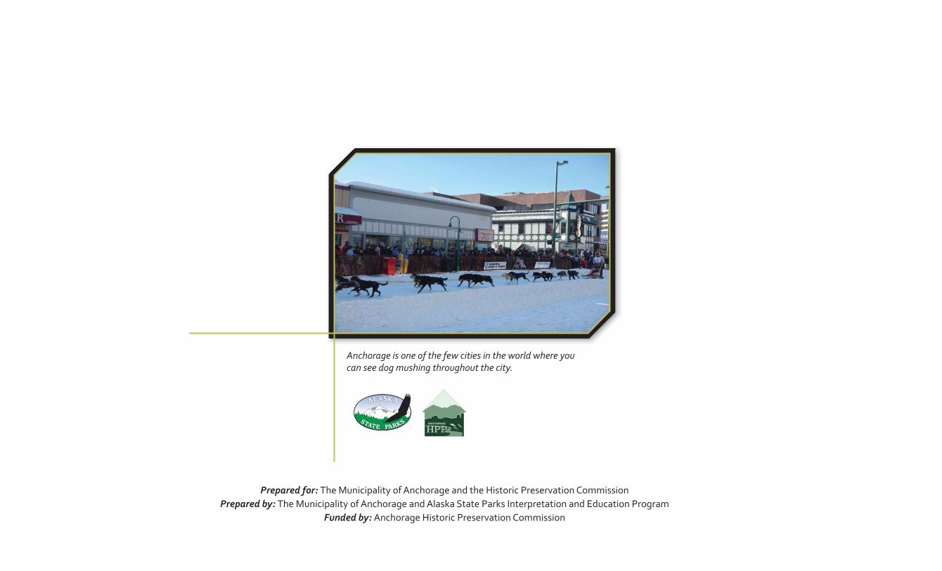
Anchorage is one of the few cities in the world where you can see dog mushing throughout the city.

Anchorage’s 2015 Centennial Legacy In 111111111111111111111111111111111111terpretive Plan TaTTaTaTaTaTaTaTaTaTaTaTaaTaTaTaTTaTaTaTaTaTaTaTTaaaTablbblblblbblblblbblbblblblblbbbbbbbblbblbbbbbbbbbb ee eeeee e e eeeee ee eeee eee ofofofofofofofofoffofofofoffofoffooffofofoffoffoffoffofoofofooffofooooo CCCCCCCCCCCCCCCCCCCCCCCCCCCCCCCCCCCCCCCConononononononononononononononononononononoononoonoonono tetetetetetetetetetetetetetetetetttetetetetetetetetetttettttet ntntnntntntntnntnntntntntntntntntnttnntnnnnntnnnnnnnntsssssssssssssssssssssssss 1Anchorage’s Four Original Neighborhoods 2015 Interpretive Plan Table of Contents
CONTENTS1. Introduction . . . . . . . . . . . . . . . . . . . . . . . . . . . . . . . . . . . . . . . . . . . . . . . . . . . . . . . . . . . . . . . . . . . . . . . . . . . . . . . . . . . 3
Purpose and Need . . . . . . . . . . . . . . . . . . . . . . . . . . . . . . . . . . . . . . . . . . . . . . . . . . . . . . . . . . . . . . . . . . . . . . . . . . . . . . . . . . . . . 4Planning Process . . . . . . . . . . . . . . . . . . . . . . . . . . . . . . . . . . . . . . . . . . . . . . . . . . . . . . . . . . . . . . . . . . . . . . . . . . . . . . . . . . . . . . 5Interpreting History and Culture . . . . . . . . . . . . . . . . . . . . . . . . . . . . . . . . . . . . . . . . . . . . . . . . . . . . . . . . . . . . . . . . . . . . . . . . . 6
2. Historical Context. . . . . . . . . . . . . . . . . . . . . . . . . . . . . . . . . . . . . . . . . . . . . . . . . . . . . . . . . . . . . . . . . . . . . . . . . . . . . 93. Four Original Neighborhoods . . . . . . . . . . . . . . . . . . . . . . . . . . . . . . . . . . . . . . . . . . . . . . . . . . . . . . . . . . . . . . . . . .19
Government Hill . . . . . . . . . . . . . . . . . . . . . . . . . . . . . . . . . . . . . . . . . . . . . . . . . . . . . . . . . . . . . . . . . . . . . . . . . . . . . . . . . . . . . . 19Downtown. . . . . . . . . . . . . . . . . . . . . . . . . . . . . . . . . . . . . . . . . . . . . . . . . . . . . . . . . . . . . . . . . . . . . . . . . . . . . . . . . . . . . . . . . . . 22South Addition . . . . . . . . . . . . . . . . . . . . . . . . . . . . . . . . . . . . . . . . . . . . . . . . . . . . . . . . . . . . . . . . . . . . . . . . . . . . . . . . . . . . . . . 24Fairview* . . . . . . . . . . . . . . . . . . . . . . . . . . . . . . . . . . . . . . . . . . . . . . . . . . . . . . . . . . . . . . . . . . . . . . . . . . . . . . . . . . . . . . . . . . . . 27Landmarks to Save . . . . . . . . . . . . . . . . . . . . . . . . . . . . . . . . . . . . . . . . . . . . . . . . . . . . . . . . . . . . . . . . . . . . . . . . . . . . . . . . . . . 30Ship Creek . . . . . . . . . . . . . . . . . . . . . . . . . . . . . . . . . . . . . . . . . . . . . . . . . . . . . . . . . . . . . . . . . . . . . . . . . . . . . . . . . . . . . . . . . . . 31
4. Interpretive Themes . . . . . . . . . . . . . . . . . . . . . . . . . . . . . . . . . . . . . . . . . . . . . . . . . . . . . . . . . . . . . . . . . . . . . . . . . . . .35Interpretive Equation . . . . . . . . . . . . . . . . . . . . . . . . . . . . . . . . . . . . . . . . . . . . . . . . . . . . . . . . . . . . . . . . . . . . . . . . . . . . . . . . . . 35
5. Defining the Interpretive Experience . . . . . . . . . . . . . . . . . . . . . . . . . . . . . . . . . . . . . . . . . . . . . . . . . . . . . . . . . . .396. Implementation Strategies . . . . . . . . . . . . . . . . . . . . . . . . . . . . . . . . . . . . . . . . . . . . . . . . . . . . . . . . . . . . . . . . . . . . . .43
Interpreting History and Culture . . . . . . . . . . . . . . . . . . . . . . . . . . . . . . . . . . . . . . . . . . . . . . . . . . . . . . . . . . . . . . . . . . . . . . . . 44
7. Design Concepts . . . . . . . . . . . . . . . . . . . . . . . . . . . . . . . . . . . . . . . . . . . . . . . . . . . . . . . . . . . . . . . . . . . . . . . . . . . . . . . .538. Evaluating Interpretation . . . . . . . . . . . . . . . . . . . . . . . . . . . . . . . . . . . . . . . . . . . . . . . . . . . . . . . . . . . . . . . . . . . . .639. APPENDIX A: Online Survey. . . . . . . . . . . . . . . . . . . . . . . . . . . . . . . . . . . . . . . . . . . . . . . . . . . . . . . . . . . . . . . . . . . . .6510. APPENDIX B: Overview Of Resources . . . . . . . . . . . . . . . . . . . . . . . . . . . . . . . . . . . . . . . . . . . . . . . . . . . . . . . . . . .75
A. Information and Cultural Centers . . . . . . . . . . . . . . . . . . . . . . . . . . . . . . . . . . . . . . . . . . . . . . . . . . . . . . . . . . . . . . . . . . . . . 75B. Government Hill. . . . . . . . . . . . . . . . . . . . . . . . . . . . . . . . . . . . . . . . . . . . . . . . . . . . . . . . . . . . . . . . . . . . . . . . . . . . . . . . . . . . .77C. Downtown . . . . . . . . . . . . . . . . . . . . . . . . . . . . . . . . . . . . . . . . . . . . . . . . . . . . . . . . . . . . . . . . . . . . . . . . . . . . . . . . . . . . . . . . 79D. South Addition. . . . . . . . . . . . . . . . . . . . . . . . . . . . . . . . . . . . . . . . . . . . . . . . . . . . . . . . . . . . . . . . . . . . . . . . . . . . . . . . . . . . . 91E. Fairview . . . . . . . . . . . . . . . . . . . . . . . . . . . . . . . . . . . . . . . . . . . . . . . . . . . . . . . . . . . . . . . . . . . . . . . . . . . . . . . . . . . . . . . . . . . 97
11. Bibliography . . . . . . . . . . . . . . . . . . . . . . . . . . . . . . . . . . . . . . . . . . . . . . . . . . . . . . . . . . . . . . . . . . . . . . . . . . . . . . . . . . .9912. Acknowledgements. . . . . . . . . . . . . . . . . . . . . . . . . . . . . . . . . . . . . . . . . . . . . . . . . . . . . . . . . . . . . . . . . . . . . . . . . . . . 101
* Ship Creek is shared by all four neighborhoods


3IntroductionAnchorage’s Four Original Neighborhoods 2015 Interpretive Plan
“Through interpretation, understanding;
through understanding, appreciation;
through appreciation, protection.”
—Quoted by Freeman Tilden
1. INTRODUCTIONAnchorage’s Four Original Neighborhoods 2015 Interpretive Plan (Plan) was developed through three important elements; public input, the Anchorage Original Neighborhoods Historic Preservation Plan (HPP)1 completed for Government Hill, Downtown, South Addition, and Fairview, and best practices for interpretation. The Plan is intended to support the many interpretive goals, contained herein, through the implementation of a wide range of interpretive and educational pro ects identi ed in the HPP and subsequent interpretive planning process. These projects could include historic walks, interpretive panel installations, brochures, oral histories, special events, and a variety of social media.
The Plan will provide a comprehensive overview of the on-the-ground interpretive elements currently found throughout the four neighborhoods. The Plan outlines interpretive themes that best describe the cultural and historical elements of Anchorage’s four original neighborhoods. Recommendations for new designs, which could be implemented in celebration of the 2015 Anchorage Centennial, are also captured in this Plan.
E ective interpretation provides opportunities for people to e plore how a resource or concept is meaningful to them. Freeman Tilden, a legend in the eld of interpretation, summed up the importance of interpretation when he quoted a National Park Service administrative manual in his book Interpreting Our Heritage; “Through interpretation, understanding; through understanding, appreciation; through appreciation, protection.”2 Tilden identi ed si principles of interpretation that continue to guide professionals in the eld. They include
1. Any interpretation that does not somehow relate what is being displayed or being described to something within the personality or e perience of the visitor will be sterile.
2. Information, as such, is not interpretation. Interpretation is revelation based upon information. But they are entirely di erent things. However, all interpretation includes information.
3. Interpretation is an art which combines many arts whether the materials presented are scienti c, historical or architectural. Any art is in some degree teachable.
4. The chief aim of interpretation is not instruction, but provocation.
1 HPP is available at muni.org
2 Quoted in Freeman Tilden, Interpreting Our Heritage (Chapel Hill niversity of North Carolina Press, 1977), 3 .
Freeman Tilden

4 Introduction Anchorage’s Four Original Neighborhoods 2015 Interpretive Plan
Interpreting history & culture tells stories and raises public
awareness about the plan area’s history, including the cultures and
traditions of Alaska Native Peoples. —Anchorage Original Neighborhoods Historic Preservation Plan
5. Interpretation should aim to present a whole rather than a part and must address itself to the whole man rather than any phase.
6. Interpretation addressed to children should not be a dilution of the presentation to adults, but should follow a fundamentally di erent approach. To be at its best it will require a separate program.
The purpose of Anchorage’s Four Original Neighborhoods 2015 Interpretive Plan is to provide a public outreach process that further e plores and de nes the themes, sub-themes, and projects e pressed in ision 3 Interpreting History Culture proposed in the HPP.
The need for an interpretive plan speci cally for the four original neighborhoods was e pressed by the Tribes, community councils, businesses, government agencies, and residents during the completion of the HPP. “Community members presented many ideas for how to interpret and commemorate important people, events, and Alaska Native People’s stories during preparation of the HPP.” The public desired that interpretive projects would be used for “telling our stories through interpretation projects.”3
This interpretive Plan uses public and multi-agency input to
Determine the topics that should be interpreted in the planning area.
Establish interpretive themes that should guide new interpretation.
Identify, map, and evaluate e isting interpretation for e ectiveness and include results in an appendi .
Determine appropriate ideas, methods, and locations for new interpretation.
Develop a e ible, yet cohesive design for new interpretation facilitated through ongoing community e orts led by the Anchorage Historic Preservation Commission, Downtown Partnership Inc., Anchorage School District, Tribes, Native Corporations and illages, Community Councils, and residents.
3 Anchorage Original Neighborhoods Historic Preservation Plan, Adopted by the Anchorage Assembly on February 12, 2013, Ordinance AO No. 2013-12.
The old Bevers & Pfeil Building on 4th Avenue

5IntroductionAnchorage’s Four Original Neighborhoods 2015 Interpretive Plan
“In addition to the preservation of physical features, interpretation of stories, people, and events can add layers and depth to a community’s identity…Interpretation is therefore an essential element of neighborhood preservation.”
—(HPP, p. 11)
Three visioning sessions were held during the initial stages of the planning process. The rst visioning session was held on uly 25, 2013 at 5 30 p.m. during the regular Anchorage Historic Preservation Commission meeting. The Commission provided guidance on the goals and objectives for the completion of the planning process, and draft questions for a Survey Monkey online questionnaire for the public to enable the team to gauge public awareness and garner input on several proposed interpretive Plan elements. The two additional visioning sessions were held in the morning and evening of September 11, 2013. This included an individual session for invited Tribes, Native Corporations and illages, and a session for the general public and the Anchorage Historic Preservation Commission.
These sessions provided an opportunity for the participants to ask questions, and provide input. The morning session was attended by ten people who collectively represented various Native Tribal groups and the Anchorage Historic Preservation Commission. Eleven people attended the evening session, some as representatives of the Anchorage Historic Preservation Commission. With respect to an element of e isting interpretation in the Downtown area, a consensus was reached during both visioning sessions that there is ample opportunity to provide new information on state-of-the-art interpretive panel con gurations.
Participants voiced their desire to engage residents, as much as visitors, for input regarding new interpretive elements. They also e pressed a desire to be included in the draft review process for this interpretive Plan. It was important to the participants to ensure that any new interpretive projects raise awareness of cultural diversity, and that any new projects are sensitive to the unique history of the four original neighborhoods .
A survey questionnaire, developed using Survey Monkey, was introduced at the visioning sessions. The planning team wished to evaluate the public’s opinions regarding appropriate topics, e isting interpretation, and recommendations for new types of interpretive media, and potential locations for new interpretation.
The survey provided interested parties with an opportunity to participate in the planning process without having to attend a visioning session. The survey was o cially open to the public from September 11, 2013 through September 25, 2013. Thirty-si people responded to seven survey questions. Full documentation of the survey can be found in Appendi A.
The survey link was sent to the Federation of Community Councils email list serve, presented as an informational item at the four neighborhoods community councils, and sent to the Tribal partners email list which was provided by Richard Porter, CEO of the Knik Tribe.
1960—Anchorage is an All-American City!

6 Introduction Anchorage’s Four Original Neighborhoods 2015 Interpretive Plan
A workshop, held on February 27, 2014 at the Cook Inlet Tribal Council o ce, re ned the draft interpretive themes for this Plan. Representatives of the Anchorage Historic Preservation Commission and the Native community revised the draft themes to make them more culturally and historically accurate. An open house is planned for September 2014 at the Pioneer School House to share the nal Plan with the community.
Interpretive planning and project implementation is a cost-e ective, inclusive way to engage many sectors of our community. Interpretive projects relate important history and culture in a descriptive and succinct way to a variety of audiences including our residents and many visitors. Heritage tourism is one of the fastest growing sectors in the tourism market. The Municipality of Anchorage has a unique opportunity to share its colorful and varied culture and heritage through the many interpretive projects identi ed in this Plan.
The Anchorage Original Neighborhoods Historic Preservation Plan (HPP) with its historic conte t, vision, goals, objectives and implementation projects, was intended at its adoption to provide the foundation for future historic preservation and interpretation e orts. Signi cant public comment on the HPP related to the importance of sharing the rich cultural and historic information found in the four original neighborhoods. This information was then translated to a signi cant number of recommendations for sharing and interpreting the past and present-day culture, and heritage of the many people who live in, or have visited the area that is now Anchorage.
To that end, this Plan includes the relevant information from the HPP including descriptive information on the settlement of the four original neighborhoods.
The above map highlights Anchorage’s four original nieghborhoods and the Ship Creek planning area.

7IntroductionAnchorage’s Four Original Neighborhoods 2015 Interpretive Plan
HPP Historic Preservation Plan
Adopted as the third vision element of the HPP, Interpreting History Culture will “Tell stories and raise public awareness about the plan area’s history, including the cultures and traditions of the Alaska Native Peoples.”
“In addition to the preservation of physical features, interpretation of stories, people, and events can add layers and depth to a community’s identity; however, there is a lack of public awareness about the plan area’s history, partly because so many of Anchorage’s residents are transplants or newcomers. Interpretation is therefore an essential element of neighborhood preservation. Community members presented many ideas for how to interpret and commemorate important people, events, and Alaska Native Peoples’ stories during preparation for the HPP. These ideas range from plaques, monuments, and interpretive signage to walking tours, documentaries, websites, and other digital media.”


9Historic ContextAnchorage’s Four Original Neighborhoods 2015 Interpretive Plan
2. HISTORICAL CONTEXT
The following abbreviated history of Anchorage provides the background information required to understand the forces that shaped the development of the built environment in the four original neighborhoods and is excerpted from Chapter 5 in the HPP. The detailed history of each neighborhood can be found in the HPP’s Chapter 7.
The Cook Inlet was named for Captain ames Cook. A British explorer who is credited with making the rst European claim in the Anchorage area, Cook sailed into the inlet in May 177 on an expedition in search of the fabled Northwest Passage—a nonexistent water route through North America that geographers hoped would connect the Atlantic and Paci c oceans—and claimed the area for England.4 Prior to Cook’s expedition, however, other parts of Alaska were visited by Russian explorers sailing east out of Kamchatka. Mikhail Gvo dev rst sighted the Alaskan mainland in 1732, and itus Bering, a Danish explorer commissioned by Russia’s C ar Peter the Great, was the rst to send boats ashore in 1741.5 Although many early outposts were established along the Kenai Peninsula and Gulf of Alaska, Russian fur traders had little presence in the upper Cook Inlet.6 This early exploration period is celebrated in the four original neighborhoods the Captain Cook Monument at Resolution Point was installed to commemorate the 200th anniversary of Cook’s expedition to Anchorage.
In 1 67, the nited States government purchased the entire Alaska territory from Russia for the bargain price of 7.2 million—just over 2 cents per acre—in a deal brokered by Secretary of State William H. Seward. Many were skeptical of Alaska’s worth to the nited States at the time, and called the purchase “Seward’s Folly.” From 1 67 until 1 4, the territory was known as the Department of Alaska and was controlled under a variety of federal departments.7
4 Murray Lundberg, “Captain ames Cook in Alaska,” at ExploreNorth, http explorenorth.com library yafeatures bl-Cook1.htm (accessed September 20, 2011
5 Anchorage Museum of History and Art, “Europe Discovers Alaska,” Exhibition Materials; Alaska History Cultural Studies, “Russia’s Colony More Russian Exploration in Alaska,” httpwww.akhistorycourse.org articles article.php artID 130 (accessed September 19, 2011).
6 Eli abeth Tower, Anchorage From Its Humble Origins as a Railroad Construction Camp (Fairbanks, AK Epicenter Press, 1999), 15.
7 nited States Department of the Interior, National Park Service, 1 (Anchorage National Park Service), 6- ; Dermot Cole, Historic Photos of Alaska (Nashville, TN Turner Publishing, 200 ), 1.
“Ambition leads me not only farther than any other man has been before me, but as far as I think it possible for man to go.”—Captain ames Cook
f I think it possiblean to go.”s Cook

10 Historic Context Anchorage’s Four Original Neighborhoods 2015 Interpretive Plan
The rst civil government was formed in Alaska in 1 4, at that time known as the District of Alaska. After the discovery of gold near uneau in 1 0 and in Canada’s ukon Territory in 1 96, prospectors ocked to the Klondike, and Alaska’s population began to boom. Discovery of gold in Nome in 1 99 and Fairbanks in 1902 further fueled the state’s growth, and
nally brought more .S. attention to Alaska. Most prospectors were not successful in the gold elds, but many of these new arrivals decided to remain in Alaska and established permanent communities.9 In response to increasing pressure for local control over Alaskan a airs, Congress established the Alaska Territory as an organi ed incorporated territory in 1912. Alaska remained a .S. Territory from 1912 until it was admitted to the nion as the 49th state in 1959.10
Anchorage is a classic railroad boomtown. Its early development followed many of the same patterns that accompanied the railroads across the American West. Anchorage was known by a variety of names prior to the arrival of the railroad, but the .S. Postal Service formali ed the name “Anchorage” in 1915 as a way to consistently direct mail to the government encampment.11
The rst railroad in Alaska was a 50-mile span built north out of Seward by the Alaska Central Railway Company in 1903. In March 1914, Congress agreed to fund the construction and operation of a railroad from Seward to Fairbanks. A new federal agency—the Alaska Engineering Commission (AEC)—was created to plan the route and supervise construction.12 Ship Creek, located at the northern edge of present-day downtown Anchorage, became the eld headquarters of the AEC in 1914. The delta was a desirable location for a camp because it was conveniently located on the inlet, and rail yards and shops could easily be built on the mud ats. On April 9, 1915, President Woodrow Wilson announced the approval of the AEC’s recommended route through Ship Creek, and ordered construction of the railroad to commence.13
As early as 1914, speculation that Ship Creek might be the base for the new government railroad was enough to attract hundreds of men hopeful for employment. Squatters arrived in droves, and by the time of the president’s announcement, a temporary settlement had already developed on the north side of the Creek. ”Tent City,” as the squatters’ settlement was often called, primarily comprised canvas tents, although entrepreneurs built more solid-wood buildings to house their businesses.14
National Park Service, The Alaska ourney, 9-15; Cole, 59.
9 Cole, 59.
10 National Park Service, The Alaska ourney, 9-15; Cole, 59.
11 Michael Carberry and Donna Lane, Patterns of the Past An Inventory of Anchorage’s Historic Resources, 2nd ed. (Anchorage Municipality of Anchorage, 19 6), .
12 ohn Strohmeyer, Historic Anchorage An Illustrated History (San Antonio, T Historical Publishing Network, 2001), 9; National Park Service, The Alaska ourney, 2 -29.
13 Tower, 26-27; Carberry and Lane, 2.
14 Tower, 26-27; Carberry and Lane, 2-3.
Tent City, 1915UAA-hmc-0778
Tent City, 1915UAA-hmc-0778Anchorage Services-Cole Historic Photos

11Historic ContextAnchorage’s Four Original Neighborhoods 2015 Interpretive Plan
Many of the squatters were European immigrants who had ocked to the West Coast but could not nd work elsewhere. The AEC did eventually hire some of these men as laborers, but in general, Alaska Railroad jobs were not as readily available as the squatters had hoped.15
From 1915 to the end of World War II, the AEC and the Alaska Railroad constructed housing on Government Hill for railroad managers, engineers, and skilled workers. The AEC built 13 cottages in 1915 on the blu overlooking Knik Arm at the western end of Government Hill, along what are now West Harvard Avenue and Delaney Street. These were among the rst frame houses constructed in Anchorage, and were initially occupied by railroad workers.
Before the Alaska Railroad was opened and running regularly to Seward in 191 , Anchorage relied entirely on the Ship Creek-Indian Pass segment of the Iditarod Trail for overland travel by foot or dogsled to Seward in the winters of 1915 thru ‘17 (Carberry and Lane 19 6). Even after the opening of the railroad, the trail continued to be used into the mid-1920s (Perry, private collection). Therefore, dogsled powered freight teams and “gold trains” were a common sight on the main streets of downtown Anchorage and at Ship Creek, where the trail to Indian Pass terminated on the north side of Ship Creek in the vicinity of the present day A-C Street bridge. Dog teams were of such necessity that the Anchorage Hotel had a livery kennel built for dog teams passing through Anchorage.
The signi cance of the role played by the Trail in the development of Anchorage is recogni ed in the 19 6 CMP, which identi es the Ship Creek-Indian Pass route as part of the Iditarod National Historic Trail system. As such, managers of qualifying trails, which includes the current day MOA Ship Creek Trail, are eligible to use the o cial insignia of the Iditarod National Historic Trail, and can receive assistance in the development of outreach materials that involve the Trail.
The land for the Anchorage Townsite had already been set aside by the General Land O ce during a cadastral survey of the region in 1914, but it was not until May 1915 that the townsite was platted. (During the HPP Public Outreach process, consultation with Tribal representatives revealed that the land for the Anchorage Townsite was reserved, platted, and distributed without consulting the Alaska Native Peoples who had inhabited the region for centuries before the arrival of the railroad.)The original townsite plat established a street grid and approximately 1,400 lots on the plateau immediately south of Ship Creek. The engineers numbered the east-west streets and named the north-south streets with letters, to simplify the plan.16
15 Strohmeyer, 9-10; Carberry and Lane, 3.
16 “Map of Anchorage Townsite” (1916), National Archives and Records Administration, Paci c Alaska Region.
UAA hmc-0816 volume 8-6826 Hotel Anchorage Dog KennelUAA h 8 6 l 8 68 6 H t l

12 Historic Context Anchorage’s Four Original Neighborhoods 2015 Interpretive Plan
The South Addition was the rst expansion of the original townsite, laid out in August 1915 to address a shortage of homestead sites. The East Addition soon followed in late September 1915. The Third Addition was added in the summer of 1916.17 The expansion of the street grid included larger lots than the original townsite. The AEC created 5- and .3-acre parcels in the South Addition and Third Addition because they wanted to encourage agricultural development around Anchorage. Thus, in 1917, a Presidential Executive Order was issued prohibiting the subdivision of tracts containing two or more acres into smaller lots.1 Homes of early Anchorage pioneers are scattered throughout the four original neighborhoods, including the historic Oscar Anderson House and Oscar Gill House, among others. Although Anchorage was quick to establish itself, it was not incorporated as a city until 1920. The original Anchorage city limits extended south to 11th Avenue and east to East G Street (now Gambell Street).19 The farther reaches were largely agricultural in character, scattered with homesteads, dairy farms, and fur farms until the late 1930s.
Aviation is one of the more signi cant themes representing Alaska history. The rst airplane ight in Alaska was a demonstration ight in Fairbanks in 1913. It was not until after World War I that signi cant aviation development occurred in the state. However, by the late 1920s, airplanes had revolutionized transportation in Alaska.20 The territory’s vast size and rough terrain necessitated the use of airplanes, and remote communities relied—and continue to rely—on bush pilots to y small planes lled with supplies.21 By 1923, Anchorage citizens had realized the potential of aviation and banded together to create a landing strip out of the rebreak between 9th and 10th avenues (today Delaney Park Strip).
The Park Strip served as a landing strip for the biplanes of the bush pilots throughout the 1920s. However, by 1929, it could no longer support Anchorage’s aviation needs. Merrill Field was o cially dedicated in 1930.
For several years after Merrill Field was completed, spring breakup occasionally forced pilots to use the more solid “old aviation eld” at the Park Strip, which by then also functioned as a golf course. The City Council ordered Alaskan Airways to “discontinue the use of the Golf Course as landing eld” in 1931, o cially ending the Park Strip’s aviation era.22
17 Ibid.
1 Carberry and Lane, 132
19 “A City is Born—And Reborn,” manuscript in ertical Files, Anchorage Museum of History and Art (n.d.)
20 “Alaska’s Heritage 4.2 Air Transportation,” http www.akhistorycourse.org articles article.php artID 177 (accessed September 22, 2011).
21 .S. Department of the Interior, National Park Service, Elmendorf Air Force Base, olume I Historic Context of World War II Buildings and Structures (Washington D.C. National Park Service, 1999), 34.
22 Carberry and Lane, 195.

13Historic ContextAnchorage’s Four Original Neighborhoods 2015 Interpretive Plan
In the late 1930s, the .S. military began to prepare for the possibility of involvement in another world war. A global study was conducted by the .S. Navy that investigated and reported on the need for additional naval bases. The report was submitted to Congress by Admiral Arthur . Hepburn in December 193 and signed into law in early 1939. The “Hepburn Report” recommended the appropriation of 19 million for the construction of air, submarine, and destroyer bases in Alaska and the Aleutian Islands. This marked the beginning of defense build-up in the Alaska Territory.23 After several failed attempts in the mid-1930s to gain Congressional support for an Alaska air base, President Franklin D. Roosevelt nally ordered the withdrawal of 43,490 acres of land on the outskirts of Anchorage for Elmendorf Field and Fort Richardson in April 1939.24
This location was chosen for the air base due to favorable topography and weather conditions, access to the Alaska Railroad, and proximity to the Cook Inlet. Construction of a permanent military air eld and Army base began on the reserved lands in une 1940. This construction included hundreds of barracks, hangars, and tactical runways. Fort Richardson and Elmendorf Field were o cially occupied by the Army in August 1940, and operated as the Army’s headquarters for the militarization of Alaska. The Army relocated its operations to the eastern edge of the reserve (present-day Fort Richardson) after World War II. The Air Force assumed control of the original base and renamed it Elmendorf Air Force Base in 194 .25 Wartime military construction turned Anchorage into a boomtown.26 Thousands of civilian workers were employed to construct the new fort. In April 1940, just before construction of Fort Richardson began, Anchorage had a population of only 4,000, and by the summer of 1941 the town had grown to over 9,000. The war created a housing shortage in Anchorage, causing the neighborhoods surrounding Downtown to be built out. Despite the 1917 Executive Order prohibiting further subdivision of tracts sized two acres or larger, Anchorage’s rst subdivisions were drawn in the South Addition for A. A. Shonbeck’s land in 193 and ohn W. Hansen’s land in 1939 (the Executive Order was eventually revoked).27
The federal agencies and business corporations that moved their headquarters to Anchorage during and after World War II did their part to address the inadequate supply of housing for their employees. Some residential tracts and complexes were constructed by the Army Corps of Engineers and the Civil Aeronautics Administration (CAA) for use by their employees in the four original neighborhoods.
23 Fern Chandonnet; “Chapter I . The Garrisoning of Alaska, 1939-41,” HyperWar, at http www.ibiblio.org hyperwar SA SA-WH-Guard SA-WH-Guard-9.html (accessed September 25, 2011)
24 Elmendorf Air Force Base, olume I, 21-24.
25 .S. Air Force, “Elmendorf Air Force Base History Fact Sheet” (2006), at http www.jber.af.mil library factsheets factsheet.asp id 52 0 (accessed September 25, 2011); Elmendorf Air Force Base, olume I, 3.
26 Claus M. Naske and L. . Rowinski, Anchorage A Pictorial History (Norfolk, A The Donning Company, 19 1) 126.
27 Municipality of Anchorage Plat Maps.
1948.02.20 Northwest Airlines on 10th and CASL-P143-0559

14 Historic Context Anchorage’s Four Original Neighborhoods 2015 Interpretive Plan
The Army Housing Association, a cooperative created by service members and their families, built 32 Minimal Traditional style homes on Block 13 of the Third Addition in the summer of 1940; this portion of 11th Avenue also earned the nickname “Pilots’ Row” because many bush pilots and aviators lived on that block in the 1940s and 1950s. Northwest Airlines built clusters of identical small ranch-style houses for their employees in the South Addition after World War II.
As part of the war e ort during World War II, the military worked to improve communication and transportation infrastructure, and began constructing roads to connect Fort Richardson to the rest of Alaska. The Alaska (Alcan) Highway (1942), Whittier Tunnel, and the Glenn Highway (1941-1942) were important projects. This military transportation infrastructure was opened to civilians in the postwar era, providing unprecedented air, rail, and road access to Anchorage.
This continued with the construction of Anchorage International Airport in 1951, which solidi ed Anchorage’s position as the “Air Crossroads of the World” and attracted other airlines and thousands of passengers to the city.2 The airport was renamed “Ted Stevens Anchorage International Airport” in 2000, in honor of .S. Senator Ted Stevens.29 Similarly, construction of the Seward Highway and repaving of the Glenn Highway in the early 1950s provided important vehicular access to Anchorage’s historic core and the entire Anchorage Bowl.30
Alaskans had been considering statehood since the late 19th century. However, early attempts at seeking statehood failed because Alaska lacked the population and nancial independence to e ectively support itself. By 1945, Alaska’s population had increased dramatically and it had become an integral part of the .S. defense network, so the demand for statehood became more forceful. The discovery of oil on the Kenai Peninsula in 1957 further fueled the debate, and was the key to changing the national perception of Alaska. Congress passed the Alaska Statehood Bill on une 30, 195 . Alaska o cially became the 49th state in the nion when President Dwight Eisenhower signed the bill into law on anuary 3, 1959.31
2 Tower, 105.
29 State of Alaska, “Ted Stevens Anchorage International Airport History,” at http dot.alaska.gov anc about history.shtml.
30 Tower, 105.
31 National Park Service, The Alaska ourney, 90-91.
circa 1950 Anchorage International Airport

15Historic ContextAnchorage’s Four Original Neighborhoods 2015 Interpretive Plan
Among the most signi cant events in Anchorage’s history is the 1964 Good Friday Earthquake, which occurred at 5 36 p.m. on March 27 of that year. Originally recorded at about .6 on the Richter scale and later upgraded to 9.2, the quake is to date the most powerful seismic event recorded in North America.32
The earthquake had a profound e ect on the physical environment in Downtown, Government Hill, South Addition, and Turnagain because these neighborhoods were especially hard hit by the disaster. The 1964 earthquake coincided with the popularity of urban renewal e orts across the country, and Anchorage took the quake as an opportunity to try to redevelop the city, including new public park spaces in areas that faced the most destruction by the quake. Evidence of this post-quake redevelopment is especially clear in Downtown and Government Hill.33
In commemoration of the 50th anniversary of the Great Earthquake of 1964, a document has been prepared by the .S. Geological Survey called 1964 Great Alaska Earthquake—A Photographic Tour Anchorage, Alaska. The publication includes historic photographs of buildings damaged, sites of major landslides, and post-earthquake responses. Much of the earthquake was felt in the Downtown area of Anchorage.
To view an interactive webpage available by the SGS, featuring a map with suggested tour stops in Anchorage, go to http alaska.usgs.gov announcements news 1964Earthquake
32 Committee on the Alaska Earthquake of the Division of Earth Sciences National Research Council, The Great Alaska Earthquake of 1964 Engineering (Washington D.C. National Academy of Sciences, 1973), ix.
33 Tower, 155
Fourth Avenue and the 1964 EarthquakeWikipedia

16 Historic Context Anchorage’s Four Original Neighborhoods 2015 Interpretive Plan
The largest oil eld in North America was discovered in Prudhoe Bay on the Arctic Slope in 196 . A 1969 oil lease sale brought billions of dollars to the state. Alaska’s gross product doubled within two years of the Prudhoe Bay oil eld development. Oil companies needed to construct a pipeline to carry North Slope oil to market in order to capitalize on the Prudhoe Bay oil lease sale.34 Construction began on the Trans-Alaska Pipeline System in 1974. The pipeline was completed in 1977 at a cost of more than
billion. The oil discovery and pipeline construction fueled an economic windfall when oil and construction companies set up headquarters in Anchorage.35
The tremendous outpourings of the oil elds led to the formation of the Alaska Permanent Fund, which mandated that a portion of the royalties earned by the oil companies be distributed equally among Alaskan residents.36 The fund was voted as a constitutional amendment by Alaska’s citizens in 1976, and the rst Permanent Fund legislation was enacted in 19 0.37
The discovery of oil at Prudhoe Bay also increased the urgency of settling the outstanding land claims of the Alaska Native Peoples, leading to the passage of the Alaska Native Claims Settlement Act (ANCSA) in 1971. ANCSA established system of regional and village corporations to hold the land titles and assets transferred to the tribes by the federal government; Alaska Native Peoples became shareholders in these corporations, which are run like traditional for-pro t businesses.
As the oil industry expanded, so did environmental conservation e orts. Many conservation groups were formed during the 1970s and 19 0s. The Alaska National Interest Lands Conservation Act (ANILCA) was passed in 19 0, which set aside over 100 million acres of public lands.3
34 Tower, 155
35 Claus M. Naske and Herman E. Slotnick, Alaska A History of the 49th State, (Grand Rapids, MI William B. Eerdmans Publishing Company, 1979), 233-266.
36 Mother Earth Travel, “History of Anchorage,” at http motherearthtravel.com united states anchorage history.htm.
37 State of Alaska Permanent Fund Dividend Division, “Historical Timeline” https pfd.alaska.gov DivisionInfo HistoricalTimeline
3 Alaska Department of Natural Resources, “What Is ANILCA ” at http dnr.alaska.gov commis opmp anilca more.htm.
Trans-Alaska Pipeline

17Historic ContextAnchorage’s Four Original Neighborhoods 2015 Interpretive Plan
The Municipality of Anchorage was formed in 1975 by a consolidation of the city and borough. Also included in this uni cation were Eagle River, Eklutna, Girdwood, Glen Alps, and several other communities. The uni ed area became o cially known as the Municipality of Anchorage. The population of Anchorage had increased to 1 4,775 by 19 0.
The decade of the 19 0s was a time of growth, thanks to a ood of North Slope oil revenue into the state treasury. Capital improvement projects and an aggressive beauti cation program, combined with far-sighted community planning, greatly increased infrastructure and amenities for citizens. This e ort was known as “Project 0s,” and included major improvements such as a new library, a civic center, a sports arena, and a performing arts center.39 The Project 0s building program rivaled the military construction of the 1940s.
During the 19 0s and 1990s, outdoor recreation activities increased the role of tourism in the modern Anchorage economy, which has continued to the present day. In turn, the recreation and tourism industries have provided employment, attracted new residents to Anchorage, and provided individuals and the Municipality alike with money in their co ers to use in further residential and community development.
39 anessa Orr, “From Project 0s to the Present Resurgence of Construction in Anchorage Recalls Earlier Time,” Alaska Business Monthly (September 2007).


19Four Original NeighborhoodsAnchorage’s Four Original Neighborhoods 2015 Interpretive Plan
3. FOUR ORIGINAL NEIGHBORHOODS
The following chapter provides speci c context on the four original neighborhoods and Ship Creek. A brief list of recommendations is also included. The extensive list can be found in Chapter 6—Implementation Strategies.
Government Hill is located north of Downtown, and was the rst of the four original neighborhoods to be settled. The area is roughly L-shaped, and is bordered on the west by the Cook Inlet, on the north and east by oint Base Elmendorf-Richardson ( BER), and on the south by Ship Creek. Government Hill is accessed by East Loop Road, an elevated roadway that crosses Ship Creek and the Alaska Railroad yards near the southwest side of the neighborhood. Four distinct sub-areas compose Government Hill the Port of Anchorage at the western edge, the Ship Creek area at the southern edge, and the residential areas of West Government Hill and East Government Hill on top of the blu .
Government Hill is Anchorage’s oldest permanent neighborhood, although the entire Anchorage area has long been seasonally inhabited by the Dena’ina people for at least 2,000 years. From 1915 to the end of World War II, the AEC and the Alaska Railroad constructed housing on Government Hill for railroad managers, engineers, and skilled workers. The AEC built 13 cottages in 1915 on the blu overlooking Knik Arm at the western end of Government Hill, along what are now West Harvard Avenue and Delaney Street. The AEC did not lay out a street grid, but positioned the houses to lookout over Ship Creek, with easy access to the Terminal ards and Alaska Railroad o ces. The AEC also built a Wireless Center on Manor Avenue to provide better transmission and reception capacity than did an earlier temporary station in the rail yards. Between 1915 and 1940, the AEC cottages, Wireless Center, and a water tower were the only permanent buildings and structures on Government Hill. During the 1930s, a fox fur farm, the Alaska Labrador Fur Farm, operated on land leased from the Alaska Railroad in the vicinity of what is now Al Miller Memorial Park. Its buildings and pens were of temporary construction. The AEC cottages were sold into private ownership to railroad employees in 192 , but the land remained in the Railroad Reserve until 1935. Once in the hands of individual owners, the original AEC cottages were modi ed with additions, porch enclosures, larger windows, and garages.
Quonsets on Government HillQ t G t Hill

20 Four Original Neighborhoods Anchorage’s Four Original Neighborhoods 2015 Interpretive Plan
In 1941, the Army Corps of Engineers built two identical cottages at Brown’s Point on the edge of the blu in western Government Hill. These residences housed construction o cers for the development of Fort Richardson and Elmendorf Air Field (later Elmendorf Air Force Base and now oint Base Elmendorf-Richardson). The Brown’s Point Cottages were donated to the Municipality of Anchorage in 1997, and were rehabilitated and listed in the National Register in 2004. During World War II, the Alaska Railroad built 10 identical duplex houses along West Manor Avenue and Delaney Street to house wartime employees. They were sold to private individuals in the mid-1950s, with preference given for longevity of residence and military service. An identical set of duplexes was built in the South Addition to house Civil Aeronautics Administration employees at the end of World War II. To support the growth of Government Hill after World War II, the Alaska Railroad laid out a block and lot system across the whole neighborhood. The Alaska Railroad set up prefabricated Quonset huts and Loxtave houses (of interlocking wood construction), which were intended to be removed and replaced by a permanent home within ve years.
In a few cases, the lessees did not construct another building, and the “temporary” buildings remain as the primary residence on the lot. In addition to the single family residences, several duplexes of a standard plan were constructed along the central core streets, such as Manor and Harvard avenues on the western side of the postwar housing area. Postwar construction boom and Railroad Rehabilitation program (194 -1952) resulted in a housing shortage, and the Alaska Railroad built two additional duplexes on Brown Street in 194 . A new steel water tower was also built in the winter of 1947-194 to a place an older wood water tower, and it still stands today as a neighborhood icon.
In eastern Government Hill, three separate but similar wood frame apartment complexes were built-in the early 1950s to accommodate the in ux of federal workers engaged on the railroad, military bases, and federal civil works projects. Richardson ista (now called North Pointe Apartments) and Panoramic iew still stand, but the Hollywood ista Apartments were demolished in 1996. Near the apartment complexes, eastern Government Hill underwent urban renewal from 195 to 1963, including replatting and leveling the blocks and paving streets and sidewalks.
Most Quonset huts were removed from this part of the neighborhood, and nearly identical ranch houses with attached garages were constructed in their places. Western Government Hill streets were paved in the 1960s, curbs and gutters were added, but no sidewalks were built.
Brown’s Point CottageB ’ P i t C tt
Water Tower on Government HillWaterTo er on Go ernment Hill
Quonset on Government HillQ t G t Hill

21Four Original NeighborhoodsAnchorage’s Four Original Neighborhoods 2015 Interpretive Plan
After World War II, shopping and entertainment activities were established in a centrally located business district at the intersection of East Loop Road, East Blu Drive, and Arctic Warrior Drive. The Hollywood Shopping Center was built in 1951 and was Anchorage’s rst “strip mall.” Recreation facilities were also established in the 1950s and 1960s, including a bowling alley, teen dance club, Anchorage Square and Round Dance Club, and Anchorage Curling Club. Government Hill Elementary School was built in 1956, but the school and two residences were destroyed during the Great Earthquake on March 27, 1964, due to a landslide along the blu immediately east of Loop Road.
The school site was developed into a park in 19 5, and Government Hill Elementary School was rebuilt in 1965 on military lands north of the original school. Since the 1960s, the character of the neighborhood has remained largely unchanged.40
The Port of Anchorage is located west of Government Hill, at the bottom of the blu . Development was originally funded by the issuance of general obligation bonds in the 1950s. Construction began in 1959, and the 700-foot Terminal 1 was completed in 1961 when the port o cially opened. In its rst year, 3 ,000 tons of marine cargo moved across its single berth. The Port of Anchorage was the only port in southcentral Alaska to survive the 1964 earthquake, and became the main shipping hub for consumer and essential goods entering southcentral Alaska. In 1964, Sea-Land began negotiating for port facilities. Terminal 2 was constructed in the late 1960s, along with the Petroleum, Oil, and Lubricants (POL) Terminal. Totem Ocean Trailer Express (TOTE) negotiated for port facilities in 1975, culminating in the completion of Terminal 3, which was nished in 197 . The Port of Anchorage now contains ve berths, and provides an estimated 90 of the merchandise cargo to 0 of Alaska’s populated areas.41
Interpret history of Government Hill
Add biographical information to street signs in Government Hill, which are named after Alaska Railroad workers. The Presidio of San Francisco has applied this strategy.
Incorporate interpretive signs for all the historic mini districts on Government Hill.
Publicize results of “Government Hill Oral Histories Project.”
40 Stephen R. Braund Associates, “Knik Arm Crossing Project Recommendations for a Historic District(s) Government Hill, Anchorage, Alaska; olume I Literature Review and
Recommendations” ( uly 25, 2006) -2 ; Alison K. Hoagland, Buildings of Alaska (New ork Oxford niversity Press, 1993), 102-104.
41 Municipality of Anchorage, Department of Economic Development and Planning, “Ship Creek Waterfront Land se Study” (May 1991), 7
Christensen DriveChristensen Dri e

22 Four Original Neighborhoods Anchorage’s Four Original Neighborhoods 2015 Interpretive Plan
Downtown Anchorage is the heart of Anchorage, and contains many of the city’s most prominent historic resources. It is surrounded by Ship Creek to the north, the Fairview neighborhood to the east and southeast, the Delaney Park Strip at 9th
Avenue and the South Addition neighborhood to the south, and L Street to the west. Primary thoroughfares include 3rd and 5th avenues (westbound), 4th and 6th avenues (eastbound), L and C streets (southbound), and I and A streets (northbound). These wide one-way streets are designed to funnel fast-moving vehicular tra c through the neighborhood, while some of Downtown’s smaller streets allow two-way tra c. The neighborhood features an orthogonal street grid laid out in 1915, though Christensen Drive, West 1st Avenue and West 2nd Avenue curve along the slope to Ship Creek at the north edge of the neighborhood. Aside from this north area, Downtown is generally level with little elevation change.
Anchorage also has a Downtown Improvement District (DID), which covers 119 square blocks, roughly bounded on the north and south by 1st and 9th avenues and on the east and west by L and Gambell streets. The DID was formed in 1997 and is overseen by the Anchorage Downtown Partnership, Ltd.
Development of the built environment in Downtown Anchorage began with the platting of the original Anchorage Townsite in May 1915. Located south of the railroad construction port of the AEC, the townsite was set aside during a cadastral survey of the region by the General Land O ce in 1914. Commissioner Frederick Mears arrived on April 26, 1915, to prepare the townsite for development. He worked on the assignment with Andrew Christensen, chief of the Alaska eld division of the General Land O ce, who arrived in Anchorage a month later. Christensen was responsible for the townsite layout and sale of lots. Initially, 240 acres were cleared, and 121 blocks, each 300 feet square, were laid out. Each block contained 12 lots, each measuring 50 feet by 140 feet. The grid plan included a federal reserve, municipal reserve, school reserve, two park reserves, wharf reserves, Indian Possessions reserves, and a cemetery reserve. The lots were sold at auction on uly 10, 1915.
Much of the earliest housing in Downtown was of makeshift construction due to a lack of nished lumber. Canvas tents and one-room log cabins were prevalent during the rst year. Lumber arrived in the summer of 1916.
Frame houses were typically designed in the “Anchorage shotgun” style or the Craftsman style and featured shiplap or clapboard siding. A water line and telephone service were installed in the fall of 1915; electricity was supplied by the AEC’s power plant beginning in 1916; and a sewer system was started in 1917.
Aliy Zirkle, Downtown Anchorage, 2012Photo by
Alaska publc.org
Ali Zirkle Do nto n Anchorage 20 2Photo b
23Four Original NeighborhoodsAnchorage’s Four Original Neighborhoods 2015 Interpretive Plan
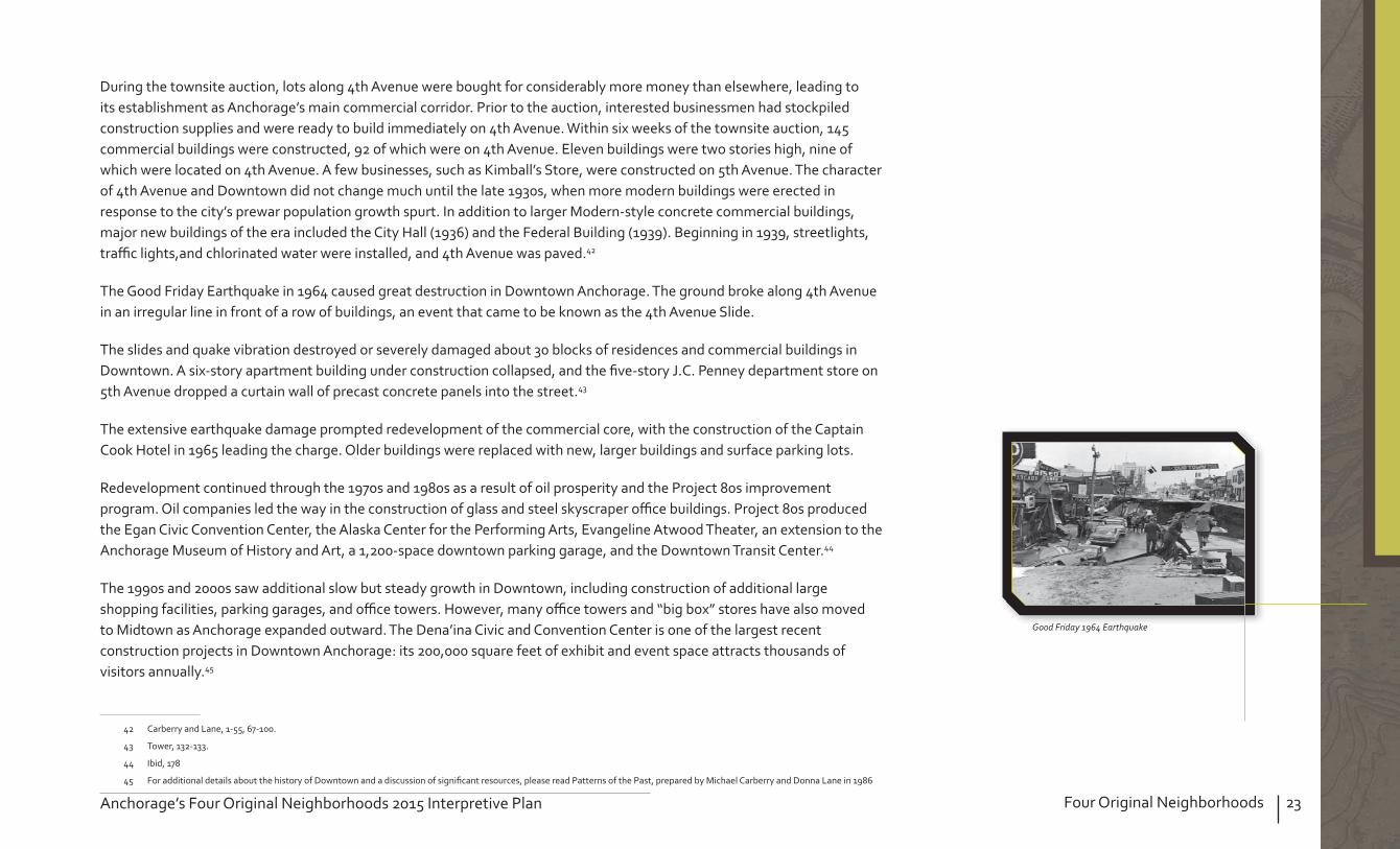
During the townsite auction, lots along 4th Avenue were bought for considerably more money than elsewhere, leading to its establishment as Anchorage’s main commercial corridor. Prior to the auction, interested businessmen had stockpiled construction supplies and were ready to build immediately on 4th Avenue. Within six weeks of the townsite auction, 145 commercial buildings were constructed, 92 of which were on 4th Avenue. Eleven buildings were two stories high, nine of which were located on 4th Avenue. A few businesses, such as Kimball’s Store, were constructed on 5th Avenue. The character of 4th Avenue and Downtown did not change much until the late 1930s, when more modern buildings were erected in response to the city’s prewar population growth spurt. In addition to larger Modern-style concrete commercial buildings, major new buildings of the era included the City Hall (1936) and the Federal Building (1939). Beginning in 1939, streetlights, tra c lights,and chlorinated water were installed, and 4th Avenue was paved.42
The Good Friday Earthquake in 1964 caused great destruction in Downtown Anchorage. The ground broke along 4th Avenue in an irregular line in front of a row of buildings, an event that came to be known as the 4th Avenue Slide.
The slides and quake vibration destroyed or severely damaged about 30 blocks of residences and commercial buildings in Downtown. A six-story apartment building under construction collapsed, and the ve-story .C. Penney department store on 5th Avenue dropped a curtain wall of precast concrete panels into the street.43
The extensive earthquake damage prompted redevelopment of the commercial core, with the construction of the Captain Cook Hotel in 1965 leading the charge. Older buildings were replaced with new, larger buildings and surface parking lots.
Redevelopment continued through the 1970s and 19 0s as a result of oil prosperity and the Project 0s improvement program. Oil companies led the way in the construction of glass and steel skyscraper o ce buildings. Project 0s produced the Egan Civic Convention Center, the Alaska Center for the Performing Arts, Evangeline Atwood Theater, an extension to the Anchorage Museum of History and Art, a 1,200-space downtown parking garage, and the Downtown Transit Center.44
The 1990s and 2000s saw additional slow but steady growth in Downtown, including construction of additional large shopping facilities, parking garages, and o ce towers. However, many o ce towers and “big box” stores have also moved to Midtown as Anchorage expanded outward. The Dena’ina Civic and Convention Center is one of the largest recent construction projects in Downtown Anchorage its 200,000 square feet of exhibit and event space attracts thousands of visitors annually.45
42 Carberry and Lane, 1-55, 67-100.
43 Tower, 132-133.
44 Ibid, 17
45 For additional details about the history of Downtown and a discussion of signi cant resources, please read Patterns of the Past, prepared by Michael Carberry and Donna Lane in 19 6
Good Friday 1964 EarthquakeGood Frida 96 Earthq ake

24 Four Original Neighborhoods Anchorage’s Four Original Neighborhoods 2015 Interpretive Plan
pdate existing walking tours to include a broader range of topics groups, new graphics, information about historic preservation, and “fun facts.”
Develop a plan to replace and improve the Project 0s historic walking tour three-legged blue kiosks around Downtown to include Alaska Native Peoples’ history, way nding, and smartphone APP information.
46
The South Addition neighborhood (based on Community Council boundaries) is roughly L-shaped,with Cook Inlet forming its western boundary and the southern edge bordered by Westchester Lagoon and Chester Creek Trail. Its eastern boundary runs from the corner of C Street and Chester Creek Trail north along C Street, jogs east on 15th Avenue, and then jogs north on Cordova Avenue to 9th Avenue. The northern boundary runs along 9th Avenue from Cordova Street to L Street, thence turning to continue north on L Street to Cook Inlet. The neighborhood generally features grid-patterned streets with narrow back alleys that run down the length of each block.
Curving streets and culs-de-sac are found west of P Street, south and west of the Park Strip, and throughout the “Elderberry Triangle” or “Bootleggers Cove” area north of the Park Strip. Primary thoroughfares include L and C streets (southbound); I and A streets (northbound); and 10th, 11th, and 15th avenues (east- and westbound). With the exception of the A C Couplet and the I L Couplet, most streets in the South Addition allow two-way tra c.
The northwest corner of the South Addition Community Council area—”Elderberry Triangle” or “Bootlegger’s Cove”—was part of the original townsite platted in May 1915. However, the majority of the neighborhood was laid out as the South and Third Additions. The South Addition plat was the rst expansion of the original townsite. It was platted in August 1915 and comprised 49 blocks bounded by 9th Avenue, C Street, Chester Creek, and Cook Inlet. Blocks were divided into parcels that grew progressively larger in size the further south they were located.
46 The terms “South Addition” or “South Addition neighborhood” are used throughout this section to mean the South Addition Community Council area; where the historic South Addition plat is speci cally discussed, it is clearly identi ed as such.
South Addition FAA housingSouth Addition FAA housing

25Four Original NeighborhoodsAnchorage’s Four Original Neighborhoods 2015 Interpretive Plan
The AEC created 5-acre and .3-acre parcels in the South Addition plat because it wanted to encourage agricultural development around Anchorage. The Third Addition was platted in August 1916, and continued the large lot sizes of the South Addition eastward. To protect agricultural development, a Presidential Executive Order was issued in 1917 prohibiting the subdivision of tracts containing two or more acres into smaller lots.47
When Anchorage incorporated in 1920, the original city limits extended south to 11th Avenue and east to East G Street (now Gambell Street). However, a majority of the South Addition neighborhood remained unincorporated until after World War II. Isolated from downtown by the Park Strip (then a re break and later an airstrip, and eventually a golf course), the large parcels of the South Addition and Third Addition plats were used in the early days for homesteads, dairies, and fur farms. Modest dwellings, including wood frame Craftsman-style houses and log cabins, were scattered throughout the neighborhood. The area retained its rural agricultural appearance until the late 1930s.
World War II was a period of major physical growth in the South Addition neighborhood. Military build-up stimulated the economy and brought thousands to Anchorage, but the resulting population boom also caused a severe housing shortage. Despite the 1917 Executive Order prohibiting further subdivision of tracts two acres or larger, Anchorage’s rst subdivisions were drawn in the South Addition neighborhood for A.A. Shonbeck’s land in 193 and ohn W. Hansen’s land in 1939 (the Executive Order was eventually revoked).4
As these residential subdivisions were created, the large agricultural blocks south of the Delaney Park Strip were no longer appropriate, so new streets were cut east-west through the blocks to mimic the grid size of the original townsite. Development in the South Addition neighborhood was concentrated primarily in the blocks closest to the Park Strip. Newly constructed houses scattered throughout the neighborhood featured near-identical forms and styles, likely re ecting pattern-book plans that were quickly and easily erected.
During the war, several federal agencies and business corporations moved their headquarters to Anchorage. These agencies also did their part to address the inadequate supply of housing by building units for their employees, many of which were located in the South Addition neighborhood. The Civil Aeronautics Administration (CAA) developed a two-block housing project called Safehaven and two groups of two-story Colonial Revival style duplexes. The .S. Army built a group of 12 military barracks at the west end of the Park Strip circa 1942, which were demolished in the early 1950s.
47 Carberry and Lane, 132.
4 Municipality of Anchorage Plat Maps

26 Four Original Neighborhoods Anchorage’s Four Original Neighborhoods 2015 Interpretive Plan
The Army Housing Association, a cooperative created by servicemen and their families, built 32 Minimal Traditional style homes on Block 13 of the Third Addition in the summer of 1940; this portion of 11th Avenue also earned the nickname “Pilots’ Row” because Bob Reeves (Pilot Owner of Reeves Aviation), Ray Petersen (Pilot Owner of Wien Air), Oscar nderhill (Pioneer Pilot), and Don Bedford (Pioneer Pilot) lived on 11th and Barrow streets in the 1940s and 1950s.
Interpret aviation history at the Delaney Park Strip and explain its relationship to the rest of the neighborhood.
Create an interpretive plan for the Delaney Park Strip, which may include installation of interpretive signage, plaques, or monuments that celebrate the Park Strip’s rich history as a re break, golf course, and airport. Installation of signage should be coordinated with the ), which regulates the placement and design of monuments and signs.
Interpret other historic aspects of the neighborhood (e.g., CAA FAA houses, early military housing, Safehaven, Army Housing Association Pilots’ Row, Northwest Airlines housing, Westchester Lagoon, long-standing small businesses, etc.).
se the South Addition Historic Context Statement (2012) to help identify interpretation and storytelling opportunities in the South Addition.
The inaugural celelbration of “Historic Preservation Day” waas held in Anchorage on April 11,2012.The ina g ral celelbration of “Historic Preser ation

27Four Original NeighborhoodsAnchorage’s Four Original Neighborhoods 2015 Interpretive Plan
Fairview is located east and southeast of Downtown Anchorage. It is bordered by Merrill Field and Sitka Street Park to the east, Rogers Park neighborhood to the southeast, North Star neighborhood to the southwest, and the South Addition neighborhood to the west. The Community Council boundaries are irregular, but the extremes align north of East 1st Avenue, Sitka Street (through Merrill Field) to the east, Chester Creek to the south, and C and Cordova streets to the west. Primary thoroughfares include Gambell Street (southbound) and Ingra Street (northbound), which connect to the Glenn Highway to the north and New Seward Highway to the south, as well as East 15th Street (east-westbound).
The neighborhood features an orthogonal street grid, though some street intersections on the east side of the neighborhood have been partially blocked in an e ort to calm through-tra c. The area is generally at, though a blu at East 15th Terrace drops down to East 16th Avenue west of Gambell Street, and another blu is located at approximately East 16th Avenue east of Ingra Street. Few vacant lots remain in the area.
The Fairview neighborhood is located east and southeast of the original Anchorage Townsite, which was platted in May 1915. The Anchorage Memorial Park Cemetery, located between 6th Avenue, Cordova Street, 9th Avenue, and Fairbanks Street in what is now Fairview, was reserved at this time by President Woodrow Wilson. The East Addition was platted in September 1915, and included the area north of East 9th Avenue between Cordova and Orca streets in the Fairview neighborhood. The Third Addition was platted in August 1916, and included the area south of East 9th Avenue. Development of the Third and East Additions occurred slowly, and the area remained rural until World War II. Because it was outside the city limits, Fairview even developed a “red light district” in its early years, with brothels and other businesses that were not allowed in the city. Aviation was an important part of Fairview development. The Delaney Park Strip, which enters Fairview from the west, was Anchorage’s rst air eld, beginning in 1923. As demand increased, however, the city developed the Anchorage Municipal Airport, subsequently renamed Merrill Field after Russell Merrill, one of many Alaska aviation pioneers. Merrill died in September 1929 while on a ight.
Merrill Field, which creates the eastern boundary for the Fairview neighborhood, began operations in 1930. Since the international airport was constructed in 1951, Merrill Field has continued functioning for private and bush operations.
* Ship Creek is shared by all four neighborhoods
15th from the east

2 Four Original Neighborhoods Anchorage’s Four Original Neighborhoods 2015 Interpretive Plan
In 1940, in anticipation of World War II, construction began on what would become Elmendorf Air Force Base and Fort Richardson. The in ux of workers created a housing shortage, and outlying neighborhoods such as Fairview began to develop, with small cottages and log cabins. The growth of Fairview was encouraged by the construction of the Glenn Highway in October 1942, which connected Anchorage to the Richardson Highway and the Alaska (Alcan) Highway. The Glenn Highway fostered commercial and industrial development along the neighborhood’s north boundary and served to funnel tra c onto Gambell Street. Gambell Street would also become the northern terminus of the Seward Highway (completed in 1951), and thus served as Fairview’s Main Street during the postwar era. Anchorage’s housing shortage continued after World War II, leading to further development of Fairview. It was a desirable location due to its proximity to Merrill Field, the Glenn Highway, the military bases, Downtown Anchorage, and the north-south tra c route and commercial core of Gambell Street. An Oregon-based company began importing prefabricated houses in 1947, many of which were erected in Fairview. Fairview residents also started local businesses for example, the rst Carr grocery store was opened in a Quonset hut on Gambell Street in 1950, and the Lucky Wishbone restaurant opened at 5th Avenue and Karluk Street in 1955.
The war and postwar in uxes brought people of varied ethnicities to Anchorage. Many African-Americans built residences in Fairview, especially in Eastchester Flats, because it was one of the few areas in the city where African-Americans were allowed to own property. Citizens like ohn Parks, an African-American contractor, and oe ackson, Anchorage’s rst African-American real estate agent, were instrumental in constructing houses and apartments in Fairview for African-Americans.
Building in Fairview was especially important because in 1951, a house in Rogers Park, just south of Fairview, was burned to the ground just after its construction to prevent an African American family from moving into an all-white neighborhood; this spurred the founding of the Anchorage branch of the National Association for the Advancement of Colored People (NAACP).
The African-American community also built churches and started businesses in Fairview, contributing greatly to the neighborhood’s history. The Greater Friendship Baptist Church at East 13th Avenue and Ingra Street were founded in 1951 as the rst Southern Baptist church in Alaska, and were later joined by Shiloh Missionary Baptist Church (founded in Downtown in 1952 and moved to Fairview in 1974). Six black-owned nightclubs were active during the 1950s and 1960s, and were known as places for blacks and whites to socialize before integration.49 African-Americans were joined in later years by Alaska Native and Hispanic residents, and Fairview remains known for its diversity today.
By 1950, Fairview remained outside the city’s limits. Anchorage’s population stood at 11,254 within the city limits and 30,600 in the overall area, indicative of the homesteading and settlement that had occurred outside the limits. The city’s rst annexation occurred in 1945, encompassing 300 acres south of Downtown.
49 Interview with Cal Williams and other Fairview residents (May 29, 2012).
Cabin in FairviewCabin in Fair ie
The Lucky Wishbone opened at 5th Avenue and Karluk Street in 1955.The L ck Wishbone opened at th A en e and

29Four Original NeighborhoodsAnchorage’s Four Original Neighborhoods 2015 Interpretive Plan
Other neighborhoods followed—Eastchester, niversity, Mountain iew, Russian ack, Rogers Park, and Spenard—leaving Fairview isolated in the middle. Like those in other neighborhoods, many Fairview residents stoutly resisted annexation by the city, since basic services were already met through the Fairview Public tility District. Many saw themselves as independent pioneers who neither wanted nor needed bureaucratic oversight or taxation from the city. Discussion extended through the 1950s, but annexation passed in 195 , approved by 60 of the neighborhood’s voters.
Fairview did not su er extensive damage from the Good Friday Earthquake on March 27, 1964. However, in 1965, the City Planning Commission called Fairview’s housing “among the poorest in the city” and attempted to implement change by rezoning Gambell and Ingra streets to commercial uses, eliminating single-family residences along those thoroughfares, and encouraging high-density housing. Gambell and Ingra streets were also expanded into four-lane, one-way streets, forming high-volume obstructions to pedestrians and e ectively dividing the neighborhood. Fairview was also the site of several urban renewal projects after the earthquake, with federal, state, and Municipal agencies taking advantage of the rebuilding e ort to remove “blighted” areas.
For example, the Eastchester rban Renewal project (south of 16th Avenue) was part of the Project Alaska R-16 rban Renewal Plan, which was adopted by the Anchorage City Council in 1964. This especially a ected the African-American residents of East Chester Flats, who were promised the right of rst refusal to return to the area after the project was completed, though most did not return.
But the 1960s also included important civil rights advancements for the African-American community in 1963, the NAACP picketed the Carrs supermarket at East 13th Avenue and Gambell Street for not including African-American workers on their sta . The picket resulted in the successful integration of the company when Richard Watts, r., was hired as a bagger, making Carrs the rst retail store in Anchorage to hire a black employee; Watts is now a senior manager for the company.50 By 1975, Anchorage’s population was approximately 1 0,000, of whom 5,000 lived in Fairview. Older homes dating from the 1940s and 1950s were torn down and replaced with apartments.
Fairview continued to be a depressed neighborhood, however, with issues that included land-use con icts between older single-family residences and multifamily and commercial buildings, inadequate parkland and recreation facilities, and general deterioration of buildings and social atmosphere. Fairview had a high turnover of residents; the 1970 Census showed that 57 of residents had lived there for a year, while only 25 had lived there more than three years. Almost 75 of residents were renters. These conditions persisted through the 19 0s.
50 Christine Kim, “Carr’s rst black worker recalls his rise through the ranks,” KT (February 19, 2010), accessed at http articles.ktuu.com 2010-02-19 carrs 24126516.
Karluk 13th Avenue in FairviewKarl k 3th A en e in Fair ie
Gambell Steet.
1954-Fairview Public Utility District9 Fair ie P blic Utilit District

30 Four Original Neighborhoods Anchorage’s Four Original Neighborhoods 2015 Interpretive Plan
During the 19 0s, the Fairview Recreation Center and the Fairview Lions Park were constructed. However, the construction of the park had major social consequences for the African-American community as with East Chester Flats in the 1960s, the demolition of the Linden Arms and S S Apartments again resulted in the displacement of African-American residents.51 During the 1990s, voters approved bond measures for a variety of neighborhood improvements, including “tra c calming” measures and beauti cation of public spaces. Since the 1990s, Fairview residents have continued to seek neighborhood improvement, and the area retains its thriving socioeconomic diversity.52
For additional details about the history of Fairview and a discussion of signi cant resources, please read the Fairview Neighborhood Historical Building Survey, prepared by BGES in 2007, available at MOA Community Development.
Identify opportunities to highlight Fairview’s African-American heritage and Socioeconomic diversity.
Place interpretive signage at Greater Friendship Baptist Church (903 E. 13th Avenue), celebrating its status as the rst African-American church in Alaska.
Work with the African-American community—especially long-time residents—to identify signi cant people, events, and places worthy of recognition and public information. Residents have already begun collecting oral histories at Fairview reunion events, and this project could continue.
Develop a walking tour or exhibition highlighting people, places, and events signi cant to the Fairview African-American community. For example, a “SoMa Pilipinas Ethnotour” was recently developed to highlight the Filipino heritage of one San Francisco neighborhood.
Reach out to other ethnic groups in Fairview to identify opportunities for preservation and interpretation
51 Interview with Cal Williams and other Fairview residents (May 29, 2012).
52 BGES, “Fairview Historic Building Survey” (March 200 ), 9-17.
The buildings, sites, and stories depicted in this graphic were
identi ed through the HPP Public Outreach Process as the
most precious resources in the four original neighborhoods.
They are also important resources to interpret. Places
mentioned within
are
shown here within the shape of each neighborhood’s
boundaries.
This list is not intended to be exhaustive—many others not
included here are listed in or eligible for the National Register
of Historic Places—yet it re ects the resources valued most
highly by the public.

31Four Original NeighborhoodsAnchorage’s Four Original Neighborhoods 2015 Interpretive Plan
Ship Creek is included in all four original neighborhoods. The Ship Creek Framework Plan was adopted in 2014. It is primarily industrial in character; it therefore has its own distinct set of opportunities for interpretation and is covered here separately. Ship Creek received several comments during the public outreach process, and the HPP acknowledges its importance to the heritage of Anchorage. Ship Creek was the rst part of Anchorage to be settled—it was home to Dena’ina sh camps and, centuries later, the headquarters of the Alaska Railroad.
A long-term vision for the future redevelopment of the Ship Creek area includes something Anchorage has never had—an accessible waterfront. Another element slated for the area is to provide an authentic Alaskan place that is attractive in all seasons, and honors the Native heritage of Ship Creek. Consistent with the Downtown Anchorage Comprehensive Plan and the Ship Creek Framework Plan, the Ship Creek area could also encourage the use of public art, creating a memorable place for residents and visitors to experience the culture of Alaska—past and present.
1915 Tent City, now known as the Ship Creek area.
UAA-hmc-0778
191 T5T tent CiCitty no kw knowwn an as ts thhe
1916-First train leaving new depot Anchorage, Alaska, Nov 1st1916 First train leavingg nenew ddepott

32 Four Original Neighborhoods Anchorage’s Four Original Neighborhoods 2015 Interpretive Planaage’s FFoFoourr OOriggiginnnaal NNeN igiggghhbhbhh ororrrhoohoododss ssssss s 220202 1515555 IIIIIInntntnttntttntnn ererprprrprp etetetete iviviveeee PlPlPlaanaan
Ship Creek ows from the Chugach Mountains into Cook Inlet. Prior to the arrival of Americans in Anchorage in 1914-1915, the Dena’ina Athabascan people used Ship Creek as a seasonal shing camp. The Dena’ina place name for Ship Creek was “Dgheyaytnu,” or “Needle sh Creek.” In 1911, two American families lived on “squatters rights” at the mouth of Ship Creek. ack and Nellie Brown arrived in 1912; ack was a Chugach Forest Service employee. Two more families were living in log cabins on the ats of the creek by early 1914. The area was already known as Ship Creek at the time. But changes were abreast for Ship Creek when the Alaska Railroad Act was passed by Congress and signed into law by President Woodrow Wilson in 1914. The AEC decided to build its eld headquarters where Ship Creek ows into Cook Inlet. Rumors about the impending construction of a railroad brought people into the area, and they set up a tent city along Ship Creek. By the spring of 1915, over a thousand tents were pitched on the north side of the creek. Ships would moor out in the inlet, and smaller boats and barges would bring materials to shore. Thus, the area became known as “Ship Creek Landing.”
During platting of the Anchorage Townsite, reserves were set aside for special uses, including a Terminal Reserve in Ship Creek alley for a rail yard and dock space. After the townsite parcels were auctioned in uly 1915, the tent city folded and people moved to the blu s above Ship Creek. By August 1915, the .S. Post O ce had established the name “Anchorage,” and the name “Ship Creek Landing” was no longer used. By the fall of 1916, buildings in the Terminal Reserve included a depot, commissary, warehouses, shops, o ces, and a power plant. Dock Number One was built in 1917, and brought an end to the practice of unloading goods onto barges or lighters to be brought into shore. Ocean Dock was built circa 191 and was closed by the Railroad in the mid-1920s. Ship Creek itself was realigned and the marshy areas and shoreline were lled in 1920. However, the creek still enters the inlet in the same location. The railroad was completed in 1923, and numerous buildings were constructed to house the various functions of the railroad, as well as the city’s other industrial and warehousing needs. In 1927, City Dock (later known as ARR Dock) was built, and adjacent cannery docks were built in 192 .
After World War II, the Alaska Railroad experienced revitalization. Older wood frame buildings were replaced with steel frame buildings, many of which were built from war surplus materials. Some buildings were moved to the site, including the Alaska Railroad Engine Repair Shop, which was moved from Denver in 194 . In 19 5, the State of Alaska purchased the Alaska Railroad from the federal government.53 In 1992, Alaska Railroad Corporations employees moved into a new 3 ,700 sq.-ft. headquarters building next to Ship Creek. Most recently, the Alaska Railroad has been working to complete upgrades to its facilities and infrastructure, and to prepare design guidelines to shape future development. The renovation of the historic freight shed, Alaska’s rst historic building certi ed under the .S. Green Building Council’s Leadership Energy and Environmental Design (LEED) program, is a key project for the revitalization of Ship Creek; completed in 2011, this project is intended to catalyze the vision of Ship Creek as a community commerce center and intermodal transit hub.54
53 Alaska Railroad Corporation, “Building Leases,” accessed HTTP http alaskarailroad.com Corporate RealEstateServices BuildingLeases tabid 406 Default.aspx.
54 Ibid

Ship Creek
The following recommended implementation strategies are speci c to Ship Creek. However, please note that due to its complicated and overlapping boundaries with the other neighborhoods, Ship Creek was not discussed as thoroughly in the public outreach process as the neighborhoods, and thus has fewer neighborhood-speci c recommendations. Because it did not receive equal attention from key stakeholders, these strategies are o ered to supplement the Ship Creek Waterfront Land
.
Interpret Alaska Native Peoples and Alaska Railroad history at Ship Creek.
Add to existing signage to tell the stories of Alaska Natives who worked to construct the railroad
Install street signs in English and Athabascan, especially to represent Athabascan names for villages and geographic features
Any interpretive project at Ship Creek would include ARRC involvement to ensure that there are no duplicate e orts, and no impacts to operations or safety.55
55 For additional details about the history of Ship Creek and a discussion of signi cant resources, please read the “Ship Creek Architectural Survey Report,” prepared by Anchorage Historic Properties, Inc. (AHPI) in 19 9.


35Interpretive ThemesAnchorage’s Four Original Neighborhoods 2015 Interpretive Plan
4. INTERPRETIVE THEMES
Interpretive themes and subthemes are the central messages readers will understand about a particular interpretive site. Themes foster a sense of continuity and assist project developers when organizing the content for interpretive materials. Each interpretive product developed will support the primary interpretive theme and at least one of the subthemes.
The Interpretive Equation is more than the sum of its parts. It depicts the importance of each of the components
(KR KA) x AT IO
The Interpretive Equation illustrates for the interpreter how to identify the elements of successful interpretation. This tool is really just a Besides using it for self-evaluation, it can be used as an e ective interpretive planning tool.
More than just imparting information, interpreters need to use the techniques and elements that work and also evaluate the e ectiveness of their interpretation. The goal is to create opportunities for intellectual and emotional connections.
Freeman Tilden says “interpretation is an art...art is in some degree teachable.”
Knowledge of Audience
Appropriate Techniques
Know
ledg
e of
Res
ourc
eIN
TERPRETIVE OPPORTUNIT
Y
For the mathematically challenged, see diagram below

36 Interpretive Themes Anchorage’s Four Original Neighborhoods 2015 Interpretive Plan
Beginning with Alaska Native peoples, the Anchorage community evolved with each period of history, de ning each of its neighborhoods in unique ways.
Anchorage’s cultural centers and museums interpret and educate us about the communities of Anchorage and Alaska

37Interpretive ThemesAnchorage’s Four Original Neighborhoods 2015 Interpretive Plan
Alaska Native peoples of Tikahtnu ( pper Cook Inlet) are rooted in ancient, dynamic, and complex cultures that continue to thrive today.
Anchorage began as a boomtown that sprang to life on the banks of Ship Creek in the early 1900s at the rst hint of a government-funded railroad.
The introduction of the aviation industry in the 1920s revolutionized transportation in Alaska.
The in ux of military personnel and infrastructure during World War II and the Cold War transformed Anchorage in ways we still see today.
Amidst jubilant celebrations and the famous headline exclaiming, “WE’RE IN,” Alaska o cially became the 49th state in the nion on anuary 3, 1959.
On March 27, 1964, a massive earthquake, registering at 9.2, jarred Anchorage and its people, causing signi cant damage and sparking an urban renewal movement.
Anchorage is a multi-cultural city enriched by a blend of languages, food, art, religions, and other traditions.
The development of the North Slope oil elds brought tremendous change to Anchorage.
Cook Inlet provides a lifeline between Anchorage, Interior Alaska, and the rest of the world.
Anchorage boasts properties worthy of preservation because they remind us of our city’s past and how it was shaped, while pointing us toward a brighter future.


39Interpretive ExperienceAnchorage’s Four Original Neighborhoods 2015 Interpretive Plan
5. DEFINING THE INTERPRETIVE EXPERIENCERecommendations for new interpretive experiences in the four original neighborhoods will take many things into consideration. Most importantly
The audience;
Resource being interpreted; and
Appropriate techniques to create an e ective interpretive opportunity.
There are two types of interpretation, personal and non-personal, that are commonly used by professionals to e ectively interpret a resource, event, person, architecture, or individual site.
occurs when one person delivers an interpretive program to another person or a group of people. This type of interpretation is interactive and allows visitors to discuss the resource with the interpreter and ask questions. It is exible and can meet the audience’s speci c needs, and it has the ability to generate publicity and a possible source of income for an individual site.
occurs when the interpreter is replaced with a type of media such as a wayside, sign, brochure, website, or exhibit. This type of interpretation does not require the presence of an interpreter; therefore, it is cost-e ective. Non-personal interpretive media are not subject to the personality of an interpreter and they provide consistent information over time that can reach large audiences during extended hours of the day.
O ering a variety of personal and non-personal interpretive media provides a greater chance to reach a wider audience. Some visitors prefer attending guided walks or presentations and feel that reading panels or brochures is cumbersome or di cult. Others prefer to read interpretation at their own pace and may feel that guided walks and presentations are intimidating. The following recommendations suggest a variety of personal and non-personal interpretive media that have the potential to enhance the experience for a diverse audience.
Interpretation tells stories and raises public awareness about the plan area’s history, including cultures and traditions of Alaska Native Peoples. Anchorage residents recognize and appreciate the unique character of the four original neighborhoods, and share a desire to celebrate the neighborhoods’ history and culture.
Athabascan beadingANHCAthabascan beading

40 Interpretive Experience Anchorage’s Four Original Neighborhoods 2015 Interpretive Plan
Historic buildings and cohesive neighborhoods are a source of pride for the community, and residents value the contribution of historic resources to the plan area’s identity. However, there is a lack of broad public awareness about the plan area’s history, partly because so many of Anchorage’s residents are transplants or newcomers.
In the plan area, storytelling is of equal importance to the preservation of physical places. Interpretation is therefore essential. During preparation for the Anchorage Original Neighborhoods Historic Preservation Plan, community members presented many ideas for how to interpret and commemorate important people and events.
These ideas range from plaques, monuments, and interpretive signage to walking tours, documentaries, websites, and other digital media. Additional interpretation programs and implementation strategies are presented in this chapter. Funding for these interpretive programs is discussed in Goals 4 and 6 of the HPP.
When it comes to deciding on methods for interpreting history and culture in the four original neighborhoods, there are numerous choices that range in size and complication to implement. Thus, it is important to start by creating an interpretive program, wherein choice methods for interpretation are established and prioritized.
Programming will likely be shaped to an extent by the arctic climate; however, the weather need not impinge on interpretation strategies, and can in fact produce more creative means for sharing stories about the plan area’s history and culture (see sidebar). Education about Anchorage’s history and preservation policies is also critical.
There is a need to improve access to information, inform community members, elected o cials, and Municipality administration how to manage historic buildings, and dispel myths about historic preservation. Most importantly0, Alaska Native Peoples’ stories—especially positive and or modern ones—should be incorporated into the narrative, and respect should be shown for all cultures and traditions. Recognizing the role of the Alaska Native Peoples community in building Anchorage and exploring current cultural practices is every bit as valuable as prehistoric stories.
Successful interpretive programs increase recognition of Native heritage and ensure that Native heritage values are acknowledged and interpreted for public understanding. These programs typically seek government and foundation or nonpro t support to implement and maintain them.
When incorporating Alaska Native Peoples’ stories into the historic narrative for the four original neighborhoods, it is important to understand that the perception of “heritage” di ers for Europeans and indigenous peoples and that over the last century Native land-based and -built heritage has been undermined, which often necessitates creative approaches to cultural preservation.
Anchorage’s location presents unique conditions for interpretive planning due to its arctic climate. The following scenarios are suggested to promote history and culture in Anchorage, despite (or because of) the weather
Construct signage using weather-resistant materials, or construct removable signage so that it does not get damaged or a ect snow removal.
Celebrate seasonal activities and opportunities. Conduct walking tours, even during the winter. se winter months for planning and fabrication
of tours and interpretive materials. Shift from outdoor activities, such as tours, to
indoor ones, such as lectures, depending on the season.
This book on the oral history of Government Hill, related through those who experienced its development, was published in 2013.
This book on the oral histor of Go ernment

The Auxiliary Heritage Collection and Craft Shop at
history and traditional artwork.
The A iliar Heritage Collection and Craft Shop at
“This Old House” has a TV series, magazine, and website dedicated to teaching homeowners about skills such as window repair.
“This Old Ho se” has aTV series maga ine and
The best examples from other .S. cities successfully integrate Native culture, heritage, art, and stories seamlessly into interpretive signage and everyday life. sing Native language and motifs in signage and place names may be an e ective way to help accomplish this. In considering ways to better represent Alaska Native Peoples in the plan area, inspiration can be drawn from Hawaii, New Mexico, and the Navajo Nation, and from the Maori people of New ealand, among others.
A successful window workshop was recently held at the Pioneer School House.A s ccessf l indo orkshop as recentl held at
Highway signs in portions of British Columbia and bilingual in English and Squamish languages.High aa signgns is in pn ortions oof Bf rittisish CoCol mmbia andd


43Implementation StrategiesAnchorage’s Four Original Neighborhoods 2015 Interpretive Plan
6. IMPLEMENTATION STRATEGIES
The following implementation strategies are excerpted from Chapter 3 of the HPP. These strategies could also be implemented throughout Anchorage and may not necessarily have to be focused in the four original neighborhoods.
The purpose of this chapter is to
articulate an action plan to help the
Municipality of Anchorage and its
preservation partners accomplish the
vision, goals, and policies outlined
in this plan for Anchorage’s four
original neighborhoods & Ship
Creek. Originally published in the
Historic Preservation Plan, this
chapter includes details that will help
readers understand each policy and
implementation strategy related to
interpretation.
cohesive brand for this Washington, D. C. neighborhood
The port of Anacortes, WA, installed vintage salmon can
labels on its trash cans to celebrate the town’s salmon
canning history.
The port of Anacortes WA

44 Implementation Strategies Anchorage’s Four Original Neighborhoods 2015 Interpretive Plan
The following Implementation Matrix is excerpted fro HPP. The matrix summarizes each implementation strategy discussed in previous chapters of the Plan, and is organized by timing. For each strategy, the matrix includes the following
Each implementation strategy is generally correlated to one policy. However, if a strategy accomplishes or relates to more than one policy, it is noted here.
The time it takes to implement each strategy varies timelines are Short-Term (less than 5 years); Intermediate (6-9 years); Long-Term (more than 10 years); and Ongoing. Please note that these time frames are approximate, and are subject to change depending on available funding, resources, and commitment.
Indicates one or more parties responsible for implementing the strategy, including collaboration among groups. The parties identi ed here are not necessarily required to fund and implement the strategy themselves, but rather would be responsible for researching and tracking the strategy to ensure that it is completed. Responsible parties may include individual property owners, neighborhood groups, local government organizations, state and federal agencies, and lawmakers. See Appendix L for a complete list of potential preservation partners who could serve as responsible parties.
Identi es which neighborhood(s) area is responsible for implementing each strategy. Ship Creek is not included here, though it is not technically one of the four original neighborhoods and did not receive the same attention as the other neighborhoods during the public outreach process.
Indicates that further action would be needed by the public, property owners, Planning oning Commission, and Municipal Assembly in order to move this item forward. At such time, the details of the programs will be developed and the feasibility of the items will be evaluated. The e ects of the programs on the cost of development would also be thoroughly investigated at this later date.
Public art, such as the salmon on A Street, adds to the quality of life in the plan area.
P blic art s ch as the salmon on A Street adds to
Public art, such as the salmon on A Street, adds to the quality of life in the plan area.
P blic art s ch as the salmon on A Street adds to

45Implementation StrategiesAnchorage’s Four Original Neighborhoods 2015 Interpretive Plan
No. Implementation Strategy Related Policy
TimingPrimary Responible Parties
Neighborhood Requires ApprovalS I L O GH DT SA FV
3 INTERPRETING HISTORY & CULTURE
3.1.1 Form an interpretive planning advisory group (or groups) composed of public-private partnerships to oversee creation of interpretive plan (or plans).
Neighborhood Groups (Community Councils); Muni (Planning); Nonpro t Organizations; Educational Institutions
3.1.2 Seek funding for an interpretive plan for Municipality-owned buildings and parks, which would identify and prioritize which stories to tell, select media to be used for each story, and establish a consistent graphic identity for all materials.
Goal #4 & Goal #6
Muni (Planning); Muni (Real Estate)
3.1.3 Seek funding for an interpretive plan for each of the Four Original Neighborhoods. Each plan would include the same components described above.
Neighborhood Groups (Community Councils)
3.1.4 Ensure that the Four Original Neighborhoods are represented in the Centennial Legacy Interpretive Project, and complete installation of interpretive signage, plaques or monuments in time for the Anchorage Centennial Celebration in 2015.
Neighborhood Groups (Community Councils)
3.1.5 Work with the Alaska Native Peoples community to identify stories in the plan area to interpret.
Alaska Native Peoples
3.1.6 Look for interpretive opportunities that take advantage of all four seasons.
Neighborhood Groups (Community Councils); Muni (Planning); Nonpro t Organizations; Educational Institutions
3.1.7 Seek funding to assist private property owners in implementing interpretive programs.
Nonpro t Organizations

46 Implementation Strategies Anchorage’s Four Original Neighborhoods 2015 Interpretive Plan
No. Implementation Strategy Related Policy
TimingPrimary Responible Parties
NeighborhoodRequires ApprovalS I L O GH DT SA FV
3.2.2 Select one example of Culturally Modi ed Trees, and place interpretive signage at that location.
2.4Alaska Native Peoples
3.2.3 Create a map of indigenous language place names in Four Original Neighborhoods.
Alaska Native Peoples
3.2.4 Publicize Shem Pete's Alaska, a book about Dena’ina place names.
Media Outlets; Nonpro t Organizations
3.2.5 Install street signs in English and Athabascan, especially to represent Athabascan names for villages and geographic features.
Same as 1.3.1
Alaska Native Peoples; Muni (Public Works)
3.2.6 Name public buildings and streets after Native leaders. Same as 1.3.2
Alaska Native Peoples; Muni (Public Works)
3.2.7 Incorporate Native art and/or sculpture into parks, open spaces, and other public areas by creating a network of partners and friends groups that will assist in planning, fund, and support of a public art program.
Same as 1.3.3
Alaska Native Peoples; Muni (Arts Advisory Commission, Parks & Rec)
3.2.8 Add more Alaska Native stories about the sun, moon, and stars to Planet Walk.
Alaska Native Peoples; Muni (Public Works)
3.2.9 Include Alaska Native Peoples’ stories in Oscar Anderson House tour.
Alaska Native Peoples; Nonpro t Organizations
3.2.10 Establish an Alaska Native Heritage Center (ANHC) annex or kiosk in Downtown to support heritage tourism.
6.7Alaska Native Peoples; Business Organizations
3.2.11 Host festivals or ceremonies to celebrate the catch of the rst salmon, migration of birds, and other traditional events and rituals.
Alaska Native Peoples; Nonpro t Organizations; Neighborhood Groups
3.2.12 Pursue Tribal Preservation Project Grants from the National Park Service to pursue interpretation of Native stories and cultural sites.
Same as 2.4.4
Alaska Native Peoples; SHPO; NPS

47Implementation StrategiesAnchorage’s Four Original Neighborhoods 2015 Interpretive Plan
No. Implementation Strategy Related Policy
TimingPrimary Responible Parties
NeighborhoodRequires ApprovalS I L O GH DT SA FV
3.3.2 Work with ASD educators and administrators to develop a scavenger hunt or other activity for elementary school students focused on the Four Original Neighborhoods.
Educational Institutions (ASD)
3.3.3 Work with university educators and administrators to incorporate historic preservation curriculum into Alaskan universities.
Educational Institutions (Universities)
3.3.4 Develop a free guided walking tour program. Nonpro t Organizations
3.3.5 Partner with Bicycle Commuters of Anchorage (BCA) or other similar group to o er maps and bike tours of historic resources in the Four Original Neighborhoods.
3.6 & 3.7
Neighborhood Groups (Bicycle Commuters of Anchorage)
3.3.6 Add information about the history of the Four Original Neighborhoods to the Anchorage Bike map (also applies to Policies 3.6 and 3.7).
3.6 & 3.7
Muni (Parks & Rec)
3.3.7 Add history of Four Original Neighborhoods to the “Alaska App.”
3.6 & 3.7Neighborhood Groups; Media Outlets
3.3.8 Compile a bibliography of further reading about each neighborhood, to be made available at the Log Cabin Visitor Information Center, Z.J. Loussac Public Library, local schools, and Municipality o ces.
Educational Institutions
3.3.9 Create a multimedia display about the Four Original Neighborhoods in City Hall or Log Cabin Visitor Information Center.
Muni (AHPC); Business Organizations
3.3.10 Seek funding for a short, engaging lm about the Four Original Neighborhoods.
Muni (AHPC); Nonpro t Organizations; Neighborhood Groups (Community Councils)
3.3.11 Publicize Rae Arno’s Anchorage Place Names, a book about the history of street, park, and place names.
Muni (AHPC); Neighborhood Groups

48 Implementation Strategies Anchorage’s Four Original Neighborhoods 2015 Interpretive Plan
No. Implementation Strategy Related Policy
TimingPrimary Responible Parties
NeighborhoodRequires ApprovalS I L O GH DT SA FV
3.4.2 Host a Preservation Education lecture series, covering topics such as neighborhood history, historic preservation incentives, and historic preservation procedures and regulations.
Nonpro t Organizations
3.4.3 Provide basic historic preservation training for Planning & Zoning Commission, Assembly, and Municipality sta .
Muni
3.4.4 Provide basic historic preservation training for lenders, appraisers, and code o cials.
Muni
3.4.5 Produce a series of historic preservation pamphlets, such as “Frequently Asked Questions,” or “how-to” guides on historic house maintenance.
Nonpro t Organizations
3.4.6 Produce a series of short segments focusing on preservation issues to air on public access television channels (Municipal Channel 10).
Muni (AHPC)
3.4.7 Update Anchorage Historic Preservation Commission (AHPC) website to include more preservation-related links and educational tools.
Same as 4.5.1
Muni (AHPC)
3.5.1 Create a Historic Plaque Program. Each plaque would state basic information about the building, such as its historic name, original owner’s name, and/or original construction date.
Nonpro t Organizations; Muni (Planning)
3.5.2 Publish a quarterly or monthly newspaper column about local history. Many years ago, Robert B. Atwood’s regular column in the Anchorage Daily News focused on history.
Media Outlets
3.5.3 Share historic photographs and facts at Community Council meetings, ASD programs, and other events.
Neighborhood Groups (Community Councils)
3.5.4 Integrate historic icons or photographs into streetscape furnishings, such as trash cans and benches.
Same as 1.3.4
Muni (Public Works)

49Implementation StrategiesAnchorage’s Four Original Neighborhoods 2015 Interpretive Plan
No. Implementation Strategy Related Policy
TimingPrimary Responible Parties
NeighborhoodRequires ApprovalS I L O GH DT SA FV
3.5.6 Host annual Historic House Tour events, rotating among the Four Original Neighborhoods each year.
Neighborhood Groups (Community Councils); Nonpro t Organizations
3.5.7 Name alleys in the Four Original Neighborhoods using historical and cultural references
Same as 1.3.6
Muni (Public Works)
3.5.8 Design interpretive signage that is weather-resistant, or mounted such that it can be removed in winter.
Muni (Public Works)
3.6.1 Develop a mobile application or podcast to host thematic walking and driving tours.
Nonpro t Organizations; Muni (AHPC)
3.6.2 Design iconic graphics (e.g., propellers, trains, etc.) to be installed at associated sites to alert people to signi cant themes.
Nonpro t Organizations; Muni (AHPC)
3.6.3 Incorporate stories about each neighborhood into the existing trail system’s paving or infrastructure to combine history and the outdoors, especially during the summer months. This could be especially e ective along the historic Iditarod Trail.
Muni (Public Works)
3.7.1 Create a media campaign to draw attention to the historic and cultural resources identi ed during the HPP public outreach process and recorded in the Consolidated Historic Resources Inventory, and to promote the bene ts of historic preservation.
Same as 2.2.2
Muni (AHPC); Media Outlets
3.7.2 Continue to host “Historic Preservation Day” in Anchorage Muni (AHPC)
3.7.3 Celebrate Historic Preservation Month (nationally celebrated in May) in the Four Original Neighborhoods.
Media Outlets
3.7.4 Celebrate Alaska Native-American Indian Heritage Month (nationally celebrated in November) in the Four Original Neighborhoods.
3.2
Alaska Native Peoples; Media Outlets

50 Implementation Strategies Anchorage’s Four Original Neighborhoods 2015 Interpretive Plan
No. Implementation Strategy Related Policy
TimingPrimary Responible Parties
NeighborhoodRequires ApprovalS I L O GH DT SA FV
3.7.6 Organize an annual historic tour of the cemetery. Nonpro t Organizations
3.7.7 Increase Anchorage Historic Preservation Commission presence on social media websites.
Muni (AHPC)
3.7.8 Publicize the Anchorage Museum’s Homestead Exhibit online, as most of the featured homesteads were in the Four Original Neighborhoods.
Media Outlets; Museums (Anchorage Museum)
3.8.1 Partner with local, state, and national organizations to develop and fund oral history programs.
Nonpro t Organizations; Educational Institutions (UAF Project Jukebox); SHPO; NPS
3.8.2 Work with Alaska Native Hospital, Southcentral Foundation, University of Alaska at Fairbanks, and other organizations to gather oral histories from Tribal Elders.
Alaska Native Hospital; Southcentral Foundation; UA Fairbanks; Muni (AHPC)
3.8.3 Encourage the Anchorage Woman's Club or other interested community organizations to continue to record the oral histories of Anchorage residents.
Nonpro t Organizations; Neighborhood Groups
3.8.4 Incorporate oral history projects and training into the public school system and local universities to get students to record the stories of Anchorage residents.
Anchorage Humanities Forum
3.8.5 Make oral histories easily accessible via podcast. Muni (AHPC)
3.9.1 GH
Add biographical information to street signs in Government Hill, which are named after Alaska Railroad workers
Muni (AHPC); Government Hill Community Council
3.9.2 GH
Incorporate interpretive signs for all the historic mini-districts on Government Hill
Muni (AHPC); Government Hill Community Council
3.9.3 GH
Publicize results of "Government Hill Oral Histories Project" Muni (AHPC); Government Hill Community Council

51Implementation StrategiesAnchorage’s Four Original Neighborhoods 2015 Interpretive Plan
No. Implementation Strategy Related Policy
TimingPrimary Responible Parties
NeighborhoodRequires ApprovalS I L O GH DT SA FV
3.11.1 SA
Create an interpretive plan for the Delaney Park Strip, which may include installation of interpretive signage, plaques, or monuments that celebrate the Park Strip’s rich history as a re break, golf course, and airport.
Neighborhood Groups; Nonpro t Organizations; Muni (Parks & Rec)
3.12.1 SA
Use the South Addition Historic Context Statement (2012) to help identify interpretation and storytelling opportunities in the South Addition.
Neighborhood Groups (Community Councils); Nonpro t Organizations; Muni (AHPC); SHPO
3.13.1 FV
Place interpretive signage at Greater Friendship Baptist Church (903 E. 13th Avenue), celebrating its status as the rst African-American church in Alaska
Neighborhood Groups (Community Councils); Nonpro t Organizations; Muni (AHPC); SHPO
3.13.2 FV
Work with the African-American community—especially long-time residents—to identify signi cant people, events, & places.
Neighborhood Groups (Community Councils); Nonpro t Organizations; Muni (AHPC); SHPO
3.13.3 FV
Develop a walking tour or exhibition highlighting people, places, and events signi cant to the Fairview African-American community.
Neighborhood Groups (Community Councils); Nonpro t Organizations; Muni (AHPC); SHPO
3.13.4 FV
Reach out to other ethnic groups in Fairview to identify opportunities for preservation and interpretation.
Neighborhood Groups (Community Councils); Nonpro t Organizations; Muni (AHPC); SHPO


53Design GuidelinesAnchorage’s Four Original Neighborhoods 2015 Interpretive Plan
7. DESIGN CONCEPTSEach of the four original neighborhoods and Ship Creek has speci c features. Creating a logo for
each neighborhood would highlight these features and re ect its uniqueness. In an e ort to reinforce the connection to Anchorage as a whole, all logos on this page include elements of the Municipality of Anchorage logo.
Logos should be simple and uncluttered, representing the character, history, or use of the area with one or two iconic features. These logos are designed so the elements can be adapted and e ectively reproduced in di erent mediums. The logos on this page are black and white, but could easily be full color.
Some of the oldest structures in Anchorage, including the water tower, are on Government Hill. The water tower is an icon and a recurring visual theme in Government Hill’s Neighborhood Plan. The Alaska Engineering Commission built housing for its employees in this neighborhood and later, the military constructed Quonset huts and other WWII-era structures, some of which still stand.
Preserving historic buildings is integral to retaining the historic character of downtown Anchorage. This neighborhood boasts the historic 4th Avenue Theater, Judge Leopold Residence, Wendler Building (the relocated Club 25), City Hall, Federal Building, and more. Events downtown, including the Iditarod and many Fur Rondy events, draw thousands of people annually from all over the world. Here, residents and visitors can get a taste of the past with all the modern amenities.
The Park Strip divides Downtown from South Addition and is a gathering place for events, sports, and general recreation. It is a de ning feature of South Addition. Pioneers and homesteaders settled here and the military and Northwest Airlines built housing for personnel. Westchester Lagoon is now a center of recreation, but Chester Creek, which was dammed to create the lagoon, had been used for centuries by Dena’ina who called it Grass Creek.
Aviation was integral to the development of Fairview. Merrill Field, dating back to 1930, now serves as a small plane airport and is still important to the community. Also, Fairview was the rst place in Anchorage where African-Americans were permitted to own property and build. The rst Carrs grocery store in Anchorage, on East 13th Avenue and Gambel, still serves the community.
The Dena’ina name for Ship Creek is translated as “Where the Stickleback Run.” The railroad, commercial industry, and the military gure prominently in the development of the area. Ship Creek itself is a huge draw for residents and tourists who want to enjoy an afternoon of shing and be home, or back to their hotel, in time for supper. With luck, they will eat fresh salmon!
Gove
rn
ment H
ill
Anchorage Original Neighborhood
I II I I
I I I I I I I I I I I I I IIIIIIIIIIIIIIIII
IIII
IIII I
I II
II IIIIIIIIIIIIIIIIIIIIIIIIIIIII
IIIIIIIIIII III
IIIIIIIIIIIIIIIIIIIII IIIIII
Anchorage Original Neighborhood
Ship Creek
S
outh Additio
n
Anchorage Original Neighborhood
nnn
Dow
ntownwn
Anchorage Original Neighborhood
Anchorage Original Neighborhood
FAIRVIEW
A h O l N hb h
FFAFF
W
These example logos depict recognizable elements or activities that represent the area and should be used as guidlines for developing neighborhood logos.
The water tower
4th Avenue Theater
The Park Strip
A bush plane
The railroad and stickleback sh

54 Design Guidelines Anchorage’s Four Original Neighborhoods 2015 Interpretive Plan
Currently, there are many di erent designs for interpretive panel mounts, most notably, the outdated blue, three-sided kiosks throughout Downtown. A fresh, cohesive look that incorporates a
exible design can have a profound e ect on interpretation.
The mounting design to the left incorporates elements previously used for mounting interpretation in Anchorage, but without drawbacks such as being too tall or big, too small, overpowering, expensive, inaccessible etc.
The multi-representational “peak” design is retained and could stand for an arctic entry, a roof line, tent, or mountain. The black, wrought iron and wood look is also retained.
This mounting standard has design elements worth keeping. The blank black back
would be more conducive to reading at a comfortable distance.
Although this mounting standard provides shelter from the elements, it overpowers the panel.
This mount also overpowers the panels and does not complement other interpretation in Anchorage.
The three-sided aspect shown here renders at least one side inaccessible during certain conditions, such as vegetative overgrowth and snow.
Currently, thmounts, mothroughout
exible de
The mouused fodrawbaexpens
The mstanblac

55Design GuidelinesAnchorage’s Four Original Neighborhoods 2015 Interpretive Plan
The panel could also be vertically oriented.The panel could also be vertically oriented.
Mounts: Choosing a standard mount and look for the four neigh orhoods and hi Creek ill hel reate and uni ed and ohesi e isual theme hile dis nguishing the neigh orhoods he design should e sim le enough to e a orda le ut
uni ue enough to ha e a stam of re ogni on he uni i alit of n horage has een de elo ing a look for ears and man
osi e elements of that look an e arried o er to this ro e t aterial sugges ons in lude large treated m ers rought
iron hannel or tu e iron or steel and sheet metal
he suggested logos an e re reated for other a li a ons as seen in the mounts i tured n these designs the logo is sim li ed so it an e fa ri ated from di erent materials he
anels are olted from the a k through a ra e
he eaut of this design is that the audien e ill re ogni e e en ithout reading the anel hat neigh orhood the are in
An engineer should be contracted to make accurate drawings of this recommended conce t ith these drawings an contractor can build the mounts and metal fabricators could create the art
he design should be drawn both er call and hori ontall to t a inch b inch anel
Appr
oxim
atel
2”
Hig
h
Approximatel 48” across
Panel si e ” X 24”
and at angle
etal plate rubbing opportunit
12”
”
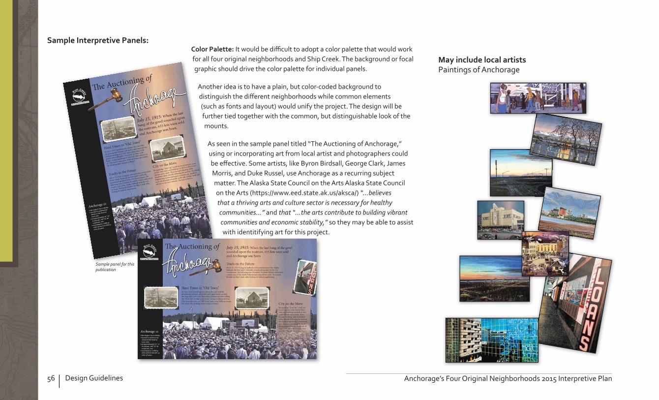
56 Design Guidelines Anchorage’s Four Original Neighborhoods 2015 Interpretive Plan
It would be di cult to adopt a color palette that would work for all four original neighborhoods and Ship Creek. The background or focal graphic should drive the color palette for individual panels.
Another idea is to have a plain, but color-coded background to distinguish the di erent neighborhoods while common elements (such as fonts and layout) would unify the project. The design will be further tied together with the common, but distinguishable look of the mounts.
As seen in the sample panel titled “The Auctioning of Anchorage,” using or incorporating art from local artist and photographers could be e ective. Some artists, like Byron Birdsall, George Clark, James Morris, and Duke Russel, use Anchorage as a recurring subject matter. The Alaska State Council on the Arts Alaska State Council on the Arts (https //www.eed.state.ak.us/aksca/) “...believes that a thriving arts and culture sector is necessary for healthy communities...” and that “...the arts contribute to building vibrant communities and economic stability,” so they may be able to assist with identitifying art for this project.
Paintings of Anchorage
Sample panel for this publication

57Design GuidelinesAnchorage’s Four Original Neighborhoods 2015 Interpretive Plan
Smartphone applications, tours, and brochures are all e ective ways to reach residents and visitors. A Centennial Trail walking tour could be designed to lead people to a series of historic locations in the four neighborhoods and Ship Creek. This tour could be available as a Smartphone application, in a printed walking tour brochure, or as a guided tour.
It is likely that the major sites along the tour will also have interpretive panels. A metal plate that has a relief image depicting each site on the walking tour could be included in the panel mount, but they could also be a stand-alone design. Residents and visitors can visit each site and make a “rubbing” as a souvenir. Each of the major themes of Anchorage’s history should be represented.
A fairly comprehensive list of interpretive media in the planing area is included in Appendix B and should be used to develop a walking tour.
Sample brochure for this publication
the wall or a brass plate and keep as a souvenir.h ll b l d k
rubbing opportunity

58 Design Guidelines Anchorage’s Four Original Neighborhoods 2015 Interpretive Plan
There are as many options as the imagination can conjure. Each mount could be based like the examples shown here.
Alaska State Parks has many standard designs that can be viewed online at http //dnr.alaska.gov/parks/designconstruct/standarddrawings.htm Below is a commonly used mount by Alaska State Parks and others.
The National Park Service uses designs that can be purchased from a variety of manufacturers. Below is a commonly used mount by NPS.
This four-sided kiosk could be adapted to re ect the previously described identifying features unique to the four original neighborhoods.

59Design GuidelinesAnchorage’s Four Original Neighborhoods 2015 Interpretive Plan
Occasionally, there are large, open spaces where multiple panels could be displayed. The following “octo-kiosk” is just one example of a multi-panel option. This would not work in places, such as downtown, where there is not ample space to support the footprint, or the crowd attracted by such a large display. It would, however, work well in neighborhood parks.
seasonally, such as these at Donner Summit near Truckee, California.

60 Design Guidelines Anchorage’s Four Original Neighborhoods 2015 Interpretive Plan
to direct people to a website using their cell phone, enabling them to retrieve more detailed information on the spot.
Guided tours allow the visitor to interact with an interpreter and get answers to questions that may not be addressed in static interpretation.
There are many ways, personal and non-personal, that can be considered to present interpretation to the public.
Logos and other identifying materials
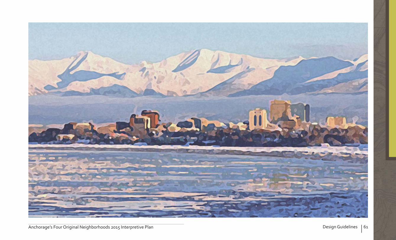
61Design GuidelinesAnchorage’s Four Original Neighborhoods 2015 Interpretive Plan


63Evaluating InterpretationAnchorage’s Four Original Neighborhoods 2015 Interpretive Plan
8. EVALUATING INTERPRETATION Creating guidelines for evaluating the e ectiveness of interpretive sites and materials is an essential part of the planning process. The purpose of evaluations is to help measure whether the Plan’s goals and objectives are being met. The intent of evaluations is to collect information to make improvements and decisions about future planning.
There are many appropriate methods for evaluating interpretation. A combination of methods will produce the best results. Media, especially interpretive panels, should be evaluated at least every ten years for both content and graphics. If panels are left too long, the message and graphics can become dated and unappealing to visitors. Using peer reviews, oral interviews, exit questionnaires, observation, and suggestion boxes would all be e ective methods for evaluating sites and services.
Professional interpreters developing media should allow for a peer review process. A group of people with varying interests will provide valuable input in the developing stages of interpretation and the product will greatly bene t from this process.
Visitors could be approached for a short interview about interpretation in the four original neighborhoods. Interviews can provide a person’s impressions and allows for follow-up questions to learn more about someone’s opinions.
Visitors could be given a questionnaire with pointed questions to determine whether the interpretative media’s objectives were met and the themes communicated. The questionnaire should also solicit ideas for improvement.
Indirect observation—having someone observe how visitors react to interpretive exhibits—is a good method for evaluating the e ectiveness of each display, including its ability to attract and hold a visitor’s attention.
Suggestion boxes or guest books could be placed in areas of high visitation to provide travelers a place to share their thoughts, suggestions, and ideas. A system should be established whereby the comments are regularly retrieved. Paper and pencils would need to be supplied and restocked. A digital “suggestion box” on the internet could also yield helpful post-trip insights.

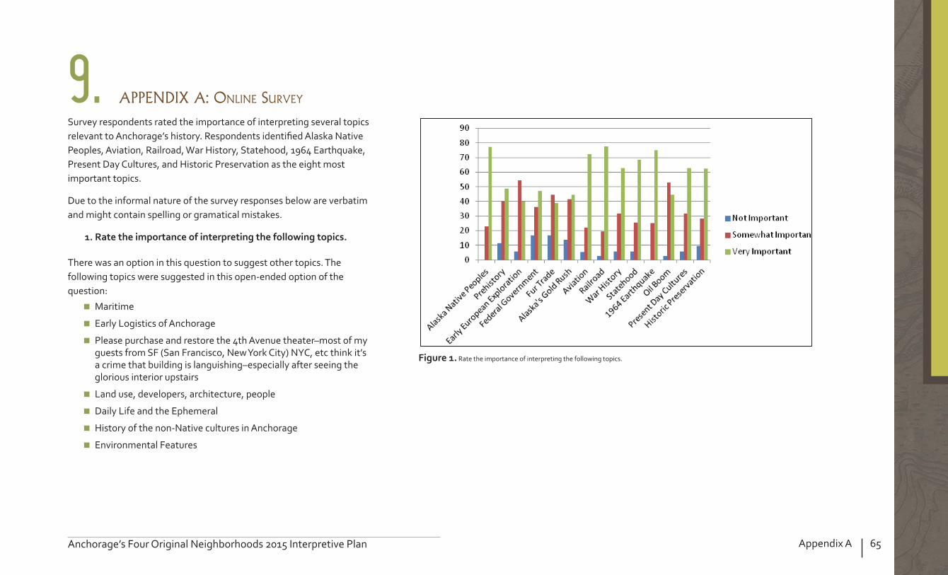
65Appendix AAnchorage’s Four Original Neighborhoods 2015 Interpretive Plan
9. APPENDIX A: ONLINE SURVEY
Survey respondents rated the importance of interpreting several topics relevant to Anchorage’s history. Respondents identi ed Alaska Native Peoples, Aviation, Railroad, War History, Statehood, 1964 Earthquake, Present Day Cultures, and Historic Preservation as the eight most important topics.
Due to the informal nature of the survey responses below are verbatim and might contain spelling or gramatical mistakes.
There was an option in this question to suggest other topics. The following topics were suggested in this open-ended option of the question
Maritime
Early Logistics of Anchorage
Please purchase and restore the 4th Avenue theater–most of my guests from SF (San Francisco, New York City) NYC, etc think it’s a crime that building is languishing–especially after seeing the glorious interior upstairs
Land use, developers, architecture, people
Daily Life and the Ephemeral
History of the non-Native cultures in Anchorage
Environmental Features
Rate the importance of interpreting the following topics.

66 Appendix A Anchorage’s Four Original Neighborhoods 2015 Interpretive Plan
The second question of the survey revealed that nearly two-thirds of the participants are aware of some interpretation in the survey area. However, the results indicate that 37 are not aware of any interpretation.
Are you aware of any interpretation (panels/signs, tours, etc.) in any of the four original neighborhoods (Downtown, Fairview, South Addition, and Government Hill, including Ship Creek)

67Appendix AAnchorage’s Four Original Neighborhoods 2015 Interpretive Plan
For those who answered “yes” to this question, the third question was a follow-up, asking what changes would most improve the current interpretive panels in the survey area.
Update them physically and with Social Media, so folks can learn more, if they want to. Use them as destination points for walking tours.
Be certain the signs are durable and weather/vandalism resistant.
Phone and mobile based data.
Update, make easier to read.
Update and expand interpretive panels.
Upkeep, upgrade, more of them, info about people other than white male businessmen.
The only interpretive panels I’m aware of are at Ship Creek and they are about Government Hill. Fairview needs some loving.
More. Photos. Weatherproof/vandal proof.
I do think it would be interesting to add information about the Dena’ina.
More photos/images.
I’ve seen interpretive panels only in Elderberry Park. Add some to the neighborhoods in other public spaces.
Ship Creek.
Opportunity for easy upgrades/updates would be neat – QR codes
Make it a game – scavenger hunt of sorts – with phone interaction QR codes. Or in the tactile sense – button pushing – invisible picture rubbings – etc.
Replace the old AHPI triangular kiosks.
Better materials, graphics and placement. Something to make them standout and be noticed.
Updating – both in form and messaging.
The signs downtown are okay – I have no ideas about how to improve them. Fairview could use some panels, perhaps at signi cant spots such as by Claris Syren’s log house, the Baptist church on 13th and Ingra, or Carrs-Gambell.
I believe the graphics of the planetary walk are cheap and not attractive. I hope the graphic standard of new displays will be top notch.
The signage that was done over 25 years ago by the Anchorage Historic Properties, Inc. is old, outdated, and needs to be replaced

68 Appendix A Anchorage’s Four Original Neighborhoods 2015 Interpretive Plan
Identify the most e ective ways to communicate the historic signi cance of the four original neighborhoods to visitors and residents. Hint If you make your selections from 1 through 8 in that order, it will help sort them as you answer the question.
The fourth question listed many types of media through which one could interpret a topic. Respondents were asked to rank the media in terms of e ectiveness.
Social media was identi ed as the least e ective way.

69Appendix AAnchorage’s Four Original Neighborhoods 2015 Interpretive Plan
The last three questions in the survey were open-ended questions. The fth question asked what people hoped to accomplish with new interpretation. The sixth question asked respondents to identify locations where they would like to see new interpretation. The nal question of the survey allowed people to provide comments that are relevant to interpreting Anchorage’s four original neighborhoods.
Make Anchorage residents more aware of their heritage—we tend to believe that we are too young for real history.
Giving visitors and new comers to Anchorage a sense of the rich history that truly is here.
Deeper understanding of history of neighborhoods.
Engage young audience. Support business economic development.
Updated and accurate info. Short tidbits of info.
Showcase our history. And get folks excited about the neighborhoods and contributing to their continuing history. We’re also fortunate because some of our history makers are still alive.
Maintain the integrity of those communities and begin to impart a sense of history that is lacking in our young city.
Better care and appreciation of local sites of interest. Ship Creek should be continually cleaned up and developed as a scenic walk and bike.
Give a sense of place to residents, fostering pride in the physical place and regard and care for fellow citizens. Entertain tourists.
Revitalization and care of the historic neighborhoods, mixed use, mixed housing, sidewalks, public transportation, good restaurants, pride.
Preservation.
Putting our neighborhood’s independence and unique character in perspective to the growth of anchorage.
Better understanding of historical importance of Original Four.
Help me know my neighborhood.
Improved public appreciation for how these neighborhoods came about and the important events and people related to these neighborhoods.
Very little, unless done right.
n
and
w
aandnd
Totems, such as this, can help interpret Native history, Alaska Native Heritage Center

70 Appendix A Anchorage’s Four Original Neighborhoods 2015 Interpretive Plan
Add to the walkability of the neighborhood while letting people know about the pastI’m not sure the goal. Making a stronger community or inviting tourists into the neighborhoods. I tend to think community should be the focus. Could the local businesses host a tour or event speci c to their eld (banking, architecture, gov’t) looking at our town through the eyes of the people who live, work & play here.
Help to explain the cultural history and character of the neighborhoods.
More pride. More preservation.
Raise awareness of the areas history and signi cance in developing Anchorage.
It could help young people appreciate the history of their neighborhoods.
It will give folks a sense of what it used to be like and how it has changed over the centuries.
Bring cultures and classes closer together, develop pride in our community.
Increased representation of the Dena’ina Athabascan’s use of the Anchorage Bowl and communicating the idea that the Dena’ina is still a part of the Anchorage landscape.
How about something at bus stops with the covered booths
Block 13/pilots row, safe haven, CAA housing, Cemetery, Port Overlook, Delaney Park Strip.
Park Strip Westchester lagoon Popular neighborhood businesses By intersection mail drop boxes.
Ship Creek. Toured Peal Street Mall, Boulder last week. Awesome!
Several areas on Government Hill.
Ship Creek – need interpretive panels about salmon life history, Parkstrip, Coastal Trail, 4th Ave Theater needs restoration and daily tours with historic movie footage…or something like that Tourists need more “ongoing activities” in downtown to visit. 4th Avenue Theater is a PRIME candidate.
Gambell St, old native medical center, old ski hill.
No.
14th and G.
The Delaney Park Strip in both Fairview and South Addition, the park at the end of Harvard in Government Hill and Town Square Park.
Need more space.
Along walking routes. Connectors between neighborhoods…perhaps with a “distance to next sign” marking and an arrow.
Park Strip.
Delaney Park, Government Hill, Anchorage Memorial Park, Near Carrs Gambell ( rst Carrs store), near Greater Friendship Church (1st African-American Church in Anchorage).

71Appendix AAnchorage’s Four Original Neighborhoods 2015 Interpretive Plan
Coastal trail and bike paths. Neighborhood commercial sites (like City Market) or churches (like Shiloh Baptist) to orbit around. Those places also link the paths to the neighborhoods.
Elderberry Park, Outside Oscar Anderson House, Suzanne Nightingale Park, Park Strip (various locations), Area schools and public buildings, it could be sprinkled around the area leading interest from one to another.
Throughout trail system – coastal and ship creek and throughout the downtown core to provide interpretation plus way nding to get people down onto the trails.
Claris Syren’s log house (13th and Karluk), the Baptist church on 13th and Ingra, Carrs-Gambell, area around Eastchester Park (interpretation could discuss urban renewal in that part of the neighborhood.
Not really.
4th Avenue Parkstrip coastal trail individual buildings or sites.
3rd and L. Street, 3rd and F. Street, 4th and Gambell, Brown’s Point Park.
Focus on local audiences and not tourists although tourists are still important. Most interpretation is geared to white, middle class. Think about reaching non-traditional audiences—Native visitors to Anchorage, other more recent immigrant ethnicities.
Merrill Field should somehow be included to tie in the aviation aspect of history.
Aerial tours on video could be e ective. Use of new technology such as Google 360 degree camera.
NOPE!
Govt Hill. Signage explaining the old wireless buildings, Quoncet buildings, water tower, 1st general store and other buildings or architecture that have special meaning for our community.
4th Avenue Theater needs renovation and interpretive tours. Some of the art work and “art deco” features are really worth preserving and displaying. It would be a great venue for arctic entries which outgrew the Snowgoose venue.
It would be neat to have some barrels you could look through that would site important landmarks like they have similar at the Portage Visitors center. Very cheap and low maintenance. Colleen Wolpert has done something similar in Syracuse but with old images laid over the new when you look through the tube.
Where are the locals getting their co ee, walking their dog, buying their groceries (all of these neighborhoods would bene t from a centrally located grocery – downtown.) exercising, etc. What does their day look like

72 Appendix A Anchorage’s Four Original Neighborhoods 2015 Interpretive Plan
The project needs to be more than the white man’s history of Anchorage, which is what the old AHPI kiosks are. It is important to include Alaska Natives and other cultures and women as part of the interpretive project.
Don’t forget to include that Fairview was Anchorage’s defacto segregated black neighborhood. It even followed the pattern of putting the black neighborhood on unstable ground in ood zones (the creek) in the style of Philadelphia and major cities like that. (Didn’t see this aspect of history mentioned in section 1.) War history end of Cold War opened air space over Russia and so reduced Anchorage’s role as a strategic location for American ight. This is such a great project!
The Railroad should be consulted. Focus on the interesting people you interviewed in a previous project.
Are their any archaeological sites in these area.
Also include the aerial photos of anchorage’s growth over the years. And some way of describing the in ux of wealth and how yesterday’s society was more “ at” with less attention paid to wealth and education than today.
If this project is related to the Anchorage Centennial then why is the interpretation being limited to the four original neighborhoods. In other words, Anchorage’s early history also extends out into Spenard and the homesteads that were north of Government Hill that were there before the military purchased the lands in 1941-1942.
Oscar Anderson House

73Appendix AAnchorage’s Four Original Neighborhoods 2015 Interpretive Plan

74 Appendix C Anchorage’s Four Original Neighborhoods 2015 Interpretive Plan
° 0 0.5 10.25 Miles
Interpretive Displays
Neighborhood Boundaries
Knik Arm
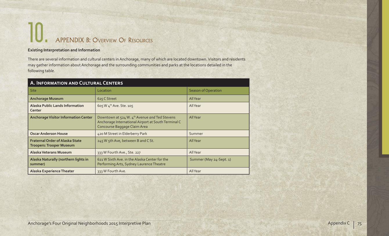
75Appendix CAnchorage’s Four Original Neighborhoods 2015 Interpretive Plan
10. APPENDIX B: OVERVIEW OF RESOURCES
There are several information and cultural centers in Anchorage, many of which are located downtown. Visitors and residents may gather information about Anchorage and the surrounding communities and parks at the locations detailed in the following table.
Site Location Season of Operation
625 C Street All Year
605 W 4th Ave. Ste. 105 All Year
Downtown at 524 W. 4th Avenue and Ted Stevens Anchorage International Airport at South Terminal C Concourse Baggage Claim Area
All Year
420 M Street in Elderberry Park Summer
245 W 5th Ave, between B and C St. All Year
333 W Fourth Ave., Ste. 227 All Year
621 W Sixth Ave. in the Alaska Center for the Performing Arts, Sydney Laurence Theatre
Summer (May 24-Sept. 1)
333 W Fourth Ave. All Year

76 Appendix C Anchorage’s Four Original Neighborhoods 2015 Interpretive Plan
Government HillInterpretive Displays
Government Hill
Knik Arm
Joint Base Elmendorf-Richardson
Fairview Airport Heights
Mountain View
East Whitney Road
W Harvard Ave.E Cook Ave.
E Loop Rd.
Hollywood Dr.
Ceda
r St.
Dogw
ood
St.
Elm
St.E Manor A
ve.
Ocean D
ock Rd.
Viking Dr.
Reev
e Bl
vd.
Ship Creek Trail
F3
M4F2
R1M5
M6R2
C5
A2,C1
P2
P3
A3,C2
P4P6
P5
O1
O2O3
Railroad
Trail
Park
Community Boundary
0 0.25 0.50.125Miles
R Undeveloped
P Tilted Panel
D 3+ Sided Kiosk
O Regulatory
F Art/Cultural
C 3-Sided
A 1-Sided
M Park Welcome Sign
Road
Ship Creek Ave.D
Knik Arm / Lake
Interpretive Display

77Appendix CAnchorage’s Four Original Neighborhoods 2015 Interpretive Plan
Location Collection Title and Description
Suzan Nightingale McKay Memorial Park
Unique art Depicts Mount Mckinley and has a small plaque describing Sydney Laurence’s life, development as a painter, and his signi cance as an Alaskan artist.
Vandalized, scratched up
Brown’s Point Park Unique art Totem pole created by schoolchildren and restored by the community around 2008
Al Miller Park Muni Park Welcome Sign Good condition
Park o E. Harvard Ave./Hollywood Dr. (curling club)
Muni Park Welcome Sign Good condition
Alderwood Park Muni Park Welcome Sign Good condition
E. Whitney Rd. (access to Ship Creek Trail
Double sided, wooden, roofed kiosk (two panels in one)
Warns against feeding geese and describes some negative e ects of doing so.
Tells of Ship Creek’s trouble with contamination due to urbanization and Anchorage’s e ort and tentative success at cleaning the creek up.
Old, faded (nothing on other side)
Ship Creek Overlook, E. Whitney Rd.
Double sided, metal-frame kiosk
Describes Ship Creek’s appeal to residents and visitors, the challenges it faced in the ‘90s, and the planning process in the e ort to make the creek more attractive and accessible. (Things have changed a lot since this “poster” was written.)
Outdated content, shows its age
Double sided, metal-frame kiosk
This panel gives readers a snapshot of the life cycle of Paci c salmon from one season to the next.
Old and faded, poorly written
Ship Creek Trail (near the east end of E. Ship Creek Ave.
Ship Creek Trail Interp. Panel mounted on railing
This panel describes the birth of Anchorage as “Tent City,“ the living conditions there, and the decision to move the “town” across Ship Creek
Vandalized and scratched up
F2F2
F3
C2
C2
C5

78 Appendix C Anchorage’s Four Original Neighborhoods 2015 Interpretive Plan
E St
reetWest 10th Avenue
East Whitney Road
West 9th Avenue
West 3rd Avenue
West 2nd Avenue
K S
tree
t
West 8th Avenue
West 1st Avenue
East Ship Creek AvenueSmall Boat Launch Road
Coa
stal
Pla
ce
North C Street
Nor
th A
Str
eet
West 7th Avenue
East 2nd Court
Port
Acces
s Roa
d
West 5th Avenue
East 10th Avenue
East 9th Avenue
F St
reet
East 2nd Avenue
East 8th Avenue
D S
tree
t
Unnamed Road
East 7th Avenue
D S
tree
t
H S
tree
t
B S
tree
tB
Str
eet
G S
tree
t
Den
ali S
tree
t
Eagl
e St
reet
East 4th Avenue
Bar
row
Str
eet
East 6th Avenue
Den
ali S
tree
t
East 1st Avenue
Alaska Public LandsInformation Center
(Historic AnchorageFederal Bldg.) ° 0 260 520130
Feet
Trail
Park
Building
VisitorInformation
Center
K8-K13 K1-K7
K16&P1
N2 N4
J9K20
K22N3
K23N5 J2
J3J4
J5
J11K21
J6E1
J7
E2-13,S
L
J1
M3M2M1
K17-K19
D
C5P2A2
C1P3 P4
A3 C2
P6
P5
AnchorageMuseum
A 1-SidedC 3-SidedD 3+ Sided KioskE Anchorage TimelineJ Historic Anchorage Walking TourK Memorial/MonumentL Old 556M Park Welcome SignN Planet WalkP Tilted PanelS Wall Panel
Community Boundary
Railroad
South Addition
Fairview
Downtown
Government Hill
J10
Interpretive Display
Road
Knik Arm
Ship Creek Trail
Tony Knowles Coastal Trail
J8
Alaska Railroad Depot

79Appendix CAnchorage’s Four Original Neighborhoods 2015 Interpretive Plan
Location Collection Title and Description
W. 8th Ave., between D St. and E St.
Unique three-panel kiosk
Relates the story of how the rst school in Anchorage came to be, how many students attended, where it was located, and where the building is today
Slightly warped
Unique three-panel kiosk
Talks about the residents of three of Anchorage’s original houses that once stood at this location
Slightly warped
Unique three-panel kiosk
Covers the establishment of Anchorage as a town and its growth, focusing on the children of Anchorage
Slightly warped
W. 5th Ave. at Performing Arts Center
Walking Tour Historic AnchorageThree-panel kiosk
Discusses Anchorage’s favorite sport in its early days—baseball
Vandalized with a sharpie
Walking Tour Historic AnchorageThree-panel kiosk
Covers Independence Day celebrations in Anchorage between 1915 and 1932
Good condition
Walking Tour Historic AnchorageThree-panel kiosk
Covers the birth of Anchorage’s favorite winter festival—Fur Rondy
Some scratches
Corner of W. 4th Ave. and F St., in front of the Visitor Information Center
Walking Tour Historic AnchorageThree-panel kiosk
Describes the birth of Anchorage on the banks of Ship Creek as a camp of people hoping to work on the railroad or catering to those hoping to work on the railroad
Some scratches and dents, slightly warped
Walking Tour Historic AnchorageThree-panel kiosk
Focuses heavily on the various buildings which once housed the City Hall, especially the rst, wood-frame building and the second, Depression-era, concrete-cast building. It also talks about the WWI parade and the volunteer re department
Slightly warped
(J3) Walking Tour Historic AnchorageThree-panel kiosk
Covers Alaska’s history from before European contact, through Euro-American discovery, the Russian era, the Alaska Purchase, and the Klondike Gold Rush
Some fading, some rust, slightly warped

80 Appendix C Anchorage’s Four Original Neighborhoods 2015 Interpretive Plan
Corner of W. 4th Ave. and F St., in front of the Federal Building
Walking Tour Historic AnchorageThree-panel kiosk
Tells the intertwined story of Austin “Cap” Lathrop and the 4th Avenue Movie Theater
Warped, rusted, edges and framing damaged
Walking Tour Historic AnchorageThree-panel kiosk
Talks of WWII in Alaska—the Aleutian Campaign and the Japanese invasion of Attu and Kiska
OK condition, rust mark near center
Walking Tour Historic AnchorageThree-panel kiosk
Highlights Alaska’s admittance into the Union as the 49th state. The bottom half discusses that block’s historic use
Good condition
Corner of W. 3rd Ave. and F St., by Hilton Hotel
Walking Tour Historic AnchorageThree-panel kiosk
Talks about some of the rst ascents of Mount McKinley, or Denali
Slightly warped, some small scratches
Walking Tour Historic AnchorageThree-panel kiosk
Discusses the two main economic engines in Alaska in the late 1800s and early 1900s—gold and salmon
Rusted marks on bottom right corner
Walking Tour Historic AnchorageThree-panel kiosk
Panel missing
Corner of W. 4th Ave. and E St.
Walking Tour Historic AnchorageThree-panel kiosk
Tells the story of Sydney Lawrence, perhaps Alaska’s most famous artist
Slightly warped, some scratches and peeling on title
Walking Tour Historic AnchorageThree-panel kiosk
Describes the businesses that once lined this block and introduces the reader to the lingo and cool facts of the 1920s
Rusted spot near middle and around edges, some scratches, slightly warped
Walking Tour Historic AnchorageThree-panel kiosk
Focuses on W. 4th Ave. and the businesses and events it was home to from construction until the 1964 earthquake
Chipped, rusted and quite warped
Loussac-Sogn Building, 429 D St.
Walking Tour Historic AnchorageWall-mounted single panel
Pays homage to “Zack,” a multi-faceted man who went broke many times seeing his fortune and nally got it right in Anchorage. He became mayor of Anchorage and perhaps Anchorage’s rst philanthropist
Good condition

81Appendix CAnchorage’s Four Original Neighborhoods 2015 Interpretive Plan
W. 4th Ave. at intersection with D St.
Walking Tour Historic AnchorageThree-panel kiosk
This panel covers three di erent topics Club 25 building, Felix’s Haberdashery, and pilot Bob Reeve
Slightly warped, rusted on left edge
Walking Tour Historic AnchorageThree-panel kiosk
This panel describes the former gold-mining town of Iditarod and the dog mushing race named after this present-day ghost town
Fairly good condition
Walking Tour Historic AnchorageThree-panel kiosk
Covers the events and aftermath of the 1964 Good Friday earthquake in Anchorage
Chipped, rusted, green paint near top, slightly warped
W. 2nd Ave. at intersection with E St.
Walking Tour Historic AnchorageThree-panel kiosk
Empty kiosk
Corner of W. 2nd Ave. and F St.
Walking Tour Historic AnchorageThree-panel kiosk
This panel also has three separate topics the “Silk Stocking Row” (once the swankiest part of town with the grandest homes), the home of Anchorage’s
rst elected mayor, and the missing J Street
Chipped, rusted, scratched (seems to have been shot), slightly warped
Walking Tour Historic AnchorageThree-panel kiosk
Tells of the women of Anchorage, few in number, but according to this panel, certainly worth their salt—and they were given their due
Slightly warped
Walking Tour Historic AnchorageThree-panel kiosk
Provides a short biography of the three men who made up the Alaska Engineering Commission in charge of the construction and operation of the Alaska Railroad
Slightly warped
The Alaska Railroad Depot, 411 W. 1st Ave.
Walking Tour Historic AnchorageThree-panel kiosk
Highlights the three main private railroads in Alaska’s early days the Wild Goose Railroad, the White Pass/Yukon Railroad, and the Copper River and Northwestern Railroad
Good condition
Walking Tour Historic AnchorageThree-panel kiosk
Explains how impressive and unique the construction and completion of the Alaska Railroad was
Some small scratches
Walking Tour Historic AnchorageThree-panel kiosk
Describes President Harding’s visit to Alaska in honor of the completion of the Alaska Railroad
Chipped and rusted on the bottom edge

82 Appendix C Anchorage’s Four Original Neighborhoods 2015 Interpretive Plan
Corner of G St. and
W. 5th Ave.
Anchorage Light Speed Planet Walk(Sun)
Many displays and panels; domed sun “sculpture”
Good condition
Anchorage Light Speed Planet Walk(Sun)
Explains the origin of the solar system
Good condition
Anchorage Light Speed Planet Walk(Sun)
Covers the life of a star from birth to death
Good condition
Anchorage Light Speed Planet Walk(Sun)
Examines the Sun’s layered composition
Good condition
N5
N5
N5
N5

83Appendix CAnchorage’s Four Original Neighborhoods 2015 Interpretive Plan
Anchorage Light Speed Planet Walk(Sun)
Interactive solar system display• Take a walk through our Solar System• Dividing up our time• Our Moon and others• Our Sun’s Violent Surface• Earth Our Observing Platform• Solar Wind • Other Solar System object’s in Earth’s neighborhood• And beyond Earth’s neighborhood…• Cultural Groups of Alaska • Raven, the Trickster• Raven and the Milky Way• The Girl Who Married the Moon• Tulunigraq• Auroras and Constellations• “The Eye of the Universe” Ellanguaq and the Cosmos• Alaska Native Language Map• For More Information…• Meet an Alaskan Planet Walker• Evolution of a Planet Walk• What is a Planet Walk• Alaska-Land of the Midnight Sun• The Rise and Fall of the Midnight Sun
Good condition
Corner of H St. and W. 5th Ave.
Anchorage Light Speed Planet Walk
Explains the Planet Walk and describes Mercury’s extreme conditions and composition
Good condition
W. 5th Ave. near I St. Anchorage Light Speed Planet Walk
Explains the Planet Walk and describes characteristics of Venus
Good condition
N5
N5
N5 N5
N5 N5

84 Appendix C Anchorage’s Four Original Neighborhoods 2015 Interpretive Plan
W. 5th Ave. near K St.
Anchorage Light Speed Planet Walk
Explains the Planet Walk and describes the characteristics of Earth that allow for life
Good condition
Sunshine Plaza W. 4th Ave.
Sunshine Plaza and 4th Avenue Market Place Interp.
Provides a snapshot of the Anchorage Area history starting between 5000 B.C. and 1868 A.D.
Good condition, poster-like and nailed to the wall
Sunshine Plaza and 4th Avenue Market Place Interp.
Discusses Alaska Native cultures through prehistory, history, and present
Good condition, larger but still poster-like and nailed to the wall
Sunshine Plaza and 4th Avenue Market Place Interp.
Provides a snapshot of the Anchorage Area history between 1880 and 1898
Good condition, poster-like and nailed to the wall
Sunshine Plaza and 4th Avenue Market Place Interp.
Provides a snapshot of the Anchorage Area history between 1906 and 1918
Good condition, two poster-like nailed side by side to the wall
Sunshine Plaza and 4th Avenue Market Place Interp.
Explores how Euro-American contact a ected Alaska Natives
Good condition, larger but still poster-like and nailed to the wall
Sunshine Plaza and 4th Avenue Market Place Interp.
Covers the development of the railroad through the Anchorage area and how and why Anchorage relocated
Good condition, larger but still poster-like and nailed to the wall
Sunshine Plaza and 4th Avenue Market Place Interp.
Covers the rapid evolution of Anchorage into a modern town until WWI and the 1919 in uenza epidemic halted the expansion
Good condition, larger but still poster-like and nailed to the wall
Sunshine Plaza and 4th Avenue Market Place Interp.
Discusses the incorporation of Anchorage as a city and its early development transportation
Good condition, larger but still poster-like and nailed to the wall
Sunshine Plaza and 4th Avenue Market Place Interp.
Provides a snapshot of the Anchorage Area history between 1920 and 1937
Good condition, poster-like and nailed to the wall
N2N2
E1
E1
E2
E2
E2
E2
E2
E2
E2

85Appendix CAnchorage’s Four Original Neighborhoods 2015 Interpretive Plan
4th Avenue Market Place, 411 W. 4th Ave.
Sunshine Plaza and 4th Avenue Market Place Interp.
Explores the evolution of transportation during the 1930s, including roads, airports, and military bases
OK condition, some writing scratched on it, larger but still poster-like and nailed to the wall
Sunshine Plaza and 4th Avenue Market Place Interp.
Provides a snapshot of Alaska history between 1940 and 1949
Good condition, poster-like and nailed to the wall
Sunshine Plaza and 4th Avenue Market Place Interp.
O ers a glimpse of the drastic changes that took place in Anchorage during WWII
OK condition, scratched, larger but still poster-like and nailed to the wall
Sunshine Plaza and 4th Avenue Market Place Interp.
Explains the evolution of air travel in Anchorage during WWII
Smudged and slightly warped, larger but still poster-like and nailed to the wall
Sunshine Plaza and 4th Avenue Market Place Interp.
Provides a snapshot of Alaska and Anchorage history between 1950 and 1964
Good condition, poster-like and nailed to the wall
Sunshine Plaza and 4th Avenue Market Place Interp.
Covers the surprising economic growth of Anchorage, its role in the Cold War, and Alaska’s climb to statehood
Good condition, larger but still poster-like and nailed to the wall
Sunshine Plaza and 4th Avenue Market Place Interp.
Provides a snapshot of Alaska and Anchorage history between 1965 and 1969
Good condition, poster-like and nailed to the wall
Sunshine Plaza Interp. Provides a snapshot of Alaska and Anchorage history between 1971 and 1976
Good condition, poster-like and nailed to the wall
Sunshine Plaza and 4th Avenue Market Place Interp.
A collection of images
Good condition, poster-like and nailed to the wall
Sunshine Plaza and 4th Avenue Market Place Interp.
Provides a snapshot of Alaska history between 1976 and 1985, with a special focus on Alaska oil production
Good condition, poster-like and nailed to the wall
Sunshine Plaza and 4th Avenue Market Place Interp.
Provides a snapshot of Alaska history between 1988 and 1996, with a heavy focus on Alaska oil production
Good condition, some smudges, poster-like and nailed to the wall
E3
E4
E4E5
E6
E7
E8
E9
E10
E11 E11

86 Appendix C Anchorage’s Four Original Neighborhoods 2015 Interpretive Plan
Sunshine Plaza and 4th Avenue Market Place Interp.
Provides a snapshot of Alaska history between 1998 and 2008
Good condition, poster-like and nailed to the wall
W. 5th Ave. and A St. Fire ghter Memorial Consists of a statue of a re ghter, 27 plaques honoring re ghters who died on the job or as a result of their job, a plaque with a poem titled “A Fire ghter’s Prayer,” a panel, and a bell.
Good condition
Fire ghter Memorial Dedicates the memorial to all Alaska Fire ghters and Emergency Responders who died serving Alaskans and recognizes the contributors to the memorial
Good condition, mounted on metal stand
W. 2nd Ave. near the intersection with E St.
Eisenhower Alaska Statehood Monument
Consists of a statue, plaques, and three interpretive panels
Needs some maintenance, the monument name on the statue is missing an “A,” the railing needs a new coat of paint, some of the “marble” is broken in places, and plaques need cleaning
Eisenhower Alaska Statehood Monument
Discusses the Alaska Railroad’s origin and construction, its intended mission, and its completion
Fairly good condition, frame slightly warped
Eisenhower Alaska Statehood Monument
Explains how the railroad mission related to the Matanuska Valley’s economic development and then talks about the Matanuska Valley Colony experiment
Appears to have a bullets hole/damage
Eisenhower Alaska Statehood Monument
Tells of Anchorage’s origins as “Tent City,” the president’s order to move the improvised town site from the mud ats to the blu , and of the land auction
Fairly good condition
W. 1st Ave. in front of the Alaska Railroad Depot
The Alaska Railroad Display/Monument
Consists of Train Engine 1, two small totem poles, and a marble plaque
Good condition
K St. across from the Captain Cook Hotel
Captain James Cook Display /Monument
Metal sculptures of three ships in a concrete pit with engraved sides and four sculpted metal plaques, one at each corner
Good condition, some wear evident on the plaques (could be purposely worn for the artistic impression) and some weeds growing in the bottom of the pit.
K17
K20
K19
K20
K20K20
K21
K17
E12

87Appendix CAnchorage’s Four Original Neighborhoods 2015 Interpretive Plan
Captain James Cook Display /Monument
This plaque gives the reader a quick overview of Captain Cook’s origin and rst voyage in 1768, telling of the success of his rst mission, detailing the terms of the second mission and covering the execution of this second mission
Good condition, some wear (could be purposely worn), cracked near middle
Captain James Cook Display /Monument
This plaque explains Captain Cook’s second voyage and his mission of circumnavigating the globe from west to east. It also tells of the honor he received for
guring out how to prevent scurvy aboard his ship—none of his crew died of scurvy
Good condition, some wear (could be purposely worn)
Captain James Cook Display /Monument
This plaque provides an account of Captain Cook’s third and last voyage in search of the Northern passage and his death in Hawaii
Good condition, some wear (could be purposely worn), scratched up
Captain James Cook Display /Monument
This plaque gives the title of the monument/art display and contains a dedication of it to “…the Children of the World who sail uncharted waters, explore new horizons, and…improve the lot of all mankind…” by Walter J. Hickel. It also attributes the sculpture to Josef Princiotta with Susan McKittrick, Jim Froehlich, and Dean McTavish
Good condition, some wear (could be purposely worn)
W. 5th Ave. almost H St. at the entrance of Holy Family Cathedral
Commemoration of Pope John Paul II’s visit This plaque provides an excerpt of Pope John Paul II’s address in the cathedral
Good condition, some scratches and marks, but few
N. C St. near W Ship Creek Ave.
Four-panel kiosk in RR plaza
This panel describes how WWII a ected the Alaska Railroad, increasing the need for infrastructure
Good conditionFour-panel kiosk in RR plaza
This panel explains the need for a railroad to open Alaska to travel and trade, discusses the existence of private railroads and President Wilson’s decision to create a new railroad segment that would connect Fairbanks to Seward. This decision caused “Tent City” to spring up
Good condition
K22
K22
K22
K22
K23
D
K22

88 Appendix C Anchorage’s Four Original Neighborhoods 2015 Interpretive Plan
Four-panel kiosk in RR plaza
This panel discusses how the development of the trail route connecting Seward and Fairbanks cause a boom of infrastructure construction, which led the railroad to reroute a potion of Ship Creek to create more usable land for infrastructure.
Good condition
Four-panel kiosk in RR plaza
This panel describes Colonel Otto F. Ohlson, appointed general manager of the Alaska Railroad, and his career in this position
Good condition, a bit dirty
Ship Creek Trail on N. C St.
Three-panel kiosk This panel explains why the Dena’ina called this creek “Stickleback Creek.” It relates the importance of this creek to the survival of Alaska Natives in early spring and tells of the Dena’ina’s in uence today
Good condition
Three-panel kiosk This panel highlights the urban nature of this beloved shing creek and explains the rules of “combat shing” for out-of-towners
Good condition, some marks and scratches
Three-panel kiosk Panel missing
Ship Creek Trail between N. C St. and N. A St.
Single Boy Scout Panel This panel covers what an invasive species is and describes the invasive nature of Northern pike. It also describes ways in which people can help prevent and control the spread of pike
Good condition, though wordy and more of an informational sign than an interpretive panel
Ship Creek Trail between N. C St. and N. A St.
Single historic feature panel
This panel highlights bridges built by the Alaska Engineering Commission for the railroad and timber trestle bridges, with a special focus on the pedestrian bridge that crosses Ship Creek
Good condition
C5
D
C5
P2
C5
D
D

89Appendix CAnchorage’s Four Original Neighborhoods 2015 Interpretive Plan
A2C1
C1 C1
Ship Creek Trail between N. C St. and N. A St.
Green, double-sided, metal kiosk
This panel explores the history of the Alaska Railroad and the Port of Anchorage and the cooperation and con ict between the two
Good condition
Green, double-sided, metal kiosk
This plaque commemorates the Ship Creek area as central to the development of transportation infrastructure in the rest of the state and the development of the City of Anchorage
Good condition
Ship Creek Trail just east of A St.
Single-panel, wooden frame
This panel informs the reader about a 2003 streambank restoration project, the importance of streambanks, and how the reader can help
Both top corners look torn, looks like paper
Ship Creek Trail near pedestrian bridge between Downtown and Government Hill
Single panel mounted on railing/fence
This panel describes the birth of Government Hill and the milestones in this neighborhood’s history
Vandalized and scratched up
Ship Creek Trail just east of the pedestrian bridge to Ship Creek
Single panel mounted on railing/fence
This panel describes the birth of Anchorage as “Tent City,“ the living conditions there, and the decision to move the “town” across Ship Creek
Vandalized and scratched up
P3 P3
P4 P5

90 Appendix C Anchorage’s Four Original Neighborhoods 2015 Interpretive Plan
South AdditionInterpretive Displays
W 15th Ave.
C S
tree
t
W 10th Avenue
MargaretEaganSullivanPark
Elderberry Park
Delaney Park
South Addition
TurnagainNorth Star
Fairview
Delaney Park
Railroad
Trail
Park
Community Boundary
0 0.25 0.50.125Miles
Westchester Lagoon
Delaney Park
Resolution Park
A St
reet
W 17th Ave.
Knik Arm
E St
reet
I Str
eet
L St
reet
W 9th Avenue
W 15th Ave.
U S
tree
t
L St
reet
Chester Creek Greenbelt
P7-P9
H1,N6
K24
G2-G7,C3A4,G1
B2
K16,P1
J12
N1
M S
t.
W 5th Ave.
K22
N2
A5
B3,H2,P10
K14,K15 K1-K7 L
C4
K8-K13
B4
B1A1
K Memorial/Monument
P Tilted Panel
J Historic Anchorage Walking Tour
N Planet Walk
H CommemorativeG Bird PanelsC 3-Sided
A 1-SidedB 1/2 Sided Kiosk
L Old 556
Road
Community Boundary
Downtown
Knik Arm / Lake
Oscar Anderson House
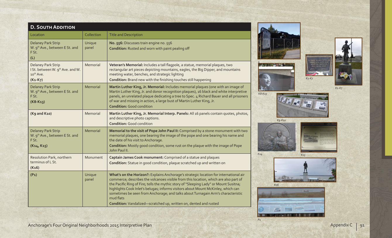
91Appendix CAnchorage’s Four Original Neighborhoods 2015 Interpretive Plan
Location Collection Title and Description
Delaney Park StripW. 9th Ave., between E St. and F St.
Unique panel
Discusses train engine no. 556 Rusted and worn with paint pealing o
Delaney Park StripI St. between W. 9th Ave. and W. 10th Ave.
Memorial Includes a tall agpole, a statue, memorial plaques, two rectangular art pieces depicting mountains, eagles, the Big Dipper, and mountains meeting water, benches, and strategic lighting
Brand new with the nishing touches still happening
Delaney Park StripW. 9th Ave., between E St. and F St.
Memorial Includes memorial plaques (one with an image of Martin Luther King, Jr. and donor recognition plaques), 16 black and white interpretive panels, an unrelated plaque dedicating a tree to Spec. 4 Richard Bauer and all prisoners of war and missing in action, a large bust of Martin Luther King, Jr.
Good condition
Memorial All 16 panels contain quotes, photos, and descriptive photo captions.
Good condition
Delaney Park StripW. 9th Ave., between E St. and F St.
Memorial Comprised by a stone monument with two memorial plaques, one bearing the image of the pope and one bearing his name and the date of his visit to Anchorage.
Mostly good condition, some rust on the plaque with the image of Pope John Paul II.
Resolution Park, northern terminus of L St.
Monument Comprised of a statue and plaquesStatue in good condition, plaque scratched up and written on
Unique panel
Explains Anchorage’s strategic location for international air commerce; describes the volcanoes visible from this location, which are also part of the Paci c Ring of Fire; tells the mythic story of “Sleeping Lady” or Mount Susitna; highlights Cook Inlet’s belugas; informs visitors about Mount McKinley, which can sometimes be seen from Anchorage; and talks about Turnagain Arm’s characteristic mud ats
Vandalized—scratched up, written on, dented and rusted
LL
K8-K13
K1-K7
K1-K7
K9-K10
K14 K15
K16
P1

92 Appendix C Anchorage’s Four Original Neighborhoods 2015 Interpretive Plan
Unique panel
This panel commemorates Captain Cook’s voyages of discovery, especially the voyage that led him up Turnagain Arm, which he called “Turnagain River,” in search of the northwest passage
Vandalized—scratched up and written on
Elderberry Park, W. M St. and 5th Ave.
Walking Tour Historic AnchorageThree-panel kiosk
Talks about Russel H. Merril and his role in Alaska aviationGood condition, some rust near frame at bottom
Walking Tour
Discusses Oscar Anderson’s arrival in Anchorage and his role in the new, developing town
Good condition, small scratch near bottom and some rust near frame at bottom
Walking Tour
Provides a glimpse of Anchorage’s early underground sceneSlightly scratched and dented
W. 5th Ave. near M St. Anchorage Light Speed Planet Walk
Explains the Planet Walk, describes the characteristics of Mars, and explores this Planet’s past and present
Good condition
Margaret Eagan Sullivan Park (Westchester Lagoon, Coastal Trail) (Technically Turnagain not South Addition)
Single panel on wooden posts with a metal back
Covers how to avoid creating a dangerous situation during a moose encounter
Good
(Technically Turnagain not South Addition)
Salmon in the City
Tells of the time when there was a large tidal estuary at Chester Creek’s mouth and the Dena’ina had sh camps along the banks
Good
(Technically Turnagain not South Addition)
Salmon in the City
Explains how the mouth of Chester Creek became Westchester Lagoon and highlights its role in community recreation
Good
(Technically Turnagain not South Addition)
Salmon in the City
Covers the recent improvements to sh access and ood management
Good
P1
N1
A5
P7 P8 P9

93Appendix CAnchorage’s Four Original Neighborhoods 2015 Interpretive Plan
Margaret Eagan Sullivan Park (Westchester Lagoon, Coastal Trail)
Anchorage Light Speed Planet Walk
Explains the Planet Walk and describes the “super” characteristics of Jupiter such as size, mass, speed, weather, and temperature
Good condition, one small scratch and some chipping at the edge
MemorialClear cover is damaged
Margaret Eagan Sullivan Park (Westchester Lagoon, Chester Creek Trail)
Memorial A poem dedicated to Ken, an ironworker Good condition
Memorial A poem dedicated to Ken, an ironworker Good condition, some smudges
Bird panel collection
A short natural history of Red-Necked Grebes Good condition
Bird panel collection
A short description of feather types and functions Good condition
Bird panel collection
A short description of beak types and functions Good condition
Bird panel collection (on side of building)
Discusses Anchorage’s role in the protection of migratory birds that stop here. The panel also gives brief description of Wandering Tattlers, Sur irds, and White-fronted Geese.
Good condition
Bird panel collection (on side of building)
Describes the sounds made by Gulls and Bald Eagles and the commotion that they cause
Good condition
Bird panel collection (on side of building)
Brie y describes those bird species Good condition
Bird panel collection (on side of building)
Brie y describes those bird species
Good condition
H1N6
K24 K24
G2
G4
G3
G5 G5
G5
G5

94 Appendix C Anchorage’s Four Original Neighborhoods 2015 Interpretive Plan
Bird panel collection (on side of building)
Brie y describes this bird species Good condition
Bird panel collection (on side of building)
Brie y describes those bird species Good condition
Bird panel collection
A short description of feet types and functions Good condition
Bird panel collection
A short description of wetlands’ bene cial roles for birds, wildlife, and people
Good condition
Fitness Cluster collection
Explains how to use the Fitness Cluster as a “coach” Fairly good condition
Fitness Cluster collection
Discusses the basic principles of cardiovascular tness and how to determine and use heart rate in achieving tness goals
Fairly good condition
Fitness Cluster collection
ame as side 1 Badly damaged on the Heart Check Guide chart
Bird panel collection
Informs people about how big an impact dogs can have on birds and bird habitat
Good condition
Bird panel collection
A short natural history of Northern Shovelers Good condition
Double sided, wooden, roofed kiosk
Encourages pet owners to keep public areas clean by picking up after their dogs
Fairly good condition
G5 G5
G6G6
C3 C3 C3
A4
B2
G1

95Appendix CAnchorage’s Four Original Neighborhoods 2015 Interpretive Plan
Double sided, wooden, roofed kiosk
Provides a “You Are Here” and highlights Anchorage’s trails Good condition
Margaret Eagan Sullivan Park, between Spenard Rd. and Minnesota/I St.
Double sided, wooden, roofed kiosk
shows where the disc golf course is and denotes, baskets, tee pads, and fairways
Map in fairly good condition, but kiosk is half empty and looks shoddy
Wooden kiosk
Encourages pet owners to keep public areas clean by picking up after their dogs
Fairly good condition
Wooden sign
Recognizes the groups and agencies responsible for developing this area as waterfowl habitat
OK condition (could use some TLC)
Metal frame panel
Explores what and how di erent waterfowl eat and how feeding bird human food can be detrimental
Some scratches and small holes, (too high for even short adults to read)
Valley of the Moon Park, Chester Creek Trail
Single panel on wooden posts with a metal back
Covers what and where moose eat over the course of a year and how they eat and digest
Good
Wooden kiosk
Encourages pet owners to keep public areas clean by picking up after their dogs
Fairly good condition
Valley of the Moon Park, W. 17th Ave.
Wooden three-panel kiosk
Explores the negative impacts of hardened surfaces on creeks and their residents; lists some counter-measures
Good condition
B4 B2
B3
H2
P10 A1
B1 C4

96 Appendix C Anchorage’s Four Original Neighborhoods 2015 Interpretive Plan
Wooden three-panel kiosk
Provides a list of ways to keep creeks in Anchorage clean and salmon-friendly
Good condition, frame partially covers left-most letters and the top and left portions of the title.
Wooden three-panel kiosk
Provides a bullet list of park rules and guidelines
Good condition
C4 C4

97Appendix CAnchorage’s Four Original Neighborhoods 2015 Interpretive Plan
Location Collection Title and Description
Fairview Some art and decorative features, but no interpretive media
Metal and wood includes seasonal owers Good condition
Decorative metal includes seasonal owersGood condition
Decorative metal includes seasonal owers Good condition
Metal plaque includes seasonal owers maintained by the Garden Club
Good condition
Q1
Q2
Q3
Q4
South Addition
Fairview
Downtown
Government Hill
North Star
Airport Heights
Rogers Park
Mountain View
East 15th Avenue
Ingra Street
Gam
bell Street
East 9th Avenue
East 5th Avenue
East 6th Avenue
Cordova Street
Karluk Street
LaTouche Street
Medfra Street
A Street
C Street
Railroad
Trail
Park
Community Boundary
°
Road
0 250 500 750 1,000Feet
Knik Arm
Interpretive Display
Q1
Q2
Q3
Q4

98 Appendix C Anchorage’s Four Original Neighborhoods 2015 Interpretive Plan

Anchorage’s Four Original Neighborhoods 2015 Interpretive Plan
11. BIBLIOGRAPHY
“A City is Born—And Reborn.” manuscript in Vertical Files, Anchorage Museum of History and Art, (n.d.).
“Alaska’s Heritage 4.2 Air Transportation.” http //www.akhistorycourse.org/articles/article.php artID 177 (accessed September 22, 2011).
Alaska Railroad Corporation. “Building Leases.” http //alaskarailroad.com/Corporate/RealEstateServices/BuildingLeases/tabid/406/Default.aspx (accessed April 23, 2014).
Anchorage Museum of History and Art. “Europe Discovers Alaska.” Exhibition Materials; Alaska History & Cultural Studies, “Russia’s Colony More Russian Exploration in Alaska.” http //www.akhistorycourse.org/articles/article.php artID 130 (accessed September 19, 2011).
Anchorage Original Neighborhoods Historic Preservation Plan. Adopted by the Anchorage Assembly on Feb. 12, 2013, Ordinance No. 2013-12.
BGES, Inc. “Fairview Historic Building Survey.” March 2008.Carberry, Michael and Donna Lane. Patterns of the Past: An
, 2nd ed. Anchorage Municipality of Anchorage, 1986.
Chandonnet, Fern “Chapter I . The Garrisoning of Alaska, 1939-41,” HyperWar. http //www.ibiblio.org/hyperwar/USA/USA-WH-Guard/USA-WH-Guard-9.html (accessed September 25, 2011).
Cole, Dermot. Historic Photos of Alaska. Nashville Turner Publishing, 2008.
Committee on the Alaska Earthquake of the Division of Earth Sciences National Research Council. The Great Alaska Earthquake of 1964. Oceanography and Coastal Engineering. Washington, D.C. National Academy of
Sciences, 1973.
Hoagland, Alison K. Buildings of Alaska. New York Oxford University Press, 1993.
Kim, Christine. “Carr’s rst black worker recalls his rise through the ranks.” KTUU (February 19, 2010). http //articles.ktuu.com/2010-02-19/carrs 24126516 (accessed April 23, 2014).
Lundberg, Murray. “Captain James Cook in Alaska.” http //explorenorth.com/library/yafeatures/bl-Cook1.htm (accessed September 20, 2011).
Mother Earth Travel. “History of Anchorage.” http //motherearthtravel.com/united states/anchorage/history.htm (accessed April 23, 2014).
“Map of Anchorage Townsite.” (1916) National Archives and Records Administration, Paci c Alaska Region.
Municipality of Anchorage, Department of Economic Development and Planning. “Ship Creek/Waterfront Land Use Study.” May 1991.
Municipality of Anchorage. Plat Maps. Naske, Claus M. and L.J. Rowinski. Anchorage: A Pictorial History.
Norfolk, VA The Donning Company, 1981.Naske, Claus M. and Herman E. Slotnick. Alaska: A History of the 49th
State. Grand Rapids, MI William B. Eerdmans Publishing Company, 1979.
Orr, Vanessa. “From Project 80s to the Present Resurgence of Construction in Anchorage Recalls Earlier Time.” Alaska
(September 2007).State of Alaska Department of Natural Resources. “What Is
ANILCA ” http //dnr.alaska.gov/commis/opmp/anilca/more.htm (accessed April 23, 2014).
State of Alaska Permanent Fund Dividend Division., “Historical Timeline.” https //pfd.alaska.gov/DivisionInfo/HistoricalTimeline (accessed April 23, 2014).
State of Alaska. “Ted Stevens Anchorage International Airport History.” http //dot.alaska.gov/anc/about/history.shtml (accessed April 23, 2014).
Stephen R. Braund & Associates. “Knik Arm Crossing Project Recommendations for a Historic District(s) Government Hill, Anchorage, Alaska; Volume I Literature Review and Recommendations.” July 25, 2006.
Strohmeyer, John. Historic Anchorage: An Illustrated History. San Antonio, T Historical Publishing Network, 2001.
Tilden, Freeman. Interpreting Our Heritage. Chapel Hill University of North Carolina Press, 1977.
Tower, Elizabeth. Construction Camp. Fairbanks, AK Epicenter Press, 1999.
U.S. Air Force. “Elmendorf Air Force Base History Fact Sheet” (2006). http //www.jber.af.mil/library/factsheets/factsheet.asp id 5280 (accessed September 25, 2011).
U. S. Department of the Interior, National Park Service. The Alaska
Anchorage National Park Service.U.S. Department of the Interior, National Park Service. Elmendorf
Air Force Base, Volume I: Historic Context of World War II Buildings and Structures. Washington, D.C. National Park Service, 1999.
Williams, Cal and other Fairview residents. Interview. May 29, 2012.


101AcknowledgmentsAnchorage’s Four Original Neighborhoods 2015 Interpretive Plan
AcknowledgementsAnchorage Mayor Dan Sullivan
Anchorage AssemblyPatrick FlynnBill StarrAmy DemboskiErnie HallTim SteeleDick TrainiElvi Gray-JacksonPaul HonemanPete PetersenBill EvansJennifer Johnston
Anchorage Community CouncilGH—Stephanie KeslerDT—Chris SchutteSA—Bonnie HarrisFV—S.J. Klein
Tribal and Native Corporations Marc Lamoreaux, Eklutna TribeMichaelene Stephan, Tyonek Native CorporationCarol Wren, Senior Director of Programs, CITCAmy Fredeen, Chief Financial O cer and Executive Vice President, CITCRichard Porter, Chief Executive O cer, Knik Tribal Coucil
Anchorage Historic Preservation CommissionDebra Corbett, ChairBobbie BianchiJohn CrittendenElizabeth GroverDarrell LewisRichard PorterMichelle RitterKim Varner WetzelSummer Rickman—SHPOAlfred Barrett
Anchorage Community Development DepartmentJerry T. Weaver, Jr., DirectorCarol Wong, Long-Range Planning ManagerKristine Bunnell, Senior PlannerJon Cecil, Senior Planner
Alaska State Parks-Interpretive Planning SectionEmily LochartNicole AcevedoMeg Anderson
Workshop ParticipantsPenelope GoforthEmily Lucy, Camp reRadhika KrishnaMary FlaretyRussel PoundsMelanie San Angelo
12. ACKNOWLEDGEMENTS

Town Square at Alaska Center for the Performing Arts


Anchorage Historic Preservation CommissionMunicipality of Anchorage
Prepared for
Municipality of Anchorage
Historic Preservation Commission
Prepared by
Municipality of Anchorage
Alaska State Parks
Paid for by
Historic Preservation Commission
2014
ANC
HORA
GE’S
FOU
R O
RIG
INA
L N
EIG
HBO
RHO
ODS
2015
INTER
PRET
IVE
PLA
N
Anchorage, from Earthquake Park