Auralization of an orchestra using multichannel and ... - DTU Orbit
Upload
independentCategory
view
3download
0
Analyses of multichannel seismic re£ection, gravity andmagnetic data along a regional pro¢le acrossthe central-western continental margin of India
A.K. Chaubey �, D. Gopala Rao, K. Srinivas, T. Ramprasad, M.V. Ramana,V. Subrahmanyam
National Institute of Oceanography, Dona Paula, Goa 403 004, India
Received 26 July 2001; accepted 2 August 2001
Abstract
Analyses of multichannel seismic reflection, gravity, magnetic and bathymetry data along a regional profileacross the central-western continental margin of India have revealed the depositional pattern of sediments, crustalstructure and tectonics. The four most distinct and varied crustal regions of the margin are palaeo-shelf edges, shelfmargin basin, Prathap and Laccadive Ridges and the Arabian Basin. The shelf margin basin is carpeted byV4.5 kmmaximum thick aggraded and prograded Paleocene to Holocene sediments. Six major seismic sequences of thesediments of the margin are identified and their ages are assigned on correlation with drill-well results. Developmentof the sequence boundaries is attributed to the events of rifting of western India, eustatic sea-level changes, Indian andEurasian plate collision and Himalayan orogeny. Tilted fault blocks (half-grabens) located almost equi-distance fromthe igneous construct of the ‘Prathap Ridge’ in the shelf margin basin suggest a failed rift associated with stretchedcontinental crust of the basin. 2-D model studies of gravity and magnetic anomalies, constrained by the seismicresults, have revealed 6 to 27 km thick crust across the margin. The Laccadive Ridge crust limited by two volcanicintrusives and a steep scarp at its western end is V16 km thick. It gradually thins towards offshore and juxtaposedwith early Tertiary normal oceanic crust V6 km thick of the Arabian Basin. The crustal thickness and velocity anddensity structure of the ridge are comparable to that of the Laxmi Ridge, a continental sliver. The inferences andabrupt change in magnetic and gravity anomaly signatures across the western end of the Laccadive Ridge mark thezone of transition from continental to oceanic crust. = 2002 Elsevier Science B.V. All rights reserved.
Keywords: Indian continental margin; Laccadive Ridge; multichannel seismic re£ection; seismic sequence; gravity; magnetic;tectonics
1. Introduction
Complex structural features such as horsts and
grabens, igneous intrusives and volcanic £ows ofthe western continental margin of India are con-cealed under thick sediments. Seismic imagingand modelling from potential ¢eld data of themargin lead to decipher the nature and structureof the crust and the present-day continental mar-gin con¢guration. So far, detailed seismic re£ec-
0025-3227 / 02 / $ ^ see front matter = 2002 Elsevier Science B.V. All rights reserved.PII: S 0 0 2 5 - 3 2 2 7 ( 0 1 ) 0 0 2 4 1 - 9
* Corresponding author.E-mail address: [email protected] (A.K. Chaubey).
MARGO 3002 2-5-02
Marine Geology 182 (2002) 303^323
www.elsevier.com/locate/margeo

tion investigations of the margin are mostly con-¢ned to the shelf region for hydrocarbon explora-tion by the Indian oil industries. Seismic refrac-tion measurements by Naini and Talwani (1983)have provided velocity and crustal structure of themargin. An understanding of the evolution of theentire margin would, however, require critical as-sessment of the crustal structure and tectonics ofthe margin and abyssal plain. Thus a detail studyof the shelf, shelf margin basin, Laccadive Ridgeand Arabian Basin is essential. The present studyis aimed to identify the sedimentary sequences,sedimentation history, crustal structure and con-tinent^ocean boundary/transition in the studyarea. In this paper we present results of detailedanalyses of stacked seismic re£ection data along apro¢le across the central-western continental mar-gin of India and forward model studies of free-airgravity and magnetic anomalies constrained byseismic results.
2. Tectonic setting
The major crustal regions of the western continen-tal margin of India are the shelf, shelf margin basin,Prathap and Laxmi^Laccadive Ridges and ArabianBasin (Fig. 1). The margin comprises a wide shelf(V300 km) and narrow slope in the north, i.e. northof 17‡N, and a narrow shelf (V50 km) and wideslope in the south. The shelf margin basin in thesouth comprises several basement rises with steepslopes near the shelf edge (Harbison and Bassinger,1973; Ramaswamy and Rao, 1980). The study ofNaini and Talwani (1983) revealed that some of thebasement rises constitute as a linear feature calledPrathap Ridge between 8‡N and 17‡N and transi-tional crust between the Laccadive Ridge in the westand the western continental slope of India in theeast. The ridge, mostly buried below the Tertiarysediments and exposed at places, occurs as singleand multiple peaks along its length associated withfree-air gravity and magnetic anomalies. The originof the ridge is attributed either to volcanic intrusivesduring the initial phase of rifting (Naini and Talwa-ni, 1983; Subrahmanyam et al., 1995) or volcanicemplacement from the Reunion hotspot when theIndian plate moved over it (Krishna et al., 1992).
The Laccadive Ridge, northern part of the Cha-gos^Laccadive Ridge (C-L-R) parallel to the west-ern Indian margin, is the most prominent bathy-metric feature seawards of the southwesterncontinental margin of India. The ridge is associ-ated with relative positive free-air gravity anoma-lies in the southwest and high-amplitude magneticanomalies at places (McKenzie and Sclater, 1971;Kahle and Talwani, 1973; Naini and Talwani,1983). The origin of the ridge has been attributedto various di¡erent processes, such as transformfaulting (Fisher et al., 1971; McKenzie and Sclat-er, 1971), micro-continent tectonics (Avrahamand Bunce, 1977) and a hotspot trace (Dietzand Holden, 1970; Morgan, 1972; Whitmarsh,1974). Detrick et al. (1977) have suggested a sub-areal volcanic origin of the ridge that has sub-sided to V2075 m. Drilling results (DSDP andODP) suggest that the Deccan Trap province ofthe Indian Peninsula and the Chagos^LaccadiveRidge formed by volcanic outpouring duringnorthward motion of the Indian plate over theReunion hotspot (Shipboard Scienti¢c Party,1988; Richards et al., 1989; Duncan, 1990). These¢ndings have led to a considerable debate on thenature and origin of the Laccadive Ridge. Thecrust of the Arabian Basin, west of the LaccadiveRidge, is oceanic and formed during the earlyTertiary (Chaubey et al., 1998; Dyment, 1998).
3. Data acquisition and processing
Multichannel seismic (MCS) re£ection, gravity,magnetic and bathymetry data along pro¢leSK12-07 across the central-western continentalmargin of India were collected during 1984^1985onboard the ORV Sagar Kanya (Fig. 1). Positionsalong the pro¢le were obtained by an integratednavigation system using a dual channel satellitereceiver as primary navigational aid. The MCSdata were acquired using a 24-channel seismicstreamer with 32 hydrophones per group spacedat 25 m intervals. A recording duration of 8 s, asampling interval of 4 ms and a shot interval of25 m were chosen with a ship speed of 4^5 knotsto achieve a 12-fold coverage of data. The seismicsource consisted of a D-type array combination of
MARGO 3002 2-5-02
A.K. Chaubey et al. /Marine Geology 182 (2002) 303^323304

Fig. 1. Generalized tectonic map of the eastern Arabian Sea, showing magnetic lineations (28Ny^18Ny), fracture zones (dashedlines) and main structural features (compiled from Bhattacharya et al., 1994; Chaubey et al., 1998). Diagonal o¡sets of magneticlineations are pseudofaults. Location of DSDP Sites (Whitmarsh et al., 1974) and industrial drill-well KR-1 (Pandey and Dave,1998) are shown as solid circles and star, respectively. Bathymetric contours are in metres. Refraction stations (Naini and Talwa-ni, 1983) are shown as solid triangles. Multichannel seismic re£ection pro¢le (SK12-07) is shown as solid line with open circles.LB=Laxmi Basin, L1^L4=Laxmi Basin magnetic lineations, PB=Padua Bank.
MARGO 3002 2-5-02
A.K. Chaubey et al. /Marine Geology 182 (2002) 303^323 305

Table 1Summary of seismic sequence stratigraphy in the study area
Seismicsequence
Outer shelf Shelf margin basin Seismicsequence
Laccadive Ridgea
Thicknessb Seismiccharacter
Likelylithology
Inferred ages Thicknessb Seismiccharacter
Likelylithology
Inferred ages Thicknessb Seismiccharacter
Likelylithology
Inferred ages
H6 0.1^0.74 Lowamplitude,nearlyre£ection free
Clay L. Pleistocene^Recent
0.2^0.48 Continuousand parallelre£ectors
Clay L. Pleistocene^Recent
L6 0.11^0.24 Weak anddiscontinuousre£ectors in alimited extent,otherwiseacousticallytransparent
Ooze andsilty clay
Recent^L. Pleistocene
H5 0.05^1.22 Near-parallelre£ectors withgood re£ectioncontinuity
Clay M. Pliocene^L. Pleistocene
0.09^0.6 Low-amplitudeand continuousre£ectors
Clay M. Pliocene^L. Pleistocene
L5 0.07^0.15 Ooze andsilty clay
M. Pliocene^L. Pleistocene
H4 Claystone M. Miocene^M. Pliocene
0.18^0.65 High-amplitude,low-frequencyanddiscontinuousre£ectors
Claystone M. Miocene^M. Pliocene
L4 0.09^0.25 Continuous,parallel andlow-amplitudere£ectors
Ooze andsilty clay
M. Pliocene^E. Miocene
H3 0.2^0.7 Variedamplitude nearparallel,good to fairlygood re£ectioncontinuity
Interveninglimestonesand shales
L. Oligocene^M. Miocene
0.1^0.68 Very good tofairly goodre£ectioncontinuity,high-amplitudeand near-parallelre£ectors
Interveninglimestonesand shales
L. Oligocene^M. Miocene
L3 0.15^0.5 Chaoticre£ectors tooccasionaldiscrete near-parallel high-amplitudere£ectors
Ooze andsilty clay
E. Miocene^L. Oligocene
H2 0.1^0.21 Top of H2 isuneven, high-amplitude,discontinuousto continuousre£ector
Dolomiticlimestonewith minorshale
L. Eocene^L. Oligocene
0.1^0.9 Discontinuous,low-frequency,high-amplitudere£ectors
Dolomiticlimestonewith minorshale
L. Eocene^L. Oligocene
L2 0.06^0.2 Weak anddiscontinuousre£ectors atplaces,otherwiseacousticallytransparent
Chalk andooze
L. Oligocene^M. Eocene
H1 ^ Near-parallelre£ectors
Dolomiticlimestonewithminorshale
Paleocene^L. Eocene
0.1^0.9 Dolomiticlimestonewith minorshale
Paleocene^L. Eocene
L1 ^ Discretenear-parallel,high-amplitudere£ectors
Chert(L1 top),chalk andlimestone
M. Eocene^E. Eocene
a The sequence boundaries are correlated to the litho-logs of DSDP Site 219. Chert layer is the key re£ector over the Laccadive Ridge.b Values measured in seconds.
Note: thickness and seismic character of sequences H5 and H4 of the outer shelf are given together. Seismic character of sequence L5 of the Laccadive Ridge issame as that of L6.
MARGO3002
2-5-02
A.K
.C
haubeyet
al./Marine
Geology
182(2002)
303^323306

7 air guns with a total capacity of 7.98 l. A stan-dard processing package NORSEIS of GECO,Norway was used on an ND-570 computer atthe National Institute of Oceanography, Goa toobtain stacked sections. The gravity data wereacquired using the Bo«denseewerk sea gravimetersystem KSS-30. The free-air gravity anomalieswere computed using the IGA 1967 internationalgravity formula and by applying the Eo«tvo«s cor-rection. Total magnetic intensity data were col-lected using the Proton Precession Magnetometerand the pro¢le plot was made after being dulycorrected for the IGRF. Bathymetry data werecollected using a Honeywell Elac narrow beamechosounder. The measured depth values werecorrected for variation of the sound velocity usingMatthew’s tables (Carter, 1980).
4. Analyses of the data
4.1. Seismic re£ection
The 720 km long seismic section, along SK12-07 in 80^4300 m water depth across the central-
western continental margin depicts seismic se-quences and basement images. The sequenceboundaries and facies changes are identi¢ed andages are assigned. The seismic character, inferredlithology, thicknesses (in two-way travel time,TWT, in seconds) and their ages are presentedin Table 1.
4.1.1. Outer shelfSeismic sequences H2, H3, H4+H5 and H6 of
V3.0 s thick are identi¢ed on the shelf in 80^200m water depth (shot points, sps, 29 000^27 000;Fig. 2). The H2 top occurs atV0.53 s subsurfacedepth (sp 28 600). Sequence H1 and base of thesequence H2 could not be identi¢ed due to thepresence of multiples. The sequences H4 and H5are marked together as they are not easily discern-able individually. The sequence H2 top is veryuneven especially towards the coast (sps 28 900^28 100). The lower parasequences of the H3 laponto it. The sequences H4+H5 and H6 togetherindicate a typical sigmoidal re£ection pattern inthe vicinity of the shelf break. A marked changein the gradient of sequences H2 (top) and H3(top) re£ectors occurs at shot points 27 300 and
Fig. 2. Multichannel seismic re£ection record and interpreted line drawing across the outer shelf show seismic sequences H1^H6,present and palaeo-shelf breaks and Late Oligocene erosional unconformity. Location of pro¢le is shown in Fig. 1.
MARGO 3002 2-5-02
A.K. Chaubey et al. /Marine Geology 182 (2002) 303^323 307

27 350, respectively, indicating palaeo-shelf edges.The palaeo-shelf edge marked by the H3 top re-£ector is V8 km behind the present shelf break.
4.1.2. Shelf margin basinThe basin in 200 to 2100 m water depth, paral-
lel to the shelf edge between the Laccadive Ridgeand shelf (sps 27 000^22 400; Figs. 3 and 4), isabout 115 km wide. It is divided into two parts:the eastern and western basins separated by a £at-topped structural high (sps 25 850^25 300). Thehigh bounded by near-vertical faults is 14 kmwide, carpeted by sediments of V1.3 s maximumthickness. It rises by V550 and V1700 m fromthe adjacent sea£oor of the eastern and westernbasins, respectively.The eastern basin, carpeted by sediments of
about 3.5 s maximum thickness in V1000 mwater depth, is 30 km wide and consists of se-quences H1^H6 (Fig. 3). The base re£ector ofthe sequence H1 is high-amplitude, uneven anddeepens towards the centre of the basin and ismarked as acoustic basement (ACB). The westernbasin carpeted by sediments of about 2.3 s max-imum thickness inV2000 m water depth is 72 kmwide (Fig. 4). Here the base of sequence H1 dis-plays hyperbolic re£ections. In the centre of thebasin (sps 24 500^23 500, Fig. 4) the re£ectionswith vertices at varied depths constitute a base-ment high at 0.5 s subsurface depth with a totalrelief of V1.6 s from the adjoining areas. To-wards the margins of the basin, short-segmentedH1 top re£ectors are bounded by faults and aretilted away from the centre of the basin (Fig. 4).
Fig. 3. Multichannel seismic re£ection record and interpreted line drawing across the shelf margin basin (eastern) show seismicsequences H1^H6, present and palaeo-shelf breaks and shelf margin high. ACB=acoustic basement. Location of the pro¢le isshown in Fig. 1.
MARGO 3002 2-5-02
A.K. Chaubey et al. /Marine Geology 182 (2002) 303^323308

Fig. 4. Multichannel seismic re£ection record and the interpreted line drawing across the shelf margin basin (western) show Prathap Ridge Complex, half-grabens(tilted fault blocks), eastern £ank of the Laccadive Ridge and seismic sequences H1^H6. Location of pro¢le is shown in Fig. 1.
MARGO3002
2-5-02
A.K
.C
haubeyet
al./Marine
Geology
182(2002)
303^323309

4.1.3. Laccadive RidgeThe Laccadive Ridge, V255 km wide in 1650^
3700 m water depth, is overlain by V0.9 s thicksediments and is bounded on the east and west bysteep scarps at sps 22 400 and 12 200, respectively(Figs. 4 and 6). Two basement highs, character-ized by hyperbolic re£ections, occur near thewestern end of the ridge at sps 14 000 and12 300 and are V4.5 km apart with V1.0 kmrelief. A steep fall of V560 m in sea£oor topog-raphy occurs at the western end of the ridge. Theseismic sequence L1 top re£ector is high-ampli-tude, and discontinuously associated with numer-ous di¡raction hyperbolae (Fig. 5). The underly-ing re£ectors are less distinct and near parallel(sps 20 000^19 000). Further deep re£ections ofcrystalline basement could not be identi¢ed. Thesequences L2 and L3 re£ectors are near parallel.The sequence L4 re£ectors are continuous, paral-lel and low-amplitude. Two low-relief graben-likefeatures, bounded by vertical faults, are noted onthe crest of the ridge. Fig. 5 shows one of thegrabens between sps 18 800 and 18 600. The se-quence L5 could not be traced over 25^30 kmdistance (sps 20 250^19 800) and here the L6 re-
£ectors overlie directly the sequence H4 re£ectorsand thus form two lens-shaped structures (sps20 600^20 000, and 19 900^19 100; Fig. 5). Thesea£oor topography here also shows a bathymet-ric low of V200 m and V8 km wide. It perhapsmarks erosion in the geological past and is mostprobably due to palaeo-contour currents paral-leling the ridge.
4.1.4. Arabian BasinThe Arabian Basin, to the west of the Lacca-
dive Ridge in 4200 to 4300 m water depth, iscarpeted by sediments ofV1.2 s maximum thick-ness (Figs. 6 and 7). The sediments consist of twowell-de¢ned seismic sequences. The re£ectors ofthe top sequence are discontinuous, near paralleland some of them lap onto the top re£ector of theunderlying sequence. Their continuity is often ob-literated by short-distance oblique re£ections cen-tred by depressions. They mark cut- and ¢ll-typesediment re£ectors typical of turbidites. The re-£ectors of the lower sequence are continuousand near parallel. The re£ector separating thetwo sequences is medium- to high-amplitude,which we denote as ‘R’. This re£ector marks the
Fig. 5. Multichannel seismic re£ection record and interpreted line drawing over the Laccadive Ridge show seismic sequences L1^L6, graben-like feature and prominent Early^Middle Eocene chert re£ector. Location of the pro¢le is shown in Fig. 1.
MARGO 3002 2-5-02
A.K. Chaubey et al. /Marine Geology 182 (2002) 303^323310
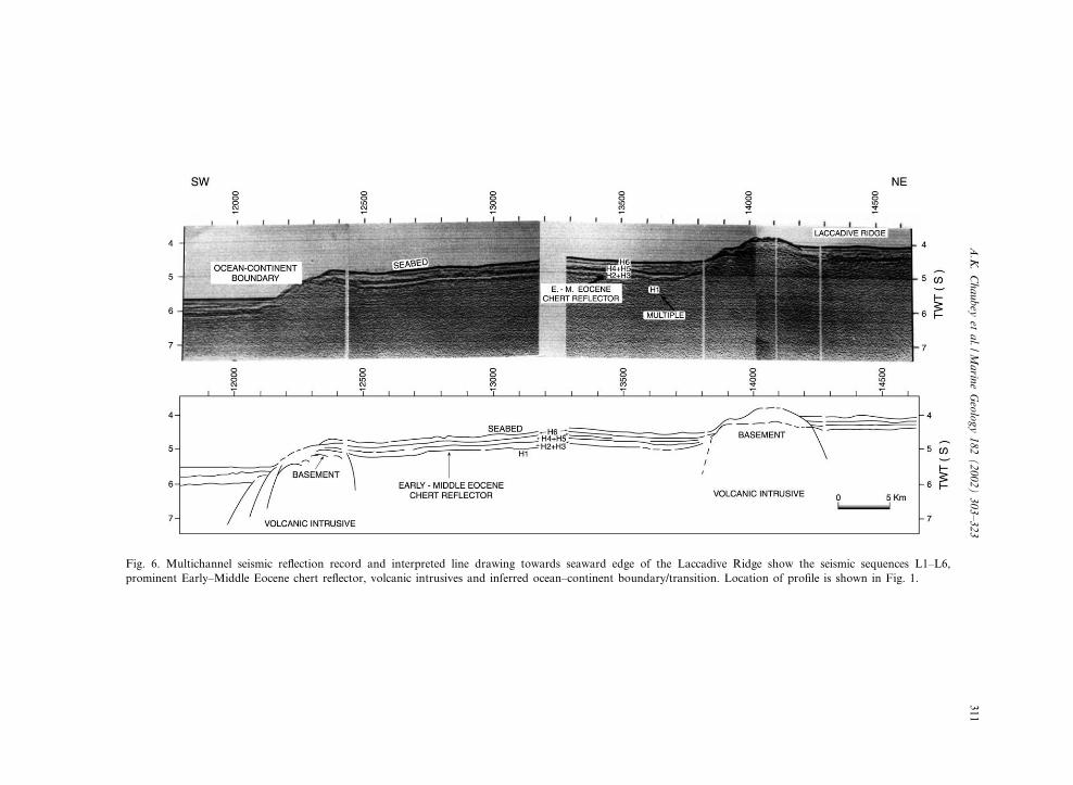
Fig. 6. Multichannel seismic re£ection record and interpreted line drawing towards seaward edge of the Laccadive Ridge show the seismic sequences L1^L6,prominent Early^Middle Eocene chert re£ector, volcanic intrusives and inferred ocean^continent boundary/transition. Location of pro¢le is shown in Fig. 1.
MARGO3002
2-5-02
A.K
.C
haubeyet
al./Marine
Geology
182(2002)
303^323311

boundary between two distinct phases of sedimen-tation. The basal re£ectors (sps 12 100^10 500) at0.8 s subsurface depth are discontinuous andhigh-amplitude associated with di¡ractions.
4.2. The free-air gravity and magnetic anomalies
The free-air gravity anomalies along the pro¢leSK12-07 (Fig. 8) display three distinct patterns.High-amplitude (50^95 mGal) and short-wave-length (50^60 km) anomalies occur in the shelfand shelf margin basin. A relative positive broadanomaly superimposed by short-wavelength low-amplitude anomalies characterises the LaccadiveRidge. The anomalies of the Arabian Basin aresubdued and show a regional trend at higher lev-el. The amplitude and wavelength of magneticanomalies of the Arabian Basin are distinct anddi¡er from the rest of the area. The marked di¡er-ences in the anomalies occur in the close vicinityof the intrusive volcanic body (sp 12 300) at thewestern end of the Laccadive Ridge indicatingbasic di¡erences in the crust and density structure.
4.3. Refraction velocities and crustal structure
The published refraction investigations (Fig. 9,location shown in Fig. 1) close to the seismic line
SK12-07 at sites 73V, 84C, 59V and 72V of theArabian Basin, and L12 and L08 of the LaccadiveRidge are considered to constrain the crustalstructure of the margin. The velocities 1.7^3.8km/s, 5.3^5.7 km/s, 6.4^6.6 km/s of the ArabianBasin are comparable to the velocities of layer 1(sediments), layers 2 (extrusive basaltic lava) and3 (gabbroic rocks), respectively, of the normaloceanic crust. The velocity structure of the Lacca-dive Ridge consists of 1.65^2.12 km/s, 4.2^4.4km/s, 5.6^5.7 km/s, 6.3 km/s and 7.2^7.3 km/s,while the representative velocity structure of theLaxmi Ridge shows 2.04, 4.46, 5.43, 6.2 and 7.15km/s. The Laccadive Ridge crustal layer velocitiesare comparable to the Laxmi Ridge, which iswidely accepted as a continental sliver by Nainiand Talwani (1983), Miles et al. (1998), Talwaniand Reif (1998) and Todal and Eldholm (1998).Two-dimensional model studies, constrained by
seismic results, of the free-air gravity and mag-netic anomalies of pro¢le SK12-07 are carriedout to determine the crustal structure of the mar-gin (Fig. 8). The densities are obtained using pub-lished refraction velocities and the velocity^den-sity curve of Nafe and Drake (1963). Densitiesof 1.03 and 3.3 g/cm3 are assumed for seawaterand upper mantle, respectively. A reasonable ¢tbetween the computed and the observed gravity
Fig. 7. Multichannel seismic re£ection record and interpreted line drawing across the Arabian Basin show oceanic basement, pe-lagic and turbidite sediments separated by re£ector ‘R’ of Middle^Late Oligocene age. Location of pro¢le is shown in Fig. 1.
MARGO 3002 2-5-02
A.K. Chaubey et al. /Marine Geology 182 (2002) 303^323312

anomalies is obtained with a mis¢t of individualpoints generally less than 5% of the observed val-ues. The best-¢t model revealed V27, V16and V6 km thick crusts of the outer shelf,Laccadive Ridge and Arabian Basin, respectively.The crustal densities of the Arabian Basin consistof three layers of 2.3, 2.75 and 2.85 g/cm3 repre-senting sediments, and layers 2 and 3 of the oce-anic crust, respectively, whereas the crustal struc-tures of the shelf, shelf margin basin andLaccadive Ridge consist of 2.3, 2.6 and 2.9 g/
cm3, representing sediments, upper and lowercontinental crust, respectively. A density of 2.8g/cm3 is assigned to the intrusive bodies of theLaccadive Ridge.The magnetic anomalies across the continental
margin are interpreted as several two-dimensionalbodies of various magnetization intensities (1^5A/m), while alternate normal and reverse magnet-izations, similar to sea£oor spreading type crust,are considered to explain the magnetic anomaliesof the Arabian Basin. The best ¢t between syn-
Fig. 8. Two-dimensional gravity and magnetic model and interpreted crustal structure along the seismic line SK12-07. OCB=ocean continent boundary/transition, SMB= shelf margin basin.
MARGO 3002 2-5-02
A.K. Chaubey et al. /Marine Geology 182 (2002) 303^323 313

thetic and the observed magnetic anomalies of theLaccadive Ridge has been simulated using eitherdensely spaced igneous intrusive-type magneticsources, or both £ows and intrusions. We preferthe later model to explain the anomalies consid-ering the geologic situation of the area. Themarked di¡erence between the oceanic and conti-nental crust is clearly discernable from the calcu-lated anomalies and crustal structure at the west-ern end of the Laccadive Ridge.
5. Interpretation
5.1. Ages of the seismic sequences
5.1.1. Seismic sequences H1^H6 of the shelf andshelf margin basinThe ages of seismic sequences H1^H6 of the
shelf and shelf margin basin are interpreted asPaleocene to Late Eocene, Late Eocene to MiddleOligocene, Middle Oligocene to Middle Miocene,
Fig. 9. Compilation of velocity structure (after Naini and Talwani, 1983) along line SK12-07 from refraction stations of the Ara-bian Basin (73V, 84C, 59V and 72V), Laccadive Ridge (L12 and L08) and continental shelf (85C). LR represents average crustalcolumn of the Laxmi Ridge. P-wave velocities (km/s) are shown inside the crustal column. Location of refraction stations arealso shown in Fig. 1.
MARGO 3002 2-5-02
A.K. Chaubey et al. /Marine Geology 182 (2002) 303^323314

Fig. 10. Correlation of boundaries of seismic sequences H1^H5 (top) of the outer shelf and shelf margin basin with the lithostra-tigraphy of drill-well KR-1 (Singh and Lal, 1993) and eustatic sea-level curve (Haq et al., 1987). Location of pro¢le is shown inFig. 1.
MARGO 3002 2-5-02
A.K. Chaubey et al. /Marine Geology 182 (2002) 303^323 315

Middle Miocene to Middle Pliocene, Middle Plio-cene to Late Pleistocene and Late Pleistocene toHolocene, respectively, on correlation with drill-well results of KR-1 (Singh and Lal, 1993; Pan-dey and Dave, 1998), global sea-level curve (Haqet al., 1987) and published results (Ramaswamyand Rao, 1980; Biswas and Singh, 1988).In the shelf region, top of H3 is a key horizon
and correlates well with the Middle Miocene re-£ector of the KR-1 drill-well (Fig. 10). We there-fore assign a Middle Miocene age to the H3 top.The sequence H2 top (Fig. 2) is another promi-nent re£ector which lies V550 m below sea£oor.This re£ector is very uneven and overlying para-sequences of H3 lap onto it. The velocity structurefrom a nearby refraction station, 85C (Fig. 9, lo-cation in Fig. 1), has revealedV1.6 km/s velocityof the sequence indicating absence of any vol-canics at that depth. Haq et al. (1987) have inter-preted a major drop in eustatic sea-level (V350 m)at the end of the Early Oligocene (Fig. 10). Whit-ing et al. (1994) inferred a characteristic Late Oli-gocene to Early Miocene rapid increase in subsi-dence rate of the western continental margin ofIndia. The interplay between eustatic sea-level andtectonics during the Early Oligocene have causedthe sequence to remain within the wave base orsub-aerial erosion resulting in the observed re£ec-tion pattern. Subsequent rise of the sea-level fol-lowed by sediment deposition had given rise toonlapping sequences of H3 onto the H2 top. Wetherefore infer that this boundary is an erosionalunconformity of Early Oligocene age.The upper re£ectors of sequences H1 and H2 of
the shelf margin basin (Fig. 3) are at 2.7 s and 1.6s subsurface depths, respectively, and are corre-lated to the unconformities of sequence II identi-¢ed by Rao and Srivastava (1984). Based on in-terval velocities, they opined that sequence IImight represent carbonate sediments developedduring stable platform conditions. Singh and Lal(1993) have inferred that the end of the MiddleEocene and the Early Oligocene marked regionalhiatuses. Thus, the sequences H1 and H2 tops
mark the Middle Eocene and Middle Oligoceneunconformities, respectively, within the carbo-nates.The near-parallel and acoustically transparent
re£ectors of the seismic sequences H4 and H5 ofthe shelf margin basin (Figs. 3 and 4) re£ect achange in facies of the sediments. Middle Plioceneand Late Pleistocene ages are assigned to the se-quences H4 and H5 tops, respectively (Fig. 10).Two distinct sediment in£ux maxima in the LateMiocene (9^6 Ma) and Middle Pliocene (4^2 Ma)have been also reported in the northern IndianOcean (Rea, 1992). The overlying H6 sequencerepresents Holocene sediments.
5.1.2. Seismic sequences L1^L6 of the LaccadiveRidgeSeismic sequences stratigraphy of the Laccadive
Ridge (Fig. 11) has been determined based oncorrelation with the lithologs of the DSDP site219 (Whitmarsh et al., 1974). The top of seismicsequence L1 is a very prominent re£ector and iscon¢dently identi¢ed across the ridge (Figs. 5 and6). The DSDP Site 219 results have revealed thepresence of a chert layer, V4.0 km/s P-wave ve-locity, of Early and Middle Eocene age. The ve-locity structure from the nearby refraction stationalso revealed a layer with a velocity ofV4.2 km/soverlain by a sediment layer with a velocity of 2.0km/s (Fig. 9). The re£ection character of the chertlayer (Whitmarsh et al., 1974) is strikingly similarto that of the L1 top. Considering the re£ectionpattern and refraction velocities, we interpretupper sequences of the L1 as a chert layer andassign an Early^Middle Eocene age. The sequen-ces L2 and L3 are thin and their upper boundariesare also prominent re£ectors. Lower sedimenta-tion rates during the Middle Oligocene to MiddleMiocene period and an unconformity at the endof the Early Miocene were reported at the DSDPsite 219. Therefore, we assign an Early Mioceneand a Late Oligocene age for the top re£ectors ofL3 and L2, respectively. The post-Early Mioceneseismic sequences L4 and L5 may represent the
Fig. 11. Correlation of boundaries of seismic sequences L1^L5 (top) of the Laccadive Ridge with the lithostratigraphy of DSDPSite 219 (Whitmarsh et al., 1974). The location of pro¢le is shown in Fig. 1.
MARGO 3002 2-5-02
A.K. Chaubey et al. /Marine Geology 182 (2002) 303^323316

Fig. 11.
MARGO 3002 2-5-02
A.K. Chaubey et al. /Marine Geology 182 (2002) 303^323 317

Middle Pliocene and Late Pleistocene ages, re-spectively, similar to the shelf margin basin se-quences.
5.1.3. Re£ector ‘R’ of the Arabian BasinThe sedimentary column in the Arabian Basin
is divided into two sequences separated by a re-£ector ‘R’ which marks a major unconformitysurface (Fig. 7). According to the results of theDSDP Site 221, illite-rich sediments characteristicof Indus Fan sediments started depositing in thedistal Arabian Sea by the Middle^Late Oligocene(Weser, 1974). Considering the Late Paleocene^Early Eocene age of the oceanic basement (Chau-bey et al., 1998), the onlapping nature of theupper sequence onto re£ector ‘R’ and the natureof the upper seismic sequence possibly represent-ing Fan sedimentation, a Middle^Late Oligoceneage is suggested for re£ector ‘R’.Fig. 12 presents crustal regions, interpreted seis-
mic sequence boundaries and structural elementsalong transect SK12-07 across the central-westerncontinental margin of India.
5.2. Nature and sedimentation history
In the shelf and shelf margin basin (sequenceH1) and over the Laccadive Ridge (sequence L1),the sedimentation has started since the Paleocene.The Eocene through Middle Miocene is dominat-ed by deposition of carbonates and carbonatesinterspersed with shales in the shelf and shelf mar-gin basin (sequences H2 and H3). The widespreadcarbonate sedimentation under stable platformconditions (Aubert and Droxler, 1996) duringthe Eocene to Middle Miocene are reported onthe shelf (Nair et al., 1992; Rao and Srivastava,1984). The sequences L2 and L3 of about thesame period over the Laccadive Ridge also showcarbonate sedimentation. However, they are verythin compared to the corresponding shelf marginbasin sequences. The upper boundary of sequen-ces H3 and L3 show remarkable change in thesedimentation pattern. In the shelf, the upperboundary of sequence H3 also coincides withthe Middle-Miocene shelf edge. The onset of theintense Indian monsoon, as a result of Indian^Eurasian plate collision and the build-up of the
Himalayas during the post-Middle Miocene,caused rapid erosion and deposition of terrige-nous clastics onto the shelf and shelf margin basinand cessation of carbonate deposition (Rao andSrivastava, 1984; Nair et al., 1992; Singh and Lal,1993; Whiting et al., 1994), whereas the LaccadiveRidge continued to receive less sediments, whichis clearly evident from the thickness of sequencesand their internal re£ectors. Due to high sedimen-tation on the shelf, the palaeo-shelf edge (upperboundary of sequence H3) has prograded sea-wards by V8 km to form the present shelfedge. Furthermore, the sequences H4, H5 andH6 clearly depict the sigmoidal re£ection pattern.An aggraded phase of sedimentation is interpretedbetween the Middle Miocene and Middle Oligo-cene, as the Oligocene shelf edge (top of H2 se-quence) lies below the Middle Miocene shelf edge.The seismic records of the continental shelf andslope region (Fig. 2) thus show three distinct shelfedges: Middle Oligocene, Middle Miocene andPresent.The re£ection pattern of the sediments of the
Arabian Basin suggests that the lower sequencedi¡ers markedly from the upper sequence in de-positional environment. The two sequences ap-pear to be conformable along the re£ector ‘R’.We consider the upper sequences due to fan sed-imentation, and the lower sequences to pelagicsedimentation.The Laccadive Ridge remained elusively a phys-
iographic high either since the Paleocene or earlierand received only pelagic or hemi-pelagic sedi-ments. It is evident from the abutting nature ofthe H1 sequence re£ectors of the shelf marginbasin, di¡erence in thickness between the sequen-ces over the Laccadive Ridge and the sequences ofthe shelf margin basin, the near-vertical scarps inthe west and east disassociating the ridge fromoceanic crust of the Arabian Basin and the shelfmargin basin, respectively. The chert layer acrossthe ridge may owe its origin either to pelagic sed-imentation rich in siliceous oozes (due to highbiogenic productivity) over a long duration oftime (few millions of years), or to extrusive vol-canism. Deposition of siliceous-rich sediments bythese processes is possible because of (1) provedupwelling on the western margin of India, and (2)
MARGO 3002 2-5-02
A.K. Chaubey et al. /Marine Geology 182 (2002) 303^323318
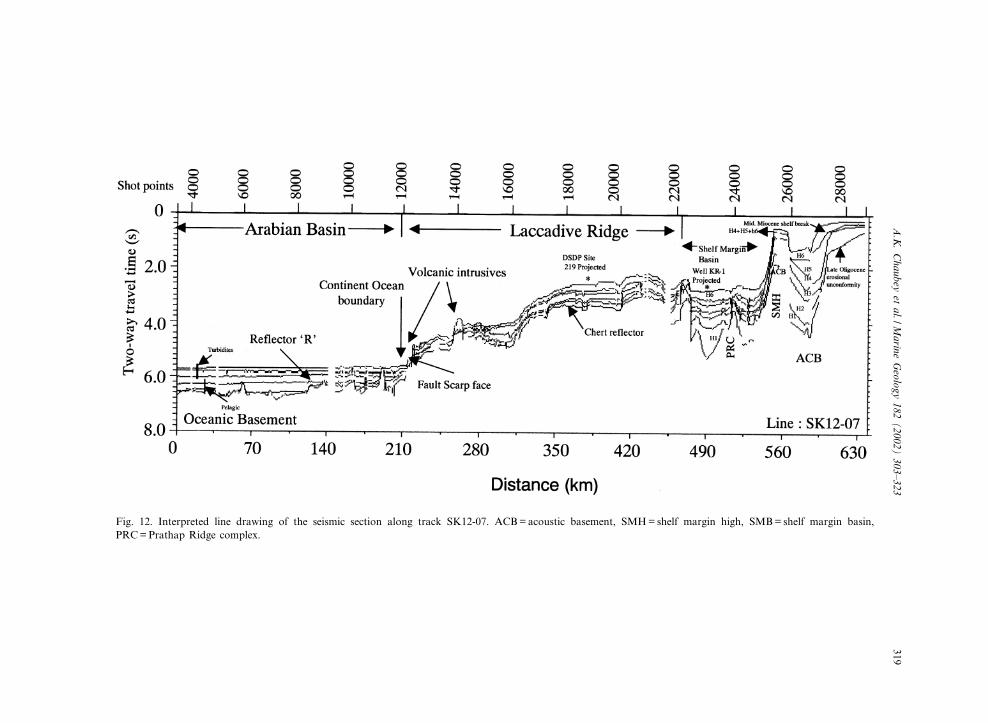
Fig. 12. Interpreted line drawing of the seismic section along track SK12-07. ACB=acoustic basement, SMH= shelf margin high, SMB= shelf margin basin,PRC=Prathap Ridge complex.
MARGO3002
2-5-02
A.K
.C
haubeyet
al./Marine
Geology
182(2002)
303^323319

volcanism related to rifting and/or passage of theIndian plate over the Reunion hotspot.
5.3. Nature of the crust of the Laccadive Ridge
The origin of the ridge is equivocal and manyworkers suggested its origin as due to the mantleplume trace of the Reunion hotspot formed dur-ing the northward motion of the Indian plate overthis hotspot (Shipboard Scienti¢c Party, 1988;Richards et al., 1989; Duncan, 1990). Hotspotrelated volcanism can occur in a large variety ofplate tectonic settings ranging from continental tooceanic lithosphere. In the continental setting,magma is erupted through thick and old litho-sphere, whereas in an oceanic lithosphere settingespecially near the spreading ridge, high exten-sional factors allow the mantle plume to generatea substantial amount of melt. We present twoplate tectonic settings: (1) on-spreading-ridge hot-spot volcanism, and (2) o¡-spreading-ridge hot-spot volcanism. They are discussed in the lightof published results as well as results of thepresent study.The mantle plume can generate a thick igneous
crust if it lies directly beneath the spreadingcentres. The seismic investigations of parts ofthe aseismic Kerguelen and Madagascar Ridges,formed due to a mantle plume lying beneath thespreading centre, have revealed a maximum crus-tal thickness of 20Q 1.3 km (Sinha et al., 1981;Recq et al., 1990; White et al., 1992). The vol-canic record of the Reunion hotspot and palaeo-geographic reconstruction of the western IndianOcean indicate that the Reunion hotspot wasnever centred directly below a spreading centreat least up to V47 Ma (Duncan, 1990). By thetime the hotspot was away from the Indian sub-continent and was lying below the Northern Cha-gos Bank. Further, in case of sub-aerially em-placed on-spreading axis hotspot volcanic con-structs of the ridge and/or subjected to shallowsubmarine conditions over a considerable geologicperiod, as was the case with the Laccadive Ridge,a thick layer 2 (2A and 2B) would develop due toweathering. Krishna et al. (2001) have reported anexcessively thick (4^5 km) upper crustal layer (2Aand 2B) of the Ninetyeast Ridge, a plume em-
placed construct. The refraction results over theLaccadive Ridge have revealed a comparativelyless thick (6 2 km) crustal layer 2 which lies be-neath the chert layer of V4.2 km/s velocity (Fig.9). Therefore, it is di⁄cult to believe that theLaccadive Ridge is a solely volcanic build-updue to the mantle plume lying directly beneaththe spreading centre.Mantle plumes such as Hawaii, Iceland and the
Cape Verdes in an oceanic crust setting (o¡-spreading ridge) generated a region of anoma-lously hot asthenospheric mantle extending upto 1000 km away from the central plume andcaused variations in crustal structure (Courtneyand White, 1986; Watson and McKenzie, 1991).The reported igneous crustal thicknesses fromseismic measurements and rare-earth element in-version of such regions are 10.3 Q 1.7 km and10.7 Q 1.6 km, respectively (White et al., 1992).The estimated crustal thickness of V16 km overthe Laccadive Ridge from the present study ishigher than the crustal thickness for o¡-spread-ing-ridge hotspot volcanism.The thickness, velocity and density structure,
structural (volcanic intrusives and graben) andphysiographic features of the Laccadive Ridgedo not support a volcanic construct either dueto on-spreading-axis or o¡-spreading-axis hotspotvolcanism. Moreover, the velocity and densitystructure and crustal thicknesses are comparablewith the Laxmi Ridge, which is widely accepted asa continental sliver of the northwestern ArabianSea. The Laxmi Ridge is associated with a pro-nounced gravity low in a geographic and tectonicsetting similar to that of the Laccadive Ridge.Interestingly the Laccadive Ridge is not so wellre£ected in the free-air gravity anomaly in spite ofits large dimensions (V2 km relief from presentsea£oor and V255 km width). The lack of anappreciable gravity anomaly over the ridge per-haps suggests the isostatically compensated natureof the ridge. These results and observations pointto thinned/extended continental crust of inter-mediate thickness intruded by volcanics. The in-dustry drill-well of the Oil and Natural Gas Cor-poration Limited of India on the Padua Bank,northern part of the Laccadive Ridge (Fig. 1),was terminated in continental basalts (Murty et
MARGO 3002 2-5-02
A.K. Chaubey et al. /Marine Geology 182 (2002) 303^323320

al., 1999). Based on results of the drill-well andvertical seismic pro¢ling, they suggested the exis-tence of continental crust beneath the bank andeven further west of it. Their inferences furthersupport our contention that the crust of Lacca-dive Ridge is a stretched continental crust.
5.4. Nature of the crust of the shelf margin basin
The crustal features of the shelf margin basinare buried under thick sediments. The PrathapRidge, 1000^3000 m water depth, parallel to theshelf edge between 8‡ and 17‡N latitudes and as-sociated with hyperbolic re£ections, lies close tothe centre of the basin and its structure is complexwith multi-peaks. It is bounded on either side bywell-developed rotated fault blocks. They repre-sent half-grabens, tilted away from the ridge,and are located almost equi-distance from theridge. These results lead us to suggest that thebasin represents a failed rift of extended continen-tal crust and igneous emplacement in the middleof the basin.
5.5. Oceanic^continent transition
The volcanic intrusives and steep scarp at thewestern end of the Laccadive Ridge limit furtherseaward extension of the ridge. Similar features ofthe ridge have also been identi¢ed in the south byGopala Rao et al. (1987), and thus they appear tobe regional in extent. They are also associatedwith relatively positive magnetic and gravity sig-natures. Again, a marked di¡erence in the anoma-lies occurs on the seaward side of the intrusiveswith a steep gradient in free-air gravity anomaly.Basement ridges of many rifted margins, e.g. theGabon^Cango region of West Africa (Belmonteet al., 1965) and Norwegian margins (Talwaniand Eldholm, 1972), are reported. Widespread oc-currences of the basement ridges at the continen-tal margins are interpreted as due to initial riftingand volcanic emplacement (Burk, 1968). Wetherefore infer that the volcanic features at thewestern end of the Laccadive Ridge mark theboundary of the rifted crust and early rift-em-placed volcanics. Major change in the basementelevation normally occurs at the boundary be-
tween oceanic and continental crusts (Talwaniand Eldholm, 1973). The observed linear ridges,steep scarps of the Laccadive Ridge, and the grav-ity and magnetic signatures at the western end ofthe Laccadive Ridge indicate the continent^oceancrust transition. Therefore, the ocean^continentboundary/transition must lie to the immediatewest of the Laccadive Ridge where thinned con-tinental crust of the ridge is juxtaposed with theknown early Tertiary normal oceanic crust.
6. Summary
The study of the seismic re£ection, gravity,magnetic and bathymetry data of the 720-km-long SK12-07 pro¢le across the central-westerncontinental margin of India has revealed the fol-lowing:(1) The shelf, shelf margin basin, Laccadive
Ridge and Arabian Basin are carpeted by sedi-ments of, respectively, 3.9, 4.5, 1.2 and 1.6 kmmaximum thickness. Six major seismic sequencesof sediments of Paleocene to Holocene age areidenti¢ed on the shelf, shelf-margin basin andLaccadive Ridge. The pre- and post-Middle Mio-cene periods were dominated by carbonate andclastic sedimentation, respectively. The seismicsection of the shelf and slope region displays threedistinct shelf edges: Late Oligocene, Middle Mio-cene and Recent. The Middle Miocene shelf edgeprograded V8 km to form the present-day shelfedge. The Late Oligocene to Middle Miocene sed-imentation was dominantly aggradational. Anerosional unconformity of Late Oligocene age (de-veloped during lowered sea-level) was interpretedon the shelf and a chert layer of Early^MiddleEocene age across the Laccadive Ridge is identi-¢ed.(2) The shelf margin basin is characterized by
the presence of rotated fault blocks at the marginsof the basin and emplaced volcanic construct(Prathap ridge). They suggest failed rift and vol-canism of the stretched continental regime of thebasin.(3) The crustal and velocity structure, structural
elements (intrusions, £ows, grabens, physio-graphic features) and free-air gravity and mag-
MARGO 3002 2-5-02
A.K. Chaubey et al. /Marine Geology 182 (2002) 303^323 321

netic signatures of the Laccadive Ridge indicatethinned continental crust and associated volcan-ism.(4) The ocean^continent boundary/transition is
inferred to lie at the western end of the LaccadiveRidge in the vicinity of the western scarp face ofthe ridge where as V16 km thick crust of theridge gradually thinned and juxtaposed to V6km thick early Tertiary oceanic crust of the Ara-bian Basin.
Acknowledgements
The authors are thankful to Dr Ehrlich Desa,Director, National Institute of Oceanography forsupport and encouragement to carry out thiswork. The authors are grateful to the Departmentof Ocean Development (DOD), Government ofIndia for providing the ORV Sagar Kanya tocollect the data. Thanks are due to scientific andtechnical colleagues, officers and crew of the ORVSagar Kanya (cruise 12) for their help during datacollection. Mr R. Uchil is thanked for neatlydrafting the figures. We are also grateful tojournal reviewers Lindsay Parsen and JohnSclater. This is NIO contribution 3706.
References
Aubert, O., Droxler, A.W., 1996. Seismic stratigraphy and de-positional signatures of the Maldive carbonate system (In-dian Ocean). Mar. Pet. Geol. 13, 503^536.
Avraham, Z.B., Bunce, E.T., 1977. Geological study of theChagos^Laccadive Ridge, Indian Ocean. J. Geophys. Res.82, 1295^1305.
Belmonte, Y., Hirtz, P., Wenger, R., 1965. The salt basin ofthe Gabon and Congo (Brazzaville). In: Kennedy, W.Q.(Ed.), Salt Basins around Africa. London Institute of Petro-leum, London, pp. 55^74.
Bhattacharya, G.C., Chaubey, A.K., Murty, G.P.S., Srinivas,K., Sarma, K.V.L.N.S., Subrahmanyam, V., Krishna, K.S.,1994. Evidence for sea£oor spreading in the Laxmi Basin,northeastern Arabian Sea. Earth Planet. Sci. Lett. 125, 211^220.
Biswas, S.K., Singh, N.K., 1988. Western continental marginof India and hydrocarbon potential of deep-sea basins. Proc.7th O¡shore Southeast Asia Conf., Singapore, pp. 170^181.
Burk, C.A., 1968. Buried ridges within continental margins.Trans. NY Acad. Sci. 30, 397^409.
Carter, D.J.T., 1980. Echosounding Correction Tables. Hydro-graphic Department. Ministry of Defence, Taunton, 150 pp.
Chaubey, A.K., Bhattacharya, G.C., Murty, G.P.S., Srinivas,K., Ramprasad, T., Gopala Rao, D., 1998. Early Tertiarysea£oor spreading magnetic anomalies and paleo-propaga-tors in the northern Arabian Sea. Earth Planet. Sci. Lett.154, 41^52.
Courtney, R.C., White, R.S., 1986. Anomalous heat £ow andgeoid across the Cape Verde Rise: evidence for dynamicsupport from a thermal plume in the mantle. Geophys. J.R. Astron. Soc. 87, 815^867.
Detrick, R.S., Sclater, J.G., Thiede, J., 1977. The subsidence ofaseismic ridges. Earth Planet. Sci. Lett. 34, 185^196.
Dietz, R.S., Holden, J.C., 1970. Reconstruction of Pangaea:breakup and dispersion of continents, Permian to Present.J. Geophys. Res. 75, 4939^4956.
Duncan, R.A., 1990. The volcanic record of the Reunion hot-spot. Proc. ODP Sci. Results 115, 3^10.
Dyment, J., 1998. Evolution of the Carlsberg Ridge between60 and 45 Ma: ridge propagation, spreading asymmetry,and the Deccan^Reunion hotspot. J. Geophys. Res. 103,24067^24084.
Fisher, R.L., Sclater, J.G., McKenzie, D.P., 1971. Evolution ofthe Central Indian Ridge, western Indian Ocean. Geol. Soc.Am. Bull. 82, 553^562.
Gopala Rao, D., Bhattacharaya, G.C., Subba Raju, L.V.,Ramana, M.V., Subrahmanyam, V., Raju, K.A.K., RamPrasad, T., Chaubey, A.K., 1987. Regional marine geophys-ical studies of the south western continental margin of India.In: Rao, T.S.S. Natarajan, R., Desai, B.N., NarayanaSwamy, G., Bhat, S.R. (Eds.), Contributions in Marine Sci-ences, National Institute of Oceanography, Goa. pp. 427^437.
Haq, B.U., Hardenbol, J., Vail, P.R., 1987. Chronology of£uctuating sea levels since the Triassic. Science 235, 1156^1167.
Harbison, R.N., Bassinger, B.G., 1973. Marine geophysicalstudy o¡ western India. J. Geophys. Res. 78, 432^440.
Kahle, H.G., Talwani, M., 1973. Gravimetric Indian Oceangeoid. J. Geophys. (Z. Geophys.) 39, 167.
Krishna, K.S., Murty, G.P.S., Srinivas, K., Gopala Rao, D.,1992. Magnetic studies over the northern extension of thePrathap Ridge complex, eastern Arabian Sea. Geo-Mar.Lett. 12, 7^13.
Krishna, K.S., Neprochnov, Y.P., Gopala Rao, D., Grinko,B.N., 2001. Crustal structure and tectonics of the NinetyeastRidge from seismic and gravity studies. Tectonics 20, 416^433.
McKenzie, D., Sclater, J.G., 1971. The evolution of the IndianOcean since the Late Cretaceous. Geophys. J. R. Astron.Soc. 25, 437^528.
Miles, P.R., Munschy, M., Segou¢n, J., 1998. Structure andearly evolution of the Arabian Sea and East Somali Basin.Geophys. J. Int. 134, 876^888.
Morgan, W.J., 1972. Plate motions and deep mantle convec-tion. Geol. Soc. Am. Mem. 132, 7^22.
Murty, A.V.S., Arasu, R.T., Dhanawat, B.S., Subrahmanyam,
MARGO 3002 2-5-02
A.K. Chaubey et al. /Marine Geology 182 (2002) 303^323322

V.S.R., 1999. Some aspects of deepwater exploration in thelight of new evidences in the western Indian o¡shore. In:Bhatnagar, A.K. (Ed.), Hydrocarbon Exploration. Papers ofthe Third International Petroleum Conference and Exhibi-tion, Petrotech-99, Thompson, Faridabad, India pp. 457^463.
Nafe, J.E., Drake, C.L., 1963. Physical properties of marinesediments. In: Hill, M.N. (Ed.), The Sea 3. Wiley, NewYork, pp. 794^815.
Naini, B.R., Talwani, M., 1983. Structural framework and theevolutionary history of the continental margin of westernIndia. In: Watkins, J.S., Drake, C.L. (Eds.), Studies in Con-tinental Margin Geology. Am. Assoc. Pet. Geol. Mem. 34,167^191.
Nair, K.M., Singh, N.K., Jokhan, R., Gavarshetty, C.P., Mur-aleekrishanan, B., 1992. Stratigraphy and sedimentation ofBombay o¡shore basin. J. Geol. Soc. India 40, 415^442.
Pandey, J., Dave, A., 1998. Stratigraphy of Indian Petrolifer-ous Basins, XVI. Indian Colloquium on Micropaleontologyand Stratigraphy. National Institute of Oceanography, Goa,248 pp.
Ramaswamy, G., Rao, K.L.N., 1980. Geology of the conti-nental shelf of the west coast of India. Can. Soc. Pet. Geol.Mem. 6, 801^821.
Rao, R.P., Srivastava, D.C., 1984. Regional seismic faciesanalysis of western o¡shore, India. Bull. Oil Nat. GasComm. 21, 83^96.
Rea, D.K., 1992. Delivery of Himalayan sediment to theNorthern Indian Ocean and its relation to global climate,sea level, uplift and seawater strontium. In: Duncan, R.A.,Rea, D.K., Kidd, R.B., von Rad, U., Weissel, J.K. (Eds.),Synthesis of Results from Scienti¢c Drilling in the IndianOcean. Am. Geophys. Union Geophys. Monogr. 70, 387^402.
Recq, M., Brefort, D., Malod, J., Veinante, J.-L., 1990. TheKerguelen Isles (southern Indian Ocean): new results ondeep structure from refraction pro¢les. Tectonophysics182, 227^248.
Richards, M.A., Duncan, R.A., Courtillot, V.E., 1989. Floodbasalts and hot-spot tracks: plume heads and tails. Science246, 103^107.
Shipboard Scienti¢c Party, 1988. Site 715. Proc. ODP Init.Rep. 115, 917^946.
Singh, N.K., Lal, N.K., 1993. Geology and petroleum pros-pects of Konkan^Kerala basin, In: Biswas, S.K. et al.(Eds.), Proceedings of the Second Seminar on PetroliferousBasins of India, Vol. 2. Indian Petroleum Publishers, DehraDun, pp. 461^469.
Sinha, M.C., Louden, K.E., Parsons, B., 1981. The crustalstructure of the Madagascar Ridge. Geophys. J. R. Astron.Soc. 66, 351^377.
Subrahmanyam, V., Gopala Rao, D., Ramana, M.V., Krish-na, K.S., Murty, G.P.S., Rao, M.G., 1995. Structure andtectonics of the southwestern continental margin of India.Tectonophysics 249, 267^282.
Talwani, M., Eldholm, O., 1972. Continental margin o¡ Nor-way: a geophysical study. Geol. Soc. Am. Bull. 83, 3575^3606.
Talwani, M., Eldholm, O., 1973. Boundary between continen-tal and oceanic crust at the margin of rifted continents.Nature 241, 325^330.
Talwani, M., Reif, C., 1998. Laxmi Ridge ^ a continental sliverin the Arabian Sea. Mar. Geophys. Res. 20, 259^271.
Todal, A., Eldholm, O., 1998. Continental margin o¡ westernIndia and Deccan Large Igneous Province. Mar. Geophys.Res. 20, 273^291.
Watson, S., McKenzie, D., 1991. Melt generation by plumes: astudy of Hawaiian volcanism. J. Petrol. 32, 501^537.
Weser, O.E., 1974. Sedimentological aspects of strata encoun-tered on Leg 23 in the northern Arabian Sea. Init. Rep.DSDP 23, 503^519.
White, R.S., McKenzie, D., O’Nions, R.K., 1992. Oceaniccrustal thickness from seismic measurements and rare earthelement inversions. J. Geophys. Res. 97, 19683^19715.
Whiting, B.M., Karner, G.D., Driscoll, N.W., 1994. Flexuraland stratigraphic development of the west Indian continen-tal margin. J. Geophys. Res. 99, 13791^13811.
Whitmarsh, R.B., 1974. Some aspects of plate tectonics in theArabian Sea. Init. Rep. DSDP 23, 527^535.
Whitmarsh, R.B., Weser, O.E., Ross, D.A. et al., 1974. Sites219, 220 and 221. Init. Rep. DSDP 23, 35^210.
MARGO 3002 2-5-02
A.K. Chaubey et al. /Marine Geology 182 (2002) 303^323 323
Copyright © 2022 FDOKUMEN