Against public order - Lund University Research Portal
198
Against public order: A critique of the right to freedom of assembly Parsa, Amin Published in: Civil Society Reclaims Public Space: Cross Perspective Based Research 2012 Document Version: Publisher's PDF, also known as Version of record Link to publication Citation for published version (APA): Parsa, A. (2012). Against public order: A critique of the right to freedom of assembly. In Civil Society Reclaims Public Space: Cross Perspective Based Research (pp. 32-37). URBANI AZZIV Publication. Total number of authors: 1 General rights Unless other specific re-use rights are stated the following general rights apply: Copyright and moral rights for the publications made accessible in the public portal are retained by the authors and/or other copyright owners and it is a condition of accessing publications that users recognise and abide by the legal requirements associated with these rights. • Users may download and print one copy of any publication from the public portal for the purpose of private study or research. • You may not further distribute the material or use it for any profit-making activity or commercial gain • You may freely distribute the URL identifying the publication in the public portal Read more about Creative commons licenses: https://creativecommons.org/licenses/ Take down policy If you believe that this document breaches copyright please contact us providing details, and we will remove access to the work immediately and investigate your claim.
-
Upload
khangminh22 -
Category
Documents
-
view
3 -
download
0
Transcript of Against public order - Lund University Research Portal

LUND UNIVERSITY
PO Box 117221 00 Lund+46 46-222 00 00
Against public order: A critique of the right to freedom of assembly
Parsa, Amin
Published in:Civil Society Reclaims Public Space: Cross Perspective Based Research
2012
Document Version:Publisher's PDF, also known as Version of record
Link to publication
Citation for published version (APA):Parsa, A. (2012). Against public order: A critique of the right to freedom of assembly. In Civil Society ReclaimsPublic Space: Cross Perspective Based Research (pp. 32-37). URBANI AZZIV Publication.
Total number of authors:1
General rightsUnless other specific re-use rights are stated the following general rights apply:Copyright and moral rights for the publications made accessible in the public portal are retained by the authorsand/or other copyright owners and it is a condition of accessing publications that users recognise and abide by thelegal requirements associated with these rights. • Users may download and print one copy of any publication from the public portal for the purpose of private studyor research. • You may not further distribute the material or use it for any profit-making activity or commercial gain • You may freely distribute the URL identifying the publication in the public portal
Read more about Creative commons licenses: https://creativecommons.org/licenses/Take down policyIf you believe that this document breaches copyright please contact us providing details, and we will removeaccess to the work immediately and investigate your claim.

HUMAN CITIES
Edited by Rafaella Houlstan-Hasaerts, Biba Tominc, Matej Nikšič and Barbara Goličnik Marušić
Cross Perspectives Based on Research
Civil Society Reclaims Public Space


Edited by Rafaella Houlstan-HasaertsBiba TomincMatej NikšičBarbara Goličnik Marušić
HUMAN CITIESCivil Society Reclaims Public Space Cross Perspectives Based on Research
International Symposium Proceedings15th - 16th March 2012, Brussels, BE

Proceedings of the Symposium “Civil Society Reclaims Public Space. Cross Perspectives Based on Research” held in Brussels on 15th and 16th March 2012.
This online publication has been released in the framework of the European project Human Cities: Reclaiming Public Space (2010-2012), supported by the EU Programme Culture 2007-2013 with the collaboration of the Association of European School of Planning (AESOP) – Thematic Group “Public spaces and urban cultures”.
The Human Cities Network is composed by ULB-Faculté d’Architecture La Cambre-Horta (BE) / Chantal Vanoeteren, Rafaella Houlstan-Hasaerts, Victor Lévy, Sabine Guisse; Pro Materia (BE) / Lise Coirier; Cité du Design (FR) / Josyane Franc, Nathalie Arnould, Camille Vilain, Jessy Gemayel; Politecnico di Milano (IT) / Paola Trapani, Liat Rogel, Davide Fassi; Urban Planning Institute of the Republic of Slovenia (SI) / Barbara Goličnik Marušić, Matej Nikšič, Nina Goršič, Biba Tominc; Strategic Design Scenarios (BE) / François Jégou, Adèle Seyrig; Time Circus (BE) / Sara Dandois; Clear Village (UK) / Thomas Ermacora, Alice Holmberg.
With the expertise of Culture Lab (BE) / Gian Giuseppe Simeone, Alexis Castro.
With the valuable contribution of María Aguirre Landa, Antoine Blave, Monika Czaja, Rachel Goldenberg, Laetitia De Nève, Sabrina Lê, Jasmijn Verlinden, Caroline Watillon.
In collaboration and with the support of our private and public sponsors.
This publication is available online at: www.uirs.si/pub/humancities2012.pdf
www.humancities.eu
Civil Society Reclaims Public Space Cross Perspectives Based On Research
During the past few years, Human Cities as a project and as a
network, has aspired to come to terms with the gap between the
practice and the theory of urban issues. This online publication is no
exception; it is rooted in actions initiated by the civil society to reclaim
public space. It continues its way along academic and professional
thoughts about this phenomenon and we hope it will enlighten and
empower all kinds of people working with public spaces. It is an
attempt to describe, analyse, evaluate and disseminate initiatives
started by citizens, in order to foster imagination, creativity, collective
experiments and criticism in contemporary cities. Indeed, as the
pragmatist philosopher John Dewey put it, we strongly believe that
researchers “must accept reality as they found it and try to shape it
toward positive social goals, not stand aside in self-righteous isolation.”
This publication shows many aspects and viewpoints of public
spaces. It allows different profiles to meet in the same book and
by this expands the field of discussion, as well as refines the
attitudes towards the subject. The editors would like to thank the
authors and all those who contributed to this publication.
Editors
PREfACE

THE EDITORS
Rafaella Houlstan-Hasaerts is an architect, who
works as a PhD researcher in the framework
of the programme “Prospective Research for
Brussels” at the ULB, Faculty of Architecture La
Cambre-Horta. Her main research interests are
the production, reception and representation
of public space in contemporary cities. More
particularly, she investigates the links between
public space and public sphere: how designing
public spaces can foster common debates
and actions and how common debates and
actions can reshape public spaces?
Biba Tominc is a geographer working at the Urban
Planning Institute of the Republic of Slovenia. She
specializes in graphic design, data visualization,
database creation, analysis and management, and
explores how to demonstrate spatial data in clear,
effective and friendly way for different users and
different media. She is also a postgraduate student
of Philosophy and Theory of Visual Culture at the
University of Primorska, Faculty of Humanities.
Matej Nikšič is an architect and holds an MA
degree in urban design from Oxford Brookes
University and a PhD in architecture from the
University of Ljubljana. He works as a researcher
at the Urban Planning Institute of the Republic of
Slovenia in the fields of detailed urban design and
place identity by design. His research focuses on
open urban public spaces in general and users’
mental conceptions of these spaces in particular.
Barbara Goličnik Marušić holds a PhD in
landscape architecture from the Edinburgh
College of Art, Heriot Watt University, Edinburgh
UK. She is a landscape architect and researcher
at the Urban Planning Institute of the Republic
of Slovenia and an assistant professor at the
School of Architecture at the University of
Maribor, Slovenia. She is mainly involved in
multidisciplinary national and international
studies and projects concerned with design and
research addressing environment-behaviour issues
linked with the development of innovative GIS
supported tools in the context of urban planning
and open space design. She is a member of
the international networks UStED and IAPS.
ABOUT
THE MEMBERS Of ORGaNISaTION BOaRD
THE MEMBERS Of ScIENTIfIc BOaRD
Mathieu Berger, Sociologist, PhD in Political
and Social Sciences. UCL, Centre de
Recherches Interdisciplinaires “Démocratie,
Institutions, Subjectivités” (Cri-Dis),
Louvain-La-Neuve, BE / EHESS, Centre d’Étude
des Mouvements Sociaux, (CEMS), Paris – FR.
Vincent calay, Sociologist and Geographer, Master
Degree in Human Geography, PhD in Political
and Social Sciences. ULB, Groupe de Recherche
sur l’Action Publique (GRAP), Brussels, BE /
SciencesPo Paris, Center for History, Paris – FR.
Isabelle Doucet, Architect, PhD in Architecture.
Lecturer in Architecture and Urbanism, University
of Manchester, Manchester Architecture Research
Centre (MARC), School of Environment and
Development (SED), and Manchester School
of Architecture (MSA), Manchester – UK.
Davide fassi, Architect, Phd in Technological
Innovation for Architecture and Design.
Politecnico di Milano, School of Design, INDACO
Department, DHOC – Interior Design for
Hospitable Cities Research Group, Milan – IT.
Barbara Goličnik-Marušić, Landscape
Architect, PhD in Landscape Architecture,
Researcher, Head of Research, Urban Planning
Institute of the Republic of Slovenia (UIRS),
Ljubljana, Assistant Professor for Open Space
Design, School of Architecture, Faculty of Civil
Engineering, University of Maribor (UM, FG) – SI.
Sabine Knierbein, Diploma studies in Landscape
Architecture, PhD in Urban Studies. Assistant
Professor (Tenure Track) for Urban Culture and
Public Space, Vienna University of Technology,
Interdisciplinary Centre for Urban Culture
and Public Space (SKuOR), Vienna – AUT.
Matej Nikšič, Architect, MA in Urban Planning, PhD
in Architecture. Researcher, Urban Planning Institute
of the Republic of Slovenia (UIRS), Ljubljana – SI.
Paola Trapani, Architect, PhD in Industrial Design.
Researcher, Politecnico di Milano, Faculty of
Design, Department INDACO, Milan – IT.
Rafaella Houlstan-Hasaerts, Architect.
Phd candidate in Architecture (Prospective
Research for Brussels), ULB, Faculty of
Architecture La Cambre-Horta, Brussels – BE.
Biba Tominc, Geographer and Pedagogue,
Master student in Philosophy and Theory of Visual
Culture. Researcher, Urban Planning Institute of
the Republic of Slovenia (UIRS), Ljubljana – SI.
7
INTRODUcTION
Rafaella Houlstan-Hasaerts and Biba TomincPROcEEDINGS Of THE HUMaN cITIES SYMPOSIUM: CIVIL SOCIETY RECLAIMS PUBLIC SPACES CROSS PERSPECTIVES BASED ON RESEARCH
HUMaN cITIES PROJEcT
Lise Coirier and Chantal VanoeterenTHE HUMaN cITIES cONcEPT aND NETWORK: BACKGROUND OF THE PROJECT AND NETWORK
Jessy Gemayel, Davide Fassi, Liat Rogel, Adèle Seyrig and Roberta MotterTHE HUMaN cITIES TOOLBOX: HOW TO RECLAIM PUBLIC SPACE?
Barbara Goličnik Marušić, Matej Nikšič, Rafaella Houlstan Hasaerts and Davide FassiTHE HUMaN cITIES OBSERVaTION MISSION: RESEARCH TOOL FOR PUBLIC SPACE ANALYSES AND EVALUATION
PaRT ONE: aNaLYTIcaL HIGHLIGHT
Mathieu Berger, Vincent Calay and Sabine Knierbein fRaMES, cONfLIcTS aND REfLEXIVITIES: aNaLYZING THE PLURaL NaTURES Of PUBLIc SPacES IN HUMaN cITIES
Amin ParsaaGaINST PUBLIc ORDER: a cRITIQUE Of THE RIGHT TO fREEDOM Of aSSEMBLY
Hagi KanaanHUMaN cITIES aND THE SPacE Of cONfLIcT
Christian Klein and Christine Taylor KleinTHE INTERSTITIaL SPacE Of THE URBaN INDIaN RaILWaY
Giacomo Golinelli a KIOSK fOR THE HEaDScaRf: HOW RELIGION cHaNGES THE PUBLIc SPacE
Dejana Nedučin, Dušan Ristić and Vladimir KubetcLaIMING PUBLIc SPacE IN a POST-SOcIaLIST SERBIa: a STRUGGLE fOR THE fIfTH PaRK
PaRT TWO: METHODOLOGIcaL HIGHLIGHT
Isabelle DoucetDESIGN aND USE: aN ON-GOING STRUGGLE?Matej NikšičIN SEaRcH fOR NEW aPPROacHES TO acHIEVE BETTER PUBLIc SPacE
Shibboleth ShechterDESIGNING SPEaKERS’ cORNER
Javier Ruiz SánchezIN PRaISE Of URBaN WaSTELaNDS: a cOMMUNIcaTIVE aND cOMPLEX aPPROacH
Mahmoud Keshavarz‘fREE TRaNSLaTION’ aS a cRITIcaL METHOD IN SOcIO-POLITIcaL DESIGN acTIONS
Potsiso PhashaaUTOPHOTOGRaPHY: a TOOL fOR REcORDING WaYS IN WHIcH STREET SKaTERS aND STREET aRTISTS HaVEaPPROPRIaTED SPacE IN JOHaNNESBURG
Giorgia Lupi, Paolo Patelli, Luca Simeone and Salvatore IaconesiMaPS Of BaBEL: URBaN SENSING THROUGH USER GENERaTED cONTENT
28
32
37
41
47
53
9
13
16
21
60
63
69
77
84
91
CONTENTS

8
PaRT THREE: OPERaTIONaL HIGHLIGHT
Paola Trapani and Barbara Goličnik MarušićcOMMUNITY cENTRED aPPROacH: a WaY Of REcLaIMING PUBLIc SPacE
Biba Tominc and Marjan ŠpegelMELLOWROOf: ROOfTOP GaRDEN aS a fRUITfUL EXPERIMENT IN RESIDENTIaL NEIGHBOURHOOD IN LJUBLJaNa, SLOVENIa
Tanja PlešivčnikcREaTIVE aPPROacHES TOWaRD REVITaLIZaTION Of DRY STONE WaLLING WITHIN PUBLIc SPacE
Agustina Martire, Mark Hackett and Declan HillfROM SacKBaHNHOf TO cENTRaL aND BacK: BELfaST GREaT VIcTORIa STREET STaTION aS REcOVERED PUBLIc SPacE
Jégou François, Seyrig Adèle, Sabine Guisse and Julien KnoepflerENGaGING caRE Of PUBLIc aND SOcIaL SPacE: 2 caSES IN THE fRaMEWORK Of aGENDa IRIS 21
Tibo Labat, Anaïs Leger and Paul SmithcOLLEcTIf fERTILE, NaNTES “DESIGNING BY USING”
cONcLUSIONSAli MadanipourREcLaIMING PUBLIc SPacE fROM RIGID ORDERS aND NaRROW INTERESTS
WORKSHOPS
Aglaée Degros and Sabine KnierbeinWORKSHOP 01 / aROUND THE 19. acTIVISM, URBaN PRacTIcE aND RESEaRcH
Giulietta LakiWORKSHOP 02 / aN aNTHROPOLOGIcaL fIELDWORK IN BRUSSELS: URBaN SIGNS aND aRTEfacTS UNDER THE MIcROScOPE
François Jégou, Josyane Franc and Nathalie ArnouldWORKSHOP 03 / GUIDED TOUR Of THE HUMaN cITIES TOOLBOX WIDESPREaD EXHIBITION
Camille Vilain and Jessy GemayelWORKSHOP 04 / OPENING THE HUMaN cITIES TOOLBOX: PETER aND GISELLa TOOLKIT
Sabine Guisse, Rafaella Houlstan-Hasaerts, Barbara Goličnik Marušić, Matej Nikšič and Biba TomincWORKSHOP 05 / fROM BRIGITTINES TO URSULINES: OPENING THE HUMaN cITIES “OBSERVaTION MISSION” TOOL
Caroline Claus and Thomas LaureyssensWORKSHOP 06 / ROUTE 10 + / WaLKS aND MaPPING WITH TEENaGERS
Sara DandoisWORKSHOP 07 / MaPPING THE INVISIBLE cITY / PLUS cHILDREN’S IMaGINaTIVE POTENTIaLS Of THE cITY
Lise Coirier, Alice Holmberg, Christian Pagh, Emilie Bonnard and Jean Monet WORKSHOP 08 / DID YOU SENSE THaT!? EXPLORING THE PERcEPTIONS aND DESIRES Of PUBLIc SPacE THROUGH aLL fIVE SENSES
Cécile Planchais and Martine CantillonWORKSHOP 09 / SOUND SPacE IN THE cITY: DIScOVER THE MUSIc ROOM
Le Début des Haricots WORKSHOP 10 / POTaGE-TOIT! ROOfTOP GaRDENING
aPPENDIX
LIST Of cONTRIBUTORS
98
101
108
115
123
129
137
144
146
151
153
155
157
159
161
163
165

9
Many of those who think about contemporary cities have highlighted
the shrinking or metamorphosis of public spaces in their common
acceptance. Public space as a spatial entity presumably accessible to
all, has been standardized, readapted, secured, museumified, privatized
and no longer supports a diversity of presence. This is particularly
due to the takeover of public space by the State or by the Market,
as people have drawn back into the private sphere, and also as a
result of the decline of public discussions and common actions.
Nevertheless, contemporary movements worldwide and within Europe
empirically show the contrary. Every day new individuals, new creative
communities, and new collaborative networks get organized to “reclaim”
public spaces – spatially, physically and politically. These initiatives, which
can be material (facilities, installations, furniture, etc.) and/or immaterial
(mobilizations, exchange of know-how and services, etc.), long-lasting or
short-lived, have one thing in common – they are backed by players who have
little to do with institutions, and are trying to invent, experiment, stimulate or
relay certain objects, processes, programmes, usages, and social interactions
within public space. They also seem to be – at least partially – detached from
other forms of activism that sprang up in urban movements in the 60s and
70s, both because of the underlying justifications, and in their formalization.
In the recent past, urban activism seemed to be based on an unshakable
belief in ambitious ideals, and it appeared to be structured vertically with
intensive commitments; while today, it seems that civil society initiatives that
are trying to reclaim public space, result from a feeling of urgency, a need
Rafaella Houlstan-Hasaerts and Biba Tominc
PROcEEDINGS Of THE HUMaN cITIES SYMPOSIUM: cIVIL SOcIETY REcLaIMS PUBLIc SPacES cROSS PERSPEcTIVES BaSED ON RESEaRcH
INTRODUCTION

10
“by design” research, etc. Call for papers was a success: we received
almost a hundred proposals, from 27 different countries all over the world.
The Scientific Board had then the difficult task to evaluate the abstracts
and select fifteen of them. Once the selection was made, full papers were
assessed and discussed on an open peer-review basis. Alongside organising
the call for papers, the Organisation Board also contacted a series of
associations, scientists, academics, artists and urban professionals in order
to start a reflection on more practical ways to address the general topic.
This long process ended with the Human Cities Symposium “Civil Society
Reclaims Public Spaces. Cross Perspectives Based on Research”, held
in Brussels on the 15th and 16th March 2012, as a part of the Human Cities
Festival “Reclaiming Public Space”. The event gathered a broad audience
and proposed lectures and experimental workshops in public spaces. Both
lectures and workshops followed three different but concomitant lines:
1. analytical Highlight
This line focused on the content and the results of research
projects using civil society initiatives as case studies. More
particularly, it explored the following questions:
- From the material standpoint, what incidence can this type of initiative
have on the production of public spaces? What are the varieties of
adopted forms? To what extent can they contribute to the aesthetic,
semantic, functional and ecological innovation in the way cities develop?
for immediate effectiveness in dealing with local problems, and are mostly
structured horizontally, in accordance with personalized commitments.
These initiatives are broadly publicized by various types of media and often
inspire urban professionals, public authorities and even private actors in
their interventions in public space. However, despite the broad movement
of empathy they inspire, it is still hard to apprehend their real power to
transform space, the way we live together, and collective discussion and
action. In this context, the Human Cities network and the Thematic Group
“Public spaces and urban cultures” of the Association of European School
of Planning (AESOP) decided to organize an international Symposium that
would discuss how researchers in a wide variety of disciplines (ranging
from urban planning to design, via architecture, sociology, anthropology,
philosophy, history, geography, law, etc.) contribute to observing,
describing, theorizing, assessing, and even spreading these initiatives.
In September 2011, the Organisation Board launched a call for papers
addressed to researchers from Europe and elsewhere, whose work is
directly related to civil society initiatives that target “reclaiming” public
space in contemporary cities. This call for papers looked for significant
contributions from the academic world as well as contributions from
independent research groups, networks, and institutions. The concept of
“research” was understood broadly. It included theoretical works, but also
other types of research grounded in the field, in which the participatory and
experimental dimensions are more significant, such as “action” research,

11
- Concerning the issue of living together, in what ways do these initiatives
integrate or reshape concepts such as mixity, hospitality or conviviality?
How can they create new means of appropriation and new networks? Do
they redefine relations between public and private ownership of space?
- For common discussions and actions, what is the capacity of these
initiatives to formulate new types of participation? What is their incidence
on the exercise of citizenship? What type of commitment do they entail
from those involved? To what extent can they enable the so-called “weak”
actors to have an influence and visibility in public spaces? In a world
governed by uncertainty, what are their ideological backdrops, what is
their critical potential, and what forms of common good do they defend?
2. Methodological Highlight
This line focused on the methods as well as the theoretical
frameworks mobilized by researchers in order to observe,
describe, understand, assess, theorize and/or spread civil
society initiatives. It consequently explored the following:
- Concerning the methods, how do researchers create or adapt
their tools? What place is left for empirical studies and work in
situ? How do they analyze and make models of the data collected?
In the case of “action” research or “by design” research, how do
researchers carry out a reflexive process, how do they analyze the
transformations enacted by the experiments they carry out?
- With regard to the theoretical level, what position do researchers
take? How do they integrate the various dimensions of these civil
society initiatives in terms of spatial, social and political levels? Are
they backed up by theoretical reflection on which urban activism has
long been based, or do they use new intellectual configurations?
3. Operational Highlight
This line focused on “action” research or “by design” research
examples that have been inspired by civil society initiatives. This type
of research often proposes prospective scenarios, design processes,
and toolboxes to improve or inspire the production of public space in
contemporary cities. This section explored the following issues:
- Is it relevant to propose a transfer of initiatives created in a particular
context elsewhere? If so, what are the criteria, the forms and the extent
of their adaptability? To whom is this type of tools made available?
What responsibility do researchers have in these processes?
- What happens when this type of initiative is transposed outside the
context in which it emerged? What are the results; spatially, socially and
politically? Does trying to generalize “good practices” contribute to a certain
standardization of public space? Does this type of scheme contribute to
the institutionalization or recovery of citizen movements, or does it, on
the contrary, empower them and increase their numbers and visibility?

12
This online publication is devoted to the Proceedings of the Human Cities
Symposium: “Civil Society Reclaims Public Spaces. Cross Perspectives Based
on Research”. As faithfully as possible, it reflects the sequence of events, and
it is divided into three main sections. The first section presents the background
of the Human Cities project, and specific tools designed by the Human
Cities network: the Toolbox and the Observation Mission. The second section
comprises the core lectures, subdivided into the three highlights mentioned
above. Each highlight is introduced by members of the Scientific Board and fed
by five contributors selected via the international call for papers. A reflective
conclusion written by Professor Ali Madanipour - keynote speaker of the
Symposium – gives an overview of the content of the lectures and discussions
that took place during the debates. And last but not least, the third section
presents the workshops that gave participants the opportunity to question
and explore the practices related to the issues discussed during the lectures.
13
Lise coirier and chantal Vanoeteren
THE HUMaN cITIES cONcEPT aND NETWORK: BacKGROUND Of THE PROJEcT aND NETWORK
Today more than half of the world’s population lives in cities, and many
studies predict that the trend will continue to grow in the coming decades,
so it seems that for a number of reasons, more than at any other time,
urban identity will become increasingly significant in the 21st century.
Under these circumstances, taking a creative look at the definition of
life in the city in general and specifically at our most common asset –
public space – seems both natural and necessary. In fact, the definition
of public space appears to be one of the major issues today for pleasant
living and collective welfare in cities; consequently the question of
outfitting this space and enabling its usage by means of “forms” and
“objects” – e.g. urban furnishings, equipment, durable or short-term urban
art, interactive and participative events – is of capital importance.
Starting with this observation, the first international Symposium “Human
Cities: sustainable urban design” was organized in Brussels in May
2007. Lise Coirier from Pro Materia and Chantal Vanoeteren, the co-
founders of this project, brought together a variety of actors who were
in some way or another involved in public space design. The meeting
meant to favour exchange of expertise by sensitizing and federating
the various players, organizations and public authorities concerned by
the role of urban planning, design and artistic creation in the process
of making quality public spaces. The interesting knowledge exchange
and encouraging results of this event laid down the conceptual and
methodological bases for the first pilot project for European cooperation.
In 2008, Human Cities evolved into a European network of professionals
dedicated to research, action and information on spatial, social and political
innovation related to public space. The network considers urban design
and production of public space using a practical and scientific approach
in collaboration with various users of the city in order to provide a better
living environment that benefits everyone. It is coordinated by the ULB –
the Faculty of Architecture La Cambre Horta working in close collaboration
with Pro Materia, Brussels, BE; the INDACO department of the Politecnico
di Milano, Milan, IT; the Urban Planning Institute of the Republic of Slovenia
(UIRS), Ljubljana, SI; the Lighthouse, Glasgow, UK, replaced by La Cité du
Design, Saint-Etienne, FR; together with the following associated partners:
Strategic Design Scenarios, Brussels, BE; Time Circus, Antwerp, BE;
Esterni, Milan, IT; Prostorož, Ljubljana, SI; and Clear Village, London, UK.
HUMaN cITIES I (2008-2010): cELEBRaTING PUBLIc SPacE
A first two-year project, supported by the European Union “Culture
programme 2007-2013” tackled the mission to identify and understand the
resources, methods and processes used by various actors who live in the
city; and question, propose and decide what it will become and who will
HUMAN CITIES PROJECT

14
make it possible to develop an open city for multiple use and presence in
public space. It questioned more particularly the sociocultural issues posed
by urban design in European cities today. The concept of urban design
was discussed in a broad sense of the word, including both the design
of urban forms and that of objects or events that occupy and organize
the city. There are many objects in the city, and they serve very different
usages. These objects can be “capacitating”, meaning that they offer
positive resources to those who live near them and to those who use them.
And they can be “decapacitating” when they prohibit, oppose or restrict
certain usages. With this approach, the network was able to identify a large
number of interactions between objects and usages in the city. Think tanks
and exchanges of experience, an international call for ideas and projects
and several initiatives on communication and dissemination to the public
(publications, websites, exhibits, etc.) culminated in the first edition of the
Human Cities Festival “Celebrating Public Space” in May 2010 in Brussels.
The programme included an international symposium, an exhibit on “Places
to Be”, presentation of results of the project and various activities in the city.
HUMaN cITIES fESTIVaL BRUSSELS-ISTaNBUL (ISTaNBUL, EUROPEaN caPITaL Of cULTURE IN 2010)
In between the two European projects supported by the European Union
“Culture programme 2007-2013”, Human Cities was selected among 120
projects to be a part of the European Capital of Culture of 2010 in Istanbul. A
total of 19 projects had the chance to take part in this European Commission
Civil Dialogue Programme between Europe and Turkey on a one-year cultural
exchange scheme. Organised by Pro Materia in collaboration with ISTAV
Foundation in Turkey and Recyclart in Belgium, this Human Cities Festival
Brussels-Istanbul underlined the importance of contemporary creation,
the quality of public spaces and sustainable development in Istanbul.
Moreover, it strongly encouraged an interdisciplinary exchange between
Istanbul and Brussels, as well as other cities involved in Human Cities
projects concerned with urban design and culture, and their interactions
with public spaces. A series of events were programmed during the
festival: a two day international symposium, a number of participative
workshops, an open space exhibition and some urban installations.
Several video screenings and sound sessions (MyFavouriteIstanbulSound
and MyFavouriteBrusselsSounds) were also created in this framework.
15
HUMaN cITIES II (2010-2012): REcLaIMING PUBLIc SPacE
For the second strand of the Human Cities European project called
“Reclaiming public space” the network focused its observations, analyses,
production, communication and mediation on various initiatives resulting
from a bottom-up process (started by non-institutionalised actors: citizens,
artists, and associations) that reshape the forms and ownership of public
space. These creative “human-centred” initiatives, which result in various
forms of investment in the city, actually reconcile two aspects of the very
concept of public space: the political aspect as a place for exchange
and participation, and the material aspect as a place accessible to all.
Moreover, they are good indicators and sources of inspiration for continued
development of urban public space that is more attentive to its first users.
During the past two years, the partners of the Human Cities network dealt
with this topic following artistic, cultural, communicative and scientific
approaches. The outcomes of these think tanks are the following:
- The creation of a Toolbox that proposes a selection of existing European
bottom-up initiatives. This toolbox suggests methods that can be used
in public space design by the general public but also by professionals
and public authorities. It highlights the processes and the resources
required according to the context and the expected impacts.
- The development of an Observation Mission tool that allows analysis
and evaluation of public space initiatives from five different aspects:
structural, behavioural, experiential, cognitive and receptive.
- The filming of a Webdocumentary that gives voice to a number of
citizens, associations and artists, who recount their personal experiences
related to setting up projects in public spaces all around Europe.
- The organisation of an Open call “Upcycling - Urban readymades”
which gathered projects that rethink, re-use and reinvent public
space by exploring existing materials or objects through co-
creations, performances, installations and hands-on experiments.
- The organisation of a second Human Cities Festival “Reclaiming
Public Space”, held in Brussels in March 2012. The festival proposed
a series of interventions, workshops and actions in public space.
- Organisation of Human Cities Symposium “Civil Society
Reclaims Public Spaces. Cross Perspectives Based on
Research” as a part of the Human Cities Festival.
- The development of the Human Cities Website, designed
to illustrate and communicate results of the project.
All those tools, events, activities and platforms aim to continue the
reflexion about public space in contemporary cities and to share the
project with more cities in Europe and at the intercontinental level.
Please access www.humancities.eu for more information.
AUTHORS
16 R. Houlstan-Hasaerts, B. Tominc, M. Nikšič, B. Goličnik Marušić (Editors) Urbani izziv - publikacije, Ljubljana, May 2012
contact Jessy Gemayel Research student “Post-Diploma Design & Research”, Cité du Design & ÉcoleSupérieure d’Art et Design, Saint-Etienn, France, [email protected] fassi Researcher, Politecnico di Milano, School of Design, INDACO Department, DHOC – Interior Design for Hospitable Cities Research Group, Milan, Italy, [email protected] RogelResearcher, Politecnico di Milano, Faculty of Design, Department INDACO, Milan, Italy, [email protected]èle Seyrig Project Manager, Strategic Design Scenarios, Brussels, Belgium, [email protected] MotterInterior Designer. Student M.sc.Product Service System Design, Politecnico di Milano, Milan, [email protected]
adèle Seyrig, Brussels (Belgium) and Roberta Motter, Brussels (Belgium)Jessy Gemayel, Saint-Etienne (France), Davide fassi, Milan (Italy), Liat Rogel, Milan (Italy),
THE HUMAN CITIES TOOLBOX: HOW TO RECLAIM PUBLIC SPACE?
start actions by themselves or collectively towards a better daily living in more humane and sustainable cities. The Toolbox was created after one year of meetings and a series of workshops that took place in Brussels, Ljubljana, Saint-Etienne and Milan. It contains projects and initiatives from the partners, originating from respective cities. Each partner had to choose between two and four projects, actions or cases in which they are involved in or that are happening in their cities. All of the collected examples were then analyzed in order to extract tools and/or toolkits that can be made available for others. The different tools and toolkits outlined in the Human Cities Toolbox allow us to have a wide overview on the diversity of the initiatives and therefore cover multiple dimensions to adapt to more situations regarding public space. For example, some of the initiatives have been realized and developed entirely by citizens or artists, while others have been realized by involving municipalities or public authorities in the process. Some of the initiatives are temporary projects, and others are long term projects.
The examples in the Toolbox are by no means exhaustive; it can only be improved through as many examples and contributions as possible. The entire Toolbox can be browsed on the website: www.sustainable-everyday-project.net/humancities-toolbox/.
2. OPEN THE TOOLBOX
2.1. Tools for social interaction
Social bonds are becoming weak in many cities. The relationship between neighbours or residents is a key issue for achieving a sustainable urban life. Initiatives such as Neighbours’ Day, After Work Niti Party, Pain Publik, to name a few, can be considered as tools for social interaction. By encouraging people to gather and talk to each other, these
1. INTRODUcTION
One of the most important outcomes of the Human Cities II project was the development of a Toolbox for reclaiming public space. The Toolbox is a collection of tools or toolkits, developed to let people take action in their cities or neighbourhoods. The Toolbox was conceived under the direction of Politecnico di Milano and Cité du Design and coordinated by Strategic Design Scenarios. Below, the partners describe the different phases and aspects of the toolbox creation process. First, the concept behind the Toolbox, the process of collecting case studies and grouping of the cases in two main categories: tools for social interaction and tools for participation. Then, the description of a student workshop ending in an event called: “c’è spazio per tutti” (there is room for one more) that aimed to create new tools and ideas, and test them in a short time. Five new tools were developed in the workshop, and are described here. In the end, the strategy for dissemination and communication of the Toolbox was developed. In particular the toolbox Blog, the toolbox walk, the “take your picture” action and the experience workshops. Altogether, the toolbox represents a fascinating collection of different tools, really capable of enabling people to use their public space in a more social and creative way. This work is aimed to be an open and ongoing process that will gradually become increasingly rich with new and existing tools.
The Human Cities Toolbox is oriented toward the idea of reclaiming public space. It is the outcome of several workshops and discussions between all partners involved within this European network, which shows a collective desire to create connections between different practices and public space research as a common good.1 By promoting bottom up initiatives (started by citizens, artists, associations, etc.) that redraw the shapes and forms of public space appropriation, the Toolbox aims to inspire everyone to undertake projects and actions in public space. It proposes a selection of European existing examples, inviting interested stakeholder such as citizens, NGO’s, public authorities, private bodies and others, to
17
HUMAN CITIES Civil Society Reclaims Public Space J. Gemayel, D. Fassi, L. Rogel, A. Seyrig, R. Motter
THE HUMAN CITIES TOOLBOX: HOW TO RECLAIM PUBLIC SPACE
THE HUMAN CITIES TOOLBOX: HOW TO RECLAIM PUBLIC SPACE?
examples help create better conditions for living together and for fostering community cohesion. Public space is used here in a creative way, offering the citizens new perspectives on how to use it together. Many initiatives collected such as Adopt a tree, Garden for all, Les jardins éphémères, Garden Angels Lab and Mellowroof among others, are reflections on urban gardening and agriculture. The growing gardens and gardening projects can be considered as the result of the need for spaces that support social contact, but also the need to reconnect with nature in urban life. These projects show a variety of scale and settings. They are places to work and to socialize, as well as places to grow vegetables and flowers. These projects are developed in a building or in a neighbourhood, and offer important individual and group benefits for users and non-users. On one hand, they engage users by making them active and they serve their recreational and community needs. On other hand, urban gardens in all their forms promote a sustainable lifestyle and present valuable visual elements for non-users.
2.2. Tools for participation
Wastelands are a source of inspiration for appropriation and experimentation. Examples such as La Cartonnerie, Rues du développement durable, Beyond a construction site, etc., use vacant places and wastelands by revitalizing and giving them new value. These projects must be considered by planners and public authorities as a laboratory for testing and for prototyping new ways of making the city. Based on collaborative approaches and direct involvement they allow strong synergies to be developed between users, but also promote a new form of interconnection with the institutions. Indeed Living in Wazemmes, Clear Village Lab and La Cartonnerie are initiatives that bring together citizens and municipalities or public services of the cities they are created in. Based on participatory and process methods, the initiatives formulated in the Toolbox propose different ways of involving the inhabitants into taking a more active role in developing and organizing the space in the city and their immediate surrounding neighbourhoods. The phases, tools, and ways of working are different, atypical and certainly complementary.
Urban planners and designers must activate and integrate the skills and the competences of users in urban projects, so that inhabitants can take part in the decision making processes for renovation and rebuilding operations. They should also take into consideration the potential value of bottom-up initiatives that reflect community needs, but at the same time improve
their physical, economic and social conditions. These initiatives help to understand the way our cities evolve and allow urban planners to react appropriately in order to catalyze long term change with short term actions.
Time is a major factor in urban projects. Although examples from the Human Cities Toolbox can raise several critical issues about their long term future and their efficiency, they offer direct improvement and solutions to public space problems and community needs. They are also a laboratory for experimentation and a field of inspiration for urban planners as well as public authorities. Indeed, the interventions outlined in the Toolbox differ in term of context, scale and duration, but they all share a common approach. They all highlight how residents and users appropriate public space to better suit their needs and their own living environment, and express the benefits such interventions produce for the city.
3. PIcK UP ONE TOOL
Beyond the collection of different existing tools to be integrated in the Toolbox, some new toolkit ideas were made within the framework of “Human Cities” research program. 42 international students joined the workshop “Temporary Urban Solutions” belonging to MSc Product Service System at the Politecnico di Milano – School of Design, to generate and test new toolkit concepts. “C’è spazio per tutti / There’s room for one more” was an event that took place at the Milano Bovisa Durando campus of Politecnico di Milano, Italy in November 2011, at the end of the workshop with the purpose of opening to the inhabitants the public spaces of the university with a series of “toolkits”, aiming at understanding, observing and enjoying public space, with the help of “esterni” collective group.
Bovisa is an ex-industrial district. In the second half of the 20th century it has been subject to great change due to the removal of almost all existing industries. The population has become more and more mixed as immigrants moved into the district. The Milano Bovisa Durando campus, hosting the School of Design, was built by the end of the 1990s on the grounds of “Ceretti & Tanfani”, a historical company producing cable railways and which made Bovisa a working class district. The place is part of this historical memory of the inhabitants. It is a hidden public space since no one beside the university community
uses it as such. Could this hidden space be opened up by the university community (students, designers and staff) to create extra space for the everyday life of permanent residents?
3.1. Participatory action Research (PaR)
To answer this question and verify the interest of people in the new space we have chosen to act through a Participatory Action Research (PAR). In the heart of the process is a five day design students’ workshop, ending in a one day event for immediately testing the ideas. The students were asked to come up with toolkits on issues such as: food, places, spare time, and entertainment to be used directly by the end users empowering them with the right tools to “occupy” this new space and use it for their needs. Students were asked to manage a final event, promoting it and involving local sponsors. 5 toolkits were designed:
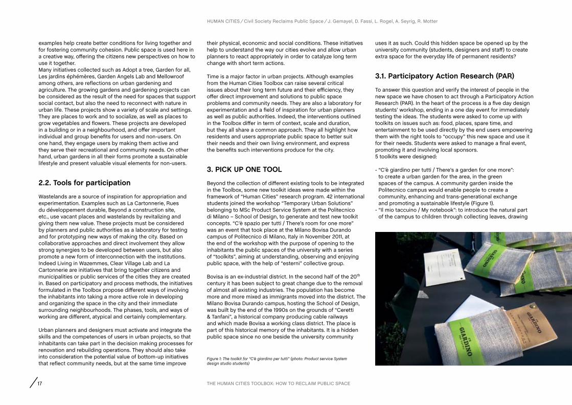
- “C’è giardino per tutti / There’s a garden for one more”: to create a urban garden for the area, in the green spaces of the campus. A community garden inside the Politecnico campus would enable people to create a community, enhancing and trans-generational exchange and promoting a sustainable lifestyle (Figure 1).
- “Il mio taccuino / My notebook”: to introduce the natural part of the campus to children through collecting leaves, drawing
Figure 1: The toolkit for “C’è giardino per tutti” (photo: Product service System design studio students)
18
HUMAN CITIES Civil Society Reclaims Public Space J. Gemayel, D. Fassi, L. Rogel, A. Seyrig, R. Motter
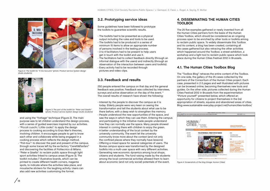
and using the “frottage” technique (Figure 2). The main purpose was to let children understand the design process, with a series of guided exercises inspired by our activities.
- “Piccoli cuochi / Little cooks”: to apply the design process to cooking according to Enzo Mari’s theories, involving children. It encourages people to get to know each other and collaborate while being engaged in a cooking process which reflects the design method.
- “Poli-tour”: to discover the past and present of the campus, through some traces left by the ex-factory “Ceretti&Tanfani” and discovering the facilities of Politecnico di Milano.
- “Peter e Gisella”: to reclaim public space through light sport activities linked to campus areas (Figure 3). The toolkit includes 7 illustrative boards, which can be printed to create different health corners, magenta spots, to indicate where the activities take place, and moustache stickers for the laughing activity. Users can also add new activities customizing the format.
3.2. Prototyping service ideas
Some guidelines have been followed to prototype the toolkits to guarantee scientific results.
- The toolkits had to be presented as a physical output including the rules and tools to be used.
- The toolkits had to be produced in a series of minimum 15 items to allow an appropriate number of persons involved in the testing process.
- 3 to 4 facilitators had to be present to help users get in touch with the toolkit and use it.
- The facilitators had to collect feedback directly (through an informal dialogue with the users) and indirectly (through an observation of the interaction between users and toolkits).
- Every activity had to be recorded through pictures and video clips.
3.3. feedback and results
250 people entered the campus on that day and the general feedback was positive. Feedback was collected by interviews, surveys and active observation on the day of the event. 2
The overall results of research have shown the following:
- Interest by the people to discover the campus as it is today. Elderly people were very keen on seeing the transformation and tell the students about what use to be there before, with a deep wish to strengthen the memory.
- People understood the new opportunities of the space, and saw the ways in which they can use them. Entering the campus and participating in the initiative made people understand how they can normally use the space. Many people showed interest in coming there with children to enjoy the green.
- A better understanding of the local context by the university community. The event let the university community know more about the context (and not only the confined places where they normally have lessons)
- Offering a mixed space for several categories of users. The Bovisa campus space was transformed by the designed toolkits into a multi-user space with very different activities.
- Generating new economic dynamics among local shops, citizens and students. The fund raising made by the students among the local commercial activities allowed them to learn about economic (and not only social) potentials of the event.
4. DISSEMINaTING THE HUMaN cITIES TOOLBOX
The 25 five examples gathered or newly invented from all the Human Cities partners form the basis of the Human Cities Toolbox, which should be considered as an ongoing process open to be enriched by other tools or toolkits aiming to reclaim public space. To widely disseminate this Toolbox and its content, a blog has been created, containing all the cases gathered but also retracing the other activities which happened around the Toolbox: a street exhibition, a workshop and a light tool to reclaim public space which took place during the Human Cities Festival 2012 in Brussels.
4.1. The Human cities Toolbox Blog
The “Toolbox Blog” retraces the entire content of the Toolbox. On one side, the gallery of the 25 cases collected by the partners of the Consortium of the Human Cities project. Each case, presented in 2-3 pages and well illustrated with pictures can be browsed online, becoming themselves new tools and guides. On the other side, pictures collected during the Human Cities Festival 2012 in Brussels from the experimentation “Picture yourself” presented below, which offered an opportunity for citizens to project themselves in the (re)appropriation of streets, squares and abandoned areas of cities. Blog: www.sustainable-everyday-project.net/humancities-toolbox/
Figure 2: The toolkit for “Il mio taccuino” (photo: Product service System design studio students)
Figure 3: The part of the toolkit for “Peter and Gisella” (photo: Product service System design studio students)
Figure 4: Screenshots of the blog (image: Human Cities)
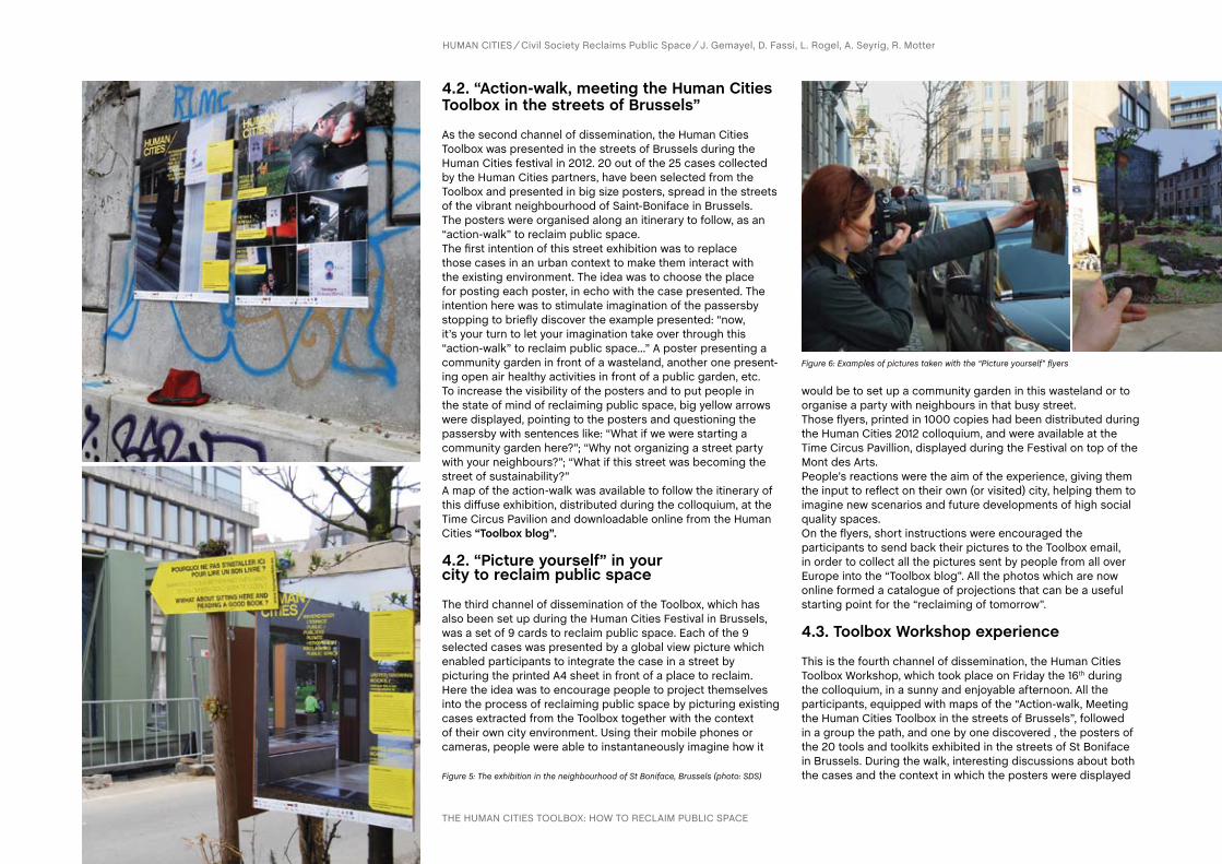
4.2. “action-walk, meeting the Human cities Toolbox in the streets of Brussels”
As the second channel of dissemination, the Human Cities Toolbox was presented in the streets of Brussels during the Human Cities festival in 2012. 20 out of the 25 cases collected by the Human Cities partners, have been selected from the Toolbox and presented in big size posters, spread in the streets of the vibrant neighbourhood of Saint-Boniface in Brussels. The posters were organised along an itinerary to follow, as an “action-walk” to reclaim public space. The first intention of this street exhibition was to replace those cases in an urban context to make them interact with the existing environment. The idea was to choose the place for posting each poster, in echo with the case presented. The intention here was to stimulate imagination of the passersby stopping to briefly discover the example presented: “now, it’s your turn to let your imagination take over through this “action-walk” to reclaim public space…” A poster presenting a community garden in front of a wasteland, another one present-ing open air healthy activities in front of a public garden, etc. To increase the visibility of the posters and to put people in the state of mind of reclaiming public space, big yellow arrows were displayed, pointing to the posters and questioning the passersby with sentences like: “What if we were starting a community garden here?”; “Why not organizing a street party with your neighbours?”; “What if this street was becoming the street of sustainability?” A map of the action-walk was available to follow the itinerary of this diffuse exhibition, distributed during the colloquium, at the Time Circus Pavilion and downloadable online from the Human Cities “Toolbox blog”.
4.2. “Picture yourself” in your city to reclaim public space
The third channel of dissemination of the Toolbox, which has also been set up during the Human Cities Festival in Brussels, was a set of 9 cards to reclaim public space. Each of the 9 selected cases was presented by a global view picture which enabled participants to integrate the case in a street by picturing the printed A4 sheet in front of a place to reclaim. Here the idea was to encourage people to project themselves into the process of reclaiming public space by picturing existing cases extracted from the Toolbox together with the context of their own city environment. Using their mobile phones or cameras, people were able to instantaneously imagine how it
would be to set up a community garden in this wasteland or to organise a party with neighbours in that busy street. Those flyers, printed in 1000 copies had been distributed during the Human Cities 2012 colloquium, and were available at the Time Circus Pavillion, displayed during the Festival on top of the Mont des Arts. People’s reactions were the aim of the experience, giving them the input to reflect on their own (or visited) city, helping them to imagine new scenarios and future developments of high social quality spaces. On the flyers, short instructions were encouraged the participants to send back their pictures to the Toolbox email, in order to collect all the pictures sent by people from all over Europe into the “Toolbox blog”. All the photos which are now online formed a catalogue of projections that can be a useful starting point for the “reclaiming of tomorrow”.
4.3. Toolbox Workshop experience
This is the fourth channel of dissemination, the Human Cities Toolbox Workshop, which took place on Friday the 16th during the colloquium, in a sunny and enjoyable afternoon. All the participants, equipped with maps of the “Action-walk, Meeting the Human Cities Toolbox in the streets of Brussels”, followed in a group the path, and one by one discovered , the posters of the 20 tools and toolkits exhibited in the streets of St Boniface in Brussels. During the walk, interesting discussions about both the cases and the context in which the posters were displayed
Figure 6: Examples of pictures taken with the “Picture yourself” flyers
Figure 5: The exhibition in the neighbourhood of St Boniface, Brussels (photo: SDS)
THE HUMAN CITIES TOOLBOX: HOW TO RECLAIM PUBLIC SPACE
HUMAN CITIES Civil Society Reclaims Public Space J. Gemayel, D. Fassi, L. Rogel, A. Seyrig, R. Motter

20
came out. This was exactly what the exhibition expected to be, an incubator of reflections and new proposals to be spread around in cities. The reality of one place, presented through the poster, was matched with a wasteland which needs to be
Notes1 The partners involved in the Toolbox are: (BE) Pro Materia, Faculty of Architecture La Cambre-Horta, Strategic Design Scenarios, (FR) Cité du Design St-Etienne, (IT) Politecnico di Milano, (SI) Urban Planning Institute of the Republic of Slovenia, (UK) Clear Village.
Figure 7: The Human Cities Toolbox Workshop (photo: SDS)
2 A short movie about “C’è spazio per tutti/There’s room for one more” made by the event managing students team is available at http://www.youtube.com/watch?v=atvk7kw5_Ic&feature=related.
HUMAN CITIES Civil Society Reclaims Public Space J. Gemayel, D. Fassi, L. Rogel, A. Seyrig, R. Motter
rethought in a social and community way for people by people. The set of cards was a very useful instrument: the cards led people to immerse themselves in a certain context and try to imagine it in a complete renewed way. The experience of the
workshop was completed in the community garden of Rue Gray, started and motivated by the “Le debut the haricots,” a well known association in Brussels, active in the field of sustainable food and urban gardening. Members of the group of people taking care of the garden explained how they were able to build an active community around a little piece of land.
5. cONcLUSION
The different steps described above are part of the process, ending with framing research and development of tools and methods for the toolbox. Defining various solutions and clustering them has allowed us to form a theoretical overview on the topic and at the same time gave us the ability to implement the tools.
The overall process of cooperation and development of innovative solutions for the public space was reached through the following steps: - mapping the existing context through the
collection of toolkits on an international level, - “action research” activity half way through the
process for real evaluation and finally - the implementation and test of the tools of
the Human cities Festival in Brussels.
In front of an obvious urban need for “reclaiming public space” the toolkit idea has resulted as extremely efficient. The cooperation between the final users and the designer / facilitator has brought to the development of light and fun tools the act upon a serious and important issue. The collection of the tools is now available to the whole community and we hope it can be used by the citizens to improve city life.
AUTHORS
21 R. Houlstan-Hasaerts, B. Tominc, M. Nikšič, B. Goličnik Marušić (Editors) Urbani izziv - publikacije, Ljubljana, May 2012
Barbara Goličnik Marušić, Matej Nikšič, Rafaella Houlstan Hasaerts and Davide fassi
THE HUMAN CITIES OBSERVATION MISSION: RESEARCH TOOL FOR PUBLIC SPACE ANALYSES AND EVALUATION
2. STRUcTURE Of THE TOOL aND ITS IMPLEMENTaTION
Operationally, the Observation mission research tool is set up from five working sheets, each consisting from two to three A4 pages. The format is suitable for field analyses. First working sheet is dedicated to the structural dimension, the most usual and straight forward place analysis. Beside structural characteristics of places, which are addressed via changes of place with time, materials and facilities, this analytical working sheet addresses also programmatic characteristics of places. Second working sheet is dedicated to the behavioural dimension, i.e. it focuses on patterns of users in places. This analysis is based on observations of a place at different times in a day and different days of a week. The practical results which follow the observations, showing information about how places actually live, are called behavioural maps. The third working sheet represents the shortest task within the tool. It asks for any kind of expressions about the route between two places. The cognitive dimension of a place is analysed in working sheet 4. The aim is to collect information about the structure of perception of a place and connections between perceived neighbouring spaces. The fifth working sheet is about receptive values. It is based on interviews and as a result marks qualifications and disqualifications of places.Each working sheet include basic ID information, such as the name of the place, the city, the country, the name of the observer, and information about the date and the like. Other sections differ according to the worksheet’s analytical purpose. A complete package of the Observation mission research tool is available from the appendix of this publication.
2.1 Structural dimension
This part of the research tool provides a template for physical characteristics of places, focussing on several viewpoints. The first analysis is about a brief historical
1. INTRODUcTION
Observation mission tool is a Human Cities project product based on a compilation and adjustment of existing tools for public space analysis and evaluation as used by some of the partners of the project. It resulted from different, but mutually related approaches towards public space. Their common denominator was that they were all based on relationships between people and places.
The tool has been designed for professionals and was set up to achieve a comparable analysis of different places, which are analysed from several points of view. In this respect, the proposed common tool has five dimensions: structural, behavioural, experiential, cognitive and receptive. This recalls the concept of Nature of place, suggested by Canter (1977). Canter’s theory of the psychology of place (1977: 158) indicates that a place is the result of relationships between actions, conceptions and physical attributes.
The structural dimension of the presented tool directly corresponds with physical attributes; the behavioural dimension with activities; the experiential and cognitive dimension with conceptions. The receptive dimension has a different character and does not fit into the scheme of Nature of place (Canter, 1977). However, talking about a conceptual system of evaluation of (natures of) places, as argued by Canter, this last dimension can be concerned in such respect. When addressing the receptive dimension, it is important to go beyond the place as a phenomenon as such. Processes and values that are inherent to places get in focus. It becomes important whose conceptions and understandings of places are being looked at. Canter’s Conceptual system of evaluation highlights the relationships and processes between different actors, talking about users’ concepts of places, design concepts of places and organisational objectives about places (Canter, 1977: 165). His model can be underlined to the receptive dimension of the Observation mission research tool.
contact Goličnik Marušić, BarbaraLandscape Architect, PhD in Landscape Architecture. Researcher, Head of research, Urban Planning Institute of the Republic of Slovenia (UIRS), Assistant Professor for Open Space Design and Urban Landscape Research and Design, School of Architecture, Faculty of Civil Engineering, University of Maribor (UM, FG) – [email protected]šič, MatejArchitect, MA in Urban Planning, PhD in Architecture. Researcher, Urban Planning Institute of the Republic of Slovenia (UIRS), Ljubljana – [email protected], RafaellaArchitect. PhD candidate (Prospective Research for Brussels), ULB, Faculty of Architecture La Cambre-Horta, Brussels – [email protected], DavideArchitect, Phd in Technological Innovation for Architecture and Design. Politecnico di Milano, School of Design, INDACO Department, DHOC - Interior Design for Hospitable Cities Research Group, Milan – [email protected]
22
HUMAN CITIES Civil Society Reclaims Public Space B. Goličnik Marušić, M. Nikšič, R. Houlstan-Hasaerts, D. Fassi
OBSERVATION MISSION: RESEARCH TOOL FOR PUBLIC SPACE ANALYSES AND EVALUATION
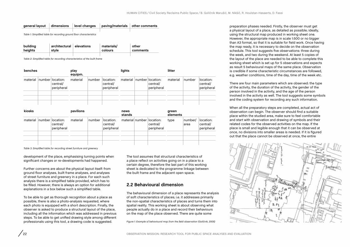
development of the place, emphasising turning points when significant changes or re-developments had happened.
Further concerns are about the physical layout itself: from ground floor analyses, built frame analyses, and analyses of street furniture and greenery in a place. For each such analysis there is a simplified table provided, which has to be filled. However, there is always an option for additional explanations in a box below such a simplified table.
To be able to get as thorough recognition about a place as possible, there is also a photo-analysis requested, where each photo is equipped with a short description. Finally, the observer is asked to produce a structural layout of the place, including all the information which was addressed in previous steps. To be able to get unified drawing style among different professionals using this tool, a drawing code is suggested.
The tool assumes that structural characteristics of a place reflect on activities going on in a place to a certain degree, therefore the last part of this working sheet is dedicated to the programme linkage between the built frame and the adjacent open space.
2.2 Behavioural dimension
The behavioural dimension of a place represents the analysis of soft characteristics of places; i.e. it addresses primarily the non-spatial characteristics of places and turns them into spatial reality. This working sheet is about observing what people actually do in a place and record their behaviours on the map of the place observed. There are quite some
general layout dimensions level changes paving/materials other comments
building heights
architectural style
elevations materials/colours
other comments
benches play equipm.
lights litter
material number location: central/peripheral
material number location: central/peripheral
material number location: central/peripheral
material number location: central/peripheral
kiosks pavilions news stands
green elements
material number location: central/peripheral
material number location: central/peripheral
material number location: central/peripheral
type number/area
location: central/peripheral
Table 1: Simplified table for recording ground floor characteristics
Table 2: Simplified table for recording characteristics of the built frame
Figure 1: Example of behavioural map from the field observation (Goličnik, 2005)
Table 3: Simplified table for recording street furniture and greenery
preparation phases needed. Firstly, the observer must get a physical layout of a place, as detailed as possible; ideally, using the structural map produced in working sheet one. However, the appropriate map is in scale 1:500 or no bigger than A3 format, so that it is suitable for field work. Once having the map ready, it is necessary to decide on the observation schedule. This tool suggests five observations: three during the week, and two during the weekend. At least 5 copies of the layout of the place are needed to be able to complete this working sheet which is set up for 5 observations and expects as result 5 behavioural maps of the same place. Observation is credible if some characteristic circumstances are followed, e.g. weather conditions, time of the day, time of the week etc.
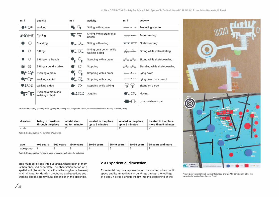
There are four main parameters which are observed: the type of the activity, the duration of the activity, the gender of the person involved in the activity, and the age of the person involved in the activity as well. The tool suggests some symbols and the coding system for recording any such information.
When all the preparatory steps are completed, actual act of observation can begin. The observer should find a suitable place within the studied area, make sure to feel comfortable and start with observation and drawing of symbols and their related codes for the observed activities on the map. If the place is small and legible enough that it can be observed at once, no divisions into smaller areas is needed. If it is figured out that the place cannot be observed at once, the entire
23
HUMAN CITIES Civil Society Reclaims Public Space B. Goličnik Marušić, M. Nikšič, R. Houlstan-Hasaerts, D. Fassi
area must be divided into sub areas, where each of them is then observed separately. The observation period of a spatial unit (the whole place if small enough or sub-areas) is 10 minutes. For detailed procedure and questions see working sheet 2: Behavioural dimension in the appendix.
2.3 Experiential dimension
Experiential map is a representation of a studied urban public space and its immediate surroundings through the feelings of a user. It gives a unique insight into the positioning of the
duration being in transition through the place
a brief stop up to 1 minute
located in the place up to 2 minutes
located in the place up to 5 minutes
located in the place more than 5 minutes
code 1’ 2’ 3’ 4’
age 0-5 years 6-12 years 13-19 years 20-34 years 35-49 years 50-64 years 65 years and moreage group 1 2 3 4 5 6 7
m f activity m f activity m f activity
Walking Sitting with a pram Propelling scooter
CyclingSitting with a pram on a bench
Roller-skating
Standing Sitting with a dog Skateboarding
SittingSitting on a bench while walking a dog
Sitting while roller-skating
Sitting on a bench Standing with a pram Sitting while skateboarding
Sitting around a table Stopping Standing while skateboarding
Pushing a pram Stopping with a pram Lying down
Walking a child Stopping with a dog Lying down on a bench
Walking a dog Stopping while talking Sitting on a tree
Pushing a pram and walking a child
Jogging Playing
Using a wheel-chair
Table 4: The coding system for the type of the activity and the gender of the person involved in the activity (Goličnik, 2005)
Figure 2: Two examples of experiential maps provided by participants after the experiential walk (photo: Davide Fassi)
Table 5: Coding system for duration of activities
Table 6: Coding system for age groups of people involved in the activities

24
studied space within the wider network of open public spaces. A completely personal geography (Psycho-geography) of the city is represented as a result of perception and not as an objective topographic item (Fassi, 2012). When studying the behavioural dimension, users are involved indirectly. In the rest of analyses focusing on user’s conceptions of places, they are approached rather directly. Walking can be a means to invent, a different approach to intervene in the urban public spaces, to investigate them, to provide symbolic meanings (Careri, 2008). Some basic information about users involved is recorded as shown in table 7.
An adequate number of users from the studied space are asked to walk through the space and its surrounding areas, and present their impressions about the space after the walk in any chosen technique (drawing, collage etc.). In the final stage, a translation of individually drawn maps using a common graphical language is provided, which allows a comparative overview of all maps.
In the preparation step of the walk, the researcher has to prepare the map of the area and mark the exact trail to be walked. The length of the walk depends on each concrete space, but should normally be no longer than 20 minutes. The participants are advised to get equipped with any kind of technical or other tools (video or audio recorders, a sketch book, coloured pencils, etc.) in order to be able to resume their impressions in a graphical way after the walk. If not done simultaneously during the walk, each participant is asked to draw his/her own experiential map of the space he/she walked through, immediately after the walk (when impressions are still fresh). The concluding step is done in the office by a researcher. It is a simplification process of all participants’ experiential maps. This step is demanded in order to put the variety of experiential maps produced by participants into a common denominator and comparatively review and sum up all maps. For a detailed procedure and questions see working sheet 3: Experiential dimension in the appendix of this proceeding.
2.4. cognitive dimension
The cognitive dimension of space is uncovered by a combination of two techniques: interviewing and sketching. This provides an understanding of the extension of a studied space in a users’ mental image, its connection with other neighbouring spaces at a mental level, and the main characteristics of spaces as perceived from the viewpoint of users. The appreciation or unappreciation of these characteristics from the side of users is covered by this tool as well, thus likes and dislikes that people share about a definite space can be listed.
The data is collected through interviews. A layout of the place (ideally the one produced in the Working sheet one) is given to the participant. He/she is asked to imagine him/herself standing at the marked position of the place, and to mark with a continuous line where he/she perceives the borders of this space. Further, the participants are asked to comment on the perceived borders of space and perceived characteristics of the space within these borders. Further steps are dedicated to recognition of neighbouring spaces to this initial perceived space. The intensity of the attachment of initial and neighbouring perceived spaces is in question as well as main characteristics of the most and the least perceived neighbouring space. The tool is not limited only to the visual perception of places, and asks also about other sensory dimensions. For a detailed procedure and questions see working sheet 4: Cognitive dimension in the appendix of this proceeding. However, when the data from each interviewee is gathered, the presentation of the common mental image of the studied space – that is shared by a larger number of users – can be provided. The designer of space is thus given an extra and otherwise not visible layer of information about the cognition of space from the side of its users.
participant gender (M/f) age (years) education 1 – none or primary 2 – secondary 3 – university or more
usual holiday destination by preference 1 – urban environments 2 – natural environments
user from 1 - neighbourhood 2 - city 3 - region 4 - other:
participant 01
participant 02
participant 03
participant 04
participant 05
built edge facades included
built edge facades excluded
narrowing/ widening of space
area with similar street furniture
area without level changes
area of same traffic regime
area of same or alike programmes
where the view ends
other: please specify
architecture natural elements
street furniture
vehicles people programmes in the built frame
programmes in open space
the sights of town
memories attached to space
other: please specify
Table 7: Collection of relevant data when conducting analyses for experiential dimension (working sheet 3), cognitive dimension (working sheet 4) and receptive dimension (working sheet 5)
Table 8: Participants are asked to name why they perceive the borders where they marked them, regarding the following aspects
Table 9: Participants are asked further to name the characteristics of the perceived space
HUMAN CITIES Civil Society Reclaims Public Space B. Goličnik Marušić, M. Nikšič, R. Houlstan-Hasaerts, D. Fassi
OBSERVATION MISSION: RESEARCH TOOL FOR PUBLIC SPACE ANALYSES AND EVALUATION

25
2.5 Receptive dimension
The receptive dimension provides a frame to comprehend what values people mobilize to assess a public space or
Tenet Type of sentence Presence (mark with an x) Number of occurrences Attentional (Q) The object is seen, used, occupied,
adopted, attended.
(D) The object is insignificant, invisible, unknown, empty, unused, unoccupied, disinvested, not attended.
(Q) The process aimed to take into account the users’ or receiver’s needs or expectations.
(D) The process moved away from the users’ or receiver’s needs or expectations.
Aesthetic (Q) The object is beautiful, attracting by formal, plastic and colour facets.
(D) The object is ugly, non-aesthetic, unattractive, badly proportioned.
(Q) The process aimed to contribute to the embellishment and decoration of public space.
(D) The process has defaced the public space.
Semantic (Q) The object has significance, tells a story and symbolizes something.
(D) The object is meaningless, inconsistent.
(Q) The process aimed to describe, comment or summarize signs that stem from a historical, identity, physical or social context.
(D) The process reduced the significance of the context.
Operational (Q) The object is useful, functional, practical and rational.
(D) The object is useless, unpractical, fragile or has no purpose.
(Q) The process was effective, coherent and well planned.
(D) The process was entropic, incoherent or technically irrational.
any object that defines it (material, urban furniture, art intervention, events, etc.). It shows the ties that exist between the discourse of receivers – their evaluations, justifications, judgments, arguments – and the actual public space.
Table 10: An example of cutting out from the grid for qualifying ir disqualifying characteristics of the studied place regarding selected tenets
Figure 3: Two examples of mental maps drawn on the morphological map of the studied space (Nikšič, 2008)
HUMAN CITIES Civil Society Reclaims Public Space B. Goličnik Marušić, M. Nikšič, R. Houlstan-Hasaerts, D. Fassi

26
Figure 4: An example of a common interpretation of the data gathered through the structural, behavioural and cognitive working sheet, as it appears in GIS (Goličnik and Nikšič, 2009)
The data is collected through at least 5 semi-directive individual interviews with users, participants or spectators who are familiar with the selected case study, or are physically present in the place (street-interview). This corpus can be completed collecting a series of documents that give an idea of people’s opinion about the case study i.e. press articles, radio or TV broadcasts. All data must be transcribed in order to analyse it according to a comprehensive grid. The grid allows the researcher to overlay the different criteria that receivers use to qualify or disqualify the case study and the processes underlying its production. It also permits to classify these criteria of qualification/disqualification in coherent perspectives or tenets: attentional, aesthetic, semantic, operational, inspired, domestic, civic, liberal, ecological or prescriptive.
The final outcome is expected to be an overview of divergences or convergences between the values different people mobilize when it comes to assessing the same public space. These results can be overlapped to the data gathered by means of other parts of the tool.
3. DIScUSSION
This Observation mission research tool as a comprehensive package of five dimensions has been tested at the workshops within the Human Cities Symposia. The aim was to implement these approaches in recently refurbished and recovered areas of Brussels. As the time was limited, some original approaches of the tool have been shorthanded. However, the workshop has proved that all five dimensions of public place wrapped up into this Observation mission research tool are meaningful to look at them simultaneously, as they can (re)inform each other and provide a bigger and better picture of the place as such.
All the data gathered via five working sheets is ideally stored and processed by GIS. This allows a simultaneous interpretation
of different kind of data – from morphological characteristics of space, behavioural patterns in space, its perceptions and cognitive characteristics, as well as processes and actors that shape it. Through a systematic and long-term data gathering in a so structured way, a rather detailed insight into the character of space is provided, which is an advantage for any entity involved in the production of public space. Some of the dimensions of here discussed Observation mission research tool have already been applied simultaneously in a study addressing revitalisation approaches in a case study area in the centre of Ljubljana, Slovenia (Goličnik et. al, 2007).
4. cONcLUSION
Exposing different layers of open public spaces, and stressing out the need for and advantages of their
HUMAN CITIES Civil Society Reclaims Public Space B. Goličnik Marušić, M. Nikšič, R. Houlstan-Hasaerts, D. Fassi
simultaneous interpretation when a high quality open public space is in question, may be one of the main aims of the Human Cities Observation Tool. This means that the tool can be adapted according to the context, used as a whole or in any kind of combination of sections when appropriate, as well as that the tool shall not stay static and fixed to its current form but is open to grow.
Recording behavioural patterns of use, other experiences and mental images of places in the manner of map making and its interpretation, offer a comprehensive way of communicating diverse spatial issues and values related to them. It also captures and translates primarily ‘non-spatial data’ into visual data and preserves its connection with the material place. Qualifying and disqualifying criteria help to elucidate the observed place from different tangible and intangible facts about a place. Thus, when talking about reclaiming public spaces it is very important to represent and consider different qualities of places mutually, including a very detailed scale, from social to physical aspects of spatial development.
Mapping methods discussed in this paper represent an attempt to bring together different aspects of urban environments — from the use and perception to the physical appearance of the environment. As such, they offer a tool for the examination and exploration of spatial reality in more depth. The common act of behavioural, experiential and cognitive mappings, additionally linked with receptive values however, has shown to be an effective way of searching for empirical knowledge about usage–spatial relationship in public spaces. It is a comprehensive way of collecting evidence about use and perception of a place and dealing with this information further. Such an approach is necessary to recognise and steer complex changes. To sum it up, the tool shall in any case act as a reminder of very different aspects that are important to be taken into account to comprehensively approach open public space in a city.
ReferencesCanter, D. (1977). The Psychology of Place. New York, St. Martin’s Press.
Careri, F. (2006). Walkscape, Einaudi, Torino.
Fassi, D. (2012). Temporary Urban Solutions. Maggioli. Rimini.
Goličnik, B. (2005). People in place: A configuration of physical form and the dynamic patterns of spatial occupancy in urban open public space, Doctoral thesis, Edinburgh College of Art, Edinburgh.
Goličnik, B., Mujkić, S., Nikšič, M. and Tominc, B. (2007). Behavioural maps for a vital city: innovative usage of GIS for monitoring and representation of spatial as well as non-spatial aspects of city centre revitalisation. Urban Planning Institute of the Republic of Slovenia, Ljubljana.
Goličnik, B. and Nikšič, M. (2009). Geographic information system behavioural and cognitive mapping in the city centre revitalisation process. Journal of urban regeneration and renewal, 3(2), pp.161-179.
Nikšič, M. (2008). Connecting urban microambients into recognizable whole: Structure of open urban public space in mental image of users, Doctoral thesis, University of Ljubljana, Ljubljana.
OBSERVATION MISSION: RESEARCH TOOL FOR PUBLIC SPACE ANALYSES AND EVALUATION
Part one: AnalyticalHighlight

28
Introduction to the Analytical Highlight
fRaMES, cONfLIcTS aND REfLEXIVITIES: aNaLYZING THE PLURaL NaTURES Of PUBLIc SPacES IN HUMaN cITIES
Mathieu Berger, Vincent calay and Sabine Knierbein
The “Analytical Highlight” assembles five very different contributions in terms
of socio-political context, space and time scales, research perspectives, as
well as regarding the type of civil society initiatives they deal with. However,
it is possible to identify at least three key problems they all address, in one
way or another. First, they all bring the reader to a reflection about the – often
taken for granted – categories and forms through which public spaces are
designed, shaped, experienced and sustained. Highlighting such processes
opens to the plural natures of publicness and of spatialities invested in the
shaping of public spaces. Second, each of the five papers tackles the political
meaning of the urban public space and its fundamental ambivalence, as the
space where practices of governmental control and economic domination on
one hand, and of civil disobedience and political subversion on the other hand,
can be best studied . Finally, all these contributions inevitably raise questions
about positionality, research ethics and in-depth interpretation. The standpoint
from which the authors are writing (describing, analysing, interpreting, etc.)
needs to be clarified, in order to shed a light on the degree of normative
involvement displayed by the researcher in his or her study. For it is impossible
to say anything about what public space is, or about how it works without
sustaining an ideal-type idea about which possible role and meaning public
spaces could or should entail for the development of more human cities.
The categories, forms and Processes That Shape Public Spaces
A first crosscutting issue in the set of papers gathered in this analytical
highlight is the mingling of cognitive categories, defining the natures of
publicness and of spatialities; of how those categories actually materialize in specific forms; and of the processes driving such a transformation of
cognitive categories into institutional, activist and/or architectural forms.
This whole issue underlies Parsa’s paper: his focus on law and on its
interactions with the emergence of criticism gives crucial insights into the
understanding of complex relationships linking the forms of claims for public
spaces and how it turns to be shaped by legal and institutional frameworks.
Kenaan’s paper opens up a unique philosophical perspective on the question
of the inner form of public space and does so by reverting to the philosophical
origins of the idea that the city is a human entity. Kenaan goes back to Plato
whose conceptualization of the city is done in analogy to the conceptualization
of the human soul in order to develop a conception of public space which,
like that of the human soul, is conflictual at heart. Conflict, Kenaan argues,
is not an aberration or an exceptional condition of public space, but, on the
contrary, the very form of the Urban. Consequently, he suggests that unless
we rethink the urban vis-a-vis the concept of intrinsic conflict, we shall fail to
embrace the meaning of Human Cities – of that which makes cities human.
Klein’s paper brings deep insights on this formal shaping of publicness in
spaces. By investigating the materialities involved in the daily living in India, it
29
shows how the technical space designed around railway tracks, often defined
in Western imagination as secured and specialized for a single use, is declined
in a set of spatialities, bringing altogether various meanings of publicness.
What is remarkable in this paper is that the claim for public space does not
appear as a matter of oppositions, of hard reclaims, strategies or struggles
against capitalist forces, but as soft concerns about daily living and its forms.
Materiality is at the core of Golinelli’s paper. It presents an in-depth
investigation of a discrete and banal kiosk for the removing and putting on
the headscarf in Turkey. His analysis appears to be a thorough description
of this whole process of investment of cultural and religious grandeurs
into a pretty small and banal device. It shows what is at stake in such
a device and describes a process that appears to be close to the one
observed in India: a soft claim for, in this case, a non-publicness of space.
By contrast, Neducin and her colleagues bring us back to the Western
logics of urban planning by discussing how neoliberal imaginations of
a post-socialist city affect the design of urban spaces. Both publicness
and materiality are put at the core of strategic and struggling processes
binding the set of stakeholders usually involved in urban development.
Public spaces as spheres for domination and subversion
All the papers in this section in their own way also address the polarity
between a dominant order and subversive practices in urban spaces, most of
them taking a critical stand in favour of the latter. These contributions all start
from a similar script: minoritary, vulnerable, marginal, sometimes illegal actors
or practices struggling for their share of the public space and spatialized
forms of recognition and legitimacy, within urban contexts controlled either
by neoliberal coalitions between the State and the powerful private actors,
by non-ambitious and legalistic administrations, or even, on a mere cognitive
level, by the lack of any available “urban culture” (see Neducin et al.)
In his contribution, Parsa proposes a critique of the dominant interpretation
of “public order”. Against a liberal, functionalist and ultimately negative
approach to public space, seen as a disciplinary space of domestication
of one’s behaviours, where individuals should interfere with each other as
little as possible in order to circulate freely and smoothly, Parsa defends
a radically political and positive vision of the public domain, considered
above all as the space where assembly, citizenship and critique happen.
In the same vein, Kenaan addresses the genuine and spontaneous
street art as a necessary counterpoint to the predominant “visual
order” in cities. For him, street art is an expression of the dynamics of
struggle, of domination and subversion and, moreover, of the plurality
that constitute the pulse of the city’s being. In this context, he argues
that, in addition to political street art and to art on the street, there is a
whole range of graffiti that should be understood as a trace of that inner
plurality/conflict which he takes to be constitutive of urban space and
he exemplifies this point by looking at graffiti in Tel-Aviv and Brussels.
30
c. Klein and c.T. Klein describe how a railroad track has become a
backbone along which a vibrant public life thrives, a series of places
where a mass of informal but vital practices are made possible.
Neducin and her colleagues, in their contribution, demonstrate that even
in the unfavourable context of post-communist Belgrade, where the uses
of public space are today mostly dependant on the agenda of big private
developers, forms of resistance conducted by the minoritary and concerned
citizens, may be possible and efficient. Finally, building on thick description
and a less normative approach of the complicated relations between the
dominant culture and the minoritary practices, Golinelli’s paper shows how
a small, unnoticed, seemingly banal dispositif such as a kiosk can become
an important tool of mediation and accommodation for religious practices
within an officially secular institution (a university campus in Izmir, Turkey).
Researching public spaces: Positionality, research ethics and in-depth interpretation
Neducin et al. presented how collective learning processes to re-establish a
collective urban culture against local authorities bypassing legal requirements
and weakening community decisions are established by reshaping the
New Fifth Park in Belgrade. They stress the crucial role of public spaces in
the transitional, post-socialist societies in Serbia, where public needs are
not underlying the conception of the cities’ policies for public spaces.
While this conception of “public needs” rather implies a re-calibration of
public demands in urban societies in transition, c. Klein and c. T. Klein
highlight existential public needs that are expressed in their case studies of
appropriated Indian railway lines as lived public spaces. Whereas the authors
draw a lively as well as ambivalent picture of minimal living conditions in
Mumbai, New Delhi and Jalandhar, their final claim remains implicit. Producing
a video documentary on the basic human needs expressed in public spaces
is a very important first step to show how people “reclaim” public spaces.
Nevertheless, such a consideration needs to be accompanied by researchers
showing their positionality explicitly, if the human living conditions do not
meet existential standards of decent everyday living standards at all.
Kenaan describes the expression of professional positionality as a plea
for what Heidegger calls “distantiality”, the “political eye” through which
philosophers construe a critical platform for rethinking the ethical dimension
of researching the city. Following Socrates’ rhetoric, “the city can serve as
a prism for interrogating the soul”. Thinking about “human cities” therefore,
embeds a paradigm that internalizes the human (the structure of the human
soul) as its ultimate measure. Analyzing changing visual culture structures in
public spaces just leads to one final concern: How should we reconceptualise
the relationship between space, the city and the condition of being contested?
Can human rights, for example serve as a valuable entry dimension to
try and understand how human the city really is and how human and
at the same time how contested its public spaces are? In this context, Parsa draws upon the right to freedom of assembly and the ambivalent
notion of how this right is often limited by (local) public order in public

31
spaces. Here, civil society action is often seen as an act of collective
civil disobedience in order to challenge, change or even deconstruct
the hegemonic structures of the state. The state is therefore analytically
distinguished from the public, and concepts like public interest and public
order are investigated critically. This leads to a strong claim for a necessary
distinction between analytical-descriptive approaches (e.g. public spaces
as places where public life unfolds) and normative, ideal-type considerations
(e.g. public space as places where democracy should be practiced).
The concept of individual freedom, as mentioned by Golinelli in the case of
Izmir, bears some meaningful risks when analyzing public spaces: In Izmir, young
women might want to wear the scarf due to religious conviction. In this case, the
laicist tradition in Turkey forbids them to show their religious choices in public
spaces, and thus reduces their individual freedom. However, social pressure
can also be mediated by the family when a young Turkish woman actually does
not choose voluntarily to wear the scarf. In this case, the law helps her to legally
“disobey” the family rules, and might open up a process for civic emancipation,
although or even because emblems of religion are not used in public spaces.
In order to analyze the actions of the civil society to reclaim public spaces,
a carefully chosen box of tools and concepts is needed, that allows taking a
professional political position; makes us reflect on research ethics that are
employed when working with people’s hopes and expectations; and allows for
an in-depth interpretation of (in)visible nuances of social patterns and cultural
practices in public spaces as places where public life might eventually unfold.
AUTHORS
Abstract
CHAPTER
32 R. Houlstan-Hasaerts, B. Tominc, M. Nikšič, B. Goličnik Marušić (Editors) Urbani izziv - publikacije, Ljubljana, May 2012
contact amin ParsaPhD candidate in Public International Law, Lund University, Malmö, Sweden, +46760833828, [email protected]
Keywords
amin Parsa
Freedom of assembly, public order, public space and form.
Amidst the so called “Arab Spring”, the rhetoric of international human rights as the common goal of humanity and the sublime framework of redemption has repeated itself over and over again. Despite the celebration of these events by those involved with human rights, this paper aims to show how international human rights law, contrary to its promise of protection of individuals against the state’s interference, is enforcing boundaries in public space through its attempt to preserve public order, and demonstrates how international human rights law provides a legal platform for the oppression of any form of collective action in public space regardless of their content. Ultimately, this paper explains why referring to human rights law and the domesticated right to freedom of assembly is of benefit to the state more than to the people.
Malmö (Sweden)
AGAINST PUBLIC ORDER: A CRITIQUE OF THE RIGHT TO FREEDOM OF ASSEMBLY
1. INTRODUcTION
From “Tahrir” Square to Wall Street, today we are witnessing the re-appearance of masses in public space through, arguably, one of the oldest methods of political participation: demonstration and public assembly. Regardless of the causes of any uprising, such forms of action are amongst the most problematic ones for a sovereign, for the simple reason that public space is of such vital importance as the space of regulation and the space for creating boundaries; with one characteristic of boundaries being to determine who can be inside and who must stay outside. In other words, public space and its regulations are of the same form as the geographical borders of a country.
Observing current events of the Middle East and elsewhere, one can see similarities as, in all cases, these “appearances” aim for a better standard of living; and economic, social and political equality. They also all share the same reaction from the authorities; from Egypt’s Tahrir Square to London to the Brooklyn Bridge, the response of authorities is relatively similar: arrest, oppression, being labelled as an illness of society, and ultimately narrowing the space of action through one means or another1.
Amidst the so called “Arab Spring”, the rhetoric of international human rights as the common goal of humanity and the sublime framework of redemption has repeated itself over and over again. Despite the celebration of these events by those involved with human rights, this paper aims to show how international human rights law, contrary to its promise of protection of individuals against the state’s interference, is enforcing boundaries in public space through its attempt to preserve public order, and demonstrates how international human rights law provides a legal platform for the oppression of any form of collective action in public space. Ultimately, this paper explains why referring to human rights law and the domesticated right to freedom of assembly is of benefit to the state more than to the people.

33 AGAINST PUBLIC ORDER: A CRITIQUE OF THE RIGHT TO FREEDOM OF ASSEMBLY
HUMAN CITIES Civil Society Reclaims Public Space A. Parsa
1.1 Public space: the locus of assembly
Today what one refers to as “public space” – in a tangible and physical sense – can be condensed with a certain level of imprecision to the term “city”. Town squares, parks, streets or simply all those spaces in between home and workplace, home and shopping centre, home and another home, are what constitute the “public space”.
There are other functions and definitions besides commuting and a place for leisure set forth for public space. Public space is widely acknowledged as the space for communicating ideas, experiencing collective life and forming networks. A place for strangers to meet, dispute, discuss and spend their free time while enjoying a community life. To put it in Harvey’s (2000; 2005) words; public space as a platform for the “proper bringing together” of multiple interests into some framework expressive of the general interest, creates an opportunity of collective urban experience that brings about a sense of obligation or a moral influence over different classes.
As a consequence of such experiences, entirely unrelated causes to, for example my own, (let us say a preoccupation of a worker over her minimum wage) will become my concern as well, and it is through these moments that the political 2
occurs. Through this lens the importance of accessibility/the politics of public space for the realization of the right to freedom of assembly become more unambiguous. In a way, public space is not only important as the proper locus for assembly, but it also has an effect on the political distribution of anxieties and discontent, thus it can increase/decrease the possibility of people coming together.
Expanding Henri Lefebvre’s “Right to the City”, Harvey (2008) speaks of it as a collective right to shape/reshape, define/redefine ourselves through doing the same to our cities. He bases his argument on Park’s (1967: 3) definition of a city as: “a man’s most consistent and, on the whole, his most successful attempt to remake the world he lives in more after his heart’s desire. But, if the city is the world which man created, it is the world in which he is henceforth condemned to live. Thus, indirectly, and without any clear sense of the nature of his task, in making the city man has remade himself.”
He concludes that the right to the city is the right to change ourselves by changing our cities in the most desirable way, and since such changes require a collective power over the process of urbanization this right is more a collective right rather than an individual one.
The relation of the study of the process of urbanization and the right to freedom of assembly lies within the notion of “change”. If cities as embodiments of public spaces are shaped or changed according to the desires and wishes of those who currently have the power over the process of urbanization, it is required to see to what extent ideologies (desires) behind such transformations match the requirements of the fulfilment of the right to freedom of assembly. In simple words, if cities are changing according to the desires of those who hold power and such changes affect who we are as collectives inhabiting those spaces, are we – or in other words – are our cities changing in a way to make more space for the practice of this right? To what extent do today’s gated communities, segregated suburbs or tightly surveilled public spaces allow such public deliberation, communication or political activities, such as assemblies or demonstrations?
2. METHOD aND MaTERIaL
This paper is a shoter version of a Maters degree thesis in International Human Rights Law. Due to the interdisciplinary nature of the project, the materials and method are divided into two seprate parts. Materials regarding the legal part of this research consist of texts related to human rights conventions – most importantly the International Covenant on Civil and Political Rights (ICCPR) and European Convention of Human Rights (ECHR), preparatory works on drafting the conventions, case laws of international/regional judicial bodies and scholary reflections on relevant issues. These materials have been subjected to traditional legal research methods and rules of interpretaion stipulated in Vienna Conventions on Laws of treaties to extract the actual scope of the right to freedom of assembly in international human rights law.
Furthermore, since the most commonly used limitation clause by the courts to hinder the practice of the right to freedom of assembly is the “protection of public order,” and in the absence of any definition of this limitation clause in legal research, I expaned my domain of research to other disciplines such as human geography and political philosophy to clarify the meaning and function of public space – as the locus of public assemblies – and socio political order of this space. Finally by coupling these two different areas together, this research has been done.
3. RESULTS
3.1 a form sensitive definition
As mentioned earlier, the main concern of this paper is to understand why and how the reaction of sovereign power toward public demonstrations and assemblies is of the same nature across the political spectrum of governance. Therefore, the content of an assembly is not as relevant for this analysis as the form of assembly is.
The Oxford English Dictionary (2000: 61) defines “assembly” as: “a meeting together of a group of people for a particular purpose.” This definition clearly regenerates the same level of broadness and ambiguity that the lack of a definition creates.
Since assembly has a broad domain, which encompasses any gathering of individuals; and given the purpose of assembly as a human right, Nowak (2005) proposes that not every assembly of individuals requires special protection. In an attempt to clarify the domain of assembly he (Nowak, 2005) states that certain forms of gathering are protected by other Articles of the ICCPR e.g. religious processions or church services are protected by Article 18 on freedom of religion, private meetings for purely social purposes by Article 17 and so on.
A comprehensive definition that can be extracted from the works of different commentators (Nowak, 2005; Mead, 2010): assembly as an institutional form of expression is a platform for discussions, communication and proclamation of ideas; while these ideas are not necessarily political in the narrow sense they must go beyond mere private or institutional (party related matters) concerns and therefore be directed at the public; assemblies in this sense are politically participative gatherings of individuals.
Therefore assembly as a part of a continuous form of politics by a collective of ordinary people that make claims against someone else’s interests, (Tilly, 2004) can be defined as a political event 3 which is a platform for communicating dissent on matters of political, economic and cultural importance while it is directed toward the general public.
Accepting this definition highlights two distinct elements of assembly’s form, elements or characteristics that are inherited in the form of assembly and cannot detached from it; engagement with time and space.

34
HUMAN CITIES Civil Society Reclaims Public Space A. Parsa
Assembly is an event; meaning that it is a mobilization of collectives in an exact momentum of time, which continues throughout the course of its own defined timetable. In this sense assemblies, regardless of their content and through their form, challenge the temporal boundaries of a society, boundaries that are set forth either by law, discipline or custom. If a worker, teacher or student decides to attend such an event, they must stop their normal routine of working, teaching and studying; a woman whose temporal boundaries are limited to the household’s work, has to break through those pre-described limits if she decides to join an assembly.
Furthermore assembly challenges the boundaries of time for those who are not participating in it as well; the factory owner, whose workers are not showing up for work; those students who miss their teacher or vice versa; all those people who cannot get to their usual routine due to an event of assembly; those who miss their flight due to traffic and those shop owners who lose their customers; all are affected by a single event. This attitude of assembly towards time more than anything re-emphases the critical nature of this collective action.
The same arguments are also applicable to the second element of assemblies: the form; challenging spatial boundaries. It is clear that any gathering of people requires a place to occur in. More importantly, the effectiveness of an assembly is to a large extent dependent on its occurrence in front of the eyes of the public. A message must be heard and seen to be understood thoroughly.
Moreover “protest [assembly] is a political resource of the powerless” (Della Porta & Diani, 2006: 166). Thus assemblies or demonstrations are the media for those who don’t have access to conventional channels of expression. It is in such climate that demonstrations and public assemblies, by using the largest and naturally the most accessible space available to masses, meaning public space, i.e. streets, city centres and town squares; and using it as the medium for transmitting dissent or exerting pressure on the government, breaks through the imposed boundaries of spaces, so a woman whose space of action is limited to the household, and the worker who is bound to the limits of the workshop break those limits to be included again in a common space for a common cause. It is in these exact moments that community life as such can be experienced by diverse group of people, “When, at a certain time and place, two bodies affected by the same form-of-life meet, they experience an objective pact, which precedes any decision, they experience community” (Tiqqun, 2010: 37). As the result, what the form of assembly denotes is a critical
and challenging attitude toward the temporal and spatial boundaries of a society. We will get back to this point in a while.
3.2 Political economy and order of public spaceCommentators (Kohen, 2004; Mitchell, 2003) from different disciplines refer to the increasing processes of privatization of once-used-to-be-public spaces as the “disappearance of public space”. This process can happen by transference of ownership from local or national governments to private entities or it can happen through expansion of property rights. In any case it is clear that such spatial transformations have a negative effect on exercise of the right to freedom of assembly.
The expansion of the so-called buffer zones around private enterprises, which allow the owners to stretch their property rights into public spaces, commercialization, and as a result of the privatization of town centres, the proliferation of shopping districts and shopping malls and their excessive controlling measures, are today’s obstacles for holding an assembly. If in the advent of the twentieth century the question was whether one can practice their rights in public space; today, by affirmation of such a possibility, the question is: where exactly there is still any public space left.
A question of such nature was brought to the European Court of Human Rights (ECtHR) (Appleby v. UK, 2003) where the applicants were banned from setting up banners and collecting signatures in the entrance of a shopping mall in a new town centre (the Galleries). The Galleries, which was owned by a private company, had all the classic componants of a traditional town square, e.g. public service offices like a police station and a post office, a shopping centre, a library and a health centre and in fact it was marked on the city map as the town centre, but still the applicants were not allowed to practise their rights there.What must be noted in this regard is that today private shopping centres are growing to be more than just a centre for mere private commercial purposes and are a place of gathering where multiple activities – besides consuming – like entertainment, education, health care, charity, etc. go on, in a sense the new shopping malls are the city – or the city centre – in miniature. When such a phenomenon replaces the traditional centre of communication, it must inherit the same regulations and functions, otherwise critical public spaces like town centres transform to private spaces that one is still welcome to enter, but only for shopping, consuming and enjoying the spectacle.
Another example of the privatization of public space in its literal sense – the transference of ownership – is the growth of gated communities. Gated communities are defined as “residential developments surrounded by walls, fences or earth banks covered with bushes and shrubs, with a secured entrance” (Low, 2005: 84).
An interesting example of such cases that Kohn (2004) introduces in her book is in Salt Lake City, Utah, where a block of downtown was sold to a church, which subsequently banned non sanctioned political and religious activity in the public-private plaza. These communities are usually secured by private security and consist of groups of people with certain similarities or interests, either Hollywood celebrities or a group of middle class bourgeoisies.
The burning issue here is that the segregation of different groups is a direct result of the creation of such physical boundaries. What these boundaries proclaim is in a sense encapsulated in Robert Frost’s poem “Mending wall” 4. The poem describes a story of two neighbours who meet up every spring to repair a wall that segregates their lands, while the poet with a bitter joke objects to this annual ritual of segregation: “My apple trees will never get across, And eat the cones under his [your] pines”, his neighbour repeatedly says: “Good fences make good neighbours.” The sad tune of Frost is in fact the melody of today’s urban life; gated communities are proliferating rapidly – especially in the US.5 In fact we have a name for the bitter answer of Frost’s neighbour, ”̧tolerance”; the other is tolerated in as much as he/she – or his/her ideas – do not get close to “us”. The poor, the homeless, the worker or the immigrant should stay in the designated areas.The city – the public space – through these practices is divided between different classes. To realize these divisions there is not always a need for walls or fences, the design and aesthetics of spaces are capable of sending the same message of “keep out” or “keep in”. It is in such an atmosphere that the relationship between public space and political activities like demonstrations and assembly becomes more and more complicated. In an environment of spatial segregation the probability of bringing people together is further reduced and freedom of assembly is the first right to be affected negatively.
The expansion of property rights in public spaces is also another growing concern for the realization of freedom of assembly. Private business owners do not only enjoy legal protection within their property but they claim such rights – and enjoy such rights in certain cases – within the surrounding area or the pedestrian walkways of their property as well.

35
Under the UK Harassment act of 1997 those businesses or private entities who are usually targeted by protestors – eg. armaments factories, major corporations or multinational companies and abortion clinics, - can claim a buffer zone or protest free zones around their establishments (Mead, 2010: 22). This means that a zone of a certain distance, even though it penetrates public space, becomes a grey zone that is not per se private or public. Protestors in these cases are compelled to conduct their action somewhere else, which leads to de-contextualization of their protest; what would be the good of holding an assembly or a protest against Nike, contesting its production standards, aiming to raise awareness among customers, when you are forced to hold it, not in front of the company’s premises, but a couple of miles away?
The above mentioned segregation by the proliferation of gated communities and the control of activities in public spaces through the protection of private activities of businesses are a further piece of evidence of the existence of political implications into public space which eventually hinder the realization of freedom of assembly in two stages. Firstly by making “bringing people together” harder and harder due to reducing the sociality of cities, a reduction of the intermix of urban experiences and physical segregating people. Secondly by bringing extra public space control by the expansion of private property rights into public space and “mall-ing the cities”.
One example of such a method of control - controlling political activities by private businesses – which Kohn (2004) notes is the case of Stephen Downs. On March 3rd 2003, in the advent of the Iraq war, a lawyer named Stephen Downs was arrested for trespassing at the Crossgate Mall in Guilderland, New York, a small town near Albany. He was wearing a T-shirt that he bought from the mall with the slogan “Give Peace a Chance”. Security guards at the mall ordered him to take off the T-shirt or leave the mall, arguing that the mall is like a “private house” and his behaviour is inappropriate. Subsequent to his refusal he was arrested and handcuffed by the police.
4. DIScUSSION/ PUBLIc ORDER aS THE PaRaDOX Of THE LaWThe above mentioned political-economic order of public space and its negative effect on the right to freedom of assembly is a direct consequence of ignorance towards the form of assembly and the necessity of accessibility of public space for the practice of this right and not surprisingly “the protection
of public order/prevention of disorder is most commonly used limitation clause by governments and courts to justify states interferences into assemblies” (White & Ovey, 2010: 206).
It is not a matter of dispute that the term “public order” entails a certain level of ambiguity. Current mainstream interpretations and understandings suggest that the normal being and status of objects in society is part of public order.
The Siracusa Principles on the Limitation and Derogation of Provisions in the International Covenant on Civil and Political Rights (UN, 1984: para 22-24) defined public order as: “the sum of rules which ensure the functioning of society or the set of fundamental principles on which society is founded. Respect for human rights is a part of public order.”
Furthermore, on a similar note, the Federal Constitutional Court of Germany in the Brokdorf decision (1985) defined pubic order as: “the totality of unwritten rules, obedience to which is regarded as an indispensable prerequisite for an orderly communal human existence within a defined area according to social and ethical opinions prevailing at the time.”
Putting these two definitions together not only shows the broad ambit of public order but also brings about a certain level of oversimplification. A red light as a sign to stop is seen as much a part of public order as are the absence of physical violence, deterrence from destruction of private property or the prohibition of torture.
Public order is therefore defined as something like this; the totality of domestic and international legal frameworks in addition to all the unwritten rules and disciplines that prevail at the time and which a functioning society is built upon, with respect to human rights and democratic values.
This in itself is a broad definition that can encompass both legal and normative frameworks and unwritten codes of conduct. What these definitions suggest is that rules, regulations and everyday disciplines preserve public order; thus compliance with them guarantees the order and defends the normal ordinary routine of a society.
The reason that I refer to public order as a “normal ordinary routine” is that the assumption of law here is that we have a society which is based on order. Consequently “disorder” is the exception and the rule is “public order”. So this ordinary routine – which is based on and protected by the rules and codes of conduct – exists throughout a certain
period of time, until something substantially changes.6 To drive between the lines or to dress before going out into the streets are orderly and normal routines, protected either by law or codes of conduct and therefore part of public order.
Acts against these rules are considered to be disorder because they destroy/disturb the routine and ordinary rituals. For that reason, in a society where rules, regulations and codes of conduct are generally complied with, the status quo becomes the orderly status and the disorder becomes the exception, thus what these definitions propose is that preserving the status quo becomes preserving the order.
In other words, preserving public order is understood as preserving the status quo, which encompasses not only domestic legal frameworks, human rights standards and values of democracy, but also goes further in as much as it covers regulations or even disciplines, while it is bound by both time (norms and rules that are prevailing at the time) and space (in a functioning society), in other words public order defines boundaries of time and space, meaning that at this time and at this exact place you are compelled to act/ behave in a certain pre-described manner. If you do the opposite you are acting against the peace of the time and place and threatening the balance and order.
Public order in its contemporary interpretation is the exact opposite of the function of assembly as a method of social movement. As explained above, an understanding of assembly is tied to an understanding of what it does in regard to the expansion of time and space. Assembly as a political event breaks through boundaries that proclaim exclusion.
Through gathering diverse interest groups to pursue a common goal, assembly repels boundaries of identity; by occurrence in a common space like public space, it rejects spatial barriers such as household and workshop, and finally assembly as a live event that occurs in a certain place in a certain period of time literally stops, the ordinary flow of time for one who participates in it – you must stop your routine to make time for participation and on the other hand it slows down the routine of others by obstructing communal space. For these reasons the progressive nature of assembly is tied to its rejection of boundaries.
To put it in Benjamin’s (1999: 273) words: assembly can be seen as a progressive act that rejects what it deems to be catastrophic. “The concept of progress must be grounded in the idea of catastrophe. That things are “status quo” is the catastrophe.”
HUMAN CITIES Civil Society Reclaims Public Space A. Parsa
AGAINST PUBLIC ORDER: A CRITIQUE OF THE RIGHT TO FREEDOM OF ASSEMBLY
36
The threat of preserving the “status quo” [here the obligation to preserve public order] for him is the critical moment and progress is “the first revolutionary measure taken” (Benjamin, 1999: 474). Assembly with its functionality that I explained above is a revolutionary act, not in the sense that it aims necessarily to conduct a revolution in its historical sense but in the sense that it revolts against the prescribed boundaries of time and space.
Notes 1 Cf David Cameron speech at a youth centre in his constituency on August 15, 2011 in Witney available at http://www.newstatesman.com/politics/2011/08/society-fight-work-rights with Hosni Mubarak and Muammar Gaddafi’s speech’s available at http://www.bbc.co.uk/news/world-africa-12313454 and http://www.bbc.co.uk/news/world-middle-east-12544624. For arrest and violent reaction of police toward protestors in New York “occupy Wall Street See http://www.guardian.co.uk/world/2011/oct/02/occupy-wall-street-protesters-brooklyn-bridge and http://www.guardian.co.uk/world/blog/2011/sep/25/occupywallstreet-occupy-wall-street-protests?INTCMP=SRCH
2 Sheldon Wolin describes the political as an expression of the idea that a free society composed of diversities can nonetheless enjoy moments of commonality when, through public deliberations, collective power is used to promote or protect the wellbeing of the collectivity. In Wolin, S. (1994). Fugitive Democracy, Constellation, 1(1), p.1.
3 Understanding of assembly as a political event highlights the fact that processions and demonstrations organized by governments for the purpose of their political propaganda cannot be considered as an assembly per se, since these sort of events fail to politically subjugate its participators.
4 The author came across this poem for the first time in Kohen, ibid p.136.
5 Kohn notes that from 1995 -1998 the number of people living in gated communities in the US increased from 4 million to 16 million. Furthermore a survey done in 2001 states that 7,058,427 (5.9%) of households live in communities surrounded by walls and 4,013,665 households live where the access is controlled. ibid, p. 86.
6 Time plays a substantial role in defining public order. For example homosexuality was considered to be an abnormal and disorderly behavior not long ago in all the countries that now accept it as normal.
ReferencesAppleby v. UK, 6 May 2003, ECtHR, no. 44306/98, Judgment.
Benjamin, W. (1999). The arcades project. Cambridge, Belknap Press.
Brokdorf decision of the Federal Constitutional Court of Germany (1985) BVerfGE 69, 315 1 BvR 233, 341/81.
Della Porta, D. & Diani, M. (2006). Social movements: an introduction. Malden, MA, Blackwell.
Harvey, D. (2000). Spaces of hope. Edinburgh, Edinburgh University Press.
Harvey, D. (2005). The political economy of public space. In Low, S. & Smith, N.(Eds.) The politics of public space, pp. 17-34. New York, Routledge.
Harvey, D. (2008). The right to the city. New Left Review, (53), pp. 23-40.
Hornby, A. S. (2000). Oxford Advanced Dictionary. Oxford, Oxford University Press.
Kohn, M. (2004). Brave new neighborhood. New York, Routledge.
Low, S. (2005). How private interests take over public space: Zoning, taxes and incorporation of gated communities. In Low, S. & Smith, N. (Eds.) The politics of public space, pp. 81-105. New York, Routledge.
Mead, D. (2010). The new law of peaceful protest: rights and regulation in the Human Rights Act era. Oxford, Hart.
HUMAN CITIES Civil Society Reclaims Public Space A. Parsa
It is in this exact understanding of assembly that preservation of public order or status quo, becomes the paradox of the right. Law threatens through punishment in order to preserve public order but at the same time assembly – inevitably – challenges the temporal and spatial boundaries of public space. It is for this reason why I argue that the right to freedom of assembly is undermined by the current understanding of
public order. The paradox lies at the heart of “public order” and “assembly”; the former tends to preserve boundaries while the latter aims at breaking the same boundaries. In a way, the law takes away with one hand what it gives with another.
Mitchell, D. (2003). The liberalization of free speech: Or, how protest is silenced in public space. Stanford Agora (On-line Journal of the Stanford Law School).
Nowak, M. (2005). U.N covenant on civil and political rights: CCPR commentary. Kehl, Engle.
Park, R. (1967). On Social Control and Collective Behavior. Chicago, Chicago University Press.
Siracusa Principles on the Limitation and Derogation of Provisions in the International Covenant on Civil and Political Rights, UN Doc E/CN.4/1984/4 (1984).
Tilly, C. (2004). Social Movements, 1768-2004. London, Paradigm Publisher, Boulder.
Tiqqun (2010). Introduction to Civil War, Semiotext(e).
White, R. C. A., Ovey, C. & Jacobs, F.G., (2010). Jacobs, White and Ovey the European convention on human rights. 5th ed. Oxford, Oxford Univ. Press.
Wolin, S. (1994). Fugitive Democracy. Constellation, 1(1), pp. 11-25.

AUTHORS
Abstract
CHAPTER
37 R. Houlstan-Hasaerts, B. Tominc, M. Nikšič, B. Goličnik Marušić (Editors) Urbani izziv - publikacije, Ljubljana, May 2012
1. INTRODUcTION
Just around the corner from the Bibliothèque Royale de Belgique in which the “Human Cities” symposium took place, on a Generali building on Rue Ravenstein, a huge dinosaur is roaring at a miniature Manneken Pis. This is that first time I see an actual work by Bonom (Figure 1). A colleague at the conference tells me about the public debate the ensued when police arrested the street artist a couple of years ago. Is Bonom’s work an act of reclaiming public space? Does Bonom’s work differ, in this sense, from the less artsy – less aesthetic – graffiti on the stairway leading to the library? (Figure 2) In what sense is public space a contested space? And, how is the presence of the surveillance cameras that is announced by the street-sign nearby, connected to the contested character of such a public space? (Figure 3) To begin thinking of human cities and struggle over hegemony in urban spaces, I suggest we go back to the 4th century B.C., where, in many ways, our thinking of the
Keywords
contact Prof. Hagi KenaanDepartment of Philosophy,Tel-Aviv University, Israel, [email protected]
Street art, graffiti, urban sphere, visual interventions, sovereign’s power, conflict, struggle, plurality, human city, Heidegger, Plato
The phrase “reclaiming public space” has become popular in recent years and gives voice to an important growing understanding of what “the right to the city” may mean in the twenty-first century. At the same time, the notion of reclaiming the space of the city, all too often appears in ways that are uncritical and that cover up important questions the answers to which we cannot take for granted. In this paper, I problematize the idea that public space is a unified space that gives itself to simple forms of “reclaiming”.
The paper returns to Plato’s Republic and focuses, specifically, on the Platonic analogy between the structure of the polis and the structure of the human soul. This analogy is relevant for contemporary discussion because it implies that like the human space of the soul, the city too is a space that is conflictual at heart. Conflict, I argue, is thus not just an aberration or an exceptional condition of public space, but, on the contrary, the very form of the Urban. Consequently, I suggest that unless we rethink the urban vis-a-vis the concept of intrinsic conflict, we shall fail to embrace the meaning of Human Cities – of that which makes cities human.
The paper thus develops the idea of an “essential conflict” through an elaboration of a notion of plurality that pervades our being-in-the-city and that finds its expression in the phenomenon of graffiti.
Tel-Aviv (Israel)Hagi Kenaan
HUMAN CITIES AND THE SPACE OF CONFLICT
Figure 1: Bonom, dinosaur roaring at a miniature Menneken Pis. Rue Ravenstein, Brussels (source: http://www.ekosystem.org)
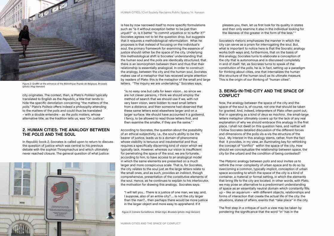
HUMAN CITIES Civil Society Reclaims Public Space H. Kenaan
city originates. The context, then, is Plato’s Politeia typically translated to English as the Republic, a title that tends to hide the specific denotation concerning “the matters of the polis.” Plato’s Politeia offers indeed a philosophy attending to the matters of the polis and could thus be translated – with a double entendre – as the polis matters, whose alternative title, as the tradition tells us, was “On Justice”.
2. HUMaN cITIES: THE aNaLOGY BETWEEN THE Polis aND THE SOULIn Republic book 2, Socrates is called upon to return to discuss the question of justice which was central to his previous debate with the sophist Thrasymachus and which ultimately never reached closure. The general question of what justice
is has by now narrowed itself to more specific formulations such as “is it without exception better to be just than unjust?” or, is it better “to commit unjustice or to suffer it?” Socrates agrees not to let the question drop, but suggests that it requires a methodological reformulation. What he proposes is that instead of focusing on the individual’s soul, the primary framework for examining the essence of justice should rather be the space of the city. Underlying this methodological shift is Socrates’ understanding that the human soul and the polis are identically structured, that there is an isomorphism between them and thus that their relationship is essentially analogical. In order to construct the analogy, between the city and the human soul, Socrates makes use of a metaphor that has received ample attention by readers of Plato: this is the metaphor of the small and large letters. “The inquiry we are undertaking,” Socrates says, “is no easy one but calls for keen vision... so since we
are not clever persons, I think we should employ the method of search that we should use if we, with not very keen vision, were bidden to read small letters from a distance, and then someone had observed that these same letters exist elsewhere larger and on a larger surface. We should have accounted it a godsend, I fancy, to be allowed to read those letters first, and then examine the smaller, if they are the same.” 1
According to Socrates, the question about the possibility of an ethical subjectivity, i.e., the soul’s ability to be the bearer of justice, leads us to a domain of phenomena whose visibility is tenuous and insubstantial and thus requires a specifically discerning kind of vision which we typically lack. However, whereas our vision is insufficient for penetrating the space of the soul, we are fortunate, according to him, to have access to an analogical model in which the same elements are presented on a much larger and more conspicuous scale. That is, for Socrates, the city relates to the soul just as the large letters relate to the small ones, and as such, provides an indirect, though comprehensive, presentation of the constitutive elements of the soul. Hence, as he continues to explain to his interlocutor, the motivation for drawing this analogy, Socrates says:
“I will tell you... There is a justice of one man, we say, and, I suppose, also of an entire city? ... Is not the city larger than the man?... then perhaps there would be more justice in the larger object and more easy to apprehend. If it
pleases you, then, let us first look for its quality in states and then only examine it also in the individual looking for the likeness of the greater in the form of the less.” 2
Socrates’s rhetoric emphasizes the manner in which the city can serve as a prism for interrogating the soul. But, what is important to notice here is that the Socratic analogy works both ways and, furthermore, that on the basis of this analogy, Socrates turns to elaborate a conception of the city that is autonomous and is discussed completely in and of itself. Yet, as Socrates turns to speak of the constitution of the polis, he is, in fact, setting up a paradigm for thinking about cities, one that internalizes the human (the structure of the human soul) as its ultimate measure. This is the origin of our thinking of “human cities”.
3. BEING-IN-THE-cITY aND THE SPacE Of cONfLIcTNow, the analogy between the space of the city and the space of the soul is, of course, not one that should be taken for granted. And, indeed, interpreters of Plato often point out, that in operating as a kind of deus ex machina , the small-large letters metaphor ultimately covers up for the lack of any real explanation of why we should embrace this analogy in the first place. I shall not dwell on this question here, and neither will I follow Socrates detailed discussion of the different forces and dimensions of the polis vis-a-vis the structure of the soul. My interest in this analogy stems, rather, from the fact that it provides, in my view, an illuminating key for rethinking the concept of “conflict” within the space of the city. How should we conceptualize the relationship between space, the city (or the urban) and the condition of being contested?
The Platonic analogy between polis and soul invites us to rethink the inner complexity of urban space and to do so by overcoming a common, typically implicit, conception of urban space according to which the space of the city is a kind of container, a material or formal setting, in which the elements that bring life to the city are located. In other words, with Plato, we may pose an alternative to a predominant understanding of space as an essentially neutral domain which constantly fills up – like an aquarium – with different objects, relationships and forms of interaction that create the actual life of the city: the situations, states of affairs, events that “take place” in the city.
The first step in a critique of such a view may be taken by pondering the significance that the word “in” has in the
Figure 2: Graffiti at the entrance of the Bibliothque Royale de Belgique, Brussels (photo: Hagi Kenaan)
Figure 3: Camera Surveillance, Street-Sign, Brussels (photo: Hagi Kenaan)
HUMAN CITIES AND THE SPACE OF CONFLICT
39
HUMAN CITIES Civil Society Reclaims Public Space H. Kenaan
phrase ”being in the city.” Here, Martin Heidegger’s work and especially his analysis of the basic structure of human existence as being-in-the-world is an important point of reference. Its importance has to do with Heidegger’s insistence that when we speak of our human being-in-the-world the term “in” does not signify a relationship of physical containment. And as such, the being of humans in the world should be articulated on different grounds than the ones by which we speak, for example, of a chair being in a room, a paper in an envelop, liquid in a bottle, etc. Heidegger writes:
“What is meant by “Being-in”? ... we are inclined to understand this Being-in as “Being in something”. This latter term designates the kind of Being which an entity has when it is “in” another one, as the water is “in” the glass, or the garment is “in” the cupboard. By this “in” we mean the relationship of Being which two entities extended in space have to each other with regard to their location in that space. Both water and glass, garment and cupboard, are “in” space and “at”a location, and both in the same way.” 3
While this kind of containment-relationship is suitable for describing things that are objectively present, it cannot capture, according to Heidegger, the human significance of “being-in” which – in contra-distinction to the objective – is grounded in the existential structure of being human. Heidegger’s explains this in an etymological way:
“In” is derived from “innan” –”to reside”, “habitare”, “to dwell”. “An” signifies “I am accustomed”, “I am familiar with”,” “I look after something”… Being-in is thus the formal existential expression for the Being of Dasein, which has Being-in-the-world as its essential state.” 4
For Heidegger, the “clue” for understanding our being-in-the-world is our ways of involvement, of immersion, in things and meanings. “Being-in-the-world... split[s] itself up into definite ways
of Being-in. The multiplicity of these is indicated by the following examples; having to do with something, producing something, attending to something and looking after it, making use of something, giving something up and letting it go, undertaking, accomplishing, evincing, interrogating, considering, discussing, determining…All these ways of Being-in have concern as their kind of Being.” 5
Heidegger’s departure from an objectively spatial interpretation of being-in has opened up ways for a reevaluation of the
character of urban space vis-a-vis an understanding of the meaning of being-in-the-city.6 For our purposes, however, there is one specific aspect of the city’s non-objective space that concerns us: the question of the relationship between space and conflict. And here, we return to Plato’s analogy between city and the soul. Is conflict an essential part of the city as it is part of human soul?
4. cONfLIcT aND HEGEMONY
The soul, according to Plato, consists in a plurality. In Republic, Plato elaborates what is known as the tripartite model of the soul. The soul consists of three parts that are in constant interaction: the appetites, the spirited part and reason. Bracketing the details of the exact relationship between these parts, it is important to recall that the essence of the relationship between these parts is a constant struggle. That is, these dimensions of the soul, have different agendas, different motivations; they pull and push in different directions, and ultimately compete for hegemony. For Plato, the question of justice (the just soul) is intrinsically tied to the question of what makes the soul well balanced. For Plato, the soul may arrive at an excellent state of balance when it is ruled by reason. But, for our purposes, it is important to notice, that even when reason rules, the other parts of the soul continue to be active. Moreover, for most people most of the time, it is not reason, but the other parts of the soul that determine its dynamic balance. Plato makes room for discussing these problematic configurations of the soul, just as he discusses the analogical political configurations of cities in which reason fails to rule. In other words, the Platonic soul never escapes its essential condition of being a plurality. And consisting in such a plurality, the struggle for hegemony never ceases to be part of the soul’s life. That is, even when the soul achieved a well-tempered balance, even when it is under the aegis of Reason, this state is no more than a “balance” between dynamic forces that continue to be operative.
To put this more directly, conflict is internal to the soul and when we speak of the soul as a place of conflict, we need to be careful not to fall into the conceptual trap of thinking of the soul as a place that exists, in and of itself, independently of conflict. No. The soul is not a neutral container in which appetite, spirit and reason struggle for hegemony. The struggle between appetite, spirit and reason, does not take place in a given space called “the soul” but it is this very struggle that constitutes the soul. In other words, the soul is that conflict between a plurality of forces.
5. THE URBaN: aLWaYS IN THE PLURaL
In a corollary manner, the Platonic analogy between soul and city invites us to reconsider the place of conflict in urban space. We may put this, more specifically, in a form of a question: are contested urban spaces contested only because they contain certain elements and forces that clash? Does conflict relate to urban space as it relates, for example, to a battle field which, in itself, may be neutral – until certain forces enter into its coordinates, bringing with them a situation of conflict? Or more simply, is conflict external or internal to urban space, is it an aspect that, at times, dawns on urban spaces or does it intrinsically belong to the being of the urban? My position should be clear by now: I think that the lesson to be gleaned from Plato’s analogy, is that the city is, at heart, a conflictual space, that urban space is, in its essence, conflictual and it is conflictual in a manner that is conceptually prior to any explicit conflict emerging in specific circumstances. In other words, while there are, of course, all kinds of conflicts and levels of conflicts in cities, conflicts that surface in a variety of (political, ethnical, ethical, economical) settings , we should take notice that the specificity of these conflicts does not block from our sight an underlying conflictual structure that is always already part of urban space - a plurality present in a complicated unity. It is a singular in the plural or, to us Jean-Luc Nancy’s phrase, it’s being is “singular-plural.” 7 This concrete plurality creates, as such, a heterogeneous space, one that can never be neutral but that is, like the Platonic soul, always already inflected, always wrought by tension, a space contested in its very origin.
6. GRaffITI aS TRacE
I have been arguing that underlying the specificity of contested urban spaces, there is a depth structure of conflict or tension that is constitutive of urban space and that, as such, needs to be acknowledged. Is this depth structure only a metaphysical postulate or does it also have a phenomenological bearing? What kind of resonance does this depth structure have within the ordinary life of the city? In Platonic terms, where can we recognize, in the city, the inner struggle of the human soul? Are we compelled, as Plato suggests, to be constantly on the move from the small scale surface of letters to the large surface and back again? Or, is there a way to recognize in the large letters (the city) the depth of the small ones (the soul)? Remaining with the image of letters and inscriptions, isn’t graffiti – with its extension into unsolicited street art – a specifically interesting trace of this deep tension that concerns us here? Walking from the library to Galeries Royales Saint-Hubert, I see

40
HUMAN CITIES Civil Society Reclaims Public Space H. Kenaan
Why is this not a pleasant view to look at? Facing this window in plurality, I recall a large door of a public building in Tel-Aviv, which I see almost daily and whose dynamics of tagging I try to follow (Figure 5). Does the incessant movement within this matrix, this palimpsest of letters and forms, tell us something about the dynamic, often violent, plurality that constitutes urban space? When I return to the conference’s hotel on Rue du Berger, such questions continue to echo while I take a photo of a big fish swimming in the conflictual life-world of tagging (Figure 6).
7. REcLaIMING PUBLIc SPacE?
The phrase “reclaiming public space” has become popular in the last few years and gives voice to an important growing understanding of what “the right to the city” may mean in the twenty-first century. At the same time, the notion of reclaiming the space of the city, all too often appears in ways that are uncritical and that cover up important questions the answers to which we cannot take for granted. In this paper, I have tried to problematize the idea that public space is a unified space that gives itself to simple forms of “reclaiming”.
I have focused on a specific point in Plato’s Republic, a text that could be read as an interesting document of city planning. Indeed, the planning in the Republic results in a program for an ideal city: this is not an actual act of planning, but more of an articulation of a regulative ideal that could guide eventual city planners. Here, the fact that the project is completely utopic, makes Plato’s point about the conflictual essence of the city even more interesting. That is, Plato could have articulated his ideal vision of the city in a manner that altogether does away with the structure of conflict. He could have, for example, based his conception of the ideal city solely on a rational structure, describing an entirely homogeneous space of reason. However, Plato chose not to do so. And, insisted instead – by embracing the analogy between city and human soul – that the city is conflictual in essence: the city is contested in its very being, that is, also in the best of worlds.Hence, if we agree with Plato that as long as the city continues to bear the mark of the human, conflict will remain constitutive of its space, the question arises of how planning or, alternatively, how a reclaiming-activism, can acknowledge this basic structure? What could such an acknowledgment consist in? In particular, we need to ask ourselves if the discourse of “reclaiming the city”, doesn’t ultimately – and despite itself – lock us into a mirror picture of the city’s master plans, which the act of reclaiming seeks to subvert. Can the idea of “reclaiming” city space actually subvert the hegemonic conception of public space or does it reproduce the ruler’s understanding of that space? That is, can we, in thinking of a city’s possibilities of development – of what it can and should be – make room for the intrinsic tension through which plurality 8 shows itself, i.e., as real conflict? Or, do we ultimately frame the conflictual as an aberrant condition in the city space, an anomaly, irregularity that needs to be eliminated in order to maintain the intrinsic cohesiveness of the city? Can we, in other words, think beyond the liberal vision of plurality as an essentially pleasant diversity? I leave these questions open.
Figure 4: Graffiti, Brussels (photo: Hagi Kenaan)
Figure 6: Graffiti, Rue du Berger, Brussels (photo: Hagi Kenaan)Figure 5: Graffiti, Lincoln Street, Tel-Aviv (photo: Hagi Kenaan)
Notes1 Plato (1982). Republic, Book 2, section 368c, in Hamilton E. and Cairns H. (Eds) The Collected Dialogues, p.614. Princeton, Princeton University Press.
2 Plato (1982). Republic, Book 2, section 368e, in Hamilton E. and Cairns H. (Eds) The Collected Dialogues, p.615. Princeton, Princeton University Press.
3 Heidegger, M. (1962) (Trans Macquarrie J. and Robinson E.). Being and Time, p.79. New York, Harper & Row.
4 Ibid, p.80
5 Ibid, p.83
6 Kofman E. and Lebas E. (1996) (Trans and eds). Writings on Cities. Oxford, Basil Blackwell.
7 See: Nancy J-L. (2000) (Trans Richardson R. and O’byrne A.). Being Singular-Plural. Standford, Stanford University Press. On Nancy’s Singular-Plural and the
question of the visual, see: Kenaan H. (2000) What Makes an Image Singular Plural: Questions to Jean-Luc Nancy. Journal of Visual Culture, 9 (1), April 2010, pp. 63-72.
8 On the possibility of a new ethics of alterity and its visual implications, see: Kenaan, H. (2012). Visage(s): Une autre éthique du regard après Levinas. Paris, L’Éclat.
HUMAN CITIES AND THE SPACE OF CONFLICT
a window shop that is entirely tagged (Figure 4): a whole range of handwritings, inscription modalities, that are held together by the apparent unity of the window frame, but seem to maintain no dialogue with – have no respect to the voice – of the other.

AUTHORS
Abstract
CHAPTER
41 R. Houlstan-Hasaerts, B. Tominc, M. Nikšič, B. Goličnik Marušić (Editors) Urbani izziv - publikacije, Ljubljana, May 2012
contact
Keywords
This paper is an analysis of the various ways in which the economically marginalized of India create and cultivate unused space for the benefit of themselves and their communities. The specific focus of the study is upon the stretches of citizen-appropriated land along the railway tracks in Indian cities of Jalandhar, Delhi and Mumbai. A survey of these spaces and the people who use them reveals much about this unique reclamation of public space in India. Driven by the increasing scarcity of available public space in urban India, many have re-appropriated portions of railway easements as well as the active tracks. While some of the land is simply claimed by adjacent property owners as an extension of their property, it is more commonly used by lower income residents from adjacent areas for communal farming plots, animal grazing lands, public gathering spaces, open green spaces, and pedestrian corridors. Considering the extreme vehicular congestion in the streets, the spaces carved by the railroads through the cities have become de facto pedestrian thoroughfares, replete with pushcart- and rickshaw-based commerce. The absence of automobile traffic and the relatively appropriate scale of railway tracks allow the transformation of these open spaces. In India, these public spaces are vibrant informal areas with numerous uses.
Indian railway, public space, informal architecture, urban farming, lived space
christian KleinAssistant Professor, Lovely Professional University, Jalandhar - Delhi G.T. Road (NH-1), Phagwara, Punjab, India, 144402, [email protected] Taylor KleinAssistant Professor, Lovely Professional University, Jalandhar - Delhi G.T. Road (NH-1), Phagwara, Punjab, India, 144402, [email protected]
and christine Taylor Klein, Punjab (India)christian Klein, Punjab (India)
THE INTERSTITIAL SPACE OF THE URBAN INDIAN RAILWAY
1. INTRODUcTION
This study is an attempt to understand the ways in which Indian citizens choose to occupy and reclaim the open spaces along India’s extensive system of railway tracks. What follows are first hand observations from an extensive physical survey of the Jalandhar railway lines as well as more cursory explorations of the rail lines within hyper-urban conditions in Delhi and Mumbai. Within the context of India’s intense and muddled urban fabric, the activities that occur along railway lines and within dense parts of the city can provide an interesting glimpse into the way that Indians conceptualize public space, occupy open areas, and assert notions of civic participation and community activity.
While the British were responsible for bringing railways to India as a tool of colonialism, it has taken on a uniquely Indian identity in the decades since independence. With a current population of nearly 1.2 billion, India has some of the world’s densest concentrations of population. Railway systems are a major component of the transportation infrastructure. The local train lines in Mumbai are by far the worlds busiest, with a daily ridership of over five million people each day (Acharya, 2000). With open-air cars and massive overcrowding, it is not uncommon to see railway passengers hanging from doorways or sitting on the roof of the cars. And this high rate of usage is not exclusive to the railway’s cars and stations; the rights-of-way — strips of land that surround railway tracks within the city — support a multitude of legal and illegal activities that add to the unique nature of the Indian Railway system. These activities include informal housing, urban farming and animal grazing, recreational and leisure space, illegal trash dumping, defecation, small-scale industrial manufacturing, and pedestrian and vehicular traffic.
Up to this point, most of the literature and discourse about th Indian railways has focused on its more discernible components: its trains, stations, colonies, employees, etc. Rarely has attention been given to the numerous and lengthy stretches of track and the areas of land that immediately

42 THE INTERSTITIAL SPACE OF THE URBAN INDIAN RAILWAY
HUMAN CITIES Civil Society Reclaims Public Space C. Klein, C. Taylor Klein
surround them. Today, the railway tracks and their rights-of-way are themselves rife with distinctive activities; these areas cross the boundaries between public and private spaces, and they represent both urban and rural cultures and ideologies, which are manifested in exciting and diverse ways. In many ways, the case studies shown here do not simply explore the appropriation of public space; indeed, these inhabitations of train rights-of-way by the lower-income groups may be seen as the activation of weak social sectors within the context of an institution that has historically maintained divisions along the lines of income, caste, ethnicity, and religion.
2. WaLKING THE TRacKS
The particular ways in which these activities are enacted along the railway tracks, as well as the unique materiality and the built components that often accompany eachother, can best be summed up using a popular Hindi word jugaad. Although there is perhaps no direct English counterpart for this term, jugaad loosely translates as the process of making the most with the least, often requiring a cheap and creative solution when faced with a problem. Along the railway’s rights-of way, jugaad can be seen in the unique ways that people delineate spaces and occupy them.
The intensity of research within each of the three cities depended largely on the size of each one. The smaller scale of Jalandar, a tertiary city located in central Punjab, made it possible to transverse the length of the entire railway system within the metropolitan area, while the enormity of Delhi and Mumbai made such a full exploration impractical for the scope of this research, and these cities were therefore studied and understood in smaller, more localized areas. Most of the survey work was done on foot, as we walked for miles along the tracks with cameras and sketchpads in hand. Residents were interviewed when possible, usually when someone was close at hand to translate, and they were generally quite warm and generous towards us, offering a cup of hot chai or vegetables cut fresh from the garden. Our observations are merely a snapshot — they record a moment in time and seek out particular urban phenomena rather than the temporal and spatial developments that have led to these current conditions. We hope only to expose a type of spatial occupation that was previously unknown to us and our peers, and hopefully through that expand our understanding of the public realm and its physical delineations. We walked the tracks in search of a new understanding of India and public space. As Marian Aguiar writes in Tracking Modernity, “the train
travels through the back door of urban spaces that many of the passengers would never walk through,” yet that is exactly what we did — right into the space of jugaad (2011: 93).
2.1. Pedestrian and vehicular traffic
Within the extremely dense built environments of Indian cities, railway tracks provide rare corridors of open space. Aguiar states that the railway collapses space within the urban fabric of dense Indian cities (c.f. 2011: xiii). We propose instead that the tracks serve to loosen the threads of that fabric, opening up new spaces among them and providing a valuable cross-section through cities. In this way, they become thoroughfares and boulevards in their own right (see Figure 1). Often, they are the quickest means to walk between certain parts of the city, as they are the most direct and often least crowded routes. Delhi was the only city in our survey where we actually encountered policemen stationed along certain lengths of tracks; they warned us of the dangers of walking along the tracks and asked us to leave. The centrally located lines in Delhi are more closely monitored, likely to prevent both terrorist attacks as well as encroachment by squatter construction and settlements. These slum settlements, or jhuggies as they are locally known, more frequently occur along the ring railway track and towards the periphery of Delhi. Usually people travelling the tracks were using them as a set route, though it was not uncommon to see babas, also called sadhus or wandering ascetics, who were simply roaming by foot along the train tracks. Both people who live adjacent to the tracks and people from other parts of the city use the tracks as thoroughfares.
Pedestrians are a common sight along the tracks in Jalandhar, as the tracks serve as a central spine running through the city. In fact, one local train station we came across was only accessible by foot or two-wheeler along a dirt path running parallel to the tracks. The trail meanders only a couple of feet from the tracks, placing it wholly within the railway right-of-way. The station is in close proximity to the bus station, within a thousand yards or so, yet the only access from one to the other is to walk down the narrow path along the tracks. Goods, including milk, are brought to the station by motorcycle. Elsewhere in Jalandhar, the rights-of-way form major vehicular arteries. Where the city has grown and swallowed up villages, the tracks are the main spine of the neighborhood, with the right-of-way being used as dirt roads for pedestrians, motorcycles, and small cars and trucks.
2.2. Housing
Informal housing often makes headlines in larger Indian cities for encroaching on the railway right-of-way. With the extreme scarcity of affordable housing and the prevalence of exorbitant land costs, many are forced to seek informal and illegal housing alternatives. In Delhi, illegal housing occupies over 130 acres of railway land (Harkauli, 2012). These structures go through a regular cycle of demolition and reconstruction. Along the city streets, so-called pavement dwellers tend towards the deserted areas of the railway rights-of-way at night as they look for less crowded places to sleep for the night. In the last few years, the NGOs in Delhi have been aiding the inhabitants of temporary shelters that spring up underneath railway bridges in an effort to help shelter the homeless. The NGOs receive funding from the local government, yet the ongoing status of night shelters is currently under litigation in court systems over their right to exist (Harkauli, 2012). It is not uncommon for the elected officials to be at odds with the railway authorities over the squatter communities. In order to secure votes, the officials often protect their squatter constituents and arrange to provide basic services and utilities for the settlements. Common practice in slum areas is to form community housing organizations for the protection of rights.
In Mumbai, it is not uncommon to see large stretches of informal housing that line the railway tracks, as well as large areas of land near the tracks that are densely filled with such settlements (see Figure 2). The residents of the right-of-way areas have formed their own specific
Figure 1: Pedestrian traffic near the main railway station in Jalandhar (photo: Christian Klein)

43
HUMAN CITIES Civil Society Reclaims Public Space C. Klein, C. Taylor Klein
group, the Railway Slum Dwellers Federation, which works in coordination with NGOs like SPARC (Society for the Promotion of Area Resource Centres) to negotiate with the city regarding services and relocation (Risbud, 2003).
In smaller cities such as Jalandhar, with a population of less than 2 million, encroachment upon the railway rights-of-way is just as common, though rarely makes headlines, as it is typically seen as less intrusive at this point since local ridership has not yet necessitated large-scale expansion as it has in larger cities. Numerous housing typologies appear along the tracks. They range from temporary shacks, constructed of scrap material such as sticks and tarps, to more permanent,
formal structures made of brick and concrete and outfitted with plumbing and electricity (see Figure 3). Temporary structures are usually seen in small clusters, filling in small patches of open and available land, while the more permanent informal structures occur in conjunction with larger settlements that
needs to be taken due to the high levels of contaminants and toxins often found in these areas. Cattle can often be found grazing along the tracks. These include the common wandering cow, as well as managed herds. Usually the managed cows are a part of small dairy herds. Typically, the milk from these cows is sold unpasteurized from large milk jugs that are hung along the rear racks of bicycles and motorcycles. In Mumbai, several larger scale dairy farms, each containing 100-200 cows, exist alongside the tracks. Local trains are used to transport milk to nearby stations where the milk is then further distributed again through the use of two-wheelers.
Figure 2: Informal housing along the main north-south railway artery in Mumbai (photo: Christian Klein)
Figure 3: Informal housing located on the outskirts of Jalandhar (photo: Christian Klein)
Figure 4: Bicycle rickshaw driver housing cluster in central Jalandhar (photo: Christian Klein)
Figure 5: Urban farming plot in railway right-of-way (photo: Christian Klein)
Figure 6: Cow dung drying in the sun in right-of-way (photo: Christian Klein)
abut the tracks. Small settlements that consist of household servants and temporary labourers are common along the tracks in the upper middle class and upper class neighbourhoods; this arrangement allows them to live in close proximity to their employers. Also common in Jalandhar are small clusters of bicycle rickshaw drivers, who tend to settle along the tracks in close proximity to nearby major roadways (see Figure 4). Much of the housing built on railroad land is situated so that it faces or opens onto the tracks, with the tracks serving as the primary circulation arteries for the homes abutting them and secondary arteries leading away from the tracks.
2.3. Urban agriculture
One of the more common uses along the track rights-of-way is urban farming. Typically these plots are vegetable gardens and small-scale farms; the produce is consumed within the household as well as sold at local markets (see Figure 5). In Mumbai, the Indian Railway Authority has even begun leasing land to its maintenance personnel for small urban farms, as this dissuades further encroachment on railway lands by squatters (Acharya, 2000). With the increase in popularity of urban farming, some non-profit groups have been helping to educate residents on proper farming techniques and responsible land use. When farming along the tracks, care
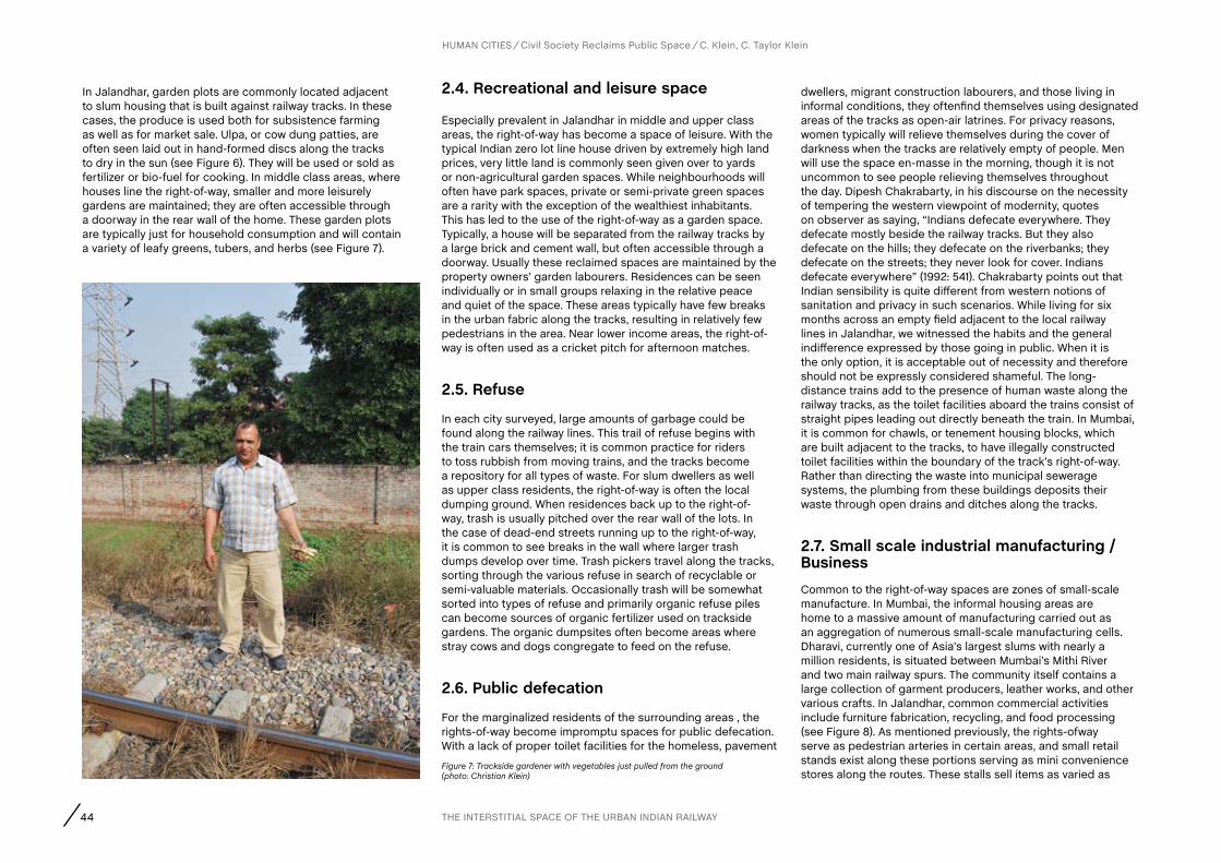
44
In Jalandhar, garden plots are commonly located adjacent to slum housing that is built against railway tracks. In these cases, the produce is used both for subsistence farming as well as for market sale. Ulpa, or cow dung patties, are often seen laid out in hand-formed discs along the tracks to dry in the sun (see Figure 6). They will be used or sold as fertilizer or bio-fuel for cooking. In middle class areas, where houses line the right-of-way, smaller and more leisurely gardens are maintained; they are often accessible through a doorway in the rear wall of the home. These garden plots are typically just for household consumption and will contain a variety of leafy greens, tubers, and herbs (see Figure 7).
2.4. Recreational and leisure space
Especially prevalent in Jalandhar in middle and upper class areas, the right-of-way has become a space of leisure. With the typical Indian zero lot line house driven by extremely high land prices, very little land is commonly seen given over to yards or non-agricultural garden spaces. While neighbourhoods will often have park spaces, private or semi-private green spaces are a rarity with the exception of the wealthiest inhabitants. This has led to the use of the right-of-way as a garden space. Typically, a house will be separated from the railway tracks by a large brick and cement wall, but often accessible through a doorway. Usually these reclaimed spaces are maintained by the property owners’ garden labourers. Residences can be seen individually or in small groups relaxing in the relative peace and quiet of the space. These areas typically have few breaks in the urban fabric along the tracks, resulting in relatively few pedestrians in the area. Near lower income areas, the right-of-way is often used as a cricket pitch for afternoon matches.
2.5. Refuse
In each city surveyed, large amounts of garbage could be found along the railway lines. This trail of refuse begins with the train cars themselves; it is common practice for riders to toss rubbish from moving trains, and the tracks become a repository for all types of waste. For slum dwellers as well as upper class residents, the right-of-way is often the local dumping ground. When residences back up to the right-of-way, trash is usually pitched over the rear wall of the lots. In the case of dead-end streets running up to the right-of-way, it is common to see breaks in the wall where larger trash dumps develop over time. Trash pickers travel along the tracks, sorting through the various refuse in search of recyclable or semi-valuable materials. Occasionally trash will be somewhat sorted into types of refuse and primarily organic refuse piles can become sources of organic fertilizer used on trackside gardens. The organic dumpsites often become areas where stray cows and dogs congregate to feed on the refuse.
2.6. Public defecation
For the marginalized residents of the surrounding areas , the rights-of-way become impromptu spaces for public defecation. With a lack of proper toilet facilities for the homeless, pavement
dwellers, migrant construction labourers, and those living in informal conditions, they oftenfind themselves using designated areas of the tracks as open-air latrines. For privacy reasons, women typically will relieve themselves during the cover of darkness when the tracks are relatively empty of people. Men will use the space en-masse in the morning, though it is not uncommon to see people relieving themselves throughout the day. Dipesh Chakrabarty, in his discourse on the necessity of tempering the western viewpoint of modernity, quotes on observer as saying, “Indians defecate everywhere. They defecate mostly beside the railway tracks. But they also defecate on the hills; they defecate on the riverbanks; they defecate on the streets; they never look for cover. Indians defecate everywhere” (1992: 541). Chakrabarty points out that Indian sensibility is quite different from western notions of sanitation and privacy in such scenarios. While living for six months across an empty field adjacent to the local railway lines in Jalandhar, we witnessed the habits and the general indifference expressed by those going in public. When it is the only option, it is acceptable out of necessity and therefore should not be expressly considered shameful. The long-distance trains add to the presence of human waste along the railway tracks, as the toilet facilities aboard the trains consist of straight pipes leading out directly beneath the train. In Mumbai, it is common for chawls, or tenement housing blocks, which are built adjacent to the tracks, to have illegally constructed toilet facilities within the boundary of the track’s right-of-way. Rather than directing the waste into municipal sewerage systems, the plumbing from these buildings deposits their waste through open drains and ditches along the tracks.
2.7. Small scale industrial manufacturing / Business Common to the right-of-way spaces are zones of small-scale manufacture. In Mumbai, the informal housing areas are home to a massive amount of manufacturing carried out as an aggregation of numerous small-scale manufacturing cells. Dharavi, currently one of Asia’s largest slums with nearly a million residents, is situated between Mumbai’s Mithi River and two main railway spurs. The community itself contains a large collection of garment producers, leather works, and other various crafts. In Jalandhar, common commercial activities include furniture fabrication, recycling, and food processing (see Figure 8). As mentioned previously, the rights-of way serve as pedestrian arteries in certain areas, and small retail stands exist along these portions serving as mini convenience stores along the routes. These stalls sell items as varied as
Figure 7: Trackside gardener with vegetables just pulled from the ground (photo: Christian Klein)
HUMAN CITIES Civil Society Reclaims Public Space C. Klein, C. Taylor Klein
THE INTERSTITIAL SPACE OF THE URBAN INDIAN RAILWAY
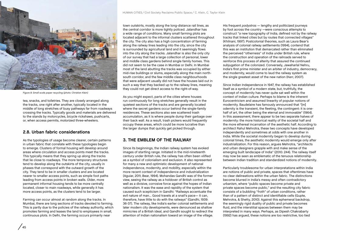
45
tea, snacks, and toiletries. They are closely arranged along the tracks, one right after another, typically located in the middle of long stretches of busy pathways far from roadways crossing the tracks. Typically goods and materials are delivered to the stands by motorcycles, bicycle rickshaws, pushcarts, or, when access permits, motorized three-wheelers.
2.8. Urban fabric considerations
As the typologies of usage become clearer, certain patterns in urban fabric that correlate with these typologies begin to emerge. Clusters of formal housing will develop around areas where circulation and access points meet the tracks. This typically means that they spring up along the tracks that lie close to roadways. The more temporary structures tend to develop along the outskirts of the city, usually in phases that correspond with the outward growth of the city. They tend to be in smaller clusters and are located nearer to smaller access points, such as simple foot paths leading from access points in broken walls. Older, more permanent informal housing tends to be more centrally located, closer to main roadways, while generally it has more access points, as the clusters tend to be larger.
Farming can occur almost at random along the tracks. In Mumbai, there are long sections of tracks devoted to farming. This is partly due to the policies of the railway authority, which promotes farming and leases the land to employees in small, continuous plots. In Delhi, the farming occurs primarily near
town outskirts, mostly along the long-distance rail lines, as the central corridor is more tightly policed. Jalandhar has a wide range of conditions. Many small farming plots are located adjacent to the informal clusters scattered throughout the city. The city also has a high concentration of farming along the railway lines leading into the city, since the city is surrounded by agricultural land and it seemingly flows into the city along the tracks. Jalandhar is also the only city of our survey that had a large collection of personal, lower and middle class gardens behind single family homes. This did not seem to be the case in Mumbai or Delhi. In Mumbai most of the land abutting the tracks was occupied by either mid-rise buildings or slums, especially along the main north-south corridor, and the few middle class neighbourhoods that were adjacent usually did not have the houses laid out in such a way that they backed up to the railway lines, meaning they could not get direct access to the right-of-way.
As you might expect, parts of the cities where houses run continuously for long stretches generally result in the quietest sections of the tracks and are generally located where the secret gardens occur behind the single-family residences. These sections also see scattered trash accumulation, as it is where people dump their garbage over their back wall. As a result, trash pickers would frequently occupy these areas, which could be more lucrative than the larger dumps that quickly get picked through.
3. THE EMBLEM Of THE RaILWaY
Since its beginnings, the Indian railway system has evoked images of startling range. Initiated in the mid-nineteenth century under British rule, the railway has often been vilified as a symbol of colonialism and exclusion. It also represented for many a new and optimistic development of national independence, modernity, and mobility, especially within the more recent context of independence and industrialization (Aguiar, 2011; Bear, 1994). Mohandas Gandhi was of the former view, seeing the railway as a holdover of British control as well as a divisive, corrosive force against the hopes of Indian nationalism. It was the ease and rapidity of the system that caused such scepticism in Gandhi: “Railways accentuate the evil nature of man… Good travels at a snail’s pace— it can, therefore, have little to do with the railways” (Gandhi, 1939: 36-37). The railway, like India’s earlier colonial settlements and later modern city developments, were denounced as shallow mimicries of a British ideal, and Gandhi sought to redirect the attention of Indian nationalism toward an image of the village.
His frequent padyatras — lengthy and politicized journeys by foot across the country —were conscious attempts to construct “a new topography of India, defined not by the railway tracks that linked cities but by routes that connected villages” (Khilnani, 1997). Postcolonial theories, such as Laura Bear’s analysis of colonial railway settlements (1994), contend that this was an institution that demarcated rather than eliminated the perceived “otherness” of India under British rule, where the construction and operation of the railroads served to reinforce this process of alterity that assured the continued subjugation of the colonized. Conversely, Jawaharlal Nehru, India’s first prime minister and an arbiter of industry, democracy, and modernity, would come to laud the railway system as the single greatest asset of the new nation (Kerr, 2007).
Since Indian Independence in 1947, the railway has established itself as a symbol of a modern state, but, truthfully, the concept of modernity has never quite sat well within the context of Indian culture. Perhaps to blame is the inherent Eurocentricism and assumed linearity of popular notions of modernity. Baudelaire has famously announced that “[m]odernity is the transient, the fleeting, the contingent: it is one-half of art, the other being the eternal and immovable” (1964). In this assessment, there appear to be two separate halves of modernity: the more historical reality of the societal half and the more ethereal incarnation of the aesthetic half. According to architect Rahul Mehrotra, these two concepts have developed independently and sometimes at odds with one another in India. While the societal modernity began to develop during colonial times, the aesthetic modernity would emerge only after industrialization. For this reason, argues Mehrotra, “architects and urban designers grapple with and make sense of the emerging built landscape of India” (2010: 244). The railway itself may now be seen as emblematic of the tenuous relationship between Indian tradition and standardized notions of modernity.
Particularly troublesome for urban interpretations within India are notions of public and private, spaces that oftentimes have no clear delineations within the urban fabric. The distinctions become blurred in India’s messy and often contradictory urbanism, where “public spaces become private and private spaces become public,” and the resulting city fabric consists of a bubbling “froth” of urban conditions, rather than of a pattern of distinct and identifiable cells (Gupte, Mehrotra, & Shetty, 2010). Against this ephemeral backdrop, the seemingly rigid duality of public and private becomes fluid, and the interstitial spaces between them may be interpreted in many ways. Perhaps, as Dipesh Chakrabarty (1992) has argued, these notions are too restrictive, too tied
Figure 8: Small scale paper recycling (photo: Christian Klein)
HUMAN CITIES Civil Society Reclaims Public Space C. Klein, C. Taylor Klein
46
to Eurocentric and imperialistic modernist ideals, and may be altogether inapplicable within urban conditions of India. We might instead use Chakrabarty’s duality of the “inside” and the “outside”, for which he assigns the paradigm of the home (enclosed, pure, protected) versus that of the bazaar (exposed, alien, disordered), to understand the complex dynamics that might exist in those interstitial spaces—such as the railway tracks—that might lie between the two.
4. cONcLUSIONS
The urban typology of the street, or bazaar, has often been described as an activated space within Indian culture. This paper argues that, in India’s urban centres, the railway tracks and their rights-of-way act as another type of activated space, one that occupies neither home nor bazaar… a public space where private activities can and do occur. The tracks also provide a cross-section through neighbourhoods, allowing
outsiders to witness various levels of urban and rural activities as they occur in these public areas. Marian Aguiar, in her study of Indian railway culture (2011), noted that the introduction of the railway system, by increasing the speed and mobility of the population, led to a more condensed spatial and therefore social reality across the country. We hope to show here that the tracks of the railway provide almost the opposite experience—they break through the dense urban fabric of India’s cities, revealing a wide and linear spectacle of cultural phenomena, enacted within open, public space, which would otherwise have remained subsumed by the crowded conditions of the city.
In many instances, the manner in which citizens choose to use the train track right-of-way reveals the railway system as a feed-line for rural conditions into the urban fabric of India. The trains feed rural populations into the urban society, but the tracks and their surrounding land are the stage on which rural conditions proliferate within the urban setting. Often, those activities that might be considered rural, such as farming,
grazing, recreation, and self-built housing, are manifested within the urban context of undeveloped railway rights-of-way.
When viewed through a westernized lens of modernity, the reclamation of the railway rights-of way in India seems problematic at first glance. However, when we step back and look at it through the eyes of Indian residents, it is just another instance of jugaad. While India pushes ever forward, modernizing the largest democracy in the world, it falls outside the accepted norms of planners and architects, forming instead its own unique urban solutions. Based in the need to shelter a rapidly growing, hyper-dense urban population, the economically marginalized have provided themselves with their own makeshift housing and commercial solutions. Much as the train is a temporal experience for its passengers, it is also a temporal existence for the track inhabitants, existing without a legal foundation upon which to build their housing and their livelihood, and yet they have developed a series of vibrant and lively communities along the tracks.
HUMAN CITIES Civil Society Reclaims Public Space C. Klein, C. Taylor Klein
ReferencesAcharya, R. C. (2000). Indian Railways — Where the Commuter is King! Japan Railway & Transport Revew, 25, pp. 34-45.
Aguiar, M. (2011). Tracking Modernity: India’s Railway and the Culture of Mobility. Minneapolis, University of Minnesota Press.
Baudelaire, C. (1964). The Painter of Modern Life, and other essays. London, Phaidon.
Bear, L. G. (1994). Miscegenations of Modernity: constructing European respectability and race in the Indian railway colony, 1857-1931. Women’s History Review, 3(4), pp. 531-48.
Chakrabarty, D. (1992). Of Garbage, Modernity, and the Citizen’s Gaze. Economic and Political Weekly, 27(10/11), pp. 541-47.
Gandhi, M. (1910). Hind Swaraj. Ahmedabad, Navajivan.
Gupte, R., Mehrotra, R., and Shetty, P. (2010). Frothing Urbanism: Urban conditions in India. Available at: http://www.archplus.net/home/news/7,1-3904,1,0.html?referer=102 (accessed 16 Jan. 2012).
Harkauli, S. (2012). Slums return along tracks, threaten life. The Sunday Standard, 27 Jan. 2012, New Delhi.
Kerr, I. J. (2007). Engines of Change: The Railroads that made India. Westport, Conn., Praeger.
Khilnani, S. (1997). India’s Theaters of Independence. The Wilson Quarterly, 21(4), pp. 16-45.
Mehrotra, R. (2010). Simultaneous Modernity: negotiations and resistances in urban India, Hell, J. and Schonle, A. (Eds.). Ruins of Modernity, pp. 244-251. Durham, Duke University Press.
Risbud, N. (2003). The Case of Mumbai. Report for Understanding Slums: Case Studies for the Global Report on Human Settlements 2003. Delhi, School of Planning and Architecture.
THE INTERSTITIAL SPACE OF THE URBAN INDIAN RAILWAY

AUTHORS
Abstract
CHAPTER
47 R. Houlstan-Hasaerts, B. Tominc, M. Nikšič, B. Goličnik Marušić (Editors) Urbani izziv - publikacije, Ljubljana, May 2012
contact
Keywords
Giacomo GolinelliPh.D. candidate in Anthropology, Bologna University: Dipartimento di Discipline Storiche, Antropologiche e Geografiche, P.zza San Giovanni in Monte 2, 40124 Bologna, Italy, +39 331 23 88 007, [email protected]
Public space, Islam, headscarf, kiosk, Turkey
Izmir is a modern and neoliberal Turkish metropolis that stands out against the political and civil conservatism of Istanbul. In its districts, during the last decade, many urban areas have become the scene for the face-off of the Turkish historical laicism and the Islamic renaissance. The aim of this paper is to show the influence of this face-off on the organization of public space around an urban campus. The object of this study is a non-institutionalized re-adaptation of a kiosk located in front of the campus gate, whose windows have been obscured. The purpose of the kiosk is to help all the Muslim women to remove and don their headscarf in front of a mirror, unobserved by the general public. In 2009 the headscarf was forbidden in every school and state building in Turkey, while allowed in private and public places. The use of the kiosk reveals two realities, one secular and one religious, that here as elsewhere still have not reached a conclusive synthesis. But in this specific case women have found a way out by re-adapting the public space around the campus. The paper presents the kiosk as a physical and semantic frontier between two social areas ruled by different habits and laws. It then focuses on the perception and the usage of this public space by different, potentially antagonist, groups. Finally it highlights how re-appropriation of the public space for religious practice revolutionizes the form and the function, as well as the significance of the area.
Bologna (Italy)Giacomo Golinelli
A KIOSK FOR THE HEADSCARF: HOW RELIGION CHANGES THE PUBLIC SPACE
1. “I’M fROM IZMIR!” (aND I’M PROUD Of IT)
When a Turkish citizen declares that he is from Izmir, probably he is expressing not so much his belonging to a territory, but his political and cultural pride. Overlooking the Aegean Sea, the city of Izmir is universally considered to be the Western outpost of Turkey. Izmir was a key point for National independence and for the consolidation of an ethnic identity in the 18th century European style. Izmir has since become a modern, secular, democratic metropolis founded on capitalist business and today offers numerous public and private universities. It has Euro-centric buildings and skyscrapers, chain stores and international restaurants. Urban planning was often entrusted to European architects (Can, 2010: 183) and today’s metropolis is criss-crossed by wide streets and fast transport systems. Its demographic and economic influence is largely due to the presence of important commercial and industrial activities as well as the presence of a substantial part of the better off classes in Turkey. For these reasons Izmir has emerged over the last thirty years on the social front and more recently, also on the political one. Izmir is the stronghold of Turkish secularism. It embraces the legacy of the founder of modern Turkey, Mustafa Kemal Atatürk. Here the secular party CHP (Cumhuriyet Halk Partisi - Republican People’s Party), founded by the same Mustafa Kemal, has its headquarters and its largest electoral constituency. Nowadays, following a ten years period of government by the AKP (Adalet ve Kalkınma Partisi - Justice and Development Party), a conservative, liberal and Islamic party, the importance of Izmir and its province are more significant than ever. It could be argued that if the CHP lost its electoral majority in Izmir, Turkish secularism would suffer a real identity crisis that would extend far beyond its political confines.
But the notoriety of the gâvur İzmir - the “giaour”, the infidel Izmir - does not derive from its secularism but goes further back in time, before the dawn of modern Turkey. Until the beginning of the 20th century, in the cosmopolitan city of Smyrna, Ottoman Muslims coexisted with Greek Orthodox, Armenians, Jews and various European communities, not only among the élite but
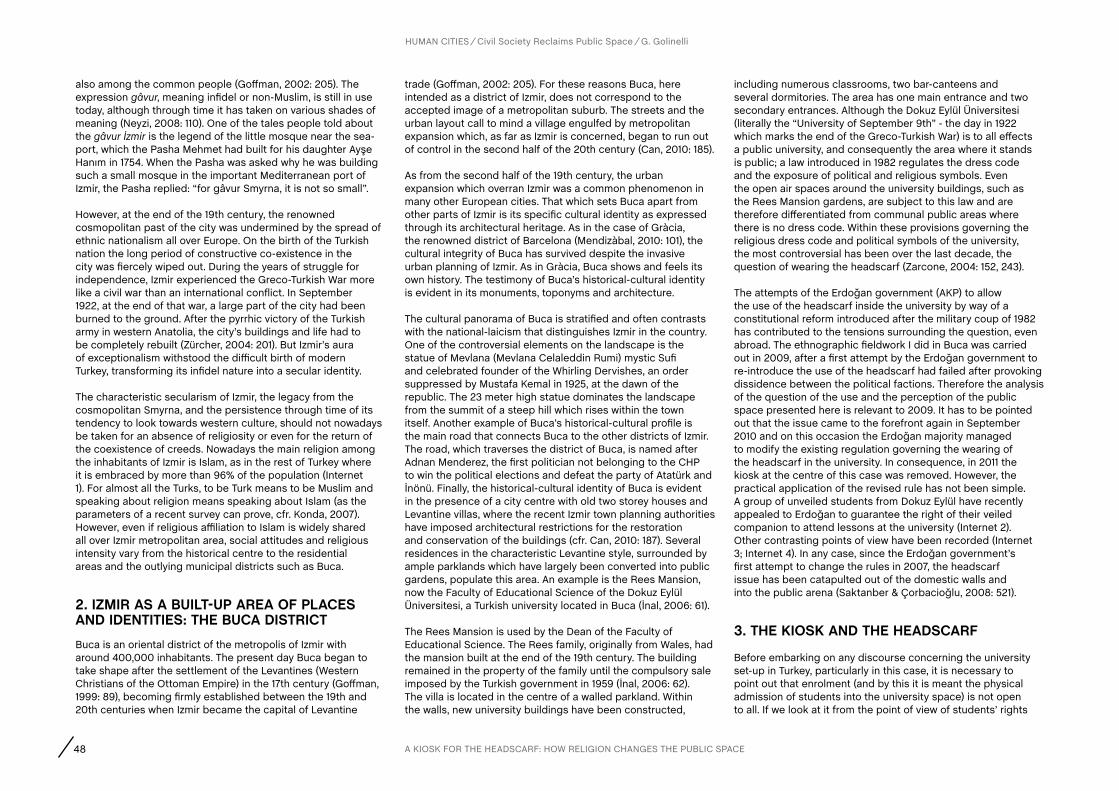
48 A KIOSK FOR THE HEADSCARF: HOW RELIGION CHANGES THE PUBLIC SPACE
HUMAN CITIES Civil Society Reclaims Public Space G. Golinelli
also among the common people (Goffman, 2002: 205). The expression gâvur, meaning infidel or non-Muslim, is still in use today, although through time it has taken on various shades of meaning (Neyzi, 2008: 110). One of the tales people told about the gâvur İzmir is the legend of the little mosque near the sea-port, which the Pasha Mehmet had built for his daughter Ayşe Hanım in 1754. When the Pasha was asked why he was building such a small mosque in the important Mediterranean port of Izmir, the Pasha replied: “for gâvur Smyrna, it is not so small”.
However, at the end of the 19th century, the renowned cosmopolitan past of the city was undermined by the spread of ethnic nationalism all over Europe. On the birth of the Turkish nation the long period of constructive co-existence in the city was fiercely wiped out. During the years of struggle for independence, Izmir experienced the Greco-Turkish War more like a civil war than an international conflict. In September 1922, at the end of that war, a large part of the city had been burned to the ground. After the pyrrhic victory of the Turkish army in western Anatolia, the city’s buildings and life had to be completely rebuilt (Zürcher, 2004: 201). But Izmir’s aura of exceptionalism withstood the difficult birth of modern Turkey, transforming its infidel nature into a secular identity.
The characteristic secularism of Izmir, the legacy from the cosmopolitan Smyrna, and the persistence through time of its tendency to look towards western culture, should not nowadays be taken for an absence of religiosity or even for the return of the coexistence of creeds. Nowadays the main religion among the inhabitants of Izmir is Islam, as in the rest of Turkey where it is embraced by more than 96% of the population (Internet 1). For almost all the Turks, to be Turk means to be Muslim and speaking about religion means speaking about Islam (as the parameters of a recent survey can prove, cfr. Konda, 2007). However, even if religious affiliation to Islam is widely shared all over Izmir metropolitan area, social attitudes and religious intensity vary from the historical centre to the residential areas and the outlying municipal districts such as Buca.
2. IZMIR aS a BUILT-UP aREa Of PLacES aND IDENTITIES: THE BUca DISTRIcTBuca is an oriental district of the metropolis of Izmir with around 400,000 inhabitants. The present day Buca began to take shape after the settlement of the Levantines (Western Christians of the Ottoman Empire) in the 17th century (Goffman, 1999: 89), becoming firmly established between the 19th and 20th centuries when Izmir became the capital of Levantine
trade (Goffman, 2002: 205). For these reasons Buca, here intended as a district of Izmir, does not correspond to the accepted image of a metropolitan suburb. The streets and the urban layout call to mind a village engulfed by metropolitan expansion which, as far as Izmir is concerned, began to run out of control in the second half of the 20th century (Can, 2010: 185).
As from the second half of the 19th century, the urban expansion which overran Izmir was a common phenomenon in many other European cities. That which sets Buca apart from other parts of Izmir is its specific cultural identity as expressed through its architectural heritage. As in the case of Gràcia, the renowned district of Barcelona (Mendizàbal, 2010: 101), the cultural integrity of Buca has survived despite the invasive urban planning of Izmir. As in Gràcia, Buca shows and feels its own history. The testimony of Buca’s historical-cultural identity is evident in its monuments, toponyms and architecture.
The cultural panorama of Buca is stratified and often contrasts with the national-laicism that distinguishes Izmir in the country. One of the controversial elements on the landscape is the statue of Mevlana (Mevlana Celaleddin Rumi) mystic Sufi and celebrated founder of the Whirling Dervishes, an order suppressed by Mustafa Kemal in 1925, at the dawn of the republic. The 23 meter high statue dominates the landscape from the summit of a steep hill which rises within the town itself. Another example of Buca’s historical-cultural profile is the main road that connects Buca to the other districts of Izmir. The road, which traverses the district of Buca, is named after Adnan Menderez, the first politician not belonging to the CHP to win the political elections and defeat the party of Atatürk and İnönü. Finally, the historical-cultural identity of Buca is evident in the presence of a city centre with old two storey houses and Levantine villas, where the recent Izmir town planning authorities have imposed architectural restrictions for the restoration and conservation of the buildings (cfr. Can, 2010: 187). Several residences in the characteristic Levantine style, surrounded by ample parklands which have largely been converted into public gardens, populate this area. An example is the Rees Mansion, now the Faculty of Educational Science of the Dokuz Eylül Üniversitesi, a Turkish university located in Buca (İnal, 2006: 61).
The Rees Mansion is used by the Dean of the Faculty of Educational Science. The Rees family, originally from Wales, had the mansion built at the end of the 19th century. The building remained in the property of the family until the compulsory sale imposed by the Turkish government in 1959 (İnal, 2006: 62). The villa is located in the centre of a walled parkland. Within the walls, new university buildings have been constructed,
including numerous classrooms, two bar-canteens and several dormitories. The area has one main entrance and two secondary entrances. Although the Dokuz Eylül Üniversitesi (literally the “University of September 9th” - the day in 1922 which marks the end of the Greco-Turkish War) is to all effects a public university, and consequently the area where it stands is public; a law introduced in 1982 regulates the dress code and the exposure of political and religious symbols. Even the open air spaces around the university buildings, such as the Rees Mansion gardens, are subject to this law and are therefore differentiated from communal public areas where there is no dress code. Within these provisions governing the religious dress code and political symbols of the university, the most controversial has been over the last decade, the question of wearing the headscarf (Zarcone, 2004: 152, 243).
The attempts of the Erdoğan government (AKP) to allow the use of the headscarf inside the university by way of a constitutional reform introduced after the military coup of 1982 has contributed to the tensions surrounding the question, even abroad. The ethnographic fieldwork I did in Buca was carried out in 2009, after a first attempt by the Erdoğan government to re-introduce the use of the headscarf had failed after provoking dissidence between the political factions. Therefore the analysis of the question of the use and the perception of the public space presented here is relevant to 2009. It has to be pointed out that the issue came to the forefront again in September 2010 and on this occasion the Erdoğan majority managed to modify the existing regulation governing the wearing of the headscarf in the university. In consequence, in 2011 the kiosk at the centre of this case was removed. However, the practical application of the revised rule has not been simple. A group of unveiled students from Dokuz Eylül have recently appealed to Erdoğan to guarantee the right of their veiled companion to attend lessons at the university (Internet 2). Other contrasting points of view have been recorded (Internet 3; Internet 4). In any case, since the Erdoğan government’s first attempt to change the rules in 2007, the headscarf issue has been catapulted out of the domestic walls and into the public arena (Saktanber & Çorbacioğlu, 2008: 521).
3. THE KIOSK aND THE HEaDScaRf
Before embarking on any discourse concerning the university set-up in Turkey, particularly in this case, it is necessary to point out that enrolment (and by this it is meant the physical admission of students into the university space) is not open to all. If we look at it from the point of view of students’ rights
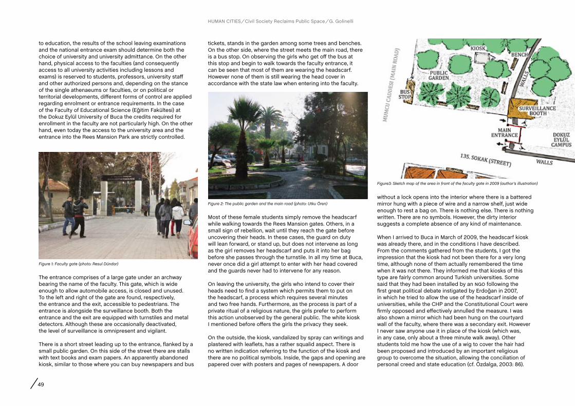
49
to education, the results of the school leaving examinations and the national entrance exam should determine both the choice of university and university admittance. On the other hand, physical access to the faculties (and consequently access to all university activities including lessons and exams) is reserved to students, professors, university staff and other authorized persons and, depending on the stance of the single athenaeums or faculties, or on political or territorial developments, different forms of control are applied regarding enrolment or entrance requirements. In the case of the Faculty of Educational Science (Eğitim Fakültesi) at the Dokuz Eylül University of Buca the credits required for enrollment in the faculty are not particularly high. On the other hand, even today the access to the university area and the entrance into the Rees Mansion Park are strictly controlled.
tickets, stands in the garden among some trees and benches. On the other side, where the street meets the main road, there is a bus stop. On observing the girls who get off the bus at this stop and begin to walk towards the faculty entrance, it can be seen that most of them are wearing the headscarf. However none of them is still wearing the head cover in accordance with the state law when entering into the faculty.
without a lock opens into the interior where there is a battered mirror hung with a piece of wire and a narrow shelf, just wide enough to rest a bag on. There is nothing else. There is nothing written. There are no symbols. However, the dirty interior suggests a complete absence of any kind of maintenance.
When I arrived to Buca in March of 2009, the headscarf kiosk was already there, and in the conditions I have described. From the comments gathered from the students, I got the impression that the kiosk had not been there for a very long time, although none of them actually remembered the time when it was not there. They informed me that kiosks of this type are fairly common around Turkish universities. Some said that they had been installed by an ngo following the first great political debate instigated by Erdoğan in 2007, in which he tried to allow the use of the headscarf inside of universities, while the CHP and the Constitutional Court were firmly opposed and effectively annulled the measure. I was also shown a mirror which had been hung on the courtyard wall of the faculty, where there was a secondary exit. However I never saw anyone use it in place of the kiosk (which was, in any case, only about a three minute walk away). Other students told me how the use of a wig to cover the hair had been proposed and introduced by an important religious group to overcome the situation, allowing the conciliation of personal creed and state education (cf. Özdalga, 2003: 86).
Figure 1: Faculty gate (photo: Resul Dündar)
Figure 2: The public garden and the main road (photo: Utku Ören)
Figure3: Sketch map of the area in front of the faculty gate in 2009 (author’s illustration)
The entrance comprises of a large gate under an archway bearing the name of the faculty. This gate, which is wide enough to allow automobile access, is closed and unused. To the left and right of the gate are found, respectively, the entrance and the exit, accessible to pedestrians. The entrance is alongside the surveillance booth. Both the entrance and the exit are equipped with turnstiles and metal detectors. Although these are occasionally deactivated, the level of surveillance is omnipresent and vigilant.
There is a short street leading up to the entrance, flanked by a small public garden. On this side of the street there are stalls with text books and exam papers. An apparently abandoned kiosk, similar to those where you can buy newspapers and bus
Most of these female students simply remove the headscarf while walking towards the Rees Mansion gates. Others, in a small sign of rebellion, wait until they reach the gate before uncovering their heads. In these cases, the guard on duty will lean forward, or stand up, but does not intervene as long as the girl removes her headscarf and puts it into her bag before she passes through the turnstile. In all my time at Buca, never once did a girl attempt to enter with her head covered and the guards never had to intervene for any reason.
On leaving the university, the girls who intend to cover their heads need to find a system which permits them to put on the headscarf, a process which requires several minutes and two free hands. Furthermore, as the process is part of a private ritual of a religious nature, the girls prefer to perform this action unobserved by the general public. The white kiosk I mentioned before offers the girls the privacy they seek.
On the outside, the kiosk, vandalized by spray can writings and plastered with leaflets, has a rather squalid aspect. There is no written indication referring to the function of the kiosk and there are no political symbols. Inside, the gaps and opening are papered over with posters and pages of newspapers. A door
HUMAN CITIES Civil Society Reclaims Public Space G. Golinelli

50
Now I would like to attempt to analyze the cultural dimension of the interior and exterior settings of the kiosk. In other words, a thick description will be proposed (Geertz, 1973), describing the kiosk as a public place amidst other public places (the garden, the street and the campus), of features and its function. And a second description of the effect that the insertion of the kiosk and its function has on the area that surround it.
4. THE INTERIOR Of THE KIOSK
In the course of the academic day, many girls go into the kiosk to put on the head covering. The process takes from three to five minutes. Often other students, girls and boys, stand outside the kiosk, holding the bags of the girls who have gone inside and checking that the door remains closed. At other times the students wait on the bench a couple of meters away from the kiosk, smoking and chatting while they wait for their companions. Sometimes the girls go inside two at a time, but in all cases, when the girls come out of the kiosk they are wearing the head covering. So access to the kiosk would seem to be reserved for the women who want to put on the headscarf. However, the internal space of the kiosk is not governed by norms which regulate access. There are no written signs, stickers, plaques or incisions which claim the kiosk as belonging to anyone. There are no party slogans, nothing that recalls a political group or even a lone political act of resistance to the 1982 norms.
The use made of the structure and its very aspect demonstrates the otherness of the kiosk with respect to the time and space around it – with respect to the rules governing the university areas as well as the public spaces. Regarding the function of the kiosk, as already mentioned, the use and the access are, in effect, limited to women who wish to put on the headscarf, although there is absolutely no official control over this. Regarding its physical appearance, there are two different aspects: on one hand the newspaper that covers the windows and the closed door isolate the internal from the external space; on the other hand the absence of any writing or drawings on the inside, compared to the degradation of the external walls, once again underlines that the kiosk belongs to a reality that is totally detached from the public area that surrounds it.
But the kiosk responds above all to a transversal issue in the society. The relationship of the kiosk with activities connected with Islam, but more in general its relationship with religious activities, cannot but influence the attitude towards the kiosk of all people, men and women alike.
In fact, from this point of view, the interior (in particular compared to the conditions of the exterior) seems to represent the inviolability of a place reserved for religious practices. The kiosk is used as part of the public space dedicated to God and not to man, not to the individual. This special bond places it out from the ordinary space and time (Özdemir & Frank, 2000: 191), without posing any challenge or breaking the laws of the lay state.
In several respects, the kiosk distinguishes itself from the public space and from the area of the university. While not outlawing itself from the State, the kiosk is, nevertheless, a frontier post, a solution to the need to connect two different realities which, for a religious subject, are regulated in a conflictual way. If we consider that many Muslim women feel and uphold the moral obligation to wear the headscarf in public (Zarcone, 2004: 242), the kiosk is the only place that offers security (or at least reduces the risk) in the passage between two territories with opposing regulations. In other words, the kiosk is the only place that allows compliance with rules that coexist, but are, in fact, incompatible.
In this framework the entire headscarf question, and with that the question of the Muslim religion in a lay state, is once again removed from the domestic scene (personal, religious) and becomes a public issue (social, regulated). As well as schools and the workplace, “spaces such as beaches, opera and concert halls, coffeehouses, fashion shows, public gardens, and public transportation all became sites for modern self-presentation” (Göle, 2002: 185). The problem of conciliating university life with personal choice (which has repercussions in public life) becomes evident in the space in front of the faculty entrance.
The practical solution to this problem is resolved by the kiosk. Once integrated into the public space and having assumed its function, the kiosk becomes a diaphragm which embodies all the characteristics of a place which, if not sacred, is however religious. Thanks to this characteristic which conserves its inviolability the kiosk allows women to use the headscarf according to their beliefs, whether these have been induced by individual faith, family tradition or the norms of their community.
Seen from the inside, the headscarf kiosk allows the women to free themselves, their own bodies, their own beliefs, from a contradiction which lies within the system. A contradiction which consents the wearing of the headscarf in a public place (the street) while banning its use in another public place (the university).
5. OUTSIDE THE KIOSK
Until now, only the interior features and the function of the kiosk have been considered. The kiosk internally is a place that is completely distinct both from the area that surrounds it and from the normal passage of time. The function that these features allow the kiosk to develop and maintain is the liberation of the individual from the contradictions of the system. Now, in order to complete this excursus, we should consider the kiosk in relation to its surrounding environment and try to evaluate the effects that its insertion and presence have caused in the organization of public space.
In fact, the insertion of the kiosk in front of the faculty redesigns and redefines the public space beyond its walls. As an example, we can take into consideration the modification of the use, and therefore of the significance, of the bench opposite the kiosk, which was part of the pre-existing urban landscape. As already said, the function of the bench is closely linked to that of the kiosk. The bench, which faces the entrance to the kiosk, is now used only by the people who are waiting for the young women to complete the donning of the headscarf inside. But the bench, so closely linked spatially and functionally to the kiosk, as well as losing its objective neutrality, also highlights a more subtle social division, which brings to the forefront the image of Islam promoted by secular Turkey.
The division is evident in the fact that students seated on the bench, waiting for the girls to come out of the kiosk, are girls with their heads uncovered; a fact that does not mean that they are non-Muslim. The bench, open and visible on all sides, contrasts with the covered windows and closed door of the kiosk. The Islam that waits outside on the bench is an Islam that not only accepts the secular rules, but also promotes them outside of the university area within which they must be observed. In this case, the form and the use of the bench construct a social significance in direct contrast with the kiosk and stress the same social division reiterated in the use of the headscarf.
In this dichotomy, Islam is not diminished, but rather its practical forms are multiplied beyond its doctrinal unity, just as the public spaces reserved for these practices are multiplied under the State. It is worth noting that in Buca the two ways of belonging to Islam, as represented by the un-headscarved girls waiting for their friends to don the headscarf; as represented by the “secular” bench and the kiosk, are not perceived as being reciprocally conflictual or exclusionary despite often needing different spaces.
HUMAN CITIES Civil Society Reclaims Public Space G. Golinelli
A KIOSK FOR THE HEADSCARF: HOW RELIGION CHANGES THE PUBLIC SPACE
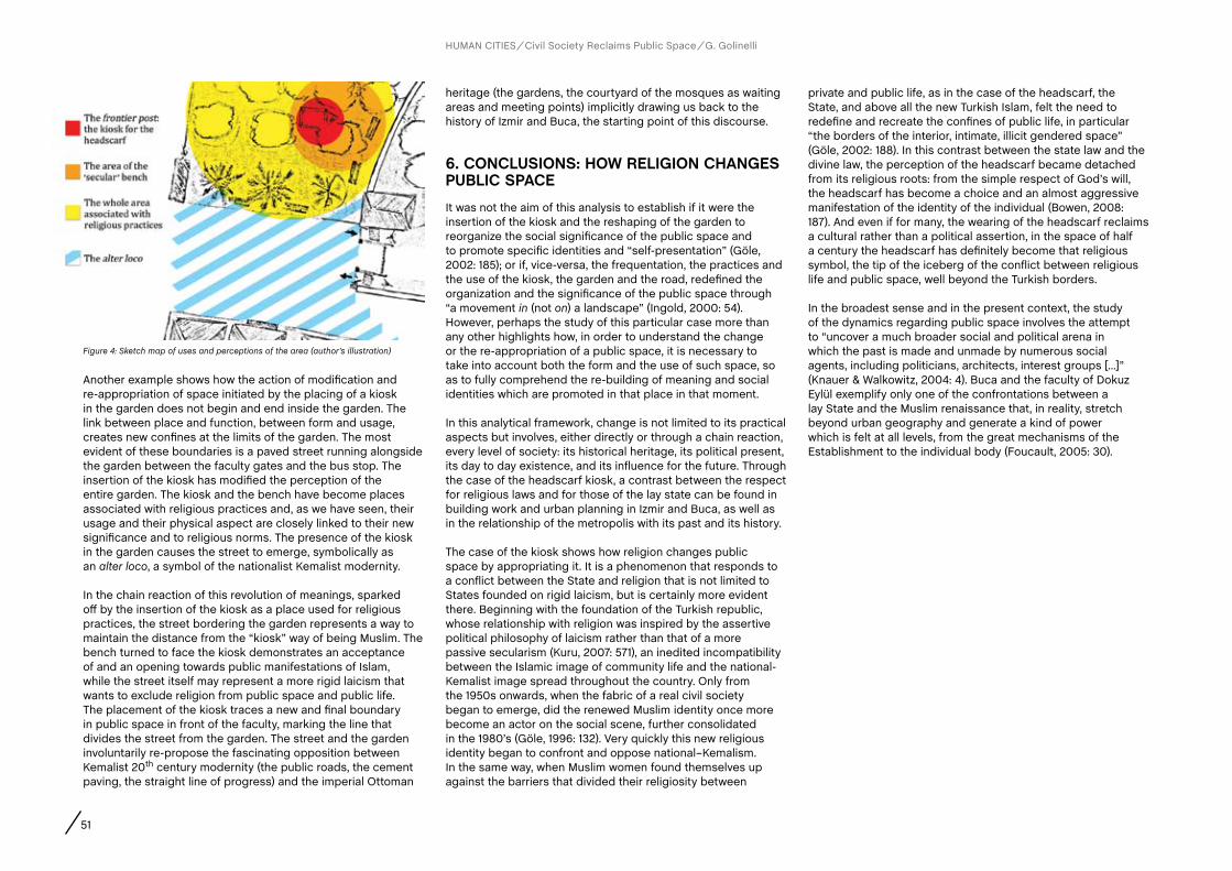
51
heritage (the gardens, the courtyard of the mosques as waiting areas and meeting points) implicitly drawing us back to the history of Izmir and Buca, the starting point of this discourse.
6. cONcLUSIONS: HOW RELIGION cHaNGES PUBLIc SPacEIt was not the aim of this analysis to establish if it were the insertion of the kiosk and the reshaping of the garden to reorganize the social significance of the public space and to promote specific identities and “self-presentation” (Göle, 2002: 185); or if, vice-versa, the frequentation, the practices and the use of the kiosk, the garden and the road, redefined the organization and the significance of the public space through “a movement in (not on) a landscape” (Ingold, 2000: 54). However, perhaps the study of this particular case more than any other highlights how, in order to understand the change or the re-appropriation of a public space, it is necessary to take into account both the form and the use of such space, so as to fully comprehend the re-building of meaning and social identities which are promoted in that place in that moment.
In this analytical framework, change is not limited to its practical aspects but involves, either directly or through a chain reaction, every level of society: its historical heritage, its political present, its day to day existence, and its influence for the future. Through the case of the headscarf kiosk, a contrast between the respect for religious laws and for those of the lay state can be found in building work and urban planning in Izmir and Buca, as well as in the relationship of the metropolis with its past and its history.
The case of the kiosk shows how religion changes public space by appropriating it. It is a phenomenon that responds to a conflict between the State and religion that is not limited to States founded on rigid laicism, but is certainly more evident there. Beginning with the foundation of the Turkish republic, whose relationship with religion was inspired by the assertive political philosophy of laicism rather than that of a more passive secularism (Kuru, 2007: 571), an inedited incompatibility between the Islamic image of community life and the national-Kemalist image spread throughout the country. Only from the 1950s onwards, when the fabric of a real civil society began to emerge, did the renewed Muslim identity once more become an actor on the social scene, further consolidated in the 1980’s (Göle, 1996: 132). Very quickly this new religious identity began to confront and oppose national–Kemalism. In the same way, when Muslim women found themselves up against the barriers that divided their religiosity between
private and public life, as in the case of the headscarf, the State, and above all the new Turkish Islam, felt the need to redefine and recreate the confines of public life, in particular “the borders of the interior, intimate, illicit gendered space” (Göle, 2002: 188). In this contrast between the state law and the divine law, the perception of the headscarf became detached from its religious roots: from the simple respect of God’s will, the headscarf has become a choice and an almost aggressive manifestation of the identity of the individual (Bowen, 2008: 187). And even if for many, the wearing of the headscarf reclaims a cultural rather than a political assertion, in the space of half a century the headscarf has definitely become that religious symbol, the tip of the iceberg of the conflict between religious life and public space, well beyond the Turkish borders.
In the broadest sense and in the present context, the study of the dynamics regarding public space involves the attempt to “uncover a much broader social and political arena in which the past is made and unmade by numerous social agents, including politicians, architects, interest groups [...]” (Knauer & Walkowitz, 2004: 4). Buca and the faculty of Dokuz Eylül exemplify only one of the confrontations between a lay State and the Muslim renaissance that, in reality, stretch beyond urban geography and generate a kind of power which is felt at all levels, from the great mechanisms of the Establishment to the individual body (Foucault, 2005: 30).
Figure 4: Sketch map of uses and perceptions of the area (author’s illustration)
Another example shows how the action of modification and re-appropriation of space initiated by the placing of a kiosk in the garden does not begin and end inside the garden. The link between place and function, between form and usage, creates new confines at the limits of the garden. The most evident of these boundaries is a paved street running alongside the garden between the faculty gates and the bus stop. The insertion of the kiosk has modified the perception of the entire garden. The kiosk and the bench have become places associated with religious practices and, as we have seen, their usage and their physical aspect are closely linked to their new significance and to religious norms. The presence of the kiosk in the garden causes the street to emerge, symbolically as an alter loco, a symbol of the nationalist Kemalist modernity.
In the chain reaction of this revolution of meanings, sparked off by the insertion of the kiosk as a place used for religious practices, the street bordering the garden represents a way to maintain the distance from the “kiosk” way of being Muslim. The bench turned to face the kiosk demonstrates an acceptance of and an opening towards public manifestations of Islam, while the street itself may represent a more rigid laicism that wants to exclude religion from public space and public life. The placement of the kiosk traces a new and final boundary in public space in front of the faculty, marking the line that divides the street from the garden. The street and the garden involuntarily re-propose the fascinating opposition between Kemalist 20th century modernity (the public roads, the cement paving, the straight line of progress) and the imperial Ottoman
HUMAN CITIES Civil Society Reclaims Public Space G. Golinelli

52
ReferencesBowen, J. R. (2008). Why the French Don’t Like Headscarves: Islam, the State & Public Space. Princeton NJ, Princeton University Press.
Can, I. (2010). Urban Design and the Planning System in Izmir. Journal of Landscape Studies, 3, pp. 181-189.
Foucault, M. (2005). Sorvegliare e punire: nascita della prigione. Torino, Einaudi [ed. orig. 1975].
Geertz, C. (1973). Thick Description: Toward an Interpretive Theory of Culture, in Geertz C. The Interpretation of Cultures: Selected Essays, pp. 3-30. New York, Basic Books.
Goffman, D. (1999). Izmir: from village to colonial port city, in Eldem, E., Goffman, D. and Masters, B. The Ottoman City between East and West: Aleppo, Izmir, and Istanbul, pp. 79-134. Cambridge UK, Cambridge University Press.
Goffman, D. (2002). The Ottoman Empire and Early Modern Europe. Cambridge UK, Cambridge University Press.
Göle, N. (1996). The forbidden modern: civilization and veiling. Michigan, Ann Arbor.
Göle, N. (2002). Islam in public: new visibilities and new imaginaries. Public Culture, 14, pp. 173-190.
İnal, O. (2006). Levantine Heritage in Izmir. Koç University M.A. Thesis, unpublished.
Ingold, T. (2000). The perception of the environment: essays on livelihood, dwelling & skill. London - New York, Routledge.
Internet 1: United States Library of Congress (Jan. 2006). Country Profile - Turkey http://www.unhcr.org/refworld/docid/46f9135d0.html [accessed 10 Jan. 2012].
Internet 2: Today’s Zaman (5 Jan. 2012). Law students protest İstanbul Bar Association’s scarf ban on interns http://www.todayszaman.com/newsDetail_getNewsById.action?load=detay&newsId=267736&link=267736 [accessed 12 Jan. 2012].
Internet 3: Today’s Zaman (15 Oct. 2010). Scarf ban still in place at some universities in defiance of YÖK move http://www.todayszaman.com/news-224391-100-scarf-ban-still-in-place-at-some-universities-in-defiance-of-yok-move.html [accessed 12 Jan. 2012].
Internet 4: Today’s Zaman (12 Jan. 2012). Turkish professor retains headscarf ban http://www.todayszaman.com/newsDetail_getNewsById.action?load=detay&newsId=268387&link=268387 [accessed 12 Jan. 2012].
Knauer, L. M. and Walkowitz, D. J. (2004). Introduction, in Knauer L. M. and Walkowitz D. J. (Eds.) Memory and the Impact of Political Transformation in Public Space, pp. 1-17. Durham NC, Duke University Press.
Konda (2007). Religion, secularism and the veil in daily life. Milliyet daily newspaper, 3-9 Dec.
Kuru, A. T. (2007). Passive and assertive secularism. World Politics, 59, pp. 568–594.
Mendizàbal, E. (2010). Una posible geografía de las identidades de Barcelona: el caso de la Vila de Gràcia. Finisterra, XLV, 90, pp. 91-109.
Neyzi, L. (2008). Remembering Smyrna/Izmir: Shared History, Shared Trauma. History and Memory, 20(2), pp. 106-127.
Özdalga, E. (2003). Following in the footsteps of Fetthulah Gülen, in Esposito, J.L. and Yavuz, M.H. (Eds.) Turkish Islam and the secular state: the Gulen movement, pp. 85-114. Syracuse: Syracuse University Press.
Özdemir, A. and Frank, K. (2000). Visible Islam in modern Turkey. Basingstoke, Palgrave Macmillan.
Saktanber, A. and Çorbacioğlu, G. (2008). Veiling and headscarf: skepticism in Turkey. Social Politics: International Studies in Gender, State and Society, 15, pp. 514-538.
Zarcone, T. (2004). La Turquie moderne et l’islam. Paris: Flammarion.
Zürcher, E. J. (2007). Storia della Turchia: dalla fine dell’impero ottomano ai giorni nostri. Roma: Donzelli. [ed. orig. 1993].
HUMAN CITIES Civil Society Reclaims Public Space G. Golinelli
A KIOSK FOR THE HEADSCARF: HOW RELIGION CHANGES THE PUBLIC SPACE

AUTHORS
Abstract
CHAPTER
53 R. Houlstan-Hasaerts, B. Tominc, M. Nikšič, B. Goličnik Marušić (Editors) Urbani izziv - publikacije, Ljubljana, May 2012
contact
Keywords
Dejana NedučinArchitect, Faculty of Technical Sciences, University of Novi Sad, Dositeja Obradovića 6, Novi Sad, Serbia, +381 63 508 971, [email protected]šan RistićSociologist, Faculty of Philosophy, University of Novi Sad, dr Zorana Đinđića 2, Novi Sad, Serbia, +381 69 163 4884, [email protected] Vladimir KubetArchitect, Faculty of Technical Sciences, University of Novi Sad, Dositeja Obradovića 6, Novi Sad, Serbia, +381 63 523 601, [email protected]
Serbia, urban culture, civil initiative, public space, Fifth Park
The past two decades of urban transformations in Serbian style illustrate that the development of Serbian cities is highly reliant on the new market relations and that there is an apparent dominance of private sector’s profit-making over recognition of public interests; which is a mutual problem of all transitional countries. Apart from causing substantial alterations in the socio-spatial outlook of all major cities, this shift in market forces instigates transformation of public spaces’ character through their privatization. As it is facilitated by a very strong bond between politicians, private investors and institutions responsible for regulating urban practices, the paper presents an attempt to analyze the impact of civil initiatives on the decision-making process that influences the future of public spaces. Even though a low level of citizen participation is a common problem of all post-socialist societies, this research is based on the assumption that, due to the effects of a decade preceding the transitional period, urban culture in contemporary Serbian society cannot give a necessary support to civil initiatives that deal with protection and preservation of public spaces. Given that even well organized and coordinated civil actions in this country most frequently present reactions to implementation of certain political decisions that favour private interests, rather than expressions of developed urban culture or consciousness of public responsibility, the aim of the paper is to investigate, through a case study of the Initiative for Preservation of the Fifth Park, their causes under these conditions, as well as the reasons due to which Serbian citizens do not see themselves as equal actors in the process of urban development.
and Vladimir Kubet, Novi Sad (Serbia)Dejana Nedučin, Novi Sad (Serbia), Dušan Ristić, Novi Sad (Serbia)
CLAIMING PUBLIC SPACE IN A POST-SOCIALIST SERBIA: A STRUGGLE FOR THE FIFTH PARK
1. INTRODUcTION
The modern urban sociology recognizes four relevant categories of players in the process of urban development: political actors who need to find a balance between public and private interests, economic actors - most often private entrepreneurs in search of suitable urban resources for their investments, urban planners in charge of creating regulations that should meet the interests of all other players and citizens who need to be aware of their right to the city (Bassand et al., 2001). In order to achieve a better urban environment that everybody would benefit from, the influence of each group should be equally important.
The past two decades of urban transformations in Serbian style illustrate quite the opposite. Same as in other post-socialist countries, the development of Serbian cities became highly reliant on new market relations based on clientelism, which resulted in an apparent dominance of private sector’s profit-making over recognition of public interests (see Szelényi, 1996; Sykora 1998; Tosics, 2005a; Stanilov, 2007). Apart from causing some substantial alterations in the socio-spatial outlook of all major cities, a divergence from the path of socialist urban development, during which the state was the only financier and everything was public by default, instigated transformation of the character of public spaces through their privatization. As it is facilitated by a very strong bond between politicians, private investors and institutions responsible for regulating urban practices, this paper presents an attempt to analyze the impact of civil initiatives on the decision-making process that influences the future of public spaces in Serbian cities.
Although there is neither a generally accepted theoretical framework or enough empirical research available that would explain the influence of complex transitional processes that Serbia is currently faced with, on citizens’ willingness to take part in public affairs; the conclusions of some studies conducted in other post-socialist countries in transition (see Howard, 2011) illustrate that the problem of a low level citizen

54 CLAIMING PUBLIC SPACE IN A POST-SOCIALIST SERBIA: A STRUGGLE FOR THE FIFTH PARK
HUMAN CITIES Civil Society Reclaims Public Space D. Nedučin, D. Ristić, V. Kubet
participation is mutual. On the other hand, the consequences of a decade marked by civil wars, war-caused migrations and almost complete social, economic and cultural isolation, which preceded the beginning of transition, make Serbian society different from the neighboring ones in many aspects. Major problems triggered by continuous political instability and great poverty, which were occurring on a daily basis, led to an almost complete disregard of many important social and cultural issues, and the suggestions on how to solve them are still missing from current political agendas. Additionally, it may be noted that they are hardly recognized by the citizens as essential segments of urban life dynamics, which points to a lack of urban culture. Therefore, the aim of this paper is to investigate, through a case study of the Initiative for Preservation of the Fifth Park, the causes of civil actions in public spaces under these conditions, as well as the reasons why Serbian citizens do not see themselves as equal actors in the process of urban development. A general overview of the impact of underdeveloped urban culture and the conflict of interests that transformation of public spaces result in, is given in order to emphasize the distinction between Serbia and other post-socialist countries in this context.
2. GENERaL cONTEXT
2.1. Urban culture of the post-socialist Serbia
For a deeper understanding of the actions civil initiatives in Serbia utilize in order to reclaim public space, it is necessary to take into consideration a broader context, especially from the aspect of problems that can be identified within the domain of urban culture. This term reflects the way people understand the meaning, importance and cultural dynamics of urban life. Since it derives from the values, attitudes, beliefs and lifestyles of urban residents, urban culture can be viewed as a basis for social transformations in a city. If defined in this manner, it also includes a complete and integral way of observing various cultural practices in an urban context.
It is difficult to truly understand urban culture and its social environments in contemporary Serbia without having a brief insight into the general political context. As a consequence of the politics from the period of Yugoslavian state socialism, but also as an effect of the economic crisis, civil wars, collapse of the socialist regime and major political changes on a national level that occurred at the end of 1990s, Serbian society has entered the process of distorted modernization, which is
characterized by a phenomenon that acts as a limiting factor of modernization and is known as “the cultural lag” (Koković, 2003: 51). It does not only imply the social value orientations typical for traditionalism, but also indicates a lack of certain kinds of cultural practices characteristic for Western European societies. Furthermore, the process of modernization of this post-socialist country is impeded by an apparent domination of politics or so-called “egalitarian syndrome” (ibid.: 50). The rigidity of its political system, as well as the emergence of new interest groups and players on the Serbian political scene, do not allow for important social processes to occur in a more flexible and thus democratic manner, or in other words, without state control.
Serbia has recently entered a period of transition. Almost all transitional processes that this society is currently going through are marked by a specific “culture of anti-urbanity” (Pušić, 2010: 381-383). It is primarily a consequence of rapid and poorly planned urbanization, which presents an important factor of modernization and a prerequisite for achieving a sustainable social development. According to Pušić (2010: 382), this “anti-urban atmosphere” is the result of at least three different influences: firstly, there is “an anti-urban offer of spatial articulation and the use of space by those who see the city exclusively through the ways of personal profit”; secondly, there are “professionals who have accepted the imposed role of designers and executors of deurbanization by planning, designing and construction of non-urban physical structures in our cities”; finally, there is the passiveness of citizens who agree to live in a devastated urban environment.
Under assumptions that “the design and spatial organization of the public space tell us a lot about cultural ambitions” of urban residents and that the “decisions about the way that the public space will be filled in are an expression of the way we deal with the shaping of the society” (Hajer and Reijndorp, 2001: 73), then we may claim that urban culture represents various social values of a particular community and provides cultural context for a variety of citizen initiatives related to promoting multiple usages of public spaces or their publicness. Unfortunately, Serbian urban culture of 2000s has not developed enough to back them up. Due to the elemental character of modernization processes and the rigidity of economic and political systems, the underdeveloped urban culture is a logical product of the disregard of certain social values and cultural practices on one side, and of the impossibility of their continuous “stimulation” on the other. That is an argument for defining urban culture as a dynamic concept that emphasizes the cultural dimension of using public space.
2.2. PUBLIc SPacES IN SERBIaN cITIES
The socialist economy used to rely on a range of non-economic factors of production, such as political, social, symbolic or ideological, and their aim was to display the superiority of communism over capitalism, most often through “gigantism” in spatial organization and urban planning (Kostinskiy, 2001). Consequently, urban practice typical for Central and Eastern European socialist systems succeeded in changing the nature of public spaces in the majority of cities within a couple of decades after the World War II. In a comparison with Western European cities, Stanilov (2007) recognizes three important fields of distinction that defined the character of public space in socialist societies: 1) much larger share of land in public use, particularly in Yugoslavia where urban land was in state ownership and public by default; 2) abundance of public space and the diffused pattern of its allocation; 3) limited functional content of public space and relatively low intensity of its use. The socialist urban matrix has thus left Serbian cities with a profusion of large, abandoned, neglected and undifferentiated public spaces in Le Corbusier-style residential districts that, according to their size, structure and organization, did not correspond to modern demands and seemed as very appealing urban features to be transformed.
Due to a shift in internal market forces in mid 1990s, private entrepreneurs became the principal investors in the post-socialist urban development (Tosics, 2005b). Their appearance at the time of a great socio-economic crisis resulted in the significant profit-oriented alterations in building and planning practices, radical interventions within inherited urban fabric, and a phenomenon in Serbia known as “the investor-oriented urbanism”. Recent urban transformations guided by these private interests introduced and defined two new types of public spaces: commercialized public spaces located in the old urban centre or its vicinity, and fictional public spaces that emerged as byproducts of the boom in housing construction during 1990s and 2000s.
Although the first type of public spaces is characteristic for Western European cities, it presents a novelty for the post-socialist ones. In brief, the influx of private investments undoubtedly contributed to the improvement of their overall appearance, but infusing them with predominantly commercial and entertainment-based amenities did not result in creation of multifunctional and multilayered public spaces, but in production of quasi-public places of consumption. As for the second type, it came out as a consequence of the privatization of urban land, especially public spaces inherited

55
from the socialist period that fit the description given above. They were transferred into construction land and leased out to private entrepreneurs for residential development. Given that investing in creation of high-quality public spaces seemed completely pointless, as they could not be charged “by the square meter”, the unbuilt leftovers of transformed residential districts constituted this new type (Figure 1).
Considering that local authorities did not interfere with these processes, the question is whether they are in control of the future of cities in transitional societies or, in other words, are “the political decisions on city development made in favour of private interests” (Čaldarović and Šarinić, 2008: 375). With the intention of solving the conflict of interests that recent transformations of public spaces resulted in, “we should create, on a theoretical level and in planning heuristic… a kind of common denominator for most of the players (in urban development)… in order to achieve a balance between individual and common interests in making, preparing and implementing the decisions at various levels of planning” (Vujošević and Petovar, 2006: 359). Theoretical articulation of different planning approaches is important for establishing the principles of democratic planning in the context of post-socialist Serbia, especially from the aspect of harmonizing a large number of emerging legitimate interests - both private and public (ibid.).
By taking into account the above-mentioned general considerations about the socio-political situation and negative aspects of modernization and urbanization processes that
Serbian cities are faced with, it is rather difficult to establish one clear and precise definition of public space that would provide a general and balanced overview of its current state. The emphasis on the lack of urban culture was thus given in order to highlight the problem of absence of certain cultural practices, which may give an adequate meaning to the uses of public space in a way that would at least fulfil basic public needs. Given that its deterioration presents a product of profit-oriented urban practices that marked the past two decades and succeeded in altering socio-spatial character and identity of many neighbourhoods in Serbian cities, the questions which then arise are the following: are the citizens willing to actively participate in the decision-making process that influences the development of their neighbourhoods and cities in general, and if yes, to what extent may they exercise their rights?
2.3. civil initiative in a post-socialist context
A research on citizens’ willingness to take part in various public actions conducted by a group of sociologists in Belgrade, the capital of Serbia, concluded that the majority of population lacks motivation due to a common mistrust in public institutions. Considering the roles of more influential actors, particularly in case of urban development, almost 80 percent believe that citizen participation in the decision-making process would have no impact whatsoever (Vujović, 2004). To illustrate, after the socialist period of dictatorship (i.e. after the fall of the regime of Slobodan Milošević in 2000), the newly established democratic legislation has enforced the Law on Planning and Construction (introduced in 2003 and revised in 2009) that recognizes the importance of public control in the process of urban development. It states several manners of citizen participation in urban planning activities, such as filing legal complaints or giving suggestions during the obligatory public presentations of urban plans, which would be taken into account before validation and endorsement. In practice, however, there are plenty of examples when local authorities bypass these legal procedures and reject proposals made by the citizens, which leaves an impression that the support to public initiative provided by the law is only declarative and formal.
There are several other facts that justify an extremely low level of citizen participation in Serbia. According to Howard (2011), in order to explain why this problem is present in many post-communist societies, it is necessary to take into consideration the social legacy of communism and its influence, as well as people’s perception of the socio-economic transition. In his opinion, the Communist Party was trying to repress the need
for independent social activities and autonomous pluralism by setting up a strong institutional network of formal state-controlled organizations with often mandatory participation, such as the party itself, youth groups, various trade, peasant or worker unions and even sports clubs. Because of “this essentially negative experience… during the communist period, majority of citizens… continue to have a common sense of mistrust of organizations today… The distinction they make is that previously they were forced to join, while today they are free to choose not to join and not to participate” (ibid.: 140). As an additional reason, Howard states that there “is the widespread disappointment, and for some even disillusionment, with political and economic developments since the collapse of the state-socialist system” (ibid.: 141).
Due to all of the above, Serbian citizens probably have a good reason to be discouraged when it comes to participating in the public sphere. Their activities and initiatives for protecting public goods often “hit the wall of silence” of local authorities or, at best, stumble upon continuous transfer of responsibilities from one institution to another (Petovar, 2010). Most of them are thus only passively observing the crisis of urbanity caused by the investor-oriented urbanism and irresponsible actions of the local authorities that facilitated it. However, there are several examples of determined and persistent civil initiatives that succeeded in accomplishing their goals even under these conditions. One of them is the Initiative for Preservation of the Fifth Park in Belgrade.
3. INITIaTIVE fOR PRESERVaTION Of THE fIfTH PaRK – a caSE STUDYA group of Belgrade’s local residents gathered around a common interest – to protect a small piece of public land in their urban block known as the Fifth Park – formed a civil initiative in 2005, which succeeded in preventing privatization of the public space. Their struggle against the decision of local authorities to favour private over public interests nowadays serves as an example of good practice for other civil associations that deal with the same issue.
3.1. chronology of events
The Fifth Park (Serb. Peti park) is a part of Lipov Lad, a residential district located three kilometres from Belgrade’s city centre and just a few corners away from one of the main city boulevards.
HUMAN CITIES Civil Society Reclaims Public Space D. Nedučin, D. Ristić, V. Kubet
Figure 1: Inner-block public space in Novi Sad’s district of Nova Detelinara (photo: the authors’ team)

56
The Lipov Lad has emerged as a new residential city area during the 1960s urban renewal, comprising of 11 multi-storey modernist style buildings and a string of public spaces (including the Fifth Park) between them (Figures 2 and 3). The Detailed Urban Plan for the Block Lipov Lad from 1987 recommended erection of a 200 square meter office building within the park area and preservation of the existing greenery, but due to a high demand for vacant construction land in the vicinity of the boulevard in the beginning of 2000s, the City Assembly endorsed a new Regulation Plan (2002) for this city district. It advised construction of a 4000 square meter edifice comprising apartments, office space and garages, with an area that would cover almost the whole park (Figure 4). This
area was thus renamed to construction land and leased out to a private developer. The start of construction in June 2005 provoked a resistance from the residents of nearby buildings, who decided to stand up for its defence (Figure 5). After they filed a formal complaint, the media department of the City Assembly gave an official announcement, stating that the area “in question has never been designed for anything else but construction of a multipurpose edifice” and emphasizing that “the city administration has cleaned the area and made
it green in order to prevent creation of garbage wasteland… until it is brought up to its legitimate function” (Internet 1). The residents thus formed a steering committee and started a self-organized struggle for the protection of Fifth Park.
During a three year struggle, they completed more than 30 organized actions in order to raise public awareness of legal appropriation of their public space by a private investor. Some of the initial actions may be characterized as slightly
HUMAN CITIES Civil Society Reclaims Public Space D. Nedučin, D. Ristić, V. Kubet
Figure 2: Lipov Lad and the park area (source: www. maps.google.com)
Figure 3: Fifth Park before 2005 (source: www.petipark.org)
Figure 4: Footprint of the building (source: www.petipark)
Figure 5: The first day of struggle (source: www.petipark)
Figures 6: Residents are trying to stop construction workers from entering the park (source: www.petipark)
Figures 7: Residents are trying to stop construction workers from entering the park (source: www.petipark)
CLAIMING PUBLIC SPACE IN A POST-SOCIALIST SERBIA: A STRUGGLE FOR THE FIFTH PARK

57
aggressive, since the residents were physically blocking the construction workers from accessing the park area and obstructing all their preparation activities (Figures 6 and 7). At one point, the steering committee has even organized a neighborhood watch in eight hour shifts and installed the sirens in order to notify the whole district when “an attack” occurs. After receiving support from many locally known musicians, artists and sportsmen, the civil initiative started a campaign of less aggressive actions, with the aim of informing wider public about the problem they were dealing with (Figures 8 and 9). They included distribution of promotional material (flyers, badges, t-shirts, etc.), petition signing, posting of signboards and flags that “mark” the public territory, thematic protests, as well as various cultural, sport and educational events (concerts of famous bands, art colonies, theatre plays, basketball and chess tournaments, open-air aerobics classes,
HUMAN CITIES Civil Society Reclaims Public Space D. Nedučin, D. Ristić, V. Kubet
etc.) (Internet 2). Meanwhile, the steering committee was gathering information on possible legal procedures and actions, such as detection of irregularities in the existing planning documentation and initiation of the procedure for its annulment.
In 2008, city authorities stopped construction works and ordered the Belgrade Urban Planning Institute to develop a plan of detailed regulation that would turn the Fifth Park into a public space again (Kucina, 2011a). In the following year, this civil initiative has instigated collaboration between a group of students from the Faculty of Architecture, University of Belgrade, and the citizen community that grew from the defence of the park, which resulted in a preliminary project for a new Fifth Park based on a method of participative designing. As this park “appears both as a concrete space (a neglected field that should be regenerated according to the citizens’ wishes) and a reflection of creative potential of a self-organized community”, the proposals citizens made were taken into account during the design process (Kucina, 2011b). Unfortunately, due to a lack of financial resources and a very slow administrative procedure for annulment of the existing planning documentation, the destiny of this “deserted battlefield” is still not clear (ibid.).
3.2. causes and outcomes
Various actions that the residents of Lipov Lad organized illustrate a possible way of dealing with a problem of mistreatment of public spaces in contemporary Serbian society. However, it does not guarantee that the local authorities would necessarily recognize such public interests or favour them. What civil initiatives of this type have in common is that they serve not just as expressions of a genuine need to claim public spaces within our cities, but also as manifestations of citizens’ dissatisfaction or even frustration with the current political situation that they are directly or indirectly affected by. In this sense, the tendency toward more radical mechanisms and means that the citizens utilize in order to reach their goals, most often represents the last line of defence from the political decisions which endanger public life of their community.
Despite its positive aspects concerning the utilization of social and cultural capital of the local community, it may be noted that the Initiative for Preservation of the Fifth Park had a rather “defensive” than “active” character. It reveals an effort of local citizens to preserve access to a space which they
consider as public property and protect it from commercial exploitation, thus presenting a post-festum reaction to its usurpation. Nevertheless, the initiatives of this type frequently do not have a significant long-term impact on the decisions of other actors in the process of urban development. In order to avoid these situations, the question that should be raised is whether there is enough political will to let the citizens develop a mechanism of preventive actions that would assist them in monitoring the decision-making on the local level.
As the development of Serbian economy without raising the level of social capital cannot not bring prosperity or improve the quality of life (Petovar, 2009), the citizens must become aware of the fact that their voices need to be heard. Regardless of the fact that this struggle set in motion several other civil initiatives for preservation of public spaces’ publicness, such as “Sixth Park” or “Zvezdara Forest“, the question whether the citizens should feel responsible for the development of their neighbourhoods still remains. On one hand, their inertness is a legacy inherited from the socialist era (Petrović, 2004), but on the other, its causes may also be found in a widespread disappointment with the outcomes of transition. The overall political and economic situation, as well as social instability and poverty, draws public attention to other more important issues that need to be instantly resolved and, considering this broader context, it is rather difficult to incorporate preservation of public spaces in a daily agenda or set it as a priority.
4. cONcLUSION
Although it seems that the urban question has been partially depoliticized during the transitional period, the case study presented in this paper proves that Serbian citizens should participate in formulation of urban policies and need to be involved in the urban development process as equally important actors right from the beginning.
The general question that this type of civil initiatives open is the question of citizen’s right to the city. From the aspects of law, politics, economy and culture, it may be differentiated and concretized in several manners. Legislation - the question of legitimacy and legalization of civil actions; what actions can be characterized as legal? Economy – the question of land ownership and making a distinction between private and public interests; are we willing to find an approach to transformation of public space that is not profit-driven? Politics – the question of decision-making on the local level; can the citizens participate in the decision-making process
Figure 8: Famous rock bands support the fight (source: www.petipark)
Figure 9: “The Fifth Park is on your right” – marking the public territory (source: www.petipark)
58
Petovar, K. (2009). Uvek ima “neko drugi”. Politika, 22 May 2009. Available at http://www.politika.rs/rubrike/Sta-da-se-radi/Uvek-ima-neko-drugi.lt.html (accessed 15 Dec. 2011).
Petovar, K. (2010). Grad bez građana – tako se gradi(lo) u Beogradu i Srbiji. Republika, No. 484-485. Available at http://www.republika.co.rs/484-485/20.html (accessed 15 Dec. 2011).
Petrović, M. (2004). Sociologija stanovanja. Beograd, Institut za sociološka istraživanja Filozofskog fakulteta.
Pušić, Lj. (2010). Kultura antiurbanosti kao praksa tranzicijskih procesa u Srbiji, in Subotić, Lj. and Živančević-Sekeruš, I. (Eds.) Susret kultura – Knjiga 1, pp. 381-389. Novi Sad, Filozofski fakultet.
Regulation Plan for the Boulevard of King Alexander and Blocks between Stanislava Sremcevica, Toneta Tomsica, Vranjska and Gvozdiceva Streets – Blocks C19 i C20 (2002). Službeni glasnik Grada Beograda, No. 28/2002. Beograd, Skupština Grada Beograda.
Szelényi, I. (1996). Cities under Socialism – and After, in Andrusz, G., Harloe, M. and Szelenyi I. (Eds.) Cities after Socialism: Urban and Regional Change and Conflict in Post-socialist Societies, pp. 286-317. Oxford, Blackwell Publishers.
Stanilov, K. (2007). Democracy, markets and public space in the transitional societies of Central and Eastern Europe, in Stanilov, K. (Ed.) The Post-Socialist City: Urban Forms and Space Transformation in Central and Eastern Europe after Socialism, pp. 269-284. Dordrecht, Springer.
Sykora, L. (1998). Commercial Property Development in Budapest, Prague and Warsaw, in Enyedi, G. (Ed.) Social Change and Urban Restructuring in Central Europe, pp.109-136. Budapest, Akademiai.
HUMAN CITIES Civil Society Reclaims Public Space D. Nedučin, D. Ristić, V. Kubet
Tosics, I. (2005a). Post-socialist Budapest: The invasion of market forces and the response of public leadership, in Hamilton, I., Dimitrovska Andrews, K. and Pichler-Milanović, N. (Eds) Transformation of Cities in Central and Eastern Europe: Towards Globalization, pp. 248-280. Tokyo, United Nations University Press.
Tosics, I. (2005b). City development in Central and Eastern Europe since 1990: The impact of internal forces, in Hamilton, I., Dimitrovska Andrews, K. and Pichler-Milanović, N. (Eds) Transformation of Cities in Central and Eastern Europe: Towards Globalization, pp. 44-78. Tokyo, United Nations University Press.
Vujošević, M. and Petovar, K. (2006). Javni interes i strategije aktera u urbanističkom i prostornom planiranju. Sociologija, 48(4), pp. 357-382.
Vujović, S. (2004). Akteri urbanih promena u Srbiji, in Milić, I. (Ed.) Društvena transformacija i strategija društvenih grupa – Svakodnevnica u Srbiji na početku milenijuma, pp. 151-193. Belgrade, ISI FF.
acknowledgementsThe paper was done within the projects: “Optimization of architectural and urban planning and design in function of sustainable development in Serbia” (TR36042) and “Changes in social structure and mobility as factors of the European integration of the Republic of Serbia, with special reference to the AP Vojvodina” (No. 179053), both funded by the Ministry of Education and Science, Republic of Serbia.
and if yes, what political consequences would they need to bear? Cultural and social aspects – the question of existing cultural patterns and social values and needs; how can we motivate the citizens to create new means of appropriation and utilization of their public spaces? The answers to these questions would display the extent to which public spaces are truly incorporated in the everyday life of their users.
It may also be concluded that in Serbia, even well organized and coordinated civil actions in public space most frequently present reactions to implementation of certain political decisions that favour private interests, rather than expressions of developed urban culture or consciousness of public responsibility. Informing the wider public about successful citizen initiatives from other European countries and their
efforts in protecting the city as a public good, would have a significant impact on raising awareness of the role Serbian citizens may play in shaping the future of their cities. A joint mission of recently founded citizen associations should therefore be to motivate people to feel responsible for the transformation of their urban environments and teach them how to successfully exercise their legitimate civil rights.
ReferencesBassand, M., Kaufmann, V. and Dominique, J. (2001). Vers une nouvelle sociologie urbaine?, in Bassand, M., Kaufmann, V. and Dominique, J. (Eds.) Enjeux de la sociologie urbaine, pp. 247-256. Lausanne, Presses polytechnique et universitaire romandes.
Čaldarović, O. and Šarinić, J. (2008). First Signs of Gentrification? Urban Regeneration in the Transitional Society: the Case of Croatia. Sociologija i prostor, 46(3-4), pp. 369-381.
Detailed Urban Plan for the Block Lipov Lad (1987). Službeni glasnik Grada Beograda, No. 29/1987. Beograd, Skupština Grada Beograda.
Hajer, M. and Reijndorp, A. (2001). In Search of New Public Domain: Analysis and Strategy, Rotterdam, NAI Publishers.
Howard, M. (2011). Civil society in post-communist Europe, in Edwards, M. (Ed.) The Oxford Handbook of Civil Society, pp. 134-145. New York, Oxford University Press Inc.
Internet 1: http://petipark.bravehost.com/indexengleski.htm (accessed 22 Dec. 2011).
Internet 2: http://petipark.org/hronologija-dogaaja.html (accessed 22 Dec. 2011).
Koković, D. (2003). Kultura kao činilac tranzicije i modernizacije. Teme, 24 (1-2), pp. 47-64.
Kostinskiy, G. (2001). Post-Socialist Cities in Flux, in Paddison, R. (Ed.) Handbook of Urban Studies, pp. 451-465. London, Sage Publications Ltd.
Kucina, I. (2011a). The Participatory Project for Peti Park. Oris – Magazine for Architecture and Culture, No. 67, pp. 94-97.
Kucina, I. (2011b). The Participatory Project for Peti Park. Urban Report, No. 3, pp. 70-73.
Law on Planning and Construction (2003). Službeni glasnik Republike Srbije, No. 47/2003. Beograd, JP Službeni glasnik.
CLAIMING PUBLIC SPACE IN A POST-SOCIALIST SERBIA: A STRUGGLE FOR THE FIFTH PARK

Part two:Methodological Highlight

60
Introduction to the Methodological Highlight
DESIGN aND USE: aN ON-GOING STRUGGLE?
This section concentrates on the methodological challenges that sprout from a public space approach that operates at the intersection of use and design.
The notion of ‘use’ is here not delimited to intended, orchestrated or purposeful use alone, but is extended to unintended use (whether desired or unwanted) and the re-claiming and appropriation of space. Such interpretation of use requires sensitivity to activisms and underground tactics, to otherness and to mechanisms of exclusion and inclusion. Likewise, also design is understood in broader terms than the design of public space layouts and furnishings. Namely, it refers to any form of material and spatial intervention in space. Use and design, defined in such terms, allow one to investigate public space as simultaneously a social, political, and material project. This session addresses the methodological consequences and challenges thereof.
Much of these methodological challenges can be brought back, even if often implicitly, to tensions that are at the heart of most design fields. Namely architecture, urban design and planning (to name only a few) operate as a practice (organised as a profession) and as a discipline (theory, history). Practices, typically defined as ‘on the ground’, are often believed to operate in pragmatic and compliant manners rather than critical or reflective. The scholarly context of the discipline, by contrast, is considered the locus for (critical) reflection.
However, the last decades have shown evidence of a clear shift away from such divisions. Design practice gives evidence of a strong critical, even activist potential. Design theories, in return, increasingly reflect on this critical potential of practice and on the integration of practice and discipline. In other
words, the traditional locus of critique (theory) has opened up to practice and the intersection between both. This is particularly evident in the re-conceptualisation of the use(r) of space. Namely whereas the user had long been defined as ‘orchestrated’ and ‘anticipated’ (by the architect/planner), s/he is now also seen as ‘empowered’ and being capable of creatively shaping, adapting, and appropriating space. The user is, thus, part of the transdisciplinary workings of architecture, namely at the intersections of theory and practice. In addition, the user has also been at the heart of the interdisciplinary workings of design disciplines. Architecture, urban design and planning alike have, as disciplines, borrowed extensively from urban and human geography, sociology, anthropology, and social, cultural and political theory.
This methodological highlight therefore analyses the possibilities of practice (e.g. design of public space) as a locus for action but also as a locus for interdisciplinary and critical reflection. Such exercise sees itself immediately confronted with a couple of tensions and challenges that occur (explicitly or not) in most of the contributions to this section.
The first tension relates to the following question: how can designers learn from the use of space (seen in the broad sense as discussed above)? We believe that this seemingly straightforward question needs particular attention. Firstly, because it may lead designers into the ‘trap’ of becoming pseudo-sociologists. It is common practice in, for example, architecture education, that those more critically, socially or politically engaged students tend to plunge into field observations before formulating design suggestions. Too often, however, such anthropological stage is far too superficial (due to time limitations and lack of methodological skills), and produces only insufficiently rigorous conclusions and interpretations. Secondly, when designers attempt to enhance this situated knowledge in their projects, they

61
risk falling into yet another ‘trap’, namely the trap of translation: from social observations into design, from concepts and analysis into project and from research into design. Because such translations are often problematic and reductive, they tend to generate a schism between the final object or form and the initial analytical starting points.
The second tension, following onto the first one, has to do with the difficulties to integrate research and design. How can research and design be integrated from the very start, as a part of the same endeavour rather than as a translation from one stage into the next? The possibilities of research-through-design (or: practice-based research) are relevant here. However, these often suffer from all sorts of practical constraints. For example, in an educational context, students are often encouraged to do research as part of their design projects, and to emphasise process over the (final) product. However, since they are often nevertheless assessed based on the final product, students are forced to hurry into overly literal and quick translations from research into design. So the question is whether and how one can come to a proper research-through-design, and thus a proper integration of the social, political and design components of a project?
The third tension relates to the question as to whether and how designers can anticipate and predict the users, particularly if the users include also the unintended and unknown ones. In addition, if, hypothetically, the anticipation of unintended use is possible, are designers prepared to give up their authority, orchestration and control? How much contingency can they bear?
The fourth tension has to do with the user as the ‘other’. How can designers learn from the (unintended) user and occupier of space, often formulated in terms of ‘otherness’: skaters, activists, street artists, political activists, space guerrillas, the urban poor … What can designers learn from these ‘other’
users for mainstream design practice where such users are usually excluded or unwanted. Can interstitial spaces and usages of space complement, replace or counter mainstream, established design and planning?
This raises the fifth and final tension, namely, the status of the unregulated, the non-designed, and the unplanned (all relating to the user as appropriator or re-claimer); vis-à-vis the planned, designed and regulated space. How can temporary activities and spontaneous situations and events emerge from the interstices of regulated space? How much permanence, structure and regulation is required in order to allow the temporary and the eventual to emerge? This is a long-standing debate both outside and within the design disciplines that tends to generate a dismissal of any form of permanent design and regulation. However, some practices have demonstrated that spontaneous occupation, creative appropriation, and temporary use can only thrive when placed in proper dialogue with the fixed, permanent structures they react upon.
isabelle Doucet
62
IN SEaRcH fOR NEW aPPROacHES TO acHIEVE BETTER PUBLIc SPacE
All these tensions are tackled in the papers to follow, albeit from different perspectives. Shibboleth Shechter discusses the extent to which design interventions influence the use of public space for civic engagement. By presenting a number of case studies she argues that the question how design can encourage or discourage such engagement stays rather unanswered, but contemporary designer’s role within the process is clear: to facilitate the questioning of established ideas. In methodological terms she highlights the importance of co-design as an approach in which local people, potential users of space, are fully involved in design and decision making processes. Co-design is particularly important, so Shechter argues, whenever a true reclaiming of space is sought.
Javier Ruiz points out the strength of the self-regulated mechanisms that exist within any urban system and may represent its evolutionary potentials, also in the field of urban public space provision. In the case of urban wastelands he reminds us that any standard, established methodological approach to urban space might limit these potentials. By contrast, Ruiz suggests that the possible futures of urban wastelands can be much richer by following the self-regulated mechanisms of uncertainty and chance. How to read and appropriately translate these potentials into planning interventions is a crucial methodological issue raised by this paper.
Translation is also at the core of Mahmoud Keshavarz’s contribution. By means of a practice-based research, he analyses the issue of co-design, however in a different fashion than in Shechter’s paper. Keshavarz focuses particularly on the role of the designer as a translator between the knowledge of ‘’participants’’ (co-designers) and the established knowledge.
For Keshavarz, translation is an attempt to fill the cracks between an unknown space and a known one. He argues that action research in the design field needs a method for understanding these cracks in order to be able to formulate actions in other contexts.
Potsiso Phasha argues that urban change is not only a top-down but also a bottom-up process and that new innovative research methods are needed to tackle this issue properly. In order to learn from what is happening ‘out there’ in urban reality, there is a need for methods that put the participants into the role of active researchers. Therefore, the author proposes the method of auto-photography.
Giorgia Lupi, Paolo Patelli, Luca Simeone and Salvatore Iaconesi conclude this section by challenging the traditional ways of data collection and explaining new approaches offered by recent technological developments. They recognise great potential for gathering urban data in established social networking services. However, as many moral and ethical questions related to this method are still unanswered, the authors demonstrate the need for a delicate and careful approach to innovative research in this fertile yet ‘virgin’ territory.
Matej Nikšič
AUTHORS
Abstract
Keywords
CHAPTER
63 R. Houlstan-Hasaerts, B. Tominc, M. Nikšič, B. Goličnik Marušić (Editors) Urbani izziv - publikacije, Ljubljana, May 2012
contact Shibboleth Shechter Associate Lecturer, University of the Arts London, United Kingdom, [email protected]
Speakers’ corner, co-design, public space, sphere and realm
How can design interventions foster the use of public space for public debates? What might a twenty-first century speakers’ corner look like? How should the design process ensure that local people can contribute? The paper considers these questions through describing the collaboration between Central Saint Martins College of Art & Design (CSM), and Speakers’ Corner Trust (SCT). Between October 2008 and June 2011, MA Creative Practice for Narrative Environments (MACPfNE) staff and students, developed their conceptual thinking on creating / reclaiming spaces for citizenship; applied these ideas to the design of a generic speakers’ corner, tested in Litchfield, and at the Global Forum for Freedom of Expression in Oslo; developed a co-design approach to speakers’ corner whereby communities co-create their own version; tested this methodology in the process and implementation of a neighbourhood speakers’ corner in North London, and a pilot project for a speakers’ corner in every school. The case study projects suggest that the questions are inherently linked. Speakers’ corners interventions can affect the way public space is used and understood as a space for debate, if the process of their design and definition are done in collaboration with local people from the start. Case study projects also indicate the wider potential of the co-design methodology developed in the design of public spaces.
London (United Kingdom)Shibboleth Shechter
DESIGNING SPEAKERS’ CORNER
1. INTRODUcTION
‘Designing Speakers’ Corners’ discusses a collaboration between Speakers’ Corner Trust (SCT) and staff and students of the MA Creative Practice for Narrative Environments (MACPfNE) at Central Saint Martins College of Art & Design (CSM), on the design of speakers’ corner’s, and on the development of a co-design process with local stakeholders. Speakers’ corner can simply be defined as a corner in public space where people can “speak publicly about moral and political matters” (Longman, 2011). Dictionary definitions refer to the most famous Speakers’ Corner in Hyde Park in London (Longman, 2011; Oxford Advanced Learners Dictionary, 2011). The Speakers’ Corner Trust is a registered charity founded in 2007 with the aim to bring back face-to-face exchange of ideas between fellow citizens to public space (Bradley, 2010). It does this through three core programmes: creating a network of local speakers’ corners in the UK, undertaking initiatives for permanent and mobile speakers’ corners around the world, and developing educational resources to assist and encourage people to express their views in public. MACPfNE was established as a response to industry demand for collaborative practitioners capable of developing user-centered environments. Project work is undertaken in multi-disciplinary teams of students from different design practices. Together they explored how to design spaces for people with people, and develop environments that enable users to tell their stories. The first year of the course is comprised of a series of live projects in which students and staff work with real clients and real communities.
1.1 Speakers’ corner
Hyde Park Speakers’ Corner is one of the most potent symbols of the public place role in sustaining public life and discourse. It occupies an area where in the mid-nineteenth century the Chartists held protests for working people’s rights, including the right to assembly (Bradley, 2010). The government of the day eventually yielded to pressure and in 1872 the right
64 DESIGNING SPEAKERS’ CORNER
HUMAN CITIES Civil Society Reclaims Public Space S. Shechter
to free assembly was granted by the ‘The Royal Parks and Gardens Regulation Act’. Since that day it has been a place for speeches, civic debates, and assembly. Originally every Sunday, but now every day, people can set up a platform and speak about any topic as long as they are not obscene or break the law. On a typical day subjects can range from the political, religious, to obscure issues such as space invaders. Many famous people have spoken at the Speakers’ Corner, including Karl Marx, Lenin, and George Orwell; however, speakers are mostly ordinary citizens that come from every background and culture to speak, interact and exchange ideas with an ever-changing audience of regulars, hecklers and transient park population. Although it remains ”the single best known place for free speech on the planet” (White, 2009), in the last couple of decades Speaker’s Corner has lost its role as a serious centre for civic life, and is considered by many as just another stop on the tourist route of London. This is partially due to the changing role of Hyde Park as a tourist attraction, yet arguably, predominantly due to the growth of mass media, the virtual public realm, which has replaced physical public space as the place where ideas and opinions are debated and formed.
1.2 Public space as a site for debate and discussionThis raises the question as to whether today, in the age of Twitter and Facebook, physical public space can still be or should be a site for exchanging views? Public space, whether physical or virtual, can be simply defined as a place where strangers meet (Sennett, 2009). Three key schools of thought have shaped the thinking on public space in modern times: Hannah Arendt and Jurgen Habermas, who both view public space as political, and the social cultural public space in the work of Richard Sennett, Ervin Goffman and Clifford Geertz (Sennett, 2009).
For Arendt and Habermas the meeting of strangers in a public space is crucial for the creation of a public sphere, the informal discourse, debates and exchange of ideas on public affairs, through which people form public opinion in order to challenge or affirm the government. For Arendt, whose work has influenced many of today’s urban designers, the public realm is a physical space in city centres. Her thinking originates in the Greek concepts of public and private. In the Greek city state, private life was separated from public life, political debate and action, which took place in the agora. Greek cities were designed to facilitate meetings and exchange of ideas. Participation, however, was only available to free citizens, to
masters of households (women and slaves were excluded); in contrast Arendt’s public space is an ideal place where people can meet and discuss ideas freely and equally, regardless of class, race or gender. Habermas believes that there should not be complete separation between the public and the private realms. His public realm is modelled on the seventeenth and eighteenth century London coffee houses, French salons, and German table societies where people from similar economic backgrounds met. It is composed of a series of public spheres that through the democratic process influence the core public sphere, the law makers or parliament (Olson, 2011). Habermas’s public space is not tied to a place, he proposes that since the invention of the printed press it can be any form of communication structure which encourages the public to think and deliberate about what they read or hear (Sennett, 2009).
SCT argues that it is crucial to bring the public sphere back to the physical public space of towns and cities. It believes that although new media has brought us closer than ever before to an ideal public sphere as envisioned by Habermas – an unparalleled platform for freedom of expression, a greater accessibility to public information, a plural and independent media system, and a high degree and quality of participation (The World Bank Group, 2011) – it also detaches us from daily life and each other. SCT believes that face to face exchange of ideas in the urban realm is the best way to develop mutual respect and cooperation, which are the bases for active citizenship and successful and sustainable communities.
1.3 Design of public space for a public debateThe decline of the public sphere in physical public space is explored, among others, in Sennett’s ‘The Fall of Public Man’ (Sennet, 1977). He argues that public space as a place for civic engagement has eroded in the mid-twentieth century by the emergence of new broadcast media, as well as the de-centralisation of urban form. In the last few decades, a growing body of urban designers and planners have been working to restore liveability, including face to face social exchange in public spaces, of the city. Public spaces designed on the basis of theorists and practitioners such as Jan Gehl in Europe, William Whyte in North America and many others, have proven successful, in that they are well used and have also increased the value and business opportunities in and around them. These theorists and practitioners argue that successful public spaces are characterised by people remaining or lingering, people engaged in optional social
activities, such as having a conversation, sitting or simply watching others. However, they seldom discuss reclaiming public space as a platform for engaged civic debate. The challenge of fostering and imbedding public debate in public space still needs to be addressed more widely (Austin et al., 2009). Which raises the question of what physical form should spaces take, in order to foster civic engagement? Should they or could they be designed?
1.4 Designing speakers’ corner
The third school of thought on public realm, the social cultural view of public space, can perhaps help illuminate this question. The work of the school, as it has been termed, looks at how and where strangers in public space express themselves to one another, it views public space as the interaction between people, others and a place; the sum of the details of people’s behaviour (Sennett, 2009). As a public space, Hyde Park Speakers’ Corner has always functioned without being ‘designed’ as such. The Corner has no clear demarcated boundaries, apart from the low-level fences that separate the pavement from the grass and the road. To make themselves visible speakers stand on soap boxes, a term which originates from the nineteenth century when speakers stood on wooden crates, used to ship dry goods, such as soap. Today, platforms include plastic milk crates, step ladders, and various forms of chairs and stools. Sennett would put forward that it is this non-design that has enabled it to function successfully for so long. He proposes that designs for public spaces that are over determined, and do not leave space for evolution of the public sphere, for gradual change in people’s behaviour and rituals, are the enemy of the public realm. Yet, Hyde Park Speakers’ Corner has existed for nearly 150 years; its rituals have been progressively learned and have evolved with time.
This is not the case when designing new speakers’ corners. The challenge for their design is to both encourage new behaviours and forms of communication to be established, alongside allowing for flexibility of use, and the possibility of change over time to ensure long term sustainability. Research (Austin et al. 2009) identified several innovative artists and design practices exploring the design of public spaces as places for debate. Their response to this challenge is a creative co-design process with the community, inviting a public debate and engagement from the beginning of the project.

65
HUMAN CITIES Civil Society Reclaims Public Space S. Shechter
2. METHODOLOGY
2.1 Guiding principles
Considering the above discourse, MACPfNE staff and students established two principles for the design of local speakers’ corners. The first that the design process should be a user-centred one, whereby communities co-design their own versions to suit their needs, interests and environment. A process that ensures that the users’ requirements, desires and value systems are incorporated into the space and the system, and that the community owns the outcomes and can develop the scheme independently as their priorities change (Austin et al., 2009). Crucial to this was to ensure that the co-design process is linked to the social drive; building the speakers’ corners projects on mutual trust. SCT starts new projects by establishing a founding committee, composed of representatives of key local actors from the public, private and voluntary sectors. The committee owns and steers the project, from inception, through to decisions on location, use and management, and continues to manage speakers’ corner after the project launches. The second principle was to develop with the users an open-ended design, a design of possibilities rather than fixed solutions.
2.2 Speakers’ corner co-design
Co-design, or designing with the user is steadily gaining prominence as the way forward within design communities. Co-design can be defined as a joint creativity of designers and users, working together on the design development process, from initial brief definition phase to the final product. The process involves shifts in power from the client, by way of the designer to the end user; from the product to the process, and from product based design to research based design (Design Council, 2010). The process has an impact on the traditional roles of researcher/designer/user in the design process. The user becomes the “expert of his/her experience, and plays a large role in knowledge development, idea generation and concept development“. As such a key role of the designer/researcher, alongside giving form to the ideas, is developing the tools for “ideation and expression” (Sanders & Stappers, 2008:12), tools “... to engage non-designers by asking, listening, learning, communicating and creating solutions collaboratively“ (Design Council, 2010).
As a tool to capture the complex issues surrounding the insertion of a platform for engaged civic debate into
an existing public space MACPfNE staff and students developed a four stage co-design process. Stage one - What is my speakers’ corner, who will use it, and how? The purpose of this stage was to define with the users the brief for the project, to encourage questioning of the established view of the speakers’ corner, and discus what form a platform for debate should take within the local context. Stage two - Where should the speakers’ corner be located? The purpose of this stage was to understand the public space into which speakers’ corner would be inserted, and consider how this intervention might affect it, and its current and future users. Stage three - What should be its physical form? The purpose of this stage was to consider, based on the previous two stages, the physical characteristics of the local speakers’ corner. Stage four – Making and testing. Construction of 1:1 prototypes to ‘interrogate’ the design on site with local users.
2.3 Speakers’ corner as a space for assembly, debate and exchangeTo facilitate the discussion on the speakers’ corner as an adaptable design that could encourage the use of public space as a site for debate and discussion, MACPfNE students and staff developed a modular kit of parts. A generic speakers’ corner prototype that could be used for the co-design process described above, or as a mobile speakers’ corner in itself. The team held brainstorming sessions on forms of communication and the props required for them.
They formulated a brief for a structure that would allow planned and spontaneous public speaking to take place; it could be permanent, mobile or a combination of the two, and enable a variety of forms of communication – one to one, one to many, two to many, many to many, oral and virtual. The brief was captured with a visual metaphor, a honeycomb structure, embodying notions of assembly, debate and exchange. Which in turn inspired a modular structure design of seating or standing elements that could be combined into a variety of group sizes, and into a ‘honeycomb’ to form larger platforms.
3. caSE STUDIES
This section presents the four case studies to which the methodology was applied. Although they are separate cases with different contexts and aims, the learning curve, the gradual refinement of the conceptual thinking and methods used are presented by discussing them in chronological order.
3.1 Litchfield
Following the launch of their first project in Nottingham, the SCT thought that further consideration should be given to the physical manifestation of speakers’ corner in public space. The trust approached MACPfNE to work on a project in Litchfield, a small heritage cathedral city in Staffordshire, Central England. The work was done in collaboration with Litchfield School of Art, Design and Media. Due to the issues of academic timing and budget limitations, MACPfNE staff and students joined the project after the local founding committee, set up by the SCT, had already been in place for a few months. As such, the design/research team was not a part of the process to define the brief. Although never clearly stated, it became obvious as the project progressed, that the co-design process was considered by the local community as a conceptual exercise alongside the main process of developing the speakers’ corner. Nevertheless, it was an opportunity to test the methodology and the modular kit of parts with local partners. Four workshops were held: a story-cube role play workshop exploring potential users of speakers’ corner from within the community that currently uses the public space; a workshop on how the chosen town centre site is used, and where within it could a speakers’ corner be located; a workshop using models and maps, exploring how the modular kit of part configuration, usage, color and material can be adopted at a local context; and a workshop to construct and test a 1:1 prototype with Litchfield Youth Forum.
Regarding the co-design methodology, the dissociation from the actual design of speakers’ corner was problematic. The first phase included a discussion on ‘who might use speakers’
Figure 1: Litchfield Youth Forum testing the 1:1 speakers‘ corner prototype (MACPfNE, 2009)

HUMAN CITIES Civil Society Reclaims Public Space S. Shechter
corner and how?’, but not a more basic debate on ‘what is a speakers’ corner?’ The questioning of the established form of speakers’ corner didn’t happen. There was also limited engagement, in the second workshop, with how this spatial intervention might affect the experience of public space; as one student commented: “they began to view the modular kit proposals as just more seating for the site“. Testing of the 1:1 prototype showed the potential of the design to provide a platform for a variety of forms of communication and rituals to emerge. During the short period of time it was on site, it was used for traditional one to many speeches, for debates, and for small group conversations. However, it was noted that the presence of the design team was crucial to guide users in the performative possibilities. A gap was observed between the understanding of the users and the design team of the modular kit as a platform to enable a variety of forms of communication.
3.2 The global forum for freedom of expression: Mobile speakers’ corner, OsloThe Global Forum for Freedom of Expression was a week long event in Oslo exploring and celebrating free expression. On
the last day a ‘Marketplace of Ideas’ was set up at University Square on Oslo’s main street, to engage the wider public. The marketplace included stalls by organisations fighting for free speech, and a programme of both planned speeches and spontaneous contributions from passers-by. SCT and MACPfNE were invited by the organisers (sponsored by the British Council) to construct a speakers’ corner modular structure as the main programme stage. Here, the participatory co-design process was not focussed on the look, form or location but on the use. The team together with the users participated in the choreography of the kit of parts in order to enable a variety of performances and narratives to unfold. At the start of the day, the behaviour of the public around the prototype was similar to the behaviour of an audience around a stage, or a ‘traditional’ use of speakers’ corner, one speaking to many. As the day progressed, the design team moved a few modules, and through example encouraged people to sit, creating an informal relationship between the speaker and the audience. The team then moved the modules closer to the speakers, creating a simultaneous use of the speakers’ corner for a speech and for informal conversations. Gradually, the speakers themselves moved the platforms to accommodate different forms of communication, from creating a larger
stage for a dance or a rap performance, to creating two stages for a debate. The public gradually grew comfortable with the mobile speakers’ corner modules, and used them for making speeches as well as informal conversations.
3.3 Stoneydown Park: Permanent speakers’ corner, LondonThe next project was for a neighbourhood speakers’ corner in a small neighbourhood park in Walthamstow, North London, fronted by two primary schools. The project originated from the schools head teachers , who felt a corner for speaking in the park could provide a platform for collaboration between the two communities. SCT worked to gain the support of local stakeholders, which together with MACPfNE formed the founding committee. The committee worked towards establishing how speaker’s corner would be used and managed. As a linked activity MACPfNE students facilitated a co-design process with school children, parents and teachers to consider the use, the location and the form.
Four workshops were held development of the Litchfield workshops. The first explored ‘what is speakers’ corner?’ using ‘forms of communication’ prompt cards. The outcome was a brief for a flexible speakers’ corner to accommodate different activities with a central platform, various configurations of seating, an open space for people to gather and observe, and interestingly a place to communicate through writing and drawing. The second explored where speakers’ corner could be located using flags to indicate current and possible uses of the park. Interestingly, participants had very different views on possible locations than the local council. The third explored the use and configuration of speakers’ corner modules with paper maps, plaster models and plasticine people. Design ideas included soft or rounded edges for the seating modules, colour to make speakers’ corner identifiable, and create zones for different uses, e.g. story-telling, singing or debating. The modular kit was then tested on site, and the public was invited to comment through speaking and drawing on ‘how I would like to use speakers’ corner in the park?’
The prototype testing on site coincided with local elections, the project gained the backing of councillors and media interest. This led to funding being secured to construct a permanent structure. To comply with the local council’s
Figure 2: Speakers’ corner mobile, modular structure at the Global Forum for Freedom of Expression, Oslo

67
MACPfNE staff and students alongside the users were involved in the project from the very start through to the final construction on site. This ensured that overall ideas co-developed were manifested in the final design, as captured by Jayne Cominetti, one of the head teachers: “The design ... has been a great experience for the children. They not only had their say when the students started work but also about the finished products. Now we’re looking forward not just to seeing it in the park but using it as well. In fact we’ve just had training in public speaking ... so we’re hopeful that the next generation of great orators will be Walthamstow children”. Close links between the co-design process and the social drive were also evident in the understanding of the ‘open ended‘ possibilities of the design as captured by James O’Roruke, chair of the founding committee: “This space is going to be for multiple use, not just a speakers’ corner. We saw from rehearsals children used it for a place to play and a place to sit and eat lunch”.
3.4 Speakers’ corner in every playground: Pilot project, London The success of Stoneydown Park project as an educational project that has been successfully integrated into the curriculum directly led to the next project, Speakers’ Corner in Every Playground. Located at Lilian Baylis Technology School and Heston Community School in London. It was a joint initiative between MACPfNE, SCT and Pupil Voice and Participation England. The initiative stems from a growing concern about the decline of key communication skills among young people in the UK. Skills that form the basis of consensus building, cooperation, and community life are also valuable
for engagement in the democratic process. MACPfNE were asked to develop a series of co-design workshops for school speakers’ corners that could then be rolled out nationwide, and to test the methodology in two pilot secondary schools.
The four workshops proposed and tested were a development of those used in preceding projects. In the first workshop the concept of a speakers’ corner was debated, topics of importance to pupils were discussed, and they practiced ‘speaking’. The second workshop focused on the physical and spatial form of a speakers’ corner. Pupils considered methods of communication and the space they required. In the third session pupils explored their campus using props to consider the relationship between the audience and the speakers, the
HUMAN CITIES Civil Society Reclaims Public Space S. Shechter
Figure 3: Stoneydown Park speakers’ corner prototype testing (photo: Shibboleth Shechter)
Figure 4: ‘Stepping Stones to Great Communication’ (source: H. Clack, S. Roming, Y. Hong, 2010)
Figure 5: Year 6 pupils speaking at the launch of the first neighbourhood speakers’ corner, and the first new London one in nearly 150 years (photo: Shibboleth Shechter)
Figure 6: Construction of 1:1 prototype, adaptable platform, seating, weather protection and a notice board of topics (source: MACPfNE, 2011)
tendering process it was agreed that the best way forward was to hold a design competition open to MACPfNE and local art college students. The local community, through an expanded founding committee, co-wrote the brief, which stressed the importance of incorporating the co-design process to date, and the inclusion of an open day event to gain additional insight into how the wider community use the park and view the proposals. The winning design ‘Stepping Stones to Great Communication’, was located in the site favoured by users, and included a series of colourful plinths that could be used as stages, play elements, tables and chairs. They plinths were decorated with mosaics inspired by William Morris, a past resident, and designed and installed collaboratively with school children and local disability groups.
acoustics, the technology, the people flow and the weather. During the fourth workshop pupils created drawings of their speakers’ corner, MACPfNE students translated these into a master drawing; and together, using recycled materials collected by the pupils, they built and tested 1:1 prototypes.
The emphasis on the process in this project served to highlight the co-design process as a ‘design intervention’ in itself, fostering the use of public space, in the case of the school campus, for a public debate. The value of the workshops, whether a final speakers corner will be constructed or not, as a tool to explore issues of public space and the public sphere, and transform the understanding of participants of their own public space, was recognised by both school pupils and MACPfNE students. Interestingly, in this final case study
68
HUMAN CITIES Civil Society Reclaims Public Space S. Shechter
the team did not use the prototype as a design tool, as this would not be easily replicated if the workshops were rolled out across all schools in the UK. The 1:1 prototypes reflect directly the ideas of the pupils, with very limited design guidance/interpretation. Arguably the 1:1 prototypes developed present a less open ended design solution and a much narrower view of a twenty-first century speakers’ corner. Highlighting the importance of design as such, and raising new questions on the role of the designers within the co-design process.
4. DIScUSSION aND cONcLUSIONS
The extent to which design interventions influence the use of public space for civic engagement, in comparison to spaces that are not designed as such, remains largely unanswered. Observing the use of the generic speakers’ corner in Litchfield, Walthamstow and Oslo, shows the potential of the modular design to encourage users to experience and explore a variety of forms of communication. Particularly in Oslo, the structure
References Austin, T., Parsons, A., Pestana, M., Resvanis, E., Shecter, S., Zucchi, C. (2009). Open to Debate: The Speakers’ Corner Experience –Public Space & Public Sphere in the 21st Available from: http://www.speakerscornertrust.org/4114/open-to-debate-the-speakers’-corner-experience-–-public-space-public-sphere-in-the-21st-century/ (Accessed: 2011, October 13).
Bradley, P. (2010). Designing Speakers’ Corners Available from: http://www.speakerscornertrust.org/speakers-corner-projects/special-initiatives/designing-speakers-corners/ (Accessed: 2011, October 13).
Design Council (2010). Co-design [online] Available from: http://www.designcouncil.org.uk/resources-and-events/Designers/Design-Glossary/Co-design/ (Accessed: 2012, January 05).
Longaman Dictionary of Contemporary English (2011). ‘Speakers’ Corner’ Available from: http://www.ldoceonline.com/dictionary/Speaker-s-Corner (Accessed: 2012, March 26).
Olson, K. (2011). Deliberative Democracy, in Fultner, B. (Ed.), Jurgen Habermas - Key Concepts, p. 140-155.
Oxford Advanced Learners Dictionary (2011). Speakers’ Corner’ Available from: http://oald8.oxfordlearnersdictionaries.com/dictionary/speakersa-corner (Accessed: 2012, March 26).
Sandars, E. & Stappers, J.P. (2008). Co-creation and the New Landscapes of Design. Co-Design 4 (1) 5-18.
Sennett, R. (1977). The Fall of Public Man. Cambridge, Cambridge University Press.
Sennett, R. (2009). Quant: The Public Realm (online) Available from: http://www.richardsennett.com/site/SENN/Templates/General2.aspx?pageid=16 (Accessed: 2012, January 18).
The World Bank Group (2011). The Public Sphere (online) Available from: http://siteresources.worldbank.org/EXTGOVACC/Resources/PubSphereweb.pdf (Accessed: 2012, January 06).
White, G. (2009). Speakers’ Corner: You Have The Right To Remain Vocal Available from: http://www.cultureunplugged.com/play/4519/Speakers--Corner--You-Have-The-Right-To-Remain-Vocal (Accessed: 2011, December 17).
orchestrated different forms of engagement, and altered the behaviours of both participants and passersby, and thus of the public space. The design process transformed the understanding of space of its users, and as such the space itself. In all these cases the designers were present. How would the users understand and use the modular structure as a platform for public debate without the design team? Stoneydown Park speakers‘corner, the only permanent speakers’ corner in whose realisation MACPfNE were involved, captures the ideas of the prototype in a permanent form, offering open ended possibilities for the use of the park as a space for civic engagement. School children, who were involved in the process from the start, instinctively understood this and responded to the design by using it as a site for performance, conversation as well as for making speeches. This was observed on the day of the launch and shortly after. Through the founding committees the SCT continues to monitor the official programme that takes place at various speakers’ corner sites. The gradual change in rituals and behaviors in response to the design, as relates to the creation of a public
sphere, is of course more difficult to monitor, but necessary to answer questions on design interventions and the use of public space as an arena for a public debate. Within the question on the extent that design interventions can foster the public sphere in public space, lies the question of the extent of role of the designer in co-designing these spaces. The final case study suggested the importance of the designer’s role to facilitate the questioning of established ideas and the interpretation of this into an ‘open ended’ design solution that leaves space for evolution of the public sphere. Arguably, the most interesting observation to emerge from the case studies is the potential of speakers’ corner co-design methodology and prototype, as tools for the wider practice of reclaiming public space, and as an educational model for exploring issues of public space and the public sphere. Inherent to the case study processes were conversations on issues surrounding civic engagement, issues whose consideration is crucial for the design of successful and sustainable public spaces.
acknowledgmentsI would like to thank Peter Bradley of the SCT for providing the opportunity for MACPfNE students to be involved in these exciting projects, and MACPfNE staff and students for thier work: Patricia Austin (MACPfNE course director), Vincenzo Di Maria, Bruno Taylor, Jona Piehl (MACPfNE staff), Shahad Abulainain, Carolina Caicedo, Hayley Clack, Eva Dan Xie, Fernanda de Uriarte, Sumedha Garg, Yookyeong Hong, Stephanie Ip, Victoria Lee, Sam Lofgren, Yukie Nagaswa, Phil Nicholson, Suzanne O’Connell, Mariana Pestana, Elli Resvanis, Stephanie Roming, Katie Russell, Yiquan Wang, Claire Whetton, Beverley White, Jiayin Wu, Younger YangGe Liu, Camilla Zucchi.
DESIGNING SPEAKERS’ CORNER
AUTHORS
Abstract
CHAPTER
69 R. Houlstan-Hasaerts, B. Tominc, M. Nikšič, B. Goličnik Marušić (Editors) Urbani izziv - publikacije, Ljubljana, May 2012
Keywords
contact Javier Ruiz SánchezArchitect, Ph.D., Professor, Research Group on Cultural Landscape, Department of Urban and Regional Planning, Technical University of Madrid UPM, Av. Juan de Herrera, 4. 28040 Madrid, Spain.00 34 913 366 592, [email protected]
City planning, complex urban systems, public space, wastelands, urban evolvability, storytelling.
Urban wastelands, those apparently empty spaces we sometimes find in interstitial positions inside our cities, are very often considered as the representation of the urban system failure , and they are perceived as lacking in interest, if not actually dangerous places. They are, of course, incompatible from the hegemonic point of view of functionalist town planning. Modern urbanism systematically makes plans to “urbanize” them, which means much more than physical transformation, but imposition of rules, order and determination. Our point of view is the opposite. The potential of wastelands is unimaginable; we see them as absolutely fundamental in urban development, while at the same time their very existence is key to urban experience. Because they are nothing at all they can become anything, reach any possible future. Because they lack rules and determined wills,
Madrid (Spain)Javier Ruiz Sánchez
IN PRAISE OF URBAN WASTELANDS: A COMMUNICATIVE AND COMPLEX APPROACH
Toute révolution est un coup de dés(title of a movie by Jean-Marie Straub and Danièle Huillet, 1977)
1. INTRODUcTION
This paper introduces some of the ideas of a main line of research we (a section of the Research Group on Cultural Landscape, UPM) started more than twelve years ago. During these years, the core of our research is based on the idea that cities are, from the point of view of urban analysis and planning, communicative systems; even more, that cities are complex and self-regulating. This subject first started with the translation into urban studies of the idea of the “society without men,” established by German sociologist Luhmann (1984, pp. 255- ). Like societies, cities do not consist of physical objects, but communications between them, that can even outlive them, as urban history has taught us. Communication units are in fact, the core elements of urban systems. The idea of a complex urban system that we are developing, is completed by an immersion into the theoretical and practical basis of the scienc of complexity (Ruiz Sánchez, 2001). This
they are full of unpayable freedom; mysterious, uncanny places, but potentially full of wonders, and also filled with meaning and information; key from the perspective of the construction of knowledge and decision. They may represent the best potential of a public communicative space from the widest point of view.
From our own experience and through the application of a personal methodological approach based on information and communication theory, and also in complex systems theory, we point out and outline the important role these spaces play; through self-regulatory mechanisms inherent in the urban system in its complexity, both in the correction of present dysfunctions, and in the evolutionary potential of the whole system. This work aims to present both the theoretical support of research and some significant cases related to it.

70 IN PRAISE OF URBAN WASTELANDS: A COMMUNICATIVE AND COMPLEX APPROACH
HUMAN CITIES Civil Society Reclaims Public Space J. Ruiz Sánchez
perspective has not only led us to establish a theoretical basis (though not exempt from the paradoxes inherent to the proper “complex” condition) but also a practical one, which has permitted us to confirm our initial hypothesis. Within this theoretical basis, the strand coming from evolutionary biology is, for us, of special interest. We must remember that more than a century ago, under the influence of Darwin’s Origin of the Species, social and political sciences (and among them, urbanism and city planning) experienced an “evolutionary” path of relevant interest. Some of the most important books on planning were even written by biologists, such as the very influential Fields, factories and workshops, by Piotr Kropotkin (1913), and Cities in Evolution, by Patrick Geddes (1915), for us one of the most important books on urban planning ever written. This “organic” path was, however, displaced in a time lapse between the two World Wars by a hegemonic functionalism-based modernism which has established the core of the official urban theory and practice during the last century.
For us, many of the problems we can find in present cities – social, ecological and economic – have less to do with the intrinsic nature of the city than with modern planning; i.e. the way cities have been conceived and effectively planned especially during the second half of the 20th century. In fact, most failed cities or urban areas can be identified with these more recent ones, both the middle or upper class suburbs and the lower or working class peripheries of the traditional city. It is a paradox that the traditional city, not just the historic centre, is better valued if we ask citizens and professionals. If we consider a traditional city as a present city the same way suburbs are, the main difference must rely on another hidden topic. Why do urban areas designed and developed for present life become less interesting for living than the old ones? For us, the hidden reason does not lie only in the urban form, but in the evolutionary capability of traditional urban fabric. Recently, also following trends in evolutionary biology, we have translated the idea of evolvability into the urban context (Ruiz Sánchez, 2012), defining the evolvable city, the characteristics or aspects that make cities or urban areas more suited or capable of evolving. What may be seen as more important is the fact that we are establishing the correspondence between evolvability and some other important aspects such as social problems, effective governance and consequences on the sustainability of the whole territorial system.
In Spain, where urban planning is a professional competence for architects and engineers, we request an effective return to multidisciplinarity in survey, planning and governance of cities, and especially a real change of perspective. If cities
are complex, and they actually are, and complexity is difficult to deal with, we only have two possible choices: the first one is to try to adapt cities to a narrow, simpler set of knowledge methods and planning tools; the second one is to try to adapt our methods and tools to reality. The first one has been the failed path we have walked for a century; the second one may possibly be the present challenge for our discipline.
2. METHODS aND RESULTS
Why is this paper focussed on wastelands? We are currently trying to demonstrate their potential in urban self-regulative processes. Their role in the process of evolving is not being taken into account when planning these urban processes. In fact, usually when planners plan they do not consider the effective evolving capabilities of the objects they plan and consider them as a system, so the future often does not look planned. We have been and are working on the main idea that cities are complex, self-regulative, self-referential systems in evolution. And out of this work we can ask ourselves a very simple question: if cities change (and obviously they do), how do they change? What are the laws of such evolution and the consequent self-regulative processes? Our method is based on the analysis of a communicative sequence: differentiation, observation (or observations) of the difference, and consequent and somehow related action (or actions); these particular actions establish the bases for new observations, which enable the process to continue and thus cities can evolve. This method is partially inspired by second-order cybernetics by Heinz von Foerster (1984), who once established the idea of systems that observe in the context of self-organizing systems.
To establish the pattern of organization, we must first assume (as if it were a mathematical axiom) that only actual observations of differences can be considered as urban events. Our research has demonstrated that differentiation is the main relevant aspect that allows us to speak of urbanization. In fact, the first urban operation is no more than the establishment of a perimeter, the establishment of urban limits and boundaries, defining what can be and what cannot be considered as part of the city. The establishment of the limit and boundaries is more than a simple spatial or physical operation. For us, urbanization consists mainly of the setting of another kind of systemic conditions. If the fields outside the limits become the territory of production, whereas the inside of the city becomes the territory of accumulation of materials, energy and information (the three very often codified as assets capital), governance laws thus become different in the same way.
So inside the urban perimeter, urban evolution mostly consists of progressive differentiation processes between elements, many times after sequent spatial splitting or division. There are two main types of differentiation processes: those consisting of specialization and those incorporating complementarity, and more often both at the same time. It may seem obvious that the most important aspect from the point of view of our specific research is the fact that this elemental differentiation between objects (elements) is closely linked to urban land ownership or property systems, to the real estate market. So plots become the support of the main elemental characteristics of systems. Let us explain: plots are not the elementary units of the system, but they enclose the set of urban characteristics linked to differentiation processes that only take place inside of the plots themselves, and that are suitable to be “observed” by other plots in order to develop new urban processes. This set of characteristics is what we codify under the concept of “type” (for us better than “typology”) or more specifically “urban type”, quite similar to the classical architectural definition of “type”, and that almost coincides with the set of urban typical (typological) aspects subject to regulation by urban planning and ordinances.
Thus the map that represents the situation of real estates does not only represent land property. It may and must be read as the map of empowerment, the power to take decisions and proper actions. So urban events mainly take place under this sequence: any typical change in any lot is somehow observed by the others within the system, activating a self-regulative, self-organizing process. Consequent changes take place through a decision making process and action inside any particular plot. In fact, rational action theory is of application: any change happens because a kind of profit is perceived by the owner or the person who has the right of decision (this is why this role is especially important). Profit may not be real, but at least it has to be perceived as possible or probable. Of course not every decision is valid. In a social system, legal systems are established in order to regulate relationships between different agents. So, as in Habermas’ book Faktizität und Geltung (1992), urban processes like any other social processes take place somewhere between facts and norms, between what is possible, desirable and valid. Real estate or land property level is where the conflict between private interests and progressive construction of public interest take place, and we must remember that this public sphere is the main field of urban planning, if we understand planning as the combination of direct action and indirect regulation. Of course, wastelands are represented with difficulty in land property urban maps; they often appear
71
HUMAN CITIES Civil Society Reclaims Public Space J. Ruiz Sánchez
as blank, empty spaces. To us, this emptiness does not mean physical emptiness at all, but a result of undetermination. And what can be perceived as a problem may contain, among a variety of futures, a set of possibilities and solutions.
Among those processes of differentiation we have discussed within the urban system, the processes we have codified under the idea of a “type”, are those concerning physical buildings, function, land use, and also economic and legal aspects. Specialisation and differentiation automatically involve a set of relationships that constitute the urban system. Similar to Luhmann’s social systems (Luhmann, 1984. pp. 139-onwards), urban systems consist of these relationships; they consist of communication and communication units. This elemental differentiation and the consequent communications system set the main basis for complexity, which implies specific urban dynamics. A definition of complexity is complex in itself, although it may be the main aspect that these disciplines we discussed in the introduction have in common. Complexity has undoubtedly something to do with the progressive growth of the number of elements (by subdividing space and specializing parts), and the possible, effective or real relationships or communication between these elements.
The idea of complexity deals with the fact that there are systems, whose behaviour and development are different from what would be expected only from the knowledge about individual parts on their own. There are physical and biological systems, but also ecological and social ones (cities belonging to the latter), where it is not possible to anticipate their behaviour through classical computing modelling based on linear calculus. Non-linear, feedback and chaos are words very often associated with these systems and their behaviour. Opposite to the classical mechanical paradigm, the real world is governed by the laws of thermodynamics, relationships between systems, whose opening and closing relations can not be separated from an entropic vision; a world liable to time’s arrow, a world where certainty must be replaced by the concepts of chance or probability.
Elsewhere we have discussed the entropic or energy implications that planning for reduced complexity has, instead of planning for complexity (Ruiz Sánchez, 2012). But while studying social implications on those different ways of planning (and through effective planning), we have had the opportunity to face some reasons why functionalist planning, the hegemonic modern urban planning has somehow failed. The main fact has to do with the idea that traditional planning conceives the city as an artefact, a very complicated one,
but ignores its real complex nature. Between Geddes and Le Corbusier, between Cities in Evolution and La Charte d’Athènes, planners had the choice and they simply chose the easiest option; thustrying to make the system more simple through planning by changing the reality instead of trying to adapt the survey and planning tools in order to deal with complexity; of course under the influence of hegemonic powers for which any kind of uncertainty is not desirable and must be forbidden.
During our main research, which is still in progress, we have found that wastelands are extremely interesting places from our complex and communicative point of view. The debate on the nature of public space that has taken place after what happened in Puerta del Sol in Madrid on May 15th, 2011 and other places around the world, and also related to the events in some other important and significant public spaces during the Arab spring, led us to think about how public space is conceived and how it actually works, and what is its role within the real urban system. Much has been written about this topic. Maybe it is not well known that an alternative movement has flourished in Spain (and in other countries as well) that mainly consists of the appropriation of empty spaces, mostly vacant plots, but in a slightly different way the squatter movement traditionally does. The main idea is also to claim some lost public rights, through an effective former use of these places, but always under the idea of temporality or contingency. We may use these interventions not only as expressions of dissatisfaction; for us, as planners, it is of great importance that they can reflect actual deficits in the city, in the surrounding urban system, that we otherwise would not be able to detect or determine. If urban events represent the consequences of observing the differences within a complex urban system, the effective setting of uses or functions can allow us to observe and extract conclusions not only about these deficits but also, more importantly, about how cities can be conceived and planned. If, as Negt and Kluge once said (1972. pp. 1-51), public sphere can be seen as an illusory synthesis of the totality of society; what happens within the limits of this urban sphere - those non-regulated spaces - becomes extraordinarily important.
There is a number of reasons why we decided not to focus on these vacant lots, but on wastelands. Among other reasons also because there are specific characteristics that make them play a very different role. They in fact must be seen as completely different cases - whereas actions in vacant lots take place in the planned sphere (public or private), actions in wastelands take place in the non-planned sphere, and this aspect has extraordinary different implications. We have defined urban wastelands as those apparently empty
spaces we sometimes find in interstitial positions inside our cities. These places, for some reasons, have been excluded from traditional processes of planning and urbanization and remain inside the boundaries of the city without being considered as part of the city in the strict sense. Following our own terms and following Habermas (1992) in his definition of the urban system, or the urbanized system as a specific sphere of facility (what is possible) and validity (what is permitted), wastelands are undoubtedly different, they are strange and uncanny places: not a city, but neither an open field, as they have been excluded from the productive system. Usual codes that govern urban systems such as planning, land value or potential profit, are not represented at all in these “other” places. This is why they are very often considered as a representation of urban planning system failure; they are very often perceived as places with a present lack of interest if not even as dangerous places (in a special use of the term “fear” as a government force). The idea of being out of control itself leads us to this perception. They are, of course, incompatible with the rest of the city from the hegemonic point of view of functionalist town planning. Modern town planning systematically makes plans to “urbanize” them, which means much more than physical transformation, but imposition of rules, order and determination. But meanwhile they have an extraordinary potential and urban behaviour; and this is because this emptiness is, of course, not real at all.
The potential of wastelands is unimaginable; we see them as absolutely fundamental in urban development, while at the same time their very existence is key to urban experience. From being nothing they can become anything, reach almost any possible future. For they lack rules and determined wills, and they are full of most valuable freedom. Mysterious and uncanny places, potentially full of wonders and also filled with meaning and information, these spaces are key for gaining knowledge and taking decisions. They may represent the best potential of a public communicative space from the widest point of view. They may be in the basis of self-regulation processes.
We thus assume that cities are organisms in the process of permanent evolution, far-from-equilibrium systems (physical planning being the representation of some equilibrium states). The irregular and complex processes of the above mentioned urban evolution could sometimes cause certain places to remain, during a shorter or longer period of time, as wastelands. These wastelands remain as residual spaces within the continuous urban system. They are not an open field or a rural space, since they generally lack any productive significant potential, they have lost all the characteristics of an agrarian
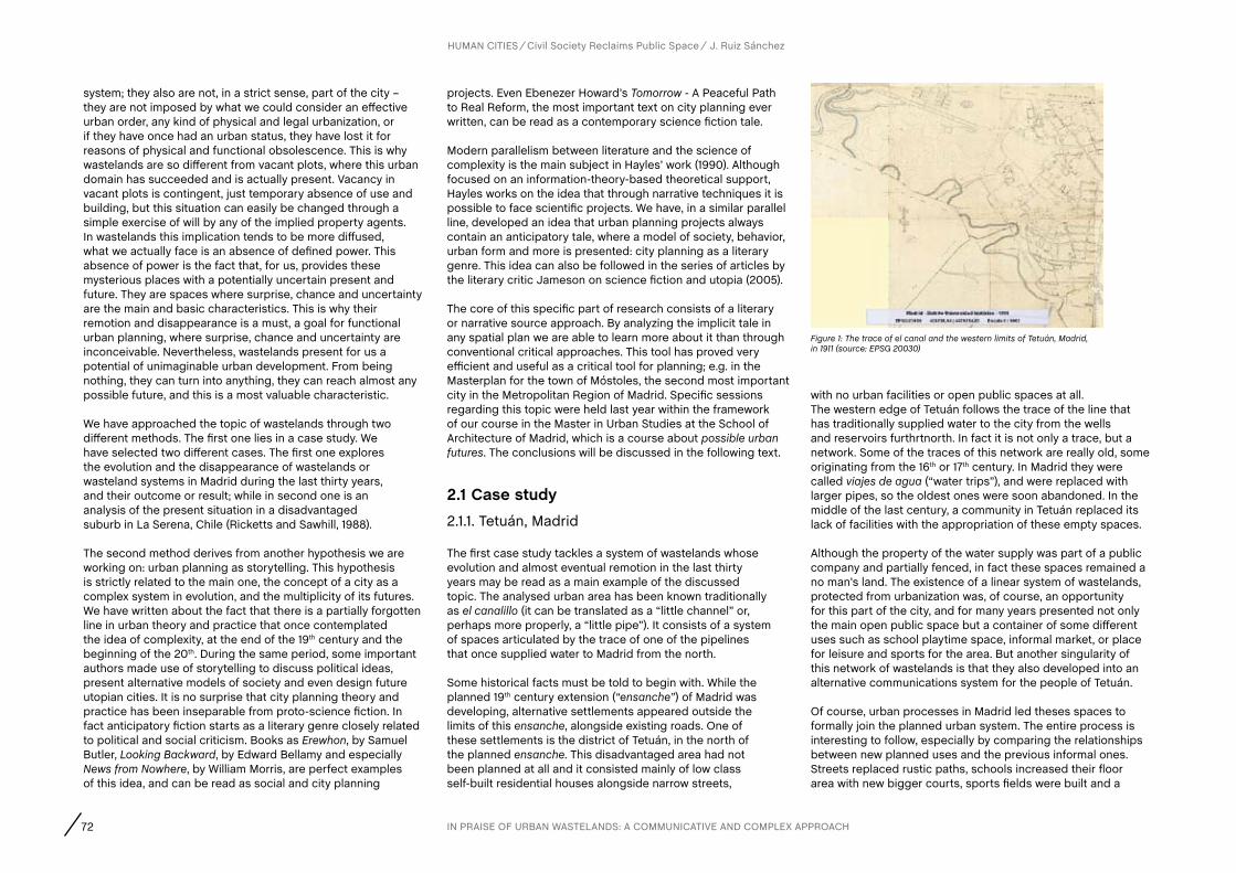
72
HUMAN CITIES Civil Society Reclaims Public Space J. Ruiz Sánchez
system; they also are not, in a strict sense, part of the city – they are not imposed by what we could consider an effective urban order, any kind of physical and legal urbanization, or if they have once had an urban status, they have lost it for reasons of physical and functional obsolescence. This is why wastelands are so different from vacant plots, where this urban domain has succeeded and is actually present. Vacancy in vacant plots is contingent, just temporary absence of use and building, but this situation can easily be changed through a simple exercise of will by any of the implied property agents. In wastelands this implication tends to be more diffused, what we actually face is an absence of defined power. This absence of power is the fact that, for us, provides these mysterious places with a potentially uncertain present and future. They are spaces where surprise, chance and uncertainty are the main and basic characteristics. This is why their remotion and disappearance is a must, a goal for functional urban planning, where surprise, chance and uncertainty are inconceivable. Nevertheless, wastelands present for us a potential of unimaginable urban development. From being nothing, they can turn into anything, they can reach almost any possible future, and this is a most valuable characteristic.
We have approached the topic of wastelands through two different methods. The first one lies in a case study. We have selected two different cases. The first one explores the evolution and the disappearance of wastelands or wasteland systems in Madrid during the last thirty years, and their outcome or result; while in second one is an analysis of the present situation in a disadvantaged suburb in La Serena, Chile (Ricketts and Sawhill, 1988).
The second method derives from another hypothesis we are working on: urban planning as storytelling. This hypothesis is strictly related to the main one, the concept of a city as a complex system in evolution, and the multiplicity of its futures. We have written about the fact that there is a partially forgotten line in urban theory and practice that once contemplated the idea of complexity, at the end of the 19th century and the beginning of the 20th. During the same period, some important authors made use of storytelling to discuss political ideas, present alternative models of society and even design future utopian cities. It is no surprise that city planning theory and practice has been inseparable from proto-science fiction. In fact anticipatory fiction starts as a literary genre closely related to political and social criticism. Books as Erewhon, by Samuel Butler, Looking Backward, by Edward Bellamy and especially News from Nowhere, by William Morris, are perfect examples of this idea, and can be read as social and city planning
projects. Even Ebenezer Howard’s Tomorrow - A Peaceful Path to Real Reform, the most important text on city planning ever written, can be read as a contemporary science fiction tale.
Modern parallelism between literature and the science of complexity is the main subject in Hayles’ work (1990). Although focused on an information-theory-based theoretical support, Hayles works on the idea that through narrative techniques it is possible to face scientific projects. We have, in a similar parallel line, developed an idea that urban planning projects always contain an anticipatory tale, where a model of society, behavior, urban form and more is presented: city planning as a literary genre. This idea can also be followed in the series of articles by the literary critic Jameson on science fiction and utopia (2005).
The core of this specific part of research consists of a literary or narrative source approach. By analyzing the implicit tale in any spatial plan we are able to learn more about it than through conventional critical approaches. This tool has proved very efficient and useful as a critical tool for planning; e.g. in the Masterplan for the town of Móstoles, the second most important city in the Metropolitan Region of Madrid. Specific sessions regarding this topic were held last year within the framework of our course in the Master in Urban Studies at the School of Architecture of Madrid, which is a course about possible urban futures. The conclusions will be discussed in the following text.
2.1 case study2.1.1. Tetuán, Madrid
The first case study tackles a system of wastelands whose evolution and almost eventual remotion in the last thirty years may be read as a main example of the discussed topic. The analysed urban area has been known traditionally as el canalillo (it can be translated as a “little channel” or, perhaps more properly, a “little pipe”). It consists of a system of spaces articulated by the trace of one of the pipelines that once supplied water to Madrid from the north.
Some historical facts must be told to begin with. While the planned 19th century extension (“ensanche”) of Madrid was developing, alternative settlements appeared outside the limits of this ensanche, alongside existing roads. One of these settlements is the district of Tetuán, in the north of the planned ensanche. This disadvantaged area had not been planned at all and it consisted mainly of low class self-built residential houses alongside narrow streets,
with no urban facilities or open public spaces at all. The western edge of Tetuán follows the trace of the line that has traditionally supplied water to the city from the wells and reservoirs furthrtnorth. In fact it is not only a trace, but a network. Some of the traces of this network are really old, some originating from the 16th or 17th century. In Madrid they were called viajes de agua (“water trips”), and were replaced with larger pipes, so the oldest ones were soon abandoned. In the middle of the last century, a community in Tetuán replaced its lack of facilities with the appropriation of these empty spaces.
Although the property of the water supply was part of a public company and partially fenced, in fact these spaces remained a no man’s land. The existence of a linear system of wastelands, protected from urbanization was, of course, an opportunity for this part of the city, and for many years presented not only the main open public space but a container of some different uses such as school playtime space, informal market, or place for leisure and sports for the area. But another singularity of this network of wastelands is that they also developed into an alternative communications system for the people of Tetuán.
Of course, urban processes in Madrid led theses spaces to formally join the planned urban system. The entire process is interesting to follow, especially by comparing the relationships between new planned uses and the previous informal ones. Streets replaced rustic paths, schools increased their floor area with new bigger courts, sports fields were built and a
Figure 1: The trace of el canal and the western limits of Tetuán, Madrid, in 1911 (source: EPSG 20030)
IN PRAISE OF URBAN WASTELANDS: A COMMUNICATIVE AND COMPLEX APPROACH
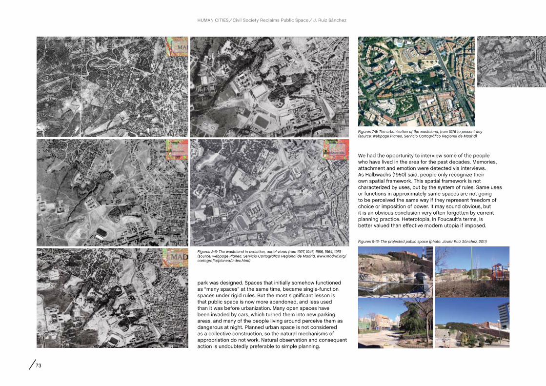
73
park was designed. Spaces that initially somehow functioned as “many spaces” at the same time, became single-function spaces under rigid rules. But the most significant lesson is that public space is now more abandoned, and less used than it was before urbanization. Many open spaces have been invaded by cars, which turned them into new parking areas, and many of the people living around perceive them as dangerous at night. Planned urban space is not considered as a collective construction, so the natural mechanisms of appropriation do not work. Natural observation and consequent action is undoubtedly preferable to simple planning.
We had the opportunity to interview some of the people who have lived in the area for the past decades. Memories, attachment and emotion were detected via interviews. As Halbwachs (1950) said, people only recognize their own spatial framework. This spatial framework is not characterized by uses, but by the system of rules. Same uses or functions in approximately same spaces are not going to be perceived the same way if they represent freedom of choice or imposition of power. It may sound obvious, but it is an obvious conclusion very often forgotten by current planning practice. Heterotopia, in Foucault’s terms, is better valued than effective modern utopia if imposed.
HUMAN CITIES Civil Society Reclaims Public Space J. Ruiz Sánchez
Figures 2-6: The wasteland in evolution, aerial views from 1927, 1946, 1956, 1964, 1975 (source: webpage Planea, Servicio Cartográfico Regional de Madrid, www.madrid.org/cartografia/planea/index.html)
Figures 7-8: The urbanization of the wasteland, from 1975 to present day (source: webpage Planea, Servicio Cartográfico Regional de Madrid)
Figures 9-12: The projected public space (photo: Javier Ruiz Sánchez, 2011)

74
2.1.2. La Serena, Chile.
Las Compañías is a semi-formal urban development in La Serena, Chile, on the other side of the river Elqui. As demonstrated by ongoing research undertaken by Tapia Cerda (2012 -), these wastelands, as a unit, form an effective structural network in the suburb, different from the formally conceived and planned system, and that it works not only in an alternative way but in a much closer relationship with people. In Las Compañías this is correlated with real measured deficits in actual urban space. But these deficits do not derive directly from city planning. Planning in La Serena contemplates a set and a number of places for different urban facilities according to strictly regulated standards. What Tapia Cerda has demonstrated is that planned spaces do not work as a communicative network.
places and their role as spaces for key social experiences. It is the daily needs of the community and not planning process, that generates the urban order of suburbs,.
Tapia Cerda has established a preliminary taxonomy of wastelands, and their different role in the system. (i)Consolidated wastelands are those that have also been observed and incorporated into formal planning; their main characteristic is that they present a high level of inertia to change, and a low level of evolvability. (ii) Interstitial wastelands have a high level of autonomy and their own urban logic; they are the spaces dismissed by the planning process as spaces of conflict; but the main characteristic is that they can reach several future conditions, and they are key to future urban evolution. These are maybe the most interesting of wastelands. (iii) Residual wastelands differ
from the previous ones because of their dependence on a higher-level urban structure, such as residual places near roads or infrastructures; they are unable to be occupied and are resilient to change. [iv] Obsolete wastelands are those created by the obsolescence of great physical structures; they provide a wide variety of circumstances in their urban dynamics. These can be considered like the Interstitial wastelands under several conditions. [v] “Vague” wastelands are remains of natural countryside encapsulated within the urban system, such as brooks, ravines or similar; their role in future evolution of the city lays in the fact that they often have a linear form and are perceived as or can turn into natural paths or borders according to Lynch’s taxonomy of perceptive elements in The image of the city (Lynch, 1960).
An important preliminary conclusion in Tapia Cerda’s work is a close relationship between social dynamics and the evolution of the forms of appropriation and the use of wastelands.
2.2. a cultural approach: Planning as story telling2.2.1. Stalker
The Strugatski brothers are among the most important science fiction writers of the cold war Soviet Union. By following some of the most interesting traditions in science fiction they surpass the limits of the genre to approach critical views, particularly on the relationship between individual’s freedom and the collective-political power. They usually use the idea of alternative futures to question the processes of decision making, what can be governed and what cannot, what can be understood or not understood, what can be effectively planned and what cannot, and the role of chance in possible or probable futures. In 1972 they published one of their most famous novels, Пикник на обочине/Picnic na obochinie/Roadside picnic. The novel describes “the Zone”, a place where some extraterrestrial beings have stopped and camped for a brief period of time. Nothing is known about the intention or purpose of their visit, only that each zone remains as a place where conventional or human physics, knowledge or rules do not work anymore. Their main characteristic is their “otherness”. They are other, strange, uncanny places, full of wonderful objects which can offer great experiences but also where you can easily find death. Stalkers are the only people who dare to enter these places full of wonder and danger. Each of their adventures is like and initiation trip. The zone is the main place to experience personal development.
HUMAN CITIES Civil Society Reclaims Public Space J. Ruiz Sánchez
Figure 13: Taxonomy of wastelands in Las Compañías, La Serena, Chile (source: Tapia Cerda, 2012)
Figure 16: Residual wastelands (Retazos por servidumbre Canal Jaramillo + Condominio Social)
Figure 17: Obsolete wastelands (Ruinas Fundicion Lambert (1850 aprox) - Sector Sur Las Compañias)
Figure 18: “Vague” wastelands (Quebrada SEctor Villa El Romero)
Figure 15: Interstitial wastelands (Descampado intersección Av. Viña del Mar con calle Colombia)
Figure 14: Consolidated wastelands (Plaza Vecinal Villa San Bartolomé)
Artificial planning establishes a design of the city based on the idea of imposing rules of domination to people belonging to a lower class. It is another case of a tale or a story written by the dominant power far from the one written by its own heroes. Planned facilities do not work as spatial references for people living in Las Compañías. So the organization of public spaces and social relationships lay on a different layer, and this layer is better determined by the existence of a network of wastelands not considered by formal planning.
Tapia Cerda’s research on what is really happening in these wastelands demonstrates that wastelands are key spaces in the dynamics and evolution of a city quarter or a neighbourhood. He defines wastelands as “those residual places urban entropy has left as regulators of the social dynamics of the suburb”. This points out the polysemic character of these Figures: 14-18 (source: Tapia Cerda, 2012)
IN PRAISE OF URBAN WASTELANDS: A COMMUNICATIVE AND COMPLEX APPROACH
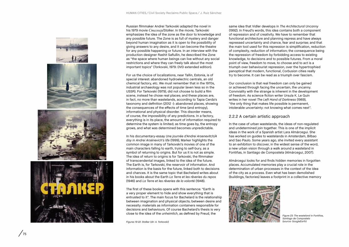
75
Russian filmmaker Andrei Tarkovski adapted the novel in his 1979 movie Сталкер/Stalker. In the movie, Tarkovski emphasizes the idea of the zone as the door to knowledge and any possible future. The Zone is as full of mystery and danger beyond human imagination as it is open to the possibility of giving answers to any desire, and it can become the theatre for any possible happening or future. In an interview with the production designer Rashit Safiullin, he described the Zone as “the space where human beings can live without any social restrictions and where they can freely talk about the most important topics” (Tarkovski, 1979: DVD extended edition).
For us the choice of localizations, near Tallin, Estonia, is of special interest: abandoned hydroelectric centrals, an old chemical factory, etc. We must remember that in the 1970s, industrial archaeology was not popular (even less so in the USSR). For Tarkovski (1979), did not choose to build a film scene, instead he chose real places; and these places are, in fact, no more than wastelands, according to Tapia Cerda’s taxonomy and definition (2012 -): abandoned places, showing the consequences of the effects of time (and entropy), informational and physical disorder. This disorder means, of course, the impossibility of any predictions. In a factory, everything is in its place, the amount of information required to determine the system is limited; as time goes by, the entropy grows, and what was determined becomes unpredictable.
In his documentary-essay Une journée d’Andrei Arsenevitch/A day in Andrei Arsénevich’s life (1999), Marker highlights the common image in many of Tarkovski’s movies of one of the main characters falling to earth, trying to self-bury, as a symbol of returning to origins. But for us it is not as simple. The idea of return to origins is for Tarkovski, the filmmaker of transcendental images, linked to the idea of the future. The Earth is, for Tarkovski, the reservoir of information. And information is the basis for the future, linked both to decisions and chances. It is the same topic that Bachelard writes about in his books about the Earth La Terre et les rêveries du repos (1946) and La Terre et les rêveries de la volonté (1948).
The first of these books opens with this sentence: “Earth is a very proper element to hide and show everything that is entrusted to it”. The main focus for Bachelard is the relationship between imagination and physical objects; between desire and necessity: materials as information containers responsible for decisions and behaviours. Of course Bachelard’s thesis is very close to the idea of the unheimlich, as defined by Freud, the
same idea that Vidler develops in The Architectural Uncanny (1992). In Freud’s words, this idea contains both a component of repression and of creativity. We have to remember that functional architecture and planning repress and have always repressed uncertainty and chance, fear and surprise; and that the main tool used for this repression is simplification, reduction of complexity, reduction of information; the consequence being the repression of freedom by forbidding access to existing knowledge, to decisions and to possible futures. From a moral point of view, freedom to move, to choose and to act is a triumph over behaviourist repression, over the hypertrophied panoptical that modern, functional, Corbusian cities really try to become. It can be read as a triumph over fascism.
Our conclusion is that real freedom can only be gained or achieved through facing the uncertain, the uncanny. Conviviality with the strange is inherent in the development of freedom. As science fiction writer Ursula K. Le Guin writes in her novel The Left Hand of Darkness (1969), “the only thing that makes life possible is permanent, intolerable uncertainty: not knowing what comes next”.
2.2.2 A certain artistic approach
In the case of urban wastelands, the ideas of non-regulated and undetermined join together. This is one of the implicit ideas in the work of a Spanish artist Lara Almárcegui. She has worked on guides to wastelands in Amsterdam, Bilbao and Sao Paulo. Some years ago, she invited every assistant to an exhibition to discover, in the widest sense of the word, a new urban vision through a walk around a wasteland in Fontiñas, in Santiago de Compostela (Almárcegui, 2007).
Almárcegui looks for and finds hidden memories in forgotten places. Accumulated memories play a crucial role in the determination of urban processes in the context of the idea of the city as a process. Even what has been demolished (buildings, factories) leaves a footprint in a collective memory
HUMAN CITIES Civil Society Reclaims Public Space J. Ruiz Sánchez
Figures 19-22: Stalker (dir: A. Tarkovski)
Figure 23: The wasteland in Fontiñas, Santiago de Compostela (source: GoogleEarth)
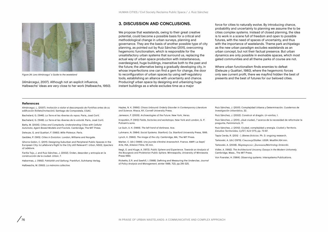
76
(Almárcegui, 2007). Although not an explicit influence, Halbwachs’ ideas are very close to her work (Halbwachs, 1950).
HUMAN CITIES Civil Society Reclaims Public Space J. Ruiz Sánchez
Figure 24: Lara Almárcegui´s Guide to the wasteland
3. DIScUSSION aND cONcLUSIONS.
We propose that wastelands, owing to their great creative potential, could become a possible basis for a critical and methodological change in urban surveys, planning and governance. They are the basis of another possible type of city planning, as pointed out by Ruiz Sánchez (2011), overcoming hegemonic functionalism, which is responsible for the unsatisfactory urban systems that surround us, replacing the actual way of urban space production with instantaneous, overdesigned, huge buildings, insensitive both to the past and the future; the alternative being a gradually developing city, in whose imperfections one can find a gem for change, the door to reconfiguration of urban spaces by using self-regulatory tools, establishing an alliance with uncertainty and chance. Producingf urban space by designing and urbanizing huge instant buildings as a whole excludes time as a major
force for cities to naturally evolve. By introducing chance, probability and uncertainty to planning we assume the to be cities complex systems. Instead of closed planning, the idea is to work in a scene full of freedom and open to possible futures, with the need of spaces of uncertainty, and thus with the importance of wastelands. Theme park archipelago as the new urban paradigm excludes wastelands as an urban concept, but not their factual presence. But urban dynamics are only possible in evolvable spaces, which most gated communities and all theme parks of course are not.
Where urban functionalism finds enemies to defeat (Deleuze y Guattari, 1980), where the hegemonic forces only see current profit, there we mayfind hidden the best of presents and the best of futures for our beloved cities.
ReferencesAlmárcegui, L. (2007). Invitación a visitar el descampado de Fontiñas antes de su edificación (folleto/invitación). Santiago de Compostela, CGAC.
Bachelard, G. (1946). La Terre et les rêveries du repos. Paris, José Cortí.
Bachelard, G. (1948). La Terre et les rêveries de la volonté. Paris, José Cortí.
Batty, M. (2005). Cities and Complexity. Understanding Cities with Cellular Automata, Agent-Based Models and Fractals. Cambridge, The MIT Press.
Deleuze, G. and Guattari, F. (1980). Mille Plateaux. Paris.
Geddes, P. (1915). Cities in Evolution. London, Williams and Norgate.
Ghorra-Gobin, C. (2011). Designing Suburban and Peripheral Public Spaces in the European City: Is Lefebvre’s Right to the City still Relevant?. Urban, NS02, Specters of Lefebvre.
Fariña Tojo, J. and Ruiz Sánchez, J. (2002). Orden, desorden y entropía en la construcción de la ciudad. Urban, 7.
Habermas, J. (1992). Faktizität und Geltung. Frankfurt, Suhrkamp Verlag.
Halbwachs, M. (1950). La mémoire collective.
Hayles, N. K. (1990). Chaos Unbound: Orderly Disorder in Contemporary Literature and Science. Ithaca, NY, Cornell University Press.
Jameson, F. (2005). Archaeologies of the Future. New York, Verso.
Kropotkin, P. (1913) Fields, factories and workshops. New York and London, G. P. Putnam’s sons.
Le Guin, U. K. (1969). The left hand of darkness. Ace.
Luhmann, N. (1984). Social Systems. Stanford, Ca. Stanford University Press, 1995.
Lynch, K. (1960). The image of the city. Cambridge, MA, The MIT Press.
Marker, C. (dir.) (1999). Une journée d’Andrei Arsenevitch. France. AMIP, La Sept/Arte, INA, Arkeion Films. 55 min.
Negt, O. and Kluge, A. (1972). Public Sphere and Experience. Towards an Analysis of the Bourgeois and Proletarian Public Sphere. Minneapolis, University of Minnesota Press 1993.
Ricketts, E.R. and Sawhill, I. (1988). Defining and Measuring the Underclas. Journal of Policy Analysis and Management, winter 1988, 7(2), pp.316-325.
Ruiz Sánchez, J. (2001). Complejidad Urbana y Determinación. Cuadernos de Investigación Urbanística, 32.
Ruiz Sánchez, J. (2002). Construir el dragón. Ur-vanitas, 1.
Ruiz Sánchez, J. (2011). ¿Qué ciudad…? acerca de la necesidad de reformular la pregunta, Feminismo/s, 17.
Ruiz Sánchez, J. (2012). Ciudad, complejidad y energía. Ciudad y Territorio. Estudios Territoriales, CyTET, XLIV (171), pp. 73-87.
Tapia Cerda, R. (2012 - ). Bienes ficticios. Ph. D. ongoing research.
Tarkovski, A. (dir.) (1979). Сталкер/Stalker. USSR. Mosfilm.164 min.
Tarkovski, A. (2008). Мартиролог: Дневники/Martirolog: Dnievniki.
Vidler, A. (1992). The Architectural Uncanny. Essays in the Modern Unhomely. Cambridge, Mass., The MIT Press.
Von Foerster, H. (1984). Observing systems. Intersystems Publications.
IN PRAISE OF URBAN WASTELANDS: A COMMUNICATIVE AND COMPLEX APPROACH
AUTHORS
Abstract
CHAPTER
77 R. Houlstan-Hasaerts, B. Tominc, M. Nikšič, B. Goličnik Marušić (Editors) Urbani izziv - publikacije, Ljubljana, May 2012
contact
Keywords
Mahmoud KeshavarzPhD Candidate, School of Arts and Communication, Malmö Univeristy, 205 06, Malmö, Sweden,+46(0)40-66 58694, [email protected]
Free translation, sensory worlds, demystification of languages, conflictual space, emancipation
Practice-based researchers in the design field usually adopt anthropological methods for ‘observing’ or ‘studying’ the field in order to come up with some ‘design solutions’ for a provocative co-designing of socio-political spaces. Usually such approaches move in the direction of legitimization of the ‘design knowledge’. What designers in socio-political action research do is an act of translation, which in various stages of the action gets different shapes (e.g. between their own knowledge and participants’ knowledge).Translation always tries to fill the cracks between an unknown space and a known one. Therefore translation becomes a functional and hierarchical bridge for those who do not know the origin’s language. But such a bridge has many cracks, which in a ‘good translation’ are not visible to readers but only to the translator. Therefore the translator, by hiding these cracks, never allows readers to engage in the work. However these cracks are fundamentally important for understanding the positioning and self-reflexivity occurring during the research.This paper draws a retrospective reflection upon the process of collaboration with women rights activists in Iran and Sweden. By adopting a new politics of translation called ‘ free translation’ 5, I argue that action research in the design field needs such a re-situational method for formulating actions in other contexts, where the first language is not familiar with the second, third and so on. A free translation brings up questions of ‘qualification’, ‘power’ and ‘ legitimization’ and opens a space for more engagement by intensifying the cracks in disciplines, knowledge and contexts.
Malmö (Sweden)Mahmoud Keshavarz
‘FREE TRANSLATION’ AS A CRITICAL METHOD IN SOCIO-POLITICAL DESIGN ACTIONS
1. INTRODUcTION
Today, design researchers adopt a mixture of research methodology to conduct research in social and political issues. More often doing research in socially and politically engaged design means you are involved with a ‘research through practice’ (Koskinen et al, 2011) or ‘participatory action research’. The issues that are discussed and addressed in such ways of doing research are complicated and complex on many various levels. One of the critical issues is the notion of ‘public’ and how the research practice makes new ‘publics’ to come. The other central issue is of course the notion of the ‘other’ in such projects. In academic discourse, also there is concern of how much such engagement would contribute to design and how much design contributes to expanding the notion of the political and social. These issues along with others and the demand of pragmatism in design discourse have created a blurry and confusing realm of theory and practice for design in social and political contexts where various ‘trends’ and categories for practicing and researching design have emerged.
Therefore, a range of alternative formulations of design, often amended as ‘social’, ‘activist’, ‘critical’, ‘relational’, ‘humanitarian’, etc. design, are amassing an increasing number of examples, public exposure and theoretical depth (Mazé & Redström, 2009; Ericson & Mazé, 2011). Associated design practitioners often operate in the public sector, the academy, the cultural sphere and even the developing world – rather than adopting the more traditional or mainstream orientation of design as a ‘service profession’ to industry. This is not, however, a mere matter of replacing clients in the corporate sector for those in the public sector (cf. Julier, 2011; Mazé & Llorens, 2011) – public and societal actors operate in relation to a particular social complexity that market or industrial models do not address (Westley and Antadze, 2009). The ‘public’ is constituted by the widest range of people and groups with a right to speak and to be represented, and the public realm is characterized by uncertainties, contradictions and controversies (Latour & Weibel, 2005; Hinchcliffe & Whatmore,
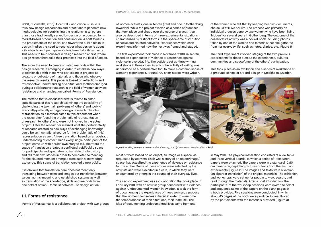
78 ‘FREE TRANSLATION’ AS A CRITICAL METHOD IN SOCIO-POLITICAL DESIGN ACTIONS
HUMAN CITIES Civil Society Reclaims Public Space M. Keshavarz
2006; Cucuzzella, 2010). A central – and critical – issue is thus how design researchers and practitioners generate new methodologies for establishing the relationship to ‘others’ than those traditionally served by design or accounted for in market-based production and consumption. A shift towards the problematic of the social and toward the public realm in design implies the need to reconsider what design is about – its objects and, perhaps more fundamentally, its subjects. This needs to be discussed in design research at first, where design researchers take their practices into the field of action.
Therefore the need to create situated methods within the design research is emerging in order to establish new ways of relationship with those who participate in projects as creators or collectors of materials and those who observe the research results. This paper is based on reflections and retrospective understanding of a situational method emerged during a collaborative research in the field of women activism, resistance and emancipation called ‘Forms of Resistance’.
The method that is discussed here is related to some specific parts of this research examining the possibility of challenging the two main problems of ‘others’ and ‘public’ in socially-politically engaged design research. The idea of translation as a method came to this experiment when the researcher faced the problematic of representation of research to ‘others’ who were not involved in the actual project. Later the researcher realized what the performativity of research created as new ways of exchanging knowledge could be an inspirational source for the problematic of (mis) representation as well. A free translation based on an abstract understanding of context made every single participant of the project come up with her/his own story to tell. Therefore the space of translation created a conflictual void/public space for participants and spectators to translate the told story and tell their own stories in order to complete the meaning for the situated moment emerged from such a knowledge exchange. This space of translation created a new public.
It is obvious that translation here does not mean only translating between texts and images but translation between values, norms, meaning and established systems as well as translation of the knowledge, skills and methods from one field of action – feminist activism – to design action.
1.1. forms of resistance
‘Forms of Resistance’ is a collaboration project with two groups
of women activists, one in Tehran (Iran) and one in Gothenburg (Sweden). While the project evolved as a series of practices that took place and shape over the course of a year, it can also be described in terms of three experimental situations, characterized by distinct forms in the space-time distribution of social and situated activities. Experiences within each experiment informed how the next was framed and staged.
The first experiment took place in November 2010, in Tehran, based on experiences of violence or resistance against violence in everyday life. The activists set up three writing workshops in three cities, in which the activity of writing was understood as a performative tool to make a common sense of women’s experiences. Around 100 short stories were written,
of the women who felt that by keeping her own documents, she could still live her life. The process was primarily an individual process done by two women who have been living ‘hidden’ for several years in Gothenburg. The outcome of the collaborative activity was a pocket book including photos taken by one of the women and materials that she gathered from her everyday life, such as notes, diaries, etc. (Figure 1).
The third experiment involved staging of the two previous experiments for those outside the experiences, cultures, communities and space/time of the others’ participation.
This took place as an exhibition and a series of workshops at a graduate school of art and design in Stockholm, Sweden,
most of them based on an object, an image or a space, as requested by activists. Each was a story of an object/image/space that actualized the experience of violence or resistance for the author. Some of these stories were selected by the activists and were exhibited in a café, in which they were encountered by others in the course of their everyday lives.
The second experiment was a collaboration that took place in February 2011, with an activist group concerned with violence against ‘undocumented’ women in Sweden. It took the form of documenting the experiences of these women, a process that the women themselves initiated in order to overcome the temporariness of their situations, their ‘bare life’. The idea of documenting undocumented lives came from one
in May 2011. The physical installation consisted of a low table and three vertical boards, to which a series of transparent papers were attached. The papers were in a standard 10x10 cm dimension, depicting pictures or texts from the first two experiments (Figure 2). The images and texts were a version (an abstract translation) of the original materials. The exhibition and workshops were set up for people to view, search, and read through the materials. After a brief introduction, the participants iof the workshop sessions were invited to select and sequence some of the papers on the blank pages of a book provided. Five sessions were conducted, in which about 45 pages of the book were produced, co-authored by the participants with the materials provided (Figure 3).
Figure 1: Working Process in Tehran and Gothenburg, 2010 (photo: Maziar Rezai & Trifa Shakely)

79
HUMAN CITIES Civil Society Reclaims Public Space M. Keshavarz
1.2. ‘Other/Public’ and the discipline in forms of resistance: The need for a situated methodForms of Resistance with its own particular issues that it addresses or challenges, has two main critical and central issues. One is the problematic of the ‘other’ and the ‘public’ that this ‘other’ makes. How does this ‘other’ participate in a process of research and how does the researcher establish a relation to the other. Moreover, who is this ‘other’? Are they only the ones who participate in the project or the spectators who will see the results of mid-way research in another space, or the same spectators who are still participants in the longer research project? How much research in such issues will allow the readers, audiences and spectators of the research to become critical subjects and engage in the work, not as consumers, but as a singular addendum, who together with the ‘other’ make the public?
The second problem is the disciplinary force of design. Designers have a far greater reverence for the usage of their own language – design knowledge, skills and grammar – than for the spirit of foreign works, including social activism and feminism studies. If we consider social activism as an original language then we might be able to allow our language – design – ‘to be powerfully affected by the foreign tongue’ or social activism. It could be one of the emancipatory gates for expanding the notion of design and overcoming the limitations in particular design studies.
Nevertheless we should bear in mind that prioritizing a foreign language – a distant discipline - and attempting to revolutionize our own language – our discipline - should happen in a form of immanent process and not in a superficial way, just through changing the surface of our own language. As Walter Benjamin (1995:81) states: “The basic error of the translator is that he preserves the state in which his own language happens to be instead of allowing his language to be powerfully affected by the foreign tongue. Particularly when translating from a language very remote from his own he must go back to the primal elements of language itself and penetrate to the point where work, image, and tone converge. He must expand and deepen his language by means of the foreign language.”
Based on the politics of translation called free translation inspired from ‘The Task of Translator’ written by Walter
Benjamin, What matters here is how much a good translation reproduces those mentioned problems and how much a free or bad translation can keep a tension between the origin and destination in order to give a chance for spectators to be emancipated and not be ‘others’ versus creators. We should not put others versus creators/participants just because we should not put others versus spectators.
This means that as much as we make ‘others’ versus participants we reinforce others versus spectators. By this we make a chaotic situation of Babblic languages; a situation where subjectivity has no space/time to come, where collectiveness becomes ideological and dangerous, where human beings are afraid of each other because simply they do not understand each other.
Therefore the task of translation is not just translating from the field to the exhibiting but also vice versa. Action research in design needs translation as a politics of formulating the design actions in other contexts, where the first language is not familiar with the second, third and so on. This process is not a historical process, but a process of looking into itself for removing the territories that a project creates during its process.
By this radical act, we do not get stuck in the loop of signs and implications but rather we go for contradictions, shortcomings and cracks of languages and their contexts/situations, where the leftovers, refuse and trash of a language are buried. A so-called ‘good translation’ closes its eyes to all of these hidden aspects of language or at least is not able to see them, but a bad translation in fact confronts with such shocking aspects of languages.
2. fREE TRaNSLaTION: a cRITIcaL METHOD
Design as a practice itself translates ideas (and ideologies) into tangible and enduring forms, which order meaning, perception, movement, interaction and behaviour of society (Dovey, 1999; Winner 1995). But what is discussed here as an act of translation is a critical and negative engagement both for breaking the foundation of design knowledge/practice and addressing ‘others’ in critical ways.
Traditional understandings of the task of translation in design replaces the language of origin with raw material or main content and the language of destination with design outcomes, in order to reach new audiences. What we need is a new formulation of translation in design, a new
Figures 2 and 3: Exhibition at Konstfack University College of Arts, Crafts and Design, Stockholm, 2011. (photo: Vijai Patchineelam)
80
formulation based on critical and negative engagement. Benjamin provides us with such a formulation: “Translation is an irrelevant and inappropriate task. The translation is a mortal act. An act which is result of a contemporary and mortality fact itself. Translator is a clear existent which the light of the content (text) is crossing through her body and language, but the cracks and shortcomings of her language are visible as well” (Mehregan, 2007:14).
Translation is a temporary act which by that those who do not know one language get to know issues written, told, visualized in other languages until they learn the language themselves. Translation is an act for a time that one common language is not possible. Translation also is connected not only to the original text but also to the afterlife of the text: “[j]ust as the manifestations of life are intimately connected with the phenomenon of life without being of importance to it, a translation issues from the original-not so much from its life as from its afterlife” (Benjamin, 1995).
Here I consider the design researcher as the translator and see both the discipline of design and materials created in the two first experiments as the origin language and the action of feminist activism and the public space of spectatorship in the third experiment as the destination language.
2.1. ‘free translation’ and its consequences
Translation always tries to fill the cracks between an unknown space and a known one. Therefore translation becomes a functional bridge for those who do not know the origin’s language. But this bridge has many cracks which in a good translation are not visible to readers but only to the translator.
Therefore the translator, by hiding these cracks, never allows readers to engage in the work and explore in more depth. These cracks are basically important to understand one from another, and to reveal the cracks we need to reveal a situation. By this, we see the challenges, shortcomings and contradictions of that situation; in fact it also enables us to define a critical path; a negative dialectic between ‘the other’ and us. Translation is something in between, an act which can wear the critical uniform for developing both sides by using this crack in between. As Benjamin says: “Fragments of a vessel which are to be glued together must match one another in the smallest details, although they need not be like one another. In the same way a translation, instead of resembling the meaning of the original, must lovingly and in detail incorporate the original’s
mode of signification, thus making both the original and the translation recognizable as fragments of a greater language, just as fragments are part of a vessel” (Benjamin, 1995 : 78).
So translation should stand in a position to sustain this tension and not remove it. This means by sustaining the tension we will be able to identify one from another in order to develop the language on both sides (or at least bring up the question of developing languages). This basically goes to what we know as ‘free translation’ or ‘bad translation’ or ‘literal translation’. A translation which does not deliver the meaning but only has a form which shows the cracks of the translator’s ability, the cracks of the origin language/work and the destination language too:“[…] a free translation bases the test on its own language. It is the task of the translator to release in his own language that pure language which is under the spell of another, to liberate the language imprisoned in a work in his re-creation of that work” (Benjamin, 1995 : 80).
Design action should take ‘free translation’ not only as the politics of doing and staging but also as an act for putting the practice in the challenge; the challenge of meaning and form. This gives the design researcher the ability to release a new language which has been always repressed by other languages.
The idea of free translation questions the democratic process of engaging. I proposed that we should not put others versus spectators or creators versus others, but this does not mean we have to displace them or simply replace their roles. On the contrary, it means only by a free translation are we able to make explicit the tension which leads us to a space for removing the language territories of both sides. This democratic space of activities is a space of storytellers and translators who dialect in order to expand their ability for understating and not consuming the meanings which are produced on both sides.
An example of conflictual space provided by free/bad translation is an animal aspect which is never foreseeable without a free translation. The animal aspect of language comes out with free translation. A free translation which focuses on form more than meaning is not meaningless but a complex of meaningfulness and divagation. A complex of human and animal voices.
We do not feel good when we read a bad or free translation, since we are confronted with a scary language, with an animal aspect of the text. For instance, here, I translate a random Persian text to English
with a bad translation to see what is happening:“Power, benefits, any type government or idea, government religious or nonreligious with any system, a hole is even for that system to life own continues. One from reasons collapse Eastern Bloc perhaps was that hole necessary inside system (that let moving to the system) filled”. (Keshavarz, 2011).
There is a shocking aspect in this text. It is like the words that are coming out of an insane mouth. This shocking aspect comes from confronting any animal aspect that is embedded in any human act. We can understand the text a bit but not completely. We can see the cracks in the content of the text as well. The cracks of the language –English in this case – and cracks of the translator’s ability – myself – are visible to us. Contrary to a good translation which never allows you to enter the transparent realm of language conflicts, this translation confronts us with a more transparent/democratic space of conflicts, which is even scary.
Therefore, if a designer positions herself/himself as a bad/free translator perhaps she/he – among readers – would be able to see the shortcomings of the context she/he is working with (the socio-political context of their work) as well as the design context. This helps her/him to expand the self-reflexivity of her/his actions during research.
In addition they will be able to challenge their design language to expand it through words they borrow from the origin’s language. By putting discourses from the original language into the destination language they engage in a critical path for understanding who they are, what could be their position and how much their position/contribution is relevant, efficient and progressive. In fact, this negative aspect of critical/bad translation opens up a space for subjectivity and self-awareness of the designer and their audiences.
2.2. The politics of translation
As I argued above, the consequences of free translation are providing a conflictual and agonistic space for engagement, as well as giving the opportunity for self-reflexivity to the researcher by looking into their cracks while they are doing the act of translation from one field to another, from one context to another. One more consequence is of course to challenge the discipline of the researcher/practitioner – design – in order to expand it through the inspiration from the destination language. Here I will analyse one consequence in detail that says how such a method
HUMAN CITIES Civil Society Reclaims Public Space M. Keshavarz
‘FREE TRANSLATION’ AS A CRITICAL METHOD IN SOCIO-POLITICAL DESIGN ACTIONS
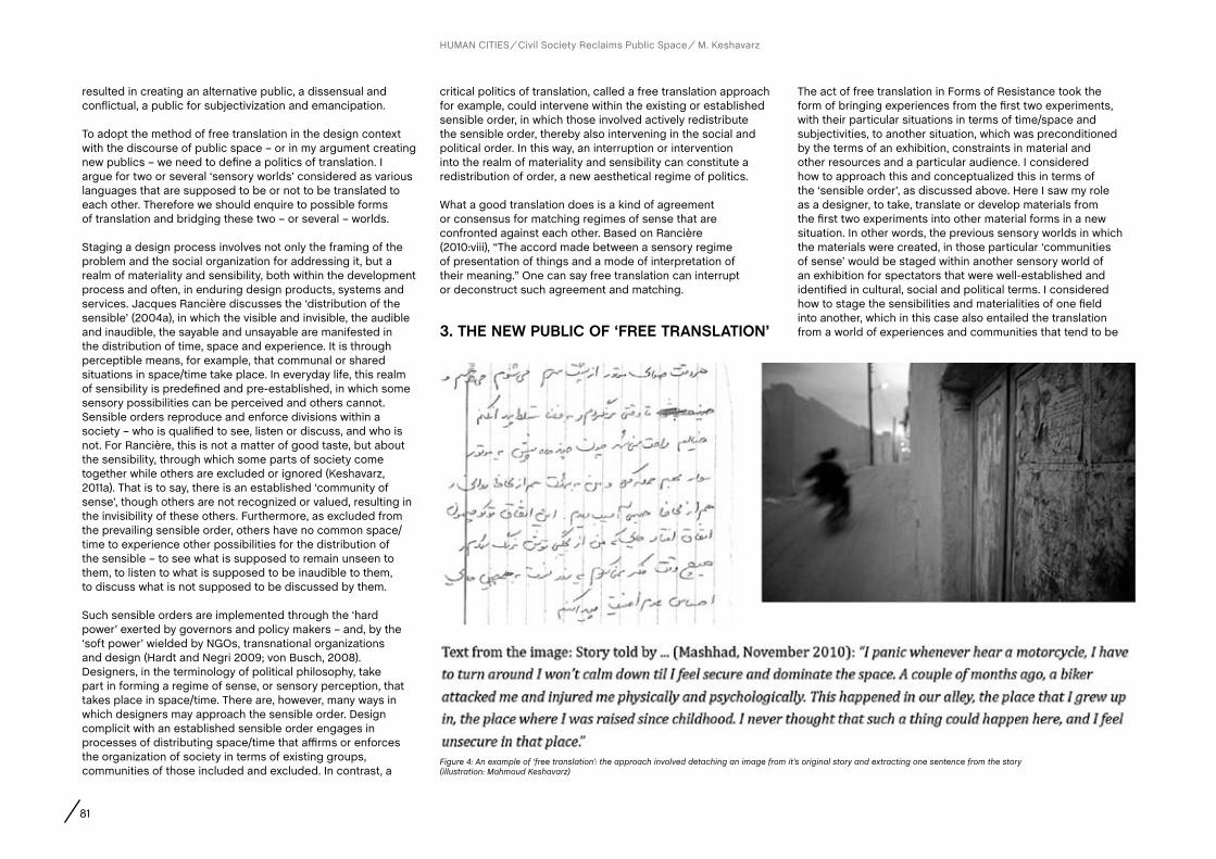
81
resulted in creating an alternative public, a dissensual and conflictual, a public for subjectivization and emancipation.
To adopt the method of free translation in the design context with the discourse of public space – or in my argument creating new publics – we need to define a politics of translation. I argue for two or several ‘sensory worlds’ considered as various languages that are supposed to be or not to be translated to each other. Therefore we should enquire to possible forms of translation and bridging these two – or several – worlds.
Staging a design process involves not only the framing of the problem and the social organization for addressing it, but a realm of materiality and sensibility, both within the development process and often, in enduring design products, systems and services. Jacques Rancière discusses the ‘distribution of the sensible’ (2004a), in which the visible and invisible, the audible and inaudible, the sayable and unsayable are manifested in the distribution of time, space and experience. It is through perceptible means, for example, that communal or shared situations in space/time take place. In everyday life, this realm of sensibility is predefined and pre-established, in which some sensory possibilities can be perceived and others cannot. Sensible orders reproduce and enforce divisions within a society – who is qualified to see, listen or discuss, and who is not. For Rancière, this is not a matter of good taste, but about the sensibility, through which some parts of society come together while others are excluded or ignored (Keshavarz, 2011a). That is to say, there is an established ‘community of sense’, though others are not recognized or valued, resulting in the invisibility of these others. Furthermore, as excluded from the prevailing sensible order, others have no common space/time to experience other possibilities for the distribution of the sensible – to see what is supposed to remain unseen to them, to listen to what is supposed to be inaudible to them, to discuss what is not supposed to be discussed by them.
Such sensible orders are implemented through the ‘hard power’ exerted by governors and policy makers – and, by the ‘soft power’ wielded by NGOs, transnational organizations and design (Hardt and Negri 2009; von Busch, 2008). Designers, in the terminology of political philosophy, take part in forming a regime of sense, or sensory perception, that takes place in space/time. There are, however, many ways in which designers may approach the sensible order. Design complicit with an established sensible order engages in processes of distributing space/time that affirms or enforces the organization of society in terms of existing groups, communities of those included and excluded. In contrast, a
critical politics of translation, called a free translation approach for example, could intervene within the existing or established sensible order, in which those involved actively redistribute the sensible order, thereby also intervening in the social and political order. In this way, an interruption or intervention into the realm of materiality and sensibility can constitute a redistribution of order, a new aesthetical regime of politics.
What a good translation does is a kind of agreement or consensus for matching regimes of sense that are confronted against each other. Based on Rancière (2010:viii), “The accord made between a sensory regime of presentation of things and a mode of interpretation of their meaning.” One can say free translation can interrupt or deconstruct such agreement and matching.
3. THE NEW PUBLIc Of ‘fREE TRaNSLaTION’
The act of free translation in Forms of Resistance took the form of bringing experiences from the first two experiments, with their particular situations in terms of time/space and subjectivities, to another situation, which was preconditioned by the terms of an exhibition, constraints in material and other resources and a particular audience. I considered how to approach this and conceptualized this in terms of the ‘sensible order’, as discussed above. Here I saw my role as a designer, to take, translate or develop materials from the first two experiments into other material forms in a new situation. In other words, the previous sensory worlds in which the materials were created, in those particular ‘communities of sense’ would be staged within another sensory world of an exhibition for spectators that were well-established and identified in cultural, social and political terms. I considered how to stage the sensibilities and materialities of one field into another, which in this case also entailed the translation from a world of experiences and communities that tend to be
Figure 4: An example of ‘free translation’: the approach involved detaching an image from it’s original story and extracting one sentence from the story (illustration: Mahmoud Keshavarz)
HUMAN CITIES Civil Society Reclaims Public Space M. Keshavarz

82
invisible or marginalized into a world of factual spectators.The confrontation, or frontier, between these two worlds, can also be understood in the terms of dissensus, in which we understand dissensus not as a conflict between an ‘enemy’ and a ‘friend’ (Corcoran, 2010), but “a total break with the existing state of affairs in order to create something absolutely new” (Mouffe, 2007:5). The potential could be for the design role – that is, myself and the design materials – to propose an interruption, a break within one world, seen and realized as ‘factual present’, in which another invisible, excluded or not present could somehow be represented. The conflict needs not take the form of confrontation among opinions and interests but a break, a shock or an interruption in the way we percept and experience the world in which we are presently located, and its sensible and social orders that are taken for granted.
In design terms, we might approach the ‘community of sense’ concretely in terms of the “combination of sense data such
Between the experiences of the original creators of the text and image forms (in the first two experiments), and factual spectators (in the third), I developed my role more specifically in terms of a politics of translation that I call ‘free translation’. In this, my concern was to develop my own design approach to how the translation was done, in which part of my intention was to leave space for spectators to make their own meaning out of given materials. Rather than attempting direct or transparent translations, I chose to make the original stories more and more abstract (Figure 4 & Figure 5).
A spectator, by placing and staging a piece of text close to another text or image that is unrelated in terms of its original sources or meanings, might experience a conflictual situation in the ‘system of meaning’, since it is presented in an unfamiliar way. The order of meaning, produced outside the field of the spectator, is both interrupted and produces a disruption within the process of staging, introducing an act of interpretation, personalization and subjectivization by the spectator (Figure 6).
My intention in rendering the materials more abstract, in this instance of ‘free translation’, was to provoke a void in meaning, a space to be filled by a spectator who sees the materials, tries to make sense of them and does so in terms of their own experience. As Benjamin (1995:77) says:“A real translation is transparent; it does not cover the original, does not block its light, but allows the pure language, as though reinforced by its own medium, to shine upon the original all the more fully. This may be achieved, above all, by a literal rendering of the syntax which proves words rather than sentences to be the primary element of the translator. For if the sentence is the ‘wall before the language of the original, literalness is the arcade.”
In this way, she or he becomes a participant, engaging her or his own story within the space/time of materials within a given situation. Outside the field of the origins of the material or translation, a spectator enters – not the other’s field – but a new situation in which they also become active in interpreting and storytelling in relation to the shared theme: human experiences on violence. A ‘free translation’ results in materials through which a spectator relates to the theme and becomes a participant by staging images and words of someone else’s story in their own terms. If the spectator edits the material by deciding how to put an image or a word and close to what, she weaves her own sensory world into another world which is totally opposed to it. In this situation, the designer’s method acts to intensify a conflict between two sensory worlds. For me, ‘free translation’ was a method
developed as a critical engagement with the politics of the situation. The method was one way of staging an encounter between two worlds, in order to make a community of storytellers and spectators. It is this dissensual approach to community and the notion of public that has the potential to become emancipated, according to Rancière (2009 : 22).
4. DIScUSSION
A designer who is engaged in socio-political issues should take translation as a vital task, an important part of their work which resituates their work in conjunction with the ideology of the work or in opposite. One can say that a free translation is a form of resistance to the established meaning making a system both in the fieldwork and discipline.
The example in this paper is one way that design might query established sensible/social orders, in which the concepts of ‘free translation’ are operationalized to question, intensify, break down and reconfigure the frontiers between sensory worlds to create a public space for participation. These communities of translators and storytellers, through discursive and sensory capacities, interrupt the experience configured within a dominant, pre-established sensory world. The designer, by transforming their role as a translator, storyteller or facilitator of participation, contributes to opening a space of conflicts if they wish for democracy by their practice.
Moreover, what a designer did in this process was more
as forms, words, spaces, rhythms and so on” – but also in terms of multiple meanings of the term ‘sense’(Rancière, 2008). Given the collected materials from the first two experiments, words and images of experiences of violence and resistance, I considered how to stage a new public in terms of two regimes of sense, two sensory worlds, two sensible orders. I began to conceptualize an approach expanding the notion of ‘translation’, beyond the translation of images and texts. In between these two worlds, a translator does not dismiss the contradictions and conflicts between the two but acts to ‘intensify’ (von Busch, 2008) a conflictual situation in order to open a space for political subjectivization.
More specifically, I reflected on the role of the designer as translator by generating such shock or conflict among two regimes of sense, two languages, two communities of participants within a process proceeded by the participants’ storytelling (in Tehran and Gothenburg) and followed by the participants’ storytelling (in the exhibition in Stockholm).
Figure 5: The ‘free translation’ as staged in the exhibition (photo: Mahmoud Keshavarz)
Figure 6: A page resulting from storytelling in a workshop session. The image and text pieces, as interpreted and redistributed by a workshop participant (photo: Mahmoud Keshavarz)
HUMAN CITIES Civil Society Reclaims Public Space M. Keshavarz
‘FREE TRANSLATION’ AS A CRITICAL METHOD IN SOCIO-POLITICAL DESIGN ACTIONS
83
engaging critically and openly into their practice to see the cracks of their practice. Free translation can awake us from the dream we see about our own discipline as Paul De Man (1986: 86) states: “We think we are at ease in our own language, we feel a cosiness, a familiarity, a shelter in the language we call our own, in which we think that we are not alienated. What the translation reveals is that this alienation is at its strongest in our relation to our own original language, that the original language within which we are engaged is disarticulated in a way which imposes upon us a particular alienation, a particular suffering.”
Also we should consider that these complex layers of translation act and the relation to establishing ‘otherness’ and creating a public with a participation of various sensory worlds is gathered under the desire of the political. The political that in itself is not a higher project to be done but a set or collection of possible forms based on situations, experiences and contexts. A free common collectiveness provided by the means of a language that does not desire the implications and meaning but the language itself. Free translation by bringing up the surplus of languages called the leftovers, the excluded parts and basically
the rags and trashes of history being carried by the means of communication and language making, fosters its community of publics with its own space. Free translation can eventuate in occurrences of transgression in and the shift of public space. As Agamben (2000: 117) says: “[p]olitics is the sphere neither of an end in itself nor of means subordinated to an end; rather, it is the sphere of a pure mediality without end intended as the field of human action and of human thought. […] It is to articulate the location, the manners, and the meaning of this experience of the event of language intended as free use of the common.”
ReferencesAgamben, G. (2000). Means without End; Notes on Politics. Minneapolis, MN: University of Minnesota.
Benjamin, W. (1995). The Task of The Translator: An Introduction to the Translation
of Baudelaire’s Tableaux Parisiens in Benjamin, W., Arendt, H.(Eds). Illuminations: Reflections and Essay. Schoken Books, pp.69-83.
Corcoran, S. (2010). Introduction in Rancière, J., Dissensus: on Politics and Aesthetics. London: Continuum, 2010.
Cucuzzella, C. (2010). Collaborative Design in A Context of Sustainability. In Proceedings of ERSCP-EMSU Conference ‘Knowledge Collaboration & Learning for Sustainabile Innovation’, 25-29 Oct 2010, Delft, the Netherlands.
De Man, P. (1986). Resistance to Theory, Minneapolis: University of Minnesota Press. pp.73-105.
Dovey, K. (1999). Framing Places: Mediating Power in Built Form. London: Routledge, 1999.
Ericson, M. and Mazé, R. (eds) (2011). DESIGN ACT: Socially and politically engaged design today. Berlin: Sternberg / Iaspis.
Hinchliffe, S. and Whatmore, S. (2006). Living Cities: Towards a Politics of Conviviality. Science as Culture 15, no. 2, 123-138, 2006.
Hardt, M. and Negri, A. (2009). Commonwealth, Cambridge: Harvard University Press.
Julier, G. (2011). Political Economies of Design Activism and the Public Sector. In Proceedings of the Nordic Design Research conference. Helsinki: NORDES.
Keshavarz, M. (2011a). Opening the Space of Experience: On Political Forms of Aesthetics in Design, Proceedings of 9th International European Academy of Design (EAD09), Porto, Portugal, 2011, pp. 777-87.
Keshavarz, M. (2011b). Forms of Resistance: the political and re-situated design, MFA thesis in Experience Design, Konstfack University College of Arts, Craft and Design, Stockholm.
Koskinen, I., Binder, T., Redström, J., Wensveen, S. and Zimmerman, J. (2011). Design Research Through Practice: Lab, Field and Showroom. San Francisco, Morgan Kaufmann.
Latour, B. and Weibel, P. (eds.) (2005). Making Things Public: Atmospheres of Democracy. Cambridge, MA: MIT Press, 2005.
Mazé, R. and Llorens, N. “How does it happen and what does it take? Tactics in Contemporary Design,” in DESIGN ACT, Mazé and Ericson (Eds.), 103-146. Berlin: Sternberg / Iaspis, 2011.
Mazé, R. and Redström, J. (2009). Difficult Forms: Critical practices of design and research. Research Design Journal, 1 (1). pp. 28-39.
Mehregan, O. (2007). Theology of Translation: Walter Benjamin and the Task of Translator. Rokhdad-e-No Pub.
Mouffe, C. (2007). Artistic Activism and Agonistic Space. Art & Research 1, No.2 , summer 2007). Available at: http://www.artandresearch.org.uk/v1n2/mouffe.html (accessed 27th October 2011).
Rancière, J. (2004). The Politics of Aesthetics: The Distribution of the Sensible. Trans. Gabriel Rockhill. London: Continuum Press.
Rancière, J. (2008). Aesthetic community, Aesthetic Separation. Art & Research 2, No.1. Summer 2008. Available at: http://www.artandresearch.org.uk/v2n1/ranciere.html (accessed 29th October 2011).
Rancière, J. (2009). The Emancipated Spectator. London, New York: Verso.
Rancière, J. (2010). Chronicles of Consensual Times. London, Continuum.
Von Busch, O. (2008). Fashion-able: Hacktivism and engaged fashion design. HDK, Göteborg. Available at:
http://www.hdk.gu.se/files/document/fashion-able_webanspassahd%20avhandling_OttovonBusch.pdf (accessed 27th October 2011).
Westley, F. and Antadze, N. (2009). Making a Difference: Strategies for Scaling Social Innovation for Greater Impact. The Innovation Journal 15(2), 2009.
Winner, L. (1995). Political Ergonomics. In Discovering Design: Explorations in Design Studies, Buchanan, R. and Margolin, V. (Eds) 146-170. Chicago, IL: University of Chicago Press, 1995.
Notes1 Previously, I have used the term ‘bad translation’ to explain my idea of translation borrowed from Benjamin (for example, Keshavarz, 2011b). Now, I prefer to use the term ’free translation’. The idea is still the same, but this term may better avoid the misunderstanding of the term as ‘bad’ in the sense of ’improper’. Instead, I understand this kind of translation as a ‘good’ thing. Moreover, ‘free translation’ resonates with related ideas in poetry, in which the translation of a poem is not possible except by engaging in a more free-form translation by another poet in destination language. In effect, another poet in another language translates the poem of the original to create a third poem, which is related to my idea of storytellers and translators.
acknowledgements
‘Forms of Resistance’ was developed during 2010-2011 with participants Samaneh Abedini, Delaram Ali, Hoda Aminian, Elnaz Ansari, Parvin Ardalan, Azadeh Faramarziha, Setareh Hashemi, Andrea Hjalmarsson, Nahid Jafari, K.K., Helena Parsmo, Maryam Rahmani, Maziar Rezai, Trifa Shakely, Maryam Zandi and as a collaboration between the ‘Change for Equality Campaign’ in Iran and in Sweden, ‘Ain’t I A Woman’ in Gothenburg and the Interactive Institute in Stockholm. I would like to thank Christina Zetterlund and Ramia Mazé, the main advisors of the ‘Forms of Resistance’ for their support, advise and critcisim during the project. I have to mention that parts of this paper are deveopled during writing another paper with Ramia Mazé. Thanks to Johan Redström for his comments and support during the project. Thanks to Jackson Oldfield for edition and review. I also would like to thank the Department of Design, Crafts and Arts (DKK) of Konstfack University College and Helge Ax:son Johnsons Foundation in Stockholm, Sweden for providing me a grant to conduct a part of the field work.
HUMAN CITIES Civil Society Reclaims Public Space M. Keshavarz

AUTHORS
Abstract
contact
CHAPTER
84 R. Houlstan-Hasaerts, B. Tominc, M. Nikšič, B. Goličnik Marušić (Editors) Urbani izziv - publikacije, Ljubljana, May 2012
Keywords
1. INTRODUcTION
Post-apartheid South Africa has seen a dramatic shift in social, economic-political as well as spatial dynamics of cities in the country. From the days of racial segregation, South African cities today are faced with different challenges ranging from rapid urbanisation, increasing infrastructure demand, urban sprawl, service delivery backlogs, to global competition and access into markets (Garner, 2011 and Winkler, 2009). Johannesburg stands as an economic powerhouse of the country and as a result, many of its urban policies are geared towards attracting investment through regeneration of the inner city. This includes bold plans such as the construction of the Nelson Mandela Bridge (Figure 1) as a way of linking the wealthier northern parts of the city to the inner city and to inner city social housing to encourage people to reside in the inner city again. As a result, the city has focused many of its resources attempting to sell investments and rebranding of the city that
Potsiso PhashaMasters Student (Development Planning), University of the Witwatersrand, Johannesburg, Private Bag 3 Wits 2050 Johannesburg, South Africa,+27 73 731 6829, [email protected]
Autophotogrpahy, public space appropriation, urban youth, bottom-up research methods
Professions such as urban planning have searched for innovative alternative ways of conducting research as a way of moving away from conventional qualitative methods such as interviews, which have dominated qualitative research. Autophotography – a visual method growing popular in social sciences, is slowly beginning to feature in the methodological landscape of urban research. In this method, participants become the photographers, thus providing a rich reflection of their realities from their own perspectives. Through such a method, the paper discusses various ways in which street skaters and street artists have appropriated public space (mainly in the form of streets) for their own needs in Johannesburg, South Africa. It argues that urban change is not only a top-down initiative but also a bottom-up process and using innovative methods that echo this, much can be leant about cities from bottom-up. Through this less paternalistic method adopted, the paper begins to demonstrate how a criticism of paternalistic methods is useful. It further highlights the sort of knowledge that skaters and artists possess about the city and how as urban practitioners, we have overlooked such knowledge, failing to adequately acknowledge its existence thus failing to grasp the complexity of the city. In the end, it is shown how planners need to develop a sensitive attitude in successfully conducting research that gives a less paternalistic understanding of the city, especially when working in culturally diverse and rapidly changing urban environments.
Johannesburg (South Africa)Potsiso Phasha
AUTOPHOTOGRAPHY: A TOOL FOR RECORDING WAYS IN WHICH STREET SKATERS AND STREET ARTISTS HAVE APPROPRIATED SPACE IN JOHANNESBURG
Figure 1: Linking the north and south: Mandela Bridge (photo: Potsiso Phasha)

85 AUTOPHOTOGRAPHY: A TOOL FOR RECORDING WAYS IN WHICH STREET SKATERS AND STREET ARTISTS HAVE APPROPRIATED SPACE
HUMAN CITIES Civil Society Reclaims Public Space P. Phasha
has tended to not pay as much attention to the expression of the youth. Resulting from the neo-liberal city planning strategies in place (Winkler, 2009), young people have thus had their expressions limited and marginalised from the everyday life of the city (Sheppard, 2009), including public spaces.
Due to this marginalisation from public spaces, some cultural forms of expression (such as street art and street skating) are seen “as an effort by marginalised and powerless young people to inscribe their living space with meaning against high odds, also in response to brutal and destructive processes of neighbourhood decline, unemployment, crime and so forth” (Breitbart, 1998: 306). In Johannesburg as in cities around the world, young people have increasingly made their mark in public spaces every day through street skating and street art. The skaters and artists have appropriated public space in their respective ways and this has brought new meaning to public space; it has introduced a new dialogue in public spaces and new social ties have emerged as a result of their appropriation of space. Through autophotography, a visual research method, the paper discusses the ways in which some skaters and street artists have appropriated public space (mainly in the form of streets) for their own needs within the city.
The paper argues that urban change is not only a top-down initiative but it is also a bottom-up process. By using innovative methods that echo this sentiment, much can be learnt about cities from the ground up. Through autophotography, a less paternalistic method, the paper begins to demonstrate how a criticism of paternalistic methods is useful. It further highlights the sort of knowledge that skaters and artists possess about the city. As urban practitioners, we have overlooked such knowledge; failed to adequately acknowledge its existence thus failing to grasp the complexity of the city. The paper thus highlights the relevance of autophotography as a method of enquiry, as well as the significance of street art and skating as fresh ways of reading the city. At the end of the paper, it is shown how planners through their research need to develop less paternalistic approaches – methods that realise the insight of urban dwellers in understanding the city, especially when working with culturally diverse and rapidly changing urban environments.
2. METHODS
A range of research approaches has been applied in this research. They are presented and commented here below.
2.1 a case study perspective
As already suggested, the paper engages with street skaters and street artists as case study subjects in the research. According to AAPS (undated: 5), a case study approach “refers to a process in which a case is examined in detail and analysed in depth using research tools most appropriate to the enquiry”. Placing greater emphasis on the actors over the actual spaces they occupy was important in the research as this group of users – both skaters and artists, are mobile and spontaneous. Spaces are constantly interchanged and renegotiated with authorities, new ones being discovered as the skaters and artists traverse the city to find suitable spaces where they can exercise their respective activities. Through this perspective, the research was able to fully understand the various ways in which the actors appropriate spaces as well as interrogating the emerging key perceptions of public space as such perceptions have often proved to inform the reasons behind certain spaces being appropriated. This approach also demonstrated a strong need to deeply engage with and learn from the participants as much as possible, going beyond the surface of their cultures. This approach begins to seek lessons and inspirations for urban planners in complex, heterogeneous societies.
2.2 Snowball sampling, insider researcher
Due to the nature of the two youth subcultures in the study (street skating and street art), snowball sampling grew increasingly useful in assisting to select research participants. As hinted earlier, these two case study groups are highly spontaneous. Their presence is unpredictable and thus required a method that would assist in identifying participants even where they were not easy to find. According to Atkinson and Flint (2001: 2), snowball sampling can be defined as “a technique for finding research subjects. One subject gives the researcher the name of another subject, who in turn provides the name of a third, and so on.” This technique is very useful in studies seeking to access difficult to reach or hidden populations (ibid). Snowball sampling makes it possible for researchers to dig deeper in their query through every informant they interact with in the process because the method takes advantage of the social networks of identified respondents to provide a researcher with an ever-expanding set of potential contacts (Thomson, 1997). With the expanding network, I quickly gained trust from both skaters and artists as I had one of their own always introducing me to the next.
As I was snowball sampling, the way that I presented myself
before the skaters and artists also mattered. Being young, I did not want to be seen as an outsider foreign to street skating as this might make the participants uneasy and thus unwilling to share their experiences. As I used to skate in the past, the way I dress continues to be very similar to how most of the skaters dress including the shoes, t-shirts and the brands. According to Dwyer and Buckle (2009), my having been a skater although in the past, and currently still sharing that interest with the participants makes me an insider in the research process. “Insider research refers to when researchers conduct research with populations which they are also members of, so that the researcher shares an identity, language and experiential base with the study participants” (ibid: 58). This came as a positive attribute because it implied that the participants would be more open and trusting, and thus increased the depth and understanding of the study (ibid). However, this brought along its own challenges. The biggest challenge in being an ‘insider researcher’ is the fact that the researcher needs to be aware of the scientific goals he or she needs to achieve from the study and also not confuse the two roles s/he is now endowed with – researcher and insider. Confusing the two roles might result in data being distorted, where the researcher’s experiences overshadow those of the participants (Adler and Adler, 1987).
2.3 autophotography
They key method of inquiry in this study has been autophotography. This is a visual qualitative research method using images, in which the photography is conducted by research participants themselves (Johnsen et al., 2008). Participants are given a set of questions that they need to answer by taking pictures with provided disposable cameras. It is therefore self-directed photography in trying to research a particular topic of interest to the researcher, even though photographs are produced by participants and not by the researcher (Phasha, 2010). The method is used mostly in the field of social sciences and assists researchers to know more about the participants, the way in which they see and understand their immediate environments on a day-to-day basis (Dollinger & Dollinger, 2003). Participants are presented with the opportunity to tell their stories from their perspectives by the taking photographs.
In undertaking autophotography, each group of participants – skaters and artists, had its own set of questions with each one designed to achieve different goals. Questions aimed at skaters sought to reveal how space is used within a given time, how such spaces are identified and what other options
86
HUMAN CITIES Civil Society Reclaims Public Space P. Phasha
the skaters have if their usual spaces cannot be access for whatever reason. For the artists, the questions sought an understanding of how street art essentially comes to shape public space from their perspective, how they select and eventually claim spaces where they would paint, the dangers involved and how the artists deal with various perceptions of their work and their presence in public space. It would not have been sensible to have a single set of questions for both skaters and artists as the two groups perceive and use pubic space in very different ways. By separating the questions, it was also envisioned that the different perceptions of public spaces would be documented from two groups of young people in the city of Johannesburg; groups that both contribute to the youth culture in the city and have devised creative ways of negotiating their place in the city through the way they interact with public space. By doing so, a backdrop would be provided against which the different reasons behind the appropriation of public space by youth in the city could be etched.
Autophotography has therefore been used widely due to its great utility in examining how participants understand and interpret the world and their place within it (Johnsen, et al, 2008). According to Hansen (2008), young people have largely been misunderstood in African cities and autophotography as a method begins to challenge preconceived notions of youth as a social group because they are in charge of the photography, communicating their perceptions of space through the camera. As Johnsen et al. (2008) maintain, photographs act as tangible resources helping research participants tell a narrative about themselves (and their everyday geographies) that retains a solid sense of social and personal context. The method thus excels in empowering young people and acknowledging their existence in cities. It is for this reason that autophotography became the ideal method in studying a group of young people that have been marginalised in the city of Johannesburg due to the identities and activities they practice in public space.
After the photographs had been taken, photo-interviews followed where each participant elaborated on each of their photographs. The purpose of photo-interviews was to clarify or extract thoughts, ideas and meanings behind each photograph as these are abstract themes which would prove to be challenging to identify by simply looking at the photograph (Phasha, 2010). As Harper (1994: 410) holds, “in the photo-elicitation interview, interview/discussion is stimulated and guided by the images”. The purpose of the photo-interviews was to therefore encourage a discussion, to motivate the participant to share their experiences, memories and stories stimulated by the photograph. This is an excellent
technique that not only leads participants to be confident in the knowledge that they posses, but the technique ensures an in-depth perspective as well, because the researcher can probe further question as the participant begins to be comfortable.
2.4 Ethics and the quest for a less paternalistic, bottom-up methodThe use of autophotography even from previous studies (Phasha, 2010) has been grounded in the fact that the method yields very rich results in understanding the city from the perspective of young people who occupy it. According to Hansen (2008), ‘youth’ is always understood as a stage, a process that young people go through on their way to becoming adults. The stage is never studied and perceived even by the members of society as an independent unit that should be studied and understood on its own. In fact even when defining ‘youth’, we use a definition that relates ‘youth’ to children and adults (Fornas, 1995). For this reason, I have found autophotography to begin to challenge those broad misconceptions about young people in cities such as Johannesburg. A good starting point became public space – as a space they inhabit more than any other age group (Hansen, 2008).
Autophotography has thus been a model that has worked well in criticising paternalistic ways of understanding the city, methods that are traditionally one-dimensional and portray the researcher as the ultimate source of knowledge (Orb et al, 2001). In criticising such top-down and prescriptive methods, autophotography acknowledges that the language used by researchers in interviews and questionnaires creates frames within which knowledge is realised (Johnsen, et al., 2008). The manner in which questions in interviews are asked always hints for a particular kind of answer. Whilst with a less paternalistic method such as autophotography, the participant has more freedom in that regard. It is up to the participant what they take picture of in answering a given question in an autophotographic study. The realisation of knowledge through this approach is made more fluid and interesting – the participant is not intimidated by the researcher’s knowledge and thus freer and willing to share his or her experiences with the researcher (Phasha, 2010).
According to Orb et al. (2001), one of the ethical issues to consider in any qualitative research is the participant-researcher relationship because it is imbued with power dynamics. Before the data-gathering process is even initiated,
the participant is by default lower than the researcher in terms of power dynamics because he or she is perceived to be big and powerful due to their association with institutions such as universities (Phasha, 2010). This information may result in the participant being shy and made to feel insignificant and irrelevant in a traditional top-down research method. Visual and engaging methods such as autophotography break that power dynamic by giving the participant a camera to generate research images – thus breaking any tension that might exist in that relationship (Garrod, 2008).
Other ethical considerations include the fact that “the research process further creates tension between the aims of research to make generalisations for the good of others, and the rights of participants to maintain privacy” (Orb et al., 2001: 93). As a researcher and due to the methods adopted in this study, the participants reveal information that they would otherwise not share with other members of society. My being an insider as discussed earlier, it implies that I now have access to certain information that is private. The research aims were to learn as rigorously as possible about the process in which the two groups of young people are actively involved in, and how they appropriate public space for their own needs in the city. Both street skating and street art are insurgent activities to a large extent and the tension that results from revelations made by the participants as well as the scientific goals of the study – objectivity and providing as complete a picture as possible, is great. The participants have revealed where they paint in the city, where they skate in the city and often enough as they do, they encounter JMPD (Johannesburg Metro Police Department), SAPS (South African Police Services) officials, as well as private security guards that react strongly at their sight. As a researcher, how does one then reflect, scientifically, on such knowledge but in a way that the privacy of the participant is retained? At placing less emphasis on the participant’s right to privacy, one may begin to violate that right. At focusing too much on the civil and human rights of the participant, the study may also end up being empty and without adequate context. Hence the fight for a perfect balance should be something that the qualitative researcher always keeps in mind.
Therefore as desirable as it is to encourage less paternalistic methods, when not carefully monitored they might result in the position of the participants being jeopardised. By getting the participants to reveal as much as possible through autophotography, for example, there is now a greater chance of their respective worlds changing because certain knowledge about those spaces they occupy has been publicised. It is a strong ethics question whether

87
to follow what is good for the research or what is good for the participant – and the strength of this dilemma becomes even more intensified when working with less paternalistic, bottom-up methods such a autophotography.
Moreover, “any research that includes people requires an awareness of the ethical issues that may be derived from such interactions, an enhanced level of understanding because qualitative research always deals with people and their experiences” (Orb et al., 2001: 93). Another issue that less paternalistic research methods need to be aware of is that working with methods such as autophotography, the disposable cameras are not always returned at the agreed time. Some participants will take a long time to return them placing the researcher under pressure. It would be unethical to begin to pressurise the participants in order to acquire the camera back and this might even change their entire attitudes towards the whole study. As a qualitative researcher working with such methods it is important that the researcher is aware of these possibilities in order to avoid facing ethical dilemmas when unpredictable situations emerge in the research process.
In summary, criticism against paternalistic research methods is necessary in order to break the monotony that has existed in the way we have always approached research as urban planners; the fixed and rigid methods that do not have any regard for the type of participants at hand nor the topic. Such conservative methods (Thrift, 2000) prevent us as built environment practitioners from being able to draw inspiration from everyday users of the city. We are not explicitly able to learn from the experiences and perspectives of the everyday lives in cities as shared by the actors. The smaller and intricate aspects of the city are not revealed as vividly as less paternalistic methods like autophotography and others show. Hence Goličnik Marušić (2011) maintains that although planning and design may create environments with much potential, it is the people in those spaces who make those environments effective. By considering methods that deeply engage public space users and thus paint a much richer image of the city, leading to a multidimensional understanding of the city, we are less prone to making mistakes and stereotypes about the city due to ill-informed data on which our planning decisions are made. Less prescriptive methods therefore make it possible to see new opportunities in qualitative research, clarifying ideas where language fails as the method relies primarily on photographs.
3. RESULTS
Although spaces of skating in the city have been revealed through the photography done by the skaters, there are no fixed skating spots in the city. Places to skate in are selected momentarily depending on whether there are security guards, high presence of the police or other aspects that might prevent their access onto the streets. When access is not possible, the skaters proceed to find alternative skating areas in the city. They always make a plan depending on the situations they face; there are no instances where they would have to go back home because they are prevented from skating in a particular part of the city – they always go elsewhere. As a result, we begin to see that street skating
is not an individual thing in the city although each skater has his or her own skateboard. There is a spirit of oneness, one that motivates them to be persistent in what they do.Newtown, the cultural precinct in the inner city, becomes a point of convergence where skaters from various other parts of the city including Soweto and Fordsburg meet. This is where all the skaters “warm up” by doing simple tricks that only require a flat surface, and then continue to skate through the city from there. In moving away from Newtown, they seek greater obstacles that they can use to hone their street skating skills. Therefore the way that the skaters move through the city as well as selecting spaces for appropriation is determined by the obstacles available in those spaces. They are constantly looking for new challenges to overcome. Hence no spaces
HUMAN CITIES Civil Society Reclaims Public Space P. Phasha
Figure 2: Newtown within the Johannesburg inner city (photo: Google Earth)
AUTOPHOTOGRAPHY: A TOOL FOR RECORDING WAYS IN WHICH STREET SKATERS AND STREET ARTISTS HAVE APPROPRIATED SPACE
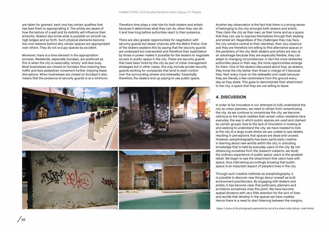
88
are taken for granted, each one has certain qualities that has lead them to appropriating it. The artists are aware of how the texture of a wall and its visibility will influence their artworks. Skaters also know what is possible on smooth tar, high ledges and so forth. Such physical elements become the core reasons behind why certain spaces are appropriated over others. They do not occupy spaces by accident.
Moreover, there is a time element in the appropriation process. Weekends, especially Sundays, are preferred as this is when the city is reasonably ‘empty’ and less busy. Most businesses are closed on Sundays thus meaning less traffic and less pedestrian movement further implying fewer disruptions. When businesses are closed on Sundays it also means that the presence of security guards is at a minimum.
Therefore time plays a vital role for both skaters and artists because it determines what they can do, when they can do it and how long before authorities react to their presence.
There are also greater opportunities for negotiation with security guards but lesser chances with the Metro Police. One of the skaters explains this by saying that the security guards are underpaid but overworked and therefore their exploitation by those in power makes it possible for the skaters to negotiate access to public space in the city. These are security guards that have been hired by the city as part of urban management strategies but in other cases, this may include private security guards working for companies that tend to exert control over the surrounding streets and sidewalks. Essentially therefore, the skaters end up paying to use public space.
Another key observation is the fact that there is a strong sense of belonging to the city amongst both skaters and artists. They claim the city as their own, as their home and as a space that they can use to express themselves through their skating and street art. Regardless of the challenges they may face, the city remains central to their identities, their very essence and they are therefore not willing to find alternative spaces in the periphery of the city. Both skaters and artists are also at an advantage because they are especially flexible, they can adapt to changing circumstances. In fact the more obstacles authorities place in their way, the more opportunities emerge for them. One of the skaters discussed about how, as skaters, they know the city better than those in charge of it because they ‘feel’ every crack on the sidewalks and roads because they are literally a few centimeters from the ground every day as they skate. This goes to demonstrate their attachment to the city, a space that they are not willing to leave.
4. DIScUSSION
In order to be innovative in our attempts to fully understand the city as urban planners, we need to refrain from romanticising the city. As we continue to romanticise the city, we become oblivious to the harsh realities that certain urban residents face everyday, the way in which public spaces are used and claimed by certain groups. Due to the lack of innovation in looking at and seeking to understand the city, we have insisted to look at the city at a large scale where we are unable to see details, resulting in perceptions that spaces are dead and unused. However, autophotography has been particularly creative in learning about new worlds within the city, in unlocking knowledge that is held by everyday users of the city. By not distancing ourselves from the research subjects, we study the ordinary experience of public space users to the greatest detail. We begin to see the attachment that users have with space, thus intervening accordingly knowing that public space is an important aspect of people’s lives in the city.
Through such creative methods as autophotography, it is possible to discover new things about oneself as built environment practitioners. By engaging with skaters and artists, it has become clear that politicians, planners and architects sometimes miss this point. We have become spatial dictators with very little attention for the sort of lives and worlds that develop in the spaces we have created. Hence there is a need to start listening between the margins,
HUMAN CITIES Civil Society Reclaims Public Space P. Phasha
Figure 3: Some of the photographs generated by one of the street artists (photo: Juliet White)
89
seeking some level of contact with occupants of public space (Carr, 1970). As Goličnik Marušić (2011) also suggests, it is important to include, within the process of collecting data, the people who occupy those spaces – especially if it is young people. The knowledge that has been unlocked through autophotography suggests that no matter how much we know as planners, architects and politicians, we always fall short because those that inhabit public space every day, possess the raw knowledge that is informed by their experiences in those spaces. We fail to recognise the ingenuity of young people in the city owing to the fact that we as planners often tend to conclude that knowledge ends with us.
Another trace of innovativeness in appropriated spaces by skaters and artists in Johannesburg rests in the fact that the two activities are able to initiate dialogue. It sets the terrain for both planners and urban inhabitants to talk because these are unusual and very visual activities taking place in public space. Within those discussions, broader issues concerning the city may be raised such as the inability of authorities in dealing with dilapidating buildings and in marginalising young people in the city. Therefore these activities are also a different way of communicating with others outside the realms of skating or street art. To receive the message however, one needs to attentively listen to and observe subcultures as they may begin to suggest bigger problems facing the city but at the same time, hint at solutions as well – i.e. they need to be studied in order for policy to be more effective.
Regarding methods therefore, paternalistic approaches with their top-down character where the researcher is seen as having the ultimate knowledge without participants becoming involved, pose problems of their own. The problem lies in their exclusive nature as the researcher claims primary knowledge over the subject at hand. In a city such as Johannesburg where such research methods have been predominantly adopted, young people that are already marginalised in a society are therefore pushed even further out by not being provided with a platform on which to voice their perspectives of the city. This persistent trend where researchers have distanced themselves with regard to subjects of their studies has resulted in many learning opportunities being missed where the everyday life in public spaces is not adequately understood. As a result, public space policy has been weak in its effectiveness because even when research is conducted, the respondent is not given a choice, no freedom to express their view of the city (Doxiadis, 1968), the same views that planners should consider in understanding the city from a bottom-up perspective. The marginalisation of young people because of the activities
they take part in is a political theme as the city has its own goal it needs to achieve. From a social perspective, those young people are also outcasts because even members of society perceive them as criminal. The bottom line however, is that a city has to be a place of imagination, visual stimulation, excitement and discovery. City-scale regeneration programs that sanitise and cleanse public spaces where decisions are made from the top; and with assumptions that all those developments can be driven by urban cultural regeneration leaves no place for creativity and imagination in the city. In ensuring creativity and imagination, methods that do not distance researchers from respondents become invaluable as we get to learn about people and their ways. As planners therefore we need to be more broadminded, avoiding planning monotonous and predictable spaces in the city. Carr (1970) talks about plasticity, or the ability of public spaces to be flexible enough to accommodate the actions of small groups and individuals. The skaters and artists have been able to emphasise the need for imaginative and flexible spaces in the city by appropriating what exists into something enjoyable and bringing a new character into public space. This adaptability of space should then become something planners and policy makers strive towards in our cities (Bentley et al, 1985).
Traditional urban planning thus learns that spontaneous activities such as street art and skating teach us about the city itself. These young people interact with spaces that planners do not often engage with. Even in those spaces that planners may be familiar with, the skaters in particular, are able to more directly and effectively point out and experience the faults of the conditions of the streets and the sidewalks. Borden (2002) holds that the sound of the skateboard over the grounds yields much more information about the quality and condition of the sidewalk than what the human eye would see. “As a skateboarder I feel it because I skate the city. I feel all the cracks because I am, like, 53mm away from the ground on my wheel. I feel what is going on in the city closer than most of these municipality guys do because they are driving in their cars” (Wandile, street skater). This reveals the ingenuity of the street skater and how they experience the city. As part of the new and refreshed way of thinking about the city and the place for young people, we need to start finding alternative ways of embracing that ingenuity. How do we creatively engage with young people to learn more about the city from their perspectives, and how do we then make those perspectives central to the way in which policy is formulated in the city? These are some of the key questions that should inspire us as planners to go beyond our traditional ways of thinking; to not only engage with certain elements
of the city from a distance and to also assist us to avoid making generalisations in our practices. What stands out however is the fact that the skaters and artists through their respective activities are able to underline faults in the city.
Another key lesson for planners is that there is a need for certain issues to be negotiated. The way that certain groups gain access to the city and actively become part of the city’s everyday life, the way that infrastructure is used, the way different group and individual identities express themselves and the way in which various forms of spaces are used, should be up for negotiation if we want the city to be an environment for everyone. In negotiating these aspects of the city with those active players, we are essentially promoting cultural diversity in our cities – which is the very soul of our cities (Madanipour, 2010). Hence a platform for negotiation means that we are beginning to acknowledge and show an enhanced level of interest in even the smallest of activities taking place in the city. However, how can we do that? This study has shown that by devising appropriate forms of engagement that are relevant for each type of social group, we can not only encourage discussion but creatively be able to raise some of the issues that need to be negotiated. Hence an appropriate methodology is a good start.
In encouraging a reinvention of how planners think about skaters and artists in the city, security guards for example, could be drawn into the management of some spaces in the city including those insurgent spaces. This suggestion emanates from the fact that both skaters and artists have identified private security guards as corrupt because they sometimes ask for bribes in order for the skaters to skate. “If you get caught, you just give them ten bucks and they leave you alone and then you can skate however you wanna skate. Because one: they are underpaid-overworked by all these people… so you are basically paying them; they get a double salary. They get a salary from me and a salary from the guy who runs the place” (Wandile, street skater). Why not make those same security guards the guardians of public space and remunerate them officially for protecting the spaces that young people use in the city instead of them receiving money from the skater and artists illegally? This would ensure some of the things that need to be negotiated for in the city (by young people, planners and politicians) could actually work in the favour of the youth. It is therefore another way of reassuring them that they still have a place in the city.
Additionally, the skaters and artists contribute to the social fabric of the city through their performative and visual
HUMAN CITIES Civil Society Reclaims Public Space P. Phasha
AUTOPHOTOGRAPHY: A TOOL FOR RECORDING WAYS IN WHICH STREET SKATERS AND STREET ARTISTS HAVE APPROPRIATED SPACE

90
engagement with it (Borden, 2002). Planning thus needs to realise this and in doing so, the skaters and artists would also suggest that the city would be beginning to address youth development in the city of Johannesburg. Currently, there is no youth policy in the city. This implies that most of the challenges facing young people in the city may not be adequately addressed, if they are identified at all. It is thus paramount that a youth department or a policy should be adopted in the city of Johannesburg as a step towards youth development. This would also show a level of commitment to the inclusion of young people in the city. However more importantly for planners, this document would act as another point of reference where more knowledge on youth in the city may be gathered, and also be guided better as to the various approaches to follow when working with young people. The current Youth Directorate, a unit
HUMAN CITIES Civil Society Reclaims Public Space P. Phasha
that falls under the city’s Community Development Department (CDD) is too small of a unit and it is not a policy. It cannot be informative as it stands – to inform other departments in the city of youth challenges and developments. A better option would thus be a coherent policy or department with sound research, to the core of youth problems and opportunities in the city.
5. cONcLUSIONS
The paper has expressed the humble and sensitive attitude that planners need to adopt in undertaking better research through less paternalistic methods. A visual method used in the study, autophotography, was useful in unlocking knowledge that two groups of young people had with regards to public
space and how they had appropriated it for their own uses. Such knowledge has shown the complexity and realness of the city, thus establishing a multidimensional, bottom-up and more informed understanding of the city. Furthermore as planners in the city, we may try to change and influence the way the urban environment changes, but those occupying and having strong relationships with public space will always find their way through the changes that we make. This demonstrates the fact that some things need to be negotiated in space and that planners need to be broad-minded in their conception of space in order to begin to facilitate that negotiation. However, the organic change in public space will remain the most challenging to study as well as the most difficult one to accept as it differs from the envisioned dynamic intended for that particular space.
acknowledgementsThis work would not have been possible without the backing of the NRF: SARchI, Development Planning and Modelling department in the School of Architecture and Planning, University of the Witwatersrand. I am thankful for the support you have shown me. I am also indebted to my supervisor, Garth Klein, for his time and guidance throughout this work and for always pushing me to do my best.
ReferencesAdler, P. and Adler, P. (1987). Membership Roles in Field Research. Newbury Park, Sage.
AAPS, Association of African Planning Schools Toolkit (undated) Guidelines for case study research and teaching. Available at: http://www.africanplanningschools.org.za/images/stories/aaps/aaps_cr_toolkit.pdf (accessed 27 Dec. 2011).
Atkinson, R. and Flint, J. (2001). Accessing hidden and hard-to-reach populations: snowball research strategies. Social Research Update, 33, pp. 1-8.
Bentley, I., Alcock, A., Murrain, P., McGlynn, S. and Smith, G. (1985). Responsive environments: a manual for designers, London, The Architectural Press.
Borden, I. (2002). ‘Another pavement, another beach: skateboarding and the performative critique of architecture’, in I. Borden, J. Kerr, J. Rendell and A. Pivaro (Eds.), The unknown city: contesting architecture and social space, Massachusetts, MIT Press.
Breitbart, M. M. (1998). Dana’s mystical tunnel: young people’s designs for survival and change in the city, in Skelton, T. and Valentine, G. (Eds.), Cool Places: Geographies of Youth Cultures. London, Routledge.
Carr, S. (1970). The city of the mind, in Proshansky, H.M., Ittelson, W.H. and Rivlin, L.G. (Eds.), Environmental psychology: Man and His Physical Setting, pp. 518-532. New York, Holt, Rinehart and Winston.
CDD, Community Development Department of City of Johannesburg, available online: www.joburg.org.za
City of Johannesburg, (2012). Options Offered to Joburg’s Youth, available online: http://www.joburg.org.za/index.php?option=com_content&view=article&id=6672&catid=88&Itemid=266 (Accessed 10 March 2012).
Dollinger, S.J. and Dollinger, S.M.C. (2003). Individuality in young and middle adulthood: an autophotographic study. Adult Development, 10(4), pp. 227-236.
Doxiadis, K.A. (1968). Ekistics: An Introduction To The Science Of Human Settlement. London, Hutchinson.
Dwyer and Buckle (2009). The space between: on being an insider-outsider in qualitative research. International Journal of Qualitative Methods, 8(1), pp. 54-63.
Fornas, J. (1995). Youth, culture and modernity, in Fornas, J. and Bolin, G. (Eds.), Youth Culture in Late Modernity. London, Sage.
Garner, G. (2011). Johannesburg: Ten Ahead: A Decade of Inner-city Regeneration. London, Double G Media.
Garrod, B. (2008). Exploring place perception: a photo-based analysis. Annals of Tourism Research, 35(2), pp. 381-401.
Goličnik Marušić, B. (2011). Analysis of patterns of spatial occupancies in urban open space using behaviour maps and GIS, Urban Design International. 16(1), pp. 36 – 50.
Hansen, K.T. (2008). Introduction: youth and the city, in Hansen, K.T. (Ed.), Youth and the City in the Global South. Bloomington, Indiana University Press.
Harper, D. (1994). On the authority of the image: visual methods at the crossroads, in Denzin, K. and Lincoln, Y.S. (Eds.), Handbook of Qualitative Research, 403-412. California, Sage.
Johnsen, S., May, J. and Cloke, P. (2008). Imag(in)ing ‘homeless places’: using auto-photography to (re)examine the geographies of homelessness. Area, 40 (2), pp. 194-207.
Madanipour, A. (2010). ‘Whose public space?’, in A. Madanipour (Ed.), Whose public space? International case studies in urban design and development, New York, Routledge.
Orb, A., Eisenhauer, L. and Wynaden, D. (2001). Ethics in qualitative research, Journal of Nursing Scholarship, 33(1), pp. 93-96.
Phasha, P. (2010). Youth Perceptions of Public Space in Yeoville: An Autophotographic Approach, Honours Research Report Submitted in the Faculty of Engineering and Built Environmenet, University of the Witwatersrand, Johannesburg.
Sheppard, C. (2009). The state of youth in South Africa: trends in education attainment. Available at: http://www.hsrc.ac.za/Document-3567.phtml (accessed 10 Jan. 2012).
Thomson, S. (1997). Adaptive sampling in behavioural surveys, NIDA Research Monograph, pp. 296-319.
Thrift, N (2000). Dead or alive? in Cook, I., Crouch, D., Naylor, S. and Ryan, J. (Eds.) Cultural Turns/Geographical Turns: Perspectives on Cultural Geography. Harlow, Prentice Hall.
Winkler, T. (2009). Believing in market forces in Johannesburg, in Porter, L. and Shaw, K. (Eds.), Whose Urban Renaissance? An International Comparison of Urban Regeneration Strategies. London, Routledge.
AUTHORS
Abstract
CHAPTER
91 R. Houlstan-Hasaerts, B. Tominc, M. Nikšič, B. Goličnik Marušić (Editors) Urbani izziv - publikacije, Ljubljana, May 2012
contact
Keywords
Giorgia Lupi PhD student, Politecnico di Milano, INDACO - Dipartimento di Industrial Design, Arte, Comunicazione, e Moda (Department of Industrial Design, Art, Communication and Fashion), Via Durando 38/A, 20158 Milan, Italy, +39.3471245480, [email protected] Patelli PhD Student, Politecnico di Milano, DiAP - Dipartimento di Architettura e Pianificazione (Department of Architecture and Planning), Via Bonardi 3, 20133, Milan, Italy, +39.3398179828, [email protected] Simeone PhD student, MEDEA Malmö University and researcher, FakePress, Via Ghislieri 14, Rome, Italy, [email protected] Iaconesi Professor, La Sapienza University and technology director, FakePress, Via Ghislieri 14, Rome, Italy, [email protected]
Urban experience, User Generated Content, environmental knowing, decision-making processes, visual tools
Urban design and planning literature stresses the role of and the need for meaningful urban public spaces for the experience of public life and social interaction. How to determine relationships between specific public places, their physical characteristics and the patterns of social activities they support, in order to promote meaningful innovation in terms of urban design and planning? How can we discover denizens’ perceptions that are affecting their urban experience? From what observations can we deduce what makes denizens satisfied? How do we get to situated everyday patterns, trends, social relations and possibilities? How can we see the relationships between these patterns, and cultural and ethnic groups, within and across cities?Traditional data collection methods such as surveys, interviews, questionnaires and, more recently, data harvesting and analysis (e.g. on the use of mobile devices) have provided interesting insights on the social life of urban spaces. Recent technological development and the emergent participation of internet users in terms of social interaction though, are leading us towards a redefinition of the possibilities of gathering and sharing first-hand information. Today virtually every denizen can produce
Luca Simeone, Rome (Italy) and Salvatore Iaconesi, Rome (Italy)Giorgia Lupi, Milan, (Italy), Paolo Patelli, Milan (Italy),
MAPS OF BABEL: URBAN SENSING THROUGH USER GENERATED CONTENT
and share public information about their everyday experiences and they actually do so, mostly using social networking services and website, such as Twitter, Facebook and Foursquare.Can geo-referenced User Generated Content (UGC), shared over social online platforms, be useful for the creation of meaningful, real time indicators of urban quality, as it is perceived and communicated by the citizens? Is it possible to use real-time text mining and conversational analysis methods on UGC in order to draw a series of maps depicting the very many and co-existing mental images of a city? How does an urban semantic layer - the meanings we attach to places - look like? How are well-being and happiness linked to places and how can we map them in real-time?The paper presents a methodology and an experiment aiming to recognize multiple stories as they emerge, influence each other, unfolding from city users’ mental representations and spatial experiences of city spaces, by conducting an analysis on location-based data sets extracted in real-time from UGC. In particular, how different ethnic groups are distributed spatially and temporally within the city of Milan and what are their sentiments towards the city spaces they name.
1. URBaN SENSING: BacKGROUND aND aIMS Of RESEaRcHThe progressive instrumentation of the city with technologies embedded into its streets and buildings, and carried by people and vehicles, provides a number of possibilities for creating new ways of inquiring our cities, and for gaining insights on how citizens live, perceive and act in public spaces.
Real-time informational landscapes produced by massively distributed technological devices (such as mobile phones acting as ubiquitous sensors or publishing platforms) are transforming our everyday life experiences: our activities (e.g. studying, working, socializing), our places (e.g. home, office, public spaces) and soft infrastructures (i.e. the delivery of specialized services to people) which are increasingly relying on users.

92 MAPS OF BABEL: URBAN SENSING THROUGH USER GENERATED CONTENT
HUMAN CITIES Civil Society Reclaims Public Space G. Lupi, P. Patelli, L. Simeone, S. Iaconesi
As Zook & Graham (2007a) noticed, traditional methods for registering users’ perceptions and activities in cities – such as surveys and ethnographic reports – are becoming inadequate to meet the need for information of our contemporary society: both because they require a considerable amount of resources in terms of time and money, and because they often do not consider the temporal dimension.
Urban informational landscapes composed by massive amount of data continuously released, collective or individual, aggregated or discrete, open or protected; constitute an observation point that allows to investigate and describe citizens’ patterns of behaviour within specific temporal and spatial coordinates. Both in urban studies and design research, addressing the ways information is transforming networks, cultures, societies, civic relationships, behaviours and the resulting interactions between people and contexts, is a major challenge (Varnelis, 2008).
Urban design and planning must set new goals, logic, skills and methods to change the way services, processes and strategies are developed in cities. Who will design cities of the future? What will be their tools, their data sources, their partners, their methods and their expertise? Finding ways to gather, analyse and depict these new layers of urban information is an attempt to understand the future, a demonstration that it can be intercepted and designed.
The main objective of the article is to find out whether socio-geographic data provided by denizens who share them through social media and social networking services can be gathered, analysed, coupled with other quantitative and qualitative data and visualised in order to discover or enlighten meaningful relationships between people, places, uses and emotions.
The investigation has been carried out through a technological platform based on previous experiences, such as ConnectiCity and VersuS, which are research projects started in 2008 by Salvatore Iaconesi and Oriana Persico.
The article is structured as follows. It starts with an overview of methods as well as of scenarios, and possibilities related to the use of geo-localized User Generated Content in urban studies. A methodological analysis describes possible ways to operate with such information, and introduces an experiment that collects, inquires and interprets geo-located UGC in order to understand patterns of how groups that speak different languages live the city, and the public spaces (the analysis is based on data gathered in the city of Milan,
Italy). The results of the experiment are presented, and finally the limits and opportunities of the tool are discussed, opening future research questions and directions.
2. INfORMaTIONaL LaNDScaPES
Contemporary city spaces are not just functional, logistical or instrumental: they can be explored, understood and interpreted according to personal and intimate situations, which can be deduced through a new informational environment. In the last decade, many narrative metaphors aiming to describe our cities have emerged, especially within critical and participatory mapping practices: the underlying idea is that we can read the experience of reality as a network of multiple, fragmented and temporary data and information generated by human-place interactions (Elwood, 2008).
Since the early 1990’s sociologists and economists have been looking at contemporary cities as expressions of networks and fluxes of information (Castells, 1992), the city is not seen merely as a physical configuration, and as the primary support for human experience, it is increasingly affected by liquid information, objects, people and even environments that are becoming nimble and move faster. Concepts like mediascape (Appadurai, 1990) and informational landscapes (Graham 2010, 2012; Zook 2000) are essential in contemporary debates about cities, offering visions of places shaped and defined by content and factors that are combined and interrelated, although they could be distant in time and space. Notable researches offered descriptions combining traditional city representation with new informational membranes (Zook & Graham, 2007 b), among all) hovering urban fabrics. This leads to imagine new kinds of geographies, handled by the denizens themselves: diverse sets of practices that operate outside, or alongside professional geographers (Szott 2006).
On the other side, along with the very nature of places and therefore their perception, technological developments and the enhanced participation, in terms of social interaction, of the internet and city users, have led to the redefinition of the concept of content production. User-generated or user-created content is such a recently coined expression that an agreed definition does not yet exist. Wunsch (2007) defines content as “user-generated” if it is produced by non-professional persons (i.e. amateurs), as opposed to professional media producers. In terms of public spaces, this new layer of digital information we constantly produce to express ourselves can be more and more related to specific places. Global Positioning System
(GPS) navigation devices in particular are allowing spatial data to be created by non-professional geographers, in fact GPS technologies have encouraged personalized mapping and have transformed everyday movements into creative expressions that can be uploaded and shared over the Web (Dykes 2006).
Although these practices of sharing are not performed by the whole population, a recent Pew Research study (pewinternet report) revealed that 58% of 25- to 34-year old Americans own smartphones, and communicate with each other and their city governments in new ways. In Europe, in 2011, 91.4 million mobile subscribers across the EU reported using smartphones, which is a 46% increase from the previous year. Hence, a fair number of denizens, especially in North America and in Europe, can produce and share information about their everyday life experiences and they actually do so, mostly using social networking services and platforms such as Twitter, Flickr, Facebook and Foursquare.
Such an unprecedented stratification of experiences embedded in places demands new modes of inquiry and synthesis: a new generation of interactive city maps capable of depicting and enlightening meaningful urban patterns and individual and collective narratives.
3. GEO-TaGGING
Particularly compelling are the new types of linkages made between online activity and physical locations to which Internet users associate meaning. These novel phenomena, commonly referred to as geotagging (also georeferencing or geocoding), provide an innovative means for studying the spatial contours of the virtual dimension of practically any subject (Shelton, Zook & Graham 2011).
Tagging is the most common way for users to annotate and categorize UGC, being it images published on Flickr or videos on YouTube. The motivation behind tagging is generally thought to be twofold; apart from the organization of content for personal use, users are also driven by the idea of social contribution and the desire to share with others (Ames, 2007). Attitudes and emotions intimately attached to places emerge from operations such as tagging, sharing, commenting, liking and other relational functionalities enabled by social networking services; these practices allow to gather extensive amounts of geo-referenced information which can be used to capture and observe the opinions and emotions of people about places and specific themes (Hollenstein & Purves 2010) and to harvest

93
HUMAN CITIES Civil Society Reclaims Public Space G. Lupi, P. Patelli, L. Simeone, S. Iaconesi
and describe the network of attention and influence which move the discussion on relevant topics. Content produced and published by the users themselves represents a valuable source of insights on lifestyles and urban experiences.
Within this framework, two main methods for gathering information can be identified: - explicit spatial footprints: geo-referenced information
provided by the users’ behaviours and containing explicit coordinates (e.g. GPS tracks, Flickr pictures, Foursquare check-ins, records and logs by public bike-sharing activities);
- implicit digital references: geographical information inferred by mining texts (e.g. messages on Twitter, blogs and forums containing place-names or points of interest).
Ultimately, geo-localized user generated content provides an important opportunity for exploring the ways people experience places and thus describe them: cities’ dynamics could be observed and interpreted by inquiring their “informational membranes”, providing insights that can be methodologically used to re-program plan and design urban spaces.
4. TOWaRDS aPPLIcaTIONS
Crossing these preliminary remarks, we are currently experimenting methods and tools aiming at providing a wide range of stakeholders (which include urban managers and public administrations as well as citizens) with meaningful visual and inquirable information about the city they live or work in.
Our researches are developing strategies for analysing different kinds of data (both quantitative and qualitative, extracted from different sources such as social networks, web platforms, mainstream media, demographic data, land use), and for visualizing them, adopting visual languages that make it possible to intuitively grasp a temporal understanding of people’s activities and city spaces, in order to support and evaluate strategic decisions and to envision possible scenarios. Data visualization as a support for decision-making processes has been expanding in use over the past years (Ahokas, 2008), relying on the act of ‘mapping’ in order to return spatial indicators of immediate understanding, which improves the possibility to highlight and compare data related to specific issues. It is now possible to identify shared needs and visions, and to highlight emerging trends in people’s needs and desires.
In economical terms, the possibility for planners and decision makers to work with UGC could reduce the costs in time and
effort of preliminary research, feedback gathering, monitoring and implementation, as doing research and collecting information about existing products, places or services would be easier and quicker. Promising fields we are testing for the application of UGC analysis are listed as follows:- Political Attitudes: through an analysis of UGC, it would be
possible to understand how the population (social network users) reacts to new policies, determining the “attitude” (e.g. is the feeling toward the introduction of a new pedestrian area positive or negative? Are people happy with the new bike lane?) as well as one which attempts to gauge a more interpretative of text contents on a discursive level (e.g. what are people talking about a new proposed policy intervention? What terms are associated with the public interest issues such as quality of public transport service?);
- Behavioural Mechanisms: very often people are not offered what they need from institutions and administration. This leads to emergent structures, bottom-up initiatives meant to answer eluded questions, needs and desires (e.g. apparently in Milan there are no mosques. Where do people talk about religion? Which places are named together with the name of God?);
- Place names: a domain where UGC has proved to have considerable potential is in the identification and description of so-called vernacular place names
- That is to say the often unofficial place names that people use in their everyday life, whose borders do not coincide with those of administrative regions;
- Main issues related to specific areas: what is it that makes people talk about an area? Shopping? Theatres? Food? How many different activities make people talk about an area? How many tags are possibly attachable to a district? How do things change over time (on a daily, weekly, monthly and yearly basis)? Answers to these questions could point to social change agents, identified and expressed in certain geographic areas by the inhabitants, within the community;
- Community/Identity: moreover, taking into account the different languages used in UGC, while analysing, could offer insights on how urban territories are lived and perceived from diverse ethnic groups.
Researches and applications relying on geo-localized UGC are still fragmented: there is a need for shared projects to analyse and return such information, to develop methodologies for bridging the gap between UGC and traditional models of production and dissemination of geographical information, and therefore to foster innovation in urban design, planning and decision making processes.
5. THE fIRST EXPERIMENT: MaPS Of BaBEL
Maps of Babel is an on-going experiment that is trying to provide some initial answers on the possibility to create novel interpretations of how the city is lived, perceived and used by its inhabitants, citizens and temporary users through an analysis on User Generated Content.
We extracted geo-referenced contributions within the city of Milan. The aim was to understand the patterns of living (in) the city from the side of groups of people that speak different languages, in terms of:- spatial distributions (in the city in general and
within specific districts and places);- temporal distributions (difference between the time of
the day, or the days of the weeks, or relating with precise events in terms of distribution of spoken languages).
The technological platform that extracts data relies on a set of engines with the following characteristics: - a harvesting engine that collects real-time
data streams from geo-localized UGC; - a text mining engine and a data clustering layer;- a web interface that allows us to perform specific
searches within pre-defined domains; - a visualizing engine.
In its first attempt, Maps of Babel is considering information generated within the city of Milan and shared over Foursquare, Facebook and Twitter, and highlights the places where users write from, and the languages they use. On every message
Figure 1: Maps of Babel. Geo-located UGC shared within the city of Milan (2 weeks of January, 2012)
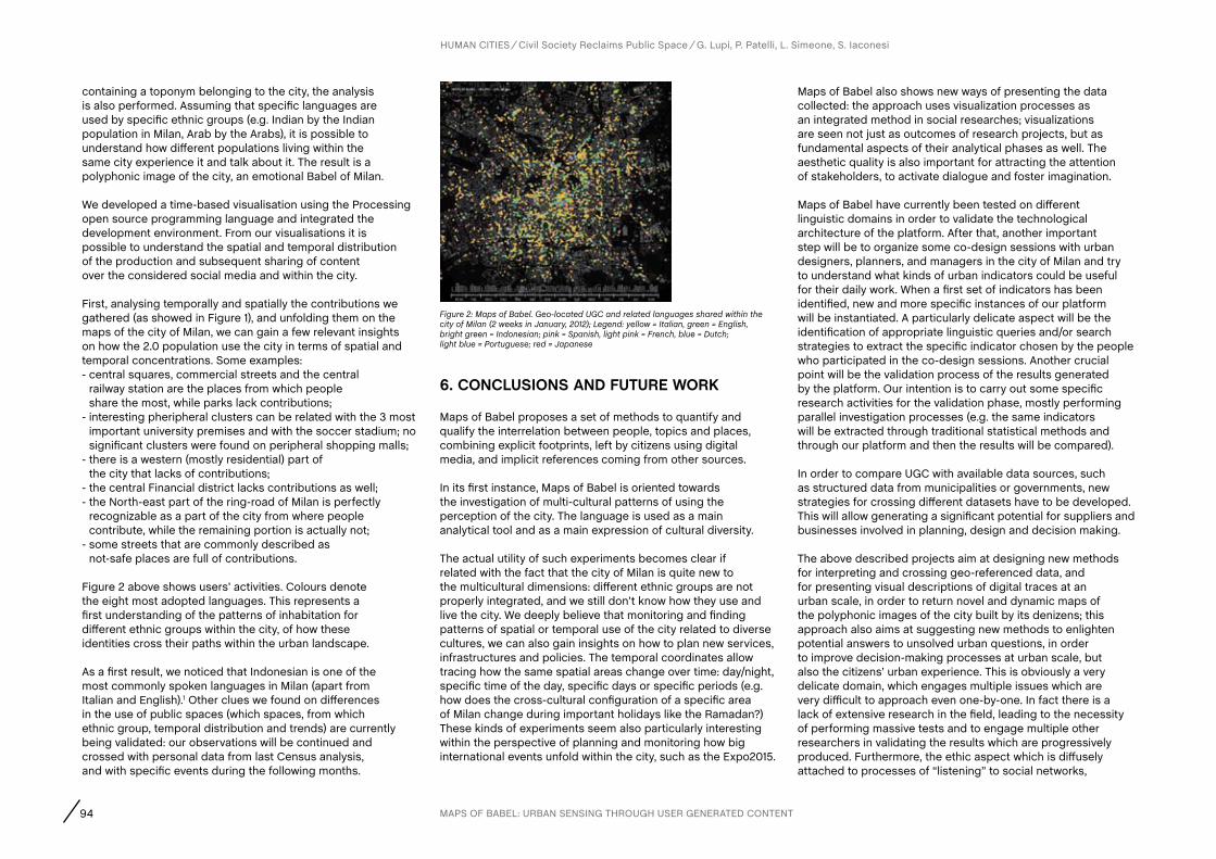
94
containing a toponym belonging to the city, the analysis is also performed. Assuming that specific languages are used by specific ethnic groups (e.g. Indian by the Indian population in Milan, Arab by the Arabs), it is possible to understand how different populations living within the same city experience it and talk about it. The result is a polyphonic image of the city, an emotional Babel of Milan.
We developed a time-based visualisation using the Processing open source programming language and integrated the development environment. From our visualisations it is possible to understand the spatial and temporal distribution of the production and subsequent sharing of content over the considered social media and within the city.
First, analysing temporally and spatially the contributions we gathered (as showed in Figure 1), and unfolding them on the maps of the city of Milan, we can gain a few relevant insights on how the 2.0 population use the city in terms of spatial and temporal concentrations. Some examples: - central squares, commercial streets and the central
railway station are the places from which people share the most, while parks lack contributions;
- interesting pheripheral clusters can be related with the 3 most important university premises and with the soccer stadium; no significant clusters were found on peripheral shopping malls;
- there is a western (mostly residential) part of the city that lacks of contributions;
- the central Financial district lacks contributions as well;- the North-east part of the ring-road of Milan is perfectly
recognizable as a part of the city from where people contribute, while the remaining portion is actually not;
- some streets that are commonly described as not-safe places are full of contributions.
Figure 2 above shows users’ activities. Colours denote the eight most adopted languages. This represents a first understanding of the patterns of inhabitation for different ethnic groups within the city, of how these identities cross their paths within the urban landscape.
As a first result, we noticed that Indonesian is one of the most commonly spoken languages in Milan (apart from Italian and English).1 Other clues we found on differences in the use of public spaces (which spaces, from which ethnic group, temporal distribution and trends) are currently being validated: our observations will be continued and crossed with personal data from last Census analysis, and with specific events during the following months.
6. cONcLUSIONS aND fUTURE WORK
Maps of Babel proposes a set of methods to quantify and qualify the interrelation between people, topics and places, combining explicit footprints, left by citizens using digital media, and implicit references coming from other sources.
In its first instance, Maps of Babel is oriented towards the investigation of multi-cultural patterns of using the perception of the city. The language is used as a main analytical tool and as a main expression of cultural diversity.
The actual utility of such experiments becomes clear if related with the fact that the city of Milan is quite new to the multicultural dimensions: different ethnic groups are not properly integrated, and we still don’t know how they use and live the city. We deeply believe that monitoring and finding patterns of spatial or temporal use of the city related to diverse cultures, we can also gain insights on how to plan new services, infrastructures and policies. The temporal coordinates allow tracing how the same spatial areas change over time: day/night, specific time of the day, specific days or specific periods (e.g. how does the cross-cultural configuration of a specific area of Milan change during important holidays like the Ramadan?) These kinds of experiments seem also particularly interesting within the perspective of planning and monitoring how big international events unfold within the city, such as the Expo2015.
Maps of Babel also shows new ways of presenting the data collected: the approach uses visualization processes as an integrated method in social researches; visualizations are seen not just as outcomes of research projects, but as fundamental aspects of their analytical phases as well. The aesthetic quality is also important for attracting the attention of stakeholders, to activate dialogue and foster imagination.
Maps of Babel have currently been tested on different linguistic domains in order to validate the technological architecture of the platform. After that, another important step will be to organize some co-design sessions with urban designers, planners, and managers in the city of Milan and try to understand what kinds of urban indicators could be useful for their daily work. When a first set of indicators has been identified, new and more specific instances of our platform will be instantiated. A particularly delicate aspect will be the identification of appropriate linguistic queries and/or search strategies to extract the specific indicator chosen by the people who participated in the co-design sessions. Another crucial point will be the validation process of the results generated by the platform. Our intention is to carry out some specific research activities for the validation phase, mostly performing parallel investigation processes (e.g. the same indicators will be extracted through traditional statistical methods and through our platform and then the results will be compared).
In order to compare UGC with available data sources, such as structured data from municipalities or governments, new strategies for crossing different datasets have to be developed. This will allow generating a significant potential for suppliers and businesses involved in planning, design and decision making.
The above described projects aim at designing new methods for interpreting and crossing geo-referenced data, and for presenting visual descriptions of digital traces at an urban scale, in order to return novel and dynamic maps of the polyphonic images of the city built by its denizens; this approach also aims at suggesting new methods to enlighten potential answers to unsolved urban questions, in order to improve decision-making processes at urban scale, but also the citizens’ urban experience. This is obviously a very delicate domain, which engages multiple issues which are very difficult to approach even one-by-one. In fact there is a lack of extensive research in the field, leading to the necessity of performing massive tests and to engage multiple other researchers in validating the results which are progressively produced. Furthermore, the ethic aspect which is diffusely attached to processes of “listening” to social networks,
HUMAN CITIES Civil Society Reclaims Public Space G. Lupi, P. Patelli, L. Simeone, S. Iaconesi
Figure 2: Maps of Babel. Geo-located UGC and related languages shared within the city of Milan (2 weeks in January, 2012); Legend: yellow = Italian, green = English, bright green = Indonesian; pink = Spanish, light pink = French, blue = Dutch; light blue = Portuguese; red = Japanese
MAPS OF BABEL: URBAN SENSING THROUGH USER GENERATED CONTENT

95
HUMAN CITIES Civil Society Reclaims Public Space G. Lupi, P. Patelli, L. Simeone, S. Iaconesi
Figure 3: Maps of Babel visualization experiment. Geo-located UGC and related languages shared within the city of Milan (January 2012); full video and images available at: http://giorgialupi.net/Maps_of_babel.html

96
harvesting information, and inferring knowledge makes it hard to effectively engage in a dialogue with institutions and professionals that could really help in making steps forward.
All these items transform this kind of research into a truly delicate domain, and researchers wishing to engage in are continuously forced to stop and deeply consider the
implications of their actions, the validity of their methodologies, the relevance of their conclusions and the ethic dimensions of the practices they promote. Luckily, many researchers are more than ready to engage in this challenge through meaningful ways. The issues raised by these processes never fail to bring up lively discussions in public occasions for a debate.
As a last conclusion, we have to say that information can, obviously, be used for the most different purposes, from the most positive ones to the most devious ones. What we believe is that there is no single answer and that the possibilities must be exposed and critically evaluated within specific contexts and circumstances.
HUMAN CITIES Civil Society Reclaims Public Space G. Lupi, P. Patelli, L. Simeone, S. Iaconesi
Notes1 According to a 2010 report by comScore, about 21 percent of Indonesians are Twitter users, making them the most Twitter-addicted nation. Possible reasons for this might include their large population (nearly 240 million), cheap access to mobile devices and English as a commonly spoken language (comScore 2011).
ReferencesAhokas, T. (2008). Information Visualization in a Business Decision Support System. Pro gradu. Available at: https://helda.helsinki.fi/handle/10138/21417 (accessed 26 Jan. 2012).
Ames, M. and Naaman, M. (2007). Why we tag: Motivations for annotation in mobile and online media, in CHI ’07: Proc. SIGCHI conference on Human Factors in Computing Systems, pp. 971–980. San Jose, CA, ACM Press.
Appadurai, A. (1990). Disjuncture and Difference in the Global Cultural Economy in M. Featherstone (ed) Global Culture. London: Sage, pp. 295-310.
Castells, M. (1992). The Informational City: Economic Restructuring and Urban Development. Wiley-Blackwell.
Dykes, J. (2006). Progress in our Representation of Geographic Phenomena and Our Evaluation, Use and Analysis of Geographic Information Computers, Environment and Urban Systems 30, pp. 125-129.
Elwood, S. (2008). Volunteered geographic information: key questions, concepts and methods to guide emerging research and practice, GeoJournal, 72(3-4), pp. 133-135.
Graham, M. (1998). The end of geography or the explosion of place? Conceptualizing space, placeand information technology, Progress in Human Geography, 22, pp. 165-185
Graham, M. (2010). Neogeography and the Palimpsests of Place: Web 2.0 and the Construction of a Virtual Earth. Tijdschrift voor economische en sociale geografie, 101(4), pp. 422-436.
Graham, M. (2012). From Cyberspace to DigiPlace: Visibility in an Age of Information and Mobility Academia.edu. (n.d.). Retrieved January 27, 2012.
Hollestein, L. and Purves, S. (2010). Exploring place through user-generated content: Using Flickr tags to describe city cores, Department of Geography, University of Zurich-Irchel, 8057 Zurich, Switzerland.
Shelton, T., Zook, M. and Graham, M. (2011). The Technology of Religion: Mapping Religious Cyberscapes, The Professional Geographer, DOI:10.1080/00330124.2011.61457.
Szott, R. (2006). What is Neogeography Anyway? available at: Platial.com, http://platial.typepad.com/news/2006/05/what_is_neogeog.html (accessed 27. May 2006).
Varnelis, K. (Ed.) (2008). Networked Publics. The MIT Press.
Wunsch, V. (2007). Participative web and user-created content web 2.0, wikis and social networking. OECD 2007.
Zook, M. (2000). The economic geography of commercial Internet content production in the United States, Environment and Planning A 32, pp. 411-426.
Zook, M. A. and Graham, M. (2007). The creative reconstruction of the Internet: Google and the privatization of cyberspace and DigiPlace, Geoforum, 38(6), pp. 1322-1343.
Zook, M. A.and Graham, M. (2007). Mapping DigiPlace: geocoded Internet data and the representation of place, Environment and Planning B: Planning and Design, 34(3), pp. 466-482.
MAPS OF BABEL: URBAN SENSING THROUGH USER GENERATED CONTENT

Part three: OperationalHighlight

98
Introduction to the Operational Highlight
cOMMUNITY cENTRED aPPROacH: a WaY Of REcLaIMING PUBLIc SPacE
Paola Trapani and Barbara Goličnik Marušić
The third highlight presents an operational approach to the issue of
public spaces, as observed in the field through the actions of groups and
communities reclaiming public space by spontaneous bottom-up initiatives.
It is a social innovation-driven approach, as we are looking for
practices, aimed at changing daily behaviours, fostering the transition
towards the sustainability of urban environment, and looking for
new solutions to the typical problems of metropolitan areas.
Whenever the perception of belonging to a community is strong, the bond
with public space is lively. It may happen that some residence service
areas are opened to the neighbourhood, resources and local knowledge
are shared within a wider network, and that territory development and
valorisation projects are encouraged by the citizen initiatives.
We try to understand how design disciplines at large can support, promote
and encourage such joint actions. Design must shift the perspective from
the paradigm of Human-Centred Design to that of Community-Centred
Design. The user at the centre of the project is no longer an individual, but
a part of the community where she or he lives. The research action has to
intercept, capture, shape and embody the collective needs; both symbolic
and functional, yet latent and unexpressed. New design thinking should
be applied to the concept of toolkits and solutions, capable of supporting
citizens in the shared use of public spaces, conceived as a common good.
The deep meaning of Common refers logically to the plurality of individuals
belonging to a community. Thus the link between public space and community
is not a novelty. Nevertheless we wish to stress that public space is not to
be considered primarily from the physical point of view, but as a Gestaltic
set of practices, uses, meanings, and their physical expressions in space.
Therefore the conventional boundary between private and public
becomes obsolete when it comes to considering social innovation, which
can actually spring from several sources: forms of mutual aid among
citizens in the household economy, informal networks, associations, and
social movements. On the other hand, the development of corporate
social responsibility makes the market increasingly meet the objectives
of social economy. Even the state is reinterpreting the concept of
public property, changing any allocation and control policies.
In this magmatic context, we may wonder what motivates informal groups
of citizens to take action and reclaim public space. The following list is not
intended to be exhaustive; rather its objective is to connect the dots between
different case studies presented by the authors in this highlight. Hopefully
a meaningful figure should emerge from the background, at the end of
this brief overview of the different contributions. Usually the communities
self-organize to act jointly in public space with different purposes:
99
- Marjan Špegel and Biba Tominc develop the theme of how to produce
goods for the household economy, in the context of a rooftop garden
experiment in a residential neighbourhood in Ljubljana, Slovenia.
- The issue of how to enhance living contexts is addressed in a couple
of papers: the first, by Tanja Plešivčnik, is about the restoration
of dry stone walls in Istria; the second one, by françois Jégou,
adèle Seyrig, Sabine Guisse and Julien Knoepfler, reports two
experiments in Brussels, in the framework of the Agenda Iris 21
Program: Adopt a tree handbook and Citizenship walks action kit.
- agustina Martire, Mark Hackett and Declan Hill illustrate how to reclaim the
streets for different uses in their paper about Belfast Great Victoria Street
Station. The same issue is the content of the paper by Tibo Labat, anaïs
Leger and Paul Smith about the Collectif Fertile, active in Nantes, where they
conduct experiments on abandoned public areas to be “designed by use”.
Of course all the cited papers across the board, also involve other
reasons why people decide to take action, for example:
- to express a political position, through activities and/or art performances;
- to improve security and safety;
- to host services and activities shared by community housing; and
- to create contexts in which elective communities can express
themselves, get organized, and find synergies.
Although presented papers addresses social innovation practices from
different angles, it is possible to find some common denominators. One
of the common messages across all is linked to the question: How things
started? It is about neglected places. There were empty boxes at the rooftops
which called for attention, there were ruined dry stone walls which called for
attention, there was a lost train station, mixed feelings about the known –
unknown neighbourhood, and there were abandoned areas on an industrial
site. Accordingly, all the projects address the process of revitalisation –
gaining identity – adding a new value and a symbolic meaning. They stress
and reach the point where ideas about social innovation come to life.
The next characteristics the following papers share together is enthusiasm and
spontaneity of actions, which in many cases lead into educational dimension,
from soil fertilisation to construction knowledge, summer/winter schools
and events on sites. This gives significant dimensions of actions to all these
projects, which are very important in situ, but always targeting for a wider
audience and consequences. Thus another common denominator that the
presented papers share is raising awareness, promoting, providing toolkits,
and even provoking. They mostly use low tech means to achieve high quality
changes in society and its environment. They aim for changes in relationships.
At this point we must discuss what the role of designers is in this context.
The answer opens a new path to public space design: more than designing
spaces according to top-down criteria, it is desirable to provide tools to
make and support. At present, the designer must do things with people and/

100
or support people in doing things. More and more, co-designing skills are
required: instead of imposing their own ‘professional’ visions, designers must
stimulate the diffused creativity, the sense of empowerment, the attitude to
proactivity. The new task seems to be the concept of enabling tools for active
groups to interact with their environment; accordingly extending the concept
of home to the entire neighbourhood, the whole city and the planet Earth.
These papers address the key motto of the symposia ‘Civil society
reclaims public space’ via three focuses of the relationships between
society and place: people in places; people for places, and places for
people. From place design point of view they stress that community
centred approach can lead to better places than they would have
otherwise become, if left alone or produced intentionally.

AUTHORS
Abstract
CHAPTER
101 R. Houlstan-Hasaerts, B. Tominc, M. Nikšič, B. Goličnik Marušić (Editors) Urbani izziv - publikacije, Ljubljana, May 2012
contact
Keywords
Biba TomincGeographer, Urban Planning Institute of the Republic of Slovenia, Trnovski pristan 2, 1000 Ljubljana, Slovenia + 386 1 420 13 34, [email protected]. Marjan ŠpegelRetired IT researcher, Ulica bratov Učakar 4, 1000 Ljubljana, [email protected]
Rooftop garden, public and private space, action research, observation methodology, participation, Ljubljana
The article addresses the issue of rooftop gardening as one of the alternatives of urban agriculture. Rooftops in residential neighbourhoods are often unnoticed and unused in spite of their attractiveness and usability. The physical spaces of the buildings usually belong more to the private sphere; therefore the article tries to promote the aspiration for transforming those spaces into spaces for public use of residents. Rooftop gardening is promoted here as a viable alternative to urban agriculture that could make cities more liveable, environmentally friendly and –with positive levels of participation – even socially a more hearty place. In this paper, we present an experiment of an informal rooftop garden in a residential neighbourhood in Ljubljana, Slovenia, named MellowRoof. The article focuses on action research inspired and implemented by an enthusiastic city gardener. This on-going experiment is a pure bottom-up project with significant experimental dimensions. In this article we illustrate some perspectives based on the observations and experience. Motivation for the MellowRoof experiment flourishes not only from love for gardening and from enjoying eating fresh
and Marjan Špegel, Ljubljana (Slovenia)Biba Tominc, Ljubljana (Slovenia)
MELLOWROOF: ROOFTOP GARDEN AS A FRUITFUL EXPERIMENT IN A RESIDENTIAL NEIGHBOURHOOD IN LJUBLJANA, SLOVENIA
1. INTRODUcTION
1.1. The forgotten spaces within residential neighbourhoods
The article deals with a rooftop in a residential neighbourhood’s building as a potential space for common use with special attention to bottom-up initiative and its role in encouraging creative activity. The experiment MellowRoof represents a challenge how building rooftops that are often unnoticed and unused in spite of their attractiveness and usability, have the potential for creative activity, such as rooftop gardening.
Urban neighbourhoods are where we live and establish daily patterns as we move around and beyond them. Neighbourhoods help shape people’s lives because they do more than house people. They form a base for wider activities,
vegetables, but also from adding a new meaning and beauty to the building. Planning a rooftop garden requires consideration of various parameters such as general characteristics of the rooftop, its structural capacity, condition and accessibility, sun and wind conditions, available time for maintenance, costs, etc. in order to select suitable plants to achieve optimal results. With monitoring and analysis of data, MellowRoof becomes also an experiment for the opportunities and the limitations of roof gardening. Observations and experience gathered will not only help evaluate the roof garden itself, but will also help create a complex methodological approach for identification of the state of the art and requirements regarding rooftop gardening in Ljubljana. The experiment MellowRoof is a stimulating example for empowering other residents and public authorities along with professionals such as agronomists, landscape architects, architects, urban designers and planners, biologists, technicians, etc. to develop an interdisciplinary creative process towards roof gardening as an alternative new form of semi public space in cities.

102 MELLOWROOF: ROOFTOP GARDEN AS A FRUITFUL EXPERIMENT IN A RESIDENTIAL NEIGHBOURHOOD IN LJUBLJANA, SLOVENIA
HUMAN CITIES Civil Society Reclaims Public Space B. Tominc, M. Špegel
providing many of the social services that link individuals with each other, giving rise to a sense of community (Power in Smith 2011: 1). There should be various types of spaces that provide people with opportunities to enjoy, use and respect different spaces, whether they want to relax, experience nature, grow vegetables, play or simply chat with their neighbours in a safe and pleasant environment (Healey, 2010).
Residential neighbourhoods are urban areas that result in a diverse pattern of public and private spaces. Also the internal space of residential buildings and their surroundings therefore had a range of private, semi-private and even semi-public spaces. In the presented experiment MellowRoof, the rooftop is a common good of the residents that live there and it is therefore recognised as a public space for them. The management and design of these spaces depends on many factors. Whilst many spaces have been designed and maintained in a positive manner, other spaces are left behind in terms of unclear sense of ownership and responsibility. As cities today are constantly renewing and reshaping themselves there is a chance to invent and put into practice new ways of living and discover new forms of semi private spaces.
In most European cities, movements towards the revitalization of cities have pushed the importance of urban open spaces to the front of public attention. Open urban spaces provide huge possibilities to carry out desired activities and different programs. Interventions are as different as their initiators, users, locations, etc. and therefore culminating in a multitude of approaches and solutions. According to Viljoen (2005) cities are now full of or reclaiming urban squares, urban parks, urban riverfronts, urban stages, urban forests and
urban beaches. On the other hand, the article highlights the opportunity of activating unused open spaces rather then reclaiming them. With creativeness of residents, those unused spaces could become more like a public space within the residential neighbourhood. According to Madanipour (2003), a private sphere is simultaneously located in the privacy of the mind; it is extended to personal space of the body, it is superimposed on land in private property, and is associated with the unit of social organization of homes. Private sphere is not pure or completely separated; rather it is interdependent with the public sphere, as reflected in their boundary, which is expected to be clear but is often ambiguous and contested.
1.2. Why urban food
The idea of urban agriculture is generally defined as the practice of cultivating, processing and distributing food and it is intertwined within the city’s urban areas. Producing food where one wants to consume it and where it has just grown, establishes a healthy and sustainable balance of production and consumption. In this respect rooftop gardening could be an excellent alternative. Therefore, rooftop gardening as a type of green roof activity is promoted as a viable alternative to urban agriculture that could make neighbourhoods more livable, environmentally friendly and with a positive level of participation, and even socially a heartier place.
Cantor (2008) showed that a rising issue of the green roof industry is a part of a wider transformation of moving towards a new type of restorative living architecture that seamlessly integrates inorganic and lifeless building components with
living and restorative systems. According to the paradigm of living architecture, there is a challenge to recognize rooftops as a potential for regeneration. Green roofs may help turn inhospitable black roofs into enjoyable community resources from the aspect of gaining new spaces for common use and strengthening the social capital between residents.
Urban agriculture plays an important role within the wider issue of urban sustainability by being able to supply fresh food on the spot, by offering an improved livelihood for urban people and even by forming new kinds of eco-efficient housing estates; such as a project in South London, the Beddington Zero Energy development (Internet 1) which is recognized as an example of good practice.
According to Krasny (2012), ever since the modernisation shock caused by industrialization, cities have been confronted with profoundly difficult challenges. By using and analyzing examples from Europe, Latin America, the USA and Asia, we can observe how the importance of informal urban movements of urban agriculture and how often small projects can lead to major changes. Settlements and vegetable gardens lead to different forms of social cohesion, neighbourliness and fair distribution. A different world can be planted, as communal gardeners today emphasise.
1.3. Introduction to the MellowRoof experimentThe aspiration of this paper is to present an informal experiment in rooftop gardening in a neighbourhood in Ljubljana, Slovenia,
Figure 1: The situation of Koseze neighbourhood and photos taken from the beginning of the construction in year 1974 and a recent view (source: UIRS photo archive)
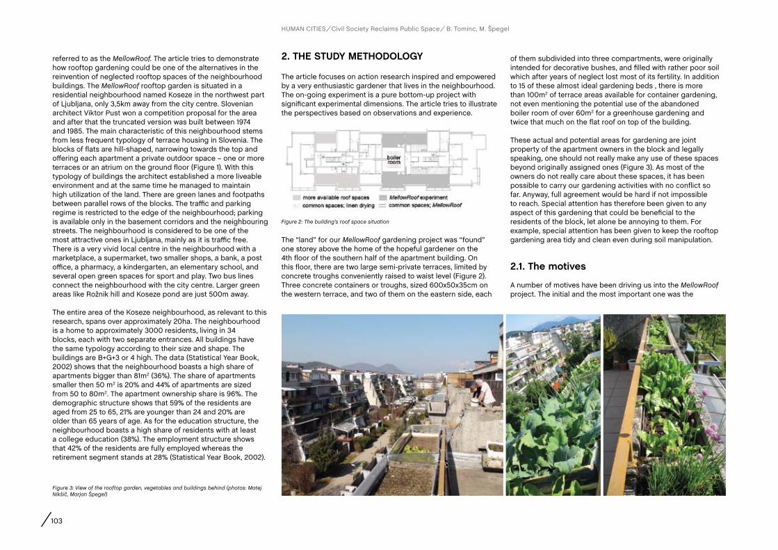
103
HUMAN CITIES Civil Society Reclaims Public Space B. Tominc, M. Špegel
referred to as the MellowRoof. The article tries to demonstrate how rooftop gardening could be one of the alternatives in the reinvention of neglected rooftop spaces of the neighbourhood buildings. The MellowRoof rooftop garden is situated in a residential neighbourhood named Koseze in the northwest part of Ljubljana, only 3,5km away from the city centre. Slovenian architect Viktor Pust won a competition proposal for the area and after that the truncated version was built between 1974 and 1985. The main characteristic of this neighbourhood stems from less frequent typology of terrace housing in Slovenia. The blocks of flats are hill-shaped, narrowing towards the top and offering each apartment a private outdoor space – one or more terraces or an atrium on the ground floor (Figure 1). With this typology of buildings the architect established a more liveable environment and at the same time he managed to maintain high utilization of the land. There are green lanes and footpaths between parallel rows of the blocks. The traffic and parking regime is restricted to the edge of the neighbourhood; parking is available only in the basement corridors and the neighbouring streets. The neighbourhood is considered to be one of the most attractive ones in Ljubljana, mainly as it is traffic free. There is a very vivid local centre in the neighbourhood with a marketplace, a supermarket, two smaller shops, a bank, a post office, a pharmacy, a kindergarten, an elementary school, and several open green spaces for sport and play. Two bus lines connect the neighbourhood with the city centre. Larger green areas like Rožnik hill and Koseze pond are just 500m away.
The entire area of the Koseze neighbourhood, as relevant to this research, spans over approximately 20ha. The neighbourhood is a home to approximately 3000 residents, living in 34 blocks, each with two separate entrances. All buildings have the same typology according to their size and shape. The buildings are B+G+3 or 4 high. The data (Statistical Year Book, 2002) shows that the neighbourhood boasts a high share of apartments bigger than 81m2 (36%). The share of apartments smaller then 50 m2 is 20% and 44% of apartments are sized from 50 to 80m2. The apartment ownership share is 96%. The demographic structure shows that 59% of the residents are aged from 25 to 65, 21% are younger than 24 and 20% are older than 65 years of age. As for the education structure, the neighbourhood boasts a high share of residents with at least a college education (38%). The employment structure shows that 42% of the residents are fully employed whereas the retirement segment stands at 28% (Statistical Year Book, 2002).
2. THE STUDY METHODOLOGY
The article focuses on action research inspired and empowered by a very enthusiastic gardener that lives in the neighbourhood. The on-going experiment is a pure bottom-up project with significant experimental dimensions. The article tries to illustrate the perspectives based on observations and experience.
of them subdivided into three compartments, were originally intended for decorative bushes, and filled with rather poor soil which after years of neglect lost most of its fertility. In addition to 15 of these almost ideal gardening beds , there is more than 100m2 of terrace areas available for container gardening, not even mentioning the potential use of the abandoned boiler room of over 60m2 for a greenhouse gardening and twice that much on the flat roof on top of the building.
These actual and potential areas for gardening are joint property of the apartment owners in the block and legally speaking, one should not really make any use of these spaces beyond originally assigned ones (Figure 3). As most of the owners do not really care about these spaces, it has been possible to carry our gardening activities with no conflict so far. Anyway, full agreement would be hard if not impossible to reach. Special attention has therefore been given to any aspect of this gardening that could be beneficial to the residents of the block, let alone be annoying to them. For example, special attention has been given to keep the rooftop gardening area tidy and clean even during soil manipulation.
2.1. The motives
A number of motives have been driving us into the MellowRoof project. The initial and the most important one was the
The “land” for our MellowRoof gardening project was “found” one storey above the home of the hopeful gardener on the 4th floor of the southern half of the apartment building. On this floor, there are two large semi-private terraces, limited by concrete troughs conveniently raised to waist level (Figure 2). Three concrete containers or troughs, sized 600x50x35cm on the western terrace, and two of them on the eastern side, each
Figure 2: The building’s roof space situation
Figure 3: View of the rooftop garden, vegetables and buildings behind (photos: Matej Nikšič, Marjan Špegel)

104
HUMAN CITIES Civil Society Reclaims Public Space B. Tominc, M. Špegel
ambition to secure a three-member family of the gardener with organically grown and the freshest possible vegetables at a reasonable cost. The local marketplace does offer a number of vegetable stands and some of them offer mostly locally grown produce, but at premium price and one cannot always be sure of the origin. Further, somewhat softer motives were to keep in closer touch with nature and to enrich the relationship between neighbours. Finally, to some extent the motive was also to relive joyful memories of a retired computer scientist’s wonderful childhood times on a small farm. And also, because of personal attitudes of the gardener as well as from economic reasons, the methods and means for gardening have been heavily relying on reuse and recycling.
2.2. The containers
In addition to the mentioned 15 concrete troughs, the gardening space has been continuously extended in recent years with added containers (Figure 4). In line with the ambition of organic gardening, more than a dozen clay pots of various sizes from 10 to 50 litres have been added, some of them generously contributed by neighbours or scraped from waste. However, other types of containers have also been used, for example a dozen of Styrofoam boxes particularly suitable for growing very early salad since they can be more readily carried into
warm shelter during freezing early Spring nights. Admittedly, also a dozen plastic buckets have been used, but any non-clay containers were lined with aluminium foil to separate the soil from the toxic vapours from plastic. Some of the heavier containers were placed on rolling platforms to move them under the roof in case of really adverse weather like hail storms.
Clearly, to keep an eye over more than 40 gardening containers, some form of systematic labelling is needed in order to be able to refer to them in records of gardening activities. A simple naming scheme employed so far uses the following naming structures: - for the 15 concrete troughs the form “abc”, where ‘’a’’
denotes the terrace side (East, West), ‘’b’’ stands for triplets of troughs (North, Middle, South), and where “c” denotes subdivision of the gardening trough, such as the northern, the middle and the southern bed of the trough;
- for all other containers we just used the form “stn” where “s” denotes the terrace side, “t” stands for the type of container (Clay, Styrofoam, Plastic, and in future also Wooden), and “n” is just a sequential number of the container.
So, for example, the name WSS denotes the southernmost concrete trough bed on the western terrace. In specific cases where subdivision of a trough bed into smaller sections is needed (e.g. when sowing for the seedlings), a labelling
extension was employed in a way that reference to specific long or cross rows can also be specified and recorded.
It also became clear that some kind of equivalent of conventional gardening cottage was needed and it was found in an unused room for linen drying next to the gardening terraces. This shelter has been most convenient for the storage of gardening materials, tools, containers and alike, safe from rain and snow, as well as comfortable for execution of gardening tasks like assembly of greenhouse walls and covers.
2.3. The preparation of coil, beds and fixturesMost vegetables require careful soil preparation and it was obvious that the original soil needs major improvement. So as a rule and gradually over a few years, old soil from concrete troughs was replaced; meaning carried away by hand and spread in the immediate surroundings of the block. Likewise, all of gravel layer securing the water drainage at the bottom of concrete troughs was removed and replaced by a thinner layer securing not only drainage but also heat insulation. Various materials were tried, with best results so far with reed and carpet layers at the bottom as well as at the trough sides. These materials too were taken from local trash.
The new garden soil was purchased together with sphagnum and this constitutes majority of the gardening expenses so far. Additional investments can be counted in units of effort (considering there is no lift yet in this building), which was not trivial considering the content of each concrete trough alone is 300 litres and about one half of soil had to be replaced, but hopefully soil renewal will give rewards in the years to come. Further soil improvement materials included a dozen buckets of old mortar from a nearby decaying house removal. And finally, manure and above all compost needed to be secured. The manure has been easy to get at no cost from nearby farmers (or at small expense in bags from stores) whereas for compost the best solution was to “grow” it on the gardening terraces as well. At the moment, two 300-liter commercial composters are there and are adequate for composting all the waste from gardening as well as from the gardener’s home. Finally, gentle amounts of fertilizer supplements have also been used.
Figure 4: The organization of the vegetables in containers (photos: Marjan Špegel)
MELLOWROOF: ROOFTOP GARDEN AS A FRUITFUL EXPERIMENT IN A RESIDENTIAL NEIGHBOURHOOD IN LJUBLJANA, SLOVENIA

105
As early, cold and long winters are not uncommon in Ljubljana even in the age of global warming, the protection of plants against frost, hail and snow is a major gardening concern. In addition to insulation at the bottom and the walls of the concrete troughs, various covers have been tried; but eventually, the best solution turned out to be building removable plastic houses from lexan, typically used for the construction of greenhouses. As this material is not cheap, the solution was to get scraps from a local lexan dealer. From these scraps, the sides and the covers of the “rooftops” of these small greenhouses were patch-worked together using wooden and aluminium profiles as well as textile re-enforced UV-hardened tape. Fortunately, the troughs have a raised metal rail at just the appropriate height of about 15cm to firmly secure the greenhouses to troughs for wind protection.
As for the poles for supporting the container-grown tomatoes and beans, they came mostly from a friend who has an overgrown fence of bamboo plants which need regular cropping anyway – which has also proved to be a welcome excuse for socializing and exchange of seedlings. However, it would have been quite difficult to fix the poles on top without overhanging ceiling of an extension of the boiler room over both terraces. This ceiling not only provided an easy fixture for the poles but also the shelter for tomatoes against hail and excessive rain and sun. Clearly, the ropes for tying the tomatoes against the poles were all produced from scrap textiles like old sheets as well.
2.4. The watering
The beds – particularly on the western terrace – are subject to sunshine and therefore to strong evaporation, and it was therefore essential to solve the problem of keeping the soil moist. One way to keep moisture for longer time was to mix into the soil a good deal of expanded (hygroscopic) clay nodules, now making up about a fifth of soil volume (Figure 5). The material is easy to get at reasonable cost and above all also easy to carry to the top of the building.
Still, the moisture disappears quickly in summer and the beds need regular watering. Some of this water has been collected from water drainage pipes from underneath the concrete troughs, but this covered only short term water shortages. Fortunately, the former boiler room also has access to fresh running water. At first, water was hand carried and sprayed over troughs and containers more or less every morning which proved quite an ordeal at days of presence and a disaster on the days of absence of the gardener or his kind neighbours. It soon became obvious that gardening cannot be productive without at least a rudimentary form of automatic watering. The simple present solution came cheap: a 220V timer from an old heater, a valve from an old washing machine and a set of plastic pipes into which holes were made with hot metal pins.
Of course, with such a simple solution, it is possible to secure only pre-programmed amount of water without any adaptation to actual dryness of beds. Nevertheless, the garden survived well even a two-week vacation absences of the gardener.
2.5. The record-keeping
As initial knowledge of this gardener was limited to memories from childhood, it was clear from the beginning that quite a bit will have to be learnt from his parent’s gardening books, from friends gardening around their houses, and from the internet.
Furthermore, with three dozen beds and containers, it was also clear that it would not be possible to keep track of gardening activities and their effects without their systematic recording. Hence, a log of daily activities was kept to keep track of soil preparation, of seeding and planting, of fertilizing, of weeding etc.
For example (02. 04.2011):- WNS planted Berggold beans- EMS cut 5 salads Castelfranco- ENN pulled out 7 Chinese onions
Clearly, a provision was also made for further descriptive annotations, for example related to factors like weather etc.
3. SUMMaRY Of RESEaRcH fINDINGS
The primary expectation from the rooftop garden was to secure salad, tomatoes – above all the cherry type – and green beans for the three-member family of the gardener throughout most of the year. This expectation was not only met but to some extent also surpassed as some produce also went to closest neighbours and friends. So salads, for example, now need to be purchased only during the coolest time of the year from mid-December to mid-February. In addition to salads, the year-round vegetables have also proved to be leeks and Mangolds. Another rewarding culture has been Chinese onion. Furthermore, due to scarcity and high cost of ecologically grown garlic, this also was successfully planted amongst salads.
The cultivation of green beans, both short and tall, has been particularly easy and rewarding, requiring little labour and
Figure 5: Construction and watering system of the containers (photos: Marjan Špegel)
HUMAN CITIES Civil Society Reclaims Public Space B. Tominc, M. Špegel

106
almost no attention after planting; except for occasional preparation and timely spraying of the plants and their leaves with nettle solution to fight lice. The berggold type of beans gave really quick and good yield, often shared with neighbours and enjoyed from mid-June to end of September according to the gardener’s logs. It would be nice if a way is found to extend this season beyond both of these borders.
But the winning culture has been tomatoes, all sorts from bushy to tall cherry types, to really large local plants like “oxen’s heart”. With early sorts ripening towards the end of June to late ones bearing fruit towards the end of October, this family is enjoying fully home-grown tomatoes throughout second half of the year, with the green ones collected at the end of October and ripening on the window shelves in the warmth of the apartment to the very end of December. So it is planned to extend the cultivation season even further by taking advantage of sheltering the seedlings and the containers in the boiler room.One particularly encouraging surprise with tomatoes was how easy it was to grow new plants from saplings
throughout the season. Except for the first half a dozen of tomato plants of various sorts purchased as early in April as possible, several dozens of further plants were grown this way, thereby further improving the economy of the operation. On the other hand, tomatoes do require more than average labour and attention and possibly about a half of all gardening time went to their cultivation.
Not all cultures were such a clear-cut success. For example, the cauliflower and broccoli were tried, but developed rather small bodies, possibly because they were planted too late. Furthermore, the plants were seriously eaten by caterpillars overnight. The cucumbers and zucchini were also tried, initially with modest results and with noticeable improvement over the years.
Finally, no rooftop garden should be without a section for spice herbs. So a less sunny trough on the eastern terrace was sown and planted with chives, parsley, basil and mint for tea. They have all been growing well, with
mint trying to overgrow everything else in the bed and yielding enough plant for drying leaves for winter tea.
In the absence of weighing produce from MellowRoof gardens, it is not yet possible to quantify the results despite careful descriptive recording of all that was taken from the garden. A quick rough estimate of the yearly yield is more than 100kg of vegetables, most of it salads, green beans and tomatoes. Considering the typical time of fruition of two months and the cultivation season of ten months, four to five yields were possible in cases of salads and similar fast-growing cultures.
The economic rewards from the project so far more than outweigh the garden’s material costs. Social effects of the project, however, are just as precious (Figure 6). Two hours of enjoyable, rewarding, untiring gardening work outdoors is joy for a retired person. Even the cultivation work is physically easy as the soil surface in troughs is at the waist level and thus no bending is required. All this is available at almost no time overhead as one can step out of apartment right into the garden as well as tidy oneself in no time. Additional ecological satisfaction comes from composting and recycling. Still, the most pleasant social consequence of such gardening is strengthening ties with neighbours in the building and friends as their interest in participation in the gardening project still grows. It cannot be hidden that this joint report too sprang out of these close neighbouring ties.
4. DIScUSSION
4.1. further steps in developing and optimizing the experiment
The achieved results inspire for more. First of all, for increasing the cultivation area by adding a few more clay pots and Styrofoam containers and probably also by designing and constructing a few wooden boxes on rollers for larger plants like dwarf vineyard peach trees. The gardening area is likely to be extended also over three concrete troughs on the terrace of a semi-blind neighbour at the same floor. An extension of the cultivation season is expected, relying not only on warmer than usual microclimate at the top of the building but also on addition of a few more lexan greenhouse covers over the concrete troughs and on sheltering potted plants (above all tomatoes) from frost into the old boiler room in early Spring and late Autumn. Further planned improvements are design and execution of an adaptive
Figure 6: Gardening work and mellow vegetables (photos: Matej Nikšič, Marjan Špegel)
HUMAN CITIES Civil Society Reclaims Public Space B. Tominc, M. Špegel
MELLOWROOF: ROOFTOP GARDEN AS A FRUITFUL EXPERIMENT IN A RESIDENTIAL NEIGHBOURHOOD IN LJUBLJANA, SLOVENIA

107
(precision) watering system from rainwater reservoir using humidity sensors and weather forecasts to reduce the amount of running water consumption. Quantitative recording of crop yields by weighing is also planned for the new season.
But the most interesting planned activity for the MellowRoof gardening project in the coming season might be the execution of systematic testing of soil and plants for key fertility elements as well as for heavy metals. This activity will be carried out as laboratory exercise work of graduate students in inorganic chemistry of Ljubljana University, with the help of another supportive neighbour who works there. And in this spirit, as the authors of this article are actually also the creators of the experiment, they should devote their time to actually doing the experiment and conclude the article with short conclusions below.
4.2. food for urban design thought
While examining the complexity and contradictory nature of contemporary society, the cities are like huge social laboratories where new ideas and new solutions are being invented and experimented within all fields of daily life (Manzini in Goličnik Marušić et al. 2010: 12-13). The food growing experiment MellowRoof tries to show how small activities, based on creative ideas from bottom-up initiatives, can
generate larger and more significant stories in searching for new possible lifestyles that are simple and in contact with nature and residents in the neighbourhoods, in order to strengthen their social capital. Local experiences need to be linked to wider social and economic forces.The key ingredients are always the people. Smith (2011) illustrated that regardless of all the talk of changing lifestyles, neighbourhood still plays a fundamental role in many people’s lives. In recent years there have been many discussions regarding social capital – the quality and scale of social relationships, groups and networks within the residential neighbourhoods. In this perspective, rooftop spaces represent the field of opportunities and interactions, where people can meet to share visions and experiences and where they can try out new activities in order to give themselves a chance for a better quality of life in neighbourhoods. Rooftop spaces present an endless palette of design opportunities and ideas for innovators. Food growing projects can also generate local economic activities and community businesses. They include improvements to the environment and landscape setting of developed areas, as well as significant socio-economic benefits including health and community development.
There is no typical food growing project, as each develops according to the characteristics of the local area and the needs of the local community and furthermore according to technical conditions. What they have in common is
encouragement of social participation, strong volunteer involvement and therefore a potential for creating sustainable communities. The inventiveness and the opportunity for personalisation in the design and management of rooftop gardens is one of the most charming characteristics. Creating those specific spaces that can offer this very personal and human interaction is almost impossible with traditional approaches to urban master planning. As the food growing projects should also benefit the community, the focus should therefore not only be the people-centred but rather a community-centred urban design. Bottom-up initiatives awake and help promote the value and image of a residential neighbourhood through those small-scale projects that have the capacity to attract and unite people around the idea. The motivation of people lies at the root of self-fulfilment when they are active in shaping their own space and social future.
Urban food growing projects are usually guided by local people, thus the movements tend to be an expression of grass-roots movement with no top-down approach. This prospect is unreasonable as environmentalism in whatever appearance, demands both, bottom-up as top-down approaches. Freeing up or reclassifying spaces for urban agriculture requires more than a desire of gardening. It requires knowledge and consideration by planners, urban designers, agronomists and other researchers; while local authorities; these contributions are recognised as a top-down approach.
BibliographyCantor, S.L. (2008). Green Roofs: Sustainable landscape design. W.W.Norton & Company. New York.
Goličnik Marušić, B., Nikšič, M. and Coirier, L. (ed.) (2010). Human cities: celebrating public space. Stichting Kunstboek. Brussels.
Healey, P. (2010). Making Better Places: The Planning project in the Twenty-First Century. Collection: Planning, Environment, Cities. Palgrave Macmillan. Hampshire.
Internet 1: http://www.bioregional.com/what-we-do/our-work/bedzed/ (accessed 12. January 2012).
Krasny, E. (2012). Hands-On Urbanism 1850-2012. The Right to Green. Architekturzentrum Wien.
Madanipour, A. (2003). Public and Private Spaces of the City. Routledge, New York.
Smith, M. K. (2011). Neighbourhoods and regeneration. Theory, practice, issues, the encyclopaedia of informal education. Available at:
www.infed.org/community/neighbourhoods_and_regeneration.htm
Statistical Office of the Republic of Slovenia (2002). Statistical Yearbook 2002. Ljubljana.
Viljoen A., Bohn K. and Howe, J. (ed.) (2005). CPULs: Continuous productive urban landscapes; designing urban agriculture for sustainable cities. Elsevier, Architectural Press. Oxford.
HUMAN CITIES Civil Society Reclaims Public Space B. Tominc, M. Špegel
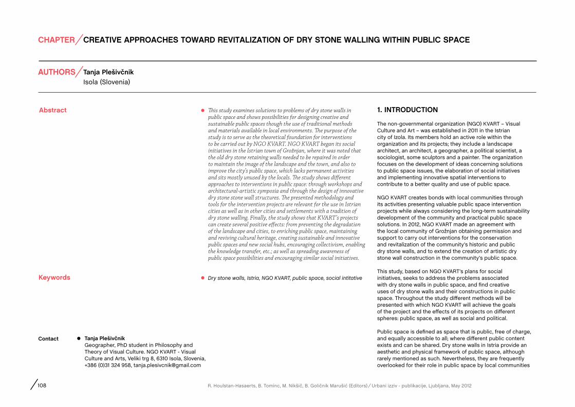
AUTHORS
Abstract
CHAPTER
108 R. Houlstan-Hasaerts, B. Tominc, M. Nikšič, B. Goličnik Marušić (Editors) Urbani izziv - publikacije, Ljubljana, May 2012
contact
Dry stone walls, Istria, NGO KVART, public space, social intitative
1. INTRODUcTION
The non-governmental organization (NGO) KVART – Visual Culture and Art – was established in 2011 in the Istrian city of Izola. Its members hold an active role within the organization and its projects; they include a landscape architect, an architect, a geographer, a political scientist, a sociologist, some sculptors and a painter. The organization focuses on the development of ideas concerning solutions to public space issues, the elaboration of social initiatives and implementing innovative spatial interventions to contribute to a better quality and use of public space.
NGO KVART creates bonds with local communities through its activities presenting valuable public space intervention projects while always considering the long-term sustainability development of the community and practical public space solutions. In 2012, NGO KVART made an agreement with the local community of Grožnjan obtaining permission and support to carry out interventions for the conservation and revitalization of the community’s historic and public dry stone walls, and to extend the creation of artistic dry stone wall construction in the community’s public space.
This study, based on NGO KVART’s plans for social initiatives, seeks to address the problems associated with dry stone walls in public space, and find creative uses of dry stone walls and their constructions in public space. Throughout the study different methods will be presented with which NGO KVART will achieve the goals of the project and the effects of its projects on different spheres: public space, as well as social and political.
Public space is defined as space that is public, free of charge, and equally accessible to all; where different public content exists and can be shared. Dry stone walls in Istria provide an aesthetic and physical framework of public space, although rarely mentioned as such. Nevertheless, they are frequently overlooked for their role in public space by local communities
Keywords
Tanja PlešivčnikGeographer, PhD student in Philosophy and Theory of Visual Culture. NGO KVART - Visual Culture and Arts, Veliki trg 8, 6310 Isola, Slovenia, +386 (0)31 324 958, [email protected]
This study examines solutions to problems of dry stone walls in public space and shows possibilities for designing creative and sustainable public spaces though the use of traditional methods and materials available in local environments. The purpose of the study is to serve as the theoretical foundation for interventions to be carried out by NGO KVART. NGO KVART began its social initiatives in the Istrian town of Grožnjan, where it was noted that the old dry stone retaining walls needed to be repaired in order to maintain the image of the landscape and the town, and also to improve the city’s public space, which lacks permanent activities and sits mostly unused by the locals. The study shows different approaches to interventions in public space: through workshops and architectural-artistic symposia and through the design of innovative dry stone stone wall structures. The presented methodology and tools for the intervention projects are relevant for the use in Istrian cities as well as in other cities and settlements with a tradition of dry stone walling. Finally, the study shows that KVART’s projects can create several positive effects: from preventing the degradation of the landscape and cities, to enriching public space, maintaining and reviving cultural heritage, creating sustainable and innovative public spaces and new social hubs, encouraging collectivism, enabling the knowledge transfer, etc.; as well as spreading awareness of public space possibilities and encouraging similar social initiatives.
Isola (Slovenia)Tanja Plešivčnik
CREATIVE APPROACHES TOWARD REVITALIZATION OF DRY STONE WALLING WITHIN PUBLIC SPACE
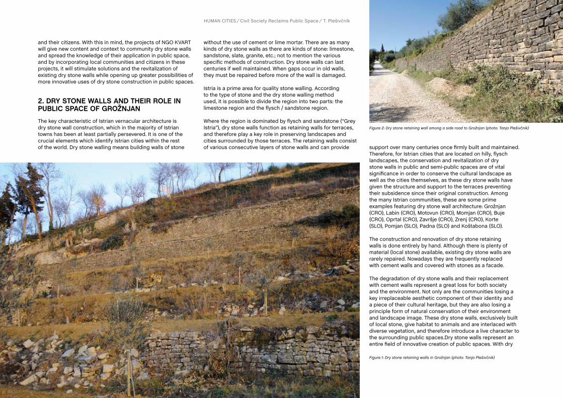
and their citizens. With this in mind, the projects of NGO KVART will give new content and context to community dry stone walls and spread the knowledge of their application in public space, and by incorporating local communities and citizens in these projects, it will stimulate solutions and the revitalization of existing dry stone walls while opening up greater possibilities of more innovative uses of dry stone construction in public spaces.
2. DRY STONE WaLLS aND THEIR ROLE IN PUBLIc SPacE Of GROŽNJaNThe key characteristic of Istrian vernacular architecture is dry stone wall construction, which in the majority of Istrian towns has been at least partially persevered. It is one of the crucial elements which identify Istrian cities within the rest of the world. Dry stone walling means building walls of stone
without the use of cement or lime mortar. There are as many kinds of dry stone walls as there are kinds of stone: limestone, sandstone, slate, granite, etc.; not to mention the various specific methods of construction. Dry stone walls can last centuries if well maintained. When gaps occur in old walls, they must be repaired before more of the wall is damaged.
Istria is a prime area for quality stone walling. According to the type of stone and the dry stone walling method used, it is possible to divide the region into two parts: the limestone region and the flysch / sandstone region.
Where the region is dominated by flysch and sandstone (“Grey Istria”), dry stone walls function as retaining walls for terraces, and therefore play a key role in preserving landscapes and cities surrounded by those terraces. The retaining walls consist of various consecutive layers of stone walls and can provide support over many centuries once firmly built and maintained.
Therefore, for Istrian cities that are located on hilly, flysch landscapes, the conservation and revitalization of dry stone walls in public and semi-public spaces are of vital significance in order to conserve the cultural landscape as well as the cities themselves, as these dry stone walls have given the structure and support to the terraces preventing their subsidence since their original construction. Among the many Istrian communities, these are some prime examples featuring dry stone wall architecture: Grožnjan (CRO), Labin (CRO), Motovun (CRO), Momjan (CRO), Buje (CRO), Oprtal (CRO), Završje (CRO), Zrenj (CRO), Korte (SLO), Pomjan (SLO), Padna (SLO) and Koštabona (SLO).
The construction and renovation of dry stone retaining walls is done entirely by hand. Although there is plenty of material (local stone) available, existing dry stone walls are rarely repaired. Nowadays they are frequently replaced with cement walls and covered with stones as a facade.
The degradation of dry stone walls and their replacement with cement walls represent a great loss for both society and the environment. Not only are the communities losing a key irreplaceable aesthetic component of their identity and a piece of their cultural heritage, but they are also losing a principle form of natural conservation of their environment and landscape image. These dry stone walls, exclusively built of local stone, give habitat to animals and are interlaced with diverse vegetation, and therefore introduce a live character to the surrounding public spaces.Dry stone walls represent an entire field of innovative creation of public spaces. With dry
Figure 1: Dry stone retaining walls in Grožnjan (photo: Tanja Plešivčnik)
Figure 2: Dry stone retaining wall among a side road to Grožnjan (photo: Tanja Plešivčnik)
HUMAN CITIES Civil Society Reclaims Public Space T. Plešivčnik
110
HUMAN CITIES Civil Society Reclaims Public Space T. Plešivčnik
stone walling it is possible to produce unique, functional and aesthetic stone constructions, which interact naturally with their environments and enhance the quality of public space.
In January 2012, the organization KVART began its first interventions in the public space of the Istrian city Grožnjan, recognized as a world city of artists.
For a long period prior to World War II, the city lived as a mix of Italian and Croatian speaking inhabitants. As a consequence of changed national borders following World War II, the province passed to the newly established Yugoslav government, and the majority of Italian speaking citizens emigrated, going to neighboring Italy. A large part of the city sat abandoned and slowly degraded for nearly 20 years until the mid-1960s, when engaged artists and associations joined their forces and began the renovation of the city in accordance with conservation principles, including the revitalization of existing construction. In this way, thanks to the common initiative of artists and associations, the city has managed to conserve its culture and historical heritage as well as its image of a city from the 14th century. Moreover, already in the times of Yugoslavia, it was given the special status of a city with protected culture-historical heritage (Zelenko, 2011). The city has conserved its many stone streets and houses in which numerous international artists now live, while the streets have been revived with galleries and cultural programs in the summer months.
Grožnjan is an extraordinary example of a city where people have united their strength and have created common space together with nature, the local architecture, and cultural-historical heritage of the place. For the city’s future it is of crucial importance to find optimal ways of managing its public space that will stimulate the collective spirit among its inhabitants and will contribute to the conservation of its image and the creative atmosphere in the city.Grožnjan is located on the top of a hill in flysch terrain. People battled the sheer slopes to transform them into terraces for easier cultivation. By doing so, large amounts of stone were removed and then used for the construction of houses, stables, etc., and particularly for building dry stone retaining walls for terraces. In this way, the terraced terrain has conserved the landscape through centuries, and the walls were just occasionally repaired. The whole city of Grožnjan is covered in terrace topography and is interlaced and surrounded with dry stone retaining walls in need of renovation in various places. Unfortunately, a decreasing number of people have functional knowledge of dry stone walling and long-term renovation, and insufficient financial means of the municipality
contribute to the increased danger of degradation of this part of the public space in the future. Apart from this, the city has ascertained that although Grožnjan is a venue of diverse cultural events in the summer, its public space mostly remains without content of lasting effect. Once the numerous visitors and summer tourists leave, the city’s outside surfaces remain empty, and not used by local citizens. There is a need for a social initiative that would aim to revive public spaces and the absence of activities out of season, which is reflected in the typical examples of public spaces which exist for tourist purposes. The municipal government of Grožnjan is aware of these problems and has thus offered support and collaboration in the public space intervention projects of NGO KVART.
3. HOW TO aPPROacH THE ISSUE?
The study explores original and innovative approaches to intervention, and stresses the importance of a participatory field in order for implemented project activities to have positive impacts on space and society; thus contributing to a long-term active solution to problems of public space. Through the methods of observation and collecting data about the existing dry stone walls as well as dry stone wall construction in public spaces, it was determined that the majority of Istrian communities do not pay enough attention to the conservation, appropriate renovation and maintenance of their public dry stone retaining walls. That is partially due to a lack of a state program and funds for the conservation of dry stone walls.
Initial inspiration for NGO KVART’s interventions in Istria derived from the will to restore retaining walls in so-called “Grey Istria”, where dry stone walls play an important role of supporting landscapes and town centres as they serve as retaining walls for the terraces, and to revitalize the traditional working method within public space. The organization later developed the idea of creating artistically inspired retaining walls and dry stone wall constructions, which can enrich and create sustainable and innovative public spaces. For the long-term effectiveness of planned spatial interventions, involvement of the local community, its inhabitants and local institutions is of absolute importance in the common renovation, revitalization and creation of sustainable public spaces; simple familiarity with the physical state of the public space is not enough. Therefore NGO KVART presents projects which emphasize the role of local participation, collectivism and encourages local initiatives.
Before planning public intervention projects in a specific city, a local opinion survey on problems regarding its specific
public space, and the relations and responsibilities of the local community toward such problems has to be done. When a local community and its inhabitants do not respond or do not see any purpose in this kind of intervention, then it would complicate the project’s realization of its intended long-term effects, and it would be more reasonable to implement it in a different, more supportive environment. Wherever a positive general response is noted, permission from that municipal government has to be obtained. If the walls are listed as cultural heritage, then permission from the Institute for the Protection of Cultural Heritage has to be obtained as well. Where no stone is immediately available, an alternate source of material needs to be provided. In the case of Grožnjan, the municipality provided the stone from the local area. The methods of space intervention in this study are based on addressing the issues of public space in the city of Grožnjan, but the stated methods can be transferred as well to other cities with similar problems and a dry stone wall tradition.
4. REcONSTRUcTION aND REVITaLIZaTION Of DRY STONE RETaINING WaLLSThe first case study discusses active solutions to problems related to the degradation of dry stone retaining walls in public spaces. The renovation and revitalization of dry stone retaining walls in public spaces can be approached in different ways. NGO KVART has set two methods of the spatial interventions for itself: reconstruction through organizing workshops and the restoration and revitalization of the retaining walls through organizing architectural-artistic symposia.
4.1. Workshops
NGO KVART will organize workshops for locals, institutions and other interested stakeholders, which will last a few days. These workshops will consist of a theoretical and a practical part. Through lectures by researchers and other professionals, the participants will gain knowledge about the history, development, importance and methods of dry stone walling in Istria and elsewhere. In the practical part, participants will learn the skill of constructing dry stone retaining walls, and under the guidance of experts of dry stone walling and architects, the participants will reconstruct destroyed wall sections along the roads entering the town, in the town and in its immediate surroundings. The walls will be built from the ruins of the pre-existing walls and from redundant stone in the environment (debris and stone mounds in the fields).

111 CREATIVE APPROACHES TOWARD REVITALIZATION OF DRY STONE WALLING WITHIN PUBLIC SPACE
HUMAN CITIES Civil Society Reclaims Public Space T. Plešivčnik
Expected results of the workshops will be fully restored dry stone retaining walls, which will permanently engage the landscape, considering that retaining walls, if solidly built, can stand for centuries. Restoration of these walls will prevent the terrain from subsiding and the terraces will be maintained. By using traditional approaches, the cultural heritage, aesthetic and sustainable image of the public space will be preserved.
Participation in the workshops will spread awareness of public space and its dry stone walls. At the same time, those participants will learn the construction techniques of dry stone retaining walls from which they may benefit in maintaining the existing walls and vernacular architecture of their local surroundings. The workshop is intended to be repeated, and aims to encourage and train local communities and local people to approach the problems in public space with real solutions, and to create similar initiatives themselves. The presented workshops would also help other towns as a model representing how to deal with solving the problems of dry stone walls in public spaces in Istria, and could be applied to other cities with similar culture and traditions of dry stone walling.
4.2. a sustainable open space gallery
An example of creating a sustainable open space gallery through the reconstruction and revitalization of damaged dry stone retaining walls introduces an innovative and original approach to creating new settings and uses for retaining walls in public spaces. In Grožnjan NGO KVART will organize an architectural-artistic symposium on restoring dry stone walls which will involve artists (sculptors, landscape artists, other artists), art groups, art organizations, architects, etc., as well as local inhabitants. Such a symposium is especially convenient for the town of Grožnjan, where many artists who may participate in the symposium already live, or take their holidays there.Similar to the workshops, a key purpose of the symposium will be supporting the renovation and revitalization of dry stone retaining walls in public space. Participating artists, artistic groups and organizations will, by using dry walling techniques, convert the previously damaged walls into open-air works of art. Conditions for artists’ participation of will be active participation in the reconstruction of the walls, the creation of individual or collective artistic works and a feasible work plan.
A short pre-seminar will be organized as part of the symposium with the purpose of acquainting symposium participants with the dry stone walling techniques and restoration procedures. A wider local audience will also be invited to the seminar
and reconstruction of the walls. The symposium will be held periodically – biennially or triennially – and will offer artists many design opportunities for converting dry stone walls into a unique artistic work in open public space.
Through their common work artists, architects, art groups and others will contribute to the maintenance of the retaining walls and creating unique pieces of landscape art. The city and residents will gain a permanent gallery in the open public space, which will grow richer with each symposium. Such an approach to the common reconstruction of dry stone retaining walls will offer a good example of sustainable and creative public space design, combining various practices to provide an innovative, high quality and long lasting appearance of public space that will fulfill the city’s image and attract active (builders and creators) and passive users (observers, visitors).
5. fUNcTIONaL aND aESTHETIc INNOVaTIVE DRY STONE WaLL cONSTRUcTION The concept of introducing dry stone walls and this specific vernacular landscape architecture into a public space is derived from the premise that this kind of intervention best suits a certain environment because it uses local autochthonous material and traditional approaches to construction. In Istrian landscapes people have removed stones from the soil surface to provide better conditions, appropriate terrain and soil for cultivation, consequently creating large piles of stones in mounds and walls, and where numerous stone ruins exist, using such stone to create new structures and
uses of public space is reasonable, even ideal. The only material cost for this kind of intervention project is the transport of stone from the surroundings to the city.
Dry stone wall construction and the introduction of dry stone wall sculptures in urban areas offer numerous possibilities for innovative (re)creations of public space, e.g. labyrinths, a labyrinth-open air gallery, spirals, a spiral-open air gallery, vertical gardens, structures for sitting and lying and other diverse dry stone wall constructions. Although building dry stone walls is far less difficult than the renovation of retaining walls, it still demands certain basic knowledge and skills.
The purpose of this project, introducing innovative dry stone wall construction, is to include and involve as much of the general population as possible; however, it still needs to be performed under professional supervision. The intention is to spread the knowledge, and to involve institutions like primary schools, secondary schools, local offices, NGOs and everyone interested in dry stone walls in contributing to their common use and the development of public spaces. Compared with intervention projects focusing on renovations of existing dry retaining stone walls, planning the incorporation of new dry stone wall construction demands far more time, since it is necessary to observe the activities taking place in those public spaces and listen to the community to understand its needs and respect its will. The current occupation of NGO KVART is planning public intervention projects, plans for constructions and opening a dialogue with local communities to find the best possible positioning and incorporation of dry stone wall construction. The concept of introducing dry stone wall construction to public spaces is useful throughout Istria and in every environment where stone terrain dominates the landscape, where a reliable supply of unused stone is available.
5.1. first steps: Dry stone wall sitting structure In January 2012, NGO KVART implemented its first spatial intervention in Grožnjan with the support of the local community. In a public space with a great view and surrounded with stone buildings, KVART built an artistic dry stone wall construction in the shape of a spiral, incorporating an old seating bench. A previously unused space that was scattered with broken wooden tables and chairs has been converted
Figure 3: Sketch of artistic dry stone retaining wall (illust.: Marko Zelenko – NGO KVART)
Figure 4: Building dry stone wall structure for sitting (photos: Tanja Plešivčnik)

112
HUMAN CITIES Civil Society Reclaims Public Space T. Plešivčnik

113
HUMAN CITIES Civil Society Reclaims Public Space T. Plešivčnik
into an attractive and functional corner with a view that blends the landscape and surrounding architecture.
The intervention has received numerous positive critics from the local community and some locals got involved in building, while others also expressed willingness to join in future KVART projects. Other ideas for spatial interventions with dry stone wall construction are presented below.
5.2. Grass bed
The concept of the grass bed or structure planted with grass for lying down is dry stone wall structure in the shape of a cube, a cylinder, etc. On the top of the structure there is a thick layer of soil and grass can be planted. There are steps leading up to the top.
The purposes of the grass bed are outdoor relaxation on comfortable grass and spreading awareness of the importance of green areas in city centres. Its positioning in a city park can also serve as a reminder to citizens about the inability to have a rest on the grass when it is covered with trash, dog droppings, cigarette butts and pieces of broken glass. The construction can be temporary or permanent if the local community maintains it.
5.3. Vertical garden
Dry stone walls can be transformed into urban vertical gardens where herbs, spices and other vegetation that thrives in dry and rocky environments can be planted, such as sage, lavender, thyme, rock jasmine, capers, moss, etc. It is possible to plant these gardens in existing or newly constructed dry stone walls. Apart from the skills of building a dry stone wall, the artist also needs basic knowledge of botany for the
selection of appropriate vegetation. In order for the vertical garden project to develop to a practical and social level and become a decorative contribution to the city, the locals that will plant, maintain and use the garden have to be included.
5.4. Labyrinth gallery, Spiral gallery
A Labyrinth or a Spiral is a dry stone wall construction. They can be used as urban playgrounds or open air galleries. The construction can be covered or just left open. It offers numerous possibilities for creativity.
5.5. Expected results
Re/creating public space by incorporating dry stone wall constructions will make public spaces livelier; they will add new functions and a more attractive appearance. The use of traditional construction techniques and introducing vernacular architectural characteristics of the specific environment will contribute to natural and ecological aestheticization of public spaces and enhance the image of the cities; and, simultaneously, they will diffuse the awareness of these traditional approaches to all that come in contact with them.
Local communities, institutions and organizations will all be included in the process. New construction of creative dry stone walls is less complicated than the renovation of existing structural dry stone walls, so young citizens, schools and other organizations can be included in those projects.By learning dry stone walling techniques the participants will be contributing to the common and sustainable creation and quality of public and private spaces.
Dry stone walls in public spaces can be long-lasting if built precisely and firmly. They do not demand special maintenance and only rarely need repair. On the other hand, they can also be installed in public spaces temporarily for the purpose of spreading awareness about specific problems of a place, e.g. Grass beds. Removal of the dry stone wall construction is not complicated, since it is just a pile of stones assembled under gravity as a structure.
This kind of common creation of public spaces that introduces the autochthonous cultural tradition of a landscape to urban
areas and includes the local community can contribute to spreading awareness of the importance of public space and traditional natural approaches to designing public spaces which are inclusive and fulfilling for locals.
6. cONcLUSION
The study has presented the social and spatial initiatives of NGO KVART and its approach to creating interventions in public space with the purpose of preserving and reviving cultural heritage and providing its sustainable appearance. The methods of how to address local communities and institutions in their common interest regarding public space to provide sustainability, quality and raising awareness have also been presented throughout the study.
Project activities and goals of NGO KVART are directed toward designing common interventions that contribute to the maintenance and revitalization of existing dry stone walls and the establishment of innovative and creative uses of dry stone wall constructions in public space of Istrian cities. One of the main characteristics of vernacular architecture of the Istrian landscape is the dry stone wall, but the concept of revitalization and preservation of traditional approaches to sustainable and quality aesthetics employed in public spaces can be applied to other cities with different types of vernacular architecture. The concept can be introduced everywhere that, through inclusion of the local community, traditional techniques and the use of local materials can be adopted.
The advantage of these kinds of projects in Istria is obvious, since there is an abundance of available stone, and the construction of dry stone walls and dry stone wall structures is relatively accessible and not too difficult to achieve for everyone from local community to take some part in. Another important factor is that most Istrian cities still retain at least partially preserved dry stone wall constructions, and it is possible that a project like this best suits smaller cities in which urban and rural elements intertwine and some of the traditional construction techniques still exist. Applying this approach in another environment would require some adaptation of perspective, tools and techniques. It requires investigation into existing natural materials of a specific environment and the local vernacular architecture, to determine the best ways to use traditional methods of designing and building for the enrichment of public spaces. Reconsideration of the meaning behind this kind of a project is necessary in order to genuinely revitalize public space and for the city to gain from it. It is Figure 5: Sketch of vertical garden (illustration: Marko Zelenko – NGO KVART)
CREATIVE APPROACHES TOWARD REVITALIZATION OF DRY STONE WALLING WITHIN PUBLIC SPACE

114
of absolute importance to investigate the local opinion and maintain an open dialogue with people to assure constant feedback on the acceptance and the course of the project.
In the study, different methods of spatial interventions in public space were presented: strategic workshops and architecture-art symposia are planned to renovate and revitalize dry stone retaining walls as well as cases for the introduction of innovative dry stone wall construction in a public space. Direct impacts of the interventions will be seen in the community environment: dry stone retaining walls will be repaired, the reconstructed dry stone walls will become artistic objects, and urban public spaces will be enriched with innovative dry stone wall constructions. The impact of intervention will be long-lasting, since repaired supporting walls and dry stone wall constructions can endure for centuries. All activities will be performed under the professional control of dry stone wall master-builders to deliver firm and safe construction.
Repaired supporting walls will preserve the terraces and prevent the drifting of the terrain; this will maintain the appearance of the cities and the cultural landscape. With the use of traditional methods of dry stone walling and the use of local materials, cultural heritage will be preserved and revitalized. Sustainable and creatively designed public spaces can become new social and cultural crossroads for local citizens. The process of common building will encourage attitudes and actions oriented toward the common good and offer opportunities for networking among the participants. Between them, awareness of a public space as a common good will develop, showing where it is possible and important to intervene. The knowledge that they will gain through participation in the interventions will give them the opportunity to transfer it to other public and private places.With the participation of the local community, citizens, institutions and organizations, the projects of NGO KVART will encourage other similar creative social initiatives. It will place
special attention on informing the local community about problems related to public spaces and encourage its active role in their resolution, possibly through similar initiatives.
The current project activities of NGO KVART are focused in the Istrian city of Grožnjan where it was noticed that supporting dry stone walls were in need for renovation and that the public space of the city was abandoned and unused most of the year (with the exception of summer months, when the city becomes a tourist attraction). Since the city of Grožnjan is an artistic city, the artistically recreated public spaces will fit attractively into its image. The dry stone walls will be renovated and new, unused public spaces will be revitalized. This kind of social initiative and reviving of the spirit of collectivism among the citizens is very important for the future of this city, since the active spirit of collectivism between the artists and artistic associations has been key to preserving and enriching the city’s unique atmosphere.
ReferencesZelenko, R. (2011). Grožnjan/Grisignana-The istrian town of artists. Pula, Slovensko kulturno društvo ISTRA.
HUMAN CITIES Civil Society Reclaims Public Space T. Plešivčnik

AUTHORS
Abstract
CHAPTER
115 R. Houlstan-Hasaerts, B. Tominc, M. Nikšič, B. Goličnik Marušić (Editors) Urbani izziv - publikacije, Ljubljana, May 2012
contact
Keywords
Dr. agustina MartireLecturer in Architecture, Queen’s University Belfast, David Keir Building, Stranmillis Road, Belfast, BT9 5AG, United Kingdom, +44 (0) 28 9097 4098, [email protected], www.qub.ac.uk/arcMark Hackett Architect, Forum for Alternative Belfast, United Kingdom, [email protected] HillArchitect, Forum for Alternative Belfast, United Kingdom, [email protected]
Urban structure; dysfunctional city; community; spatial connectivity; railway stations
This paper addresses the importance of urban railway stations as public spaces and analyses Belfast Great Victoria Sreet railway station in the context of a fractured city. It argues that the role of Forum for Alternative Belfast in the process of urban regeneration and community participation in Belfast is an important one, while questioning some of the representation methods used.Railways have radically transformed the spatial qualities of cities, dictating urban and regional processes. The recent revalorisation of railways in Europe brings back the interest to these elements of the urban fabric and especially their relevance as public spaces. In recent decades Belfast was shaped by a relatively unconstrained development market that has largely failed to create a thriving and vibrant city environment. The demolition of the Great Victoria Street Railway Station in 1976 was part of these publicly funded infrastructure decisions which had a major impact on the central
in collaboration with Mark Hackett, Belfast (United Kingdom) and Declan Hill, Belfast (United Kingdom)agustina Martire, Belfast (United Kingdom)
FROM SACKBAHNHOF TO CENTRAL AND BACK: BELFAST GREAT VICTORIA STREET STATION AS RECOVERED PUBLIC SPACE
1. INTRODUcTION
1.1. Transportation infrastructure and the urban landscape
Transportation infrastructure has significantly transformed the urban fabric, especially since the nineteenth century, with the establishment of the railway and its stations in cities throughout the world. This was especially the case in Victorian cities, according to John R. Kellett: “It was the influence of the railways, more than any other single agency, which gave the Victorian city its compact shape, which influenced the topography and character of its central and inner districts, the disposition of its dilapidated and waste areas, and of its suburbs, the direction and character of its growth” (Kellett, 1969 p1). However, this process is not only limited to Victorian cities, for we can see this phenomenon throughout Europe and in several cities in North and South America and Asia.
The International Railway History Association (4th IRHA, 2010) recently recognised the relationship between railways and
city. Today Great Victoria Street Railway Station has practically disappeared behind the Europa Hotel and the bus station, signifying its secondary status in the city transport hierarchy. However, the transport holding company in charge of the station have been discussing the slight relocation of the station, creating a new transportation hub and public space to articulate the area.Forum for Alternative Belfast (FAB) is a not-for-profit organisation that campaigns for a better and a more equitable built environment in Belfast. The Forum consists of a group of architects, planners and others who came together to explore alternative ways to develop the city. During the summer school in 2011, the problem of the relocation of the station was discussed with students and members of the community. This led to questioning recent plans for transportation infrastructure transformation.

116 FROM SACKBAHNHOF TO CENTRAL AND BACK: BELFAST GREAT VICTORIA STREET STATION AS RECOVERED PUBLIC SPACE
HUMAN CITIES Civil Society Reclaims Public Space A. Martire, M. Hackett, D. Hill
cities as a complex one, on which not enough research has been conducted. Nowadays, the railway transportation system of many European cities has undergone a process of renewal accompanied by extensive urban transformation, with changes in the functional layout of the entire neighbourhood in the vicinity of railway buildings. Lami claims that the station has become a “basic structural element in a city district in a state of transformation resulting in its progressive integration into the city centre, from which originally it had been excluded” (Lami, 2007). The recent inclusion of stations in the urban landscape is only the case of some cities, while others have gone through an opposite process. Great Victoria Street in Belfast, which was relatively central throughout the nineteenth and twentieth centuries, has been since the 1970s condemned to the periphery.
1.2. Railway stations as public spaces
Railway stations are hubs of many aspects of public space, from the functional movement of people within the city, the arrival and departure movements, to the social, cultural and commercial aspects of leisure. The combination of all these aspects of urban life make railway stations vibrant spaces where different strata of society interact. Railway stations are not parks or squares, they are not the result of evolution of the urban fabric, and they are neither purposefully the product of a plan for providing a space of encounter or political demonstration. Instead, they were purposefully built for the movement of people and goods, but the results of the relationship between stations and cities have provided much more complex and rich spaces of interaction as public space.
One of the definitions of public space is a social space that is open and accessible to all, regardless of gender, race, ethnicity, age or socio-economic level. But this definition is relatively reductive. Stephen Carr defines public space as the stage in which the drama of communal life unfolds. If we accept Glasser’s assumption that “Culture is the outward manifestation of man’s attempt to understand himself in relation to his environment” (Glasser, 1970:92), we can begin to understand the relationship between culture and the built environment, and how significant public space is for urban life. A railway station is a space of culture, a stage in which the drama of communal life unfolds; it is a positive public space “as definite as the shape of a room” (Alexander, 2005), bounded and determined; and people tend to feel comfortable in it. If culture is the outward manifestation of man’s attempt to understand himself in relation to his environment, then
places where this understanding is clearer, make a significant contribution to the built environment as a cultural space.
Several authors have identified public spaces and their bottom up and top down processes. In the bottom up perspective, public space is an unconstrained space within which political movements can organize and expand into wider arenas. Meanwhile, they are also open spaces for recreation and entertainment, subject to usage by an appropriate public that is allowed in. These two visions of public space correspond with Henri Lefebvre’s (1991) distinction between representational space (appropriated, lived space; space-in-use) and representations of space (planned, controlled, ordered space). Railway stations are democratic spaces, they provide a place where people meet, and issues of the day are discussed; while being also planned, controlled and ordered.
Railway stations are easy to recognise, because they have a form and presence that makes their use very clear. Habermas gives an account of the structural change of the public sphere in the contemporary era with the rise of state capitalism, the culture industries, and the increasingly powerful positions of economic corporations and big businesses in public life. Even if a railway station is a space that closes its doors at certain times, and it may be made of elements that are obviously private, the sheer combination of functions and symbols of such a space makes it one of the most efficient and clear public spaces in the city. The combination of functions such as circulation to the diverse retail and food services, provide a space that is in broad terms shared by a very diverse public. Even if these spaces are taken over by private retail and commercialism, this is something that cannot be changed overnight, and it is essential to accept the fact that the combination of commercialisation and spaces of interaction makes this a shared space.
1.3. Belfast urban planning 1960s/70s and the denial of the railway stationFollowing international guidelines of post war planning principles, Belfast in the 1960s was taken over by the growth of private car ownership and the developments by the Roads Authority, with relatively short term plans that deeply affected the use and shape of the city until today.
According to Fredrick Boal, who wrote in the 1990s, planning in Belfast between the end of World War II and the late 1960s was
dominated by three basic themes: the growth of population in Belfast, the physical spread of the city, and the poor housing conditions in inner Belfast (Boal, 1995:35). The Regional Plan was published in 1964, its prime objective was “to simultaneously demagnetise the centre, and re-invigorate the many attractive small towns in the Region” (Boal, 1995:37). This was evidently a plan focused on zoning policies that would encourage people to leave the city core and populate the outskirts of the city, leaving only commercial and administrative functions in the city centre. The plan also mentioned the need to improve attractiveness of public transport and its integration with private transport movement. Even though all these intentions seemed logical and plausible, there is a definite absence of one crucial element in the plan: the railway; it is barely mentioned in the 1967 plan and apparently voluntarily avoided in the definite 1969 detailed report on planning policy.
The 1969 Report on Belfast Corporation on planning policy in the city centre gave accurate details on the plans for the city centre and also specifically for the area around Great Victoria Street Railway Station. In the chapter on context of the
Figure 1: Belfast urban motorway (Building Design Partnership, 1969)

117
HUMAN CITIES Civil Society Reclaims Public Space A. Martire, M. Hackett, D. Hill
Belfast Urban Area it is specified that “A road based transport system was selected by the Transportation Consultants after an examination of the feasibility and benefit of developing a rapid transit system” (BDP, 1969:8). The maps in the report show a land zoning scheme that concentrated shopping in the city core, offices and commerce in a second ring around the shopping area, housing and commerce in the third ring, industry in the north and markets in the east. This scheme forced the limited functions of the city in the following decades and the relocation of residential areas outside of the city core (figure 1).
The report recognised the presence of secondary shops and offices in the area of Great Victoria street Railway station, but did not mention these as part of the new scheme. Even though it is recognised in the report that public transport was “still the means of transport for the majority of route miles and passengers” (BDP, 1969:38), it highlights that the number of passengers had declined as car ownership and usage increased. In the report there is an evident avoidance of Great Victoria Street Railway Station. In the chapter on public transport the report outlines: “There are three railway stations. The Queen’s Quay station and York Road station are a ten to twenty minutes walk from Castle Junction. Connections are difficult. Services are mainly used for journeys to places outside the Urban Area. The railway and the stations are generally not well related to housing areas in the inner city and suburbs” (BDP, 1969:38). For some reason Great Victoria Station was not mentioned in this section; a railway station which was about a ten minute walk from Castle Junction, immediately adjacent to housing estates of Sandy Row, and provided the connection with most of the suburbs of the southwest. Another striking feature of the report was part of the conclusions in the transportation strategy. Its final conclusion was that they “support the decision not to develop a rapid transit network to meet transport needs in the period up to 1986. A longer term view strengthens the case for rapid transit development, but is not conclusive; and predictions are not firm enough to justify proposals” (BDP, 1969:40). This is how the plan took shape and the road took precedence to any kind of public transportation scheme, leading to the fracture of public transport infrastructure and the transformation of the urban fabric. The north of the city was completely destroyed by the urban motorway proposed and built according to this scheme.
The main transformation proposed for the public transportation infrastructure of the city was the construction of a new railway station to replace the three existing ones. The closure of Great Victoria Street and Queen’s Quay station was proposed, with a new station at Maysfield and a halt at Shaftesbury Square (BDP,
1969:48) (figure 2). The elimination of the railway station became crystal clear in the drawings shown in the report (BDP, 1969:101). The blocks in the detailed area are completely redesigned, except for the pub ‘the Crown’, the only protected element. The comments of Jeffrey Richards on the development that erased several railway stations in the world is relevant: “as part of the dehumanization process, the great railway stations, the local cinemas, and the corner shops, the familiar landmarks of a lifetime, were swept away” (Richards & McKenzie, 1986:34).
The final drawings of the report show only one railway station (Central Station), eliminating the whole railway network from the image, and show a major road network breaking through the fabric in a seemingly harmless way, by just not showing the built up area around the city core. The plan was carried out, and by 1976 Great Victoria Street Railway Station was demolished and Central Station was opened. However, the plan was not carried out to its full extent. The bus station, Europa Hotel and a car park were built in the land where the railway station used to stand. Central Station was built under the terms of the plan, where the automobile would completely replace most modes of public transport.
Ten years later the situation changed dramatically, and the
plans of the 1960s seemed to be too successful (Boal, 1995:40). Demographically there was a net outflow between 1966 and 1975 of some 76,000 persons, while the birth rate in the Core City dropped by 40 percent. From 1969 until today, the plans of roads authority, together with the Housing Executive, the MacCrory Commission and the Ministry of Development managed to transform the urban fabric of the city, in a scheme based on the priority of the car, disregarding the vitality of certain districts and the necessities of the community. What is concerning today is that there are still remnants of the 1969 that could potentially be developed, namely the south link.
In 2012, looking back at the scattered development of the outskirts of the city and the wounded urban landscape, combined with the urgent need to repopulate the city core, the value of this type of development is doubtful. This is the case, especially considering that there are still plans of the Roads Authority to continue building the South and West links. Therefore, new types of forums for intervention in the city are needed. Forum for Alternative Belfast is one of these platforms, which could potentially have a significant influence in the development of the city and its vitality through its transportation infrastructure.
2. METHODS – fORUM fOR aLTERNaTIVE BELfaST ROLE ON SPaTIaL PLaNNING
2.1. Planning collaboration and community participation
The purpose of this paper is not to evaluate the result of the work of FAB and its influence in the urban landscape, which has been analysed recently by Sterrett et al (2012), but rather to present it as a possible alternative to the existing planning strategies and mechanisms in Belfast, and specifically the recovery of Great Victoria Street Railway station as a vital node in the city. The main role of FAB has been to establish a platform of dialogue between different stakeholders in the spatial planning of the city with a special focus on community participation. It is worth explaining the role of community participation in Belfast’s planning strategies.
Public participation may be defined as the practice of consulting and involving members of the public in the agenda-setting, decision-making, and policy-forming activities of organizations or institutions responsible for policy development (Rowe & Frewer 2004). An earlier definition by Sherry Arnstein
Figure 2: Great Victoria Street Area (Building Design Partnership, 1969)

118
(1969) considers citizen participation as a categorical term for citizen power. “It is the redistribution of power that enables the have-not citizens, presently excluded from the political and economic processes, to be deliberately included in the future” (Arstein, 1969:216). Participation has proved to be a contested issue in spatial planning, as in many other political and administrative areas. The priority given to these mechanisms of decision making have followed different paths in different locations. However, it is undeniable that this has been a growing phenomenon in urban planning in the last two decades.
At this stage, and especially in the case of Belfast, the initial questions regarding community participation, such as why it has caught the attention of policy institutions or whether these actions are beneficial to planning strategies, are no longer relevant (Rowe & Frewer, 2004). The lack of communication between different planning authorities and the communities they are catering for in Belfast makes it evident that these processes are necessary in places of conflict. However, the benefits gained of these processes can only be tested in particular contexts, as in this case in Belfast.
Community participation is not new to Belfast and Northern Ireland. Since the beginning of the “troubles” in the late 1960s, both communities, Catholic and Protestant, have had some sort of intervention in planning policy, especially regarding the spatial division of both communities. However, the position of governing bodies has tended to take a “neutral” position, as explained by Bollen “The operative principles for Belfast urban policy-makers and administrators are to: position government’s role and image in Belfast as a neutral participant not biased toward either “orange” (Protestant) or “green” (Catholic); and ensure that government policy does not exacerbate sectarian tensions by managing ethnic space in a way that reacts to, and reflects, residents’ wishes” (Bollen, 1998:197). This position is linked with the organisation of governing bodies in the context of an extremely intergovernmental case, with direct rule having removed decision-making authority from local policy-making bodies. According to Bollen (1998:206), “In the absence of effective local government in Belfast, local NGOs are critical in bringing community needs and demands to the Northern Ireland government.” Even though FAB is not categorised as an NGO, but a not-for-profit organisation, its role in urban policy could be comparable to these. FAB appears at a time of change, where planning policies are in the process of returning from central government to the councils.
According to Till (2005), community participation in architecture is a rather new practice, quite different from that in planning.
“(In architecture) critics of participation are few and far between; it is seen as politically unpalatable to be seen to challenge something so eminently sensible. Instead, as will become clear, mainstream architectural culture is in a state of denial about participation, a denial that is tantamount to rejection but without the need to be explicit about it” (Till, 2005:21). Till also adds that normally, when there is a situation of community participation in architecture, this involves a project that is already defined, and just expecting approval from the community; thus not involving them in the process, but only the product. In this pattern the ideas of pseudo participation coined by Carole Pateman (1970) can be applied to participation in architecture. However, there may be different instances in which participation of communities becomes more active in the process. Apparently, the role of FAB is aiming in this direction.
2.2. forum for alternative Belfast (faB)
Forum for Alternative Belfast (FAB) is an action-research group that explores alternative ways in which the city might be developed. It is also committed to the task of connecting its analysis of urban form and structure to the needs of those communities who have been negatively affected by past poor planning. The group leaders are Ken Sterrett, planner and academic, and Declan Hill and Mark Hackett, architects. This is one of the first initiatives in Belfast to address specifically the communication between a series of disjointed authorities and communities.
In May 2008 as part of the Cathedral Quarter Arts Festival Sterrett, Hill and Hackett invited Ron Wiener, author of the seminal book The Rape and Plunder of the Shankill (1975), to present a talk in Belfast. Wiener’s book is a case study in how infrastructure projects can impact the inner city working class communities. The book also recognises the fact that poor housing renewal was a key issue that fuelled the beginning of the conflict in Belfast. The following day during a walk up the Shankill Road with the author and various community activists the idea of a Forum for Alternative Belfast was born. The Forum was formally launched on the 4th June 2009. It campaigns for a better and more equitable built environment in Belfast.
FAB acts as a space for negotiation, as a think-tank and a ‘do-tank’ (Sterrett, 2102:105), and questions current planning policies and strategies, while also proposing new modes of operation. The City Council has no planning or
regeneration powers, which according to FAB’s analysis, consequently makes Belfast ‘nobody’s project’. These powers lie fragmented within separate region wide government departments and there is a need to gather these departments together to proactively deal with the city’s fractured spaces. “Contemporary Belfast remains nobody’s project ... its fractured environment ... expresses the ‘invisible hand’ of modern consumer capitalism married to hopelessly fragmented systems of urban governance ... this is a cityscape marked by incoherence, exclusion, and disconnection” (O’Dowd, 2010).
Since its formation, the Forum has organised and managed three Summer Schools (2009-2011), which have focused particularly on disadvantaged inner city working class communities in terms of pedestrian access and quality of environment. Each Summer School takes place over the period of one week and it brings together communities, students and professionals, with a core group working on design solutions and a number of public critical review sessions. Uniting conflicting communities around common interests allows trust to build what may in time foster a more productive dialogue
Figure 3: The Missing City Map (Forum for Alternative Belfast - Summer School 2009)
HUMAN CITIES Civil Society Reclaims Public Space A. Martire, M. Hackett, D. Hill
FROM SACKBAHNHOF TO CENTRAL AND BACK: BELFAST GREAT VICTORIA STREET STATION AS RECOVERED PUBLIC SPACE

119
about the new spaces. Similarly, working with Ministers, councillors and officials in central and local government on individual schemes, demonstrates the value of taking a more holistic and integrated approach to the development of the city.
The result of the first school held in 2009 was the “Missing City Map” that showed the extent of empty land within a 20 minute walk of the city centre (figure 3). Subsequent summer schools deal with the legacy of the doughnut of road and car space that this map revealed. This map could be criticized for being reductive. It homogenizes empty space, covering areas such as open air parking lots
to derelict buildings. Commentators have said that the insistence of FAB in working on increasing density does not align with the needs of people, for Belfast dwellers are not used to density. I tend to disagree, for no city was initially dense, and due to transformations in politics and planning, Belfast, which used to be densely populated, was decentralized and suburbanized. Would the opposite process not be possible? However, what lacks in this first approach is detail, which was provided in the following years.
In 2010 the school focused on inner north Belfast where three motorways coalesce; during the week the extent of the current
project for a road interchange joining these roads was first fully understood. The result of the week is a project called “the Six Links” demonstrating how the interchange project could be seen as an urban design opportunity and not a roads only scheme (figure 4). This project replaces the roads authority plan to continue the building of roads through and around the city core, with streets that are pedestrian accessible. Even though in plan it seems feasible to replace roads with streets, when it comes to the representation of those hopefully human scaled streets and sidewalks, the image is reductive and this is one of the risks of giving a realistically rendered picture of the potential
Figure 4: The Six Links (Forum for Alternative Belfast – Summer School 2010) Figures 5 and 6: Hope Street – current and proposed image (Forum for Alternative Belfast – Summer School 2010)
HUMAN CITIES Civil Society Reclaims Public Space A. Martire, M. Hackett, D. Hill

120
situation at such an early stage (figures 5 and 6 – before and after). The picture shows new building blocks that resemble 1990s architecture, not a fabric built through time where negotiation can take place in the occupation of space. However, according to members of FAB, these are the images that when shown to communities and authorities have had an impact and have eventually made the plans of Road Authority change.
The 2011 Summer School for inner south Belfast, where again the inner city communities are faced with a long standing plan to build a road around the south of the city cutting off these communities from the city centre. This road proposal is what remains of the Belfast Urban Motorway (BUM) planned 50 years ago (see figure 1). The blighted space left and created by the road catchment line however offers opportunities for strengthening connections as well as expanding shared streets and services. This resonates with Sennett’s argument about the importance of seeing connecting streets and avenues as borders rather than boundaries that promote the development of ‘trusted spaces’ between urban neighbourhoods (Demos, 2007).
As a result of the most recent conferences in Belfast and Dublin, two key issues and possible solutions arose for
addressing the problem of the relocation of Great Victoria Street Railway Station on Sandy Row. On one hand, addressing the problem of urban form and the physical characteristics of the road as opposed to the street, the proposed road could be broken into two paths and designed as tree lined streets also for pedestrians and cyclists and not just for motorised vehicles. On the other, the building of streets would free up surplus land which has been blighted for years, representing a significant new urban space and a city scale east/west link which should be developed with benefit for the community.
The plan of FAB involves the redesign of the street linking the west and the east of the city, and somehow re-knitting the fabric of the city with the stations. However, and once again, in the representation of the re design there seems to be a reductive view, even in plan, which by defining these red areas as blocks (figure 7) it runs the risk of presenting a finalised picture of something that should be defined in the longer term.
3. RESULTS
Through the summer schools, FAB has addressed the spatial qualities of urban space, and especially that
of Great Victoria Street Railway Station, which was part of the latest summer school. A project for a new spatial layout of the station, considering its potential relocation, was devised during the summer school.
The current situation of having two railway stations catering for a similar public and destinations makes it evident that this scheme should change. On one hand, the current position and context of Central Station is bleak and removed from the city core, while being the point of arrival of practically all train lines from the south, including the Belfast Dublin line; on the other, Great Victoria Street Railway Station is currently located at the back of Europa Hotel, behind the bus terminal and practically hidden from the street pattern of the city core. Only few local trains arrive to that station and the flow of passengers is forced to pass under Europa hotel, through an outdated arcade. One option for the new plan of the station is to stop the trains about 50 metres short of the original halt. The station street would head the northern end of the serpentine Sandy Row. This is a low scaled shopping street leading south that is currently much depleted due to the replacement of dense terrace housing with low density suburban models. This relocation would allow the removal of a road bridge over the existing lines. The bridge tends to act as a barrier street within the city; therefore the street can be rebuilt at ground level. The station building has the potential to make a significant forecourt space bounding the new street, creating a sense of urban arrival and space for cycle parking, taxis and buses. The new station street would lead to the proposed wide east-west avenue though the blighted zones mentioned above. On the opposite side of the new station a significant site allows the adjacent urban block to be properly defined. Thus the new street can be fully designed as a coherent urban place along both sides and through its entire length. This is a rare formal urban design opportunity in the often incoherent development of Belfast.
The common threat of a road cutting through inner south Belfast has in some ways united the politically divided communities in the area. This was clearly evident during the summer school along with concerns about other common social and planning issues. The participation of the Roads Service department was also critical to the success of the outcome. On the first day of the summer school, both Roads Service and Rapid Transit teams set out their positions. Two key points arose, the existing plan for the south link was not needed to make room for Rapid Transport around the City Hall but a road is needed if other civic plans wish to displace all the traffic away from the City Hall. Thus the perceived need for a multilane ring road based on wider city traffic pressure was no longer there and a series
Figure 7: South Link – streets not roads (Forum for Alternative Belfast – Summer School 2011)
HUMAN CITIES Civil Society Reclaims Public Space A. Martire, M. Hackett, D. Hill
FROM SACKBAHNHOF TO CENTRAL AND BACK: BELFAST GREAT VICTORIA STREET STATION AS RECOVERED PUBLIC SPACE

121
of street networks and carefully designed new junctions would provide the needed east-west traffic movement. A series of options and alternatives were discussed and negotiated before a potential solution was reached which all parties could buy into.The South Link project has created blighted sites and caused stagnation in the area (figure 8). Much of the land is also in public ownership. Once a plan has been agreed, and especially with the support of the community, surplus land will become
valuable. Active buildings with people living in them will define and make the streets. The value uplift in the sale of these liberated assets will have been created by a community process and civic vision on public land, and therefore should have key design and social controls that benefit neighbourhoods and the city directly. Returning the station to its original position could return the experience of arrival and departure which was part of the original station. The new station site, just a few minutes’ walk from the city core will also encourage people out of their cars and back to using public transport.
4. cONcLUSIONS
There is an evident need to address the fracture of the urban fabric and be more careful in the decisions that involve the transformation of the city and its uses. General systems applied internationally are not suitable for each case and this has been proved in the case of Belfast. Giving priority to the road and car traffic has caused the blight and deterioration of great parts of the city, and the area of Great Victoria Street Station can be counted as one of them. The expectations of the planning principles of the 1960s were mistaken in this case, as they were globally; the predominance of the car has been questioned by issues of contamination, sustainability and energy. This has led to the revalorisation of the railway networks, together with the reconsidered value of the compact city.
There are indeed risks in community participation, and these have been addressed by Till as the need to confront the risk of consultation fatigue (Till, 2005:19) and the lack of critique of participation as a whole. However, the problem
of participation here is addressed in the context of a wider framework. FAB is now one of the stakeholders in the European funded project Planning for Spatial Reconciliation, based in Queen’s University Belfast and led by Dr.Frank Gaffikin and Dr.Ken Sterrett, one of the members of FAB. This means that the reach of the work of FAB would go from the first stages of consultation with the community, to the wider framework of planning in Belfast, also including the communication with the wider international network of the project. Apart from this new context, the legal context of Belfast is changing. Since 1972, Planning decisions in Northern Ireland have been in direct Government control as opposed to local authority control. In the current review of public administration it is intended to revert to local authority, where decisions are made by elected representatives by 2015.The process is as follows: during 2012 three pilot projects wil be carried out to investigate the process and the challenges of this change. Between 2013 and 2014 local councils and the Department of the Environment will work in parallel for two years. And finally by 2015 the decision making powers will be handed over to local councils. This allows a governance system where FAB could have a more relevant role in the decision making process.
The role of groups such as FAB is crucial in the negotiation and potential transformation of the urban landscape. Their initiative to make different stakeholders discuss planning issues in collaboration with communities is invaluable, especially in a contested space such as Belfast. However, the product of these discussions should be considered with care, not to run the risk of ending up with prescriptive spatial plans that will give a final and unchangeable image to the projects at stake.
ReferencesAlexander, C. (2007). The nature of order: an essay on the art of building and the nature of the universe, The Center for Environmental Structure series, Center for Environmental Structure. Taylor and Francis: Berkeley, Calif.
Boal, F. (1994). “Belfast: A City on Edge.” In Clout, H.(ed.) Europe’s Cities in the Late Twentieth Century Amsterdam, Royal Dutch Geographical Society.
Boal, F.W. (1995). Shaping a City, Belfast in the late twentieth century, Institute of Irish Studies, Queen’s University Belfast.
Bollens, S.A. (1998). “Urban Policy in Ethnically Polarized Societies”, International Political Science Review / Revue internationale de science politique, Vol.19, No. 2, New Trends in Municipal Government. Le gouvernement des villes: nouvellestendances April, pp. 187-215.
Building Design Partnership (1967). Belfast Urban Area Interim Planning Policy,
Figure 8: South Link – streets not roads (Forum for Alternative Belfast – Summer School 2011)
Building Design Partnership in association with N.Lichfield and Associates, D.Lovejoy and Associates, J Madge, Belfast.
Building Design Partnership (1969). Report on Belfast Corporation on planning policy in the city centre, by Building Design Partnership in association with Nathaniel Lichfield and Associates, Derek Lovejoy and Associates and John Madge, Belfast.
Carter R.W.G and Parker, A.J. (1990). Ireland: contemporary perspectives on a land and its people, London, Taylor & Francis.
Department of the Environment for Northern Ireland (DOENI) (1987). Belfast Urban Area Plan 2001 (draft). Belfast, HMSO.
Glasser, R. (1970). Leisure; penalty or prize? , London:Macmillan.
Hommels, A. (2005). ‘Studying Obduracy in the City: Toward a Productive Fusion
between Technology Studies and Urban Studies’, in Science, Technology, & Human Values, Vol. 30, No. 3, Summer, pp. 323-351,
IRHC (2010) Cities, users and their railways, 4th International Railway History Conference, May 27-29, Mechelen.
Whitehand, J.W.R. (2007). ‘Conzenian Urban Morphology and urban landscapes’, Proceedings, 6th International Space Syntax Symposium, Istanbul.
Kellett, J.R. (1969). The impact of railways on Victorian cities. London, Routledge & Kegan Paul
Lami, I. M. (2005). ‘Logiche pubbliche –private nelle operazioni di trasformazione urbana’ in G. Ferrero (ed), Valutare i programmi complessi. Savigliano, L’Artistica Editrice.
HUMAN CITIES Civil Society Reclaims Public Space A. Martire, M. Hackett, D. Hill

122
HUMAN CITIES Civil Society Reclaims Public Space A. Martire, M. Hackett, D. Hill
FROM SACKBAHNHOF TO CENTRAL AND BACK: BELFAST GREAT VICTORIA STREET STATION AS RECOVERED PUBLIC SPACE
Lami, I. M. (2007). ‘Transformation Processes of Large Railway Stations in Europe: when Urban Quality is directly related to positional value’, International Conference on Whole Life Urban Sustainability and its Assessment. M. Horner, C. Hardcastle, A. Price, J. Bebbington (Eds) Glasgow.
Lefebvre, H. (1991). The Production of Space, trans. D. Nicholson-Smith. Oxford: Basil Blackwell
O’Dowd, L. (2010). Belfast Transitions, in Downey, Karen, Where are the people: contemporary photographs of Belfast 2002 – 2010. Belfast, Belfast Exposed Photography.
Richards, J. and McKenzie, J. (1986). The Railway Station. A Social History. Oxford, New York, Oxford University Press.
Rowe, G. and Lynn Frewer, J. (2004). ‘Evaluating Public-Participation Exercises: A Research Agenda’ Science, Technology, & Human Values, Vol. 29, No. 4, Autumn, pp. 512-557.
Schneider, J. and Susser, I. (2003). Wounded cities: destruction and reconstruction in a globalized world, Political Science, Berg.
Sterrett, K., Hackett, M. and Hill, D. (2012). ‘The social consequences of broken urban structures: a case study of Belfast’, Journal of Transport Geography, article in press.
Till, J. (2005). ‘The architecture of hope’ in Blundell Jones, P, Petrescu, D, Till J. Architecture and Participation, London, Routledge.
Weiner, R. (1980). (2nd Edition) The Rape and Plunder of the Shankill. Farset Co-operative Press, Belfast
Yago, G.. (1983). ‘The Sociology of Transportation’, Annual Review of Sociology, Annual Reviews Vol. 9, pp.171-190.
Pateman, C. (1970). Participation and Democratic Theory, Cambridge: Cambridge University Press.

AUTHORS
Abstract
CHAPTER
123 R. Houlstan-Hasaerts, B. Tominc, M. Nikšič, B. Goličnik Marušić (Editors) Urbani izziv - publikacije, Ljubljana, May 2012
Keywords
contact françois JégouDesign research, Strategic Design Scenarios, Rue Dautzenberg 36-38, BE-1050 Brussels, +32 (0)495 50 24 33, [email protected] adèle SeyrigDesign research, Strategic Design Scenarios, Rue Dautzenberg 36-38, BE-1050 Brussels, +32 (0)2 346 56 52, [email protected] Sabine Guisse Researcher, La Cambre Architecture Research Centre, Place Flagey 19, BE_1050 Brussels, [email protected] Julien KnoepflerAgenda 21 co-ordinator for Molenbeek city council and Director of ARCH!MED Consulting scs, Rue Lesbroussart 25, BE-1050 Bruxelles, [email protected]
Agenda21, social innovation, participative design, public policies, public space
The paper exposes two case studies developed in the framework of the Agenda Iris 21 programme supported by the Brussels Capital Region between 2009 and 2011. “Adopt a tree handbook” involves the children and families of Saint-Gilles neighbourhood in Brussels in greening the square metre of earth at the bottom of the trees in the streets in front of their own houses. Another initiative is ”Citizenship walks action kit” which involves inviting the inhabitants of the Molenbeek-Saint-Jean neighbourhood in Brussels to take part in collective walks across the area where they live and rediscover it. Both cases are analysed for their similar strategy to engage people participation in exploring and taking care of public space in the perspective of sustainable ways of living on one hand, and on the other hand, in enhancing socialisation and refurbishing the social fabric between communities in both of these popular areas of Brussels. In particular, the design-based approaches and tools used in both processes are presented; firstly a collective investigation of local initiatives of social innovations focusing on
Sabine Guisse, Brussels (Belgium) and Julien Knoepfler, Brussels (Belgium)françois Jégou, Brussels (Belgium), adèle Seyrig, Brussels (Belgium),
ENGAGING CARE OF PUBLIC AND SOCIAL SPACE: 2 CASES IN THE FRAMEWORK OF AGENDA IRIS 21
1. INTRODUcTION
The Brussels-Capitale Region encouraged the development of Agenda 21 action plans between 2007 and 2011 through an annual call for tender named Agenda Iris 21 and oriented toward the 19 Communes (Brussels city districts public authorities), and an equal number of CPAS (districts’ local social centres). The Framework proposed by the Region in the call would belong to the category of “Institutional Agenda 21” in Boutauds’ (2009) and comparison of Agenda 21 processes in Europe. This is an initiative promoted by the public authorities. It aims to support local projects as well as the transformation of local public action and governance. To balance this top-down setting, the Region requires that 10% of the funding provided per year should be allocated to external support to engage participation of citizens, civil society and stakeholders outside the public administration in the realisation of the assessment preceding the constitution of the action plan. Within these sub-calls for tender, Strategic Design Scenarios have been involved in 2010 and 2011 in supporting the
the interaction between citizens and the public spaces they cross in their everyday lives. Secondly, a co-design process involving citizens, local authorities and civil servants into a participative ideation, specification and experimentation of new social activities. Third, the delivery of an enabling solution based on a set of tools and a shared community of practice to empower the participants to the initials experimentations to reproduce and disseminate them. The conclusive part of the paper enlarges the focus and considers these two case studies in the light of Agenda 21. Firstly, how co-design of new social activities may enable the re-appropriation of public space as a common good and stimulate the renovation of public action and public authorities practices. Secondly, how participative design approach based on investigation of local social innovation, inclusive co-design, progressive micro-experimentations and design of enabling solutions opens opportunities of renewal for Agenda 21 as a modern eco-systemic instrument in the perspective of Rio+20 conference.
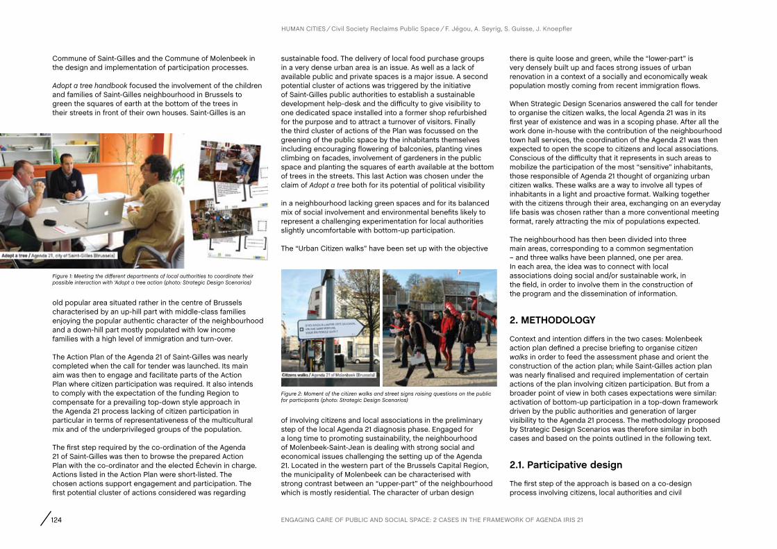
124 ENGAGING CARE OF PUBLIC AND SOCIAL SPACE: 2 CASES IN THE FRAMEWORK OF AGENDA IRIS 21
HUMAN CITIES Civil Society Reclaims Public Space F. Jégou, A. Seyrig, S. Guisse, J. Knoepfler
old popular area situated rather in the centre of Brussels characterised by an up-hill part with middle-class families enjoying the popular authentic character of the neighbourhood and a down-hill part mostly populated with low income families with a high level of immigration and turn-over.
The Action Plan of the Agenda 21 of Saint-Gilles was nearly completed when the call for tender was launched. Its main aim was then to engage and facilitate parts of the Action Plan where citizen participation was required. It also intends to comply with the expectation of the funding Region to compensate for a prevailing top-down style approach in the Agenda 21 process lacking of citizen participation in particular in terms of representativeness of the multicultural mix and of the underprivileged groups of the population.
The first step required by the co-ordination of the Agenda 21 of Saint-Gilles was then to browse the prepared Action Plan with the co-ordinator and the elected Échevin in charge. Actions listed in the Action Plan were short-listed. The chosen actions support engagement and participation. The first potential cluster of actions considered was regarding
sustainable food. The delivery of local food purchase groups in a very dense urban area is an issue. As well as a lack of available public and private spaces is a major issue. A second potential cluster of actions was triggered by the initiative of Saint-Gilles public authorities to establish a sustainable development help-desk and the difficulty to give visibility to one dedicated space installed into a former shop refurbished for the purpose and to attract a turnover of visitors. Finally the third cluster of actions of the Plan was focussed on the greening of the public space by the inhabitants themselves including encouraging flowering of balconies, planting vines climbing on facades, involvement of gardeners in the public space and planting the squares of earth available at the bottom of trees in the streets. This last Action was chosen under the claim of Adopt a tree both for its potential of political visibility
in a neighbourhood lacking green spaces and for its balanced mix of social involvement and environmental benefits likely to represent a challenging experimentation for local authorities slightly uncomfortable with bottom-up participation.
The “Urban Citizen walks” have been set up with the objective
there is quite loose and green, while the “lower-part” is very densely built up and faces strong issues of urban renovation in a context of a socially and economically weak population mostly coming from recent immigration flows.
When Strategic Design Scenarios answered the call for tender to organise the citizen walks, the local Agenda 21 was in its first year of existence and was in a scoping phase. After all the work done in-house with the contribution of the neighbourhood town hall services, the coordination of the Agenda 21 was then expected to open the scope to citizens and local associations. Conscious of the difficulty that it represents in such areas to mobilize the participation of the most “sensitive” inhabitants, those responsible of Agenda 21 thought of organizing urban citizen walks. These walks are a way to involve all types of inhabitants in a light and proactive format. Walking together with the citizens through their area, exchanging on an everyday life basis was chosen rather than a more conventional meeting format, rarely attracting the mix of populations expected.
The neighbourhood has then been divided into three main areas, corresponding to a common segmentation – and three walks have been planned, one per area. In each area, the idea was to connect with local associations doing social and/or sustainable work, in the field, in order to involve them in the construction of the program and the dissemination of information.
2. METHODOLOGY
Context and intention differs in the two cases: Molenbeek action plan defined a precise briefing to organise citizen walks in order to feed the assessment phase and orient the construction of the action plan; while Saint-Gilles action plan was nearly finalised and required implementation of certain actions of the plan involving citizen participation. But from a broader point of view in both cases expectations were similar: activation of bottom-up participation in a top-down framework driven by the public authorities and generation of larger visibility to the Agenda 21 process. The methodology proposed by Strategic Design Scenarios was therefore similar in both cases and based on the points outlined in the following text.
2.1. Participative design
The first step of the approach is based on a co-design process involving citizens, local authorities and civil
of involving citizens and local associations in the preliminary step of the local Agenda 21 diagnosis phase. Engaged for a long time to promoting sustainability, the neighbourhood of Molenbeek-Saint-Jean is dealing with strong social and economical issues challenging the setting up of the Agenda 21. Located in the western part of the Brussels Capital Region, the municipality of Molenbeek can be characterised with strong contrast between an “upper-part” of the neighbourhood which is mostly residential. The character of urban design
Commune of Saint-Gilles and the Commune of Molenbeek in the design and implementation of participation processes.
Adopt a tree handbook focused the involvement of the children and families of Saint-Gilles neighbourhood in Brussels to green the squares of earth at the bottom of the trees in their streets in front of their own houses. Saint-Gilles is an
Figure 1: Meeting the different departments of local authorities to coordinate their possible interaction with ‘Adopt a tree action (photo: Strategic Design Scenarios)
Figure 2: Moment of the citizen walks and street signs raising questions on the public for participants (photo: Strategic Design Scenarios)

125
HUMAN CITIES Civil Society Reclaims Public Space F. Jégou, A. Seyrig, S. Guisse, J. Knoepfler
servants into a participative ideation, specification and experimentation of new social activities.
In Molenbeek, this process was developed in five phases. First a preliminary exchange at the city council; second, an open workshop organised in one of the neighbourhood community centres; third, three days of preparatory visits on the field to meet the local initiatives and visit the potential stops; fourth, organisation of the three participative walks; and fifth, debriefing following each walk. The principle of citizen walks itself was an idea proposed by the local public authority and already precisely described in the call for tender. In the offer, Strategic Design Scenarios suggested to adapt the methodology with their own approach.
The first exchange in Neighbourhood Council was organised to define more precisely with the working group the methodology proposed by Strategic Design Scenarios in its answer to the call. Building confidence, sharing on the spirit of the mission, and specifying details of organisation were the main objectives of the meeting.
The second step, the open workshop, broadened the participative assembly to other civil servants and politics and to local associations in charge of sustainable initiatives already identified by the Agenda 21 coordinator. Designed as a creative workshop aiming to build the walks in a collaborative way, the session was dispatched by working tables. The local expertise of participants was requested in two ways. They were invited on one hand to feed a city map with promising social initiatives, which could potentially become stops for the walk, and on the other hand, they were asked to contribute with a set of playing cards to the definition of the walks on the conceptual and more technical point of view. Both their practical knowledge and their experiences in the field were mobilized. The collaborative tools like the map with flags to pin, or the playing cards were designed to facilitate the collection of information, but also to create a user-friendly atmosphere that leads to numerous informal discussions.
Some weeks later, the collaborative process of building the walks has been continued by the organisation of three “spotting” days, one corresponding to each of the future walks. Those preparatory visits were open to the people from the neighbourhood council and to citizens linked to authorities, like neighbourhood councillors. The idea here was first to have a preliminary contact with the hosts to share the concept and organisation of these citizen walks and to prepare the discussion before the
event time and also to check the interest and capacity of the visited places to host the group during the walks.
Fourth step, during the walk themselves: to facilitate the interaction between the organisers (including the consultants and the representatives of the city) and the participants, several supports were designed to involve the citizens in the walk itself, and in the construction of the shared diagnosis of sustainability. A map displayed on a sandwich-board, a “stick for talk” to record conversations on the go, and a shared camera were initially designed in the interest of facilitating participation in an informal way.
Finally, the convivial debriefings organised at the end of each walk were opportunities for walkers to get back on the route but also to discuss other untreated subjects. Those debriefing finally also turned out to discussions on the methodology of the walks, considered as an open process. In Saint-Gilles, stakeholders involved in the actions of the Plan of the Agenda 21 characterized by citizens’ participations gathered in a Pecha-Kucha-like evening to share, discuss and select interesting initiatives.
A similar open workshop as in Molenbeek was organised, inviting players already involved in citizens’ participation in a presentation evening hosted by the local cultural and art centre Pianofabriek in Saint-Gilles. The purpose of the evening had multiple reasons: to give visibility to existing citizens’ and public authorities’ initiatives oriented toward participation; to let their promoters meet each other and confront their points of view; to get a reasonable panorama of what is happening in that field and finally to debate on how public participation could be supported and enhanced. The presentation format was inspired by the settings of a Pecha-Kucha presentation methodology in which 20 slides are shown for 20 seconds each, usually seen in a multiple-speaker event. In the case of Saint-Gilles evening, each speaker – including the Échevin – had only 3 images and 3 minutes to present an overview of his/her project or initiative. The aim of this rather strict and somewhat frustrating format was to keep presentations very short in order to be able to present a large panorama of examples stimulating a debate, and keeping time for discussion. Cases from local NGOs supporting families to reduce their energy bill to public authorities initiatives to diffuse sustainable daily practices were complemented by a range of social innovations from other parts of the world brought by Strategic Design Scenarios to open the debate (Meroni, 2007; Jégou and Manzini 2008). Highlights of the discussion point out the paradoxical injunction of local authorities struggling
to engage participation in a top-down process and the lack of practice of public action to acknowledge and support spontaneous bottom-up public participation. Beyond the conceptual debate that will be developed in the last part of the article, the exchanges allow pointing to a series of promising local initiatives and experienced actors to further investigate active local participation processes in public space.
2.2. Investigating local initiatives
The second step of the approach is based on the collective investigation of local initiatives of social innovations focusing the interaction between citizens and the public spaces they cross in their everyday life.
In Saint-Gilles a systematic series of visits and interviews to all citizens’ initiatives of greening public space allow exploring existing practices, detect resisting barriers and integrate working solutions.
The very idea of ‘adopting a tree’ and its inscription in the Agenda 21 Action Plan of Saint-Gilles was suggested by two remarked initiatives conducted in 2008 and 2009. The first took place in Anderlecht, another neighbourhood of Brussels, and is based on the Comité de Quartier (neighbourhood committee) called Chrysalide and supported by the Brussels Capitale Regions’ Quartiers Verts (Green Neighbourhood) programme. The second took place among inhabitants of Crickx and Gustave Defnet streets in Saint-Gilles in the context of a summer initiative called La rue aux enfants (The street to the children), transforming both streets for a few days into a temporary children’s playground and a party place for their families. In both initiatives, the highlight was to focus on a square of earth at the bottom of the trees in the streets and consider it as micro-gardens of the inhabitants living in front rather than as public space. In consequence, these micro-gardens not owned by anybody are proposed for ‘adoption’ by one or more families. Both processes include the involvement of children as gardeners and as intermediary to involve their families; the progressive engagement of more participants until the organisation of a hot moment around a planting party; and last but not least, a strong project management by a group of motivated citizens and in particular a leader whose creativity, entrepreneurship and persistency ensure the progress, overcome barriers and is key to the success of the operation. Both cases were investigated in detail through visits and in-depth interviews trying to detect enablers, tips, difficulties and ways to overcome them. More initiatives of
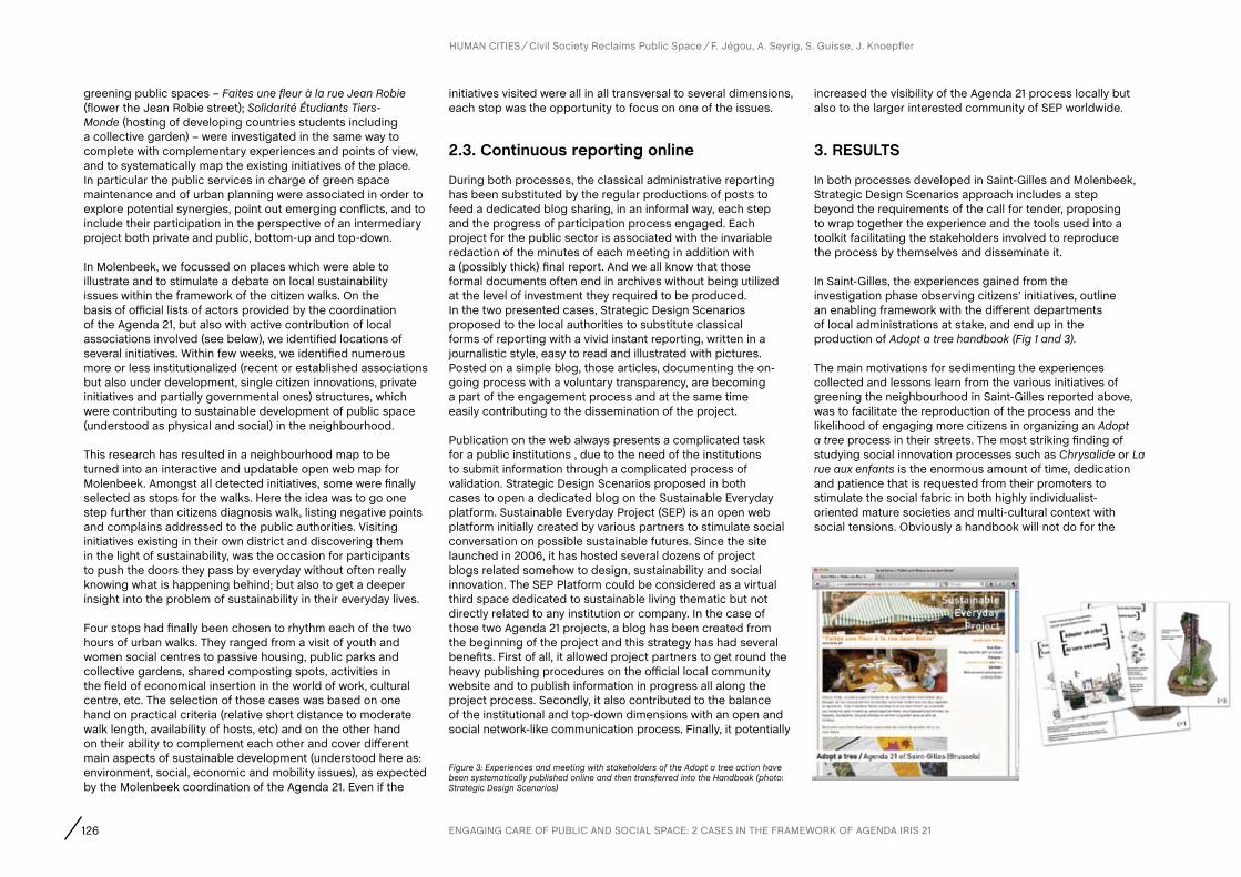
126
greening public spaces – Faites une fleur à la rue Jean Robie (flower the Jean Robie street); Solidarité Étudiants Tiers-Monde (hosting of developing countries students including a collective garden) – were investigated in the same way to complete with complementary experiences and points of view, and to systematically map the existing initiatives of the place. In particular the public services in charge of green space maintenance and of urban planning were associated in order to explore potential synergies, point out emerging conflicts, and to include their participation in the perspective of an intermediary project both private and public, bottom-up and top-down.
In Molenbeek, we focussed on places which were able to illustrate and to stimulate a debate on local sustainability issues within the framework of the citizen walks. On the basis of official lists of actors provided by the coordination of the Agenda 21, but also with active contribution of local associations involved (see below), we identified locations of several initiatives. Within few weeks, we identified numerous more or less institutionalized (recent or established associations but also under development, single citizen innovations, private initiatives and partially governmental ones) structures, which were contributing to sustainable development of public space (understood as physical and social) in the neighbourhood.
This research has resulted in a neighbourhood map to be turned into an interactive and updatable open web map for Molenbeek. Amongst all detected initiatives, some were finally selected as stops for the walks. Here the idea was to go one step further than citizens diagnosis walk, listing negative points and complains addressed to the public authorities. Visiting initiatives existing in their own district and discovering them in the light of sustainability, was the occasion for participants to push the doors they pass by everyday without often really knowing what is happening behind; but also to get a deeper insight into the problem of sustainability in their everyday lives.
Four stops had finally been chosen to rhythm each of the two hours of urban walks. They ranged from a visit of youth and women social centres to passive housing, public parks and collective gardens, shared composting spots, activities in the field of economical insertion in the world of work, cultural centre, etc. The selection of those cases was based on one hand on practical criteria (relative short distance to moderate walk length, availability of hosts, etc) and on the other hand on their ability to complement each other and cover different main aspects of sustainable development (understood here as: environment, social, economic and mobility issues), as expected by the Molenbeek coordination of the Agenda 21. Even if the
initiatives visited were all in all transversal to several dimensions, each stop was the opportunity to focus on one of the issues.
2.3. continuous reporting online
During both processes, the classical administrative reporting has been substituted by the regular productions of posts to feed a dedicated blog sharing, in an informal way, each step and the progress of participation process engaged. Each project for the public sector is associated with the invariable redaction of the minutes of each meeting in addition with a (possibly thick) final report. And we all know that those formal documents often end in archives without being utilized at the level of investment they required to be produced. In the two presented cases, Strategic Design Scenarios proposed to the local authorities to substitute classical forms of reporting with a vivid instant reporting, written in a journalistic style, easy to read and illustrated with pictures. Posted on a simple blog, those articles, documenting the on-going process with a voluntary transparency, are becoming a part of the engagement process and at the same time easily contributing to the dissemination of the project.
Publication on the web always presents a complicated task for a public institutions , due to the need of the institutions to submit information through a complicated process of validation. Strategic Design Scenarios proposed in both cases to open a dedicated blog on the Sustainable Everyday platform. Sustainable Everyday Project (SEP) is an open web platform initially created by various partners to stimulate social conversation on possible sustainable futures. Since the site launched in 2006, it has hosted several dozens of project blogs related somehow to design, sustainability and social innovation. The SEP Platform could be considered as a virtual third space dedicated to sustainable living thematic but not directly related to any institution or company. In the case of those two Agenda 21 projects, a blog has been created from the beginning of the project and this strategy has had several benefits. First of all, it allowed project partners to get round the heavy publishing procedures on the official local community website and to publish information in progress all along the project process. Secondly, it also contributed to the balance of the institutional and top-down dimensions with an open and social network-like communication process. Finally, it potentially
increased the visibility of the Agenda 21 process locally but also to the larger interested community of SEP worldwide.
3. RESULTS
In both processes developed in Saint-Gilles and Molenbeek, Strategic Design Scenarios approach includes a step beyond the requirements of the call for tender, proposing to wrap together the experience and the tools used into a toolkit facilitating the stakeholders involved to reproduce the process by themselves and disseminate it.
In Saint-Gilles, the experiences gained from the investigation phase observing citizens’ initiatives, outline an enabling framework with the different departments of local administrations at stake, and end up in the production of Adopt a tree handbook (Fig 1 and 3).
The main motivations for sedimenting the experiences collected and lessons learn from the various initiatives of greening the neighbourhood in Saint-Gilles reported above, was to facilitate the reproduction of the process and the likelihood of engaging more citizens in organizing an Adopt a tree process in their streets. The most striking finding of studying social innovation processes such as Chrysalide or La rue aux enfants is the enormous amount of time, dedication and patience that is requested from their promoters to stimulate the social fabric in both highly individualist-oriented mature societies and multi-cultural context with social tensions. Obviously a handbook will not do for the
HUMAN CITIES Civil Society Reclaims Public Space F. Jégou, A. Seyrig, S. Guisse, J. Knoepfler
Figure 3: Experiences and meeting with stakeholders of the Adopt a tree action have been systematically published online and then transferred into the Handbook (photo: Strategic Design Scenarios)
ENGAGING CARE OF PUBLIC AND SOCIAL SPACE: 2 CASES IN THE FRAMEWORK OF AGENDA IRIS 21

127
irreplaceable skills of creative empowerment and charismatic entrepreneurship. But it may achieve two articulated goals:
The handbook will gather a significant number of experiences (failures and success) in an easily accessible way to avoid the burden of collecting case studies, analysing barriers, and enable simple access to the contacts of experienced people who can give advice from their own experience;
Consequently, the handbook is the evidence of real practices that both illustrate that it exists (it is not an idea or a utopia) and it is feasible (it has already been done by others even if with clear difficulties). And the very fact of presenting it as more feasible and accessible as shown in the first point is likely to inspire new vocations among a larger range of less charismatic and skilled citizens.
In consequence, the Adopt a tree handbook is designed as an attractive set balancing the narration of a panorama of experiences, showing citizens’ creativity in making use of the tiny squares of earth at the bottom of street trees, with the tips and notes to concretely enable and facilitate a potential candidate to take action. A careful trade-off is kept between the enabling dimension (with the risk to produce a boring technical manual diluting the process into too many advices and precautions), and the appealing dimension (with the risk of presenting a fairytale underestimating the requested effort to catalyse participation). The handbook is composed of 3 tools:
The front end is a set of post-cards showing a selection of cases of greening tree bottoms. They play the role of Enabling Cards (Jégou, Liberman, Girardi & Bernagozzi, 2008) with 3 levels of usage: the dissemination of the core idea as independent post-cards showing and explaining key benefits of undertaking a tree greening process (distributing the post-card to attract inhabitants of the street interest); the presentation of current field of possibilities and main steps of the tree greening process (using the post-cards as an articulated story-board); the discussion and selection of the most appropriated components of the solution to fit the specific new street context where the greening process is envisioned (using the post-cards as building blocs of the desired solution).
The core content of the handbook based on a customized and self-printed manual presenting the synthesis of many tree
greening experiences in a form of story-telling. This manual can be read from the beginning to the end as a reportage: it drives the reader through pictures of many aesthetics obtained using the squares of earth at the bottom of the trees; it points out the dangers that high plants represent, for example hiding children from vehicle circulation; it proposes a list of appropriated plants advised by the public services in charge of neighbourhood green areas; it shows models of tree adoption certificates to involve all the families; it shows how children may build signs with their names to indicate that a tree has been adopted by them. It explains how giving visibility to the people caring for the public space in front of their house increases interest from other citizens and reduced vandalism; etc.
The third component of the handbook consists of having simple annual planning; starting in autumn when it is the time to start the involvement of the core promoters group, involve the neighbourhood authorities for authorizations. It continues with main steps to be taken in winter and spring, formulated by questions: when do the public green services order their plants for the coming year and therefore when to ask for support? What about a workshop with children And similar. Finally it signals main steps to anticipate when organising a planting party. All the questions are loosely suggested on a large format to be completed, changed and pinned on the wall to keep participants focused on a minimum structured process.
Page setting of all 3 elements is made on a common presentation software to enable editing, customization, appropriation and printing on a simple desktop printer.
In Molenbeek, the three walks organised were considered as a process and not the end product, a way to pilot the tools and procedures used during the preparation and the animation of the walk in order to fine-tune the design of a “Citizenship walks action kit” (Fig 2 and 4).
Even if the initial conditions of organisation were not ideal due to a lack of time which did not allow to involve a local association working with groups of people in fragile social situations as much as hoped, the experimentation of the organisation of those three pilots walks gave the opportunity to the project team (consultants in collaboration with the coordinator of the Agenda 21 and local associations) to test and improve several participation and animation tools. Presented to the city and local associations in the form of a simple slide show to browse or to print, this kit describes step by step how to organize citizenship walks on sustainability. It gives advice and at the same time feedback from the pilots walks, suggesting different implementation options. Among the tools of organisation and animation suggested, here are some examples:
Temporary sign boards mimicking official street signs were placed along the walk itinerary to engage a dialog about specific public space situations. What about a community garden in this empty space? What if parking would be prohibited in this place? The aim was to invite the participants to the walk but also all people passing by to look at their everyday environment in a different way.
A “speech-stick” to collect the informal exchanges between participants during the walk: including a digital recorder and covered with bright colours, the stick passed from hand to hand, everybody taking responsibility in turn to keep track of interesting remarks and specific conversations.
All those tools and advices aim to contribute to the simple organisation of citizen walks to involve inhabitants into participative activities turning sustainability in their area into an everyday concern.
4. DIScUSSION
This discussion should also be reported to the Agenda 21 framework in which the two experiences reported here have taken place. Participation is a core aspect of Agenda 21 but when promoted through a top-down public initiative, participation appears ex-post as an alibi, or a justification, or in the perspective of the historical antagonism between direct democracy and participative democracy (Fung, 2011); it may even be a threat for policy makers. Participative design approach based on investigation of local social innovation, inclusive co-design, progressive micro-experimentations and design of enabling solutions opens opportunities of renewal for Agenda 21 as a modern eco-systemic instrument.
HUMAN CITIES Civil Society Reclaims Public Space F. Jégou, A. Seyrig, S. Guisse, J. Knoepfler
Figure 4: 2 tools used during the citizen walks: a “speech-stick” to record informal conversations; a map of the walk with stops carried by one of the organizers in order to enable participants to locate their remarks and ideas (photo: Strategic Design Scenarios)
128
Co-designing new social activities have multiple enabling effects by supporting citizens in their appropriation of public space. It supports but also fulfils to a certain extent the so-called reclaim of public space. At first, the design is inspired by local existing citizen initiatives. It means that spontaneous citizen actions are not only recognized but also promoted. Recognition and visibility given by networking initiatives can act as an alternative to institutionalization. It is a chance to maintain social effectiveness of spontaneous structures. The design activity involved, which provides new interactions, new collaborations and new enrolments, may also develop original actions and support emergence of new initiatives.
On the one hand, by engaging continually local expertise (about social initiative strictly speaking, but also about local population practices and habits, etc), the design process increases the potential success of new initiatives. It results in an optimally documented project based on local experiences of social innovation and a social network of involved creative citizens. On the other hand, by supporting local processes with new
interaction tools and experiences of social innovations collected in different contexts, the design operation can stimulate, question and refresh the initiatives and practices of citizens but also local authorities. More precisely, this design mediated process can be considered as a governance tool, horizontally shaped, articulating top-down and bottom-up for cooperation towards a public space more considered as a common good. These participatory, real-life and collaborative ways of work and innovation are preventing public space standardisation. This approach also prevents potential privatization.
The design potential for this form of innovation focuses the attention to existing uses, including informal, weak or non-obvious practices, represents a barrier against standardization. Privatization risks could appear if participation of some users generates monopolization of public territories. That happens when only classical participatory tools, like prospective workshops or public opinion meetings, are used. There are often concerns when only a small part of real public space users are involved. People with not much spare time may
HUMAN CITIES Civil Society Reclaims Public Space F. Jégou, A. Seyrig, S. Guisse, J. Knoepfler
include a large portion of users such as those with children, young professionals or poor people, local workers, walkers, housewives, etc. Design helps then to multiply participatory tools (questioning boards and other interventions in public space, web blog, citizen walks, citizen workshops, targeted animations, etc), enabling, together, to reach more and diverse citizens by dealing with diverse commitment rates and forms.
The necessity to pay attention to user’s commitment to the plurality of public space was a major highlight of last Human Cities Symposium in 2010. It is also an overall stake, when contemporary society and public policies tend to privilege high and constant citizenship, initiative and competition (Ehrenberg, 2000). It seems that if it’s contextualized, constantly adjusted, collaborative, inventive and attentive, the design process supporting social initiative illustrated in this paper helps achieve a multiple appropriation of public space. It supports each citizen enabling as much as possible common good status of the place.
BibliographyBouteau, A. (2009). Les agendas 21 locaux. Bilan et perspectives en Europe et en France, in Le Centre Ressource Prospective du Grand Lyon, Décembre 2009.
Ehrenberg, A. (2000). La Fatigue d’être soi. Dépression et société, Odile Jacob, Paris.
Fung, A. (2011). Démocratiser le processus d’élaboration des politiques in Téléscope. Revue d’analyse comparée de l’administration publique. Vol 17, La participation citoyenne, Winter 2011.
Jégou, F. and Manzini, E. (2008). Collaborative Services, Social Innovation and Design for Sustainability. With essay by Bala, P., Cagnin, C., Cipolla, C., Green, J., van der Horst, T., de Leeuw, B., Luiten, H. Marras, I., Meroni, A., Rocchi, S., Strandbakken, P., Stø, E., Thakara, J., Un, S., Vadovics, E. Warnke, P. and Zacarias A. Edizioni Poli.design, Milan.
Jégou, F., Liberman, J., Girardi, S. and Bernagozzi, A. (2008). Design for Social Innovation. Enabling replication of promising initiatives for sustainable living in Brussels and Paris. Changing the Change design research conférence, 10-12 July 2008, Torino.
Meroni A. (2007). Creative communities. People inventing sustainable ways of living. With essay by Bala, P., Ciuccarelli, P., Collina, L., de Leeuw, B., Jégou, F., Luiten, H., Manzini, E., Marras, I., Meroni, A., Strandbakken, P., Stø, E., Vadovics, S. Edited by Polidesign, Milan.
ENGAGING CARE OF PUBLIC AND SOCIAL SPACE: 2 CASES IN THE FRAMEWORK OF AGENDA IRIS 21
AUTHORS
Abstract
CHAPTER
129 R. Houlstan-Hasaerts, B. Tominc, M. Nikšič, B. Goličnik Marušić (Editors) Urbani izziv - publikacije, Ljubljana, May 2012
Keywords
contact Tibo LabatArchitect, Collectif Fertile, 6 rue de la Tour d’Auvergne, 44200, Nantes, France, 0033662882760, [email protected]ïs LegerLandscape architect, PhD student, Agrocampus Ouest, 2 rue Le Notre, 49045 Angers, France, 0033630001706, [email protected] SmithLandscape architect, 11 rue Lagrange, 75005, Paris, France, 0033645102854, [email protected]
Collective, urban prefiguration, designing by using, friche
Since the 1980s the City of Nantes has undergone a succession of urban mutations linked to de-industrialization. While the well-known project of “Ile de Nantes” has master planned an “eco-district” of 350ha, a large number of gaps and leftover spaces still hold great potential in the urban fabric. The collective Fertile is active in two such sites in Bas-Chantenay. The neighbourhood lies to the West of Nantes, at the symbolic point where the Brittany granite formation “ le Sillon de Bretagne” terminates at the River Loire. An abandoned quarry “ la Carrière Miséry” and an adjacent railway track constitute two “ friches” that our collective is investigating as a research-action project. Based on a rhythm of spontaneous events, Fertile aims to bring out the potential of the sites for public use, ecologic continuities and economic alternative solutions. The intention is to bring people together to initiate and explore imaginative solutions for the use of these spaces. “Designing by using” incarnates our concept that encourages locals, artists and planners to re-invent the space by using
and Paul Smith, Paris (France)Tibo Labat, Nantes (France), anaïs Leger, Angers (France)
COLLECTIF FERTILE, NANTES: DESIGNING BY USING
Un état du monde“La vie avance selon un chaos poétique offert à tous ceux qui veulent bien ne pas fermer les yeux.”
State of the World.”Life moves ahead in poetical chaos visible to those willing to keep their eyes open.”
Gilles Clément, la Vallée, 17th April 2009.
1. fERTILE “fRIcHES” IN NaNTES
Since the 1980s the City of Nantes has undergone a succession of urban mutations linked to de-industrialization. The urban community is well known for its innovative urban solutions, its alternative mobility policies and its ambitions to develop services around artistic and cultural activities. While the well-known project of “Ile de Nantes” has master planned an “eco-district” of 350ha, a large number of gaps and leftover spaces still hold great potential in the urban
and living in it. Over a period of two years, Fertile has organized a long-term communal strategy, managed by volunteer networks on the sites through diverse actions: Ephemeral art and performances to draw interest, temporary structures and a mobile kitchen for events, bike information units, creating playgrounds, gardening and growing food, establishing a compost and botanical seed exchange, experimental animal city farming, revealing wildlife… in brief making the unlikely more likely. Such events and projects reveal new interests and uses for the spaces. Our action, which just gained a three years agreement to occupy the site from the City of Nantes, anticipates and influences urban planning decisions. Fertile’s posture is an “urban prefiguration” to draw an intelligent line for future urban mutations, and wishes to inspire new practices and processes to read, reclaim, and recreate urban public spaces. Designing by using.

130 COLLECTIF FERTILE, NANTES. “DESIGNING BY USING”.
HUMAN CITIES Civil Society Reclaims Public Space T. Labat, A. Leger, P. Smith
fabric. The collective Fertile is active in two such sites in Bas-Chantenay. The neighbourhood lies to the West of Nantes, at the point where the granite formation “le Sillon de Bretagne” terminates at the River Loire. An abandoned quarry “la Carrière Miséry” and an adjacent abandoned railway track, le Caillou, constitute two “friches” that our collective is investigating as a “Designing by using” research-action project. A “friche” describes an abandoned, unused urban space often overgrown with naturally regenerating pioneer plant species with no current specified use or designated function. Friches are places in abeyance and while waiting, plants grow! These “friches” offer a potential for occupation, intention and experimentation.
In 2010 a group of landscape architects, gardeners and architects gathered on the Carrière Miséry, an abandoned quarry close to central Nantes. They met around the notion to occupy the quarry. The Collectif Fertile was created. Composed initially of five members, the small group mobilized and experimented together. To start with, the first experimentations took place in the Carrière Miséry. Simultaneously urban explorations, taking the form of urban walks, looked for potentials, imaginaries and abandoned spaces by taking participants on improvised urban itineraries. The collective discovered and identified urban gaps. In 2011, the site le Caillou was occupied as a new experimentation space (e.g., Figure 1).
Fertile invests in friches, potential spaces in the city, and organizes “urban prefiguration” actions. Urban prefiguration’s objective is to activate dormant or speculative pockets in order to influence future planning decisions. Through the approach of designing by using, Fertile’s posture is of urban prefiguration that draws an intelligent line for future urban mutations and wishes to inspire new practices and processes to read, reclaim, and recreate public urban spaces. The collective militates for a better integration of the communities in the urbanisation process. For two years Fertile has organized a long-term communal strategy managed by volunteer networks on the sites… in brief making the unlikely more likely. Fertile is a group of urban design professionals who reflect upon their dual role as fabricators of cities whilst contiguously being inhabitants and users of urban spaces.
After briefly introducing the context and background in which the reflection is positioned, the article presents the methodologies used for the experimentations by the collective: The urban explorations and the “designing by using” approach. Actions are then presented. Finally the article offers a reflection upon urban occupations as an urban prefiguration tool, discusses the role of the designer / user in the creation of public space, and reflects on how civil groups can engage with the local authorities to create a dialogue with politicians in influencing the creation and use of public space.
1.1. analysis: Urban imaginaries and sterile contemporary public spacesThe question of urban planning interrogates the current economic, political and cultural models. These models are addressed by all disciplinary fields and crystallize in the production of public spaces. Cities can be understood as a framework of spaces for social interaction (Benjamin, 1983). Historically, public spaces have been conceived as zones of social communication that allowed individual buildings to catalyse processes of social interaction (Brillembourg, Klumpner, Contento, & Sherman, 2011) through diverse forms of communication in the street, the cafes or the salons (Senett, 1992). They contain collective imagination and reflect political changes: “Public spaces are firstly the containers of collective memory and desire, and secondly they are the places for geographic and social imagination to extend new relationships and sets of possibility…” (Corner, 2006).
Figure 1: Location plan of the two sites (Source: Fertile, 2011)

131
HUMAN CITIES Civil Society Reclaims Public Space T. Labat, A. Leger, P. Smith
As the contemporary city continues to grow, it becomes more difficult to craft these public spaces of interaction. The ownership of public space is narrowed. Between neutrality and dominant political models, we observe a generalized sterilisation of public spaces. It becomes necessary to encourage new processes of social design (Brillembourg et al., 2011) by discussing the traditional issues of the construction of public spaces through new ways of consultation, governance and conception (Zepf, 2004).
1.2. Diagnostic: fertile urban interstices in the cityWe are entering into what has been called the “first urban century” (Steiner, 2011), with a majority of people on the planet living in city-regions for the first time in history. Facing these new urban challenges, the scales of urban intervention are changing. The notion of urban ecology is emerging. “Dynamic” and “unpredictable” are the adjectives used to describe ecological dynamics. The city is understood as a process (Desvigne, 2012).
Urban gaps, or “friches”, are the result of urban mutations that occurred during de-industrialization. They represent a “place” in the city, an urban potential that offers a rich biodiversity. Developers often covet them. When considering the sterilization of contemporary public spaces, “friches” offer places to make the unlikely more likely to happen. They are places for possibilities, through experimentation. These “scrap spaces” have potential for imagination and biodiversity. Clément describes these spaces in his theory of the Third Landscape:
”The Third Landscape designates the sum of the space left over by man to landscape evolution, to nature alone. Included in this category are left behind urban or rural sites, transitional spaces, neglected land, swamps, moors, peat bogs, but also roadsides, shores, railroad embankments, etc” (Clément, 2004).
Through the concept of urban garden, Zepf promotes the landscape approach as a model for the construction of the city (Zepf, 2004). In response to a fast pace of urbanization, the urban gardener takes time into account and transforms the site. In response to the sterilization of public spaces, the urban garden creates new uses through the activities of gardening, practices, festivals, rituals and social behaviours. In response to incessant marketing and imageability (Lynch,
1960) in the contemporary city, the urban garden brings a sensitive answer.
In Nantes, the site of the Carrière Miséry is a haven of biodiversity, located to the west of the centre of Nantes. This site is the starting point of the Fertile adventure. It is by visiting and occupying this quarry that the members of the future collective gathered together. These events raise questions. Are urban interventions justified on these kinds of sites when a future urban development is planned? How do you organize experimentations that bring biodiversity and social potentials to light?
1.3. Evolution: Public spaces as arenas for political action Public spaces can be understood as spaces for political actions (Habermas, 1993). Following Jane Jacobs’s idea of the Open city as opposed to the Closed city and its capitalist urban homogeneity, Fertile encourages a spontaneous growth of the city that does not fit neatly together but allows for creation, free from regulation. In invisible derelict gaps and wasteland termed “intermediary natures” or “interstitial spaces” (Cauquelin, 2000; Jannière & Pousin, 2007), Fertile wishes to experience the “incomplete public spaces” described by Senett, that admit porosity, dissonance and conflicts (Senett, 2006). Inspired by Sieverts and his concept of the “in-between city” (Sieverts, 2000), Fertile wishes to experience urban interventions based on recycling and reclaiming economies.
In order to address these issues, civil society initiates occupation of public spaces. Fertile’s actions can serve as an example of this. The participative design process or user’s appropriation of public space create new ways of social design. This is the subject of our article. How can hands on, on site interventions work?
2. fERTILE INTENTIONSThe Collectif Fertile is a group of young professionals who question contemporary urban issues. Fertile questions the link between the conception and the urban reality, specifically when designing public spaces. How can professionals design if they do not experiment on site? The collective wants to
manifest itself physically on site and show a presence. Through our hands-on, on site experimentations in urban “friches”, how can we impact on policymaking and influence urban planning?
3. METHODS
3.1 approach: Urban explorations
In our eyes, the preamble to action is linked to the way a space is perceived. Fertile is interested in instigating a shift, questioning the context and mining the potentials.
As a tool of urban diagnostic, the practise of urban exploration or Explo is proposed as a collective walk, or a creative
Figure 2: The explos (Source: Fertile, 2011)
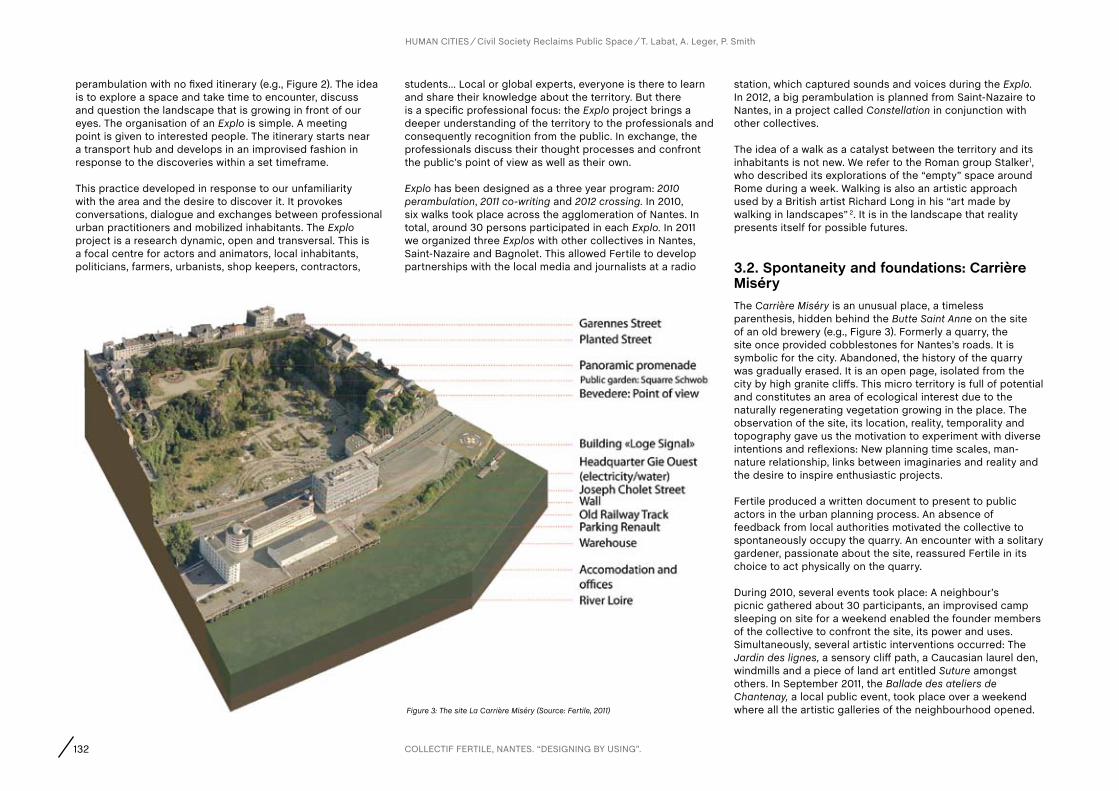
132
perambulation with no fixed itinerary (e.g., Figure 2). The idea is to explore a space and take time to encounter, discuss and question the landscape that is growing in front of our eyes. The organisation of an Explo is simple. A meeting point is given to interested people. The itinerary starts near a transport hub and develops in an improvised fashion in response to the discoveries within a set timeframe.
This practice developed in response to our unfamiliarity with the area and the desire to discover it. It provokes conversations, dialogue and exchanges between professional urban practitioners and mobilized inhabitants. The Explo project is a research dynamic, open and transversal. This is a focal centre for actors and animators, local inhabitants, politicians, farmers, urbanists, shop keepers, contractors,
students… Local or global experts, everyone is there to learn and share their knowledge about the territory. But there is a specific professional focus: the Explo project brings a deeper understanding of the territory to the professionals and consequently recognition from the public. In exchange, the professionals discuss their thought processes and confront the public’s point of view as well as their own.
Explo has been designed as a three year program: 2010 perambulation, 2011 co-writing and 2012 crossing. In 2010, six walks took place across the agglomeration of Nantes. In total, around 30 persons participated in each Explo. In 2011 we organized three Explos with other collectives in Nantes, Saint-Nazaire and Bagnolet. This allowed Fertile to develop partnerships with the local media and journalists at a radio
station, which captured sounds and voices during the Explo. In 2012, a big perambulation is planned from Saint-Nazaire to Nantes, in a project called Constellation in conjunction with other collectives.
The idea of a walk as a catalyst between the territory and its inhabitants is not new. We refer to the Roman group Stalker1, who described its explorations of the “empty” space around Rome during a week. Walking is also an artistic approach used by a British artist Richard Long in his “art made by walking in landscapes” 2. It is in the landscape that reality presents itself for possible futures.
3.2. Spontaneity and foundations: carrière MiséryThe Carrière Miséry is an unusual place, a timeless parenthesis, hidden behind the Butte Saint Anne on the site of an old brewery (e.g., Figure 3). Formerly a quarry, the site once provided cobblestones for Nantes’s roads. It is symbolic for the city. Abandoned, the history of the quarry was gradually erased. It is an open page, isolated from the city by high granite cliffs. This micro territory is full of potential and constitutes an area of ecological interest due to the naturally regenerating vegetation growing in the place. The observation of the site, its location, reality, temporality and topography gave us the motivation to experiment with diverse intentions and reflexions: New planning time scales, man-nature relationship, links between imaginaries and reality and the desire to inspire enthusiastic projects.
Fertile produced a written document to present to public actors in the urban planning process. An absence of feedback from local authorities motivated the collective to spontaneously occupy the quarry. An encounter with a solitary gardener, passionate about the site, reassured Fertile in its choice to act physically on the quarry.
During 2010, several events took place: A neighbour’s picnic gathered about 30 participants, an improvised camp sleeping on site for a weekend enabled the founder members of the collective to confront the site, its power and uses. Simultaneously, several artistic interventions occurred: The Jardin des lignes, a sensory cliff path, a Caucasian laurel den, windmills and a piece of land art entitled Suture amongst others. In September 2011, the Ballade des ateliers de Chantenay, a local public event, took place over a weekend where all the artistic galleries of the neighbourhood opened.
HUMAN CITIES Civil Society Reclaims Public Space T. Labat, A. Leger, P. Smith
Figure 3: The site La Carrière Miséry (Source: Fertile, 2011)
COLLECTIF FERTILE, NANTES. “DESIGNING BY USING”.

133
The quarry became a point on the artistic itinerary. The artistic installations, a newly cleared terrain for boules and the results of the workshops were presented to more than 300 people while sheep and ducks were left to roam (e.g., Figure 4).
From this spontaneous adventure, Fertile built up progressively the methodology of an evolutive project. The collective developed an in-situ experimental approach to open up sites for the public and instigating a debate. The event La Ballade des Ateliers provided an opportunity to visit the quarry for local inhabitants, journalists, public actors… some of whom had never dared to enter the site. This event did not have the support of local officials. Following the
Ballade des Ateliers, a contact was established with the City of Nantes. The winter allowed for a break during which the collective wrote a publication about the Carrière Miséry adventure. Regular meetings discussed a collective vision of a possible evolution and the importance of the hands-on action to modify the environment, which brought Fertile to formulate the concept of “designing by using”.
In spring, with no answer or support from local authorities and the Mairie de Nantes started to use the quarry to store construction materials for a high profile city centre urban regeneration project. Piles of sand and excavated gravel destroyed numerous art works. A fence was erected with a
locked gate. Fertile decided to move on and changed site.
3.3. activation: Designing by using: Le caillouClose to the Carrière, an old abandoned rail track runs parallel to the River Loire. A few hundred meters further, this old rail track cuts through a granite intrusion. Over 200 metres long, this granite block, forms a corridor taken over by spontaneous vegetation. Impenetrable, the corridor has become a dumping area. In the spring of 2011, we investigated the site. Fertile decided to call the site: Le Caillou, meaning the Stone in French. Its length, location, protected character invisible from the local area made it a potential site for Fertile. The idea of a project on le Caillou was born. Building on the experience of la Carrière, le Caillou evolved. Fertile invests into the site, experiments with diverse uses and shares good moments. Before meeting the public authorities, it is important to feel the site.
The first meeting with the public authority provided a three years occupation agreement in le Caillou. The idea is to create a garden, linking a boulevard and a parc, le Parc des Oblattes, located in the neighbourhood above. By creating a garden, Fertile comes back to the seasons. Based on a rhythm of spontaneous events, the intention is to introduce the local inhabitants to the collective and so to initiate and explore imaginative uses of the space.
Fertile proceeds with a clearer methodology following the experience of the Carrière Miséry. The first idea is to create a tool to meet people. This tool needs to be mobile and convivial. A mobile kitchen structure, based on a bike frame, was built with the help of a social reinsertion association. This mobile kitchen is deployed during each event forming a focus. The first action on site was to remove dumped items. Following that, a whole month was dedicated to pruning some vegetation, while keeping the mysterious aspect and maintaining a hidden access. A little path was created through the vegetation to access the site (e.g., Figure 5). The second action was to organize a social event during the 2011 edition of the Ballade des ateliers, the event that “launched” the Carrière in 2010. Several events were planned including theatre and projection of documentaries, a mobile kitchen as a meeting point, and hens for farming
HUMAN CITIES Civil Society Reclaims Public Space T. Labat, A. Leger, P. Smith
Figure 4: La Ballade des Ateliers : Event on the 26th September 2010 in La Carrière Miséry : Windmills installation, Building a structure, Sheep (Source: Fertile, 2011)
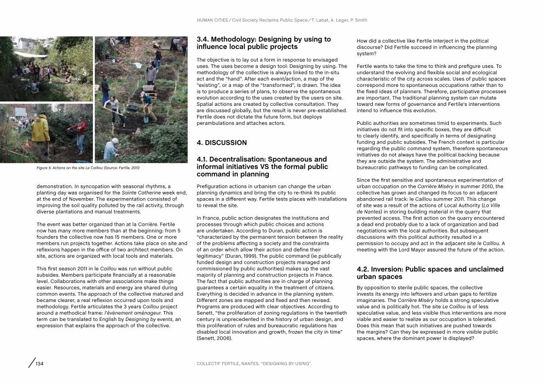
134
demonstration. In syncopation with seasonal rhythms, a planting day was organised for the Sainte Catherine week end, at the end of November. The experimentation consisted of improving the soil quality polluted by the rail activity, through diverse plantations and manual treatments.
The event was better organized than at la Carrière. Fertile now has many more members than at the beginning: from 5 founders the collective now has 15 members. One or more members run projects together. Actions take place on site and reflexions happen in the office of two architect members. On site, actions are organized with local tools and materials.
This first season 2011 in le Caillou was run without public subsides. Members participate financially at a reasonable level. Collaborations with other associations make things easier. Resources, materials and energy are shared during common events. The approach of the collective matured and became clearer, a real reflexion occurred upon tools and methodology. Fertile articulates the 3 years Caillou project around a methodical frame: l’évènement aménageur. This term can be translated to English by Designing by events, an expression that explains the approach of the collective.
3.4. Methodology: Designing by using to influence local public projects
The objective is to lay out a form in response to envisaged uses. The uses become a design tool: Designing by using. The methodology of the collective is always linked to the in-situ act and the “hand”. After each event/action, a map of the “existing”, or a map of the “transformed”, is drawn. The idea is to produce a series of plans, to observe the spontaneous evolution according to the uses created by the users on site. Spatial actions are created by collective consultation. They are discussed globally, but the result is never pre-established. Fertile does not dictate the future form, but deploys perambulations and attaches actors.
4. DIScUSSION
4.1. Decentralisation: Spontaneous and informal initiatives VS the formal public command in planning
Prefiguration actions in urbanism can change the urban planning dynamics and bring the city to re-think its public spaces in a different way. Fertile tests places with installations to reveal the site.
In France, public action designates the institutions and processes through which public choices and actions are undertaken. According to Duran, public action is “characterized by the permanent tension between the reality of the problems affecting a society and the constraints of an order which allow their action and define their legitimacy” (Duran, 1999). The public command (ie publically funded design and construction projects managed and commissioned by public authorities) makes up the vast majority of planning and construction projects in France. The fact that public authorities are in charge of planning guarantees a certain equality in the treatment of citizens. Everything is decided in advance in the planning system. Different zones are mapped and fixed and then revised. Programs are produced with clear objectives. According to Senett, “the proliferation of zoning regulations in the twentieth century is unprecedented in the history of urban design, and this proliferation of rules and bureaucratic regulations has disabled local innovation and growth, frozen the city in time” (Senett, 2006).
How did a collective like Fertile interject in the political discourse? Did Fertile succeed in influencing the planning system?
Fertile wants to take the time to think and prefigure uses. To understand the evolving and flexible social and ecological characteristic of the city across scales. Uses of public spaces correspond more to spontaneous occupations rather than to the fixed ideas of planners. Therefore, participative processes are important. The traditional planning system can mutate toward new forms of governance and Fertile‘s interventions intend to influence this evolution.
Public authorities are sometimes timid to experiments. Such initiatives do not fit into specific boxes, they are difficult to clearly identify, and specifically in terms of designating funding and public subsides. The French context is particular regarding the public command system, therefore spontaneous initiatives do not always have the political backing because they are outside the system. The administrative and bureaucratic pathways to funding can be complicated.
Since the first sensitive and spontaneous experimentation of urban occupation on the Carrière Miséry in summer 2010, the collective has grown and changed its focus to an adjacent abandoned rail track: le Caillou summer 2011. This change of site was a result of the actions of Local Authority (La Ville de Nantes) in storing building material in the quarry that prevented access. The first action on the quarry encountered a dead end probably due to a lack of organization and bad negotiations with the local authorities. But subsequent discussions with this political authority resulted in a permission to occupy and act in the adjacent site le Caillou. A meeting with the Lord Mayor assured the future of the action.
4.2. Inversion: Public spaces and unclaimed urban spacesBy opposition to sterile public spaces, the collective invests its energy into leftovers and urban gaps to fertilize imaginaries. The Carrière Miséry holds a strong speculative value and is politically hot. The site Le Caillou is of less speculative value, and less visible thus interventions are more viable and easier to realize as our occupation is tolerated. Does this mean that such initiatives are pushed towards the margins? Can they be expressed in more visible public spaces, where the dominant power is displayed?
HUMAN CITIES Civil Society Reclaims Public Space T. Labat, A. Leger, P. Smith
Figure 5: Actions on the site Le Caillou (Source: Fertile, 2011)
COLLECTIF FERTILE, NANTES. “DESIGNING BY USING”.
135
The urban leftover spaces conserve a memory of the marginality that is not always appreciated by the politicians, which does not correspond to the imaginaries, contemporary aesthetics and meanings imbued in their public spaces. The point is to change imaginaries. Fertile introduced new uses in the leftover spaces to change collective imagination. The collective is undertaking a mapping project of all unused spaces in Nantes, in order to encourage people to claim, perceive, appreciate, interact with and mainly notice their environment.
4.3. Implication: Renewed professional practices, alternative economies and the status of the collectiveComposed of architects and landscape architects, Fertile’s members are trained design professionals. They are apt to manipulate analysis and action tools and understand planning situations. Most of them come from a professional background, designing buildings or landscapes, and have the status of salaried employees or freelancers. The collective questions traditional ways of planning cities and searches for new practical approaches. The collective took the status of an association, enabling it to enter a dialogue with institutional actors. Its members meet once a week after work. Its activity is voluntary, which creates limits. All the institutional actors are really excited by supporting these initiatives but do not follow up with funding. Fertile now understands that it is important to ask more precisely for things (subsides, political support, permission for occupation) and recognise the importance to prepare a budget.
Collective’s and association’s economies question the role of public institutions. Are such initiatives condemned to survive with subsidies or can they develop to become broader practices? Could official budgets be freed up to support them?
4.4. action researchAs professionals, members of Fertile turn a critical eye on their own profession and learn from fertilising experiences. However, the hybrid posture of professional/inhabitant, designer/user is delicate. What objectives are we serving?
Fertile is a tool open to everyone. New members keep the collective moving. The structure is open and evolving. This
openness continuously brings new ideas but also questions the base of the collective. Efficiency can be slowed down by continuously questioning our practises and intentions. A research posture is nourished through action, but research also nourishes action.
4.5. constellation: Networks of actorsBeyond sites themselves it is important to set the territory in resonance and illuminate contemporary questions regarding geologic, biologic, ecological or human matters.
Within the agglomeration of Nantes, Fertile is a part of a network of five other collectives, working in landscape architecture, arts and alternative architectures named Constellation.
Constellation is a way to link together several objects, places and consciences. Constellation proposes to create an online interactive mapping of all local initiatives exploring the notion sensitive approaches to the territory. One project is planned to link a virtual project to physical exploration: A walk between Nantes and Saint-Nazaire (both cities are located along the Loire Estuary) in July 2012 that will link diverse points, natural sites, pieces of art and events. This artistic, cultural and botanic caravan will study and explore the territory through the walk. From these perambulations will emerge a discussion of the territory, its past, its present, future and local conflicts. The format is a one-week walk and three days of debriefing on five collectives sites where the different collectives are active.
The group is a new generation of nomads in their own territory, to apprehend and reflect on its essence.
5. cONcLUSIONSThe collective Fertile intends to use and activate spaces for the public, in order to create debate and renew urban planning practises. Fertile wishes to question the traditional planning system and propose a more flexible and participative process.
Initial attempts at engaging the Local Authority resulted in no definite direction or permission so Fertile decided to let events unfold spontaneously in the Quarry with no official permission to occupy the site. Events and actions drew
interest to the site from the local community and attracted artists wishing to create installations interacting with the place. This accumulated interest in the place was important when negotiating with the Ville De Nantes after they erected a fence around the quarry and started to store materials (ironically, including imported granite in this former granite quarry!) for the construction of a high profile public space in town centre. During subsequent negotiations with the Local Authority, which resulted in the permission to act in le Caillou, the collective found that it had earned its voice from having been present on the site. At the same time the production of various documents and proposals often anticipated by the French planning system assuaged the persons responsible for the area that the collective was organised, motivated and capable.
Fertile has moved from the posture of being activists acting without the support of the local political authority, to being accepted and incorporated into the ‘system’ with funding and permission now being granted. The challenge for us is to retain the initial spontaneity, openness and experimental approach.
The methodology of the collective is always linked to hands-on action. The idea is to observe spontaneous evolution according to the uses found by the users on site. The uses become a design tool. Uses in public spaces correspond more to spontaneous occupations rather than to fixed ideas of the planners and detached designers. The approach of fertile to ‘Design by using’ aims to introduce new uses in the leftover spaces. Changing collective imaginaries.
Prefiguration actions or designing using punctual events can influence urban planning systems and bring the city and its inhabitants to re-think its public spaces, the manner in which they are legislated, designated, designed and ultimately used. The key to mutating this planning process in favour of a more spontaneous approach to the design of public spaces is to be present on site, to activate the site. This is through events and hands on acts of any nature from screening films on the granite walls of the Caillou, through bringing sheep and ducks to the site to entice in local residence to creating ephemeral artistic instillations. This presence legitimises and validates the design and the proposals by bringing diverse actors together to discuss how to use the space and crucially to experiment on it.
Designing by using. Seeing what might happen…
HUMAN CITIES Civil Society Reclaims Public Space T. Labat, A. Leger, P. Smith
136
Notes 1 http://www.osservatorionomade.net/tarkowsky/
2 http://www.richardlong.org/
acknowledgementsThe founders of Fertile collectif: Tibo Labat, Marie Perin, Grégoire Barraud, Matthieu Picot, Vianney Cottineau; The members of Fertile: Alice Broilliard, Catherine Lenoble, Margaux Vigne, Léa Guilloy Martos, Émilie Leonardon, Sayed Sadat, Fanny-Anaïs Leger, François Cougoule, Greg Davy, Julien Coeurdevey, Julien Viniane, Didier Sanz, Marianne Kuhn, Sabrina Lamouroux, Nico Beloeil, Paul Smith, Jérôme Sautarel, Gany, Yannick, Matthieu Guillemot, Jean Baptiste Bureau; The network around Fertile: Tica, Campo, Gribb, Ping, Scopic, atelier Flexible, Atelier Architecture Autogérée, exyzt, coloco, Brut, Ecos, A la Criée, Atelier de la Loire, Agrocampus, ENSP Versailles.
HUMAN CITIES Civil Society Reclaims Public Space T. Labat, A. Leger, P. Smith
COLLECTIF FERTILE, NANTES. “DESIGNING BY USING”.
ReferencesBenjamin, W. (1983). Das Passagen-Werk: Suhrkamp.
Brillembourg, A., Klumpner, H., Contento, M., & Sherman, L. (2011). Trans-Borderlands, Activating the Plasticity of Urban Border-Space. EFLA journal : Political Implications of the Urban Landscape and Urban Planning, 1, pp. 13-19.
Cauquelin, A. (2000). L’invention du paysage. Paris: PUF.
Clément, G. (2004). Manifeste pour le Tiers paysage: Sujet.
Desvignes, M. (2012). Grand prix de l’urbanisme 2011. Paper presented at the Grand prix de l’urbanisme 2011, Cité de l’architecture et du patrimoine, Paris.
Duran, P. (1999). Penser l’action publique Droit et société, 27.
Habermas, J. (1993). L’espace public. Archéologie de la publicité comme dimension constitutive de la société bourgeoise. Paris: Payot.
Jannière, H., & Pousin, F. (2007). Paysage urbain: genèse, représentations, enjeux contemporains, Paysage urbain: d’une thématique à un objet de recherche. Strates, 13, 12p.
Lynch, K. (1960). The Image of the City. Cambridge MA: MIT Press.
Senett, R. (1992). La ville à vue d’oeil. Paris: Plon.
Senett, R. (2006). The open city, Urban age. London School of Economics and Political Science.
Sieverts, T. (2000). Zwischenstadt: Zwischen Ort und Welt, Raum und Zeit, Stadt und Land: Birkhäuser Basel.
Steiner, F. (2011). Landscape ecological urbanism: Origins and trajectories. Landscape and Urban Planning, 100 (1), pp. 333-337.
Zepf, M. (2004). Action publique, métropolisation et espaces publics, les enjeux du débat. In M. Zepf (Ed.), Concerter, gouverner et concevoir les espaces publics urbains. Lausanne: Presses polytechniques et universitaires romandes, 192p.
Websites
http://meusemisery.wordpress.com/
http://explo2010.wordpress.com/
137
ali MadanipourProfessor of Urban Design, School of Architecture, Planning and Landscape, Newcastle University
REcLaIMING PUBLIc SPacE fROM RIGID ORDERS aND NaRROW INTERESTS
I would like to thank the organizers for a well-organized event, and for their
kind invitation and hospitality. I have been asked to listen carefully to all
presentations, take notes, and offer some concluding thoughts at the end
of the conference. The rich diversity of the papers makes this a very difficult
task, and each of us here would have his or her own conclusions; the traces
of the presentations and discussions that will remain in our notebooks or
memories, to which we might return later. We also had good discussions and
rich conclusions at the end of each of the three parts of the conference. So
I will try to offer some reflections on the conference as a whole and develop
some general ideas. I will try to draw on as many points mentioned in the
interesting range of presentations, but I am sure that I will miss a lot of
interesting issues raised during the Symposium, so I hope you will forgive me.
The first point would be about the title of the conference. When I said
to one of my colleagues that I am going to a conference called Human
Cities he said, are there any inhuman cities? And of course all cities are
human settlements. So perhaps the title refers to Humane Cities, which
means having a caring, humanitarian approach to cities, where it refers to
people as people, rather than as cogs in impersonal systems or as profit-
seeking individualists. Or it means putting emphasis on the human, rather
than its nonhuman elements, approaching the physical environment,
as the designers do, with reference to the human experience.
There are many ways in which we can talk about public space, and we have
different alternatives in how to organize our discussions about the subject.
The theme of the conference is how civil society reclaims public space, which
inherently implies taking something back. On the basis of the papers we’ve
had in the conference, it is possible to think of two directions from which civil
society might reclaim public space: reclaiming it from the state and from the
market, the powers that seem to have dominated public space too much, and
it is now the task of the civil society to take it back. The traditional triad of
state-market-civil society may be useful to an extent, but we should remember
that there are many overlaps and blurred boundaries between these three
categories, and they are not rigid mega-structures. So perhaps the two
forms of reclaiming public space can be reformulated in this way: reclaiming
public space from the rigid orders and reclaiming public space from narrow
interests. So I focus on these two forms of reclaiming, but along the way I
also try to raise some critical reflections on our claims about reclaiming and
our explicit or implicit assumptions. So let us start with the first theme.
REcLaIMING PUBLIc SPacE fROM RIGID ORDERS
For political scientists, the public sphere is the sphere of the state. In more
general terms, public space is the space of power, where political power and
social order are displayed and enforced through institutional and physical
CONCLUSIONS

138
means, from explicit forms of control, to the implicit symbols of power, and
to the hidden effect of the mere co-presence of social actors. Explicit forms
of control include physical objects such as signs, gates and walls, as well as
the laws that set boundaries on what can or cannot be done; and people who
enforce those limitations, sometime through the use of naked force. Symbols
of power, meanwhile, have been used to establish or imply particular narratives
about people and to remind the citizens of the existing or desirable political
and cultural hierarchies, such as the historical habit of placing the statues of
gods, kings and national heroes on pedestals in public spaces. Co-presence
can have an even more invisible form of control, where social conventions and
norms are observed and enforced through the experience of being together,
what Jane Jacobs described as the eyes on the street, and what Michel
Foucault criticized as the enforcement of power through normal everyday
encounters. Together these explicit, implicit and hidden forms of exerting
power are closely associated with public spaces, as a stage upon which a
particular political and social order is on show so that it can reproduce itself.
This apparently settled order can be potentially challenged by individual
expressions, which can range from unusual personal appearances, to a
reordering and displacement of the familiar words, images, objects and events,
to articulated or spontaneous expressions such as street art and graffiti. It
can also be unsettled by collective undertakings, which can range from street
festivals to political protests. The effects of these unsettling performances
could be emancipatory, in that they encourage those involved and those who
observe them from the side-lines, to imagine alternative ways of thinking,
acting and being. Reclaiming the public space as the sphere of performance
would mean launching a pathway towards a possible alternative future.
The response to these unsettling performances would partly depend on
the nature of the established power. If it feels insecure, as most totalitarian
powers do, it would ban any such expression. If it feels safe and in full control,
however, it would allow a range of expressions to take place, partly as a
feedback mechanism to ensure its resilience. But it would try to tame them
through temporal and spatial frameworks such as permissions, dedicated
institutions, and allocation of particular times and places. It could also tame
them through commercialization, whereby individual expressions find their
monetary value, and their unsettling energies find comfortable commercial
niches. In this way, the expressions are drowned in a sea of proliferation and
overproduction, where a cacophony of voices and a plethora of images are
all on offer, facilitated by the new technologies and a consumer culture. They
are pacified by becoming mere visual impressions seen from a safe distance.
But when individual and collective expressions are related and linked to the
lines of cultural differences that reveal fractures in a society, the controversies
are more heated, and the responses from all sides become more precarious,
turning a tense situation into a fragile one. The pressure for control over
what is and what is not allowed to appear in public space may result in the
establishment of private or semi-private zones of transition, where the gap
between what is concealed and what is exposed is negotiated and bridged.

139
The ability to conceal or to expose is the ability to include or exclude others,
which lies at the heart of public space. The stories of public spaces are
stories of sharing and collaborating, but also stories of exclusion, where
the marginalized seek a leftover corner somewhere to find a place of their
own. When control over public space is not strong or not strictly enforced, it
becomes the place in which many aspects of urban life unfold, particularly for
the lower income groups who have limited or no access to private space. This
is privatization from the other end of the spectrum, where no alternative exists
but to live on the street. The roads and railways, which are the lifelines of the
city, offer the possibility of an alternative urban existence. From the homeless
in rich cities to the poor and disadvantaged in many cities around the world,
public space is occupied for living, not as a manifestation of protest and
dissent or for the display of public festivals, but simply as a place of being.
The absence of care or control would also generate decay and abandonment,
where the private sphere becomes the centre of attention, while rubbish
could pile up in public spaces, repairs are postponed, the urban fabric
deteriorates, and with it the public life of a city is impoverished.
But the absence of control can also lead to new possibilities. While
planning and property ownership tend to fix the control and the use
of a place, formalizing it and accounting for it through a market or
administrative process, the in-between spaces that are absent from
these accounts can offer new opportunities. The temporary use of space
in vacant places, and the alternative capacities that wastelands offer,
are some of the advantages of not having everything fully fixed. Public
spaces, even when fully controlled and accounted for, are amongst these
spaces of possibility, as their fairly flexible and inclusive nature turns
them into possible platforms for innovative and imaginative practices.
Public space is the space of the society, and we generally think of it as
a common good. The more of it there is available, the better for society.
But when the state is overpowering, it eliminates the private sphere and
prevents the development of a civil society, public spaces become spaces
of the state, rather than spaces of the society. They can become vast open
spaces, underused by people but overused by the state for the display of
its power. When civil society is activated through the formation of various
collective initiatives and participation in urban affairs, public spaces find a
different spirit and meaning. The same physical space, therefore, can mean
different things in different circumstances, where the state, the market
and the civil society have different strengths and play different roles.
A primary function of the state is to monopolize violence, which is legitimized
through various means and enforced through a legal system. In democracies,
the gap between the state and the society is narrowed, where the populace
largely identifies with the state, legitimizing its efforts at establishing and
maintaining different forms of order. In totalitarian regimes and in some
deprived or suppressed minorities in democratic societies as well however,
140
the gap is wide, and the display and enforcement of the state’s power may
be viewed with suspicion and discontent by society or some of its members.
When mistrust in the state and political institutions sets in, it needs hard work
and long time to eradicate. Public space is the place in which relations of trust
can be mended or broken. When collective action around a common good is
developed, such as in saving a public park, the social scene is transformed,
with new energies and a sense of optimism for what can be achieved.
If democracy is a collective self-rule, then the problem is related to the
formation of that collective; the way it can undertake this self-rule, and
how it finds legitimacy. A major problem has been the tension between the
representative and the participative form of democracy. The established
institutions occupy prominent places in the public sphere, but it is
also significant for the civil society and private individuals to have their
presence in public space, e.g. in places such as a Speaker’s Corner or
nowadays the Internet, which can offer alternative platforms for a dialogue,
places for skaters to experience the city and the street artists to express
themselves. But the right to expression of one person or a group of people
can always be challenged by another who may want an equal share of
attention in a crowded city. Moreover, reclaiming public space from rigid
orders, if successful, would establish another type of order, which itself
should be open to questioning. Our claim to reclaiming public space
should be as open to such scrutiny as the order we tried to change.
REcLaIMING PUBLIc SPacE fROM NaRROW INTERESTS
Beyond the relations between the state and the society, we can look at the
role of the market. A major challenge for all societies has been the changing
relationship between the state and the market, the public and private sectors.
Here is where the production of space in a physical sense takes place,
where different parties stake their claims over space, and where differences
of interest can lead to tensions and conflicts. It is at this intersection that
the theme of public space has been significant, as a challenge against the
control of space by narrow private interests, which tends to lead to social
and cultural impoverishment, making spectacles to aid consumerism,
and displacing the lower income groups in a process of gentrification.
As we saw at the beginning of the conference, the images of Occupy
Wall Street and similar events around the world are a direct challenge
to this changing relationship, where the balance of interest and
influence is transformed in favour of the interests of the minority.
The pressure on the state to reduce its size is a defining feature of the last
three decades, with direct implications for the public sphere, public services
and public space. This pressure has many sources: efforts to reduce the tax
burden, criticism of the state inefficiency and bureaucracy, the unaffordability
of the state expenditure, and the need for competitiveness in a global
economy, are all part of the reasons given for a transition of some power from
the public sector to the private sector. The effect of this stimulus for the growth
of the private sector has been an increased pressure on the public space.

141
Competition over the use of space is one of the major influences on urban
public spaces. Wherever the demand for land is high, and the developmental
pressure is strong, the problem becomes how to safeguard public spaces
in the face of the development industry and the local authorities. A narrow
economic interpretation sees the aim of any urban improvement as raising
the value of land. If land can generate high private and tax revenues,
the problem is justifying a non-monetary use of space, such as a public
park. This is a battle that is being fought in many cities, between the
economics of development and the social and environmental imperatives.
The privatization of public space can limit the spaces of collective actions.
This is either through a wholesale transition of space to private owners
and managers, such as in shopping malls and gated neighbourhoods, or
through systems of management such as setting up Business Improvement
Districts, all limiting what can happen within certain locations.
Public space may appear to be developed in these private spaces, but
there is a substantial difference between these anaemic places and the real
living spaces of the city. Shopping malls and exclusive neighbourhoods all
imitate the authentic urban spaces, with a difference that they are highly
controlled. Indeed the theme of public space is very much adopted by
many municipalities as part of their city-marketing activities. Places of
display are created as a part of economic development strategies and
their health and strength is closely associated with commercial viability
and festivalization of the urban space. The challenge for civil society actors
involved in public space creation and animation is to see whether they
would feed this trend of festivalization and city-marketing, or they feed the
development of civil society’s capacity to enrich urban social and cultural
life. Do they encourage meaningful encounters or only superficial, transient
and passive co-presence? Are they interventions from outside that would
disappear as soon as we have left the scene, or are they a part of the local
dynamics of a place, which can linger and lead to capacity development?
Public space is a place of public culture, broadly defined. But when this
public culture comes under pressure from suburbanization and social
segregation, or political and cultural divide and conflict, public space
becomes fragmented, itself a manifestation of the social fragmentation.
The relationship between people and the urban environment is a
significant factor in determining the nature of the public space. The speed
of movement, which was made possible first by trains and later by cars,
reduced the physical contact of a passenger with the city, limiting it to a
visual experience, which reflected the growing social division between the
rich and poor. Rapid movement could open up new frontiers and connect
people across long distances; however, it could also disconnect people
from one another, turning them into permanent travellers who had no
emotional connections with the people and places that they came across.
Close and slow contacts with public space can reclaim public space from
the dominance of alienating technologies, back to a human contact.

142
Papers in the conference may not all be about reclaiming public space;
some are simply about actions in public space, while others demonstrate
a desire to find ways of recording, understanding and explaining public
spaces and what goes on in them. Most papers share a critical approach
to the traditional bird’s eye view methods of thinking about and acting on
public space. Instead, they invite us to look at the phenomena from the street
viewpoint, at social thresholds and the in-between spaces; through the eyes
of the urban inhabitants, where stories can be told, where phenomenological
accounts of urban experience can be recorded as personal narratives, and
where new groups of public can emerge out of inter-subjective experiences.
These are action spaces for the civil society, which may be spaces of
uncertainty and spontaneity, and hence offer new forms of freedom,
but also places where new social relations emerge and civil society
institutions take shape. The examples of collective efforts that we have
seen include food production, support of cultural heritage in dry stone
walls, infrastructure projects, and community participation processes
that involve people in the transformation of their neighbourhoods.
They are places in which time unfolds, where the passage of life events can
be observed, narrated and shared; places of interpersonal communication
and mutual recognition, where it becomes possible to understand another
person’s viewpoint and experience, where collective memories may be kept
or new ones forged. This methodological critique partly reflects the critique
of power that makes public space on its own a potentially sterile and largely
alienating image. Mapping these experiences through photography or social
media may generate new forms of knowledge, opening new opportunities for
action, but also inviting questions about the legitimate use of technology, and
about the use of toolkits and checklists. A question that needs to be asked
is: how far are these efforts truly participative, or are they driven by outsiders
who have good intentions, but may have tangential relations or impacts on
a place. But what is always worth exploring is the generation of new ideas
through collective processes. They may not all become immediately practical,
but they provide new bases for the development of practices at a later stage.
The normative point that needs to be borne in mind at all stages is the
potential impact of these actions on the groups in weaker social positions
and on the natural environment. Talking about reclaiming public space
means adopting a critical stance; it is not advocating a mere passive co-
presence, but an active stance that would make the invisible visible, bringing
the unheard voices and the untold stories to the centre of attention.

WORK-SHOPS
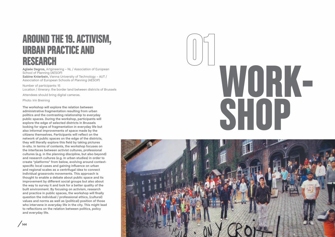
144
aglaée Degros, Artgineering – NL / Association of European School of Planning (AESOP) Sabine Knierbein, Vienna University of Technology – AUT / Association of European Schools of Planning (AESOP)
Number of participants: 15 Location / itinerary: the border land between districts of Brussels
Attendees should bring digital cameras.
Photo: Irin BreiningWORK-SHOP
AROUND THE 19. ACTIVISM, URBAN PRACTICE AND RESEARCH
The workshop will explore the relation between administrative fragmentation resulting from urban politics and the contrasting relationship to everyday public spaces. During the workshop, participants will explore the edge of selected districts in Brussels looking for signs of fragmentation in everyday life but also informal improvements of space made by the citizens themselves. Participants will reflect on the network of public spaces on the edge of the districts, they will literally explore this field by taking pictures in-situ. In terms of contents, the workshop focuses on the interfaces between activist cultures, professional cultures (e.g. in the planning discipline, but also beyond) and research cultures (e.g. in urban studies) in order to create “platforms” from below, evolving around context-specific local cases and gaining influence on urban and regional scales as a centrifugal idea to connect individual grassroots movements. This approach is thought to enable a debate about public space and its improvement by different social groups but also about the way to survey it and look for a better quality of the built environment. By focusing on activism, research and practice in public spaces, the workshop will finally question the individual / professional ethics, (cultural) values and norms as well as (political) position of those who intervene in everyday life in the city. This might lead to reflections on the relation between politics, policy and everyday life.
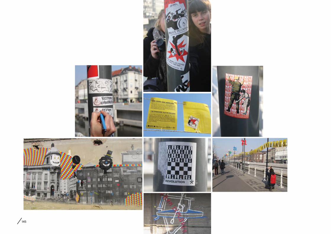
145

146
WORK-SHOP
Giulietta Laki, PhD fellow, Université Libre de Bruxelles (/FNRS), avenue F.D. Roosevelt 50, CP124, 1050 Bruxelles – BE, +32 (0)2 6506507, [email protected]
Number of participants: 15Location / itinerary: Madou, around Saint-Josse area
Attendees should bring digital cameras.
Photo: Irin Breining (1-7), Giulietta Laki (8)
AN ANTHROPOLOgICAL fIELDWORK IN BRUSSELS: URBAN SIgNS AND ARTEfACTS UNDER THE MICROSCOPE
This workshop will be a micro-anthropological fieldwork of urban space, based on the methodology of Giulietta Laki’s PhD thesis titled: “Ethnic, multicultural, cosmopolitan: neighbourhoods at a glance. Traces and signs of identity bricolages in urban landscapes”. The global perception of what we call “urban landscape” is juxtaposed to an in-depth observation of specific visual or functional elements, chosen by the participants, by the means of an interpretative framework. These signs and artefacts will be documented through photography and spontaneous interviews. How are cultural identities made visible in public space? How are interactions and relations visible in objects, material interventions, traces left by actions? How do they shape urban landscapes?
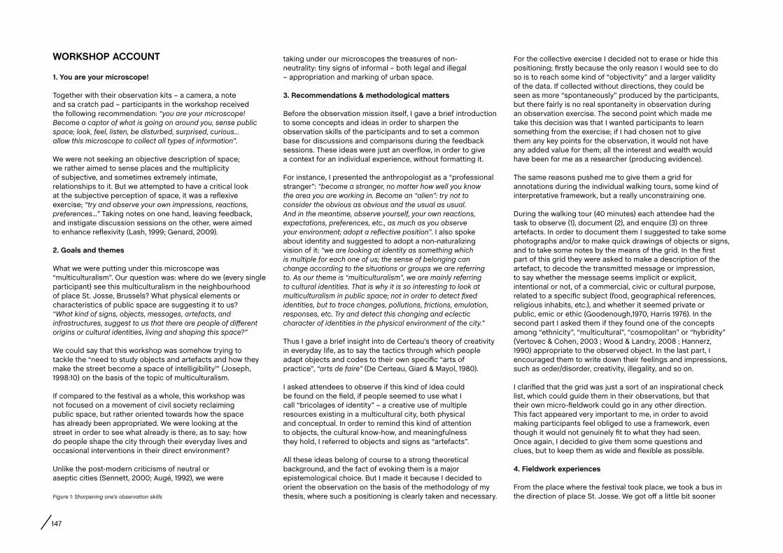
147
WORKSHOP accOUNT
1. You are your microscope!
Together with their observation kits – a camera, a note and sa cratch pad – participants in the workshop received the following recommendation: “you are your microscope! Become a captor of what is going on around you, sense public space; look, feel, listen, be disturbed, surprised, curious... allow this microscope to collect all types of information”.
We were not seeking an objective description of space; we rather aimed to sense places and the multiplicity of subjective, and sometimes extremely intimate, relationships to it. But we attempted to have a critical look at the subjective perception of space, it was a reflexive exercise; “try and observe your own impressions, reactions, preferences...” Taking notes on one hand, leaving feedback, and instigate discussion sessions on the other, were aimed to enhance reflexivity (Lash, 1999; Genard, 2009).
2. Goals and themes
What we were putting under this microscope was “multiculturalism”. Our question was: where do we (every single participant) see this multiculturalism in the neighbourhood of place St. Josse, Brussels? What physical elements or characteristics of public space are suggesting it to us? “What kind of signs, objects, messages, artefacts, and infrastructures, suggest to us that there are people of different origins or cultural identities, living and shaping this space?”
We could say that this workshop was somehow trying to tackle the “need to study objects and artefacts and how they make the street become a space of intelligibility1” (Joseph, 1998:10) on the basis of the topic of multiculturalism.
If compared to the festival as a whole, this workshop was not focused on a movement of civil society reclaiming public space, but rather oriented towards how the space has already been appropriated. We were looking at the street in order to see what already is there, as to say: how do people shape the city through their everyday lives and occasional interventions in their direct environment?
Unlike the post-modern criticisms of neutral or aseptic cities (Sennett, 2000; Augé, 1992), we were
taking under our microscopes the treasures of non-neutrality: tiny signs of informal – both legal and illegal – appropriation and marking of urban space.
3. Recommendations & methodological matters
Before the observation mission itself, I gave a brief introduction to some concepts and ideas in order to sharpen the observation skills of the participants and to set a common base for discussions and comparisons during the feedback sessions. These ideas were just an overflow, in order to give a context for an individual experience, without formatting it.
For instance, I presented the anthropologist as a “professional stranger”: “become a stranger, no matter how well you know the area you are working in. Become an “alien”: try not to consider the obvious as obvious and the usual as usual. And in the meantime, observe yourself, your own reactions, expectations, preferences, etc., as much as you observe your environment; adopt a reflective position”. I also spoke about identity and suggested to adopt a non-naturalizing vision of it: “we are looking at identity as something which is multiple for each one of us; the sense of belonging can change according to the situations or groups we are referring to. As our theme is “multiculturalism”, we are mainly referring to cultural identities. That is why it is so interesting to look at multiculturalism in public space; not in order to detect fixed identities, but to trace changes, pollutions, frictions, emulation, responses, etc. Try and detect this changing and eclectic character of identities in the physical environment of the city.”
Thus I gave a brief insight into de Certeau’s theory of creativity in everyday life, as to say the tactics through which people adapt objects and codes to their own specific “arts of practice”, “arts de faire” (De Certeau, Giard & Mayol, 1980).
I asked attendees to observe if this kind of idea could be found on the field, if people seemed to use what I call “bricolages of identity” – a creative use of multiple resources existing in a multicultural city, both physical and conceptual. In order to remind this kind of attention to objects, the cultural know-how, and meaningfulness they hold, I referred to objects and signs as “artefacts”.
All these ideas belong of course to a strong theoretical background, and the fact of evoking them is a major epistemological choice. But I made it because I decided to orient the observation on the basis of the methodology of my thesis, where such a positioning is clearly taken and necessary. Figure 1: Sharpening one’s observation skills
For the collective exercise I decided not to erase or hide this positioning; firstly because the only reason I would see to do so is to reach some kind of “objectivity” and a larger validity of the data. If collected without directions, they could be seen as more “spontaneously” produced by the participants, but there fairly is no real spontaneity in observation during an observation exercise. The second point which made me take this decision was that I wanted participants to learn something from the exercise; if I had chosen not to give them any key points for the observation, it would not have any added value for them; all the interest and wealth would have been for me as a researcher (producing evidence).
The same reasons pushed me to give them a grid for annotations during the individual walking tours, some kind of interpretative framework, but a really unconstraining one.
During the walking tour (40 minutes) each attendee had the task to observe (1), document (2), and enquire (3) on three artefacts. In order to document them I suggested to take some photographs and/or to make quick drawings of objects or signs, and to take some notes by the means of the grid. In the first part of this grid they were asked to make a description of the artefact, to decode the transmitted message or impression, to say whether the message seems implicit or explicit, intentional or not, of a commercial, civic or cultural purpose, related to a specific subject (food, geographical references, religious inhabits, etc.), and whether it seemed private or public, emic or ethic (Goodenough,1970, Harris 1976). In the second part I asked them if they found one of the concepts among “ethnicity”, “multicultural”, “cosmopolitan” or “hybridity” (Vertovec & Cohen, 2003 ; Wood & Landry, 2008 ; Hannerz, 1990) appropriate to the observed object. In the last part, I encouraged them to write down their feelings and impressions, such as order/disorder, creativity, illegality, and so on.
I clarified that the grid was just a sort of an inspirational check list, which could guide them in their observations, but that their own micro-fieldwork could go in any other direction. This fact appeared very important to me, in order to avoid making participants feel obliged to use a framework, even though it would not genuinely fit to what they had seen. Once again, I decided to give them some questions and clues, but to keep them as wide and flexible as possible.
4. fieldwork experiences
From the place where the festival took place, we took a bus in the direction of place St. Josse. We got off a little bit sooner

148
in order to walk the last part, from Madou metro station down to the place where the individual walking tours had started.
I asked participants to note down their first impressions, both of the higher and of the lower area. It is quite interesting to notice that even people, who were in Brussels or in this neighbourhood for the first time, had a clear perception of the first zone as “business-like”, “typical office district”, “mineral”, “functional”, “gray, cold and windy”, “empty and
high”, “sad”, etc. Whilst the lower area – around place St. Josse – was associated to “multiethnic”, “chaos”, “music from cars”, “faces”, “school-kids”, “nice weather”, “shouts”, “pedestrians”, “food and clothes > stories”, “not much light”, “vibrant”, “overloaded directions”, “crowded”, and “loud”.
The observation mission itself consisted from a forty minute walking tour which every participant completed on their own. After having observed the area as a whole – as landscapes – they proceeded to the task of focusing on three artefacts. The results were quite astonishing.
Most of the reported signs were connected to foreign languages (a language school, the board of the “European Bureau for Lesser Used Languages”, the choice of foreign languages for communication and advertising in shop windows, etc.) Another popular subject were flags (in commemoration to the victims of an accident but associated to a turkish flag, a belgian flag on a car, flags as icons on shop windows, etc.) Several participants also documented the boards of small shops or services, their names (for instance “Boucherie du nord” written in French and Arabic), or for instance door bells with the names of the inhabitants coming from all over the world.
“Door bells > explicit message: ‘we live here!’; message to the public on private residence. Implicit message: hidden stories, where did they come from? How do they relate to the neighbourhood?” noted one of the participants.
Some observations were connected to the aesthetics of “otherness” or “exoticism”, for instance a british-looking post box, or a palm tree painted on the entrance of a shop, the message she read in it was “here you will find exotic products” or a kind of “holiday reminder”. One participant, who was in Brussels for the second time in her life, and in St. Josse for the first time, interpreted the façade of a political party’s headquarters as a multicultural school: the multicoloured faces and the ludic style let her suppose it there were some kind of “multiethnic education”.
Sometimes they allowed themselves to make very subjective readings of the environment, and saw evidence in a carpet hanging out of a window or the fact that curtains were depicting venetian gondolas as a sign of italian people living in that flat. That was exactly what I
Figure 2: “We live here”Figure 3: Commemoration for the Turkish victims of the accident of a Belgian school-bus in SwitzerlandFigure 4: “Holiday reminder”

149
asked them to do. To let such associations happen and to register them. In order to get a more complete picture of the perception of space, and not only a reason-filtered or – which is even worst – an academically-filtered one.
One participant exclusively took pictures of satellite dishes, and she interpreted them by means of her own experience. “It’s a typical sign that people coming from
abroad are living there. I am one of them too: my parents have a horrible satellite dish on the front of our house. And amongst all my friends only the foreigners have one”.
Some of the documented artefacts were particularly adapted to explain the eclectic and creative bricolage from which they originated. One of these was the entrance of a private garage, where the official parking prohibition and towing signs were juxtaposed to the handwritten explication “garaj” – phonetically it is the same word as the french or the english – and “durma”, what apparently means “don’t stop here”, as the participant – who happened to speak Turkish – explained. She pointed out the mixed character of the sign, turned inward and not readable on one hand, and international on the other, the absurdity that such a “civic” sign with a normative message is in a foreign language, and the do-it-yourself character of the sign itself, handwritten. Unfortunately, she did not have the opportunity to make any interviews. Within the methodology of my thesis such a finding would make me start further investigations in order to verify if, for instance, this assemblage has been built-up in several layers, if they were superposed as a result of a conflict, et cetera. One of the most pressing issues would be if the reason the author of the sign states for writing the message in Turkish is primary because it is their own language or because it is addressed specifically to people speaking this language, as if they would not respect the visual sign all alone!
Of course the fact that the observer could understand the written message has to be acknowledged, and has most probably played a role in her interpretation of the artefact; but in this case the visual impact of the message must have been strong enough, because another participant of the workshop took the same picture, without understanding Turkish language.
Another participant noticed the board of a Turkish café “Cafe Tutoglu”, written with the font of Coca-Cola, very recognisable. She interpreted it as a reference to a consumeristic identity
Figure 5: “Multiethnic education?” Figure 6: Composed garage sign Figure 7: Do-it-yourself

150
of the globalised capitalist society (Coca-Cola) associated to Belgian beer (Jupiler) and the general Turkish reference.
Another reported artefact was a hand-sewn sign reproducing the logo of the social network Facebook, with the handwritten message “join us on Facebook!”, written in English and with the same characters as the logo itself.
5. Drawing conclusions
If I had to make a global assessment of the workshop, I would say that for me as a researcher it has been most enriching, because I could test some elements of my methodology with other people’s points of view. Although they were somehow selected because they all came through the Human Cities Festival, the workshop attendees were very diverse in terms of education, origin and familiarity with Brussels and with our field of study. I let them fill in a
questionnaire in order to gather all this information. Not because I am sure that they are relevant, but sometimes it is still useful to be able to check them, especially because we cannot always help but try to guess them.
As to the experience of the participants, I think everybody learned something from the workshop, even though at very different levels: one person said she first wanted to discover a not so touristic area of Brussels, some others were happy to focus on cultural identities and their material manifestations, and almost all participants who already knew St. Josse, stated in the questionnaire that their image of the neighbourhood evolved after this brief fieldwork. )
After the feedback and discussion session took part on the same day, I invited everybody to come to the festival’s “Data Pavillon” the day after. This temporary structure was conceived as a sort of an information and meeting point
Notes1 Roughly translated from French language “ La nécessité d’étudier les objets et artéfacts et comment ils font de la rue un espace d’intelligibilité” (Joseph, 1998:10).
Reference Augé, M. (1992). Non-lieux: introduction à une anthropologie de la surmodernité. Paris, Seuil.
De Certeau, M., Giard, L., Mayol P. (1980). L’invention du quotidien: Arts de faire (Vol.1). Paris, Union Générale d’Editions.
Genard, J-L. (2009). À propos du concept de réflexivité. In Architecture et réflexivité: une discipline en régime d’incertitude, pp. 10-21. Lettre volée, La Cambre.
Goodenough, W. (1970). Description & comparison in cultural anthropology. Piscataway, Transaction Publishers.
Hannerz, U. (1990). Cosmopolitans and Locals in World Culture. In Featherstone M., Global culture: nationalism, globalization and modernity, Londron, Sage.
Harris, M. (1976). History and Significance of the Emic/Etic Distinction, Annual Review of Anthropology 5, pp. 329–350.
Joseph, I. (1998). La ville sans qualités. La Tour d’Aiguës, Éditions de l’Aube.
Lash, S. (1999). Another modernity, a different rationality. Oxford, Wiley-Blackwell.
Sennett, R. (2000). La conscience de l’oeil: urbanisme et société. Paris, Éd. de la Passion.
Vertovec, S. and Cohen, R. (2003). Conceiving cosmopolitanism, New York, Oxford University Press.
Wood, P. and Landry, C. (2008). The intercultural city: planning for diversity advantage. London, Earthscan.
Figure 8: Workshop 2 at the Data Pavillon
of the Human Cities Festival. It was transparent and placed at Mont des Art in order to gather passers-by. I printed out the workshop’s pictures and invited participants to display them and associate some words to elicit the observation mission. We thus took up the invitation to use the Pavillon as an open archive. Even if only a few people came over that day, the small exhibition seemed successful; especially because there were further reactions to the pictures – even made by an inhabitant of St. Josse who found them very representative of her own image of the neighborhood.
The other wealth I saw in this last part of the exercise – communicating the experience to the outside world – is that people kept thinking about the workshop a little bit longer (even if it was only in order to decide not to come to the appointment). Basically I hope that to some extent, this exercise has not finished yet and that the participants are still “being their own microscopes” while walking through the city.
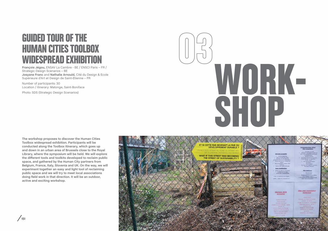
151
WORK-SHOP
françois Jégou, ENSAV La Cambre - BE / ENSCI Paris – FR / Strategic Design Scenarios – BE Josyane franc and Nathalie arnould, Cité du Design & Ecole Supérieure d’Art et Design de Saint-Etienne – FR
Number of participants: 30Location / itinerary: Matonge, Saint-Boniface
Photo: SDS (Strategic Design Scenarios)
gUIDED TOUR Of THE HUMAN CITIES TOOLBOx WIDESPREAD ExHIBITION
The workshop proposes to discover the Human cities Toolbox widespread exhibition. Participants will be conducted along the Toolbox itinerary, which goes up and down in an urban area of Brussels close to the Royal Library, where the symposium will be held. We will explore the different tools and toolkits developed to reclaim public space, and gathered by the Human city partners from Belgium, france, Italy, Slovenia and UK. On the way, we will experiment together an easy and light tool of reclaiming public space and we will try to meet local associations doing field work in that direction. It will be an outdoor, active and exciting workshop.

152

153
WORK-SHOP
camille Vilain and Jessy Gemayel, Cité du Design – FRPaola Trapani, Politecnico di Milano – IT Emily Ballantyne-Brodie, Urban Reforestation – AU
Number of participants: 20Location / itinerary: around the Central Station
Photo: Chantal Vanoeteren and Jessy Gemayel
OPENINg THE HUMAN CITIES TOOLBOx: PETER AND gISELLA TOOLKIT
The workshop will test the “Peter and Gisella” toolkit created by students of the Politecnico di Milano (http://peteregisella.wordpress.com/). “Peter and Gisella” toolkit is a fun way to be active and learn about the amount of calories that are burnt engaging in simple daily activities. This toolkit will be implemented on a recreational path using urban furniture elements. Participants will be invited to use the urban furniture and their own capacities to do sports to actively experiment with public spaces after two days of sitting at the conference.
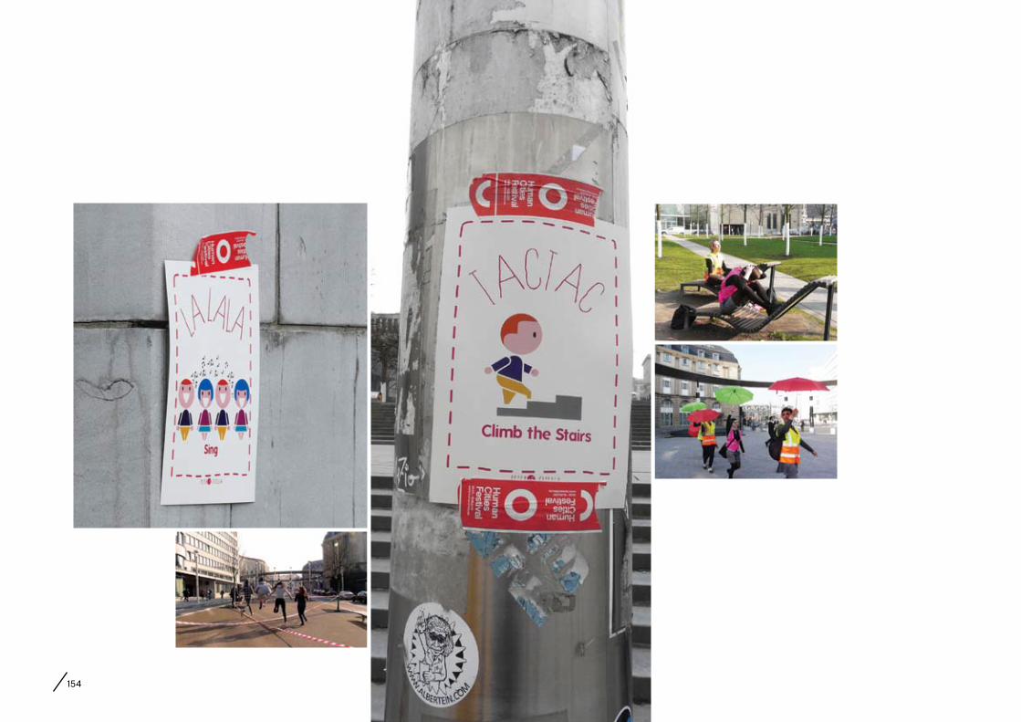
154
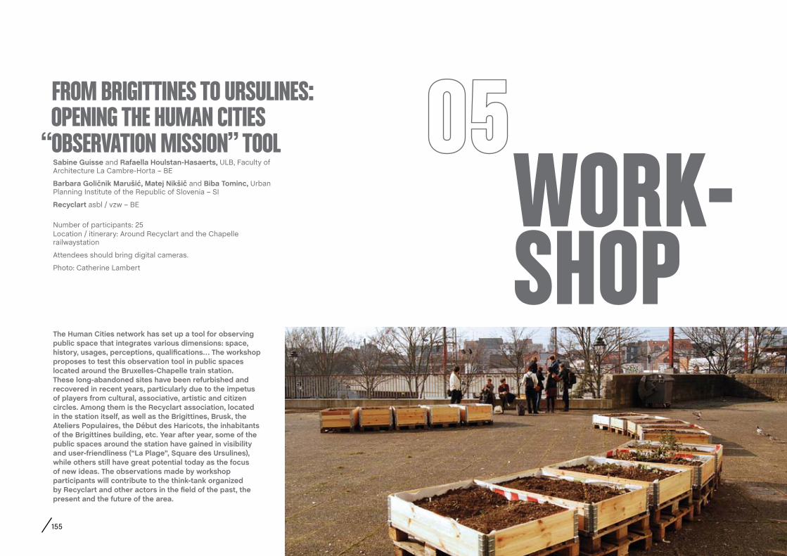
155
WORK-SHOP
Sabine Guisse and Rafaella Houlstan-Hasaerts, ULB, Faculty of Architecture La Cambre-Horta – BE
Barbara Goličnik Marušić, Matej Nikšič and Biba Tominc, Urban Planning Institute of the Republic of Slovenia – SI
Recyclart asbl / vzw – BE
Number of participants: 25Location / itinerary: Around Recyclart and the Chapelle railwaystation
Attendees should bring digital cameras.
Photo: Catherine Lambert
fROM BRIgITTINES TO URSULINES: OPENINg THE HUMAN CITIES “OBSERVATION MISSION” TOOL
The Human cities network has set up a tool for observing public space that integrates various dimensions: space, history, usages, perceptions, qualifications… The workshop proposes to test this observation tool in public spaces located around the Bruxelles-chapelle train station. These long-abandoned sites have been refurbished and recovered in recent years, particularly due to the impetus of players from cultural, associative, artistic and citizen circles. among them is the Recyclart association, located in the station itself, as well as the Brigittines, Brusk, the ateliers Populaires, the Début des Haricots, the inhabitants of the Brigittines building, etc. Year after year, some of the public spaces around the station have gained in visibility and user-friendliness (“La Plage”, Square des Ursulines), while others still have great potential today as the focus of new ideas. The observations made by workshop participants will contribute to the think-tank organized by Recyclart and other actors in the field of the past, the present and the future of the area.

156

157
WORK-SHOP
caroline claus, Yota! / Jes – BEThomas Laureyssens, MAD-faculty / FAK (KU Leuven), Brussels – BE
Number of participants: 10Location / itinerary: The “Bosnie” quarter in Saint-Gilles
Photo: Sabrina Lê and Caroline Claus
ROUTE 10 + / WALKS AND MAPPINg WITH TEENAgERS
ROUTE 10 + is a workshop were local teenagers (age 10 to 12) walk, map and “mark” together with specialists in public space to uncover knowledge about the social and playful tissue of the Quartier Bosnie in Saint-Gilles. What is the relationship of these young people with the urban space around their living environment? How do they use, hack or abuse these spaces; with whom, and how do they feel about it? after a preparatory walk, we will use the MaP-it participatory mapping methodology (www.map-it.be) combined with insights from the Karakol project (www.karakol.be) by Yota! afterwards, we will re-insert findings of the mapping sessions in the city in the form of digital markers, which we hope will facilitate as a platform for continuing exchange. Ultimately, these observations will lead to projects that aim to strengthen the position of teenagers within the social and spatial structure of the urban space; and will encourage projects that empower inhabitants across generations to create a rich and dynamic social environment.

158
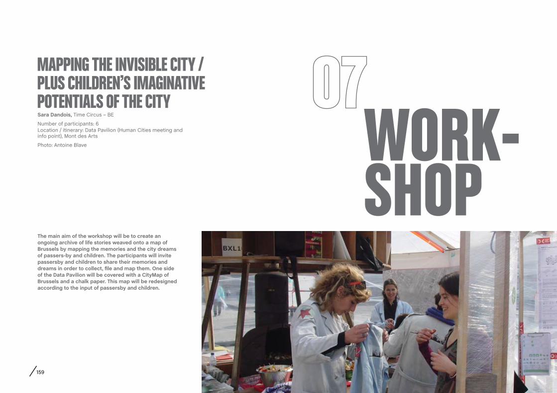
159
WORK-SHOP
Sara Dandois, Time Circus – BE
Number of participants: 6Location / itinerary: Data Pavilion (Human Cities meeting and info point), Mont des Arts
Photo: Antoine Blave
MAPPINg THE INVISIBLE CITy / PLUS CHILDREN’S IMAgINATIVE POTENTIALS Of THE CITy
The main aim of the workshop will be to create an ongoing archive of life stories weaved onto a map of Brussels by mapping the memories and the city dreams of passers-by and children. The participants will invite passersby and children to share their memories and dreams in order to collect, file and map them. One side of the Data Pavilion will be covered with a cityMap of Brussels and a chalk paper. This map will be redesigned according to the input of passersby and children.
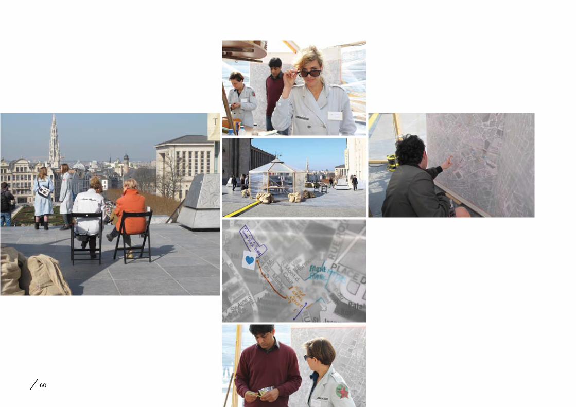
160

161
WORK-SHOP
Lise coirier, Pro Materia – BEalice Holmberg, ClearVillage – UKchristian Pagh, UIWE Culture Design – DKEmilie Bonnard, Jean Monet University
Number of participants: no limitLocation / itinerary: Data Pavilion (Human cities meeting and info point), Mont des Arts - around the Central Metro Station
Photo: Monika Czaja
DID yOU SENSE THAT!? ExPLORINg THE PERCEPTIONS AND DESIRES Of PUBLIC SPACE THROUgH ALL fIVE SENSES
In the workshop we pursue how a shared space like a metro station is constituted - not alone as a piece of architecture, but as the living place that it is in a certain way. following a multi-layered perceptual exploration, the workshop directs the attention to the desirability and potential enhancement of the human quality of public space. We will work on scenarios for each individual sensory layer as well as on the crosspollination of all. Emphasising that the personally experienced phenomena also sustain social aspects, questions addressed in the workshop thus include: How are public spaces perceived by our senses? What type of audience does that involve? How is the “we” expressed? What are the borders and limits of the space? Which type of sensory impressions is desirable? What type of “urban design” deepens the sense of belonging in public space? The workshop takes a human-centric approach and firstly introduces sensory perspectives of public space, and secondly engages all participants in an on-site exploration. To conclude, the ambition is to document and analyse the human quality of public space, share tools on understanding and involving the audience in the making of public spaces.

162

163
WORK-SHOP
cécile Planchais, sculptor and designer – FRMartine cantillon, Brussels-Environment – BE
Number of participants: 10Location / itinerary: in front of the Musical Instruments Museum
If possible, attendees should bring their mobile phones with a Qr code reader.
Photo: Caroline Watillon
SOUND SPACE IN THE CITy: DISCOVER THE MUSIC ROOM
from short-lived to long-lasting: Icilasong is an interactive design concept developed by cécile Planchais to promote access to cultural soundtracks in public urban spaces. The Music Room was the first permanent Icilasong installation, set up as a lasting feature at the end of 2011 by the order of Brussels-Environment and implemented in a partnership with the Musical Instruments Museum. The installation gives the MIM a permanent extension in Brussels where music lovers can sit on a uniquely designed bench, let their minds wander and listen to the instruments. Passersby discover a lectern that indicates how they can hear the sounds: they flash a Qr code on a camera-telephone and simply sit down to listen. all the details of the soundtrack are found on the MIM site. The design has made a surprising addition to the ways people use public space; and it contributes to the success of an urban project that encourages people to stop for a minute, to have a seat, and to share a cultural moment. This workshop proposes to discover the Music Room in the company of the designer who developed the concept, and the Events Manager at Brussels-Environment, the client of the project.

164
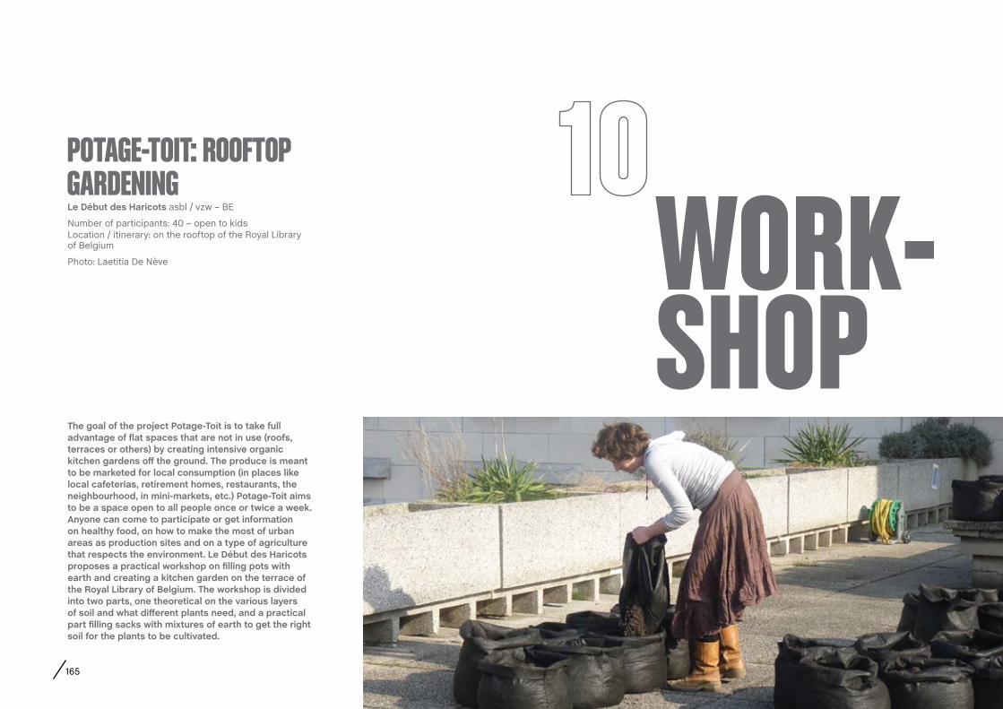
165
WORK-SHOP
Le Début des Haricots asbl / vzw – BE
Number of participants: 40 – open to kidsLocation / itinerary: on the rooftop of the Royal Library of Belgium
Photo: Laetitia De Nève
POTAgE-TOIT: ROOfTOP gARDENINg
The goal of the project Potage-Toit is to take full advantage of flat spaces that are not in use (roofs, terraces or others) by creating intensive organic kitchen gardens off the ground. The produce is meant to be marketed for local consumption (in places like local cafeterias, retirement homes, restaurants, the neighbourhood, in mini-markets, etc.) Potage-Toit aims to be a space open to all people once or twice a week. anyone can come to participate or get information on healthy food, on how to make the most of urban areas as production sites and on a type of agriculture that respects the environment. Le Début des Haricots proposes a practical workshop on filling pots with earth and creating a kitchen garden on the terrace of the Royal Library of Belgium. The workshop is divided into two parts, one theoretical on the various layers of soil and what different plants need, and a practical part filling sacks with mixtures of earth to get the right soil for the plants to be cultivated.
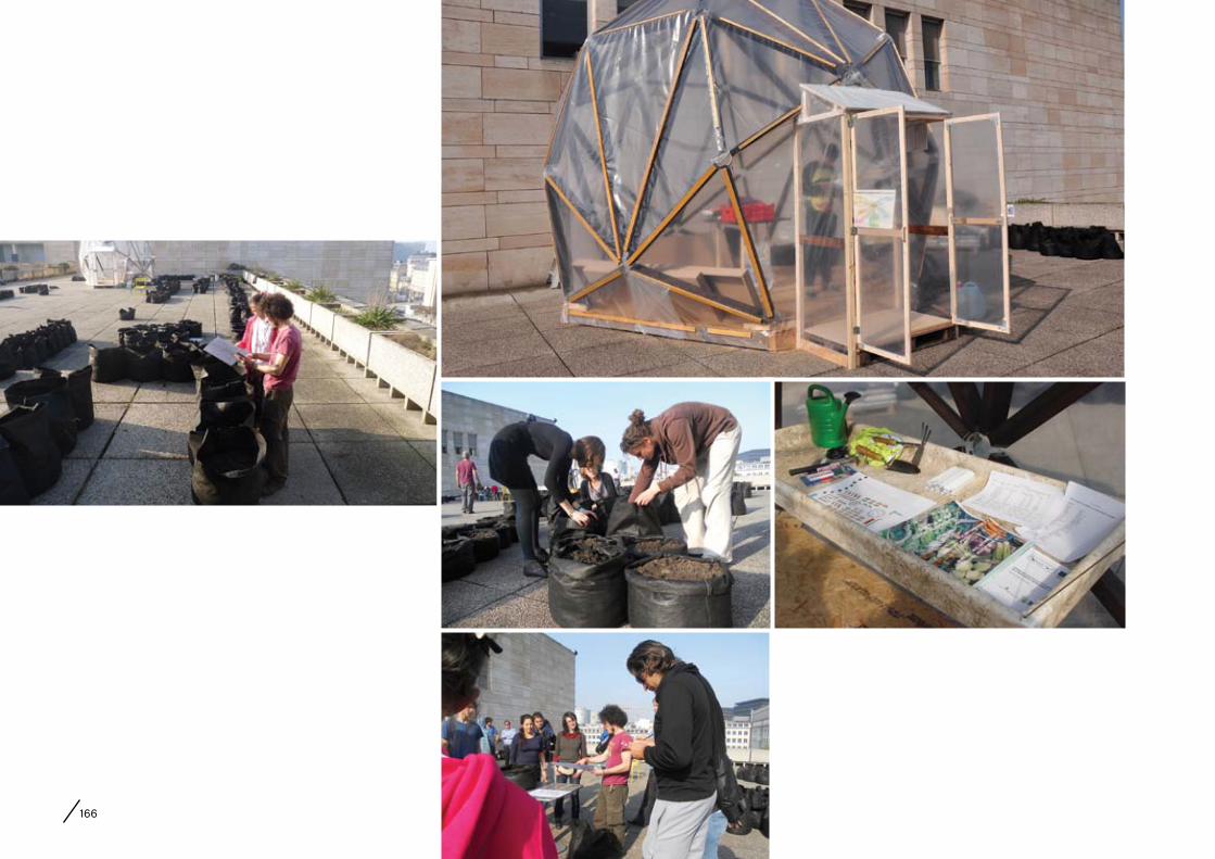
166
APPENDIx Human CitiesFestival
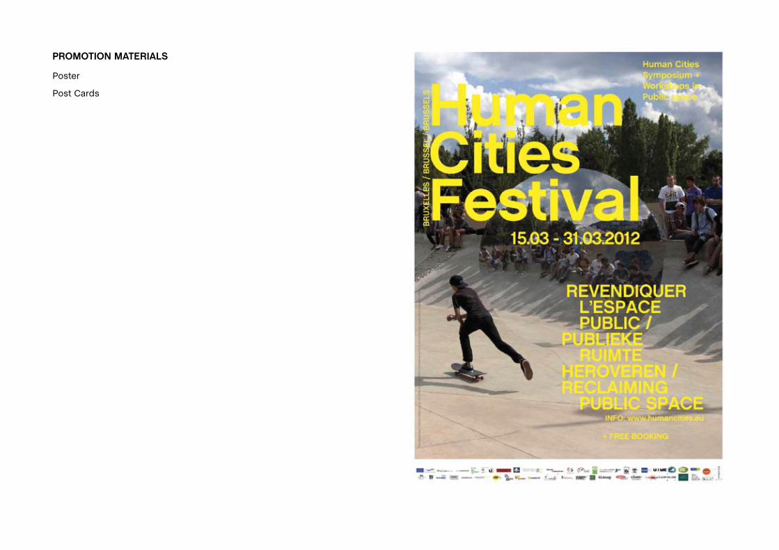
PROMOTION MaTERIaLS
Poster
Post Cards


APPENDIx Observation MissionWorking Sheets

WORKING SHEET: Structural dimension
1. Researcher name: surname:
2. case study place: city: country:
3. Date
4. Historical development of the case study: Show main development stages from first appearance to further transformations
Development stage
year What? Type of place Why? Purpose Other comments
Built up:
Transformation/redesign 1:
Transformation/redesign 2:
Transformation/redesign 3:
More description or explanation if needed (max 1000 characters with spaces:
5. Ground floor as it is today
general layout dimensions level changes paving/materials other comments
More description or explanation if needed (max 1000 characters with spaces):
01

6. Built frame as it is today
7. Street furniture and green elements that is present today in a place
benches play equipment lights litter
material number location
central-peripheral
material number location
central-peripheral
material number location
central-peripheral
material number location
central-peripheral
kiosks pavilions news-stands green elements:
material number location
central-peripheral
material number location
central-peripheral
material number location
central-peripheral
type number/area location
central-peripheral
More description or explanation if needed (max 1000 characters with spaces):
building heights architectural style elevations materials / colours other comments
More description or explanation if needed (max 1000 characters with spaces):

8. Photo-analysis of the placeThe photos shall give a general impression of the space and be supportive to the data collected above. Make sure that at least some of the photos will show the users in space too, not only to indicate the scale of the space but also to show which kinds of activities are taking place there. Select max 15 photos and provide their thumbnails here under. Each image shall be provided with short description (max 60 characters with space). Provide the original photos in high resolution on a CD.
Image 01 Image 02 Image 03 Image 04 Image 05
Short description: Short description: Short description: Short description: Short description:
Image 06 Image 07 Image 08 Image 09 Image 10
Short description: Short description: Short description: Short description: Short description:
Image 11 Image 12 Image 13 Image 14 Image 15
Short description: Short description: Short description: Short description: Short description:
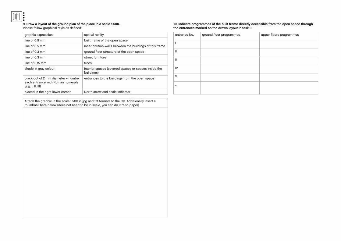
9. Draw a layout of the ground plan of the place in a scale 1:500. Please follow graphical style as defined:
10. Indicate programmes of the built frame directly accessible from the open space through the entrances marked on the drawn layout in task 9.
Attach the graphic in the scale 1:500 in jpg and tiff formats to the CD. Additionally insert a thumbnail here below (does not need to be in scale, you can do it fit-to-paper)
graphic expression spatial reality
line of 0.5 mm built frame of the open space
line of 0.5 mm inner division-walls between the buildings of this frame
line of 0.3 mm ground floor structure of the open space
line of 0.3 mm street furniture
line of 0.15 mm trees
shade in gray colour interior spaces (covered spaces or spaces inside the buildings)
black dot of 2 mm diameter + number each entrance with Roman numerals (e.g. I, II, III)
entrances to the buildings from the open space
placed in the right lower corner North arrow and scale indicator
entrance No. ground floor programmes upper floors programmes
I
II
III
IV
V
...

WORKING SHEET: Behavioural mapping
1. Researcher name: surname:
2. case study place: city: country:
3. Date – weekday Date – weekend:
4. PreparationPrepare a layout of a place in scale 1:500 or in appropriate scale, no bigger than A3 format. Ideally, use the map which you constructed in Worksheet 01, task 9. Make sure to have 5 copies prepared, to be able to conduct 5 separate observations, at different time a day as well as once during the week and once during the weekend, as specified in tasks 5 and 6.
5. characteristic circumstances
Weekday morning 10 – 12 am
weather conditions: temperature
weather conditions: wind weather conditions: sun other comments
yes variable no sunny partly sunny partly cloudy cloudy rainy
Weekday afternoon 12 – 16 pm
weather conditions: temperature
weather conditions: wind weather conditions: sun other comments
yes variable no sunny partly sunny partly cloudy cloudy rainy
Weekday late afternoon 16 – 19 pm
weather conditions: temperature
weather conditions: wind weather conditions: sun other comments
yes variable no sunny partly sunny partly cloudy cloudy rainy
Weekend morning 10 – 12 am
weather conditions: temperature
weather conditions: wind weather conditions: sun other comments
yes variable no sunny partly sunny partly cloudy cloudy rainy
Weekend afternoon 12 – 16 am
weather conditions: temperature
weather conditions: wind weather conditions: sun other comments
yes variable no sunny partly sunny partly cloudy cloudy rainy
02
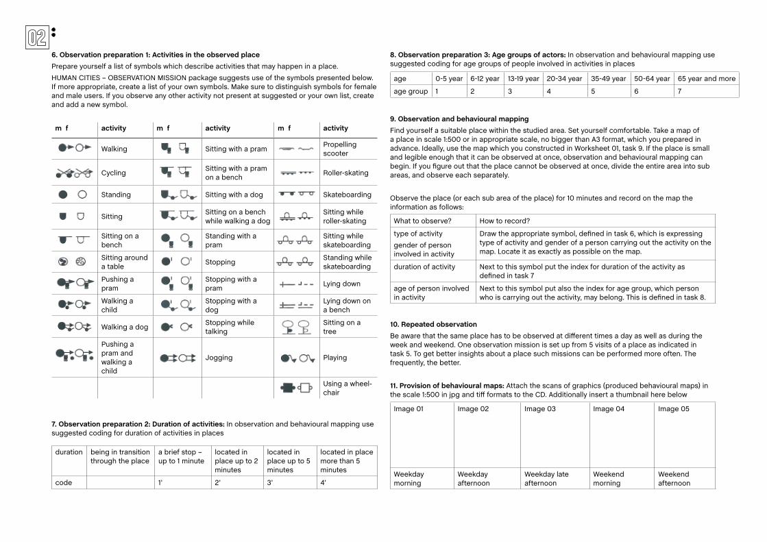
6. Observation preparation 1: activities in the observed placePrepare yourself a list of symbols which describe activities that may happen in a place.
HUMAN CITIES – OBSERVATION MISSION package suggests use of the symbols presented below. If more appropriate, create a list of your own symbols. Make sure to distinguish symbols for female and male users. If you observe any other activity not present at suggested or your own list, create and add a new symbol.
7. Observation preparation 2: Duration of activities: In observation and behavioural mapping use suggested coding for duration of activities in places
8. Observation preparation 3: age groups of actors: In observation and behavioural mapping use suggested coding for age groups of people involved in activities in places
9. Observation and behavioural mappingFind yourself a suitable place within the studied area. Set yourself comfortable. Take a map of a place in scale 1:500 or in appropriate scale, no bigger than A3 format, which you prepared in advance. Ideally, use the map which you constructed in Worksheet 01, task 9. If the place is small and legible enough that it can be observed at once, observation and behavioural mapping can begin. If you figure out that the place cannot be observed at once, divide the entire area into sub areas, and observe each separately.
Observe the place (or each sub area of the place) for 10 minutes and record on the map the information as follows:
10. Repeated observationBe aware that the same place has to be observed at different times a day as well as during the week and weekend. One observation mission is set up from 5 visits of a place as indicated in task 5. To get better insights about a place such missions can be performed more often. The frequently, the better.
11. Provision of behavioural maps: Attach the scans of graphics (produced behavioural maps) in the scale 1:500 in jpg and tiff formats to the CD. Additionally insert a thumbnail here below
m f activity m f activity m f activity
Walking Sitting with a pramPropelling scooter
CyclingSitting with a pram on a bench
Roller-skating
Standing Sitting with a dog Skateboarding
SittingSitting on a bench while walking a dog
Sitting while roller-skating
Sitting on a bench
Standing with a pram
Sitting while skateboarding
Sitting around a table
StoppingStanding while skateboarding
Pushing a pram
Stopping with a pram
Lying down
Walking a child
Stopping with a dog
Lying down on a bench
Walking a dogStopping while talking
Sitting on a tree
Pushing a pram and walking a child
Jogging Playing
Using a wheel-chair
duration being in transition through the place
a brief stop – up to 1 minute
located in place up to 2 minutes
located in place up to 5 minutes
located in place more than 5 minutes
code 1’ 2’ 3’ 4’
age 0-5 year 6-12 year 13-19 year 20-34 year 35-49 year 50-64 year 65 year and more
age group 1 2 3 4 5 6 7
What to observe? How to record?
type of activity
gender of person involved in activity
Draw the appropriate symbol, defined in task 6, which is expressing type of activity and gender of a person carrying out the activity on the map. Locate it as exactly as possible on the map.
duration of activity Next to this symbol put the index for duration of the activity as defined in task 7
age of person involved in activity
Next to this symbol put also the index for age group, which person who is carrying out the activity, may belong. This is defined in task 8.
Image 01 Image 02 Image 03 Image 04 Image 05
Weekday morning
Weekday afternoon
Weekday late afternoon
Weekend morning
Weekend afternoon

Working Sheet: Experiential walk
1. Researcher name: surname:
2. case study place: city: country:
3. Date Time of a day:
4. PreparationPrepare a map with marked path of the Experiential walk. The map must include the selected case study place. The entire walk should not take more than 20 minutes time.
5. case study mapInsert the map of case study (geographical or orthophoto) and indicate the exact trail of the walk on it. Save it to the CD in jpg and tiff format, too.
6. Participants: Select a group (or more groups) of 5 people. Introduce them with the experiential walk approach and record the following data relevant to a participant:
7. act of the experiential walk: Equip participants with the maps and let them enjoy the experiential walk.
participant gender (M/F) age (years) education
1 – none or primary
2 – secondary
3 – university or more
usual holiday destination by preference
1 – urban environments
2 – natural environments
participant 01
participant 02
participant 03
participant 04
participant 05
8. Workshop after the walk: Run the workshop with participants when they return from the experiential walk. Provide 5 sheets of blank paper/cardboard in A3 format per group. Arrange accessories such as colour pencils, coloured papers, stickers, glue, scissors etc., so that the participants can use them to produce each his/her individual experiential map reflecting the walk that has just been walked. Each participant produces two maps showing the same experiential walk:
When complete both the works please indicate location of a case study place in the REPRODUCTION image.
ORIGINAL experiential walk map REPRODUCTION of the original map
This is design representation, produced upon the experiences of the walk
This is a simple copy of the design representation. It shows the layout of the design composition of the original work accompanied with comments to these expressions.
03

9. Provision of maps of experiential walksWhen the workshop is completed, make photos or scans of the Originals and Reproductions and add the thumbnails of each such experiential map of the walk here below. Add the scans of all the experiential maps on the CD in jpg and tiff format.
10. Experiential context of the case study: To get a broader picture of the experiential context of the studied area, provide a brief comment on experiential dimension of the case study place regarding to the experiential dimensions along the experiential walk.
Image 01_O Image 02_O Image 03_O Image 04_O Image 05_O
Image 01_R Image 02_R Image 03_R Image 04_R Image 05_R
Short description made by author of the map:
Short description made by author of the map:
Short description made by author of the map:
Short description made by author of the map:
Short description made by author of the map:
Comments on experiential contexts of the case study (max 2000 characters with spaces):
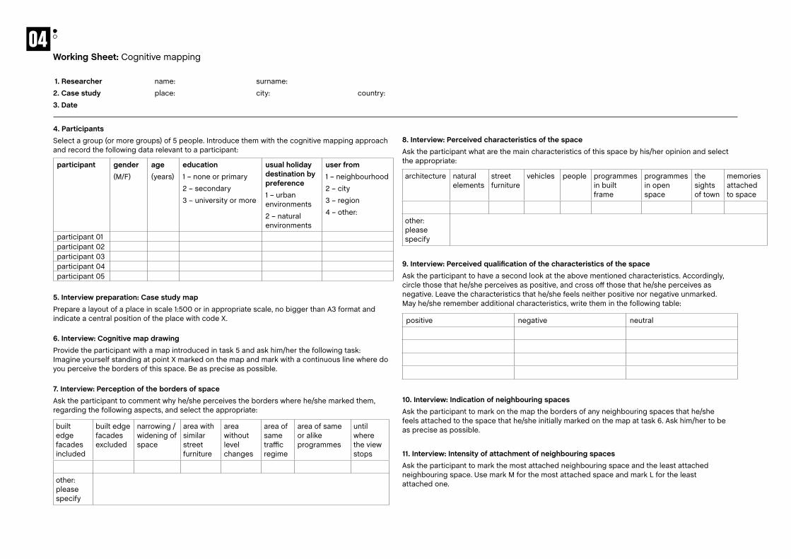
Working Sheet: Cognitive mapping
1. Researcher name: surname:
2. case study place: city: country:
3. Date
4. ParticipantsSelect a group (or more groups) of 5 people. Introduce them with the cognitive mapping approach and record the following data relevant to a participant:
5. Interview preparation: case study map
Prepare a layout of a place in scale 1:500 or in appropriate scale, no bigger than A3 format and indicate a central position of the place with code X.
6. Interview: cognitive map drawingProvide the participant with a map introduced in task 5 and ask him/her the following task: Imagine yourself standing at point X marked on the map and mark with a continuous line where do you perceive the borders of this space. Be as precise as possible.
participant gender (M/F)
age
(years)
education
1 – none or primary
2 – secondary
3 – university or more
usual holiday destination by preference
1 – urban environments
2 – natural environments
user from
1 – neighbourhood
2 – city
3 – region
4 – other:
participant 01participant 02participant 03participant 04participant 05
built edge facades included
built edge facades excluded
narrowing / widening of space
area with similar street furniture
area without level changes
area of same traffic regime
area of same or alike programmes
until where the view stops
other: please specify
7. Interview: Perception of the borders of spaceAsk the participant to comment why he/she perceives the borders where he/she marked them, regarding the following aspects, and select the appropriate:
8. Interview: Perceived characteristics of the spaceAsk the participant what are the main characteristics of this space by his/her opinion and select the appropriate:
9. Interview: Perceived qualification of the characteristics of the spaceAsk the participant to have a second look at the above mentioned characteristics. Accordingly, circle those that he/she perceives as positive, and cross off those that he/she perceives as negative. Leave the characteristics that he/she feels neither positive nor negative unmarked. May he/she remember additional characteristics, write them in the following table:
10. Interview: Indication of neighbouring spacesAsk the participant to mark on the map the borders of any neighbouring spaces that he/she feels attached to the space that he/she initially marked on the map at task 6. Ask him/her to be as precise as possible.
11. Interview: Intensity of attachment of neighbouring spaces Ask the participant to mark the most attached neighbouring space and the least attached neighbouring space. Use mark M for the most attached space and mark L for the least attached one.
architecture natural elements
street furniture
vehicles people programmes in built frame
programmes in open space
the sights of town
memories attached to space
other: please specify
positive negative neutral
04

12. Interview: characteristics of the most and the least attached neighbouring spacesAsk the participant what are the main characteristics of each of the two attached neighbouring spaces he/she defined. Write them in a table here below.
17. Interview: Micro-locationAsk the participant where in the entire area that is marked on the map he/she spent most of his/her time? Indicate the location with a bold point (•).
18. Interview: common wayAsk the participant what is his/her most common path across the entire area marked on the map? Indicate it with a hatched line (- - - - - -).
19. Interview: Sense of a placeAsk the participant to put down a slogan which would describe the studied space best by his/her opinion?
20. Provision of cognitive maps: Attach the scan of graphics (produced cognitive map) in the scale 1:500 in jpg and tiff formats to the CD. Additionally insert it here below in fit-to-margin manner.
13. Interview: Basic qualitative analysis of characteristics of the most and the least attached neighbouring spacesAsk the participant to have a second look at the above written characteristics. Circle those that he/she perceives as positive, and cross off those that he/she perceives as negative. Leave the characteristics that he/she feels neither positive nor negative unmarked. May he/she remember additional characteristics, write them add them in the following table.
14. Interview: Qualification of the most and the least attached neighbouring spacesAsk the participant why does he/she feel that these spaces (M and L) are connected to initial space marked in task 6? Ask further why does he/she feel they are not an integral part of this initial space? The participant should give reasons – insert them in the following table..
15. Interview: Preferred visual directionAsk the participant if he/she had a chance to take one photo when standing at point X – in which direction would he/she take it? Mark on map with arrow ().
16. Interview: additional sensory dimensionAsk the participant to imagine himself/herself standing at point X and ask them to tell (1) which voices are present and (2) which smells are present. Insert the answers in the following table:
Choose the most characteristic voice and the most characteristic smell among those that you mentioned and mark them.
space No. main characteristics
M
L
space No. positive negative neutral
M
L
Space No. what attaches this space to space X (why do you feel it connected to space X)
what dis-attaches this space from space X (why do you feel it is not part of space X)
M
L
Voices Smells
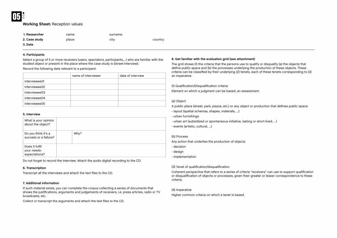
Working Sheet: Reception values
1. Researcher name: surname:
2. case study place: city: country:
3. Date
4. ParticipantsSelect a group of 5 or more receivers (users, spectators, participants,…) who are familiar with the studied object or present in the place where the case study is (street-interview).
Record the following data relevant to a participant:
5. Interview
Do not forget to record the interview. Attach the audio digital recording to the CD.
6. TranscriptionTranscript all the interviews and attach the text files to the CD.
7. additional informationIf such material exists, you can complete the corpus collecting a series of documents that shows the justifications, arguments and judgements of receivers, i.e. press articles, radio or TV broadcasts, etc.
Collect or transcript the arguments and attach the text files to the CD.
name of interviewer date of interview
interviewee01
interviewee02
interviewee03
interviewee04
interviewee05
What is your opinion about the object?
Do you think it’s a success or a failure?
Why?
Does it fulfil your needs-expectations?
8. Get familiar with the evaluation grid (see attachment)The grid shows (1) the criteria that the persons use to qualify or disqualify (a) the objects that define public space and (b) the processes underlying the production of these objects. These criteria can be classified by their underlying (2) tenets, each of these tenets corresponding to (3) an imperative.
(1) Qualification/Disqualification criteria
Element on which a judgment can be based, an assessment.
(a) Object
A public place (street, park, piazza, etc.) or any object or production that defines public space:
- layout (spatial schemas, shapes, materials, …)
- urban furnishings
- urban art (subsidized or spontaneous initiative, lasting or short-lived, …)
- events (artistic, cultural, …)
(b) Process
Any action that underlies the production of objects
- decision
- design
- implementation
(3) Tenet of qualification/disqualification
Coherent perspective that refers to a series of criteria “receivers” can use to support qualification or disqualification of objects or processes, given their greater or lesser correspondence to these criteria.
(4) Imperative
Higher common criteria on which a tenet is based.
05

9. Place qualification / disqualificationAnalyze the corpus, acknowledge similar sentences and assess the number of occurrences in the table below.
Tenet Type of sentence Presence (mark with an x)
Number of occurrences
Attentionnal (Q) The object is seen, used, occupied, adopted, attended.
(D) The object insignificant, invisible, unknown, empty, unused, unoccupied, disinvested, not attended.
(Q) The process aimed to take into account user’s or receiver’s needs or expectations.
(D) The process moved away from user’s or receiver’s needs or expectations.
Aesthetic (Q) The object is beautiful, attracting by formal, plastic and colour facets.
(D) The object is ugly, unaesthetic, unattractive, badly proportioned.
(Q) The process aimed to contribute to the embellishment and decoration of public space.
(D) The process has defaced the public space.
Semantic (Q) The object has significance, tells a story and symbolizes something.
(D) The object is meaningless, inconsistent.
(Q) The process aimed to describe, comment or summarize signs that stem from historical, identity, physical or social context.
(D) The process reduced the significance of the context.
Operational (Q) The object is useful, functional, practical and rational.
(D) The object is useless, unpractical, fragile or has no purpose.
(Q) The process was effective, coherent and well planned.
(D) The process was entropic, incoherent or technically irrational.
Inspired (Q) The object is original, innovating and avant-garde.
(D) The object is “déjà vu”, copied, reproduced identically, old hat, obsolete and uses a classical language.
(Q) The process shows the creativity, imagination, experimentation and spontaneity of its authors.
(D) The process promoted that which is stable, concrete, established.
Domestic (Q) The object is familiar, common, recognizable, identifiable and legible.
(D) The object is ludicrous, unnecessarily original and leeches the context.
(Q) The process aimed to respect the existing physical, historical and social context.
(D) The process compromised the integrity of indigenous territories and their characteristics.
Civic (Q) The object brings everyone together, allowing meeting each other.
(D) The object restricts access for certain types of users, includies private or restrictive usages, puts users in categories and limits contact between them.
(Q) The process targeted collective interest, social cohesion and listens to the citizens’ voices.
(D) The process was based on unilateral decisions and does not express a collective will.
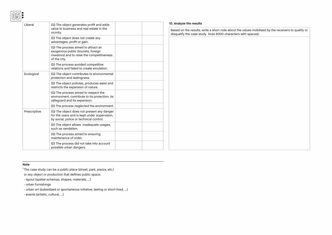
Liberal (Q) The object generates profit and adds value to business and real estate in the vicinity.
(D) The object does not create any advantages, profit or gain.
(Q) The process aimed to attract an exogenous public (tourists, foreign investors) and to raise the competitiveness of the city.
(D) The process avoided competitive relations and failed to create emulation.
Ecological (Q) The object contributes to environmental protection and lastingness.
(D) The object pollutes, produces waist and restricts the expansion of nature.
(Q) The process aimed to respect the environment, contribute to its protection, its safeguard and its expansion.
(D) The process neglected the environment.
Prescriptive (Q) The object does not present any danger for the users and is kept under supervision, by social, police or technical control.
(D) The object allows inadequate usages, such as vandalism.
(Q) The process aimed to ensuring maintenance of order.
(D) The process did not take into account possible urban dangers.
10. analyze the results
Based on the results, write a short note about the values mobilized by the receivers to qualify or disqualify the case study (max 6000 characters with spaces):
Note 1 The case study can be a public place (street, park, piazza, etc.)
or any object or production that defines public space:
- layout (spatial schemas, shapes, materials, …)
- urban furnishings
- urban art (subsidized or spontaneous initiative, lasting or short-lived, …)
- events (artistic, cultural, …)
APPENDIx Observation MissionInnitial Tools

185
1. name of the tool OBSERVATION AND BEHAVIOUR MAPPING (OBBM)
2. main aim / what the tool is about Recording actual uses/activities in places
3. starting motivation / why and where the tool was initially developed
The tool was developed in 1970s in the field of Environmental Psychology. Initially it was used for indoor observations. Some decades later it became used in assent of outdoor places in neighbourhoods, as post occupancy evaluation tool. Observation and behaviour mapping supported by GIS for analysis and evaluation of public spaces was developed within a PhD research (Goličnik, B, 2005) at the School of Landscape Architecture, ECA, Heriot Watt University, Edinburgh, UK.
4. basic information / description of a tool and how it can assist understanding the public space better
Generally, OBBM is quite a low-tech tool. There are five key elements in behavioural mapping which have to be addressed before actual action of observation and mapping. They are:
• a graphic rendering of the areas observed;
• a clear definition of the human behaviours observed, and depicted;
• a schedule of repeated times during which the observation and recording take place;
• a systematic procedure followed in observing;
• a coding and counting system, which minimises the effort required in recording observations.
OBBM gives direct information about actual usage of public places. It can help to understand public space through dynamic patterns of places’ occupancies. By this it reflects on functionality of place design and on spatio-temporal cohabitation of users in places.
5. proposed data-collection process within Hc Observation Mission / details regarding the collection of data
A schedule of repeated times during which the observation and recording take place is prepared in advance. Reasons such as available amount of time per day section, general daily routine, exacting process, skills and concentration needed for every observation usually limit it. In terms of a systematic procedure followed in observing the whole the observation process is divided into four sections per day: morning, between 10 and 12am; early afternoon, between 12am and 2pm; afternoon, between 2 and 4pm; and late afternoon after 4pm, and usually until 7pm; during the week and weekends as well. The observer tries to find a comfortable location within the chosen sub-area, usually at the edge of it, to be able to see the whole area as clearly as possible. Every sub-area is observed for 10 minutes.
contact: Barbara Goličnik MarušićUrban Planning Institute of the Republic of SloveniaTrnovski pristan 2, SI 1000 Ljubljana, [email protected], 00386 1 420 13 46
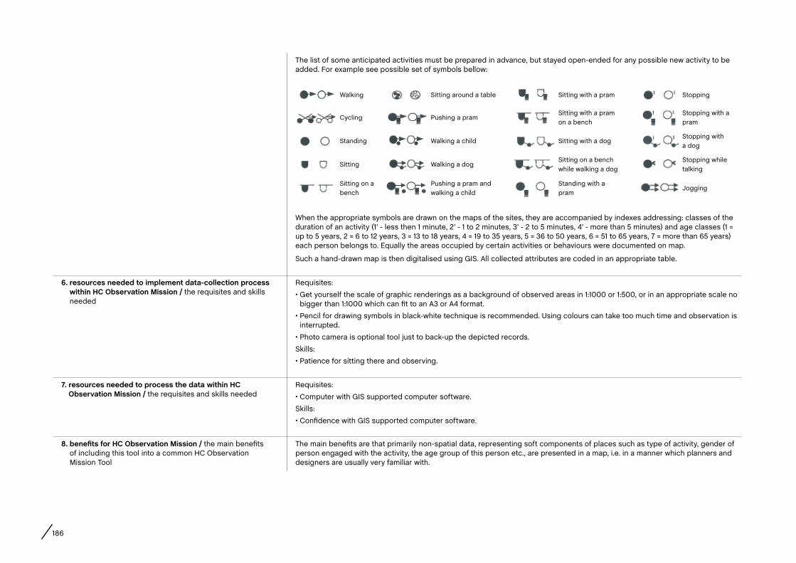
186
The list of some anticipated activities must be prepared in advance, but stayed open-ended for any possible new activity to be added. For example see possible set of symbols bellow:
When the appropriate symbols are drawn on the maps of the sites, they are accompanied by indexes addressing: classes of the duration of an activity (1’ - less then 1 minute, 2’ - 1 to 2 minutes, 3’ - 2 to 5 minutes, 4’ - more than 5 minutes) and age classes (1 = up to 5 years, 2 = 6 to 12 years, 3 = 13 to 18 years, 4 = 19 to 35 years, 5 = 36 to 50 years, 6 = 51 to 65 years, 7 = more than 65 years) each person belongs to. Equally the areas occupied by certain activities or behaviours were documented on map.
Such a hand-drawn map is then digitalised using GIS. All collected attributes are coded in an appropriate table.
6. resources needed to implement data-collection process within Hc Observation Mission / the requisites and skills needed
Requisites:
• Get yourself the scale of graphic renderings as a background of observed areas in 1:1000 or 1:500, or in an appropriate scale no bigger than 1:1000 which can fit to an A3 or A4 format.
• Pencil for drawing symbols in black-white technique is recommended. Using colours can take too much time and observation is interrupted.
• Photo camera is optional tool just to back-up the depicted records.
Skills:
• Patience for sitting there and observing.
7. resources needed to process the data within Hc Observation Mission / the requisites and skills needed
Requisites:
• Computer with GIS supported computer software.
Skills:
• Confidence with GIS supported computer software.
8. benefits for Hc Observation Mission / the main benefits of including this tool into a common HC Observation Mission Tool
The main benefits are that primarily non-spatial data, representing soft components of places such as type of activity, gender of person engaged with the activity, the age group of this person etc., are presented in a map, i.e. in a manner which planners and designers are usually very familiar with.
Walking Sitting around a table Sitting with a pram Stopping
Cycling Pushing a pramSitting with a pram on a bench
Stopping with a pram
Standing Walking a child Sitting with a dogStopping with a dog
Sitting Walking a dogSitting on a bench while walking a dog
Stopping while talking
Sitting on a bench
Pushing a pram and walking a child
Standing with a pram
Jogging

187
contact: Davide fassiPolitecnico di Milano – Scuola del Design Relè Office Via Durando 10, 20158 Milano – Italy [email protected], 0039 347 500 8782
1. name of the tool EXPERIENTIAL MAP (DERIVE MAP)
2. main aim / what the tool is about It is a representation of a portion of landscape (urban context or natural environment) through the eyes and feelings of the user.
3. starting motivation / why and where the tool was initially developed
The experiential maps were used for the first time by the Situationists in late 1950s as a tool to describe towns from a non-geographical point of view.
4. basic information / description of a tool and how it can assist understanding the public space better
It is a map drawn by the user after/during a walk in a portion of landscape with free techniques (sketches, collages, etc.). It gives a unique perception of an urban space due to the feelings and point of views of the user.
5. proposed data-collection process within Hc Observation Mission / give details regarding the collection of data
Data collection can be done on an adequate number of users who assess the same portion of urban space. At the end or during the walk, they could represent their own point of view about what they are looking at and perceiving. The output must have the same format (depending on the scale of the portion assessed) in order to make them comparable. Data are not quantitative but qualitative.
6. resources needed to implement data-collection process within Hc Observation Mission / the requisites and skills needed
• A geographical map to see the objective part of the analysis.
• Paper/cardboard on a determined format (A4, A3, etc.).
• Other useful tools depending on the user’s needs and outputs (camera, pens, etc.).
7. resources needed to process the data within Hc Observation Mission / the requisites and skills needed
• A geographical map of the urban portion to be assessed.
• Capabilities to read the results and put them in a geographical context to understand the strengths and weaknesses of the place.
8. benefits for Hc Observation Mission / the main benefits of including this tool into a common HC Observation Mission Tool
It will give a subjective point of view and a perception of a specific place, context. It could add a new layer to the reading of the landscape.
188
contact: Matej NikšičUrban Planning Institute of the Republic of SloveniaTrnovski pristan 2, SI-1000 Ljubljana, [email protected], 00386 1 420 13 44
1. name of the tool COGNITIVE MAP (INSEM)
2. main aim / what the tool is about Uncovering users’ perceptions and cognition of public spaces.
3. starting motivation / why and where the tool was initially developed
Urban design practice is traditionally focused on two aspects of urban environments – its physical structure and its functions. The need to develop new approaches that would equally deal also with the cognitive dimensions of space was a basic motivation to develop INSEM. As the perception of space strongly influences the way the users use the space (and vice versa) one of the motivations for developing the tool was also to understand the relations between behavioural patterns and perceptions of space. The tool was developed at Urban Planning Institute of the Republic of Slovenia.
4. basic information / description of a tool and how it can assist understanding the public space better
The tool combines interviewing and sketching techniques in order to get to know how people perceive a concrete open public space in terms of its perceived extent, perceived characteristics, and (un)appreciation of the perceived characteristics. It uncovers the extension of studied space in users’ mental image and the connection of this space with other neighbouring spaces in users’ mental image. It is used to get to know likes and dislikes that people share about a definite space. Based on the individual INSEM maps of perceptions it is possible to uncover the common perceptions shared by wider groups of users.
5. proposed data-collection process within Hc Observation Mission / details regarding the collection of data
Data collection is done through a questionnaire which combines open-ended questions as well as drawing tasks. The average expected fill-in time per questionnaire is 15 minutes. Ideally, sampling is done according to the findings of the behavioural mapping and shall reflect the proportion of concrete users by gender, age and type of activity. In any case, the number of carried out questionnaires shall not be less than 30, which proved to be a minimum relevant number in previous studies. The following working steps shall be taken:
1. Preparation of a site-specific questionnaire (the questionnaires need to be translated into a local language, relevant maps and names of a studied place have to be inserted);
2. Printing of an adequate number of questionnaires;
3. Distribution of questionnaires;
4. Collection of filled-in questionnaires.
6. resources needed to implement data-collection process within Hc Observation Mission / the requisites and skills needed
1. Access to cartographic source (to provide a map showing the morphology of the observed area* and the names of the main streets),
2. Translating capacity (to translate the questionnaire from English to local language),
3. Printing capacity (to print the adequate number of questionnaires) / alternatively the questionnaires can be filled in electronically.
* the area within the 3 minutes (300 meters radius) walking distance from the centre of the observed area must be shown on a map
189
7. resources needed to process the data within Hc Observation Mission / the requisites and skills needed
Studio work on a computer: electronic processing of data in a GIS database.
8. benefits for Hc Observation Mission / the main benefits of including this tool into a common HC Observation Mission Tool
Inclusion of the aspect covered by INSEM tool will give an insight into how people perceive the studied space – which elements they find characteristic and which of them are appreciated or disappreciated by users. A direct sensory dimension of space will be revealed as well. In this way the identity of space as seen through the eyes of the users will be indicated.
190
contact: Rafaella Houlstan-HasaertsULB – Faculté d’architecture La Cambre-Horta19, place Eugène Flagey, 1050 Brussels, [email protected], 0032 484 052 352
1. name of the tool QUALIFICATION / DISQUALIFICATION GRID
2. main aim / what the tool is about To understand the criteria (values) mobilized by those who produce public space and those who receive it.
3. starting motivation / why and where the tool was initially developed
The starting motivation was to understand the correlation between public space in the material sense of the word and public space in the intangible sense, meaning space defined politically by talking and acting together. The standpoint is that material public space is a common good in contemporary cities, that can be (re)negotiated and subject to validation. That means that those who take part in the public space dynamics must use criteria to qualify or disqualify it. These criteria are subject to a strong condition of public acceptance – to be legitimate, they must go beyond a simple personal motivation of the subjects and have a potential to be shared by others. The grid identifies these criteria and was developed in the Faculté d’architecture La Cambre-Horta.
4. basic information / description of a tool and how it can assist understanding the public space better
The grid shows (1) the criteria that the persons use to qualify or disqualify (a) the objects that define public space, (b) the processes underlying the production of these objects and (c) the subjects involved in producing public space. These criteria can be classified by their underlying (2) tenets, each of these tenets corresponding to (3) an imperative. It shows the ties that exist between the discourse of the “actors” who produce public space (their justifications, their arguments), the way public space effectively takes shape, and the judgments of the “receivers” that assess the production of public space. Within the HC project, the grid can be use to analyse the gap or the concordance between the criteria (values) mobilized by those who carry out a bottom up initiative and those who receive it.
5. proposed data-collection process within Hc Observation Mission / details regarding the collection of data
The researcher(s) will proceed to semi-directive individual interviews of 15 minutes each with (1) the “actor(s)” who initiate the project and (2) a group of receivers, who used-attended-participated to the project. The questions could be the following:
(1) To the actors:
• What was your motivation to start this project?
• What were the aims?
• How did you proceed to carry it out? What means did you use?
(2) To the receivers:
• What is your opinion about the project? Do you think it is a success or a failure? Why?
• Does it fulfil your needs-expectations?
• What changes could be made to improve it?
If such material exists, the researcher could complete the corpus collecting a series of documents that shows the justifications, arguments and judgements of “actors” and “receivers”: statements of intent, press articles, radio or TV broadcasts, etc.
191
6. resources needed to implement data-collection process within Hc Observation Mission / the requisites and skills needed
(1) One or several motivated researcher(s).
(2) Pertinent case study.
(3) Audio recorder(s).
(4) Access to databases (press, radio, tv, etc.), if needed.
7. resources needed to process the data within Hc Observation Mission / the requisites and skills needed
(1) The printed qualification / disqualification grid (previously translated into the local language).
(2) The glossary with the terminology used in the grid, translated into the local language.
(3) Studio work on a computer (interviews transcription, documents reviewing and redaction of final conclusions).
The researcher(s) will use the grid to identify the criteria “actors” and “receivers” mobilize to qualify or disqualify (a) the chosen bottom-up initiative, (b) the processes underlying it, (c) the subjects involved in the dynamic. They will compare the gap or the correlation between the intentional discourses of the “actors” and the attention discourse of the “receivers”. The outcome should be a short paper with the final conclusions.
8. benefits for Hc Observation Mission / the main benefits of including this tool into a common HC Observation Mission Tool
The grid could be used as a comprehensive tool, to target understanding both the values that underline the carrying out of a bottom-up initiative and its effective reception.
192
List of Contributors
arnould, NathalieDesigner. Design Manager of Cité du design for Saint-Etienne local public authorities (City, Metropolis, and urban planning agency), Saint-Etienne – [email protected]
Ballantyne-Brodie, Emily BA Dip Management, MA Environment and Sustainability. Director – Sustainable Designer, Urban Reforestation, Docklands – [email protected]
Berger, Mathieu Sociologist, PhD in Political and Social Sciences. Researcher, UCL, Centre de Recherches Interdisciplinaires “Démocratie, Institutions, Subjectivités” (Cri-Dis), Louvain-La-Neuve, BE / EHESS, Centre d’Étude des Mouvements Sociaux, (CEMS), Paris – [email protected]
Bonnard, Emilie Designer. PhD candidate, Jean Monet University, Saint-Etienne – [email protected]
calay, VincentSociologist and Geographer, Master Degree in Human Geography, PhD in Political and Social Sciences. ULB, Groupe de Recherche sur l’Action Publique (GRAP), Brussels, BE / SciencesPo Paris, Center for History, Paris – [email protected]
cantillon, Martine Anthroplogist. Brussels Environment, Brussels – [email protected]
claus, Caroline MA in Sociology, Master student in Urbanism and Urban
Planning. Yota! Collaborator, JES vzw, Brussels – BE. [email protected]
coirier, Lise MA in Art History and Management. Manager, ProMateria association, Brussels – [email protected]
Dandois, Sara Artist and Activist. Project developer, Time Circus vzw, Antwerp – [email protected]
Dattola, Filippo Le Début des Haricots asbl, Brussels – [email protected]
Degros, Aglaée Architect. Co-founder and partner, Artgineering, Rotterdam – NL. Member of the Association of European School of Planning (AESOP) – Thematic Group “Public spaces and urban cultures.” [email protected]
Doucet, Isabelle Architect, PhD in Architecture. Lecturer in Architecture and Urbanism, University of Manchester, Manchester Architecture Research Centre (MARC), School of Environment and Development (SED), and Manchester School of Architecture (MSA), Manchester – [email protected]
fassi, Davide Architect, Phd in Technological Innovation for Architecture and Design. Politecnico di Milano, School of Design, INDACO Department, DHOC – Interior Design for Hospitable Cities Research Group, Milan – [email protected]
franc, Josyane Languages and Public Management studies. Manager of International Affairs, Cité du Design & Ecole Supérieure d’Art et Design, Saint-Etienne – [email protected]
Gemayel, Jessy Designer. Research student “Post-Diploma Design & Research”, Cité du Design & École Supérieure d’Art et Design, Saint-Etienne – [email protected]
Goličnik Marušić, Barbara Landscape Architect, PhD in Landscape Architecture. Researcher, Head of Research, Urban Planning Institute of the Republic of Slovenia (UIRS), Assistant Professor for Open Space Design and Urban Landscape Research and Design, School of Architecture, Faculty of Civil Engineering, University of Maribor (UM, FG) – [email protected]
Golinelli, Giacomo PhD candidate in Anthropology, University of Bologna, Dipartimento di Discipline Storiche, Antropologiche e Geografiche, Bologna – [email protected]
Guisse, Sabine Architect. Researcher, ULB, Faculty of Architecture La Cambre-Horta, Brussels – [email protected]
Hackett, Mark Architect. Forum for Alternative Belfast – [email protected]
Hill, Declan Architect. Forum for Alternative Belfast – [email protected]

193
Holmberg, Alice Process Designer. Operations and Development Director, Clear Village, London – [email protected]
Houlstan-Hasaerts, Rafaella Architect. PhD candidate (Prospective Research for Brussels), ULB, Faculty of Architecture La Cambre-Horta, Brussels – [email protected]
Iaconesi, Salvatore Professor, La Sapienza University / Technology Director, FakePress, Rome – [email protected]
Jégou, François Master in Industrial Design. Professor, ENSAV La Cambre, Brussels – BE / Director, ENSCI Paris DESIS Lab, Ecole Nationale Supérieure de Création Industrielle, Les Ateliers, Paris – FR / Managing Director, Strategic Design Scenarios, Brussels – [email protected]
Kenaan, Hagi PhD in Philosophy. Associate Professor, Tel Aviv University, Department of Philosophy, Tel Aviv – [email protected]
Keshavarz, Mahmoud PhD candidate in Design, Malmö University, School of Arts and Communication, Malmö – [email protected]
Klein, Christian Architect, Designer. Assistant Professor, Lovely Professional University, Jalandhar – [email protected]
Knierbein, SabineDiploma studies in Landscape Architecture, PhD in Urban
Studies. Assistant Professor (Tenure Track) for Urban Culture and Public Space, Vienna University of Technology, Interdisciplinary Centre for Urban Culture and Public Space (SKuOR), Vienna – AT. Member of the Association of European School of Planning (AESOP) – Thematic Group “Public spaces and urban cultures.” [email protected]
Knoepfler, Julien Master in Law, Professional Degree of Barrister, European Master in Mediation, Executive Master in Real Estate. Coordinator of the Agenda 21 of the District of Molenbeek-St-Jean / Free-lance consultant (ARCH!MED Consulting), Brussels – [email protected]
Kubet, Vladimir Architect. University of Novi Sad, Faculty of Technical Sciences, Novi Sad – [email protected]
Labat, Tibo Architect. Collectif Fertile, Nantes – [email protected]
Laki, GiuliettaAnthropologist. PhD candidate, ULB, Groupe de Recherche sur l’Action Publique (GRAP), Brussels – [email protected]
Laureyssens, Thomas MA in Graphic Design. PhD candidate, MAD-faculty / FAK (KU Leuven), Brussels – [email protected]
Leger, Anaïs Landscape Architect. Collectif Fertile / Phd candidate, Agrocampus Ouest, Angers – [email protected]
Lupi, GiorgiaPhD candidate, Politecnico di Milano, Faculty of Design, Department INDACO, Milan – [email protected]
Madanipour, Ali Professor of Urban Design, Newcastle University, School of Architecture, Planning and Landscape, Newcastle upon Tyne – UK. Member of the Association of European School of Planning (AESOP) – Thematic Group “Public spaces and urban cultures.”[email protected]
Martire, Agustina Architect, PhD in Urban History. Queen’s University Belfast, Belfast – [email protected]
Motter, Roberta Interior Designer. Student M.sc. Product Service System Design, Politecnico di Milano, Milan – [email protected]
Nedučin, Dejana Architect. University of Novi Sad, Faculty of Technical Sciences, Novi Sad – [email protected]
Nikšič, Matej Architect, MA in Urban Planning, PhD in Architecture. Researcher, Urban Planning Institute of the Republic of Slovenia (UIRS), Ljubljana – [email protected]
Pagh, ChristianMA in Modern Culture and Philosophy. Cultural Planner and Founding Partner, UIWE culture design, Copenhagen – [email protected]

194
Parsa, Amin LL.M in International Human Rights Law. PhD candidate in International Law, Lund University, Faculty of Law, Lund – [email protected]
Patelli, Paolo PhD candidate, Politecnico di Milano, DiAP – Department of Architecture and Planning, Milan – [email protected]
Phasha, Potsiso Masters student, MSc (Development Planning), University of the Witwatersrand, School of Architecture and Planning, Faculty of Engineering and Built Environment, Johannesburg – [email protected]
Planchais, Cécile Sculptor and Designer, Paris – [email protected]
Plešivčnik, Tanja Geographer. PhD candidate in Philosophy and Theory of Visual Culture / NGO KVART-Visual Culture and Arts, Isola – [email protected]
Recyclart asbl-vzwArt center and workshops, Brussels – [email protected]
Ristić, DušanSociologist. University of Novi Sad, Faculty of Philosophy, Novi Sad – [email protected]
Rogel, LiatResearcher, Politecnico di Milano, Faculty of Design, Department INDACO, Milan – [email protected]
Ruiz-Sánchez, Javier Architect. PhD Professor, Technical University of Madrid UPM, Department of Urban and Regional Planning, Research Group on Cultural Landscape, Madrid – [email protected]
Seyrig, Adèle MA in Economy (Local project development) and Industrial Design. Project Manager, Strategic Design Scenarios, Brussels – [email protected]
Shechter, Shibboleth AA Dip, RIBA II, PgCert Learning and Teaching, MRes Landscape Urbanism. Associate Lecturer, University of the Arts London, School of Communication, Product and Spatial Design, MA Creative Practice for Narrative Environments, London – [email protected]
Simeone, Luca PhD candidate, Malmö University, MEDEA – SE / Researcher, FakePress, Rome – IT. [email protected]
Smith, Paul Landscape Architect. Collectif Fertile, Paris – [email protected]
Špegel, Marjan IT Researcher, retired, Institute Jožef Stefan for Scientific research, Ljubljana – [email protected]
Taylor Klein, Christine BA in Philosophy, MArch in Architecture, MA in Architectural History. Assistant Professor, Lovely Professional University, Jalandhar – [email protected]
Tominc, Biba Geographer and Pedagogue. Master student in Philosophy and Theory of visual Culture. Researcher, Urban Planning Institute of the Republic of Slovenia (UIRS), Ljubljana – [email protected]
Trapani, Paola Architect, PhD in Industrial Design. Researcher, Politecnico di Milano, Faculty of Design, Department INDACO, Milan – [email protected]
Udechuku, Ike Ampersand House and Gallery, Brussels – [email protected]
Van Dessel, MartheMedia Artist, Graphic Designer, MA in Political and Social Sciences. BolwerK, Antwerp – [email protected]
Vanoeteren, ChantalMA in Management and Town planning. Researcher, ULB, Faculty of Architecture La Cambre-Horta, Brussels – [email protected]
Vilain, Camille MA in Social Sciences and International Cultural Projects Management. International Projects Officer, Cité du Design, Saint-Etienne – [email protected]
195
Proceedings of the Symposium “Civil Society Reclaims Public Space. Cross Perspectives Based on Research” held in Brussels on 15th and 16th March 2012. This online publication has been released in the framework of the European project Human Cities: Reclaiming Public Space (2010-2012), supported by the EU Programme Culture 2007-2013.
With the support of the “Culture” (2007-2013) programme of the European Union
European Partners
Associated Partners
Editors Rafaella Houlstan-Hasaerts, Biba Tominc, Matej Nikšič and Barbara Goličnik Marušić.
contributing authors: Part of Human cities Network (alphabetic order)Lise Coirier, Davide Fassi, Jessy Gemayel, Barbara Goličnik Marušić, Rafaella Houlstan-Hasaerts, Roberta Motter, Matej Nikšič, Liat Rogel, Adèle Seyrig, Biba Tominc and Chantal Vanoeteren.
contributing authors: Part of Human cities Symposium (alphabetic order)Mathieu Berger, Vincent Calay, Isabelle Doucet, Davide Fassi, Barbara Goličnik Marušić, Giacomo Golinelli, Sabine Guisse, Mark Hackett, Declan Hill, Salvatore Iaconesi, François Jégou, Hagi Kenaan, Mahmoud Keshavarz, Christian Klein, Sabine Knierbein, Julien Knoepfler, Vladimir Kubet, Tibo Labat, Anaïs Léger, Giorgia Lupi, Ali Madanipour, Agustina Martire, Dejana Nedučin, Matej Nikšič, Amin Parsa, Paolo Patelli, Potsiso Phasha, Tanja Plešivčnik, Dušan Ristić, Javier Ruiz-Sánchez, Adèle Seyrig, Shibboleth Shechter, Luca Simeone, Paul Smith, Marjan Špegel, Christine Taylor Klein and Biba Tominc.
contributing moderators of workshops: Part of Human cities Symposium (alphabetic order)Nathalie Arnould, Emily Ballantyne-Brodie, Emilie Bonnard, Martine Cantillon, Caroline Claus, Lise Coirier, Sara Dandois, Filippo Dattola, Aglaée Degros, Josyane Franc, Jessy Gemayel, Barbara Goličnik Marušić, Sabine Guisse, Alice Holmberg, Rafaella Houlstan-Hasaerts, François Jégou, Sabine Knierbein, Giulietta Laki, Thomas Laureyssens, Matej Nikšič, Christian Pagh, Cécile Planchais, Recyclart asbl-vzw, Biba Tominc, Paola Trapani, Ike Udechuku, Marthe Van Dessel and Camille Vilain.
ProofreadingMaša Šorn
Graphic designDamjan Jermančič (Contributors: Biba Tominc and Guillaume Bokiau)
DTPDamjan Jermančič
CIP - Kataložni zapis o publikaciji Narodna in univerzitetna knjižnica, Ljubljana
711.4(082)
HUMAN cities [Elektronski vir] : civil society reclaims public space : cross perspectives based on research : international symposium proceedings, 15th-16th March, 2012, Brussels / edited by Rafaella Houlstan-Hasaerts ...[et al.]. - El. knjiga. - Ljubljana : Urban Planning Institute, 2012. - (Urbani izziv : publikacije)
Način dostopa (URL): http://www.uirs.si/pub/humancities2012.pdf
ISBN 978-961-6390-36-1 (pdf)
1. Houlstan-Hasaerts, Rafaella
262208000
Colophon
The contributions to this book have been peer reviewed.
We thank all the contributors for the pictures provided free of copyright.
This book is an online publication published by the Urban Planning Institute of the Republic of Slovenia’s press Urbani izziv – publikacije.
Available at: www.uirs.si/pub/humancities2012.pdf
May 2012
This project has been funded with the support from the European Commission – Programme Culture 2007-2013.
This online publication reflects the views only of the authors, and the Commission cannot be held responsible for any use, which may be made of the information contained therein.
REPUBLIC OF SLOVENIAMINISTRY OF EDUCATION,SCIENCE, CULTURE AND SPORT

Cross Perspectives Based on Research
Civil Society Reclaims Public Space
Edited by Rafaella Houlstan-Hasaerts, Biba Tominc, Matej Nikšič and Barbara Goličnik Marušić
HUMAN CITIES
“Researchers must accept reality
as they found it and try to shape it
toward positive social goals, not stand
aside in self-righteous isolation.”
John Dewey