Afforestation with ‘multipurpose trees’ in ‘media lunas’, a case study from the Tarija...
34
Agroforestry Systems 9: 93-126, 1989. 93 © 1989 Kluwer Academic Publishers. Printed in the Netherlands. Afforestation with 'multipurpose trees' in 'media lunas', a case study from the Tarija basin, Bolivia ERWIN BASTIAN 1 and WERNER GR,~FE 2 IGeographisches Institut der Universitiit Hannover, Schneiderberg 50, 3000 Hannover 1, FRG ; 2 M isi6n alemana agr oforestal ( G TZ ), Casilla 1141, Tarija, Bolivia Key words: Multipurpose trees, agroforestry systems, erosion control, semiarid area, forage legumes, soil conservation, run-off and soil loss Abstract. Human-induced soil erosion has already affected all of the potential farming land in the Tarija basin/South Bolivia. It is described as an afforestation method involving 'media lunas' and multipurpose trees, whose implementation is associated with a high degree of mobilization of the target group. On sites where a sufficientnumber of media lunas have been established, surface runoff is drastically reduced. They diminish the risk of failure of newly planted trees during frequently occurring dry phases, and promote their growth by preventing excessivelylarge fluctuations in the soil-water balance and increasing soil moisture in general. Mostly indigenous multi- purpose trees (Acacia and Prosopis) serve to stabilizeerosion-prone sites on a long-term basis, and become invaluable because they provide a source of firewood, improve the soil, and yield protein-rich livestock forage during dry season. Media lunas provide more favorable con- ditions for natural vegetation. 1. Introduction and objectives Bolivia is one of the poorest developing countries in Latin America. A large part of its rapidly growing population is consistently undernourished. The population is concentrated in the Andean highlands, the agricultural poten- tial of which is insufficient to make a major contribution towards signifi- cantly improving the nutritional situation. The Tarija basin, situated at an elevation of about 2,000 m, possesses a variety of favorable climatic, oro- graphic and infrastructural factors which make it inherently suited to de- velop into an important center for cultivation of high-value products such as wine, fruit and demanding irrigated crops. The greatest obstacle in the way of this area developing its potential is a process of extreme, human-induced soil erosion which has already affected virtually all of the potential farming land and turned much of it into badlands. Within the scope of the GTZ project 'Agroforestry Development in the
-
Upload
independent -
Category
Documents
-
view
4 -
download
0
Transcript of Afforestation with ‘multipurpose trees’ in ‘media lunas’, a case study from the Tarija...
Agroforestry Systems 9: 93-126, 1989. 93 © 1989 Kluwer Academic Publishers. Printed in the Netherlands.
Afforestation with 'multipurpose trees' in 'media lunas', a case study from the Tarija basin, Bolivia
E R W I N BASTIAN 1 and W E R N E R GR,~FE 2 IGeographisches Institut der Universitiit Hannover, Schneiderberg 50, 3000 Hannover 1, FRG ; 2 M isi6n alemana agr of or estal ( G TZ ), Casilla 1141, Tarija, Bolivia
Key words: Multipurpose trees, agroforestry systems, erosion control, semiarid area, forage legumes, soil conservation, run-off and soil loss
Abstract. Human-induced soil erosion has already affected all of the potential farming land in the Tarija basin/South Bolivia. It is described as an afforestation method involving 'media lunas' and multipurpose trees, whose implementation is associated with a high degree of mobilization of the target group.
On sites where a sufficient number of media lunas have been established, surface runoff is drastically reduced. They diminish the risk of failure of newly planted trees during frequently occurring dry phases, and promote their growth by preventing excessively large fluctuations in the soil-water balance and increasing soil moisture in general. Mostly indigenous multi- purpose trees (Acacia and Prosopis) serve to stabilize erosion-prone sites on a long-term basis, and become invaluable because they provide a source of firewood, improve the soil, and yield protein-rich livestock forage during dry season. Media lunas provide more favorable con- ditions for natural vegetation.
1. Introduction and objectives
Bolivia is one of the poorest developing countries in Latin America. A large part of its rapidly growing population is consistently undernourished. The populat ion is concentrated in the Andean highlands, the agricultural poten- tial of which is insufficient to make a major contribution towards signifi- cantly improving the nutrit ional situation. The Tarija basin, situated at an elevation of about 2,000 m, possesses a variety of favorable climatic, oro- graphic and infrastructural factors which make it inherently suited to de- velop into an important center for cultivation of high-value products such as wine, fruit and demanding irrigated crops.
The greatest obstacle in the way of this area developing its potential is a process of extreme, human-induced soil erosion which has already affected virtually all of the potential farming land and turned much of it into badlands.
Within the scope of the G T Z project 'Agroforestry Development in the
C
H
$$.
Q
u I
S A
I c
A
! / ! !
Gmpm
/~
o.
AR
G
E
NT
I
H
A
/ !
" O[
PART
AMI~N
TN_
..
..
..
..
*
S.~
FUb'YA
CIO~E
SC'/r~ITA
L ~q
~ DE
PA
RT
A/4
EN
TO
~
R~S
_
_.,
-.,~
v.
j.Sc.
ala:
: I
:3 0
00 0
00
6S*
T.4R
IJA
[]
T
~ri
ja b
~sin
Map
1.
Lo
cati
on
of
the
pro
ject
are
a in
Bol
ivia
.
95
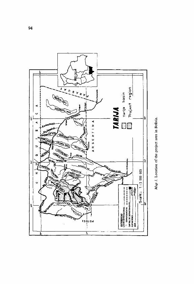
Tarija Valley', since 1984 an attempt has been underway to develop agroforestry systems which would permit stabilization and regeneration of the natural ecosystem, while at the same time making it possible to secure, expand and improve the agriculturally utilized areas.
The afforestation method involving 'medias lunas' described in this article is derived from a technique for water retention developed by the ancient Nabateans over 2,000 years ago which was more recently 'reinvented' in the Negev desert of Israel [Lamprecht, 1986]. Our aim here is to present a silvicultural system, the practical implementations of which is associated with a high degree of mobilization of the target group, which is directly involved in both preparation and field work.
2. Geographical and natural characterization
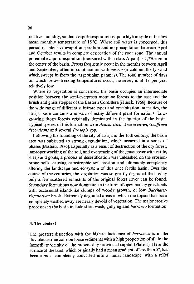
The Tarija basin (see Map 1) is situated between the central southern mountain ranges of the sub-Andean sierra zones and the Eastern Cordillera.
In the central area of the basin (fluviolacustrine zone), fluviatile-limnic fine sediments composed primarily of silty of clayey soil types predominate.
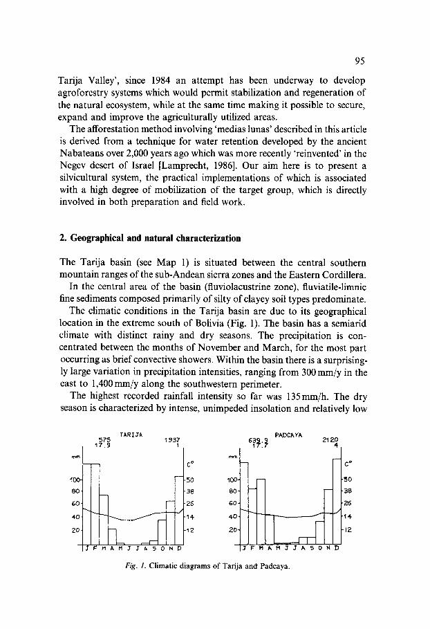
The climatic conditions in the Tarija basin are due to its geographical location in the extreme south of Bolivia (Fig. 1). The basin has a semiarid climate with distinct rainy and dry seasons. The precipitation is con- centrated between the months of November and March, for the most part occurring as brief convective showers. Within the basin there is a surprising- ly large variation in precipitation intensities, ranging from 300 mm/y in the east to 1,400 mm/y along the southwestern perimeter.
The highest recorded rainfall intensity so far was 135mm/h. The dry season is characterized by intense, unimpeded insolation and relatively low
575 17.9
-
8O
4O
2O
I J F M A M J J ~ 5 0 N D
TARI3A
mra
C °
5O 100.
38 80'
26 GO
14-
'12 20'
]J F M ~, M J J h 5 0 N D
PADCAYA 21 20
4
J
Fig. 1. Climatic diagrams of Tarija and Padcaya.
C D
.50
"38
'26
'14-
-12
96
relative humidity, so that evapotranspiration is quite high in spite of the low mean monthly temperature of 15 °C. Where soil water is concerned, this period of intensive evapotranspiration and no precipitation between April and October results in complete desiccation of the root zone. The annual potential evapotranspiration (measured with a class A pan) is 1,770 mm in the center of the basin. Frosts frequently occur in the months between April. and September, often in combination with surazo (a cold southerly wind which sweeps in from the Argentinian pampas). The total number of days on which below-freezing temperatures occur, however, is at 17 per year relatively low.
Where its vegetation is concerned, the basin occupies a n intermediate position between the semi-evergreen montane forests to the east and the brush and grass steppes of the Eastern Cordillera [Hueck, 1966]. Because of the wide range of different substrate types and precipitation intensities, the Tarija basin contains a mosaic of many different plant formations. Low- growing thorn forests originally dominated in the interior of the basin. Typical species of this formation were Acacia visco, Acacia caven, Geoffroea decorticans and several Prosopis spp.
Following the founding of the city of Tarija in the 16th century, the basin area was subjected to strong degradation, which occurred in a series of phases [Bastian, 1986]. Especially as a result of destruction of the dry forest, improper working of the soil, and overgrazing of the grass cover with cattle, sheep and goats, a process of desertification was unleashed on the erosion- prone soils, causing catastrophic soil erosion and ultimately completely altering the landscape and ecosystem of this once fertile basin. Over the course of the centuries, the vegetation was so greatly degraded that today only a few scattered remnants of the original forest cover can be found. Secondary formations now dominate, in the form of open patchy grasslands with occasional island-like clumps of woody growth, or low Baccharis- Eupatorium brush. Extremely degraded areas in which the topsoil has been completely washed away are nearly devoid of vegetation. The major erosive processes in the basin include sheet wash, gullying and barranco formation.
3. The context
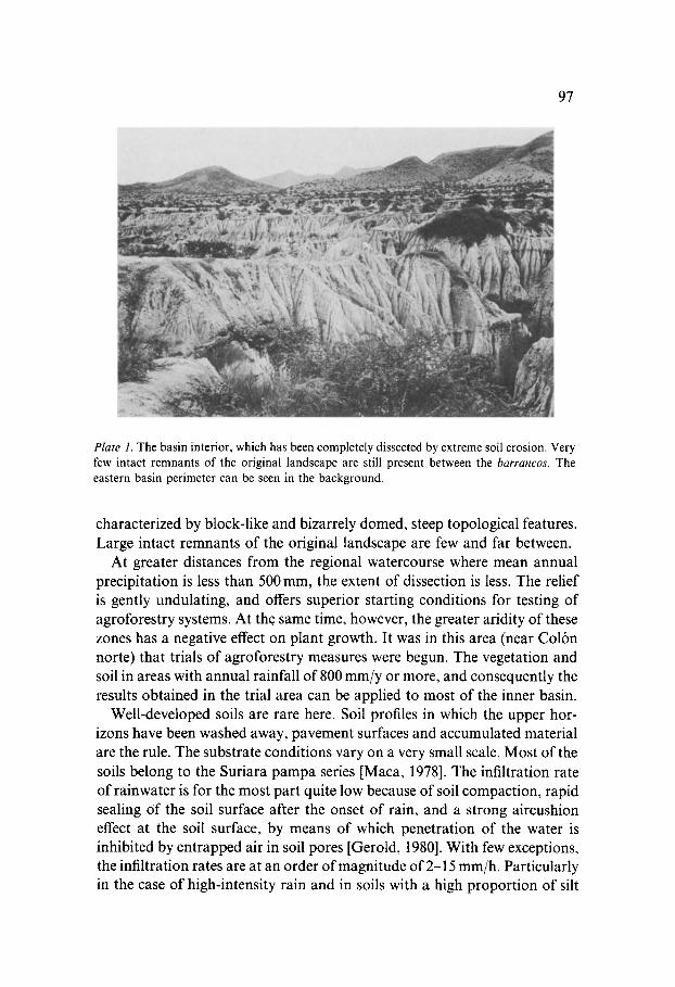
The greatest dissection with the highest incidence of barrancos is in the fluviolacustrine zone on loose sediments with a high proportion of silt in the immediate vicinity of the present-day provincial capital (Plate 1). Here the surface of the land, which originally had a mean gradient of less than 5 °, has been almost completely converted into a 'lunar landscape' with a relief
97
Plate 1. The basin interior, which has been completely dissected by extreme soil erosion. Very few intact remnants of the original landscape are still present between the barrancos. The eastern basin perimeter can be seen in the background.
characterized by block-like and bizarrely domed, steep topological features. Large intact remnants of the original landscape are few and far between.
At greater distances from the regional watercourse where mean annual precipitation is less than 500 mm, the extent of dissection is less. Tile relief is gently undulating, and offers superior starting conditions for testing of agroforestry systems. At the same time, however, the greater aridity of these zones has a negative effect on plant growth. It was in this area (near Col6n norte) that trials of agroforestry measures were begun. The vegetation and soil in areas with annual rainfall of 800 mm/y or more, and consequently the results obtained in the trial area can be applied to most of the inner basin.
Well-developed soils are rare here. Soil profiles in which the upper hor- izons have been washed away, pavement surfaces and accumulated material are the rule. The substrate conditions vary on a very small scale. Most of the soils belong to the Suriara pampa series [Maca, 1978]. The infiltration rate of rainwater is for the most part quite low because of soil compaction, rapid sealing of the soil surface after the onset of rain, and a strong aircushion effect at the soil surface, by means of which penetration of the water is inhibited by entrapped air in soil pores [Gerold, 1980]. With few exceptions, the infiltration rates are at an order of magnitude of 2-15 mm/h. Particularly in the case of high-intensity rain and in soils with a high proportion of silt
98
and/or clay, the rainwater penetrates only very shallowly into the soil, Accordingly, the vegetation is also poorly developed. In addition to locally prominent formations such as cactus scrub and brush communities, sparse grasslands dotted with island-like patches of Prosopis alpataco or other leguminous trees are widespread. Often, however, the ground is virtually bare of any vegetation.
The rate at which the barrancos are being incised is difficult to measure. Preliminary results from long-term measurements on 2 barrancos indicate that they are working their way upstream at a rate on the order of 0.5-1 m per year. No reliable data are available on depth of incision and soil loss. In any case, it is to be expected that these values will vary greatly from case to case.
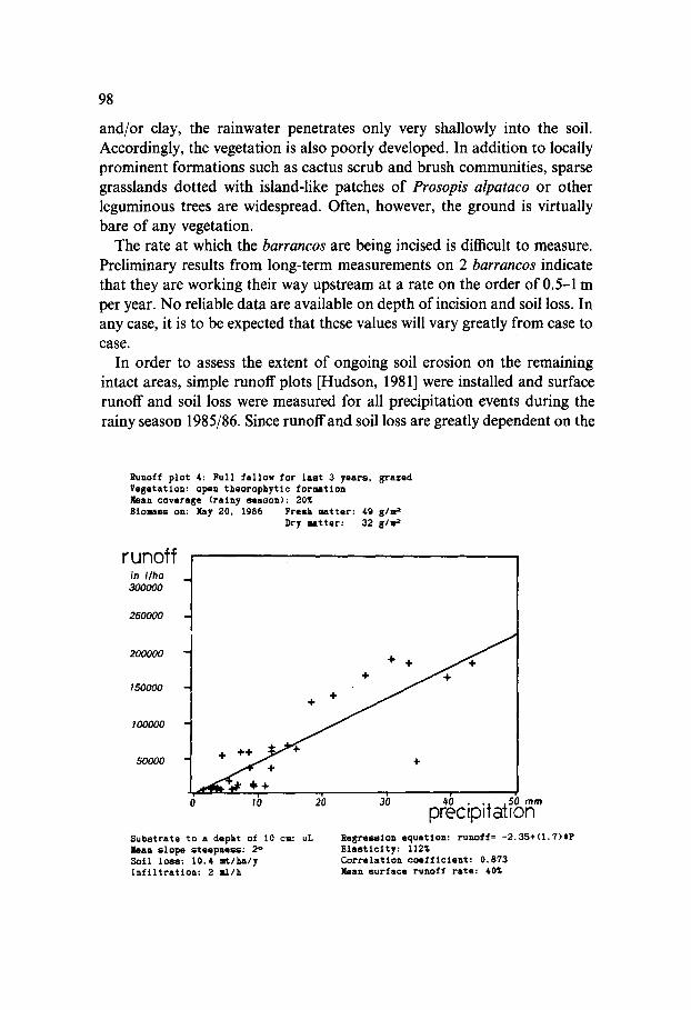
In order to assess the extent of ongoing soil erosion on the remaining intact areas, simple runoff plots [Hudson, 1981] were installed and surface runoff and soil loss were measured for all precipitation events during the rainy season 1985/86. Since runoff and soil loss are greatly dependent on the
runoff l in I /ha 300000
250000
200000 -
150000
100000
50000
Substrate to a depht of 10 cm: uL ban slope steepne~: 2 ° Soil loss: 10.4 mt/ha/y Infiltration: 2 ml/h
lb 2b 3b 4b . . . . so ~ preczp Tat on equation: runoff= - 2 . 3 5 + ( 1 . 7 ) t P Regre~lon
Elasticity: 112% Correlation ooefflcleat: 0.873 hart surface runoff rate: 40%
Runoff pitt 4: Full fallow for last 3 years, grazed Vegetation: open theorophytlc forsmtion ~[ean coverage (rainy Season): 20~ Btomass on: May 20, 1986 Fresh Jmtter: 49 g/m =
Dry matter: 32 glm 2
99
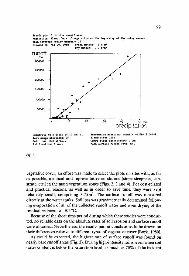
Runoff plo t 5: Ac t ive runof f area Vese ta t ion: Almost bare of v e s e t a t i o n a t the bas inn in8 of the r a i n y season Ilaan coverage ( r a i n y season) : I~ Blomass on: llay 20, 1986 Fresh matter: 6 5/m ~
Dry mat te r : 2 , 7 gl~
runoff I/ha
300000
250000
200000
150000
100000
50000
÷
/ I ÷ ÷
t
+ ÷ + +
I'0 J0 J0 ~'0 50 m,, preci p.,=t ori
Subs t r a t e to a depht of 10 ca: uL Xean s l ope s t e e p n e s s : 2 ~ S o l , l o s s : 232 a ' t / h a / y I n f i l t r a t i o n : 6 ml/h
Regress ion equa t ion : runoff= - 6 . 5 9 + ( 2 . 6 4 ) t P E l a s t i c i t y : 125~ C o r r s l a t i o u c o e f f i c i e n t : 0,957 Mean surface runoff rate: 57%
F/g. J .
vegetative cover, an effort was made to select the plots on sites with, as far as possible, identical and representative conditions (slope steepness, sub- strate, etc.) in the main vegetation zones (Figs. 2, 3 and 4). For cost-related and practical reasons, as well as in order to save time, they were kept relatively small, comprising 3.75m 2. The surface runoff was measured directly at the water tanks. Soil loss was gravimetrically determined follow- ing evaporation of all of the collected runoff water and oven drying of the residual sediment at 105 °C.
Because of the short time period during which these studies were conduc- ted, no reliable data on the absolute rates of soil erosion and surface runoff were obtained. Nevertheless, the results permit conclusions to be drawn on their differences relative to different types of vegetative cover [Bork, 1980].
As could be expected, the highest rate of surface runoff was found on nearly bare runoff areas (Fig. 2). During high-intensity rains, even when soil water content is below the saturation level, as much as 70% of the incident
100
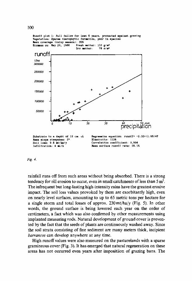
Runoff p l o t l : Fu l l f s l l o w f o r l a s t 5 yea r s , . p ro t ec t ed n s a i n s t 8 r a z i n 8 Vesetat ion: S p a r ~ therophyt lc r o t a t i o n , poor in s p e c i e s Keen covernse (rainy season): 35~ B i o ~ s s on: May 20, 1988 Fresh matter: 110 g/~r ~
runoff I lhe 300000
250000
200000
150000
100000
50000
Dr? ~ a t t e r : 78 ~/zr ~
o . . . . . . / o ~o Jo ~o . . 5o.m= precipitation Substrs te to a depht of 10 ca: uL Xean s lope s teepness : 2 ° So i l l o s s : 9,8 I t lha ly I n f i l t r a t i o n : 4 u l / h
R e g r e s s i o n e q u a t i o n : runof f= -2 .33+(1 .6~ )0P E l a s t i c i t y : 113~ Corre la t ion c o e f f i c i e n t : 0,904 b a n sur face runoff rate: 39.1~
Fig . 4.
rainfall runs off from such areas without being absorbed. There is a strong tendency for rill erosion to occur, even in small catchments of less than 5 m 2. The infrequent but long-lasting high-intensity rains have the greatest erosive impact. The soil loss values provoked by them are exorbitantly high, even on nearly level surfaces, amounting to up to 65 metric tons per hectare for a single storm and total losses of approx. 230 mt/ha/y (Fig. 5). In other words, the ground surface is being lowered each year on the order of centimeters, a fact which was also confirmed by other measurements using implanted measuring rods. Natural development of ground cover is preven- ted by the fact that the seeds of plants are continuously washed away. Since the soil strata consisting of fine sediment are many meters thick, incipient barrancos can develop anywhere at any time.
High runoff values were also measured on the pasturelands with a sparse gramineous cover (Fig. 3). It has emerged that natural regeneration on these areas has not occurred even years after impositiion of grazing bans. The
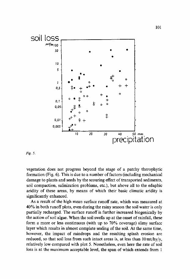
soil
Fig. 5.
[OSS m'~/~ 7 00
50
10
5
I
0,5
O j T •
0,05
0 ,01
0,005
o •
? +++
$ o
+ e+ • o
o + $
to g+
+
o o
+
o
10 20 30
0,
+
40 50 m m
precipitation
lO1
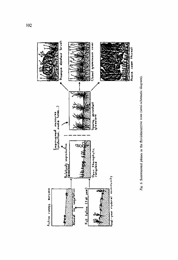
vegetation does not progress beyond the stage of a patchy therophytic formation (Fig. 6). This is due to a number of factors (including mechanical damage to plants and seeds by the scouring effect of transported sediments, soil compaction, salinization problems, etc.), but above all to the edaphic aridity of these areas, by means of which their basic climatic aridity is significantly enhanced.
As a result of the high mean surface runoff rate, which was measured at 40% in both runoff plots, even during the rainy season the soil water is only partially recharged. The surface runoff is further increased biogenically by the action of soil algae. When the soil swells up at the onset of rainfall, these form a more or less continuous (with up to 70% coverage) slimy surface layer which results in almost complete sealing of the soil. At the same time, however, the impact of raindrops and the resulting splash erosion are reduced, so that soil loss from such intact areas is, at less than l0 mt/hy/y, relatively low compared with plot 5. Nonetheless, even here the rate of soil loss is at the maximum acceptable level, the span of which extends from 1
C~
Ix-)
Acf
iv~
runo
ff.
~urf-
acc
Full
fallo
w
(4 ~
1" y=
a,)
Firo
SC-y
~mt r
udcr
al
com
mun
i~.y
~mpr
ovem
en~
(pro
~tct
ion,
m
e&;a
tu
nas.
,.)
Re l
a'l'~
v~Ix
u-p
ro au
~T/~
w ra
n~
¢la
nd
Ope
n ~:
he
eo
p~
t ~i
C
ronq
alan
d
I~r~
e a 5
u fG
5
\ r~~
N
5par
e~.
I~r*
i,;~-
t 9r
ass~
and
Proe
op;s
a|
pa~a
m~o
lar
u~ln
CIo
sc(I
ajr~
lm;n
~ous
co
~¢r
Aca
cia
cayL
, n +
hic
~l"
Fig
. 6.
Suc
cess
iona
l ph
ases
in
the
fluv
iola
cust
rine
zon
e (s
emi-
sche
mat
ic d
iagr
am).
103
to 10 metric tons per hectare per year according to Smith and Stamey [1965]. The high runoff rate causes the erosive forces to become fully effective in channels in the form of downward erosion, greatly accelerating the for- mation of cd~rcavas and barrancos. The greatest threat to the remaining intact areas is therefore that of their increasing dissection by deep erosion gullies until they are ultimately destroyed. Since only a minimum amount of water infiltrates into the remaining intact areas, during dry periods, which regularly occur during the rainy season and can last up to a month, the permanent wilting point is quickly reached in the soil, and the plants are thus subjected to constant damaging stress. Natural selection strongly favors species that are resistant to drought and browsing by animals. The resulting plant communities (Fig. 6) are characterized by shallow root penetration and a low degree of ground cover. Unless improvement measures are taken, further development of these communities within an acceptable time frame is not possible, a circumstance which is due not only to the poor soil-water regime, but also to the extremely unfavorable germination conditions in those areas.
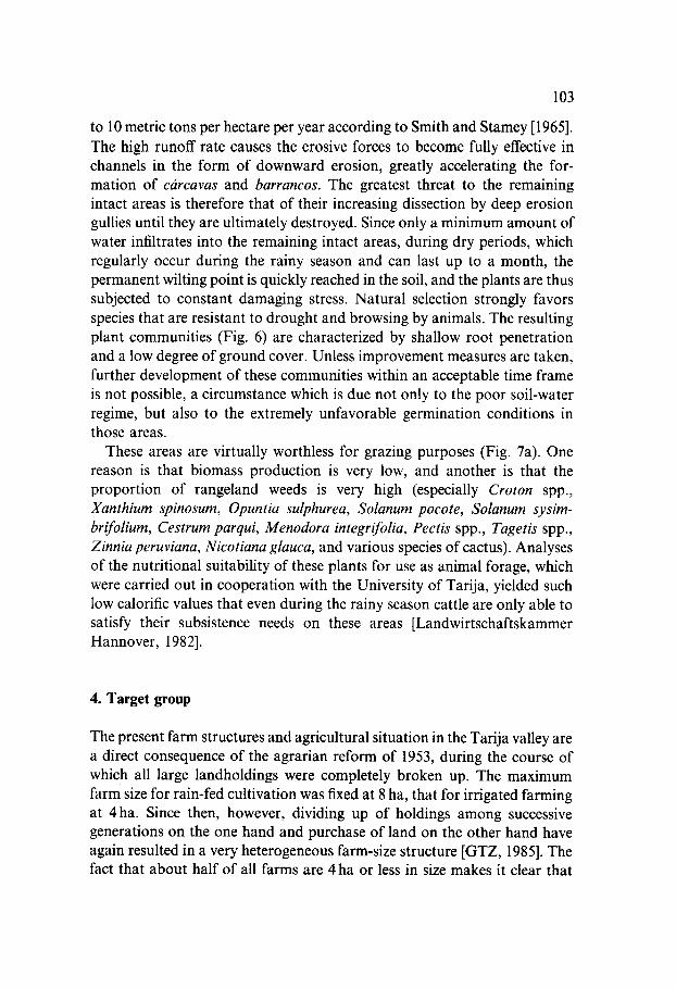
These areas are virtually worthless for grazing purposes (Fig. 7a). One reason is that biomass production is very low, and another is that the proportion of rangeland weeds is very high (especially Croton spp., Xanthium spinosum, Opuntia sulphurea, Solanum pocote, Solanum sysim- brifolium, Cestrum parqui, Menodora integrifolia, Pectis spp., Tagetis spp., Zinnia peruviana, Nicotiana glauca, and various species of cactus). Analyses of the nutritional suitability of these plants for use as animal forage, which were carried out in cooperation with the University of Tarija, yielded such low calorific values that even during the rainy season cattle are only able to satisfy their subsistence needs on these areas [Landwirtschaftskammer Hannover, 1982].
4. Target group
The present farm structures and agricultural situation in the Tarija valley are a direct consequence of the agrarian reform of 1953, during the course of which all large landholdings were completely broken up. The maximum farm size for rain-fed cultivation was fixed at 8 ha, that for irrigated farming at 4 ha. Since then, however, dividing up of holdings among successive generations on the one hand and purchase of land on the other hand have again resulted in a very heterogeneous farm-size structure [GTZ, 1985]. The fact that about half of all farms are 4 ha or less in size makes it clear that
104
a
Open therophytic formation
rnt/ha
:~-~'.:-" ~ ~ . . . . . . . .
O c t " Nov Dec Jan I:eb Mar A'pr tday Jun Jul
rntlha"
9
8
7
6
5
tl
3
2
I
b
Closed grassland (Pappophorurn )
Oct Nov Dec Jan Feb Mar Apr May Jun Jul
O: Total biomoss 4.: Grasses • :~ Herbaceous plants ~ : Dead plant material
Fig. 7. Biomass development for grazing on important plant communities in the fluviolacu-
strine zone of the Tarija basin. All values are indicated in metric tons of dry matter per hectare.
the Tarija region is dominated by smallholder farming with its characteristic cost structure and low market orientation.
Because of the limited possibilities for production on their own farms, particularly those which are rain-watered, farming activities being restricted to just a few months out of each year, members of nearly all of the families temporarily travel to find work in the sugarcane-growing areas near the Argentinian border. Yet, it is the small farmers themselves who - without
105
capital or any possibility of obtaining credit - are principally responsible for the erosion, as a result of their traditional practices. Extensive and un- controlled small animal husbandry and destruction of vegetation to obtain firewood are practiced almost exclusively by this population group, thus automatically qualifying it as the target group for implementation of soil conservation measures. It is therefore of decisive importance for the success of the project activities that these small farmers be included and their active participation gained in all decision-making processes concerning them and the determination of interests and priorities.
Accordingly, the project work began with an extremely intensive cam- paign by project staff to inform the target group. Regular meetings with members of the target group finally led to the formation of a group of interested farmers who recognized the necessity of carrying out soil con- servation and afforestation measures. Experiences made in different countries (e.g. village forestry associations in South Korea) have shown that such relatively small grass-roots organizations linked with the other local organizations and structures as a rule promise the greatest success, since they are based on solidarity and uniform expectations as to results [Grfife, 1986]. During this project phase it was shown once again that silvicultural management systems in dry regions more often encounter serious obstacles of a sociocultural and socioeconomic nature than where technical aspects are concerned [Lamprecht, 1986].
5. Grazing
Although most of the strongly eroded fluviolacustrine zone of the project region is divided up into a number of privately owned properties, it has become usual for these areas to be used as communal pastureland without consideration to property boundaries.
It is estimated that each family possesses an average of 14.4 cattle, 12.6 sheep and 7.0 goats [Plaza, 1984]. The stocking rate is thus 4 times higher than the supportive capacity of the ecosystem. While the large livestock is driven after the rainy season into the central valley of Entre Rios to graze in the forest [Echeverria, 1985], it is year-round overgrazing by goats and sheep that is primarily responsible for destroying the ecological balance. This situation harbors a conflict of interests which must be taken very seriously: On the one hand goats play a very important part in the subsis- tence economy practiced by many small farmers, while on the other hand strict separation of forest and livestock management is indispensable for the
106
success of afforestation measures, at least during the first years following planting. The project is therefore attempting to introduce domesticated goat breeds (Saanen and Nubians) that can be kept with stall feeding, and thus satisfy the traditional demands and 'needs of the target group. At the same time, it is necessary to establish multipurpose forests as a backup measure in response to the diverse demands and needs of humans, animals and the ecosystem.
6. Background
Prior to the beginning of the project, improper choice of species (e.g. Eucalyptus globulus and E. camaldulensis), had had negative effects on soil properties and prevented a rapid plant succession that could lead to a continuous ground cover [Gerold, 1985], as well as resulting in extremely poor growth rates. Following an assessment of the afforestation activities in the Tarija basin, in particular those in the fluviolacustrine zone - this gave rise to a reevaluation and restructuring of the silvicultural concept.
The objective of the German-Bolivian project was formulated as follows: to focus on establishment of multipurpose protective forests consisting of indigenous tree species and exotics suited to local conditions. For the purpose of optimally fulfilling this objective, in 1984/85 three different planting techniques were tried and the following species included in the final round of consideration:
Acacia arorno Acacia visco Acacia caven Acacia cyanophylla Acacia decurrens Acacia dealbata Albizia stipulata Albizia lebbek Bauhinia variegata Eucalyptus cladocalyx Grevillea robusta
Jacaranda mimosifolia Leucaena alternifolia Leucaena pulverulenta Leucaena leucocephala Melia azedarach Parkinsonia aculeata Pinus radiata Prosopis alba Robinia pseud.acacia Schinus molle Tipuana tipu
Although it was not possible to statistically evaluate the trials following the first vegetation period, since the results were influenced by repeated browsing by animals, it was nevertheless possible to carry out an empirical evaluation as a basis for making decisions on subsequent procedures.
107
Where planting techniques are concerned, it emerged that simple hole planting and the establishment of small planting covers were both clearly inferior to the 'medias lunas' method (Chapter 8).
The most promising tree species proved to be: Acacia cyanophylla, A. aromo, A. visco, A. caven, Prosopis alba and Leucaena pulverulenta.
On the basis of these preliminary results on silvicultural techniques, a concept for this pilot phase with small-scale implementation was developed with the participation of the target group.
7. Methodology
As a basis for the measures, a kind of contract is drawn up which defines the contributions of the farmers and of the project. Afterwards, each farmer inspects his property together with the project technicians and selects a suitable piece of land to be made available for the planned measure, and pledges to protect this area from browsing animals by surrounding it with a 'dead' hedge made of thorny branches. In order to protect this unpassable fence, the farmers then plant species close to it which during the following years will grow to become a 'living fence' and guarantee that livestock will be permanently kept away from the newly developing vegetation. The materials for these purposes (thorny branches of Opuntia spp., Agave spp., Acacia spp., Lycium spp., etc.) are provided and delivered to the farmers free of charge.
Persons living in the project region are then commissioned on a contract basis and paid by the project to make the 'medias lunas'.
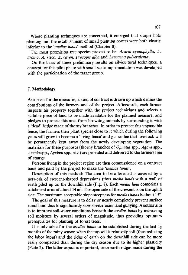
Description of this method: The area to be afforested is covered by a network of crescent-shaped depressions (thus media luna) with a wall of earth piled up on the downhill side (Fig. 8). Each media luna comprises a catchment area of about 14 m 2. The open side of the crescent is on the uphill side. The maximum acceptable slope steepness for medias lunas is about 15 °.
The goal of this measure is to delay or nearly completely prevent surface runoff and thus to significantly slow sheet erosion and gullying. Another aim is to improve soil-water conditions beneath the medias lunas by increasing soil moisture by several orders of magnitude, thus providing optimum prerequisites for planting of forest trees.
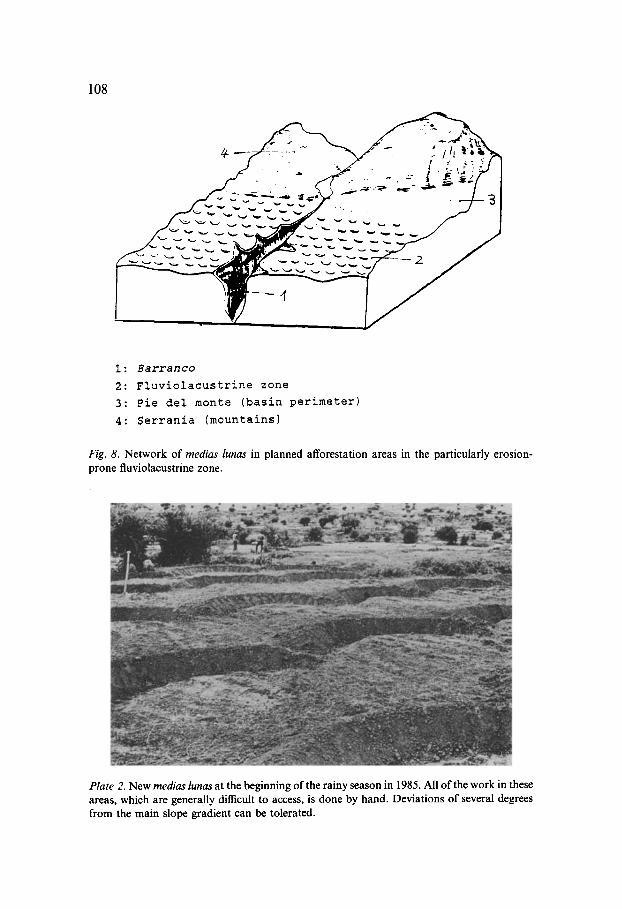
It is advisable for the medias lunas to be established during the last 1½ months of the rainy season when the top soil is relatively soft (thus reducing the labor input) and the ridge of earth on the downhill side can be more easily compacted than during the dry season due to its higher plasticity (Plate 2). The latter aspect is important, since earth ridges made during the
108
I: Barranco
2: Fluviolacustrine zone
3: Pie del monte (basin perimeter)
4: Serrania (mountains)
Fig. 8. Network of medias lunas in planned afforestation areas in the particularly erosion- prone fluviolacustrine zone.
Plate 2. New medias lunas at the beginning of the rainy season in 1985. All of the work in these areas, which are generally difficult to access, is done by hand. Deviations of several degrees from the main slope gradient can be tolerated.
109
dry season are usually too loose and are often damaged if the first rains are too intense.
Before planting it is important to carry out measures to control leaf-cutter ants (in some areas there are more than 40 colonies per hectare). These measures should subsequently be repeated regularly for at least 2 years. The insecticide used is made by the project itself, and is being provided to the farmers free of charge during this pilot phase.
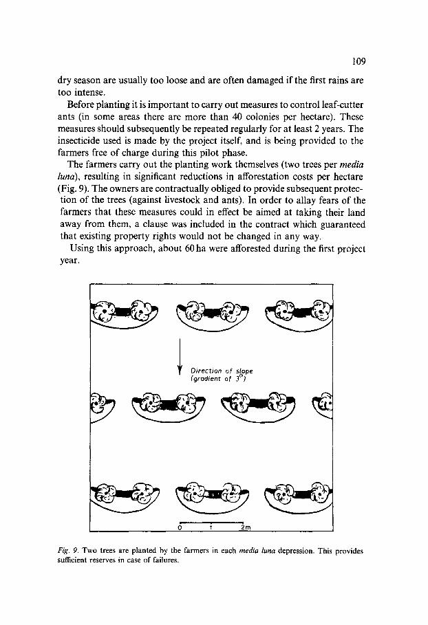
The farmers carry out the planting work themselves (two trees per media luna), resulting in significant reductions in afforestation costs per hectare (Fig. 9). The owners are contractually obliged to provide subsequent protec- tion of the trees (against livestock and ants). In order to allay fears of the farmers that these measures could in effect be aimed at taking their land away from them, a clause was included in the contract which guaranteed that existing property rights would not be changed in any way.
Using this approach, about 60 ha were afforested during the first project year.
Direction of slope (graclient of 3 °)
Fig. 9. Two trees are planted by the farmers in each media luna depression. This provides sumcient reserves in case of failures.
110
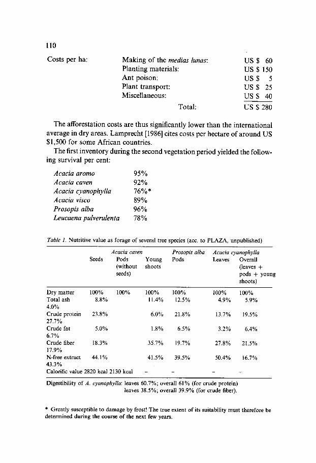
Costs per ha: Making of the medias lunas: US $ 60 Planting materials: US $150 Ant poison: US $ 5 Plant transport: US $ 25 Miscellaneous: US $ 40
Total: US $ 280
The afforestation costs are thus significantly lower than the international average in dry areas. Lamprecht [1986] cites costs per hectare of around US $1,500 for some African countries.
The first inventory during the second vegetation period yielded the follow- ing survival per cent:
Acacia aromo 95% Acacia caven 92% Acacia cyanophylla 76%* Acacia visco 89% Prosopis alba 96°,/0 Leucaena pulverulenta 78%
Table 1. Nutritive value as forage of several tree species (acc. to PLAZA, unpublished)
Acacia caven Prosopis alba Acacia cyanophylla Seeds Pods Young Pods Leaves Overall
(without shoots (leaves + seeds) pods + young
shoots)
Dry matter 100% 100% 100% 100% 100% 100% Total ash 8.8% 11.4% 12.5% 4.9% 5.9% 4.0% Crude protein 23.8% 6.0% 21.8% 13.7% 19.5% 27.7% Crude fat 5.0% 1.8% 6.5% 3.2% 6.4% 6.7% Crude fiber 18.3% 35.7% 19.7% 27.8% 21.5% 17.9% N-free extract 44.1% 41.5% 39.5% 50.4% 16.7% 43.3% Calorific value 2820 kcal 2130 kcal . . . .
Digestibility of A. cyanophylla: leaves 60.7%; overall 61% (for crude protein) leaves 38.5%; overall 39.9% (for crude fiber).
* Greatly susceptible to damage by frost! The true extent of its suitability must therefore be determined during the course of the next few years.
111
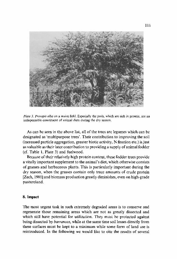
Plate 3. Prosopis alba on a maize field. Especially the pods, which are rich in protein, are an indispensable constituent of animal diets during the dry season.
As can be seen in the above list, all of the trees are legumes which can be designated as 'multipurpose trees'. Their contribution to improving the soil (increased particle aggregation, greater biotic activity, N fixation etc.) is just as valuable as their later contribution to providing a supply of animal fodder (cf. Table 1, Plate 3) and fuelwood.
Because of their relatively high protein content, these fodder trees provide a vitally important supplement to the animal's diet, which otherwise consists of grasses and herbaceous plants. This is particularly important during the dry season, when the grasses contain only trace amounts of crude protein [Zech, 1981] and biomass production greatly diminishes, even on high-grade pastureland.
8. Impact
The most urgent task in such extremely degraded areas is to conserve and regenerate those remaining areas which are not as greatly dissected and which still have potential for utilization. They must be protected against being dissected by barrancos, while at the same time soil losses directly from these surfaces must be kept to a minimum while some form of land use is reintroduced. In the following we would like to cite the results of several
112
studies to demonstate that afforestation measures with multipurpose trees in connection with medias lunas is the best-suited instrument for doing this.
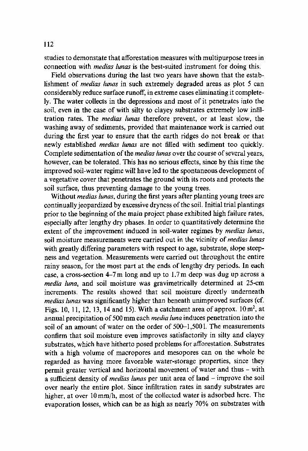
Field observations during the last two years have shown that the estab- lishment of medias lunas in such extremely degraded areas as plot 5 can considerably reduce surface runoff, in extreme cases eliminating it complete- ly. The water collects in the depressions and most of it penetrates into the soil, even in the case of with silty to clayey substrates extremely low infil- tration rates. The medias lunas therefore prevent, or at least slow, the washing away of sediments, provided that maintenance work is carried out during the first year to ensure that the earth ridges do not break or that newly established medias lunas are not filled with sediment too quickly. Complete sedimentation of the medias lunas over the course of several years, however, can be tolerated. This has no serious effects, since by this time the improved soil-water regime will have led to the spontaneous development of a vegetative cover that penetrates the ground with its roots and protects the soil surface, thus preventing damage to the young trees.
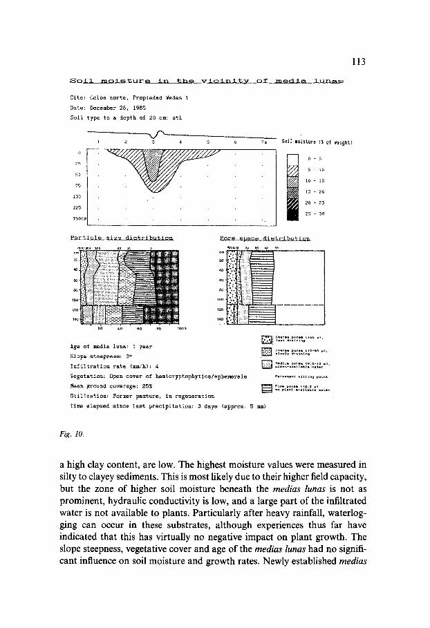
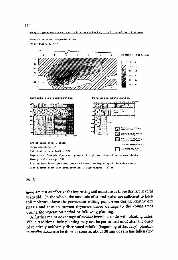
Without medias lunas, during the first years after planting young trees are continually jeopardized by excessive dryness of the soil. Initial trial plantings prior to the beginning of the main project phase exhibited high failure rates, especially after lengthy dry phases. In order to quantitatively determine the extent of the improvement induced in soil-water regimes by medias lunas, soil moisture measurements were carried out in the vicinity of medias lunas with greatly differing parameters with respect to age, substrate, slope steep- ness and vegetation. Measurements were carried out throughout the entire rainy season, for the most part at the ends of lengthy dry periods. In each case, a cross-section 4 - 7 m long and up to 1.7m deep was dug up across a media luna, and soil moisture was gravimetrically determined at 25-cm increments. The results showed that soil moisture directly underneath medias lunas was significantly higher than beneath unimproved surfaces (cf. Figs. 10, 11, 12, 13, 14and 15). With a catchment area of approx. 10m 2, at annual precipitation of 500 mm each media luna induces penetration into the soil of an amount of water on the order of 500-1,5001. The measurements confirm that soil moisture even improves satisfactorily in silty and clayey substrates, which have hitherto posed problems for afforestation. Substrates with a high volume of macropores and mesopores can on the whole be regarded as having more favorable water-storage properties, since they permit greater vertical and horizontal movement of water and thus - with a sufficient density of medias lunas per unit area of land - improve the soil over nearly the entire plot. Since infiltration rates in sandy substrates are higher, at over 10 mm/h, most of the collected water is adsorbed here. The evaporation losses, which can be as high as nearly 70% on substrates with
113
Soil m o i s t u r m in the vicinity of m e d i a lunas
0
25
50
75
i00
125
150ca
Site: Colon norte, Propiedad Wedes 1
Date: December 28, 1985
Soll type to a depth of 20 cm: stL
-x/"-, 2 3 4 5 6 7m Soil moisture ( I of weight)
0 5
5 lO
i0 15
15 20
20 25
25 30
Particle size distribution Pore space distribution
cm
2o
l oo
12o
140
Age of media luna: 1 year
Slope steepness: 3 ~'
Infiltration rate (mm/h): 4
Vegetation: Open cover of hemicryptophytics/ephemersls
Mean ground coverase: 25%
Utilization: Former pasture, in regeneration
]i c°+..o po... ,>so ,,~
] ¢o.... poro. ~zo-so ~), • ~o.*v dr.l.i.~
p.......t .ll~i.g ~o+.t
] Fi.. po~.. (<o+2 ~
Time elapsed since last precipitation: 3 days (approx. 5 mm)
Fig. 10.
a high clay content, are low. The highest moisture values were measured in silty to clayey sediments. This is most likely due to their higher field capacity, but the zone of higher soil moisture beneath the medias lunas is not as prominent, hydraulic conductivity is low, and a large part of the infiltrated water is not available to plants. Particularly after heavy rainfall, waterlog- ging can occur in these substrates, although experiences thus far have indicated that this has virtually no negative impact on plant growth. The slope steepness, vegetative cover and age of the medias lunas had no signifi- cant influence on soil moisture and growth rates. Newly established medias
114
Soil r n o : t ~ ' l : u r ~ in the vlcinltv of ~.~dia lunas
S i t e : C o l o n n o r t e , P r o p t e d a d ¥ i l t e
D a t e : ~anuary 2 , 1986
x/'- 1 2 3 4
°t 25
5O
?5
ioo
125
150cJ
5 6 7m Soil moisture (S of weight)
• V ~ o - 5
lO
10 15
15 20
20 25
25 30
Particle size distribution
.'.g
':::i ~ ~ . . . ' . . . . . . . . . - ; . . . . . . .
,00 ii!i
:_::_::_-:--:_:_~ 0 0 ~ 2 0 4O eO
Age o f media lunar 2 month
S l o p e s t e e p n e s s : 4 °
I n f i l t r a t i o n r a t e (mm/h): 7 . 5
P o r e ~ D a c e d i s t r i b u t i o n
] , , : : • \ : :"3 ~:::: " ........ S T - "
,@~~o °< > i:dii::d J ~o °.* • : : : : : cos,so pores I>so ~1,
14o **" : :i::iii:~ ,.e~ ~1 ~ I ele. ty d , l l . lne
n t d l ~ porH (o 2-1o m)
P I , m l n l ~ u t l ~ l ~ p o i n l
~ I'lnl po,n (~o:l ~,) no plant-ivslallDll ~stor
Vegeta t ion : P r o e o p i s a l p a t a c o - grass w i th high p r o p o r t i o n o f h e r b a c e o u s p l a n t s
Mean ground coverage: 3 5 ~
U t i l i z a t i o n : Former p a s t u r e , p r o t e c t e d s i n c e t h e b e s i n n i n S o f t h e r a i n y s e a s o n
T i m e e l a p s e d s i n c e l a s t p r e c i p i t a t i o n : 2 d a y s ( a p p r o x , 20 I m )
Fig. 11.
lunas are just as effective for improving soil moisture as those that are several years old. On the whole, the amounts of stored water are sufficient to keep soil moisture above the permenant wilting point even during lengthy dry phases and thus to prevent dryness-induced damage to the young trees during the vegetation period or following planting.
A further major advantage of medias lunas has to do with planting dates. While traditional hole planting may not be performed until after the onset of relatively uniformly distributed rainfall (beginning of January), planting in medias lunas can be done as soon as about 30 mm of rain has fallen (end
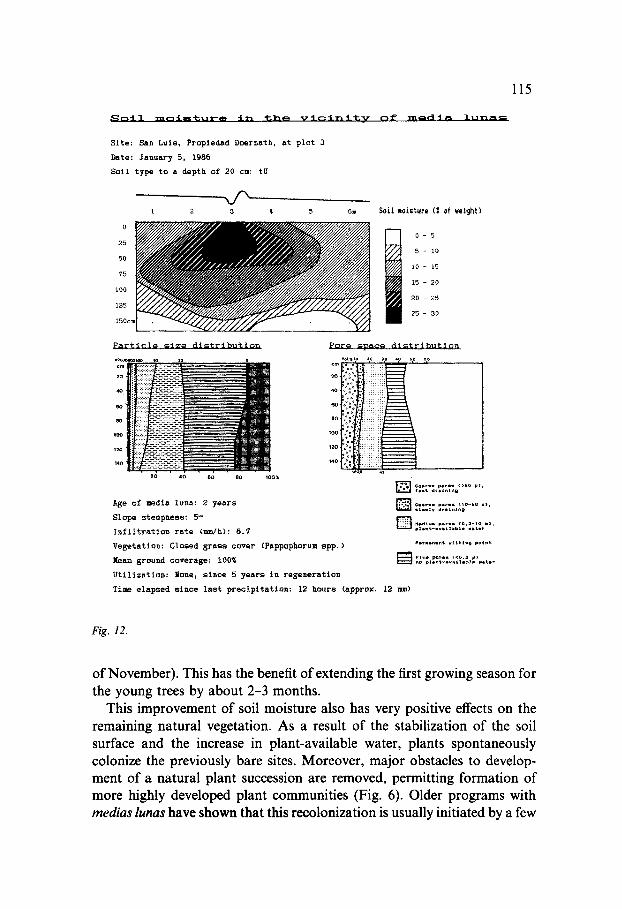
Soil mt3isture in %he vicinity of media lun~m
Site: San Luls, Propledad Doernath, at plot 3
Date: January 5, 1986
Soil type to a depth of 20 cm: tU
i 2 3 4 5
0
25
50 ~ 75
IO0
125
150cI
Particle mize distribution
20 40 60 80 1007,
A g e of m e d i a l u n a : 2 years
S l o p e s t e e p n e s s : 5 °
Infiltration rate (mmlh): 6.7
Vegetation: Closed grass cover (Pappophorum spp.)
Rean ground coverage: IOOZ
Utilization: lone, since 5 years in regeneration
6m
Pore s p a c e distribution
v,,~,0 20 30 4o ~o eo
20
140
' ~ c . , . p o , . (>so ~1, ¢ . t = ~ l l . l . U
~ C . . I p = r . ~), ( IO-~o 1 1 . 1 y = . = l . l . g
~ . . t = . p = ~ . (o.=- ,o . ) , e l l n ¢ - . = * l l b t * - -¢e,
S o i l m o i s t u r e ( I of v e i g h t )
o - 5
5 - I 0
10 - 15
15 - 2C
20 - 25
25 - 30
Time e l a p s e d s i n c e l a s t p r e c i p i t a t i o n : 12 hours ( a p p r o x , 12 =m)
115
Fig. 12.
of November). This has the benefit of extending the first growing season for the young trees by about 2-3 months.
This improvement of soil moisture also has very positive effects on the remaining natural vegetation. As a result of the stabilization of the soil surface and the increase in plant-available water, plants spontaneously colonize the previously bare sites. Moreover, major obstacles to develop- ment of a natural plant succession are removed, permitting formation of more highly developed plant communities (Fig. 6). Older programs with medias lunas have shown that this recolonization is usually initiated by a few
116
Soil m o i s t u r e in the vlclnltv of mm~lia lunas
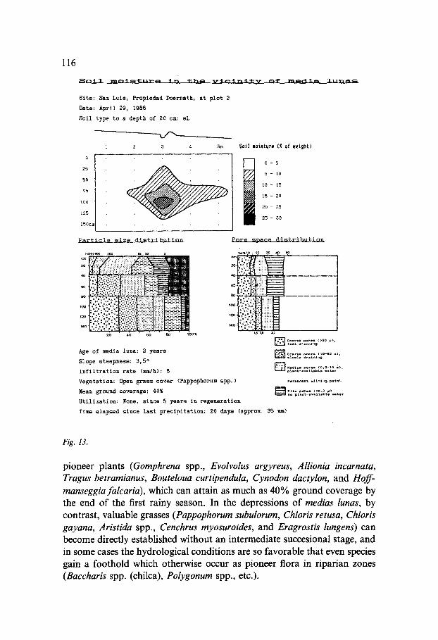
Site: San Luls, Propledad Doernath, at plot 2
Date: April 29, 1986
Soll type to a depth of 20 cm: sL
2 3 4 5m
0
25
50
75
100
125
1 5 0 c m
Soil eoisture ( | of v * i g h t )
20 - 25
Particle s i z e distrlbutlon
• 2 ; ' 4~ ' e~ ' . b ' ,bo~
Age of media luna: 2 years
Slope steepness: 3, 5 ~
Infiltration rate (mm/h): 8
Vegetation: Open grass cover (Pappophurum spp, )
Mean ground coverage: 40%
Utilization: None, since 5 years in regeneration
5 - 10
10 - 15
15 - 20
25 - 30
Pore soace di~trlbution
oo .
12o •
14o. , : ' . *
C o l t * * p ° r * . c l o - i o * ) ,
Pe~mmnlnt v l | % t . 9 poi.%
[ ] " ' . " : , ' . : : - ' : J , ' ? . = ' , : ' . . . . .
T i m e elapsed since las t p rec ip i ta t ion : 20 days (approx, 3 5 n )
Fig. 13.
pioneer plants (Gomphrena spp., Evolvolus argyreus, Allionia incarnata, Tragus betramianus, Bouteloua curtipendula, Cynodon dactylon, and Hoff. manseggiafalcaria), which can attain as much as 40% ground coverage by the end of the first rainy season. In the depressions of medias lunas, by contrast, valuable grasses ( Pappophorum subulorum, Chloris retusa, Chloris gayana, Aristida spp., Cenchrus myosuroides, and Eragrostis lungens) can become directly established without an intermediate succesional stage, and in some cases the hydrological conditions are so favorable that even species gain a foothold which otherwise occur as pioneer flora in riparian zones (Baccharis spp. (chilca), Polygonum spp., etc.).
117
Soil m o i s t u r a in the vicinitv of media lunas
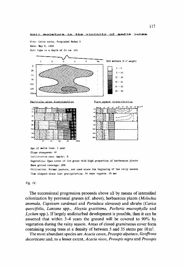
Site: Colon norte, Propiedad Yedes 3
Date: Ray 9, 1986
Soil type to a depth of 20 cm: stL
1 2 3 4 5 ~m
0
25
50
75
I00
125
150ca
S o i l moisture (Z of ~e igh t )
0 - 5
5 10
i0 15
15 20
20 25
25 30
Particle size distribution
leo
12o
14o
2o 4o 6o ao I ~ , L
Pore space distribution
;~ .............. o ....... o,
loo
14o
i/ca 3
Age of media luna: I year
Slope steepness: 4 °
Infiltration rate (mm/h): 5
Vegetation: Open cover of low grass with high proportion of herbaceous plants
Mean ground coverage: 25%
Utilization: Pormer pasture, not used since the beginning of the rainy season
Time elapsed since last precipitation: 30 days (approx. 15 mm)
Fig. 14.
The successional progression proceeds above all by means of intensified colonization by perennial grasses (cf. above), herbaceous plants (Melochia anomala, Capsicum cardenasi and Portulaca oleracea) and shrubs (Carica quercifolia, Lantana spp., Aloysia grattisima, Porlieria mucrophylla and Lycium spp.). If largely undisturbed development is possible, then it can be assumed that within 3-4 years the ground will be covered to 90% by vegetation during the rainy season. Areas of closed gramineous cover form containing young trees at a density of between 5 and 35 stems per 10 m E.
The most abundant species are Acacia caven, Prosopis alpataco, Geoffroea decorticans and, to a lesser extent, Acacia visco, Prosopis nigra and Prosopis
118
Soil moisture in the vicinity of media lunas
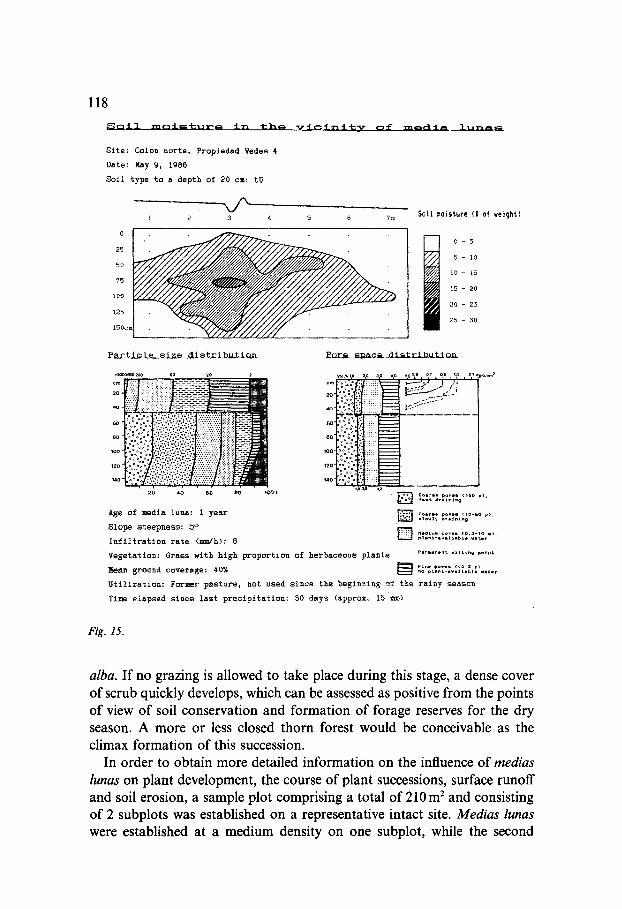
Site: Colon norte, Propledad Yedes 4
Date: May g, 1986
Soil type to a depth of 20 cm: tU
- @ - -
Particle size distribution
Soi l =o is tu re ( I of weight )
0 - 5
5 - 10
1 0 - 15
15 -- 2 0
2 0 - 2 5
2 5 - 3 0
Pore space d i s t r i b u t i o n
1 100 ;
*~°.':° :.:::':'::.'..'.':"..::" ,2o ":
,40
20 40 60 80 100~
Age Of media luna: I year
Slope steepness: 5 °
Infiltration rate (,m/h): 6
~e ,0 se o,, or o.s a3 oi ,~m~
!!!!i ilui .- i
[ ] coo,o° p°.o. >so ~1 ~ost a .oi . i .g '
] c . . , l o pa.. . I,o-s¢ ~ , i l o . ] y l ~ i l ~ l n m
] po.o. ° ~ , Ned*urn 1 0 . 2 - 1 0 p l B n t - a v l l l h b l l . a ¢ i ,
Vegetation: Grass with high proportion of herbaceous plants .o..o...~ .,,t~., ~ * , . t
F i n e p O t l l ( ~ 0 . 2 p~ Mean ground coverage: 40% .o p*..,-.v.,,.b~° ..t.,
Utilization: ~ormer pasture, not used since the beginning of the rainy season
Time elapsed since last precipitation: S0 days (approx. 15 ]am)
Fig. 15.
alba. If no grazing is allowed to take place during this stage, a dense cover of scrub quickly develops, which can be assessed as positive from the points of view of soil conservation and formation of forage reserves for the dry season. A more or less closed thorn forest would be conceivable as the climax formation of this succession.
In order to obtain more detailed information on the influence of medias lunas on plant development, the course of plant successions, surface runoff and soil erosion, a sample plot comprising a total of 210 m 2 and consisting of 2 subplots was established on a representative intact site. Medias lunas were established at a medium density on one subplot, while the second
119
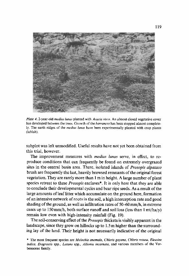
Plate 4.2-year-old medias lunas planted with Acacia visco. An almost closed vegetative cover has developed between the trees. Growth of the barrancos has been stopped almost complete- ly. The earth ridges of the medias lunas have been experimentally planted with crop plants (lablab).
subplot was left unmodified. Useful results have not yet been obtained from this trial, however.
The improvement measures with medias lunas serve, in effect, to re- produce conditions that can frequently be found on extremely overgrazed sites in the central basin area. There, isolated islands of Prosopis alpataco brush are frequently the last, heavily browsed remnants of the original forest vegetation. They are rarely more than 1 m in height. A large number of plant species retreat to these Prosopis enclaves*. It is only here that they are able to conclude their developmental cycles and bear ripe seeds. As a result of the large amounts of leaf litter which accumulate on the ground here, formation of an intensive network of roots in the soil, a high interception rate and good shading of the ground, as well as infiltration rates of 50-60 mm/h, in extreme cases up to 150 mm/h, both surface runoff and soil loss (less than 1 mt/ha/y) remain low even with high-intensity rainfall (Fig. 19).
The soil-conserving effect of the Prosopis thickets is visibly apparent in the landscape, since they grow on hillocks up to 1.5 m higher than the surround- ing lay of the land. Their height is not necessarily indicative of the original
* The most frequent species are Melochia anomala, Chloris gayana, Chloris retusa, Eleusine indica, Eragrostis spp., Latana spp., Allionia incarnata, and various members of the Ver- benaceae family.

120
level of the terrain, however, since during the dry season the Prosopis enclaves filter out and accumulate soil particles carried by the wind.
The establishment of medias lunas represents a simple means of artificially achieving this same effect, thus fulfilling a basic prerequisite for granting plant species that are readily devoured by animals and/or are less resistant to browsing the chance to reestablish themselves over a wider area.
The results from runoff plot 2 (Fig. 16) show that the most common grass community type resulting from this regenerative process (Pappophorum grassland, Fig. 6) is capable, at ground coverage of only 40%, of significant- ly reducing surface runoff and soil loss. In spite of the different substrate conditions on this plot, it can thus be regarded as confirmed that infiltration considerably increases as a result of greater interception, more intensive root penetration and the associated reduced tendency to sealing of the soil surface. Indeed, the infiltration rate is high enough for the water from precipitation events of moderate intensity and/or duration to be nearly completely adsorbed. Surface runoff is only greater with high-intensity rainfall, then amounting to up to 30%. Soil loss in these cases, at a maximum of 1.2 mt/ha per precipitation event, is still quite high. However,
Runoff p lo t 2: Regeneration stage, 4 years Vesetatios: Sparse, pers is tent Pappophoru~ cover Mean coverage (rainy season): 45¢ Bio=~ss on: )t~y 20, 1986 Fresh m i t e r : 234 g / z =
Dry m i t e r : 177 glr ~
runoff Ilho
300000
250000
200000
150000
100000
50000
÷ J
÷ ÷ ~ ~ + ++ + + Ib 2b 3b 46 so ~m
precipitation ~egressioa equation: runoff= -2,4~ + (0,8) t P ~ l a s t t c i t y : 131% C o r r e l a t i o n c o e f f i c i e n t : 0 , 8 1 8 ](ean surface runoff rate: 16,3~
Substrate to a depht of 10 c1: sL kan slope steepness: 2 ° S o i l loss: 4.6 =t/haly I n f i l t r a t i o n : 27 ml/h
Fig. 16.
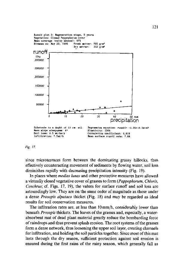
Runoff p l o t 3: Regeneration stase, 5 years Vesetation: Closed Pappophoru= cover Mean coverage (rainy season): 97~ Biomass on: Kay 20, X986 Fresh =Btter: 785 81= =
runoff I /ha
300000
250000 -
200000 -
! 50000
100000
50000
Dry matter: 312 8 / ~
0 I0 20 30 #0 . . 50 m m
precapJtation Substrata to a depht of 10 c=: s t L ltean slope steepness: 4 ° So i l loss : 0 .5 =t/ha/y l~ f i l t ra t ton: 7.Szcl /h
Regression equation: ruooff= - 1 , 3 5 + ( 0 , 3 9 ) e P ~lasttctty: 136¢ Correlation c o e f f i c i e n t : 0,819 1(ean surface runoff rate: 7.6¢
121
Fig. 17.
since microterraces form between the dominating grassy hillocks, thus effectively counteracting movement of sediments by flowing water, soil loss diminishes rapidly with decreasing precipitation intensity (Fig. 19).
In places where medias lunas and other protective measures have allowed a virtually closed vegetative cover of grasses to form (Pappophorum, Chloris, Cenchrus; cf. Figs. 17, 19), the values for surface runoff and soil loss are astoundingly low. They are on the same order of magnitude as those under a dense Prosopis alpataco thicket (Fig. 18) and may be regarded as ideal results for soil conservation measures.
The infiltration rates are, at less than 10mm/h, considerably lower than beneath Prosopis thickets. The leaves of the grasses and, especially, a water- absorbent mat of dead plant material greatly reduce the bombarding force of raindrops and thus prevent splash erosion. The root systems of the grasses form a dense network, thus loosening the upper soil layer, creating channels for infiltration, and holding the soil particles together. Since most of this mat lasts through the dry season, sufficient protection against soil erosion is ensured during the first rains of the rainy season, which generally fall as
122
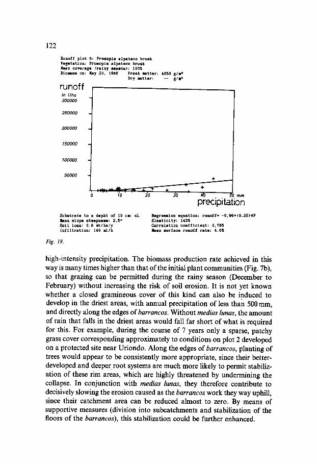
Runoff p l o t 6: P r o s o p t s a l p a t a c o brush V e g e t a t i o n : P r o s o p t s a l p a t a c o brush I~an c o v e c a s e ( r a i n y s e a s o n ) : 100~ Btol laes on: Nay 20, 1986 Fresh mat t er : 4850 g / s t 1
Dry l a t t e r : - - g l ~
runoff in I/ha 300000
250000
200000
150000
100000
50000 t , : . ~ ; ., 0 ~0
S u b 6 t r a t e t o a d e p h t of 10 ca: sL l e a n s l o p e s t e e p n e u : 2 , 5 ° S o i l l o s s : 0 .8 ~ t / h a / y I n f i l t r a t i o n : 140 I 1 / h
Fig. 18.
20 3'o 4~ m m
precipitation R e g r e u t o n e q u a t i o n : r u n o f f : - 0 , 9 9 + ( 0 . 2 5 ) t P e l a s t i c i t y : 143~ C o r r e l a t i o n c c m f f t c l s n t : 0,785 l e a n s u r f a c e r u n o f f r a t e : 4.6Z
high-intensity precipitation. The biomass production rate achieved in this way is many times higher than that of the initial plant communities (Fig. 7b), so that grazing can be permitted during the rainy season (December to February) without increasing the risk of soil erosion. It is not yet known whether a closed gramineous cover of this kind can also be induced to develop in the driest areas, with annual precipitation of less than 500 mm, and directly along the edges ofbarrancos. Without medias lunas, the amount of rain that falls in the driest areas would fall far short of what is required for this. For example, during the course of 7 years only a sparse, patchy grass cover corresponding approximately to conditions on plot 2 developed on a protected site near Uriondo. Along the edges of barrancos, planting of trees would appear to be consistently more appropriate, since their better- developed and deeper root systems are much more likely to permit stabiliz- ation of these rim areas, which are highly threatened by undermining the collapse. In conjunction with medias lunas, they therefore contribute to decisively slowing the erosion caused as the barraneos work they way uphill, since their catchment area can be reduced almost to zero. By means of supportive measures (division into subcatchments and stabilization of the floors of the barrancos), this stabilization could be further enhanced.
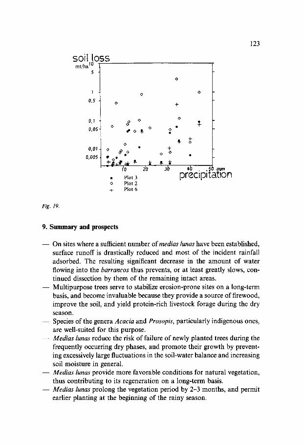
Fig. 19.
soil loss mtlh& 10
5
1
0,5
0,1
0,05
O, O l .
0,005.
0
0
OO O O
so~-
0
0 ~ oO
• 0 e
- - I'0
• Plot 3 o Plot 2 ~. Plot 6
0 0
+ 0 0
2'o 3b
-t-
o
4- O
4b . .~ preclpl:,
123
9. S u m m a r y and prospects
- - On sites where a sufficient number o f medias lunas have been established, surface runoff is drastically reduced and most of the incident rainfall adsorbed. The resulting significant decrease in the amount of water flowing into the barrancos thus prevents, or at least greatly slows, con- tinued dissection by them of the remaining intact areas.
- - Multipurpose trees serve to stabilize erosion-prone sites on a long-term basis, and become invaluable because they provide a source of firewood, improve the soil, and yield protein-rich livestock forage during the dry season.
- - Species of the genera Acacia and Prosopis, particularly indigenous ones, are well-suited for this purpose.
- - Medias lunas reduce the risk of failure of newly planted trees during the frequently occurring dry phases, and promote their growth by prevent- ing excessively large fluctuations in the soil-water balance and increasing soil moisture in general.
- - Medias lunas provide more favorable conditions for natural vegetation, thus contributing to its regeneration on a long-term basis.
- - Medias lunas prolong the vegetation period by 2-3 months, and permit earlier planting at the beginning of the rainy season.
124
- - The selected planting method serves to achieve the greatest possible participation of the target group, since it does not require any expensive technology.
- - The afforestation costs amount to US $280 per hectare. The method used is thus very cost-effective.
- - These successes can only be attained if it is possible to ensure largely undisturbed development on the afforestation sites, at least during the first 2-3 years after planting.
By way of conclusion it can be said that the system presented here should be regarded as dynamic rather than static. At this point in time, 2 years after the initiation of the project, efforts are still being made to improve and extend the approach. For example, in future new tree species will be inte- grated into the afforestation areas on small plots and observed in order to assess their suitability.
In the long term, it is planned to propagate direct seeding. If it should prove to be possible to propagate some species by this method, this would not only perceptibly lower the overall afforestation costs, but at the same time also free manpower - of the target group and of course also of the institution charged with implementation of this project - for other tasks.
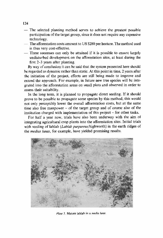
For half a year now, trials have also been underway with the aim of integrating agricultural crop plants into the afforestation sites. Initial trials with seeding of lablab (Lablab purpureus/highworth) in the earth ridges of the medias lunas, for example, have yielded promising results.
Plate 5. Mature lab lab in a media luna.
125
Wi thou t the need to irrigate or carry out o ther tending work, the yields
amoun ted to 0.98 kg per meter o f media luna, i.e. approx. 703/ha (pods wi th
seeds = 146 kg, and other above-g round b iomass = 557 kg), exceptionally high values for these otherwise complete ly unproduct ive sites.
In view of the known high nutrit ive value of lablab as animal forage, this
represents an impor t an t step in the direction o f large-scale cult ivation of livestock feed for stall-fed goats (experimental p r o g r a m o f the G T Z project).
A fodder mixture consisting o f Acacia cyanophylla leaves, Prosopis pods and
lablab, for example, was readily accepted by the goats.
I f it should genuinely prove to be possible to obta in shor t - te rm yields
f rom agricultural crops in spite o f the required relatively extensive farming,
then this could significantly increase the mot iva t ion of the target g roup to part ic ipate an afforestat ion measures with an agricutural c o m p o n e n t in the
fluviolacustrine zone.
10. References
Bastian E (1986) Grundziige der Vegetationsdegradation in S/idost-Bolivien. Jahrbuch der Geographischen Gessellschaft zu Hannover, Jahrbuch f/Jr 1985. Bolivien, Beitr/ige zur physischen Geographie eines Andenstaates, pp 23-67. Hannover
Bork H R (1980) Oberfl~ichenabfluB und Infiltration. Landschaftgenese und Landschaft- s6kologie 6, pp 8-90. Braunschweig
Coro M (1982) E1 Algarrobo y la Vegetaci6n del Vale de Tarija. Revista de Ciencia y T6cnica, Vol. III (4), pp 29-107. Universidad Aut6noma 'Juan Misael Saracho', Tarija, Bolivia
Echeverria O (1985) La Ganaderia Transhumante en el Sur de Bolivia. Unpublished manu- script. Tarija, Bolivia
Gerold G (1981) 'Desertifikation' in SiJdostbolivien - U ntersuchungen im Badlandbereich des Andinen Beckens yon Tarija. WiJrzburger Geogr. Arbeiten, H. 53, Geographische Pro- bleme in den Trockenr~iumen der Erde, pp 73-109. Wiirzburg
Gerold G (1985) MeliorationsmaBnahem und pedo6kologische Auswirkungen. Excerpt from an unpublished research report prepared for the DFG
Gr~ife W (1986) Der Beitrag der Forstwirtschaft zur lfindlichen Regionalentwicklung. All- gemeine Forstzeitschrift, No 6
GTZ (1985) Agroforstliche Entwicklung im Tarija-Tal/Bolivien, Evaluierungsbericht, Decem- ber 1985
Lamprecht H (1988) Silviculture in the tropics. Paul Parey Verlag Hudson N (1981) Soil conservation. Batsford Academy and Educultioned Ltd. London Hueck K (1966) Die W~ilder Siidamerikas. Fischer Verlag Landwirtschaftskammer Hannover (1982) Futterwerttabellen f/ir Wiederk~iuer. 3rd ed, Han-
nover Maca (1978) Proyecto de Desarrollo Rural Integrado del Valle Central de Tarija, Estudio
semidetallado de suelos. Ministerio de Asuntos Campesinos y Agropecuarios Departa- mento de Suelos, La Paz, Bolivia
Ministerio de Agricultura y Alimentaci6n (DGA) (1978) Parcelas experimentales para el control de la erosi6n y escorrentia. Boletin t+nico No 6, April 1978. Lima, Peru

126
Plaza J (1984) Problemas causados por la cria ovina y caprina y su disminuci6n desde el punto de vista del establecimiento de una cobertura vegetal en el valle de Tarija. Pertt/GTZ
Schuurman J J and Goedewaagen M A J (1971) Methods for the Examination of Root Systems and Roots. Centre for Agricultural Publishing and Documentation. Wageningen
Smith R M and Stamey W L (1965) Soil Sci 100, pp 414-424 Thurland M (1986) Informe T6cnico Agroforestal. FAO GCP/BOL/016/NOR, Rome Zech W and Maydell H-J (1981) Futterwert forstlicher Pflanzen im Sahel. Weltforum Verlag,
Munich, Cologne, London