Active School Travel_Park to Park Route.pdf
6
© 2020 Microsoft Corporation © 2020 Maxar ©CNES (2020) Distribution Airbus DS © 2020 HERE Notes Legend: N Rev Description Date By Chk App For Consultation CMK LRT RVGD 2020-09-28 C0 Project No: Scale (@A1): Drawn: Date: Drawing No: Rev: www.ramboll.dk Fax +45 51 61 10 01 Tlf. +45 51 61 10 00 DK-2300 København S Hannemanns Allé 53 CONSULTATION Dun Laoghaire & Rathdown Active School Travel Park to Park General Arrangement Sheet 1 of 6 1620010428 1:2500 RS 2020-09-25 1620010428-RAM-XX-XX-DR-C-303 C0 c:\pwwork\ramdk\han\d0188815\NRam_A_right.dwg 2020-09-29 18:03:46 CMCEK Cycle track / Lane Safety Bollard Hatched protected space Wayfinding for Sea to Mountains route Wayfinding for Park to Park route Wayfinding for Mountains to Metals 1. Do not scale from this drawing. 2. All dimensions are metres U.N.O. 3. All levels are in metres above Ordnance datum U.N.O. 4. This drawing is to be read in conjunction with all relevant Engineers drawings and specifications. 5. Exact position and location of all bollards and marking to be confirmed with the engineer on site prior to installation. INSERT A INSERT A: GEORGE'S AVENUE CYCLELANE 1 The route will follow the Sea to Mountains route to the roundabout at Carysfort Naonal School. From here it will run to Rockfield Park. The route will go along Convent Road crossing Carysfort Avenue at the exisng signal crossing on to Brookfield Terrace. Then south onto Brookfield Place, through Brookfield Court and then in to Rockfield Park next to the Carraig Lawn Tennis Club. PARK TO PARK ROUTE 1 BLACKROCK STATION Bath Place George’s Avenue Frasca Road George’s Avenue CARYSFORT NATIONAL SCHOOL Contraflow Cycle Lane Exisng signal crossing Quiet residenal street Exisng signal crossing Caryfort Avenue Contraflow Cycle Lane and one-way traffic to be maintained Park to Park Route Sea to Mountains Route
-
Upload
khangminh22 -
Category
Documents
-
view
0 -
download
0
Transcript of Active School Travel_Park to Park Route.pdf
© 2020 Microsoft Corporation © 2020 Maxar ©CNES (2020) Distribution Airbus DS © 2020 HERE
Notes
Legend:
N
Rev Description DateByChk
App
For Consultation CMKLRT
RVGD2020-09-28C0
Project No: Scale (@A1): Drawn: Date:
Drawing No: Rev:
www.ramboll.dkFax +45 51 61 10 01Tlf. +45 51 61 10 00
DK-2300 København SHannemanns Allé 53
CONSULTATION
Dun Laoghaire & RathdownActive School Travel
Park to Park
General ArrangementSheet 1 of 6
1620010428 1:2500 RS 2020-09-25
1620010428-RAM-XX-XX-DR-C-303 C0c:\pwwork\ramdk\han\d0188815\NRam_A_right.dwg2020-09-29 18:03:46
CM
CEK
Cycle track / Lane
Safety Bollard
Hatched protected space
Wayfinding for Sea to Mountains route
Wayfinding for Park to Park route
Wayfinding for Mountains to Metals
1. Do not scale from this drawing.2. All dimensions are metres U.N.O.3. All levels are in metres above Ordnance datum
U.N.O.4. This drawing is to be read in conjunction with all
relevant Engineers drawings and specifications.5. Exact position and location of all bollards and
marking to be confirmed with the engineer on siteprior to installation.
INSERT A
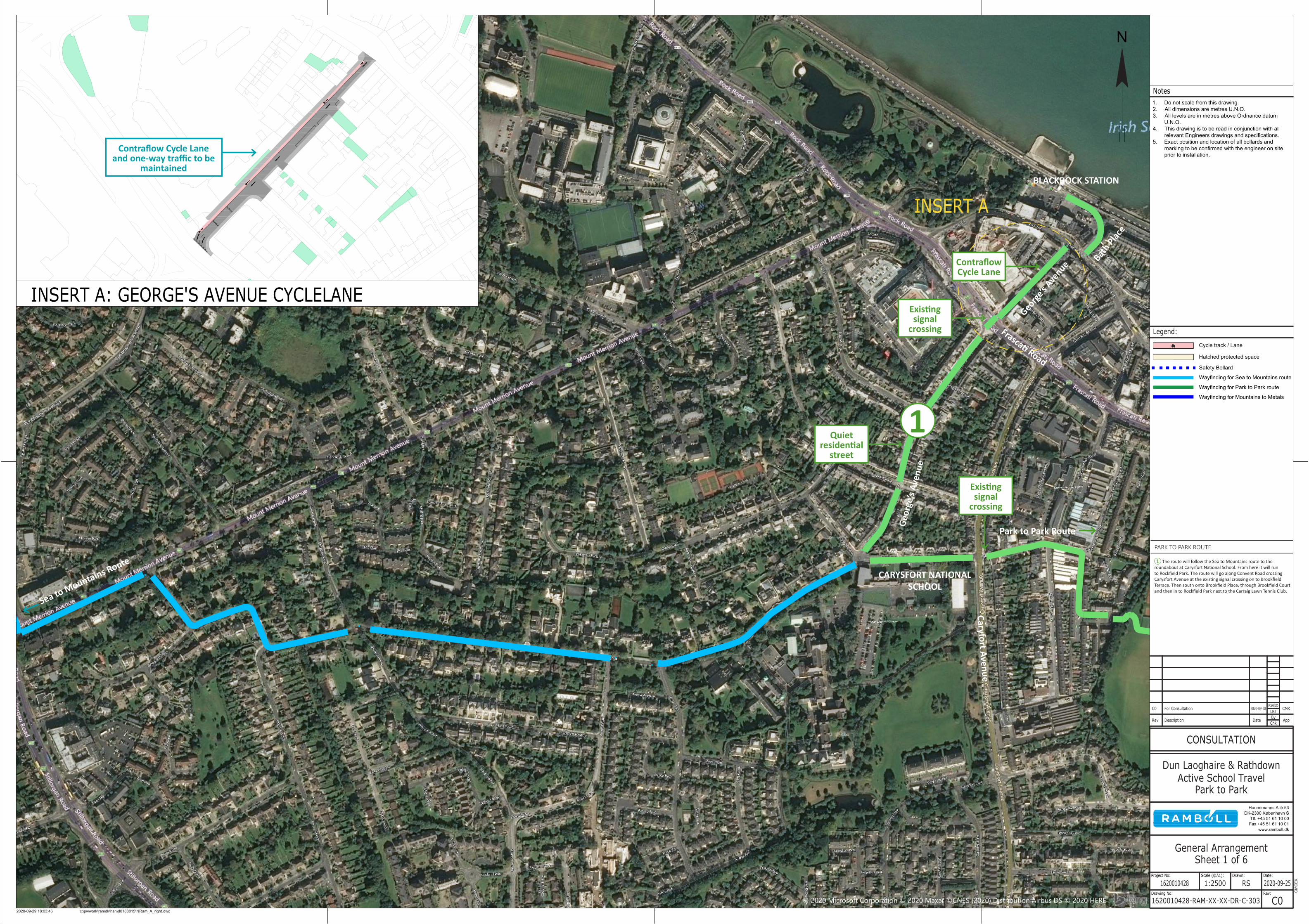
INSERT A: GEORGE'S AVENUE CYCLELANE
1 The route will follow the Sea to Mountains route to the roundabout at Carysfort National School. From here it will run to Rockfield Park. The route will go along Convent Road crossing Carysfort Avenue at the existing signal crossing on to Brookfield Terrace. Then south onto Brookfield Place, through Brookfield Court and then in to Rockfield Park next to the Carraig Lawn Tennis Club.
PARK TO PARK ROUTE
1
BLACKROCK STATION
Bath Plac
e
George
’s Ave
nue
Frascati Road
Geor
ge’s
Aven
ue
CARYSFORT NATIONAL SCHOOL
Contraflow Cycle Lane
Existing signal
crossing
Quiet residential
street
Existing signal
crossing
Caryfort Avenue
Contraflow Cycle Lane and one-way traffic to be
maintained
Park to Park Route
Sea to Mountains Route
© 2020 Microsoft Corporation © 2020 Maxar ©CNES (2020) Distribution Airbus DS © 2020 HERE
Notes
Legend:
N
Rev Description DateByChk App
For Consultation CMKLRTRVGD
2020-09-28C0
Project No: Scale (@A1): Drawn: Date:
Drawing No: Rev:
www.ramboll.dkFax +45 51 61 10 01Tlf. +45 51 61 10 00
DK-2300 København SHannemanns Allé 53
CONSULTATION
Dun Laoghaire & RathdownActive School Travel
Park to Park
General ArrangementSheet 2 of 6
1620010428 1:2500 RS 2020-09-25
1620010428-RAM-XX-XX-DR-C-304 C0c:\pwwork\ramdk\han\d0188815\NRam_A_right.dwg2020-09-29 17:57:25
CM
CEK
Cycle track / Lane
Safety Bollard
Hatched protected space
Wayfinding for Sea to Mountains route
Wayfinding for Park to Park route
Wayfinding for Mountains to Metals
1. Do not scale from this drawing.2. All dimensions are metres U.N.O.3. All levels are in metres above Ordnance datum
U.N.O.4. This drawing is to be read in conjunction with all
relevant Engineers drawings and specifications.5. Exact position and location of all bollards and
marking to be confirmed with the engineer on siteprior to installation.
INSERT A
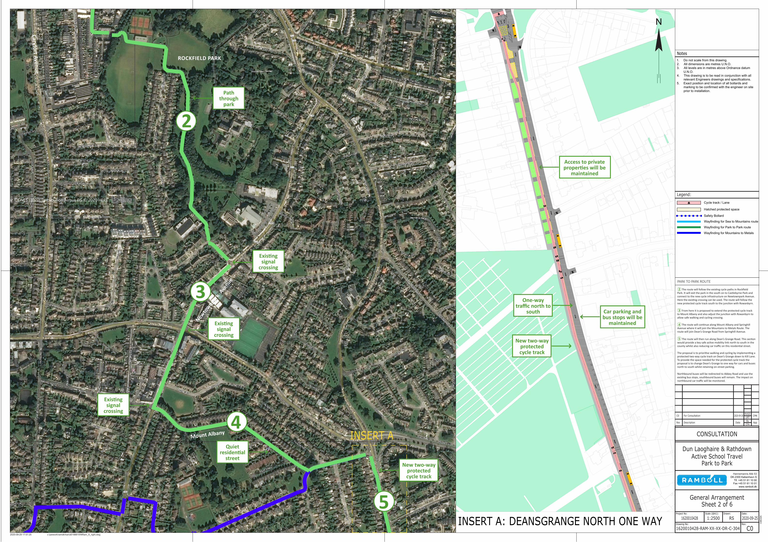
INSERT A: DEANSGRANGE NORTH ONE WAY
Path through
park
3
4
2
5
2 The route will follow the existing cycle paths in Rockfield Park. It will exit the park in the south on to Castlebyrne Park and connect to the new cycle infrastructure on Newtownpark Avenue. Here the existing crossing can be used. The route will follow the new protected cycle track south to the junction with Rowanbyrn.
3 From here it is proposed to extend the protected cycle track to Mount Albany and also adjust the junction with Rowanbyrn to allow safe walking and cycling crossing.
4 The route will continue along Mount Albany and Springhill Avenue where it will join the Mountains to Metals Route. The route will join Dean’s Grange Road from Springhill Avenue.
5 The route will then run along Dean’s Grange Road. This section would provide a key safe active mobility link north to south in the county whilst also reducing car traffic on this residential street.
The proposal is to prioritise walking and cycling by implementing a protected two-way cycle track on Dean’s Grange down to Kill Lane. To provide the space needed for the protected cycle track the proposal is to change Dean’s Grange to one way for cars and buses north to south whilst retaining on-street parking.
Northbound buses will be redirected to Abbey Road and use the existing bus stops, southbound buses will remain. The impact on northbound car traffic will be monitored.
Existing signal
crossing
Existing signal
crossing
Existing signal
crossing
Quiet residential
streetNew two-way
protected cycle track
New two-way protected cycle track
Car parking and bus stops will be
maintained
ROCKFIELD PARK
Caryfort Avenue
Newto
wnpark
Avenue
Mount Albany
Access to private properties will be
maintained
One-way traffic north to
south
PARK TO PARK ROUTE
© 2020 Microsoft Corporation © 2020 Maxar ©CNES (2020) Distribution Airbus DS © 2020 HERE
© 2020 Microsoft Corporation © 2020 Maxar ©CNES (2020) Distribution Airbus DS © 2020 HERE
Notes
Legend:
N
Rev Description Date ByChk
App
For Consultation CMKLRTRVGD
2020-09-28C0
Project No: Scale (@A1): Drawn: Date:
Drawing No: Rev:
www.ramboll.dkFax +45 51 61 10 01Tlf. +45 51 61 10 00
DK-2300 København SHannemanns Allé 53
CONSULTATION
Dun Laoghaire & RathdownActive School Travel
Park to Park
General ArrangementSheet 3 of 6
1620010428 1:2500 RS 2020-09-25
1620010428-RAM-XX-XX-DR-C-305 C0c:\pwwork\ramdk\han\d0188815\NRam_A_right.dwg2020-09-29 16:45:41
CM
CEK
Cycle track / Lane
Safety Bollard
Hatched protected space
Wayfinding for Sea to Mountains route
Wayfinding for Park to Park route
Wayfinding for Mountains to Metals
1. Do not scale from this drawing.2. All dimensions are metres U.N.O.3. All levels are in metres above Ordnance datum
U.N.O.4. This drawing is to be read in conjunction with all
relevant Engineers drawings and specifications.5. Exact position and location of all bollards and
marking to be confirmed with the engineer on siteprior to installation.
INSERT A
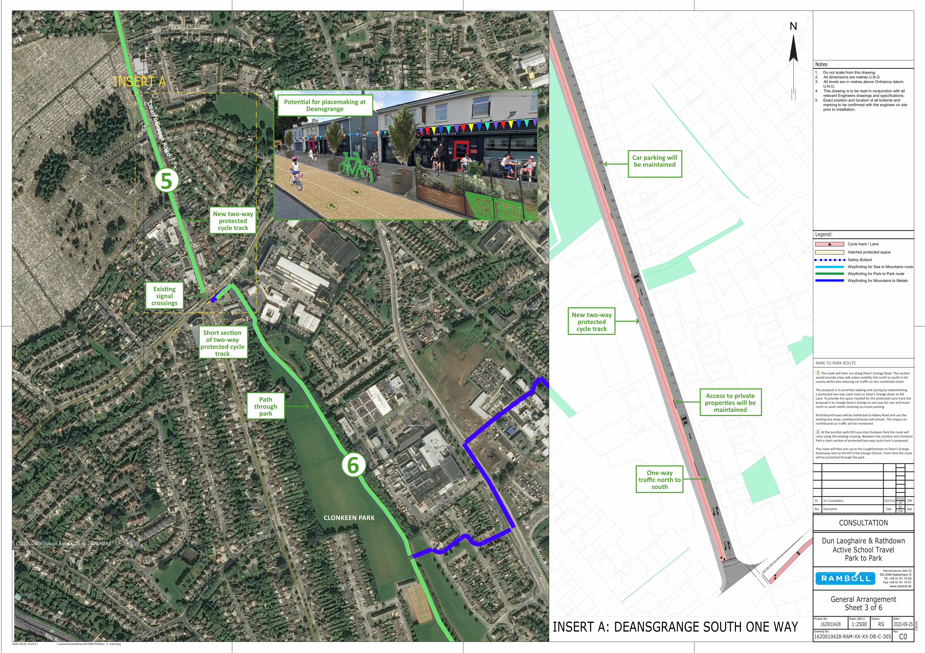
INSERT A: DEANSGRANGE SOUTH ONE WAY
6
5
5 The route will then run along Dean’s Grange Road. This section would provide a key safe active mobility link north to south in the county whilst also reducing car traffic on this residential street.
The proposal is to prioritise walking and cycling by implementing a protected two-way cycle track on Dean’s Grange down to Kill Lane. To provide the space needed for the protected cycle track the proposal is to change Dean’s Grange to one way for cars and buses north to south whilst retaining on-street parking.
Northbound buses will be redirected to Abbey Road and use the existing bus stops, southbound buses will remain. The impact on northbound car traffic will be monitored.
6 At the junction with Kill Lane into Clonkeen Park the route will cross using the existing crossing. Between the junction and Clonkeen Park a short section of protected two-way cycle track is proposed.
The route will then join up to the Loughlinstown to Dean’s Grange Greenway next to the Kill O the Grange Church. From here the route will be protected through the park.
Dean’s Grange Road
Existing signal
crossings
Path through
park
Short section of two-way
protected cycle track
New two-way protected cycle track
Car parking will be maintained
Access to private properties will be
maintained
New two-way protected cycle track
CLONKEEN PARK
CLONKEEN PARK
Kill La
ne
One-way traffic north to
south
Potential for placemaking at Deansgrange
PARK TO PARK ROUTE
© 2020 Microsoft Corporation © 2020 Maxar ©CNES (2020) Distribution Airbus DS © 2020 HERE
© 2020 Microsoft Corporation © 2020 Maxar ©CNES (2020) Distribution Airbus DS © 2020 HERE
Notes
Legend:
N
Rev Description DateByChk
App
For Consultation CMKLRT
RVGD2020-09-28C0
Project No: Scale (@A1): Drawn: Date:
Drawing No: Rev:
www.ramboll.dkFax +45 51 61 10 01Tlf. +45 51 61 10 00
DK-2300 København SHannemanns Allé 53
CONSULTATION
Dun Laoghaire & RathdownActive School Travel
Park to Park
General ArrangementSheet 4 of 6
1620010428 1:2500 RS 2020-09-25
1620010428-RAM-XX-XX-DR-C-306 C0c:\pwwork\ramdk\han\d0188815\NRam_A_right.dwg2020-09-29 16:43:46
CM
CEK
Cycle track / Lane
Safety Bollard
Hatched protected space
Wayfinding for Sea to Mountains route
Wayfinding for Park to Park route
Wayfinding for Mountains to Metals
1. Do not scale from this drawing.2. All dimensions are metres U.N.O.3. All levels are in metres above Ordnance datum
U.N.O.4. This drawing is to be read in conjunction with all
relevant Engineers drawings and specifications.5. Exact position and location of all bollards and
marking to be confirmed with the engineer on siteprior to installation.
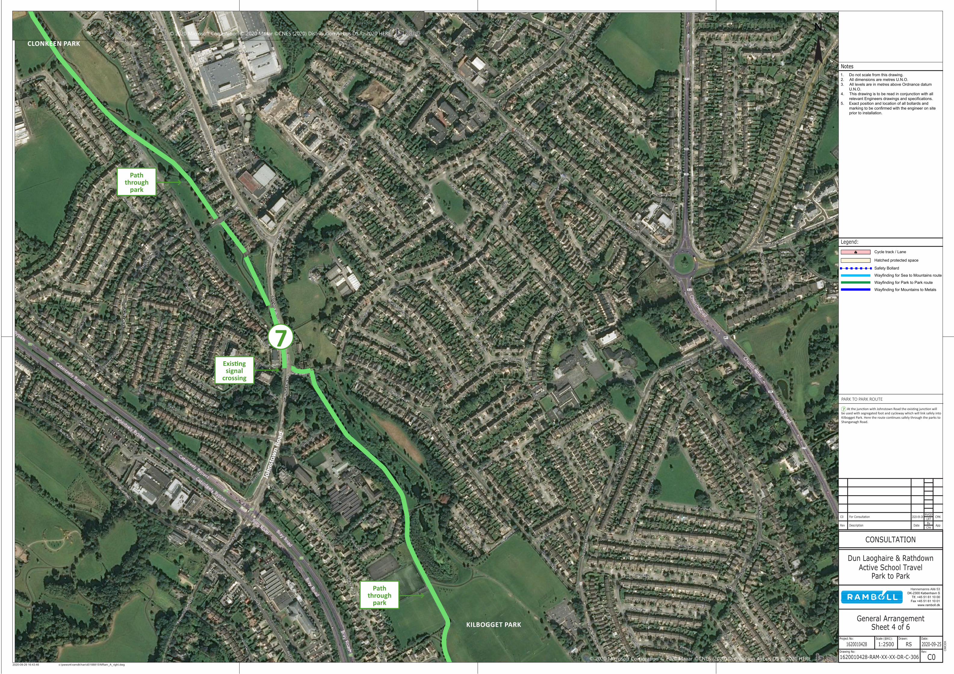
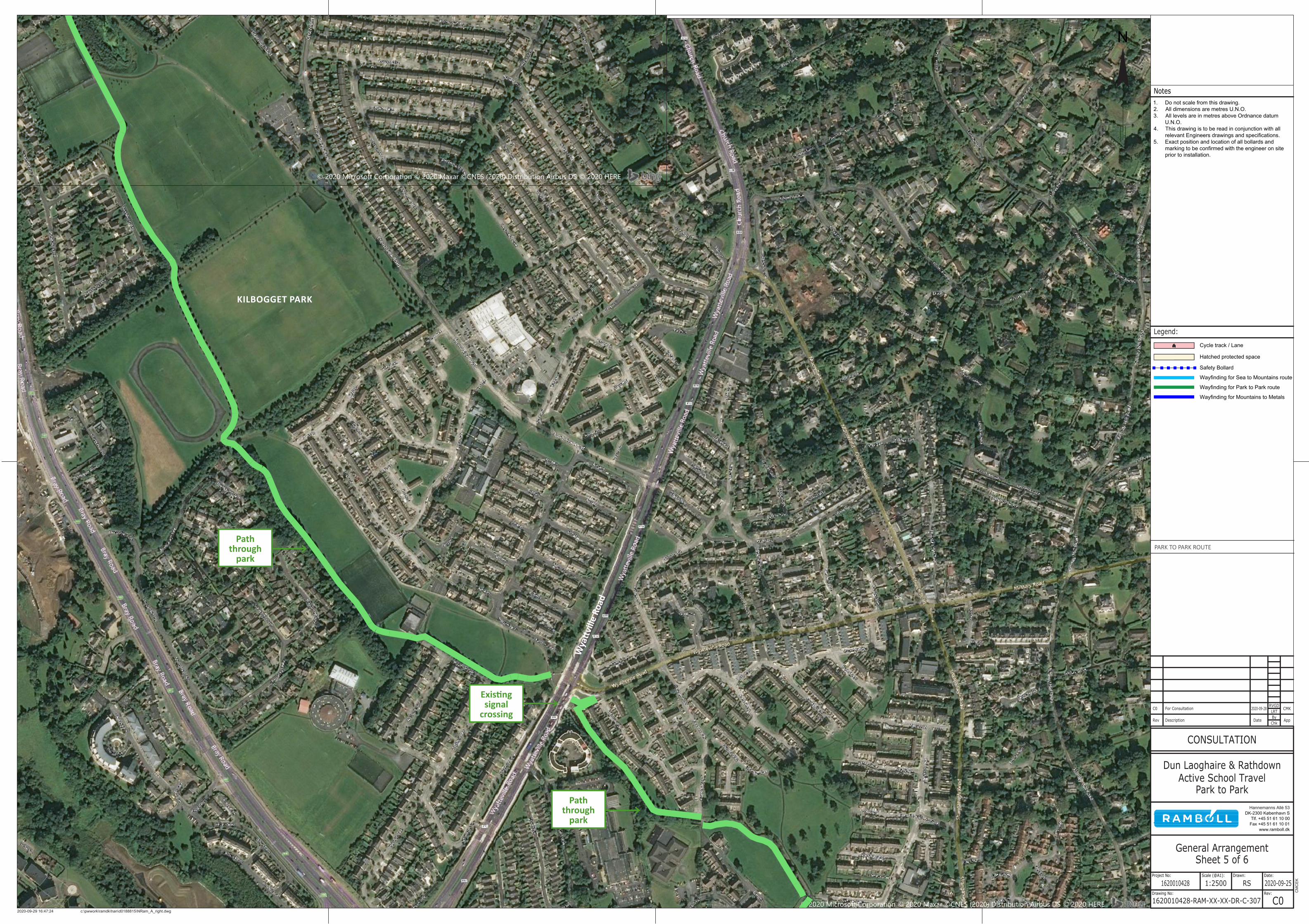
7 At the junction with Johnstown Road the existing junction will be used with segregated foot and cycleway which will link safely into Kilbogget Park. Here the route continues safely through the parks to Shanganagh Road.
7
Path through
park
Existing signal
crossing
Path through
park
KILBOGGET PARK
CLONKEEN PARK
John
stow
n Ro
ad
PARK TO PARK ROUTE
© 2020 Microsoft Corporation © 2020 Maxar ©CNES (2020) Distribution Airbus DS © 2020 HERE
© 2020 Microsoft Corporation © 2020 Maxar ©CNES (2020) Distribution Airbus DS © 2020 HERE
Notes
Legend:
N
Rev Description DateByChk
App
For Consultation CMKLRT
RVGD2020-09-28C0
Project No: Scale (@A1): Drawn: Date:
Drawing No: Rev:
www.ramboll.dkFax +45 51 61 10 01Tlf. +45 51 61 10 00
DK-2300 København SHannemanns Allé 53
CONSULTATION
Dun Laoghaire & RathdownActive School Travel
Park to Park
General ArrangementSheet 5 of 6
1620010428 1:2500 RS 2020-09-25
1620010428-RAM-XX-XX-DR-C-307 C0c:\pwwork\ramdk\han\d0188815\NRam_A_right.dwg2020-09-29 16:47:24
CM
CEK
Cycle track / Lane
Safety Bollard
Hatched protected space
Wayfinding for Sea to Mountains route
Wayfinding for Park to Park route
Wayfinding for Mountains to Metals
1. Do not scale from this drawing.2. All dimensions are metres U.N.O.3. All levels are in metres above Ordnance datum
U.N.O.4. This drawing is to be read in conjunction with all
relevant Engineers drawings and specifications.5. Exact position and location of all bollards and
marking to be confirmed with the engineer on siteprior to installation.
KILBOGGET PARK
Path through
park
Existing signal
crossing
Path through
park
Wya
ttvill
e Ro
ad
PARK TO PARK ROUTE

© 2020 Microsoft Corporation © 2020 Maxar ©CNES (2020) Distribution Airbus DS © 2020 HERE
© 2020 Microsoft Corporation © 2020 Maxar ©CNES (2020) Distribution Airbus DS © 2020 HERE
Notes
Legend:
N
Rev Description DateByChk
App
For Consultation CMKLRT
RVGD2020-09-28C0
Project No: Scale (@A1): Drawn: Date:
Drawing No: Rev:
www.ramboll.dkFax +45 51 61 10 01Tlf. +45 51 61 10 00
DK-2300 København SHannemanns Allé 53
CONSULTATION
Dun Laoghaire & RathdownActive School Travel
Park to Park
General ArrangementSheet 6 of 6
1620010428 1:2500 RS 2020-09-25
1620010428-RAM-XX-XX-DR-C-308 C0c:\pwwork\ramdk\han\d0188815\NRam_A_right.dwg2020-09-29 16:48:47
CM
CEK
Cycle track / Lane
Safety Bollard
Hatched protected space
Wayfinding for Sea to Mountains route
Wayfinding for Park to Park route
Wayfinding for Mountains to Metals
1. Do not scale from this drawing.2. All dimensions are metres U.N.O.3. All levels are in metres above Ordnance datum
U.N.O.4. This drawing is to be read in conjunction with all
relevant Engineers drawings and specifications.5. Exact position and location of all bollards and
marking to be confirmed with the engineer on siteprior to installation.
8 At Shanganagh Road it is proposed to connect the facilities in the park to Achill Road. The route will follow the existing track along Shanganagh Road to the roundabout with Killiney Hill Road. This roundabout will be altered to include safe cycling and walking crossings. The route will continue through Bayview Estate to link to the coast.
8
Shanganagh Road
Killi
ney
Hill
Road
Bayv
iew
Driv
e
Bayview Green
PARK TO PARK ROUTE