Community characteristics and policing styles in suburban agencies
Upload
nationaltrustCategory
view
1download
0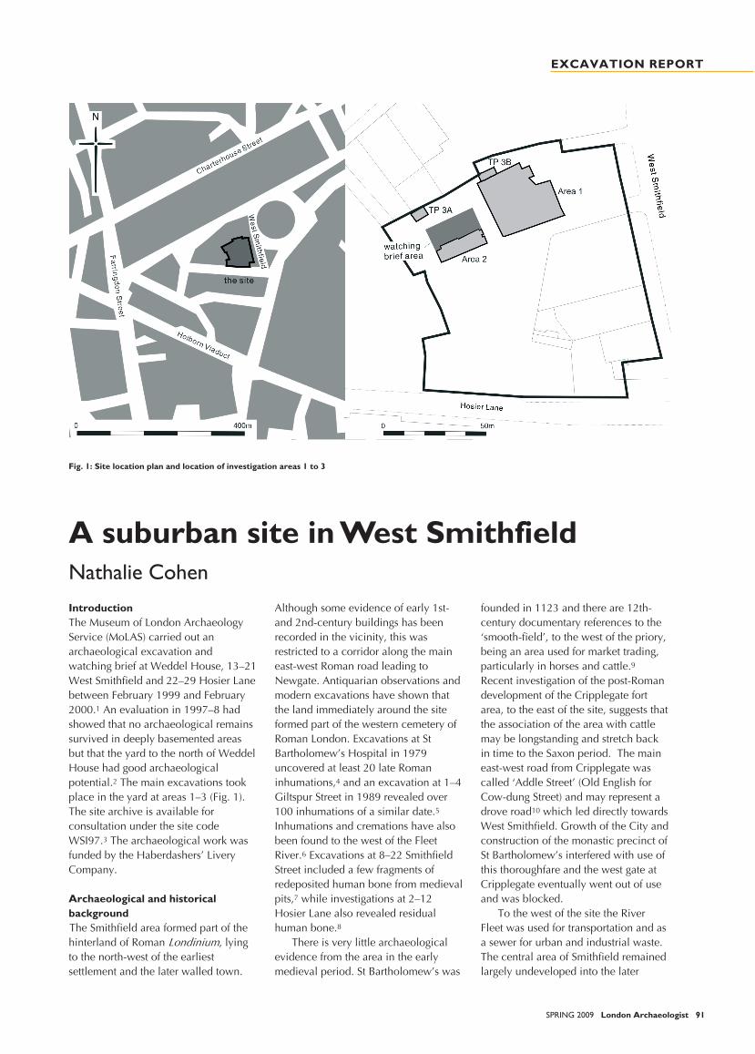
WEST SMITHFIELD
SPRING 2009 London Archaeologist 91
A suburban site in West SmithfieldNathalie CohenIntroductionThe Museum of London ArchaeologyService (MoLAS) carried out anarchaeological excavation andwatching brief at Weddel House, 13–21West Smithfield and 22–29 Hosier Lanebetween February 1999 and February2000.1 An evaluation in 1997–8 hadshowed that no archaeological remainssurvived in deeply basemented areasbut that the yard to the north of WeddelHouse had good archaeologicalpotential.2 The main excavations tookplace in the yard at areas 1–3 (Fig. 1).The site archive is available forconsultation under the site codeWSI97.3 The archaeological work wasfunded by the Haberdashers’ LiveryCompany.
Archaeological and historicalbackgroundThe Smithfield area formed part of thehinterland of Roman , lyingto the north-west of the earliestsettlement and the later walled town.
Although some evidence of early 1st-and 2nd-century buildings has beenrecorded in the vicinity, this wasrestricted to a corridor along the maineast-west Roman road leading toNewgate. Antiquarian observations andmodern excavations have shown thatthe land immediately around the siteformed part of the western cemetery ofRoman London. Excavations at StBartholomew’s Hospital in 1979uncovered at least 20 late Romaninhumations,4 and an excavation at 1–4Giltspur Street in 1989 revealed over100 inhumations of a similar date.5
Inhumations and cremations have alsobeen found to the west of the FleetRiver.6 Excavations at 8–22 SmithfieldStreet included a few fragments ofredeposited human bone from medievalpits,7 while investigations at 2–12Hosier Lane also revealed residualhuman bone.8
There is very little archaeologicalevidence from the area in the earlymedieval period. St Bartholomew’s was
founded in 1123 and there are 12th-century documentary references to the‘smooth-field’, to the west of the priory,being an area used for market trading,particularly in horses and cattle.9
Recent investigation of the post-Romandevelopment of the Cripplegate fortarea, to the east of the site, suggests thatthe association of the area with cattlemay be longstanding and stretch backin time to the Saxon period. The maineast-west road from Cripplegate wascalled ‘Addle Street’ (Old English forCow-dung Street) and may represent adrove road10 which led directly towardsWest Smithfield. Growth of the City andconstruction of the monastic precinct ofSt Bartholomew’s interfered with use ofthis thoroughfare and the west gate atCripplegate eventually went out of useand was blocked.
To the west of the site the RiverFleet was used for transportation and asa sewer for urban and industrial waste.The central area of Smithfield remainedlargely undeveloped into the later
Fig. 1: Site location plan and location of investigation areas 1 to 3
EXCAVATION REPORT
WEST SMITHFIELD
92 London Archaeologist SPRING 2009
medieval period, with the land used forpublic events such as tournaments andjousts. Smithfield was the site of theencampment of the rebels during thePeasants Revolt of 1381 and the sceneof Wat Tyler's fatal meeting withRichard II and Mayor WilliamWalworth. The area was a place ofpublic hangings until the gallows weremoved to Tyburn in the 14th century,although burnings of witches andheretics continued until the 17thcentury.11
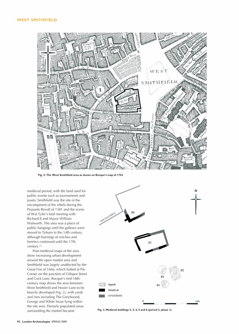
Post-medieval maps of the areashow increasing urban developmentaround the open market area andSmithfield was largely unaffected by theGreat Fire of 1666, which halted at PieCorner on the junction of Giltspur Streetand Cock Lane. Rocque’s mid-18th-century map shows the area betweenWest Smithfield and Hosier Lane to beheavily developed (Fig. 2), with yardsand inns including The Greyhound,George and White Swan lying withinthe site area. Densely populated areassurrounding the market became Fig. 3: Medieval buildings 2, 3, 4, 5 and 6 (period 3, phase 1)
Fig. 2: The West Smithfield area as shown on Rocque’s map of 1754
WEST SMITHFIELD
SPRING 2009 London Archaeologist 93
notorious ‘rookeries’ or slums.12
The street plan and character of thearea was radically changed by thedevelopment of the Farringdon railwayterminus in 1859 and completion of thenew meat market in 1868, but theWeddel House site largely escapedalteration. Trade and propertydirectories record a variety of tradesand functions in the 19th-centurybuildings on the site, many of themlinked to the meat market and includingsaddlers, butchers’ cutlers, cattledealers and hay and straw salesmen.Other trades include builders, carversand gilders, watch and clockmanufacturers, boot-makers andprovision merchants.
Weddel House was described as ‘ahulking mass of offices built in 1907 forthe meat trade’.13 Despite heavybombing during World War II thebuildings escaped the severe damagewhich destroyed adjacent blocks. Thesite has been redeveloped as a newLivery hall for the Haberdashers’Company, designed by Sir MichaelHopkins & Partners and constructed byHolloway White Allom. The formerfrontage of Weddel House which wrapsaround the hall has been converted intoresidential and retail units.
Results of the fieldworkThe site lies 800 m north of theThames, on the eastern down-slope ofthe Fleet valley. The natural geology isLondon Clay overlain by second terrace
Thames river gravels capped bybrickearth. Truncated natural gravelwas recorded at 12.71 m OD in Area 2and at 15.55 m OD in evaluation TP 3,but the untruncated natural surface mayoriginally have been fairly level.
Evidence for early Roman activity wasrestricted to a timber-lined well and tworubbish or quarry pits located inexcavation area 1. The pottery fromthese features is dated to the 1st and2nd centuries AD and the vessel formssuggest kitchen-related functions. Thearea appears to have remained externalin the later Roman period but there wasno evidence of Roman inhumations orcremations.
There was no evidence of post-Romanactivity at the site before the medievalperiod, when gravel quarries wereestablished. Pottery recovered fromquarry backfills were generally dated to
1230–1350, with some early 15th-century pottery associated with the finalbackfilling of the larger pits. The potteryincludes jugs, cooking pots and pipkins,bowls and cups. A fragmentedassemblage of animal bone from thebackfills was largely composed of themajor domesticates, including chickenand goose as well as wild game, hareand rabbit.
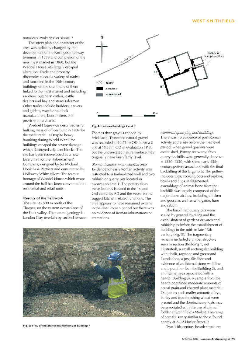
The backfilled quarry pits weresealed by general levelling and theestablishment of gardens or yards andrubbish pits before the establishment ofbuildings in the mid- to late 13thcentury (Fig. 3). The fragmentaryremains included a timber structureseen in section (Building 1; notillustrated), a small rectangular buildingwith chalk, ragstone and greensandfoundations, a peg-tile floor andevidence of an internal stone wall lineand a porch or lean-to (Building 2), andan internal area associated with ahearth (Building 3). A sample from thehearth contained moderate amounts ofcereal grain and charred plant material.Oat grains and smaller amounts of rye,barley and free-threshing wheat werepresent and the dominance of oats maybe associated with the use of animalfodder at Smithfield’s Market. The rangeof cereals is very similar to those foundnearby at 2–12 Hosier Street.14
Two 14th-century hearth structures
Fig. 4: medieval buildings 7 and 8
Fig. 5: View of the arched foundations of Building 7
WEST SMITHFIELD
94 London Archaeologist SPRING 2009
provide evidence for Buildings 4 and 5,although the absence of any evidenceof walls suggests these may have beenopen-air cook-shops similar to thosefound at Queen Street.15 Truncatedchalk and Reigate foundations in test pit3B provide evidence for Building 6 atthe northern limit of the site area(Fig. 3).
In the late 14th or early 15thcenturies Buildings 2–5 weredemolished. The faunal assemblagefrom deposits in Open Area 5 is mainlycomposed of pig, bird and fish bones,including a very young piglet, largechickens interpreted as capons, andgame species including woodcock,thrush, snipe and swan. Most of thefish-bones were eel and clupeid(herring family), from riverine andestuarine fisheries respectively. Thehigh status and variety of food typesmay indicate waste from a special meal.A medieval delicacy known as a‘cokagrys’ involved the spitting androasting of the sewn together fore andhind halves of a capon and a suckingpig.16
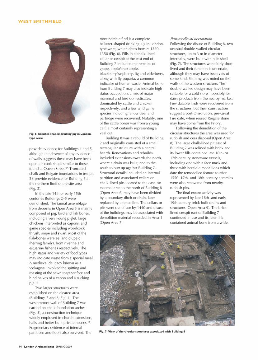
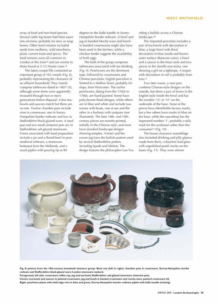
Two larger structures wereestablished on the cleared area(Buildings 7 and 8; Fig. 4). Thewesternmost wall of Building 7 wascarried on chalk foundation arches(Fig. 5), a construction techniquewidely employed in church extensions,halls and better-built private houses.17
Fragmentary evidence of internalpartitions and floors also survived. The
most notable find is a completebaluster-shaped drinking jug in London-type ware, which dates from 1270–1350 (Fig. 6). Fills in a chalk-linedcellar or cesspit at the east end ofBuilding 7 included the remains ofgrape, apple/crab apple,blackberry/raspberry, fig and elderberry,along with fly puparia, a commonindicator of human waste. Animal bonefrom Building 7 may also indicate high-status occupation: a mix of majormammal and bird domesticates,dominated by cattle and chickenrespectively, and a few wild gamespecies including fallow deer andpartridge were recovered. Notably, oneof the cattle bones was from a youngcalf, almost certainly representing aveal cut.
Building 8 was a rebuild of Building2 and originally consisted of a smallrectangular structure with a centralhearth. Renovations and rebuildsincluded extensions towards the north,where a drain was built, and to thesouth to butt up against Building 7.Structural details included an internalpartition and associated cellars orchalk-lined pits located to the east. Anexternal area to the north of Building 8(Open Area 6) may have been dividedby a boundary ditch or drain, laterreplaced by a fence line. The cellars orpits went out of use by 1440 and disuseof the buildings may be associated withdemolition material recorded in Area 1(Open Area 7).
Following the disuse of Building 8, twounusual double-walled circularstructures, up to 3 m in diameterinternally, were built within its shell(Fig. 7). The structures were fairly short-lived and their function is uncertain,although they may have been vats ofsome kind. Staining was noted on thewalls of the western structure. Thedouble-walled design may have beensuitable for a cold store – possibly fordairy products from the nearby market.Few datable finds were recovered fromthe structures, but their constructionsuggest a post-Dissolution, pre-GreatFire date, when reused Reigate stonemay have come from the Priory.
Following the demolition of thecircular structures the area was used forrubbish and cess disposal (Open Area8). The large chalk-lined pit east ofBuilding 7 was relined with brick andits lower fills contained late 16th- or17th-century stoneware vessels,including one with a face mask andthree with heraldic medallions whichdate the remodelled feature to after1550. 17th- and 18th-century ceramicswere also recovered from nearbyrubbish pits.
The final extant activity wasrepresented by late 18th- and early19th-century brick-built drains andstructures (Open Area 9). The brick-lined cesspit east of Building 7continued in use and its later fillscontained animal bone from a wide
Fig. 7: View of the circular structures associated with Building 8
Fig. 6: baluster-shaped drinking jug in London-type ware
WEST SMITHFIELD
SPRING 2009 London Archaeologist 95
array of food and non-food species.Several cattle leg bones had been sawninto sections, probably for stew or soupbones. Other food remains includedseeds from mulberry, wild strawberry,plum, currant fruits and spices. Thefood remains were all common inLondon at this time18 and are similar tothose found at 2–12 Hosier Lane.19
The latest cesspit fills contained animportant group of 102 vessels (Fig. 8),probably representing the clearance ofan affluent household. They mainlycomprise tableware dated to 1807–20,although some items were apparentlytreasured through two or moregenerations before disposal. A few tea-bowls and saucers match but there areno sets. Twelve chamber pots includenine in creamware, one in Surrey-Hampshire border redware and two inStaffordshire black-glazed ware. A stoolpan and two small ointment pots are inStaffordshire salt-glazed stoneware.Forms associated with food preparationinclude a jar and a flared bowl in post-medieval redware, a stonewarebutterpot from the Midlands, and asmall pipkin with pouring lip at 90°
degrees to the ladle handle in Surrey-Hampshire border redware. A bowl andjug in banded Mocha ware and bowlsin banded creamwares might also havebeen used in the kitchen, while achicken feeder suggests the availabilityof fresh eggs.
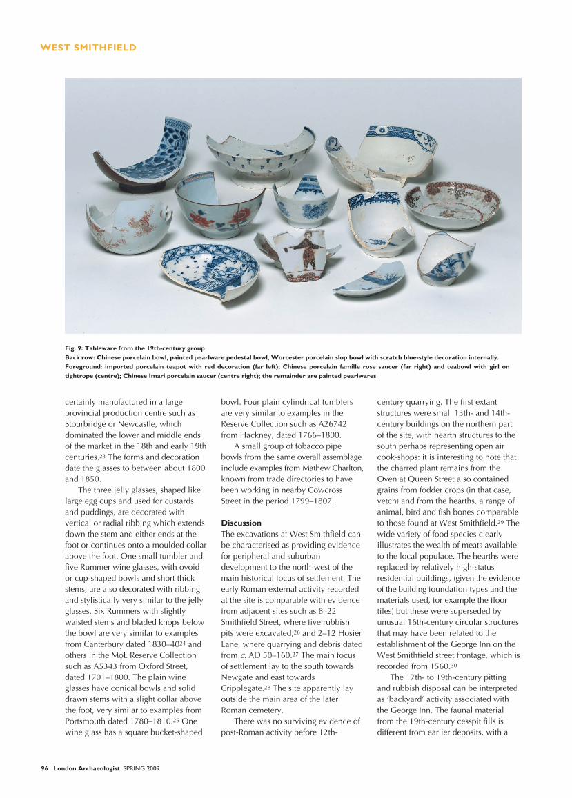
The bulk of the group comprisestablewares associated with tea drinking(Fig. 9). Pearlwares are the dominanttype, followed by creamwares andChinese porcelain. English porcelain islimited to a shallow bowl, probably forslops, from Worcester. The earlierpearlwares, dating from the 1760s to1780s, are hand-painted. Some havepolychrome floral designs, while othersare in blue and white and include twoscenes with boats, one at sea and theother in a harbour with sampans (notillustrated). The later 18th- and 19th-century pieces are transfer-printed,initially in the Chinese style, and mosthave standard landscape designsshowing temples. A bowl and thecream jug have the buffalo pattern usedby several Staffordshire potters,including Spode and Minton. Thedesign features the philosopher Lao-Tzu
riding a buffalo across a Chineselandscape.20
The imported porcelain includes apair of tea-bowls with decoration inblue, a large bowl with floraldecoration in blue inside and brownouter surface (Batavian ware), a bowland a saucer in the Imari style and twopieces in the styles, oneshowing a girl on a tightrope. A teapotwith decoration in red is probably fromIran.21
Two later wares, a near pair,combine Chinese-style designs on theoutside, but show a pair of lovers in theEnglish style inside the bowl and hasthe number ‘15’ or ‘51’ on theunderside of the base. None of thepieces have identifiable factory marks,but a few others have marks in blue onthe base, while the sauceboat has theimpressed number ‘1’, probably a tallymark for the workman rather than theconsumer22 (Fig. 10).
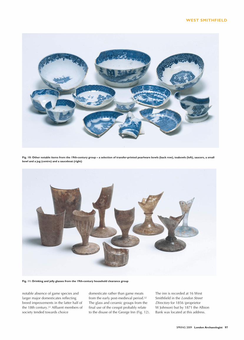
The house clearance assemblagealso included drinking and jelly glassesmade from thick, colourless lead glasswith unpolished pontil marks on thebases (Fig. 11). They were almost
Fig. 8: pottery from the 19th-century household clearance group- Back row (left to right): chamber pots in creamware, Surrey-Hampshire borderredware and Staffordshire black-glazed ware; London stoneware tankard.Foreground, left side: creamware coffee cup, jug and tea-bowl; Staffordshire salt-glazed stoneware ointment pots.Centre: tea-bowls and saucers in painted creamware, jug and bowls in banded creamware and mocha ware, painted creamware lid.Right: pearlware plates with shell edge rims in blue and green; Surrey-Hampshire border redware pipkin with ladle handle (missing)
WEST SMITHFIELD
96 London Archaeologist SPRING 2009
certainly manufactured in a largeprovincial production centre such asStourbridge or Newcastle, whichdominated the lower and middle endsof the market in the 18th and early 19thcenturies.23 The forms and decorationdate the glasses to between about 1800and 1850.
The three jelly glasses, shaped likelarge egg cups and used for custardsand puddings, are decorated withvertical or radial ribbing which extendsdown the stem and either ends at thefoot or continues onto a moulded collarabove the foot. One small tumbler andfive Rummer wine glasses, with ovoidor cup-shaped bowls and short thickstems, are also decorated with ribbingand stylistically very similar to the jellyglasses. Six Rummers with slightlywaisted stems and bladed knops belowthe bowl are very similar to examplesfrom Canterbury dated 1830–4024 andothers in the MoL Reserve Collectionsuch as A5343 from Oxford Street,dated 1701–1800. The plain wineglasses have conical bowls and soliddrawn stems with a slight collar abovethe foot, very similar to examples fromPortsmouth dated 1780–1810.25 Onewine glass has a square bucket-shaped
bowl. Four plain cylindrical tumblersare very similar to examples in theReserve Collection such as A26742from Hackney, dated 1766–1800.
A small group of tobacco pipebowls from the same overall assemblageinclude examples from Mathew Charlton,known from trade directories to havebeen working in nearby CowcrossStreet in the period 1799–1807.
DiscussionThe excavations at West Smithfield canbe characterised as providing evidencefor peripheral and suburbandevelopment to the north-west of themain historical focus of settlement. Theearly Roman external activity recordedat the site is comparable with evidencefrom adjacent sites such as 8–22Smithfield Street, where five rubbishpits were excavated,26 and 2–12 HosierLane, where quarrying and debris datedfrom AD 50–160.27 The main focusof settlement lay to the south towardsNewgate and east towardsCripplegate.28 The site apparently layoutside the main area of the laterRoman cemetery.
There was no surviving evidence ofpost-Roman activity before 12th-
century quarrying. The first extantstructures were small 13th- and 14th-century buildings on the northern partof the site, with hearth structures to thesouth perhaps representing open aircook-shops: it is interesting to note thatthe charred plant remains from theOven at Queen Street also containedgrains from fodder crops (in that case,vetch) and from the hearths, a range ofanimal, bird and fish bones comparableto those found at West Smithfield.29 Thewide variety of food species clearlyillustrates the wealth of meats availableto the local populace. The hearths werereplaced by relatively high-statusresidential buildings, (given the evidenceof the building foundation types and thematerials used, for example the floortiles) but these were superseded byunusual 16th-century circular structuresthat may have been related to theestablishment of the George Inn on theWest Smithfield street frontage, which isrecorded from 1560.30
The 17th- to 19th-century pittingand rubbish disposal can be interpretedas ‘backyard’ activity associated withthe George Inn. The faunal materialfrom the 19th-century cesspit fills isdifferent from earlier deposits, with a
Fig. 9: Tableware from the 19th-century groupBack row: Chinese porcelain bowl, painted pearlware pedestal bowl, Worcester porcelain slop bowl with scratch blue-style decoration internally.Foreground: imported porcelain teapot with red decoration (far left); Chinese porcelain famille rose saucer (far right) and teabowl with girl ontightrope (centre); Chinese Imari porcelain saucer (centre right); the remainder are painted pearlwares
WEST SMITHFIELD
SPRING 2009 London Archaeologist 97
Fig. 10: Other notable items from the 19th-century group – a selection of transfer-printed pearlware bowls (back row), teabowls (left), saucers, a smallbowl and a jug (centre) and a sauceboat (right)
Fig. 11: Drinking and jelly glasses from the 19th-century household clearance group
notable absence of game species andlarger major domesticates reflectingbreed improvements in the latter half ofthe 18th century.31 Affluent members ofsociety tended towards choice
domesticate rather than game meatsfrom the early post-medieval period.32
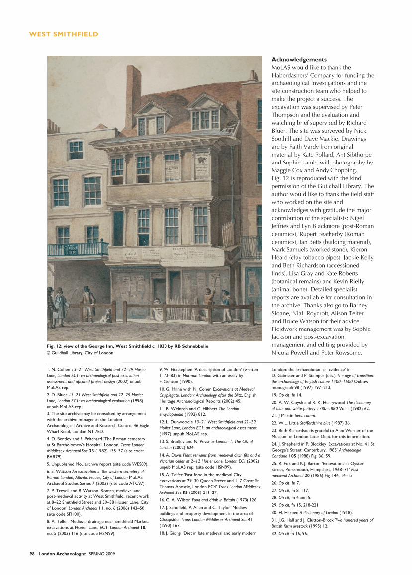
The glass and ceramic groups from thefinal use of the cesspit probably relateto the disuse of the George Inn (Fig. 12).
The inn is recorded at 16 WestSmithfield in the
for 1856 (proprietorW Johnson) but by 1871 the AlbionBank was located at this address.
WEST SMITHFIELD
98 London Archaeologist SPRING 2009
AcknowledgementsMoLAS would like to thank theHaberdashers’ Company for funding thearchaeological investigations and thesite construction team who helped tomake the project a success. Theexcavation was supervised by PeterThompson and the evaluation andwatching brief supervised by RichardBluer. The site was surveyed by NickSoothill and Dave Mackie. Drawingsare by Faith Vardy from originalmaterial by Kate Pollard, Ant Sibthorpeand Sophie Lamb, with photography byMaggie Cox and Andy Chopping.Fig. 12 is reproduced with the kindpermission of the Guildhall Library. Theauthor would like to thank the field staffwho worked on the site andacknowledges with gratitude the majorcontribution of the specialists: NigelJeffries and Lyn Blackmore (post-Romanceramics), Rupert Featherby (Romanceramics), Ian Betts (building material),Mark Samuels (worked stone), KieronHeard (clay tobacco pipes), Jackie Keilyand Beth Richardson (accessionedfinds), Lisa Gray and Kate Roberts(botanical remains) and Kevin Rielly(animal bone). Detailed specialistreports are available for consultation inthe archive. Thanks also go to BarneySloane, Niall Roycroft, Alison Telferand Bruce Watson for their advice.Fieldwork management was by SophieJackson and post-excavationmanagement and editing provided byNicola Powell and Peter Rowsome.
Fig. 12: view of the George Inn, West Smithfield c. 1830 by RB Schnebbelie© Guildhall Library, City of London
1. N. Cohen 13–21 West Smithfield and 22–29 HosierLane, London EC1: an archaeological post-excavationassessment and updated project design (2002) unpubMoLAS rep.
2. D. Bluer 13–21 West Smithfield and 22–29 HosierLane, London EC1: an archaeological evaluation (1998)unpub MoLAS rep.
3. The site archive may be consulted by arrangementwith the archive manager at the LondonArchaeological Archive and Research Centre, 46 EagleWharf Road, London N1 7ED.
4. D. Bentley and F. Pritchard ‘The Roman cemeteryat St Bartholomew’s Hospital, London, Trans LondonMiddlesex Archaeol Soc 33 (1982) 135–37 (site code:BAR79).
5. Unpublished MoL archive report (site code WES89).
6. S. Watson An excavation in the western cemetery ofRoman London, Atlantic House, City of London MoLASArchaeol Studies Series 7 (2003) (site code ATC97).
7. P. Treveil and B. Watson ‘Roman, medieval andpost-medieval activity at West Smithfield: recent workat 8–22 Smithfield Street and 30–38 Hosier Lane, Cityof London’ London Archaeol 11, no. 6 (2006) 143–50(site code SFH00).
8. A. Telfer ‘Medieval drainage near Smithfield Market:excavations at Hosier Lane, EC1’ London Archaeol 10,no. 5 (2003) 116 (site code HSN99).
9. W. Fitzstephen ‘A description of London’ (written1173–83) in Norman London with an essay byF. Stenton (1990).
10. G. Milne with N. Cohen Excavations at MedievalCripplegate, London: Archaeology after the Blitz, EnglishHeritage Archaeological Reports (2002) 45.
11. B. Weinreb and C. Hibbert The Londonencyclopaedia (1992) 812.
12. L. Dunwoodie 13–21 West Smithfield and 22–29Hosier Lane, London EC1: an archaeological assessment(1997) unpub MoLAS rep.
13. S. Bradley and N. Pevsner London 1: The City ofLondon (2002) 624.
14. A. Davis Plant remains from medieval ditch fills and aVictorian cellar at 2–12 Hosier Lane, London EC1 (2002)unpub MoLAS rep. (site code HSN99).
15. A. Telfer ‘Fast food in the medieval City:excavations at 29–30 Queen Street and 1–7 Great StThomas Apostle, London EC4’ Trans London MiddlesexArchaeol Soc 55 (2005) 211–27.
16. C. A. Wilson Food and drink in Britain (1973) 126.
17. J. Schofield, P. Allen and C. Taylor ‘Medievalbuildings and property development in the area ofCheapside’ Trans London Middlesex Archaeol Soc 41(1990) 167.
18. J. Giorgi ‘Diet in late medieval and early modern
London: the archaeobotanical evidence’ inD. Gaimster and P. Stamper (eds.) The age of transition:the archaeology of English culture 1400–1600 Oxbowmonograph 98 (1997) 197–213.
19. Op cit fn 14.
20. A. W. Coysh and R. K. Henrywood The dictionaryof blue and white pottery 1780–1880 Vol 1 (1982) 62.
21. J Martin pers. comm.
22. W.L. Little Staffordshire blue (1987) 36.
23. Beth Richardson is grateful to Alex Werner of theMuseum of London Later Dept. for this information.
24. J. Shepherd in P. Blockley ‘Excavations at No. 41 StGeorge’s Street, Canterbury, 1985’ ArchaeologiaCantiana 105 (1988) Fig. 36, 59.
25. R. Fox and K.J. Barton ‘Excavations at OysterStreet, Portsmouth, Hampshire, 1968–71’ Post-medieval Archaeol 20 (1986) Fig. 144, 14–15.
26. Op cit fn 7.
27. Op cit, fn 8, 117.
28. Op cit, fn 4 and 5.
29. Op cit, fn 15, 218-221
30. H. Harben A dictionary of London (1918).
31. J.G. Hall and J. Clutton-Brock Two hundred years ofBritish farm livestock (1995) 12.
32. Op cit fn 16, 96.
Copyright © 2022 FDOKUMEN