Investigations at Tor al-Tareeq: an Epipaleolithic Site in the Wadi Hasa, west-central Jordan
24
Board of Trustees, Boston University Investigations at Tor al-Tareeq: An Epipaleolithic Site in the Wadi el-Hasa, Jordan Author(s): Michael P. Neeley, Jane D. Peterson, Geoffrey A. Clark, Suzanne K. Fish and Margaret Glass Reviewed work(s): Source: Journal of Field Archaeology, Vol. 25, No. 3 (Autumn, 1998), pp. 295-317 Published by: Boston University Stable URL: http://www.jstor.org/stable/530535 . Accessed: 23/11/2012 15:50 Your use of the JSTOR archive indicates your acceptance of the Terms & Conditions of Use, available at . http://www.jstor.org/page/info/about/policies/terms.jsp . JSTOR is a not-for-profit service that helps scholars, researchers, and students discover, use, and build upon a wide range of content in a trusted digital archive. We use information technology and tools to increase productivity and facilitate new forms of scholarship. For more information about JSTOR, please contact [email protected]. . Boston University and Board of Trustees, Boston University are collaborating with JSTOR to digitize, preserve and extend access to Journal of Field Archaeology. http://www.jstor.org This content downloaded by the authorized user from 192.168.52.77 on Fri, 23 Nov 2012 15:50:47 PM All use subject to JSTOR Terms and Conditions
Transcript of Investigations at Tor al-Tareeq: an Epipaleolithic Site in the Wadi Hasa, west-central Jordan

Board of Trustees, Boston University
Investigations at Tor al-Tareeq: An Epipaleolithic Site in the Wadi el-Hasa, JordanAuthor(s): Michael P. Neeley, Jane D. Peterson, Geoffrey A. Clark, Suzanne K. Fish andMargaret GlassReviewed work(s):Source: Journal of Field Archaeology, Vol. 25, No. 3 (Autumn, 1998), pp. 295-317Published by: Boston UniversityStable URL: http://www.jstor.org/stable/530535 .
Accessed: 23/11/2012 15:50
Your use of the JSTOR archive indicates your acceptance of the Terms & Conditions of Use, available at .http://www.jstor.org/page/info/about/policies/terms.jsp
.JSTOR is a not-for-profit service that helps scholars, researchers, and students discover, use, and build upon a wide range ofcontent in a trusted digital archive. We use information technology and tools to increase productivity and facilitate new formsof scholarship. For more information about JSTOR, please contact [email protected].
.
Boston University and Board of Trustees, Boston University are collaborating with JSTOR to digitize, preserveand extend access to Journal of Field Archaeology.
http://www.jstor.org
This content downloaded by the authorized user from 192.168.52.77 on Fri, 23 Nov 2012 15:50:47 PMAll use subject to JSTOR Terms and Conditions

295
Investigations at Tor al-Tareeq: An Epipaleolithic Site in the Wadi el-Hasa, Jordan
Michael P. Neeley Montana State University Bozeman, Montana
Jane D. Peterson Marquette University Milwaukee, Wisconsin
Geoffrey A. Clark Arizona State University Tempe, Arizona
Suzanne K. Fish Arizona State Museum Tucson, Arizona
Margaret Glass Arizona State University Tempe, Arizona
The Epipaleolithic site of Tor al-Tareeq (WHS 1065) was discovered in 1982 by Burton Mac- Donald's Wadi Hasa Survey in west-central Jordan, suiface collected and tested in 1984, and partially excavated in 1992. The earliest and best represented occupation is an early Epipaleo- lithic industry, overlain in places by an ephemeral geometric industry identified by a higher in- cidence ofgeometric microliths. Six radiocarbon determinations span the period between 16,900 and 15,600 b.p. and confirm an early Epipaleolithic date but the subsequent geomet- ric phase has not been dated. The site consists ofa series of camps, near a collapsed rockshelter and a spring, and strung out along the shore of a mildly-alkaline, late Pleistocene lake. The permanent water and varied resource zones surely made the locale attractive in an otherwise arid landscape. Faunal remains and pollen from the site indicate diverse resources in condi- tions substantially different from those of today. This report examines a wide range of archae- ological and paleoenvironmental data in order to understand aspects of the regional system of settlement and subsistence ofwhich Tor al-Tareeq was apart. Continuing research in the east- ern Hasa drainage seems likely to provoke a reassessment of current models ofhunter-gatherer adaptation during the Epipaleolithic in the southern Levant.
Introduction
Archaeological excavation and survey in the Levantine
Epipaleolithic have discovered hundreds of sites over the past 65 years. Spanning the interval from 20,000 to 10,000 b.p., the Epipaleolithic has generated much interest as the predecessor to domestication economies. A large body of research has focused on the latter portion of the Epipaleo- lithic, in particular the Natufian (12,500-10,500 b.p.) (Bar-
Yosef and Valla 1991). Immediately preceeding Neolithic domestication economies, Natufian settlement and subsis- tence strategies have been characterized as being markedly different from those of the earlier Epipaleolithic. Over the last 25 years, however, the early and middle Epipaleolithic (20,000-12,500 b.p.) have undergone increased research emphases. Despite the growing richness of the early and middle Epipaleolithic database, consensus as to how these
This content downloaded by the authorized user from 192.168.52.77 on Fri, 23 Nov 2012 15:50:47 PMAll use subject to JSTOR Terms and Conditions
296 Tor al-Tareeq, an Epipaleolithic Site/Neeley et al.
industries are defined has not been reached. Indicative of the state of Levantine Epipaleolithic research is the prolif- eration of names used to classify assemblages from different
regions of the Levant (Byrd 1994). The primary basis for these divisions lies in the analysis of techno-typological traits among assemblages (Bar-Yosef 1970, 1975, 1981; Goring-Morris 1987; Henry 1983, 1988, 1989, 1995). Central to these classification schemes are the retouched
tools, especially the microliths. It is primarily the frequency and type of geometric and non-geometric microliths that form the bases for these temporal and regional distinctions. These complexes were first defined in the coastal regions of the western Levant, but as research has expanded inland, many researchers have questioned the utility of these labels and proposed revised terminologies for regions east of the Rift Valley (Byrd 1994; Henry 1983, 1989, 1995; Olszewski et al. 1994).
Although the classification of these assemblages allows us to place them in time and space, Levantine researchers are also interested in what these assemblages might tell us about forager adaptive strategies. In particular, how did these Epipaleolithic foragers organize themselves over the
landscape? Several models of Epipaleolithic settlement have been proposed, relying upon seasonal forager transhu- mance and/or long-term responses to climatic changes (Henry 1987, 1994, 1995; Marks and Freidel 1977; Gor-
ing-Morris 1987; Bar-Yosef 1981). These models provide reasonable explanations of Epipaleolithic forager strategies within the regions for which they were developed, but the
applicability of these settlement models outside those re-
gions is questionable. The possibility exists, for example, that different settlement strategies might have been adopted by foragers in the Hasa region.
The aims of this paper are twofold. First, the results of an excavation of a multi-component Epipaleolithic site are
presented, with the goal of placing it within the current
systematic framework. Second, we examine evidence from the site and region in order to better understand the settle-
ment strategies utilized in the Hasa relative to the models derived from other regions.
Overview of the Early and Middle
Epipaleolithic The Kebaran, dating from 19,000 to 14,500 b.p., is
perhaps the earliest Epipaleolithic complex, and is defined by a high frequency of backed non-geometric microliths and the absence of the microburin technique for truncating bladelets (Bar-Yosef 1975, 1981; Bar-Yosef and Vogel 1987) (TABLE 1). Typological variation among Kebaran as- semblages has been attributed to regional and temporal differences (Bar-Yosef 1975, 1981). Kebaran sites are gener-
ally small in size and represent a strategy of frequent resi- dential mobility, although a few larger sites (e.g., Ohalo II) indicate a higher degree of sedentism (Nadel and Hershkovitz 1991).
In southern Jordan, the Early Hamran has been iden- tified as a regional variant of the Kebaran on the basis of minor techno-typological differences (Henry 1982, 1983, 1988, 1995). Roughly contemporaneous with both the Kebaran and the Early Hamran is the supposedly unrelated Qalkhan complex, argued to represent an adaptation to arid environments (Henry 1986, 1995). Unlike the Kebaran, the Qalkhan is characterized by variable microburin fre-
quencies (Henry 1995: 228) (TABLE i). Henry (1995: 233-
234) sees similarities between the Qalkhan and the un- named early Epipaleolithic industries of the Azraq Basin in eastern Jordan. Byrd (1994: 210-211), however, is reluc- tant to label the assemblages east of the Rift Valley, prefer- ring to use the more generalizable term of non-Natufian microlithic.
The middle Epipaleolithic, from 14,500 to 12,500 b.p., includes the Geometric Kebaran and the Mushabian. The Geometric Kebaran is distinguished typologically by the
presence of large numbers of geometric microliths (Bar- Yosef 1975, 1981). Within this complex, regional industries have been identified based on variations in the general Geometric Kebaran techno-typological theme (Bar-Yosef 1981; Henry 1989). Geometric Kebaran sites are found in a wider range of environmental settings than those of the
Kebaran, and some settlement strategies are based on the seasonal movement of foragers between elevationally differ- entiated resource zones (Bar-Yosef 1987; Goring-Morris 1987; Henry 1994, 1995).
Regional Geometric Kebaran variants include the Mid-
dle, Late, and Final Hamran in southern Jordan (Henry 1982, 1989, 1995). Although characterized by geometric microliths, Hamran sites show an increase through time in lunate and microburin frequencies relative to Geometric Kebaran sites in the core region of Israel. Contemporane- ous with the Geometric Kebaran and Middle Hamran is an unnamed non-microlithic industry identified at a few sites in the Azraq Basin. The presence of a non-microlithic indus-
try during the middle Epipaleolithic suggests differences in
the sequence of lithic industries and regional adaptations between the eastern and western Levant.
The second major middle Epipaleolithic complex is the Mushabian. First identified in the Sinai, the Mushabian is
distinguished by the use of the microburin technique to manufacture non-geometric microliths (TABLE 1). Found in some arid regions of the Levant, Mushabian sites overlap spatially and temporally with the Geometric Kebaran. Most sites are small but a few larger ones suggest a strategy of
This content downloaded by the authorized user from 192.168.52.77 on Fri, 23 Nov 2012 15:50:47 PMAll use subject to JSTOR Terms and Conditions
Journal of Field Archaeology/Vol. 25, 1998 297
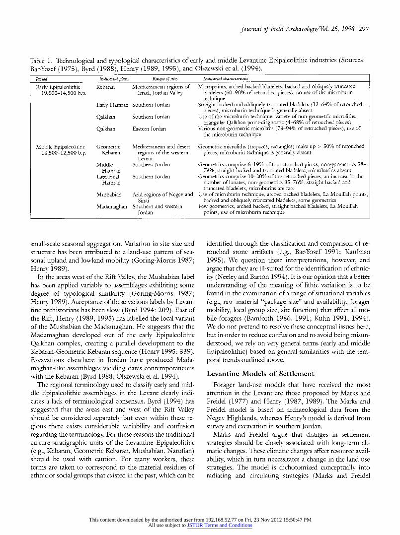
Table 1. Technological and typological characteristics of early and middle Levantine Epipaleolithic industries (Sources: Bar-Yosef (1975), Byrd (1988), Henry (1989, 1995), and Olszewski et al. (1994).
Period Industrial phase Range of sites Industrial characteristics
Early Epipaleolithic Kebaran Mediterranean regions of Micropoints, arched backed bladelets, backed and obliquely truncated 19,000-14,500 b.p. Israel, Jordan Valley bladelets (50-90% of retouched pieces), no use of the microburin
technique Early Hamran Southern Jordan Straight backed and obliquely truncated bladelets (13-64% of retouched
pieces), microburin technique is generally absent Qalkhan Southern Jordan Use of the microburin technique, variety of non-geometric microliths,
triangular Qalkhan point-diagnostic (4-68% of retouched pieces) Qalkhan Eastern Jordan Various non-geometric microliths (73-94% of retouched pieces), use of
the microburin technique
Middle Epipaleolithic Geometric Mediterranean and desert Geometric microliths (trapezes, rectangles) make up > 50% of retouched 14,500-12,500 b.p. Kebaran regions of the western pieces, microburin technique is generally absent
Levant Middle Southern Jordan Geometrics comprise 6-19% of the retouched pieces, non-geometrics 58-
Hamran 73%, straight backed and truncated bladelets, microburins absent Late/Final Southern Jordan Geometrics comprise 10-20% of the retouched pieces, an increase in the
Hamran number of lunates, non-geometrics 35-76%, straight backed and truncated bladelets, microburins are rare
Mushabian Arid regions of Negev and Use of microburin technique, arched backed bladelets, La Mouillah points, Sinai backed and obliquely truncated bladelets, some geometrics
Madamaghan Southern and western Few geometrics, arched backed, straight backed bladelets, La Mouillah Jordan points, use of microburin technique
small-scale seasonal aggregation. Variation in site size and structure has been attributed to a land-use pattern of sea- sonal upland and lowland mobility (Goring-Morris 1987; Henry 1989).
In the areas west of the Rift Valley, the Mushabian label has been applied variably to assemblages exhibiting some
degree of typological similarity (Goring-Morris 1987; Henry 1989). Acceptance of these various labels by Levan- tine prehistorians has been slow (Byrd 1994: 209). East of the Rift, Henry (1989, 1995) has labelled the local variant of the Mushabian the Madamaghan. He suggests that the
Madamaghan developed out of the early Epipaleolithic Qalkhan complex, creating a parallel development to the Kebaran-Geometric Kebaran sequence (Henry 1995: 339). Excavations elsewhere in Jordan have produced Mada-
maghan-like assemblages yielding dates contemporaneous with the Kebaran (Byrd 1988; Olszewski et al. 1994).
The regional terminology used to classify early and mid- dle Epipaleolithic assemblages in the Levant clearly indi- cates a lack of terminological consensus. Byrd (1994) has
suggested that the areas east and west of the Rift Valley should be considered separately but even within these re-
gions there exists considerable variability and confusion
regarding the terminology. For these reasons the traditional
culture-stratigraphic units of the Levantine Epipaleolithic (e.g., Kebaran, Geometric Kebaran, Mushabian, Natufian) should be used with caution. For many workers, these terms are taken to correspond to the material residues of ethnic or social groups that existed in the past, which can be
identified through the classification and comparison of re- touched stone artifacts (e.g., Bar-Yosef 1991; Kaufman 1995). We question these interpretations, however, and argue that they are ill-suited for the identification of ethnic- ity (Neeley and Barton 1994). It is our opinion that a better understanding of the meaning of lithic variation is to be found in the examination of a range of situational variables (e.g., raw material "package size" and availability, forager mobility, local group size, site function) that affect all mo- bile foragers (Bamforth 1986, 1991; Kuhn 1991, 1994). We do not pretend to resolve these conceptual issues here, but in order to reduce confusion and to avoid being misun- derstood, we rely on very general terms (early and middle Epipaleolithic) based on general similarities with the tem- poral trends outlined above.
Levantine Models of Settlement
Forager land-use models that have received the most attention in the Levant are those proposed by Marks and Freidel (1977) and Henry (1987, 1989). The Marks and Freidel model is based on archaeological data from the Negev Highlands, whereas Henry's model is derived from survey and excavation in southern Jordan.
Marks and Freidel argue that changes in settlement strategies should be closely associated with long-term cli- matic changes. These climatic changes affect resource avail- ability, which in turn necessitates a change in the land use strategies. The model is dichotomized conceptually into radiating and circulating strategies (Marks and Freidel
This content downloaded by the authorized user from 192.168.52.77 on Fri, 23 Nov 2012 15:50:47 PMAll use subject to JSTOR Terms and Conditions
298 Tor al-Tareeq, an Epipaleolithic Site/Neeley et al.
1977: 150; see also Mortensen 1972). For the early and middle Epipaleolithic, the model suggests foragers prac- ticed a circulating strategy of land use. With a circulating strategy, extractive/special activity sites are apt to be small, perhaps archaeologically invisible loci, while base camps, which vary in the length of occupation, are not expected to be formally structured in terms of their use of space (i.e., anticipated duration of occupation is likely to be short [Kent 1992]). As a result, we should see less intrasite pat- terning with regard to the use of space, and "blurring" of
patterning as a result of repeated, non-continuous occupa- tion over time. With a radiating strategy, base camps are
organized logistically and may be highly visible due to extended occupations and the accumulation of midden de-
posits. They may contain greater intrasite patterning with
regard to structures, features, and disposal areas. Extractive sites are expected to be more numerous, although still
potentially invisible archaeologically, because of the limited
range of activities occurring there.
Henry's (1987, 1989, 1994) model of forager land-use is based upon the seasonal movement of foragers between
upland and lowland settings. This model is used to charac- terize land-use strategies over much of the later Pleistocene and Holocene but is especially relevant to the Epipaleo- lithic, where it is linked to a large body of archaeological data. Henry suggests that larger winter camps will be found in lowland settings whereas the smaller summer camps are situated in upland regions. The model incorporates aspects of the radiating/circulating model in that a radiating pattern of settlement would be expected for the large winter, low- land sites and a circulating pattern of settlement for the
upland sites. Variations on the upland/lowland pattern of settlement have also been applied to areas of the western Levant (Bar-Yosef 1987; Goring-Morris 1987).
Although these models are derived from regional data- bases, their applicability to other areas, especially the inland
regions of northern and central Jordan, remains to be tested. In particular, we are interested in the inland regions characterized by lakes or oases. During the late Pleistocene, inland lakes were present in the Jafr Basin, the Azraq Basin, the northern Jordan Valley, and the eastern Wadi Hasa. These lake beds are presently located in arid, steppe/desert environments, yet the archaeological record from these re- gions suggests that these were areas of intensive and re- peated settlement in the prehistoric past (Clark et al. 1992, 1994; Garrard et al. 1988; MacDonald 1988).
The Wadi Hasa and Tor al-Tareeq
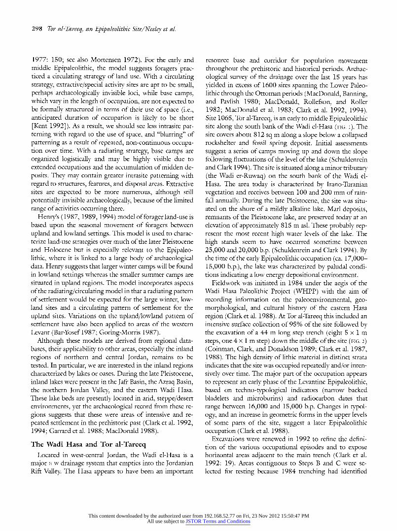
Located in west-central Jordan, the Wadi el-Hasa is a major E-w drainage system that empties into the Jordanian Rift Valley. The Hasa appears to have been an important
resource base and corridor for population movement throughout the prehistoric and historical periods. Archae- ological survey of the drainage over the last 15 years has yielded in excess of 1600 sites spanning the Lower Paleo- lithic through the Ottoman periods (MacDonald, Banning, and Pavlish 1980; MacDonald, Rollefson, and Roller 1982; MacDonald et al. 1983; Clark et al. 1992, 1994). Site 1065, Tor al-Tareeq, is an early to middle Epipaleolithic site along the south bank of the Wadi el-Hasa (FIG. i). The site covers about 812 sq m along a slope below a collapsed rockshelter and fossil spring deposit. Initial assessments suggest a series of camps moving up and down the slope following fluctuations of the level of the lake (Schuldenrein and Clark 1994). The site is situated along a minor tributary (the Wadi er-Ruwaq) on the south bank of the Wadi el- Hasa. The area today is characterized by Irano-Turanian vegetation and receives between 100 and 200 mm of rain- fall annually. During the late Pleistocene, the site was situ- ated on the shore of a mildly alkaline lake. Marl deposits, remnants of the Pleistocene lake, are preserved today at an elevation of approximately 815 m asl. These probably rep- resent the most recent high water levels of the lake. The high stands seem to have occurred sometime between 25,000 and 20,000 b.p. (Schuldenrein and Clark 1994). By the time of the early Epipaleolithic occupation (ca. 17,000- 15,000 b.p.), the lake was characterized by paludal condi- tions indicating a low energy depositional environment.
Fieldwork was initiated in 1984 under the aegis of the Wadi Hasa Paleolithic Project (WHPP) with the aim of recording information on the paleoenvironmental, geo- morphological, and cultural history of the eastern Hasa region (Clark et al. 1988). At Tor al-Tareeq this included an intensive surface collection of 95% of the site followed by the excavation of a 44 m long step trench (eight 5 x 1 m steps, one 4 x 1 m step) down the middle of the site (FIG. 2) (Coinman, Clark, and Donaldson 1989; Clark et al. 1987, 1988). The high density of lithic material in distinct strata indicates that the site was occupied repeatedly and/or inten- sively over time. The major part of the occupation appears to represent an early phase of the Levantine Epipaleolithic, based on techno-typological indicators (narrow backed bladelets and microburins) and radiocarbon dates that range between 16,000 and 15,000 b.p. Changes in typol- ogy, and an increase in geometric forms in the upper levels of some parts of the site, suggest a later Epipaleolithic occupation (Clark et al. 1988).
Excavations were renewed in 1992 to refine the defini- tion of the various occupational episodes and to expose horizontal areas adjacent to the main trench (Clark et al. 1992: 19). Areas contiguous to Steps B and C were se- lected for testing because 1984 trenching had identified
This content downloaded by the authorized user from 192.168.52.77 on Fri, 23 Nov 2012 15:50:47 PMAll use subject to JSTOR Terms and Conditions

Journal of Field Archaeology/Vol. 25, 1998 299
WADI IIASA SYRI 'A"o
I'PAIEOLITIIIC PROJECT Scale 1: 25,000
WIIS 784 a Qal
a|'Qasa (ruined)
N
Arab al'Mana'hin
W860 Jordan Phosphate Mines Company el'tHasa Townsite
et I u;eh Ooinedl 8
WHS 623 Jebel al'Misq
R
800 Arab al'Misq WHS 618
TorMahattat alasaq
Pl cne-Lae
au seasonal mud flatsun
S 500 1000 meters a ts
Figure 1. Map of the eastern end of the Wadi el-Hasa indicating the former extent of the Pleistocene lake and the location of Tor al-Tareeq along with other nearby Upper and Epipaleolithic sites.
both in situ deposits and radiocarbon-dated features in these areas (Clark et al. 1988). During 1992, 2 x 2 m units were opened up adjacent to trench segments B and C in the
hope of identifying additional features, architecture, and intact cultural deposits (FIG. 2). To date, excavation at Tor
al-Tareeq has resulted in the collection of more than 200,000 lithic artifacts along with fauna, shell, and ground stone.
Stratigraphy
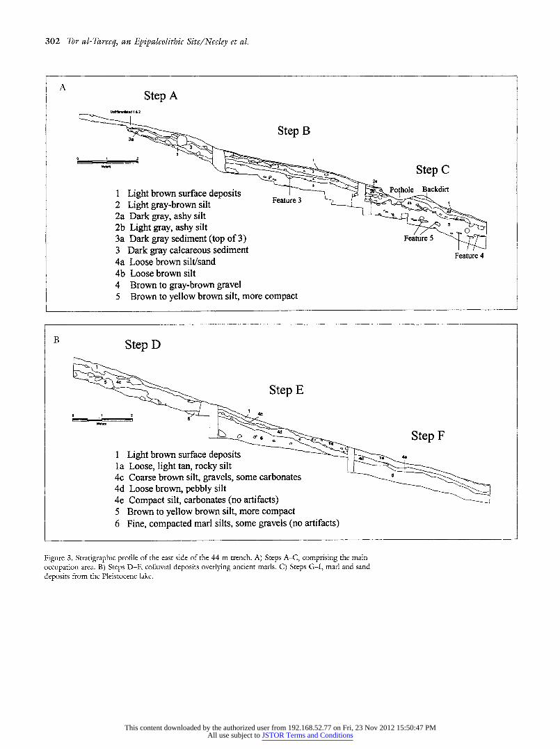
The 1984 Trench In 1984 a 44 m step trench (Steps A-I) was excavated
along a N-S line following the slope of the land surface. Previous reports have discussed a limited part of the trench (Steps B, C) or dealt with the general geomorphological site processes (Clark et al. 1987, 1988; Schuldenrein and Clark 1994). The section drawing indicates that much of
the site stratigraphy is represented by colluvial deposits overlying calcareous lacustrine marls (FIG. 3A-C). Occupa- tion of the site appears to have been largely confined to the upslope areas of Steps A, B, and C as they contain consis- tently high densities of artifacts and features from top to bottom (Clark et al. 1988).
During the 1992 season, the upper steps of the 1984 step trench were cleared of backfill in order to utilize the old stratigraphic profile as a guide for further excavations. Both Steps B and C are documented in previously-published section drawings (Clark et al. 1988: 255) and we used these as guides for following the natural stratigraphic levels vis- ible in the trench. When the correspondences between the 1984 and 1992 strata were unclear, excavation proceeded by arbitrary 10 cm levels.
Differences in the stratigraphy of Units B and C are evident. Unit B seems to have greater preservation of intact, distinct strata from the early Epipaleolithic occupation
This content downloaded by the authorized user from 192.168.52.77 on Fri, 23 Nov 2012 15:50:47 PMAll use subject to JSTOR Terms and Conditions

300 Tor al-Tareeq, an Epipaleolithic Site/Neeley et al.
Deposit Remnant
BEDROCK MORTARS
S4 GYPSUM PILE (NOT COLLECTED)
3
2--------,
2Unit B
NW QAD NE QUAD
P.THOLE (NOT COLLECTED)
C EXPOSED BEDROCK
BACKDIRT
EXPOSED BEDROCK -D
.SW
QUAD E
SE QUAD
WHS SITE 1065 W E CONTOUR INTERVAL IM --
0 2 4 6 8 IOM
SCALEH
OTTOMAN HOUSE FOUNDATIONS
MARLS
Figure 2. Site map indicating the 1984 step trench (A-I) and the 1992 excavation units (B and C).
along the lake margin. The stratigraphy of Unit C, further
downslope, is less distinctive, probably because of greater colluviation.
Unit B Excavation Unit B (2 x 2 m) was located on the eastern
edge of Step B (FIG. 2). This area was adjacent to the part of the step trench with exposed charcoal and ash (Feature 3) reported in the 1984 excavations (Clark et al. 1987, 1988). Excavation in Unit B revealed five distinct strata corre-
sponding to those identified in the 1984 excavations (Clark et al. 1988).
Unit C Excavation Unit C (2 x 2 m) was placed along the west-
ern edge of Step C. Because of recent erosion along the trench, which destroyed part of its western edge, a small balk was left in place between the trench and excavation Unit C (FIG. 2). Excavation identified four stratigraphic levels. The stratigraphy differs markedly from the complex stratigraphy reported for the eastern face of Step C in the 1984 excavations (Clark et al. 1987: 58). The western face of Step C, however, which is much less complex, is very similar to that identified in the 2 x 2 m unit. The lower levels are characterized by carbonate lenses, suggesting local
This content downloaded by the authorized user from 192.168.52.77 on Fri, 23 Nov 2012 15:50:47 PMAll use subject to JSTOR Terms and Conditions

Journal of Field Archaeology/Vol. 25, 1998 301
conditions wetter than at present due either to the proxim- ity of the spring, lake, or overall more mesic climatic re-
gimes. Changes in the frequency and kinds of lithic artifacts
throughout the levels in Step C and those in Unit C are
strikingly similar, however, suggesting a continuous hori- zontal distribution of occupational debris in this area of the site. It is only in the area of Step C and Unit C that there is
compelling evidence for differentiating between an earlier
(Level 5) and later (Levels 1 and 4) Epipaleolithic occupa- tion (Stevens 1996).
Although we argue for the relative integrity of the two
archaeological occupations, we acknowledge the possibility of mixing. Location on a slope has resulted in some displace- ment of material over time (Coinman, Clark, and Donald- son 1989), which might produce a "watered down" assem-
blage signature as the earlier materials are combined with those of the later occupation. This is problematic when
trying to place assemblages within the existing culture-strati-
graphic units. Nonetheless, while recognizing these po- tential alternative sources of patterning, we feel that the
arguments presented here warrant the separation of the ma- terial into an early and later geometric Epipaleolithic occu-
pation.
Chronology
Eight radiocarbon samples have been processed from Tor
al-Tareeq (TABLE 2; Schuldenrein and Clark 1994: 34 con- tains a complete listing of radiometric dates from the east- ern Hasa region). Six of the eight determinations cluster in the 16,000-15,000 b.p. interval-dates compatible with radiocarbon-dated early Epipaleolithic industries in the Le- vant (Bar-Yosef and Vogel 1987; Byrd 1994). Typologically, the paucity of geometric microliths and a high proportion of backed bladelets typical of the radiometrically-dated lev- els correspond to a generalized Kebaran pattern (Bar-Yosef 1975, 1981). While an internally consistent cluster of dates was obtained for the early Epipaleolithic occupation, the
upper layers did not yield dateable remains of the sub-
sequent occupation. Thus far, all of the radiocarbon dates on charcoal come from the lowest levels in Steps A, B, and C. The later material, containing higher proportions of
geometric microliths, is confined to Step C and rests well above the dated levels. Two other dates were obtained from bulk soil samples containing organic material in Unit B within a heavily calcreted, consolidated layer. These dates are much younger than the others and are considered prob- lematic with regard to the site chronology because of poten- tial problems inherent in the bulk sample dating technique, and the possibility of contamination. They are not consid- ered in the following site interpretations.
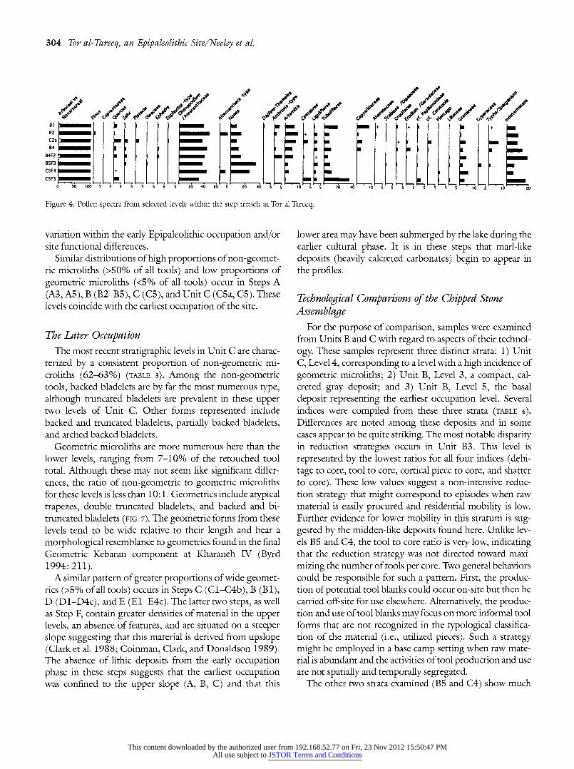
Analysis of Pollen
Pollen preservation was inconsistent within natural strata at Tor al-Tareeq, but productive samples indicate the strong predominance of non-arboreal taxa. Some of the variability among pollen spectra may be the result of the transport of
pollen-bearing plant materials into the camp environs (e.g., Ambrosia-type pollen in Feature 2 and Typha/Sparganium pollen in Feature 3).
The pollen spectra indicate steppe-like conditions persist- ing throughout most of the site occupation (FIG. 4). There is some indication that the earliest occupations may have been associated with cooler and possibly drier conditions in the absence of riparian taxa. These climatic conditions are in
general agreement with conditions across the region during the last glacial maximum (Bar-Yosef 1990: 60). The local environment appears to have changed fairly rapidly with the onset of warmer conditions, indicated by the rise in Noaca- type pollen and the regular appearance of riparian taxa in the pollen samples. These changes, however, do not appear to have altered the environment in a drastic fashion. The results suggest that the lake/marsh environment of the Hasa basin, with its numerous active springs, provided a broad
range of resources that differed markedly from the sur-
rounding steppe. This diversity was a major factor in the
prehistoric occupation of the Hasa basin during the early Epipaleolithic.
In comparison, the shift toward Noaea-type pollen may parallel a similar change in pollen configurations from an
early to late period during the Early Epipaleolithic occupa- tions investigated by Donald Henry in southern Jordan (Emery-Barbier 1988). As in the pollen sequence at Tor
al-Tareeq, Artemisia appears following this shift, although Ephedra spans the entire early Epipaleolithic interval in the southern samples. Like the Tor al-Tareeq sequence, later
assemblages contain small amounts of the pollen of mesic trees. In southern Jordan, these include alder, Olive family, elm (Ulmus), and fig (Ficus).
Typological Comparisons
Meter-deep cultural deposits in conjunction with radio- carbon dates indicate that the site was occupied over a span of several thousand years. Because of the continuity of cultural deposits and the likely disturbances associated with natural processes, the identification of discrete, occupa- tional episodes (e.g., living floors) was not possible. Rather, it seems more productive to identify gross differences in the occupational episodes based on aspects of lithic typology and technology. The retouched tool component from Tor al-Tareeq indicates some variability over the occupational history of the site. Typological differences are noted in both
This content downloaded by the authorized user from 192.168.52.77 on Fri, 23 Nov 2012 15:50:47 PMAll use subject to JSTOR Terms and Conditions
302 Tor al-Tareeq, an Epipaleolithic Site/Neeley et al.
A Step A
Step B
3
2Step C
1 Light brown surface depositsPothoe ackdirt
2 Light gray-brown silt 2a Dark gray, ashy silt 2b Light gray, ashy silt l 3a Dark gray sediment (top of 3) Feature 5 3 Dark gray calcareous sediment Feature 4 4a Loose brown silt/sand 4b Loose brown silt 4 Brown to gray-brown gravel 5 Brown to yellow brown silt, more compact
Step D
Step E
SO a ...d ? Step F
1 Light brown surface deposits 4,
la Loose, light tan, rocky silt 4c Coarse brown silt, gravels, some carbonates 4d Loose brown, pebbly silt 4e Compact silt, carbonates (no artifacts) 5 Brown to yellow brown silt, more compact 6 Fine, compacted marl silts, some gravels (no artifacts)
Figure 3. Stratigraphic profile of the east side of the 44 m trench. A) Steps A-C, comprising the main
occupation area. B) Steps D-F, colluvial deposits overlying ancient marls. C) Steps G-I, marl and sand
deposits from the Pleistocene lake.
This content downloaded by the authorized user from 192.168.52.77 on Fri, 23 Nov 2012 15:50:47 PMAll use subject to JSTOR Terms and Conditions

Journal of Field Archaeology/Vol. 25, 1998 303
C
Step G
Step H Step I
la Of
Channel
Silts 6b
Sand Lenses
la Loose, light tan, rocky silt 6
0
4e Compact silt, carbonates 7 Mo/ 4f Blocky gravels with slightly compact silts and sands 6a Marl deposits, some carbonates 6b Fine marls 6 Fine, compacted marl silts 7 Compact marl silts with gravels and pebbles
the horizontal and vertical dimensions of the occupation that can be differentiated into two major culture-strati- graphic phases. The earliest occupational history is charac- terized by a non-geometric microlithic industry occurring in the basal levels and the upper slope of the site. The later
phase, stratigraphically higher and further downslope, is characterized by broad, geometric microliths.
The Earliest Occupation The levels in excavation Unit B are characterized by a
high proportion of non-geometric microliths (TABLE 3). The incidence of non-geometric microliths in the five levels form 64-84% of the retouched tool totals. Within this tool
group straight backed bladelets and arched backed bladelets are most common (FIGS. 5, 6). The arched backed bladelet
category includes narrow micropoints and curved backed bladelets. Other forms represented in these levels include backed and truncated bladelets, truncated bladelets, and
partially backed bladelets. Among the layers in Unit B, Level 5 differs from the others in its higher incidence of arched backed bladelets (21% vs. 6-10%). The presence of arched backed bladelets and narrow micropoints in
quantity suggests a typological affinity with the early Ke- baran, whereas late Kebaran assemblages are believed to be
represented by a greater incidence of obliquely truncated
backed bladelets (Bar-Yosef 1981; Bar-Yosef and Vogel 1987: 225).
Geometric microliths (trapeze/rectangles, triangles, lu-
nates) comprise a very small part of the retouched tools in Unit B. The greatest frequency of these forms occur in Level 1 (3%) and they represent less than 1% of the retouched tool component in Levels 4 and 5. Ratios of non-geometric to geometric microliths are greater than 10:1, indicating that geometric forms comprised a very small proportion of the retouched pieces. These low frequencies indicate a pre- dominantly non-geometric assemblage in these levels that is
relatively homogeneous from bottom to top. Minor differ- ences might represent differences attributable to temporal
Table 2. Radiometric dates from Tor al-Tareeq, ordered by radiocarbon age.
Laboratory no. Level Material Age b.p. Beta-57898 B3 Soil/sediment 9,010 ? 100 Beta-57899 B3 Soil/sediment 11,280 ? 290 UA-4392 B4 Charcoal/hearth 15,580 + 250 UA-4394 B4 Charcoal/hearth 15,860 + 430
UA-4390 C5 Charcoal/hearth 16,570 ? 380 Beta-57900 B4 Charcoal/hearth 16,670 ? 270 UA-4393 C5 Charcoal 16,790 ? 340 UA-4391 A5 Charcoal 16,900 ? 500
This content downloaded by the authorized user from 192.168.52.77 on Fri, 23 Nov 2012 15:50:47 PMAll use subject to JSTOR Terms and Conditions
304 Tor al-Tareeq, an Epipaleolithic Site/Neeley et al.
";o , /4,"
B2I g + C2a il 1
B4 - B4F2 BSF3 CSF4 C5F5
0 SO 1O06 5 S 5 5 5 5 5 5 20 40 60 5 2b 40 5 5 1 5 5 20 40 10 5 5 5 5 5 5 05 10 2
Figure 4. Pollen spectra from selected levels within the step trench at Tor al-Tareeq.
variation within the early Epipaleolithic occupation and/or site functional differences.
Similar distributions of high proportions of non-geomet- ric microliths (>50% of all tools) and low proportions of geometric microliths (<5% of all tools) occur in Steps A (A3, A5), B (B2-B5), C (C5), and Unit C (C5a, C5). These levels coincide with the earliest occupation of the site.
The Later Occupation The most recent stratigraphic levels in Unit C are charac-
terized by a consistent proportion of non-geometric mi- croliths (62-63%) (TABLE 3). Among the non-geometric tools, backed bladelets are by far the most numerous type, although truncated bladelets are prevalent in these upper two levels of Unit C. Other forms represented include backed and truncated bladelets, partially backed bladelets, and arched backed bladelets.
Geometric microliths are more numerous here than the lower levels, ranging from 7-10% of the retouched tool total. Although these may not seem like significant differ-
ences, the ratio of non-geometric to geometric microliths for these levels is less than 10:1. Geometrics include atypical trapezes, double truncated bladelets, and backed and bi- truncated bladelets (FIG. 7). The geometric forms from these levels tend to be wide relative to their length and bear a
morphological resemblance to geometrics found in the final Geometric Kebaran component at Kharaneh IV (Byrd 1994: 211).
A similar pattern of greater proportions of wide geomet- rics (>5% of all tools) occurs in Steps C (C1-C4b), B (B1), D (D1-D4c), and E (E1-E4c). The latter two steps, as well as Step F, contain greater densities of material in the upper levels, an absence of features, and are situated on a steeper slope suggesting that this material is derived from upslope (Clark et al. 1988; Coinman, Clark, and Donaldson 1989). The absence of lithic deposits from the early occupation phase in these steps suggests that the earliest occupation was confined to the upper slope (A, B, C) and that this
lower area may have been submerged by the lake during the earlier cultural phase. It is in these steps that marl-like
deposits (heavily calcreted carbonates) begin to appear in the profiles.
Technological Comparisons of the Chipped Stone Assemblage
For the purpose of comparison, samples were examined from Units B and C with regard to aspects of their technol-
ogy. These samples represent three distinct strata: 1) Unit C, Level 4, corresponding to a level with a high incidence of
geometric microliths; 2) Unit B, Level 3, a compact, cal- creted gray deposit; and 3) Unit B, Level 5, the basal
deposit representing the earliest occupation level. Several indices were compiled from these three strata (TABLE 4).
Differences are noted among these deposits and in some cases appear to be quite striking. The most notable disparity in reduction strategies occurs in Unit B3. This level is
represented by the lowest ratios for all four indices (debi- tage to core, tool to core, cortical piece to core, and shatter to core). These low values suggest a non-intensive reduc- tion strategy that might correspond to episodes when raw material is easily procured and residential mobility is low. Further evidence for lower mobility in this stratum is sug- gested by the midden-like deposits found here. Unlike lev- els B5 and C4, the tool to core ratio is very low, indicating that the reduction strategy was not directed toward maxi-
mizing the number of tools per core. Two general behaviors could be responsible for such a pattern. First, the produc- tion of potential tool blanks could occur on-site but then be carried off-site for use elsewhere. Alternatively, the produc- tion and use of tool blanks may focus on more informal tool forms that are not recognized in the typological classifica- tion of the material (i.e., utilized pieces). Such a strategy might be employed in a base camp setting when raw mate- rial is abundant and the activities of tool production and use are not spatially and temporally segregated.
The other two strata examined (B5 and C4) show much
This content downloaded by the authorized user from 192.168.52.77 on Fri, 23 Nov 2012 15:50:47 PMAll use subject to JSTOR Terms and Conditions

Journal of Field Archaeology/Vol. 25, 1998 305
Table 3. Percentages of major tool classes from all excavation units at Tor al-Tareeq. End- Multiple Notch- Retouch Non-
Area and level scraper Burin Perforator tool denticulate Truncation piece geometric Geometric Varia N
Step A 1/2 5.7 7.5 15.1 0 17.0 1.9 43.3 9.4 0 0 53 3a 0 0 0 0 12.5 25.0 25.0 37.5 0 0 8 3 4.6 11.6 0 0 2.3 2.3 16.3 62.3 0 0 43 5 3.7 2.5 1.2 0 3.7 3.7 18.7 65.0 0 1.2 80
Step B 1 2.8 0 0 0 8.6 8.6 8.6 60.0 11.4 0 35 2 2.0 2.9 2.9 0.9 7.9 7.9 17.8 68.3 2.9 2.0 101 3 8.4 6.5 0.9 1.8 3.7 6.5 19.6 50.5 0.9 0.9 107 4 8.5 5.0 2.5 0 6.8 2.5 17.8 51.7 3.4 1.7 118 5 2.9 1.3 2.1 0.5 11.9 9.9 9.7 58.3 2.7 0.3 513
Step C 1 7.8 3.9 1.3 1.3 9.1 10.4 3.9 50.6 11.7 0 77 2a 5.0 2.5 0.8 2.5 16.5 9.9 22.3 34.7 5.0 0.8 121 2b 3.7 0 3.7 3.7 18.5 33.3 14.8 11.1 11.1 0 27 4a 3.5 3.1 2.7 0.8 9.1 8.0 13.0 45.9 13.1 0.8 778 4b 4.1 2.7 2.2 1.2 15.0 8.2 19.3 36.0 10.7 0.6 488 5 3.0 1.0 1.8 0.3 10.2 7.2 16.7 54.9 4.8 0 599
Step D 1 5.2 2.1 3.5 0 11.3 12.6 22.7 36.7 9.1 0 229 1/4c 6.3 1.1 0.5 0.5 10.9 14.3 26.4 33.9 5.1 0.5 174 4c 2.1 2.8 2.5 0.3 16.2 19.0 24.4 27.0 5.4 0 278 5 0 0 0 0 12.8 23.0 23.0 41.0 0 0 39
Step E 1 11.8 9.2 0 2.6 7.9 11.8 14.4 36.8 5.2 0 76 4c 4.7 2.3 7.0 0 3.1 10.0 25.7 36.7 9.3 0.7 128 4d 0 0 0 0 0 7.1 35.7 50.0 7.1 0 14
Step F 1 6.0 0.4 4.7 0.8 26.6 7.7 22.3 30.0 1.3 0 223 4d 0 0 3.5 3.5 7.1 0 42.8 42.8 0 0 28
Unit B 1 7.9 5.9 0 0 1.9 1.9 8.9 68.3 3.0 1.9 101 2 5.3 3.5 0 0.9 1.7 2.6 19.3 64.0 2.6 0 114 3 7.4 7.4 0 0 1.3 4.0 6.0 71.1 1.3 1.3 149 4 7.7 4.5 0 0 1.8 0.4 9.5 73.2 0.9 1.8 220 5 2.8 1.4 0 0 2.3 1.1 7.4 84.4 0.4 0 430
Unit C 1 3.4 2.4 0.2 0.2 5.1 4.4 13.0 63.6 7.3 0.2 409 4 4.0 1.5 0.3 0.5 3.6 3.1 14.2 62.2 10.4 0.2 606 5a 1.9 1.1 0 0.4 4.6 1.9 11.6 73.7 4.6 0 259 5 1.1 1.1 0 0 3.3 3.8 10.9 78.8 1.1 0 184
higher ratios of debitage to core and shatter to core, indicat- ing a greater emphasis in on-site reduction strategies. The evidence of on-site core reduction is bolstered by the higher ratios of cortical pieces to cores, corresponding to the initial stages of core reduction. This suggests that cores were
brought onto the site in a mostly complete form (i.e., they have not been shaped extensively off-site). The transport of mostly complete raw material nodules on-site might reflect the distance in which the materials were carried and suggest the utilization of nearby raw material sources. The tool to core ratios in B5 and C4 suggest either a greater emphasis on in situ tool manufacture, use, and discard or are repre- sentative of a "gearing up" stage of tool production for
future tool use during which old, worn out tools are dis- carded in favor of newly manufactured ones. Both sorts of behaviors are compatible with base camp settlements.
Blank and Tool Metrics In addition to debitage ratios, measurements were re-
corded for lithic samples from these three strata. Typologi- cally, Units B3 and B5 are most similar and fall within the range of a generalized early Epipaleolithic industry. The third sample, Unit C4, bears a greater affinity to a geometric industry. Measures of length, width, and thickness were recorded for complete retouched and unretouched flakes and blades.
This content downloaded by the authorized user from 192.168.52.77 on Fri, 23 Nov 2012 15:50:47 PMAll use subject to JSTOR Terms and Conditions

306 Tor al-Tareeq, an Epipaleolithic Site/Neeley et al.
3
1 2 4 5
6
7 8 9
10 0 1 2 3 4 5
11 centimeters
12
14
13
Figure 5. Retouched stone artifacts and cores from Unit B, Level 5. 1-2: backed and obliquely trun-
cated bladelets; 3-4: arched backed bladelets; 5-6: straight backed bladelets; 7: inversely retouched
bladelet; 8: double backed bladelet; 9: straight backed bladelet with basal modification; 10: truncated
blade segment; 11: circular scraper; 12-14: bladelet cores.
This content downloaded by the authorized user from 192.168.52.77 on Fri, 23 Nov 2012 15:50:47 PMAll use subject to JSTOR Terms and Conditions

Journal of Field Archaeology/Vol. 25, 1998 307
7
1 2
5 6 0 1 2 3 4 5
centimeters
9 1
10 12
Figure 6. Retouched stone artifacts and cores from Unit B, Level 3. 1-2, 4: straight backed bladelets; 3:
straight backed bladelet with a retouched tip; 5, 12: backed and obliquely truncated bladelets; 6, 11: arched backed bladelets; 7: multiple burin on a blade; 8: endscraper/burin on a straight truncation; 9: bladelet core; denticulate on a retouched blade.
This content downloaded by the authorized user from 192.168.52.77 on Fri, 23 Nov 2012 15:50:47 PMAll use subject to JSTOR Terms and Conditions

308 Tor al-Tareeq, an Epipaleolithic Site/Neeley et al.
1 2 3 4 5
6 7
I 8
9 10
_ 14
13 centimeters
11 12
15
Figure 7. Retouched stone artifacts and cores from Unit C, Level 4. 1-2, 4-6: Hasa lunates; 3, 8: dou- bled truncated bladelets; 7: broken Hasa lunate; 5, 10-13: backed and truncated bladelets; 9: rectangle; 14: endscraper/burin on an oblique truncation; 15: flake/blade core.
This content downloaded by the authorized user from 192.168.52.77 on Fri, 23 Nov 2012 15:50:47 PMAll use subject to JSTOR Terms and Conditions

Journal of Field Archaeology/Vol. 25, 1998 309
Table 4. Technological indices pertaining to reduction strategies for three strata at Tor al-Tareeq.
Level Debitage:core Tool:core Cortical piece:core Shatter:core B3 28:1 2:1 3:1 12:1 B5 84:1 10:1 9:1 45:1 C4 70:1 7:1 6:1 74:1
The results of these measurements indicate that B3 con- tains the longest average unretouched blade length (44.04 mm), followed by C4 (38.03 mm) and B5 (31.34 mm). The larger sized blanks from B3 support the notion of a non-intensive reduction strategy. The unretouched blades and flakes from Level B5 are the smallest in size for all three variables. Complete flake sizes are largest in C4.
Differences in the retouched blades are noted for all three levels. Those in C4 are smaller than the unretouched blade
sample whereas retouched blades in B3 are larger and those in B5 are about the same size. The larger size of blade tools in B3 might be due to 1) better preservation (less break-
age); 2) intrasite functional differences in which large blade tools were important (e.g., scrapers, burins, retouched
blades); or 3) tool and blank production were less intensive
(i.e., producing larger sized usable blanks). Although most of the tools in this level are microliths (non-geometrics account for 71%), some larger tools like scrapers and burins are relatively well represented (7% each).
Technological Summary The aim of the technological comparison of these sam-
ples was to try to identify intra-assemblage differences. Dif- ferences have been noted for indices of reduction intensity as well as blank and tool morphology. Reduction strategies appear to be variable within typologically similar assem-
blages, whereas aspects of blank morphology among the
early Epipaleolithic samples remain very similar. Having identified some aspects of variation is not, however, the same thing as explaining why they occur. Perhaps the most
widely accepted explanation for differences in pattern in
Epipaleolithic assemblages is that they reflect differences in cultural or ethnic identity (e.g., Bar-Yosef 1975, 1981, 1991; Bar-Yosef and Vogel 1987; Goring-Morris 1987; Henry 1989). These explanations depend upon the assump- tion that technological and typological differences are iso-
morphic with differences in learned behavior, which in turn reflect differences in ethnic identity. Some of these assump- tions have been questioned recently and alternative explana- tions advanced that account for variability in terms of a smaller number of universal situational variables (e.g., raw material availability, mobility, site function) (Donaldson 1991; Kuhn 1994; Neeley and Barton 1994). Perhaps the
greatest challenge of these alternative explanations lies in the difficulty of untangling these factors. Raw material
availability/use and mobility can influence assemblage vari- ation in a variety of ways, resulting in a somewhat incom-
plete separation of these distinct causal factors (see Kuhn 1995; Potter 1993).
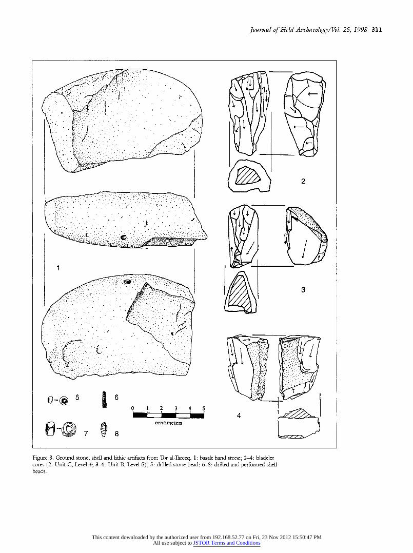
Ground Stone Assemblage During the 1984 and 1992 excavations at Tor al-Tareeq,
14 ground stone implements were recovered. In addition to the excavated sample, five bedrock grinding features were located in the rocky escarpment directly NE of the archae-
ological deposits. Morphologically the artifacts fall into a
relatively narrow range of categories. Ground stone artifacts were placed in one of four catego-
ries: 1) indeterminate fragment, 2) handstone/pestle frag- ment, 3) pestle, or 4) mortar. Two indeterminate fragments were defined by the presence of a ground surface or surfaces that were too small for any further typological distinction. The three items in the handstone/pestle category were com-
plete enough to warrant a general functional inference (FIG. 8). Usewear typically occurs as battering at one or both
ends, with striations or grinding around the circumference near the ends.
Four of the bedrock mortars were of the small "cupmark" variety (Wright 1991: 31). They are circular in plan, with
slightly incurving sides. The remaining two mortars are of interest because they seem to have two composite, yet dis-
tinctive, use surfaces. They contain a large, elliptical depres- sion surrounding a smaller, cup-shaped indentation similar to those described above.
Excluding the mortars formed in the Upper Cretaceous limestone bedrock, the ground stone raw material includes basalt, quartzite, and limestone. Several basalt outcrops are
present within a 15 km radius of the site (Bender 1974: 112). Basalt sheet lavas are a prominent feature of the Jurf ed Darawish area to the south, and basalt plugs occur to the west, along the Wadi al-Hasa drainage.
Whatever the specific occupational history of the site, it
appears that ground stone technology was used throughout its duration as pestles and handstones are found in the
upper and lower levels of Unit B. The ground stone assem- blage from Tor al-Tareeq is distinctive on two counts: 1) the
This content downloaded by the authorized user from 192.168.52.77 on Fri, 23 Nov 2012 15:50:47 PMAll use subject to JSTOR Terms and Conditions

310 Tor al-Tareeq, an Epipaleolithic Site/Neeley et al.
lack of deep vessel/mortars and shaped pestles; and 2) the occurrence of multifunctional grinding and pounding mor- tars. The combination of expedient handstones and bedrock mortars seems especially efficient for mobile populations returning to a site as part of an annual cycle in which plant foods played a decisive role.
Features
The excavations at Tor al-Tareeq revealed five features in
Steps A, B, and C; four are hearths while the other appears to be a minor architectural feature.
Numerous hearths have been described from Mushabian and Geometric Kebaran contexts in the northern Sinai (Bar- Yosef 1977; Bar-Yosef and Goring-Morris 1977; Phillips and Mintz 1977). These are often deflated, diffuse, scat- tered features which, like those at Tor al-Tareeq, are believed to have been made by mobile foragers. The hearths from the Sinai and Tor al-Tareeq are both informally made, often associated with burned stones in or around the hearth, and with depths generally about 10-15 cm. The Tor al-Tareeq hearths tend to be smaller (ca. average D. 65 cm, compared to 1 m for the Sinai sample). Nearly all of the Tor al-Tareeq hearths are incomplete, however, as they were found along the edges of the excavated units. Also, the deflation evident in the Sinai hearths may have increased the size of these features. In any case, they are both pretty clearly functional
equivalents. The overall pattern at Tor al-Tareeq suggests short-term occupation, given that the hearths are informal
affairs, relatively small, and constructed with a minimal labor investment.
Marine Gastropods The excavations at Tor al-Tareeq yielded a modest
amount of marine shell. The presence of marine shell from both the Mediterranean and Red seas suggests that the late Pleistocene foragers in the Hasa were not isolated groups, but likely participated in a larger, regional network charac- terized by interaction and limited exchange. Seven species of gastropod were identified, dominated by Mitra, Den- talium, Nerita, and Conus. These shells appear to have been used for decorative purposes, as most of them were perfo- rated or otherwise intentionally altered (FIG. 8). The sources for these marine gastropods are the Mediterranean Sea to the west and the Red Sea to the south. Shells of Mediterra- nean origin include Arcularia and Columbella, while Conus is found in both the Mediterranean and Red seas (Clark et al. 1988). The remaining shells are from the Red Sea. The Mediterranean shell appears to occur more frequently in the earlier levels, but the samples are too small to make any generalizable statements. Most of the marine shell can be sourced to the Red Sea, which is slightly further in distance
than the Mediterranean Sea (ca. 155 vs. 135 km). Although closer in actual distance, access to the Mediterranean in- volves the topographic barriers of the Rift Valley and the Lisan Lake. The presence of shell from both coastal areas
suggests that early Epipaleolithic foragers participated in some sort of informal exchange network, extending beyond the ranges normally traversed by these foragers in the course of an annual round. Implied by this non-local mate- rial is a series of social relations (probably kin-based) with
groups both to the west and to the south.
Comparison with Other Regional Industries
Placing the site in a broader, regional context employs published data from the western Negev and Sinai (Gilead and Marder 1989; Bar-Yosef and Goring-Morris 1977), northern and eastern Jordan (Byrd 1988; Edwards 1990; Muheisen 1988), west-central Jordan (Olszewski et al.
1994; Byrd and Colledge 1991), and southern Jordan (Henry 1995; Jones 1983; Byrd 1991). These comparisons are simple and very generalized in nature, but provide an initial assessment of the regional context of the site.
The occupational episodes at Tor al-Tareeq are differenti- ated by changes in microlith forms associated with distinct
stratigraphic levels at the site. Although we disagree with some of the ethnic group ramifications of microlith mor-
phology, we acknowledge that morphological variability can be used to identify spatial and temporal differences
(Neeley and Barton 1994; cf. Bar-Yosef and Vogel 1987; Henry 1989).
For this comparison, materials from the uphill portion of the site were utilized, representing six levels from the early Epipaleolithic occupation and two from the later occupa- tion. The geometric samples are distinct from the rest by virtue of higher proportions of geometric microliths (10- 12%). When these collections are compared with Levantine
assemblages ranging in time from the Kebaran through the
Natufian, some salient patterns emerge (TABLE 5). Geomet- ric Kebaran assemblages from the western Negev and Sinai are least similar to the geometric industry at Tor al-Tareeq in terms of the proportional frequency of geometric forms
present. The Tor al-Tareeq collections contain far fewer
geometrics, proportionally. Those assemblages most similar to Tor al-Tareeq in terms of the proportional frequency of geometrics are the Middle and Late Hamran industries (6-19%) from southern Jordan which are considered to be a regional variant of the Geometric Kebaran (Henry 1988: 251). The most common geometric form in the Tor al- Tareeq assemblage is the broad, atypical trapeze, a form similar to that found at Kharaneh IV in eastern Jordan (Muheisen 1985, 1988; Byrd 1994). Although this occupa- tion remains undated at Tor al-Tareeq, recent dates from
This content downloaded by the authorized user from 192.168.52.77 on Fri, 23 Nov 2012 15:50:47 PMAll use subject to JSTOR Terms and Conditions
Journal of Field Archaeology/Vol. 25, 1998 311
? .I ..
-4-
. ? .. .. .... . .
....
. 1
3
4- -"
I:
?''??? I
.
.....~ 1 lk1. I y
'/
0 ~ ~ 1 2 4 .. 4 '' ~ 8cetiet
Figure 8. Ground stone, shell and lithic artifacts from Tor al-Tareeq. 1: basalt hand stone; 2-4: bladelet cores (2: Unit C, Level 4; 3-4: Unit B, Level 5); 5: drilled stone bead; 6-8: drilled and perforated shell beads.
This content downloaded by the authorized user from 192.168.52.77 on Fri, 23 Nov 2012 15:50:47 PMAll use subject to JSTOR Terms and Conditions

312 Tor al-Tareeq, an Epipaleolithic Site/Neeley et al.
Table 5. Comparison of 8 levels from Tor al-Tareeq with other regional Epipaleolithic industries. End- Multiple Notch- Retouch Non-
Site scraper Burin Perforator tool denticulate Truncation piece geometric Geometric Varia Tor al-Tareeq assemblage
Step A5 3.7 2.5 1.2 0 3.7 3.7 18.7 65.0 0 1.2 Unit B3 7.4 7.4 0 0 1.3 4.0 6.0 71.1 1.3 1.3 Unit B5 2.8 1.4 0 0 2.3 1.1 7.4 84.4 0.4 0 Step B5 2.9 1.3 2.1 0.5 11.9 9.9 9.7 58.3 2.7 1.1
Unit C5 1.1 1.1 0 0 3.3 3.8 10.9 78.8 1.1 0.3 Step C5 3.0 1.0 1.8 0.3 10.2 7.2 16.7 54.9 4.8 0 Unit C4 4.0 1.5 0.3 0.5 3.6 3.1 14.2 62.2 10.4 0.2 Step C4b 4.1 2.7 2.2 1.2 15.0 8.2 19.3 36.0 10.7 0.6
Early Epipaleolithic industries W. Hammeh 26* 6.2 5.7 0 0 3.1 0 3.6 78.9 0.5 2.1 Yutil Hasat 1.8 1.8 0 0 6.1 1.0 6.1 80.1 2.8 0.3 Uwaynid 18 T2t 1.7 0.9 0 0 0 1.3 3.8 89.0 0 3.4 Uwaynid 14 Up. 1.0 2.5 0 0 0 5.9 2.0 85.3 0 3.5
Jilat 6 Lower 2.1 0.7 0 0 2.8 4.9 9.0 79.2 1.4 0 Jilat 6 Middle 1.9 2.7 0 0 10.5 2.3 7.0 73.0 1.6 1.2 J5045 12.8 2.7 3.3 1.3 12.1 4.4 32.3 28.3 0.3 2.3 J520 11.8 3.6 3.2 0.3 16.1 2.8 34.6 26.1 0.7 0.7
J21 7.1 3.6 1.8 0 10.7 3.6 42.8 19.6 1.8 8.9 J22 13.0 8.7 0 0 13.0 0 52.2 13.0 0 0 J201C 5.2 3.2 3.2 0 3.2 2.6 16.2 64.3 0 1.9
Middle Epipaleolithic industries Nahal Rut 48A** 1.0 0.2 1.2 0 8.0 3.6 1.8 56.4 24.2 3.6 Nahal Rut 48B 1.1 0.1 0.4 0 3.0 2.1 1.7 56.3 34.2 1.0 Nahal Rut 48C 2.5 0 0 0 3.3 1.1 2.2 46.4 43.1 1.4 Nahal Rut 48D 6.5 0 0.3 0 9.6 2.2 6.5 41.2 32.8 0.9
Lagama N. IVtt 9.6 0 0 0 9.6 1.1 2.1 29.8 37.2 10.6 Lagama N. VIII 1.3 0 0.1 0 2.1 12.5 1.0 28.7 50.5 3.7 Mushabi XIV L.2 0.5 0 0.5 0 1.0 1.0 0 49.2 47.8 0 Mushabi XVII 0 0 0 0 4.4 4.4 0 53.3 37.8 0
Mushabi XVIII 0 0 0 0 3.3 3.3 0 33.3 60.0 0 Kharaneh IVctt 10.7 3.9 0.8 1.7 4.0 3.5 3.2 63.8 6.8 1.2 Kharaneh IVd 7.7 2.8 1.6 0.7 1.0 1.8 3.9 13.4 66.7 0.3 J201B5 4.4 0.6 0 0 7.5 2.2 10.9 59.2 14.9 0.3
J201A 3.9 0 1.1 0 3.3 2.2 12.3 57.5 19.5 0 J31 2.0 0 0 2.0 3.3 11.4 7.4 63.1 10.1 0.7 J203 Middle 3.4 0.1 0.4 0 2.1 2.7 4.7 75.5 10.1 0.9 J203 Upper 3.3 0 0.2 0 5.0 3.1 5.6 69.2 13.5 0
J202 Lower 4.5 0.8 1.6 0 9.7 6.0 15.3 47.6 13.7 0.8 J202 Upper 3.7 1.1 2.1 0.6 15.6 4.1 17.2 34.7 19.7 1.1
Natufian Industries W. Hammeh 27* 5.3 24.5 0 0.4 13.5 1.8 2.4 28.4 16.2 7.3 Tabaqa5 9.6 7.0 1.6 1.1 17.6 2.7 15.5 3.7 23.5 17.6 Beidha*** 11.6 3.9 1.1 2.9 30.4 6.5 9.7 5.5 13.1 15.3
* Edwards 1990 ** Gilead and Marder 1989 *** Byrd 1991 t Olszewski et al. 1994 tt Bar-Yosef and Goring-Morris 1977 SByrd 1988 # Muheisen 1985, 1988b 5
Henry 1995; Jones 1983 5 Byrd and Colledge 1991
Kharaneh IV are consistent with the latter portion of the
early Epipaleolithic (Byrd 1994). For the early Epipaleolithic industry at Tor al-Tareeq, the
assemblages most similar in terms of microlith frequencies seem to be the Madamaghan from the Wadi Hasa (Yutil al-Hasa), the early Epipaleolithic sites from the Azraq basin
(Uwaynid 18, Uwaynid 14, Jilat 6), and the Kebaran from Wadi Hammeh 26 in the northern part of the Jordan Rift. All of these contain high proportional frequencies of non-
geometric microliths (>70%) and are associated with mod- erate to intensive use of the microburin technique for snap- ping bladelets. Low frequencies of geometrics also charac- terize the Early Hamran of southern Jordan but the Early Hamran contains a high frequency of retouched pieces, fewer non-geometrics, and lacks evidence for consistent use of the microburin technique. The assignment of these levels to the early Epipaleolithic is also supported by the six radiocarbon dates from Tor al-Tareeq that fall squarely
This content downloaded by the authorized user from 192.168.52.77 on Fri, 23 Nov 2012 15:50:47 PMAll use subject to JSTOR Terms and Conditions

Journal of Field Archaeology/Vol. 25, 1998 313
within the range of dated early Epipaleolithic occupations elsewhere (Byrd 1994).
Site Function
Previous reports have suggested that Tor al-Tareeq repre- sented a base camp, or a series of superimposed base camps (Clark et al. 1987, 1988; Schuldenrein and Clark 1994). This interpretation seems to be based primarily on the large areal extent of the site (812 sq m), the potential for architec- tural remains, and the high density of bone and lithic debris. This interpretation should be re-evaluated in light of the 1992 data. The long temporal span of occupation (possibly representing repeated occurrences over several thousand years), the likelihood that natural processes (especially col- luviation and erosion) have artificially inflated the size of the site, and the question of whether the portion of archi- tecture exposed is associated with the main occupational sequence, make the "base camp" interpretation of Tor al- Tareeq less straightforward than it appeared to be in 1986.
Although Tor al-Tareeq does not appear to be a limited activity/extractive site, it remains to be determined whether it represents a semi-sedentary locality (e.g., like Ohalo II) or whether it is the result of numerous, short-term occupa- tions over a span of several thousand years. Most of the evidence suggests that the site was not occupied for long, continuous spans of time (i.e., it was not a semi-sedentary logistically-organized settlement). This evidence includes the high density of artifactual debris spanning several thou- sand years of occupation (based on the radiocarbon dates), as well as the different ages and placement of the hearths and the relatively informal nature of their construction. Long-term occupants would have presumably invested greater time and effort in constructing site features (e.g., hearths, huts). The lone architectural feature cannot be firmly associated with the early Epipaleolithic levels. Aside from this rock alignment, no evidence for long-term occu- pation such as living surfaces, houses, or burials was iden- tified (cf. Bar-Yosef 1970; Muheisen 1985; Nadel and Hershkovitz 1991; Garrard, Baird, and Byrd 1994). Also, the heavily microlithic assemblage can be argued to be a response to the demands of mobility in which lightweight, portable, and easily manufactured, multifunctional tools would be desirable (see e.g., Shott 1986; Kuhn 1994). The informal, expedient nature of many of the ground stone tools lends additional support to a higher degree of group mobility.
Some evidence that might support a longer-term occupa- tion is the formation of the dark organic levels, probable midden-like deposits given the absence of any features. These areas are characterized by high densities of bone and lithic debris, but the rate at which this material accumulated
is unknown and it is possible that they resulted from inten- sive short-term or seasonal occupations.
Settlement in the Wadi Hasa
How does the occupation at Tor al-Tareeq fit into the larger settlement models proposed elsewhere by Marks and Freidel (1977) and Henry (1987)? One of us (Clark 1992) has attempted to address this issue by comparing the coarse-grained Wadi Hasa survey data against the expecta- tions of these models. For the period in question, neither the climatic model proposed by Marks and Freidel (1977) nor the elevation model of Henry (1987, 1994) was con- firmed by the Wadi Hasa data (Clark 1992: 92-93). A particularly important factor for understanding the Epipa- leolithic settlement in the Wadi Hasa is the large lake in the eastern end of the drainage. Clark (1992: 92) suggests that the presence of this lake and associated springs would have made settlement along its shoreline attractive, especially during more xeric climatic intervals. In addition to the lake-margin environment, fauna and pollen indicate the presence of steppe-adapted species along with some wood- land and riparian forms. Resources available to foragers in the eastern Hasa would include aquatic fowl, amphibians, fish, and terrestrial species, all concentrated in the marshes and ponds found around the shores of the lake. Species identifications support this notion of a diverse natural envi- ronment as evidenced by the presence of Testudo sp. (tor- toise), Gazella sp. (gazelle), Bos sp. (auroch), Equus sp. (horse, ass, zebra), Ovis/Capra sp. (probably ibex), and avi- fauna.
The presence of "site furniture" in the form of ground stone tools reinforces the notion that plant resources in the site vicinity might have played a significant role in repeated visits to the area. Fresh water from the spring also would have been a powerful attraction. In addition to its south- ward exposure, potentially important for winter occupa- tions, the immediate site vicinity would have provided a vista for observing large areas of the eastern end of the lake, useful for tracking the movements of game animals.
Olszewski et al. (1994: 139) also take issue with the applicability of the current settlement models to these in- land lake basin settings. They suggest that the ecological factors that constrain forager adaptations in the arid envi- ronments to the west and south are different from those of inland lake basins. Given the potential for higher resource returns in a lake environment, the high residential mobility characteristic of the other models might not apply for these regions. Instead, there may have been a kind of tethered mobility, with residential sites occupied for longer periods of time. Similar patterns of reduced residential mobility are found at Ohalo II and Ein Gev I along the Sea of Galilee. Using the lake basin as a central focus, with the steppe/
This content downloaded by the authorized user from 192.168.52.77 on Fri, 23 Nov 2012 15:50:47 PMAll use subject to JSTOR Terms and Conditions
314 Tor al-Tareeq, an Epipaleolithic Site/Neeley et al.
desert as a secondary resource area, these models combine
aspects of both the circulating and radiating strategies pro- posed by Marks and Freidel (1977).
Preliminary indications point to a pattern of radiating settlement for the early Epipaleolithic, but absent are the
long-term residential base camps implied by the Marks and Freidel (1977) model. In addition to the large site of Tor
al-Tareeq, a smaller limited activity site with an early Epipa- leolithic component has been investigated several kilome- ters to the north at Yutil al-Hasa (WHS 784) (Olszewski et al. 1994). The combined evidence suggests that a radiating strategy was characteristic of early Epipaleolithic settlement at least part of the time. Further research in the Hasa basin and the surrounding steppe/desert is necessary, however, as these patterns are suggestive of an adaptive system that is
significantly different from that of grossly similar macro- environments in the Negev and Sinai. If these patterns hold
up to future scrutiny, they would suggest that adaptive systems across the southern Levant comprised a mosaic of
strategies strongly influenced by regional, microenviron- mental conditions, rather than the more generalized adapta- tions suggested by current models. Consequently, the ex-
ploitation of these habitats (inland lake basins) might produce different spectra of artifact frequency distributions as local foragers responded to the constraints and opportu- nities available to them in these relatively unique environ- mental settings.
The faunal assemblage, while highly fragmented, con- tains a number of artiodactyl and herbivore teeth. A crucial
component for testing these models is the duration of occu-
pation and seasonality of the sites. One potential avenue for
inferring the season(s) of occupation involves the incre- mental cementum analysis of teeth, a technique which has been successfully applied to a number of sites in the south- ern Levant (Lieberman 1993).
Conclusions
The excavations at Tor al-Tareeq provide another facet of
our growing understanding of hunter-gatherer adaptations in west-central Jordan during the Epipaleolithic. Situated along the shores of a shrinking Pleistocene lake, early Epi- paleolithic foragers could have potentially exploited a wider range of locally available resources than typically found in other xeric regions of the Levant (i.e., Sinai, the Negev). Technological and typological analyses indicate the presence of multiple occupations at the site corresponding to various phases of the early and middle Epipaleolithic.
On a regional level Tor al-Tareeq exhibits similarities with other assemblages from the Wadi el-Hasa and from eastern Jordan (Azraq basin) based on a limited comparison of typological and technological indices. Olszewski et al.
(1994: 138-139) have recently suggested that these assem-
blages be placed in the Madamaghan, a technocomplex identified by Henry (1988, 1989; Henry and Garrard
1988) on the basis of work on the south edge of the Jordan Plateau. Although there are some similarities between the Tor al-Tareeq assemblage and these Madamaghan indus- tries, we are reluctant to use the term because of the uncer- tain relationship of Madamaghan industries to the Mush- abian (Henry 1989; cf. Olszewski et al. 1994). Henry (1989: 134) has suggested that the Madamaghan is a Jorda- nian variant of the Mushabian, found in the Negev and
Sinai, and dated there between 14,000 and 12,500 b.p. The
Madamaghan as defined by Olszewski et al. (1994), how- ever, dates to a much earlier phase of the Epipaleolithic (ca. 20,000-18,000 b.p.) and appears to have little direct tem-
poral continuity with the later Mushabian. We suggest that Tor al-Tareeq belongs to the broad class
of early Levantine Epipaleolithic industries based on its suite of radiocarbon dates ranging from 16,900-15,570 b.p. The geometric occupation is typologically similar to that found at Kharaneh IV (C and D) (Muheisen 1985, 1988), but contains low frequencies of geometrics like the Middle-Late Hamran assemblages of southern Jordan (Henry 1995). Many of the typological and technological characteristics link Tor al-Tareeq to industries found in east- ern Jordan. The marine shell associated with these assem-
blages, however, is derived from sources to the west and
south, suggesting interaction and social ties with foragers in other regions.
Although Tor al-Tareeq exhibits some similarity with lithic assemblages from other regions, it is important to try to understand 'the site within the settlement/subsistence patterns of the eastern Hasa basin. Throughout its exis-
tence, Tor al-Tareeq appears to be a residential camp that was occupied repeatedly during the early to middle part of the Epipaleolithic. Other sites in the Hasa drainage reflect-
ing different aspects of the regional adaptive system are only now being systematically investigated (see Byrd and
Colledge 1991; Coinman 1993; Olszewski et al. 1994). Epipaleolithic settlement/subsistence models developed
elsewhere in the xeric regions of the Levant might not be
appropriate for the Hasa. Whether we accept or reject them
depends on the recovery of additional data and on compari- sons between the Hasa, which is essentially a series of closed inland basins drained by a major watercourse, and the topo- graphic settings in southern Jordan, the Sinai and the Negev highlands (Henry 1989, 1994; Marks and Freidel 1977; cf. Clark 1992). As these data accumulate we hope to be better able to understand how prehistoric foragers survived and adapted to a succession of changing environ- ments. Essential to this understanding is a regional per-
This content downloaded by the authorized user from 192.168.52.77 on Fri, 23 Nov 2012 15:50:47 PMAll use subject to JSTOR Terms and Conditions

Journal of Field Archaeology/Vol. 25, 1998 315
spective, for forager adaptations are always regional phe- nomena, and it is necessary to better control the range of situational variables (e.g., raw material package size and
availability, local group size, resource distributions, logisti- cal and residential mobility) that affected forager adapta- tions wherever they evolved and persisted.
Acknowledgments We thank the Department of Antiquities of the
Hashemite Kingdom of Jordan (DAJ), and its former Di- rectors General, Adnan Hadidi and Safwan Tell, for encour-
aging us to pursue the research reported here, and DAJ
Representative Jihad Darwish, for logistical assistance and
many kindnesses during our stay in Tafila. We also acknowl-
edge the help of the American Center for Oriental Research
(ACOR), and its director, Pierre Bikai, who also provided logistical-support as well as a refuge in Amman during the terrible winter of 1992. Gratitude is owed to Mary Stiner
(University of Arizona) for identifying the shell material from the 1992 season, Caroline Davies (Arizona State Uni-
versity) for preparing the pollen diagram, and Victoria Var-
gas (Arizona State University) for drafting the maps and
drawing the cores. This is Wadi Hasa Paleolithic Project Contribution No. 25, supported by grants from the Na- tional Science Foundation (BNS-8405601, BNS-9013972, DBS-9302853, SBR-9406034), the National Geographic Society (2914-84), the Chase Bank of Arizona, and the Research Vice-President's Office at Arizona State University (90-0729).
Michael P Neeley (Ph.D. Arizona State University, 1997) is a visiting assistant professor at Montana State University. His research interests include hunter-gatherer adaptations and the organization of lithic technologies. Mailing address:
Department ofAnthropology, Montana State University, Bozeman, MT 59717.
Jane D. Peterson (Ph.D. Arizona State University, 1995) is an assistant professor at Marquette University . Her re- search interests include the archaeology of the Levant, ground stone analysis, and the reconstruction of domestic labor sys- tems. Mailing address: Department of Social and Cultural
Sciences, Marquette University, Milwaukee, WI 53233. Geoffrey A. Clark (Ph.D. University of Chicago, 1971) pro-
fessor of anthropology at Arizona State University, has been conducting archaeological research in west-central Jordan since 1983, and is the director of the Wadi Hasa Paleolithic Project and North Bank Survey, supported since 1984 by the National Geographic Society and the National Science Foun- dation. His interests are in circum-Mediterranean hunter-
gatherer adaptations and in long-term human biological and cultural evolution in the Pleistocene. Mailing address: Depart-
ment of Anthropology, Arizona State University, Tempe, AZ 85287-2402.
Suzanne K. Fish (Ph.D. University ofArizona, 1994) is the WHPP palynologist (since 1984) and has published exten-
sively on various aspects of archaeological palynology in the American Southwest, Mesoamerica and the Levant. Other ar- eas of research include settlement pattern analysis, cultural
ecology and the traditional agriculture of arid lands. She is a curator of archaeology at the Arizona State Museum and an associate research professor in anthropology. Mailing address: Arizona State Museum, University ofArizona, Tucson, AZ 85721.
Margaret Glass (Ph.D. University of Calgary, 1989) a
faunal analyst, is currently a co-principal investizator on an
interdisciplinary, NSF-funded mesolithic research project in southern Germany's Federsee District. Mailing address: De-
partment ofAnthropology, Arizona State University, Tempe, AZ 85287-2402.
Bamforth, Douglas B. 1986 "Technological Efficiency and Tool Curation," American
Antiquity 51: 38-50.
1991 "Technological Organization and Hunter-Gatherer Land Use: A California Example,"American Antiquity 56: 216- 234.
Bar-Yosef, Ofer 1970 "The Epi-Palaeolithic Cultures of Palestine," unpublished
Ph.D. dissertation, Hebrew University, Jerusalem.
1975 "The Epipaleolithic in Palestine and Sinai," in Fred Wen- dorf and Anthony E. Marks, eds., Problems in Prehistory, North Africa and the Levant. Dallas: SMU Press, 363-378.
1977 "Miscellaneous Epi-Palaeolithic Occurrences," in Ofer Bar- Yosef and James L. Phillips, eds., Prehistoric Investigations in Gebel Maghara, Northern Sinai. Monographs of the Institute of Archaeology, Qedem 7. Jerusalem: Hebrew University, 184-198.
1981 "The Epi-paleolithic Complexes in the Southern Levant," in J. Cauvin and P. Sanlaville, eds., Prehistoire du Levant. Paris: CNRS, 389-408.
1987 "Late Pleistocene Adaptations in the Levant" in Olga Sof- fer, ed., The Pleistocene Old World: Regional Perspectives. New York: Plenum Publishing, 219-236.
1990 "The Last Glacial Maximum in the Mediterranean Le- vant" in Clive Gamble and Olga Soffer, eds., The World at 18,000 BP, Vol. 2. London: Unwin Hyman Ltd, 58-77.
1991 "Stone Tools and Social Context in Levantine Prehistory," in Geoffrey A. Clark, ed., Perspectives on the Past: Theoretical Biases in Mediterranean Hunter-Gatherer Research. Philadel- phia: University of Pennsylvania Press, 371-395.
Bar-Yosef, O., and A. N. Goring-Morris 1977 "Geometric Kebaran A Occurrences," in Ofer Bar-Yosef
and James L. Phillips, eds., Prehistoric Investigations in Gebel Maghara, Northern Sinai. Monographs of the Institute ofAr-
This content downloaded by the authorized user from 192.168.52.77 on Fri, 23 Nov 2012 15:50:47 PMAll use subject to JSTOR Terms and Conditions
316 Tor al-Tareeq, an Epipaleolithic Site/Neeley et al.
chaeology, Qedem 7. Jerusalem: Hebrew University, 115- 148.
Bar-Yosef, Ofer, and Frangois Valla, editors 1991 The Natufian Culture in the Levant. Ann Arbor: Interna-
tional Monographs in Prehistory.
Bar-Yosef, O., and J. C. Vogel 1987 "Relative and Absolute Chronology of the Epi-Paleolithic
in the Southern Levant" in Olivier Aurenche, Jacques Evin, and Francis Hours, eds., Chronologies in the Near East. BAR International Series 379. Oxford: B.A.R., 219- 245.
Bender, Friedrich 1974 Geology offordan. Berlin: Gebriider Borntraeger.
Byrd, Brian F. 1988 "Late Pleistocene Settlement Diversity in the Azraq Ba-
sin" Paldorient 14: 257-264.
1991 "Beidha: An Early Natufian Encampment in Southern Jor- dan," in Ofer Bar-Yosef and Frangois R. Valla, eds., The Natufian Culture in the Levant. Ann Arbor: International Monographs in Prehistory, 245-264.
1994 "Late Quaternary Hunter-Gatherer Complexes in the Le- vant between 20,000 and 10,000 BP,' in Ofer Bar-Yosef and Renee S. Kra, eds., Late Quaternary Chronology and Paleoclimates of the Eastern Mediterranean. Tucson: Radio- carbon, 205-226.
Byrd, Brian F., and Susan M. Colledge 1991 "Early Natufian Occupation along the edge of the South-
ern Jordanian Steppe," in Ofer Bar-Yosef and Frangois R. Valla, eds., The Natufian Culture in the Levant. Ann Arbor: International Monographs in Prehistory, 265-276.
Clark, Geoffrey A. 1992 "Wadi al'Hasa Paleolithic Settlement Patterns: Negeb and
South Jordan Models Compared," in Safwan Tell, ed., Studies in the History and Archaeology of Jordan, Vol. IV Amman: Department of Antiquities, 89-96.
Clark, Geoffrey A., John Lindly, Marcia Donaldson, Andrew N. Garrard, Nancy Coinman, Joseph Schuldenrein, Suzanne Fish, and Deborah Olszewski
1987 "Paleolithic Archaeology in the Southern Levant: A Pre- liminary Report of Excavations at Middle, Upper and Epi- paleolithic sites in Wadi el-Hasa, West-Central Jordan"' Annual of the Department ofAntiquities offordan 31: 19-77.
1988 "Excavations at Middle, Upper and Epipaleolithic sites in the Wadi Hasa, West-Central Jordan" in Andrew N. Gar- rard and Hans Georg Gebel, eds., The Prehistory offordan. BAR International Series 396. Oxford: B.A.R., 209-285.
Clark, Geoffrey A., Michael P. Neeley, Burton MacDonald, Joseph Schuldenrein, and Khairieh 'Amr
1992 "Wadi al-Hasa Paleolithic Project 1992: Preliminary Re- port," Annual of the Department ofAntiquities offordan 36: 13-21.
Clark, Geoffrey A., Deborah Olszewski, Joseph Schuldenrein, Nazmieh Rida, and James Eighmey
1994 "Survey and Excavation in the Wadi al-Hasa: A Preliminary Report of the 1993 Field Season," Annual of the Depart- ment ofAntiquities offordan 38: 41-55.
Coinman, Nancy R. 1993 "WHS 618-Ain el-Buhira: An Upper Paleolithic Site in the
Wadi Hasa, West-Central Jordan" Paleorient 19: 17-37.
Coinman, Nancy R., Geoffrey A. Clark, and Marcia L. Donaldson 1989 "Aspects of Structure in an Epipaleolithic Occupation Site
in West Central Jordan"' in Donald O. Henry and George H. Odell, eds., Alternative Approaches to Lithic Analysis. Archeological Papers of theAmerican Anthropological Association 1. Washington, D.C.: Archeological Papers of the American Anthropological Association, 213-235.
Donaldson, Marcia L. 1991 "Historic Biases in Modern Perceptions of the Levantine
Epipaleolithic" in Geoffrey A. Clark, ed., Perspectives on the Past: Theoretical Biases in Mediterranean Hunter-Gatherer Research. Philadelphia: University of Pennsylvania Press, 341-352.
Edwards, Phillip C. 1990 "Kebaran Occupation at the Last Glacial Maximum in
Wadi al-Hammeh, Jordan Valley," in Clive Gamble and Olga Soffer, eds., The World at 18,000 B.P London: Unwin Hyman, 97-118.
Emery-Barbier, A. 1988 "Analyses Polliniques du Quaternaire Superieur en Jor-
danie Meridionale" Pale'orient 14: 111-118.
Garrard, Andrew, Douglas Baird, and Brian F. Byrd 1994 "The Chronological Basis and Significance of the Late Pa-
leolithic and Neolithic Sequence in the Azraq Basin, Jor- dan," in Ofer Bar-Yosef and Renee S. Kra, eds., Late Qua- ternary Chronology and Paleoclimates of the Eastern Mediterranean. Tucson: Radiocarbon, 177-199.
Garrard, A. N., A. Betts, B. Byrd, S. Colledge, and C. Hunt 1988 "Summary of Paleoenvironmental Investigations in the
Azraq Basin," in Andrew N. Garrard and Hans Georg Gebel, eds., Prehistory of Jordan. BAR International Series 396. Oxford: B.A.R., 311-337.
Gilead, I., and 0. Marder 1989 "Geometric Kebaran Sites in Nahal Rut Area, Western
Negev, Israel" Paldorient 15: 123-137.
Goring-Morris, A. N. 1987 At the Edge: Terminal Pleistocene Hunter-Gatherers in the
Negev and Sinai. BAR International Series 361. Oxford: B.A.R.
Henry, Donald O. 1982 "The Prehistory of Southern Jordan and Relationships
with the Levant" Journal of FieldArchaeology 9: 417-444.
1983 "Adaptive Evolution within the Epipaleolithic of the Near East," Advances in WorldArchaeology 2: 99-160.
1986 "Prehistory and Paleoenvironments of Jordan: An Over- view," Paleorient 12: 5-26.
1987 "Topographic Influences on Epipaleolithic Land-Use Pat- terns in Southern Jordan" in A. Hadidi, ed., Studies in the
History and Archaeology offordan, Vol. 3. London: Rout- ledge and Kegan Paul, 21-28.
1988 "The Epipaleolithic Sequence within the Ras en Naqb - el Quweira Area, Southern Jordan" Pale'orient 14: 245-256.
This content downloaded by the authorized user from 192.168.52.77 on Fri, 23 Nov 2012 15:50:47 PMAll use subject to JSTOR Terms and Conditions

Journal of Field Archaeology/Vol. 25, 1998 317
1989 From Foraging to Agriculture: The Levant at the End of the Ice Age. Philadelphia: University of Pennsylvania Press.
1994 "Prehistoric Cultural Ecology in Southern Jordan," Science 265: 336-341.
1995 Prehistoric Cultural Ecology and Evolution: Insights from Southern Jordan. New York: Plenum Press.
Henry, Donald O., and Andrew N. Garrard 1988 "Tor Hamar: An Epipaleolithic Rockshelter in Southern
Jordan" Palestine Exploration Quarterly 120: 1-25.
Jones, Marcia L. 1983 The Qalkan and Hamran: Two Epipaleolithic Industries from
Southern Jordan. Ph.D. dissertation, Southern Methodist University, Dallas. Ann Arbor: University Microfilms.
Kaufman, Daniel 1995 "Microburins and Microliths of the Levantine Epipaleo-
lithic: A Comment on the Paper by Neeley and Barton," Antiquity 69: 375-381.
Kent, Susan 1992 "Studying Variability in the Archaeological Record: An
Ethnoarchaeological Model for Distinguishing Mobility Patterns," American Antiquity 57: 635-660.
Kuhn, Steven L. 1991 "Unpacking Reduction: Lithic Raw Material Economy in
the Mousterian of West-Central Italy,"Journal ofAnthropo- logicalArchaeology 10: 76-106.
1994 "A Formal Approach to the Design and Assembly of Mo- bile Toolkits" American Antiquity 59: 426-442.
1995 Mousterian Lithic Technology: An Ecological Perspective. Princeton: Princeton University Press.
Lieberman, Daniel E. 1993 "The Rise and Fall of Seasonal Mobility among Hunter-
Gatherers: The Case of the Southern Levant" Current Anthropology 34: 599-631.
MacDonald, Burton, editor 1988 The Wadi Hasa Archaeological Survey (1979-1983), West-
Central Jordan. Waterloo: Wilfrid Laurier University Press.
MacDonald, Burton, Edward Banning, and Linda Pavlish 1980 "The Wadi el-Hasa Survey 1979. A Preliminary Report"
Annual of the Department ofAntiquities offordan 24: 169- 184.
MacDonald, Burton, Gary Rollefson, and Duane Roller 1982 "The Wadi el-Hasa Survey 1981. A Preliminary Report,"
Annual of the Department ofAntiquities offordan 26: 117- 132.
MacDonald, Burton, Gary Rollefson, Edward Banning, Brian Byrd, and Cesare d'Annibale
1983 "The Wadi el-Hasa Survey 1982. A Preliminary Report," Annual of the Department ofAntiquities offordan 27: 311- 323.
Marks, Anthony E., and David A. Freidel 1977 "Prehistoric Settlement Patterns in the Avdat/Aqev Area,"
in Anthony E. Marks, ed., Prehistory and Paleoenvironments in the Central Negev, Israel, Vol. 2. Dallas: Southern Meth- odist University Press, 191-232.
Mortensen, P. 1972 "Seasonal Camps and Early Villages in the Zagros," in
P. Ucko, R. Tringham, and G. Dimbleby, eds., Man, Settle- ment and Urbanism. London: Gerald Duckworth, 293- 297.
Muheisen, Mujahed 1985 "IL'pipaldolithique dans le gisement de Kharaneh
IVPaleorient 11: 149-160.
1988 "Le gisement de Kharaneh IV, note sommaire sur la phase D,"Paleorient 14: 265-269.
Nadel, D., and I. Hershkovitz 1991 "New Subsistence Data and Human Remains from the
Earliest Levantine Epipalaeolithic" Current Anthropology 32: 631-635.
Neeley, Michael P., and C. Michael Barton 1994 "A New Approach to Interpreting Late Pleistocene Micro-
lith Industries in Southwest Asia'Antiquity 68: 275-288.
Olszewski, D. I., M. Stevens, M. Glass, R. E. Beck, J. Cooper, and G. A. Clark
1994 "The 1993 Excavations at Yutil al-Hasa (WHS 784), an Upper/Epipaleolithic Site in West-Central Jordan" Paleorient 20: 129-141.
Phillips, J. L., and E. Mintz 1977 "The Mushabian" in Ofer Bar-Yosef and James L. Phillips,
eds., Prehistoric Investigations in Gebel Maghara, Northern Sinai. Monographs of the Institute of Archaeology, Qedem 7. Jerusalem: Hebrew University, 149-183.
Potter, James M. 1993 Middle Paleolithic Assemblage and Settlement Variability in
West-Central Jordan. Arizona State University Anthropologi- cal Research Papers No. 45. Tempe: Arizona State University.
Schuldenrein, Joseph, and Geoffrey A. Clark 1994 "Landscape and Prehistoric Chronology of West-Central
Jordan" Geoarchaeology 9: 31-55.
Shott, Michael 1986 "Technological Organization and Settlement Mobility: An
Ethnographic Examination," Journal ofAnthropological Re- search 42: 15-51.
Stevens, Michelle N. 1996 "A Techno-Typological Analysis of Tor al-Tareeq (WHS
1065): An Epipaleolithic Site in West-Central Jordan" un- published Master's Thesis, University of Arizona, Tucson.
Wright, Katherine 1991 "The Origins and Development of Ground Stone Assem-
blages in Late Pleistocene Southwest Asia," Paleorient 17: 19-45.
This content downloaded by the authorized user from 192.168.52.77 on Fri, 23 Nov 2012 15:50:47 PMAll use subject to JSTOR Terms and Conditions