Project Definition - Pace Suburban Bus
402
Project Definition PULSE DEMPSTER LINE August 2016 Prepared by: Prepared for:
-
Upload
khangminh22 -
Category
Documents
-
view
1 -
download
0
Transcript of Project Definition - Pace Suburban Bus
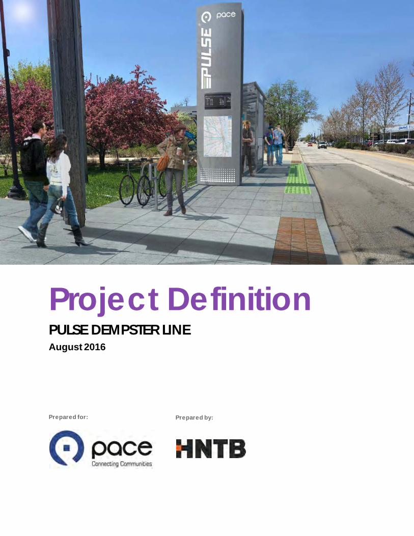
Project Definition PULSE DEMPSTER LINE August 2016
Prepared by: Prepared for:

i
PROJECT DEFINITION PULSE DEMPSTER LINE
PAGE INTENTIONALLY LEFT BLANK
i i
PROJECT DEFINITION PULSE DEMPSTER LINE
Table of Contents Glossary of Terms ix Executive Summary ES-1
The Project ES-1 Project Features and Characterist ics ES-2 Next Steps ES-5
1 Introduction 1 Defining the Project 3 1.1 Dempster Corridor Project Goals 3 1.2 Organization of this Plan Document 3 1.3
2 Corridor Context 6 Corridor Route Description 6 2.1 Land Use Character 6 2.2 Ex isting & Planned Transit Service 9 2.3 Local and Regional Plans 10 2.4 Historical Resources 11 2.5 Detailed Conditions Inventory 13 2.6
3 Existing Ridership Analysis 29 Overview of Route 250 29 3.1 Overall Route 250 Ridership 30 3.2 Average Weekday Boardings by Stop 32 3.3 Ridership by Hour and Direction 33 3.4 Major Transfer Connections 34 3.5 Boardings near Pace-Proposed Pulse Stations 37 3.6 Average Boardings per Trip 38 3.7 Throughput Analysis and Activity by Segment 39 3.8
4 Stations 42 Overview 42 4.1 Station Design 48 4.2 Station Locations 60 4.3 Station Sites 61 4.4 Local Stop Consolidation 127 4.5
5 Running Way 128 Vehicle Operations 128 5.1 Station-Related and Collateral Improvements 128 5.2

i i i
PROJECT DEFINITION PULSE DEMPSTER LINE
Transit Signal Pr iority 128 5.3
6 Running Time Analysis 130 On-Time Performance 130 6.1 Travel Time (On-Board Survey) 135 6.2
7 Vehicles 138 General Vehicle Specif ications 138 7.1 Pulse Vehicle Ex terior 139 7.2 Pulse Vehicle Interior 140 7.3 Vehicle Procurement Schedule 141 7.4 Specialized Tools, Equipment and Training Needs 141 7.5
8 Technology 142 Real-Time Arrival Information 142 8.1
9 Preliminary Operating Plan 153 Corridor Overview 153 9.1 Running Time Estimate 153 9.2 Service Planning Assumptions 160 9.3 Alternative Operating Plans 164 9.4
10 Branding 167 Brand Name 167 10.1 Brand Application Guidelines 167 10.2
11 National Environmental Policy Act Documentation 168 Purpose Statement 168 11.1 Need elements 169 11.2 Goals and Objectives 170 11.3 Logical Termini 170 11.4
12 Stakeholder Involvement 171 Corridor Advisory Group 171 12.1 Agency Coordination and Community Outreach 172 12.2 Property Ow ners and Interest Groups 174 12.3 Future Stakeholder Involvement Activities 175 12.4
13 Financial Plan 176 Capital Cost Estimate 176 13.1 Operations and Maintenance Cost Estimate 191 13.2
14 Ridership Forecast 193 STOPS Model Background 193 14.1 Dempster Corridor Model Parameters 196 14.2 Ridership Forecast Results 201 14.3 Sensit ivity Tests 202 14.4
15 Project Delivery 204 Project Delivery Approach 204 15.1 Intergovernmental Coordination 206 15.2
iv
PROJECT DEFINITION PULSE DEMPSTER LINE
16 Next Steps 210
Appendix A 211 Appendix B 212
Appendix C 213
Appendix D 214 Appendix E 215
Appendix F 216
Appendix G 217 Appendix H 218
Appendix I 219
Appendix J 220 Appendix K 221
Appendix L 222
Figures Figure ES.1: Pulse Dempster Line Stations and Major Transit Connections ES-1 Figure ES.2: Typical Station Layout ES-3 Figure ES.3: Typical Station Layout Rendering ES-3 Figure ES.4: Pulse Dempster Line Project Timeline ES-6 Figure 1.1: Pulse Dempster Line Proposed Stations w ith Major Transit Connections 2 Figure 2.1: Pulse Dempster Line Land Use w ithin One-Half Mile 8 Figure 3.1: Departures per Hour, Average Weekday (Excludes School Trips) 30 Figure 3.2: Average Weekday Ridership, 2000-2015 31 Figure 3.3: Average Weekday Ridership by Month, 2000-2015 32 Figure 3.4: Route 250 Average Weekday Ridership by Hour 34 Figure 3.5: Average Weekday Transfers to/from Route 250, November 2015 36 Figure 3.6: Average Boardings per Trip 39 Figure 3.7: Route 250 Evanston-Bound Boardings, Alightings, and Throughput 40 Figure 3.8: Route 250 O’Hare-Bound Boardings, Alightings, and Throughput 41 Figure 4.1: Pulse Dempster Line Station Locations from Pace 2010 Report 42 Figure 4.2: Pulse Dempster Line Station Location Changes since May 2016 Preliminary Station Location and Site Selection Options Technical Memorandum 43 Figure 4.3: Vertical Marker w ith Branding 49 Figure 4.4: Typical Pulse Station and Feature Set 50 Figure 4.5: Standard Shelter Elevations (Side and Front) 51 Figure 4.6: Pulse Station Render ing w ith Typical Concrete Bus Pad Extents 54 Figure 4.7: Bola Bicycle Rack 55 Figure 4.8: Steely Can Trash Receptacle 56 Figure 4.9: Typical Station Layout 57

v
PROJECT DEFINITION PULSE DEMPSTER LINE
Figure 4.10: Section of a Typical Station 58 Figure 4.11: Compact Station Layout 59 Figure 4.12: Compact Station Layout Rendering 59 Figure 4.13: Pulse Dempster Line Proposed Stations 60 Figure 4.14: O’Hare CRCF Site Plan 64 Figure 4.15: Pace Bus Configuration at O’Hare CRCF at Full Buildout 65 Figure 4.16: O'Hare CRCF Rendering 66 Figure 4.17: Mannheim/Higgins Station Sites 67 Figure 4.18: Lee/Touhy Station Sites 70 Figure 4.19: Lee-Mannheim/Oakton Station Sites 73 Figure 4.20: Des Plaines Metra Station Sites 76 Figure 4.21: Potter Station Sites 81 Figure 4.22: Dee Station Sites 85 Figure 4.23: Dee Eastbound Alternate 2 Station Site 87 Figure 4.24: Western Station Sites 89 Figure 4.25: Cumber land Station Sites 92 Figure 4.26: Milw aukee Station Sites 95 Figure 4.27: Milw aukee Westbound Alternate 2 Station Site 99 Figure 4.28: Harlem Station Sites 100 Figure 4.29: Waukegan Station Sites 103 Figure 4.30: Austin Station Sites 106 Figure 4.31: Dempster-Skokie CTA Station Sites 109 Figure 4.32: Craw ford Station Sites 113 Figure 4.33: Lincolnw ood Station Sites 116 Figure 4.34: Dodge Station Sites 120 Figure 4.35: Dodge Eastbound Alternate 3 Station Site 124 Figure 4.36: Davis CTA/Metra Station Site 126 Figure 5.1: Pulse Dempster Line TSP Implementation Recommendation 129 Figure 6.1: Eastbound Schedule Adherence 134 Figure 6.2: Westbound Schedule Adherence 134 Figure 6.3: Non-Moving Travel Condition Summary (All Trips) 136 Figure 7.1: Branded Pulse Vehicle 139 Figure 7.2: Four-sided Detail of the Pulse Vehicle Wrap 139 Figure 7.3: Pulse Destination Sign 140 Figure 7.4: Branded Pulse Vehicle Interior 140 Figure 10.1: Pace A RT Brand Name and Preliminary Logo 167 Figure 12.1: Pulse Dempster Line Stakeholder Involvement Activity Timeline 171 Figure 13.1: Station Site Subtotal Costs 182 Figure 13.2: Corridor-Level Cost Estimate Formula 183 Figure 13.3: Share of Corridor-Level Capital Cost by Category 188 Figure 14.1: Key STOPS Model Data Inputs 195 Figure 14.2: Additional Districts, Dempster and Milw aukee Corridors 199 Figure 15.1: Dempster Line Implementation Schedule 204

vi
PROJECT DEFINITION PULSE DEMPSTER LINE
Tables Table 2.1: HARGIS Resources Identif ied w ithin One-Quarter Mile of the Pulse Dempster Line 12 Table 2.2: HARGIS Resources Identif ied w ithin One-Quarter Mile of Potential Station Locations 13 Table 2.3: Dempster Corridor Condit ions Inventory Summary 14 Table 2.4: Bus Stops Betw een Zemke Boulevard and I-90 16 Table 2.5: Bus Stops betw een I-90 and Touhy Avenue 16 Table 2.6: Bus Stops betw een Mannheim Road and Lee Street 17 Table 2.7: Bus Stops betw een Touhy Avenue and Lee Street-Mannheim Road 18 Table 2.8: Bus Stops betw een Lee Street and Walnut Avenue 18 Table 2.9: Bus Stops betw een Walnut Avenue and Miner Street 19 Table 2.10: Bus Stops betw een Lee Street-Mannheim Road and I-294 20 Table 2.11: Bus Stops betw een I-294 and Potter Road 20 Table 2.12: Bus Stops betw een Potter Road and Milw aukee Avenue 21 Table 2.13: Bus Stops betw een Milw aukee Avenue and Waukegan Road 22 Table 2.14: Bus Stops betw een Waukegan Road and I-94 23 Table 2.15: Bus Stops betw een I-94 and Crawford Avenue 24 Table 2.16: Bus Stops betw een Crawford Avenue and Dodge Avenue 25 Table 2.17: Bus Stops betw een Dodge Avenue and Oak Avenue 26 Table 2.18: Bus Stops betw een Dempster Street and Church Street and Davis Street and Dempster Street 27 Table 2.19: Bus Stops along Church Street, Davis Street, and Benson Avenue 28 Table 3.1: Top 10 Stops for Route 250 Boardings and Alightings 33 Table 3.2: Ridership near Pace-Proposed Pulse Stations 37 Table 4.1: Pulse Dempster Line Station Location Status Summary 45 Table 4.2: Pulse Dempster Line Station Location Summary 61 Table 4.3: Status of Station Sites Evaluated 62 Table 4.4: Mannheim/Higgins Eastbound Station Site Summary 68 Table 4.5: Mannheim/Higgins Westbound Station Site Summary 68 Table 4.6: Lee/Touhy Eastbound Station Site Summary 71 Table 4.7: Lee/Touhy Westbound Station Site Summary 71 Table 4.8: Lee-Mannheim/Oakton Eastbound Station Site Summary 74 Table 4.9: Lee-Mannheim/Oakton Westbound Station Site Summary 74 Table 4.10: Des Plaines Metra Eastbound Station Site Summary 77 Table 4.11: Des Plaines Metra Westbound Station Site Summary 78 Table 4.12: Potter Eastbound Station Site Summary 82 Table 4.13: Potter Westbound Station Site Summary 82 Table 4.14: Dee Eastbound Station Site Summary 86 Table 4.15: Dee Westbound Station Site Summary 86 Table 4.16: Western Eastbound Station Site Summary 90 Table 4.17: Western Westbound Station Site Summary 90 Table 4.18: Cumberland Eastbound Station Site Summary 93 Table 4.19: Cumberland Westbound Station Site Summary 93

vii
PROJECT DEFINITION PULSE DEMPSTER LINE
Table 4.20: Milw aukee Eastbound Station Site Summary 96 Table 4.21: Milw aukee Westbound Station Site Summary 97 Table 4.22: Harlem Eastbound Station Site Summary 101 Table 4.23: Harlem Westbound Station Site Summary 101 Table 4.24: Waukegan Eastbound Station Site Summary 104 Table 4.25: Waukegan Westbound Station Site Summary 104 Table 4.26: Austin Eastbound Station Site Summary 107 Table 4.27: Austin Westbound Station Site Summary 107 Table 4.28: Dempster-Skokie CTA EastBound Station Site Summary 110 Table 4.29: Dempster-Skokie CTA Westbound Station Site Summary 110 Table 4.30: Crawford Eastbound Station Site Summary 114 Table 4.31: Crawford Westbound Station Site Summary 114 Table 4.32: Lincolnw ood Eastbound Station Site Summary 117 Table 4.33: Lincolnw ood Westbound Station Site Summary 118 Table 4.34: Dodge Eastbound Station Site Summary 121 Table 4.35: Dodge Westbound Station Site Summary 122 Table 6.1: Average Trip Length by Station Pair – Weekday, Eastbound 131 Table 6.2: Average Trip Length by Station Pair – Weekday, Westbound 131 Table 6.3: Summary Running Time and Dw ell Time by Direction and Time Period 132 Table 6.4: 95% Confidence Interval of Average Running Time (Minutes), Excluding Dw ell Time at Time Points 133 Table 6.5: Travel Time Summary 135 Table 6.6: Summary of Average Total Duration Per Trip, AM Peak and PM Peak (H:MM:SS) 137 Table 8.1: System Component and Contract Summary 143 Table 9.1: Route 250 Observed Running Time Breakdow n 155 Table 9.2: TSP Time Savings Estimate 156 Table 9.3: Estimated Pulse Dempster Line Running Time 158 Table 9.4: Estimated Route 250 Future Running Time 159 Table 9.5: Pulse and Local Running Times by Segment, PM Peak Hour, Eastbound 160 Table 9.6: Service Spans and Headw ays for Pulse Dempster Line and Reduced Local Route 250 Service 162 Table 9.7: Ex isting and Future Corridor Service Statistics 164 Table 9.8: Alternative Operating Plan: 15 minute All Day Service 165 Table 9.9: Alternative Operating Plan: Rosemont Extension 166 Table 12.1: Municipalities and Tow nships w ith Corresponding Proposed Station Sites 172 Table 13.1: Pulse Dempster Line Station Sites 176 Table 13.2: Typical Pulse Station Features 179 Table 13.3: Station Site Capital Costs - All Sites 179 Table 13.4: Station Site Capital Costs - Selected Sites and Site Subtotal 184 Table 13.5: Breakdow n of Costs included in the Site Subtotal 185 Table 13.6: Contractor Costs 186 Table 13.7: Project Costs 187 Table 13.8: Corridor-Level Capital Cost Category Totals 187 Table 13.9: Escalated Corridor-Level Capital Costs 189 Table 13.10: Escalated Vehicle Costs 189

vii i
PROJECT DEFINITION PULSE DEMPSTER LINE
Table 13.11: Total Project Costs 190 Table 13.12: Current and Future Unit O&M Cost, by Year of Expenditure 192 Table 13.13: Existing and Future O&M Cost 192 Table 14.1: Summary of Calibration Results and Baseline 2015 Ridership Forecast for Pace System and the Dempster Corridor 201 Table 14.2: Summary of Sensit ivity Tests 203

PROJECT DEFINITION PULSE DEMPSTER LINE
Glossary of Terms ix
Glossary of Terms Airport Transit System (ATS) Americans w ith Disabilities Act (ADA) Arterial Rapid Transit (ART) Automatic Passenger Counter (APC) Automatic Voice Annunciation (AVA) Average Daily Traff ic (ADT) Bus Rapid Transit (BRT) Capital, Financing and Infrastructure Department (CFI) Chicago Department of Aviation (CDA) Chicago Metropolitan Agency for Planning (CMAP) Chicago Transit Authority (CTA) Congestion Mitigation and Air Quality (CMAQ) Federal Transit Administration (FTA) General Engineering Contractor (GEC) General Transit Feed Specif ication (GTFS) Historic and Architectural Resources Geographic Information System (HARGIS) Illinois Department of Transportation (IDOT) Illinois Historic Preservation Agency (IHPA) Innovation, Coordination, and Enhancement Program (ICE) Intergovernmental Agreements (IGAs) Joint Use and Consolidated Rental Car Facility (CRCF) Letters of Interest and Qualif ications (LIQ) Metra North Central Service (NCS) Metra UP-North (UP-N) Metra UP-Northw est (UP-NW) Metropolitan Water Reclamation District (MWRD) National Transit Database (NTD) Northw est Suburban Municipal Joint Action Water Agency (NSMJAWA) O’Hare Airport Consolidated Rental Car and Joint Use Facility (CRCF) On-Time Performance (OTP) Operations & Maintenance (O&M) Regional Transportation Authority (RTA) Simplif ied Trips-on-Project Softw are (STOPS) Stakeholder Involvement Plan (SIP) Transit Oriented Development (TOD) Transit Signal Priority (TSP) Transit Signal Priority Implementation Program (TSPIP)

PROJECT DEFINITION PULSE DEMPSTER LINE
Executive Summary ES-1
Executive Summary THE PROJECT In 2001, Pace published Vision 2020, w hich identif ied the Dempster Corridor Arterial Rapid Transit (ART) project as one of 24 ART corridors that w ould enhance the regional transit netw ork and intersuburban travel. In 2009, Pace’s Arterial Rapid Transit Study evaluated and prioritized these corridors for phased implementation. The Dempster Corridor (see Figure ES.1) w as identif ied as the second ART project to be implemented, after the Milw aukee Corridor. In 2010, Pace completed a Dempster Station Location Study identifying preliminary station locations along the corridor. ART service has since been branded as Pulse, w ith the Milw aukee and Dempster ART projects now referred to as the Pulse Milw aukee Line and the Pulse Dempster Line.
FIGURE ES.1: PULSE DEMPSTER LINE STATIONS AND MAJOR TRANSIT CONNECTIONS
Note: Figure ES-1 reflects the current proposed stations, which vary from the original station set suggested in the 2010 Station Location Study. A Potter Road station is also under consideration as an alternate for the Dee station.

PROJECT DEFINITION PULSE DEMPSTER LINE
Executive Summary ES-2
The Pulse Dempster Line is defined by the follow ing characteristics:
Approximately 15 miles in length.
17 station locations, including tw o terminals and 15 intermediate station pairs.
Runs north from the new O’Hare Airport Consolidated Rental Car and Joint Use Facility (CRCF) and the O’Hare Kiss ‘N’ Fly/O’Hare Metra Transfer station to the Des Plaines Metra station in the City of Des Plaines, and then east to the Chicago Transit Authority’s (CTA) Purple Line Davis Street station in the City of Evanston.
Connects to the Airport Transit System (ATS) at O’Hare, the Metra North Central Service (NCS) Line, the Metra UP-Northw est (UP-NW) Line, the Pulse Milw aukee Line, the CTA Yellow Line, the Metra UP-North (UP-N) Line, the CTA Purple Line, and numerous local Pace and CTA bus routes at stations along the route.
As Pace’s second Pulse line, it w ill improve connectivity and increase transit service levels through higher frequencies, travel time savings, and station and rider amenities. The Pulse Dempster Line w ill connect to the Pulse Milw aukee Line and eventually to three additional planned routes serving Mannheim – LaGrange Road, Touhy Avenue and Harlem Avenue.
PROJECT FEATURES AND CHARACTERISTICS
Capital Improvements The Pulse Dempster Line service w ill operate in mixed traff ic, w ith tw o off-street terminal stations at the Davis CTA/Metra station in the City of Evanston and the new O’Hare Kiss ‘N’ Fly/O’Hare Metra Transfer station and CRCF facility at O’Hare International Airport; and 15 additional intermediate station pairs, for a total of 32 stations. It is expected that the Dempster Line stations w ill use the typical station design and configuration developed for the Milw aukee Line w ith some modif ications to reflect design development of the Milw aukee Line stations. Figure ES.2 illustrates the typical station w hich has a 12.5 foot by 60 foot footprint, featuring a 12-inch near-level boarding platform w ith accessible ramps, based on Americans w ith Disabilities Act (ADA) standards, at both ends connecting the station to the surrounding sidew alk netw ork. Smaller, more compact stations w ith a modif ied feature set w ill be used w here necessary to accommodate constrained right-of-w ay conditions.
Planned station amenities include the follow ing features (see Figure ES.3):
• Raised platform for near-level boarding, enabling passengers to board the bus w ithout requiring the bus to kneel;
• Semi-custom branded shelters; • Benches, trash receptacles, and bicycle racks; • A vertical marker conveying the Pulse brand and featuring real-time information signage, Pulse route
information, and local/regional transit maps; • Infrared overhead heating w ithin the shelter; • Electric pavement snow -melt system; • Railings along the back of the platform and along the access ramps; • Landscaping.

PROJECT DEFINITION PULSE DEMPSTER LINE
Executive Summary ES-3
From east to w est, the Pulse Dempster Line w ill traverse the communities of Evanston, Skokie, Morton Grove, Niles, Park Ridge, Des Plaines, Rosemont and Chicago.
FIGURE ES.2: TYPICAL STATION LAYOUT
FIGURE ES.3: RENDERING OF THE TYPICAL STATION LAYOUT

PROJECT DEFINITION PULSE DEMPSTER LINE
Executive Summary ES-4
Operating Plan The preliminary operating plan, based on running time and ridership analysis, reflects implementation of the new Pulse service and corresponding changes to local Route 250 service. Reducing the number of intermediate stops w ill enable time savings compared to the existing Route 250 w hile providing improved service to nearly all existing riders.
The operating plan consists of the follow ing w eekday service characteristics:
Pulse Dempster Line
• Ten (10) minute peak headw ays (three morning and three afternoon hours) • 15-minute off-peak headw ays (most of the day) • 30-minute off-peak headw ays (three late night hours) • Service span of 20 hours per day
Route 250
• Reduced to 35-minute peak headw ays • Reduced to 70-minute off-peak headw ays • Reduced service span to 16 hours per day
Operations and maintenance (O&M) costs are estimated based on revenue-hours of service. For the combined Pulse and future local service, the estimated annual revenue hours are 67,100. This represents a 95% increase over the 34,400 annual revenue hours estimated for the approved service improvements for Route 250 being implemented in August 2016. Pulse Dempster Line and Route 250 O&M costs are estimated at approximately $7.5 million (in 2019 dollars).
Technology Requirements Chapter 8 documents the requirements for the real-time arrival information system, audio system, cellular communications equipment, and the requirements for content management softw are (CMS) and media players. For the Milw aukee Line, Pace is issuing an Invitation for Bid (IFB) for system integration of real-time arrival information signage. The systems integrator w ill purchase and install a real-time information system for displaying bus arrival times at Pulse stations, standard f ixed route bus stops, and transit centers including integration of the necessary CMS and media players. This system is anticipated to be functional before Dempster Line construction begins. Pace anticipates that the technology features w ill be delivered as part of station construction for the Dempster Line.
Implemented through a separate project, transit signal priority (TSP) is anticipated to improve schedule reliability for the Dempster Line. TSP is anticipated to be implemented along the Dempster Line corridor prior to the commencement of Pulse service.
Financial Plan A capital cost estimate w as developed to a level of detail appropriate for the Project Definition phase. Capital costs consist primarily of those related to station construction and vehicle procurement. The estimated total station capital cost is approximately 12.6 million (in 2016$). The Dempster Line preliminary operating plan w ould require 18 Pulse vehicles (15 regular service plus three spares) and f ive (5) vehicles for Route 250. Pulse vehicles w ill cost

PROJECT DEFINITION PULSE DEMPSTER LINE
Executive Summary ES-5
approximately $9.6 million (in 2016$). The total project capital costs are estimated at approximately $22.2 million (in 2016$).
Pace intends to fund the Pulse Dempster Line w ith local, regional, and federal sources, potentially including a federal Congestion Mitigation and Air Quality (CMAQ) grant, a Regional Transportation Authority (RTA) Innovation, Coordination, and Enhancement (ICE) grant, and Federal Transit Administration Section 5307 formula funds. Federal discretionary capital funding has not yet been secured for the project.
Ridership The ridership forecast for the Pulse Dempster Line project w as developed using the Federal Transit Administration’s Simplif ied Trips-on-Project Softw are (STOPS) model. The model incorporates the proposed baseline operating plan, including any proposed service changes on Route 250, as w ell as demographic and trip data. STOPS model inputs include Census Transportation Planning Products (CTPP) journey to w ork data, Metropolitan Planning Organization (MPO) travel time skims (i.e. highw ay travel times), MPO demographic data, ridership data, and General Transit Feed Specif ication (GTFS) transit data. The model is calibrated using existing ridership and produces ridership estimates for no-build and build scenarios. The STOPS model forecasts 7,125 daily trips on the Pulse Dempster Line compared to the 3,002 existing daily trips on Route 250. This increase is largely attributed to an increase in revenue hours.
Stakeholder Involvement Throughout the Project Definition phase, stakeholder involvement activities for the Pulse Dempster Line focused on coordination w ith government agencies at the local, state, and federal level. Tw o Corridor Advisory Group (CAG) meetings, held on March 23rd, 2016 and June 29th, 2016, engaged local agency representatives to solicit feedback and provide project updates. The 37 attendees at the f irst meeting, and 27 attendees at the second meeting, included representatives from local agencies, private and public properties, municipalities, state agencies and off ices, and a federal agency.
As the Project Definition phase concludes and the project advances into the environmental phase, stakeholder involvement and outreach efforts w ill be a priority as the National Environmental Policy Act (NEPA) documentation is prepared. Coordination w ith communities, government off icials, public agencies, and individual interest groups w ill continue and emphasis w ill be placed on public involvement and broad community outreach. Guided by the Stakeholder Involvement Plan established for the Dempster Line, Pace w ill connect w ith its customers, the general public, affected property ow ners, and business groups through outreach activities including a project w ebsite, project new sletters, public meetings, and one-on-one stakeholder meetings.
NEXT STEPS
The planning effort to define the features and characteristics of the Pulse Dempster Line concludes in August 2016, w hen the Project Definition Report is f inalized. At the conclusion of this planning phase, the Pulse Dempster Line project is expected to enter the federally mandated National Environmental Policy Act review process. The NEPA documentation is expected to be complete around the third quarter of-2017, follow ed by engineering, permitting and property acquisition w hich w ill continue until mid-2018. Utilizing a design-bid-build delivery method, construction is slated to begin in late 2018 and continue into 2019 w ith service beginning in the third quarter of 2019 (see Figure ES.4).

PROJECT DEFINITION PULSE DEMPSTER LINE
Executive Summary ES-6
FIGURE ES.4: PULSE DEMPSTER LINE PROJECT TIMELINE

PROJECT DEFINITION PULSE DEMPSTER LINE
Introduction 1
1 Introduction The Pulse Dempster Line Project Definition defines Pace’s second Arterial Rapid Transit (ART) project including capital improvements, a preliminary operating plan, technology requirements, f inancial estimates and plans, and a ridership forecast. The ART service has been branded as Pulse, w ith the f irst ART project on Milw aukee Avenue and the Dempster corridor ART project now referred to as the Pulse Milw aukee Line and the Pulse Dempster Line, respectively. This report summarizes the various technical memoranda, environmental documentation, stakeholder involvement activities, and other related Pulse Program activities that have occurred during the Project Definition phase.
In 2001, Pace published Vision 2020, w hich identif ied the Dempster Corridor ART project as one of 24 corridors that w ould enhance the regional transit netw ork and inter-suburban travel. In 2009, Pace’s Arterial Rapid Transit Study evaluated and prioritized these corridors for phased implementation. Project Definition for the f irst Pulse project, the Pulse Milw aukee Line, w as completed in December of 2014. Stakeholder involvement activities continued throughout the environmental review phase in 2015. Project design occurred in 2015 and 2016 w ith construction scheduled for late 2016 and service anticipated to begin in 2017.
The Dempster Line w as identif ied as the second Pulse project to be implemented. In 2010, Pace completed a Dempster Station Location Study identifying preliminary station locations along the corridor. Project Definition and stakeholder involvement activities examined these station locations further and identif ied changes, opportunities, and challenges. Figure 1.1 show s the current station locations under consideration.
PROJECT DEFINITION PULSE DEMPSTER LINE
Introduction 2
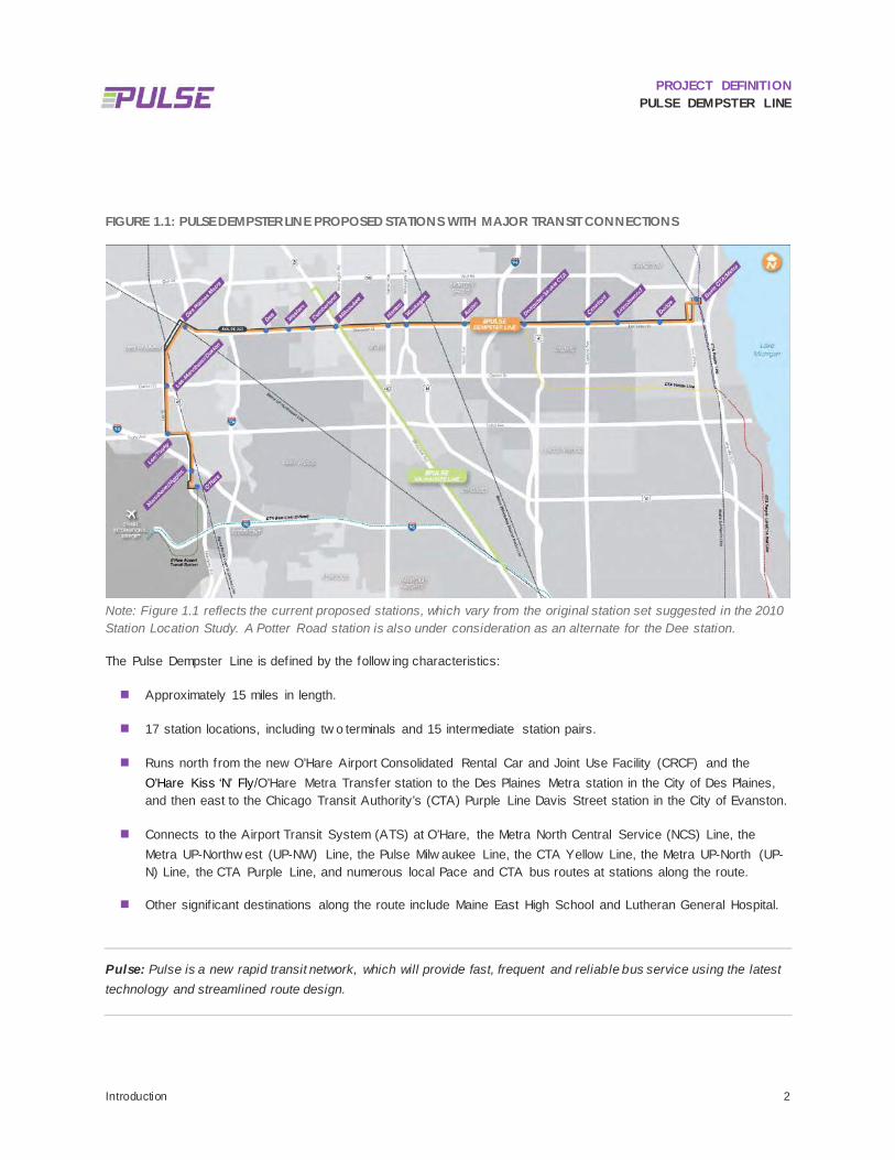
FIGURE 1.1: PULSE DEMPSTER LINE PROPOSED STATIONS WITH MAJOR TRANSIT CONNECTIONS
Note: Figure 1.1 reflects the current proposed stations, which vary from the original station set suggested in the 2010 Station Location Study. A Potter Road station is also under consideration as an alternate for the Dee station.
The Pulse Dempster Line is defined by the follow ing characteristics:
Approximately 15 miles in length.
17 station locations, including tw o terminals and 15 intermediate station pairs.
Runs north from the new O’Hare Airport Consolidated Rental Car and Joint Use Facility (CRCF) and the O’Hare Kiss ‘N’ Fly/O’Hare Metra Transfer station to the Des Plaines Metra station in the City of Des Plaines, and then east to the Chicago Transit Authority’s (CTA) Purple Line Davis Street station in the City of Evanston.
Connects to the Airport Transit System (ATS) at O’Hare, the Metra North Central Service (NCS) Line, the Metra UP-Northw est (UP-NW) Line, the Pulse Milw aukee Line, the CTA Yellow Line, the Metra UP-North (UP-N) Line, the CTA Purple Line, and numerous local Pace and CTA bus routes at stations along the route.
Other signif icant destinations along the route include Maine East High School and Lutheran General Hospital.
Pulse: Pulse is a new rapid transit network, which will provide fast, frequent and reliable bus service using the latest technology and streamlined route design.

PROJECT DEFINITION PULSE DEMPSTER LINE
Introduction 3
As Pace’s second Pulse line, the Dempster Line w ill improve connectivity and increase transit service levels through higher frequencies, travel time savings, and station and rider amenities. The Pulse Dempster Line w ill connect to the Pulse Milw aukee Line and eventually to three additional planned routes serving Mannheim – LaGrange Road, Touhy Avenue and Harlem Avenue.
DEFINING THE PROJECT 1.1
Pace is undertaking a planning effort to define the features and characteristics of the Pulse Dempster Line. This report describes preliminary assumptions regarding station locations and station amenities; the development of station designs, vehicle specif ications, and technology requirements; the application of brand elements; the operating plan; and cost estimates. At the conclusion of this planning effort, the Project Definition Report w ill serve as a reference and resource for Pace, project stakeholders, and the general public.
DEMPSTER CORRIDOR PROJECT GOALS 1.2
Building on the overall Pace ART goals articulated in previous studies, the follow ing project goals for the Dempster Line have been developed:
1. Encourage suburban transit usage through the establishment of a netw ork of higher-quality line-haul routes;
2. Improve the visibility and perception of suburban bus transit service; and
3. Support transportation, land use and grow th objectives identif ied in the study corridor.
ORGANIZATION OF THIS PLAN DOCUMENT 1.3
The follow ing sections of this Project Definition Report are generally organized around the seven elements of bus rapid transit (BRT) that distinguish premium bus service: stations, running w ay, vehicles, technology, branding, and the operating plan.1 The remaining sections address the stakeholder involvement process, National Environmental Policy Act (NEPA) documentation, project delivery, and the next steps needed to advance the project. Technical memoranda available under separate cover, as noted throughout the report, document technical analyses and f indings in more detail. This Project Definition Report serves to summarize the relevant conclusions that w ill inform design and engineering in the next phase of the project.
The follow ing sections present initial assumptions based on past analyses, summarize additional analysis, and document confirmed and pending decisions. The general content of the sections that follow is described briefly below :
Corridor Context: Existing conditions in the corridor are presented, including physical infrastructure, land uses, existing and planned transit service, local plans and studies, historical resources, and a detailed conditions inventory by subsection.
Existing Ridership Analysis: Route 250 ridership from 2000 to 2015 w as analyzed to examine local route operation in the corridor and inform station location development.
1 Transportation Research Board. Transit Cooperative Research Program. Bus Rapid Transit Practitioner's Guide (TCRP Report 118). Transportation Research Board, 2007.

PROJECT DEFINITION PULSE DEMPSTER LINE
Introduction 4
Stations: General station locations and specif ic station sites w ere refined through technical analysis, stakeholder involvement, and conceptual design. Functional requirements and conceptual layouts for both terminal stations and intermediate stations are defined. Station designs are based on design standards for the Pulse Milw aukee Line w ith refinements as needed for the operation of the Pulse Dempster Line. The functional requirements inform the cost estimates and serve as the basis of design for the engineering phase.
Running Way: After conducting physical conditions and travel time inventories, a strategy for station area roadw ay treatments is identif ied, including right-of-w ay requirements, curb reconstruction needs and crossw alk and sidew alk improvements. Information on the RTA’s Regional TSP Implementation Program (RTSPIP) and its application in the Dempster Corridor are also discussed for reference.
Running Time Analysis: More detailed analysis of Route 250 operations, including on-time performance and on-board travel time data, w as conducted to inform the Preliminary Operating Plan development.
Vehicles: Preliminary requirements for Pulse vehicles are documented, reflecting recently developed specif ications used in recent Pulse vehicle purchases that ensure a unique identity.
Technology: A technology strategy developed for the Pulse Milw aukee Line service has been further developed w ith specif ications for real-time arrival information signs and systems.
Preliminary Operating Plan: The Preliminary Operating Plan includes running time estimates for Pulse Dempster Line service and Route 250, an initial baseline service plan, and alternative operating plans. The Preliminary Operating Plan informed the development of the Operating and Maintenance Cost Estimate included in the Financial Plan. The operating plan provides a preliminary schedule that reflects Pulse frequency and service span, station locations and f leet requirements, and also includes service reallocation recommendations for the overlapping local Route 250 and other connecting services.
Branding: Based on a branding strategy developed concurrently w ith the Pulse Milw aukee Line, the Pulse Dempster Line Project Definition report documents the advancement of the Pulse brand and its application to Pulse features.
NEPA Documentation: The Purpose and Need Statement and Categorical Exclusion checklist documentation required to meet NEPA requirements are summarized.
Stakeholder Involvement: Outreach and coordination w ith federal, state, and local agencies; municipalities; interest groups; and the general public, are summarized.
Financial Plan: Preliminary capital cost estimates are provided for project implementation, documenting provisions for stations, technology equipment, roadw ay improvements, property acquisition, vehicles, other station elements, and estimated costs of engineering and other professional services. An operations and maintenance (O&M) cost estimate for the initial phase of implementation includes provisions for vehicle operations, fuel, vehicle maintenance, station maintenance, technology elements, fare collection, and allocated general administration costs.
Ridership Forecast: A ridership forecast for the initial year of operation w as developed by applying a forecasting method that pivots from Route 250 ridership, reflecting service enhancements planned for the corridor and BRT experience in similar corridors elsew here.

PROJECT DEFINITION PULSE DEMPSTER LINE
Introduction 5
Project Delivery: A project schedule provides key elements of the various project delivery phases and discusses relevant considerations and recommendations regarding intergovernmental agreements.
Next Steps: An overview of the next steps required to implement the Pulse Dempster Line and a summary of upcoming project activities are provided.

PROJECT DEFINITION PULSE DEMPSTER LINE
Corridor Context 6
2 Corridor Context CORRIDOR ROUTE DESCRIPTION 2.1
The route for the Pulse Dempster Line begins at the O’Hare CRCF at Zemke Boulevard and Mannheim Road. The section of Mannheim Road from Zemke Boulevard to just north of Higgins Road is currently under construction by the Illinois Department of Transportation. The corridor has a six lane cross-section w ith a station at the intersection of Mannheim Road and Higgins Road. North of Higgins, Mannheim Road reduces dow n to four lanes under the Jane Addams Tollw ay (I-90) in Rosemont. The Dempster Line turns w est on Touhy Avenue, a four lane arterial road.
The Dempster Line continues north through Des Plaines at Lee Street, a tw o lane collector road through a residential area. The eastbound route continues on Lee Street-Mannheim Road into dow ntow n Des Plaines. Mannheim Road, north of Algonquin Road, is a one-w ay northbound street w ith three through lanes. Westbound Dempster Line buses w ill travel one block w est on Graceland Avenue.
When the Dempster Line reaches Miner Street, it turns east to serve the Des Plaines Metra station and dow ntow n Des Plaines before proceeding east on Dempster Street. Dempster Street, from dow ntow n Des Plaines through Skokie, is a major arterial road w ith tw o to three through lanes in each direction and many curb cuts serving various auto-oriented developments.
At Milw aukee Avenue in Niles, in each direction tw o through lanes of Dempster Street are grade separated, traveling under Milw aukee Avenue. Milw aukee Avenue is the location of a major transfer site betw een the Pulse Dempster Line and Pulse Milw aukee Line, w hich w ill be constructed in the spring of 2017.
As the Dempster Line route travels through Niles and into Morton Grove, it crosses over the Edens Expressw ay (I-94) and enters Skokie. In Skokie, the Dempster Line w ill provide an opportunity to transfer to or from the CTA Yellow Line at Dempster. When the Dempster Line enters Evanston, just east of Dodge Street, Dempster narrow s to one through lane in each direction as land uses transition from suburban strip mall retail to residential neighborhoods and historic districts. The Dempster Line leaves Dempster Street to travel north on Oak Street (w estbound Dempster Line buses w ill utilize Ridge Avenue, one block w est) and then east on Church Street (w estbound Dempster Line buses w ill utilize Davis Street).
LAND USE CHARACTER 2.2
Existing land use data w as obtained from a 2010 geographic information system (GIS) dataset compiled by Chicago Metropolitan Agency for Planning (CMAP). The w estern portion of the route that runs north and south through Rosemont and Des Plaines, begins at the O’Hare Kiss ‘N’ Fly and CRCF, w hich consists of commercial and transportation land uses, and travels through residential and open space areas to a predominantly commercial area w ith some institutional and industrial land. The central portion, through Park Ridge, Niles, and Morton Grove, is

PROJECT DEFINITION PULSE DEMPSTER LINE
Corridor Context 7
primarily commercial or institutional w ith some residential and open space land uses. The eastern portion of the Pulse Dempster Line corridor transitions from a residential, commercial, and open space area at the w estern boundary of Skokie to a predominantly commercial and mixed-use area in dow ntow n Evanston. Figure 2.1 show s the corridor, station locations, and land use w ithin a half-mile.

PROJECT DEFINITION PULSE DEMPSTER LINE
Corridor Context 8
FIGURE 2.1: PULSE DEMPSTER LINE LAND USE WITHIN ONE-HALF MILE

PROJECT DEFINITION PULSE DEMPSTER LINE
Corridor Context 9
EXISTING & PLANNED TRANSIT SERVICE 2.3
2.3.1 Pace Suburban Bus Pace Route 250 operates w ithin the Dempster corridor w ith w eekday service every 20 minutes during the peak period, 30 minutes during the midday, and roughly 40-60 minutes in the evening. In August 2016, service on Route 250 w ill be enhanced w ith increases to w eekday off-peak service. Route 250 w ill operate approximately every 20 minutes during the peak and midday and approximately every 30 minutes during the evening. No changes are being made to w eekend service. As the new Pulse Dempster Line service comes on-line in the Dempster corridor, the Pulse service w ill offer 10-minute headw ays during peak hours and 15 minute headw ays during off -peak hours and on w eekends, follow ing a span of service that is equal to or better than the corridor’s existing local service as w ell as the expanded service implemented in August 2016. Thirty-minute Pulse headw ays w ill be offered during late night hours. Service reductions on Route 250 are being considered, including a reduction in the span of service, particularly during evenings, during w hich time Pulse w ould be the only available service on the corridor. Preliminary operating plans call for Route 250 to operate at headw ays of 30 minutes or greater during daytime hours, and 60 minutes during evenings and w eekends. How ever, service reductions on Route 250 w ill be subject to further evaluation by Pace and w ill be subject to a public hearing.
The Dempster Line w ill operate from 5:00 am to 1:00 am on w eekdays. During a three hour morning and afternoon peak period, the Pulse Dempster Line w ill feature 10 minute headw ays, w ith 15 minute headw ays throughout the rest of the day and 30 minute headw ays during late evening hours.
Many local Pace routes make connections along Dempster Street, including Routes 208, 210, 211, 213, 215, 221, 223, 226, 240, 241, 270, 330, 410, 423, and 626. In 2017, Pace w ill begin construction on the Pulse Milw aukee Line, w hich w ill provide a transfer opportunity betw een Pulse services at Milw aukee Avenue. Another planned Pulse service that w ill connect to the Dempster Line is the future Pulse Touhy Line, w ith a connection at Lee Street and Touhy Avenue.
The Village of Niles operates three community circulator routes, collectively referred to as the Niles Free Bus and designated as Pace Routes 410, 411, and 412. Recently, Pace and the Village of Niles completed a Niles Circulator Modernization Study, aimed at identifying changes to improve the eff iciency of the Niles Free Bus service, boost ridership, and better complement the planned Pulse service. As a result of the study, Route 410 w as added and service on Route 413 w as discontinued. These service changes began in May of 2016.
2.3.2 Chicago Transit Authority In addition to Pace connections, the Dempster Line w ill also make connections to the CTA “L” heavy rail system at the CTA Yellow Line Dempster-Skokie station in Skokie and at the CTA Purple Line Davis station in Evanston. CTA bus connections w ill include Route 54A and 97 at the CTA Yellow Line, Routes 93 and 206 at Dodge Avenue, and Routes 93, 201 and 205 at Davis CTA/Metra.
2.3.3 Metra The Dempster Line w ill make connections to Metra at O’Hare w ith the Metra North Central Service (NCS), w hich travels betw een dow ntow n Chicago to Antioch; at Des Plaines Metra w ith the Union Pacif ic Northw est Line (UP-NW),

PROJECT DEFINITION PULSE DEMPSTER LINE
Corridor Context 10
w hich travels betw een dow ntow n Chicago and Harvard and McHenry; and at Davis CTA/Metra w ith the Union Pacif ic North Line (UP-N), w hich travels betw een dow ntow n Chicago and Kenosha, Wisconsin.
At O’Hare, the Dempster Line w ill connect to Pace Route 330 and other regional bus services at the O’Hare CRCF and w ith Metra’s NCS, w hich is located in an existing station facility behind the CRCF. The CRCF is a multimodal facility that w ill provide connections to Metra and Pace as w ell as an extension of the ATS, w hich w ill connect CRCF to all of the terminals at O’Hare International Airport and the CTA Blue Line O’Hare station.
LOCAL AND REGIONAL PLANS 2.4
As Pace began outreach activities w ith local communities and transportation agencies, local and regional plans along the Dempster Line corridor w ere researched and documented in a the Local and Regional Plan Review technical memorandum. Most communities have comprehensive plans that address housing, transportation, land use, economic development, public facilities, recreation, and other issues of local concern and these are summarized in the Tech Memo. Many communities include multi-modal, transit-oriented development, and urban design plans in the comprehensive plan or have separate plans that address these topics.
As the Dempster Line project advances tow ards implementation, Pace w ill continue to coordinate w ith local communities on planning activities along the Dempster Line corridor. In addition to coordinating w ith ongoing development included in community plans, Pace w ill pay close attention to the follow ing projects:
Redevelopment at Mannheim Road and Higgins Road in Des Plaines and Rosemont. Des Plaines has approved a project w hich includes a hotel; a stand-alone restaurant; and a gas-station/convenience facility that includes a convenience store, tw o quick-service restaurants, a car w ash, and a CNG refueling station. The proposed schedule indicates that bridge, road and utility improvements and the construction of the gas station/convenience facility and the stand alone restaurant w ill be complete in 2016. Hotel construction w ould be complete in 2017.2
The Preliminary Engineering for Farmers Creek Flood Control Improvements project w ithin Maine Tow nship including the construction of new sew er pipe under Dempster Street from Vernon Lane on the east to the Interstate 294 Dempster Street Exit Ramp on the w est. The project is currently in the engineering phase w ith permit and easement w ork underw ay. It is anticipated that the project construction w ill be put out for bid in third quarter 2016 (see Appendix A).3
Infrastructure and pedestrian facility improvements.
Redevelopment activity near the Dempster Street and Milw aukee Avenue and Dempster Street and Harlem Avenue intersections.
Implementation of the Niles Free Bus Modernization Project (effective May 2, 2016).4
2 City of Des Plaines Community and Economic Development Department. (2016, January 13). Memorandum. Retrieved January 22, 2016, from http://www.desplaines.org/ArchiveCenter/ViewFile/Item/1457 3 Metropolitan Water Reclamation District of Greater Chicago. (2012). Scope of Work Preliminary Engineering for Farmers-Prairie Flood Control Improvements. 4 Nelson\Nygaard Consulting Associates, Inc. (October 2014). Niles Free Bus Modernization Project. Pace Suburban Bus.

PROJECT DEFINITION PULSE DEMPSTER LINE
Corridor Context 11
Redevelopment near the Dempster-Skokie CTA station in Skokie.5
2.4.1 Regional Transit Plans As the Pulse Dempster Line project progresses, Pace w ill need to coordinate w ith regional transportation agencies including the CTA, the Chicago Department of Aviation (CDA), and Metra. Pace initiated the Pace/CTA North Shore Transit Service Coordination Plan & Market Analysis on January 27, 2016.6 The plan w ill review and coordinate Pace and CTA services in Evanston, Skokie, Chicago, and other North Shore communities. The project is underw ay and the plan w ill be developed over the next tw o years. As the study progresses, it w ill be important to coordinate efforts w ith planning for the Dempster Line and evaluate the potential changes in transit service that could impact the Pulse Dempster Line project.
The O’Hare Modernization Program includes the construction of a new Consolidated Rental Car and Joint Use Facility (CRCF) located at the southeast corner of Mannheim Road and Zemke Boulevard.7 The CRCF facility w ill establish an integrated facility for rental car operations that is served by an extension of the ATS. The facility w ill also provide direct access to Metra North Central Service via the existing Metra O’Hare Transfer Station. Facility plans include a bus plaza – including bays slated for Pulse Dempster Line and Route 250 – public parking, and a transit oriented development (TOD) area. Route 250 currently serves the existing Kiss ‘N’ Fly and in the 2010 Station Location Study, it w as anticipated that the Pulse Dempster Line w ould also serve the existing Kiss ‘N’ Fly. How ever, both services w ill shift to the CRCF and new Kiss ‘N’ Fly once it is completed.
HISTORICAL RESOURCES 2.5
The 2010 study did not include a review of the Illinois Historic Preservation Agency’s (IHPA) Historic and Architectural Resources Geographic Information System (HARGIS) database nor note potential historic resources in the vicinity of preliminary station locations. The Historic Resources Review Technical Memorandum developed during this Project Definition phase documented these historic resources relative to the Pulse Dempster Line. The resources identif ied using HARGIS and additional resources observed during f ield visits w ere used as screening criteria for station locations during this Project Definition phase of. The Historical Resources Review should also inform Pace’s approach to the environmental review phase w ith particular regards to the resources and historic districts to be evaluated further as part of the Section 106 process and the coordination that may be required w ith the Illinois State Historic Preservation Office (SHPO).
For the Technical Memorandum, historic resources—such as historic districts and properties—w ere identif ied in HARGIS and the raw data w as dow nloaded and screened to identify resources w ithin a quarter mile of the Pulse Dempster Line. These resources w ere compiled into the table in Appendix B and displayed on the maps in Appendix C using geocoding tools. The sections below summarize the historic resources data collection process.
5 HNTB. (December 2015). Program Management Oversight Dempster Corridor Site Visit. 6 Pace Suburban Bus. (2015). Request for Proposal No. 414143. Pace/CTA North Shore Transit Service Coordination Plan & Market Analysis. 7 U.S. Department of Transportation. (n.d.). Chicago O'Hare International Airport Consolidated Joint Use Facility. Retrieved January 8, 2016, from https://www.transportation.gov/tifia/financed-projects/chicago-ohare-international-airport-consolidated-joint-use-facility

PROJECT DEFINITION PULSE DEMPSTER LINE
Corridor Context 12
2.5.1 HARGIS Data To identify historic resources located along the Pulse Dempster Line, the HARGIS database w as accessed on January 7, 2016.8 The HARGIS database identif ies historic districts and properties that may consist of a site, building, structure, landscape, or object of historic signif icance. The HARGIS database contains properties that are either listed in the National Register of Historic Places 9 or have been determined eligible for listing in the Register. In addition, it includes properties that have been documented as part of a historic property survey, but for w hich no determination of eligibility has been made.
Definition: The National Register of Historic Places is the official list of the Nation's historic places worthy of preservation. Authorized by the National Historic Preservation Act of 1966, the National Park Service's National Register of Historic Places is part of a national program to coordinate and support public and private efforts to identify, evaluate, and protect America's historic and archeological resources.
Historic districts and properties listed in HARGIS w ere identif ied and dow nloaded for the area generally betw een Golf Road/Emerson Street/Sheridan Road, Lake Michigan, South Boulevard/Oakton Street and Wolf Road and betw een Golf Road, River Road, I-190 and O’Hare Airport/Wolf Road.
2.5.2 Historic Districts and Properties According to the HARGIS database, there are three historic districts and 359 properties listed w ithin one-quarter (1/4) mile of the Pulse Dempster Line. Table 2.1 identif ies the number of properties identif ied by property type and the total number identif ied.
TABLE 2.1: HARGIS RESOURCES IDENTIFIED WITHIN ONE-QUARTER MILE OF THE PULSE DEMPSTER LINE
HARGIS Property Type Number Identified
Entered in the National Register 17
Part of a National Register Historic District 21
Part of a Historic District – Contributing 174
Part of National Register Historic District – Non-contributing 102
Determined eligible for the National Register 1
Undetermined 44
Total Properties Identified 359
8 Il l inois Historic Preservation Agency. Historic Architectural Resources Geographic Information System. Retrieved on January 7, 2016 from http://gis.hpa.state.i l.us/hargis/. 9 National Register of Historic Places. Retrieved from http://www.nps.gov/nr/

PROJECT DEFINITION PULSE DEMPSTER LINE
Corridor Context 13
Based on the data collected from HARGIS, three historic districts w ere identif ied proximate to the Pulse Dempster Line:
Evanston Ridge Historic District;
George B. Dryden House Historic District; and
Evanston Lakeshore Historic District.
Of the 359 listed properties w ithin one-quarter (1/4) mile of the Dempster Line corridor approximately 241 HARGIS properties are w ithin one-quarter mile of the individual station locations identif ied in the Station Location Selection for the Dempster ART study. Table 2.2 lists the number of HARGIS resources (properties and districts combined) identif ied w ithin one-quarter (1/4) mile of potential station locations. Detailed area maps of these stations are included in the maps in Appendix D.
TABLE 2.2: HARGIS RESOURCES IDENTIFIED WITHIN ONE-QUARTER MILE OF POTENTIAL STATION LOCATIONS
Potential Station Location Number Identified
Dav is CTA/Metra Station 27 Properties
2 Historic Districts
Ridge Av enue 177 Properties
2 Historic Districts
Dodge Av enue 2 Properties
Dempster-Skokie CTA Station 1 Property
Milw aukee Av enue 1 Property
Des Plaines Metra Station 6 Properties
Note: Only potential station locations w ith HARGIS properties or districts w ithin a one-quarter mile radius are listed in Table 2.2.
Tw o memorials w ere identif ied during a December 18, 2015 f ield visit, but are not HARGIS identif ied resources. How ever, they are community cultural resources and siting a station(s) near them may w arrant an evaluation of the station’s impact on the resource.
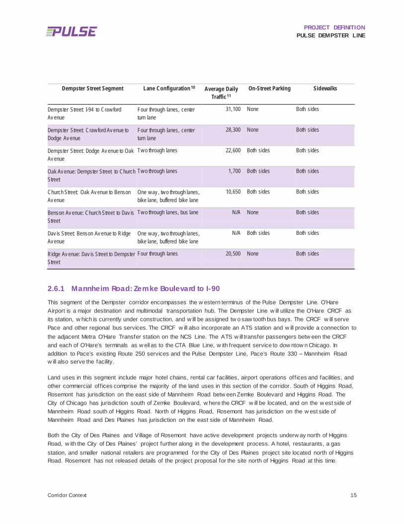
DETAILED CONDITIONS INVENTORY 2.6
This section contains detailed descriptions of existing conditions along the Dempster corridor that may affect the design and/or operation of Pulse service. The conditions inventory is organized by corridor segment in the sections that follow and are summarized in Table 2.3.

PROJECT DEFINITION PULSE DEMPSTER LINE
Corridor Context 14
TABLE 2.3: DEMPSTER CORRIDOR CONDITIONS INVENTORY SUMMARY
Dempster Street Segment Lane Configuration 10 Average Daily Traffic11
On-Street Parking Sidewalks
Mannheim Road: Zemke Boulev ard to I-90
Six through lanes, tw o center turn lanes
41,900 None Both sides, north of Higgins only
Mannheim Road: I-90 to Touhy Av enue Four through lanes, one center turn lane
23,200 None Both sides from I-90 to Lunt, then just the w est side
Touhy Av enue: Mannheim Road to Lee Street
Four through lanes, one center turn lane
24,800 None Both sides
Lee Street: Touhy Av enue to Lee Street-Mannheim Road
Tw o through lanes, no turn lanes
N/A On w est side only from Touhy to How ard, then both sides
Both sides
Lee Street-Mannheim Road: Lee Street to Walnut Av enue
Four through lanes, one center turn lane
17,100 None Both sides
Lee Street-Mannheim Road: Walnut Av enue to Miner Street (NB)
One-w ay , tw o to three through lanes
6,900 Partial on both sides Both sides
Graceland Av enue: Walnut Av enue to Miner Street (SB)
One-w ay , tw o through lanes 21,100 On east side Both sides
Dempster/Miner Street: Lee Street-Mannheim Road to I-294
Four through lanes, no center turn lanes betw een Riv er Road and Rand/NW Hw y
18,200 None Partial. Both sides
Dempster Street: I-294 to Potter Road Four through lanes, no center turn lane
35,100 None Both sides
Dempster Street: Potter Road to Milw aukee Av enue
Four through lanes, center turn lane. Grade separation of Dempster through lanes at Milw aukee
35900 None Both side
Dempster Street: Milw aukee Av enue to Waukegan Road
Six through lanes, center turn lane
49,600 None Both sides
Dempster Street: Waukegan Road to I-94 Four through lanes, center turn lane
39,000 None Both sides
10 Lane Configuration, On-Street Parking, and Sidewalk information was retrieved from Google satellite imagery and Street View in July 2016. 11 Il l inois Department of Transportation. Average Daily Traffic Counts GIS Application. Retrieved in July 2016 from http://www.idot.i llinois.gov/transportation-system/Network-Overview/highway-system/il linois-travel-statistics
PROJECT DEFINITION PULSE DEMPSTER LINE
Corridor Context 15
Dempster Street Segment Lane Configuration 10 Average Daily Traffic11
On-Street Parking Sidewalks
Dempster Street: I-94 to Craw ford Av enue
Four through lanes, center turn lane
31,100 None Both sides
Dempster Street: Craw ford Av enue to Dodge Av enue
Four through lanes, center turn lane
28,300 None Both sides
Dempster Street: Dodge Av enue to Oak Av enue
Tw o through lanes 22,600 Both sides Both sides
Oak Av enue: Dempster Street to Church Street
Tw o through lanes 1,700 Both sides Both sides
Church Street: Oak Av enue to Benson Av enue
One w ay , tw o through lanes, bike lane, buffered bike lane
10,650 Both sides Both sides
Benson Av enue: Church Street to Dav is Street
Tw o through lanes, bus lane N/A None Both sides
Dav is Street: Benson Av enue to Ridge Av enue
One w ay , tw o through lanes, bike lane, buffered bike lane
N/A Both sides Both sides
Ridge Av enue: Dav is Street to Dempster Street
Four through lanes 20,500 None Both sides
2.6.1 Mannheim Road: Zemke Boulevard to I-90 This segment of the Dempster corridor encompasses the w estern terminus of the Pulse Dempster Line. O’Hare Airport is a major destination and multimodal transportation hub. The Dempster Line w ill utilize the O’Hare CRCF as its station, w hich is currently under construction, and w ill be assigned tw o saw tooth bus bays. The CRCF w ill serve Pace and other regional bus services. The CRCF w ill also incorporate an ATS station and w ill provide a connection to the adjacent Metra O’Hare Transfer station on the NCS Line. The ATS w ill transfer passengers betw een the CRCF and each of O’Hare’s terminals as w ell as to the CTA Blue Line, w ith frequent service to dow ntow n Chicago. In addition to Pace’s existing Route 250 services and the Pulse Dempster Line, Pace’s Route 330 – Mannheim Road w ill also serve the facility.
Land uses in this segment include major hotel chains, rental car facilities, airport operations off ices and facilities, and other commercial off ices comprise the majority of the land uses in this section of the corridor. South of Higgins Road, Rosemont has jurisdiction on the east side of Mannheim Road betw een Zemke Boulevard and Higgins Road. The City of Chicago has jurisdiction south of Zemke Boulevard, w here the CRCF w ill be located, and on the w est side of Mannheim Road south of Higgins Road. North of Higgins Road, Rosemont has jurisdiction on the w est side of Mannheim Road and Des Plaines has jurisdiction on the east side of Mannheim Road.
Both the City of Des Plaines and Village of Rosemont have active development projects underw ay north of Higgins Road, w ith the City of Des Plaines’ project further along in the development process. A hotel, restaurants, a gas station, and smaller national retailers are programmed for the City of Des Plaines project site located north of Higgins Road. Rosemont has not released details of the project proposal for the site north of Higgins Road at this time.

PROJECT DEFINITION PULSE DEMPSTER LINE
Corridor Context 16
Mannheim Road is currently undergoing reconstruction by the Illinois Department of Transportation (IDOT) and w ill have three through lanes w ith tw o center left turn lanes at Higgins Road. There is no on-street parking available on Mannheim Road and sidew alks are not present south of Higgins Road. The reconstructed Mannheim Road and Higgins Road intersection w ill have crossw alks on each segment. Sidew alks are present on both sides of Mannheim Road north of Higgins Road. According to IDOT, average daily traff ic (ADT) on Mannheim Road w as 41,900 as of 2011.
A Pulse Dempster Line station is proposed for the intersection of Mannheim Road and Higgins Road and the station site options are described in Chapter 4. Pace has several existing bus stops in this segment as show n in Table 2.4.
TABLE 2.4: BUS STOPS BETWEEN ZEMKE BOULEVARD AND I-90
Posted Stop Direction Average Weekday Boardings (2014) Treatment
EB WB EB WB
Mannheim/Zemke EB/WB 1 0 -- --
Mannheim/Higgins EB/WB 5 1 -- --
Mannheim/Holiday Inn Ex press
WB -- 0 -- Sign
2.6.2 Mannheim Road: I-90 to Touhy Avenue Mannheim Road, north of I-90, narrow s from three through lanes in each direction to tw o through lanes w ithout a median turn lane. There are dedicated turn lanes at Lunt Avenue and Touhy Avenue. Sidew alks are present throughout most of this segment although there are no sidew alks betw een I-90 to just north of the Hyatt Hotel on the w est side of Mannheim and from Lunt Avenue to Touhy Avenue on the east side of Mannheim Road. ADT for Mannheim Road in this section w as 23,200 vehicles, as of 2015.
Land uses are predominantly commercial in this segment, w ith a large hotel adjacent to I-90 and the Allstate Arena at the southw est corner of Mannheim Road and Lunt Avenue. North of Lunt Avenue, across from Allstate Arena, is a large shopping center w ith a big box retailer as w ell as outlots w ith chain restaurants and smaller national brands. This shopping center extends from Lunt Avenue to Touhy Avenue on the w est side of Mannheim Road.
There are no Pulse Dempster Line stations proposed in this section of the corridor. Pace has several bus stops in this segment as show n in Table 2.5.
TABLE 2.5: BUS STOPS BETWEEN I-90 AND TOUHY AVENUE
Posted Stop Direction Average Weekday Boardings (2014) Treatment
EB WB EB WB
Mannheim/Pratt EB/WB 8 0 Sign Sign
Mannheim/Lunt EB/WB 6 3 Shelter Sign

PROJECT DEFINITION PULSE DEMPSTER LINE
Corridor Context 17
2.6.3 Touhy Avenue: Mannheim Road to Lee Street The section beginning at Mannheim Road to Lee Street has tw o through lanes in each direction w ith a center turn lane. Sidew alks are present on both sides of Touhy Avenue. Touhy Avenue is a large arterial w ith an ADT of 24,800 vehicles as of 2015.
Land uses include a mix of multifamily residential, retail and off ice uses. The north side of Touhy is predominantly off ice parks and is located in Des Plaines. The area south of Touhy is w ithin the Village of Rosemont and is made up of predominantly three-story apartment buildings.
Pace Route 221 traverses Touhy Avenue in this section. A Pulse Dempster Line station location is proposed at Lee Street and Touhy Avenue and is detailed in Chapter 4. A future Pulse line is planned for the Touhy corridor, w hich provides additional opportunities for transferring betw een Pulse services and local Pace routes. Pace has several existing bus stops in this segment as show n in Table 2.6.
TABLE 2.6: BUS STOPS BETWEEN MANNHEIM ROAD AND LEE STREET
Posted Stop Direction Average Weekday Boardings (2014) Treatment
EB WB EB WB
Touhy /Chestnut EB/WB 15 1 Sign Sign
Touhy /Ly ndon EB/WB 6 3 Shelter Sign
Lee/Touhy WB -- 2 -- Sign
2.6.4 Lee Street: Touhy Avenue to Lee Street-Mannheim Road Lee Street runs north-south through Des Plaines and along this segment is a tw o lane collector street that traverses a residential neighborhood. Lake Park is a large park on the w est side of Lee Street that extends from Touhy Avenue to How ard Avenue. Sidew alks are available on both sides of Lee Street and on-street parking exists on the w est side of Lee Street from Touhy Avenue to How ard Street and on both sides of the street betw een How ard Street and Lee Street-Mannheim Road. This segment of Lee Street is a municipally controlled street and traff ic counts are not available.
Pace has several existing bus stops in this segment as show n in Table 2.7.

PROJECT DEFINITION PULSE DEMPSTER LINE
Corridor Context 18
TABLE 2.7: BUS STOPS BETWEEN TOUHY AVENUE AND LEE STREET-MANNHEIM ROAD
Posted Stop Direction Average Weekday Boardings (2014) Treatment
EB WB EB WB
Touhy /Lee EB 26 -- Sign --
Lee/Fargo EB/WB 6 2 None Sign
Lee/How ard EB/WB 18 6 Sign Sign
Lee/Prospect EB/WB 4 2 Sign Sign
Lee/Ev erett EB 6 -- --
2.6.5 Lee Street-Mannheim Road: Lee Street to Walnut Avenue Lee Street merges into Mannheim Road in this section and becomes an arterial road w ith tw o through lanes in each direction w ith a center turn lane. There are sidew alks on both sides of Lee Street-Mannheim Road. ADT on this section of the corridor w as 17,100 vehicles as of 2015.
Land uses along this section of the corridor are predominantly commercial w ith three large retail strip centers at the Lee Street-Mannheim Road and Oakton Street intersection that support several big box stores. North of Oakton Street, there are smaller retail strips along w ith numerous standalone fast food restaurants and other small businesses that are predominantly auto-oriented.
A Dempster Line station location is proposed at Lee Street-Mannheim Road and Oakton Street. Pace Route 226 serves this corridor. Existing Pace bus stops for Route 250 are show n in Table 2.8.
TABLE 2.8: BUS STOPS BETWEEN LEE STREET AND WALNUT AVENUE
Posted Stop Direction Average Weekday Boardings (2014) Treatment
EB WB EB WB
Lee Street-Mannheim/K-Mart
WB -- 6 -- Sign
Lee/Oakton EB/WB 37 6 Shelter Sign
Lee/The Oaks/Oak Leaf Commons
EB/WB 1 11 Sign Sign
Lee/Forest EB/WB 9 3 None Sign
Lee/Algonquin EB 8 6 Sign Sign
2.6.6 Lee Street-Mannheim Road: Walnut Avenue to Miner Street (NB) Lee Street-Mannheim Road splits and runs one-w ay northbound w ith Graceland carrying southbound traff ic one block w est w ithin the City of Des Plaines.

PROJECT DEFINITION PULSE DEMPSTER LINE
Corridor Context 19
Lee Street-Mannheim Road has tw o to three through lanes w ith no dedicated turn lanes and on-street parking on both sides of the street. Similarly, Graceland Avenue has tw o through lanes w ith no dedicated turn lanes and on-street parking on both sides of the street. ADT on Lee Street-Mannheim Road is 6,900 vehicles. On Graceland Avenue ADT w as 21,100 as of 2015. Sidew alks are present on both sides of the street on Lee Street-Mannheim Road and Graceland Avenue. There is upgraded streetscaping on Lee Street-Mannheim Road from Prairie Avenue to Miner Street.
Land uses in this section are mixed use and fairly dense as this section is in the core of dow ntow n Des Plaines. Buildings in this section range from one-story strip centers and auto-oriented uses to multi-story off ice and residential buildings closer to Miner Street.
No Dempster Line station locations are proposed in this section of the corridor. Pace Routes 226 and 230 operate in the corridor. Existing Route 250 bus stops are show n in Table 2.9.
TABLE 2.9: BUS STOPS BETWEEN WALNUT AVENUE AND MINER STREET
Posted Stop Direction Average Weekday Boardings (2014) Treatment
EB WB EB WB
Lee/Walnut EB 2 -- Sign --
Graceland/Walnut WB -- 1 -- Sign
Lee/Thacker/Dempster EB 4 -- None --
Graceland/Thacker/Dempster WB -- 4 -- Sign
Lee/Prairie EB 3 -- Sign --
Lee/Ellinw ood EB 5 -- Sign --
Graceland/Webford WB -- 22 -- Sign
2.6.7 Miner Street: Lee Street-Mannheim Road to I-294 Miner Street is the local name for Dempster Street in dow ntow n Des Plaines. Miner Street is a four lane arterial road through this segment. In dow ntow n Des Plaines, Miner Street has tw o through lanes in each direction and no dedicated turn lanes. Miner Street runs adjacent to the Metra UP-NW Line and the Des Plaines Metra station is just east of Lee Street-Mannheim Road. The Des Plaines Metra station has a turnout that can accommodate three to four buses. ADT on Miner Street betw een Lee Street-Mannheim Road and Des Plaines River Road is only 3,600 vehicles. West of Lee Street-Mannheim Road, ADT is 16,700 vehicles. East of Des Plaines River Road ADT is 18,200 vehicles. In dow ntow n Des Plaines, Miner Street is very urban, w ith a new streetscape and on-street parking on the north side of the street.
Land uses in this section are very dense in dow ntow n Des Plaines w ith mixed-use retail buildings betw een Graceland Avenue and Pearson Street and a large condo complex at Miner Street and Pearson Street. East of Des Plaines River Road, Miner Street turns into Dempster Street and land uses vary betw een single family residential, a park, a school, and some commercial uses.

PROJECT DEFINITION PULSE DEMPSTER LINE
Corridor Context 20
Dempster Line station sites are proposed at the Metra station in the eastbound direction, and at Metropolitan Way and Pearson Street in the w estbound direction. Seven Pace routes serve the Des Plaines Metra station and most routes have layovers at the station. Pace routes operating on this section of the corridor include Routes 208, 209, 226, 230, 234, 250 and 619. Pace bus stops w ithin this section of the corridor are show n in Table 2.10.
TABLE 2.10: BUS STOPS BETWEEN LEE STREET-MANNHEIM ROAD AND I-294
Posted Stop Direction Average Weekday Boardings (2014) Treatment
EB WB EB WB
Des Plaines Metra Station EB/WB 193 83 Turnout Shelter
Miner/Riv er EB/WB 7 2 Shelter Sign
Miner/Busse EB 1 -- Sign --
Miner/Mason EB/WB 2 1 Sign Sign
Miner/2025 Miner/Garland EB/WB 4 2 Sign Sign
Miner/Acres/Rand EB/WB 6 1 Sign Sign
2.6.8 Dempster Street: I-294 to Potter Road Dempster Street, from east of I-294 to Potter Road, has tw o through lanes in each direction w ith a narrow median that does not support a turn lane. At Potter, Dempster Street w idens slightly to accommodate a dedicated left turn lane. The south side of Dempster Street is w ithin the City of Park Ridge and the north side of Dempster Street is w ithin the City of Des Plaines. ADT on this section of Dempster Street is 35,100 vehicles, based on a 2015 count.
The south side of Dempster is residential and has a privacy fence w hich does not have any pedestrian or vehicle openings onto Dempster Street. The north side of Dempster Street has commercial and light off ice land uses. The largest property on this section is Lurvey’s Landscape Supply and Garden Center, w hich has a w ell maintained streetscape in front of its property along Dempster Street. Sidew alks are present along both sides of the street, w ith the exception of the north side of Dempster Street underneath I-294.
Dempster Line station locations are proposed at Potter Road, w hich is an alternate to the Dee Road station location. Route 250 bus stops w ithin this section of the corridor are show n in Table 2.11.
TABLE 2.11: BUS STOPS BETWEEN I-294 AND POTTER ROAD
Posted Stop Direction Average Weekday Boardings (2014) Treatment
EB WB EB WB
Dempster/Ly man EB/WB 2 3 Sign Shelter
Dempster/Potter EB/WB 14 27 Sign Sign

PROJECT DEFINITION PULSE DEMPSTER LINE
Corridor Context 21
2.6.9 Dempster Street: Potter Road to Milwaukee Avenue Dempster Street from Potter Road to Milw aukee Avenue has tw o through lanes in each direction w ith a median turn lane. On the north side of Dempster Street, betw een Potter Road and Robin Drive, the area is in unincorporated Cook County, under the jurisdiction of Maine Tow nship. Betw een Robin Drive and just east of Parkside Drive, the north side of Dempster Street is w ithin the City of Park Ridge. From Parkside Drive to Milw aukee Avenue, Dempster Street is w ithin the Village of Niles. The south side of Dempster Street, from Potter Road to Greenw ood Avenue, is w ithin the City of Park Ridge. East of Greenw ood Avenue to Milw aukee Avenue, the south side of Dempster Street is w ithin the Village of Niles. ADT from Potter to Greenw ood is 33,800 vehicles and from Greenw ood to Milw aukee Avenue it is 35,900 vehicles. At Milw aukee Avenue, Dempster Street w idens as tw o through lanes in each direction travel under Milw aukee Avenue in a grade separated intersection. Access to Milw aukee Avenue is via tw o through lanes in the eastbound direction and one through lane in the w estbound direction. Sidew alks are present on both sides of the street w ith an exception along Maryhill Cemetery, w here no sidew alk is present on the south side of Dempster Street betw een Cumberland Avenue and Milw aukee Avenue. On-street parking is present on the access street on the north side of Dempster Street betw een Dempster Street and Milw aukee Avenue.
Land uses in the corridor include a w ide mix of commercial big box retailers and chain stores, multi-family and single-family homes, as w ell as major institutions and trip generators including Maine East High School and Advocate Lutheran General Hospital, both of w hich are located on the south side of Dempster Street w ithin the segment.
Proposed Dempster Line station locations are at Dee Road (w ith a Potter Road alternate), Western Avenue, Cumberland Avenue, and Milw aukee Avenue. Existing route 250 bus stops w ithin this section of the corridor are show n in Table 2.12.
TABLE 2.12: BUS STOPS BETWEEN POTTER ROAD AND MILWAUKEE AVENUE
Posted Stop Direction Average Weekday Boardings (2014) Treatment
EB WB EB WB
Dempster/Potter EB/WB 14 27 Sign Sign
Dempster/Dee EB/WB 19 15 Sign Shelter
Dempster/Lutheran General Hospital
EB/WB 24 24 Shelter Shelter
Dempster/Western EB/WB 60 23 Shelter Sign
Dempster/Greenw ood EB/WB 11 14 Sign Sign
Dempster/Grace EB/WB 9 9 Sign Sign
Dempster/Cumberland EB/WB 10 26 Sign Sign
Dempster/Grand EB/WB 11 22 Sign Sign
Dempster/Milw aukee (SW/NW) EB/WB 55 2 Shelter Sign

PROJECT DEFINITION PULSE DEMPSTER LINE
Corridor Context 22
2.6.10 Dempster Street: Milwaukee Avenue to Waukegan Road Dempster Street, from Milw aukee Avenue to Waukegan Road, has three through lanes in each direction w ith a median turn lane. East of Milw aukee Avenue, a one lane access road connecting Milw aukee joins Dempster Street in its ow n lane. Westbound, on approach to Milw aukee, the third outermost lane is dedicated to accessing Milw aukee Avenue and has a dedicated right turn lane and shared left turn and through lane. On the north side of Dempster Street, the area is w ithin the Village of Niles betw een Milw aukee Avenue and Ozanam Avenue. East of Ozanam Avenue, the north side of Dempster Street is w ithin the Village of Morton Grove. On the south side of Dempster Street, from Milw aukee Avenue to approximately 500 feet w est of Waukegan Road, Dempster Street is w ithin the Village of Niles. From 500 feet w est of Waukegan Road to Waukegan Road, it is w ithin the Village of Morton Grove. Sidew alks are present on both sides of Dempster Street. ADT w ithin this section of the corridor is 49,600 vehicles.
Land uses in this section are predominantly single-family residential, w ith a small cluster of multi-family residential housing near Milw aukee Avenue on the north side of Dempster. A large cluster of strip retail and large big box chain stores are clustered at the Harlem Avenue and Waukegan Road intersections. The private Notre Dame High School is located on the south side of Dempster Street approximately one-quarter mile east of Milw aukee Avenue. Pace Route 270 has special trips that serve the high school. Pace routes 210, 410, and 423 also operate w ithin the corridor and the Pulse Milw aukee Line w ill intersect the Dempster Line at Milw aukee Avenue. The Milw aukee Line station sites are at the northeast and southw est corners of the Dempster Street and Milw aukee Avenue intersection. Pulse Dempster Line station locations are proposed for Milw aukee Avenue, Harlem Avenue and Waukegan Avenue. Existing Pace bus stops w ithin the corridor are show n in Table 2.13.
TABLE 2.13: BUS STOPS BETWEEN MILWAUKEE AVENUE AND WAUKEGAN ROAD
Posted Stop Direction Average Weekday Boardings (2014) Treatment
EB WB EB WB
Dempster/Milw aukee (SE/NE) EB/WB 2 82 Sign Sign
Dempster/Merrill EB/WB 5 2 Sign Sign
Dempster/Ozark EB/WB 5 11 None Sign
Dempster/Oriole EB/WB 22 1 Shelter Sign
Dempster/Olcott EB/WB 1 3 Sign Sign
Dempster/Oketo EB/WB 6 13 Sign Sign
Dempster/Harlem EB/WB 20 25 Sign Shelter
Dempster/Shermer EB 12 -- Sign --
Dempster/National EB/WB 5 3 Sign Sign
Dempster/Waukegan EB/WB 35 9 Shelter Sign

PROJECT DEFINITION PULSE DEMPSTER LINE
Corridor Context 23
2.6.11 Dempster Street: Waukegan Road to I-94 This section of Dempster Street narrow s from three through lanes in each direction at Waukegan Road to tw o through lanes in each direction w ith a median turn lane. ADT in this section of the corridor is 39,000 vehicles. Sidew alks are present on both sides of Dempster Street. The entire corridor is w ithin the Village of Morton Grove.
Land uses in the corridor are mostly commercial, w ith larger big box chain retailers clustered at Waukegan Road and smaller strip malls, standalone retailers, and other chains along Dempster Street from Lehigh Avenue to I-94. The Forest Preserve District of Cook County has land in the area betw een Waukegan Road to Lehigh Avenue and Metra’s Milw aukee District North Line. The North Branch bike trail crosses Dempster Street at Lehigh Avenue. The Morton Grove Park District has tw o parks w ithin the corridor as w ell.
Pace Routes 210 and 250 operate w ithin the corridor. Pulse Dempster Line station locations are proposed at Waukegan Road and at Austin Avenue. Existing Pace bus stops w ithin the corridor are show n in Table 2.14.
TABLE 2.14: BUS STOPS BETWEEN WAUKEGAN ROAD AND I-94
Posted Stop Direction Average Weekday Boardings (2014) Treatment
EB WB EB WB
Dempster/Waukegan EB/WB 35 9 Shelter Sign
Dempster/New England WB -- 8 -- Sign
Dempster/Birch EB 11 -- Sign --
Dempster/Lincoln EB 1 -- Sign --
Dempster/Lehigh WB -- 0 -- Sign
Dempster/Ferris EB/WB 12 10 Sign Sign
Dempster/Fernald EB/WB 5 2 Sign Sign
Dempster/Moody /School EB/WB 4 1 Sign Sign
Dempster/Austin EB/WB 17 10 Sign Sign
Dempster/Marmora EB/WB 3 4 Sign Sign
Dempster/Menard EB/WB 10 5 Sign Sign
Dempster/Central/Parkside EB/WB 7 4 Sign None
2.6.12 Dempster Street: I-94 to Crawford Avenue This section of Dempster Street has tw o through lanes in each direction and a center turn lane. It is located entirely w ithin the Village of Skokie and has an ADT of 31,000 vehicles from I-94 to Skokie Boulevard and 23,900 vehicles from Skokie Boulevard to Craw ford Avenue. Sidew alks are present on both sides of Dempster Street.
Land uses w ithin the corridor consist of small retail strip centers and fast food chains. East of Skokie Boulevard, the land use changes to mostly single-family residential until the intersection w ith Craw ford, w hich has another cluster of

PROJECT DEFINITION PULSE DEMPSTER LINE
Corridor Context 24
small retail strip centers. The Evanston Golf Club is located south of Dempster Street betw een Skokie Boulevard and Craw ford Avenue.
Pace and CTA both operate several transit services in this section of the corridor. Besides Route 250, Pace operates Routes 620 and 626, w hich are tw o express services from the CTA Yellow Line Dempster-Skokie station, and Pace Route 215. The CTA operates bus routes 54A, 97 out of the CTA Yellow Line Dempster-Skokie station. The CTA Yellow Line Dempster-Skokie station is the terminal station for the CTA Yellow Line, a rapid transit line serving the Village of Skokie and connecting to the CTA Red and Purple Lines at How ard. The CTA Yellow Line Dempster-Skokie station is a major transfer point for Route 250 and is located approximately 1,000 feet w est of Niles Center Road. All buses currently serving the Yellow Line pull off of Dempster Street into the park and ride facility. A bus lane adjacent to the rail platform facilitates transfers. Pulse Dempster Line station locations are proposed on-street at the CTA Yellow Line Dempster-Skokie station and at Craw ford Avenue. Existing Pace bus stops in this section of the corridor are show n in Table 2.15.
TABLE 2.15: BUS STOPS BETWEEN I-94 AND CRAWFORD AVENUE
Posted Stop Direction Average Weekday Boardings (2014) Treatment
EB WB EB WB
Dempster/Lockw ood EB 2 -- Sign --
Dempster/Gross Point WB -- 13 -- Sign
Dempster/LeClaire EB/WB 2 3 Sign Sign
Skokie Sw ift CTA Station EB/WB 64 266 Bus depot Bus depot
Dempster/Niles Center EB/WB 27 22 Sign Sign
Dempster/Knox EB 2 -- Sign --
Dempster/Kilpatrick WB -- 1 -- Sign
Dempster/Kolmar EB/WB 1 1 Sign Sign
Dempster/Kostner EB/WB 1 1 Sign Sign
Dempster/Kildare EB/WB 1 2 Sign Sign
Dempster/Keeler EB/WB 3 5 Sign Sign
Dempster/Karlov EB/WB 2 5 Sign Sign
Dempster/Craw ford EB/WB 14 22 Sign Sign
2.6.13 Dempster Street: Crawford Avenue to Dodge Avenue Dempster Street, from Craw ford Avenue to McCormick Boulevard has tw o through lanes in each direction and a center turn lane. From McCormick Boulevard to Dodge Avenue, Dempster Street narrow s and only has tw o through lanes in each direction. Sidew alks are present on both sides. The section of the corridor w est of the North Shore Channel is located w ithin the Village of Skokie. East of the North Shore Channel, the corridor is w ithin the City of Evanston. ADT varies betw een 28,300 vehicles betw een Craw ford Avenue and McCormick Boulevard and 22,600

PROJECT DEFINITION PULSE DEMPSTER LINE
Corridor Context 25
vehicles betw een McCormick Boulevard and Dodge Avenue, based on counts taken in 2014. The North Shore Channel Trail runs parallel to the North Shore Channel, just east of McCormick Boulevard.
Land uses in the corridor betw een Craw ford Avenue and McCormick Boulevard are small scale strip retail and restaurants w ith very limited single family residential. The commercial uses are auto-oriented, w ith parking in front of the stores and large signage visible to passing vehicles. Betw een McCormick Boulevard and Dodge Avenue the land uses include a mix of single family homes and tow nhomes as w ell as some small commercial businesses and a large shopping center at the southw est corner of Dempster Street and Dodge Avenue.
In addition to Route 250, Pace also operates Route 215 along Craw ford Avenue. CTA operates Routes 97 and 206 w ithin the City of Evanston. Pulse Dempster Line station locations proposed w ithin this section of the corridor are at Craw ford Avenue, Lincolnw ood Drive, and Dodge Avenue. Existing Pace bus stops in this section of the corridor are show n in Table 2.16.
TABLE 2.16: BUS STOPS BETWEEN CRAWFORD AVENUE AND DODGE AVENUE
Posted Stop Direction Average Weekday Boardings (2014) Treatment
EB WB EB WB
Dempster/Craw ford EB/WB 14 22 Sign Sign
Dempster/Springfield EB/WB 2 6 Sign Sign
Dempster/Ridgew ay EB 2 -- Sign --
Dempster/East Prairie EB/WB 9 8 Sign Sign
Dempster/Central Park WB -- 4 -- Sign
Dempster/Lincolnw ood/St. Louis EB 12 -- Sign --
Dempster/Forestv iew WB -- 17 -- Sign
Dempster/Kimball EB 13 -- Shelter --
Dempster/McCormick EB/WB 5 5 Sign Sign
Dempster/Fow ler EB/WB 12 9 Sign Sign
Dempster/Hartrey EB/WB 11 11 Sign Sign
Dempster/Dodge EB/WB 23 70 Sign Sign
2.6.14 Dempster Street: Dodge Avenue to Oak Avenue In this section of the corridor, Dempster Street narrow s from tw o through lanes in each direction to one through lane in each direction w ith a dedicated left turn lane only at Ridge Avenue and Oak Avenue. Sidew alks are present on both sides of the street and the corridor feels more urban, w ith a narrow street and buildings much closer to the right-of-w ay edge. This entire section of the corridor is w ithin the City of Evanston. ADT on Dempster Street is 22,600 vehicles. East of Dempster Street, traff ic volume decreases dramatically dow n to 2,650 vehicles, based on counts taken by IDOT in 2014. On-street parking is allow ed in the corridor on both sides of Dempster Street from Dodge Avenue to Florence Avenue.
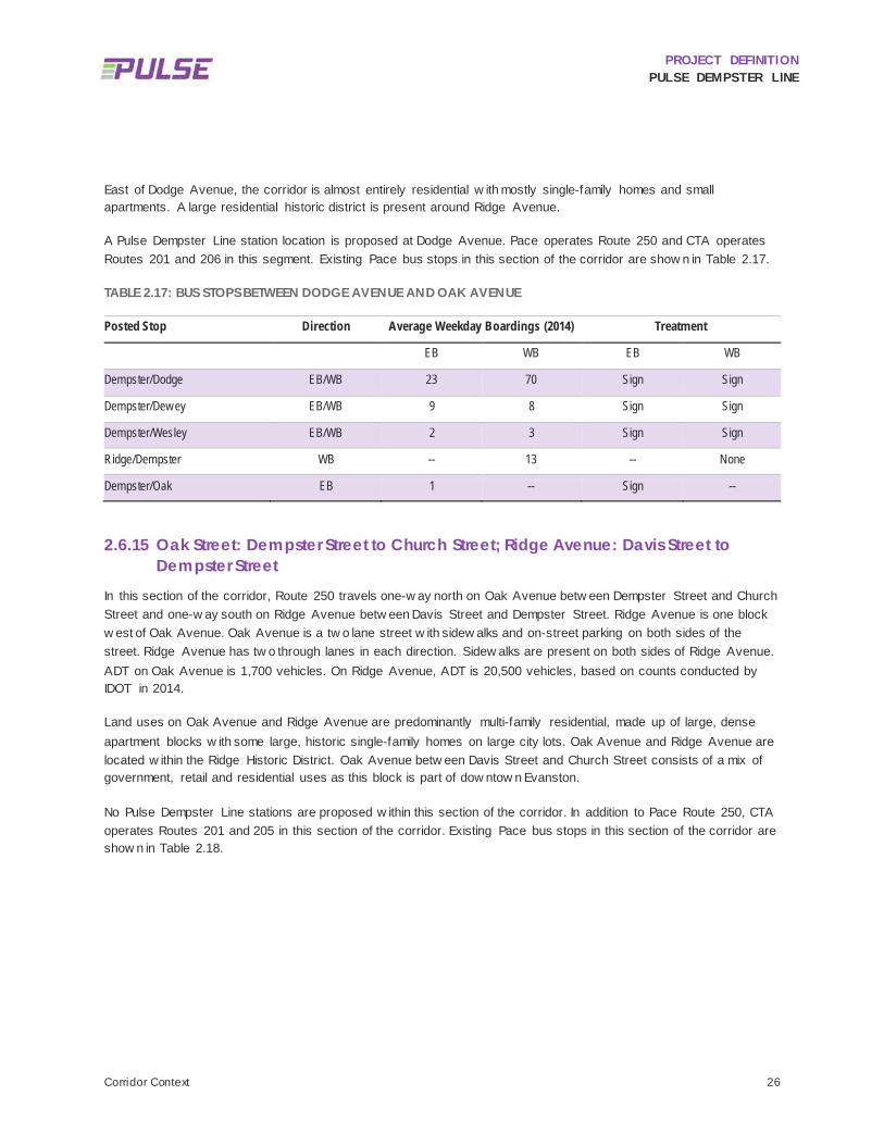
PROJECT DEFINITION PULSE DEMPSTER LINE
Corridor Context 26
East of Dodge Avenue, the corridor is almost entirely residential w ith mostly single-family homes and small apartments. A large residential historic district is present around Ridge Avenue.
A Pulse Dempster Line station location is proposed at Dodge Avenue. Pace operates Route 250 and CTA operates Routes 201 and 206 in this segment. Existing Pace bus stops in this section of the corridor are show n in Table 2.17.
TABLE 2.17: BUS STOPS BETWEEN DODGE AVENUE AND OAK AVENUE
Posted Stop Direction Average Weekday Boardings (2014) Treatment
EB WB EB WB
Dempster/Dodge EB/WB 23 70 Sign Sign
Dempster/Dew ey EB/WB 9 8 Sign Sign
Dempster/Wesley EB/WB 2 3 Sign Sign
Ridge/Dempster WB -- 13 -- None
Dempster/Oak EB 1 -- Sign --
2.6.15 Oak Street: Dempster Street to Church Street; Ridge Avenue: Davis Street to Dempster Street
In this section of the corridor, Route 250 travels one-w ay north on Oak Avenue betw een Dempster Street and Church Street and one-w ay south on Ridge Avenue betw een Davis Street and Dempster Street. Ridge Avenue is one block w est of Oak Avenue. Oak Avenue is a tw o lane street w ith sidew alks and on-street parking on both sides of the street. Ridge Avenue has tw o through lanes in each direction. Sidew alks are present on both sides of Ridge Avenue. ADT on Oak Avenue is 1,700 vehicles. On Ridge Avenue, ADT is 20,500 vehicles, based on counts conducted by IDOT in 2014.
Land uses on Oak Avenue and Ridge Avenue are predominantly multi-family residential, made up of large, dense apartment blocks w ith some large, historic single-family homes on large city lots. Oak Avenue and Ridge Avenue are located w ithin the Ridge Historic District. Oak Avenue betw een Davis Street and Church Street consists of a mix of government, retail and residential uses as this block is part of dow ntow n Evanston.
No Pulse Dempster Line stations are proposed w ithin this section of the corridor. In addition to Pace Route 250, CTA operates Routes 201 and 205 in this section of the corridor. Existing Pace bus stops in this section of the corridor are show n in Table 2.18.

PROJECT DEFINITION PULSE DEMPSTER LINE
Corridor Context 27
TABLE 2.18: BUS STOPS BETWEEN DEMPSTER STREET AND CHURCH STREET AND DAVIS STREET AND DEMPSTER STREET
Posted Stop Direction Average Weekday Boardings (2014) Treatment
EB WB EB WB
Dempster/Oak EB 1 -- Sign --
Oak/Lake EB 0 -- Sign --
Oak/Dav is EB 1 -- Sign --
Oak/Church EB 0 -- Sign --
Dav is/Ridge WB -- 9 -- Sign
Ridge/Lake WB -- 2 -- Sign
2.6.16 Church Street, Davis Street, and Benson Avenue Church Street and Davis Street are one-w ay streets running eastbound and w estbound respectively into and out of dow ntow n Evanston. Benson Avenue has one through lane in each direction and has a bus only lane betw een Church Street and Davis Street. The terminus of Route 250 and the Pulse Dempster Line is on Benson Avenue, w hich is adjacent to the CTA Purple Line at Davis Street. Just w est of the CTA Purple Line is the Metra UP-N Line at Davis, w ith connections to Kenosha, Wisconsin and dow ntow n Chicago. Church Street has tw o through lanes in the eastbound direction, as w ell as an on-street bike lane east of Oak Avenue. East of Oak Avenue, on-street, metered parking is available on both sides of Church Street. Davis Street has tw o through lanes in the w estbound direction as w ell as a protected, striped green bike lane that runs betw een the curb and gutter and a row of on-street parking spaces along the north side of the street. On the south side of Davis Street, angled parking is provided for vehicles. All parking is metered. Benson Avenue has no on-street parking but has a large public parking garage entrance located halfw ay betw een Church Street and Davis Street. Sidew alks are provided on both sides of the street on all dow ntow n streets.
Land uses include dense multi-family condos and apartment buildings, as w ell as multi-story mixed use buildings of various sizes. The environment is very urban, w ith several f ive-story or buildings, or taller, built to the property line.
The eastern terminal of the Pulse Dempster Line is proposed to be located along Benson Avenue, adjacent to the CTA Purple Line station, in a bus boarding location to be determined. In addition to Pace Route 250, CTA operates Routes 93, 201, and 205 w hich all serve the CTA and Metra Davis Street stations. Existing Pace bus stops in this section of the corridor are show n in Table 2.19.

PROJECT DEFINITION PULSE DEMPSTER LINE
Corridor Context 28
TABLE 2.19: BUS STOPS ALONG CHURCH STREET, DAVIS STREET, AND BENSON AVENUE
Posted Stop Direction Average Weekday Boardings (2014) Treatment
EB WB EB WB
Church/Maple EB 0 -- None --
Dav is CTA Station WB -- 354 -- Sign
Dav is/Maple WB -- 22 -- CTA/Pace
Dav is/Oak WB -- 6 -- CTA/Pace

PROJECT DEFINITION PULSE DEMPSTER LINE
Existing Ridership Analysis 29
3 Existing Ridership Analysis OVERVIEW OF ROUTE 250 3.1
Pace Route 250 provides daily service from the O’Hare Kiss ‘N’ Fly ATS station, via Mannheim Road, Touhy Avenue, and Lee Street, to the Des Plaines Metra and then travels east to dow ntow n Evanston station via Dempster Street. Along the route, Route 250 connects to the ATS and Metra North Central Service at O’Hare, the Metra Union Pacif ic Northw est Line in Des Plaines, the CTA Yellow Line at the Dempster-Skokie CTA station, and the CTA Purple Line and Metra Union Pacif ic North Line in dow ntow n Evanston at the Davis Street CTA/Metra station. The route also intersects more than tw o dozen Pace and CTA bus routes.
In the O’Hare-bound direction, all regular trips begin at the Davis CTA/Metra station w ith all but four continuing to the terminus at the O’Hare Kiss ‘N’ Fly. The remaining four trips terminate at Des Plaines Metra, primarily in the early morning and late evening hours. Similarly, most Evanston-bound trips begin at O’Hare and end at Davis CTA/Metra station. Three trips begin at Des Plaines Metra and end at Davis, and one trip begins at O’Hare and ends at Des Plaines Metra.
In addition to these regular trips, special limited trips provide direct service to Maine West and Maine East high schools. The Maine West High School service operates betw een dow ntow n Des Plaines and the school, deviating from the Route 250 corridor at Oakton Street. One trip operates to the school in the morning w ith a return trip in the afternoon. The Maine East High School service operates betw een the high school and tw o termini: Oakton Street and Greenw ood Avenue to the south, and Harlem Avenue and Golf Road to the north. Both services deviate from the corridor at Dempster Street and Harlem Avenue. One round trip operates betw een Oakton/Greenw ood and Maine East High School, and one inbound trip operates from Golf/Harlem in the morning (there is no return trip on this route in the afternoon). School trips operate only w hen school is in session.
Figure 3.1 show s the number of w eekday departures by hour for existing Evanston- and O’Hare-bound Route 250 trips. School trips are not included in the f igure because they operate over very limited portions of the Route 250 corridor and only on school days.
As show n, a base level of service of at least tw o trips per hour in each direction is provided from early morning through early evening. During peak hours, three or sometimes four trips depart in each direction. There are more O’Hare-bound trips during the AM rush and Evanston-bound trips in the PM rush, w hich roughly corresponds w ith the overall ridership pattern on the route (discussed in the follow ing sections).

PROJECT DEFINITION PULSE DEMPSTER LINE
Existing Ridership Analysis 30
FIGURE 3.1: DEPARTURES PER HOUR, AVERAGE WEEKDAY (EXCLUDES SCHOOL TRIPS)
OVERALL ROUTE 250 RIDERSHIP 3.2
According to Pace’s monthly ridership reports, Route 250 had an average w eekday ridership of 2,545 in 2015. Among all routes in Pace’s netw ork, Route 250 had the sixth highest average w eekday ridership in 2015. Overall, ridership on Route 250 has been relatively consistent over the period betw een 2000 and 2015 (in 2000, average w eekday ridership w as 2,575). Over the last 15 years, there have been tw o periods in w hich average w eekday ridership peaked about 10% above average ridership during those years, 2007-2008 and 2011-2012 (see Figure 3.2), follow ing a period of decreased ridership during 2002-2004. Potential external or service-related influences on these ridership f igures have not been analyzed.
0
1
2
3
4
5
4 5 6 7 8 9 10 11 12 13 14 15 16 17 18 19 20 21 22 23 0
Hour Beginning
Evanston-bound O'Hare-bound

PROJECT DEFINITION PULSE DEMPSTER LINE
Existing Ridership Analysis 31
FIGURE 3.2: AVERAGE WEEKDAY RIDERSHIP, 2000-2015
As show n in Figure 3.3, Route 250 ridership f luctuates throughout the year, w ith tw o distinct peaks and valleys. Average monthly peak ridership occurs in May and in September, w ith deviations of 6% and 8% respectively over the annual average. Valleys occur in July and in December and January, w ith deviations of -1% and -10% respectively. School schedules have some influence on ridership patterns as Route 250 serves both Maine East and Maine West high schools directly and runs tw o blocks south of Evanston Tow nship High School and a number of other middle and high schools. In the case of the Maine Tow nship high schools, Route 250 has one trip that operates as a feeder service from the Oak Leaf Commons to Maine West High School, and another diversion of service from Maine East High School to Oakton/Greenw ood in Park Ridge.
2,545 2,677
2,842 2,929 2,891 2,758 2,724
2,964 2,944 2,885 2,662
2,255 2,230 2,317 2,438
2,575
0
500
1,000
1,500
2,000
2,500
3,000
3,500
2015201420132012201120102009200820072006200520042003200220012000

PROJECT DEFINITION PULSE DEMPSTER LINE
Existing Ridership Analysis 32
FIGURE 3.3: AVERAGE WEEKDAY RIDERSHIP BY MONTH, 2000-2015
AVERAGE WEEKDAY BOARDINGS BY STOP 3.3
Average w eekday boardings by stop w ere derived from Pace’s automatic passenger counter (APC) data for the period from May 1, 2014 through April 30, 2015, w hich coincides w ith the most recent 12-month period prior to the temporary closure of the CTA Yellow Line, w hich affected Route 250 ridership. This APC data yielded a somew hat higher total estimated average w eekday ridership than the aforementioned monthly ridership reports. Based on the analysis of APC data, there w ere 2,874 average w eekday boardings during the May 2014 – April 2015 period.
Boardings are highest at the terminal stations and at transfer points to CTA and Metra rail service. Other major boarding and alighting points include: Milw aukee Avenue, w here transfers to Pace Route 270 occur and a future transfer to the Pulse Milw aukee Line w ill be available; Dempster/Dodge, w hich is tw o blocks south of Evanston Tow nship High School; and Dempster/Western and Dempster/Luther, w hich serve Lutheran General Hospital. Retail nodes around the Dempster/Harlem, Dempster/Niles Center, and Dempster/Potter intersections drive ridership at these locations. Table 3.1 summarizes the top Route 250 stops for passenger boardings and alightings.
1,500
1,700
1,900
2,100
2,300
2,500
2,700
2,900
3,100
3,300
3,500
1 2 3 4 5 6 7 8 9 10 11 12
2015201420132012201120102009200820072006200520042003200220012000Average
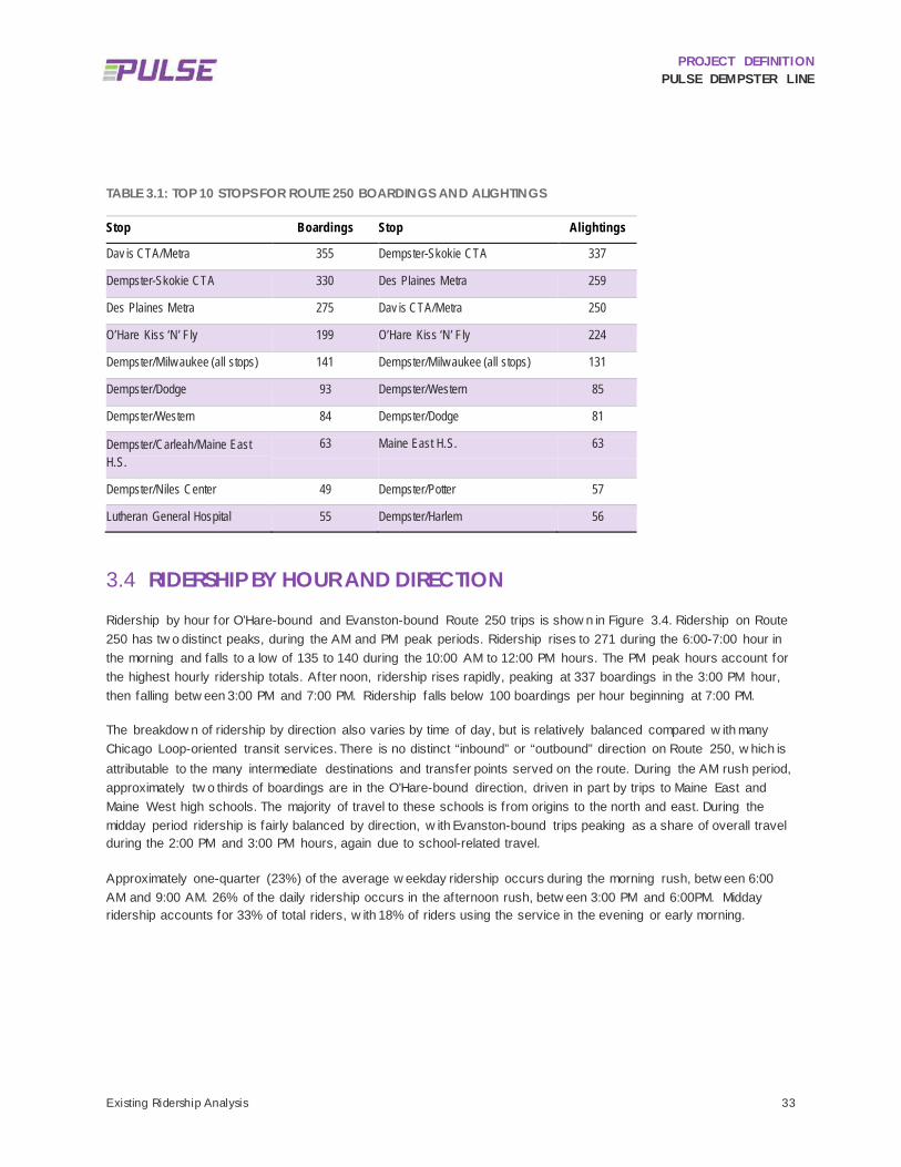
PROJECT DEFINITION PULSE DEMPSTER LINE
Existing Ridership Analysis 33
TABLE 3.1: TOP 10 STOPS FOR ROUTE 250 BOARDINGS AND ALIGHTINGS
Stop Boardings Stop Alightings
Dav is CTA/Metra 355 Dempster-Skokie CTA 337
Dempster-Skokie CTA 330 Des Plaines Metra 259
Des Plaines Metra 275 Dav is CTA/Metra 250
O’Hare Kiss ‘N’ Fly 199 O’Hare Kiss ‘N’ Fly 224
Dempster/Milw aukee (all stops) 141 Dempster/Milw aukee (all stops) 131
Dempster/Dodge 93 Dempster/Western 85
Dempster/Western 84 Dempster/Dodge 81
Dempster/Carleah/Maine East H.S.
63 Maine East H.S. 63
Dempster/Niles Center 49 Dempster/Potter 57
Lutheran General Hospital 55 Dempster/Harlem 56
RIDERSHIP BY HOUR AND DIRECTION 3.4
Ridership by hour for O’Hare-bound and Evanston-bound Route 250 trips is show n in Figure 3.4. Ridership on Route 250 has tw o distinct peaks, during the AM and PM peak periods. Ridership rises to 271 during the 6:00-7:00 hour in the morning and falls to a low of 135 to 140 during the 10:00 AM to 12:00 PM hours. The PM peak hours account for the highest hourly ridership totals. After noon, ridership rises rapidly, peaking at 337 boardings in the 3:00 PM hour, then falling betw een 3:00 PM and 7:00 PM. Ridership falls below 100 boardings per hour beginning at 7:00 PM.
The breakdow n of ridership by direction also varies by time of day, but is relatively balanced compared w ith many Chicago Loop-oriented transit services. There is no distinct “inbound” or “outbound” direction on Route 250, w hich is attributable to the many intermediate destinations and transfer points served on the route. During the AM rush period, approximately tw o thirds of boardings are in the O’Hare-bound direction, driven in part by trips to Maine East and Maine West high schools. The majority of travel to these schools is from origins to the north and east. During the midday period ridership is fairly balanced by direction, w ith Evanston-bound trips peaking as a share of overall travel during the 2:00 PM and 3:00 PM hours, again due to school-related travel.
Approximately one-quarter (23%) of the average w eekday ridership occurs during the morning rush, betw een 6:00 AM and 9:00 AM. 26% of the daily ridership occurs in the afternoon rush, betw een 3:00 PM and 6:00PM. Midday ridership accounts for 33% of total riders, w ith 18% of riders using the service in the evening or early morning.

PROJECT DEFINITION PULSE DEMPSTER LINE
Existing Ridership Analysis 34
FIGURE 3.4: ROUTE 250 AVERAGE WEEKDAY RIDERSHIP BY HOUR
MAJOR TRANSFER CONNECTIONS 3.5
A substantial share of Route 250 passengers use other Pace and CTA services to complete their journeys. It is important to identify w here transfers to and from Route 250 occur, and w hat other services passengers are using to complete their journeys, in order to fully understand overall travel patterns, identify major destinations, and prioritize investments in station locations and facilities at those locations.
Estimated transfers to Route 250 w ere provided by Pace from Ventra farebox data for the month of November 2015. The data indicates the bus route or rail station from w hich a passenger transferred, but not the precise location at w hich the transfer occurred (w ith the exception of rail stations). A second dataset provided by Pace estimates the transfer location based on latitude and longitude captured by the farebox, but not the route or rail station from w hich the passenger transferred. This second dataset w as considered less reliable, and w as used only to allocate the route-level transfers to the most likely station at w hich the transfer occurred.
Figure 3.5 summarizes estimated transfers betw een Route 250 and other CTA and Pace services. This includes transfers both to and from Route 250. It should be noted that the transfer data comes from the farebox, w hereas other data cited in this report comes from onboard passenger counters. Therefore, the results should be considered a rough estimate. For example, w hereas the farebox data indicates average w eekday Route 250 boardings of 2,449 in
0
50
100
150
200
250
300
350
4 5 6 7 8 9 10 11 12 13 14 15 16 17 18 19 20 21 22 23 0Hour Beginning
Evanston-bound
O'Hare-bound

PROJECT DEFINITION PULSE DEMPSTER LINE
Existing Ridership Analysis 35
November 2015, the Pace monthly ridership report indicates 2,663 average w eekday boardings during the same time period.
In November 2015, an estimated 562 passengers boarded Route 250 from other routes on an average w eekday, and 526 passengers transferred from Route 250 to other routes. Combined, this suggests that nearly half of all Route 250 passengers use at least one other connecting service to complete their trips.
The Dempster-Skokie CTA station has the largest number of transfers to and from Route 250, primarily connecting w ith the CTA Yellow Line. Dempster-Skokie is the terminus for the Yellow Line and has an off-street bus layover facility. The station also serves tw o CTA bus routes and four Pace bus routes. Of 336 passengers transferring to and from Route 250 in November 2015, 70% connected w ith the Yellow Line, w hile most of the remainder connected w ith CTA bus routes 54A and 97. More than half of all Route 250 boardings at this location are transfers.
Nearly as many transfers occur at Davis CTA/Metra, w ith more than 300 daily transfers to and from Route 250 occurring here, representing nearly 30% of all transfers to and from Route 250. Nearly half of all Route 250 boardings at this station are transfers. Davis Street is one of three hubs in the Regional Transportation Authority system w here all RTA services (CTA bus, CTA rail, Metra and Pace) meet at the same station. It is served by the CTA Purple Line, three CTA bus routes, four Pace bus routes, and Metra’s Union Pacif ic North Line. At Davis Street, transfer activity w ith Route 250 is 54% from CTA Rail, 23% from CTA Bus and 23% from other Pace routes.
Transfer activity directly to Route 250 from Metra is undetermined and is not included in the 320 transfers recorded at that location. According to Metra’s 2014 Origin-Destination Survey, 6% of Metra boardings at Davis Street, or 63 daily riders, transferred from bus routes.
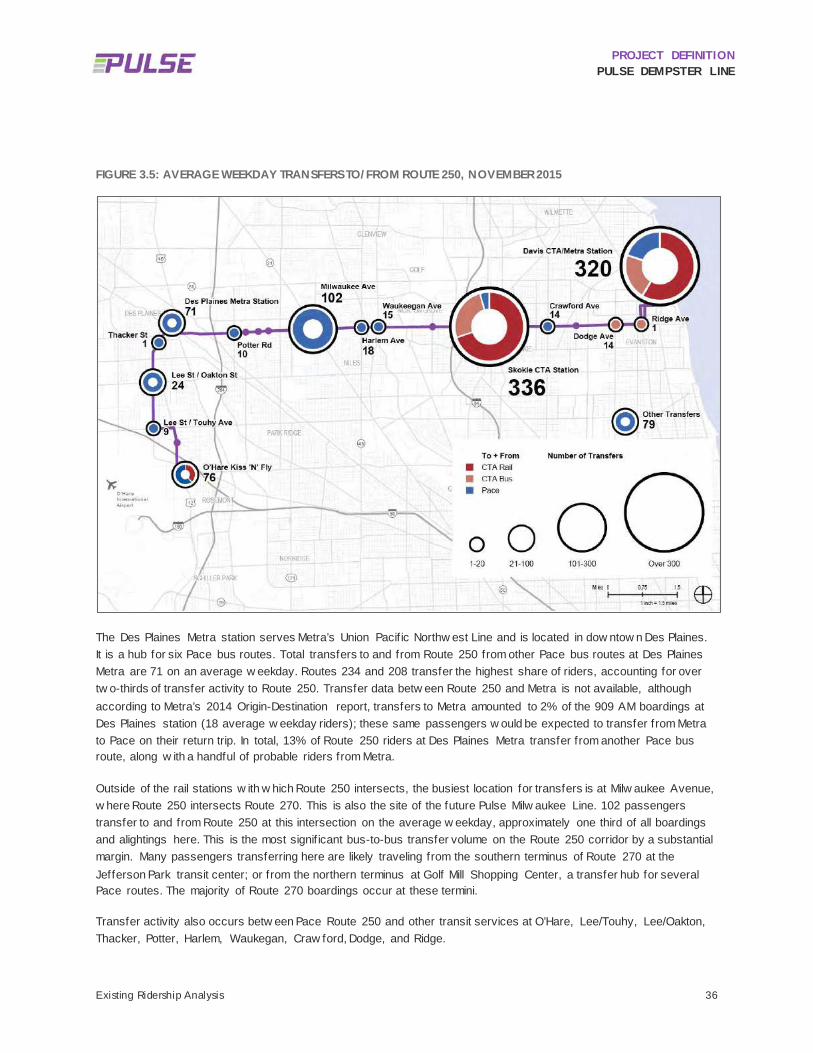
PROJECT DEFINITION PULSE DEMPSTER LINE
Existing Ridership Analysis 36
FIGURE 3.5: AVERAGE WEEKDAY TRANSFERS TO/FROM ROUTE 250, NOVEMBER 2015
The Des Plaines Metra station serves Metra’s Union Pacif ic Northw est Line and is located in dow ntow n Des Plaines. It is a hub for six Pace bus routes. Total transfers to and from Route 250 from other Pace bus routes at Des Plaines Metra are 71 on an average w eekday. Routes 234 and 208 transfer the highest share of riders, accounting for over tw o-thirds of transfer activity to Route 250. Transfer data betw een Route 250 and Metra is not available, although according to Metra’s 2014 Origin-Destination report, transfers to Metra amounted to 2% of the 909 AM boardings at Des Plaines station (18 average w eekday riders); these same passengers w ould be expected to transfer from Metra to Pace on their return trip. In total, 13% of Route 250 riders at Des Plaines Metra transfer from another Pace bus route, along w ith a handful of probable riders from Metra.
Outside of the rail stations w ith w hich Route 250 intersects, the busiest location for transfers is at Milw aukee Avenue, w here Route 250 intersects Route 270. This is also the site of the future Pulse Milw aukee Line. 102 passengers transfer to and from Route 250 at this intersection on the average w eekday, approximately one third of all boardings and alightings here. This is the most signif icant bus-to-bus transfer volume on the Route 250 corridor by a substantial margin. Many passengers transferring here are likely traveling from the southern terminus of Route 270 at the Jefferson Park transit center; or from the northern terminus at Golf Mill Shopping Center, a transfer hub for several Pace routes. The majority of Route 270 boardings occur at these termini.
Transfer activity also occurs betw een Pace Route 250 and other transit services at O’Hare, Lee/Touhy, Lee/Oakton, Thacker, Potter, Harlem, Waukegan, Craw ford, Dodge, and Ridge.

PROJECT DEFINITION PULSE DEMPSTER LINE
Existing Ridership Analysis 37
BOARDINGS NEAR PACE-PROPOSED PULSE STATIONS 3.6
Stop-level boarding data obtained from Pace for the period from May 1, 2014 through April 30, 2015 w as used to evaluate the share of overall Route 250 ridership that w ould be served by the stations identif ied in the Pace 2010 Report. Based on 2015 ridership data, these stations w ould capture 80% of total ridership w ithin one-quarter (1/4) mile of a Pulse station and 65% of total ridership w ithin one-eighth (1/8) mile of a Pulse station (see Table 3.2).
TABLE 3.2: RIDERSHIP NEAR PACE-PROPOSED PULSE STATIONS
Route 250 Ridership Within 1/4 Mile of Original Pace-Recommended Locations: 2,312 (80% of Total)
Route 250 Ridership Within 1/8 Mile of Original Pace-Recommended Locations: 1,868 (65% of Total)
3.6.1 Key Locations Not Served by Pace-Proposed Pulse Stations The majority of Route 250 ridership is captured by the stations recommended in the Pace 2010 report, but there are signif icant gaps along Lee Street/Mannheim Road and along Dempster Street w here ridership w ould not be effectively served. These segments w ere further scrutinized and, in some cases, additional or alternative station locations are proposed, as discussed in Chapter 4.
Ridership that is not w ithin ¼ mile of a Pace-proposed Pulse exists in the follow ing segments of the corridor:
Lee-Mannheim/Touhy to Lee-Mannheim/Oakton (Des Plaines): 38 average w eekday boardings occur along this segment, w ith the largest share at How ard Avenue.
Lee-Mannheim/Oakton to Des Plaines Metra (Des Plaines): 53 average w eekday boardings occur along this segment, distributed among more than 10 bus stop locations.
Des Plaines Metra to Dee Road (Des Plaines): This ridership is w ithin Des Plaines betw een Busse Road and Rand Road/Northw est Highw ay. Approximately 21 boardings occur here on an average w eekday.
Luther Lane to Milwaukee Avenue (Niles): Approximately 112 average w eekday boardings are beyond one-quarter (1/4) mile of the nearest Pace-proposed station. The Cumberland Avenue and Grand Avenue stops each have more than 30 w eekday boardings.
Milwaukee Avenue to Waukegan Road (Morton Grove and Niles): Approximately 119 average w eekday boardings occur beyond one-quarter (1/4) mile from Milw aukee or Waukegan w ithin this gap. The highest ridership along this segment occurs at Notre Dame High School, w here boardings occur primarily in the hours follow ing school dismissal, and at Harlem Avenue, w ith 84 w eekday boardings.
Waukegan Road to Austin Avenue (Morton Grove): Ridership not served in this area is east of the Metra Milw aukee District North Line tracks and includes about 31 average w eekday riders, distributed among multiple stops.
Austin Avenue to Dempster-Skokie CTA (Morton Grove and Skokie): 28 riders are not served w ithin one-quarter (1/4) mile of a Pulse station, distributed among multiple stops.

PROJECT DEFINITION PULSE DEMPSTER LINE
Existing Ridership Analysis 38
Dempster-Skokie CTA to Crawford Avenue (Skokie): Much of the south side of Dempster in this gap is occupied by the Evanston Golf Club. Single family homes are north of Dempster. Only 9 w eekday boardings are unserved by Pace-proposed stations along this segment.
Another source of ridership to be considered is the special trips to and from Maine East and Maine West high schools that operate over portions of the Route 250 corridor and are signed as Route 250. Among trips serving Maine East High School, ridership along the route deviation betw een Oakton/Greenw ood and Dempster/Harlem accounts for 25 boardings and alightings, w hile a northern trip from Golf Road and Harlem serves only tw o total boardings and alightings per day.
To serve Maine West High School in Des Plaines, a single trip in the morning begins in dow ntow n Des Plaines and deviates from the Route 250 corridor to serve the high school, located about six-tenths (6/10) of a mile w est of Mannheim Road on Oakton Street, w ith a return trip operating in the afternoon. 22 passengers arrive at Maine West High School on the morning trip, and 43 passengers board there in the afternoon.
AVERAGE BOARDINGS PER TRIP 3.7
Figure 3.6 show s average w eekday boardings per trip, by hour and direction. This is defined as total hourly ridership divided by the number of Route 250 departures in that hour.
Averaged throughout the typical w eekday, Route 250 sees over 32 boardings per trip, including school trips. Service levels are generally responsive to changes in demand at different times of the day, resulting in relatively consistent vehicle loads throughout the morning, midday, and afternoon. Boardings per trip are highest in the early afternoon, w hen Evanston-bound and O’Hare-bound vehicles carry up to 43 passengers per trip. Throughout the remainder of daytime hours demand ranges betw een 30 and 40 boardings per trip, declining to betw een 20 and 30 boardings per trip in the early evening and 10 boardings per trip in the late evening.

PROJECT DEFINITION PULSE DEMPSTER LINE
Existing Ridership Analysis 39
FIGURE 3.6: AVERAGE BOARDINGS PER TRIP
In the morning peak period, per-trip boardings are noticeably higher in the Evanston-bound direction. There are few er Evanston-bound trips than O’Hare-bound trips during these hours. This may be indicative of the need to provide additional Evanston-bound service during peak AM commuting hours.
Because ridership on Route 250 is dispersed throughout the corridor, there is still ample capacity on most Route 250 vehicles even during periods of peak per-trip boardings. This is discussed further in the next section.
THROUGHPUT ANALYSIS AND ACTIVITY BY SEGMENT 3.8
Throughput measures the total number of passengers traveling through each segment of the corridor, and is defined as the difference betw een cumulative boardings and alightings in each segment as the bus travels from the start of its run tow ard its terminus.
Figure 3.7 show s the overall activity along the Evanston-bound route 250 by stop, including boardings and alightings by stop as w ell as overall throughput. Throughput increases steadily as Route 250 heads north into Des Plaines and east along Dempster Street. Throughput hits a plateau betw een Lutheran General Hospital and Dempster-Skokie CTA, dropping considerably as Evanston-bound riders alight to transfer to the CTA Yellow Line. Throughput remains f lat betw een CTA Skokie and Dempster/Dodge w here it then steadily declines tow ards Davis Street as riders alight in dow ntow n Evanston.
0
5
10
15
20
25
30
35
40
45
50
4 5 6 7 8 9 10 11 12 13 14 15 16 17 18 19 20 21 22 23 0Hour Beginning
Evanston-bound
O'Hare-bound
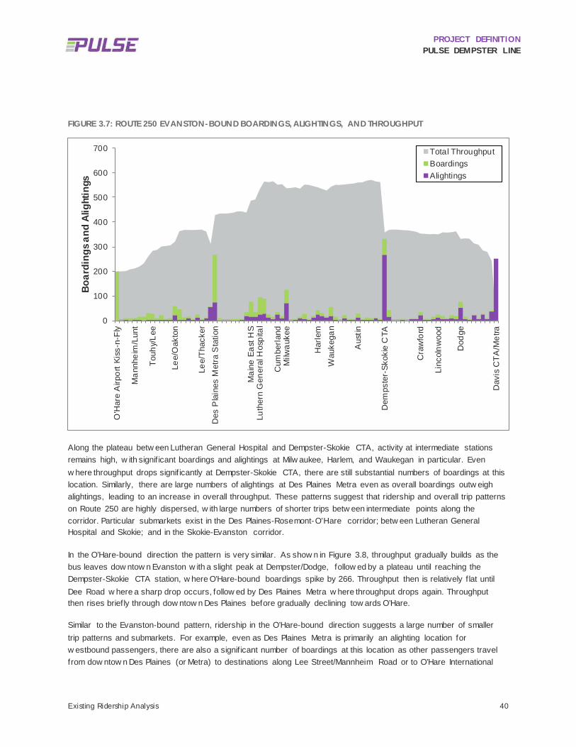
PROJECT DEFINITION PULSE DEMPSTER LINE
Existing Ridership Analysis 40
FIGURE 3.7: ROUTE 250 EVANSTON-BOUND BOARDINGS, ALIGHTINGS, AND THROUGHPUT
Along the plateau betw een Lutheran General Hospital and Dempster-Skokie CTA, activity at intermediate stations remains high, w ith signif icant boardings and alightings at Milw aukee, Harlem, and Waukegan in particular. Even w here throughput drops signif icantly at Dempster-Skokie CTA, there are still substantial numbers of boardings at this location. Similarly, there are large numbers of alightings at Des Plaines Metra even as overall boardings outw eigh alightings, leading to an increase in overall throughput. These patterns suggest that ridership and overall trip patterns on Route 250 are highly dispersed, w ith large numbers of shorter trips betw een intermediate points along the corridor. Particular submarkets exist in the Des Plaines-Rosemont-O’Hare corridor; betw een Lutheran General Hospital and Skokie; and in the Skokie-Evanston corridor.
In the O’Hare-bound direction the pattern is very similar. As show n in Figure 3.8, throughput gradually builds as the bus leaves dow ntow n Evanston w ith a slight peak at Dempster/Dodge, follow ed by a plateau until reaching the Dempster-Skokie CTA station, w here O’Hare-bound boardings spike by 266. Throughput then is relatively f lat until Dee Road w here a sharp drop occurs, follow ed by Des Plaines Metra w here throughput drops again. Throughput then rises briefly through dow ntow n Des Plaines before gradually declining tow ards O’Hare.
Similar to the Evanston-bound pattern, ridership in the O’Hare-bound direction suggests a large number of smaller trip patterns and submarkets. For example, even as Des Plaines Metra is primarily an alighting location for w estbound passengers, there are also a signif icant number of boardings at this location as other passengers travel from dow ntow n Des Plaines (or Metra) to destinations along Lee Street/Mannheim Road or to O’Hare International
0
100
200
300
400
500
600
700
O'H
are
Airp
ort K
iss-
n-Fl
y
Man
nhei
m/L
unt
Touh
y/Le
e
Lee/
Oak
ton
Lee/
Thac
ker
Des
Pla
ines
Met
ra S
tatio
n
Mai
ne E
ast H
SLu
ther
n G
ener
al H
ospi
tal
Cum
berla
ndM
ilwau
kee
Har
lem
Wau
kega
n
Aus
tin
Dem
pste
r-Sk
okie
CTA
Cra
wfo
rd
Linc
olnw
ood
Dod
ge
Dav
is C
TA/M
etra
Boar
ding
s and
Alig
htin
gs
Total ThroughputBoardingsAlightings

PROJECT DEFINITION PULSE DEMPSTER LINE
Existing Ridership Analysis 41
Airport. Similarly, there are signif icant numbers of alightings betw een Dodge and Craw ford, indicating a substantial market for short-distance trips from dow ntow n Evanston to other parts of Evanston and Skokie. Finally, there is signif icant overall boarding and alighting activity at intermediate stops along the highest-throughput segment of Route 250 betw een Dempster-Skokie CTA and Lutheran General Hospital. FIGURE 3.8: ROUTE 250 O’HARE-BOUND BOARDINGS, ALIGHTINGS, AND THROUGHPUT
0
100
200
300
400
500
600
700
Dav
is C
TA S
tatio
n
Dod
ge
Fore
stvi
ew
Cra
wfo
rd
Dem
pste
r-Sk
okie
CTA
Aus
tin
Wau
kega
nH
arle
m
Milw
auke
e
Cum
berla
nd
Luth
ern
Gen
eral
Hos
pita
lM
aine
Eas
t HS
Des
Pla
ines
Met
raG
race
land
/Tha
cker
Lee/
Oak
ton
Lee/
Touh
y
Man
nhei
m/L
unt
O'H
are
Airp
ort K
iss-
n-Fl
y
Boar
ding
s and
Alig
htin
gs
Total ThroughputBoardingsAlightings

PROJECT DEFINITION PULSE DEMPSTER LINE
Stations 42
4 Stations OVERVIEW 4.1
In April 2010, Pace completed the 2010 Pace Dempster ART Station Selection Report (Pace 2010 Report) w hich identif ied one or more preferred Evanston-bound and O’Hare-bound station sites at each of the recommended station locations, as show n in Figure 4.1 and Table 4.1.
FIGURE 4.1: PULSE DEMPSTER LINE STATION LOCATIONS FROM PACE 2010 REPORT
The suitability of each of the proposed stations in the Pace 2010 Report w as reassessed in the context of other transit services and recent developments. A number of additional station locations, w ere also evaluated either in addition to or as potential alternates to those identif ied in the Pace 2010 Report, all of w hich w ere summarized in a May 2016 Preliminary Station Location and Site Selection Options Technical Memorandum.

PROJECT DEFINITION PULSE DEMPSTER LINE
Stations 43
A Conceptual Station Design Technical Memorandum issued in June 2016 furthered the station evaluation in the Pace 2010 Report and the Preliminary Station Location and Site Selection Options Technical Memorandum by undertaking an examination of existing Route 250 ridership, local land use patterns, street cross-sections, f ield observations, and input from community stakeholders.12 The analysis documented in the Conceptual Station Design Technical Memorandum is included here w ith some additional minor refinements, including updates to the typical station sand station layouts to reflect an increase in the typical platform w idth to 12.5 feet, w hich includes a 1.5’ w ide landscape bed. This change w as made to ensure a four foot w ide pedestrian access route betw een the shelter and the back of the platform curb. During the next environmental review and design phases, it is expected that the station sites and layouts w ill be further refined.
FIGURE 4.2: PULSE DEMPSTER LINE STATION LOCATION CHANGES SINCE MAY 2016 PRELIMINARY STATION LOCATION AND SITE SELECTION OPTIONS TECHNICAL MEMORANDUM
4.1.1 Station Location Evaluations Figure 4.2 documents changes made to the proposed Dempster Line station set since the May 2016 Preliminary Station Location and Site Selection Options Technical Memorandum w as issued. Since that time, 23 station locations
12 The previous tech memo documented the prior elimination of Ridge as a station location due to low ridership, anticipated community opposition, and the presence of surrounding historic districts. As it was eliminated at that time, it is not documented within the individual station sites in Section 4.4 of this memo but is included in our summary table of evaluated station locations.

PROJECT DEFINITION PULSE DEMPSTER LINE
Stations 44
w ere evaluated including the 16 original station locations from the Pace 2010 Report. These changes w ere made as a result of additional feedback received from stakeholder communities and technical analysis. Of the 23 evaluated stations, 18 have been detailed w ith station layouts and are recommended for evaluation during the NEPA phase. These 18 stations includes tw o terminal station locations, 15 intermediate station locations and one alternate station at Potter Road that may be considered as alternate to locating a station at Dee Road. The follow ing points summarize the signif icant changes made to the station set since the May 2016 Preliminary Station Location and Site Selection Options Technical Memorandum w as issued, many of w hich are illustrated in Figure 4.2 and Table 4.1.
Station Location – The station location refers to the general location of the station along the Pulse Dempster Line corridor. Station locations often refer to the intersection adjacent to the station.
Station Site – A station site refers to the geographic location of an individual station platform. There are often multiple station site options at each station location. These are referred to as station alternates.
23 station locations and 79 station site options w ere evaluated
18 station locations and 47 station sites are advancing for further consideration
Relocation of one station location from Mannheim/Lunt to Mannheim/Higgins
Relocation of one station location from Luther to Western
Addition of new station locations at Cumberland and Harlem

PROJECT DEFINITION PULSE DEMPSTER LINE
Stations 45
TABLE 4.1: PULSE DEMPSTER LINE STATION LOCATION STATUS SUMMARY
STATION LOCATION 2010 PACE STUDY STATION LOCATIONS
PRELIMINARY STATION LOCATION MEMO
RECOMMENDATION
STATIONS CURRENTLY UNDER CONSIDERATION
Rosemont CTA X X
O’Hare
Mannheim/Higgins X X
Mannheim/Lunt X X
Lee/Touhy
Lee-Mannheim/Oakton
Lee-Mannheim/Graceland/Thacker X X
Des Plaines Metra
Potter (Dee Alternate) X
Dee X
Luther X
Western (Luther Alternate) X
Cumberland X
Milwaukee
Harlem X
Waukegan
Austin
Dempster-Skokie CTA
Crawford
Lincolnwood
Dodge
Ridge X X
Davis CTA/Metra
Total Number of Stations (23) 16 19 18

PROJECT DEFINITION PULSE DEMPSTER LINE
Stations 46
4.1.1.1 RELOCATED STATIONS
The station at Mannheim/Lunt w as relocated to Mannheim/Higgins at the suggestion of the City of Des Plaines and Village of Rosemont, each of w hom have new developments and/or proposals being considered for the area. The Mannheim/Lunt station is less desirable as a station location due to its low ridership (six (6) average daily boardings eastbound and three (3) w estbound in 2014). Although Allstate Arena is located at Mannheim/Lunt, existing Route 250 has not typically served the arena as riders attending events typically use Route 222, the Allstate Arena Express, w hich operates directly from Allstate Arena to Rosemont CTA.
A station w as relocated from Luther Lane to Western Avenue to better serve Lutheran General Hospital as w ell as retail land uses near the intersection of Western Avenue and Dempster Street. There are higher boardings on Route 250 at Western than at Luther. Representatives from the City of Park Ridge also noted that the Luther intersection has the highest incidence of crashes of any section of Dempster w ithin Park Ridge. The Western location also provides a better connection to Niles Free Bus Route 411.
4.1.1.2 ADDED STATIONS
Cumberland w as added as a new station to establish half-mile station spacing betw een Western Avenue and Milw aukee Avenue. Adding a station at this location also allow s Pulse to potentially capture the 85 daily boardings for Route 250 and serve the multifamily developments in the area.
Harlem w as added as a new station to f ill in a service gap betw een Milw aukee and Waukegan and to serve commercial retail land uses. Adding a station at this location allow s Pulse to potentially serve 74 daily boardings that are currently being served by Route 250 and to establish half-mile station spacing betw een Milw aukee and Waukegan.
4.1.1.3 DISCARDED STATIONS
The extension of the Pulse Dempster Line service to the Rosemont CTA Blue Line station and adding a station at Lee-Mannheim/Graceland/Thacker w as also evaluated. The addition of the Lee-Mannheim/Graceland/Thacker station location w as contingent upon the Rosemont extension in order to provide frequent service betw een the high-density residential and commercial development near the Lee-Mannheim/Graceland/Thacker intersection and the CTA Blue Line and 15 other Pace bus routes. Both of these station locations w ere determined to be infeasible at this time due to limited bus bay availability at the Rosemont CTA station.
4.1.2 Station Site Evaluations Station sites w ere qualitatively evaluated on a number of factors, including: operations; constructability; available right-of-w ay; traff ic movements; ridership and passenger markets including proximity to high ridership stops, ridership generators, and transfer connections; impacts on adjacent properties; pedestrian movements and access; Americans w ith Disabilities Act (ADA) implications; current and future land use; local context; community and agency input; potential impacts on project schedule and cost. These factors are described in more detail below and w ere taken into consideration w hen evaluating each station site for potential further development w ith a station layout and advancement to the NEPA screening phase. The qualitative evaluation of individual station sites is documented in Section 4.4.

PROJECT DEFINITION PULSE DEMPSTER LINE
Stations 47
4.1.2.1 PASSENGER COMFORT AND ACCESSIBILITY
Proximity to a signalized intersection or safe protected pedestrian crossing;
Sidew alk connections;
ADA implications including available space for constructing accessible ramps;
Proximity to major trip generators;
Proximity to the corresponding station platform in the opposite direction of travel;
Proximity to other local bus routes, including the potential for a shared station to serve connecting local buses;
Connections to proposed Pulse Lines on Touhy Avenue and Milw aukee Avenue; and
Aesthetic considerations and place-making potential.
4.1.2.2 RIGHT-OF-WAY AND PROPERTY IMPACTS
Sufficient curb length and suff icient right-of-w ay w idth for development of a station (it w as assumed that a typical Pulse station w ould require a contiguous space of approximately 60 feet in length and 12.5 feet in w idth (see Figure 4.9), although a smaller footprint can be accommodated for constrained sites (see Figure 4.11));
Cost and schedule impacts associated w ith modif ications, additional features, and/or remediation associated w ith construction at specif ic sites;
Potential impacts on adjacent property ow ners, particularly the potential need to acquire land, or to relocate or close drivew ays (these impacts should be minimized unless substantially outw eighed by other positive attributes of a particular location); and
Future development plans along the corridor.
4.1.2.3 OPERATIONS AND MAINTENANCE
Transit signal priority (TSP) opportunities, particularly for locations w here TSP is recommended 13 (far side stations are preferred for these intersections in order to maximize TSP benefits, and also at locations w here preliminary analysis did not result in a recommendation of TSP in order to facilitate future signal priority or other intersection treatments); and
Traff ic movements such as right turn lanes.
4.1.2.4 STAKEHOLDER FEEDBACK
Input received from local communities, agencies and project partners.
13 Transit Signal Priority is being implemented as a regional program. An evaluation was done by Pace in 2013 to determine which intersections along the Dempster corridor would be eligible for TSP. The results of that evaluation are referenced here in terms of whether there is the potential for TSP at each of the station locations.

PROJECT DEFINITION PULSE DEMPSTER LINE
Stations 48
STATION DESIGN 4.2
In 2013 and 2014, the Pulse station functional requirements, features, and layouts w ere established during the project definition phase of the f irst Pulse corridor, the Milw aukee Line. The station functional requirements guided the selection of station features and the development of station layout concepts. These requirements w ere refined through the advanced conceptual design and design phases for the Milw aukee Line. This station design w ork provides a foundation for the Pulse Dempster Line. The follow ing sections describe the Pulse station functional requirements as defined and refined through the development of the Milw aukee Line, including key passenger, operational, branding, and naming considerations; the primary station feature characteristics; and examples of tw o typical station layout concepts.
4.2.1 Station Functional Requirements Station facilities w ill be the most visible physical elements associated w ith Pulse service throughout the Pace system. Stations along the Dempster corridor should balance the need to express permanence and consistency throughout the Pulse system w ith a desire to accommodate local community context and preferences.
Station design priorities include providing passenger amenities for comfort and safety, operational considerations, and aesthetic and branding considerations that make the service attractive, legible and recognizable. These design priorities informed the development of the station functional requirements and the station feature set, and also influenced the development of appropriate site-specif ic station solutions. The follow ing lists outline the key design considerations that helped establish the functional requirements.
4.2.1.1 PASSENGER COMFORT AND SAFETY CONSIDERATIONS
The Chicago region’s climate requires that adequate station shelter be provided for w aiting passengers.
Stations shall be fully compliant w ith the ADA.
Safety shall be a primary consideration in all shelter designs.
Nearby drivew ays may present challenges at some station locations and may require modif ied design solutions to ensure that pedestrian-vehicle conflicts are minimized.
Stations shall preserve adequate sight distance and visibility for pedestrians as w ell as cyclists, bus drivers, and other motorists.
Stations in the vicinity of bicycle lanes shall be designed to minimize bicycle-pedestrian conflicts as w ell as bus-bicycle conflicts.
Stations shall be designed to function as part of the surrounding sidew alk netw ork w hen space or local preferences preclude routing the sidew alk behind the station.

PROJECT DEFINITION PULSE DEMPSTER LINE
Stations 49
4.2.1.2 OPERATIONAL CONSIDERATIONS
Local bus routes operating w ithin the corridor shall be accommodated at Pulse stations w here appropriate. This may include buses operated by both Pace and CTA. Where Pulse stations are located near, but not concurrent w ith, existing stops, the existing stops may be considered for closure. Stations served by CTA buses may require modif ications to platform height in order that they may serve both Pace and CTA fleet vehicles.
Stations shall provide appropriate drainage for rain and snow w ithin the public right-of-w ay and shall not direct drainage tow ard buildings or onto private property.
The use of heated pavement for de-icing and the additional pow er requirements for all station heating elements shall be incorporated into preliminary station planning and design documents.
Station platforms shall be designed for clear, intuitive operational usage.
Stations shall be located to preserve bus driver sight distance requirements for nearby streets and access drives.
Stations and the adjacent roadw ay shall be laid out to ensure safe operation of the bus as it approaches, dw ells, and departs the station.
Stations shall be located and designed to minimize the impact to adjacent properties, sidew alks, and access drives.
Stations shall be designed to facilitate maintenance. Maintenance may include shelter repairs, snow removal, and vertical marker upkeep.
Pace and/or its contractors shall maintain Pulse stations. Pace may establish local community partnerships for the maintenance of some elements, including any landscaping.
4.2.1.3 BRANDING CONSIDERATIONS
Stations shall provide a consistent user experience, even if their physical configuration may vary due to unique site or service conditions.
Vertical markers that are separate from the shelter structure shall serve as the primary visual expression of the Pulse brand, w ith near-level boarding platforms as another key distinguishing feature.
Branding elements shall be applied to the vertical marker, detectable w arning strip, shelter f inish, and shelter front panels. Figure 4.3 illustrates the vertical marker w ith Pulse branding.
Opportunities have been identif ied to customize selected station features to express local community character w hile preserving the distinct Pulse brand. More details regarding community expression and cost sharing are provided in the Station Feature Set subsection.
FIGURE 4.3: VERTICAL MARKER WITH BRANDING

PROJECT DEFINITION PULSE DEMPSTER LINE
Stations 50
Pulse Station Naming Guidelines w ere developed in November 2015 to establish consistency throughout the Pulse program and f inalize the Pulse Milw aukee Line station names. The Dempster Line station names used in this document w ere established according to these guidelines. Station names for each Dempster Line station shall be incorporated into the shelter design to enhance each station’s identity as part of the transit line.
4.2.2 Station Feature Set The station feature set w as established during the Milw aukee Line Project Definition based on Pace’s design priorities and typical station functional requirements. The features depicted in Figure 4.4 and described below w ere refined during the design of the Milw aukee Line. They have been incorporated into the Dempster Line station layout concepts. Portions of these station features can be customized by local communities to reflect local community character and context. 14
FIGURE 4.4: TYPICAL PULSE STATION AND FEATURE SET
14 In early 2016, Pace developed guidelines as part of the Milwaukee Line design to establish standards for the customization of some station elements as well as maintenance and cost sharing responsibil ities associated with customization. These standards are detailed in the guidance document entitled Community Expression Features: Cost Sharing Strategy and Coordination Guidelines (Appendix M) .

PROJECT DEFINITION PULSE DEMPSTER LINE
Stations 51
The follow ing features shall be incorporated into the Dempster Line stations:
4.2.2.1 SHELTERS
Each station shall include a partially enclosed, four-sided, fully accessible shelter structure to include rear, side, and front panels for w eather protection. The shelter w ill be approximately 16 feet long and six feet deep and is based on the Tolar 16’ Ad ‘Orion’ shelter, although similar prefabricated shelters from other vendors may be acceptable. The shelter is to be furnished and installed by the construction contractor hired by Pace, based on approved design and palette options. Some stations may require a modif ied station shelter, w hich shall be based upon the selected typical Pulse shelter. Figure 4.5 show s the side and front standard shelter elevations for the shelter designed for use on the Milw aukee Line and throughout the Pulse Program, provided that some modif ications to the shelter may be w arranted in the future.
FIGURE 4.5: STANDARD SHELTER ELEVATIONS (SIDE AND FRONT)
The front shelter panel shall be etched w ith the Pulse frit pattern and shall include the station name. Rear and approach-side shelter panels w ill be transparent glass. Communities may opt to include a customized rear etched glass panel. The side panel tow ard the departing end of the platform w ill be a tw o-sided advertising/information panel.
All glass shelter panels shall be vandal-resistant and have an anti-graff iti f ilm or coating.

PROJECT DEFINITION PULSE DEMPSTER LINE
Stations 52
For cleanliness and comfort, there shall be a gap of approximately tw o to four inches betw een the shelter w alls and the platform surface. A w ind skirt may be incorporated into the shelter w alls to further protect w aiting passengers from the elements.
Shelters shall have an angular roof that is sloped tow ard the back, and made of metal and glass or other approved materials. Shelters shall not have f lat or curved roofs.
A w heelchair w aiting area, bench, and additional standing w aiting area shall be accommodated w ithin the shelter. Shelter bench seats shall be f lat, have seat dividers, and be made of recycled plastic or w ood and steel.
Shelter interiors shall be w heelchair accessible and ADA-compliant.
Shelters shall be illuminated via interior lighting integrated w ithin the structure. The lighting shall be suff icient for passenger comfort as w ell as to illuminate the station name on the front panel.
Advertising panels on the shelter and the real-time arrival sign on the vertical marker shall be positioned to maximize visibility and sight lines at the stations.
Shelters shall provide overhead infrared heating for passenger comfort in cold w eather. Durable, tamper-proof activation mechanisms, such as motion sensors or piezoelectric buttons, shall be utilized along w ith theft deterring hardw are.
Pace shall coordinate w ith communities to determine if cameras/call boxes are desired at the shelters. If desired, Pace can provide pre-w ired accommodations but shall not pay for installation, nor monitor or maintain any such systems.
A speaker and audio activation button connected to the real-time information sign on the vertical marker shall be installed in the interior of the shelter w ith cabling routed w ithin the racew ays of the shelter’s structural members.
4.2.2.2 STATION PLATFORMS AND LOADING AREAS
Each station shall include a vertical marker or signage element placed at each station so as to indicate to riders and the bus driver the general front-door boarding location (see Figure 4.4).
Flag signs for local Pace routes do not need to be provided at Pulse stations. Transfer connections to local routes stopping at a Pulse station shall be indicated on the vertical marker if applicable. CTA may continue to require f lag signs at stations w here CTA buses w ill stop; this shall be coordinated w ith CTA.
The typical station platform shall provide near-level boarding at a height of 12 inches above the roadw ay surface, w hich is six inches above a typical adjacent sidew alk, and shall be accessed via ADA-compliant pedestrian ramps at a 1:20 slope at either end. Alternative pedestrian access options shall be considered on a case-by-case basis to accommodate site constraints. The 12-inch high boarding platform shall be constructed of concrete over a minimum of four inches of compacted granular sub-base.
Standard concrete is assumed for platforms. The station pavement can be customized by a community through the use of colored concrete or by stamping the municipal logo at the base of the ramp. The customization of the platform pavement and/or stamped municipal logo shall be subject to standards established in the Community Expression Features: Cost Sharing Strategy and Coordination Guidelines document (see Appendix M).

PROJECT DEFINITION PULSE DEMPSTER LINE
Stations 53
An electric pavement heating system suff icient for prevention of snow and ice buildup shall be embedded in the concrete platform and ramps, thus mitigating slip hazards. Snow melt systems elements can be detected prior to any future concrete penetrations, and can be repaired if inadvertently damaged. The snow melt system has been designed into the station platforms for the Milw aukee Line. As the Milw aukee Line is constructed and goes into service, the snow melt system shall be monitored and evaluated for any modif ications that may need to be made prior to installation on the Dempster Line.
o The pavement heating systems, as w ell as the shelter heaters, w ill be signif icant pow er draw s w hen in operation (betw een 200A and 250A). Therefore, the local energy utility, ComEd, w ill need to evaluate the impact on the pow er distribution system along the corridor; coordination w ith ComEd w ill also be needed to locate a 120/240V pow er source and determine how it w ill route to the utility meters. This shall be an early coordination item during advanced conceptual design.
The rear of the platform shall be separated from the surrounding area by pipe railing. This standard design w ill allow for community expression in the form of tw o panels mounted to the railing along the back of the platform. A community may customize these infill panels subject to standards established in the Community Expression Features: Cost Sharing Strategy and Coordination Guidelines document.
Per individual station site plans, concrete curb and gutter shall be removed and reconstructed w ith gutter w idths matching existing conditions (either B6.12 or B6.24) unless otherw ise specif ied. The height of the barrier curb w ill slope from the existing curb height to the 12-inch high curb.
A green detectable w arning strip shall be installed at the back of curb along the open boarding edge of the raised platform. A segment of w arning strip having a contrasting color shall be installed in a location that indicates the front door boarding area. Color selections for the detectable w arning strip and the contrasting segment should match or approximate approved colors of the Pulse brand.
A bus curb shall be installed along the face of the curb to facilitate near level boarding and to limit damage to the curb as w ell as to the vehicle and tire.
A concrete bus loading pad 60 feet long and at least 10 feet w ide shall be installed adjacent to each station platform to provide for a consistent platform-to-roadw ay height tolerance at the loading edge of the platform and a durable pavement solution for bus operations. Consistent w ith the design for the Milw aukee Line, the design specif ications for the bus pad shall be based on CDOT standards, w hich call for 10 inches of concrete pavement over a minimum of 8 inches of granular sub-base. The concrete pad shall be tied to the existing pavement and curb and gutter w ith dow el bars, and joint sealer shall be poured along the full perimeter of the pad. The bus pad shall extend 10 feet from the gutter, or to the existing pavement joint, w hichever distance is greater. Figure 4.6 depicts a typical concrete bus loading pad in relation to the platform.

PROJECT DEFINITION PULSE DEMPSTER LINE
Stations 54
FIGURE 4.6: PULSE STATION RENDERING WITH TYPICAL CONCRETE BUS PAD EXTENTS
Station electrical cabinets shall be located adjacent to each station platform in an area that is accessible for maintenance purposes. Where possible, the electrical cabinet shall be installed at the end of the platform, near the bicycle rack, or behind the shelter, facing aw ay from the road. This w ill avoid obstructing movement on the platform and minimize its visual appearance. To the extent possible, the electrical cabinets shall be sited to minimize impacts to adjacent properties. The cabinet shall be a NEMA 4X enclosure and shall be made of a brushed stainless steel designed for exterior installation w ith extra corrosion resistance to road salt. The cabinets shall be rectangular in shape and shall not exceed 60 inches w ide by 18 inches deep by 74 inches in height. How ever, the actual size of cabinet may vary and should be minimized to the greatest extent possible to reduce potential property impacts. The enclosure shall be mounted on a solid concrete foundation.
The pow er and control cabinet shall be equipped w ith tw o doors: one side of the cabinet shall contain pow er distribution equipment, w hile the other side shall be designated for various control and communication equipment. The site’s utility meter shall be installed on the side of the cabinet adjacent to the 120/240V distribution panel. The dimensions indicated assume that all planned electrical components w ill be included in the station. If certain components, particularly the shelter heaters and/or pavement snow melt system, are excluded, the required size of the electrical cabinet may be reduced and/or eliminated provided that the vertical marker is able to serve as an electrical cabinet.
4.2.2.3 STATION FURNISHINGS AND AMENITIES
Each station shall include a vertical marker, incorporating the Pulse brand and informational signage. The vertical marker is being designed as part of the Milw aukee Line design contract. The f inal design and fabrication of the vertical marker for the Milw aukee Line should be monitored, and the design refined as necessary during the advanced conceptual design and design phases for the Dempster Line. The vertical marker shall be designed and bid as a comprehensive system w ith all necessary hardw are and softw are detailed in the Dempster Line construction plans, specif ications, and estimate.

PROJECT DEFINITION PULSE DEMPSTER LINE
Stations 55
o Sign height ordinances may limit the height of the vertical marker in some communities along the Dempster Line. For this reason, design options may be needed and the placement of reduced height markers shall be considered on an as-needed basis w hile maximizing visibility of the Pulse station.
o Real-time information signs shall be located w ithin the vertical marker and visible from the platform and the street. The signs shall be visible from both sides of the marker. The real time information sign system shall be designed, detailed, and bid as part of the Dempster Line construction.
o In addition to the real-time arrival display, additional signage incorporated into the vertical marker shall include a static route map, w ayfinding signage, and information on connecting CTA and Pace routes, if appropriate. All static information shall be easily updated and modif ied, w hile also being vandal-resistant.
o To the extent possible, the vertical marker shall be designed so that it can accommodate electrical pow er and control equipment suff icient to supply all electrical components at the station, except for those needed for the pavement snow melt and shelter heater systems. This allow s for the separate electrical cabinet to have a more modest size to accommodate the pavement snow melt and shelter heating systems.
Bicycle storage shall be provided at every station w here feasible. Racks shall allow for both front and rear w heel attachment, rather than being narrow in configuration. Where space allow s, at least one rack, capable of accommodating tw o bicycles, shall be provided at each typical Pulse station. Although Pace has selected a preferred bicycle rack for the typical Pulse station, Pace w ill install a substitution of the community’s choice that meets the design requirements subject to the Community Expression Features: Cost Sharing Strategy and Coordination Guidelines. Pace’s preferred bicycle rack is the Landscape Forms Bola model (see Figure 4.7).
A metal-body trash receptacle shall be provided at every station. Trash receptacles should be of a 30 to 40 gallon capacity and f ire resistant. Receptacles shall be bolted to the station platform and have a removable liner. Similar to the bicycle rack, Pace w ill install a substitution trash receptacle at the preference of a local community subject to the Community Expression Features: Cost Sharing Strategy and Coordination Guidelines. Pace has selected the Landscape Forms Steely Can model as the preferred trash receptacle for Pulse stations (see Figure 4.8).
FIGURE 4.7: BOLA BICYCLE RACK

PROJECT DEFINITION PULSE DEMPSTER LINE
Stations 56
FIGURE 4.8: STEELY CAN TRASH RECEPTACLE
The typical station shall include an 18-inch w ide landscaping strip located along the back edge of the ramps and the boarding platform w here space allow s and w here appropriate based on the surrounding context. The landscaping w ill be provided only if a local partner (e.g. community, w ard off ice, Special Service Area (SSA), chamber of commerce, or local business) is w illing to maintain it. The landscaping shall be irrigated in part via runoff from the shelter roof and shall feature drought-tolerant plants requiring minimal upkeep. The landscaping shall also serve as a community expression option (subject to local commitments for ongoing maintenance noted above). The station layouts indicate w hether or not landscaping has been included in each station. Landscaping may be w idened as appropriate to f ill the available space. Pace shall coordinate w ith local communities to select the planting palette provided that a local partner has agreed to maintain it.
If local communities desire to provide cameras/call boxes at Pulse stations, they shall notify Pace during project development so that pre-w ired accommodations can be provided.
Ventra™ fare vending machines are installed, or w ill be installed by others, at each of the intermodal stations at O’Hare, Des Plaines Metra, Dempster-Skokie CTA, and Davis CTA/Metra as part of other regional coordination efforts. Pace is not procuring or installing any fare vending machines for the Pulse Dempster Line.
4.2.3 Station Layout Concepts Station layout concepts w ere developed and refined through the planning and design of the Pulse Milw aukee Line. Tw o station layouts, a “typical” layout and a “compact” layout, w ere established and used as the basis for the development of site-specif ic station layouts for the Pulse Dempster Line. Since the June issuance of the Conceptual Station Design Technical Memorandum, the station layouts have been updated to ensure a four foot w ide pedestrian access route betw een the shelter and the back of the platform curb. This resulted in an increase in the typical platform w idth from 12 feet to 12.5 feet, w hich includes the 18-inch landscape bed. The layouts reflecting this update are dated July 15, 2016 and are included as Appendix F.

PROJECT DEFINITION PULSE DEMPSTER LINE
Stations 57
4.2.3.1 TYPICAL STATION LAYOUT
The typical layout reflects an ideal, preferred station configuration and feature set and shall be used in locations w here the available right-of-w ay is not constrained. The typical station layout has a footprint of 60 feet in length by 12.5 feet in w idth. Figure 4.9 show s the typical station layout in plan view , Figure 4.10 provides a section of the typical station, and Figure 4.4 above show s a rendering of a typical station.
FIGURE 4.9: TYPICAL STATION LAYOUT

PROJECT DEFINITION PULSE DEMPSTER LINE
Stations 58
FIGURE 4.10: SECTION OF A TYPICAL STATION
4.2.3.2 COMPACT STATION LAYOUT
The compact layout reflects a station configuration to be used in locations w here available right-of-w ay w idth and/or length are limited at the selected site. The compact station layout, w ith a footprint of 45 feet by 11 feet, differs from the typical station layout in the follow ing w ays:
The shelter structure is anticipated to be shorter (12 feet in length instead of 16 feet), w ith the same depth as the typical station shelter and providing adequate space for a bench and w heelchair w aiting area.
The raised platform is reduced in length to 33 feet, w ith access ramps at a 1:12 slope at both ends.
The bicycle rack is eliminated.
The landscape bed is eliminated.
Figure 4.11 show s the compact station layout and Figure 4.12 show s a rendering of a compact station.

PROJECT DEFINITION PULSE DEMPSTER LINE
Stations 59
FIGURE 4.11: COMPACT STATION LAYOUT
FIGURE 4.12: COMPACT STATION LAYOUT RENDERING
Along the Dempster corridor, each of the station sites has varied conditions and constraints. Station layouts w ill be adapted to accommodate unique site characteristics and right-of-w ay constraints w hile still adhering to the functional
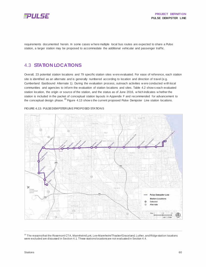
PROJECT DEFINITION PULSE DEMPSTER LINE
Stations 60
requirements documented herein. In some cases w here multiple local bus routes are expected to share a Pulse station, a larger station may be proposed to accommodate the additional vehicular and passenger traff ic.
STATION LOCATIONS 4.3
Overall, 23 potential station locations and 79 specif ic station sites w ere evaluated. For ease of reference, each station site is identif ied as an alternate and is generally numbered according to location and direction of travel (e.g. Cumberland Eastbound Alternate 1). During the evaluation process, outreach activities w ere conducted w ith local communities and agencies to inform the evaluation of station locations and sites. Table 4.2 show s each evaluated station location, the origin or source of the station, and the status as of June 2016, w hich indicates w hether the station is included in the packet of conceptual station layouts in Appendix F and recommended for advancement to the conceptual design phase. 15 Figure 4.13 show s the current proposed Pulse Dempster Line station locations.
FIGURE 4.13: PULSE DEMPSTER LINE PROPOSED STATIONS
15 The reasons that the Rosemont CTA, Mannheim/Lunt, Lee-Mannheim/Thacker/Graceland, Luther, and Ridge station locations were excluded are discussed in Section 4.1. These stations locations are not evaluated in Section 4.4.

PROJECT DEFINITION PULSE DEMPSTER LINE
Stations 61
TABLE 4.2: PULSE DEMPSTER LINE STATION LOCATION SUMMARY
Station Location Source Status (June 2016)
Rosemont CTA 2016 Analy sis Ex cluded
O’Hare 2010 Study Included
Mannheim/Higgins Community Outreach Included
Mannheim/Lunt 2010 Study Ex cluded
Lee/Touhy 2010 Study Included
Lee-Mannheim/Oakton 2010 Study Included
Lee-Mannheim/Thacker/Graceland 2016 Analy sis Ex cluded
Des Plaines Metra 2010 Study Included
Potter (Dee Alternate) 2016 Analy sis Included
Dee 2010 Study Included
Luther 2010 Study Ex cluded
Western 2016 Analy sis Included
Cumberland 2016 Analy sis Included
Milw aukee 2010 Study Included
Harlem 2016 Analy sis Included
Waukegan 2010 Study Included
Austin 2010 Study Included
Dempster-Skokie CTA 2010 Study Included
Craw ford 2010 Study Included
Lincolnw ood 2010 Study Included
Dodge 2010 Study Included
Ridge 2010 Study Ex cluded
Dav is CTA/Metra 2010 Study Included
STATION SITES 4.4
The Pulse Dempster Line includes f if teen (15) pairs of intermediate stations and tw o terminal stations at O’Hare and at Davis CTA/Metra. The terminal stations w ill be built at intermodal facilities w here minimal capital investments w ill be needed to support Pulse service. Intermediate stations serving the Pulse Dempster Line w ill typically consist of curbside stations serving buses in a mixed traff ic lane.

PROJECT DEFINITION PULSE DEMPSTER LINE
Stations 62
As stated in the Section 4.1, a total of 79 individual station sites w ere evaluated on a number of factors, including: operations, constructability, available right-of-w ay, traff ic movements, passenger markets, transfer connections, impacts on adjacent properties, passenger convenience, pedestrian movements and access, ADA implications, current and future land use, local context, community and agency input, potential impacts on project schedule, and the potential cost to remediate site issues. For each site evaluated, a determination w as made as to w hether it w ould be developed w ith a Conceptual Station Improvement Plan, or Station Layout, w hich are provided as Appendix F and w ill be advanced to the environmental review phase. An overview of the number of alternates evaluated and their status is summarized in Table 4.3 and the evaluations are documented in the sections that follow .
TABLE 4.3: STATUS OF STATION SITES EVALUATED
Eastbound Alternates Westbound Alternates
Station 1 2 3 4 1 2 3 4
O’Hare - - - - - - -
Mannheim/Higgins - - - -
Lee/Touhy E - - E - -
Lee-Mannheim/Oakton E - - E - -
Des Plaines Metra E - - -
Potter (Dee Alternate) E - - - -
Dee (Potter Alternate) E - - - -
Luther E E - - E E - -
Western - - - - - -
Cumberland - - - - -
Milw aukee E - - -
Harlem - - - - - -
Waukegan - - - E E -
Austin - - - - - -
Dempster-Skokie CTA E E - E - -
Craw ford - - - E E
Lincolnw ood E - E -
Dodge E E - E E
Dav is CTA/Metra - - - - - - -
Included in Conceptual Station Improv ement Plans
E Eliminated from consideration; NOT included in Conceptual Station Improv ement Plans

PROJECT DEFINITION PULSE DEMPSTER LINE
Stations 63
4.4.1 O’Hare Municipality: City of Chicago
Jurisdiction: CDA
Cross Section: Off-street multimodal station. Bus bays w ill have saw tooth design
TSP Possible: NA
Pace has been coordinating w ith CDA on the design of the CRCF and the allocation of space to Pace services, including the Pulse Dempster Line. It is anticipated that Pace w ill have tw o assigned layover stalls and tw o curbside bus bays at the CRCF per the most recent facility designs. The bus bays w ill have a saw tooth curb design w ith dimensions of 66 feet w ide by six foot deep w ithin the saw tooth. The location of Pace’s curbside stalls and layover areas are show n in Figure 4.14 and Figure 4.15. The tw o curbside bus bays allocated for Pace w ill be adjacent to each other and located in the middle of a group of six saw tooth bays tow ards the southern end of the CRCF, w hich w ill have a climate controlled lobby and station canopy for passengers. Figure 4.16 show s a rendering of the CRCF from the road. Pulse specif ic improvements at the CRCF w ill be limited to static signage identifying the bays for Pulse service. Real time information signs may be provided inside the facility or curbside and w ill need to be coordinated betw een the CDA, Pace and the Regional Transportation Authority (RTA).
CDA notes that the Airport Transit System (ATS) w ill not be extended until sometime after the completion of the CRCF, but anticipates the ATS w ill be extended to the CRCF by the end of 2018, w hich should precede the start of service of the Pulse Dempster Line. Until then, all bus bays and layover facilities w ill be used for rental cars and bus economy parking. .

PROJECT DEFINITION PULSE DEMPSTER LINE
Stations 64
FIGURE 4.14: O’HARE CRCF SITE PLAN
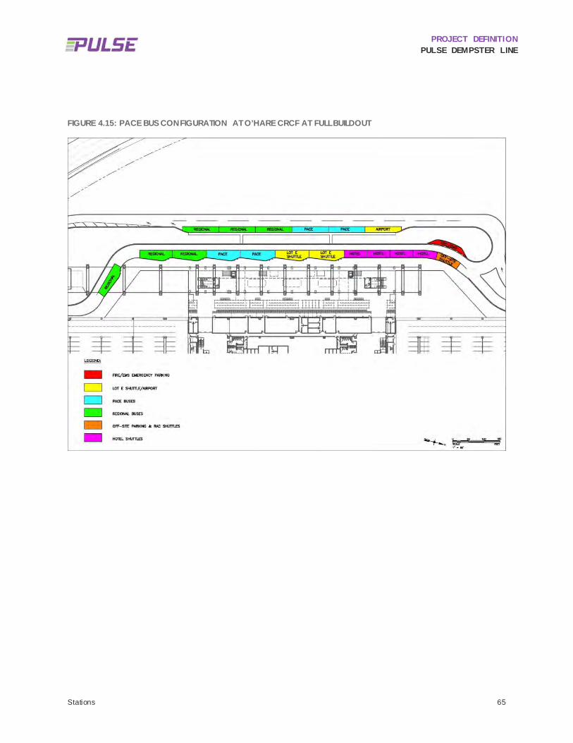
PROJECT DEFINITION PULSE DEMPSTER LINE
Stations 65
FIGURE 4.15: PACE BUS CONFIGURATION AT O’HARE CRCF AT FULL BUILDOUT

PROJECT DEFINITION PULSE DEMPSTER LINE
Stations 66
FIGURE 4.16: O'HARE CRCF RENDERING
Source: TranSystems / Ross Barney Architects

PROJECT DEFINITION PULSE DEMPSTER LINE
Stations 67
4.4.2 Mannheim/Higgins Municipality: City of Des Plaines (Eastbound Alternate 1), Village of Rosemont (Eastbound Alternate 2 and
Westbound Alternate 1), City of Chicago, 41st Ward, (Westbound Alternate 2)
Jurisdiction: Illinois Department of Transportation (IDOT)
Cross Section: Three through lanes, tw o center turn lanes, and one right turn lane in each direction
2 eastbound alternates, 2 w estbound alternates
TSP Possible: No
FIGURE 4.17: MANNHEIM/HIGGINS STATION SITES

PROJECT DEFINITION PULSE DEMPSTER LINE
Stations 68
TABLE 4.4: MANNHEIM/HIGGINS EASTBOUND STATION SITE SUMMARY
Opportunities Challenges
Alt 1
(Mid
bloc
k) • Av ailable right-of-w ay
• Transfers to Pace Route 223, w hich serv es the Rosemont CTA station and Elk Grov e Village industrial areas
• Directly serv e new Des Plaines dev elopment
• Distance from signalized intersection • Challenging pedestrian env ironment • Midblock crossing needed • Low ex isting Route 250 ridership (5 av erage daily boardings)
Alt 2
(Nea
r Sid
e) • Transfers to Pace Route 223, w hich serv es the CTA Blue
Line Rosemont station and Elk Grov e Village industrial areas
• Blocks right turn lane • Farther from dev elopment sites • Challenging pedestrian env ironment • Requires bus to merge from turn lane through intersection
and then merge back into trav el lane
TABLE 4.5: MANNHEIM/HIGGINS WESTBOUND STATION SITE SUMMARY
Opportunities Challenges
Alt 1
(Mid
bloc
k)
• Transfers to Pace Route 223, w hich serv es the Rosemont CTA station and Elk Grov e Village industrial areas
• Potential to directly serv e new dev elopment
• Distance to the intersection • Challenging pedestrian env ironment • Midblock crossing needed • Low ex isting Route 250 ridership (less than 1 daily boarding
on av erage) • Potential for property impacts due to need to meet sight
distance requirements
Alt 2
(Far
Sid
e) • Transfers to Pace Route 223, w hich serv es the Rosemont
CTA station and Elk Grov e Village industrial areas • Close to signalized intersection • Will be located on permanent easement
• Far from dev elopment site • Challenging pedestrian env ironment • Very little ex isting ridership • 90” w ater main adjacent to station site requires coordination
w ith Northw est Suburban Municipal Joint Action Water Agency
The City of Chicago, City of Des Plaines, and the Village of Rosemont share a border running dow n Mannheim Road, w ith Rosemont on the w est and Des Plaines on the east, north of Higgins Road. South of Higgins Road, Chicago is on the w est and Rosemont is on the east side of Mannheim Road. Rosemont has a current development proposal north of Higgins Road and Des Plaines has a development currently under construction on the east side of Mannheim Road north of Higgins Road. The Village of Rosemont and the City of Des Plaines suggested relocating the Mannheim/Lunt station to the intersection of Mannheim Road and Higgins Road.
Reconstruction of Mannheim Road and the Mannheim Road/Higgins Road intersection is expected to be complete summer of 2016. The new Mannheim Road cross section at this intersection consists of three through lanes in each

PROJECT DEFINITION PULSE DEMPSTER LINE
Stations 69
direction w ith tw o left turn lanes in the northbound and southbound direction and a northbound right turn lane. The corner islands show n in the aerials in Figure 4.17 above and in the Station Layouts in Appendix F w ere removed as part of the reconstruction. As a result of the construction, in the eastbound direction approaching Mannheim Road, Higgins Road has tw o through lanes w ith tw o left turn lanes and one right turn lane. In the w estbound direction upon approach w ith Mannheim Road, Higgins Road now has tw o through lanes w ith tw o left turn lanes and one right turn lane. In the w estbound direction w est of Mannheim Road, Higgins has tw o through lanes w ith a third right lane that tapers off. Crossw alks now connect all corners of the intersection.
4.4.2.1 EASTBOUND
4.4.2.1.1 Alternate 1 Alternate 1 is located north of the McDonald’s restaurant and adjacent to a new development that is currently under construction and consists of a gas station, retail strip center, hotel and restaurant outlot. An exact station site is dependent on coordination w ith the City of Des Plaines. In order for this location to be viable, a safe pedestrian crossing w ill be required. This may be a signalized intersection or a pedestrian signal. These improvements require coordination w ith the City of Des Plaines, the Village of Rosemont, and IDOT.
4.4.2.1.2 Alternate 2 The Alternate 2 station site in the eastbound direction w ill be a near side station sited in the right turn lane upon the approach to Higgins Road. A far side option is not feasible due to the drive access for McDonald’s and the presence of a culvert for Willow Creek w hich w ould possibly require construction on a bridge deck.
4.4.2.2 WESTBOUND
4.4.2.2.1 Alternate 1 The Alternate 1 station site is located near the entrance to the Holiday Inn hotel and adjacent to a 22-acre planned development site. An exact station site at this location is dependent on coordination w ith the Village of Rosemont and possibly the site developer. Due to sight distance requirements, the station may need to be set farther back from the road edge, w hich w ill likely result in property impacts. In order for this location to be viable, a safe pedestrian crossing w ill be required. This may be a signalized intersection or a pedestrian signal. These improvements require coordination w ith the City of Des Plaines, the Village of Rosemont, and IDOT.
4.4.2.2.2 Alternate 2 The Alternate 2 station site is located at the far side of the intersection, south of Higgins Road. This site is w ithin the City of Chicago’s 41st Ward and is adjacent to O’Hare Airport property. Nearby airport uses include an Enterprise rental car facility, w hich is accessible from Zemke Boulevard to the south. IDOT is currently reconstructing this intersection and is procuring a permanent easement for roadw ay purposes. The Alternate 2 station site w ill be located w ithin this permanent easement and w ould need to be negotiated w ith the property ow ner. A 90” high pressure w ater main ow ned by the Northw est Suburban Municipal Joint Action Water Agency (NSMJAWA) runs just w est the station site. NSMJAWA has an easement for the main. In addition, IDOT is procuring a permanent easement for roadw ay purposes that w ould be w ithin NSMJAWA’s existing easement.
4.4.2.3 SUMMARY STATUS OF ALTERNATES
All station sites at Mannheim/Higgins are recommended for further consideration and conceptual station layouts are included in Appendix F. Figure 4.17 show s the Mannheim/Higgins station locations. Table 4.4 and Table 4.5 provide further analysis of challenges and opportunities for each station alternative.
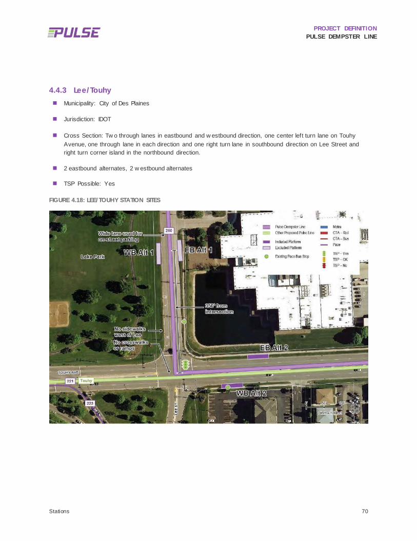
PROJECT DEFINITION PULSE DEMPSTER LINE
Stations 70
4.4.3 Lee/Touhy Municipality: City of Des Plaines
Jurisdiction: IDOT
Cross Section: Tw o through lanes in eastbound and w estbound direction, one center left turn lane on Touhy Avenue, one through lane in each direction and one right turn lane in southbound direction on Lee Street and right turn corner island in the northbound direction.
2 eastbound alternates, 2 w estbound alternates
TSP Possible: Yes
FIGURE 4.18: LEE/TOUHY STATION SITES

PROJECT DEFINITION PULSE DEMPSTER LINE
Stations 71
TABLE 4.6: LEE/TOUHY EASTBOUND STATION SITE SUMMARY
Opportunities Challenges
Alt 1
(Far
Sid
e) • Av ailable right-of-w ay
• TSP benefits • 350 feet north of signalized crossing • Ex isting fire hy drant and ov erhead pow er lines • Higher ridership on Touhy
Alt 2
(Nea
r Sid
e) • Connection to other Pace routes
• Connection to future Pulse Touhy Line • Av ailable right-of-w ay
• Westbound approach needs to be reconfigured to accommodate pedestrian elements
• TSP more challenging to implement and make effectiv e
TABLE 4.7: LEE/TOUHY WESTBOUND STATION SITE SUMMARY
Opportunities Challenges
Alt 1
(Nea
r Sid
e) • Av ailable right-of-w ay • Adjacent to Lake Park and memorial site (Potential Section
4(f) issues) • No pedestrian facilities • Operational issues in merging into left lane for turn onto
Touhy
Alt 2
(Far
Sid
e) • Connection to other Pace routes
• Connection to future Pulse Touhy Line • TSP benefits • Av ailable right-of-w ay
• NA
This station location w as identif ied by Pace in its 2010 Report based on modest ridership levels (62 average w eekday boardings to Evanston, 9 to O’Hare), supportive land uses (e.g. commercial/off ice and nearby multi-family residential), and potentially suitable station sites. There are transfer opportunities w ith Pace Route 221 and w ith a future Pulse Touhy Line. Pace has identif ied tw o alternate station sites in each direction.
There are sidew alks on only tw o legs of the intersection; further, there are no crossw alks and there is a raised median on Touhy Avenue. This w ould need to be addressed in coordination w ith City of Des Plaines and IDOT as part of the station planning and design.
There are broader operational issues at Lee Street and Touhy Avenue that the City of Des Plaines w ould like to address, including a long-term major reconfiguration of the intersection. If this w ere to proceed, pedestrian improvements w ould be implemented as part of the reconfiguration. Des Plaines and Rosemont report that they have both received complaints about pedestrian safety along Touhy Avenue.
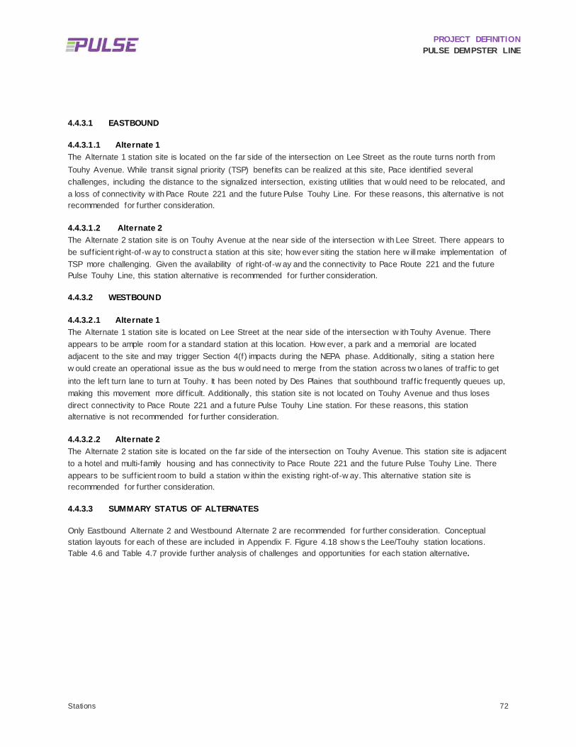
PROJECT DEFINITION PULSE DEMPSTER LINE
Stations 72
4.4.3.1 EASTBOUND
4.4.3.1.1 Alternate 1 The Alternate 1 station site is located on the far side of the intersection on Lee Street as the route turns north from Touhy Avenue. While transit signal priority (TSP) benefits can be realized at this site, Pace identif ied several challenges, including the distance to the signalized intersection, existing utilities that w ould need to be relocated, and a loss of connectivity w ith Pace Route 221 and the future Pulse Touhy Line. For these reasons, this alternative is not recommended for further consideration.
4.4.3.1.2 Alternate 2 The Alternate 2 station site is on Touhy Avenue at the near side of the intersection w ith Lee Street. There appears to be suff icient right-of-w ay to construct a station at this site; how ever siting the station here w ill make implementation of TSP more challenging. Given the availability of right-of-w ay and the connectivity to Pace Route 221 and the future Pulse Touhy Line, this station alternative is recommended for further consideration.
4.4.3.2 WESTBOUND
4.4.3.2.1 Alternate 1 The Alternate 1 station site is located on Lee Street at the near side of the intersection w ith Touhy Avenue. There appears to be ample room for a standard station at this location. How ever, a park and a memorial are located adjacent to the site and may trigger Section 4(f) impacts during the NEPA phase. Additionally, siting a station here w ould create an operational issue as the bus w ould need to merge from the station across tw o lanes of traff ic to get into the left turn lane to turn at Touhy. It has been noted by Des Plaines that southbound traff ic frequently queues up, making this movement more diff icult. Additionally, this station site is not located on Touhy Avenue and thus loses direct connectivity to Pace Route 221 and a future Pulse Touhy Line station. For these reasons, this station alternative is not recommended for further consideration.
4.4.3.2.2 Alternate 2 The Alternate 2 station site is located on the far side of the intersection on Touhy Avenue. This station site is adjacent to a hotel and multi-family housing and has connectivity to Pace Route 221 and the future Pulse Touhy Line. There appears to be suff icient room to build a station w ithin the existing right-of-w ay. This alternative station site is recommended for further consideration.
4.4.3.3 SUMMARY STATUS OF ALTERNATES
Only Eastbound Alternate 2 and Westbound Alternate 2 are recommended for further consideration. Conceptual station layouts for each of these are included in Appendix F. Figure 4.18 show s the Lee/Touhy station locations. Table 4.6 and Table 4.7 provide further analysis of challenges and opportunities for each station alternative.

PROJECT DEFINITION PULSE DEMPSTER LINE
Stations 73
4.4.4 Lee-Mannheim/Oakton Municipality: City of Des Plaines
Jurisdiction: IDOT
Cross Section: Tw o through lanes in each direction, center turn lane
2 eastbound alternates, 2 w estbound alternates
TSP Possible: No
FIGURE 4.19: LEE-MANNHEIM/OAKTON STATION SITES
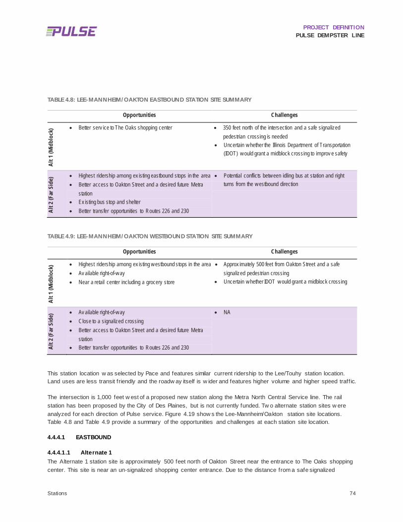
PROJECT DEFINITION PULSE DEMPSTER LINE
Stations 74
TABLE 4.8: LEE-MANNHEIM/OAKTON EASTBOUND STATION SITE SUMMARY
Opportunities Challenges
Alt 1
(Mid
bloc
k) • Better serv ice to The Oaks shopping center • 350 feet north of the intersection and a safe signalized
pedestrian crossing is needed • Uncertain w hether the Illinois Department of Transportation
(IDOT) w ould grant a midblock crossing to improv e safety
Alt 2
(Far
Sid
e) • Highest ridership among ex isting eastbound stops in the area
• Better access to Oakton Street and a desired future Metra station
• Ex isting bus stop and shelter • Better transfer opportunities to Routes 226 and 230
• Potential conflicts betw een idling bus at station and right turns from the w estbound direction
TABLE 4.9: LEE-MANNHEIM/OAKTON WESTBOUND STATION SITE SUMMARY
Opportunities Challenges
Alt 1
(Mid
bloc
k) • Highest ridership among ex isting w estbound stops in the area
• Av ailable right-of-w ay • Near a retail center including a grocery store
• Approx imately 500 feet from Oakton Street and a safe signalized pedestrian crossing
• Uncertain w hether IDOT w ould grant a midblock crossing
Alt 2
(Far
Sid
e) • Av ailable right-of-w ay
• Close to a signalized crossing • Better access to Oakton Street and a desired future Metra
station • Better transfer opportunities to Routes 226 and 230
• NA
This station location w as selected by Pace and features similar current ridership to the Lee/Touhy station location. Land uses are less transit friendly and the roadw ay itself is w ider and features higher volume and higher speed traff ic.
The intersection is 1,000 feet w est of a proposed new station along the Metra North Central Service line. The rail station has been proposed by the City of Des Plaines, but is not currently funded. Tw o alternate station sites w ere analyzed for each direction of Pulse service. Figure 4.19 show s the Lee-Mannheim/Oakton station site locations. Table 4.8 and Table 4.9 provide a summary of the opportunities and challenges at each station site location.
4.4.4.1 EASTBOUND
4.4.4.1.1 Alternate 1 The Alternate 1 station site is approximately 500 feet north of Oakton Street near the entrance to The Oaks shopping center. This site is near an un-signalized shopping center entrance. Due to the distance from a safe signalized

PROJECT DEFINITION PULSE DEMPSTER LINE
Stations 75
crossing, a midblock pedestrian crossing may be needed although it is unlikely that IDOT w ould support this. Due to these safety challenges, this station site is not recommended for further consideration.
4.4.4.1.2 Alternate 2 The Alternate 2 station site is located on the far side of the intersection but close to the signaled intersection. This site also provides access to a potential future Oakton Street station on Metra’s North Central Service line and Pace Routes 226 and 230 on Oakton Avenue. The Metra station w ould be located about 1,000 feet to the east of the Lee Street-Mannheim Road and Oakton Street intersection. The current bus stop at this location has the highest ridership of the existing eastbound bus stops in the area. This station site is recommended for further consideration.
4.4.4.2 WESTBOUND
In the w estbound direction of travel tw o alternate station sites w ere examined.
4.4.4.2.1 Alternate 1 The Alternate 1 station site is located approximately 500 feet north of Oakton Street. A midblock crossing w ould most likely be needed at this location. Despite its distance from the intersection, this station site has the highest ridership among existing w estbound Route 250 stops in the area and provides good access to the shopping center on the w est side of the street. There is also suff icient room for the station platform w ithin the right-of-w ay, betw een curb and gutter back to the existing sidew alk. How ever, due to the distance from the intersection and the challenges associated w ith accommodating a midblock pedestrian crossing, this station site is not recommended for further consideration.
4.4.4.2.2 Alternate 2 The Alternate 2 station site is located on the far side of the intersection. While TSP is not currently recommended for the intersection, the far side site w ould provide benefits in the future if TSP w ere feasible. There is ample room for a typical station platform w ithin the right-of-w ay betw een the curb and the sidew alk. The station w ould be adjacent to a KFC restaurant on the southw est corner of the intersection and is close to a signalized crossing. This station site is recommended due to its far side location, proximity to the planned Metra station and access to a safe pedestrian crossing at Lee and Oakton Streets.
4.4.4.3 SUMMARY STATUS OF ALTERNATES
Only Eastbound Alternate 2 and Westbound Alternate 2 are recommended for further consideration. Conceptual station layouts for each of these are included in Appendix F. Eastbound Alternate 1 and Westbound Alternate 1 have been excluded from consideration due to distance from the intersection and the possible need for a midblock crossing. Eastbound Alternate 2 and Westbound Alternate 2 are currently under consideration.

PROJECT DEFINITION PULSE DEMPSTER LINE
Stations 76
4.4.5 Des Plaines Metra Municipality: City of Des Plaines
Jurisdiction: Ow nership for bus turnaround site to be determined; Likely IDOT/Metra/UP ; Westbound Miner Street - IDOT
Cross Section: Bus turnaround/layover facility (eastbound), tw o through lanes in each direction on Miner Street.
2 eastbound alternates, 3 w estbound site alternates
TSP Possible: Potentially at Miner/Pearson
FIGURE 4.20: DES PLAINES METRA STATION SITES

PROJECT DEFINITION PULSE DEMPSTER LINE
Stations 77
TABLE 4.10: DES PLAINES METRA EASTBOUND STATION SITE SUMMARY
Opportunities Challenges
Alt 1
(Mid
bloc
k) • Ex isting bus lay ov er facility in front of the Des Plaines Metra
station • Limited capital improv ements required to be functional for
Pulse (e.g. signage only )
• Capacity constraints may ex ist here as 7 Pace routes and more than 40 buses utilize turnaround during the peak periods
Alt 2
(Nea
r Sid
e) • Lessens demand on capacity constrained lay ov er facility
• City of Des Plaines and Pace consider this site unsuitable

PROJECT DEFINITION PULSE DEMPSTER LINE
Stations 78
TABLE 4.11: DES PLAINES METRA WESTBOUND STATION SITE SUMMARY
Opportunities Challenges
Alt 1
(Nea
r Sid
e)
• Close to the ex isting midblock crossw alk to the Des Plaines Metra station
• Ex isting Pace stop sets precedent for continued use for Pace serv ices
• Limited right-of-w ay w ith buildings built to property lines • Constructing necessary station platform adjacent to building
facades w ould be difficult Station w ould likely limit v isibility and access to businesses
• Buses must pull out of traffic and then merge back in • Passengers w ould use the midblock crossing or jay w alk to get
to Metra; this has been raised as a safety concern by Des Plaines and IDOT
Alt 2
(Nea
r Sid
e)
• Near the midblock crossing • On-street parking could be relocated to the w est w ith the
elimination of the ex isting stop at Lee Street and Miner Street
• Limited right-of-w ay w ith buildings built to property lines • Passengers w ould alight and cross in front of bus and use the
midblock crossw alk or jay walk to get to Metra; this has been raised as a safety concern by Des Plaines and IDOT
• Station construction w ould require remov al of majority of on-street parking
• Station w ould likely limit v isibility and access to businesses
Alt 3
A (N
ear S
ide,
On-
Stre
et) • Site places passengers at a signalized intersection that is
safer than the midblock crossing • Significantly more right-of-w ay av ailable than other options • Minimizes impact on local businesses
• Prev iously proposed site for bus stop that w as not supported by area residents; gaining support for this site may be challenging
• On-street station w ould likely result in buses blocking traffic; for this reason, the station could only be sized to accommodate one v ehicle, w hich does not take full adv antage of av ailable right-of-w ay
• Ex isting stop at near side of Miner and Lee w ould likely still be needed to serv e local routes
Alt 3
B (N
ear S
ide,
Tur
n Ou
t)
• Site places passengers at a signalized intersection that is safer than the midblock crossing
• Significantly more right-of-w ay av ailable than other options • Minimizes impact on local businesses • Pull out configuration accommodates multiple buses,
reduces potential of buses blocking traffic, and max imizes use of av ailable right-of-w ay
• Configuration proposed by Des Plaines and w ould generally be supported by City
• Prev iously proposed site for bus stop that w as not supported by area residents; gaining support for this site may be challenging
• Bus pull out does not meet BDE requirements for a bus bay . Will require additional coordination w ith IDOT and City , including potential design ex ception
The Des Plaines Metra station is a major transfer location for Pace and Metra customers, w ith over 1,000 w eekday commuter rail boardings and nearly as many Pace boardings. The station is among the highest ridership locations along Route 250. Many Route 250 trips start or end at this location. Tw o station sites w ere evaluated in the eastbound direction and three in the w estbound direction. Figure 4.20 show s the potential Des Plaines station site locations.

PROJECT DEFINITION PULSE DEMPSTER LINE
Stations 79
4.4.5.1 EASTBOUND
4.4.5.1.1 Alternate 1 The Alternate 1 station site utilizes the existing bus pull out in front of the Des Plaines Metra station and w ould only require minimal improvements such as Pulse and real time arrival information signage. Seven Pace routes stop here and more than 40 buses utilize the layover area during the AM and PM peak periods. Capacity constraints may exist here. As this facility is currently serving Pace, is located directly adjacent to the Des Plaines Metra station, and w ould require minimal capital improvements, this alternate is recommended for further consideration.
4.4.5.1.2 Alternate 2 The Alternate 2 station site is located at the existing taxi stand. Due to operational issues raised by the City of Des Plaines and Pace, this station site is not recommended for further consideration.
4.4.5.2 WESTBOUND
4.4.5.2.1 Alternate 1 The Alternate 1 station site is located on Miner Street across from the Des Plaines Metra station and sited at the location of an existing bus stop. The bus stop is served by an existing midblock crossing. How ever, the City of Des Plaines is concerned that a station here may block storefronts and further reduce existing on-street parking. While the sidew alks are relatively w ide here, constructing a station platform adjacent to the storefronts w ould potentially be diff icult and w ould likely limit visibility and access to businesses. Operationally, this station site requires buses to pull out of traff ic and then merge back in and cross a travel lane to get positioned to make a left turn onto Graceland.
An additional concern w ith this station site is that bus passengers w ould alight and use the midblock crossing or jayw alk to get to Metra; this has been raised as a safety concern by Des Plaines and IDOT. Despite these challenges, this station site is recommended for further consideration.
4.4.5.2.2 Alternate 2 The Alternate 2 station site is located betw een Metropolitan Way and Pearson Street. This station site may limit visibility and access to businesses behind it. It w ould require the removal of the majority of parking as the station platform w ould be built w ithin the parking lane. How ever, parking could be relocated to the w est if the existing stop w ere relocated here. Similar to Alternate 1, passengers w ould alight and cross in front of the bus and use the midblock crossw alk or jayw alk to get to Metra, w hich has been raised as a safety concern by Des Plaines and IDOT. Despite these challenges, this station site is recommended for further consideration.
4.4.5.2.3 Alternate 3A-B The Alternate 3 station site is located on the near side of Miner Street and Pearson Street. This stop w as previously proposed for a local bus stop and there w as opposition from local residents in the adjacent condominium building. How ever, recent feedback from IDOT indicates that a recently completed safety study found that this site w ould improve safety on Miner Street as it w ould place alighting passengers at the near side of a signalized intersection that provides a safer pedestrian crossing. In addition, this site is proposed because it has signif icantly more right-of-w ay available than either Alternates 1 or 2, and w ould not impact local businesses.
It w as noted in Des Plaines and IDOT coordination meetings that River Road w ill be reconstructed in summer 2016, w hich w ill include reconstruction of the Miner/Pearson intersection. This w ould be an opportune time to modify the layout of this intersection to support a future Pulse station location.

PROJECT DEFINITION PULSE DEMPSTER LINE
Stations 80
There are tw o station configurations provided for consideration for station site Alternate 3. Alternate 3A is an on-street station and Alternative 3B is a bus turnout station. Because an on-street station w ould block through traff ic, it is sized to serve only one transit vehicle at a time. In this scenario, the existing stop at the near side of Miner and Lee w ould likely still be needed. The pull out station configuration w ould remove buses from the travel lane and w ould likely be able to accommodate multiple buses. How ever, it is noted that the turnout does not meet requirements set forth in the IDOT Bureau of Design and Environment (BDE) Manual or in Pace’s Transit Supportive Guidelines. This station site, in either configuration is recommended for further consideration. During advanced conceptual design, partner agencies should be consulted on acceptable station geometrics.
4.4.5.3 SUMMARY STATUS OF ALTERNATES
Eastbound Alternate 1 and Westbound Alternates 1, 2 and 3A-B are recommended for further evaluation. Conceptual station layouts for each of these are included in Appendix F. Figure 4.20 show s the Des Plaines Metra station site locations. Table 4.10 and Table 4.11 provide a summary of the opportunities and challenges at each station site location. Eastbound Alternate 2 is not recommended for further consideration due to operational issues raised by the City of Des Plaines and Pace.

PROJECT DEFINITION PULSE DEMPSTER LINE
Stations 81
4.4.6 Potter Municipality: City of Park Ridge (eastbound), Maine Tow nship (w estbound),
Jurisdiction: IDOT
Cross Section: Tw o through lanes in each direction, center turn lane
2 eastbound alternates, 2 w estbound alternates
TSP Possible: Potentially
FIGURE 4.21: POTTER STATION SITES

PROJECT DEFINITION PULSE DEMPSTER LINE
Stations 82
TABLE 4.12: POTTER EASTBOUND STATION SITE SUMMARY
Opportunities Challenges
Alt 1
(Nea
r Sid
e) • NA • Ridership is predominantly east of Potter Road
• Significant underground utilities, including a 36-inch storm sew er, electrical, and gas utilities underneath
• Limited right-of-w ay • Adjacent single-family residential properties could be
impacted
Alt 2
(Far
Sid
e)
• Potential to better serv e Maine East High School, the source of the majority of the ridership in this area
• TSP benefits can be realized • Av ailable right-of-w ay for a station betw een curb and gutter
and sidew alk • Water main and storm sew er are likely deep enough to av oid
conflicts
• There are potential utility conflicts, including a gas v ault, 15-inch storm sew er, w ater main, street lighting, and mature street trees
• Sight lines and v isual impacts to the school
TABLE 4.13: POTTER WESTBOUND STATION SITE SUMMARY
Opportunities Challenges
Alt 1
(Far
Sid
e )
• TSP benefits can be realized at this location • Sufficient right-of-w ay
• Furthest from source of ex isting ridership (Maine East High School)
• Site constrained by pow er lines and underground utilities including telephone, electrical, and gas, all of w hich may need to be relocated depending on the ex isting depth
• Potential conflicts w ith traffic ex iting adjacent fast food restaurant and traffic turning from southbound Potter onto w estbound Dempster in order to access I-294
• Impacts to new decorativ e landscaping at Lurv ey Landscape Supply and Garden Center
Alt 2
(Nea
r Sid
e) • High ridership stop and closer to source of ex isting ridership
than far side station
• Temporary impacts to parking lot • Grade change betw een parking lot and street w ould require
curb construction • Tree remov al w ould be necessary • Ov erhead pow er lines and utility poles are present, though
may not need to be remov ed
This location w as identif ied as an alternate to Dee Road due to signif icant site constraints and utility conflicts at that location. The largest passenger traff ic generator at both Dee Road and Potter Road is Maine East High School, w hich is equally accessible from either intersection. The highest ridership stops on the segment from Potter to Dee are at the high school, and these stops are equidistant from both intersections. A station at Potter w ould serve the high

PROJECT DEFINITION PULSE DEMPSTER LINE
Stations 83
school as w ell as Dee and w ould require a w alk of less than f ive minutes for residents of the Dee Road multi-family housing to reach Potter Road. A station at Potter Road w ould also facilitate transfers to and from Pace Route 240, w hich crosses Dempster Street at Potter Road. Figure 4.21show s the Potter station sites.
It is noted that the Metropolitan Water Reclamation District (MWRD) is undertaking a storm w ater improvement project from I-294 to w est of Luther Lane. Currently the project is in the design phase and is expected to be under construction in 2017. Coordination w ith MWRD w ill be needed to align plans at either location.
4.4.6.1 EASTBOUND
4.4.6.1.1 Alternate 1 The Alternate 1 station site is located on the near side of the intersection w ith Potter Road and is located adjacent to a subdivision of single-family homes that is edged by a solid fence along Dempster Street and Potter Road. Construction of a station at this site w ould impact these single-family homes.
Utility conflicts in this area include a 36-inch storm sew er as w ell as electric and gas lines, w hich w ould possibly have to be relocated to accommodate a station. Because of this, and because existing Route 250 ridership is predominantly east of Potter serving Maine East High School, the Alternate 1 station site is not recommended for further consideration.
4.4.6.1.2 Alternate 2 The Alternate 2 station site is located at the far side of the intersection w ith Potter Road and is adjacent to Maine East High School, w here the majority of the ridership is based and w here TSP benefits can be realized. There is ample room for a station betw een the curb and gutter and sidew alk, although the right-of-w ay limits need to be confirmed as Cook County parcel data indicates that the property line extends to the centerline of Dempster Street. Further, caution must be exercised to avoid impacts to the mature street trees. This site does bring potential utility conflicts including a gas vault, 15-inch storm sew er, w ater main, street lighting, and large trees. The w ater main and storm sew er is likely deep enough to avoid conflicts. Maine East High School representatives also raised concerns regarding sight lines and potential visual impacts to the school’s architecture. This station site is recommended for further consideration.
4.4.6.2 WESTBOUND
4.4.6.2.1 Alternate 1 Alternate 1 is proposed for the far side of the intersection w ith Potter Road. Space is somew hat constrained for this site as overhead pow er lines and utility poles are present, though likely do not need to be removed. This far side station may also create conflicts w ith traff ic exiting the adjacent fast food restaurant as w ell as w ith traff ic turning from southbound Potter onto w estbound Dempster to access I-294. Siting a station at this site requires the majority of riders to cross one additional street to access the station or Maine East High School. Though TSP benefits can be realized at this location, it is not recommended for further consideration due to the distance from existing ridership generators as w ell as the potential for traff ic conflicts.
4.4.6.2.2 Alternate 2 The Alternate 2 station site is located at the near side of the intersection at Potter Road, across Dempster Street from Maine East High School. The parking lot for the adjacent retail center w ill sit at a slightly higher elevation after constructing the sidew alk and station to meet ADA requirements. Therefore a curb may be needed at the back of the station platform w hich w ould likely result in temporary property impacts. In addition, street trees w ould need to be
PROJECT DEFINITION PULSE DEMPSTER LINE
Stations 84
removed to construct the station. How ever, as ridership is predominantly generated by the high school east of Potter Road, this site is a greater convenience to riders. For this reason and because the property impacts are anticipated to be relatively minor, the Alternate 2 station site is recommended for further consideration.
4.4.6.3 SUMMARY STATUS OF ALTERNATES
Eastbound Alternate 2 and w estbound Alternate 2 are recommended for further evaluation. Conceptual station layouts for each of these are included in Appendix F. Table 4.12 and Table 4.13provide a summary of the opportunities and challenges at each station site location. Eastbound Alternate 1 is not recommended for further consideration due to limited right-of-w ay, utility conflicts and nearby homes that may have property impacts. Westbound Alternate 1 is not recommended for further consideration due to distance from existing ridership generators and potential traff ic conflicts.
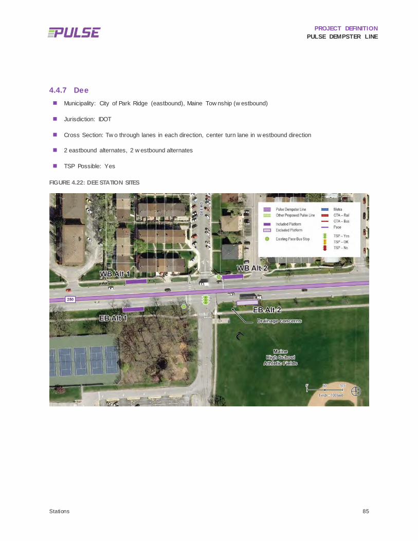
PROJECT DEFINITION PULSE DEMPSTER LINE
Stations 85
4.4.7 Dee Municipality: City of Park Ridge (eastbound), Maine Tow nship (w estbound)
Jurisdiction: IDOT
Cross Section: Tw o through lanes in each direction, center turn lane in w estbound direction
2 eastbound alternates, 2 w estbound alternates
TSP Possible: Yes
FIGURE 4.22: DEE STATION SITES

PROJECT DEFINITION PULSE DEMPSTER LINE
Stations 86
TABLE 4.14: DEE EASTBOUND STATION SITE SUMMARY
Opportunities Challenges
Alt 1
(Nea
r Sid
e) • Closer to Maine East High School than far side Dee site
• TSP benefits w ould not be realized here • Ex isting underground utilities may present challenges • Ponding issues at sidew alk discov ered during site v isit • Sensitiv e natural area on the southw est corner of the
intersection
Alt 2
(Far
Sid
e)
• NA
• Significant grading issues as the sidew alk is below the street and flooding is an issue, including ponding issues at sidew alk discov ered during site v isit
• Ex posed storm sew er at ground lev el that w ould need to be relocated
• Other utilities may need to be relocated depending on their ex isting depths
TABLE 4.15: DEE WESTBOUND STATION SITE SUMMARY
Opportunities Challenges
Alt 1
(Far
Sid
e)
• Preferred for TSP functionality • Limited right-of-w ay • Site utilities include telephone, storm, 6-inch gas and sanitary
sew er • Sanitary and w ater appear to be deep enough to av oid
conflict • Telephone and gas may need to be relocated or deepened
depending on their ex isting depths • Curb is higher than sidew alk w hich would require the ex isting
sidew alk to be reconstructed w ith the station to meet ADA requirements. Grading may be required at back of sidew alk after constructed and may potentially impact residential fences
Alt 2
(Nea
r Sid
e) • Ex isting bus stop and shelter
• Limited right-of-w ay • Utilities are present on site, though sanitary and w ater utilities
are likely deep enough to not conflict w ith a station here
This station location w as identif ied by Pace to serve Maine East High School and a multi-family apartment complex immediately north of the Dee Road intersection. As previously noted, the Potter station is being offered as an alternate to a Dee station and the tw o should be compared for their respective impacts and benefits during the

PROJECT DEFINITION PULSE DEMPSTER LINE
Stations 87
environmental review phase. Figure 4.22 show s the Dee station site locations. Table 4.14 and Table 4.15 provide a summary of the opportunities and challenges at each station site location.
Like the Potter station site, this area w ill be impacted by the MWRD storm w ater improvement project planned for 2017. Coordination w ith MWRD w ill be needed to align plans for either location.
4.4.7.1 EASTBOUND
4.4.7.1.1 Alternate 1 The Alternate 1 station site is located at the existing Route 250 bus stop at the near side of the intersection w ith Dee Road, and is directly adjacent to Maine East High School. The existing curb is higher than the sidew alk in this area resulting in the parkw ay being pitched tow ards a terraced area near the catch basin. The storm inlet along the curb may need to be adjusted as part of any station improvements. Cook County parcel data indicates that the parcel lines along the south side of Dempster extend to the centerline of the street. This w ill need to be confirmed during the environmental review phase in order to ascertain the extent of any property impacts. An historic stand of oak trees is located to the south of the station site. Potential impacts to this natural area w ill be further assessed during the environmental review phase and may w arrant shifting this station site slightly w est, placing it adjacent to the tennis courts. With this in mind, this station site is recommended for further consideration because it is closest to Maine East High School, w hich generates the majority of ridership in the area.
4.4.7.1.2 Alternate 2 The Alternate 2 station site is located at the far side of the intersection at Dee Road. This station site has signif icant grading issues as the sidew alk elevation is below the street elevation and f looding occurs at this site.
FIGURE 4.23: DEE EASTBOUND ALTERNATE 2 STATION SITE
During a f ield visit, it w as observed that ponding occurs in the parkw ay, as show n in Figure 4.23. In addition, there is a partially exposed drainage pipe and catch basins in the station area. These issues could create signif icant

PROJECT DEFINITION PULSE DEMPSTER LINE
Stations 88
challenges to constructing a far side station in this direction. Because of the grading and infrastructure required to support a station at this site, Alternate 2 is not recommended for further consideration.
4.4.7.2 WESTBOUND
4.4.7.2.1 Alternate 1 The Alternate 1 station site is located at the far side of the intersection at Dee Road. The right-of-w ay appears to be limited on the north side of Dempster Street as the parcel lines run through the middle of the parkw ay w ith the sidew alk located on private property. In addition, there are numerous utilities and a private drivew ay in the parkw ay. The drivew ay w ould require that the far side station be positioned some distance aw ay from the signalized intersection in order to avoid traff ic conflicts and maintain sight distance requirements. The Alternate 1 station site is recommended for further consideration.
4.4.7.2.2 Alternate 2 The Alternate 2 station site is located at an existing Route 250 bus stop and shelter at the near side of the intersection at Dee Road. The right-of-w ay at this location is constrained. The sidew alk w ould have to be routed through the station as the shelter and vertical marker w ould need to be set back to accommodate sight distance requirements. The limits of the right-of-w ay w ill need to be confirmed during the environmental review phase to better determine the extent of any property impacts. Utilities are present on site, though sanitary and w ater utilities are likely deep enough to not conflict w ith a station here. Other utilities may need to be relocated depending on their existing depths. The Alternate 2 station site is recommended for further consideration.
4.4.7.3 SUMMARY STATUS OF ALTERNATES
Eastbound Alternate 1 and w estbound Alternates 1 and 2 are recommended for further evaluation. Conceptual station layouts for each of these are included in Appendix F. Due to grade and utility issues, the Eastbound Alternate 2 station site is not recommended for further consideration. Because of challenges associated w ith the eastbound Potter and Dee alternates that w ere evaluated and feedback received from Maine East High School, an additional eastbound alternate, located just east of the one-w ay egress near the high school tennis courts, may be considered during the environmental review phase.

PROJECT DEFINITION PULSE DEMPSTER LINE
Stations 89
4.4.8 Western Municipality: City of Park Ridge (eastbound), Village of Niles (w estbound)
Jurisdiction: IDOT
Cross Section: Tw o through lanes in each direction, center turn lane
1 eastbound alternate, 1 w estbound alternate
TSP Possible: Yes
FIGURE 4.24: WESTERN STATION SITES

PROJECT DEFINITION PULSE DEMPSTER LINE
Stations 90
TABLE 4.16: WESTERN EASTBOUND STATION SITE SUMMARY
Opportunities Challenges
Alt 1
(Nea
r Sid
e) • Good access to Lutheran General Hospital entrance
• Site is currently used for transit stop w ith bus shelter • Hospitable pedestrian env ironment
• Limited right-of-w ay • Shelter and sidew alk may be on priv ate property • TSP benefits not fully realized
TABLE 4.17: WESTERN WESTBOUND STATION SITE SUMMARY
Opportunities Challenges
Alt 1
(Far
Sid
e) • Good access to Lutheran General Hospital entrance
• Transfer opportunity w ith Niles Free Bus Route 411 • Av ailable right-of-w ay • TSP benefits can be realized
• NA
This location w ould be a superior location to Luther Lane for a station to serve Lutheran General Hospital, nearby retail and other land uses, and to provide transfer opportunities to the Niles Free Bus, Route 411. For this reason, the Luther Lane station location w as removed from consideration and replaced w ith the Western station location. The majority of Route 250 ridership is to and from the east at this location, w hich may be an indication of w hy more hospital-related passenger activity is occurring at this location east of the hospital, rather than at Luther Lane w est of the hospital.
4.4.8.1 EASTBOUND
4.4.8.1.1 Alternate 1 In the eastbound direction, the site is on the near side of the intersection, w here there is an existing Route 250 bus shelter and a landscaped plaza belonging to Lutheran General Hospital. Cook County parcel lines appear to indicate that the shelter and sidew alk are located on private property. This w ill need to be confirmed during the environmental review phase in order to determine the extent of any property impacts. How ever, it is noted that there appears to be ample room to construct the station platform betw een the curb and gutter and the back of the existing sidew alk. A far side station at this location w as considered as it w ould provide TSP benefits. How ever, it w as dismissed due to the limited right-of-w ay, the adjacent land use (an automotive dealer), as w ell as feedback from the City of Park Ridge.
4.4.8.2 WESTBOUND
4.4.8.2.1 Alternate 1 In the w estbound direction, a station site w as examined on the far side of the intersection, close to the hospital and local businesses, and at an existing Route 250. There appears to be ample room w ithin the right-of-w ay for the station platform, w hich could be built betw een the curb and gutter and existing sidew alk. This far side station w ould provide TSP benefits and w ould also help provide an easy transfer to the Niles Free Bus, Route 411.

PROJECT DEFINITION PULSE DEMPSTER LINE
Stations 91
4.4.8.3 SUMMARY STATUS OF ALTERNATES
Eastbound Alternate 1 and Westbound Alternate 1 are both recommended for further consideration. Figure 4.24 show s the Western station sites. Table 4.16 and Table 4.17 provide a summary of the opportunities and challenges at each station site location.

PROJECT DEFINITION PULSE DEMPSTER LINE
Stations 92
4.4.9 Cumberland Municipality: Village of Niles
Jurisdiction: IDOT
Cross Section: Tw o through lanes in each direction, center turn lane
2 eastbound alternates, 1 w estbound alternate
TSP Possible: Yes
FIGURE 4.25: CUMBERLAND STATION SITES

PROJECT DEFINITION PULSE DEMPSTER LINE
Stations 93
TABLE 4.18: CUMBERLAND EASTBOUND STATION SITE SUMMARY
Opportunities Challenges
Alt 1
(Nea
r Sid
e) • Closer to adjacent multi-family housing
• Sufficient right-of-w ay for a station • Tw o manholes located in the parkw ay should be inv estigated
for utility conflicts and w ill likely need to be adjusted • Increases complex ity of achiev ing TSP benefits
Alt 2
(Far
Sid
e) • Prov ides opportunity to achiev e TSP benefits
• Far side location helps to more fully distribute station spacing • No pedestrian infrastructure • Located across the street from a fire station • Station w ould likely encroach on Mary hill Cemetery property
TABLE 4.19: CUMBERLAND WESTBOUND STATION SITE SUMMARY
Opportunities Challenges
Alt 1
(Far
Sid
e) • Serv es nearby multi-family housing
• Capitalize on ex isting ridership • Sufficient right-of-w ay • TSP benefits can be realized
• Storm inlet may need to be adjusted as part of station construction
Cumberland Avenue is located exactly one-half (1/2) mile east of Western Avenue and one-half (1/2) mile w est of Milw aukee Avenue. Constructing an additional station here w ould provide service to 69 existing daily Route 250 trip origins that w ould not otherw ise be located w ithin one-quarter (1/4) mile of a Pulse station.
The intersection is surrounded on three sides by a mix of commercial and public land uses as w ell as dense residential development. Maryhill Cemetery is located at the southeast corner. The intersection is ADA compliant w ith full sidew alks on three sides; how ever there are no sidew alks on the southeast corner adjacent to cemetery. Gemini Junior High School is located one block north. The Niles Fire Department has a station at the northeast corner of the intersection. The majority of the ridership is w est of the intersection. The Cumberland station site locations are show n in Figure 4.25.
4.4.9.1 EASTBOUND
4.4.9.1.1 Alternate 1 In the eastbound direction, the Alternate 1 station site is proposed near side at the site of an existing Route 250 bus stop, adjacent to an apartment complex. There is approximately 18 feet of right-of-w ay from the curb to the sidew alk, providing ample room for a station. Tw o manholes located in the parkw ay should be investigated for utility conflicts. The near side location w ould increase TSP complexity. This station site is recommended for further consideration.

PROJECT DEFINITION PULSE DEMPSTER LINE
Stations 94
4.4.9.1.2 Alternate 2 The Alternate 2 station site is located adjacent to Maryhill Cemetery at the far side of the intersection. The far side location presents an opportunity for TSP benefits; how ever, the use of TSP and development of the site is challenged by the presence of the f ire station on the opposite side of the street, at the northeast corner of the intersection. It is further noted that there is no curb and gutter or sidew alk on Dempster Street in the area of the proposed station site. Because of this, the site grading w ill be needed and a storm structure w ill need to be relocated to accommodate drainage. Additionally, the Cook County parcel lines indicate that the Maryhill Cemetery parcel lines extend to the center line of the street, w hich w ould result in the station encroaching on the Cemetery property. If this site w ere selected, it w ould be the Pulse third station to encroach on the Maryhill Cemetery and continued coordination w ith the Cemetery w ould be needed. Despite these challenges, this station is recommended for further consideration.
4.4.9.2 WESTBOUND
4.4.9.2.1 Alternate 1 In the w estbound direction, a station site is located at the far side of the intersection w ith Cumberland Avenue in betw een tw o drivew ays for an existing bank. There appears to be suff icient right-of-w ay available to construct at station at this site. This site w ould also be able to take advantage of TSP and is recommended for further consideration.
4.4.9.3 SUMMARY STATUS OF ALTERNATES
Eastbound Alternate 1 and 2 and Westbound Alternate 1 are all recommended for further consideration. Figure 4.25 show s the Cumberland station site locations. Table 4.18 and Table 4.19 provide a summary of the opportunities and challenges at each station site location.

PROJECT DEFINITION PULSE DEMPSTER LINE
Stations 95
4.4.10 Milwaukee Municipality: Village of Niles
Jurisdiction: IDOT
Cross Section: Grade separated intersection, w ith Dempster Street traveling under Milw aukee Avenue. At-grade access to Milw aukee has one through lane and one right turn lane
2 eastbound alternates, 3 w estbound alternates
TSP Possible: Yes
FIGURE 4.26: MILWAUKEE STATION SITES

PROJECT DEFINITION PULSE DEMPSTER LINE
Stations 96
TABLE 4.20: MILWAUKEE EASTBOUND STATION SITE SUMMARY
Opportunities Challenges
Alt 1
(Nea
r Sid
e)
• Adjacent to the southbound Pulse Milw aukee Line station • Location is w here the majority of boardings and alightings
occur for Route 250 eastbound
• There are no sidew alks along the south side of Dempster Street and there is limited right-of-w ay w hich w ill likely require property acquisition or an easement
• Buses required to stop in the right turn lane and merge into the traffic lane once through the intersection
• Pedestrian refuge islands (from channelized right turns) on SE and NW corners do not allow buses to continue straight through the intersection
• Increases complex ity of achiev ing TSP benefits
Alt 2
(Far
Sid
e)
• Far side location w ould prov ide TSP benefits
• Limited right-of-w ay to construct a platform • To av oid property impacts, the station w ould need to be
constructed w ithin the striped area and w ould result in buses stopping in the trav el lane
• One or more driv ew ay closures would likely be needed • A fire hy drant and telephone pole may require relocation • Transfers to the Milw aukee Line w ould require crossing
Dempster Street for northbound transfers or Milw aukee Av enue for southbound transfers
• There may be env ironmental issues associated w ith the adjacent automotiv e use

PROJECT DEFINITION PULSE DEMPSTER LINE
Stations 97
TABLE 4.21: MILWAUKEE WESTBOUND STATION SITE SUMMARY
Opportunities Challenges
Alt 1
(Far
Sid
e) • Av oid potential traffic conflicts
• Far side location w ould prov ide TSP benefits • Limited right-of-w ay • Site is farthest from Pulse Milw aukee Line stations • Property impacts here w ould include closure of one parking
lot entrance and parking lot reconfiguration
Alt 2
(Far
Sid
e)
• Far side location w ould prov ide TSP benefits • Striped area could allow the bus to pull out of traffic w hen
pulling into the station and av oid traffic conflicts
• Limited right-of-w ay • Site is farthest from Pulse Milw aukee Line stations and may
promote jay w alking across Milw aukee and through priv ate property parking lot to access station
• The station may interfere w ith the business entrance • Transfers to the Milw aukee Line w ould require crossing street • If a platform w ere constructed in the striped zone of the
current Route 250 stop, it w ould likely impact the single trav el lane and the turn lane from Milw aukee Av enue
Alt 3
(Nea
r Sid
e)
• Station site is w here the majority of Route 250 w estbound boardings occur
• Station w ould prov ide direct transfer to the northbound Milw aukee Line w ithout requiring street crossing
• Significant property impacts including driv ew ay closure and potential reconfiguration of parking lot
• Station w ould be located in a right turn lane • Requires that buses stop in the right turn lane and merge into
the traffic lane through the intersection • Pedestrian refuge islands (from channelized right turns) on
SE and NW corners do not allow buses to continue straight through intersection.
• Increases complex ity of achiev ing TSP benefits
The intersection of Milw aukee Avenue and Dempster Street has already been designated as a station on the Pulse Milw aukee Line, and is therefore an essential station location on the Dempster Line. The Milw aukee Line is scheduled to open in 2017.
Over 100 passengers transfer betw een Routes 250 and 270 on an average w eekday, making Milw aukee Avenue one of the busiest transfer points along Route 250. Because of the challenging pedestrian environment, Route 250 stops at each corner of the Dempster/Milw aukee intersection. Although this location poses signif icant site constraints and challenges to pedestrian safety and comfort, its importance as a station location necessitates overcoming these challenges. Some improvements to pedestrian infrastructure are planned as part of the Milw aukee Line project.
4.4.10.1 EASTBOUND
In the eastbound direction, tw o station sites w ere evaluated on the near side and one on the far side of the intersection, both of w hich currently serve as stops for Route 250.

PROJECT DEFINITION PULSE DEMPSTER LINE
Stations 98
4.4.10.1.1 Alternate 1 Alternate 1 is a near side station adjacent to the southbound Pulse Milw aukee Line station and is w here the majority of boardings and alightings occur. A station at this location w ould facilitate easy transfers to the southbound Pulse Milw aukee Line station. There are no sidew alks along the south side of Dempster Street and there is limited right-of-w ay w hich w ill likely result in property impacts. The near side location w ill require buses to stop in the right turn lane and merge into the traff ic lane once through the intersection. Pedestrian refuge islands (from channelized right turns) on the southeast and northw est corners do not allow buses to continue straight through the intersection. The feasibility for a queue jump at this location should be evaluated in future phases of design development. This site is recommended for further consideration.
4.4.10.1.2 Alternate 2 Alternate 2 is on the far side of the intersection, w here TSP benefits could be realized. Dempster Street has one through lane here w ith a striped pavement marking to indicate a lane transition. There is also an existing Route 250 stop here, though ridership is low er than the stop at Alternate 1. The tapered lane appears to be w ide enough to allow a bus to pull out of traff ic w hen pulling into the station. How ever, there is limited right-of-w ay in w hich to construct a curb-side station. The station could be constructed in the striped area; how ever, this w ould impact the single travel lane. There are also possible drivew ay impacts to the adjacent automotive use (M&A Auto Service), though this business has f ive existing drivew ays betw een its Milw aukee and Dempster frontages. The adjacent automotive use also suggests that there may be environmental issues (e.g. hazardous materials) associated w ith this site.
Utility conflicts here appear to be minimal; how ever, a f ire hydrant and telephone pole may require relocation. Transfers to the Pulse Milw aukee Line w ould require crossing Dempster Street for northbound transfers or Milw aukee Avenue for southbound transfers.
This site is not recommended for further consideration due to limited right-of-w ay, the potential for environmental issues and challenges in transferring to the Pulse Milw aukee Line.
4.4.10.2 WESTBOUND
In the w estbound direction, Pace evaluated three station sites including the tw o existing bus stops at the northw est and northeast sides of the intersection as w ell as a third site farther to the w est.
4.4.10.2.1 Alternate 1 Alternate 1 is a far side station located furthest from the Milw aukee Avenue intersection. It is adjacent to the parking lot serving Merle Furniture and a pump station. A station here w ould require a property easement and w ould impact the layout of the parking lot w ith a resultant loss of one or tw o parking spaces and the closure of a drivew ay. There are TSP benefits available from building a station at this site. Transfers to the Pulse Milw aukee Line w ould require crossing Milw aukee Avenue (northbound Milw aukee Line) or Dempster Street (southbound Milw aukee Line). Alternate 1 is recommended for further consideration.
4.4.10.2.2 Alternate 2 Alternate 2 is located on the far side of the intersection. Due to the limited right-of-w ay, construction of a station w ould impact the adjacent building, as show n in Figure 4.27, w hich has a higher f inish f loor elevation that is accessed by terraced steps along the sidew alk. Construction of a station at this location w ould require removal of some of the steps and integration of the remaining steps into the station platform, potentially interfering w ith the business entrance. The station site is located w ithin the striped taper lane on Dempster Street, w hich has one through lane at this location. There are TSP benefits available here, but also potential conflicts w ith vehicles turning right onto

PROJECT DEFINITION PULSE DEMPSTER LINE
Stations 99
w estbound Dempster Street from Milw aukee Avenue. Transfers to the Pulse Milw aukee Line w ould require crossing Milw aukee Avenue (northbound Milw aukee Line) or Dempster Street (southbound Milw aukee Line). Alternate 2 is recommended for further consideration.
FIGURE 4.27: MILWAUKEE WESTBOUND ALTERNATE 2 STATION SITE
4.4.10.2.3 Alternate 3 Alternate 3 is located on the near side of the intersection at the location of the intersection’s highest boarding location for Route 250 w estbound. A majority of w estbound boardings occur here, and opportunities for transferring to the Pulse Milw aukee Line northbound do not require crossing any streets. How ever, this site w ill result in impacts to the drivew ay of the adjacent restaurant and may require reconfiguration of the parking lot. Additionally, the station w ould be located in a right turn lane, w hich w ould require that buses stop in the right turn lane and merge into traff ic lane through the intersection. TSP benefits w ould not be maximized here as the site is located near side. Because of the direct connection to northbound Milw aukee Line, Alternate 3 is recommended for further consideration.
4.4.10.3 SUMMARY STATUS OF ALTERNATES
Eastbound Alternate 1 and Westbound Alternates 1, 2, and 3 are recommended for further consideration. Eastbound Alternate 2 is not recommended for consideration due to property impacts. Figure 4.26 show s the Milw aukee station sites. Table 4.20 and Table 4.21 provide a summary of the opportunities and challenges at each station site location.

PROJECT DEFINITION PULSE DEMPSTER LINE
Stations 100
4.4.11 Harlem Municipality: Village of Niles (eastbound), Village of Morton Grove (w estbound)
Jurisdiction: IDOT
Cross Section: Three through lanes in each direction, one center turn lane
1 eastbound alternate, 1 w estbound alternate
TSP Possible: Potentially
FIGURE 4.28: HARLEM STATION SITES

PROJECT DEFINITION PULSE DEMPSTER LINE
Stations 101
TABLE 4.22: HARLEM EASTBOUND STATION SITE SUMMARY
Opportunities Challenges
Alt 1
(Nea
r Sid
e) • Inclusion of station at this location helps to serv e riders and
achiev e station spacing goals • Right-of-w ay is limited and an easement may be needed • Potential impact to adjacent parking lot • TSP benefits more difficult to realize
TABLE 4.23: HARLEM WESTBOUND STATION SITE SUMMARY
Opportunities Challenges
Alt 1
(Far
Sid
e) • Prov ides opportunity to achiev e TSP benefits • Right turn mov ement from southbound Harlem may be
impacted w hich may require siting the station farther w est • Station construction may result in impacts to the adjacent
parking lot and may require restriping and reconfiguration of parking lot to mitigate impacts
Harlem Avenue is the highest ridership Route 250 stop location that w as not recommended by Pace for a proposed station. Combined w ith modest ridership east of the intersection at Shermer Road and w est of the intersection at Oketo Avenue, this location, if included, w ould be among the top ten on the Dempster Line corridor in terms of existing ridership w ithin one-quarter (1/4) mile. Although it is fairly close to the Waukegan station location, it is likely that that Waukegan station w ill be shifted slightly to the east due to site constraints at the Waukegan intersection, resulting in a spacing of almost exactly one-half (1/2) mile.
This intersection w ould also serve Pace Route 423. Approximately 20 passengers transfer betw een Route 250 and Route 423 on an average w eekday. Follow ing changes that took effect on May 2, 2016, the Niles Free Bus Route 410 also serves this intersection.
IDOT is beginning a storm w ater improvement project that w ould affect both this station and the Waukegan station. The Phase I design for the storm w ater project is expected to begin in 2017 w ith construction planned for 2021 or 2022. IDOT has indicated that they anticipate acquiring right-of-w ay at this intersection to support the project.
4.4.11.1 EASTBOUND
4.4.11.1.1 Alternate 1 In the eastbound direction, the station location proposed is at the site of the existing near side Route 250 bus stop. The right-of-w ay is narrow and an easement may be needed in order to construct a station here. There is also a potential impact to a nearby parking lot. The station design and any property impacts or acquisition needs should be coordinated w ith IDOT’s storm w ater improvement project.

PROJECT DEFINITION PULSE DEMPSTER LINE
Stations 102
4.4.11.2 WESTBOUND
4.4.11.2.1 Alternate 1 In the w estbound direction, the proposed station is located on the far side of the intersection, w hich is preferred for achieving TSP benefits. The right turn movement from southbound Harlem to w estbound Dempster may create traff ic conflicts, w hich may also require siting the station farther w est. Property impacts may result from the station construction. It may be possible to restripe and reconfigure the parking lot to mitigate impacts. As w ith the eastbound station site, the station design and any property impacts or acquisition needs should be coordinated w ith IDOT’s storm w ater improvement project.
4.4.11.3 SUMMARY STATUS OF ALTERNATES
Eastbound Alternate 1 and Westbound Alternate 1 are recommended for further consideration due to transfer opportunities betw een Route 423. Figure 4.28 show s the Harlem station site locations. Table 4.22 and Table 4.23 provide a summary of the opportunities and challenges at each station site location.
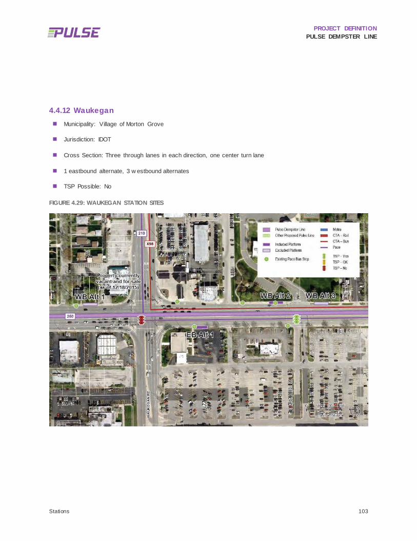
PROJECT DEFINITION PULSE DEMPSTER LINE
Stations 103
4.4.12 Waukegan Municipality: Village of Morton Grove
Jurisdiction: IDOT
Cross Section: Three through lanes in each direction, one center turn lane
1 eastbound alternate, 3 w estbound alternates
TSP Possible: No
FIGURE 4.29: WAUKEGAN STATION SITES

PROJECT DEFINITION PULSE DEMPSTER LINE
Stations 104
TABLE 4.24: WAUKEGAN EASTBOUND STATION SITE SUMMARY
Opportunities Challenges
Alt 1
(Far
Sid
e) • Far side station is operationally beneficial
• Potential for future TSP if the intersection conditions change • Limited right-of-w ay
TABLE 4.25: WAUKEGAN WESTBOUND STATION SITE SUMMARY
Opportunities Challenges
Alt 1
(Far
Sid
e) • Far side station is operationally beneficial
• Potential for future TSP if the intersection conditions change • Site is constrained w ith property impacts likely • Channelized right turn from southbound Waukegan Road to
w estbound Dempster Street may require the station to be mov ed farther w est
• Site w ould be located in front of a single family home that appears to be used for a commercial use
Alt 2
(Far
Sid
e)
• Far side location w ould prov ide TSP benefits at Athletic Driv e • Located prox imate to tw o ex isting Pace bus stops to capture
the majority of w estbound boardings • Av ailable right-of-w ay
• 550 feet east of Waukegan Road • Adjacent to Park District property ; there may be potential
Section 4(f) issues if Park District property is impacted
Alt 3
(Nea
r Sid
e) • Near side of the Morton Grov e Park District entrance
• Av ailable right-of-w ay • 750 feet east of Waukegan Road • Would complicate TSP implementation • Adjacent to Park District property ; there may be potential
Section 4(f) concerns
The Dempster/Waukegan intersection is among the busier posted stop locations along Route 250. Route 250 intersects Route 210 at this location, w ith approximately 15 passengers transferring betw een the routes on an average w eekday.
The immediate vicinity of the intersection presents signif icant challenges to station siting, w ith a w ide intersection w ith channelized right turn lanes. How ever, most boardings and alightings for this station area occur east of this intersection. Placing the station east of the intersection w ould help to capture this ridership and w ould also provide a more appropriate one-half (1/2) mile spacing to the proposed Harlem station to the w est.
PROJECT DEFINITION PULSE DEMPSTER LINE
Stations 105
4.4.12.1 EASTBOUND
4.4.12.1.1 Alternate 1 In the eastbound direction, only one station site w as analyzed on the far side of the intersection. This is the site of an existing Route 250 bus stop and shelter. This location has a moderately constrained right-of-w ay and the station construction w ould result in property impacts. The sidew alk w ould need to pass through the station to minimize these impacts. Given that most Route 250 ridership is east of Waukegan Road, this station site is recommended for further consideration.
4.4.12.2 WESTBOUND
In the w estbound direction, one station site is examined on the far side of the Waukegan intersection and tw o station sites are examined approximately one quarter mile east of the intersection betw een New England Avenue and Athletic Drive.
4.4.12.2.1 Alternate 1 Alternate 1 is proposed at the far side of the Waukegan Road intersection. This right-of-w ay is limited, w ith signif icant property impacts likely. Additionally, the channelized right turn from southbound Waukegan Road to w estbound Dempster Street w ould create traff ic conflicts or require the station to be moved farther w est. For these reason, this station alternative is not recommended for further consideration.
4.4.12.2.2 Alternate 2 Alternate 2 is located at the far side of Athletic Drive, the entrance to the Morton Grove Park District facilities, w hich is 550 feet east of Waukegan Road. A turn lane begins at this location and three through lanes continue through the intersection at Waukegan. The impact of a station at this location w ould be minimized by the additional through lane. This site w ould also take advantage of TSP benefits from the signalized Park District entrance. The station is located near tw o existing Pace Route 250 bus stops to capture the majority of w estbound boardings. There appears to be suff icient space w ithin the right-of-w ay for a station at this location. Given its location adjacent to Park District property, there may be potential Section 4(f) issues if the Park District property w ere impacted. This station is recommended for further consideration.
4.4.12.2.3 Alternate 3 Alternate 3 is located at the near side of the Morton Grove Park District Athletic Drive entrance and is 750 feet w est of Waukegan Road. The near side location w ould complicate TSP implementation. The roadw ay begins to w iden at this location to establish a third through lane. Due to the location of the station site adjacent to Park District property, there may be potential Section 4(f) issues if the property is directly impacted. For all of these reasons, this station site is not recommended for further consideration.
4.4.12.3 SUMMARY STATUS OF ALTERNATES
Eastbound Alternate 1 and Westbound Alternate 2 are recommended for further consideration. Westbound Alternate 1 is not recommended for further consideration due to property impacts and traff ic impacts due to being located close to a channelized right turn lane. Westbound Alternate 3 is not recommended for further consideration due to its distance from Waukegan Road. Figure 4.29 show s the Waukegan station site locations. Table 4.24 and Table 4.25 provide a summary of the opportunities and challenges at each station site location.
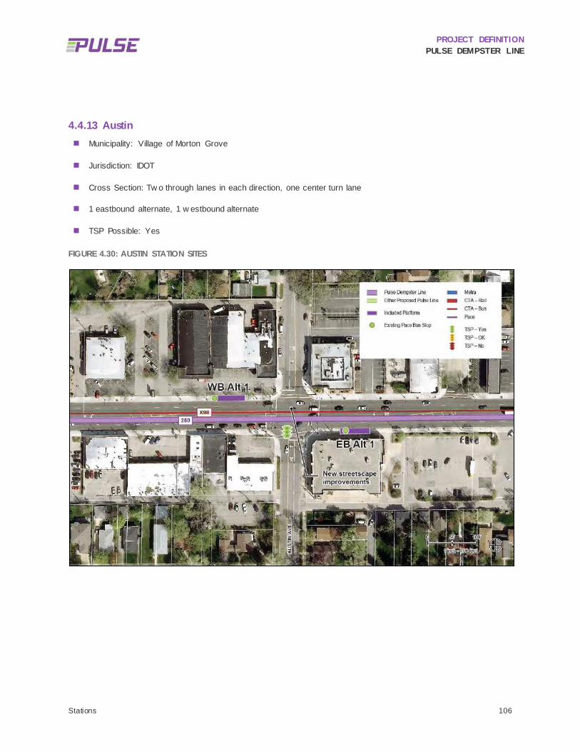
PROJECT DEFINITION PULSE DEMPSTER LINE
Stations 106
4.4.13 Austin Municipality: Village of Morton Grove
Jurisdiction: IDOT
Cross Section: Tw o through lanes in each direction, one center turn lane
1 eastbound alternate, 1 w estbound alternate
TSP Possible: Yes
FIGURE 4.30: AUSTIN STATION SITES

PROJECT DEFINITION PULSE DEMPSTER LINE
Stations 107
TABLE 4.26: AUSTIN EASTBOUND STATION SITE SUMMARY
Opportunities Challenges
Alt 1
(Far
Sid
e) • Far side location w ould prov ide TSP benefits • Limited right-of-w ay w ould result in property impacts
• Potential impacts to streetscaping
TABLE 4.27: AUSTIN WESTBOUND STATION SITE SUMMARY
Opportunities Challenges
Alt 1
(Far
Sid
e) • Far side location w ould prov ide TSP benefits • Streetscape improv ements w ill hav e to be modified
This station w as selected by Pace based on modest ridership levels, supportive land use, and a suitable site. Although this is one of the low er ridership station locations on the corridor, it helps establish the desired one-quarter (1/4) mile station spacing along a stretch of Dempster Street w ith no other proposed stations, and is the most appropriate location along the corridor betw een Waukegan Road and I-94 in eastern Morton Grove.
This pedestrian friendly section of Dempster Street includes streetscaping, crossw alks, shorter crossing distances, medium density land uses w ith buildings close to the street, and bicycle parking. Because of the streetscaping, station platforms w ould require streetscape modif ications including street lamp relocations. The Austin station site locations are show n in Figure 4.30.
4.4.13.1 EASTBOUND
4.4.13.1.1 Alternate 1 The eastbound station site is located on the far side of the intersection to take advantage of TSP benefits. At this location, streetscape improvements have been made by the Village. Cook County parcel data indicates the available right-of-w ay is very limited. This w ill need to be investigated during the environmental review and advanced conceptual design phase to determine if there are any property impacts and to w hat extent they might occur. This station site is recommended for further consideration.
4.4.13.2 WESTBOUND
4.4.13.2.1 Alternate 1 The w estbound station is located on the far side of the intersection to take advantage of TSP benefits. At this location, street trees have been planted and other streetscape improvements have been made. A station at this site w ould impact the street trees and streetscape. Cook County parcel data indicates that the parcel lines extend to the center of Dempster Street. Further surveying w ill be needed to confirm the right-of-w ay limits and determine the extent of any property impacts. This station site is recommended for further consideration.

PROJECT DEFINITION PULSE DEMPSTER LINE
Stations 108
4.4.13.3 SUMMARY STATUS OF ALTERNATES
Eastbound Alternate 1 and Westbound Alternate 1 are recommended for further consideration. Figure 4.30 show s the Austin station site locations. Table 4.26 and Table 4.27 provide a summary of the opportunities and challenges at each station site location.

PROJECT DEFINITION PULSE DEMPSTER LINE
Stations 109
4.4.14 Dempster-Skokie CTA Municipality: Village of Skokie
Jurisdiction: Layover facility – CTA; Dempster Street – IDOT and ComEd
Cross Section: Tw o through lanes in each direction w ith a left turn lane in the w estbound direction
3 eastbound alternates, 2 w estbound alternates
TSP Possible: Yes
FIGURE 4.31: DEMPSTER-SKOKIE CTA STATION SITES
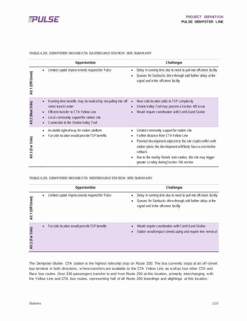
PROJECT DEFINITION PULSE DEMPSTER LINE
Stations 110
TABLE 4.28: DEMPSTER-SKOKIE CTA EASTBOUND STATION SITE SUMMARY
Opportunities Challenges
Alt 1
(Off-
Stre
et) • Limited capital improv ements required for Pulse • Delay in running time due to need to pull into off-street facility
• Queues for Starbucks driv e-through add further delay at the signal and in the off-street facility
Alt 2
(Nea
r Sid
e) • Running time benefits may be realized by not pulling into off-
street transit center • Efficient transfer to CTA Yellow Line • Local community support for station site • Connection to the Skokie Valley Trail
• Near side location adds to TSP complex ity • Skokie Valley Trail may present a Section 4(f) issue • Would require coordination w ith ComEd and Skokie
Alt 3
(Far
Sid
e)
• Av ailable right-of-w ay for station platform • Far side location w ould prov ide TSP benefits
• Limited community support for station site • Farther distance from CTA Yellow Line • Planned dev elopment adjacent to the site could conflict w ith
station plans; the dev elopment w ill likely hav e a zero lot line setback
• Due to the nearby historic train station, this site may trigger greater scrutiny during Section 106 rev iew
TABLE 4.29: DEMPSTER-SKOKIE CTA WESTBOUND STATION SITE SUMMARY
Opportunities Challenges
Alt 1
(Off-
Stre
et) • Limited capital improv ements required for Pulse • Delay in running time due to need to pull into off-street facility
• Queues for Starbucks driv e-through add further delay at the signal and in the off-street facility
Alt 2
(Far
Sid
e) • Far side location w ould prov ide TSP benefits
• Would require coordination w ith ComEd and Skokie • Station w ould impact streetscaping and require tree remov al
The Dempster-Skokie CTA station is the highest ridership stop on Route 250. The bus currently stops at an off -street bus terminal in both directions, w here transfers are available to the CTA Yellow Line as w ell as four other CTA and Pace bus routes. Over 330 passengers transfer to and from Route 250 at this location, primarily interchanging w ith the Yellow Line and CTA bus routes, representing half of all Route 250 boardings and alightings at this location.

PROJECT DEFINITION PULSE DEMPSTER LINE
Stations 111
4.4.14.1 EASTBOUND
4.4.14.1.1 Alternate 1 Three station alternates are being considered in the eastbound direction. Alternate 1 is at the site of the existing bus drop off area located off-street at the CTA Yellow Dempster-Skokie station. Based on conversations w ith Pace and the Village of Skokie, as w ell as potential running time savings resulting from locating a station on-street, this alternative is not recommended for further consideration.
4.4.14.1.2 Alternate 2 Alternate 2 is located on Dempster Street immediately north of the CTA Yellow Line off-street facility, to the near side of the signalized entrance to the CTA station. TSP benefits are not available at this location, though the location provides ease of transfer to CTA. There is room for a standard station, how ever the exact limits of the public right-of-w ay need to be determined. A ComEd right-of-w ay appears to run through Dempster Street, suggesting that signif icant coordination w ill be needed w ith ComEd and the Village of Skokie. The Skokie Valley Bike Trail has been recently constructed along this railroad corridor and the Village of Skokie has indicated a w illingness to reconfigure the trailhead. It is unknow n w hether the trail is on park land or w hat funding w as used to construct the trail. This w ill need to be evaluated during the environmental review phase to determine if there are any potential Section 4(f) issues w ith modifying the trailhead. This station alternative is recommended for further consideration.
4.4.14.1.3 Alternate 3 Alternate 3 is located on Dempster Street on the far side of the signalized entrance to the CTA Yellow Line station and is adjacent to a Starbucks coffee shop housed in a historic train depot. TSP benefits may be realized here, but w ould create a longer w alking distance for passengers to transfer betw een CTA and Pace. It is anticipated that the parcel adjacent to this station site w ill be developed in the near future, possibly w ith a zero lot line set back, w hich could pose challenges for constructing the Pulse station. Given the Village of Skokie’s preference for Alternate 2, this station alternate is not recommended for further consideration.
4.4.14.2 WESTBOUND
4.4.14.2.1 Alternate 1 In the w estbound direction, tw o station alternates have been examined. Alternate 1 is at the site of the existing bus drop off area located off-street at the CTA Yellow Line station. Accessing this off-site station requires buses to turn left w hich adds travel time to the service. In addition, queues for Starbucks further congest the intersection and the off-street facility. Based on conversations w ith Pace and the Village of Skokie, as w ell as potential running time savings resulting from locating a station on-street, this alternative is not recommended for further consideration.
4.4.14.2.2 Alternate 2 Alternate 2 is located on Dempster Street on the far side of the signalized entrance to the CTA station. TSP benefits are available at this location and the location provides a relatively easy and safe transfer to CTA via the signalized intersection. There is room for a standard station here; how ever the exact limits of the public right-of-w ay need to be determined. A ComEd right-of-w ay appears to run through Dempster Street, suggesting that signif icant coordination w ill be needed w ith ComEd and the Village of Skokie. The Village prefers this station location over Alternative 1. This alternative is recommended for further consideration.

PROJECT DEFINITION PULSE DEMPSTER LINE
Stations 112
4.4.14.3 SUMMARY STATUS OF ALTERNATES
Eastbound and Westbound Alternate 1 are not recommended for further consideration because of a desire by the Village of Skokie to have an on-street station, and by Pace to minimize impacts to running time. Eastbound Alternate 2 and Westbound Alternate 2 have been recommended for further consideration. These alternate station sites are on Dempster Street and are strongly supported by the Village of Skokie and Pace. Figure 4.31 show s the Dempster-Skokie CTA station site locations. Table 4.28 and Table 4.29 provide a summary of the opportunities and challenges at each station site location.

PROJECT DEFINITION PULSE DEMPSTER LINE
Stations 113
4.4.15 Crawford Municipality: Village of Skokie
Jurisdiction: IDOT
Cross Section: Tw o through lanes, one center turn lane
1 eastbound alternate, 3 w estbound alternates
TSP Possible: No
FIGURE 4.32: CRAWFORD STATION SITES

PROJECT DEFINITION PULSE DEMPSTER LINE
Stations 114
TABLE 4.30: CRAWFORD EASTBOUND STATION SITE SUMMARY
Opportunities Challenges
Alt 1
(Far
Sid
e) • Potential for future TSP if the intersection conditions change • Limited right-of-w ay
• Streetscaping may be impacted and street trees may need to be remov ed
TABLE 4.31: CRAWFORD WESTBOUND STATION SITE SUMMARY
Opportunities Challenges
Alt 1
(Far
Sid
e) • NA • Long distance (500 feet) from signalized intersection
• Limited right-of-w ay • Station construction w ould impact property , including off-
street parking
Alt 2
(Far
Sid
e)
• Potential for future TSP benefits if the intersection conditions change
• Limited right-of-w ay • Constructing station w ould be difficult betw een curb and
building façade • Farther from most of the ridership and the proposed
eastbound station site • Makes transfers more difficult to Pace Route 215
(approx imately 15 transfers per day betw een these tw o routes)
Alt 3
(Far
Sid
e) • Potential for future TSP benefits if the intersection conditions
change • Highest number of boardings in the area
• Located betw een tw o gas station driv ew ays and may require modify ing one or both driv ew ay s
• Limited right-of-w ay w ould result in property impacts • Further inv estigation is needed to determine w hether a station
location here impedes fuel deliv eries
Alt 4
(Nea
r Sid
e) • NA • 350 feet east of the intersection, farther from the
concentration of ridership and a signalized intersection • Shelter may encroach into parking lot on priv ate property • May require the remov al of trees and relocation of a fire
hy drant and street lamp • Utility conflicts include an electrical v ault near this site
This station w as selected by Pace based on modest ridership levels, supportive land use, and suitable sites. This station is located 1.3 miles east of the preceding station at the Dempster-Skokie CTA. Low ridership along this segment and the presence of a golf course along much of the south side of Dempster Street make this w ide spacing appropriate. The Craw ford station site alternates are show n in Figure 4.32.
PROJECT DEFINITION PULSE DEMPSTER LINE
Stations 115
4.4.15.1 EASTBOUND
4.4.15.1.1 Alternate 1 One station site in the eastbound direction w as examined. Located on the far side of the intersection, this site can take advantage of TSP benefits if future conditions indicate that TSP could be implemented at this location. Since the 2010 Station Location Study, a Walgreen’s store has been built adjacent to proposed site. The store has been built to the property line and there is limited available right-of-w ay. Despite these challenges, this station alternative is recommended for further consideration.
4.4.15.2 WESTBOUND
In the w estbound direction, four station sites have been examined: three far side stations and one near side.
4.4.15.2.1 Alternate 1 Alternate 1 is located 500 feet w est of Craw ford Avenue, adjacent to a grocery store parking lot. This location is farther from most of the ridership and the proposed eastbound station site. It also makes transfers more diff icult to Pace Route 215 (approximately 15 transfers per day currently occur betw een these tw o routes). There is insuff icient space w ithin the right-of-w ay for a station and any station to be constructed w ould impact the adjacent parking lot. Due to the property impacts, the distance from Craw ford, and the diff iculty of transferring to Route 215, this alternate station is not recommended for further consideration.
4.4.15.2.2 Alternate 2 Alternate 2 is adjacent to the grocery store, w est of the intersection. There is limited right-of-w ay here for a station and the station w ill impact the building entrance. Due to the distance from the intersection and property impacts, this alternate station is not recommended for further consideration.
4.4.15.2.3 Alternate 3 Alternate 3 is on the far side of the intersection adjacent to a gas station. Though TSP is not currently planned for this intersection, a far side station w ould enable TSP benefits if intersection conditions w ere to change in the future and TSP is deemed viable. The highest number of boardings in this station area occurs at the existing stop in this location betw een the tw o gas station drivew ays. There is generally suff icient length betw een the drivew ays to build a station; how ever, the depth of the right-of-w ay is limited and a station may impact the private property. Further investigation is needed to determine w hether a station location here w ould impede fuel deliveries and w hether the station w ould require modifying one or both drivew ays. This station is recommended for further consideration.
4.4.15.2.4 Alternate 4 Alternate 4 is located on the near side of the intersection, approximately 350 feet east of the intersection, and w as recommended for inclusion by the Village of Skokie. A station here w ould impact the adjacent parking lot as the shelter w ould need to be set back to meet sight distance requirements. The station w ould also likely require the removal of street trees and relocation of a f ire hydrant, street lamp and electrical vault. Because of the Village’s support for this location, this station alternate is recommended for further investigation.
4.4.15.3 SUMMARY STATUS OF ALTERNATES
Eastbound Alternate 1 and Westbound Alternates 3 and 4 are recommended for further consideration. Westbound Alternates 1 and 2 are not recommended for further consideration due to property impacts and the distance from Craw ford Avenue. Figure 4.32 show s the Craw ford station site locations. Table 4.30 and Table 4.31 provide a summary of the opportunities and challenges at each station site location.

PROJECT DEFINITION PULSE DEMPSTER LINE
Stations 116
4.4.16 Lincolnwood Municipality: Village of Skokie
Jurisdiction: IDOT
Cross Section: Tw o through lanes in each direction, one center turn lane
3 eastbound alternates, 3 w estbound alternates
TSP Possible: Yes
FIGURE 4.33: LINCOLNWOOD STATION SITES

PROJECT DEFINITION PULSE DEMPSTER LINE
Stations 117
TABLE 4.32: LINCOLNWOOD EASTBOUND STATION SITE SUMMARY
Opportunities Challenges
Alt 1
(Nea
r Sid
e) • Adjacent to a v acant parcel
• Any new dev elopment could incorporate the station into the dev elopment plan
• Limited right-of-w ay to construct a station w ithout impacting the adjacent property (the property line is 10 feet from the curb)
• Increases complex ity of achiev ing TSP benefits
Alt 2
(Far
Sid
e) • Far side location w ould prov ide TSP benefits
• Sufficient right-of-w ay to construct full size station
• Station construction Station construction w ould require remov al of landscaping, including mature trees
Alt 3
(Nea
r Sid
e - K
imba
ll) • Location w ould prov ide TSP benefits at Lincolnw ood
• • Located more than 500 feet from the nearest crossw alk; a
midblock crossing may be needed • Space is av ailable for a w alk-through station configuration • Limited right-of-w ay w ould result in station impacting priv ate
property • Close prox imity to Kimball Av enue could present
sightline/v isibility issues and require station to be set farther back on property
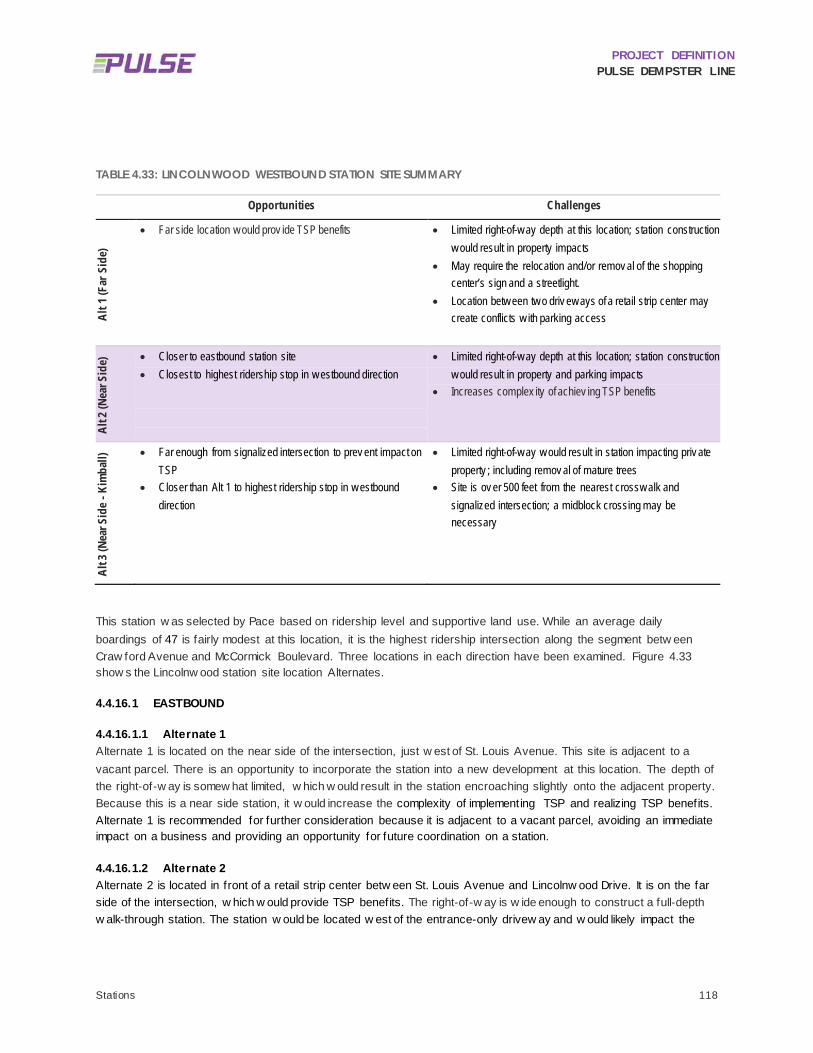
PROJECT DEFINITION PULSE DEMPSTER LINE
Stations 118
TABLE 4.33: LINCOLNWOOD WESTBOUND STATION SITE SUMMARY
Opportunities Challenges
Alt 1
(Far
Sid
e)
• Far side location w ould prov ide TSP benefits
• Limited right-of-w ay depth at this location; station construction w ould result in property impacts
• May require the relocation and/or remov al of the shopping center’s sign and a streetlight.
• Location betw een tw o driv ew ays of a retail strip center may create conflicts w ith parking access
Alt 2
(Nea
r Sid
e) • Closer to eastbound station site
• Closest to highest ridership stop in w estbound direction
• Limited right-of-w ay depth at this location; station construction w ould result in property and parking impacts
• Increases complex ity of achiev ing TSP benefits
Alt 3
(Nea
r Sid
e - K
imba
ll) • Far enough from signalized intersection to prev ent impact on
TSP • Closer than Alt 1 to highest ridership stop in w estbound
direction
• Limited right-of-w ay w ould result in station impacting priv ate property ; including remov al of mature trees
• Site is ov er 500 feet from the nearest crossw alk and signalized intersection; a midblock crossing may be necessary
This station w as selected by Pace based on ridership level and supportive land use. While an average daily boardings of 47 is fairly modest at this location, it is the highest ridership intersection along the segment betw een Craw ford Avenue and McCormick Boulevard. Three locations in each direction have been examined. Figure 4.33 show s the Lincolnw ood station site location Alternates.
4.4.16.1 EASTBOUND
4.4.16.1.1 Alternate 1 Alternate 1 is located on the near side of the intersection, just w est of St. Louis Avenue. This site is adjacent to a vacant parcel. There is an opportunity to incorporate the station into a new development at this location. The depth of the right-of-w ay is somew hat limited, w hich w ould result in the station encroaching slightly onto the adjacent property. Because this is a near side station, it w ould increase the complexity of implementing TSP and realizing TSP benefits. Alternate 1 is recommended for further consideration because it is adjacent to a vacant parcel, avoiding an immediate impact on a business and providing an opportunity for future coordination on a station.
4.4.16.1.2 Alternate 2 Alternate 2 is located in front of a retail strip center betw een St. Louis Avenue and Lincolnw ood Drive. It is on the far side of the intersection, w hich w ould provide TSP benefits. The right-of-w ay is w ide enough to construct a full-depth w alk-through station. The station w ould be located w est of the entrance-only drivew ay and w ould likely impact the

PROJECT DEFINITION PULSE DEMPSTER LINE
Stations 119
shopping center’s landscape buffer, requiring removal of existing landscaping and mature trees. Alternate 2 is recommended for further consideration.
4.4.16.1.3 Alternate 3 Alternate 3 is located on the near side of the intersection w ith Kimball Avenue, w here there is an existing bus stop w ith shelter. While the site is on the near side of the Kimball Avenue intersection, it is east of the Lincolnw ood Avenue intersection, w hich w ould allow for TSP benefits at Lincolnw ood. How ever, the site is located more than 500 feet from the nearest crossw alk; a midblock crossing may be needed. Cook County parcel data indicates that the right-of-w ay is limited in depth, w hich w ould likely result in a station impacting private property. In addition, the close proximity to Kimball Avenue could present sightline and visibility issues, w hich w ould necessitate setting the station back from the curb. Because of the distance from signalized intersection and the potential for property impacts, Alternate 3 is not recommended for further consideration.
4.4.16.2 WESTBOUND
4.4.16.2.1 Alternate 1 Alternate 1 is located on the far side of the intersection betw een tw o drivew ays of a retail strip center, w hich w ould allow for TSP benefits. The right-of-w ay depth is limited here; the station w ould encroach onto the private property and require the relocation and/or removal of the shopping center sign and a streetlight. In addition, there may be sightline issues associated w ith the access drives. Despite these challenges, this station site is recommended for further consideration as it provides TSP benefits, is relatively close to a signalized intersection and safe crossing, and may be less impactful than other w estbound station alternates.
4.4.16.2.2 Alternate 2 The site for Alternate 2 w as suggested by the Village of Skokie and is located on the near side of the intersection, closest to the highest ridership w estbound stop. Construction of a station at this location w ould make it more diff icult to achieve TSP benefits. The limited right-of-w ay w ould also result in direct impacts to the adjacent property, w ith the station encroaching into the parking lot and likely impacting parking spaces. This station alternative should move forw ard for further consideration given the proximity to existing ridership and the recommendation by the Village of Skokie.
4.4.16.2.3 Alternate 3 Alternate 3 is located midblock betw een Forestview Road and Ew ing Avenue, across from Kimball Avenue and near the eastbound Alternate 3 site. This site is over 500 feet from the nearest signalized intersection and crossw alk; a midblock crossing may be necessary to create a safe pedestrian environment. The right-of-w ay is limited in depth and a station w ould likely encroach onto the adjacent property and require the removal of mature trees. For all these reasons, this site is not recommended for further consideration.
4.4.16.3 SUMMARY STATUS OF ALTERNATES
Eastbound Alternates 1 and 2 and Westbound Alternates 1 and 2 are recommended for further consideration. Eastbound and Westbound Alternate 3 are not recommended for further consideration due to potential property impacts and the distance from a crossw alk, w hich may necessitate adding a midblock crossing. Figure 4.33 show s the Lincolnw ood station site locations. Table 4.32 and Table 4.33 provide a summary of the opportunities and challenges at each station site location.

PROJECT DEFINITION PULSE DEMPSTER LINE
Stations 120
4.4.17 Dodge Municipality: City of Evanston
Jurisdiction: IDOT
Cross Section: Tw o through lanes and a center turn lane in each direction w est of Dodge; east of Dodge, one through lane in each direction w ith on-street parking
2 eastbound alternates, 3 w estbound alternates
TSP Possible: Potentially
FIGURE 4.34: DODGE STATION SITES

PROJECT DEFINITION PULSE DEMPSTER LINE
Stations 121
TABLE 4.34: DODGE EASTBOUND STATION SITE SUMMARY
Opportunities Challenges
Alt 1
(Nea
r Sid
e) • Av ailable right-of-w ay
• Station is located at high ridership Pace stop • A Div v y bike share station is programmed for the adjacent
retail center
• An easement w ould be required to route the sidew alk behind the station
• Street trees and a street light w ould hav e to be relocated • TSP benefits more difficult to realize
Alt 2
(Far
Sid
e)
• Far side location w ould prov ide TSP benefits
• Ex tremely limited right-of-w ay ; the building has a small setback from the sidew alk, leav ing approx imately 13 feet betw een the curb and the building
• Station w ould interfere w ith building entrances • Dempster Street narrow s from tw o lanes in each direction
dow n to one; site is w ithin the taper w hich could contribute to congestion and traffic conflicts
Alt 3
(Far
Sid
e) • Far side location w ould prov ide TSP benefits • 350 feet from Dodge Av enue
• Site is at un-signalized intersection • Site likely to prov oke opposition from nearby property ow ners

PROJECT DEFINITION PULSE DEMPSTER LINE
Stations 122
TABLE 4.35: DODGE WESTBOUND STATION SITE SUMMARY
Opportunities Challenges
Alt 1
(Far
Sid
e)
• Opportunity to take adv antage of TSP at Dodge • Signalized intersection prov ides for safe pedestrian crossing
• 300 feet w est of high ridership Route 250 stop near Alternate 2
• Sight distance requirements likely w ill result in station setback and property impacts
• May affect traffic mov ements from the shopping center to w estbound Dempster
• Station w ould require new crossw alk and ADA accessible curb ramp
Alt 2
(Far
Sid
e)
• Opportunity to take adv antage of TSP at Dodge • Site is the closest to ex isting high ridership Route 250 stop
• Limited curb length w ith 55 feet betw een driv ew ay entrances and limited right-of-w ay depth w ould result in property impacts
• Streetlight w ould need to be relocated • Operational issues w ith siting a station betw een tw o
driv ew ays • Property ow ner likely to oppose station
Alt 3
(Nea
r Sid
e) • Site is close to safe signalized pedestrian crossing • TSP benefits more difficult to realize
• Limited right-of-w ay depth w ould result in property impacts, including reduction in the w idth of the Burger King driv e-thru lane
• Station could impact right turns onto Dodge Av enue • TSP benefits more difficult to realize
Alt 4
(Nea
r Sid
e) • Sufficient right-of-w ay to construct a station • Un-signalized intersection • TSP benefits more difficult to realize
The intersection of Dempster Street and Dodge Avenue is a major shopping and restaurant node in w estern Evanston, as w ell as a transfer point for Route 250. CTA Route 93, w hich intersects Route 250 both at this intersection and at the Davis CTA/Metra station, is the third most signif icant source of transfers to Route 250, and the most signif icant non-Pace source of ridership transfers.
There are signif icant site constraints for placement of stations at this intersection, particularly in the w estbound direction. How ever, w ith over 200 daily boardings and alightings in the vicinity of this station location and the lack of other superior locations for stations in Evanston, the importance of siting a station at this location necessitates that Pace identify suitable station sites. Seven station sites have been evaluated. The Dodge station site locations are show n in Figure 4.34.
PROJECT DEFINITION PULSE DEMPSTER LINE
Stations 123
4.4.17.1 EASTBOUND
4.4.17.1.1 Alternate 1 Alternate 1 is located on the near side of the intersection adjacent to a retail shopping center at the location of a high ridership stop (approximately 23 average daily boardings). The right-of-w ay is suff iciently w ide enough to construct a full station although landscaping may be impacted. The near side location of this station w ould make TSP benefits diff icult to realize. Evanston staff indicated this is a highly desirable location for a station and transit facilities have been requested at this location by local stakeholders. Evanston is coordinating w ith the adjacent property to site a Divvy station w ithin the shopping center parking lot. This station alterative is recommended for further consideration.
4.4.17.1.2 Alternate 2 Alternate 2 is located on the far side of the intersection in front of the Heartw ood Center. The right-of-w ay is extremely limited here as the building is setback only a few feet from the sidew alk, leaving approximately 13 feet betw een the curb and the building. A proposed platform here w ould interfere w ith the building entrances. East of Dodge, Dempster Street narrow s from tw o lanes in each direction dow n to one w ith taper and parking lanes. This station site is w ithin the road taper. Pace’s Operations Department provided feedback that a station site is not viable at this location. For these reasons, this site is not recommended for further consideration.
4.4.17.1.3 Alternate 3 Alternate 3 is located on the far side of the intersection farthest east, approximately 350 feet from Dodge Avenue, near Darrow Avenue. This is the site of an existing CTA Route 206 bus stop (see Figure 4.35). The site is un-signalized but a crossw alk w ould be appropriate here. How ever, in the past IDOT has declined requests to install crossw alks at this location. The City of Evanston believes that a station site here is likely to provoke opposition from adjacent property ow ners w ho have previously voiced opposition to a bus shelter at this location. This station site is not recommended for further consideration.

PROJECT DEFINITION PULSE DEMPSTER LINE
Stations 124
FIGURE 4.35: DODGE EASTBOUND ALTERNATE 3 STATION SITE
4.4.17.2 WESTBOUND
4.4.17.2.1 Alternate 1 Alternate 1 is located the farthest w est from Dodge Avenue in front of a Jiffy Lube. It is on the far side of the signalized entrance to the shopping center, and a crossw alk and ADA ramps w ould have to be installed. Although TSP is not recommended at this signal, TSP is recommended at Dodge and siting the station here w ould allow Pulse vehicles to take advantage of TSP at Dodge. There is limited right-of-w ay depth here and sight distance requirements w ould likely result in property impacts. In addition, the station may affect turning movements from the shopping center onto w estbound Dempster. Despite these challenges, this station alternative is recommended for further consideration.
4.4.17.2.2 Alternate 2 Alternate 2 is located in front of McDonald’s at a high ridership stop for Route 250. There is limited curb length here w ith just 55 feet betw een drivew ay entrances, and limited right-of-w ay depth w ould result in property impacts. A streetlight w ould also need to be relocated. There are operational concerns w ith siting a station betw een tw o drivew ays. Conversations w ith Evanston staff indicate that the property ow ner w ould likely oppose this station site. This station alternative is not recommended for further consideration.
4.4.17.2.3 Alternate 3 Alternate 3 is located on the near side of Dodge Avenue, adjacent to a Burger King restaurant. There is limited right-of-w ay here and platform construction at this location w ould reduce the w idth of the Burger King drive-thru lane. The

PROJECT DEFINITION PULSE DEMPSTER LINE
Stations 125
station w ould also impact right turns onto Dodge Avenue and w ould make it more diff icult to achieve the benefits of TSP. Despite these challenges this station alternative is recommended for further consideration as it could be less impactful than other station sites.
4.4.17.2.4 Alternate 4 Alternate 4 is located one block east of Dodge Avenue and although it is on the far side of Darrow Avenue, it is considered a near side station for the purposes of Dodge Avenue and as such, it w ould be diff icult to take full advantage of TSP benefits. There is suff icient right-of-w ay to construct a w alk-through station at this site. How ever, Darrow Avenue is an un-signalized intersection and a crossw alk w ould be needed to provide a safe pedestrian environment. In the past, IDOT has declined requests to install crossw alks at this site. Due to the challenging pedestrian environment and the near side location, a station site at this location is not recommended for further consideration.
4.4.17.3 SUMMARY STATUS OF ALTERNATES
Eastbound Alternate 1 and Westbound Alternates 1 and 3 are recommended for further consideration. Eastbound Alternates 2 and 3 and Westbound Alternates 2 and 4 are not recommended for further study. Figure 4.34 show s the Dodge station site locations. Table 4.34 and Table 4.35 provide a summary of the opportunities and challenges at each station site location.

PROJECT DEFINITION PULSE DEMPSTER LINE
Stations 126
4.4.18 Davis CTA/Metra Municipality: City of Evanston
Jurisdiction: City of Evanston/CTA
Cross Section: One through lane; buses share a layover lane
1 terminal station at existing bus terminal
TSP Possible: N/A
FIGURE 4.36: DAVIS CTA/METRA STATION SITE
The Davis CTA/Metra station is the 13th busiest bus stop in the Pace netw ork and the busiest on Route 250. Of the over 600 daily boardings and alightings for Route 250 that occur in the vicinity of this station, approximately half are transfer passengers from the CTA Purple Line or other CTA and Pace bus routes. Pace Route 208, w hich also uses this stop, is the second largest source of non-rail transfers to Route 250. Additionally, Metra’s Union Pacif ic North Line runs parallel to the CTA Purple Line and also serves this station at its Davis Street station.
It has been assumed that the Dempster Line station w ill be located in front of the CTA station entrance on Benson Avenue, w here CTA and Pace buses currently lay over. The precise site and extent of the Pulse station at Davis

PROJECT DEFINITION PULSE DEMPSTER LINE
Stations 127
CTA/Metra w ill be determined in coordination w ith the CTA and the City of Evanston. It is anticipated that station improvements w ill likely only include static signage, although a vertical marker may be possible. Pace w ill coordinate w ith the RTA for real-time information signage to support all transit services at this location. Figure 4.36 show s the Davis CTA/Metra station site location.
4.4.19 Summary In total, 23 station locations and 79 individual station site options w ere evaluated, including stations that w ere suggested for elimination in the Preliminary Station Location and Site Selection Options Technical Memorandum (i.e. Rosemont CTA, Mannheim/Lunt, Lee-Mannheim/Thacker/Graceland, Luther, and Ridge). Table 4.2 provides a list of all station locations and sites that have been review ed and identif ies those recommended for advancement to the environmental review phase. At this time, 18 station locations (including Potter as an alternate to Dee) and 47 individual station sites are recommended to advance. During the environmental review phase, a boundary and topographic survey w ill be conducted to confirm property lines and right-of-w ay limits and collect topographic data. This data w ill support the environmental review , the development of advanced conceptual designs, and Pace’s selection of a preferred station site for each location that w ill advance forw ard to the design phase.
LOCAL STOP CONSOLIDATION 4.5
As the Pulse Dempster Line Project advances through the environmental review , design, construction, and operation phases, Pace may consider local stop consolidation as a strategy for improving the operation of Pulse and Route 250 service. Local stop consolidation w as not examined as part of Pulse Dempster Line Project Definition.

PROJECT DEFINITION PULSE DEMPSTER LINE
Running Way 128
5 Running Way VEHICLE OPERATIONS 5.1
The Pulse Dempster Line w ill operate in mixed traff ic w ith the vehicle generally occupying the right travel lane. Appendix F provides station layouts that include the follow ing types of station sites: 1) the boarding platform w ill be constructed to align w ith the travel lane and the bus w ill not pull over, 2) the bus w ill use a bus pull out, 3) the bus w ill pull off of the roadw ay to board and alight passengers, and 4) the bus w ill stop at an existing on-street transit facility w ith a standard curb height.
STATION-RELATED AND COLLATERAL IMPROVEMENTS 5.2
Without dedicating running w ays, the majority of Pulse Dempster Line improvements w ill be directly related to station construction w ithin the right-of-w ay. These include construction of new raised station platforms w ithin the right-of-w ay at several locations and substantial curb, gutter, and sidew alk reconstruction. Pace’s preliminary evaluation on the potential for queue jumps around the region indicate that queue jumps are not likely feasible on the Dempster corridor. Other collateral improvements near Pulse station locations are proposed to facilitate safe and hospitable pedestrian access to the stations. These include upgraded, ADA compliant curb ramps; high-visibility crossw alks; and a pedestrian refuge island. Many of these improvements are not required for operation of Pulse service, but are incorporated to create a pedestrian-friendly environment and improve accessibility near the stations. It is expected that local communities w ill share some of the cost for these improvements w hen not required for the actual construction of Pulse stations.
Pace has also proposed pedestrian enhancements be included in improvement projects constructed by other agencies. For example, the Illinois Tollw ay is currently w orking on intersection improvements at the Lee Street and Touhy Avenue intersection.. Pace’s proposed improvements include additional sidew alks to f ill in gaps at the intersection. Plans for these improvements are under development and construction is slated for 2017.
TRANSIT SIGNAL PRIORITY 5.3
Pace is actively participating in the Regional Transit Signal Priority (TSP) Implementation Program led by the Regional Transportation Authority (RTA). Figure 5.1 show s intersections along the Dempster corridor and recommendation for implementation of TSP.16 TSP is planned for Dempster Street, and development of the TSP system w ill adhere to the Regional TSP Standards and Implementation Guidelines, w hich w ere developed under the Regional Transit Signal Priority Implementation Program (RTSPIP). When TSP is implemented on Dempster Street, it
16 Delcan. (March 11, 2013.) Pace Signal Coordination and Timing Project.

PROJECT DEFINITION PULSE DEMPSTER LINE
Running Way 129
w ill be utilized by local services in addition to Pulse service. TSP is currently anticipated to be operational on Dempster Street before the Dempster Line’s planned start of service.
FIGURE 5.1: PULSE DEMPSTER LINE TSP IMPLEMENTATION RECOMMENDATION

PROJECT DEFINITION PULSE DEMPSTER LINE
Running Time Analysis 130
6 Running Time Analysis ON-TIME PERFORMANCE 6.1
Pace analyzed on-time performance for Pace Route 250 – Dempster Street betw een the O’Hare Kiss ‘N’ Fly and the CTA Purple Line Davis Street Station in Evanston. Only w eekday trips w ere analyzed, and special trip deviations connecting to and from the Maine Tow nship high schools w ere excluded from the analysis. Data w as analyzed for the month of October 2015.
The purpose of this analysis w as to evaluate the current performance of Route 250, identify operating concerns, and support the development of the running time and schedule for the proposed Pulse Dempster Line, w hich w ill follow approximately the same routing as Route 250 w ith limited stops and transit signal priority.
6.1.1 Average Travel Time by Segment and time of day Weekday mainline trips w ere analyzed by segments, defined as the portion of the route betw een tw o time points. All mainline trips, including those trips w hich operate only betw een one terminus and the Des Plaines Metra station, w ere included in the analysis. The data includes recorded arrival and departure times for each time point, w ith the total trip length equaling the sum of travel times betw een time points, plus the time spent at each time point boarding, alighting, and idling (know n as “dw ell time”). Using the sample of on-time performance data from the month of October 2015 and summing trip times betw een time points and dw ell times at time points, an average total trip length w as calculated for both the eastbound and w estbound directions of Route 250, as show n in Table 6.1 and Table 6.2. The dw ell time at each time point w as added to the running time to arrive at a total travel time to each time point. Dw ell time after arrival at the f inal stop w as not included.
To account for unusual trips or data irregularities that should not be used to predict typical operating conditions, outlier records w ere identif ied, w hich are segments of trips more than 1.5 times the interquartile range beyond the f irst and third quartile ranges running time (not including dw ell time at time points). The data presented below represents only those trip segments w ithin that range and w hich w ere therefore not identif ied as outliers.

PROJECT DEFINITION PULSE DEMPSTER LINE
Running Time Analysis 131
TABLE 6.1: AVERAGE TRIP LENGTH BY STATION PAIR – WEEKDAY, EASTBOUND
Point A Point B Running Time Dwell Time Total Travel Time
O’Hare Airport Kiss ‘N’ Fly Lee/Touhy 0:07:40 0:00:07 0:07:48
Lee/Touhy Des Plaines Metra Station 0:12:46 0:00:57 0:13:43
Des Plaines Metra Station Dempster/Lutheran General Hospital 0:05:54 0:00:50 0:06:45
Dempster/Lutheran General Hospital Dempster/Milw aukee 0:05:01 0:01:38 0:06:40
Dempster/Milw aukee Dempster/Waukegan 0:04:33 0:00:27 0:05:01
Dempster/Waukegan Dempster-Skokie CTA Station 0:07:49 0:02:13 0:10:03
Dempster-Skokie CTA Station Dempster/Craw ford 0:04:07 0:00:20 0:04:28
Dempster/Craw ford Dempster/Dodge 0:05:12 0:00:53 0:06:05
Dempster/Dodge Dav is CTA/Metra Station 0:05:57 n/a 0:05:57
Total 0:58:59 0:07:25 1:06:30
Notes: Dwell time is not included for the final stop. The sum of the column totals varies slightly due to rounding of the segment times.
TABLE 6.2: AVERAGE TRIP LENGTH BY STATION PAIR – WEEKDAY, WESTBOUND
Point A Point B Segment Time Dwell Time Total Travel Time
Dav is CTA/Metra Station Dempster/Dodge 0:05:24 0:01:09 0:06:34
Dempster/Dodge Dempster/Craw ford 0:05:28 0:00:22 0:05:51
Dempster/Craw ford Dempster-Skokie CTA Station 0:03:26 0:03:16 0:06:42
Dempster-Skokie CTA Station Dempster/Waukegan 0:09:07 0:00:07 0:09:14
Dempster/Waukegan Dempster/Milw aukee 0:03:31 0:01:21 0:04:53
Dempster/Milw aukee Dempster/Lutheran General Hospital 0:05:09 0:00:44 0:05:53
Dempster/Lutheran General Hospital Des Plaines Metra Station 0:06:13 0:02:12 0:08:26
Des Plaines Metra Station Lee/Touhy 0:09:45 0:00:44 0:10:30
Lee/Touhy O’Hare Kiss ‘N’ Fly 0:07:45 n/a 0:07:45
Total 0:55:48 0:09:55 1:05:48
Notes: Dwell time is not included for the final stop. The sum of the column totals varies slightly due to rounding of the segment times.
Current w eekday trip times average approximately one hour, six minutes in both directions of travel. On most segments, the running times and total travel times are similar in both directions of travel, w ith several notable exceptions:
• Betw een Lee/Touhy and Des Plaines Metra, travel times are consistently longer in the eastbound direction, likely due to signal delay and the railroad grade crossing in dow ntow n Des Plaines – w estbound buses are
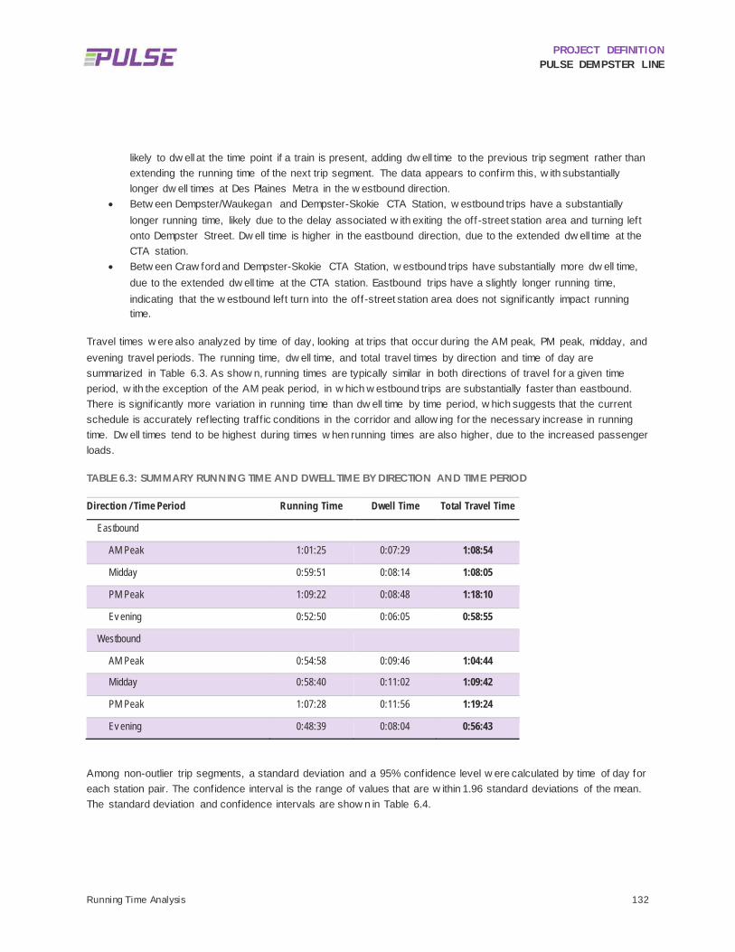
PROJECT DEFINITION PULSE DEMPSTER LINE
Running Time Analysis 132
likely to dw ell at the time point if a train is present, adding dw ell time to the previous trip segment rather than extending the running time of the next trip segment. The data appears to confirm this, w ith substantially longer dw ell times at Des Plaines Metra in the w estbound direction.
• Betw een Dempster/Waukegan and Dempster-Skokie CTA Station, w estbound trips have a substantially longer running time, likely due to the delay associated w ith exiting the off-street station area and turning left onto Dempster Street. Dw ell time is higher in the eastbound direction, due to the extended dw ell time at the CTA station.
• Betw een Craw ford and Dempster-Skokie CTA Station, w estbound trips have substantially more dw ell time, due to the extended dw ell time at the CTA station. Eastbound trips have a slightly longer running time, indicating that the w estbound left turn into the off-street station area does not signif icantly impact running time.
Travel times w ere also analyzed by time of day, looking at trips that occur during the AM peak, PM peak, midday, and evening travel periods. The running time, dw ell time, and total travel times by direction and time of day are summarized in Table 6.3. As show n, running times are typically similar in both directions of travel for a given time period, w ith the exception of the AM peak period, in w hich w estbound trips are substantially faster than eastbound. There is signif icantly more variation in running time than dw ell time by time period, w hich suggests that the current schedule is accurately reflecting traff ic conditions in the corridor and allow ing for the necessary increase in running time. Dw ell times tend to be highest during times w hen running times are also higher, due to the increased passenger loads.
TABLE 6.3: SUMMARY RUNNING TIME AND DWELL TIME BY DIRECTION AND TIME PERIOD
Direction / Time Period Running Time Dwell Time Total Travel Time
Eastbound
AM Peak 1:01:25 0:07:29 1:08:54
Midday 0:59:51 0:08:14 1:08:05
PM Peak 1:09:22 0:08:48 1:18:10
Ev ening 0:52:50 0:06:05 0:58:55
Westbound
AM Peak 0:54:58 0:09:46 1:04:44
Midday 0:58:40 0:11:02 1:09:42
PM Peak 1:07:28 0:11:56 1:19:24
Ev ening 0:48:39 0:08:04 0:56:43
Among non-outlier trip segments, a standard deviation and a 95% confidence level w ere calculated by time of day for each station pair. The confidence interval is the range of values that are w ithin 1.96 standard deviations of the mean. The standard deviation and confidence intervals are show n in Table 6.4.

PROJECT DEFINITION PULSE DEMPSTER LINE
Running Time Analysis 133
TABLE 6.4: 95% CONFIDENCE INTERVAL OF AVERAGE RUNNING TIME (MINUTES), EXCLUDING DWELL TIME AT TIME POINTS
AM Peak Midday PM Peak Evening
Eastbound
Mean 61.5 60.2 69.5 57.8
Standard Dev iation 11.3 10.7 11.1 12.1
95% Confidence – Low 39.4 39.3 47.8 34.0
95% Confidence – High 83.7 81.2 91.3 81.5
Westbound
Mean 55.2 59.1 67.2 51.2
Standard Dev iation 10.6 10.6 11.3 11.3
95% Confidence – Low 34.4 38.3 45.1 29.1
95% Confidence – High 76.0 79.9 89.4 73.3 Note: The range of times shown in Table 6.4 does not include dwell time at time points.
Looking at the 95% confidence interval for October 2015 trips, eastbound trip times can range from a low of 34 minutes to a high of 91 minutes, depending on time of day. Westbound trip times range from a low of approximately 29 minutes to a high of 89 minutes. This extreme variability in running times is partially, but not fully, reflected in the published schedule for Route 250, w hich ranges from 51 to 75 minutes.
6.1.2 Overall Schedule Adherence Schedule adherence w as analyzed in terms of the average arrival and departure at each time point. Figure 6.1 and Figure 6.2 show mean arrival and departure delay at scheduled time points, in minutes, by time of day. Schedule delay w as defined as any delay beyond the scheduled arrival/departure time. This differs from Pace’s operational definition of “late,” w hich is defined as arrivals one minute before or f ive minutes after the scheduled time. For the originating terminus, only departure delay is show n, w hile for the f inal stop only arrival delay is show n. The sloped segments in the graph represent trips gaining or losing time versus the schedule w hile moving betw een time points, w hile the vertical segments represent the average dw ell time at each time point.
In the eastbound direction, Route 250 typically departs O’Hare betw een 1.5 and 4 minutes behind schedule, arriving at Davis CTA / Metra station betw een 6 and 11 minutes behind schedule. The average trip takes 4.8 minutes longer than its scheduled running time. Schedule adherence is w orst during the PM peak period, w hen buses depart the furthest behind schedule and also fall an additional 6.6 minutes behind schedule en route to Evanston. During the PM peak, trips typically recover some lost time betw een Dempster-Skokie CTA and the Davis CTA / Metra terminus. During the other three time periods, schedule adherence is much more consistent.
The PM peak period also exhibits the w orst schedule adherence in the w estbound direction, departing Davis CTA / Metra an average of 5.9 minutes behind schedule and falling an additional 3.3 minutes behind schedule w hile en route to O’Hare. Overall, w estbound schedule adherence is somew hat better than eastbound, w ith trips taking an average of 2.0 minutes longer than the scheduled running time, and arriving at O’Hare betw een 2 and 9 minutes behind schedule. The majority of the delay experienced by w estbound buses occurs in the initial departure from

PROJECT DEFINITION PULSE DEMPSTER LINE
Running Time Analysis 134
Davis CTA / Metra, w ith buses departing betw een 1.6 and 5.9 minutes behind schedule on average. This suggests that eastbound delay is having a residual effect on w estbound trips. In the evening time period, w estbound trips actually operate faster than the schedule, departing Davis 3.8 minutes behind schedule but arriving at O’Hare only 2.1 minutes behind schedule.
FIGURE 6.1: EASTBOUND SCHEDULE ADHERENCE
FIGURE 6.2: WESTBOUND SCHEDULE ADHERENCE

PROJECT DEFINITION PULSE DEMPSTER LINE
Running Time Analysis 135
TRAVEL TIME (ON-BOARD SURVEY) 6.2
A smartphone application (i.e. app) w as developed to collect travel condition data on-board Route 250 buses. The data w as collected by riding the bus from one terminal to the other and selecting the appropriate travel condition continuously throughout the run. The app captured ten different travel conditions w ithin the follow ing four categories:
Direction: NB/EB (i.e. Evanston Bound), SW/WB (i.e. O’Hare Bound)
Free Flow: Moving, Stopped at a Traff ic Light
Bus Stop: Doors Open, Ramp Deployed, Bike Rack Used, Idling at a Time Point
Congestion: Slow ed, Stopped
A sample of selected trips represents various Route 250 conditions over the existing w eekday and w eekend service hours. Data w as collected and analyzed for 47 trips betw een February 11, 2016 and March 23, 2016, including 28 w eekday trips, 19 w eekend trips, 28 northbound/eastbound trips, and 19 southbound/w estbound trips. Weekday trips w ere categorized w ithin one of the follow ing defined time periods (based on the time at w hich the bus departed to begin its trip): AM Peak (6:00am-8:59am), Midday (9:00am-1:59pm), PM Peak (2:00pm-4:59pm), or Night (5:00pm-11:59pm and 12:00am-5:59am). Weekend trips w ere summarized as a single time period.
6.2.1 Analysis The average trip length w as one hour and eight minutes. The Route 250 buses opened the doors at an average of 28 stops per trip. The average dw ell time per stop w as 16 seconds. The average dw ell time w as fairly consistent across various times periods. See Table 6.5 for more details regarding the travel time survey data by time period.
TABLE 6.5: TRAVEL TIME SUMMARY
All Trips NB/EB SB/WB Typical Weekday
AM Peak (Weekday)
PM Peak (Weekday)
Weekend
Avg Trip Length (h:mm:ss) 1:08:21 1:08:39 1:07:55 1:09:29 1:08:10 1:15:08 1:06:42 Avg Stops per Trip 28 29 27 30 33 34 24 Avg Total Dw ell Time per Trip (h:mm:ss)
0:07:17 0:07:46 0:06:34 0:07:47 0:07:28 0:08:47 0:06:32
Avg Dw ell Time per Stop (h:mm:ss)
0:00:16 0:00:16 0:00:15 0:00:15 0:00:14 0:00:15 0:00:16
Total Stops w ith Dw ell Time >60 sec.
45 15 30 16 3 3 29
Dw ell Time (% of Travel Time)
11 11 10 11 11 12 10
Avg Idling Count per Trip 2 3 1 1 1 2 2
Sixty-f ive percent of the travel time w as identif ied as moving, 34% as stopped, and 1% as slow ed in congestion. The majority of non-moving time w as stopped at a stop light and “doors open” w as identif ied as the second highest non-moving travel condition. See Figure 6.3 for more information regarding non-moving travel conditions.

PROJECT DEFINITION PULSE DEMPSTER LINE
Running Time Analysis 136
FIGURE 6.3: NON-MOVING TRAVEL CONDITION SUMMARY (ALL TRIPS)
Wheelchair ramp deployment and bike rack use appeared to have minimal impact on the overall trip time. The ramp w as deployed an average of 0.26 times per trip and accounted for less than one percent of aggregate travel time. The bike racks w ere used an average of .47 times per trip and also accounted for less than one percent of aggregate travel time.
The data indicates that a combination of several travel conditions result in PM peak trips that are approximately seven minutes longer than AM peak trips. PM peak trips are identif ied as moving for an additional tw o minutes and thirty seconds w hen compared to AM peak trips. PM peak trips also experience one minute of additional of dw ell time. An additional 35 seconds of slow ed and stopped time w as recorded per trip. The additional moving time implies that the bus w as moving at a slow er average speed even w hen not identif ied as slow ed in congestion by the data collector due to the diff icult nature of defining the slow ed travel condition.
Other travel time conditions also contributed to the travel time difference betw een AM and PM peak trips. The average total duration of time at a traff ic light per trip w as approximately one minute and 30 seconds higher for PM peak trips than AM peak trips. The data indicated that PM peak trips include an average of one additional instance of idling at a time point than AM peak trips, resulting in approximately one additional minute of travel time. A combination of time attributed to moving, traff ic light, dw ell time, slow ed, stopped, and idling travel conditions account for approximately seven minutes of additional travel time observed for the PM peak trips. See Table 6.6 for more information about AM peak and PM peak travel time conditions.
32%
6% 1%
61%
Doors OpenIdling at a Time PointStoppedTraffic Light

PROJECT DEFINITION PULSE DEMPSTER LINE
Running Time Analysis 137
TABLE 6.6: SUMMARY OF AVERAGE TOTAL DURATION PER TRIP, AM PEAK AND PM PEAK (H:MM:SS)
All Trips AM Peak (Weekday)
PM Peak (Weekday)
PM/AM Difference
Moving 0:44:42 0:45:25 0:48:03 0:02:39 Stopped at Traff ic Light 0:13:50 0:14:06 0:15:39 0:01:33 Dw ell Time 0:07:17 0:07:28 0:08:47 0:01:19 Slow ed in Congestion 0:00:36 0:00:27 0:00:52 0:00:25 Stopped in Congestion 0:00:16 0:00:12 0:00:02 (0:00:10) Idling at a Time Point 0:01:21 0:00:25 0:01:23 0:00:57
Total PM Peak/AM Peak Difference
- - - 0:07:09
6.2.2 Findings The travel time survey data indicates the follow ing f indings:
The Dempster Pulse Line could realize travel time savings through stop consolidation. The Route 250 buses stop an average of 28 stops w ith an average dw ell time of 16 seconds per stop. By consolidating the Dempster Pulse Line stops to approximately 17 stations, an average of four minutes and tw enty-six seconds could be saved per trip.
Time stopped at a traff ic light accounted for 61% of non-moving time and some variation in the average total time at a traff ic light per trip w as observed betw een time periods. This suggests that TSP may provide travel time savings, particularly during the PM peak period. The exact impact of TSP implementation along the Dempster Corridor and on the Dempster Pulse Line project has not yet been determined. TSP has resulted in up to 20% travel time savings in other parts of the Pace service area.
PM peak trips are seven minutes longer in travel time, w hich can be accounted for by a combination of time attributed to moving, traff ic light, dw ell time, slow ed, stopped, and idling travel conditions.
PROJECT DEFINITION PULSE DEMPSTER LINE
Vehicles 138
7 Vehicles Pace is in the process of procuring new Pulse vehicles for the Milw aukee Line and expects to take delivery of the vehicles in late 2016. These vehicles are being purchased as part of Pace’s regular vehicle replacement program and w ill be the same 40 foot low -floor ElDorado vehicles deployed for other f ixed route services. How ever, the Pulse vehicles w ill vary from the standard Pace f leet vehicle in several important and highly visible w ays to provide passengers w ith an enhanced experience and to clearly differentiate the Pulse service and vehicle f leet from Pace’s traditional f ixed route bus service. This chapter outlines the interior and exterior components of the vehicle, and in particular how they w ill differ from the regular Pace f ixed route f leet. A general schedule for vehicle procurement is also provided here.
GENERAL VEHICLE SPECIFICATIONS 7.1
Pace is currently in the process of replacing its Northw est Division garage w ith a new facility that may support alternative fuel vehicles such as compressed natural gas (CNG). How ever, this facility may not be available at the start of the Pulse Dempster Line service and, therefore, it is anticipated that the Dempster Line Pulse vehicles w ill be diesel fueled. These ElDorado Axess 40-foot low floor buses w ill have the follow ing design specif ications:
Minimum expected life of 12 years or 500,000 miles, w hichever comes f irst
Capacity of up to 43 seated passengers; 61 w ith standees
14 inch step height at both doors
ADA compliant front and rear passenger doors w ith passenger lif t
Compatibility w ith Pace’s Intelligent Bus System (IBS)
Vehicle video surveillance
Automatic passenger counters (APC)
Transit Signal Priority compatibility

PROJECT DEFINITION PULSE DEMPSTER LINE
Vehicles 139
Several additional features specif ic to the Pulse f leet w ill enhance the passenger experience. These include:
In-vehicle passenger information including digital route maps and automated stop announcements
In-vehicle WiFi
USB charging ports for electronic devices
PULSE VEHICLE EXTERIOR 7.2
When procured, the vehicles w ill be painted w ith Pace’s standard paint scheme to allow for f lexibility of use over the course of their useful life. Once received by Pace, a Pulse branded w rap w ill be applied to the vehicles. A vehicle w rap w as chosen as it is easier to remove and/or modify and it also allow s for the vehicle’s w indow s and doors to be covered, making for a bolder design that features the service brand graphics and color scheme. A w rapped Pulse vehicle is illustrated in Figure 7.1. Figure 7.2 show s how the vehicle w rap w ill be applied around all sides of the vehicle.
FIGURE 7.1: BRANDED PULSE VEHICLE
.
FIGURE 7.2: FOUR-SIDED DETAIL OF THE PULSE VEHICLE WRAP

PROJECT DEFINITION PULSE DEMPSTER LINE
Vehicles 140
In an effort to further distinguish the Pulse vehicles from other Pace buses, particularly the front of the bus as it approaches stations, a modif ied full-color destination sign w ill show the Pulse logo along w ith the Pulse route name (see Figure 7.3). The route name w ill alternate w ith the terminal station name, w hich w ill vary depending on the direction of the bus. This w ill make Pulse vehicles easily distinguishable from a distance of several hundred feet.
FIGURE 7.3: PULSE DESTINATION SIGN
PULSE VEHICLE INTERIOR 7.3
The finish options throughout the interior of Pulse vehicles w ill differ in appearance from standard Pace buses. As show n in Figure 7.4, the Pulse brand colors w ill be applied to the stanchions and f loor accents and the Pulse logo w ill be added to the interior vehicle w alls.
FIGURE 7.4: BRANDED PULSE VEHICLE INTERIOR

PROJECT DEFINITION PULSE DEMPSTER LINE
Vehicles 141
VEHICLE PROCUREMENT SCHEDULE 7.4
Eighteen dedicated Pulse vehicles w ill be needed at the commencement of Dempster Line service in 2019, w hich w ill provide for the 15 vehicles required per the operating plan as w ell as three spares. Pace has an existing contract w ith ElDorado National to procure new 40 foot low -floor buses in the next several years, and it is anticipated that Pulse vehicles w ill be obtained through this existing contract. For the Milw aukee Line, the vehicles w ere procured from this same contract in the spring of 2016 and are expected to be delivered to Pace in late 2016. In order to obtain the 18 Pulse vehicles for the Dempster Line from the same contract and to have those vehicles received in time for the start of the Dempster Line service in 2019, vehicles should be ordered by the fourth quarter of 2018.
SPECIALIZED TOOLS, EQUIPMENT AND TRAINING NEEDS 7.5
It is anticipated that the 12” high platform curb w ill be faced w ith a bus curb to help protect the curb face as w ell as the bus w heels (see Figure 4.10). It w ill also help the driver guide the bus into the station, allow ing them to get as close as possible to the platform edge, thus facilitating boarding and alighting. Operators assigned to a Pulse route w ill need to be trained on the proper technique needed to approach the platform and bus curb to maximize the near-level boarding opportunities. As the Milw aukee Line stations w ill be constructed in a similar fashion, it is expected that the Milw aukee Avenue corridor w ill provide an appropriate training ground for Pulse Dempster Line operators.
Because other local bus routes may also use certain Pulse stations, training on proper use of the bus curb should be integrated into Pace’s regular driver training program.
PROJECT DEFINITION PULSE DEMPSTER LINE
Technology 142
8 Technology The Pulse Dempster Line w ill incorporate the follow ing technology features: TSP, in-vehicle passenger information, vehicle video surveillance, vehicle passenger WiFi, and real-time arrival information. Pace is active in the regional implementation of TSP being led by the RTA. Through interfaces among numerous subsystems, TSP allow s the bus to communicate w ith the traff ic signal control netw ork to request an extended green light or shortened red light to allow a bus to continue through an intersection w ithout delay w hen it is running behind schedule. This w ill improve travel times and on-time arrival. The precise implementation year for TSP along Dempster Street is unknow n at this time but is anticipated to occur prior to the Dempster Line’s start of revenue service in 2019.
Pulse Dempster Line vehicles w ill be equipped w ith in-vehicle passenger information system components that are compatible w ith the existing AVA (Automatic Voice Annunciation) system on Pace buses. A vehicle video surveillance system w ill provide continuous, real-time monitoring for the vehicle operator, off line review for security investigations, and remote support from the Pace operations center. The Dempster Line w ill offer passenger WiFi as an amenity. This w ill be enabled in WiFi capable Pulse vehicles via the addition of a cellular netw ork card. Real-time arrival information signage w ill be installed at the Pulse stations. See Section 8.1 for more information about system integration and delivery of real time bus arrival information.
REAL-TIME ARRIVAL INFORMATION 8.1
Under an Invitation for Bid (IFB) for system integration of real-time bus information signage that is separate from the Pulse corridor contracts, Pace is pursuing a solicitation for a vendor to purchase and install a real-time information system for displaying bus arrival times at various Pace facilities systemw ide. This IFB includes real-time information signs for standard f ixed route bus stops and transit centers as w ell as the content management softw are (CMS) and media players required to feed and manage the content displayed on real-time information signs at various locations throughout the Pace service area, including Pulse stations.
The real-time information signs and audio system for the Pulse stations, as w ell as the required cellular modem, antenna and cabling, w ill be procured as part of the Pulse corridor contracts and w ill be integrated into the station vertical markers during construction of the Pulse stations. The CMS and media players needed to display video content on the Pulse real-time information signs and broadcast announcements on the audio system at Pulse stations w ill be procured through the above referenced IFB.
A Technology Strategy Technical Memorandum w as issued for tw o main purposes: 1) to document the requirements for the real-time information sign, audio system, and cellular communications equipment to be procured and installed as part of the Pulse station construction contracts; and 2) document the requirements for content management softw are and media player that w ill be procured through the separate system integration IFB. Table 8.1 summarizes the several main system components and their associated contract. The technical requirements for the real-time

PROJECT DEFINITION PULSE DEMPSTER LINE
Technology 143
information system and the acceptance testing and training requirements for the system that are documented in the Technical Memorandum are included in the sections below for ease of reference.
TABLE 8.1: SYSTEM COMPONENT AND CONTRACT SUMMARY
Component Pulse Contract System Integration Contract
Vertical marker at Pulse stations X
LCD v ideo monitor at Pulse stations X
Cellular modem/antennae at Pulse stations X
Audio sy stem at Pulse stations X
Media play ers at Pulse stations X
CMS for Pulse stations and Pace headquarters X
Sy stem integration at Pulse stations and Pace headquarters X
8.1.1 Real-Time Arrival Information System Technical Requirements 1) General
a) The Pulse real-time arrival information system is controlled by content management softw are (CMS) that consists of a video subsystem, an audio subsystem, and a communications subsystem. i) The video subsystem consists of a real-time information sign (i.e. LCD display monitor) that is controlled
and managed by content management softw are operating on the media player. ii) The audio subsystem consists of outdoor speakers, an ambient noise sensor and microphones, and
pushbuttons operating w ith the media player and CMS to provide actuation input from the pushbuttons and audio playback responses out of the speakers.
iii) The communications subsystem consists of a cellular modem w ith an external antenna and cabling. With configuration by the system integrator, this communications w ill provide the CMS and media player a means of receiving real-time bus location and arrival data from the Pace IBS to update the bus arrival times displayed on the LCD monitor. The bus location and arrival time data w ill also enable the CMS and media player to play the correct audio f ile w hen requested by pushbutton actuation.
b) The real-time arrival information sign (i.e. the display monitor), audio system, antenna, cabling and modem, shall be integrated into the vertical marker and constructed and installed as part of the construction of the individual Pulse stations.
c) The installed real-time arrival information system components in item 1b shall appear as an integral part of the Pulse vertical marker as opposed to obvious add-ons.
d) A submittal (i.e. shop draw ing) of all the proposed Pulse station real-time arrival information system components detailed in item 1b that w ill be integrated into the Pulse vertical marker during construction of the Pulse stations shall be submitted in advance to Pace and shall include the type, make and model of components and their communications capabilities, w here appropriate.
e) All f ield components shall be manufactured for outdoor use. f) The real-time arrival information system shall be compliant w ith the federal ADA. g) All exposed electronic components shall be rugged to be vandal and w eather resistant.
PROJECT DEFINITION PULSE DEMPSTER LINE
Technology 144
h) Field electronics shall be housed in NEMA 4 enclosures w ithin the vertical marker. i) All components of the real-time arrival information system shall be mounted securely. j) Cabling for the real-time arrival information system shall be neatly routed w ithin racew ays that are concealed
from public view inside the housing of the vertical marker.
2) Pulse Real-Time Information Sign Requirements a) The sign shall be mounted in a landscape orientation. b) Tw o signs (mounted back-to-back) shall be installed w ithin each Pulse vertical marker. c) The sign shall be a light emitting diode (LED) backlit, f lat panel, liquid crystal display (LCD). d) The sign shall be manufactured for outdoor direct sunlight view ing. e) The sign shall be designed to operate 24 hours, 7 days per w eek. f) The sign shall have a nominal display size of 32-inches minimum (diagonal). g) The size of the sign and the mounting hardw are shall f it w ithin the vertical marker w idth, w hich shall not
exceed 46” including the stainless steel skin. h) The real-time arrival information sign vendor shall provide the dimensions of the sign’s view able display to
the vertical marker fabricator so that the marker opening can be closely matched to the dimensions of the sign’s view able display.
i) The installed real-time arrival information sign shall be installed such that no portion of the view able display of the sign shall be covered by the vertical marker housing.
j) The installed real-time arrival information sign shall be secured w ith a w ater-tight seal. k) The sign shall include an ambient light sensor that automatically adjusts the display brightness based on the
ambient light level. l) The activation of the auto brightness function shall be user selectable by Pace. m) The sign shall be installed such that no interference to the ambient light sensor occurs from the Pulse
vertical marker housing. n) The sign display shall have optically bonded protective glass. o) The sign’s protective face shall be replaceable by Pace’s maintenance personnel in the event of damage. p) The real-time information sign shall meet the follow ing:
i) Brightness shall be a minimum of 900 nits (cd/m2) ii) Minimum operating temperature range shall be -22° F to +122° F (-30° C to +50° C) iii) Minimum contrast ratio shall be 3000:1 iv) Response time shall be less than 10 milliseconds (ms) v) View ing angle shall be a minimum of 178° vertical, 178° horizontal vi) Resolution shall be greater than 1 million pixels vii) Mean time betw een failures (MTBF) shall be a minimum of 40,000 hours
q) The sign shall have 30° horizontal and 30° vertical view ing angles. r) The w ords, “Pace Bus Tracker” shall be clearly printed in contrasting color directly below the sign display. s) The mounting hardw are shall securely hold the display in the designated space w ithin the vertical marker. t) The sign shall include mounting hardw are from the sign manufacturer that is compatible w ith the Pulse
station vertical marker. u) The sign and its mounting hardw are shall accommodate convenient access for maintenance personnel. v) The design of maintenance access to the sign shall be detailed as part of, and coordinated w ith, the vertical
marker design. w) The sign shall include a pow er supply by the manufacturer that is designed for 120 VAC service.

PROJECT DEFINITION PULSE DEMPSTER LINE
Technology 145
3) Audio System The audio system shall include equipment and hardw are to facilitate audible announcements from the CMS and media player in response to pushbutton actuations. Pushbuttons on the Pulse vertical marker and inside the shelter shall provide a means for aw aiting riders at Pulse stations to play an audio message of the estimated arrival time of the next Pace bus. Activation of any pushbutton shall initiate the same audio message simultaneously from all outdoor speakers. The audio system w ill include outdoor speakers, ambient noise sensor (ANS), and pushbuttons. a) Outdoor speakers
i) Outdoor speakers, one on each side of the vertical marker, shall be integrated in the vertical marker into the space designated for them in accordance w ith the vertical marker specif ications.
ii) An outdoor speaker shall be installed w ithin the interior ceiling corner of the Pulse shelter in accordance w ith the shelter specif ications.
b) The audio system shall include an ANS inside the vertical marker into the space designated for it in accordance w ith the vertical marker specif ications. i) The ANS shall receive audio signal input from the media player audio output. ii) The ANS shall measure ambient noise level inputs from noise microphones. iii) Noise microphones shall be installed w ithin the vertical marker in the space designated for them in
accordance w ith the vertical marker specif ications. iv) The ANS shall make real-time gain adjustments to the audio signal input based on ambient noise levels. v) The ANS shall output adjusted audio signals to the outdoor speakers. vi) The thresholds and adjustment levels shall be user-configurable by Pace.
c) Pushbuttons for audio activation i) Tw o pushbuttons, one on each side of the vertical marker, shall be integrated in the vertical marker into
the space designated for them in accordance w ith the vertical marker specif ications. The buttons shall be installed in compliance w ith ADA requirements.
ii) A pushbutton shall be integrated in interior w all of the Pulse shelter in accordance w ith the shelter specif ications. The button shall be installed in compliance w ith ADA requirements.
iii) The button shall be solid-state piezo sw itch. iv) The activation force for the button shall be compliant w ith MUTCD 2009 – 4E. v) The button shall be rugged and shall be compliant w ith NEMA TS 2 mechanical shock and vibration
requirements. vi) The button enclosure shall be w eather resistant and shall be NEMA 6P rated. vii) The button sw itch operating life shall be rated for a minimum of 300 million activations.
d) The audio system shall include all required hardw are, adapters, splitters, w iring, and configuration to provide a complete and functioning audio system as described herein.
e) The outdoor speakers, noise microphones, and w iring shall be in compliance w ith the requirements of the ANS manufacturer.
4) Content Management System There are a number of real-time information signs that w ill be deployed throughout the Pace netw ork, including signs to be installed at Pulse stations w ithin the vertical marker, as w ell as real-time information signs at transit

PROJECT DEFINITION PULSE DEMPSTER LINE
Technology 146
centers, and w ithin bus shelters at f ixed route bus stops. In all situations, the real-time arrival information sign shall provide unique bus arrival information specif ic to the particular station, transit center, or stop. Pace w ill acquire a content management system solution to manage the display content on these various real-time information displays, w hich w ill initially include only the real-time bus arrival times. The content management system w ill include content management softw are (CMS), w hich w ill operate on media player hardw are that is connected to video monitors on Pulse vertical markers, Pace bus shelters, and Pace transit centers. The CMS w ill control the information displayed on video monitors and the audio announcements. The CMS must also have the capability to display advertisements in addition to real-time bus arrival times in order to support this potential function for future f lexibility on real time information signs at various Pace facilities systemw ide. This requires the CMS to manage content from multiple sources. The real-time bus location data is currently available in an open format from the existing Pace Intelligent Bus System (IBS) via a General Transit Feed Specif ication (GTFS) real-time feed in addition to a proprietary API. Pace has also developed a real-time XML feed of the predicted bus arrival times at bus stops utilizing the data from its IBS. The CMS shall interface w ith the existing real-time bus location and arrival time data utilizing Pace’s existing real-time data feed. It is anticipated that Pace w ill provide additional information during the bidding process as needed to the CMS provider, so that the development level of effort of the CMS interface w ith Pace’s existing real-time data feed can be assessed. The CMS requirements w ill be included in the Pace contract for system integration that is separate from the Pulse corridor contracts. Preliminary requirements for the CMS are provided below . a) Shall include a softw are program to interface w ith the Pace IBS real-time feed and enable the accurate
retrieval of real-time vehicle position data. b) Shall include a softw are program that converts the Pace IBS real-time feed into a display of bus arrival times
on the real-time information displays. c) Shall be fully compatible w ith the media player to display real-time bus arrival information on the selected
LCD monitors installed in the vertical marker and those other signs procured through the IFB. d) Shall support up to 3000 media players. e) Shall communicate w ith media players via a cellular netw ork using static IP addresses. f) Shall support 1080p video quality content delivery to the media player. g) Shall support refreshing real-time bus information every 30 seconds. h) Shall support a server-based solution w ith a server located at Pace headquarters. Any server needed to
operate the content management system shall be fully scalable to accommodate the media players procured through the IFB
i) The server shall meet the follow ing minimum requirements or CMS system requirements, w hichever are greater: i) Operating System: Window s Server R2 64-Bit ii) Processor: Intel Quad Core Xeon 3 GHz( minimum) iii) RAM: 8 GB or greater iv) Hard Drive: 4x80GB(minimum)
j) Shall allow the user to define content schedules. k) Shall include management softw are on the media players that seamlessly displays content on the real-time
information signs from multiple sources. l) Shall support the follow ing format or sources of display content:
i) Pace real-time bus arrival time ii) Text feed

PROJECT DEFINITION PULSE DEMPSTER LINE
Technology 147
iii) Graphics iv) Video v) Audio f iles vi) Pow erPoint vii) Weather viii) Bus Schedules ix) New s x) Alerts xi) RSS feeds xii) Tw itter xiii) Facebook xiv) Stock Data xv) Excel xvi) XML xvii) HTML5 Webpages xviii) SharePoint
m) Shall be capable of displaying the follow ing content: i) Unique real-time arrival information specif ic to the particular station. ii) Real-time bus arrival time of the next three buses. iii) Minutes remaining before the arrival of each bus.
n) Shall be capable of displaying content in the follow ing manner: i) The arrival information for each bus shall be displayed on a single line. ii) Scrolling text.
(1) This function is anticipated for use if arrival information for a given bus route extends beyond a single line.
(2) The scroll time for messages shall be configurable by the Pace system administrator. iii) The size of letters and numbers on the signs shall be ADA compliant.
o) Shall include templates for creating layout content. p) Shall allow for creating customizable layout content. q) Shall include an interface w ith the CTA Bus Tracker API that enables the accurate retrieval of real-time CTA
vehicle position data. r) Shall interface w ith both Pace and CTA vehicle data to enable Pace and CTA bus information to be
displayed on real-time information signs at stations and transit centers at shared locations that serve both agencies.
s) Shall be programmed to receive the actuation input from the pushbuttons and respond by playing the appropriate audio f ile that indicates the arrival time of the next bus in minutes.
t) Shall be programmed to automatically make an announcement of the bus arrival on all station speakers w hen the bus arrives at the station.
u) Audio announcements shall be a message library created from prerecorded professional speech for optimal clarity. Text to speech w ill not be allow ed.

PROJECT DEFINITION PULSE DEMPSTER LINE
Technology 148
5) Media Player Each Pulse vertical marker shall have a rugged media player to manage the content displayed on the real-time information signs and manage the audio messages announced on the audio system. The preliminary requirements for the media player are provided below . a) Shall be fully compatible w ith the Content Management System (CMS). b) Shall communicate w ith the CMS via a cellular modem. c) Shall have dual outputs to support at least tw o monitors simultaneously. d) Shall be able to display layouts w ith content from sources compatible w ith the CMS. e) Shall support all of the display content types that are supported by the CMS. f) Shall include the follow ing ports as a minimum:
i) USB 2.0 (1) ii) 10/100 Ethernet port (1) iii) HDMI ports (2) iv) 3.5mm Audio Jack (1)
g) The media player shall be capable of outputting audio to three speakers, one inside the bus shelter and the other tw o in the vertical marker.
h) Shall include a vendor-supplied pow er supply to operate w ith a 120 VAC source. i) Shall have a minimum operating temperature range of 32° F to +122° F (0° C to +50° C) j) Shall be UL or CE certif ied. k) The media player shall meet the recommended specif ications of the CMS or the minimum requirements
below , w hichever are greater i) Processor: Intel 1.8GHz, Quad Core or greater ii) Memory: 4 GB minimum iii) Operating System: Window s 7 or Equivalent iv) Hard Drive Space: 40 GB minimum
l) The media player shall have a small form factor. m) The media player shall be w all-mountable or DIN rail mountable and include mounting hardw are. n) The media player shall be capable of accepting an I/O event input from the cellular modem or directly
through one of its communications ports to trigger the CMS to play an appropriate bus arrival time audio f ile through the speaker connections.
o) Contractor shall submit technical details on the media player to Pace for review and approval.
6) Communications Pace operates an existing TransitMaster system by Trapeze Softw are Group, Inc., w hich serves as the central component of Pace’s IBS. The IBS stores the real-time bus position data, w hich is accessed by an existing program and made available as a GTFS real-time data feed. The CMS softw are programming w ill need to include a conversion of the online GTFS real-time feed into a format compatible w ith the media players. This data must be accessed and received at the media player at each Pulse station w here the CMS softw are w ill manage the display of the bus arrival times in the proper format. The online data w ill be transmitted over cellular communications through the cellular modem at each Pulse station. a) Cellular Modems
PROJECT DEFINITION PULSE DEMPSTER LINE
Technology 149
The real-time information signs shall use a cellular modem to communicate, using a static IP, w ith the CMS. The modem shall be installed w ithin the Pulse vertical marker at a location that is accessible for maintenance. The preliminary requirements for the cellular modem are provided below .
i) Shall be fully compatible w ith the Pulse station media players. ii) Shall be static IP addressable. iii) Shall support real-time tw o-way communications for remote management and shall include vendor-
supplied management softw are. iv) Shall have SIM-based auto carrier selection for all North American carriers. v) The cellular modem shall meet the follow ing requirements: vi) Port Requirements (minimum)
(1) USB 2.0 (1) (2) 10/100 Ethernet ports (3) (3) Cellular antenna connectors (SMA) (2) (4) Active GPS antenna connector (SMA) (1) (5) RS-232 serial connector (1) (6) Wi-Fi antenna connectors (R-SMA) (2) (7) WAN port speed control
vii) Frequency Band and Netw ork (1) 4G LTE multi-band support for 700/850/1700/1900/2100Mhz (2) Compatible w ith HSPA+, HSPA, EDGE, GSM, GPRS,EV DO (Rev A) (3) Wi-Fi compatibility w ith 802.11 b/g/n (4) IP passthrough (5) Load balancing (6) Advanced modem failure check
viii) Management and Diagnostics (1) Web-based Graphical User Interface (GUI). (2) Command Line Interface (CLI) access. (3) Compatibility w ith Simple Netw ork Management Protocol (SNMP) (4) Light-Emitting Diode (LED) indicators for Ethernet, pow er, cellular link/activity and signal strength. (5) Event reporting: netw ork parameters, data usage, pow er, and temp.
ix) Security (1) Netw ork Address Translation (NAT) (2) Ability to establish VPN tunnels (3) IPsec, SSL, and GRE VPN client (4) Port forw arding and DMZ (5) Filtering: IP address, MAC address
x) Temperature (cellular modem, pow er supply, and all connectors) (1) Operating temperature: -22° F to +122° F (-30° C to +50° C) (2) Storage temperature: -40° F to +185° F (-40° C to +85° C (3) Relative humidity: 5% to 95% (non-condensing)
xi) Pow er (1) Input Voltage: 10 to 30 VDC (pow er supply provided by manufacturer)
b) Antenna and Cabling Dual antennas and cabling shall be provided to support 4G data rates. i) The antenna shall meet the follow ing requirements:
(1) Indoor/outdoor-type
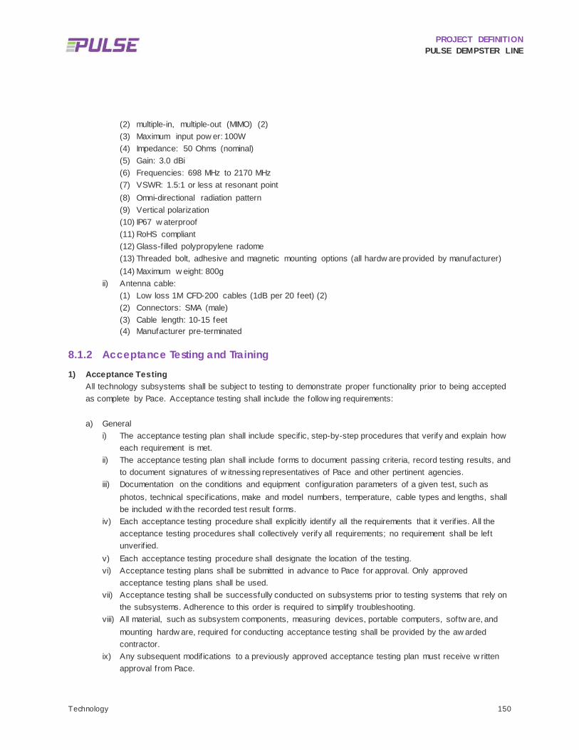
PROJECT DEFINITION PULSE DEMPSTER LINE
Technology 150
(2) multiple-in, multiple-out (MIMO) (2) (3) Maximum input pow er: 100W (4) Impedance: 50 Ohms (nominal) (5) Gain: 3.0 dBi (6) Frequencies: 698 MHz to 2170 MHz (7) VSWR: 1.5:1 or less at resonant point (8) Omni-directional radiation pattern (9) Vertical polarization (10) IP67 w aterproof (11) RoHS compliant (12) Glass-f illed polypropylene radome (13) Threaded bolt, adhesive and magnetic mounting options (all hardw are provided by manufacturer) (14) Maximum w eight: 800g
ii) Antenna cable: (1) Low loss 1M CFD-200 cables (1dB per 20 feet) (2) (2) Connectors: SMA (male) (3) Cable length: 10-15 feet (4) Manufacturer pre-terminated
8.1.2 Acceptance Testing and Training 1) Acceptance Testing
All technology subsystems shall be subject to testing to demonstrate proper functionality prior to being accepted as complete by Pace. Acceptance testing shall include the follow ing requirements: a) General
i) The acceptance testing plan shall include specif ic, step-by-step procedures that verify and explain how each requirement is met.
ii) The acceptance testing plan shall include forms to document passing criteria, record testing results, and to document signatures of w itnessing representatives of Pace and other pertinent agencies.
iii) Documentation on the conditions and equipment configuration parameters of a given test, such as photos, technical specif ications, make and model numbers, temperature, cable types and lengths, shall be included w ith the recorded test result forms.
iv) Each acceptance testing procedure shall explicitly identify all the requirements that it verif ies. All the acceptance testing procedures shall collectively verify all requirements; no requirement shall be left unverif ied.
v) Each acceptance testing procedure shall designate the location of the testing. vi) Acceptance testing plans shall be submitted in advance to Pace for approval. Only approved
acceptance testing plans shall be used. vii) Acceptance testing shall be successfully conducted on subsystems prior to testing systems that rely on
the subsystems. Adherence to this order is required to simplify troubleshooting. viii) All material, such as subsystem components, measuring devices, portable computers, softw are, and
mounting hardw are, required for conducting acceptance testing shall be provided by the aw arded contractor.
ix) Any subsequent modif ications to a previously approved acceptance testing plan must receive w ritten approval from Pace.

PROJECT DEFINITION PULSE DEMPSTER LINE
Technology 151
x) A minimum 10 w orking days advance notice shall be provided to Pace prior to scheduling an acceptance testing date and location.
xi) At a date mutually agreed upon by the Contractor and Pace, but no more than 30 days after f inal acceptance of all contract w ork, the Contractor shall meet w ith Pace, make its project management personnel available to review the functionality of the equipment and make any repairs or adjustments that may be necessary.
xii) The acceptance testing plan shall be initiated after the contractor has informed Pace and other pertinent agencies that all equipment has been installed and is ready for the acceptance testing plan to begin.
b) Real-Time Arrival Information System Acceptance testing shall be consistent w ith the respective equipment manufacturer’s recommendations. Testing shall be in accordance w ith the corresponding contract specif ications. The media player and CMS components of the real-time information system shall be in accordance w ith the requirements defined under the system integration contract. The acceptance testing plan for components of the real-time arrival information system that are covered under the Pulse corridor contracts shall provide verif ication of the follow ing items. Testing requires all components from both the Pulse corridor contracts and the system integration contract to be installed and operational.
i) Video Subsystem (1) The bus arrival times displayed on the LCD monitors are updated automatically. (2) Each bus arrival time is displayed on a single line on the LCD monitor. (3) Long text lines are scrolled on the LCD monitor. (4) Identical next bus arrival times are displayed on both LCD monitors simultaneously. (5) The bus arrival times and bus IDs match the real-time data feed for each Pulse station from the
Pace IBS. (6) The display of bus arrival times resumes after a loss and return of pow er of the LCD monitor
w ithout manual intervention. ii) Audio Subsystem
(1) The announcement of the next bus arrival time is played upon request using any of the pushbuttons.
(2) The same next bus arrival time is announced on all outdoor speakers. (3) The volume is automatically adjusted based on varying levels of background noise. Each ambient
noise microphone shall be tested individually. (4) The announcement of the next bus arrival time is consistent w ith the next bus arrival time that is
displayed on the LCD monitor. (5) The arrival of the bus is automatically announced on all outdoor speakers.
iii) Communications Subsystem (1) Suff icient signal quality is achieved at each Pulse station. (2) The cellular modem has stable Internet connectivity. (3) The cellular modem enables the media player and CMS to read the real-time bus arrival time data
feed from the Pace IBS.
2) Training Requirements a) Training shall be provided by the Contractor to Pace after all components from both the Pulse corridor
contracts and the system integration contract are installed and operational.

PROJECT DEFINITION PULSE DEMPSTER LINE
Technology 152
b) The Contractor shall provide training for each technology component or system installed, including the media player, CMS, ANS, cellular modem, and LCD monitor.
c) A comprehensive training plan shall be developed and submitted to Pace for review and approval. i) A minimum of three hardcopy sets and one electronic copy of approved training manuals shall be
submitted to Pace. ii) Training shall cover both hardw are installation and maintenance as w ell as softw are operation.
d) Training shall incorporate the operational instructions of the component equipment manufacturers. e) All training schedules shall be coordinated w ith and at the convenience of Pace. Training must correspond
to Pace’s w ork schedule, and training must be provided to all shifts of w orkers that w ill be w orking w ith the new technologies.
f) On-site training shall be in a classroom setting conducted at Pace’s headquarters and shall provide detailed hands-on instruction to Pace’s personnel for complete system operation, system configurations, interpretation of data, troubleshooting, and care and maintenance of the components.
g) Training course instructors shall have prior training experience and thorough familiarity w ith all aspects of the systems and topics covered in the training materials.
h) The vendor shall provide training sessions up to three 8-hour days to instruct Pace’s personnel in operation and maintenance of the system. Training may be in non-contiguous days at the request of Pace. Pace w ill notify the vendor a minimum seven (7) calendar days in advance of each day of requested training. The vendor's designated training personnel shall meet w ith Pace for the purpose of discussing and f ine-tuning the training agenda prior to the f irst training session.
i) Training agenda shall cover the follow ing items: i) Overview of the various parts of the O&M manuals. ii) Demonstration of login/logout procedures, passw ord setup, and reporting. iii) Demonstration of softw are menu penetration and overview of the various features. iv) Presentation of configuration databases and upload/dow nload procedures. v) Overview of alert features and setup. vi) Review of components and how to configure them. vii) Review of common technical issues, diagnostic procedures, and remedies. viii) Creation of customized reports selectable by Pace personnel.

PROJECT DEFINITION PULSE DEMPSTER LINE
Preliminary Operating Plan 153
9 Preliminary Operating Plan
This chapter presents the estimated running times and draft proposed schedules for the Pulse Dempster Line, as w ell as proposed changes to the existing local Route 250 to be implemented upon commencement of Pulse service in the corridor. The proposed running times in the corridor are based on the existing published schedules and analyses of actual operating conditions in the corridor, as w ell as estimated changes resulting from increased service frequencies, increased ridership, limited stops, TSP, and raised boarding platforms.
CORRIDOR OVERVIEW 9.1
The running time estimate and associated O&M cost estimate provided in this document are based on the corridor station assumptions described in the previously submitted Conceptual Station Design technical memorandum (June 2016) and documented in Chapter 4, as show n in Figure 4.13. The Pulse Dempster Line corridor w ill consist of tw o terminal stations (O’Hare and Davis CTA/Metra) and 15 intermediate stations. One station (Dee) is still being considered for relocation to a nearby intersection (Potter), but this decision w ill not affect the overall number of stations nor the overall running time.
RUNNING TIME ESTIMATE 9.2
Several planned changes in the corridor w ill impact the future running times for both Pulse and local Route 250 trips betw een O’Hare and Davis CTA/Metra. These changes w ill affect the O&M costs associated w ith the service by reducing the time required to complete a single trip and also potentially reducing the number of vehicles required to meet a given service level.
Specif ic changes that w ill impact running time include the follow ing:
Stop Consolidation: Each time the bus stops to board and alight passengers, running time is impacted in tw o w ays. First is the time the bus spends decelerating as it approaches a stop and accelerating as it departs, w hich is a direct function of the number of stops served. Pulse Dempster Line running times are expected to decrease as a result of few er stops, and therefore less time spent accelerating and decelerating. The second impact to running time is the dw ell time in w hich the bus is stopped w hile boarding and alighting passengers. This is a more complex matter, as some existing passengers w ho w ill not be w ell served by the reduced number of Pulse stations are unlikely to use the service (thus reducing passenger loads and dw ell times), but the increase in service is expected to increase overall ridership at Pulse stations (thus increasing passenger loads and dw ell times). This is discussed in greater detail in the methodology section that follow s.

PROJECT DEFINITION PULSE DEMPSTER LINE
Preliminary Operating Plan 154
Level Boarding: Pulse stations w ill feature a 12-inch raised boarding platform. Based on the Transit Capacity and Quality of Service Manual, raised platforms reduce boarding times by approximately ½ second per passenger.17
Higher Frequency and Increased Ridership: For a given ridership level, a higher frequency service means few er passengers per individual trip, w hich reduces running time. In practice, the higher frequency service w ill also be expected to generate higher ridership, so these tw o factors are somew hat offsetting (this is further addressed in the methodology section below ). The reverse w ill be true of the reduced local Route 250, w hich w ill be expected to serve few er passengers but w ill also operate at low er frequencies.
Transit Signal Priority: TSP w ill enable buses to stay on schedule by requesting extended green lights or shorter red lights w hen they are running behind. This permits more aggressive scheduling and can thus reduce the expected running time for both Pulse and local Route 250 trips.
9.2.1 Basis for Estimate The future running time estimate w as constructed starting from the existing observed breakdow n of running times by category (moving, boarding/alighting, stopped at traff ic signals, etc.). The basis for the understanding of existing conditions w as the follow ing sources:
Current scheduled running times from the Route 250 timetable dated April 14, 2014.
On board travel time survey documented in the Route 250 Travel Time Analysis Technical Memorandum (May 2016).
On time performance (OTP) data as documented in the Route 250 On-Time Performance Analysis Technical Memorandum (May 2016).
Posted speed limits obtained from observation.
Distance for each corridor segment (obtained using Google Maps).
The number and location of proposed Pulse stations as documented in the Conceptual Station Design Technical Memorandum (June 2016).
The detailed results of the aforementioned technical analyses can be found in the respective technical memoranda associated w ith each.
9.2.2 Methodology Running times w ere estimated for the Pulse Dempster Line and local Route 250 using the methodology described in this section. This method utilizes existing running times and dw ell times to estimate projected travel time under the Build condition.
17 Transit Cooperative Research Program, Report 165: Transit Capacity and Quality of Service Manual, Third Edition, Transportation Research Board, Washington, DC. 2013.

PROJECT DEFINITION PULSE DEMPSTER LINE
Preliminary Operating Plan 155
9.2.2.1 CURRENT RUNNING TIME BREAKDOWN
To estimate future running times, the analysis starts w ith current run times. Table 6.3 in Section 6.1 provides current running times and dw ell times for average trips by time of day. This running time, minus the dw ell time, w as further reduced by the time spent idling at time points (from Table 6.6). Idling at time points is not a desirable characteristic for Pulse service, as it detracts from the customer’s expectation and perception of faster service. Finally, the running time w as reduced once more by subtracting the time required to accelerate and decelerate from 28 bus stops, the average number of stops made per trip. The result is a “stripped” running time consisting of the actual time spent moving at cruising speed through the corridor. This is described in Table 9.1.
TABLE 9.1: ROUTE 250 OBSERVED RUNNING TIME BREAKDOWN
Direction / Time Period Total Travel Time Dwell Time
Running Time minus Dwell Idling
Acceleration/ Deceleration
Stripped Running
Time
Eastbound
AM Peak 1:08:54 0:07:29 1:01:25 0:00:25 0:13:03 0:47:57
Midday 1:08:05 0:08:14 0:59:51 0:01:21 0:13:03 0:45:27
PM Peak 1:18:10 0:08:48 1:09:22 0:01:23 0:13:03 0:54:56
Ev ening 0:58:55 0:06:05 0:52:50 0:01:21 0:13:03 0:38:26
Westbound
AM Peak 1:04:44 0:09:46 0:54:58 0:00:25 0:13:03 0:41:30
Midday 1:09:42 0:11:02 0:58:40 0:01:21 0:13:03 0:44:16
PM Peak 1:19:24 0:11:56 1:07:28 0:01:23 0:13:03 0:53:02
Ev ening 0:56:43 0:08:04 0:48:39 0:01:21 0:13:03 0:34:15

PROJECT DEFINITION PULSE DEMPSTER LINE
Preliminary Operating Plan 156
9.2.2.2 PULSE RUNNING TIME ESTIMATE
The Pulse running time w as estimated using the stripped running time estimated in the previous step, and adding the various additional running time components that describe the overall operations of the vehicle en route.
Transit Signal Priority
TSP w ill enable buses to stay on schedule by requesting extended green lights or shorter red lights w hen they are running behind. This permits more aggressive scheduling and can thus reduce the expected running time for both Pulse and local Route 250 trips. Estimated time savings from TSP w ere based on the existing time spent stopped at traff ic signals as described in Table 6.6. The number of intersections assumed to be eligible for TSP w as based on the Signal Coordination and Timing (SCAT) reports conducted for the Dempster Street corridor, w hich established that out of 97 intersections in the corridor, 43 intersections w ere suitable for TSP and another 18 w ere possible candidates. Assuming that all of the suitable and half of the possible intersections w ould be equipped w ith TSP, 53 intersections, or 54% of the corridor, w ould be equipped. It w as further assumed that among these 53 intersections, 20% of existing stopped time could be eliminated. The result w as an estimated TSP time savings of betw een one and tw o minutes per trip, as described in Table 9.2.
TABLE 9.2: TSP TIME SAVINGS ESTIMATE
Time Period Existing Signal Time per
Trip Eligible
Intersections Time Savings
per Intersection Net TSP
Time Savings
AM Peak 0:14:06 54% 20% 0:01:31
Midday 0:13:34 54% 20% 0:01:27
PM Peak 0:15:39 54% 20% 0:01:41
Ev ening 0:13:34 54% 20% 0:01:27
Dwell Time
The dw ell time estimate is based on current dw ell times to ensure that current ridership characteristics are reflected in the new dw ell time. The total current dw ell time is based on Table 6.5 in Section 6.2.
The follow ing changes w ere applied to the existing dw ell time to arrive at the estimated Pulse Dempster Line dw ell time:
Current dw ell time w as reduced by 15% to represent the share of existing Route 250 boardings beyond ¼ mile from a proposed Pulse station that w ould be unlikely to use the new limited-stop service.
The remaining dw ell time w as then increased by 35% to represent anticipated grow th in ridership resulting from the improved service. This grow th w as reduced by one-quarter because approximately every fourth bus w ill be a local bus, and passengers are likely to continue boarding w hichever vehicle arrives f irst at any Pulse station.
The new subtotal dw ell time w as reduced by one-third in the peak and one-half off-peak to represent the increased frequency of service. More frequent service results in low er passenger loads – and low er dw ell time – per trip.
PROJECT DEFINITION PULSE DEMPSTER LINE
Preliminary Operating Plan 157
The second subtotal w as reduced by 15% to represent the time savings associated w ith level boarding. The 15% reduction is based on the Transit Capacity and Quality of Service Manual, w hich estimates level boarding to reduce boarding time per-passenger from 3.25 seconds to 2.75 seconds, assuming smart card payment on board.18 Based on the most recent data available for Route 250, more than 80% of all boardings use the Ventra transit card, and this share is expected to continue grow ing in the future.
9.2.2.3 ROUTE 250 RUNNING TIME ESTIMATE
Under the Build condition, the local Route 250 w ill operate at reduced frequencies, this “reduced local Route 250” w ill also experience running time savings, although the magnitude of savings w ill be less than for the Pulse Dempster Line. Local service running time does not benefit from few er stops; how ever, speed on the local service w ill improve due to TSP and reduced passenger loads. The follow ing adjustments w ere made to the existing running times to estimate the running times for Route 250 after Pulse service commences:
TSP time savings w ere assumed to be the same as for Pulse (see Table 9.2).
Dw ell time savings assumed a substantial reduction in ridership (85% of existing riders are expected to use Pulse), partly offset by grow th at Pulse stations (approximately ¼ of w hich w ill use local Route 250 trips) and by frequency reductions (higher loads per vehicle).
9.2.3 Final Estimated Running Time 9.2.3.1 PULSE DEMPSTER LINE
Table 9.3 show s the projected end-to-end running times for the Pulse Dempster Line by time period and by direction. Running times are expected to decline by 15% to 23% compared w ith existing service, w ith overall running time savings of up to 16 minutes for a full length one-w ay trip.
18 Transit Cooperative Research Program, Report 165: Transit Capacity and Quality of Service Manual, Third Edition, Transportation Research Board, Washington, DC. 2013.

PROJECT DEFINITION PULSE DEMPSTER LINE
Preliminary Operating Plan 158
TABLE 9.3: ESTIMATED PULSE DEMPSTER LINE RUNNING TIME
Direction / Time Period
Stripped Running
Time Accel/ Decel
Revised Dwell Time
TSP Time Savings
Total Running
Time
Existing Route
250 Percent
Improvement Eastbound
AM Peak 0:47:57 0:07:44 0:04:31 0:01:31 0:58:41 1:08:54 15%
Midday 0:45:27 0:07:44 0:02:58 0:01:27 0:54:42 1:08:05 20%
PM Peak 0:54:56 0:07:44 0:05:19 0:01:41 1:06:18 1:18:10 15%
Ev ening 0:38:26 0:07:44 0:02:58 0:01:27 0:47:41 0:58:55 19%
Westbound
AM Peak 0:41:30 0:07:44 0:04:31 0:01:31 0:52:14 1:04:44 19%
Midday 0:44:16 0:07:44 0:02:58 0:01:27 0:53:31 1:09:42 23%
PM Peak 0:53:02 0:07:44 0:05:19 0:01:41 1:04:24 1:19:24 19%
Ev ening 0:34:15 0:07:44 0:02:58 0:01:27 0:43:30 0:56:43 23%
9.2.3.2 ROUTE 250
Table 9.4 show s projected running times for the reduced local Route 250 service by direction. Running times are expected to decline by 9% to 17% compared w ith existing service, w ith up to 11 minutes of running time savings for a full-length one-w ay trip.

PROJECT DEFINITION PULSE DEMPSTER LINE
Preliminary Operating Plan 159
TABLE 9.4: ESTIMATED REDUCED LOCAL ROUTE 250 FUTURE RUNNING TIME
Direction / Time Period
Stripped Running
Time Accel/ Decel
Revised Dwell Time
TSP Time Savings
Reduced Local
Route 250 Running Time
Existing Route
250 Running Time
Percent Improvement
Eastbound
AM Peak 0:47:57 0:13:03 0:03:21 0:01:31 1:02:50 1:08:54 9%
Midday 0:45:27 0:13:03 0:02:12 0:01:27 0:59:15 1:08:05 13%
PM Peak 0:54:56 0:13:03 0:03:56 0:01:41 1:10:15 1:18:10 10%
Ev ening 0:38:26 0:13:03 0:02:12 0:01:27 0:52:14 0:58:55 11%
Westbound
AM Peak 0:41:30 0:13:03 0:03:21 0:01:31 0:56:23 1:04:44 13%
Midday 0:44:16 0:13:03 0:02:12 0:01:27 0:58:04 1:09:42 17%
PM Peak 0:53:02 0:13:03 0:03:56 0:01:41 1:08:21 1:19:24 14%
Ev ening 0:34:15 0:13:03 0:02:12 0:01:27 0:48:03 0:56:43 15%
9.2.3.3 RUNNING TIMES BY SEGMENT
The running times show n in Table 9.3 and Table 9.4 w ere allocated across the length of the route to provide travel times by segment. The segments adopted for this analysis are the existing Route 250 time points show n in the published schedule. Table 9.5 is an example of eastbound Pulse and Local running times by segment during the PM peak period. The running times by segment and time of day w ere used to produce draft schedules for the Pulse Dempster Line and reduced local Route 250.

PROJECT DEFINITION PULSE DEMPSTER LINE
Preliminary Operating Plan 160
TABLE 9.5: PULSE AND LOCAL RUNNING TIMES BY SEGMENT, PM PEAK HOUR, EASTBOUND
Segment Existing Route 250 Pulse Travel Time Reduced Local Route 250
Travel Time
O'Hare to Lee/Touhy 0:09:39 0:06:44 0:07:08
Lee/Touhy to DP Metra 0:14:51 0:11:32 0:12:14
DP Metra to Hosp 0:08:14 0:07:41 0:08:10
Hosp to Milw aukee 0:07:38 0:04:48 0:05:06
Milw aukee to Waukegan 0:05:06 0:05:46 0:06:07
Waukegan to CTA Skokie
0:09:14 0:08:39 0:09:11
CTA Skokie to Craw ford 0:04:50 0:04:48 0:05:06
Craw ford to Dodge 0:05:53 0:06:44 0:07:08
Dodge to Dav is 0:07:09 0:07:41 0:08:10
Total 1:12:34 1:04:24 1:08:21
SERVICE PLANNING ASSUMPTIONS 9.3
9.3.1 Baseline Operating Plan The policy framew ork for Pulse service planning on the Dempster Line w as established during the Pulse Milw aukee Line Project Definition study, completed in 2014. That study established that Pulse service should offer 10-minute headw ays during peak hours and 15-minute headw ays during off-peak hours and on w eekends, follow ing a span of service that is equal to or better than the existing local service on the corridor. Further, it w as established on the Milw aukee Line study that local service reductions should include a reduction in the span of local service, particularly during evenings, during w hich time Pulse w ould be the only available service on the corridor. Local service should operate at headw ays of 30 minutes or greater during daytime hours, and 60 minutes during evenings and w eekends.
It w as assumed that these principles w ould be applied as a baseline service planning assumption on the Dempster Line as w ell. The Dempster Line is assumed to operate from 5:00 am to 1:00 am on w eekdays, w hich matches the already extensive span of service provided by Route 250. Three hours in the morning and afternoon w ill feature 10-minute headw ays (approximately 6:00 am to 9:00 am and 3:00 pm to 6:00 pm), w ith 15-minute service throughout the rest of the day, w ith the exception of 30-minute service during late evening hours (after 10:00 pm).
Pace is implementing service enhancements to Route 250 in August 2016. These service changes w ill include increased w eekday off-peak service, w ith no changes to w eekend service and no increase in vehicle requirements. Upon the commencement of Pulse Dempster Line service, Route 250 service w ould be reduced in both span and frequency, operating at 35-minute peak and 70-minute off-peak headw ays, w ith service beginning 30 minutes after

PROJECT DEFINITION PULSE DEMPSTER LINE
Preliminary Operating Plan 161
Dempster Line service and f inal trips departing at approximately 9:30 pm on all days.19 Any changes to Route 250 w ould be subject to a separate public hearing process. The underlying Pulse corridor local service planning assumptions w ill be further evaluated after the Pulse Milw aukee Line begins service as similar local reductions are proposed in that corridor. The assumed spans and frequencies for Pulse Dempster Line and reduced local Route 250 service are summarized in Table 9.6.
19 In preliminary discussions with Pace service planning staff, a 30-minute peak and 60-minute off peak headway was identified as appropriate for reduced local Route 250 service. However, based on the estimated running time for the corridor and the low frequency of service, these headways resulted in unreasonably long layovers at the route termini. Increasing the headways by five minutes allowed for much shorter layovers, and therefore allowed for the service to be provided with one fewer vehicle.

PROJECT DEFINITION PULSE DEMPSTER LINE
Preliminary Operating Plan 162
TABLE 9.6: SERVICE SPANS AND HEADWAYS FOR PULSE DEMPSTER LINE AND REDUCED LOCAL ROUTE 250 SERVICE
Time Period Pulse Reduced Local Route 250
Weekday s
Span of Serv ice 5:00 – 1:00 5:30 – 21:30
Peak Headw ay 10 minutes 35 minutes
Peak Hours 6:00 – 9:00 15:00 – 18:00
6:30 – 9:30, 15:00 – 18:00
Off Peak Headw ay 15 minutes 70 minutes
Off Peak Hours 5:00 – 6:00 9:00 – 15:00 18:00 – 22:00
5:30 – 6:30 9:30 – 15:00 18:00 – 21:30
Late Night Headw ay 30 minutes N/A
Late Night Hours 22:00 – 1:00 N/A
Saturday s
Span of Serv ice 6:00 – 1:00 6:30 – 21:30
Day time Headw ay 15 minutes 60 minutes
Day time Hours 7:00 – 21:00 6:30 – 21:30
Night Headw ay 30 minutes N/A
Night Hours 6:00 – 7:00 21:00 – 1:00
N/A
Sunday s
Span of Serv ice 7:00 – 1:00 7:30 – 21:30
Day time Headw ay 15 minutes 60 minutes
Day time Hours 8:00 – 21:00 7:30 – 21:30
Night Headw ay 30 minutes N/A
Night Hours 7:00 – 8:00 21:00 – 1:00
N/A
Note: The span of service describes the departure times of the first and last trips of the day. For example, the last weekday Pulse Dempster Line trips would depart each terminal at approximately 1:00 am.
9.3.2 Corridor Service Statistics Table 9.7 summarizes the estimated existing and future vehicle revenue hours, vehicle revenue miles, and vehicles operating in maximum service. In addition to existing Route 250 service, the table also includes approved service improvements for Route 250 set for implementation in August 2016. Future conditions in the corridor include both the
PROJECT DEFINITION PULSE DEMPSTER LINE
Preliminary Operating Plan 163
Pulse Dempster Line and the reduced local Route 250 service. In total, revenue hours are expected to grow by 95% and revenue miles are expected to grow by 129% over the fall 2016 service levels. Compared w ith approximately nine vehicles required to serve the current Route 250 peak service levels, Pulse service is estimated to require 15 vehicles in maximum service. Reduced local Route 250 service w ould require f ive vehicles during peak service. Because Pulse service w ill use a dedicated f leet of branded vehicles, a total of 18 Pulse buses w ould need to be purchased to supply the necessary vehicles in service, including three spares.
It should be noted that the future service statistics show n below do not include school trips. Currently, there are three w estbound trips in the morning and tw o eastbound trips in the afternoon serving Maine Tow nship high schools (Maine East and Maine West). These specialized trips operate on only small portions of the Route 250 corridor, and it is assumed that they w ould continue to operate. In total these trips add approximately tw o revenue hours of service per school day, or approximately 400 revenue hours annually.

PROJECT DEFINITION PULSE DEMPSTER LINE
Preliminary Operating Plan 164
TABLE 9.7: EXISTING AND FUTURE CORRIDOR SERVICE STATISTICS
Ex isting
Route 250 Fal l 2016
Route 250 Pulse
Dempster Line Reduced Local
Route 250 Total Future
Condition Percent Growth
Rev enue Hours
Weekday 89.0 110.0 158.9 40.6 199.5 81%
Saturday 65.0 65.0 120.8 31.3 152.1 134%
Sunday 52.1 52.1 113.6 29.3 142.9 174%
Estimated Annual
29,084 34,356 53,403 13,670 67,073 95%
Rev enue Miles
Weekday 1,241 1,539 2,678 612 3,290 114%
Saturday 914 914 2,050 490 2,540 178%
Sunday 770 770 1,928 459 2,387 210%
Estimated Annual
408,697 484,559 901,185 208,141 1,109,326 129%
Vehicles Operated in Max imum Serv ice
9 9 15 5 20 122%
Notes: Percent Growth in service statistics is based on the planned fall 2016 Route 250 service levels. Reduced Local Route 250 Service Statistics do not include school trips, which are expected to be retained and add approximately 400 revenue hours of service per year. Vehicles Operated in Maximum Service for the existing Route 250 is an estimate and may not precisely reflect current Pace operations. The estimated VOMS does not include school trips, which are interlined with other routes.
9.3.3 Draft Schedules Detailed draft schedules for the Pulse Dempster Line and for the reduced local Route 250 are included in Appendix G. The draft schedules do not include the current Maine Tow nship High School trips, w hich are assumed to remain in operation w ith their current schedules.
ALTERNATIVE OPERATING PLANS 9.4
Several alternative operating plans for the Dempster Corridor have been discussed as potential options for reducing cost or improving service and connectivity to other transit services. Tw o such alternative operating plans w ere analyzed and compared to the baseline operating plan. One evaluated alternative eliminates the 10-minute headw ay. The second alternative considers the extension of the Pulse service to the Rosemont Transit Center.

PROJECT DEFINITION PULSE DEMPSTER LINE
Preliminary Operating Plan 165
9.4.1 15 Minute Peak Headway To mitigate the substantial increase in revenue hours and O&M costs that are projected under the baseline operating plan, an alternative operating plan w as considered in w hich the 10-minute peak headw ay w ould be eliminated, w ith Pulse Dempster Line service operating at a 15-minute all-day headw ay.
Table 9.8 summarizes the impact of this alternative operating plan compared to the baseline. Eliminating 10-minute peak period service w ould reduce annual revenue hours by approximately 4%, resulting in cost savings of approximately $240,000 in current year dollars compared to the baseline.
TABLE 9.8: ALTERNATIVE OPERATING PLAN: 15 MINUTE ALL DAY SERVICE
Baseline Operating Plan
(Pulse + Local) Alternative Operating Plan
(Pulse + Local) Difference
Annual Rev enue Hours
67,074 64,641 -2,433 (-4%)
Vehicles Operated in Max imum Serv ice
15 Pulse, 5 Local 10 Pulse, 5 Local -5 Pulse v ehicles
O&M Cost, 2016 Dollars
$6.7 million $6.4 million -$240,000 (-4%)
O&M Cost, 2019 Dollars
$7.5 million $7.2 million -$270,000 (-4%)
9.4.2 Rosemont Extension To address a recommendation made during the station site selection process, an alternative operating plan w as developed in w hich service continues to the Rosemont Transit Center, connecting w ith the CTA Blue Line and numerous Pace bus routes. Under this operating plan, the w estern terminus of the Pulse Dempster Line w ould be moved from the O’Hare station to the existing Rosemont Transit Center. O’Hare w ould remain as an intermediate station betw een the Rosemont and Mannheim/Higgins station. The analysis w as based on the follow ing route: Depart O'Hare Transfer Station via Mannheim south to I-190 east, exit at River Road, and proceed north to the Rosemont Transit Center. According to Google Maps, this adds 3.1 miles each w ay. Running times assume express operation and w ere also obtained from Google Maps at differing times of day. For planning purposes, an additional running time of nine to 12 minutes w as assumed betw een Rosemont and O’Hare, varying by time period. This alternative operating plan w as based on the Baseline Operating Plan (10-minute peak period Pulse service). It w as assumed that only Pulse service w ould be extended to Rosemont, w hile Route 250 w ould continue to terminate at O’Hare.
Table 9.9 summarizes the impact of this alternative operating plan as compared to the baseline operating plan. Extending Pulse service to Rosemont w ould increase annual revenue hours by approximately 19% over the baseline, resulting in additional annual O&M cost of approximately $1.1 million in current year dollars.

PROJECT DEFINITION PULSE DEMPSTER LINE
Preliminary Operating Plan 166
TABLE 9.9: ALTERNATIVE OPERATING PLAN: ROSEMONT EXTENSION
Segment Baseline Operating Plan
(Pulse + Local) Alternative Operating Plan
(Pulse + Local) Difference
Annual Rev enue Hours
67,074 77,142 10,068 (+19%)
Vehicles Operated in Max imum Serv ice
15 Pulse, 5 Local 18 Pulse, 5 Local +3 Pulse v ehicles
O&M Cost, 2016 Dollars
$6.7 million $7.7 million +$1.0 million (+19%)
O&M Cost, 2019 Dollars
$7.5 million $8.6 million +1.1 million (+19%)

PROJECT DEFINITION PULSE DEMPSTER LINE
Branding 167
10 Branding BRAND NAME 10.1
Pulse is the brand name established for the arterial rapid transit service. The name selection w as informed by market research, focus groups, an internal survey, and a branding w orkshop. In order to arrive at the brand name, a brand identity w as defined to describe the service as A Better Time M achine, and the brand promise w as defined as follow s:
With faster routes and more frequent service, Pace’s new ART service will help you make better use of your time.
Graphic treatments w ere developed for the Pulse brand name including the brand logo (see Figure 10.1) and color scheme. These treatments have been incorporated into the Pulse station design, w ith particular attention given to the vertical marker and its map elements, w hich reflect the overall look and feel of the brand name and logo.
FIGURE 10.1: PACE ART BRAND NAME AND PRELIMINARY LOGO
BRAND APPLICATION GUIDELINES 10.2Brand Application Guidelines have been developed in draft form and are being f inalized by Pace. The guidelines detail the application of the brand to the Pulse vehicles and stations as w ell as supporting elements such as outreach materials, maps, schedules and the Pulse w ebsite.

PROJECT DEFINITION PULSE DEMPSTER LINE
National Environmental Policy Act Documentation 168
11 National Environmental Policy Act Documentation
Pace plans to pursue a documented Categorical Exclusion (CE) under 23 CFR 771.118(d) of the NEPA for the Pulse Dempster Line project. The Pulse Milw aukee Line qualif ied for a CE in September 2015. Sections 11.1 through 11.4 reflect the document submitted to the FTA on June 14, 2016 as the Pulse Dempster Line Purpose and Need Statement. It w ill be used as the basis for the environmental analysis conducted in the next phase of the Dempster Line development.
PURPOSE STATEMENT 11.1
The purpose of the Pulse Dempster Line project is to provide an enhanced and cost-effective bus rapid transit service in the Dempster Street and Lee Street, Mannheim Road and Touhy Avenue corridors through the improved frequency, reliability and travel time of bus transit service, as w ell as improved bus transit facilities.
Definition: A Purpose and Need Statement shall briefly specify the underlying purpose and need to which the agency is responding in proposing the alternatives including the proposed action.20
The proposed action must address the follow ing needs:
Improve the frequency of bus transit service;
Improve the reliability of bus transit service;
Improve travel time of bus transit service vehicles; and
Improve the quality of bus transit facilities.
20 https://www.gpo.gov/fdsys/pkg/CFR-2012-title40-vol34/pdf/CFR-2012-title40-vol34-sec1502-13.pdf

PROJECT DEFINITION PULSE DEMPSTER LINE
National Environmental Policy Act Documentation 169
NEED ELEMENTS 11.2
The proposed action must address the follow ing needs:
Improve the frequency of bus transit service;
Improve the reliability of bus transit service;
Improve travel time of bus transit service vehicles; and
Improve the quality of bus transit facilities.
The need to improve bus service and the quality of bus transit facilities in the Dempster Street and Lee Street, Mannheim Road and Touhy Avenue corridors (Pace Bus Route 250) dates back to 2001, w hen Pace published Vision 202021. The Pulse Dempster Line project w as identif ied in Vision 2020 as one of tw enty-four corridors that w ould provide a regional netw ork of premium transit services across Pace’s six county service area. Over the next several years, Pace completed additional planning studies 22 to develop a specif ic action plan for implementation of Pulse corridors. The studies completed by Pace helped to better define the infrastructure improvements and design elements that w ould be feasible and w ould provide cost-effective transit investments throughout Pace’s service area. Six priority Pulse corridors w ere identif ied:
Milw aukee Avenue – Jefferson Park Transit Center to Golf Mill Shopping Center;
Dempster Street – CTA Purple Line Davis Street Station/Metra UP North Line Station to O’Hare Kiss ‘n’ Fly;
Oak Brook – CTA Blue Line/Pink Line to Yorktow n;
Harlem Avenue – Milw aukee Avenue to 95th Street;
95th Street – CTA Red Line 95th Street/Dan Ryan to Harlem Avenue; and
Halsted Street – CTA Red Line 95th Street/Dan Ryan to 159th Street.
The proposed J-Route from Schaumburg/O’Hare to Oak Brook and Naperville w as also identif ied as a potential priority Pulse corridor, but w as not associated w ith a specif ic alignment at the time. Subsequent studies have identif ied multiple potential Pulse corridors to satisfy the north-south travel demand addressed by the J-Route concept.
The Pulse Dempster Line corridor w as identif ied as a priority for implementation due to several factors, including strength of existing transit service, benefits to local and regional transit connectivity, existing and projected ridership and the potential to begin establishing the Pulse netw ork by offering a connection w ith the Pulse Milw aukee Line.
21 http:/ /ww w .pac eb us.c om /s ub/vi si o n20 20/stud y_ co ntents.a sp 22 Other studies completed by Pace include Arterial Rapid Transit (ART) Study (May 2009) and ART Implementation Plan (December 2009).

PROJECT DEFINITION PULSE DEMPSTER LINE
National Environmental Policy Act Documentation 170
GOALS AND OBJECTIVES 11.3
The follow ing goals and objectives w ere identif ied through a review of Pace’s past transit planning efforts, discussions w ith local planning off icials, as w ell as direct input provided by members of the Project’s Corridor Advisory Group (CAG). The CAG serves an advisory role by review ing transit improvements and design elements, service and station features, and environmental considerations. The CAG is composed of local, state, and federal government off icials and staff, regional transportation and transit agencies, transit advocacy groups, and other key stakeholders in the study area. The f irst CAG meeting w as held on March 23, 2016. Up to three additional CAG meetings are anticipated throughout the duration of the project, providing stakeholder input at key project milestones.
The goals and objectives identif ied below are not the core transportation needs the proposed action is intended to address. How ever, they w ere used to shape the project’s purpose and need statement and w ill be used in conjunction w ith the identif ied needs to evaluate the proposed action.
The follow ing goals and objectives have been identif ied for the Pulse Dempster Line project:
Encourage suburban transit usage through the establishment of a netw ork of higher-quality line-haul routes;
Improve the visibility and perception of suburban bus transit service; and
Support transportation, land use and grow th objectives identif ied in the study corridor.
LOGICAL TERMINI 11.4
Based on ridership and operational data, the limits of this transit improvement project w ill be the new O’Hare Airport Kiss ‘N’ Fly/Consolidated Rental Car and Joint Use Facility (CRCF) on the w est end and the CTA Purple Line Davis Street Station and Metra UP North Line Station in Evanston on the east end. The new CRCF is a transportation hub that w ill provide connections to Metra’s NCS Line, Pace Route 330, O'Hare's Airport Transit System (an automated people mover system that operates 24 hours a day, connecting all four terminals and the remote parking lots) as w ell as rental car facilities. The new CRCF is replacing the current O’Hare Airport Kiss ‘N’ Fly, w hich is on the opposite side of Mannheim Road. On the other end of the corridor, the CTA Purple Line Davis Street Station and Metra UP North Line Station serves as an existing transit hub w ith connections to Pace bus, CTA bus, CTA rail, and Metra commuter rail lines.
The existing O’Hare Airport Kiss ‘N’ Fly and the CTA Purple Line Davis Street Station and Metra UP North Line Station are the current end points of Pace Route 250. As a result, the logical termini for any potential infrastructure improvements necessary to provide enhanced transit service in the project corridor are the new CRCF and the CTA Purple Line Davis Street Station and Metra UP North Line Station. The designated termini are also suff icient to allow for appropriate consideration of environmental conditions and effects / benefits.

PROJECT DEFINITION PULSE DEMPSTER LINE
Stakeholder Involvement 171
12 Stakeholder Involvement
Pace developed a Dempster Line Stakeholder Involvement Plan (SIP) in January of 2016 and updated the document in February and June of 2016. The SIP outlines project goals and objectives, project activities, stakeholder groups, stakeholder involvement activities, and ongoing management of the SIP. During the Project Definition phase, Pace engaged stakeholders at the local, state and federal level. The meeting format ranged from large Corridor Advisory Group (CAG) meetings, w hich included a variety of stakeholders, to smaller, individual meetings w ith property ow ners, local government representatives, and agency representatives. The meetings fall w ithin the follow ing general categories: Corridor Advisory Group, Municipal/Tow nship, Local Agencies, and Federal and State Agencies. Stakeholder coordination w ill continue through the environmental review phase and expand to include broader public participation. The follow ing subsections describe activities w ithin each of the categories. Figure 12.1 show s a timeline of stakeholder involvement activities.
FIGURE 12.1: PULSE DEMPSTER LINE STAKEHOLDER INVOLVEMENT ACTIVITY TIMELINE
CORRIDOR ADVISORY GROUP 12.1
CAG #1 w as held on March 23, 2016 at the Morton Grove Library. The purpose of the meeting w as to introduce the Pulse Program and Pulse Dempster Line project to communities and agencies throughout the corridor. The meeting included a presentation, w hich provided an overview of the Pulse Program and Dempster Line project; role of the

PROJECT DEFINITION PULSE DEMPSTER LINE
Stakeholder Involvement 172
Corridor Advisory Group; project schedule; preliminary station locations; current ridership statistics; transit needs discussion; station concepts; public involvement process; and next steps. The meeting concluded w ith a question and answ er session. Thirty-seven CAG members attended the meeting including representatives from local agencies, private and public properties, municipalities, state agencies and off ices, and a federal agency.
CAG #2 w as held on June 29, 2016 at the Morton Grove Library. The purpose of the meeting w as to provide an update on Pulse Dempster Line project activities. The meeting included a presentation, w hich provided an overview of the Pulse Dempster Line project; feedback received from CAG members; preliminary station locations changes; preliminary service plan and capital costs; and next steps. A question and answ er session w as facilitated at the end of the presentation. The 27 attendees included representatives from local agencies, private and public properties, municipalities, and state agencies and off ices.
AGENCY COORDINATION AND COMMUNITY OUTREACH 12.2
In addition to the CAG meetings, Pace engaged stakeholders through 16 meetings w ith representatives from local governments, local agencies, and federal and state agencies. These meetings w ere tailored to address specif ic topics or issues particular to specif ic station sites.
12.2.1 Municipal/Township Pace facilitated an outreach meeting w ith each of the eight municipalities along the corridor including: Chicago, Rosemont, Des Plaines, Park Ridge, Niles, Morton Grove, Skokie, and Evanston. Meetings w ere also held w ith Maine Tow nship, w hich serves an unincorporated portion of Cook County near Park Ridge and Niles. The coordination meetings w ith the City of Chicago w ere held w ith the 41st Ward as w ell as the Chicago Department of Aviation (CDA) (see Section 12.2.2). The O’Hare station is in the City of Chicago, but is under CDA management. Outreach meetings w ith municipalities and the tow nship along the corridor focused on the specif ic proposed station sites w ithin the community. Table 12.1 show s the proposed station platforms and alternates that remain under consideration w ithin each municipality or tow nship.
TABLE 12.1: MUNICIPALITIES AND TOWNSHIPS WITH CORRESPONDING PROPOSED STATION SITES
Municipality/Township Proposed Station Sites
City of Chicago O’Hare (Alt 1) Mannheim/Higgins WB (Alt 2)
Rosemont Mannheim/Higgins EB (Alt 2) Mannheim/Higgins WB (Alt 1)
Des Plaines Mannheim/Higgins EB (Alt 1) Lee/Touhy EB (Alt 2) Lee/Touhy WB (Alt 2) Lee-Mannheim/Oakton EB (Alt 2) Lee-Mannheim/Oakton WB (Alt 2) Des Plaines Metra EB (Alt 1) Des Plaines Metra WB (Alt 1, Alt 2, Alt 3) Potter WB (Alt 1)

PROJECT DEFINITION PULSE DEMPSTER LINE
Stakeholder Involvement 173
Municipality/Township Proposed Station Sites
Park Ridge Potter EB (Alt 2) Dee EB (Alt 1) Western EB (Alt 1)
Niles Western WB (Alt 1) Cumberland EB (Alt 1, Alt 2) Cumberland WB (Alt 1) Milw aukee EB (Alt 1) Milw aukee WB (Alt 1, Alt 2, Alt 3) Harlem EB (Alt 1)
Maine Tow nship Potter WB (Alt 2) Dee WB (Alt 1, Alt 2)
Morton Grov e Harlem WB (Alt 1) Waukegan EB (Alt 1) Waukegan WB (Alt 2) Austin EB (Alt 1) Austin WB (Alt 1)
Skokie Dempster-Skokie CTA EB (Alt 2) Dempster-Skokie CTA WB (Alt 2) Craw ford EB (Alt 1) Craw ford WB (Alt 3, Alt 4) Lincolnw ood EB (Alt 1, Alt 2) Lincolnw ood WB (Alt 1, Alt 2)
Ev anston Dav is CTA/Metra WB Dodge EB (Alt 1) Dodge WB (Alt 1, Alt 3)
12.2.2 Local Agencies Pace met w ith the CDA and the Morton Grove Park District to discuss proposed station locations near each agency’s facilities. Pace proposed siting the O’Hare station at the new CRCF w hich is on City of Chicago property and under CDA jurisdiction. The CRCF is anticipated to be completed in December of 2018, though it is uncertain if the ATS w ill be extended at that time. Shuttle buses w ill operate betw een the CRCF and the existing ATS terminal if the ATS extension is not complete. Pace does not anticipate building a typical station at the site, but rather using the saw tooth design bus bays as they are being constructed. With tw o designated curbside stalls, Pace w ill be able to operate Pulse service, Route 250 and Route 330 w ithout signif icant conflict, though the Route 330 service may be relocated. Because this w ill be an intermodal hub, Pace w ill coordinate w ith the RTA and CDA to have real time information signage provided at the facility.

PROJECT DEFINITION PULSE DEMPSTER LINE
Stakeholder Involvement 174
Pace met w ith the Morton Grove Park District to discuss the proposed Waukegan station location. The proposed site is located one block east of Waukegan Road, on the far side of the park district entrance (Athletic Drive). This signalized intersection is eligible for TSP. The far side site is not anticipated to require any permanent acquisition of Park District property; how ever, Pace w ill examine sightlines in relation to the Pulse station and the Park District’s existing marquee sign. This w ill be confirmed during the environmental review phase through a survey and refinement of station designs. The Maine-Niles Association of Special Recreation (MNASR) has an off ice inside the Park District administration building at this site. The Pulse Dempster Line’s ADA accessible stations w ould better serve MNASR and offer more frequent service to MNASR’s clients.
12.2.3 Federal and State Agencies Pace held tw o meetings w ith FTA Region 5 to establish early coordination for the environmental review phase. The purpose of the f irst meeting w as to introduce the Pulse Dempster Line project and provide updates on the current project status, project schedule, public involvement, and agency coordination activities. Pulse Dempster Line impacts are anticipated to be similar to those documented for the Pulse Milw aukee Line. Impacts may include some drivew ay consolidation and/or closure, minor land acquisition, changes to local bus service, and, potentially, the use of queue jumps. The purpose of the second meeting w as to provide an update on the Pulse Dempster Line Project Definition study and discuss the draft Purpose and Need document and a potential Class of Action determination. The FTA is generally supportive of a CE. Pace is currently preparing documentation seeking the formal Class of action determination.
A meeting w as held w ith IDOT to review the progress of the Pulse Dempster Line project. Participants discussed the station locations, stakeholder feedback, IDOT and other agency projects along the corridor, and the project timeline. IDOT provided information regarding installation of a new storm sew er from Ozark to w est of Waukegan along the center of Dempster Street. The Phase 1 report for the project and ADA improvements along Dempster should be completed by the end of 2017. Construction is anticipated to occur betw een 2020 and 2021. IDOT shared information on Morton Grove’s planned drainage improvements, w hich w ere anticipated to be completed in 2017, though the timeline is uncertain. MWRD’s drainage project from I-294 to Luther Lane w as also discussed. The tentative timeframe for construction is 2017. An additional meeting w as held w ith IDOT and the Federal Highw ay Administration (FHWA) to discuss routing, preliminary station design, and project schedule.
PROPERTY OWNERS AND INTEREST GROUPS 12.3
Because it a major employment center and attraction along the corridor, Pace held an outreach meeting w ith representatives from Advocate Lutheran General Hospital. The purpose of the meeting w as to discuss the proposed station location near the hospital. Pace proposes locating the station at Western Avenue due to a higher number of boardings here than at Luther Lane, a connection to the Niles Free Bus (Route 411) on the north side of Dempster Street, and closer proximity to commercial development. The discussion centered on the proposed location of the eastbound station site at Western Avenue and the extent to w hich the station improvements w ould encroach onto the hospital’s property. The discussion also addressed snow removal and the snow melt system as w ell as traff ic backups at Luther, w hich Pulse service w ill not negatively impact.
An outreach meeting w as held w ith Maine East High School to discuss a station at Dee Road and possibility of an alternate station location at Potter Road. Representatives of Maine East High School expressed opposition to impacts on the natural area w est of Dee Road and concerns about traff ic and sight lines related to the Potter Road location.

PROJECT DEFINITION PULSE DEMPSTER LINE
Stakeholder Involvement 175
Maine East High School representatives recommended a site located just east of the one-w ay egress drivew ay near the tennis courts.
Additional meetings w ith property ow ners and interest groups w ill be held during future project phases.
FUTURE STAKEHOLDER INVOLVEMENT ACTIVITIES 12.4
As the Pulse Dempster Line project advances from the Project Definition phase to the environmental review phase, stakeholder involvement activities w ill expand to include broader participation. Pace w ill actively engage stakeholders including Pace customers, residents, affected property ow ners, business groups, and the general public. The project w ebsite w ill be updated and planned activities include fact sheets, project new sletters, public meetings, and one-on-one stakeholder meetings. Pace w ill continue to coordinate w ith local communities, government off icials, and local, state, and federal agencies.

PROJECT DEFINITION PULSE DEMPSTER LINE
Financial Plan 176
13 Financial Plan CAPITAL COST ESTIMATE 13.1
This section presents the capital cost estimate for Pace’s proposed Pulse Dempster Line service. This estimate is based on station layout draw ings submitted to Pace on June 14, 2016 and dated June 10, 2016. The updated station layout draw ings submitted w ith this Project Definition Report and dated July 15, 2016 have not changed in any substantive w ay suff icient to w arrant revision of the preliminary capital cost estimate.
Included in this report is a cost estimate for all 48 station layouts included in Appendix F, including the tw o layout options for the Des Plaines Metra WB Alternate #3 (alternates #3A and #3B). In addition, a corridor-level cost estimate w as developed to present the total project cost for the Dempster Line. The corridor-level estimate assumes 17 stations, including tw o terminal stations and 15 intermediate stations, w ith one station site in each direction for a total of 32 station sites . Table 13.1 identif ies each of the station sites for w hich a capital cost estimate w as developed and indicates w hich sites are included in the corridor-level estimate.
TABLE 13.1: PULSE DEMPSTER LINE STATION SITES
Station Site Alternate # Included in Corridor-Level Estimate
O'Hare Yes
Mannheim/Higgins (NB) Alt #1
Mannheim/Higgins (SB) Alt #1
Mannheim/Higgins (NB) Alt #2 Yes
Mannheim/Higgins (SB) Alt #2 Yes
Lee/Touhy (EB) Alt #2 Yes
Lee/Touhy (WB) Alt #2 Yes
Lee/Mannheim/Oakton (NB) Alt #2 Yes
Lee/Mannheim/Oakton (SB) Alt #2 Yes
Des Plaines Metra (EB) Alt #1 Yes
Des Plaines Metra (WB) Alt #1
Des Plaines Metra (WB) Alt #2
Des Plaines Metra (WB) Alt #3A
Des Plaines Metra (WB) Alt #3B Yes

PROJECT DEFINITION PULSE DEMPSTER LINE
Financial Plan 177
Station Site Alternate # Included in Corridor-Level Estimate
Dee (EB) Alt #2
Dee (WB) Alt #1
Dee (WB) Alt #2
Potter (EB) Alt #2 Yes
Potter (WB) Alt #1
Potter (WB) Alt #2 Yes
Western (EB) Alt #1 Yes
Western (WB) Alt #1 Yes
Cumberland (EB) Alt #1 Yes
Cumberland (EB) Alt #2
Cumberland (WB) Alt #1 Yes
Milw aukee (EB) Alt #1 Yes
Milw aukee (WB) Alt #1
Milw aukee (WB) Alt #2 Yes
Milw aukee (WB) Alt #3
Harlem (EB) Alt #1 Yes
Harlem (WB) Alt #1 Yes
Waukegan (EB) Alt #1 Yes
Waukegan (WB) Alt #2 Yes
Austin (EB) Alt #1 Yes
Austin (WB) Alt #1 Yes
Dempster-Skokie CTA (EB) Alt #2 Yes
Dempster-Skokie CTA (WB) Alt #2 Yes
Craw ford (EB) Alt #1 Yes
Craw ford (WB) Alt #3 Yes
Craw ford (WB) Alt #4
Lincolnw ood (EB) Alt #1
Lincolnw ood (EB) Alt #2 Yes
Lincolnw ood (WB) Alt #1 Yes
Lincolnw ood (WB) Alt #2
Dodge (EB) Alt #1 Yes

PROJECT DEFINITION PULSE DEMPSTER LINE
Financial Plan 178
Station Site Alternate # Included in Corridor-Level Estimate
Dodge (WB) Alt #1 Yes
Dodge (WB) Alt #3
Dav is CTA/Metra Yes
13.1.1 Methodology A capital cost estimate w as prepared based on the Pulse Dempster Line station layouts dated June 10, 2016 as w ell as aerial photography show ing the individual station sites’ existing features and utilities, potential site requirements and limitations, and a general indication of the w ork anticipated to occur at each station along the corridor. The 60% design f iles for the Milw aukee Line w ere also used as a reference for the capital costs of the Dempster Line station features and amenities. The cost estimate reflects existing conditions w here know n or observed, such as underground utilities or planned infrastructure projects that w ere identif ied through agency coordination.
Sage Timberline Estimating softw are (now know n as Sage Estimating) w as used to develop the estimate in a tw o-step approach. The f irst step w as establishing a station-level estimate and using that to build a corridor-level estimate.
The station-level estimate provides estimates for each of the 48 station layouts. Historical bid prices, time (i.e. labor) and materials w ere used to develop unit prices. These unit prices w ere used in conjunction w ith takeoff quantities obtained from the station layouts to arrive at a total cost per item, w hich w as rolled up to a total for each station site. Backup detail on the takeoff quantities are documented Appendix H. All monetary f igures included in this estimate and the appendices are reported in 2015 dollars, unless otherw ise noted.
The corridor-level estimate provides a total project capital cost for the Dempster Line project. It is based on the station-level estimate, but assumes that 15 intermediate stations w ill be built, w ith tw o stations in each direction of travel and tw o terminal station sites for a total of 32 station sites in the corridor-level estimate. The station sites selected for inclusion in the corridor-level estimate w ere chosen because they are generally representative of the improvements needed for that station location. They do not necessarily represent a preferred station site.
To establish the corridor-level cost estimate, the station-level costs for the 32 selected station sites w ere subtotaled and contingency, and project costs such as engineering and project management/administration w ere added. A basis of estimate is provided in Appendix I that provides additional information on the development of the station-level estimate and the corridor-level estimate.
13.1.2 Station-Level Estimate The estimate for station sites includes station elements and amenities, access features, related infrastructure requirements, and other miscellaneous items and tasks. Dempster Line Pulse stations w ill include station features currently being used on the Milw aukee Line, w hich have been selected by Pace to enhance passenger comfort, address safety and operations concerns, and reflect the Pulse brand. A selection of Pulse station features and their unit costs are provided in Table 13.2.

PROJECT DEFINITION PULSE DEMPSTER LINE
Financial Plan 179
TABLE 13.2: TYPICAL PULSE STATION FEATURES
Station Feature Unit Cost (2015$)
Pulse Shelter $35,000/each
Vertical Marker $60,000/each
Real-Time Sign $24,000 ($12,000 x 2 per marker)
Shelter Heater $12,000 (2 per shelter)
Bench $3,400/each
Trash Receptacle $1,500/each
Bike Rack $850/each
Tactile Strip $27.70/square foot
Pav ement Snow melt $16,000/each
Electrical Cabinet $14,000/each
Railing $176/linear foot
For the shelters, vertical marker, heaters, pavement snow melt system, and real time information signs, cost allow ances established during the development of the Pulse Milw aukee Line w ere also used for this estimate through a parametric approach that applies historical unit prices w ith a unit of measure. Bottom–up production based costs, or the total costs based on a detailed breakdow n of the cost of each task or component, w ere prepared for all other elements for the stations such as the concrete pad, concrete ramp, tactile w arning strip, stations furnishings, and steel railing. The unit prices for the electrical cabinet and the conduit/w ire from the cabinet to the station elements w ere also developed using this method. The estimate also applied an order of magnitude cost to ComEd service drops, the purchase or acquisition of right-of w ay, and utility relocations. All items included in the station-level estimate w ere categorized according to the Federal Transit Administration’s (FTA) standard cost categories (SCC) to facilitate the documentation of the estimate in the SCC Small Starts w orkbook.
A separate station site cost is provided for each of the 48 individual station layouts. These station site costs include costs for labor, materials, subcontracts, equipment and other related construction costs. Capital costs for each of the station sites are summarized in Table 13.3; detailed cost information for each site is provided in Appendix J.
TABLE 13.3: STATION SITE CAPITAL COSTS - ALL SITES
Station Sites Alternate Amount (2015$)
O'Hare $195
Mannheim/Higgins (NB) Alt #1 $291,626
Mannheim/Higgins (SB) Alt #1 $288,896
Mannheim/Higgins (NB) Alt #2 $277,108
Mannheim/Higgins (SB) Alt #2 $273,013
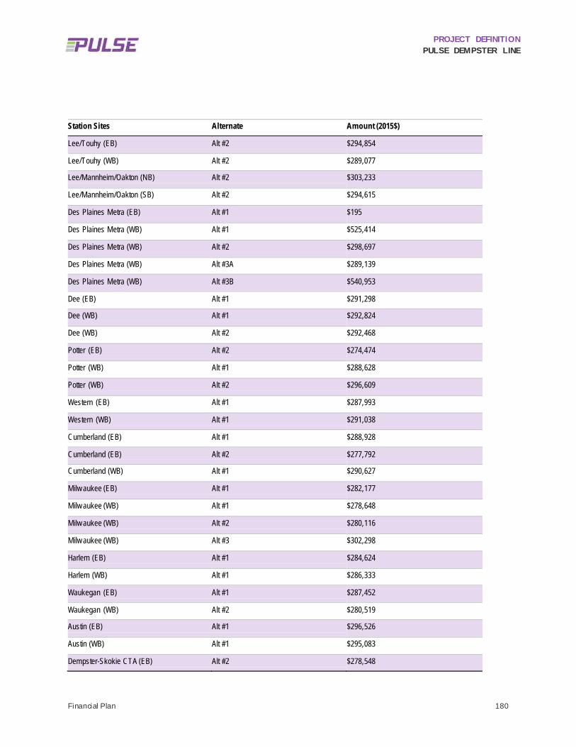
PROJECT DEFINITION PULSE DEMPSTER LINE
Financial Plan 180
Station Sites Alternate Amount (2015$)
Lee/Touhy (EB) Alt #2 $294,854
Lee/Touhy (WB) Alt #2 $289,077
Lee/Mannheim/Oakton (NB) Alt #2 $303,233
Lee/Mannheim/Oakton (SB) Alt #2 $294,615
Des Plaines Metra (EB) Alt #1 $195
Des Plaines Metra (WB) Alt #1 $525,414
Des Plaines Metra (WB) Alt #2 $298,697
Des Plaines Metra (WB) Alt #3A $289,139
Des Plaines Metra (WB) Alt #3B $540,953
Dee (EB) Alt #1 $291,298
Dee (WB) Alt #1 $292,824
Dee (WB) Alt #2 $292,468
Potter (EB) Alt #2 $274,474
Potter (WB) Alt #1 $288,628
Potter (WB) Alt #2 $296,609
Western (EB) Alt #1 $287,993
Western (WB) Alt #1 $291,038
Cumberland (EB) Alt #1 $288,928
Cumberland (EB) Alt #2 $277,792
Cumberland (WB) Alt #1 $290,627
Milw aukee (EB) Alt #1 $282,177
Milw aukee (WB) Alt #1 $278,648
Milw aukee (WB) Alt #2 $280,116
Milw aukee (WB) Alt #3 $302,298
Harlem (EB) Alt #1 $284,624
Harlem (WB) Alt #1 $286,333
Waukegan (EB) Alt #1 $287,452
Waukegan (WB) Alt #2 $280,519
Austin (EB) Alt #1 $296,526
Austin (WB) Alt #1 $295,083
Dempster-Skokie CTA (EB) Alt #2 $278,548

PROJECT DEFINITION PULSE DEMPSTER LINE
Financial Plan 181
Station Sites Alternate Amount (2015$)
Dempster-Skokie CTA (WB) Alt #2 $292,740
Craw ford (EB) Alt #1 $287,407
Craw ford (WB) Alt #3 $295,879
Craw ford (WB) Alt #4 $302,966
Lincolnw ood (EB) Alt #1 $285,919
Lincolnw ood (EB) Alt #2 $281,861
Lincolnw ood (WB) Alt #1 $302,289
Lincolnw ood (WB) Alt #2 $291,302
Dodge (EB) Alt #1 $280,994
Dodge (WB) Alt #1 $294,652
Dodge (WB) Alt #3 $287,190
Dav is CTA/Metra Alt #1 $195
Figure 13.1 depicts the capital costs of each of the 48 station layouts as w ell as the average cost. The average capital cost of a station site is $293,370 w hen eliminating the station sites w ith minimal capital improvements planned (e.g. signage). These include the terminal at O’Hare, Des Plaines Metra (EB), and the Davis CTA/Metra station.
When comparing the costs of all other station sites, the majority are relatively comparable to one another. The exceptions are the Des Plaines Metra (WB) Alternate #1 and Alternate #3B, w hich are almost double the average station cost as it w as assumed an elongated platform w ith a bus turnout w ould be needed at these station sites.

PROJECT DEFINITION PULSE DEMPSTER LINE
Financial Plan 182
FIGURE 13.1: STATION SITE SUBTOTAL COSTS
Average: $293,370

PROJECT DEFINITION PULSE DEMPSTER LINE
Financial Plan 183
13.1.3 Corridor-Level Estimate The corridor-level estimate w as built upon the station-level estimate using the subtotal of costs for a subset of the 48 station layouts and then adding global project-level costs. A total of 32 site specif ic station layouts w ere included in the site subtotal used to establish the corridor total. These station sites are generally representative of the improvements needed for that station location. While only a representative sample of station sites are included in the corridor-level estimate, all station sites and layout options w ill be evaluated during the environmental review phase and a preferred alternative w ill be established that identif ies one station site in each direction to be developed w ith detailed design draw ings during the design phase. Figure 13.2 illustrates the process of building the corridor-level estimate.
FIGURE 13.2: CORRIDOR-LEVEL COST ESTIMATE FORMULA
13.1.3.1 STATION SITE SUBTOTAL
Appendix K includes a detailed accounting of costs for each station site included in the corridor-level estimate as w ell as a summary sheet for the total capital cost for Pulse Dempster Line stations. A brief summary of the costs for each selected station site is show n below in Table 13.4 as w ell as a subtotal for all 32 station sites. As noted above, station sites selected for the corridor-level cost estimate w ere chosen to provide a representative sample of all station sites, w ith one station site in each direction chosen for the intermediate station locations and both terminal station sites included.
Labor Material Allowance Equipment Other Contractor Costs
Site Subtotal
(Selected
Sites)
Contingency Project Costs
Corridor Total
(Selected Sites)

PROJECT DEFINITION PULSE DEMPSTER LINE
Financial Plan 184
TABLE 13.4: STATION SITE CAPITAL COSTS - SELECTED SITES AND SITE SUBTOTAL
Station Sites Alternate Amount (2015$)
O'Hare $195
Mannheim/Higgins (NB) Alt #2 $277,108
Mannheim/Higgins (SB) Alt #2 $273,013
Lee/Touhy (EB) Alt #2 $294,854
Lee/Touhy (WB) Alt #2 $289,077
Lee/Mannheim/Oakton (NB) Alt #2 $303,233
Lee/Mannheim/Oakton (SB) Alt #2 $294,615
Des Plaines Metra (EB) Alt #1 $195
Des Plaines Metra (WB) Alt #3B $540,953
Potter (EB) Alt #2 $274,474
Potter (WB) Alt #2 $296,609
Western (EB) Alt #1 $287,993
Western (WB) Alt #1 $291,038
Cumberland (EB) Alt #1 $288,928
Cumberland (WB) Alt #1 $290,627
Milw aukee (EB) Alt #1 $282,177
Milw aukee (WB) Alt #2 $280,116
Harlem (EB) Alt #1 $284,624
Harlem (WB) Alt #1 $286,333
Waukegan (EB) Alt #1 $287,452
Waukegan (WB) Alt #2 $280,519
Austin (EB) Alt #1 $296,526
Austin (WB) Alt #1 $295,083
Dempster-Skokie CTA (EB) Alt #2 $278,548
Dempster-Skokie CTA (WB) Alt #2 $292,740
Craw ford (EB) Alt #1 $287,407
Craw ford (WB) Alt #3 $295,879
Lincolnw ood (EB) Alt #2 $281,861
Lincolnw ood (WB) Alt #1 $302,289
Dodge (EB) Alt #1 $280,994
Dodge (WB) Alt #1 $294,652
Dav is CTA/Metra Alt #1 $195

PROJECT DEFINITION PULSE DEMPSTER LINE
Financial Plan 185
Station Sites Alternate Amount (2015$)
SITE SUBTOTAL $8,610,306 Note: Due to rounding adjustments, the sum of individual station sites may not equal $8,610,306.
The station site subtotal includes direct site costs such as labor, materials, subcontracts, large equipment and other direct costs in addition to contractor costs. A breakdow n of the elements included in the site subtotal is show n in Table 13.5. The site subtotal, contingency, and project costs w ere combined to develop an estimate for the total corridor-level capital construction cost for the Pulse Dempster Line. The site subtotal for the selected station sites represents 69% of the total Dempster Line station capital costs at $8,610,306. Additional detail on the items included in the contractor costs are provided in the section that follow s.
TABLE 13.5: BREAKDOWN OF COSTS INCLUDED IN THE SITE SUBTOTAL
Description Amount (2015$) Percent of Total Project Cost
Labor $858,987 6.90%
Materials $1,133,399 9.10%
Subcontracts $5,007,500 40.23%
Equipment $357,677 2.87%
Other $145,000 1.16%
Subtotal - Direct Site Costs $7,502,563
Contractor Costs $1,107,743 8.90%
SITE SUBTOTAL $8,610,306
13.1.3.1.1 Contractor Costs Contractor costs are included in the costs for each individual station site in Table 13.4 as w ell as the breakdow n of costs in Table 13.5. Contractor costs and fees total $1,107,743 and include contractor’s general condition, overhead and profit, an adjustment for labor and payroll burden, small tools and equipment, bonds, and other insurance, sales tax and utility relocation costs. The costs are developed from rates based on historical data and estimator experience and are applied to the direct site costs of labor, material, subcontractors, large equipment and other direct costs. For information purposes, a breakdow n of the rates and costs included in the total costs are provided in Table 13.6. Contractor costs represent 8.9% of total project costs.
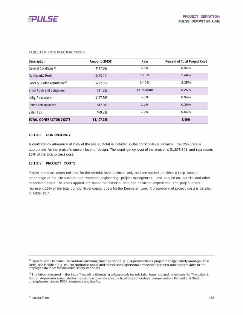
PROJECT DEFINITION PULSE DEMPSTER LINE
Financial Plan 186
TABLE 13.6: CONTRACTOR COSTS
Description Amount (2015$) Rate Percent of Total Project Cost
General Conditions 23 $117,503 5.0% 0.94%
Ov erhead & Profit $423,011 18.0% 3.40%
Labor & Burden Adjustment24 $292,055 34.0% 2.35%
Small Tools and Equipment $31,332 $1.50/hour 0.25%
Utility Relocations $117,503 5.0% 0.94%
Bonds and Insurance $47,001 2.0% 0.38%
Sales Tax $79,338 7.0% 0.64%
TOTAL CONTRACTOR COSTS $1,107,743 8.90%
13.1.3.2 CONTINGENCY
A contingency allowance of 25% of the site subtotal is included in the corridor-level estimate. The 25% rate is appropriate for the project’s current level of design. The contingency cost of the project is $1,875,641 and represents 15% of the total project cost.
13.1.3.3 PROJECT COSTS
Project costs are costs included for the corridor-level estimate only and are applied as either a lump sum or percentage of the site subtotal and represent engineering, project management, land acquisition, permits and other associated costs. The rates applied are based on historical data and estimator experience. The project costs represent 16% of the total corridor-level capital costs for the Dempster Line. A breakdow n of project costs is detailed in Table 13.7.
23 General conditions include construction management personnel (e.g. superintendents, project manager, safety manager, time clerk), site facil ities (e.g. trailers, sanitation units), and miscellaneous personal protective equipment and tools provided to the employees to meet the minimum safety standards. 24 The labor rates used in the Sage Timberline Estimating software only include labor base rate and fringe benefits. The Labor & Burden Adjustment is included in the estimate to account for the fixed costs of worker’s compensation, Federal and State unemployment taxes, FICA, insurance and liability.

PROJECT DEFINITION PULSE DEMPSTER LINE
Financial Plan 187
TABLE 13.7: PROJECT COSTS
Project Cost Categories Amount (2015$) Rate Percent of Total Project Cost
Preliminary Engineering $375,128 5.0% 3.01%
Final Design $375,128 5.0% 3.01%
Project Management, Agency /PM consulting $375,128 5.0% 3.01%
Construction Administration & Management $450,154 6.0% 3.62%
Insurance $37,513 0.5% 0.30%
Legal, Permits, Rev iew Fees $187,564 2.5% 1.51%
Right-of-Way Acquisition $87,000 Lump Sum 0.70%
Surv ey , Testing, Inspection $75,026 1.0% 0.60%
TOTAL PROJECT COSTS $1,962,641 15.77%
13.1.3.4 CORRIDOR-LEV EL TOTAL CAPITAL COSTS
Total corridor-level capital costs are $12,448,588. Project cost categories for the corridor are broken out in Table 13.7. A breakdow n of all corridor-level cost components is provided in Table 13.8 and the percentage of the total corridor-level cost is show n in Figure 13.3.
TABLE 13.8: CORRIDOR-LEVEL CAPITAL COST CATEGORY TOTALS
Project Cost Categories Amount (2015$)
Station Site Subtotal $8,610,306
Contingency $1,875,641
Project Costs $1,962,641
TOTAL DEMPSTER LINE CORRIDOR-LEVEL CAPITAL COSTS $12,448,588
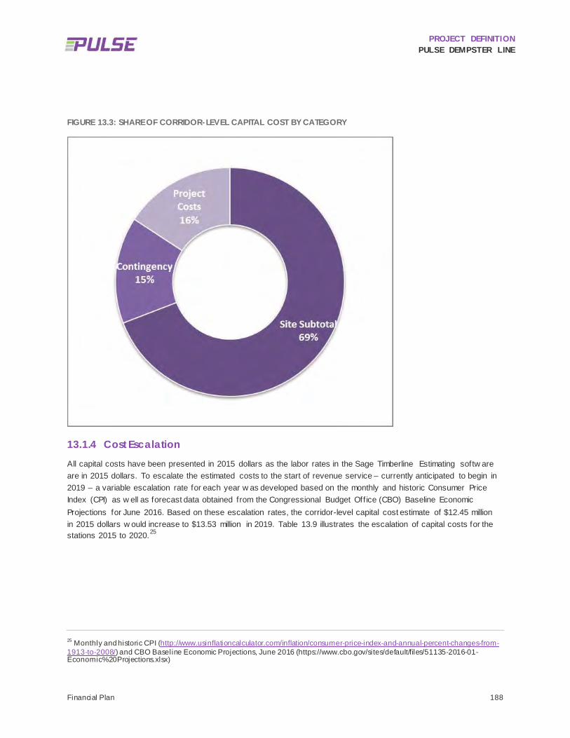
PROJECT DEFINITION PULSE DEMPSTER LINE
Financial Plan 188
FIGURE 13.3: SHARE OF CORRIDOR-LEVEL CAPITAL COST BY CATEGORY
13.1.4 Cost Escalation All capital costs have been presented in 2015 dollars as the labor rates in the Sage Timberline Estimating softw are are in 2015 dollars. To escalate the estimated costs to the start of revenue service – currently anticipated to begin in 2019 – a variable escalation rate for each year w as developed based on the monthly and historic Consumer Price Index (CPI) as w ell as forecast data obtained from the Congressional Budget Office (CBO) Baseline Economic Projections for June 2016. Based on these escalation rates, the corridor-level capital cost estimate of $12.45 million in 2015 dollars w ould increase to $13.53 million in 2019. Table 13.9 illustrates the escalation of capital costs for the stations 2015 to 2020.25
25 Monthly and historic CPI (http://www.usinflationcalculator.com/inflation/consumer-price-index-and-annual-percent-changes-from-1913-to-2008/) and CBO Baseline Economic Projections, June 2016 (https://www.cbo.gov/sites/default/files/51135-2016-01-Economic%20Projections.xlsx)

PROJECT DEFINITION PULSE DEMPSTER LINE
Financial Plan 189
TABLE 13.9: ESCALATED CORRIDOR-LEVEL CAPITAL COSTS
2015 2016 2017 2018 2019 2020
Corridor Capital Cost (Stations)
$12,448,588 $12,600,563 $12,907,840 $13,214,557 $13,530,202 $13,858,452
Escalation Rate 1.22% 2.44% 2.38% 2.39% 2.43%
13.1.5 Vehicles Pulse vehicles w ill be procured as part of Pace’s regular vehicle replacement program. Based on the preliminary operating plan for the Dempster Line, there is an assumed need for 15 vehicles w ith 3 spares for a total of 18 new Pulse vehicles at a cost of $526,815 per vehicle.26 Like the corridor-level cost estimate, a variable escalation rate for each year w as used to escalate the vehicle costs to 2019. Vehicle costs of $9.6 million in 2016 dollars w ould increase to $10.3 million in 2019, the anticipated year of purchase and revenue service. Table 13.10 illustrates the escalation of vehicle costs.
TABLE 13.10: ESCALATED VEHICLE COSTS
2015 2016 2017 2018 2019 2020
Pulse Vehicles (18 = 15 + 3 spares)
$9,482,670 $9,598,436 $9,832,504 $10,066,144 $10,306,586 $10,556,629
Escalation Rate 1.22% 2.44% 2.38% 2.39% 2.43%
26 Vehicle costs were established during the Pulse Milwaukee Line capital cost estimate and may vary based on the current vehicle specifications.

PROJECT DEFINITION PULSE DEMPSTER LINE
Financial Plan 190
13.1.6 Total Cost for the Dempster Line As show n in Table 13.11, the total cost for the Pulse Dempster Line including the station capital costs and Pulse vehicles is $22.2 million in 2016 dollars and $23.8 million in 2019 dollars. Project costs are escalated to 2020 to show how the costs may increase w ith the start of revenue service.
TABLE 13.11: TOTAL PROJECT COSTS
2015$ 2016$ 2017$ 2018$ 2019$ 2020$
Station Capital Cost
$12,448,588 $12,600,563 $12,907,840 $13,214,557 $13,530,202 $13,858,452
Pulse Vehicles $9,482,670 $9,598,436 $9,832,504 $10,066,144 $10,306,586 $10,556,629
Total Project Capital Cost
$21,931,258 $22,199,000 $22,740,344 $23,280,702 $23,836,789 $24,415,082
Escalation Rate 1.22% 2.44% 2.38% 2.39% 2.43%
13.1.7 FTA Standard Cost Categories Projects that are pursuing federal funding through the Federal Transit Administration (FTA) grant programs, including the Congestion Mitigation and Air Quality (CMAQ) program, must organize project costs according to the FTA’s Standard Cost Categories (SCC) structure. The Station Capital Cost estimate presented in this memorandum and detailed in Appendix J and Appendix K w as transferred to a SCC Capital Cost Estimate w orkbook that follow s FTA guidance and requirements for estimating and annualizing capital construction costs and other project costs and funding sources. While the cost of vehicles is not included in Appendix J and Appendix K, they are included in the SCC w orkbook, w hich is presented in Appendix L.
Follow ing FTA methodology recommendations, the SCC Capital Cost Estimate is broken dow n into ten (10) major components including f ive (5) cost categories for station construction and f ive (5) cost categories for supporting project elements, needs and administration / f inance. These include the follow ing:
• Category 10: Guidew ay and Track Elements • Category 20: Stations, Stops, Terminals and Intermodal • Category 30: Support Facilities: Yards, Shops, and Administrative Buildings • Category 40: Sitew ork and Special Conditions • Category 50: Systems • Category 60: Right of Way, Land, and Existing Improvements • Category 70: Vehicles • Category 80: Professional Services • Category 90: Unallocated Contingency • Category 100: Finance Charges
A key difference betw een the SCC format and the capital cost estimate presented in this memo is that the costs in the SCC w orkbook have variable years of expenditure to reflect w hen w ork is expected to occur. For example, in order for the Pulse Dempster Line to begin revenue service in 2019, the engineering design services must begin in 2017 and conclude in 2018. Because the schedule and years of expenditure are defined in more detail, the project costs are escalated to different years. The result is a total project cost of $23.5 million in year of expenditure dollars, w ith

PROJECT DEFINITION PULSE DEMPSTER LINE
Financial Plan 191
the largest share of expenses anticipated in 2019 (see the “Fund Source by Cat” w orksheet in the SCC w orkbook, w hich can be found in Appendix L).
OPERATIONS AND MAINTENANCE COST ESTIMATE 13.2
13.2.1 Methodology The O&M cost estimate for the Pulse Dempster Line and reduced local Route 250 service w as developed using Pace’s fully allocated unit costs for the f irst quarter of 2016, provided in June 2016. Pace allocates costs by operating division, and w ithin each division costs are allocated by total vehicle hour, w hich includes both revenue and non-revenue hours (such as deadhead, layovers, etc.). By this approach, every route operated w ithin a given division has the same unit cost structure. In the f irst quarter of 2016, the unit O&M cost for the Northw est Division w as $78.22.
How ever, since the preliminary schedules developed as part of this study are suff iciently detailed only to describe revenue vehicle hours, the operating data provided by Pace w as recalculated to estimate the unit O&M cost per revenue hour. When measuring costs by revenue hour, every route has a slightly different cost structure, reflecting different relationships betw een revenue hours and total hours that may arise from different deadhead distances, layovers, and other operational characteristics. The average unit cost per revenue hour for the Northw est Division w as $105.45 in the f irst quarter of 2016, w hile the unit cost for Route 250 w as $99.53 for the same period. These unit costs represent an annualized w eighted average of w eekday, Saturday, and Sunday operating conditions (assuming 255 w eekdays, 52 Saturdays, and 58 Sundays/holidays).
Because the eff iciencies associated w ith Route 250, including short deadheads to the garage in Des Plaines and relatively short and eff icient layovers, are likely to continue w hen the Dempster Line commences service, the Dempster Line O&M cost estimate w as developed using the specif ic Route 250 unit O&M cost of $99.53 per revenue hour. The same unit cost w as used to estimate the future O&M costs for Route 250 after service reductions are implemented.
Because O&M cost is driven by a single-factor model driven directly by vehicle revenue hours, the percentage increase in O&M cost over existing conditions w ill be identical to the percentage increase in vehicle revenue hours.
It should be noted that the O&M costs documented in this report do not include additional O&M costs specif ic to Pulse operation, such as station electrical costs, station maintenance, cellular service, and real time information sign operation. These costs have been omitted per previous direction from Pace and have not been fully determined at this time.
13.2.1.1 FUTURE YEAR O&M COST GROWTH
To estimate the grow th in O&M costs, Pace analyzed ten years’ of O&M cost data as reported to the National Transit Database (NTD), for the years 2005 through 2014. Reported total O&M costs w ere compared w ith reported total vehicle revenue hours to estimate a unit cost per revenue hour for each year. The analysis specif ically looked at Pace’s directly operated service, and specif ically at the Motor Bus mode; thus, any privately operated contract service, and all paratransit service, w as excluded from the analysis.
Historical unit O&M costs w ere adjusted to constant 2016 dollars to analyze cost grow th beyond the general rate of inf lation. The analysis found that Pace’s O&M costs have annually grow n at approximately 1.46% above the rate of inflation.

PROJECT DEFINITION PULSE DEMPSTER LINE
Financial Plan 192
To estimate future year grow th, the 1.46% annual grow th rate w as combined w ith the projected rate of inf lation, as developed by the Congressional Budget Off ice, to estimate a nominal rate of unit cost grow th. The resulting unit cost grow th estimate is show n in Table 13.12. Unit costs are estimated to grow at approximately 3.9% annually in year of expenditure dollars, resulting in a unit cost of $111.64 by the anticipated start of service in 2019.
TABLE 13.12: CURRENT AND FUTURE UNIT O&M COST, BY YEAR OF EXPENDITURE
2016 2017 2018 2019
Dollars per Rev enue Hour $99.53 $103.45 $107.46 $111.64
Percent Increase n/a 3.94% 3.88% 3.89%
13.2.2 Cost Estimate Total aggregate O&M cost for existing and future conditions are summarized in Table 13.13. The summary show s the cost in both 2016 and 2019 dollars. The estimated total O&M cost for service in the corridor is expected to grow by $3.3 million or 95% over existing conditions.
TABLE 13.13: EXISTING AND FUTURE O&M COST
Segment Existing
Route 250 Fall 2016
Route 250 Pulse
Dempster Line Reduced Local
Route 250 Total Future Condition
Percent Growth
Annual Rev enue Hours
29,084 34,456 53,403 13,670 67,073 95%
O&M Cost, 2016 Dollars
$2.9 million $3.4 million $5.3 million $1.4 million $6.7 million 95%
O&M Cost, 2019 Dollars
$3.2 million $3.8 million $6.0 million $1.5 million $7.5 million 95%
Note: Percent Growth in O&M cost is based on the planned fall 2016 Route 250 service levels. Reduced Local Route 250 Service Statistics do not include school trips, which are expected to be retained and add approximately 400 revenue hours of service per year.

PROJECT DEFINITION PULSE DEMPSTER LINE
Ridership Forecast 193
14 Ridership Forecast This memorandum presents the ridership estimate for the Pulse Dempster Line, as w ell as proposed changes to the existing local Route 250 to be implemented upon commencement of Pulse service in the corridor. The forecast w as built upon previous detailed ridership analysis for the corridor and w as developed using Simplif ied Trips-on-Project Softw are (STOPS) ridership forecasting model, w hich w as f irst released in 2013 by the Federal Transit Administration (FTA). The Chicago application of the STOPS model w as originally constructed by the Regional Transportation Authority w ith additional modif ications, calibration, and project coding completed for specif ic application to this project. The modif ied STOPS model developed for the development of this ridership forecast has not been calibrated to the full RTA region and is not necessarily suitable for use on other projects.
The ridership forecast documented in this memorandum is based on the corridor station assumptions described in Section 4.4. As show n in Figure 4.13, the Pulse Dempster Line corridor w ill consist of tw o terminal stations (Davis CTA/Metra and O’Hare) and 15 intermediate stations. One station (Dee) is still being considered for relocation to a nearby intersection (Potter), but this decision w ill not affect the overall number of stations nor the overall running time. For modeling purposes the station w as assumed to be located halfw ay betw een the tw o intersections.
The running times, span of service, and frequency of service assumptions that w ere used in development of the ridership forecast are documented in Section 9.
Existing Route 250 ridership, w hich w as used in the calibration stage of model development, w as documented in the Preliminary Station Location and Site Selection Options technical memorandum, and supplemented w ith additional data provided by Pace addressing ridership beyond the Route 250 corridor.
STOPS MODEL BACKGROUND 14.1
STOPS w as developed by the FTA in 2013 as an alternative to using a local travel demand model for transit ridership forecasting. Through several subsequent softw are releases and real-w orld experience running the softw are, the FTA has expanded the types of recommended applications for STOPS and has updated several important recommended procedures for model implementation.
The latest version of STOPS currently available is Version 2.0, w hich became available in early 2016. Version 2.0 has been released to users on request, but has not yet been fully documented. The most current documentation available is from the previous release, Version 1.5, and can be accessed on the FTA’s STOPS w ebsite.27 Version 2.0 includes several new features and updates w hich w ill be further discussed in Section 14.2.
27 https://www.transit.dot.gov/funding/grant-programs/capital-investments/stops-%E2%80%93-documentation-and-software

PROJECT DEFINITION PULSE DEMPSTER LINE
Ridership Forecast 194
14.1.1 Overview of the STOPS Model The FTA’s STOPS Model documentation contains an exhaustive discussion of how the model operates, key data inputs, etc., w hich this memorandum w ill not attempt to replicate. This section presents a high level discussion of the main features and data inputs in STOPS. For a detailed technical discussion, the model documentation should be consulted.
STOPS emulates the w orkflow of a traditional “four-step” travel demand model, w ith a greater focus on accurate representation of the transit netw ork and detailed calibration to actual transit demand in the study area. Figure 14.1 summarizes the key data inputs used by STOPS, w hich include the follow ing:
MPO Demographic Data: While STOPS is intended to function as an alternative to using a regional travel demand model, a region must still have a conventional model available, as STOPS uses several items from these models. The f irst is the regional zone-based data set for base year and future year population and employment. For the Dempster Corridor model, the 1,944-zone demographic forecast prepared by the Chicago Metropolitan Agency for Planning (CMAP) w as used. The demographic forecast is used to take existing base year journey-to-w ork data (described below ) and grow it to current and future years.
MPO Travel Time Skims: The second MPO model data set used by STOPS is the highw ay travel-time “skim” matrix, w hich is a database containing the estimated travel time and travel distance betw een any tw o pairs of MPO zones. Models typically contain skims for various time periods and forecast years. In accordance w ith STOPS Model recommended procedures, the AM Peak time period is used. The CMAP travel time skims contained separate distance and time tabulations for all forecast years (2015, 2020, 2030, and 2040). Travel time skims are used by STOPS to compare highw ay driving times to transit travel times (the latter of w hich are computed w ithin the model), and thereby establish the highw ay/transit mode share of a given zone-to-zone travel movement.
Journey to Work (JTW) Data: The FTA packages and provides JTW data sets specif ically for use in STOPS. The data comes from the Census Transportation Planning Package (CTPP), a modeling package produced using Census data to describe origin-destination patterns of travel demand specif ically for w ork trips. The data contains a table of trip productions and trip attractions for every zone in a given region. Because the CTPP JTW data only describes w ork trips, STOPS uses internal factors w ithin the model to expand the w ork trip table to include non-w ork trips. The zone system used in the JTW data is not necessarily the same zone system used in the previously described MPO demographic and travel time data; STOPS automatically reconciles the tw o zone systems.
GTFS Schedule Data: One area w here STOPS differs from conventional travel demand models is in the manner in w hich it represents existing and future transit service. While conventional models typically represent transit service in terms of a travel time betw een zones w hich includes an assumed w aiting time (based on the frequency of service), STOPS uses detailed schedule data to develop a precise and far more accurate representation of the true transit travel time betw een any tw o zones at any given departure or arrival time. To do this, STOPS reads GTFS data. GTFS is the open-source standard for publishing transit schedule data, used in applications such as Google Maps and various other third-party trip planning tools. There are many GTFS reader and editor tools available, and the f iles are easily modif ied to represent future changes to the transit netw ork. Additionally, many transit agencies use internal scheduling and run-cutting softw are that automatically generates GTFS files for both existing and proposed conditions. In addition to the standard GTFS file set, STOPS uses several “add-on” f iles that are not part of the standard GTFS file sets, w hich are used to represent

PROJECT DEFINITION PULSE DEMPSTER LINE
Ridership Forecast 195
the existence of park-and-ride facilities, and to facilitate quick edits to the transit netw ork, such as turning off routes or rerouting service, w ithout the need for extensive GTFS schedule coding.
The Dempster Corridor STOPS model contains a complete GTFS representation of CTA, Pace, Metra, and NICTD (South Shore Line) transit service.
Ridership Data: STOPS uses ridership data at both the stop level and the system level as a tool for model calibration. Stop-level ridership data is entered as a Geographic Information System (GIS) Shapefile, w hile system-level ridership (linked and/or unlinked transit trips) is entered in a model parameter f ile as a control total. For the Dempster Corridor model, several sources of ridership data w ere combined. This is further described in Section 14.2.
FIGURE 14.1: KEY STOPS MODEL DATA INPUTS
In comparison to a traditional four-step travel demand model, STOPS differs primarily in the f inal tw o steps, Mode Choice and Trip Assignment. For the f irst tw o steps, Trip Generation and Trip Distribution, STOPS depends on external data sources (MPO data, CTPP JTW data) and on model calibration constants to develop an understanding of existing travel demand in the study area.
14.1.2 Regional Transportation Authority STOPS Model In November 2015 Chicago’s Regional Transportation Authority (RTA) publicly released a STOPS model for the Chicago region, for use by the various transit service providers and planning agencies in the region. This regionally calibrated model w as used as the starting point for development of the Dempster Corridor model, w ith several signif icant modif ications. This section briefly describes key inputs and assumptions that w ere used in the RTA’s model. Section 14.2 then describes the modif ications that w ere made in preparing the Dempster Corridor model.

PROJECT DEFINITION PULSE DEMPSTER LINE
Ridership Forecast 196
The follow ing is a summary of key elements of the RTA STOPS model. Additional technical detail can be found in that model’s User Guide.28
The RTA model w as developed using Version 1.50 of STOPS, w hich w as the latest version available at the time of the model’s development. Accordingly, the RTA model used JTW data derived from the 2000 Census, the only JTW data set available for use in Version 1.50 of STOPS.
For station-level calibration, the RTA model included station-level boarding data for all Metra, NICTD, and CTA rail stations, as w ell as for Pace’s I-55 express corridors. CTA bus boardings and Pace boardings outside the I-55 corridor w ere not included in the station shapefile and w ere thus not used in calibration. The decision to include only f ixed guidew ay stations w as made in accordance w ith FTA guidance at the time of the RTA model’s development.
o CTA boardings data represents October 2014 average w eekday boardings.
o Metra boardings data represents average w eekday boardings for calendar year 2014.
o NICTD boardings data represents estimated 2010 average w eekday boardings, scaled up from station-level data collected in 2006.
o Pace boardings on I-55 services represent average w eekday boardings for calendar year 2014.
These stations are aggregated into 59 Station Groups based on operator, mode, line, and distance to Dow ntow n Chicago.
MPO zones are aggregated into 38 Districts based on areas of similar transit mode share and land use characteristics.
GTFS files w ere assembled from the four existing transit agencies representing early 2015 service levels. Only existing conditions w ere represented; a future no-build w as not developed.
Various transfer penalties w ere imposed at the station and agency level to improve calibration results. For example, inter-agency transfer penalties w ere imposed at some Metra stations to suppress the number of transfers betw een Metra and other transit services, especially to CTA service at non-dow ntow n locations in Chicago.
DEMPSTER CORRIDOR MODEL PARAMETERS 14.2
The RTA model covers a very large area including Chicago, its surrounding suburbs, and beyond (including portions of Indiana and Wisconsin), and w as intended by its developers to be modif ied and supplemented for corridor-specif ic applications such as the Dempster Corridor. Additionally, non-dow ntow n-oriented corridors such as Dempster are particularly challenging for a regional, largely dow ntow n-oriented model such as the RTA STOPS model, and require additional refinement and data to achieve a suitable level of local calibration. Additional detailed stop-level boardings data provided by Pace w as available and w as utilized to substantially enhance model calibration in the vicinity of the Dempster Corridor.
28 http://www.rtams.org/pdf/planning/STOPSUserGuide.pdf

PROJECT DEFINITION PULSE DEMPSTER LINE
Ridership Forecast 197
This chapter describes the adjustments and additional data used to update and enhance the RTA model for application to this project. In addition to detailed calibration adjustments, tw o key factors drove the need to modify the RTA’s model. First, the RTA model w as developed using Version 1.50 of STOPS, w hile the Dempster Corridor model w as constructed using Version 2.0 in order to take advantage of important updates in that version.
14.2.1 JTW Data The RTA model w as developed using Version 1.50 of STOPS, w hich w as the latest version available at the time of the model’s release. Accordingly, the model w as developed using JTW data from the 2000 Census, the only dataset available for use in Version 1.50. With Version 2.0, STOPS has been updated to also be compatible w ith updated JTW files based on the American Community Survey (ACS), representing a f ive-year average of the years 2006 through 2010. The Dempster Corridor Model uses this new er data set. In addition to more recent travel demand data, the ACS JTW data utilizes an updated zone system. Thus, the transition from the Census 2000 JTW data used in the RTA model to the ACS 2006-2010 JTW data used in the Dempster Corridor model had signif icant implications for model calibration, and represented a major change from the RTA’s model.
14.2.2 Stations Shapefile As previously noted, the stations shapefile developed for the RTA STOPS model included only f ixed guidew ay stations, w hich w as consistent w ith FTA guidance at the time of the model’s development. By request of Pace, the RTA also included Pace’s bus-on-shoulder stations along I-55 (and in Dow ntow n Chicago) as w ell.
To aid in calibration, and in accordance w ith the latest FTA guidance, the Dempster Corridor model station shapefile w as updated to include a large number of local bus stops. The station shapefile is limited to no more than 10,000 total records, w hereas Pace has over 18,000 bus stops and CTA more than 12,000. To w ork w ithin the limitations of the softw are and available data, the follow ing approach w as used to add local bus stops to the station shapefile:
CTA bus stops w ere excluded entirely. This w as done due to both the limitation in size of the data set (and a desire to prioritize Pace over CTA for calibration purposes), as w ell as a lack of available ridership data. The station shapefile requires stop-level ridership data that w as not available for the CTA bus system.
Pace bus stops w ithin 10 miles of the Dempster corridor w ere included. Additionally, for any routes that pass w ithin that 10 mile radius, all other stops on those routes, including stops beyond the 10 mile radius, w ere included as w ell. Stop-level average w eekday ridership data w as provided by Pace for the Fall 2014 period, representing the most recent quarter before the temporary closure of the CTA Yellow Line, w hich impacted Pace ridership in the project corridor. The list of stops included all of the follow ing: (a) all stops included in the Fall 2014 ridership data; (b) any additional stops included in the corresponding August 2014 GTFS data set; (c) any additional stops included in the Spring 2016 GTFS data set (w hich w as used as the basis for the future No Build and Build conditions); and (d) all new Pulse Milw aukee Line and Pulse Dempster Line stations included in the No Build and Build conditions, respectively. The stations shapefile attribute table includes a f ield indicating the source of each stop included in the shapefile.

PROJECT DEFINITION PULSE DEMPSTER LINE
Ridership Forecast 198
14.2.3 Districts and Station Groups 14.2.3.1 DISTRICTS
In the initial Dempster Corridor model development, the RTA district-zone system w as largely preserved. The 38 RTA districts had to be redefined using the updated ACS zone system, w hich resulted in small adjustments to the district boundaries, but the overall regional district definition scheme w as preserved.
Through the Dempster Corridor model calibration, seven additional districts w ere defined and carved out of the existing districts in their vicinities. They are described below and show n in Figure 14.2:
District 39: Dempster-Evanston – created from parts of tw o other existing Evanston districts.
District 40: Dempster-Skokie – created from parts of an existing Skokie (and surrounding suburbs) district and the w estern Evanston district.
District 41: Dempster-Morton Grove – created from parts of existing Skokie, Glenview , and North Glenview districts.
District 42: Dempster-Niles/Park Ridge – created from parts of existing Skokie and North Glenview districts.
District 43: Dempster-Des Plaines/Rosemont – created from parts of existing Rosemont and Northw est Suburbs districts.
District 44: Dempster-O’Hare – O’Hare Airport only, created from part of the adjacent Rosemont district.
District 45: Milw aukee-Chicago – Representing the Chicago section of the Pulse Milw aukee Line, this district w as created from parts of existing Jefferson Park, Northw est Side, and Skokie districts.
14.2.3.2 STATION GROUPS
Based on updated guidance from the FTA, and follow ing calibration testing, the station grouping scheme developed for the RTA STOPS model w as replaced by an entirely new regional station grouping scheme. The FTA now recommends that station groups follow the same boundaries as districts. For the Dempster Corridor model, the station groups w ere further subdivided by transit agency (w ith Metra and NICTD combined), such that there could be up to three station groups corresponding to each district, for any district in w hich there exist commuter rail stations, CTA rail stations, and Pace bus stops. In practice, many districts had few er than three corresponding station groups, particularly outside the City of Chicago, w here few CTA stations exist.
In a small number of cases, stations w ere assigned a group corresponding to a nearby adjacent district. This w as the case in locations w here stations w ere situated on the boundary betw een tw o districts, to keep reciprocal (e.g. northbound and southbound) stations together, and in situations w here the character of a station w as more relevant to a nearby district than to the district in w hich it w as located. An example of this latter case occurred at O’Hare. The single zone representing the O’Hare district w as very large and incorporated some Pace bus stops on the south and w est end of the zone. These stops are functionally and operationally distinct from the O’Hare station, and thus w ere grouped separately from the existing O’Hare Kiss ‘N’ Fly stop and the future O’Hare Pulse station. They w ere instead grouped w ith other stops in the adjacent Rosemont district.

PROJECT DEFINITION PULSE DEMPSTER LINE
Ridership Forecast 199
FIGURE 14.2: ADDITIONAL DISTRICTS, DEMPSTER AND MILWAUKEE CORRIDORS
Note: The colored polygons represent the districts described in section 14.2.3.1. The numbered, bold colored polygons represent the redefined districts.
14.2.4 GTFS Files The follow ing GTFS file sets w ere included in the Dempster Corridor STOPS model:
CTA: The latest GTFS files w ere dow nloaded from the CTA w ebsite in April, 2016. The data set w as modif ied to remove the temporary Purple Line Express southbound stops at Sheridan and Wilson. Under the Build condition, the permanent Purple Line Express northbound and southbound stop at Wilson station w as added.
Metra: The GTFS files developed by the RTA w ere used, w ith no further modif ications for the Dempster Corridor model.
NICTD: The GTFS files developed by the RTA w ere used, w ith no further modif ications for the Dempster Corridor model.
Pace: Existing Pace conditions w ere represented by the August 2014 GTFS files. This time period w as selected to correspond to the ridership data that w as provided. This w as important to ensure that ridership w as calibrated

PROJECT DEFINITION PULSE DEMPSTER LINE
Ridership Forecast 200
to the actual service levels in place at the time the ridership data w as collected. For No Build conditions, Pace’s latest GTFS data set (May 2016) w as used. The Pulse Milw aukee Line w as added to this data set, and local service on Milw aukee Avenue (Route 270) w as modif ied, both in accordance w ith the service plan described in the Milwaukee Corridor Arterial Rapid Transit Project Definition Report (December 2014). For Build conditions, the Pulse Dempster Line w as added to the No Build condition, and local Route 250 service w as modif ied, both in accordance w ith the Operating Plan and O&M Cost Estimate technical memorandum (July 2016). For both Pulse Lines, the service w as coded in the GTFS data set as Type 3 (bus), as opposed to Type 0 (streetcar). There is no service type specif ic to BRT. Coding as Type 3 means that the service w ill compete against other bus routes strictly on the basis of service levels and travel times alone. There is no inherent “advantage” to the Pulse lines as compared w ith all other bus routes. An alternate Build data set w as developed featuring an extension of the Dempster Line beyond the O’Hare terminus to the Rosemont Transit Center. This w as used for a model sensitivity test.
For all four transit agencies, the PnR.txt f ile that w as developed by the RTA, w hich represents Park and Ride facilities, w as added to the GTFS data set. The Pace PnR.txt f ile w as modif ied to include the Golf Mill Shopping Center as an “unsanctioned Park-and-Ride” facility.
14.2.5 Penalties The majority of the access and transfer penalties defined in the RTA model w ere left unchanged. During Dempster Corridor model calibration, additional penalties w ere introduced at the O’Hare and Des Plaines Metra stations to suppress transfers betw een Pace and Metra at these locations. Additionally, a transfer w as defined betw een the O’Hare Kiss ‘N’ Fly station and the CTA Blue Line at O’Hare. These stations are physically too far apart for STOPS to recognize the possibility of a transfer, but due to the existence of the Airport Transit System (ATS), w hich is not coded in STOPS, it is possible to transfer betw een these locations, and a small number of transfers do occur. The time penalty associated w ith this transfer w as refined during calibration to generate a reasonably accurate number of existing transfer boardings.
14.2.6 STOPS Parameter File The follow ing are several key parameters that w ere used in the Dempster Corridor STOPS model parameter f ile:
CTPP Calibration Approach: Productions and Attractions
Station Group Calibration Approach: Type 06: Static Group Calibration
Fraction of Transfer Penalty to Apply: 1.0 (default value)
Fixed Guideway Visibility: 1.0 (default value)
Linked Trip Factors: All default values w ere used as taken from the RTA model.

PROJECT DEFINITION PULSE DEMPSTER LINE
Ridership Forecast 201
Weekday Unlinked Trip Control Total: 2,036,255. This is the sum total of CTA, Metra, Pace, and NICTD ridership and is the combination of three sources: (1) Total rail ridership is based on the total indicated in the station shapefile from the RTA STOPS model; (2) CTA bus ridership is from the calendar year 2015 ridership report; (3) Pace ridership is based on the Fall 2014 data set for use in the STOPS model.
Weekday Regional Linked Transit Trips Made by Travelers from Home-to-Work or Work-to-Home: 646,680, w hich is the default value contained in the RTA STOPS model.
RIDERSHIP FORECAST RESULTS 14.3
In total the model w as run and updated 17 times during the calibration phase. The f inal results of the Existing Conditions calibration as w ell as the No Build and Build Condition forecasts for 2015 are show n in Table 14.1. The No Build differs from Existing conditions in tw o w ays: f irst, it is based on May 2016 Pace service data as coded in the latest available GTFS files. Second, it assumes operation of the Pulse Milw aukee Line.
TABLE 14.1: SUMMARY OF CALIBRATION RESULTS AND BASELINE 2015 RIDERSHIP FORECAST FOR PACE SYSTEM AND THE DEMPSTER CORRIDOR
Pace Systemwide
Boardings Pace Route
250 Pulse Dempster
Line Dempster Corridor
Total
Existing Ridership (Actual) 111,593 3,002 N/A 3,002
Existing Ridership (Modeled) 126,776 2,671 N/A 2,671
Percent Difference vs. Actual Existing (+14%) (-11%)
No-Build Ridership (Modeled) 124,814 2,839 N/A 2,839
Percent Difference vs. Actual Existing (+12%) (-5%)
Build Condition Ridership 128,225 91 7,034 7,125
Percent Difference vs. Actual Existing (+3%) (+151%)
Note: The existing boardings number differs somewhat from the total reported in other technical memoranda. It is reflective of the specific stop-level data that was provided for the Fall 2014 time period, and corresponds with the Fall 2014 GTFS files used in the STOPS model.
As show n, the model forecast indicates that ridership on the corridor w ill increase by 151% over existing boardings. While this number is high, it falls betw een the 131% increase in revenue hours planned in the corridor and the 171% increase in revenue miles (a closer reflection of the overall increase in trips). Ridership grow th in the corridor is driven by both frequency improvements and speed improvements. To better understand the relative ridership impacts of speed versus frequency improvements in the model, a sensitivity test w as conducted, w hich is discussed in the follow ing section.
The forecast indicates that betw een the No Build and Build conditions, average w eekday Dempster Corridor ridership grow s by 4,286 passengers (2,839 to 7,125), w hile Pace systemw ide ridership grow s by 3,411 boardings. Thus, approximately three quarters of new Dempster Corridor boardings are expected to represent new Pace passengers, w hile the remainder represent trips draw n from other bus routes. Due to data limitations in the STOPS model, the Build condition does not reflect potential passengers that could utilize the new Pulse Dempster Line service to

PROJECT DEFINITION PULSE DEMPSTER LINE
Ridership Forecast 202
transfer to or from an airport employee shuttle, rental car, or regional bus though there w ill be new opportunities for transfers to/from these non-Pace services.
SENSITIVITY TESTS 14.4
Sensitivity tests w ere conducted to examine the impacts of certain assumptions as w ell as to ascertain how changes to the project might affect ridership. Tw o sensitivity tests have been developed as part of the ridership forecast development, and are described in this section and summarized in Table 14.2.
14.4.1 Rosemont Extension To address a recommendation made during the station site selection process, an alternative operating plan w as developed in w hich service continues to the Rosemont Transit Center, connecting w ith the CTA Blue Line and numerous Pace bus routes. Under this operating plan, the w estern terminus of the Pulse Dempster Line w ould be moved from the O’Hare station to the existing Rosemont Transit Center. O’Hare w ould remain as an intermediate station betw een the Rosemont and Mannheim/Higgins station. The STOPS model does not consider the exact route, but rather generates results based on station locations and the travel times. As discussed in Section 9.4.2, running times assume express operation and w ere obtained from Google Maps at differing times of day. For modeling purposes, an additional running time of ten minutes w as assumed betw een Rosemont and O’Hare. The operating assumptions (reflected in corresponding GTFS files) w ere based on the baseline ridership forecast (10-minute peak period Pulse service). It w as assumed that only Pulse service w ould be extended to Rosemont, w hile Route 250 w ould continue to terminate at O’Hare.
The resulting forecast suggested approximately 20% grow th in ridership, or approximately 1,500 additional w eekday boardings, w hen service is extended to Rosemont. In addition to approximately 900 new boardings at the Rosemont Transit Center, the majority of new demand resulting from the extension is in the section of the corridor betw een Des Plaines Metra and O’Hare, w here approximately 600 additional boardings are forecasted to occur. Some of the additional ridership is draw n from other routes operating betw een Rosemont and portions of the corridor, including Route 221 and Route 223. How ever, the sensitivity test results in nearly 500 new boardings on the Pace system and nearly 1,000 new transit unlinked trips in the region – the majority of the non-Pace ridership grow th generated on the CTA rail system due to the improved transfer connection betw een CTA and Pace.
14.4.2 Speed Improvements Only In light of the signif icant ridership increases generated in the STOPS model ridership forecast, it is important to better understand how the model is responding to the various changes betw een the Existing and Build conditions. A sensitivity test w as performed in w hich the anticipated Pulse Dempster Line running time improvements w ere retained, but the frequency/headw ay improvements w ere removed. Under this scenario, the Dempster Line w ould operate at the same approximate spans and headw ays as the existing Route 250, and the reduced local Route 250 under the Build condition w as eliminated.
Under this sensitivity test, the resulting forecast indicates 5,383 average w eekday boardings in the corridor, w hich is more than 1,600 boardings few er than the 7,125 baseline, or 23% below the baseline forecast. Nearly all of the reduction in boardings represents new transit trips, as opposed to trips draw n from other corridors, as overall Pace systemw ide ridership in this sensitivity test is 1,400 low er than the baseline.

PROJECT DEFINITION PULSE DEMPSTER LINE
Ridership Forecast 203
In total, approximately 40% of the ridership grow th in the Dempster Corridor that w as projected under the Baseline still occurs under the Speed Improvements sensitivity test. The remaining 60% of projected ridership grow th under the Baseline Build scenario w as attributable to the substantial proposed frequency improvements.
TABLE 14.2: SUMMARY OF SENSITIVITY TESTS
Pace Systemwide
Boardings Pace Route
250 Pulse Dempster
Line Dempster Corridor
Total
No Build Ridership 124,814 2,839 N/A 2,839
Baseline (Build) Ridership 128,225 91 7,034 7,125
Percent Different vs. No-Build (+3%) (+151%)
Rosemont Extension 128,703 96 8,538 8,634
Percent Difference vs. Baseline (+0.4%) (+21%)
Percent Different vs. No-Build (+3%) (+201%)
Speed Improvements Only 126,806 N/A 5,383 5,383
Percent Difference vs. Baseline (+3%) (-23%)
Percent Difference vs. No-Build (+2%) (+90%)
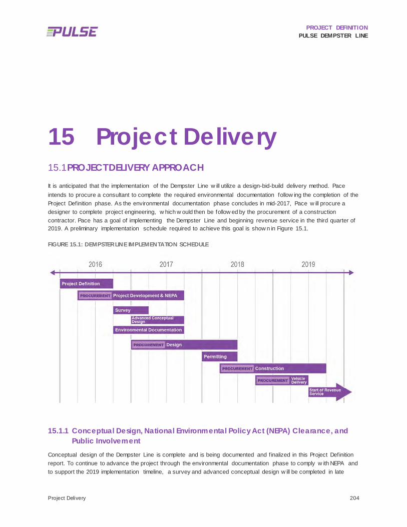
PROJECT DEFINITION PULSE DEMPSTER LINE
Project Delivery 204
15 Project Delivery PROJECT DELIVERY APPROACH 15.1
It is anticipated that the implementation of the Dempster Line w ill utilize a design-bid-build delivery method. Pace intends to procure a consultant to complete the required environmental documentation follow ing the completion of the Project Definition phase. As the environmental documentation phase concludes in mid-2017, Pace w ill procure a designer to complete project engineering, w hich w ould then be follow ed by the procurement of a construction contractor. Pace has a goal of implementing the Dempster Line and beginning revenue service in the third quarter of 2019. A preliminary implementation schedule required to achieve this goal is show n in Figure 15.1.
FIGURE 15.1: DEMPSTER LINE IMPLEMENTATION SCHEDULE
15.1.1 Conceptual Design, National Environmental Policy Act (NEPA) Clearance, and Public Involvement
Conceptual design of the Dempster Line is complete and is being documented and f inalized in this Project Definition report. To continue to advance the project through the environmental documentation phase to comply w ith NEPA and to support the 2019 implementation timeline, a survey and advanced conceptual design w ill be completed in late

PROJECT DEFINITION PULSE DEMPSTER LINE
Project Delivery 205
2016-2017. During this time, the conceptual station layouts w ill be updated to reflect the conditions documented in the survey to a preliminary level of detail to support the environmental analysis. During the NEPA phase, Pace w ill undertake a public involvement and stakeholder outreach effort that w ill include public meetings, Corridor Advisory Group meetings and one-on-one stakeholder meetings to facilitate stakeholder input on impacts, particularly related to affected properties.
15.1.2 Engineering As Pace anticipates using federal CMAQ dollars to fund the capital construction of the Dempster Line, a qualif ications based solicitation w ill be used to procure a project designer. Similar to the process used for the Milw aukee Line, it is expected that Pace w ill solicit a qualif ied professional design f irm using a Letters of Interest and Qualif ications (LIQ) procurement. A scope of w ork for the designer w ill be developed during the NEPA phase and w ill be based on the scope for the design of the Milw aukee Line capital facilities as w ell as the advanced conceptual design draw ings for the Dempster Line and w ill provide for the design of all station facilities, including the shelter, vertical marker, real time information signage, communications, and utility services. During the engineering phase, the designer w ill also coordinate w ith Pace to obtain the necessary project permits. It is anticipated that the Pace Purchasing Department w ill begin the procurement process in January 2017 in order to solicit qualif ied f irms, aw ard a contract and issue a notice to proceed (NTP) in the third quarter of 2017.
Throughout the engineering phase, Pace’s External Relations and Strategic Services divisions w ill support the Capital, Financing and Infrastructure (CFI) department and Project Manager by coordinating community outreach and stakeholder involvement efforts appropriate to the engineering phase, including the development of intergovernmental agreements and coordination w ith property ow ners, businesses and other stakeholders.
15.1.3 Construction As the engineering phase draw s to a close, Pace w ill procure a general engineering contractor (GEC) to construct the Dempster Line capital facilities. The GEC w ill need to team w ill qualif ied subcontractors, fabricators and vendors capable of ensuring the f it and proper function of all station elements, including the real time information signs. Given the implementation timeline of the third quarter of 2019, the project team w ill need to coordinate early during the engineering phase to establish a procurement schedule that allow s for a construction NTP by the fourth quarter of 2018 w hich w ill facilitate the w inter fabrication of station elements and a spring groundbreaking on the station facilities.
As w ith the engineering phase w ork, Pace’s External Relations and Strategic Services divisions w ill support the CFI project manager by coordinating community outreach and stakeholder involvement efforts appropriate to the construction phase.
15.1.4 Operations At the close of project construction, Pace w ill conduct testing of the capital facilities associated w ith the Dempster Line and w ill train staff on Pulse operations. Revenue service is planned to begin on or about August 2019 w ith the regular school schedule pick. From that point forw ard, Pace w ill focus on launching and evaluating the performance of the service and making any necessary adjustments.

PROJECT DEFINITION PULSE DEMPSTER LINE
Project Delivery 206
INTERGOVERNMENTAL COORDINATION 15.2
During the development of the Milw aukee Line, Pace has coordinated w ith municipal and agency representatives as w ell as the appropriate roadw ay authorities on roadw ay design modif ications, right-of-w ay improvements, and the construction of station facilities and is developing intergovernmental agreements (IGAs) w ith these partnering entities to facilitate project implementation. As the Milw aukee Line IGAs are developed, they w ill set precedents for the implementation of future Pulse projects, including the Dempster Line, and help establish a consistent strategy for negotiating and administering community partnerships.
For the Dempster Line service, Pulse vehicles w ill operate on roadw ays that are primarily under the jurisdiction of IDOT and at off-street facilities controlled by local municipalities and other partner agencies such as CTA, Metra and the Chicago Department of Aviation. The route w ill serve and connect the communities of Chicago, Rosemont, Des Plaines, Park Ridge, Niles, Morton Grove, Skokie, and Evanston. During this Project Definition phase, Pace has initiated involvement and coordination w ith municipal and agency representatives and the appropriate roadw ay authorities. These efforts w ill be continued during the NEPA, engineering, and construction phases of the Dempster Line project.
Roadw ay design modif ications, right-of-w ay improvements, and the construction of station facilities w ill require IGAs w ith partner entities in advance of construction; these IGAs w ill be detailed during the engineering phase. Each of the partners w ill have a unique perspective on the Dempster Line project and ability to facilitate the service. Pace w ill need to develop, negotiate, and execute IGAs w ith these parties as appropriate. Generally, coordination and support in the follow ing areas w ill be critical to ensure maximum mutual benefit from Pace’s investments:
• Facilitating eff icient transfers betw een Pulse and connecting transit service at the O’Hare Airport CRCF, Des Plaines Metra, Dempster-Skokie CTA station and Davis CTA/Metra Station.
• IDOT investments in providing and maintaining appropriate roadw ay access and conditions, including coordination of right-of-w ay acquisition or easements w ith local jurisdictions in advance of construction.
• IDOT support for innovative transit facilities that support the program goals and project needs. • Support for Pulse station improvements including construction w ithin the public right-of-w ay and on publicly
or privately ow ned property outside of the right-of-w ay limits. • Permission for Pace to access and maintain station facilities w ithin the public right-of-w ay as needed. • Proactive coordination of agency activities that could impact access to or use of Pulse station facilities to
ensure minimal service impacts. • Local community investments in “last mile” mobility, ensuring adequate sidew alk and crossw alk access to
Pulse stations. • A coordinated strategy to mutually publicize and reinforce the Pace Pulse brand, w hile also providing
opportunities for local branding, advertising, and community expression.
15.2.1 Pace Responsibilities As the lead agency responsible for implementing the Pulse program and the Pulse Dempster Line project, Pace’s responsibilities w ill include (but not be limited to) the follow ing:
• Station area construction that complies w ith state and local codes/standards and permitting requirements. • Timely and reasonable requests for variances, if needed. • Coordination w ith local and other authorities, as appropriate, regarding the follow ing:
o Utility service to the station/shelter during and after construction, and any needed relocation of existing utility infrastructure.

PROJECT DEFINITION PULSE DEMPSTER LINE
Project Delivery 207
o Demolition, clearing and earthw ork at the station site. o Connection to the existing sidew alk netw ork in an ADA-compliant manner adjacent to the station
site. o Containment, mitigation, or removal and appropriate disposal of any hazardous materials disturbed
during station site construction. o Maintenance of traff ic during station construction. o Installation and removal of any required temporary facilities associated w ith station site
construction. • Minimization of disruptions to nearby property ow ners and the existing transportation netw ork as a result of
Pulse construction activities. • Construction of the station shelter, platform, vertical marker and other associated amenities, w hich may or
may not include the follow ing: o Bicycle racks. o Trash receptacles. o Real-time information signage (on the vertical marker). o Other information signage including local area and transit information on the vertical marker.
• Maintenance of the vertical marker and periodic updates to associated information signage. • Regular cleaning and sw eeping of Pulse shelter structure and station platform (e.g. loose trash, landscape
debris), if not provided for in a service agreement w ith IC&SC, Titan or other advertising shelter contractor. • Regular trash collection (frequency to be determined by Pace). • Guarantee of a minimum number of years of Pulse service in response to local infrastructure investments
(pending discussion betw een Pace and local agencies). • Release of Pulse operations-related liability for local governments and DOTs (pending discussion betw een
Pace and local agencies).
15.2.2 Local Municipality Responsibilities In order to facilitate Pulse implementation, Pace w ill need to form partnerships w ith local communities and coordinate on the provision of mutually beneficial improvements. While construction of the station improvements w ill be Pace’s primary responsibility, local municipalities may be relied upon to deliver, facilitate or support some or all of the follow ing:
• Commitment to implement Pulse improvements at on-street stations and transit centers such as the Dempster-Skokie CTA Station and the Davis CTA/Metra station.
• Timely review s and a streamlined permitting process, and approval of reasonable variances w hen needed (for example, to accommodate the height of the vertical marker, if needed, and Pulse-related electronic signage).
• Location and marking of any existing underground utilities in the station area prior to commencement of construction (Pace w ill bear no responsibility for impacts to existing utilities not accurately marked in advance by others).
• Provision and maintenance of suff icient street lighting near the station platform area for visibility of and for Pulse passengers.
• Facilitation of agreements w ith IC&SC and other advertising shelter contractors for station and shelter maintenance, if appropriate.
• Timely snow and ice removal w hen needed, including salting/sanding for slip resistance. (The station snow melt system planned for the stations w ill melt snow falling at a moderate rate, but signif icant snow events w ill require manual clearing of snow and ice.)
• Any locally desired security measures, potentially to include: security cameras, emergency call boxes, and emergency response (Pace w ill provide supporting conduit runs in the standard shelters to enable local

PROJECT DEFINITION PULSE DEMPSTER LINE
Project Delivery 208
installation and maintenance of security related equipment. Pace w ill be provided “read only” access as requested to video feed from security cameras and w ill bear no responsibility for responding to calls for emergency assistance).
• Installation and maintenance of public art, if desired. • Maintenance of community expression elements desired by the local community as established in the
Community Expression Features: Cost Sharing Strategy and Coordination Guidelines document. • Installation and maintenance of local advertising (on panels aff ixed to the shelter structure, in coordination
w ith Pace). • Provision of ADA-accessible sidew alk access routes to the station. • Provision of at least one fully marked and signalized pedestrian crossing across an arterial roadw ay w ithin
200 feet of a station platform w ith crossing locations to be mutually agreed upon by Pace and the local municipality.
• Installation of missing segments, or upgrades to existing segments, of the broader pedestrian and bicycle access netw ork w ithin a one-quarter (1/4) mile area surrounding each station location.
• Coordination w ith local plans and programmed roadw ay improvements: o TSP o Turn lane and other roadw ay configuration coordination.
• Facilitation of use agreements w ith adjacent private property ow ners w here temporary and/or permanent off-street station access is needed.
• Facilitation of right-of-w ay acquisition or easement negotiations as needed (and potentially acquiring right-of-w ay or easements on Pace’s behalf, as appropriate).
• Development of transit-supportive land uses along the Dempster corridor and TOD-friendly zoning amendments.
15.2.3 Transportation Department Responsibilities Departments of Transportation, in this case IDOT and Maine Tow nship, have a critical role to play in facilitating the development of the Pulse Dempster Line, w hich may include, but not be limited to, the follow ing;
• Timely review s and permitting. • Allow ing reasonable use of and access to the right-of-w ay:
o Allow ing installation and use/maintenance of structures w ithin the right-of-w ay. o Coordinating w ith Pace w ith regards to any changes to the station improvements or access and
ensuring that Pace w ill have continued access to and use of such improvements. o Facilitating transit signal priority, raised platforms, bus pads, curb bump outs, and other roadw ay
treatments as appropriate. • Allow ing innovative transit facilities (e.g. raised platforms and bus curbs) that support the program goals and
project needs. • Supporting the right-of-w ay acquisition process.
15.2.4 Transit Agency Responsibilities Other transit agencies, specif ically Metra, the CTA, and the RTA, also have a role to play in facilitating Pulse, including (but not limited to) the follow ing:
• Commitment by the CTA through an IGA to implement effective Pulse transfers at the Dempster-Skokie and Davis stations, w hich may involve:
o Allocation of bus bays to Pulse service. o Allocation of space for a vertical marker and/or other Pulse signage.

PROJECT DEFINITION PULSE DEMPSTER LINE
Project Delivery 209
• Commitment by Metra to w ork cooperatively to facilitate effective Pulse transfer opportunities at the North Central Service O’Hare Transfer Metra station, UP-Northw est Des Plaines Metra station and UP-North Davis Street Metra station.
• Commitment by the RTA to support Pulse throughout the suburban market w here demand has been identif ied:
o Provide general support and funding for Bus Rapid Transit projects throughout the region. o Provide support and leadership on interagency signage, including real time information signs w here
tw o or more transit services meet o Facilitating IGAs w hen needed (e.g. CTA and Pace, Metra and Pace).
15.2.5 Intergovernmental Agreements (IGAs) Pulse implementation w ill require more complex and varied IGAs than have been needed for Pace service and facilities in the past, w ith a new emphasis on the construction and maintenance of physical infrastructure located primarily w ithin the public right-of-w ay.
IGAs are currently being developed for the Pulse Milw aukee Line and should serve as templates for the implementation of the Dempster Line and other future Pulse projects. The IGAs w ill serve to clarify the respective roles and responsibilities of the various parties involved in Pulse implementation, both during the construction phase and during ongoing operations. This includes the customization of community expression features and the ongoing maintenance responsibilities for these elements as documented in the guidelines Pace developed in February 2016, entitled Community Expression Features: Cost Sharing Strategy and Coordination Guidelines 2016 (see Appendix M). IGAs w ith local and agency stakeholders needed to support Pulse-related improvements may address (but are not limited to) the items listed below . IGAs should be executed prior to the commencement of station construction in each municipality.
15.2.5.1 POTENTIAL IGA ELEMENTS
Utility locating, relocation and/or extension.
Hazardous material testing, and mitigation or removal as needed.
Temporary or permanent easements.
Temporary construction facilities and/or detours.
Installation of TSP.
Roadw ay construction and maintenance (e.g. curb bumpouts, bus pads, etc.).
Local provision of pedestrian crossings and sidew alk connections.
Upgrades from basic station amenities (e.g. custom platform paving, additional bicycle racks, custom railing-mounted panels, etc.), w ith local municipalities funding (or securing funding for) the incremental increase in cost.
Public art installation, if desired.

PROJECT DEFINITION PULSE DEMPSTER LINE
Next Steps 210
16 Next Steps Pace plans to apply for CMAQ funding to support the implementation of the Pulse Dempster Line. CMAQ funds are federal funds administered by the FTA w hen used for transit projects. Use of CMAQ funds requires compliance w ith federal aid procedures, including compliance w ith the NEPA. The Dempster Line must receive environmental clearance in order to advance into the engineering phase, making the environmental analysis the next step to be completed to advance the project.
Additional key steps to continue the implementation process beyond this Project Definition Report include (but are not limited to) the follow ing:
1. Prepare a land survey to delineate the right-of-w ay and identify parcel boundaries. 2. Identify any easements, land acquisitions, and drivew ay closures and/or consolidations needed to
support the construction of the stations and shelters. 3. Solicit feedback from the public and project stakeholders on the location and configuration of each
stations as w ell as the proposed operating plan. 4. Update conceptual station layouts, capital cost estimates and station design criteria to incorporate and
respond to survey information. 5. Complete NEPA documentation process and FTA approval. 6. Engage a design contractor to design the station improvements and prepare construction bid
documents as part of the engineering phase. 7. Develop IGAs w ith local communities, IDOT, and other agencies to address the varied aspects of Pulse,
as described in previous sections. 8. Acquire any easements, right-of-w ay and complete any drivew ay closures or consolidations needed to
support the construction of the stations and shelters. 9. Complete the engineering for the station improvements. 10. Secure the necessary project permits. 11. Procure a general engineering contractor to construct the station improvements. 12. Secure permits for utilities and/or permanent structures in the right-of-w ay. 13. Construct the station improvements. 14. Train Pulse operators on the use of the near level boarding and bus curbs. 15. Complete operational test of facilities.
By employing these steps in a timely and coordinated manner, Pace w ill be w ell positioned for CMAQ funding for the Dempster Line and future Pulse projects. Further, Pace w ill lay the groundw ork for eff icient implementation of Pulse projects and the rapid establishment of the Pulse netw ork.

PROJECT DEFINITION PULSE DEMPSTER LINE
Appendix A FARMER’S PRAIRIE CREEK FLOOD CONTROL
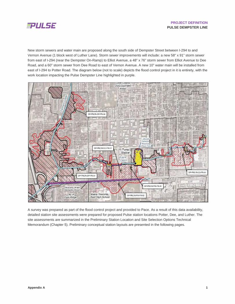
Appendix A 1
PROJECT DEFINITION PULSE DEMPSTER LINE
New storm sewers and water main are proposed along the south side of Dempster Street between I-294 to and Vernon Avenue (1 block west of Luther Lane). Storm sewer improvements will include: a new 58” x 91” storm sewer from east of I-294 (near the Dempster On-Ramp) to Elliot Avenue, a 48” x 76” storm sewer from Elliot Avenue to Dee Road, and a 60” storm sewer from Dee Road to east of Vernon Avenue. A new 10” water main will be installed from east of I-294 to Potter Road. The diagram below (not to scale) depicts the flood control project in it is entirety, with the work location impacting the Pulse Dempster Line highlighted in purple.
A survey was prepared as part of the flood control project and provided to Pace. As a result of this data availability, detailed station site assessments were prepared for proposed Pulse station locations Potter, Dee, and Luther. The site assessments are summarized in the Preliminary Station Location and Site Selection Options Technical Memorandum (Chapter 5). Preliminary conceptual station layouts are presented in the following pages.

PROJECT DEFINITION PULSE DEMPSTER LINE
Appendix B HISTORIC RESOURCES REVIEW LOCATION DATA

Appendix B 1
PROJECT DEFINITION PULSE DEMPSTER LINE
Bolded text highlights HARGIS properties with multiple street addresses associated with a single listed property and the single street address used to geocode the property.
Rows with grey banded rows highlights HARGIS properties with misspelled or otherwise incorrect street addresses and the edited street address used to geocode the property.
HISTORIC RESOURCES REVIEW LOCATION DATA
ID # HARGIS Street Address Cook County Street Address National Register (NR) Status HARGIS
Reference #
1 707 S. Center 707 Center St Undetermined 153496
2 766 Graceland Avenue 766 Graceland Ave Determined eligible for the NR 153500
3 1085 W. Walnut 1085 E Walnut Ave Undetermined 153503
4 725 Des Plaines River Road 725 S Des Plaines River Rd Undetermined 153651
5 Des Plaines River Rd. at Miner S Des Plaines River Rd & Miner St
Undetermined 153652
6 1702 Mill St. 1702 Mill St Undetermined 153655
7 796 S. Center 796 Center St Undetermined 153658
8 1700 Asbury 1700 Asbury Ave Part of a NR Historic District 154250
9 1520 Chicago 1520 Chicago Ave Undetermined 154267
10 918 Clark 918 Clark St Undetermined 154270
11 816 Clark St. 816 Clark St Undetermined 154271
12 1322 Davis 1322 Davis St Part of a NR Historic District 154287
13 1416 Elinor Place 1416 Elinor Pl Part of a NR Historic District 154292
14 1308 Elmwood 1308 Elmwood Ave Undetermined 154294
15 1207 Greenleaf 1207 Greenleaf St Part of a NR Historic District 154325
16 1215 Lake 1215 Lake St Part of a NR Historic District 154395
17 1419 Lake 1419 Lake St Undetermined 154398
18 1613 Lake 1613 Lake St Undetermined 154399
19 1802 Maple 1802 Maple Ave Undetermined 154424
20 1028 Clark 1028 Clark St Undetermined 154426
21 1450-1456 Oak & 1101-1111 Lake
1450 Oak Ave Undetermined 154445
22 1700 Ridge 1700 Ridge Ave Part of a NR Historic District 154482
23 1578 Sherman 1578 Sherman Ave Undetermined 154519
24 1830 Sherman 1830 Sherman Ave Undetermined 154521
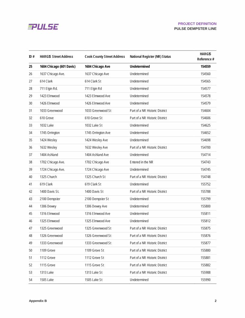
Appendix B 2
PROJECT DEFINITION PULSE DEMPSTER LINE
ID # HARGIS Street Address Cook County Street Address National Register (NR) Status HARGIS
Reference #
25 1604 Chicago (601 Davis) 1604 Chicago Ave Undetermined 154559
26 1637 Chicago Ave. 1637 Chicago Ave Undetermined 154560
27 614 Clark 614 Clark St Undetermined 154565
28 711 Elgin Rd. 711 Elgin Rd Undetermined 154577
29 1423 Elmwood 1423 Elmwood Ave Undetermined 154578
30 1426 Elmwood 1426 Elmwood Ave Undetermined 154579
31 1033 Greenwood 1033 Greenwood St Part of a NR Historic District 154604
32 610 Grove 610 Grove St Part of a NR Historic District 154606
33 1032 Lake 1032 Lake St Undetermined 154625
34 1745 Orrington 1745 Orrington Ave Undetermined 154652
35 1424 Wesley 1424 Wesley Ave Undetermined 154698
36 1632 Wesley 1632 Wesley Ave Part of a NR Historic District 154700
37 1404 Ashland 1404 Ashland Ave Undetermined 154714
38 1702 Chicago Ave. 1702 Chicago Ave Entered in the NR 154743
39 1724 Chicago Ave. 1724 Chicago Ave Undetermined 154745
40 1325 Church 1325 Church St Part of a NR Historic District 154748
41 619 Clark 619 Clark St Undetermined 155752
42 1400 Davis St. 1400 Davis St Part of a NR Historic District 155788
43 2100 Dempster 2100 Dempster St Undetermined 155799
44 1306 Dewey 1306 Dewey Ave Undetermined 155800
45 1316 Elmwood 1316 Elmwood Ave Undetermined 155811
46 1325 Elmwood 1325 Elmwood Ave Undetermined 155812
47 1325 Greenwood 1325 Greenwood St Part of a NR Historic District 155875
48 1326 Greenwood 1326 Greenwood St Part of a NR Historic District 155876
49 1333 Greenwood 1333 Greenwood St Part of a NR Historic District 155877
50 1109 Grove 1109 Grove St Part of a NR Historic District 155880
51 1112 Grove 1112 Grove St Part of a NR Historic District 155881
52 1115 Grove 1115 Grove St Part of a NR Historic District 155882
53 1313 Lake 1313 Lake St Part of a NR Historic District 155988
54 1505 Lake 1505 Lake St Undetermined 155990

Appendix B 3
PROJECT DEFINITION PULSE DEMPSTER LINE
ID # HARGIS Street Address Cook County Street Address National Register (NR) Status HARGIS
Reference #
55 1621 Lake 1621 Lake St Undetermined 155991
56 1712 Oak 1712 Oak Ave Undetermined 156111
57 1450 Pitner 1450 Pitner Ave Undetermined 156141
58 1407 Ridge 1407 Ridge Ave Part of a NR Historic District 156158
59 1563 Sherman 1563 Sherman Ave Undetermined 156211
60 8970 N. Milwaukee Ave. 8970 N Milwaukee Ave Undetermined 157434
61 901 Davis 901 Davis St Undetermined 163565
62 1000 Grove 1000 Grove St Undetermined 163566
63 1314 Ridge Ave. 1314 Ridge Ave Entered in the NR 200192
64 1703--1713 Ridge Ave. 1703 Ridge Ave Entered in the NR 200193
65 1730 Chicago Ave. 1730 Chicago Ave Entered in the NR 200495
66 5001 Dempster St. 5001 Dempster St Entered in the NR 201160
67 1209-1217 Maple Ave. 1209 Maple Ave Entered in the NR 201241
68 1316 Maple Ave. 1316 Maple Ave Entered in the NR 201244
69 1401-1407 Elmwood Ave. 1401 Elmwood Ave Entered in the NR 201245
70 1505-1509 Oak Ave. 1505 Oak Ave Entered in the NR 201258
71 1627-1645 Ridge Ave., 1124-1136 Church St.
1627 Ridge Ave Entered in the NR 201276
72 1115-1133 Maple Ave. 1115 Maple Ave Entered in the NR 201499
73 1615-1625 Ridge Ave. 1615 Ridge Ave Entered in the NR 201504
74 1112 Grove St. 1112 Grove St Entered in the NR 201506
75 1603-1611 Ridge Ave. and 1125 Davis St.
1603 Ridge Ave Entered in the NR 201507
76 1450--1456 Oak Ave. and 1101-1111 Lake St.
1450 Oak Ave Entered in the NR 201539
77 614 Clark St. 614 Clark St Entered in the NR 201545
78 1112 Asbury Ave. 1112 Asbury Ave Part of a NR Historic District - contributing 208102
79 1117 Asbury Ave. 1117 Asbury Ave Part of a NR Historic District - contributing 208103
80 1120 Asbury Ave. 1120 Asbury Ave Part of a NR Historic District - contributing 208104
81 1124 Asbury Ave. 1124 Asbury Ave Part of a NR Historic District - contributing 208105
82 1141 Asbury Ave. 1141 Asbury Ave Part of a NR Historic District - contributing 208106

Appendix B 4
PROJECT DEFINITION PULSE DEMPSTER LINE
ID # HARGIS Street Address Cook County Street Address National Register (NR) Status HARGIS
Reference #
83 1231 Asbury Ave. 1231 Asbury Ave Part of a NR Historic District - contributing 208107
84 1232 Asbury Ave. 1232 Asbury Ave Part of a NR Historic District - contributing 208108
85 1239 Asbury Ave. 1239 Asbury Ave Part of a NR Historic District - contributing 208109
86 1404 Asbury Ave. 1404 Asbury Ave Part of a NR Historic District - contributing 208115
87 1454 Asbury Ave. 1454 Asbury Ave Part of a NR Historic District - contributing 208116
88 1459 Asbury Ave. 1459 Asbury Ave Part of a NR Historic District - contributing 208117
89 1460 Asbury Ave. 1460 Asbury Ave Part of a NR Historic District - contributing 208118
90 1501 Asbury Ave. 1501 Asbury Ave Part of a NR Historic District - contributing 208119
91 1512 Asbury Ave. 1512 Asbury Ave Part of a NR Historic District - contributing 208120
92 1513 Asbury Ave. 1513 Asbury Ave Part of a NR Historic District - contributing 208121
93 1710 Asbury Ave. 1710 Asbury Ave Part of a NR Historic District - contributing 208122
94 1714 Asbury Ave. 1714 Asbury Ave Part of a NR Historic District - contributing 208123
95 1720 Asbury Ave. 1720 Asbury Ave Part of a NR Historic District - contributing 208124
96 1723 Asbury Ave. 1723 Asbury Ave Part of a NR Historic District - contributing 208125
97 1724 Asbury Ave. 1724 Asbury Ave Part of a NR Historic District - contributing 208126
98 1733 Asbury Ave. 1733 Asbury Ave Part of a NR Historic District - contributing 208127
99 1734 Asbury Ave. 1734 Asbury Ave Part of a NR Historic District - contributing 208128
100 1742 Asbury Ave. 1742 Asbury Ave Part of a NR Historic District - contributing 208129
101 1800 Asbury Ave. 1800 Asbury Ave Part of a NR Historic District - contributing 208130
102 1812 Asbury Ave. 1812 Asbury Ave Part of a NR Historic District - contributing 208131
103 1817 Asbury Ave. 1817 Asbury Ave Part of a NR Historic District - contributing 208132
104 1833 Asbury Ave. 1833 Asbury Ave Part of a NR Historic District - contributing 208133
105 1416 Church Street 1416 Church St Part of a NR Historic District - contributing 208145
106 1215 Church Street 1215 Church St Part of a NR Historic District - contributing 208146
107 1312 Church Street 1312 Church St Part of a NR Historic District - contributing 208147
108 1316 Church Street 1316 Church St Part of a NR Historic District - contributing 208148
109 1416 Church Street 1416 Church St Part of a NR Historic District - contributing 208151
110 1220 Crain Street 1220 Crain St Part of a NR Historic District - contributing 208152
111 1233 Crain Street 1233 Crain St Part of a NR Historic District - contributing 208153
112 1319 Crain Street 1319 Crain St Part of a NR Historic District - contributing 208154

Appendix B 5
PROJECT DEFINITION PULSE DEMPSTER LINE
ID # HARGIS Street Address Cook County Street Address National Register (NR) Status HARGIS
Reference #
113 1300 Davis Street 1300 Davis St Part of a NR Historic District - contributing 208155
114 1302 Davis Street 1302 Davis St Part of a NR Historic District - contributing 208156
115 1306 Davis Street 1306 Davis St Part of a NR Historic District - contributing 208157
116 1315 Davis Street 1315 Davis St Part of a NR Historic District - contributing 208158
117 1316 Davis Street 1316 Davis St Part of a NR Historic District - contributing 208159
118 1132 Davis Street 1132 Davis St Part of a NR Historic District - contributing 208160
119 1401 Davis Street 1401 Davis St Part of a NR Historic District - contributing 208161
120 1606 Wesley Ave. 1606 Wesley Ave Part of a NR Historic District - contributing 208162
121 910 Dempster Street 910 Dempster St Part of a NR Historic District - contributing 208163
122 1311 Dempster Ave. 1311 Dempster St Part of a NR Historic District - contributing 208164
123 1415 Elinor Place 1415 Elinor Pl Part of a NR Historic District - contributing 208165
124 1416 Elinor Place 1416 Elinor Pl Part of a NR Historic District - contributing 208166
125 1207 Greenleaf Street 1207 Greenleaf St Part of a NR Historic District - contributing 208168
126 1215 Greenleaf Street 1215 Greenleaf St Part of a NR Historic District - contributing 208169
127 1015 Greenwood Street 1015 Greenwood St Part of a NR Historic District - contributing 208170
128 1022 Greenwood Street 1022 Greenwood St Part of a NR Historic District - contributing 208171
129 1112 Greenwood Street 1112 Greenwood St Part of a NR Historic District - contributing 208172
130 1100 Lake Street 1100 Lake St Part of a NR Historic District - contributing 208173
131 1316 Lake Street 1316 Lake St Part of a NR Historic District - contributing 208174
132 1319 Lake Street 1319 Lake St Part of a NR Historic District - contributing 208175
133 1322 Lake Street 1322 Lake St Part of a NR Historic District - contributing 208176
134 1327 Lake Street 1327 Lake St Part of a NR Historic District - contributing 208177
135 1330 Lake Street 1330 Lake St Part of a NR Historic District - contributing 208178
136 1403 Maple Ave. 1403 Maple Ave Part of a NR Historic District - contributing 208185
137 1411 Maple 1411 Maple Ave Part of a NR Historic District 208186
138 1415 Maple 1415 Maple Ave Part of a NR Historic District 208187
139 1425 Maple Ave. 1425 Maple Ave Part of a NR Historic District - contributing 208188
140 1106 Oak Ave. 1106 Oak Ave Part of a NR Historic District - contributing 208190
141 1119 Oak Ave. 1119 Oak Ave Part of a NR Historic District - contributing 208191
142 1115 Oak Ave. 1115 Oak Ave Part of a NR Historic District - contributing 208192

Appendix B 6
PROJECT DEFINITION PULSE DEMPSTER LINE
ID # HARGIS Street Address Cook County Street Address National Register (NR) Status HARGIS
Reference #
143 1118 Oak Ave. 1118 Oak Ave Part of a NR Historic District - contributing 208193
144 1401 Oak Ave. 1401 Oak Ave Part of a NR Historic District - contributing 208195
145 1417 Oak Ave. 1417 Oak Ave Part of a NR Historic District - contributing 208196
146 1421 Oak Ave. 1421 Oak Ave Part of a NR Historic District - contributing 208198
147 1560 Oak Ave. 1560 Oak Ave Part of a NR Historic District - contributing 208199
148 1100 Ridge Ave. 1100 Ridge Ave Part of a NR Historic District - contributing 208207
149 1101 Ridge Ave. 1101 Ridge Ave Part of a NR Historic District - contributing 208208
150 1123 Ridge Ave 1123 Ridge Ave Part of a NR Historic District - contributing 208209
151 1128 Ridge Ave. 1128 Ridge Ave Part of a NR Historic District - contributing 208210
152 1307 Ridge Ave. 1307 Ridge Ave Part of a NR Historic District - contributing 208214
153 1313 Ridge Ave. 1313 Ridge Ave Part of a NR Historic District - contributing 208215
154 1456 Ridge Ave. 1456 Ridge Ave Part of a NR Historic District - contributing 208217
155 1461 Ridge Ave. 1461 Ridge Ave Part of a NR Historic District - contributing 208218
156 1462 Ridge Ave. 1462 Ridge Ave Part of a NR Historic District - contributing 208219
157 1622 Ridge Ave. 1622 Ridge Ave Part of a NR Historic District - contributing 208221
158 1628 Ridge Ave. 1628 Ridge Ave Part of a NR Historic District - contributing 208222
159 1601 Wesley Ave. 1601 Wesley Ave Part of a NR Historic District - contributing 208223
160 1606 Wesley Ave. 1606 Wesley Ave Part of a NR Historic District - contributing 208224
161 1612 Wesley Ave. 1612 Wesley Ave Part of a NR Historic District - contributing 208225
162 1621 Wesley Ave. 1621 Wesley Ave Part of a NR Historic District - contributing 208226
163 1624 Wesley Ave. 1624 Wesley Ave Part of a NR Historic District - contributing 208227
164 1627 Wesley Ave. 1627 Wesley Ave Part of a NR Historic District - contributing 208228
165 1743 Wesley Ave. 1743 Wesley Ave Part of a NR Historic District - contributing 208229
166 1632 Wesley Ave. 1632 Wesley Ave Part of a NR Historic District - contributing 208231
167 1127 Asbury Ave. 1127 Asbury Ave Part of a NR Historic District - contributing 208232
168 1133 Asbury Ave. 1133 Asbury Ave Part of a NR Historic District - contributing 208233
169 1135 Asbury Ave. 1135 Asbury Ave Part of a NR Historic District - contributing 208234
170 1144 Asbury Ave. 1144 Asbury Ave Part of a NR Historic District - contributing 208235
171 1145 Asbury Ave. 1145 Asbury Ave Part of a NR Historic District - contributing 208236
172 1204 Asbury Ave. 1204 Asbury Ave Part of a NR Historic District - contributing 208237

Appendix B 7
PROJECT DEFINITION PULSE DEMPSTER LINE
ID # HARGIS Street Address Cook County Street Address National Register (NR) Status HARGIS
Reference #
173 1218 Asbury Ave. 1218 Asbury Ave Part of a NR Historic District - contributing 208238
174 1222 Asbury Ave. 1222 Asbury Ave Part of a NR Historic District - contributing 208239
175 1236 Asbury Ave. 1236 Asbury Ave Part of a NR Historic District - contributing 208240
176 1242 Asbury Ave. 1242 Asbury Ave Part of a NR Historic District - contributing 208241
177 1250 Asbury Ave. 1250 Asbury Ave Part of a NR Historic District - contributing 208242
178 1410 Asbury Ave. 1410 Asbury Ave Part of a NR Historic District - contributing 208246
179 1416 Asbury Ave. 1416 Asbury Ave Part of a NR Historic District - contributing 208247
180 1430 Asbury Ave. 1430 Asbury Ave Part of a NR Historic District - contributing 208248
181 1432 Asbury Ave. 1432 Asbury Ave Part of a NR Historic District - contributing 208249
182 1500 Asbury Ave. 1500 Asbury Ave Part of a NR Historic District - contributing 208250
183 1509 Asbury Ave. 1509 Asbury Ave Part of a NR Historic District - contributing 208251
184 1564 Asbury Ave. 1564 Asbury Ave Part of a NR Historic District - contributing 208252
185 1570 Asbury Ave. 1570 Asbury Ave Part of a NR Historic District - contributing 208253
186 1574 Asbury Ave. 1574 Asbury Ave Part of a NR Historic District - contributing 208254
187 1700 Asbury Ave. 1700 Asbury Ave Part of a NR Historic District - contributing 208255
188 1713 Asbury Ave. 1713 Asbury Ave Part of a NR Historic District - contributing 208256
189 1719 Asbury Ave. 1719 Asbury Ave Part of a NR Historic District - contributing 208257
190 1735 Asbury Ave. 1735 Asbury Ave Part of a NR Historic District - contributing 208258
191 1801 Asbury Ave. 1801 Asbury Ave Part of a NR Historic District - contributing 208259
192 1820 Asbury Ave. 1820 Asbury Ave Part of a NR Historic District - contributing 208260
193 1821 Asbury Ave. 1821 Asbury Ave Part of a NR Historic District - contributing 208261
194 1825 Asbury Ave. 1825 Asbury Ave Part of a NR Historic District - contributing 208262
195 1827 Asbury Ave. 1827 Asbury Ave Part of a NR Historic District - contributing 208263
196 1832 Asbury Ave. 1832 Asbury Ave Part of a NR Historic District - contributing 208264
197 1837 Asbury Ave. 1837 Asbury Ave Part of a NR Historic District - contributing 208265
198 1214 Church Street 1214 Church St Part of a NR Historic District - contributing 208276
199 1217 Church Street 1217 Church St Part of a NR Historic District - contributing 208277
200 1314 Church Street 1314 Church St Part of a NR Historic District - contributing 208278
201 1414 Church Street 1414 Church St Part of a NR Historic District - contributing 208279
202 1415 Church Street 1415 Church St Part of a NR Historic District - contributing 208280

Appendix B 8
PROJECT DEFINITION PULSE DEMPSTER LINE
ID # HARGIS Street Address Cook County Street Address National Register (NR) Status HARGIS
Reference #
203 1332 Davis Street 1332 Davis St Part of a NR Historic District - contributing 208282
204 1326 Davis Street 1326 Davis St Part of a NR Historic District - contributing 208283
205 1411 Davis Street 1411 Davis St Part of a NR Historic District - contributing 208284
206 1415 Davis Street 1415 Davis St Part of a NR Historic District - contributing 208285
207 1414 Davis Street 1414 Davis St Part of a NR Historic District - contributing 208286
208 1420 Davis Street 1420 Davis St Part of a NR Historic District - contributing 208287
209 1425 Davis Street 1425 Davis St Part of a NR Historic District - contributing 208288
210 1030 Dempster Street 1030 Dempster St Part of a NR Historic District - contributing 208289
211 1402 Elinor Place 1402 Elinor Pl Part of a NR Historic District - contributing 208290
212 1421 Elinor Place 1421 Elinor Pl Part of a NR Historic District - contributing 208291
213 1424 Elinor Place 1424 Elinor Pl Part of a NR Historic District - contributing 208292
214 1225 Greenleaf Street 1225 Greenleaf St Part of a NR Historic District - contributing 208293
215 925 Greenwood Street 925 Greenwood St Part of a NR Historic District - contributing 208294
216 1004 Greenwood Street 1004 Greenwood St Part of a NR Historic District - contributing 208295
217 1021 Greenwood Street 1021 Greenwood St Part of a NR Historic District - contributing 208296
218 1027 Greenwood Street 1027 Greenwood St Part of a NR Historic District - contributing 208297
219 1028 Greenwood Street 1028 Greenwood St Part of a NR Historic District - contributing 208298
220 1104 Grenwood Street 1104 Greenwood St Part of a NR Historic District - contributing 208299
221 1314 Greenwood Street 1314 Greenwood St Part of a NR Historic District - contributing 208300
222 1109 Grove Street 1109 Grove St Part of a NR Historic District - contributing 208301
223 1111 Grove Street 1111 Grove St Part of a NR Historic District - contributing 208302
224 1115 Grove Street 1115 Grove St Part of a NR Historic District - contributing 208303
225 1012 Lake Street 1012 Lake St Part of a NR Historic District - contributing 208304
226 1110 Lake Street 1110 Lake St Part of a NR Historic District - contributing 208305
227 1112 Lake Street 1112 Lake St Part of a NR Historic District - contributing 208306
228 1115 Lake Street 1115 Lake St Part of a NR Historic District - contributing 208307
229 1118 Lake Street 1118 Lake St Part of a NR Historic District - contributing 208308
230 1120 Lake Street 1120 Lake St Part of a NR Historic District - contributing 208310
231 1313 Lake Street 1313 Lake St Part of a NR Historic District - contributing 208311
232 1317 Lyons Street 1317 Lyons St Part of a NR Historic District - contributing 208317

Appendix B 9
PROJECT DEFINITION PULSE DEMPSTER LINE
ID # HARGIS Street Address Cook County Street Address National Register (NR) Status HARGIS
Reference #
233 1421 Maple Ave. 1421 Maple Ave Part of a NR Historic District - contributing 208331
234 1223 Oak Ave. 1223 Oak Ave Part of a NR Historic District - contributing 208332
235 1229 Oak Ave. 1229 Oak Ave Part of a NR Historic District - contributing 208333
236 1110 Ridge Ave. 1110 Ridge Ave Part of a NR Historic District - contributing 208347
237 1131 Ridge Ave. 1131 Ridge Ave Part of a NR Historic District - contributing 208348
238 1147 Ridge Ave. 1147 Ridge Ave Part of a NR Historic District - contributing 208349
239 1319 Ridge Ave. 1319 Ridge Ave Part of a NR Historic District - contributing 208353
240 1333 Ridge Ave. 1333 Ridge Ave Part of a NR Historic District - contributing 208354
241 1425 Ridge Ave. 1425 Ridge Ave Part of a NR Historic District - contributing 208355
242 1431 Ridge Ave. 1431 Ridge Ave Part of a NR Historic District - contributing 208356
243 1453 Ridge Ave. 1453 Ridge Ave Part of a NR Historic District - contributing 208357
244 1571 Wesley Ave. 1571 Wesley Ave Part of a NR Historic District - contributing 208359
245 1584 Wesley Ave. 1584 Wesley Ave Part of a NR Historic District - contributing 208360
246 1710 Wesley Ave. 1710 Wesley Ave Part of a NR Historic District - contributing 208361
247 1721 Wesley Ave. 1721 Wesley Ave Part of a NR Historic District - contributing 208362
248 1724 Wesley Ave. 1724 Wesley Ave Part of a NR Historic District - contributing 208363
249 1727 Wesley Ave. 1727 Wesley Ave Part of a NR Historic District - contributing 208364
250 1731 Wesley Ave. 1731 Wesley Ave Part of a NR Historic District - contributing 208365
251 1735 Wesley Ave. 1735 Wesley Ave Part of a NR Historic District - contributing 208366
252 1745 Wesley Ave. 1745 Wesley Ave Part of a NR Historic District - contributing 208367
253 1314 Wilder Street 1314 Wilder St Part of a NR Historic District - contributing 208368
254 1240 Asbury Ave. 1240 Asbury Ave Part of a NR Historic District - non-contributing 208369
255 1426 Asbury Ave. 1426 Asbury Ave Part of a NR Historic District - non-contributing 208370
256 1620 Asbury Ave. 1620 Asbury Ave Part of a NR Historic District - non-contributing 208371
257 1625 Asbury Ave. 1625 Asbury Ave Part of a NR Historic District - non-contributing 208372
258 1629 Asbury Ave. 1629 Asbury Ave Part of a NR Historic District - non-contributing 208373
259 1633 Asbury Ave. 1633 Asbury Ave Part of a NR Historic District - non-contributing 208374
260 1807 Asbury Ave. 1807 Asbury Ave Part of a NR Historic District - non-contributing 208375
261 1809 Asbury Ave. 1809 Asbury Ave Part of a NR Historic District - non-contributing 208376
262 1815 Asbury Ave. 1815 Asbury Ave Part of a NR Historic District - non-contributing 208377

Appendix B 10
PROJECT DEFINITION PULSE DEMPSTER LINE
ID # HARGIS Street Address Cook County Street Address National Register (NR) Status HARGIS
Reference #
263 1828 Asbury Ave. 1828 Asbury Ave Part of a NR Historic District - non-contributing 208378
264 1841 Asbury Ave. 1841 Asbury Ave Part of a NR Historic District - non-contributing 208379
265 1843 Asbury Ave. 1843 Asbury Ave Part of a NR Historic District - non-contributing 208380
266 1411 Church Street 1411 Church St Part of a NR Historic District - non-contributing 208386
267 1011 Crain Street 1011 Crain St Part of a NR Historic District - non-contributing 208387
268 1016 Dempster Street 1016 Dempster St Part of a NR Historic District - non-contributing 208388
269 1020 Dempster Street 1020 Dempster St Part of a NR Historic District - non-contributing 208389
270 1024 Dempster Street 1024 Dempster St Part of a NR Historic District - non-contributing 208390
271 1028 Dempster Street 1028 Dempster St Part of a NR Historic District - non-contributing 208391
272 1104 Dempster Street 1104 Dempster St Part of a NR Historic District - non-contributing 208393
273 1106 Dempster Street 1106 Dempster St Part of a NR Historic District - non-contributing 208394
274 1221 Greenleaf Street 1221 Greenleaf St Part of a NR Historic District - non-contributing 208396
275 1215 Lake Street 1215 Lake St Part of a NR Historic District - non-contributing 208397
276 1323 Lake Street 1323 Lake St Part of a NR Historic District - non-contributing 208398
277 1217 Oak Ave. 1217 Oak Ave Part of a NR Historic District - non-contributing 208402
278 1219 Oak Ave. 1219 Oak Ave Part of a NR Historic District - non-contributing 208403
279 1224 Oak Ave. 1224 Oak Ave Part of a NR Historic District - non-contributing 208404
280 1225 Oak Ave. 1225 Oak Ave Part of a NR Historic District - non-contributing 208405
281 1228 Oak Ave. 1228 Oak Ave Part of a NR Historic District - non-contributing 208406
282 1231 Oak Ave. 1231 Oak Ave Part of a NR Historic District - non-contributing 208407
283 1234 Oak Ave. 1234 Oak Ave Part of a NR Historic District - non-contributing 208408
284 1236 Oak Ave. 1236 Oak Ave Part of a NR Historic District - non-contributing 208410
285 1239 Oak Ave. 1239 Oak Ave Part of a NR Historic District - non-contributing 208412
286 1139 Ridge Ave. 1139 Ridge Ave Part of a NR Historic District - non-contributing 208415
287 1457 Ridge Ave. 1457 Ridge Ave Part of a NR Historic District - non-contributing 208417
288 1577 Wesley Ave. 1577 Wesley Ave Part of a NR Historic District - non-contributing 208418
289 1618 Wesley Ave. 1618 Wesley Ave Part of a NR Historic District - non-contributing 208419
290 1702 Wesley Ave. 1702 Wesley Ave Part of a NR Historic District - non-contributing 208420
291 1715 Wesley Ave. 1715 Wesley Ave Part of a NR Historic District - non-contributing 208421
292 1720 Wesley Ave. 1720 Wesley Ave Part of a NR Historic District - non-contributing 208422

Appendix B 11
PROJECT DEFINITION PULSE DEMPSTER LINE
ID # HARGIS Street Address Cook County Street Address National Register (NR) Status HARGIS
Reference #
293 1123 Asbury Ave. 1123 Asbury Ave Part of a NR Historic District - non-contributing 208423
294 1212 Asbury Ave. 1212 Asbury Ave Part of a NR Historic District - non-contributing 208424
295 1225 Asbury Ave. 1225 Asbury Ave Part of a NR Historic District - non-contributing 208425
296 1418 Asbury Ave. 1418 Asbury Ave Part of a NR Historic District - non-contributing 208426
297 1464 Asbury Ave. 1464 Asbury Ave Part of a NR Historic District - non-contributing 208427
298 1510 Asbury Ave. 1510 Asbury Ave Part of a NR Historic District - non-contributing 208428
299 1550 Asbury Ave. 1550 Asbury Ave Part of a NR Historic District - non-contributing 208429
300 1560 Asbury Ave. 1560 Asbury Ave Part of a NR Historic District - non-contributing 208430
301 1610 Asbury Ave. 1610 Asbury Ave Part of a NR Historic District - non-contributing 208431
302 1616 Asbury Ave. 1616 Asbury Ave Part of a NR Historic District - non-contributing 208432
303 1202 Crain Street 1202 Crain St Part of a NR Historic District - non-contributing 208435
304 1204 Crain Street 1204 Crain St Part of a NR Historic District - non-contributing 208436
305 1205 Crain Street 1205 Crain St Part of a NR Historic District - non-contributing 208437
306 1206 Crain Street 1206 Crain St Part of a NR Historic District - non-contributing 208438
307 1212 Crain Street 1212 Crain St Part of a NR Historic District - non-contributing 208439
308 1201 Croft Lane 1201 Croft Ln Part of a NR Historic District - non-contributing 208440
309 1206 Croft Lane 1206 Croft Ln Part of a NR Historic District - non-contributing 208441
310 1212 Croft Lane 1212 Croft Ln Part of a NR Historic District - non-contributing 208442
311 1215 Croft Lane 1215 Croft Ln Part of a NR Historic District - non-contributing 208443
312 1301 Davis Street 1301 Davis St Part of a NR Historic District - non-contributing 208444
313 1311 Davis Street 1311 Davis St Part of a NR Historic District - non-contributing 208445
314 1314 Davis Street 1314 Davis St Part of a NR Historic District - non-contributing 208446
315 1421 Davis Street 1421 Davis St Part of a NR Historic District - non-contributing 208447
316 1211 Greenleaf Street 1211 Greenleaf St Part of a NR Historic District - non-contributing 208449
317 1005 Greenwood Street 1005 Greenwood St Part of a NR Historic District - non-contributing 208450
318 1014 Greenwood Street 1014 Greenwood St Part of a NR Historic District - non-contributing 208451
319 1018 Greenwood Street 1018 Greenwood St Part of a NR Historic District - non-contributing 208452
320 1207 Greenwood Street 1207 Greenwood St Part of a NR Historic District - non-contributing 208453
321 1215 Greenwood Street 1215 Greenwood St Part of a NR Historic District - non-contributing 208454
322 1219 Greenwood Street 1219 Greenwood St Part of a NR Historic District - non-contributing 208455

Appendix B 12
PROJECT DEFINITION PULSE DEMPSTER LINE
ID # HARGIS Street Address Cook County Street Address National Register (NR) Status HARGIS
Reference #
323 1221 Greenwood Street 1221 Greenwood St Part of a NR Historic District - non-contributing 208456
324 1222 Greenwood Street 1222 Greenwood St Part of a NR Historic District - non-contributing 208457
325 1223 Greenwood Street 1223 Greenwood St Part of a NR Historic District - non-contributing 208458
326 1225 Greenwood Street 1225 Greenwood St Part of a NR Historic District - non-contributing 208459
327 1227 Greenwood Street 1227 Greenwood St Part of a NR Historic District - non-contributing 208460
328 1311 Grove Street 1311 Grove St Part of a NR Historic District - non-contributing 208461
329 1210 Lake Street 1210 Lake St Part of a NR Historic District - non-contributing 208462
330 1218 Lake Street 1218 Lake St Part of a NR Historic District - non-contributing 208464
331 1222 Lake Street 1222 Lake St Part of a NR Historic District - non-contributing 208465
332 1224 Lake Street 1224 Lake St Part of a NR Historic District - non-contributing 208466
333 1228 Lake Street 1228 Lake St Part of a NR Historic District - non-contributing 208467
334 1400 Maple Ave. 1400 Maple Ave Part of a NR Historic District - non-contributing 208468
335 1406 Maple Ave. 1406 Maple Ave Part of a NR Historic District - non-contributing 208469
336 1414 Maple Ave. 1414 Maple Ave Part of a NR Historic District - non-contributing 208470
337 1420 Maple Ave. 1420 Maple Ave Part of a NR Historic District - non-contributing 208471
338 1400 Oak Ave. 1400 Oak Ave Part of a NR Historic District - non-contributing 208472
339 1402 Oak Ave. 1402 Oak Ave Part of a NR Historic District - non-contributing 208473
340 1408 Oak Ave. 1408 Oak Ave Part of a NR Historic District - non-contributing 208474
341 1410 Oak Ave. 1410 Oak Ave Part of a NR Historic District - non-contributing 208475
342 1111 Ridge Ave. 1111 Ridge Ave Part of a NR Historic District - non-contributing 208485
343 1116 Ridge Ave. 1116 Ridge Ave Part of a NR Historic District - non-contributing 208486
344 1118 Ridge Ave. 1118 Ridge Ave Part of a NR Historic District - non-contributing 208487
345 1120 Ridge Ave. 1120 Ridge Ave Part of a NR Historic District - non-contributing 208488
346 1330 Ridge Ave. 1330 Ridge Ave Part of a NR Historic District - non-contributing 208492
347 1408 Ridge Ave. 1408 Ridge Ave Part of a NR Historic District - non-contributing 208493
348 1414 Ridge Ave. 1414 Ridge Ave Part of a NR Historic District - non-contributing 208494
349 1420 Ridge Ave. 1420 Ridge Ave Part of a NR Historic District - non-contributing 208495
350 1426 Ridge Ave. 1426 Ridge Ave Part of a NR Historic District - non-contributing 208496
351 1430 Ridge Ave. 1430 Ridge Ave Part of a NR Historic District - non-contributing 208497
352 1501 Ridge Ave 1501 Ridge Ave Part of a NR Historic District - non-contributing 208498

Appendix B 13
PROJECT DEFINITION PULSE DEMPSTER LINE
ID # HARGIS Street Address Cook County Street Address National Register (NR) Status HARGIS
Reference #
353 1551 Wesley Ave. 1551 Wesley Ave Part of a NR Historic District - non-contributing 208499
354 1570 Wesley Ave. 1570 Wesley Ave Part of a NR Historic District - non-contributing 208500
355 1578 Wesley Ave. 1578 Wesley Ave Part of a NR Historic District - non-contributing 208501
356 1730R Chicago Ave. 1730 Chicago Ave Entered in the NR 219400
357 Ellinwood & Pearson Ellinwood St & Pearson St Undetermined 305542
358 777 Lee St. 777 Lee St Undetermined 305543
359 1400 Wesley 1400 Wesley Ave Undetermined 305554

PROJECT DEFINITION PULSE DEMPSTER LINE
Appendix C HISTORIC RESOURCES STATION AREA MAPS

I
APPENDIX C-1: DAVIS CTA/METRA STATION
PROJECT DEFINITIONPULSE DEMPSTER LINE
Source: Historical and Architectural Resources Geographic Information System (HARGIS). Accessed on January 7, 2016. Retrieved from http://gis.hpa.state.il.us/hargis/.Basemap: United States Geological Survey. (2012). Accessed on January 6, 2016.
2/10/2016
''
)
Davis
CTA/
Metra S
tation
!
! !
!
!
!
!
!
!
!
!
!
!
!
!
!
!
!
!
!
!
! !!!
!!!
!
!!
!
!!!
!
!
!
!
!
!
!
!
!
!
!
!!!
!
!
!!!!!
!
!
!
!
!!!
!
! !
!
!
!
!!
!!!
!
!!
!
!!
!!!
!!!!! !
!
!
!!
!!!!!!
!
!!!
!!
!
!
!
!
! !
!
!
!
!
!
!!
!
!!
!
!
! !!!
!!
!!!!
!
!!
!!!!
!
!!
!!!
!!!!
!!
!
!
!
!
!
!!
!!!!
!
!
!
!
!
!
!
!
!
!
!!!
!
!
!
!
!
!
!
!
!
!
!
!
Lyons St
Lake St
Oak
Ave
Juds
on A
ve
Davis St
University Pl
Clark St
Rid
ge A
ve
Church St
Map
le A
ve
Bens
on A
ve
Elgin Rd
Elmwood Ave
Orri
ngto
n Av
e
Sher
man
Ave
Wes
ley A
ve
Hinm
an A
ve
Chica
go A
ve
E Railroad Ave
Sheridan Rd
Asb
ury
St
Church St
Grove St
Lake St
CTA Purple Line
Metra U
P North Line
Grove St
77
194
192
262
264
251
189
205206
163
312
119
159 114
124
354
258
74
8
9
10 11
12
13
1920
22
23
24
25
26
27
28
32
34
36
38
3940
41
42
50
51
52
56
59
61
62
64
65
71
73
75
939495
9697
9899
100
101
102103
104
106
107108
113
115
116
117118
120
123
147
157
158
160161162
164
165
166
184
185
186
187
188
190
191
193
195196
197
198199
200
202
203
204207
211
212
213
222223224
232
244
245
246247
248
249
250
252
256
257
259
260
261
263
265
266
288
289
290291
292
299
300
301
302
313
314
328
353
355
356
298
29789
243135
22916 21
3353
70
76
8788
90
91 92
130
131 132
133
134154155
156182183
225226
227
228
230
231
275
276
287
329
330
331332333
352
Quarter Mile Pulse Station Buffer
Determined eligible for the NR
Entered in the NR
Part of a NR Historic District
Part of a NR Historic District (Contributing)
Part of a NR Historic District (Non-contributing)
Undetermined
George B. Dryden House Historic District
Evanston Lakeshore Historic District
Evanston Ridge Historic District
CTA Rail Lines (Purple, Red, Yellow, Blue)Metra Rail Lines
Note:
Pulse Dempster Line Location Map
250 500 Feet0
'
I
Pulse Dempster Line StationsPulse Dempster Line
(NR) National Register
!
!
!
!
!
!

!
!
!!!
!!
!
!
!
!!!
!!
!
!
!
!
!!!!!!
!
!!
!!!!!!!!!
!
!
!
!
!
!
!
!
!!!
!!!!
!!
!
!!!
!!!!!!!!
!!!!!
!
!
!
!
!!
!!
!
!!!
!
!
!
!
!!
!
!!
!
!!
!!!
!
!!!
!
!!
!!
!
!!
!!
!!!
!!!!!!
!
!
!
!!!
!
!!
!!
!!
!!
!!!
!
!!
!
!
!
!!
!!!
!
!
!!
!!
!
!
!!
!!!!!
!!!!
!!!
!
!!
!
!
!
!
!
!
!
!
!
!
!
!
!
!!!
!
!!!
!
!
!
!
!
!
!
Metra U
P North Line
CTA Purple Line
Ridge Ave
Metra U
P North Line
CTA Purple Line
14
15
16
1718
21
29
30
31
33
35
37
44
45
46
47
48
49
53
5455
58
63
67
68
69
70
72
76
78
79
8081
82
83
84
85
86
8788
89
9091
92
110
111
112
121122
125
126
127
128
129
130
131
132
133
134
135
136
137138
139
140
141
142
143
144
145146
148 149
150151
152
153
154155
156
167
168
169
170
171
172
173 174
175
176
177
178179
180
181
182183
210
214
215
216
217
218
219220
221
225
226
227
228
229
230
231
233
234235
236
237
238
239
240
241
242243
253
254
255
267
268
269
270
271
272273
274
275
276
277
278
279
280
281
282
283284
285
286
287
293
294
295
296
297
298
303
304
305
306
307
308309
310311
316
317
318
319320
321
322
323
324325
326
327
329
330
331
332
333
334
335
336337
338
339
340
341
342343344
345
346
347348
349350
351
352
359
I0.05 0 0.05 Miles
Quarter Mile Pulse Station Buffer
Dempster Stations
Dempster Pulse Line! Determined eligible for the NR
! Entered in the NR
! Part of a NR Historic District
! Part of a NR Historic District (Contributing)
! Part of a NR Historic District (Non-contributing)
! UndeterminedMunicipal BoundaryGeorge B. Dryden House HDEvanston Lakeshore HDEvanston Ridge HD
"
"
"""
""
"
"
"
"""
""
"
"
"
"
""""""
"
""
"""""""""
"
"
"
"
"
"
"
"
"""
""""
""
"
"""
""""""""
"""""
"
"
"
"
""
""
"
"""
"
"
"
"
""
"
""
"
""
"""
"
"""
"
""
""
"
""
""
"""
""""""
"
"
"
"""
"
""
""
""
""
"""
"
""
"
"
"
""
"""
"
"
""
""
"
"
""
"""""
""""
"""
"
""
"
"
"
"
"
"
"
"
"
"
"
"
"
"""
"
"""
"
"
"
"
"
"
"
APPENDIX C-2: RIDGE AVE UP N
orth Line
Purple Line
Ridge Ave
Metra U
P North Line
CTA Purple Line
!
!!!
!
!
!
!
!
!!
!
!!
!
!
!
!
!!!!!!
!
!
!!! !! !!!!
!
!
!
!
!
!
!
!
!!!
!!!!!!
!
!!!
!!!!!
!!!
!!!!!
!
!
!
!
!!
!!
!
!!!
!
!
!
!
!
!
!
! !
!
!
!
!!!
!
!!!
!
! !
!
!
!
!
!
!!
!!!
!!!!!!
!
!
!
!!
!
!
!
!
! !
!
!
!!
!!!
!
!!
!
!
!
!!
!!!
!
!
!!
!
!
!
!
!!
!!!!!
!!!
!!!
!
!
!!
!
!
!
!
!
!
!
!
!
!
!
!
!
!!
!
!
!
!
!
!
!
!
!
!
!
!!
Hamilton St
Grove St
Crain St
Wilder St
Greenwood St
Thelin Ct
Flor
ence
Ave
Lake St
Dempster St
Greenleaf St
Dew
ey A
ve
Asbu
ry A
ve Sherman Pl
Wes
ley A
ve
Ashl
and
Ave
Sher
man
Ave
Dar
row
Ave
Elm
woo
d Av
e
Map
le A
ve
Oak Ave
Ridge Ave
Chicago Ave
298
29789
243
241
323
327
135
325 324
322
229
338
216318
317
319
218
14
46
175
16982
306
310
151 286
344 150
285
274
15
161718 21
29
30
31
33
35
37
44 45
47
48
49
535455
58
63
67
68
69
70
72
76
7879
80
81
8384
85
86
8788
90
91 92
110
111
112
121
122
125126
127
128
129
130131
132
133
134
136
137138
139
140
141
142143
144
145146
148 149
152153
154
155156
167
168
170
171
172
173174
176 177
178179
180181
182183
210
214
215
217
219
220221
225
226227
228
230231
233
234
235
236
237
238
239
240
242
253
254
255
267
268
269270271272273
275276
277 278279
280281
282
283284
287
293
294
295
296
303
304 305
307
308
309
311
316
320
321
326
329330331332
333
334
335336
337
339 340341
342343
345
346
347
348
349
350351
352
359
PROJECT DEFINITIONPULSE DEMPSTER LINE
Quarter Mile Pulse Station Buffer
Determined eligible for the NR
Entered in the NR
Part of a NR Historic District
Part of a NR Historic District (Contributing)
Part of a NR Historic District (Non-contributing)
Undetermined
George B. Dryden House Historic District
Evanston Lakeshore Historic District
Evanston Ridge Historic District
CTA Rail Lines (Purple, Red, Yellow, Blue)Metra Rail Lines
Note:
Pulse Dempster Line Location Map
250 500 Feet0
'
I
Pulse Dempster Line StationsPulse Dempster Line
(NR) National Register
!
!
!
!
!
!
Source: Historical and Architectural Resources Geographic Information System (HARGIS). Accessed on January 7, 2016. Retrieved from http://gis.hpa.state.il.us/hargis/.Basemap: United States Geological Survey. (2012). Accessed on January 6, 2016.
2/10/2016

HARGIS (Historical and Architectural Resources Geographic Information System) properties retrieved from http://gis.hpa.state.il.us/hargis/.NR (National Register)
1/22/2016
S ource : E s ri, D ig ita lG lobe , G eo E ye , i-cubed , E a rth s ta r G e og raph ics , C N E S /A irb us D S , U S D A , U S G S , A E X , G e tm a pp ing , A e rog rid , IG N , IG P, sw iss to po , an d the G IS U se r C o m m un ity
!!
!
!
!
!
!!
!
!
!
!
!
!
!
!
!
!
!
!!
!
!!
!!!
!
!!!
!
!!
!
!
!!!!!
!
!!
!
!
!
!!
!!!
!
!
!!
!!
!
!
!
!!!
!
Dodge Ave
1718
35
37
43
44
47
48
49
53
545557
78
79
80
81
82
83
84
85
86
87
88
89
90
112
122
131
132
133
134
135
167
168
169
170
171
172
173 174
175
176 177
178179
180
181
182
183
221
231
253
254
255
276
293
294
295
296
297
359
I0.05 0 0.05 Miles
Quarter Mile Pulse Station Buffer
Dempster Stations
Dempster Pulse Line! Determined eligible for the NR
! Entered in the NR
! Part of a NR Historic District
! Part of a NR Historic District (Contributing)
! Part of a NR Historic District (Non-contributing)
! UndeterminedMunicipal BoundaryGeorge B. Dryden House HDEvanston Lakeshore HDEvanston Ridge HD
I
Quarter Mile Pulse Station Buffer
Dempster StationsDempster Pulse Line
! Determined eligible for the NR
! Entered in the NR
! Part of a NR Historic District
! Part of a NR Historic District (Contributing)
! Part of a NR Historic District (Non-contributing)
! UndeterminedMunicipal BoundaryGeorge B. Dryden House HDEvanston Lakeshore HDEvanston Ridge HD
0 250 500125 Feet
CTA Rail LinesMetra Rail Lines''
NR = National Register
APPENDIX C-3: DODGE AVE
PROJECT DEFINITIONPULSE DEMPSTER LINE
Source: Historical and Architectural Resources Geographic Information System (HARGIS). Accessed on January 7, 2016. Retrieved from http://gis.hpa.state.il.us/hargis/.Basemap: United States Geological Survey. (2012). Accessed on January 6, 2016.
2/10/2016
Dodge Ave
!!
!
!
!
!
!!
!
!
!
!
!
!
!
!
!
!
!
! !
!
!
!
!!!
!
!!!
!
!
!
!
!
!!!
!
!
!!
!
!
!
!!
!!!
!
!
!!
!!
!
!
!
!!
!
!
298
29789
323
327
135
175
1718
35
37
44
47
48
49
535455
78
80
81
8384
85
86
8788
90
1
112
122
131
132
133
134
170
171
172
173174
176 177
178179
180181
182183
221
231
253
254
255
276
294
295
296
326
332
33
359
43
57
Gre
y Av
e
Grove St
Crain St
Wilder St
Thelin Ct
Flor
ence
Ave
Brow
n Av
e
Lake St
Greenwood St
Greenleaf St
Dew
ey A
ve
Asbu
ry A
ve
Wes
ley A
ve
Ashl
and
Ave
Mc
Dan
iel A
ve
Dar
row
Ave
Dod
ge A
ve
McD
anie
l Ave
Pitn
er A
ve
Fow
ler A
ve
Har
trey
Ave
Dempster St
Quarter Mile Pulse Station Buffer
Determined eligible for the NR
Entered in the NR
Part of a NR Historic District
Part of a NR Historic District (Contributing)
Part of a NR Historic District (Non-contributing)
Undetermined
George B. Dryden House Historic District
Evanston Lakeshore Historic District
Evanston Ridge Historic District
CTA Rail Lines (Purple, Red, Yellow, Blue)Metra Rail Lines
Note:
Pulse Dempster Line Location Map
250 500 Feet0
'
I
Pulse Dempster Line StationsPulse Dempster Line
(NR) National Register
!
!
!
!
!
!

!
Skokie
CTA
Station
CTA Yellow
Line
66
I0.05 0 0.05 Miles
Quarter Mile Pulse Station Buffer
Dempster Stations
Dempster Pulse Line! Determined eligible for the NR
! Entered in the NR
! Part of a NR Historic District
! Part of a NR Historic District (Contributing)
! Part of a NR Historic District (Non-contributing)
! UndeterminedMunicipal BoundaryGeorge B. Dryden House HDEvanston Lakeshore HDEvanston Ridge HD
HARGIS (Historical and Architectural Resources Geographic Information System) properties retrieved from http://gis.hpa.state.il.us/hargis/.NR (National Register)
1/22/2016
S ource : E s ri, D ig ita lG lobe , G eo E ye , i-cubed , E a rth s ta r G e og raph ics , C N E S /A irb us D S , U S D A , U S G S , A E X , G e tm a pp ing , A e rog rid , IG N , IG P, sw iss to po , an d the G IS U se r C o m m un ity
Quarter Mile Pulse Station Buffer
Dempster StationsDempster Pulse Line
! Determined eligible for the NR
! Entered in the NR
! Part of a NR Historic District
! Part of a NR Historic District (Contributing)
! Part of a NR Historic District (Non-contributing)
! UndeterminedMunicipal BoundaryGeorge B. Dryden House HDEvanston Lakeshore HDEvanston Ridge HD
0 250 500125 Feet
CTA Rail LinesMetra Rail Lines''
NR = National Register
I
Skokie
CTA
Station
CTA Yellow
Line
!66
APPENDIX C-4: SKOKIE CTA STATION
PROJECT DEFINITIONPULSE DEMPSTER LINE
Source: Historical and Architectural Resources Geographic Information System (HARGIS). Accessed on January 7, 2016. Retrieved from http://gis.hpa.state.il.us/hargis/.Basemap: United States Geological Survey. (2012). Accessed on January 6, 2016.
2/10/2016
Lecl
aire
Ave
Terminal Ave
Lave
rgne
Ave
Lara
mie
Ave
Lock
woo
d Av
e
US
Hw
y 41
Gros
s Poin
t Rd
Blv
d
Enfield Ave
Conrad St
Crain St
Greenwood St
Suffield Ct
Grove St
Kilp
atric
k Av
e
Lam
on A
ve
Bron
x Av
e Knox
Ave
la C
ross
e Av
e
Carol St
Dempster St
Nile
s C
ente
r Rd
Greenleaf St
Quarter Mile Pulse Station Buffer
Determined eligible for the NR
Entered in the NR
Part of a NR Historic District
Part of a NR Historic District (Contributing)
Part of a NR Historic District (Non-contributing)
Undetermined
George B. Dryden House Historic District
Evanston Lakeshore Historic District
Evanston Ridge Historic District
CTA Rail Lines (Purple, Red, Yellow, Blue)Metra Rail Lines
Note:
Pulse Dempster Line Location Map
250 500 Feet0
'
I
Pulse Dempster Line StationsPulse Dempster Line
(NR) National Register
!
!
!
!
!
!

''
)"
)" )"
)"
)")"
)"
)"
)"
)"
)"
)"
)"
)"
)"
)"
)"
)"
)"
)"
)"
)")")")"
)")")"
)"
)")"
)"
)")" )"
)"
)"
)"
)"
)"
)"
)"
)"
)"
)"
)"
)")")"
)"
)"
)")")")")"
)"
)"
)"
)"
)")")"
)")")"
)")"
)")"
)"
)")")"
)"
)")"
)"
)")"
)")")"
)")")")")" )"
)")"
)")"
)")")")")")"
)"
)")")"
)")"
)"
)"
)"
)")")"
)"
)"
)")"
)"
)")"
)"
)")"
)"
)"
)")")")"
)")"
)")")")"
)"
)")")")"
)")")"
)")")"
)")")"
)")")")"
)")")"
)"
)"
)"
)"
)")")")")")")"
)"
)"
)"
)"
)"
)"
)"
)"
)"
)")")"
)"
)"
)"
)"
)"
)"
)"
)"
)"
)"
)"
)"
Metra U
P North Line
CTA Purple Line
Davis
CTA/
Metra S
tation
Lyons St
Sai
nt M
arks
Ct
Lake St
Oak
Ave
Grove St
Juds
on A
ve
Davis St
University Pl
Clark St
Rid
ge A
ve
Church St
Map
le A
ve
Ben
son
Ave
Elgin Rd
Elmwood Ave
Orri
ngto
n Av
e
She
rman
Ave
Wes
ley
Ave
Hin
man
Ave
Chi
cago
Ave
E Railroad Ave
Sheridan Rd
8
9
10 11
12
13
16
19
20
21
22
23
24
25
26
27
28
32
33
34
36 3839
40
41
42
5051
52
53
56
59
61
62
64
65
70
71
73
75
7687
88
89 90
91 92
93
9495
96 97
9899
100
101
102103
104
106
107108
113
115
116
117
118
120
123
130
131
133135
147
154
155156
157
158
160161
162
164
165
166
182183
184185
186
187
188
190
191
193195
196
197
198
199200
202
203
204
207
211
212
213
222
223
224
225226
228229
230
231
232
244
245
246 247
248249 250
252
256257
259
260
261
263 265
266
275276
287
288
289
290
291
292
297
298
299
300
301302
313
314
328
329
330
331 333
352
353
355
356
Quarter Mile Pulse Station Buffer
Dempster StationsDempster Pulse Line
! Determined eligible for the NR
! Entered in the NR
! Part of a NR Historic District
! Part of a NR Historic District (Contributing)
! Part of a NR Historic District (Non-contributing)
! UndeterminedMunicipal BoundaryGeorge B. Dryden House HDEvanston Lakeshore HDEvanston Ridge HD
0 250 500125 Feet
CTA Rail LinesMetra Rail Lines''
NR = National Register
I
'
Des Plai
nes M
etra S
tation
Metra N
orth Central Service Line
Metra UP Northwest Line
1
2
4
5
6
7
357
358
!
!
!
!
!
!
!
!
Wes
tern
Ave
Oak
St
Dempster St
Marion StId
a St
Rand Rd
Market St
Dempster St
1st Ave
Alle
s Av
e
Met
ropo
litan
Way
Jefferson St
Joseph Schwab Rd
Mill St
S River R
d
Laur
el Av
e
Arlington Ave
River St
Grac
eland
Ave
E Northwest HwyParsons Ave
Brown St
Perry St
Pear
son
St
Prairie Ave
Wils
on L
n
Ellinwood Ave
Miner St
Lee
StCe
nter
St
Webford Ave
Thacker St
Busse Hwy
APPENDIX C-5: DES PLAINES METRA STATION
PROJECT DEFINITIONPULSE DEMPSTER LINE
Source: Historical and Architectural Resources Geographic Information System (HARGIS). Accessed on January 7, 2016. Retrieved from http://gis.hpa.state.il.us/hargis/.Basemap: United States Geological Survey. (2012). Accessed on January 6, 2016.
2/10/2016
Quarter Mile Pulse Station Buffer
Determined eligible for the NR
Entered in the NR
Part of a NR Historic District
Part of a NR Historic District (Contributing)
Part of a NR Historic District (Non-contributing)
Undetermined
George B. Dryden House Historic District
Evanston Lakeshore Historic District
Evanston Ridge Historic District
CTA Rail Lines (Purple, Red, Yellow, Blue)Metra Rail Lines
Note:
Pulse Dempster Line Location Map
250 500 Feet0
'
I
Pulse Dempster Line StationsPulse Dempster Line
(NR) National Register
!
!
!
!
!
!

PROJECT DEFINITION PULSE DEMPSTER LINE
Appendix D DES PLAINES MEMORIALS LOCATION MAP

Plai
nfie
ld D
r
Lynd
on A
ve
Jarvis Ave
Fargo St
Betty Ct
Ann Ct
Carol Ct
Doris Ct
Ethel Ct
Spru
ce A
ve
Ash
St
Pine
St
Sherwin Ave
S C
hest
nut S
tC
hest
nut S
t
Greco Ave
E Touhy AveState Rte 72
Frontage Rd
Lunt StLunt Ave
Barry
St
Lee St
Web
ster
Ln
East
view
Dr
Wes
tvie
w D
r
Mannheim
Rd
US H
wy 45
US H
wy 12 &
45
Lee St/T
ouhy Ave
""
Blue Star Memorial Highway Plaque
Flight 191 Memorial
Source: Project team field visit, December 18, 2015.Basemap: United States Geological Survey. (2012). Accessed on January 10, 2016.
2/10/2016
APPENDIX D: DES PLAINES MEMORIALS LOCATION MAP
PROJECT DEFINITIONPULSE DEMPSTER LINE
Quarter Mile Pulse Station Buffer
Identified Memorials
Metra Rail Lines
"
Pulse Dempster Line Location Map
250 500 Feet0
'
I
Pulse Dempster Line StationsPulse Dempster Line

PROJECT DEFINITION PULSE DEMPSTER LINE
Appendix E PULSE DEMPSTER LINE STATION SITE SUMMARY

1
PROJECT DEFINITION PULSE DEMPSTER LINE
PULSE DEMPSTER LINE STATION SITE SUMMARY S tation Location TS P Intersection S tation Site S ource Intersection Location Municipality Road/Site Jurisdiction Private Property
Impact Concern
S ection 106 / 4(f)
Concern
Included
(June 2016)
Reason Excluded
Rosemont CTA n/a Terminal PMO Terminal Rosemont CTA Ex cluded due to capacity constraints, traffic congestion on Riv er Road, and need for a broader facility plan
O’Hare n/a Terminal Pace 2010 Study Terminal City of Chicago Municipal
Mannheim/Higgins No EB Alternate 1 Outreach Midblock Des Plaines State
EB Alternate 2 Outreach Near side Rosemont State
WB Alternate 1 Outreach Midblock Rosemont State
WB Alternate 2 Outreach Far side Rosemont State
Mannheim/Lunt Yes EB Alternate 1 Pace 2010 Study Far side Des Plaines State Ex cluded due to low ridership and community feedback
EB Alternate 2 PMO Near side Des Plaines State Ex cluded due to low ridership and community feedback
WB Alternate 1 Pace 2010 Study Far side Rosemont State Ex cluded due to low ridership and community feedback
Lee/Touhy Yes EB Alternate 1 Pace 2010 Study Far side Des Plaines State Ex cluded due to distance to signalized crossing and lack of direct connection to Route 221 and future Pulse Touhy Line
EB Alternate 2 PMO Near side Des Plaines State
WB Alternate 1 PMO Near side Des Plaines State Ex cluded due to potential 4(f) issues, operational issues, and lack of direct connection to Route 221 and future Pulse Touhy Line
WB Alternate 2 Pace 2010 Study Far side Des Plaines State
Lee-Mannheim/Oakton No EB Alternate 1 Pace 2010 Study Midblock Des Plaines State Site ex cluded due to safety concerns of midblock station
EB Alternate 2 PMO Far side Des Plaines State
WB Alternate 1 Pace 2010 Study Midblock Des Plaines State Site ex cluded due to safety concerns of midblock station
WB Alternate 2 PMO Far side Des Plaines State
Lee-Mannheim/Thacker/Graceland
OK EB Alternate 1 PMO Near side Des Plaines State Ex cluded as it w as contingent on ex tension of Dempster Line to Rosemont CTA Blue Line
WB Alternate 1 PMO Far side Des Plaines State Ex cluded as it w as contingent on ex tension of Dempster Line to

2
PROJECT DEFINITION PULSE DEMPSTER LINE
S tation Location TS P Intersection S tation Site S ource Intersection Location Municipality Road/Site Jurisdiction Private Property Impact Concern
S ection 106 / 4(f) Concern
Included (June 2016)
Reason Excluded
Rosemont CTA Blue Line
Des Plaines Metra OK EB Alternate 1 Pace 2010 Study Far side Des Plaines State
EB Alternate 2 Pace 2010 Study Far side Des Plaines State Ex cluded due to limited capacity of site
WB Alternate 1 Pace 2010 Study Far side Des Plaines State
WB Alternate 2 Pace 2010 Study Far side Des Plaines State
WB Alternate 3A & 3B PMO Near side Des Plaines State
Potter (Dee Alternate) OK EB Alternate 1 PMO Near side Park Ridge State Ex cluded due to property impacts, lack of ridership
EB Alternate 2 PMO Far side Park Ridge State
WB Alternate 1 PMO Far side Des Plaines State
WB Alternate 2 PMO Near side Maine Tow nship State
Dee Yes EB Alternate 1 PMO Near side Park Ridge State
EB Alternate 2 Pace 2010 Study Far side Park Ridge State Ex cluded due to infrastructure and drainage issues
WB Alternate 1 Pace 2010 Study Far side Maine Tow nship State
WB Alternate 2 PMO Near side Maine Tow nship State
Luther OK EB Alternate 1 PMO Near side Park Ridge State Station relocated from Luther to Western to serv e higher ridership stop, hospital entrance, and adjacent commercial land use
EB Alternate 2 Pace 2010 Study Far side Park Ridge State Station relocated from Luther to Western to serv e higher ridership stop, hospital entrance, and adjacent commercial land use
WB Alternate 1 Pace 2010 Study Far side Park Ridge State Station relocated from Luther to Western to serv e higher ridership ex isting stop and commercial land use
WB Alternate 2 PMO Near side Park Ridge State Station relocated from Luther to Western to serv e higher ridership ex isting stop and commercial land use
Western Yes EB Alternate 1 PMO Near side Park Ridge State
WB Alternate 1 PMO Far side Niles State
Cumberland Yes EB Alternate 1 PMO Near side Niles State
EB Alternate 2 PMO Far side Niles
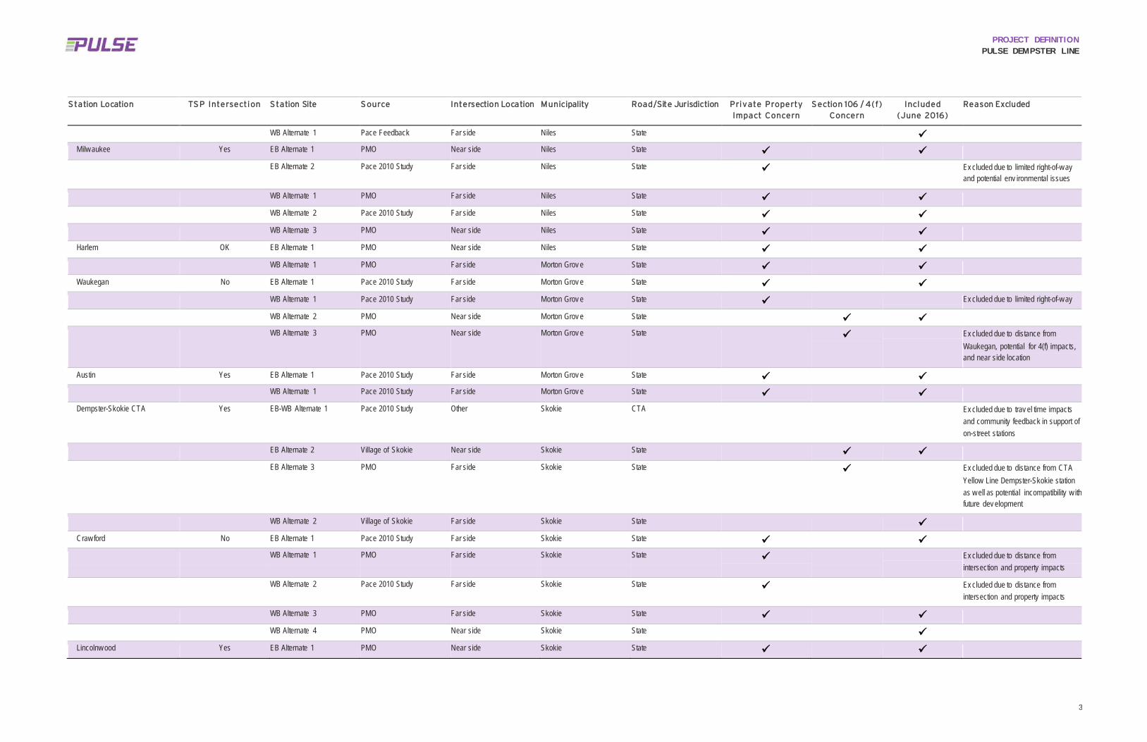
3
PROJECT DEFINITION PULSE DEMPSTER LINE
S tation Location TS P Intersection S tation Site S ource Intersection Location Municipality Road/Site Jurisdiction Private Property Impact Concern
S ection 106 / 4(f) Concern
Included (June 2016)
Reason Excluded
WB Alternate 1 Pace Feedback Far side Niles State
Milw aukee Yes EB Alternate 1 PMO Near side Niles State
EB Alternate 2 Pace 2010 Study Far side Niles State Ex cluded due to limited right-of-w ay and potential env ironmental issues
WB Alternate 1 PMO Far side Niles State
WB Alternate 2 Pace 2010 Study Far side Niles State
WB Alternate 3 PMO Near side Niles State
Harlem OK EB Alternate 1 PMO Near side Niles State
WB Alternate 1 PMO Far side Morton Grov e State
Waukegan No EB Alternate 1 Pace 2010 Study Far side Morton Grov e State
WB Alternate 1 Pace 2010 Study Far side Morton Grov e State Ex cluded due to limited right-of-w ay
WB Alternate 2 PMO Near side Morton Grov e State
WB Alternate 3 PMO Near side Morton Grov e State Ex cluded due to distance from Waukegan, potential for 4(f) impacts, and near side location
Austin Yes EB Alternate 1 Pace 2010 Study Far side Morton Grov e State
WB Alternate 1 Pace 2010 Study Far side Morton Grov e State
Dempster-Skokie CTA Yes EB-WB Alternate 1 Pace 2010 Study Other Skokie CTA Ex cluded due to trav el time impacts and community feedback in support of on-street stations
EB Alternate 2 Village of Skokie Near side Skokie State
EB Alternate 3 PMO Far side Skokie State Ex cluded due to distance from CTA Yellow Line Dempster-Skokie station as w ell as potential incompatibility w ith future dev elopment
WB Alternate 2 Village of Skokie Far side Skokie State
Craw ford No EB Alternate 1 Pace 2010 Study Far side Skokie State
WB Alternate 1 PMO Far side Skokie State Ex cluded due to distance from intersection and property impacts
WB Alternate 2 Pace 2010 Study Far side Skokie State Ex cluded due to distance from intersection and property impacts
WB Alternate 3 PMO Far side Skokie State
WB Alternate 4 PMO Near side Skokie State
Lincolnw ood Yes EB Alternate 1 PMO Near side Skokie State

4
PROJECT DEFINITION PULSE DEMPSTER LINE
S tation Location TS P Intersection S tation Site S ource Intersection Location Municipality Road/Site Jurisdiction Private Property Impact Concern
S ection 106 / 4(f) Concern
Included (June 2016)
Reason Excluded
EB Alternate 2 Pace 2010 Study Far side Skokie State
EB Alternate 3 Pace 2010 Study Near side Skokie State Lincolnw ood alternate at Kimball; ex cluded due to distance from signalized intersection, property impacts, and lack of safe crossing
WB Alternate 1 Pace 2010 Study Far side Skokie State
WB Alternate 2 PMO Near side Skokie
WB Alternate 3 PMO Midblock Skokie State Lincolnw ood alternate at Kimball; ex cluded due to distance from signalized intersection, property impacts, and lack of safe crossing
Dodge OK EB Alternate 1 PMO Near side Ev anston State
EB Alternate 2 Pace 2010 Study Far side Ev anston State Ex cluded due to lack of ridership and limited right-of-w ay
EB Alternate 3 PMO Near side Ev anston State Dodge alternate; ex cluded due to potential site impacts, business opposition and distance from signalized intersection
WB Alternate 1 PMO Midblock Ev anston State
WB Alternate 2 Pace 2010 Study Far side Ev anston State Ex cluded due to location betw een driv ew ays, potential business opposition, and limited right-of-w ay
WB Alternate 3 PMO Near side Ev anston
WB Alternate 4 PMO Far side Ev anston State Dodge alternate; ex cluded due to distance from signalized intersection
Ridge No EB Alternate 1 Pace 2010 Study Near side Ev anston State Ex cluded during initial rev iew of Pace 2010 Study locations due to low ridership and Section 106 issues
WB Alternate 1 Pace 2010 Study Near side Ev anston State Ex cluded during initial rev iew of Pace 2010 Study locations due to low ridership and Section 106 issues
WB Alternate 2 Pace 2010 Study Far side Ev anston State Ex cluded during initial rev iew of Pace 2010 Study locations due to low ridership and Section 106 issues
Dav is CTA/Metra n/a Terminal Pace 2010 Study Terminal Ev anston Municipal Station eliminated per discussions with Pace at March 7, 2016 Station Location meeting and review of the Preliminary Station Location and Site Selection Options Technical Memorandum as noted in Chapter 1. These stations were not evaluated in Chapter 3.

PROJECT DEFINITION PULSE DEMPSTER LINE
Appendix F CONCEPTUAL STATION IMPROVEMENT PLANS

FOR INDEX OF SHEETS, SEE SHEET NO. 2
PROJECT LOCATED IN THE
1. CRY OF CHICAGO
2. VILLAGE OF ROSEMONT
3. CllY OF DES PLAINES
4. CllY OF PARK RIDGE
5. VILLAGE OF NILES
&. VILLAGE OF MORTON GROVE
1. VILLAGE OF SKOKIE
8. CllY OF EVANSTON
SUBMITTALJULY 15. 2016
100' 1IM --1"= 100' 10' 'IJt IO' -1·= I ..
. ·.·.·.·.·----a • 11111'e..·-·-·-·-----e -- ,._ ...
� ---� -A- .-- .. i* WWW ,: - 1111' -------------------- -1·= •
FUll SIZE PLANS HAVE BEEN PRB'ARED USING STANDARD
ENGINEBIING SCALES. REDUCED SIZED PIANS Will NOT
CONFGRM 1U STANDARD SCALES.. IN MAKING MEASURBIENIS
ON REDUCED PUNS, 111E ABOVE SCALES MAY BE USED.
CONTRACT N0.56849
PACE SUBURBAN BUS
REGIONAL TRANSPORTATION AUTHORITY
CONCEPTUAL STATION
IMPROVEMENT PLANS PULSE DEMPSTER LINE
ARTERIAL RAPID TRANSIT FROM o·HARE (CHICAGO) TO DAVIS
CTA I METRA FACILITIES (EVANSTON)
RECONSTRUCTING, STATIONS, SIDEWALK. DRAINAGE, ITS
COOK COUNTY
///�
LOCATION MAP
N.T.S..
GROSS LENGHT .,. 15 MIIIS
lake Mcn,gan
SECTION COUNTY s1ilfs ,i�T COOK 28 t
D.LJ�OIS 568419
LOCATION llf SEmON INDICATED llUS:- ---
0pace Connecting commvnitie5
550 WEST ALOONDUIN ROAD
ARIJNCITON NEIOHIS, IL 18005-4412
(14113�72U
MNTB ONE SOU111 WACKER DRIVE
SUIIE 900
CHICAGO, IL I080I
13121 930-8111
IWNOIS PROFESSIONAL DESIGN FIRM
RRIITMTION NO. 114.08130&
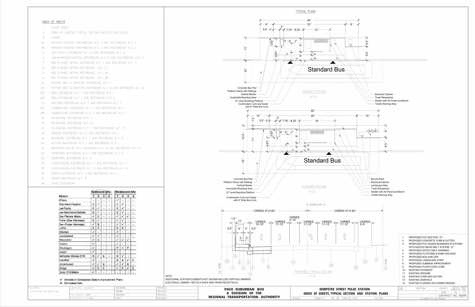
INDEX OF SHEETS
Standard Bus
Platform Ramp with Railings
Concrete Bus Pad
Vertical Marker
Accessible Boarding Area
Shelter with Ad Panel and Bench
Tactile Warning Strip
Trash Receptacle
Electrical Cabinet
45'
33'
10'
COMPACT STATION
N.T.S.
STANDARD STATION
N.T.S.
Standard Bus
Platform Ramp with Railings
Concrete Bus Pad
Vertical Marker
Accessible Boarding Area
Landscape Strip
Shelter with Ad Panel and Bench
Tactile Warning Strip
Trash Receptacle
Electrical Cabinet
60'
40'2'
TYPICAL PLANS
Bicycle Rack
SECTION COUNTY
ILLINOIS FED. AID PROJECT
COOK 28 2
TOTAL
SHEETS
SHEET
NO.RTE.
CONTRACT NO. 56849
SCALE: REGIONAL TRANSPORTATION AUTHORITY
A DIVISION OF THE
PACE SUBURBAN BUSFILE NAME
...\2 sht-Index-typ section.dgn
amjensenUSER NAME =
PLOT SCALE = 1.0000 ' / in.
PLOT DATE = 7/6/2016
=
DATE
DESIGNED
CHECKED
DRAWN
-
-
-
-
REVISED -
-
-
-
REVISED
REVISED
REVISED
F.A.
INDEX OF SHEETS, TYPICAL SECTION AND STATION PLANS
DEMPSTER STREET PULSE STATION
SHEET 2 OF 28 SHEETS STA. TO STA.
10'-15'VARIES
11'-12'VARIES
11'-12'VARIES
11'-12'VARIES
11'-12'VARIES
5'-6'VARIES
2'-10'VARIES
1.5'
6.5'
N.T.S.
PROPOSED TYPICAL SECTION
28
27
26
25
24
23
22
21
20
19
18
17
16
15
14B
14A
13
12B
12A
11B
11A
10
9
8
7
6
5
4B
4A
3
2
1
4'
12" Level Boarding Platform
12" Level Boarding Platform
12'
6'
5'
8'
3.8
3'
6.6
7'
with 6" Wide Bus Curb
Combination Curb and Gutter
10'10'
5'
8'
2'6'
7.75' - 8.25'
7.75' - 8.25'
with 6" Wide Bus Curb
Combination Curb and Gutter
EXISTING FLUSHED OR CURBED MEDIAN14
EXISTING SIDEWALK13
EXISTING CURB AND GUTTER12
EXISTING GROUND11
EXISTING PAVEMENT10
PROPOSED PLASTIC BUS CURB9
PROPOSED SUBBASE IMPROVEMENT8
PROPOSED LANDSCAPE STRIP7
PROPOSED BUS SHELTER6
PROPOSED PLATFORM & RAMP RAILINGS5
PROPOSED DETECTABLE WARNING4
WITH HEATED SNOW MELT SYSTEM, 12"
PROPOSED PCC RAISED BOARDING PLATFORM3
PROPOSED CONCRETE CURB & GUTTER2
PROPOSED PCC BUS PAD, 10"1
VARIES 37.5'-60'VARIES 37.5'-60'
6'
ELECTRICAL CABINET, BICYCLE RACK AND TRASH RECEPTACLE
ADDITIONAL STATION ELEMENTS NOT SHOWN INCLUDE VERTICAL MARKER,
NOTE:
DAVIS CTA/METRA
DODGE: WESTBOUND ALT. 3
DODGE: EASTBOUND ALT. 1 AND WESTBOUND ALT. 1
LINCOLNWOOD: EASTBOUND ALT. 2 AND WESTBOUND ALT. 2
LINCOLNWOOD: EASTBOUND ALT. 1 AND WESTBOUND ALT. 1
CRAWFORD: WESTBOUND ALT. 4
CRAWFORD: EASTBOUND ALT. 1 AND WESTBOUND ALT. 3
DEMPSTER-SKOKIE CTA: EASTBOUND ALT. 2 AND WESTBOUND ALT. 2
AUSTIN: EASTBOUND ALT. 1 AND WESTBOUND ALT. 1
WAUKEGAN: EASTBOUND ALT. 1 AND WESTBOUND ALT. 2
HARLEM: EASTBOUND ALT. 1 AND WESTBOUND ALT. 1
MILWAUKEE: EASTBOUND ALT. 1 AND WESTBOUND ALT. 3
MILWAUKEE: WESTBOUND ALT. 2
MILWAUKEE: WESTBOUND ALT. 1
CUMBERLAND: EASTBOUND ALT. 2 AND WESTBOUND ALT. 1
CUMBERLAND: EASTBOUND ALT. 1 AND WESTBOUND ALT. 1
WESTERN: EASTBOUND ALT. 1 AND WESTBOUND ALT. 1
DEE: EASTBOUND ALT. 1 AND WESTBOUND ALT. 2
DEE: EASTBOUND ALT. 1 AND WESTBOUND ALT. 1
POTTER (DEE ALTERNATE): EASTBOUND ALT. 2 AND WESTBOUND ALT. 2
POTTER (DEE ALTERNATE): WESTBOUND ALT. 1
DES PLAINES METRA: WESTBOUND ALT. 3B
DES PLAINES METRA: WESTBOUND ALT. 3A
DES PLAINES METRA: WESTBOUND ALT. 2
DES PLAINES METRA: EASTBOUND ALT. 1 AND WESTBOUND ALT. 1
LEE-MANNHEIM/OAKTON: NORTHBOUND ALT. 2 AND SOUTHBOUND ALT. 2
LEE/TOUHY: EASTBOUND ALT. 2 AND WESTBOUND ALT. 2
MANHEIM/HIGGINS: NORTHBOUND ALT. 2 AND SOUTHBOUND ALT. 2
MANHEIM/HIGGINS: NORTHBOUND ALT. 1 AND SOUTHBOUND ALT. 1
O'HARE
INDEX OF SHEETS, TYPICAL SECTION AND STATION PLANS
COVER SHEET
11'
11'
4.5'
11'
'6
'
'
''
'
'
'
'
6'
EX
RO
W
EX
RO
W1
2
4
5
6
37
10
~ DEMPSTER ST.
4 6.5
4
6.6
7
'2
'
16
'1.5
'2
'
'3.8
3
'3.5' - 4
'3.5' - 4
'0.5
'2
9
8
14
1012
1311
13
'0.5
'
2
2
12.5
6
2

LOCATION MAP
EXISTING PACE STOP
NOT TO SCALE
LEGEND
LOCATION OPTIONS
STATION PLATFORM
28
PROPERTY LINE
PORTLAND CEMENT CONCRETE RAMP, VARIABLE DEPTH
PORTLAND CEMENT CONRETE PLATFORM, 12"
PORTLAND CEMENT CONCRETE SIDEWALK, 5"
PORTLAND CEMENT CONCRETE DRIVEWAY PAVEMENT, 8"
HMA SURFACE COURSE, 1-3/4", HMA BASE COURSE, 2-1/4"
HMA SURFACE COURSE, VARIABLE DEPTH
H.E.S. PORTLAND CEMENT CONCRETE CONCRETE PAVEMENT, 10"
QUANTITIES
0 25' 50'
SECTION COUNTY
ILLINOIS FED. AID PROJECT
COOK
TOTAL
SHEETS
SHEET
NO.RTE.
CONTRACT NO.
SCALE: 1=40'REGIONAL TRANSPORTATION AUTHORITY
A DIVISION OF THE
PACE SUBURBAN BUSFILE NAME
\\CHIW00\Project_Data\56849\CADD\TO 11 Dempster\Sheets\Station Layouts_05132016\3 sht-OHare Metra.dgn
dpanfiloUSER NAME =
PLOT SCALE = 0.3048 m / in.
PLOT DATE = 6/7/2016
=
DATE
DESIGNED
CHECKED
DRAWN
-
-
-
-
REVISED -
-
-
-
REVISED
REVISED
REVISED
F.A.
DP
AMJ
05132016
SH
SHEET OF 28 SHEETS STA. TO STA.
--
SCALE: 1"=40'MANNHEIM RD (US 12/45)
3
3
ZE
MK
E B
LV
D
METRA STATIONO'HARE TRANSFER
METRA STATIONO'HARE TRANSFER
ZEMKE BLVD
NOTES
1.
SIGNAGE.
COORDINATE WITH CHICAGO DEPARTMENT OF AVIATION ON FUTURE
PACE COODINATING WITH CDATWO DEDICATED PACE BUS BAYSNEW BUS FACILITY UNDER CONSTRUCTION
O'HARE
PULSE DEMPSTER LINE
TOUHY AVE.

LOCATION MAP
EXISTING PACE STOP
NOT TO SCALE
LEGEND
LOCATION OPTIONS
STATION PLATFORM
28
PROPERTY LINE
PORTLAND CEMENT CONCRETE RAMP, VARIABLE DEPTH
PORTLAND CEMENT CONRETE PLATFORM, 12"
PORTLAND CEMENT CONCRETE SIDEWALK, 5"
PORTLAND CEMENT CONCRETE DRIVEWAY PAVEMENT, 8"
HMA SURFACE COURSE, 1-3/4", HMA BASE COURSE, 2-1/4"
HMA SURFACE COURSE, VARIABLE DEPTH
H.E.S. PORTLAND CEMENT CONCRETE CONCRETE PAVEMENT, 10"
QUANTITIES
0 25' 50'
SECTION COUNTY
ILLINOIS FED. AID PROJECT
COOK
TOTAL
SHEETS
SHEET
NO.RTE.
CONTRACT NO.
SCALE: 1=40'REGIONAL TRANSPORTATION AUTHORITY
A DIVISION OF THE
PACE SUBURBAN BUSFILE NAME
\\CHIW00\Project_Data\56849\CADD\TO 11 Dempster\Sheets\Station Layouts_05132016\4A sht-Manheim_Higgins.dgn
dpanfiloUSER NAME =
PLOT SCALE = 1.0000 ' / in.
PLOT DATE = 6/10/2016
=
DATE
DESIGNED
CHECKED
DRAWN
-
-
-
-
REVISED -
-
-
-
REVISED
REVISED
REVISED
F.A.
DP
AMJ
05132016
SH
SHEET OF 28 SHEETS STA. TO STA.
Standard Bus
60'
10'
6'
10'
Standard Bus60'
15'
8'
6'
ADJUST STORM INLET
ADJUST STORM MANHOLE
(CROSSWALK AND TRAFFIC SIGNAL BY OTHERS)PROPOSED PEDESTRIAN IMPROVEMENTS
EXISTING STORM
EXISTING SEWER
EXISTING UNDERGROUND WATER
EXISTING STORM
EXISTING UNDERGROUND TELEPHONE
EXISTING GAS
EXISTING UNDERGROUND TELEPHONE
EXISTING WATER MAIN
H
SCALE: 1"=40'
4A
OPTIONS LOCATION
PLATFORMSTATION
4A
MA
NH
NEIM R
D (
US 1
2/4
5)
I-90
MANNHEIM RD (US RTE 12 / 45)
HOLIDAY INN
NOTES
3.
2.
1.
DES PLAINES FOR PROPOSED STATIONS AND NEW DEVELOPMENT.
COORDINATE WITH VILLAGE OF ROSEMONT AND CITY OF
COORDINATE WITH IDOT FOR POTENTIAL TRAFFIC SIGNAL.
NEW DEVELOPMENT ON EAST SIDE OF MANNHEIM ROAD.
AERIAL IS OUTDATED. IMPROVEMENTS TO MANNHEIM ROAD AND
HIGGINS RD (IL 72)
NORTHBOUND ALT. 1 AND SOUTHBOUND ALT. 1
MANNHEIM / HIGGINS:
PULSE DEMPSTER LINE

14'
60'
12.5'
LOCATION MAP
EXISTING PACE STOP
NOT TO SCALE
LEGEND
LOCATION OPTIONS
STATION PLATFORM
28
PROPERTY LINE
PORTLAND CEMENT CONCRETE RAMP, VARIABLE DEPTH
PORTLAND CEMENT CONRETE PLATFORM, 12"
PORTLAND CEMENT CONCRETE SIDEWALK, 5"
PORTLAND CEMENT CONCRETE DRIVEWAY PAVEMENT, 8"
HMA SURFACE COURSE, 1-3/4", HMA BASE COURSE, 2-1/4"
HMA SURFACE COURSE, VARIABLE DEPTH
H.E.S. PORTLAND CEMENT CONCRETE CONCRETE PAVEMENT, 10"
QUANTITIES
0 25' 50'
SECTION COUNTY
ILLINOIS FED. AID PROJECT
COOK
TOTAL
SHEETS
SHEET
NO.RTE.
CONTRACT NO.
SCALE: 1=40'REGIONAL TRANSPORTATION AUTHORITY
A DIVISION OF THE
PACE SUBURBAN BUSFILE NAME
I:\56849\CADD\TO 11 Dempster\Sheets\Station Layouts_05132016\4B sht-Manheim_Higgins.dgn
amjensenUSER NAME =
PLOT SCALE = 1.0000 ' / in.
PLOT DATE = 7/8/2016
=
DATE
DESIGNED
CHECKED
DRAWN
-
-
-
-
REVISED -
-
-
-
REVISED
REVISED
REVISED
F.A.
DP
AMJ
05132016
SH
SHEET OF 28 SHEETS STA. TO STA.
Standard Bus
Standard Bus
EXISTING UNDERGROUND ELECTRIC
EXISTING RETAINING WALLADJUST UTILITY FRAME
RELOCATE EXISTING SIGN
EXIST. POWER POLE
REMOVAL (SEE NOTE 1)PROPOSED CORNER ISLAND
ADJUST CATCH BASIN
EXISTING UNDERGROUND ELECTRIC
EXISTING UNDERGROUND ELECTRIC
60'
10'
IDOT PERMANENT EASEMENT FOR MANNHEIM IMPROVEMENTS
50'
50'
EXISTING CTV CONDUIT
EXISTING 12" W.M.
EXISTING 12" STORM
PIPE UNDERDRAINEXISTING 6"
EXISTING GAS EXISTING TELEPHONE
EXISTING NSMJAWA 90" W.M.
EXISTING 24" STORM
EXISTING 12" STORM
REMOVAL (SEE NOTE 1)PROPOSED CORNER ISLAND
12.5'
(SEE NOTE 2)(NSMJAWA) EASEMENTACTION WATER AGENCY SUBURBAN MUNICIPAL JOINT EXISTING NORTHWEST
C
H
H
H
J
H
ONLYONLY
ONLY
ONLYONLY
ONLYONLY
ONLY
ONLY
ONLY
ONLY
SCALE: 1"=40'
4B
OPTIONS LOCATION
PLATFORMSTATION
4B
MA
NH
NEIM R
D (
US 1
2/4
5)
MANNHEIM RD (US RTE 12 / 45)
NOTES
NORTHBOUND ALT. 2 AND SOUTHBOUND ALT. 2
MANNHEIM / HIGGINS:
PULSE DEMPSTER LINE
HIG
GIN
S R
D (IL 7
2)
HIGGINS RD (IL 72)
2.
1.
90" W.M.
CONFLICT WITH PROPOSING STATION NEAR EXISTING NSMJAWA
COORDINATION WITH NSMJAWA IS REQUIRED. POTENTIAL
IS CURRENTLY UNDER CONSTRUCTION.
AERIAL IS OUTDATED. MANNHEIM ROAD AND HIGGINS ROAD

PROPOSED ADA ACCESSIBLE CURB RAMP
PROPOSED ADA ACCESSIBLE CURB RAMP
LOCATION MAP
EXISTING PACE STOP
NOT TO SCALE
LEGEND
LOCATION OPTIONS
STATION PLATFORM
28
PROPERTY LINE
PORTLAND CEMENT CONCRETE RAMP, VARIABLE DEPTH
PORTLAND CEMENT CONRETE PLATFORM, 12"
PORTLAND CEMENT CONCRETE SIDEWALK, 5"
PORTLAND CEMENT CONCRETE DRIVEWAY PAVEMENT, 8"
HMA SURFACE COURSE, 1-3/4", HMA BASE COURSE, 2-1/4"
HMA SURFACE COURSE, VARIABLE DEPTH
H.E.S. PORTLAND CEMENT CONCRETE CONCRETE PAVEMENT, 10"
QUANTITIES
0 25' 50'
SECTION COUNTY
ILLINOIS FED. AID PROJECT
COOK
TOTAL
SHEETS
SHEET
NO.RTE.
CONTRACT NO.
SCALE: 1=40'REGIONAL TRANSPORTATION AUTHORITY
A DIVISION OF THE
PACE SUBURBAN BUSFILE NAME
\\chiw00\Project_data\56849\CADD\TO 11 Dempster\Sheets\Station Layouts_05132016\5 sht-Lee-Touhy.dgn
dpanfiloUSER NAME =
PLOT SCALE = 1.0000 ' / in.
PLOT DATE = 7/6/2016
=
DATE
DESIGNED
CHECKED
DRAWN
-
-
-
-
REVISED -
-
-
-
REVISED
REVISED
REVISED
F.A.
DP
AMJ
05132016
SH
SHEET OF 28 SHEETS STA. TO STA.
Standard Bus
Standard Bus
TOUHY AVE.
LE
E S
T.
PROPOSED HIGH-VISIBILITY CROSSWALK (SEE NOTES)
REMOVE EXISTING PACE SIGN
EXISTING HYDRANT
ADJUST STORM INLET
REMOVE EXISTING PACE SIGN
EXISTING FENCE
REMOVE EXISTING PACE SIGN
14.5'
ADJUST STORM INLET
FRAME
ADJUST UTILITY
60'
15'
12'
60'
TS
TOUHY AVE.
LE
E S
T.
NOTES
OPTIONSLOCATION PLATFORM STATION
5
SCALE: 1"=40'
5
4.
3.
2.
1.
STATIONS.
NO PROPOSED LANDSCAPE STRIP FOR EASTBOUND AND WESTBOUND
CROSSWALK AND TO RECONFIGURE WESTBOUND LEFT LANE.
AND RECONSTRUCT MEDIAN TO ACCOMMODATE PROPOSED
ACCESSIBILITY IMPROVEMENTS. PROPOSE TO RELOCATE STOP BAR
INTERSECTION GEOMETRY REQUIRES EVALUATION TO ACCOMMODATE
BUREAU OF DESIGN AND ENVIRONMENT REQUIREMENTS.
EXISTING WB LEFT TURNING STORAGE IS NOT MEETING IDOT
IDOT COORDINATION IS REQUIRED.
EASTBOUND ALT. 2 AND WESTBOUND ALT. 2
LEE/TOUHY:
PULSE DEMPSTER LINE

ADJUST UTILITY FRAME
ROUTE SIGN AND STREET SIGN
RELOCATE EXISTING US
ADJUST STORM INLET
LOCATION MAP
EXISTING PACE STOP
NOT TO SCALE
LEGEND
LOCATION OPTIONS
STATION PLATFORM
28
PROPERTY LINE
PORTLAND CEMENT CONCRETE RAMP, VARIABLE DEPTH
PORTLAND CEMENT CONRETE PLATFORM, 12"
PORTLAND CEMENT CONCRETE SIDEWALK, 5"
PORTLAND CEMENT CONCRETE DRIVEWAY PAVEMENT, 8"
HMA SURFACE COURSE, 1-3/4", HMA BASE COURSE, 2-1/4"
HMA SURFACE COURSE, VARIABLE DEPTH
H.E.S. PORTLAND CEMENT CONCRETE CONCRETE PAVEMENT, 10"
QUANTITIES
0 25' 50'
SECTION COUNTY
ILLINOIS FED. AID PROJECT
COOK
TOTAL
SHEETS
SHEET
NO.RTE.
CONTRACT NO.
SCALE: 1=40'REGIONAL TRANSPORTATION AUTHORITY
A DIVISION OF THE
PACE SUBURBAN BUSFILE NAME
\\chiw00\Project_data\56849\CADD\TO 11 Dempster\Sheets\Station Layouts_05132016\6 sht-Lee-Oakton.dgn
dpanfiloUSER NAME =
PLOT SCALE = 1.0000 ' / in.
PLOT DATE = 7/6/2016
=
DATE
DESIGNED
CHECKED
DRAWN
-
-
-
-
REVISED -
-
-
-
REVISED
REVISED
REVISED
F.A.
DP
AMJ
05132016
SH
SHEET OF 28 SHEETS STA. TO STA.
Standard BusREMOVE EXISTING PACE SIGN
ADJUST MANHOLE
ADJUST MANHOLE
Standard Bus
18'
13'
POTENTIAL POWER POLE RELOCATION
RELOCATE LIGHT POLE
ADJUST CATCH BASIN
AND PACE SIGN
CONCRETE PAD, TRASH RECEPTACLE,
REMOVE EXISTING BUS SHELTER WITH
SEE NOTE 2
45'
60.00'
14'
TS
OAKTON ST.
LE
E S
T.
LEE ST.
OA
KT
ON S
T. SCALE: 1"=40'
6
OPTIONSLOCATION PLATFORM STATION
MA
NN
HEIM R
D.
6
NOTES:
NORTHWEST CORNER OF OAKTON STREET AND MANNHEIM ROAD.
AERIAL IS OUTDATED. NEW CHASE BACK IS LOCATED AT THE 4.
ADVANCED CONCEPTUAL DESIGN.
PROPERTY LINES TO BE CONFIRMED VIA SURVEY DURING
CURRENT BACK OF SIDEWALK USED FOR REAR LINE OF PLATFORM.3.
REQUIREMENTS.
PROPOSED SHELTER IS SET BACK TO MEET SIGHT DISTANCE2.
NO PROPOSED LANDSCAPE STRIP AT NORTHBOUND STATION.1.
NORTHBOUND ALT. 2 AND SOUTHBOUND ALT. 2
LEE-MANNHEIM/OAKTON:
PULSE DEMPSTER LINE
MANNHEIM RD.

LOCATION MAP
EXISTING PACE STOP
NOT TO SCALE
LEGEND
LOCATION OPTIONS
STATION PLATFORM
28
PROPERTY LINE
PORTLAND CEMENT CONCRETE RAMP, VARIABLE DEPTH
PORTLAND CEMENT CONRETE PLATFORM, 12"
PORTLAND CEMENT CONCRETE SIDEWALK, 5"
PORTLAND CEMENT CONCRETE DRIVEWAY PAVEMENT, 8"
HMA SURFACE COURSE, 1-3/4", HMA BASE COURSE, 2-1/4"
HMA SURFACE COURSE, VARIABLE DEPTH
H.E.S. PORTLAND CEMENT CONCRETE CONCRETE PAVEMENT, 10"
QUANTITIES
0 25' 50'
SECTION COUNTY
ILLINOIS FED. AID PROJECT
COOK
TOTAL
SHEETS
SHEET
NO.RTE.
CONTRACT NO.
SCALE: 1=40'REGIONAL TRANSPORTATION AUTHORITY
A DIVISION OF THE
PACE SUBURBAN BUSFILE NAME
\\chiw00\Project_data\56849\CADD\TO 11 Dempster\Sheets\Station Layouts_05132016\7 sht-Des Plaines Metra Alt 1.dgn
dpanfiloUSER NAME =
PLOT SCALE = 1.0000 ' / in.
PLOT DATE = 7/6/2016
=
DATE
DESIGNED
CHECKED
DRAWN
-
-
-
-
REVISED -
-
-
-
REVISED
REVISED
REVISED
F.A.
DP
AMJ
05132016
SH
SHEET OF 28 SHEETS STA. TO STA.
EXISTING BUS BAY
PROPOSED NEW PULSE SIGN
Standard Bus
RELOCATE LIGHT POLES
REMOVE TREES
RELOCATE LIGHT POLE
REMOVE TREE
140'
LENGTHDECELERATION 30'
LENGTHACCELERATION30'
10.5'
REMOVE EXISTING BUS SHELTER
11'
TS
SCALE: 1"=40'
7
ME
TR
OP
OLIT
AN W
AY
METROPOLITAN WAY
LEE ST.
PEARSON ST.
RIV
ER R
D.
OPTIONSLOCATION PLATFORM STATION
7
NOTES:
LENGTH AND 120FT. MINIMUM FOR DECELERATION LENGTH.
TURNOUT TAPER LENGTHS, 50FT. MINIMUM FOR ACCELERATION
MARCH 2013. GUIDELINES SUGGEST 150FT. MINIMUM FOR BUS
TRANSIT SUPPORTIVE GUIDELINES FOR THE CHICAGOLAND REGION
TURN OUT DOES NOT MEET IDOT BDE REQUIREMENTS AND PACE5.
BUILDING.
APPROXIMATELY 20FT OF SIDEWALK FROM EXISTING CURB TO 4.
NO PROPOSED LANDSCAPE STRIP AT WEST BOUND STATION.3.
ON INTERAGENCY REAL TIME ARRIVAL SIGNS.
FUTURE COORDINATION WITH REGIONAL TRANSPORTATION AUTHORITY 2.
NO EASTBOUND STATION IMPROVEMENT PLANS.1.
EASTBOUND ALT. 1 AND WESTBOUND ALT. 1
DES PLAINES METRA:
PULSE DEMPSTER LINE
(US 1
4)
MIN
ER S
T./ N
OR
TH
WE
ST H
WY
(US 14)MINER ST. / NORTHWEST HWY
METRA STATIONDES PLAINES

LOCATION MAP
EXISTING PACE STOP
NOT TO SCALE
LEGEND
LOCATION OPTIONS
STATION PLATFORM
28
PROPERTY LINE
PORTLAND CEMENT CONCRETE RAMP, VARIABLE DEPTH
PORTLAND CEMENT CONRETE PLATFORM, 12"
PORTLAND CEMENT CONCRETE SIDEWALK, 5"
PORTLAND CEMENT CONCRETE DRIVEWAY PAVEMENT, 8"
HMA SURFACE COURSE, 1-3/4", HMA BASE COURSE, 2-1/4"
HMA SURFACE COURSE, VARIABLE DEPTH
H.E.S. PORTLAND CEMENT CONCRETE CONCRETE PAVEMENT, 10"
QUANTITIES
0 25' 50'
SECTION COUNTY
ILLINOIS FED. AID PROJECT
COOK
TOTAL
SHEETS
SHEET
NO.RTE.
CONTRACT NO.
SCALE: 1=40'REGIONAL TRANSPORTATION AUTHORITY
A DIVISION OF THE
PACE SUBURBAN BUSFILE NAME
\\chiw00\Project_data\56849\CADD\TO 11 Dempster\Sheets\Station Layouts_05132016\8 sht-Des Plaines Metra Alt 2.dgn
dpanfiloUSER NAME =
PLOT SCALE = 1.0000 ' / in.
PLOT DATE = 7/6/2016
=
DATE
DESIGNED
CHECKED
DRAWN
-
-
-
-
REVISED -
-
-
-
REVISED
REVISED
REVISED
F.A.
DP
AMJ
05132016
SH
SHEET OF 28 SHEETS STA. TO STA.
Standard Bus
REMOVE TREE
RELOCATE LIGHT POLE
REMOVE TREE
NO PARKING50' MINIMUM
60'
NO PARKING
60' MINIMUM
11.0
0'
12.0'
SCALE: 1"=40'
METROPOLITAN WAY
PE
AR
SO
N S
T
PEARSON ST.
RIV
ER R
D.
8
8
NOTES:
LEE ST. (US 45)
TO BUILDINGS.
4. APPROXIMATELY 22 FT OF SIDEWALK AREA FROM EXISTING CURB
BUS PLATFORM. RESTRIPE PAVEMENT MARKINGS FOR NO PARKING.
3. EIGHT PARKING SPACES (155 FT) WILL BE REPLACED WITH PROPOSED
2. NO PROPOSED LANDSCAPE STRIP AT WESTBOUND STATION.
1. SEE SHEET 7 FOR PROPOSED EASTBOUND STATION.
OPTIONLOCATION PLATFORM STATION
WESTBOUND ALT. 2
DES PLAINES METRA:
PULSE DEMPSTER LINE
METRA STATIONDES PLAINES
WA
YM
ET
RO
PO
LIT
AN
(US 14)MINER ST./ NORTHWEST HWY
(US 1
4)
MIN
ER S
T. /
NO
RT
HW
ES
T H
WY

LOCATION MAP
EXISTING PACE STOP
NOT TO SCALE
LEGEND
LOCATION OPTIONS
STATION PLATFORM
28
PROPERTY LINE
PORTLAND CEMENT CONCRETE RAMP, VARIABLE DEPTH
PORTLAND CEMENT CONRETE PLATFORM, 12"
PORTLAND CEMENT CONCRETE SIDEWALK, 5"
PORTLAND CEMENT CONCRETE DRIVEWAY PAVEMENT, 8"
HMA SURFACE COURSE, 1-3/4", HMA BASE COURSE, 2-1/4"
HMA SURFACE COURSE, VARIABLE DEPTH
H.E.S. PORTLAND CEMENT CONCRETE CONCRETE PAVEMENT, 10"
QUANTITIES
0 25' 50'
SECTION COUNTY
ILLINOIS FED. AID PROJECT
COOK
TOTAL
SHEETS
SHEET
NO.RTE.
CONTRACT NO.
SCALE: 1=40'REGIONAL TRANSPORTATION AUTHORITY
A DIVISION OF THE
PACE SUBURBAN BUSFILE NAME
\\chiw00\Project_data\56849\CADD\TO 11 Dempster\Sheets\Station Layouts_05132016\9 sht-Des Plaines Metra Alt 3.dgn
dpanfiloUSER NAME =
PLOT SCALE = 1.0000 ' / in.
PLOT DATE = 7/6/2016
=
DATE
DESIGNED
CHECKED
DRAWN
-
-
-
-
REVISED -
-
-
-
REVISED
REVISED
REVISED
F.A.
DP
AMJ
05132016
SH
SHEET OF 28 SHEETS STA. TO STA.
Standard Bus
CONCRETE PAVERS
REMOVE AND RESET
CONCRETE PAVERS (TYP)
REMOVE AND RESET
DECORATOVE BRICK (TYP)
REMOVE AND RESET REMOVE TREE
REMOVE TREE
RELOCATE LIGHT POLE
10'
60'
9.5'
SCALE: 1"=40'
9
METROPOLITAN WAY
PE
AR
SO
N S
T
PEARSON ST.
RIV
ER R
D.
LEE ST. (US 45)
OPTIONLOCATION PLATFORM STATION
9
NOTES:
2. NO LANDSCAPE STRIP PROPOSED AT STATION.
1. SEE SHEET 7 FOR PROPOSED EASTBOUND STATION.
WESTBOUND ALT. 3A
DES PLAINES METRA:
PULSE DEMPSTER LINE
(US 1
4)
NO
RT
HW
ES
T H
WY
MIN
ER S
T. /
(US 14)MINER ST./ NORTHWEST HWY
METRA STATIONDES PLAINES

LOCATION MAP
EXISTING PACE STOP
NOT TO SCALE
LEGEND
LOCATION OPTIONS
STATION PLATFORM
28
PROPERTY LINE
PORTLAND CEMENT CONCRETE RAMP, VARIABLE DEPTH
PORTLAND CEMENT CONRETE PLATFORM, 12"
PORTLAND CEMENT CONCRETE SIDEWALK, 5"
PORTLAND CEMENT CONCRETE DRIVEWAY PAVEMENT, 8"
HMA SURFACE COURSE, 1-3/4", HMA BASE COURSE, 2-1/4"
HMA SURFACE COURSE, VARIABLE DEPTH
H.E.S. PORTLAND CEMENT CONCRETE CONCRETE PAVEMENT, 10"
QUANTITIES
0 25' 50'
SECTION COUNTY
ILLINOIS FED. AID PROJECT
COOK
TOTAL
SHEETS
SHEET
NO.RTE.
CONTRACT NO.
SCALE: 1=40'REGIONAL TRANSPORTATION AUTHORITY
A DIVISION OF THE
PACE SUBURBAN BUSFILE NAME
\\chiw00\Project_data\56849\CADD\TO 11 Dempster\Sheets\Station Layouts_05132016\10 sht-Des Plaines Metra Alt 4.dgn
dpanfiloUSER NAME =
PLOT SCALE = 1.0000 ' / in.
PLOT DATE = 7/6/2016
=
DATE
DESIGNED
CHECKED
DRAWN
-
-
-
-
REVISED -
-
-
-
REVISED
REVISED
REVISED
F.A.
DP
AMJ
05132016
SH
SHEET OF 28 SHEETS STA. TO STA.
Standard Bus
RELOCATE LIGHT POLE
REMOVE TREE
PROPOSED IMPROVEMENTS
ADJACENT TO
DECORATIVE BRICK
RESET CONCRETE PAVERS AND RELOCATE LIGHT POLE
(SEE NOTE 3)
PROPOSED BUS TURNOUT
AND CONCRETE PAVERS
REMOVE DECORATIVE BRICK
RELOCATE LIGHT POLE
REMOVE TREE
RELOCATE LIGHT POLE
REMOVE TREE
12.5' TAPER LENGTH (TYP)
REMOVE DECORATIVE PLANTER
140'
25' DECEL. LENGTH
25' ACCEL. LENGTH
12.0'
SCALE: 1"=40'
10
METROPOLITAN WAY
PEARSON ST.
RIV
ER R
D.
PE
AR
SO
N S
T.
NOTES:
10
LEE ST. (US 45)
OPTIONLOCATION PLATFORM STATION
120 FT MINIMUM FOR DECELERATION LENGTH.
SUGGEST 150 FT MINIMUM FOR BUS TURNOUT TAPER LENGTHS AND
GUIDELINES FOR THE CHICAGOLAND REGION MARCH 2013. GUIDELINES
3. TURNOUT DOES NOT MEET PACE TRANSIT SUPPORTIVE
2. NO PROPOSED LANDSCAPE STRIP AT WESTBOUND STATION
1. SEE SHEET 7 FOR PROPOSED EASTBOUND STATION
METRA STATIONDES PLAINES
(US 14)MINER ST./ NORTHWEST HWY
WESTBOUND ALT. 3B
DES PLAINES METRA:
PULSE DEMPSTER LINE
(US 1
4)
NO
RT
HW
ES
T H
WY
MIN
ER S
T./

LOCATION MAP
EXISTING PACE STOP
NOT TO SCALE
LEGEND
LOCATION OPTIONS
STATION PLATFORM
28
PROPERTY LINE
PORTLAND CEMENT CONCRETE RAMP, VARIABLE DEPTH
PORTLAND CEMENT CONRETE PLATFORM, 12"
PORTLAND CEMENT CONCRETE SIDEWALK, 5"
PORTLAND CEMENT CONCRETE DRIVEWAY PAVEMENT, 8"
HMA SURFACE COURSE, 1-3/4", HMA BASE COURSE, 2-1/4"
HMA SURFACE COURSE, VARIABLE DEPTH
H.E.S. PORTLAND CEMENT CONCRETE CONCRETE PAVEMENT, 10"
QUANTITIES
0 25' 50'
SECTION COUNTY
ILLINOIS FED. AID PROJECT
COOK
TOTAL
SHEETS
SHEET
NO.RTE.
CONTRACT NO.
SCALE: 1=40'REGIONAL TRANSPORTATION AUTHORITY
A DIVISION OF THE
PACE SUBURBAN BUSFILE NAME
\\chiw00\Project_data\56849\CADD\TO 11 Dempster\Sheets\Station Layouts_05132016\11A sht-PotterREV .dgn
dpanfiloUSER NAME =
PLOT SCALE = 1.0000 ' / in.
PLOT DATE = 7/6/2016
=
DATE
DESIGNED
CHECKED
DRAWN
-
-
-
-
REVISED -
-
-
-
REVISED
REVISED
REVISED
F.A.
DP
AMJ
05132016
SH
SHEET OF 28 SHEETS STA. TO STA.
Standard Bus
EXISTING TELE.
12.5'
9'
ADJUST STORM INLET
EXISTING 8" WATER MAIN
EXISTING OVHD. ELECTRIC
EXISTING 12" STORM
(SEE NOTE 2)
DECORATIVE LANDSCAPING
11'
T
T T
T T
GV
VV
VV
VV
VV
BB
BB
BB
GV
DEMPSTER ST. (US RTE 14)
PO
TT
ER R
D.
SCALE: 1"=40'
NOTES
CARLEAH ST.
OPTIONSLOCATIONPLATFORMSTATION
POTTER RD.
DE
MP
ST
ER S
T. (U
S R
TE 1
4)
11A
11A
WESTBOUND ALT. 1
POTTER (DEE ALTERNATE):
PULSE DEMPSTER LINE
3. SEE SHEET 11B FOR EASTBOUND STATION DETAILS.
LANDSCAPING.
REQUIRES PACE SHELTER TO BE SET BACK AND IMPACTS DECORATIVE
SUPPY & GARDEN CENTER. SIGHT DISTANCE TRIANGLE
ADJACENT TO EXISTING SIDEWALK AT LURVEY LANDSCAPE
2. AERIAL IS OUTDATED. NEW DECORATIVE LANDSCAPING IS LOCATED
1. SURVEY WAS PERFORMED BY OTHERS AND SHALL BE VERIFIED.

LOCATION MAP
EXISTING PACE STOP
NOT TO SCALE
LEGEND
LOCATION OPTIONS
STATION PLATFORM
28
PROPERTY LINE
PORTLAND CEMENT CONCRETE RAMP, VARIABLE DEPTH
PORTLAND CEMENT CONRETE PLATFORM, 12"
PORTLAND CEMENT CONCRETE SIDEWALK, 5"
PORTLAND CEMENT CONCRETE DRIVEWAY PAVEMENT, 8"
HMA SURFACE COURSE, 1-3/4", HMA BASE COURSE, 2-1/4"
HMA SURFACE COURSE, VARIABLE DEPTH
H.E.S. PORTLAND CEMENT CONCRETE CONCRETE PAVEMENT, 10"
QUANTITIES
0 25' 50'
SECTION COUNTY
ILLINOIS FED. AID PROJECT
COOK
TOTAL
SHEETS
SHEET
NO.RTE.
CONTRACT NO.
SCALE: 1=40'REGIONAL TRANSPORTATION AUTHORITY
A DIVISION OF THE
PACE SUBURBAN BUSFILE NAME
\\chiw00\Project_data\56849\CADD\TO 11 Dempster\Sheets\Station Layouts_05132016\11B sht-PotterREV.dgn
dpanfiloUSER NAME =
PLOT SCALE = 1.0000 ' / in.
PLOT DATE = 7/6/2016
=
DATE
DESIGNED
CHECKED
DRAWN
-
-
-
-
REVISED -
-
-
-
REVISED
REVISED
REVISED
F.A.
DP
AMJ
05132016
SH
SHEET OF 28 SHEETS STA. TO STA.
EXISTING 12" WATER MAIN
EXISTING 12" STORM
EXISTING OVHD. ELEC.
EXISTING 6" GAS
EXISTING TELE.
EXISTING GAS VAULT
EXISTING 6" GAS
PROPOSED 48" X 76" CLASS I HERCP STORM BY OTHERS
Standard Bus
Standard Bus
ADJUST STORM SEWER INLET
13'
PROPOSED 6" CURB AT BACK OF SIDEWALK
13'
60'
39'
EXISTING ELEC.
CONDUITEXISTING ELEC.
EXISTING ELEC.
EXISTING 15" STORM REMOVAL BY OTHERS
EXIST. 4" GAS
EXIST. 16" GAS
EXISTING 15" STORM TO REMAIN
PROPOSED 10" WATER MAIN BY OTHERS
10" WATER MAIN REMOVAL BY OTHERS
11'
T
T T
T T
GV
GV
VV
VV
VV
VV
BB
BB
GV
DEMPSTER ST. (US RTE 14)P
OT
TE
R R
D.
SCALE: 1"=40'
OF DEMPSTER ST (US RTE 14) AND DEE RD.
SHELTER, AND TRASH RECEPTACLE AT NORTHEAST CORNER
ST. (US RTE 14) AND DEE RD. REMOVE EXISTING PACE SIGN,
REMOVE EXISTING PACE SIGN AT SOUTHWEST CORNER OF DEMPSTER
STATIONS
NO PROPOSED LANDSCAPE STRIP AT EASTBOUND AND WESTBOUND
PRIVATE PARKING LOT WAS NOT SURVEYED
SURVEY WAS PERFORMED BY OTHERS AND SHALL BE VERIFIED.
NOTES
3.
2.
1.
CARLEAH ST.
OPTIONSLOCATIONPLATFORMSTATION
POTTER RD.
DE
MP
ST
ER S
T. (U
S R
TE 1
4)
11B
11B
EASTBOUND ALT. 2 AND WESTBOUND ALT. 2
POTTER (DEE ALTERNATE):
PULSE DEMPSTER LINE

W
LOCATION MAP
EXISTING PACE STOP
NOT TO SCALE
LEGEND
LOCATION OPTIONS
STATION PLATFORM
28
PROPERTY LINE
PORTLAND CEMENT CONCRETE RAMP, VARIABLE DEPTH
PORTLAND CEMENT CONRETE PLATFORM, 12"
PORTLAND CEMENT CONCRETE SIDEWALK, 5"
PORTLAND CEMENT CONCRETE DRIVEWAY PAVEMENT, 8"
HMA SURFACE COURSE, 1-3/4", HMA BASE COURSE, 2-1/4"
HMA SURFACE COURSE, VARIABLE DEPTH
H.E.S. PORTLAND CEMENT CONCRETE CONCRETE PAVEMENT, 10"
QUANTITIES
0 25' 50'
SECTION COUNTY
ILLINOIS FED. AID PROJECT
COOK
TOTAL
SHEETS
SHEET
NO.RTE.
CONTRACT NO.
SCALE: 1=40'REGIONAL TRANSPORTATION AUTHORITY
A DIVISION OF THE
PACE SUBURBAN BUSFILE NAME
\\chiw00\Project_data\56849\CADD\TO 11 Dempster\Sheets\Station Layouts_05132016\12A sht-Dee .dgn
dpanfiloUSER NAME =
PLOT SCALE = 1.0000 ' / in.
PLOT DATE = 7/6/2016
=
DATE
DESIGNED
CHECKED
DRAWN
-
-
-
-
REVISED -
-
-
-
REVISED
REVISED
REVISED
F.A.
DP
AMJ
05132016
SH
SHEET OF 28 SHEETS STA. TO STA.
W
114
637.68
FIR
VVVV
BB
VVTV
GV
D
Standard Bus
PROPOSED 48" X 76" CLASS I HERCP
STORM SEWER BY OTHERS
Standard Bus
14'
60'
EXISTING TELE.
EXISTING 12" STORM
EXISTING FENCE
EXISTING 6" GAS
EXISTING 12" SANITARY
EXISTING WATER MAIN
EXISTING OVHD. ELEC.
ADJUST STORM INLET
SEE SHEET 12B FOR STATION DETAILS
RELOCATE SPEED LIMIT SIGN
SEE NOTE 4
11'
D
DEMPSTER ST. (US RTE 14)
DE
MP
ST
ER S
T. (U
S R
TE 1
4)
NOTES
COOK 28
DEE RD.
HOWARD CT.
ROBIN DR.
DE
E R
D.
OPTIONSLOCATIONPLATFORMSTATION
SCALE: 1"=40'
12A
12A
TEMPORARY CONSTRUCTION EASEMENT.
POTENTIALLY IMPACTS RESIDENTIAL FENCES AND REQUIRES
REQUIRED AT THE BACK OF PROPOSED SIDEWALK AND
RESIDENTIAL PROPERTIES AT WESTBOUND STATION. GRADING IS
EXISTING CURB IS HIGHER THAN SIDEWALK AND PITCHED TOWARDS4.
SOUTHWEST CORNERS OF DEMPSTER (US RTE 14) AND DEE RD.
REMOVE EXISTING PACE SIGNS AT NORTHEAST AND 3.
NO PROPOSED LANDSCAPE STRIP AT WESTBOUND STATION.2.
SURVEY WAS PERFORMED BY OTHERS AND SHALL BE VERIFIED. 1.
EASTBOUND ALT. 1 AND WESTBOUND ALT. 1
DEE:
PULSE DEMPSTER LINE

W
LOCATION MAP
EXISTING PACE STOP
NOT TO SCALE
LEGEND
LOCATION OPTIONS
STATION PLATFORM
28
PROPERTY LINE
PORTLAND CEMENT CONCRETE RAMP, VARIABLE DEPTH
PORTLAND CEMENT CONRETE PLATFORM, 12"
PORTLAND CEMENT CONCRETE SIDEWALK, 5"
PORTLAND CEMENT CONCRETE DRIVEWAY PAVEMENT, 8"
HMA SURFACE COURSE, 1-3/4", HMA BASE COURSE, 2-1/4"
HMA SURFACE COURSE, VARIABLE DEPTH
H.E.S. PORTLAND CEMENT CONCRETE CONCRETE PAVEMENT, 10"
QUANTITIES
0 25' 50'
SECTION COUNTY
ILLINOIS FED. AID PROJECT
COOK
TOTAL
SHEETS
SHEET
NO.RTE.
CONTRACT NO.
SCALE: 1=40'REGIONAL TRANSPORTATION AUTHORITY
A DIVISION OF THE
PACE SUBURBAN BUSFILE NAME
\\chiw00\Project_data\56849\CADD\TO 11 Dempster\Sheets\Station Layouts_05132016\12B sht-Dee.dgn
dpanfiloUSER NAME =
PLOT SCALE = 1.0000 ' / in.
PLOT DATE = 7/6/2016
=
DATE
DESIGNED
CHECKED
DRAWN
-
-
-
-
REVISED -
-
-
-
REVISED
REVISED
REVISED
F.A.
DP
AMJ
05132016
SH
SHEET OF 28 SHEETS STA. TO STA.
W
637.48
PP
636.11
BDC636.06
BDC
636.07
BDC636.09
BDC636.14
BDC
636.15
BDC
114
637.68
FIR
VVVV
BB
VVTV
GV
D
EXISTING 21" STORM SEWER TO REMAIN
ADJUST STORM SEWER INLET
EXISTING 12" WATER MAIN
ADJUST STORM SEWER INLET
ADJUST STORM SEWER INLET
EXISTING 12" STORM
EXISTING 12" STORM
SEWER TO REMAIN
EXISTING 12" SANITARY
EXISTING OVHD. ELEC.
EXISTING TELEPHONE
Standard Bus
PROPOSED 48" X 76" CLASS I HERCP
STORM SEWER BY OTHERS
Standard Bus
REMOVE EXISTING BUS
SHELTERAND CONC. PAD
14'
12'
60'
14'
60'
3.5'
EXISTING 18" STORM
SEWER TO REMAIN
(SEE NOTE 4)
D
DEMPSTER ST. (US RTE 14)
DE
MP
ST
ER S
T. (U
S R
TE 1
4)
NOTES
COOK 28
DEE RD.
HOWARD CT.
ROBIN DR.
DE
E R
D.
OPTIONSLOCATIONPLATFORMSTATION
SCALE: 1"=40'
12B
12B
STATION.
THE EXISTING CATCH BASIN IN TERRACE AREA AT EASTBOUND
4. EXISTING CURB IS HIGHER THAN SIDEWALK AND PITCHED TOWARDS
SOUTHWEST CORNERS OF DEMPSTER (US RTE 14) AND DEE RD.
REMOVE EXISTING PACE SIGNS AT NORTHEAST AND 3.
NO PROPOSED LANDSCAPE STRIP AT WESTBOUND STATION2.
SURVEY WAS PERFORMED BY OTHERS AND SHALL BE VERIFIED. 1.
EASTBOUND ALT. 1 AND WESTBOUND ALT. 2
DEE:
PULSE DEMPSTER LINE

LOCATION MAP
EXISTING PACE STOP
NOT TO SCALE
LEGEND
LOCATION OPTIONS
STATION PLATFORM
28
PROPERTY LINE
PORTLAND CEMENT CONCRETE RAMP, VARIABLE DEPTH
PORTLAND CEMENT CONRETE PLATFORM, 12"
PORTLAND CEMENT CONCRETE SIDEWALK, 5"
PORTLAND CEMENT CONCRETE DRIVEWAY PAVEMENT, 8"
HMA SURFACE COURSE, 1-3/4", HMA BASE COURSE, 2-1/4"
HMA SURFACE COURSE, VARIABLE DEPTH
H.E.S. PORTLAND CEMENT CONCRETE CONCRETE PAVEMENT, 10"
QUANTITIES
0 25' 50'
SECTION COUNTY
ILLINOIS FED. AID PROJECT
COOK
TOTAL
SHEETS
SHEET
NO.RTE.
CONTRACT NO.
SCALE: 1=40'REGIONAL TRANSPORTATION AUTHORITY
A DIVISION OF THE
PACE SUBURBAN BUSFILE NAME
\\CHIW00\Project_Data\56849\CADD\TO 11 Dempster\Sheets\Station Layouts_05132016\13 sht-Western.dgn
dpanfiloUSER NAME =
PLOT SCALE = 1.0000 ' / in.
PLOT DATE = 6/10/2016
=
DATE
DESIGNED
CHECKED
DRAWN
-
-
-
-
REVISED -
-
-
-
REVISED
REVISED
REVISED
F.A.
DP
AMJ
05132016
SH
SHEET OF 28 SHEETS STA. TO STA.
Standard Bus
Standard Bus
PAD AND BUS SHELTER
REMOVE EXISTING CONCRETE
INLET
ADJUST STORM
REMOVE PACE SIGN
15'
14'
60'
60'
14'
14'
9'
5'
11'
13
13
PARKSIDE DR.
WESTERN AVE.
WE
ST
ER
N A
VE.
DE
MP
ST
ER S
T. (I
L 1
4)
LOCATION OPTIONSPLATFORM STATION
NOTES:
SCALE: 1"=40'
GENERAL HOSPITALADVOCATE LUTHERN
DEMPSTER ST. (IL 14)
ADVANCED CONCEPTUAL DESIGN.
PROPERTY LINES TO BE CONFIRMED VIA SURVEY DURING
CURRENT BACK OF SIDEWALK USED FOR REAR LINE OF PLATFORM.2.
PLATFORMS.
NO PROPSED LANDSCAPE STRIP AT EASTBOUND AND WESTBOUND 1.
EASTBOUND ALT. 1 AND WESTBOUND ALT. 1
WESTERN:
PULSE DEMPSTER LINE

LOCATION MAP
EXISTING PACE STOP
NOT TO SCALE
LEGEND
LOCATION OPTIONS
STATION PLATFORM
28
PROPERTY LINE
PORTLAND CEMENT CONCRETE RAMP, VARIABLE DEPTH
PORTLAND CEMENT CONRETE PLATFORM, 12"
PORTLAND CEMENT CONCRETE SIDEWALK, 5"
PORTLAND CEMENT CONCRETE DRIVEWAY PAVEMENT, 8"
HMA SURFACE COURSE, 1-3/4", HMA BASE COURSE, 2-1/4"
HMA SURFACE COURSE, VARIABLE DEPTH
H.E.S. PORTLAND CEMENT CONCRETE CONCRETE PAVEMENT, 10"
QUANTITIES
0 25' 50'
SECTION COUNTY
ILLINOIS FED. AID PROJECT
COOK
TOTAL
SHEETS
SHEET
NO.RTE.
CONTRACT NO.
SCALE: 1=40'REGIONAL TRANSPORTATION AUTHORITY
A DIVISION OF THE
PACE SUBURBAN BUSFILE NAME
\\CHIW00\Project_Data\56849\CADD\TO 11 Dempster\Sheets\Station Layouts_05132016\14A sht-Cumberland.dgn
dpanfiloUSER NAME =
PLOT SCALE = 1.0000 ' / in.
PLOT DATE = 6/10/2016
=
DATE
DESIGNED
CHECKED
DRAWN
-
-
-
-
REVISED -
-
-
-
REVISED
REVISED
REVISED
F.A.
DP
AMJ
05132016
SH
SHEET OF 28 SHEETS STA. TO STA.
Standard Bus
ADJUST MANHOLES
14'
4'
Standard Bus
60'
60'
REMOVE PACE SIGN
ADJUST STORM INLET
14'
REMOVE PACE SIGN
18'
16'
CUMBERLAND AVE.
GRACE AVE.
ROOT ST.
CU
MB
ER
LA
ND A
VE.
SCALE: 1"=40'
DE
MP
ST
ER S
T. (I
L 1
4)
LOCATION OPTIONSSTATION PLATFORM
NOTES:
DEMPSTER ST. (IL 14)
STATIONS
NO PROPOSED LANDSCAPE STRIP AT EASTBOUND AND WESTBOUND 1.
14A
14A
EASTBOUND ALT. 1 AND WESTBOUND ALT. 1
CUMBERLAND:
PULSE DEMPSTER LINE

LOCATION MAP
EXISTING PACE STOP
NOT TO SCALE
LEGEND
LOCATION OPTIONS
STATION PLATFORM
28
PROPERTY LINE
PORTLAND CEMENT CONCRETE RAMP, VARIABLE DEPTH
PORTLAND CEMENT CONRETE PLATFORM, 12"
PORTLAND CEMENT CONCRETE SIDEWALK, 5"
PORTLAND CEMENT CONCRETE DRIVEWAY PAVEMENT, 8"
HMA SURFACE COURSE, 1-3/4", HMA BASE COURSE, 2-1/4"
HMA SURFACE COURSE, VARIABLE DEPTH
H.E.S. PORTLAND CEMENT CONCRETE CONCRETE PAVEMENT, 10"
QUANTITIES
0 25' 50'
SECTION COUNTY
ILLINOIS FED. AID PROJECT
COOK
TOTAL
SHEETS
SHEET
NO.RTE.
CONTRACT NO.
SCALE: 1=40'REGIONAL TRANSPORTATION AUTHORITY
A DIVISION OF THE
PACE SUBURBAN BUSFILE NAME
\\chiw00\Project_data\56849\CADD\TO 11 Dempster\Sheets\Station Layouts_05132016\14B sht-Cumberland.dgn
dpanfiloUSER NAME =
PLOT SCALE = 1.0000 ' / in.
PLOT DATE = 7/6/2016
=
DATE
DESIGNED
CHECKED
DRAWN
-
-
-
-
REVISED -
-
-
-
REVISED
REVISED
REVISED
F.A.
DP
AMJ
05132016
SH
SHEET OF 28 SHEETS STA. TO STA.
Standard Bus
Standard Bus
60'
10'
POTENTIAL IMPACTS TO FENCE
REGRADE FOR DRAINAGE
EAST OF STATION AND
RELOCATE CATCH BASIN
SEE SHEET 14A FOR STATION DETAILS
11'
CUMBERLAND AVE.
GRACE AVE.
ROOT ST.
CU
MB
ER
LA
ND A
VE.
SCALE: 1"=40'
DE
MP
ST
ER S
T. (I
L 1
4)
LOCATION OPTIONSSTATION PLATFORM
NOTES:
DEMPSTER ST. (IL 14)
14B
14B
EASTBOUND ALT. 2 AND WESTBOUND ALT. 1
CUMBERLAND:
PULSE DEMPSTER LINE
STATIONS.
NO PROPOSED LANDSCAPE STRIP AT EASTBOUND AND WESTBOUND 1.

LOCATION MAP
EXISTING PACE STOP
NOT TO SCALE
LEGEND
LOCATION OPTIONS
STATION PLATFORM
28
PROPERTY LINE
PORTLAND CEMENT CONCRETE RAMP, VARIABLE DEPTH
PORTLAND CEMENT CONRETE PLATFORM, 12"
PORTLAND CEMENT CONCRETE SIDEWALK, 5"
PORTLAND CEMENT CONCRETE DRIVEWAY PAVEMENT, 8"
HMA SURFACE COURSE, 1-3/4", HMA BASE COURSE, 2-1/4"
HMA SURFACE COURSE, VARIABLE DEPTH
H.E.S. PORTLAND CEMENT CONCRETE CONCRETE PAVEMENT, 10"
QUANTITIES
0 25' 50'
SECTION COUNTY
ILLINOIS FED. AID PROJECT
COOK
TOTAL
SHEETS
SHEET
NO.RTE.
CONTRACT NO.
SCALE: 1=40'REGIONAL TRANSPORTATION AUTHORITY
A DIVISION OF THE
PACE SUBURBAN BUSFILE NAME
\\chiw00\Project_data\56849\CADD\TO 11 Dempster\Sheets\Station Layouts_05132016\15 sht-Milwaukee Alt 1.dgn
dpanfiloUSER NAME =
PLOT SCALE = 1.0000 ' / in.
PLOT DATE = 7/6/2016
=
DATE
DESIGNED
CHECKED
DRAWN
-
-
-
-
REVISED -
-
-
-
REVISED
REVISED
REVISED
F.A.
DP
AMJ
05132016
SH
SHEET OF 28 SHEETS STA. TO STA.
Standard Bus
CLOSE DRIVEWAY (SEE NOTE 2)
REMOVE PARKING SPACE
PROPOSED BOLLARD (TYP.)
ADJUST CATCH BASIN
ADJUST STORM MANHOLE
Standard Bus
DETAILS
FOR STATION
SEE SHEET 17
10'
6'
REMOVE PARKING SPACE
45'
PULSE MILWAUKEE LINE
IMPROVEMENTS WITH
FUTURE PEDESTRIAN
PULSE MILWAUKEE LINE
AT DEMPSTER INTERSECTION WITH FUTURE PEDESTRIAN IMPROVEMENTS
WITH PULSE MILWAUKEE LINE
FUTURE SOUTHBOUND STATION
4.5'
Standard Bus
CLOSE DRIVEWAY (SEE NOTE 2)
REMOVE PARKING SPACE
PROPOSED BOLLARD (TYP.)
ADJUST CATCH BASIN
ADJUST STORM MANHOLE
Standard Bus
DETAILS
FOR STATION
SEE SHEET 17
10'
6'
REMOVE PARKING SPACE
45'
PULSE MILWAUKEE LINE
IMPROVEMENTS WITH
FUTURE PEDESTRIAN
PULSE MILWAUKEE LINE
AT DEMPSTER INTERSECTION WITH FUTURE PEDESTRIAN IMPROVEMENTS
WITH PULSE MILWAUKEE LINE
FUTURE SOUTHBOUND STATION
4.5'
SCALE: 1"=40'
OPTIONS LOCATION
PLATFORMSTATION
DEMPSTER ST. (US 14)
MARY HILL CEMETERY
DE
MP
ST
ER S
T. (U
S 1
4)
WASHINGTON ST.
WISNER ST.
DEMPSTER ST. (US 14)
NOTES:
15
MIL
WAUKEE
AVE. (I
L 21)
WESTBOUND ALT. 1
MILWAUKEE:
PULSE DEMPSTER LINE
PULSE MILWAUKEE LINE.
EXISTING CONDTIONS AND PROPERTY LINES ARE SURVEYED FROM3.
CLOSE EXISTING DRIVEWAY. COORDINATE WITH PROPERTY OWNER.2.
NO PROPOSED LANDSCAPE STRIP AT WESTBOUND STATION.1.
15
MIL
WA
UKEE A
VE. (IL 21)

LOCATION MAP
EXISTING PACE STOP
NOT TO SCALE
LEGEND
LOCATION OPTIONS
STATION PLATFORM
28
PROPERTY LINE
PORTLAND CEMENT CONCRETE RAMP, VARIABLE DEPTH
PORTLAND CEMENT CONRETE PLATFORM, 12"
PORTLAND CEMENT CONCRETE SIDEWALK, 5"
PORTLAND CEMENT CONCRETE DRIVEWAY PAVEMENT, 8"
HMA SURFACE COURSE, 1-3/4", HMA BASE COURSE, 2-1/4"
HMA SURFACE COURSE, VARIABLE DEPTH
H.E.S. PORTLAND CEMENT CONCRETE CONCRETE PAVEMENT, 10"
QUANTITIES
0 25' 50'
SECTION COUNTY
ILLINOIS FED. AID PROJECT
COOK
TOTAL
SHEETS
SHEET
NO.RTE.
CONTRACT NO.
SCALE: 1=40'REGIONAL TRANSPORTATION AUTHORITY
A DIVISION OF THE
PACE SUBURBAN BUSFILE NAME
\\chiw00\Project_data\56849\CADD\TO 11 Dempster\Sheets\Station Layouts_05132016\16 sht-Milwaukee Alt 2.dgn
dpanfiloUSER NAME =
PLOT SCALE = 1.0000 ' / in.
PLOT DATE = 7/6/2016
=
DATE
DESIGNED
CHECKED
DRAWN
-
-
-
-
REVISED -
-
-
-
REVISED
REVISED
REVISED
F.A.
DP
AMJ
05132016
SH
SHEET OF 28 SHEETS STA. TO STA.
Standard Bus
Standard Bus
STEPS ADJACENT TO STATION
INSTALL RAILING AT TOP STEP AND
REMOVE PACE SIGN
10'
ADJUST INLET45'
5'
5'
4'
REMOVE 3 STEPSSAW CUT AND
SEE SHEET 17 FOR STATION DETAILS
WITH PULSE MILWAUKEE LINE
FUTURE PEDESTRIAN IMPROVEMENTS
WITH PULSE MILWAUKEE LINE
AT DEMPSTER INTERSECTION
FUTURE PEDESTRIAN IMPROVEMENTS
WITH PULSE MILWAUKEE LINE
FUTURE SOUTHBOUND STATION
Standard Bus
Standard Bus
Standard Bus
Standard Bus
SCALE: 1"=40'
16
OPTIONS LOCATION
PLATFORMSTATION
DEMPSTER ST. (US 14)
MARY HILL CEMETERY
DE
MP
ST
ER S
T. (U
S 1
4)
WASHINGTON ST.
WISNER ST.
DEMPSTER ST. (US 14)
16
NOTES:
MIL
WAUKEE
AVE. (I
L 21)
WESTBOUND ALT. 2
MILWAUKEE:
PULSE DEMPSTER LINE
PULSE MILWAUKEE LINE.
EXISTING CONDITIONS AND PROPERTY LINES ARE SURVEYED FROM 3.
PROPOSED STATION.
COORDINATE WITH PROPERTY OWNER ON MODIFYING STEPS FOR 2.
NO PROPOSED LANDSCAPE STRIP AT WESTBOUND STATION.1.
MIL
WA
UKEE A
VE. (IL. 2
1)
STEPS ADJACENT TO STATION
INSTALL RAILING AT TOP STEP AND
REMOVE PACE SIGN
10'
ADJUST INLET45'
5'
5'
4'
REMOVE 3 STEPSSAW CUT AND
SEE SHEET 17 FOR STATION DETAILS
WITH PULSE MILWAUKEE LINE
FUTURE PEDESTRIAN IMPROVEMENTS
WITH PULSE MILWAUKEE LINE
AT DEMPSTER INTERSECTION
FUTURE PEDESTRIAN IMPROVEMENTS
WITH PULSE MILWAUKEE LINE
FUTURE SOUTHBOUND STATION

LOCATION MAP
EXISTING PACE STOP
NOT TO SCALE
LEGEND
LOCATION OPTIONS
STATION PLATFORM
28
PROPERTY LINE
PORTLAND CEMENT CONCRETE RAMP, VARIABLE DEPTH
PORTLAND CEMENT CONRETE PLATFORM, 12"
PORTLAND CEMENT CONCRETE SIDEWALK, 5"
PORTLAND CEMENT CONCRETE DRIVEWAY PAVEMENT, 8"
HMA SURFACE COURSE, 1-3/4", HMA BASE COURSE, 2-1/4"
HMA SURFACE COURSE, VARIABLE DEPTH
H.E.S. PORTLAND CEMENT CONCRETE CONCRETE PAVEMENT, 10"
QUANTITIES
0 25' 50'
SECTION COUNTY
ILLINOIS FED. AID PROJECT
COOK
TOTAL
SHEETS
SHEET
NO.RTE.
CONTRACT NO.
SCALE: 1=40'REGIONAL TRANSPORTATION AUTHORITY
A DIVISION OF THE
PACE SUBURBAN BUSFILE NAME
\\chiw00\Project_data\56849\CADD\TO 11 Dempster\Sheets\Station Layouts_05132016\17 sht-Milwaukee Alt 3.dgn
dpanfiloUSER NAME =
PLOT SCALE = 1.0000 ' / in.
PLOT DATE = 7/6/2016
=
DATE
DESIGNED
CHECKED
DRAWN
-
-
-
-
REVISED -
-
-
-
REVISED
REVISED
REVISED
F.A.
DP
AMJ
05132016
SH
SHEET OF 28 SHEETS STA. TO STA.
ADJUST INLET
FRAMEADJUST UTILITY
PACE SIGNREMOVE EXISTING
PACE SIGNREMOVE EXISTING
FRAMEADJUST UTILITY
RECEPTACLECONCRETE PAD, AND TRASHREMOVE EXISTING SHELTER,
ADJUST INLET
ADJUST CATCH BASIN
PROPOSED BOLLARD (TYP)
45'
MILWAUKEE LINE
STATION WITH PULSE
FUTURE SOUTHBOUND
DEMPSTER INTERSECTION WITH PULSE MILWAUKEE LINEFUTURE PEDESTRIAN IMPROVEMENTS AT
WITH PULSE MILWAUKEE LINEFUTURE PEDESTRIAN IMPROVEMENTS
(NOTE 2)ADD NEW DRIVEWAY ON WASHINGTONREPLACE DRIVEWAY WITH SIDEWALK AND
4'11'
24'
EXISTING POWER POLE
11'
60'
12'
12'
11'
Standard Bus
Standard Bus
SCALE: 1"=40'
17
OPTIONS LOCATION
PLATFORMSTATION
DEMPSTER ST. (US 14)
MARY HILL CEMETERY
DE
MP
ST
ER S
T. (U
S 1
4)
WASHINGTON ST.
WISNER ST.
DEMPSTER ST. (US 14)
WA
SHIN
GT
ON S
T.
17
NOTES:
MIL
WAUKEE
AVE. (I
L 21)
PULSE MILWAUKEE LINE.
EXISTING CONDITIONS AND PROPERTY LINES ARE SURVEYED FROM 4.
STATIONS.
RESTRIPE PAVEMENT MARKINGS AT EASTBOUND AND WESTBOUND 3.
OWNER AND VILLAGE.
ST. COORDINATE WITH PROPERTY RELOCATED TO WASHINGTON
CLOSE EXISTING DRIVEWAY. DRIVEWAY CAN POTENTIALLY BE 2.
STATIONS.
NO PROPOSED LANDSCAPE STRIP AT EASTBOUND AND WESTBOUND1.
EASTBOUND ALT. 1 AND WESTBOUND ALT. 3
MILWAUKEE:
PULSE DEMPSTER LINE
MIL
WA
UKEE A
VE. (IL 21)
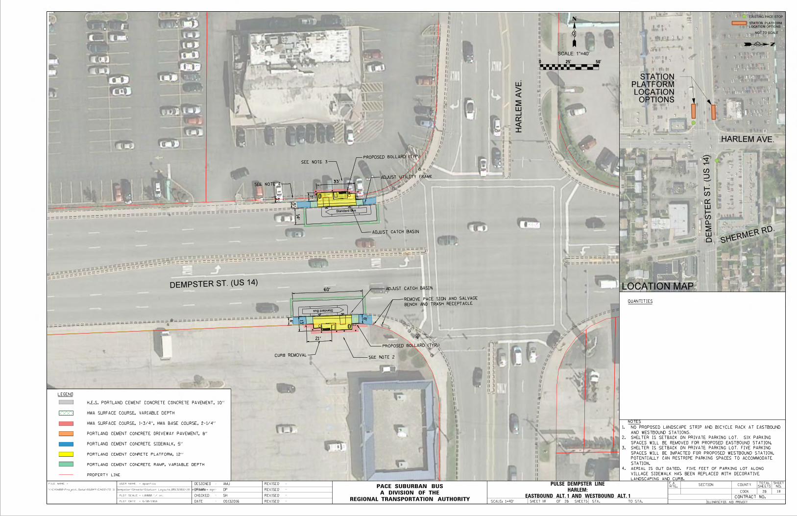
LOCATION MAP
EXISTING PACE STOP
NOT TO SCALE
LEGEND
LOCATION OPTIONS
STATION PLATFORM
28
PROPERTY LINE
PORTLAND CEMENT CONCRETE RAMP, VARIABLE DEPTH
PORTLAND CEMENT CONRETE PLATFORM, 12"
PORTLAND CEMENT CONCRETE SIDEWALK, 5"
PORTLAND CEMENT CONCRETE DRIVEWAY PAVEMENT, 8"
HMA SURFACE COURSE, 1-3/4", HMA BASE COURSE, 2-1/4"
HMA SURFACE COURSE, VARIABLE DEPTH
H.E.S. PORTLAND CEMENT CONCRETE CONCRETE PAVEMENT, 10"
QUANTITIES
0 25' 50'
SECTION COUNTY
ILLINOIS FED. AID PROJECT
COOK
TOTAL
SHEETS
SHEET
NO.RTE.
CONTRACT NO.
SCALE: 1=40'REGIONAL TRANSPORTATION AUTHORITY
A DIVISION OF THE
PACE SUBURBAN BUSFILE NAME
\\CHIW00\Project_Data\56849\CADD\TO 11 Dempster\Sheets\Station Layouts_05132016\18 sht-Harlem.dgn
dpanfiloUSER NAME =
PLOT SCALE = 1.0000 ' / in.
PLOT DATE = 6/10/2016
=
DATE
DESIGNED
CHECKED
DRAWN
-
-
-
-
REVISED -
-
-
-
REVISED
REVISED
REVISED
F.A.
DP
AMJ
05132016
SH
SHEET OF 28 SHEETS STA. TO STA.
Standard Bus
Standard Bus
PROPOSED BOLLARD (TYP.)
ADJUST UTILITY FRAME
ADJUST CATCH BASIN
SEE NOTE 3
33'
5'
SEE NOTE 4
5'
14'
7'
BENCH AND TRASH RECEPTACLE
REMOVE PACE SIGN AND SALVAGE
21'
ADJUST CATCH BASIN
6'
8'13'
60'
CURB REMOVAL
PROPOSED BOLLARD (TYP.)
SEE NOTE 2
TS
Standard Bus
Standard Bus
PROPOSED BOLLARD (TYP.)
ADJUST UTILITY FRAME
ADJUST CATCH BASIN
SEE NOTE 3
33'
5'
SEE NOTE 4
5'
14'
7'
SCALE: 1"=40'
18
OPTIONS LOCATION
PLATFORMSTATION
DEMPSTER ST. (US 14)
NOTES
4.
3.
2.
1.
18
HARLEM AVE.
DE
MP
ST
ER S
T. (U
S 1
4)
SHERMER RD.
HA
RLE
M A
VE.
LANDSCAPING AND CURB.
VILLAGE SIDEWALK HAS BEEN REPLACED WITH DECORATIVE
AERIAL IS OUT DATED. FIVE FEET OF PARKING LOT ALONG
STATION.
POTENTIALLY CAN RESTRIPE PARKING SPACES TO ACCOMMODATE
SPACES WILL BE IMPACTED FOR PROPOSED WESTBOUND STATION.
SHELTER IS SETBACK ON PRIVATE PARKING LOT. FIVE PARKING
SPACES WILL BE REMOVED FOR PROPOSED EASTBOUND STATION.
SHELTER IS SETBACK ON PRIVATE PARKING LOT. SIX PARKING
AND WESTBOUND STATIONS.
NO PROPOSED LANDSCAPE STRIP AND BICYCLE RACK AT EASTBOUND
EASTBOUND ALT. 1 AND WESTBOUND ALT. 1
HARLEM:
PULSE DEMPSTER LINE
BENCH AND TRASH RECEPTACLE
REMOVE PACE SIGN AND SALVAGE
21'
ADJUST CATCH BASIN
6'
8'13'
60'
CURB REMOVAL
PROPOSED BOLLARD (TYP.)
SEE NOTE 2

LOCATION MAP
EXISTING PACE STOP
NOT TO SCALE
LEGEND
LOCATION OPTIONS
STATION PLATFORM
28
PROPERTY LINE
PORTLAND CEMENT CONCRETE RAMP, VARIABLE DEPTH
PORTLAND CEMENT CONRETE PLATFORM, 12"
PORTLAND CEMENT CONCRETE SIDEWALK, 5"
PORTLAND CEMENT CONCRETE DRIVEWAY PAVEMENT, 8"
HMA SURFACE COURSE, 1-3/4", HMA BASE COURSE, 2-1/4"
HMA SURFACE COURSE, VARIABLE DEPTH
H.E.S. PORTLAND CEMENT CONCRETE CONCRETE PAVEMENT, 10"
QUANTITIES
0 25' 50'
SECTION COUNTY
ILLINOIS FED. AID PROJECT
COOK
TOTAL
SHEETS
SHEET
NO.RTE.
CONTRACT NO.
SCALE: 1=40'REGIONAL TRANSPORTATION AUTHORITY
A DIVISION OF THE
PACE SUBURBAN BUSFILE NAME
I:\56849\CADD\TO 11 Dempster\Sheets\Station Layouts_05132016\19 sht-Waukegan.dgn
amjensenUSER NAME =
PLOT SCALE = 1.0000 ' / in.
PLOT DATE = 7/7/2016
=
DATE
DESIGNED
CHECKED
DRAWN
-
-
-
-
REVISED -
-
-
-
REVISED
REVISED
REVISED
F.A.
DP
AMJ
05132016
SH
SHEET OF 28 SHEETS STA. TO STA.
Standard Bus
Standard Bus
60'
PAD
SHELTER AND CONCRETE
REMOVE EXISTING BUS
9'
11'
SCALE: 1"=40'
19
OPTIONS LOCATION
PLATFORMSTATION
19
WAUKEGAN RD.
NE
W E
NG
LA
ND A
VE.
AVE.NEW ENGLAND
ESTIMATE
PARK DISTRICTMORTON GROVE
DE
MP
ST
ER S
T. (I
L 5
8)
OAK PARK AVE
STATIONS.
NO PROPOSED LANDSCAPE STRIP AT EASTBOUND AND WESTBOUND 1.
MORTON GROVE PARK DISTRICT
DEMPSTER ST. (IL 58)
EASTBOUND ALT. 1 AND WESTBOUND ALT. 2
WAUKEGAN:
PULSE DEMPSTER LINE
REMOVE PACE SIGN
RELOCATE LIGHT POST
11'
60'
RESTORE DECORATIVE LANDSCAPE
6.5'
REMOVE PACE SIGNDISTRICT PROPERTY
AVOID IMPACTS TO PARK

LOCATION MAP
EXISTING PACE STOP
NOT TO SCALE
LEGEND
LOCATION OPTIONS
STATION PLATFORM
28
PROPERTY LINE
PORTLAND CEMENT CONCRETE RAMP, VARIABLE DEPTH
PORTLAND CEMENT CONRETE PLATFORM, 12"
PORTLAND CEMENT CONCRETE SIDEWALK, 5"
PORTLAND CEMENT CONCRETE DRIVEWAY PAVEMENT, 8"
HMA SURFACE COURSE, 1-3/4", HMA BASE COURSE, 2-1/4"
HMA SURFACE COURSE, VARIABLE DEPTH
H.E.S. PORTLAND CEMENT CONCRETE CONCRETE PAVEMENT, 10"
QUANTITIES
0 25' 50'
SECTION COUNTY
ILLINOIS FED. AID PROJECT
COOK
TOTAL
SHEETS
SHEET
NO.RTE.
CONTRACT NO.
SCALE: 1=40'REGIONAL TRANSPORTATION AUTHORITY
A DIVISION OF THE
PACE SUBURBAN BUSFILE NAME
\\chiw00\Project_data\56849\CADD\TO 11 Dempster\Sheets\Station Layouts_05132016\20 sht-Austin.dgn
dpanfiloUSER NAME =
PLOT SCALE = 1.0000 ' / in.
PLOT DATE = 7/6/2016
=
DATE
DESIGNED
CHECKED
DRAWN
-
-
-
-
REVISED -
-
-
-
REVISED
REVISED
REVISED
F.A.
DP
AMJ
05132016
SH
SHEET OF 28 SHEETS STA. TO STA.
Standard Bus
Standard Bus
REMOVE BOLLARDS
RELOCATE LIGHT POST
RELOCATE FIRE HYDRANT
REMOVE TREE AND GRATE
REMOVE TREE AND GRATE
REMOVE TREE AND GRATE
DECORATIVE BRICK
REMOVE AND RESET
REMOVE AND SALVAGE ORNAMENTAL PLANTER
REMOVE PACE SIGN
REMOVE BOLLARD
REMOVE TREES
REMOVE PACE SIGN
REMOVE AND SALVAGE TRASH RECEPTACLE
REMOVE AND SALVAGE BENCH
60'
12'
12'
60'
11'
SCALE: 1"=40'
20
OPTIONS LOCATION
PLATFORMSTATION
20
AU
STIN A
VE.
AUSTIN AVE.
MARMORA AVE.
NOTES:
DE
MP
ST
ER S
T. (I
L 5
8)
STATIONS.
NO PROPOSED LANDSCAPE STRIP AT EASTBOUND AND WESTBOUND 1.
DEMPSTER ST. (IL 58)
CVS PHARMACY
EASTBOUND ALT. 1 AND WESTBOUND ALT. 1
AUSTIN:
PULSE DEMPSTER LINE

LOCATION MAP
EXISTING PACE STOP
NOT TO SCALE
LEGEND
LOCATION OPTIONS
STATION PLATFORM
28
PROPERTY LINE
PORTLAND CEMENT CONCRETE RAMP, VARIABLE DEPTH
PORTLAND CEMENT CONRETE PLATFORM, 12"
PORTLAND CEMENT CONCRETE SIDEWALK, 5"
PORTLAND CEMENT CONCRETE DRIVEWAY PAVEMENT, 8"
HMA SURFACE COURSE, 1-3/4", HMA BASE COURSE, 2-1/4"
HMA SURFACE COURSE, VARIABLE DEPTH
H.E.S. PORTLAND CEMENT CONCRETE CONCRETE PAVEMENT, 10"
QUANTITIES
0 25' 50'
SECTION COUNTY
ILLINOIS FED. AID PROJECT
COOK
TOTAL
SHEETS
SHEET
NO.RTE.
CONTRACT NO.
SCALE: 1=40'REGIONAL TRANSPORTATION AUTHORITY
A DIVISION OF THE
PACE SUBURBAN BUSFILE NAME
I:\56849\CADD\TO 11 Dempster\Sheets\Station Layouts_05132016\21 sht-Skokie.dgn
amjensenUSER NAME =
PLOT SCALE = 1.0000 ' / in.
PLOT DATE = 7/7/2016
=
DATE
DESIGNED
CHECKED
DRAWN
-
-
-
-
REVISED -
-
-
-
REVISED
REVISED
REVISED
F.A.
DP
AMJ
05132016
SH
SHEET OF 28 SHEETS STA. TO STA.
Standard Bus
SK
OKIE V
ALLE
Y T
RAIL
COMED
Standard Bus
REMOVE AND RE-ERECT FENCE
REMOVE TREE AND TREE GRATE
REMOVE TREES AND GRATES
REMOVE AND RESET BRICK PAVERS
REMOVE AND RESET BRICKPAVERS
REMOVE TREES AND TREE GRATES
REMOVE AND RESET BRICK PAVERSREMOVE AND RESET BRICK PAVERS
8'
8'
ADJUST UTILITY FRAME
RESTORE DECORATIVE LANDSCAPING
CO
ME
D
13.5'
12.5'
12.5'
DEMPSTER ST. (IL 58)
SEE NOTE 3
RELOCATE SKOKIE SWIFT SIGN
60'
45'
DEMPSTER - SKOKIE CTA STATION
EXISTING BRICK CROSSWALK
TS
LE CLAIRE AVE.
21
21
1" = 40'
OPTIONSLOCATION PLATFORMSTATION
BRONX AVE.
DE
MP
ST
ER S
T. (IL
58)
STATIONSKOKIE CTADEMPSTER-
AND FOR PLACEMENT OF BICYCLE RACKS.
FOR CONSTRUCTING WESTBOUND STATION ADJACENT TO NEW TRAIL
CONSTRUCTED. COODINATION WITH VILLAGE OF SKOKIE IS REQUIRED
AERIAL IS OUTDATED. SKOKIE VALLEY TRAIL HAS BEEN 3.
WESTBOUND STATIONS.
COORDINATION WITH COMED IS REQUIRED FOR EASTBOUND AND2.
PLATFORMS.
NO LANDSCAPE PROPOSED AT WESTBOUND AND EASTBOUND 1.
NOTES:
EASTBOUND ALT. 2 AND WESTBOUND ALT. 2
DEMPSTER-SKOKIE CTA:
PULSE DEMPSTER LINE

LOCATION MAP
EXISTING PACE STOP
NOT TO SCALE
LEGEND
LOCATION OPTIONS
STATION PLATFORM
28
PROPERTY LINE
PORTLAND CEMENT CONCRETE RAMP, VARIABLE DEPTH
PORTLAND CEMENT CONRETE PLATFORM, 12"
PORTLAND CEMENT CONCRETE SIDEWALK, 5"
PORTLAND CEMENT CONCRETE DRIVEWAY PAVEMENT, 8"
HMA SURFACE COURSE, 1-3/4", HMA BASE COURSE, 2-1/4"
HMA SURFACE COURSE, VARIABLE DEPTH
H.E.S. PORTLAND CEMENT CONCRETE CONCRETE PAVEMENT, 10"
QUANTITIES
0 25' 50'
SECTION COUNTY
ILLINOIS FED. AID PROJECT
COOK
TOTAL
SHEETS
SHEET
NO.RTE.
CONTRACT NO.
SCALE: 1=40'REGIONAL TRANSPORTATION AUTHORITY
A DIVISION OF THE
PACE SUBURBAN BUSFILE NAME
\\CHIW00\Project_Data\56849\CADD\TO 11 Dempster\Sheets\Station Layouts_05132016\22 sht-Crawford Alt 1.dgn
dpanfiloUSER NAME =
PLOT SCALE = 1.0000 ' / in.
PLOT DATE = 6/10/2016
=
DATE
DESIGNED
CHECKED
DRAWN
-
-
-
-
REVISED -
-
-
-
REVISED
REVISED
REVISED
F.A.
DP
AMJ
05132016
SH
SHEET OF 28 SHEETS STA. TO STA.
Standard Bus
Standard Bus
ADJUST INLET
SEE NOTE 4
REMOVE PACE SIGN
REMOVE TREE
REMOVE TREE
12'
60'
13'
3'
11'
RESTORE DECORATIVE LANDSCAPING
8'
45'
10.5'
PLATFORMEAST AND WEST SIDES OF PROPOSED RAILING ALONG
SEE NOTE 3
REMOVE TREE
SCALE: 1"=40'
22
OPTIONSLOCATION PLATFORM STATION CRAWFORD AVE.
SPRINGFIELD AVE.
CR
AW
FO
RD A
VE.
HARDING AVE.
DE
MP
ST
ER S
T.
NOTES:
22
MOBILE GAS STATION
PARKING LOT.
REQUIREMENTS. SHELTER MAY ENCROACH INTO PRIVATE
SHELTER IS SET BACK TO MEET SIGHT DISTANCE4.
REQUIREMENTS. SHELTER WILL POTENTIALLY BE AGAINST BUILDING.
SHELTER IS SET BACK TO MEET SIGHT DISTANCE 3.
WESTBOUND STATIONS AND NO BIKE RACK AT WESTBOUND STATION.
PROPOSE NO LANDSCAPE STRIP AT EASTBOUND AND 2.
THE SOUTHEAST CORNER OF CRAWFORD AND DEMPSTER
AERIAL IS OUTDATED. A NEW CVS PHARMACY IS LOCATED AT1.
DEMPSTER ST.
EASTBOUND ALT. 1 AND WESTBOUND ALT. 3
CRAWFORD:
PULSE DEMPSTER LINE
WALGREENS

LOCATION MAP
EXISTING PACE STOP
NOT TO SCALE
LEGEND
LOCATION OPTIONS
STATION PLATFORM
28
PROPERTY LINE
PORTLAND CEMENT CONCRETE RAMP, VARIABLE DEPTH
PORTLAND CEMENT CONRETE PLATFORM, 12"
PORTLAND CEMENT CONCRETE SIDEWALK, 5"
PORTLAND CEMENT CONCRETE DRIVEWAY PAVEMENT, 8"
HMA SURFACE COURSE, 1-3/4", HMA BASE COURSE, 2-1/4"
HMA SURFACE COURSE, VARIABLE DEPTH
H.E.S. PORTLAND CEMENT CONCRETE CONCRETE PAVEMENT, 10"
QUANTITIES
0 25' 50'
SECTION COUNTY
ILLINOIS FED. AID PROJECT
COOK
TOTAL
SHEETS
SHEET
NO.RTE.
CONTRACT NO.
SCALE: 1=40'REGIONAL TRANSPORTATION AUTHORITY
A DIVISION OF THE
PACE SUBURBAN BUSFILE NAME
I:\56849\CADD\TO 11 Dempster\Sheets\Station Layouts_05132016\23 sht-Crawford Alt 2.dgn
amjensenUSER NAME =
PLOT SCALE = 1.0000 ' / in.
PLOT DATE = 6/10/2016
=
DATE
DESIGNED
CHECKED
DRAWN
-
-
-
-
REVISED -
-
-
-
REVISED
REVISED
REVISED
F.A.
DP
AMJ
05132016
SH
SHEET OF 28 SHEETS STA. TO STA.
Standard Bus
45'
REMOVE TREE
RELOCATE LIGHT POLE
SEE SHEET 22 FOR STATION DETAILS
SEE NOTE 4RESTORE DECORATIVE LANDSCAPE
11'
12'
EAST SIDE OF PLATFORMPROPOSED RAILING ALONG
Standard Bus
8'
28'
SCALE: 1"=40'
23
OPTIONSLOCATION PLATFORM STATION
CRAWFORD AVE.
SPRINGFIELD AVE.
HA
RDIN
G A
VE.
HARDING AVE.
DE
MP
ST
ER S
T.
NOTES:
23
REQUIREMENTS. SHELTER MAY ENCROACH INTO PRIVATE PARKING LOT.
4. SHELTER IS SET BACK TO MEET SIGHT DISTANCE
DEMPSTER ST AND CRAWFORD AVE
3. REMOVE EXISTING PACE SIGN AT NORTHWEST CORNER OF
2. NO PROPOSED LANDSCAPE STRIP AT WESTBOUND STATION
SOUTHEAST CORNER OF CRAWFORD AND DEMPSTER
1. AERIAL IS OUTDATED. A NEW CVS PHARMACY IS LOCATED AT THE
WESTBOUND ALT. 4
CRAWFORD:
PULSE DEMPSTER LINE
DEMPSTER ST.
WALGREENS

LOCATION MAP
EXISTING PACE STOP
NOT TO SCALE
LEGEND
LOCATION OPTIONS
STATION PLATFORM
28
PROPERTY LINE
PORTLAND CEMENT CONCRETE RAMP, VARIABLE DEPTH
PORTLAND CEMENT CONRETE PLATFORM, 12"
PORTLAND CEMENT CONCRETE SIDEWALK, 5"
PORTLAND CEMENT CONCRETE DRIVEWAY PAVEMENT, 8"
HMA SURFACE COURSE, 1-3/4", HMA BASE COURSE, 2-1/4"
HMA SURFACE COURSE, VARIABLE DEPTH
H.E.S. PORTLAND CEMENT CONCRETE CONCRETE PAVEMENT, 10"
QUANTITIES
0 25' 50'
SECTION COUNTY
ILLINOIS FED. AID PROJECT
COOK
TOTAL
SHEETS
SHEET
NO.RTE.
CONTRACT NO.
SCALE: 1=40'REGIONAL TRANSPORTATION AUTHORITY
A DIVISION OF THE
PACE SUBURBAN BUSFILE NAME
\\CHIW00\Project_Data\56849\CADD\TO 11 Dempster\Sheets\Station Layouts_05132016\24 sht-Lincolnwoon Alt 1.dgn
dpanfiloUSER NAME =
PLOT SCALE = 1.0000 ' / in.
PLOT DATE = 6/10/2016
=
DATE
DESIGNED
CHECKED
DRAWN
-
-
-
-
REVISED -
-
-
-
REVISED
REVISED
REVISED
F.A.
DP
AMJ
05132016
SH
SHEET OF 28 SHEETS STA. TO STA.
Standard Bus
Standard Bus
12.5'
10.5'
45'
8'
12'
ADJUST INLET
12'
RELOCATE LIGHT POLE
REMOVE TREE
SEE NOTE 2
RELOCATE PRIVATE SIGN
REMOVE TREE
SCALE: 1"=40'
24
OPTIONSLOCATION PLATFORM STATION
ST. L
OUIS A
VE.
LIN
CO
LN
WO
OD D
R.
LINCOLNWOOD DR.ST. LOUIS AVE.
TRUMBELL AVE.
FORESTVIEW RD.
CENTRAL PARK AVE.
DRAKE AVE.
DE
MP
ST
ER S
T.
24
NOTES:
SHELTER MAY ENCROACH INTO PRIVATE PARKING LOT.
SHELTER IS SET BACK TO MEET SIGHT DISTANCE REQUIREMENTS.2.
WESTBOUND STATIONS.
NO PROPOSED LANDSCAPE STRIP AT EASTBOUND AND 1.
DEMPSTER ST.
EASTBOUND ALT. 1 AND WESTBOUND ALT. 1
LINCOLNWOOD:
PULSE DEMPSTER LINE

LOCATION MAP
EXISTING PACE STOP
NOT TO SCALE
LEGEND
LOCATION OPTIONS
STATION PLATFORM
28
PROPERTY LINE
PORTLAND CEMENT CONCRETE RAMP, VARIABLE DEPTH
PORTLAND CEMENT CONRETE PLATFORM, 12"
PORTLAND CEMENT CONCRETE SIDEWALK, 5"
PORTLAND CEMENT CONCRETE DRIVEWAY PAVEMENT, 8"
HMA SURFACE COURSE, 1-3/4", HMA BASE COURSE, 2-1/4"
HMA SURFACE COURSE, VARIABLE DEPTH
H.E.S. PORTLAND CEMENT CONCRETE CONCRETE PAVEMENT, 10"
QUANTITIES
0 25' 50'
SECTION COUNTY
ILLINOIS FED. AID PROJECT
COOK
TOTAL
SHEETS
SHEET
NO.RTE.
CONTRACT NO.
SCALE: 1=40'REGIONAL TRANSPORTATION AUTHORITY
A DIVISION OF THE
PACE SUBURBAN BUSFILE NAME
\\chiw00\Project_data\56849\CADD\TO 11 Dempster\Sheets\Station Layouts_05132016\25 sht-Lincolnwoon Alt 2.dgn
dpanfiloUSER NAME =
PLOT SCALE = 1.0000 ' / in.
PLOT DATE = 7/6/2016
=
DATE
DESIGNED
CHECKED
DRAWN
-
-
-
-
REVISED -
-
-
-
REVISED
REVISED
REVISED
F.A.
DP
AMJ
05132016
SH
SHEET OF 28 SHEETS STA. TO STA.
REMOVE TREE
ADJUST CATCH BASIN
SEE NOTE 2
REMOVE TREE
REMOVE PACE SIGN
RELOCATE SPEED LIMIT SIGN
11'
45'
PROPOSED BOLLARD (TYP.)
13'
Standard Bus
Standard Bus
45'
6.5'13'
SCALE: 1"=40'
25
OPTIONSLOCATION PLATFORM STATION
ST. L
OUIS A
VE.
LIN
CO
LN
WO
OD D
R.
LINCOLNWOOD DR.ST. LOUIS AVE.
TRUMBELL AVE.
FORESTVIEW RD.
CENTRAL PARK AVE.
DRAKE AVE.
NOTES:
25
DE
MP
ST
ER S
T.
4 PARKING SPACES.
SHELTER MAY ENCROACH INTO PRIVATE PARKING LOT AND ELIMINATE
SHELTER IS SET BACK TO MEET SIGHT DISTANCE REQUIREMENTS. 2.
STATIONS.
NO PROPOSED LANDSCAPE STRIP AT EASTBOUND AND WESTBOUND 1.
EASTBOUND ALT. 2 AND WESTBOUND ALT. 2
LINCOLNWOOD:
PULSE DEMPSTER LINE
DEMPSTER ST.
CVS PHARMACY

LOCATION MAP
EXISTING PACE STOP
NOT TO SCALE
LEGEND
LOCATION OPTIONS
STATION PLATFORM
28
PROPERTY LINE
PORTLAND CEMENT CONCRETE RAMP, VARIABLE DEPTH
PORTLAND CEMENT CONRETE PLATFORM, 12"
PORTLAND CEMENT CONCRETE SIDEWALK, 5"
PORTLAND CEMENT CONCRETE DRIVEWAY PAVEMENT, 8"
HMA SURFACE COURSE, 1-3/4", HMA BASE COURSE, 2-1/4"
HMA SURFACE COURSE, VARIABLE DEPTH
H.E.S. PORTLAND CEMENT CONCRETE CONCRETE PAVEMENT, 10"
QUANTITIES
0 25' 50'
SECTION COUNTY
ILLINOIS FED. AID PROJECT
COOK
TOTAL
SHEETS
SHEET
NO.RTE.
CONTRACT NO.
SCALE: 1=40'REGIONAL TRANSPORTATION AUTHORITY
A DIVISION OF THE
PACE SUBURBAN BUSFILE NAME
\\chiw00\Project_data\56849\CADD\TO 11 Dempster\Sheets\Station Layouts_05132016\26 sht-Dodge Alt 1.dgn
dpanfiloUSER NAME =
PLOT SCALE = 1.0000 ' / in.
PLOT DATE = 7/6/2016
=
DATE
DESIGNED
CHECKED
DRAWN
-
-
-
-
REVISED -
-
-
-
REVISED
REVISED
REVISED
F.A.
DP
AMJ
05132016
SH
SHEET OF 28 SHEETS STA. TO STA.
Standard Bus
Standard Bus
SEE NOTE 2
PROPOSED ADA ACCESSIBLE CURB RAMP
PROPOSED CROSSWALK
PROPOSED ADA ACCESSIBLE CURB RAMP
REMOVE PACE SIGN
REMOVE TREE
RELOCATE TRAFFIC SIGN
ADJUST MANHOLE
SHRUBSEXISTING DECORATIVE
14'
13.5'
10'
RECEPTACLEREMOVE TRASH
11'
60'
45'
SCALE: 1"=40'
26
DO
DG
E A
VE.
DODGE AVE.
DARROW AVE.
26
NOTES:
DE
MP
ST
ER S
T.
OPTIONSLOCATION PLATFORM STATION
PRIVATE PARKING LOT.
SIGHT DISTANCE REQUIREMENTS. MAY ENCROACH INTO
SHELTER IS SET BACK ONTO PRIVATE PROPERTY TO MEET2.
STATIONS.
NO PROPOSED LANDSCAPE AT EASTBOUND AND WESTBOUND1.
DEMPSTER ST.
EASTBOUND ALT. 1 AND WESTBOUND ALT. 1
DODGE:
PULSE DEMPSTER LINE

LOCATION MAP
EXISTING PACE STOP
NOT TO SCALE
LEGEND
LOCATION OPTIONS
STATION PLATFORM
28
PROPERTY LINE
PORTLAND CEMENT CONCRETE RAMP, VARIABLE DEPTH
PORTLAND CEMENT CONRETE PLATFORM, 12"
PORTLAND CEMENT CONCRETE SIDEWALK, 5"
PORTLAND CEMENT CONCRETE DRIVEWAY PAVEMENT, 8"
HMA SURFACE COURSE, 1-3/4", HMA BASE COURSE, 2-1/4"
HMA SURFACE COURSE, VARIABLE DEPTH
H.E.S. PORTLAND CEMENT CONCRETE CONCRETE PAVEMENT, 10"
QUANTITIES
0 25' 50'
SECTION COUNTY
ILLINOIS FED. AID PROJECT
COOK
TOTAL
SHEETS
SHEET
NO.RTE.
CONTRACT NO.
SCALE: 1=40'REGIONAL TRANSPORTATION AUTHORITY
A DIVISION OF THE
PACE SUBURBAN BUSFILE NAME
\\chiw00\Project_data\56849\CADD\TO 11 Dempster\Sheets\Station Layouts_05132016\27 sht-Dodge Alt 2.dgn
dpanfiloUSER NAME =
PLOT SCALE = 1.0000 ' / in.
PLOT DATE = 7/6/2016
=
DATE
DESIGNED
CHECKED
DRAWN
-
-
-
-
REVISED -
-
-
-
REVISED
REVISED
REVISED
F.A.
DP
AMJ
05132016
SH
SHEET OF 28 SHEETS STA. TO STA.
Standard Bus
Standard Bus
FOR STATION DETAILSSEE SHEET 26
SEE NOTE 2
RELOCATE FIRE HYDRANT
45'
8'
10'
PROPOSED BOLLARD (TYP.)
9'
SCALE: 1"=40'
27
DO
DG
E A
VE.
DODGE AVE.
DARROW AVE.
NOTES:
OPTIONSLOCATION PLATFORM STATION
27
DE
MP
ST
ER S
T.
SIGHT DISTANCE REQUIREMENTS
2. STATION IS SET BACK ONTO PRIVATE PROPERTY TO MEET
1. NO PROPOSED LANDSCAPE STRIP AT WESTBOUND STATION
WESTBOUND ALT. 3
DODGE:
PULSE DEMPSTER LINE
DEMPSTER ST.

LOCATION MAP
EXISTING PACE STOP
NOT TO SCALE
LEGEND
LOCATION OPTIONS
STATION PLATFORM
28
PROPERTY LINE
PORTLAND CEMENT CONCRETE RAMP, VARIABLE DEPTH
PORTLAND CEMENT CONRETE PLATFORM, 12"
PORTLAND CEMENT CONCRETE SIDEWALK, 5"
PORTLAND CEMENT CONCRETE DRIVEWAY PAVEMENT, 8"
HMA SURFACE COURSE, 1-3/4", HMA BASE COURSE, 2-1/4"
HMA SURFACE COURSE, VARIABLE DEPTH
H.E.S. PORTLAND CEMENT CONCRETE CONCRETE PAVEMENT, 10"
QUANTITIES
0 25' 50'
SECTION COUNTY
ILLINOIS FED. AID PROJECT
COOK
TOTAL
SHEETS
SHEET
NO.RTE.
CONTRACT NO.
SCALE: 1=40'REGIONAL TRANSPORTATION AUTHORITY
A DIVISION OF THE
PACE SUBURBAN BUSFILE NAME
\\CHIW00\Project_Data\56849\CADD\TO 11 Dempster\Sheets\Station Layouts_05132016\28 sht-Davis Metra.dgn
dpanfiloUSER NAME =
PLOT SCALE = 1.0000 ' / in.
PLOT DATE = 6/7/2016
=
DATE
DESIGNED
CHECKED
DRAWN
-
-
-
-
REVISED -
-
-
-
REVISED
REVISED
REVISED
F.A.
DP
AMJ
05132016
SH
SHEET OF 28 SHEETS STA. TO STA.
PULSE SIGNPROPOSE NEW
SCALE: 1"=40'
28
OPTIONS LOCATION
PLATFORMSTATION
DA
VIS S
T.
BENSON AVE.
MAPLE AVE.
OAK AVE.
ELMW
OOD AVE.
DAVIS CTA / METRA
PULSE DEMPSTER LINEB
EN
SO
N A
VE.
28
NOTES:
REAL TIME ARRIVAL INFORMATION SIGNS.
TRANSPORTATION AUTHORITY ON INTERAGENCY
FUTURE COORDINATION NEEDED WITH REGIONAL 1.
DAVIS CTA/METRA STATION

PROJECT DEFINITION PULSE DEMPSTER LINE
Appendix G DRAFT BUS SCHEDULES

BASELINE OPERATING PLAN: PULSE DEMPSTER LINE

DRAFT 8/1/2016
Pace Dempster Pulse (7/27/16) Weekday
Total annual rev vehicle hrs 53403:37:28 Peak Buses = 15Total annual rev vehicle mi 901,185.30 20% Spares = 3
Fleet Size = 18Schedule Inputs AM EB Running Time 0:58:41Headway 1 0:15:00 AM WB Running Time 0:52:14 wkday rev hrs 158:56:30Headway 2 0:10:00 Midday EB Running Time 0:54:42 wkday rev mi 2677.5Headway 3 0:30:00 Midday WB Running Time 0:53:31Headway 4 0:00:00 PM EB Running Time 1:06:18 annual rev hrs 40530:07:30
PM WB Running Time 1:04:24 annual rev mi 682762.5Eve EB Running Time 0:47:41
Eve WB Running Time 0:43:30
Weekday Pace Dempster Pulse Headways:
Round trip Count Block No. Lv O'Hare Lee/Touhy DP Metra Hosp Milwaukee Waukegan CTA Skokie Crawford Dodge Ar Davis Recovery time Lv Davis Dodge Crawford CTA Skokie Waukegan Milwaukee Hosp DP Metra Lee/Touhy Ar O'Hare Recovery time Lv next trip Trip Miles Trip Hours
Total Recovery
Time EB WB1 1 5:00 AM 5:05 AM 5:09 AM 5:12 AM 5:18 AM 5:22 AM 5:25 AM 5:31 AM 5:38 AM 5:43 AM 0:16:30 6:00 AM 1 15.3 1:00:00 0:16:302 2 5:15 AM 5:20 AM 5:24 AM 5:27 AM 5:33 AM 5:37 AM 5:40 AM 5:46 AM 5:53 AM 5:58 AM 0:11:30 6:10 AM 2 15.3 0:55:00 0:11:30 0:15:003 3 5:30 AM 5:35 AM 5:39 AM 5:42 AM 5:48 AM 5:52 AM 5:55 AM 6:01 AM 6:08 AM 6:13 AM 0:06:30 6:20 AM 3 15.3 0:50:00 0:06:30 0:15:004 4 5:45 AM 5:50 AM 5:54 AM 5:57 AM 6:03 AM 6:07 AM 6:10 AM 6:16 AM 6:23 AM 6:28 AM 0:11:30 6:40 AM 4 15.3 0:55:00 0:11:30 0:15:005 5 5:00 AM 5:04 AM 5:13 AM 5:19 AM 5:22 AM 5:27 AM 5:33 AM 5:37 AM 5:41 AM 5:47 AM 0:13:00 6:00 AM 6:06 AM 6:10 AM 6:15 AM 6:22 AM 6:26 AM 6:29 AM 6:35 AM 6:45 AM 6:52 AM 0:07:05 7:00 AM 5 30.6 2:00:00 0:20:05 0:15:416 6 5:15 AM 5:19 AM 5:28 AM 5:34 AM 5:37 AM 5:42 AM 5:48 AM 5:52 AM 5:56 AM 6:02 AM 0:08:00 6:10 AM 6:16 AM 6:20 AM 6:25 AM 6:32 AM 6:36 AM 6:39 AM 6:45 AM 6:55 AM 7:02 AM 0:07:05 7:10 AM 6 30.6 1:55:00 0:15:05 0:15:00 0:10:007 7 6:20 AM 6:26 AM 6:30 AM 6:35 AM 6:42 AM 6:46 AM 6:49 AM 6:55 AM 7:05 AM 7:12 AM 0:07:05 7:20 AM 7 15.3 0:59:19 0:07:05 0:10:008 8 5:30 AM 5:34 AM 5:43 AM 5:49 AM 5:52 AM 5:57 AM 6:03 AM 6:07 AM 6:11 AM 6:17 AM 0:13:00 6:30 AM 6:36 AM 6:40 AM 6:45 AM 6:52 AM 6:56 AM 6:59 AM 7:05 AM 7:15 AM 7:22 AM 0:07:05 7:30 AM 8 30.6 2:00:00 0:20:05 0:15:00 0:10:009 9 5:45 AM 5:49 AM 5:58 AM 6:04 AM 6:07 AM 6:12 AM 6:18 AM 6:22 AM 6:26 AM 6:32 AM 0:08:00 6:40 AM 6:46 AM 6:50 AM 6:55 AM 7:02 AM 7:06 AM 7:09 AM 7:15 AM 7:25 AM 7:32 AM 0:07:05 7:40 AM 9 30.6 1:55:00 0:15:05 0:15:00 0:10:00
10 10 6:50 AM 6:56 AM 7:00 AM 7:05 AM 7:12 AM 7:16 AM 7:19 AM 7:25 AM 7:35 AM 7:42 AM 0:07:05 7:50 AM 10 15.3 0:59:19 0:07:05 0:10:0011 11 7:00 AM 7:06 AM 7:10 AM 7:15 AM 7:22 AM 7:26 AM 7:29 AM 7:35 AM 7:45 AM 7:52 AM 0:07:05 8:00 AM 11 15.3 0:59:19 0:07:05 0:10:0012 1 6:00 AM 6:06 AM 6:16 AM 6:23 AM 6:28 AM 6:33 AM 6:41 AM 6:45 AM 6:51 AM 6:58 AM 0:10:00 7:08 AM 7:14 AM 7:18 AM 7:23 AM 7:30 AM 7:34 AM 7:37 AM 7:43 AM 7:53 AM 8:00 AM 0:09:05 8:10 AM 1 30.6 2:10:00 0:19:05 0:15:00 0:08:0013 2 6:10 AM 6:16 AM 6:26 AM 6:33 AM 6:38 AM 6:43 AM 6:51 AM 6:55 AM 7:01 AM 7:08 AM 0:10:00 7:18 AM 7:24 AM 7:28 AM 7:33 AM 7:40 AM 7:44 AM 7:47 AM 7:53 AM 8:03 AM 8:10 AM 0:09:05 8:20 AM 2 30.6 2:10:00 0:19:05 0:10:00 0:10:0014 3 6:20 AM 6:26 AM 6:36 AM 6:43 AM 6:48 AM 6:53 AM 7:01 AM 7:05 AM 7:11 AM 7:18 AM 0:10:00 7:28 AM 7:34 AM 7:38 AM 7:43 AM 7:50 AM 7:54 AM 7:57 AM 8:03 AM 8:13 AM 8:20 AM 0:09:05 8:30 AM 3 30.6 2:10:00 0:19:05 0:10:00 0:10:0015 12 6:30 AM 6:36 AM 6:46 AM 6:53 AM 6:58 AM 7:03 AM 7:11 AM 7:15 AM 7:21 AM 7:28 AM 0:10:00 7:38 AM 7:44 AM 7:48 AM 7:53 AM 8:00 AM 8:04 AM 8:07 AM 8:13 AM 8:23 AM 8:30 AM 0:09:05 8:40 AM 12 30.6 2:10:00 0:19:05 0:10:00 0:10:0016 4 6:40 AM 6:46 AM 6:56 AM 7:03 AM 7:08 AM 7:13 AM 7:21 AM 7:25 AM 7:31 AM 7:38 AM 0:10:00 7:48 AM 7:54 AM 7:58 AM 8:03 AM 8:10 AM 8:14 AM 8:17 AM 8:23 AM 8:33 AM 8:40 AM 0:09:05 8:50 AM 4 30.6 2:10:00 0:19:05 0:10:00 0:10:0017 13 6:50 AM 6:56 AM 7:06 AM 7:13 AM 7:18 AM 7:23 AM 7:31 AM 7:35 AM 7:41 AM 7:48 AM 0:10:00 7:58 AM 8:04 AM 8:08 AM 8:13 AM 8:20 AM 8:24 AM 8:27 AM 8:33 AM 8:43 AM 8:50 AM 0:09:05 9:00 AM 13 30.6 2:10:00 0:19:05 0:10:00 0:10:0018 5 7:00 AM 7:06 AM 7:16 AM 7:23 AM 7:28 AM 7:33 AM 7:41 AM 7:45 AM 7:51 AM 7:58 AM 0:10:00 8:08 AM 8:14 AM 8:18 AM 8:23 AM 8:30 AM 8:34 AM 8:37 AM 8:43 AM 8:53 AM 9:00 AM 0:00:00 9:00 AM 5 30.6 2:00:55 0:10:00 0:10:00 0:10:0019 6 7:10 AM 7:16 AM 7:26 AM 7:33 AM 7:38 AM 7:43 AM 7:51 AM 7:55 AM 8:01 AM 8:08 AM 0:10:00 8:18 AM 8:24 AM 8:28 AM 8:33 AM 8:40 AM 8:44 AM 8:47 AM 8:53 AM 9:03 AM 9:10 AM 0:04:05 9:15 AM 6 30.6 2:05:00 0:14:05 0:10:00 0:10:0020 7 7:20 AM 7:26 AM 7:36 AM 7:43 AM 7:48 AM 7:53 AM 8:01 AM 8:05 AM 8:11 AM 8:18 AM 0:10:00 8:28 AM 8:34 AM 8:38 AM 8:43 AM 8:50 AM 8:54 AM 8:57 AM 9:03 AM 9:13 AM 9:20 AM 0:09:05 9:30 AM 7 30.6 2:10:00 0:19:05 0:10:00 0:10:0021 8 7:30 AM 7:36 AM 7:46 AM 7:53 AM 7:58 AM 8:03 AM 8:11 AM 8:15 AM 8:21 AM 8:28 AM 0:10:00 8:38 AM 8:44 AM 8:48 AM 8:53 AM 9:00 AM 9:04 AM 9:07 AM 9:13 AM 9:23 AM 9:30 AM 0:14:05 9:45 AM 8 30.6 2:15:00 0:24:05 0:10:00 0:10:0022 9 7:40 AM 7:46 AM 7:56 AM 8:03 AM 8:08 AM 8:13 AM 8:21 AM 8:25 AM 8:31 AM 8:38 AM 0:10:00 8:48 AM 8:54 AM 8:58 AM 9:03 AM 9:10 AM 9:14 AM 9:17 AM 9:23 AM 9:33 AM 9:40 AM 0:00:00 9:40 AM 9 30.6 2:00:55 0:10:00 0:10:00 0:10:0023 10 7:50 AM 7:56 AM 8:06 AM 8:13 AM 8:18 AM 8:23 AM 8:31 AM 8:35 AM 8:41 AM 8:48 AM 0:10:00 8:58 AM 9:04 AM 9:08 AM 9:13 AM 9:20 AM 9:24 AM 9:27 AM 9:33 AM 9:43 AM 9:50 AM 0:09:05 10:00 AM 10 30.6 2:10:00 0:19:05 0:10:00 0:10:0024 11 8:00 AM 8:06 AM 8:16 AM 8:23 AM 8:28 AM 8:33 AM 8:41 AM 8:45 AM 8:51 AM 8:58 AM 0:12:00 9:10 AM 9:17 AM 9:22 AM 9:26 AM 9:33 AM 9:38 AM 9:42 AM 9:49 AM 9:58 AM 10:04 AM 0:10:48 10:15 AM 11 30.6 2:15:00 0:22:48 0:10:00 0:12:0025 1 8:10 AM 8:16 AM 8:26 AM 8:33 AM 8:38 AM 8:43 AM 8:51 AM 8:55 AM 9:01 AM 9:08 AM 1 15.3 0:58:41 0:00:00 0:10:0026 2 8:20 AM 8:26 AM 8:36 AM 8:43 AM 8:48 AM 8:53 AM 9:01 AM 9:05 AM 9:11 AM 9:18 AM 0:07:00 9:25 AM 9:32 AM 9:37 AM 9:41 AM 9:48 AM 9:53 AM 9:57 AM 10:04 AM 10:13 AM 10:19 AM 0:10:48 10:30 AM 2 30.6 2:10:00 0:17:48 0:10:00 0:15:0027 3 8:30 AM 8:36 AM 8:46 AM 8:53 AM 8:58 AM 9:03 AM 9:11 AM 9:15 AM 9:21 AM 9:28 AM 0:12:00 9:40 AM 9:47 AM 9:52 AM 9:56 AM 10:03 AM 10:08 AM 10:12 AM 10:19 AM 10:28 AM 10:34 AM 0:10:48 10:45 AM 3 30.6 2:15:00 0:22:48 0:10:00 0:15:0028 12 8:40 AM 8:46 AM 8:56 AM 9:03 AM 9:08 AM 9:13 AM 9:21 AM 9:25 AM 9:31 AM 9:38 AM 12 15.3 0:58:41 0:00:00 0:10:0029 4 8:50 AM 8:56 AM 9:06 AM 9:13 AM 9:18 AM 9:23 AM 9:31 AM 9:35 AM 9:41 AM 9:48 AM 0:08:00 9:56 AM 10:03 AM 10:08 AM 10:12 AM 10:19 AM 10:24 AM 10:28 AM 10:35 AM 10:44 AM 10:50 AM 0:09:48 11:00 AM 4 30.6 2:10:00 0:17:48 0:10:00 0:16:0030 13 9:00 AM 9:05 AM 9:15 AM 9:22 AM 9:26 AM 9:31 AM 9:38 AM 9:42 AM 9:48 AM 9:54 AM 13 15.3 0:54:42 0:00:00 0:10:00 0:18:0131 6 9:15 AM 9:20 AM 9:26 AM 9:30 AM 9:37 AM 9:42 AM 9:46 AM 9:53 AM 10:03 AM 10:09 AM 0:05:00 10:14 AM 10:21 AM 10:26 AM 10:30 AM 10:37 AM 10:42 AM 10:46 AM 10:53 AM 11:02 AM 11:08 AM 0:06:47 11:15 AM 6 30.6 2:00:00 0:11:47 0:15:0032 7 9:30 AM 9:35 AM 9:45 AM 9:52 AM 9:56 AM 10:01 AM 10:08 AM 10:12 AM 10:18 AM 10:24 AM 0:08:00 10:32 AM 10:39 AM 10:44 AM 10:48 AM 10:55 AM 11:00 AM 11:04 AM 11:11 AM 11:20 AM 11:26 AM 0:03:47 11:30 AM 7 30.6 2:00:00 0:11:47 0:15:00 0:18:0033 8 9:45 AM 9:50 AM 10:00 AM 10:07 AM 10:11 AM 10:16 AM 10:23 AM 10:27 AM 10:33 AM 10:39 AM 0:07:00 10:46 AM 10:53 AM 10:58 AM 11:02 AM 11:09 AM 11:14 AM 11:18 AM 11:25 AM 11:34 AM 11:40 AM 0:04:47 11:45 AM 8 30.6 2:00:00 0:11:47 0:15:00 0:14:0034 10 10:00 AM 10:05 AM 10:15 AM 10:22 AM 10:26 AM 10:31 AM 10:38 AM 10:42 AM 10:48 AM 10:54 AM 0:07:00 11:01 AM 11:08 AM 11:13 AM 11:17 AM 11:24 AM 11:29 AM 11:33 AM 11:40 AM 11:49 AM 11:55 AM 0:04:47 12:00 PM 10 30.6 2:00:00 0:11:47 0:15:00 0:15:0035 11 10:15 AM 10:20 AM 10:30 AM 10:37 AM 10:41 AM 10:46 AM 10:53 AM 10:57 AM 11:03 AM 11:09 AM 0:07:00 11:16 AM 11:23 AM 11:28 AM 11:32 AM 11:39 AM 11:44 AM 11:48 AM 11:55 AM 12:04 PM 12:10 PM 0:04:47 12:15 PM 11 30.6 2:00:00 0:11:47 0:15:00 0:15:0036 2 10:30 AM 10:35 AM 10:45 AM 10:52 AM 10:56 AM 11:01 AM 11:08 AM 11:12 AM 11:18 AM 11:24 AM 0:07:00 11:31 AM 11:38 AM 11:43 AM 11:47 AM 11:54 AM 11:59 AM 12:03 PM 12:10 PM 12:19 PM 12:25 PM 0:04:47 12:30 PM 2 30.6 2:00:00 0:11:47 0:15:00 0:15:0037 3 10:45 AM 10:50 AM 11:00 AM 11:07 AM 11:11 AM 11:16 AM 11:23 AM 11:27 AM 11:33 AM 11:39 AM 0:07:00 11:46 AM 11:53 AM 11:58 AM 12:02 PM 12:09 PM 12:14 PM 12:18 PM 12:25 PM 12:34 PM 12:40 PM 0:04:47 12:45 PM 3 30.6 2:00:00 0:11:47 0:15:00 0:15:0038 4 11:00 AM 11:05 AM 11:15 AM 11:22 AM 11:26 AM 11:31 AM 11:38 AM 11:42 AM 11:48 AM 11:54 AM 0:07:00 12:01 PM 12:08 PM 12:13 PM 12:17 PM 12:24 PM 12:29 PM 12:33 PM 12:40 PM 12:49 PM 12:55 PM 0:04:47 1:00 PM 4 30.6 2:00:00 0:11:47 0:15:00 0:15:0039 6 11:15 AM 11:20 AM 11:30 AM 11:37 AM 11:41 AM 11:46 AM 11:53 AM 11:57 AM 12:03 PM 12:09 PM 0:07:00 12:16 PM 12:23 PM 12:28 PM 12:32 PM 12:39 PM 12:44 PM 12:48 PM 12:55 PM 1:04 PM 1:10 PM 0:04:47 1:15 PM 6 30.6 2:00:00 0:11:47 0:15:00 0:15:0040 7 11:30 AM 11:35 AM 11:45 AM 11:52 AM 11:56 AM 12:01 PM 12:08 PM 12:12 PM 12:18 PM 12:24 PM 0:07:00 12:31 PM 12:38 PM 12:43 PM 12:47 PM 12:54 PM 12:59 PM 1:03 PM 1:10 PM 1:19 PM 1:25 PM 0:04:47 1:30 PM 7 30.6 2:00:00 0:11:47 0:15:00 0:15:0041 8 11:45 AM 11:50 AM 12:00 PM 12:07 PM 12:11 PM 12:16 PM 12:23 PM 12:27 PM 12:33 PM 12:39 PM 0:07:00 12:46 PM 12:53 PM 12:58 PM 1:02 PM 1:09 PM 1:14 PM 1:18 PM 1:25 PM 1:34 PM 1:40 PM 0:04:47 1:45 PM 8 30.6 2:00:00 0:11:47 0:15:00 0:15:0042 10 12:00 PM 12:05 PM 12:15 PM 12:22 PM 12:26 PM 12:31 PM 12:38 PM 12:42 PM 12:48 PM 12:54 PM 0:07:00 1:01 PM 1:08 PM 1:13 PM 1:17 PM 1:24 PM 1:29 PM 1:33 PM 1:40 PM 1:49 PM 1:55 PM 0:04:47 2:00 PM 10 30.6 2:00:00 0:11:47 0:15:00 0:15:0043 11 12:15 PM 12:20 PM 12:30 PM 12:37 PM 12:41 PM 12:46 PM 12:53 PM 12:57 PM 1:03 PM 1:09 PM 0:07:00 1:16 PM 1:23 PM 1:28 PM 1:32 PM 1:39 PM 1:44 PM 1:48 PM 1:55 PM 2:04 PM 2:10 PM 0:04:47 2:15 PM 11 30.6 2:00:00 0:11:47 0:15:00 0:15:0044 2 12:30 PM 12:35 PM 12:45 PM 12:52 PM 12:56 PM 1:01 PM 1:08 PM 1:12 PM 1:18 PM 1:24 PM 0:07:00 1:31 PM 1:38 PM 1:43 PM 1:47 PM 1:54 PM 1:59 PM 2:03 PM 2:10 PM 2:19 PM 2:25 PM 0:04:47 2:30 PM 2 30.6 2:00:00 0:11:47 0:15:00 0:15:0045 3 12:45 PM 12:50 PM 1:00 PM 1:07 PM 1:11 PM 1:16 PM 1:23 PM 1:27 PM 1:33 PM 1:39 PM 0:07:00 1:46 PM 1:53 PM 1:58 PM 2:02 PM 2:09 PM 2:14 PM 2:18 PM 2:25 PM 2:34 PM 2:40 PM 0:04:47 2:45 PM 3 30.6 2:00:00 0:11:47 0:15:00 0:15:0046 4 1:00 PM 1:05 PM 1:15 PM 1:22 PM 1:26 PM 1:31 PM 1:38 PM 1:42 PM 1:48 PM 1:54 PM 0:07:00 2:01 PM 2:08 PM 2:14 PM 2:20 PM 2:29 PM 2:34 PM 2:38 PM 2:46 PM 2:57 PM 3:06 PM 0:03:54 3:10 PM 4 30.6 2:06:06 0:10:54 0:15:00 0:15:0047 6 1:15 PM 1:20 PM 1:30 PM 1:37 PM 1:41 PM 1:46 PM 1:53 PM 1:57 PM 2:03 PM 2:09 PM 0:10:00 2:19 PM 2:26 PM 2:32 PM 2:38 PM 2:47 PM 2:52 PM 2:56 PM 3:04 PM 3:15 PM 3:24 PM 0:05:54 3:30 PM 6 30.6 2:15:00 0:15:54 0:15:00 0:18:0048 7 1:30 PM 1:35 PM 1:45 PM 1:52 PM 1:56 PM 2:01 PM 2:08 PM 2:12 PM 2:18 PM 2:24 PM 0:10:00 2:34 PM 2:41 PM 2:47 PM 2:53 PM 3:02 PM 3:07 PM 3:11 PM 3:19 PM 3:30 PM 3:39 PM 0:10:54 3:50 PM 7 30.6 2:20:00 0:20:54 0:15:00 0:15:0049 8 1:45 PM 1:50 PM 2:00 PM 2:07 PM 2:11 PM 2:16 PM 2:23 PM 2:27 PM 2:33 PM 2:39 PM 0:10:00 2:49 PM 2:56 PM 3:02 PM 3:08 PM 3:17 PM 3:22 PM 3:26 PM 3:34 PM 3:45 PM 3:54 PM 0:05:54 4:00 PM 8 30.6 2:15:00 0:15:54 0:15:00 0:15:00
14 3:04 PM 3:11 PM 3:17 PM 3:23 PM 3:32 PM 3:37 PM 3:41 PM 3:49 PM 4:00 PM 4:09 PM 0:00:00 4:09 PM 14 15.3 1:04:24 0:00:00 0:15:0050 10 2:00 PM 2:06 PM 2:19 PM 2:29 PM 2:34 PM 2:40 PM 2:48 PM 2:51 PM 2:59 PM 3:06 PM 0:08:24 3:14 PM 3:21 PM 3:27 PM 3:33 PM 3:42 PM 3:47 PM 3:51 PM 3:59 PM 4:10 PM 4:19 PM 0:10:54 4:30 PM 10 30.6 2:30:00 0:19:18 0:15:00 0:10:00
15 3:24 PM 3:31 PM 3:37 PM 3:43 PM 3:52 PM 3:57 PM 4:01 PM 4:09 PM 4:20 PM 4:29 PM 0:10:54 4:40 PM 15 15.3 1:15:18 0:10:54 0:10:0051 11 2:15 PM 2:21 PM 2:34 PM 2:44 PM 2:49 PM 2:55 PM 3:03 PM 3:06 PM 3:14 PM 3:21 PM 0:13:00 3:34 PM 3:41 PM 3:46 PM 3:52 PM 4:02 PM 4:07 PM 4:11 PM 4:19 PM 4:30 PM 4:38 PM 0:11:18 4:50 PM 11 30.6 2:35:00 0:24:18 0:15:00 0:09:3652 2 2:30 PM 2:36 PM 2:49 PM 2:59 PM 3:04 PM 3:10 PM 3:18 PM 3:21 PM 3:29 PM 3:36 PM 0:08:00 3:44 PM 3:51 PM 3:56 PM 4:02 PM 4:12 PM 4:17 PM 4:21 PM 4:29 PM 4:40 PM 4:48 PM 0:11:18 5:00 PM 2 30.6 2:30:00 0:19:18 0:15:00 0:10:0053 3 2:45 PM 2:51 PM 3:04 PM 3:14 PM 3:19 PM 3:25 PM 3:33 PM 3:36 PM 3:44 PM 3:51 PM 0:05:00 3:56 PM 4:03 PM 4:08 PM 4:14 PM 4:24 PM 4:29 PM 4:33 PM 4:41 PM 4:52 PM 5:00 PM 0:09:18 5:10 PM 3 30.6 2:25:00 0:14:18 0:15:00 0:12:00
16 4:06 PM 4:13 PM 4:18 PM 4:24 PM 4:34 PM 4:39 PM 4:43 PM 4:51 PM 5:02 PM 5:10 PM 0:09:18 5:20 PM 16 15.3 1:13:42 0:09:18 0:10:0054 17 3:00 PM 3:06 PM 3:19 PM 3:29 PM 3:34 PM 3:40 PM 3:48 PM 3:51 PM 3:59 PM 4:06 PM 0:10:00 4:16 PM 4:23 PM 4:28 PM 4:34 PM 4:44 PM 4:49 PM 4:53 PM 5:01 PM 5:12 PM 5:20 PM 0:09:18 5:30 PM 17 30.6 2:30:00 0:19:18 0:15:00 0:10:0055 4 3:10 PM 3:16 PM 3:29 PM 3:39 PM 3:44 PM 3:50 PM 3:58 PM 4:01 PM 4:09 PM 4:16 PM 0:10:00 4:26 PM 4:33 PM 4:38 PM 4:44 PM 4:54 PM 4:59 PM 5:03 PM 5:11 PM 5:22 PM 5:30 PM 0:09:18 5:40 PM 4 30.6 2:30:00 0:19:18 0:10:00 0:10:0056 18 3:20 PM 3:26 PM 3:39 PM 3:49 PM 3:54 PM 4:00 PM 4:08 PM 4:11 PM 4:19 PM 4:26 PM 0:10:00 4:36 PM 4:43 PM 4:48 PM 4:54 PM 5:04 PM 5:09 PM 5:13 PM 5:21 PM 5:32 PM 5:40 PM 0:09:18 5:50 PM 18 30.6 2:30:00 0:19:18 0:10:00 0:10:0057 6 3:30 PM 3:36 PM 3:49 PM 3:59 PM 4:04 PM 4:10 PM 4:18 PM 4:21 PM 4:29 PM 4:36 PM 0:10:00 4:46 PM 4:53 PM 4:58 PM 5:04 PM 5:14 PM 5:19 PM 5:23 PM 5:31 PM 5:42 PM 5:50 PM 0:09:18 6:00 PM 6 30.6 2:30:00 0:19:18 0:10:00 0:10:0058 19 3:40 PM 3:46 PM 3:59 PM 4:09 PM 4:14 PM 4:20 PM 4:28 PM 4:31 PM 4:39 PM 4:46 PM 0:10:00 4:56 PM 5:03 PM 5:08 PM 5:14 PM 5:24 PM 5:29 PM 5:33 PM 5:41 PM 5:52 PM 6:00 PM 0:00:00 6:00 PM 19 30.6 2:20:42 0:10:00 0:10:00 0:10:0059 7 3:50 PM 3:56 PM 4:09 PM 4:19 PM 4:24 PM 4:30 PM 4:38 PM 4:41 PM 4:49 PM 4:56 PM 0:10:00 5:06 PM 5:13 PM 5:18 PM 5:24 PM 5:34 PM 5:39 PM 5:43 PM 5:51 PM 6:02 PM 6:10 PM 0:04:18 6:15 PM 7 30.6 2:25:00 0:14:18 0:10:00 0:10:0060 8 4:00 PM 4:06 PM 4:19 PM 4:29 PM 4:34 PM 4:40 PM 4:48 PM 4:51 PM 4:59 PM 5:06 PM 0:10:00 5:16 PM 5:23 PM 5:28 PM 5:34 PM 5:44 PM 5:49 PM 5:53 PM 6:01 PM 6:12 PM 6:20 PM 0:09:18 6:30 PM 8 30.6 2:30:00 0:19:18 0:10:00 0:10:0061 20 4:10 PM 4:16 PM 4:29 PM 4:39 PM 4:44 PM 4:50 PM 4:58 PM 5:01 PM 5:09 PM 5:16 PM 0:10:00 5:26 PM 5:33 PM 5:38 PM 5:44 PM 5:54 PM 5:59 PM 6:03 PM 6:11 PM 6:22 PM 6:30 PM 0:00:00 6:30 PM 20 30.6 2:20:42 0:10:00 0:10:00 0:10:0062 21 4:20 PM 4:26 PM 4:39 PM 4:49 PM 4:54 PM 5:00 PM 5:08 PM 5:11 PM 5:19 PM 5:26 PM 0:10:00 5:36 PM 5:43 PM 5:48 PM 5:54 PM 6:04 PM 6:09 PM 6:13 PM 6:21 PM 6:32 PM 6:40 PM 0:04:18 6:45 PM 21 30.6 2:25:00 0:14:18 0:10:00 0:10:0063 10 4:30 PM 4:36 PM 4:49 PM 4:59 PM 5:04 PM 5:10 PM 5:18 PM 5:21 PM 5:29 PM 5:36 PM 0:10:00 5:46 PM 5:53 PM 5:58 PM 6:04 PM 6:14 PM 6:19 PM 6:23 PM 6:31 PM 6:42 PM 6:50 PM 0:09:18 7:00 PM 10 30.6 2:30:00 0:19:18 0:10:00 0:10:0064 15 4:40 PM 4:46 PM 4:59 PM 5:09 PM 5:14 PM 5:20 PM 5:28 PM 5:31 PM 5:39 PM 5:46 PM 0:10:00 5:56 PM 6:03 PM 6:08 PM 6:14 PM 6:24 PM 6:29 PM 6:33 PM 6:41 PM 6:52 PM 7:00 PM 0:00:00 7:00 PM 15 30.6 2:20:42 0:10:00 0:10:00 0:10:0065 11 4:50 PM 4:56 PM 5:09 PM 5:19 PM 5:24 PM 5:30 PM 5:38 PM 5:41 PM 5:49 PM 5:56 PM 0:15:00 6:11 PM 6:16 PM 6:21 PM 6:24 PM 6:30 PM 6:34 PM 6:37 PM 6:42 PM 6:50 PM 6:54 PM 0:00:00 6:54 PM 11 30.6 2:04:48 0:15:00 0:10:00 0:15:00
22 6:26 PM 6:31 PM 6:36 PM 6:39 PM 6:45 PM 6:49 PM 6:52 PM 6:57 PM 7:05 PM 7:09 PM 0:05:12 7:15 PM 22 15.3 0:48:42 0:05:12 0:15:0066 2 5:00 PM 5:06 PM 5:19 PM 5:29 PM 5:34 PM 5:40 PM 5:48 PM 5:51 PM 5:59 PM 6:06 PM 2 15.3 1:06:18 0:00:00 0:10:0067 3 5:10 PM 5:16 PM 5:29 PM 5:39 PM 5:44 PM 5:50 PM 5:58 PM 6:01 PM 6:09 PM 6:16 PM 3 15.3 1:06:18 0:00:00 0:10:0068 16 5:20 PM 5:26 PM 5:39 PM 5:49 PM 5:54 PM 6:00 PM 6:08 PM 6:11 PM 6:19 PM 6:26 PM 0:09:00 6:35 PM 6:40 PM 6:45 PM 6:48 PM 6:54 PM 6:58 PM 7:01 PM 7:06 PM 7:14 PM 7:18 PM 0:11:12 7:30 PM 16 30.6 2:10:00 0:20:12 0:10:00 0:09:0069 17 5:30 PM 5:36 PM 5:49 PM 5:59 PM 6:04 PM 6:10 PM 6:18 PM 6:21 PM 6:29 PM 6:36 PM 0:14:00 6:50 PM 6:55 PM 7:00 PM 7:03 PM 7:09 PM 7:13 PM 7:16 PM 7:21 PM 7:29 PM 7:33 PM 0:11:12 7:45 PM 17 30.6 2:15:00 0:25:12 0:10:00 0:15:0070 4 5:40 PM 5:46 PM 5:59 PM 6:09 PM 6:14 PM 6:20 PM 6:28 PM 6:31 PM 6:39 PM 6:46 PM 4 15.3 1:06:18 0:10:0071 18 5:50 PM 5:56 PM 6:09 PM 6:19 PM 6:24 PM 6:30 PM 6:38 PM 6:41 PM 6:49 PM 6:56 PM 0:09:00 7:05 PM 7:10 PM 7:15 PM 7:18 PM 7:24 PM 7:28 PM 7:31 PM 7:36 PM 7:44 PM 7:48 PM 0:11:12 8:00 PM 18 30.6 2:10:00 0:20:12 0:10:00 0:15:0072 6 6:00 PM 6:04 PM 6:13 PM 6:19 PM 6:22 PM 6:27 PM 6:33 PM 6:37 PM 6:41 PM 6:47 PM 6 15.3 0:47:41 0:10:0073 7 6:15 PM 6:19 PM 6:28 PM 6:34 PM 6:37 PM 6:42 PM 6:48 PM 6:52 PM 6:56 PM 7:02 PM 0:10:00 7:12 PM 7:17 PM 7:22 PM 7:25 PM 7:31 PM 7:35 PM 7:38 PM 7:43 PM 7:51 PM 7:56 PM 0:00:00 7:56 PM 7 30.6 1:41:11 0:10:00 0:15:00 0:07:2374 8 6:30 PM 6:34 PM 6:43 PM 6:49 PM 6:52 PM 6:57 PM 7:03 PM 7:07 PM 7:11 PM 7:17 PM 0:10:00 7:27 PM 7:32 PM 7:37 PM 7:40 PM 7:46 PM 7:50 PM 7:53 PM 7:58 PM 8:06 PM 8:11 PM 0:03:49 8:15 PM 8 30.6 1:45:00 0:13:49 1:56:40 0:15:00 0:15:0075 21 6:45 PM 6:49 PM 6:58 PM 7:04 PM 7:07 PM 7:12 PM 7:18 PM 7:22 PM 7:26 PM 7:32 PM 0:10:00 7:42 PM 7:47 PM 7:52 PM 7:55 PM 8:01 PM 8:05 PM 8:08 PM 8:13 PM 8:21 PM 8:26 PM 0:03:49 8:30 PM 21 30.6 1:45:00 0:13:49 0:15:00 0:15:0076 10 7:00 PM 7:04 PM 7:13 PM 7:19 PM 7:22 PM 7:27 PM 7:33 PM 7:37 PM 7:41 PM 7:47 PM 0:10:00 7:57 PM 8:02 PM 8:07 PM 8:10 PM 8:16 PM 8:20 PM 8:23 PM 8:28 PM 8:36 PM 8:41 PM 0:03:49 8:45 PM 10 30.6 1:45:00 0:13:49 0:15:00 0:15:0077 22 7:15 PM 7:19 PM 7:28 PM 7:34 PM 7:37 PM 7:42 PM 7:48 PM 7:52 PM 7:56 PM 8:02 PM 0:10:00 8:12 PM 8:17 PM 8:22 PM 8:25 PM 8:31 PM 8:35 PM 8:38 PM 8:43 PM 8:51 PM 8:56 PM 0:03:49 9:00 PM 22 30.6 1:45:00 0:13:49 0:15:00 0:15:0078 16 7:30 PM 7:34 PM 7:43 PM 7:49 PM 7:52 PM 7:57 PM 8:03 PM 8:07 PM 8:11 PM 8:17 PM 0:10:00 8:27 PM 8:32 PM 8:37 PM 8:40 PM 8:46 PM 8:50 PM 8:53 PM 8:58 PM 9:06 PM 9:11 PM 0:03:49 9:15 PM 16 30.6 1:45:00 0:13:49 0:15:00 0:15:0079 17 7:45 PM 7:49 PM 7:58 PM 8:04 PM 8:07 PM 8:12 PM 8:18 PM 8:22 PM 8:26 PM 8:32 PM 0:10:00 8:42 PM 8:47 PM 8:52 PM 8:55 PM 9:01 PM 9:05 PM 9:08 PM 9:13 PM 9:21 PM 9:26 PM 0:03:49 9:30 PM 17 30.6 1:45:00 0:13:49 0:15:00 0:15:0080 18 8:00 PM 8:04 PM 8:13 PM 8:19 PM 8:22 PM 8:27 PM 8:33 PM 8:37 PM 8:41 PM 8:47 PM 0:10:00 8:57 PM 9:02 PM 9:07 PM 9:10 PM 9:16 PM 9:20 PM 9:23 PM 9:28 PM 9:36 PM 9:41 PM 0:03:49 9:45 PM 18 30.6 1:45:00 0:13:49 0:15:00 0:15:0081 8 8:15 PM 8:19 PM 8:28 PM 8:34 PM 8:37 PM 8:42 PM 8:48 PM 8:52 PM 8:56 PM 9:02 PM 0:10:00 9:12 PM 9:17 PM 9:22 PM 9:25 PM 9:31 PM 9:35 PM 9:38 PM 9:43 PM 9:51 PM 9:56 PM 0:03:49 10:00 PM 8 30.6 1:45:00 0:13:49 0:15:00 0:15:0082 21 8:30 PM 8:34 PM 8:43 PM 8:49 PM 8:52 PM 8:57 PM 9:03 PM 9:07 PM 9:11 PM 9:17 PM 0:10:00 9:27 PM 9:32 PM 9:37 PM 9:40 PM 9:46 PM 9:50 PM 9:53 PM 9:58 PM 10:06 PM 10:11 PM 0:00:00 10:11 PM 21 30.6 1:41:11 0:10:00 0:15:00 0:15:0083 10 8:45 PM 8:49 PM 8:58 PM 9:04 PM 9:07 PM 9:12 PM 9:18 PM 9:22 PM 9:26 PM 9:32 PM 0:10:00 9:42 PM 9:47 PM 9:52 PM 9:55 PM 10:01 PM 10:05 PM 10:08 PM 10:13 PM 10:21 PM 10:26 PM 0:03:49 10:30 PM 10 30.6 1:45:00 0:13:49 0:15:00 0:15:0084 22 9:00 PM 9:04 PM 9:13 PM 9:19 PM 9:22 PM 9:27 PM 9:33 PM 9:37 PM 9:41 PM 9:47 PM 0:10:00 9:57 PM 10:02 PM 10:07 PM 10:10 PM 10:16 PM 10:20 PM 10:23 PM 10:28 PM 10:36 PM 10:41 PM 0:00:00 10:41 PM 22 30.6 1:41:11 0:10:00 0:15:00 0:15:0085 16 9:15 PM 9:19 PM 9:28 PM 9:34 PM 9:37 PM 9:42 PM 9:48 PM 9:52 PM 9:56 PM 10:02 PM 0:10:00 10:12 PM 10:17 PM 10:22 PM 10:25 PM 10:31 PM 10:35 PM 10:38 PM 10:43 PM 10:51 PM 10:56 PM 0:03:49 11:00 PM 16 30.6 1:45:00 0:13:49 0:15:00 0:15:0086 17 9:30 PM 9:34 PM 9:43 PM 9:49 PM 9:52 PM 9:57 PM 10:03 PM 10:07 PM 10:11 PM 10:17 PM 0:10:00 10:27 PM 10:32 PM 10:37 PM 10:40 PM 10:46 PM 10:50 PM 10:53 PM 10:58 PM 11:06 PM 11:11 PM 0:18:49 11:30 PM 17 30.6 2:00:00 0:28:49 0:15:00 0:15:0087 18 9:45 PM 9:49 PM 9:58 PM 10:04 PM 10:07 PM 10:12 PM 10:18 PM 10:22 PM 10:26 PM 10:32 PM 18 15.3 0:47:41 0:15:0088 8 10:00 PM 10:04 PM 10:13 PM 10:19 PM 10:22 PM 10:27 PM 10:33 PM 10:37 PM 10:41 PM 10:47 PM 0:10:00 10:57 PM 11:02 PM 11:07 PM 11:10 PM 11:16 PM 11:20 PM 11:23 PM 11:28 PM 11:36 PM 11:41 PM 0:18:49 12:00 AM 8 30.6 2:00:00 0:28:49 0:15:00 0:30:0089 10 10:30 PM 10:34 PM 10:43 PM 10:49 PM 10:52 PM 10:57 PM 11:03 PM 11:07 PM 11:11 PM 11:17 PM 0:10:00 11:27 PM 11:32 PM 11:37 PM 11:40 PM 11:46 PM 11:50 PM 11:53 PM 11:58 PM 12:06 AM 12:11 AM 0:18:49 12:30 AM 10 30.6 2:00:00 0:28:49 0:30:00 0:30:0090 16 11:00 PM 11:04 PM 11:13 PM 11:19 PM 11:22 PM 11:27 PM 11:33 PM 11:37 PM 11:41 PM 11:47 PM 0:10:00 11:57 PM 12:02 AM 12:07 AM 12:10 AM 12:16 AM 12:20 AM 12:23 AM 12:28 AM 12:36 AM 12:41 AM 0:18:49 1:00 AM 16 30.6 2:00:00 0:28:49 0:30:00 0:30:0091 17 11:30 PM 11:34 PM 11:43 PM 11:49 PM 11:52 PM 11:57 PM 12:03 AM 12:07 AM 12:11 AM 12:17 AM 0:10:00 12:27 AM 12:32 AM 12:37 AM 12:40 AM 12:46 AM 12:50 AM 12:53 AM 12:58 AM 1:06 AM 1:11 AM 17 30.6 1:41:11 0:10:00 0:30:00 0:30:0092 8 12:00 AM 12:04 AM 12:13 AM 12:19 AM 12:22 AM 12:27 AM 12:33 AM 12:37 AM 12:41 AM 12:47 AM 0:10:00 12:57 AM 1:02 AM 1:07 AM 1:10 AM 1:16 AM 1:20 AM 1:23 AM 1:28 AM 1:36 AM 1:41 AM 8 30.6 1:41:11 0:10:00 0:30:00 0:30:0093 10 12:30 AM 12:34 AM 12:43 AM 12:49 AM 12:52 AM 12:57 AM 1:03 AM 1:07 AM 1:11 AM 1:17 AM 10 15.3 0:47:41 0:30:0094 16 1:00 AM 1:04 AM 1:13 AM 1:19 AM 1:22 AM 1:27 AM 1:33 AM 1:37 AM 1:41 AM 1:47 AM 16 15.3 0:47:41 0:30:00
12:03:24 10:07:36 2677.5 158:56:30 22:11:009:24 7:4 Total Hours with Reco 181:07:30
% Rec = 0.139569024Ave run time 1:50:54

DRAFT 8/1/2016
Pace Dempster Pulse (7/27/16) Saturday
Schedule Inputs AM EB Running Time 0:58:41AM WB Running Time 0:52:14 Satday rev hrs 120:50:31
Midday EB Running Time 0:54:42 Satday rev mi 2050.2Headway 1 0:10:00 Midday WB Running Time 0:53:31Headway 2 0:15:00 PM EB Running Time 1:06:18 annual rev hrs 6283:46:52Headway 3 0:30:00 PM WB Running Time 1:04:24 annual rev mi 106610.4Headway 4 0:20:00 Eve EB Running Time 0:47:41
Eve WB Running Time 0:43:30
Saturday Pace Dempster Pulse Headways:Round trip
CountBlock No. Lv O'Hare Lee/Touhy DP Metra Hosp Milwaukee Waukegan CTA Skokie Crawford Dodge Ar Davis Recovery time Lv Davis Dodge Crawford CTA Skokie Waukegan Milwaukee Hosp DP Metra Lee/Touhy Ar O'Hare Recovery time Lv next trip Trip Miles Trip Hours
Total Rec Time EB WB
1 6:00 AM 6:06 AM 6:11 AM 6:15 AM 6:23 AM 6:27 AM 6:31 AM 6:38 AM 6:47 AM 6:53 AM 0:06:00 6:59 AM 15.3 0:59:31 0:06:002 6:30 AM 6:36 AM 6:41 AM 6:45 AM 6:53 AM 6:57 AM 7:01 AM 7:08 AM 7:17 AM 7:23 AM 0:06:00 7:29 AM 15.3 0:59:31 0:06:00 0:30:003 6:00 AM 6:05 AM 6:15 AM 6:22 AM 6:26 AM 6:31 AM 6:38 AM 6:42 AM 6:48 AM 6:54 AM 0:06:00 7:00 AM 7:07 AM 7:12 AM 7:16 AM 7:23 AM 7:28 AM 7:32 AM 7:39 AM 7:48 AM 7:54 AM 0:06:00 8:00 AM 30.6 2:00:13 0:12:00 0:30:424 7:15 AM 7:22 AM 7:27 AM 7:31 AM 7:38 AM 7:43 AM 7:47 AM 7:54 AM 8:03 AM 8:09 AM 0:06:00 8:15 AM 15.3 0:59:31 0:06:00 0:15:005 6:30 AM 6:35 AM 6:45 AM 6:52 AM 6:56 AM 7:01 AM 7:08 AM 7:12 AM 7:18 AM 7:24 AM 0:06:00 7:30 AM 7:37 AM 7:42 AM 7:46 AM 7:53 AM 7:58 AM 8:02 AM 8:09 AM 8:18 AM 8:24 AM 0:06:00 8:30 AM 30.6 2:00:13 0:12:00 0:30:00 0:15:006 7:45 AM 7:52 AM 7:57 AM 8:01 AM 8:08 AM 8:13 AM 8:17 AM 8:24 AM 8:33 AM 8:39 AM 0:06:00 8:45 AM 15.3 0:59:31 0:06:00 0:15:007 7:00 AM 7:05 AM 7:15 AM 7:22 AM 7:26 AM 7:31 AM 7:38 AM 7:42 AM 7:48 AM 7:54 AM 0:06:00 8:00 AM 8:07 AM 8:12 AM 8:16 AM 8:23 AM 8:28 AM 8:32 AM 8:39 AM 8:48 AM 8:54 AM 0:06:00 9:00 AM 30.6 2:00:13 0:12:00 0:30:00 0:15:008 7:15 AM 7:20 AM 7:30 AM 7:37 AM 7:41 AM 7:46 AM 7:53 AM 7:57 AM 8:03 AM 8:09 AM 0:06:00 8:15 AM 8:22 AM 8:27 AM 8:31 AM 8:38 AM 8:43 AM 8:47 AM 8:54 AM 9:03 AM 9:09 AM 0:06:00 9:15 AM 30.6 2:00:13 0:12:00 0:15:00 0:15:009 7:30 AM 7:35 AM 7:45 AM 7:52 AM 7:56 AM 8:01 AM 8:08 AM 8:12 AM 8:18 AM 8:24 AM 0:06:00 8:30 AM 8:37 AM 8:42 AM 8:46 AM 8:53 AM 8:58 AM 9:02 AM 9:09 AM 9:18 AM 9:24 AM 0:06:00 9:30 AM 30.6 2:00:13 0:12:00 0:15:00 0:15:00
10 7:45 AM 7:50 AM 8:00 AM 8:07 AM 8:11 AM 8:16 AM 8:23 AM 8:27 AM 8:33 AM 8:39 AM 0:06:00 8:45 AM 8:52 AM 8:57 AM 9:01 AM 9:08 AM 9:13 AM 9:17 AM 9:24 AM 9:33 AM 9:39 AM 0:06:00 9:45 AM 30.6 2:00:13 0:12:00 0:15:00 0:15:0011 8:00 AM 8:05 AM 8:15 AM 8:22 AM 8:26 AM 8:31 AM 8:38 AM 8:42 AM 8:48 AM 8:54 AM 0:06:00 9:00 AM 9:07 AM 9:12 AM 9:16 AM 9:23 AM 9:28 AM 9:32 AM 9:39 AM 9:48 AM 9:54 AM 0:06:00 10:00 AM 30.6 2:00:13 0:12:00 0:15:00 0:15:0012 8:15 AM 8:20 AM 8:30 AM 8:37 AM 8:41 AM 8:46 AM 8:53 AM 8:57 AM 9:03 AM 9:09 AM 0:06:00 9:15 AM 9:22 AM 9:27 AM 9:31 AM 9:38 AM 9:43 AM 9:47 AM 9:54 AM 10:03 AM 10:09 AM 0:06:00 10:15 AM 30.6 2:00:13 0:12:00 0:15:00 0:15:0013 8:30 AM 8:35 AM 8:45 AM 8:52 AM 8:56 AM 9:01 AM 9:08 AM 9:12 AM 9:18 AM 9:24 AM 0:06:00 9:30 AM 9:37 AM 9:42 AM 9:46 AM 9:53 AM 9:58 AM 10:02 AM 10:09 AM 10:18 AM 10:24 AM 0:06:00 10:30 AM 30.6 2:00:13 0:12:00 0:15:00 0:15:0014 8:45 AM 8:50 AM 9:00 AM 9:07 AM 9:11 AM 9:16 AM 9:23 AM 9:27 AM 9:33 AM 9:39 AM 0:06:00 9:45 AM 9:52 AM 9:57 AM 10:01 AM 10:08 AM 10:13 AM 10:17 AM 10:24 AM 10:33 AM 10:39 AM 0:06:00 10:45 AM 30.6 2:00:13 0:12:00 0:15:00 0:15:0015 9:00 AM 9:05 AM 9:15 AM 9:22 AM 9:26 AM 9:31 AM 9:38 AM 9:42 AM 9:48 AM 9:54 AM 0:06:00 10:00 AM 10:07 AM 10:12 AM 10:16 AM 10:23 AM 10:28 AM 10:32 AM 10:39 AM 10:48 AM 10:54 AM 0:06:00 11:00 AM 30.6 2:00:13 0:12:00 0:15:00 0:15:0016 9:15 AM 9:20 AM 9:30 AM 9:37 AM 9:41 AM 9:46 AM 9:53 AM 9:57 AM 10:03 AM 10:09 AM 0:06:00 10:15 AM 10:22 AM 10:27 AM 10:31 AM 10:38 AM 10:43 AM 10:47 AM 10:54 AM 11:03 AM 11:09 AM 0:06:00 11:15 AM 30.6 2:00:13 0:12:00 0:15:00 0:15:0017 9:30 AM 9:35 AM 9:45 AM 9:52 AM 9:56 AM 10:01 AM 10:08 AM 10:12 AM 10:18 AM 10:24 AM 0:06:00 10:30 AM 10:37 AM 10:42 AM 10:46 AM 10:53 AM 10:58 AM 11:02 AM 11:09 AM 11:18 AM 11:24 AM 0:06:00 11:30 AM 30.6 2:00:13 0:12:00 0:15:00 0:15:0018 9:45 AM 9:50 AM 10:00 AM 10:07 AM 10:11 AM 10:16 AM 10:23 AM 10:27 AM 10:33 AM 10:39 AM 0:06:00 10:45 AM 10:52 AM 10:57 AM 11:01 AM 11:08 AM 11:13 AM 11:17 AM 11:24 AM 11:33 AM 11:39 AM 0:06:00 11:45 AM 30.6 2:00:13 0:12:00 0:15:00 0:15:0019 10:00 AM 10:05 AM 10:15 AM 10:22 AM 10:26 AM 10:31 AM 10:38 AM 10:42 AM 10:48 AM 10:54 AM 0:06:00 11:00 AM 11:07 AM 11:12 AM 11:16 AM 11:23 AM 11:28 AM 11:32 AM 11:39 AM 11:48 AM 11:54 AM 0:06:00 12:00 PM 30.6 2:00:13 0:12:00 0:15:00 0:15:0020 10:15 AM 10:20 AM 10:30 AM 10:37 AM 10:41 AM 10:46 AM 10:53 AM 10:57 AM 11:03 AM 11:09 AM 0:06:00 11:15 AM 11:22 AM 11:27 AM 11:31 AM 11:38 AM 11:43 AM 11:47 AM 11:54 AM 12:03 PM 12:09 PM 0:06:00 12:15 PM 30.6 2:00:13 0:12:00 0:15:00 0:15:0021 10:30 AM 10:35 AM 10:45 AM 10:52 AM 10:56 AM 11:01 AM 11:08 AM 11:12 AM 11:18 AM 11:24 AM 0:06:00 11:30 AM 11:37 AM 11:42 AM 11:46 AM 11:53 AM 11:58 AM 12:02 PM 12:09 PM 12:18 PM 12:24 PM 0:06:00 12:30 PM 30.6 2:00:13 0:12:00 0:15:00 0:15:0022 10:45 AM 10:50 AM 11:00 AM 11:07 AM 11:11 AM 11:16 AM 11:23 AM 11:27 AM 11:33 AM 11:39 AM 0:06:00 11:45 AM 11:52 AM 11:57 AM 12:01 PM 12:08 PM 12:13 PM 12:17 PM 12:24 PM 12:33 PM 12:39 PM 0:06:00 12:45 PM 30.6 2:00:13 0:12:00 0:15:00 0:15:0023 11:00 AM 11:05 AM 11:15 AM 11:22 AM 11:26 AM 11:31 AM 11:38 AM 11:42 AM 11:48 AM 11:54 AM 0:06:00 12:00 PM 12:07 PM 12:12 PM 12:16 PM 12:23 PM 12:28 PM 12:32 PM 12:39 PM 12:48 PM 12:54 PM 0:06:00 1:00 PM 30.6 2:00:13 0:12:00 0:15:00 0:15:0024 11:15 AM 11:20 AM 11:30 AM 11:37 AM 11:41 AM 11:46 AM 11:53 AM 11:57 AM 12:03 PM 12:09 PM 0:06:00 12:15 PM 12:22 PM 12:27 PM 12:31 PM 12:38 PM 12:43 PM 12:47 PM 12:54 PM 1:03 PM 1:09 PM 0:06:00 1:15 PM 30.6 2:00:13 0:12:00 0:15:00 0:15:0025 11:30 AM 11:35 AM 11:45 AM 11:52 AM 11:56 AM 12:01 PM 12:08 PM 12:12 PM 12:18 PM 12:24 PM 0:06:00 12:30 PM 12:37 PM 12:42 PM 12:46 PM 12:53 PM 12:58 PM 1:02 PM 1:09 PM 1:18 PM 1:24 PM 0:06:00 1:30 PM 30.6 2:00:13 0:12:00 0:15:00 0:15:0026 11:45 AM 11:50 AM 12:00 PM 12:07 PM 12:11 PM 12:16 PM 12:23 PM 12:27 PM 12:33 PM 12:39 PM 0:06:00 12:45 PM 12:52 PM 12:57 PM 1:01 PM 1:08 PM 1:13 PM 1:17 PM 1:24 PM 1:33 PM 1:39 PM 0:06:00 1:45 PM 30.6 2:00:13 0:12:00 0:15:00 0:15:0027 12:00 PM 12:05 PM 12:15 PM 12:22 PM 12:26 PM 12:31 PM 12:38 PM 12:42 PM 12:48 PM 12:54 PM 0:06:00 1:00 PM 1:07 PM 1:12 PM 1:16 PM 1:23 PM 1:28 PM 1:32 PM 1:39 PM 1:48 PM 1:54 PM 0:06:00 2:00 PM 30.6 2:00:13 0:12:00 0:15:00 0:15:0028 12:15 PM 12:20 PM 12:30 PM 12:37 PM 12:41 PM 12:46 PM 12:53 PM 12:57 PM 1:03 PM 1:09 PM 0:06:00 1:15 PM 1:22 PM 1:27 PM 1:31 PM 1:38 PM 1:43 PM 1:47 PM 1:54 PM 2:03 PM 2:09 PM 0:06:00 2:15 PM 30.6 2:00:13 0:12:00 0:15:00 0:15:0029 12:30 PM 12:35 PM 12:45 PM 12:52 PM 12:56 PM 1:01 PM 1:08 PM 1:12 PM 1:18 PM 1:24 PM 0:06:00 1:30 PM 1:37 PM 1:42 PM 1:46 PM 1:53 PM 1:58 PM 2:02 PM 2:09 PM 2:18 PM 2:24 PM 0:06:00 2:30 PM 30.6 2:00:13 0:12:00 0:15:00 0:15:0030 12:45 PM 12:50 PM 1:00 PM 1:07 PM 1:11 PM 1:16 PM 1:23 PM 1:27 PM 1:33 PM 1:39 PM 0:06:00 1:45 PM 1:52 PM 1:57 PM 2:01 PM 2:08 PM 2:13 PM 2:17 PM 2:24 PM 2:33 PM 2:39 PM 0:06:00 2:45 PM 30.6 2:00:13 0:12:00 0:15:00 0:15:0031 1:00 PM 1:05 PM 1:15 PM 1:22 PM 1:26 PM 1:31 PM 1:38 PM 1:42 PM 1:48 PM 1:54 PM 0:06:00 2:00 PM 2:07 PM 2:12 PM 2:16 PM 2:23 PM 2:28 PM 2:32 PM 2:39 PM 2:48 PM 2:54 PM 0:06:00 3:00 PM 30.6 2:00:13 0:12:00 0:15:00 0:15:0032 1:15 PM 1:20 PM 1:30 PM 1:37 PM 1:41 PM 1:46 PM 1:53 PM 1:57 PM 2:03 PM 2:09 PM 0:06:00 2:15 PM 2:22 PM 2:27 PM 2:31 PM 2:38 PM 2:43 PM 2:47 PM 2:54 PM 3:03 PM 3:09 PM 0:06:00 3:15 PM 30.6 2:00:13 0:12:00 0:15:00 0:15:0033 1:30 PM 1:35 PM 1:45 PM 1:52 PM 1:56 PM 2:01 PM 2:08 PM 2:12 PM 2:18 PM 2:24 PM 0:06:00 2:30 PM 2:37 PM 2:42 PM 2:46 PM 2:53 PM 2:58 PM 3:02 PM 3:09 PM 3:18 PM 3:24 PM 0:06:00 3:30 PM 30.6 2:00:13 0:12:00 0:15:00 0:15:0034 1:45 PM 1:50 PM 2:00 PM 2:07 PM 2:11 PM 2:16 PM 2:23 PM 2:27 PM 2:33 PM 2:39 PM 0:06:00 2:45 PM 2:52 PM 2:57 PM 3:01 PM 3:08 PM 3:13 PM 3:17 PM 3:24 PM 3:33 PM 3:39 PM 0:06:00 3:45 PM 30.6 2:00:13 0:12:00 0:15:00 0:15:0035 2:00 PM 2:05 PM 2:15 PM 2:22 PM 2:26 PM 2:31 PM 2:38 PM 2:42 PM 2:48 PM 2:54 PM 0:06:00 3:00 PM 3:07 PM 3:12 PM 3:16 PM 3:23 PM 3:28 PM 3:32 PM 3:39 PM 3:48 PM 3:54 PM 0:06:00 4:00 PM 30.6 2:00:13 0:12:00 0:15:00 0:15:0036 2:15 PM 2:20 PM 2:30 PM 2:37 PM 2:41 PM 2:46 PM 2:53 PM 2:57 PM 3:03 PM 3:09 PM 0:06:00 3:15 PM 3:22 PM 3:27 PM 3:31 PM 3:38 PM 3:43 PM 3:47 PM 3:54 PM 4:03 PM 4:09 PM 0:06:00 4:15 PM 30.6 2:00:13 0:12:00 0:15:00 0:15:0037 2:30 PM 2:35 PM 2:45 PM 2:52 PM 2:56 PM 3:01 PM 3:08 PM 3:12 PM 3:18 PM 3:24 PM 0:06:00 3:30 PM 3:37 PM 3:42 PM 3:46 PM 3:53 PM 3:58 PM 4:02 PM 4:09 PM 4:18 PM 4:24 PM 0:06:00 4:30 PM 30.6 2:00:13 0:12:00 0:15:00 0:15:0038 2:45 PM 2:50 PM 3:00 PM 3:07 PM 3:11 PM 3:16 PM 3:23 PM 3:27 PM 3:33 PM 3:39 PM 0:06:00 3:45 PM 3:52 PM 3:57 PM 4:01 PM 4:08 PM 4:13 PM 4:17 PM 4:24 PM 4:33 PM 4:39 PM 0:06:00 4:45 PM 30.6 2:00:13 0:12:00 0:15:00 0:15:0039 3:00 PM 3:05 PM 3:15 PM 3:22 PM 3:26 PM 3:31 PM 3:38 PM 3:42 PM 3:48 PM 3:54 PM 0:06:00 4:00 PM 4:07 PM 4:12 PM 4:16 PM 4:23 PM 4:28 PM 4:32 PM 4:39 PM 4:48 PM 4:54 PM 0:06:00 5:00 PM 30.6 2:00:13 0:12:00 0:15:00 0:15:0040 3:15 PM 3:20 PM 3:30 PM 3:37 PM 3:41 PM 3:46 PM 3:53 PM 3:57 PM 4:03 PM 4:09 PM 0:06:00 4:15 PM 4:22 PM 4:27 PM 4:31 PM 4:38 PM 4:43 PM 4:47 PM 4:54 PM 5:03 PM 5:09 PM 0:06:00 5:15 PM 30.6 2:00:13 0:12:00 0:15:00 0:15:0041 3:30 PM 3:35 PM 3:45 PM 3:52 PM 3:56 PM 4:01 PM 4:08 PM 4:12 PM 4:18 PM 4:24 PM 0:06:00 4:30 PM 4:37 PM 4:42 PM 4:46 PM 4:53 PM 4:58 PM 5:02 PM 5:09 PM 5:18 PM 5:24 PM 0:06:00 5:30 PM 30.6 2:00:13 0:12:00 0:15:00 0:15:0042 3:45 PM 3:50 PM 4:00 PM 4:07 PM 4:11 PM 4:16 PM 4:23 PM 4:27 PM 4:33 PM 4:39 PM 0:06:00 4:45 PM 4:52 PM 4:57 PM 5:01 PM 5:08 PM 5:13 PM 5:17 PM 5:24 PM 5:33 PM 5:39 PM 0:06:00 5:45 PM 30.6 2:00:13 0:12:00 0:15:00 0:15:0043 4:00 PM 4:05 PM 4:15 PM 4:22 PM 4:26 PM 4:31 PM 4:38 PM 4:42 PM 4:48 PM 4:54 PM 0:06:00 5:00 PM 5:07 PM 5:12 PM 5:16 PM 5:23 PM 5:28 PM 5:32 PM 5:39 PM 5:48 PM 5:54 PM 0:06:00 6:00 PM 30.6 2:00:13 0:12:00 0:15:00 0:15:0044 4:15 PM 4:20 PM 4:30 PM 4:37 PM 4:41 PM 4:46 PM 4:53 PM 4:57 PM 5:03 PM 5:09 PM 0:06:00 5:15 PM 5:22 PM 5:27 PM 5:31 PM 5:38 PM 5:43 PM 5:47 PM 5:54 PM 6:03 PM 6:09 PM 0:06:00 6:15 PM 30.6 2:00:13 0:12:00 0:15:00 0:15:0045 4:30 PM 4:35 PM 4:45 PM 4:52 PM 4:56 PM 5:01 PM 5:08 PM 5:12 PM 5:18 PM 5:24 PM 0:06:00 5:30 PM 5:37 PM 5:42 PM 5:46 PM 5:53 PM 5:58 PM 6:02 PM 6:09 PM 6:18 PM 6:24 PM 0:06:00 6:30 PM 30.6 2:00:13 0:12:00 0:15:00 0:15:0046 4:45 PM 4:50 PM 5:00 PM 5:07 PM 5:11 PM 5:16 PM 5:23 PM 5:27 PM 5:33 PM 5:39 PM 0:06:00 5:45 PM 5:52 PM 5:57 PM 6:01 PM 6:08 PM 6:13 PM 6:17 PM 6:24 PM 6:33 PM 6:39 PM 0:06:00 6:45 PM 30.6 2:00:13 0:12:00 0:15:00 0:15:0047 5:00 PM 5:05 PM 5:15 PM 5:22 PM 5:26 PM 5:31 PM 5:38 PM 5:42 PM 5:48 PM 5:54 PM 0:06:00 6:00 PM 6:07 PM 6:12 PM 6:16 PM 6:23 PM 6:28 PM 6:32 PM 6:39 PM 6:48 PM 6:54 PM 0:06:00 7:00 PM 30.6 2:00:13 0:12:00 0:15:00 0:15:0048 5:15 PM 5:20 PM 5:30 PM 5:37 PM 5:41 PM 5:46 PM 5:53 PM 5:57 PM 6:03 PM 6:09 PM 0:06:00 6:15 PM 6:22 PM 6:27 PM 6:31 PM 6:38 PM 6:43 PM 6:47 PM 6:54 PM 7:03 PM 7:09 PM 0:06:00 7:15 PM 30.6 2:00:13 0:12:00 0:15:00 0:15:0049 5:30 PM 5:35 PM 5:45 PM 5:52 PM 5:56 PM 6:01 PM 6:08 PM 6:12 PM 6:18 PM 6:24 PM 0:06:00 6:30 PM 6:37 PM 6:42 PM 6:46 PM 6:53 PM 6:58 PM 7:02 PM 7:09 PM 7:18 PM 7:24 PM 0:06:00 7:30 PM 30.6 2:00:13 0:12:00 0:15:00 0:15:0050 5:45 PM 5:50 PM 6:00 PM 6:07 PM 6:11 PM 6:16 PM 6:23 PM 6:27 PM 6:33 PM 6:39 PM 0:06:00 6:45 PM 6:52 PM 6:57 PM 7:01 PM 7:08 PM 7:13 PM 7:17 PM 7:24 PM 7:33 PM 7:39 PM 0:06:00 7:45 PM 30.6 2:00:13 0:12:00 0:15:00 0:15:0051 6:00 PM 6:05 PM 6:15 PM 6:22 PM 6:26 PM 6:31 PM 6:38 PM 6:42 PM 6:48 PM 6:54 PM 0:06:00 7:00 PM 7:07 PM 7:12 PM 7:16 PM 7:23 PM 7:28 PM 7:32 PM 7:39 PM 7:48 PM 7:54 PM 0:06:00 8:00 PM 30.6 2:00:13 0:12:00 0:15:00 0:15:0052 6:15 PM 6:20 PM 6:30 PM 6:37 PM 6:41 PM 6:46 PM 6:53 PM 6:57 PM 7:03 PM 7:09 PM 0:06:00 7:15 PM 7:22 PM 7:27 PM 7:31 PM 7:38 PM 7:43 PM 7:47 PM 7:54 PM 8:03 PM 8:09 PM 0:06:00 8:15 PM 30.6 2:00:13 0:12:00 0:15:00 0:15:0053 6:30 PM 6:35 PM 6:45 PM 6:52 PM 6:56 PM 7:01 PM 7:08 PM 7:12 PM 7:18 PM 7:24 PM 0:06:00 7:30 PM 7:37 PM 7:42 PM 7:46 PM 7:53 PM 7:58 PM 8:02 PM 8:09 PM 8:18 PM 8:24 PM 0:06:00 8:30 PM 30.6 2:00:13 0:12:00 0:15:00 0:15:0054 6:45 PM 6:50 PM 7:00 PM 7:07 PM 7:11 PM 7:16 PM 7:23 PM 7:27 PM 7:33 PM 7:39 PM 0:06:00 7:45 PM 7:52 PM 7:57 PM 8:01 PM 8:08 PM 8:13 PM 8:17 PM 8:24 PM 8:33 PM 8:39 PM 0:06:00 8:45 PM 30.6 2:00:13 0:12:00 0:15:00 0:15:0055 7:00 PM 7:05 PM 7:15 PM 7:22 PM 7:26 PM 7:31 PM 7:38 PM 7:42 PM 7:48 PM 7:54 PM 0:06:00 8:00 PM 8:07 PM 8:12 PM 8:16 PM 8:23 PM 8:28 PM 8:32 PM 8:39 PM 8:48 PM 8:54 PM 0:06:00 9:00 PM 30.6 2:00:13 0:12:00 0:15:00 0:15:0056 7:15 PM 7:20 PM 7:30 PM 7:37 PM 7:41 PM 7:46 PM 7:53 PM 7:57 PM 8:03 PM 8:09 PM 0:06:00 8:15 PM 8:22 PM 8:27 PM 8:31 PM 8:38 PM 8:43 PM 8:47 PM 8:54 PM 9:03 PM 9:09 PM 0:06:00 9:15 PM 30.6 2:00:13 0:12:00 0:15:00 0:15:0057 7:30 PM 7:35 PM 7:45 PM 7:52 PM 7:56 PM 8:01 PM 8:08 PM 8:12 PM 8:18 PM 8:24 PM 0:06:00 8:30 PM 8:37 PM 8:42 PM 8:46 PM 8:53 PM 8:58 PM 9:02 PM 9:09 PM 9:18 PM 9:24 PM 0:06:00 9:30 PM 30.6 2:00:13 0:12:00 0:15:00 0:15:0058 7:45 PM 7:50 PM 8:00 PM 8:07 PM 8:11 PM 8:16 PM 8:23 PM 8:27 PM 8:33 PM 8:39 PM 0:06:00 8:45 PM 8:52 PM 8:57 PM 9:01 PM 9:08 PM 9:13 PM 9:17 PM 9:24 PM 9:33 PM 9:39 PM 0:06:00 9:45 PM 30.6 2:00:13 0:12:00 0:15:00 0:15:0059 8:00 PM 8:05 PM 8:15 PM 8:22 PM 8:26 PM 8:31 PM 8:38 PM 8:42 PM 8:48 PM 8:54 PM 0:06:00 9:00 PM 9:07 PM 9:12 PM 9:16 PM 9:23 PM 9:28 PM 9:32 PM 9:39 PM 9:48 PM 9:54 PM 0:06:00 10:00 PM 30.6 2:00:13 0:12:00 0:15:00 0:15:0060 8:15 PM 8:20 PM 8:30 PM 8:37 PM 8:41 PM 8:46 PM 8:53 PM 8:57 PM 9:03 PM 9:09 PM 15.3 0:54:42 0:15:0061 8:30 PM 8:35 PM 8:45 PM 8:52 PM 8:56 PM 9:01 PM 9:08 PM 9:12 PM 9:18 PM 9:24 PM 0:06:00 9:30 PM 9:37 PM 9:42 PM 9:46 PM 9:53 PM 9:58 PM 10:02 PM 10:09 PM 10:18 PM 10:24 PM 0:06:00 10:30 PM 30.6 2:00:13 0:12:00 0:15:00 0:30:0062 8:45 PM 8:50 PM 9:00 PM 9:07 PM 9:11 PM 9:16 PM 9:23 PM 9:27 PM 9:33 PM 9:39 PM 15.3 0:54:42 0:15:0063 9:00 PM 9:05 PM 9:15 PM 9:22 PM 9:26 PM 9:31 PM 9:38 PM 9:42 PM 9:48 PM 9:54 PM 0:06:00 10:00 PM 10:07 PM 10:12 PM 10:16 PM 10:23 PM 10:28 PM 10:32 PM 10:39 PM 10:48 PM 10:54 PM 0:06:00 11:00 PM 30.6 2:00:13 0:12:00 0:15:00 0:30:0064 9:30 PM 9:35 PM 9:45 PM 9:52 PM 9:56 PM 10:01 PM 10:08 PM 10:12 PM 10:18 PM 10:24 PM 0:06:00 10:30 PM 10:37 PM 10:42 PM 10:46 PM 10:53 PM 10:58 PM 11:02 PM 11:09 PM 11:18 PM 11:24 PM 0:06:00 11:30 PM 30.6 2:00:13 0:12:00 0:30:00 0:30:0065 10:00 PM 10:05 PM 10:15 PM 10:22 PM 10:26 PM 10:31 PM 10:38 PM 10:42 PM 10:48 PM 10:54 PM 0:06:00 11:00 PM 11:07 PM 11:12 PM 11:16 PM 11:23 PM 11:28 PM 11:32 PM 11:39 PM 11:48 PM 11:54 PM 0:06:00 12:00 AM 30.6 2:00:13 0:12:00 0:30:00 0:30:0066 10:30 PM 10:35 PM 10:45 PM 10:52 PM 10:56 PM 11:01 PM 11:08 PM 11:12 PM 11:18 PM 11:24 PM 0:06:00 11:30 PM 11:37 PM 11:42 PM 11:46 PM 11:53 PM 11:58 PM 12:02 AM 12:09 AM 12:18 AM 12:24 AM 0:06:00 12:30 AM 30.6 2:00:13 0:12:00 0:30:00 0:30:0067 11:00 PM 11:05 PM 11:15 PM 11:22 PM 11:26 PM 11:31 PM 11:38 PM 11:42 PM 11:48 PM 11:54 PM 0:06:00 12:00 AM 12:07 AM 12:12 AM 12:16 AM 12:23 AM 12:28 AM 12:32 AM 12:39 AM 12:48 AM 12:54 AM 0:06:00 1:00 AM 30.6 2:00:13 0:12:00 0:30:00 0:30:0068 11:30 PM 11:35 PM 11:45 PM 11:52 PM 11:56 PM 12:01 AM 12:08 AM 12:12 AM 12:18 AM 12:24 AM 0:06:00 12:30 AM 12:37 AM 12:42 AM 12:46 AM 12:53 AM 12:58 AM 1:02 AM 1:09 AM 1:18 AM 1:24 AM 0:06:00 1:30 AM 30.6 2:00:13 0:12:00 0:30:00 0:30:0069 12:00 AM 12:05 AM 12:15 AM 12:22 AM 12:26 AM 12:31 AM 12:38 AM 12:42 AM 12:48 AM 12:54 AM 0:06:00 1:00 AM 1:07 AM 1:12 AM 1:16 AM 1:23 AM 1:28 AM 1:32 AM 1:39 AM 1:48 AM 1:54 AM 0:06:00 2:00 AM 30.6 2:00:13 0:12:00 0:30:00 0:30:0070 12:30 AM 12:35 AM 12:45 AM 12:52 AM 12:56 AM 1:01 AM 1:08 AM 1:12 AM 1:18 AM 1:24 AM 15.3 0:54:42 0:30:0071 1:00 AM 1:05 AM 1:15 AM 1:22 AM 1:26 AM 1:31 AM 1:38 AM 1:42 AM 1:48 AM 1:54 AM 15.3 0:54:42 0:30:00
0:06:00 0:06:00 2050.2 120:50:31 13:00:00
W/Rec = 133:50:31% Rec = 10.8%

DRAFT 8/1/2016
Pace Dempster Pulse (7/27/16) Sunday
Schedule Inputs AM EB Running Time 0:58:41AM WB Running Time 0:52:14 Sunday rev hrs 113:36:57
Midday EB Running Time 0:54:42 Sunday rev mi 1927.8Headway 1 0:10:00 Midday WB Running Time 0:53:31Headway 2 0:15:00 PM EB Running Time 1:06:18 annual rev hrs 6589:43:06Headway 3 0:30:00 PM WB Running Time 1:04:24 annual rev mi 111812.40Headway 4 0:05:00 Eve EB Running Time 0:47:41
Eve WB Running Time 0:43:30
Sunday Pace Dempster Pulse HeadwaysRound trip
Count Block No. Lv O'Hare Lee/Touhy DP Metra Hosp Milwaukee Waukegan CTA Skokie Crawford Dodge Ar DavisRecovery
time Lv Davis Dodge Crawford CTA Skokie Waukegan Milwaukee Hosp DP Metra Lee/Touhy Ar O'HareRecovery
time Lv next trip Trip Miles Trip HoursTotal Rec
Time NB SB1 7:00 AM 7:06 AM 7:11 AM 7:15 AM 7:23 AM 7:27 AM 7:31 AM 7:38 AM 7:47 AM 7:53 AM 0:06:00 7:59 AM 15.3 0:59:31 0:06:002 7:30 AM 7:36 AM 7:41 AM 7:45 AM 7:53 AM 7:57 AM 8:01 AM 8:08 AM 8:17 AM 8:23 AM 0:06:00 8:29 AM 15.3 0:59:31 0:06:00 0:30:003 7:00 AM 7:05 AM 7:15 AM 7:22 AM 7:26 AM 7:31 AM 7:38 AM 7:42 AM 7:48 AM 7:54 AM 0:06:00 8:00 AM 8:06 AM 8:11 AM 8:15 AM 8:23 AM 8:27 AM 8:31 AM 8:38 AM 8:47 AM 8:53 AM 0:06:00 8:59 AM 30.6 1:59:31 0:12:00 0:30:004 8:15 AM 8:21 AM 8:26 AM 8:30 AM 8:38 AM 8:42 AM 8:46 AM 8:53 AM 9:02 AM 9:08 AM 0:06:00 9:14 AM 15.3 0:59:31 0:06:00 0:15:005 7:30 AM 7:35 AM 7:45 AM 7:52 AM 7:56 AM 8:01 AM 8:08 AM 8:12 AM 8:18 AM 8:24 AM 0:06:00 8:30 AM 8:37 AM 8:42 AM 8:46 AM 8:53 AM 8:58 AM 9:02 AM 9:09 AM 9:18 AM 9:24 AM 0:06:00 9:30 AM 30.6 2:00:13 0:12:00 0:30:00 0:15:426 8:45 AM 8:52 AM 8:57 AM 9:01 AM 9:08 AM 9:13 AM 9:17 AM 9:24 AM 9:33 AM 9:39 AM 0:06:00 9:45 AM 15.3 0:59:31 0:06:00 0:15:007 8:00 AM 8:05 AM 8:15 AM 8:22 AM 8:26 AM 8:31 AM 8:38 AM 8:42 AM 8:48 AM 8:54 AM 0:06:00 9:00 AM 9:07 AM 9:12 AM 9:16 AM 9:23 AM 9:28 AM 9:32 AM 9:39 AM 9:48 AM 9:54 AM 0:06:00 10:00 AM 30.6 2:00:13 0:12:00 0:30:00 0:15:008 8:15 AM 8:20 AM 8:30 AM 8:37 AM 8:41 AM 8:46 AM 8:53 AM 8:57 AM 9:03 AM 9:09 AM 0:06:00 9:15 AM 9:22 AM 9:27 AM 9:31 AM 9:38 AM 9:43 AM 9:47 AM 9:54 AM 10:03 AM 10:09 AM 0:06:00 10:15 AM 30.6 2:00:13 0:12:00 0:15:00 0:15:009 8:30 AM 8:35 AM 8:45 AM 8:52 AM 8:56 AM 9:01 AM 9:08 AM 9:12 AM 9:18 AM 9:24 AM 0:06:00 9:30 AM 9:37 AM 9:42 AM 9:46 AM 9:53 AM 9:58 AM 10:02 AM 10:09 AM 10:18 AM 10:24 AM 0:06:00 10:30 AM 30.6 2:00:13 0:12:00 0:15:00 0:15:00
10 8:45 AM 8:50 AM 9:00 AM 9:07 AM 9:11 AM 9:16 AM 9:23 AM 9:27 AM 9:33 AM 9:39 AM 0:06:00 9:45 AM 9:52 AM 9:57 AM 10:01 AM 10:08 AM 10:13 AM 10:17 AM 10:24 AM 10:33 AM 10:39 AM 0:06:00 10:45 AM 30.6 2:00:13 0:12:00 0:15:00 0:15:0011 9:00 AM 9:05 AM 9:15 AM 9:22 AM 9:26 AM 9:31 AM 9:38 AM 9:42 AM 9:48 AM 9:54 AM 0:06:00 10:00 AM 10:07 AM 10:12 AM 10:16 AM 10:23 AM 10:28 AM 10:32 AM 10:39 AM 10:48 AM 10:54 AM 0:06:00 11:00 AM 30.6 2:00:13 0:12:00 0:15:00 0:15:0012 9:15 AM 9:20 AM 9:30 AM 9:37 AM 9:41 AM 9:46 AM 9:53 AM 9:57 AM 10:03 AM 10:09 AM 0:06:00 10:15 AM 10:22 AM 10:27 AM 10:31 AM 10:38 AM 10:43 AM 10:47 AM 10:54 AM 11:03 AM 11:09 AM 0:06:00 11:15 AM 30.6 2:00:13 0:12:00 0:15:00 0:15:0013 9:30 AM 9:35 AM 9:45 AM 9:52 AM 9:56 AM 10:01 AM 10:08 AM 10:12 AM 10:18 AM 10:24 AM 0:06:00 10:30 AM 10:37 AM 10:42 AM 10:46 AM 10:53 AM 10:58 AM 11:02 AM 11:09 AM 11:18 AM 11:24 AM 0:06:00 11:30 AM 30.6 2:00:13 0:12:00 0:15:00 0:15:0014 9:45 AM 9:50 AM 10:00 AM 10:07 AM 10:11 AM 10:16 AM 10:23 AM 10:27 AM 10:33 AM 10:39 AM 0:06:00 10:45 AM 10:52 AM 10:57 AM 11:01 AM 11:08 AM 11:13 AM 11:17 AM 11:24 AM 11:33 AM 11:39 AM 0:06:00 11:45 AM 30.6 2:00:13 0:12:00 0:15:00 0:15:0015 10:00 AM 10:05 AM 10:15 AM 10:22 AM 10:26 AM 10:31 AM 10:38 AM 10:42 AM 10:48 AM 10:54 AM 0:06:00 11:00 AM 11:07 AM 11:12 AM 11:16 AM 11:23 AM 11:28 AM 11:32 AM 11:39 AM 11:48 AM 11:54 AM 0:06:00 12:00 PM 30.6 2:00:13 0:12:00 0:15:00 0:15:0016 10:15 AM 10:20 AM 10:30 AM 10:37 AM 10:41 AM 10:46 AM 10:53 AM 10:57 AM 11:03 AM 11:09 AM 0:06:00 11:15 AM 11:22 AM 11:27 AM 11:31 AM 11:38 AM 11:43 AM 11:47 AM 11:54 AM 12:03 PM 12:09 PM 0:06:00 12:15 PM 30.6 2:00:13 0:12:00 0:15:00 0:15:0017 10:30 AM 10:35 AM 10:45 AM 10:52 AM 10:56 AM 11:01 AM 11:08 AM 11:12 AM 11:18 AM 11:24 AM 0:06:00 11:30 AM 11:37 AM 11:42 AM 11:46 AM 11:53 AM 11:58 AM 12:02 PM 12:09 PM 12:18 PM 12:24 PM 0:06:00 12:30 PM 30.6 2:00:13 0:12:00 0:15:00 0:15:0018 10:45 AM 10:50 AM 11:00 AM 11:07 AM 11:11 AM 11:16 AM 11:23 AM 11:27 AM 11:33 AM 11:39 AM 0:06:00 11:45 AM 11:52 AM 11:57 AM 12:01 PM 12:08 PM 12:13 PM 12:17 PM 12:24 PM 12:33 PM 12:39 PM 0:06:00 12:45 PM 30.6 2:00:13 0:12:00 0:15:00 0:15:0019 11:00 AM 11:05 AM 11:15 AM 11:22 AM 11:26 AM 11:31 AM 11:38 AM 11:42 AM 11:48 AM 11:54 AM 0:06:00 12:00 PM 12:07 PM 12:12 PM 12:16 PM 12:23 PM 12:28 PM 12:32 PM 12:39 PM 12:48 PM 12:54 PM 0:06:00 1:00 PM 30.6 2:00:13 0:12:00 0:15:00 0:15:0020 11:15 AM 11:20 AM 11:30 AM 11:37 AM 11:41 AM 11:46 AM 11:53 AM 11:57 AM 12:03 PM 12:09 PM 0:06:00 12:15 PM 12:22 PM 12:27 PM 12:31 PM 12:38 PM 12:43 PM 12:47 PM 12:54 PM 1:03 PM 1:09 PM 0:06:00 1:15 PM 30.6 2:00:13 0:12:00 0:15:00 0:15:0021 11:30 AM 11:35 AM 11:45 AM 11:52 AM 11:56 AM 12:01 PM 12:08 PM 12:12 PM 12:18 PM 12:24 PM 0:06:00 12:30 PM 12:37 PM 12:42 PM 12:46 PM 12:53 PM 12:58 PM 1:02 PM 1:09 PM 1:18 PM 1:24 PM 0:06:00 1:30 PM 30.6 2:00:13 0:12:00 0:15:00 0:15:0022 11:45 AM 11:50 AM 12:00 PM 12:07 PM 12:11 PM 12:16 PM 12:23 PM 12:27 PM 12:33 PM 12:39 PM 0:06:00 12:45 PM 12:52 PM 12:57 PM 1:01 PM 1:08 PM 1:13 PM 1:17 PM 1:24 PM 1:33 PM 1:39 PM 0:06:00 1:45 PM 30.6 2:00:13 0:12:00 0:15:00 0:15:0023 12:00 PM 12:05 PM 12:15 PM 12:22 PM 12:26 PM 12:31 PM 12:38 PM 12:42 PM 12:48 PM 12:54 PM 0:06:00 1:00 PM 1:07 PM 1:12 PM 1:16 PM 1:23 PM 1:28 PM 1:32 PM 1:39 PM 1:48 PM 1:54 PM 0:06:00 2:00 PM 30.6 2:00:13 0:12:00 0:15:00 0:15:0024 12:15 PM 12:20 PM 12:30 PM 12:37 PM 12:41 PM 12:46 PM 12:53 PM 12:57 PM 1:03 PM 1:09 PM 0:06:00 1:15 PM 1:22 PM 1:27 PM 1:31 PM 1:38 PM 1:43 PM 1:47 PM 1:54 PM 2:03 PM 2:09 PM 0:06:00 2:15 PM 30.6 2:00:13 0:12:00 0:15:00 0:15:0025 12:30 PM 12:35 PM 12:45 PM 12:52 PM 12:56 PM 1:01 PM 1:08 PM 1:12 PM 1:18 PM 1:24 PM 0:06:00 1:30 PM 1:37 PM 1:42 PM 1:46 PM 1:53 PM 1:58 PM 2:02 PM 2:09 PM 2:18 PM 2:24 PM 0:06:00 2:30 PM 30.6 2:00:13 0:12:00 0:15:00 0:15:0026 12:45 PM 12:50 PM 1:00 PM 1:07 PM 1:11 PM 1:16 PM 1:23 PM 1:27 PM 1:33 PM 1:39 PM 0:06:00 1:45 PM 1:52 PM 1:57 PM 2:01 PM 2:08 PM 2:13 PM 2:17 PM 2:24 PM 2:33 PM 2:39 PM 0:06:00 2:45 PM 30.6 2:00:13 0:12:00 0:15:00 0:15:0027 1:00 PM 1:05 PM 1:15 PM 1:22 PM 1:26 PM 1:31 PM 1:38 PM 1:42 PM 1:48 PM 1:54 PM 0:06:00 2:00 PM 2:07 PM 2:12 PM 2:16 PM 2:23 PM 2:28 PM 2:32 PM 2:39 PM 2:48 PM 2:54 PM 0:06:00 3:00 PM 30.6 2:00:13 0:12:00 0:15:00 0:15:0028 1:15 PM 1:20 PM 1:30 PM 1:37 PM 1:41 PM 1:46 PM 1:53 PM 1:57 PM 2:03 PM 2:09 PM 0:06:00 2:15 PM 2:22 PM 2:27 PM 2:31 PM 2:38 PM 2:43 PM 2:47 PM 2:54 PM 3:03 PM 3:09 PM 0:06:00 3:15 PM 30.6 2:00:13 0:12:00 0:15:00 0:15:0029 1:30 PM 1:35 PM 1:45 PM 1:52 PM 1:56 PM 2:01 PM 2:08 PM 2:12 PM 2:18 PM 2:24 PM 0:06:00 2:30 PM 2:37 PM 2:42 PM 2:46 PM 2:53 PM 2:58 PM 3:02 PM 3:09 PM 3:18 PM 3:24 PM 0:06:00 3:30 PM 30.6 2:00:13 0:12:00 0:15:00 0:15:0030 1:45 PM 1:50 PM 2:00 PM 2:07 PM 2:11 PM 2:16 PM 2:23 PM 2:27 PM 2:33 PM 2:39 PM 0:06:00 2:45 PM 2:52 PM 2:57 PM 3:01 PM 3:08 PM 3:13 PM 3:17 PM 3:24 PM 3:33 PM 3:39 PM 0:06:00 3:45 PM 30.6 2:00:13 0:12:00 0:15:00 0:15:0031 2:00 PM 2:05 PM 2:15 PM 2:22 PM 2:26 PM 2:31 PM 2:38 PM 2:42 PM 2:48 PM 2:54 PM 0:06:00 3:00 PM 3:07 PM 3:12 PM 3:16 PM 3:23 PM 3:28 PM 3:32 PM 3:39 PM 3:48 PM 3:54 PM 0:06:00 4:00 PM 30.6 2:00:13 0:12:00 0:15:00 0:15:0032 2:15 PM 2:20 PM 2:30 PM 2:37 PM 2:41 PM 2:46 PM 2:53 PM 2:57 PM 3:03 PM 3:09 PM 0:06:00 3:15 PM 3:22 PM 3:27 PM 3:31 PM 3:38 PM 3:43 PM 3:47 PM 3:54 PM 4:03 PM 4:09 PM 0:06:00 4:15 PM 30.6 2:00:13 0:12:00 0:15:00 0:15:0033 2:30 PM 2:35 PM 2:45 PM 2:52 PM 2:56 PM 3:01 PM 3:08 PM 3:12 PM 3:18 PM 3:24 PM 0:06:00 3:30 PM 3:37 PM 3:42 PM 3:46 PM 3:53 PM 3:58 PM 4:02 PM 4:09 PM 4:18 PM 4:24 PM 0:06:00 4:30 PM 30.6 2:00:13 0:12:00 0:15:00 0:15:0034 2:45 PM 2:50 PM 3:00 PM 3:07 PM 3:11 PM 3:16 PM 3:23 PM 3:27 PM 3:33 PM 3:39 PM 0:06:00 3:45 PM 3:52 PM 3:57 PM 4:01 PM 4:08 PM 4:13 PM 4:17 PM 4:24 PM 4:33 PM 4:39 PM 0:06:00 4:45 PM 30.6 2:00:13 0:12:00 0:15:00 0:15:0035 3:00 PM 3:05 PM 3:15 PM 3:22 PM 3:26 PM 3:31 PM 3:38 PM 3:42 PM 3:48 PM 3:54 PM 0:06:00 4:00 PM 4:07 PM 4:12 PM 4:16 PM 4:23 PM 4:28 PM 4:32 PM 4:39 PM 4:48 PM 4:54 PM 0:06:00 5:00 PM 30.6 2:00:13 0:12:00 0:15:00 0:15:0036 3:15 PM 3:20 PM 3:30 PM 3:37 PM 3:41 PM 3:46 PM 3:53 PM 3:57 PM 4:03 PM 4:09 PM 0:06:00 4:15 PM 4:22 PM 4:27 PM 4:31 PM 4:38 PM 4:43 PM 4:47 PM 4:54 PM 5:03 PM 5:09 PM 0:06:00 5:15 PM 30.6 2:00:13 0:12:00 0:15:00 0:15:0037 3:30 PM 3:35 PM 3:45 PM 3:52 PM 3:56 PM 4:01 PM 4:08 PM 4:12 PM 4:18 PM 4:24 PM 0:06:00 4:30 PM 4:37 PM 4:42 PM 4:46 PM 4:53 PM 4:58 PM 5:02 PM 5:09 PM 5:18 PM 5:24 PM 0:06:00 5:30 PM 30.6 2:00:13 0:12:00 0:15:00 0:15:0038 3:45 PM 3:50 PM 4:00 PM 4:07 PM 4:11 PM 4:16 PM 4:23 PM 4:27 PM 4:33 PM 4:39 PM 0:06:00 4:45 PM 4:52 PM 4:57 PM 5:01 PM 5:08 PM 5:13 PM 5:17 PM 5:24 PM 5:33 PM 5:39 PM 0:06:00 5:45 PM 30.6 2:00:13 0:12:00 0:15:00 0:15:0039 4:00 PM 4:05 PM 4:15 PM 4:22 PM 4:26 PM 4:31 PM 4:38 PM 4:42 PM 4:48 PM 4:54 PM 0:06:00 5:00 PM 5:07 PM 5:12 PM 5:16 PM 5:23 PM 5:28 PM 5:32 PM 5:39 PM 5:48 PM 5:54 PM 0:06:00 6:00 PM 30.6 2:00:13 0:12:00 0:15:00 0:15:0040 4:15 PM 4:20 PM 4:30 PM 4:37 PM 4:41 PM 4:46 PM 4:53 PM 4:57 PM 5:03 PM 5:09 PM 0:06:00 5:15 PM 5:22 PM 5:27 PM 5:31 PM 5:38 PM 5:43 PM 5:47 PM 5:54 PM 6:03 PM 6:09 PM 0:06:00 6:15 PM 30.6 2:00:13 0:12:00 0:15:00 0:15:0041 4:30 PM 4:35 PM 4:45 PM 4:52 PM 4:56 PM 5:01 PM 5:08 PM 5:12 PM 5:18 PM 5:24 PM 0:06:00 5:30 PM 5:37 PM 5:42 PM 5:46 PM 5:53 PM 5:58 PM 6:02 PM 6:09 PM 6:18 PM 6:24 PM 0:06:00 6:30 PM 30.6 2:00:13 0:12:00 0:15:00 0:15:0042 4:45 PM 4:50 PM 5:00 PM 5:07 PM 5:11 PM 5:16 PM 5:23 PM 5:27 PM 5:33 PM 5:39 PM 0:06:00 5:45 PM 5:52 PM 5:57 PM 6:01 PM 6:08 PM 6:13 PM 6:17 PM 6:24 PM 6:33 PM 6:39 PM 0:06:00 6:45 PM 30.6 2:00:13 0:12:00 0:15:00 0:15:0043 5:00 PM 5:05 PM 5:15 PM 5:22 PM 5:26 PM 5:31 PM 5:38 PM 5:42 PM 5:48 PM 5:54 PM 0:06:00 6:00 PM 6:07 PM 6:12 PM 6:16 PM 6:23 PM 6:28 PM 6:32 PM 6:39 PM 6:48 PM 6:54 PM 0:06:00 7:00 PM 30.6 2:00:13 0:12:00 0:15:00 0:15:0044 5:15 PM 5:20 PM 5:30 PM 5:37 PM 5:41 PM 5:46 PM 5:53 PM 5:57 PM 6:03 PM 6:09 PM 0:06:00 6:15 PM 6:22 PM 6:27 PM 6:31 PM 6:38 PM 6:43 PM 6:47 PM 6:54 PM 7:03 PM 7:09 PM 0:06:00 7:15 PM 30.6 2:00:13 0:12:00 0:15:00 0:15:0045 5:30 PM 5:35 PM 5:45 PM 5:52 PM 5:56 PM 6:01 PM 6:08 PM 6:12 PM 6:18 PM 6:24 PM 0:06:00 6:30 PM 6:37 PM 6:42 PM 6:46 PM 6:53 PM 6:58 PM 7:02 PM 7:09 PM 7:18 PM 7:24 PM 0:06:00 7:30 PM 30.6 2:00:13 0:12:00 0:15:00 0:15:0046 5:45 PM 5:50 PM 6:00 PM 6:07 PM 6:11 PM 6:16 PM 6:23 PM 6:27 PM 6:33 PM 6:39 PM 0:06:00 6:45 PM 6:52 PM 6:57 PM 7:01 PM 7:08 PM 7:13 PM 7:17 PM 7:24 PM 7:33 PM 7:39 PM 0:06:00 7:45 PM 30.6 2:00:13 0:12:00 0:15:00 0:15:0047 6:00 PM 6:05 PM 6:15 PM 6:22 PM 6:26 PM 6:31 PM 6:38 PM 6:42 PM 6:48 PM 6:54 PM 0:06:00 7:00 PM 7:07 PM 7:12 PM 7:16 PM 7:23 PM 7:28 PM 7:32 PM 7:39 PM 7:48 PM 7:54 PM 0:06:00 8:00 PM 30.6 2:00:13 0:12:00 0:15:00 0:15:0048 6:15 PM 6:20 PM 6:30 PM 6:37 PM 6:41 PM 6:46 PM 6:53 PM 6:57 PM 7:03 PM 7:09 PM 0:06:00 7:15 PM 7:22 PM 7:27 PM 7:31 PM 7:38 PM 7:43 PM 7:47 PM 7:54 PM 8:03 PM 8:09 PM 0:06:00 8:15 PM 30.6 2:00:13 0:12:00 0:15:00 0:15:0049 6:30 PM 6:35 PM 6:45 PM 6:52 PM 6:56 PM 7:01 PM 7:08 PM 7:12 PM 7:18 PM 7:24 PM 0:06:00 7:30 PM 7:37 PM 7:42 PM 7:46 PM 7:53 PM 7:58 PM 8:02 PM 8:09 PM 8:18 PM 8:24 PM 0:06:00 8:30 PM 30.6 2:00:13 0:12:00 0:15:00 0:15:0050 6:45 PM 6:50 PM 7:00 PM 7:07 PM 7:11 PM 7:16 PM 7:23 PM 7:27 PM 7:33 PM 7:39 PM 0:06:00 7:45 PM 7:52 PM 7:57 PM 8:01 PM 8:08 PM 8:13 PM 8:17 PM 8:24 PM 8:33 PM 8:39 PM 0:06:00 8:45 PM 30.6 2:00:13 0:12:00 0:15:00 0:15:0051 7:00 PM 7:05 PM 7:15 PM 7:22 PM 7:26 PM 7:31 PM 7:38 PM 7:42 PM 7:48 PM 7:54 PM 0:06:00 8:00 PM 8:07 PM 8:12 PM 8:16 PM 8:23 PM 8:28 PM 8:32 PM 8:39 PM 8:48 PM 8:54 PM 0:06:00 9:00 PM 30.6 2:00:13 0:12:00 0:15:00 0:15:0052 7:15 PM 7:20 PM 7:30 PM 7:37 PM 7:41 PM 7:46 PM 7:53 PM 7:57 PM 8:03 PM 8:09 PM 0:06:00 8:15 PM 8:22 PM 8:27 PM 8:31 PM 8:38 PM 8:43 PM 8:47 PM 8:54 PM 9:03 PM 9:09 PM 0:06:00 9:15 PM 30.6 2:00:13 0:12:00 0:15:00 0:15:0053 7:30 PM 7:35 PM 7:45 PM 7:52 PM 7:56 PM 8:01 PM 8:08 PM 8:12 PM 8:18 PM 8:24 PM 0:06:00 8:30 PM 8:37 PM 8:42 PM 8:46 PM 8:53 PM 8:58 PM 9:02 PM 9:09 PM 9:18 PM 9:24 PM 0:06:00 9:30 PM 30.6 2:00:13 0:12:00 0:15:00 0:15:0054 7:45 PM 7:50 PM 8:00 PM 8:07 PM 8:11 PM 8:16 PM 8:23 PM 8:27 PM 8:33 PM 8:39 PM 0:06:00 8:45 PM 8:52 PM 8:57 PM 9:01 PM 9:08 PM 9:13 PM 9:17 PM 9:24 PM 9:33 PM 9:39 PM 0:06:00 9:45 PM 30.6 2:00:13 0:12:00 0:15:00 0:15:0055 8:00 PM 8:05 PM 8:15 PM 8:22 PM 8:26 PM 8:31 PM 8:38 PM 8:42 PM 8:48 PM 8:54 PM 0:06:00 9:00 PM 9:07 PM 9:12 PM 9:16 PM 9:23 PM 9:28 PM 9:32 PM 9:39 PM 9:48 PM 9:54 PM 0:06:00 10:00 PM 30.6 2:00:13 0:12:00 0:15:00 0:15:0056 8:15 PM 8:20 PM 8:30 PM 8:37 PM 8:41 PM 8:46 PM 8:53 PM 8:57 PM 9:03 PM 9:09 PM 15.3 0:54:42 0:15:0057 8:30 PM 8:35 PM 8:45 PM 8:52 PM 8:56 PM 9:01 PM 9:08 PM 9:12 PM 9:18 PM 9:24 PM 0:06:00 9:30 PM 9:37 PM 9:42 PM 9:46 PM 9:53 PM 9:58 PM 10:02 PM 10:09 PM 10:18 PM 10:24 PM 0:06:00 10:30 PM 30.6 2:00:13 0:12:00 0:15:00 0:30:0058 8:45 PM 8:50 PM 9:00 PM 9:07 PM 9:11 PM 9:16 PM 9:23 PM 9:27 PM 9:33 PM 9:39 PM 15.3 0:54:42 0:15:0059 9:00 PM 9:05 PM 9:15 PM 9:22 PM 9:26 PM 9:31 PM 9:38 PM 9:42 PM 9:48 PM 9:54 PM 0:06:00 10:00 PM 10:07 PM 10:12 PM 10:16 PM 10:23 PM 10:28 PM 10:32 PM 10:39 PM 10:48 PM 10:54 PM 0:06:00 11:00 PM 30.6 2:00:13 0:12:00 0:15:00 0:30:0060 9:30 PM 9:35 PM 9:45 PM 9:52 PM 9:56 PM 10:01 PM 10:08 PM 10:12 PM 10:18 PM 10:24 PM 0:06:00 10:30 PM 10:37 PM 10:42 PM 10:46 PM 10:53 PM 10:58 PM 11:02 PM 11:09 PM 11:18 PM 11:24 PM 0:06:00 11:30 PM 30.6 2:00:13 0:12:00 0:30:00 0:30:0061 10:00 PM 10:05 PM 10:15 PM 10:22 PM 10:26 PM 10:31 PM 10:38 PM 10:42 PM 10:48 PM 10:54 PM 0:06:00 11:00 PM 11:07 PM 11:12 PM 11:16 PM 11:23 PM 11:28 PM 11:32 PM 11:39 PM 11:48 PM 11:54 PM 0:06:00 12:00 AM 30.6 2:00:13 0:12:00 0:30:00 0:30:0062 10:30 PM 10:35 PM 10:45 PM 10:52 PM 10:56 PM 11:01 PM 11:08 PM 11:12 PM 11:18 PM 11:24 PM 0:06:00 11:30 PM 11:37 PM 11:42 PM 11:46 PM 11:53 PM 11:58 PM 12:02 AM 12:09 AM 12:18 AM 12:24 AM 0:06:00 12:30 AM 30.6 2:00:13 0:12:00 0:30:00 0:30:0063 11:00 PM 11:05 PM 11:15 PM 11:22 PM 11:26 PM 11:31 PM 11:38 PM 11:42 PM 11:48 PM 11:54 PM 0:06:00 12:00 AM 12:07 AM 12:12 AM 12:16 AM 12:23 AM 12:28 AM 12:32 AM 12:39 AM 12:48 AM 12:54 AM 0:06:00 1:00 AM 30.6 2:00:13 0:12:00 0:30:00 0:30:0064 11:30 PM 11:35 PM 11:45 PM 11:52 PM 11:56 PM 12:01 AM 12:08 AM 12:12 AM 12:18 AM 12:24 AM 0:06:00 12:30 AM 12:37 AM 12:42 AM 12:46 AM 12:53 AM 12:58 AM 1:02 AM 1:09 AM 1:18 AM 1:24 AM 30.6 1:54:13 0:06:00 0:30:00 0:30:0065 12:00 AM 12:05 AM 12:15 AM 12:22 AM 12:26 AM 12:31 AM 12:38 AM 12:42 AM 12:48 AM 12:54 AM 0:06:00 1:00 AM 1:07 AM 1:12 AM 1:16 AM 1:23 AM 1:28 AM 1:32 AM 1:39 AM 1:48 AM 1:54 AM 30.6 1:54:13 0:06:00 0:30:00 0:30:0066 12:30 AM 12:35 AM 12:45 AM 12:52 AM 12:56 AM 1:01 AM 1:08 AM 1:12 AM 1:18 AM 1:24 AM 15.3 0:54:42 0:00:00 0:30:0067 1:00 AM 1:05 AM 1:15 AM 1:22 AM 1:26 AM 1:31 AM 1:38 AM 1:42 AM 1:48 AM 1:54 AM 15.3 0:54:42 0:00:00 0:30:00
0:06:00 0:06:00 1927.8 113:36:57 12:00:00
Total Hours w/R 125:36:57% Rec = 0.147929

BASELINE OPERATING PLAN: REDUCED LOCAL ROUTE 250

DRAFT 8/1/2016
Pace Dempster Local (7/30/16) Weekday
Total annual rev vehicle hrs 13669:54:13 Peak Buses = 5Total annual rev vehicle mi 208,141.20 20% Spares = 1
Fleet Size = 6Schedule Inputs AM EB Running Time 1:02:50Headway 1 0:15:00 AM WB Running Time 0:56:23 wkday rev hrs 40:33:25Headway 2 0:10:00 Midday EB Running Time 0:59:15 wkday rev mi 612Headway 3 0:35:00 Midday WB Running Time 0:58:04Headway 4 1:10:00 PM EB Running Time 1:10:15 annual rev hrs 10342:01:15
PM WB Running Time 1:08:21 annual rev mi 156060Eve EB Running Time 0:52:14
Eve WB Running Time 0:48:03
Weekday Pace Dempster Local Headways:
Round trip Count Block No. Lv O'Hare Lee/Touhy DP Metra Hosp Milwaukee Waukegan CTA Skokie Crawford Dodge Ar Davis Recovery time Lv Davis Dodge Crawford CTA Skokie Waukegan Milwaukee Hosp DP Metra Lee/Touhy Ar O'Hare Recovery time Lv next trip Trip Miles Trip Hours
Total Recovery
Time EB WB1 1 5:30 AM 5:35 AM 5:40 AM 5:44 AM 5:50 AM 5:55 AM 5:58 AM 6:04 AM 6:13 AM 6:18 AM 0:21:57 6:40 AM 1 15.3 1:10:00 0:21:572 2 5:30 AM 5:35 AM 5:44 AM 5:51 AM 5:54 AM 5:59 AM 6:06 AM 6:10 AM 6:16 AM 6:22 AM 0:08:00 6:30 AM 6:36 AM 6:41 AM 6:46 AM 6:53 AM 6:58 AM 7:01 AM 7:08 AM 7:18 AM 7:26 AM 0:23:23 7:50 AM 2 30.6 2:20:00 0:31:23 1:00:143 3 7:05 AM 7:11 AM 7:16 AM 7:21 AM 7:28 AM 7:33 AM 7:36 AM 7:43 AM 7:53 AM 8:01 AM 0:23:23 8:25 AM 3 15.3 1:19:46 0:23:23 0:35:004 1 6:40 AM 6:46 AM 6:57 AM 7:05 AM 7:10 AM 7:15 AM 7:24 AM 7:28 AM 7:35 AM 7:42 AM 0:05:00 7:47 AM 7:53 AM 7:58 AM 8:03 AM 8:11 AM 8:15 AM 8:19 AM 8:25 AM 8:35 AM 8:44 AM 0:15:47 9:00 AM 1 30.6 2:20:00 0:20:47 1:10:00 0:42:365 4 7:15 AM 7:21 AM 7:32 AM 7:40 AM 7:45 AM 7:50 AM 7:59 AM 8:03 AM 8:10 AM 8:17 AM 0:05:00 8:22 AM 8:28 AM 8:33 AM 8:38 AM 8:46 AM 8:50 AM 8:54 AM 9:00 AM 9:10 AM 9:19 AM 0:15:47 9:35 AM 4 30.6 2:20:00 0:20:47 0:35:00 0:35:006 2 7:50 AM 7:56 AM 8:07 AM 8:15 AM 8:20 AM 8:25 AM 8:34 AM 8:38 AM 8:45 AM 8:52 AM 0:05:00 8:57 AM 9:03 AM 9:08 AM 9:13 AM 9:21 AM 9:25 AM 9:29 AM 9:35 AM 9:45 AM 9:54 AM 0:00:00 9:54 AM 2 30.6 2:04:13 0:05:00 0:35:00 0:35:007 3 8:25 AM 8:31 AM 8:42 AM 8:50 AM 8:55 AM 9:00 AM 9:09 AM 9:13 AM 9:20 AM 9:27 AM 0:05:00 9:32 AM 9:39 AM 9:45 AM 9:50 AM 9:57 AM 10:03 AM 10:07 AM 10:14 AM 10:24 AM 10:30 AM 0:14:06 10:45 AM 3 30.6 2:20:00 0:19:06 0:35:00 0:35:008 1 9:00 AM 9:06 AM 9:17 AM 9:25 AM 9:30 AM 9:35 AM 9:44 AM 9:48 AM 9:55 AM 10:02 AM 1 15.3 1:02:50 0:00:00 0:35:009 4 9:35 AM 9:41 AM 9:51 AM 9:58 AM 10:03 AM 10:08 AM 10:16 AM 10:20 AM 10:27 AM 10:34 AM 0:05:00 10:39 AM 10:46 AM 10:52 AM 10:56 AM 11:04 AM 11:09 AM 11:13 AM 11:20 AM 11:31 AM 11:37 AM 0:17:41 11:55 AM 4 30.6 2:20:00 0:22:41 0:35:00 1:06:25
10 3 10:45 AM 10:51 AM 11:01 AM 11:08 AM 11:13 AM 11:18 AM 11:26 AM 11:30 AM 11:37 AM 11:44 AM 0:05:00 11:49 AM 11:56 AM 12:02 PM 12:06 PM 12:14 PM 12:19 PM 12:23 PM 12:30 PM 12:41 PM 12:47 PM 0:17:41 1:05 PM 3 30.6 2:20:00 0:22:41 1:10:00 1:10:0011 4 11:55 AM 12:01 PM 12:11 PM 12:18 PM 12:23 PM 12:28 PM 12:36 PM 12:40 PM 12:47 PM 12:54 PM 0:05:00 12:59 PM 1:06 PM 1:12 PM 1:16 PM 1:24 PM 1:29 PM 1:33 PM 1:40 PM 1:51 PM 1:57 PM 0:17:41 2:15 PM 4 30.6 2:20:00 0:22:41 1:10:00 1:10:0012 3 1:05 PM 1:11 PM 1:21 PM 1:28 PM 1:33 PM 1:38 PM 1:46 PM 1:50 PM 1:57 PM 2:04 PM 0:05:00 2:09 PM 2:16 PM 2:22 PM 2:26 PM 2:34 PM 2:39 PM 2:43 PM 2:50 PM 3:01 PM 3:07 PM 0:00:00 3:07 PM 3 30.6 2:02:19 0:05:00 1:10:00 1:10:0013 4 2:15 PM 2:21 PM 2:31 PM 2:38 PM 2:43 PM 2:48 PM 2:56 PM 3:00 PM 3:07 PM 3:14 PM 0:05:00 3:19 PM 3:26 PM 3:32 PM 3:39 PM 3:48 PM 3:54 PM 3:58 PM 4:06 PM 4:18 PM 4:27 PM 0:00:00 4:27 PM 4 30.6 2:12:36 0:05:00 1:10:00 1:10:0014 5 3:54 PM 4:02 PM 4:08 PM 4:14 PM 4:24 PM 4:30 PM 4:34 PM 4:42 PM 4:54 PM 5:02 PM 0:22:24 5:25 PM 5 15.3 1:30:45 0:22:24 0:35:0015 6 3:05 PM 3:11 PM 3:26 PM 3:36 PM 3:41 PM 3:48 PM 3:56 PM 3:59 PM 4:07 PM 4:15 PM 0:10:00 4:25 PM 4:33 PM 4:39 PM 4:45 PM 4:55 PM 5:01 PM 5:05 PM 5:13 PM 5:25 PM 5:33 PM 0:26:24 6:00 PM 6 30.6 2:55:00 0:36:24 0:50:00 0:31:0016 7 3:40 PM 3:46 PM 4:01 PM 4:11 PM 4:16 PM 4:23 PM 4:31 PM 4:34 PM 4:42 PM 4:50 PM 0:10:00 5:00 PM 5:08 PM 5:14 PM 5:20 PM 5:30 PM 5:36 PM 5:40 PM 5:48 PM 6:00 PM 6:08 PM 0:00:00 6:08 PM 7 30.6 2:28:36 0:10:00 0:35:00 0:35:0017 8 4:15 PM 4:21 PM 4:36 PM 4:46 PM 4:51 PM 4:58 PM 5:06 PM 5:09 PM 5:17 PM 5:25 PM 0:10:00 5:35 PM 5:43 PM 5:49 PM 5:55 PM 6:05 PM 6:11 PM 6:15 PM 6:23 PM 6:35 PM 6:43 PM 0:26:24 7:10 PM 8 30.6 2:55:00 0:36:24 0:35:00 0:35:0018 9 4:50 PM 4:56 PM 5:11 PM 5:21 PM 5:26 PM 5:33 PM 5:41 PM 5:44 PM 5:52 PM 6:00 PM 0:10:00 6:10 PM 6:18 PM 6:24 PM 6:30 PM 6:40 PM 6:46 PM 6:50 PM 6:58 PM 7:10 PM 7:18 PM 0:00:00 7:18 PM 9 30.6 2:28:36 0:10:00 0:35:00 0:35:0019 5 5:25 PM 5:31 PM 5:46 PM 5:56 PM 6:01 PM 6:08 PM 6:16 PM 6:19 PM 6:27 PM 6:35 PM 5 15.3 1:10:15 0:00:00 0:35:0020 6 6:00 PM 6:06 PM 6:21 PM 6:31 PM 6:36 PM 6:43 PM 6:51 PM 6:54 PM 7:02 PM 7:10 PM 0:10:00 7:20 PM 7:25 PM 7:31 PM 7:34 PM 7:41 PM 7:45 PM 7:48 PM 7:54 PM 8:03 PM 8:08 PM 0:11:42 8:20 PM 6 30.6 2:20:00 0:21:42 0:35:00 1:10:0021 8 7:10 PM 7:15 PM 7:24 PM 7:31 PM 7:34 PM 7:39 PM 7:46 PM 7:50 PM 7:56 PM 8:20 PM 0:10:00 8:30 PM 8:35 PM 8:41 PM 8:44 PM 8:51 PM 8:55 PM 8:58 PM 9:04 PM 9:13 PM 9:18 PM 0:11:42 9:30 PM 8 30.6 2:20:00 0:21:42 1:10:00 1:10:0022 6 8:20 PM 8:25 PM 8:34 PM 8:41 PM 8:44 PM 8:49 PM 8:56 PM 9:00 PM 9:06 PM 9:12 PM 0:10:00 9:22 PM 9:27 PM 9:32 PM 9:36 PM 9:43 PM 9:47 PM 9:50 PM 9:56 PM 10:05 PM 10:10 PM 0:00:00 10:10 PM 6 30.6 1:50:17 0:10:00 1:10:00 0:51:5923 8 9:30 PM 9:35 PM 9:44 PM 9:51 PM 9:54 PM 9:59 PM 10:06 PM 10:10 PM 10:16 PM 10:22 PM 8 15.3 0:52:14 0:00:00 1:10:00
2:03:00 4:26:02 612 40:33:25 6:29:02Total Hours with Recover 47:02:27
% Rec = 0.15987124Ave run time 2:02:43

DRAFT 8/1/2016
Pace Dempster Local (7/30/16) Saturday
Schedule Inputs AM EB Running Time 1:02:50AM WB Running Time 0:56:23 Satday rev hrs 31:17:04
Midday EB Running Time 0:59:15 Satday rev mi 489.6Headway 1 0:10:00 Midday WB Running Time 0:58:04Headway 2 0:15:00 PM EB Running Time 1:10:15 annual rev hrs 1626:47:28Headway 3 0:30:00 PM WB Running Time 1:08:21 annual rev mi 25459.2Headway 4 1:00:00 Eve EB Running Time 0:52:14
Eve WB Running Time 0:48:03
Saturday Pace Dempster Local Headways:Round trip
CountBlock No. Lv O'Hare Lee/Touhy DP Metra Hosp Milwaukee Waukegan CTA Skokie Crawford Dodge Ar Davis Recovery time Lv Davis Dodge Crawford CTA Skokie Waukegan Milwaukee Hosp DP Metra Lee/Touhy Ar O'Hare Recovery time
Lv next trip Trip Miles
Trip Hours
Total Rec Time EB WB
1 6:30 AM 6:36 AM 6:43 AM 6:47 AM 6:55 AM 7:00 AM 7:04 AM 7:11 AM 7:22 AM 7:28 AM 0:06:00 7:34 AM 15.3 1:04:04 0:06:002 6:30 AM 6:36 AM 6:46 AM 6:53 AM 6:58 AM 7:03 AM 7:11 AM 7:15 AM 7:22 AM 7:29 AM 0:06:00 7:35 AM 7:42 AM 7:48 AM 7:52 AM 8:00 AM 8:05 AM 8:09 AM 8:16 AM 8:27 AM 8:33 AM 0:06:00 8:39 AM 30.6 2:09:19 0:12:00 1:05:153 7:30 AM 7:36 AM 7:46 AM 7:53 AM 7:58 AM 8:03 AM 8:11 AM 8:15 AM 8:22 AM 8:29 AM 0:06:00 8:35 AM 8:42 AM 8:48 AM 8:52 AM 9:00 AM 9:05 AM 9:09 AM 9:16 AM 9:27 AM 9:33 AM 0:06:00 9:39 AM 30.6 2:09:19 0:12:00 1:00:00 1:00:004 8:30 AM 8:36 AM 8:46 AM 8:53 AM 8:58 AM 9:03 AM 9:11 AM 9:15 AM 9:22 AM 9:29 AM 0:06:00 9:35 AM 9:42 AM 9:48 AM 9:52 AM 10:00 AM 10:05 AM 10:09 AM 10:16 AM 10:27 AM 10:33 AM 0:06:00 10:39 AM 30.6 2:09:19 0:12:00 1:00:00 1:00:005 9:30 AM 9:36 AM 9:46 AM 9:53 AM 9:58 AM 10:03 AM 10:11 AM 10:15 AM 10:22 AM 10:29 AM 0:06:00 10:35 AM 10:42 AM 10:48 AM 10:52 AM 11:00 AM 11:05 AM 11:09 AM 11:16 AM 11:27 AM 11:33 AM 0:06:00 11:39 AM 30.6 2:09:19 0:12:00 1:00:00 1:00:006 10:30 AM 10:36 AM 10:46 AM 10:53 AM 10:58 AM 11:03 AM 11:11 AM 11:15 AM 11:22 AM 11:29 AM 0:06:00 11:35 AM 11:42 AM 11:48 AM 11:52 AM 12:00 PM 12:05 PM 12:09 PM 12:16 PM 12:27 PM 12:33 PM 0:06:00 12:39 PM 30.6 2:09:19 0:12:00 1:00:00 1:00:007 11:30 AM 11:36 AM 11:46 AM 11:53 AM 11:58 AM 12:03 PM 12:11 PM 12:15 PM 12:22 PM 12:29 PM 0:06:00 12:35 PM 12:42 PM 12:48 PM 12:52 PM 1:00 PM 1:05 PM 1:09 PM 1:16 PM 1:27 PM 1:33 PM 0:06:00 1:39 PM 30.6 2:09:19 0:12:00 1:00:00 1:00:008 12:30 PM 12:36 PM 12:46 PM 12:53 PM 12:58 PM 1:03 PM 1:11 PM 1:15 PM 1:22 PM 1:29 PM 0:06:00 1:35 PM 1:42 PM 1:48 PM 1:52 PM 2:00 PM 2:05 PM 2:09 PM 2:16 PM 2:27 PM 2:33 PM 0:06:00 2:39 PM 30.6 2:09:19 0:12:00 1:00:00 1:00:009 1:30 PM 1:36 PM 1:46 PM 1:53 PM 1:58 PM 2:03 PM 2:11 PM 2:15 PM 2:22 PM 2:29 PM 0:06:00 2:35 PM 2:42 PM 2:48 PM 2:52 PM 3:00 PM 3:05 PM 3:09 PM 3:16 PM 3:27 PM 3:33 PM 0:06:00 3:39 PM 30.6 2:09:19 0:12:00 1:00:00 1:00:00
10 2:30 PM 2:36 PM 2:46 PM 2:53 PM 2:58 PM 3:03 PM 3:11 PM 3:15 PM 3:22 PM 3:29 PM 0:06:00 3:35 PM 3:42 PM 3:48 PM 3:52 PM 4:00 PM 4:05 PM 4:09 PM 4:16 PM 4:27 PM 4:33 PM 0:06:00 4:39 PM 30.6 2:09:19 0:12:00 1:00:00 1:00:0011 3:30 PM 3:36 PM 3:46 PM 3:53 PM 3:58 PM 4:03 PM 4:11 PM 4:15 PM 4:22 PM 4:29 PM 0:06:00 4:35 PM 4:42 PM 4:48 PM 4:52 PM 5:00 PM 5:05 PM 5:09 PM 5:16 PM 5:27 PM 5:33 PM 0:06:00 5:39 PM 30.6 2:09:19 0:12:00 1:00:00 1:00:0012 4:30 PM 4:36 PM 4:46 PM 4:53 PM 4:58 PM 5:03 PM 5:11 PM 5:15 PM 5:22 PM 5:29 PM 0:06:00 5:35 PM 5:42 PM 5:48 PM 5:52 PM 6:00 PM 6:05 PM 6:09 PM 6:16 PM 6:27 PM 6:33 PM 0:06:00 6:39 PM 30.6 2:09:19 0:12:00 1:00:00 1:00:0013 5:30 PM 5:36 PM 5:46 PM 5:53 PM 5:58 PM 6:03 PM 6:11 PM 6:15 PM 6:22 PM 6:29 PM 0:06:00 6:35 PM 6:42 PM 6:48 PM 6:52 PM 7:00 PM 7:05 PM 7:09 PM 7:16 PM 7:27 PM 7:33 PM 0:06:00 7:39 PM 30.6 2:09:19 0:12:00 1:00:00 1:00:0014 6:30 PM 6:36 PM 6:46 PM 6:53 PM 6:58 PM 7:03 PM 7:11 PM 7:15 PM 7:22 PM 7:29 PM 0:06:00 7:35 PM 7:42 PM 7:48 PM 7:52 PM 8:00 PM 8:05 PM 8:09 PM 8:16 PM 8:27 PM 8:33 PM 0:06:00 8:39 PM 30.6 2:09:19 0:12:00 1:00:00 1:00:0015 7:30 PM 7:36 PM 7:46 PM 7:53 PM 7:58 PM 8:03 PM 8:11 PM 8:15 PM 8:22 PM 8:29 PM 0:06:00 8:35 PM 8:42 PM 8:48 PM 8:52 PM 9:00 PM 9:05 PM 9:09 PM 9:16 PM 9:27 PM 9:33 PM 0:06:00 9:39 PM 30.6 2:09:19 0:12:00 1:00:00 1:00:0016 8:30 PM 8:36 PM 8:46 PM 8:53 PM 8:58 PM 9:03 PM 9:11 PM 9:15 PM 9:22 PM 9:29 PM 0:06:00 9:35 PM 9:42 PM 9:48 PM 9:52 PM 10:00 PM 10:05 PM 10:09 PM 10:16 PM 10:27 PM 10:33 PM 30.6 2:03:19 0:06:00 1:00:00 1:00:0017 9:30 PM 9:36 PM 9:46 PM 9:53 PM 9:58 PM 10:03 PM 10:11 PM 10:15 PM 10:22 PM 10:29 PM 15.3 0:59:15 1:00:00
0:06:00 0:06:00 489.6 31:17:04 3:00:00
W/Rec = 34:17:04% Rec = 9.6%

DRAFT 8/1/2016
Pace Dempster Local (7/30/16) Sunday
Schedule Inputs AM EB Running Time 1:02:50AM WB Running Time 0:56:23 Sunday rev hrs 29:19:45
Midday EB Running Time 0:59:15 Sunday rev mi 459Headway 1 0:10:00 Midday WB Running Time 0:58:04Headway 2 0:15:00 PM EB Running Time 1:10:15 annual rev hrs 1701:05:30Headway 3 0:30:00 PM WB Running Time 1:08:21 annual rev mi 26622.00Headway 4 1:00:00 Eve EB Running Time 0:52:14
Eve WB Running Time 0:48:03
Sunday Pace Dempster Local HeadwaysRound trip
Count Block No. Lv O'Hare Lee/Touhy DP Metra Hosp Milwaukee Waukegan CTA Skokie Crawford Dodge Ar Davis Recovery time Lv Davis Dodge Crawford CTA Skokie Waukegan Milwaukee Hosp DP Metra Lee/Touhy Ar O'Hare Recovery time Lv next trip Trip MilesTrip
HoursTotal Rec
Time NB SB1 7:35 AM 7:41 AM 7:48 AM 7:52 AM 8:00 AM 8:05 AM 8:09 AM 8:16 AM 8:27 AM 8:33 AM 0:06:00 8:39 AM 15.3 1:04:04 0:06:002 7:30 AM 7:36 AM 7:46 AM 7:53 AM 7:58 AM 8:03 AM 8:11 AM 8:15 AM 8:22 AM 8:29 AM 0:06:00 8:35 AM 8:42 AM 8:48 AM 8:52 AM 9:00 AM 9:05 AM 9:09 AM 9:16 AM 9:27 AM 9:33 AM 0:06:00 9:39 AM 30.6 2:09:19 0:12:00 1:00:153 8:30 AM 8:36 AM 8:46 AM 8:53 AM 8:58 AM 9:03 AM 9:11 AM 9:15 AM 9:22 AM 9:29 AM 0:06:00 9:35 AM 9:42 AM 9:48 AM 9:52 AM 10:00 AM 10:05 AM 10:09 AM 10:16 AM 10:27 AM 10:33 AM 0:06:00 10:39 AM 30.6 2:09:19 0:12:00 1:00:00 1:00:004 9:30 AM 9:36 AM 9:46 AM 9:53 AM 9:58 AM 10:03 AM 10:11 AM 10:15 AM 10:22 AM 10:29 AM 0:06:00 10:35 AM 10:42 AM 10:48 AM 10:52 AM 11:00 AM 11:05 AM 11:09 AM 11:16 AM 11:27 AM 11:33 AM 0:06:00 11:39 AM 30.6 2:09:19 0:12:00 1:00:00 1:00:005 10:30 AM 10:36 AM 10:46 AM 10:53 AM 10:58 AM 11:03 AM 11:11 AM 11:15 AM 11:22 AM 11:29 AM 0:06:00 11:35 AM 11:42 AM 11:48 AM 11:52 AM 12:00 PM 12:05 PM 12:09 PM 12:16 PM 12:27 PM 12:33 PM 0:06:00 12:39 PM 30.6 2:09:19 0:12:00 1:00:00 1:00:006 11:30 AM 11:36 AM 11:46 AM 11:53 AM 11:58 AM 12:03 PM 12:11 PM 12:15 PM 12:22 PM 12:29 PM 0:06:00 12:35 PM 12:42 PM 12:48 PM 12:52 PM 1:00 PM 1:05 PM 1:09 PM 1:16 PM 1:27 PM 1:33 PM 0:06:00 1:39 PM 30.6 2:09:19 0:12:00 1:00:00 1:00:007 12:30 PM 12:36 PM 12:46 PM 12:53 PM 12:58 PM 1:03 PM 1:11 PM 1:15 PM 1:22 PM 1:29 PM 0:06:00 1:35 PM 1:42 PM 1:48 PM 1:52 PM 2:00 PM 2:05 PM 2:09 PM 2:16 PM 2:27 PM 2:33 PM 0:06:00 2:39 PM 30.6 2:09:19 0:12:00 1:00:00 1:00:008 1:30 PM 1:36 PM 1:46 PM 1:53 PM 1:58 PM 2:03 PM 2:11 PM 2:15 PM 2:22 PM 2:29 PM 0:06:00 2:35 PM 2:42 PM 2:48 PM 2:52 PM 3:00 PM 3:05 PM 3:09 PM 3:16 PM 3:27 PM 3:33 PM 0:06:00 3:39 PM 30.6 2:09:19 0:12:00 1:00:00 1:00:009 2:30 PM 2:36 PM 2:46 PM 2:53 PM 2:58 PM 3:03 PM 3:11 PM 3:15 PM 3:22 PM 3:29 PM 0:06:00 3:35 PM 3:42 PM 3:48 PM 3:52 PM 4:00 PM 4:05 PM 4:09 PM 4:16 PM 4:27 PM 4:33 PM 0:06:00 4:39 PM 30.6 2:09:19 0:12:00 1:00:00 1:00:00
10 3:30 PM 3:36 PM 3:46 PM 3:53 PM 3:58 PM 4:03 PM 4:11 PM 4:15 PM 4:22 PM 4:29 PM 0:06:00 4:35 PM 4:42 PM 4:48 PM 4:52 PM 5:00 PM 5:05 PM 5:09 PM 5:16 PM 5:27 PM 5:33 PM 0:06:00 5:39 PM 30.6 2:09:19 0:12:00 1:00:00 1:00:0011 4:30 PM 4:36 PM 4:46 PM 4:53 PM 4:58 PM 5:03 PM 5:11 PM 5:15 PM 5:22 PM 5:29 PM 0:06:00 5:35 PM 5:42 PM 5:48 PM 5:52 PM 6:00 PM 6:05 PM 6:09 PM 6:16 PM 6:27 PM 6:33 PM 0:06:00 6:39 PM 30.6 2:09:19 0:12:00 1:00:00 1:00:0012 5:30 PM 5:36 PM 5:46 PM 5:53 PM 5:58 PM 6:03 PM 6:11 PM 6:15 PM 6:22 PM 6:29 PM 0:06:00 6:35 PM 6:42 PM 6:48 PM 6:52 PM 7:00 PM 7:05 PM 7:09 PM 7:16 PM 7:27 PM 7:33 PM 0:06:00 7:39 PM 30.6 2:09:19 0:12:00 1:00:00 1:00:0013 6:30 PM 6:36 PM 6:46 PM 6:53 PM 6:58 PM 7:03 PM 7:11 PM 7:15 PM 7:22 PM 7:29 PM 0:06:00 7:35 PM 7:42 PM 7:48 PM 7:52 PM 8:00 PM 8:05 PM 8:09 PM 8:16 PM 8:27 PM 8:33 PM 0:06:00 8:39 PM 30.6 2:09:19 0:12:00 1:00:00 1:00:0014 7:30 PM 7:36 PM 7:46 PM 7:53 PM 7:58 PM 8:03 PM 8:11 PM 8:15 PM 8:22 PM 8:29 PM 0:06:00 8:35 PM 8:42 PM 8:48 PM 8:52 PM 9:00 PM 9:05 PM 9:09 PM 9:16 PM 9:27 PM 9:33 PM 0:06:00 9:39 PM 30.6 2:09:19 0:12:00 1:00:00 1:00:0015 8:30 PM 8:36 PM 8:46 PM 8:53 PM 8:58 PM 9:03 PM 9:11 PM 9:15 PM 9:22 PM 9:29 PM 0:06:00 9:35 PM 9:42 PM 9:48 PM 9:52 PM 10:00 PM 10:05 PM 10:09 PM 10:16 PM 10:27 PM 10:33 PM 0:06:00 10:39 PM 30.6 2:09:19 0:12:00 1:00:00 1:00:0016 9:30 PM 9:36 PM 9:46 PM 9:53 PM 9:58 PM 10:03 PM 10:11 PM 10:15 PM 10:22 PM 10:29 PM 15.3 0:59:15 1:00:00
0:06:00 0:06:00 459 29:19:45 2:54:00
Total Hours w/Rec = 32:13:45% Rec = 0.14793

ALTERNATIVE OPERATING PLAN: 15-MINUTE PEAK HEADWAY

DRAFT 8/1/2016
Pace Dempster Pulse (7/27/16) Weekday
Total annual rev vehicle hrs 50970:51:13 Peak Buses = 10Total annual rev vehicle mi 854,367.30 20% Spares = 2
Fleet Size = 12Schedule Inputs AM EB Running Time 0:58:41Headway 1 0:15:00 AM WB Running Time 0:52:14 wkday rev hrs 149:24:05Headway 2 0:15:00 Midday EB Running Time 0:54:42 wkday rev mi 2493.9Headway 3 0:30:00 Midday WB Running Time 0:53:31Headway 4 0:00:00 PM EB Running Time 1:06:18 annual rev hrs 38097:21:15
PM WB Running Time 1:04:24 annual rev mi 635944.5Eve EB Running Time 0:47:41
Eve WB Running Time 0:43:30
Weekday Pace Dempster Pulse Headways:
Round trip Count Block No. Lv O'Hare Lee/Touhy DP Metra Hosp Milwaukee Waukegan CTA Skokie Crawford Dodge Ar Davis Recovery time Lv Davis Dodge Crawford CTA Skokie Waukegan Milwaukee Hosp DP Metra Lee/Touhy Ar O'Hare Recovery time Lv next trip Trip Miles Trip Hours
Total Recovery
Time EB WB1 1 5:00 AM 5:05 AM 5:09 AM 5:12 AM 5:18 AM 5:22 AM 5:25 AM 5:31 AM 5:38 AM 5:43 AM 0:16:30 6:00 AM 1 15.3 1:00:00 0:16:302 2 5:15 AM 5:20 AM 5:24 AM 5:27 AM 5:33 AM 5:37 AM 5:40 AM 5:46 AM 5:53 AM 5:58 AM 0:16:30 6:15 AM 2 15.3 1:00:00 0:16:30 0:15:003 3 5:30 AM 5:35 AM 5:39 AM 5:42 AM 5:48 AM 5:52 AM 5:55 AM 6:01 AM 6:08 AM 6:13 AM 0:16:30 6:30 AM 3 15.3 1:00:00 0:16:30 0:15:004 4 5:45 AM 5:50 AM 5:54 AM 5:57 AM 6:03 AM 6:07 AM 6:10 AM 6:16 AM 6:23 AM 6:28 AM 0:16:30 6:45 AM 4 15.3 1:00:00 0:16:30 0:15:005 5 5:00 AM 5:04 AM 5:13 AM 5:19 AM 5:22 AM 5:27 AM 5:33 AM 5:37 AM 5:41 AM 5:47 AM 0:13:00 6:00 AM 6:06 AM 6:10 AM 6:15 AM 6:22 AM 6:26 AM 6:29 AM 6:35 AM 6:45 AM 6:52 AM 0:07:05 7:00 AM 5 30.6 2:00:00 0:20:05 0:15:416 6 5:15 AM 5:19 AM 5:28 AM 5:34 AM 5:37 AM 5:42 AM 5:48 AM 5:52 AM 5:56 AM 6:02 AM 0:13:00 6:15 AM 6:21 AM 6:25 AM 6:30 AM 6:37 AM 6:41 AM 6:44 AM 6:50 AM 7:00 AM 7:07 AM 0:07:05 7:15 AM 6 30.6 2:00:00 0:20:05 0:15:00 0:15:007 7 5:30 AM 5:34 AM 5:43 AM 5:49 AM 5:52 AM 5:57 AM 6:03 AM 6:07 AM 6:11 AM 6:17 AM 0:13:00 6:30 AM 6:36 AM 6:40 AM 6:45 AM 6:52 AM 6:56 AM 6:59 AM 7:05 AM 7:15 AM 7:22 AM 0:07:05 7:30 AM 7 30.6 2:00:00 0:20:05 0:15:00 0:15:008 8 5:45 AM 5:49 AM 5:58 AM 6:04 AM 6:07 AM 6:12 AM 6:18 AM 6:22 AM 6:26 AM 6:32 AM 0:08:00 6:40 AM 6:46 AM 6:50 AM 6:55 AM 7:02 AM 7:06 AM 7:09 AM 7:15 AM 7:25 AM 7:32 AM 0:12:05 7:45 AM 8 30.6 2:00:00 0:20:05 0:15:00 0:10:009 9 6:55 AM 7:01 AM 7:05 AM 7:10 AM 7:17 AM 7:21 AM 7:24 AM 7:30 AM 7:40 AM 7:47 AM 0:12:05 8:00 AM 9 15.3 1:04:19 0:12:05 0:15:00
10 1 6:00 AM 6:06 AM 6:16 AM 6:23 AM 6:28 AM 6:33 AM 6:41 AM 6:45 AM 6:51 AM 6:58 AM 0:12:00 7:10 AM 7:16 AM 7:20 AM 7:25 AM 7:32 AM 7:36 AM 7:39 AM 7:45 AM 7:55 AM 8:02 AM 0:12:05 8:15 AM 1 30.6 2:15:00 0:24:05 0:15:00 0:15:0011 2 6:15 AM 6:21 AM 6:31 AM 6:38 AM 6:43 AM 6:48 AM 6:56 AM 7:00 AM 7:06 AM 7:13 AM 0:10:00 7:23 AM 7:29 AM 7:33 AM 7:38 AM 7:45 AM 7:49 AM 7:52 AM 7:58 AM 8:08 AM 8:15 AM 0:14:05 8:30 AM 2 30.6 2:15:00 0:24:05 0:15:00 0:13:0012 3 6:30 AM 6:36 AM 6:46 AM 6:53 AM 6:58 AM 7:03 AM 7:11 AM 7:15 AM 7:21 AM 7:28 AM 0:10:00 7:38 AM 7:44 AM 7:48 AM 7:53 AM 8:00 AM 8:04 AM 8:07 AM 8:13 AM 8:23 AM 8:30 AM 0:14:05 8:45 AM 3 30.6 2:15:00 0:24:05 0:15:00 0:15:0013 4 6:45 AM 6:51 AM 7:01 AM 7:08 AM 7:13 AM 7:18 AM 7:26 AM 7:30 AM 7:36 AM 7:43 AM 0:10:00 7:53 AM 7:59 AM 8:03 AM 8:08 AM 8:15 AM 8:19 AM 8:22 AM 8:28 AM 8:38 AM 8:45 AM 0:14:05 9:00 AM 4 30.6 2:15:00 0:24:05 0:15:00 0:15:0014 5 7:00 AM 7:06 AM 7:16 AM 7:23 AM 7:28 AM 7:33 AM 7:41 AM 7:45 AM 7:51 AM 7:58 AM 0:10:00 8:08 AM 8:14 AM 8:18 AM 8:23 AM 8:30 AM 8:34 AM 8:37 AM 8:43 AM 8:53 AM 9:00 AM 0:14:05 9:15 AM 5 30.6 2:15:00 0:24:05 0:15:00 0:15:0015 6 7:15 AM 7:21 AM 7:31 AM 7:38 AM 7:43 AM 7:48 AM 7:56 AM 8:00 AM 8:06 AM 8:13 AM 0:10:00 8:23 AM 8:29 AM 8:33 AM 8:38 AM 8:45 AM 8:49 AM 8:52 AM 8:58 AM 9:08 AM 9:15 AM 0:14:05 9:30 AM 6 30.6 2:15:00 0:24:05 0:15:00 0:15:0016 7 7:30 AM 7:36 AM 7:46 AM 7:53 AM 7:58 AM 8:03 AM 8:11 AM 8:15 AM 8:21 AM 8:28 AM 0:10:00 8:38 AM 8:44 AM 8:48 AM 8:53 AM 9:00 AM 9:04 AM 9:07 AM 9:13 AM 9:23 AM 9:30 AM 0:14:05 9:45 AM 7 30.6 2:15:00 0:24:05 0:15:00 0:15:0017 8 7:45 AM 7:51 AM 8:01 AM 8:08 AM 8:13 AM 8:18 AM 8:26 AM 8:30 AM 8:36 AM 8:43 AM 0:10:00 8:53 AM 8:59 AM 9:03 AM 9:08 AM 9:15 AM 9:19 AM 9:22 AM 9:28 AM 9:38 AM 9:45 AM 0:14:05 10:00 AM 8 30.6 2:15:00 0:24:05 0:15:00 0:15:0018 9 8:00 AM 8:06 AM 8:16 AM 8:23 AM 8:28 AM 8:33 AM 8:41 AM 8:45 AM 8:51 AM 8:58 AM 0:10:00 9:08 AM 9:14 AM 9:19 AM 9:23 AM 9:31 AM 9:35 AM 9:38 AM 9:44 AM 9:54 AM 10:00 AM 0:14:05 10:15 AM 9 30.6 2:15:00 0:24:05 0:15:00 0:15:0019 1 8:15 AM 8:21 AM 8:31 AM 8:38 AM 8:43 AM 8:48 AM 8:56 AM 9:00 AM 9:06 AM 9:13 AM 0:10:00 9:23 AM 9:29 AM 9:34 AM 9:38 AM 9:46 AM 9:50 AM 9:53 AM 9:59 AM 10:09 AM 10:15 AM 0:14:05 10:30 AM 1 30.6 2:15:00 0:24:05 0:15:00 0:15:0020 2 8:30 AM 8:36 AM 8:46 AM 8:53 AM 8:58 AM 9:03 AM 9:11 AM 9:15 AM 9:21 AM 9:28 AM 0:10:00 9:38 AM 9:44 AM 9:49 AM 9:53 AM 10:01 AM 10:05 AM 10:08 AM 10:14 AM 10:24 AM 10:30 AM 0:14:05 10:45 AM 2 30.6 2:15:00 0:24:05 0:15:00 0:15:0021 3 8:45 AM 8:51 AM 9:01 AM 9:08 AM 9:13 AM 9:18 AM 9:26 AM 9:30 AM 9:36 AM 9:43 AM 0:10:00 9:53 AM 9:59 AM 10:04 AM 10:08 AM 10:16 AM 10:20 AM 10:23 AM 10:29 AM 10:39 AM 10:45 AM 0:14:05 11:00 AM 3 30.6 2:15:00 0:24:05 0:15:00 0:15:0022 4 9:00 AM 9:05 AM 9:16 AM 9:23 AM 9:27 AM 9:32 AM 9:40 AM 9:45 AM 9:51 AM 9:58 AM 0:10:00 10:08 AM 10:14 AM 10:19 AM 10:23 AM 10:31 AM 10:35 AM 10:38 AM 10:44 AM 10:54 AM 11:02 AM 0:12:48 11:15 AM 4 30.6 2:15:00 0:22:48 0:15:00 0:15:0025 5 9:15 AM 9:20 AM 9:30 AM 9:37 AM 9:41 AM 9:46 AM 9:53 AM 9:57 AM 10:03 AM 10:13 AM 0:10:00 10:23 AM 10:29 AM 10:34 AM 10:38 AM 10:46 AM 10:50 AM 10:53 AM 10:59 AM 11:09 AM 11:17 AM 0:12:48 11:30 AM 5 30.6 2:15:00 0:22:48 0:15:00 0:15:0026 6 9:30 AM 9:35 AM 9:45 AM 9:52 AM 9:56 AM 10:01 AM 10:08 AM 10:12 AM 10:18 AM 10:28 AM 0:10:00 10:38 AM 10:45 AM 10:50 AM 10:54 AM 11:01 AM 11:06 AM 11:10 AM 11:17 AM 11:26 AM 11:32 AM 0:12:48 11:45 AM 6 30.6 2:15:00 0:22:48 0:15:00 0:15:0027 7 9:45 AM 9:50 AM 10:00 AM 10:07 AM 10:11 AM 10:16 AM 10:23 AM 10:27 AM 10:33 AM 10:43 AM 0:10:00 10:53 AM 11:00 AM 11:05 AM 11:09 AM 11:16 AM 11:21 AM 11:25 AM 11:32 AM 11:41 AM 11:47 AM 0:12:48 12:00 PM 7 30.6 2:15:00 0:22:48 0:15:00 0:15:0028 8 10:00 AM 10:05 AM 10:15 AM 10:22 AM 10:26 AM 10:31 AM 10:38 AM 10:42 AM 10:48 AM 10:58 AM 0:10:00 11:08 AM 11:15 AM 11:20 AM 11:24 AM 11:31 AM 11:36 AM 11:40 AM 11:47 AM 11:56 AM 12:02 PM 0:12:48 12:15 PM 8 30.6 2:15:00 0:22:48 0:15:00 0:15:0029 9 10:15 AM 10:20 AM 10:30 AM 10:37 AM 10:41 AM 10:46 AM 10:53 AM 10:57 AM 11:03 AM 11:13 AM 0:10:00 11:23 AM 11:30 AM 11:35 AM 11:39 AM 11:46 AM 11:51 AM 11:55 AM 12:02 PM 12:11 PM 12:17 PM 0:12:48 12:30 PM 9 30.6 2:15:00 0:22:48 0:15:00 0:15:0030 1 10:30 AM 10:35 AM 10:45 AM 10:52 AM 10:56 AM 11:01 AM 11:08 AM 11:12 AM 11:18 AM 11:24 AM 0:10:00 11:34 AM 11:41 AM 11:46 AM 11:50 AM 11:57 AM 12:02 PM 12:06 PM 12:13 PM 12:22 PM 12:28 PM 0:16:47 12:45 PM 1 30.6 2:15:00 0:26:47 0:15:00 0:11:0131 2 10:45 AM 10:50 AM 11:00 AM 11:07 AM 11:11 AM 11:16 AM 11:23 AM 11:27 AM 11:33 AM 11:39 AM 0:10:00 11:49 AM 11:56 AM 12:01 PM 12:05 PM 12:12 PM 12:17 PM 12:21 PM 12:28 PM 12:37 PM 12:43 PM 0:16:47 1:00 PM 2 30.6 2:15:00 0:26:47 0:15:00 0:15:0032 3 11:00 AM 11:05 AM 11:15 AM 11:22 AM 11:26 AM 11:31 AM 11:38 AM 11:42 AM 11:48 AM 11:54 AM 0:08:00 12:02 PM 12:09 PM 12:14 PM 12:18 PM 12:25 PM 12:30 PM 12:34 PM 12:41 PM 12:50 PM 12:56 PM 0:00:00 12:56 PM 3 30.6 1:56:13 0:08:00 0:15:00 0:13:0033 4 11:15 AM 11:20 AM 11:30 AM 11:37 AM 11:41 AM 11:46 AM 11:53 AM 11:57 AM 12:03 PM 12:09 PM 0:07:00 12:16 PM 12:23 PM 12:28 PM 12:32 PM 12:39 PM 12:44 PM 12:48 PM 12:55 PM 1:04 PM 1:10 PM 0:04:47 1:15 PM 4 30.6 2:00:00 0:11:47 0:15:00 0:14:0034 5 11:30 AM 11:35 AM 11:45 AM 11:52 AM 11:56 AM 12:01 PM 12:08 PM 12:12 PM 12:18 PM 12:24 PM 0:07:00 12:31 PM 12:38 PM 12:43 PM 12:47 PM 12:54 PM 12:59 PM 1:03 PM 1:10 PM 1:19 PM 1:25 PM 0:04:47 1:30 PM 5 30.6 2:00:00 0:11:47 0:15:00 0:15:0035 6 11:45 AM 11:50 AM 12:00 PM 12:07 PM 12:11 PM 12:16 PM 12:23 PM 12:27 PM 12:33 PM 12:39 PM 0:07:00 12:46 PM 12:53 PM 12:58 PM 1:02 PM 1:09 PM 1:14 PM 1:18 PM 1:25 PM 1:34 PM 1:40 PM 0:04:47 1:45 PM 6 30.6 2:00:00 0:11:47 0:15:00 0:15:0036 7 12:00 PM 12:05 PM 12:15 PM 12:22 PM 12:26 PM 12:31 PM 12:38 PM 12:42 PM 12:48 PM 12:54 PM 0:07:00 1:01 PM 1:08 PM 1:13 PM 1:17 PM 1:24 PM 1:29 PM 1:33 PM 1:40 PM 1:49 PM 1:55 PM 0:04:47 2:00 PM 7 30.6 2:00:00 0:11:47 0:15:00 0:15:0037 8 12:15 PM 12:20 PM 12:30 PM 12:37 PM 12:41 PM 12:46 PM 12:53 PM 12:57 PM 1:03 PM 1:09 PM 0:07:00 1:16 PM 1:23 PM 1:28 PM 1:32 PM 1:39 PM 1:44 PM 1:48 PM 1:55 PM 2:04 PM 2:10 PM 0:04:47 2:15 PM 8 30.6 2:00:00 0:11:47 0:15:00 0:15:0038 9 12:30 PM 12:35 PM 12:45 PM 12:52 PM 12:56 PM 1:01 PM 1:08 PM 1:12 PM 1:18 PM 1:24 PM 0:07:00 1:31 PM 1:38 PM 1:43 PM 1:47 PM 1:54 PM 1:59 PM 2:03 PM 2:10 PM 2:19 PM 2:25 PM 0:04:47 2:30 PM 9 30.6 2:00:00 0:11:47 0:15:00 0:15:0039 1 12:45 PM 12:50 PM 1:00 PM 1:07 PM 1:11 PM 1:16 PM 1:23 PM 1:27 PM 1:33 PM 1:39 PM 0:07:00 1:46 PM 1:53 PM 1:58 PM 2:02 PM 2:09 PM 2:14 PM 2:18 PM 2:25 PM 2:34 PM 2:40 PM 0:04:47 2:45 PM 1 30.6 2:00:00 0:11:47 0:15:00 0:15:0040 2 1:00 PM 1:05 PM 1:15 PM 1:22 PM 1:26 PM 1:31 PM 1:38 PM 1:42 PM 1:48 PM 1:54 PM 0:07:00 2:01 PM 2:08 PM 2:14 PM 2:20 PM 2:29 PM 2:34 PM 2:38 PM 2:46 PM 2:57 PM 2:55 PM 0:04:47 3:00 PM 2 30.6 2:00:00 0:11:47 0:15:00 0:15:0041 4 1:15 PM 1:20 PM 1:30 PM 1:37 PM 1:41 PM 1:46 PM 1:53 PM 1:57 PM 2:03 PM 2:09 PM 0:07:00 2:16 PM 2:23 PM 2:29 PM 2:35 PM 2:44 PM 2:49 PM 2:53 PM 3:01 PM 3:12 PM 3:10 PM 0:04:47 3:15 PM 4 30.6 2:00:00 0:11:47 0:15:00 0:15:0042 5 1:30 PM 1:35 PM 1:45 PM 1:52 PM 1:56 PM 2:01 PM 2:08 PM 2:12 PM 2:18 PM 2:24 PM 0:07:00 2:31 PM 2:38 PM 2:44 PM 2:50 PM 2:59 PM 3:04 PM 3:08 PM 3:16 PM 3:27 PM 3:25 PM 0:04:47 3:30 PM 5 30.6 2:00:00 0:11:47 0:15:00 0:15:0043 6 1:45 PM 1:50 PM 2:04 PM 2:14 PM 2:18 PM 2:25 PM 2:32 PM 2:36 PM 2:43 PM 2:39 PM 0:07:00 2:46 PM 2:53 PM 2:59 PM 3:05 PM 3:14 PM 3:19 PM 3:23 PM 3:31 PM 3:42 PM 3:40 PM 0:04:47 3:45 PM 6 30.6 2:00:00 0:11:47 0:15:00 0:15:0044 7 2:00 PM 2:06 PM 2:20 PM 2:30 PM 2:35 PM 2:41 PM 2:48 PM 2:52 PM 2:59 PM 2:54 PM 0:07:00 3:01 PM 3:08 PM 3:14 PM 3:20 PM 3:29 PM 3:34 PM 3:38 PM 3:46 PM 3:57 PM 3:55 PM 0:04:47 4:00 PM 7 30.6 2:00:00 0:11:47 0:15:00 0:15:0045 8 2:15 PM 2:21 PM 2:35 PM 2:45 PM 2:50 PM 2:56 PM 3:03 PM 3:07 PM 3:14 PM 3:09 PM 0:07:00 3:16 PM 3:23 PM 3:29 PM 3:35 PM 3:44 PM 3:49 PM 3:53 PM 4:01 PM 4:12 PM 4:10 PM 0:04:47 4:15 PM 8 30.6 2:00:00 0:11:47 0:15:00 0:15:0046 9 2:30 PM 2:36 PM 2:50 PM 3:00 PM 3:05 PM 3:11 PM 3:18 PM 3:22 PM 3:29 PM 3:24 PM 0:07:00 3:31 PM 3:38 PM 3:44 PM 3:50 PM 3:59 PM 4:04 PM 4:08 PM 4:16 PM 4:27 PM 4:36 PM 0:08:54 4:45 PM 9 30.6 2:15:00 0:15:54 0:15:00 0:15:0047 1 2:45 PM 2:51 PM 3:05 PM 3:15 PM 3:20 PM 3:26 PM 3:33 PM 3:37 PM 3:44 PM 3:39 PM 0:10:00 3:49 PM 3:56 PM 4:02 PM 4:08 PM 4:17 PM 4:22 PM 4:26 PM 4:34 PM 4:45 PM 4:54 PM 0:05:54 5:00 PM 1 30.6 2:15:00 0:15:54 0:15:00 0:18:0048 2 3:00 PM 3:06 PM 3:20 PM 3:30 PM 3:35 PM 3:41 PM 3:48 PM 3:52 PM 3:59 PM 3:54 PM 0:10:00 4:04 PM 4:11 PM 4:17 PM 4:23 PM 4:32 PM 4:37 PM 4:41 PM 4:49 PM 5:00 PM 5:09 PM 0:05:54 5:15 PM 2 30.6 2:15:00 0:15:54 0:15:00 0:15:0049 4 3:15 PM 3:21 PM 3:35 PM 3:45 PM 3:50 PM 3:56 PM 4:03 PM 4:07 PM 4:14 PM 4:09 PM 0:10:00 4:19 PM 4:26 PM 4:32 PM 4:38 PM 4:47 PM 4:52 PM 4:56 PM 5:04 PM 5:15 PM 5:24 PM 0:05:54 5:30 PM 4 30.6 2:15:00 0:15:54 0:15:00 0:15:0050 10 4:34 PM 4:41 PM 4:47 PM 4:53 PM 5:02 PM 5:07 PM 5:11 PM 5:19 PM 5:30 PM 5:39 PM 0:05:54 5:45 PM #### 15.3 1:10:18 0:05:54 0:15:00 0:15:0051 5 3:30 PM 3:36 PM 3:49 PM 3:59 PM 4:04 PM 4:10 PM 4:18 PM 4:21 PM 4:29 PM 4:36 PM 0:13:24 4:49 PM 4:56 PM 5:02 PM 5:08 PM 5:17 PM 5:22 PM 5:26 PM 5:34 PM 5:45 PM 5:54 PM 0:05:54 6:00 PM 5 30.6 2:30:00 0:19:18 0:15:0052 6 3:45 PM 3:51 PM 4:04 PM 4:14 PM 4:19 PM 4:25 PM 4:33 PM 4:36 PM 4:44 PM 4:51 PM 0:13:00 5:04 PM 5:11 PM 5:16 PM 5:22 PM 5:32 PM 5:37 PM 5:41 PM 5:49 PM 6:00 PM 6:08 PM 0:06:18 6:15 PM 6 30.6 2:30:00 0:19:18 0:15:00 0:14:3653 7 4:00 PM 4:06 PM 4:19 PM 4:29 PM 4:34 PM 4:40 PM 4:48 PM 4:51 PM 4:59 PM 5:06 PM 0:13:00 5:19 PM 5:26 PM 5:31 PM 5:37 PM 5:47 PM 5:52 PM 5:56 PM 6:04 PM 6:15 PM 6:23 PM 0:06:18 6:30 PM 7 30.6 2:30:00 0:19:18 0:15:00 0:15:0054 8 4:15 PM 4:21 PM 4:34 PM 4:44 PM 4:49 PM 4:55 PM 5:03 PM 5:06 PM 5:14 PM 5:21 PM 0:13:00 5:34 PM 5:41 PM 5:46 PM 5:52 PM 6:02 PM 6:07 PM 6:11 PM 6:19 PM 6:30 PM 6:38 PM 0:06:18 6:45 PM 8 30.6 2:30:00 0:19:18 0:15:00 0:15:0055 11 4:30 PM 4:36 PM 4:49 PM 4:59 PM 5:04 PM 5:10 PM 5:18 PM 5:21 PM 5:29 PM 5:36 PM 0:10:00 5:46 PM 5:53 PM 5:58 PM 6:04 PM 6:14 PM 6:19 PM 6:23 PM 6:31 PM 6:42 PM 6:50 PM 0:09:18 7:00 PM #### 30.6 2:30:00 0:19:18 0:15:00 0:12:0056 9 4:45 PM 4:51 PM 5:04 PM 5:14 PM 5:19 PM 5:25 PM 5:33 PM 5:36 PM 5:44 PM 5:51 PM 0:10:00 6:01 PM 6:06 PM 6:11 PM 6:14 PM 6:20 PM 6:24 PM 6:27 PM 6:32 PM 6:40 PM 7:05 PM 0:09:18 7:15 PM 9 30.6 2:30:00 0:19:18 0:15:00 0:15:0057 1 5:00 PM 5:06 PM 5:19 PM 5:29 PM 5:34 PM 5:40 PM 5:48 PM 5:51 PM 5:59 PM 6:06 PM 0:10:00 6:16 PM 6:21 PM 6:26 PM 6:29 PM 6:35 PM 6:39 PM 6:42 PM 6:47 PM 6:55 PM 7:20 PM 0:09:18 7:30 PM 1 30.6 2:30:00 0:19:18 0:15:00 0:15:0058 2 5:15 PM 5:21 PM 5:34 PM 5:44 PM 5:49 PM 5:55 PM 6:03 PM 6:06 PM 6:14 PM 6:21 PM 0:10:00 6:31 PM 6:36 PM 6:41 PM 6:44 PM 6:50 PM 6:54 PM 6:57 PM 7:02 PM 7:10 PM 7:35 PM 0:09:18 7:45 PM 2 30.6 2:30:00 0:19:18 0:15:00 0:15:0059 4 5:30 PM 5:36 PM 5:49 PM 5:59 PM 6:04 PM 6:10 PM 6:18 PM 6:21 PM 6:29 PM 6:36 PM 0:10:00 6:46 PM 6:51 PM 6:56 PM 6:59 PM 7:05 PM 7:09 PM 7:12 PM 7:17 PM 7:25 PM 7:50 PM 0:09:18 8:00 PM 4 30.6 2:30:00 0:19:18 0:15:00 0:15:0060 10 5:45 PM 5:51 PM 6:04 PM 6:14 PM 6:19 PM 6:25 PM 6:33 PM 6:36 PM 6:44 PM 6:51 PM 0:10:00 7:01 PM 7:06 PM 7:11 PM 7:14 PM 7:20 PM 7:24 PM 7:27 PM 7:32 PM 7:40 PM 8:05 PM 0:09:18 8:15 PM #### 30.6 2:30:00 0:19:18 0:15:00 0:15:0061 5 6:00 PM 6:04 PM 6:13 PM 6:19 PM 6:22 PM 6:27 PM 6:33 PM 6:37 PM 6:41 PM 7:06 PM 0:10:00 7:16 PM 7:21 PM 7:26 PM 7:29 PM 7:35 PM 7:39 PM 7:42 PM 7:47 PM 7:55 PM 8:20 PM 0:09:18 8:30 PM 5 30.6 2:30:00 0:19:18 0:15:00 0:15:0062 6 6:15 PM 6:19 PM 6:28 PM 6:34 PM 6:37 PM 6:42 PM 6:48 PM 6:52 PM 6:56 PM 7:21 PM 0:10:00 7:31 PM 7:36 PM 7:41 PM 7:44 PM 7:50 PM 7:54 PM 7:57 PM 8:02 PM 8:10 PM 8:35 PM 0:09:18 8:45 PM 6 30.6 2:30:00 0:19:18 0:15:00 0:15:0063 7 6:30 PM 6:34 PM 6:43 PM 6:49 PM 6:52 PM 6:57 PM 7:03 PM 7:07 PM 7:11 PM 7:36 PM 0:10:00 7:46 PM 7:51 PM 7:56 PM 7:59 PM 8:05 PM 8:09 PM 8:12 PM 8:17 PM 8:25 PM 8:50 PM 0:09:18 9:00 PM 7 30.6 2:30:00 0:19:18 0:15:00 0:15:0064 8 6:45 PM 6:49 PM 6:58 PM 7:04 PM 7:07 PM 7:12 PM 7:18 PM 7:22 PM 7:26 PM 7:51 PM 0:10:00 8:01 PM 8:06 PM 8:11 PM 8:14 PM 8:20 PM 8:24 PM 8:27 PM 8:32 PM 8:40 PM 9:05 PM 0:09:18 9:15 PM 8 30.6 2:30:00 0:19:18 0:15:00 0:15:0065 11 7:00 PM 7:04 PM 7:13 PM 7:19 PM 7:22 PM 7:27 PM 7:33 PM 7:37 PM 7:41 PM 8:06 PM 0:10:00 8:16 PM 8:21 PM 8:26 PM 8:29 PM 8:35 PM 8:39 PM 8:42 PM 8:47 PM 8:55 PM 9:20 PM 0:09:18 9:30 PM #### 30.6 2:30:00 0:19:18 0:15:00 0:15:0066 9 7:15 PM 7:19 PM 7:28 PM 7:34 PM 7:37 PM 7:42 PM 7:48 PM 7:52 PM 7:56 PM 8:21 PM 0:10:00 8:31 PM 8:36 PM 8:41 PM 8:44 PM 8:50 PM 8:54 PM 8:57 PM 9:02 PM 9:10 PM 9:14 PM 0:00:00 9:14 PM 9 30.6 1:59:48 0:10:00 0:15:00 0:15:0067 1 7:30 PM 7:34 PM 7:43 PM 7:49 PM 7:52 PM 7:57 PM 8:03 PM 8:07 PM 8:11 PM 8:36 PM 0:10:00 8:46 PM 8:51 PM 8:56 PM 8:59 PM 9:05 PM 9:09 PM 9:12 PM 9:17 PM 9:25 PM 9:29 PM 0:15:12 9:45 PM 1 30.6 2:15:00 0:25:12 0:15:00 0:15:0068 2 7:45 PM 7:49 PM 7:58 PM 8:04 PM 8:07 PM 8:12 PM 8:18 PM 8:22 PM 8:26 PM 8:51 PM 0:10:00 9:01 PM 9:06 PM 9:11 PM 9:14 PM 9:20 PM 9:24 PM 9:27 PM 9:32 PM 9:40 PM 9:44 PM 0:15:12 10:00 PM 2 30.6 2:15:00 0:25:12 0:15:00 0:15:0069 4 8:00 PM 8:04 PM 8:13 PM 8:19 PM 8:22 PM 8:27 PM 8:33 PM 8:37 PM 8:41 PM 9:06 PM 0:10:00 9:16 PM 9:21 PM 9:26 PM 9:29 PM 9:35 PM 9:39 PM 9:42 PM 9:47 PM 9:55 PM 9:59 PM 0:15:12 10:15 PM 4 30.6 2:15:00 0:25:12 0:15:00 0:15:0070 10 8:15 PM 8:19 PM 8:28 PM 8:34 PM 8:37 PM 8:42 PM 8:48 PM 8:52 PM 8:56 PM 9:21 PM 0:10:00 9:31 PM 9:36 PM 9:41 PM 9:44 PM 9:50 PM 9:54 PM 9:57 PM 10:02 PM 10:10 PM 10:14 PM 0:15:12 10:30 PM #### 30.6 2:15:00 0:25:12 0:15:00 0:15:0071 5 8:30 PM 8:34 PM 8:43 PM 8:49 PM 8:52 PM 8:57 PM 9:03 PM 9:07 PM 9:11 PM 9:36 PM 0:10:00 9:46 PM 9:51 PM 9:56 PM 9:59 PM 10:05 PM 10:09 PM 10:12 PM 10:17 PM 10:25 PM 10:29 PM 0:15:12 10:45 PM 5 30.6 2:15:00 0:25:12 0:15:00 0:15:0072 6 8:45 PM 8:49 PM 8:58 PM 9:04 PM 9:07 PM 9:12 PM 9:18 PM 9:22 PM 9:26 PM 9:51 PM 0:10:00 10:01 PM 10:06 PM 10:11 PM 10:14 PM 10:20 PM 10:24 PM 10:27 PM 10:32 PM 10:40 PM 10:44 PM 0:15:12 11:00 PM 6 30.6 2:15:00 0:25:12 0:15:00 0:15:0073 7 9:00 PM 9:04 PM 9:13 PM 9:19 PM 9:22 PM 9:27 PM 9:33 PM 9:37 PM 9:41 PM 9:47 PM 7 15.3 0:47:41 0:00:00 0:15:0074 8 9:15 PM 9:19 PM 9:28 PM 9:34 PM 9:37 PM 9:42 PM 9:48 PM 9:52 PM 9:56 PM 10:02 PM 0:10:00 10:12 PM 10:17 PM 10:22 PM 10:25 PM 10:31 PM 10:35 PM 10:38 PM 10:43 PM 10:51 PM 10:56 PM 0:00:00 10:56 PM 8 30.6 1:41:11 0:10:00 0:15:00 0:11:2375 11 9:30 PM 9:34 PM 9:43 PM 9:49 PM 9:52 PM 9:57 PM 10:03 PM 10:07 PM 10:11 PM 10:17 PM 0:10:00 10:27 PM 10:32 PM 10:37 PM 10:40 PM 10:46 PM 10:50 PM 10:53 PM 10:58 PM 11:06 PM 11:11 PM 0:03:49 11:15 PM #### 30.6 1:45:00 0:13:49 2:13:21 0:15:00 0:15:0076 1 9:45 PM 9:49 PM 9:58 PM 10:04 PM 10:07 PM 10:12 PM 10:18 PM 10:22 PM 10:26 PM 10:32 PM 0:10:00 10:42 PM 10:47 PM 10:52 PM 10:55 PM 11:01 PM 11:05 PM 11:08 PM 11:13 PM 11:21 PM 11:26 PM 0:03:49 11:30 PM 1 30.6 1:45:00 0:13:49 0:15:00 0:15:0077 2 10:00 PM 10:04 PM 10:13 PM 10:19 PM 10:22 PM 10:27 PM 10:33 PM 10:37 PM 10:41 PM 10:47 PM 0:10:00 10:57 PM 11:02 PM 11:07 PM 11:10 PM 11:16 PM 11:20 PM 11:23 PM 11:28 PM 11:36 PM 11:41 PM 0:03:49 11:45 PM 2 30.6 1:45:00 0:13:49 0:15:00 0:15:0078 4 10:15 PM 10:19 PM 10:28 PM 10:34 PM 10:37 PM 10:42 PM 10:48 PM 10:52 PM 10:56 PM 11:02 PM 0:10:00 11:12 PM 11:17 PM 11:22 PM 11:25 PM 11:31 PM 11:35 PM 11:38 PM 11:43 PM 11:51 PM 11:56 PM 0:03:49 12:00 AM 4 30.6 1:45:00 0:13:49 0:15:00 0:15:0079 10 10:30 PM 10:34 PM 10:43 PM 10:49 PM 10:52 PM 10:57 PM 11:03 PM 11:07 PM 11:11 PM 11:17 PM 0:10:00 11:27 PM 11:32 PM 11:37 PM 11:40 PM 11:46 PM 11:50 PM 11:53 PM 11:58 PM 12:06 AM 12:11 AM 0:03:49 12:15 AM #### 30.6 1:45:00 0:13:49 0:15:00 0:15:0080 5 10:45 PM 10:49 PM 10:58 PM 11:04 PM 11:07 PM 11:12 PM 11:18 PM 11:22 PM 11:26 PM 11:32 PM 0:10:00 11:42 PM 11:47 PM 11:52 PM 11:55 PM 12:01 AM 12:05 AM 12:08 AM 12:13 AM 12:21 AM 12:26 AM 0:03:49 12:30 AM 5 30.6 1:45:00 0:13:49 0:15:00 0:15:0081 6 11:00 PM 11:04 PM 11:13 PM 11:19 PM 11:22 PM 11:27 PM 11:33 PM 11:37 PM 11:41 PM 11:47 PM 0:10:00 11:57 PM 12:02 AM 12:07 AM 12:10 AM 12:16 AM 12:20 AM 12:23 AM 12:28 AM 12:36 AM 12:41 AM 0:03:49 12:45 AM 6 30.6 1:45:00 0:13:49 0:15:00 0:15:0082 11 11:15 PM 11:19 PM 11:28 PM 11:34 PM 11:37 PM 11:42 PM 11:48 PM 11:52 PM 11:56 PM 12:02 AM 0:10:00 12:12 AM 12:17 AM 12:22 AM 12:25 AM 12:31 AM 12:35 AM 12:38 AM 12:43 AM 12:51 AM 12:56 AM 0:03:49 1:00 AM #### 30.6 1:45:00 0:13:49 0:15:00 0:15:0083 1 11:30 PM 11:34 PM 11:43 PM 11:49 PM 11:52 PM 11:57 PM 12:03 AM 12:07 AM 12:11 AM 12:17 AM 0:10:00 12:27 AM 12:32 AM 12:37 AM 12:40 AM 12:46 AM 12:50 AM 12:53 AM 12:58 AM 1:06 AM 1:11 AM 0:00:00 1:11 AM 1 30.6 1:41:11 0:10:00 0:15:00 0:15:0084 2 11:45 PM 11:49 PM 11:58 PM 12:04 AM 12:07 AM 12:12 AM 12:18 AM 12:22 AM 12:26 AM 12:32 AM 0:10:00 12:42 AM 12:47 AM 12:52 AM 12:55 AM 1:01 AM 1:05 AM 1:08 AM 1:13 AM 1:21 AM 1:26 AM 0:00:00 1:26 AM 2 30.6 1:41:11 0:10:00 0:15:00 0:15:0085 4 12:00 AM 12:04 AM 12:13 AM 12:19 AM 12:22 AM 12:27 AM 12:33 AM 12:37 AM 12:41 AM 12:47 AM 0:10:00 12:57 AM 1:02 AM 1:07 AM 1:10 AM 1:16 AM 1:20 AM 1:23 AM 1:28 AM 1:36 AM 1:41 AM 0:00:00 1:41 AM 4 30.6 1:41:11 0:10:00 0:15:00 0:15:0086 10 12:15 AM 12:19 AM 12:28 AM 12:34 AM 12:37 AM 12:42 AM 12:48 AM 12:52 AM 12:56 AM 1:02 AM #### 15.3 0:47:41 0:00:00 0:15:00 ########87 5 12:30 AM 12:34 AM 12:43 AM 12:49 AM 12:52 AM 12:57 AM 1:03 AM 1:07 AM 1:11 AM 1:17 AM 5 15.3 0:47:41 0:00:00 0:15:00 0:00:0088 6 12:45 AM 12:49 AM 12:58 AM 1:04 AM 1:07 AM 1:12 AM 1:18 AM 1:22 AM 1:26 AM 1:32 AM 6 15.3 0:47:41 0:15:0089 11 1:00 AM 1:04 AM 1:13 AM 1:19 AM 1:22 AM 1:27 AM 1:33 AM 1:37 AM 1:41 AM 1:47 AM #### 15.3 0:47:41 0:00:00 0:15:00 0:00:00
12:17:24 12:12:18 2493.9 149:24:05 24:29:42Total Hours with Re 173:53:47
% Rec = 0.1639543Ave run time 1:59:56

DRAFT 8/1/2016
Pace Dempster Pulse (7/27/16) Saturday
Schedule Inputs AM EB Running Time 0:58:41AM WB Running Time 0:52:14 Satday rev hrs 120:50:31
Midday EB Running Time 0:54:42 Satday rev mi 2050.2Headway 1 0:10:00 Midday WB Running Time 0:53:31Headway 2 0:15:00 PM EB Running Time 1:06:18 annual rev hrs 6283:46:52Headway 3 0:30:00 PM WB Running Time 1:04:24 annual rev mi 106610.4Headway 4 0:20:00 Eve EB Running Time 0:47:41
Eve WB Running Time 0:43:30
Saturday Pace Dempster Pulse Headways:Round trip
CountBlock No. Lv O'Hare Lee/Touhy DP Metra Hosp Milwaukee Waukegan CTA Skokie Crawford Dodge Ar Davis Recovery time Lv Davis Dodge Crawford CTA Skokie Waukegan Milwaukee Hosp DP Metra Lee/Touhy Ar O'Hare Recovery time Lv next trip Trip Miles
Trip Hours
Total Rec Time EB WB
1 6:00 AM 6:06 AM 6:11 AM 6:15 AM 6:23 AM 6:27 AM 6:31 AM 6:38 AM 6:47 AM 6:53 AM 0:06:00 6:59 AM 15.3 0:59:31 0:06:002 6:30 AM 6:36 AM 6:41 AM 6:45 AM 6:53 AM 6:57 AM 7:01 AM 7:08 AM 7:17 AM 7:23 AM 0:06:00 7:29 AM 15.3 0:59:31 0:06:00 0:30:003 6:00 AM 6:05 AM 6:15 AM 6:22 AM 6:26 AM 6:31 AM 6:38 AM 6:42 AM 6:48 AM 6:54 AM 0:06:00 7:00 AM 7:07 AM 7:12 AM 7:16 AM 7:23 AM 7:28 AM 7:32 AM 7:39 AM 7:48 AM 7:54 AM 0:06:00 8:00 AM 30.6 2:00:13 0:12:00 0:30:424 7:15 AM 7:22 AM 7:27 AM 7:31 AM 7:38 AM 7:43 AM 7:47 AM 7:54 AM 8:03 AM 8:09 AM 0:06:00 8:15 AM 15.3 0:59:31 0:06:00 0:15:005 6:30 AM 6:35 AM 6:45 AM 6:52 AM 6:56 AM 7:01 AM 7:08 AM 7:12 AM 7:18 AM 7:24 AM 0:06:00 7:30 AM 7:37 AM 7:42 AM 7:46 AM 7:53 AM 7:58 AM 8:02 AM 8:09 AM 8:18 AM 8:24 AM 0:06:00 8:30 AM 30.6 2:00:13 0:12:00 0:30:00 0:15:006 7:45 AM 7:52 AM 7:57 AM 8:01 AM 8:08 AM 8:13 AM 8:17 AM 8:24 AM 8:33 AM 8:39 AM 0:06:00 8:45 AM 15.3 0:59:31 0:06:00 0:15:007 7:00 AM 7:05 AM 7:15 AM 7:22 AM 7:26 AM 7:31 AM 7:38 AM 7:42 AM 7:48 AM 7:54 AM 0:06:00 8:00 AM 8:07 AM 8:12 AM 8:16 AM 8:23 AM 8:28 AM 8:32 AM 8:39 AM 8:48 AM 8:54 AM 0:06:00 9:00 AM 30.6 2:00:13 0:12:00 0:30:00 0:15:008 7:15 AM 7:20 AM 7:30 AM 7:37 AM 7:41 AM 7:46 AM 7:53 AM 7:57 AM 8:03 AM 8:09 AM 0:06:00 8:15 AM 8:22 AM 8:27 AM 8:31 AM 8:38 AM 8:43 AM 8:47 AM 8:54 AM 9:03 AM 9:09 AM 0:06:00 9:15 AM 30.6 2:00:13 0:12:00 0:15:00 0:15:009 7:30 AM 7:35 AM 7:45 AM 7:52 AM 7:56 AM 8:01 AM 8:08 AM 8:12 AM 8:18 AM 8:24 AM 0:06:00 8:30 AM 8:37 AM 8:42 AM 8:46 AM 8:53 AM 8:58 AM 9:02 AM 9:09 AM 9:18 AM 9:24 AM 0:06:00 9:30 AM 30.6 2:00:13 0:12:00 0:15:00 0:15:00
10 7:45 AM 7:50 AM 8:00 AM 8:07 AM 8:11 AM 8:16 AM 8:23 AM 8:27 AM 8:33 AM 8:39 AM 0:06:00 8:45 AM 8:52 AM 8:57 AM 9:01 AM 9:08 AM 9:13 AM 9:17 AM 9:24 AM 9:33 AM 9:39 AM 0:06:00 9:45 AM 30.6 2:00:13 0:12:00 0:15:00 0:15:0011 8:00 AM 8:05 AM 8:15 AM 8:22 AM 8:26 AM 8:31 AM 8:38 AM 8:42 AM 8:48 AM 8:54 AM 0:06:00 9:00 AM 9:07 AM 9:12 AM 9:16 AM 9:23 AM 9:28 AM 9:32 AM 9:39 AM 9:48 AM 9:54 AM 0:06:00 10:00 AM 30.6 2:00:13 0:12:00 0:15:00 0:15:0012 8:15 AM 8:20 AM 8:30 AM 8:37 AM 8:41 AM 8:46 AM 8:53 AM 8:57 AM 9:03 AM 9:09 AM 0:06:00 9:15 AM 9:22 AM 9:27 AM 9:31 AM 9:38 AM 9:43 AM 9:47 AM 9:54 AM 10:03 AM 10:09 AM 0:06:00 10:15 AM 30.6 2:00:13 0:12:00 0:15:00 0:15:0013 8:30 AM 8:35 AM 8:45 AM 8:52 AM 8:56 AM 9:01 AM 9:08 AM 9:12 AM 9:18 AM 9:24 AM 0:06:00 9:30 AM 9:37 AM 9:42 AM 9:46 AM 9:53 AM 9:58 AM 10:02 AM 10:09 AM 10:18 AM 10:24 AM 0:06:00 10:30 AM 30.6 2:00:13 0:12:00 0:15:00 0:15:0014 8:45 AM 8:50 AM 9:00 AM 9:07 AM 9:11 AM 9:16 AM 9:23 AM 9:27 AM 9:33 AM 9:39 AM 0:06:00 9:45 AM 9:52 AM 9:57 AM 10:01 AM 10:08 AM 10:13 AM 10:17 AM 10:24 AM 10:33 AM 10:39 AM 0:06:00 10:45 AM 30.6 2:00:13 0:12:00 0:15:00 0:15:0015 9:00 AM 9:05 AM 9:15 AM 9:22 AM 9:26 AM 9:31 AM 9:38 AM 9:42 AM 9:48 AM 9:54 AM 0:06:00 10:00 AM 10:07 AM 10:12 AM 10:16 AM 10:23 AM 10:28 AM 10:32 AM 10:39 AM 10:48 AM 10:54 AM 0:06:00 11:00 AM 30.6 2:00:13 0:12:00 0:15:00 0:15:0016 9:15 AM 9:20 AM 9:30 AM 9:37 AM 9:41 AM 9:46 AM 9:53 AM 9:57 AM 10:03 AM 10:09 AM 0:06:00 10:15 AM 10:22 AM 10:27 AM 10:31 AM 10:38 AM 10:43 AM 10:47 AM 10:54 AM 11:03 AM 11:09 AM 0:06:00 11:15 AM 30.6 2:00:13 0:12:00 0:15:00 0:15:0017 9:30 AM 9:35 AM 9:45 AM 9:52 AM 9:56 AM 10:01 AM 10:08 AM 10:12 AM 10:18 AM 10:24 AM 0:06:00 10:30 AM 10:37 AM 10:42 AM 10:46 AM 10:53 AM 10:58 AM 11:02 AM 11:09 AM 11:18 AM 11:24 AM 0:06:00 11:30 AM 30.6 2:00:13 0:12:00 0:15:00 0:15:0018 9:45 AM 9:50 AM 10:00 AM 10:07 AM 10:11 AM 10:16 AM 10:23 AM 10:27 AM 10:33 AM 10:39 AM 0:06:00 10:45 AM 10:52 AM 10:57 AM 11:01 AM 11:08 AM 11:13 AM 11:17 AM 11:24 AM 11:33 AM 11:39 AM 0:06:00 11:45 AM 30.6 2:00:13 0:12:00 0:15:00 0:15:0019 10:00 AM 10:05 AM 10:15 AM 10:22 AM 10:26 AM 10:31 AM 10:38 AM 10:42 AM 10:48 AM 10:54 AM 0:06:00 11:00 AM 11:07 AM 11:12 AM 11:16 AM 11:23 AM 11:28 AM 11:32 AM 11:39 AM 11:48 AM 11:54 AM 0:06:00 12:00 PM 30.6 2:00:13 0:12:00 0:15:00 0:15:0020 10:15 AM 10:20 AM 10:30 AM 10:37 AM 10:41 AM 10:46 AM 10:53 AM 10:57 AM 11:03 AM 11:09 AM 0:06:00 11:15 AM 11:22 AM 11:27 AM 11:31 AM 11:38 AM 11:43 AM 11:47 AM 11:54 AM 12:03 PM 12:09 PM 0:06:00 12:15 PM 30.6 2:00:13 0:12:00 0:15:00 0:15:0021 10:30 AM 10:35 AM 10:45 AM 10:52 AM 10:56 AM 11:01 AM 11:08 AM 11:12 AM 11:18 AM 11:24 AM 0:06:00 11:30 AM 11:37 AM 11:42 AM 11:46 AM 11:53 AM 11:58 AM 12:02 PM 12:09 PM 12:18 PM 12:24 PM 0:06:00 12:30 PM 30.6 2:00:13 0:12:00 0:15:00 0:15:0022 10:45 AM 10:50 AM 11:00 AM 11:07 AM 11:11 AM 11:16 AM 11:23 AM 11:27 AM 11:33 AM 11:39 AM 0:06:00 11:45 AM 11:52 AM 11:57 AM 12:01 PM 12:08 PM 12:13 PM 12:17 PM 12:24 PM 12:33 PM 12:39 PM 0:06:00 12:45 PM 30.6 2:00:13 0:12:00 0:15:00 0:15:0023 11:00 AM 11:05 AM 11:15 AM 11:22 AM 11:26 AM 11:31 AM 11:38 AM 11:42 AM 11:48 AM 11:54 AM 0:06:00 12:00 PM 12:07 PM 12:12 PM 12:16 PM 12:23 PM 12:28 PM 12:32 PM 12:39 PM 12:48 PM 12:54 PM 0:06:00 1:00 PM 30.6 2:00:13 0:12:00 0:15:00 0:15:0024 11:15 AM 11:20 AM 11:30 AM 11:37 AM 11:41 AM 11:46 AM 11:53 AM 11:57 AM 12:03 PM 12:09 PM 0:06:00 12:15 PM 12:22 PM 12:27 PM 12:31 PM 12:38 PM 12:43 PM 12:47 PM 12:54 PM 1:03 PM 1:09 PM 0:06:00 1:15 PM 30.6 2:00:13 0:12:00 0:15:00 0:15:0025 11:30 AM 11:35 AM 11:45 AM 11:52 AM 11:56 AM 12:01 PM 12:08 PM 12:12 PM 12:18 PM 12:24 PM 0:06:00 12:30 PM 12:37 PM 12:42 PM 12:46 PM 12:53 PM 12:58 PM 1:02 PM 1:09 PM 1:18 PM 1:24 PM 0:06:00 1:30 PM 30.6 2:00:13 0:12:00 0:15:00 0:15:0026 11:45 AM 11:50 AM 12:00 PM 12:07 PM 12:11 PM 12:16 PM 12:23 PM 12:27 PM 12:33 PM 12:39 PM 0:06:00 12:45 PM 12:52 PM 12:57 PM 1:01 PM 1:08 PM 1:13 PM 1:17 PM 1:24 PM 1:33 PM 1:39 PM 0:06:00 1:45 PM 30.6 2:00:13 0:12:00 0:15:00 0:15:0027 12:00 PM 12:05 PM 12:15 PM 12:22 PM 12:26 PM 12:31 PM 12:38 PM 12:42 PM 12:48 PM 12:54 PM 0:06:00 1:00 PM 1:07 PM 1:12 PM 1:16 PM 1:23 PM 1:28 PM 1:32 PM 1:39 PM 1:48 PM 1:54 PM 0:06:00 2:00 PM 30.6 2:00:13 0:12:00 0:15:00 0:15:0028 12:15 PM 12:20 PM 12:30 PM 12:37 PM 12:41 PM 12:46 PM 12:53 PM 12:57 PM 1:03 PM 1:09 PM 0:06:00 1:15 PM 1:22 PM 1:27 PM 1:31 PM 1:38 PM 1:43 PM 1:47 PM 1:54 PM 2:03 PM 2:09 PM 0:06:00 2:15 PM 30.6 2:00:13 0:12:00 0:15:00 0:15:0029 12:30 PM 12:35 PM 12:45 PM 12:52 PM 12:56 PM 1:01 PM 1:08 PM 1:12 PM 1:18 PM 1:24 PM 0:06:00 1:30 PM 1:37 PM 1:42 PM 1:46 PM 1:53 PM 1:58 PM 2:02 PM 2:09 PM 2:18 PM 2:24 PM 0:06:00 2:30 PM 30.6 2:00:13 0:12:00 0:15:00 0:15:0030 12:45 PM 12:50 PM 1:00 PM 1:07 PM 1:11 PM 1:16 PM 1:23 PM 1:27 PM 1:33 PM 1:39 PM 0:06:00 1:45 PM 1:52 PM 1:57 PM 2:01 PM 2:08 PM 2:13 PM 2:17 PM 2:24 PM 2:33 PM 2:39 PM 0:06:00 2:45 PM 30.6 2:00:13 0:12:00 0:15:00 0:15:0031 1:00 PM 1:05 PM 1:15 PM 1:22 PM 1:26 PM 1:31 PM 1:38 PM 1:42 PM 1:48 PM 1:54 PM 0:06:00 2:00 PM 2:07 PM 2:12 PM 2:16 PM 2:23 PM 2:28 PM 2:32 PM 2:39 PM 2:48 PM 2:54 PM 0:06:00 3:00 PM 30.6 2:00:13 0:12:00 0:15:00 0:15:0032 1:15 PM 1:20 PM 1:30 PM 1:37 PM 1:41 PM 1:46 PM 1:53 PM 1:57 PM 2:03 PM 2:09 PM 0:06:00 2:15 PM 2:22 PM 2:27 PM 2:31 PM 2:38 PM 2:43 PM 2:47 PM 2:54 PM 3:03 PM 3:09 PM 0:06:00 3:15 PM 30.6 2:00:13 0:12:00 0:15:00 0:15:0033 1:30 PM 1:35 PM 1:45 PM 1:52 PM 1:56 PM 2:01 PM 2:08 PM 2:12 PM 2:18 PM 2:24 PM 0:06:00 2:30 PM 2:37 PM 2:42 PM 2:46 PM 2:53 PM 2:58 PM 3:02 PM 3:09 PM 3:18 PM 3:24 PM 0:06:00 3:30 PM 30.6 2:00:13 0:12:00 0:15:00 0:15:0034 1:45 PM 1:50 PM 2:00 PM 2:07 PM 2:11 PM 2:16 PM 2:23 PM 2:27 PM 2:33 PM 2:39 PM 0:06:00 2:45 PM 2:52 PM 2:57 PM 3:01 PM 3:08 PM 3:13 PM 3:17 PM 3:24 PM 3:33 PM 3:39 PM 0:06:00 3:45 PM 30.6 2:00:13 0:12:00 0:15:00 0:15:0035 2:00 PM 2:05 PM 2:15 PM 2:22 PM 2:26 PM 2:31 PM 2:38 PM 2:42 PM 2:48 PM 2:54 PM 0:06:00 3:00 PM 3:07 PM 3:12 PM 3:16 PM 3:23 PM 3:28 PM 3:32 PM 3:39 PM 3:48 PM 3:54 PM 0:06:00 4:00 PM 30.6 2:00:13 0:12:00 0:15:00 0:15:0036 2:15 PM 2:20 PM 2:30 PM 2:37 PM 2:41 PM 2:46 PM 2:53 PM 2:57 PM 3:03 PM 3:09 PM 0:06:00 3:15 PM 3:22 PM 3:27 PM 3:31 PM 3:38 PM 3:43 PM 3:47 PM 3:54 PM 4:03 PM 4:09 PM 0:06:00 4:15 PM 30.6 2:00:13 0:12:00 0:15:00 0:15:0037 2:30 PM 2:35 PM 2:45 PM 2:52 PM 2:56 PM 3:01 PM 3:08 PM 3:12 PM 3:18 PM 3:24 PM 0:06:00 3:30 PM 3:37 PM 3:42 PM 3:46 PM 3:53 PM 3:58 PM 4:02 PM 4:09 PM 4:18 PM 4:24 PM 0:06:00 4:30 PM 30.6 2:00:13 0:12:00 0:15:00 0:15:0038 2:45 PM 2:50 PM 3:00 PM 3:07 PM 3:11 PM 3:16 PM 3:23 PM 3:27 PM 3:33 PM 3:39 PM 0:06:00 3:45 PM 3:52 PM 3:57 PM 4:01 PM 4:08 PM 4:13 PM 4:17 PM 4:24 PM 4:33 PM 4:39 PM 0:06:00 4:45 PM 30.6 2:00:13 0:12:00 0:15:00 0:15:0039 3:00 PM 3:05 PM 3:15 PM 3:22 PM 3:26 PM 3:31 PM 3:38 PM 3:42 PM 3:48 PM 3:54 PM 0:06:00 4:00 PM 4:07 PM 4:12 PM 4:16 PM 4:23 PM 4:28 PM 4:32 PM 4:39 PM 4:48 PM 4:54 PM 0:06:00 5:00 PM 30.6 2:00:13 0:12:00 0:15:00 0:15:0040 3:15 PM 3:20 PM 3:30 PM 3:37 PM 3:41 PM 3:46 PM 3:53 PM 3:57 PM 4:03 PM 4:09 PM 0:06:00 4:15 PM 4:22 PM 4:27 PM 4:31 PM 4:38 PM 4:43 PM 4:47 PM 4:54 PM 5:03 PM 5:09 PM 0:06:00 5:15 PM 30.6 2:00:13 0:12:00 0:15:00 0:15:0041 3:30 PM 3:35 PM 3:45 PM 3:52 PM 3:56 PM 4:01 PM 4:08 PM 4:12 PM 4:18 PM 4:24 PM 0:06:00 4:30 PM 4:37 PM 4:42 PM 4:46 PM 4:53 PM 4:58 PM 5:02 PM 5:09 PM 5:18 PM 5:24 PM 0:06:00 5:30 PM 30.6 2:00:13 0:12:00 0:15:00 0:15:0042 3:45 PM 3:50 PM 4:00 PM 4:07 PM 4:11 PM 4:16 PM 4:23 PM 4:27 PM 4:33 PM 4:39 PM 0:06:00 4:45 PM 4:52 PM 4:57 PM 5:01 PM 5:08 PM 5:13 PM 5:17 PM 5:24 PM 5:33 PM 5:39 PM 0:06:00 5:45 PM 30.6 2:00:13 0:12:00 0:15:00 0:15:0043 4:00 PM 4:05 PM 4:15 PM 4:22 PM 4:26 PM 4:31 PM 4:38 PM 4:42 PM 4:48 PM 4:54 PM 0:06:00 5:00 PM 5:07 PM 5:12 PM 5:16 PM 5:23 PM 5:28 PM 5:32 PM 5:39 PM 5:48 PM 5:54 PM 0:06:00 6:00 PM 30.6 2:00:13 0:12:00 0:15:00 0:15:0044 4:15 PM 4:20 PM 4:30 PM 4:37 PM 4:41 PM 4:46 PM 4:53 PM 4:57 PM 5:03 PM 5:09 PM 0:06:00 5:15 PM 5:22 PM 5:27 PM 5:31 PM 5:38 PM 5:43 PM 5:47 PM 5:54 PM 6:03 PM 6:09 PM 0:06:00 6:15 PM 30.6 2:00:13 0:12:00 0:15:00 0:15:0045 4:30 PM 4:35 PM 4:45 PM 4:52 PM 4:56 PM 5:01 PM 5:08 PM 5:12 PM 5:18 PM 5:24 PM 0:06:00 5:30 PM 5:37 PM 5:42 PM 5:46 PM 5:53 PM 5:58 PM 6:02 PM 6:09 PM 6:18 PM 6:24 PM 0:06:00 6:30 PM 30.6 2:00:13 0:12:00 0:15:00 0:15:0046 4:45 PM 4:50 PM 5:00 PM 5:07 PM 5:11 PM 5:16 PM 5:23 PM 5:27 PM 5:33 PM 5:39 PM 0:06:00 5:45 PM 5:52 PM 5:57 PM 6:01 PM 6:08 PM 6:13 PM 6:17 PM 6:24 PM 6:33 PM 6:39 PM 0:06:00 6:45 PM 30.6 2:00:13 0:12:00 0:15:00 0:15:0047 5:00 PM 5:05 PM 5:15 PM 5:22 PM 5:26 PM 5:31 PM 5:38 PM 5:42 PM 5:48 PM 5:54 PM 0:06:00 6:00 PM 6:07 PM 6:12 PM 6:16 PM 6:23 PM 6:28 PM 6:32 PM 6:39 PM 6:48 PM 6:54 PM 0:06:00 7:00 PM 30.6 2:00:13 0:12:00 0:15:00 0:15:0048 5:15 PM 5:20 PM 5:30 PM 5:37 PM 5:41 PM 5:46 PM 5:53 PM 5:57 PM 6:03 PM 6:09 PM 0:06:00 6:15 PM 6:22 PM 6:27 PM 6:31 PM 6:38 PM 6:43 PM 6:47 PM 6:54 PM 7:03 PM 7:09 PM 0:06:00 7:15 PM 30.6 2:00:13 0:12:00 0:15:00 0:15:0049 5:30 PM 5:35 PM 5:45 PM 5:52 PM 5:56 PM 6:01 PM 6:08 PM 6:12 PM 6:18 PM 6:24 PM 0:06:00 6:30 PM 6:37 PM 6:42 PM 6:46 PM 6:53 PM 6:58 PM 7:02 PM 7:09 PM 7:18 PM 7:24 PM 0:06:00 7:30 PM 30.6 2:00:13 0:12:00 0:15:00 0:15:0050 5:45 PM 5:50 PM 6:00 PM 6:07 PM 6:11 PM 6:16 PM 6:23 PM 6:27 PM 6:33 PM 6:39 PM 0:06:00 6:45 PM 6:52 PM 6:57 PM 7:01 PM 7:08 PM 7:13 PM 7:17 PM 7:24 PM 7:33 PM 7:39 PM 0:06:00 7:45 PM 30.6 2:00:13 0:12:00 0:15:00 0:15:0051 6:00 PM 6:05 PM 6:15 PM 6:22 PM 6:26 PM 6:31 PM 6:38 PM 6:42 PM 6:48 PM 6:54 PM 0:06:00 7:00 PM 7:07 PM 7:12 PM 7:16 PM 7:23 PM 7:28 PM 7:32 PM 7:39 PM 7:48 PM 7:54 PM 0:06:00 8:00 PM 30.6 2:00:13 0:12:00 0:15:00 0:15:0052 6:15 PM 6:20 PM 6:30 PM 6:37 PM 6:41 PM 6:46 PM 6:53 PM 6:57 PM 7:03 PM 7:09 PM 0:06:00 7:15 PM 7:22 PM 7:27 PM 7:31 PM 7:38 PM 7:43 PM 7:47 PM 7:54 PM 8:03 PM 8:09 PM 0:06:00 8:15 PM 30.6 2:00:13 0:12:00 0:15:00 0:15:0053 6:30 PM 6:35 PM 6:45 PM 6:52 PM 6:56 PM 7:01 PM 7:08 PM 7:12 PM 7:18 PM 7:24 PM 0:06:00 7:30 PM 7:37 PM 7:42 PM 7:46 PM 7:53 PM 7:58 PM 8:02 PM 8:09 PM 8:18 PM 8:24 PM 0:06:00 8:30 PM 30.6 2:00:13 0:12:00 0:15:00 0:15:0054 6:45 PM 6:50 PM 7:00 PM 7:07 PM 7:11 PM 7:16 PM 7:23 PM 7:27 PM 7:33 PM 7:39 PM 0:06:00 7:45 PM 7:52 PM 7:57 PM 8:01 PM 8:08 PM 8:13 PM 8:17 PM 8:24 PM 8:33 PM 8:39 PM 0:06:00 8:45 PM 30.6 2:00:13 0:12:00 0:15:00 0:15:0055 7:00 PM 7:05 PM 7:15 PM 7:22 PM 7:26 PM 7:31 PM 7:38 PM 7:42 PM 7:48 PM 7:54 PM 0:06:00 8:00 PM 8:07 PM 8:12 PM 8:16 PM 8:23 PM 8:28 PM 8:32 PM 8:39 PM 8:48 PM 8:54 PM 0:06:00 9:00 PM 30.6 2:00:13 0:12:00 0:15:00 0:15:0056 7:15 PM 7:20 PM 7:30 PM 7:37 PM 7:41 PM 7:46 PM 7:53 PM 7:57 PM 8:03 PM 8:09 PM 0:06:00 8:15 PM 8:22 PM 8:27 PM 8:31 PM 8:38 PM 8:43 PM 8:47 PM 8:54 PM 9:03 PM 9:09 PM 0:06:00 9:15 PM 30.6 2:00:13 0:12:00 0:15:00 0:15:0057 7:30 PM 7:35 PM 7:45 PM 7:52 PM 7:56 PM 8:01 PM 8:08 PM 8:12 PM 8:18 PM 8:24 PM 0:06:00 8:30 PM 8:37 PM 8:42 PM 8:46 PM 8:53 PM 8:58 PM 9:02 PM 9:09 PM 9:18 PM 9:24 PM 0:06:00 9:30 PM 30.6 2:00:13 0:12:00 0:15:00 0:15:0058 7:45 PM 7:50 PM 8:00 PM 8:07 PM 8:11 PM 8:16 PM 8:23 PM 8:27 PM 8:33 PM 8:39 PM 0:06:00 8:45 PM 8:52 PM 8:57 PM 9:01 PM 9:08 PM 9:13 PM 9:17 PM 9:24 PM 9:33 PM 9:39 PM 0:06:00 9:45 PM 30.6 2:00:13 0:12:00 0:15:00 0:15:0059 8:00 PM 8:05 PM 8:15 PM 8:22 PM 8:26 PM 8:31 PM 8:38 PM 8:42 PM 8:48 PM 8:54 PM 0:06:00 9:00 PM 9:07 PM 9:12 PM 9:16 PM 9:23 PM 9:28 PM 9:32 PM 9:39 PM 9:48 PM 9:54 PM 0:06:00 10:00 PM 30.6 2:00:13 0:12:00 0:15:00 0:15:0060 8:15 PM 8:20 PM 8:30 PM 8:37 PM 8:41 PM 8:46 PM 8:53 PM 8:57 PM 9:03 PM 9:09 PM 15.3 0:54:42 0:15:0061 8:30 PM 8:35 PM 8:45 PM 8:52 PM 8:56 PM 9:01 PM 9:08 PM 9:12 PM 9:18 PM 9:24 PM 0:06:00 9:30 PM 9:37 PM 9:42 PM 9:46 PM 9:53 PM 9:58 PM 10:02 PM 10:09 PM 10:18 PM 10:24 PM 0:06:00 10:30 PM 30.6 2:00:13 0:12:00 0:15:00 0:30:0062 8:45 PM 8:50 PM 9:00 PM 9:07 PM 9:11 PM 9:16 PM 9:23 PM 9:27 PM 9:33 PM 9:39 PM 15.3 0:54:42 0:15:0063 9:00 PM 9:05 PM 9:15 PM 9:22 PM 9:26 PM 9:31 PM 9:38 PM 9:42 PM 9:48 PM 9:54 PM 0:06:00 10:00 PM 10:07 PM 10:12 PM 10:16 PM 10:23 PM 10:28 PM 10:32 PM 10:39 PM 10:48 PM 10:54 PM 0:06:00 11:00 PM 30.6 2:00:13 0:12:00 0:15:00 0:30:0064 9:30 PM 9:35 PM 9:45 PM 9:52 PM 9:56 PM 10:01 PM 10:08 PM 10:12 PM 10:18 PM 10:24 PM 0:06:00 10:30 PM 10:37 PM 10:42 PM 10:46 PM 10:53 PM 10:58 PM 11:02 PM 11:09 PM 11:18 PM 11:24 PM 0:06:00 11:30 PM 30.6 2:00:13 0:12:00 0:30:00 0:30:0065 10:00 PM 10:05 PM 10:15 PM 10:22 PM 10:26 PM 10:31 PM 10:38 PM 10:42 PM 10:48 PM 10:54 PM 0:06:00 11:00 PM 11:07 PM 11:12 PM 11:16 PM 11:23 PM 11:28 PM 11:32 PM 11:39 PM 11:48 PM 11:54 PM 0:06:00 12:00 AM 30.6 2:00:13 0:12:00 0:30:00 0:30:0066 10:30 PM 10:35 PM 10:45 PM 10:52 PM 10:56 PM 11:01 PM 11:08 PM 11:12 PM 11:18 PM 11:24 PM 0:06:00 11:30 PM 11:37 PM 11:42 PM 11:46 PM 11:53 PM 11:58 PM 12:02 AM 12:09 AM 12:18 AM 12:24 AM 0:06:00 12:30 AM 30.6 2:00:13 0:12:00 0:30:00 0:30:0067 11:00 PM 11:05 PM 11:15 PM 11:22 PM 11:26 PM 11:31 PM 11:38 PM 11:42 PM 11:48 PM 11:54 PM 0:06:00 12:00 AM 12:07 AM 12:12 AM 12:16 AM 12:23 AM 12:28 AM 12:32 AM 12:39 AM 12:48 AM 12:54 AM 0:06:00 1:00 AM 30.6 2:00:13 0:12:00 0:30:00 0:30:0068 11:30 PM 11:35 PM 11:45 PM 11:52 PM 11:56 PM 12:01 AM 12:08 AM 12:12 AM 12:18 AM 12:24 AM 0:06:00 12:30 AM 12:37 AM 12:42 AM 12:46 AM 12:53 AM 12:58 AM 1:02 AM 1:09 AM 1:18 AM 1:24 AM 0:06:00 1:30 AM 30.6 2:00:13 0:12:00 0:30:00 0:30:0069 12:00 AM 12:05 AM 12:15 AM 12:22 AM 12:26 AM 12:31 AM 12:38 AM 12:42 AM 12:48 AM 12:54 AM 0:06:00 1:00 AM 1:07 AM 1:12 AM 1:16 AM 1:23 AM 1:28 AM 1:32 AM 1:39 AM 1:48 AM 1:54 AM 0:06:00 2:00 AM 30.6 2:00:13 0:12:00 0:30:00 0:30:0070 12:30 AM 12:35 AM 12:45 AM 12:52 AM 12:56 AM 1:01 AM 1:08 AM 1:12 AM 1:18 AM 1:24 AM 15.3 0:54:42 0:30:0071 1:00 AM 1:05 AM 1:15 AM 1:22 AM 1:26 AM 1:31 AM 1:38 AM 1:42 AM 1:48 AM 1:54 AM 15.3 0:54:42 0:30:00
0:06:00 0:06:00 2050.2 120:50:31 13:00:00
W/Rec = 133:50:31% Rec = 10.8%

DRAFT 8/1/2016
Pace Dempster Pulse (7/27/16) Sunday
Schedule Inputs AM EB Running Time 0:58:41AM WB Running Time 0:52:14 Sunday rev hrs 113:36:57
Midday EB Running Time 0:54:42 Sunday rev mi 1927.8Headway 1 0:10:00 Midday WB Running Time 0:53:31Headway 2 0:15:00 PM EB Running Time 1:06:18 annual rev hrs 6589:43:06Headway 3 0:30:00 PM WB Running Time 1:04:24 annual rev mi 111812.40Headway 4 0:05:00 Eve EB Running Time 0:47:41
Eve WB Running Time 0:43:30
Sunday Pace Dempster Pulse HeadwaysRound trip
Count Block No. Lv O'Hare Lee/Touhy DP Metra Hosp Milwaukee Waukegan CTA Skokie Crawford Dodge Ar DavisRecovery
time Lv Davis Dodge Crawford CTA Skokie Waukegan Milwaukee Hosp DP Metra Lee/Touhy Ar O'HareRecovery
time Lv next trip Trip Miles Trip HoursTotal Rec
Time NB SB1 7:00 AM 7:06 AM 7:11 AM 7:15 AM 7:23 AM 7:27 AM 7:31 AM 7:38 AM 7:47 AM 7:53 AM 0:06:00 7:59 AM 15.3 0:59:31 0:06:002 7:30 AM 7:36 AM 7:41 AM 7:45 AM 7:53 AM 7:57 AM 8:01 AM 8:08 AM 8:17 AM 8:23 AM 0:06:00 8:29 AM 15.3 0:59:31 0:06:00 0:30:003 7:00 AM 7:05 AM 7:15 AM 7:22 AM 7:26 AM 7:31 AM 7:38 AM 7:42 AM 7:48 AM 7:54 AM 0:06:00 8:00 AM 8:06 AM 8:11 AM 8:15 AM 8:23 AM 8:27 AM 8:31 AM 8:38 AM 8:47 AM 8:53 AM 0:06:00 8:59 AM 30.6 1:59:31 0:12:00 0:30:004 8:15 AM 8:21 AM 8:26 AM 8:30 AM 8:38 AM 8:42 AM 8:46 AM 8:53 AM 9:02 AM 9:08 AM 0:06:00 9:14 AM 15.3 0:59:31 0:06:00 0:15:005 7:30 AM 7:35 AM 7:45 AM 7:52 AM 7:56 AM 8:01 AM 8:08 AM 8:12 AM 8:18 AM 8:24 AM 0:06:00 8:30 AM 8:37 AM 8:42 AM 8:46 AM 8:53 AM 8:58 AM 9:02 AM 9:09 AM 9:18 AM 9:24 AM 0:06:00 9:30 AM 30.6 2:00:13 0:12:00 0:30:00 0:15:426 8:45 AM 8:52 AM 8:57 AM 9:01 AM 9:08 AM 9:13 AM 9:17 AM 9:24 AM 9:33 AM 9:39 AM 0:06:00 9:45 AM 15.3 0:59:31 0:06:00 0:15:007 8:00 AM 8:05 AM 8:15 AM 8:22 AM 8:26 AM 8:31 AM 8:38 AM 8:42 AM 8:48 AM 8:54 AM 0:06:00 9:00 AM 9:07 AM 9:12 AM 9:16 AM 9:23 AM 9:28 AM 9:32 AM 9:39 AM 9:48 AM 9:54 AM 0:06:00 10:00 AM 30.6 2:00:13 0:12:00 0:30:00 0:15:008 8:15 AM 8:20 AM 8:30 AM 8:37 AM 8:41 AM 8:46 AM 8:53 AM 8:57 AM 9:03 AM 9:09 AM 0:06:00 9:15 AM 9:22 AM 9:27 AM 9:31 AM 9:38 AM 9:43 AM 9:47 AM 9:54 AM 10:03 AM 10:09 AM 0:06:00 10:15 AM 30.6 2:00:13 0:12:00 0:15:00 0:15:009 8:30 AM 8:35 AM 8:45 AM 8:52 AM 8:56 AM 9:01 AM 9:08 AM 9:12 AM 9:18 AM 9:24 AM 0:06:00 9:30 AM 9:37 AM 9:42 AM 9:46 AM 9:53 AM 9:58 AM 10:02 AM 10:09 AM 10:18 AM 10:24 AM 0:06:00 10:30 AM 30.6 2:00:13 0:12:00 0:15:00 0:15:00
10 8:45 AM 8:50 AM 9:00 AM 9:07 AM 9:11 AM 9:16 AM 9:23 AM 9:27 AM 9:33 AM 9:39 AM 0:06:00 9:45 AM 9:52 AM 9:57 AM 10:01 AM 10:08 AM 10:13 AM 10:17 AM 10:24 AM 10:33 AM 10:39 AM 0:06:00 10:45 AM 30.6 2:00:13 0:12:00 0:15:00 0:15:0011 9:00 AM 9:05 AM 9:15 AM 9:22 AM 9:26 AM 9:31 AM 9:38 AM 9:42 AM 9:48 AM 9:54 AM 0:06:00 10:00 AM 10:07 AM 10:12 AM 10:16 AM 10:23 AM 10:28 AM 10:32 AM 10:39 AM 10:48 AM 10:54 AM 0:06:00 11:00 AM 30.6 2:00:13 0:12:00 0:15:00 0:15:0012 9:15 AM 9:20 AM 9:30 AM 9:37 AM 9:41 AM 9:46 AM 9:53 AM 9:57 AM 10:03 AM 10:09 AM 0:06:00 10:15 AM 10:22 AM 10:27 AM 10:31 AM 10:38 AM 10:43 AM 10:47 AM 10:54 AM 11:03 AM 11:09 AM 0:06:00 11:15 AM 30.6 2:00:13 0:12:00 0:15:00 0:15:0013 9:30 AM 9:35 AM 9:45 AM 9:52 AM 9:56 AM 10:01 AM 10:08 AM 10:12 AM 10:18 AM 10:24 AM 0:06:00 10:30 AM 10:37 AM 10:42 AM 10:46 AM 10:53 AM 10:58 AM 11:02 AM 11:09 AM 11:18 AM 11:24 AM 0:06:00 11:30 AM 30.6 2:00:13 0:12:00 0:15:00 0:15:0014 9:45 AM 9:50 AM 10:00 AM 10:07 AM 10:11 AM 10:16 AM 10:23 AM 10:27 AM 10:33 AM 10:39 AM 0:06:00 10:45 AM 10:52 AM 10:57 AM 11:01 AM 11:08 AM 11:13 AM 11:17 AM 11:24 AM 11:33 AM 11:39 AM 0:06:00 11:45 AM 30.6 2:00:13 0:12:00 0:15:00 0:15:0015 10:00 AM 10:05 AM 10:15 AM 10:22 AM 10:26 AM 10:31 AM 10:38 AM 10:42 AM 10:48 AM 10:54 AM 0:06:00 11:00 AM 11:07 AM 11:12 AM 11:16 AM 11:23 AM 11:28 AM 11:32 AM 11:39 AM 11:48 AM 11:54 AM 0:06:00 12:00 PM 30.6 2:00:13 0:12:00 0:15:00 0:15:0016 10:15 AM 10:20 AM 10:30 AM 10:37 AM 10:41 AM 10:46 AM 10:53 AM 10:57 AM 11:03 AM 11:09 AM 0:06:00 11:15 AM 11:22 AM 11:27 AM 11:31 AM 11:38 AM 11:43 AM 11:47 AM 11:54 AM 12:03 PM 12:09 PM 0:06:00 12:15 PM 30.6 2:00:13 0:12:00 0:15:00 0:15:0017 10:30 AM 10:35 AM 10:45 AM 10:52 AM 10:56 AM 11:01 AM 11:08 AM 11:12 AM 11:18 AM 11:24 AM 0:06:00 11:30 AM 11:37 AM 11:42 AM 11:46 AM 11:53 AM 11:58 AM 12:02 PM 12:09 PM 12:18 PM 12:24 PM 0:06:00 12:30 PM 30.6 2:00:13 0:12:00 0:15:00 0:15:0018 10:45 AM 10:50 AM 11:00 AM 11:07 AM 11:11 AM 11:16 AM 11:23 AM 11:27 AM 11:33 AM 11:39 AM 0:06:00 11:45 AM 11:52 AM 11:57 AM 12:01 PM 12:08 PM 12:13 PM 12:17 PM 12:24 PM 12:33 PM 12:39 PM 0:06:00 12:45 PM 30.6 2:00:13 0:12:00 0:15:00 0:15:0019 11:00 AM 11:05 AM 11:15 AM 11:22 AM 11:26 AM 11:31 AM 11:38 AM 11:42 AM 11:48 AM 11:54 AM 0:06:00 12:00 PM 12:07 PM 12:12 PM 12:16 PM 12:23 PM 12:28 PM 12:32 PM 12:39 PM 12:48 PM 12:54 PM 0:06:00 1:00 PM 30.6 2:00:13 0:12:00 0:15:00 0:15:0020 11:15 AM 11:20 AM 11:30 AM 11:37 AM 11:41 AM 11:46 AM 11:53 AM 11:57 AM 12:03 PM 12:09 PM 0:06:00 12:15 PM 12:22 PM 12:27 PM 12:31 PM 12:38 PM 12:43 PM 12:47 PM 12:54 PM 1:03 PM 1:09 PM 0:06:00 1:15 PM 30.6 2:00:13 0:12:00 0:15:00 0:15:0021 11:30 AM 11:35 AM 11:45 AM 11:52 AM 11:56 AM 12:01 PM 12:08 PM 12:12 PM 12:18 PM 12:24 PM 0:06:00 12:30 PM 12:37 PM 12:42 PM 12:46 PM 12:53 PM 12:58 PM 1:02 PM 1:09 PM 1:18 PM 1:24 PM 0:06:00 1:30 PM 30.6 2:00:13 0:12:00 0:15:00 0:15:0022 11:45 AM 11:50 AM 12:00 PM 12:07 PM 12:11 PM 12:16 PM 12:23 PM 12:27 PM 12:33 PM 12:39 PM 0:06:00 12:45 PM 12:52 PM 12:57 PM 1:01 PM 1:08 PM 1:13 PM 1:17 PM 1:24 PM 1:33 PM 1:39 PM 0:06:00 1:45 PM 30.6 2:00:13 0:12:00 0:15:00 0:15:0023 12:00 PM 12:05 PM 12:15 PM 12:22 PM 12:26 PM 12:31 PM 12:38 PM 12:42 PM 12:48 PM 12:54 PM 0:06:00 1:00 PM 1:07 PM 1:12 PM 1:16 PM 1:23 PM 1:28 PM 1:32 PM 1:39 PM 1:48 PM 1:54 PM 0:06:00 2:00 PM 30.6 2:00:13 0:12:00 0:15:00 0:15:0024 12:15 PM 12:20 PM 12:30 PM 12:37 PM 12:41 PM 12:46 PM 12:53 PM 12:57 PM 1:03 PM 1:09 PM 0:06:00 1:15 PM 1:22 PM 1:27 PM 1:31 PM 1:38 PM 1:43 PM 1:47 PM 1:54 PM 2:03 PM 2:09 PM 0:06:00 2:15 PM 30.6 2:00:13 0:12:00 0:15:00 0:15:0025 12:30 PM 12:35 PM 12:45 PM 12:52 PM 12:56 PM 1:01 PM 1:08 PM 1:12 PM 1:18 PM 1:24 PM 0:06:00 1:30 PM 1:37 PM 1:42 PM 1:46 PM 1:53 PM 1:58 PM 2:02 PM 2:09 PM 2:18 PM 2:24 PM 0:06:00 2:30 PM 30.6 2:00:13 0:12:00 0:15:00 0:15:0026 12:45 PM 12:50 PM 1:00 PM 1:07 PM 1:11 PM 1:16 PM 1:23 PM 1:27 PM 1:33 PM 1:39 PM 0:06:00 1:45 PM 1:52 PM 1:57 PM 2:01 PM 2:08 PM 2:13 PM 2:17 PM 2:24 PM 2:33 PM 2:39 PM 0:06:00 2:45 PM 30.6 2:00:13 0:12:00 0:15:00 0:15:0027 1:00 PM 1:05 PM 1:15 PM 1:22 PM 1:26 PM 1:31 PM 1:38 PM 1:42 PM 1:48 PM 1:54 PM 0:06:00 2:00 PM 2:07 PM 2:12 PM 2:16 PM 2:23 PM 2:28 PM 2:32 PM 2:39 PM 2:48 PM 2:54 PM 0:06:00 3:00 PM 30.6 2:00:13 0:12:00 0:15:00 0:15:0028 1:15 PM 1:20 PM 1:30 PM 1:37 PM 1:41 PM 1:46 PM 1:53 PM 1:57 PM 2:03 PM 2:09 PM 0:06:00 2:15 PM 2:22 PM 2:27 PM 2:31 PM 2:38 PM 2:43 PM 2:47 PM 2:54 PM 3:03 PM 3:09 PM 0:06:00 3:15 PM 30.6 2:00:13 0:12:00 0:15:00 0:15:0029 1:30 PM 1:35 PM 1:45 PM 1:52 PM 1:56 PM 2:01 PM 2:08 PM 2:12 PM 2:18 PM 2:24 PM 0:06:00 2:30 PM 2:37 PM 2:42 PM 2:46 PM 2:53 PM 2:58 PM 3:02 PM 3:09 PM 3:18 PM 3:24 PM 0:06:00 3:30 PM 30.6 2:00:13 0:12:00 0:15:00 0:15:0030 1:45 PM 1:50 PM 2:00 PM 2:07 PM 2:11 PM 2:16 PM 2:23 PM 2:27 PM 2:33 PM 2:39 PM 0:06:00 2:45 PM 2:52 PM 2:57 PM 3:01 PM 3:08 PM 3:13 PM 3:17 PM 3:24 PM 3:33 PM 3:39 PM 0:06:00 3:45 PM 30.6 2:00:13 0:12:00 0:15:00 0:15:0031 2:00 PM 2:05 PM 2:15 PM 2:22 PM 2:26 PM 2:31 PM 2:38 PM 2:42 PM 2:48 PM 2:54 PM 0:06:00 3:00 PM 3:07 PM 3:12 PM 3:16 PM 3:23 PM 3:28 PM 3:32 PM 3:39 PM 3:48 PM 3:54 PM 0:06:00 4:00 PM 30.6 2:00:13 0:12:00 0:15:00 0:15:0032 2:15 PM 2:20 PM 2:30 PM 2:37 PM 2:41 PM 2:46 PM 2:53 PM 2:57 PM 3:03 PM 3:09 PM 0:06:00 3:15 PM 3:22 PM 3:27 PM 3:31 PM 3:38 PM 3:43 PM 3:47 PM 3:54 PM 4:03 PM 4:09 PM 0:06:00 4:15 PM 30.6 2:00:13 0:12:00 0:15:00 0:15:0033 2:30 PM 2:35 PM 2:45 PM 2:52 PM 2:56 PM 3:01 PM 3:08 PM 3:12 PM 3:18 PM 3:24 PM 0:06:00 3:30 PM 3:37 PM 3:42 PM 3:46 PM 3:53 PM 3:58 PM 4:02 PM 4:09 PM 4:18 PM 4:24 PM 0:06:00 4:30 PM 30.6 2:00:13 0:12:00 0:15:00 0:15:0034 2:45 PM 2:50 PM 3:00 PM 3:07 PM 3:11 PM 3:16 PM 3:23 PM 3:27 PM 3:33 PM 3:39 PM 0:06:00 3:45 PM 3:52 PM 3:57 PM 4:01 PM 4:08 PM 4:13 PM 4:17 PM 4:24 PM 4:33 PM 4:39 PM 0:06:00 4:45 PM 30.6 2:00:13 0:12:00 0:15:00 0:15:0035 3:00 PM 3:05 PM 3:15 PM 3:22 PM 3:26 PM 3:31 PM 3:38 PM 3:42 PM 3:48 PM 3:54 PM 0:06:00 4:00 PM 4:07 PM 4:12 PM 4:16 PM 4:23 PM 4:28 PM 4:32 PM 4:39 PM 4:48 PM 4:54 PM 0:06:00 5:00 PM 30.6 2:00:13 0:12:00 0:15:00 0:15:0036 3:15 PM 3:20 PM 3:30 PM 3:37 PM 3:41 PM 3:46 PM 3:53 PM 3:57 PM 4:03 PM 4:09 PM 0:06:00 4:15 PM 4:22 PM 4:27 PM 4:31 PM 4:38 PM 4:43 PM 4:47 PM 4:54 PM 5:03 PM 5:09 PM 0:06:00 5:15 PM 30.6 2:00:13 0:12:00 0:15:00 0:15:0037 3:30 PM 3:35 PM 3:45 PM 3:52 PM 3:56 PM 4:01 PM 4:08 PM 4:12 PM 4:18 PM 4:24 PM 0:06:00 4:30 PM 4:37 PM 4:42 PM 4:46 PM 4:53 PM 4:58 PM 5:02 PM 5:09 PM 5:18 PM 5:24 PM 0:06:00 5:30 PM 30.6 2:00:13 0:12:00 0:15:00 0:15:0038 3:45 PM 3:50 PM 4:00 PM 4:07 PM 4:11 PM 4:16 PM 4:23 PM 4:27 PM 4:33 PM 4:39 PM 0:06:00 4:45 PM 4:52 PM 4:57 PM 5:01 PM 5:08 PM 5:13 PM 5:17 PM 5:24 PM 5:33 PM 5:39 PM 0:06:00 5:45 PM 30.6 2:00:13 0:12:00 0:15:00 0:15:0039 4:00 PM 4:05 PM 4:15 PM 4:22 PM 4:26 PM 4:31 PM 4:38 PM 4:42 PM 4:48 PM 4:54 PM 0:06:00 5:00 PM 5:07 PM 5:12 PM 5:16 PM 5:23 PM 5:28 PM 5:32 PM 5:39 PM 5:48 PM 5:54 PM 0:06:00 6:00 PM 30.6 2:00:13 0:12:00 0:15:00 0:15:0040 4:15 PM 4:20 PM 4:30 PM 4:37 PM 4:41 PM 4:46 PM 4:53 PM 4:57 PM 5:03 PM 5:09 PM 0:06:00 5:15 PM 5:22 PM 5:27 PM 5:31 PM 5:38 PM 5:43 PM 5:47 PM 5:54 PM 6:03 PM 6:09 PM 0:06:00 6:15 PM 30.6 2:00:13 0:12:00 0:15:00 0:15:0041 4:30 PM 4:35 PM 4:45 PM 4:52 PM 4:56 PM 5:01 PM 5:08 PM 5:12 PM 5:18 PM 5:24 PM 0:06:00 5:30 PM 5:37 PM 5:42 PM 5:46 PM 5:53 PM 5:58 PM 6:02 PM 6:09 PM 6:18 PM 6:24 PM 0:06:00 6:30 PM 30.6 2:00:13 0:12:00 0:15:00 0:15:0042 4:45 PM 4:50 PM 5:00 PM 5:07 PM 5:11 PM 5:16 PM 5:23 PM 5:27 PM 5:33 PM 5:39 PM 0:06:00 5:45 PM 5:52 PM 5:57 PM 6:01 PM 6:08 PM 6:13 PM 6:17 PM 6:24 PM 6:33 PM 6:39 PM 0:06:00 6:45 PM 30.6 2:00:13 0:12:00 0:15:00 0:15:0043 5:00 PM 5:05 PM 5:15 PM 5:22 PM 5:26 PM 5:31 PM 5:38 PM 5:42 PM 5:48 PM 5:54 PM 0:06:00 6:00 PM 6:07 PM 6:12 PM 6:16 PM 6:23 PM 6:28 PM 6:32 PM 6:39 PM 6:48 PM 6:54 PM 0:06:00 7:00 PM 30.6 2:00:13 0:12:00 0:15:00 0:15:0044 5:15 PM 5:20 PM 5:30 PM 5:37 PM 5:41 PM 5:46 PM 5:53 PM 5:57 PM 6:03 PM 6:09 PM 0:06:00 6:15 PM 6:22 PM 6:27 PM 6:31 PM 6:38 PM 6:43 PM 6:47 PM 6:54 PM 7:03 PM 7:09 PM 0:06:00 7:15 PM 30.6 2:00:13 0:12:00 0:15:00 0:15:0045 5:30 PM 5:35 PM 5:45 PM 5:52 PM 5:56 PM 6:01 PM 6:08 PM 6:12 PM 6:18 PM 6:24 PM 0:06:00 6:30 PM 6:37 PM 6:42 PM 6:46 PM 6:53 PM 6:58 PM 7:02 PM 7:09 PM 7:18 PM 7:24 PM 0:06:00 7:30 PM 30.6 2:00:13 0:12:00 0:15:00 0:15:0046 5:45 PM 5:50 PM 6:00 PM 6:07 PM 6:11 PM 6:16 PM 6:23 PM 6:27 PM 6:33 PM 6:39 PM 0:06:00 6:45 PM 6:52 PM 6:57 PM 7:01 PM 7:08 PM 7:13 PM 7:17 PM 7:24 PM 7:33 PM 7:39 PM 0:06:00 7:45 PM 30.6 2:00:13 0:12:00 0:15:00 0:15:0047 6:00 PM 6:05 PM 6:15 PM 6:22 PM 6:26 PM 6:31 PM 6:38 PM 6:42 PM 6:48 PM 6:54 PM 0:06:00 7:00 PM 7:07 PM 7:12 PM 7:16 PM 7:23 PM 7:28 PM 7:32 PM 7:39 PM 7:48 PM 7:54 PM 0:06:00 8:00 PM 30.6 2:00:13 0:12:00 0:15:00 0:15:0048 6:15 PM 6:20 PM 6:30 PM 6:37 PM 6:41 PM 6:46 PM 6:53 PM 6:57 PM 7:03 PM 7:09 PM 0:06:00 7:15 PM 7:22 PM 7:27 PM 7:31 PM 7:38 PM 7:43 PM 7:47 PM 7:54 PM 8:03 PM 8:09 PM 0:06:00 8:15 PM 30.6 2:00:13 0:12:00 0:15:00 0:15:0049 6:30 PM 6:35 PM 6:45 PM 6:52 PM 6:56 PM 7:01 PM 7:08 PM 7:12 PM 7:18 PM 7:24 PM 0:06:00 7:30 PM 7:37 PM 7:42 PM 7:46 PM 7:53 PM 7:58 PM 8:02 PM 8:09 PM 8:18 PM 8:24 PM 0:06:00 8:30 PM 30.6 2:00:13 0:12:00 0:15:00 0:15:0050 6:45 PM 6:50 PM 7:00 PM 7:07 PM 7:11 PM 7:16 PM 7:23 PM 7:27 PM 7:33 PM 7:39 PM 0:06:00 7:45 PM 7:52 PM 7:57 PM 8:01 PM 8:08 PM 8:13 PM 8:17 PM 8:24 PM 8:33 PM 8:39 PM 0:06:00 8:45 PM 30.6 2:00:13 0:12:00 0:15:00 0:15:0051 7:00 PM 7:05 PM 7:15 PM 7:22 PM 7:26 PM 7:31 PM 7:38 PM 7:42 PM 7:48 PM 7:54 PM 0:06:00 8:00 PM 8:07 PM 8:12 PM 8:16 PM 8:23 PM 8:28 PM 8:32 PM 8:39 PM 8:48 PM 8:54 PM 0:06:00 9:00 PM 30.6 2:00:13 0:12:00 0:15:00 0:15:0052 7:15 PM 7:20 PM 7:30 PM 7:37 PM 7:41 PM 7:46 PM 7:53 PM 7:57 PM 8:03 PM 8:09 PM 0:06:00 8:15 PM 8:22 PM 8:27 PM 8:31 PM 8:38 PM 8:43 PM 8:47 PM 8:54 PM 9:03 PM 9:09 PM 0:06:00 9:15 PM 30.6 2:00:13 0:12:00 0:15:00 0:15:0053 7:30 PM 7:35 PM 7:45 PM 7:52 PM 7:56 PM 8:01 PM 8:08 PM 8:12 PM 8:18 PM 8:24 PM 0:06:00 8:30 PM 8:37 PM 8:42 PM 8:46 PM 8:53 PM 8:58 PM 9:02 PM 9:09 PM 9:18 PM 9:24 PM 0:06:00 9:30 PM 30.6 2:00:13 0:12:00 0:15:00 0:15:0054 7:45 PM 7:50 PM 8:00 PM 8:07 PM 8:11 PM 8:16 PM 8:23 PM 8:27 PM 8:33 PM 8:39 PM 0:06:00 8:45 PM 8:52 PM 8:57 PM 9:01 PM 9:08 PM 9:13 PM 9:17 PM 9:24 PM 9:33 PM 9:39 PM 0:06:00 9:45 PM 30.6 2:00:13 0:12:00 0:15:00 0:15:0055 8:00 PM 8:05 PM 8:15 PM 8:22 PM 8:26 PM 8:31 PM 8:38 PM 8:42 PM 8:48 PM 8:54 PM 0:06:00 9:00 PM 9:07 PM 9:12 PM 9:16 PM 9:23 PM 9:28 PM 9:32 PM 9:39 PM 9:48 PM 9:54 PM 0:06:00 10:00 PM 30.6 2:00:13 0:12:00 0:15:00 0:15:0056 8:15 PM 8:20 PM 8:30 PM 8:37 PM 8:41 PM 8:46 PM 8:53 PM 8:57 PM 9:03 PM 9:09 PM 15.3 0:54:42 0:15:0057 8:30 PM 8:35 PM 8:45 PM 8:52 PM 8:56 PM 9:01 PM 9:08 PM 9:12 PM 9:18 PM 9:24 PM 0:06:00 9:30 PM 9:37 PM 9:42 PM 9:46 PM 9:53 PM 9:58 PM 10:02 PM 10:09 PM 10:18 PM 10:24 PM 0:06:00 10:30 PM 30.6 2:00:13 0:12:00 0:15:00 0:30:0058 8:45 PM 8:50 PM 9:00 PM 9:07 PM 9:11 PM 9:16 PM 9:23 PM 9:27 PM 9:33 PM 9:39 PM 15.3 0:54:42 0:15:0059 9:00 PM 9:05 PM 9:15 PM 9:22 PM 9:26 PM 9:31 PM 9:38 PM 9:42 PM 9:48 PM 9:54 PM 0:06:00 10:00 PM 10:07 PM 10:12 PM 10:16 PM 10:23 PM 10:28 PM 10:32 PM 10:39 PM 10:48 PM 10:54 PM 0:06:00 11:00 PM 30.6 2:00:13 0:12:00 0:15:00 0:30:0060 9:30 PM 9:35 PM 9:45 PM 9:52 PM 9:56 PM 10:01 PM 10:08 PM 10:12 PM 10:18 PM 10:24 PM 0:06:00 10:30 PM 10:37 PM 10:42 PM 10:46 PM 10:53 PM 10:58 PM 11:02 PM 11:09 PM 11:18 PM 11:24 PM 0:06:00 11:30 PM 30.6 2:00:13 0:12:00 0:30:00 0:30:0061 10:00 PM 10:05 PM 10:15 PM 10:22 PM 10:26 PM 10:31 PM 10:38 PM 10:42 PM 10:48 PM 10:54 PM 0:06:00 11:00 PM 11:07 PM 11:12 PM 11:16 PM 11:23 PM 11:28 PM 11:32 PM 11:39 PM 11:48 PM 11:54 PM 0:06:00 12:00 AM 30.6 2:00:13 0:12:00 0:30:00 0:30:0062 10:30 PM 10:35 PM 10:45 PM 10:52 PM 10:56 PM 11:01 PM 11:08 PM 11:12 PM 11:18 PM 11:24 PM 0:06:00 11:30 PM 11:37 PM 11:42 PM 11:46 PM 11:53 PM 11:58 PM 12:02 AM 12:09 AM 12:18 AM 12:24 AM 0:06:00 12:30 AM 30.6 2:00:13 0:12:00 0:30:00 0:30:0063 11:00 PM 11:05 PM 11:15 PM 11:22 PM 11:26 PM 11:31 PM 11:38 PM 11:42 PM 11:48 PM 11:54 PM 0:06:00 12:00 AM 12:07 AM 12:12 AM 12:16 AM 12:23 AM 12:28 AM 12:32 AM 12:39 AM 12:48 AM 12:54 AM 0:06:00 1:00 AM 30.6 2:00:13 0:12:00 0:30:00 0:30:0064 11:30 PM 11:35 PM 11:45 PM 11:52 PM 11:56 PM 12:01 AM 12:08 AM 12:12 AM 12:18 AM 12:24 AM 0:06:00 12:30 AM 12:37 AM 12:42 AM 12:46 AM 12:53 AM 12:58 AM 1:02 AM 1:09 AM 1:18 AM 1:24 AM 30.6 1:54:13 0:06:00 0:30:00 0:30:0065 12:00 AM 12:05 AM 12:15 AM 12:22 AM 12:26 AM 12:31 AM 12:38 AM 12:42 AM 12:48 AM 12:54 AM 0:06:00 1:00 AM 1:07 AM 1:12 AM 1:16 AM 1:23 AM 1:28 AM 1:32 AM 1:39 AM 1:48 AM 1:54 AM 30.6 1:54:13 0:06:00 0:30:00 0:30:0066 12:30 AM 12:35 AM 12:45 AM 12:52 AM 12:56 AM 1:01 AM 1:08 AM 1:12 AM 1:18 AM 1:24 AM 15.3 0:54:42 0:00:00 0:30:0067 1:00 AM 1:05 AM 1:15 AM 1:22 AM 1:26 AM 1:31 AM 1:38 AM 1:42 AM 1:48 AM 1:54 AM 15.3 0:54:42 0:00:00 0:30:00
0:06:00 0:06:00 1927.8 113:36:57 12:00:00
Total Hours w/R 125:36:57% Rec = 0.14792899

ALTERNATIVE OPERATING PLAN: ROSEMONT EXTENSION

DRAFT 8/1/2016
Rosemont Pace Dempster Pulse Rosemont (7/27/16) Weekday
Total annual rev vehicle hrs 63472:14:13 Peak Buses = 18Total annual rev vehicle mi 1,088,470.40 20% Spares = 4
Fleet Size = 22Schedule Inputs AM EB Running Time 1:07:41Headway 1 0:15:00 AM WB Running Time 1:01:14 wkday rev hrs 189:08:01Headway 2 0:10:00 Midday EB Running Time 1:04:42 wkday rev mi 3238.4Headway 3 0:30:00 Midday WB Running Time 1:03:31Headway 4 0:00:00 PM EB Running Time 1:18:18 annual rev hrs 48229:04:15
PM WB Running Time 1:16:24 annual rev mi 825792Eve EB Running Time 0:56:41
Eve WB Running Time 0:52:30
Weekday Pace Dempster Pulse Rosemont Headways:
Round trip Count Block No. Lv Rosemont Lee/Touhy DP Metra Hosp Milwaukee Waukegan CTA Skokie Crawford Dodge Ar Davis Recovery time Lv Davis Dodge Crawford CTA Skokie Waukegan Milwaukee Hosp DP Metra Lee/Touhy Ar Rosemont Recovery time Lv next trip Trip Miles Trip Hours
Total Recovery
Time EB WB1 1 5:05 AM 5:11 AM 5:16 AM 5:20 AM 5:27 AM 5:32 AM 5:36 AM 5:42 AM 5:52 AM 5:57 AM 0:02:30 6:00 AM 1 18.4 0:55:00 0:02:302 2 5:20 AM 5:26 AM 5:31 AM 5:35 AM 5:42 AM 5:47 AM 5:51 AM 5:57 AM 6:07 AM 6:12 AM 0:07:30 6:20 AM 2 18.4 1:00:00 0:07:30 0:15:003 3 5:35 AM 5:41 AM 5:46 AM 5:50 AM 5:57 AM 6:02 AM 6:06 AM 6:12 AM 6:22 AM 6:27 AM 0:02:30 6:30 AM 3 18.4 0:55:00 0:02:30 0:15:004 4 5:50 AM 5:56 AM 6:01 AM 6:05 AM 6:12 AM 6:17 AM 6:21 AM 6:27 AM 6:37 AM 6:42 AM 0:07:30 6:50 AM 4 18.4 1:00:00 0:07:30 0:15:005 5 5:00 AM 5:05 AM 5:16 AM 5:22 AM 5:27 AM 5:32 AM 5:39 AM 5:44 AM 5:49 AM 5:56 AM 0:10:00 6:06 AM 6:13 AM 6:18 AM 6:24 AM 6:32 AM 6:36 AM 6:40 AM 6:47 AM 6:58 AM 7:07 AM 0:02:05 7:10 AM 5 36.8 2:10:00 0:12:05 0:16:416 6 5:15 AM 5:20 AM 5:31 AM 5:37 AM 5:42 AM 5:47 AM 5:54 AM 5:59 AM 6:04 AM 6:11 AM 0:05:00 6:16 AM 6:23 AM 6:28 AM 6:34 AM 6:42 AM 6:46 AM 6:50 AM 6:57 AM 7:08 AM 7:17 AM 0:02:05 7:20 AM 6 36.8 2:05:00 0:07:05 0:15:00 0:10:007 7 6:26 AM 6:33 AM 6:38 AM 6:44 AM 6:52 AM 6:56 AM 7:00 AM 7:07 AM 7:18 AM 7:27 AM 0:02:05 7:30 AM 7 18.4 1:03:19 0:02:05 0:10:008 8 5:30 AM 5:35 AM 5:46 AM 5:52 AM 5:57 AM 6:02 AM 6:09 AM 6:14 AM 6:19 AM 6:26 AM 0:13:00 6:39 AM 6:46 AM 6:51 AM 6:57 AM 7:05 AM 7:09 AM 7:13 AM 7:20 AM 7:31 AM 7:40 AM 0:09:05 7:50 AM 8 36.8 2:20:00 0:22:05 0:15:00 0:13:009 9 5:45 AM 5:50 AM 6:01 AM 6:07 AM 6:12 AM 6:17 AM 6:24 AM 6:29 AM 6:34 AM 6:41 AM 0:08:00 6:49 AM 6:56 AM 7:01 AM 7:07 AM 7:15 AM 7:19 AM 7:23 AM 7:30 AM 7:41 AM 7:50 AM 0:09:05 8:00 AM 9 36.8 2:15:00 0:17:05 0:15:00 0:10:00
10 10 6:59 AM 7:06 AM 7:11 AM 7:17 AM 7:25 AM 7:29 AM 7:33 AM 7:40 AM 7:51 AM 8:00 AM 0:09:05 8:10 AM 10 18.4 1:10:19 0:09:05 0:10:0011 11 7:09 AM 7:16 AM 7:21 AM 7:27 AM 7:35 AM 7:39 AM 7:43 AM 7:50 AM 8:01 AM 8:10 AM 0:09:05 8:20 AM 11 18.4 1:10:19 0:09:05 0:10:0012 1 6:00 AM 6:07 AM 6:19 AM 6:27 AM 6:32 AM 6:38 AM 6:47 AM 6:52 AM 6:59 AM 7:07 AM 0:10:00 7:17 AM 7:24 AM 7:29 AM 7:35 AM 7:43 AM 7:47 AM 7:51 AM 7:58 AM 8:09 AM 8:18 AM 0:11:05 8:30 AM 1 36.8 2:30:00 0:21:05 0:15:00 0:08:0013 12 6:10 AM 6:17 AM 6:29 AM 6:37 AM 6:42 AM 6:48 AM 6:57 AM 7:02 AM 7:09 AM 7:17 AM 0:10:00 7:27 AM 7:34 AM 7:39 AM 7:45 AM 7:53 AM 7:57 AM 8:01 AM 8:08 AM 8:19 AM 8:28 AM 0:11:05 8:40 AM 12 36.8 2:30:00 0:21:05 0:10:00 0:10:0014 2 6:20 AM 6:27 AM 6:39 AM 6:47 AM 6:52 AM 6:58 AM 7:07 AM 7:12 AM 7:19 AM 7:27 AM 0:10:00 7:37 AM 7:44 AM 7:49 AM 7:55 AM 8:03 AM 8:07 AM 8:11 AM 8:18 AM 8:29 AM 8:38 AM 0:11:05 8:50 AM 2 36.8 2:30:00 0:21:05 0:10:00 0:10:0015 3 6:30 AM 6:37 AM 6:49 AM 6:57 AM 7:02 AM 7:08 AM 7:17 AM 7:22 AM 7:29 AM 7:37 AM 0:10:00 7:47 AM 7:54 AM 7:59 AM 8:05 AM 8:13 AM 8:17 AM 8:21 AM 8:28 AM 8:39 AM 8:48 AM 0:11:05 9:00 AM 3 36.8 2:30:00 0:21:05 0:10:00 0:10:0016 13 6:40 AM 6:47 AM 6:59 AM 7:07 AM 7:12 AM 7:18 AM 7:27 AM 7:32 AM 7:39 AM 7:47 AM 0:10:00 7:57 AM 8:04 AM 8:09 AM 8:15 AM 8:23 AM 8:27 AM 8:31 AM 8:38 AM 8:49 AM 8:58 AM 0:16:05 9:15 AM 13 36.8 2:35:00 0:26:05 0:10:00 0:10:0017 4 6:50 AM 6:57 AM 7:09 AM 7:17 AM 7:22 AM 7:28 AM 7:37 AM 7:42 AM 7:49 AM 7:57 AM 0:10:00 8:07 AM 8:14 AM 8:19 AM 8:25 AM 8:33 AM 8:37 AM 8:41 AM 8:48 AM 8:59 AM 9:08 AM 0:00:00 9:08 AM 4 36.8 2:18:55 0:10:00 0:10:00 0:10:0018 14 7:00 AM 7:07 AM 7:19 AM 7:27 AM 7:32 AM 7:38 AM 7:47 AM 7:52 AM 7:59 AM 8:07 AM 0:10:00 8:17 AM 8:24 AM 8:29 AM 8:35 AM 8:43 AM 8:47 AM 8:51 AM 8:58 AM 9:09 AM 9:18 AM 0:11:05 9:30 AM 14 36.8 2:30:00 0:21:05 0:10:00 0:10:0019 5 7:10 AM 7:17 AM 7:29 AM 7:37 AM 7:42 AM 7:48 AM 7:57 AM 8:02 AM 8:09 AM 8:17 AM 0:10:00 8:27 AM 8:34 AM 8:39 AM 8:45 AM 8:53 AM 8:57 AM 9:01 AM 9:08 AM 9:19 AM 9:28 AM 0:00:00 9:28 AM 5 36.8 2:18:55 0:10:00 0:10:00 0:10:0020 6 7:20 AM 7:27 AM 7:39 AM 7:47 AM 7:52 AM 7:58 AM 8:07 AM 8:12 AM 8:19 AM 8:27 AM 0:10:00 8:37 AM 8:44 AM 8:49 AM 8:55 AM 9:03 AM 9:07 AM 9:11 AM 9:18 AM 9:29 AM 9:38 AM 0:06:05 9:45 AM 6 36.8 2:25:00 0:16:05 0:10:00 0:10:0021 7 7:30 AM 7:37 AM 7:49 AM 7:57 AM 8:02 AM 8:08 AM 8:17 AM 8:22 AM 8:29 AM 8:37 AM 0:10:00 8:47 AM 8:54 AM 8:59 AM 9:05 AM 9:13 AM 9:17 AM 9:21 AM 9:28 AM 9:39 AM 9:48 AM 0:11:05 10:00 AM 7 36.8 2:30:00 0:21:05 0:10:00 0:10:0022 15 7:40 AM 7:47 AM 7:59 AM 8:07 AM 8:12 AM 8:18 AM 8:27 AM 8:32 AM 8:39 AM 8:47 AM 0:10:00 8:57 AM 9:04 AM 9:09 AM 9:15 AM 9:23 AM 9:27 AM 9:31 AM 9:38 AM 9:49 AM 9:58 AM 0:16:05 10:15 AM 15 36.8 2:35:00 0:26:05 0:10:00 0:10:0023 8 7:50 AM 7:57 AM 8:09 AM 8:17 AM 8:22 AM 8:28 AM 8:37 AM 8:42 AM 8:49 AM 8:57 AM 0:10:00 9:07 AM 9:14 AM 9:19 AM 9:25 AM 9:33 AM 9:37 AM 9:41 AM 9:48 AM 9:59 AM 10:08 AM 0:00:00 10:08 AM 8 36.8 2:18:55 0:10:00 0:10:00 0:10:0024 9 8:00 AM 8:07 AM 8:19 AM 8:27 AM 8:32 AM 8:38 AM 8:47 AM 8:52 AM 8:59 AM 9:07 AM 9 18.4 1:07:41 0:00:00 0:10:0025 10 8:10 AM 8:17 AM 8:29 AM 8:37 AM 8:42 AM 8:48 AM 8:57 AM 9:02 AM 9:09 AM 9:17 AM 0:05:00 9:22 AM 9:30 AM 9:36 AM 9:41 AM 9:50 AM 9:55 AM 10:00 AM 10:08 AM 10:19 AM 10:26 AM 0:03:48 10:30 AM 10 36.8 2:20:00 0:08:48 0:10:00 0:15:0026 11 8:20 AM 8:27 AM 8:39 AM 8:47 AM 8:52 AM 8:58 AM 9:07 AM 9:12 AM 9:19 AM 9:27 AM 0:10:00 9:37 AM 9:45 AM 9:51 AM 9:56 AM 10:05 AM 10:10 AM 10:15 AM 10:23 AM 10:34 AM 10:41 AM 0:03:48 10:45 AM 11 36.8 2:25:00 0:13:48 0:10:00 0:15:0027 1 8:30 AM 8:37 AM 8:49 AM 8:57 AM 9:02 AM 9:08 AM 9:17 AM 9:22 AM 9:29 AM 9:37 AM 1 18.4 1:07:41 0:00:00 0:10:0028 12 8:40 AM 8:47 AM 8:59 AM 9:07 AM 9:12 AM 9:18 AM 9:27 AM 9:32 AM 9:39 AM 9:47 AM 0:05:00 9:52 AM 10:00 AM 10:06 AM 10:11 AM 10:20 AM 10:25 AM 10:30 AM 10:38 AM 10:49 AM 10:56 AM 0:03:48 11:00 AM 12 36.8 2:20:00 0:08:48 0:10:00 0:15:0029 2 8:50 AM 8:57 AM 9:09 AM 9:17 AM 9:22 AM 9:28 AM 9:37 AM 9:42 AM 9:49 AM 9:57 AM 0:10:00 10:07 AM 10:15 AM 10:21 AM 10:26 AM 10:35 AM 10:40 AM 10:45 AM 10:53 AM 11:04 AM 11:11 AM 0:03:48 11:15 AM 2 36.8 2:25:00 0:13:48 0:10:00 0:15:0030 3 9:00 AM 9:06 AM 9:18 AM 9:26 AM 9:30 AM 9:36 AM 9:45 AM 9:50 AM 9:56 AM 10:04 AM 0:10:00 10:14 AM 10:22 AM 10:28 AM 10:33 AM 10:42 AM 10:47 AM 10:52 AM 11:00 AM 11:11 AM 11:18 AM 0:11:47 11:30 AM 3 36.8 2:30:00 0:21:47 0:10:00 0:07:0131 13 9:15 AM 9:21 AM 9:28 AM 9:33 AM 9:42 AM 9:47 AM 9:52 AM 10:00 AM 10:11 AM 10:19 AM 0:05:00 10:24 AM 10:32 AM 10:38 AM 10:43 AM 10:52 AM 10:57 AM 11:02 AM 11:10 AM 11:21 AM 11:28 AM 0:16:47 11:45 AM 13 36.8 2:30:00 0:21:47 0:15:00 0:17:0132 14 9:30 AM 9:36 AM 9:48 AM 9:56 AM 10:00 AM 10:06 AM 10:15 AM 10:20 AM 10:26 AM 10:34 AM 0:05:00 10:39 AM 10:47 AM 10:53 AM 10:58 AM 11:07 AM 11:12 AM 11:17 AM 11:25 AM 11:36 AM 11:43 AM 0:16:47 12:00 PM 14 36.8 2:30:00 0:21:47 0:15:00 0:15:0033 6 9:45 AM 9:51 AM 10:03 AM 10:11 AM 10:15 AM 10:21 AM 10:30 AM 10:35 AM 10:41 AM 10:49 AM 0:07:00 10:56 AM 11:04 AM 11:10 AM 11:15 AM 11:24 AM 11:29 AM 11:34 AM 11:42 AM 11:53 AM 12:00 PM 0:14:47 12:15 PM 6 36.8 2:30:00 0:21:47 0:15:00 0:17:0034 7 10:00 AM 10:06 AM 10:18 AM 10:26 AM 10:30 AM 10:36 AM 10:45 AM 10:50 AM 10:56 AM 11:04 AM 0:07:00 11:11 AM 11:19 AM 11:25 AM 11:30 AM 11:39 AM 11:44 AM 11:49 AM 11:57 AM 12:08 PM 12:15 PM 0:14:47 12:30 PM 7 36.8 2:30:00 0:21:47 0:15:00 0:15:0035 15 10:15 AM 10:21 AM 10:33 AM 10:41 AM 10:45 AM 10:51 AM 11:00 AM 11:05 AM 11:11 AM 11:19 AM 0:07:00 11:26 AM 11:34 AM 11:40 AM 11:45 AM 11:54 AM 11:59 AM 12:04 PM 12:12 PM 12:23 PM 12:30 PM 0:14:47 12:45 PM 15 36.8 2:30:00 0:21:47 0:15:00 0:15:0036 10 10:30 AM 10:36 AM 10:48 AM 10:56 AM 11:00 AM 11:06 AM 11:15 AM 11:20 AM 11:26 AM 11:34 AM 0:07:00 11:41 AM 11:49 AM 11:55 AM 12:00 PM 12:09 PM 12:14 PM 12:19 PM 12:27 PM 12:38 PM 12:45 PM 0:14:47 1:00 PM 10 36.8 2:30:00 0:21:47 0:15:00 0:15:0037 11 10:45 AM 10:51 AM 11:03 AM 11:11 AM 11:15 AM 11:21 AM 11:30 AM 11:35 AM 11:41 AM 11:49 AM 0:07:00 11:56 AM 12:04 PM 12:10 PM 12:15 PM 12:24 PM 12:29 PM 12:34 PM 12:42 PM 12:53 PM 1:00 PM 0:14:47 1:15 PM 11 36.8 2:30:00 0:21:47 0:15:00 0:15:0038 12 11:00 AM 11:06 AM 11:18 AM 11:26 AM 11:30 AM 11:36 AM 11:45 AM 11:50 AM 11:56 AM 12:04 PM 0:07:00 12:11 PM 12:19 PM 12:25 PM 12:30 PM 12:39 PM 12:44 PM 12:49 PM 12:57 PM 1:08 PM 1:15 PM 0:14:47 1:30 PM 12 36.8 2:30:00 0:21:47 0:15:00 0:15:0039 2 11:15 AM 11:21 AM 11:33 AM 11:41 AM 11:45 AM 11:51 AM 12:00 PM 12:05 PM 12:11 PM 12:19 PM 0:07:00 12:26 PM 12:34 PM 12:40 PM 12:45 PM 12:54 PM 12:59 PM 1:04 PM 1:12 PM 1:23 PM 1:30 PM 0:14:47 1:45 PM 2 36.8 2:30:00 0:21:47 0:15:00 0:15:0040 3 11:30 AM 11:36 AM 11:48 AM 11:56 AM 12:00 PM 12:06 PM 12:15 PM 12:20 PM 12:26 PM 12:34 PM 0:07:00 12:41 PM 12:49 PM 12:55 PM 1:00 PM 1:09 PM 1:14 PM 1:19 PM 1:27 PM 1:38 PM 1:45 PM 0:14:47 2:00 PM 3 36.8 2:30:00 0:21:47 0:15:00 0:15:0041 13 11:45 AM 11:51 AM 12:03 PM 12:11 PM 12:15 PM 12:21 PM 12:30 PM 12:35 PM 12:41 PM 12:49 PM 0:07:00 12:56 PM 1:04 PM 1:10 PM 1:15 PM 1:24 PM 1:29 PM 1:34 PM 1:42 PM 1:53 PM 2:00 PM 0:14:47 2:15 PM 13 36.8 2:30:00 0:21:47 0:15:00 0:15:0042 14 12:00 PM 12:06 PM 12:18 PM 12:26 PM 12:30 PM 12:36 PM 12:45 PM 12:50 PM 12:56 PM 1:04 PM 0:07:00 1:11 PM 1:19 PM 1:25 PM 1:30 PM 1:39 PM 1:44 PM 1:49 PM 1:57 PM 2:08 PM 2:15 PM 0:14:47 2:30 PM 14 36.8 2:30:00 0:21:47 0:15:00 0:15:0043 6 12:15 PM 12:21 PM 12:33 PM 12:41 PM 12:45 PM 12:51 PM 1:00 PM 1:05 PM 1:11 PM 1:19 PM 0:07:00 1:26 PM 1:34 PM 1:40 PM 1:45 PM 1:54 PM 1:59 PM 2:04 PM 2:12 PM 2:23 PM 2:30 PM 0:14:47 2:45 PM 6 36.8 2:30:00 0:21:47 0:15:00 0:15:0044 7 12:30 PM 12:36 PM 12:48 PM 12:56 PM 1:00 PM 1:06 PM 1:15 PM 1:20 PM 1:26 PM 1:34 PM 0:07:00 1:41 PM 1:49 PM 1:55 PM 2:00 PM 2:09 PM 2:14 PM 2:19 PM 2:27 PM 2:38 PM 2:45 PM 0:14:47 3:00 PM 7 36.8 2:30:00 0:21:47 0:15:00 0:15:0045 15 12:45 PM 12:51 PM 1:03 PM 1:11 PM 1:15 PM 1:21 PM 1:30 PM 1:35 PM 1:41 PM 1:49 PM 0:07:00 1:56 PM 2:04 PM 2:10 PM 2:15 PM 2:24 PM 2:29 PM 2:34 PM 2:42 PM 2:53 PM 3:00 PM 0:09:47 3:10 PM 15 36.8 2:25:00 0:16:47 0:15:00 0:15:0046 10 1:00 PM 1:06 PM 1:18 PM 1:26 PM 1:30 PM 1:36 PM 1:45 PM 1:50 PM 1:56 PM 2:04 PM 0:07:00 2:11 PM 2:19 PM 2:26 PM 2:33 PM 2:44 PM 2:50 PM 2:55 PM 3:04 PM 3:18 PM 3:28 PM 0:01:54 3:30 PM 10 36.8 2:28:06 0:08:54 0:15:00 0:15:0047 11 1:15 PM 1:21 PM 1:33 PM 1:41 PM 1:45 PM 1:51 PM 2:00 PM 2:05 PM 2:11 PM 2:19 PM 0:10:00 2:29 PM 2:37 PM 2:44 PM 2:51 PM 3:02 PM 3:08 PM 3:13 PM 3:22 PM 3:36 PM 3:46 PM 0:03:54 3:50 PM 11 36.8 2:35:00 0:13:54 0:15:00 0:18:0048 12 1:30 PM 1:36 PM 1:48 PM 1:56 PM 2:00 PM 2:06 PM 2:15 PM 2:20 PM 2:26 PM 2:34 PM 0:10:00 2:44 PM 2:52 PM 2:59 PM 3:06 PM 3:17 PM 3:23 PM 3:28 PM 3:37 PM 3:51 PM 4:01 PM 0:08:54 4:10 PM 12 36.8 2:40:00 0:18:54 0:15:00 0:15:0049 2 1:45 PM 1:51 PM 2:03 PM 2:11 PM 2:15 PM 2:21 PM 2:30 PM 2:35 PM 2:41 PM 2:49 PM 0:10:00 2:59 PM 3:07 PM 3:14 PM 3:21 PM 3:32 PM 3:38 PM 3:43 PM 3:52 PM 4:06 PM 4:16 PM 0:03:54 4:20 PM 2 36.8 2:35:00 0:13:54 0:15:00 0:15:00
15 3:14 PM 3:22 PM 3:29 PM 3:36 PM 3:47 PM 3:53 PM 3:58 PM 4:07 PM 4:21 PM 4:31 PM 0:08:54 4:40 PM 15 18.4 1:25:18 0:08:54 0:15:0050 3 2:00 PM 2:07 PM 2:23 PM 2:35 PM 2:40 PM 2:48 PM 2:56 PM 3:01 PM 3:09 PM 3:18 PM 0:06:24 3:24 PM 3:32 PM 3:39 PM 3:46 PM 3:57 PM 4:03 PM 4:08 PM 4:17 PM 4:31 PM 4:41 PM 0:08:54 4:50 PM 3 36.8 2:50:00 0:15:18 0:15:00 0:10:00
16 3:34 PM 3:42 PM 3:49 PM 3:56 PM 4:07 PM 4:13 PM 4:18 PM 4:27 PM 4:41 PM 4:51 PM 0:08:54 5:00 PM 16 18.4 1:25:18 0:08:54 0:10:0051 13 2:15 PM 2:22 PM 2:38 PM 2:50 PM 2:55 PM 3:03 PM 3:11 PM 3:16 PM 3:24 PM 3:33 PM 0:13:00 3:46 PM 3:54 PM 4:01 PM 4:08 PM 4:19 PM 4:25 PM 4:30 PM 4:39 PM 4:52 PM 5:02 PM 0:07:18 5:10 PM 13 36.8 2:55:00 0:20:18 0:15:00 0:11:3652 14 2:30 PM 2:37 PM 2:53 PM 3:05 PM 3:10 PM 3:18 PM 3:26 PM 3:31 PM 3:39 PM 3:48 PM 0:08:00 3:56 PM 4:04 PM 4:11 PM 4:18 PM 4:29 PM 4:35 PM 4:40 PM 4:49 PM 5:02 PM 5:12 PM 0:07:18 5:20 PM 14 36.8 2:50:00 0:15:18 0:15:00 0:10:0053 6 2:45 PM 2:52 PM 3:08 PM 3:20 PM 3:25 PM 3:33 PM 3:41 PM 3:46 PM 3:54 PM 4:03 PM 0:05:00 4:08 PM 4:16 PM 4:23 PM 4:30 PM 4:41 PM 4:47 PM 4:52 PM 5:01 PM 5:14 PM 5:24 PM 0:05:18 5:30 PM 6 36.8 2:45:00 0:10:18 0:15:00 0:12:00
17 4:18 PM 4:26 PM 4:33 PM 4:40 PM 4:51 PM 4:57 PM 5:02 PM 5:11 PM 5:24 PM 5:34 PM 0:05:18 5:40 PM 17 18.4 1:21:42 0:05:18 0:10:001 7 3:00 PM 3:07 PM 3:23 PM 3:35 PM 3:40 PM 3:48 PM 3:56 PM 4:01 PM 4:09 PM 4:18 PM 0:10:00 4:28 PM 4:36 PM 4:43 PM 4:50 PM 5:01 PM 5:07 PM 5:12 PM 5:21 PM 5:34 PM 5:44 PM 0:05:18 5:50 PM 7 36.8 2:50:00 0:15:18 0:15:00 0:10:002 15 3:10 PM 3:17 PM 3:33 PM 3:45 PM 3:50 PM 3:58 PM 4:06 PM 4:11 PM 4:19 PM 4:28 PM 0:10:00 4:38 PM 4:46 PM 4:53 PM 5:00 PM 5:11 PM 5:17 PM 5:22 PM 5:31 PM 5:44 PM 5:54 PM 0:05:18 6:00 PM 15 36.8 2:50:00 0:15:18 0:10:00 0:10:003 18 3:20 PM 3:27 PM 3:43 PM 3:55 PM 4:00 PM 4:08 PM 4:16 PM 4:21 PM 4:29 PM 4:38 PM 0:10:00 4:48 PM 4:56 PM 5:03 PM 5:10 PM 5:21 PM 5:27 PM 5:32 PM 5:41 PM 5:54 PM 6:04 PM 0:10:18 6:15 PM 18 36.8 2:55:00 0:20:18 0:10:00 0:10:004 10 3:30 PM 3:37 PM 3:53 PM 4:05 PM 4:10 PM 4:18 PM 4:26 PM 4:31 PM 4:39 PM 4:48 PM 0:10:00 4:58 PM 5:06 PM 5:13 PM 5:20 PM 5:31 PM 5:37 PM 5:42 PM 5:51 PM 6:04 PM 6:14 PM 0:15:18 6:30 PM 10 36.8 3:00:00 0:25:18 0:10:00 0:10:005 19 3:40 PM 3:47 PM 4:03 PM 4:15 PM 4:20 PM 4:28 PM 4:36 PM 4:41 PM 4:49 PM 4:58 PM 0:10:00 5:08 PM 5:16 PM 5:23 PM 5:30 PM 5:41 PM 5:47 PM 5:52 PM 6:01 PM 6:14 PM 6:24 PM 0:00:00 6:24 PM 19 36.8 2:44:42 0:10:00 0:10:00 0:10:006 11 3:50 PM 3:57 PM 4:13 PM 4:25 PM 4:30 PM 4:38 PM 4:46 PM 4:51 PM 4:59 PM 5:08 PM 0:10:00 5:18 PM 5:26 PM 5:33 PM 5:40 PM 5:51 PM 5:57 PM 6:02 PM 6:11 PM 6:24 PM 6:34 PM 0:10:18 6:45 PM 11 36.8 2:55:00 0:20:18 0:10:00 0:10:007 20 4:00 PM 4:07 PM 4:23 PM 4:35 PM 4:40 PM 4:48 PM 4:56 PM 5:01 PM 5:09 PM 5:18 PM 0:10:00 5:28 PM 5:36 PM 5:43 PM 5:50 PM 6:01 PM 6:07 PM 6:12 PM 6:21 PM 6:34 PM 6:44 PM 0:00:00 6:44 PM 20 36.8 2:44:42 0:10:00 0:10:00 0:10:008 12 4:10 PM 4:17 PM 4:33 PM 4:45 PM 4:50 PM 4:58 PM 5:06 PM 5:11 PM 5:19 PM 5:28 PM 0:10:00 5:38 PM 5:46 PM 5:53 PM 6:00 PM 6:11 PM 6:17 PM 6:22 PM 6:31 PM 6:44 PM 6:54 PM 0:05:18 7:00 PM 12 36.8 2:50:00 0:15:18 0:10:00 0:10:009 2 4:20 PM 4:27 PM 4:43 PM 4:55 PM 5:00 PM 5:08 PM 5:16 PM 5:21 PM 5:29 PM 5:38 PM 0:10:00 5:48 PM 5:56 PM 6:03 PM 6:10 PM 6:21 PM 6:27 PM 6:32 PM 6:41 PM 6:54 PM 7:04 PM 0:10:18 7:15 PM 2 36.8 2:55:00 0:20:18 0:10:00 0:10:00
10 21 4:30 PM 4:37 PM 4:53 PM 5:05 PM 5:10 PM 5:18 PM 5:26 PM 5:31 PM 5:39 PM 5:48 PM 0:10:00 5:58 PM 6:06 PM 6:13 PM 6:20 PM 6:31 PM 6:37 PM 6:42 PM 6:51 PM 7:04 PM 7:14 PM 0:15:18 7:30 PM 21 36.8 3:00:00 0:25:18 0:10:00 0:10:0011 15 4:40 PM 4:47 PM 5:03 PM 5:15 PM 5:20 PM 5:28 PM 5:36 PM 5:41 PM 5:49 PM 5:58 PM 0:10:00 6:08 PM 6:16 PM 6:23 PM 6:30 PM 6:41 PM 6:47 PM 6:52 PM 7:01 PM 7:14 PM 7:24 PM 0:00:00 7:24 PM 15 36.8 2:44:42 0:10:00 0:10:00 0:10:0012 3 4:50 PM 4:57 PM 5:13 PM 5:25 PM 5:30 PM 5:38 PM 5:46 PM 5:51 PM 5:59 PM 6:08 PM 0:15:00 6:23 PM 6:29 PM 6:35 PM 6:38 PM 6:46 PM 6:50 PM 6:54 PM 7:00 PM 7:10 PM 7:15 PM 0:00:00 7:15 PM 3 36.8 2:25:48 0:15:00 0:10:00 0:15:0013 22 6:38 PM 6:44 PM 6:50 PM 6:53 PM 7:01 PM 7:05 PM 7:09 PM 7:15 PM 7:25 PM 7:30 PM 0:00:00 7:30 PM 22 18.4 0:52:30 0:00:00 0:15:0014 16 5:00 PM 5:07 PM 5:23 PM 5:35 PM 5:40 PM 5:48 PM 5:56 PM 6:01 PM 6:09 PM 6:18 PM 16 18.4 1:18:18 0:00:00 0:10:0015 13 5:10 PM 5:17 PM 5:33 PM 5:45 PM 5:50 PM 5:58 PM 6:06 PM 6:11 PM 6:19 PM 6:28 PM 13 18.4 1:18:18 0:00:00 0:10:0016 14 5:20 PM 5:27 PM 5:43 PM 5:55 PM 6:00 PM 6:08 PM 6:16 PM 6:21 PM 6:29 PM 6:38 PM 0:09:00 6:47 PM 6:53 PM 6:59 PM 7:02 PM 7:10 PM 7:14 PM 7:18 PM 7:24 PM 7:34 PM 7:39 PM 0:05:12 7:45 PM 14 36.8 2:25:00 0:14:12 0:10:00 0:09:0017 6 5:30 PM 5:37 PM 5:53 PM 6:05 PM 6:10 PM 6:18 PM 6:26 PM 6:31 PM 6:39 PM 6:48 PM 0:14:00 7:02 PM 7:08 PM 7:14 PM 7:17 PM 7:25 PM 7:29 PM 7:33 PM 7:39 PM 7:49 PM 7:54 PM 0:05:12 8:00 PM 6 36.8 2:30:00 0:19:12 0:10:00 0:15:0018 17 5:40 PM 5:47 PM 6:03 PM 6:15 PM 6:20 PM 6:28 PM 6:36 PM 6:41 PM 6:49 PM 6:58 PM 17 18.4 1:18:18 0:10:0019 7 5:50 PM 5:57 PM 6:13 PM 6:25 PM 6:30 PM 6:38 PM 6:46 PM 6:51 PM 6:59 PM 7:08 PM 0:09:00 7:17 PM 7:23 PM 7:29 PM 7:32 PM 7:40 PM 7:44 PM 7:48 PM 7:54 PM 8:04 PM 8:09 PM 0:05:12 8:15 PM 7 36.8 2:25:00 0:14:12 0:10:00 0:15:0020 15 6:00 PM 6:05 PM 6:16 PM 6:22 PM 6:27 PM 6:32 PM 6:39 PM 6:44 PM 6:49 PM 6:56 PM 15 18.4 0:56:41 0:10:0021 18 6:15 PM 6:20 PM 6:31 PM 6:37 PM 6:42 PM 6:47 PM 6:54 PM 6:59 PM 7:04 PM 7:11 PM 0:10:00 7:21 PM 7:27 PM 7:33 PM 7:37 PM 7:44 PM 7:49 PM 7:53 PM 7:59 PM 8:08 PM 8:14 PM 0:15:49 8:30 PM 18 36.8 2:15:00 0:25:49 0:15:00 0:04:2322 10 6:30 PM 6:35 PM 6:46 PM 6:52 PM 6:57 PM 7:02 PM 7:09 PM 7:14 PM 7:19 PM 7:26 PM 0:10:00 7:36 PM 7:42 PM 7:48 PM 7:52 PM 7:59 PM 8:04 PM 8:08 PM 8:14 PM 8:23 PM 8:29 PM 0:15:49 8:45 PM 10 36.8 2:15:00 0:25:49 2:17:27 0:15:00 0:15:0023 11 6:45 PM 6:50 PM 7:01 PM 7:07 PM 7:12 PM 7:17 PM 7:24 PM 7:29 PM 7:34 PM 7:41 PM 0:10:00 7:51 PM 7:57 PM 8:03 PM 8:07 PM 8:14 PM 8:19 PM 8:23 PM 8:29 PM 8:38 PM 8:44 PM 0:15:49 9:00 PM 11 36.8 2:15:00 0:25:49 0:15:00 0:15:0024 12 7:00 PM 7:05 PM 7:16 PM 7:22 PM 7:27 PM 7:32 PM 7:39 PM 7:44 PM 7:49 PM 7:56 PM 0:10:00 8:06 PM 8:12 PM 8:18 PM 8:22 PM 8:29 PM 8:34 PM 8:38 PM 8:44 PM 8:53 PM 8:59 PM 0:15:49 9:15 PM 12 36.8 2:15:00 0:25:49 0:15:00 0:15:0025 2 7:15 PM 7:20 PM 7:31 PM 7:37 PM 7:42 PM 7:47 PM 7:54 PM 7:59 PM 8:04 PM 8:11 PM 0:10:00 8:21 PM 8:27 PM 8:33 PM 8:37 PM 8:44 PM 8:49 PM 8:53 PM 8:59 PM 9:08 PM 9:14 PM 0:15:49 9:30 PM 2 36.8 2:15:00 0:25:49 0:15:00 0:15:0026 21 7:30 PM 7:35 PM 7:46 PM 7:52 PM 7:57 PM 8:02 PM 8:09 PM 8:14 PM 8:19 PM 8:26 PM 0:10:00 8:36 PM 8:42 PM 8:48 PM 8:52 PM 8:59 PM 9:04 PM 9:08 PM 9:14 PM 9:23 PM 9:29 PM 0:15:49 9:45 PM 21 36.8 2:15:00 0:25:49 0:15:00 0:15:0027 14 7:45 PM 7:50 PM 8:01 PM 8:07 PM 8:12 PM 8:17 PM 8:24 PM 8:29 PM 8:34 PM 8:41 PM 0:10:00 8:51 PM 8:57 PM 9:03 PM 9:07 PM 9:14 PM 9:19 PM 9:23 PM 9:29 PM 9:38 PM 9:44 PM 0:15:49 10:00 PM 14 36.8 2:15:00 0:25:49 0:15:00 0:15:0028 6 8:00 PM 8:05 PM 8:16 PM 8:22 PM 8:27 PM 8:32 PM 8:39 PM 8:44 PM 8:49 PM 8:56 PM 0:10:00 9:06 PM 9:12 PM 9:18 PM 9:22 PM 9:29 PM 9:34 PM 9:38 PM 9:44 PM 9:53 PM 9:59 PM 0:00:00 9:59 PM 6 36.8 1:59:11 0:10:00 0:15:00 0:15:0029 7 8:15 PM 8:20 PM 8:31 PM 8:37 PM 8:42 PM 8:47 PM 8:54 PM 8:59 PM 9:04 PM 9:11 PM 0:10:00 9:21 PM 9:27 PM 9:33 PM 9:37 PM 9:44 PM 9:49 PM 9:53 PM 9:59 PM 10:08 PM 10:14 PM 0:15:49 10:30 PM 7 36.8 2:15:00 0:25:49 0:15:00 0:15:0030 18 8:30 PM 8:35 PM 8:46 PM 8:52 PM 8:57 PM 9:02 PM 9:09 PM 9:14 PM 9:19 PM 9:26 PM 0:10:00 9:36 PM 9:42 PM 9:48 PM 9:52 PM 9:59 PM 10:04 PM 10:08 PM 10:14 PM 10:23 PM 10:29 PM 0:00:00 10:29 PM 18 36.8 1:59:11 0:10:00 0:15:00 0:15:0031 10 8:45 PM 8:50 PM 9:01 PM 9:07 PM 9:12 PM 9:17 PM 9:24 PM 9:29 PM 9:34 PM 9:41 PM 0:10:00 9:51 PM 9:57 PM 10:03 PM 10:07 PM 10:14 PM 10:19 PM 10:23 PM 10:29 PM 10:38 PM 10:44 PM 0:15:49 11:00 PM 10 36.8 2:15:00 0:25:49 0:15:00 0:15:0032 11 9:00 PM 9:05 PM 9:16 PM 9:22 PM 9:27 PM 9:32 PM 9:39 PM 9:44 PM 9:49 PM 9:56 PM 0:10:00 10:06 PM 10:12 PM 10:18 PM 10:22 PM 10:29 PM 10:34 PM 10:38 PM 10:44 PM 10:53 PM 10:59 PM 0:00:00 10:59 PM 11 36.8 1:59:11 0:10:00 0:15:00 0:15:0033 12 9:15 PM 9:20 PM 9:31 PM 9:37 PM 9:42 PM 9:47 PM 9:54 PM 9:59 PM 10:04 PM 10:11 PM 0:10:00 10:21 PM 10:27 PM 10:33 PM 10:37 PM 10:44 PM 10:49 PM 10:53 PM 10:59 PM 11:08 PM 11:14 PM 0:15:49 11:30 PM 12 36.8 2:15:00 0:25:49 0:15:00 0:15:0034 2 9:30 PM 9:35 PM 9:46 PM 9:52 PM 9:57 PM 10:02 PM 10:09 PM 10:14 PM 10:19 PM 10:26 PM 0:10:00 10:36 PM 10:42 PM 10:48 PM 10:52 PM 10:59 PM 11:04 PM 11:08 PM 11:14 PM 11:23 PM 11:29 PM 0:00:00 11:29 PM 2 36.8 1:59:11 0:10:00 0:15:00 0:15:0035 21 9:45 PM 9:50 PM 10:01 PM 10:07 PM 10:12 PM 10:17 PM 10:24 PM 10:29 PM 10:34 PM 10:41 PM 21 18.4 0:56:41 0:15:0036 14 10:00 PM 10:05 PM 10:16 PM 10:22 PM 10:27 PM 10:32 PM 10:39 PM 10:44 PM 10:49 PM 10:56 PM 0:05:00 11:01 PM 11:07 PM 11:13 PM 11:17 PM 11:24 PM 11:29 PM 11:33 PM 11:39 PM 11:48 PM 11:54 PM 0:05:49 12:00 AM 14 36.8 2:00:00 0:10:49 0:15:00 0:25:0037 7 10:30 PM 10:35 PM 10:46 PM 10:52 PM 10:57 PM 11:02 PM 11:09 PM 11:14 PM 11:19 PM 11:26 PM 0:05:00 11:31 PM 11:37 PM 11:43 PM 11:47 PM 11:54 PM 11:59 PM 12:03 AM 12:09 AM 12:18 AM 12:24 AM 0:05:49 12:30 AM 7 36.8 2:00:00 0:10:49 0:30:00 0:30:0038 10 11:00 PM 11:05 PM 11:16 PM 11:22 PM 11:27 PM 11:32 PM 11:39 PM 11:44 PM 11:49 PM 11:56 PM 0:05:00 12:01 AM 12:07 AM 12:13 AM 12:17 AM 12:24 AM 12:29 AM 12:33 AM 12:39 AM 12:48 AM 12:54 AM 0:05:49 1:00 AM 10 36.8 2:00:00 0:10:49 0:30:00 0:30:0039 12 11:30 PM 11:35 PM 11:46 PM 11:52 PM 11:57 PM 12:02 AM 12:09 AM 12:14 AM 12:19 AM 12:26 AM 0:05:00 12:31 AM 12:37 AM 12:43 AM 12:47 AM 12:54 AM 12:59 AM 1:03 AM 1:09 AM 1:18 AM 1:24 AM 12 36.8 1:54:11 0:05:00 0:30:00 0:30:0040 14 12:00 AM 12:05 AM 12:16 AM 12:22 AM 12:27 AM 12:32 AM 12:39 AM 12:44 AM 12:49 AM 12:56 AM 0:05:00 1:01 AM 1:07 AM 1:13 AM 1:17 AM 1:24 AM 1:29 AM 1:33 AM 1:39 AM 1:48 AM 1:54 AM 14 36.8 1:54:11 0:05:00 0:30:00 0:30:0041 7 12:30 AM 12:35 AM 12:46 AM 12:52 AM 12:57 AM 1:02 AM 1:09 AM 1:14 AM 1:19 AM 1:26 AM 7 18.4 0:56:41 0:30:0042 10 1:00 AM 1:05 AM 1:16 AM 1:22 AM 1:27 AM 1:32 AM 1:39 AM 1:44 AM 1:49 AM 1:56 AM 10 18.4 0:56:41 0:30:00
11:28:24 12:34:11 3238.4 189:08:01 24:02:35Total Hours with Recov 213:10:36
% Rec = 0.127122067Ave run time 2:10:31

DRAFT 8/1/2016
Pace Dempster Pulse (7/27/16) Saturday
Schedule Inputs AM EB Running Time 1:07:41AM WB Running Time 1:01:14 Satday rev hrs 143:10:31
Midday EB Running Time 1:04:42 Satday rev mi 2465.6Headway 1 0:10:00 Midday WB Running Time 1:03:31Headway 2 0:15:00 PM EB Running Time 1:18:18 annual rev hrs 7445:06:52Headway 3 0:30:00 PM WB Running Time 1:16:24 annual rev mi 128211.2Headway 4 0:20:00 Eve EB Running Time 0:56:41
Eve WB Running Time 0:52:30
Saturday Pace Dempster Pulse Rosemont Headways:Round trip
CountBlock No. Lv Rosemont Lee/Touhy DP Metra Hosp Milwaukee Waukegan CTA Skokie Crawford Dodge Ar Davis Recovery time Lv Davis Dodge Crawford CTA Skokie Waukegan Milwaukee Hosp DP Metra Lee/Touhy Ar Rosemont Recovery time Lv next trip Trip Miles
Trip Hours
Total Rec Time EB WB
1 6:00 AM 6:07 AM 6:14 AM 6:18 AM 6:27 AM 6:33 AM 6:37 AM 6:45 AM 6:56 AM 7:03 AM 0:06:00 7:09 AM 18.4 1:09:31 0:06:002 6:30 AM 6:37 AM 6:44 AM 6:48 AM 6:57 AM 7:03 AM 7:07 AM 7:15 AM 7:26 AM 7:33 AM 0:06:00 7:39 AM 18.4 1:09:31 0:06:00 0:30:003 6:00 AM 6:06 AM 6:18 AM 6:26 AM 6:30 AM 6:36 AM 6:45 AM 6:50 AM 6:56 AM 7:04 AM 0:06:00 7:10 AM 7:18 AM 7:24 AM 7:29 AM 7:38 AM 7:43 AM 7:48 AM 7:56 AM 8:07 AM 8:14 AM 0:06:00 8:20 AM 36.8 2:20:13 0:12:00 0:40:424 7:25 AM 7:33 AM 7:39 AM 7:44 AM 7:53 AM 7:58 AM 8:03 AM 8:11 AM 8:22 AM 8:29 AM 0:06:00 8:35 AM 18.4 1:09:31 0:06:00 0:15:005 6:30 AM 6:36 AM 6:48 AM 6:56 AM 7:00 AM 7:06 AM 7:15 AM 7:20 AM 7:26 AM 7:34 AM 0:06:00 7:40 AM 7:48 AM 7:54 AM 7:59 AM 8:08 AM 8:13 AM 8:18 AM 8:26 AM 8:37 AM 8:44 AM 0:06:00 8:50 AM 36.8 2:20:13 0:12:00 0:30:00 0:15:006 7:55 AM 8:03 AM 8:09 AM 8:14 AM 8:23 AM 8:28 AM 8:33 AM 8:41 AM 8:52 AM 8:59 AM 0:06:00 9:05 AM 18.4 1:09:31 0:06:00 0:15:007 7:00 AM 7:06 AM 7:18 AM 7:26 AM 7:30 AM 7:36 AM 7:45 AM 7:50 AM 7:56 AM 8:04 AM 0:06:00 8:10 AM 8:18 AM 8:24 AM 8:29 AM 8:38 AM 8:43 AM 8:48 AM 8:56 AM 9:07 AM 9:14 AM 0:06:00 9:20 AM 36.8 2:20:13 0:12:00 0:30:00 0:15:008 7:15 AM 7:21 AM 7:33 AM 7:41 AM 7:45 AM 7:51 AM 8:00 AM 8:05 AM 8:11 AM 8:19 AM 0:06:00 8:25 AM 8:33 AM 8:39 AM 8:44 AM 8:53 AM 8:58 AM 9:03 AM 9:11 AM 9:22 AM 9:29 AM 0:06:00 9:35 AM 36.8 2:20:13 0:12:00 0:15:00 0:15:009 7:30 AM 7:36 AM 7:48 AM 7:56 AM 8:00 AM 8:06 AM 8:15 AM 8:20 AM 8:26 AM 8:34 AM 0:06:00 8:40 AM 8:48 AM 8:54 AM 8:59 AM 9:08 AM 9:13 AM 9:18 AM 9:26 AM 9:37 AM 9:44 AM 0:06:00 9:50 AM 36.8 2:20:13 0:12:00 0:15:00 0:15:00
10 7:45 AM 7:51 AM 8:03 AM 8:11 AM 8:15 AM 8:21 AM 8:30 AM 8:35 AM 8:41 AM 8:49 AM 0:06:00 8:55 AM 9:03 AM 9:09 AM 9:14 AM 9:23 AM 9:28 AM 9:33 AM 9:41 AM 9:52 AM 9:59 AM 0:06:00 10:05 AM 36.8 2:20:13 0:12:00 0:15:00 0:15:0011 8:00 AM 8:06 AM 8:18 AM 8:26 AM 8:30 AM 8:36 AM 8:45 AM 8:50 AM 8:56 AM 9:04 AM 0:06:00 9:10 AM 9:18 AM 9:24 AM 9:29 AM 9:38 AM 9:43 AM 9:48 AM 9:56 AM 10:07 AM 10:14 AM 0:06:00 10:20 AM 36.8 2:20:13 0:12:00 0:15:00 0:15:0012 8:15 AM 8:21 AM 8:33 AM 8:41 AM 8:45 AM 8:51 AM 9:00 AM 9:05 AM 9:11 AM 9:19 AM 0:06:00 9:25 AM 9:33 AM 9:39 AM 9:44 AM 9:53 AM 9:58 AM 10:03 AM 10:11 AM 10:22 AM 10:29 AM 0:06:00 10:35 AM 36.8 2:20:13 0:12:00 0:15:00 0:15:0013 8:30 AM 8:36 AM 8:48 AM 8:56 AM 9:00 AM 9:06 AM 9:15 AM 9:20 AM 9:26 AM 9:34 AM 0:06:00 9:40 AM 9:48 AM 9:54 AM 9:59 AM 10:08 AM 10:13 AM 10:18 AM 10:26 AM 10:37 AM 10:44 AM 0:06:00 10:50 AM 36.8 2:20:13 0:12:00 0:15:00 0:15:0014 8:45 AM 8:51 AM 9:03 AM 9:11 AM 9:15 AM 9:21 AM 9:30 AM 9:35 AM 9:41 AM 9:49 AM 0:06:00 9:55 AM 10:03 AM 10:09 AM 10:14 AM 10:23 AM 10:28 AM 10:33 AM 10:41 AM 10:52 AM 10:59 AM 0:06:00 11:05 AM 36.8 2:20:13 0:12:00 0:15:00 0:15:0015 9:00 AM 9:06 AM 9:18 AM 9:26 AM 9:30 AM 9:36 AM 9:45 AM 9:50 AM 9:56 AM 10:04 AM 0:06:00 10:10 AM 10:18 AM 10:24 AM 10:29 AM 10:38 AM 10:43 AM 10:48 AM 10:56 AM 11:07 AM 11:14 AM 0:06:00 11:20 AM 36.8 2:20:13 0:12:00 0:15:00 0:15:0016 9:15 AM 9:21 AM 9:33 AM 9:41 AM 9:45 AM 9:51 AM 10:00 AM 10:05 AM 10:11 AM 10:19 AM 0:06:00 10:25 AM 10:33 AM 10:39 AM 10:44 AM 10:53 AM 10:58 AM 11:03 AM 11:11 AM 11:22 AM 11:29 AM 0:06:00 11:35 AM 36.8 2:20:13 0:12:00 0:15:00 0:15:0017 9:30 AM 9:36 AM 9:48 AM 9:56 AM 10:00 AM 10:06 AM 10:15 AM 10:20 AM 10:26 AM 10:34 AM 0:06:00 10:40 AM 10:48 AM 10:54 AM 10:59 AM 11:08 AM 11:13 AM 11:18 AM 11:26 AM 11:37 AM 11:44 AM 0:06:00 11:50 AM 36.8 2:20:13 0:12:00 0:15:00 0:15:0018 9:45 AM 9:51 AM 10:03 AM 10:11 AM 10:15 AM 10:21 AM 10:30 AM 10:35 AM 10:41 AM 10:49 AM 0:06:00 10:55 AM 11:03 AM 11:09 AM 11:14 AM 11:23 AM 11:28 AM 11:33 AM 11:41 AM 11:52 AM 11:59 AM 0:06:00 12:05 PM 36.8 2:20:13 0:12:00 0:15:00 0:15:0019 10:00 AM 10:06 AM 10:18 AM 10:26 AM 10:30 AM 10:36 AM 10:45 AM 10:50 AM 10:56 AM 11:04 AM 0:06:00 11:10 AM 11:18 AM 11:24 AM 11:29 AM 11:38 AM 11:43 AM 11:48 AM 11:56 AM 12:07 PM 12:14 PM 0:06:00 12:20 PM 36.8 2:20:13 0:12:00 0:15:00 0:15:0020 10:15 AM 10:21 AM 10:33 AM 10:41 AM 10:45 AM 10:51 AM 11:00 AM 11:05 AM 11:11 AM 11:19 AM 0:06:00 11:25 AM 11:33 AM 11:39 AM 11:44 AM 11:53 AM 11:58 AM 12:03 PM 12:11 PM 12:22 PM 12:29 PM 0:06:00 12:35 PM 36.8 2:20:13 0:12:00 0:15:00 0:15:0021 10:30 AM 10:36 AM 10:48 AM 10:56 AM 11:00 AM 11:06 AM 11:15 AM 11:20 AM 11:26 AM 11:34 AM 0:06:00 11:40 AM 11:48 AM 11:54 AM 11:59 AM 12:08 PM 12:13 PM 12:18 PM 12:26 PM 12:37 PM 12:44 PM 0:06:00 12:50 PM 36.8 2:20:13 0:12:00 0:15:00 0:15:0022 10:45 AM 10:51 AM 11:03 AM 11:11 AM 11:15 AM 11:21 AM 11:30 AM 11:35 AM 11:41 AM 11:49 AM 0:06:00 11:55 AM 12:03 PM 12:09 PM 12:14 PM 12:23 PM 12:28 PM 12:33 PM 12:41 PM 12:52 PM 12:59 PM 0:06:00 1:05 PM 36.8 2:20:13 0:12:00 0:15:00 0:15:0023 11:00 AM 11:06 AM 11:18 AM 11:26 AM 11:30 AM 11:36 AM 11:45 AM 11:50 AM 11:56 AM 12:04 PM 0:06:00 12:10 PM 12:18 PM 12:24 PM 12:29 PM 12:38 PM 12:43 PM 12:48 PM 12:56 PM 1:07 PM 1:14 PM 0:06:00 1:20 PM 36.8 2:20:13 0:12:00 0:15:00 0:15:0024 11:15 AM 11:21 AM 11:33 AM 11:41 AM 11:45 AM 11:51 AM 12:00 PM 12:05 PM 12:11 PM 12:19 PM 0:06:00 12:25 PM 12:33 PM 12:39 PM 12:44 PM 12:53 PM 12:58 PM 1:03 PM 1:11 PM 1:22 PM 1:29 PM 0:06:00 1:35 PM 36.8 2:20:13 0:12:00 0:15:00 0:15:0025 11:30 AM 11:36 AM 11:48 AM 11:56 AM 12:00 PM 12:06 PM 12:15 PM 12:20 PM 12:26 PM 12:34 PM 0:06:00 12:40 PM 12:48 PM 12:54 PM 12:59 PM 1:08 PM 1:13 PM 1:18 PM 1:26 PM 1:37 PM 1:44 PM 0:06:00 1:50 PM 36.8 2:20:13 0:12:00 0:15:00 0:15:0026 11:45 AM 11:51 AM 12:03 PM 12:11 PM 12:15 PM 12:21 PM 12:30 PM 12:35 PM 12:41 PM 12:49 PM 0:06:00 12:55 PM 1:03 PM 1:09 PM 1:14 PM 1:23 PM 1:28 PM 1:33 PM 1:41 PM 1:52 PM 1:59 PM 0:06:00 2:05 PM 36.8 2:20:13 0:12:00 0:15:00 0:15:0027 12:00 PM 12:06 PM 12:18 PM 12:26 PM 12:30 PM 12:36 PM 12:45 PM 12:50 PM 12:56 PM 1:04 PM 0:06:00 1:10 PM 1:18 PM 1:24 PM 1:29 PM 1:38 PM 1:43 PM 1:48 PM 1:56 PM 2:07 PM 2:14 PM 0:06:00 2:20 PM 36.8 2:20:13 0:12:00 0:15:00 0:15:0028 12:15 PM 12:21 PM 12:33 PM 12:41 PM 12:45 PM 12:51 PM 1:00 PM 1:05 PM 1:11 PM 1:19 PM 0:06:00 1:25 PM 1:33 PM 1:39 PM 1:44 PM 1:53 PM 1:58 PM 2:03 PM 2:11 PM 2:22 PM 2:29 PM 0:06:00 2:35 PM 36.8 2:20:13 0:12:00 0:15:00 0:15:0029 12:30 PM 12:36 PM 12:48 PM 12:56 PM 1:00 PM 1:06 PM 1:15 PM 1:20 PM 1:26 PM 1:34 PM 0:06:00 1:40 PM 1:48 PM 1:54 PM 1:59 PM 2:08 PM 2:13 PM 2:18 PM 2:26 PM 2:37 PM 2:44 PM 0:06:00 2:50 PM 36.8 2:20:13 0:12:00 0:15:00 0:15:0030 12:45 PM 12:51 PM 1:03 PM 1:11 PM 1:15 PM 1:21 PM 1:30 PM 1:35 PM 1:41 PM 1:49 PM 0:06:00 1:55 PM 2:03 PM 2:09 PM 2:14 PM 2:23 PM 2:28 PM 2:33 PM 2:41 PM 2:52 PM 2:59 PM 0:06:00 3:05 PM 36.8 2:20:13 0:12:00 0:15:00 0:15:0031 1:00 PM 1:06 PM 1:18 PM 1:26 PM 1:30 PM 1:36 PM 1:45 PM 1:50 PM 1:56 PM 2:04 PM 0:06:00 2:10 PM 2:18 PM 2:24 PM 2:29 PM 2:38 PM 2:43 PM 2:48 PM 2:56 PM 3:07 PM 3:14 PM 0:06:00 3:20 PM 36.8 2:20:13 0:12:00 0:15:00 0:15:0032 1:15 PM 1:21 PM 1:33 PM 1:41 PM 1:45 PM 1:51 PM 2:00 PM 2:05 PM 2:11 PM 2:19 PM 0:06:00 2:25 PM 2:33 PM 2:39 PM 2:44 PM 2:53 PM 2:58 PM 3:03 PM 3:11 PM 3:22 PM 3:29 PM 0:06:00 3:35 PM 36.8 2:20:13 0:12:00 0:15:00 0:15:0033 1:30 PM 1:36 PM 1:48 PM 1:56 PM 2:00 PM 2:06 PM 2:15 PM 2:20 PM 2:26 PM 2:34 PM 0:06:00 2:40 PM 2:48 PM 2:54 PM 2:59 PM 3:08 PM 3:13 PM 3:18 PM 3:26 PM 3:37 PM 3:44 PM 0:06:00 3:50 PM 36.8 2:20:13 0:12:00 0:15:00 0:15:0034 1:45 PM 1:51 PM 2:03 PM 2:11 PM 2:15 PM 2:21 PM 2:30 PM 2:35 PM 2:41 PM 2:49 PM 0:06:00 2:55 PM 3:03 PM 3:09 PM 3:14 PM 3:23 PM 3:28 PM 3:33 PM 3:41 PM 3:52 PM 3:59 PM 0:06:00 4:05 PM 36.8 2:20:13 0:12:00 0:15:00 0:15:0035 2:00 PM 2:06 PM 2:18 PM 2:26 PM 2:30 PM 2:36 PM 2:45 PM 2:50 PM 2:56 PM 3:04 PM 0:06:00 3:10 PM 3:18 PM 3:24 PM 3:29 PM 3:38 PM 3:43 PM 3:48 PM 3:56 PM 4:07 PM 4:14 PM 0:06:00 4:20 PM 36.8 2:20:13 0:12:00 0:15:00 0:15:0036 2:15 PM 2:21 PM 2:33 PM 2:41 PM 2:45 PM 2:51 PM 3:00 PM 3:05 PM 3:11 PM 3:19 PM 0:06:00 3:25 PM 3:33 PM 3:39 PM 3:44 PM 3:53 PM 3:58 PM 4:03 PM 4:11 PM 4:22 PM 4:29 PM 0:06:00 4:35 PM 36.8 2:20:13 0:12:00 0:15:00 0:15:0037 2:30 PM 2:36 PM 2:48 PM 2:56 PM 3:00 PM 3:06 PM 3:15 PM 3:20 PM 3:26 PM 3:34 PM 0:06:00 3:40 PM 3:48 PM 3:54 PM 3:59 PM 4:08 PM 4:13 PM 4:18 PM 4:26 PM 4:37 PM 4:44 PM 0:06:00 4:50 PM 36.8 2:20:13 0:12:00 0:15:00 0:15:0038 2:45 PM 2:51 PM 3:03 PM 3:11 PM 3:15 PM 3:21 PM 3:30 PM 3:35 PM 3:41 PM 3:49 PM 0:06:00 3:55 PM 4:03 PM 4:09 PM 4:14 PM 4:23 PM 4:28 PM 4:33 PM 4:41 PM 4:52 PM 4:59 PM 0:06:00 5:05 PM 36.8 2:20:13 0:12:00 0:15:00 0:15:0039 3:00 PM 3:06 PM 3:18 PM 3:26 PM 3:30 PM 3:36 PM 3:45 PM 3:50 PM 3:56 PM 4:04 PM 0:06:00 4:10 PM 4:18 PM 4:24 PM 4:29 PM 4:38 PM 4:43 PM 4:48 PM 4:56 PM 5:07 PM 5:14 PM 0:06:00 5:20 PM 36.8 2:20:13 0:12:00 0:15:00 0:15:0040 3:15 PM 3:21 PM 3:33 PM 3:41 PM 3:45 PM 3:51 PM 4:00 PM 4:05 PM 4:11 PM 4:19 PM 0:06:00 4:25 PM 4:33 PM 4:39 PM 4:44 PM 4:53 PM 4:58 PM 5:03 PM 5:11 PM 5:22 PM 5:29 PM 0:06:00 5:35 PM 36.8 2:20:13 0:12:00 0:15:00 0:15:0041 3:30 PM 3:36 PM 3:48 PM 3:56 PM 4:00 PM 4:06 PM 4:15 PM 4:20 PM 4:26 PM 4:34 PM 0:06:00 4:40 PM 4:48 PM 4:54 PM 4:59 PM 5:08 PM 5:13 PM 5:18 PM 5:26 PM 5:37 PM 5:44 PM 0:06:00 5:50 PM 36.8 2:20:13 0:12:00 0:15:00 0:15:0042 3:45 PM 3:51 PM 4:03 PM 4:11 PM 4:15 PM 4:21 PM 4:30 PM 4:35 PM 4:41 PM 4:49 PM 0:06:00 4:55 PM 5:03 PM 5:09 PM 5:14 PM 5:23 PM 5:28 PM 5:33 PM 5:41 PM 5:52 PM 5:59 PM 0:06:00 6:05 PM 36.8 2:20:13 0:12:00 0:15:00 0:15:0043 4:00 PM 4:06 PM 4:18 PM 4:26 PM 4:30 PM 4:36 PM 4:45 PM 4:50 PM 4:56 PM 5:04 PM 0:06:00 5:10 PM 5:18 PM 5:24 PM 5:29 PM 5:38 PM 5:43 PM 5:48 PM 5:56 PM 6:07 PM 6:14 PM 0:06:00 6:20 PM 36.8 2:20:13 0:12:00 0:15:00 0:15:0044 4:15 PM 4:21 PM 4:33 PM 4:41 PM 4:45 PM 4:51 PM 5:00 PM 5:05 PM 5:11 PM 5:19 PM 0:06:00 5:25 PM 5:33 PM 5:39 PM 5:44 PM 5:53 PM 5:58 PM 6:03 PM 6:11 PM 6:22 PM 6:29 PM 0:06:00 6:35 PM 36.8 2:20:13 0:12:00 0:15:00 0:15:0045 4:30 PM 4:36 PM 4:48 PM 4:56 PM 5:00 PM 5:06 PM 5:15 PM 5:20 PM 5:26 PM 5:34 PM 0:06:00 5:40 PM 5:48 PM 5:54 PM 5:59 PM 6:08 PM 6:13 PM 6:18 PM 6:26 PM 6:37 PM 6:44 PM 0:06:00 6:50 PM 36.8 2:20:13 0:12:00 0:15:00 0:15:0046 4:45 PM 4:51 PM 5:03 PM 5:11 PM 5:15 PM 5:21 PM 5:30 PM 5:35 PM 5:41 PM 5:49 PM 0:06:00 5:55 PM 6:03 PM 6:09 PM 6:14 PM 6:23 PM 6:28 PM 6:33 PM 6:41 PM 6:52 PM 6:59 PM 0:06:00 7:05 PM 36.8 2:20:13 0:12:00 0:15:00 0:15:0047 5:00 PM 5:06 PM 5:18 PM 5:26 PM 5:30 PM 5:36 PM 5:45 PM 5:50 PM 5:56 PM 6:04 PM 0:06:00 6:10 PM 6:18 PM 6:24 PM 6:29 PM 6:38 PM 6:43 PM 6:48 PM 6:56 PM 7:07 PM 7:14 PM 0:06:00 7:20 PM 36.8 2:20:13 0:12:00 0:15:00 0:15:0048 5:15 PM 5:21 PM 5:33 PM 5:41 PM 5:45 PM 5:51 PM 6:00 PM 6:05 PM 6:11 PM 6:19 PM 0:06:00 6:25 PM 6:33 PM 6:39 PM 6:44 PM 6:53 PM 6:58 PM 7:03 PM 7:11 PM 7:22 PM 7:29 PM 0:06:00 7:35 PM 36.8 2:20:13 0:12:00 0:15:00 0:15:0049 5:30 PM 5:36 PM 5:48 PM 5:56 PM 6:00 PM 6:06 PM 6:15 PM 6:20 PM 6:26 PM 6:34 PM 0:06:00 6:40 PM 6:48 PM 6:54 PM 6:59 PM 7:08 PM 7:13 PM 7:18 PM 7:26 PM 7:37 PM 7:44 PM 0:06:00 7:50 PM 36.8 2:20:13 0:12:00 0:15:00 0:15:0050 5:45 PM 5:51 PM 6:03 PM 6:11 PM 6:15 PM 6:21 PM 6:30 PM 6:35 PM 6:41 PM 6:49 PM 0:06:00 6:55 PM 7:03 PM 7:09 PM 7:14 PM 7:23 PM 7:28 PM 7:33 PM 7:41 PM 7:52 PM 7:59 PM 0:06:00 8:05 PM 36.8 2:20:13 0:12:00 0:15:00 0:15:0051 6:00 PM 6:06 PM 6:18 PM 6:26 PM 6:30 PM 6:36 PM 6:45 PM 6:50 PM 6:56 PM 7:04 PM 0:06:00 7:10 PM 7:18 PM 7:24 PM 7:29 PM 7:38 PM 7:43 PM 7:48 PM 7:56 PM 8:07 PM 8:14 PM 0:06:00 8:20 PM 36.8 2:20:13 0:12:00 0:15:00 0:15:0052 6:15 PM 6:21 PM 6:33 PM 6:41 PM 6:45 PM 6:51 PM 7:00 PM 7:05 PM 7:11 PM 7:19 PM 0:06:00 7:25 PM 7:33 PM 7:39 PM 7:44 PM 7:53 PM 7:58 PM 8:03 PM 8:11 PM 8:22 PM 8:29 PM 0:06:00 8:35 PM 36.8 2:20:13 0:12:00 0:15:00 0:15:0053 6:30 PM 6:36 PM 6:48 PM 6:56 PM 7:00 PM 7:06 PM 7:15 PM 7:20 PM 7:26 PM 7:34 PM 0:06:00 7:40 PM 7:48 PM 7:54 PM 7:59 PM 8:08 PM 8:13 PM 8:18 PM 8:26 PM 8:37 PM 8:44 PM 0:06:00 8:50 PM 36.8 2:20:13 0:12:00 0:15:00 0:15:0054 6:45 PM 6:51 PM 7:03 PM 7:11 PM 7:15 PM 7:21 PM 7:30 PM 7:35 PM 7:41 PM 7:49 PM 0:06:00 7:55 PM 8:03 PM 8:09 PM 8:14 PM 8:23 PM 8:28 PM 8:33 PM 8:41 PM 8:52 PM 8:59 PM 0:06:00 9:05 PM 36.8 2:20:13 0:12:00 0:15:00 0:15:0055 7:00 PM 7:06 PM 7:18 PM 7:26 PM 7:30 PM 7:36 PM 7:45 PM 7:50 PM 7:56 PM 8:04 PM 0:06:00 8:10 PM 8:18 PM 8:24 PM 8:29 PM 8:38 PM 8:43 PM 8:48 PM 8:56 PM 9:07 PM 9:14 PM 0:06:00 9:20 PM 36.8 2:20:13 0:12:00 0:15:00 0:15:0056 7:15 PM 7:21 PM 7:33 PM 7:41 PM 7:45 PM 7:51 PM 8:00 PM 8:05 PM 8:11 PM 8:19 PM 0:06:00 8:25 PM 8:33 PM 8:39 PM 8:44 PM 8:53 PM 8:58 PM 9:03 PM 9:11 PM 9:22 PM 9:29 PM 0:06:00 9:35 PM 36.8 2:20:13 0:12:00 0:15:00 0:15:0057 7:30 PM 7:36 PM 7:48 PM 7:56 PM 8:00 PM 8:06 PM 8:15 PM 8:20 PM 8:26 PM 8:34 PM 0:06:00 8:40 PM 8:48 PM 8:54 PM 8:59 PM 9:08 PM 9:13 PM 9:18 PM 9:26 PM 9:37 PM 9:44 PM 0:06:00 9:50 PM 36.8 2:20:13 0:12:00 0:15:00 0:15:0058 7:45 PM 7:51 PM 8:03 PM 8:11 PM 8:15 PM 8:21 PM 8:30 PM 8:35 PM 8:41 PM 8:49 PM 0:06:00 8:55 PM 9:03 PM 9:09 PM 9:14 PM 9:23 PM 9:28 PM 9:33 PM 9:41 PM 9:52 PM 9:59 PM 0:06:00 10:05 PM 36.8 2:20:13 0:12:00 0:15:00 0:15:0059 8:00 PM 8:06 PM 8:18 PM 8:26 PM 8:30 PM 8:36 PM 8:45 PM 8:50 PM 8:56 PM 9:04 PM 0:06:00 9:10 PM 9:18 PM 9:24 PM 9:29 PM 9:38 PM 9:43 PM 9:48 PM 9:56 PM 10:07 PM 10:14 PM 0:06:00 10:20 PM 36.8 2:20:13 0:12:00 0:15:00 0:15:0060 8:15 PM 8:21 PM 8:33 PM 8:41 PM 8:45 PM 8:51 PM 9:00 PM 9:05 PM 9:11 PM 9:19 PM 18.4 1:04:42 0:15:0061 8:30 PM 8:36 PM 8:48 PM 8:56 PM 9:00 PM 9:06 PM 9:15 PM 9:20 PM 9:26 PM 9:34 PM 0:06:00 9:40 PM 9:48 PM 9:54 PM 9:59 PM 10:08 PM 10:13 PM 10:18 PM 10:26 PM 10:37 PM 10:44 PM 0:06:00 10:50 PM 36.8 2:20:13 0:12:00 0:15:00 0:30:0062 8:45 PM 8:51 PM 9:03 PM 9:11 PM 9:15 PM 9:21 PM 9:30 PM 9:35 PM 9:41 PM 9:49 PM 18.4 1:04:42 0:15:0063 9:00 PM 9:06 PM 9:18 PM 9:26 PM 9:30 PM 9:36 PM 9:45 PM 9:50 PM 9:56 PM 10:04 PM 0:06:00 10:10 PM 10:18 PM 10:24 PM 10:29 PM 10:38 PM 10:43 PM 10:48 PM 10:56 PM 11:07 PM 11:14 PM 0:06:00 11:20 PM 36.8 2:20:13 0:12:00 0:15:00 0:30:0064 9:30 PM 9:36 PM 9:48 PM 9:56 PM 10:00 PM 10:06 PM 10:15 PM 10:20 PM 10:26 PM 10:34 PM 0:06:00 10:40 PM 10:48 PM 10:54 PM 10:59 PM 11:08 PM 11:13 PM 11:18 PM 11:26 PM 11:37 PM 11:44 PM 0:06:00 11:50 PM 36.8 2:20:13 0:12:00 0:30:00 0:30:0065 10:00 PM 10:06 PM 10:18 PM 10:26 PM 10:30 PM 10:36 PM 10:45 PM 10:50 PM 10:56 PM 11:04 PM 0:06:00 11:10 PM 11:18 PM 11:24 PM 11:29 PM 11:38 PM 11:43 PM 11:48 PM 11:56 PM 12:07 AM 12:14 AM 0:06:00 12:20 AM 36.8 2:20:13 0:12:00 0:30:00 0:30:0066 10:30 PM 10:36 PM 10:48 PM 10:56 PM 11:00 PM 11:06 PM 11:15 PM 11:20 PM 11:26 PM 11:34 PM 0:06:00 11:40 PM 11:48 PM 11:54 PM 11:59 PM 12:08 AM 12:13 AM 12:18 AM 12:26 AM 12:37 AM 12:44 AM 0:06:00 12:50 AM 36.8 2:20:13 0:12:00 0:30:00 0:30:0067 11:00 PM 11:06 PM 11:18 PM 11:26 PM 11:30 PM 11:36 PM 11:45 PM 11:50 PM 11:56 PM 12:04 AM 0:06:00 12:10 AM 12:18 AM 12:24 AM 12:29 AM 12:38 AM 12:43 AM 12:48 AM 12:56 AM 1:07 AM 1:14 AM 0:06:00 1:20 AM 36.8 2:20:13 0:12:00 0:30:00 0:30:0068 11:30 PM 11:36 PM 11:48 PM 11:56 PM 12:00 AM 12:06 AM 12:15 AM 12:20 AM 12:26 AM 12:34 AM 0:06:00 12:40 AM 12:48 AM 12:54 AM 12:59 AM 1:08 AM 1:13 AM 1:18 AM 1:26 AM 1:37 AM 1:44 AM 0:06:00 1:50 AM 36.8 2:20:13 0:12:00 0:30:00 0:30:0069 12:00 AM 12:06 AM 12:18 AM 12:26 AM 12:30 AM 12:36 AM 12:45 AM 12:50 AM 12:56 AM 1:04 AM 0:06:00 1:10 AM 1:18 AM 1:24 AM 1:29 AM 1:38 AM 1:43 AM 1:48 AM 1:56 AM 2:07 AM 2:14 AM 0:06:00 2:20 AM 36.8 2:20:13 0:12:00 0:30:00 0:30:0070 12:30 AM 12:36 AM 12:48 AM 12:56 AM 1:00 AM 1:06 AM 1:15 AM 1:20 AM 1:26 AM 1:34 AM 18.4 1:04:42 0:30:0071 1:00 AM 1:06 AM 1:18 AM 1:26 AM 1:30 AM 1:36 AM 1:45 AM 1:50 AM 1:56 AM 2:04 AM 18.4 1:04:42 0:30:00
0:06:00 0:06:00 2465.6 143:10:31 13:00:00
W/Rec = 156:10:31% Rec = 9.1%

DRAFT 8/1/2016
Pace Dempster Pulse R (7/27/16) Sunday
Schedule Inputs AM EB Running Time 0:58:41AM WB Running Time 0:52:14 Sunday rev hrs 134:26:57
Midday EB Running Time 1:04:42 Sunday rev mi 2318.4Headway 1 0:10:00 Midday WB Running Time 1:03:31Headway 2 0:15:00 PM EB Running Time 1:06:18 annual rev hrs 7798:03:06Headway 3 0:30:00 PM WB Running Time 1:04:24 annual rev mi 134467.20Headway 4 0:05:00 Eve EB Running Time 0:47:41
Eve WB Running Time 0:43:30
Sunday Pace Dempster Pulse Rosemont HeadwaysRound trip
Count Block No. Lv Rosemont Lee/Touhy DP Metra Hosp Milwaukee Waukegan CTA Skokie Crawford Dodge Ar DavisRecovery
time Lv Davis Dodge Crawford CTA Skokie Waukegan Milwaukee Hosp DP Metra Lee/Touhy Ar RosemontRecovery
time Lv next trip Trip Miles Trip HoursTotal Rec
Time NB SB1 7:00 AM 7:07 AM 7:14 AM 7:18 AM 7:27 AM 7:33 AM 7:37 AM 7:45 AM 7:56 AM 8:03 AM 0:06:00 8:09 AM 18.4 1:09:31 0:06:002 7:30 AM 7:37 AM 7:44 AM 7:48 AM 7:57 AM 8:03 AM 8:07 AM 8:15 AM 8:26 AM 8:33 AM 0:06:00 8:39 AM 18.4 1:09:31 0:06:00 0:30:003 7:00 AM 7:06 AM 7:18 AM 7:26 AM 7:30 AM 7:36 AM 7:45 AM 7:50 AM 7:56 AM 8:04 AM 0:06:00 8:00 AM 8:07 AM 8:14 AM 8:18 AM 8:27 AM 8:33 AM 8:37 AM 8:45 AM 8:56 AM 9:03 AM 0:06:00 9:09 AM 36.8 2:09:31 0:12:00 0:30:004 8:15 AM 8:22 AM 8:29 AM 8:33 AM 8:42 AM 8:48 AM 8:52 AM 9:00 AM 9:11 AM 9:18 AM 0:06:00 9:24 AM 18.4 1:09:31 0:06:00 0:15:005 7:30 AM 7:36 AM 7:48 AM 7:56 AM 8:00 AM 8:06 AM 8:15 AM 8:20 AM 8:26 AM 8:34 AM 0:06:00 8:40 AM 8:48 AM 8:54 AM 8:59 AM 9:08 AM 9:13 AM 9:18 AM 9:26 AM 9:37 AM 9:44 AM 0:06:00 9:50 AM 36.8 2:20:13 0:12:00 0:30:00 0:25:426 8:55 AM 9:03 AM 9:09 AM 9:14 AM 9:23 AM 9:28 AM 9:33 AM 9:41 AM 9:52 AM 9:59 AM 0:06:00 10:05 AM 18.4 1:09:31 0:06:00 0:15:007 8:00 AM 8:06 AM 8:18 AM 8:26 AM 8:30 AM 8:36 AM 8:45 AM 8:50 AM 8:56 AM 9:04 AM 0:06:00 9:10 AM 9:18 AM 9:24 AM 9:29 AM 9:38 AM 9:43 AM 9:48 AM 9:56 AM 10:07 AM 10:14 AM 0:06:00 10:20 AM 36.8 2:20:13 0:12:00 0:30:00 0:15:008 8:15 AM 8:21 AM 8:33 AM 8:41 AM 8:45 AM 8:51 AM 9:00 AM 9:05 AM 9:11 AM 9:19 AM 0:06:00 9:25 AM 9:33 AM 9:39 AM 9:44 AM 9:53 AM 9:58 AM 10:03 AM 10:11 AM 10:22 AM 10:29 AM 0:06:00 10:35 AM 36.8 2:20:13 0:12:00 0:15:00 0:15:009 8:30 AM 8:36 AM 8:48 AM 8:56 AM 9:00 AM 9:06 AM 9:15 AM 9:20 AM 9:26 AM 9:34 AM 0:06:00 9:40 AM 9:48 AM 9:54 AM 9:59 AM 10:08 AM 10:13 AM 10:18 AM 10:26 AM 10:37 AM 10:44 AM 0:06:00 10:50 AM 36.8 2:20:13 0:12:00 0:15:00 0:15:00
10 8:45 AM 8:51 AM 9:03 AM 9:11 AM 9:15 AM 9:21 AM 9:30 AM 9:35 AM 9:41 AM 9:49 AM 0:06:00 9:55 AM 10:03 AM 10:09 AM 10:14 AM 10:23 AM 10:28 AM 10:33 AM 10:41 AM 10:52 AM 10:59 AM 0:06:00 11:05 AM 36.8 2:20:13 0:12:00 0:15:00 0:15:0011 9:00 AM 9:06 AM 9:18 AM 9:26 AM 9:30 AM 9:36 AM 9:45 AM 9:50 AM 9:56 AM 10:04 AM 0:06:00 10:10 AM 10:18 AM 10:24 AM 10:29 AM 10:38 AM 10:43 AM 10:48 AM 10:56 AM 11:07 AM 11:14 AM 0:06:00 11:20 AM 36.8 2:20:13 0:12:00 0:15:00 0:15:0012 9:15 AM 9:21 AM 9:33 AM 9:41 AM 9:45 AM 9:51 AM 10:00 AM 10:05 AM 10:11 AM 10:19 AM 0:06:00 10:25 AM 10:33 AM 10:39 AM 10:44 AM 10:53 AM 10:58 AM 11:03 AM 11:11 AM 11:22 AM 11:29 AM 0:06:00 11:35 AM 36.8 2:20:13 0:12:00 0:15:00 0:15:0013 9:30 AM 9:36 AM 9:48 AM 9:56 AM 10:00 AM 10:06 AM 10:15 AM 10:20 AM 10:26 AM 10:34 AM 0:06:00 10:40 AM 10:48 AM 10:54 AM 10:59 AM 11:08 AM 11:13 AM 11:18 AM 11:26 AM 11:37 AM 11:44 AM 0:06:00 11:50 AM 36.8 2:20:13 0:12:00 0:15:00 0:15:0014 9:45 AM 9:51 AM 10:03 AM 10:11 AM 10:15 AM 10:21 AM 10:30 AM 10:35 AM 10:41 AM 10:49 AM 0:06:00 10:55 AM 11:03 AM 11:09 AM 11:14 AM 11:23 AM 11:28 AM 11:33 AM 11:41 AM 11:52 AM 11:59 AM 0:06:00 12:05 PM 36.8 2:20:13 0:12:00 0:15:00 0:15:0015 10:00 AM 10:06 AM 10:18 AM 10:26 AM 10:30 AM 10:36 AM 10:45 AM 10:50 AM 10:56 AM 11:04 AM 0:06:00 11:10 AM 11:18 AM 11:24 AM 11:29 AM 11:38 AM 11:43 AM 11:48 AM 11:56 AM 12:07 PM 12:14 PM 0:06:00 12:20 PM 36.8 2:20:13 0:12:00 0:15:00 0:15:0016 10:15 AM 10:21 AM 10:33 AM 10:41 AM 10:45 AM 10:51 AM 11:00 AM 11:05 AM 11:11 AM 11:19 AM 0:06:00 11:25 AM 11:33 AM 11:39 AM 11:44 AM 11:53 AM 11:58 AM 12:03 PM 12:11 PM 12:22 PM 12:29 PM 0:06:00 12:35 PM 36.8 2:20:13 0:12:00 0:15:00 0:15:0017 10:30 AM 10:36 AM 10:48 AM 10:56 AM 11:00 AM 11:06 AM 11:15 AM 11:20 AM 11:26 AM 11:34 AM 0:06:00 11:40 AM 11:48 AM 11:54 AM 11:59 AM 12:08 PM 12:13 PM 12:18 PM 12:26 PM 12:37 PM 12:44 PM 0:06:00 12:50 PM 36.8 2:20:13 0:12:00 0:15:00 0:15:0018 10:45 AM 10:51 AM 11:03 AM 11:11 AM 11:15 AM 11:21 AM 11:30 AM 11:35 AM 11:41 AM 11:49 AM 0:06:00 11:55 AM 12:03 PM 12:09 PM 12:14 PM 12:23 PM 12:28 PM 12:33 PM 12:41 PM 12:52 PM 12:59 PM 0:06:00 1:05 PM 36.8 2:20:13 0:12:00 0:15:00 0:15:0019 11:00 AM 11:06 AM 11:18 AM 11:26 AM 11:30 AM 11:36 AM 11:45 AM 11:50 AM 11:56 AM 12:04 PM 0:06:00 12:10 PM 12:18 PM 12:24 PM 12:29 PM 12:38 PM 12:43 PM 12:48 PM 12:56 PM 1:07 PM 1:14 PM 0:06:00 1:20 PM 36.8 2:20:13 0:12:00 0:15:00 0:15:0020 11:15 AM 11:21 AM 11:33 AM 11:41 AM 11:45 AM 11:51 AM 12:00 PM 12:05 PM 12:11 PM 12:19 PM 0:06:00 12:25 PM 12:33 PM 12:39 PM 12:44 PM 12:53 PM 12:58 PM 1:03 PM 1:11 PM 1:22 PM 1:29 PM 0:06:00 1:35 PM 36.8 2:20:13 0:12:00 0:15:00 0:15:0021 11:30 AM 11:36 AM 11:48 AM 11:56 AM 12:00 PM 12:06 PM 12:15 PM 12:20 PM 12:26 PM 12:34 PM 0:06:00 12:40 PM 12:48 PM 12:54 PM 12:59 PM 1:08 PM 1:13 PM 1:18 PM 1:26 PM 1:37 PM 1:44 PM 0:06:00 1:50 PM 36.8 2:20:13 0:12:00 0:15:00 0:15:0022 11:45 AM 11:51 AM 12:03 PM 12:11 PM 12:15 PM 12:21 PM 12:30 PM 12:35 PM 12:41 PM 12:49 PM 0:06:00 12:55 PM 1:03 PM 1:09 PM 1:14 PM 1:23 PM 1:28 PM 1:33 PM 1:41 PM 1:52 PM 1:59 PM 0:06:00 2:05 PM 36.8 2:20:13 0:12:00 0:15:00 0:15:0023 12:00 PM 12:06 PM 12:18 PM 12:26 PM 12:30 PM 12:36 PM 12:45 PM 12:50 PM 12:56 PM 1:04 PM 0:06:00 1:10 PM 1:18 PM 1:24 PM 1:29 PM 1:38 PM 1:43 PM 1:48 PM 1:56 PM 2:07 PM 2:14 PM 0:06:00 2:20 PM 36.8 2:20:13 0:12:00 0:15:00 0:15:0024 12:15 PM 12:21 PM 12:33 PM 12:41 PM 12:45 PM 12:51 PM 1:00 PM 1:05 PM 1:11 PM 1:19 PM 0:06:00 1:25 PM 1:33 PM 1:39 PM 1:44 PM 1:53 PM 1:58 PM 2:03 PM 2:11 PM 2:22 PM 2:29 PM 0:06:00 2:35 PM 36.8 2:20:13 0:12:00 0:15:00 0:15:0025 12:30 PM 12:36 PM 12:48 PM 12:56 PM 1:00 PM 1:06 PM 1:15 PM 1:20 PM 1:26 PM 1:34 PM 0:06:00 1:40 PM 1:48 PM 1:54 PM 1:59 PM 2:08 PM 2:13 PM 2:18 PM 2:26 PM 2:37 PM 2:44 PM 0:06:00 2:50 PM 36.8 2:20:13 0:12:00 0:15:00 0:15:0026 12:45 PM 12:51 PM 1:03 PM 1:11 PM 1:15 PM 1:21 PM 1:30 PM 1:35 PM 1:41 PM 1:49 PM 0:06:00 1:55 PM 2:03 PM 2:09 PM 2:14 PM 2:23 PM 2:28 PM 2:33 PM 2:41 PM 2:52 PM 2:59 PM 0:06:00 3:05 PM 36.8 2:20:13 0:12:00 0:15:00 0:15:0027 1:00 PM 1:06 PM 1:18 PM 1:26 PM 1:30 PM 1:36 PM 1:45 PM 1:50 PM 1:56 PM 2:04 PM 0:06:00 2:10 PM 2:18 PM 2:24 PM 2:29 PM 2:38 PM 2:43 PM 2:48 PM 2:56 PM 3:07 PM 3:14 PM 0:06:00 3:20 PM 36.8 2:20:13 0:12:00 0:15:00 0:15:0028 1:15 PM 1:21 PM 1:33 PM 1:41 PM 1:45 PM 1:51 PM 2:00 PM 2:05 PM 2:11 PM 2:19 PM 0:06:00 2:25 PM 2:33 PM 2:39 PM 2:44 PM 2:53 PM 2:58 PM 3:03 PM 3:11 PM 3:22 PM 3:29 PM 0:06:00 3:35 PM 36.8 2:20:13 0:12:00 0:15:00 0:15:0029 1:30 PM 1:36 PM 1:48 PM 1:56 PM 2:00 PM 2:06 PM 2:15 PM 2:20 PM 2:26 PM 2:34 PM 0:06:00 2:40 PM 2:48 PM 2:54 PM 2:59 PM 3:08 PM 3:13 PM 3:18 PM 3:26 PM 3:37 PM 3:44 PM 0:06:00 3:50 PM 36.8 2:20:13 0:12:00 0:15:00 0:15:0030 1:45 PM 1:51 PM 2:03 PM 2:11 PM 2:15 PM 2:21 PM 2:30 PM 2:35 PM 2:41 PM 2:49 PM 0:06:00 2:55 PM 3:03 PM 3:09 PM 3:14 PM 3:23 PM 3:28 PM 3:33 PM 3:41 PM 3:52 PM 3:59 PM 0:06:00 4:05 PM 36.8 2:20:13 0:12:00 0:15:00 0:15:0031 2:00 PM 2:06 PM 2:18 PM 2:26 PM 2:30 PM 2:36 PM 2:45 PM 2:50 PM 2:56 PM 3:04 PM 0:06:00 3:10 PM 3:18 PM 3:24 PM 3:29 PM 3:38 PM 3:43 PM 3:48 PM 3:56 PM 4:07 PM 4:14 PM 0:06:00 4:20 PM 36.8 2:20:13 0:12:00 0:15:00 0:15:0032 2:15 PM 2:21 PM 2:33 PM 2:41 PM 2:45 PM 2:51 PM 3:00 PM 3:05 PM 3:11 PM 3:19 PM 0:06:00 3:25 PM 3:33 PM 3:39 PM 3:44 PM 3:53 PM 3:58 PM 4:03 PM 4:11 PM 4:22 PM 4:29 PM 0:06:00 4:35 PM 36.8 2:20:13 0:12:00 0:15:00 0:15:0033 2:30 PM 2:36 PM 2:48 PM 2:56 PM 3:00 PM 3:06 PM 3:15 PM 3:20 PM 3:26 PM 3:34 PM 0:06:00 3:40 PM 3:48 PM 3:54 PM 3:59 PM 4:08 PM 4:13 PM 4:18 PM 4:26 PM 4:37 PM 4:44 PM 0:06:00 4:50 PM 36.8 2:20:13 0:12:00 0:15:00 0:15:0034 2:45 PM 2:51 PM 3:03 PM 3:11 PM 3:15 PM 3:21 PM 3:30 PM 3:35 PM 3:41 PM 3:49 PM 0:06:00 3:55 PM 4:03 PM 4:09 PM 4:14 PM 4:23 PM 4:28 PM 4:33 PM 4:41 PM 4:52 PM 4:59 PM 0:06:00 5:05 PM 36.8 2:20:13 0:12:00 0:15:00 0:15:0035 3:00 PM 3:06 PM 3:18 PM 3:26 PM 3:30 PM 3:36 PM 3:45 PM 3:50 PM 3:56 PM 4:04 PM 0:06:00 4:10 PM 4:18 PM 4:24 PM 4:29 PM 4:38 PM 4:43 PM 4:48 PM 4:56 PM 5:07 PM 5:14 PM 0:06:00 5:20 PM 36.8 2:20:13 0:12:00 0:15:00 0:15:0036 3:15 PM 3:21 PM 3:33 PM 3:41 PM 3:45 PM 3:51 PM 4:00 PM 4:05 PM 4:11 PM 4:19 PM 0:06:00 4:25 PM 4:33 PM 4:39 PM 4:44 PM 4:53 PM 4:58 PM 5:03 PM 5:11 PM 5:22 PM 5:29 PM 0:06:00 5:35 PM 36.8 2:20:13 0:12:00 0:15:00 0:15:0037 3:30 PM 3:36 PM 3:48 PM 3:56 PM 4:00 PM 4:06 PM 4:15 PM 4:20 PM 4:26 PM 4:34 PM 0:06:00 4:40 PM 4:48 PM 4:54 PM 4:59 PM 5:08 PM 5:13 PM 5:18 PM 5:26 PM 5:37 PM 5:44 PM 0:06:00 5:50 PM 36.8 2:20:13 0:12:00 0:15:00 0:15:0038 3:45 PM 3:51 PM 4:03 PM 4:11 PM 4:15 PM 4:21 PM 4:30 PM 4:35 PM 4:41 PM 4:49 PM 0:06:00 4:55 PM 5:03 PM 5:09 PM 5:14 PM 5:23 PM 5:28 PM 5:33 PM 5:41 PM 5:52 PM 5:59 PM 0:06:00 6:05 PM 36.8 2:20:13 0:12:00 0:15:00 0:15:0039 4:00 PM 4:06 PM 4:18 PM 4:26 PM 4:30 PM 4:36 PM 4:45 PM 4:50 PM 4:56 PM 5:04 PM 0:06:00 5:10 PM 5:18 PM 5:24 PM 5:29 PM 5:38 PM 5:43 PM 5:48 PM 5:56 PM 6:07 PM 6:14 PM 0:06:00 6:20 PM 36.8 2:20:13 0:12:00 0:15:00 0:15:0040 4:15 PM 4:21 PM 4:33 PM 4:41 PM 4:45 PM 4:51 PM 5:00 PM 5:05 PM 5:11 PM 5:19 PM 0:06:00 5:25 PM 5:33 PM 5:39 PM 5:44 PM 5:53 PM 5:58 PM 6:03 PM 6:11 PM 6:22 PM 6:29 PM 0:06:00 6:35 PM 36.8 2:20:13 0:12:00 0:15:00 0:15:0041 4:30 PM 4:36 PM 4:48 PM 4:56 PM 5:00 PM 5:06 PM 5:15 PM 5:20 PM 5:26 PM 5:34 PM 0:06:00 5:40 PM 5:48 PM 5:54 PM 5:59 PM 6:08 PM 6:13 PM 6:18 PM 6:26 PM 6:37 PM 6:44 PM 0:06:00 6:50 PM 36.8 2:20:13 0:12:00 0:15:00 0:15:0042 4:45 PM 4:51 PM 5:03 PM 5:11 PM 5:15 PM 5:21 PM 5:30 PM 5:35 PM 5:41 PM 5:49 PM 0:06:00 5:55 PM 6:03 PM 6:09 PM 6:14 PM 6:23 PM 6:28 PM 6:33 PM 6:41 PM 6:52 PM 6:59 PM 0:06:00 7:05 PM 36.8 2:20:13 0:12:00 0:15:00 0:15:0043 5:00 PM 5:06 PM 5:18 PM 5:26 PM 5:30 PM 5:36 PM 5:45 PM 5:50 PM 5:56 PM 6:04 PM 0:06:00 6:10 PM 6:18 PM 6:24 PM 6:29 PM 6:38 PM 6:43 PM 6:48 PM 6:56 PM 7:07 PM 7:14 PM 0:06:00 7:20 PM 36.8 2:20:13 0:12:00 0:15:00 0:15:0044 5:15 PM 5:21 PM 5:33 PM 5:41 PM 5:45 PM 5:51 PM 6:00 PM 6:05 PM 6:11 PM 6:19 PM 0:06:00 6:25 PM 6:33 PM 6:39 PM 6:44 PM 6:53 PM 6:58 PM 7:03 PM 7:11 PM 7:22 PM 7:29 PM 0:06:00 7:35 PM 36.8 2:20:13 0:12:00 0:15:00 0:15:0045 5:30 PM 5:36 PM 5:48 PM 5:56 PM 6:00 PM 6:06 PM 6:15 PM 6:20 PM 6:26 PM 6:34 PM 0:06:00 6:40 PM 6:48 PM 6:54 PM 6:59 PM 7:08 PM 7:13 PM 7:18 PM 7:26 PM 7:37 PM 7:44 PM 0:06:00 7:50 PM 36.8 2:20:13 0:12:00 0:15:00 0:15:0046 5:45 PM 5:51 PM 6:03 PM 6:11 PM 6:15 PM 6:21 PM 6:30 PM 6:35 PM 6:41 PM 6:49 PM 0:06:00 6:55 PM 7:03 PM 7:09 PM 7:14 PM 7:23 PM 7:28 PM 7:33 PM 7:41 PM 7:52 PM 7:59 PM 0:06:00 8:05 PM 36.8 2:20:13 0:12:00 0:15:00 0:15:0047 6:00 PM 6:06 PM 6:18 PM 6:26 PM 6:30 PM 6:36 PM 6:45 PM 6:50 PM 6:56 PM 7:04 PM 0:06:00 7:10 PM 7:18 PM 7:24 PM 7:29 PM 7:38 PM 7:43 PM 7:48 PM 7:56 PM 8:07 PM 8:14 PM 0:06:00 8:20 PM 36.8 2:20:13 0:12:00 0:15:00 0:15:0048 6:15 PM 6:21 PM 6:33 PM 6:41 PM 6:45 PM 6:51 PM 7:00 PM 7:05 PM 7:11 PM 7:19 PM 0:06:00 7:25 PM 7:33 PM 7:39 PM 7:44 PM 7:53 PM 7:58 PM 8:03 PM 8:11 PM 8:22 PM 8:29 PM 0:06:00 8:35 PM 36.8 2:20:13 0:12:00 0:15:00 0:15:0049 6:30 PM 6:36 PM 6:48 PM 6:56 PM 7:00 PM 7:06 PM 7:15 PM 7:20 PM 7:26 PM 7:34 PM 0:06:00 7:40 PM 7:48 PM 7:54 PM 7:59 PM 8:08 PM 8:13 PM 8:18 PM 8:26 PM 8:37 PM 8:44 PM 0:06:00 8:50 PM 36.8 2:20:13 0:12:00 0:15:00 0:15:0050 6:45 PM 6:51 PM 7:03 PM 7:11 PM 7:15 PM 7:21 PM 7:30 PM 7:35 PM 7:41 PM 7:49 PM 0:06:00 7:55 PM 8:03 PM 8:09 PM 8:14 PM 8:23 PM 8:28 PM 8:33 PM 8:41 PM 8:52 PM 8:59 PM 0:06:00 9:05 PM 36.8 2:20:13 0:12:00 0:15:00 0:15:0051 7:00 PM 7:06 PM 7:18 PM 7:26 PM 7:30 PM 7:36 PM 7:45 PM 7:50 PM 7:56 PM 8:04 PM 0:06:00 8:10 PM 8:18 PM 8:24 PM 8:29 PM 8:38 PM 8:43 PM 8:48 PM 8:56 PM 9:07 PM 9:14 PM 0:06:00 9:20 PM 36.8 2:20:13 0:12:00 0:15:00 0:15:0052 7:15 PM 7:21 PM 7:33 PM 7:41 PM 7:45 PM 7:51 PM 8:00 PM 8:05 PM 8:11 PM 8:19 PM 0:06:00 8:25 PM 8:33 PM 8:39 PM 8:44 PM 8:53 PM 8:58 PM 9:03 PM 9:11 PM 9:22 PM 9:29 PM 0:06:00 9:35 PM 36.8 2:20:13 0:12:00 0:15:00 0:15:0053 7:30 PM 7:36 PM 7:48 PM 7:56 PM 8:00 PM 8:06 PM 8:15 PM 8:20 PM 8:26 PM 8:34 PM 0:06:00 8:40 PM 8:48 PM 8:54 PM 8:59 PM 9:08 PM 9:13 PM 9:18 PM 9:26 PM 9:37 PM 9:44 PM 0:06:00 9:50 PM 36.8 2:20:13 0:12:00 0:15:00 0:15:0054 7:45 PM 7:51 PM 8:03 PM 8:11 PM 8:15 PM 8:21 PM 8:30 PM 8:35 PM 8:41 PM 8:49 PM 0:06:00 8:55 PM 9:03 PM 9:09 PM 9:14 PM 9:23 PM 9:28 PM 9:33 PM 9:41 PM 9:52 PM 9:59 PM 0:06:00 10:05 PM 36.8 2:20:13 0:12:00 0:15:00 0:15:0055 8:00 PM 8:06 PM 8:18 PM 8:26 PM 8:30 PM 8:36 PM 8:45 PM 8:50 PM 8:56 PM 9:04 PM 0:06:00 9:10 PM 9:18 PM 9:24 PM 9:29 PM 9:38 PM 9:43 PM 9:48 PM 9:56 PM 10:07 PM 10:14 PM 0:06:00 10:20 PM 36.8 2:20:13 0:12:00 0:15:00 0:15:0056 8:15 PM 8:21 PM 8:33 PM 8:41 PM 8:45 PM 8:51 PM 9:00 PM 9:05 PM 9:11 PM 9:19 PM 18.4 1:04:42 0:15:0057 8:30 PM 8:36 PM 8:48 PM 8:56 PM 9:00 PM 9:06 PM 9:15 PM 9:20 PM 9:26 PM 9:34 PM 0:06:00 9:40 PM 9:48 PM 9:54 PM 9:59 PM 10:08 PM 10:13 PM 10:18 PM 10:26 PM 10:37 PM 10:44 PM 0:06:00 10:50 PM 36.8 2:20:13 0:12:00 0:15:00 0:30:0058 8:45 PM 8:51 PM 9:03 PM 9:11 PM 9:15 PM 9:21 PM 9:30 PM 9:35 PM 9:41 PM 9:49 PM 18.4 1:04:42 0:15:0059 9:00 PM 9:06 PM 9:18 PM 9:26 PM 9:30 PM 9:36 PM 9:45 PM 9:50 PM 9:56 PM 10:04 PM 0:06:00 10:10 PM 10:18 PM 10:24 PM 10:29 PM 10:38 PM 10:43 PM 10:48 PM 10:56 PM 11:07 PM 11:14 PM 0:06:00 11:20 PM 36.8 2:20:13 0:12:00 0:15:00 0:30:0060 9:30 PM 9:36 PM 9:48 PM 9:56 PM 10:00 PM 10:06 PM 10:15 PM 10:20 PM 10:26 PM 10:34 PM 0:06:00 10:40 PM 10:48 PM 10:54 PM 10:59 PM 11:08 PM 11:13 PM 11:18 PM 11:26 PM 11:37 PM 11:44 PM 0:06:00 11:50 PM 36.8 2:20:13 0:12:00 0:30:00 0:30:0061 10:00 PM 10:06 PM 10:18 PM 10:26 PM 10:30 PM 10:36 PM 10:45 PM 10:50 PM 10:56 PM 11:04 PM 0:06:00 11:10 PM 11:18 PM 11:24 PM 11:29 PM 11:38 PM 11:43 PM 11:48 PM 11:56 PM 12:07 AM 12:14 AM 0:06:00 12:20 AM 36.8 2:20:13 0:12:00 0:30:00 0:30:0062 10:30 PM 10:36 PM 10:48 PM 10:56 PM 11:00 PM 11:06 PM 11:15 PM 11:20 PM 11:26 PM 11:34 PM 0:06:00 11:40 PM 11:48 PM 11:54 PM 11:59 PM 12:08 AM 12:13 AM 12:18 AM 12:26 AM 12:37 AM 12:44 AM 0:06:00 12:50 AM 36.8 2:20:13 0:12:00 0:30:00 0:30:0063 11:00 PM 11:06 PM 11:18 PM 11:26 PM 11:30 PM 11:36 PM 11:45 PM 11:50 PM 11:56 PM 12:04 AM 0:06:00 12:10 AM 12:18 AM 12:24 AM 12:29 AM 12:38 AM 12:43 AM 12:48 AM 12:56 AM 1:07 AM 1:14 AM 0:06:00 1:20 AM 36.8 2:20:13 0:12:00 0:30:00 0:30:0064 11:30 PM 11:36 PM 11:48 PM 11:56 PM 12:00 AM 12:06 AM 12:15 AM 12:20 AM 12:26 AM 12:34 AM 0:06:00 12:40 AM 12:48 AM 12:54 AM 12:59 AM 1:08 AM 1:13 AM 1:18 AM 1:26 AM 1:37 AM 1:44 AM 36.8 2:14:13 0:06:00 0:30:00 0:30:0065 12:00 AM 12:06 AM 12:18 AM 12:26 AM 12:30 AM 12:36 AM 12:45 AM 12:50 AM 12:56 AM 1:04 AM 0:06:00 1:10 AM 1:18 AM 1:24 AM 1:29 AM 1:38 AM 1:43 AM 1:48 AM 1:56 AM 2:07 AM 2:14 AM 36.8 2:14:13 0:06:00 0:30:00 0:30:0066 12:30 AM 12:36 AM 12:48 AM 12:56 AM 1:00 AM 1:06 AM 1:15 AM 1:20 AM 1:26 AM 1:34 AM 18.4 1:04:42 0:00:00 0:30:0067 1:00 AM 1:06 AM 1:18 AM 1:26 AM 1:30 AM 1:36 AM 1:45 AM 1:50 AM 1:56 AM 2:04 AM 18.4 1:04:42 0:00:00 0:30:00
0:06:00 0:06:00 2318.4 134:26:57 12:00:00
Total Hours w/R 146:26:57% Rec = 0.14792899

PROJECT DEFINITION PULSE DEMPSTER LINE
Appendix H COST ESTIMATE TAKE OFFS

Takeoff Tab
PACE Dempster LineBid No. 19
Quantity1 Quantity2 Quantity3HeightNameNo. UOM1 UOM2 UOM3
PLATFORM COMPONENTS (COMPACT)
(unassigned)
1 0 0 12' Shelter3 0" EA
1 0 0 Advertising Panel (48" x 72") two-sided
4 0" EA
1 0 0 74" Bench5 0" EA
1 0 0 Electric Cabinet (NEMA Type 3R or 4X Stainless Steel)
9 0" EA
74"x60"x18"
1 0 0 Trash Receptacle10 0" EA
1 0 0 Vertical Pylon Marker with Real-time Bus Information
12 0" EA
41 0 0 Underground Electric Conduit & Wire
275 0" LF
From Cabinet to PACE Sign
PLATFORM COMPONENTS (TYPICAL)
(unassigned)
1 0 0 16' Shelter15 0" EA
1 0 0 Advertising Panel (48" x 72") two-sided
16 0" EA
1 0 0 74" Bench17 0" EA
1 0 0 Trash Receptacle22 0" EA
1 0 0 Vertical Marker Pylon with Real-time Bus Information
24 0" EA
1 0 0 Bike Rack27 0" EA
50 0 0 Underground Electric Conduit & Wire
276 0" LF
From Cabinet to PACE Sign
1 0 0 Electric Cabinet (NEMA Type 3R or 4X Stainless Steel)
277 0" EA
74"x60"x18"
REMOVALS - PLATFORM #04 (WB) ALT #2
(LEE/TOUHY)
(unassigned)
298 0 0 Remove Concrete Sidewalk & Driveway
126 0" SF
84 0 0 Sawcut Full Depth Pvmt127 0" LF
92 0 0 Sawcut 4" Asphalt Pvmt128 0" LF
88 176 0 Remove Variable Asphalt - Road
129 0" LF SF
67 0 0 Remove Curb & Gutter130 0" LF SF
30 0 0 Sawcut Sidewalk131 0" LF
1 720 0 Remove Full Depth Pvmt (EA)
132 0" EA SF
2 0 0 Sawcut Curb198 0" EA
11:23:16AM6/22/2016 Page 1 of 47

Takeoff Tab
PACE Dempster LineBid No. 19
Quantity1 Quantity2 Quantity3HeightNameNo. UOM1 UOM2 UOM3
PROPOSED - PLATFORM #04 (WB) ALT #2
(LEE/TOUHY)
(unassigned)
1 720 144 Concrete Bus Pad (14') per EA
145 0" EA SF LF
67 167 0 Curb & Gutter Type B-24.12
146 0" LF SF
1 0 0 Adjust Utility Frame147 0" EA
66 0 0 Steel Tube Railing148 0" LF
1 0 0 Electric Service Connection on Existing Pole
149 0" EA
419 0 0 12" PCCP Platform Pad with Heating System
150 0" SF
494 0 0 5" Concrete Sidewalk151 0" SF
226 0 0 Underground Electric Service Conduit & Wire
152 0" LF
260 0 0 Silt Fence153 0" LF
60 0 0 6" Bus Curb154 0" LF
1 0 0 Pavement Striping (LS)155 0" EA
40 80 0 Tactile Warning Strip156 0" LF SF
1 0 0 MOT During Construction158 0" EA
1 0 0 Platform Components (Typical)
159 0" EA
1 0 0 Adjust Storm Inlet160 0" EA
162 0 0 Variable Depth Concrete Ramp
161 0" SF
88 176 0 New Variable Asphalt Patch - Road
163 0" LF SF
2 0 0 Storm Inlet Protection164 0" EA
1 0 0 Intersection Striping (High Visibility X-Wallk)
196 0" EA
945 0 0 Restore Sod (SF)204 0" SF
PROPOSED - PLATFORM #07 (EB) ALT #1
(DES PLAINES)
(unassigned)
1 0 0 New Pace Sign404 0" EA
PROPOSED - PLATFORM #09 (WB) ALT #1
(DES PLAINES)
(unassigned)
136 340 0 Curb & Gutter Type B-24.12
364 0" LF SF
95 0 0 Steel Tube Railing366 0" LF
1 0 0 Electric Service Connection on Existing Underground
367 0" EA
1,244 0 0 12" PCCP Platform Pad with Heating System
368 0" SF
11:23:16AM6/22/2016 Page 2 of 47

Takeoff Tab
PACE Dempster LineBid No. 19
Quantity1 Quantity2 Quantity3HeightNameNo. UOM1 UOM2 UOM3
399 0 0 5" Concrete Sidewalk369 0" SF
161 0 0 Underground Electric Service Conduit & Wire
370 0" LF
136 0 0 6" Bus Curb372 0" LF
1 0 0 Pavement Striping (LS)373 0" EA
120 240 0 Tactile Warning Strip374 0" LF SF
1 0 0 MOT During Construction376 0" EA
3 0 0 Platform Components (Typical)
377 0" EA
Only (1) each vertical marker, bike reack and electrical cabinet
159 0 0 Variable Depth Concrete Ramp
379 0" SF
1,831 0 0 Concrete Bus Pad (SF)380 0" SF
240 480 0 New Variable Asphalt Patch - Road
381 0" LF SF
REMOVALS - PLATFORM #09 (WB) ALT #1
(DES PLAINES)
(unassigned)
1,788 0 0 Remove Concrete Sidewalk & Driveway
389 0" SF
240 0 0 Sawcut Full Depth Pvmt390 0" LF
245 0 0 Sawcut 4" Asphalt Pvmt391 0" LF
240 480 0 Remove Variable Asphalt - Road
392 0" LF SF
136 340 0 Remove Curb & Gutter393 0" LF SF
194 0 0 Sawcut Sidewalk394 0" LF
1,845 0 0 Remove Full Depth Pvmt (SF)
396 0" SF
160 0 0 Remove & Relocate Underground Electric
397 0" LF
2 0 0 Sawcut Curb398 0" EA
2 0 0 Relocate Light Pole400 0" EA
1 0 0 Remove Existing Shelter401 0" EA
3 0 0 Remove Tree403 0" EA
PROPOSED - PLATFORM #11 (WB) ALT#1
(DEE)
(unassigned)
1 780 146 Concrete Bus Pad (14') per EA
1983 0" EA SF LF
60 90 0 Curb & Gutter Type B-12.12
1984 0" LF SF
53 0 0 Steel Tube Railing1986 0" LF
1 0 0 Electric Service Connection on Existing Pole
1987 0" EA
420 0 0 12" PCCP Platform Pad with Heating System
1988 0" SF
772 0 0 5" Concrete Sidewalk1989 0" SF
11:23:16AM6/22/2016 Page 3 of 47

Takeoff Tab
PACE Dempster LineBid No. 19
Quantity1 Quantity2 Quantity3HeightNameNo. UOM1 UOM2 UOM3
39 0 0 Underground Electric Service Conduit & Wire
1990 0" LF
137 0 0 Silt Fence1991 0" LF
60 0 0 6" Bus Curb1992 0" LF
1 0 0 Pavement Striping (LS)1993 0" EA
40 80 0 Tactile Warning Strip1994 0" LF SF
1 0 0 MOT During Construction1996 0" EA
1 0 0 Platform Components (Typical)
1997 0" EA
Only (1) each vertical marker, bike reack and electrical cabinet
1 0 0 Adjust Storm Inlet1998 0" EA
150 0 0 Variable Depth Concrete Ramp
1999 0" SF
90 180 0 New Variable Asphalt Patch - Road
2001 0" LF SF
2 0 0 Storm Inlet Protection2002 0" EA
74 441 0 Restore Sod2004 0" LF SF
347 0 0 Restore Sod (SF)2005 0" SF
REMOVALS - PLATFORM #11 (WB) ALT#1
(DEE)
(unassigned)
1 0 0 Relocate Existing Sign2008 0" EA
408 0 0 Remove Concrete Sidewalk & Driveway
2009 0" SF
86 0 0 Sawcut Full Depth Pvmt2010 0" LF
94 0 0 Sawcut 4" Asphalt Pvmt2011 0" LF
90 180 0 Remove Variable Asphalt - Road
2012 0" LF SF
60 90 0 Remove Curb & Gutter2013 0" LF SF
13 0 0 Sawcut Sidewalk2014 0" LF
1 780 0 Remove Full Depth Pvmt (EA)
2015 0" EA SF
2 0 0 Sawcut Curb2018 0" EA
107 0 0 Remove & Replace Wood Fencing
2024 0" LF
PROPOSED - PLATFORM #14 (WB) ALT #2
(MILWAUKEE)
(unassigned)
1 540 138 Concrete Bus Pad (10') per EA
913 0" EA SF LF
60 90 0 Curb & Gutter Type B-12.12
914 0" LF SF
58 0 0 Steel Tube Railing916 0" LF
1 0 0 Electric Service Connection on Existing Underground
917 0" EA
11:23:16AM6/22/2016 Page 4 of 47

Takeoff Tab
PACE Dempster LineBid No. 19
Quantity1 Quantity2 Quantity3HeightNameNo. UOM1 UOM2 UOM3
346 0 0 12" PCCP Platform Pad with Heating System
918 0" SF
373 0 0 5" Concrete Sidewalk919 0" SF
63 0 0 Underground Electric Service Conduit & Wire
920 0" LF
60 0 0 6" Bus Curb922 0" LF
1 0 0 Pavement Striping (LS)923 0" EA
33 66 0 Tactile Warning Strip924 0" LF SF
1 0 0 MOT During Construction926 0" EA
1 0 0 Platform Components (Compact)
927 0" EA
1 0 0 Adjust Storm Inlet928 0" EA
58 0 0 Variable Depth Concrete Ramp
929 0" SF
82 164 0 New Variable Asphalt Patch - Road
931 0" LF SF
1 0 0 Storm Inlet Protection932 0" EA
REMOVALS - PLATFORM #14 (WB) ALT #2
(MILWAUKEE)
(unassigned)
1 0 0 Remove Existing Pace Sign
939 0" EA
78 0 0 Sawcut Full Depth Pvmt940 0" LF
86 0 0 Sawcut 4" Asphalt Pvmt941 0" LF
82 164 0 Remove Variable Asphalt - Road
942 0" LF SF
60 90 0 Remove Curb & Gutter943 0" LF SF
10 0 0 Sawcut Sidewalk944 0" LF
1 540 0 Remove Full Depth Pvmt (EA)
945 0" EA SF
595 0 0 Remove Concrete Sidewalk & Driveway
953 0" SF
194 0 0 Remove Concrete Steps955 0" SF
45 0 0 Sawcut Steps956 0" LF
PROPOSED - PLATFORM #17 (EB) ALT #1
(WAUKEGAN)
(unassigned)
177 0 0 Restore Landscape Area1167 0" SF
1 660 142 Concrete Bus Pad (12') per EA
1168 0" EA SF LF
60 90 0 Curb & Gutter Type B-12.12
1169 0" LF SF
51 0 0 Steel Tube Railing1171 0" LF
1 0 0 Electric Service Connection on Existing Underground
1172 0" EA
11:23:16AM6/22/2016 Page 5 of 47

Takeoff Tab
PACE Dempster LineBid No. 19
Quantity1 Quantity2 Quantity3HeightNameNo. UOM1 UOM2 UOM3
400 0 0 12" PCCP Platform Pad with Heating System
1173 0" SF
278 0 0 5" Concrete Sidewalk1174 0" SF
81 0 0 Underground Electric Service Conduit & Wire
1175 0" LF
51 0 0 Silt Fence1176 0" LF
60 0 0 6" Bus Curb1177 0" LF
1 0 0 Pavement Striping (LS)1178 0" EA
40 80 0 Tactile Warning Strip1179 0" LF SF
1 0 0 MOT During Construction1181 0" EA
1 0 0 Platform Components (Typical)
1182 0" EA
160 0 0 Variable Depth Concrete Ramp
1184 0" SF
88 176 0 New Variable Asphalt Patch - Road
1186 0" LF SF
1 0 0 Storm Inlet Protection1187 0" EA
52 315 0 Restore Sod1189 0" LF SF
REMOVALS - PLATFORM #17 (EB) ALT #1
(WAUKEGAN)
(unassigned)
322 0 0 Remove Landscape Area1098 0" SF
1 0 0 Remove Existing Pace Sign
1197 0" EA
84 0 0 Sawcut Full Depth Pvmt1198 0" LF
92 0 0 Sawcut 4" Asphalt Pvmt1199 0" LF
88 176 0 Remove Variable Asphalt - Road
1200 0" LF SF
60 90 0 Remove Curb & Gutter1201 0" LF SF
29 0 0 Sawcut Sidewalk1202 0" LF
1 720 0 Remove Full Depth Pvmt (EA)
1203 0" EA SF
2 0 0 Sawcut Curb1206 0" EA
1 0 0 Remove Existing Shelter1209 0" EA
709 0 0 Remove Concrete Sidewalk & Driveway
1211 0" SF
PROPOSED - PLATFORM #18 (WB) ALT #1
(AUSTIN)
(unassigned)
1 0 0 Remove & Replace Fire Hydrant
1099 0" EA
1 660 142 Concrete Bus Pad (12') per EA
1260 0" EA SF LF
60 90 0 Curb & Gutter Type B-12.12
1261 0" LF SF
50 0 0 Steel Tube Railing1263 0" LF
11:23:16AM6/22/2016 Page 6 of 47
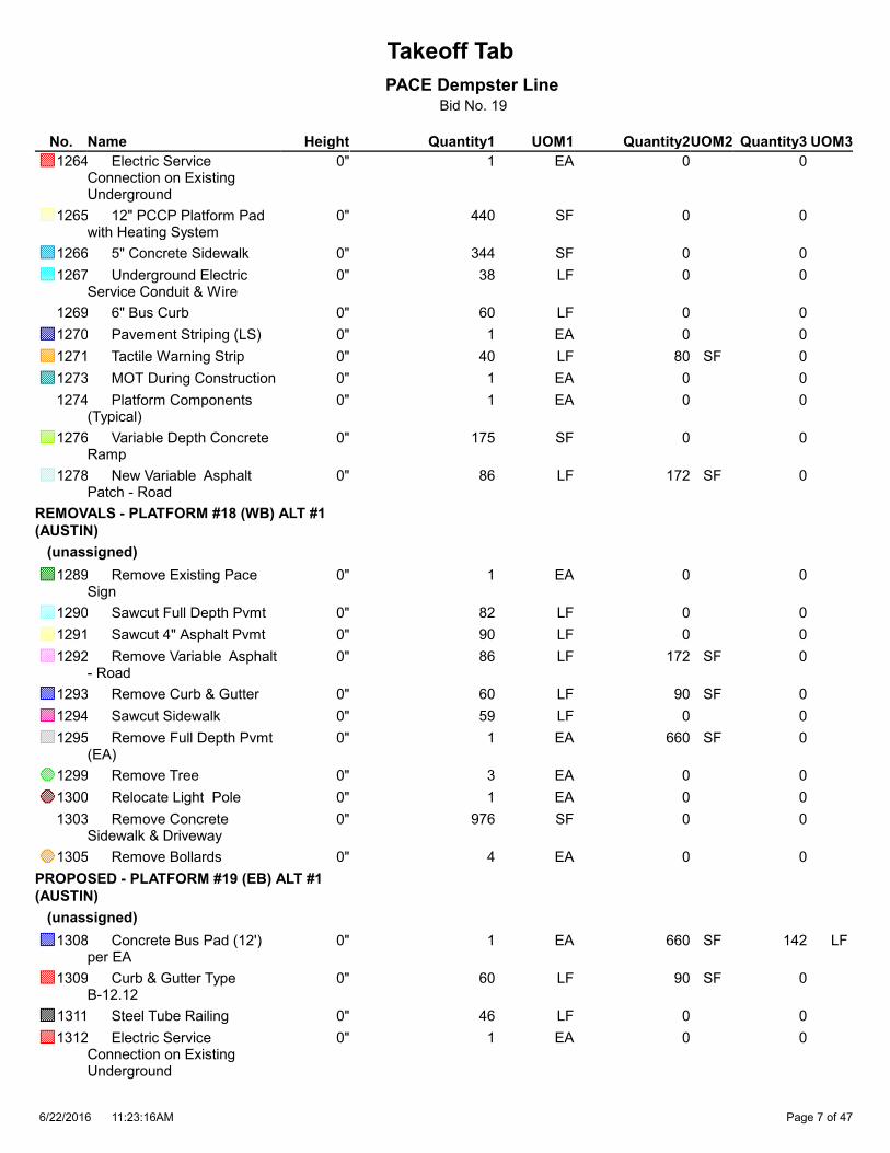
Takeoff Tab
PACE Dempster LineBid No. 19
Quantity1 Quantity2 Quantity3HeightNameNo. UOM1 UOM2 UOM3
1 0 0 Electric Service Connection on Existing Underground
1264 0" EA
440 0 0 12" PCCP Platform Pad with Heating System
1265 0" SF
344 0 0 5" Concrete Sidewalk1266 0" SF
38 0 0 Underground Electric Service Conduit & Wire
1267 0" LF
60 0 0 6" Bus Curb1269 0" LF
1 0 0 Pavement Striping (LS)1270 0" EA
40 80 0 Tactile Warning Strip1271 0" LF SF
1 0 0 MOT During Construction1273 0" EA
1 0 0 Platform Components (Typical)
1274 0" EA
175 0 0 Variable Depth Concrete Ramp
1276 0" SF
86 172 0 New Variable Asphalt Patch - Road
1278 0" LF SF
REMOVALS - PLATFORM #18 (WB) ALT #1
(AUSTIN)
(unassigned)
1 0 0 Remove Existing Pace Sign
1289 0" EA
82 0 0 Sawcut Full Depth Pvmt1290 0" LF
90 0 0 Sawcut 4" Asphalt Pvmt1291 0" LF
86 172 0 Remove Variable Asphalt - Road
1292 0" LF SF
60 90 0 Remove Curb & Gutter1293 0" LF SF
59 0 0 Sawcut Sidewalk1294 0" LF
1 660 0 Remove Full Depth Pvmt (EA)
1295 0" EA SF
3 0 0 Remove Tree1299 0" EA
1 0 0 Relocate Light Pole1300 0" EA
976 0 0 Remove Concrete Sidewalk & Driveway
1303 0" SF
4 0 0 Remove Bollards1305 0" EA
PROPOSED - PLATFORM #19 (EB) ALT #1
(AUSTIN)
(unassigned)
1 660 142 Concrete Bus Pad (12') per EA
1308 0" EA SF LF
60 90 0 Curb & Gutter Type B-12.12
1309 0" LF SF
46 0 0 Steel Tube Railing1311 0" LF
1 0 0 Electric Service Connection on Existing Underground
1312 0" EA
11:23:16AM6/22/2016 Page 7 of 47

Takeoff Tab
PACE Dempster LineBid No. 19
Quantity1 Quantity2 Quantity3HeightNameNo. UOM1 UOM2 UOM3
440 0 0 12" PCCP Platform Pad with Heating System
1313 0" SF
596 0 0 5" Concrete Sidewalk1314 0" SF
60 0 0 Underground Electric Service Conduit & Wire
1315 0" LF
60 0 0 6" Bus Curb1317 0" LF
1 0 0 Pavement Striping (LS)1318 0" EA
40 80 0 Tactile Warning Strip1319 0" LF SF
1 0 0 MOT During Construction1321 0" EA
1 0 0 Platform Components (Typical)
1322 0" EA
175 0 0 Variable Depth Concrete Ramp
1324 0" SF
86 172 0 New Variable Asphalt Patch - Road
1326 0" LF SF
383 0 0 Replace Brick Pavers1356 0" SF
REMOVALS - PLATFORM #19 (EB) ALT #1
(AUSTIN)
(unassigned)
531 0 0 Salvage Decorative Brick Sidewalk
1338 0" SF
82 0 0 Sawcut Full Depth Pvmt1339 0" LF
90 0 0 Sawcut 4" Asphalt Pvmt1340 0" LF
86 172 0 Remove Variable Asphalt - Raod
1341 0" LF SF
60 90 0 Remove Curb & Gutter1342 0" LF SF
45 0 0 Sawcut Sidewalk1343 0" LF
1 660 0 Remove Full Depth Pvmt (EA)
1344 0" EA SF
2 0 0 Sawcut Curb1347 0" EA
2 0 0 Remove Tree1348 0" EA
1 0 0 Remove Bench1351 0" EA
1,044 0 0 Remove Concrete Sidewalk & Driveway
1352 0" SF
1 0 0 Remove Existing Pace Sign
1353 0" EA
1 0 0 Remove Trash Receptacle
1354 0" EA
1 0 0 Remove 3' Dia Conc Planter
1355 0" EA
PROPOSED - PLATFORM #22 (EB) ALT #1
(CRAWFORD)
(unassigned)
190 0 0 Restore Landscape Area1507 0" SF
1 720 144 Concrete Bus Pad (13') per EA
1508 0" EA SF LF
11:23:16AM6/22/2016 Page 8 of 47

Takeoff Tab
PACE Dempster LineBid No. 19
Quantity1 Quantity2 Quantity3HeightNameNo. UOM1 UOM2 UOM3
60 90 0 Curb & Gutter Type B-12.12
1509 0" LF SF
53 0 0 Steel Tube Railing1511 0" LF
1 0 0 Electric Service Connection on Existing Underground
1512 0" EA
560 0 0 12" PCCP Platform Pad with Heating System
1513 0" SF
200 0 0 5" Concrete Sidewalk1514 0" SF
62 0 0 Underground Electric Service Conduit & Wire
1515 0" LF
20 0 0 Silt Fence1516 0" LF
60 0 0 6" Bus Curb1517 0" LF
1 0 0 Pavement Striping (LS)1518 0" EA
40 80 0 Tactile Warning Strip1519 0" LF SF
1 0 0 MOT During Construction1521 0" EA
1 0 0 Platform Components (Typical)
1522 0" EA
175 0 0 Variable Depth Concrete Ramp
1524 0" SF
88 176 0 New Variable Asphalt Patch - Road
1526 0" LF SF
60 359 0 Restore Sod1529 0" LF SF
REMOVALS - PLATFORM #22 (EB) ALT #1
(CRAWFORD)
(unassigned)
86 0 0 Sawcut Full Depth Pvmt1541 0" LF
92 0 0 Sawcut 4" Asphalt Pvmt1542 0" LF
88 176 0 Remove Variable Asphalt - Road
1543 0" LF SF
60 90 0 Remove Curb & Gutter1544 0" LF SF
10 0 0 Sawcut Sidewalk1545 0" LF
1 720 0 Remove Full Depth Pvmt (EA)
1546 0" EA SF
2 0 0 Sawcut Curb1549 0" EA
2 0 0 Remove Tree1550 0" EA
447 0 0 Remove Concrete Sidewalk & Driveway
1554 0" SF
PROPOSED - PLATFORM #23 (WB) ALT #1
(LINCOLNWOOD)
(unassigned)
585 0 0 Restore Landscape Area1610 0" SF
1 690 143 Concrete Bus Pad (12.5') per EA
1611 0" EA SF LF
60 90 0 Curb & Gutter Type B-12.12
1612 0" LF SF
48 0 0 Steel Tube Railing1614 0" LF
11:23:16AM6/22/2016 Page 9 of 47

Takeoff Tab
PACE Dempster LineBid No. 19
Quantity1 Quantity2 Quantity3HeightNameNo. UOM1 UOM2 UOM3
1 0 0 Electric Service Connection on Existing Underground
1615 0" EA
546 0 0 12" PCCP Platform Pad with Heating System
1616 0" SF
311 0 0 5" Concrete Sidewalk1617 0" SF
123 0 0 Underground Electric Service Conduit & Wire
1618 0" LF
60 0 0 6" Bus Curb1620 0" LF
1 0 0 Pavement Striping (LS)1621 0" EA
33 66 0 Tactile Warning Strip1622 0" LF SF
1 0 0 MOT During Construction1624 0" EA
1 0 0 Platform Components (Compact)
1625 0" EA
96 0 0 Variable Depth Concrete Ramp
1627 0" SF
87 174 0 New Variable Asphalt Patch - Road
1629 0" LF SF
222 0 0 Concrete Driveway1637 0" SF
REMOVALS - PLATFORM #23 (WB) ALT #1
(LINCOLNWOOD)
(unassigned)
977 0 0 Remove Landscape Area1642 0" SF
83 0 0 Sawcut Full Depth Pvmt1645 0" LF
91 0 0 Sawcut 4" Asphalt Pvmt1646 0" LF
87 174 0 Remove Variable Asphalt - Road
1647 0" LF SF
60 90 0 Remove Curb & Gutter1648 0" LF SF
13 0 0 Sawcut Sidewalk1649 0" LF
1 690 0 Remove Full Depth Pvmt (EA)
1650 0" EA SF
72 0 0 Remove & Relocate Underground Electric
1652 0" LF
2 0 0 Sawcut Curb1653 0" EA
2 0 0 Remove Tree1654 0" EA
1 0 0 Relocate Light Pole1655 0" EA
773 0 0 Remove Concrete Sidewalk & Driveway
1658 0" SF
1 0 0 Relocate Existing Sign1659 0" EA
May be illuminated - has foundation
PROPOSED - PLATFORM #24 (EB) ALT #2
(LIINCOLNWOOD)
(unassigned)
1 750 145 Concrete Bus Pad (13.5') per EA
1770 0" EA SF LF
60 90 0 Curb & Gutter Type B-12.12
1771 0" LF SF
11:23:16AM6/22/2016 Page 10 of 47

Takeoff Tab
PACE Dempster LineBid No. 19
Quantity1 Quantity2 Quantity3HeightNameNo. UOM1 UOM2 UOM3
39 0 0 Steel Tube Railing1773 0" LF
1 0 0 Electric Service Connection on Existing Underground
1774 0" EA
363 0 0 12" PCCP Platform Pad with Heating System
1775 0" SF
441 0 0 5" Concrete Sidewalk1776 0" SF
60 0 0 Underground Electric Service Conduit & Wire
1777 0" LF
60 0 0 6" Bus Curb1779 0" LF
1 0 0 Pavement Striping (LS)1780 0" EA
33 66 0 Tactile Warning Strip1781 0" LF SF
1 0 0 MOT During Construction1783 0" EA
1 0 0 Platform Components (Compact)
1784 0" EA
103 0 0 Variable Depth Concrete Ramp
1786 0" SF
89 178 0 New Variable Asphalt Patch - Road
1788 0" LF SF
58 345 0 Restore Sod1791 0" LF SF
137 0 0 Restore Sod (SF)1792 0" SF
REMOVALS - PLATFORM #24 (EB) ALT #2
(LINCOLNWOOD)
(unassigned)
1 0 0 Remove Existing Pace Sign
1803 0" EA
85 0 0 Sawcut Full Depth Pvmt1804 0" LF
93 0 0 Sawcut 4" Asphalt Pvmt1805 0" LF
89 178 0 Remove Variable Asphalt - Road
1806 0" LF SF
60 90 0 Remove Curb & Gutter1807 0" LF SF
6 0 0 Sawcut Sidewalk1808 0" LF
1 750 0 Remove Full Depth Pvmt (EA)
1809 0" EA SF
2 0 0 Sawcut Curb1812 0" EA
1 0 0 Remove Tree1813 0" EA
671 0 0 Remove Concrete Sidewalk & Driveway
1817 0" SF
1 0 0 Relocate Existing Sign1818 0" EA
May be illuminated - has foundation
PROPOSED - PLATFORM #29 ALT #1 (DAVIS
CTA/METRA)
(unassigned)
1 0 0 New Pace Sign1982 0" EA
REMOVALS - PLATFORM #31 (EB) ALT #2
(LEE/TOUHY)
(unassigned)
11:23:16AM6/22/2016 Page 11 of 47
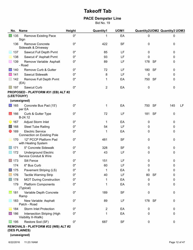
Takeoff Tab
PACE Dempster LineBid No. 19
Quantity1 Quantity2 Quantity3HeightNameNo. UOM1 UOM2 UOM3
1 0 0 Remove Existing Pace Sign
135 0" EA
422 0 0 Remove Concrete Sidewalk & Driveway
136 0" SF
85 0 0 Sawcut Full Depth Pvmt137 0" LF
93 0 0 Sawcut 4" Asphalt Pvmt138 0" LF
89 178 0 Remove Variable Asphalt - Road
139 0" LF SF
72 180 0 Remove Curb & Gutter140 0" LF SF
8 0 0 Sawcut Sidewalk141 0" LF
1 750 0 Remove Full Depth Pvmt (EA)
142 0" EA SF
2 0 0 Sawcut Curb197 0" EA
PROPOSED - PLATFORM #31 (EB) ALT #2
(LEE/TOUHY)
(unassigned)
1 750 145 Concrete Bus Pad (15') per EA
165 0" EA SF LF
72 181 0 Curb & Gutter Type B-24.12
166 0" LF SF
1 0 0 Adjust Storm Inlet167 0" EA
54 0 0 Steel Tube Railing168 0" LF
1 0 0 Electric Service Connection on Existing Pole
169 0" EA
481 0 0 12" PCCP Platform Pad with Heating System
170 0" SF
328 0 0 5" Concrete Sidewalk171 0" SF
43 0 0 Underground Electric Service Conduit & Wire
172 0" LF
151 0 0 Silt Fence173 0" LF
60 0 0 6" Bus Curb174 0" LF
1 0 0 Pavement Striping (LS)175 0" EA
40 80 0 Tactile Warning Strip176 0" LF SF
1 0 0 MOT During Construction178 0" EA
1 0 0 Platform Components (Typical)
179 0" EA
189 0 0 Variable Depth Concrete Ramp
181 0" SF
89 178 0 New Variable Asphalt Patch - Road
183 0" LF SF
2 0 0 Storm Inlet Protection184 0" EA
1 0 0 Intersection Striping (High Visibility X-Wallk)
186 0" EA
687 0 0 Restore Sod (SF)195 0" SF
REMOVALS - PLATFORM #32 (WB) ALT #2
(DES PLAINES)
(unassigned)
11:23:16AM6/22/2016 Page 12 of 47

Takeoff Tab
PACE Dempster LineBid No. 19
Quantity1 Quantity2 Quantity3HeightNameNo. UOM1 UOM2 UOM3
1,350 0 0 Remove Concrete Sidewalk & Driveway
406 0" SF
80 0 0 Sawcut Full Depth Pvmt407 0" LF
88 0 0 Sawcut 4" Asphalt Pvmt408 0" LF
84 168 0 Remove Variable Asphalt - Road
409 0" LF SF
60 150 0 Remove Curb & Gutter410 0" LF SF
370 0 0 Sawcut Sidewalk411 0" LF
1 600 0 Remove Full Depth Pvmt (EA)
412 0" EA SF
69 0 0 Remove & Relocate Underground Electric
414 0" LF
2 0 0 Sawcut Curb415 0" EA
2 0 0 Remove Tree416 0" EA
1 0 0 Relocate Light Pole417 0" EA
PROPOSED - PLATFORM #32 (WB) ALT #2
(DES PLAINES)
(unassigned)
1 600 140 Concrete Bus Pad (12') per EA
421 0" EA SF LF
60 150 0 Curb & Gutter Type B-24.12
422 0" LF SF
51 0 0 Steel Tube Railing424 0" LF
1 0 0 Electric Service Connection on Existing Underground
425 0" EA
420 0 0 12" PCCP Platform Pad with Heating System
426 0" SF
813 0 0 5" Concrete Sidewalk427 0" SF
148 0 0 Underground Electric Service Conduit & Wire
428 0" LF
60 0 0 6" Bus Curb430 0" LF
1 0 0 Pavement Striping (LS)431 0" EA
40 80 0 Tactile Warning Strip432 0" LF SF
1 0 0 MOT During Construction434 0" EA
1 0 0 Platform Components (Typical)
435 0" EA
Only (1) each vertical marker, bike reack and electrical cabinet
160 0 0 Variable Depth Concrete Ramp
437 0" SF
84 168 0 New Variable Asphalt Patch - Road
439 0" LF SF
PROPOSED - PLATFORM #33 (EB) ALT #1
(MILWAUKEE)
(unassigned)
1 660 142 Concrete Bus Pad (12') per EA
958 0" EA SF LF
11:23:16AM6/22/2016 Page 13 of 47
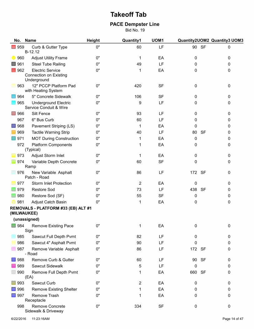
Takeoff Tab
PACE Dempster LineBid No. 19
Quantity1 Quantity2 Quantity3HeightNameNo. UOM1 UOM2 UOM3
60 90 0 Curb & Gutter Type B-12.12
959 0" LF SF
1 0 0 Adjust Utility Frame960 0" EA
49 0 0 Steel Tube Railing961 0" LF
1 0 0 Electric Service Connection on Existing Underground
962 0" EA
420 0 0 12" PCCP Platform Pad with Heating System
963 0" SF
106 0 0 5" Concrete Sidewalk964 0" SF
9 0 0 Underground Electric Service Conduit & Wire
965 0" LF
93 0 0 Silt Fence966 0" LF
60 0 0 6" Bus Curb967 0" LF
1 0 0 Pavement Striping (LS)968 0" EA
40 80 0 Tactile Warning Strip969 0" LF SF
1 0 0 MOT During Construction971 0" EA
1 0 0 Platform Components (Typical)
972 0" EA
1 0 0 Adjust Storm Inlet973 0" EA
60 0 0 Variable Depth Concrete Ramp
974 0" SF
86 172 0 New Variable Asphalt Patch - Road
976 0" LF SF
2 0 0 Storm Inlet Protection977 0" EA
73 438 0 Restore Sod979 0" LF SF
55 0 0 Restore Sod (SF)980 0" SF
1 0 0 Adjust Catch Basin981 0" EA
REMOVALS - PLATFORM #33 (EB) ALT #1
(MILWAUKEE)
(unassigned)
1 0 0 Remove Existing Pace Sign
984 0" EA
82 0 0 Sawcut Full Depth Pvmt985 0" LF
90 0 0 Sawcut 4" Asphalt Pvmt986 0" LF
86 172 0 Remove Variable Asphalt - Road
987 0" LF SF
60 90 0 Remove Curb & Gutter988 0" LF SF
5 0 0 Sawcut Sidewalk989 0" LF
1 660 0 Remove Full Depth Pvmt (EA)
990 0" EA SF
2 0 0 Sawcut Curb993 0" EA
1 0 0 Remove Existing Shelter996 0" EA
1 0 0 Remove Trash Receptacle
997 0" EA
334 0 0 Remove Concrete Sidewalk & Driveway
998 0" SF
11:23:16AM6/22/2016 Page 14 of 47

Takeoff Tab
PACE Dempster LineBid No. 19
Quantity1 Quantity2 Quantity3HeightNameNo. UOM1 UOM2 UOM3
PROPOSED - PLATFORM #34 (WB) ALT #3
(MILWAUKEE)
(unassigned)
1 660 142 Concrete Bus Pad (12') per EA
1001 0" EA SF LF
69 103 0 Curb & Gutter Type B-12.12
1002 0" LF SF
1 0 0 Adjust Utility Frame1003 0" EA
44 0 0 Steel Tube Railing1004 0" LF
1 0 0 Electric Service Connection on Existing Pole
1005 0" EA
347 0 0 12" PCCP Platform Pad with Heating System
1006 0" SF
295 0 0 5" Concrete Sidewalk1007 0" SF
151 0 0 Underground Electric Service Conduit & Wire
1008 0" LF
6 0 0 Silt Fence1009 0" LF
60 0 0 6" Bus Curb1010 0" LF
1 0 0 Pavement Striping (LS)1011 0" EA
33 66 0 Tactile Warning Strip1012 0" LF SF
1 0 0 MOT During Construction1014 0" EA
1 0 0 Platform Components (Compact)
1015 0" EA
1 0 0 Adjust Storm Inlet1016 0" EA
72 0 0 Variable Depth Concrete Ramp
1017 0" SF
293 585 0 New Variable Asphalt Patch - Road
1019 0" LF SF
1 0 0 Storm Inlet Protection1020 0" EA
96 578 0 Restore Sod1022 0" LF SF
8 0 0 Bollards1043 0" EA
322 0 0 Concrete Driveway1044 0" SF
REMOVALS - PLATFORM #34 (WB) ALT #3
(MILWAUKEE)
(unassigned)
1 0 0 Remove Existing Pace Sign
1027 0" EA
82 0 0 Sawcut Full Depth Pvmt1028 0" LF
297 0 0 Sawcut 4" Asphalt Pvmt1029 0" LF
132 264 0 Remove Variable Asphalt - Road
1030 0" LF SF
109 164 0 Remove Curb & Gutter1031 0" LF SF
35 0 0 Sawcut Sidewalk1032 0" LF
1 660 0 Remove Full Depth Pvmt (EA)
1033 0" EA SF
4 0 0 Sawcut Curb1036 0" EA
11:23:16AM6/22/2016 Page 15 of 47

Takeoff Tab
PACE Dempster LineBid No. 19
Quantity1 Quantity2 Quantity3HeightNameNo. UOM1 UOM2 UOM3
678 0 0 Remove Concrete Sidewalk & Driveway
1041 0" SF
490 0 0 Remove 4" Asphalt - Parking
1094 0" SF
PROPOSED - PLATFORM #36 (WB) ALT #3
(CRAWFORD)
(unassigned)
257 0 0 Restore Landscape Area1457 0" SF
1 660 142 Concrete Bus Pad (12') per EA
1458 0" EA SF LF
60 90 0 Curb & Gutter Type B-12.12
1459 0" LF SF
75 0 0 Steel Tube Railing1461 0" LF
1 0 0 Electric Service Connection on Existing Underground
1462 0" EA
559 0 0 12" PCCP Platform Pad with Heating System
1463 0" SF
402 0 0 5" Concrete Sidewalk1464 0" SF
89 0 0 Underground Electric Service Conduit & Wire
1465 0" LF
6 0 0 Silt Fence1466 0" LF
1 0 0 Pavement Striping (LS)1468 0" EA
33 66 0 Tactile Warning Strip1469 0" LF SF
1 0 0 MOT During Construction1471 0" EA
1 0 0 Platform Components (Compact)
1472 0" EA
1 0 0 Adjust Storm Inlet1473 0" EA
66 0 0 Variable Depth Concrete Ramp
1474 0" SF
86 172 0 New Variable Asphalt Patch - Road
1476 0" LF SF
1 0 0 Storm Inlet Protection1477 0" EA
266 0 0 Restore Sod (SF)1480 0" SF
REMOVALS - PLATFORM #36 (WB) ALT #3
(CRAWFORD)
(unassigned)
62 0 0 Remove 4" Asphalt - Parking
1101 0" SF
408 0 0 Remove Landscape Area1487 0" SF
1 0 0 Remove Existing Pace Sign
1489 0" EA
82 0 0 Sawcut Full Depth Pvmt1490 0" LF
122 0 0 Sawcut 4" Asphalt Pvmt1491 0" LF
86 172 0 Remove Variable Asphalt - Road
1492 0" LF SF
60 90 0 Remove Curb & Gutter1493 0" LF SF
11:23:16AM6/22/2016 Page 16 of 47

Takeoff Tab
PACE Dempster LineBid No. 19
Quantity1 Quantity2 Quantity3HeightNameNo. UOM1 UOM2 UOM3
51 0 0 Sawcut Sidewalk1494 0" LF
1 660 0 Remove Full Depth Pvmt (EA)
1495 0" EA SF
2 0 0 Sawcut Curb1498 0" EA
1 0 0 Remove Tree1499 0" EA
651 0 0 Remove Concrete Sidewalk & Driveway
1503 0" SF
PROPOSED - PLATFORM #37 (EB) ALT #1
(LINCOLNWOOD)
(unassigned)
1 660 142 Concrete Bus Pad (12') per EA
1664 0" EA SF LF
60 90 0 Curb & Gutter Type B-12.12
1665 0" LF SF
50 0 0 Steel Tube Railing1667 0" LF
1 0 0 Electric Service Connection on Existing Underground
1668 0" EA
480 0 0 12" PCCP Platform Pad with Heating System
1669 0" SF
324 0 0 5" Concrete Sidewalk1670 0" SF
34 0 0 Underground Electric Service Conduit & Wire
1671 0" LF
119 0 0 Silt Fence1672 0" LF
60 0 0 6" Bus Curb1673 0" LF
1 0 0 Pavement Striping (LS)1674 0" EA
40 80 0 Tactile Warning Strip1675 0" LF SF
1 0 0 MOT During Construction1677 0" EA
1 0 0 Platform Components (Typical)
1678 0" EA
1 0 0 Adjust Storm Inlet1679 0" EA
210 0 0 Variable Depth Concrete Ramp
1680 0" SF
86 172 0 New Variable Asphalt Patch - Road
1682 0" LF SF
1 0 0 Storm Inlet Protection1683 0" EA
115 687 0 Restore Sod1685 0" LF SF
REMOVALS - PLATFORM #37 (EB) ALT #1
(LINCOLNWOOD)
(unassigned)
82 0 0 Sawcut Full Depth Pvmt1698 0" LF
90 0 0 Sawcut 4" Asphalt Pvmt1699 0" LF
86 172 0 Remove Variable Asphalt - Road
1700 0" LF SF
60 90 0 Remove Curb & Gutter1701 0" LF SF
12 0 0 Sawcut Sidewalk1702 0" LF
11:23:16AM6/22/2016 Page 17 of 47

Takeoff Tab
PACE Dempster LineBid No. 19
Quantity1 Quantity2 Quantity3HeightNameNo. UOM1 UOM2 UOM3
1 660 0 Remove Full Depth Pvmt (EA)
1703 0" EA SF
2 0 0 Sawcut Curb1706 0" EA
567 0 0 Remove Concrete Sidewalk & & Driveway
1711 0" SF
PROPOSED - PLATFORM #38 (EB) ALT #1
(DODGE)
(unassigned)
1 540 138 Concrete Bus Pad (10') per EA
1877 0" EA SF LF
60 90 0 Curb & Gutter Type B-12.12
1878 0" LF SF
51 0 0 Steel Tube Railing1880 0" LF
1 0 0 Electric Service Connection on Existing Underground
1881 0" EA
480 0 0 12" PCCP Platform Pad with Heating System
1882 0" SF
250 0 0 5" Concrete Sidewalk1883 0" SF
70 0 0 Underground Electric Service Conduit & Wire
1884 0" LF
154 0 0 Silt Fence1885 0" LF
60 0 0 6" Bus Curb1886 0" LF
1 0 0 Pavement Striping (LS)1887 0" EA
40 80 0 Tactile Warning Strip1888 0" LF SF
1 0 0 MOT During Construction1890 0" EA
1 0 0 Platform Components (Typical)
1891 0" EA
179 0 0 Variable Depth Concrete Ramp
1893 0" SF
82 164 0 New Variable Asphalt Patch - Road
1895 0" LF SF
867 0 0 Restore Sod (SF)1899 0" SF
REMOVALS - PLATFORM #38 (EB) ALT #1
(DODGE)
(unassigned)
1 0 0 Remove Existing Pace Sign
1910 0" EA
78 0 0 Sawcut Full Depth Pvmt1911 0" LF
86 0 0 Sawcut 4" Asphalt Pvmt1912 0" LF
82 164 0 Remove Variable Asphalt - Road
1913 0" LF SF
60 90 0 Remove Curb & Gutter1914 0" LF SF
29 0 0 Sawcut Sidewalk1915 0" LF
1 540 0 Remove Full Depth Pvmt (EA)
1916 0" EA SF
2 0 0 Sawcut Curb1919 0" EA
11:23:16AM6/22/2016 Page 18 of 47

Takeoff Tab
PACE Dempster LineBid No. 19
Quantity1 Quantity2 Quantity3HeightNameNo. UOM1 UOM2 UOM3
1 0 0 Remove Tree1920 0" EA
1 0 0 Remove Trash Receptacle
1923 0" EA
732 0 0 Remove Concrete Sidewalk & Driveway
1924 0" SF
1 0 0 Relocate Existing Sign1925 0" EA
PROPOSED - PLATFORM #39 (WB) ALT #3
(DODGE)
(unassigned)
1 0 0 Remove & Replace Fire Hydrant
1929 0" EA
160 0 0 Restore Landscape Area1930 0" SF
1 540 138 Concrete Bus Pad (10') per EA
1931 0" EA SF LF
60 90 0 Curb & Gutter Type B-12.12
1932 0" LF SF
46 0 0 Steel Tube Railing1934 0" LF
1 0 0 Electric Service Connection on Existing Underground
1935 0" EA
448 0 0 12" PCCP Platform Pad with Heating System
1936 0" SF
191 0 0 5" Concrete Sidewalk1937 0" SF
77 0 0 Underground Electric Service Conduit & Wire
1938 0" LF
65 0 0 Silt Fence1939 0" LF
60 0 0 6" Bus Curb1940 0" LF
1 0 0 Pavement Striping (LS)1941 0" EA
33 66 0 Tactile Warning Strip1942 0" LF SF
1 0 0 MOT During Construction1944 0" EA
1 0 0 Platform Components (Compact)
1945 0" EA
102 0 0 Variable Depth Concrete Ramp
1947 0" SF
82 164 0 New Variable Asphalt Patch - Road
1949 0" LF SF
7 0 0 Bollards1956 0" EA
137 0 0 New 4" Asphalt Patch - Parking
1958 0" SF
REMOVALS - PLATFORM #39 (WB) ALT #3
(DODGE)
(unassigned)
2 0 0 Remove Parking Curb1960 0" EA
226 0 0 Remove 4" Asphalt - Parking
1961 0" SF
207 0 0 Remove Landscape Area1962 0" SF
78 0 0 Sawcut Full Depth Pvmt1965 0" LF
11:23:16AM6/22/2016 Page 19 of 47

Takeoff Tab
PACE Dempster LineBid No. 19
Quantity1 Quantity2 Quantity3HeightNameNo. UOM1 UOM2 UOM3
140 0 0 Sawcut 4" Asphalt Pvmt1966 0" LF
82 164 0 Remove Variable Asphalt - Road
1967 0" LF SF
60 90 0 Remove Curb & Gutter1968 0" LF SF
17 0 0 Sawcut Sidewalk1969 0" LF
1 540 0 Remove Full Depth Pvmt (EA)
1970 0" EA SF
2 0 0 Sawcut Curb1973 0" EA
603 0 0 Remove Concrete Sidewalk & Driveway
1978 0" SF
PROPOSED - PLATFORM #40 (WB) ALT #1
(DODGE)
(unassigned)
2 0 0 New ADA Curb Ramp1103 0" EA
362 0 0 Restore Landscape Area1822 0" SF
60 90 0 Curb & Gutter Type B-12.12
1824 0" LF SF
45 0 0 Steel Tube Railing1826 0" LF
1 0 0 Electric Service Connection on Existing Underground
1827 0" EA
490 0 0 12" PCCP Platform Pad with Heating System
1828 0" SF
673 0 0 5" Concrete Sidewalk1829 0" SF
103 0 0 Underground Electric Service Conduit & Wire
1830 0" LF
60 0 0 6" Bus Curb1832 0" LF
1 0 0 Pavement Striping (LS)1833 0" EA
33 66 0 Tactile Warning Strip1834 0" LF SF
1 0 0 MOT During Construction1836 0" EA
1 0 0 Platform Components (Compact)
1837 0" EA
128 0 0 Variable Depth Concrete Ramp
1839 0" SF
595 0 0 Concrete Bus Pad (SF)1840 0" SF
87 173 0 New Variable Asphalt Patch - Road
1841 0" LF SF
1 0 0 Intersection Striping (High Visibility X-Wallk)
1843 0" EA
1 0 0 Adjust Mabhole1846 0" EA
224 0 0 Concrete Driveway1849 0" SF
REMOVALS - PLATFORM #40 (WB) ALT #1
(DODGE)
(unassigned)
520 0 0 Remove Landscape Area1854 0" SF
83 0 0 Sawcut Full Depth Pvmt1857 0" LF
11:23:16AM6/22/2016 Page 20 of 47

Takeoff Tab
PACE Dempster LineBid No. 19
Quantity1 Quantity2 Quantity3HeightNameNo. UOM1 UOM2 UOM3
90 0 0 Sawcut 4" Asphalt Pvmt1858 0" LF
87 174 0 Remove Variable Asphalt - Road
1859 0" LF SF
60 90 0 Remove Curb & Gutter1860 0" LF SF
29 0 0 Sawcut Sidewalk1861 0" LF
685 0 0 Remove Full Depth Pvmt (SF)
1863 0" SF
2 0 0 Sawcut Curb1865 0" EA
1,395 0 0 Remove Concrete Sidewalk
1870 0" SF
PROPOSED - PLATFORM #42 (WB) ALT #4
(CRAWFORD)
(unassigned)
89 0 0 Restore Landscape Area1558 0" SF
1 660 142 Concrete Bus Pad (12') per EA
1559 0" EA SF LF
60 90 0 Curb & Gutter Type B-12.12
1560 0" LF SF
65 0 0 Steel Tube Railing1562 0" LF
1 0 0 Electric Service Connection on Existing Underground
1563 0" EA
594 0 0 12" PCCP Platform Pad with Heating System
1564 0" SF
246 0 0 5" Concrete Sidewalk1565 0" SF
106 0 0 Underground Electric Service Conduit & Wire
1566 0" LF
60 0 0 6" Bus Curb1568 0" LF
1 0 0 Pavement Striping (LS)1569 0" EA
33 66 0 Tactile Warning Strip1570 0" LF SF
1 0 0 MOT During Construction1572 0" EA
1 0 0 Platform Components (Compact)
1573 0" EA
93 0 0 Variable Depth Concrete Ramp
1575 0" SF
86 172 0 New Variable Asphalt Patch - Raod
1577 0" LF SF
439 0 0 Restore Sod (SF)1581 0" SF
224 0 0 Concrete Driveway1585 0" SF
REMOVALS - PLATFORM #42 (WB) ALT #4
(CRAWFORD)
(unassigned)
8 0 0 Remove Parking Curb1102 0" EA
93 0 0 Remove 4" Asphalt - Parking
1588 0" SF
317 0 0 Remove Landscape Area1589 0" SF
82 0 0 Sawcut Full Depth Pvmt1592 0" LF
11:23:16AM6/22/2016 Page 21 of 47

Takeoff Tab
PACE Dempster LineBid No. 19
Quantity1 Quantity2 Quantity3HeightNameNo. UOM1 UOM2 UOM3
125 0 0 Sawcut 4" Asphalt Pvmt1593 0" LF
86 172 0 Remove Variable Asphalt - Road
1594 0" LF SF
60 90 0 Remove Curb & Gutter1595 0" LF SF
37 0 0 Sawcut Sidewalk1596 0" LF
1 660 0 Remove Full Depth Pvmt (EA)
1597 0" EA SF
63 0 0 Remove & Relocate Underground Electric
1599 0" LF
2 0 0 Sawcut Curb1600 0" EA
1 0 0 Remove Tree1601 0" EA
1 0 0 Relocate Light Pole1602 0" EA
626 0 0 Remove Concrete Sidewalk & Driveway
1605 0" SF
44 22 0 Remove Single Curb1608 0" LF SF
PROPOSED - PLATFORM #44 (SB) ALT #2
(LEE/MANN/OAK)
(unassigned)
1 690 143 Concrete Bus Pad (14) per EA
205 0" EA SF LF
60 150 0 Curb & Gutter Type B-24.12
206 0" LF SF
1 0 0 Adjust Utility Frame207 0" EA
51 0 0 Steel Tube Railing208 0" LF
1 0 0 Electric Service Connection on Existing Pole
209 0" EA
420 0 0 12" PCCP Platform Pad with Heating System
210 0" SF
329 0 0 5" Concrete Sidewalk211 0" SF
110 0 0 Underground Electric Service Conduit & Wire
212 0" LF
129 0 0 Silt Fence213 0" LF
60 0 0 6" Bus Curb214 0" LF
1 0 0 Pavement Striping (LS)215 0" EA
40 80 0 Tactile Warning Strip216 0" LF SF
60 90 0 Landscape Strip217 0" LF SF
1 0 0 MOT During Construction218 0" EA
1 0 0 Platform Components (Typical)
219 0" EA
1 0 0 Adjust Storm Inlet220 0" EA
205 0 0 Variable Depth Concrete Ramp
221 0" SF
87 174 0 New Variable Asphalt Patch - Road
223 0" LF SF
1 0 0 Storm Inlet Protection224 0" EA
123 735 0 Restore Sod226 0" LF SF
11:23:16AM6/22/2016 Page 22 of 47
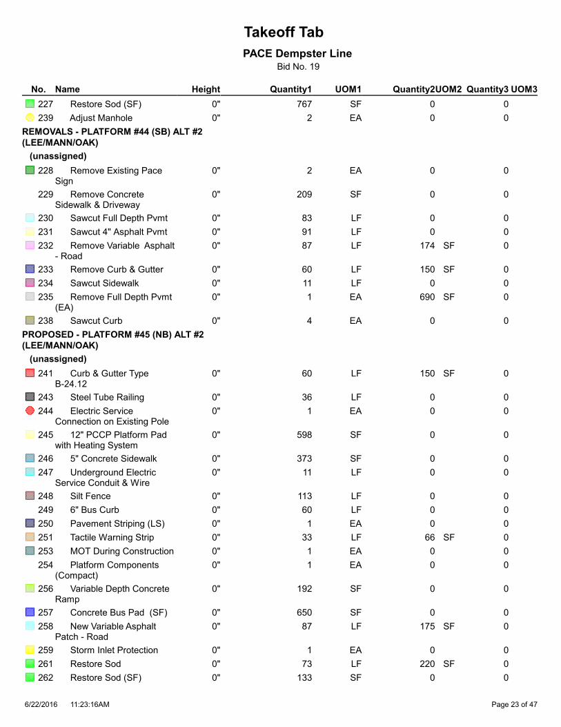
Takeoff Tab
PACE Dempster LineBid No. 19
Quantity1 Quantity2 Quantity3HeightNameNo. UOM1 UOM2 UOM3
767 0 0 Restore Sod (SF)227 0" SF
2 0 0 Adjust Manhole239 0" EA
REMOVALS - PLATFORM #44 (SB) ALT #2
(LEE/MANN/OAK)
(unassigned)
2 0 0 Remove Existing Pace Sign
228 0" EA
209 0 0 Remove Concrete Sidewalk & Driveway
229 0" SF
83 0 0 Sawcut Full Depth Pvmt230 0" LF
91 0 0 Sawcut 4" Asphalt Pvmt231 0" LF
87 174 0 Remove Variable Asphalt - Road
232 0" LF SF
60 150 0 Remove Curb & Gutter233 0" LF SF
11 0 0 Sawcut Sidewalk234 0" LF
1 690 0 Remove Full Depth Pvmt (EA)
235 0" EA SF
4 0 0 Sawcut Curb238 0" EA
PROPOSED - PLATFORM #45 (NB) ALT #2
(LEE/MANN/OAK)
(unassigned)
60 150 0 Curb & Gutter Type B-24.12
241 0" LF SF
36 0 0 Steel Tube Railing243 0" LF
1 0 0 Electric Service Connection on Existing Pole
244 0" EA
598 0 0 12" PCCP Platform Pad with Heating System
245 0" SF
373 0 0 5" Concrete Sidewalk246 0" SF
11 0 0 Underground Electric Service Conduit & Wire
247 0" LF
113 0 0 Silt Fence248 0" LF
60 0 0 6" Bus Curb249 0" LF
1 0 0 Pavement Striping (LS)250 0" EA
33 66 0 Tactile Warning Strip251 0" LF SF
1 0 0 MOT During Construction253 0" EA
1 0 0 Platform Components (Compact)
254 0" EA
192 0 0 Variable Depth Concrete Ramp
256 0" SF
650 0 0 Concrete Bus Pad (SF)257 0" SF
87 175 0 New Variable Asphalt Patch - Road
258 0" LF SF
1 0 0 Storm Inlet Protection259 0" EA
73 220 0 Restore Sod261 0" LF SF
133 0 0 Restore Sod (SF)262 0" SF
11:23:16AM6/22/2016 Page 23 of 47

Takeoff Tab
PACE Dempster LineBid No. 19
Quantity1 Quantity2 Quantity3HeightNameNo. UOM1 UOM2 UOM3
1 0 0 Adjust Catch Basin263 0" EA
REMOVALS - PLATFORM #45 (NB) ALT #2
(LEE/MANN/OAK)
(unassigned)
2 0 0 Relocate Existing Sign264 0" EA
468 0 0 Remove Concrete Sidewalk & Driveway
265 0" SF
83 0 0 Sawcut Full Depth Pvmt266 0" LF
92 0 0 Sawcut 4" Asphalt Pvmt267 0" LF
87 174 0 Remove Variable Asphalt - Road
268 0" LF SF
60 150 0 Remove Curb & Gutter269 0" LF SF
13 0 0 Sawcut Sidewalk270 0" LF
660 0 0 Remove Full Depth Pvmt (SF)
272 0" SF
72 0 0 Remove & Relocate Underground Electric
273 0" LF
2 0 0 Sawcut Curb274 0" EA
1 0 0 Relocate Power Pole278 0" EA
1 0 0 Relocate Light Pole279 0" EA
1 0 0 Remove Existing Shelter280 0" EA
1 0 0 Remove Trash Receptacle
281 0" EA
PROPOSED - PLATFORM #46 (WB) ALT #2
(POTTER)
(unassigned)
1 720 144 Concrete Bus Pad (13') per EA
282 0" EA SF LF
60 90 0 Curb & Gutter Type B-12.12
283 0" LF SF
50 0 0 Steel Tube Railing285 0" LF
1 0 0 Electric Service Connection on Existing Pole
286 0" EA
400 0 0 12" PCCP Platform Pad with Heating System
287 0" SF
653 0 0 5" Concrete Sidewalk288 0" SF
60 0 0 Underground Electric Service Conduit & Wire
289 0" LF
21 0 0 Silt Fence290 0" LF
60 0 0 6" Bus Curb291 0" LF
1 0 0 Pavement Striping (LS)292 0" EA
40 80 0 Tactile Warning Strip293 0" LF SF
1 0 0 MOT During Construction295 0" EA
1 0 0 Platform Components (Typical)
296 0" EA
1 0 0 Adjust Storm Inlet297 0" EA
11:23:16AM6/22/2016 Page 24 of 47

Takeoff Tab
PACE Dempster LineBid No. 19
Quantity1 Quantity2 Quantity3HeightNameNo. UOM1 UOM2 UOM3
162 0 0 Variable Depth Concrete Ramp
298 0" SF
88 176 0 New Variable Asphalt Patch - Road
300 0" LF SF
1 0 0 Storm Inlet Protection301 0" EA
214 0 0 Restore Sod (SF)304 0" SF
93 0 0 Curb 6"322 0" LF
REMOVALS - PLATFORM #46 (WB) ALT #2
(POTTER)
(unassigned)
430 0 0 Remove Concrete Sidewalk & Driveway
307 0" SF
83 0 0 Sawcut Full Depth Pvmt308 0" LF
91 0 0 Sawcut 4" Asphalt Pvmt309 0" LF
87 174 0 Remove Variable Asphalt - Road
310 0" LF SF
60 90 0 Remove Curb & Gutter311 0" LF SF
10 0 0 Sawcut Sidewalk312 0" LF
1 690 0 Remove Full Depth Pvmt (EA)
313 0" EA SF
80 0 0 Remove & Relocate Underground Electric
315 0" LF
2 0 0 Sawcut Curb316 0" EA
3 0 0 Remove Tree321 0" EA
PROPOSED - PLATFORM #47 (WB) ALT #1
(POTTER)
(unassigned)
129 0 0 Restore Landscape Area486 0" SF
1 690 143 Concrete Bus Pad (10') per EA
533 0" EA SF LF
60 90 0 Curb & Gutter Type B-12.12
534 0" LF SF
51 0 0 Steel Tube Railing536 0" LF
1 0 0 Electric Service Connection on Existing Pole
537 0" EA
412 0 0 12" PCCP Platform Pad with Heating System
538 0" SF
217 0 0 5" Concrete Sidewalk539 0" SF
41 0 0 Underground Electric Service Conduit & Wire
540 0" LF
92 0 0 Silt Fence541 0" LF
60 0 0 6" Bus Curb542 0" LF
1 0 0 Pavement Striping (LS)543 0" EA
40 80 0 Tactile Warning Strip544 0" LF SF
1 0 0 MOT During Construction546 0" EA
11:23:16AM6/22/2016 Page 25 of 47

Takeoff Tab
PACE Dempster LineBid No. 19
Quantity1 Quantity2 Quantity3HeightNameNo. UOM1 UOM2 UOM3
1 0 0 Platform Components (Typical)
547 0" EA
1 0 0 Adjust Storm Inlet548 0" EA
140 0 0 Variable Depth Concrete Ramp
549 0" SF
87 174 0 New Variable Asphalt Patch - Road
551 0" LF SF
1 0 0 Storm Inlet Protection552 0" EA
24 145 0 Restore Sod554 0" LF SF
68 0 0 Restore Sod (SF)555 0" SF
REMOVALS - PLATFORM #47 (WB) ALT #1
(POTTER)
(unassigned)
83 0 0 Sawcut Full Depth Pvmt562 0" LF
91 0 0 Sawcut 4" Asphalt Pvmt563 0" LF
87 174 0 Remove Variable Asphalt - Road
564 0" LF SF
60 90 0 Remove Curb & Gutter565 0" LF SF
10 0 0 Sawcut Sidewalk566 0" LF
1 690 0 Remove Full Depth Pvmt (EA)
567 0" EA SF
2 0 0 Sawcut Curb570 0" EA
414 0 0 Remove Concrete Sidewalk & Driveway
575 0" SF
PROPOSED - PLATFORM #48 (EB) ALT #2
(POTTER)
(unassigned)
1 720 144 Concrete Bus Pad (13') per EA
323 0" EA SF LF
39 59 0 Curb & Gutter Type B-12.12
324 0" LF SF
33 0 0 Steel Tube Railing326 0" LF
1 0 0 Electric Service Connection on Existing Underground
327 0" EA
366 0 0 12" PCCP Platform Pad with Heating System
328 0" SF
123 0 0 5" Concrete Sidewalk329 0" SF
35 0 0 Underground Electric Service Conduit & Wire
330 0" LF
24 0 0 Silt Fence331 0" LF
60 0 0 6" Bus Curb332 0" LF
1 0 0 Pavement Striping (LS)333 0" EA
33 66 0 Tactile Warning Strip334 0" LF SF
1 0 0 MOT During Construction336 0" EA
1 0 0 Platform Components (Typical)
337 0" EA
11:23:16AM6/22/2016 Page 26 of 47

Takeoff Tab
PACE Dempster LineBid No. 19
Quantity1 Quantity2 Quantity3HeightNameNo. UOM1 UOM2 UOM3
36 0 0 Variable Depth Concrete Ramp
339 0" SF
88 176 0 New Variable Asphalt Patch - Road
341 0" LF SF
36 108 0 Restore Sod344 0" LF SF
331 0 0 Restore Sod (SF)345 0" SF
REMOVALS - PLATFORM #48 (EB) ALT #2
(POTTER)
(unassigned)
84 0 0 Sawcut Full Depth Pvmt350 0" LF
92 0 0 Sawcut 4" Asphalt Pvmt351 0" LF
88 176 0 Remove Variable Asphalt - Road
352 0" LF SF
39 59 0 Remove Curb & Gutter353 0" LF SF
1 720 0 Remove Full Depth Pvmt (EA)
355 0" EA SF
2 0 0 Sawcut Curb358 0" EA
PROPOSED - PLATFORM #49 (EB) ALT #1
(WESTERN)
(unassigned)
1 720 144 Concrete Bus Pad (14') per EA
701 0" EA SF LF
60 150 0 Curb & Gutter Type B-24.12
702 0" LF SF
46 0 0 Steel Tube Railing704 0" LF
1 0 0 Electric Service Connection on Existing Underground
705 0" EA
539 0 0 12" PCCP Platform Pad with Heating System
706 0" SF
270 0 0 5" Concrete Sidewalk707 0" SF
80 0 0 Underground Electric Service Conduit & Wire
708 0" LF
103 0 0 Silt Fence709 0" LF
60 0 0 6" Bus Curb710 0" LF
1 0 0 Pavement Striping (LS)711 0" EA
40 80 0 Tactile Warning Strip712 0" LF SF
1 0 0 MOT During Construction714 0" EA
2 0 0 Platform Components (Typical)
715 0" EA
1 0 0 Adjust Storm Inlet716 0" EA
226 0 0 Variable Depth Concrete Ramp
717 0" SF
88 176 0 New Variable Asphalt Patch - Road
719 0" LF SF
2 0 0 Storm Inlet Protection720 0" EA
789 0 0 Restore Sod (SF)723 0" SF
11:23:16AM6/22/2016 Page 27 of 47

Takeoff Tab
PACE Dempster LineBid No. 19
Quantity1 Quantity2 Quantity3HeightNameNo. UOM1 UOM2 UOM3
REMOVALS - PLATFORM #49 (EB) ALT #1
(WESTERN)
(unassigned)
84 0 0 Sawcut Full Depth Pvmt727 0" LF
92 0 0 Sawcut 4" Asphalt Pvmt728 0" LF
88 176 0 Remove Variable Asphalt - Road
729 0" LF SF
60 150 0 Remove Curb & Gutter730 0" LF SF
12 0 0 Sawcut Sidewalk731 0" LF
1 720 0 Remove Full Depth Pvmt (EA)
732 0" EA SF
90 0 0 Remove & Relocate Underground Electric
734 0" LF
2 0 0 Sawcut Curb735 0" EA
1 0 0 Remove Existing Shelter738 0" EA
720 0 0 Remove Concrete Sidewalk & Driveway
740 0" SF
PROPOSED - PLATFORM #50 (WB) ALT #1
(WESTERN)
(unassigned)
1 720 144 Concrete Bus Pad (14') per EA
659 0" EA SF LF
60 150 0 Curb & Gutter Type B-24.12
660 0" LF SF
47 0 0 Steel Tube Railing662 0" LF
1 0 0 Electric Service Connection on Existing Underground
663 0" EA
599 0 0 12" PCCP Platform Pad with Heating System
664 0" SF
281 0 0 5" Concrete Sidewalk665 0" SF
27 0 0 Underground Electric Service Conduit & Wire
666 0" LF
131 0 0 Silt Fence667 0" LF
60 0 0 6" Bus Curb668 0" LF
1 0 0 Pavement Striping (LS)669 0" EA
40 80 0 Tactile Warning Strip670 0" LF SF
1 0 0 MOT During Construction672 0" EA
1 0 0 Platform Components (Typical)
673 0" EA
1 0 0 Adjust Storm Inlet674 0" EA
249 0 0 Variable Depth Concrete Ramp
675 0" SF
88 176 0 New Variable Asphalt Patch - Road
677 0" LF SF
2 0 0 Storm Inlet Protection678 0" EA
438 0 0 Restore Sod (SF)681 0" SF
11:23:16AM6/22/2016 Page 28 of 47

Takeoff Tab
PACE Dempster LineBid No. 19
Quantity1 Quantity2 Quantity3HeightNameNo. UOM1 UOM2 UOM3
REMOVALS - PLATFORM #50 (WB) ALT #1
(WESTERN)
(unassigned)
1 0 0 Remove Existing Pace Sign
684 0" EA
84 0 0 Sawcut Full Depth Pvmt685 0" LF
92 0 0 Sawcut 4" Asphalt Pvmt686 0" LF
88 176 0 Remove Variable Asphalt - Road
687 0" LF SF
60 150 0 Remove Curb & Gutter688 0" LF SF
10 0 0 Sawcut Sidewalk689 0" LF
1 720 0 Remove Full Depth Pvmt (EA)
690 0" EA SF
111 0 0 Remove & Relocate Underground Electric
692 0" LF
2 0 0 Sawcut Curb693 0" EA
447 0 0 Remove Concrete Sidewalk & Driveway
698 0" SF
1 0 0 Relocate Existing Sign699 0" EA
REMOVALS - PLATFORM #55 (WB) ALT #2
(DEMP-SKOK)
(unassigned)
287 0 0 Remove Landscape Area1100 0" SF
6 0 0 Remove & Replace Chain Link Fence
1357 0" LF
85 0 0 Sawcut Full Depth Pvmt1359 0" LF
93 0 0 Sawcut 4" Asphalt Pvmt1360 0" LF
89 178 0 Remove Variable Asphalt - Road
1361 0" LF SF
60 90 0 Remove Curb & Gutter1362 0" LF SF
19 0 0 Sawcut Sidewalk1363 0" LF
1 750 0 Remove Full Depth Pvmt (EA)
1364 0" EA SF
2 0 0 Sawcut Curb1367 0" EA
3 0 0 Remove Tree1368 0" EA
639 0 0 Remove Concrete Sidewalk & Driveway
1372 0" SF
201 0 0 Salvage Brick Pavers1404 0" SF
PROPOSED - PLATFORM #55 (WB) ALT #2
(DEMP-SKOK)
(unassigned)
247 0 0 Restore Landscape Area1375 0" SF
1 750 145 Concrete Bus Pad (13.5') per EA
1376 0" EA SF LF
60 90 0 Curb & Gutter Type B-12.12
1377 0" LF SF
11:23:16AM6/22/2016 Page 29 of 47

Takeoff Tab
PACE Dempster LineBid No. 19
Quantity1 Quantity2 Quantity3HeightNameNo. UOM1 UOM2 UOM3
1 0 0 Adjust Utility Frame1378 0" EA
50 0 0 Steel Tube Railing1379 0" LF
1 0 0 Electric Service Connection on Existing Underground
1380 0" EA
420 0 0 12" PCCP Platform Pad with Heating System
1381 0" SF
244 0 0 5" Concrete Sidewalk1382 0" SF
25 0 0 Underground Electric Service Conduit & Wire
1383 0" LF
47 0 0 Silt Fence1384 0" LF
60 0 0 6" Bus Curb1385 0" LF
1 0 0 Pavement Striping (LS)1386 0" EA
40 80 0 Tactile Warning Strip1387 0" LF SF
1 0 0 MOT During Construction1389 0" EA
1 0 0 Platform Components (Typical)
1390 0" EA
163 0 0 Variable Depth Concrete Ramp
1392 0" SF
89 178 0 New Variable Asphalt Patch - Road
1394 0" LF SF
36 214 0 Restore Sod1397 0" LF SF
33 0 0 Restore Sod (SF)1398 0" SF
68 0 0 Replace Brick Pavers1405 0" SF
PROPOSED - PLATFORM #56 (EB) ALT #2
(DEMP-SKOK)
(unassigned)
1 690 143 Concrete Bus Pad (12.5') per EA
1408 0" EA SF LF
60 90 0 Curb & Gutter Type B-12.12
1409 0" LF SF
39 0 0 Steel Tube Railing1411 0" LF
1 0 0 Electric Service Connection on Existing Pole
1412 0" EA
370 0 0 12" PCCP Platform Pad with Heating System
1413 0" SF
272 0 0 5" Concrete Sidewalk1414 0" SF
49 0 0 Underground Electric Service Conduit & Wire
1415 0" LF
70 0 0 Silt Fence1416 0" LF
60 0 0 6" Bus Curb1417 0" LF
1 0 0 Pavement Striping (LS)1418 0" EA
33 66 0 Tactile Warning Strip1419 0" LF SF
1 0 0 MOT During Construction1421 0" EA
1 0 0 Platform Components (Compact)
1422 0" EA
11:23:16AM6/22/2016 Page 30 of 47

Takeoff Tab
PACE Dempster LineBid No. 19
Quantity1 Quantity2 Quantity3HeightNameNo. UOM1 UOM2 UOM3
93 0 0 Variable Depth Concrete Ramp
1424 0" SF
87 174 0 New Variable Asphalt Patch - Road
1426 0" LF SF
55 333 0 Restore Sod1429 0" LF SF
33 0 0 Restore Sod (SF)1430 0" SF
48 0 0 Replace Brick Pavers1436 0" SF
REMOVALS - PLATFORM #56 (EB) ALT #2
(DEMP-SKOK)
(unassigned)
83 0 0 Sawcut Full Depth Pvmt1440 0" LF
91 0 0 Sawcut 4" Asphalt Pvmt1441 0" LF
87 174 0 Remove Variable Asphalt - Road
1442 0" LF SF
60 90 0 Remove Curb & Gutter1443 0" LF SF
19 0 0 Sawcut Sidewalk1444 0" LF
1 690 0 Remove Full Depth Pvmt (EA)
1445 0" EA SF
2 0 0 Sawcut Curb1448 0" EA
2 0 0 Remove Tree1449 0" EA
561 0 0 Remove Concrete Sidewalk & Driveway
1453 0" SF
1 0 0 Relocate Existing Sign1454 0" EA
196 0 0 Salvage Brick Pavers1455 0" SF
PROPOSED - PLATFORM #60 (EB) ALT #1
(DEE)
(unassigned)
1 780 146 Concrete Bus Pad (13') per EA
618 0" EA SF LF
60 90 0 Curb & Gutter Type B-12.12
619 0" LF SF
51 0 0 Steel Tube Railing621 0" LF
1 0 0 Electric Service Connection on Existing Underground
622 0" EA
420 0 0 12" PCCP Platform Pad with Heating System
623 0" SF
633 0 0 5" Concrete Sidewalk624 0" SF
129 0 0 Underground Electric Service Conduit & Wire
625 0" LF
145 0 0 Silt Fence626 0" LF
120 0 0 6" Bus Curb627 0" LF
1 0 0 Pavement Striping (LS)628 0" EA
40 80 0 Tactile Warning Strip629 0" LF SF
60 90 0 Landscape Strip630 0" LF SF
1 0 0 MOT During Construction631 0" EA
11:23:16AM6/22/2016 Page 31 of 47

Takeoff Tab
PACE Dempster LineBid No. 19
Quantity1 Quantity2 Quantity3HeightNameNo. UOM1 UOM2 UOM3
1 0 0 Platform Components (Typical)
632 0" EA
1 0 0 Adjust Storm Inlet633 0" EA
160 0 0 Variable Depth Concrete Ramp
634 0" SF
90 180 0 New Variable Asphalt Patch - Road
636 0" LF SF
3 0 0 Storm Inlet Protection637 0" EA
143 861 0 Restore Sod639 0" LF SF
656 0 0 Restore Sod (SF)640 0" SF
REMOVALS - PLATFORM #60 (EB) ALT #1
(DEE)
(unassigned)
86 0 0 Sawcut Full Depth Pvmt644 0" LF
94 0 0 Sawcut 4" Asphalt Pvmt645 0" LF
90 180 0 Remove Variable Asphalt - Road
646 0" LF SF
60 90 0 Remove Curb & Gutter647 0" LF SF
24 0 0 Sawcut Sidewalk648 0" LF
1 780 0 Remove Full Depth Pvmt (EA)
649 0" EA SF
2 0 0 Sawcut Curb652 0" EA
315 0 0 Remove Concrete Sidewalk & Driveway
657 0" SF
PROPOSED - PLATFORM #61 (EB) ALT #1
(CUMBERLAND)
(unassigned)
1 720 144 Concrete Bus Pad (14') per EA
785 0" EA SF LF
60 150 0 Curb & Gutter Type B-24.12
786 0" LF SF
51 0 0 Steel Tube Railing788 0" LF
1 0 0 Electric Service Connection on Existing Underground
789 0" EA
540 0 0 12" PCCP Platform Pad with Heating System
790 0" SF
281 0 0 5" Concrete Sidewalk791 0" SF
73 0 0 Underground Electric Service Conduit & Wire
792 0" LF
18 0 0 Silt Fence793 0" LF
60 0 0 6" Bus Curb794 0" LF
1 0 0 Pavement Striping (LS)795 0" EA
40 80 0 Tactile Warning Strip796 0" LF SF
1 0 0 MOT During Construction798 0" EA
1 0 0 Platform Components (Typical)
799 0" EA
11:23:16AM6/22/2016 Page 32 of 47

Takeoff Tab
PACE Dempster LineBid No. 19
Quantity1 Quantity2 Quantity3HeightNameNo. UOM1 UOM2 UOM3
200 0 0 Variable Depth Concrete Ramp
801 0" SF
88 176 0 New Variable Asphalt Patch - Road
803 0" LF SF
1 0 0 Storm Inlet Protection804 0" EA
18 107 0 Restore Sod806 0" LF SF
600 0 0 Restore Sod (SF)807 0" SF
2 0 0 Adjust Manholes808 0" EA
REMOVALS - PLATFORM #61 (EB) ALT #1
(CUMBERLAND)
(unassigned)
1 0 0 Remove Existing Pace Sign
810 0" EA
84 0 0 Sawcut Full Depth Pvmt811 0" LF
92 0 0 Sawcut 4" Asphalt Pvmt812 0" LF
88 176 0 Remove Variable Asphalt - Road
813 0" LF SF
60 150 0 Remove Curb & Gutter814 0" LF SF
1 720 0 Remove Full Depth Pvmt (EA)
816 0" EA SF
2 0 0 Sawcut Curb819 0" EA
PROPOSED - PLATFORM #62 (WB) ALT #1
(CUMBERLAND)
(unassigned)
1 720 144 Concrete Bus Pad (14') per EA
743 0" EA SF LF
60 150 0 Curb & Gutter Type B-24.12
744 0" LF SF
53 0 0 Steel Tube Railing746 0" LF
1 0 0 Electric Service Connection on Existing Pole
747 0" EA
642 0 0 12" PCCP Platform Pad with Heating System
748 0" SF
324 0 0 5" Concrete Sidewalk749 0" SF
18 0 0 Underground Electric Service Conduit & Wire
750 0" LF
109 0 0 Silt Fence751 0" LF
1 0 0 Pavement Striping (LS)753 0" EA
40 80 0 Tactile Warning Strip754 0" LF SF
1 0 0 MOT During Construction756 0" EA
1 0 0 Platform Components (Typical)
757 0" EA
1 0 0 Adjust Storm Inlet758 0" EA
258 0 0 Variable Depth Concrete Ramp
759 0" SF
88 176 0 New Variable Asphalt Patch - Road
761 0" LF SF
11:23:16AM6/22/2016 Page 33 of 47

Takeoff Tab
PACE Dempster LineBid No. 19
Quantity1 Quantity2 Quantity3HeightNameNo. UOM1 UOM2 UOM3
1 0 0 Storm Inlet Protection762 0" EA
156 0 0 Restore Sod (SF)765 0" SF
REMOVALS - PLATFORM #62 (WB) ALT #1
(CUMBERLAND)
(unassigned)
1 0 0 Remove Existing Pace Sign
768 0" EA
84 0 0 Sawcut Full Depth Pvmt769 0" LF
92 0 0 Sawcut 4" Asphalt Pvmt770 0" LF
88 176 0 Remove Variable Asphalt - Road
771 0" LF SF
60 150 0 Remove Curb & Gutter772 0" LF SF
12 0 0 Sawcut Sidewalk773 0" LF
1 720 0 Remove Full Depth Pvmt (EA)
774 0" EA SF
2 0 0 Sawcut Curb777 0" EA
472 0 0 Remove Concrete Sidewalk & Driveway
782 0" SF
PROPOSED - PLATFORM #63 (EB) ALT #1
(HARLEM)
(unassigned)
240 0 0 Restore Landscape Area1045 0" SF
1 780 146 Concrete Bus Pad (14') per EA
1046 0" EA SF LF
60 90 0 Curb & Gutter Type B-12.12
1047 0" LF SF
44 0 0 Steel Tube Railing1049 0" LF
1 0 0 Electric Service Connection on Existing Pole
1050 0" EA
404 0 0 12" PCCP Platform Pad with Heating System
1051 0" SF
204 0 0 5" Concrete Sidewalk1052 0" SF
69 0 0 Underground Electric Service Conduit & Wire
1053 0" LF
60 0 0 6" Bus Curb1055 0" LF
1 0 0 Pavement Striping (LS)1056 0" EA
33 66 0 Tactile Warning Strip1057 0" LF SF
1 0 0 MOT During Construction1059 0" EA
1 0 0 Platform Components (Compact)
1060 0" EA
84 0 0 Variable Depth Concrete Ramp
1062 0" SF
88 176 0 New Variable Asphalt Patch - Road
1064 0" LF SF
1 0 0 Storm Inlet Protection1065 0" EA
3 0 0 Curb 6"1070 0" LF
11:23:16AM6/22/2016 Page 34 of 47

Takeoff Tab
PACE Dempster LineBid No. 19
Quantity1 Quantity2 Quantity3HeightNameNo. UOM1 UOM2 UOM3
171 0 0 New 4" Asphalt Patch - Parking
1095 0" SF
REMOVALS - PLATFORM #63 (EB) ALT #1
(HARLEM)
(unassigned)
1 0 0 Remove Existing Pace Sign
1074 0" EA
84 0 0 Sawcut Full Depth Pvmt1075 0" LF
161 0 0 Sawcut 4" Asphalt Pvmt1076 0" LF
88 176 0 Remove Variable Asphalt - Road
1077 0" LF SF
60 90 0 Remove Curb & Gutter1078 0" LF SF
14 0 0 Sawcut Sidewalk1079 0" LF
1 720 0 Remove Full Depth Pvmt (EA)
1080 0" EA SF
2 0 0 Sawcut Curb1083 0" EA
1 0 0 Remove Trash Receptacle
1087 0" EA
542 0 0 Remove Concrete Sidewalk & Driveway
1088 0" SF
1 0 0 Remove Bench1090 0" EA
21 11 0 Remove Single Curb1091 0" LF SF
334 0 0 Remove 4" Asphalt - Parking
1092 0" SF
4 0 0 Remove Parking Curb1093 0" EA LF
REMOVALS - PLATFORM #64 (WB) ALT #1
(HARLEM)
(unassigned)
263 0 0 Remove 4" Asphalt - Parking
1096 0" SF
86 0 0 Sawcut Full Depth Pvmt1121 0" LF
147 0 0 Sawcut 4" Asphalt Pvmt1122 0" LF
90 180 0 Remove Variable Asphalt - Road
1123 0" LF SF
60 90 0 Remove Curb & Gutter1124 0" LF SF
11 0 0 Sawcut Sidewalk1125 0" LF
1 780 0 Remove Full Depth Pvmt (EA)
1126 0" EA SF
2 0 0 Sawcut Curb1129 0" EA
357 0 0 Remove Concrete Sidewalk & Driveway
1134 0" SF
49 24 0 Remove Single Curb1136 0" LF SF
147 0 0 Remove Landscape Area1137 0" SF
PROPOSED - PLATFORM #64 (WB) ALT #1
(HARLEM)
(unassigned)
11:23:16AM6/22/2016 Page 35 of 47

Takeoff Tab
PACE Dempster LineBid No. 19
Quantity1 Quantity2 Quantity3HeightNameNo. UOM1 UOM2 UOM3
50 0 0 Restore Landscape Area1138 0" SF
1 780 146 Concrete Bus Pad (14') per EA
1139 0" EA SF LF
60 90 0 Curb & Gutter Type B-12.12
1140 0" LF SF
1 0 0 Adjust Utility Frame1141 0" EA
50 0 0 Steel Tube Railing1142 0" LF
1 0 0 Electric Service Connection on Existing Underground
1143 0" EA
406 0 0 12" PCCP Platform Pad with Heating System
1144 0" SF
122 0 0 5" Concrete Sidewalk1145 0" SF
39 0 0 Underground Electric Service Conduit & Wire
1146 0" LF
60 0 0 6" Bus Curb1148 0" LF
1 0 0 Pavement Striping (LS)1149 0" EA
33 66 0 Tactile Warning Strip1150 0" LF SF
1 0 0 MOT During Construction1152 0" EA
1 0 0 Platform Components (Compact)
1153 0" EA
60 0 0 Variable Depth Concrete Ramp
1155 0" SF
90 180 0 New Variable Asphalt Patch - Road
1157 0" LF SF
1 0 0 Storm Inlet Protection1158 0" EA
1 0 0 Adjust Catch Basin1162 0" EA
16 0 0 Curb 6"1163 0" LF
6 0 0 Bollards1164 0" EA
133 0 0 New 4" Asphalt Patch - Parking
1166 0" SF
REMOVALS - PLATFORM #66 (WB) ALT #2
(WAUKEGAN)
(unassigned)
1 0 0 Remove Existing Pace Sign
1214 0" EA
82 0 0 Sawcut Full Depth Pvmt1215 0" LF
90 0 0 Sawcut 4" Asphalt Pvmt1216 0" LF
86 172 0 Remove Variable Asphalt - Road
1217 0" LF SF
60 90 0 Remove Curb & Gutter1218 0" LF SF
18 0 0 Sawcut Sidewalk1219 0" LF
1 660 0 Remove Full Depth Pvmt (EA)
1220 0" EA SF
87 0 0 Remove & Relocate Underground Electric
1222 0" LF
2 0 0 Sawcut Curb1223 0" EA
11:23:16AM6/22/2016 Page 36 of 47

Takeoff Tab
PACE Dempster LineBid No. 19
Quantity1 Quantity2 Quantity3HeightNameNo. UOM1 UOM2 UOM3
1 0 0 Relocate Light Pole1225 0" EA
791 0 0 Remove Concrete Sidewalk & Driveway
1228 0" SF
PROPOSED - PLATFORM #66 (WB) ALT #2
(WAUKEGAN)
(unassigned)
1 660 142 Concrete Bus Pad (12') per EA
1231 0" EA SF LF
60 90 0 Curb & Gutter Type B-12.12
1232 0" LF SF
50 0 0 Steel Tube Railing1234 0" LF
1 0 0 Electric Service Connection on Existing Underground
1235 0" EA
419 0 0 12" PCCP Platform Pad with Heating System
1236 0" SF
251 0 0 5" Concrete Sidewalk1237 0" SF
88 0 0 Underground Electric Service Conduit & Wire
1238 0" LF
113 0 0 Silt Fence1239 0" LF
60 0 0 6" Bus Curb1240 0" LF
1 0 0 Pavement Striping (LS)1241 0" EA
40 80 0 Tactile Warning Strip1242 0" LF SF
1 0 0 MOT During Construction1244 0" EA
1 0 0 Platform Components (Typical)
1245 0" EA
171 0 0 Variable Depth Concrete Ramp
1247 0" SF
86 172 0 New Variable Asphalt Patch - Road
1249 0" LF SF
1 0 0 Storm Inlet Protection1250 0" EA
89 535 0 Restore Sod1252 0" LF SF
50 0 0 Restore Sod (SF)1253 0" SF
PROPOSED - PLATFORM #68 (WB) ALT #1
(MILWAUKEE)
(unassigned)
7 0 0 Bollards561 0" EA
1 540 138 Concrete Bus Pad (10') per EA
870 0" EA SF LF
60 90 0 Curb & Gutter Type B-12.12
871 0" LF SF
43 0 0 Steel Tube Railing873 0" LF
1 0 0 Electric Service Connection on Existing Underground
874 0" EA
346 0 0 12" PCCP Platform Pad with Heating System
875 0" SF
11:23:16AM6/22/2016 Page 37 of 47

Takeoff Tab
PACE Dempster LineBid No. 19
Quantity1 Quantity2 Quantity3HeightNameNo. UOM1 UOM2 UOM3
390 0 0 5" Concrete Sidewalk876 0" SF
61 0 0 Underground Electric Service Conduit & Wire
877 0" LF
60 0 0 6" Bus Curb879 0" LF
1 0 0 Pavement Striping (LS)880 0" EA
33 66 0 Tactile Warning Strip881 0" LF SF
1 0 0 MOT During Construction883 0" EA
1 0 0 Platform Components (Compact)
884 0" EA
72 0 0 Variable Depth Concrete Ramp
886 0" SF
153 307 0 New Variable Asphalt Patch - Road
888 0" LF SF
1 0 0 Storm Inlet Protection889 0" EA
REMOVALS - PLATFORM #68 (WB) ALT #1
(MILWAUKEE)
(unassigned)
78 0 0 Sawcut Full Depth Pvmt897 0" LF
159 0 0 Sawcut 4" Asphalt Pvmt898 0" LF
82 164 0 Remove Variable Asphalt - Road
899 0" LF SF
60 90 0 Remove Curb & Gutter900 0" LF SF
12 0 0 Sawcut Sidewalk901 0" LF
1 540 0 Remove Full Depth Pvmt (EA)
902 0" EA SF
2 0 0 Sawcut Curb905 0" EA
662 0 0 Remove Concrete Sidewalk & Driveway
910 0" SF
309 0 0 Remove 4" Asphalt Parking
1097 0" SF
PROPOSED - PLATFORM #70 (WB) ALT #2
(DEE)
(unassigned)
1 780 146 Concrete Bus Pad (13') per EA
577 0" EA SF LF
60 90 0 Curb & Gutter Type B-12.12
578 0" LF SF
52 0 0 Steel Tube Railing580 0" LF
1 0 0 Electric Service Connection on Existing Pole
581 0" EA
543 0 0 12" PCCP Platform Pad with Heating System
582 0" SF
356 0 0 5" Concrete Sidewalk583 0" SF
34 0 0 Underground Electric Service Conduit & Wire
584 0" LF
95 0 0 Silt Fence585 0" LF
60 0 0 6" Bus Curb586 0" LF
11:23:16AM6/22/2016 Page 38 of 47

Takeoff Tab
PACE Dempster LineBid No. 19
Quantity1 Quantity2 Quantity3HeightNameNo. UOM1 UOM2 UOM3
1 0 0 Pavement Striping (LS)587 0" EA
40 80 0 Tactile Warning Strip588 0" LF SF
1 0 0 MOT During Construction590 0" EA
1 0 0 Platform Components (Typical)
591 0" EA
2 0 0 Adjust Storm Inlet592 0" EA
230 0 0 Variable Depth Concrete Ramp
593 0" SF
90 180 0 New Variable Asphalt Patch - Road
595 0" LF SF
3 0 0 Storm Inlet Protection596 0" EA
642 0 0 Restore Sod (SF)599 0" SF
REMOVALS - PLATFORM #70 (WB) ALT #2
(DEE)
(unassigned)
1 0 0 Remove Existing Pace Sign
602 0" EA
86 0 0 Sawcut Full Depth Pvmt603 0" LF
94 0 0 Sawcut 4" Asphalt Pvmt604 0" LF
90 180 0 Remove Variable Asphalt - Road
605 0" LF SF
60 90 0 Remove Curb & Gutter606 0" LF SF
6 0 0 Sawcut Sidewalk607 0" LF
1 780 0 Remove Full Depth Pvmt (EA)
608 0" EA SF
2 0 0 Sawcut Curb611 0" EA
1 0 0 Remove Existing Shelter614 0" EA
1 0 0 Remove Trash Receptacle
615 0" EA
627 0 0 Remove Concrete Sidewalk & Driveway
616 0" SF
PROPOSED - PLATFORM #73 (WB) ALT #3A
(DES PLAINES)
(unassigned)
1 480 136 Concrete Bus Pad (10') per EA
446 0" EA SF LF
66 165 0 Curb & Gutter Type B-24.12
447 0" LF SF
51 0 0 Steel Tube Railing449 0" LF
1 0 0 Electric Service Connection on Existing Underground
450 0" EA
407 0 0 12" PCCP Platform Pad with Heating System
451 0" SF
43 0 0 5" Concrete Sidewalk452 0" SF
98 0 0 Underground Electric Service Conduit & Wire
453 0" LF
11:23:16AM6/22/2016 Page 39 of 47

Takeoff Tab
PACE Dempster LineBid No. 19
Quantity1 Quantity2 Quantity3HeightNameNo. UOM1 UOM2 UOM3
88 0 0 Silt Fence454 0" LF
60 0 0 6" Bus Curb455 0" LF
1 0 0 Pavement Striping (LS)456 0" EA
40 80 0 Tactile Warning Strip457 0" LF SF
1 0 0 MOT During Construction459 0" EA
1 0 0 Platform Components (Typical)
460 0" EA
160 0 0 Variable Depth Concrete Ramp
462 0" SF
80 160 0 New Variable Asphalt Patch - Road
464 0" LF SF
1 0 0 Storm Inlet Protection465 0" EA
81 485 0 Restore Sod467 0" LF SF
140 0 0 Restore Concrete Paver Sidewalk
488 0" SF
149 0 0 Restore Brick Sidewalk489 0" SF
REMOVALS - PLATFORM #73 (WB) ALT #3A
(DES PLAINES)
(unassigned)
553 0 0 Salvage Decorative Brick Sidewalk
472 0" SF
76 0 0 Sawcut Full Depth Pvmt473 0" LF
84 0 0 Sawcut 4" Asphalt Pvmt474 0" LF
80 160 0 Remove Variable Asphalt - Road
475 0" LF SF
66 165 0 Remove Curb & Gutter476 0" LF SF
1 480 0 Remove Full Depth Pvmt (EA)
478 0" EA SF
75 0 0 Remove & Relocate Underground Electric
480 0" LF
2 0 0 Sawcut Curb481 0" EA
2 0 0 Remove Tree482 0" EA
1 0 0 Relocate Light Pole483 0" EA
360 0 0 Salvage Concrete Paver Sidewalk
487 0" SF
PROPOSED - PLATFORM #73 (WB) ALT #3B
(DES PLAINES)
(unassigned)
214 535 0 Curb & Gutter Type B-24.12
491 0" LF SF
98 0 0 Steel Tube Railing493 0" LF
1 0 0 Electric Service Connection on Existing Underground
494 0" EA
1,261 0 0 12" PCCP Platform Pad with Heating System
495 0" SF
51 0 0 5" Concrete Sidewalk496 0" SF
11:23:16AM6/22/2016 Page 40 of 47
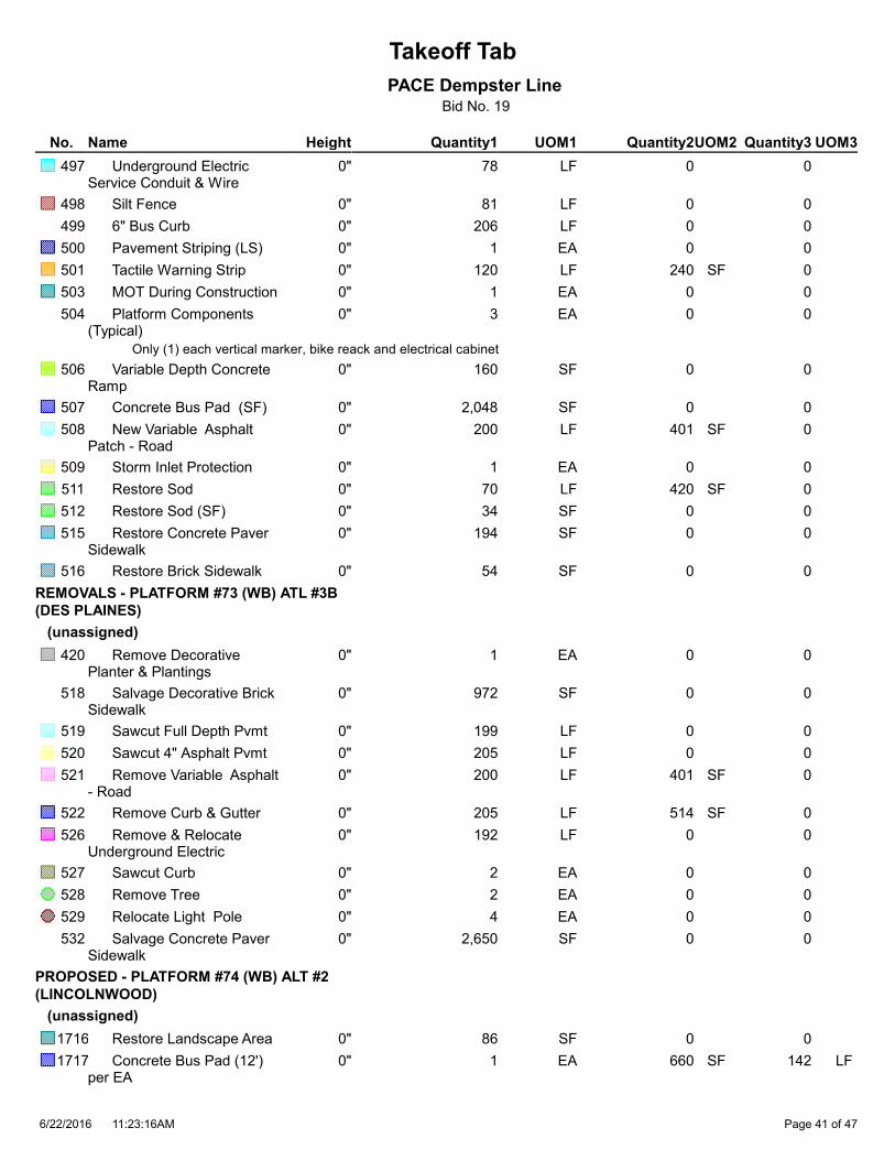
Takeoff Tab
PACE Dempster LineBid No. 19
Quantity1 Quantity2 Quantity3HeightNameNo. UOM1 UOM2 UOM3
78 0 0 Underground Electric Service Conduit & Wire
497 0" LF
81 0 0 Silt Fence498 0" LF
206 0 0 6" Bus Curb499 0" LF
1 0 0 Pavement Striping (LS)500 0" EA
120 240 0 Tactile Warning Strip501 0" LF SF
1 0 0 MOT During Construction503 0" EA
3 0 0 Platform Components (Typical)
504 0" EA
Only (1) each vertical marker, bike reack and electrical cabinet
160 0 0 Variable Depth Concrete Ramp
506 0" SF
2,048 0 0 Concrete Bus Pad (SF)507 0" SF
200 401 0 New Variable Asphalt Patch - Road
508 0" LF SF
1 0 0 Storm Inlet Protection509 0" EA
70 420 0 Restore Sod511 0" LF SF
34 0 0 Restore Sod (SF)512 0" SF
194 0 0 Restore Concrete Paver Sidewalk
515 0" SF
54 0 0 Restore Brick Sidewalk516 0" SF
REMOVALS - PLATFORM #73 (WB) ATL #3B
(DES PLAINES)
(unassigned)
1 0 0 Remove Decorative Planter & Plantings
420 0" EA
972 0 0 Salvage Decorative Brick Sidewalk
518 0" SF
199 0 0 Sawcut Full Depth Pvmt519 0" LF
205 0 0 Sawcut 4" Asphalt Pvmt520 0" LF
200 401 0 Remove Variable Asphalt - Road
521 0" LF SF
205 514 0 Remove Curb & Gutter522 0" LF SF
192 0 0 Remove & Relocate Underground Electric
526 0" LF
2 0 0 Sawcut Curb527 0" EA
2 0 0 Remove Tree528 0" EA
4 0 0 Relocate Light Pole529 0" EA
2,650 0 0 Salvage Concrete Paver Sidewalk
532 0" SF
PROPOSED - PLATFORM #74 (WB) ALT #2
(LINCOLNWOOD)
(unassigned)
86 0 0 Restore Landscape Area1716 0" SF
1 660 142 Concrete Bus Pad (12') per EA
1717 0" EA SF LF
11:23:16AM6/22/2016 Page 41 of 47

Takeoff Tab
PACE Dempster LineBid No. 19
Quantity1 Quantity2 Quantity3HeightNameNo. UOM1 UOM2 UOM3
60 90 0 Curb & Gutter Type B-12.12
1718 0" LF SF
62 0 0 Steel Tube Railing1720 0" LF
1 0 0 Electric Service Connection on Existing Underground
1721 0" EA
428 0 0 12" PCCP Platform Pad with Heating System
1722 0" SF
543 0 0 5" Concrete Sidewalk1723 0" SF
124 0 0 Underground Electric Service Conduit & Wire
1724 0" LF
60 0 0 6" Bus Curb1726 0" LF
1 0 0 Pavement Striping (LS)1727 0" EA
33 66 0 Tactile Warning Strip1728 0" LF SF
1 0 0 MOT During Construction1730 0" EA
1 0 0 Platform Components (Compact)
1731 0" EA
72 0 0 Variable Depth Concrete Ramp
1733 0" SF
86 172 0 New Variable Asphalt Patch - Road
1735 0" LF SF
1 0 0 Storm Inlet Protection1736 0" EA
1 0 0 Adjust Catch Basin1740 0" EA
6 0 0 Curb 6"1741 0" LF
7 0 0 Bollards1742 0" EA
131 0 0 New 4" Asphalt Patch - Parking
1744 0" SF
REMOVALS - PLATFORM #74 (WB) ALT #2
(LINCOLNWOOD)
(unassigned)
286 0 0 Remove 4" Asphalt - Parking
1747 0" SF
182 0 0 Remove Landscape Area1748 0" SF
82 0 0 Sawcut Full Depth Pvmt1751 0" LF
143 0 0 Sawcut 4" Asphalt Pvmt1752 0" LF
86 172 0 Remove Variable Asphalt - Road
1753 0" LF SF
60 90 0 Remove Curb & Gutter1754 0" LF SF
12 0 0 Sawcut Sidewalk1755 0" LF
1 660 0 Remove Full Depth Pvmt (EA)
1756 0" EA SF
2 0 0 Sawcut Curb1759 0" EA
1 0 0 Remove Tree1760 0" EA
820 0 0 Remove Concrete Sidewalk & Driveway
1764 0" SF
38 19 0 Remove Single Curb1767 0" LF SF
11:23:16AM6/22/2016 Page 42 of 47
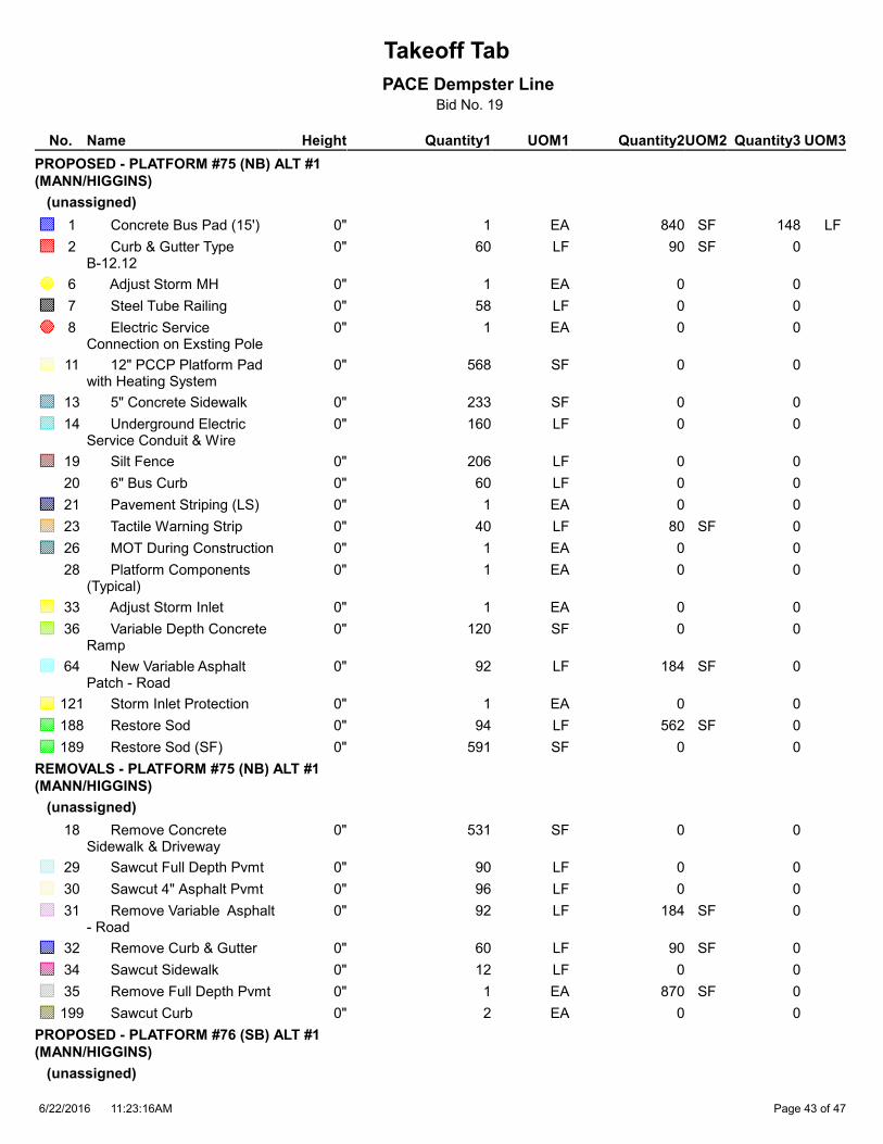
Takeoff Tab
PACE Dempster LineBid No. 19
Quantity1 Quantity2 Quantity3HeightNameNo. UOM1 UOM2 UOM3
PROPOSED - PLATFORM #75 (NB) ALT #1
(MANN/HIGGINS)
(unassigned)
1 840 148 Concrete Bus Pad (15')1 0" EA SF LF
60 90 0 Curb & Gutter Type B-12.12
2 0" LF SF
1 0 0 Adjust Storm MH6 0" EA
58 0 0 Steel Tube Railing7 0" LF
1 0 0 Electric Service Connection on Exsting Pole
8 0" EA
568 0 0 12" PCCP Platform Pad with Heating System
11 0" SF
233 0 0 5" Concrete Sidewalk13 0" SF
160 0 0 Underground Electric Service Conduit & Wire
14 0" LF
206 0 0 Silt Fence19 0" LF
60 0 0 6" Bus Curb20 0" LF
1 0 0 Pavement Striping (LS)21 0" EA
40 80 0 Tactile Warning Strip23 0" LF SF
1 0 0 MOT During Construction26 0" EA
1 0 0 Platform Components (Typical)
28 0" EA
1 0 0 Adjust Storm Inlet33 0" EA
120 0 0 Variable Depth Concrete Ramp
36 0" SF
92 184 0 New Variable Asphalt Patch - Road
64 0" LF SF
1 0 0 Storm Inlet Protection121 0" EA
94 562 0 Restore Sod188 0" LF SF
591 0 0 Restore Sod (SF)189 0" SF
REMOVALS - PLATFORM #75 (NB) ALT #1
(MANN/HIGGINS)
(unassigned)
531 0 0 Remove Concrete Sidewalk & Driveway
18 0" SF
90 0 0 Sawcut Full Depth Pvmt29 0" LF
96 0 0 Sawcut 4" Asphalt Pvmt30 0" LF
92 184 0 Remove Variable Asphalt - Road
31 0" LF SF
60 90 0 Remove Curb & Gutter32 0" LF SF
12 0 0 Sawcut Sidewalk34 0" LF
1 870 0 Remove Full Depth Pvmt35 0" EA SF
2 0 0 Sawcut Curb199 0" EA
PROPOSED - PLATFORM #76 (SB) ALT #1
(MANN/HIGGINS)
(unassigned)
11:23:16AM6/22/2016 Page 43 of 47

Takeoff Tab
PACE Dempster LineBid No. 19
Quantity1 Quantity2 Quantity3HeightNameNo. UOM1 UOM2 UOM3
60 90 0 Curb & Gutter Type B-12.12
38 0" LF SF
86 0 0Steel Tube Railing40 0" LF
1 0 0 Electric Service Connection on New Pole
41 0" EA
730 0 0 12" PCCP Platform Pad with Heating System
42 0" SF
234 0 0 5" Concrete Sidewalk43 0" SF
21 0 0 Underground Electric Service Conduit & Wire
44 0" LF
106 0 0 Silt Fence45 0" LF
60 0 0 6" Bus Curb46 0" LF
1 0 0 Pavement Striping (LS)47 0" EA
40 80 0 Tactile Warning Strip48 0" LF SF
1 0 0 MOT During Construction50 0" EA
1 0 0 Platform Components (Typical)
51 0" EA
119 0 0 Variable Depth Concrete Ramp
53 0" SF
629 0 0 Concrete Bus Pad (SF)63 0" SF
85 170 0 New Variable Asphalt Patch - Road
65 0" LF SF
36 216 0 Restore Sod185 0" LF SF
362 0 0 Restore Sod (SF)187 0" SF
REMOVALS - PLATFORM #76 (SB) ALT #1
(MANN/HIGGINS)
(unassigned)
499 0 0 Remove Concrete Sidewalk & Driveway
54 0" SF
81 0 0 Sawcut Full Depth Pvmt55 0" LF
90 0 0 Sawcut 4" Asphalt Pvmt56 0" LF
86 171 0 Remove Variable Asphalt - Road
57 0" LF SF
60 90 0 Remove Curb & Gutter58 0" LF SF
12 0 0 Sawcut Sidewalk59 0" LF
688 0 0 Remove Full Depth Pvmt (SF)
61 0" SF
2 0 0 Sawcut Curb200 0" EA
PROPOSED - PLATFORM #77 (SB) ALT #2
(MANN/HIGGINS)
(unassigned)
1 540 138 Concrete Bus Pad (10') per EA
66 0" EA SF LF
60 150 0 Curb & Gutter Type B-24.12
67 0" LF SF
1 0 0Adjust Storm CB68 0" EA
11:23:16AM6/22/2016 Page 44 of 47
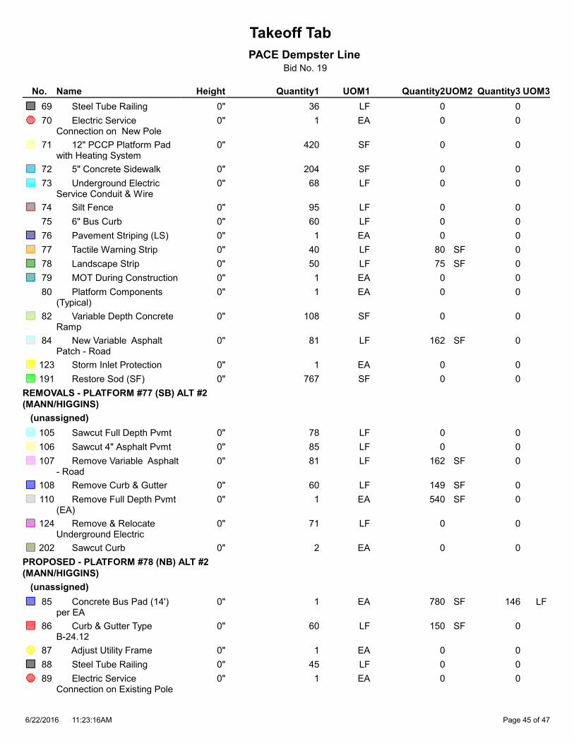
Takeoff Tab
PACE Dempster LineBid No. 19
Quantity1 Quantity2 Quantity3HeightNameNo. UOM1 UOM2 UOM3
36 0 0 Steel Tube Railing69 0" LF
1 0 0 Electric Service Connection on New Pole
70 0" EA
420 0 0 12" PCCP Platform Pad with Heating System
71 0" SF
204 0 0 5" Concrete Sidewalk72 0" SF
68 0 0 Underground Electric Service Conduit & Wire
73 0" LF
95 0 0 Silt Fence74 0" LF
60 0 0 6" Bus Curb75 0" LF
1 0 0 Pavement Striping (LS)76 0" EA
40 80 0 Tactile Warning Strip77 0" LF SF
50 75 0 Landscape Strip78 0" LF SF
1 0 0 MOT During Construction79 0" EA
1 0 0 Platform Components (Typical)
80 0" EA
108 0 0 Variable Depth Concrete Ramp
82 0" SF
81 162 0 New Variable Asphalt Patch - Road
84 0" LF SF
1 0 0 Storm Inlet Protection123 0" EA
767 0 0 Restore Sod (SF)191 0" SF
REMOVALS - PLATFORM #77 (SB) ALT #2
(MANN/HIGGINS)
(unassigned)
78 0 0 Sawcut Full Depth Pvmt105 0" LF
85 0 0 Sawcut 4" Asphalt Pvmt106 0" LF
81 162 0 Remove Variable Asphalt - Road
107 0" LF SF
60 149 0 Remove Curb & Gutter108 0" LF SF
1 540 0 Remove Full Depth Pvmt (EA)
110 0" EA SF
71 0 0 Remove & Relocate Underground Electric
124 0" LF
2 0 0 Sawcut Curb202 0" EA
PROPOSED - PLATFORM #78 (NB) ALT #2
(MANN/HIGGINS)
(unassigned)
1 780 146 Concrete Bus Pad (14') per EA
85 0" EA SF LF
60 150 0 Curb & Gutter Type B-24.12
86 0" LF SF
1 0 0 Adjust Utility Frame87 0" EA
45 0 0 Steel Tube Railing88 0" LF
1 0 0 Electric Service Connection on Existing Pole
89 0" EA
11:23:16AM6/22/2016 Page 45 of 47

Takeoff Tab
PACE Dempster LineBid No. 19
Quantity1 Quantity2 Quantity3HeightNameNo. UOM1 UOM2 UOM3
400 0 0 12" PCCP Platform Pad with Heating System
90 0" SF
149 0 0 5" Concrete Sidewalk91 0" SF
9 0 0 Underground Electric Service Conduit & Wire
92 0" LF
100 0 0 Silt Fence93 0" LF
60 0 0 6" Bus Curb94 0" LF
1 0 0 Pavement Striping (LS)95 0" EA
40 80 0 Tactile Warning Strip96 0" LF SF
50 75 0 Landscape Strip97 0" LF SF
1 0 0 MOT During Construction98 0" EA
1 0 0 Platform Components (Typical)
99 0" EA
100 0 0 Variable Depth Concrete Ramp
101 0" SF
90 180 0 New Variable Asphalt Patch - Road
103 0" LF SF
1 0 0 Storm Inlet Protection120 0" EA
REMOVALS - PLATFORM #78 (NB) ALT #2
(MANN/HIGGINS)
(unassigned)
1 0 0 Relocate Existing Sign62 0" EA
236 0 0 Remove Concrete Sidewalk & Driveway
112 0" SF
88 0 0 Sawcut Full Depth Pvmt113 0" LF
94 0 0 Sawcut 4" Asphalt Pvmt114 0" LF
90 180 0 Remove Variable Asphalt - Road
115 0" LF SF
60 150 0 Remove Curb & Gutter116 0" LF SF
6 0 0 Sawcut Sidewalk117 0" LF
836 0 0 Remove Full Depth Pvmt (SF)
119 0" SF
75 0 0 Remove & Relocate Underground Electric
122 0" LF
2 0 0 Sawcut Curb201 0" EA
PROPOSED - PLATFORM #79 (EB) ALT #2
(CUMBERLAND)
(unassigned)
12 0 0 Relocate Storm Pipe559 0" LF
Size not known - use 24" RCP
1 600 140 Concrete Bus Pad (10') per EA
827 0" EA SF LF
52 0 0 Steel Tube Railing830 0" LF
1 0 0 Electric Service Connection on Existing Pole
831 0" EA
421 0 0 12" PCCP Platform Pad with Heating System
832 0" SF
11:23:16AM6/22/2016 Page 46 of 47

Takeoff Tab
PACE Dempster LineBid No. 19
Quantity1 Quantity2 Quantity3HeightNameNo. UOM1 UOM2 UOM3
309 0 0 5" Concrete Sidewalk833 0" SF
138 0 0 Underground Electric Service Conduit & Wire
834 0" LF
183 0 0 Silt Fence835 0" LF
1 0 0 Pavement Striping (LS)837 0" EA
40 80 0 Tactile Warning Strip838 0" LF SF
1 0 0 MOT During Construction840 0" EA
1 0 0 Platform Components (Typical)
841 0" EA
1 0 0 Relocate Storm Catch Basin
842 0" EA
50 0 0 Variable Depth Concrete Ramp
843 0" SF
73 0 0 Concrete Bus Pad (SF)844 0" SF
109 218 0 New Variable Asphalt Patch - Road
845 0" LF SF
1 0 0 Storm Inlet Protection846 0" EA
166 997 0 Restore Sod848 0" LF SF
91 0 0 Restore Sod (SF)849 0" SF
REMOVALS - PLATFORM #79 (EB) ALT #2
(CUMBERLAND)
(unassigned)
77 0 0 Remove & Replace Chain Link Fence
558 0" LF
104 0 0 Sawcut Full Depth Pvmt853 0" LF
113 0 0 Sawcut 4" Asphalt Pvmt854 0" LF
109 219 0 Remove Variable Asphalt - Road
855 0" LF SF
715 0 0 Remove Full Depth Pvmt (SF)
859 0" SF
11:23:16AM6/22/2016 Page 47 of 47

Combined_Dempster Conceptual Plans_06092016 small.pdf (2) (98% of Scale); PACE Dempster Line; 2016 - Database; 6/22/2016 11:28 AM

16'
40'
16'
#75
(NB)
#76
(SB)
Combined_Dempster Conceptual Plans_06092016 small.pdf (4) (98% of Scale); PACE Dempster Line; 2016 - Database; 6/22/2016 11:28 AM

16'
16'
#77
#78
4B sht-Manheim_Higgins-Sheet-000.pdf (98% of Scale); PACE Dempster Line; 2016 - Database; 6/22/2016 11:28 AM

16'
#31
(EB)
#04
(WB)
Combined_Dempster Conceptual Plans_06092016 small.pdf (6) (98% of Scale); PACE Dempster Line; 2016 - Database; 6/22/2016 11:28 AM

16'
12'
#45
(NB)
#44
(SB)
Combined_Dempster Conceptual Plans_06092016 small.pdf (7) (98% of Scale); PACE Dempster Line; 2016 - Database; 6/22/2016 11:28 AM

16' 16' 16'
#9
(WB)
Only (1) Vertical Marker,
Bike Rack & Electric
#7
(EB)
Combined_Dempster Conceptual Plans_06092016 small.pdf (8) (98% of Scale); PACE Dempster Line; 2016 - Database; 6/22/2016 11:28 AM
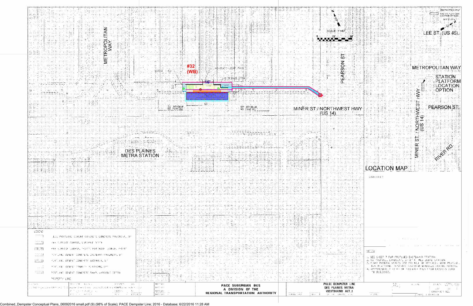
16'
#32
(WB)
Combined_Dempster Conceptual Plans_06092016 small.pdf (9) (98% of Scale); PACE Dempster Line; 2016 - Database; 6/22/2016 11:28 AM

16' #73 (WB) ALT 3A
Combined_Dempster Conceptual Plans_06092016 small.pdf (10) (98% of Scale); PACE Dempster Line; 2016 - Database; 6/22/2016 11:28 AM

#73 (WB) ALT 3B
Only (1) Vertical Marker,
Bike Rack & Electric
Combined_Dempster Conceptual Plans_06092016 small.pdf (11) (98% of Scale); PACE Dempster Line; 2016 - Database; 6/22/2016 11:28 AM

16'
#47
(WB)
Combined_Dempster Conceptual Plans_06092016 small.pdf (12) (98% of Scale); PACE Dempster Line; 2016 - Database; 6/22/2016 11:28 AM
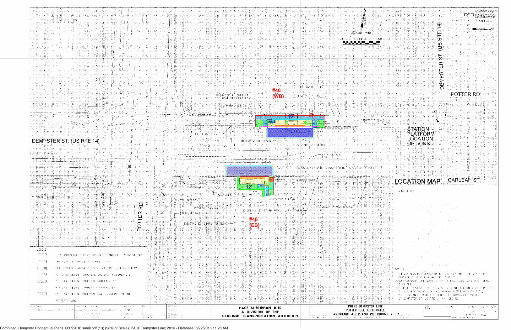
16'
12'
#48
(EB)
#46
(WB)
Combined_Dempster Conceptual Plans_06092016 small.pdf (13) (98% of Scale); PACE Dempster Line; 2016 - Database; 6/22/2016 11:28 AM

#11
(WB)
Combined_Dempster Conceptual Plans_06092016 small.pdf (14) (98% of Scale); PACE Dempster Line; 2016 - Database; 6/22/2016 11:28 AM

16'
16'
#60
(EB)
#70
(WB)
Combined_Dempster Conceptual Plans_06092016 small.pdf (15) (98% of Scale); PACE Dempster Line; 2016 - Database; 6/22/2016 11:28 AM

#50
(WB)
#49
(EB)
Combined_Dempster Conceptual Plans_06092016 small.pdf (16) (98% of Scale); PACE Dempster Line; 2016 - Database; 6/22/2016 11:28 AM

#61
(EB)
#62
(WB)
Combined_Dempster Conceptual Plans_06092016 small.pdf (17) (98% of Scale); PACE Dempster Line; 2016 - Database; 6/22/2016 11:28 AM

#79
(EB)
Combined_Dempster Conceptual Plans_06092016 small.pdf (18) (98% of Scale); PACE Dempster Line; 2016 - Database; 6/22/2016 11:28 AM

#68
(WB)
Combined_Dempster Conceptual Plans_06092016 small.pdf (19) (98% of Scale); PACE Dempster Line; 2016 - Database; 6/22/2016 11:28 AM

#14
(WB)
Combined_Dempster Conceptual Plans_06092016 small.pdf (20) (98% of Scale); PACE Dempster Line; 2016 - Database; 6/22/2016 11:28 AM

#34
(W...
#33
(EB)
Combined_Dempster Conceptual Plans_06092016 small.pdf (21) (98% of Scale); PACE Dempster Line; 2016 - Database; 6/22/2016 11:28 AM

#64
(WB)
#63
(EB)
Combined_Dempster Conceptual Plans_06092016 small.pdf (22) (98% of Scale); PACE Dempster Line; 2016 - Database; 6/22/2016 11:28 AM

#66
(WB)
#17
(EB)
Combined_Dempster Conceptual Plans_06092016 small.pdf (23) (98% of Scale); PACE Dempster Line; 2016 - Database; 6/22/2016 11:28 AM

#18
(WB)
#19
(EB)
Combined_Dempster Conceptual Plans_06092016 small.pdf (24) (98% of Scale); PACE Dempster Line; 2016 - Database; 6/22/2016 11:28 AM

#55
(WB)
#56
(EB)
Combined_Dempster Conceptual Plans_06092016 small.pdf (25) (98% of Scale); PACE Dempster Line; 2016 - Database; 6/22/2016 11:28 AM

16'
#36
(WB)
#22
(EB)
Combined_Dempster Conceptual Plans_06092016 small.pdf (26) (98% of Scale); PACE Dempster Line; 2016 - Database; 6/22/2016 11:28 AM

#42
(WB)
Combined_Dempster Conceptual Plans_06092016 small.pdf (27) (98% of Scale); PACE Dempster Line; 2016 - Database; 6/22/2016 11:28 AM

16'
#23
(WB)
#37
(EB)
Combined_Dempster Conceptual Plans_06092016 small.pdf (28) (98% of Scale); PACE Dempster Line; 2016 - Database; 6/22/2016 11:28 AM

12
'
#74
(WB)
#24
(EB)
Combined_Dempster Conceptual Plans_06092016 small.pdf (29) (98% of Scale); PACE Dempster Line; 2016 - Database; 6/22/2016 11:28 AM
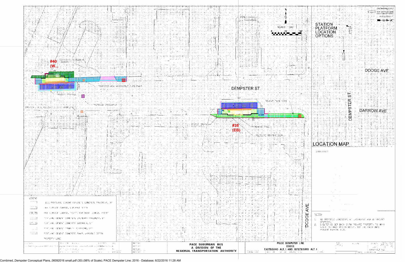
#40
(W...
#38
(EB)
Combined_Dempster Conceptual Plans_06092016 small.pdf (30) (98% of Scale); PACE Dempster Line; 2016 - Database; 6/22/2016 11:28 AM

#39
(WB)
Combined_Dempster Conceptual Plans_06092016 small.pdf (31) (98% of Scale); PACE Dempster Line; 2016 - Database; 6/22/2016 11:28 AM

Combined_Dempster Conceptual Plans_06092016 small.pdf (32) (98% of Scale); PACE Dempster Line; 2016 - Database; 6/22/2016 11:28 AM


1
Cynthia Rood
From: Bryan Olin <[email protected]>
Sent: Friday, June 17, 2016 4:24 PM
To: Cynthia Rood
Subject: POLYSLICK BUS CURB FOR PACE PROJECT
Attachments: POLYSLICK BUS CURB.PDF; c.jpg; f.jpg; g.jpg; j.jpg; k.jpg
Cindy,
As we discussed, attached is an informational sheet for POLYSLICK® BUS CURB along with a few extra photos of our product and below is an engineering estimate and sample specification. I am providing pricing for 1.50”, 2.00”, and 2.50” thick all x 6.00” high.
All material shall be 6.00” high x 10’-0” long POLYSLICK® BUS CURB YELLOW drilled, c’bored, radius edged, and tapered (when required) as manufactured by Polymer Industries, Tacoma, WA 253-272-1217
112 ea. standard 56 ea. tapered (for lead in and trailing parts)
1.50” thick - $30,576.00 lot 2.00” thick - $38,448.00 lot 2.50” thick - $46,320.00 lot
Please acknowledge receipt and contact me with questions. Thanks, Bryan
Bryan Olin | Business Development Mgr. | Polymer Industries | 253.552.4558 direct | 800.872.8469 ph

RECORD OF TELEPHONE CALL
Job # PACE _ Dempster Line ___________ Date 6-17-2016 __________________________
Call From ______________________________ Of ___________________________________
Call To Matt _________________________ Of Landscape Forms 1-800-430-6209 _______
By Cindy Rood _____________________
Subject Discussed Action to be Taken
Site Furnishings
Trash Can - “ Steely Can” 39 gal
Bicycle Rack “ Bola”
74” backless “Arcata Bench”
$ 910.00 each w/ freight @ $973.70
$ 320.00 each w/freight @ $342.40
$ 2,020.00 each w/freight @ 2,161.40
Freight to Illinois @ 7%

RECORD OF TELEPHONE CALL
Job # PACE _ Dempster Line ___________ Date 6-17-2016 __________________________
Call From ______________________________ Of ___________________________________
Call To Emily ________________________ Of Ozinga Concrete 1-800-786-6380 ________
By Cindy Rood _____________________
Subject Discussed Action to be Taken
Concrete
High Early – State Mix 6.1
3500 psi Concrete
Minimum 6 CY load & $ 20 delivery fee
$ 188.80 per CY
$ 174. 00 per CY

PROJECT DEFINITION PULSE DEMPSTER LINE
Appendix I BASIS OF COST ESTIMATE

1 | Capital Cost Estimate
CAPITAL COST ESTIMATE: BASIS OF ESTIMATE
Introduction This document provides the basis of the Independent Cost Estimate (ICE) developed for the Pace – Dempster Line stations. The goal of this estimate is to evaluate the design documents produced and provide a detailed cost estimate to determine the appropriate construction costs for 47station sites. An additional estimate was provided that presented the total project cost for the Dempster Line corridor for 15 intermediate station locations (with two station sites per location) plus two additional terminal stations for a total of 32 estimated sites. All available project design files and documents were used to determine and evaluate anticipated construction costs for this project. The design documents were understood to be developed to a conceptual design level.
This report defines the parameters, scope of work, structure, assumptions and exclusions used in the development of the cost estimate. Separate reports may be developed, if needed, for further analysis and review.
It was understood that the design is at a preliminary stage and all elements of the project have not yet been fully detailed and designed; therefore estimating assumptions were utilized to generate the quantities and costs when needed. The documents provided for use in the preparation of the estimate include:
• Dempster station layouts (draft) – June 10, 2016• Design Plan for Mannheim-Higgins• PMO_DEMP_Stations-Platforms_For Estimate.xlsx• GIS_PMO_DEMP_StationLayout_2016-06-06.shp• Pulse Milwaukee Line 60% Design files• Google Earth Pro
Quantity surveys (takeoff) have been developed and are included in the Backup attachment (Appendix A). These quantities are used for each station location and are complimented by details (shown or assumed) for the estimated element.
The purpose of this cost estimate, at this level, is to provide an accurate accounting and anticipated cost assessment for this project based on the information developed to date. The procedures used in the estimate are consistent with AACE International, formerly known as the Association for the Advancement of Cost Engineering.
Baseline Parameters for All Station Estimate and The Corridor Wide estimate STATION DEMOLITION
Using design documents and Google Earth Pro the existing conditions demolition for each station location was compiled. The quantities of work will include items noted on the drawings and some assumed based on estimator experience. Station quantities for demolition vary per site.
EARTHWORK PARAMETERS
Grading documents were not included in the design documents available, so the earthwork related to the stations was quantified by taking square footage of proposed hard surface and assuming a cut of (1’) to subgrade for new pavements. Each site was assumed to be an excess site with “clean” soils for distribution within a one hour 2-way travel time of each station location.

2 | Capital Cost Estimate
ROADWAY PARAMETERS
Elements of roadway construction required on this project are a 10” PCC bus pad using a high early concrete mix design, a 2’ wide variable asphalt patch and B6-12 or B6124 curb & gutter (size determined by measurement on aerial photo).
LANDSCAPE
Landscape items figured in the estimate include restoring existing planting beds and sodded areas affected by the new station work. Also included are new planting beds but, the typical designs for the “Compact” and “Typical” stations would imply this landscape strip is not to be included at each site. Only a select few of the stations in the current design drawings for the Dempster Line included this new landscaping (noted as New Landscape Area) on the takeoff and estimate.
DRAINAGE AND UTILITY PARAMETERS
Drainage and utility relocations were included based on the design plans provided. In the absence of survey documents for existing utilities at each location, a complete cost determination could not be prepared at this time. Relocation for the utility items noted on the drawings has been included in the estimate, with an additional cost of 5% of the total construction cost allocated through the unit prices to cover the risk for unforeseen utility conflicts.
STATION PLATFORM
For the station platform the shelters, vertical marker, heaters, snow melting system, and real time sign allowances that were used in development of the Milwaukee Line were also used for this estimate. Bottoms–up production based costs were prepared on all other elements for the station platforms such as concrete pad, concrete ramp, tactile warning edge, stations furnishings, and steel railing. The unit prices for the electrical cabinet and conduit/wire from cabinet to station elements was also developed with this method. Local suppliers were contacted and copies of the quotes are attached to the backup documents.
EROSION CONTROL
Erosion control for each location was assumed based on estimator experience in storm water management practices. If the new station location had existing storm drainage structures in the area of construction, inlet protection was assumed. At the station location where existing sod was located, silt fence was added as both a construction zone fence and to prevent any silt runoff outside of construction limits.
MOBILIZATION AND TRAFFIC CONTROL
Each station is treated as an individual project in the estimate, requiring separate mobilization and traffic control per location. These items have been added based on a time determination or expectation for the amount of work that will be required at each station’s location.
COMED ELECTRIC SERVICE DROP
The design drawings do not provide a power source for each of the station locations. Using Google Map Pro and any design drawings showing utility as-builts, a best guess for an electrical service drop location was used to determine length of conduit and wire needed for each station. An allowance of $5,000.00 was used for ComEd to provide the service connection to either an existing pole or on a buried power line. In some locations with power poles at or near the new station, the work required was clear-cut. In the station locations where the existing power lines were underground it was not always clear as to the amount of work involved to get electricity to the station. In these cases, at a minimum it was assumed a conduit would be placed within the right-of-way to the closest intersection were a power source may be available to tap into.

3 | Capital Cost Estimate
Work Breakdown At the lowest level, the cost estimate is structured at established bid items in order to provide transparency to the listed items carried in the cost estimate. Each pay item or work activity number is broken down into further activities that represent the level of construction effort for the line item. Costs were derived to roll up to these items and generate a unit price for the associated item. A full detailed cost report showing all activities as well as a rolled up cost reports are included in the estimate document provided. In order to provide additional breakout and reporting flexibility, the estimate has additional breakdown above the item level, the full work breakdown structure utilized is shown below:
Station Site ID #
• #__ - Station Number, Name, Travel Direction and Alternate # o SCC Code
20 - Stations, Stops, Terminals 40 - Sitework & Special Conditions 50 - Systems
o SCC Description 20.01 - At-grade station, stop, shelter, mall, terminal, platform 40.01 - Demolition, Clearing, Earthwork 40.02 - Site Utilities, Utility Relocation 40.06 - Pedestrian / bike access and accommodation, landscaping 40.07 - Automobile, bus, van accessways including roads, parking lots 40.08 - Temporary Facilities and other indirect costs during construction 50.05 - Communications
o Work Type 00 - General Conditions 02 – Site Removals 03 - Earthwork 04 – Roadway 05 - Utilities 06 – Station Elements 08 – Electric 09 - Communications
Estimate Exclusions COST ESTIMATE EXCLUSIONS / ADDITIONAL RISKS
1 Special insurances (railroad, builder’s risk, etc.) are excluded.
2 Hazardous or contaminated material abatement and/or removal.
3 Archeological finds and/or any delays that could be caused by them.
4 3rd Party utility impacts, relocation and/or any delays that could be caused by them.
5 Right of way (ROW) procurement costs or easement costs have not been included in the All-Station estimate, but an allowance of 600SF per location at a cost of $5.00 per SF was added to the Corridor Wide Estimate Summary Page.
6 Unforeseen conditions due borings or geotechnical information.
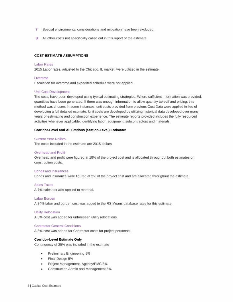
4 | Capital Cost Estimate
7 Special environmental considerations and mitigation have been excluded.
8 All other costs not specifically called out in this report or the estimate.
COST ESTIMATE ASSUMPTIONS
Labor Rates 2015 Labor rates, adjusted to the Chicago, IL market, were utilized in the estimate.
Overtime Escalation for overtime and expedited schedule were not applied.
Unit Cost Development The costs have been developed using typical estimating strategies. Where sufficient information was provided, quantities have been generated. If there was enough information to allow quantity takeoff and pricing, this method was chosen. In some instances, unit costs provided from previous Cost Data were applied in lieu of developing a full detailed estimate. Unit costs are developed by utilizing historical data developed over many years of estimating and construction experience. The estimate reports provided includes the fully resourced activities whenever applicable, identifying labor, equipment, subcontractors and materials.
Corridor-Level and All Stations (Station-Level) Estimate:
Current Year Dollars The costs included in the estimate are 2015 dollars.
Overhead and Profit Overhead and profit were figured at 18% of the project cost and is allocated throughout both estimates on construction costs.
Bonds and Insurances Bonds and insurance were figured at 2% of the project cost and are allocated throughout the estimate.
Sales Taxes A 7% sales tax was applied to material.
Labor Burden A 34% labor and burden cost was added to the RS Means database rates for this estimate.
Utility Relocation A 5% cost was added for unforeseen utility relocations.
Contractor General Conditions A 5% cost was added for Contractor costs for project personnel.
Corridor-Level Estimate Only Contingency of 25% was included in the estimate
• Preliminary Engineering 5%• Final Design 5%• Project Management, Agency/PMC 5%• Construction Admin and Management 6%

5 | Capital Cost Estimate
• Insurance .5%• Legal, Permits, Review Fees 2.5%
Escalation Unit costs are set in 2015 dollars. Escalation was done to bring the costs to 2019 and 2020 dollars, a time period when the project would likely be under construction or operating. A variable inflation rate was used based on inflation forecasts from the Congressional Budget Office Baseline Economic Projections and Consumer Price Index, All Urban Users from the Bureau of Labor Statistics.

PROJECT DEFINITION PULSE DEMPSTER LINE
Appendix J COST ESTIMATE: ALL STATION SITES EXCEL WORKBOOK

PROJECT DEFINITION PULSE DEMPSTER LINE
Appendix K COST ESTIMATE: CORRIDOR STATION SITES EXCEL WORKBOOK

PROJECT DEFINITION PULSE DEMPSTER LINE
Appendix L FTA STANDARD COST CATEGORIES (SCC) EXCEL WORKBOOK

PROJECT DEFINITION PULSE DEMPSTER LINE
Appendix M COMMUNITY EXPRESSION FEATURES: COST SHARING AND COORDINATION GUIDELINES

Community Expression Features Cost Sharing Strategy and Coordination Guidelines February 5, 2016 PREPARED BY Pace Suburban Bus 550 W. Algonquin Road Arlington Heights, IL 60005
AND HNTB Corporation 1 S. Wacker Drive, Suite 900 Chicago, IL 60606

COST SHARING STRATEGY | 1 1/26/2016
Community Expression Features | Cost-Sharing Strategy
Pace is coordinating with local communities to ensure Pulse stations are easily identifiable and communicate the Pace and Pulse brands while also being well integrated into the surrounding environment. As part of the planning and design process, Pace identified typical Pulse station elements. On average, Pace is investing $422,000 per station to install basic features as illustrated in Figure 1. Pace also identified which of these features could be customized community expression elements. The customizable features include landscaping, railing infill panels, shelter panels, trash receptacles, bicycle racks, and platform paving (see Figure 1). As part of this process, Pace also evaluated options for sharing the costs of customizing these station features with local communities. Provided below is a summary of Pace’s cost-sharing strategy as well as guidelines for coordinating with communities on the customization of the features.
Figure 1: Station Feature Customization Opportunities
Cost Sharing Strategy
1. Pace will pay for a customized rear etched glass panel for station shelters and will coordinate with communities on the design of the panel graphics. The approximate cost to customize the glass panel is $3,000 per shelter. Pace covers 100% of this custom element.
2. Pace has selected a bicycle rack and trash receptacle to be installed as a standard item at each station.
• If a municipality would like to substitute its locally preferred bicycle rack and/or trash receptacle, Pace will make the substitution provided that the cost is equal to or less than the bicycle rack or trash receptacle selected by Pace. The municipality is also required to procure the substituted bicycle rack and trash receptacle that will be installed by Pace during station construction.
• If the locally preferred bicycle rack and/or trash receptacle has a higher cost than the selected standard feature the municipality must cover the additional cost (see prices in Figure 2 below),
Landscaping
Railing (Add Custom Panels)
Rear Shelter Panel Trash Receptacle
Platform Paving
Bicycle Rack

COST SHARING STRATEGY | 2 1/26/2016
3. A municipality may customize the platform railing by adding 2 custom infill panels that feature community artwork adjacent to the passenger boarding area.
• If a community desires to add custom infill panels, the community will be responsible for the standardized cost of the panels (See Figure 2).
4. Pace has specified a station platform concrete paving. If desired, the concrete paving material can be customized by a municipality. Available custom treatment options are limited to:
• A single municipal logo stamped into concrete at the base of the ramps leading into the station area. If a community opts for a stamped concrete of their municipal logo at these locations the municipality will be required to design and furnish a stamp that Pace will use to imprint the concrete during construction. Pace will cover 100% of this construction cost.
• Uniform color treatment for the entire platform with no stamping (limited approved colors TBD). If a community opts for a uniform color treatment, there will be a standardized cost of $1,000 per station for the custom treatment
For all the platform paving options, the municipality must agree to maintain the custom pavement and restore it to its original appearance if damaged or disturbed by construction or right-of-way work. (See Figure 2).
5. The typical station will include landscaping adjacent to the back of the platform provided that a local partner (e.g. a local business, community, chamber of commerce, Special Service Area (SSA), or ward office) is willing to maintain it. Pace will specify a planting design appropriate for urban streetscapes.
• If no local partner is willing to maintain the landscaping, none will be provided.
• If a community would like to substitute its locally preferred planting palette, Pace will make the substitution provided that the cost is comparable to the design selected by Pace.
Landscaping
ShelterStandard Shelters w ith Customized Back Panel
Trash ReceptacleBicycle Rack
Stamped municipal logo (no color) $0
Colored Concrete $1000 per station
CUSTOMIZED STATION FEATURES
$3,300 per station
$0
Any amount in excess of $1,600/Unit
Any amount in excess of $1,300/UnitPlatform Paving (Stamped, Colored Concrete)
$0 (Plantings to be Coordinated with Community)
Feature
Railings (With Decorative Panels)
Community Cost Customized Station Features
Figure 2: Station Feature Customization Community Costs

COST SHARING STRATEGY | 3 1/26/2016
Coordination Guidelines
In addition to the above outlined strategy, Pace developed the guidelines below to facilitate agreements, and coordination with local communities on the feature customizations.
• Pace will coordinate directly with the municipality in which a station is located regarding any / all custom options. If a station is located in unincorporated territory, Pace may coordinate with the closest municipality or the county. If a station is located entirely or partially on private property, Pace may elect to coordinate with the property owner for the customization of station features.
• A municipality may offer customization decisions to local organizations. However, Pace accepts direction on station customization only from the municipal government (or county, or private property owner) in which the station is located and will enter into Intergovernmental Agreements only with municipal governments.
• If a municipality declines the opportunity to customize station features, Pace reserves the right to proceed with standard station features or custom features of its choosing.
• Pace reserves the right to enter into sponsorship agreements with public agencies or private entities to provide for the maintenance and/or customization of the Pulse system and Pulse station features.
• Pace has final authority to approve or disapprove all design treatments and customizations. Pace reserves its right to maintain design control over all features of the Pulse system and its stations, subject to compliance with local, state and federal regulations and permits.
• If a local municipality wishes to customize station features, it must enter into an Intergovernmental Agreement with Pace to document the features to be customized, the costs associated with such custom features, the responsibility of each party for payment of such costs, and responsibilities for maintenance of the features, including the cost of replacing damaged station features, among other items. General station maintenance, such as cleaning and trash removal, will be performed by Pace or a shelter vendor as determined or contracted by Pace. However, painting, general maintenance, repair and/or replacement of custom features (including landscaping, paving and railing panels) will be the responsibility of the partnering municipality.
• If a local municipality wishes to customize station features, the local community must provide Pace with vector-based digital files of any custom artwork or logos as well as any product specifications for the desired station features (e.g. bicycle rack or trash receptacle).
• Customized station features must be coordinated prior to the completion of 60% design drawings. Pace will not guarantee that new requests for custom station features can be accommodated after this point. Any requests for custom features received after the completion of 60% design drawings will be considered on a case by case basis with consideration given to the feasibility of accommodating the customized feature, the expected life and condition of the feature, and the costs for any associated change orders, including the responsibility for said costs.
• Custom features and/or substitutions (e.g. substituting a community’s bicycle rack for Pace’s standard bicycle rack) may be limited by site constraints and/or other

COST SHARING STRATEGY | 4 1/26/2016
project requirements or restrictions, including rights of access to be granted through required real estate transactions, permits, and/or use agreements.
• If a municipality seeks a customization that is not listed on the above menu, it shall be submitted to Pace for consideration, with a visual rendering of the proposed element.