bus-forward.pdf - NYC.gov
16
1 2017
-
Upload
khangminh22 -
Category
Documents
-
view
0 -
download
0
Transcript of bus-forward.pdf - NYC.gov

1
2017

2
City Council legislation in 2015, sponsored by Council Member Brad Lander, called for NYC DOT to develop an updated plan for implementing Select Bus Service lines in partnership with the MTA.
In May 2017, the Council passed additional legislation, sponsored by Council Member Ydanis Rodriguez, calling for NYC DOT to include plans for transit improvements other than Bus Rapid Transit (BRT) and strategies for improving transit access in neighborhoods not well served by the subway.
Based on this legislation, the Citywide Transit Plan will build on the 2009 BRT plan to expand the Select Bus Service (SBS) network, but will also identify complementary projects beyond BRT within the transit system based on changes in transit use, land use, demographics and other important factors.
1
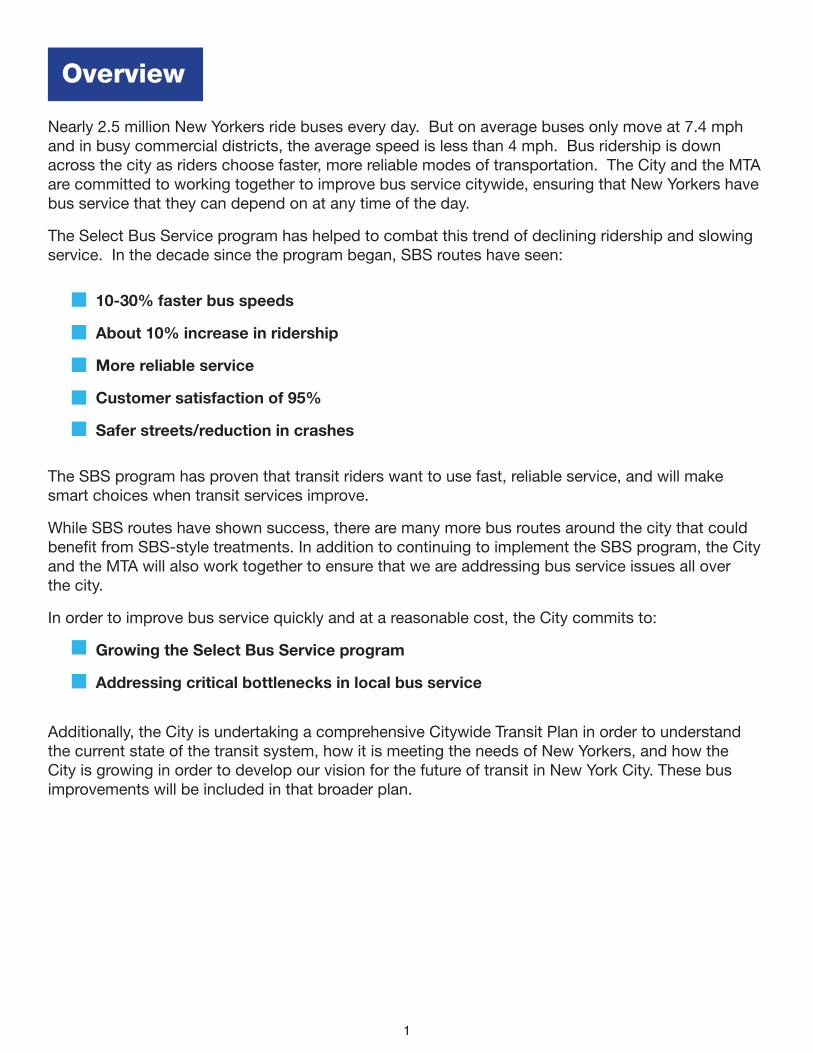
Nearly 2.5 million New Yorkers ride buses every day. But on average buses only move at 7.4 mph and in busy commercial districts, the average speed is less than 4 mph. Bus ridership is down across the city as riders choose faster, more reliable modes of transportation. The City and the MTA are committed to working together to improve bus service citywide, ensuring that New Yorkers have bus service that they can depend on at any time of the day.
The Select Bus Service program has helped to combat this trend of declining ridership and slowing service. In the decade since the program began, SBS routes have seen:
10-30% faster bus speeds
• About 10% increase in ridership
• More reliable service
• Customer satisfaction of 95%
• Safer streets/reduction in crashes
The SBS program has proven that transit riders want to use fast, reliable service, and will make smart choices when transit services improve.
While SBS routes have shown success, there are many more bus routes around the city that could benefit from SBS-style treatments. In addition to continuing to implement the SBS program, the City and the MTA will also work together to ensure that we are addressing bus service issues all over the city.
In order to improve bus service quickly and at a reasonable cost, the City commits to:
Growing the Select Bus Service program
Addressing critical bottlenecks in local bus service
Additionally, the City is undertaking a comprehensive Citywide Transit Plan in order to understand the current state of the transit system, how it is meeting the needs of New Yorkers, and how the City is growing in order to develop our vision for the future of transit in New York City. These bus improvements will be included in that broader plan.
Overview

2
A
B
C
D
F
E
O
L
Q
M
S
N
P
I
RT
J
G
K
H
U
H
L
R
Subway
SBS - Proposed
SBS - Existing
0 1 2 3 4Miles
¹Figure 1: Future Rapid Transit Network With Proposed SBS Connections
SBS Connections
Based on the results of data analysis and public feedback through workshops, on-street surveying and online feedback, NYC DOT and the MTA have identified 21 candidate corridors across the city for the next phase of SBS.
By continuing to grow the SBS network, we are focusing on key issues including improving job access across the City and providing service on trips not well served by the subway and rail systems.
Growing the SBS Program

3
The BronxA Broadway to Central BronxB Gun Hill RoadC University AvenueD Tremont AvenueE Harlem to Southern BoulevardF Soundview to Washington HeightsBrooklynG Church AvenueH South Brooklyn East-West (multiple)I Downtown Brooklyn to RidgewoodJ Brooklyn Access to JFKK Flatbush AvenueManhattan L Manhattan Crosstown Routes
(multiple, including 14th Street)QueensM Ridgewood to FlushingN Flushing to Springfield BoulevardO Hillside AvenueP Union TurnpikeQ Northern BoulevardR Southeast Queens (multiple)S Jamaica to Flushing (via Kissena Boulevard)T Queens Access to JFKStaten IslandU North Shore*
* North Shore BRT is currently being studied by the MTA. NYC DOT supports this effort.

4

5
2013 and earlier20162017 2014
2015Post-2017
N
M60125th St / Astoria Blvd
/ LGA
Bx41Webster Av
Q44Main St / Cross
Bronx Service Rd
B46Utica Av
M151st Av / 2nd Av
Bx12Fordham Rd
B44Nostrand Av /
Rogers Av
S79Hylan Blvd
M34/M34A34th St
Bx6161st St / 163rd St
M8686th St
Q70BQE / LGA
M2323rd St
M7979th St
Q52/Q53Woodhaven Blvd /
Cross Bay Blvd
B82Kings Hwy/Flatlands Av
M1414th St
Figure 2: Existing and in-planning SBS routes by year of launch
The existing SBS network has over 309,000 daily riders, 12% of city bus ridership. With the addition of the new proposed SBS routes, over 800,000 bus riders would be on routes with fast and reliable service, over 32% of city bus ridership.
Mayor de Blasio has committed significant funds toward the implementation of SBS, allowing for the launch of 2-3 SBS routes per year
• $9.4M per year is dedicated to SBS projects in NYC DOT’s annual expense budget
• Additional DOT funds are also used to fund the launch of SBS and bus priority projects
• The de Blasio administration has increased capital funding by $196M to date for SBS-related projects

6
What Tools do NYC DOT and the MTA Use to Improve Bus Service?
Off-board fare collection and all-door boarding to speed passenger loadingBus-only lanes and queue jumps to speed up busesTransit signal priority to reduce the time buses spend waiting at red lightsWider stop spacing to reduce the time buses are stopped and ensure they can travel faster between stopsBus route changes to ensure that passengers are efficiently connected to the destinations most important to themImproved curb regulations to facilitate efficient deliveries and reduce double parkingConcrete islands and curb extensions to improve pedestrian safety Real time bus arrival information and improved wayfinding to enhance passenger experienceBus bulbs and enhanced station amenities like benches, shelters, and additional trees and plantings to improve passenger comfortBus dispatching to continue to adjust to real time traffic conditions
Updated relief locations to reduce impact on passengers where possible
Since the start of the SBS program, bus lane miles have more than doubled.
110
100
90
80
70
60
50
40
30
20
10
1990
1992
1994
1996
1998
2000
2002
2004
2006
2008
2010
2012
2014
2016
0
103.8miles
49.2miles
Figure 3: Cumulative Bus Lane Miles in New York City

7
Off-Board Fare Collection
Bus Lanes Bus Bulbs and Curb Extensions
All Door Boarding
Bus Shelters and Amenities Real Time Information
8
Lexington Avbtwn E 68 St
& E 96 St
Broadwaybtwn W 225 St
& W 231 St
Bay St at Victory Blvd
Church Avbtwn Coney Island Av
& Flatbush Av
Fresh Pond Rdbtwn Metropolitan Av
& Putnam Av
Unreliable segmentsSlow speed segments
0 1 2 3 4Miles
¹
Long and slow trip segments
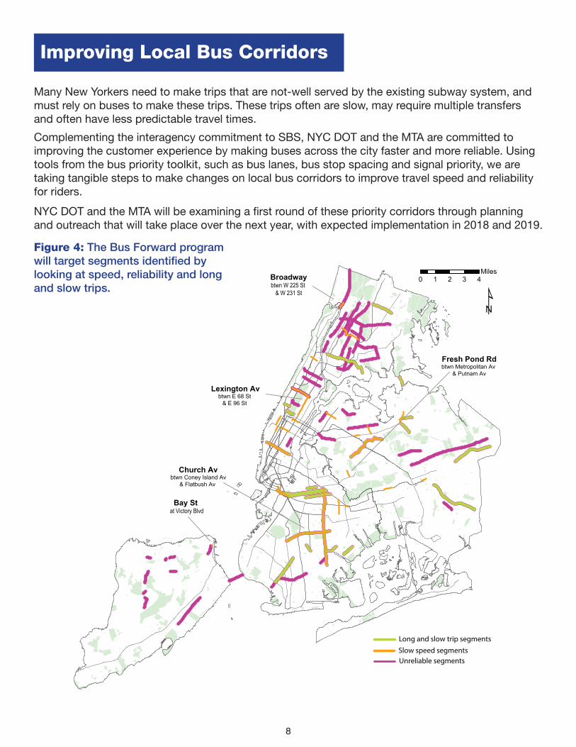
Many New Yorkers need to make trips that are not-well served by the existing subway system, and must rely on buses to make these trips. These trips often are slow, may require multiple transfers and often have less predictable travel times.
Complementing the interagency commitment to SBS, NYC DOT and the MTA are committed to improving the customer experience by making buses across the city faster and more reliable. Using tools from the bus priority toolkit, such as bus lanes, bus stop spacing and signal priority, we are taking tangible steps to make changes on local bus corridors to improve travel speed and reliability for riders.
NYC DOT and the MTA will be examining a first round of these priority corridors through planning and outreach that will take place over the next year, with expected implementation in 2018 and 2019.
Figure 4: The Bus Forward program will target segments identified by looking at speed, reliability and long and slow trips.
Improving Local Bus Corridors
9
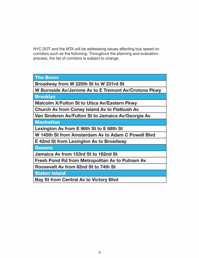
NYC DOT and the MTA will be addressing issues affecting bus speed on corridors such as the following. Throughout the planning and evaluation process, the list of corridors is subject to change.
The BronxBroadway from W 225th St to W 231rd StW Burnside Av/Jerome Av to E Tremont Av/Crotona PkwyBrooklynMalcolm X/Fulton St to Utica Av/Eastern PkwyChurch Av from Coney Island Av to Flatbush AvVan Sinderen Av/Fulton St to Jamaica Av/Georgia AvManhattanLexington Av from E 96th St to E 68th StW 145th St from Amsterdam Av to Adam C Powell BlvdE 42nd St from Lexington Av to BroadwayQueensJamaica Av from 153rd St to 162nd StFresh Pond Rd from Metropolitan Av to Putnam AvRoosevelt Av from 82nd St to 74th StStaten IslandBay St from Central Av to Victory Blvd

10

11
In order to understand where to target SBS expansion and local bus service improvements, NYC DOT and the MTA identified four key analyses that projects should help address:
• Access to rapid transit service
• Long and slow bus trips
Access To Rapid Transit Service
While every neighborhood in New York City has local bus service, it is not always frequent and many neighborhoods do not have access to rapid rail or bus service. Riders in these neighborhoods often face longer trips, more transfers and unreliable trip times even for short trips.
• Slow bus speeds
• Bus reliability
0 1 2 3 4Miles
¹SubwaySBS
1/2 mile walksheds from stops
Figure 5: In blue are areas of the city within ½ mile walk of subway and SBS service
An Assessment of NYC’s Bus Service

12
Long and Slow Bus Trips
Many New Yorkers make trips that are not well-served by our current transit system. Many of these trips take longer, require one or more transfers between buses or bus and subway and have unreliable travel times. The MTA identified trips between neighborhoods that take longer than 30 minutes and are slower than 8mph that over 900 people made by bus on an average weekday. There are 28 neighborhood connections where customers choose to take an arduous trip, in many cases because there may not be a better alternative. Scores more may be making the trip in private vehicles, or choosing to forgo because it is difficult.
0 5.5 112.75 Miles
¹
Norwood
Co-Op City
Hunts Point
East HarlemNorth
East Tremont
WestConcourse
University Heights-Morris Heights
WashingtonHeights
North
WashingtonHeights
South
Lenox Hill
UpperWestSide
Midtown
LincolnSquare
West Village
Lower EastSide
Elmhurst
RidgewoodDowntownBrooklyn
Flatbush Canarsie
Crown Heights North
Stuyvesant Heights
Bushwick South
BushwickNorth
Rugby-Remsen Village
Kew Gardens Queens VillageJamaica
South Ozone Park
Woodhaven
Oakland Gardens
Bayside-Bayside Hills
Flushing
Springfield GardensSouth
Laurelton
Cambria Heights
Figure 6: Long and slow trips. Includes trips made by more than 900 passengers on the evaluated day.
Source: MTA Operations Planning, 2016.
13
Slow Bus Speeds
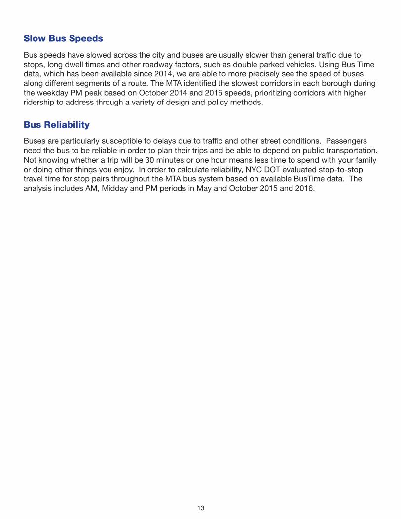
Bus speeds have slowed across the city and buses are usually slower than general traffic due to stops, long dwell times and other roadway factors, such as double parked vehicles. Using Bus Time data, which has been available since 2014, we are able to more precisely see the speed of buses along different segments of a route. The MTA identified the slowest corridors in each borough during the weekday PM peak based on October 2014 and 2016 speeds, prioritizing corridors with higher ridership to address through a variety of design and policy methods.
Bus Reliability
Buses are particularly susceptible to delays due to traffic and other street conditions. Passengers need the bus to be reliable in order to plan their trips and be able to depend on public transportation. Not knowing whether a trip will be 30 minutes or one hour means less time to spend with your family or doing other things you enjoy. In order to calculate reliability, NYC DOT evaluated stop-to-stop travel time for stop pairs throughout the MTA bus system based on available BusTime data. The analysis includes AM, Midday and PM periods in May and October 2015 and 2016.

14