
Determining the Optimum Inner Diameter of Condenser Tubes ...
Tigh na Darach, 6 Braeroy Road, Roy Bridge, Highland PH31 4AJ, UK. Email: [email protected]
b e n l e n n o n
a s t u d y o f t h e t r e e s o f s av e r n a k e f o r e s t a n d
t o t t e n h a m pa r k , w i lt s h i r e , u s i n g s tat i s t i c a l
a n a ly s i s o f s t e m d i a m e t e r
Savernake Forest and Tottenham Park, Wiltshire, is an extensive designed landscape established on the remnants of a medieval hunting forest and best known for its concentration of veteran trees. Between 2006 and 2009 seven thousand large trees were located and measured in a survey carried out by the Forestry Commission. The data are here stratified and analysed using the normal distribution curve to identify populations and compared with archival material. It is suggested that the majority of veteran trees date from the late eighteenth century. A small number of oaks are indicated as being of older cohorts in the medieval period. Three may have their origins before the Norman Conquest.
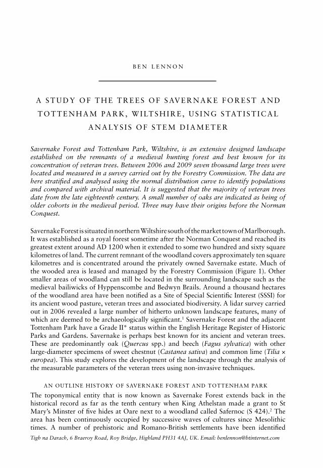
savernake forest is situated in northern wiltshire south of the market town of marlborough. it was established as a royal forest sometime after the norman conquest and reached its greatest extent around ad 1200 when it extended to some two hundred and sixty square kilometres of land. the current remnant of the woodland covers approximately ten square kilometres and is concentrated around the privately owned savernake estate. much of the wooded area is leased and managed by the forestry commission (figure 1). other smaller areas of woodland can still be located in the surrounding landscape such as the medieval bailiwicks of hyppenscombe and Bedwyn Brails. around a thousand hectares of the woodland area have been notified as a site of special scientific interest (sssi) for its ancient wood pasture, veteran trees and associated biodiversity. a lidar survey carried out in 2006 revealed a large number of hitherto unknown landscape features, many of which are deemed to be archaeologically significant.1 savernake forest and the adjacent tottenham park have a grade ii* status within the english heritage register of historic parks and gardens. savernake is perhaps best known for its ancient and veteran trees. these are predominantly oak (Quercus spp.) and beech (Fagus sylvatica) with other large-diameter specimens of sweet chestnut (Castanea sativa) and common lime (Tilia × europea). this study explores the development of the landscape through the analysis of the measurable parameters of the veteran trees using non-invasive techniques.
an outline history of savernake forest and tottenham park
the toponymical entity that is now known as savernake forest extends back in the historical record as far as the tenth century when king athelstan made a grant to st mary’s minster of five hides at oare next to a woodland called safernoc (s 424).2 the area has been continuously occupied by successive waves of cultures since mesolithic times. a number of prehistoric and romano-British settlements have been identified
235trees of savernake forest and tottenham park, wiltshire
across the landscape, but by the time of the domesday survey there were no settlements in the central forest. during this period much of the core forest may well have been managed as a common pool resource involving the integration of domestic stock with deer and game, and managed trees in a silvo-pastoral system.3 By the end of the twelfth century the medieval royal forest administration had been established and occupied its greatest extent.
during the thirteenth and fourteenth centuries the extent of the land under forest law declined through processes of disafforestation of the privately held lands, and assart around the fringes of the royal demesne. in 1548 the remains of the forest were transferred from the crown to the personal estate of edward seymour, lord protector and duke of somerset. throughout the medieval period horses, cattle sheep and deer extensively grazed much of the area that remained under forest jurisdiction. there is little evidence of much closed canopy woodland although attempts at woodland inclosure are intermittently recorded. parks had been established in the area from the thirteenth century. By the 1580s a number of pastures and woodlands across the forest had been emparked, including wolfhall, tottenham,4 Brimslade,5 and the great park.6 wolfhall park (also known as suddene park) appears to have been created c.1347 and was sited at the south side of the manor house.7
in 1721 richard Boyle, 3rd earl of Burlington, created a new house for lord charles Bruce, descendant of the seymours, and remodelled the old tottenham park along more fashionable lines. over the first half of the century the park was developed with shifting boundaries and instilled with an aesthetic property that would be extended into the wider landscape via a series of rides and avenues. the latter part of the eighteenth century saw the whole of the remaining bailiwick of la Verme incorporated into a large forest park
figure 1. location of savernake forest. all drawings are by the author
236 garden history 42 : 2
under the guidance of lancelot ‘capability’ Brown. the differences in approach to the landscape design of the early and late eighteenth centuries are widely believed to be marked by a shift from the geometric formal layout of Burlington to the informality of Brown. thus the entire geometric ride layout of savernake was assumed to belong to the Burlington period with the serpentine rides and clumps attributed to Brown.8
tree planting continued into the nineteenth and early twentieth centuries under the 5th and 6th marquesses of ailesbury. many of the avenues of horse chestnut and common lime can be dated through maps to the latter part of the nineteenth century.9 much of the forest was leased to the forestry commission in 1939. after this time the open woodland character of the forest changed when much was converted into plantations of oak, beech and conifers.
previous studies
the mystical qualities of savernake have long held people in their thrall. this charm is largely attributable to its ancient trees, some of which have been famous for centuries. in 1672 antiquarian John aubrey described savernake as ‘a most parkley ground and romancey pleasant place: several great walkes of great length, of trees planted’.10 later still, the victorian writer richard Jeffries was moved to comment: ‘certainly no one who had not seen it would believe that a forest still existed in the very heart of southern england so completely recalling those woods and “chases” upon which the ancient feudal monarchs set such store.’11 the forest and park featured in numerous tour guides and topographical accounts of wiltshire throughout the eighteenth and nineteenth centuries. these tended to be copied from previous accounts and occasionally errors of historical fact would become established through repetition. some old trees assumed their own character and attracted names, stories and provided a focus for art and literature in their own right.
studies carried out during the twentieth century have tended to focus on the rich historical record of the savernake archive,12 or on species hybridization and historical management practices in relation to the very largest trees.13 these studies have undoubtedly highlighted the potential for the further study of the ancient trees of savernake as a source of historical and archaeological information.
methodologies used in the study
over recent years the study of trees and woodlands as a living archaeological resource has expanded the understanding of wooded landscapes. dendrochronology and palaeo-environmental studies using stable isotopes in trees rings is a growing area of study. palaeo-environmental sampling can be revealing but can be expensive and is a highly specialist discipline. consequently, sample sizes are relatively small. gathering data from cut stumps is neither intrusive nor expensive, but is rather opportunistic. working within species data sets, increment bore sampling is an invaluable method to derive age information from growing trees, although this method is invasive and inevitably the sample sets tend to be small. nonetheless, since it is possible to target the source trees as being ‘representative’ (according age class/shade density index), data gathered in this way can be applied to larger data sets and used in parallel to stump (i.e. dead tree) data.
John white has proposed a method of predicting the age of large-diameter trees using comparisons with lists of trees established at a known date.14 from these data the likely performance of various trees in different locations can be evaluated through cross-referencing with trees growing in similar conditions.15 the method uses the measurement of stem diameter, as this is the single non-reversible and easily measurable
237trees of savernake forest and tottenham park, wiltshire
parameter of the tree.16 the method for single trees may also be extended to clumps, avenues and other features through the analysis of frequency distribution.17 although individually very variable, trees of a common species, planting age, site type and management regime conform to a natural pattern of variability with a predictable frequency diameter distribution. analysis of this distribution within a given population can reveal characteristics that relate to its establishment period and development over time. these models can then be applied to other known populations of trees and individual specimens within the same landscape in order to establish a historical pattern of development. variation in growth patterns between different species can also be exploited to recalibrate models. this method is best applied to the level of the landscape where there is an abundance of relevant data and supporting documentary evidence. where establishment dates cannot be accurately derived, it may at least be possible to establish a chronological pattern of establishment.18
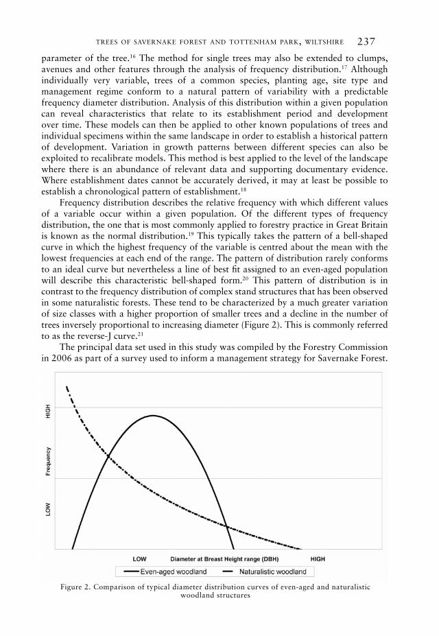
frequency distribution describes the relative frequency with which different values of a variable occur within a given population. of the different types of frequency distribution, the one that is most commonly applied to forestry practice in great Britain is known as the normal distribution.19 this typically takes the pattern of a bell-shaped curve in which the highest frequency of the variable is centred about the mean with the lowest frequencies at each end of the range. the pattern of distribution rarely conforms to an ideal curve but nevertheless a line of best fit assigned to an even-aged population will describe this characteristic bell-shaped form.20 this pattern of distribution is in contrast to the frequency distribution of complex stand structures that has been observed in some naturalistic forests. these tend to be characterized by a much greater variation of size classes with a higher proportion of smaller trees and a decline in the number of trees inversely proportional to increasing diameter (figure 2). this is commonly referred to as the reverse-J curve.21
the principal data set used in this study was compiled by the forestry commission in 2006 as part of a survey used to inform a management strategy for savernake forest.
figure 2. comparison of typical diameter distribution curves of even-aged and naturalistic woodland structures
238 garden history 42 : 2
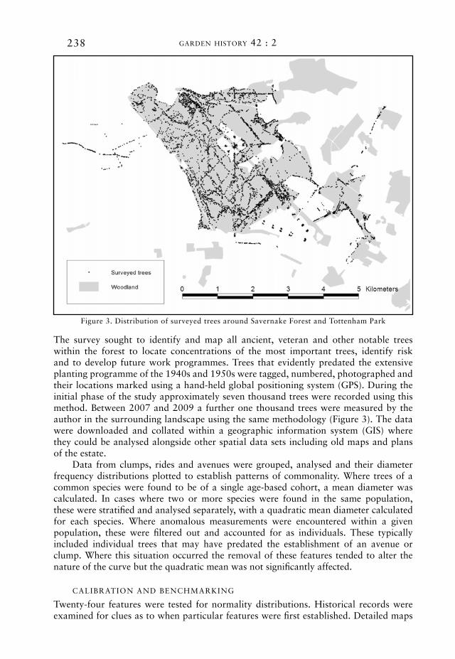
the survey sought to identify and map all ancient, veteran and other notable trees within the forest to locate concentrations of the most important trees, identify risk and to develop future work programmes. trees that evidently predated the extensive planting programme of the 1940s and 1950s were tagged, numbered, photographed and their locations marked using a hand-held global positioning system (gps). during the initial phase of the study approximately seven thousand trees were recorded using this method. Between 2007 and 2009 a further one thousand trees were measured by the author in the surrounding landscape using the same methodology (figure 3). the data were downloaded and collated within a geographic information system (gis) where they could be analysed alongside other spatial data sets including old maps and plans of the estate.
data from clumps, rides and avenues were grouped, analysed and their diameter frequency distributions plotted to establish patterns of commonality. where trees of a common species were found to be of a single age-based cohort, a mean diameter was calculated. in cases where two or more species were found in the same population, these were stratified and analysed separately, with a quadratic mean diameter calculated for each species. where anomalous measurements were encountered within a given population, these were filtered out and accounted for as individuals. these typically included individual trees that may have predated the establishment of an avenue or clump. where this situation occurred the removal of these features tended to alter the nature of the curve but the quadratic mean was not significantly affected.
caliBration and Benchmarking
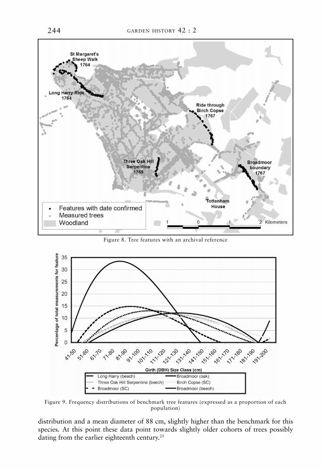
twenty-four features were tested for normality distributions. historical records were examined for clues as to when particular features were first established. detailed maps
figure 3. distribution of surveyed trees around savernake forest and tottenham park
239trees of savernake forest and tottenham park, wiltshire
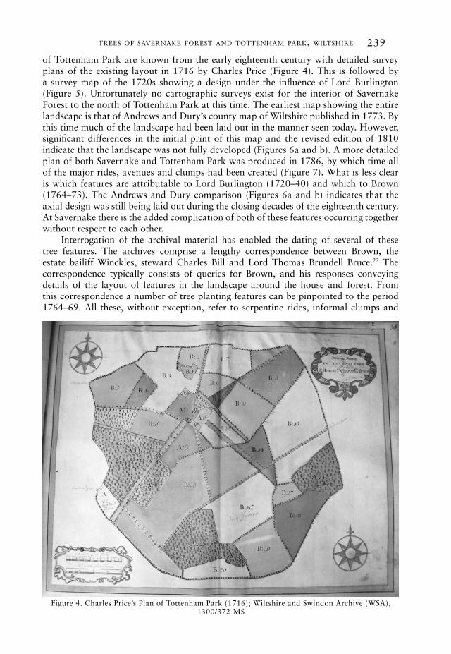
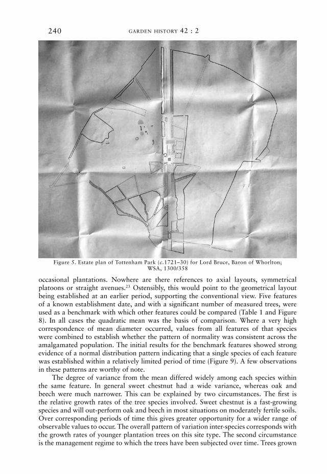
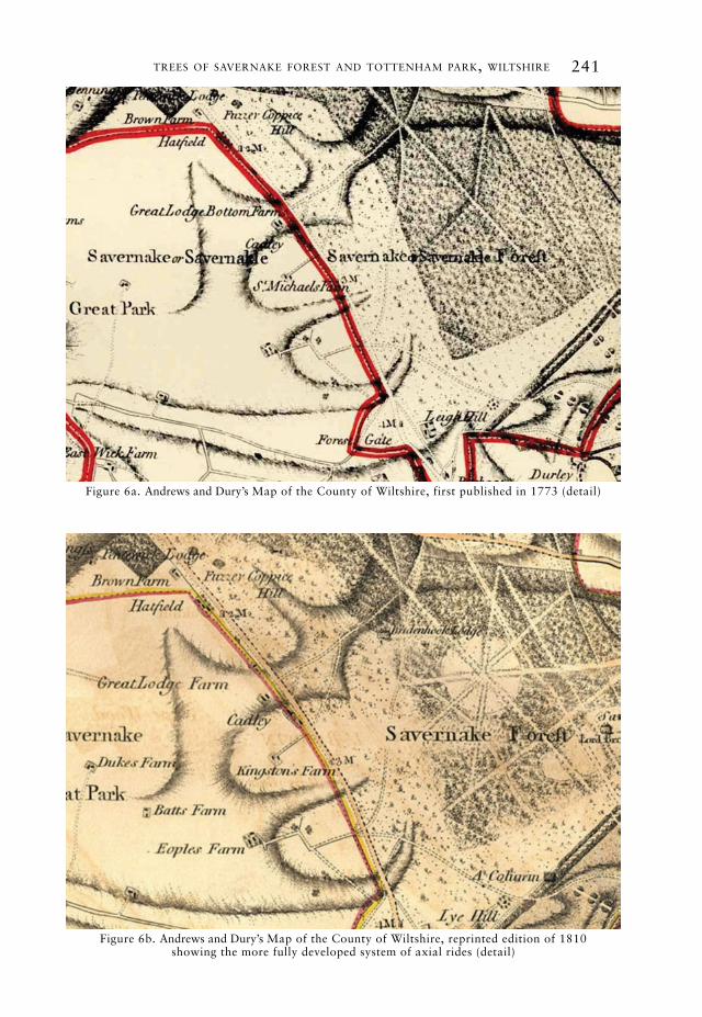
of tottenham park are known from the early eighteenth century with detailed survey plans of the existing layout in 1716 by charles price (figure 4). this is followed by a survey map of the 1720s showing a design under the influence of lord Burlington (figure 5). unfortunately no cartographic surveys exist for the interior of savernake forest to the north of tottenham park at this time. the earliest map showing the entire landscape is that of andrews and dury’s county map of wiltshire published in 1773. By this time much of the landscape had been laid out in the manner seen today. however, significant differences in the initial print of this map and the revised edition of 1810 indicate that the landscape was not fully developed (figures 6a and b). a more detailed plan of both savernake and tottenham park was produced in 1786, by which time all of the major rides, avenues and clumps had been created (figure 7). what is less clear is which features are attributable to lord Burlington (1720–40) and which to Brown (1764–73). the andrews and dury comparison (figures 6a and b) indicates that the axial design was still being laid out during the closing decades of the eighteenth century. at savernake there is the added complication of both of these features occurring together without respect to each other.
interrogation of the archival material has enabled the dating of several of these tree features. the archives comprise a lengthy correspondence between Brown, the estate bailiff winckles, steward charles Bill and lord thomas Brundell Bruce.22 the correspondence typically consists of queries for Brown, and his responses conveying details of the layout of features in the landscape around the house and forest. from this correspondence a number of tree planting features can be pinpointed to the period 1764–69. all these, without exception, refer to serpentine rides, informal clumps and
figure 4. charles price’s plan of tottenham park (1716); wiltshire and swindon archive (wsa), 1300/372 ms
240 garden history 42 : 2
occasional plantations. nowhere are there references to axial layouts, symmetrical platoons or straight avenues.23 ostensibly, this would point to the geometrical layout being established at an earlier period, supporting the conventional view. five features of a known establishment date, and with a significant number of measured trees, were used as a benchmark with which other features could be compared (table 1 and figure 8). in all cases the quadratic mean was the basis of comparison. where a very high correspondence of mean diameter occurred, values from all features of that species were combined to establish whether the pattern of normality was consistent across the amalgamated population. the initial results for the benchmark features showed strong evidence of a normal distribution pattern indicating that a single species of each feature was established within a relatively limited period of time (figure 9). a few observations in these patterns are worthy of note.
the degree of variance from the mean differed widely among each species within the same feature. in general sweet chestnut had a wide variance, whereas oak and beech were much narrower. this can be explained by two circumstances. the first is the relative growth rates of the tree species involved. sweet chestnut is a fast-growing species and will out-perform oak and beech in most situations on moderately fertile soils. over corresponding periods of time this gives greater opportunity for a wider range of observable values to occur. the overall pattern of variation inter-species corresponds with the growth rates of younger plantation trees on this site type. the second circumstance is the management regime to which the trees have been subjected over time. trees grown
figure 5. estate plan of tottenham park (c.1721–30) for lord Bruce, Baron of whorlton; wsa, 1300/358
241trees of savernake forest and tottenham park, wiltshire
figure 6b. andrews and dury’s map of the county of wiltshire, reprinted edition of 1810 showing the more fully developed system of axial rides (detail)
figure 6a. andrews and dury’s map of the county of wiltshire, first published in 1773 (detail)
242 garden history 42 : 2
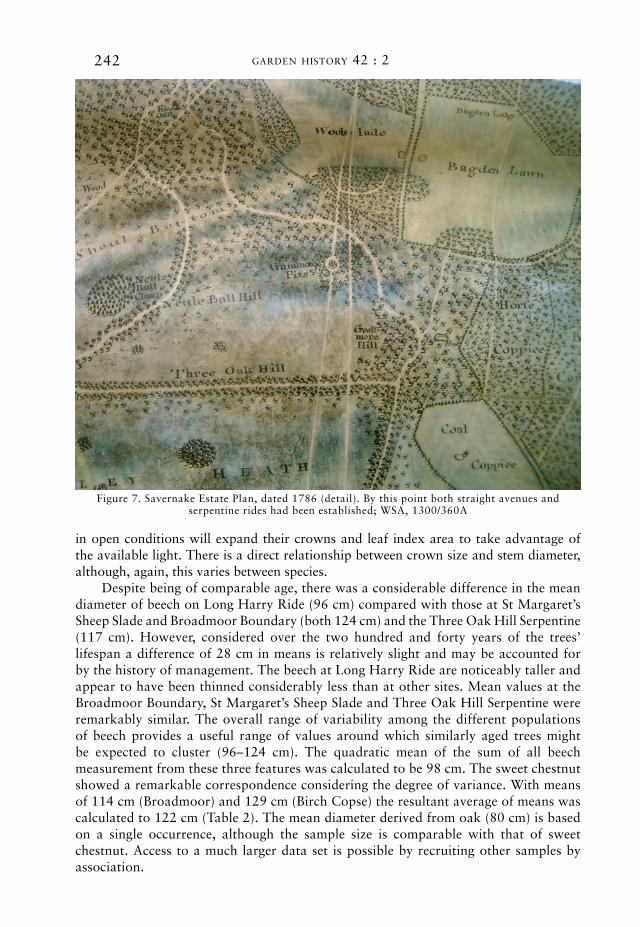
figure 7. savernake estate plan, dated 1786 (detail). By this point both straight avenues and serpentine rides had been established; wsa, 1300/360a
in open conditions will expand their crowns and leaf index area to take advantage of the available light. there is a direct relationship between crown size and stem diameter, although, again, this varies between species.
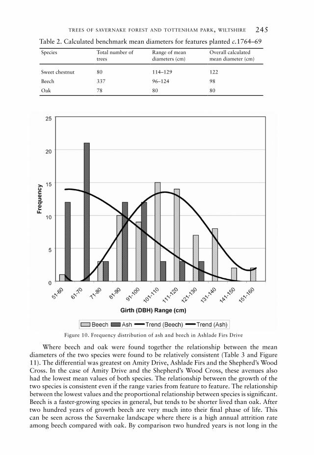
despite being of comparable age, there was a considerable difference in the mean diameter of beech on long harry ride (96 cm) compared with those at st margaret’s sheep slade and Broadmoor Boundary (both 124 cm) and the three oak hill serpentine (117 cm). however, considered over the two hundred and forty years of the trees’ lifespan a difference of 28 cm in means is relatively slight and may be accounted for by the history of management. the beech at long harry ride are noticeably taller and appear to have been thinned considerably less than at other sites. mean values at the Broadmoor Boundary, st margaret’s sheep slade and three oak hill serpentine were remarkably similar. the overall range of variability among the different populations of beech provides a useful range of values around which similarly aged trees might be expected to cluster (96–124 cm). the quadratic mean of the sum of all beech measurement from these three features was calculated to be 98 cm. the sweet chestnut showed a remarkable correspondence considering the degree of variance. with means of 114 cm (Broadmoor) and 129 cm (Birch copse) the resultant average of means was calculated to 122 cm (table 2). the mean diameter derived from oak (80 cm) is based on a single occurrence, although the sample size is comparable with that of sweet chestnut. access to a much larger data set is possible by recruiting other samples by association.
243trees of savernake forest and tottenham park, wiltshire
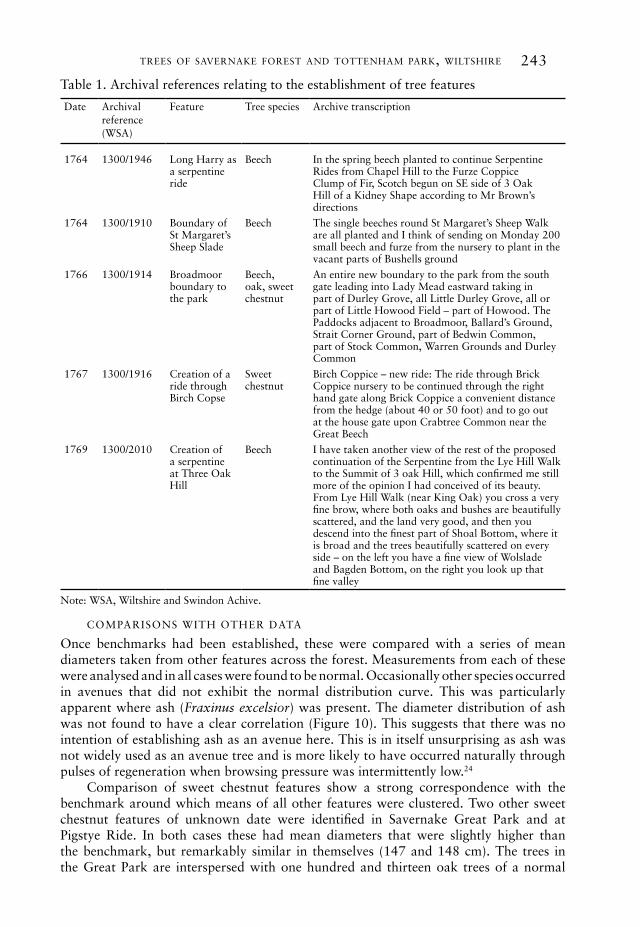
table 1. archival references relating to the establishment of tree features
date archival reference (wsa)
feature tree species archive transcription
1764 1300/1946 long harry as a serpentine ride
Beech in the spring beech planted to continue serpentine rides from chapel hill to the furze coppiceclump of fir, scotch begun on se side of 3 oak hill of a kidney shape according to mr Brown’s directions
1764 1300/1910 Boundary of st margaret’s sheep slade
Beech the single beeches round st margaret’s sheep walk are all planted and i think of sending on monday 200 small beech and furze from the nursery to plant in the vacant parts of Bushells ground
1766 1300/1914 Broadmoor boundary to the park
Beech, oak, sweet chestnut
an entire new boundary to the park from the south gate leading into lady mead eastward taking in part of durley grove, all little durley grove, all or part of little howood field – part of howood. the paddocks adjacent to Broadmoor, Ballard’s ground, strait corner ground, part of Bedwin common, part of stock common, warren grounds and durley common
1767 1300/1916 creation of a ride through Birch copse
sweet chestnut
Birch coppice – new ride: the ride through Brick coppice nursery to be continued through the right hand gate along Brick coppice a convenient distance from the hedge (about 40 or 50 foot) and to go out at the house gate upon crabtree common near the great Beech
1769 1300/2010 creation of a serpentine at three oak hill
Beech i have taken another view of the rest of the proposed continuation of the serpentine from the lye hill walk to the summit of 3 oak hill, which confirmed me still more of the opinion i had conceived of its beauty. from lye hill walk (near king oak) you cross a very fine brow, where both oaks and bushes are beautifully scattered, and the land very good, and then you descend into the finest part of shoal Bottom, where it is broad and the trees beautifully scattered on every side – on the left you have a fine view of wolslade and Bagden Bottom, on the right you look up that fine valley
note: wsa, wiltshire and swindon achive.
comparisons with other data
once benchmarks had been established, these were compared with a series of mean diameters taken from other features across the forest. measurements from each of these were analysed and in all cases were found to be normal. occasionally other species occurred in avenues that did not exhibit the normal distribution curve. this was particularly apparent where ash (Fraxinus excelsior) was present. the diameter distribution of ash was not found to have a clear correlation (figure 10). this suggests that there was no intention of establishing ash as an avenue here. this is in itself unsurprising as ash was not widely used as an avenue tree and is more likely to have occurred naturally through pulses of regeneration when browsing pressure was intermittently low.24
comparison of sweet chestnut features show a strong correspondence with the benchmark around which means of all other features were clustered. two other sweet chestnut features of unknown date were identified in savernake great park and at pigstye ride. in both cases these had mean diameters that were slightly higher than the benchmark, but remarkably similar in themselves (147 and 148 cm). the trees in the great park are interspersed with one hundred and thirteen oak trees of a normal
244 garden history 42 : 2
figure 8. tree features with an archival reference
figure 9. frequency distributions of benchmark tree features (expressed as a proportion of each population)
distribution and a mean diameter of 88 cm, slightly higher than the benchmark for this species. at this point these data point towards slightly older cohorts of trees possibly dating from the earlier eighteenth century.25
245trees of savernake forest and tottenham park, wiltshire
table 2. calculated benchmark mean diameters for features planted c.1764–69
species total number of trees
range of mean diameters (cm)
overall calculated mean diameter (cm)
sweet chestnut 80 114–129 122
Beech 337 96–124 98
oak 78 80 80
figure 10. frequency distribution of ash and beech in ashlade firs drive
where beech and oak were found together the relationship between the mean diameters of the two species were found to be relatively consistent (table 3 and figure 11). the differential was greatest on amity drive, ashlade firs and the shepherd’s wood cross. in the case of amity drive and the shepherd’s wood cross, these avenues also had the lowest mean values of both species. the relationship between the growth of the two species is consistent even if the range varies from feature to feature. the relationship between the lowest values and the proportional relationship between species is significant. Beech is a faster-growing species in general, but tends to be shorter lived than oak. after two hundred years of growth beech are very much into their final phase of life. this can be seen across the savernake landscape where there is a high annual attrition rate among beech compared with oak. By comparison two hundred years is not long in the
246 garden history 42 : 2
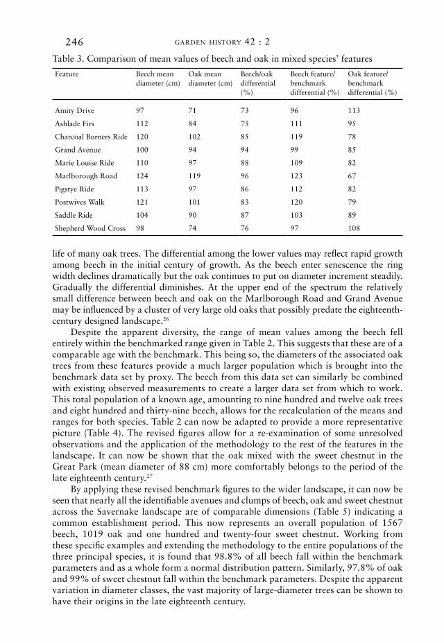
table 3. comparison of mean values of beech and oak in mixed species’ features
feature Beech mean diameter (cm)
oak mean diameter (cm)
Beech/oak differential (%)
Beech feature/benchmark differential (%)
oak feature/benchmark differential (%)
amity drive 97 71 73 96 113
ashlade firs 112 84 75 111 95
charcoal Burners ride 120 102 85 119 78
grand avenue 100 94 94 99 85
marie louise ride 110 97 88 109 82
marlborough road 124 119 96 123 67
pigstye ride 113 97 86 112 82
postwives walk 121 101 83 120 79
saddle ride 104 90 87 103 89
shepherd wood cross 98 74 76 97 108
life of many oak trees. the differential among the lower values may reflect rapid growth among beech in the initial century of growth. as the beech enter senescence the ring width declines dramatically but the oak continues to put on diameter increment steadily. gradually the differential diminishes. at the upper end of the spectrum the relatively small difference between beech and oak on the marlborough road and grand avenue may be influenced by a cluster of very large old oaks that possibly predate the eighteenth-century designed landscape.26
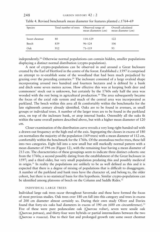
despite the apparent diversity, the range of mean values among the beech fell entirely within the benchmarked range given in table 2. this suggests that these are of a comparable age with the benchmark. this being so, the diameters of the associated oak trees from these features provide a much larger population which is brought into the benchmark data set by proxy. the beech from this data set can similarly be combined with existing observed measurements to create a larger data set from which to work. this total population of a known age, amounting to nine hundred and twelve oak trees and eight hundred and thirty-nine beech, allows for the recalculation of the means and ranges for both species. table 2 can now be adapted to provide a more representative picture (table 4). the revised figures allow for a re-examination of some unresolved observations and the application of the methodology to the rest of the features in the landscape. it can now be shown that the oak mixed with the sweet chestnut in the great park (mean diameter of 88 cm) more comfortably belongs to the period of the late eighteenth century.27
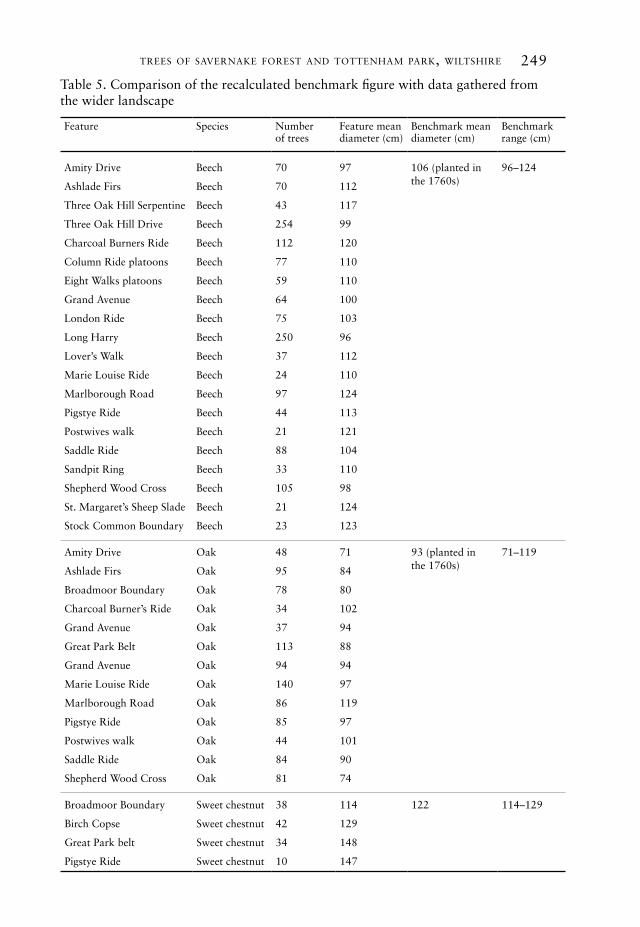
By applying these revised benchmark figures to the wider landscape, it can now be seen that nearly all the identifiable avenues and clumps of beech, oak and sweet chestnut across the savernake landscape are of comparable dimensions (table 5) indicating a common establishment period. this now represents an overall population of 1567 beech, 1019 oak and one hundred and twenty-four sweet chestnut. working from these specific examples and extending the methodology to the entire populations of the three principal species, it is found that 98.8% of all beech fall within the benchmark parameters and as a whole form a normal distribution pattern. similarly, 97.8% of oak and 99% of sweet chestnut fall within the benchmark parameters. despite the apparent variation in diameter classes, the vast majority of large-diameter trees can be shown to have their origins in the late eighteenth century.
247trees of savernake forest and tottenham park, wiltshire
figure 11. comparison of the diameter of beech and oak across mixed species features (expressed as a proportion of each population)
anomalies and crypto-populations
on a number of rides measurements were encountered that lay conspicuously beyond the normal distribution pattern of the rest of the feature. where these were observed they were excluded from the above calculations. these only occurred in very small numbers and usually comprised very large oak trees. occasionally these can be dated
248 garden history 42 : 2
table 4. revised benchmark mean diameter for features planted c.1764–69
species total number of trees observed range of mean diameters (cm)
overall calculated mean diameter (cm)
sweet chestnut 80 114–129 122
Beech 839 96–124 106
oak 912 71–119 93
independently.28 otherwise normal populations can contain hidden, smaller populations displaying a distinct normal distribution (crypto-population).
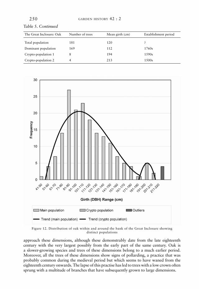
a nest of crypto-populations can be observed in and around a great inclosure created by the earl of hertford in the centre of the forest. established c.1597 it comprised an attempt to re-establish some of the woodland that had been much prejudiced by grazing over the preceding centuries.29 the inclosure consisted of a large ovaloid shape incorporating around two hundred and fourteen hectares and is defined by a bank and ditch some seven metres across. how effective this was at keeping both deer and commoners’ stock out is unknown, but certainly by the 1760s only half the area was wooded with the rest being in agricultural production.30 the area subsequently became the focus of the axial ride system and much of the central area was incorporated as parkland. the beech within this area all fit comfortably within the benchmarks for the late eighteenth century already identified. oaks are to be found in avenues, as small groups or individual trees. a number of the larger trees are to be found in the parkland area, on top of the inclosure bank, or atop internal banks. ostensibly all the oaks fit within the same overall pattern described above, but with a higher mean diameter of 120 cm.
closer examination of the distribution curve reveals a very long right-handed tail with a drawn-out frequency at the high end of the axis. segregating the classes in excess of 180 cm normalizes the majority of the population (169 trees) with a mean diameter of 112 cm, comfortably within the benchmark for the 1760s. of the anomalous twelve trees, these fall into two categories. eight fall into a new small but still markedly normal pattern with a mean diameter of 194 cm (figure 12), with the remaining four having a mean diameter of 213 cm. the characteristics of these groupings seem to indicate three distinct cohorts: one from the 1760s; a second possibly dating from the establishment of the great inclosure in 1597; and a third older, but very small population predating this and possibly medieval in origin.31 in reality the populations are unlikely to be as well defined as this and it is expected that there is a degree of mixing of populations that is difficult to disaggregate. a number of the parkland and bank trees have the character of, and belong to, the older cohort, but there is no statistical basis for this hypothesis. similar crypto-populations can be identified among platoons of beech on the column and saddle rides.32
individual large trees
individual large oak trees occur throughout savernake and these have formed the focus of most previous studies. oak trees over 180 cm fall into this category and trees in excess of 200 cm diameter almost certainly so. during their own study oliver and davies found that forty-six oaks had diameters in excess of 190 cm (600 cm circumference).33 five of these were pure pedunculate oak (Quercus robur), seven were sessile oak (Quercus petraea), and thirty-four were hybrids or partial intermediates between the two (Quercus × rosacea). due to their fast and prolonged growth rate some sweet chestnut
249trees of savernake forest and tottenham park, wiltshire
table 5. comparison of the recalculated benchmark figure with data gathered from the wider landscape
feature species number of trees
feature mean diameter (cm)
Benchmark mean diameter (cm)
Benchmark range (cm)
amity drive Beech 70 97 106 (planted in the 1760s)
96–124
ashlade firs Beech 70 112
three oak hill serpentine Beech 43 117
three oak hill drive Beech 254 99
charcoal Burners ride Beech 112 120
column ride platoons Beech 77 110
eight walks platoons Beech 59 110
grand avenue Beech 64 100
london ride Beech 75 103
long harry Beech 250 96
lover’s walk Beech 37 112
marie louise ride Beech 24 110
marlborough road Beech 97 124
pigstye ride Beech 44 113
postwives walk Beech 21 121
saddle ride Beech 88 104
sandpit ring Beech 33 110
shepherd wood cross Beech 105 98
st. margaret’s sheep slade Beech 21 124
stock common Boundary Beech 23 123
amity drive oak 48 71 93 (planted in the 1760s)
71–119
ashlade firs oak 95 84
Broadmoor Boundary oak 78 80
charcoal Burner’s ride oak 34 102
grand avenue oak 37 94
great park Belt oak 113 88
grand avenue oak 94 94
marie louise ride oak 140 97
marlborough road oak 86 119
pigstye ride oak 85 97
postwives walk oak 44 101
saddle ride oak 84 90
shepherd wood cross oak 81 74
Broadmoor Boundary sweet chestnut 38 114 122 114–129
Birch copse sweet chestnut 42 129
great park belt sweet chestnut 34 148
pigstye ride sweet chestnut 10 147
250 garden history 42 : 2
table 5. Continued
the great inclosure: oak number of trees mean girth (cm) establishment period
total population 181 120 ?
dominant population 169 112 1760s
crypto-population 1 8 194 1590s
crypto-population 2 4 213 1500s
figure 12. distribution of oak within and around the bank of the great inclosure showing distinct populations
approach these dimensions, although these demonstrably date from the late eighteenth century with the very largest possibly from the early part of the same century. oak is a slower-growing species and trees of these dimensions belong to a much earlier period. moreover, all the trees of these dimensions show signs of pollarding, a practice that was probably common during the medieval period but which seems to have waned from the eighteenth century onwards. the lapse of this practise has led to trees with a low crown often sprung with a multitude of branches that have subsequently grown to large dimensions.
251trees of savernake forest and tottenham park, wiltshire
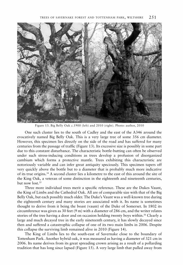
one such cluster lies to the south of cadley and the east of the a346 around the evocatively named Big Belly oak. this is a very large tree of some 356 cm diameter. however, this specimen lies directly on the side of the road and has suffered for many centuries from the passage of traffic (figure 13). its excessive size is possibly in some part due to this constant disturbance. the characteristic bottle-butting can often be observed under such stress-inducing conditions as trees develop a profusion of disorganized cambium which forms a protective mantle. trees exhibiting this characteristic are notoriously variable and can infer great antiquity speciously. this specimen tapers off very quickly above the bottle but to a diameter that is probably much more indicative of its true origins.34 a second cluster lies a kilometre to the east of this around the site of the king oak, a veteran of some distinction in the eighteenth and nineteenth centuries, but now lost.35
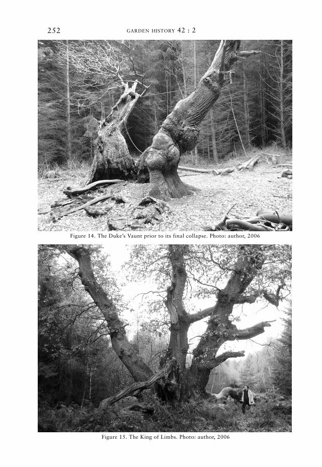
three more individual trees merit a specific reference. these are the dukes vaunt, the king of limbs and the cathedral oak. all are of comparable size with that of the Big Belly oak, but each possibly much older. the duke’s vaunt was a well-known tree during the eighteenth century and many stories are associated with it. its name is sometimes thought to derive from it being the boast (vaunt) of the duke of somerset. in 1802 its circumference was given as 30 feet (9 m) with a diameter of 286 cm, and the writer relates stories of the tree having a door and on occasion holding twenty boys within.36 clearly a large and much decayed tree in the early nineteenth century, it has slowly decayed since then and suffered a catastrophic collapse of one of its two main limbs in 2006. despite this collapse the surviving limb remained alive in 2010 (figure 14).
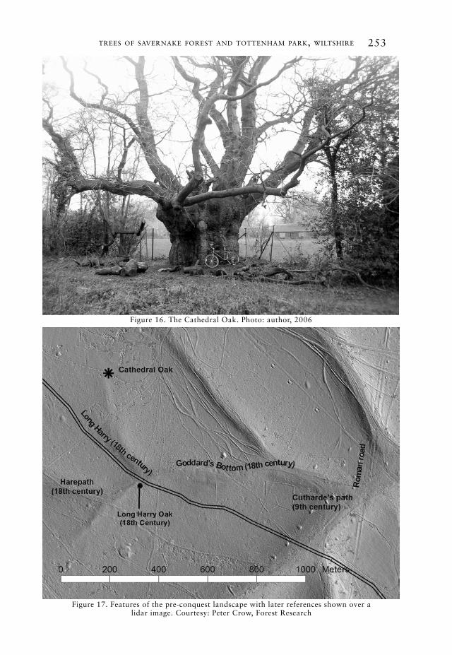
the king of limbs lies to the south-east of savernake close to the boundary of tottenham park. another hybrid oak, it was measured as having a diameter of 321 cm in 2006. its name derives from its great spreading crown arising as a result of a pollarding tradition that has long since lapsed (figure 15). a very large limb that pulled away from
figure 13. Big Belly oak c.1900 (left) and 2010 (right). photo: author, 2010
252 garden history 42 : 2
figure 14. the duke’s vaunt prior to its final collapse. photo: author, 2006
figure 15. the king of limbs. photo: author, 2006
253trees of savernake forest and tottenham park, wiltshire
figure 16. the cathedral oak. photo: author, 2006
figure 17. features of the pre-conquest landscape with later references shown over a lidar image. courtesy: peter crow, forest research

254 garden history 42 : 2
the tree over fifty years ago has a diameter in excess of 100 cm, comparable with the stem diameters of many of the late eighteenth-century oaks. Both the king of limbs and duke’s vaunt lie on the modern parish boundary. this has changed over time, and during the medieval period the forest boundary, on occasion, lay close by. neither tree is mentioned in the perambulations of the forest.
the final tree of this elite group is the cathedral oak, occasionally called the monarch oak (figure 16). a pedunculate oak, it was measured as having a diameter of 302 cm in 2006, making it a likely contemporary of the previous two. it sits across a bank and ditch, approximately six to eight metres across, that now forms the boundary between the forest and an area of private land known as furze coppice. another nearby oak on the same earthwork has a diameter of 202 cm. oliver and davies have claimed that the names for this tree are relatively recent.37 certainly it seems not to have featured directly in any historical documents. however, the name of cathedral oak may have an origin that has persisted in the oral tradition for a long period. the aforementioned charter from king eadgar (s 756) makes reference to a place called ‘Bradan leage’, which probably relates to an area to the south of the cathedral oak now known as Braydon hook: ‘þonne ut to bradan leage þær cuðhardes pæð ut ligð’ (then on to bradan leage where cuðharde’s path emerges).38 ‘cuðhardes pæð’, probably based on a personal name, may well equate with a dry valley between the cathedral oak and Braydon hook that was known in the eighteenth century as goddard’s Bottom. taken as a whole goddard, cuðharde and cathedral may be etymologically connected, originating with the anglo-saxon personal name of cuðharde and becoming corrupted or assimilated over time. the presence of the tree overlying a bank and ditch may indicate an early tenural boundary. other names of old english origin can be found in the locality (figure 17).
conclusions
the use of the normal distribution curve to identify even-aged populations of veteran trees is found to be a useful and credible tool for understanding the development of historic landscapes where there is an abundance of measurable trees alongside archival material. initial benchmarking against populations of a known age provides a basis from which associated populations can be used to expand the population and sample size. comparisons with growth rates of other species assist in further calibration. in total nearly eight thousand large-diameter trees were measured and plotted. these were predominantly oak, beech and sweet chestnut. despite its long history and association with large trees, the majority of veteran beech, oak and sweet chestnut extant in savernake today can be shown to have their origins in the late eighteenth century as part of the designed landscape. regardless of the large diameter of some of the trees, many of these are found to lie within acceptable parameters for this period. a small proportion of the oak trees are indicated as being of older cohorts, including a handful from the medieval period and three that may have their origins prior the norman conquest.
acknowledgements
the author thanks and acknowledges the assistance of the forestry commission for the use of the veteran tree data, in particular peter crow, rob guest and tim yarnell. many thanks too to graham Bathe for sharing resources and providing challenging debate.
trees of savernake forest and tottenham park, wiltshire 255
references1 simon crutchley, fiona small and mark
Bowden, Savernake Forest: A Report for the National Mapping Programme (london: english heritage, 2010); Ben lennon and peter crow, ‘lidar and its role in understanding the historic landscape of savernake forest’, Wiltshire Archaeological and Natural History Magazine, 102 (2009), pp. 245–61.
2 all anglo-saxon charters are referred to using the sawyer catalogue numbering system: peter h. sawyer, Anglo-Saxon Charters: An Annotated List and Bibliography (london: royal historical society, 1968).
3 Ben lennon, ‘leah names in the anglo-saxon charters of wiltshire’, Wiltshire Archaeological and Natural History Magazine, 102 (2009), pp. 175–87 (p. 184).
4 wiltshire and swindon archive (wsa), 1300/182.
5 wsa, 1300/90: survey of properties of edward earl of hertford in wolfhall, tottenham park, crofton, sudden, crofton in great Bedwyn, Bowden and westcourt in Burbage, Brimslade in savernake, easton, wootton rivers (early seventeenth or possibly late sixteenth century).
6 wsa, 9/22/204: Bargain and sale of land adjoining savernake great park, from sir edward Baynton to sir edward seymour, 1575.
7 anon., Calendar of Charter Rolls Preserved in the Public Records Office (london: hmso, 1908), entry for the year 1347.
8 dorothy stroud, Capability Brown, 2nd revd edn (london: country life, 1975), p. 93.
9 populations of trees that clearly date from a specific period and can be accounted for entirely in the historical record lie outside the parameters of this study. in other studies such populations may be useful in calibration. in savernake almost all the horse chestnut and common lime date from the nineteenth century.
10 John aubrey (1672), cited in t. phillips (ed.), Aubrey’s Collections for Wiltshire (london, 1838), p. 71.
11 richard Jeffries, The Hills and the Vale [1909] (oxford: oxford university press, 1980), p. 34.
12 chandos sydney cedric Brudenell-Bruce, earl of cardigan, The Wardens of Savernake Forest (london: routledge & kegan, 1949); chandos sydney cedric Brudenell-Bruce, 7th marquess of ailesbury, The History of Savernake Forest (devizes: chas. h. woodward, 1962).
13 Joan davies and graham Bathe, ‘the king oak in savernake forest and its comparison with the living king of limbs’, Wiltshire Archaeological and Natural History Magazine, 100 (2007), pp. 181–6; J. davies and J. oliver, ‘large and special trees in the eastern part of kennet district’, Wiltshire Archaeological and Natural History Magazine, pp. 42–64;
J. oliver and J. davies, ‘savernake forest oaks’, Wiltshire Archaeological and Natural History Magazine, 94 (2001), pp. 24–46.
14 John white, Estimating the Age of Large and Veteran Trees in Britain. forestry commission information note (hmso, 1998).
15 white recognized that trees grow under a wide range of conditions, both physical and cultural, and it is important to take this into account in order to establish meaningful comparisons.
16 typically taken as being 1.3 metres above ground level. all measurement conventions used in this paper are as prescribed in white, Estimating the Age of Large and Veteran Trees in Britain.
17 Ben lennon, ‘estimating the age of groups of trees in historic landscapes’, Arboricultural Journal, 32 (2009), pp. 167–88.
18 ibid., p. 167.19 g. J. hamilton, Forest Mensuration
Handbook. forestry commission Booklet no. 39 (london: hmso, 1988), p. 120.
20 the trend line used in all examples in this study is a polynomial calculated to the third degree.
21 gary kerr, Bill mason, roger Boswell and arne pommerening, Monitoring the Transformation of Even-Aged Stands to Continuous Cover Management. forestry commission information note no. 45 (2002), p. 7.
22 wsa, 1300/1910-1952: correspondence between lord Bruce, charles Bill and mr. winckles and capability Brown concerning tottenham park and savernake forest (1764–1770s).
23 Ben lennon, ‘Burlington, Brown and Bill: the landscaping of tottenham park and savernake forest in the eighteenth century’, Garden History, 39/1 (2011), pp. 3–33.
24 for a comprehensive consideration of woodland development in savernake, see Ben lennon, Savernake Forest: Continuity and Change in a Wooded Landscape. British archaeological report no. 555. British series (oxford: archaeopress, 2012), pp. 43–60.
25 in total 317 sweet chestnut were measured across the project area. when the measurements from the entire population are aggregated, a normal distribution pattern can still be observed. taken as a single population the mean diameter is calculated as 132 cm. this compares favourably with the benchmark, suggesting that all sweet chestnut may indeed derive from a common planting period. only four extreme values were observed, all in excess of 230 cm diameter.
26 in most cases anomalous data were removed from the calculations. in this instance the distinction between the two cohorts was not sufficiently clear to make a division such was the degree of intersection between the two.
27 the sweet chestnut may, of course, have been planted earlier and interspersed with

256 garden history 42 : 2
oak at a later date, but this seems unlikely. the slow growth of oak compared with sweet chestnut makes it an unlikely ‘beat up’ species. avenues and shelterbelts rely on a formality and regularity that would not be well served by planting a slow-growing species among an already established fast-growing one.
28 one very large sweet chestnut (236 cm) on london ride can be dated to the 1720s when a pair of platoons was established at a point on Bedwyn common called crossways; wsa, 9/3/388: Bedwyn stock and durley commons lawsuit for trespass.
29 Joanne ramsay and graham Bathe, ‘the great inclosure of savernake with a note on cross valley dykes’, Wiltshire Archaeological and Natural History Magazine, 101 (2008), pp. 158–75.
30 wsa, 1300/1719: letter from charles Bill to lancelot ‘capability’ Brown (13 march 1767).
31 a letter of 1767 relating to these being within the great inclosure notes that ‘the whole
is finely ornamented with large oaks and birch trees’, suggesting that a pre-existing population of mature trees was already to be found across this area; wsa, 1300/1917.
32 a comparison of late nineteenth- and early twentieth-century maps confirms that extra platoons were added between 1885 and 1925.
33 Jack oliver and Joan davies, ‘savernake forest oaks’, Wiltshire Archaeological and Natural History Magazine, 94 (2001), pp. 24–46.
34 despite this assertion, figure 10 shows that the tree has changed very little over the last hundred years.
35 davies and Bathe, ‘the king oak in savernake forest’.
36 J. stone, ‘savernake’, Gentleman’s Magazine, i (1802), p. 497.
37 oliver and davies, ‘savernake forest oaks’.
38 other related names are Braydon oak, Braden valley and Bræcdene (same charter).
Copyright © 2022 FDOKUMEN