A robust algorithm for estimating soil erodibility in different climates
10
A robust algorithm for estimating soil erodibility in different climates L. Borselli a, ⁎, D. Torri b , J. Poesen c , P. Iaquinta d a Instituto de Geologia/Fac. De Ingenerìa, Universitad Autonoma de San Luis Potosì (UASLP), Av. Dr. Manuel Nava 5, C.P. 78240, San Luis Potosí, SLP, Mexico b CNR-IRPI, Research Institute for Geo-Hydrological Protection, Via Madonna Alta 126, 06128 Perugia, Italy c Division of Geography, KU Leuven, Celestijnenlaan 200E, B-3001 Heverlee, Belgium d CNR-IRPI, Research Institute for Geo-Hydrological Protection, Via Cavour 4‐6, 87030 Rende di Cosenza, Italy abstract article info Article history: Received 3 November 2011 Received in revised form 20 May 2012 Accepted 30 May 2012 Available online xxxx Keywords: Soil erosion Soil erodibility Quantile regression Probability density function KUERY software The analysis of global soil erodibility data by Salvador Sanchis et al. (2008) showed that there is a significant climate effect on soil erodibility which allows for a split of the data into two subsets, one for prevailing cool conditions and another for prevailing warm conditions (defined using the Köppen climate classification). De- spite the recognition of this new dichotomous variable, prediction of soil erodibility values remained very poor. This paper presents a new technique for dealing with such a variability by calculating probability den- sity functions of soil erodibility K values when the user knows a set of textural parameters and the climatic classification of the site. Finally the user has the possibility to decide, on the basis of local knowledge, which K value to use. The procedure has been implemented in a freeware software named KUERY available for the scientific community. Finally, as an illustration, the methodology is applied to a catchment in south Italy. Crown Copyright © 2012 Published by Elsevier B.V. All rights reserved. 1. Introduction Soil erodibility conceptually represents the way in which soil re- acts to erosional agents, hence it is limited to a series of processes (e.g. detachment and transport of soil particles, rain infiltration, breakdown of soil aggregates, etc.) that occur while soil erosion takes place and the complex interaction between the erosive agent and soil determines how much and how soil is eroded. Hence soil erodibility depends on the processes that cause erosion. From a prac- tical point of view, erodibility depends on the way in which we select the processes to include in our description (i.e. model), how we de- fine the mathematics of the chosen processes, how rough is our parameterisation and how difficult it is to measure all the relevant properties of the soil and of the erosive agents. When we restrict our- selves to the Universal Soil Loss Equation (Wischmeier and Smith, 1978), and its subsequent modifications (Foster et al., 2001; Renard et al., 1997), soil erodibility gets a particular meaning. It represents the integrated long-term average soil response to rainstorms. Soil erodibility represents in a lumped manner the global response of a soil to a large number of hydrological and erosion processes of which runoff generation, sheet and rill erosion are the most impor- tant. The soil profile in its entirety determines the soil response to rain erosive power. All this is represented through one single number (i.e. K, the soil erodibility factor ) that is calculated from soil loss mea- surement in the field over a standard plot, kept freshly disked in an up-down direction, hence bare with no cumulative erosion forms (Wischmeier and Smith, 1978). Data are suggested to be collected over a 20‐year period. Obviously, rill erosion, which usually causes in- tense soil losses, cannot be overwhelmingly important, otherwise soil characteristics, such as texture or other basic characteristics of the surface soil horizon, will not be invariant during the observation peri- od (as top soil characteristics may change after intense or prolonged soil loss). Operatively, the USLE defines soil erodibility (K) as the ratio be- tween soil loss and the causative rain erosivity (R), when the other erosion factors (L: slope length; S: slope gradient; C: crop and man- agement; P: erosion control practice) are unitary or, more generally, as the following ratio: K ¼ A RLS ð1Þ This definition implies that all the errors on measurements and all the inaccuracy in mathematical representations of the factors at the denominator are errors on K, which acts as a black-box coefficient. When the K-data are interpolated in order to generate an alterna- tive to the costly and time-consuming way of measuring K in the field, data are scattered and many aspects remain unanswered. One of the best estimates of the soil erodibility factor still remains the Wischmeier et al. (1971) formula (or nomograph) which is largely based on field-data for medium-textured soils in the USA. Many additional data that allow an estimation of soil erodibility do exist in the literature (e.g. Poesen, 1993; Poesen et al., 1994; Torri et al., 1997). As data have been measured in conditions often far from Catena 97 (2012) 85–94 ⁎ Corresponding author. Tel.: + 524448171039. E-mail address: [email protected] (L. Borselli). 0341-8162/$ – see front matter. Crown Copyright © 2012 Published by Elsevier B.V. All rights reserved. doi:10.1016/j.catena.2012.05.012 Contents lists available at SciVerse ScienceDirect Catena journal homepage: www.elsevier.com/locate/catena
Transcript of A robust algorithm for estimating soil erodibility in different climates

Catena 97 (2012) 85–94
Contents lists available at SciVerse ScienceDirect
Catena
j ourna l homepage: www.e lsev ie r .com/ locate /catena
A robust algorithm for estimating soil erodibility in different climates
L. Borselli a,⁎, D. Torri b, J. Poesen c, P. Iaquinta d
a Instituto de Geologia/Fac. De Ingenerìa, Universitad Autonoma de San Luis Potosì (UASLP), Av. Dr. Manuel Nava 5, C.P. 78240, San Luis Potosí, SLP, Mexicob CNR-IRPI, Research Institute for Geo-Hydrological Protection, Via Madonna Alta 126, 06128 Perugia, Italyc Division of Geography, KU Leuven, Celestijnenlaan 200E, B-3001 Heverlee, Belgiumd CNR-IRPI, Research Institute for Geo-Hydrological Protection, Via Cavour 4‐6, 87030 Rende di Cosenza, Italy
⁎ Corresponding author. Tel.: +524448171039.E-mail address: [email protected] (L. Borselli).
0341-8162/$ – see front matter. Crown Copyright © 20doi:10.1016/j.catena.2012.05.012
a b s t r a c t
a r t i c l e i n f oArticle history:Received 3 November 2011Received in revised form 20 May 2012Accepted 30 May 2012Available online xxxx
Keywords:Soil erosionSoil erodibilityQuantile regressionProbability density functionKUERY software
The analysis of global soil erodibility data by Salvador Sanchis et al. (2008) showed that there is a significantclimate effect on soil erodibility which allows for a split of the data into two subsets, one for prevailing coolconditions and another for prevailing warm conditions (defined using the Köppen climate classification). De-spite the recognition of this new dichotomous variable, prediction of soil erodibility values remained verypoor. This paper presents a new technique for dealing with such a variability by calculating probability den-sity functions of soil erodibility K values when the user knows a set of textural parameters and the climaticclassification of the site. Finally the user has the possibility to decide, on the basis of local knowledge,which K value to use. The procedure has been implemented in a freeware software named KUERY availablefor the scientific community. Finally, as an illustration, the methodology is applied to a catchment in southItaly.
Crown Copyright © 2012 Published by Elsevier B.V. All rights reserved.
1. Introduction
Soil erodibility conceptually represents the way in which soil re-acts to erosional agents, hence it is limited to a series of processes(e.g. detachment and transport of soil particles, rain infiltration,breakdown of soil aggregates, etc.) that occur while soil erosiontakes place and the complex interaction between the erosive agentand soil determines how much and how soil is eroded. Hence soilerodibility depends on the processes that cause erosion. From a prac-tical point of view, erodibility depends on the way in which we selectthe processes to include in our description (i.e. model), how we de-fine the mathematics of the chosen processes, how rough is ourparameterisation and how difficult it is to measure all the relevantproperties of the soil and of the erosive agents. When we restrict our-selves to the Universal Soil Loss Equation (Wischmeier and Smith,1978), and its subsequent modifications (Foster et al., 2001; Renardet al., 1997), soil erodibility gets a particular meaning. It representsthe integrated long-term average soil response to rainstorms. Soilerodibility represents in a lumped manner the global response of asoil to a large number of hydrological and erosion processes ofwhich runoff generation, sheet and rill erosion are the most impor-tant. The soil profile in its entirety determines the soil response torain erosive power. All this is represented through one single number(i.e. K, the soil erodibility factor ) that is calculated from soil loss mea-surement in the field over a standard plot, kept freshly disked in an
12 Published by Elsevier B.V. All rig
up-down direction, hence bare with no cumulative erosion forms(Wischmeier and Smith, 1978). Data are suggested to be collectedover a 20‐year period. Obviously, rill erosion, which usually causes in-tense soil losses, cannot be overwhelmingly important, otherwise soilcharacteristics, such as texture or other basic characteristics of thesurface soil horizon, will not be invariant during the observation peri-od (as top soil characteristics may change after intense or prolongedsoil loss).
Operatively, the USLE defines soil erodibility (K) as the ratio be-tween soil loss and the causative rain erosivity (R), when the othererosion factors (L: slope length; S: slope gradient; C: crop and man-agement; P: erosion control practice) are unitary or, more generally,as the following ratio:
K ¼ ARLS
ð1Þ
This definition implies that all the errors on measurements and allthe inaccuracy in mathematical representations of the factors at thedenominator are errors on K, which acts as a black-box coefficient.
When the K-data are interpolated in order to generate an alterna-tive to the costly and time-consuming way of measuring K in the field,data are scattered and many aspects remain unanswered. One of thebest estimates of the soil erodibility factor still remains theWischmeier et al. (1971) formula (or nomograph) which is largelybased on field-data for medium-textured soils in the USA.
Many additional data that allow an estimation of soil erodibility doexist in the literature (e.g. Poesen, 1993; Poesen et al., 1994; Torri etal., 1997). As data have been measured in conditions often far from
hts reserved.
86 L. Borselli et al. / Catena 97 (2012) 85–94
the standard conditions, Torri et al. (1997) and Salvador Sanchis et al.(2008) have used only part of the data, i.e. those collected in condi-tions relatively close to the standard procedure (Torri et al., 1997).Despite the reduction, they come from various places in the worldand represent soil response under widely different climatic condi-tions (Salvador Sanchis et al., 2008).
The recent re-elaboration of part of the Torri et al. (1997) soilerodibility global dataset (EGD) by Salvador Sanchis et al. (2008)showed that there is a significant climate effect on soil erodibilitywhich allows for a split of the data into two subsets, one with domi-nant cool conditions and another with dominant warm conditions(defined on the basis of Köppen climate classification). Despite therecognition of this new dichotomous variable, prediction of soil erod-ibility values remains extremely poor. This study aims at developing atechnique for dealing with such a variability, calculating it throughthe frequency distributions of the soil erodibility values observedfor given textural, organic matter and climate data. The user of the al-gorithm will finally have the possibility to decide, on the basis of localknowledge, which values to use. Finally application of the methodol-ogy is illustrated using data from the Esaro catchment (Calabria,Italy). A full freeware software, implementing the proposed algo-rithms and methodology, is available for users and the scientificcommunity.
2. Algorithm definition
The poor performance of classical statistical techniques, whichhave been applied in previous studies (e.g. Römkens et al., 1997;Salvador Sanchis et al., 2008; Torri et al., 1997, 2002) for analysingthe global soil erodibility dataset (EGD: Poesen et al., 1994; Torriet al., 1997, 2002) lead to explore alternative ways in order to inferthe range of uncertainty of K-values associated to every combinationof climate and of input soil parameters.
In our Algorithm the soil parameters considered are the following.
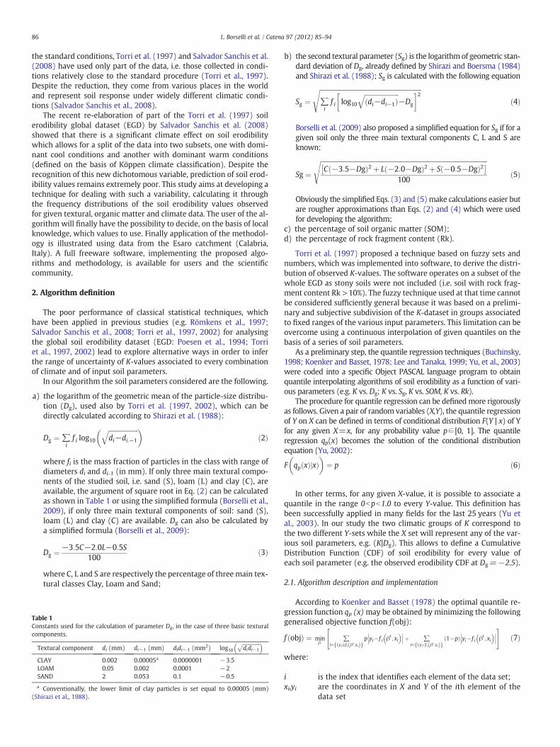
a) the logarithm of the geometric mean of the particle-size distribu-tion (Dg), used also by Torri et al. (1997, 2002), which can bedirectly calculated according to Shirazi et al. (1988):
Dg ¼ ∑if i log10
ffiffiffiffiffiffiffiffiffiffiffiffiffiffiffiffiffiffiffidi−di:−1
q� �ð2Þ
where fi is the mass fraction of particles in the class with range ofdiameters di and di-1 (in mm). If only three main textural compo-nents of the studied soil, i.e. sand (S), loam (L) and clay (C), areavailable, the argument of square root in Eq. (2) can be calculatedas shown in Table 1 or using the simplified formula (Borselli et al.,2009), if only three main textural components of soil: sand (S),loam (L) and clay (C) are available. Dg can also be calculated bya simplified formula (Borselli et al., 2009):
Dg ¼ −3:5C−2:0L−0:5S100
ð3Þ
where C, L and S are respectively the percentage of three main tex-tural classes Clay, Loam and Sand;
Table 1Constants used for the calculation of parameter Dg, in the case of three basic texturalcomponents.
Textural component di (mm) di−1 (mm) didi−1 (mm2) log10ffiffiffiffiffiffiffiffiffiffiffiffiffiffididi−1
p CLAY 0.002 0.00005a 0.0000001 −3.5LOAM 0.05 0.002 0.0001 −2SAND 2 0.053 0.1 −0.5
a Conventionally, the lower limit of clay particles is set equal to 0.00005 (mm)(Shirazi et al., 1988).
b) the second textural parameter (Sg) is the logarithmof geometric stan-dard deviation of Dg, already defined by Shirazi and Boersma (1984)and Shirazi et al. (1988); Sg is calculated with the following equation
Sg ¼ffiffiffiffiffiffiffiffiffiffiffiffiffiffiffiffiffiffiffiffiffiffiffiffiffiffiffiffiffiffiffiffiffiffiffiffiffiffiffiffiffiffiffiffiffiffiffiffiffiffiffiffiffiffiffiffiffiffiffiffiffiffiffiffiffi∑if i log10
ffiffiffiffiffiffiffiffiffiffiffiffiffiffiffiffiffiffiffiffiffiffidi−di−1ð Þ
q−Dg
� �2sð4Þ
Borselli et al. (2009) also proposed a simplified equation for Sg if for agiven soil only the three main textural components C, L and S areknown:
Sg ¼ffiffiffiffiffiffiffiffiffiffiffiffiffiffiffiffiffiffiffiffiffiffiffiffiffiffiffiffiffiffiffiffiffiffiffiffiffiffiffiffiffiffiffiffiffiffiffiffiffiffiffiffiffiffiffiffiffiffiffiffiffiffiffiffiffiffiffiffiffiffiffiffiffiffiffiffiffiffiffiffiffiffiffiffiffiffiffiffiffiffiffiffiffiffiffiffiffiffiffiffiffiffiffiffiffiffiffiC −3:5−Dgð Þ2 þ L −2:0−Dgð Þ2 þ S −0:5−Dgð Þ2� �
100
sð5Þ
Obviously the simplified Eqs. (3) and (5)make calculations easier butare rougher approximations than Eqs. (2) and (4) which were usedfor developing the algorithm;
c) the percentage of soil organic matter (SOM);d) the percentage of rock fragment content (Rk).
Torri et al. (1997) proposed a technique based on fuzzy sets andnumbers, which was implemented into software, to derive the distri-bution of observed K-values. The software operates on a subset of thewhole EGD as stony soils were not included (i.e. soil with rock frag-ment content Rk >10%). The fuzzy technique used at that time cannotbe considered sufficiently general because it was based on a prelimi-nary and subjective subdivision of the K-dataset in groups associatedto fixed ranges of the various input parameters. This limitation can beovercome using a continuous interpolation of given quantiles on thebasis of a series of soil parameters.
As a preliminary step, the quantile regression techniques (Buchinsky,1998; Koenker and Basset, 1978; Lee and Tanaka, 1999; Yu, et al., 2003)were coded into a specific Object PASCAL language program to obtainquantile interpolating algorithms of soil erodibility as a function of vari-ous parameters (e.g. K vs. Dg; K vs. Sg, K vs. SOM, K vs. Rk).
The procedure for quantile regression can be definedmore rigorouslyas follows. Given a pair of random variables (X,Y), the quantile regressionof Y on X can be defined in terms of conditional distribution F(Y | x) of Yfor any given X=x, for any probability value p∈[0, 1]. The quantileregression qp(x) becomes the solution of the conditional distributionequation (Yu, 2002):
F qp xð Þ xj Þ�
¼ p�
ð6Þ
In other terms, for any given X-value, it is possible to associate aquantile in the range 0bpb1.0 to every Y-value. This definition hasbeen successfully applied in many fields for the last 25 years (Yu etal., 2003). In our study the two climatic groups of K correspond tothe two different Y-sets while the X set will represent any of the var-ious soil parameters, e.g. (K|Dg). This allows to define a CumulativeDistribution Function (CDF) of soil erodibility for every value ofeach soil parameter (e.g. the observed erodibility CDF at Dg=−2.5).
2.1. Algorithm description and implementation
According to Koenker and Basset (1978) the optimal quantile re-gression function qp (x)may be obtained by minimizing the followinggeneralised objective function f(obj):
f objð Þ ¼ minβ
∑i∈ i:yi≥f i βt ;xið Þf g
p yi−f i βt; xi
��� ���þ ∑i∈ i:yibf i βt ;xið Þf g
1−pð Þ yi−f i βt; xi
��� ���24
35 ð7Þ
where:
i is the index that identifies each element of the data set;xi,yi are the coordinates in X and Y of the ith element of the
data set

87L. Borselli et al. / Catena 97 (2012) 85–94
p is the chosen regression quantile (e.g.: 0.1, 0.5, 0.75);βt is a vector that contains the values of the coefficients defin-
ing the quantile function to be optimized (i.e. coefficients tobe found during the optimization process);
fi(βt, xi) the regression quantile function as defined by βt and xiposition.
In the case of the EGD, the variance and distribution of observed K-values varies irregularly and independently from the soil parameterfor which the K-behaviour is examined (see Fig. 1a, b, c, d). Hence lin-ear or monotonic quantile functions (Koenker and Basset, 1978) can-not be used because they are not general enough. Instead a non-linearand non-monotonic function is needed for the quantile regression(e.g. kernel function, polynomial or spline; Yu et al., 2003).
In our case we adopted the four-point sliding polynomial tech-nique (Snyder et al., 1991) to build up a non-linear function withthe required properties. The sliding polynomials are specific type ofspline functions that preserve the properties of continuity and non-monotonicity in the explored range of the dataset.
This technique requires the subdivision of the data range of the in-dependent variable X in n intervals (spans) of equal length (n=7 inour case). The positioning of the spline's knots is given from a set of(xj, yj) coordinates, where j=1, …, n.
Using sliding polynomial splines the xj coordinate of the spans areconstant values, but the yj values must be obtained by an optimisationalgorithm. In this case the yj coincide with the βt shown in Eq. (7).
The non-linear optimisation process follows two steps:
Step 1. Quantile functions are optimised and calculated for the 0.25and 0.75 quantiles. A filtering criterion is then established in
Fig. 1. Examples of quantile interpolating functions. a, b) Soil erodibility (K) versus the logaritb10%, c, d) Soil erodibility (K) versus the standard deviation of the logarithmic transformation
order to remove possible outliers: all the data-points, plottingoutside the two quartiles and whose distance from the closerquartile exceeds twice the local interquartile range, are classi-fied as outliers and removed.
Step 2. The quantile regression, after outlier's removal, is performedfor the following quantiles: 0.01, 0.05, 0.1, 0.2, 0.25, 0.3, 0.4,0.5, 0.6, 0.7, 0.75, 0.8, 0.9, 0.95, 0.99 (note that quantiles0.25 and 0.75 are calculated anew).
The non-linear optimisation process for each single quantile isobtained using a differential genetic evolution algorithm (Storn andPrice, 1997) and adopting all the additional set-up strategies to en-sure a global optimisation result (Price, 1999; Storn and Price, 1997).
2.2. Soil erodibility subsets and results
The global K-data base (EGD) was subdivided in four subsets,according to climate (two groups) and to rock fragment content(Rk: two groups: less than and more than 10% rock fragment contentby mass). The optimisation algorithmwas launched for all soil param-eters. Some of these parameters did not produce any acceptable oruseful result and were consequently removed. The final “explanatory”variables were slightly different in each group as described below, inagreement with Salvador Sanchis et al.'s (2008) findings:
Group 1) cool climate–fine soil: Dg, Sg, SOM;Group 2) cool climate–stony soil: Dg, Rk>10%;Group 3) warm climate–fine soil: Dg, Sg, SOM;Group 4) warm climate–stony soil: Dg, Rk>10%.
hm of the geometric mean particle size (Dg) for cool and warm climates and rock contentof particle-size distribution (Sg) for cool and warm climates and rock content b10%.

88 L. Borselli et al. / Catena 97 (2012) 85–94
In the case of groups 2 and 4 (stony soils), the behaviour is strong-ly dominated by rock fragment content while the effects of SOM andSg are not detectable and in these case only Dg and Rk are used.
Two examples of the final results of the optimisation algorithm,i.e. the quantile functions, are shown in Fig. 2(a, b) the inferred cumu-lative distribution function (CDF) for two Dg-values (−2.4 and−0.7)and two Sg -values (0.8 and 1.2) (both for cool climate).
When the quantile functions are available, the conditional proba-bility F(K|x) (e.g.: x=Dg or x=Sg) can be obtained for each indepen-dent variable in the dataset and for each climate group.
All the quantile functions derived for the optimisation process onthe EGD are stored in a special format using the positions ofoptimised knots that define univocally the sliding polynomialfunctions.
To facilitate the query process and inference from the globaldataset for an end user, a special software (KUERY: from “query”and K) has been developed. This software allows the end user to cal-culate the most probable soil erodibility CDF for the given climategroup and the given soil type (defined in terms of Dg, Sg, SOM and Rk).
The data processing flow of KUERY follows these steps:
1) For a given combination of climate group and Dg, Sgand SOM inputvalues (if soil rock fragment content is Rkb10%) or of Dg and rockfragment content (if rock fragment content is Rk>10%), KUERYinterrogates the stored quantile functions for each parameterand produces an erodibility CDF for each input parameter as illus-trated in Fig. 2(a, b);
2) The end user selects one of the two available Merging OperatorTypes (MOT) for producing one single final CDF : a) intersection(the logical operator AND) b) union (the logical operator OR).
Fig. 2. Cumulative distribution function (CDF) of soil erodibility-values (K) correspondingto a) two different Dg values and b) two different Sg values (cool climate case).
As an example for the Group 1 and 3, the final CDF distributionF(K)i for MOT intersection operator that is the normalised productof independent F(K)I for each soil parameter considered (e.g. F(K|Dg)i):
F Kð Þi ¼ F Kð jDgÞiF Kð jSgh
iF Kð jSOMÞi�−F Kð Þimin
F Kð Þimax−F Kð Þiminð8Þ
where:
F Kð Þimax ¼ max F Kð jDgÞi; F Kð jSgh
i; F Kð jSOMÞi� ð9Þ
F Kð Þimin ¼ min F Kð jDgÞi; F Kð jSgh
i; F Kð jSOMÞi� ð10Þ
and the final CDF distribution for MOT union operator is given bynormalising the summation of independent F(K)i for each soil param-eter considered:
F Kð Þi ¼ F Kð jDgÞi þ F Kð jSgh
iþ F Kð jSOMÞi�
3ð11Þ
The resulting CDF represents the most probable values for the soilerodibility factor corresponding to the given values of soil properties.In the case of intersection, the CDF represents the irreducible disper-sion of observed data, given the values of the input soil parameters. If,instead, union is chosen then the user obtains the total dispersion ofobserved data. In principle, intersection should give the correct
Fig. 3. Probability Density Functions (PDF) produced by KUERY for: a) cool and b) warmclimate groups, and rock content b10%. Input data are identical for both cases. Note thedifferences in interpolated frequency distributions, despite the fact that input values arethe same.

Fig. 4. Location of the Esaro catchment (115 km²) in south Italy with soil map, Dg, Sg, SOM. The codes (4.2; 4.4; 4.5; 4.7; 6.3) of the pedological units identify different soilassociations: 4.2 includes Chromic and Vertic Haploxererts; 4.4 is dominated by Entisols; 4.5 includes Typic Haploxerepts and Vertic Haploxerolls; 4.7 includes TypicHaploxeralfs and Typic Fragixeralfs; 6.3 includes Typic Endoaquents, Vertic Haploxerepts and Vertic Calcixerepts (ARSSA-CAL, 2003).
89L. Borselli et al. / Catena 97 (2012) 85–94
guess but in case of non-existing intersection a warning is given andthe use of union operator instead is suggested.
KUERY allows for extracting quantiles and relevant statistics asmean and variance from the final CDF. The final probability densityfunction (PDF) is also calculated by KUERY using a numerical differ-entiation of the final CDF.
Examples of the final output produced by KUERY are given inFig. 3a, b.
Knowledge of the distribution of the interpolated K-values at anygiven set of proper soil parameters represents an important help forassessing soil erodibility. Actually, information on the distribution ofsoil erodibility, coupled with field observations or laboratory tests(such as soil aggregate stability assessed using the drop method),can help in selecting a soil erodibility value from the distributionobtained using KUERY. For example, high aggregate stability or high
infiltration rate suggest the selection of a low quantile K-value. Addi-tional dispersive behaviour of the soil (ESP>5% ) may suggest a selec-tion of K value corresponding to higher quantile (e.g. 0.9, Borselli etal., 2009).
2.3. Application at watershed level: the Esaro catchment (Calabria, Italy)
The Esaro catchment, located in the Calabria region (south Italy),lies between latitudes 38°58′44′′ and 39°05′26′′ and between longi-tudes 16°57′52′′ and 17°08′38′′. This catchment is approximately115 km2 in size with an average elevation of about 105 m a.s.l. anda maximum elevation of 238 m a.s.l.; the average gradient of theslopes is 1.74%.
The average annual air temperature is about 18 °C, the warmestmonth reaches an average temperature of ca. 26.5 °C in August and,

90 L. Borselli et al. / Catena 97 (2012) 85–94
finally, the coldest month is January with an average temperature ofabout 9.7 °C.
The total annual rainfall is about 650 mm, concentrated over 90%in the wet season between October and March.
The rounded shape of the catchment—the Gravelius factor is equalto 1.65—and the radial pattern of drainage network promote the con-centration of surface runoff. In fact, although the average runoff dis-charge is approximately only 0.6 m3 s−1, frequently occurringhistorical flooding events with peak discharges larger than 100 m3/s,culminated in the tragic floods of October 14, 1996 (estimated peakdischarge of about 775 m3 s−1). On this last occasion large volumes ofsediment from the slopes were deposited in the town of Crotone.
Marly clay and silty clay Pliocenic marine sediments are the dom-inant lithologies in this catchment (60% of the area). Land use ismainly characterized by cropland (ca. 68%) and by arboreal coverage(ca. 16%). Soil type distribution in the catchment is shown in Fig. 4.Soil data come from the local soil service (ARSSA-CAL, 2003) andnumbers correspond to a code referring to the soil sub Regions (atscale 1:1,000,000) 4.2 to 6.3 (cartographic units covering severalsoil types). The soil units and dominant soil families represented inFig. 4 are described in Table 2.
According to the Köppen criteria, the local climate is classified as“Mediterranean climate” with hot summers, or, in other words, Csawarm group:
C temperate humid climates with mild winters and air tem-peratures between −3 °C and 18 °C for the coldest month;
s with a dry summer, where the driest month of summer re-ceives less than 40 mm, and the month with most rainfall inwinter has at least 3 times the rainfall of the driest summermonth;
a hot summer. The air temperature of the warmest month isabove 22 °C, at least 4 months have an average above 10 °C.
This climatic group corresponds to the warm group according toSalvador Sanchis et al. (2008). Here we also present the elaborationfor the case “cool climate” in order to exemplify the differences be-tween the two situations.
Applying KUERY gives rise to probability distributions of K-values,shown in Fig. 5b and c where soil erodibility for the “warm and coolclimate” case is shown through its mean value. In both cases (warmand cool climate) there are soils with and without rock fragments.Hence the example covers the four basic subsets: 2 climate groupsand 2 subgroups each having a different rock fragment content (e.g.the unit 4.5 in Fig. 4 is characterised by Rk>10%). Fig. 5a presents
Table 2Soil cartographic units present in the Esaro catchment (Fig. 4) (from ARSSA-CAL, 2003).
Pedologicalfeatures(Soil unitcode)
Description
4.2 Includes flat areas, sometimes reclaimed and locally terraced. The substrateDominant soil families: Chromic and Vertic Haploxererts
4.4 Mainly present in the valley bottoms in hilly countryside whose substrate aDominant soil families: Entisols
4.5 This unit includes three orders of Quaternary marine terraces:, located betwdrainage network. Along the cuts and slopes of the terraces the transition bcropland (including orchards).Dominant soil families: Typic Haploxerepts and Vertic Haploxerolls
4.7 This unit is mainly distributed parallel to the coastline, usually below 100 malong terraces with a pedogenetic substratum which consists of coarse sediDominant soil families: Typic Haploxeralfs and Typic Fragixeralfs
6.3 This unit is located on hilly morphology having low to moderately steep sloThis environment has been affected in recent decades by significant land usdegradation and erosion with gullies and local small biancana badlands. Lanand Vertic Calcixerepts
the K factor (Kw, in SI units) calculated using the nomograph pro-posed by Wischmeier et al. (1971), but limiting ourselves to the useof soil textural data and organic matter content only.
Fig. 6a, b shows the differences Δk (in %), between the soil erod-ibility calculated using KUERY for both climatic groups (warm(Fig. 6a) and cool (Fig. 6b)) and the soil erodibility computed by theclassical nomograph method Kw, (Wischmeier et al., 1971). Δk is cal-culated using the equation:
Δk ¼ 100K−Kwð ÞKw
ð12Þ
3. Discussion
Despite the fact that K-data have been subdivided on the basis ofclimate, advances in deterministic prediction of soil erodibility re-mains limited. The attempts made by Salvador Sanchis et al. (2008)were all negative and even the loose trends found by Torri et al.(1997) where not confirmed. This paper tries to bridge this lack ofpredictability by introducing the probability of finding a value ofsoil erodibility which is in agreement with the measured K-datafrom soils with similar characteristics. Hence an algorithm (KUERY)has been developed which calculates probabilities under the form ofpercentiles. KUERY works using as input data climate (dichotomous),rock fragment content (continuous from 10% up), textural data (log-arithms of fine soil geometric mean particle size and standard devia-tion) and soil organic matter content.
With this input data a probability distribution of K-values is pro-duced. The user is then invited to opt for some of the values on thebasis of available local knowledge or of other data which he/she canaccess. Soil aggregate stability, exchangeable sodium content andelectrical conductivity (i.e. dispersivity of the soil) are certainly verygood indicators of soil erodibility. Infiltration rate and depth of thefirst impervious horizon are other parameters that can help selectinga realistic K value.
An application of KUERY to a real situation is illustrated for a smallcatchment in South Italy.
The climate of this catchment belongs to the warm climate group.Calculations have also been made for the cool climate group, to showthe significant differences in K between the two groups. The differ-ences between the two scenarios (Cool and Warm climate, Fig. 5) in-dicate that care should be taken when defining the climate zone.Obviously climatic zones, such as rock fragment above/below the10% thresholds are all sharp discontinuities which add to the
are fine, calcareous sediments. Predominant land use: cropland, vineyard.
re fine-grained colluvial and alluvial deposits Predominant land use: cropland.
een 40 and 170 m asl The surfaces are terraced, at times, deeply incised by theetween the calcarenitic thick crust and the Pliocene clays is visible. Land use:
asl.,ment on silty clay Pliocene formation. Land use: cropland, olive grove, and vineyard.
pes over Pliocene silty-clay sediment.e changes: from pasture to grain cultivation in monoculture which triggered soild use: cropland. Dominant soil families: Typic Endoaquents, Vertic Haploxerepts

91L. Borselli et al. / Catena 97 (2012) 85–94
discontinuity due to soil type borders. Here no sophisticated analysisis proposed to solve this problem as it is beyond the scope of thispaper.
The precise reason behind the differences in soil erodibility due toclimate is not yet known. A possible explanation may be that claysoils tend to have much larger infiltration rates in a warm climatewhere they may have cracks which remain open during the wholeyear. At the same time soil organic matter will be mineralised more
Fig. 5. Spatial distribution of soil erodibility (K, in SI units) in the Esaro catchment: a) soil esoil erodibility predicted by KUERY for a warm/temperate climate (KWarm; current situathypothetical scenario.
quickly resulting in a lower soil aggregate stability. Laterization ofsoil and the dynamics of sexquioxides are processes typical of warmclimate resulting in a larger soil resistance. Still other processes canbe suggested and all these observations point to the fact that more re-search is needed in order to move forward and beyond the intrinsiclimits of soil erodibility definitions such as the one used by the USLE.
The results shown in Fig. 6a, b indicate a strong sensitivity ofUSLE-type erosion models used for the assessment of annual/monthly
rodibility computed using the nomograph byWischmeier et al. (1971) (Kw); b) meanion)c) mean soil erodibility predicted by KUERY for a cool/temperate climate (K Cool;

Fig. 5(continued).
92 L. Borselli et al. / Catena 97 (2012) 85–94
soil erosion rate to K values obtained by the KUERY algorithm. Thisconfirms the findings of Borselli et al. (2009) for a similar applicationin a watershed in central Italy. In the case of Esaro catchment 80% ofthe area shows significant large differences (+38%, −59% ) betweenK-values calculated with KUERY and Kw calculated using the nomo-graph (Wischmeier et al., 1971). Under a hypothetical cool climatescenario this difference may rise up to +160%. The percentage of dif-ference found between K values will produce an equal difference insoil erosion rate computed with the K factors in USLE-Type Models(Borselli et al., 2009).
These results suggest that the procedure for calculating the K fac-tor, due to its large effect on soil erosion rate assessments and its en-vironmental relevance for future climate change scenarios, needs acomplete reappraisal using a large global soil/climate erodibility data-base and new analysis tools.
KUERY algorithm is a promising novel techniques andwhile waitingfor better soil erodibility datasets to be collected, the KUERY algorithmcan help producing K-probability distributions for a range of soil typesand climate conditions. The last version of the software (KUERY 1.3) isavailable as freeware for the scientific community on the website:
http://www.lorenzo-borselli.eu/kuery
4. Conclusions
The KUERY algorithm is a new tool allowing a more robust assess-ment of the probability distribution of erodibility values, used inUSLE-type soil erosion models, for soils found worldwide and underdifferent climates. The new algorithm allows a rapid assessment ofsoil erodibility (K), by a query to a pre-processed soil database andclimatic groups (Salvador Sanchis et al., 2008; Torri et al., 1997),using a specific freeware software (KUERY 1.3). An application ofthis algorithm to a catchment in the Mediterranean demonstratesthe potential use of the KUERY algorithm. The new assessment proce-dure produces a set of parametric and non-parametric statistics of soilerodibility (K) values as well as an estimate of the uncertainty distri-bution derived from data for similar soils in the global dataset. The
final user has the choice to select the most appropriate value of K,depending on additional soil information (Borselli et al., 2009)which was usually not present in detail in previous soil erodibility as-sessments. The climatic effects on soil erodibility, reported by Sanchiset al. (2008), are always clearly shown by the KUERY output. A com-parison between the newmean soil erodibility values obtained by theKUERY algorithm with the classical ones calculated using a nomo-graph (Wischmeier et al., 1971) shows large differences. These largedifferences, i.e. between −59% and +160%, produce an equivalentpercentage of difference in soil loss rates predicted by USLE-typesoil erosion models. The KUERY algorithm and software is rec-ommended for amore reliable assessment of soil erodibilityworldwide.
Acknowledgements
This research was partly funded by the European Commission,Directorate-General of Research, Global Change and DesertificationProgramme, Project No. GOCE-CT-2003-505361 (RECONDES), andthe European Integrated Project: GOCE 2007–0370462, “DesertificationMitigation and Remediation of Land—a global approach for local solu-tions “ (DESIRE). Regione Calabria contributed through POR Calabria2000–2006, asse 1—risorse naturali. misura 1.4—sistemi insediativi,azione 1.4.c—azioni di studio, programmazione, sperimentazione,monitoraggio, valutazione e informazione finalizzati alla predisposizionee gestione di politiche integrate d'intervento di difesa del suolo, lottoprogettuale n.2, pericolosità legata ai fenomeni di intensa erosione idricaareale e lineare.
References
ARSSA-CAL, 2003. In: Agenzia Regionale per lo Sviluppo e per i Servizi in Agricoltura(Ed.), I Suoli della Calabria, Programma Interregionale Agricoltura-Qualità, Misura,5. Rubettino Industrie Grafiche e Editoriali, Soveria Mannelli. 387 pgg.
Borselli, L., Cassi, P., Salvador Sanchis, P., 2009. Soil Erodibility Assessment for Applica-tions at Watershed Scale. In: Costantini, Edoardo A.C. (Ed.), Manual of Methods forSoil and Land Evaluation. Science Publisher Inc.. ISBN: 978-1-57808-571-2. 600pages. November 2009.

Fig. 6. Spatial distribution of differences in soil erodibility (Δk, in SI units, calculated by Eq. (12)) in the Esaro catchment. Soil erodibility had been calculated using differentmethods: i.e. Kw (Wischmeier et al., 1971) and mean K by KUERY algorithm. a) difference between Kw (Fig. 5a) and K Warm (Fig. 5b) and b) difference between Kw (Fig. 5a)and K Cool (Fig. 5c).
93L. Borselli et al. / Catena 97 (2012) 85–94
Buchinsky, M., 1998. Recent advances in quantile regression models. Journal of HumanResources 33, 88–126.
Foster, G.R., Yoder, D.C., Weesies, G.A., Toy, T.J., 2001. The Design Philosophy BehindRUSLE2: Evolution of an Empirical Model. In: Ascough II, J.C., Flanagan, D.C.(Eds.), Soil Erosion Research for the 21st Century, Proc. Int. Symp. (3–5 January2001, Honolulu, HI, USA. ASAE, St. Joseph, MI, p. 701P0007.
Koenker, R., Basset, G., 1978. Regression Quantiles. Econometrica 46 (1), 33–50.Lee, H., Tanaka, H., 1999. Upper and lower approximation models in interval regression
using regression quantile techniques. European Journal of Operational Research116, 653–666.
Poesen, J., 1993. Gully typology and gully control measures in the European loess belt.In: Wicherek, S. (Ed.), Farm Land Erosion in Temperate Plains Environment andHills. Elsevier Science Publishers, Amsterdam, pp. 221–239.
Poesen, J., Torri, D., Bunte, K., 1994. Effects of rock fragments on soil erosion by water atdifferent spatial scales: a review. Catena 23, 141–166.
Price, K.V., 1999. An Introduction to differential evolution. In: Corne, D., Dorigo, M., Glover, F.(Eds.), New Ideas in Optimization. Mc Graw-Hill International, London, pp. 79–108.
Renard, K.G., Foster, G.R., Weesies, G.A., McCool, D.A., Yoder, D.C., 1997. Predicting soilerosion by water: a guide to conservation planning with the Revised Universal SoilLoss Equation RUSLE. Agricultural Handbook, 703. USDA-ARS, Washington DC.

94 L. Borselli et al. / Catena 97 (2012) 85–94
Römkens, M.J.M., Young, R.A., Poesen, J.W.A., McCool, D.K., El-Swaify, S.A., Bradford,J.M., 1997. Soil Erodibility Factor (K), in: Renard, K.G., Foster, G.R., Weesies, G.A.,McCool, D.K. and Yoder, D.C. (coordinators) “Predicting Soil Erosion by Water: AGuide to Conservation Planning with the Revised Universal Soil Loss Equation”. Ag-riculture Handbook Number 703, USDA-ARS, Washington DC, pp. 65–100.
Salvador Sanchis, M.P., Torri, D., Borselli, L., Poesen, J., 2008. Climate Effects on SoilErodibility. Earth Surface Processes and Landforms 33 (7), 1082–1097, http://dx.doi.org/10.1002/esp.1604.
Shirazi, M.A., Boersma, L., 1984. A unifying quantitative analysis of soil texture. SoilScience Society of America Journal 48, 142–147.
Shirazi, M.A., Boersma, L., Hart, W., 1988. A unifying analysis of soil texture: improve-ment of precision and extension of scale. Soil Science Society of America Journal 52,181–190.
Snyder, W.M., Richard, H., McCuen, R.H., 1991. Numerical Analysis with Sliding Polyno-mials. Lighthouse Publications, Mission viejo, California, USA, 561 pp. (ISBN 0-914055-09-7).
Storn, R., Price, K., 1997. Differential evolution—a simple and efficient heuristic forglobal optimization over continuous spaces. Journal of Global Optimization 11(4), 341–359.
Torri, D., Poesen, J., Borselli, L., 1997. Predictability and uncertainty of the soil erodibil-ity factor using a global dataset. Catena 31 (1/2), 1–22.
Torri, D., Poesen, J., Borselli, L., 2002. Corrigendum to “Predictability and uncertainty ofthe soil erodibility factor using a global dataset”. Catena 46, 309–310.
Wischmeier, W.H., Smith, D.D., 1978. Predicting Rainfall Erosion Losses. AgricultureHandbook No. 537. USDA, Washington, D.C. 57 pp.
Wischmeier, W.H., Johnson, C.B., Cross, B.V., 1971. A soil erodibility nomograph forfarmland and construction sites. Journal of Soil and Water Conservation 26 (5),189–194.
Yu, K., 2002. Quantile regression using RJMCMC algorithm. Computational Statistics &Data Analysis 40, 303–315.
Yu, K., Lu, Z., Stander, J., 2003. Quantile regression: applications and current researchareas. The Statisticians 52 (3), 331–350.