Checklist of Baltic Sea macro-species: Baltic Sea Environment Proceedings
Upload
independentCategory
view
1download
0
ARTICLE IN PRESS
1040-6182/$ - se
doi:10.1016/j.qu
�CorrespondE-mail addr
Quaternary International 167–168 (2007) 19–34
A gradual drowning of the southwestern Black Sea shelf: Evidence for aprogressive rather than abrupt Holocene reconnection with the eastern
Mediterranean Sea through the Marmara Sea Gateway
Richard N. Hiscotta,�, Ali E. Aksua, Peta J. Mudieb, Fabienne Marretc, Teofilo Abrajanod,Michael A. Kaminskie, James Evanse, Ays-e I. C- akiroglua, Dogan Yas-arf
aDepartment of Earth Sciences, Memorial University of Newfoundland, St. John’s, NF, Canada A1B 3X5bGeological Survey of Canada—Atlantic, P.O. Box 1006, Dartmouth, NS, Canada B2Y 4A2
cDepartment of Geography, The University of Liverpool, Roxby Building, Liverpool L69 7ZT, UKdDepartment of Earth and Environmental Sciences, Rensselaer Polytechnic Institute, Troy, NY 12180, USA
eDepartment of Earth Sciences, University College London, Gower Street, London WCIE 6BT, UKfInstitute of Marine Sciences and Technology (IMST), Dokuz Eylul University, Haydar Aliyev Caddesi No.10, Inciraltı, Izmir, 35340, Turkey
Available online 4 May 2007
Abstract
Core M02-45 recovered 9.5m of a �12m-thick transgressive succession on the SW Black Sea shelf. The underlying transgressive
unconformity, a, deepens toward the shelf edge, so that the coresite was never isolated from the open Black Sea. Fourteen radiocarbon
dates indicate sedimentation from �9.3 ka to the present, with only one hiatus at �270 cm depth spanning �4.5–2.5 ka. Three units are
present in the core: Unit A (0–270 cm) ¼ burrowed mud with laminated silt beds and mollusc shells of Mediterranean affinity
(accumulation rate �125 cm/ky); Unit B (270–525 cm) ¼ silty mud with shelly interbeds containing Truncatella subcylindrica, Mytilus
galloprovincialis, Parvicardium exiguum, Rissoa spp. and Modiolula phaseolina (rate �85 cm/ky); Unit C (525–950 cm) ¼ burrowed silty
mud with graded beds of silt and fine sand, and shells of T. subcylindrica, P. exiguum and Dreissena polymorpha (rate �360 cm/ky). Unit
C developed below storm wave base at a time when proponents of a catastrophic flood in the Black Sea claim that the shelf was
subaerially exposed. Clearly it was not. Ostracoda of Caspian affinity indicate �5% salinity until �7.5 ka. Dinocysts and foraminifera
confirm a low but rising salinity after �8.6 ka. An increase of d34S from �5–30% through 8.4–7.6 ka is attributed to a first pulse of
sulfate-rich Aegean water into an already high Black Sea, after which this sulfate was quantitatively precipitated as sulfide. d34S then
dropped at �8 ka to ��20% as dysoxia and water-column stratification were established because of the initiation of two-way flow
through the Bosphorus. Earlier water exchange with the Mediterranean was likely impeded by strong Black Sea outflow which prevented
easy access of the Aegean water mass.
r 2006 Elsevier Ltd and INQUA. All rights reserved.
1. Introduction
Aksu et al. (2002a) described and mapped a blanket ofHolocene deposits, locally 410m thick, on the SW BlackSea shelf (Fig. 1c). These strata lie above a prominenttransgressive unconformity which they called a. Thisunconformity corresponds to the basin-wide ‘‘washout’’described by Khrischev and Georgiev (1991), created bytransgression over what had been a subaerially exposed
e front matter r 2006 Elsevier Ltd and INQUA. All rights re
aint.2006.11.007
ing author.
ess: [email protected] (R.N. Hiscott).
coastal plain. At the shelf edge, in water depths of �110m,there is a progradational delta lobe which Aksu et al.(2002a) ascribed to deposition during the sealevel lowstandassociated with glacial isotopic stages 2–4; this is their lobeD1. In this part of the Black Sea, water depths on the shelfexceed 60m even within 5 km of the modern shoreline.Where water depths are less than �50–60m, the inner shelfis largely devoid of Holocene sediments, so that dippingand locally folded Neogene strata are exposed at the seabed (Hiscott and Aksu, 2002).In a recent summary of their work in the Black
Sea – Marmara Sea – Aegean Sea region, Hiscott et al.
served.
ARTICLE IN PRESS
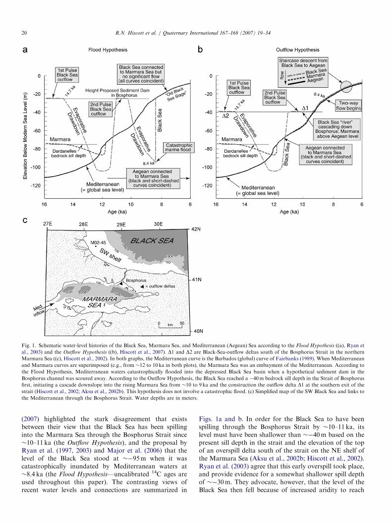
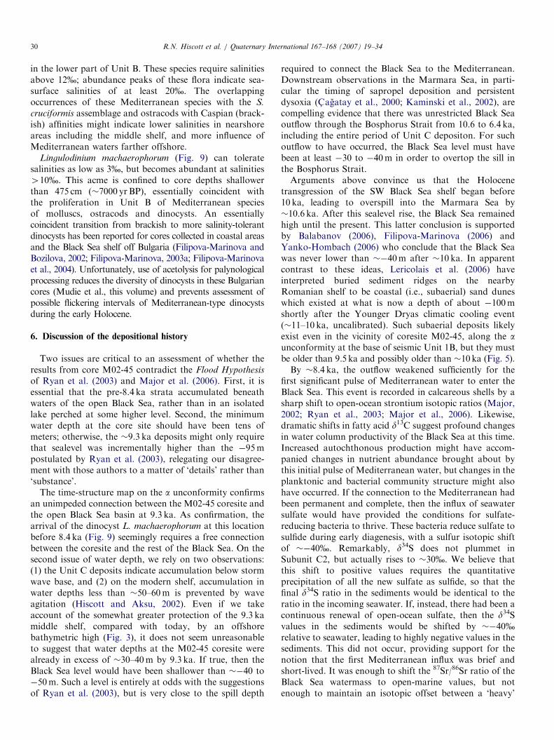
Fig. 1. Schematic water-level histories of the Black Sea, Marmara Sea, and Mediterranean (Aegean) Sea according to the Flood Hypothesis ((a), Ryan et
al., 2003) and the Outflow Hypothesis ((b), Hiscott et al., 2007). D1 and D2 are Black-Sea-outflow deltas south of the Bosphorus Strait in the northern
Marmara Sea ((c), Hiscott et al., 2002). In both graphs, the Mediterranean curve is the Barbados (global) curve of Fairbanks (1989). When Mediterranean
and Marmara curves are superimposed (e.g., from �12 to 10 ka in both plots), the Marmara Sea was an embayment of the Mediterranean. According to
the Flood Hypothesis, Mediterranean waters catastrophically flooded into the depressed Black Sea basin when a hypothetical sediment dam in the
Bosphorus channel was scoured away. According to the Outflow Hypothesis, the Black Sea reached a �40m bedrock sill depth in the Strait of Bosphorus
first, initiating a cascade downslope into the rising Marmara Sea from �10 to 9 ka and the construction the outflow delta D1 at the southern exit of the
strait (Hiscott et al., 2002; Aksu et al., 2002b). This hypothesis does not involve a catastrophic flood. (c) Simplified map of the SW Black Sea and links to
the Mediterranean through the Bosphorus Strait. Water depths are in meters.
R.N. Hiscott et al. / Quaternary International 167–168 (2007) 19–3420
(2007) highlighted the stark disagreement that existsbetween their view that the Black Sea has been spillinginto the Marmara Sea through the Bosphorus Strait since�10–11 ka (the Outflow Hypothesis), and the proposal byRyan et al. (1997, 2003) and Major et al. (2006) that thelevel of the Black Sea stood at ��95m when it wascatastrophically inundated by Mediterranean waters at�8.4 ka (the Flood Hypothesis—uncalibrated 14C ages areused throughout this paper). The contrasting views ofrecent water levels and connections are summarized in
Figs. 1a and b. In order for the Black Sea to have beenspilling through the Bosphorus Strait by �10–11 ka, itslevel must have been shallower than ��40m based on thepresent sill depth in the strait and the elevation of the topof an overspill delta south of the strait on the NE shelf ofthe Marmara Sea (Aksu et al., 2002b; Hiscott et al., 2002).Ryan et al. (2003) agree that this early overspill took place,and provide evidence for a somewhat shallower spill depthof ��30m. They advocate, however, that the level of theBlack Sea then fell because of increased aridity to reach

ARTICLE IN PRESSR.N. Hiscott et al. / Quaternary International 167–168 (2007) 19–34 21
��95m by 8.4 ka. One complication with this scenario of alowstand immediately before 8.4 ka is that the level of theglobal ocean reached �40m at �9.5 ka and �30m at�9.0 ka (Fairbanks, 1989). It is therefore not clear whatkept Mediterranean waters from entering the Black Seaearlier than 8.4 ka, particularly if the Bosphorus sill depthhad been in the range of �40 to �30m only a short timebefore. Ryan et al. (1997) had advocated a sediment dam inthe Bosphorus to explain the delayed flooding, but wecannot imagine what process would have created thisbarrier in the short time interval between �10 and �9 ka.
As illustrated by Fig. 1, the nub of the disagreementbetween our group on the one hand, and Ryan et al. (2003)and Major et al. (2006) on the other, concerns the timeperiod from �10 to 8.4 ka. Our Outflow Hypothesis holdsthat the Black Sea remained high. Their Flood Hypothesis
identifies a sharp drawdown throughout this interval oftime to ��95m, producing an unconformity within theHolocene shelf deposits (unconformity 1a of Ryanet al.(2003), which they correlate with unconformity a1 ofAksu et al.(2002a)). Several workers from easternEuropean countries also dispute that an early Holocenesea-level drawdown and catastrophic flood occurred(Fedorov, 1982; Chepalyga, 1984; Filipova-Marinova,2006; Yanko-Hombach, 2006). Instead, they advocate agradual and in some cases step-wise Holocene rise in thelevel of the Black Sea, reaching depths shallower than��40m by �9–9.5 ka and never dropping below that levelagain.
In 2002, we cored 9.5m into the post-transgressivesuccession on the SW Black Sea middle shelf at a waterdepth of 69m (Fig. 1c). Core M02-45 establishes conclu-sively that the level of the Black Sea was shallower than��70m by �9.3 ka and remained so until the present.Sedimentary facies, decribed below, suggest that the waterdepth was actually shallower than ��55m. The thicknessof unpenetrated strata below the base of the core suggeststhat the transgression began no later than �10 ka. Thereare two unconformities within the Holocene succession,but new radiocarbon dates reported below indicate thatthey formed at �7.5 ka (a1) and in the time interval�2.5–4.5 ka (a2), well after both the proposed water-leveldrawdown of Ryan et al. (2003) and Major et al. (2006)and their estimated time of catastrophic flooding. These aretherefore not transgressive unconformities produced byshoreface erosion (i.e., ravinement surfaces). Instead, weattribute a1 and a2 to marine erosion during phases of localintensification of the Rim Current (Oguz et al., 1993). Thisinterpretation disagrees with our earlier views (Aksu et al.,2002a, pp. 74 and 79), in which we proposed that a1 was alowstand unconformity and a2 was a ravinement surface.
In this manuscript, we present proxy data from coreM02-45 which demonstrate brackish conditions on an openSW Black Sea shelf from �9.5–7.5 ka. A minor pulse ofMediterranean water (or short series of pulses) reached theBlack Sea almost 1000 years earlier at �8.4 ka (Major,2002; Mudie et al., 2002a, 2004; Ryan et al., 2003; Major
et al., 2006), but was short-lived based on our core results.Sustained two-way flow began at �7.5 ka when faunalassemblages and dinocysts indicate a rise in salinity to410–12%. Strong stratification and anoxia/dysoxia wereestablished by �2.4 ka. These results substantiate ourearlier views that (a) the level of the Black Sea rose to itsspillover point by �10 ka, (b) this level has not droppedsignificantly since, and (c) the re-establishment of aHolocene connection between the Mediterranean Sea andBlack Sea was gradual and progressive, not catastrophic.
2. Seismic stratigraphy of the post-transgressive succession,
SW Black Sea shelf
We have remapped three Holocene seismic units in thevicinity of coresite M02-45, using a grid of ultra-highresolution Huntec deep-tow-system (DTS) boomer profilesacquired with an average line spacing of �2 km on theinner and middle shelf and �4 km on the outer shelf. TheHuntec DTS profiles were collected using a deep-towsystem with a 500 J boomer source, recorded using both asingle internal hydrophone and a 21-element 6m-longBenthos hydrophone streamer. The Huntec DTS profileshave a vertical resolution of 15–30 cm, and locally providedetails on sedimentary deposits up to 50–100m below theseabed. The remapped seismic units correspond to seismicunits 1B, 1C and 1D of Aksu et al. (2002a); their seismicunit 1A is only present at the shelf edge and consists oflowstand delta lobes. On the middle shelf, 1B directlyoverlies the transgressive unconformity, a. 1C overlies awidespread reflection called a1 that is locally an erosionalunconformity. 1D overlies a second unconformity, a2, thatis in most profiles an onlap surface. At coresite M02-45,seismic data provide no evidence for an hiatus at a1,whereas a2 is an onlap surface.Seismic unit 1B consists of discontinuous, subtly
mounded, moderately strong reflections just above a,passing quickly upward into weaker but very continuousreflections that characterize the bulk of the unit (Fig. 2).This reflection configuration is characteristic of stratifiedmuds, although the basal hummocky and more reflectivedeposits are likely more sand-prone. A structure-contourmap of the a unconformity surface shows that depositionoccurred in a semi-enclosed shelf depression which openedtoward the north (Fig. 3), affording unrestricted commu-nication between the middle shelf and the open BlackSea basin. An isopach map of unit 1B (Fig. 4a) showsit to be thickest on the middle shelf and thin to absentover the shelf-edge high that partially enclosed the middleshelf depression. Aksu et al. (2002a) defined unit 1B closerto the shelf edge where it is thinner and likely has a youngerbasal age.Seismic unit 1C has a distinctive acoustic character,
consisting of moderately strong but highly discontinuousand ‘‘crinkly’’ reflections. On other parts of the shelf, itpasses laterally into morphological mounds interpreted asmud volcanoes by Aksu et al. (2002a; their Fig. 17). In the

ARTICLE IN PRESS
Fig. 3. Structure-contour map at the level of unconformity a. Contouredvalues are in meters below sealevel. Two paleo-highs partly protected
coresite M02-45 from the open sea at �9 ka, but these highs would have
been entirely submerged if water depth at the coresite was even 10m.
Rivers draining from the west and southwest of coresite M02-45 supplied
shelf-edge deltas during lowstands. The locations of short seismic profiles
shown in Figs. 2 and 6 are indicated.
Fig. 2. Huntec DTS boomer profile showing the acoustic properties and geometries of seismic units 1B–1D. The profile is located in Fig. 3. Seismic unit 1B
onlaps a toward the NE in this area because there is a shelf-edge paleo-bathymetric high. At the SW extremity of the profile, continuous high- to moderate-
amplitude reflections in unit 1B are obscured by gas. Seismic unit 1C has a characteristic hummocky/crinkly character, wherease unit 1D is similar to unit
1B, but with less consistently parallel reflections. Elsewhere, seismic unit 1D is characterized by large climbing waveforms and drift-like deposition around
mud volcanoes. Note that unit 1D subtly onlaps unit 1C toward the NE.
R.N. Hiscott et al. / Quaternary International 167–168 (2007) 19–3422
vicinity of coresite M02-45, this unit has a sheet-likegeometry with only gradual thickness changes (Fig. 4b).The top of seismic unit 1C is marked by onlap in almost allseismic profiles.
In the vicinity of coresite M02-45, seismic unit 1D is verysimilar in reflection character and continuity to unit 1B.Elsewhere on the shelf, particularly to the southeast andnear the shelf edge, it forms drift-like deposits aroundelevated mud volcanoes and shelf ridges, and containsmany internal truncation surfaces (Aksu et al., 2002a, theirFig. 19). The thickest deposits of unit 1D (Fig. 4c) areoffset from the thickest deposits of seismic unit 1B (Fig. 4a;see also Hiscott and Aksu, 2002, their Fig. 16, withtheir * reflection equivalent to a1—on their Fig. 2d location
map, Hiscott and Aksu (2002) mislabelled this profile as‘‘Fig. 15’’).
3. Chronology of core M02-45
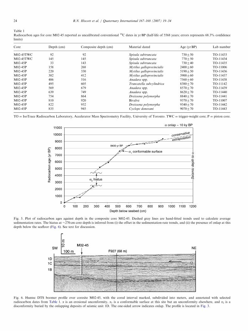
A short trigger-weight core (i.e., gravity core; M02-45TWC) and piston core (M02-45P) were collected at41141.170N, 28119.080E. Radiocarbon dates in both cores(Table 1) indicate some core-top loss in the piston core.This is a normal outcome during piston coring, becausewater-rich surface sediments are easily bypassed by theheavier corer, and because of uncertainties in setting thetrip-wire length when rigging the corer. Our best matchesof radiocarbon ages and geochemical trends suggest that adepth of 110 cm in the trigger-weight core is equivalent tothe top of the piston core. All depths in this paper are givenrelative to the seafloor at the coresite, with the result thatthe top of the piston core has been adjusted downward to adepth of 110 cm to account for the core-top loss. Thecomposite succession obtained by splicing together recordsfrom the trigger-weight and piston cores is designated ascore M02-45.A plot of radiocarbon dates against depth (Fig. 5)
indicates accumulation rates of �360 cm/1000 yr from 605to 950 cm depth, �85 cm/1000 yr from 330 to 605 cm depth,and �125 cm/1000 yr in the upper 268 cm of the compositecore. The age discontinuity between 268 and 330 cmcorrelates with the approximate depth of a2 (Fig. 6)—based on facies in the core, a2 is correlated to a core depthof 270 cm. The youngest deposits beneath a2 have an age of�4.5 ka and the duration of the hiatus is �2000 years (Fig.5). There is no apparent hiatus at a1, but correlation of thedated core to the seismic data suggests an age of�7500 yr BP. Farther east on the southern Black Sea shelf,Mart et al. (2006) identify an equivalent unconformitywhich is overlain by sediments younger than 4400 yr BP.Unconformity a is believed to be at least 250 cm below
the base of core M02-45 (Fig. 6). Based on accumulationrates, a is therefore inferred to be at least 700 years olderthan the deepest recovered sediments. This provides a

ARTICLE IN PRESS
Fig. 4. Isopach maps of seismic units 1B (lower), 1C (middle) and 1D
(top). The contoured values are in milliseconds (TWT), with 10ms �7.5m
of sediment. Coresite M02-45 is labelled in the lower and middle panels.
This and other cores are indicated by unfilled circles. Mud volcanoes are
indicated by gray-filled circles.
R.N. Hiscott et al. / Quaternary International 167–168 (2007) 19–34 23
minimum age of �10 ka for a. The approximate ages ofseismic units 1B, 1C and 1D are therefore 10–7.5 ka,7.5–4.5 ka, and 2.5–0 ka, respectively.
4. Methods of core analysis
Core M02-45 was split and described after uprightshipment from Turkey to Canada. Texture, color andsedimentary structures were evaluated visually. 20 cm3
samples were taken each 10 cm for micropaleontological,textural, and geochemical analysis. Samples were wetsieved through a 63 mm screen to determine the proportionof sand and to isolate foraminifera, ostracods and molluscshells for subsequent identification. For benthic foraminif-eral studies, the dry sand fraction was screened once moreat 125 mm, then split with a microsplitter until a subsamplecontaining about 300–400 specimens was obtained. Thisstep was omitted if the entire sample was judged to containfewer than 300 specimens. For particularly rich samples,microsplitting reduced the 4125 mm fraction to one-eighthto one-sixteenth of its original size. We did not use anyheavy liquids to concentrate the foraminifera. Instead,100% of the visible foraminifera were hand picked fromthe split of the 4125 mm fraction according to standardprocedures. The number of specimens per sample averaged290 above a core depth of 500 cm; deeper samples wereimpoverished and no benthic foraminifera were seen belowa depth of 620 cm. Benthic foraminifera were identifiedusing the taxonomy of Yanko and Troitskaya (1987). Allspecimens in each hand-picked mount were identified andcounted.The 63–125 mm fraction of each sample was checked for
the occurrence of small foraminifera, but not picked. Scantnumbers of small foraminifera were seen in this fraction,not enough to affect the percentage data reported in thispaper.Sample preparation for palynology and carbon geo-
chemistry followed procedures in Mudie et al. (2002a), andAbrajano et al. (2002). For some types of quantitativework (e.g., palynological counting), alternate samplesrather than all samples were studied in intervals of lesserinterest (e.g., uppermost Holocene).The amount of total sulfur (TS) and the sulfur isotopic
composition were determined using a Carlo-Erba NA 1500Elemental Analyzer coupled to a Finnegan MAT 252isotope-ratio mass spectrometer (IRMS). Samples wereacidified using 30% HCl, and carbonate-free residues weredried overnight in an oven at 40 1C. A small amount ofsample (�15mg) was transferred into 4� 6mm tin capsuleswhich were then sealed in preparation for analysis. Totalsulfur in the samples was converted to SO2, H2O and otheroxidized gases in the oxidation chamber and then passedthrough a reduction reagent, a Mg(ClO4)2 water trap and a1.2m Poropak QS 50/80 chromatographic column at 70 1Cfor final isolation. Total sulfur quantification frommeasurement of generated SO2 was accomplished usingan external standard (sulphanilamide, C6H8N2O2S) and a
ARTICLE IN PRESS
Table 1
Radiocarbon ages for core M02-45 reported as uncalibrated conventional 14C dates in yr BP (half-life of 5568 years; errors represents 68.3% confidence
limits)
Core Depth (cm) Composite depth (cm) Material dated Age (yrBP) Lab number
M02-45TWC 92 92 Spisula subtruncata 730750 TO-11433
M02-45TWC 145 145 Spisula subtruncata 770750 TO-11434
M02-45P 33 143 Spisula subtruncata 730740 TO-11435
M02-45P 158 268 Mytilus galloprovincialis 2400760 TO-11006
M02-45P 220 330 Mytilus galloprovincialis 5190750 TO-11436
M02-45P 302 412 Mytilus galloprovincialis 5900760 TO-11437
M02-45P 406 516 Anadara spp. 7560760 TO-11438
M02-45P 495 605 Truncatella subcylindrica 8380770 TO-11142
M02-45P 569 679 Anadara spp. 8570770 TO-11439
M02-45P 639 749 Anadara spp. 8620770 TO-11440
M02-45P 754 864 Dreissena polymorpha 8840770 TO-11441
M02-45P 810 920 Bivalve 9370770 TO-11007
M02-45P 822 932 Dreissena polymorpha 9340770 TO-11442
M02-45P 835 945 Cyclope donovani 9070770 TO-11443
TO ¼ IsoTrace Radiocarbon Laboratory, Accelerator Mass Spectrometry Facility, University of Toronto. TWC ¼ trigger-weight core; P ¼ piston core.
Fig. 5. Plot of radiocarbon ages against depth in the composite core M02-45. Dashed gray lines are hand-fitted trends used to calculate average
sedimentation rates. The hiatus at �270 cm core depth is inferred from (i) the offset in the sedimentation-rate trends, and (ii) the presence of onlap at this
depth below the seafloor (Fig. 6). See text for discussion.
Fig. 6. Huntec DTS boomer profile over coresite M02-45, with the cored interval marked, subdivided into meters, and annotated with selected
radiocarbon dates from Table 1. a is an erosional unconformity, a1 is a conformable surface at this site but an unconformity elsewhere, and a2 is a
disconformity buried by the onlapping deposits of seismic unit 1D. The one-sided arrow indicates onlap. The profile is located in Fig. 3.
R.N. Hiscott et al. / Quaternary International 167–168 (2007) 19–3424

ARTICLE IN PRESSR.N. Hiscott et al. / Quaternary International 167–168 (2007) 19–34 25
thermal conductivity detector (TCD). From the TCD, theSO2 was carried by He to a ConFloII interface, whichallows a portion of the He and combustion gases to enterdirectly into the ion source of the IRMS for sulfur isotopicmeasurement. The total sulfur concentration in the samplesis back-calculated as a percentage of dry-weight sediment.All isotopic analyses are reported in standard notationreferenced to the standard CDT.
Ostracods were hand picked from a split of the 463 mmfraction and identified using reference texts such asAthersuch et al. (1989) and Schornikov (1967). In mostsamples, several hundred to 41000 specimens wereidentified and counted. Mollusc shells were identified usinga number of taxonomic keys, descriptions and illustrations(Tebble, 1966; Graham, 1971; Poppe and Goto, 1991;Grossu, 1995; Muller, 1995; Abbott and Dance, 1998;Demir, 2003), with details provided in C- akiroglu (2005).
Fig. 7. Textural and geochemical proxies plotted against the sedimentary profi
and upright dish-shaped symbols in the lithological column indicate shells. Unit
elemental abundances of organic carbon (TOC) and total sulfur (TS). Bold
photographs shown in Fig. 8. (b) carbon and sulfur isotopic compositions. Ter
constitutes a mixture of marine and terrigenous end-members with d13C rat
discussion.
5. Core data
5.1. Sedimentary facies and molluscan assemblages of core
M02-45
Three lithologic units are recognized in core M02-45(Fig. 7). The oldest Unit C extends from the base of thecored interval to a depth of 525 cm. Its top thereforecorrelates in the seismic data to a1 (Fig. 6). Unit B extendsupward from this point to a core depth of 270 cm, which isjust below a o5 cm-thick shelly horizon, and whichcorrelates in the seismic data to a2. Unit A coincides withseismic unit 1D. Lithologic units are described in strati-graphic order, from oldest to youngest.Unit C consists of color-banded mud with graded
laminae and beds of silt to very fine sand (Fig. 8a), andscattered shells of Truncatella subcylindrica, Parvicardium
le for core M02-45. No trends are extended across the a2 hiatus. Inverteds, subunits and correlations to key reflections are indicated. (a) texture and
lines adjacent to the depth scale in part (a) indicate the position of core
rigenous fraction of the TOC is estimated by assuming that the bulk d13Cios of �22% and �27%, respectively (Aksu et al., 1999b). See text for
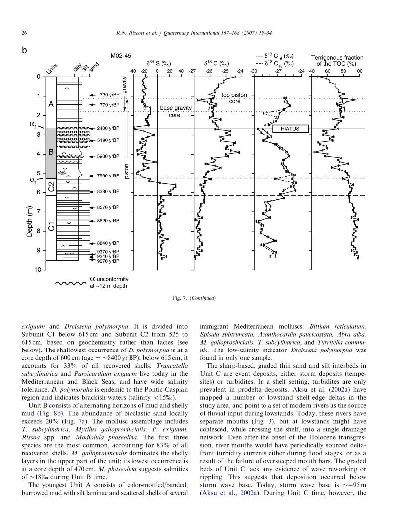
ARTICLE IN PRESS
Fig. 7. (Continued)
R.N. Hiscott et al. / Quaternary International 167–168 (2007) 19–3426
exiguum and Dreissena polymorpha. It is divided intoSubunit C1 below 615 cm and Subunit C2 from 525 to615 cm, based on geochemistry rather than facies (seebelow). The shallowest occurrence of D. polymorpha is at acore depth of 600 cm (age ¼ �8400 yr BP); below 615 cm, itaccounts for 33% of all recovered shells. Truncatella
subcylindrica and Parvicardium exiguum live today in theMediterranean and Black Seas, and have wide salinitytolerance. D. polymorpha is endemic to the Pontic-Caspianregion and indicates brackish waters (salinity o15%).
Unit B consists of alternating horizons of mud and shellymud (Fig. 8b). The abundance of bioclastic sand locallyexceeds 20% (Fig. 7a). The mollusc assemblage includesT. subcylindrica, Mytilus galloprovincialis, P. exiguum,
Rissoa spp. and Modiolula phaseolina. The first threespecies are the most common, accounting for 83% of allrecovered shells. M. galloprovincialis dominates the shellylayers in the upper part of the unit; its lowest occurrence isat a core depth of 470 cm. M. phaseolina suggests salinitiesof �18% during Unit B time.
The youngest Unit A consists of color-mottled/banded,burrowed mud with silt laminae and scattered shells of several
immigrant Mediterranean molluscs: Bittium reticulatum,
Spisula subtruncata, Acanthocardia paucicostata, Abra alba,
M. galloprovincialis, T. subcylindrica, and Turritella commu-
nis. The low-salinity indicator Dreissena polymorpha wasfound in only one sample.The sharp-based, graded thin sand and silt interbeds in
Unit C are event deposits, either storm deposits (tempe-sites) or turbidites. In a shelf setting, turbidites are onlyprevalent in prodelta deposits. Aksu et al. (2002a) havemapped a number of lowstand shelf-edge deltas in thestudy area, and point to a set of modern rivers as the sourceof fluvial input during lowstands. Today, these rivers haveseparate mouths (Fig. 3), but at lowstands might havecoalesced, while crossing the shelf, into a single drainagenetwork. Even after the onset of the Holocene transgres-sion, river mouths would have periodically sourced delta-front turbidity currents either during flood stages, or as aresult of the failure of oversteeped mouth bars. The gradedbeds of Unit C lack any evidence of wave reworking orrippling. This suggests that deposition occurred belowstorm wave base. Today, storm wave base is ��95m(Aksu et al., 2002a). During Unit C time, however, the

ARTICLE IN PRESS
Fig. 8. Photographs of typical features of lithologic units C1 (left) and B
(right). The graded silts and very fine sands in Subunit C1 punctuate
burrowed muds; these graded beds are interpreted as prodelta turbidites
which accumulated below storm wave base. The shell layers in Unit B are
dominated by Mytilus galloprovincialis. The locations of these photo-
graphs are marked in Fig. 7a.
R.N. Hiscott et al. / Quaternary International 167–168 (2007) 19–34 27
middle shelf was somewhat protected from offshore swellby the paleo-bathymetric high seaward of coresite M02-45(Fig. 3), but it is still likely that storm wave base was deeperthan �30m. With a modern water depth of 69m and UnitC sub-seafloor depths of �9m, the 9 ka water depth in thevicinity of coresite M02-45 is interpreted to have beenshallower than 69+9�30 ¼ 48m. Based on the paleo-bathymetry (Fig. 3), the 9 ka shoreline in the SW Black Seawould have been within 5 km of the modern coastline.
Unit B muds and shelly muds with a diverse molluscanfauna suggest well oxygenated marine conditions. We haveencountered such interbedded muds and shelly muds inmany cores on the Black Sea shelf, over a wide geographicarea (Aksu et al., 2002a, their Fig. 23). The shells show noevidence of significant transport or abrasion, so weinterpret them as thin, in situ mollusc communities livingon a mud bottom. The decreased abundance of macro-fauna and the sharp decline in TS in Unit A suggestreduced oxygen levels in the basin as a whole after �2.4 ka,with sulfur drawdown attributed to precipitation of pyritein deeper parts of the now-anoxic Black Sea basin.
5.2. Carbon and sulfur geochemistry
In Subunit C1, total organic carbon (TOC) is ratheruniform at 0.5–1.0% (Fig. 7a); this is �90% terrigenouscarbon and �10% marine carbon (Fig. 7b). d13C of theTOC is mostly �26.5% to �27%, and compound-specificcarbon isotopic signatures (C16 and C18 saturated fattyacids) are even more negative at ��28% to �29% (Fig.7b). TS is less than 0.5% and d34S is uniform in the range0–10%. In Subunit C2, TOC is �0.5% and remains�85–90% terrigenous in origin. d13C of the TOC is��26.5%, whereas C16 and C18 saturated fatty acidd13C values climb to higher values than in Subunit C1,eventually reaching ��26% to �25%. Such profound shiftin fatty acid d13C values is commonly ascribed to limitationin the supply of carbon substrates during primaryproduction. Unlike total organic carbon, the sulfurcomposition is dramatically different to values in SubunitC1. TS rises rapidly at the base of Subunit C2 to values41%, reaching a peak of �1.7% by the middle of thesubunit (�8200 yr BP) before declining to �1% at the top.The increased TS is marked by abundant fine pyriteparticles, less than 5 mm in diameter, in palynologicalseparates (Mudie et al., this volume). d34S increasesprogressively throughout the lower part of Subunit C2,reaching values of �30% (marginally higher than seawatersulfate; Paytan et al., 1998). There is then a steady declinein d34S across the interval 560–525 cm to values of ��20%.The change is large—about 50%! Based on accumulationrates, this large decline in d34S occurred over a time intervalof �500 years.TOC is �0.5% at the base of Unit B but more than
doubles to �1.5% above a core depth of 480 cm (Fig. 7a).The marine contribution to the TOC increases to �50% inthe middle to upper part of Unit B—such values aredistinctly different to the source compositions for Units Cand A, and are only seen again at the modern depositionalsurface (Fig. 7b). There is a rise in values of d13C from�26.2% to ��25% which parallels the rise in TOC. d13Chas peaks as high as �24.2% (Fig. 7b). In contrast, thecompound-specific d13C values for C16 and C18 fatty acidsgradually decrease through Unit B from ��25% to��29%. TS increases progressively from �1% to �2%in the lower half of the unit, and then fluctuates irregularlyin the range 1–2%. d34S fluctuates from ��40% to �0%,with an average of ��20%. Poorly defined trends mightexist in the d34S profile through Unit B, but these aremasked by the scatter in the data.TOC is uniform at �1.0% in Unit A (Fig. 7a). The
proportion of terrigenous organic matter is �75% exceptfor the upper 100 cm of the composite core. Above thisdepth, the proportion of marine organic carbon increasesgradually to �50%, in step with a gradual increase in d13Cto ��24.5%. Below this depth, d13C shows weak trends inthe range �25.5% to �26%. d13C values for C16 and C18fatty acids are higher in the base of Unit A than they are inthe top of Unit B, but this offset is to be expected since

ARTICLE IN PRESSR.N. Hiscott et al. / Quaternary International 167–168 (2007) 19–3428
there is an hiatus of �2000 years at the contact betweenthese units. Samples from the trigger-weight core were notanalyzed, but we expect an upward continuation of thesame inverse relationship seen in Units B and A betweenbulk d13C and compound-specific (C16 and C18 fatty acid)values of d13C. d34S is essentially unchanged from thevalues of about �20% seen in Unit B, except for anexcursion to �40% at the a2 hiatus. TS decreases upwardthrough Unit A from �1.2% to �0.2%.
5.3. Microfossils and their constraints on water-mass
characteristics
There are no planktonic foraminifera in our samples,consistent with the low salinity of Black Sea surface watersand the strong surface-water outflow through the Bo-sphorus Strait. We did not study coccoliths and diatoms.Foraminifera are very rare in Unit C, consisting ofindividual specimens of Ammonia and Porosononion. Thesemight have been mixed downward into Unit C byburrowers. The high abundance of pyritized burrowinfillings in Unit C appears to support this interpretation.Organic linings of benthic foraminifera, however, arecommon in palynological residiues at intervals in Unit C,suggesting that dissolution might also have contributed tothe low number of foraminifera. Likewise, organic liningsof ostracoda in palynological residues point to localcarbonate dissolution.
Ammonia species display high dominance in Unit B(Fig. 9a), where Ammonia tepida is the most abundantspecies. The diversity of this assemblage is lower than inUnit A (with a maximum of 7 species, versus 17 species inUnit A). Accessory species are rare, and mostly consist ofPorosonion sp. The shallowest consistent occurrence oflagenids is noted at a composite core depth of 390 cm(�5800 yr BP from Fig. 5), indicating deposition in a shelfenvironment with water depths in excess of �35m (seeYanko and Troitskaya, 1987, their Table 6). An assem-blage dominated by A. tepida (without lagenids) todaycharacterizes areas of the inner continental shelf offBulgaria where salinity values are in the range of 17–19%(Yanko, 1990).
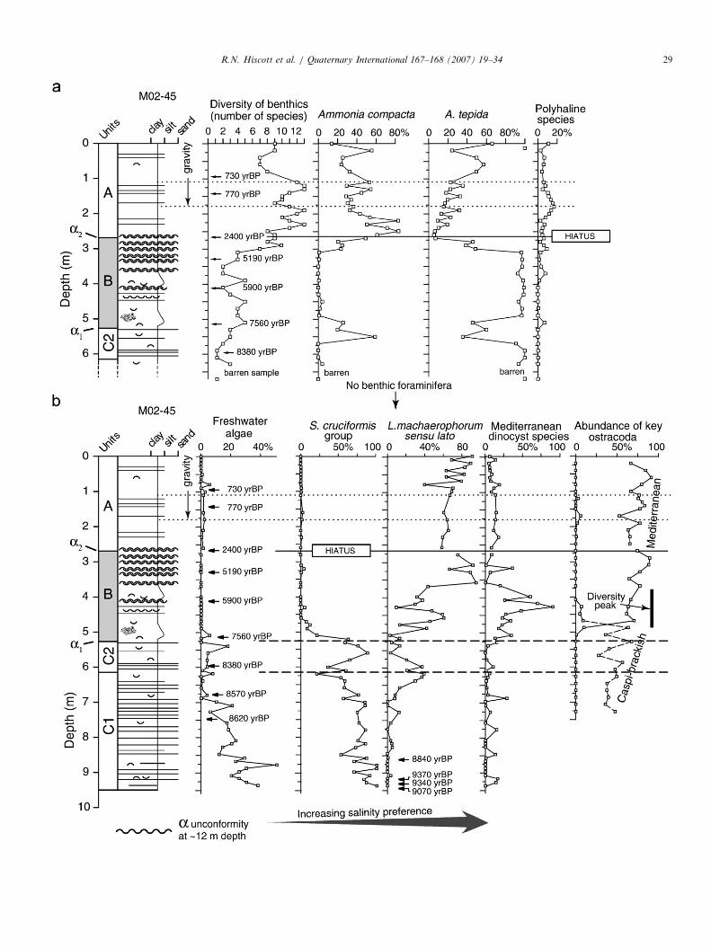
Fig. 9. Microfossils and ostracods plotted against the sedimentary profile fo
foraminifera abundances. Only unidentifiable foramiferal linings are present i
stratigraphy is not presented in this part of the figure. Species abundances a
Polyhaline species (Yanko, 1990) are found in environments where the salini
lucida, and Eggerelloides scabrus. A. tepida is an inner shelf dweller in salinit
salinities of 21–22% (Yanko, 1990). (b), Freshwater algae ¼ Pediastrum
group ¼ Spiniferites cruciformis+Pyxidinopsis psilata+S. inaequalis; Lingulodi
of this taxon; Mediterranean species ¼ Spiniferites belerius+Operculodinium
freshwater algae is calculated relative to the sum of all dinocysts and freshwater
count of dinocyst specimens. The larger variation in dinocyst concentrations at
Key Mediterranean ostracoda ¼ Leptocythere ramosa+Leptocythere sp.+Cal
Caspi-brackish ostracoda ¼ Loxoconcha aff. lepida+Candona aff. schweyer
These are reported as percentages of all specimens of ostracoda in each samp
Benthic foraminifera and ostracods with Mediterraneanaffinities are relatively diverse in Unit A. The foraminiferalassemblage in this unit is dominated by A. compacta, withlesser numbers of A. tepida (Fig. 9a). These are accom-panied by Haynesina depressula and H. germanica,Gavelinopsis praegeri, Elphidium spp., lagenids, and spora-dic occurrences of agglutinated taxa (mostly Eggerelloides
scabrus, Ammomarginulina sp., and Reophax sp.). Miliolidsare rare and mostly consist of the genus Triloculina. Themiliolids and agglutinates are confined to Unit A. Yanko(1990, Table 1) indicates that A. compacta is a relativelydeep-water form which characterizes areas deeper than�70m on the modern Bulgarian outer shelf; there, thesalinity is 21–22%.Ostracods are found from the core top downward, well
into Unit C, but the ostracod species change from anexclusively Mediterranean assemblage above 420 cm (inUnit B) to a Caspian (brackish) assemblage below 500 cm(implied salinity �5%; Evans, 2004); the intervening 80 cminterval contains a mixture of these two assemblages andtherefore has the highest ostracod diversity in core M02-45(Fig. 9b). The time required to complete this transition inostracod assemblages was �1300 years, from �7300 to6000 yr BP (Fig. 5).Dinoflagellate cysts and colonial algae (Pediastrum,
Botrycoccus) provide the clearest record of changingwater-mass characteristics (Fig. 9; Mudie et al., thisvolume). The freshwater algae Pediastrum and Botrycoccus
are only significant below a depth of 510 cm (age�7500 yr BP). In the same interval and upward to a depthof 460 cm (age �6700 yr BP), a dinocyst assemblagedominated by Spiniferites cruciformis and Pyxidinopsis
psilata indicates brackish waters with salinities of 3–12%.Flickering, minor amounts of euryhaline/Mediterraneanspecies in the same interval indicate periodically increasedsalinity. We interpret the overlap of Pediastrum and the S.
cruciformis assemblage to indicate brackish conditionsthroughout Unit C time, with the freshwater specieswashed in from rivers or nearby coastal areas.Mediterranean dinocysts S. belerius, S. bentorii, S.
mirabilis, S. ramosus and Operculodinium centrocarpum
first appear in a persistent way at a depth of 510 cm(�7500 yr BP), reaching their highest relative proportions
r core M02-45. No trends are extended across the a2 hiatus. (a), Benthic
n Unit C below 670 cm (�8500 yr BP); hence, the deeper part of the core
re presented as a percentage of all benthic foraminifera in each sample.
ty is in excess of 11%, and include Gavelinopsis praegeri, Fissurina ex gr.
ies of 17–19%, whereas A. compacta lives in deeper water (470m) with
simplex+P. boryanum+Pediastrum sp.+Botryococcus; S. cruciformis
nium machaerophorum sensu lato includes all the morphological variations
centrocarpum+S. bentorii+S. mirabilis+S. ramosus. The percentage of
algae, whereas percentages of dinocysts are calculated relative to the total
the top of the core is partly due to lower counts of cysts in some samples.
listocythere diffusa+Palmoconcha aff. guttata+Cytheroma marinovi. Key
i+Callistocythere quinquetuberculata+Loxoconcha sp.+Eucytherura sp.
le.
ARTICLE IN PRESSR.N. Hiscott et al. / Quaternary International 167–168 (2007) 19–34 29
ARTICLE IN PRESSR.N. Hiscott et al. / Quaternary International 167–168 (2007) 19–3430
in the lower part of Unit B. These species require salinitiesabove 12%; abundance peaks of these flora indicate sea-surface salinities of at least 20%. The overlappingoccurrences of these Mediterranean species with the S.
cruciformis assemblage and ostracods with Caspian (brack-ish) affinities might indicate lower salinities in nearshoreareas including the middle shelf, and more influence ofMediterranean waters farther offshore.
Lingulodinium machaerophorum (Fig. 9) can toleratesalinities as low as 3%, but becomes abundant at salinities410%. This acme is confined to core depths shallowerthan 475 cm (�7000 yr BP), essentially coincident withthe proliferation in Unit B of Mediterranean speciesof molluscs, ostracods and dinocysts. An essentiallycoincident transition from brackish to more salinity-tolerantdinocysts has been reported for cores collected in coastal areasand the Black Sea shelf off Bulgaria (Filipova-Marinova andBozilova, 2002; Filipova-Marinova, 2003a; Filipova-Marinovaet al., 2004). Unfortunately, use of acetolysis for palynologicalprocessing reduces the diversity of dinocysts in these Bulgariancores (Mudie et al., this volume) and prevents assessment ofpossible flickering intervals of Mediterranean-type dinocystsduring the early Holocene.
6. Discussion of the depositional history
Two issues are critical to an assessment of whether theresults from core M02-45 contradict the Flood Hypothesis
of Ryan et al. (2003) and Major et al. (2006). First, it isessential that the pre-8.4 ka strata accumulated beneathwaters of the open Black Sea, rather than in an isolatedlake perched at some higher level. Second, the minimumwater depth at the core site should have been tens ofmeters; otherwise, the �9.3 ka deposits might only requirethat sealevel was incrementally higher than the �95mpostulated by Ryan et al. (2003), relegating our disagree-ment with those authors to a matter of ‘details’ rather than‘substance’.
The time-structure map on the a unconformity confirmsan unimpeded connection between the M02-45 coresite andthe open Black Sea basin at 9.3 ka. As confirmation, thearrival of the dinocyst L. machaerophorum at this locationbefore 8.4 ka (Fig. 9) seemingly requires a free connectionbetween the coresite and the rest of the Black Sea. On thesecond issue of water depth, we rely on two observations:(1) the Unit C deposits indicate accumulation below stormwave base, and (2) on the modern shelf, accumulation inwater depths less than �50–60m is prevented by waveagitation (Hiscott and Aksu, 2002). Even if we takeaccount of the somewhat greater protection of the 9.3 kamiddle shelf, compared with today, by an offshorebathymetric high (Fig. 3), it does not seem unreasonableto suggest that water depths at the M02-45 coresite werealready in excess of �30–40m by 9.3 ka. If true, then theBlack Sea level would have been shallower than ��40 to�50m. Such a level is entirely at odds with the suggestionsof Ryan et al. (2003), but is very close to the spill depth
required to connect the Black Sea to the Mediterranean.Downstream observations in the Marmara Sea, in parti-cular the timing of sapropel deposition and persistentdysoxia (C- agatay et al., 2000; Kaminski et al., 2002), arecompelling evidence that there was unrestricted Black Seaoutflow through the Bosphorus Strait from 10.6 to 6.4 ka,including the entire period of Unit C depositon. For suchoutflow to have occurred, the Black Sea level must havebeen at least �30 to �40m in order to overtop the sill inthe Bosphorus Strait.Arguments above convince us that the Holocene
transgression of the SW Black Sea shelf began before10 ka, leading to overspill into the Marmara Sea by�10.6 ka. After this sealevel rise, the Black Sea remainedhigh until the present. This latter conclusion is supportedby Balabanov (2006), Filipova-Marinova (2006) andYanko-Hombach (2006) who conclude that the Black Seawas never lower than ��40m after �10 ka. In apparentcontrast to these ideas, Lericolais et al. (2006) haveinterpreted buried sediment ridges on the nearbyRomanian shelf to be coastal (i.e., subaerial) sand duneswhich existed at what is now a depth of about �100mshortly after the Younger Dryas climatic cooling event(�11–10 ka, uncalibrated). Such subaerial deposits likelyexist even in the vicinity of coresite M02-45, along the aunconformity at the base of seismic Unit 1B, but they mustbe older than 9.5 ka and possibly older than �10ka (Fig. 5).By �8.4 ka, the outflow weakened sufficiently for the
first significant pulse of Mediterranean water to enter theBlack Sea. This event is recorded in calcareous shells by asharp shift to open-ocean strontium isotopic ratios (Major,2002; Ryan et al., 2003; Major et al., 2006). Likewise,dramatic shifts in fatty acid d13C suggest profound changesin water column productivity of the Black Sea at this time.Increased autochthonous production might have accom-panied changes in nutrient abundance brought about bythis initial pulse of Mediterranean water, but changes in theplanktonic and bacterial community structure might alsohave occurred. If the connection to the Mediterranean hadbeen permanent and complete, then the influx of seawatersulfate would have provided the conditions for sulfate-reducing bacteria to thrive. These bacteria reduce sulfate tosulfide during early diagenesis, with a sulfur isotopic shiftof ��40%. Remarkably, d34S does not plummet inSubunit C2, but actually rises to �30%. We believe thatthis shift to positive values requires the quantitativeprecipitation of all the new sulfate as sulfide, so that thefinal d34S ratio in the sediments would be identical to theratio in the incoming seawater. If, instead, there had been acontinuous renewal of open-ocean sulfate, then the d34Svalues in the sediments would be shifted by ��40%relative to seawater, leading to highly negative values in thesediments. This did not occur, providing support for thenotion that the first Mediterranean influx was brief andshort-lived. It was enough to shift the 87Sr/86Sr ratio of theBlack Sea watermass to open-marine values, but notenough to maintain an isotopic offset between a ‘heavy’
ARTICLE IN PRESSR.N. Hiscott et al. / Quaternary International 167–168 (2007) 19–34 31
reservoir of seawater sulfate and a ‘light’ reservoir in thesulfide minerals in the sediments. The different behavior ofstrontium and sulfur results from the fact that strontium isa ‘trace element’ in calcareous shells, whereas sulfur is arelatively more abundant ‘minor element’ in seawater andin sediments. Strontium ratios would have shifted to open-ocean values with a small influx of Mediterranean waterbecause the strontium concentration in marine water isabout two orders of magnitude higher than in fresh water.The strontium isotopic ratios would have remained atopen-ocean values for a long period of time because little isremoved during biogenic precipitation of carbonateshells. In contrast, newly introduced sulfate would havebeen rapidly consumed by sulfate-reducing bacteria andpotentially entirely removed from the water column.
The proposal that an initial short-lived pulse of seawaterenter the Black Sea is supported by trends in thepercentages of salinity-diagnostic groups of dinocysts andfreshwater algae (Fig. 9). Between �8.5 and �8.1 ka, L.
machaerophorum increased at the expense of the S.
cruciformis group and freshwater algae (ages are basedon the convertion of core depths to time using Fig. 5). Thisfloral shift was temporarily reversed starting at �8.1 ka(Fig. 9b), but later (�7.5–7.0 ka) the taxa characteristic oflower salinities were completely displaced. Caspi-brackishostracoda gave way to Mediterranean species and theforaminiferal fauna becames established during this secondand larger seawater incursion. Balabanov (2006) alsodescribes this initial pulse, then decline, in the early influxof Mediterranean water from cores collected on theCaucasus shelf (northern Black Sea). There, the firsteuryhaline immigrants died off at �8.3–8.2 ka (compareFig. 9b), then returned in larger numbers a short time later.Filipova-Marinova (2003a, 2006) likewise notes the occur-rence of single specimens of euryhaline gastropods andsmall numbers of euryhaline dinoflagellate cysts in pre-8.4 ka deposits at the mouth of the Veleka River, southernBulgaria, and attributes these to ‘‘an accidental ingress ofMediterranean sea water’’ at that time.
We believe that the first pulse of Mediterranean waterentered the Black Sea at �8.4 ka not because of a ‘‘flood’’,but because the persistent Black Sea outflow weakenedtemporarily (see also Balabanov, 2006). The sulfate in thisincoming water was entirely reduced and incorporated intothe sediments of Subunit C2 where it is now observed asabundant o5 mm particles of pyrite (Mudie et al., thisvolume). The peak in TS at this time is followed by adecline toward the top of the subunit. d34S in the sedimentsrose to open-ocean values because bacterial fractionationwas negated by extreme substrate limitation and completeconversion of all of the new sulfate to sedimentary sulfidein an essentially closed system (e.g., Londry and DesMarais, 2003). This period is also marked by a significantshift in fatty acid d13C, reflecting changes in nutrientbalance, carbon substrate or microbial community struc-ture in the Black Sea watermass. Some salinity-tolerantdinocysts (e.g., L. machaerophorum) might have arrived
with this first pulse of saline water. The floral datapotentially indicate the arrival of the first immigrants ashort time before 8.4 ka (Fig. 9), perhaps during seasonaldeclines in Black Sea outflow too small to influence thebulk geochemistry of the basinal waters. Corroboration isprovided by Balabanov (2006), who notes the presence of‘‘rare larvae and immature species of Cardium edule, Abra
ovata, and, infrequently, Chione gallina and Spisula
subtruncata’’ in sediments older than �8.5 ka beneath thenorthern Black Sea shelf.At the base of Unit B, several biological and geochemical
proxies track the second influx of Mediterranean waterswhich has persisted to the present day. This influx startedat �7.5 ka and is attributed to the initiation of permanenttwo-way flow in the Bosphorus Strait. Mediterraneanbenthic foraminifera, ostracods and molluscs took overfrom brackish species during a transitional period of �500years. The benthic foraminiferal assemblage of Unit Bcompares best with the modern middle shelf fauna(35–70m water depth, Bulgarian Shelf) reported by Yanko(1990, Tables 1 and 2), whereas the foraminiferal assem-blage of Unit A compares best with her deeper shelfassemblage found at water depths in excess of 70m. Sulfateconcentrations rose sufficiently just before the onset ofUnit B deposition to nourish an active crop of sulfate-reducing bacteria in surface sediments, leading to apronounced drop in d34S values to an average of ��20%(Fig. 7b).There is no debate concerning the post-7.5 ka arrival and
proliferation of Mediterranean species on shelves of theBlack Sea. Ryan et al. (1997) originally flagged thisproliferation as evidence for a catastrophic flood at thattime, but later moved the time of flooding back almost1000 years to 8.4 ka based on strontium isotopes incalcareous shells (Ryan et al., 2003; Major et al., 2006).Instead, we have consistently argued (e.g., Aksu et al.,1999a) that the �7.5 ka faunal turnover resulted from atime lag between initial reconnection of the Black Sea withthe Mediterranean, and the colonization of shelf environ-ments by organisms which experienced difficulty enteringthe Black Sea because of strong outflow and inhospitableenvironmental conditions (e.g., low salinity).Ryan et al. (2003) criticized our contention that strong
outflow could have prevented immigration of Mediterra-nean aquatic organisms into the Black Sea. They statedthat ‘‘Although one could argue that Black Sea dischargeto the Marmara Sea was so strong as to keep the saltwaterout, the Marmara Sea passes this same stream to theMediterranean via the Dardanelles Strait. Yet the Mar-mara Sea did not keep the Mediterranean at bay butbecame marine at 11.7 kyBP as soon as its outlet wasbreached’’. This criticism has no merit whatsoever, becauseno one has proposed that the Black Sea was exporting freshwater to the Mediterranean at 11.7 ka (Fig. 1). Instead, theMarmara Sea was an isolated lake which became a marineembayment of the Aegean Sea after it was passively floodedat �12 ka (C- agatay et al., 2000; Hiscott and Aksu, 2002).

ARTICLE IN PRESSR.N. Hiscott et al. / Quaternary International 167–168 (2007) 19–3432
During its reconnection to the Mediterranean, there was nooutflow through the Dardanelles; the Marmara Sea mightactually have been abruptly inundated because its level waslower than that of the open ocean by �15m (Hiscott andAksu, 2002).
In core M02-45, the record of conditions from �4.5 to2.5 ka is apparently missing at unconformity a2. Above a2in Unit A, TS is very low compared to underlying values,consistent with deposition in a poorly oxygenated basinwhere sulfur is removed and deposited as pyrite in deep-water areas. On the shelf, pore-water sulfate is also reducedto sulfide during early diagenesis, with the bacterialfractionation accounting for persistently low d34S valuesof ��20% (Fig. 7b).
7. Origin of a1 and a2
In our earlier work (Aksu et al., 2002a) and in otherstudies (Ryan et al., 2003), it has been proposed thatunconformities above a were created by erosion duringtimes of lower water level, perhaps even during times ofsubaerial exposure and subsequent transgressive erosion(ravinement). Indeed, there is evidence elsewhere in theBlack Sea for minor transgressions and regressionsthroughout the Holocene (Chepalyga, 1984; Filipova-Marinova, 2003a, 2006; Balabanov, 2006; Ivanov andKakaranza, 2006). However, we now believe that waterlevel changes are not essential to the development of a1 anda2. Instead, we hypothesize that unconformities like a2develop on the inner and middle shelf wherever surfacecurrents are strong enough to prevent deposition.
Today, the SW Black Sea shelf is swept by the RimCurrent and an associated set of semi-permanent eddies(Oguz et al., 1993). Can this current cause local erosion? Aspart of a separate study of the seabed seaward of theBosphorus exit into the Black Sea, we have acquired amultibeam mosaic, including backscatter imagery (Hiscottet al., 2006). Approximately 35 km2 of the seabed in themulti-beam survey area is characterized by surface linea-tions which result from truncation of shallowly dippingstrata equivalent to Unit A. This beveled seabed is a‘‘modern’’ unconformity that is being created undermodern oceanographic conditions, and which will surelybe buried in the future to produce a stratal discontinuityvery similar to a1 or a2. The second point in our argumentagainst a sealevel control on a1 and a2 is the geographicrestriction of these hiatuses to local areas. If they were theresult of water-level changes, then we would expect them tobe widespread across the shelf. Seaward of the SakaryaRiver delta, Algan et al. (2002) record no unconformityyounger than 7–8 ka. As corroboration, we have unpub-lished radiocarbon ages obtained on mollusc shells in longpiston cores in the same area (Aksu et al., 2006) thatdemonstrate uninterrupted sedimentation precisely whena2 was developing at coresite M02-45 (i.e., in the interval4.5–2.5 ka). These observations are, in our view, incon-
sistent with a basin-wide regression as the cause for thisunconformity.As a final point, Giosan et al. (2006) have determined
from study of the Danube Delta that the water level of theBlack Sea has not varied by more than a few meters in thelast 5000 years. They argue that younger water-levelexcursions reported by other workers are likely attributableto local subsidence rather than basin-scale sealevel changes.Our reinterpretation of the origin of unconformities a1 anda2 is consistent with their view.It might be possible that the Holocene Rim Current
system reorganized itself from time to time as water-masscharacteristics or wind patterns in the region changed. Weare not aware of physical oceanographic data which wouldbear on the issue of long-term stability of the surfacecurrents in the Black Sea, so our hypothesis of periodicreorganization is necessarily somewhat speculative.
8. Conclusions
The major conclusion that we draw from the study ofcore M02-45 is that the SW Black Sea shelf wastransgressed by no later than 10 ka, and that the outerand middle shelf has been under water ever since. Thisconclusion accords with the published results of manyRussian, Bulgarian and Ukrainian workers (Chepalyga,1984; Balabanov, 2006; Murdmaa et al., 2006; Yanko-Hombach, 2006) but is in direct conflict with the FloodHypothesis of Ryan et al. (2003) and Major et al. (2006).The deepest facies in the core (age ¼ �9.3 ka) wasapparently deposited below storm wave base as prodeltamuds and turbidites, implying that the level of the BlackSea was near or at the sill depth of the Bosphorus Straitthroughout the Holocene. The reconnection to theMediterranean Sea involved a number of steps and mostlyprogressive changes from one stage to the next. From �10to 8.4 ka, we infer that the Black Sea was flowing sostrongly out through the Bosphorus Strait that noMediterranean water penetrated northward—early in thisperiod, the Marmara Sea would have been lower than theBlack Sea so that the Bosphorus would have been a riverwith a significant surface slope toward the south. At�8.4 ka, a first pulse of Mediterranean water entered theBlack Sea, perhaps because of a temporary decline inriverine inflow from northern European watersheds. Thispulse was sufficient to permanently (until today) shift thestrontium isotopic signature of the Black Sea to globalvalues, but the newly introduced sulfate was rapidlyconsumed by sulfate-reducing bacteria and buried as pyritein Subunit C2 (and contemporaneous) sediments. Becauseall the sulfate was consumed, the sedimentary sulfur isunfractionated relative to seawater. Finally, at �7.5 ka,outflow declined enough to permit continuous two-wayflow throught the strait, opening the Black Sea to a widevariety of Mediterranean immigrant species, and leading tothe establishment of a typical marine diagenetic profilewith active sulfate reduction, strong sulfur isotopic

ARTICLE IN PRESSR.N. Hiscott et al. / Quaternary International 167–168 (2007) 19–34 33
fractionation, and negative d34S values in the sediments. Bythe time that onlapping sediments buried the a2 unconfor-mity at �2.5 ka, the middle shelf was a dyaerobic setting,perhaps because of a progressive rise of the chemocline.The timing of this transition is poorly constrained atcoresite M02-45 because of the hiatus at unconformity a2,which we attribute to intensification of the Rim Currentduring the middle Holocene.
Proxy data from core M02-45 are therefore entirelyconsistent with the Outflow Hypothesis of Hiscott et al.(2007). Our conclusion that the Holocene was moist andthat water levels remained high is corroborated by thepollen records for core M02-45, core B7 (from the southernBlack Sea basin), and coastal areas of southeasternBulgaria that clearly show the onset of (i) humid conditionssupporting mesic forest, and (ii) relatively warm winterconditions (45 1C) by 9 ka (Mudie et al., 2002b; Filipova-Marinova, 2003b; Mudie et al., this volume). These pollendata are inconsistent with the cold dry conditionspostulated by Ryan et al. (2003) to account for the earlyHolocene drawdown. The only change we would make toFig. 1b is to shift the onset of fully developed two-way flowfrom �8.4 to �7.5 ka.
Acknowledgments
We thank the officers and crew of the R.V. Koca PiriReis for invaluable assistance during a succession ofsuccessful cruises. Hiscott and Aksu acknowledge fundingand in-kind support from the Natural Sciences andEngineering Research Council of Canada, the Piri ReisFoundation, the Geological Survey of Canada, and theVice-President (Research) of Memorial University ofNewfoundland. Kaminski thanks the Graduate School ofthe University College of London for grant funds. Evanswas able to participate in this project through support froma Natural Environment Research Council (UK) student-ship. An anonymous reviewer and special-issue editorValentina Yanko-Hombach are thanked for their con-structive criticisms that improved the paper.
References
Abbott, R.T., Dance, S.P., 1998. Compendium of Seashells. Odyssey
Publishing, Hong Kong, 412p.
Abrajano, T., Aksu, A.E., Hiscott, R.N., Mudie, P.J., 2002. Aspects of
carbon isotope biogeochemistry of Late Quaternary sediments from
the Marmara Sea and Black Sea. Marine Geology 190, 151–164.
Aksu, A.E., Hiscott, R.N., Yas-ar, D., 1999a. Oscillating Quaternary water
levels of the Marmara Sea and vigorous outflow into the Aegean Sea
from the Marmara Sea–Black Sea drainage corridor. Marine Geology
153, 275–302.
Aksu, A.E., Abrajano, T., Mudie, P.J., Yas-ar, D., 1999b. Organic
geochemical and palynological evidence for terrigenous origin of the
organic matter in Aegean Sea sapropel S1. Marine Geology 153,
303–318.
Aksu, A.E., Hiscott, R.N., Yas-ar, D., Is-ler, F.I., Marsh, S., 2002a. Seismic
stratigraphy of Late Quaternary deposits from the southwestern Black
Sea shelf: evidence for non-catastrophic variations in sea-level during
the last 10,000 years. Marine Geology 190, 61–94.
Aksu, A.E., Hiscott, R.N., Mudie, P.J., Rochon, A., Kaminski, M.A.,
Abrajano, T., Yas-ar, D., 2002b. Persistent Holocene outflow from the
Black Sea to the Eastern Mediterranean contradicts Noah’s Flood
hypothesis. GSA Today 12 (5), 4–10.
Aksu, A.E., Hiscott, R.N., Mudie, P.J., Kaminski, M.A., Abrajano, T.,
Marret, F., Yas-ar, D., 2006. Pre-10 ka transgression of the SW
Black Sea shelves: seismic and core evidence. In: IGCP 521 Second
Plenary Meeting, Odessa, Ukraine, 20–28 August, Abstracts volume,
pp. 4–6.
Algan, O., Gokas-n, E., Gazioglu, C., Yucel, Z.Y., Alpar, B., Guneysu, C.,
Kirci, E., Demirel, S., Sari, E., Ongan, D., 2002. A high-resolution
seismic study in Sakarya Delta and Submarine Canyon, southern
Black Sea shelf. Continental Shelf Research 22, 1511–1527.
Athersuch, J., Horne, D.J., Whittaker, J.E., 1989. Marine and Brackish
Water Ostracods. E.J. Brill, Bath, UK, 343p.+7 plates.
Balabanov, I.P., 2006. Holocene sea-level changes in the northern Black
Sea. In: IGCP 521 Second Plenary Meeting, Odessa, Ukraine, 20–28
August, Abstracts volume, pp. 21–23.
C- agatay, M.N., Gorur, N., Algan, O., Eastoe, C., Tchepalyga, A., Ongan,
D., Kuhn, T., Kus-cu, I., 2000. Late Glacial–Holocene palaeoceano-
graphy of the Sea of Marmara: timing of connections with the
Mediterranean and Black Seas. Marine Geology 167, 191–206.
C- akiroglu, A.I., 2005. Distribution of mollusc assemblages in the surface
sediments of the Black Sea, Marmara Sea and Aegean Sea. M.Sc.
Thesis, Memorial University of Newfoundland, St. John’s, Canada,
220p.
Chepalyga, A.L., 1984. Inland Sea basins. In: Barnosky-Cathy, W. (Ed.),
Late Quaternary Environments of the Soviet Union. University of
Minnesota Press, Minneapolis, MN, pp. 229–247 (Chapter 23).
Demir, M., 2003. Shells of Mollusca collected from the Seas of Turkey.
Turkish Journal of Zoology, TUB/TAK 27, 101–140.
Evans, J.M., 2004. Noah’s Flood: fact or fiction? A palaeoenvironmental
study of Holocene Black Sea ostracoda. M.Sc. in Micropalaeontology
project report, University College London, 79p.
Filipova-Marinova, M., 2003a. Paleoenvironmental changes along the
Southern Black Sea Coast of Bulgaria during the last 29000 years.
Phytologia Balcanica 9, 275–292.
Filipova-Marinova, M., 2003b. Postglacial vegetation dynamics in the
coastal part of the Strandza Mountains, southeastern Bulgaria. In:
Tonkov, S. (Ed.), Aspects of Palynology and Palaeoecology:
Festschrift in honour of Elissaveta Bozilova. PENSOFT Publishers,
Sofia, Bulgaria, pp. 213–231.
Filipova-Marinova, M., 2006. Archaeological and paleontological evi-
dence of climate dynamics, sealevel change, and coastline migration in
the Bulgarian sector of the circum-Pontic region. In: Yanko-Hombach,
V., Gilbert, A.S., Panin, N., Dolukhanov, P. (Eds.), The Black Sea
Flood Question: Changes in Coastline, Climate, and Human Settle-
ment. Springer, Dordrecht, The Netherlands, pp. 453–481.
Filipova-Marinova, M., Bozilova, E., 2002. Paleoecological conditions in
the area of the prehistorical settlement in the Bay of Sozopol during
the Eneolithic. Phytologia Balcanica 8 (2), 133–143.
Filipova-Marinova, M., Christova, R., Bozilova, E., 2004. Palaeoeological
conditions in the Bulgarian Black Sea area during the Quaternary.
Journal Environmental Micropaleontology, Microbiology and Meio-
benthology 1, 135–154.
Fairbanks, R.G., 1989. A 17,000-year glacio-eustatic sea level record:
influence of glacial melting rates on the Younger Dryas event and
deep-ocean circulation. Nature 342, 637–642.
Fedorov, P., 1982. Nekotorye diskusionnye voprosy pleistotsenovoi istorii
Chernogo moria [Some controversial questions about the Pleistocene
history of the Black Sea]. Buletin Moskovskogo obshchestva
ispytatelei prirody, otdelenie geologicheskoe 57 (1), 108–117 (In
Russian).
Giosan, L., Donnelly, J.P., Constantinescu, S., Filip, F., Ovejanu, I.,
Vespremeanu-Stroe, A., Vespremeanu, E., Duller, G.A.T., 2006.
Young Danube delta documents stable Black Sea level since the

ARTICLE IN PRESSR.N. Hiscott et al. / Quaternary International 167–168 (2007) 19–3434
middle Holocene: morphodynamic, paleogeographic, and archaeolo-
gical implications. Geology 34, 757–760.
Graham, A., 1971. British Prosobranch and Other Operculate Gastropod
Molluscs. The Linnean Society of London, Academic Press, London
and New York, 112p.
Grossu, A.V., 1995. Fauna Republiciipopulare Romıne: Mollusca. V.III.
Academiei Republicii Populare Romıne.
Hiscott, R.N., Aksu, A.E., 2002. Late Quaternary history of the Marmara
Sea and Black Sea from high-resolution seismic and gravity-core
studies. Marine Geology 190, 261–282.
Hiscott, R.N., Aksu, A.E., Yas-ar, D., Kaminski, M.A., Mudie, P.J.,
Kostylev, V., MacDonald, J., Is-ler, F.I., Lord, A.R., 2002. Deltas
south of the Strait of Bosphorus record persistent Black Sea outflow to
the Marmara Sea since �10 ka. Marine Geology 190, 95–118.
Hiscott, R.N., Aksu, A.E., Mudie, P.J., Kaminski, M.A., Abrajano, T.,
Yas-ar, D., Rochon, A., 2007. The Marmara Sea Gateway since
�16 ka: non-catastrophic causes of paleoceanographic events in the
Black Sea at 8.4 ka and 7.15 ka. In: Yanko-Hombach, V., Gilbert,
A.S., Panin, N., Dolukhanov, P. (Eds.), The Black Sea Flood
Question: Changes in Coastline, Climate, and Human Settlement.
Springer, Dordrecht, The Netherlands, pp. 89–117.
Hiscott, R.N., Flood, R.D., Aksu, A.E., Kinney, J., Yas-ar, D., 2006.
Saline density-current channel created by Mediterranean inflow to the
Black Sea through the Bosphorus Strait: morphology, history, and
surface-current modification imaged by swath mapping and Huntec
boomer profiles. Abstract, International Congress of Sedimentology,
Fukuoka, Japan.
Ivanov, V.G., Kakaranza, S.D., 2006. Major stages of Late Pleistocene–-
Holocene evolution of the northwestern Black Sea. In: IGCP 521
Second Plenary Meeting, Odessa, Ukraine, 20–28 August, Abstracts
volume, pp. 75–80.
Kaminski, M.A., Aksu, A.E., Hiscott, R.N., Box, M., Al-Salameen, M.,
Filipescu, S., 2002. Late glacial to Holocene benthic foraminifera in the
Marmara Sea: implications for Black Sea – Mediterranean Sea
connections following the last deglaciation. Marine Geology 190,
165–202.
Khrischev, K.V., Georgiev, V., 1991. Regional washout in the Pleistoce-
ne–Holocene boundary in the western Black Sea depression. Comptes
rendus de l’Academie bulgare des Sciences 44 (9), 69–71.
Lericolais, G., Bulois, C., Gillet, H., 2006. Coastal sand dunes at �100m
under sea level as proof of a post Younger-Dryas Black Sea lowstand.
In: IGCP 521 Second Plenary Meeting, Odessa, Ukraine, August
20–28, Abstracts volume, pp. 108–110.
Londry, K.L., Des Marais, D.J., 2003. Stable carbon isotope fractionation
by sulfate reducing bacteria. Applied and Environmental Microbiol-
ogy 69, 2942–2949.
Major, C.O., 2002. Non-eustatic controls on sealevel change in semi-
enclosed basins. Ph.D. Thesis. Columbia University, NY. 223p.
Major, C.O., Goldstein, S.L., Ryan, W.B.F., Lericolais, G., Piotrowski,
A.M., Hajdas, I., 2006. The co-evolution of Black Sea level and
composition through the last deglaciation and its paleoclimatic
significance. Quaternary Science Reviews 25, 2031–2047.
Mart, Y., Ryan, W., C- agatay, N., McHugh, C., Giosan, L., Vachtman,
D., 2006. Evidence for intensive flow from the Bosporus northwards
during the early Holocene. Geophysical Research Abstracts, 8, SRef-
ID: 1607-7962/gra/EGU06-A-02572.
Mudie, P.J., Rochon, A., Aksu, A.E., Gillespie, H., 2002a. Dinoflagellate
cysts and freshwater algae and fungal spores as salinity indicators in
Late Quaternary cores from Marmara and Black Seas. Marine
Geology 190, 203–231.
Mudie, P.J., Rochon, A., Aksu, A.E., 2002b. Pollen stratigraphy of Late
Quaternary cores from Marmara Sea: land–sea correlation and
paleoclimatic history. Marine Geology 190, 233–260.
Mudie, P.J., Rochon, A., Aksu, A.E., Gillespie, H., 2004. Late glacial,
Holocene and modern dinoflagellate cyst assemblages in the Aegean–-
Marmara–Black Sea corridor: statistical analysis and re-interpretation
of the early Holocene Noah’s Flood hypothesis. Review of Palaeobo-
tany and Palynology 128, 143–167.
Muller, G.I., 1995. Diversitatea Lumii VII—Determinatorul ilustrat al
florei fli faunei Romaniei sub redactia Stoica Preda Godeanu, Volumul
I—Mediul Marin, pp. 197–221.
Murdmaa, I., Ivanova, E., Chepalyga, A., Cronin, T., Levchenko, O.,
Howe, S., Manushkina, A., Pasechnik, I., Platonova, E., 2006.
Paleoenvironments on the north Caucasian Black Sea shelf since the
LGM. In: IGCP 521 Second Plenary Meeting, Odessa, Ukraine, 20–28
August, Abstracts volume, pp. 127–129.
Oguz, T., Latun, V.S., Latif, M.A., Vladimirov, V.V., Sur, H.I., Markov,
A.A., Ozsoy, E., Kotovshchikov, B.B., Eremeev, V.V., Unluata, U.,
1993. Circulation in the surface and intermediate layers of the Black
Sea. Deep-Sea Research I 40, 1597–1612.
Paytan, A., Kastner, M., Campbell, D., Thiemens, M.H., 1998. Sulfur
isotopic composition of Cenozoic seawater sulfate. Science 282,
1459–1462.
Poppe, G.T., Goto, Y., 1991. European Seashells. Volumes I and II,
Verlag Christa Hemmen, Wiesbaden, Germany, 352pp, 221pp.
Ryan, W.B.F., Pitman III, W.C., Major, C.O., Shimkus, K., Maskalenko,
V., Jones, G.A., Dimitrov, P., Gorur, N., Sakinc- , M., Yuce, H., 1997.
An abrupt drowning of the Black Sea shelf. Marine Geology 138,
119–126.
Ryan, W.B.F., Major, C.O., Lericolais, G., Goldstein, S.L., 2003.
Catastrophic flooding of the Black Sea. Annual Review Earth and
Planetary Sciences 31, 525–554.
Schornikov, E.N., 1967. Identification Key to the Fauna of the Black Sea
and Azov Sea. Volume 2: Free Living Invertebates. Crustacean. 12
Datel’Stvo, Kiev, Russia, 536pp.
Tebble, N., 1966. British Bivalve Seashells. A handbook for identification.
Trustees of British Museum (Natural History), 212pp.
Yanko-Hombach, V., 2006. Transformation of the Neoeuxinian lake into
the Black Sea: evidence from benthic foraminifera. In: IGCP 521
Second Plenary Meeting, Odessa, Ukraine, 20–28 August, Abstracts
volume, pp. 171–173.
Yanko, V., 1990. Stratigraphy and paleogeography of the marine
Pleistocene and Holocene deposits of the southern seas of the USSR.
Memorie Societa Geologica Italiana 44, 167–187.
Yanko, V.V., Troitskaya, T.S., 1987. Late Quaternary foraminifera of the
Black Sea. Akademia Nauk SSSR, Sibirskoye Otdeleniye, Institut
Geologii i Geofizikii im. 60-letiya Soyuza SSR, Trudy, vypusk 694.
Nauka Publishers, Moscow, 111p. [in Russian].
Copyright © 2022 FDOKUMEN