Factors Determining Magnetic Enhancement of Burnt Clay from Archaeological Sites
Upload
independentCategory
view
4download
0
This article appeared in a journal published by Elsevier. The attachedcopy is furnished to the author for internal non-commercial researchand education use, including for instruction at the authors institution
and sharing with colleagues.
Other uses, including reproduction and distribution, or selling orlicensing copies, or posting to personal, institutional or third party
websites are prohibited.
In most cases authors are permitted to post their version of thearticle (e.g. in Word or Tex form) to their personal website orinstitutional repository. Authors requiring further information
regarding Elsevier’s archiving and manuscript policies areencouraged to visit:
http://www.elsevier.com/copyright

Author's personal copy
ISPRS Journal of Photogrammetry and Remote Sensing 64 (2009) 37–46
Contents lists available at ScienceDirect
ISPRS Journal of Photogrammetry and Remote Sensing
journal homepage: www.elsevier.com/locate/isprsjprs
A forward/backward principal component analysis of Landsat-7 ETM+ data toenhance the spectral signal of burnt surfacesNikos Koutsias ∗, Giorgos Mallinis, Michael KarterisSchool of Forestry and Natural Environment, Aristotle University of Thessaloniki, Box 248, GR-54006 Thessaloniki, Greece
a r t i c l e i n f o
Article history:Received 15 February 2008Received in revised form23 June 2008Accepted 24 June 2008Available online 9 October 2008
Keywords:Fire scarsSatellitePrincipal component analysisLandsat-7 ETM+Image enhancement
a b s t r a c t
In this paper, principal component analysis (PCA), a dimensionality reduction method, has been appliedsuccessfully as an image enhancement technique to improve the spectral signal of burnt surfaces.Forward/backward PCA (F/B PCA) and image differencing, which the proposedmethod consists of, createsa new spectral space that preserves the original spectral patterns while enhancing particular structures ofthe original satellite data. Burnt surfaces constitute a spectrally enhanced feature after selective removalof spectral information from the original Landsat-7 Enhanced Thematic Mapper data.Improvement of the spectral separability of burnt surfaces is most evident in spectral channels
ETM+4 and ETM+7, where burnt surfaces already compose distinct spectral objects, and channelsETM+2 and ETM+5. This improvement is reasonable since the third PC axis, which is not consideredin the back-transformation, is composed mainly of the spectral information in these channels. Anotherbenefit of the technique is a reduction of interband correlation in the satellite data.No clear differences between the standardized and non-standardized F/B PCA were identified to
recommend the use of one over the other. Both methods show advances in certain aspects. Finally, anincrease of the separability value between burnt areas and dry vegetated areas from 0.473 to 1.06 and1.31 was obtained with the use of the standardized and non-standardized F/B PCA, respectively.
© 2008 International Society for Photogrammetry and Remote Sensing, Inc. (ISPRS). Published byElsevier B.V. All rights reserved.
1. Introduction and background
The application of space-borne sensor data for forest firemapping and inventory, is both an old topic in remote sensingstudies (Richards, 1984) and an active research topic today (DeSantis and Chuvieco, 2007; Gong et al., 2006; Smith et al., 2007).Several techniques have been developed to map burnt surfaces,ranging from simple ones, such as visual interpretation and singlechannel density, to more complex methods, such as spectralmixture analysis and principal component analysis (Pereira et al.,1997). Many characteristic examples of satellite remote sensingstudies on burnt land mapping and monitoring can be found inthe literature (Barbosa et al., 1999; Chuvieco and Martin, 1994;Eva and Lambin, 1998; Fraser et al., 2004; Garcia and Chuvieco,2004; Gong et al., 2006; Hudak and Brockett, 2004; Justice et al.,2002; Kasischke and French, 1995; Koutsias et al., 2000; Laris,2005; Lasaponara, 2006; Li et al., 2004; Pereira, 1999, 2003;Riáno et al., 2002; Roy et al., 2002; Salvador et al., 2000; Silva
∗ Corresponding address: Department of Environmental and Natural ResourcesManagement, University of Ioannina, Seferi 2, GR-30100 Agrinio, Greece. Tel.: +3026410 74201; fax: +30 26410 74179.E-mail address: [email protected] (N. Koutsias).
et al., 2005; Smith et al., 2007; Stroppiana et al., 2002; Trigg andFlasse, 2001; Vega-García and Chuvieco, 2006). However, there arespectral similarities between burnt surfaces and other land covercategories, such as water bodies, urban areas, shadows, and mixedland-water and water-vegetation pixels, that result in spectralconfusion and overlapping (Chuvieco and Congalton, 1988). In thatsense, development of methods able to increase spectral distancesand, therefore, enhance the spectral discrimination ability amongand within landscape features, is a continuing topic of research.In remote sensing studies, especially those in which multi-
spectral satellite data are used, (i.e. Landsat-7 Enhanced ThematicMapper), various statistical methods are often applied for imageenhancement and feature extraction (García-Haro et al., 2001;Patterson and Yool, 1998; Ribed and López, 1995; Siljeström andMoreno-López, 1995). The required spectral information, however,is partially distributed over all the original spectral channels.Multivariate statistical methods, especially those dealing withthe reduction of dimensionality (i.e. PCA, vegetation indices),attempt to extract and place this spectral information into asmaller set of new components that are more interpretable(Koutsias et al., 1999).Principal component analysis, a linear transformation tech-
nique, known also as eigenvector transformation, Hotelling trans-
0924-2716/$ – see front matter© 2008 International Society for Photogrammetry and Remote Sensing, Inc. (ISPRS). Published by Elsevier B.V. All rights reserved.doi:10.1016/j.isprsjprs.2008.06.004

Author's personal copy
38 N. Koutsias et al. / ISPRS Journal of Photogrammetry and Remote Sensing 64 (2009) 37–46
formation, and Karhunen–Loève (K-L) transformation (Singh andHarrison, 1985), has been applied extensively in remote sensingstudies. PCA transforms multivariate data, comprising a set of cor-related variables (i.e. spectral channels), to an uncorrelated coordi-nate system (i.e. principal components) (Fung and LeDrew, 1987).In this new orthogonal coordinate system, which arises from therotation and shifting of the old one, the first component containsmost of the original data variance, while succeeding componentscontain decreasing proportions of data variation, mainly contain-ing unexplained residual variance (Fung and LeDrew, 1987; Jolliffe,1986; Richards, 1984). Under this perspective, PCA has been ap-plied in change detection to create a new space where varianceassociated with unchanged landscape features accumulates in thefirst components, while that of changed features is emphasized insucceeding components.Apart from change detection, (Byrne et al., 1980; Fung and
LeDrew, 1987; Lodwick, 1979; Muchoney and Haack, 1994;Richards, 1984; Singh and Harrison, 1985) PCA has been appliedto determine the underlying dimensions of remotely sensed data(Anuta et al., 1984; Ready and Wintz, 1973; Townshend et al.,1985), for image enhancement (Gillespie, 1980; Richards, 1986),image data compression (Gonzales and Wintz, 1977), mergingmultiresolution and multispectral data (Chavez et al., 1991),land-cover characterization (Hirosawa et al., 1996) and otherresearch topics (Ahearn and Wee, 1991; Canas and Barnett, 1985;Conese et al., 1988; Dwivedi and Rao, 1992; Eastman and Fult,1993; Ingerbritsen and Lyon, 1985; Jiaju, 1988; Loughlin, 1991;Siljeström and Moreno-López, 1995).Principal component analysis of satellite sensor data is im-
plemented computationally using three steps (Canas and Barnett,1985; Eklundh and Singh, 1993; Fung and LeDrew, 1987):i. Calculation of either variance–covariance matrix (non-standardized) or correlationmatrix (standardized) of the satel-lite sensor data,
ii. Computation of the eigenvalues and eigenvectors of thevariance–covariance matrix or correlation matrix, and
iii. Linear transformation of the satellite sensor data using thecoefficients of the eigenvector matrix.
The use of a correlationmatrix instead of a variance–covariancematrix implies there is a scaling of the axes, so that each featurehas unit variance (Eklundh and Singh, 1993). According to Eklundhand Singh (1993), and Duda and Hart (1973) this normalizationprevents certain features from dominating the analysis due totheir large numerical values. Fung and LeDrew (1987) found thisstandardization very useful, especially in multi-temporal studies,as it eliminates differences due to different atmospheric conditionsor sun angles. The variance–covariance or the correlation matrixcan be derived either from the total number of pixels in the satelliteimage or from a subset. In this sense, PCA is considered to be ascene-dependent technique, which requires very careful appraisal(Fung and LeDrew, 1987).PCA can be applied using either all spectral channels (i.e.
conventional approach), or only a subset (i.e. selective approach).Selective PCA was applied by Chavez and Kwarteng (1989) toovercome two problems arising from conventional PCA; first theinformation of interest might be mapped mathematically to oneof the unused components, and second the color composite can bedifficult to interpret.This paper aims to demonstrate an image enhancement
technique, based on principal component analysis, to enhancethe spectral signal of fire scars and improve the spectraldiscriminator ability of burnt surfaces, while preserving theoriginal spectral characteristics of the satellite imagery. So far,the non-standardized F/B PCA has been applied to Landsat-5Thematic Mapper data (Koutsias et al., 2001); however neither thestandardized method has been explored comparatively, nor has itbeen applied to newer Landsat-7 Enhanced ThematicMapper data.
2. PCA in burnt land mapping and monitoring
Pioneer work using PCA in burnt land mapping studies waspublished by Richards and Milne (1983) and Richards (1984).They used PCA on an 8-dimensional multi-temporal image dataset, consisting of two Landsat MSS scenes to highlight regions oflocalized change associated with bushfire damage and succeedingvegetation regrowth. Burnings, or fire related features werehighlighted in the third and fourth principal component, dueto a high correlation observed between dates for regions thatremain relatively constant and the low correlation observed forregions that change with time. To assure proper use of the methodhowever, the scenery must include a substantial region of nochange; the variance imputed to static features has to dominatethat associated with changing features (Milne, 1986; Richards,1984).Pereira (1992) applied standardized principal component
analysis following the conventional approach (a 12-dimensionalmulti-temporal image data set consisting of two Landsat TMscenes), and the selective approach (a selected subsequence ofspectral channels consisting of pairs of two spectral channels withlow to medium correlation). Contrary to Richards (1984), Pereiraobserved that burnings were highlighted in the second and fourthprincipal component, possibly because the fire scar occupied alarge proportion of the study area although in his study ThematicMapper scenes were used (six spectral channels excluding theThermal) while Richards usedMSS scenes (four spectral channels).Finally, Pereira concluded that selective PCA was more effectivethan conventional PCA.Ribed and López (1995) also applied principal component
analysis to an 8-dimensional multi-temporal image data set,comprising the four less correlated spectral channels of two dateLandsat TM scenes (bands 3, 4, 5, and 7). Burnings and posteriorvegetation regrowth were highlighted in the first, second, fourthand mostly the sixth principal component. Patterson and Yool(1998) compared principal component with Kauth–Thomas (KT)transformation to enhance fire-related brightness, greenness, andwetness variations to detect the extent of different fire severities.In their study, however, KT transformation led to higher overallclassification accuracies than the PC transformation.The same rationale is followed inmore recent work of principal
component analysis in burnt area mapping. Multi-temporal ERS-2SAR images acquired before and after a fire event have been used,together with PCA to enhance information regarding changes; thesecond PC revealed changes due to fire. (Siegert and Ruecker,2000). Neural network classification was applied to a subsetof ERS-2 SAR scenes selected by principal component analysis,however, the accuracy of 89.90% was slightly less than that ofthe classification of the whole ERS-2 SAR time series that reached92.11% (Gimeno et al., 2004). Using the multi-temporal concept,non-standardized PCA was applied by García-Haro et al. (2001)to a multi-temporal data set comprising TM3, TM4 and TM5 fromboth dates. The band choice was based on the spectral informationcontent for vegetated-related studies, and the degree of correlationbetween the spectral channels. The first axis was associatedwith soil brightness, the second with vegetation greenness, andthe third with temporal changes (i.e. burnings). Using a similarconcept, Rogan and Yool (2001) applied PCA to a 12-dimensionalmultitemporal image data set and the fire scar was observed inthe second PC axis. Classification of this component to map threeseverity classes yielded an overall Kappa of 0.61, slightly less thanthat for Kauth-Thomas wetness, which was 0.62.Nielsen et al. (2002) applied PCA to standardized NDVI, surface
temperature and albedo from a NOAA AVHRR time series datasetto discriminate and map burnt surfaces. The PCA was applied tothe time series data using coefficients of the first image due to

Author's personal copy
N. Koutsias et al. / ISPRS Journal of Photogrammetry and Remote Sensing 64 (2009) 37–46 39
a cloud-free scene and because only a few fires had occurred.Fire-affected pixels were identified as pixels subjected to changealong the first principal component in the feature space defined byNDVI and surface temperature. Hudak and Brockett (2004) appliedstandardized PCA along with a simple, non-parametric, supervisedclassification (parallelepiped) to reconstruct fire history from atime series Landsat data set consisting of 22 annual images ofLandsat MSS, TM and ETM+ from 1972 to 2002. Brewer et al.(2005) compared six different approaches to classify and mapfire severity, using multi-temporal Landsat TM data, includingprincipal component analysis of all 14 spectral bands from pre-and post-fire images. They observed the burnt surfaces in PC2and PC5. The results suggested that PCA produced highly accurateresults, however, the degree of analyst input required could beproblematic.The literature review shows that PCA has been applied to burnt
land mapping, using a multitemporal data set consisting usuallyof pre- and post-fire satellite images, a single post-fire image,or a selected subsequence of the spectral channels. The methodhas been shown to be very useful in delineating the spectralinformation of areas that have changed in time, such as thoseaffected by wildfires.
3. Data and methods
3.1. Study area and satellite sensor data
Satellite sensor data of Landsat-7 ETM+ (path 181, row 34)were acquired twenty days (25/07/2000) after a large forest firebroke out on the island of Samos in Greece. The fire occurredin a semi-mountainous area, and burnt around 14000 hectaresof mature forest and agricultural land. The estimated burnt areafrom official authorities was an approximation of the actual burntsurface within the outer perimeter of the fire scar. However, manyunburnt patches were observed within the outer perimeter ofthe fire scar, and these account for a significant reduction in thisestimate.Besides the existence of two burning dates (one just 20
days before the data acquisition and a minor fire three monthspreviously), other major land cover types presented in the satellitesensor imagery are: forested areas, cultivated areas, bare soil,urban areas, dry vegetated areas for the time period of theacquisition of the imagery, and the sea.
3.2. Methods
3.2.1. Principal component analysisA F/B PCA is proposed as an image enhancement technique
consisting of three steps: a forward principal component analysis,a backward principal component analysis, and image differencing.Briefly, the concept of the method is as follows: the forward PCAis applied to Landsat-7 ETM+ and the spectral signal of burntsurfaces is accumulated in the third PC axis. By applying thebackward PCA to PC axes, excluding the third PC axis where theburnt surfaces are highlighted, the original spectral space is re-created without the spectral information of the burnt surfaces.Finally, by applying image differencing of the original and theinverted spectral channels, information is selectively removedform the original data, which corresponds to the third PC axis. Theselective removal of the information focuses on the categories thatare highlighted in the third PC axis (i.e. burnt surfaces). Each stepof the proposed methodology is presented below.Forward principal component analysis: Forward PCA was appliedto the original satellite data using the eigenvectors of both thevariance–covariance matrix and the correlation matrix. The burnt
surfaces appeared dark tones and constitute a spectrally enhancedfeature in spectral channel ETM+4 of the original satellite data.Although standardized principal component analysis is preferredover non-standardized according to previous studies, (Duda andHart, 1973; Eklundh and Singh, 1993; Fung, 1990), in our studyboth methods were implemented and their ability to enhance thespectral signal of burnt surfaces was explored further.Backward principal component analysis: Backward PCA was appliedusing the transpose eigenvector matrix multiplied by a ‘back-transformation coefficient’, and selectively excluding the third PCaxis. If all PC axes are used the back-transformation creates exactlythe original spectral data. However, if certain PC axes are excluded,back-transformation creates a spectral space, which differs fromthe original to a degree that depends on the PC axes excluded.The purpose of the inversion to the original spectral space was toexclude in the back transformation the PC axes which highlightburnings. Therefore, the spectral information that corresponds toburnt surfaces is expected to be reduced drastically in the back-transformed data.A critical issue in the back-transformation process is the
amount of information taken from each PC axis. The originalspectral pattern of the satellite image is modified to a degree thatdepends on the amount of the information taken from each PC axis.In our study, 11 back-transformationswere considered by utilizingspecific percentages in the range of 0 to 1 (0%–100%).Image differencing: Image differencing of the back-transformeddata from the original satellite data created the final transformeddata. Image differencing selectively partly removes informationfrom each pixel’s digital number of the original satellite data withrespect to the category assigned to that pixel. Since the informationof the third principal component axis has not been included inthe back-transformation, this selective removal focuses on thecategories highlighted in the third component (i.e. burnt areas).
3.2.2. Evaluation of the transformed dataThe evaluation of the transformed data was based on four
indicators that correspond to various aspects of data quality:the correlation coefficients among the spectral channels, the bi-spectral scatter plots, the separability indices, and the spectralpatterns of various landscape features. For that purpose, fivemajorland cover categories were identified on the post-fire satellitesensor image, and their spectral characteristics were comparedwith those of the spectrally-enhanced transformed data.In satellite remote sensing data, correlation among spectral
channels denotes repetition of information that depends on thedegree of correlation. Apart from the repetition of the informa-tion among the original spectral channels, the presence of highlycorrelated variables is associated with a problem known as mul-ticollinearity. When multicollinearity is present, regression coef-ficient estimates are unstable and their interpretation becomestenuous (Afifi and Clark, 1990).Scatter plots provide a graphic way to evaluate the discrimi-
nation of various spectral classes. However, these are limited toonly two spectral channels for two-dimensional plots or to threespectral channels for three-dimensional plots. The advantage ofusing scatter plots to evaluate the discrimination between certainpairs of spectral classes, is the graphic evaluation of all the datavariance–covariance in the spectral channels.Separability indices provide a prior quantitative measurement
of the discrimination ability offered by each spectral channel orany combination of them for a certain pair of spectral classes(Swain and Davis, 1978). For the quantitative assessment of thespectral enhancement of the burnt surfaces in the transformeddata, a ‘Bhattacharyya distance’ was estimated between the burntsurfaces and other land cover categories. This separability index
Author's personal copy
40 N. Koutsias et al. / ISPRS Journal of Photogrammetry and Remote Sensing 64 (2009) 37–46
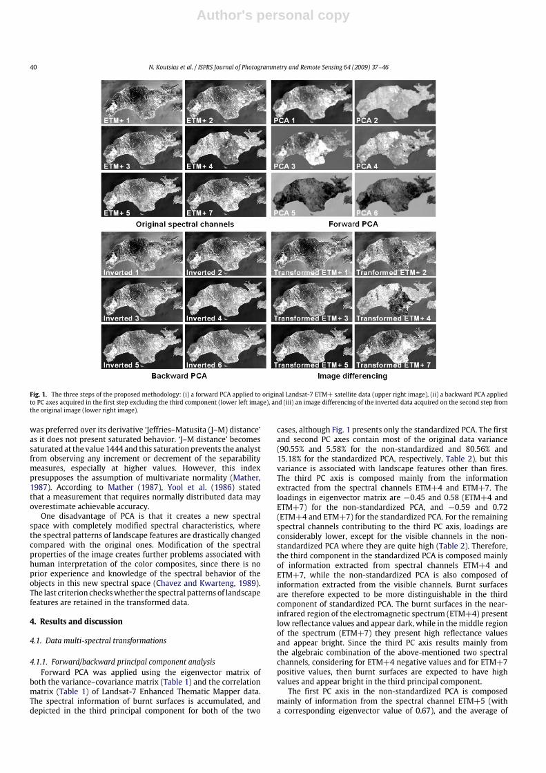
Fig. 1. The three steps of the proposed methodology: (i) a forward PCA applied to original Landsat-7 ETM+ satellite data (upper right image), (ii) a backward PCA appliedto PC axes acquired in the first step excluding the third component (lower left image), and (iii) an image differencing of the inverted data acquired on the second step fromthe original image (lower right image).
was preferred over its derivative ‘Jeffries–Matusita (J–M) distance’as it does not present saturated behavior. ‘J–M distance’ becomessaturated at the value 1444 and this saturation prevents the analystfrom observing any increment or decrement of the separabilitymeasures, especially at higher values. However, this indexpresupposes the assumption of multivariate normality (Mather,1987). According to Mather (1987), Yool et al. (1986) statedthat a measurement that requires normally distributed data mayoverestimate achievable accuracy.One disadvantage of PCA is that it creates a new spectral
space with completely modified spectral characteristics, wherethe spectral patterns of landscape features are drastically changedcompared with the original ones. Modification of the spectralproperties of the image creates further problems associated withhuman interpretation of the color composites, since there is noprior experience and knowledge of the spectral behavior of theobjects in this new spectral space (Chavez and Kwarteng, 1989).The last criterion checkswhether the spectral patterns of landscapefeatures are retained in the transformed data.
4. Results and discussion
4.1. Data multi-spectral transformations
4.1.1. Forward/backward principal component analysisForward PCA was applied using the eigenvector matrix of
both the variance–covariance matrix (Table 1) and the correlationmatrix (Table 1) of Landsat-7 Enhanced Thematic Mapper data.The spectral information of burnt surfaces is accumulated, anddepicted in the third principal component for both of the two
cases, although Fig. 1 presents only the standardized PCA. The firstand second PC axes contain most of the original data variance(90.55% and 5.58% for the non-standardized and 80.56% and15.18% for the standardized PCA, respectively, Table 2), but thisvariance is associated with landscape features other than fires.The third PC axis is composed mainly from the informationextracted from the spectral channels ETM+4 and ETM+7. Theloadings in eigenvector matrix are −0.45 and 0.58 (ETM+4 andETM+7) for the non-standardized PCA, and −0.59 and 0.72(ETM+4 and ETM+7) for the standardized PCA. For the remainingspectral channels contributing to the third PC axis, loadings areconsiderably lower, except for the visible channels in the non-standardized PCA where they are quite high (Table 2). Therefore,the third component in the standardized PCA is composed mainlyof information extracted from spectral channels ETM+4 andETM+7, while the non-standardized PCA is also composed ofinformation extracted from the visible channels. Burnt surfacesare therefore expected to be more distinguishable in the thirdcomponent of standardized PCA. The burnt surfaces in the near-infrared region of the electromagnetic spectrum (ETM+4) presentlow reflectance values and appear dark, while in themiddle regionof the spectrum (ETM+7) they present high reflectance valuesand appear bright. Since the third PC axis results mainly fromthe algebraic combination of the above-mentioned two spectralchannels, considering for ETM+4 negative values and for ETM+7positive values, then burnt surfaces are expected to have highvalues and appear bright in the third principal component.The first PC axis in the non-standardized PCA is composed
mainly of information from the spectral channel ETM+5 (witha corresponding eigenvector value of 0.67), and the average of

Author's personal copy
N. Koutsias et al. / ISPRS Journal of Photogrammetry and Remote Sensing 64 (2009) 37–46 41
Table 1Variance–covariance matrix (grey cells) and correlation coefficient matrix (white cells) of the original spectral channels of the Landsat-7 Enhanced ThematicMapper+ satellite sensor image
ETM+1 ETM+2 ETM+3 ETM+4 ETM+5 ETM+7
ETM+1 118.648 128.811 184.491 60.092 191.838 167.600
ETM+2 0.75631 244.480 383.372 316.752 580.296 417.206
ETM+3 0.67357 0.97507 632.303 536.953 987.045 707.319
ETM+4 0.20828 0.76483 0.80620 701.559 1018.909 635.431
ETM+5 0.41186 0.86791 0.91796 0.89961 1828.533 1280.272
ETM+7 0.49230 0.85373 0.90000 0.76759 0.95795 976.828
Table 2The eigenvalue and eigenvector matrix for both non-standardized and standardized PCA
Principal component axesNon-standardized (Covariance) Standardized (Correlation)PC1 PC2 PC3 PC4 PC5 PC6 PC1 PC2 PC3 PC4 PC5 PC6
Eigenvalue 4077 251.4 143.7 13.9 13.0 3.4 4.83 0.91 0.20 0.03 0.01 0.01%Var. 90.55 5.58 3.19 0.31 0.29 0.08 80.56 15.18 3.32 0.54 0.24 0.16ETM+1 0.083 −0.530 −0.317 0.035 0.620 0.476 0.289 −0.804 −0.095 0.444 −0.236 0.090ETM+2 0.223 −0.277 −0.367 −0.127 0.190 −0.829 0.442 −0.194 −0.250 −0.232 0.742 −0.318ETM+3 0.375 −0.338 −0.412 0.063 −0.723 0.221 0.449 −0.075 −0.089 −0.730 −0.447 0.229ETM+4 0.372 0.652 −0.448 −0.421 0.162 0.182 0.386 0.474 −0.595 0.391 −0.036 0.345ETM+5 0.666 0.176 0.231 0.663 0.176 −0.043 0.436 0.266 0.232 0.204 −0.356 −0.720ETM+7 0.471 −0.269 0.584 −0.602 0.001 0.051 0.427 0.124 0.717 0.146 0.257 0.449
the remaining channels (loadings range from 0.22 to 0.47), exceptETM+1. The increased proportion of ETM+5 in the first PC axisresults from the high variance of this spectral channel, which is1828.53 (Table 1), compared with the low variance values of theother spectral channels, which range from 118.69 (ETM+2) to976.83 (ETM+7). In the non-standardized PCA, the rotation of theaxes is accomplished in a way that the first PC axis lies along thespectral channel with the highest variance. On the contrary, thefirst PC axis in standardized PCA is composed of the average valuesfrom all the original spectral channels (eigenvector values rangebetween 0.39 and 0.49), except ETM+1 whose eigenvector valueis 0.29.The second PC axis comprises spectral information of ETM+1
and ETM+4 for both the non-standardized and standardized PCA.The first three PC axes account for 99.32% and 99.06% of the originalvariance for non-standardized and standardized PCA, respectively(Table 2).Exclusion of the third PC axis during the backward PCA ensured
that spectral information of burnt surfaces is not considered inthe back-transformation. This is especially evident in the spectralchannel ETM+4 where the burnt surfaces originally constituted aspectrally enhanced object appearing in dark tones (Fig. 1), whilein the inverted components they appear in bright tones.
4.1.2. Image differencingImage differencing created the final transformed data where
the burnt surfaces constitute a spectrally enhanced feature (Fig. 1).Spectral enhancement of the burnt surfaces results from theselective removal of spectral information from the original satellitedata. A different amount of information is removed from eachpixel’s digital number, depending on the spectral class towhich thepixel belongs. This spectral enhancement can be observed visuallyin ETM+4 and ETM+7. In these channels, the burnt surfacesbecome darker in ETM+4 and brighter in ETM+7 compared to theoriginal data.
4.2. Qualitative evaluation of the transformed data
4.2.1. Three-channel colour compositesKoutsias and Karteris (2000) concluded that the spectral
channels TM4, TM7 and one of the TM1 or TM2 of a single
post-fire Landsat-5 Thematic Mapper image were the best three-channel color composites for enhancing the spectral separabilityof the burnt surfaces. Based on these findings, three-channel colorcomposites consisting of TM7, TM4 and TM2 were created for theoriginal and transformed data after the F/B PCA (Fig. 2). From agraphic evaluation of these composites, it is evident that the burntsurfaces (dark red area) constitute a spectrally enhanced featurein the transformed data compared to the original. This spectralenhancement is quantitatively and qualitatively assessed by usingseparability measurements and scatter plots.
4.2.2. Impact of the ‘back-transformation coefficient’ on the trans-formed dataThe back-transformation is performed by considering the trans-
pose eigenvector matrix multiplied by the ‘back-transformationcoefficient’,which reflects the percentage of informationused fromeach PC axis. The three-channel color composites resulting fromthe different values of the ‘back-transformation coefficient’ usedin our study are presented in Fig. 3.It is evident that the color scheme is not enhanced spectrally
and preserves the original spectral patterns for low values of theback-transformation coefficient without modification. In contrast,the color scheme reaches the maximum spectral enhancement,and the original spectral pattern of the satellite image deterioratesat high values. A coefficient value of between 0.5 and 0.7 seems tobe the most appropriate, since in the resulting color scheme bothspectral enhancement and maintenance of the original spectralpatterns are achieved.
4.3. Quantitative evaluation of the transformed data
4.3.1. Correlation coefficientsTable 3 summarizes the correlation coefficients of the spectral
channels in the transformed data that were compared with thoseof the original satellite data (Table 1). The transformed data referto all four cases of the F/B PCA considering a ‘back-transformationcoefficient’ of 0.7. The correlation coefficients were reduced inall the spectral channel pairs in the transformed data for thestandardized F/B PCA, while in the non-standardized PCA, areduction is observed between the pairs of spectral channelswhere

Author's personal copy
42 N. Koutsias et al. / ISPRS Journal of Photogrammetry and Remote Sensing 64 (2009) 37–46
Fig. 2. Three-channel color composites of (a) the original Landsat-7 Enhanced Thematic Mapper data, (b) the transformed data of the non-standardized F/B PCA, and (c) thetransformed data of the standardized F/B PCA.
Fig. 3. Three-channel color composites resulting fromback-transformationwhen considering a different proportion of information taken from PC axes.When the coefficientvalues are close to 0, the color scheme is not spectrally enhanced, but preserves the original spectral pattern, while the opposite occurs when the coefficient values are closeto 1.

Author's personal copy
N. Koutsias et al. / ISPRS Journal of Photogrammetry and Remote Sensing 64 (2009) 37–46 43
Fig. 4. Bi-spectral scatter plots between the burnt surfaces and (i) vegetation, (ii) dry vegetation, (iii) bare soil and (iv) sea in the original satellite sensor data (lowerleft diagonal cells) and in the transformed data resulted from the standardized F/B PCA (right upper diagonal cells). The columns and rows of the embodied scatter plotscorrespond to the spectral channels as indicated inside the cells of the diagonal line.
ETM+5 or ETM+7 is present. There is also aminor reduction in theETM+3 and ETM+2 pair.If we consider the reduction of the interband correlation as an
indicator of data quality, then the transformed data are superiorto the original. In the standardized F/B PCA, the correlationcoefficients were reduced in all spectral channel pairs. In thenon-standardized PCA, only some selected pairs showed reducedcoefficients.
4.3.2. Bi-spectral scatter plotsBi-spectral scatter plots of all combinations of spectral channels
were created for the graphic evaluation of spectral differentiationbetween the burnt surfaces and the other land cover featuresidentified in the previous section. A total of 15 pairs ofspectral channels were considered, in order to cover all possiblecombinations of spectral channels of the Enhanced ThematicMapper. It is clear that burnt surfaces present many spectralcharacteristics that are similar with other land cover types sincethere is an obvious spectral overlapping in specific combinationsof spectral channels (Fig. 4).Bi-spectral scatter plots of the transformed data were also
constructed and compared with those of the original satellite data.
Fig. 4 presents the scatter plots between the burnt surfaces and(i) fresh vegetation, (ii) dry vegetation, (iii) bare soil and (iv) sea inthe original satellite sensor data (lower left diagonal cells), and thetransformed data resulting from the standardized F/B PCA (rightupper diagonal cells). The columns and rows of the embodiedscatter plots correspond to the spectral channels as indicatedinside the cells of the diagonal line.The spectral distances between the burnt surfaces and other
land cover types were increased in themajority of the scatter plotsof the transformeddata, thus implying their spectral enhancement.Specifically, enhancement of spectral discrimination is observedbetween burnt surfaces and vegetation. In the original data, thesetwo categories are spectrally distinct only when the spectralchannel ETM+4 is included in the scatter plot, and in thecase of combination ETM+5–ETM+7. In the transformed data,burnt surfaces and vegetated areas constitute spectrally distinctfeatures in the combinations where spectral channels ETM+2,ETM+4 and ETM+7 are present, and also in the combinationof ETM+1–ETM+2. Furthermore, the spectral discrimination wasimproved in the majority of the scatter plots.In the scatter plot composed of spectral channels ETM+1
and ETM+2 of the original satellite data, burnt surfaces and

Author's personal copy
44 N. Koutsias et al. / ISPRS Journal of Photogrammetry and Remote Sensing 64 (2009) 37–46
Table 3Correlation coefficient matrix of the spectral channels in the transformed data after non-standardized (white cells) and standardized (grey cells) F/B PCA
ETM+1 0.6975↓ 0.5466↓ 0.0615↓ 0.1788↓ 0.1474↓
0.8726↑ ETM+2 0.7869↓ 0.6897↓ 0.4332↓ 0.1634↓
0.7757↑ 0.9695↓ ETM+3 0.3618↓ 0.8613↓ 0.7081↓
0.5199↑ 0.8404↑ 0.8617↑ ETM+4 0.1498↓ −0.2290↓
0.1203↓ 0.4995↓ 0.6562↓ 0.6312↓ ETM+5 0.9220↓
−0.1627↓ 0.1318↓ 0.3149↓ 0.2109↓ 0.8811↓ ETM+7
The symbols ↓ and ↑ indicate increment and decrement, respectively, of the correlation coefficients compared to those of the original satellite spectral channels.
Table 4‘Bhattacharyya distance’ separability index between the burnt surfaces and the other land cover categories for each spectral channel in (a) the original satellite data (boldcharacters), (b) transformed data of the standardized F/B PCA (white cells), and (c) transformed data of the non-standardized F/B PCA (grey cells)
Burnt surfacesETM+1 ETM+2 ETM+3 ETM+4 ETM+5 ETM+7 Average
Bare land (urban areas) 1.391 1.803 2.035 2.401 0.941 0.427 1.4991.70 2.07 2.39 2.47 2.434 2.79 1.16 3.07 0.60 0.45 0.11 0.08 1.40 1.82
Sea 0.039 0.208 0.684 1.384 2.243 2.403 1.1600.57 1.10 0.92 0.47 0.265 0.12 2.28 0.50 2.56 2.93 2.88 3.26 1.58 1.40
Vegetation (dark tones) 1.009 0.541 1.039 1.261 1.020 2.180 1.1750.11 0.29 2.15 0.75 0.420 0.27 6.69 4.60 1.68 1.55 3.04 2.90 2.35 1.73
Vegetation (bright tones) 0.455 0.068 0.238 6.948 0.127 1.107 1.4900.09 0.90 4.18 1.88 0.009 0.79 10.9 10.9 0.58 0.45 2.53 2.41 3.04 2.89
Dry vegetated areas 0.092 0.285 0.275 1.815 0.155 0.218 0.4730.47 1.01 1.84 1.39 0.597 1.24 2.85 3.30 0.08 0.09 0.53 0.81 1.06 1.31
Average 0.597 0.581 0.854 2.762 0.897 1.267 1.1600.59 1.07 2.30 1.39 0.745 1.04 4.77 4.48 1.10 1.09 1.82 1.89 1.89 1.83
vegetated areas do not constitute spectrally distinct features.In the transformed data, these two categories constitute clearlydistinct spectral classes. The selective removal of information alsoallows their discrimination in the visible part of electromagneticspectrum.Apart from the improvement of spectral differentiation be-
tween burnt surfaces and vegetation, the enhancement of spec-tral discrimination between burnt surfaces and dry vegetatedareas, bare soil and the sea is also evident. In the transformed data,compared to other landscape features, burned surfaces constitutewell separated spectral classes since there is no, or only minor,overlapping between the data values of these classes in the de-fined bi-spectral space. In the original data, there is limited spectraldiscrimination between burnt surfaces with bare soil and also dryvegetated areas, since their data values present a marginal sepa-ration in the defined bi-spectral space. In certain cases, this lim-ited spectral discrimination is enhanced in the transformed data(Fig. 4). Similar results, not presented here, were also observed inthe non-standardized F/B PCA.
4.3.3. Separability measuresThe separability measurements based on the ‘Bhattacharyya
distance’ between burnt surfaces and other landscape featuresare summarized in Table 4 for the original satellite data, thestandardized PCA, and the non-standardized PCA. Mean valuesand standard deviations between the burnt surfaces and each landcover category for each spectral channel are also provided.The overall discrimination in the original satellite data is 1.16,
as indicated by the overallmean value (Table 4). The dry vegetationcategory presented a very low average separability value (0.473),which denotes spectral similarity and possible spectral confusionwith burnt surfaces. The vegetation that appears in dark tones andthe sea both present values similar to the average, while the bareland and vegetation that appeared in bright tones show higherseparability values than the average, and correspond to spectrallydistinct objects.
In the transformeddata of the standardized F/B PCA, the averageseparability index increased considerably (1.89), thus implyingincreased spectral separability of the burnt surfaces over other landcover types. Specifically, the separability value of dry vegetatedareas increased from0.473 to 1.06 and 1.31 in the standardized andnon-standardized F/B PCA, respectively. In the transformed dataof the non-standardized F/B PCA, the averaged separability valueincreased to 1.83, slightly less than the standardized one. However,in the non-standardized the separability value of dry vegetatedareas is 1.31, much higher than that of the standardized value.Additionally, the non-standardized separability indices presenta better distribution, compared with the standardized where ahigher distance exists between the low and high values.
4.3.4. Spectral patternsOneof the disadvantages of PCA, is the creation of a newspectral
space in which the spectral pattern of various landscape features isdeteriorated, compared with the original satellite data. Alterationof spectral pattern characteristics creates further problems, whichare associated with the ability to interpret the satellite imagery,since there is no prior knowledge and experience regarding thespectral characteristics of the new data.Ourmethod of F/B PCA creates a new spectral space that retains
the original general characteristics of the spectral signatures ofvarious land cover features. In the series of color images presentedin Figs. 2 and 3, it is obvious that all land cover categoriespreserve their original chromatic properties. Thus, the pre-existingknowledge needed to interpret the color composites is retained,and can be used successfully in interpreting the transformed data.Additionally, spectral signature plots of various land cover typesfor the original and transformed satellite data presented in Fig. 5strengthen this finding. It is obvious, that although the spectralsignatures of land cover types were modified in the transformeddata, their original general chromatic properties were retained.

Author's personal copy
N. Koutsias et al. / ISPRS Journal of Photogrammetry and Remote Sensing 64 (2009) 37–46 45
Fig. 5. Spectral signature plots of various land cover types identified in the originalLandsat-7 ETM+ data (upper figure), the standardized F/B PCA (middle figure), andthe non-standardized F/B PCA (lower figure).
5. Conclusions
The proposed method, which involves a F/B PCA of Landsat En-hanced Thematic Mapper data and image differencing, enhancedthe spectral signal of fire scars, and therefore improved the spec-tral discrimination of burnt surfaces. This spectral enhancementresulted from selective removal of the spectral information fromthe satellite data; a different amount of information is removedfrom each pixel’s digital number depending on the spectral classto which the pixel belongs.The transformed data were superior to the original satellite
sensor data in various aspects. Firstly, the F/B PCA created a newspectral space inwhich the burnt surfaces are spectrally enhanced.The spectral separability between burnt surfaces and certain landcover types was considerably increased in the transformed data, asindicated by the bi-spectral plots and separability measurements.Specifically, the separability value of dry vegetated areas, whichpresents a very low separability index, increased from 0.473to 1.06 and 1.31 in the standardized and non-standardizedF/B PCA, respectively. Secondly, the high correlation coefficientsobserved among the original spectral channels were reduced in
the transformed data. The reduction of the interband correlationindicates better data performance,which is further associatedwiththe reduction of multicollinearity effects. Thirdly, the proposedmethodology created a new spectral space that retains the originalspectral characteristics of the various landscape features. Since thetransformeddata preserve their original chromatic properties, pre-existing knowledge to interpret the color composites is retained,and can be used successfully for image interpretation.
References
Afifi, A.A., Clark, V., 1990. Computer-Aided Multivariate Analysis, second ed. VanNostrand Reinhold, New York.
Ahearn, S.C., Wee, C., 1991. Data space volumes and classification optimization ofSPOT and Landsat TM data. Photogrammetric Engineering & Remote Sensing 57(1), 61–65.
Anuta, P.E., Bartolucci, L.A., Dean, M.E., Lozano, D.F., Malaret, E., McGillem, C.D.,Valenzuela, C.R., 1984. Landsat-4 MSS and Thematic Mapper data quality andinformation content analysis. IEEE Transactions on Geoscience and RemoteSensing GE-22 (3), 222–236.
Barbosa, P.M., Gregoire, J.M., Pereira, J.M.C., 1999. An algorithm for extractingburned areas from time series of AVHRRGAC data applied at a continental scale.Remote Sensing of Environment 69 (3), 253–263.
Brewer, C.K., Winne, J.C., Redmond, R.L., Opitz, D.W., Mangrich, M.V., 2005. Classify-ing andmappingwildfire severity: A comparison ofmethods. PhotogrammetricEngineering and Remote Sensing 71 (11), 1311–1320.
Byrne, G.F., Crapper, P.F., Mayo, K.K., 1980. Monitoring land-cover change byprincipal component analysis of multitemporal Landsat data. Remote Sensingof Environment 10 (3), 175–184.
Canas, A.A.D., Barnett, M.E., 1985. The generation and interpretation of false-colourcomposite principal components images. International Journal of RemoteSensing 6 (6), 867–881.
Chavez, P.S.J., Kwarteng, A.Y., 1989. Extracting spectral contrast in LandsatThematic Mapper image data using selective principal component analysis.Photogrammetric Engineering and Remote Sensing 55 (3), 339–348.
Chavez, P.S.J., Sides, S.C., Anderson, J.A., 1991. Comparison of three differentmethods to merge multiresolution and multispectral data: Landsat TM andSPOT Panchromatic. Photogrammetric Engineering and Remote Sensing 57 (3),295–303.
Chuvieco, E., Congalton, R.G., 1988. Mapping and inventory of forest fires fromdigital processing of TM data. Geocarto International 4 (4), 41–53.
Chuvieco, E., Martin, M.P., 1994. Global fire mapping and fire danger estimationusing AVHRR images. Photogrammetric Engineering and Remote Sensing 60 (5),563–570.
Conese, C., Maracchi, G., Miglietta, F., Maselli, F., Sacco, V.M., 1988. Forestclassification by principal component analyses of TMdata. International Journalof Remote Sensing 9 (10), 1597–1612.
De Santis, A., Chuvieco, E., 2007. Burn severity estimation from remotely senseddata: Performance of simulation versus empirical models. Remote Sensing ofEnvironment 108 (4), 422–435.
Duda, R.O., Hart, P.E., 1973. Pattern Classification and Scene Analysis. John Wiley,New York.
Dwivedi, R.S., Rao, B.R.M., 1992. The selection of the best possible Landsat TM bandcombination for delineating salt-affected soils. International Journal of RemoteSensing 13 (11), 2051–2058.
Eastman, J.R., Fult, M., 1993. Long sequence time series evaluation usingstandardized principal components. Photogrammetric Engineering and RemoteSensing 59 (6), 991–996.
Eklundh, L., Singh, A., 1993. A comparative analysis of standardised andunstandardised principal component analysis in remote sensing. InternationalJournal of Remote Sensing 14 (7), 1359–1370.
Eva, H., Lambin, E.F., 1998. Burnt area mapping in Central Africa using ATSR data.International Journal of Remote Sensing 19 (18), 3473–3497.
Fraser, R.H., Hall, R.J., Landry, R., Lynham, T., Raymond, D., Lee, B., Li, Z., 2004.Validation and calibration of Canada-wide-coarse-resolution satellite burned-area maps. Photogrammetric Engineering and Remote Sensing 70 (4), 451–460.
Fung, T., 1990. An assessment of TM imagery for land-cover change detection. IEEETransactions on Geoscience and Remote Sensing 28 (4), 681–684.
Fung, T., LeDrew, E., 1987. Application of principal components analysis tochange detection. Photogrammetric Engineering and Remote Sensing 53 (12),1649–1658.
García-Haro, F.J., Gilabert, M.A., Meliá, J., 2001. Monitoring fire-affected areasusing Thematic Mapper data. International Journal of Remote Sensing 22 (4),533–549.
Garcia, M., Chuvieco, E., 2004. Assessment of the potential of SAC-C/MMRS imageryfor mapping burned areas in Spain. Remote Sensing of Environment 92 (3),414–423.
Gillespie, A.R., 1980. Digital techniques of image enhancement. In: Siegal, B.S.,Gillespie, A.R. (Eds.), Remote Sensing in Geology. John Wiley, New York,pp. 139–226.
Gimeno, M., San Miguel-Ayanz, J., Schmuck, G., 2004. Identification of burnedareas in Mediterranean forest environments from ERS-2 SAR time series.International Journal of Remote Sensing 25 (22), 4873–4888.

Author's personal copy
46 N. Koutsias et al. / ISPRS Journal of Photogrammetry and Remote Sensing 64 (2009) 37–46
Gong, P., Pu, R., Li, Z., Scarborough, J., Clinton, N., Levien, L.M., 2006. An integratedapproach to wildland fire mapping of California, USA using NOAA/AVHRR data.Photogrammetric Engineering and Remote Sensing 72 (2), 139–150.
Gonzales, R.C., Wintz, P., 1977. Digital Image Processing. Addison Wesley, Reading,MA.
Hirosawa, Y., Marsh, S.E., Kliman, D.H., 1996. Application of standardized principalcomponent analysis to land-cover characterization usingmultitemporal AVHRRdata. Remote Sensing of Environment 58 (3), 267–281.
Hudak, A.T., Brockett, B.H., 2004. Mapping fire scars in a southern African savannahusing Landsat imagery. International Journal of Remote Sensing 25 (16),3231–3243.
Ingerbritsen, S.E., Lyon, R.J.P., 1985. Principal components analysis ofmultitemporalimage pairs. International Journal of Remote Sensing 6 (5), 687–696.
Jiaju, L., 1988. Development of principal component analysis applied to multi-temporal Landsat TM data. International Journal of Remote Sensing 9 (12),1895–1907.
Jolliffe, I.T., 1986. Principal Component Analysis, first ed. Springer-Verlag, NewYork.Justice, C.O., Giglio, L., Koronzi, S., Owens, J., Morisette, J.T., Roy, D., Descloitres, J.,Alleaume, S., Petitcolin, F., Kaufman, Y., 2002. The MODIS fire products. RemoteSensing of Environment 83 (1–2), 244–262.
Kasischke, E.S., French, N.H.F., 1995. Locating and estimating the areal extentof wildfires in Alaskan boreal forests using multiple-season AVHRR NDVIcomposite data. Remote Sensing of Environment 51 (2), 263–275.
Koutsias, N., Karteris, M., 2000. Burned area mapping using logistic regressionmodeling of a single post-fire Landsat-5 Thematic Mapper image. InternationalJournal of Remote Sensing 21 (4), 673–687.
Koutsias, N., Karteris, M., Chuvieco, E., 2000. The use of Intensity-Hue-Saturationtransformation of Landsat-5 Thematic Mapper data for burned land mapping.Photogrammetric Engineering and Remote Sensing 66 (7), 829–839.
Koutsias, N., Karteris, M., Fernandez-Palacios, A., Navarro, C., Jurado, J., Navarro, R.,Lobo, A., 1999. Burned landmapping at local scale. In: Chuvieco, E. (Ed.), RemoteSensing of Large Wildfires in the European Mediterranean Basin. Springer-Verlag, Berlin Heidelberg, pp. 157–187.
Koutsias, N., Tsitsipati, V., Karteris,M., 2001. A forward/inverse principal componenttransformation of Landsat-5 Thematic Mapper data to improve the spectraldiscriminator ability of burned surfaces. In: Chuvieco, E., Martín, M.P. (Eds.), 3rdInternational Workshop on Remote Sensing and GIS Applications to Forest FireManagement: New Methods and Sensors. EARSeL, Paris, pp. 138–141.
Laris, P.S., 2005. Spatiotemporal problems with detecting and mapping mosaic fireregimes with coarse-resolution satellite data in savanna environments. RemoteSensing of Environment 99 (4), 412–424.
Lasaponara, R., 2006. Estimating spectral separability of satellite derived parame-ters for burned areas mapping in the Calabria region by using SPOT-vegetationdata. Ecological Modelling 196 (1-2), 265–270.
Li, R.R., Kaufman, Y.J., Hao, W.M., Salmon, J.M., Gao, B.C., 2004. A technique fordetecting burn scars using MODIS data. IEEE Transactions on Geoscience andRemote Sensing 42 (6), 1300–1308.
Lodwick, G.D., 1979. Measuring ecological changes in multitemporal Landsat datausing principal component. In: Proc. 13th International Symposium on RemoteSensing of the Environment, Ann Arbor, Michigan, 23–27 April, pp. 1131–1141.
Loughlin, W.P., 1991. Principal component analysis for alteration mapping.Photogrammetric Engineering and Remote Sensing 57 (9), 1163–1169.
Mather, P.M., 1987. Computer Processing of Remotely-Sensed Images: AnIntroduction. John Wiley and Sons, New York.
Milne, A.K., 1986. The use of remote sensing in mapping and monitoringvegetational change associated with bushfire events in eastern Australia.Geocarto International 1 (1), 25–32.
Muchoney, D.M., Haack, B.N., 1994. Change detection for monitoring forestdefoliation. Photogrammetric Engineering and Remote Sensing 60 (10),1243–1251.
Nielsen, T.T., Mbow, C., Kane, R., 2002. A statistical methodology for burned areaestimation using multitemporal AVHRR data. International Journal of RemoteSensing 23 (6), 1181–1196.
Patterson, M.W., Yool, S.R., 1998. Mapping fire-induced vegetation mortalityusing Landsat Thematic Mapper data: A comparison of linear transformationtechniques. Remote Sensing of Environment 65 (2), 132–142.
Pereira, J.M.C., 1992. Burned area mapping with conventional and selectiveprincipal component analysis. Finisterra XXVII (53–54), 63–78.
Pereira, J.M.C., 1999. A comparative evaluation of NOAA/AVHRR vegetation indexesfor burned surface detection andmapping. IEEE Transactions onGeoscience andRemote Sensing 37 (1), 217–226.
Pereira, J.M.C., 2003. Remote sensing of burned areas in tropical savannas.International Journal of Wildland Fire 12 (3–4), 259–270.
Pereira, J.M.C., Chuvieco, E., Beaudoin, A., Desbois, N., 1997. Remote sensing ofburned areas: A review. In: Chuvieco, E. (Ed.), A Review of Remote SensingMethods for the Study of Large Wildland Fires. Universidad de Alcala, Alcalade Henares, Spain, pp. 127–183.
Ready, P.J., Wintz, P.A., 1973. Information extraction, SNR improvement and datacompression in multi-spectral imagery. IEEE Transactions on Communications21 (10), 1123–1131.
Riáno, D., Chuvieco, E., Ustin, S., Zomer, R., Dennison, P., Roberts, D., Salas, J.,2002. Assessment of vegetation regeneration after fire through multitemporalanalysis of AVIRIS images in the Santa Monica Mountains. Remote Sensing ofEnvironment 79 (1), 60–71.
Ribed, P.S., López, A.M., 1995. Monitoring burnt areas by principal componentsanalysis of multi-temporal TM data. International Journal of Remote Sensing16 (9), 1577–1587.
Richards, J.A., 1984. Thematic mapping from multitemporal image data using theprincipal component transformation. Remote Sensing of Environment 16 (1),35–46.
Richards, J.A., 1986. Remote Sensing Digital Image Analysis: An Introduction.Springer-Verlag, Berlin.
Richards, J.A., Milne, A.K., 1983. Mapping fire burns and vegetation regenerationusing principal component analysis. In: Proc. International Geoscience andRemote Sensing Symposium, IGARSS’83, San Francisco, California, 31 August–2September, vol. 1, pp. 51–56.
Rogan, J., Yool, S.R., 2001.Mapping fire-induced vegetation depletion in the PeloncillMountains, Arizona and New Mexico. International Journal of Remote Sensing22 (16), 3101–3121.
Roy, D.P., Lewis, P.E., Justice, C.O., 2002. Burned areamapping usingmulti-temporalmoderate spatial resolution data—A bi-directional reflectance model-basedexpectation approach. Remote Sensing of Environment 83 (1–2), 263–286.
Salvador, R., Valeriano, J., Pons, X., Dìaz-Delgado, R., 2000. A semi-automaticmethodology to detect fire scars in shrubs and evergreen forests with LandsatMSS time series. International Journal of Remote Sensing 21 (4), 655–671.
Siegert, F., Ruecker, G., 2000. Use of multitemporal ERS-2 SAR images for identifica-tion of burned scars in south-east Asian tropical rainforest. International Journalof Remote Sensing 21 (4), 831–837.
Siljeström, R., Moreno-López, A., 1995. Monitoring burned areas by principal com-ponent analysis. International Journal of Remote Sensing 16 (9), 1577–1587.
Silva, J.M.N., Sá, A.C.L., Pereira, J.M.C., 2005. Comparison of burned area estimatesderived from SPOT-VEGETATION and Landsat ETM+ data in Africa: Influenceof spatial pattern and vegetation type. Remote Sensing of Environment 96 (2),188–201.
Singh, A., Harrison, A., 1985. Standardized principal components. InternationalJournal of Remote Sensing 6 (6), 883–896.
Smith, A.M.S., Drake, N.A., Wooster, M.J., Hudak, A.T., Holden, Z.A., Gibbons, C.J.,2007. Production of Landsat ETM plus reference imagery of burned areaswithinSouthern African savannahs: Comparison ofmethods and application toMODIS.International Journal of Remote Sensing 28 (12), 2753–2775.
Stroppiana, D., Pinnock, S., Pereira, J.M.C., Gregoire, J.M., 2002. Radiometric analysisof SPOT-VEGETATION images for burnt area detection in Northern Australia.Remote Sensing of Environment 82 (1), 21–37.
Swain, P.H., Davis, S.M., 1978. Remote Sensing: The Quantitative Approach.McGraw-Hill, New York.
Townshend, J.R.G., Goff, T.E., Tucker, C.J., 1985. Multitemporal dimensionality ofimages of normalised difference vegetation index at continental scales. IEEETransactions on Geoscience and Remote Sensing GE-23 (6), 888–895.
Trigg, S., Flasse, S., 2001. An evaluation of different bi-spectral spaces fordiscriminating burned shrub-savannah. International Journal of RemoteSensing 22 (13), 2641–2647.
Vega-García, C., Chuvieco, E., 2006. Applying localmeasures of spatial heterogeneityto Landsat-TM images for predicting wildfire occurrence in Mediterraneanlandscapes. Landscape Ecology 21 (4), 595–605.
Yool, S.R., Star, J.L., Estes, J.E., Botkin, D.B., Eckhardt, D.W., Davis, F.W., 1986.Performance analysis of image processing algorithms for classification ofnatural vegetation in the mountains of Southern California. InternationalJournal of Remote Sensing 7 (5), 683–702.
Copyright © 2022 FDOKUMEN